Marine Institute
65
Marine Institute Clonakilty Bay Special Protection Area (004081): Appropriate Assessment of Aquaculture April 2021
-
Upload
khangminh22 -
Category
Documents
-
view
1 -
download
0
Transcript of Marine Institute

Marine Institute
Clonakilty Bay Special Protection Area (004081): Appropriate Assessment of Aquaculture
April 2021

Clonakilty Bay SPA - Appropriate Assessment of Aquaculture
Marine Institute
5146490Dg08_Clonakilty Bay SPA_Rev 2.1.doc i
Marine Institute
Clonakilty Bay Special Protection Area: Appropriate Assessment of Aquaculture
April 2021
Notice
This report was produced by Atkins Ecology for the Marine Institute for the specific purpose of the Marine Institute Bird Studies project. This report may not be used by any person other than the Marine Institute without the Marine Institute's express permission. In any event, Atkins accepts no liability for any costs, liabilities or losses arising as a result of the use of or reliance upon the contents of this report by any person other than the Marine Institute.
Document History
JOB NUMBER: 5146490 DOCUMENT REF: 5146490Dg08_Clonakilty Bay SPA_Rev 2.0.doc
1.0 Revision 1.0 POD POD NS MF 22-06-20
2.0 Final for Issue POD POD NS MF 12-03-21
2.1 Final for Issue POD POD NS MF 22-04-21
Revision Purpose Description Originated Checked Reviewed Authorised Date

Clonakilty Bay SPA - Appropriate Assessment of Aquaculture
Marine Institute
5146490Dg08_Clonakilty Bay SPA_Rev 2.1.doc i
Contents Section Page
Executive Summary i
1. Introduction 1
Description of the Proposed Development 1
Constraints to this assessment 1
2. Methods 6
Data sources 6
Assessment Methodology 11
3. Aquaculture Profile 15
Clonakilty Bay Overview 15
General description 15
Protected Sites and Species 15
Aquaculture Overview 16
Oyster production 16
Bag and Trestle Method 16
Oyster Site Layouts 16
Turning Oyster Bags 17
Site Access 17
4. Conservation objectives 19
Clonakilty Bay SPA (004081) 19
Other sites 21
Courtmacsherry Bay SPA (004219) 21
Seven Heads SPA (004191) 22
Old Head of Kinsale SPA (004021) 22
Galley Head to Duneen Point SPA (004190) 23
Sovereign Islands SPA (004124) 23
Sheep’s Head to Toe Head SPA (004156) 23
5. Status, habits and distribution of SCI species 25
Clonakilty Bay SPA 25
Waterbird habitats and distribution 28
Waterbird Survey Programme (2010/2011) 37
Waterbird habitats and distribution 37
Shelduck 37
Dunlin 38
Black-tailed Godwit 38
Curlew 38
Roosts 39
Shelduck 39
Dunlin 39
Black-tailed Godwit 39
Curlew 40

Clonakilty Bay SPA - Appropriate Assessment of Aquaculture
Marine Institute
5146490Dg08_Clonakilty Bay SPA_Rev 2.1.doc ii
Other species 40
6. Assessment of Potential Impacts 42
7. Cumulative Impacts 50
8. Conclusion & Recommendations 52
Conclusions 52
Recommendations 53
9. References 54
List of Tables
Table 2.1 IWEBS subsites.
Table 9.2 Equivalence between IWEBS and NPWS Waterbird Survey Program count subsites.
Table 2.2 Criteria for assessing significance with reference to attribute 1 of the conservation objectives.
Table 4.1 Attributes and targets for the conservation objectives for Shelduck, Dunlin, Black-tailed Godwit and Curlew at Clonakilty Bay SPA.
Table 4.2 Attribute and target for the conservation objective for wetlands and waterbirds at Clonakilty Bay SPA.
Table 4.3 Attributes and targets for the conservation objectives for Great Northern Diver, Shelduck, Wigeon, Red-breasted Merganser, Golden Plover, Lapwing, Dunlin, Black-tailed Godwit, Bar-tailed Godwit, Curlew, Black-headed Gull and Common Gull at Courtmacsherry Bay SPA.
Table 4.4 Attribute and target for the conservation objective for wetlands and waterbirds at Courtmacsherry Bay SPA.
Table 9.1 Population data of the SCI assessment species at Clonakilty Bay SPA.
Table 5.2 Clonakilty Bay 2010 / 2011 water bird numbers – summary data.
Table 5.3 Site population trends for qualifying interests of Clonakilty Bay SPA.
Table 5.4 Comparison with national population trends for qualifying interests of Clonakilty Bay SPA.
Table 5.5 Recent IWeBS count data; 2013/14 to 2015/16 compared to 2008/09 – 2012/13 5 year peak.
Table 6.1 Counts of qualifying interests in Clonakilty Bay SPA during NPWS 2010/11 Counts.
Table 6.2 Counts of qualifying interests in 0L506 during NPWS 2010/11 Counts.
Table 6.3 Counts of qualifying interests in 0L507 during NPWS 2010/11 Counts.
Table 6.4 Counts of qualifying interests in both 0L506 & 0L507 during NPWS 2010/11 Counts.
Table 6.5 Birds in 0L506 & 0L507 as a percentage of the Clonakilty Bay counts.
Table 6.6 Results of targets roost counts in November 2010 and February 2011.
List of Figures
Figure 1.1 Site Location.
Figure 1.2 SPAs within 15km.
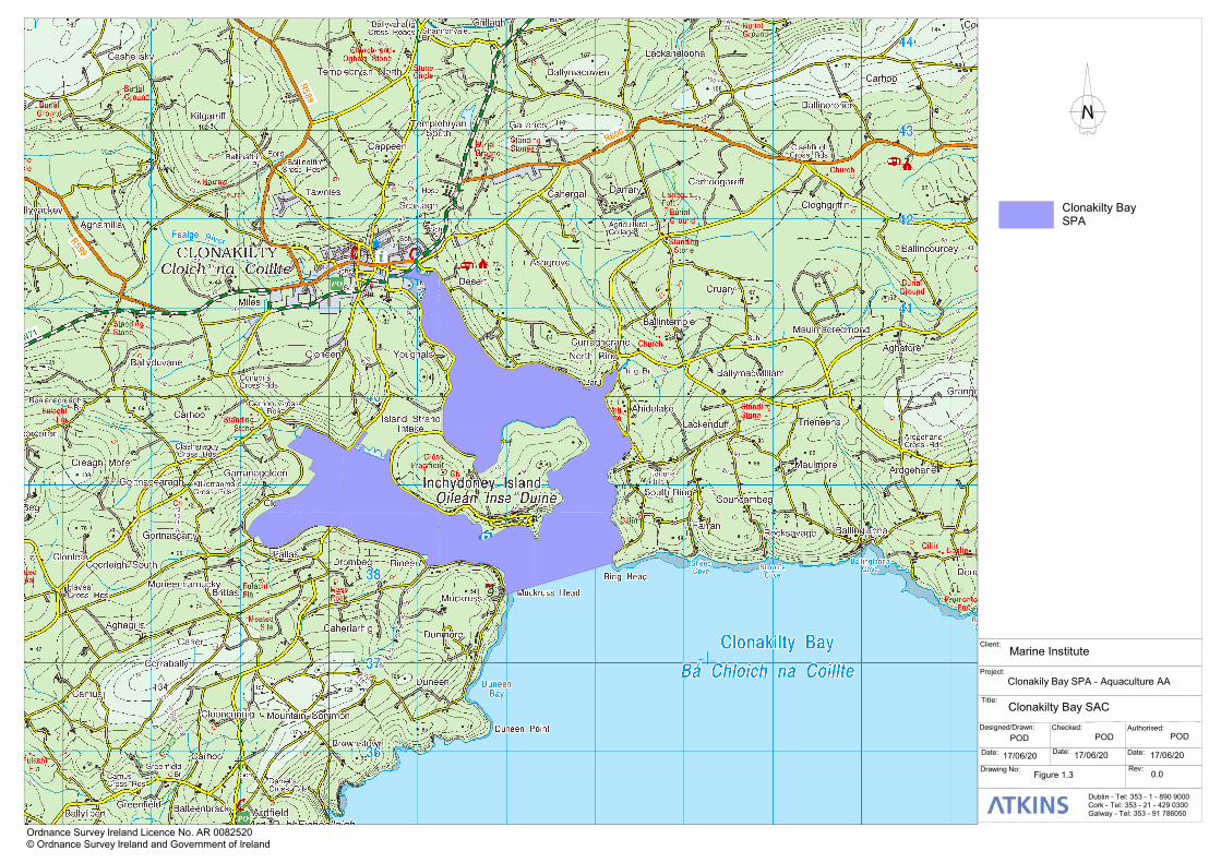
Figure 1.3 Clonakilty Bay SAC.
Figure 2.1 IWEBS Subsites.
Figure 2.2 NPWS waterbird survey program subsite boundaries (from NPWS, 2014a).
Figure 3.1 Aquaculture Sites.

Clonakilty Bay SPA - Appropriate Assessment of Aquaculture
Marine Institute
5146490Dg08_Clonakilty Bay SPA_Rev 2.1.doc iii
Figure 5.1 1130 Estuaries – Distribution.
Figure 5.2 1140 Mudflats & Sandflats.
Figure 5.3 Shallow Inlets.
Figure 5.4 Coastal Lagoons.
Figure 5.5 Sand dune habitats.
Figure 5.6a Marine Communities (from Clonakilty Bay SAC supporting documents – marine).
Figure 5.6 Marine Communities from MERC, 2012 intertidal survey.
Figure 6.1 Aerial image from Bing Maps, 2020 showing tidal channels in 0L506 (left) and 0L507 (right).
Figure 6.2 Subtidal Channels.
List of Plates
Plate 3.1 Example of Bag trestle cultivation of pacific oyster.

Clonakilty Bay SPA - Appropriate Assessment of Aquaculture
Marine Institute
5146490Dg08_Clonakilty Bay SPA_Rev 2.1.doc i
Executive Summary Introduction
This document contains the Appropriate Assessment Report for aquaculture in Clonakilty Bay SPA (site
code IE004081). The predominant habitats within the SPA are intertidal sand and mud flats.
There is currently no licenced aquaculture within Clonakilty Bay. There is one application to farm oysters
(Crassostrea gigas) on a site north of Inchydoney Island in the inner harbour - T05/603A. This site is 22.7ha
in area and lies at the mouth of Clonakilty Bay and close to Ring Channel.
The aquaculture licence application site occupies 22.57ha; ca. 16.6ha of 0L506 (32.6% of the subsite) and
ca. 6ha of 0L507 (15.4% of the subsite). In all the proposed licence occupies ca. 25.2% of the combined
area of Outer Clonakilty Bay as defined by the NPWS low tide count sectors 0L506 & 0L507.
Access is proposed from 3 no. locations as shown on Figure 3.1. One is from the public road and along the
shoreline from close to the Cul-de-Sac pool. The remaining two access point are by boat from quays in Ring
on the eastern side of the Harbour.
Methodology
Information on the proposed oyster cultivation activities in Clonakilty Bay SPA were obtained from the
aquaculture profile document compiled by Bord Iascaigh Mhara. Consultation was also undertaken with the
Marine Institute.
The analyses of the likely impacts of activities covered in this assessment are based on consideration of
spatial overlap between the SCI species distribution and the spatial extent of the activities. These analyses
focus on distribution patterns of feeding, or potentially feeding birds, as the main potential impacts will be to
the availability and/or quality of feeding habitat, although we have included assessment of potential impacts
on roosting birds, where relevant.
The distribution of waterbirds was analysed using data from the Irish Wetland Bird Survey (IWeBS) counts of
Clonakilty Bay SPA and the National Parks and Wildlife Service (NPWS) Baseline Waterbird Survey (BWS)
low tide counts (carried out in 2010/11 at Clonakilty Bay). A number of further low tide counts undertaken by
NPWS Regional staff, namely 2011-12; 2012-13 and 2013-14, were also reviewed( (from NPWS, 2014a); as
were data compiled to inform the Clonakilty Wastewater Treatment Plant Upgrade. Environmental Impact
Statement prepared by White Young Green (Limosa, 2006). The Clonakilty Bay SPA Conservation
Objectives Supporting document also quotes additional data collated by Dr. Lewis from 2000/01 – 2010/11.
The age of the NPWS low tide survey work which is relied on heavily in this assessment (2010/11) is of note.
The assessment was further informed by research carried out for a previous Marine Institute project: The
effects of intertidal oyster culture on the spatial distribution of waterbirds (Gittings and O’Donoghue, 2016) as
well as general observations from 2011 and 2016. Maps of flock locations from the NPWS BWS low tide
counts and descriptions of waterbird distribution in and NPWS (2014a) have also been used to interpret the
patterns derived from these analyses.
Additional sources of data included intertidal and subtidal biotope mapping; NPWS information on marine
communities; Admiralty Charts; tidal information; and the MERC 2012 report on intertidal habitats
(commissioned by the Marine Institute on behalf of National Parks and Wildlife Service), etc.
The methodology used to identify potentially significant impacts is focussed on the Conservation Objectives,
and their attributes, that have been defined and described for the Clonakilty Bay SPA. Impacts that will
cause displacement of 5% or more of the total Clonakilty Bay SPA population of a non-breeding SCI species
have been assessed as potentially having a significant negative impact.

Clonakilty Bay SPA - Appropriate Assessment of Aquaculture
Marine Institute
5146490Dg08_Clonakilty Bay SPA_Rev 2.1.doc ii
Conservation objectives & Screening
The Special Conservation Interest (SCI) of Clonakilty Bay SPA (004081) is the non-breeding population of
Shelduck (Tadorna tadorna), Dunlin (Calidris alpina), Black-tailed Godwit (Limosa limosa) and Curlew
(Numenius arquata). In addition, wetland habitats within Clonakilty Bay SPA are identified to be of
conservation importance for non-breeding (wintering) migratory waterbirds. There are no subtidal species for
which the SPA has been designated.
There are also several other SPAs in the vicinity: e.g. Courtmacsherry Bay SPA (004219), Seven Heads
SPA (004191), Old Head of Kinsale SPA (004021), Galley Head to Duneen Point SPA (004191), Sovereign
Islands SPA (004124) and Sheep’s Head to Toe Head SPA (004156).
Status of species in Clonakilty Bay SPA
NPWS in the Conservation Objective Supporting Document indicate a long term population trend (up to 25
years) of -51% Highly Unfavourable status for Shelduck. Dunlin and Curlew indicate a long term population
trend of Unfavourable (populations that have declined between 25.0 – 49.9% from the baseline reference
value). In contrast, Black-tailed Godwit have shown a positive +13% population change.
Other Species of Note
A very large roost of gulls and terns (>1000) is located on the sandbanks by Ring village; while large
numbers of gulls (in the thousands) also congregate in the central portion of Clonakilty estuary at dusk – it is
not known if this aggregation persists as a night-time roost. Terns roosting near Ring are predominantly
Sandwich Tern (Thalasseus sandvicensis) during late summer / autumn. Common tern (Sterna hirundo) and
Arctic tern (S. paradisaea) can also occur. All three tern species are listed on Annex I of the EU Birds
Directive. Furthermore, Little Egret (Egretta garzetta), breeds at a Grey heron colony adjoining the cul-de-
sac pool.
Conclusions
The extent of intertidal habitat is 40.9ha in 0L506 (80.3% of the subsite) and 27.5ha in 0L507 (71% of the
subsite). The total area of intertidal habitat within subsites 0L506 and 0L507 equates to approximately 76.2%
of available habitat in these subsites (combined). As noted, within Clonakilty Bay SPA, NPWS (2014a)
recorded 325ha of intertidal habitat. The intertidal habitat located within subsites 0L506 and 0L507 therefore
equates to ca. 21% of intertidal habitat within Clonakilty Bay SPA as a whole. Its loss would therefore
represent a significant loss of this habitat within the SPA; one of whose qualifying interests is Wetland and
Waterbirds [A999].
NPWS biotope mapping (from Clonakilty Bay SAC Conservation Objectives supporting documents – marine;
NPWS, 2014f ) record a single community type – Sand to sandy mud with Tubificoides benedii and Peringia
ulvae community complex (see Figure 5.6a). This occurs on intertidal and shallow intertidal habitat (<2m
within Clonakilty Bay). MERC (2012) found that north of Inchydoney Island is dominated by
Polychaete/bivalve-dominated muddy sand shores (LS.LSa.MuSa) and Polychaete/bivalve-dominated mid-
estuarine mud shores (LS.LMu.MEst). (see Figure 5.6b). These sediments are both high in species diversity
and biomass (MERC, 2012) and therefore provide good quality habitat for intertidal waders and wildfowl.
The percentage occurrence of the qualifying interest in 0L506 & 0L507 can be summarised as follows: -
Black-tailed Godwit: 1.06% - 29.64% at low tide; 51.98% at high tide;
Curlew: 14.00% - 45.3%% at low tide; 75.96% at high tide;
Shelduck: 0% at low tide; 78.57% at high tide; and

Clonakilty Bay SPA - Appropriate Assessment of Aquaculture
Marine Institute
5146490Dg08_Clonakilty Bay SPA_Rev 2.1.doc iii
Dunlin: 0.52% - 31.37% at low tide; 51.98% at high tide.
With respect to potential for displacement (based on NPWS low tide data from 2010/11) based on loss of
access to intertidal areas within 0L506 & 0L507 within the licence plot: -
Black-tailed godwit - The peak low tide count was 206 birds; 29.64% of birds in in Clonakilty Bay at
this time. Assuming development of T05/603A birds could be displaced from 76.2% of available
intertidal habitat at low tide; this would represent ca. 22.6% displacement (average displacement -
8.85%);
Curlew - The peak low tide count was 135 birds; 45.3% of birds in in Clonakilty Bay at this time.
Assuming development of T05/603A birds could be displaced from 76.2% of available intertidal
habitat at low tide; this would represent ca. 34.5% displacement (average displacement - 23.4%)
Shelduck – no birds were recorded at low tide. During the January high tide count 44 birds were
recorded in 0L506. While not a large count it did represent 78.6% of Shelduck using Clonakilty Bay
at the time.
Dunlin - The peak low tide count was 101 birds (100 birds in 0L506 in February 2011); 10% of birds
in in Clonakilty Bay at this time (1001 birds). Assuming development of T05/603A birds could be
displaced from 76.2% of available intertidal habitat at low tide; this would represent ca. 7.62%
displacement. However, the LT1 count noted that 31.37% of Dunlin within the bay occurred in these
two count sectors (i.e. 48 of 153 birds) – this represented a potential displacement of 23.9% of birds
in Clonakilty Bay at this time (average displacement of 9.23%).
Result from the targeted roost counts recorded significant numbers of both Black-tailed Godwit and Dunlin in
November 2010; 375 both Black-tailed Godwit in November 2010 (including a flock of 310 godwit recorded
along the border of 0L506 and 0L507 roosting intertidally) and a flock of 337 Dunlin in 0L507. These both
represent significant numbers.
As noted, a significant tern / gull roost also occurs within Clonakilty Harbour. There is insufficient data
available on the numbers, species and location of these roosts to discount the potential for negative impacts.
As noted, this includes post-breeding Sandwich Tern, a species listed on Annex I of the EU Habitats
Directive.
In conclusion, based on the potential levels of displacement identified above the potential for negative
impacts on bird’s species for which Clonakilty Bay SPA has been designated cannot be discounted. Given
the large risk of displacement there is no obvious mitigation measures that would be helpful.
Recommendations
While a diverse range of data has been used to ensure a robust assessment is undertaken, the main low
tide data was collected in 2010 / 2011. We would recommend that up to date low tide data be collected in
order to better understand the current spatial distribution relative to 0L506 & 0L507 as well as within
T05/603A.
While, not qualifying interests of Clonakilty Bay SPA, one area of uncertainty relates to the post-breeding /
autumn tern roost as well as the areas used by roosting gulls to discount the potential for negative impacts.
Note that Sandwich tern roosting at the site most likely originate from the tern colony at Lady’s Island Lake
SPA (004009).

Clonakilty Bay SPA - Appropriate Assessment of Aquaculture
Marine Institute
5146490Dg08_Clonakilty Bay SPA_Rev 2.1.doc 1
1. Introduction
Description of the Proposed Development
1.1 Atkins (Ecology) was commissioned by the Marine Institute to provide ornithological services in
relation to the appropriate assessment of aquaculture and shellfisheries on coastal Special
Protection Areas (SPAs).
1.2 This report contains the Appropriate Assessment of aquaculture in Clonakilty Bay SPA. The
aquaculture sites are within Clonakilty Bay SPA (site code 004081) and this SPA is the primary
focus of this assessment. There are also a several other SPAs in the vicinity: - Courtmacsherry
Bay SPA (004219); Seven Heads SPA (004191) and Galley Head to Duneen Point SPA (004190).
These SPAs are also considered. SPAs in the wider environment are also considered to rule out
any usage of Clonakilty Bay SPA by birds from these sites. The boundaries of the SPAs are
shown in Figure 1.1.
1.3 Clonakilty Bay SPA in west County Cork is a wetland complex which extends from Clonakilty town
to the open sea. It comprises two small estuarine bays: Clonakilty Estuary and Inchydoney
Estuary (also known as Muckruss Island). These are separated by Inchydoney Island and a
section of empoldered land to the west called Island Strand Intake. The main watercourse
entering Clonakilty Estuary is the Fealge River, but several small rivers also flow into the site.
1.4 There are currently no aquaculture activities in Clonakilty Bay. A crab and lobster pot fishery
operate beyond the subtidal boundary of the SPA1. There are no Fisheries Natura Declarations
(under Regulation 9 of the European Union (Birds and Natural Habitats) (Sea-fisheries)
Regulations 2013) in place within Clonakilty Bay.
1.5 This assessment is based on a desktop review of existing information, combined with an
examination of the results of Irish Wetland Bird Survey data provided by BirdWatch Ireland, the
Waterbird Survey Program 2010/11 (NPWS, 2011a), as well as other sources of published data
and peer reviewed publications. In the case of trestle cultivation of Pacific oyster, it was also
informed by data collected as part of a wider study of the effects of intertidal oyster cultivation on
the spatial distribution of waterbirds (Gittings and O’Donoghue, 2012; Gittings and O’Donoghue,
2016). Interpretation of licences and proposed activities was assisted by consultation with Bord
Iascaigh Mhara (BIM); the Marine Institute and the Department of Agriculture, Food and the
Marine.
1.6 Where relevant, it identifies information gaps that may affect the reliability of the conclusions of
this assessment.
1.7 The data analysis and report writing were done by Paul O’Donoghue.
1.8 Scientific names and British Trust for Ornithology (BTO) species codes of bird species mentioned
in the text are listed in Appendix A.
Constraints to this assessment
1.9 The spatial extents of the aquaculture plots have been derived from shapefiles supplied by the
Marine Institute. Detailed information on the aquaculture activities proposed was compiled by BIM
1 Ireland’s Marine Atlas: atlas.marine.ie

Clonakilty Bay SPA - Appropriate Assessment of Aquaculture
Marine Institute
5146490Dg08_Clonakilty Bay SPA_Rev 2.1.doc 2
through an aquaculture profiling exercise. Details of site specific activities were further clarified
through follow-up consultation with BIM, the Marine Institute and the Department of Agriculture,
Food and the Marine as appropriate.
1.10 There is little information available on historic patterns and distribution of aquaculture in Clonakilty
Bay SPA; where available this is discussed in the relevant chapters assessing specific
aquaculture practices.
1.11 There is relatively good information available on the low tide distribution of waterbirds in Clonakilty
Bay SPA in mid-late winter through the NPWS low tide counts (undertaken in 2009-2010). The I-
WeBS dataset generally includes 2-3 good counts per year over the period 2008 – 2014; thus,
providing a good dataset for analysis of impacts. The age of the data should, however, be noted.
1.12 Good information on general patterns of bird use of Clonakilty Bay SPA was also available
through consultation with National Parks & Wildlife Service (2009/2010) and BirdWatch Ireland.
1.13 The assessment of cumulative impacts provides a general assessment of issues such as
recreational impacts, but without detailed information on other activities it is not possible to
precisely quantify these potential impacts. General comments are, however, included as
appropriate.

No Window
Ordnance Survey Ireland Licence No. AR 0082520© Ordnance Survey Ireland and Government of Ireland
Client:
Project:
Title:
Designed/Drawn: Checked: Authorised:
Date:Date:Date:
Drawing No: Rev:
Dublin - Tel: 353 - 1 - 890 9000Cork - Tel: 353 - 21 - 429 0300Galway - Tel: 353 - 91 786050
No Window
Marine Institute
Clonakily Bay SPA - Aquaculture AA
Site Location
POD POD POD
17/06/20 17/06/20 17/06/20
Figure 1.1 0.0
Clonakilty Bay SPA

No Window
Ordnance Survey Ireland Licence No. AR 0082520© Ordnance Survey Ireland and Government of Ireland
Client:
Project:
Title:
Designed/Drawn: Checked: Authorised:
Date:Date:Date:
Drawing No: Rev:
Dublin - Tel: 353 - 1 - 890 9000Cork - Tel: 353 - 21 - 429 0300Galway - Tel: 353 - 91 786050
No Window
Marine Institute
Clonakily Bay SPA - Aquaculture AA
SPAs within 15km
POD POD POD
17/06/20 17/06/20 17/06/20
Figure 1.2 0.0
No Window
SPAs within 15 km
Galley Head to Duneen Point SPA
Clonakilty Bay SPA
CourtmacsherryBay SPA
Seven Heads SPA
No Window
Ordnance Survey Ireland Licence No. AR 0082520© Ordnance Survey Ireland and Government of Ireland
Client:
Project:
Title:
Designed/Drawn: Checked: Authorised:
Date:Date:Date:
Drawing No: Rev:
Dublin - Tel: 353 - 1 - 890 9000Cork - Tel: 353 - 21 - 429 0300Galway - Tel: 353 - 91 786050
No Window
Marine Institute
Clonakily Bay SPA - Aquaculture AA
Clonakilty Bay SAC
POD POD POD
17/06/20 17/06/20 17/06/20
Figure 1.3 0.0
No Window
Clonakilty BaySPA

Clonakilty Bay SPA - Appropriate Assessment of Aquaculture
Marine Institute
5146490Dg08_Clonakilty Bay SPA_Rev 2.1.doc 6
2. Methods
Data sources
2.1 Clonakilty Bay is counted as part of Irish Wetland Bird Survey2 co-ordinated by BirdWatch Ireland
on behalf of National Parks and Wildlife. The Bay is divided into 5 no. counts zones. Count zones
as listed illustrated on Figure 2.1: -
0L428 Clogheen Marsh
0L430 White’s Marsh
0L427 Muckruss Strand (western bay)
0L431 Clonakilty Harbour (eastern bay & outer bay west of Virgin Mary’s Pt.)
0L912 Outer bay east of Virgin Mary’s Pt.
2.2 There are a number of small differences between the IWEBS count zones and the spatial extent
of the SPA. In 0L430 the area counted in IWEBS includes the full lagoon system and is slightly
larger than that within the SPA. On Inchydoney Island, the dune system on the eastern end of the
island is not counted as part of IWEBS.
2.3 More recently the IWEBS count sectors have been further subdivided from the boundaries shown
on the BirdWatch Ireland webpage3 - see Table 2.1.
Table 2.1 IWEBS subsites.
Original Subsite
no.’s
Description Amended Subsite
no.’s
Description
0L428 Clogheen Marsh 0L913 Cul-de-sac Pool
0L430 White’s Marsh 0L428 Clogheen
0L427 Muckruss Strand (western bay)
0L429 Clogheen Field
0L431 Clonakilty Harbour 0L430 White’s Marsh
0L912 Outer bay east of Virgin Mary’s Pt.
0L427 Inchydoney
0L914 Island Strand Intake
0L608 Deasy’s Quay
0L431 Clonakilty Harbour
0L912 Inchydoney East
2.4 Clonakilty Bay was counted in 2010 / 2011 as part of the National Parks and Wildlife Service
Waterbird Survey Program (as described in NPWS, 2011a). The Waterbird Survey Program was
2 https://www.birdwatchireland.ie/?tabid=111 3 https://bwi.maps.arcgis.com/apps/View/index.html?appid=1043ba01fcb74c78bc75e306eda48d3a
Clonakilty Bay SPA - Appropriate Assessment of Aquaculture
Marine Institute
5146490Dg08_Clonakilty Bay SPA_Rev 2.1.doc 7
undertaken by BirdWatch Ireland on behalf of NPWS. Unlike IWeBS, which focuses on high tide
survey work, the Waterbird Survey Program undertook a series of low tide surveys and
considered the spatial distribution of waterbirds within the bay at low tide (4 counts) as well as a
single high tide survey in the winter of 2010/2011. The age of this data should be noted. Findings
are presented in Cummins and Crowe (2011); Collection of base line waterbird data for Irish
coastal Special Protection Areas 2010/ 2011 as well as in NPWS (2014a); Clonakilty Bay SPA
(Site Code 4081). Conservation Objective Supporting Document.
2.5 The Conservation Objective Supporting Document also includes data from more recent low tide
surveys undertaken by NPWS Regional staff; namely 2011-12; 2012-13 and 2013-14 (NPWS,
2014a).
2.6 In the NPWS Waterbird Survey Program the study area was divided into 17 no. subsites.
Equivalence between IWEBS and NPWS Waterbird Survey Program is shown below. Count
subsite 0L501 Island Strand Intake is largely outside the SPA; apart from the southern end at
White’s Marsh (the latter is equivalent to IWEBS subsite 0L430 (see Figure 2.2). As noted, a large
area of dunes on the eastern end of Inchydoney Island was not counted.
Table 2.2 Equivalence between IWEBS and NPWS Waterbird Survey Program count subsites.
NPWS WSP Subsite Name Overlap with IWEBS Subsite
Subsite Code
0L447 Deasy’s Quay 0L431
0L448 Desert North 0L431
0L449 Desert South 0L431
0L450 Youghals House 0L431
0L451 Muckruss Head 0L427
0L462 East Muckruss Strand 0L427
0L465 West Muckruss Strand 0L427
0L500 Causeway 0L427
0L501 Island Strand Intake Includes White’s Marsh – 0L430. Most of Island
Strand Intake not counted by IWEBS
0L502 Clogheen Strand Intake 0L428
0L503 Inchydoney Island 0L431
0L504 Inchydoney House 0L431
0L505 Youghals SE 0L431
0L506 Ring Quay 0L431
0L507 Ring Harbour 0L431
0L508 Ring Head 0L912 (slight difference on norther boundary in
Ring Channel)
0L509 Desert Church 0L431
2.7 An assessment of previous data collected by Dr. L.J. Lewis (monthly count data for the period
January 2000 – February 2002) including low-tide species distribution was included in the Ecology
Chapter (7.0; prepared by Limosa) of the Clonakilty Wastewater Treatment Plant Upgrade.
Environmental Impact Statement prepared by White Young Green (Limosa, 2006). These data
have also been reviewed to inform this assessment.
2.8 In the case of trestle cultivation of Pacific oyster the assessment was also informed by data
collected as part of a wider study of the effects of intertidal oyster cultivation on the spatial
distribution of waterbirds (Gittings and O’Donoghue, 2012; Gittings and O’Donoghue, 2016).

Clonakilty Bay SPA - Appropriate Assessment of Aquaculture
Marine Institute
5146490Dg08_Clonakilty Bay SPA_Rev 2.1.doc 8
Interpretation of licences and proposed activities was assisted by consultation with Bord Iascaigh
Mhara (BIM); the Marine Institute and the Department of Agriculture, Food and the Marine.
2.9 The SPA boundaries are derived from NPWS4 shapefiles. The spatial extents of the aquaculture
plots have been derived from shapefiles supplied by the Marine Institute.
2.10 Information on the development and current practices of aquaculture in Clonakilty Bay was
obtained from the aquaculture profile document compiled by Bord Iascaigh Mhara as well as
consultation with the Marine Institute and the Department of Agriculture, Food and the Marine, as
appropriate. The aquaculture profile is included in full in Chapter 2.0 and was used to inform this
Appropriate Assessment.
2.11 Clonakilty Bay does not currently have a CLAMS plan (i.e. Co-ordinated Local Aquaculture
Management Systems. CLAMS is a “is a nationwide initiative to manage the development of
aquaculture in bays and inshore waters throughout Ireland at a local level. In each case, the plan
fully integrates aquaculture interests with relevant national policies” (BIM, n.a.) (see
http://www.bim.ie/clams/).
2.12 Biotopes within Clonakilty Bay were reviewed in Conservation Objectives: Clonakilty Bay SAC
000091 (NPWS, 2014b). GIS / mapping was downloaded from NPWS online Habitats and
Species data portal (http://www.npws.ie/maps-and-data/habitat-and-species-data) and also
viewed on EMODnet – The European Marine Observation and Data Network5.
2.13 The extent of intertidal and subtidal habitats in key bays are based on Admiralty Chart data and
represent the depth below the lowest astronomical tide; supplemented by available aerial imagery.
NPWS (2014a) notes that area of broad habitat types that occur within the SPA are as follows: -
Subtidal 67ha
Intertidal 325ha
Supratidal 39ha
Lagoons & associated habitats 77ha
2.14 Data on the timing and height of low tides were obtained from the United Kingdom Hydrographic
Offices Admiralty EasyTide website (http://easytide.ukho.gov.uk/).
2.15 Information on other activities (such as recreational use and shellfish gathering) was obtained
primarily from the data on potentially disturbing activities recorded during the NPWS low tide
counts; supplemented by desktop research and consultation.
2.16 Desktop research to find other published studies on birds within Clonakilty Bay was also
undertaken. These are referenced as appropriate below.
4 http://www.npws.ie/maps-and-data/designated-site-data/download-boundary-data 5 https://www.emodnet-seabedhabitats.eu/access-data/launch-map-viewer/

No Window
Ordnance Survey Ireland Licence No. AR 0082520© Ordnance Survey Ireland and Government of Ireland
Client:
Project:
Title:
Designed/Drawn: Checked: Authorised:
Date:Date:Date:
Drawing No: Rev:
Dublin - Tel: 353 - 1 - 890 9000Cork - Tel: 353 - 21 - 429 0300Galway - Tel: 353 - 91 786050
No Window
0L912
0L427
0L430
0L428
0L431
Marine Institute
Clonakilty Bay SPA - Aquaculture AA
IWEBS Subsites
POD POD POD
17/06/20 17/06/20 17/06/20
Figure 2.1 0.0
IWEBS Subsites

Clonakilty Bay SPA - Appropriate Assessment of Aquaculture
Marine Institute
5146490Dg08_Clonakilty Bay SPA_Rev 2.1.doc 10
Figure 2.2 NPWS waterbird survey program subsite boundaries (from NPWS, 2014a).

Clonakilty Bay SPA - Appropriate Assessment of Aquaculture
Marine Institute
5146490Dg08_Clonakilty Bay SPA_Rev 2.1.doc 11
Assessment Methodology
Identification of potential impacts
2.17 A literature review was carried out to assess the likely main food resources of the SCI species in
the Clonakilty Bay SPA. Information on the impact of the proposed aquaculture activities on
intertidal and subtidal biotopes from the SAC Appropriate Assessment, and previous published
research, has been used to identify potential impacts to prey resources used by the SCI species.
Where available, previous research (Caldow et al., 2003; Gittings and O’Donoghue, 2012 / 2016;
Roycroft et al., 2004, 2007; Scheiffarth et al., 2007; van der Kam et al., 1999; Wehrmann, 2009)
has also been used to identify the likely response (positive, neutral or negative) of the SCI species
to the activities being assessed.
2.18 Potential negative impacts to SCI species have been identified where the activity may cause
negative impacts to prey resources, where there is evidence of a negative response to the activity
by the species from previous work, and/or where a negative response is considered possible by
analogy to activities that have similar types of impacts on habitat structure and/or by analogy to
ecologically similar species.
2.19 With respect to cultivation of oysters on trestles, the primary source of information used for the
identification of potential impacts is the oyster trestle study (Gittings and O’Donoghue, 2012;
2016). The results of this study were used to identify consistent patterns of positive or negative
association with oyster trestles across the sites studied and categorised species into the following
groups: neutral/positive association, negative association, exclusion response, and variable
response (response may vary between sites). The trestle study was carried out during periods
with typical levels of husbandry activity. Therefore, the effects of disturbance due to husbandry
activity associated with intertidal oyster cultivation are included in the categorisation of species
responses and such disturbance impacts are not analysed separately in this assessment. The
trestle study focused on species associated with the intertidal and/or shallow subtidal habitats
including Light-bellied Brent Goose.
Assessment of impact magnitude
2.20 In previous Appropriate Assessments, the approach adopted was that where potential impacts
from an activity on a SCI species have been identified, the spatial overlap between the
distributions of the species and the spatial extent of the activity was calculated, or qualitatively
assessed when quantitative data was not available. This overlap is considered to represent the
potential magnitude of the impact, as it represents the maximum potential displacement if the
species has a negative response to the activity. Where appropriate, information on species habitat
usage is also used to refine the assessment of likely impact magnitude.
Assessment of impact significance
2.21 The methodology used for this Appropriate Assessment is focussed on the Conservation
Objectives, and their attributes, that have been defined and described for the Clonakilty Bay SPA
(NPWS, 2014a).
2.22 Conservation Objective 1 defines two types of attributes to assess conservation condition: long
term population trends and numbers or range (distribution) of areas used. This assessment
focuses on assessing potential impacts on the spatial distribution of qualifying interest within
Clonakilty Bay SPA and, in particular, whether the activities will cause displacement of a
significant proportion of the Clonakilty Bay SPA population of these species from the affected
area(s). If the activities are not predicted to cause significant displacement, then the activities are

Clonakilty Bay SPA - Appropriate Assessment of Aquaculture
Marine Institute
5146490Dg08_Clonakilty Bay SPA_Rev 2.1.doc 12
not likely to affect the long term population trends. If the activities are predicted to cause
significant displacement, then the activities could affect the long term population trends (but see
below). In the cases where the activities are predicted to cause significant displacement, the
impacts on distribution and population size are assessed separately.
2.23 The basis for the assessments is datasets that indicate the distribution of waterbird species
between different broad sectors of Clonakilty Bay SPA (e.g. IWeBS, NPWS Waterbird Survey
Programme etc.). In general, the approach adopted to examine the potential for negative impacts
is to use datasets in order to allow calculation of the proportion of the Clonakilty Bay SPA
population that would be affected if aquaculture or fisheries activities cause displacement of birds
from areas occupied by the activities. This approach can be considered as a very simple form of
habitat association model and represents a conservative form of assessment (see Stillman and
Goss-Custard, 2010): the population-level consequences of displacement will depend upon the
extent to which the remaining habitat is available (i.e., whether the site is at carrying capacity). In
general, this assessment method “will be pessimistic because some of the displaced birds will be
able to settle elsewhere and survive in good condition” (Stillman and Goss-Custard, 2010).
2.24 The assessment of potential disturbance impacts is based mainly on the potential for disturbance
to cause displacement of birds from areas they would otherwise occupy. However, where there is
limited availability of alternative habitat, or where the energetic costs of moving to alternative
habitat is high, disturbance may not cause displacement of birds but may still have population
level consequences (e.g., through increased stress, or reduced food intake, leading to reduced
fitness) (Gill et al., 2001a/b). However, assessing these types of potential impacts would require
detailed population modelling, which would require a major research effort that is beyond the
scope of this assessment.
Assessment of significance
2.25 The significance of any potential impacts identified has been assessed with reference to the
attributes and targets specified by NPWS (2014a) for this conservation objective. Potential
negative impacts are either assessed as significant (if the assessment indicates that they will have
a detectable effect on the attributes and targets) or not significant. The significance levels of
potential positive impacts have not been assessed.
Attribute 1 – Long term population trends
2.26 The criteria that we have used in Appropriate Assessments to date for assessing significance with
reference to attribute 1 of the conservation objectives are summarised in Table 2.3 and are
described below.
2.27 If the impact is predicted to cause spatial displacement of >25% of the total Clonakilty Bay SPA
population of a SCI species, then the impact could, pessimistically, cause the long term population
trend to show a decrease of 25% or more. Therefore, the impact would be potentially significant
with reference to attribute 1 of the conservation objective.
2.28 If the long-term population trend of the species is a decrease of 25% or more, and the impact is
predicted to cause spatial displacement of 5% or more (see criteria under Attribute 2), then the
impact could prevent the potential recovery of the population. Therefore, the impact would be
potentially significant with reference to Attribute 1 of the conservation objective.
2.29 If the long-term population trend of the species is a decrease of less than 25%, but the
combination of the long-term population trend and the predicted spatial displacement (where the
latter is assessed to be significant; see criteria under Attribute 2) would equal or exceed 25%,
then the impact could cause the long term population trend to show a decrease of 25% or more.

Clonakilty Bay SPA - Appropriate Assessment of Aquaculture
Marine Institute
5146490Dg08_Clonakilty Bay SPA_Rev 2.1.doc 13
Therefore, the impact would be potentially significant with reference to attribute 1 of the
conservation objective.
Table 2.3 Criteria for assessing significance with reference to attribute 1 of the conservation
objectives.
Long-term population decrease (P)
Spatial displacement (S)
Additional criteria Impact
- ≥ 25% - Significant
≥ 25% ≥ 5% - Significant
< 25% ≥ 5% P + S ≥ 25% Significant
Attribute 2 – Number or range (distribution) of areas used
2.30 Assessing significance with reference to attribute 2 is more difficult because the level of decrease
in the numbers or range (distribution) of areas that is considered significant has not been specified
by NPWS. There are two obvious ways of specifying this threshold: (i) the value above which
other studies have shown that habitat loss causes decreases in estuarine waterbird populations;
and (ii) the value above which a decrease in the total Clonakilty Bay SPA population would be
detectable against background levels of annual variation.
2.31 If a given level of displacement is assumed to cause the same level of population decrease (i.e.,
all the displaced birds die or leave the site), then displacement will have a negative impact on the
conservation condition of the species. However, background levels of annual variation in recorded
waterbird numbers are generally high, due to both annual variation in absolute population size and
the inherent error rate in counting waterbirds in a large and complex site. Therefore, low levels of
population decrease will not be detectable (even with a much higher monitoring intensity than is
currently carried out). The minimum error level in large-scale waterbird monitoring is considered to
be around 5% (Hale, 1974; Prater, 1979; Rappoldt, 1985). Therefore, any population decrease of
less than 5% is unlikely to be detectable and, for the purposes of this assessment, 5% has been
taken to be the threshold value below which displacement effects are not considered to be
significant. This is a conservative threshold, as error levels combined with natural variation are
likely to, in many cases; prevent detectability of higher levels of change. This threshold is also
likely to be very conservative in relation to levels that would cause reduced survivorship (see
above).
Summary
2.32 Impacts have been assessed as potentially having a significant negative impact on attribute 1 of
the conservation objectives (the species’ long-term population trend), if they are predicted to
cause: -
Displacement of 25% or more of the Clonakilty Bay SPA total; or
Significant displacement levels (i.e., 5% or greater; see below) that combined with current
long-term population trends, could result in a long-term population decline of 25%; or
Significant displacement levels (i.e., 5% or greater; see below) where the current long-term
population trends are already equal to or greater than 25%.
2.33 Impacts that will cause displacement of 5% or more of the total Clonakilty Bay SPA population of
a SCI species have been assessed as potentially having a significant negative impact on attribute
2 of the conservation objectives (the species’ distribution within Clonakilty Bay SPA). In this

Clonakilty Bay SPA - Appropriate Assessment of Aquaculture
Marine Institute
5146490Dg08_Clonakilty Bay SPA_Rev 2.1.doc 14
context, displacement may involve birds moving to other areas within the SPA or leaving the site
altogether.
2.34 The 25% threshold has been derived from the NPWS conservation objectives. The 5% threshold
is based on the rationale presented above.

Clonakilty Bay SPA - Appropriate Assessment of Aquaculture
Marine Institute
5146490Dg08_Clonakilty Bay SPA_Rev 2.1.doc 15
3. Aquaculture Profile
Clonakilty Bay Overview
General description
3.1 Clonakilty Bay is described by NPWS as “Clonakilty Bay in west Cork is an inter tidal expanse that
stretches from Clonakilty to the open sea, and comprises two small estuaries separated by
Inchydoney Island. The site also includes adjacent sand dunes and inland marshes, and therefore
is a coastal complex with a good diversity of habitats” (NPWS, 2013; SAC Site Synopses; 2013 -
000091_Rev13.Doc).
3.2 The town of Clonakilty is located at the head of the more easterly bay; where the River Fealge
joins the estuary. The village of Ring, with associated pier, is also located on the eastern side of
the bay. A narrow strait known as Ring Channel connects to the sea on the eastern side of
Inchydoney Island. A coastal lagoon, separated from the estuary, is located on the northern shore
of Inchydoney Island. This supports a nesting colony of Grey heron (Ardea cinerea) and Little
egret (Egretta garzetta).
3.3 A second large bay, called Muckruss Strand, is located on the western side of Inchydoney Island.
The western / northwestern side of this is bound by causeway roads – beyond which are located a
number of notable wetlands; Clogheen Marsh and White’s Marsh.
3.4 Apart from urban development centred on Clonakilty and the Inchydoney Hotel, the catchment of
the bay is mainly agricultural; with dairy farming the dominant land use.
3.5 Clonakilty has frequently been flooded and is currently the subject of a Flood Relief Scheme. This
“is designed to protect the town of Clonakilty from fluvial flooding from the Ballyhalwick River, the
River Fealge, the Cappeen Stream and the Garage Stream along with tidal flooding from
Clonakilty Bay” (http://clonakiltyfrs.ie/).
3.6 A new Waste Water Treatment Plant has been constructed by EPS –
https://www.epswater.ie/group/nereda-wwtp-clonakilty. The discharge consent is as follows: -
BOD 25 mg/l, TSS 35 mg/l, MRP 1 mg/l, Total-P 2mg/l, Total-N 15 mg/l, NH3-N 10 mg/l
Protected Sites and Species
3.7 The Bay is designated as Clonakilty Bay SAC (000091) and Clonakilty Bay SPA (004081). It is
also designated as Clonakilty Bay proposed Natural Heritage Area (000091).
3.8 Ramsar sites are designated as a result of the Ramsar Convention, held in Iran in 197 (refer to
http://www.ramsar.org/). The Ramsar Convention is an intergovernmental treaty that provides the
framework for national action and international cooperation for the conservation and wise use of
wetlands and their resources; Clonakilty Bay is not listed as a Ramsar site.
3.9 The qualifying interests of Clonakilty Bay SAC (000091) are: -
Mudflats and sandflats not covered by seawater at low tide [1140]
Annual vegetation of drift lines [1210]
Embryonic shifting dunes [2110]

Clonakilty Bay SPA - Appropriate Assessment of Aquaculture
Marine Institute
5146490Dg08_Clonakilty Bay SPA_Rev 2.1.doc 16
Shifting dunes along the shoreline with Ammophila arenaria (white dunes) [2120]
Fixed coastal dunes with herbaceous vegetation (grey dunes) [2130]
Atlantic decalcified fixed dunes (Calluno-Ulicetea) [2150]
Aquaculture Overview
3.10 The following profile was prepared by Bord Iascaigh Mhara (BIM) and is reproduced (with minor
changes) in full here in order to inform the Appropriate Assessment.
3.11 There is currently no licenced aquaculture within Clonakilty Bay. There is one application to farm
oysters (Crassostrea gigas) on a site north of Inchydoney Island in the inner harbour - T05/603A.
This site is 22.7ha in area and lies at the mouth of Clonakilty Bay and close to Ring Channel.
Oyster production
3.12 Oyster production has a life cycle from seed input to harvest for market of 2½ years. Oysters are
sold fully grown at a size range from 60-140 grams, or as half grown for ongrowing elsewhere.
3.13 The oyster seed will either be bought in from other farms in Ireland; oyster nurseries in Ireland the
UK and France; or from wild seed stocks in France.
3.14 It is not indicated in the application whether diploid or triploid seed is proposed to be used on site.
Bag and Trestle Method
3.15 It is proposed that cultivation of oysters will be undertaken using trestles and bags. The trestle
type to be used in Bay will most likely measure 3m x 1m and stand 0.4 – 1.2m in height, holding
5-6 bags each. Bags are made of a plastic (HDPE) mesh and are fastened to trestles using rubber
straps and hooks. Bags vary in mesh size depending on oyster stock grade (6mm, 9mm, and
14mm). Trestle size may vary according to local conditions.
3.16 Seed is generally imported in the spring and in the autumn of each year. The intake size ranges,
packed in oyster bags at a predetermined density and taken to the inter-tidal zone, where the
bags are attached to trestles for the growing process to begin.
3.17 Packing densities of seed is individually determined by each producer.
3.18 Oysters are thinned out and graded as the oysters grow. As the oysters grow, they are taken to a
handling / sorting facility or foreshore area for splitting and re-packing, and returned to the trestles.
The seed will be split following a few months once growth starts. Producers generally split the
oysters either once or twice over the growth cycle. Again the density following splitting varies from
producer to producer.
Oyster Site Layouts
3.19 The trestles are arranged in rows and blocks on site. Again, this is not determined on the
application. Rows are often set out in pairs with sufficient gap between pairs for flat-bottomed
vessels or tractors to pass, allowing servicing. Other producers will arrange trestles in blocks e.g.
block of 40 trestles where there are 4 trestles deep and 8 trestles long. There are generally gaps
left between blocks for access and servicing.

Clonakilty Bay SPA - Appropriate Assessment of Aquaculture
Marine Institute
5146490Dg08_Clonakilty Bay SPA_Rev 2.1.doc 17
3.20 The site will either be accessed by boat from a nearby pier or by tractor across the foreshore.
Plate 3.1 Example of Bag trestle cultivation of pacific oyster.
Turning Oyster Bags
3.21 Producers generally turn each bag on site once a month. Turning takes place when the oysters
are growing. This means turning takes place from March up to Oct/Nov depending on growth.
Both spring tides of each month are generally used by producers to get out to their sites.
Site Access
3.22 Access to the site is across the foreshore from the west by tractor and at three point for potential
boat access (see Figure 3.1). The potential for negative impacts to Annex I habitats for which
Clonakilty Bay SAC has been designated are addressed in the accompanying Appropriate
Assessment of impacts to Clonakilty Bay SAC.

No Window
Ordnance Survey Ireland Licence No. AR 0082520© Ordnance Survey Ireland and Government of Ireland
Client:
Project:
Title:
Designed/Drawn: Checked: Authorised:
Date:Date:Date:
Drawing No: Rev:
Dublin - Tel: 353 - 1 - 890 9000Cork - Tel: 353 - 21 - 429 0300Galway - Tel: 353 - 91 786050
No Window
Marine Institute
Clonakilty Bay SPA - Aquaculture AA
Aquaculture Sites
POD POD POD
17/06/20 17/06/20 17/06/20
Figure 3.1 0.0
No Window
Access
Licence Application
Shore Access Route
Boat Access Points
T05/603A - Oysters
Clonakilty Bay SPA

Clonakilty Bay SPA - Appropriate Assessment of Aquaculture
Marine Institute
5146490Dg08_Clonakilty Bay SPA_Rev 2.1.doc 19
4. Conservation objectives
Clonakilty Bay SPA (004081)
Qualifying features
4.1 The Special Conservation Interests (SCIs) of Clonakilty Bay SPA (004081) include non-breeding
populations of Shelduck, Dunlin, Black-tailed Godwit and Curlew.
4.2 In addition, wetland habitats within Clonakilty Bay SPA are identified to be of conservation
importance for non-breeding (wintering) migratory waterbirds. Therefore, the wetland habitats are
considered to be an additional Special Conservation Interest (NPWS, 2014a6 & c7).
Conservation objectives
SCI species
4.3 The conservation objectives for the non-breeding populations of Shelduck, Dunlin, Black-tailed
Godwit and Curlew at Clonakilty Bay SPA are to maintain their favourable conservation status
(NPWS, 2014a & c).
4.4 The favourable conservation conditions of these species at Clonakilty Bay SPA are defined by
various attribute and targets, which are shown in Table 4.1.
Table 4.1 Attributes and targets for the conservation objectives for Shelduck, Dunlin, Black-tailed
Godwit and Curlew at Clonakilty Bay SPA.
Attribute Measure Target Notes
1 Population trend
Percentage change
Long term population trend stable or increasing
Waterbird population trends are presented in part four of the Conservation Objectives Supporting Document
2 Distribution Range, timing and intensity of use of areas
There should be no significant decrease in the range, timing and intensity of use of areas used by the ‘SCI species’, other than that occurring from natural patterns of variation
Waterbird distribution from the 2009/10 waterbird survey programme is discussed in Part Five of the conservation objectives supporting document
Source: NPWS (2014a). Attributes are not numbered in NPWS (2014a), but are numbered here for convenience.
Wetlands and waterbirds
4.5 The conservation objective for wetlands and waterbirds at Clonakilty Bay SPA is to to “maintain the
favourable conservation condition of the wetland habitat in Clonakilty Bay SPA as a resource for the
regularly occurring migratory waterbirds that utilise it” (NPWS, 2014a).
6 https://www.npws.ie/sites/default/files/protected-sites/conservation_objectives/CO004081.pdf 7 https://www.npws.ie/sites/default/files/publications/pdf/Clonakilty%20Bay%20SPA%20(004081)%20Conservation%20objectives%20supporting%20document%20-%20[Version%201].pdf
Clonakilty Bay SPA - Appropriate Assessment of Aquaculture
Marine Institute
5146490Dg08_Clonakilty Bay SPA_Rev 2.1.doc 20
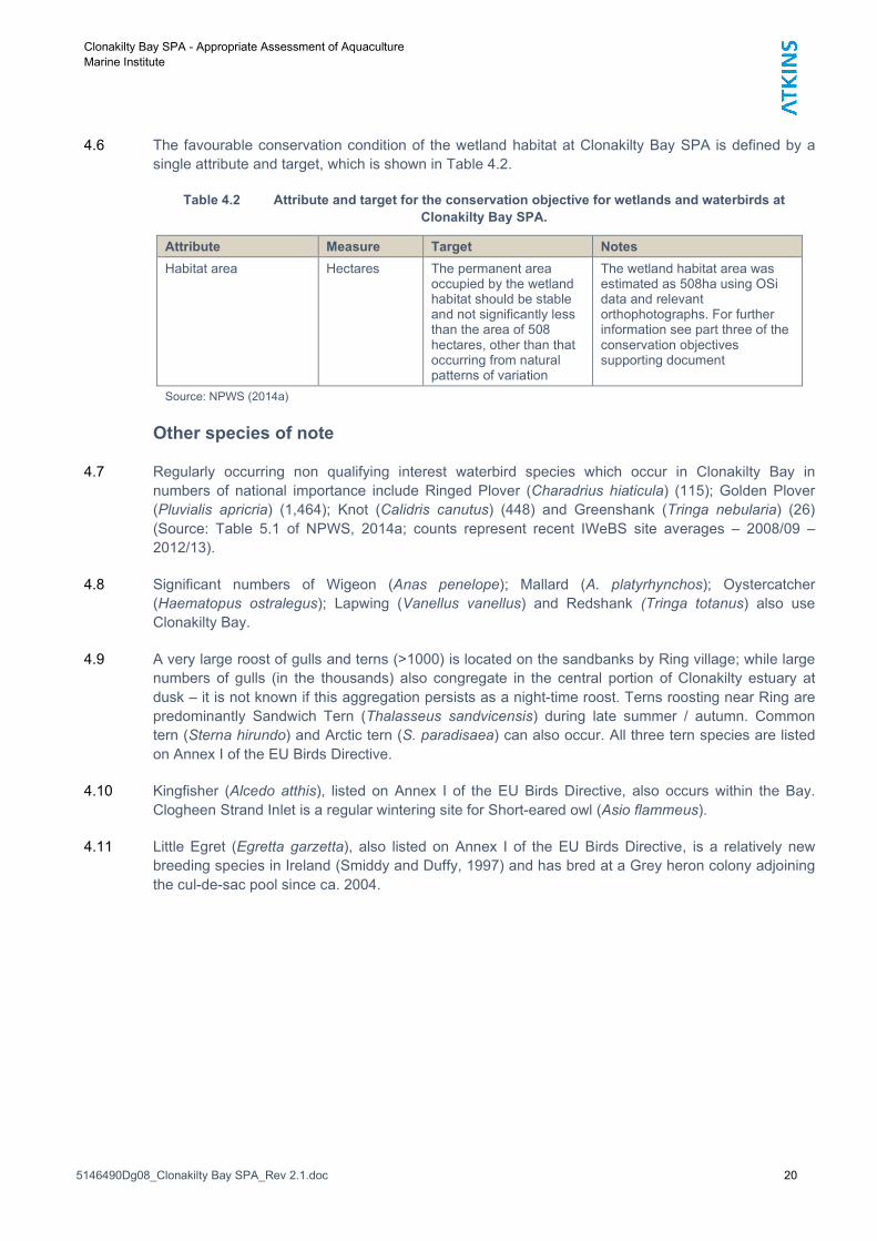
4.6 The favourable conservation condition of the wetland habitat at Clonakilty Bay SPA is defined by a
single attribute and target, which is shown in Table 4.2.
Table 4.2 Attribute and target for the conservation objective for wetlands and waterbirds at
Clonakilty Bay SPA.
Attribute Measure Target Notes
Habitat area Hectares The permanent area occupied by the wetland habitat should be stable and not significantly less than the area of 508 hectares, other than that occurring from natural patterns of variation
The wetland habitat area was estimated as 508ha using OSi data and relevant orthophotographs. For further information see part three of the conservation objectives supporting document
Source: NPWS (2014a)
Other species of note
4.7 Regularly occurring non qualifying interest waterbird species which occur in Clonakilty Bay in
numbers of national importance include Ringed Plover (Charadrius hiaticula) (115); Golden Plover
(Pluvialis apricria) (1,464); Knot (Calidris canutus) (448) and Greenshank (Tringa nebularia) (26)
(Source: Table 5.1 of NPWS, 2014a; counts represent recent IWeBS site averages – 2008/09 –
2012/13).
4.8 Significant numbers of Wigeon (Anas penelope); Mallard (A. platyrhynchos); Oystercatcher
(Haematopus ostralegus); Lapwing (Vanellus vanellus) and Redshank (Tringa totanus) also use
Clonakilty Bay.
4.9 A very large roost of gulls and terns (>1000) is located on the sandbanks by Ring village; while large
numbers of gulls (in the thousands) also congregate in the central portion of Clonakilty estuary at
dusk – it is not known if this aggregation persists as a night-time roost. Terns roosting near Ring are
predominantly Sandwich Tern (Thalasseus sandvicensis) during late summer / autumn. Common
tern (Sterna hirundo) and Arctic tern (S. paradisaea) can also occur. All three tern species are listed
on Annex I of the EU Birds Directive.
4.10 Kingfisher (Alcedo atthis), listed on Annex I of the EU Birds Directive, also occurs within the Bay.
Clogheen Strand Inlet is a regular wintering site for Short-eared owl (Asio flammeus).
4.11 Little Egret (Egretta garzetta), also listed on Annex I of the EU Birds Directive, is a relatively new
breeding species in Ireland (Smiddy and Duffy, 1997) and has bred at a Grey heron colony adjoining
the cul-de-sac pool since ca. 2004.

Clonakilty Bay SPA - Appropriate Assessment of Aquaculture
Marine Institute
5146490Dg08_Clonakilty Bay SPA_Rev 2.1.doc 21
Other sites
Courtmacsherry Bay SPA (004219)
Qualifying features
4.12 The Special Conservation Interests (SCIs) of Courtmacsherry Bay SPA (004219) include non-
breeding populations of Great Northern Diver, Shelduck, Wigeon, Red-breasted Merganser, Golden
Plover, Lapwing, Dunlin, Black-tailed Godwit, Bar-tailed Godwit, Curlew, Black-headed Gull and
Common Gull.
4.13 In addition, wetland habitats within Courtmacsherry Bay SPA are identified to be of conservation
importance for non-breeding (wintering) migratory waterbirds. Therefore, the wetland habitats are
considered to be an additional Special Conservation Interest (NPWS, 2014d & e).
Conservation objectives
SCI species
4.14 The conservation objectives for the non-breeding populations of Great Northern Diver, Shelduck,
Wigeon, Red-breasted Merganser, Golden Plover, Lapwing, Dunlin, Black-tailed Godwit, Bar-tailed
Godwit, Curlew, Black-headed Gull and Common Gull at Courtmacsherry Bay SPA are to maintain
their favourable conservation status (NPWS, 2014d & e).
4.15 The favourable conservation conditions of these species at Courtmacsherry Bay SPA are defined by
various attribute and targets, which are shown in Table 4.3.
Table 4.3 Attributes and targets for the conservation objectives for Great Northern Diver, Shelduck,
Wigeon, Red-breasted Merganser, Golden Plover, Lapwing, Dunlin, Black-tailed Godwit, Bar-tailed
Godwit, Curlew, Black-headed Gull and Common Gull at Courtmacsherry Bay SPA.
Attribute Measure Target Notes
1 Population trend
Percentage change
Long term population trend stable or increasing
Waterbird population trends are presented in part four of the Conservation Objectives Supporting Document
2 Distribution Range, timing and intensity of use of areas
There should be no significant decrease in the range, timing and intensity of use of areas used by the ‘SCI species’, other than that occurring from natural patterns of variation
Waterbird distribution from the 2010/11 waterbird survey programme is discussed in Part Five of the conservation objectives supporting document
Source: NPWS (2014d). Attributes are not numbered in NPWS (2014d), but are numbered here for convenience.
Wetlands and waterbirds
4.16 The conservation objective for wetlands and waterbirds at Courtmacsherry Bay SPA is to “maintain
the favourable conservation condition of the wetland habitat in Clonakilty Bay SPA as a resource for
the regularly occurring migratory waterbirds that utilise it” (NPWS, 2014d).
4.17 The favourable conservation condition of the wetland habitat at Courtmacsherry Bay SPA is defined
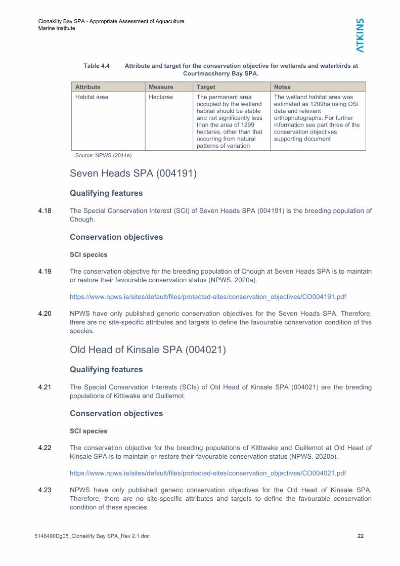
by a single attribute and target, which is shown in Table 4.4.
Clonakilty Bay SPA - Appropriate Assessment of Aquaculture
Marine Institute
5146490Dg08_Clonakilty Bay SPA_Rev 2.1.doc 22
Table 4.4 Attribute and target for the conservation objective for wetlands and waterbirds at
Courtmacsherry Bay SPA.
Attribute Measure Target Notes
Habitat area Hectares The permanent area occupied by the wetland habitat should be stable and not significantly less than the area of 1299 hectares, other than that occurring from natural patterns of variation
The wetland habitat area was estimated as 1299ha using OSi data and relevant orthophotographs. For further information see part three of the conservation objectives supporting document
Source: NPWS (2014e)
Seven Heads SPA (004191)
Qualifying features
4.18 The Special Conservation Interest (SCI) of Seven Heads SPA (004191) is the breeding population of
Chough.
Conservation objectives
SCI species
4.19 The conservation objective for the breeding population of Chough at Seven Heads SPA is to maintain
or restore their favourable conservation status (NPWS, 2020a).
https://www.npws.ie/sites/default/files/protected-sites/conservation_objectives/CO004191.pdf
4.20 NPWS have only published generic conservation objectives for the Seven Heads SPA. Therefore,
there are no site-specific attributes and targets to define the favourable conservation condition of this
species.
Old Head of Kinsale SPA (004021)
Qualifying features
4.21 The Special Conservation Interests (SCIs) of Old Head of Kinsale SPA (004021) are the breeding
populations of Kittiwake and Guillemot.
Conservation objectives
SCI species
4.22 The conservation objective for the breeding populations of Kittiwake and Guillemot at Old Head of
Kinsale SPA is to maintain or restore their favourable conservation status (NPWS, 2020b).
https://www.npws.ie/sites/default/files/protected-sites/conservation_objectives/CO004021.pdf
4.23 NPWS have only published generic conservation objectives for the Old Head of Kinsale SPA.
Therefore, there are no site-specific attributes and targets to define the favourable conservation
condition of these species.

Clonakilty Bay SPA - Appropriate Assessment of Aquaculture
Marine Institute
5146490Dg08_Clonakilty Bay SPA_Rev 2.1.doc 23
Galley Head to Duneen Point SPA (004190)
Qualifying features
4.24 The Special Conservation Interest (SCI) of Galley Head to Duneen Point SPA (004191) is the
breeding population of Chough.
Conservation objectives
SCI species
4.25 The conservation objective for the breeding population of Chough at Galley Head to Duneen Point
SPA is to maintain or restore their favourable conservation status (NPWS, 2020c).
https://www.npws.ie/sites/default/files/protected-sites/conservation_objectives/CO004190.pdf
4.26 NPWS have only published generic conservation objectives for the Galley Head to Duneen Point
SPA. Therefore, there are no site-specific attributes and targets to define the favourable conservation
condition of this species.
Sovereign Islands SPA (004124)
Qualifying features
4.27 The Special Conservation Interest (SCI) of Sovereign Islands SPA (004124) is the breeding
population of Cormorant.
Conservation objectives
SCI species
4.28 The conservation objective for the breeding population of Cormorant at Sovereign Islands SPA is to
maintain or restore their favourable conservation status (NPWS, 2020d).
https://www.npws.ie/sites/default/files/protected-sites/conservation_objectives/CO004124.pdf
4.29 NPWS have only published generic conservation objectives for the Sovereign Island SPA. Therefore,
there are no site-specific attributes and targets to define the favourable conservation condition of this
species.
Sheep’s Head to Toe Head SPA (004156)
Qualifying features
4.30 The Special Conservation Interests (SCIs) of Sheep’s Head to Toe Head SPA (004156) are the
breeding populations of Peregrine and Chough.

Clonakilty Bay SPA - Appropriate Assessment of Aquaculture
Marine Institute
5146490Dg08_Clonakilty Bay SPA_Rev 2.1.doc 24
Conservation objectives
SCI species
4.31 The conservation objective for the breeding populations of Peregrine and Chough at Sheep’s Head to
Toe Head SPA is to maintain or restore their favourable conservation status (NPWS, 2020e).
https://www.npws.ie/sites/default/files/protected-sites/conservation_objectives/CO004156.pdf
4.32 NPWS have only published generic conservation objectives for the Sheep’s Head to Toe Head SPA.
Therefore, there are no site-specific attributes and targets to define the favourable conservation
condition of these species.

Clonakilty Bay SPA - Appropriate Assessment of Aquaculture
Marine Institute
5146490Dg08_Clonakilty Bay SPA_Rev 2.1.doc 25
5. Status, habits and distribution of SCI species
Clonakilty Bay SPA
5.1 As noted, the qualifying interests of Clonakilty Bay SPA are: -
Shelduck (Tadorna tadorna) [A048]
Dunlin (Calidris alpina) [A149]
Black-tailed Godwit (Limosa limosa) [A156]
Curlew (Numenius arquata) [A160]
Wetland and Waterbirds [A999]
5.2 The conservation condition and trends of the non-breeding waterbird SCI species at Clonakilty Bay
Estuary SPA are summarised in Table 5.1 – 5.2. Table 5.2 also shows the relationship between a
species’ long-term site trend and the current national trend for the 12-year period 1998/99 to 2010/11
(as extracted from the NPWS Conservation Objectives Supporting document; NPWS, 2014a).
5.3 There are four categories of conservation condition, as follows: -
Favourable population = population is stable/increasing.
Intermediate (unfavourable) = Population decline in the range 1.0 – 24.9%.
Unfavourable population = populations that have declined between 25.0 – 49.9% from the
baseline reference value.
Highly Unfavourable population = populations that have declined > 50.0% from the baseline
reference value.
5.4 One species is currently considered as being of highly unfavourable condition (Shelduck); two
species are of unfavourable condition (Dunlin and Curlew); and one species is of favourable condition
(Black-tailed Godwit) (Table 5.2 & 5.3).

Clonakilty Bay SPA - Appropriate Assessment of Aquaculture
Marine Institute
5146490Dg08_Clonakilty Bay SPA_Rev 2.1.doc 26
Table 5.1 Population data of the SCI assessment species at Clonakilty Bay SPA.
Special Conservation
Interests (SCIs)
Baseline Period1
(1995/96 – 1998/99)
(4 year peak)
Recent Site Data2
2008/09 – 2012/13 (5 year peak)
Peak Numbers recorded in recent NPWS low tide surveys
(from NPWS, 2014a)
2011-12 2012-13 2013-14
Shelduck 156 (n) 77 46 85 60
Dunlin 1,172 (n) 882 (n) 1,390 1,030 1,050
Black-tailed Godwit 874 (i) 988 (i) 1,177 1,511 1,065
Curlew 599 (n) 366 (n) 480 235 450
Source: Tables 4.1 in NPWS (2014a)
1Baseline data is the 4-year mean peak for the period 1995/96 – 1998/99;
2recent site data is the mean peak for the 5-year period 2008/09 – 2012/13 (I-WeBS).
(i) denotes numbers of international importance; (n) denotes numbers of all-Ireland importance. Note that thresholds differ
for the baseline and recent time periods used; international thresholds are outlined in Wetlands International (2002) and
Wetlands International (2012), while all-Ireland thresholds are presented within Crowe et al. (2008) and Crowe & Holt
(2013) for the baseline and recent site data respectively.
Table 5.2 Clonakilty Bay 2010 / 2011 water bird numbers – summary data.
Special Conservation Interests
Peak Numbers – Low Tide 1 Peak number – High Tide 2 Peak Overall
Shelduck 97 56 97
Dunlin 1,006 (n) 1,081 (n) 1,081
Black-tailed Godwit 761 (i) 481 (n) 761
Curlew 399 (n) 545 (n) 545
(ii) Source: Table 5.4 in NPWS (2014a); Cummins and Crowe, 2011.
(iii) (i) denotes numbers of international importance (after Wetlands International, 2010); (n) denotes numbers of all-Ireland
importance (after Crowe and Holt, 2013).
(iv) 1 Four low tide counts – 09/10/10; 10/11/10; 09/12/10 & 08/02/11.
(v) 2 One high tide count – 16/01/11.
Table 5.3 Site population trends for qualifying interests of Clonakilty Bay SPA.
Special Conservation Interests (SCIs)
Site Conservation
Condition
Site population trend
Recent all-Ireland Trend
Current international
trend
Shelduck Highly Unfavourable
-51 Stable Stable
Dunlin Unfavourable -25 Declining Stable
Black-tailed Godwit Favourable +13 Increasing Increasing
Curlew Unfavourable -39 Declining Declining
Source: Table 4.2 & 4.3 in NPWS (2014a).
Site population trend – based on comparison of a four and five year mean (1995/96 – 1998/99 and 2008/09 – 2012/13).

Clonakilty Bay SPA - Appropriate Assessment of Aquaculture
Marine Institute
5146490Dg08_Clonakilty Bay SPA_Rev 2.1.doc 27
Table 5.4 Comparison with national population trends for qualifying interests of Clonakilty Bay SPA.
Special Conservation Interests (SCIs)
Site population trend
(NPWS, 2014a) 1
5 year All Ireland Trend 2
12 year All Ireland Trend 3
22 year All Ireland Trend 4
Shelduck -51 -9.9 -17.3 -23.0
Dunlin -25.0 -23.0 -41.7 -63.0
Black-tailed Godwit +13 +3.0 +29.8 +77.7
Curlew -39 -2.4 -21.1 -41.0
Source: Table 4.2 & 4.3 in NPWS (2014a).
1 Site population trend – based on comparison of a four and five year mean (1995/96 – 1998/99 and 2008/09 – 2012/13).
2 5 year: Percentage change between 2011/12 – 2015/16.
3 12 year: Percentage change between 2004/05 – 2015/16.
4 22 year: Percentage change between 1994/95 – 2015/16.
From Lewis et al., 2019.
Table 5.5 Recent IWeBS count data; 2013/14 to 2015/16 compared to 2008/09 – 2012/13 5 year peak.
Special Conservation Interests (SCIs)
2008/09 – 2012/13 (5 year peak)
2013/14 2014/15 2015/16 2016/17 2017/18 2014/15 – 2017/18 (5 year
mean)
Shelduck 77 108 86 95 72 133 99
Dunlin 882 (n) 880 552 651 673 808 713
Black-tailed Godwit
988 (i) 871 1551 1080 613 732 969
Curlew 366 (n) 325 430 299 354 400 362
5.5 Shelduck numbers seem to have stabilised in recent years; however, their site conservation status is
catergorised as Highly Unfavourable.
5.6 Black-tailed Godwit have a Favourable site status; recent counts shows evidence of continued
population growth (see Table 5.5).
5.7 IWeBS data (high tide counts) would suggest a decline in Dublin; however, the low tide NPWS
surveys during the same time window (see Table 5.1) indicate a greater degree of stability in the
period 2011/12 – 2013/14 (peak of 1,050 in 2013/14).
5.8 Due to their tendency to field feed Curlew can be missed during coastal IWeBS counts. A total of 430
were recorded in the 2014/15 IWeBS count; while NPWS recorded 450 in a low tide survey
undertaken in 2013/14. Both Dunlin and Curlew were, however, noted by NPWS (2014a) to have an
Unfavourable site conservation status.

Clonakilty Bay SPA - Appropriate Assessment of Aquaculture
Marine Institute
5146490Dg08_Clonakilty Bay SPA_Rev 2.1.doc 28
Waterbird habitats and distribution
Tidal zones & biotope mapping
5.9 Clonakilty Bay is designated for the marine habitat Mudflats and sandflats not covered by seawater at
low tide (Annex I of EU Habitats Directive).
5.10 The site was surveyed in 2011 (MERC, 2012); the results of which informed the identification of
benthic habitats with the SAC and overlapping SPA.
5.11 As noted, Clonakilty Bay SAC is designated for
Mudflats and sandflats not covered by seawater at low tide [1140]
Annual vegetation of drift lines [1210]
Embryonic shifting dunes [2110]
Shifting dunes along the shoreline with Ammophila arenaria (white dunes) [2120]
Fixed coastal dunes with herbaceous vegetation (grey dunes) [2130]
Atlantic decalcified fixed dunes (Calluno-Ulicetea) [2150]
5.12 The spatial extent of mudflats and sandflats (1140) is shown Figure 5.2; while the extent of Estuary
and Shallow Inlets are shown on Figures 5.1 and 5.3, respectively. The site also contains a number
of coastal lagoons; shown on Figure 5.4, while sand dune habitats for which the site has been
designated are shown on Figure 5.5 (see also NPWS, 2014b).
5.13 Within the bay a single community type is recorded – Sand to sandy mud with Tubificoides benedii
and Peringia ulvae community complex (Figure 5.6a / b) (the following descriptions are from NPWS,
2014f). This occurs on intertidal and shallow intertidal habitat (<2m within Clonakilty Bay). The
sediment includes a mix of sand to sandy mud; apart from an area of mixed sediment in the nearer
bay near Dysert.
5.14 The distinguishing species are the oligochaete Tubificoides benedii, the gastropod Peringia ulvae, the
amphipods Deshayesorchestia dehayesii and Talitrus saltator and the polychaetes Hediste
diversicolor, Scoloplos (Scoloplos) armiger and Pygospio elegans. A variant of this community is
found along the south of Inchydoney Island (from Ring Harbour to Muckruss Strand); the sediment
here is mainly of clean sand.
5.15 Significant mats of green algae can occur in the southwest of Clonakilty Bay and southwest of
Muckruss Strand; this has been the subject of a number of publications on the potential impact on
shorebirds (Lewis and Kelly, 2012; Lewis et al., 2014). As noted, improvements to the Clonakilty
WwTP have recently been implemented.
5.16 This community type overlaps with the annex I habitat Mudflats and sandflats not covered by
seawater at low tide [1140].
5.17 The MERC (2012) report provides further resolution on the distribution and type of habitats. The
majority of the site is defined as polychaete / amphipod dominated fine sands shores (LS.LSa.FiSa);
this dominates Muckruss Bay and the outer harbour east to Ring Channel. The inner muddier parts of
Muckruss Bay are characterised by polychaete / oligochaete dominated upper estuarine mud shores
(LS.LMu.UEst). These have a slightly lower species diversity than the muddier shores (see below).

Clonakilty Bay SPA - Appropriate Assessment of Aquaculture
Marine Institute
5146490Dg08_Clonakilty Bay SPA_Rev 2.1.doc 29
5.18 By contrast, north of Inchydoney Island is dominated by Polychaete/bivalve-dominated muddy sand
shores (LS.LSa.MuSa) along the eastern side of the bay and Polychaete/bivalve-dominated mid-
estuarine mud shores (LS.LMu.MEst). These sediments are both high in species diversity and
biomass (MERC, 2012).
5.19 Fringes of shingle habitat are located in places along the shoreline; i.e. shingle (pebble) and gravel
shores (LS.LCS.Sh). This habitat is located at / close to the proposed access points. Potential for
impacts is considered in the accompanying assessment of Clonakilty Bay SAC (see Figure 1.3; 3.1
and 5.6).
5.20 MERC (2012) found that Hydrobia ulvae, a favoured prey item of Shelduck, “was particularly
widespread and abundant at the majority of sheltered sites behind Inchydoney Island”. The
oligochaete Tubificoides benedii “was particularly abundant in the upper sections of the site, behind
Inchydoney Island in muddy and fine sand sediments”.

No Window
Ordnance Survey Ireland Licence No. AR 0082520© Ordnance Survey Ireland and Government of Ireland
Client:
Project:
Title:
Designed/Drawn: Checked: Authorised:
Date:Date:Date:
Drawing No: Rev:
Dublin - Tel: 353 - 1 - 890 9000Cork - Tel: 353 - 21 - 429 0300Galway - Tel: 353 - 91 786050
No Window
Marine Institute
Clonakilty Bay SPA - Aquaculture AA
1130 Estuaries - Distrubution
POD POD POD
17/06/20 17/06/20 17/06/20
Figure 5.1 0.0
1130 - Estuaries

No Window
Ordnance Survey Ireland Licence No. AR 0082520© Ordnance Survey Ireland and Government of Ireland
Client:
Project:
Title:
Designed/Drawn: Checked: Authorised:
Date:Date:Date:
Drawing No: Rev:
Dublin - Tel: 353 - 1 - 890 9000Cork - Tel: 353 - 21 - 429 0300Galway - Tel: 353 - 91 786050
No Window
Marine Institute
Clonakilty Bay SPA - Aquaculture AA
1140 - Mudflats & Sandflats
POD POD POD
17/06/20 17/06/20 17/06/20
Figure 5.2 0.0
1140 - Mudflats & Sandflats

No Window
Ordnance Survey Ireland Licence No. AR 0082520© Ordnance Survey Ireland and Government of Ireland
Client:
Project:
Title:
Designed/Drawn: Checked: Authorised:
Date:Date:Date:
Drawing No: Rev:
Dublin - Tel: 353 - 1 - 890 9000Cork - Tel: 353 - 21 - 429 0300Galway - Tel: 353 - 91 786050
No Window
Marine Institute
Clonakilty Bay SPA - Aquaculture AA
Large Shallow Inlet
POD POD POD
17/06/20 17/06/20 17/06/20
Figure 5.3 0.0
Large ShallowInlet

No Window
Ordnance Survey Ireland Licence No. AR 0082520© Ordnance Survey Ireland and Government of Ireland
Client:
Project:
Title:
Designed/Drawn: Checked: Authorised:
Date:Date:Date:
Drawing No: Rev:
Dublin - Tel: 353 - 1 - 890 9000Cork - Tel: 353 - 21 - 429 0300Galway - Tel: 353 - 91 786050
No Window
Marine Institute
Clonakily Bay SPA - Aquaculture AA
Coastal Lagoons
POD POD POD
17/06/20 17/06/20 17/06/20
Figure 5.4 0.0
Coastal lagoons
Clonakilty BaySPA

No Window
Ordnance Survey Ireland Licence No. AR 0082520© Ordnance Survey Ireland and Government of Ireland
Client:
Project:
Title:
Designed/Drawn: Checked: Authorised:
Date:Date:Date:
Drawing No: Rev:
Dublin - Tel: 353 - 1 - 890 9000Cork - Tel: 353 - 21 - 429 0300Galway - Tel: 353 - 91 786050
No Window
Marine Institute
Clonakily Bay SPA - Aquaculture AA
Sand Dune Habitats
POD POD POD
17/06/20 17/06/20 17/06/20
Figure 5.5 0.0
Sand Dune Habitats
2190- Humid slackdunes
2130 - * Fixed coastaldunes
2120 - Shifting dunes
2110 - Embryonicshifting dunes

No Window
Ordnance Survey Ireland Licence No. AR 0082520© Ordnance Survey Ireland and Government of Ireland
Client:
Project:
Title:
Designed/Drawn: Checked: Authorised:
Date:Date:Date:
Drawing No: Rev:
Dublin - Tel: 353 - 1 - 890 9000Cork - Tel: 353 - 21 - 429 0300Galway - Tel: 353 - 91 786050
No Window
Marine Institute
Clonakily Bay SPA - Aquaculture AA
Marine Communities
POD POD POD
17/06/20 17/06/20 17/06/20
Figure 5.6a 0.0
Marine Communities
Sand to sandy mud with Tubificoides benedii and Peringia ulvae community complex
Shingle

Clonakilty Bay SPA - Appropriate Assessment of Aquaculture
Marine Institute
5146490Dg08_Clonakilty Bay SPA_Rev 2.1.doc 36
Figure 5.6b Biotope map of Clonakilty Bay (copy of Figure 4.3 from MERC, 2012).

Clonakilty Bay SPA - Appropriate Assessment of Aquaculture
Marine Institute
5146490Dg08_Clonakilty Bay SPA_Rev 2.1.doc 37
Waterbird Survey Programme (2010/2011)
Waterbird habitats and distribution
Shelduck
5.21 With respect to total numbers the peak Shelduck count was 97 birds (08/02/2011); 56 during the
hight tide count on the 16/01/11. There were no counts of national or international importance.
5.22 Shelduck were recorded across 8 subsites during the waterbird survey programme (2010/11); these
were mainly in the north of Clonakilty Bay and in the western reaches of Muckruss Strand; i.e. 0L448,
0L450, 0L465, 0L500,0L503, 0L505, 0L506 and 0L509 (see Figure 2.2 for subsite boundaries). Peak
numbers were recorded in 0L500 (Causeway) on 10/11/10 and 09/02/2011; while 0L503 (Inchydoney
Strand) held peak numbers on 09/10/10 and 08/02/11.
5.23 0L505 (Youghals SE) was also of note; recording a subsite peak count of 45 on 08/02/11.
5.24 The aquaculture site overlaps with 0L506 and 0L507; no Shelduck were recorded during the
waterbird survey programme (2010/11) in 0L507.
5.25 Shelduck feed mainly on invertebrates; particularly molluscs, insects, and crustaceans and can also
take plant materials. They can feed in both the benthic and pelagic zones. However, in north and
west Europe, molluscans predominate in the diet, particularly Hydrobia ulvae8 (see also Buxton et al.,
1981; Viain et al., 2011); thought they do take a variety of small invertebrates. This species was
found to be particularly widespread and abundant at the majority of sheltered sites behind
Inchydoney Island (MERC, 2012). Much of the western side and inner Clonakilty Bay, behind
Inchydoney Island, is dominated by polychaete / bivalve dominated mid-estuarine shores
(LS.LMu.MEst); this coincides with areas favoured by Shelduck. NPWS (2014a) noted that P. ulvae
generally occurs in low abundance but is locally abundant in the southwest shores of both Clonakilty
Harbour and Muckruss Strand (i.e. subsites 0L500, 0L503 and 0L505).
5.26 The boundary between 0L506 and 0L507 represents a transition from an area of polychaete / bivalve
dominated mid-estuarine shores (LS.LMu.MEst) in 0L506 which supports Shelduck; to polychaete /
bivalve dominated muddy sand shores (LS.LSa.MuSa) where Shelduck were not recorded. The
infauna of LS.LSa.MuSa is characterised by the amphipods Bathyporeia pilosa, Corophium
arenarium and C. volutator, and the spire shell Hydrobia ulvae. However, MERC (2012) noted the
presence of the oligochaete Tubificoides beneddii, an indicator of stressed habitat (i.e. eutrophic tidal
flats and polluted coastal areas often characterised by high levels of hydrogen sulphide. They also
recorded abundant algal mats (Ulva) in this area.
5.27 Foraging Shelduck were recorded from 7 no. subsites (see Figure 2.2): - 0L448, 0L450, 0L465,
0L500, 0L503, 0L505 and 0L509. Thus, foraging Shelduck were not recorded from either 0L506 and
0L507 within which the aquaculture plot is located. Access, however, would be from close to the cul-
de-sac pool within 0L503 (see Figure 3.1). 0L500, 0L503 and 0L505 are favoured foraging areas
indicating a strong association with P. ulvae distribution.
5.28 The largest record of roosting birds was of 82 in 0L503 (Inchydoney Island)
8 Now Peringia (Hydrobia) ulvae.
Clonakilty Bay SPA - Appropriate Assessment of Aquaculture
Marine Institute
5146490Dg08_Clonakilty Bay SPA_Rev 2.1.doc 38
5.29 NPWS undertook further low tide surveys in 2011/12, 2012/13 and 2013/14. Peak numbers of
foraging birds were recorded in 0L503 and 0L505 (2011/12); 0L503 (2012/13) and 0L505 (2013/14),
showing strong consistency with the waterbird survey programme (2010/11) results.
Dunlin
5.30 Dunlin were recorded in 13 subsites: – 0L447,0L448, 0L449, 0L450, 0L462, 0L465, 0L500, 0L502,
0L503, 0L505, 0L506, 0L507 and 0L509 (foraging at 12 subsites). Peak numbers during low tide
counts were recorded in 0L506 (Ring Quay), 0L465 (West Muckruss Strand) and 0L503 (Inchydoney
Island; on two occasions). 0L447, 0L465, 0L503 and 0L507 held Dunlin on all four low tide counts.
The aquaculture site overlaps with 0L506 and 0L507.
5.31 The peak low tide count was 376 in 0L503 on 08/02/2011; a higher peak high tide count of 605
Dunlin was recorded in 0L465 on 16/01/11.
5.32 NPWS undertook further low tide surveys in 2011/12, 2012/13 and 2013/14. Peak numbers of Dunlin
recorded were 1,390 (2011/12), 1,030 (2012/13) and 1,050 (2013/14). Peak numbers were recorded
within 0L447, 0L500 and 0L506 (2011-12); 0L465, 0L500 and 0L505 (2012-13) and 0L448, 0L465
and 0L505 (2013-14).
Black-tailed Godwit
5.33 While Black-tailed Godwits were recorded across 15 subsites during the NPWS counts, they were
recorded at six subsites across all four low tide counts (see Figure 5.2): namely 0L447 Deasy’s Quay;
0L449 (Desert South); 0L450 (Youghals House); 0L465 (Muckruss Strand); 0L500 (Causeway) and
0L507 (Ring Harbour). The licence application is located within 0L506 & 0L507. The flock maps
included in the Conservation Objective supporting documentation supports this picture of Black-tailed
godwits being widely distributed in Clonakilty Harbour; with Ring Harbour notable amongst these.
5.34 Sites which held peak numbers were 0L502 (Clogheen Strand Intake) in October; 0L500 (Causeway)
in November and December and 0L506 (Ring Quay) in February. 0L506 (Ring Quay) also held the
peak subsite count during the high tide count in January 2011 (i.e. 250 birds).
5.35 Recent low tide counts carried out by NPWS recorded peak counts of 1,177 (2011/12), 1,511
(2012/13) and 1,065 (2013/14) (see Table 5.1).
5.36 When considering foraging birds, while Black-tailed Godwits were recorded across 12 subsites during
the NPWS counts (see Figure 5.2) only 0L447 Deasy’s Quay and 0L465 (Muckruss Strand) held
foraging birds on all four low tide counts. Peak counts of foraging birds were held by 0L509 (Desert
Church), 0L500 (Causeway), 0L500 and 0L506 (Ring Quay), respectively – again highlighting the
relative importance of the Ring area for Black-tailed Godwit. Terrestrial foraging was also noted at
fields adjoining Ring Harbour.
5.37 A previous long term study (2000/01 – 2010/11) of Clonakilty Estuary (excluding Inchydoney Estuary)
also found Black-tailed Godwit to be widely distributed, with peak counts occurring across a range of
subsites; though the importance of the inner bay – from 0L447 to 0L503 was noted.
Curlew
5.38 During the low tide surveys, Curlew were widespread across Clonakilty Harbour, being recorded from
15 subsites overall. Peak numbers were record in 0L506 (Ring Quay), 0L500 (Causeway), 0L500 and
0L503 (Inchydoney Island) during the four low tide counts. Of note, 0L507, within which the
aquaculture site is located, recorded numbers ranked in the top three on two survey occasions,
highlighting its importance to Curlew.
Clonakilty Bay SPA - Appropriate Assessment of Aquaculture
Marine Institute
5146490Dg08_Clonakilty Bay SPA_Rev 2.1.doc 39
5.39 Terrestrial foraging was noted in fields adjoining both 0L506 (Ring Quay) and 0L507 (Ring Harbour).
Field feeding outside the SPA boundaries is a regular occurrence at Clonakilty.
5.40 Recent low tide surveys undertaken by NPWS Regional staff recorded peak numbers of 480
(2011/12), 235 (2012/13) and 450 (2013/14). Peak numbers were recorded feeding in the following
areas: -
0L449, 0L465 & 0L507 in 2011/12;
0L449, 0L500 & 0L506 in 2012/13; and
0L503, 0L506 & 0L507 in 2013/14.
5.41 The subsites adjoining Ring (0L506 & 0L507) are again identified as important to Curlew, along with
adjoining fields.
5.42 A previous long term study (2000/01 – 2010/11) of Clonakilty Estuary (excluding Inchydoney Estuary)
also found Curlew to be widely distributed, with peak counts occurring across a range of subsites
including 0L449, 0L450, 0L503 and most frequently 0L506; though the importance of the inner bay –
was noted, with the highest density of Curlew noted from here.
Roosts
5.43 During the course of the NPWS low tide survey work roost locations were mapped during targeted
high tide surveys undertaken on the 3rd November 2010 and the 16th February 2011. These findings
are summarised below; though as noted previously care must be taken in interpreting patterns based
on a limited number of samples which are now ca. 10 years old.
Shelduck
5.44 No Shelduck were recorded roosting during low tide surveys in 2010/11. Birds were not recorded
roosting in 0L506 (Ring Quay) or 0L507 (Ring Harbour) during the roost surveys (see Figure 3.1 for
location of aquaculture site).
Dunlin
5.45 Relatively few Dunlin were recorded roosting during low tide surveys. During the November 2010
roost survey birds were recorded roosting in 0L447 (3 groups of 2, 26 and 28 mainly roosting
terrestrially) and 0L462; the latter being the largest and holding 281 birds (roosting on a sandbank the
remained exposed). During the February 2011 roost survey birds were recorded roosting in four
subsite: 0L447, 0L451, 0L507 and 0L508; 15 Dunlin were noted roosting on intertidal sand in 0L507.
Black-tailed Godwit
5.46 During the high tide survey, a total of 294 Black-tailed godwits were roosting intertidally – 85% of
these birds were within 0L506 (Ring Quay).
5.47 The November 2010 roost survey recorded five roosting flocks in 3 subsites – 0L500, 0L506 and
0L507; with the largest flock of 310 birds on sand in the southeast of 0L506. There were a further 22
birds roosting in 0L507.
5.48 The February 2011 roost survey recorded four flocks of roosting birds in 0L501, 0L502 and 0L507.
Largest numbers were again recorded in Ring – two flocks of 70 birds on intertidal sands and 145
birds terrestrially on Inchydoney Island.

Clonakilty Bay SPA - Appropriate Assessment of Aquaculture
Marine Institute
5146490Dg08_Clonakilty Bay SPA_Rev 2.1.doc 40
Curlew
5.49 The NPWS low tide survey recorded good numbers of Curlew roosting intertidally – peak numbers
were recorded in 0L506 (Ring Quay) and 0L507 (Ring Harbour) (09/10/10 & 10/11/10, respectively);
0L448 held peak numbers in 08/02/11.
5.50 During the high tide survey 385 Curlew were recorded to be roosting intertidally; 96% of these were
roosting within 0L506 (Ring Quay), with smaller numbers in 0L500 and 0L507 (Ring Harbour). Thus,
on this occasion nearly all Curlew counted were within 0L506 (Ring Quay) or 0L507 (Ring Harbour)
within which the aquaculture licence site is located (see Figure 3.1).
5.51 The November 2010 roost count recorded roosting birds across six subsites: 0L451, 0L462, 0L501,
0L502, 0L506 and 0L507. The largest flock (31 birds) was in 0L502 (Clogheen Strand Intake). Flocks
of <12 birds were recorded in 0L506 (Ring Quay) or 0L507 (Ring Harbour).
5.52 The February 2011 roost count recorded roosting birds across four subsites: 0L501, 0L502, 0L506
and 0L507. The largest flock (71 birds) was in 0L502 (Clogheen Strand Intake). 17 Curlew roosted in
a field adjoining 0L506 (Ring Quay) (outside the SPA boundary).
Other species
5.53 As noted, a very large roost of gulls and terns (>1000) is located on the sandbanks by Ring village;
while large numbers of gulls (in the thousands) also congregate in the central portion of Clonakilty
estuary at dusk – it is not known if this aggregation persists as a night-time roost (see Figure 5.7 for
locations). Terns roosting near Ring are predominantly Sandwich Tern (Thalasseus sandvicensis)
during late summer / autumn. Common tern (Sterna hirundo) and Arctic tern (S. paradisaea) can also
occur. All three tern species are listed on Annex I of the EU Birds Directive. The nearest nesting
colony of Sandwich tern is at Lady’s Island SPA (004009); as recently as 2016 Lady’s Island
supported 1,682 nesting pairs of Sandwich tern.
5.54 Burke et al. (2020) reported on the first three years of monitoring of post-breeding tern aggregations
in Ireland. A peak count of 51 Sandwich tern were recorded in Clonakilty Bay. Burke et al. (2020)
noted that walker and dogs as a key source of disturbance to roosting terns (a trend noted for waders
also; see Lewis et al., 2019). Furthermore, Burke et al. (2020) stressed the importance of protected
post-breeding / autumnal tern roosting sites when balancing commercial and recreational uses.

No Window
Ordnance Survey Ireland Licence No. AR 0082520© Ordnance Survey Ireland and Government of Ireland
Client:
Project:
Title:
Designed/Drawn: Checked: Authorised:
Date:Date:Date:
Drawing No: Rev:
Dublin - Tel: 353 - 1 - 890 9000Cork - Tel: 353 - 21 - 429 0300Galway - Tel: 353 - 91 786050
No Window
Marine Institute
Clonakily Bay SPA - Aquaculture AA
Gull & Tern Roost
POD POD POD
17/06/20 17/06/20 17/06/20
Figure 5.7 0.0
Tern & Gull Roosts
Central gull roost
Ring Gull & tern roost
Clonakilty Bay SPA

Clonakilty Bay SPA - Appropriate Assessment of Aquaculture
Marine Institute
5146490Dg08_Clonakilty Bay SPA_Rev 2.1.doc 42
6. Assessment of Potential Impacts
6.1 There is a single application to cultivate pacific oyster (Crassostrea gigas) at a site close to Ring
on the eastern side of Clonakilty Bay SPA, T05/603A.
Habitats
6.2 The site is located within IWEBS count sector 0L431 (see Figure 5.1). This is a large site running
from Ring northwards to Deasy’s Quay at Clonakilty (equivalent to Clonakilty Harbour). Due to its
size it was subsequently further subdivided into a number of IWEBS subsites, with the licence
application area remaining within 0L431 Clonakilty Harbour (amended).
6.3 T05/603A covers an area of 22.57ha of Clonakilty Harbour; this area is equivalent to IWEBS count
subsite 0L431 and covers 197.3ha or 11.44% of Clonakilty Harbour.
6.4 With respect to the NPWS low tide surveys (Figure 5.2), licence application T05/603A is located
within 0L506 (Ring Quay) and 0L507 (Ring Harbour). As we were unable to source a digital map
of the NPWS low-tide boundaries these were drawn up from published maps (NPWS, 2014a).
0L506 (Ring Quay) is approximately 50.97ha in area, while 0L507 (Ring Harbour) is
approximately 38.74ha in area; a combined area 89.71ha located in outer Clonakilty Harbour (i.e.
45.5% of Clonakilty Harbour / 17.7% of Clonakilty Bay SPA).
6.5 The aquaculture licence application site occupies ca. 16.6ha of 0L506 (32.6% of the subsite) and
ca. 6ha of 0L507 (15.4% of the subsite). In all the proposed licence occupies ca. 25.2% of the
combined area of Outer Clonakilty Bay (in the environs of Ring) – as represented by NPWS low
tide count sectors 0L506 and 0L507. As noted above, both of these areas are repeatedly
highlighted as being important for species for which Clonakilty Bay SPA has been designated.
6.6 The relative proportion of intertidal to subtidal habitat was also examined – with areas mapped
initially from OSi Discovery Series mapping. However, more recent aerial images on GoogleEarth
(2013) and Bing Maps (2020) indicated movement in the location and size of subtidal channels.
Subtidal channels were therefore remapped from aerial imagery hosted on Bing Maps (dated
2020) (see Figure 6.1 and 6.2).

Clonakilty Bay SPA - Appropriate Assessment of Aquaculture
Marine Institute
5146490Dg08_Clonakilty Bay SPA_Rev 2.1.doc 43
Figure 6.1 Aerial image from Bing Maps, 2020 showing tidal channels in 0L506 (left) and
0L507 (right).
6.7 The extent of subtidal / shallow subtidal habitat (channels) is 10.0ha in 0L506 (19.7% of the
subsite) and 11.25ha in 0L507 (29% of the subsite). The area in 0L506 represents an increase of
over 6ha from that shown in the OSi Discovery Series map; however, many of this is made up of
recently formed shallow braided channels. The total area of subtidal channel equates to
approximately 23.8% of available habitat within 0L506 and 0L507. As noted the total area of
subtidal habitat in Clonakilty Bay SPA is ca. 67ha (NPWS, 2014a); thus, Outer Clonakilty Bay
(0L506 and 0L507) represents ca. 31.86% of subtidal habitat within Clonakilty Bay SPA [Note: it
should, however, be noted that the increase in subtidal channels noted in Figure 6.1 may be such that the
overall area of subtidal habitat within the SPA has also increased; this would reduce the percentage
represented by 0L506 and 0L507 to a small degree].
6.8 However, Apart from one area of shallow channel which is most probably available to intertidally
feeding waders due to its shallow depth, there is little overlap between the proposed aquaculture
plot and the distribution of subtidal / shallow subtidal habitat (see Figure 6.1 & 6.2). Furthermore,
no species of diving duck, grebe, diver or Cormorant who require subtidal areas are qualifying
interests of Clonakilty Bay SPA.
6.9 The extent of intertidal habitat is 40.9ha in 0L506 (80.3% of the subsite) and 27.5ha in 0L507
(71% of the subsite). The total area of intertidal habitat within subsites 0L506 and 0L507 equates
to approximately 76.2% of available habitat in these subsites (combined). As noted, within
Clonakilty Bay SPA, NPWS (2014a) recorded 325ha of intertidal habitat. The intertidal habitat
located within subsites 0L506 and 0L507 therefore equates to ca. 21% of intertidal habitat within
Clonakilty Bay SPA as a whole. Its loss would therefore represent a significant loss of this habitat
within the SPA; one of whose qualifying interests is Wetland and Waterbirds [A999].
6.10 NPWS site specific conservation objectives (NPWS, 2014) for Wetlands and Waterbirds is “To
maintain the favourable conservation condition of the wetland habitat in Clonakilty Bay SPA as a
resource for the regularly occurring migratory waterbirds that utilise it”. This is defined by the
following attribute and target: Habitats – with the target being “The permanent area occupied by
the wetland habitat should be stable and not significantly less than the area of 508 hectares, other

Clonakilty Bay SPA - Appropriate Assessment of Aquaculture
Marine Institute
5146490Dg08_Clonakilty Bay SPA_Rev 2.1.doc 44
than that occurring from natural patterns of variation” (NPWS, 2014). While the proposed
cultivation of oysters does not represent a permanent loss of habitat, it does nonetheless
represent a significant area / percentage of habitat not being available to species, for which the
SPA has been designated, for the duration of operation of the licence.
6.11 NPWS biotope mapping (from Clonakilty Bay SAC Conservation Objectives supporting
documents – marine; NPWS, 2014f ) record a single community type – Sand to sandy mud with
Tubificoides benedii and Peringia ulvae community complex (see Figure 5.6a). This occurs on
intertidal and shallow intertidal habitat (<2m within Clonakilty Bay). Development of the proposed
aquaculture plot would remove access to up to 22.57ha of this habitat type. Habitats were further
resolved by MERC (2012); this found that north of Inchydoney Island is dominated by
Polychaete/bivalve-dominated muddy sand shores (LS.LSa.MuSa) and Polychaete/bivalve-
dominated mid-estuarine mud shores (LS.LMu.MEst). (see Figure 5.6b). These sediments are
both high in species diversity and biomass (MERC, 2012) and therefore provide good quality
habitat for intertidal waders and wildfowl (see pg’s. 5.9-5.20). For a detailed review of potential
impacts to habitats refer to the accompanying Appropriate Assessment of impacts to Clonakilty
Bay SAC (000091).
6.12 As noted, field feeding species, such as Curlew, also feed on agricultural grassland outside the
SPA, such as in fields east of Ring. Use of such fields will not be negatively impacted by operation
of the proposed licence.
Access
6.13 Access is proposed from 3 no. locations as shown on Figure 3.1. One is from the public road and
along the shoreline from close to the Cul-de-Sac pool (see Figure 3.1). The egret / grey heron
colony is sufficiently distant and screened from this location that negative impacts through
disturbance to the Annex I species Little egret are not anticipated.
6.14 Access by foot and / or vehicles along the shoreline would, however, increase the level of
disturbance to birds foraging in the southwestern corner of Clonakilty Harbour.
6.15 The remaining two access point are by boat from quays in Ring on the eastern side of the
Harbour. As noted, there are not subtidal species for which the SPA has been designated.
Roosts
6.16 As discussed above the environs of Ring is noted to be of importance to roosting gulls and terns
(see paragraphs 5.53 – 5.54). During consultation two areas were noted. One is to the west of
0L506, with the second located within 0L507. Details as to the spatial extent and relative
distribution of roosting gulls and terns is not available. The potential for displacement of birds by
activities associated with the proposed trestles cannot be discounted at this time. As noted,
Sandwich Tern (listed on Annex I of the Birds Directive) is known to use this area as a post
breeding / autumnal roost. This behaviour amongst terns in Ireland is currently under investigation
by BirdWatch Ireland (Burke et al., 2020).
6.17 During the October 2010 NPWS counts Sandwich tern were noted roosting at two locations; 27
birds on Muckruss Strand and 19 within 0L507 northwest of Ring Quay. On a separate count in
August 2017 44 birds were recorded at Muckruss Estuary / Inchydoney (Gittings, 2017).
6.18 The NPWS low tide survey in 2010/2011 also found evidence to indicate that 0L506 and 0L507
are notable sites for roosting waders. This discussed in detail between 5.43 and 5.52.

Clonakilty Bay SPA - Appropriate Assessment of Aquaculture
Marine Institute
5146490Dg08_Clonakilty Bay SPA_Rev 2.1.doc 45
6.19 Shelduck were not recorded roosting in 0L506 and 0L507 during the NPWS 2010/2011 surveys.
Dunlin have been recorded roosting in 0L507, but not in large numbers.
6.20 Of particular note was the occurrence 385 Curlew roosting intertidally during a high tide count in
the winter of 2010/11, with 96% of these roosting within 0L506 (Ring Quay); suggesting that this
area is of significance to Curlew for roosting.
6.21 Similarly, during the high tide survey a total of 294 Black-tailed godwits were roosting intertidally –
85% of these birds were again within 0L506 (Ring Quay). During the November 2010 roost survey
310 Black-tailed Godwit were recorded roosting on sand in the southeast of 0L506. In February
2011 the largest numbers of Black-tailed Godwit were again recorded in Ring – two flocks of 70
birds on intertidal sands and 145 birds terrestrially on Inchydoney Island. Note that the estuary in
this area is also located close to fields used by field feeding Curlew.
Intertidal Species
6.22 Count data for qualifying interests from low tide and high tide counts undertaken in the winter of
2010/11 for count Clonakilty Bay are shown in Table 6.1. Count data from subsites 0L506 and
0L507 are presented in Table 6.2 and 6.3; with combined data shown in Table 6.4. The count data
expressed as a percentage of the same count for the entirety if Clonakilty Bay is shown in Table
6.5.
Table 6.1 Counts of qualifying interests in Clonakilty Bay SPA during NPWS 2010/11 Counts.
Species LT1 LT2 LT3 LT4 HT
Black-tailed Godwit 104 761 662 695 481
Curlew 298 205 100 399 545
Shelduck 12 15 13 97 56
Dunlin 153 572 733 1006 1081
Note: -
LT – Low Tide; HT – High Tide.
LT1 – 9/10/11; LT2 – 12/11/10; LT3 – 09/12/10; LT4 – 08/02/11 and HT – 16/01/11.
Table 6.2 Counts of qualifying interests in 0L506 during NPWS 2010/11 Counts.
Species LT1 LT2 LT3 LT4 HT
Black-tailed Godwit 0 13 5 110 250
Curlew 21 67 6 34 381
Shelduck 0 0 0 0 44
Dunlin 45 0 38 100 0
Note: -
LT – Low Tide; HT – High Tide.
LT1 – 9/10/11; LT2 – 12/11/10; LT3 – 09/12/10; LT4 – 08/02/11 and HT – 16/01/11.

Clonakilty Bay SPA - Appropriate Assessment of Aquaculture
Marine Institute
5146490Dg08_Clonakilty Bay SPA_Rev 2.1.doc 46
Table 6.3 Counts of qualifying interests in 0L507 during NPWS 2010/11 Counts.
Species LT1 LT2 LT3 LT4 HT
Black-tailed Godwit 2 93 2 96 0
Curlew 114 23 8 44 33
Shelduck 0 0 0 0 0
Dunlin 3 3 10 1 0
Note: -
LT – Low Tide; HT – High Tide.
LT1 – 9/10/11; LT2 – 12/11/10; LT3 – 09/12/10; LT4 – 08/02/11 and HT – 16/01/11.
Table 6.4 Counts of qualifying interests in both 0L506 & 0L507 during NPWS 2010/11 Counts.
Species LT1 LT2 LT3 LT4 HT
Black-tailed Godwit 2 106 7 206 250
Curlew 135 90 14 78 414
Shelduck 0 0 0 0 44
Dunlin 48 3 48 101 0
Table 6.5 Birds in 0L506 & 0L507 as a percentage of the Clonakilty Bay counts.
Species LT1 LT2 LT3 LT4 HT
Black-tailed Godwit 1.92% 13.93% 1.06% 29.64% 51.98%
Curlew 45.30% 43.90% 14.00% 19.55% 75.96%
Shelduck 0 0 0 0 78.57%
Dunlin 31.37% 0.52% 6.55% 10.04% 0.00%
6.23 The percentage occurrence of the qualifying interest in 0L506 & 0L507 can be summarised as
follows: -
Black-tailed Godwit: 1.06% - 29.64% at low tide; 51.98% at high tide;
Curlew: 14.00% - 45.3%% at low tide; 75.96% at high tide;
Shelduck: 0% at low tide; 78.57% at high tide; and
Dunlin: 0.52% - 31.37% at low tide; 51.98% at high tide.
6.24 Thus, at low tide, on average, 0L506 and 0L507 combined support 11.6% of Black-tailed Godwit;
30.7% of Curlew and 12.12% of Dunlin that are utilising Clonakilty Bay.
6.25 As noted, the intertidal habitat located within subsites 0L506 and 0L507 represents 21% of
intertidal habitat within Clonakilty Bay SPA as a whole. However, the area of intertidal habitat
within the licence application area equates to 76.2% of available intertidal habitat within these
subsites.
6.26 Table 6.6 presents the results of two targeted roost counts in November 2010 and February 2011.
It includes birds roosting in intertidal, supratidal and terrestrial habitats.

Clonakilty Bay SPA - Appropriate Assessment of Aquaculture
Marine Institute
5146490Dg08_Clonakilty Bay SPA_Rev 2.1.doc 47
Table 6.6 Results of targets roost counts in November 2010 and February 2011.
Species 03.11.10 16.02.11
0L506 0L507 0L506 0L507
Black-tailed Godwit 310 1 65 215
Curlew 2 108 23 74
Shelduck 5
Dunlin 337 15
Note: -
1 Same 310 birds were noted in 0L506 and later in 0L507. Birds were roosting intertidally. Recorded under 0L506.
Black-tailed Godwit
6.27 The oyster study found that the response of Black-tailed Godwit to trestles was negative (Gittings
and O’Donoghue, 2012; 2016a). However, given the limited data available at the time we consider
that the overall response of Black-tailed Godwit to oyster trestles should be classified as negative,
with a low degree of confidence. For the purposes of this assessment predictions of the impact of
oyster trestle blocks should therefore assume complete exclusion of these species from the
affected area, although this may be a conservative assumption.
6.28 The peak numbers of Black-tailed Godwit recorded was at high tide in January 2011 (250 birds);
this represented 52% of birds recorded in Clonakilty Bay at this time. The peak low tide count was
206 birds; 29.64% of birds in in Clonakilty Bay at this time. Assuming development of T05/603A
birds could be displaced from 76.2% of available intertidal habitat at low tide; this would represent
ca. 22.6% displacement.
6.29 As noted, the average number of birds using 0L506 and 0L507 (combined) was 11.64%. A worst
case scenario of complete exclusion could result in displacement of up to 8.85% of the Black-
tailed Godwit population of Clonakilty Bay.
6.30 The peak numbers recorded during a targeted roost count was 375 birds in November, including a
flock of 310 godwit recorded along the border of 0L506 and 0L507 roosting intertidally.
6.31 The population trend for Black-tailed Godwit at Clonakilty Bay SPA is Favourable (positive).
Curlew
6.32 Curlew showed a neutral response in most of the analyses of the impact of oyster trestles on
waterbirds; though at Ballymacoda Bay they showed consistently negative responses to trestles.
There was no obvious reason for the differences between sites, if these were real. In particular,
Curlews do not frequently occur on trestles, so variation between sites in the condition of the
trestles should not affect their response. Therefore, given the robust evidence of a neutral
response from the intensive study (Gittings and O’Donoghue, 2012; 2016a), we consider that the
overall response of Curlews to oyster trestles should be classified as neutral, but with only a
moderate degree of confidence.
6.33 The peak numbers of Curlew recorded was at high tide was 381 birds in 0L506 in January 2011;
414 birds across both subsites which represented 76% of birds recorded in Clonakilty Bay at this
time. The peak low tide count was 135 birds; 45.3% of birds in in Clonakilty Bay at this time.
Assuming development of T05/603A birds could be displaced from 76.2% of available intertidal
habitat at low tide; this would represent ca. 34.5% displacement.

Clonakilty Bay SPA - Appropriate Assessment of Aquaculture
Marine Institute
5146490Dg08_Clonakilty Bay SPA_Rev 2.1.doc 48
6.34 As noted, the average number of birds using 0L506 and 0L507 (combined) was 30.7%. A worst
case scenario of complete exclusion could result in displacement of up to 23.4% of the Curlew
population of Clonakilty Bay.
6.35 The peak numbers recorded during a targeted roost count was 108 birds in 0L506 in November.
6.36 The population trend for Curlew at Clonakilty Bay SPA is Unfavourable. This therefore represents
a significant negative impact. The age of the data derived as it is from 2010 / 2011 must however
be noted.
Shelduck
6.37 The subsites, 0L506 and 0L507 does not appear to support significant numbers of Shelduck at
low tide, with none recorded in 0L506 or 0L507 during any of the low tide counts suggesting they
are not actively foraging in this area. As noted, however, this data is from 2010/11, so its age must
be borne in mind.
6.38 During the January high tide count 44 birds were recorded in 0L506. While not a large count it did
represent 78.6% of Shelduck using Clonakilty Bay at the time. Activities at the proposed trestles
would largely be around low tide, though access at higher water levels by boat (eastern access
points) or along the shore (from the cul-de-sac pool access) may cause disturbance to birds
roosting. The conservation status of Shelduck in Clonakilty is Highly Unfavourable; declining
numbers of Shelduck are also evident in other sites along the south coast, such as Cork Harbour
SPA (004030).
Dunlin
6.39 The oyster study found that the response of Dunlin to trestles was negative (Gittings and
O’Donoghue, 2012; 2016a).
6.40 Dunlin were not recorded in 0L506 or 0L507 during the January 2011 high tide survey. The peak
low tide count was 101 birds (100 birds in 0L506 in February 2011); 10% of birds in in Clonakilty
Bay at this time. Assuming development of T05/603A birds could be displaced from 76.2% of
available intertidal habitat at low tide; this would represent ca. 7.62% displacement. However, the
LT1 count noted that 31.37% of Dunlin within the bay occurred in these two count sectors (i.e. 48
of 153 birds) – this represented a potential displacement of 23.9% of birds in Clonakilty Bay at this
time.
6.41 As noted, the average number of birds using 0L506 and 0L507 (combined) was 12.1%. A worst
case scenario of complete exclusion could result in displacement of up to 9.22% of the Curlew
population of Clonakilty Bay. While a higher percentage of Dunlin occurred in 0L506 & 0L507
(34.4%) in October 2010, this represented 48 birds from a total of 153 – at a time when Dunlin
numbers were beginning to build up.
6.42 The peak numbers recorded during a targeted roost count was 337 birds in 0L507 in November
2010.
6.43 The population trend for Dunlin at Clonakilty Bay SPA is Unfavourable. This therefore represents
a significant negative impact. The age of the data derived as it is from 2010 / 2011 must however
be noted.

No Window
Ordnance Survey Ireland Licence No. AR 0082520© Ordnance Survey Ireland and Government of Ireland
Client:
Project:
Title:
Designed/Drawn: Checked: Authorised:
Date:Date:Date:
Drawing No: Rev:
Dublin - Tel: 353 - 1 - 890 9000Cork - Tel: 353 - 21 - 429 0300Galway - Tel: 353 - 91 786050
No Window
Marine Institute
Clonakilty Bay SPA - Aquaculture AA
Subtidal Channels
POD POD POD
17/06/20 17/06/20 17/06/20
Figure 6.2 0.0
No Window
Subtidal Channels
Access
Licence Application
In 0L507
In 0L506
Shore Access Route
Boat Access Points
T05/603A - Oysters
Low Tide Subsites

Clonakilty Bay SPA - Appropriate Assessment of Aquaculture
Marine Institute
5146490Dg08_Clonakilty Bay SPA_Rev 2.1.doc 50
7. Cumulative Impacts
7.1 At site level, the concept of ‘favourable status’, the overriding objective of the Habitats Directive, is
referred to as ‘conservation condition’. Conservation condition does not only relate to species
numbers, but also to factors that influence species abundance and distribution at a site. Identifying
activities and events that occur at a designated site is therefore important, as is the assessment of
their potential impact upon the waterbird species and their habitats, thus influencing the
achievement of favourable condition. Site-based management and control of factors that impact
on species or habitats of conservation concern are fundamental to the achievement of site
conservation objectives.
7.2 Information regarding activities, plans and projects across Clonakilty Bay SPA was collated
through a desktop review including NPWS site reports (NPWS 2014b), County Development
Plans, Local Area Plans and Town Council Plans (Cork County Council 2014, 2017, 2009; town
councils were abolished in 2014 but their plans remain in effect until the next County Development
Plan is published in 2020).
http://corkcocodevplan.com/wp-content/uploads/2017/10/CCDP_Volume_3.pdf
http://corklocalareaplans.com/wp-content/uploads/2017/08/West-Cork-Environmental-Report-MD-
LAP.pdf
https://corkcocoplans.ie/wp-content/uploads/bsk-pdf-manager/2016/07/Clonakilty-T.C-Vol-1-2009-
2015.pdf
Fishing
7.3 Fishing boats are docked at Ring Pier (subsite 0L507) and some small-scale fishing occurs in the
outer estuarine subsites (e.g. 0L507, 0L508) but most boats make their way out through the
narrow estuary opening and proceed to fishing areas further offshore (NPWS, 2014a).
7.4 Shore angling is a common activity at the site, at both Clonakilty and Inchydoney estuaries, and at
Ring Harbour, Inchydoney beach and Muckruss Head. Some small-scale bait-digging occurs
around Ring Estuary targeting lugworm and crabs and at Clonakilty Harbour targeting lugworm
and sandeel.
7.5 Hand collection of shellfish is not a common activity in Clonakilty Bay.
Beach recreation
7.6 A popular hotel is located on Inchydoney Island overlooking two beaches (0L451 and 0L508)
which are separated by Virgin Mary’s Point. As a popular holiday destination, the beaches are
extensively used for recreational purposes throughout the year. Inchydoney beach has held Blue
Flag status since 1991.
7.7 With high accessibility due to roads and pavements bounding many parts of the estuarine areas of
the site, walking, often with dogs, is a regular occurrence around the site but rarely within the
estuary itself due its muddy substrate. A road train brings tourists around the coast on public
roads year-round (NPWS, 2014b).
7.8 Horse riding on the western beach at Inchydoney (0L451) is a common occurrence.
Clonakilty Bay SPA - Appropriate Assessment of Aquaculture
Marine Institute
5146490Dg08_Clonakilty Bay SPA_Rev 2.1.doc 51
Water-based recreation
7.9 Inchydoney beach is often favoured for surfing as water can be unsafe for swimming due to rip-
tides (NPWS, 2014b). A surf school is based on the beach, often hosting large groups of children
and adults. Other watersports in the vicinity are mainly carried either in Courtmacsherry Bay or
Rosscarbery. There are no sailing or boating clubs within the bay.
Hunting and shooting
7.10 Wildfowling has been recorded previously at the site, such as shooting for Snipe in Island Strand
Intake, although this is not a regular occurrence. This activity was not observed during the
2010/11 Waterbird Survey Programme (NPWS, 2014b).
Livestock
7.11 Goats and ponies are often grazed along the shoreline of West Muckruss Strand (0L465) and
partly graze saltmarsh habitat. As part of a habitat management programme managed by the
NPWS, horses graze clogheen Marsh and White’s Marsh (NPWS, 2014b).
Water treatment
7.12 For many years Clonakilty WWTP was operating above capacity, failing to meet minimum quality
standards. In 2015, a new WWTP was made operational, employing new technology to achieve a
more environmentally sustainable treatment solution. The new treatment plant has a population
equivalent of >10,000 and operates a secondary treatment process. There is a primary treatment
sewage treatment plant in Ring, which discharges untreated effluent into the bay.
7.13 EPA Transitional Water Quality monitoring recorded Clonakilty harbour as eutrophic in the 2010-
2012 reporting, while it was classed as moderate in the 2010-2015 Water Framework Directive
reporting. Coastal Water Quality monitoring (2010 – 2012) recorded Clonakilty Bay as of
intermediate quality, while 2010 – 2015 WFD monitoring recorded it as moderate.
7.14 Algal mats are present at this site annually (see below) and in years where excessive growth
occurs, macroalgal material washes up onto the beaches at Inchydoney (subsites 0L451 and
0L508) where it causes considerable nuisance and odour pollution. Cork County Council has
obtained permission to remove the mass of macroalgae (which otherwise remains piled up, and
rots down gradually) (NPWS, 2014a).
7.15 A reduction in organic and nutrient loading to an estuary may have various consequences for the
ecology of the estuarine system. For example, there could be a reduction in the abundance of
benthic invertebrate prey species (e.g. Burton et al. 2002) particularly those invertebrates that
thrive (proliferate) in organically-enriched sediments. This could therefore have subsequent
knock-on effects upon waterbird foraging distribution, prey intake rates, and ultimately upon
survival and fitness. (NPWS, 2014b ; https://www.bto.org/sites/default/files/publications/rr696.pdf).

Clonakilty Bay SPA - Appropriate Assessment of Aquaculture
Marine Institute
5146490Dg08_Clonakilty Bay SPA_Rev 2.1.doc 52
8. Conclusion & Recommendations
Conclusions
8.1 The extent of intertidal habitat is 40.9ha in 0L506 (80.3% of the subsite) and 27.5ha in 0L507
(71% of the subsite). The total area of intertidal habitat within subsites 0L506 and 0L507 equates
to approximately 76.2% of available habitat in these subsites (combined). As noted, within
Clonakilty Bay SPA, NPWS (2014a) recorded 325ha of intertidal habitat. The intertidal habitat
located within subsites 0L506 and 0L507 therefore equates to ca. 21% of intertidal habitat within
Clonakilty Bay SPA as a whole. Its loss would therefore represent a significant loss of this habitat
within the SPA; one of whose qualifying interests is Wetland and Waterbirds [A999].
8.2 NPWS biotope mapping (from Clonakilty Bay SAC Conservation Objectives supporting
documents – marine; NPWS, 2014f ) record a single community type – Sand to sandy mud with
Tubificoides benedii and Peringia ulvae community complex (see Figure 5.6a). This occurs on
intertidal and shallow intertidal habitat (<2m within Clonakilty Bay). MERC (2012) found that north
of Inchydoney Island is dominated by Polychaete/bivalve-dominated muddy sand shores
(LS.LSa.MuSa) and Polychaete/bivalve-dominated mid-estuarine mud shores (LS.LMu.MEst).
(see Figure 5.6b). These sediments are both high in species diversity and biomass (MERC, 2012)
and therefore provide good quality habitat for intertidal waders and wildfowl.
8.3 The percentage occurrence of the qualifying interest in 0L506 & 0L507 can be summarised as
follows: -
Black-tailed Godwit: 1.06% - 29.64% at low tide; 51.98% at high tide;
Curlew: 14.00% - 45.3%% at low tide; 75.96% at high tide;
Shelduck: 0% at low tide; 78.57% at high tide; and
Dunlin: 0.52% - 31.37% at low tide; 51.98% at high tide.
8.4 With respect to potential for displacement (based on NPWS low tide data from 2010/11) based on
loss of access to intertidal areas within 0L506 & 0L507 within the licence plot: -
Black-tailed godwit - The peak low tide count was 206 birds; 29.64% of birds in in Clonakilty
Bay at this time. Assuming development of T05/603A birds could be displaced from 76.2% of
available intertidal habitat at low tide; this would represent ca. 22.6% displacement (average
displacement - 8.85%);
Curlew - The peak low tide count was 135 birds; 45.3% of birds in in Clonakilty Bay at this
time. Assuming development of T05/603A birds could be displaced from 76.2% of available
intertidal habitat at low tide; this would represent ca. 34.5% displacement (average
displacement - 23.4%)
Shelduck – no birds were recorded at low tide. During the January high tide count 44 birds
were recorded in 0L506. While not a large count it did represent 78.6% of Shelduck using
Clonakilty Bay at the time.
Dunlin - The peak low tide count was 101 birds (100 birds in 0L506 in February 2011); 10%
of birds in in Clonakilty Bay at this time (1001 birds). Assuming development of T05/603A

Clonakilty Bay SPA - Appropriate Assessment of Aquaculture
Marine Institute
5146490Dg08_Clonakilty Bay SPA_Rev 2.1.doc 53
birds could be displaced from 76.2% of available intertidal habitat at low tide; this would
represent ca. 7.62% displacement. However, the LT1 count noted that 31.37% of Dunlin
within the bay occurred in these two count sectors (i.e. 48 of 153 birds) – this represented a
potential displacement of 23.9% of birds in Clonakilty Bay at this time (average displacement
of 9.23%).
8.5 Result from the targeted roost counts recorded significant numbers of both Black-tailed Godwit
and Dunlin in November 2010; 375 both Black-tailed Godwit in November 2010 (including a flock
of 310 godwit recorded along the border of 0L506 and 0L507 roosting intertidally) and a flock of
337 Dunlin in 0L507. These both represent significant numbers.
8.6 As noted, a significant tern / gull roost also occurs within Clonakilty Harbour. There is insufficient
data available on the numbers, species and location of these roosts to discount the potential for
negative impacts. As noted, this includes post-breeding Sandwich Tern, a species listed on Annex
I of the EU Habitats Directive.
8.7 In conclusion, based on the potential levels of displacement identified above the potential for
negative impacts on bird species for which Clonakilty Bay SPA has been designated cannot be
discounted. In conclusion, based on the potential levels of displacement identified above the
potential for negative impacts on bird’s species for which Clonakilty Bay SPA has been
designated cannot be discounted. Given the large risk of displacement there is no obvious
mitigation measures that would be helpful.
Recommendations
8.8 While a diverse range of data has been used to ensure a robust assessment is undertaken, the
main low tide data was collected in 2010 / 2011. We would recommend that up to date low tide
data be collected in order to better understand the current spatial distribution relative to 0L506 &
0L507 as well as within T05/603A.
8.9 While, not qualifying interests of Clonakilty Bay SPA, one area of uncertainty relates to the post-
breeding / autumn tern roost as well as the areas used by roosting gulls to discount the potential
for negative impacts. Note that Sandwich tern roosting at the site most likely originate from the
tern colony at Lady’s Island Lake SPA (004009).

Clonakilty Bay SPA - Appropriate Assessment of Aquaculture
Marine Institute
5146490Dg08_Clonakilty Bay SPA_Rev 2.1.doc 54
9. References BIM (n.a.). Co-ordinated Local Aquaculture Management Systems. Explanatory Handbook.
Published by Bord Iascaigh Mhara.
BIM (2014). SEA / AA for Aquaculture in Ireland. Published by Bord Iascaigh Mhara.
BIM (n.a.). Clonakilty Harbour SPA. Aquaculture Profile. Published by Bord Iascaigh Mhara [incorporated in Chapter 3.0 of this report].
BWPi (2004). Birds of the Western Palearctic Interactive. BirdGuides Ltd.
[Cramp, S., & Simmons, K. E. L. (2004). Birds of the Western Palearctic interactive (DVD-ROM). Sheffield: BirdGuides Ltd.]
Burke, B., Fitzgerald, N., Boland, H., Murray, T., Gittings, T. and Tierney, D. (2020). Results from the first three years of monitoring post-breeding tern aggregations in Ireland. Irish Birds 42: 35-44.
Caldow, R. W. G., Beadman, H. A., McGrorty, S., Kaiser, M. J., Goss-Custard, J. D., Mould, K., & Wilson, A. (2003). Effects of intertidal mussel cultivation on bird assemblages. Marine Ecology Progress Series, 259, 173–183.
Cabot, D. and Nisbet, I. (2013). Terns. The New Naturalist Library. Harper Collins.
Colhoun, K. & Cummins, S. (2013). Birds of Conservation Concern in Ireland 2014–2019. Irish Birds 9: 523-544.
Crowe, O. (2005). Ireland’s Wetlands and their Waterbirds: Status and Distribution. BirdWatch Ireland, Newcastle, Co. Wicklow.
Crowe, O., Austin, G, E., Colhoun, K., Cranswick, P., Kershaw, M. & Musgrove, A. J. (2008) Estimates and trends of waterbird numbers wintering in Ireland, 1994/95-2003/04. Bird Study 55, 66-7.
Crowe, O. and Holt, C. (2013). Estimates of waterbird numbers wintering in Ireland 2006/07 – 2010/11. Irish Birds 9, 545-552.
Cummins, S. and Crowe, O. (2011). Collection of baseline waterbird data for Irish coastal Special Protection Areas 2010/ 2011. Report prepared by BirdWatch Ireland for national Parks and Wildlife Service.
Daly, D., Murphy, B. and Murray, T. (2016). Lady’s Island Lake Tern Report, 2016. Department of Arts, Heritage and the Gaeltacht.
Gill, J., Norris, K. & Sutherland, W.J. (2001a). Why behavioural responses may not reflect the population consequences of human disturbance. Biological Conservation, 97, 265–268.
Gill, J.A., Norris, K. & Sutherland, W.J. (2001b). The effects of disturbance on habitat use by black-tailed godwits Limosa limosa. Journal of Applied Ecology, 38, 846–856.
Gittings, T. & O’Donoghue, P. D. (2012). The effects of intertidal oyster culture on the spatial distribution of waterbirds. Unpublished report prepared for the Marine Institute. Atkins, Cork.
Gittings, T. & O’Donoghue, P. D. (2016). The effects of intertidal oyster culture on the spatial distribution of waterbirds. Wader Study 123(3).
Gittings, T. (2017). Co. Cork Sandwich Tern Roost Count. Unpublished Note, August 2017.
Hale, W.G. (1974). Aerial counting of waders. Ibis, 116, 412.
Lewis, L.J. and Kelly, T.C. (2012a) Aspects of the spatial ecology of waders along an estuarine gradient. Irish Birds 9, 375-384.
Lewis, L. J and Kelly, T.C. (2012b). A short-term study of the effects of algal mats on the distribution and behavioural ecology of estuarine birds. Bird Study 48, 3, 354-360.

Clonakilty Bay SPA - Appropriate Assessment of Aquaculture
Marine Institute
5146490Dg08_Clonakilty Bay SPA_Rev 2.1.doc 55
Lewis, L.J., Kelly, T.C. and Davenport, J. (2014). Black-tailed Godwits Limosa limosa islandica and Redshanks Tringa totanus respond to macroalgal mats in their foraging areas. Wader Study Group Bull. 121(2), 21-29.
Lewis, L. J. & Tierney, T. D. (2014). Low tide waterbird surveys: survey methods and guidance notes. Irish Wildlife Manuals, No. 80. National Parks and Wildlife Service, Department of Arts, Heritage and the Gaeltacht, Ireland.
Lewis, L. J., Burke, B., Fitzgerald, N., Tierney, T. D. & Kelly, S. (2019) Irish Wetland Bird Survey: Waterbird Status and Distribution 2009/10-2015/16. Irish Wildlife Manuals, No. 106. National Parks and Wildlife Service, Department of Culture, Heritage and the Gaeltacht, Ireland.
Limosa (2006). Ecology. Chapter 7.0 In White Young Green (2006). Clonakilty Wastewater Treatment Plant Upgrade. Environmental Impact Statement.
MERC (2012). Intertidal Benthic Survey of Clonakilty Bay SAC and Clonakilty Bay SPA. Carried out by MERC on behalf of the Marine Institute in partnership with National Parks and Wildlife Service, Department of Environment, Heritage and Local Government.
NPWS (2011a). Waterbird surveys within Irish coastal Special Protection Areas. Survey methods and guidance notes. Unpublished Report. National Parks & Wildlife Service June 2011.
NPWS (2013). Clonakilty Bay SAC (000091). Site Synopsis (2013 - 000091_Rev13.Doc).
NPWS (2014a). Clonakilty Bay SPA (Site Code 4081). Conservation Objective Supporting Document.
NPWS (2014b). Conservation Objectives: Clonakilty Bay SAC 000091. Version 1. National Parks and Wildlife Service, Department of Arts, Heritage and the Gaeltacht.
NPWS (2014c). Clonakilty Bay SPA (Site Code 4081). Conservation Objectives. Supporting Documentation. National Parks and Wildlife Service.
NPWS (2014d). Conservation Objectives: Courtmacsherry Bay SPA 004219. Version 1. National Parks and Wildlife Service, Department of Arts, Heritage and the Gaeltacht.
NPWS (2014e). Conservation Objectives: Courtmacsherry Bay SPA 004219. Supporting Documentation. National Parks and Wildlife Service.
NPWS (2014f). Clonakilty Bay SAC. Conservation objectives supporting documentation – marine habitats. Version 1.0. April 2014.
NPWS (2020a). Conservation objectives for Seven Heads SPA [004191]. Generic Version 7.0. Department of Culture, Heritage and the Gaeltacht
NPWS (2020b). Conservation objectives for Old Head of Kinsale SPA [004021]. Generic Version 7.0. Department of Culture, Heritage and the Gaeltacht.
NPWS (2020c). Conservation objectives for Galley Head to Duneen Point SPA [004190]. Generic Version 7.0. Department of Culture, Heritage and the Gaeltacht.
NPWS (2020d) Conservation objectives for Sovereign Islands SPA [004124]. Generic Version 7.0. Department of Culture, Heritage and the Gaeltacht.
NPWS (2020e). Conservation objectives for Sheep's Head to Toe Head SPA [004156]. Generic Version 7.0. Department of Culture, Heritage and the Gaeltacht.
Prater, A.J. (1979). Trends in accuracy of counting birds. Bird Study 26, 198–200.
Rappoldt, C., Kersten, M. & Smit, C. (1985). Errors in large-scale shorebird counts. Ardea 73, 13–24.
Roycroft, D, Kelly, T. C., & Lewis, L. J. (2004). Birds, seals and the suspension culture of mussels in Bantry Bay, a non-seaduck area in Southwest Ireland. Estuarine, Coastal and Shelf Science 61(4), 703–712.
Roycroft, Daphne, Kelly, T. C., & Lewis, L. J. (2007). Behavioural interactions of seabirds with suspended mussel longlines. Aquaculture International 15(1), 25–36.
Scheiffarth, G., Ens, B., & Schmidt, A. (2007). What will happen to birds when Pacific oysters take over the mussel beds in the Wadden Sea? Wadden Sea Newsletter 1, 10–14.

Clonakilty Bay SPA - Appropriate Assessment of Aquaculture
Marine Institute
5146490Dg08_Clonakilty Bay SPA_Rev 2.1.doc 56
Smiddy, P. and Duff, B. (1997). Little Egret Egretta garzetta: a new breeding bird for Ireland. Irish Birds 6: 55-56.
Stillman, R.A. & Goss-Custard, J.D. (2010). Individual-based ecology of coastal birds. Biological Reviews 85, 413–434.
van de Kam, J., B. Ens, T. Piersma & L. Zwarts, 1999. Ecologische atlas van de Nederlandse wadvogels. Schuyt & Co Uitgevers en Impoteurs BV, Haarlem. (Quoted by Scheiffarth et al., 2007).
Wetlands International (2012). Waterbird Population Estimates, Fifth Edition. Summary Report. Wetlands International, Wageningen, The Netherlands.
Wehrmann, A. (2009). Management der bioinvasion der Pazifischen Auster (Crassostrea gigas). Wilhelmshaven: Unpublished report, Forschungsinstitut Senckenberg.

Atkins is one of the world's leading providers of professional, technology based consultancy services. With over 18,000 staff worldwide, Atkins has expanded in recent years from its historical base in traditional engineering into related technological consultancy services. In Ireland, Atkins can deliver the full range of services to clients in both the public and private sector.
Our clients are varied and include governments, local and regional authorities, funding agencies and commercial and industrial enterprises. We help our clients to realise their objectives by developing and delivering practical solutions, adding value to their businesses through the application of our experience, innovative thinking and state-of-the-art technology.Atkins in Ireland is an integral part of WS Atkins plc and has offices in Dublin, Cork and Galway. In addition, it is able to draw on the expertise of other Atkins divisions in the UK to provide appropriate staff on a project by project basis.
Atkins in Ireland provides a wide range of engineering, architectural, technical support and management services in the following key areas:-
Architecture & Design Engineering Roads (Highways & Bridges) Environment & Landscape Transportation & Planning Services Rail Water Cost Management and Quantity Surveying
Atkins Unit 2B2200 Cork Airport Business ParkCorkTelephone +353 21 4290300Fax +353 21 4290360
Atkins House150 Airside Business ParkSwordsCo DublinTel: +353 1 810 8000Fax: +353 1 810 8001
2nd FloorTechnology HouseParkmore Technology ParkGalwayTelephone +353 91 786050Fax +353 91 779830
www.atkinsireland.ieemail: [email protected]