Collaboration-Autonomy-Collaboration? A history of school improvement in the UK
Upload
khangminh22Category
view
3download
0
�����������������
Citation: Song, J.; Kook, J. Mapping
Server Collaboration Architecture
Design with OpenVSLAM for Mobile
Devices. Appl. Sci. 2022, 12, 3653.
https://doi.org/10.3390/app12073653
Academic Editor: Cheonshik Kim
Received: 11 March 2022
Accepted: 2 April 2022
Published: 5 April 2022
Publisher’s Note: MDPI stays neutral
with regard to jurisdictional claims in
published maps and institutional affil-
iations.
Copyright: © 2022 by the authors.
Licensee MDPI, Basel, Switzerland.
This article is an open access article
distributed under the terms and
conditions of the Creative Commons
Attribution (CC BY) license (https://
creativecommons.org/licenses/by/
4.0/).
applied sciences
Article
Mapping Server Collaboration Architecture Design withOpenVSLAM for Mobile DevicesJooeun Song 1 and Joongjin Kook 2,*
1 Department of Electronics Information System Engineering, Sangmyung University, 31 Sangmyungdae-gil,Dongnam-gu, Cheonan-si 31066, Chungcheongnam-do, Korea; [email protected]
2 Department of Information Security Engineering, Sangmyung University, 31 Sangmyungdae-gil,Dongnam-gu, Cheonan-si 31066, Chungcheongnam-do, Korea
* Correspondence: [email protected]
Abstract: SLAM technology, which is used for spatial recognition in autonomous driving androbotics, has recently emerged as an important technology to provide high-quality AR contents onmobile devices due to the spread of XR and metaverse technologies. In this paper, we designed,implemented, and verified the SLAM system that can be used on mobile devices. Mobile SLAM iscomposed of a stand-alone type that directly performs SLAM operation on a mobile device and amapping server type that additionally configures a mapping server based on FastAPI to performSLAM operation on the server and transmits data for map visualization to a mobile device. Themobile SLAM system proposed in this paper mixes the two types in order to make SLAM operationand map generation more efficient. The stand-alone type of SLAM system was configured as anAndroid app by porting the OpenVSLAM library to the Unity engine, and the map generation andperformance were evaluated on desktop PCs and mobile devices. The mobile SLAM system in thispaper is an open-source project, so it is expected to help develop AR contents based on SLAM in amobile environment.
Keywords: mobile SLAM; mobile AR; markerless AR; SLAM; visual SLAM
1. Introduction
Simultaneous localization and mapping (SLAM) technology belongs to the informationcommunication technology (ICT) application field, and it is a technology in which a mobiledevice creates an environment map and calculates a location within the environmentusing the generated map at the same time. The field of SLAM is growing remarkablydue to advances in computer vision and robotics, and there are various types, such asextended Kalman filter (EKF) SLAM [1], rapid SLAM [2], and graph-based SLAM [3,4].Among the various SLAM technologies, visual SLAM based on machine learning andcomputer vision, which uses camera image data to track feature points in images and createmaps, is considered to be the next-generation technology that supports industries such asautomobiles, drones, and mixed reality. In particular, thanks to the spread of remote andnon-contact culture caused by COVID-19, augmented reality (AR) and virtual reality (VR)application technologies, such as digital twins, are attracting attention. In addition, as thedemand for indoor applications where maps do not exist and the demand for drones inmilitary and commercial applications increase, the need for SLAM technology developmentis also growing.
A SLAM technology that uses various sensors that can replace markers to searchfor information, estimate one’s location in an arbitrary space, and generate a spatial maphas emerged [5]. The markerless AR system recognizes an object by detecting featurepoints of an object or image without prior knowledge of the environment, such as a wallor intersection, and, through this, 3D contents can be placed at a specific location. Themarkerless AR technology not only improves the accuracy of image analysis with the
Appl. Sci. 2022, 12, 3653. https://doi.org/10.3390/app12073653 https://www.mdpi.com/journal/applsci

Appl. Sci. 2022, 12, 3653 2 of 17
development of SLAM technology, which is a simultaneous localization and mappingtechnology, but also detects the surroundings and synchronizes the current location of thetargets through various sensor data [6]. In AR applications, the real-time camera pose andthe distance between the camera and the object are more important, and the accuracy ofSLAM system mapping and global positioning is relatively low [7].
Creating a map of SLAM requires solutions to problems such as localization. Map-ping and path planning are required, and robust path planning depends on successfullocalization and mapping. Both problems can be overcome with SLAM techniques. Sincesequential sensor information is required for SLAM, eliminating these sensor noises iscrucial for the next measurement and prediction [8]. Visual SLAM requires camera-basedvisual SLAM technology or SLAM technology using initial measurement unit (IMU) sen-sors or LiDAR sensors because UAVs used in indoor spaces cannot be positioned usingGPS [9].
SLAM systems can be divided into direct SLAM, which uses every pixel of the cameraframe, and indirect SLAM, which uses a series of key frames and feature points. DirectSLAM has a slow processing speed, but it is possible to model the surrounding environmentclosely and has excellent performance, even in a featureless environment. On the otherhand, indirect SLAM a has fast processing speed because it estimates the camera locationusing certain pixels in the image and creates a 3D map [10].
In the field of AR, ORB-SLAM [11–13] and OpenVSLAM [14], which are indirect SLAMsystems that can be mainly used for robots or autonomous driving, are used. However,since these SLAM libraries are mainly developed for robots related to autonomous driving,although they are open-source software, they are rarely used for the purpose of realizingAR in mobile devices or augmented reality headsets. It is especially difficult to find openSLAM libraries for mobile devices. Therefore, AR contents for mobile devices are mostlydeveloped using solutions provided with software development kits (SDK) by companiessuch as Google’s ARCore, Apple’s ARKit, and Maxst’s SensorFusionSLAM.
In this paper, we propose a design method for an AR system that can be used inmobile devices or augmented reality headsets through a markerless-based SLAM algorithm.For the implementation of the mobile SLAM system, OpenVSLAM, which can save and loadthe generated maps among various open-source SLAMs and provides web visualizationfunctions, was chosen. In consideration of real-time performance and scalability, the stand-alone type, which independently performs SLAM on a mobile device, and the mappingserver type, which receives the result of SLAM from the server and processes only thevisualization for the purpose of not adding to the SLAM operation overhead on the mobiledevice, were designed at the same time. Through the dualization of SLAM performance,users can continuously track their location along with a map generated in advance for theindoor/outdoor environment they are looking at and are able to build a service that canprovide AR contents based on a more accurate location. To enable the development ofvisual-slam-based AR applications in a mobile environment, Unity, which is widely usedas a visualization engine for Android apps, was applied to evaluate the performance of theslam system.
To verify the function and the performance of the mobile SLAM system proposed inthis paper, comparisons between the stand-alone type and mapping server type were madeon desktops and mobile devices using the EuRoC datasets, and the abilities for each typeto generate maps in real environments were evaluated.
The remainder of this paper is organized as follows. In the following section, we describethe related works on various SLAM methods. In Section 3, the OpenVSLAM-based mobileSLAM system structure and main functions are described. In Section 4, we evaluate the resultsof map creation and visualization and localization accuracy using real mobile devices. Finally,we provide our conclusions in Section 5.

Appl. Sci. 2022, 12, 3653 3 of 17
2. Related Works
The SLAM system proposed in this paper is a markerless-based system. The stand-alonetype generates a map by directly performing SLAM operation on the mobile device, and themapping server type performs SLAM operation and transmits the information for visualizationto the mobile device by transmitting the camera image to the FastAPI-based server.
2.1. Markerless-Based AR
In the early AR systems, markers were used to connect the real world and the virtualworld. The marker-based AR system recognizes a marker from an image input by a cameraand represents it by overlaying 2D or 3D contents related to the marker on an image outputto a display device. Simple patterns, such as QR codes or logos, are mainly used for theshape of the marker, and when the marker is recognized, the location or direction of themarker is also calculated, allowing digital 3D contents to be placed in an augmented realityapplication. However, the marker-based AR requires a prior appointment for a marker,and it has technical limitations, such as making tracking impossible when the cameraleaves the marker. In the marker-based AR system, the three steps of marker recognition,reasoning, and representation can be configured as shown in [15]. On the other hand, themarkerless-based AR system provides contents by recognizing a specific object or spaceinstead of a pre-arranged marker, so it requires that the marker recognition, reasoning, andrepresentation must be made on the mobile devices themselves, unlike the marker-basedAR system.
In order to overcome the limitations of marker-based AR technology, a SLAM tech-nology has emerged that uses various sensors that can replace markers to search forinformation, estimate one’s location in an arbitrary space, and generate a spatial map. Themarkerless AR system recognizes an object by detecting feature points of an object or imagewithout prior knowledge of the environment, such as a wall or intersection, and, throughthis, 3D contents can be placed at a specific location. The markerless AR technology notonly improves the accuracy of image analysis with the development of SLAM technology,which is a simultaneous localization and mapping technology, but also detects the sur-roundings and synchronizes the current location of the targets through various sensor data.Representative SLAM-based markerless AR development tools include Google’s ARCore,Apple’s ARKit and RealityKit2, and PTC’s Vuforia.
Google’s ARCore provides SDKs that support multiple platforms, including mobileplatforms, such as Android and iOS, to build an AR system, allowing mobile devices todetect their surroundings and interact with information about their surroundings. ARCoreuses three main functions to integrate virtual contents with the real world viewed througha mobile device’s camera: motion tracking, environmental understanding, and lightingestimation. Basically, ARCore performs two tasks: it tracks the location of moving mobiledevices and builds its own environment. ARCore’s tracking technology uses a mobiledevice’s camera to identify specific points and track how those points move over time,combining image data and IMU data from the mobile device to track its location anddirection as the mobile device moves through space. In addition to identifying featurepoints, flat surfaces can be detected, and the average illumination of the surroundingarea can also be estimated, making it possible to build map data for the surroundingenvironment on its own. These functions allow you to build a totally new AR system orimprove existing applications [16].
Apple’s ARKit is a software framework for making AR applications, which was un-veiled at WWDC17 and which enables AR technology to be implemented and used inApple products, such as the iPhone, iPad, and Mac. Recently, Apple released RealityKit2,which integrates ARKit and SWIFT API, and these are being used in the ‘Measure’ ap-plication, an app for distance measurement, and the App Store app for providing Appleproduct information based on AR. In addition, Apple is widely applying more preciseAR technology by additionally using depth information of pixels depending on the changes

Appl. Sci. 2022, 12, 3653 4 of 17
in the surrounding environment, such as the spatial audio function added to the AirPodPro and the LiDAR sensor installed in iPhone 12 Pro and iPad Pro [17].
2.2. Visual SLAM
The representative open-source-based visual SLAM algorithms are Kimera [18], PTAM [19],DSO [20], LSD-SLAM [21], ORB-SLAM2 [12], ORB-SLAM3 [13], SVO [22], and OpenVS-LAM [14]. If these SLAM algorithms are classified based on the method, Kimera, PTAM,ORB-SLAM2, ORB-SLAM3, and OpenVSLAM correspond to the feature-point-based indirectSLAM algorithm. DSO and LSD-SLAM are direct SLAM algorithms that do not need to explic-itly extract feature points from the image, and the SVO algorithm uses both direct and indirectSLAM methods (Figure 1).
Figure 1. Classification of SLAM algorithms depending on map configuration method.
In the case of classification based on map density, there are sparse types with lowmap density, such as DSO, ORB-SLAM2, ORB-SLAM3, SVO, and OpenVSLAM; densetypes with dense map density, such as Kimera and PTAM; and semi-dense types, suchas LSD-SLAM, whose map densities are mostly higher than the sparse types and whoseprocessing speeds are faster than most dense types. Since the comparison target is visualSLAM, the sensors of all the compared algorithms are cameras and can be divided intomono/stereo/RGBD/IMU depending on the algorithm. PTAM, DSO, and SVO do not haveloop closure and optimization functions because they are VO (visual odometry). Finally,most of the point cloud maps are drawn in the form of points, but only Kimera uses apolygon mesh method (Table 1).
Table 1. Open-source-based visual SLAM algorithms.
Category Kimera PTAM DSO LSDSLAM ORB-SLAM2 ORB-SLAM3 SVO OpenVSLAM
Method Indirect Indirect Direct Direct Indirect Indirect Hybrid Indirect
Density Dense Dense Sparse Semi-Dense Sparse Sparse Sparse Sparse
SensorMonoStereoIMU
monoMonoStereoIMU
monoMonoStereoRGBD
MonoStereoRGBDIMU
MonoStereoRGBD
MonoStereoRGBDIMU
Backend GTSAM - - g2o g2o g2o - g2o
Geometry Mesh/TSDF points points points points points points points
The adaptive monocular visual-inertial SLAM system is a system similar to the mobileAR system proposed in this paper, and it is a system that can develop real-time ARapplications for mobile devices using ORB-SLAM [7]. In that study, a visual inertialodometry (VIO) method that combines a camera and an IMU sensor was designed, anda high-speed visual odometry (VO) module was designed to support the fast tracking ofAR applications in a mobile environment. An adaptive execution method for selecting atracking module was proposed by combining with the existing ORB-SLAM system and by

Appl. Sci. 2022, 12, 3653 5 of 17
changing the IMU sensor value. In that paper, the system was designed for the purpose offast tracking with lower optimization, while our paper has the purpose of accurate mappingand localization to implement an AR system in a mobile environment. Therefore, a fastSLAM system adding optimization to the VIO method is needed, and a sophisticated SLAMsystem that can save and load maps to continue drawing previous maps is also needed.
Therefore, in this paper, among the various open-source visual SLAM algorithms,the OpenVSLAM algorithm is used. It is (1) an indirect SLAM system that can be mainlyused for robots or autonomous driving, (2) a sparse type with high speed, and (3) has theadvantage of being easy to extend through the network by providing a web visualizationthrough SocketIO communication.
OpenVSLAM is a visual SLAM system based on the graph-based indirect SLAMalgorithm and based on the sparse type with low-density maps, such as ORB-SLAM,ProSLAM [23], and UcoSLAM [24]. As a feature point detector, oriented FAST and rotatedBRIEF (ORB), which improved the problem of the non-directional FAST detector, wasadopted as a representative image feature. The OpenVSLAM algorithm was designed byencapsulating multiple functions in components separated with a clear API (applicationprogramming interface) divided into tracking, mapping, and global optimization modulesin a completely modular way. The tracking module estimates camera poses for all framessequentially input to OpenVSLAM through key point matching and pose optimizationand determines whether to insert a new keyframe. If it is determined that the currentframe is suitable for a new key frame, it is transmitted to the mapping module and theglobal optimization module. In the mapping module, new 3D points are triangulatedusing inserted keyframes to create and extend a map, and a local bundle adjustmentmodule is performed. Loop closure detection, pause graph optimization, and global bundleadjustment are performed in the global optimization module, and trajectory drift is resolvedthrough the pose graph optimization implemented with g2o.
BA uses g2o, a library for nonlinear optimization, to calculate the pose of the currentframe as a motion-only BA, the pose of a recent key frame as a local BA, and the overalloptimization as a pose graph optimization of loop closing and global BA. All four opti-mizations run independently on different threads. Motion-only BA optimizes only thecurrent pose with the key points on the map fixed, and local BA optimizes the pose of theco-visibility keyframe and the key points visible in the corresponding pose when a newkeyframe is created. Loop closing optimizes the pose graph with only the pose, exceptfor key points from the co-visibility graph. After optimizing the pose graph, key framesand key points newly added through the global BA are updated [10–14]. Table 2 describesterms and explanations for the main procedures of BA.
Table 2. Bundle Adjustment.
Type Description
Motion-only BA Optimize the pose of the current frame using the g2o libraryLocal BA pose optimization of co-visibility keyframes and new keyframes
Loop Closing pose graph optimizationFull BA added keyframes and key point updates
OpenVSLAM is mainly implemented in C++ and uses several libraries to implementSLAM functions. Typically, it includes Eigen [25] for matrix calculation, OpenCV2 forI/O operation of image and feature point extraction, g2o [26] for map optimization, andFBoW [27] for compressing the feature point descriptions for the image to quickly useimage data in loop closure. Eigen supports all matrix sizes, from small fixed-size matrices toarbitrarily large matrices, and supports all standard number types, including the complexclass in the C++ standard library for representing complex numbers and the integer classfor representing integers. It is also easily extensible with user-defined number typesand supports geometric and decomposition functions of various matrices. OpenCV2 is acomputer vision library focused on real-time image processing. By using the cv::Mat class

Appl. Sci. 2022, 12, 3653 6 of 17
instead of the existing IplImage and CVMat structures for image data management, dataprocessing or pixel access can be performed quickly and conveniently. If using the C++ APIof OpenCV2 instead of the C API of OpenCV, the size and type of image data returned fromthe function are automatically assigned, depending on the input parameters. In addition,by automatically releasing the memory of each image datum in the class destructor, theimage data management is convenient. g2o is a C++ framework for optimizing graph-based nonlinear error functions, providing solutions to several variants of SLAM andBA by finding the configuration of parameters or state variables that maximize a set ofmeasurements affected by Gaussian noise. FBoW is a version of the DBow2/DBow3 librarythat is optimized to speed up the creation of a bag of words using AVX, SSE, and MMXcommands, and, when loading vocabulary, it is about 80 times faster than DBoW2.
The OpenVSLAM system is compatible with various types of camera models, includ-ing fisheye, square, mono/stereo/RGBD/IMU cameras, and can be customized for thecamera model and provides a cross-platform viewer running in a web browser for userconvenience. The generated map can be saved and loaded, so new images can be localizedusing pre-made maps. Since it is implemented almost the same in perspective cameras andin fisheye cameras, AR systems can be implemented on mobile devices as well. In addition,SLAM’s spatial recognition technology and map creation technology can be identifiedusing the OpenGL-based Pangolin viewer and the WebGL-based viewer running on a webbrowser through NodeJS’s web socket. However, since the system of this paper targets themobile platform, we would like to check SLAM’s key frame, camera pose, and point cloudby using the application through Unity Engine’s Android SDK and NDK.
2.3. FastAPI-Based Mapping Server Architecture
FastAPI is one of the high-performance web frameworks that are fast enough to becomparable to NodeJS or Go based on Starlette and Pydantic and is designed based onJSON Schema, an open API standard. In addition, FastAPI has fewer bugs due to theminimization of code duplication, so debugging time can be reduced, and code can bewritten quickly. [28] shows the results of several tests that take multiple rows from asimple database table and serialize them into JSON messages in order to compare theperformance of various web frameworks. Per request, 1, 5, 10, 15, and 20 queries weretested. FastAPI showed the second-best performance after atreugo, and, in this paper,FastAPI implemented in Python was used for development convenience.
Figure 2a shows the relationship between Uvicorn, an ASGI server, and FastAPI, oneincluded ASGI framework. FastAPI can be composed of Starlette, a microweb framework,and Pydantic for data validation. Starlette, a subclass of FastAPI, is a web application thatcan be executed asynchronously. It runs on the Uvicorn server and uses Pydantic, the fastestPython validation tool, for all data processing of FastAPI. Uvicorn is a high-speed ASGIweb server that performs asynchronous processing based on uvloop in a single process.Because parallel processing is not possible with Uvicorn alone, FastAPI uses Gunicorn,which can handle everything that happens between a web server and a web applicationas a server and process manager, making parallel processing possible. Figure 2b showsthe multi-process architecture based on Gunicorn. FastAPI based on parallel processingusing Gunicorn has all the performance advantages of Uvicorn and can also execute ASGIapplications [28].
To implement the OpenVSALM algorithm in the server, instead of the communicationmethod using Node.js and SoketIO, this paper focused on the ease of maintenance andon the asynchronous process communication for the background process implementa-tion of the server. This requires a server with the same level of performance as Node.js,which was used in the existing OpenVSLAM. In the case of FastAPI, the SLAM algorithmcomposed of C++ is applicable, and it is an asynchronous process communication and ahigh-performance Python web framework. Therefore, it meets the requirements of thesystem in this paper.

Appl. Sci. 2022, 12, 3653 7 of 17
Figure 2. FastAPI-based single-process and multi-process models; (a) Single Process Model;(b) Multi-process Model.
3. Visual-SLAM-Based Mobile AR System
The mobile SLAM system proposed in this paper is a stand-alone type that directlyperforms SLAM operation on a mobile device and a mapping server type that transmitsdata for map visualization to a mobile device after performing SLAM operation on theserver through a FastAPI-based mapping server. The mapping server type is a mixedarchitecture. Through this, real-time performance can be improved by alleviating theburden of SLAM computation on mobile devices.
3.1. OpenVSLAM-Based Mobile AR System Architecture
The mobile AR system proposed in this paper consists of sensors, networks, a Unityengine, and a FastAPI server. The image and IMU data collected by the camera of themobile device are serialized through ProtoBuffer and transmitted to the SLAM systemthrough Socket.IO. At this time, the SLAM system can be a SLAM system or a FastAPIserver built into the Unity Android app in the form of a plugin. In the former case, SLAMis performed in the mobile device app, whereas in the latter case, SLAM can be performedthrough the multi-process environment considering multiple clients.
The SLAM system running on the Android app performs a function corresponding toGoogle ARCore and is used as an algorithm to track the camera movement and demonstrateAR technology. The SLAM system running on the FastAPI server is designed to mergethe maps of multiple clients and perform localization to provide the same AR experienceto multiple users by integrating data received from multiple clients. Figure 3 shows anintegrated mobile SLAM architecture of the stand-alone type and mapping server type.

Appl. Sci. 2022, 12, 3653 8 of 17
Figure 3. Integrated mobile SLAM architecture of stand-alone type and mapping server type.
3.2. Android-Based SLAM System Design
The overall workflow of the mobile SLAM system is shown in Figure 4. First, con-tinuous image data and IMU data are collected using the camera of the mobile device.The collected data are serialized through Protobuffer and transmitted to the SLAM systeminside the Unity engine through Socket.IO. The Unity engine’s SLAM system estimatesthe approximate camera pose by extracting the ORB feature for each image datum andcalculating the location of the feature point by comparing it with the nearest key frame.In order to determine the correlation with the real environment based on the camera’spose information and create a map that is as similar to the real one as possible, we drawa local map that is the map data at the time the camera is viewing using the BA (bun-dle adjustment) co-visibility graph that represents the relationship between key frames.To remove the accumulated drift, loop closure detection is performed on the local map,and, after optimization to reduce the map points on the global map that are obtained byadding all the local maps, localization is performed with only the camera pose, excludingthe map points. BA (bundle adjustment) uses the g2o library for non-linear optimization tocalculate the current frame’s pose with motion-only BA, the recent key frame’s pose withlocal BA, and the overall optimization with loop closing’s pose graph optimization andfull BA, and the four optimization tasks are performed independently through each thread.Motion-only BA optimizes only the current pose while fixing the key points of the map,and local BA optimizes the pose of the co-visible keyframe and the key points visible in thecorresponding pose when a new keyframe is created. Loop closing performs pose graphoptimization as a way of optimizing with only the pose perspective, excluding key pointsfrom the co-visibility graph, and when the pose graph optimization is finished, the addedkey frames and key points are updated through full BA [10–14].
Figure 4. Mobile SLAM system architecture for stand-alone type.
Appl. Sci. 2022, 12, 3653 9 of 17
In order to apply the SLAM algorithm to the Unity engine, which can only supportdynamic libraries, the SLAM system must be libraryized through the Clang build of LLVMand converted into a Unity plug-in. LLVM [29] is the basis of the compiler and makes iteasy to optimize programs, regardless of the writing language at compile time, link time,and runtime environment. Clang is a front-end of a compiler for programming languagessuch as C, C++, Objective-C, and Objective-C++ that uses LLVM as a backend and hasfaster compilation speed, faster execution speed, and more accurate tracking of the errorlocation and of the error information than the GCC compiler to increase the convenience ofdevelopment. In this paper, the SLAM plug-in built with Clang is imported into the Unityengine’s ‘DllImport (“PluginName.dll”)’ function to use it in the Unity engine, and theSLAM system is controlled by using the SLAM system initialization function, setting value,and function for image transfer. In this way, AR technology was implemented through theSLAM plug-in built into the Unity engine.
Pose data and point cloud data from the continuous image data collected by mobiledevices are first delivered to the SLAM library to be finally provided to the Unity engine.The camera pose data may represent the camera movement as a 4 × 4 matrix, and thepoint cloud data may represent a location in space as 1 × 3 vector data. Through thesetwo types of data, it is possible to visualize the current camera pose and the surroundingenvironment, which are saved inside SLAM.
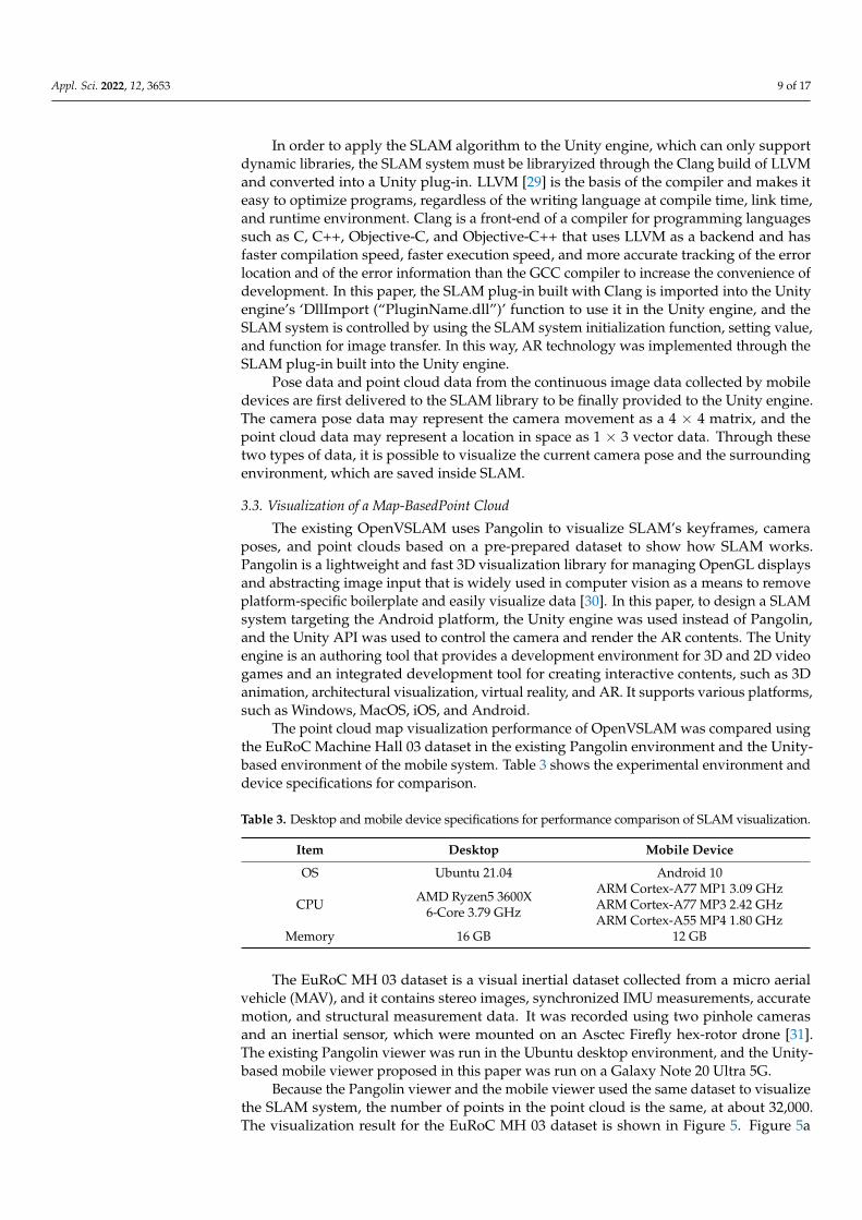
3.3. Visualization of a Map-BasedPoint Cloud
The existing OpenVSLAM uses Pangolin to visualize SLAM’s keyframes, cameraposes, and point clouds based on a pre-prepared dataset to show how SLAM works.Pangolin is a lightweight and fast 3D visualization library for managing OpenGL displaysand abstracting image input that is widely used in computer vision as a means to removeplatform-specific boilerplate and easily visualize data [30]. In this paper, to design a SLAMsystem targeting the Android platform, the Unity engine was used instead of Pangolin,and the Unity API was used to control the camera and render the AR contents. The Unityengine is an authoring tool that provides a development environment for 3D and 2D videogames and an integrated development tool for creating interactive contents, such as 3Danimation, architectural visualization, virtual reality, and AR. It supports various platforms,such as Windows, MacOS, iOS, and Android.
The point cloud map visualization performance of OpenVSLAM was compared usingthe EuRoC Machine Hall 03 dataset in the existing Pangolin environment and the Unity-based environment of the mobile system. Table 3 shows the experimental environment anddevice specifications for comparison.
Table 3. Desktop and mobile device specifications for performance comparison of SLAM visualization.
Item Desktop Mobile Device
OS Ubuntu 21.04 Android 10
CPU AMD Ryzen5 3600X6-Core 3.79 GHz
ARM Cortex-A77 MP1 3.09 GHzARM Cortex-A77 MP3 2.42 GHzARM Cortex-A55 MP4 1.80 GHz
Memory 16 GB 12 GB
The EuRoC MH 03 dataset is a visual inertial dataset collected from a micro aerialvehicle (MAV), and it contains stereo images, synchronized IMU measurements, accuratemotion, and structural measurement data. It was recorded using two pinhole camerasand an inertial sensor, which were mounted on an Asctec Firefly hex-rotor drone [31].The existing Pangolin viewer was run in the Ubuntu desktop environment, and the Unity-based mobile viewer proposed in this paper was run on a Galaxy Note 20 Ultra 5G.
Because the Pangolin viewer and the mobile viewer used the same dataset to visualizethe SLAM system, the number of points in the point cloud is the same, at about 32,000.The visualization result for the EuRoC MH 03 dataset is shown in Figure 5. Figure 5a

Appl. Sci. 2022, 12, 3653 10 of 17
is the visualization result using the Pangolin library on the desktop, and Figure 5b isthe visualization result based on Unity in the mobile environment. Although there is adifference in the size of the point cloud and the scale of the entire map in Figure 5b, themobile-based visualization result, it can be seen that the overall map shape is the same asin Figure 5a, the desktop result. It shows that the OpenVSLAM-based SLAM system can bevisualized using Unity in the Android environment.
Figure 5. The result of SLAM visualization; (a) for desktop (Pangolin); (b) mobile device (Unity).
Table 4 shows the results of comparing CPU usage, memory usage, resolution, and fpsfor SLAM visualization performance using OpenVSLAM in the Pangolin-based desktopenvironment and the Unity-based mobile environment. When running the Pangolin viewer,the CPU usage was 99% and the memory usage was 23.1%, whereas in the Unity-basedmobile environment, CPU and memory usage were less, 28% and 8.3%, respectively.
Table 4. Comparison of SLAM visualization performance on desktop and mobile devices.
Item Desktop(Pangolin)
Mobile Device(Unity)
CPU Usage (%) 99 28Memory Usage (%) 23.1 8.3Screen Resolution 1920 × 1080 1280 × 720Frame rate (FPS) Avg. 30 Avg. 25
This experiment shows that SLAM visualization, even in a Unity-based mobile en-vironment, is almost equivalent to visualization using OpenVSLAM in a Pangolin-baseddesktop environment. It is expected to be efficient from a multitasking perspective dueto low load on CPU. However, the frame rate is slightly lower than that of the desktopenvironment, resulting in poor real-time performance.
3.4. FastAPI Server
SocketIO is a library that enables two-way event-based communication between abrowser and a server and provides functions such as stability, automatic reconnection,packet buffering, and multiplexing through web sockets. The client sets a websocketconnection, a communication protocol that provides a full-duplex and low-latency channelbetween the server and the browser and replaces it with HTTP long polling when awebsocket cannot be connected [32]. Google’s Protobuffer, which stands for protocol buffer,is a useful data structure for serializing structured data and provides SDKs for variousprogramming languages. Data serialization is a process mainly required when developinga communication program for the purpose of wired communication or data storage. To useProtobuffer, you need to install the protocol compiler required to compile the proto file andthe Protobuffer runtime for the programming language you want to use.
Figure 6 is the overall workflow diagram of the FastAPI server system. On the serverside, it is more convenient to implement in the Python server rather than using the spatial

Appl. Sci. 2022, 12, 3653 11 of 17
data processing, visualization, and reconstruction library implemented as C++ in Node.js.Therefore, in this paper, in order to apply the OpenVSLAM-based mobile mixed realitysystem as a plug-in, the Socket.IO communication module was configured in the sameway as the existing Node.js event handler and was used in FastAPI. The data collectedby mobile is serialized through Protobuffer, and data communication between the mobileapplication and the SLAM algorithm of the server is implemented using FastAPI server andSoketIO. It receives image and IMU data from the client through Socket.IO, deserializes itwith Protobuffer, puts the deserialized data to the input data of the OpenVSLAM algorithm,receives camera pose data, and sends it back to the client through Socket.IO.
Figure 6. SLAM procedure by FastAPI-based mapping server.
Figure 7 is the overall workflow of the OpenVSLAM-based mobile AR system. Imagesand IMU data are collected by the user’s client’s mobile device camera and transmitted tothe Python FastAPI server for mapping. On the mapping server, map data and camera posedata are obtained through the OpenVSLAM and transmitted to the Android application ofthe user client’s Unity engine to visualize the global map and location.
Figure 7. Interaction between mobile device and mapping server for performing SLAM based onmapping server.
4. Experiments and Results
To evaluate the function and performance of the mobile SLAM system proposed inthis paper, SLAM was performed in a real indoor space and the visualization results andperformance were evaluated.
4.1. Experimental Environments
Through the mobile SLAM system proposed in this paper, we tried to verify by creatingand localizing a map in the real environment. To this end, image data and IMU data werecollected by capturing the experimental environment in advance.

Appl. Sci. 2022, 12, 3653 12 of 17
Figure 8 shows the indoor (office) experimental environment used for the experiment.The indoor space has an area of about 65 m2, and it was captured using the camera of theGalaxy Note 20 Ultra 5G.
Figure 8. Indoor environment for mobile SLAM system evaluation.
4.2. Experimental Results
The captured image was saved as Frames.m4v. cam0 was converted to an image basedon the timestamp (Frames.txt). GPS.txt was the saved location data. Accel.txt was theacceleration data. Gyro. txt was the angular velocity data. IMU.txt was the saved inertiadata obtained by calculating the acceleration data and angular velocity data. config.yamlcontained the camera settings. The sparse map (.bin) and sparse point cloud (.ply) fileswere created through the Unity engine with the image data and IMU data captured by themobile camera. Table 5 is a description of the main files.
Table 5. SLAM performance-related files.
Filename Description
Frames.m4v captured imageFrames.txt time stamp
cam0 image converted form Frames.m4v based on Frames.txtGPS.txt pose dataAccel.txt acceleration dataGyro.txt angular velocity dataIMU.txt inertia data
config.yaml camera setting valueSparse_Map_Unity.bin sparse map created in Unity engineSparse_PointCloud.ply sparse point cloud
Figure 9 is the result of comparing the partial capture of a point cloud map thatmatches the actual indoor space by capturing the indoor space of Figure 8 for about 2 minand 30 s in advance.
The resolution was 1280 × 720, and point clouds in the captured indoor space num-bered about 54,000. The average fps was measured to be 40, and the battery consumptionwas very low, about 1% or less (Table 6).

Appl. Sci. 2022, 12, 3653 13 of 17
Figure 9. Map creation results by mobile SLAM system.
Table 6. Mobile SLAM system performance.
Item Description
Display Resolution 1280 × 720Recording Time (s) 150Number of Points about 54,000Frame rate (FPS) avg. 40
The overall consistency of the trajectory estimated in the visual SLAM system is animportant factor. The absolute trajectory error (ATE) is evaluated by comparing the absolutedistance between the estimate and the actual measurement. Since both trajectories canbe specified in any coordinate frames, alignment is required first, in which the method ofHorn [33] to find the rigid transformation, S, corresponding to the least-squares solutionmapping the estimated trajectory, P1:n, to the actual trajectory, Q1:n, can be used. The ATEat time step i can be calculated as follows [34].
Fi := Q−1i SPi (1)
For each temporal index of the converted components, the root-mean-squared error(RMSE) can be calculated as follows.
RMSE(F1:n) :=
(1n
n
∑i=1‖ trans(Fi) ‖2
)1/2
(2)
The accuracy of the localization was evaluated by comparing it with the ground-truth data for the monocular of the EuRoC dataset, and the comparison results are shownin Table 7. The average RMSE of the monocular mobile SLAM is about 2.017, but it is not aproblem for the purpose of displaying AR contents through a mobile app.

Appl. Sci. 2022, 12, 3653 14 of 17
Table 7. Absolute translation RMSE, mean, and standard deviation.
Dataset RMSE (m) MEAN (m) STD (m)
MH_01(Easy) 3.110 2.863 1.213MH_03(Medium) 3.562 3.230 1.502MH_04(Difficult) 3.308 2.976 1.445
V1_01(Easy) 0.912 0.832 0.375V1_02(Medium) 1.796 1.675 0.650V1_03(Difficult) 1.589 1.412 0.729
V2_01(Easy) 1.611 1.559 0.406V2_02(Medium) 1.327 1.244 0.463V2_03(Difficult) 0.939 0.854 0.390
Average 2.017 1.849 0.797
Figure 10 is a picture comparing the results before and after the optimization. Whenloop closure was detected, the point cloud map was optimized close to the scale of thereal space centered on the current location, as shown in Figure 10b. Since the point cloudmap represents a sparse map reconstructed with a monocular system, it may be difficultto identify objects with the naked eye. For such a problem, it is necessary to maintain thecolor of the point cloud and improve it so that it can be reconstructed as a close point cloudmap. In addition, if the map is taken using a sensor that can obtain depth data, such asa stereo camera or RGB-D camera, it is expected that mapping and localization will bemore accurate.
Figure 10. Optimization results: (a) before optimization; (b) after optimization.
To verify this, the RTAB-Map application was installed on an iPhone 12 Pro with aLiDAR sensor, and the indoor environment shown in Figure 11. The RTAB-Map applicationfor iOS was released in June 2021 and is an RGB-D based on loop closure detection, stereo,and a LiDAR graph-based ROS SLAM system. Loop closure detection uses the BoWsapproach to determine the likelihood that a new image comes from a previous or newlocation. In addition, when loop closure is detected, it detects the previous location anddraws a map, enabling real-time mapping for a large-scale environment [32]. Since theRTAB-Map SLAM system can draw a more accurate map through a depth sensor, it isestimated that adding depth data to the system in this paper will enable a clearer and moreaccurate AR system to be implemented in a mobile environment. Therefore, in this paper,further research and development will be conducted using the iPhone’s LiDAR sensor bychanging the existing Android-based data collector to an iOS-based data collector.

Appl. Sci. 2022, 12, 3653 15 of 17
Figure 11. SLAM visualization results by RTAB-Map application.
5. Conclusions
In this paper, to reduce unnecessary self-research by researchers and contribute tothe rapid growth of the SLAM field, an OpenVSLAM-based AR system was designed andimplemented in a mobile environment for the purpose of open-source software, and itsfunction and performance were evaluated not only in an actual indoor space but also usingthe EuRoC datasets. To implement this system, image data and IMU data were collectedusing the camera on a mobile device. In addition, SLAM plugins were created to useSLAM functions, including the tracking, regional and global map generation, loop closuredetection, and localization functions in Unity-based mobile applications.
By building a mapping server based on the FastAPI server, implementing SLAMfunctions that require a lot of computation, such as mapping and optimization, on theserver, and transmitting it to the mobile app, a method to reduce the overhead of SLAMoperation in a mobile environment was proposed. This allows users to continuouslytrack their location along with a map generated in advance for the indoor and outdoorenvironment they are looking at and to build a service that can provide AR contents basedon a more accurate location. When the accuracy was evaluated by comparing the RMSE ofthe trajectory based on the monocular camera with the ground-truth data of the EuRoCdataset, the average of 2.017 was shown, and it was conformed that materialization ofthe main object is possible through the visualization of the point cloud for the actualindoor space.
Through the system in this paper, the cost of constructing an AR system for a widerange of environments can be reduced with only a mobile device and a laptop withoutusing a separate camera or other expensive equipment. We hope that this will serve asa basis for applying SLAM technology to various application fields, such as safe andreliable autonomous driving technology for drones and vehicles, multi-access AR systemimplementation technology, and indoor space navigation.
In the future, based on this system, we plan to use the LiDAR sensor by changing theAndroid-based data collector to an iOS-based data collector. It is expected to implementa lighter system by providing a localization function to Android-based mobile deviceswithout depth sensors after taking a map of the surrounding environment using an iOS-based mobile device.
Author Contributions: Conceptualization, J.S. and J.K.; methodology, J.S. and J.K.; software, J.S.;validation, J.S. and J.K.; formal analysis, J.S.; investigation, J.S.; resources, J.S.; data curation, J.S. andJ.K.; writing—original draft preparation, J.S. and J.K.; writing—review and editing, J.K.; visualization,J.S.; supervision, J.K.; project administration, J.K.; funding acquisition, J.K. All authors have read andagreed to the published version of the manuscript.

Appl. Sci. 2022, 12, 3653 16 of 17
Funding: This work was carried out with the support of Green Convergence Professional ManpowerTraining Program of the Korea Environmental Industry and Technology Institute funded by theMinistry of Environment.
Institutional Review Board Statement: Not applicable.
Informed Consent Statement: Not applicable.
Data Availability Statement: Not applicable.
Conflicts of Interest: The authors declare no conflict of interest.
References1. Esparza-Jiménez, J.O.; Devy, M.; Gordillo, J.L. Visual EKF-SLAM from Heterogeneous Landmarks. Sensors 2016, 16, 489. Available
online: http://lps3.www.ncbi.nlm.nih.gov.libproxy.smu.ac.kr/pubmed/27070602 (accessed on 3 February 2022). [CrossRef][PubMed]
2. Chul Roh, H.; Hun Sung, C.; Jin Chung, M. Rapid SLAM using Simple Map Representation in Indoor Environment; IEEE: Piscataway,NJ, USA, 2013; pp. 225–229.
3. Jung, S.; Choi, D.; Song, S.; Myung, H. Bridge Inspection Using Unmanned Aerial Vehicle Based on HG-SLAM: HierarchicalGraph-based SLAM. Remote Sens. 2020, 12, 3022. Available online: http://lps3.doaj.org.libproxy.smu.ac.kr/article/b28d031fbd6a40e59e70f9563ae11c95 (accessed on 3 February 2022). [CrossRef]
4. Fan, T.; Wang, H.; Rubenstein, M.; Murphey, T. CPL-SLAM: Efficient and Certifiably Correct Planar Graph-Based SLAM Usingthe Complex Number Representation. TRO 2020, 36, 1719–1737. Available online: http://lps3.ieeexplore.ieee.org.libproxy.smu.ac.kr/document/9143200 (accessed on 3 February 2022). [CrossRef]
5. Durrant-Whyte, H.; Bailey, T. Simultaneous localization and mapping: Part I. MRA 2006, 13, 99–110. Available online: http://lps3.ieeexplore.ieee.org.libproxy.smu.ac.kr/document/1638022 (accessed on 3 February 2022). [CrossRef]
6. Peddie, J. Types of Augmented Reality. In Augmented Reality; Springer International Publishing: Cham, Switzerland, 2017; pp. 29–46.7. Piao, J.-C.; Kim, S.-D. Adaptive Monocular Visual–Inertial SLAM for Real-Time Augmented Reality Applications in Mobile
Devices. Sensors 2017, 17, 2567. [CrossRef] [PubMed]8. Protobuf. Available online: https://developers.google.com/protocol-buffers (accessed on 3 February 2022).9. Aslan, M.F.; Durdu, A.; Yusefi, A.; Sabanci, K.; Sungur, C. A Tutorial: Mobile Robotics, SLAM, Bayesian Filter, Keyframe Bundle
Adjustment and ROS Applications. In Robot Operating System (ROS); Springer International Publishing: Cham, Switzerland, 2021;pp. 227–269.
10. Servières, M.; Renaudin, V.; Dupuis, A.; Antigny, N. Visual and Visual-Inertial SLAM: State of the Art, Classification, andExperimental Benchmarking. J. Sens. 2021, 2021, 1–26. Available online: http://lps3.dx.doi.org.libproxy.smu.ac.kr/10.1155/2021/2054828 (accessed on 3 February 2022). [CrossRef]
11. Mur-Artal, R.; Montiel, J.M.M.; Tardos, J.D. ORB-SLAM: A Versatile and Accurate Monocular SLAM System. TRO 2015, 31,1147–1163. Available online: http://lps3.ieeexplore.ieee.org.libproxy.smu.ac.kr/document/7219438 (accessed on 3 February2022). [CrossRef]
12. Mur-Artal, R.; Tardos, J.D. ORB-SLAM2: An Open-Source SLAM System for Monocular, Stereo, and RGB-D Cameras. TRO 2017,33, 1255–1262. Available online: http://lps3.ieeexplore.ieee.org.libproxy.smu.ac.kr/document/7946260 (accessed on 3 February2022). [CrossRef]
13. Campos, C.; Elvira, R.; Rodríguez, J.J.G.; Montiel, J.M.M.; Tardós, J.D. ORB-SLAM3: An Accurate Open-Source Library for Visual,Visual-Inertial and Multi-Map SLAM. IEEE Trans. Robot. 2021, 37, 1874–1890. Available online: https://arxiv.org/abs/2007.11898(accessed on 3 February 2022). [CrossRef]
14. Sumikura, S.; Shibuya, M.; Sakurada, K. OpenVSLAM, ACM. In Proceedings of the 27th ACM International Conference onMultimedia, Nice, France, 15 October 2019; pp. 2292–2295.
15. El Filali, Y.; Krit, S. Augmented Reality Types and Popular Use Cases. In Proceedings of the 1st International Conference of ComputerScience and Renewable Energies—ICCSRE; IEEE Digital Library: Piscataway, NJ, USA, 2019; pp. 107–110. ISBN 978-989-758-431-2.[CrossRef]
16. Anonymous ARCore. Available online: https://developers.google.com/ar/develop (accessed on 3 February 2022).17. Apple ARKit. Available online: https://developer.apple.com/documentation/arkit (accessed on 3 February 2022).18. Rosinol, A.; Abate, M.; Chang, Y.; Carlone, L. Kimera: An Open-Source Library for Real-Time Metric-Semantic Localization and Mapping;
IEEE: Piscataway, NJ, USA, 2020; pp. 1689–1696.19. Klein, G.; Murray, D. Parallel Tracking and Mapping for Small AR Workspaces; IEEE: Piscataway, NJ, USA, 2007; pp. 225–234.20. Engel, J.; Koltun, V.; Cremers, D. Direct Sparse Odometry. IEEE Trans. Pattern Anal. Mach. Intell. 2018, 40, 611–625. Available online:
http://lps3.ieeexplore.ieee.org.libproxy.smu.ac.kr/document/7898369 (accessed on 3 February 2022). [CrossRef] [PubMed]21. Engel, J.; Schöps, T.; Cremers, D. LSD-SLAM: Large-Scale Direct Monocular SLAM. In Computer Vision—ECCV 2014; Springer
International Publishing: Cham, Switzerland, 2014; pp. 834–849.22. Forster, C.; Pizzoli, M.; Scaramuzza, D. SVO: Fast Semi-Direct Monocular Visual Odometry; IEEE: Piscataway, NJ, USA, 2014;
pp. 15–22.

Appl. Sci. 2022, 12, 3653 17 of 17
23. Schlegel, D.; Colosi, M.; Grisetti, G. ProSLAM: Graph SLAM from a Programmer’s Perspective; IEEE: Piscataway, NJ, USA, 2018; pp.3833–3840.
24. Muñoz-Salinas, R.; Medina-Carnicer, R. UcoSLAM: Simultaneous localization and mapping by fusion of keypoints and squaredplanar markers. Pattern Recognit. 2020, 101, 107193. Available online: https://lps3.dx.doi.org.libproxy.smu.ac.kr/10.1016/j.patcog.2019.107193 (accessed on 3 February 2022). [CrossRef]
25. Anonymous Eigen. Available online: https://eigen.tuxfamily.org/index.php?title=Main_Page (accessed on 3 February 2022).26. Rainer Kümmerle, g2o. Available online: https://github.com/RainerKuemmerle/g2o (accessed on 3 February 2022).27. Muñoz-Salinas, R. Available online: https://github.com/OpenVSLAM-Community/FBoW (accessed on 3 February 2022).28. FastAPI. Available online: https://fastapi.tiangolo.com/ (accessed on 3 February 2022).29. Hsu, M. LLVM Techniques, Tips, and Best Practices Clang and Middle-End Libraries; Packt Publishing, Limited: Birmingham, UK, 2021.30. Pangolin. Available online: https://github.com/uoip/pangolin (accessed on 3 February 2022).31. Burri, M.; Nikolic, J.; Gohl, P.; Schneider, T.; Rehder, J.; Omari, S.; Achtelik, M.W.; Siegwart, R. The EuRoC micro aerial vehicle
datasets. Int. J. Robot. Res. 2016, 35, 1157–1163. [CrossRef]32. Socket.IO. Available online: https://socket.io (accessed on 3 February 2022).33. Horn, B.K.P. Closed-form solution of absolute orientation using unit quaternions. J. Opt. Soc. Am. A Opt. Image Sci. Vis. 1987,
4, 629. [CrossRef]34. Aslan, M.F.; Durdu, A.; Sabanci, K.; Ropelewska, E.; Gültekin, S.S. A Comprehensive Survey of the Recent Studies with UAV for
Precision Agriculture in Open Fields and Greenhouses. Appl. Sci. 2022, 12, 1047. [CrossRef]
Copyright © 2022 FDOKUMEN