Eco-Industrial Clusters in Urban-Rural Fringe Areas - Institute ...
Upload
independentCategory
view
1download
0
International Journal of Undergraduate Research and CreativeActivities
Volume 6 Special Issue Article 5
2014
Managing Development of Fringe Areas in DhakaCity: "Land Readjustment" as a Technique forSustainable Future Development EnsuringEnvironmental and Social JusticeShoaib MahmudDepartment of Urban and Regional Planning (DURP), Bangladesh University of Engineering and Technology (BUET),[email protected]
Mohammad Ehsanul HuqDepartment of Urban and Regional Planning (DURP), Bangladesh University of Engineering and Technology (BUET),[email protected]
Armita KarDepartment of Urban and Regional Planning (DURP), Bangladesh University of Engineering and Technology (BUET),[email protected]
Rafsun MashrakyDepartment of Urban and Regional Planning (DURP), Bangladesh University of Engineering and Technology (BUET),[email protected]
Recommended CitationMahmud, Shoaib; Huq, Mohammad Ehsanul; Kar, Armita; Mashraky, Rafsun; Khatun, Farzana; Islam, Ishrat; and Akther,Mohammad Shakil (2014) "Managing Development of Fringe Areas in Dhaka City: "Land Readjustment" as a Technique forSustainable Future Development Ensuring Environmental and Social Justice," International Journal of Undergraduate Research andCreative Activities: Vol. 6, Article 5.DOI: http://dx.doi.org/10.7710/2168-0620.1020

Farzana KhatunDepartment of Urban and Regional Planning (DURP), Bangladesh University of Engineering and Technology (BUET),[email protected]
See next page for additional authors
Follow this and additional works at: http://commons.pacificu.edu/ijurca
Managing Development of Fringe Areas in Dhaka City: "LandReadjustment" as a Technique for Sustainable Future DevelopmentEnsuring Environmental and Social Justice
Peer ReviewThis work has undergone a double-blind review by a minimum of two faculty members from institutions ofhigher learning from around the world. The faculty reviewers have expertise in disciplines closely related tothose represented by this work. If possible, the work was also reviewed by undergraduates in collaborationwith the faculty reviewers.
AbstractDhaka, the capital city of Bangladesh, is one of the fastest growing megacities in the world. With the rapidgrowth of population and high urbanization rate, Dhaka is bound to expand the borders to accommodate thegrowing need of space. But this expansion is already taking its toll in the form of environmental degradationand social injustice hampering the geographical sustainability in the process. This study proposes a controlledand well-planned development in the eastern fringe of Dhaka City (comprising of Badda, Satarkul and Vatara)to meet up the challenge of future accommodation requirements. The area being geographically vulnerablewith lots of agricultural lands, water bodies and retention ponds, the prime concern is to ensure thegeographic sustainability of the area and use all the natural features as a vital tool in the process ofdevelopment. As a planning technique, Land Readjustment Scheme is applied in this regard. This reportcontains all the measures and proposals regarding the natural features of the study area as well as the wholeprocess of the development scheme including a financial proposal to recover the cost of the development tomake this plan financially viable. Finally, the outcome of the study shows that it can be well implemented as allthe objectives are fulfilled to the fullest.
KeywordsContribution Ratio; Fringe areas; GIS Maps; Land Readjustment or Land Pooling; Observation Survey;Replotting; Rural-urban migration
AcknowledgementsWe express our gratitude to our honorable teachers Dr. Mohammad Shakil Akther, Professor, Department ofUrban and Regional Planning, BUET; Dr. Ishrat Islam, Professor, Department of Urban and RegionalPlanning, BUET and Farzana Khatun, Lecturer, Department of Urban and Regional Planning, BUET; forgiving us the opportunity to work on this project. Throughout the process they have guided us with theirprecious comments and suggestions without which it would be difficult to accomplish the task. We arethankful to K. A. Z. Taufique, Director Planning, RAJUK for helping us with the cost estimation data of“Purbachal new town Project”. We also express our gratitude to the people of Badda-Satarkul who helped uswith different information during the survey work. Finally, we are thankful to our classmates who helped uswith their survey data without which it would be very hard to complete the project.
Editor's Note: Dr. Ishrat Islam, Professor, Dr. Mohammad Shakil Akther, Professor, and Farzana Khatun,Lecturer, Department of Urban & Regional Planning, Bangladesh University of Engineering & Technology,served as faculty mentors for this work.
This research article is available in International Journal of Undergraduate Research and Creative Activities:http://commons.pacificu.edu/ijurca/vol6/iss2/5

AuthorsShoaib Mahmud, Mohammad Ehsanul Huq, Armita Kar, Rafsun Mashraky, Farzana Khatun, Ishrat Islam, andMohammad Shakil Akther
This research article is available in International Journal of Undergraduate Research and Creative Activities:http://commons.pacificu.edu/ijurca/vol6/iss2/5
INTRODUCTION
Dhaka, Bangladesh, is one of the
most densely populated cities of the world.
Approximately 14.5 million people live here
in just 1,325 square kilometers with a
density of 10,943 persons per square
kilometer and an annual growth rate of
4.34% (BBS, 2011). The Population of
Dhaka is increasing at an alarming rate and
one of the main reasons of such increment is
rural-urban migration. Home-wrecked
people from natural catastrophes and rural
people from the surrounding areas migrate
to Dhaka city in search of better living
conditions. Providing housing and other
facilities for this huge population along with
preserving the environment and social
equity, has now become a greater challenge
for maintaining sustainability in the
development of Dhaka city. Sustainability
requires reconciliation of three things:
economic demands, environmental and
social equity (Abukhater, 2011). The effect
of present urbanization and development
process of Dhaka on sustainability is
twofold. First, natural environment is
affected severely in the form of illegal and
haphazard development over flood flow
areas, agricultural lands and critical natural
resource areas. Second, this unplanned
development results in uprooting the local
poor people who have been living in those
areas for a long time denying them their
social right and justice. Ensuring
environmental preservation and social equity
usually come after financial profitability, in
most of the private housing and land
development projects of Dhaka city, if
considered at all. Between 1960 and 2010,
water bodies have decreased by 33% and
low lands have decreased by 53% (Islam et
al, 2010). A study shows that, only around
30% of relocated local people can regain
their land ownership in such development
projects (Mahmood, 2013).
In this paradigm of urban planning,
Land Readjustment technique can be a
useful tool to determine geographic
sustainability in a city such as Dhaka. “Land
readjustment or Land pooling” is a
technique for managing the urban
development of urban-fringe lands, whereby
land parcels are assembled for their unified
planning, servicing and subdivision as a
single estate, with the sale of some of the
new building plots to recover the costs and
the redistribution of the other plots back to
the landowners (Yomralioglu, 1993). There
are many examples worldwide where this
technique was successfully implemented for
high density housing projects. One such
project was the Gaepo project in Seoul,
South Korea (Lee, 2002). This project was
undertaken for accommodating the
increasing population in Seoul, without
hampering the valuable agricultural land in
the area. This project was also important
because it improved the connectivity of the
project site with the neighboring built-up
areas.
To avoid scattered settlement in the
fringe areas and at the same time to preserve
the natural resources along with upholding
the social right of the local people in those
areas, this study aims at accommodating
future population through a Land
Readjustment Scheme at Badda-Satarkul
area (Figure 2), located at the eastern fringe
area of Dhaka city (Figure 1). There is an
ample amount of agricultural lands, vacant
spaces and water retention ponds in this
area. These days many housing projects are
undertaken in this area by the private
developers which involve illegal occupation
of agricultural land as well as wetlands.
This study envisions several
perspectives which are-- Vision 1: A self-
sufficient sustainable city, where all the
natural resources are fully utilized and
preserved and Vision 2: An effective
implementation of Land Readjustment
1
Mahmud et al.: Managing Development of Fringe Areas in Dhaka City: "Land Readjus
Scheme at Badda-Satarkul to accommodate
all the present and probable future
population. Fulfilling these visions will
ensure to find the right balance among the
three E’s of sustainability (environment,
economy and equity) (Abukhater, 2011).
Keeping in mind the above mentioned
visions, some objectives have been selected
for the study which is: 1) to preserve the
existing agricultural lands, water retention
ponds and water bodies and 2) to allocate
serviced land or floor space to the land
owners through land readjustment scheme.
METHODOLOGY
Study Area Selection
This project is intended to implement
land readjustment scheme in Badda,
Satarkul and Bhatara Unions of the DMDP
(Dhaka Metropolitan Development Plan)
Area. The area is appropriate for land
readjustment for the following reasons:
Badda, Satarkul and Bhatara unions
are located in the fringe areas which are less
developed and mostly vacant. These types of
areas are more preferred for land
readjustment scheme as provision of
serviced land and community facilities
causes a lesser amount of demolition of
existing structures.
Around 38 percent land of this area
is covered with agricultural land and water
retention ponds. This area has been selected
because preservation and proper utilization
of agricultural land will contribute to the
economy by increasing agricultural
production and at the same time,
preservation of water retention ponds will
control flood water and enhance the visual
attractiveness of the city.
Most of the land owners of this area
possess less than 2 kathas (see glossary) of
vacant land. Land readjustment project is
proposed for this area to accommodate all
land owners by providing them the
equivalent amount of serviced land or floor
space after their contribution.
The number of existing community
facilities is not sufficient for the projected
future population. Land readjustment is
required in this area for construction of
additional community facilities. This will
enable the area to operate as a self-
sustainable city.
Data Collection
This study is based on both primary
and secondary sources. An observation
survey was conducted at the study area to
gather an overall knowledge about the
existing land use pattern.
The study area map was collected
from the capital improvement authority of
Dhaka city named as: Rajdhani Unnayan
Kartipakkha (RAJUK). All the data were
extracted from the GIS database and
information such as- land use pattern,
ownership pattern; existing community
facilities and service facilities were
collected. Analyzing these data, the
operating policies and design principles
regarding the study area were determined.
A systematic procedure was
followed then to apply the Land
Readjustment technique in the study area. At
first, the operating principles were set up to
determine the contribution ratio, replotting
procedure and amount of monetary
compensation. Then a detail design scheme
was developed for the whole study area.
Finally, the costs of the project along with
the implementation phase were designed to
see the feasibility of the project from
financial perspectives.
2
International Journal of Undergraduate Research and Creative Activities, Vol. 6 [2014], Art. 5
http://commons.pacificu.edu/ijurca/vol6/iss2/5DOI: http://dx.doi.org/10.7710/2168-0620.1020
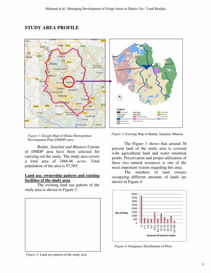
STUDY AREA PROFILE
Badda, Satarkul and Bhatara
of DMDP area have been selected for
carrying out the study. The study ar
a total area of 3466.46 acre
population of the area is 97,585.
Land use, ownership pattern and existing
facilities of the study area
The existing land use pattern of the
study area is shown in Figure 3:
Figure 1: Google Map of Dhaka Metropolitan
Development Plan (DMDP) area.
Figure 3: Land use pattern of the study area
0
500
1000
1500
2000
2500
3000
3500
4000
<2
2-3
3-4
4-5
5-8
.2
8.2
-10
No of Plots
Amount of Land in Katha
Badda, Satarkul and Bhatara Unions
of DMDP area have been selected for
out the study. The study area covers
acres. Total
opulation of the area is 97,585.
and existing
The existing land use pattern of the
The Figure 3 shows that around 38
percent land of the study area is covered
with agricultural land and water retention
ponds. Preservation and proper utilization of
these two natural resources is one of the
most important visions regarding this area.
The numbers of land owners
occupying different amounts of lands are
shown in Figure 4:
: Google Map of Dhaka Metropolitan Figure 2: Existing Map of Badda, Satarkul, Bhatara
Land use pattern of the study area
Figure 4: Frequency Distribution of Plots
8.2
-10
10
-15
15
-20
20
-25
25
-50
50
-70
0
Amount of Land in Katha
igure 3 shows that around 38
percent land of the study area is covered
with agricultural land and water retention
ponds. Preservation and proper utilization of
these two natural resources is one of the
most important visions regarding this area.
ers of land owners
occupying different amounts of lands are
: Existing Map of Badda, Satarkul, Bhatara
Frequency Distribution of Plots
3
Mahmud et al.: Managing Development of Fringe Areas in Dhaka City: "Land Readjus
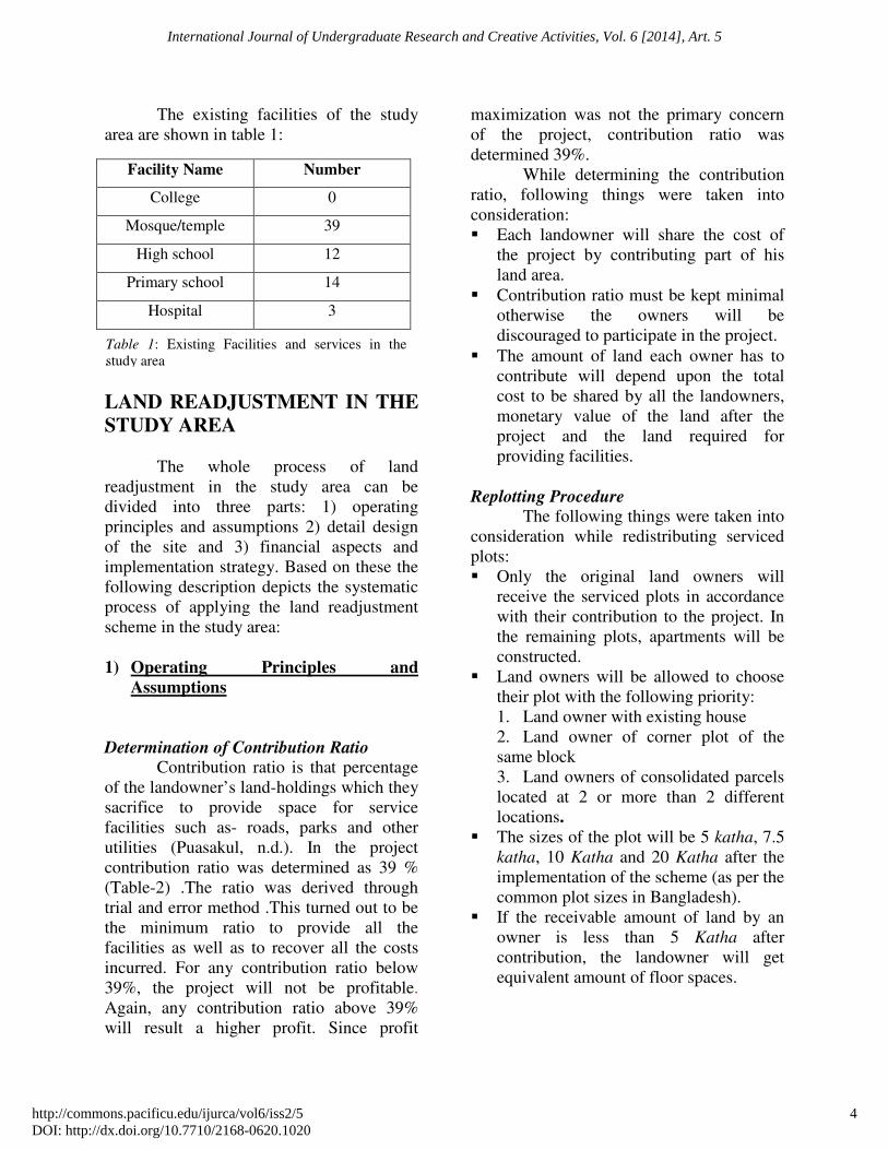
The existing facilities of the study
area are shown in table 1:
.
LAND READJUSTMENT IN THE
STUDY AREA
The whole process of land
readjustment in the study area can be
divided into three parts: 1) operating
principles and assumptions 2) detail design
of the site and 3) financial aspects and
implementation strategy. Based on these the
following description depicts the systematic
process of applying the land readjustment
scheme in the study area:
1) Operating Principles and
Assumptions
Determination of Contribution Ratio Contribution ratio is that percentage
of the landowner’s land-holdings which they
sacrifice to provide space for service
facilities such as- roads, parks and other
utilities (Puasakul, n.d.). In the project
contribution ratio was determined as 39 %
(Table-2) .The ratio was derived through
trial and error method .This turned out to be
the minimum ratio to provide all the
facilities as well as to recover all the costs
incurred. For any contribution ratio below
39%, the project will not be profitable.
Again, any contribution ratio above 39%
will result a higher profit. Since profit
maximization was not the primary concern
of the project, contribution ratio was
determined 39%.
While determining the contribution
ratio, following things were taken into
consideration:
� Each landowner will share the cost of
the project by contributing part of his
land area.
� Contribution ratio must be kept minimal
otherwise the owners will be
discouraged to participate in the project.
� The amount of land each owner has to
contribute will depend upon the total
cost to be shared by all the landowners,
monetary value of the land after the
project and the land required for
providing facilities.
Replotting Procedure The following things were taken into
consideration while redistributing serviced
plots:
� Only the original land owners will
receive the serviced plots in accordance
with their contribution to the project. In
the remaining plots, apartments will be
constructed.
� Land owners will be allowed to choose
their plot with the following priority:
1. Land owner with existing house
2. Land owner of corner plot of the
same block
3. Land owners of consolidated parcels
located at 2 or more than 2 different
locations.
� The sizes of the plot will be 5 katha, 7.5
katha, 10 Katha and 20 Katha after the
implementation of the scheme (as per the
common plot sizes in Bangladesh).
� If the receivable amount of land by an
owner is less than 5 Katha after
contribution, the landowner will get
equivalent amount of floor spaces.
Facility Name Number
College 0
Mosque/temple 39
High school 12
Primary school 14
Hospital 3
Table 1: Existing Facilities and services in the
study area
4
International Journal of Undergraduate Research and Creative Activities, Vol. 6 [2014], Art. 5
http://commons.pacificu.edu/ijurca/vol6/iss2/5DOI: http://dx.doi.org/10.7710/2168-0620.1020
Determination of Equivalent Amount of
Floor Space and Monetary Compensation
The equivalent amount of floor space
and amount of monetary compensation was
determined through the following process:
� At first total amount of floor space that
can be built in the remaining lands was
determined by using this equation: Floor
space (S1 sq. ft.) = remaining amount of
land (katha) after contribution * 720 *
maximum ground coverage (60%)
*building height (6 stories)
� Then the cost of building this floor space
was determined. In the present scenario
the building cost of per square feet floor
space is 2,000 BDT. As this project is
targeted for year 2030, the building cost
is assumed as 4,000 BDT per square feet
due to inflation.
� Therefore, Total building cost = Total
floor space * 4,000 BDT
� Equivalent floor space which should be
sold to recover this cost was determined
next. At present per square feet selling
price of apartments in nearby areas
(Gulshan) is 14,000 BDT (Sheltech). But
in this project profit maximization is not
the primary goal. So selling price of per
be square feet apartment space was
assumed 10,000 BDT which will be
affordable among the people of various
income groups ensuring social justices.
So, Equivalent floor space for cost
recovery (S2 sq. ft.) = Total Cost/10000
� By deducting this floor space from the
floor space which can be built, the
amount of floor space required to be
returned was found.
� Equivalent floor space required to be
returned (S sq. ft.) = S1 – S2
� The remaining fractions of receivable
amount of floor spaces will be
compensated in terms of equivalent
amount of money (shown in the table 2).
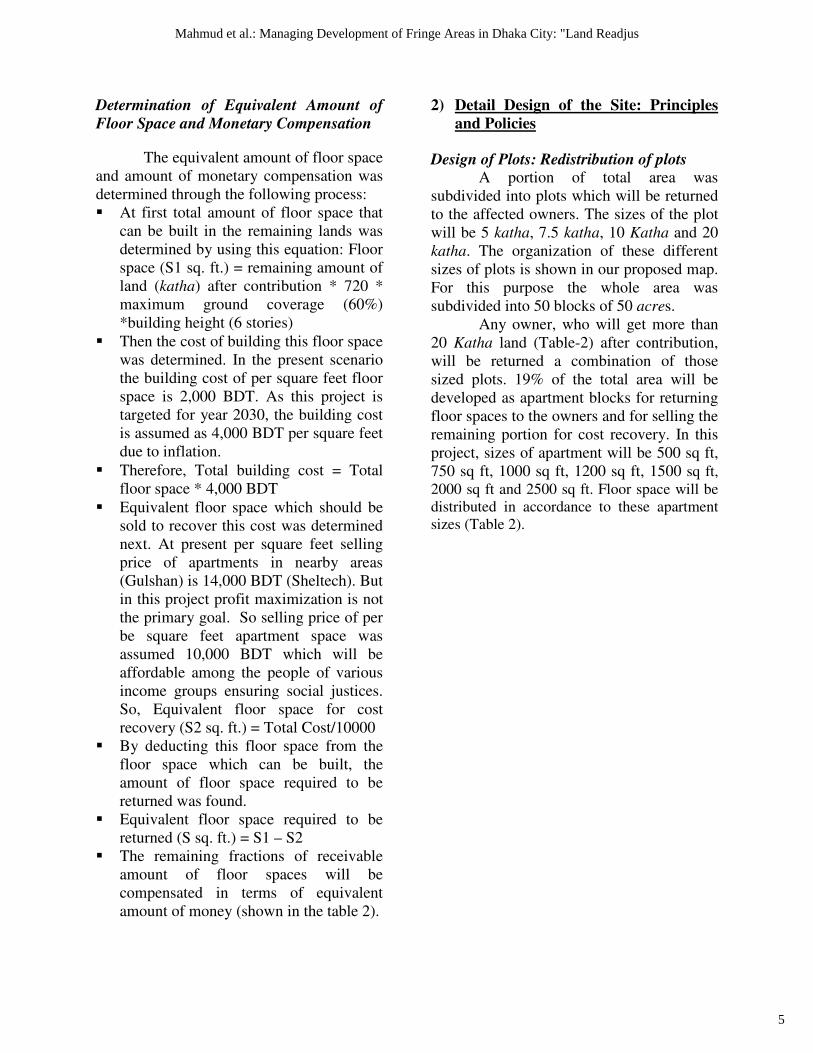
2) Detail Design of the Site: Principles
and Policies
Design of Plots: Redistribution of plots
A portion of total area was
subdivided into plots which will be returned
to the affected owners. The sizes of the plot
will be 5 katha, 7.5 katha, 10 Katha and 20
katha. The organization of these different
sizes of plots is shown in our proposed map.
For this purpose the whole area was
subdivided into 50 blocks of 50 acres.
Any owner, who will get more than
20 Katha land (Table-2) after contribution,
will be returned a combination of those
sized plots. 19% of the total area will be
developed as apartment blocks for returning
floor spaces to the owners and for selling the
remaining portion for cost recovery. In this
project, sizes of apartment will be 500 sq ft,
750 sq ft, 1000 sq ft, 1200 sq ft, 1500 sq ft,
2000 sq ft and 2500 sq ft. Floor space will be
distributed in accordance to these apartment
sizes (Table 2).
5
Mahmud et al.: Managing Development of Fringe Areas in Dhaka City: "Land Readjus
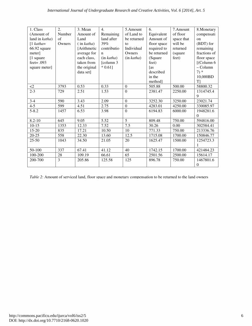
1. Class
(Amount of
land in katha)
[1 katha=
66.92 square
meter]
[1 square
feet= .093
square meter]
2.
Number
of
Owners
3. Mean
Amount of
Land
( in katha)
[Arithmetic
average for
each class,
taken from
the original
data set]
4.
Remaining
land after
39%
contributio
n
(in katha)
[column 3
* 0.61]
5.Amount
of Land to
be returned
to
Individual
Owners
(in katha)
6.
Equivalent
Amount of
floor space
required to
be returned
(Square
feet)
[as
described
in the
method]
7.Amount
of floor
space that
will be
returned
(square
feet)
8.Monetary
compensati
on
(BDT) for
remaining
fractions of
floor space
[(Column 6
– Column
7) *
10,000BD
T]
<2 3793 0.53 0.33 0 505.88 500.00 58800.32
2-3 729 2.51 1.53 0 2381.47 2250.00 1314745.4
9
3-4 590 3.43 2.09 0 3252.30 3250.00 23021.74
4-5 599 4.51 2.75 0 4283.01 4250.00 330085.97
5-8.2 1457 6.53 3.98 0 6194.83 6000.00 1948281.6
0
8.2-10 645 9.05 5.52 5 809.48 750.00 594816.00
10-15 1353 12.33 7.52 7.5 30.26 0.00 302584.41
15-20 835 17.21 10.50 10 771.33 750.00 213336.76
20-25 558 22.30 13.60 12.5 1715.08 1700.00 150846.77
25-50 1043 34.50 21.05 20 1625.47 1500.00 1254723.3
1
50-100 337 67.41 41.12 40 1742.15 1700.00 421484.23
100-200 28 109.19 66.61 65 2501.56 2500.00 15614.17
200-700 3 205.86 125.58 125 896.78 750.00 1467801.6
0
Table 2: Amount of serviced land, floor space and monetary compensation to be returned to the land owners
6
International Journal of Undergraduate Research and Creative Activities, Vol. 6 [2014], Art. 5
http://commons.pacificu.edu/ijurca/vol6/iss2/5DOI: http://dx.doi.org/10.7710/2168-0620.1020
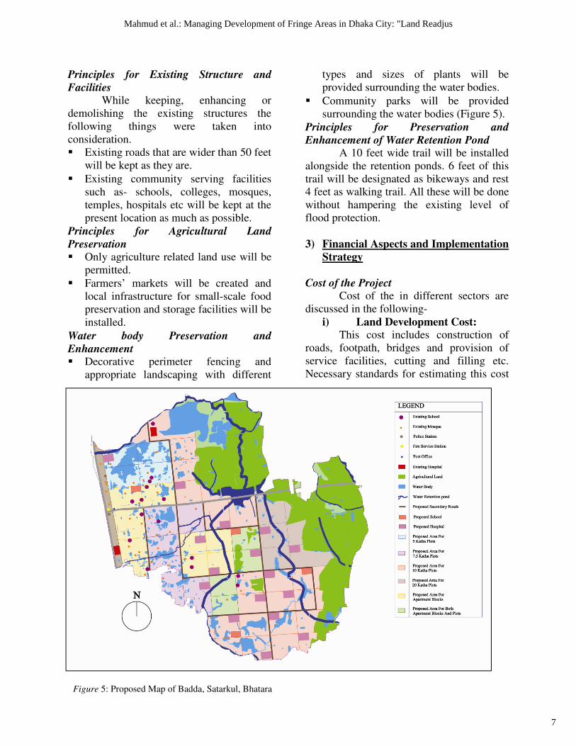
Principles for Existing Structure and
Facilities While keeping, enhancing or
demolishing the existing structures the
following things were taken into
consideration.
� Existing roads that are wider than 50 feet
will be kept as they are.
� Existing community serving facilities
such as- schools, colleges, mosques,
temples, hospitals etc will be kept at the
present location as much as possible.
Principles for Agricultural Land
Preservation � Only agriculture related land use will be
permitted.
� Farmers’ markets will be created and
local infrastructure for small-scale food
preservation and storage facilities will be
installed.
Water body Preservation and
Enhancement � Decorative perimeter fencing and
appropriate landscaping with different
types and sizes of plants will be
provided surrounding the water bodies.
� Community parks will be provided
surrounding the water bodies (Figure 5).
Principles for Preservation and
Enhancement of Water Retention Pond A 10 feet wide trail will be installed
alongside the retention ponds. 6 feet of this
trail will be designated as bikeways and rest
4 feet as walking trail. All these will be done
without hampering the existing level of
flood protection.
3) Financial Aspects and Implementation
Strategy
Cost of the Project Cost of the in different sectors are
discussed in the following-
i) Land Development Cost:
This cost includes construction of
roads, footpath, bridges and provision of
service facilities, cutting and filling etc.
Necessary standards for estimating this cost
Figure 5: Proposed Map of Badda, Satarkul, Bhatara
7
Mahmud et al.: Managing Development of Fringe Areas in Dhaka City: "Land Readjus
is taken from the “Detailed Estimate of
Purbachal New Town Project” and per
Katha development cost is estimated
202,638 BDT. Total cost in this sector is
estimated 2,632.93 crore BDT (338,641,328
USD).
ii) Apartment Construction Cost:
The remaining land, after returning
serviced plots to the owner and providing
land for community facilities, will be
developed as apartment blocks. Total cost in
this sector is estimated 16,220.11crore BDT
(2,086,188,286 USD).
iii) Monetary Compensation:
The amount of monetary
compensation is derived in Table 2. [Total
monetary compensation = Σ (monetary
compensation of each person in each
class*number of owner in each class.)] The
total amount of monetary compensation is
BDT 674.23 crore (86,718,310 USD).
iv) Construction of Walking and
Cycling Trail:
From the cost of road construction of
“Purbachal New Town Project”, the cost of
construction of this road is derived
1533BDT/ square meter. Total cost in this
sector is 30.63 crore BDT (3,940,312.98
USD).
v) Initial Development of Water
Bodies and Agricultural Land:
For landscaping surrounding the
water bodies and retention pond, providing
small-scale food preservation and storage
facilities and development of agricultural
land and initial budget of 100 crore BDT
(12,861,737 USD) is estimated.
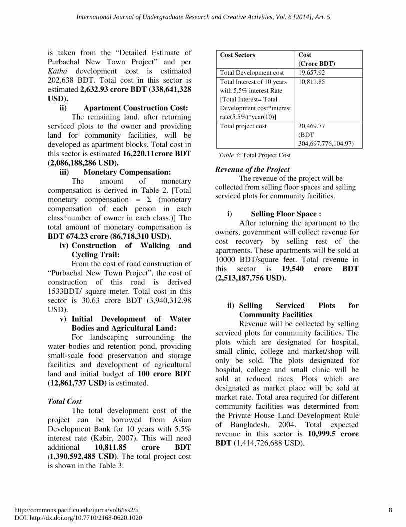
Total Cost The total development cost of the
project can be borrowed from Asian
Development Bank for 10 years with 5.5%
interest rate (Kabir, 2007). This will need
additional 10,811.85 crore BDT
(1,390,592,485 USD). The total project cost
is shown in the Table 3:
Revenue of the Project The revenue of the project will be
collected from selling floor spaces and selling
serviced plots for community facilities.
i) Selling Floor Space :
After returning the apartment to the
owners, government will collect revenue for
cost recovery by selling rest of the
apartments. These apartments will be sold at
10000 BDT/square feet. Total revenue in
this sector is 19,540 crore BDT
(2,513,187,756 USD).
ii) Selling Serviced Plots for
Community Facilities
Revenue will be collected by selling
serviced plots for community facilities. The
plots which are designated for hospital,
small clinic, college and market/shop will
only be sold. The plots designated for
hospital, college and small clinic will be
sold at reduced rates. Plots which are
designated as market place will be sold at
market rate. Total area required for different
community facilities was determined from
the Private House Land Development Rule
of Bangladesh, 2004. Total expected
revenue in this sector is 10,999.5 crore
BDT (1,414,726,688 USD).
Cost Sectors Cost
(Crore BDT)
Total Development cost 19,657.92
Total Interest of 10 years
with 5.5% interest Rate
[Total Interest= Total
Development cost*interest
rate(5.5%)*year(10)]
10,811.85
Total project cost 30,469.77
(BDT
304,697,776,104.97)
Table 3: Total Project Cost
8
International Journal of Undergraduate Research and Creative Activities, Vol. 6 [2014], Art. 5
http://commons.pacificu.edu/ijurca/vol6/iss2/5DOI: http://dx.doi.org/10.7710/2168-0620.1020
Implementation Phasing
The phases of this project are shown
in the following chart:
Phase Time
Period Project Description
Phase
01
2013-
2022
Construction of apartments,
internal roads and
preservation of natural
resources.
Phase
02
2020-
2026
Construction of apartments
on the lands near Pragati
Sarani and selling
apartments for cost recovery
Phase
03
2025-
2030
Redistribution of serviced
plots and distribution of
apartments among the
owners
This project will be implemented
under the supervision of the government but
public participation will be ensured in
acquisition of land and redistribution of
serviced plots.
CONCLUSION
As most of the projects in Dhaka city
are initiated by the private developers, they
are completely based on profit
maximization. As a result balancing the
social equity and preservation of natural
environment is completely ignored.
Moreover, because of such housing projects,
people of low income are becoming
landless. This study proposes a plan to
continue with the development of an area,
with solutions to these problems. Land
readjustment scheme of Badda, Satarkul and
Bhatara is a project which is totally based
on the three pillars of geographical
sustainability.
First, it proposes a plan which is
financially viable. As the scheme shows, all
the estimated costs of the project are
recovered through the revenues earned by
selling plots for community facilities. This
process leaves enough room of flexibility.
Second, this plan is designed in way;
so that the environment is least disturbed
and all the natural features of the study area
were preserved. Additionally in some cases
proposals were provided regarding their
enhancement.
Third, the plan was focused to ensure
social equity by securitizing serviced plots
or apartment space for all the land owners
specially the owners having small parcel of
lands. During redistribution, maximum
possible developed plots were returned to
the original owners.
In conclusion it can be said that the
study fulfills all of its objectives. With
proper governance, the project can be well
implemented and thereby ensure a
geographically sustainable development in
the eastern fringe of Dhaka city.
REFERENCE
Abukhater, A. (2011). GIS for planning and
community development: Solving global
challenges. Directions Magazine.
Retrieved on December 13, 2013 from
http://www.directionsmag.com/articles/g
is-for-planning-and-
communitydevelopment-solving-
globalchallenges/149245.
B.B.S. (2011). Bangladesh Population
Census, (National Series). Bangladesh
Bureau of Statistics, Government of
Bangladesh: Dhaka.
Total revenue
of the project
305,395,348,000.00
BDT
Total project
cost
304,697,776,104.97
BDT
Total profit of
the project
697,571,895.04 BDT
69.75 crore BDT
Table 5: Implementation Phasing
Table 4: Total revenue earned from the project
9
Mahmud et al.: Managing Development of Fringe Areas in Dhaka City: "Land Readjus
Islam, M. S., Rahman, M. R., Shahbuddin,
A. K. M., Ahmed, R. (2010). Changes in
wetlands in Dhaka city: Trends and
physico-environmental consequences.
Journal of Life and Earth Science, Vol.
5, pages 37-42. DOI:
http://dx.doi.org/10.3329/jles.v5i0.7348
Lee, T. I. (2002). Land Readjustment in
Korea. Tools for Land Management and
Development: Land Readjustment
conference, March 21-22, 2002. Lincoln
Institute of Land Policy, Korea.
Retrieved on December 13, 2013 from
https://www.lincolninst.edu/pubs/dl/641
_lee.pdf
Mahmood, S. (2013). Study of Relocation
Process and Socio-economic Impact on
Local People Due to Private Land
Development Projects of Dhaka.
Unpublished MURP Thesis, Department
of Urban and Regional Planning,
Bangladesh University of Engineering
and Technology, Dhaka.
Puasakul, U. (n.d.). Land Readjustment in
Thailand. Asia-Pacific Housing Journal,
Better cities, better lives, pages 35-38.
Retrieved on December 05, 2013 from
www.ghbhomecenter.com/journal/downl
oad.php?file=1219Jan11wh2djhy.pdf
Yomralioglu, T. (1993). Nominal Value
Based Approach for Land Readjustment
and Its Implementation Using GIS
(Doctoral dissertation, University of
Newcastle, Australia). Retrieved on
December 05, 2013 from
http://web.itu.edu.tr/tahsin/tahsin/Yayn_
PhDThesis_TY_files/CH02.pdf
GLOSSARY
Acre: 1 acre = 43,560 sq. ft. Or 1 acre =
4046.86 sq. meter
DMDP: Dhaka Metropolitan Development
Plan
Katha: Local unit of land measurement. 1
katha= 66.92 square meter
BDT: Bangladesh Taka. 1USD =77.75BDT
(Source: Bangladesh Bank, accessed on
17/02/2014)
10
International Journal of Undergraduate Research and Creative Activities, Vol. 6 [2014], Art. 5
http://commons.pacificu.edu/ijurca/vol6/iss2/5DOI: http://dx.doi.org/10.7710/2168-0620.1020
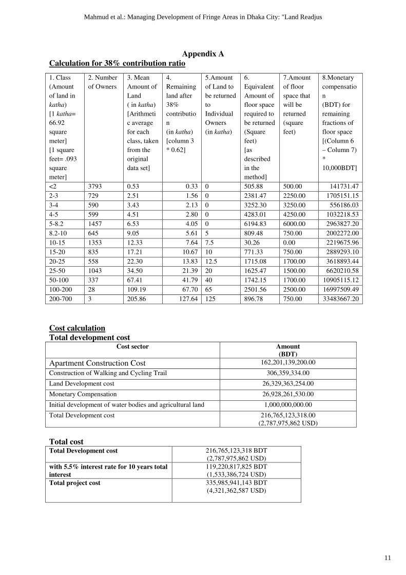
Appendix A
Calculation for 38% contribution ratio
Cost calculation
Total development cost Cost sector Amount
(BDT)
Apartment Construction Cost 162,201,139,200.00
Construction of Walking and Cycling Trail 306,359,334.00
Land Development cost 26,329,363,254.00
Monetary Compensation 26,928,261,530.00
Initial development of water bodies and agricultural land 1,000,000,000.00
Total Development cost 216,765,123,318.00
(2,787,975,862 USD)
Total cost Total Development cost 216,765,123,318 BDT
(2,787,975,862 USD)
with 5.5% interest rate for 10 years total
interest
119,220,817,825 BDT
(1,533,386,724 USD)
Total project cost 335,985,941,143 BDT
(4,321,362,587 USD)
1. Class
(Amount
of land in
katha)
[1 katha=
66.92
square
meter]
[1 square
feet= .093
square
meter]
2. Number
of Owners
3. Mean
Amount of
Land
( in katha)
[Arithmeti
c average
for each
class, taken
from the
original
data set]
4.
Remaining
land after
38%
contributio
n
(in katha)
[column 3
* 0.62]
5.Amount
of Land to
be returned
to
Individual
Owners
(in katha)
6.
Equivalent
Amount of
floor space
required to
be returned
(Square
feet)
[as
described
in the
method]
7.Amount
of floor
space that
will be
returned
(square
feet)
8.Monetary
compensatio
n
(BDT) for
remaining
fractions of
floor space
[(Column 6
– Column 7)
*
10,000BDT]
<2 3793 0.53 0.33 0 505.88 500.00 141731.47
2-3 729 2.51 1.56 0 2381.47 2250.00 1705151.15
3-4 590 3.43 2.13 0 3252.30 3250.00 556186.03
4-5 599 4.51 2.80 0 4283.01 4250.00 1032218.53
5-8.2 1457 6.53 4.05 0 6194.83 6000.00 2963827.20
8.2-10 645 9.05 5.61 5 809.48 750.00 2002272.00
10-15 1353 12.33 7.64 7.5 30.26 0.00 2219675.96
15-20 835 17.21 10.67 10 771.33 750.00 2889293.10
20-25 558 22.30 13.83 12.5 1715.08 1700.00 3618893.44
25-50 1043 34.50 21.39 20 1625.47 1500.00 6620210.58
50-100 337 67.41 41.79 40 1742.15 1700.00 10905115.12
100-200 28 109.19 67.70 65 2501.56 2500.00 16997509.49
200-700 3 205.86 127.64 125 896.78 750.00 33483667.20
11
Mahmud et al.: Managing Development of Fringe Areas in Dhaka City: "Land Readjus
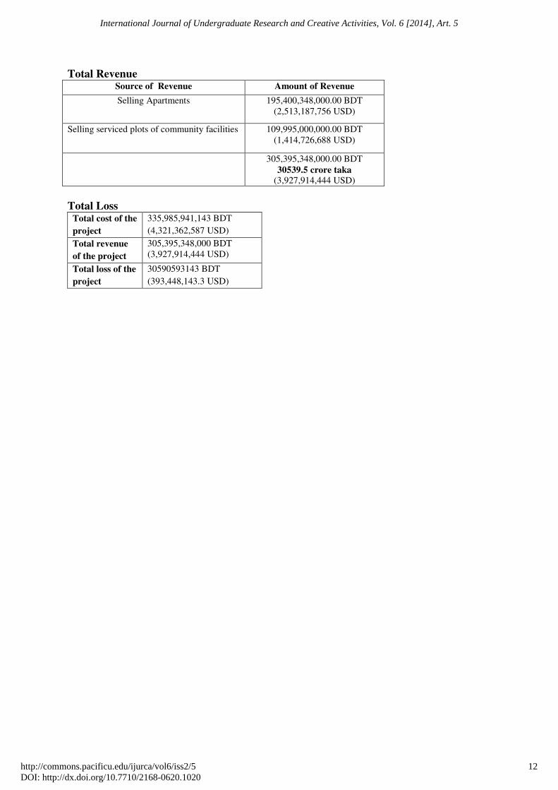
Total Revenue Source of Revenue Amount of Revenue
Selling Apartments 195,400,348,000.00 BDT
(2,513,187,756 USD)
Selling serviced plots of community facilities
109,995,000,000.00 BDT
(1,414,726,688 USD)
305,395,348,000.00 BDT
30539.5 crore taka (3,927,914,444 USD)
Total Loss Total cost of the
project
335,985,941,143 BDT
(4,321,362,587 USD)
Total revenue
of the project
305,395,348,000 BDT
(3,927,914,444 USD)
Total loss of the
project
30590593143 BDT
(393,448,143.3 USD)
12
International Journal of Undergraduate Research and Creative Activities, Vol. 6 [2014], Art. 5
http://commons.pacificu.edu/ijurca/vol6/iss2/5DOI: http://dx.doi.org/10.7710/2168-0620.1020
Copyright © 2022 FDOKUMEN