Management Plan - DENR
124
Department of Environment and Natural Resources Management Plan Peñablanca Protected Landscape and Seascape Strengthening Climate Change Resilience through Improved Watershed and Coastal Resources Management in Protected Areas
-
Upload
khangminh22 -
Category
Documents
-
view
2 -
download
0
Transcript of Management Plan - DENR

Department of Environmentand Natural Resources
ManagementPlan
Peñablanca ProtectedLandscape and Seascape
Strengthening Climate ChangeResilience through ImprovedWatershed and Coastal ResourcesManagement in Protected Areas

Peñablanca Protected Landscape and Seascape
MANAGEMENT PLAN
November 30, 2015
With Technical Assistance from:
Orient Integrated Development Consultants, Inc.

Strengthening Climate Change Resilience through Improved Watershed and Coastal Resources Management in Protected Areas in Peñablanca and Siargao
P P L S M a n a g e m e n t P l a n i | P a g e
Table of Contents
ACRONYMS ........................................................................................................................... iv
EXECUTIVE SUMMARY ..................................................................................................... ES-1
1.0 INTRODUCTION ............................................................................................................ 1 1.1 Legal Basis for Protected Area Management in the Philippines ..................................... 1 1.2 Background and Continuing Relevance of PPLS as a Protected Area .............................. 1 1.3 The Process of Updating the PPLS Plan ........................................................................... 2
2.0 PROFILE OF THE PEÑABLANCA PROTECTED LANDSCAPE AND SEASCAPE ...................... 5 2.1 Biogeographic Setting ...................................................................................................... 5 2.2 Regional and Local Development Context ....................................................................... 6 2.3 Physical Features ............................................................................................................. 6
2.3.1 Topography and Slope ........................................................................................................ 8 2.3.2 Geology and Soils ............................................................................................................... 8 2.3.3 Hydrology ........................................................................................................................... 8 2.3.4 Climate.............................................................................................................................. 10 2.3.5 Hazards ............................................................................................................................. 12
2.4 Biological Diversity ......................................................................................................... 14 2.4.1 Habitats and Ecosystems .................................................................................................. 14 2.4.2 Flora .................................................................................................................................. 19
2.5 Socio-Economic and Cultural Profile.............................................................................. 20 2.5.1 Demography ..................................................................................................................... 21 2.5.2 Livelihood and Income Sources ........................................................................................ 22 2.5.3 Land Cover ........................................................................................................................ 23 2.5.4 Forestland Tenure ............................................................................................................ 24 2.5.5 Road Infrastructure and Communication Facilities .......................................................... 25
2.6 PA Stakeholders ............................................................................................................. 25 2.7 Current PA Management Structure and Capabilities for Management ........................ 27 2.8 Current PA Management Activities ............................................................................... 28
2.8.1 PASu Office/DENR Enforcement and IEC Activities .......................................................... 28 2.8.2 National Greening Program of DENR................................................................................ 28 2.8.3 Peñablanca LGU Support to Enforcement and Other Activities ....................................... 29 2.8.4 Conservation International Reforestation and Agroforestry Project ............................... 29 2.8.5 Metro Tuguegarao Water District Watershed Reservation Management ....................... 30 2.8.6 PhilCCAP Pilot Agroforestry Project ................................................................................. 30 2.8.7 Department of Tourism Support to Ecotourism ............................................................... 31
2.9 Current Issues, Concerns and Opportunities ................................................................. 31 2.9.1 Management and Development Issues and Concerns ..................................................... 32 2.9.2 Vulnerabilities to Climate Change .................................................................................... 36 2.9.3 Development Potentials ................................................................................................... 47
3.0 THE MANAGEMENT PLAN .......................................................................................... 49 3.1 Vision, Missions, Goals and Objectives .......................................................................... 49
3.1.1 Vision ................................................................................................................................ 49 3.1.2 Mission ............................................................................................................................. 49 3.1.3 Goals and Objectives ........................................................................................................ 50

Strengthening Climate Change Resilience through Improved Watershed and Coastal Resources Management in Protected Areas in Peñablanca and Siargao
P P L S M a n a g e m e n t P l a n ii | P a g e
3.2 Key Management Strategies .......................................................................................... 51 3.2.1 Management Zoning ........................................................................................................ 51 3.2.2 Collaborative Management .............................................................................................. 52 3.2.3 Community Based Resource Management ...................................................................... 53 3.2.4 Sustainable Financing ....................................................................................................... 53 3.2.5 Climate Change Adaptation .............................................................................................. 54
3.3 Management Programs ................................................................................................. 54 3.3.1 Biodiversity Protection, Conservation and Rehabilitation Program ................................. 54 3.3.2 Social and Economic Program .......................................................................................... 59 3.3.3 Disaster Risk Reduction Program ..................................................................................... 63 3.3.4 Governance Enhancement and Institutional Strengthening Program ............................. 65 3.3.5 Climate Change Adaptation Measures in PPLS: A Summary ............................................ 68
3.4 Management Zones and Prescriptions .......................................................................... 69 3.4.1 Strict Protection Zone ....................................................................................................... 69 3.4.2 Multiple Use Zone ............................................................................................................ 69
3.5 Management Standards and Guidelines ....................................................................... 74
4.0 PROPOSED MANAGEMENT STRUCTURE AND INSTITUTIONAL ARRANGEMENTS ..... 76 4.1 Protected Area Management Board .............................................................................. 76 4.2 Protected Area Superintendent’s Office ....................................................................... 78
5.0 IMPLEMENTATION PLAN ............................................................................................ 79
6.0 MONITORING AND EVALUATION ............................................................................... 84
REFERENCES ........................................................................................................................ 87
Tables Table 2.1 Diversity, Endemicity and Threatened Species of Vertebrate Wildlife
at Various Geographic Levels ............................................................................................ 5 Table 2.2 Slope Categories of Peñablanca ......................................................................................... 8 Table 2.3 Tropical Cyclones that Affected Cagayan Province, 2008-2014 ...................................... 10 Table 2.4 Temperature Increases and Seasonal Rainfall Change under Medium Range
Emission Scenario: Cagayan Province, 2020 and 2050 ................................................... 12 Table 2.5 Mangrove Species Found in Barangays Lapi and Minanga, Peñablanca, Cagayan,
2012 ................................................................................................................................. 16 Table 2.6 Birds Netted in the Montane Forest of PPLS* ................................................................. 18 Table 2.7 Land Area by Barangay .................................................................................................... 20 Table 2.8 Population Density per Barangay, 2010 ........................................................................... 21 Table 2.9 Annual Population Growth Rates in Peñablanca, Cagayan .............................................. 22 Table 2.10 Rice and Corn Farming in Peñablanca, Cagayan ............................................................ 22 Table 2.11 Land Cover Change in Peñablanca, Cagayan, 2003 to 2010 .......................................... 24 Table 2.12 Tenurial Instruments Issued........................................................................................... 24 Table 2.13 NGP Sites and Targets within the PPLS .......................................................................... 29 Table 2.14 Distribution of PhilCCAP Agroforestry Farmer Cooperators by Barangay .................... 30 Table 2.15 Callao Caves Tourism Inflow, 2008-2013. ...................................................................... 47 Table 3.1 Summary of Criteria Used for Zoning .............................................................................. 51 Table 5.1 Schedule of Activities for Implementing the PPLS Plan ................................................... 79 Table 5.2 Five-Year Budget Requirements of the PPLS Management Plan Implementation .......... 81

Strengthening Climate Change Resilience through Improved Watershed and Coastal Resources Management in Protected Areas in Peñablanca and Siargao
P P L S M a n a g e m e n t P l a n iii | P a g e
Figures Figure 1.1 The PA Plan Updating Process (with enhancements) ....................................................... 4 Figure 2.1 Location of the PPLS ......................................................................................................... 7 Figure 2.2 Major Uses of Water Resources of PPLS........................................................................... 9 Figure 2.3 Climate Map of Region 2 ................................................................................................ 11 Figure 2.4 Flood-Prone Areas in Peñablanca, Baggao and Tuguegarao City ................................... 13 Figure 2.5 Landslide-Prone Areas in Peñablanca, Baggao and Tuguegarao City ............................. 13 Figure 2.6 Land Cover Change in PPLS, 2003-2010.......................................................................... 33 Figure 2.7 Relative Locations of Unsustainable Livelihood Activities in PPLS ................................. 35 Figure 2.8 Potential Impact of Flooding on Agriculture .................................................................. 38 Figure 2.9 Potential Impact of Flooding on Built-up Areas .............................................................. 39 Figure 2.10 Potential Impact of Landslide on Agriculture ............................................................... 41 Figure 2.11 Potential Impact of Landslide on Built-up Areas .......................................................... 42 Figure 2.12 Vulnerability Map for Flooding and Landslide in the PPLS ........................................... 43 Figure 2.13 Vulnerability to Multiple Hazards in the PPLS .............................................................. 44 Figure 2.14 Ecosystems at High Risk to Temperature Change (> 1,000 masl) ................................ 46 Figure 3.1 Zoning Map of PPLS ........................................................................................................ 52 Figure 3.2 Proposed Land Uses in the Multiple Use Zones of PPLS ................................................. 55 Figure 3.3 Example of a Farm Plan for a Model Agroforestry Farm ................................................ 60 Figure 4.1 Proposed PPLS Management Structure .......................................................................... 76 Figure 6.1 PPLS Results Framework ................................................................................................. 85
Annex Maps Annex Map 1. Location of the PPLS Annex Map 2. Slope Map of Peñablanca, Cagayan Annex Map 3. Elevation Map of Peñablanca, Cagayan Annex Map 4. Soil Map of Peñablanca, Cagayan Annex Map 5. Drainage Map of PPLS Annex Map 6. Flood Prone Areas As Affected by PPLS Annex Map 7. Landslide Prone Areas in Peñablanca Annex Map 8. Land Classification Map of PPLS Annex Map 9. 2003 Land Cover Map of Peñablanca Annex Map 10. Tenure Map in the PPLS Annex Map 11. Zoning Map of PPLS
Annex Tables Annex Table 1. Stakeholders’ Matrix Annex Table 2. Vulnerability ratings of birds in PPLS Annex Table 3. Vulnerability rating of 109 plant species in PPLS

Strengthening Climate Change Resilience through Improved Watershed and Coastal Resources Management in Protected Areas in Peñablanca and Siargao
P P L S M a n a g e m e n t P l a n iv | P a g e
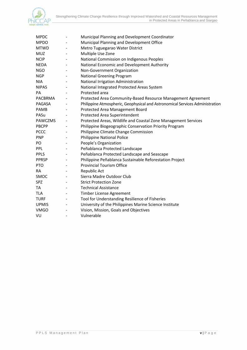
ACRONYMS ADSDPP - Ancestral Domain Sustainable Development and Protection Plan ANR - Assisted Natural Regeneration BMB - Biodiversity Management Bureau BMS - Biodiversity Monitoring System CADC - Certificate of Ancestral Domain Claim CADT - Certificate of Ancestral Domain Title CBFM - Community Based Forest Management CBFMA - Community Based Forest Management Agreement CCA - Climate Change Adaptation CENRO - Community Environment and Natural Resources Office CIP - Communal Irrigation Projects CIP - Conservation International Philippines CIS - Communal Irrigation System CLUP - Comprehensive Land Use Plan CPDO - City Planning and Development Office CR - Critically endangered CRMP - Community Resource Management Plan CSC - Certificate of Stewardship Contract CSU - Cagayan State University DA - Department of Agriculture DAO - DENR Administrative Order DENR - Department of Environment and Natural Resources DENRO - Deputized Environment and Natural Resources Officer DepEd - Department of Education DOT - Department of Tourism DOST - Department of Science and Technology DRRM - Disaster Risk Reduction and Management ECC - Environmental Compliance Certificate EIA - Environmental Impact Assessment EN - Endangered ENRO - Environment and Natural Resources Office EO - Executive Order EXECOM - Executive Committee ICC - Indigenous Cultural Community ICRAF - International Center for Research and Agroforestry IEC - Information, Education and Communications IP - Indigenous People IPAF - Integrated Protected Area Fund ISU - Isabela State University IUCN - International Union for Conservation of Nature KBA - Key Biodiversity Area Kph - kilometers per hour LGU - Local Government Unit MAO - Municipal Agriculturist’s Office masl - meters above sea level MENRO - Municipal Environment and Natural Resources Office MGB - Mines and Geosciences Bureau MOA - Memorandum of Agreement
Strengthening Climate Change Resilience through Improved Watershed and Coastal Resources Management in Protected Areas in Peñablanca and Siargao
P P L S M a n a g e m e n t P l a n v | P a g e
MPDC - Municipal Planning and Development Coordinator MPDO - Municipal Planning and Development Office MTWD - Metro Tuguegarao Water District MUZ - Multiple Use Zone NCIP - National Commission on Indigenous Peoples NEDA - National Economic and Development Authority NGO - Non-Government Organization NGP - National Greening Program NIA - National Irrigation Administration NIPAS - National Integrated Protected Areas System PA - Protected area PACBRMA - Protected Area Community-Based Resource Management Agreement PAGASA - Philippine Atmospheric, Geophysical and Astronomical Services Administration PAMB - Protected Area Management Board PASu - Protected Area Superintendent PAWCZMS - Protected Areas, Wildlife and Coastal Zone Management Services PBCPP - Philippine Biogeographic Conservation Priority Program PCCC - Philippine Climate Change Commission PNP - Philippine National Police PO - People’s Organization PPL - Peñablanca Protected Landscape PPLS - Peñablanca Protected Landscape and Seascape PPRSP - Philippine Peñablanca Sustainable Reforestation Project PTO - Provincial Tourism Office RA - Republic Act SMOC - Sierra Madre Outdoor Club SPZ - Strict Protection Zone TA - Technical Assistance TLA - Timber License Agreement TURF - Tool for Understanding Resilience of Fisheries UPMIS - University of the Philippines Marine Science Institute VMGO - Vision, Mission, Goals and Objectives VU - Vulnerable

Strengthening Climate Change Resilience through Improved Watershed and Coastal Resources Management in Protected Areas in Peñablanca and Siargao
P P L S M a n a g e m e n t P l a n ES-1 | P a g e
EXECUTIVE SUMMARY Peñablanca Protected Landscape and Seascape (PPLS) became a protected area through Presidential Proclamation No. 484 issued on October 6, 2003. It was an expansion from the original Peñablanca Protected Landscape (PPL), which covered 4,136 hectares. The PPLS currently has 103,801 hectares of land and 14, 980 hectares of water. Eighteen barangays comprise the PPLS. The PPLS is home to a diverse and unique species of flora and fauna, many of which are critically endangered (CR), endangered (EN) and vulnerable (VU) species. As part of the Sierra Madre sub region, it has been identified as an important bird area and a high priority for conservation in the Philippine Biogeographic Conservation Priority Program (PBCPP). PPLS has more than 200 cave systems that include the nationally renowned Callao Caves. Many of the cave systems have been identified to have archeological, historical and ecological significance. The PPLS is currently threatened by the following: declining forest cover and threatened habitats; unsustainable livelihood practices in the uplands; land tenure issues in forestlands; insufficient financial, logistical and manpower resources for the effective management of the PA; and weak governance structure. The PPLS is vulnerable to such climate change impacts as increased temperature, erratic rainfall patterns, sea level rise, and more intense extreme climatic events such as typhoons, floods, and droughts. The temperature and rainfall changes have great impact on agriculture, forestry, water resources, fisheries and marine resources, human settlements, biodiversity, and ecosystems in general. These can adversely affect the stability and sustainability of the terrestrial and marine ecosystems within PPLS.
Vulnerability Assessments The vulnerability assessment on PPLS looked specifically at vulnerabilities to flooding and landslides. Flooding is a common hazard in Peñablanca. Every year, several barangays in the municipality experience flooding, including four barangay settlements within PPLS. The downstream barangays of Penablanca, however, are more seriously affected by flooding which to a large degree is caused by the degraded condition of the major sub-watersheds within PPLS. Since more than 60% of PPLS have steep to very steep slopes, many areas in the PA are also prone to rain-induced landslide. The expected increase in seasonal rainfall during the wet season increases the risk of settlements, agriculture and ecosystems to this hazard. In view of limited information, the assessment of the vulnerability of plant and faunal species to increasing temperatures focused on a few species only, primarily those which respond or adapt to temperature increase by migrating upwards to elevational zones that approximate former habitat conditions. Flora and fauna found growing in the mossy forest zone of mountains (i.e., above 1,000 masl) such as Mt. Cetaceoare are highly at risk because there are no more places to migrate to that are higher than where they are at present.
Strengthening Climate Change Resilience through Improved Watershed and Coastal Resources Management in Protected Areas in Peñablanca and Siargao
P P L S M a n a g e m e n t P l a n ES-2 | P a g e
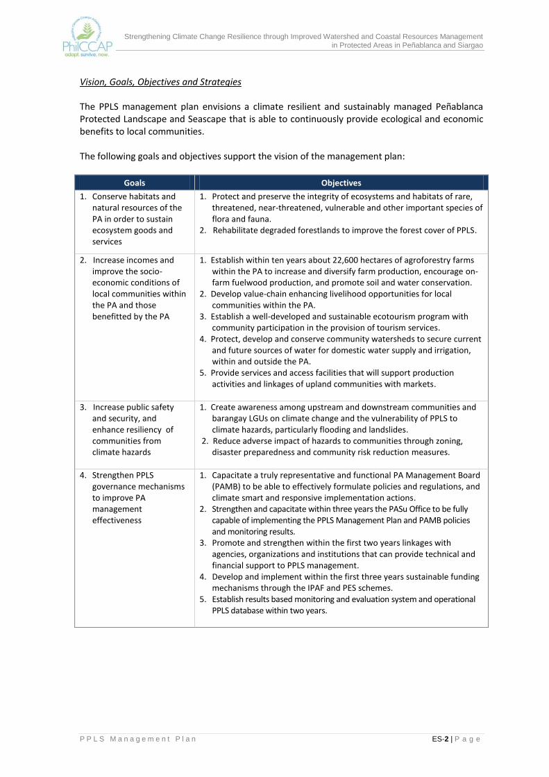
Vision, Goals, Objectives and Strategies The PPLS management plan envisions a climate resilient and sustainably managed Peñablanca Protected Landscape and Seascape that is able to continuously provide ecological and economic benefits to local communities. The following goals and objectives support the vision of the management plan:
Goals Objectives
1. Conserve habitats and natural resources of the PA in order to sustain ecosystem goods and services
1. Protect and preserve the integrity of ecosystems and habitats of rare, threatened, near-threatened, vulnerable and other important species of flora and fauna.
2. Rehabilitate degraded forestlands to improve the forest cover of PPLS.
2. Increase incomes and improve the socio-economic conditions of local communities within the PA and those benefitted by the PA
1. Establish within ten years about 22,600 hectares of agroforestry farms within the PA to increase and diversify farm production, encourage on-farm fuelwood production, and promote soil and water conservation.
2. Develop value-chain enhancing livelihood opportunities for local communities within the PA.
3. Establish a well-developed and sustainable ecotourism program with community participation in the provision of tourism services.
4. Protect, develop and conserve community watersheds to secure current and future sources of water for domestic water supply and irrigation, within and outside the PA.
5. Provide services and access facilities that will support production activities and linkages of upland communities with markets.
3. Increase public safety and security, and enhance resiliency of communities from climate hazards
1. Create awareness among upstream and downstream communities and barangay LGUs on climate change and the vulnerability of PPLS to climate hazards, particularly flooding and landslides.
2. Reduce adverse impact of hazards to communities through zoning, disaster preparedness and community risk reduction measures.
4. Strengthen PPLS governance mechanisms to improve PA management effectiveness
1. Capacitate a truly representative and functional PA Management Board (PAMB) to be able to effectively formulate policies and regulations, and climate smart and responsive implementation actions.
2. Strengthen and capacitate within three years the PASu Office to be fully capable of implementing the PPLS Management Plan and PAMB policies and monitoring results.
3. Promote and strengthen within the first two years linkages with agencies, organizations and institutions that can provide technical and financial support to PPLS management.
4. Develop and implement within the first three years sustainable funding mechanisms through the IPAF and PES schemes.
5. Establish results based monitoring and evaluation system and operational PPLS database within two years.

Strengthening Climate Change Resilience through Improved Watershed and Coastal Resources Management in Protected Areas in Peñablanca and Siargao
P P L S M a n a g e m e n t P l a n ES-3 | P a g e
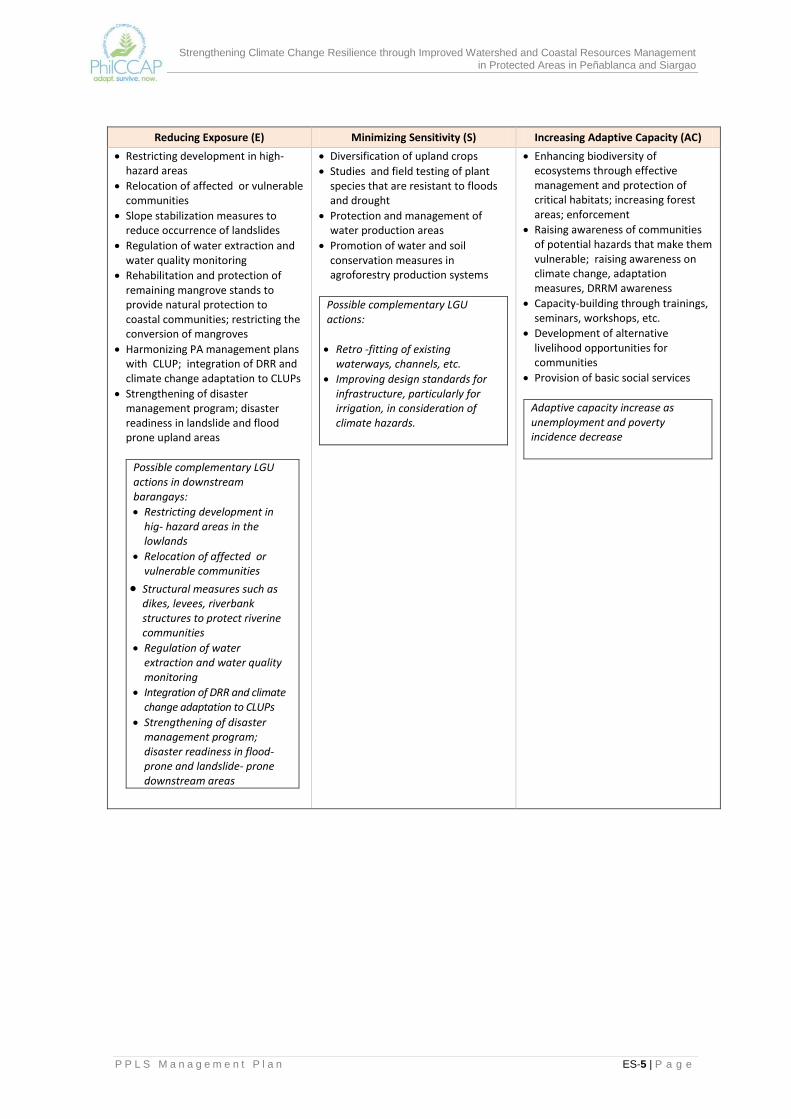
Key management strategies to attain the goals include: (1) management zoning; (2) collaborative management; (3) community-based resource management; (4) sustainable financing mechanisms; and (5) climate change adaptation. In management zoning, the strict protection zones are areas that are 1,000 meters above sea level (masl) and have closed canopy forests, mossy forests and known habitats of rare and endangered species of flora and fauna. All other areas outside the strict protection zones are multiple use zones, with sub-zones that are based on the unique characteristics of the area, and actual and potential land uses. The identified sub-zones are: resource rehabilitation and conservation, mangrove rehabilitation, ecotourism, agroforestry development, forest plantation, water conservation, settlement and special land use areas. The standards and prescriptions were formulated to serve as guides to zoning implementation. Because of the multiple ecosystems goods and services provided by the PPLS and the multiple resource users of such goods and services, use of collaborative management will be maximized through management agreements between the PAMB and designated on-site managers for specific management units. Realizing the inherent constraints and limitations of national agencies, particularly the Department of Environment and Natural Resources (DENR), community-based resource management will be adopted by mobilizing barangay residents and officials, and peoples organizations to participate in all stages of resource management. This strategy shall be employed to foster link between the resources used by the communities and the conservation and sustainable use of these resources. This strategy recognizes the fact that management of natural resources with strong community involvement is both efficient and cost effective. The development and establishment of sustainable sources of financing to support PPLS activities will be accorded priority attention because of limited financial resources available to the PAMB and the PASu Office. There is a need to assess the different resources available in the PA, the uses and users of these resources, and determine the appropriate fees for their uses. A system for payment of ecosystem services (PES) and resource use fees, and the mechanism for the allocation and disbursement of the Integrated PA Fund (IPAF) will be established by the PAMB. In accordance with national policies and guided by the results of climate change vulnerability assessments, climate change adaptation (CCA) measures is incorporated into PA management strategies. CCA measures are to increase the resilience of ecosystems and communities to the impacts of climate change. These aim to reduce exposure to natural hazards such as flooding and landslides, minimize sensitivity to climate change, and enhance adaptive capacity of communities and ecosystems.
Management Programs The resulting management programs for implementation have four focus areas: (1) biodiversity protection, conservation and rehabilitation; (2) social and economic development; (3) disaster risk reduction; and (4) governance enhancement and institutional strengthening. The protection of biological diversity and enhancement of ecosystems services will include ground demarcation of the SPZ; ecological research and biodiversity monitoring; community-based resource protection and law enforcement; terrestrial and marine habitat restoration/rehabilitation and conservation; and conservation awareness and education.
Strengthening Climate Change Resilience through Improved Watershed and Coastal Resources Management in Protected Areas in Peñablanca and Siargao
P P L S M a n a g e m e n t P l a n ES-4 | P a g e
Programs on social and economic development are to improve the quality of life of protected area communities through environment-friendly livelihoods that are directly linked to sustainable land and resource use; improved access to basic services and facilities and water security. More specific interventions are:
(1) agroforestry farm development in multiple use zones that can potentially cover 22,600 hectares; (2) forest plantation management in about 3,619 hectares to develop source of wood for the wood
requirements of local communities; (3) ecotourism development, which will involve planning and development of scenic, historical and
cultural ecotourism destinations, and ecotourism-related livelihood; (4) development of other sustainable livelihood opportunities; (5) enhanced delivery of basic social services; and (6) rehabilitation of water conservation areas to sustainably provide for the water needs of
communities for domestic use and for agriculture.
The disaster risk reduction program will involve the review and refinement of existing municipal DRRM plans; hazards awareness and education; training and assistance in the development and implementation of community disaster risk reduction and preparedness plans. Results of vulnerability assessment will be presented to local communities and the LGUs to make them aware which areas are vulnerable to particular hazards, including the impacts of these hazards on ecosystems and on communities and livelihoods. Community-level planning will be organized and will focus on reducing exposure to climate hazards. The final focus area would be on governance enhancement and institutional strengthening. This recognizes that the management of PPLS resources requires multi-sectoral and multi-stakeholders collaboration. There will be need to build the capability of both the PAMB and the PASu Office and install systems and mechanisms for coordination and management, resource generation and mobilization. The PAMB will have to develop its policy agenda, starting with those raised during PA planning, and provide its recommendations on the various policy issues that are affecting PPLS management. Climate change adaptation measures are embedded in the PPLS management plan. Enhancing climate resiliency essentially means reducing the vulnerability of the PA to the adverse effects of climate hazards. Vulnerability to climate change is a function of three factors, namely: (1) types and magnitudes of Exposure to climate change; (2) Sensitivity of the system to climate hazards; and (3) Adaptive Capacity of the system. In the PPLS management plan, CCA strategies and measures that address the three factors are summarized below:
Strengthening Climate Change Resilience through Improved Watershed and Coastal Resources Management in Protected Areas in Peñablanca and Siargao
P P L S M a n a g e m e n t P l a n ES-5 | P a g e
Reducing Exposure (E) Minimizing Sensitivity (S) Increasing Adaptive Capacity (AC)
Restricting development in high-hazard areas
Relocation of affected or vulnerable communities
Slope stabilization measures to reduce occurrence of landslides
Regulation of water extraction and water quality monitoring
Rehabilitation and protection of remaining mangrove stands to provide natural protection to coastal communities; restricting the conversion of mangroves
Harmonizing PA management plans with CLUP; integration of DRR and climate change adaptation to CLUPs
Strengthening of disaster management program; disaster readiness in landslide and flood prone upland areas
Possible complementary LGU actions in downstream barangays:
Restricting development in hig- hazard areas in the lowlands
Relocation of affected or vulnerable communities
Structural measures such as dikes, levees, riverbank structures to protect riverine communities
Regulation of water extraction and water quality monitoring
Integration of DRR and climate change adaptation to CLUPs
Strengthening of disaster management program; disaster readiness in flood-prone and landslide- prone downstream areas
Diversification of upland crops
Studies and field testing of plant species that are resistant to floods and drought
Protection and management of water production areas
Promotion of water and soil conservation measures in agroforestry production systems
Possible complementary LGU actions:
Retro -fitting of existing waterways, channels, etc.
Improving design standards for infrastructure, particularly for irrigation, in consideration of climate hazards.
Enhancing biodiversity of ecosystems through effective management and protection of critical habitats; increasing forest areas; enforcement
Raising awareness of communities of potential hazards that make them vulnerable; raising awareness on climate change, adaptation measures, DRRM awareness
Capacity-building through trainings, seminars, workshops, etc.
Development of alternative livelihood opportunities for communities
Provision of basic social services
Adaptive capacity increase as unemployment and poverty incidence decrease

Strengthening Climate Change Resilience through Improved Watershed and Coastal Resources Management in Protected Areas in Peñablanca and Siargao
P P L S M a n a g e m e n t P l a n ES-6 | P a g e
Investment Requirements The first five years will be crucial in implementing the PPLS plan because this period lays down the groundwork for other activities in the succeeding years to ensure protection, rehabilitation and effective on-site management of the protected area. The total budgetary requirement for the first five years amounts to Php155 million. The distribution by component is as follows:
Program Estimated Cost
(Php M) % of Total
Estimated Cost
Biodiversity protection, conservation and rehabilitation 52.97 34%
Social and Economic Development 74.40 48%
Disaster Risk Reduction 2.69 2%
Governance Enhancement and Institutional Strengthening 4.50 3%
Administration 20.44 13%
Total 155.00
Funding for the PPLS plan implementation will come from various sources. Most of the biodiversity protection and conservation programs, including administrative costs, will be shouldered by the DENR, tapping the NGP funds, the PPLS allocation and other DENR projects. However, the PAMB will have to explore and develop other sources of financing to sustain funding to the PPLS such as user fees and payment for environmental services. The LGU, on the other hand, will have to provide the major investments for socio-economic development and disaster risk reduction. The budget indicated in the plan provide mostly for pre-implementation assessments, planning, training and coordination/monitoring and very focused implementation activities. The private sector and the provincial LGU will be encouraged to take responsibility for the ecotourism development program activities.
PA Management Structure It is proposed that the current PAMB and its committee system be expanded to broaden stakeholder participation and provide for a more effective decision-making process. The PAMB membership is proposed to be increased from 27 to 35 so other key stakeholders can be represented and provided the opportunity to participate in PAMB decision-making. Of the new members proposed, Baggao and Tuguegarao City, the National Irrigation Authority (NIA), and the water district of Baggao are considered direct stakeholders of PPLS as they are major users of water coming from PPLS watersheds. Baggao and Tuguegarao City are also impact areas of PPLS; these LGUs are affected by flooding that is caused by degradation in the uplands. The interest they represent in the PAMB are those of off-site resource users and of communities that are vulnerable to flooding. In addition to the current Executive Committee (ExeCom) and two other committees of PAMB, it is also proposed that sub-watershed management committees be created to further decentralize discussions and deliberations on issues and plans that concern a specific sub-watershed. The task of threshing out local issues, monitoring performance, review of proposals/applications, and the evaluation of options for a particular concern will be assigned to the sub-watershed management committee. Recommendations of sub-watershed management committees will be elevated to the ExeCom or the PAMB en banc for confirmation and adoption. The sub-watersheds of PPLS have been grouped into three, each of which represent a different set of issues and challenges.
Strengthening Climate Change Resilience through Improved Watershed and Coastal Resources Management in Protected Areas in Peñablanca and Siargao
P P L S M a n a g e m e n t P l a n ES-7 | P a g e
Monitoring and Evaluation The Monitoring and Evaluation (M and E) system for the updated management plan gives emphasis to the expected results of the implementation of the updated management plan. The indicator system for M and E are based on a results framework that has been developed from the goals, objectives and strategies in the management plan and which shows the progression of results from project activities to major outputs, outcomes and impacts. A detailed M and E plan serves as an accompanying document to the management plan. It also serves as a guide to the development of a PPLS database.

Strengthening Climate Change Resilience through Improved Watershed and Coastal Resources Management in Protected Areas in Peñablanca and Siargao
P P L S M a n a g e m e n t P l a n 1 | P a g e
PEÑABLANCA PROTECTED LANDSCAPE AND SEASCAPE MANAGEMENT PLAN
1.0 INTRODUCTION The United Nations considers biodiversity as one of five priority areas for sustainable development. The others are water, energy, health and agriculture. While the important role of biodiversity is widely recognized, studies indicate that biodiversity resources are being lost at alarming rates. Since the primary threat to terrestrial, freshwater and coastal species is the destruction of their habitats, the establishment of protected areas (PAs) for these species has emerged as one of the most important and effective measures to conserve biodiversity (Brumer, et. al., 2001).
1.1 Legal Basis for Protected Area Management in the Philippines
Protected area establishment in the Philippines was institutionalized when the National Integrated Protected Areas System (NIPAS) Act or Republic Act (RA) 7586 was passed in 1992 by Congress. Among others, the NIPAS Act provides for: a) identification of protected area categories; b) establishment of standard planning process; c) NIPAS administration by the Department of Environment and Natural Resources (DENR) and the Protected Area Management Board (PAMB), a multi-sectoral body mandated to decide on matters related to protected areas management; d) recognition of ancestral rights; and e) institutionalization of environmental impact assessment. Pursuant to this law, “all areas or islands in the Philippines proclaimed, designated or set aside, pursuant to a law, presidential decree, presidential proclamation or Executive Order as national park, game refuge, bird and wildlife sanctuary, wilderness area, strict nature reserve, watershed, mangrove reserve, fish sanctuary, natural and historical landmark, protected and managed landscape/seascape as well as identified virgin forests before the effectivity of this Act are hereby designated as initial components of the System.” In addition to the initial components, the DENR Secretary is mandated to propose the inclusion in the System of additional areas with outstanding physical features, anthropological significance and biological diversity in accordance with the provisions of Section 5 of the NIPAS Act.
1.2 Background and Continuing Relevance of PPLS as a Protected Area The Peñablanca Protected Landscape and Seascape (PPLS) was proclaimed as a protected area on October 6, 2003 through Presidential Proclamation 484. It was an expansion from the original Peñablanca Protected Landscape (PPL), which was declared as a protected area under Proclamation No. 416 signed by then President Fidel V. Ramos on June 29, 1994.1 Originally covering 4,136 hectares, the PPLS now covers 103,801 hectares of land and 14, 980 hectares of marine waters.
1This Proclamation expanded the Callao Cave National Park to include ecologically-important portions and the cave ecosystems found
within in order to conserve, manage, and protect their scenic, cultural, historical, scientific, recreational, and archeological features.

Strengthening Climate Change Resilience through Improved Watershed and Coastal Resources Management in Protected Areas in Peñablanca and Siargao
P P L S M a n a g e m e n t P l a n 2 | P a g e
The PPLS has been identified as a key biodiversity area (KBA) based on recorded occurrence of critically endangered (CR), endangered (EN) and vulnerable (VU) species. Following the revised IUCN Red List of 2009, PPLS has recorded presence of two CR species (Philippine Eagle, Pithecophaga jefferyii, and the Isabela Oriole, Oriolus isabelae), three EN species (Taylor‘s Igorot frog, Platymantis taylori; Golden-crowned fruit bat, Acerodon jubatus; and Cantor‘s soft-shelled turtle, Pelochelys cantorii), and 20 VU species of fauna. The flora survey conducted by Conservation International Philippines (CIP) in 2002 also recorded 11 critically endangered plants, (i.e. Hopea acuminta, Shorea guiso, S. polysprema, S. contorta, S. negrosensis, S. malibato, Dipterocarpus gracilis, D. validis, D. grandiflorus, D. kunstleri, and Parashorea malaanonan) in this KBA (Conservation International, 2009). Indeed, PPLS is home to diverse, unique and endangered species of flora and fauna. As part of the Sierra Madre sub-region, it is identified as an important bird area and a high priority for conservation in the Philippine Biogeographic Conservation Priority Program (PBCPP). Aside from its biodiversity resources, PPLS also provides economic benefits and environmental services to Peñablancaand to the adjoining municipality of Baggao, Cagayan and the City of Tuguegarao. It is the source of domestic water for both Peñablanca and Tuguegarao and of irrigation water for the agricultural areas of Peñablanca, Baggao and Tuguegarao City.Metro Tuguegarao Water District (MTWD) is partly sourcing its domestic water requirements from reservoirs located within the protected area. Significant areas of rice lands are dependent on the PPLS for irrigation making PPLS crucial in securing rice production in Peñablanca and to some extent in Baggao and Tuguegarao City. Thus, the PA impacts on the livelihood of local communities, specifically lowland rice farmers and upland communities that depend on hunting, gathering of forest products and farming in forestlands. In addition, the PA also plays an important role in mitigating the impacts of flooding in downstream barangays. Since PPLS is the headwater of most of rivers and creeks draining into downstream communities, the vegetative cover of the PA determines to a large extent the degree of flooding occurring in these areas and the extent of flood damage to lives, crops and properties. The declaration of the PPLS as a protected area is considered a strategic measure to protect and conserve its biodiversity resources and sustain the economic benefits and ecosystem services that it provides. Local communities, the Local Government Unit (LGU), national agencies and other stakeholders recognize and enjoy such benefits but have been unable to completely stop the destruction of forest and coastal resources within the PA.
1.3 The Process of Updating the PPLS Plan The NIPAS Act requires that a management plan be prepared for each PA. The first PPLS management plan was done in 2004. It was proposed that this be updated under the Philippine Climate Change Adaptation Project (PhilCCAP) to consider recent developments in the PA and climate change challenges that threaten the ability of the PPLS to provide ecosystems goods and services. The updating of the PPLS plan in order to take into account the potential impacts of climate related hazards is in accordance with RA 9729 or the Climate Change Act of 2009.
Strengthening Climate Change Resilience through Improved Watershed and Coastal Resources Management in Protected Areas in Peñablanca and Siargao
P P L S M a n a g e m e n t P l a n 3 | P a g e
In updating the PPLS management plan, enhancements were introduced to the PA planning process provided under Rule 10 of DAO 2008-26. Refer to Figure 1.1.The Local Working Group (LWG)2, with guidance from the Technical Assistance (TA) Team, followed a participatory planning process that involved various stakeholders consisting of local communities, non-government organizations (NGOs), peoples’ organizations (POs), Peñablanca LGU, and national government agencies operating in the area. As shown in Figure 1.1, the first crucial step in updating the PA plan was the collection of updated thematic maps, biodiversity studies and other socio-economic information. Additional data on climate scenarios as well as land cover and hazards maps were collected from the Philippine Atmospheric, Geophysical and Astronomical Services Administration (PAGASA) and the Mines and Geosciences Bureau (MGB) of DENR. Resource uses and users or stakeholders were also identified including institutions involved in the management and regulation of uses within the PPLS. The overlay of thematic maps and analysis of data led to the identification of issues, concerns and opportunities in the PA. The watershed-based and integrated ecosystems framework guided the planning team in conducting the situational analysis particularly in relation to the use of the water resources of PPLS. The vulnerability assessment of specific areas to climate-related hazards such as flooding and landslide was included in the situational analysis which led to the identification of specific barangays, including those in downstream areas, that are highly susceptible to these hazards. Based on the vulnerability assessment and the identified issues, concerns and opportunities, the LWG formulated the vision, goals and objectives of the plan, which incorporate the need to enhance the resiliency of ecosystems and communities and livelihoods to climate change impacts. Strategies to achieve the vision, goals and objectives were then formulated and fleshed out. A key strategy is the delineation of the strict protection zone (SPZ) and multiple use zones (MUZ), with management prescriptions that considered their vulnerability to climate change hazards. The protection and conservation, and investment programs developed for the SPZ and MUZ highlight how these mitigate climate change impacts or enable ecosystems and communities to adapt to climate change. Among the support implementation strategies introduced are the development of sustainable financing schemes for specific management programs such as the payment for environmental services (PES); the adoption of a results-based M and E system to capture the final major outputs and outcomes of the various interventions and investments; and the strengthening of governance arrangements through capability-building and linkages with support institutions. Consultations with stakeholders, which include the Sangguniang Bayan (SB) of Peñablanca and the members of the PAMB, were organized where the draft PA plan of PPLS was presented for validation. The draft plan was also presented to the technical staff of the Biodiversity Management Bureau (BMB). Following these consultations, the plan was then finalized. The revised PPLS management plan was approved by the PAMB during its October 30, 2015 meeting.
2The LWG was formed under PhilCCAP to participate in the updating of the PPLS Management Plan. Other than the PASu Office, its
members represented these agencies and organizations: Peñablanca LGU (MPDO, MENRO, MAO), Cagayan Provincial LGU (PPDO), Department of Tourism, Peñablanca and Metro Tuguegarao Water Districts, Cagayan State University, Isabela State University and the Sierra Madre Outdoor Club.

Strengthening Climate Change Resilience through Improved Watershed and Coastal Resources Management in Protected Areas in Peñablanca and Siargao
P P L S M a n a g e m e n t P l a n 4 | P a g e
Figure 1.1 The PA Plan Updating Process (with enhancements)
Strengthening Climate Change Resilience through Improved Watershed and Coastal Resources Management in Protected Areas in Peñablanca and Siargao
P P L S M a n a g e m e n t P l a n 5 | P a g e
2.0 PROFILE OF THE PEÑABLANCA PROTECTED LANDSCAPE AND SEASCAPE This section provides a description of the biogeographic zone to which the PA is included, and how management of the PA relates to the development programs of the region, province and the municipality. Its physical, biological, and socio-economic profile and the users/ stakeholders of the PA including the institutions involved in its management are identified and described in this section. The assessment leads to the identification of issues, concerns and opportunities for PA management.
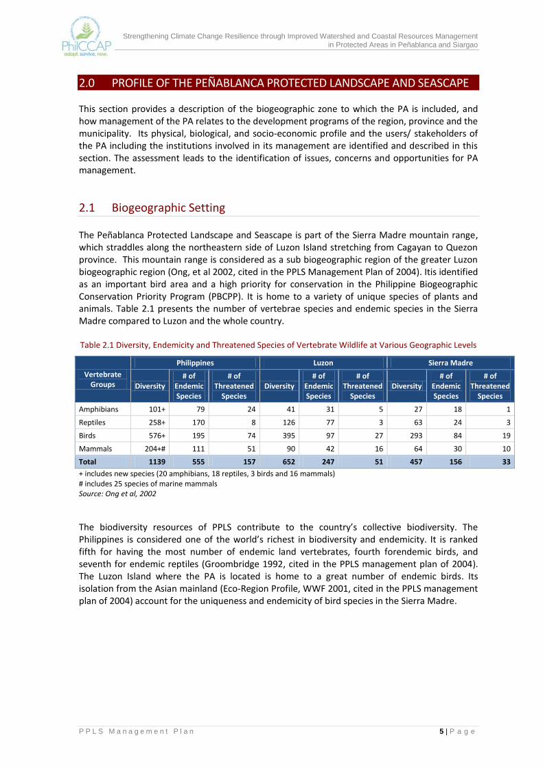
2.1 Biogeographic Setting The Peñablanca Protected Landscape and Seascape is part of the Sierra Madre mountain range, which straddles along the northeastern side of Luzon Island stretching from Cagayan to Quezon province. This mountain range is considered as a sub biogeographic region of the greater Luzon biogeographic region (Ong, et al 2002, cited in the PPLS Management Plan of 2004). Itis identified as an important bird area and a high priority for conservation in the Philippine Biogeographic Conservation Priority Program (PBCPP). It is home to a variety of unique species of plants and animals. Table 2.1 presents the number of vertebrae species and endemic species in the Sierra Madre compared to Luzon and the whole country. Table 2.1 Diversity, Endemicity and Threatened Species of Vertebrate Wildlife at Various Geographic Levels
Vertebrate Groups
Philippines Luzon Sierra Madre
Diversity # of
Endemic Species
# of Threatened
Species Diversity
# of Endemic Species
# of Threatened
Species Diversity
# of Endemic Species
# of Threatened
Species
Amphibians 101+ 79 24 41 31 5 27 18 1
Reptiles 258+ 170 8 126 77 3 63 24 3
Birds 576+ 195 74 395 97 27 293 84 19
Mammals 204+# 111 51 90 42 16 64 30 10
Total 1139 555 157 652 247 51 457 156 33
+ includes new species (20 amphibians, 18 reptiles, 3 birds and 16 mammals) # includes 25 species of marine mammals Source: Ong et al, 2002
The biodiversity resources of PPLS contribute to the country’s collective biodiversity. The Philippines is considered one of the world’s richest in biodiversity and endemicity. It is ranked fifth for having the most number of endemic land vertebrates, fourth forendemic birds, and seventh for endemic reptiles (Groombridge 1992, cited in the PPLS management plan of 2004). The Luzon Island where the PA is located is home to a great number of endemic birds. Its isolation from the Asian mainland (Eco-Region Profile, WWF 2001, cited in the PPLS management plan of 2004) account for the uniqueness and endemicity of bird species in the Sierra Madre.

Strengthening Climate Change Resilience through Improved Watershed and Coastal Resources Management in Protected Areas in Peñablanca and Siargao
P P L S M a n a g e m e n t P l a n 6 | P a g e
2.2 Regional and Local Development Context The PPLS, which covers 18 barangays within the municipality of Peñablanca in the province of Cagayan, is within Region 2. Its establishment as a protected area supports the development priorities of the LGU and the region in general. As provided in the Regional Physical Framework Plan for 2001-2030, the region adopted the “Parallel Spatial Development Strategy” as its overall framework for the utilization and allocation of its physical resources and development requirements. This type of development strategy harmonizes the region’s desire to facilitate and attain agri-industrial development and the need to enhance its environmental integrity. Pursuant to this strategy, three major land uses are identified in the region, namely: (1) protection land use within the Sierra Madre Conservation Corridor, (2) production land use at the valley side where rich agricultural plains and forest production areas are located, and (3) multiple use along the Cagayan River and selected land areas. Seven conservation zones, which includes the PPLS, are identified in the regional physical framework plan. The objective is to reduce and control the incidence of human intrusion and exploitation activities in protected areas, effectively manage and control the degradation of the environment, and enhance capacities to provide environmental services. The Provincial Development and Physical Framework Plan of Cagayan for 2010-2040 also recognizes the important role of protected areas in supporting its development programs. With agriculture as the main driver of its economy, the province identified 341,690 hectares of protection lands including the PPLS. The allocation of protection lands in the plan is meant to ensure the sustainable supply of water for irrigation and domestic uses and reduce damages due to flooding which constrain agricultural production. The broad sectoral and spatial goal of the municipality of Peñablanca is to ensure the sustainable use of land resources and the protection of identified environmentally critical areas. Because of the limited agricultural lands in the municipality due to physical constraints and flooding hazards, the LGU’s strategy is to intensify agricultural production rather than increase agricultural land areas. Following this strategy, Peñablanca gives priority to the development of irrigation and farm-to-market roads in prime agricultural lands. The protection and conservation of PPLS is crucial to secure the source of water supply for the agricultural areas of the municipality.
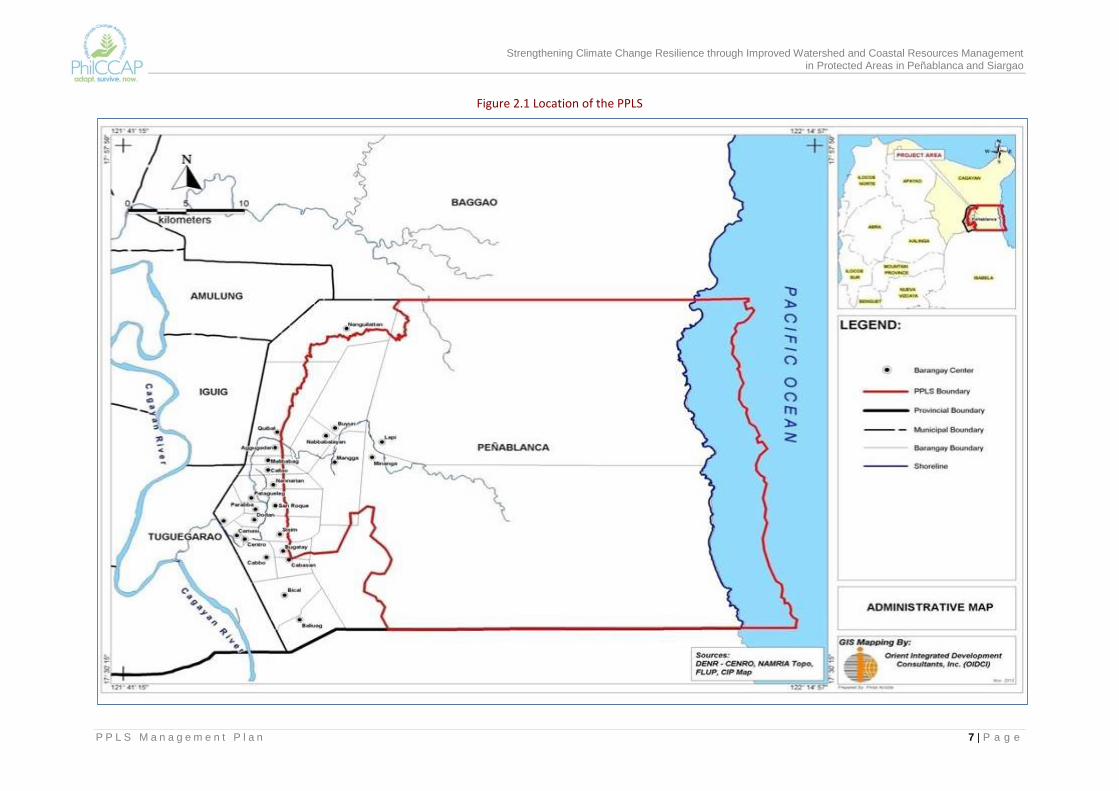
2.3 Physical Features PPLS is located in the southernmost part of Cagayan at 121°49' to 122°13' longitude and at latitude 17°32' to 17°50' latitude (Annex Map 1). It is bounded on the north by the municipality of Baggao, Cagayan; the Pacific Ocean on the east; the province of Isabela on the south and by Tuguegarao City and the municipality of Iguig, Cagayan on the west (Figure 2.1). Of the 18 barangays comprising the PPLS, barangays Lapi and Minanga have the biggest land area and are the only ones with coastal areas. These barangays have four sitios that are isolated from the rest of Peñablanca: sitios Sta. Marina of barangay Minanga, Baguio Point and a portion of Valley Cove in the coastal side and barangay Lapi in the northernmost portion of the PA adjacent to the municipality of Baggao.
Barangays within PPLS Aggugaddan Malibabag
Baliuag Mangga
Bical Minanga
Bugatay Nabbabalayan
Buyun Nanguillattan
Cabasan Nannarian
Cabbo Quibal
Callao San Roque
Lapi Sisim
Strengthening Climate Change Resilience through Improved Watershed and Coastal Resources Management in Protected Areas in Peñablanca and Siargao
P P L S M a n a g e m e n t P l a n 7 | P a g e
Figure 2.1 Location of the PPLS
Strengthening Climate Change Resilience through Improved Watershed and Coastal Resources Management in Protected Areas in Peñablanca and Siargao
P P L S M a n a g e m e n t P l a n 8 | P a g e
2.3.1 Topography and Slope PPLS is characterized as mostly mountainous with very steep slopes (Annex Map2).About 61% of the area have steep to very steep slopes (greater than 30%); 16% have steep to moderately steep slopes (18-30%). The rest of the area have rolling terrain or are flat lands (Table 2.2). Rugged terrain is encountered as one moves from the built-up areas towards the mountain ridge. The relief of steep ridges and canyon-like valleys implies high susceptibility to erosion and leaching. Areas above 1,000 meters above sea level (masl)are located along the mountain ridge and include the peak of Mt. Cetaceo (1,720 masl). In its mountainous section, elevation is from 800 to 1,000 masl, while towards its western boundaries, elevation is commonly between 50 to 150 masl. Refer to Annex Map 3.
2.3.2 Geology and Soils The lithographic units underlying the PA include broad and minor alluvial plain, volcanic mountain, shale, coastal plains and limestone rocks. The latter is found in the westernmost barangays where numerous caves (i.e., more than 200 cave systems) are found. These caves contain varied and unique geological formations, and are home to millions of bats. A few of its caves have underground water, one of which is deemed an ideal source of potable water.
The soil type on the eastern side of the PA is classified as undifferentiated mountain soil while in the western side is classified as sandy loam, silt loam, clay loam and rocky land. See Annex Map 4.
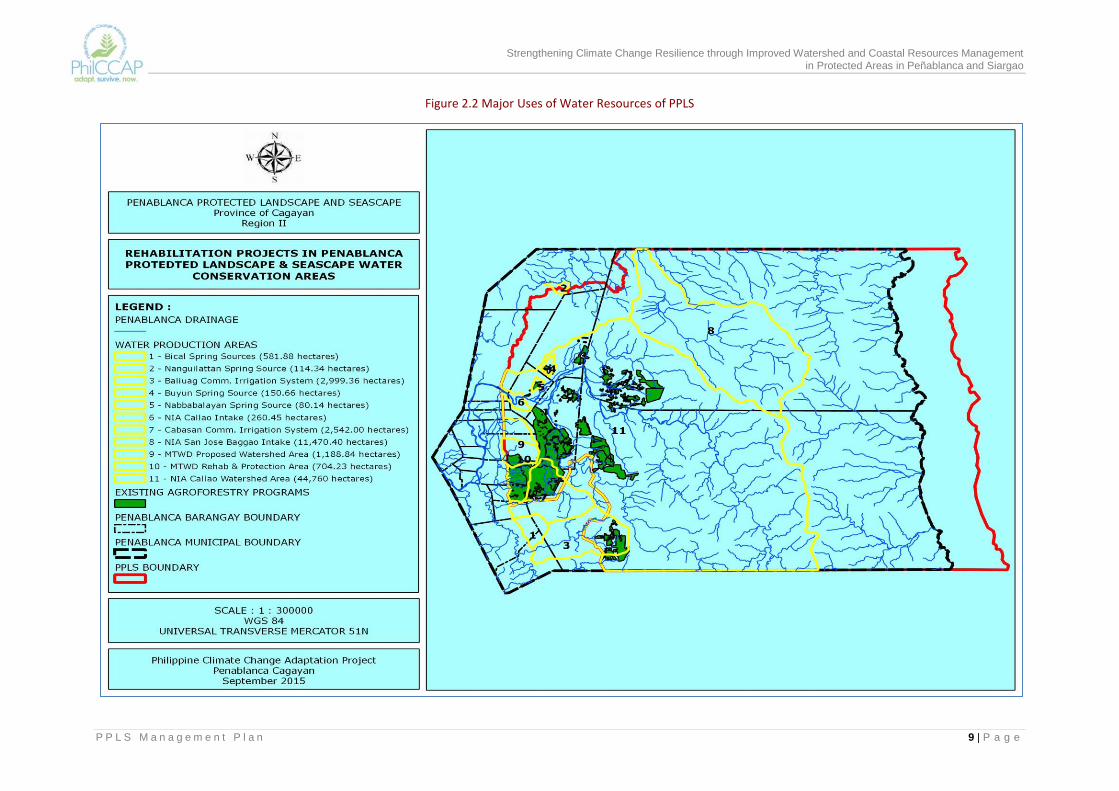
2.3.3 Hydrology There are two major rivers within the PPLS, namely, the Pinacanauan and Pared Rivers (Annex Map 5). These rivers drain directly to Cagayan River. In the coastal side, the biggest river system is that of the Taboan River that drains towards the coastal area of adjacent Baggao LGU.
The Pinacanauan River serves as major transport route of five barangays within PPLS. It supplies the irrigation water requirements of about 500 hectares of Peñablanca’s agricultural lands and some 55 hectares of Tuguegarao City. It also serves as recreation and washing area for the local people. This river has also been considered as a potential source of water for a mini-hydro power
dam project. The Pared River on the other hand, supplies irrigation water to rice lands of the adjoining municipality of Baggao.
Springs and creeks also abound within the PPLS, which are tapped by the local folks as sources of potable water. The three big springs, namely Lalungan, Bunnong and Dabba are being tapped by the National Irrigation Administration (NIA) to supply irrigation water. The Cabasan CIS, Baliuag CIS, and the Buyun CIP that tap water from these creeks are irrigating 170 hectares, 70 hectares and 32 hectares of rice lands, respectively.
More than 20 rivers and creeks that drain to the Pacific Ocean support small irrigation systems of the coastal sitios. Figure 2.2 shows the different uses of the surface water resources of PPLS.
Table 2.2 Slope Categories of Peñablanca
Slope Categories Area %
0-3% 6,496 5.2%
3-8% 3,537 2.8%
8-18% 17,776 14.3%
18-30% 20,042 16.1%
30-50% 24,494 19.7%
> 50% 52,219 41.9%
Total 124,564 100.0%
Source: Slope map of Peñablanca, Cagayan
Strengthening Climate Change Resilience through Improved Watershed and Coastal Resources Management in Protected Areas in Peñablanca and Siargao
P P L S M a n a g e m e n t P l a n 9 | P a g e
Figure 2.2 Major Uses of Water Resources of PPLS
Strengthening Climate Change Resilience through Improved Watershed and Coastal Resources Management in Protected Areas in Peñablanca and Siargao
P P L S M a n a g e m e n t P l a n 10 | P a g e
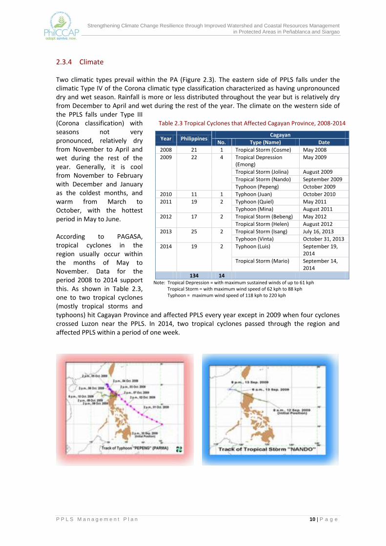
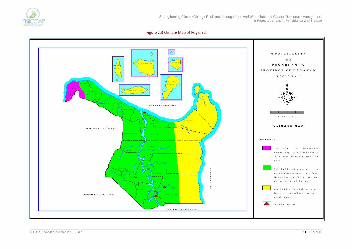
2.3.4 Climate Two climatic types prevail within the PA (Figure 2.3). The eastern side of PPLS falls under the climatic Type IV of the Corona climatic type classification characterized as having unpronounced dry and wet season. Rainfall is more or less distributed throughout the year but is relatively dry from December to April and wet during the rest of the year. The climate on the western side of the PPLS falls under Type III (Corona classification) with seasons not very pronounced, relatively dry from November to April and wet during the rest of the year. Generally, it is cool from November to February with December and January as the coldest months, and warm from March to October, with the hottest period in May to June. According to PAGASA, tropical cyclones in the region usually occur within the months of May to November. Data for the period 2008 to 2014 support this. As shown in Table 2.3, one to two tropical cyclones (mostly tropical storms and typhoons) hit Cagayan Province and affected PPLS every year except in 2009 when four cyclones crossed Luzon near the PPLS. In 2014, two tropical cyclones passed through the region and affected PPLS within a period of one week.
Table 2.3 Tropical Cyclones that Affected Cagayan Province, 2008-2014
Year Philippines Cagayan
No. Type (Name) Date
2008 21 1 Tropical Storm (Cosme) May 2008
2009 22 4 Tropical Depression (Emong)
May 2009
Tropical Storm (Jolina) August 2009
Tropical Storm (Nando) September 2009
Typhoon (Pepeng) October 2009
2010 11 1 Typhoon (Juan) October 2010
2011 19 2 Typhoon (Quiel) May 2011
Typhoon (Mina) August 2011
2012 17 2 Tropical Storm (Bebeng) May 2012
Tropical Storm (Helen) August 2012
2013 25 2 Tropical Storm (Isang) July 16, 2013
Typhoon (Vinta) October 31, 2013
2014 19 2 Typhoon (Luis) September 19, 2014
Tropical Storm (Mario) September 14, 2014
134 14 Note: Tropical Depression = with maximum sustained winds of up to 61 kph Tropical Storm = with maximum wind speed of 62 kph to 88 kph Typhoon = maximum wind speed of 118 kph to 220 kph
Strengthening Climate Change Resilience through Improved Watershed and Coastal Resources Management in Protected Areas in Peñablanca and Siargao
P P L S M a n a g e m e n t P l a n 11 | P a g e
M U N I C I P A L I T Y
O F
P E Ñ A B L A N C A
P R O V I N C E O F C A G A Y A N
R E G I O N - II
N O T T O S C A L E
L E G E N D :
1 s t T Y P E - T w o p r o n o u n c e d
s e a s o n , d r y f r o m N o v e m b e r t o
A p r i l , w e t d u r i n g th e r e s t o f t h e
y e a r .
3 r d T Y P E - S e a s o n s n o t v e r y
p r o n o u n c e d , r e l a t i v e ly d r y f r o m
N o v e m b e r t o A p r i l & w e t
d u r in g th e r e s t o f t h e y e a r .
4 th T Y P E - R a in f a l l m o r e o r
l e s s e v e n ly d i s t r i b u t e d th r o u g h
o u t t h e y e a r .
W e a th e r S t a t io n
D A L U P I R
IS L A N D
C A L A Y A N I S L A N D
B A B U Y A N
C L A R O I S L A N D
F U G A IS L A N D
C A M I G U I N
IS L A N DC L A V E R I A
S T A . P R A X E D E SS A N C H E Z
MI R A
A B U L U GP A M P L O N A
B A L L E S T E R O S
A P A R R I
B U G U E Y
C A M A L A N I U G A N
S T A . T E R E S I T A
G O N Z A G A
S T A . A N A
A L L A C A P A NL A L - L O
L A S A M
G A T T A R A N
A L C A L A
B A G G A O
S T O . N I Ñ O
PI A T
R I Z A L
T U A O
A M U L U N G
I G U I G
P E Ñ A B L A N C A
T U G U E G A R A O
S O L A N A
E N R I L E
B A B U Y A N C H A N N E L
P R O V I N C E O F A P A Y A O
P R O V I N C E O F K A L I N G A
P R O V I N C E O F I S A B E L AP
HI
LI
PP
IN
E S
EA
C L I M A T E M A P
Figure 2.3 Climate Map of Region 2

Strengthening Climate Change Resilience through Improved Watershed and Coastal Resources Management in Protected Areas in Peñablanca and Siargao
P P L S M a n a g e m e n t P l a n 12 | P a g e
The historical (observed) monthly mean temperature and monthly rainfall and the corresponding monthly projected climate change forecasts for Cagayan for 2020 and 2050 based on a downscaled climate scenario of PAGASA (2011) are summarized in Table 2.4. The projections show that the monthly mean temperature is expected to increase. The changes in rainfall suggest that dry and hot months in the Province could become drier, and the wet months wetter.
Table 2.4 Temperature Increases and Seasonal Rainfall Change under Medium Range Emission Scenario: Cagayan Province, 2020 and 2050
Period Seasonal Temperature (⁰C) Seasonal Rainfall (mm)
DJF MAM JJA SON DJF MAM JJA SON
Observed baseline (1971-2000) 24.5 28.1 28.4 27.1 284.4 207.7 538.4 887
Change in 2020 0.8 1.0 0.9 0.8 6.9 3.6 2.9 16.3
Change in 2050 2.0 2.2 2.0 1.8 14.6 -23.3 0.9 -1.0
Source: PAGASA, 2011
2.3.5 Hazards Aside from the tropical cyclones that occur every year, other hazards faced by communities in Peñablanca include flooding (Annex Map 6) and rain induced landslides (Annex Map 7). Figure 2.4 presents the areas affected by flooding and landslide within the PPLS and those outside PPLS. As shown in the maps, the upper slopes of PPLS are highly susceptible to landslide while the lower slopes at the western section of Peñablanca are highly exposed to flooding. The flooding problem that is experienced in downstream Peñablanca, Tuguegarao City and Baggao is largely influenced by PPLS because the rivers draining to the flood prone areas come from the PA. Given the topography of PPLS, the vegetative cover of the PA greatly determine the degree of flooding in these three municipalities. As assessed by the MGB (refer to Annex Map 7), most of the upper slopes of barangays Lapi and Minanga including areas in barangays Nannarian, San Roque and Nabbabalayan are highly susceptible to landslide. The rest of the barangays have low to moderate susceptibility to landslide. In terms of flooding, barangays Bical, Poblacion, Patagueleg, Sisim, Aggugaddan, Lapi and Nabbabalayan are highly exposed to the hazards. The rest of the barangays have low to moderate exposure to flooding.

Strengthening Climate Change Resilience through Improved Watershed and Coastal Resources Management in Protected Areas in Peñablanca and Siargao
P P L S M a n a g e m e n t P l a n 13 | P a g e
Figure 2.4 Flood-Prone Areas in Peñablanca, Baggao and Tuguegarao City
Figure 2.5 Landslide-Prone Areas in Peñablanca, Baggao and Tuguegarao City
Strengthening Climate Change Resilience through Improved Watershed and Coastal Resources Management in Protected Areas in Peñablanca and Siargao
P P L S M a n a g e m e n t P l a n 14 | P a g e
2.4 Biological Diversity The PPLS has an array of unique assemblages of plants and animals thus, exemplifying biologically important ecosystems. Below are its biodiversity resources. 3
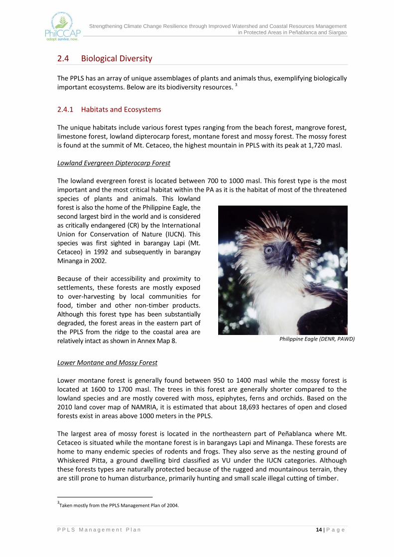
2.4.1 Habitats and Ecosystems The unique habitats include various forest types ranging from the beach forest, mangrove forest, limestone forest, lowland dipterocarp forest, montane forest and mossy forest. The mossy forest is found at the summit of Mt. Cetaceo, the highest mountain in PPLS with its peak at 1,720 masl. Lowland Evergreen Dipterocarp Forest The lowland evergreen forest is located between 700 to 1000 masl. This forest type is the most important and the most critical habitat within the PA as it is the habitat of most of the threatened species of plants and animals. This lowland forest is also the home of the Philippine Eagle, the second largest bird in the world and is considered as critically endangered (CR) by the International Union for Conservation of Nature (IUCN). This species was first sighted in barangay Lapi (Mt. Cetaceo) in 1992 and subsequently in barangay Minanga in 2002. Because of their accessibility and proximity to settlements, these forests are mostly exposed to over-harvesting by local communities for food, timber and other non-timber products. Although this forest type has been substantially degraded, the forest areas in the eastern part of the PPLS from the ridge to the coastal area are relatively intact as shown in Annex Map 8.
Lower Montane and Mossy Forest Lower montane forest is generally found between 950 to 1400 masl while the mossy forest is located at 1600 to 1700 masl. The trees in this forest are generally shorter compared to the lowland species and are mostly covered with moss, epiphytes, ferns and orchids. Based on the 2010 land cover map of NAMRIA, it is estimated that about 18,693 hectares of open and closed forests exist in areas above 1000 meters in the PPLS. The largest area of mossy forest is located in the northeastern part of Peñablanca where Mt. Cetaceo is situated while the montane forest is in barangays Lapi and Minanga. These forests are home to many endemic species of rodents and frogs. They also serve as the nesting ground of Whiskered Pitta, a ground dwelling bird classified as VU under the IUCN categories. Although these forests types are naturally protected because of the rugged and mountainous terrain, they are still prone to human disturbance, primarily hunting and small scale illegal cutting of timber.
3Taken mostly from the PPLS Management Plan of 2004.
Philippine Eagle (DENR, PAWD)

Strengthening Climate Change Resilience through Improved Watershed and Coastal Resources Management in Protected Areas in Peñablanca and Siargao
P P L S M a n a g e m e n t P l a n 15 | P a g e
Forest over Limestone or Limestone Forest Also known as karst forest, this type of forests cover an area of about 7,700 hectares and are located in the western most side of the PA within barangays Nanguillattan, Buyun, Nabbabalayan, Aggugaddan, Callao, Malibabag, Nannarian, San Roque, Sisim, Bugatay and Quibal. This area also contains valuable artifacts that depict the richness of the early inhabitants of the municipality. The unique rock formation of this forest serves as home to numerous species of bats. Of the more than 200 caves in the PA, one in barangay Quibal is known to locals as the “bat cave.” It houses millions of bats and has become a tourist attraction. Some of the caves are used for ecotourism, e.g., spelunking. Thousands of flying foxes, which are considered threatened, are also found in these areas. Large colonies of this species can be seen in the limestone forest between barangay Nanguillattan and Buyun. Further study on this type of forest and of the caves that are inhabited by bats need to be done geared towards the sound formulation of an ecotourism management plan. Despite the ruggedness, large and sharp rocks and deficient soil nutrients, the area has not escaped human destruction. Areas along the periphery of the forest are converted into kaingin while some timber poaching activities in accessible areas have been observed.
Beach Forest Beach forests are found along the coastlines of Peñablanca. It is generally dominated by “putat” (Bamintonia Asiatic, Agoho or Casuanina equisetifolia or Pongamia pinnata). This forest type extends from sitio Sta. Marina of barangay Minanga to sitios Baguio Point and Valley Cove of barangay Lapi. The establishment of settlements in the coastal areas of Peñablanca with settlers looking for land to till is a major threat to this type of forest.
Wetlands, Mangroves, Tidal Reef Flats and Coral Reefs Limited study has been conducted on this type of habitat that are located along the whole stretch of the coastal areas of PPLS, particularly in barangay Minanga (sitios Baguio Point and Sta. Marina) and barangay Lapi (sitio Valley Cove). Coral reefs are important home and nursery areas to many marine species that serve as source of protein for the local communities. Tidal reef flats are also home to many marine shells, sea cucumber, crabs and lobsters that are usually gathered and sold at a high price in the market. Mangrove forest serves as protection from ocean waves.
Bat Cave, Brgy Quibal, Peñablanca, Cagayan (PPLS Management Plan, 2004)
Strengthening Climate Change Resilience through Improved Watershed and Coastal Resources Management in Protected Areas in Peñablanca and Siargao
P P L S M a n a g e m e n t P l a n 16 | P a g e
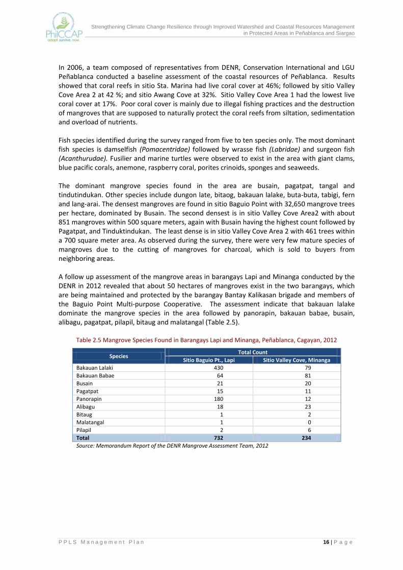
In 2006, a team composed of representatives from DENR, Conservation International and LGU Peñablanca conducted a baseline assessment of the coastal resources of Peñablanca. Results showed that coral reefs in sitio Sta. Marina had live coral cover at 46%; followed by sitio Valley Cove Area 2 at 42 %; and sitio Awang Cove at 32%. Sitio Valley Cove Area 1 had the lowest live coral cover at 17%. Poor coral cover is mainly due to illegal fishing practices and the destruction of mangroves that are supposed to naturally protect the coral reefs from siltation, sedimentation and overload of nutrients. Fish species identified during the survey ranged from five to ten species only. The most dominant fish species is damselfish (Pomacentridae) followed by wrasse fish (Labridae) and surgeon fish (Acanthurudae). Fusilier and marine turtles were observed to exist in the area with giant clams, blue pacific corals, anemone, raspberry coral, porites crinoids, sponges and seaweeds. The dominant mangrove species found in the area are busain, pagatpat, tangal and tindutindukan. Other species include dungon late, bitaog, bakauan lalake, buta-buta, tabigi, fern and lang-arai. The densest mangroves are found in sitio Baguio Point with 32,650 mangrove trees per hectare, dominated by Busain. The second densest is in sitio Valley Cove Area2 with about 851 mangroves within 500 square meters, again with Busain having the highest count followed by Pagatpat, and Tinduktindukan. The least dense is in sitio Valley Cove Area 2 with 461 trees within a 700 square meter area. As observed during the survey, there were very few mature species of mangroves due to the cutting of mangroves for charcoal, which is sold to buyers from neighboring areas. A follow up assessment of the mangrove areas in barangays Lapi and Minanga conducted by the DENR in 2012 revealed that about 50 hectares of mangroves exist in the two barangays, which are being maintained and protected by the barangay Bantay Kalikasan brigade and members of the Baguio Point Multi-purpose Cooperative. The assessment indicate that bakauan lalake dominate the mangrove species in the area followed by panorapin, bakauan babae, busain, alibagu, pagatpat, pilapil, bitaug and malatangal (Table 2.5).
Table 2.5 Mangrove Species Found in Barangays Lapi and Minanga, Peñablanca, Cagayan, 2012
Species Total Count
Sitio Baguio Pt., Lapi Sitio Valley Cove, Minanga
Bakauan Lalaki 430 79
Bakauan Babae 64 81
Busain 21 20
Pagatpat 15 11
Panorapin 180 12
Alibagu 18 23
Bitaug 1 2
Malatangal 1 0
Pilapil 2 6
Total 732 234
Source: Memorandum Report of the DENR Mangrove Assessment Team, 2012

Strengthening Climate Change Resilience through Improved Watershed and Coastal Resources Management in Protected Areas in Peñablanca and Siargao
P P L S M a n a g e m e n t P l a n 17 | P a g e
Fauna Amphibians There are 101 Amphibian species in the Philippines of which 78 species are endemic to the country. The diversity of frogs in PPLS is not known but a biological survey in the PA has documented 14 species of frogs. Among these, only one is not endemic to the country and five are under the CR, EN, or VU category following IUCN. A good example of an endemic species to this area is Brown and Alcala's Sierra Madre Frog (Rana tipanan). This species usually lives in cool mountain streams and rivers in lower montane and lowland forests but in the recent biological survey, it was recorded in the primary montane forest at higher elevation in the protected area. The biggest threats to this species include deforestation, habitat conversion to agriculture, and siltation and pollution of streams and rivers. This frog is categorized as VU by the IUCN.
Reptiles There are about 254 species of reptiles in the Philippines. About 208 are endemic (82% endemicity) and ten species are under various categories of threat (four CR, five EN, and one VU).The diversity of reptiles in the PPLS is also not known. Information on species found in PPLS is only taken from local communities, particularly local hunters. The reptile species commonly encountered by people in the protected area are freshwater turtle, monitor lizard, flying lizard, cobra, pit viper and python. A biological survey conducted in the park documented about nine species. There are two species of monitor lizards found in PPLS: the common Water Monitor Lizard (Varanus salvator) and the rare Gray’s Monitor Lizard or Butaan (Varanus olivaceus). The Water Monitor Lizard, commonly known in the locality as Bayawakis, is heavily hunted by the locals for food. The Bayawak is carnivorous while the Butaan is a fruit-eating species. The Gray’s Monitor Lizard is listed in the IUCN as VU. The conservation of Butaan has been neglected.
Mammals There are 201 species of mammals (terrestrial and marine) in the Philippines, 111 of which are endemic in the country. A total of 53 species, including marine species, are under various categories of threat based on the IUCN Red list. In the PPLS, there are 22 species of terrestrial mammals, 12 (54% endemicity) of which are endemic to the country. Five of the 12species are under the IUCN categories: two under EN and three are VU. The VU species are the Luzon Pygmy Fruit Bat (Otopteropus cartilagonodus), Philippine Pygmy Fruit Bat (Haplonycteris fischeri) and the Philippine Warty Pig (Sus philippensis). Those under the EN category are the Golden-crowned Flying Fox (Acerodon jubatus) and the Mottled-winged Flying Fox (Pteropus leucopterus). Of the 63 species of rodents or rats in the Philippines, only six cause minor damage or disturbance to humans. The harmful rats are not endemic to the country. One of the endemic rats is the Northern Luzon slender-tailed cloud rat (Phloeomys pallidus), a unique species which can be found in the PPLS. It weighs up to two and a half kilos and is considered among the largest

Strengthening Climate Change Resilience through Improved Watershed and Coastal Resources Management in Protected Areas in Peñablanca and Siargao
P P L S M a n a g e m e n t P l a n 18 | P a g e
rats in the world. Due to their size, this species is heavily hunted for food. The skin is used for handicrafts like bags or hats, among others. The Palanan Shrew Mouse (Archboldomys musseri) is another endemic rodent species in PPLS. This species is found only in the mossy forest of Mt. Cetaceo. This is a CR species of rodent that is found only in Luzon. It was first found in 1992 and formally described in 1999. Information on its population status and biology is still not known. Flying foxes/fruit bats (Pteropus vampyrus) are among the largest fruit bats in the world. There are nine species of flying foxes in the Philippines, six of which are endemic. This species usually live in colonies of over 100,000 individuals. Records show that this species needs about 40 kilometers (from its roost) of feeding area. They are one of the primary seed dispersers that help regenerate the forest. Another group of bats is the insectivorous or insect-eating bats. They live in caves, tree holes and rock crevices. There are 48 species of insectivorous bats recorded in the Philippines. Only five species are confirmed to be found in the PPLs. Insectivorous bats are important particularly for farmers as they serve as biological pest control. A single insectivorous bat can eat about half of their body weight in one night.
Birds There are 572 birds in the Philippines, 178 species are endemic. Of the total number, 68 species are under various levels of global threat according to the IUCN. Records show that there are 118 species of birds found in the PPLS, and about 56 (47%) are endemic. Five of the endemic species are listed as threatened (one CR and four VU) under IUCN. Among the notable bird species found in PPLS are the Philippine Eagle (Pithecophaga jefferyi), Philippine Hawk Eagle (Spizaetus philippensis) and Whiskered Pitta (Pitta kochi). The Philippine Eagle is a diurnal forest raptor and is one of the three most critically endangered eagles in the world. This bird was sighted in several areas within the Sierra Madre Biodiversity Corridor including the PPLS. The Sierra Madre mountain range is one of the last refuges of this magnificent raptor. There is so far no data on breeding or nesting behavior of this bird in the island of Luzon. In the montane forest zone of PPLS alone, 21 bird species (Table 2.6) were netted at an elevation of 1,300-1,400 masl, of which 15 are endemics (75% endemicity).
Table 2.6 Birds Netted in the Montane Forest of PPLS*
Taxonomy Numbers Status
Rhipidura cyaniceps 13 endemic
Pachycephala albiventris 10 endemic
Stachyis whiteheadi 9 endemic
Ficedula hyperythra 8 indigenous
Actenoides lindsyai 6 endemic
Hypsipetes philippinus 5 endemic
Brachypteryx montana 4 indigenous
Otus longicornis 4 endemic
Parus elegans 3 endemic
Pachycephala philippensis 2 endemic
Cacomantis variolosus 2 indigenous
Sitta frontalis 2 indigenous
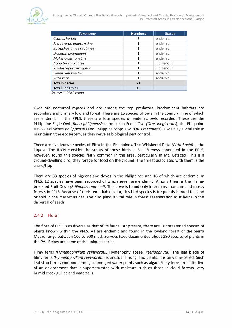
Strengthening Climate Change Resilience through Improved Watershed and Coastal Resources Management in Protected Areas in Peñablanca and Siargao
P P L S M a n a g e m e n t P l a n 19 | P a g e
Taxonomy Numbers Status
Cyornis herioti 2 endemic
Phapitreron amethystina 1 endemic
Batrachostomus septimus 1 endemic
Dicaeum pygmaeum 1 endemic
Mulleripicus funebris 1 endemic
Accipiter trivirgatus 1 indigenous
Phylloscopus trivirgatus 1 indigenous
Lanius validirostris 1 endemic
Pitta kochi 1 endemic
Total Species 21
Total Endemics 15 Source: CI-DENR report
Owls are nocturnal raptors and are among the top predators. Predominant habitats are secondary and primary lowland forest. There are 15 species of owls in the country, nine of which are endemic. In the PPLS, there are four species of endemic owls recorded. These are the Philippine Eagle-Owl (Bubo philippensis), the Luzon Scops Owl (Otus longicornis), the Philippine Hawk-Owl (Ninox philippensis) and Philippine Scops Owl (Otus megalotis). Owls play a vital role in maintaining the ecosystem, as they serve as biological pest control. There are five known species of Pitta in the Philippines. The Whiskered Pitta (Pitta kochi) is the largest. The IUCN consider the status of these birds as VU. Surveys conducted in the PPLS, however, found this species fairly common in the area, particularly in Mt. Cetaceo. This is a ground-dwelling bird; they forage for food on the ground. The threat associated with them is the snare/trap. There are 33 species of pigeons and doves in the Philippines and 16 of which are endemic. In PPLS, 12 species have been recorded of which seven are endemic. Among them is the Flame-breasted Fruit Dove (Ptilinopus marchei). This dove is found only in primary montane and mossy forests in PPLS. Because of their remarkable color, this bird species is frequently hunted for food or sold in the market as pet. The bird plays a vital role in forest regeneration as it helps in the dispersal of seeds.
2.4.2 Flora The flora of PPLS is as diverse as that of its fauna. At present, there are 16 threatened species of plants known within the PPLS. All are endemic and found in the lowland forest of the Sierra Madre range between 100 to 900 masl. Surveys have documented about 280 species of plants in the PA. Below are some of the unique species. Filmy ferns (Hymenophyllum reinwardtii, Hymenophyllaceae, Pteridophyta). The leaf blade of filmy ferns (Hymenophyllum reinwardtii) is unusual among land plants. It is only one-celled. Such leaf structure is common among submerged water plants such as algae. Filmy ferns are indicative of an environment that is supersaturated with moisture such as those in cloud forests, very humid creek gullies and waterfalls.
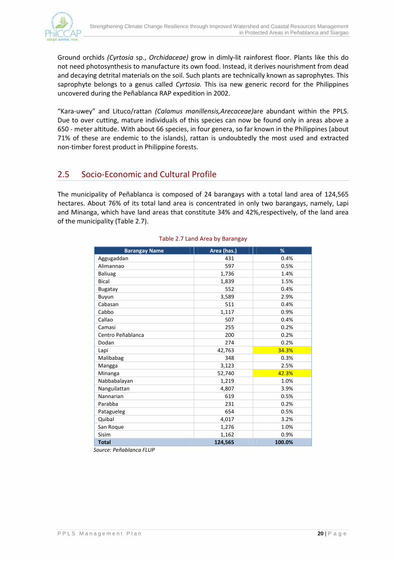
Strengthening Climate Change Resilience through Improved Watershed and Coastal Resources Management in Protected Areas in Peñablanca and Siargao
P P L S M a n a g e m e n t P l a n 20 | P a g e
Ground orchids (Cyrtosia sp., Orchidaceae) grow in dimly-lit rainforest floor. Plants like this do not need photosynthesis to manufacture its own food. Instead, it derives nourishment from dead and decaying detrital materials on the soil. Such plants are technically known as saprophytes. This saprophyte belongs to a genus called Cyrtosia. This isa new generic record for the Philippines uncovered during the Peñablanca RAP expedition in 2002. “Kara-uwey” and Lituco/rattan (Calamus manillensis,Arecaceae)are abundant within the PPLS. Due to over cutting, mature individuals of this species can now be found only in areas above a 650 - meter altitude. With about 66 species, in four genera, so far known in the Philippines (about 71% of these are endemic to the islands), rattan is undoubtedly the most used and extracted non-timber forest product in Philippine forests.
2.5 Socio-Economic and Cultural Profile The municipality of Peñablanca is composed of 24 barangays with a total land area of 124,565 hectares. About 76% of its total land area is concentrated in only two barangays, namely, Lapi and Minanga, which have land areas that constitute 34% and 42%,respectively, of the land area of the municipality (Table 2.7).
Table 2.7 Land Area by Barangay
Barangay Name Area (has.) %
Aggugaddan 431 0.4%
Alimannao 597 0.5%
Baliuag 1,736 1.4%
Bical 1,839 1.5%
Bugatay 552 0.4%
Buyun 3,589 2.9%
Cabasan 511 0.4%
Cabbo 1,117 0.9%
Callao 507 0.4%
Camasi 255 0.2%
Centro Peñablanca 200 0.2%
Dodan 274 0.2%
Lapi 42,763 34.3%
Malibabag 348 0.3%
Mangga 3,123 2.5%
Minanga 52,740 42.3%
Nabbabalayan 1,219 1.0%
Nanguilattan 4,807 3.9%
Nannarian 619 0.5%
Parabba 231 0.2%
Patagueleg 654 0.5%
Quibal 4,017 3.2%
San Roque 1,276 1.0%
Sisim 1,162 0.9%
Total 124,565 100.0%
Source: Peñablanca FLUP

Strengthening Climate Change Resilience through Improved Watershed and Coastal Resources Management in Protected Areas in Peñablanca and Siargao
P P L S M a n a g e m e n t P l a n 21 | P a g e
2.5.1 Demography The population ofPeñablanca in CY 2010 is 42,736. The barangays with the largest population are barangays Dodan, Camasi and Poblacion. The average population density is 0.3person per hectare with barangay Centro/Poblacion having the highest density of about 15 persons per hectare. Due to their large land area, barangay Minanga and Lapi have the lowest population density at 0.04 and 0.05 person per hectare, respectively (Table 2.8).
Table 2.8 Population Density per Barangay, 2010
Name Area (ha) Population
(as of May 1, 2010) Population density
(persons/ ha)
Aggugaddan 431 2,372 5.5
Alimanao 597 2,402 4.0
Baliuag 1,736 1,599 0.9
Bical 1,839 1,728 0.9
Bugatay 552 1,242 2.2
Buyun 3,589 1,100 0.3
Cabasan 511 958 1.9
Cabbo 1,117 1,567 1.4
Callao 507 1,543 3.0
Camasi 255 3,291 12.9
Centro (Pob.) 200 2,964 14.8
Dodan 274 3,193 11.7
Lapi 42,763 2,318 0.05
Malibabag 348 1,283 3.7
Manga 3,123 1,626 0.5
Minanga 52,740 2,218 0.04
Nabbabalayan 1,219 943 0.8
Nanguilattan 4,807 1,794 0.4
Nannarian 619 1,740 2.8
Parabba 231 1,453 6.3
Patagueleg 654 555 0.8
Quibal 4,017 1,879 0.5
San Roque (Litto) 1,276 1,487 1.2
Sisim 1,162 1,481 1.3
Total 124,565 42,736 0.3
Source: Philippine Statistical Authority, 2010
Overall, the population in Peñablanca in 2010 has increased by 225%since the 1960s. However, an examination of Table 2.9 shows that the population growth rate is fluctuating with the highest growth rates registered between 1960 and 1990. The average annual population increase between CY 2007 and 2010 is much reduced at 0.8%, less than half of the national average of 1.9%. The decline in the annual population growth rate is largely due to outmigration caused by the limited livelihood opportunities in rural barangays.
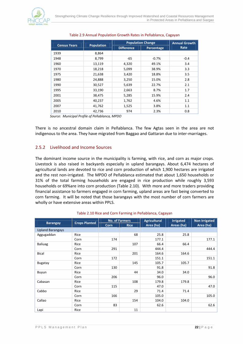
Strengthening Climate Change Resilience through Improved Watershed and Coastal Resources Management in Protected Areas in Peñablanca and Siargao
P P L S M a n a g e m e n t P l a n 22 | P a g e
Table 2.9 Annual Population Growth Rates in Peñablanca, Cagayan
Census Years Population Population Change Annual Growth
Rate Difference Percentage
1939 8,864
1948 8,799 -65 -0.7% -0.4
1960 13,119 4,320 49.1% 3.4
1970 18,218 5,099 38.9% 3.3
1975 21,638 3,420 18.8% 3.5
1980 24,888 3,250 15.0% 2.8
1990 30,527 5,639 22.7% 2.1
1995 33,190 2,663 8.7% 1.7
2001 38,475 5,285 15.9% 2.4
2005 40,237 1,762 4.6% 1.1
2007 41,762 1,525 3.8% 1.1
2010 42,736 974 2.3% 0.8
Source: Municipal Profile of Peñablanca, MPDO
There is no ancestral domain claim in Peñablanca. The few Agtas seen in the area are not indigenous to the area. They have migrated from Baggao and Gattaran due to inter-marriages.
2.5.2 Livelihood and Income Sources The dominant income source in the municipality is farming, with rice, and corn as major crops. Livestock is also raised in backyards especially in upland barangays. About 6,474 hectares of agricultural lands are devoted to rice and corn production of which 1,900 hectares are irrigated and the rest non-irrigated. The MPDO of Peñablanca estimated that about 1,650 households or 31% of the total farming households are engaged in rice production while roughly 3,593 households or 69%are into corn production (Table 2.10). With more and more traders providing financial assistance to farmers engaged in corn farming, upland areas are fast being converted to corn farming. It will be noted that those barangays with the most number of corn farmers are wholly or have extensive areas within PPLS.
Table 2.10 Rice and Corn Farming in Peñablanca, Cagayan
Barangay Crops Planted No. of Farmers Agricultural
Area (ha) Irrigated
Areas (ha) Non Irrigated
Area (ha) Corn Rice
Upland Barangays
Aggugaddan Rice
68 25.8 25.8
Corn 174 177.1 177.1
Baliuag Rice
107 66.4 66.4
Corn 291 444.4 444.4
Bical Rice 201 164.6 164.6
Corn 172 151.1 151.1
Bugatay Rice 145 105.7 105.7
Corn 130 91.8 91.8
Buyun Rice 44 34.0 34.0
Corn 206 96.0 96.0
Cabasan Rice 108 179.8 179.8
Corn 115 47.0 47.0
Cabbo Rice 29 71.4 71.4
Corn 166 105.0 105.0
Callao Rice 154 104.0 104.0
Corn 83 62.6 62.6
Lapi Rice 11

Strengthening Climate Change Resilience through Improved Watershed and Coastal Resources Management in Protected Areas in Peñablanca and Siargao
P P L S M a n a g e m e n t P l a n 23 | P a g e
Barangay Crops Planted No. of Farmers Agricultural
Area (ha) Irrigated
Areas (ha) Non Irrigated
Area (ha) Corn Rice
Corn 314 993.65 993.6
Malibabag Rice 123 82.3 82.3
Corn 51 37.2 37.2
Mangga Rice 3
Corn 389 476.4 476.4
Minanga Rice 24
Corn 181 110.4 110.4
Nabbabalayan Rice 14
Corn 230 106.0 106.0
Naguilattan Rice 130 119.0 119.0
Corn 118 439.0 439.0
Nannarian Rice 160 102.8 102.8
Corn 102 99.7 99.7
Quibal Rice 3
Corn 425 344.0 344.0
San Roque Rice 159 138.2 138.2
Corn 78 167.1 167.1
Sisim Rice 71 30.8 30.8
Corn 98 145.6 145.6
Alimanao Rice 0
Corn 8 12.5 12.5
Camasi Rice 5 6.0 6.0
Corn 28 34.0 34.0
Centro Rice 670.0 670.0
Corn 63 32.2 32.2
Dodan Corn 91 137.6 137.6
Parabba Rice
Corn 89 109.0 109.0
Patagueleg Rice
Corn 82 154.0 154.0
Grand Total 3,593 1650 6,474.0 1,900.81 4,406.7
68.5% 31.5%
Source: MPDO, Peñablanca
Some households augment their farming income by engaging in backyard vegetable gardening and livestock or poultry production. Livestock raised include cattle, carabaos, hogs, goats and horses; poultry includes layers, broilers, turkeys and geese. Other households gather firewood (and make charcoal out of these), bamboo, rattan and other minor forest products and sell them in adjoining municipalities and Tuguegarao City where there is high demand for these products.
2.5.3 Land Cover The PPLS covers about 93.8% of the total forest land of Peñablanca (refer to land classification map in Annex Map 8). The 2010 vegetative cover map of the DENR indicates that about 43% of the municipality’s land area or 53,832 hectares are open canopy forests while 21% or 26,631 hectares are closed canopy forests. Almost all the closed and open canopy forests are situated in barangays Lapi and Minanga. PPLS has about 78% of its area still with forest cover. The rest of the area of the municipality consists of shrubs, and wooded grasslands (19% or 23,297 ha); natural grasslands (8% or 10,178 ha); cultivated lands (5% or 6,859 ha); and built up, barren lands and inland water (3% or 3,313 ha). The grasslands and cultivated lands are generally located in the western section of the PPLS where most of the barangay centers are located.

Strengthening Climate Change Resilience through Improved Watershed and Coastal Resources Management in Protected Areas in Peñablanca and Siargao
P P L S M a n a g e m e n t P l a n 24 | P a g e
A comparison of the 2003 land cover map (Annex Map 9) and that for 2010 indicate that closed canopy forests of Peñablanca have increased by as much as 21% (4,561 ha). However, there was also a large decrease in the open canopy forests equivalent to 7,445 hectares indicating an overall net decrease of 2,884 hectares (Table 2.11). Other land cover consisting of wooded grasslands shrubs, open/ barren lands and built up areas also increased by 3,425 hectares (10%) while lands cultivated into annual crops decreased by 541 hectares or 7% of the 2003 area. Apparently, parts of the open canopy forests in 2003 have closed while other sections became wooded grasslands and shrubs. The decrease in the area of cultivated lands indicates that some of areas being cultivated are no longer productive possibly because of their degraded condition or of the high cost of production. It is likely that those who have ceased their agricultural activities have been resorting to illegal harvesting activities (such as timber poaching, firewood gathering and charcoal making) in open canopy forests, which are accessible to them.
Table 2.11 Land Cover Change in Peñablanca, Cagayan, 2003 to 2010
Land cover type Area (hectares)
% change 2003 2010 Change
Closed forest, broadleaved 22,070 26,631 4,561 21%
Open forest, broadleaved 61,277 53,832 -7,445 -12%
Cultivated lands 7,400 6,859 -541 -7%
Other land cover( grasslands, shrubs, open/ barren, inland water & built up)
33,362 36,787 3,425 10%
Source: DENR land cover maps, 2003 and 2010
2.5.4 Forestland Tenure In the 1960s up to the late 1980s, large portions of the Peñablanca forestlands were under Timber License Agreements (TLAs) issued to private companies. These were later replaced by other tenure instruments which are presented in Annex Map 10. The areas covered by these tenure instruments are summarized in Table 2.12. More than 50% of the tenured areas are covered by community- based tenure instruments (CBFMA, PACBRMA, ISF/CSC). Of the tenure instruments listed in Table 2.12, those found within PPLS are the following:
(a) Community-based forest management agreements (CBFMA) issued to three peoples’ organizations. These are Lapi CBFM, Baguio Point CBFM in the coastal side and the Quibal CBFM in the western portion. The three have a total area of 22,933 hectares and are benefiting about 600 members of people’s organizations and their families.
(b) Protected Area Community-Based Resource Management Agreement (PACBRMA) in PPLS issued to the Mangga Farmers Multipurpose Cooperative in barangay Mangga
(c) Certificates of Stewardship Contracts (CSC), many of which are about to expire (d) Watershed under the management of the Metro Tuguegarao Water District.
Table 2.12 Tenurial Instruments Issued Within the PPLS
Type of Tenure Instrument Total (ha.) %
CBFMA 22,933.0 50.5
PACBRMA 2,032 4.5
ISF/CSC 6,702.0 14.8
MOAs with farmers (NGP) 3,552.7 7.8
FLGLA 7,638.0 16.8
FLMA 30.0 0.1
SIFMA 1,577.0 3.5
Tree farm lease 252.0 0.5
MTWD watershed 687.0 1.5
Total 45,403.7 100.00
Source: DENR – CENRO

Strengthening Climate Change Resilience through Improved Watershed and Coastal Resources Management in Protected Areas in Peñablanca and Siargao
P P L S M a n a g e m e n t P l a n 25 | P a g e
In addition to these is the Callao Cave National Park, which is under the management of the Cagayan Provincial LGU through a MOA with DENR. Currently, DENR allows the legal use of resources within the PPLS through the issuance of permits, agreements and land tenure instruments, upon approval by the Protected Area Management Board (PAMB).
2.5.5 Road Infrastructure and Communication Facilities The transport services that are available in the different barangays vary. The western barangays, composed of Aggugaddan, Bical, Baliuag, Bugatay, Cabasaban Cabbo, Callao, Malibabag, Nanguilatan, Nannarian, Quibal, San Roque and Sisim (Cluster 1 barangays) are accessible using any type of vehicles coming from Tuguegarao City. The Cluster 1 barangays have all-weather roads, except for barangays Nanguilattan and Baliuag, which have dirt roads that are not passable during the rainy season. Cluster 2 barangays are composed of Buyun, Lapi, Nabbabalayan, Mangga and Minanga. Barangays Minanga and Mangga are accessible all year round via land transportation. The three others can only be accessed through a motorized boat from barangay Mangga via the Pinacanauan River. There is no road connecting the coastal sitios or Cluster 3 to the municipal proper of Peñablanca. There are three options to reach the sitios. One option is through a light aircraft from Tuguegarao City to the municipality of Maconacon, Isabela where one can take a motorized boat to the area. The second option is through a motorized boat from Sta. Ana, Cagayan. The third option is a hike across the Sierra Madre Mountain for about two to four days given the rugged terrain and weather condition. All options are difficult during the rainy season. Sitio Bayan of barangay Lapi is the only accessible area in Cluster 4. A truck goes to the community mainly to collect farm products but this is only done during summer when the dirt road and Pared River are both passable. Usually, sitio residents walk to San Miguel, Baggao where transport vehicles are available. In terms of communication services, mobile phones are the common mode of communication. Residents of urban barangays obtain information on current events from the television and sometimes from newspapers bought in Tuguegarao City or Peñablanca town proper. The municipal LGU issued one hand-held two-way radio to each of the 18 barangays in PPLS to facilitate communication between the LGU and the barangays. In the case of the coastal sitios, the residents only have ordinary transistor radios and the occasional visit of postal carriers as sources of information.
2.6 PA Stakeholders Different individuals, groups, institutions and organizations within and outside the municipality of Peñablanca have different stakes or interests on the resources within the PPLS. The interests of these stakeholders may be compatible or are in conflict with each other. For instance, the interests of those communities inside the PPLS are not necessarily compatible with those residing outside the PPLS.
Strengthening Climate Change Resilience through Improved Watershed and Coastal Resources Management in Protected Areas in Peñablanca and Siargao
P P L S M a n a g e m e n t P l a n 26 | P a g e
The major stakeholders of PPLS include current forest occupants, the CBFM/PACBRMA POs and other groups with tenure and other agreements with PAMB/DENR, local entrepreneurs who are dependent on forest products, the Metro Tuguegarao and Peñablanca Water Districts and the communities they service, the NIA and its irrigators associations, the municipal and barangay LGUs, and DENR. Annex Table 1 provides the list of these stakeholders and their corresponding interests. Stakeholders are divided into two groups. The first group of stakeholders is those categorized as on-site and direct stakeholders. The group includes (1) those who are currently residing inside the PPLS (tenured and non-tenured) and (2) those which have been given legal rights to occupy, use and extract resources within PPLS. Belonging to the latter are the following:
DENR CENRO/PENRO and the PPLS PASu Office
LGU of Peñablanca and the barangay LGUs which have areas within the PPLS
People’s Organizations and private entities who have been issued tenure instruments, licenses and permits such as PACBRMA, CBFMA, CSC, FLGMA, FLMA, SIFMA, tree farm leases, and others
Provincial Government of Cagayan which is managing the Callao Caves
MTWD and Peñablanca Water District
NIA which have established irrigation facilities that draw water from rivers within PPLS
Other agencies and organizations with special use agreements with and permits from PAMB and the DENR
Based on their agreement with or permit from PAMB/DENR, the above organizations are regarded as in situ managers of the resources that have been entrusted to them by the national government. Off-site stakeholders are those who are located outside of the PPLS but are directly or indirectly benefitting from the PPLS or are affected by the conditions of the PPLS. They are concerned with the management and protection of the PPLS as they currently or can potentially enjoy economic and environmental benefits from the PA. This group includes:
Irrigators associations from both Peñablanca and Baggao;
Business and private sector in Peñablanca and neighboring LGUs, particularly those dependent on products from PPLS;
Communities in Peñablanca and Tuguegarao City that are served by domestic water supply sourced from PPLS; and
Communities downstream of PPLS (Peñablancaand Baggao) which are affected by flooding resulting from the degraded condition of the PPLS.
Other groups (indirect stakeholders) that have a stake on PPLS by virtue of their mandate, advocacy and concern for biodiversity, the environment and local social development are:
Non-government organizations (NGOs) with environmental advocacies;
Academic and research institutions;
Church-based organizations;
Civic and professional organizations and other groups including youth, women, etc.;
Mass media; and

Strengthening Climate Change Resilience through Improved Watershed and Coastal Resources Management in Protected Areas in Peñablanca and Siargao
P P L S M a n a g e m e n t P l a n 27 | P a g e
Other national agencies: Department of Agriculture (DA), Philippine National Police (PNP), Department of Education (DepEd), Department of Tourism (DOT), National Economic and Development Authority (NEDA), others.
2.7 Current PA Management Structure and Capabilities for Management
The operation of the PPLS is mainly governed by the NIPAS Act and its implementing rules and regulations under DENR Administrative Order 2008-26. Other than the NIPAS Act, these other laws have impact on the PPLS, such as the following:
RA 7160 – Local Government Code of 1991;
RA 9072 –National Cave and Cave Resources Management and Protection Act of 2001;
RA 9147 – Wildlife Resources Conservation and Protection Act of 2001;
EO 263 series of 1995 – Adoption of Community Based Forest Management (CBFM) as the national strategy to ensure the sustainable development of the country’s forestland resources;
RA 8550 – Philippine Fisheries Code of 1991;
RA 7942 – Philippine Mining Act of 1995;
RA 9003 – Ecological Solid Waste Management Act of 2000. As provided in the NIPAS Act, the PAMB is the highest policy making body of the PPLS. The PPLS PAMB is composed of the following:
DENR Regional Director of Region 2 as Ex-Officio Chair
Local Chief Executive (LCE) of Peñablanca
Barangay Chairpersons of the 18 barangays that cover PPLS
Provincial Planning and Development Officer (PPDO) of Cagayan
One representative each of the NGOs – Sierra Madre Outdoor Club (SMOC) and Conservation International (CI)
Representative of the Department of Tourism (DOT)
Representative of the Provincial Tourism Office (PTO)
Representative of the Environment and Natural Resources Office (ENRO) of Cagayan Province
Representative from the Metro Tuguegarao Water District (MTWD)
The PAMB has 27 members. While the Provincial LGU has three members in the PAMB, it only has one vote. The regular meetings of the PAMB (Executive Committee and en banc) are held to draw up policy support for PPLS management. PAMB actions include among others the issuance of gratuitous permits for research purposes, approval of various projects to be implemented within the PPLS, and fostering coordination and partnership in implementing the various projects earmarked for implementation by the stakeholders. To manage the day-to-day activities of DENR in the PA and to implement the policies and programs of the PAMB, a Protected Area Superintendent (PASu) has been designated for PPLS. The PASu is being assisted by personnel assigned at the Protected Areas, Wildlife and Coastal Zone Management Services (PAWCZMS) of CENRO Tuguegarao, which has administrative jurisdiction over Peñablanca. The PAWCZMS has a few technical staff. Forest Rangers from CENRO Tuguegarao are assigned to augment the manpower of the PASu.

Strengthening Climate Change Resilience through Improved Watershed and Coastal Resources Management in Protected Areas in Peñablanca and Siargao
P P L S M a n a g e m e n t P l a n 28 | P a g e
Current staffing for the management of the PPLS is inadequate considering the large area coverage of the PA. The PPLS does not have full time personnel assigned to plan, implement and monitor the activities within the PA. DENR staff currently assigned to PPLS are mostly seconded and thus only work part-time in PPLS.
The rationalization plan of DENR does not provide for regular positions for the PASu Office thus it will continue to depend on seconded staff.
2.8 Current PA Management Activities Since its establishment as a PA, various activities had been undertaken within the PPLS to protect and conserve its biodiversity resources. Those discussed in this section refer to the most recent activities undertaken by the PASu Office/DENR and the different stakeholders and partner institutions of the PAMB.
2.8.1 PASu Office/DENR Enforcement and IEC Activities The PASu Office, as implementing arm of the DENR in the promotion of development and institutional strengthening of communities within the PPLS, has consistently pursued its mandate of ensuring the conservation and development of natural resources within the PA. It works closely with the forestry sector of CENRO Tuguegarao in performing the protection and law enforcement functions of DENR. Jointly, they conduct foot patrolling and law enforcement within and around the PA. In cooperation with the LGU of Peñablanca and community leaders, the CENRO and PASu Office have established monitoring checkpoints in every barangay within the PPLS, which resulted in the confiscation of natural resources gathered from the PPLS right at the barangay level. These checkpoints and monitoring teams to some extent neutralized the gathering and transport of natural resources within and from the PA.
The PASu Office and PAWCZMS staff tap the barangay Bantay Kalaw teams in the conduct of biodiversity conservation activities within their own barangays. As needed, the municipal LGU sends its police force to support massive information drive and law enforcement in hotspots located at the periphery of the PA. Schools are also venues for information, education and communication (IEC) activities on climate change and biodiversity conservation.
2.8.2 National Greening Program of DENR The implementation of the National Greening Program (NGP) within Peñablanca accomplished 501 hectares of plantations of various species from 2011-2012. Additional 510 hectares were reportedly planted in 2013. Another 800 hectares of plantations were earmarked in 2014 while 1,102 hectares are targeted in 2015-2016. The barangays within PPLS where these plantations were implemented and targeted for development are reflected in Table 2.13. The areas developed were those within the PACBRMA but not included in the Philippine Peñablanca Sustainable Reforestation Project (PPSRP) project areas and beneficiaries. The species planted were a combination of high value crops such as mango, cacao and coffee to support the livelihood of communities and indigenous tree species such as molave, narra, tuai, and rain tree. Farmer beneficiaries, including members of the PO-holder of the PACBRMA in barangay Mangga, are paid Php12.00/seedling from seedling production to plantation establishment. For maintenance activities, farmers are given Php3,000.00/hectare on the first year while Php1,000.00/ hectare is provided during the second year.
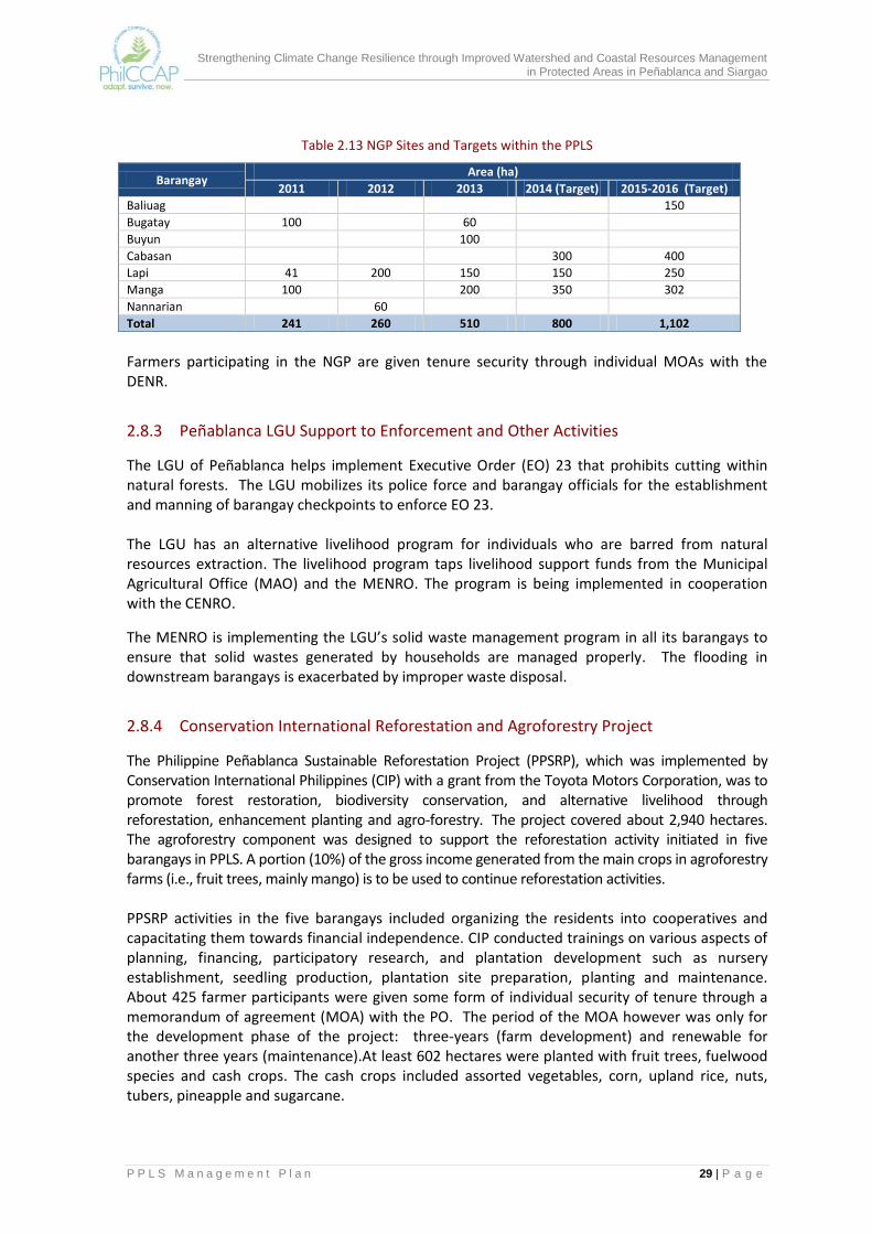
Strengthening Climate Change Resilience through Improved Watershed and Coastal Resources Management in Protected Areas in Peñablanca and Siargao
P P L S M a n a g e m e n t P l a n 29 | P a g e
Table 2.13 NGP Sites and Targets within the PPLS
Barangay Area (ha)
2011 2012 2013 2014 (Target) 2015-2016 (Target)
Baliuag
150
Bugatay 100
60 Buyun
100
Cabasan
300 400
Lapi 41 200 150 150 250
Manga 100
200 350 302
Nannarian
60 Total 241 260 510 800 1,102
Farmers participating in the NGP are given tenure security through individual MOAs with the DENR.
2.8.3 Peñablanca LGU Support to Enforcement and Other Activities
The LGU of Peñablanca helps implement Executive Order (EO) 23 that prohibits cutting within natural forests. The LGU mobilizes its police force and barangay officials for the establishment and manning of barangay checkpoints to enforce EO 23. The LGU has an alternative livelihood program for individuals who are barred from natural resources extraction. The livelihood program taps livelihood support funds from the Municipal Agricultural Office (MAO) and the MENRO. The program is being implemented in cooperation with the CENRO.
The MENRO is implementing the LGU’s solid waste management program in all its barangays to ensure that solid wastes generated by households are managed properly. The flooding in downstream barangays is exacerbated by improper waste disposal.
2.8.4 Conservation International Reforestation and Agroforestry Project
The Philippine Peñablanca Sustainable Reforestation Project (PPSRP), which was implemented by Conservation International Philippines (CIP) with a grant from the Toyota Motors Corporation, was to promote forest restoration, biodiversity conservation, and alternative livelihood through reforestation, enhancement planting and agro-forestry. The project covered about 2,940 hectares. The agroforestry component was designed to support the reforestation activity initiated in five barangays in PPLS. A portion (10%) of the gross income generated from the main crops in agroforestry farms (i.e., fruit trees, mainly mango) is to be used to continue reforestation activities. PPSRP activities in the five barangays included organizing the residents into cooperatives and capacitating them towards financial independence. CIP conducted trainings on various aspects of planning, financing, participatory research, and plantation development such as nursery establishment, seedling production, plantation site preparation, planting and maintenance. About 425 farmer participants were given some form of individual security of tenure through a memorandum of agreement (MOA) with the PO. The period of the MOA however was only for the development phase of the project: three-years (farm development) and renewable for another three years (maintenance).At least 602 hectares were planted with fruit trees, fuelwood species and cash crops. The cash crops included assorted vegetables, corn, upland rice, nuts, tubers, pineapple and sugarcane.

Strengthening Climate Change Resilience through Improved Watershed and Coastal Resources Management in Protected Areas in Peñablanca and Siargao
P P L S M a n a g e m e n t P l a n 30 | P a g e
When the project was completed, only the PO of barangay Mangga was issued by DENR with a PACBRMA with a duration of 25 years. The issuance of PACBRMA to each PO in the other barangays or the expansion of the PACBRMA in barangay Mangga to cover other barangays remain under consideration by DENR. In support of agroforestry, a market study on mango fruits was undertaken. The results indicate that mango trees must at least produce 25 kilos per tree per harvest and the produce must be sold at P25.00 per kilo in order to generate positive income for the growers and funds for the reforestation. Such level of production per tree will need good silvicultural practices during the fruiting stage.
2.8.5 Metro Tuguegarao Water District Watershed Reservation Management The Metro Tuguegarao Water District (MTWD) has been benefitting from the PPLS through water accessed from the area. To date, the PPLS-sourced water is being distributed to about 15% of the serviced households of MTWD in Tuguegarao City. The MTWD was given responsibility for the management of the 633-hectare watershed reservation within barangay San Roque. The MTWD has regular staff who patrol and secure the area from the entry of more illegal settlers. In the past, illegal settlers occupied and cleared the area for cultivation of cash crops, fuelwood gathering and other extractive activities. During the census in the watershed reservation of the MTWD, there were more than a hundred households recorded. Nursery development, agroforestry farm establishment and reforestation activities are among the regular activities of the MTWD. Communities inside the reservation are tapped as conservation partners. The MTWD conducts IEC and tree planting activities with its partner institutions such as the Cagayan State University (CSU), the Philippine National Police (PNP), the Philippine Army, and other groups and institutions based in Tuguegarao City.
2.8.6 PhilCCAP Pilot Agroforestry Project The PhilCCAP, which was implemented starting in 2013, is supporting the development of about 122 hectares of agroforestry plantations in barangays Mangga, Buyun and Nabbabalayan. This agroforestry pilot project is designed to support the livelihood of upland farmers and at the same time improve the land cover of the area and enhance the stability of the upland ecosystem. The vulnerability assessment of PPLS showed that these three barangays are among the areas within the PA that have high to very high susceptibility to landslides and flooding. The species planted in the agroforestry farms are mainly mango and cacao. Selected farmers were provided with guyabano and calamansi seedlings. The 77 farmer cooperators are also encouraged to plant indigenous tree species and their preferred fuelwood species. Indigenous species such as balete, bignay, kakawate and anchoan dilaw were proposed as living fences along boundaries. The latter two are good fuelwood sources. Farmer cooperators were taught to prepare farm plans that incorporated soil and water conservation measures to help control soil erosion. Under the PhilCCAP-supported agroforestry, farmer beneficiaries were
Table 2.14 Distribution of PhilCCAP Agroforestry Farmer Cooperators by Barangay
Pilot Barangay No. of Farmer-
Cooperators Total Area
(ha) Ave. Farm
Lot (ha)
Buyun 31 42.968 1.38
Mangga 12 31.678 2.64
Nabbabalayan 34 47.136 1.39
Total 77 121.782 1.58
Source: PPLS PASu Office
Strengthening Climate Change Resilience through Improved Watershed and Coastal Resources Management in Protected Areas in Peñablanca and Siargao
P P L S M a n a g e m e n t P l a n 31 | P a g e
provided with planting materials and limited farm inputs. They were not paid for establishing the plantations. The project also recognized the importance of tenure security for the sustainable management of the plantations. Without clear land tenure, farmer beneficiaries have less incentive to protect the established plantations since they are not assured that the benefits or the harvest will accrue to them. DENR opted to pursue individual agreements, through MOAs, with the farmer-cooperators to legitimize their rights over the land assigned to them and to clearly establish the obligations of both parties to the agreement. A five-year business plan for mango processing, with mango puree as main product, was prepared in consultation with MUFAMCO, the PO that was formed under the PPSRP and awarded a PACBRMA by DENR. The business plan provided an assessment of mango production in the area and analyses of the profitability and viability of a processing enterprise. While the plan was prepared mainly for MUFAMCO, the establishment of a mango processing facility in Peñablanca will eventually benefit all mango producers in the municipality. The Japan Social Development Fund (JSDF) was identified as a potential source of funding assistance.
2.8.7 Department of Tourism Support to Ecotourism Under its existing ecotourism development program, the DOT Region 2 Office conducts training for ecotourism guides and for those interested in handicraft and souvenir item production. The DOT conducted tree planting within the Callao Caves Resort and a clean-up drive along the section of the Pinacanauan River that is near the resort. It has forged ties with local tourism agencies for support, promotion and development of ecotourism packages and scheduled tourism circuits to maximize the stay of tourists in the region.
2.9 Current Issues, Concerns and Opportunities The assessment of the PPLS bio-physical, socio-economic, stakeholder and institutional profiles revealed a number of issues and concerns on the condition and management of the PA. Among these are the interrelated problems of declining natural forests, threatened habitats, flora and fauna, land conversion, unclear land tenure arrangements, and overall watershed degradation. If not addressed in an appropriate and timely manner, the PA’s ability to provide economic and environmental services to communities will be compromised. The ecosystems and communities in PPLS are also being exposed increasingly to disaster risks due to climate hazards. However, those who are tasked to manage the PA lack sufficient capability and financial and logistical resources to mitigate these risks.
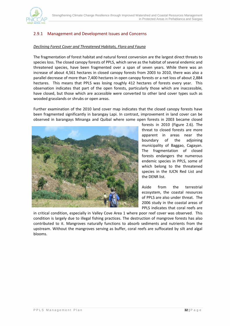
Strengthening Climate Change Resilience through Improved Watershed and Coastal Resources Management in Protected Areas in Peñablanca and Siargao
P P L S M a n a g e m e n t P l a n 32 | P a g e
2.9.1 Management and Development Issues and Concerns
Declining Forest Cover and Threatened Habitats, Flora and Fauna The fragmentation of forest habitat and natural forest conversion are the largest direct threats to species loss. The closed canopy forests of PPLS, which serve as the habitat of several endemic and threatened species, have been fragmented over a span of seven years. While there was an increase of about 4,561 hectares in closed canopy forests from 2003 to 2010, there was also a parallel decrease of more than 7,400 hectares in open canopy forests or a net loss of about 2,884 hectares. This means that PPLS was losing roughly 412 hectares of forests every year. This observation indicates that part of the open forests, particularly those which are inaccessible, have closed, but those which are accessible were converted to other land cover types such as wooded grasslands or shrubs or open areas. Further examination of the 2010 land cover map indicates that the closed canopy forests have been fragmented significantly in barangay Lapi. In contrast, improvement in land cover can be observed in barangays Minanga and Quibal where some open forests in 2003 became closed
forests in 2010 (Figure 2.6). The threat to closed forests are more apparent in areas near the boundary of the adjoining municipality of Baggao, Cagayan. The fragmentation of closed forests endangers the numerous endemic species in PPLS, some of which belong to the threatened species in the IUCN Red List and the DENR list. Aside from the terrestrial ecosystem, the coastal resources of PPLS are also under threat. The 2006 study in the coastal areas of PPLS indicates that coral reefs are
in critical condition, especially in Valley Cove Area 1 where poor reef cover was observed. This condition is largely due to illegal fishing practices. The destruction of mangrove forests has also contributed to it. Mangroves naturally functions to absorb sediments and nutrients from the upstream. Without the mangroves serving as buffer, coral reefs are suffocated by silt and algal blooms.
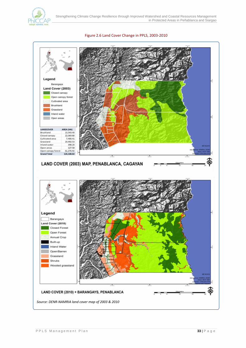
Strengthening Climate Change Resilience through Improved Watershed and Coastal Resources Management in Protected Areas in Peñablanca and Siargao
P P L S M a n a g e m e n t P l a n 33 | P a g e
Figure 2.6 Land Cover Change in PPLS, 2003-2010
Source: DENR-NAMRIA land cover map of 2003 & 2010
Strengthening Climate Change Resilience through Improved Watershed and Coastal Resources Management in Protected Areas in Peñablanca and Siargao
P P L S M a n a g e m e n t P l a n 34 | P a g e
Inappropriate and Unsustainable Livelihood Practices Habitats fragmentation can be traced to the unsustainable livelihood practices of local communities. Field documentations revealed that one of the common livelihood sources of surrounding communities in PPLS is firewood gathering and charcoal making. The high demand for these products in Tuguegarao City encourages barangay residents near the forests to illegally cut trees and sell them to traders in the area as firewood or charcoal. The common outlets for the firewood are the bakeries and small panciterias around Tuguegarao City. With the cost of fuel continuously rising, the demand for firewood and charcoal is expected to increase further. With increasing demand, local communities are encouraged to gather more firewood in forest to augment their family income. Aside from this activity, some residents are also engaged in kaingin and timber poaching. With limited A and D lands and the diminishing productivity of existing farms due to flooding and soil erosion, forests are being cleared for farming purposes. The relative location where these unsustainable livelihood activities of local communities are occurring are reflected in Figure 2.7. Kaingin is prevalent in the coastal barangays. It is more so in the western section of PPLS where timber poaching is also happening. Charcoal making is concentrated in the southwestern section of PPLS, specifically in Barangays Baliuag, Bical, Bugatay, Cabasan and Sisim, which are near its main market, Tuguegarao City.
Land Tenure Insecurity of Individual Tenured Migrants Several tenure instruments have been issued even prior to its proclamation of PPLS as a protected area. Among these are community based forest management agreement (CBFMA) and the Certificate of Stewardship Contracts (CSC). Many of the awarded CSCs have expired and the remaining CSCs will soon expire. The CBFM in Quibal will be expiring in a few years. Individual CSC holders and settlers within CBFM areas are asking whether they will be given individual tenure once the existing instruments expire. Current policies within protected areas only allow community tenure in the form of PACBRMA. There is no individual tenure instrument presently being issued within protected areas. While a PACBRMA has already been awarded in barangay Mangga, individual members still prefer to have individual tenure instruments issued to them. To promote meaningful participation of individual claimants within PPLS, DENR needs to study further the possibility of providing individual tenure instruments within community tenured areas of PAs.
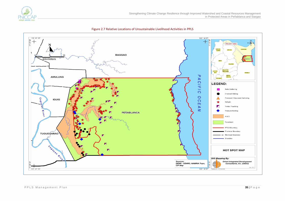
Strengthening Climate Change Resilience through Improved Watershed and Coastal Resources Management in Protected Areas in Peñablanca and Siargao
P P L S M a n a g e m e n t P l a n 35 | P a g e
Figure 2.7 Relative Locations of Unsustainable Livelihood Activities in PPLS
Strengthening Climate Change Resilience through Improved Watershed and Coastal Resources Management in Protected Areas in Peñablanca and Siargao
P P L S M a n a g e m e n t P l a n 36 | P a g e
Insufficient Financial, Logistical and Manpower Resources A more crucial management issue in PPLS is the limited financial resources and manpower allocated for PA management. The current budget allocation for PPLS is very limited and is not enough to cover the operational expenses of personnel assigned to PPLS. Because of this problem, the PASu Office cannot effectively implement protection and conservation activities within the PA. Unlike legislated PAs that are provided regular budgets in their respective legal instruments, the PPLS does not have regular budget support. It is highly dependent on the meager funds that DENR can provide and the support that the LGU extends to it. In addition to limited funding, the PASu Office also has very limited manpower to implement the various programs and activities of PPLS. While some personnel from the CENRO and the PAWCZMS are assigned to the PASu, they do not work on a full-time basis. Their responsibilities in the PPLS are often secondary to their primary tasks in their respective offices. This unduly jeopardizes the protection and conservation efforts within the PA. The above limitations highlight the need to develop and implement financing mechanisms to be able to sustain the management requirements of PPLS.
Need to Strengthen PAMB and the Capabilities of PASu Personnel There is a need to strengthen the PAMB as the highest policy governing body of PPLS. PAMB members need to be kept updated and aware of new developments and policies in the ENR and PA sectors that have impacts on PPLS. They need to work towards the harmonization of different regulations, plans, programs and projects within PPLS. The PAMB need to operate within an organizational framework that has clear and effective management structure, systems and procedures to be able to address effectively and efficiently the different issues and concerns in the PA. The PPLS covers a very large area and the PASu does not have adequate personnel. The PAMB should consider the involvement of other stakeholders who may be given responsibility, authority and accountability for specific portions of the PA. For these management arrangements, the PAMB and the PASu will need to develop their negotiation skills, and establish the needed policies and the monitoring system to assess the performance of tenure holders and resource managers of PPLS. The PAMB and the PASu have to make sure that tenure holders meet their responsibilities set out in tenure agreements. The capability of the PASu Office to establish and develop adequate baseline information and a PPLS data bank will also have to be improved. One area that should be given attention is on the biodiversity resources of the PA. The PPLS is an important conservation area but information on habitat types and their location inside the PA is limited, particularly the extent of their coverage, the associated flora and fauna, species abundance.
2.9.2 Vulnerabilities to Climate Change Climate change projections by PAGASA (2011) for Cagayan Province indicate a temperature increase of 0.8 to 1.0oC in 2020 and of 1.8 to 2.2⁰C in 2050, with dry months becoming drier, and wet months wetter (refer back to Table 2.4). The temperature and rainfall changes will have great impact on agriculture, forestry, water resources, fisheries and marine resources, human

Strengthening Climate Change Resilience through Improved Watershed and Coastal Resources Management in Protected Areas in Peñablanca and Siargao
P P L S M a n a g e m e n t P l a n 37 | P a g e
settlements, biodiversity, and ecosystems in general. Erratic rainfall patterns are expected to result to significant changes in the hydrologic regimes of the watersheds such as water yield though time, magnitudes of peak discharges of rivers, and time-to-peak discharge relative to rainfall events. These changes provide additional threats to the PPLS. The ecosystems and communities within and adjacent to PPLS experience not only increasing temperature and erratic rainfall patterns but also sea level rise, and more intense extreme climatic events such as typhoons, floods, droughts, and landslides which adversely affect the stability and sustainability of the terrestrial and marine ecosystems of PPLS. The vulnerability assessment that follows takes a closer look specifically at the vulnerability of the PPLS to flooding and landslides. The vulnerability assessment considered three aspects: (a) exposure of the community and ecosystem to the hazards; b) sensitivity of exposed elements to the hazard; and 3) adaptive capacity to cope with the hazard (IPCC, 2007). The higher the exposure and sensitivity of the ecosystem and community to the hazards, and the lower their adaptive capacity is to the hazards, the higher is overall vulnerability.
Vulnerability to Flooding Flooding is a common hazard in Peñablanca. Every year, several barangays in the municipality experience flooding. With more rains expected during the wet season, the impact of flooding on agriculture and settlements will be aggravated. The PPLS will play a major role in mitigating the impacts of flooding in downstream areas since the rivers that drain into flood prone areas originate from the PA. Based on the assessment of the DENR – MGB, the flood prone areas in Peñablanca, Baggao and Tuguegarao City are influenced by the PA is presented in Annex Map 6. The sub-watersheds that directly affect the flood prone areas are the Pared, Pinacanauan, Natallad and Abaca sub-watershed. The condition of these sub-watersheds, particularly the vegetative cover and land use practices within them greatly affect the degree of flooding in the downstream communities and its consequent impact on agriculture and settlements. The potential impact of flooding to agricultural areas in Peñablanca is presented in Figure 2.8 Except for barangays Nanguilatan, Quibal, Alimanao and Camasi, significant agricultural areas in 20 barangays of Peñablanca(or 80% of total barangays) are exposed to and are sensitive to flooding. Areas that are highly vulnerable to flooding are shown in the map. Within PPLS, agricultural areas that are highly vulnerable to flooding are limited to barangays Lapi, Buyun, Nabbabalayan and Mangga. This situation greatly impact on the food security of the municipality as well as on the livelihood of local communities that are mainly dependent on farming as primary source of household income. Flooding also affects built-up areas and endangers the lives and properties of affected communities. The potential impacts of flooding on settlements/ built up areas is presented in Figure 2.9. The settlement areas located in 11 barangays of Peñablanca (46% of total barangays) are highly vulnerable to flooding: barangays Mangga, Minanga, Buyun, Nabbabalayan, Malibabag, Aggugaddan, Sisim, Poblacion, Bugatay, Cabasan and Bical. Those of the first three barangays are located within PPLS.
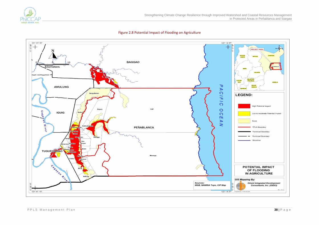
Strengthening Climate Change Resilience through Improved Watershed and Coastal Resources Management in Protected Areas in Peñablanca and Siargao
P P L S M a n a g e m e n t P l a n 38 | P a g e
Figure 2.8 Potential Impact of Flooding on Agriculture

Strengthening Climate Change Resilience through Improved Watershed and Coastal Resources Management in Protected Areas in Peñablanca and Siargao
P P L S M a n a g e m e n t P l a n 39 | P a g e
Figure 2.9 Potential Impact of Flooding on Built-up Areas

Strengthening Climate Change Resilience through Improved Watershed and Coastal Resources Management in Protected Areas in Peñablanca and Siargao
P P L S M a n a g e m e n t P l a n 40 | P a g e
Vulnerability to Landslide Since more than 60% of PPLS have steep to very steep slopes, many areas in the PA are prone to rain induced landslide. As indicated in Annex Map 7, most of these landslide-prone areas are located in the eastern and mid-section of the PA, mostly in barangays Lapi and Minanga and portions of barangay Nanguilatan, Buyun, Mangga, Nabbabalayan, and Quibal. With the expected increase in seasonal rainfall during the wet season, the occurrence of landslides is expected to worsen, affecting settlements, agriculture and ecosystems near landslide prone areas. The potential impact on agriculture of rain-induced landslides is presented in Figure 2.10. The assessment reveals that agricultural areas in four barangays within PPLS are at high risk to this threat. These areas, which are mostly upland farms are located in Barangays Lapi, Buyun, Nabbabalayan, and Mangga. The farms are the primary source of income for local residents in these barangays. With wet months projected to become wetter due to climate change, more landslides are expected to occur. These will push local residents to open alternative areas for farming through kaingin. Landslides also endanger the lives and properties of communities living in or adjacent to landslide prone areas. Figure 2.11 shows the potential impact of landslide on built up areas. The high-risk areas are the settlements in Barangays Lapi (part of Pared sub-watershed), Mangga, Buyun and Nabbabalayan (part of Pinacanauan and Natallad sub-watersheds). Considering the potential damage and risks associated with landslides, the LGU and the residents will have to consider relocating the affected settlements to safer areas. The overall vulnerability of communities in the municipality to flooding and landslide were derived by taking into consideration their lack of adaptive capacity to climate change hazards. In the absence of direct measures for adaptive capacity of communities in the PPLS, the average household income in each barangay was chosen as proxy indicator. This means that the lower the average household income is in the barangay, the lower is its adaptive capacity to climate change. Figure 2.12 shows in one map the overall vulnerability of barangays to flooding and landslide.
Vulnerability to Multiple Hazards Combining the vulnerabilities to flooding, landslide and biodiversity loss, a vulnerability map to multi hazards was developed (Figure 2.13). Within the PPLS, the barangays that are highly vulnerable to multi hazards include barangays Lapi, Minanga and Mangga. Most of the protection, conservation and rehabilitation activities will therefore have to be prioritized in these barangays. It will be noted that these barangays are also crucial in mitigating the impacts of flooding in downstream areas of Peñablanca, Baggao and Tuguegarao City, which affect significant areas of agricultural lands and settlements. The benefits of investments in these priority barangays will redound to a large number of off-site stakeholders.
Landslide-prone area within PPLS

Strengthening Climate Change Resilience through Improved Watershed and Coastal Resources Management in Protected Areas in Peñablanca and Siargao
P P L S M a n a g e m e n t P l a n 41 | P a g e
Figure 2.10 Potential Impact of Landslide on Agriculture
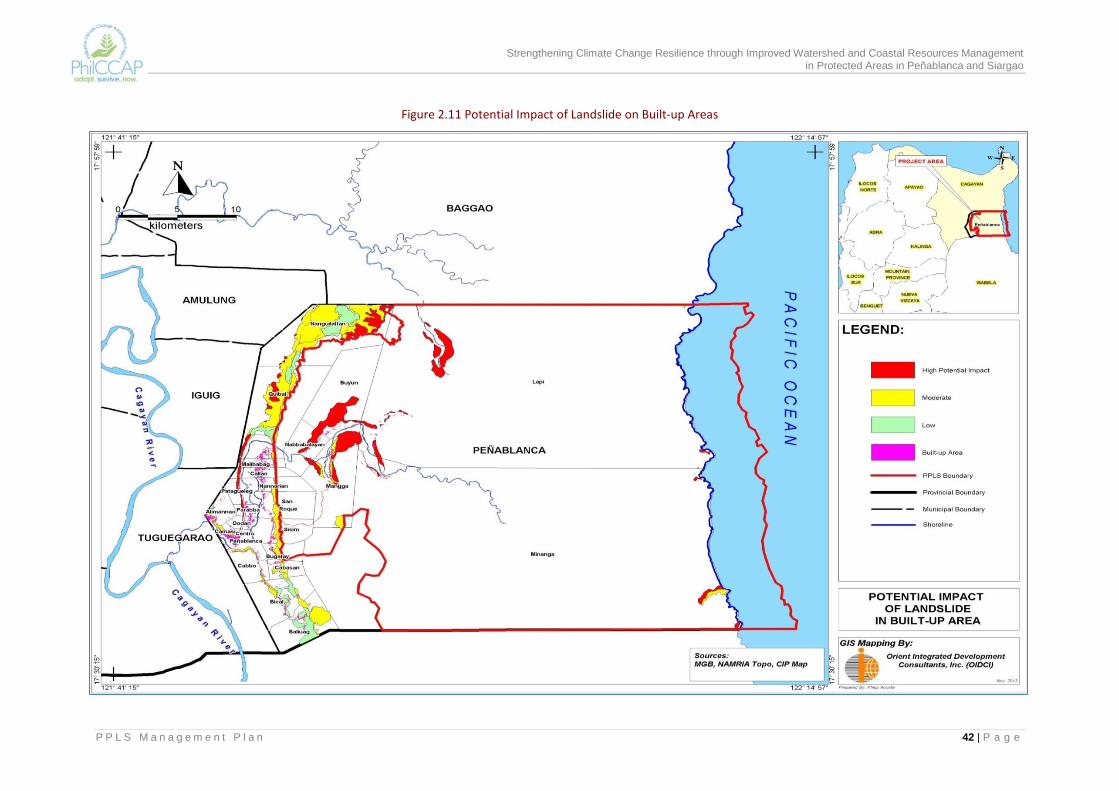
Strengthening Climate Change Resilience through Improved Watershed and Coastal Resources Management in Protected Areas in Peñablanca and Siargao
P P L S M a n a g e m e n t P l a n 42 | P a g e
Figure 2.11 Potential Impact of Landslide on Built-up Areas
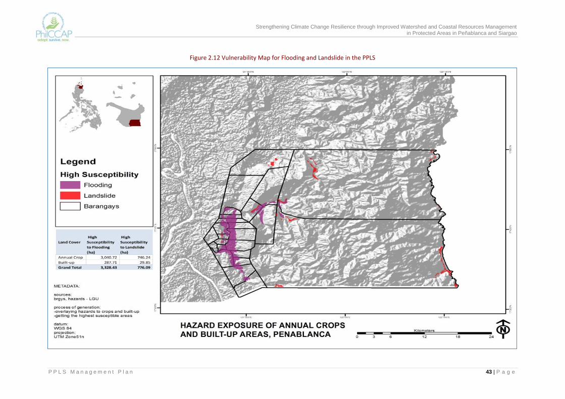
Strengthening Climate Change Resilience through Improved Watershed and Coastal Resources Management in Protected Areas in Peñablanca and Siargao
P P L S M a n a g e m e n t P l a n 43 | P a g e
Figure 2.12 Vulnerability Map for Flooding and Landslide in the PPLS
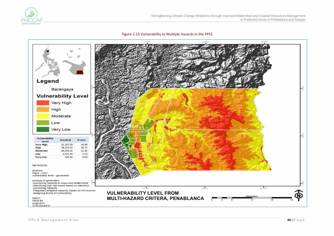
Strengthening Climate Change Resilience through Improved Watershed and Coastal Resources Management in Protected Areas in Peñablanca and Siargao
P P L S M a n a g e m e n t P l a n 44 | P a g e
Figure 2.13 Vulnerability to Multiple Hazards in the PPLS

Strengthening Climate Change Resilience through Improved Watershed and Coastal Resources Management in Protected Areas in Peñablanca and Siargao
P P L S M a n a g e m e n t P l a n 45 | P a g e
Vulnerability to Biodiversity Losses Annex Table 2 provides a list of 109 plants that are present in PPLS with their respective vulnerability ratings. Annex Table 3 shows the vulnerability ratings of 141 bird species found in PPLS. Among plants, 11 are considered highly vulnerable while among birds, there are 52 species that have high vulnerability. The vulnerability to climate change of plant species is dependent on its types of habit, i.e., whether herb, shrub, small/medium-sized/tall-giant trees, climbers/vines/lianas. For instance, kara-uwey or lituco/rattan, which has a medium vulnerability rating based on three adaptive traits, namely: (a) its habit, i.e., woody climber); (b) its capacity to profusely produce fruits with viable seeds that are dispersed by fruit-eating bats, such as flying foxes or fruit bats; and (c) its total dependence to tall or giant forest trees as its trellises. The tall or giant forest trees such as the dipterocarps have low vulnerability rating by virtue of their habit. There are plants, however, that adapt to increase in temperature by shifting to elevational zones that approximate former habitat conditions. For example, ground orchids such as Cyrtosia sp., which are herbaceous in habit and are commonly found growing luxuriantly on moist, debris-rich forest floors at lower elevations, will migrate to higher elevations of nearly the same habitat conditions with the onset of increased temperature. Similarly, filmy ferns like Hymenophyllum reinwardtii, which are indicators of super moist soil and always wet places such as stream banks and waterfalls will, likewise, migrate up the mountain slopes along watercourses, terminating their upward migration to the vicinity of headwaters. Once these headwaters dry up, it will signal the start of their local extinction. There are plants therefore that are now found growing in the mossy forest zone of mountains (i.e., above 1,000 masl) such as Mt. Cetaceo (see Figure 2.14) are highly at risk for the simple reason that there are no more places to migrate to that are higher than where they are growing at present. Local extinction will be their ultimate fate. Among faunal species, the impact of increased temperature will be more pronounced and easily detectable among amphibians. With increase in temperature leading to the drying up of natural ponds, sloughs, streams, creeks, and tributaries, the amphibians will have to migrate to higher elevations of mountains and remaining waterways up near the summits. The overall adaptation response of animals will depend on their ability to evade and escape the impact of increased temperature. There are the non-volant animals (such as mountain rats, amphibians, reptiles, mollusks) and volant animals (like birds, flying mammals such as bats). For animals that can fly, they can migrate far and wide to similar or compatible habitats as soon as inimical conditions start to show in the present ecosystems where they thrive. For animals incapable of flight, “escape and evasion” may serve the purpose only as long as similar habitats or ecosystems will be available in short distances from where they are currently living and they may only be able escape for a short time. This migration “in short leaps” is directly proportional to the height of the mountains (in the tropics) where they are.
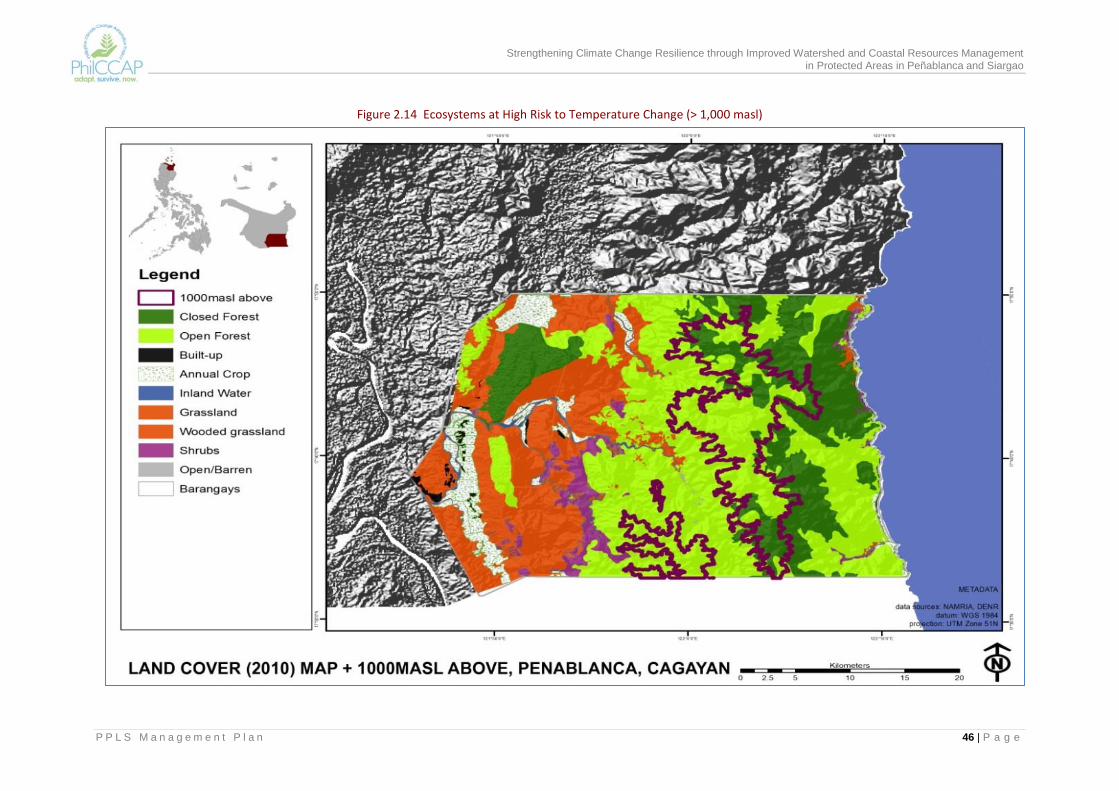
Strengthening Climate Change Resilience through Improved Watershed and Coastal Resources Management in Protected Areas in Peñablanca and Siargao
P P L S M a n a g e m e n t P l a n 46 | P a g e
Figure 2.14 Ecosystems at High Risk to Temperature Change (> 1,000 masl)
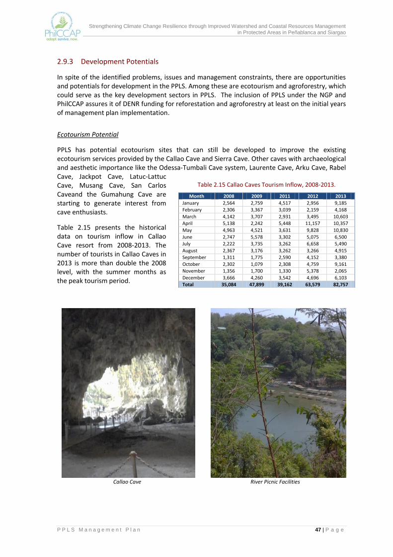
Strengthening Climate Change Resilience through Improved Watershed and Coastal Resources Management in Protected Areas in Peñablanca and Siargao
P P L S M a n a g e m e n t P l a n 47 | P a g e
2.9.3 Development Potentials
In spite of the identified problems, issues and management constraints, there are opportunities and potentials for development in the PPLS. Among these are ecotourism and agroforestry, which could serve as the key development sectors in PPLS. The inclusion of PPLS under the NGP and PhilCCAP assures it of DENR funding for reforestation and agroforestry at least on the initial years of management plan implementation.
Ecotourism Potential
PPLS has potential ecotourism sites that can still be developed to improve the existing ecotourism services provided by the Callao Cave and Sierra Cave. Other caves with archaeological and aesthetic importance like the Odessa-Tumbali Cave system, Laurente Cave, Arku Cave, Rabel Cave, Jackpot Cave, Latuc-Lattuc Cave, Musang Cave, San Carlos Caveand the Gumahung Cave are starting to generate interest from cave enthusiasts.
Table 2.15 presents the historical data on tourism inflow in Callao Cave resort from 2008-2013. The number of tourists in Callao Caves in 2013 is more than double the 2008 level, with the summer months as the peak tourism period.
Callao Cave River Picnic Facilities
Table 2.15 Callao Caves Tourism Inflow, 2008-2013.
Month 2008 2009 2011 2012 2013
January 2,564 2,759 4,517 2,956 9,185
February 2,306 3,367 3,039 2,159 4,168
March 4,142 3,707 2,931 3,495 10,603
April 5,138 2,242 5,448 11,157 10,357
May 4,963 4,521 3,631 9,828 10,830
June 2,747 5,578 3,302 5,075 6,500
July 2,222 3,735 3,262 6,658 5,490
August 2,367 3,176 3,262 3,266 4,915
September 1,311 1,775 2,590 4,152 3,380
October 2,302 1,079 2,308 4,759 9,161
November 1,356 1,700 1,330 5,378 2,065
December 3,666 4,260 3,542 4,696 6,103
Total 35,084 47,899 39,162 63,579 82,757
Strengthening Climate Change Resilience through Improved Watershed and Coastal Resources Management in Protected Areas in Peñablanca and Siargao
P P L S M a n a g e m e n t P l a n 48 | P a g e
The development and inclusion of other caves in ecotourism promotion and the introduction of other tourism activities such as river trailing or kayaking, boating, spelunking, bird watching, trekking, and mountain climbing will boost PPLS as a tourism destination. These services should be able to attract more tourists, both local and foreign. The revenues from ecotourism can augment the resources allocated for PPLS management.
Funding for Reforestation, Agroforestry and Livelihood The DENR has continuing NGP targets in PPLS, which can be aligned with the implementation of the PPLS management plan. The LGU budget likewise includes a regular allocation for PPLS support activities. Other potential source of funding support is the Bottom-Up Budgeting (BUB) Program which has DENR, DA, the Department of Interior and Local Government (DILG) and the Department of Social Welfare and Development (DSWD) among the agency partners.
Potential Partner-Stakeholders There are a number of PA stakeholders who are already participating and contributing to the protection and conservation of the natural resources of the PPLS. The PAMB should be able to strengthen their involvement and tap others who have a stake in the PPLS. These include the downstream barangays, which are affected by flooding, neighboring LGUs like Baggao and Tuguegarao City, irrigators associations, and other people’s organizations. In addition to the above are academic and research institutions, which have indicated interest in PPLS, among them the Isabela State University (ISU) and the International Center for Research and Agroforestry (ICRAF). Their researches and studies will contribute much to the building of the database of PPLS. The support of some private investors and businesses in Tuguegarao City can be explored.
Strengthening Climate Change Resilience through Improved Watershed and Coastal Resources Management in Protected Areas in Peñablanca and Siargao
P P L S M a n a g e m e n t P l a n 49 | P a g e
3.0 THE MANAGEMENT PLAN The succeeding sections will outline the management plan of the PPLS. It presents the vision, mission, goals and objectives (VMGO) of the plan and the strategies to achieve the VMGO. The management zones, prescriptions, PPLS standards and guidelines as well as the management programs to operationalize the strategies are likewise discussed.
3.1 Vision, Missions, Goals and Objectives The vision, mission, goals and objectives of the plan are based on the results of the analysis of the situation in the PPLS. They provide direction for the management strategies and activities of the PA plan.
3.1.1 Vision The vision sets the long-term direction on what the PPLS stakeholders would like to attain in the future with respect to the management of the protected area. It gives a picture of the ultimate aspiration of the stakeholders and is the basis in formulating the different goals and objectives of the PA plan. The current vision statement is a slight modification of the 2004 PPLS management plan and incorporates the concerns on climate change impacts. The reformulated vision is as follows:
3.1.2 Mission To achieve the vision, the PAMB, as the highest policy-making body of the protected area, commits to ensure climate-resilient ecosystems and communities in the PPLS by providing a conducive environment for participatory formulation, implementation and monitoring and evaluation of policies, plans and programs for the effective protection, conservation and management of the PPLS.
A climate- resilient and sustainably managed Peñablanca Protected Landscape and Seascape providing environmental and economic benefits to communities with its habitats and ecosystems and their associated biological diversity conserved, protected and managed by local communities in partnership with protected area management and other stakeholders.
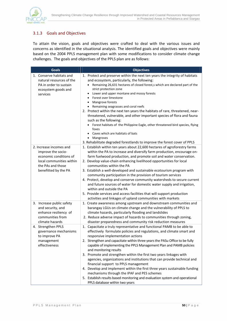
Strengthening Climate Change Resilience through Improved Watershed and Coastal Resources Management in Protected Areas in Peñablanca and Siargao
P P L S M a n a g e m e n t P l a n 50 | P a g e
3.1.3 Goals and Objectives To attain the vision, goals and objectives were crafted to deal with the various issues and concerns as identified in the situational analysis. The identified goals and objectives were mainly based on the 2004 PPLS management plan with some modifications to consider climate change challenges. The goals and objectives of the PPLS plan are as follows:
Goals Objectives
1. Conserve habitats and natural resources of the PA in order to sustain ecosystem goods and services
1. Protect and preserve within the next ten years the integrity of habitats and ecosystem, particularly, the following: Remaining 26,631 hectares of closed forest,s which are declared part of the
strict protection zone
Lower and upper montane and mossy forests
Forest over limestone
Mangrove forests
Remaining seagrasses and coral reefs
2. Protect within the next ten years the habitats of rare, threatened, near-threatened, vulnerable, and other important species of flora and fauna such as the following: Forest habitats of the Philippine Eagle, other threatened bird species, flying
foxes
Caves which are habitats of bats
Mangroves
3. Rehabilitate degraded forestlands to improve the forest cover of PPLS
2. Increase incomes and improve the socio-economic conditions of local communities within the PAs and those benefitted by the PA
1. Establish within ten years about 22,600 hectares of agroforestry farms within the PA to increase and diversify farm production, encourage on-farm fuelwood production, and promote soil and water conservation.
2. Develop value-chain enhancing livelihood opportunities for local communities within the PA
3. Establish a well-developed and sustainable ecotourism program with community participation in the provision of tourism services
4. Protect, develop and conserve community watersheds to secure current and future sources of water for domestic water supply and irrigation, within and outside the PA
5. Provide services and access facilities that will support production activities and linkages of upland communities with markets
3. Increase public safety and security, and enhance resiliency of communities from climate hazards
1. Create awareness among upstream and downstream communities and barangay LGUs on climate change and the vulnerability of PPLS to climate hazards, particularly flooding and landslides
2. Reduce adverse impact of hazards to communities through zoning, disaster preparedness and community risk reduction measures
4. Strengthen PPLS governance mechanisms to improve PA management effectiveness
1. Capacitate a truly representative and functional PAMB to be able to effectively formulate policies and regulations, and climate smart and responsive implementation actions
2. Strengthen and capacitate within three years the PASu Office to be fully capable of implementing the PPLS Management Plan and PAMB policies and monitoring results
3. Promote and strengthen within the first two years linkages with agencies, organizations and institutions that can provide technical and financial support to PPLS management
4. Develop and implement within the first three years sustainable funding mechanisms through the IPAF and PES schemes
5. Establish results based monitoring and evaluation system and operational PPLS database within two years
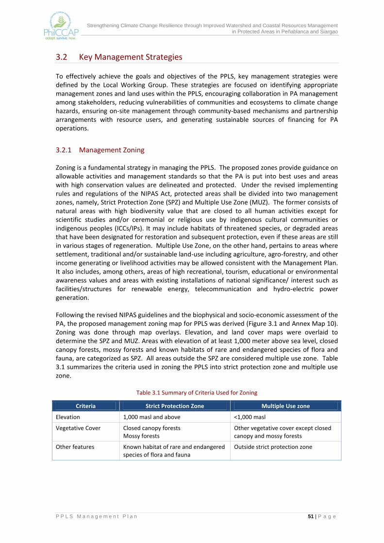
Strengthening Climate Change Resilience through Improved Watershed and Coastal Resources Management in Protected Areas in Peñablanca and Siargao
P P L S M a n a g e m e n t P l a n 51 | P a g e
3.2 Key Management Strategies To effectively achieve the goals and objectives of the PPLS, key management strategies were defined by the Local Working Group. These strategies are focused on identifying appropriate management zones and land uses within the PPLS, encouraging collaboration in PA management among stakeholders, reducing vulnerabilities of communities and ecosystems to climate change hazards, ensuring on-site management through community-based mechanisms and partnership arrangements with resource users, and generating sustainable sources of financing for PA operations.
3.2.1 Management Zoning Zoning is a fundamental strategy in managing the PPLS. The proposed zones provide guidance on allowable activities and management standards so that the PA is put into best uses and areas with high conservation values are delineated and protected. Under the revised implementing rules and regulations of the NIPAS Act, protected areas shall be divided into two management zones, namely, Strict Protection Zone (SPZ) and Multiple Use Zone (MUZ). The former consists of natural areas with high biodiversity value that are closed to all human activities except for scientific studies and/or ceremonial or religious use by indigenous cultural communities or indigenous peoples (ICCs/IPs). It may include habitats of threatened species, or degraded areas that have been designated for restoration and subsequent protection, even if these areas are still in various stages of regeneration. Multiple Use Zone, on the other hand, pertains to areas where settlement, traditional and/or sustainable land-use including agriculture, agro-forestry, and other income generating or livelihood activities may be allowed consistent with the Management Plan. It also includes, among others, areas of high recreational, tourism, educational or environmental awareness values and areas with existing installations of national significance/ interest such as facilities/structures for renewable energy, telecommunication and hydro-electric power generation. Following the revised NIPAS guidelines and the biophysical and socio-economic assessment of the PA, the proposed management zoning map for PPLS was derived (Figure 3.1 and Annex Map 10). Zoning was done through map overlays. Elevation, and land cover maps were overlaid to determine the SPZ and MUZ. Areas with elevation of at least 1,000 meter above sea level, closed canopy forests, mossy forests and known habitats of rare and endangered species of flora and fauna, are categorized as SPZ. All areas outside the SPZ are considered multiple use zone. Table 3.1 summarizes the criteria used in zoning the PPLS into strict protection zone and multiple use zone.
Table 3.1 Summary of Criteria Used for Zoning
Criteria Strict Protection Zone Multiple Use zone
Elevation 1,000 masl and above <1,000 masl
Vegetative Cover Closed canopy forests Mossy forests
Other vegetative cover except closed canopy and mossy forests
Other features Known habitat of rare and endangered species of flora and fauna
Outside strict protection zone

Strengthening Climate Change Resilience through Improved Watershed and Coastal Resources Management in Protected Areas in Peñablanca and Siargao
P P L S M a n a g e m e n t P l a n 52 | P a g e
Figure 3.1 Zoning Map of PPLS
Within the MUZ, sub-zones are likewise proposed based mainly on the unique characteristics of specific areas, and on actual and potential land uses. Thus, degraded habitat areas are classified as restoration/ conservation zones. Those with waterfalls, rapids, caves, lakes, and recreation potentials are reserved as recreation sub-zones. Areas with telecom lines are categorized as special use zones. The compatibility of adjoining zones across a ridge-to-reef landscape was also a key consideration in defining the sub-zones.
3.2.2 Collaborative Management Because of the multiple ecosystems goods and services provided by the PPLS and the multiple resource users of such goods and services, the use of collaborative management will be maximized. The participation of the stakeholders will be encouraged in the performance of the various PA management functions, which can range from protection and rehabilitation of forests to IEC and advocacy. The PAMB will continue to serve as the venue for stakeholder collaboration. Its composition, however, may need to be expanded to include other direct and off-site stakeholders. Management agreements will be forged between the PAMB and the designated on-site managers for specific management units. For instance, the PAMB may enter into management agreement with barangay LGUs for the management of community watersheds, which had been identified as sources of water for barangay constituents.

Strengthening Climate Change Resilience through Improved Watershed and Coastal Resources Management in Protected Areas in Peñablanca and Siargao
P P L S M a n a g e m e n t P l a n 53 | P a g e
Both the PAMB and its partners in PPLS management will have to go through a process of knowledge and capability building so they are able to perform their tasks effectively and contribute significantly to the management of the PPLS.
3.2.3 Community Based Resource Management The protection and conservation of terrestrial and marine resources in PPLS is a priority environmental agenda of the DENR and the municipality of Peñablanca. Realizing the inherent constraints and limitations of national agencies particularly the DENR, community based resource management will be adopted by mobilizing barangay residents and officials, and peoples organizations to participate in all stages of resource management. This is crucial as the community residents are considered the primary custodians and beneficiaries of the natural resources in their areas. This strategy shall be employed to foster link between the resources used by the communities and the conservation and sustainable use of these resources. This strategy recognizes the fact that management of natural resources with strong community involvement is both efficient and cost effective. The proposed zones and sub-zones will be discussed with barangay officials and local communities/people’s organizations particularly the prescriptions or rules on their use. The ultimate objective is for the adoption of these zones in Barangay Development Plans (BDP) of barangay LGUs and the Community Resource Management Framework (CRMFs) of CBFMA and PACBRMA holders. The harmonization of plans at the barangay level should eventually lead to the harmonization of the Comprehensive Land Use Plan (CLUP) of Peñablanca and PA Management Plan. Particular attention shall be given to (1) barangays considered as key conservation areas of PPLS, which are barangays Lapi and Minanga, and (2) barangays which are highly vulnerable to climate change hazards which are barangays Lapi, Minanga, Buyun, Nabbabalayan and Mangga. Support shall be provided to barangay LGUs and POs so their skills in planning and managing the areas assigned to them in accordance with the PA Management Plan will be developed.
3.2.4 Sustainable Financing The development and establishment of sustainable sources of financing to support PPLS activities will be given priority attention. Plan implementation in the past has been compromised because of limited financial resources available to the PAMB and the PASu Office. While the NIPAS Act and its implementing rules and regulations provide for the establishment of the integrated protected area fund (IPAF), this provision has not been fully taken advantaged of. There is a need to assess the different resources available in the PA, the uses and users of these resources, and determine the appropriate fees for their uses. Following this, a system for payment of ecosystem services (PES) and resource use fees and the mechanism for the allocation and disbursement of the IPAF will be established by the PAMB.
Strengthening Climate Change Resilience through Improved Watershed and Coastal Resources Management in Protected Areas in Peñablanca and Siargao
P P L S M a n a g e m e n t P l a n 54 | P a g e
3.2.5 Climate Change Adaptation In accordance with national policies and guided by the results of climate change vulnerability assessments, climate change adaptation (CCA) is incorporated into PA management strategies. CCA measures are to increase the resilience of ecosystems and communities to the impacts of climate change as they are aimed to reduce exposure to natural hazards such as flooding and landslides, minimize the sensitivity to climate change and enhance their adaptive capacity. Communities and municipal and barangay LGUs will be made aware of the risks and hazards associated with climate change in their respective barangays and will then be engaged in formulating very specific and doable community actions that will facilitate the implementation of broader CCA measures in the plan. In barangays that are highly vulnerable to climate hazards, the urgency of doing intensive IEC and the need to develop sound community-based disaster risk reduction and preparedness plans will be emphasized. The effectiveness of CCA will be a key area for M and E.
3.3 Management Programs Management programs consist of activities that will operationalize the strategies. There are four management programs presented in this plan: (a) biodiversity protection, conservation and rehabilitation program to sustain ecosystem goods and services and enhance resilience of ecosystems; (b) social and economic program to improve incomes and living conditions of local communities;(c) disaster risk reduction to avoid losses and damages from disasters resulting from climate change, and (d) governance enhancement and institutional development program to improve capabilities of resource managers and overall PA management. Presented in Figure 3.2 are the location of the areas where the first three management programs are to be implemented.
3.3.1 Biodiversity Protection, Conservation and Rehabilitation Program The main focus of this program is the protection and conservation of existing biodiversity resources particularly critical habitats and important species of flora and fauna, and the rehabilitation and development of degraded terrestrial, coastal and marine resources. The SPZ of PPLS (see Figure 3.2), which has an area of about 36,272 hectares shall be accorded with the highest form of protection from destructive and illegal activities since these are the areas with high biodiversity value. The ultimate desired result of the program would be enhanced resiliency of the upland and coastal ecosystems to climate change. This program will have five component activities: (a) ground demarcation of management zones, (b) ecological research and biodiversity monitoring; (c) community-based resource protection and law enforcement; (d) habitat restoration and conservation; and (e) conservation awareness and education.
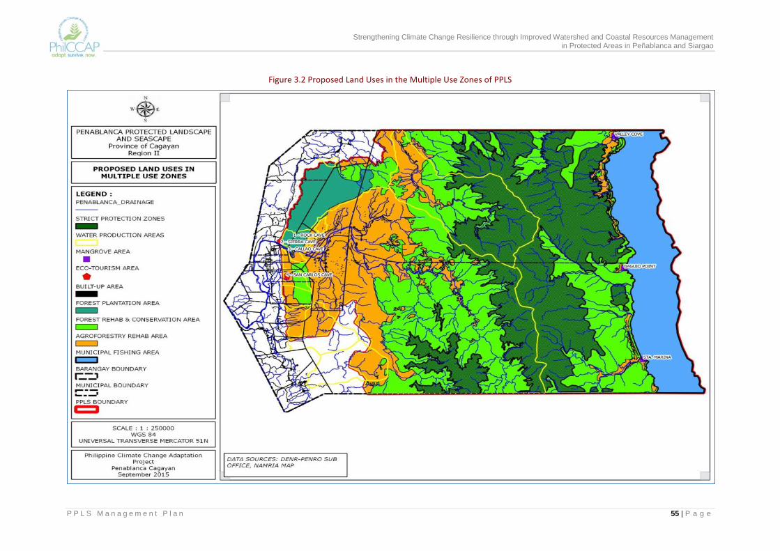
Strengthening Climate Change Resilience through Improved Watershed and Coastal Resources Management in Protected Areas in Peñablanca and Siargao
P P L S M a n a g e m e n t P l a n 55 | P a g e
Figure 3.2 Proposed Land Uses in the Multiple Use Zones of PPLS
Strengthening Climate Change Resilience through Improved Watershed and Coastal Resources Management in Protected Areas in Peñablanca and Siargao
P P L S M a n a g e m e n t P l a n 56 | P a g e
Ground Demarcation of Management zones In order to effectively implement the management zones, it is necessary to first demarcate on the ground the boundaries of the SPZ and the MUZ. Ground demarcation will be conducted in consultation and coordination with barangay officials and community members so that in the process, they become aware of the importance of these zones and the specific location of the boundaries. Signages will be installed in appropriate locations to clearly mark the SPZ as biodiversity protection and conservation areas. The agreed zones will have to be integrated also into the Barangay Development Plans, and the CLUP and zoning ordinance of the LGU so these can be enforced. The PASu and the MENRO will lead the effort to determine the investment requirements for ground demarcation, to identify potential sources of funding, and to prepare the necessary funding proposals, which will have to be endorsed by the PAMB. As funding is made available, they will also be responsible for planning, organizing and supervising the ground demarcation activity. The final boundaries that are demarcated on the ground will have to be plotted into an official PPLS map.
Ecological research and biodiversity monitoring The PAMB, through the PASu Office, will reach out to research and academic institutions within and outside the region that could provide technical assistance and are willing to undertake research studies in PPLS. The PASu and the MENRO/MPDO shall identify possible technical assistance and research areas that will support the implementation of the management plan. These can include the study and monitoring of specific habitats and/or species, coastal resource assessment, establishment of pilot demonstration or field testing areas for specific management technologies and/or plant species that are resistant to flooding and drought, water balance study, water quality or erosion/sedimentation measurement, and community-level climate hazard risk assessment. They will also formulate the specific guidelines for the evaluation of research and technical assistance proposals and for securing the necessary clearance from the PAMB. The PAMB shall sign a partnership agreement with the interested institutions, which will be encouraged to involve a PO, barangay LGU and other interested stakeholders in their field activities. Results of the researches and technical assistance activities will be required to be presented to the PAMB and other stakeholders with appropriate recommendations for policy formulation, action/implementation, further validation or replication. This activity can contribute significantly to enrich the information base of PPLS and will make possible the periodic generation of data in accordance with the M and E plan for the PA. For example, proposals to conduct biodiversity monitoring for example can be designed to focus on species that are considered good indicators of ecosystem health and/or climate change. This will allow the development of a PPLS database that can be used in future assessments of ecosystem resilience.

Strengthening Climate Change Resilience through Improved Watershed and Coastal Resources Management in Protected Areas in Peñablanca and Siargao
P P L S M a n a g e m e n t P l a n 57 | P a g e
Community-based resource protection and law enforcement Important to biodiversity protection and conservation is the curtailment of illegal and destructive activities in the PA. In view of inherent constraints and limitations of national agencies, community-based forest protection and law enforcement will be adopted. This means that barangay officials and residents, and POs in 18 barangays will be mobilized to become part of Bantay Gubat/Bantay Dagat to augment the forest protection staff of DENR and other national and local enforcement agencies. It is proposed that the Bantay Gubat/Bantay Dagat team for each barangay have at least 8 volunteers who may be nominated by the Barangay Council. The DENR and BFAR shall organize and provide the appropriate orientation and training of the volunteers on forest and coastal protection and law enforcement. They are also to issue deputation orders so they become Deputized Environment and Natural Resources Officers (DENROs). Members of the Barangay Council shall be provided with the deputation orders issued by the DENR and BFAR. The Bantay Gubat/Bantay Dagat teams, led by PASu and DENR enforcement staff and barangay officials, shall undertake regular patrolling and shall establish check points in strategic areas considered as hotspots of illegal activities. Patrol operations in every barangay will be done at least once a week following an enforcement plan and reporting protocols formulated and agreed upon by the PASu, DENR, barangay LGU and the team. Incidents and findings on illegal activities, encroachment, forest fires and other relevant on-site observations, including sightings of important flora and fauna, will be properly documented (preferably geotagged and with photo-documentation) for reporting to appropriate authorities. Apprehension of violators, confiscation of illegally harvested products, and filing of cases in court against violators will be pursued following set protocols and guidelines, and will likewise be properly documented. The provision of support for the filing of cases will be considered. The municipal and barangay LGUs will be encouraged to enact local ordinances to strengthen the protection of the forests and marine/ coastal resources of Peñablanca. The PASu and the MENRO shall provide technical assistance to the Sangguniang Bayan in formulating the appropriate ordinances. The municipal LGU will also be encouraged to provide monetary or non-monetary incentives to the DENROs to recognize and compensate them for their time and services. The enforcement activities of the Bantay Gubat/Bantay Dagat teams shall be augmented by PO-holders of CBFMA and PACBRMA who will have protection responsibility over forest resources that are within their tenured areas. It is important that these POs also develop their own enforcement plans for their respective areas of coverage. In several of the PPLS barangays, there also exists Bantay Kalaw, which can also be a partner in the enforcement effort.
Forest resource rehabilitation and conservation With open forests declining at the rate of 412 hectares per year, the rehabilitation, restoration and protection of these areas becomes more urgent in order that important habitats will be restored and that the degradation will not exacerbate the occurrence of flooding, landslides and soil erosion. Rehabilitation activities shall also help conserve water sources and protect marine habitats from siltation and sedimentation. Enrichment planting and protection activities shall be undertaken in open forest areas designated as forest conservation sub-zone (Figure 3.2) which is estimated at roughly 36,995 hectares. These

Strengthening Climate Change Resilience through Improved Watershed and Coastal Resources Management in Protected Areas in Peñablanca and Siargao
P P L S M a n a g e m e n t P l a n 58 | P a g e
are mostly located in barangay Minanga and Lapi but also cover portions of Buyun, Mangga, Nabbabalayan, Nanguilatan, Malibabag, Nannarian, Callao and San Roque.To support these activities (and the agroforestry component that is discussed in succeeding section), each barangay will be encouraged to establish a nursery for planting materials, which are to consist mainly of indigenous trees. The municipal LGU shall coordinate with DENR for the implementation of the Barangay Forest Program and the establishment and maintenance of barangay nurseries. The MENRO, with technical assistance from the PASu, shall plan and supervise the implementation of rehabilitation and restoration activities within the sub-zone. The identification of rehabilitation and restoration areas will be done in consultation with tenure holders, particularly CBFM/PACBRM POs and CSC holders. To be included in the rehabilitation targets are those areas which require slope stabilization to prevent erosion. The NGP of the DENR shall be a major source of funding. Counterpart funding from the LGU will be sought.
Rehabilitation and management of coastal and marine habitats In the coastal areas, mangrove rehabilitation will be undertaken in sitios Valley Cove, Baguio Point and Sta. Marina. Small patches of mangroves are still found in these sitios, which are important in terms of protecting marine habitats and fisheries. Initially, 150 hectares will be targeted for mangrove rehabilitation. Local POs and community residents will be mobilized for this activity, under the direction of the PASu and MENRO. Mangrove rehabilitation however should be supplemented by activities that will retard the cutting of mangroves for fuelwood. These activities will be a combination of IEC on the importance of mangroves as habitat and natural protection from storm surges, and the development of alternative sources of fuelwood in designated agroforestry areas. The PASu and MENRO will have to make sure that both are simultaneously addressed in the mangrove rehabilitation plan that will have to be prepared with the local community. The marine component of the PPLS covers approximately 14,991 hectares. The last assessment of the coastal resources of the area was done in 2006. It showed poor coral cover mainly due to illegal fishing practices. It is necessary that such assessment be updated in order to establish the current condition of marine habitats (coral reefs and sea grass beds) and determine the extent of protection and management that is needed and can be done to enhance the productivity of marine fisheries. The BFAR, DENR and academic or research institutions can jointly undertake these detailed studies. It can also include the assessment of the vulnerability of coastal settlements, habitats and fisheries to sea level rise, increasing temperature, storm surges and other climate related hazards. Such assessments can make use of science-based tools that have been developed and tested such as the Tool for Understanding Resilience of Fisheries (TURF) of the University of the Philippines Marine Science Institute (UPMSI). Such studies shall determine the practicability of establishing marine protected areas (MPAs) or sanctuaries within the PPLS waters. These shall provide the basis for developing a more detailed climate-smart coastal and marine resources management plan and MPA plans.
Conservation awareness and education Conservation awareness and education shall aim to popularize the biodiversity and ecosystem services of PPLS so as to gain broader support for its protection and conservation from the general public. IEC materials will be developed and disseminated to increase the conservation awareness of local communities and other stakeholders, and increase compliance with set prescriptions for the
Strengthening Climate Change Resilience through Improved Watershed and Coastal Resources Management in Protected Areas in Peñablanca and Siargao
P P L S M a n a g e m e n t P l a n 59 | P a g e
management zones and other regulations governing the protected area.The signages along the SPZ boundaries will include information on the biodiversity significance of the PPLS and the man-made and climate change related threats that could result in biodiversity losses. Conservation will be promoted in the context of climate change and the need to enhance the resiliency of ecosystems and communities to climate change impacts. Climate change concepts and observed trends will be included in IEC materials; technical information will have to be translated into layman’s terms and as much as possible, local examples and situations shall be used. There will be different IEC approaches and activities for different target groups. School-based IEC activities will be initiated to increase awareness of teachers and students on the PPLS and its resources, and possibly highlight the rare, endangered and vulnerable species found within the PA. Water users will be made aware of the need to protect and manage watersheds for water security, health and agricultural production, also in the light of climate change. For LGU officials, a forum type of activity can be designed to advocate for policy, enforcement and funding support to conservation. The PASu and MENRO shall seek the assistance of government agencies, academic institutions in the region, and NGOs with particular interest in conservation in developing the IEC and advocacy program. These awareness and education initiatives should facilitate the mobilization of manpower and financial resources for conservation and rehabilitation activities.
3.3.2 Social and Economic Program The current condition in the upland areas of the municipality underscores the need to improve the quality of life of communities within the PA and to provide them with environment friendly livelihood alternatives so they will veer away from resource extractive and destructive activities. Small farmers, fisher folk and forest dwellers are among the poor in the municipality and are affected the most by the impacts of climate change. Interventions to enhance food and water security and increase incomes are important measures to enhance the resiliency of communities to climate change.
Agroforestry Farm Development Agroforestry shall be promoted in multiple use zones, particularly in open areas and those currently cultivated. Catchments which are sources of water for irrigation and domestic use shall also be prioritized for agroforestry development. Estimated to cover 22,600 hectares, these areas will be planted to combinations of annual and perennial crops such as mango, coffee, cacao and indigenous tree species such as bignay, the fruit of which can be processed into local wine. Fuelwood species such as kakawate and anchoan dilaw may also be integrated and planted in lot boundaries as sources of fuelwood for home consumption and the local market.
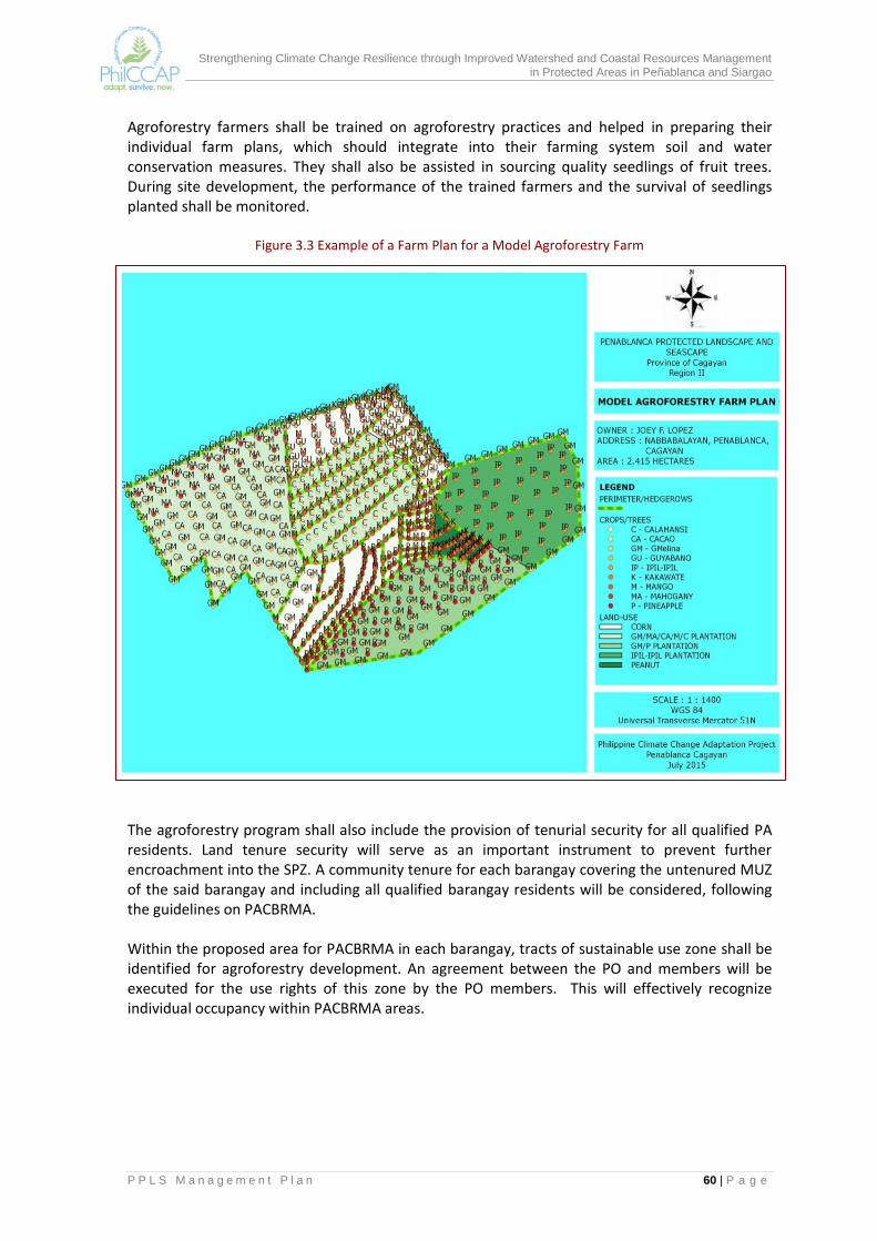
Strengthening Climate Change Resilience through Improved Watershed and Coastal Resources Management in Protected Areas in Peñablanca and Siargao
P P L S M a n a g e m e n t P l a n 60 | P a g e
Agroforestry farmers shall be trained on agroforestry practices and helped in preparing their individual farm plans, which should integrate into their farming system soil and water conservation measures. They shall also be assisted in sourcing quality seedlings of fruit trees. During site development, the performance of the trained farmers and the survival of seedlings planted shall be monitored.
Figure 3.3 Example of a Farm Plan for a Model Agroforestry Farm
The agroforestry program shall also include the provision of tenurial security for all qualified PA residents. Land tenure security will serve as an important instrument to prevent further encroachment into the SPZ. A community tenure for each barangay covering the untenured MUZ of the said barangay and including all qualified barangay residents will be considered, following the guidelines on PACBRMA. Within the proposed area for PACBRMA in each barangay, tracts of sustainable use zone shall be identified for agroforestry development. An agreement between the PO and members will be executed for the use rights of this zone by the PO members. This will effectively recognize individual occupancy within PACBRMA areas.

Strengthening Climate Change Resilience through Improved Watershed and Coastal Resources Management in Protected Areas in Peñablanca and Siargao
P P L S M a n a g e m e n t P l a n 61 | P a g e
Forest plantation management The existing forest plantations in barangays Quibal, Nanguilatan, Lapi and Buyun covering approximately 3,619 hectares will be managed to support livelihood of POs and communities in these areas. Planted with gmelina, mahogany and other fast growing species under the CBFM program, these plantations can be designated as community woodlots and managed as source of wood for wood-based industries such as furniture making, for housing, and for other needs of local communities.
A management plan that includes a resource use plan will have to be developed by the CBFM PO-tenure holder in consultation with the LGU and PASu to ensure sustainable use. In no case will clear-cutting be permitted in harvesting operations. Replanting will be required following guidelines on species selection.
Ecotourism development The situational analysis revealed the presence of potential ecotourism sites in PPLS. These sites include scenic, historical, cultural, geological and biodiversity sites that can be developed into a network of nature-based tourism destinations that can generate more employment and income opportunities to households and increased revenues to the LGU.
Part of the program therefore are the review/updating of the ecotourism master plan that was prepared by Peñablanca LGU to jumpstart ecotourism development in the municipality and the preparation of an accompanying business plan. A detailed assessment of the potential sites for ecotourism will have to be undertaken to serve as basis for preparing profiles and maps and for prioritization. Such assessment shall also establish the sensitivity of the area and determine limits (i.e., number of visitors, number of operating hours, seasons, physical development) that may have to be imposed so as to sustain the “attraction” of the ecotourism site. The PAMB shall request the DOT and other organizations, which have the necessary technical capacity to help in refining the ecotourism master plan and the business plan. The Peñablanca LGU will be requested to enact the necessary ecotourism policies and regulations.
The business plan shall spell out the short-term and long-term development of the physical facilities and how the development and operations of the facilities will be financed. It will also look at the development of the market for ecotourism in PPLS. The business plan should also project the revenues that can be generated from ecotourism and indicate how much of the revenues can be made part of the IPAF or directly plowed back to the management and protection of the natural resources within the ecotourism site.
To promote new ecotourism destinations, promotional materials and site profiles will be prepared and posted in websites or distributed to established travel agencies, which will be encouraged to include such in their tourism circuits. The promotion of ecotourism should also campaign for responsible tourism.
The PAMB shall negotiate for a partnership agreement with public agencies or private groups, which may be interested to invest in the development and management of the ecotourism site. Currently, the Provincial LGU has an agreement with the PAMB for the management of the Callao Caves. An option is to expand this agreement to cover a network of ecotourism sites within PPLS. The construction of facilities such as access roads, communication facilities and viewdecks may be allowed as long as environmental modification or disturbance is minimal and that these are consistent with the municipality’s thrust on low impact ecotourism and nature-based activities.
Strengthening Climate Change Resilience through Improved Watershed and Coastal Resources Management in Protected Areas in Peñablanca and Siargao
P P L S M a n a g e m e n t P l a n 62 | P a g e
Local community organizations shall be tapped to provide ecotourism services. Members of these organizations shall be trained as tour guides, porters, and food caterers. Ecotourism-related livelihood projects can be introduced such as the production of souvenirs items.
Sustainable livelihoods The implementation of sustainable livelihood activities is crucial for the long-term conservation of PPLS since this will minimize the dependency of PPLS communities on the remaining natural resources for subsistence. The implementation of this program however will require substantial financing since there are already numerous occupants in PPLS, most of whom are engaged in unsustainable and destructive forms of livelihood. The PAMB shall seek the support and cooperation of the LGU, national agencies (e.g., DA, DSWD), NGOs and the private sector in the development and implementation of sustainable livelihood for PPLS communities. The needed support will involve the conduct of studies on on-farm and off-farm livelihood opportunities; preparation of feasibility studies, proposals and business plans; resource generation and investment promotion; organization/cooperative development, leadership and entrepreneurship; skills training, demonstration/piloting, and visits to successful livelihood projects; actual set up of the livelihood activity; and training and assistance in livelihood management, marketing and financial management. The livelihood activity can be directly linked to sustainable land and resource use (e.g. processing of produce from agroforestry farms) and should promote conservation of resources. The Municipal Agriculture Office (MAO) supported by the MPDO, MENRO, and PASu will take the lead in preparing the feasibility studies and in identifying potential sources of funding/investments. They are also to identify the support infrastructure (e.g., farm-to-market roads, post-harvest facilities) and other services (e.g., market linkages, assistance in product development) that will be needed to enhance the viability of community enterprises and propose to the concerned agency the provision of such. The LGU shall be a major source of funding for livelihood development and infrastructure support.
Improved delivery of basic social services and facilities This entails the mobilization of support for social services delivery to the barangays and local communities covered by PPLS. The different Barangay Councils shall identify priority needs in terms of social services and community facilities. The MPDO and the PASu shall consolidate these proposals, determine those which can be addressed in the Annual Investment Plan of Peñablanca, and referothers to appropriate offices of the LGU and other government agencies. There are a number of national programs through which these services and facilities can be funded. Among them would be the Bottom-Up Budgeting (BUB) program which is supported by the DILG, DA, DepEd, DOH, DSWD and DENR.
Management of water sources for water security One of the anticipated impacts of climate change is on water resources. With dry months projected to be drier in the coming years, availability of water for irrigation and domestic use during the dry season shall be a serious concern. This will have implications on agricultural productivity, mainly on rice farming in downstream barangays, as irrigation water become limited. This will be aggravated if watershed degradation that is brought about by conversion of

Strengthening Climate Change Resilience through Improved Watershed and Coastal Resources Management in Protected Areas in Peñablanca and Siargao
P P L S M a n a g e m e n t P l a n 63 | P a g e
forests to agriculture and the use of inappropriate farming practices will not be controlled. Lack of adequate and safe water for domestic use will also affect the health of the local population. Water is a major product of PPLS. Long-term access to safe water particularly by those within PPLS is therefore be aimed for in this plan. Water production areas of about 56,624 hectares have been identified for protection, conservation and rehabilitation. These cover the water sources of the water utilities that service Metro Tuguegarao and Peñablanca, of some of the barangays, and of NIA’s communal irrigation systems. Other barangays that have yet to identify their water conservation areas must be encouraged to do so. The MENRO and the PASu, in coordination with the Barangay Councils, shall jointly identify and delineate the priority catchments/local watersheds for protection and rehabilitation. They shall initiate the forging of agreements between the PAMB and concerned barangay for the co-management of priority local watersheds, and assist these bodies prepare integrated watershed management plans for water production areas that they have been assigned to manage. They shall also help them carry out conservation measures, including erosion prone areas, per the approved management plan. Depending on the existing land cover and land use in priority watersheds, these activities may be implemented at the barangay level nursery establishment, seedling production, enrichment planting of indigenous forest trees, and agroforestry with soil and water conservation measures. The MENRO and PASu shall provide the needed training on the above activities and assist the barangays source out the required funding.
3.3.3 Disaster Risk Reduction Program Given the findings of the vulnerability assessment and the projected climate change scenarios, it is important to integrate disaster risk reduction (DRR) in the PPLS plan. Critical to the process is the enhancement of the climate literacy of the communities and their involvement is formulating DRR actions as this may require the relocation of settlers from high hazard areas to safer grounds.
Climate awareness and education The results of the vulnerability assessment of PPLS will be presented to the municipal and barangay LGU, local communities and other stakeholders to make them aware of climate change hazards and the level of vulnerability of their barangays and settlements to flooding and landslides, and extreme climatic events such as typhoons and droughts. Coastal sitios will also be made aware of the risk of storm surges. How climate hazards and impacts will affect biodiversity, ecosystem services, livelihoods and the socio-economic development of communities will be explained. The presentation will be an opportunity to validate the findings of the vulnerability assessment particularly in barangays that are identified to be highly vulnerable to natural hazards. The role of PPLS in minimizing the losses and damages from flooding in downstream barangays will be highlighted by showing the upland and lowland interaction within Peñablanca (and between Peñablanca and Baggao) with the use of maps. The value of conserving the biodiversity resources of the PA and of increasing the resiliency of ecosystems and communities through zoning and the various resource management and socio-economic development programs and climate adaptation measures contained in the updated PPLS Management Plan will also be discussed. How the climate
Strengthening Climate Change Resilience through Improved Watershed and Coastal Resources Management in Protected Areas in Peñablanca and Siargao
P P L S M a n a g e m e n t P l a n 64 | P a g e
change adaptation measures contribute to reducing vulnerability and increasing resilience will be illustrated. This awareness raising and education campaign will be spearheaded by the PASu and MENRO. They should be able to secure assistance from the IEC and public information units of the DENR and LGU in developing a communication plan and suitable information materials for different target groups. Assistance can also be sought from academic institutions in the region. They shall identify members of the PPLS Local Working Group and other persons or groups (e.g., Chair of the Environment Committee of the Sanggunian Bayan) who may be tapped to assist in the awareness raising effort and to champion and lead the advocacy for support from LGU officials and the private sector.
Disaster risk reduction planning Following the above activity, municipal and barangay officials and local communities shall be engaged in identifying specific actions that they can take to avoid loss of lives and minimize damages to property, livelihoods and infrastructure during extreme weather episodes in PPLS. The Disaster Risk Reduction and Management Plan of Peñablanca shall be reviewed and refined in the light of the vulnerability assessment that has been done. Highly vulnerable barangays will be priority for assistance in the development of community DRRM plans. DRR will focus on reducing exposure to climate hazards and on disaster preparedness. Adaptation measures will include land use zoning through which restrictions can be imposed on further development and expansion of settlement areas that are exposed to the hazards; relocation of settlements that are susceptible to flooding, landslides and storm surges; slope stabilization to prevent occurrence of landslides; mangrove protection and rehabilitation; and disaster readiness. The latter will necessitate intensive IEC, putting place an early warning system and safe evacuation centers, formulation of evacuation protocols and training of volunteers. Most of the built up areas in Peñablanca are located outside the PPLS and occupy alienable and disposable lands. There are areas however in Buyun, Nabbalayan, Mangga, Lapi, San Roque and Minanga (comprising 137 hectares) settlements, which are exposed to flooding and landslides. Coastal sitios are exposed to storm surges. The municipal and barangay LGUs shall be enjoined to stop further population movement into these areas and prohibit new settlements in vulnerable areas. Where possible, households shall be relocated to safer areas. An inventory of forest occupants within the PPLS shall be undertaken jointly by the barangay and municipal LGUs and DENR to ascertain the current population and their location within the PA. This will serve as basis for monitoring the entry of new settlers into PPLS. The municipal LGU is expected to initiate similar community-based activities in highly vulnerable downstream barangays and institute appropriate structural measures such as dikes, levees, and riverbank structures to protect riverine communities. LGUs are mandated to annually allocate funding for DRRM. Where opportunities exist to access external funding, the MPDO will be assisted by the PASu in preparing the needed project proposals.
Strengthening Climate Change Resilience through Improved Watershed and Coastal Resources Management in Protected Areas in Peñablanca and Siargao
P P L S M a n a g e m e n t P l a n 65 | P a g e
3.3.4 Governance Enhancement and Institutional Strengthening Program The complex issues and problems, and needs of PPLS stakeholders require that its management involve multiple sectors and multiple stakeholders. The current PAMB structure already provides for this although there is need to consider the representation of other key sectors. Refer to Section 4.0. The other essential areas that will improve the governance of the PA are the strengthening the individual and collective capability of the PAMB members to enhance the functionality of the PAMB, and establishment the mechanisms for its efficient operations.
Knowledge and capability building PAMB members represent different sectors, which have different interests in PPLS but as the overall policy-making body for PPLS, it is important that members have a common understanding of the entire PA, its resources and their local/national/global significance and the challenges in managing such a resource. It will be the responsibility of the PASu Office/DENR to ensure that all new members of the PAMB, especially after every local elections, are provided a full orientation on PPLS. In addition to this initial input, it will be useful for members of the PAMB, as a body, go through a continuing capacity and knowledge building activity to enhance its effectiveness in policy formulation, PA planning and decision-making, resource mobilization and allocation, and coordination and linkages with partner institutions and agencies. Examples of knowledge and capability building activities are orientation on new/proposed laws and national policies that are relevant to PA management (e.g., proposed expanded NIPAS); training on essential weather knowledge for decision-making (e.g., Weather 101 and Tropical Cyclone 101 sessions that are held by the Weather Phil Foundation); orientation/exposure to climate change vulnerability assessment tools and methods that are applicable to PAs; and visits and sharing of experiences with the PAMB of other protected areas. The PASu shall identify and recommend at least one of these types of activities per year and, upon approval of PAMB, shall undertake the needed arrangements for the funding of such activity. Periodic reporting to the PAMB of the results of the PPLS Management Plan implementation, using consistently the agreed performance indicators, shall be made part of PAMB deliberations. This will be another source of knowledge for informed decision-making. This reporting will not only update them on what have been accomplished and the results that have been generated but also deepen their understanding and appreciation of how the performance of PPLS is evaluated, and the totality of issues the PAMB should be concerned about. The above set of knowledge and capability building activities apply to the PASu Office as well. Serving as the technical secretariat to the PAMB, the PASu and staff need to be exposed to relevant developments at the national and international scene, and enrich ideas and approaches to PA management. A particular skill that needs to be developed is the ability to organize data, synthesize reports and data analysis, and to present information in such a way that such will be useful for PAMB deliberations and decision-making. In the case of the PASu Office, exposure to best practices, mentoring and actual work experience or practice remain as the best capability building methods that can be adopted.

Strengthening Climate Change Resilience through Improved Watershed and Coastal Resources Management in Protected Areas in Peñablanca and Siargao
P P L S M a n a g e m e n t P l a n 66 | P a g e
Collaboration and resource mobilization Collaboration between PAMB and other stakeholders in PPLS can cover a broad range of PA management activities. Among the most important ones are listed below, with the specific stakeholders that may be mobilized by the PAMB.
Protection, rehabilitation and management of protection and conservation areas: DENR, municipal and barangay LGUs, tenure holders, other agencies and organizations
Development of production forestlands: DENR, municipal and barangay LGUs, individual farmers, tenure holders, i.e., holders of CBFMA/PACBRMA, private sector
Protection, rehabilitation and management of mangroves and coastal habitats: DENR, DA/Bureau of Fisheries and Aquatic Resources (BFAR), municipal and barangay LGUs, people’s organization in coastal area, other agencies and organizations
Management of watershed reservations and local watersheds: DENR, municipal and barangay LGUs, the Peñablanca and Metro Tuguegarao Water Districts and other water utilities, NIA and irrigators association, neighboring LGUs (e.g., Baggao) which are benefitting from water resources from PPLS
Management of ecotourism sites (caves and other recreation areas) within the PA: DENR, Cagayan Province for Callao Cave and other sites, municipal and barangay LGUs, people’s organizations, Department of Tourism, private sector
IEC and advocacy campaigns on sound PA management practices and climate change adaptation strategies: DENR, municipal and barangay LGUs, other agencies (e.g., DEpEd), academic institutions and organizations
Livelihood development: municipal and barangay LGUs, other agencies (e.g., DSWD) and organizations, private sector.
Many of those listed above can serve as de facto resource manager for specific management unit by virtue of an agreement with the PAMB. Such is now the case of the MTWD for a watershed reservation, the CBFMA and PACBRMA holders, the Provincial Government for Callao Caves, and the individual farmers with MOA with PAMB. To maximize the benefits from collaboration and partnerships, the PAMB and the PASu Office need to establish clear guidelines and mechanics for pursuing this so that there is consistency in the application of the strategy, and all parties to the agreements are clear as to the process (e.g., from application for tenure to approval to issuance), the sharing of responsibilities and accountabilities, and financing. Sections3.4 and 3.5 of this plan provide prescriptions, rules and regulations that apply to specific zones and land uses. The PAMB will require that these and other relevant DENR and LGU guidelines be consolidated, organized and harmonized by the PASu Office into specific guidelines that the PAMB can then issue for PPLS. Related to this are systems and mechanisms for sustainable financing and performance evaluation of on-site resource managers. To supplement budget allocations from the national and local governments, the PAMB may also explore the possibility of implementing PES as a sustainable financing mechanism for PA activities. This may be possible in the use of water resources and ecotourism. The process for this will start with the assessment of the ecosystem services being provided by the PA, and the identification of the uses and beneficiaries of these services. The system and mechanics will have to be developed and established for the estimation of the value of the resource, determination of corresponding fees, sharing of revenues, fund management, and the budgeting and allocation of the IPAF, all of which may warrant PAMB approval. Negotiations for appropriate PES arrangements between service providers and beneficiaries of the ecosystem services will have to be facilitated by the PASu.
Strengthening Climate Change Resilience through Improved Watershed and Coastal Resources Management in Protected Areas in Peñablanca and Siargao
P P L S M a n a g e m e n t P l a n 67 | P a g e
As more stakeholders are assigned PA management roles, there has to be a system for the periodic assessment of the performance of tenure holders and co-managers of PPLS to ensure effective on-site management that is also consistent with approved management plan for the specific resource management unit. It is important that there is agreement among members of the PAMB on the performance indicators that will be used, on the mechanics for the assessment, on rewards for good performance and on actions on findings of ineffective performance or non-compliance with the terms of the agreement with PAMB. For transparency, it is critical that tenure holders/on-site resource managers are made aware of this practice during the process of consultation and negotiation.
Policy support As the policy-making body for PPLS, the PAMB need to draw up a policy agenda that will support and ensure the sustainability of the proposed interventions in the PA management plan. The PAMB may commence with the policy issues/recommendations that have been raised in the course of formulating the management plan and in the implementation of the pilot agroforestry project in PPLS (see list below). A strong policy support is a key ingredient to governance enhancement.
Allow planting of selected non-endemic species in specific areas within the multiple use zone to support fuelwood/timber production initiatives especially if the area has comparative advantage for these products. Allowing it will enhance livelihood support to communities.
Allow harvesting of planted tree species in multiple use zones to provide incentives to communities to develop and protect degraded areas within these zones.
Clarify the policy on harvesting non-timber species within the multiple use zone. Some PAMBs do not permit the harvesting of bamboo, rattan, resin and other non-timber products inside protected areas.
Establish a policy for setting up a scheme on payment for ecosystems services with corresponding fee system for the use of natural resources within PPLS. PES will be part of the strategy to develop sustainable financing for PA operations.
Clarify possibility of municipal and barangay LGUs getting a share on income from PA operations (IPAF funds) to encourage it to actively participate in the protection and conservation of protected areas. Barangay LGUs do not get financial benefits from protected areas since all income from PAs go to the IPAF.
Establish policy for the adoption by the LGU of the zoning in PAs and its integration into the CLUPs
Establish policy for the protection and management of marine waters beyond the seascape.
Establish policy for tenure arrangement for individual farmers.
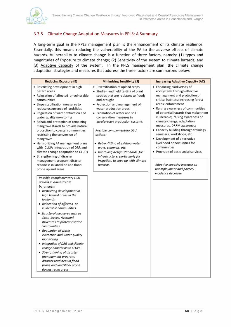
Strengthening Climate Change Resilience through Improved Watershed and Coastal Resources Management in Protected Areas in Peñablanca and Siargao
P P L S M a n a g e m e n t P l a n 68 | P a g e
3.3.5 Climate Change Adaptation Measures in PPLS: A Summary A long-term goal in the PPLS management plan is the enhancement of its climate resilience. Essentially, this means reducing the vulnerability of the PA to the adverse effects of climate hazards. Vulnerability to climate change is a function of three factors, namely: (1) types and magnitudes of Exposure to climate change; (2) Sensitivity of the system to climate hazards; and (3) Adaptive Capacity of the system. In the PPLS management plan, the climate change adaptation strategies and measures that address the three factors are summarized below:
Reducing Exposure (E) Minimizing Sensitivity (S) Increasing Adaptive Capacity (AC)
Restricting development in high hazard areas
Relocation of affected or vulnerable communities
Slope stabilization measures to reduce occurrence of landslides
Regulation of water extraction and water quality monitoring
Rehab and protection of remaining mangrove stands to provide natural protection to coastal communities; restricting the conversion of mangroves
Harmonizing PA management plans with CLUP; integration of DRR and climate change adaptation to CLUPs
Strengthening of disaster management program; disaster readiness in landslide and flood prone upland areas
Possible complementary LGU actions in downstream barangays:
Restricting development in high hazard areas in the lowlands
Relocation of affected or vulnerable communities
Structural measures such as dikes, levees, riverbank structures to protect riverine communities
Regulation of water extraction and water quality monitoring
Integration of DRR and climate change adaptation to CLUPs
Strengthening of disaster management program; disaster readiness in flood-prone and landslide- prone downstream areas
Diversification of upland crops
Studies and field testing of plant species that are resistant to floods and drought
Protection and management of water production areas
Promotion of water and soil conservation measures in agroforestry production systems
Possible complementary LGU actions:
Retro -fitting of existing water ways, channels, etc.
Improving design standards for infrastructure, particularly for irrigation, to cope up with climate hazards.
Enhancing biodiversity of ecosystems through effective management and protection of critical habitats; increasing forest areas; enforcement
Raising awareness of communities of potential hazards that make them vulnerable; raising awareness on climate change, adaptation measures, DRRM awareness
Capacity building through trainings, seminars, workshops, etc.
Development of alternative livelihood opportunities for communities
Provision of basic social services
Adaptive capacity increase as unemployment and poverty incidence decrease

Strengthening Climate Change Resilience through Improved Watershed and Coastal Resources Management in Protected Areas in Peñablanca and Siargao
P P L S M a n a g e m e n t P l a n 69 | P a g e
3.4 Management Zones and Prescriptions
3.4.1 Strict Protection Zone The management zones identify which areas in the PPLS are priority for biodiversity conservation and protection and which areas can be devoted to other uses to address the needs of PA residents. As shown in Figure 3.1, the SPZ covering about 36,272 hectares are located in barangays Lapi and Minanga where most of the natural forests and areas above 1,000 masl exist. The management prescriptions for this zone are the following:
SPZs shall be demarcated on the ground and appropriate signages will be installed;
Natural resources in the SPZ are not allowed for utilization
SPZ shall be closed to all environmentally critical projects such as logging, mining, agro-industrial development, road construction and other infrastructure projects.
Exotic and invasive species are not allowed to be introduced in the SPZ. If these species are found in the area, eradication measures shall be implemented.
Forest clearing, agricultural development and settlements are prohibited in the SPZ.
Scientific studies may be allowed in accordance with the standards and regulations issued by the PAMB.
Biodiversity monitoring stations established for management purposes shall be allowed in the SPZ. Results of the periodic monitoring shall be presented to the PAMB and other stakeholders for appropriate actions
Community based biodiversity protection and law enforcement units shall be allowed to conduct patrolling operation at the SPZ
3.4.2 Multiple Use Zone The multiple use zone, with an estimated area of 66,557 hectares cover areas where settlements, traditional and or sustainable land uses including agriculture, agroforestry, extraction and other income generating or livelihood activities may be allowed to the extent prescribed in this plan. In view of the limited information on the marine/ coastal resources in PPLS, the marine/coastal areas are zoned as MUZ. More detailed studies will have to be undertaken in the marine/coastal areas of the PPLS to identify any areas that should be delineated for strict protection. The management prescriptions for the MUZ are as follows:
Logging, mining, forest clearing and other destructive activities are not allowed in the MUZ;
Regular monitoring shall be implemented for existing environmentally critical projects to determine their compliance with the provisions in the Environmental Compliance Certificates (ECC) issued by the DENR. Any violation to the provisions of the ECC shall be ground for the termination of their operations in PPLS and a phase out mechanisms shall be implemented;
Community development activities adhering to the principles of biodiversity conservation and consistent with this management plan shall be allowed;
Sustainable livelihood and other economic enterprises promoting biodiversity conservation and sustainable development shall be allowed for tenured migrants;
Strengthening Climate Change Resilience through Improved Watershed and Coastal Resources Management in Protected Areas in Peñablanca and Siargao
P P L S M a n a g e m e n t P l a n 70 | P a g e
The PAMB in coordination with concerned stakeholders shall develop and implement measures to address migration inside MUZ;
Utilization/capture of threatened species is not allowed;
Ecotourism activities identified in this plan and as may be determined by the PAMB shall be allowed but will require management and business plans;
Cottage industries based on non-timber forest resources will be promoted;
Road banks stabilization will be promoted;
Private organizations or individuals may enter into agreement with PAMB for the development of portions of the multiple use zones;
Commercial collection of wildlife is not allowed;
Commercial fishing in marine/coastal MUZ is prohibited since these are part of the municipal waters;
Prohibited acts under RA 8550 will be strictly enforced in marine/coastal MUZ. Within the MUZ are specific land uses and sub zones, which were derived to harmonize land uses from ridge to reef. The management prescriptions for these land uses and sub-zones are the following:
Resource rehabilitation and conservation areas
Introduction of exotic flora may be allowed only if the species to be used have been scientifically proven to cause no significant harm to the ecology of PPLS;
Enrichment planting in marginal open forest is allowed only if it is ecologically significant and only if the cost is insignificant and does not compete with the rehabilitation needs of other degraded sites;
Restoration of forest margins is priority over enrichment planting;
An approved site-specific rehabilitation plan is required prior to actual work implementation;
Restoration projects that are designed to improve a marginal forestland must use indigenous species and must follow uneven-age and random distribution pattern to approximate the succession stage usually occurring in a typical rainforest ecosystem;
Cutting or harvesting of naturally growing trees is not allowed unless within road right of way previously approved by the PAMB;
No commercial collection of wildlife is allowed unless results of studies on their population and distribution show the practicability of engaging in the sustainable management and development of the economically important species;
Scientific studies are allowed following the system of control established by the PAMB and the DENR;
At the minimum, trails and patrol roads will be located and constructed where there would be least damage to soil and biodiversity, and where the best scenic areas are located.
Development of infrastructures in river areas is allowed provided it is 50 meters from the highest waterline;
Commercial fishing is prohibited as all marine area of the PA is within municipal waters.

Strengthening Climate Change Resilience through Improved Watershed and Coastal Resources Management in Protected Areas in Peñablanca and Siargao
P P L S M a n a g e m e n t P l a n 71 | P a g e
Mangrove rehabilitation areas
Cutting of naturally growing mangroves is prohibited;
Only mangrove species indigenous to the area and suitable to the salinity conditions of the coastal waters will be used for rehabilitation/ planting;
As much as possible, only planting materials which are locally available will be used for planting;
Shell gathering and fishing may be allowed; selective capture methodologies for aquatic resources will be implemented;
Use of pesticide is not permitted.
Ecotourism areas
Community based ecotourism will be promoted;
Activities should not lead to deterioration of natural resources and ecosystems specially the endangered and vulnerable species and ecosystems;
Proper waste management should be an integral part of any ecotourism and tourism program/project.
Vandalism of any form is prohibited in ecotourism areas;
Collection of stalactites and stalagmites in caves is strictly prohibited
Potential ecotourism sites shall be assessed prior to their development and an ecotourism plan (with visitor carrying capacity assessment) shall be developed in coordination with the provincial and municipal tourism office.
Caves identified for ecotourism development shall explored and detailed assessment will be undertaken to ensure safety of tourists and guests.
Cutting of trees will not be allowed; and
Collection of flora and fauna is not allowed unless authorized by the PAMB through a permit.
Responsible tourism will be promoted.
Agroforestry development areas
Priority areas for agroforestry are lands within the MUZ which are cultivated by tenured migrants;
Soil and water conservation technologies, use of organic fertilizers in food production and crop diversification shall be promoted. Use of inorganic chemicals such as pesticides and herbicides and fertilizers is not allowed;
Farmers who are currently involved in the use of these destructive products are given three years to transform their destructive practices and completely eliminate these chemicals in all parts of the PA;
Use of indigenous forest and fruit trees will be encouraged for integration in agroforestry systems;
Land tenure security shall be provided to qualified tenured migrants. Holders of these tenure instruments shall be required to develop their farms consistent with the community based resource management plans;
Tenured migrants who are holders of tenure instruments shall prepare their individual agroforestry farm plans which integrate soil and water conservation measures;
Harvesting of planted forest trees will be allowed upon approval by the PAMB.

Strengthening Climate Change Resilience through Improved Watershed and Coastal Resources Management in Protected Areas in Peñablanca and Siargao
P P L S M a n a g e m e n t P l a n 72 | P a g e
Forest plantation areas
Selective harvesting of planted trees in mature forest plantations shall be allowed subject to PAMB approval. Clear cutting is not allowed;
Tree Inventory will be undertaken and corresponding resource use plan will be prepared prior to harvesting;
Monitoring of harvesting operations shall be undertaken jointly by the PASu, PAMB, barangay and municipal LGU and community/ PO representatives;
Harvested trees shall be replaced by planting at least five indigenous forest trees within the forest plantation area;
A production sharing arrangement will be developed which shall specify the share of barangay and municipal LGUs, the PAMB and the PO in the proceeds of harvested trees.
Water conservation areas
Watershed management plan will be prepared for each water catchment draining towards specific water infrastructure;
Harvesting of naturally growing trees is not allowed in water conservation areas;
Inventory of actual occupants and tillers will be undertaken;
New settlements are prohibited;
Use of pesticides and chemical fertilizers is not allowed;
Use of indigenous forest and fruit trees will be encouraged in rehabilitation activities;
Harvesting of planted trees in agroforestry farms within water conservation areas will be allowed provided selective cutting is implemented under the supervision of the PASu and the MENRO;
Soil and water conservation measures and structures will be implemented in developing agroforestry farms within water conservation areas.
Settlement areas
Inventory of PA residents will be undertaken as baseline on actual settlers of the PA;
New settlers are not allowed;
Proper solid and liquid waste management shall be implemented;
Population education shall be promoted in settlement areas;
Information campaign on climate change vulnerability will be promoted;
Settlements in areas which are highly vulnerable to landslide and flooding will be relocated to safer areas.
Forest protection
Resettlement of tenured migrants and ejection of squatters in strict protection zone;
Horses/ boats shall be the preferred means of transportation by the protected area rangers in the conduct of their routine and related works;
Trails are to be developed only after a patrol network and plan is developed and approved by the PAMB;
Only officially designated trails are to be maintained by the protected area management. Illegal trails are to be closed using vegetative controls along approaches;

Strengthening Climate Change Resilience through Improved Watershed and Coastal Resources Management in Protected Areas in Peñablanca and Siargao
P P L S M a n a g e m e n t P l a n 73 | P a g e
Officially designated PA rangers shall use a standard uniform for identification purposes and to establish authority;
Deputized rangers/DENROS are required to carry with them identification papers.
Wildlife/Fisheries management
The selected indicator species used for the DENR BMS will be supplemented with indicator species that provide easy indicators of climate change effects and impacts;
Identify featured species that will serve as planning constraints in economic planning;
Conduct research on the natural interspersion of the various habitat types;
Maximize habitat (structural) diversity in rehabilitation sites;
There shall be designated wildlife viewing areas where wildlife watchers are allowed to stay following certain rules and regulations.
Road construction
The government standards on road construction, environmental impacts and maintenance must be strictly observed;
Roads to be constructed must be located where there is least or negligible impact/damage to the micro-ecosystem;
An approved environmental compliance certificate and road construction and maintenance plan is required prior to project start-up;
Appropriate road signs must be installed at critical sites along the stretch of the road;
Off-road viewing areas are to be designated; scenic sites are to be selected following a system of selection;
No roads will be constructed in strict protection zones.
Livelihood and economic development
Harvesting of timber and fuel wood resources for the domestic requirements of communities dependent on the park’s resources are allowed in the MUZ provided that a community woodlot is established and maintained from which sustainable harvesting is allowed;
Implementation of the CBFM program, and related types, in the multiple use and buffer zone areas is encouraged to define the basis for rights and responsibilities in increasing the productivity of the land;
A user fees framework will be developed in consultation with the LGU. This will lay the foundation for allowing facilities and establishments in designated areas of the PA. The computed value will be used in developing cooperative agreement between the PAMB and the user;
The harvesting of non-timber forest products is allowed only after official scientific studies are able to prescribe the sustained yield level for the products. In the absence of these studies, temporary volume may be allowed subject to the recommendation of a designated scientific advisor on the matter and provided further that this is approved by the PAMB;
All existing facilities or enterprises that benefit directly or indirectly from the PA resources will be required to allot a certain percentage of their revenues for the protection, maintenance and restoration of the PA.
Strengthening Climate Change Resilience through Improved Watershed and Coastal Resources Management in Protected Areas in Peñablanca and Siargao
P P L S M a n a g e m e n t P l a n 74 | P a g e
Waste management
A solid and liquid waste management program shall be developed and approved by the PAMB for implementation in all the facilities and community settlements located within the park;
The solid waste management program must contain specific designs, processes and alternative for ease in selection and adoption by the participating communities;
Violators will be charged punitive fees;
Training on development of naturally-based and cost effective “water treatment facility” must be highlighted in drawing the communities to participate in water quality maintenance activity.
3.5 Management Standards and Guidelines The management standards and guidelines for the protected area are PA-wide rules and regulations that have to be observed in the administration of PPLS. They are subject to revision to further enhance the attainment of goals, objectives and expected outputs. The standards and guidelines are sensitive to the zoning regime. Where they are not applicable to a zone, the PASu must see to it that zone managers are aware of such restrictions. They are by themselves activities that the PASu will undertake. Some of them are policy matters that will be implemented on a per zone basis, if warranted.
The PASu, being the chief executive officer of the DENR for protected area managementshall ensure that the PAMB-approved management plan for the area is implemented.
The PAMB shall guide the PASu in implementing protected area wide policies, ensuring that such policies are consistent with national statutes on protected area administration and environmental management and are complementary to local government plans and programs.
An operations manual will be developed which shall establish the protocols and guide the PA personnel and administrators.
All personnel involved in the protection program shall be oriented on the PPLS Management Plan and will be required to pass a training course on PA management.
Protected area infrastructures are to be developed with utmost regard for: (1) security and safety of personnel and visitors; (2) durability of facility; (3) cost of maintenance; (4) cost of construction; and (5) environmental compatibility.
All plans and programs of the PPLS must be disseminated to all barangays, local communities, municipal local officials and other stakeholders for appropriate action.
Development of the natural resources of the PA is subject to the Environmental Impact Assessment (EIA) process.
Proposed projects that will impact on the PA’s resources and are outside of those included in the approved management plan for the protected area following the GMPS planning process have to go through the EIA process.
Critical projects included in the approved management plan have to go through the EIA process.
The concerned PAMB committee shall review and coordinate with the concerned LGU on all matters pertaining to the development of specific projects prior to its presentation to the PAMB for approval.
Strengthening Climate Change Resilience through Improved Watershed and Coastal Resources Management in Protected Areas in Peñablanca and Siargao
P P L S M a n a g e m e n t P l a n 75 | P a g e
Existing projects of the government and private institutions that are using the resources of the PA must enter into contract/agreement with the PAMB.
The PASu, PAMB and LGU shall complement plans and programs for PA communities.
Water development projects must secure a water permit from the National Water Regulatory Board (NWRB) and an Environmental Compliance Certificate.
No new settlements will be created and existing cultivation of communities within the PA should not exceed the allowable five hectares per actual tiller.
Only officially designated trails are to be maintained by the PAMB. Illegal trails are to be closed using vegetative controls along approaches.
Introduction of exotic wild fauna is prohibited.
Scientific studies shall be encouraged with priority to be given on identifying the management indicator species per zone or habitat type.
Species richness and diversity shall be monitored following a standard monitoring scheme.
The production and use of IEC materials will both be in English and the local dialect.
The IEC program and materials must enable the communities to actively participate in the management of the PA in ways that will enhance biodiversity.

Strengthening Climate Change Resilience through Improved Watershed and Coastal Resources Management in Protected Areas in Peñablanca and Siargao
P P L S M a n a g e m e n t P l a n 76 | P a g e
4.0 PROPOSED MANAGEMENT STRUCTURE AND INSTITUTIONAL ARRANGEMENTS
The proposed management structure for the PPLS is shown in Figure 4.1. This is essentially similar to that contained in the 2004 PPLS management plan except for the proposed expansion and reconstitution of the PAMB and its committee system. It is expected that the changes will broaden stakeholder participation and provide for a more effective decision-making process.
4.1 Protected Area Management Board As per the NIPAS Law, the PAMB shall be responsible for the site-specific management of PPLS, in accordance with the management plan approved by it. The PAMB decides on policies, plans, proposals, programs, agreements, budget allocation and matters and issues pertaining to management plan implementation.
Figure 4.1 Proposed PPLS Management Structure
Strengthening Climate Change Resilience through Improved Watershed and Coastal Resources Management in Protected Areas in Peñablanca and Siargao
P P L S M a n a g e m e n t P l a n 77 | P a g e
The PAMB originally has 27 members (refer to page 27). The membership is proposed to be increased to 35so other key stakeholders can be represented and provided the opportunity to participate in PAMB decision-making. These are the recommended members of the reconstituted PAMB:
Regional Director of the DENR as Chairperson
Local Chief Executive of Peñablanca;
Barangay Chairmen of the 18 barangays covering the PA
Provincial Planning and Development Officer of Cagayan;
Representative of national government agencies: DOT
Representative of national government agencies: DA
Representative of NGOs operating inside the PA
Representative from the Metro Tuguegarao Water District
Representative from the Peñablanca Water District (new)
Representative from Baggao LGU (new)
Representative from Tuguegarao City (new)
Representative from the Sangguniang Kabataan (new)
Representative from NIA Peñablanca (new)
Representative from NIA Baggao (new)
Three representatives from POs within PPLS (new)
Representative from the women’s sector (new)
Of the new members proposed to the PAMB, Baggao and Tuguegarao City, the NIA, and the water district of Baggao are considered direct stakeholders of PPLS as they are major users of water coming from PPLS watersheds. Baggao and Tuguegarao City are also impact areas of PPLS; these LGUs are affected by flooding that is caused by the degradation in the uplands. The interest they represent in the PAMB are those of off-site resource users and of communities that are vulnerable to flooding. The PAMB currently has an Executive Committee (ExeCom) to which it has delegated some of its powers or functions. It has the authority to create other committees. In line with this, it is proposed that PPLS PAMB create sub-watershed management committees to further decentralize discussions and deliberations on issues and plans that concern a focus sub-watershed. The task of threshing out issues, monitoring performance, review of proposals/applications, and the evaluation of options for a particular concern will be assigned to the sub-watershed management committee. The recommendations of sub-watershed management committees will be elevated to the ExeCom or the PAMB en banc for confirmation and adoption. The three sub-watershed management committees shall cover the areas indicated below, each of which represent a different set of issues and challenges.
Sub-Watershed
Coverage Significance
1 Pinacanauan, Natallad and Abaca sub-watersheds
These drain towards the poblacion of Peñablanca and Tuguegarao City. These are the sources of irrigation water for Peñablanca’s rice farms and domestic water supply for most of Peñablanca’s barangays. These are crucial in mitigating the impacts of flooding in downstream Peñablanca and Tuguegarao City.
2 Pared and Bitag sub-watersheds
These sub-watersheds drain towards Baggao. They are sources of irrigation water to extensive rice areas of Baggao, and are sources of flooding in the Baggao area.
Strengthening Climate Change Resilience through Improved Watershed and Coastal Resources Management in Protected Areas in Peñablanca and Siargao
P P L S M a n a g e m e n t P l a n 78 | P a g e
Sub-Watershed
Coverage Significance
3 Eastern sub-watersheds
These sub-watersheds drain towards the Pacific Ocean.
4.2 Protected Area Superintendent’s Office The PASu, who is directly accountable to the PAMB, shall execute all plans and programs for PPLS that is approved by the PAMB. As shown in the structure, there are five units under the PASu, consisting of the following:
(a) Institutional Development. This unit will spearhead all IEC and training activities. It will also provide secretariat support to the PAMB. This will be staffed by an IEC Officer cum Training Officer.
(b) Biodiversity Conservation. This unit will handle management zoning, protection and monitoring, restoration/rehabilitation of degraded habitats and coordination of biodiversity researches. The staff of this unit will consist of Park Rangers, Protection Officers, Biodiversity Monitoring and Research Coordinators.
(c) Socio-economic Development. This unit will coordinate community-based resource management activities such as provision of tenurial instruments, preparation of community resource management plans, and community organizing. It will also be responsible for livelihood related activities. It will establish linkages with the LGU and other agencies for the provision of basic services and infrastructure to rural barangays. Key staff shall include Tenure Specialist, Livelihood Officer, and Community Organizers.
(d) Administrative and Finance. This will handle all administrative and financial transactions of the PASu Office, including budgeting, accounting, disbursements of funds, and personnel concerns.
(e) Monitoring and Evaluation. This unit will undertake the periodic monitoring and reporting of the results of implementation activities of concerned agencies and organizations, adopting performance indicators and methods set out in the M and E plan. The PPLS database will be established and made operational. Key staff include M and E officers.
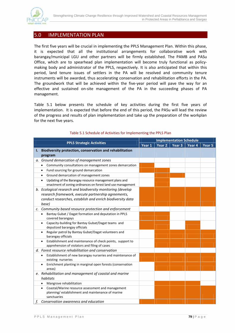
Strengthening Climate Change Resilience through Improved Watershed and Coastal Resources Management in Protected Areas in Peñablanca and Siargao
P P L S M a n a g e m e n t P l a n 79 | P a g e
5.0 IMPLEMENTATION PLAN The first five years will be crucial in implementing the PPLS Management Plan. Within this phase, it is expected that all the institutional arrangements for collaborative work with barangay/municipal LGU and other partners will be firmly established. The PAMB and PASu Office, which are to spearhead plan implementation will become truly functional as policy-making body and administrator of the PPLS, respectively. It is also anticipated that within this period, land tenure issues of settlers in the PA will be resolved and community tenure instruments will be awarded, thus accelerating conservation and rehabilitation efforts in the PA. The groundwork that will be achieved within the five-year period will pave the way for an effective and sustained on-site management of the PA in the succeeding phases of PA management. Table 5.1 below presents the schedule of key activities during the first five years of implementation. It is expected that before the end of this period, the PASu will lead the review of the progress and results of plan implementation and take up the preparation of the workplan for the next five years.
Table 5.1 Schedule of Activities for Implementing the PPLS Plan
PPLS Strategic Activities Implementation Schedule
Year 1 Year 2 Year 3 Year 4 Year 5
I. Biodiversity protection, conservation and rehabilitation program
a. Ground demarcation of management zones Community consultations on management zones demarcation
Fund sourcing for ground demarcation Ground demarcation of management zones Updating of the Barangay resource management plans and
enactment of zoning ordinances on forest land use management
b. Ecological research and biodiversity monitoring (develop research framework, execute partnership agreements, conduct researches, establish and enrich biodiversity data base)
c. Community based resource protection and enforcement Bantay Gubat / Dagat formation and deputation in PPLS
covered barangays Capacity-building for Bantay Gubat/Dagat teams and
deputized barangay officials
Regular patrol by Bantay Gubat/Dagat volunteers and barangay officials
Establishment and maintenance of check points, support to apprehension of violators and filing of cases
d. Forest resource rehabilitation and conservation Establishment of new barangay nurseries and maintenance of
existing nurseries Enrichment planting in marginal open forests (conservation
areas)
e. Rehabilitation and management of coastal and marine habitats
Mangrove rehabilitation
Coastal/Marine resource assessment and management planning/ establishment and maintenance of marine sanctuaries
f. Conservation awareness and education
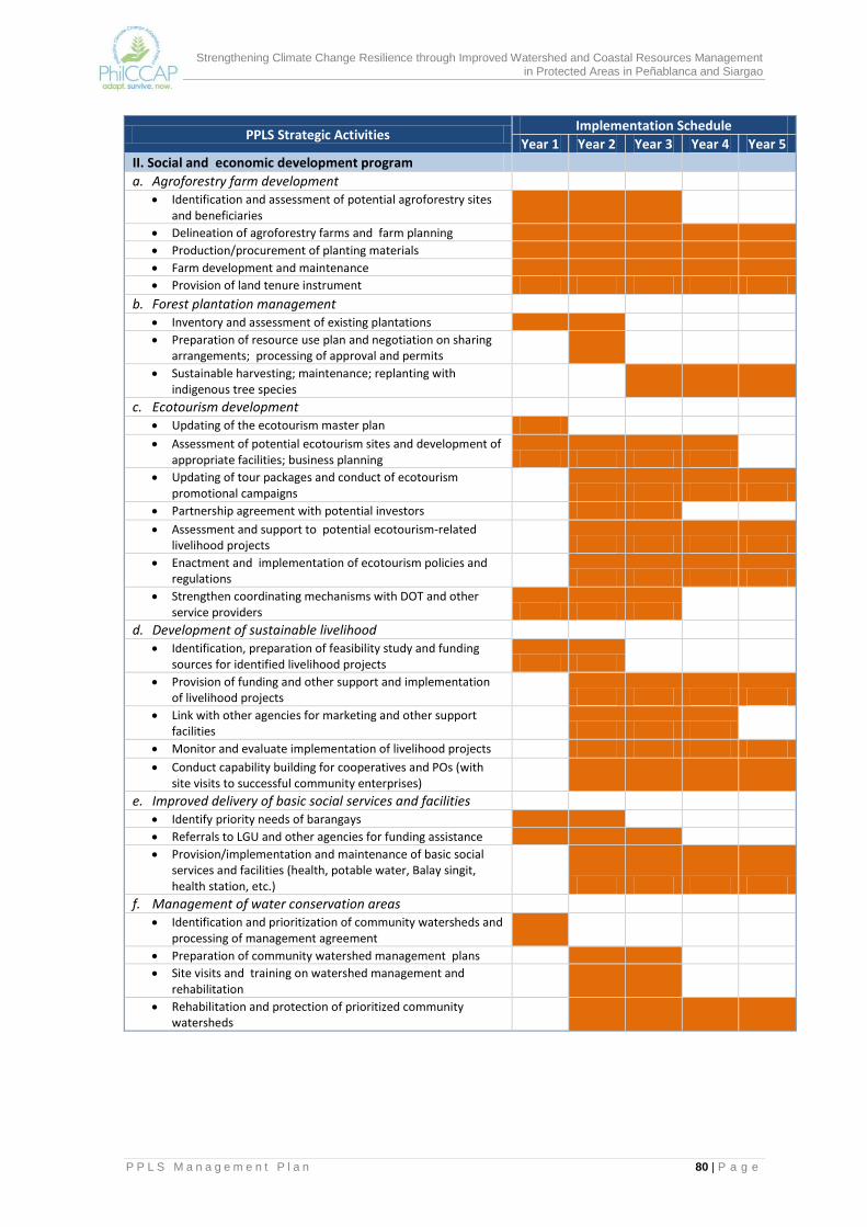
Strengthening Climate Change Resilience through Improved Watershed and Coastal Resources Management in Protected Areas in Peñablanca and Siargao
P P L S M a n a g e m e n t P l a n 80 | P a g e
PPLS Strategic Activities Implementation Schedule
Year 1 Year 2 Year 3 Year 4 Year 5
II. Social and economic development program a. Agroforestry farm development Identification and assessment of potential agroforestry sites
and beneficiaries
Delineation of agroforestry farms and farm planning
Production/procurement of planting materials
Farm development and maintenance
Provision of land tenure instrument
b. Forest plantation management Inventory and assessment of existing plantations
Preparation of resource use plan and negotiation on sharing arrangements; processing of approval and permits
Sustainable harvesting; maintenance; replanting with indigenous tree species
c. Ecotourism development Updating of the ecotourism master plan Assessment of potential ecotourism sites and development of
appropriate facilities; business planning Updating of tour packages and conduct of ecotourism
promotional campaigns Partnership agreement with potential investors Assessment and support to potential ecotourism-related
livelihood projects Enactment and implementation of ecotourism policies and
regulations Strengthen coordinating mechanisms with DOT and other
service providers
d. Development of sustainable livelihood Identification, preparation of feasibility study and funding
sources for identified livelihood projects Provision of funding and other support and implementation
of livelihood projects Link with other agencies for marketing and other support
facilities Monitor and evaluate implementation of livelihood projects Conduct capability building for cooperatives and POs (with
site visits to successful community enterprises)
e. Improved delivery of basic social services and facilities Identify priority needs of barangays
Referrals to LGU and other agencies for funding assistance
Provision/implementation and maintenance of basic social services and facilities (health, potable water, Balay singit, health station, etc.)
f. Management of water conservation areas Identification and prioritization of community watersheds and
processing of management agreement
Preparation of community watershed management plans
Site visits and training on watershed management and rehabilitation
Rehabilitation and protection of prioritized community watersheds
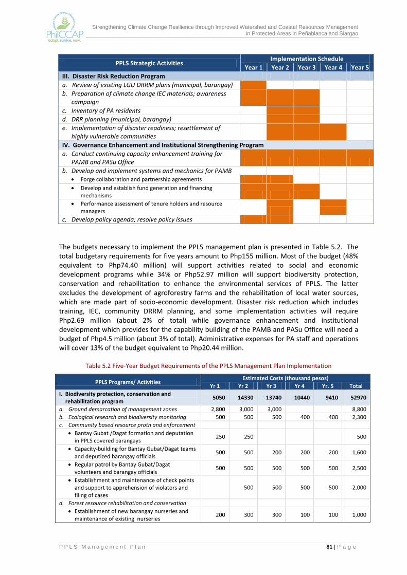
Strengthening Climate Change Resilience through Improved Watershed and Coastal Resources Management in Protected Areas in Peñablanca and Siargao
P P L S M a n a g e m e n t P l a n 81 | P a g e
PPLS Strategic Activities Implementation Schedule
Year 1 Year 2 Year 3 Year 4 Year 5
III. Disaster Risk Reduction Program
a. Review of existing LGU DRRM plans (municipal, barangay) b. Preparation of climate change IEC materials; awareness
campaign c. Inventory of PA residents d. DRR planning (municipal, barangay) e. Implementation of disaster readiness; resettlement of
highly vulnerable communities IV. Governance Enhancement and Institutional Strengthening Program
a. Conduct continuing capacity enhancement training for PAMB and PASu Office
b. Develop and implement systems and mechanics for PAMB Forge collaboration and partnership agreements Develop and establish fund generation and financing
mechanisms Performance assessment of tenure holders and resource
managers
c. Develop policy agenda; resolve policy issues
The budgets necessary to implement the PPLS management plan is presented in Table 5.2. The total budgetary requirements for five years amount to Php155 million. Most of the budget (48% equivalent to Php74.40 million) will support activities related to social and economic development programs while 34% or Php52.97 million will support biodiversity protection, conservation and rehabilitation to enhance the environmental services of PPLS. The latter excludes the development of agroforestry farms and the rehabilitation of local water sources, which are made part of socio-economic development. Disaster risk reduction which includes training, IEC, community DRRM planning, and some implementation activities will require Php2.69 million (about 2% of total) while governance enhancement and institutional development which provides for the capability building of the PAMB and PASu Office will need a budget of Php4.5 million (about 3% of total). Administrative expenses for PA staff and operations will cover 13% of the budget equivalent to Php20.44 million.
Table 5.2 Five-Year Budget Requirements of the PPLS Management Plan Implementation
PPLS Programs/ Activities Estimated Costs (thousand pesos)
Yr 1 Yr 2 Yr 3 Yr 4 Yr. 5 Total
I. Biodiversity protection, conservation and rehabilitation program
5050 14330 13740 10440 9410 52970
a. Ground demarcation of management zones 2,800 3,000 3,000
8,800
b. Ecological research and biodiversity monitoring 500 500 500 400 400 2,300
c. Community based resource protn and enforcement
Bantay Gubat /Dagat formation and deputation in PPLS covered barangays
250 250
500
Capacity-building for Bantay Gubat/Dagat teams and deputized barangay officials
500 500 200 200 200 1,600
Regular patrol by Bantay Gubat/Dagat volunteers and barangay officials
500 500 500 500 500 2,500
Establishment and maintenance of check points and support to apprehension of violators and filing of cases
500 500 500 500 2,000
d. Forest resource rehabilitation and conservation
Establishment of new barangay nurseries and maintenance of existing nurseries
200 300 300 100 100 1,000
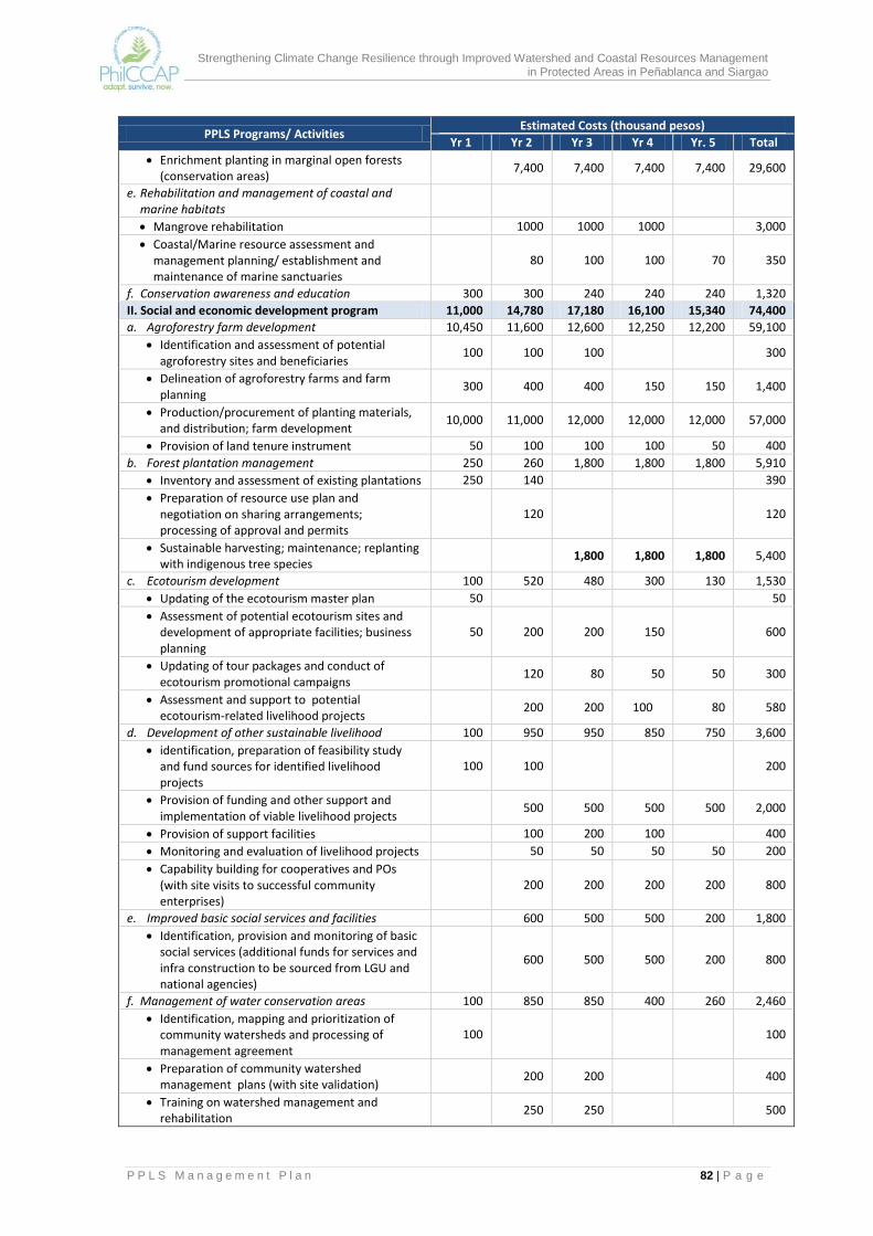
Strengthening Climate Change Resilience through Improved Watershed and Coastal Resources Management in Protected Areas in Peñablanca and Siargao
P P L S M a n a g e m e n t P l a n 82 | P a g e
PPLS Programs/ Activities Estimated Costs (thousand pesos)
Yr 1 Yr 2 Yr 3 Yr 4 Yr. 5 Total
Enrichment planting in marginal open forests (conservation areas)
7,400 7,400 7,400 7,400 29,600
e. Rehabilitation and management of coastal and marine habitats
Mangrove rehabilitation
1000 1000 1000
3,000
Coastal/Marine resource assessment and management planning/ establishment and maintenance of marine sanctuaries
80 100 100 70 350
f. Conservation awareness and education 300 300 240 240 240 1,320
II. Social and economic development program 11,000 14,780 17,180 16,100 15,340 74,400
a. Agroforestry farm development 10,450 11,600 12,600 12,250 12,200 59,100
Identification and assessment of potential agroforestry sites and beneficiaries
100 100 100
300
Delineation of agroforestry farms and farm planning
300 400 400 150 150 1,400
Production/procurement of planting materials, and distribution; farm development
10,000 11,000 12,000 12,000 12,000 57,000
Provision of land tenure instrument 50 100 100 100 50 400
b. Forest plantation management 250 260 1,800 1,800 1,800 5,910
Inventory and assessment of existing plantations 250 140
390
Preparation of resource use plan and negotiation on sharing arrangements; processing of approval and permits
120
120
Sustainable harvesting; maintenance; replanting with indigenous tree species
1,800 1,800 1,800 5,400
c. Ecotourism development 100 520 480 300 130 1,530
Updating of the ecotourism master plan 50
50
Assessment of potential ecotourism sites and development of appropriate facilities; business planning
50 200 200 150
600
Updating of tour packages and conduct of ecotourism promotional campaigns
120 80 50 50 300
Assessment and support to potential ecotourism-related livelihood projects
200 200 100 80 580
d. Development of other sustainable livelihood 100 950 950 850 750 3,600
identification, preparation of feasibility study and fund sources for identified livelihood projects
100 100
200
Provision of funding and other support and implementation of viable livelihood projects
500 500 500 500 2,000
Provision of support facilities
100 200 100
400
Monitoring and evaluation of livelihood projects
50 50 50 50 200
Capability building for cooperatives and POs (with site visits to successful community enterprises)
200 200 200 200 800
e. Improved basic social services and facilities
600 500 500 200 1,800
Identification, provision and monitoring of basic social services (additional funds for services and infra construction to be sourced from LGU and national agencies)
600 500 500 200 800
f. Management of water conservation areas 100 850 850 400 260 2,460
Identification, mapping and prioritization of community watersheds and processing of management agreement
100
100
Preparation of community watershed management plans (with site validation)
200 200
400
Training on watershed management and rehabilitation
250 250
500

Strengthening Climate Change Resilience through Improved Watershed and Coastal Resources Management in Protected Areas in Peñablanca and Siargao
P P L S M a n a g e m e n t P l a n 83 | P a g e
PPLS Programs/ Activities Estimated Costs (thousand pesos)
Yr 1 Yr 2 Yr 3 Yr 4 Yr. 5 Total
Rehabilitation and protection of prioritized community watersheds (excludes cost of designated resource managers/tenure holders)
400 400 400 260 1,460
III. Disaster Risk Reduction 530 850 700 310 300 2,690
a. Review of existing LGU DRRM plans (municipal, barangay)
80
80
b. Preparation of climate change IEC materials; awareness campaign
100 50 50 50 50 300
c. Inventory of PA residents 50 100 50
200
d. Training on DRR planning (municipal, barangay)
200 100
300
e. Implementation of disaster readiness measures; early warning systems/resettlement of highly vulnerable communities, others(supplemental to municipal and barangay DRRM budgets)
300 500 500 260 250 1,810
IV. Governance Enhancement and Institutional Strengthening Program
1,120 1,200 820 690 670 4,500
a. Conduct of continuing knowledge and capacity building activities for PAMB and PASu Office
500 500 300 200 200 1,700
b. Development and implementation of systems and mechanics for PAMB
120 200 150 120 110 700
Partnership agreements; tenure
Financing mechanisms
Fund disbursement
Performance assessment of tenure holders and resource managers
c. PAMB meetings (including ExCom and Su-Watershed Committees); policy formulation
100 100 100 100 100 500
d. Monitoring and evaluation 400 400 270 270 260 1,600
V. Administration 3,520 3,910 4,220 4,110 4,680 20,440
a. Key Personnel 2,520 2,910 3,260 3,610 3,980 16,280
Forest guards (10) 960 1,100 1,200 1,300 1,400 5,960
Supervisory (5) 1,200 1,400 1,600 1,800 2,000 8,000
Support staff (3) 360 410 460 510 580 2,320
b. Maintenance and Other Operating Expenses 500 500 500 500 500 2,500
c. Capital Outlay (Equipment) 500 500
200 1,200
TOTAL 21,220 35,070 36,660 31,650 30,400 155,000
The first year of implementation would require Php21.22 million or 14% of the total budget requirement. This increases significantly by 65% on the second year when most of the site activities are to commence. Year 2 to Year 4 will have the highest requirements. The total budget requirement for this period constitutes 67% of the total budget requirement. Funding for the PPLS plan implementation will come from various sources. Most of the biodiversity protection and conservation programs including the administrative costs will be shouldered by the DENR, tapping the NGP funds, the PPLS allocation and other DENR projects. However, the PAMB will have to explore and develop other sources of financing to sustain funding to the PPLS such as PES. The LGU on the other hand will have to provide the major investments for socio-economic development and disaster risk reduction. The budget indicated in the table above will only provide for pre-implementation assessments, planning, training and coordination/monitoring. The private sector and the provincial LGU will be encouraged to take responsibility for the ecotourism development program activities.

Strengthening Climate Change Resilience through Improved Watershed and Coastal Resources Management in Protected Areas in Peñablanca and Siargao
P P L S M a n a g e m e n t P l a n 84 | P a g e
6.0 MONITORING AND EVALUATION The M and E for PPLS puts emphasis on the expected results of interventions outlined in the management plan. These results consist of outputs, outcomes and impacts, which correspond to short-term objectives, intermediate objectives or purposes, and long-term objectives or goals, respectively. Outputs are produced from the right and timely use of the identified inputs through various activities. The continued use and proper management of the outputs will produce the desired outcomes (e.g., effective management of critical habitats by assigned resource manager leads to improved condition of habitat). Sustaining the outcomes will, in the long term, bring about the desired impact (e.g., if the improved condition of the habitat is sustained, species diversity will be enhanced). The emphasis of the M and E effort will be on the collection of evidences and the measurement of progress in the attainment of the management plan’s expected results. The data collected should be able to indicate both the magnitude and the direction of the change (i.e., positive or negative) that is taking place. To support M and E activities, a number of databases will have to be designed and maintained to serve as repository of data that will be collected periodically from various sources The M and E system shall be based on the PPLS Results Framework (Figure 6.1) which has been derived from the goals and objectives statements set out in the management plan. The results are presented in a hierarchy that start from outputs leading to outcomes and finally, to impacts. A detailed M and E Plan has been prepared as an accompanying document to the PPLS management plan (refer to the M and E Plan for PPLS, August 2015). The plan suggests suitable indicators for each of the outputs identified in the results framework. Most of the information on the output indicators are based on secondary sources. Data collection, analysis and reporting is to be done quarterly. At this level, the analysis of data will mainly entail comparisons between targets and accomplishments, with explanations for performance delays or shortfalls. Quarterly reporting on the progress of plan implementation will be made part of the PAMB meeting agenda. For outcomes, the M and E Plan provides a more detailed discussion on the definition of the indicators, the sources of data to measure performance, and the corresponding methods and tools for data collection, organization and analysis. The data that can be used as the baseline are also identified. A mix of quantitative and qualitative data collection methods are suggested for the expected outcomes and the frequency of data collection will differ among the indicators. Some data collection will be done quarterly while reporting on other outcomes be on a semi-annual or annual basis. There are some indicators on which the frequency of reporting will be longer. Improved vegetative cover for instance can only be reported when new maps are made available. Crop diversification, employment and income improvement can only be measured a few years after start of plan implementation. The analysis of the outcomes will mainly involve comparison of measurements or conditions at a specific time during implementation with the measurement or condition at the beginning of implementation. It will also show temporal trends and geographic distributions. It is thus important that the baseline (measurement or condition) is established before or at the early part of implementation.
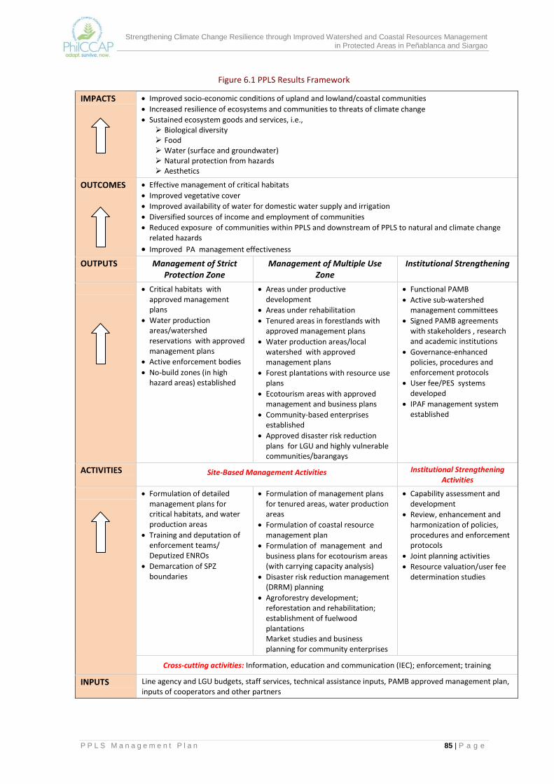
Strengthening Climate Change Resilience through Improved Watershed and Coastal Resources Management in Protected Areas in Peñablanca and Siargao
P P L S M a n a g e m e n t P l a n 85 | P a g e
Figure 6.1 PPLS Results Framework
IMPACTS Improved socio-economic conditions of upland and lowland/coastal communities
Increased resilience of ecosystems and communities to threats of climate change
Sustained ecosystem goods and services, i.e., Biological diversity Food Water (surface and groundwater) Natural protection from hazards Aesthetics
OUTCOMES
Effective management of critical habitats
Improved vegetative cover
Improved availability of water for domestic water supply and irrigation
Diversified sources of income and employment of communities
Reduced exposure of communities within PPLS and downstream of PPLS to natural and climate change related hazards
Improved PA management effectiveness
OUTPUTS Management of Strict Protection Zone
Management of Multiple Use Zone
Institutional Strengthening
Critical habitats with approved management plans
Water production areas/watershed reservations with approved management plans
Active enforcement bodies
No-build zones (in high hazard areas) established
Areas under productive development
Areas under rehabilitation
Tenured areas in forestlands with approved management plans
Water production areas/local watershed with approved management plans
Forest plantations with resource use plans
Ecotourism areas with approved management and business plans
Community-based enterprises established
Approved disaster risk reduction plans for LGU and highly vulnerable communities/barangays
Functional PAMB
Active sub-watershed management committees
Signed PAMB agreements with stakeholders , research and academic institutions
Governance-enhanced policies, procedures and enforcement protocols
User fee/PES systems developed
IPAF management system established
ACTIVITIES Site-Based Management Activities Institutional Strengthening Activities
Formulation of detailed management plans for critical habitats, and water production areas
Training and deputation of enforcement teams/ Deputized ENROs
Demarcation of SPZ boundaries
Formulation of management plans for tenured areas, water production areas
Formulation of coastal resource management plan
Formulation of management and business plans for ecotourism areas (with carrying capacity analysis)
Disaster risk reduction management (DRRM) planning
Agroforestry development; reforestation and rehabilitation; establishment of fuelwood plantations Market studies and business planning for community enterprises
Capability assessment and development
Review, enhancement and harmonization of policies, procedures and enforcement protocols
Joint planning activities
Resource valuation/user fee determination studies
Cross-cutting activities: Information, education and communication (IEC); enforcement; training
INPUTS Line agency and LGU budgets, staff services, technical assistance inputs, PAMB approved management plan, inputs of cooperators and other partners

Strengthening Climate Change Resilience through Improved Watershed and Coastal Resources Management in Protected Areas in Peñablanca and Siargao
P P L S M a n a g e m e n t P l a n 86 | P a g e
With respect to impacts, M and E will focus on the resiliency goal since climate change adaptation is the main theme of the PPLS management plan. The M and E Plan outlines the general process for doing a qualitative evaluation of the impacts of climate change adaptation. It centers on the review of the continuing relevance, effectiveness and sustainability of interventions designed to reduce the vulnerability of ecosystems and communities. Vulnerability to climate change is a function of three factors, namely: (1) types and magnitudes of Exposure to climate change; (2) Sensitivity of the system to climate hazards; and (3) Adaptive Capacity of the system. The evaluation of the effectiveness of climate change adaptation measures will examine how interventions are able to bring about change on the vulnerability factor that is being addressed. The impacts of climate change on biodiversity will be another area of study in impact evaluation. This will require periodic monitoring of indicator species that provide easy indicators of effects and impacts. Some plant and faunal species are recommended as frontline indicators among them a herbaceous fern, terrestrial and arboreal frogs, monitor lizards and mangroves. The main users of the information generated through M and E activities would be the PAMB, the PASu Office and the LGU who are the primary implementors of the planned interventions. The reports to them should be in a format that will be useful for decision-making, planning and budgeting, making use of pictures, maps and charts, when applicable. Reports to PAMB will highlight the most important findings and present corresponding options for those requiring PAMB action. Other users of the information, particularly on outcomes and impacts, would be the DENR-PENRO, DENR Regional Office, BMB, Provincial LGU, local communities and the academe. The feedback of monitoring results to local communities is an important part of the M and E system. It provides the venue for a regular dialogue with the communities; it will enhance their appreciation for biodiversity monitoring and conservation. It will also sustain their interest and active participation in PPLS management activities.

Strengthening Climate Change Resilience through Improved Watershed and Coastal Resources Management in Protected Areas in Peñablanca and Siargao
P P L S M a n a g e m e n t P l a n 87 | P a g e
REFERENCES Bruner, A.G., Gullison, R.E., Rice, R.E. and Fonseca, G.A.B. 2001.Effectiveness of Parks in
Protecting Tropical Biodiversity.Science291: 125–128. Congress of the Philippines. 1992. Republic Act No. 7586. Quezon City, Philippines Department of Environment and Natural Resources. 2008. DENR Administrative Order No. 2008-
26. Quezon City, Philippines. Department of Environment and Natural Resources. 2012. Memo Report of DENR Mangrove
Assessment Team. Groombridge, B. (ed). 1992. Global Biodiversity. Status of the Earth’s Living Resources. Langhammer, P.F., et al. 2007. Identification and Gap Analysis of Key Biodiversity Areas: Targets
for Comprehensive Protected Area Systems. Gland, Switzerland: International Union for Conservation of Nature.
Local Government Unit of Peñablanca.2001. Comprehensive Land Use Plan of the Municipality
ofPeñablanca, Cagayan, 2001-2011. Municipal Planning and Development Office ofPeñablanca.Coastal Profile ofPeñablanca. Office of the President of the Republic of the Philippines. 2004. Presidential Proclamation No.
484. Manila, Philippines. Ong, P.S., L.E. Afuangand R.G. Rosell-Ambal (eds.) (2002).Philippine Biodiversity Conservation
Priorities: A Second Iteration of the National Biodiversity Strategy and Action Plan. Department of Environment and Natural Resources-Protected Areas and Wildlife Bureau, Conservation International Philippines, Biodiversity Conservation Program-University of the Philippines Center for Integrative and Development Studies, and Foundation for the Philippine Environment, Quezon City, Philippines,
Peñablanca Protected Landscape and Seascape Protected Area Management Board. 2004. PPLS
Management Plan. Philippine Climate Change Adaptation Project. DENR. 2015. Piloting Agroforestry in PPLS: A
Documentation. Province of Cagayan. Provincial Physical Framework Plan of Cagayan Province.2010-2040. Regional Physical Framework Plan of Region 2.2001-2011. Toyota Motors Corporation and Conservation International. 2009. Philippine Peñablanca
Sustainable Reforestation Project: Project Design Document for Climate, Community and Biodiversity Standards, second edition.

Strengthening Climate Change Resilience through Improved Watershed and Coastal Resources Management in Protected Areas in Peñablanca and Siargao
A n n e x M a p s 1 | P a g e
Annex Maps
Annex Map 1. Location of the PPLS

Strengthening Climate Change Resilience through Improved Watershed and Coastal Resources Management in Protected Areas in Peñablanca and Siargao
A n n e x M a p s 2 | P a g e
Annex Map 2. Slope Map of Peñablanca, Cagayan

Strengthening Climate Change Resilience through Improved Watershed and Coastal Resources Management in Protected Areas in Peñablanca and Siargao
A n n e x M a p s 3 | P a g e
Annex Map 3. Elevation Map of Peñablanca, Cagayan
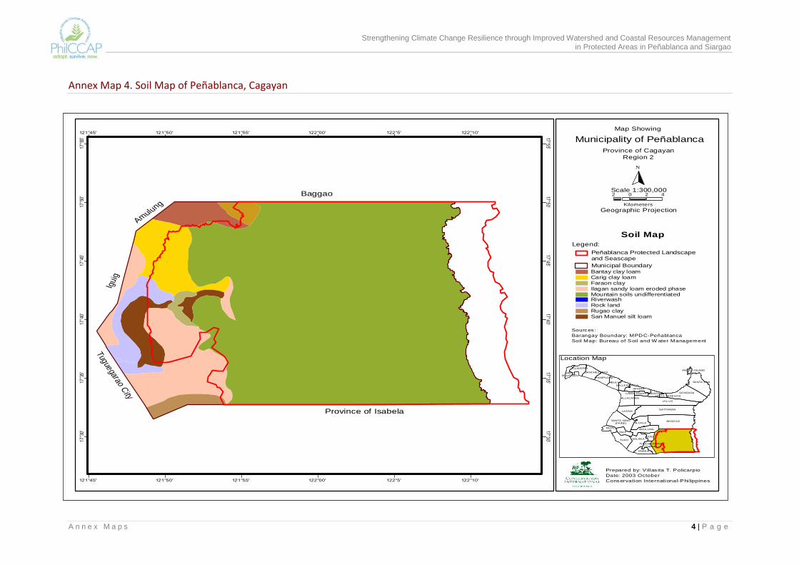
Strengthening Climate Change Resilience through Improved Watershed and Coastal Resources Management in Protected Areas in Peñablanca and Siargao
A n n e x M a p s 4 | P a g e
Map Showing
Municipality of Peñablanca
Province of CagayanRegion 2
N
Scale 1:300,000
Geographic Projection
Soil Map
BAGGAO
LAL-LO
GATTARAN
GONZAGA
TUAO SOLANA
SANTA ANA
LASAM
ALCALA
PIAT
ALLACAPAN
AMULUNG
APARRI
SANTO NINO (FAIRE)
ABULUG
ENRILE
RIZAL
CLAVERIA
IGUIG
PAMPLONA
SANCHEZ MIRA
BUGUEY
BALLESTEROS
CAMALANIUGAN
TUGUEGARAO (Capital)
SANTAPRAXEDES
SANTA TERESITA
PALAUI ISLAND
Location Map
Prepared by: Villas ita T. Policarpio
Date: 2003 October
Conservation International-Philippines
Legend:
Sources:
Barangay Boundary: MPDC-Peñablanca
Soil Map: Bureau of Soil and W ater Management
2 0 2 4
Kilometers
Municipal Boundary
Peñablanca Protected Landscape and Seascape
17°30'
17°30'
17°35'
17°35'
17°40'
17°40'
17°45'
17°45'
17°50'
17°50'
17°55'
17°55'
121°45'
121°45'
121°50'
121°50'
121°55'
121°55'
122°00'
122°00'
122°5'
122°5'
122°10'
122°10'
Baggao
Province of Isabela
Amulu
ng
Igui
g
Tuguegarao City
Bantay clay loamCarig clay loamFaraon clayIlagan sandy loam eroded phaseMountain soils undifferentiatedRiverwashRock landRugao claySan Manuel silt loam
Annex Map 4. Soil Map of Peñablanca, Cagayan

Strengthening Climate Change Resilience through Improved Watershed and Coastal Resources Management in Protected Areas in Peñablanca and Siargao
A n n e x M a p s 5 | P a g e
Annex Map 5. Drainage Map of PPLS
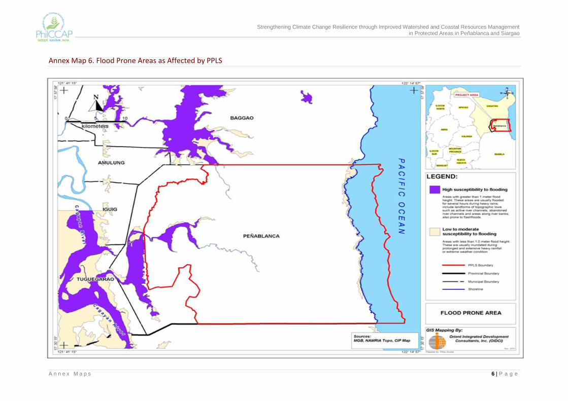
Strengthening Climate Change Resilience through Improved Watershed and Coastal Resources Management in Protected Areas in Peñablanca and Siargao
A n n e x M a p s 6 | P a g e
Annex Map 6. Flood Prone Areas as Affected by PPLS

Strengthening Climate Change Resilience through Improved Watershed and Coastal Resources Management in Protected Areas in Peñablanca and Siargao
A n n e x M a p s 7 | P a g e
Annex Map 7. Landslide Prone Areas in Peñablanca

Strengthening Climate Change Resilience through Improved Watershed and Coastal Resources Management in Protected Areas in Peñablanca and Siargao
A n n e x M a p s 8 | P a g e
Annex Map 8. Land Classification Map of PPLS
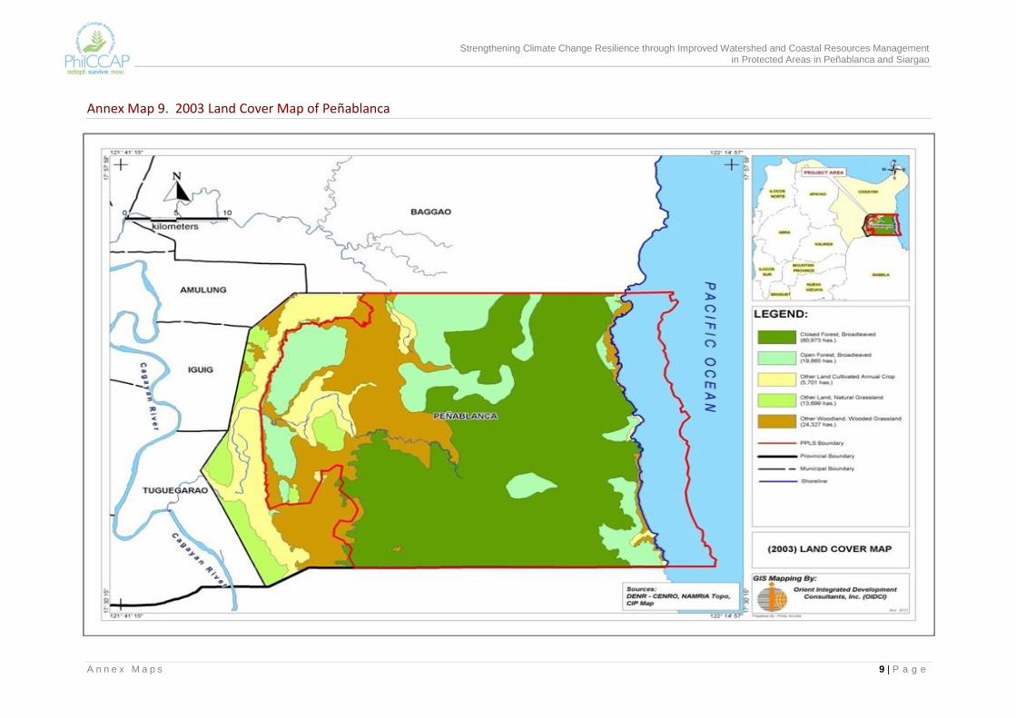
Strengthening Climate Change Resilience through Improved Watershed and Coastal Resources Management in Protected Areas in Peñablanca and Siargao
A n n e x M a p s 9 | P a g e
Annex Map 9. 2003 Land Cover Map of Peñablanca
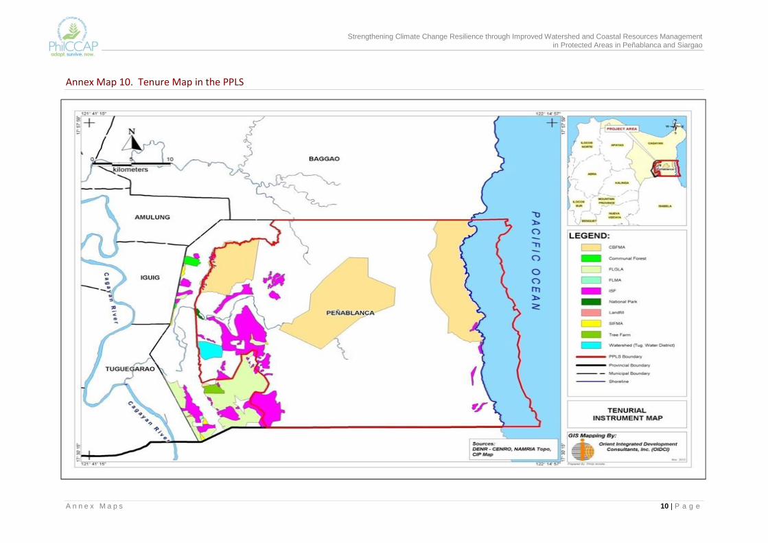
Strengthening Climate Change Resilience through Improved Watershed and Coastal Resources Management in Protected Areas in Peñablanca and Siargao
A n n e x M a p s 10 | P a g e
Annex Map 10. Tenure Map in the PPLS
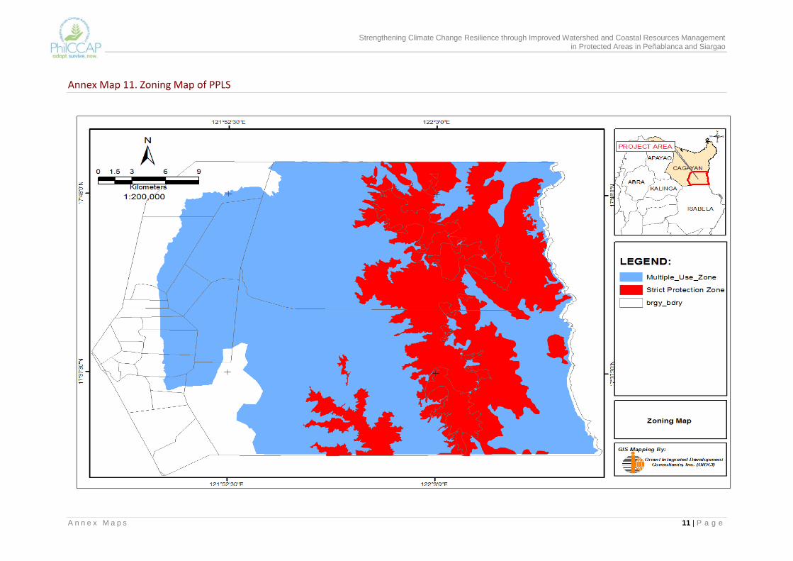
Strengthening Climate Change Resilience through Improved Watershed and Coastal Resources Management in Protected Areas in Peñablanca and Siargao
A n n e x M a p s 11 | P a g e
Annex Map 11. Zoning Map of PPLS
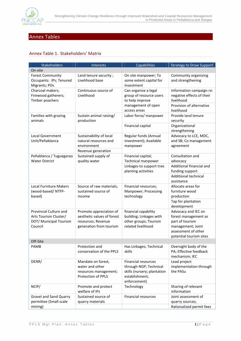
Strengthening Climate Change Resilience through Improved Watershed and Coastal Resources Management in Protected Areas in Peñablanca and Siargao
P P L S M g t P l a n : A n n e x T a b l e s 1 | P a g e
Annex Tables
Annex Table 1. Stakeholders’ Matrix
Stakeholders Interests Capabilities Strategy to Draw Support
On-site
Forest Community Occupants: IPs; Tenured Migrants; POs
Land tenure security ; Livelihood base
On site manpower; To some extent capital for investment
Community organizing and strengthening
Charcoal makers; Firewood gatherers; Timber poachers
Continuous source of Livelihood
Can organize a legal group of resource users to help improve management of open access areas
Information campaign re: negative effects of their livelihood
Provision of alternative livelihood
Families with grazing animals
Sustain animal raising/ production
Labor force/ manpower Provide land tenure security
Financial capital Organizational strengthening
Local Government Unit/Peñablanca
Sustainability of local natural resources and environment
Regular funds (Annual investment); Available manpower
Advocacy to LCE, MDC, and SB; Co management agreement
Revenue generation
Peñablanca / Tuguegarao Water District
Sustained supply of quality water
Financial capital; Technical manpower
Consultation and advocacy
Linkages to support tree planting activities
Additional financial and funding support
Additional technical assistance
Local Furniture Makers (wood-based/ NTFP-based)
Source of raw materials; sustained source of income
Financial resources; Manpower; Processing technology
Allocate areas for furniture wood production
Tap for plantation development
Provincial Culture and Arts Tourism Cluster/ DOT/ Municipal Tourism Council
Promote appreciation of aesthetic values of forest resources; Revenue generation from tourism
financial capability building; Linkages with other groups; Tourism related livelihood
Advocacy and IEC on forest management as part of tourism management; Joint assessment of other potential tourism sites
Off-Site
PAMB Protection and conservation of the PPLS
Has Linkages; Technical skills
Oversight body of the PA; Effective feedback mechanism; IEC
DENR/ Mandate on forest, water and other resources management; Protection of PPLS
Financial resources through NGP; Technical skills (nursery; plantation establishment; enforcement)
Lead project implementation through the PASu
NCIP/ Promote and protect welfare of IPs
Technology Sharing of relevant information
Gravel and Sand Quarry permittee (Small scale mining)
Sustained source of quarry materials
Financial resources Joint assessment of quarry sources;
Rationalized permit fees
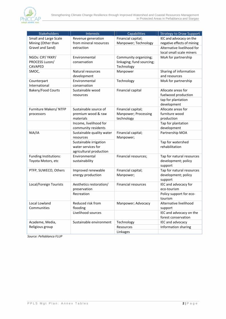
Strengthening Climate Change Resilience through Improved Watershed and Coastal Resources Management in Protected Areas in Peñablanca and Siargao
P P L S M g t P l a n : A n n e x T a b l e s 2 | P a g e
Stakeholders Interests Capabilities Strategy to Draw Support
Small and Large Scale Mining (Other than Gravel and Sand)
Revenue generation from mineral resources extraction
Financial capital; Manpower; Technology
IEC and advocacy on the negative effects of mining
Alternative livelihood for local small scale miners
NGOs: CIP/ YKKP/ PROCESS Luzon/ CAVAPED
Environmental conservation
Community organizing; linkaging; fund sourcing; Technology
MoA for partnership
SMOC, Natural resources development
Manpower Sharing of information and resources
Counterpart International
Environmental conservation
Technology MoA for partnership
Bakery/Food Courts Sustainable wood resources
Financial capital Allocate areas for fuelwood production
tap for plantation development
Furniture Makers/ NTFP processors
Sustainable source of premium wood & raw materials
Financial capital; Manpower; Processing technology
Allocate areas for furniture wood production
Income, livelihood for community residents
Tap for plantation development
NIA/IA Sustainable quality water resources
Financial capital; Manpower;
Partnership MOA
Sustainable irrigation water services for agricultural production
Tap for watershed rehabilitation
Funding Institutions: Toyota Motors, etc
Environmental sustainability
Financial resources; Tap for natural resources development; policy support
PTFP, SUWECO, Others Improved renewable energy production
Financial capital; Manpower;
Tap for natural resources development; policy support
Local/Foreign Tourists Aesthetics restoration/ preservation
Financial resources IEC and advocacy for eco-tourism
Recreation Policy support for eco-tourism
Local Lowland Communities
Reduced risk from flooding
Manpower; Advocacy Alternative livelihood support
Livelihood sources IEC and advocacy on the forest conservation
Academe, Media, Religious group
Sustainable environment Technology IEC and advocacy
Resources Information sharing
Linkages Source: Peñablanca FLUP

Strengthening Climate Change Resilience through Improved Watershed and Coastal Resources Management in Protected Areas in Peñablanca and Siargao
P P L S M g t P l a n : A n n e x T a b l e s 3 | P a g e
Annex Table 2. Vulnerability ratings of birds in PPLS – a total of 141 species in 40 families: LOW (L) = 19 species; MEDIUM (M) = 70 species and HIGH (H) = 52 species.
Family/Scientific Name Common Name VA
Rating Distribution and Conservation Status
1 Family Anatidae
1 Anasluzonica Philippine Duck M Philippine Endemic-Common / Vulnerable (DAO/IUCN)
2 Family Accipitridae
2 Accipiter gularis Japanese Sparrowhawk L Migrant-Uncommon (CITES II)
3 Butasturindicus Grey-faced Buzzard L Migrant-Fairly Common (CITES II)
4 Haliasturindus Brahminy Kite M Resident-Common (CITES II)
5 Hieraaetuskienerii Rufous-bellied Eagle M Resident - Uncommon (CITES II)
6 Pernisptiloryncus Oriental Honeybuzzard L Resident/Migrant-Common
7 Spilornischeela Crested Serpent-eagle M Resident - Common
8 Perniscelebensis Barred Honey Buzzard M Resident
9 Microheiraxerythrogenys Philippine Falconet H Endemic
10 Buteobuteo Common Buzzard L Migrant
11 Spizaetusphilippensis Philippine Hawk Eagle H Endemic
3 Family Phasianidae
12 Coturnixchinensis Blue-breasted Quail M Resident-Common
13 Gallus gallus Red Junglefowl M Resident - Common
4 Family Turnicidae
14 Turnixocellata Spotted Buttonquail H Philippine Endemic - Common
15 Turnixsylvatica Small Button Quail M Resident-Common
5 Family Rallidae
16 Amaurornisphoenicurus White-breasted Waterhen M Resident -Common
17 Amaurornisolivaceus Plain Bush-hen H Endemic
18 Galliralustorquatus Barred Rail M Resident-Common
19 Gallirallusphilippensis Buff-banded Rail M Resident-Locally common
6 Family Scolopacidae
20 Gallinagomegala Swinhoe's Snipe L Migrant-Common
7 Family Columbidae
21 Chalcophapsindica Common Emerald M Resident - Common
22 Geopeliastriata Zebra Dove M Resident - Common
23 Macropygiaphasianella Reddish Cuckoo-Dove M Resident-Common
24 Phapitreronamethystina Amethyst brown Dove H Philippine Endemic - Common
25 Phapitreronleucotis White-eared Brown Dove H Philippine Endemic - Common
26 Ptilinopusleclancheri Black-chinned Fruit-dove H Near Endemic - Uncommon
27 Ptilinopusoccipitalis Yellow-breasted Fruit-Dove H Philippine Endemic - Common
28 Streptopeliabitorquata Island Collared-Dove M Resident-Uncommon
29 Streptopeliachinensis Spotted Dove M Resident- Common
30 Streptopeliatranquebarica Red Turtle-Dove M Resident - Fairly Common
31 Treronpompadora Pompadour Green-Pigeon M Resident-Common
32 Treronvernans Pink-necked Green-Pigeon M Resident-Common
8 Family Psittacidae
33 Bolbopsittacuslunulatus Guaiabero H Philippine Endemic - Common
34 Loriculusphilippensis Colasisi H Philippine Endemic - Common
35 Tanygnathuslucionensis Blue-naped Parrot M Resident
9 Family Cuculidae
36 Cacomantismerulinus Plaintive Cuckoo M Resident - Common
37 Cacomantisvariolosus Brush Cuckoo M Resident - Common
38 Centropusbenghalensis Lesser Coucal M Resident - Common
39 Centropusunirufus RufousCoucal H Philippine Endemic - Uncommon
40 Centropusviridis Philippine Coucal H Philippine Endemic - Common
41 Cuculuspectoralis Philippine Hawk-Cuckoo H Philippine Endemic
42 Cuculusfugax Hodgson's Hawk-Cuckoo M Resident

Strengthening Climate Change Resilience through Improved Watershed and Coastal Resources Management in Protected Areas in Peñablanca and Siargao
P P L S M g t P l a n : A n n e x T a b l e s 4 | P a g e
Family/Scientific Name Common Name VA
Rating Distribution and Conservation Status
43 Eudynamysscolopacea Common Koel M Resident-Locally Common
44 Phaenicophaeuscumingi Scale-feathered Malkoha H Luzon Endemic - Fairly Common
45 Phaenicophaeussuperciliosus
Red-crested Malkoha H Luzon Endemic - Fairly Common
10 Family Strigidae
46 Bubo philippensis Philippine Eagle-Owl H Philippine Endemic - Uncommon / Vulnerable(DAO/IUCN) (CITES II)
47 Ninoxphilippensis Philippine Hawk-owl H Philippine Endemic - Common (CITES II)
48 Otusmegalotis Philippine Scops-Owl H Philippine Endemic - Common (CITES II)
49 Otuslongicornis Luzon Scops-Owl H Endemic - Locally Common (Near Threatened (IUCN)
50 Tytocapensis Grass Owl M Resident-Fairly Common (CITES II)
11 Family Caprimulgidae
51 Caprimulgusmanillensis Philippine Nightjar M Resident - Common
52 Eurostopodusmacrotis Great-eared Nightjar M Resident - Common
12 Family Apodidae
53 Apuspacificus Fork-tailed Swift M Resident - Common
54 Apusaffinis House Swift M Resident-Locally common
55 Collocaliavanikorensis Island Swiftlet M Resident - Common
56 Collocaliaesculenta Glossy Swiftlet M Resident - Common
57 Collocalia troglodytes Pygmy Swiftlet H Philippine Endemic - Fairly Common
13 Family Hemiprocnidae
58 Hemiprocnecomata Whiskered Tree Swift M Resident-Fairly Common
14 Family Alcedinidae
59 Actenoideslindsayi Spotted Wood-Kingfisher H Philippine Endemic-Fairly Common
60 Alcedocyanopecta Indigo-banded Kingfisher H Philippine Endemic - Uncommon
61 Halcyon chloris White-collared Kingfisher M Resident - Common
62 Halcyon smyrnensis White-throated Kingfisher M Resident Fairly Common
63 Ceyxmelanurus Philippine Dwarf-Kingfisher H Philippine Endemic-Vulnerable (IUCN, 2010)
15 Family Meropidae
64 Meropsphilippinus Blue-tailed Bee-eater M Resident-Fairly Common
65 Meropsviridis Blue-Throated Bee-eater M Resident - Fairly Common
16 Family Bucerotidae
66 Buceroshydrocorax Rufous Hornbill H Philippine Endemic - Common (VU-DAO; NT-IUCN; CITES II)
67 Penelopidespaninimanillae Tarictic Hornbill H Philippine Endemic - Common
17 Family Capitonidae
68 Megalaimahaemacephala Coppersmith barbet M Resident - Common
18 Family Picidae
69 Dendrocopusmaculatus Philippine Pygmy Woodpecker H Philippine Endemic - Common
70 Chrysocolapteslucidus Greater Flameback M Resident - Fairly Common
19 Family Pittidae
71 Pitta sordida Hooded Pitta M Resident - Common
20 Family Hirundinidae
72 Cecropisstriolata Striated Swallow M Resident
73 Hirundorustica Barn Swallow L Migrant-Common
74 Hirundotahitica Pacific Swallow M Resident - Common
75 Hirundodaurica Red-rumped Swallow L Migrant
21 Family Campephagidae
76 Coracinastriata Bar-bellied Cuckoo-shrike M Resident-Common
77 Lalagenigra Pied Triller M Resident - Common
78 Pericrocotusdivaricatus Ashy Minivet L Migrant
22 Family Pycnonotidae
79 Hypsipetesphilippinus Philippine Bulbul H Philippine Endemic - Common
80 Pycnonotusgoiavier Yellow-vented Bulbul M Resident - Common

Strengthening Climate Change Resilience through Improved Watershed and Coastal Resources Management in Protected Areas in Peñablanca and Siargao
P P L S M g t P l a n : A n n e x T a b l e s 5 | P a g e
Family/Scientific Name Common Name VA
Rating Distribution and Conservation Status
81 Pycnonotusurostictus Yellow wattled Bulbul H Philippine Endemic
23 Family Dicruridae
82 Dicrurusbalicassius Balicassiao H Philippine Endemic - Common
24 Family Oriolidae
83 Irena cyanogaster Philippine Fairy-Bluebird H Philippine Endemic - Common
84 Orioluschinensis Black-naped oriole M Resident - Common
25 Family Corvidae
85 Corvusenca Slender-billed Crow M Resident-Locally Common
86 Corvusmacrorhynchos Large-billed Crow M Resident-Common
26 Family Paridae
87 Paruselegans Elegan Tit H Philippine Endemic - Common
27 Family Rhabdornithidae
88 Rhabdornismystacalis Striped-headed Rhabdornis H Philippine Endemic - Common
28 Family Timaliidae
89 Stachyrisstriata Luzon Striped-Babbler H Luzon Endemic - Uncommon
29 Family Turdidae
90 Copsychusluzoniensis White-browed Shama H Philippine Endemic - Uncommon
91 Copsychussaularis Oriental Magpie-robin M Resident - Uncommon
92 Luscineacaliope Siberian Rubythroat L Migrant-Uncommon
93 Saxicolacaprata Pied Bushchat M Resident - Common
94 Turduschrysolaus Brown-headed Thrush L Migrant-Uncommon
95 Turdusobscurus Eyebrowed Thrush L Migrant-Uncommon
96 Zooteradauma Scaly Ground-Thrush L Migrant - Uncommon
30 Family Sylviidae
97 Cisticolaexilis Bright-capped Cisticola M Resident - Common
98 Cisticolajuncidis ZittingCisticola M Resident-Common
99 Gerygonesulphurea Golden-bellied Flyeater M Resident-Locally Common
100 Megaluruspalustris Striated Grassbird M Resident - Common
101 Megalurustimoriensis Tawny Grassbird M Resident - Common
102 Orthotomuscastaneiceps Philippine Tailorbird H Philippine Endemic - Common
103 Orthotomusderbianus Grey-backed Tailorbird H Luzon Endemic - Common
104 Phylloscopus borealis Arctic Warbler L Migrant - Common
105 Phylloscopuscebuensis Lemon-throated Leaf-Warbler H Philippine Endemic - Common
31 Family Muscicapidae
106 Cyornisherioti Blue-breasted Flycatcher H Luzon Endemic - Common
107 Cyornisrufigastra Mangrove Blue Flycatcher M Resident - Common
108 Eumyiaspanayensis Mountain Verditer-Flycatcher M Resident - Common
109 Hypothymisazurea Black-naped monarch M Resident - Common
110 Ficedulanarcissina Narcissus Flycatcher L Migrant - Rare
111 Ficedulawestermanni Little Pied Flycatcher M Resident-Fairly Common
112 Muscicapagreseisticta Grey-streaked Flycatcher L Migrant-Common
113 Rhipiduracyaniceps Blue-headed Fantail H Endemic - Common
114 Rhipidurajavanica Pied Fantail M Resident - Common
32 Family Pachycephalidae
115 Pachycephalaphilippinensis
Yellow-breasted whistler H Philippine Endemic - Common
33 Family Motacillidae
116 Anthusnovaeseelandiae Richard's Pipit M Resident - Common
117 Anthusgustavi Pechora Pipit L Migrant-Uncommon
118 Motacillacinerea Grey Wagtail L Migrant - Common
119 Motacilla alba Yellow Wagtail L Migrant-Rare
34 Family Artamidae
120 Artamusleucorynchus White-breasted Woodswallow M Resident – Common
35 Family Laniidae
121 Laniuscristatus Brown Shrike L Migrant - Common
122 Laniusschach Long-tailed Shrike M Resident – Common

Strengthening Climate Change Resilience through Improved Watershed and Coastal Resources Management in Protected Areas in Peñablanca and Siargao
P P L S M g t P l a n : A n n e x T a b l e s 6 | P a g e
Family/Scientific Name Common Name VA
Rating Distribution and Conservation Status
36 Family Sturnidae
123 Acridotherescristatellus Crested Myna M Resident - Common
124 Sarcopscalvus Coleto H Near Endemic-Common
37 Family Nectariniidae
125 Aethopygapulcherrima Metallic-winged Sunbird H Philippine Endemic-Common
126 Anthreptesmalacensis Plain-throated Sunbird M Resident - Common
127 Arachnotheraclarae Naked-faced Spiderhunter H Philippine Endemic-Uncommon
128 Nectariniajugularis Olive-backed sunbird M Resident - Common
129 Nectariniasperata Purple-throated sunbird M Resident - Common
38 Family Dicaeidae
130 Prionichilusolivaeus Olive-backed Flowerpecker H Endemic - Common
131 Dicaeumaustrale Red-keeled Flowerpecker H Philippine Endemic - Common
132 Dicaeum bicolor Bicolored Flowerpecker H Philippine Endemic- Uncommon
133 Dicaeumhypoleucum Buzzing Flowerpecker H Philippine Endemic-Common
134 Dicaeumpygmaeum Pygmy Flowerpecker H Philippine Endemic - Common
135 Dicaeumaeruginosum Striped Flowerpecker H Endemic -Uncommon
136 Dicaeumtrigonostigma Orange-bellied Flowerpecker M Resident - Common
39 Family Zosteropidae
137 Zosteropsmeyeni Lowland white-eye H Luzon Endemic Common
138 Zosteropsnigrorum Yellowish White-eye H Philippine Endemic - Common
40 FamilyEstrilidae
139 Lonchuraleucogastra White-bellied Munia M Resident-Common
140 Lonchuramalacca Chestnut Munia M Resident - Common
141 Lonchurapunctulata Scaly-breasted Munia M Resident - Common
Source: CI Report

Strengthening Climate Change Resilience through Improved Watershed and Coastal Resources Management in Protected Areas in Peñablanca and Siargao
P P L S M g t P l a n : A n n e x T a b l e s 7 | P a g e
Annex Table 3. Vulnerability rating of 109 plant species in PPLS (plant names based on allowed species under PPSRP Reforestation and Enhancement). Low vulnerability = 16 species; Medium = 82 species and High = 11 species)
Common Name/Family/Scientific Name Habitat(s)* VA Rating Akleng-aceae Premnaodorata gr-f L Alagasi Urticacparang Leguminosae Albiziaprocera gr-br L Alagao Verbeneae Leucosykecapitellata gr-f L Alahan Sapindaceae Guioakoelreuteria f H Alauihau Meliaceae Aglaiacumingiana f M Alibangbang Caesalpiniaceae Bauhiniamalabarica gr-br L Alilaua Urticaceae Villebruneatrinervis f M Alim Euphorbiaceae Melanolepismultiglandulosa gr-br M
Amamali Leeaceae Leeaaculeata br-f M
Amugan Rosaceae Prunusmarsupialis f M
Anagap Leguminosae Archidendronscutiferum br-f L
Anilao Tiliaceae Colonaserratifolia br-f M
Aninguai Flacourtiaceae Scolopialuzonensis br L
Antipolo Moraceae Artocarpusblancoi br-f M
Apaped Euphorbiaceae Glochidionluzonense br-f M
Aunasin Myrsinaceae Ardisiapyramidalis br-f M
Bagawak Verbenaceae Clerodendrumminahassae br-f M
BahaiLeguminosae Albiziasaponaria br-f M
Bakawan-gubatRhizophoraceae Caralliabrachiata f M
Balikbikan Euphorbiaceae Drypeteslongifolia f M
Balinghasai Anacardiaceae Buchananiaarborescens f M
Balobo Tiliaceae Diplodiscuspaniculatus f L
Banaba Lythraceae Lagerstroemiaspeciosa br-f M
Banato Euphorbiaceae Mallotusphilippensis br-f M
Bangkal Rubiaceae Naucleaorientalis br-f L
Batino Apocynaceae Alstoniamacrophylla br-f M
Bato-bato Euphorbiaceae Drypeteslittoralis br-f H
Bieum Meliaceae Cipadessabaccifera f L
Bignai Euphorbiaceae Antidesmabunius br-f M
Binayoyo Euphorbiaceae Antidesmaghaesembilla gr M
Binunga Euphorbiaceae Macarangatanarius br-f M
Bolong-eta Ebenaceae Diospyrospilosanthera f H
Buboy-gubat Bombacaceae Samaliamalabarica br-f M
Bugkau Rutaceae Toddaliaasiatica f L
Dapdap Leguminosae Erythrinavariegata (syn. E. orientalis) br-f M
Dita Apocynaceae Alstoniascholaris br-f M
Duhat Myrtaceae Syzygiumcumini gr-br M
Dungon Sterculiaceae Heritierasylvatica br-f M
Guyong-guyong Hypericaceae Cratoxylumsumatranum ssp. blancoi br-f M
Hagimit Moraceae Ficusminahassae br-f M
Halakan Euphorbiaceae Glochidionurophylloides f M
Hauili Moraceae Ficusseptica gr-br-f L
Himbabao Moraceae Broussonetialuzonica br-f M
Ibu Sapindaceae Alectryonglaber br-f M
Igyo Meliaceae Dysoxylumgaudichaudianum br-f M
IpilLeguminosae Intsiabijuga f M
Is-is Moraceae Ficusulmifolia gr-br-f M

Strengthening Climate Change Resilience through Improved Watershed and Coastal Resources Management in Protected Areas in Peñablanca and Siargao
P P L S M g t P l a n : A n n e x T a b l e s 8 | P a g e
Common Name/Family/Scientific Name Habitat(s)* VA Rating Kalios Moraceae Streblusasper gr-br M
Kaluag Flacourtiaceae Caseariagrewiaefolia br-f M
Kalumpit Combretaceae Terminaliacitrina br-f M
Kamagong Ebenaceae Diospyrosblancoi br-f H
KanapaiM oraceae Ficusmagnoliifolia br-f M
Kangko Meliaceae Aphanamixispolystachya f M
Karaksan Olacaceae Chionanthusramiflorus br-f H
Katakpo Rubiaceae Psychotrialuzoniensis br-f M
Kubi Moraceae Artocarpusovatus br-f M
Kupang Leguminosae Parkiatimoriana br-f M
Kuyos-kuyos Moraceae Streblusilicifolius br-f H
Ligas Anacardiaceae Semecarpuscuneiformis br-f M
Lunas Rutaceae Lunasiaamara br-f H
Malabagna Euphorbiaceae Glochidionphyllanthoides br-f M
Malapapaya Araliaceae Polysciasnodosa br-f M
Malatungau Melastomataceae Melastomamalabathricum gr-br H
Malauisak Rubiaceae Neonaucleareticulata br-f M
Mali-maliLeeaceae Leeaguineensis br-f M
Mamalis Pittosporaceae Pittosporumpentandrum br-f M
Migtanong-puso Euphorbiaceae Acalyphacaturus br-f L
Molave Verbenaceae Vitexparviflora br-limestone f H
Narra Fabaceae Pterocarpusindicus br-f H
Niog-niogan Moraceae Ficuspseudopalma br-f L
Pagsahingin Burseraceae Canariumasperum f M
Paguringon Hypericaceae Cratoxylumsumatranum ssp. Sumatranum br-f M
Pakak Moraceae Artocarpustreculianus br-f M
Pandakaki Apocynaceae Tabernaemontanapandacaqui gr-br L
Rain Tree Mimosaceae Samaneasaman gr-br-f M
Rimas Moraceae Artocarpusaltilis br-f M
Sablot Lauraceae Litseaglutinosa br-f M
Salisi Moraceae Ficusbenjamina gr-br L
Sarakag Sapindaceae Lepisanthestetraphylla br-f H
Tadiang-anunang Rubiaceae Canthiummonstruosum br-f M
TakipAsin Euphorbiaceae Macarangagrandifolia br-f M
Taliknono Loganiaceae Buddlejaasiatica br-f M
Tangisang- bayawak Moraceae Ficusvariegata br-f M
Tibig Moraceae Ficus nota br-f M
TindaloLeguminosae Afzeliarhomboidea br-f M
Tuai Euphorbiaceae Bischofiajavanica br-f M
Tulibas-mabolo Rutaceae Micromelumcompressum var. inodorum br-f M
Uas Sapindaceae Harpulliaarborea br-f M
Wild Santol Meliaceae Sandoricumvidalii br-f M
Wisak Rubiaceae Neonauclea media br-f M
Yakal Dipterocarpaceae Shoreaastylosa f L
Apocynaceae Ochrosiaackeringae br-f M
Bignoniaceae Radermacheragrandiflora br-f M
Celastraceae Gymnosporiaspinosa br-f M
Euphorbiaceae Securinegavirosa (syn. Flueggeavirosa) br-f M
Leguminosae Caesalpinialatisiliqua br-f M
Leguminosae Moghaniamacrophylla br-f M
Leguminosae Moghaniastrobilifera br-f M
Leguminosae Phyllodiumpulchellum br-f M
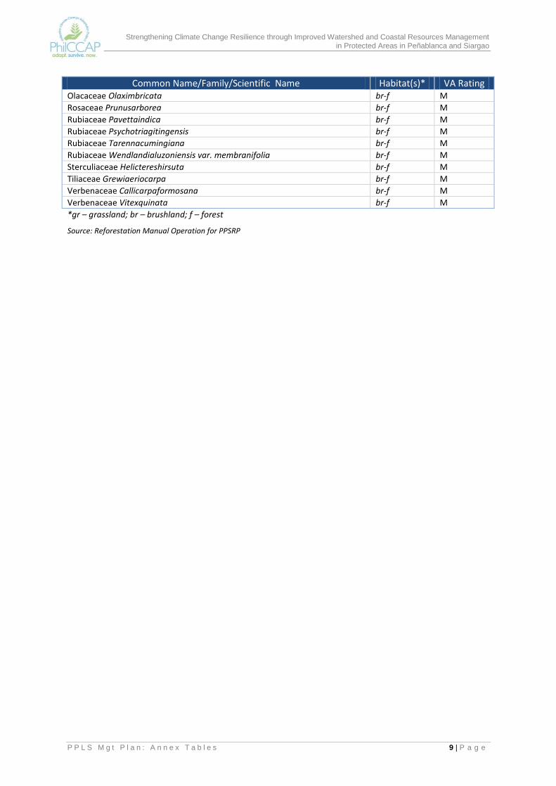
Strengthening Climate Change Resilience through Improved Watershed and Coastal Resources Management in Protected Areas in Peñablanca and Siargao
P P L S M g t P l a n : A n n e x T a b l e s 9 | P a g e
Common Name/Family/Scientific Name Habitat(s)* VA Rating Olacaceae Olaximbricata br-f M
Rosaceae Prunusarborea br-f M
Rubiaceae Pavettaindica br-f M
Rubiaceae Psychotriagitingensis br-f M
Rubiaceae Tarennacumingiana br-f M
Rubiaceae Wendlandialuzoniensis var. membranifolia br-f M
Sterculiaceae Helictereshirsuta br-f M
Tiliaceae Grewiaeriocarpa br-f M
Verbenaceae Callicarpaformosana br-f M
Verbenaceae Vitexquinata br-f M
*gr – grassland; br – brushland; f – forest
Source: Reforestation Manual Operation for PPSRP