Management of Natural Resource....Traditional Wisdom of the War Khasis, Meghalaya
78
TRADITIONAL WISDOM AND SUSTAINABLE LIVING A Study on the Indian Tribal Societies) Editors Hrishikesh Mandal Amitabha Sarkar Anthropological Survey of India
Transcript of Management of Natural Resource....Traditional Wisdom of the War Khasis, Meghalaya
TRADITIONAL WISDOM AND
SUSTAINABLE LIVINGA Study on the Indian Tribal Societies)
Editors Hrishikesh Mandal Amitabha Sarkar
Anthropological Survey of India
Traditional Wisdom and Sustainable Living (A Study on the Indian Tribal Societies)
© Anthropological Survey of India
ISBN : 978-81-212-1164-2
All rights reserved. No part of this book may be reproduced in any manner without written permission
Published in 2013 in India by Gyan Publishing House
23, Main Ansari Road, Daryaganj,New Delhi - 110002
Phones : 23282060, 23261060 Fax : (011) 23285914
E-mail: [email protected] website: gyanbooks.com
Laser Type Setting : Rajender Vashist, Delhi Printed at : Chawla Offset Printers, Delhi
10Management of Environment
and Natural Resources Study on Traditional Wisdom
among the War Khasi of Meghalaya
R. R. Gowloog and S. Mukherjee
In tro d u c tion
Historical material on the Khasis, before the advent of the British, is scarce and scholars have had to deal with incomplete and inconsistent records. But it has been well established that the Khasi and Jaintia Hills formed one kingdom, which in course of time became divided to two separate kingdoms - the Khynriam and the Pnar(Jaintia). These kingdoms in turn, were divided into several political units (Bareh - 1967 - 13).
The Khasis are a Scheduled Tribe of Meghalaya and are divided into five groups known as (1) Khynriam, (2) Pnar, (3) Bhoi, (4) Lyngam and (5) War, occupying different parts of the state. The Khasis speak a Mon-Khmer language which belongs to the Austro- Asiatic family. They follow the matrilineal descent system.
The Khasis belong to one of the earliest groups of people migrating to North-East India. They are the nearest cognates of the Austrics in view of anthropological and linguistic findings. That the ancient Khasis had settled in Assam before coming to this present abode is shown by the Austric names of ancient places in Assam. The remains of megaliths of Austric origin scattered
476 Traditional Wisdom and Sustainable Living
over the hills and plains of North-East India also lead to the h i i i i i k
conclusion (Bareh - 1967).
No separate historical account of the War Khasis is available Thus the historical accounts relating to the Khasi people in general largely stand true for the West Khasi Hills also. There are historian! indications to show that they had migrated from outside and littil a fairly developed political organisation and detailed administration for the villages as well. They also had a highly developed technol<>nV of iron smelting and manufacturing iron tools which were exporl < • I to distant places on the south as well as north (Bareh - 1907, Dasgupta - 1984, Gurdon - 1907).
This present essay is based on the study conducted in Maw lam village under Pynursla Block, East Khasi Hills districts, Meghalaya The study deals with tribal wisdom among the traditional Wm Khasi people who are spread throughout the Pynursla Block anil surrounding areas. They are concentrated over the highly dissert ,oi I plateau gradually sloping down towards south from the ridge ami culminating abruptly in the Bangladesh plains.
Mawlam, a typical War village, was selected for detailed ntwtl\ mainly due to its location in a remote corner of the south weslnt n part of the Pynursla Block and still dominated by traditional religion called ‘Niamtre’. The village is approachable by a partially metal I oil road from Pynursla village, the block headquarters. One haw In cover a distance of about 15 kilometres from the diversion point on the Shillong — Dawki Highway at 58 kilometres from Shillonn, the state headquarters.
The village is mainly inhabited by the War Khasis. The low migrant labourers found there, however, cannot be considered o part of the village population and are not considered so by IIto villagers themselves. The total population of the local people according to the records available with the Pynursla Block ollko is 556 of which 254 are males and 282 are females. The total number of households according to the same source is 135. Sin li households are distributed over a number of clusters, sample
AREA IN FOCUSThe main objective of the present work is to study the traditional
wisdom in relation to environmental resource use and conservation Hence the enquiry was directed to document and understand I on the indigenous knowledge of the people about their traditional sources of livelihood in West Khasi Hills district of Meghalaya, l"
Management o f Environment and Natural Resources 477
understand the traditional forms of resource utilization, the traditional technology of preservation and conservation of natural resources, and to understand the changes, if any, in the above respects.
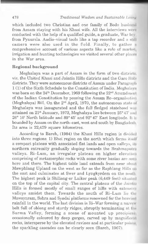
The study is based on a purposively selected village called Mawlam, located in interior part of Pynursla Block of East Khasi Hills Districts. The purpose of selecting this village was to find a village which was rich in traditional wisdom regarding environmental management. This was discussed with local knowledgeable officials and key informants at the Pynursla Block Office and finally the village under study was selected. The whole Pynursla C D Block is the traditional homeland of the War Khasis living in symbiotic relation with the environment for a few thousand years or so.
Fig. 1. Location o f studied village in the R i War or the War country, the traditional habitat o f the War Khasi people.
The requisite data for the purpose were based on observation and interview. The interview was based on the schedule for village survey along with a detailed guideline provided by the office project coordinator. Schedules on household survey were used to take the information regarding demographic as well as resource possessions. Households were selected purposively again to get samples from various economic levels to get a complete picture of the different resources utilization patterns. In total 52 households were covered
478 Traditional Wisdom and Sustainable Living
which included two Christian and one family of Bodo husband from Assam staying with his Khasi wife. All the interviews won' conducted with the help of a qualified guide, a graduate, War boy, from Pynursla. Audio-visual tools like a tap recorder and a nIIII camera were also used in the field. Finally, to gather it comprehensive account of various aspects like a role of market irrigation and hunting technologies we visited several other plan in the War area.
R e g io n a l back grou n d
Meghalaya was a part of Assam in the form of two district m, viz. the United Khasi and Jaintia Hills districts and the Garo 1 lilln districts. They were autonomous districts of Assam under Paragraph 1 (1) of the Sixth Schedule to the Constitution of India. Meghalaya was born on the 24th December, 1969 following the 22nd Amendment of the Indian Constitution by passing the Assam Re-organisation (Meghalaya) Bill. On the 2nd April, 1970, the autonomous stato "I Meghalaya was inaugurated and the full fledged statehood wan attained on 21st January, 1972, Meghalaya lies between 25° 47' anil 26° 10' North latitude and 89°45' and 92° 47' East longitude. It In bounded by Assam on the north-east, west and south by Bangladesh Its area is 22,429 square kilometres.
According to Bareh, (1984) the Khasi Hills region is divided into three regions 1 ) Bhoi region on the north which forms H h p M
a compact plateau with associated flat lands and open valleys, II *> northern extremity gradually sloping towards the Brahmaputin valleys. Ri-Lum, an irregular plateau on higher elevation comprising of metamorphic rocks with some river basins are seen here and there. The highest table land extends from near about Mawphlang Upland on the west as far as the Raphlang Hillw an the east and culminates at Swer and Lyngkyrdem on the south The highest peak is Shillong or Laikor peak (6,449 feet) situated on the top of the capital city. The central plateau of the Jain! in Hills is formed mostly of small ranges of hills with extcnalve valleys amidst them. Towards the south of Ri-Lum lio the Mawsynram, Sohra and Syndai platforms renowned for the heavliml rainfall in the world. The last division is Ri-War forming a narrow belt full of oblong and sturdy ridges, abruptly terminating at t he Surma Valley, forming a scene of mounted up precipicnn, occasionally coloured by deep gorges, carved up by magnificent rocks, intersperse by the elevated ravines and at particular point m
the sparkling cascades can be clearly seen (Bareh, 1967).
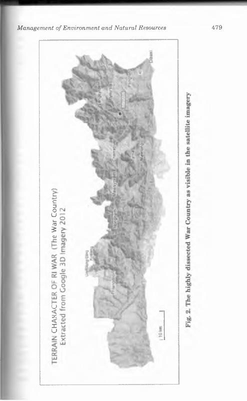
Management o f Environment and Natural Resources 479
c3ou03$at
U < o'.: < Xu
480 Traditional Wisdom and Sustainable Living
The climate of the region differs due to variation in altitude* and terrain. Generally the high hills enjoy a salubrious climato through most part of the year. The region is directly influenced by the south-west monsoon. It is interesting to note that Cherrapunjeo at the southern extremity of Ri-Lum received the highest rainfall and in 1961 the total amount of rainfall came up to about 900 inches but recently Mawsynram, lying west of Cherrapunjee, haw received more rainfall than hitherto rainiest place.
The three main communities in Meghalaya are Khasi, Jaintia and Garo. The Khasis and the Jaintias inhabit the eastern and central portions of Meghalaya. They speak a Mon-Khmer language, where as the Garos inhabiting the western part of Meghalaya speaks a Tibeto-Burman language. All these three communitiow are distinct in terms of their matrilineal kinship system. Mori' than sixty percent of its population are Christians, the remain inn being distributed among "animists”, Hindus, Muslims and Jain:.
The origin of the name ‘Khasi’ is shrouded in mystery and no one has so far been able to come up with a satisfactory explanation of the term. It has been derived, according to some, from tho Indo-Aryan word ‘Khas’ signifying waste or scrub land. ‘Khasi’ oi ‘Khasia’ would thus mean, according to them, an inhabitant ol scrub country (Meghalaya Districts Gazetteer, Khasi Hills Distra in 1991: 1). To quote Bareh again “The term Khasi has a particuhu significance. Kha means born of and Si refers to an ancient mot/m It is relevant to add here that the various names o f clans bear thru mother’s names. For instance Sawain clan owes its name to S<i, the ancestress; Ngap Kynta bears the name of Ngap, the ancirnl mother of that clan... This system of ascribing the names of clan* after mother, is, as well, intimately related to a matrilineal system of the people themselves. Khasi therefore, indicated, an original derivation and a legacy bequeathed upon the descendants" (1907)
The state is now divided into seven districts, each with an Autonomous Districts Council. These districts are (1) East Kim i Hills district; (2) Jaintia Hills districts; (3) West Khasi Hills dist 11< i(4) Ri-Bhoi districts; (5) East Garo Hills district; (6) West (Jam Hills district and (7) South Garo Hills districts. The East Klnml Hills district is predominantly dominated by the Khynriain ami War Khasis. The Jaintia Hills districts by the Jaintias or 1'imi the West Khasi Hills districts by Wars and Lyngngams; Ri I Mini by Bhois; and the three other districts by the Garos. The Dinti n l» Councils are not only autonomous in internal affairs but nlmi m I an intermediary body determining the relations between the poo|ili
Management o f Environment and Natural Resources 481
on one hand and the state and the Union Governments on the other (Bareh 1967).
Natural ResourcesSOIL : There are three main types of soils in Meghalaya the
red loam or hill soils, the laterite soil, and the old alluvium. The red loam or hill soils occupy almost the entire region except a limited tract in the foot hills and sub-mundane fringes and a pocket in the south western Mikir Hills adjoining the Jaintia Hills. These soils are generally loamy, varying sometimes between clay and sandy loam and are rich in organic matter and nitrogen. These are usually acidic and are good for the cultivation of fruits, potatoes and rice in hill slopes and terraces. The soil is, however, deficient in phosphate and potash.
The laterite soil of the plateau are confined to a small fringe extending from west to east in the northern border of the plateau with its important concentration in the south-western part of the Mikir Hills adjoining the Jaintia Hills. These soils are highly leached, poor in plant nutrients and acidic in reaction.
The old alluvium is found in the highland areas bordering the plains, all along the northern fringe of the region. These soils occupy very low percentage of the region and are usually very much acidic in nature. In texture they vary from sandy to clay loam with a varying degree of nitrogen from high to low content. They are deficient in available phosphate. These soils are used for the cultivation of rice, fruits, vegetables and tea (a limited average) in the Mikir Hills region adjoining the Nowgong and Sibsagar districts (Singh 1971).
The vegetation is rich. To quote Sir Joseph Hooker, ‘’The flora of the Khasi Hills in number and variety of fine plants is the richest in India and probably in Asia” (1856: 490). Nature and climate have exercised a tremendous influence on the life and activities of the people. Impressed with the scenery of the Khasi Hills, the first English observer (1826) compared the country to the highlands of Scotland, whereas Sir Joseph Hooker in 1856 compared the pastures of Mairong to those of New Zealand. During the Second World War, the Khasi Hills was nickname ‘the Scotland of the East’ and Shillong (then headquarters of Assam) situated in the heart of the land was known as one of the lovely ‘Queens of Hill Stations’ in India. (Bareh, 1967: 9)
The region is very rich in mineral resources but so far only coal, limestone and sillimunite have, to some extent, been
482 Traditional Wisdom and Sustainable Liu mu
commercially exploited. Recent investigations have revealed th<< presence of clay, corundum, glass, sand, phosphate, iron, uranium etc. The important minerals of the region are-
(1) Upper cretaceous and lower tertiary coal in Garo, Khasi and Mikir Hills;
(2) High grade numulitic limestone, in a belt extending from Garo Hills in the west through the Khasi, Jaintia, Mikir Hills in the east;
(3) Sillimanite and corundum deposits in Sonapahar area of the Khasi Hills;
(4) Clays including Kaolin or ‘China-Clay’ in the Garo (Turn area), Khasi (Mawphlang area), Jaintia and Mikir Hills, t he Garo Hills alone having more than 35 million tons of kaolin and occurring in as many as ten places;
(5) Glass sands in the coal-fields of the Laitryngew ami Cherrapunjee areas in the Khasi Hills;
(6) Banded iron-ore in the border areas of the Khasi Jaintia Hills and the Assam Valley;
(7) Copper, in the Umpyrtha and Ranighat areas in the Khun I and Jaintia Hills;
(8) Gold bearing rocks with a trace of 1.2 penny weight of gold per ton of rock, south-west of Mawphlang in the Khasi Hilln, and
(9) Gypsum in the form of Sebe'mite crystals and disseminated in shale beds, near Mahendraganj in the Garo Hills and in some places in Mikir Hills.
Regarding regional distribution of the said potentially rlili mineral wealth, Meghalaya plateau not only has the groat enl
concentration of minerals but also has accounted for a high regionnl income from mining in the Meghalaya. This section of Meghnlm n produces more than 90% of the total sillimanite of India which In
mined in and around the recently established mining cent re ofSonapahar, about 3 kilometres north of Nongmaweit in the nort l.....part of the Nongstoin state of the Khasi Hills, from 13 deposit III a belt, 20 kilometres long and 1.5 kilometres wide reserves of tin natural refractory, world famous from the point of view of quuill II vand purity and for occurrence in the form of massive rockn I.....which blocks can be sawn for direct use in furnaces, have In i n estimated at about 0.5 million tonnes. Corundum, another vnlunhlti mineral, is found to occur in association with the sillimite doponlln
Management o f Environment and Natural Resources 483
Coal has been exploited to a great extent in the Garo and the Jaintia Hills.
The exploitation of nummulitic limestone is also very significant in the region. Bulk of the limestone is being utilized in the cement factory at Cherrapunjee.
The wide variations in climatic conditions in elevation as well as in the character of the soil offer scope for the cultivation of a wide variety of agricultural crops and fruits trees, ranging from species adapted to tropical conditions to those that thrive in temperate climate. Major crops are rice, maize, millet etc. Productions of these are for self consumption only. The introduction of tapioca the Forest Department helped to stabilize the situation in time. According to the 1981 census report as many as 84 (eighty four) villages in the area raised tapioca. Many villages are large scale producers of potato. Potato was apparently introduced by David Scott into the Khasi Hills and immediately proved successful. The British Government started on an experimental farm at Upper Shillong in 1873 but discontinued the project after a short time because of the loss it sustained. The farm was, however, revived towards the close of the 19th century and the report for 1897 - 98 indicated that the potato experiment was very successful. It is also one of the major cash crops. It can be grown in rotation with rice, thus ensuring the maximum utilization of land as well as greater profit. Sweet potato and yam are grown for domestic consumption other important cash crops are areca nut, betel leaf, black pepper, bay leaves, ginger, broom stick etc.
Almost all kinds of vegetables suitable for varying climatic conditions are also cultivated, e.g. carrot, cucumber, turnip, varieties of beans and peas, cauliflower, cabbage, tomatoes, chillies, brinjal, okra, gourds etc. The soil and climate are also conductive for the growth of variety of fruits like orange, pineapples, lemons, bananas, guava, mango, jackfruits, litchi, pears, peaches, papaya, plums, etc.
Geographical aspectsThe Southern portion of the Shillong Plateau under the East
Khasi Hills District is dominantly inhabited by the War Khasi group stands as a distinct physiographic and cultural unit. In fact War Khasi villages are scattered all over this highly dissected plateau surface which, as per Dasgupta (1984) is bounded by Mahram state, Mawsynram state and Laitlyngkot on the south by Mymensing and Sylhet districts of Bangladesh mid on the east by
484 Traditional Wisdom and Sustainable Livinti
Jaintia Hills with extreme point reaching Lubha River. Roughly within the co-ordinates of 25° 10" to 25° 27" north latitude and 91°10" to 92°05" east longitude the region spreads approximately Hfi km. along the Bangladesh Border and 20 km. along north-south
Physiography: The Khasi Hills as a whole may be roughly divided into three prominent physiographic zones from north to south. The Central ridge, the highest part of the Meghalaya Plateau is called Khasi Highland with average height of about 1000 ni includes Shillong Peak (1964 m.) stands mighty as the Central zone. On the north of it the plateau drops slowly stepwise upto tho edge of the Brahmaputra plain of Assam. This moderately sloping rolling hills region is termed as Ri-Bhoi were altitude average* around 600 m. The third zone starts immediately the southern edge of the central Khasi upland roughly conforming to the 4000 feet (1000 m) contour line. This narrow elongated ‘Ri-War’ region is highly dissected by many small and big streams and river* flowing south ward into the Bangladesh plains. The highest relative relief with deep gorges over the old erosional levels of the plateau are the most striking. Topographical features of the region is very heavy rainfall, mostly from the south west monsoon is tin responsible factor for shaping the topography of this War region which includes Mawsynram and Cherrapunjee the worlds high enl rainfall sites. The central ridge acts as the orographic barriei leaving the northern part as rain shadow area of the monsoon current.
The Meghalaya Plateau has a complex geological and geomorphological history being the part of the ancient Gondwan# super continent separated by the Garo-Rajmahal gap on its westoi a boundary. The plateau contains within its barren faceted marks ol several peneplains or the old erosion surfaces, which ranges from Pre-Cambrian to Recent and Sub-Recent periods. This Pre Cambrian Gondwana block experienced several emergence and submergence with erosion, sedimentation, diastrophism, intrusion, movement of land and sea and emission (Singh - 1971). The northern part of the War country, just south of the Shillong Hill* has a typical granitic topography with rounded hills and shallow valleys compared of the Myllium granite. Further south beyond Myllium there is a vast structure platform on which stand* Cherrapunjee. This part is composed gently dipping sandstone* ol cretaceous age. This structural platform stands as an escarpment and its face has been attacked by flurried action due to extremely heavy rainfall and as a result of which a number of platforms, e m
Management o f Environment and Natural Resources 485
Cherrapunjee, Lyngkyrdem and Mawsynram have been formed. From Cherrapunjee and Lyngkyrdem the terrain has a gentle slope southwards for about 7 -10 km. and then falls rapidly to the Sylhet Plains (Singh, 1971).
The drainage pattern in the region represents a most spectacular feature of extraordinary straight river courses evidently along joints and faults. The magnificent gorges scooped out by the rivers in the southern Khasi Hills are the results of massive hardward erosion by the antecedent streams along joints of the sedimentary rocks over the blocks, experiencing relatively greater upliftment.
The War region is drained by several south flowing rivers and streams originates from southern flank of the Central Upland.
Along the eastern boundary of the War Um-Ngot River is one of the longest in the region. It originates near the Shillong Peak and has a straight flow southward with a westward bend in the middle and finally enters Bangladesh plains of Dawki taking the name Pigain Gang. It has a relatively large catchment area which includes the eastern part of the Shillong - Dawki Highway. This Highway runs along the narrow ridge between Laitlynkot and Pynursla forming the water divides with another important system on the west run by the river Umsohryngkew and its tributaries. In between these two drainage systems a small triangular segment of the lower plateau with its crest near Pynursla village, is drained by the river Umkrem. Further west the source flows just west of Shillong Peak. It has a narrow long course sandwiched between Cherrapunjee plateau on the east and Mawsynram and enters Bangladesh at Sheila Bazar. The Umngi River drains the western flank of Mawsynram ridge. Finally the Kynchiang or Jadukata River, the longest river course of the War country forms roughly its western limit. However, all along the Bangladesh border there are some minor rivers or rather hilly streams like Ballat, Rengua, Mawkam, Armen, Erangaru etc. which along with all others rivers mentioned above are draining their waters into the Surma River in Bangladesh.
Climate: A huge difference in altitude, very high slopes of the valley walls, direct exposure to the strong tropical monsoon currents from Bay of Bengal are the important keys to understand the climatic characters of the War region. From more 80 m on the south to above 1000 m on the north is an immense altitudinal range within a maximum aerial distance of only 32 km (near Lyngkerdem village).
486 Traditional Wisdom and Sustainabli' /.iem«
The meteorological significance of the War region is ovitlonl from the fact that two of the five major meteorological station til Meghalaya are located here, i.e. Cherrapunjee and Mawsynrnm recording world’s highest rainfall. These two stations are IochUmI only about 165 km apart and almost along 25°17'’N Latitude. Tlin normal annual rainfall recorded (Census - 1981) are 7.378.94 nun in Cherrapunjee and 10.093.53 m in Mawsynram most of which Iw received during the actual rainy season from May to Septemhei, though April and October are also fairly wet. The geographic foal in tt of these two stations are unique in the sense that sheer cli 11m of about 1000 m up to the edge of the table and faces directly houIIi providing a huge barrier to the monsoon clouds. Thus, it is expod t >1 that even within this micro region we may get considerable variation of fall depending on the location and direction of vnll« \ walls. Likewise, air temperature varies with the altitude. TIim tablelands reaches above 900 m enjoy milder temperature compart "I to the deep valleys and low lying patches of plains along I In Bangladesh border having hot-humid condition. The innim maximum temperatures for Cherrapunjee are 20.6°C and moan minimum is 14.3°C. But there are no such recordings in any low valley areas to understand the range of variation in normal month U temperatures with 9.20°C in January the coolest month and I In 16.91°C in the hottest month August. But as major part of Hit region is lower in altitude than the other stations, the gonoral climatic conditions must be warmer with higher differences bet wet < i winter and summer temperature. In fact in most part there in a short dry winter of moderate temperature between November ami January followed by a dry pre-monsoon months of March A|iiil characterised by very strong winds spreading wild fires over tin grassy slopes. Then the long hottest and wettest season between May-October is prevalent along this southern plateau slopoH
Geology of War Country: The northern most part, which In in fact the southern flank of Central (Shillong) ridge is mottllv Shillong group of quartzite lying unconformabely over the Arclnn mi gneissic complex. Then the rocks are intruded by acidic siltH anil dykes around Myllium are hard Myllium granites. To the south nl Lyngkerdem up to the Bangladesh border Cretaceous Tertlai v Sediments occupies the thick and extensive beds, a continuity "I the same series of Bangladesh Basin. The sediments are main I v sandstone and shale and most of the major coal and limoHtnm deposits of the area.
Management o f Environment and Natural Resources 487
Soil: The archaran and Pre-Cambrian rocks under the impact of heavy tropical rainfall have developed into Red Loam or Hill soils over most of the plateau with certain exception of Laterites and alliiminms- These soils are generally loamy, varying sometimes between clayee and dandy loam and are rich in organic matter and nitrogen. These are usually acidic and suitable for orchards of fruits, potatoes etc. However, the soils are deficient in potash and phosphate (Singh, 1971).
On the southern part of East Khasi Hills District soils are of somewhat different types depending on the local geologic formation and climate. The Pynursla Block and the adjoining War country possess mainly two types of soils. Those are as per I.C.A.R. classification
(1) Udalfs-Ochrepts-Orthents - with high base status and of shallow black and brown colour, which have formed recently under humid climatic conditions. This type roughly occupies the portion north of Pynursla village over the high plateau slopes and tablelands when potato and orange grows well.
(2) Ustalfs-Ochrepts-Orthents - the shallow black, brown and recent alluvial soils utilized well for oranges, betel nuts, betel leaves, all over the southern most part upto Bangladesh border (Census 1981).
Flora: Though the Meghalaya Plateau is well known for its unique bio-diversity having a wide range of endemic species the present day forest cover is far below the significant level from environmental point of view. Still the last traces of greens are found mostly in the form of sacred grove’s and village or community forest which is preserved as part of the old tradition of these people.
In the Central and Eastern Meghalaya including Khasi and Jaintia Hills districts, the vegetation types can broadly be grouped into.:
(a) The mixed tropical evergreen hardwood are found in the northern and southern parts upto an elevation of about 300 m where main species are Sal, Sam, Champa, Gamhari, Boli, etc. besides the thickets of bamboo, cane and wild banana trees in the slopes and narrow valleys;
(b) In the middle altitude belt between 300 - 700 m the rolling grasslands of the Central plateau trees and shrubs are bare with scattered pine trees;
488 Traditional Wisdom and Sustainable Living
(c) Mainly Pine trees are found along with Willow, Birch, Mokrisal, Oak, Mongolia, Beech and Rhododendrons etc ovm the highest part of the plateau around Shillong above 75(1 in
One of the significant peculiarities in vegetation covoi In observed in the southern faces of the Shillong Plateau including the War country. In spite of very heavy precipitation under troplcnl conditions we do not get a dense evergreen rainforest in the pm I The entire area looks black and dreamy with hillocks and !h« landscape is characterised by occasional open grassland through which the underlying rocks project out. This is mainly due to I wo factors the steep slopes and the structural character of the horizontally laid limestone beds which helps quick draining of rnln water leaving a very badly leached soil on surface (Singh - 10711 But over the lower slopes and the head ward region of the niii id I and medium catchments one can find lush green blocks and 8trlpn compound of a very rich species of trees and under growl It resembling rainforests. In brief the natural vegetation of Kim i Hills can broadly be divided into the Tropical (upto about 1000 in i and warm temperate type (on the higher region) (Simon - 19011
The richness in floral diversity of the War country can well Im projected from the comments made by Dr. Joseph Dalton Iloolwi in his Himalayan Journals (1850): “It is extremely difficult to //in within the limits of this narration any idea of the Khasi Hills /lot n which is, in extent and number of fern plants, the richest in I ml in and probably in all Asia. We collected upwards o f 2000 flowi’riii/i plants within ten miles of the station of Churra (Cherra) beuldc« 150 ferns, with a profusion of mosses, litchens and fungi" iiihI again “In fact, strange as it may appear ... the temperate /lout descends fully 1000 ft lower in the latitude of Khassia (25 di'Ul., N ) thus, and that of Sikkim (27 degree N ) though the former in hi m degrees nearer to the Equator”.
Further Hooker (1850) has given a first hand account of tin vegetation on the southern slopes of the East Khasi Hills di.sli n i He observed many varieties of palm trees of those twenty loin! being indigenous including the cultivated betel nut with its grnci'lnl standard feathery crown adorned the verdant slopes. Tree*) III" oaks, oranges, gamboges, diosphyros, figs, jacks, plantains, and h c m w
pines and many more frequent here together with virus and popp«i m The broader leafed wild betel nuts, and beautiful earyoter or wlm palms with huge leaves twelve feet long. There are usual previdom t of numerous parasites, epi-physical orchids, ferns, mossoH mid Lycopodiums - and host of bamboo species. (Dasgupta, 198,'!)
Management o f Environment and Natural Resources 489
North Eastern India being declared as one of the eight ‘Bio- Diversity Hot Spots of the world’, faces a serious threat for steady depletion of its forest cover. In Meghalaya the situation is among the worst with only 42.34% of total geographical area under any type of forest cover which is second lowest only above Assam in North-Eastern states in terms of the rate of depletion of forest cover between 1993 and 1995. Meghalaya (39.78%) again came second only to Nagaland. The Forest Survey of India, Report (1995) further stated that the actual healthy dense forest cover, the environmentally useful land is only 20.96% of the total forest cover in Meghalaya, the lowest among all N.E. states. The remaining 79.04% of forest are the mixture of open and degraded types. The impact of the Supreme Court order towards the enforcement of Front Conservation Acts since 1996 has not yet been assured. But the sudden drying up of a major source of income generation through illegal sale of forest products may develop a paradox as the rural Meghalayans will not find any alternate occupation than their traditional Jhum Cultivation again. In fact, Jhum cultivation change forest on hill slope could not be stopped totally and some ...110 sq. km of forest waste converted to jhum fields during 1991 - 1993 and also to plantation agriculture (NEC, 1995). This jhuming or shifting cultivation is observed as the main factor responsible for depletion of natural resources. This is because due to increased population that the jhum cycle has become shorter from around 30 - 40 years to as low as 6 - 10 years or less at present (Simon, 1991). Hence usual term of regeneration of the forests on fallow jhum lands is not allowed and also as the forests and mostly owned by families jhuming cannot be prevented easily.
C u ltu ra l S et U p
Mawlam, the village under study, is mostly inhabited by the War Khasi people. People in the village believe the War Khasis to have migrated from the Cherra side. Those settled in the upper side are known as War Phlang (grass land) and those who settled down slope were known as War. Some also believe the term War to be an anglicised term from Wah meaning river. An interesting story is narrated by some elders as to why the name “Mawlam” meaning guiding stone ‘Maw’ meaning ‘rock’, ‘Lam’ means ‘one who leads the path’. Originally the village was far down the slope on the northern side. Once, a group of Synteng people from Jaintia Hills came to that village to capture some land. At the entry point one stone with a small stone resting on top blocked the way of the
490 Traditional Wisdom and Sustainable
invaders. The villagers found the invaders trapped by that ntoii** The invaders begged pardon and promised never to come Inn l« again. So the villagers believe that they were saved by that stone Since then they consider the stone as Ublei (God). Every year t in \ worship the stone in the month of March. I f anybody disturb* m touches the stone; a tiger with a man’s head or a man without head will appear indicating God’s wrath. They appease with mum sacrifice and annual worship. The whole village was later shill• ■<! to the Upper part of the hill as they found a flat surface. But mI III they have much area in Podwar region.
Village Mawlam nestles on the southern slope of a hill mill slowly descends to the Bangladesh plains. Viewed from the top the village is hardly perceptible with the green foliage with which the southern slopes are clad. Thick jungle having large grove* nl betel nut and other fruit trees surround the main village. Thun is no paddy land in the village and the people do not cultivate tin crop. Shifting cultivation is practised in the neighbouring jungle Communication between houses are maintained with narrow footpaths or rough stone steps. Mawlam is one of the eleven Raldn under Pynursla Block. The village comprises a number of hamleln or Khels. These Khels send their headman to represent them In the village council or Dorbar Shnong. The houses (mainly Kalelm and semi Pucca) clusters together in various pockets. No area nl the village is kept separate for any particular clan; all categoric" of people live together. There is one Government Lower Primm \ School for the whole village up to Class - IV, employing four (41 teachers. Recently they have built one community hall, whicli win* yet to be inaugurated. Most interesting thing to be noted in (lit maintenance of traditional houses built with good quality of wood type of bamboo, stone and thatched roofs. There were only Iwn pucca buildings in the village viz. school and one shop, most houncn were semi-pucca. The houses were constructed in such a fanhl<m that they best suited this region and most materials used In construction were locally available. Triangular shaped plots of laml are avoided because it brings bad luck and death occurs in 11 ml family ultimately leaving none. Boundary stones are always tronli •! with respect. In case one happens to touch it or go over it, he/nln will suffer rheumatic pains and victims are advised to tie a si i n\* or creeper around the stone and thereby transfer the affliction In the stone. They prefer their houses facing eastward. A comimm playground lies in the centre of the village, which is typical of mi\ large and important War village, which is meant for any kind "I community gatherings like annual religious festivals and dam c.
Management o f Environment and Natural Resources 491
etc. The two main sources of water, natural springs, lies either side of the village inside the Law Adong Wah Shiep lies towards north east and Wah Tlang towards south-west of the village. Water scarcity prevails during winter months. To reach these two water sources needed quite steep descend. As told by the villagers during summer pits (Shynkhah) were dug at the front of the houses to store rain water for washing and other purposes.
All their fields of broomstick, orange, bay leaves and orchards lies away from the village and most of the family members leave their houses at dawn carrying their lunch packs (made locally from bark of betel nut trees) and return only after sunset.
Domesticated animals were mainly pigs, and fowls. They had no concept of consuming milk so no cows are reared. But spilling of milk on the fire is considered harmful to the animal from which the milk has been obtained and to ward off the injurious consequences salt is sprinkled on the fire immediately. Sometimes milk packets are brought for consumption from Shillong.
Regarding dress, majority of males have adopted the western type dress, i.e. coat, trousers and shirt. Their traditional dress was a small cloth round the waist and between the legs, one end of which hangs in front like a small apron (Sleng). A sleeveless coat (Jymphang) with a row of tassels across the chest which acts like button, elderly men wear turbans. A bag made of cloth or some back of a tree is slung across the shoulders for carrying their necessary things. Most women, particularly those of the rural areas are still conservative regarding their dress known as Jainsem (two pieces of cloth pinned over the shoulders). The undergarment of the women is a petticoat (Kashimi) and a blouse (Ka Korkhakti) is worn. Over these piece of cloth (Jainkyrsa) is used as an apron. A head shawl or Tapmohkhlieh knotted at the back of the neck. Over this a larger piece of thicker texture called the Jainkup is knotted in front. They are fond of ornaments of gold, silver, various coloured precious stones and beads.
The weapons of the Khasis are swords, spears, bows and arrows, mostly prepared by local smiths. They never use wood or bone handles for their swords, only iron and steel. The Khasi weapon par excellence is the bow (ka Syntieh). The bow is of bamboo, and is about 5 feet in height. The bow string is of split bamboo, the bamboos that are used are Uspit, Uskhen and Usiej-lieh.
The arrows (Ki Khnon) are of two kinds, (a) the bark headed (Ki Pliang), and (b) the plain headed (Sop). Both made of bamboo. The first is used for hunting, the latter for archery matches only.
492 Traditional Wisdom and Sustainable Living
Khasi society may be divided into three groups, the ruling class (Syiem), the priestly class (Lyngdoh) and the rest. In social v however, there is no separation of these groups and there in no bar to inter-marriage between one group and another. Howevm marriage within some clan is strictly a taboo. Even after marring" a man belongs to his own clan, though his earning goes toward* the support of his wife and children and in case his wife is lln< youngest (Ka Khadduh) he lives in his wife’s house.
Sickness is believed to be caused by acts of omission 01 commission against God or spirit. The reasons are sought liy divination, by seeing the positions and shapes of egg shells <u examining the entrails of the sacrificial cock, and appropriate remedies are resorted to.
When a person dies, his funeral and cremation are arranged on the third day, unless death is accidental. Normally, the deoil are cremated, but in time of an epidemic particularly of the eruptive diseases like measles, chicken pox, and small pox, temporary burial is resorted to. After the epidemic has passed, the body is exhumed and then cremated according to the usual practice. Food is left. I'm the use of the departed soul at the place of cremation. Fragment of bones are collected and taken by a female relative to tlm repository of the bones of the clan. She must walk steadily and look in front; not paying any attention to the possible distraction* that unfriendly spirits may arise. When a stream has to be cros*ed a string is run from bank to bank to serve as a bridge for the Hoid of the dead.
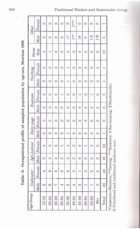
Demographic ProfileDemographically speaking the studied village represent* o
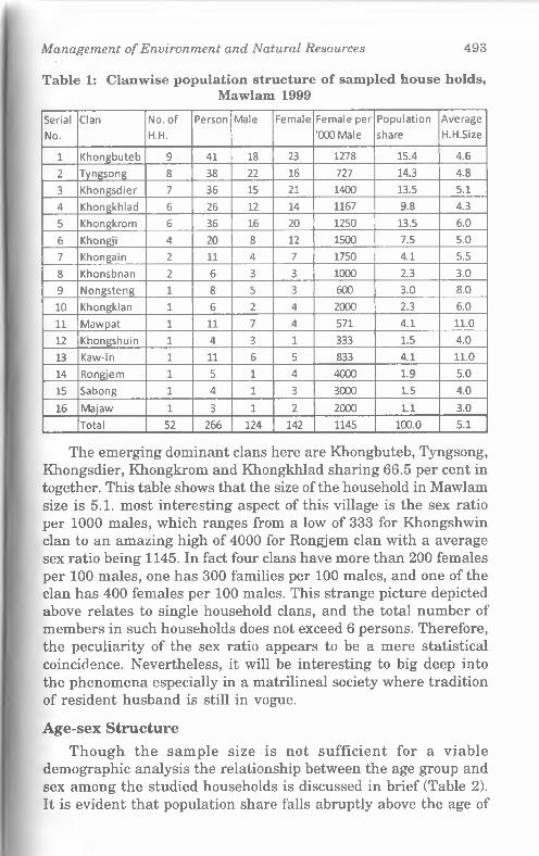
medium size Khasi village with 135 households of which 52 Imvr been covered in detail as required for the study. Considering I In clan of the head of the household, in this case that of the mothei in a matrilineal society, 16 such clans are recorded among tho*e sampled. However there were 22 clans found considering the cion of the husbands who reside at the in-law's house as per the Klmnl traditions. Perhaps such a large number of clans may have emerged as a consequence of strict clan exogamy. Those clans are ranked as per total number of representative households and a comparative account is presented to examine the sex ratio, share of population and household size (Table 1).
Management o f Environment and Natural Resources 493
Table 1: Clanwise population structure o f sampled house holds,Mawlam 1999
SerialNo.
Clan No. of H.H.
Person Male Female Female per '000 Male
Populationshare
AverageH.H.Size
1 Khongbuteb 9 41 18 23 1278 15.4 4.62 Tyngsong 8 38 22 16 727 14.3 4.83 Khongsdier 7 36 15 21 1400 13.5 5.14 Khongkhlad 6 26 12 14 1167 9.8 4.35 Khongkrom 6 36 16 20 1250 13.5 6.06 Khongji 4 20 8 12 1500 7.5 5.07 Khongain 2 11 4 7 1750 4.1 5.58 Khonsbnan 2 6 3 3 1000 2.3 3.09 Nongsteng 1 8 5 3 600 3.0 8.010 Khongklan 1 6 2 4 2000 2.3 6.011 Mawpat 1 11 7 4 571 4.1 11.012 Khongshuin 1 4 3 1 333 1.5 4.013 Kaw-in 1 11 6 5 833 4.1 11.014 Rongjem 1 5 1 4 4000 1.9 5.015 Sabong 1 4 1 3 3000 1.5 4.016 Majaw 1 3 1 2 2000 1.1 3.0
Total 52 266 124 142 1145 100.0 5.1
The emerging dominant clans here are Khongbuteb, Tyngsong, Khongsdier, Khongkrom and Khongkhlad sharing 66.5 per cent in together. This table shows that the size of the household in Mawlam size is 5.1. most interesting aspect of this village is the sex ratio per 1000 males, which ranges from a low of 333 for Khongshwin clan to an amazing high of 4000 for Rongjem clan with a average sex ratio being 1145. In fact four clans have more than 200 females per 100 males, one has 300 families per 100 males, and one of the clan has 400 females per 100 males. This strange picture depicted above relates to single household clans, and the total number of members in such households does not exceed 6 persons. Therefore, the peculiarity of the sex ratio appears to be a mere statistical coincidence. Nevertheless, it will be interesting to big deep into the phenomena especially in a matrilineal society where tradition of resident husband is still in vogue.
Age-sex StructureThough the sample size is not sufficient for a viable
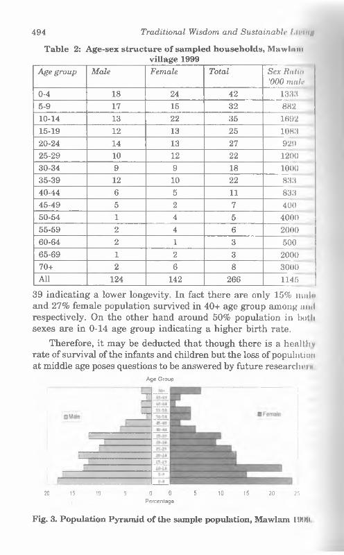
demographic analysis the relationship between the age group and sex among the studied households is discussed in brief (Table 2). It is evident that population share falls abruptly above the age of
494 Traditional Wisdom and Sustainable l.lI'ln#
Table 2: Age-sex structure o f sampled households, Mawliimvillage 1999
Age group Male Female Total Sex Iialin '000 mat?
0-4 18 24 42 13385-9 17 15 32 88210-14 13 22 35 169215-19 12 13 25 108320-24 14 13 27 92925-29 10 12 22 120030-34 9 9 18 100035-39 12 10 22 83340-44 6 5 11 83345-49 5 2 7 40050-54 1 4 5 400055-59 2 4 6 200060-64 2 1 3 50065-69 1 2 3 200070+ 2 6 8 3000All 124 142 266 1145
39 indicating a lower longevity. In fact there are only 15% mule and 27% female population survived in 40+ age group among ami respectively. On the other hand around 50% population in both sexes are in 0-14 age group indicating a higher birth rate.
Therefore, it may be deducted that though there is a healthy rate o f survival o f the infants and children but the loss o f population at middle age poses questions to be answered by future researches«
Age Group
20 15 10 5 0 0 5 10 15 20 25
Percentage
Fig. 3. Population Pyramid o f the sample population, Mawlam 11MMI
Management o f Environment and Natural Resources 495
The population pyramid (Fig. 3) also conforms to the above analysis and represents a typical conical form. Another remarkable feature that sex ratio is remains high in favour of female since both in all age groups except in a few, which, in other words, possibly represents the culture of female preference in the Khasi society.
Marital Status
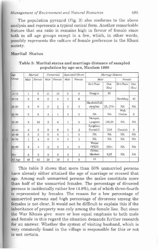
Table 3: M arital status and marriage distance o f sampled population by age-sex, Maulam 1999
AgeGroup
Married Unmarried Separated IDivorc Marmige Distance
Male Female Male Female Male Female Male Female
Birt Place Dist(Km)
Birt Place Dist.(Km)
15-19 1 3 11 10 0 0 Nongjiri 20
20-24 6 9 8 4 0 0 Mawkhap 40
25-29 8 9 2 3 0 2Mawbeh(2),K
okreyhar 25,170+ NA NA
30-34 5 8 4 1 0 0 NA NAWah
Umlun 5
35-39 9 10 3 0 1 0Mawpat,Lyngdem 150,23 NA NA
40-44 6 5 0 0 0 2Lyngdem,Pyma>(2) 23,6 Umniuh 8
45-49 5 2 0 0 1 0 NA NA NA NA
50-54 1 4 0 0 0 1 NA NA NA NA
55-59 2 4 0 0 0 0Weilai(WKH) 150+ NA NA
60+ 5 9 0 0 0 1 Mawbeh 6,25 NA NA
All Age 48 63 28 18 2 6 12
This table 3 shows that more than 50% unmarried persons have already either attained the age of marriage or crossed that age. Among such unmarried persons the males constitute more than half of the unmarried females. The percentage of divorced persons is incidentally rather low (4.8%), out of which three-fourth is represented by females. The reason for a low percentage of unmarried persons and high percentage of divorcees among the females is not clear. It would not be difficult to explain this if the inheritance of property was only among the female line. But since the War Khasis give more or less equal emphasis to both male and female in this regard the situation demands further research for an answer. Whether the system of visiting husband, which is very commonly found in the village is responsible for this or not is not certain.
496 Traditional Wisdom and Sustainable /.ii'iittf
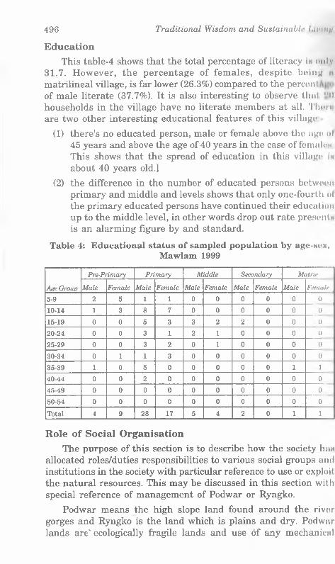
EducationThis table-4 shows that the total percentage of literacy In only
31.7. However, the percentage of females, despite boinu it matrilineal village, is far lower (26.3%) compared to the percont of male literate (37.7%). It is also interesting to observe that "il households in the village have no literate members at all. Then are two other interesting educational features of this village
(1) there's no educated person, male or female above the ago ol 45 years and above the age of 40 years in the case of femaloN This shows that the spread of education in this village In about 40 years old.]
(2) the difference in the number of educated persons between primary and middle and levels shows that only one-fourth ol the primary educated persons have continued their education up to the middle level, in other words drop out rate present* is an alarming figure by and standard.
Table 4: Educational status o f sampled population by age-wex,Mawlam 1999
Age Group
Pre-Prim ary Prim ary Middle Secondary M atrir
Male Female Male Female Male Female Male Female Male Female
5-9 2 5 1 1 0 0 0 0 0 0
10-14 1 3 8 7 0 0 0 0 0 0
15-19 0 0 5 3 3 2 2 0 0 0
20-24 0 0 3 1 2 1 0 0 0 0
25-29 0 0 3 2 0 1 0 0 0 0
30-34 0 1 1 3 0 0 0 0 0 0
35-39 1 0 5 0 0 0 0 0 1 1
40-44 0 0 2 0 0 0 0 0 0 0
45-49 0 0 0 0 0 0 0 0 0 0
50-54 0 0 0 0 0 0 0 0 0 0
Total 4 9 28 17 5 4 2 0 1 1
Role of Social OrganisationThe purpose of this section is to describe how the society hiiM
allocated roles/duties responsibilities to various social groups and institutions in the society with particular reference to use or exploit the natural resources. This may be discussed in this section with special reference of management of Podwar or Ryngko.
Podwar means the high slope land found around the river gorges and Ryngko is the land which is plains and dry. Podwar lands are' ecologically fragile lands and use of any mechanical
Management o f Environment and Natural Resources 497
instruments is impossible Ryngko lands are basically used for the cultivation of broomsticks which at one time was the major source of income for the villagers.
Crops grown in the Podwar regions are mostly potatoes, yams, maize, millet and a few varieties of pulses. Fruits are widely cultivated like orange, jackfruit, pineapple, banana and varieties of lemon. Vegetables like pumpkin, gourds, beans, squash and a few locally available leafy vegetables are grown black pepper, chillies, ginger, turmeric, garlic are also cultivated. Betel nut and betel leaf are also grown widely both for consumption and commercial purpose.
The War Khasi families are small in size and nuclear family is the dominant type of family composition. The authority in the management of the family rests on the wife; but the role and position of a husband in the family are not insignificant inspite of the matrilineal and matrilocal set up. All the adult capable members of the family, both male and female work in the fields, cook and serve meals, wash clothes, fetch water and do the marketing. Generally the womenfolk carry the garden products to the market and sell them there and purchase there the domestic necessities. The daughter’s friends help in each others family chores especially domestic help. Most of the heavy work is done by the men folk like construction repairing of roads/houses, carrying fuel from jungles, breaking stones, clearing of jungles and the outdoor work.
The wife manages all family affairs consultation with the husband and he represents her in the village councils and other extra domestic affairs. During the marriage of the children father’s approval is necessary. Hence the position of father in a War family is much better among the Khasis. Except the youngest one, other daughters establish separate families with their husbands and expected to be economically independent. Sons, after marriage, leave parental house, and they also have equal right from the parental property, a unique feature of the War Khasis. The youngest daughter, with whom the parents live, looks after the main house and takes care of her old parents with the help of her husband. One very peculiar feature amongst them is that of the visiting husband. Husband stays with his parents and helps there only at night he comes to stay with his wife and family.
The present section is based on the data collected from 52 households, inhabiting two Khels or hamlets of Mawlam. The War Khasis are divided into a number of exogamous clans (Kuror Jait). We would identify total 22 clans within Mawlam. Among the War
498 Traditional Wisdom and Sustainable l.iuutu
Khasis, there is no trace of totemic clan (Dasgupta - 1984).
The clan or Jait, and not the individual, is the unit of the Khasi society in which the eldest maternal uncle or U Khi is tlw head. Clan organization and function among the War Khasis m o not as elaborate as among the Khasi proper. Among the K I i i im I
people the clan members are bound together by the religious tin of ancestor worship in common and a common clan sepulchre (Gurdon, 1914: 65). Among them a very large proportion of land is also the property of the clan which is known as Rikur and the youngest daughter or Ka Khadduh in the line of the clam, whoso house is known as Kaiing Khadduh or last house, holds tho obligation of performing the religious ceremonies of the clan (Gurdon, 1914).
Role of Village AuthoritiesTraditionally the Khasis were divided into numerous nativo
states (Syiemships) that were administered by a king known as Syiem who had an executive council (Dorbar) consisting of Myntrirn, The Myntries in the Dorbar possesses judicial powers and in tho past was the highest court of appeal inside the Syiemship. At tho village level in the village Dorbar which looks into tho administration of the village. The Dorbar is headed by the Rangbali Shnong of village council who is assisted by the leading members of the village. He convenes a full village Dorbar attended by all adults of the village when important issues are to be considered and upon which decision has to be taken. At the Raid level, administration is conducted by the Dorbar Raid headed by a person known by different titles as Lyngdoh Raid or Syiem Raid or Bason Raid who is assisted by representatives of certain clans lowest administrative unit for maintaining order and settling disputes is the Raid Dorbar consisting of 2 (two) or more villages represented in the Dorbar by a headman (Rongbah Shnong) and all adult men in the Raid and presided by Sardar. Besides judicial functions, tho village resources, land and the collection of tribute for the Syiem, called Pynsuk. These collections are used for the state religious ceremonies for the Syiem who is also the religious head of tho state. After Independence, the Sixth Schedule of the Indian Constitution created the District Council (1952) which is empowered to make laws concerning Syiemships. It has introduced certain changes regarding administration of justice and has classified tho Syiems court as Additional Subordinate District Council Court. At, present, there is a clash of authority between the Syiemship and the District Council a modern institution. It is difficult to say tho
Management o f Environment and Natural Resources 499
future of the Syiemship. Considering the fact that the Syiemship reflects the political instincts of the fore-fathers of the Khasi people and continues to be a mark of their tribal identity its significance remains.
EducationOn the educational status of the people of this village it may
at first be pointed out that there is no non-formal education whatsoever. The villagers were totally illiterate until about 1960’s when the first school in the village is reported to have been established. A few fortunate villagers went out of the village for educational purposes. Even now if any villager wants to study beyond the primary level he has to go out of the village because the only school in the village is a Lower Primary School, managed by four teachers.
The educational status of the villagers clearly reflects the above circumstances. For instance Table 4, shows that 81.7% of the educated persons in the village are primary or pre-primary educated 12.7% are middle level educated and only 5.6% of them are educated above middle level. It may also be noticed there is not a single literate person above matric level.
Age group wise it is seen that there is no literate person above the age of 45. In fact more than 50% of the literates are concentrated between 10 and 19 years. Above this age group the percentage of literates is not very significant. From the above it is indicated that educational spread in the village is quite recent and there is a high level of drop cuts at 20+ age.
With regard to male/female distribution the above table shows that the ratio is in favour of the female only at pre-primary level. In all other levels above pre -primary level the males have a clear dominance over the females except at middle level where the females seems to compete with the males.
Occupational changesAs regards traditional occupation all the 52 respondents
reported that their parents and grandparents were engaged in agriculture, which earlier was of shifting type. Being located where it is there is very little occupational change even today. The present study table 5 shows that almost 90% of the respondents are still dependent on agriculture. But the dependence on Jhum Cultivation has declined much since horticulture was taken up during early British period and such plantation agriculture was intensified during
i
500 Traditional Wisdom and Sustainable Livtnn

Management o f Environment and Natural Resources 501
the later part of the colonial regime. Only the popularity of broomstick plantation can be mentioned as a remarkable change in land use. The new occupations like business and teaching jobs do not even constitute together a total of 5%. What is however noticeable in the village is a fairly large category of agricultural labourers. This could be an indication of growing population with only about 5% of the respondents having secondary and above level education. With such a state of education in the village no significant occupational change can be visualized in the near future because education is one of the most important factors responsible for occupational change. Another important change in their economic world is in terms of free trade with Bangladesh which has a major setback after the partition of Bengal. This has made a big impact on many aspects of their peasant economy particularly the marketing of betel leaves.
Accessibility and Transport NetworkThe village Mawlam is located at a distance of 72 kilometres
from Shillong. The village is approachable by a partially metalled road from Pynursla village, the Block Headquarters. To reach the village one has to cover a distance of about 15 kilometres from the diversion point on the Shillong. Dawki Highway lies at a distance of 58 kilometres from Shillong, the State Headquarter.
Modes of transport are mainly M.T.C. buses which started from (Nongjri) to Shillong via Pynursla local buses are more frequent during hot days. A few private vehicles are also occasionally seen plying on this road.
Role of marketA market, other than being the main centre of business
transactions, needs to be viewed as an important traditional social institution; particularly in the tribal territories providing the base for both inter and intra community socio educational symbiosis. Among the Khasis of Meghalaya, a very long tradition of village markets is continuing till today with a well integrated and well distributed network throughout the region. The significance of Khasi markets in the Khasi society can easily be understood from the writing of P.T. Gurdon (1975) in his pioneering work The Khasis. He observed “The Khasi week has the peculiarity that it almost universally consists of eight days. The reason of the eight- day week is because the markets are usually held every eighth day. The names of the days of the week are not those of planets, but the places where the principal markets are held, or used to be
502 Traditional Wisdom and Sustainable l.nunti
held, in the Khasi and Jaintia Hills.” The names of the week day* and corresponding market places of the Khasi Hills were -
(1) Lynkah (Barapani or Khawang)
(2) Nongkrem
(3) Um-long (Mawlong the hat at Laban)
(4) Ranghep (Ku-bah at Cherri) (Mawtawar in Mylliem) (IJinmnv in Nongkhlaw)
(5) Shillong (Laitlyngkot)
(6) Pomtih or Pomtiah (Mawkhar, small market)
(7) Umnih
(8) Yeo-duh (Mawkhar, large market)
It is obvious that the War area was traditionally rich produrmn of horticultural and mineral resources, thus experiencing highnt trade and business activities in the whole Khasi land. It is evident from the fact that markets have always been held every font Hi day at Nongjai, Mawbong, Tyliawp and Sheila, all located aloii|f the border with present Bangladesh through which most of tin export and import were made. The chief products were oranmui betel nut, betel leaf and bay leaf. Before partition the orange trodi was mainly controlled by the Muslims of Sylhet, who used to vittll many small and large village markets e.g. Theria, BholagnnJ Byrong, Phali, Mawdon, Rengua and Balat. Oranges used to l»' exported to Sylhet by the rivers. Chattak, in Bangladesh, jiml south of Shelia, was the main centre from where oranges wore consigned to different parts of Bangladesh and to Calcutta. Hut after partition, the War Khasi people were almost overnight reduced from prosperity to near poverty due to the banning nl border trades resulting in the closure of most of the marknln Another factor that attributed to the fall in the prosperity of tin* War economy was abrupt decline in orange production caused by a widespread attack of blight (Simon, 1991) which recurs regularlv in the orchards during the last two decades or so.
In cause of the present study altogether five such villain markets were found in existence in the whole of Pynursla Blot It Those are as follows :

Management o f Environment and Natural Resources 503
S.No. Name of the village / market
Day of next two markets
Organised and managed by
1. Laitlynkot 12.2.99, 24.2.99 (every 8th day)
Khasi Hills District Council
2. Pynursla 14.2.99, 18.2.99 (every 4th day)
Khynriem Syiemship
3. Lyngkhat 15.2.99, 19.2.99 (every 4th day)
Khynriem Syiemship
4. Hat Thymmai 13.2.99,17.2.99 (every 4th day)
Khynriem Syiemship
5. Hat Nongjri 12.2.99, 16.2.99 (every 4th day)
Ilaka Nongjri
Only the Laitlynkot market day falls every eighth day in accordance with the usual day for Shillong market (at present Bara Bazaar) because it is located at the northern tip of the Pynursla Block and does not fall under actual War country. All other markets are held every fourth day so that everyday there is a market in the region and thus the traditional eighth day cycle is maintained by doubling the occurrence. The village Hat Nongjri, Hat Thymmai and Lyngkhat are all located on the Bangladesh border from west to east respectively. All these village markets are connected by motorable roads, though mostly unmetalled. Nongjri gets two buses on bazaar days coming from Shillong and Pynursla Hat Lyngkhat and Hat - Thymmai. Buses ply from Pynursla and Pongtung on this route every bazaar day. Moreover trucks and other small and medium carriage vehicles also ply during the peak seasons. The traditional bazaar buses are unique in Meghalaya the rear half of which is meant only for commodities while the front half has a few seats.
The National Highway 40, the first highway laid in Meghalaya is responsible for the trade significance of the rural markets at Dawki of Jaintia Hills District on the border of Bangladesh close to Tamabil. The place is well connected by regular bus services and other public vehicles from Shillong via Pynursla and Jowai the district town of Jaintia Hills. In fact there are two markets running simultaneously on every fourth day. The old Dawki bazaar or Low Dawki has lost its importance mainly due to partition and a huge fire that completely gutted down the market place around a decade back. The piece of land on the south east bank of the river Um Nyat was provided by the rich Rynksai clan of Dawki for
504 Traditional Wisdom and Sustainable I AVI tin
the purpose. At present the land holds one Hindu temple and h Inn betel nut garden, where some orange, betel nut and betel leaf m « transacted on the bazaar days. But as informed by the presold village secretary of Dawki, Mr. Mitford Ryngksai, the owner of tlw land, the old Low Dawki market was one of the two main outloln through which most of the famous War oranges, betel nuts and betel leaves were sold to big merchants of Sylhet. In those days'n betel leaf was of great demand in Bangladesh and was exchang'd through “Barter system” against rice, fish (fresh and dry). Even inferior quality betel leaves (smaller variety) used to find good markets and partition played havoc to the particular business ol this highly perishable commodity. It is said that the present markd of betel leaf here is only one tenth compared to earlier period Even orange had a good open competitive market where growers used to get reasonably fair prices but at present the market iw totally controlled and monopolised by a handful of orange exporti'i m who fix up the rates at their benefits only. Moreover the local crafts from various bamboos and canes and the traditional Khanl iron tools and implements are of good demand in the market.
With the steady decline of the old Dawki market another plot of land was provided some 200 metres east of the old market by the Lamin clan of the Lamin village of Jaintia Hills. This now market is known as Bakur market and at present holds the main bulk of transaction leaving only orange which goes to Dawki market. The Bakur market is jointly managed by the village (Raid) authority and the District Council while the Meghalaya marketing board, a newly formed body, has provided infrastructural assistance by construction permanent sheds, stalls and storage etc. Permanent stalls and stores are allotted as per the recommendation of tlio Bakur Bazar society strictly only to the tribals. The roadside and pavement vendors are allowed on daily basis. In case of permanent stalls Boidung or one time salami is collected in addition to Rs. I fl as Khajna for the bazaar days only. The temporary vendors on tln> pavements pay Rs. 10/- or Rs. 5/- depending on the type and quantity of commodities brought that day. A petty yam seller pay** only Rs. 5/- while a basket seller has to pay Rs. 10/- and so on an the place is well connected by roads many vendors seen attendinn from as far as Shillong and Jowai amongst the nearby villagon
Though not a single non-tribal was seen as seller in the markol but the Khasis and Jaintias from Bangladesh villages have opon access to the border and sell various articles as pavement vendoin Only the children and aged women folks of Bangladeshi citizen arc
Management o f Environment and Natural Resources 505
allowed to come to the market and work as household maids or porters and earn a day’s wage.
The Bakur market is placed over a small dome shaped hillock, left of the N.H. 40, behind the permanent Dawki Bazar area. There are five entry points from different directions corresponding five main sections e.g. the betel nut section, betel leaf section, baskets and steel implements section, garments and stationary section and fish and meat section. The main vegetable section, dry fish, tea stalls, etc. are more or less located around the central zone. During our visit betel nut and leaf were observed as the main item of transaction and these two commodities occupied almost 25% of total sale. Broomsticks along with betel nuts/leaf and charcoal were sold to the middle man buyers who ultimately export those to far away markets in Bangladesh and Assam etc. The service Tenderers like barbers, tea and meal stalls owners, herbal medicine man, studio photographers, tailors, even large departmental stores and grocery, pan and cigarette sellers, book sellers, etc. are mostly having regular, permanent shops and stalls also have to pay the Khajna for the bazaar days. There were a good number of vendors, the tribals from Bangladesh selling mostly second hand garments and warm clothes.
None of the aged local informants could mention any special social meetings or interactions during the bazaar days in earlier years. But in many ways the authors have depicted the local peoples activities revolve around the market to a large extent.
The most significant impact of the border trade on environment was reported by the elderly local people as related to the closure of huge betel/leaf market in Bangladesh due to partition. Earlier the forests were preserved carefully to cultivate betel leaf which suits well in an unaltered forest ecosystem. But as the demand of these some dwindled after 1947 the villagers started transferring those virgin forests in to jhum fields and then into broomstick plantation. The comprehensive assessment of this fact has never been attempted.
In this border market the relic or the residual of the large scale socio-cultural and economic interactions between the tribal groups and the non-tribal people of different ethno-linguistic groups of the earlier year could still be observed in Dawki. Both the Meghalayans and Bangladeshis try to converse in each other’s language as and when required. The Khasi sellers interact with Bengali buyers in broken Sylheti dialect while most of the Bengali
506 Traditional Wisdom and Sustainable Living
labourers use Khasi while conversing with their Khasi muNtniM and traders.
Further, this particular market acts as the base of a dynmnlt functional interaction linking the traditional tribal economy wllli the larger economic system. The results of demonstrative eH'tuli* are found among rural tribal communities most prominently In the form of adaptations and changes in dietary habits, drowning patterns, etc.
The roadway communication and transport system of the rollon becomes very much alive during the bazaar days. All the regulai buses change their schedule times and reach early as the bu/.mn starts around 8 a.m. and leaves late in the afternoon when it l« over. Many special buses including typical bazaar buses, small nn<! medium four wheelers, trucks, etc. found occupying the one ami a half kilometre long stretch of the N.H. 40 near the market Most of the vehicles ply between various far flung villages ol Pynursla Block which, it seemed, is the main hinterland.
Various other activities like a political meeting for the fourth coming M.P.C. election was held at the Bungalow near the market a two day traditional dance festival with a small fair was organ i/iil by the local school. The famous boat racing festival of this y«ai has been scheduled on next two consecutive bazaar days when a dance competition and fete are held in the market. The organ i/.ci of the competition get a good return of money from various sourct - of gambling and lotteries during the great gathering due to tin bazaar and the boat festival on the same day.
Finally, for various officials and authorities of Dawki, the bn/.aui days become very busy days too. All the wage labourers conut to receive their payments from P.W.D. contractors at the P.W It office. The schedule for next phase of work is also settled thoi a The officials of the village authorities meet and discuss manyimportant matters regarding any problem or dispute ranging I.....allotment of jhum fields to selection of beneficiaries of diflciant government schemes.
The Dawki Primary Health Centre, located at the main mnrlti'l becomes truly busy with all the doctors and health workers pninanl to serve the heavy rush of patients. The private pharmacy arrnnn< a private practitioner too.
There are five export agency offices near Tamabil, border ......about 1 km away, along with District Council Agents, Boidai Security and Passport office, Land Custom office, Land Clonrlnu
Management o f Environment and Natural Resources 507
Agents etc. play their respective roles in handling matters related to the export of oranges, betel leaf, betel nut, coal, limestone etc. to Bangladesh. But during our visit the border movement was restricted due to sudden spurt of security problems which made the business quite dull as reported by many of the villagers visiting the market.
Pynursla BazaarFor the Mawlam villagers the nearest market place is Pynursla,
the block headquarters. The place is well connected by roads with Shillong and Dawki, being located on the N.H. 40 at around 50 km from the state capital. As one of the important transport junction this large village has gained certain urban characteristics. Buses and other public vehicles ply from several directions connecting far away places like Nongjri, Laitlynkot, Lyngkerdem, Nongsken, Mawpram etc. mostly during market days. Villagers from all directions come to attend this market mainly by buses and other four wheeler vehicles. The sellers and buyers can broadly be divided into the following categories
(1) Producer seller: They sell their own produce like agricultural surplus, minor forest produces and local crafts etc. forming the wide base of such rural markets. Products like yams, oranges, lemons, betel leaf and betel nuts, bananas, bay -leaf, fowls and birds and their products, pigs, goats, broomstick, canes, baskets etc.
(2) Middleman sellers:. They are either from villages or urban areas who collect mostly the cash crops, village crafts etc. from the villagers at the villages and sell the goods to bigger businessmen or the middleman buyers in the villages or nearby urban markets.
(3) Non-farm good sellers:. They are from urban areas who sell, besides food items like rice, cooked meat, tea and snacks, clothes, plastic wares, aluminium and brass wares, dry fish and iron tools which are commonly used in the villages.
Pynursla has permanent rows of shops on both sides of the N.H. 40. The village after having been given the status of Block Headquarters in October, 1960, a number of important government offices such as B.D.O., Post and Telegraph, Banks, P.H.C., S.D.O., P.W.D. (South Div.), P.O., Police Headquarters, etc were established in and around. One Secondary English Medium Boarding School, first one in the whole War area, founded by one Italian father -
508 Traditional Wisdom and Sustainable LivinH
Nicolas Chology is also located at the village hill top. Moreovor, one Government Primary School is also in operation at present
Though there is hardly any mention of the Pynursla periodic rural market in any of the literature available, the present study reveals this as one of the oldest traditional market still managed by the Khynrim Syiemship on a community land. Similar to all other such markets in the War country the market is held every fourth day. Bazaar Khajna for certain items like betel leaf and betel nut are collected in kind, i.e. for 40 taps, 1 tap is given as Khajna. For other items like vegetables, fishes, pusari, clothes, fruit shops (temporary and permanent) only Rs. 3/- is taken Khajna on market days only.
One interesting thing to be noted is that all the roadside lands belonging to the Raid has now been leased out to Khasi students union, who also collect similar Khajna as stated above from different categories of shops, vendors and hawkers. Especially on market days, K.S.U. members would manage the heavy traffic and charge parking fee of Rs. 3/- for small vehicles and Rs. 5 for heavy vehicles, maintenance and cleaning is done by their members only.
The market area is cleaned every fourth day by the employees of the Syiem and are paid on monthly basis.
Religion, beliefs and practicesIt has already been indicated that this village is the bastion ol
traditional religion called Niamtre. Besides the two Christian households, which have been mentioned earlier, all othei households practise their traditional religion. This religion may in other words be equated with what is usually described as ‘Animism'
Among the War Khasis, worship is known as Ainguh (Ai give, Nguh - worship). They worship numerous gods and goddesses These gods and goddesses are supposed to exercise good or evil influence over human beings, according to whether they urn propitiated with sacrifice or not. Thus, illness for example, In thought to be caused by one or more of the spirits on account nl some act of omission, and health can only be restored by tho dim propitiation of the offended spirits. In order to ascertain which i the offended spirit; a system of divination by means of cow in breaking eggs, or examining the entrails of animals and birds, wnn instituted.
Management o f Environment and Natural Resources 509
They worship the creator Ka Blei Nongthaw. Ka-Blaing is the guardian spirit of the family. Ka-Jymngiew is the goddess of luck and is worshipped if any dire catastrophe befalls on the family.
Ryngkew bason is worshipped before any hunting expedition and again after they return from the same.
K a-Jangrieng is worshipped before fishing.
The community or village worship is performed when some dire catastrophe befalls on the village. Four main gods are worshipped: (1) Mawkhan (2) Maweh (3) Mawknoe (4) Shinteng. This year (March - 1999) also they were supposed to perform this ritual due to very less production. Besides the usual religious paraphernalia (betel nut, leaf, certain plants, rice, eggs, liquor, one cock and goat, preferably black in colour are must for the sacrifice). Last they performed this ritual was inside the Law Adong in a particular place always. No presence of outsiders is allowed at that time and at that place. Christians and women are also not allowed to participate. The village elders and knowledgeable persons are allowed to take part along with the village Lyndoh. The total time for the ritual takes about 2 hours.
Lyngdohs (priests) are chosen from among six clans only. (1) Khongngain (2) Khongbutib (3) Khongsdier (4) khongkrom (5) Tongsong (6) Khongji.
Every clan has got their own god called Lei-Phen, who protects the clan and is believed to reside in every home.
They never symbolize their gods by means of images, their worship being offered to the spirit only. The propitiation of these spirits is carried out either by priests {Lyngdohs) or by old men. Ancestor worship is an important duty of every Khasi individual. They believe that the spirits of the dead, whose funeral ceremonies have been duly performed, goes to the house or garden of god, where betel nut groves are there, hence the expression for the departed - Uba bam Kwai Haiing Ublei (he who is eating betel nut in god’s house). Idea of supreme happiness to the Khasi is being able to eat betel nut uninterruptedly.
The memorial stone to commemorate the dead were huge flat stones known as Mawkrah to preserve the mortal remains of their dead, clanwise.
Their crematorium (Jingthangbrew) was placed inside the jungle. There were three in Mawlam.
510 Traditional Wisdom and Sustainable Liuinn
Management of landIn the War country (Ri War) most of the land is with moderat e
to very high slopes, interspersed with restricted flat topped ridden and narrow valley floors. These highly dissected, high relief, hi^li slope landforms are believed to be synonymous to the term Podwar, literally, Podwar might have been derived from Pudwah meaning steep valley walls on either side of the river (Wah). The almost flat or undulating ridge tops here most of the village settlements are located are called Ryngko which is almost equivalent to Ka-Rilum or Ka-Riphland of the highland Khasi area (Gurdon - 1975) or the high grasslands. But the wet paddy lands on the valley plains (IJah or Pynthor) are less common here excepting along the Bangladesh border. In the village Mawlam, which is situated on the northern border of Ri War, the village land other than the homestead area is divided into Podwar and Ryngko with pre-dominance of the former category.
The traditional War people of the village define the Podwar an sloppy land of vast extent usually on either sides of a big river. 11 is observed that slopes approximately above 20° and continuing lot a considerable area is termed Podwar. On either side of the ridge (Ryngko), on which the village is located, Podwar lands start with declination ranging from 20° up to 50° or even more till it ends in the valley floor, some 2000 to 3000 ft below. Due to heavy rainfall these slopes are mostly under thick green cover either with the natural vegetation or orchard groves of various fruits and nuts. I a the deeps of those narrow valleys the air remains warmer then the upper part which helps the growth of various trees and crop*
The Ryngko lands on the other hand are restricted along the swinging ridge tops varying in width from half a kilometre to an little as 150 m. In fact, the main motorable road from Pynursln upto the village and beyond runs through the Ryngko. This type of land is rocky and greasy in nature where trees and crops are hardly seen growing healthy. The wider parts and the occasion id flat pockets of Ryngko are also called Maidan by the villager* Now-a-days this category of land is used only for broomstick plantation other than its use as homestead land.
LAND MORTGAGEWe came across one interesting phenomenon regard inn
mortgage of orchard plots in the village. Mrs. Faith Khongshuin, 45 years was reported having three sohkwit plots mortgaged to her by three households in the village. She has paid Rs. 8,500/- in
Management o f Environment and Natural Resources 511
cash last year for those three plots through verbal contract only. Such mortgage contract is called Babuh Bynda, which gives the person the total right to harvest the fruits along with the responsibility of maintaining those orchards. The assessment of the value of harvest and the accounting is solely done by the lady mentioned above under mutual trust. The agreement will continue till the amount is balanced by sale of the fruits. Hence this agreement will be inherited by her family even after her death if necessary. In general the youngest daughter will inherit the same though all the children will share the benefit. She finds a good market for those fruits in Bangladesh through Nongjri market. So far we have not come across any such record of mortgage system in the available literature in War Khasis. It is further interesting to note that the same lady having a younger second husband (after death of the first) staying with her. She has also given shelter to a widowed relative (Mrs. Longba Tynsong) along with her two sons. They help her in the fields as well as in running the grocery shop. She has given them a separate room to live-in.
MEASUREMENT AND DEMARCATION OF LANDIn the study area no villager or village authority uses any kind
of unit of measuring land, whether individual or community. But the practice of demarcating individual plots has become more common with the transformation towards settled cultivation. A large stone or Mawpud (comer stone) usually placed in one corner of the plot, adjacent to another plot. They perform certain prayers and sacrifice a cock on the stone before placing it on the field. This traditional practice was actually meant for protecting their crops by appeasing the relevant god. This is still followed by the villagers practising their traditional religion particularly for their jhum fields. But at present it seems that the stone plays a most important role as demarcation point between plots of different owners. Now they place some smaller stones along the boundary of the plots for clear demarcation. It is interesting further to note that even Christian Khasi villagers believe that if anybody steps or goes over the Mawpud he or she will be punished by god and suffers rheumatic pains on the joints and the only way to cure is to tie a straw over the Mawpud to transfer the pain as believed. Thus this old belief still continues to help avoiding probably property disputes till date.
LAND TENURE SYSTEMIn all over Khasi Hills, land tenure system is governed by a
member of Khasi customary laws (Simon - 1991). Broadly, we come across two common types of land ownership
512 Traditional Wisdom and Sustainable l.nunu
(i) Ri Kynti i.e. owned by a particular clan or a family.
(ii) Ri Raid i.e. which belongs to a particular village or a group of villages. Hence Ri Raid is meant for community use under tin supervision of Sirdar, the head of the Raid organisation.
The customs regarding inheritance of land or property amoll|| the general Khasi custom of female inheritance in the way ( Iwit War children (both male and female) get definite share. As started by Khongphai (1974) only women keep the bones of ancestors In their family land (Ri-Shieng) adjacent to their own houses, bul it man cannot. I f a woman dies without daughters, her bones and those of her sons are kept by her female Kur (near relatives). Tin* Ri-Shieng) land is given to the youngest female (Ka Khadduh) because she maintains the religion and keeps the bones. Tin property mostly consisting of groves (ki-bui) remains in the mum of Ka Khadduh which she cannot sell or lease out. The management of this lies with the Kurs. The brothers and sistcrn of Ka-Khadduh can plant trees in the grove and get the share ol the product, when there is any empty or unmanaged land in tlm Ri-Shieng. After the death of the brothers of Ka-Khadduh, tlmli children cease to have the right to cultivate the land, but can take the fruits from the groves planted by their fathers. But in cam* nl the children of the sisters of Ka-Khadduh they too have rights to plant trees even after the death of their mother. A woman having no children can give her Ri-Shieng to her youngest sisters. Now a-days in the village, the Ri-Shieng land is left in the joint possession and engagement of all the daughters and not tlm youngest alone.
JIIUM CULTIVATIONJhuming or Thang Shyrti a very old mode of agriculture
involving slashing and burning of forests on slopes, is still in practice in the War area but due to its long history of plantation agriculture producing several horticultural crops the practice ol jhuming remained comparatively less in this region then in tlm other parts of Meghalaya. As per 1981 census, the Pynursla Blork as a whole had only 8.6% of total households in jhuming compan d to 10.8% in the East Khasi Hills District (Tayang, 1983). Furtlmi in the Block 48% of all the villages had jhum fields involving about 60% of the total population during early 70’s as per a more detailed study conducted by this office (Roy Choudhuri - 1991). The saim study shows that there was 1755 hectares of land under jlium (2.07% area of the block) and 0.03% hectares jhum land per capit a
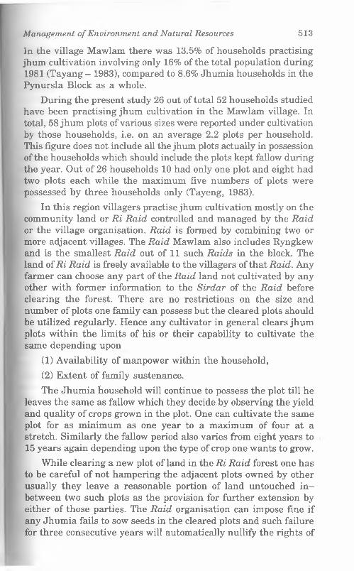
Management o f Environment and Natural Resources 513
In the village Mawlam there was 13.5% of households practising jhum cultivation involving only 16% of the total population during 1981 (Tayang - 1983), compared to 8.6% Jhumia households in the Pynursla Block as a whole.
During the present study 26 out of total 52 households studied have been practising jhum cultivation in the Mawlam village. In total, 58 jhum plots of various sizes were reported under cultivation by those households, i.e. on an average 2.2 plots per household. This figure does not include all the jhum plots actually in possession of the households which should include the plots kept fallow during the year. Out of 26 households 10 had only one plot and eight had two plots each while the maximum five numbers of plots were possessed by three households only (Tayeng, 1983).
In this region villagers practise jhum cultivation mostly on the community land or Ri Raid controlled and managed by the Raid or the village organisation. Raid is formed by combining two or more adjacent villages. The Raid Mawlam also includes Ryngkew and is the smallest Raid out of 11 such Raids in the block. The land of Ri Raid is freely available to the villagers of that Raid. Any farmer can choose any part of the Raid land not cultivated by any other with former information to the Sirdar of the Raid before clearing the forest. There are no restrictions on the size and number of plots one family can possess but the cleared plots should be utilized regularly. Hence any cultivator in general clears jhum plots within the limits of his or their capability to cultivate the same depending upon
(1) Availability of manpower within the household,
(2) Extent of family sustenance.
The Jhumia household will continue to possess the plot till he leaves the same as fallow which they decide by observing the yield and quality of crops grown in the plot. One can cultivate the same plot for as minimum as one year to a maximum of four at a stretch. Similarly the fallow period also varies from eight years to15 years again depending upon the type of crop one wants to grow.
While clearing a new plot of land in the Ri Raid forest one has to be careful of not hampering the adjacent plots owned by other usually they leave a reasonable portion of land untouched in- between two such plots as the provision for further extension by either of those parties. The Raid organisation can impose fine if any Jhumia fails to sow seeds in the cleared plots and such failure for three consecutive years will automatically nullify the rights of
514 Traditional Wisdom and Sustaituibl* I ihm*
possession of the holder and the same plot can be taknn up Itv others.
During clearing of the forests all the vegetations aro ulm li. «l off accepting the base of the large tree trunks just to avoid . »i. n labour required to dig it out and for regeneration of the hii i i ih 11»» cut trees and branches are kept on the same plot to bo dm <1 up under the winter sun (January — February). The Raid orgnnimil mn does not allow the Jhumia to take away any such cut branchon tilla heavy shower of rain occurs which in fact occurs within a ..... litor so. At first the large logs, if any, are taken away and utllUtttl for house building and repairing and mostly as firewood I Iimbranches with medium girth are kept mostly for making cli...... tlwhile the dried leaves and other smaller branches includinK >.... .bamboos are left on the ground to be burnt afterwards (Mun li April). It is reported that the firewood, collected from jhum lltdiU are meant mostly for their own use but they sell charcoal tllit" tit to the local markets. The details of charcoal making promm will be given later on.
STAGES IN JHUM CULTIVATION AND IMPLEMENT'S IIMHITo cut and clear the forest one iron axe or U-Sdie for cull Inn
large trees and a dao or Ka-Wait Lyndong for cutting wood, buml...etc., another smaller dao Ka-Went Lung for clearing buHlmn In the village Mawlam Jhumias start clearing the forest in tho nmnllt of November - December after completion of harvesting I In n orchards. Then the dried leaves and branches are burn! ultci around 6 — 8 weeks. The ashes or U-dpar are spread over tho land as manure and the Jhumia wait for the rains to come. Allot iwn or three showers they sow seeds in the small holes matin by I Ik long digging sticks or Lyngkha which has become nIiihimI synonymous to the jhum cultivation itself. The holes art' iihiiIm with roughly 1 ft gaps in-between, but without maintuiiunu nitf pattern. In each hole they put a mixed quantity of seodri wlili It they carry in a small cloth bag hanging from his neck anti Hn>n cover the hole with soil by foot. In case of tuber plants tlmy i nl segments of the matured tuber like arum or tapioca anti plant nut by one by digging holes. No more care is taken after howIiik Im the next two three months. Weeding is done twice in May and i ml of August depending upon the growth of unwanted voKtdallntt They still do not apply any manure.
In the village they usually combine maize with millet tot nl nplt cereals along with arum and tapioca as staple tubers, anti a I mi i
Management o f Environment and Natural Resources 515
ginger, turmeric and rai (mustard seeds) are sometimes grown as popular cash crops here. Since a variety of crops are grown in the same plot the harvesting is done in different periods depending on the maturity of those crops. For harvesting they use a small dao or Ka-Wait and the Lynkha.
Men folk undertake the clearing of forest and burning the dried vegetation often in a group comprising relatives and covillagers of the owner of the plot. The weeding, harvesting and carrying the crop to their houses are mostly done by the women folk of the farmer’s household. Unlike harvesting the fruits and broomstick, hired labourers are not engaged for harvesting jhum fields.
The present generation Jhumias are found less involved and less informative about jhum cultivation because they have better alternative land use over the more laborious traditional one with less returns.
Cropping pattern in jhumIn Meghalaya and particularly in Khasi Hills cropping pattern
varies a lot from place to place and year to year (Roy Choudhuri, 1991). But it was interesting to observe in Mawlam and surrounding areas that the traditional cropping pattern has been and still in the changing phase, though the higher hills of Pynursla block as a whole had no tradition of growing paddy in jhum fields the staple crops like arum, tapioca, maize and millet in combination with ginger and turmeric as cash crops have been largely altered. In fact almost all the households studied reported that after the first crop, e.g. arum, sweet potatoes, tapioca, etc. they switch over either to broomstick, bay-leaf or even to horticulture. They find it more profitable to grow those cash crops than continuing with traditional ones.
Depending on the quality of soils and the capacity of the Jhumia family the second and third year’s land use is chosen. The crops which require minimum maintenance and gives reasonable return like broomstick and bay-leaf are taken up by the poorer and smaller households having limited capacity for horticulture and other plantation crops. Others plant orange, lemon, banana, pineapple, papaya etc. after one or two years of jhuming.
The probable reasons behind such trends in the War villages may be many folds;
516 Traditional Wisdom and Sustainable I ii'mu
(1) Primarily the success rate of permanent plantation crop* In horticulture and broomstick is more compared to tho low return from jhum crops.
(2) The Government policy discouraging and even prohibit mu the jhum cultivation in the state as a whole.
(3) Growth of population leading to lower man land ratio am I shorter jhum styles have compelled villagers to extract nun. from the same plot of land even in the absence of developed agricultural technology.
(4) By transferring jhum plots in the community land (lii Himh to permanent plantations private possessions of land.
On the whole the brighter side of such transformation can I" felt in decreasing or stopping the degradation of the valuable lop soil of hill slopes by keeping those under one or the other type el permanent plantation.
Plantation agricultureAs already mentioned Podwar lands are extensively ami
intensively used mainly for horticulture. The high slopes wllli thinner soil cover do not permit any physical alteration and n • such these villagers do not have any tradition or construction terraces. The degree and direction of slope and the availabilit y nl‘ water are the important aspects villagers consider to plant different varieties of trees. The highest part of the slope just below tin Ryngko with less moisture in the soil and colder atmosphere ate planted with broomstick is continued upto the first break of xlnpn downward. In fact this higher zone of Podwar was earlier iimhI mostly for jhum cultivation, which had been transformed In broomstick fields since this cash crop started finding market arouml 20 - 22 years ago.
As the settlement of the village is situated at around 3,500 It the orange orchards are found 500 - 600 ft below the top end extends well upto an altitude of 1500 ft or so. Hence, the narrow strip of slope upto the river bank on either side is meant month for areca nut and betel leaf which are inter-cultured. Black pep pi i is also grown in combination with areca nuts. Moreover, alonn I lie perennial streams and springs on the lower and middle Podwm, various fruit trees are grown like mango, jackfruit and papaya ami climbers like betel leaf and pepper grow very healthy over I lie trunks of these trees as the traditional mode of inter-cult me According to the villagers perception south facing slopes are bent suited for almost all these trees to grow depending upon the
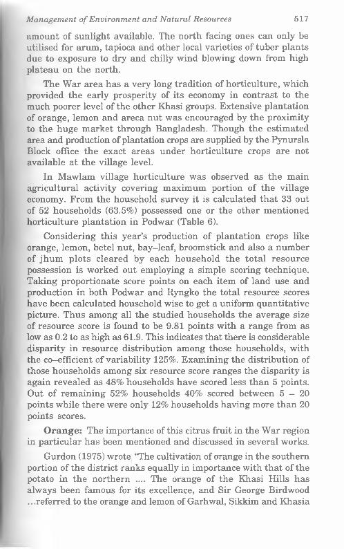
Management o f Environment and Natural Resources 517
amount of sunlight available. The north facing ones can only be utilised for arum, tapioca and other local varieties of tuber plants due to exposure to dry and chilly wind blowing down from high plateau on the north.
The War area has a very long tradition of horticulture, which provided the early prosperity of its economy in contrast to the much poorer level of the other Khasi groups. Extensive plantation of orange, lemon and areca nut was encouraged by the proximity to the huge market through Bangladesh. Though the estimated area and production of plantation crops are supplied by the Pynursla Block office the exact areas under horticulture crops are not available at the village level.
In Mawlam village horticulture was observed as the main agricultural activity covering maximum portion of the village economy. From the household survey it is calculated that 33 out of 52 households (63.5%) possessed one or the other mentioned horticulture plantation in Podwar (Table 6).
Considering this year’s production of plantation crops like orange, lemon, betel nut, bay-leaf, broomstick and also a number of jhum plots cleared by each household the total resource possession is worked out employing a simple scoring technique. Taking proportionate score points on each item of land use and production in both Podwar and Ryngko the total resource scores have been calculated household wise to get a uniform quantitative picture. Thus among all the studied households the average size of resource score is found to be 9.81 points with a range from as low as 0.2 to as high as 61.9. This indicates that there is considerable disparity in resource distribution among those households, with the co-efficient of variability 125%. Examining the distribution of those households among six resource score ranges the disparity is again revealed as 48% households have scored less than 5 points. Out of remaining 52% households 40% scored between 5 - 2 0 points while there were only 12% households having more than 20 points scores.
Orange: The importance of this citrus fruit in the War region in particular has been mentioned and discussed in several works.
Gurdon (1975) wrote “The cultivation of orange in the southern portion of the district ranks equally in importance with that of the potato in the northern .... The orange of the Khasi Hills has always been famous for its excellence, and Sir George Birdwood .. .referred to the orange and lemon of Garhwal, Sikkim and Khasia

Tabl
e 6:
Aver
age
annu
al a
gric
ultu
ral
prod
uctio
n sc
ore
by ca
tego
ry
of lan
d cl
anw
ise,
M
awla
mvi
llage
199
9
518 Traditional Wisdom and Sustainable lAuinji
Aver
age
Scor
e
17.1
0| CO00rHrH
[61
6|08T9 6.
64| |06
XX
IOCOid
oo<N 2.
22|
12.1
0|4.
25|
6.40
|5.
20| |00‘ 8
o00d
OOJd 9.
78|
No.
of
H.H
.
00 CO tH 05 <N ?H CD rH <N rH rH rH rH rH IO
Tota
l Sc
ore
poin
ta 136.
8071
.001
64.3
061
.80
59.8
023
.801
OV
IZ
Od(M
oCOcdrH
0131O IO00
oCD
001id
opcd
ocqd
Od
08'80SRi
ngki
lan
dBr
oom
Stic
k
14.2
016
.801
15.8
0 ooCD 12
.20 o00
099
OO o00rH
oCDrH
OOCD
00
0
ocqcd
opcd
o00d
o<Nd
97.0
0
Podw
ar l
and
Jhum 14
.00 OO
00op OO
rH 12.0
0
loo
s
OOrH
opcd
|00 9 2.
00
OOo
Opd
op<N
OO’O|0000
00
58.0
0
Bay
Leaf 14
.40 0901
ovz00‘8
11.8
0 OO00
ocd
oo OCDrH
OCDrH
o<NrH
00
00
00
00
0|00'0
OOd 62
.001
Arec
aN
uts 36
.80 Ocq
rH 2.70
00‘6S
otH 2.
201 0
00 5.
30 OCOrH
O00rH
oCOd
ocqrH
00
000’0
opd
00‘0
93.4
0
Oran
ge+
Lem
on 57.4
034
.30
39.4
012
.80 ovzz
o00cd
OdrH 4.10
2.60
15.
10
oprH 5.
10 Opd
opd
OOd
Opd
198.
40
Clan
of
Hea
d of
HH
Tyn
gson
g B
4Co£
tH_0>
o£ M
awpa
tK
hon
gbu
teb
Kh
onga
inK
hon
gji
Kh
ongs
uin
'73J2
flo£ N
ongs
tein
gK
hons
bnan
Ron
gjem
Sab
ong
Kaw
-in
Kh
ongk
lan
Maj
awT
otal
Seria
lN
o. rH <N co IO CD 00 05 orH rHrH <NrH COrH rH
IOrH CDrH R=-
0.1
1.
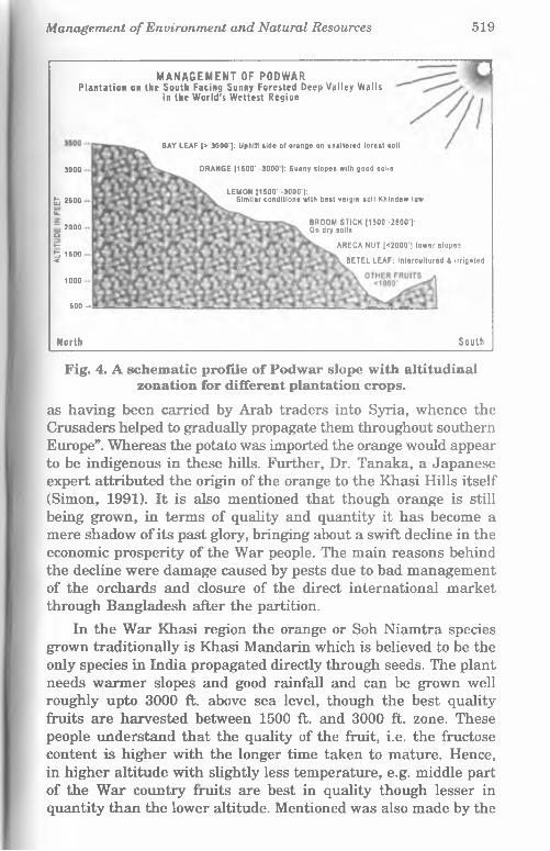
Management o f Environment and Natural Resources 519
MANAGEMENT OF PODWAR P la n ta t io n on the South Facing Sunny Forested Deep Valley W a lls
in the W o r ld 's W ettest Region
BAY LEAF [> 3500’]: Uphill side of orange on unaltered forest soil
500 -
N orth South
3000 ORANGE [1500‘ -3000 ): Sunny slopes with good soils
t 2500U.
~ 2000oy-5 1500 <
1000
LEMON [1500’ -3000*]:Similar conditions with best vergin soil Khindew law
BROOM STICK [1500‘-2500‘J: On dry soils
ARECA NUT [<2000'] lower slopes
BETEL LEAF: Intercultured & irrigated
Fig. 4. A schematic profile of Podwar slope with altitudinal zonation for different plantation crops.
as having been carried by Arab traders into Syria, whence the Crusaders helped to gradually propagate them throughout southern Europe”. Whereas the potato was imported the orange would appear to be indigenous in these hills. Further, Dr. Tanaka, a Japanese expert attributed the origin of the orange to the Khasi Hills itself (Simon, 1991). It is also mentioned that though orange is still being grown, in terms of quality and quantity it has become a mere shadow of its past glory, bringing about a swift decline in the economic prosperity of the War people. The main reasons behind the decline were damage caused by pests due to bad management of the orchards and closure of the direct international market through Bangladesh after the partition.
In the War Khasi region the orange or Soh Niamtra species grown traditionally is Khasi Mandarin which is believed to be the only species in India propagated directly through seeds. The plant needs warmer slopes and good rainfall and can be grown well roughly upto 3000 ft. above sea level, though the best quality fruits are harvested between 1500 ft. and 3000 ft. zone. These people understand that the quality of the fruit, i.e. the fructose content is higher with the longer time taken to mature. Hence, in higher altitude with slightly less temperature, e.g. middle part of the War country fruits are best in quality though lesser in quantity than the lower altitude. Mentioned was also made by the
520 Traditional Wisdom and Sustainable Living
villagers about the Wakhen orange claiming it as the world’s sweetest variety grown in and around the village of the same name. This village is located further north near Lyngkerdem in the Rumkheng river gorge at an altitude of about 2,500 ft.
The seeds are collected selectively from the most matured oranges including those which are over matured and damaged during transporting. The seeds are first dried completely in the' sun, then, during December-February first nursery is prepared in the homestead land and is called Share-Shyieng-Soh. The ground is thoroughly hoed and soil pulverized completely. Then the nursery is fenced up with stones to prevent the movements of pigs and fowls. The seeds are sown in haphazard rows and a thin layer of soil is spread to cover the seeds. These nurseries are watered regularly to keep the top layer of soil moist and also being covered by leaves particularly on sunny days ensuring the retention of moisture.
As the seedlings (Dieng-Soh-Niamtra) in some War villages ol lower altitude orange nurseries are raised commercially. The saplings of 3 - 4 years old (Kwin) are sold at the rate of Rs. 8/- to Rs. 10/- per plant. The War people believe that the saplings grown in Um-Syjem village are best though the village does not have any orange orchard. Even in Mawlam village when they are 3 4 inches tall they are transplanted in the second nursery or Share Dieng-Soh, on a warmer slope in the lower Podwar. For tin* second nursery, villagers select a slope having rocky red hill soil of low depth. The seedlings are kept there for 4/5 years after planting at 2 ft. spacing. The reason for selecting the particulm soil called Daw-Maw is that the roots would not penetrate deop into the soil and it will be easier and safer to transplant those tender plants with harder stems on the actual orchard.
The final sites for the orchard Bri-Soh-Niamtra are chosen by the villagers in their Podwar land avoiding the shady corners and exposure to strong winds. The mature saplings are planted with at least 6 - 9 ft. space in-between upon the angle of slope. Thu orchards are not cleared totally of all plants and trees naturally present. A few shady trees are kept during the growth of tho orange plant. Those shady trees are gradually lopped off with the growth of the orange trees. Such trees act as wind barriers us well. The Khasi mandarin takes around 5 - 8 years from germination to flowering. At about 20 years of age the plant becomes fully mature and bears maximum fruits. The quality and quantity of production falls with its ageing if not maintained properly.
Management o f Environment and Natural Resources 521
The flowering starts within one month of harvesting, i.e. in the month of March, the Pyrem (spring) in this region. Orange takes a longer period to start becoming red or orange in colour during October (which they call Risaw or month when the landscape (orchards) becomes red in colour). This month the villagers clear the undergrowth in the orchards for the second time after the first priming and cutting of dead branches done in the post harvesting period. They spread those dead branches on the ground to add green manure to the soil. They do not use any other manure nor do they dig the soil to expose the roots which is a common care taken in other regions. The clearing of the tree trunk from mosses and other parasitic plants is also done along with the clearing of undergrowth. But these labours of intensive works are not done completely in each and every orchard in the village. This is one of the reasons the orange orchards in War country are affected by various pests and insects. It is recorded by Gurdon (1975) that a full grown tree yields as many as one thousand fruits in a year. But due to heavy damages done by different pests and also due to the old age of a large numbers of orange trees the production at present and particularly in this year was very meagre. As per the estimate given by the villagers this year they got a very low yield ranging approximately from 50 - 120 fruits per tree. In the village an old farmer narrated about the pests of the orange plants. They call it Ksain, a caterpillar like pest, which first appears on leaves and feeds on it, after being grown up it bores hole in the stems and fruits as well. They have even observed the life cycle of the Ksain as similar to that of butterfly. In fact, they do not know any proper effective measure to control such pests. At present they only plug the hole with a stick or Shar so as to check its movement. They have also observed that the attacks of such pests are more every year. In addition this year there were many unseasoned heavy showers with hailstones which have also damaged the crops heavily.
The orange is harvested starting from the orchards on the lower slopes in the month of December or Nohprah. They carry a medium size basket and climb on the tree to pluck the fruits carefully by hand. The fruits on the tips of the extended branches are also plucked carefully by their hands only. Till today villagers at large do not accept any exotic orange species or adapt to new farming techniques though they are very much concerned about the fall in production.
522 Trad itiona l Wisdom and Sustainable L ivihh
The village farmers as well as the middle men measure tho fruits in traditional way and not by weight. For orange and lemon the smallest unit of counting is Hali (4 pieces). 16 Hali equalH I Bhar, 16 Bhars equals 1 Lenti or 1024 numbers. Oranges an* transported from the village to market packed in a conical bamboo basket called Ka Khara made in the village itself. This year dim to very low production the villagers earned a good price of around Rs. 1000/- per Lenti.
Lemon: The lemon species grown here are locally known iih Soh Kwit in War dialect and seems to be an indigenous one too It requires some kind of environment like orange but latter grown in a particular soil called Khyndew law meaning old undisturbed soils of the forest. Villagers plant Soh Kwit even at a higher altitude than orange. It fetches much lower price than orange This fruit has a high demand in Bangladesh and is mostly exported there. The rate of production was almost similar to orange thin year. But the harvesting is completed 2 - 3 months before orange
Bay leaf: Bay Leaf or Tezpat (Cinnamonum zeylanicum) in another extensively grown indigenous crop in the East Khasi Hill/i It is called La-Tuson in War dialect and Sla Tyrpad in Klimd proper. It is an aromatic plant having a wide market in India and Bangladesh. The saplings are collected from the forest and transplanted to the chosen plot of land in Podwar. The village™ prefer to plant bay-leaf on the uphill side of orange in a good unaltered forest soil. The collection of leaves starts after the plant »i are about 5 years old. Every year villagers harvest bay leaves in February - March as soon as the orange is completely harvested The leaves are dried in the sun for a few days in the village and transported to market packed in gunny bags. In other parts of the Khasi Hills harvesting season starts in November. The plant hardly needs any care, once it is grown up except only a periodical cleaning of weeds and other unwanted vegetation. It fetches Rs. 450/- to I0t 500/- per quintal.
Cinnamon: The local variety o f cinnamon plantn (Cinammomum temala) locally called Tynsia is recently beinn popularised as another cash crop in the village. The method ol cultivation is almost similar to that of bay-leaf but it is propagated through cuttings and planted in Ryngko lands of the village nl present. Both leaves and its bark are harvested and sold which in inferior in quality to the one cultivated in South India and famou* for its aromatic use. Only after 14 - 15 years of growth the plant is ready to be harvested, though leaves are collected for use much
Management o f Environment and Natural Resources 523
earlier. They cut the matured branches along with leaves leaving only one or two feet of the main trunk to allow further growth. The bark of the branches are peeled off and dried in the sun for 2-3 weeks while the leaves dry quicker. They sell Shimuth (1 bundle) at Rs. 10/- per kg of dried bundle and Rs. 1/- per bundle of leaves. At present Cinnamon grown in the village goes mostly to Bangladesh through Nongjri bazaar. It seemed that this crop is a recent inclusion here and they neither knew the actual price in the outside market nor they are sure about the quality of the produce. Villagers reported that since last 20 years or so they are planting this spice though only around 14-15 houses are having the plantation at present.
A reca nut: Areca nut is the second major cash crop traditionally cultivated in the War country. This is perhaps the most widely consumed non-food item in the whole of Northeast India and is propagated over a vast range of eco-zones from riverine plains to low hills of the plateau and the foot hills of the Himalaya as well. As informed by the State Agriculture Department the areca nut species grown here is an indigenous one which shows variable growth and production depending upon the altitude, soil type and slope. The Kwai in Khasi and Kwei War country can be cultivated successfully even up to an altitude of 2000 ft on various soils but require good rainfall and warmer climate. In the village the areca nut plantations occupy the lowest part of the Podwar. But a few yards away from the river bed to avail water logging.
It is propagated through seeds in a common traditional way. The seeds are selected carefully from the mature trees. Experienced farmers select the seeds, identifying the mature ones observing the shape of a single nut, a nut with protruded tail part. Such nuts are produced only by the trees which are 25 - 30 years old. This is called Sleij when the Pdeng (tail part) is protruded. Usually all the saplings of areca nut are grown in nurseries in the low altitude villages bordering Bangladesh in a rich clayey soil. Many of the northern War villages mentioned that they best preferred saplings produced in Umkren village nurseries located close to the border some 6 - 7 km west of Dawki. The selected nuts are at first loaded in a bamboo basket and wrapped in gunny bags and rags etc on ground under shade and regularly watered till those are germinated. It takes around 3 - 4 weeks and usually done in the month of January - February then those are planted in the nursery called Kwei-Shace and are watered regularly assuring no water logging. These saplings, when it reaches 2 - 3 ft height, are sold
524 Traditional Wisdom and Sustainable Liu mu
to the farmers from all over War areas as the hilly villages are nol found suitable for Kwei-Share.
In the actual garden plot the saplings are planted about 4 (I ft apart so that no plant touches another when matured. Tho inter-plant distance is kept less over high slopes and higher altitude where they grow less tall. The garden plantation site is called 'I'tu Kwei or Barah Kwei. The best soil for areca nut is clay loam t y p e
and results better on east facing slopes. On an average the fruiting starts from eighth year. One tree bears nuts even upto 60 - 70 years if proper care is taken. To avoid insects and pests the garden should be cleared off undergrowth and also the tree trunk needli to be cleaned from mosses and fungi, dried and old leaves are almi pruned regularly.
Harvesting starts from December and continues upto March In the Mawlam village harvesting is done very late in March foi late maturity due to high altitude. It is reported that at tho beginning between 8 -11 years one areca nut plant bears 3 bunched annually called Ka containing 80 - 100 nuts in each. But with tho maturity the production goes upto 5 Ka of 150 nuts each. Due to tall height of the trees the villagers employ unique technique foi harvesting the nuts to reach the heights of around 40 - 60 ft any ladder cannot be placed on the slim trunk; neither would it withstand the weight of an adult person to reach the top. So tho villagers have adopted a technique combining two usual method* within the limits of safety. They make a light ladder with a long one vertical pole of bamboo (18 - 20 ft) and fix up tangential bamboo pieces (1.5 ft. These tangential bamboo pieces are fixed equally extended on either side of the pole to be used as step* The person, usually young males, hold another thin and long pioco of bamboo fitted on the top with a sharp iron sickle and climb tin ladder leaning on the tree keeping his balance as meticulously iim an expert acrobat. Reaching around middle of the tree he hold* the tree trunk with left hand and leg while the right leg holds t in ladder and right hand operates the second bamboo pole to cut t in branches from the tree. Another person who holds the lower end of the ladder at the beginning now plays the part of a catcher on ground. The catcher takes care of the branches falling free from such a height using an empty gunny bag, which he swings swiftly synchronising accurately to hold the branch safely in the sack. An it was observed the whole operation takes around just 2 Jl minutes per tree.
Management o f Environment and Natural Resources 525
The branches are gathered in one or two places in the garden to be sorted out and be classified into four grades, the biggest and most mature nuts called Paduh are kept for two purposes
(i) Making Wisecup by processing in water (U’wei urn) for local consusmption and
(ii) For selling to various ‘pan-masala’ manufacturing industries.
The second quality called Kwei Soh is to be sold for direct consumption (U’wei khaw). The third and fourth grades are called Pdeng and Bia are the smallest and defective ones. These are mainly sold in the markets in the plain areas outside Northeast region where dry ‘supari’ is consumed. They count the nuts in a traditional way as follows.
After grading, the nuts are packed in bamboo baskets called Khara (large one) and Khoh (small one) and transported to' the market.
Processing of areca nut: The traditional system of processing nuts in water for making and lightly fermented and stronger one different in War areas compared to that of making Garuah Tamul in Assam. The best qualities of nuts are put into huge, roughly made bamboo baskets called Khara (5 to 5V& ft high and 3 to 3*4 ft diameter) and immersed in water pools called Kwei Pukhri. Such Pukhris are made near or along a natural stream. The continuous flow of water is allowed through the pool with only one inlet and one outlet point; to avoid strong smell to develop. Every day a person forces himself into each Khara full of nuts to assure that the nuts are immersed properly. After processing such a way for around 3 - 4 months the Wisecup or the U’wei um can be kept for 6 months without further decline in quality and it fetches around thrice of the normal Kwei.
Disease since last two decades or so a new and so far unknown disease has been found infesting areca nut trees mainly in the lower hills of the War area that is the largest producing belt. A kind of wilting starts usually from the tip of the mature leaves which become dry and dark in colour. Within a few weeks the whole tree upto the root gets affected and dies. The affected part
10 Nos
10 Kati
= 1 Kati
= 1 Pai
= 1 Kani40 Kati or 4 Pai
16 Kani = 1 Lenti or 6400 nuts
526 Traditional Wisdom and Sustainable I a v i i i h
smells rotten. So far no remedy is found other than detecting It early and cutting the affected leaves.
Betel leaf or tympaw: This is another important traditional agricultural product in Khasi Hills equally popular like areca nut But betel leaf is not grown well on northern part of the War aron This delicate creeper plant needs a very restricted and sped lie environment to thrive. This tropical plant loves cool and shady places with enough moisture in soil and atmosphere. The plant In propagated through cuttings and planted close to shady trees on which the creeper will grow. At the base of the newly planted cutting they put some leaf mould to retain moisture and to hnlp developing roots faster. They usually plant new cuttings during peak rainy season (July - August). The cuttings are made front full grown, healthy plants. About three-four pieces of the main stem of one plant are taken from a height of 8 ft upward so thnt the master plant survives.
On earlier days when forest was ample in the region they preferred undisturbed old forest areas for betel leaf cultivation Big trees like Dieng Bati, Dieng-Sohphang, Diengli, Dieng-Kyu, Dieng-Taric etc. were preferred as support trees on which tho creeper got twined. After planting a new cutting they used to prime all the lower branches of the support tree to allow sun lint it as the creeper grows faster initially in a warm-lighted and airy condition. The west facing slopes are preferred for betel leaf. Thoy make leaf mould out of the cut branches and put those around tlio base of the tree. Now-a-days due to depletion of forest the bot«>l leaf plants are mostly grown in the betel nut gardens. Bofou< planting they clear the part of the forest. Once it starts grow inn steadily and new shoots come out it requires complete shade and regular watering. As winter season approaches the farmers prupnin a unique network of dual irrigation in their betel leaf plantation*) (to be discussed later on).
Harvesting of betel leaf starts after four years of plantation, leaves are harvested regularly at an interval of two to three month" in the lower or southern region. In the village Mawlam it In harvested only twice a year, once in July - August giving highnnl yield and the second time in March-April. In general at Io w k i
altitudes the best quality leaves are plucked during winli'i (December - February) when all the leaves excepting the vtn \ young ones are collected. This harvest is called Kheit Lynghlinn The next harvest Noh Tram is done in April - May - June whim they pluck selectively and screen out the diseased leaves. So I ln<
Management o f Environment and Natural Resources 527
production remains low in quality and quantity. Again during rain another selective harvest they do which is called Kheit Siediap but do not prime the plant. They maintain very high level of hygiene during harvesting which is not always followed religiously by the present day farmers. Earlier any person was allowed inside these plantation areas only after taking bath and wearing a clean loin cloth or “Gamcha”. They still believe that betel leaf plants are very sensitive to various bacteria and viruses foreign to the forest eco-system it is growing in, hence management of this plant demands higher attention of the farmers and the success depends upon the traditional wisdom in him.
The leaves are carefully sorted by size and maturity. The bigger and greener leaves are washed carefully in clean and fresh water before making bundles in a typical traditional way.
16 Jora (pairs) = 1 Shong (32)
3 Shongs = 1 Bhiah
4 Bhiah = 1 Tap
20 Tap = 1 Kwi
40 Tap or 2 Kwi = 1 Khah (one basket full)
N.B. One Khah of best quality leaf is formed by only 5 Tap instead of 40 Taps.
Diseases and Pests: Similar to the disease in the areca nut trees, a new and unknown disease is affecting the production of betel leaf since the last 10 - 12 years. The villagers call it Tram when they find some leaves are getting black spots as if the portion is burnt. They believe this is an air-borne disease which spreads very fast by wind. At present they do not know any remedy for this disease and simply keep strict watch and cut the affected part immediately. After cutting those leaves, they are collected in a particular basket called kharatram and then thrown in a river or dumped in an isolated place. The Kharatram is washed and cleaned after every use and kept separately for this purpose only.
An important point was raised by an experienced farmer in Dawki, the border market, that after the partition with Bengal they have lost a huge market for betel leaf. This crop being very much sensitive to heat and dryness is very difficult to transport to distant markets in Assam without proper transport facility. Hence the loss of market has forced many farmers to switch over to jhum cultivation and timber trade by cutting of the healthy old forest which provided the necessary eco-system for betel leaf plant.
528 Traditional Wisdom and Sustainable l.linnu
Broomstick: The long sticks of flowers of the Thysalolnemn maxima species of Poicea family have extensively altered tin* In. < of the Meghalaya plateau by revolutionizing the rural economy ill least the last two decades. This indigenously available grow* can be grown even up to an altitude of 4000 ft but maximum concentration was observed roughly between 1500 and 2500 11 II can thrive on a wide range of soil and slope. Usually the dry and rocky slopes with very thin soil cover and the jhum fallow him In are the natural habitat of this grass. So the plantation of it in commercial scale is a unique phenomenon in the history ol agriculture in Meghalaya. Farmers simply transplant the naturally available plant by selecting the new shoots. But they usually profei old and new jhum fallows as well as any vacant space in and around the homestead. Though the exact date is not known an I n when the commercialization started most of the villagers said that it must be around 20 years before. Several probable causes wine highlighted regarding the popularity of this plant. Firstly, as lln- yield in the jhum fields declined due to shortened jhum cyclo ami parallelly the Government campaign to give up jhuming, acted an the triggering effect. It seems logical because broomstick became popular at a very fast pace, mainly, in the lower and middle* hill ranges of East Khasi Hills Districts where there was hardly any forest left, due to intensive jhum activities. So people had mi option to substitute jhuming, unlike the West Khasi Hills whom timber trade became the alternate while in the Jaintia Hills thoy had enough coal reserves to exploit.
On the other hand the less fertile or degraded and barron rocky plateau could not produce any other crop profitable enough to earn their livelihood.
The lucrative vast market all over India must have played encouraging role too. It is observed that slopes all along tho highways connecting Shillong and Guwahati and the interior village* connected by motorable subsidiary roads have adopted this crop early and in greater extent.
The broomstick is called Lynnai in War district and require* least care to grow. After harvesting the sticks during January March, they perform weeding and cleaning the fields and leavo foi the rain to come. Only once in two-three years they burn tho grasses after harvesting believing that it will help the gras* to grow better at par with their traditional perception and very old practice as in the case of jhum cultivation. Harvesting require* hard labour continuously for several months to avoid gcttiiiH
Management o f Environment and Natural Resources 529
scratched on their legs, while harvesting by the sharp edges of the leaves. They use a kind of cover upto the knee with a cotton garter called Jingropjat. The harvested sticks are brought near the village settlement and spread over any dry ground mostly along the road side to dry it under the sun. Some households make bamboo stacks to hang or spread those sticks in their courtyards. It takes 2 - 3 weeks or more to dry depending on the sunny days. The dried up sticks are then thrashed on stone slabs thoroughly to separate the seeds from the sticks. After that these are made into bundles.
A small bundle (handful) is called Shi Khim while a big bundle (backload) is Shi Kit consisting of 9 Shi Khim. One backload of brown stick weighs around 35 kg, when it is brought from the field after harvesting. The same quantity weighs 25 kg (approx.) after drying backload (row) from the field to the owner’s house as labourer gets @ Rs. 80 per kg or Rs. 28/- per Kit as the charges of harvesting and considering 2 - 3V6 hours walk. An adult male can carry about 18-20 Khims a day (9 a.m. - 5 p.m.) and woman can carry 15-16 Khims a day. The Khim quantity depends on the person making it, so also the Kit. There is no standard weight for these measures. A very strong man can carry upto 70 kg backload. Normal person can carry 50 kg and a woman upto 35 kg.
There has been a huge fall in the sale prices of broomstick within the last 10 years, villagers reported that they started selling this crop as high as Rs. 1000 per quintal, which has come down to mere Rs. 100 this year. This is mainly due to the huge production of this crop and owing to a very large portion of land brought under this crop. The trade of broomstick was in their tradition as it is an indigenous species which people used to gather as a minor forest produce.
One old man in the village told that there is an old Khasi proverb saying - “Broom is a good slave but a bad master”. At present these villagers have started realizing the truth behind the proverb. They now find it almost impossible to clear the broomstick plots to grow some other crop through jhum and plantation. In fact this grass can only be cleared by carefully uprooting the whole plant and drying under the sun, the secondary growth has to be cleared regularly. The mellowed officers of State Agriculture Office at Pynursla informed that this grass has a 15 - 20 years life cycle. At present the villagers are at a loss and do not find any alternative to it as the price has dropped considerably. Thus, the land less or marginal farmers in the village are getting lower and lower labour
530 Traditional Wisdom and Sustainable Living
charges for harvesting proportionate to the price level. Hence, tho same crop which once boosted the rural economy has turned to bt* a liability to them. Moreover, it is yet to be ascertained as to wlinl could be the state of soil fertility after the plant is removed from the land. Experienced farmers in the village have noticed thul whatever the quality of the soil the broomstick plots can be uhciI
for planting other crops only after minimum three years. During this first 3 to 5 years they used to continue weeding and uprooting of whatever secondary growth of the grass occurs. But to uproot the grass is a labour intensive job. They prefer to grow pineapple, arum, chillies, etc. But in Ryngko lands they still prefer broomst.i< It as the most profitable crop with least labour required.
Basket making: The War people, like most of the tribnl communities of northeast India, are well known for their experience in making a wide range of baskets. The most commonly used raw materials are bamboo and cane which are available naturally in the forests.
The Mawlam villagers make all the baskets for uses like packing and transporting their produces, fishing, food gathering and varioun domestic purposes. The baskets for packaging the fruits; in particular are required in large quantities and are done by some of the household commercially as a small scale household industry in their own houses. For making one ‘Ka Khara’, the ‘medium size basket to pack orange, a nine feet long piece of bamboo’ - Thyi is required which is collected from the Ri-Raid land in the Podwm Though both man and women participate in basketry works tho latter are considered more expert. Experienced women can make upto 50 such baskets with split bamboo in a single day. The basket m are made in large numbers well in advance of harvesting orange and lemon. Due to very less production of fruits this year wo found about 800 such baskets are left unsold only in one house Moreover, they received only half the usual price i.e. @ Rs. 0.50 per basket this year.
Other kinds of baskets were seen in use in the village include Ka Khoh the conical and most common one, Ka Polo for storing fruits and vegetables, Ka Kriah a smaller with a square bottom used for keeping various kitchen articles including food items, Kti Kuh to collect fish during fishing, Ka Prah - a typical basket foi winnowing the husks and dust from cereals and grains.
This traditional drip irrigation system practised by the Wm people is a unique example of their wisdom. Using only the locally
Management o f Environment and Natural Resources 531
available resource i.e. bamboo, a well developed dendritic network of bamboo channels are laid wisely utilizing the slope of the land. One natural stream or spring is selected at a higher level than the field. The water source is then canalised through a narrow outlet using stones and mud. Then they place a pipe made of a whole bamboo sometimes joining a series of such bamboo pipes depending on the distance to be covered. This main pipe is called Kdung. Then the subsidiary or the second order pipes (Lar) made of half split bamboo (Shken) are fitted with the main pipe in selected points. The third order (Khliah), fourth (Pyntee) and the fifth (Pynjan) other bamboo channels are connected stepwise to reach the water right up to the base of each and every betel plant. To control the flow of water they place a small piece of wood 2" long tangentially fixed to a 3"—4" long thin slice of bamboo through which water is diverted to the next order canal. Thus, at the end water falls at the root of the plant drop by drop whole day and night. The small piece of wood and bamboo part is called Shyngliar- which is only used at the junction between the last canal and the earlier one. At present, in most cases, polythene (flexible) pipes have replaced the first 2-3 stages of bamboo pipes but the Pyntler and Pynjam the last two channels are still in use if we compare the modern drip irrigation equipment and the cost involved in installation and maintenance it costs many times cheaper and equally effective indigenous eco-friendly technology requiring no power and exotic materials.
Management of forestThe Khasis have a long symbiotic relation between them and
their natural surroundings. Till recent past these tribal group was highly dependent on its immediate natural resources for sustenance. Forests were the mother of all required resources to these people for several thousand years. Only after the development of road transport network from 1870’s and the consequent impact of the huge markets of the northern and southern plains did the forest start depleting from the hills for commercial uses. On the other hand the continuously growing burden of population has made the once viable jhum land use system responsible for permanent degradation of forests and hill slopes by reducing the jhum cycle from 30—40 years to mere 6-10 years or less (Simon, 1991).
Types and ownership of forestThe United Khasi-Jaintia Hills Autonomous District
(Management and Control of Forests) Acts 1961 passed in pursuance
532 Traditional Wisdom and Sustainable Living
of paragraph 11 of the Sixth Schedule of Indian Constitution was extended to all forest land of the region except 722.30 sq. km (i.e. only 8% of the total forest) which is directly under the State Forest Department (Tiwari et.al., 1998). Therefore, almost all tho forests (92%) are under the private control through the rules framed by the Executive Committee of District Council. These forests in Khasi Hills are basically divided into two depending upon their ownership (i) the village on community forests controlled by Raid and (ii) those of individual or clan holdings Ri Kynti. Since time immemorial all the forests were controlled and demarked through Khasi customary laws governed by the traditional Syiems of different Durbars. The forests were presented for specific needs and were utilized carefully.
Law Nian
Law Adong Forest protected by village Durbar.
Law Long Um Forest with water source for winters.
Law Shnong Village forest.
Law Kue Clan (family) forests.
Several Acts, norms and religious sanctions were framed to conserve these forests were there before. The implementation of Forests Acts, signifies the depths and extent of the indigenous knowledge of environment of these tribal people.
In the village Mawlam a well preserved Law Lyndoh was observed other than the huge patch of law Adong. But only a few households (6 out of 52 studied) have reported possessing purely private forests inherited from ancestors of their clans Law Kue. In all cases the area of these forests were not estimated either by tho villagers or by the state administration as in the case of any land as such.
(I) Law Lyndoh: is a sacred grove of highest order kept under the stringent customary rules of total protection and control by the priest or Lyndoh selected by the village authority. Thin forest is the abode of the supreme guardian god. ‘U Ryngkew I) Basa’ who from time immemorial guards the villages and tho people from any harm. At present a small patch of about 50 sq. metres of undisturbed primary forest is housing the ‘Mawlam’ the ‘Guiding Stone’ of the village. It is a 2 Vfc ft high, 2'xl' stone block with another small piece of stone on top of it. The stone in worshipped every year in the month of March by the Lyndoh or priest who is deputed from the recognised clan council of the raid
Management o f Environment and Natural Resources 533
comprised of six clans, viz. Khongain, Khongitib, Khongsdier, Khongklan, Tynsong and Khongji. The ritual is performed after the burning of jhum field called Knai Khatrat on the 15th or 16th day of March as fixed by the Durbar. Prayers are chanted before the goat and cocks are sacrificed. Every tenth year they hold a special prayer where a cow is sacrificed. The villagers (other than the Christian families) believe that if anybody disturbs the stone by touching or hitting or verbal teasing the stone god will appear with the body of tiger and head of a man. In such incidence they have to perform ritual and sacrifice on animal by law of the Lyndohs even a dry leaf cannot be collected from the Law Lyndoh. Only the elderly men are allowed to take part in the ritual or the families who strictly follow the traditional religion. (Niamtre), neither any children nor any person of other religion is allowed. We were allowed to visit the forest after much pursuance. We observed a very old and huge rubber tree (Jri) by the ‘Mawlam’ rock. The tree is held in high reverence by the villagers and is seen as the Gateway of the village. In fact the typically laid root system of the tree is used as the god made stairs before construction of the road.
The Law Lyndoh forest still possesses a good species diversity including various medicinal herbal plants. The most valuable trees found in the forest as reported by the villagers are dieng tusei, dieng shyrngan, dieng sohsyrlet, dieng sohsarat, dieng shoat, dieng jri, dieng lakhor, dieng pyrchit, dieng sohphi, dieng sohum, dieng bti, dieng sohniar, tuson, ka brah etc. along with many varieties of bamboo (Thyr). The ‘Kambiraj’ or the village medicine man collects many of these herbal plants from the law Lyndoh when these are needed but only through proper channel i.e. permission and guidance of the Lyndoh.
(2) Law Adong: These are protected forests in the village meant for specific community needs and managed by the Raid organization as the local body of the Syiem, in this case Khynriem Syiemship. In the village most of the Law Adongs are present in and around the heads of the mini catchments areas, from where large and small streams originate (Law Thang Um). All the four natural water points supplying water to the villagers are all located inside the Law Adongs, which surround the village on three sides. Moreover the three crematoria for non-Christian Khasi villagers are also located inside these forests. Only with the permission of the Sirdar or the Bah Shnong of the Mawlam Raid villagers can utilize the forest produce for building materials, firewood and
534 Trad itiona l Wisdom and Sustainable L iv in g
cremation. Compared to Law Lyndoh the forests of Law Adong are more disturbed and exploited.
(3) Raid: organization also manages other categories of forest land under Ri Raid, which are non-protected forests. Villagers are free to these for jhum cultivation or plantation of any crop both annual and perennial. During the last few decades both area under jhum and jhum fields are decreasing with increasing land under plantation crops.
(4) The fourth category of forests includes those under family and clan possession under the Ri Kynti area. Such forests are kept for household level or clan level requirements like house building, jhum cultivation and firewood. In the village Mawlam land under such type of forest is very much restricted even today. Only 6 of the 52 household surveyed belonging to 3 clans (Khonghrom, Khonghitib, Nongsteih) reported having such forest through of negligible amount.
Utilization of forest resourceThe forests of Meghalaya being very rich in flora and fauna
with high species diversity have long been supporting the people with many of their needs. Broadly the War Khasi people utilize the forest resource to fulfil their basic needs through:
(i) Hunting and collection of food articles.
(ii) Firewood and charcoal.
(iii) House building materials.
(iv) Materials for making domestic crafts.
(v) Medicinal plants.
(i) Traditionally these jhumia populations have been practising hunting and food gathering to supplement their food shorten'' during the lean periods. Today hunting of games is practised more as a recreation than as a regular means of livelihood. As reported by the elderly villagers and documented by various earliei researchers; game hunting was a group activity in all the village i n of the region. In earlier days winter and spring (November March) was the usual lean period for the Jhumia population. Durian these hunting of games like wild boar, deer, jungle cat, rabbitM, mongoose, large rats and squirrel were hunted in the foroNtM Khasi villagers consume many varieties of birds starting from large eagles to small sparrows. Fish is also a favourite, available in rivers, streams and pools. Dry fish are mostly bought from Bangladesh.
Management o f Environment and Natural Resources 535
A rich variety of tools and techniques were used during hunting which included bows and arrows, spears, daos or choppers, knives along with fishing nets and hooks supported quite a few simple and effective trapping systems. Dogs with specific traits known as ‘Sew-beh’ were usually employed in a group hunting and game chaser (Caje and Syiemlieh 1998).
As a part of the traditional forest conservation customs the hunting activity was also guided by a set of rules and regulations. Firstly an individual or a group of hunters should give a general notice to the ‘Rongbah Shnong and village elders before venturing into the forests, usually the community forest, or Law Adong under the Raid. They usually avoid composing a hunting team of odd numbers (3,7,9,13 etc.) believed as unlucky, secondly, one or two village elderly people used to guide the hunting team in restricting them against killing any animal which is pregnant or nursing stage. Restrictions are also observed in choosing the right season and number of animals hunted, which usually does not exceed three per season for a group of hunters. These norms were common to almost all villagers with some variation depending upon the village Dorbar’s decision.
Fishing is also a favourite to all the Khasis in general. An individual’s family or a group of individuals go for fishing in the streams and rivers in their village surroundings. Unlike hunting fishing has no such restriction other than that odd numbers of participants which is usually avoided.
But certain traditional beliefs on natural phenomenon like rain, thunder, lightning etc. occurring during the start of the journey to forest would either delay or postpone their going. Hunting is always an all male affair, while for fishing both sexes may participate.
In the village Mawlam hunting and fishing are quite common still today. During harvesting season (October - March) they also go for hunting both in agricultural fields and Law Adong forests. They use guns (Suloi) for hunting monkey, fox, bear, deer, boars, wild fowls etc. Usually at least two males go together for such ventures. Sometimes hunting and harvesting of crops like Tejpat and broomsticks are done together. The guns are usually bought from nearby markets including cities like Guwahati and Shillong. But mostly shot guns with one/two barrels are crudely made by some local artisans and used due to its easy availability and low price (Rs. 1500 - Rs. 2500 ). These days use of trained dogs is no
536 Traditional Wisdom and Sustainable Living
more common in hunting, guns have replaced bow and arrows and other weapons.
During our field study most of the Mawlam villagers were found experts in making various traps using nothing but natural raw materials available in the forests. For catching or killing different birds, squirrels, wild rats, rabbits, they lay different kinds of traps (Pap). A few of these traps are described below:-
(1) Riam Pap: The most common and effective trap meant for small animals like wild rat, mongoose, squirrel and rabbit. It is mostly laid in winter inside the broom stick fields or in the forests. They select a place which appears to be the shelter or path of such animals. They find a flat slab of stone of at least VA ft x 1 foot in size, which is called Mawpap or the trap stone. Then a piece of strong branch of tree of 1 foot length is collected, dieng Kynthei or female stick. Another piece of stick Dieng Shynong or male stick of 6-8" length is fixed tangentially in such a way that it holds the weight of the rock on the ground. To fix these two together a flexible piece of slit bamboo of 10-12' length is attached with one end pressed on the ground. The same piece is then laid round the Dieng Kynthei. Finally another piece of long bamboo stick of about 1.5 to 2 ft length, which is lighter and thinner is fixed as trigger passing between the twisted Riwai to reach well inside the raised stone (as in the sketch). The bait usually a small piece of carrot or bread is fixed tightly at one end of the long stick- Dieng Bamkhana reaching inside the rock. The tap laid in thin way is left as such. Everyday a person will come and examine tho tap trap and he may change the bait if necessary. Smaller animals are trapped or killed below the rock as it falls on them.
(2) R iam Khung: Riam Khung is the bird trap laid abovo ground using smaller trees and carefully keeping the natural lay out of the forest intact. This trapping system is engineered by employing the strength of the branches. At first a small tree is cut at around 3' - 4' height above ground in the forest preferably closo to crop fields or streams. The cut away stem is made like a loiitf wedge (Dieng Kynring) and fixed on the cut end of the stem stand inn on ground (Dieng Jingbam). Then a tender branch 2 V2" is tied with the horizontal Dieng Kynring in the form of an inverted 'II' shape called ‘Pyrdung’. The next step is to pull down anothoi young tree and find it by a strong string (at present a nylon striiiK I with the horizontal pale (Dieng Kynrieng) - keeping the string in full tension. This second tree when fixed in tension acts as tho main force of the trap. The string is then pulled down further an I
Management of Environment and Natural Resources 537
delicately locked with the help of one small wedge like stick (Pyrson) and another thin stick 1 Vi ft long) called Kalar, parallel to the horizontal which acts as the trigger. A loop is made with the loose part of the string and laid over the one end of the Kalar is the place for birds to sit and eat the bait. As soon as any bird put its weight loop the trap will go off and the bird will be tied by the legs in the string. In this region the common birds caught are pyrsaw, sympohnei, slang, per kdait, mrit, purnei, pdit etc.
(3) Pnah: Pnah is another kind of simple trap for birds. The Thriang the resin of the wild rubber tree Dieng Jri is collected first. A piece of tender bamboo (1' to 1W ) is slit into thin sticks leaving some 3 "- 4" of the piece intact which acts as the handle. The resin is smeared over the slit part of the bamboo which holds the resin. Then the whole thing is placed on some tree close to water points or streams where birds used to perch after bathing. In fields or forests with no bait the gum is strong enough to hold the bird. A bamboo casing is also used to cover the gum while carrying it. This gum is also applied over a long bamboo pole (3"- 4") and tied horizontally over two vertical poles fixed on the ground with some baits kept close to this. The birds come and sit on it and get stuck. Even large birds like eagles are caught in this way. Attraction bait prepared from a fruit Sohlang was found sold in the village markets in the shape of a cricket ball they say it is effective bait for catching birds and fish.
Another common way of killing birds is with Tehjiri or catapult. Almost any young boy upto the age of 18 - 20 years and some elderly persons too carry a catapult while casually strolling around the homestead. Most of them are sharp shooters and kill one bird almost every hour. A few are really experts in whistling and imitating various sounds of birds with perfection. They stand quietly under a large tree or near a bush in the forest and whistle and the birds respond by coming closer towards him and then he targets the birds.
Fishing: The summer and rainy seasons (April - September) are good for fishing in the streams, rivers and pools around the village. Khasis in general enjoy fishing and still find time to do so, unlike rare occasions for hunting. The Mawlam villagers have little access to large rivers and ponds due to its location on top of the range with average height of about 15007 ft from the main river - Wah Umroh. Hence they mainly fish in few natural water pools and streams using smaller hand nets (Ka Bnij) and cast nets (Ka Billea) and fishing rods (Rong Wiang) fitted with Khwai or the
538 Traditional Wisdom and Sustainable Livinn
hook. They usually make their own nets (Jer) with thread prepared from barks of trees.
Normally they catch fishes like Khasaw, Kharew, Khamongtw etc from rivers and streams Snalynai, Doh Thli and Shee an* smaller fishes caught by small pieces of cloth or ‘Gamchcha’ and hand nets. To keep such smaller fishes they carry small baskets (Ruh) tied around their waists.
Various superstitious, beliefs and fears restrict the villagers from over exploitation and disturbing natural habitats of the fishes The medicine-man or Kambiraj narrated that they believe a ‘Puri' or female spirit of the river lives in the War Khas and (the river of fishes) if any body throws stones or disturbs the water too much, the ‘Puri gets angry. She then causes a storm with heavy rains resulting in certain epidemic diseases etc. or she makes particular males (single) go insane. Rituals are performed therefore before fishing to the ‘Puri’. Further in and around the permanent water sources in the ‘law Adong’ fishing by any kind of net is totally prohibited so as to maintain the natural flow of water.
COLLECTION OF FRUITS AND VEGETABLESIn almost all the seasons various roots, vegetables (mushroom h/
tits) and fruits form a portion of their diet. Fruits like banana, fin jackfruits, etc. are widely available in the forests. They plant them in their homesteads too. The tender shoots of fig (Lapong), the tender core of banana trunk (Pashor) and flower (Ka Siur), jackfruits and their seeds are favourite vegetables to the people Bamboo shoots are also collected for consumption similar to other parts is also consumed like Jahjee, Shorblang and Jamgrdoh During monsoon at least 10 - 12 varieties of mushrooms (Tit) are collected, the most common ones are Tit Tung and Tit Lakheh Squash plants, once planted grow without further care for which they get large quantity of vegetable, fruits, plant itself and its root.
BEE KEEPING AND HONEY COLLECTIONThe War Khasi people has a long tradition of bee keeping and
honey collection, using their own knowledge and techniques (Dasgupta, 1984) till today bee keeping is practiced almost in all villages through honey collection from the forests has become a low key affair due to the shrinking of forest cover. In the village we found only a few households not rearing bees.
Management o f Environment and Natural Resources 539
The collection of wild honey is done during February - March and completed before the starts of the rains. There are two varieties of honey bees found in the forests:
(i) Uimai - the bigger one producing better quality and larger quantity of honey but more dangerous to handle and
(ii) Ungap - the common smaller variety is considered less pugnacious and chosen for keeping in a box. The collectors apply smoke to the hives by burning cotton rags to drive away the bees. But they avoid collection from Uimai hives during day time.
The box for keeping bees is made by scooping out a piece of 2" - 5" long log with 10" - 12" diameter to make cylinder sort of container (Ka Ksing Ngap). Two circular plates of wood are used as lids (U Jong Sit) for both ends of the cylinder making a small entry and exit slit passage on one end. Usually during the autumn season (Symrai) September - October they locate U Ngap hive in the forest. After collecting the queen bee (Ka Sympa) they carefully tie one of its wings and put it inside Ka Ksing tied with a stick then both ends are closed and slowly the other bees enter inside following the queen. Then the Ka Ksing is brought back to their house and kept usually on the raised platform of their huts selecting a comer with least disturbance or it is tied up in some branch of a tree in the courtyard.
The first collection of honey is done after around one year and subsequently they get honey 2 - 3 times a year, depending on the season and flora. One hive produces one to two bottles (700 ml bottles) per harvest. The rate per bottle is Rs. 150/- to Rs. 200/- per bottle. Maximum honey is available from the extraction made during spring and winter season. The honey is consumed as high energy substance and also for medicinal purpose especially for cold and cough. During winter months children are fed with honey, women during pregnancy and post delivery period are also given honey. The Kambiraj traditional medicine man also used honey as base for some of his medicines.
COLLECTION OF FIREWOOD AND CHARCOAL MAKINGIn the village Mawlam people are totally dependent on firewood
for cooking and heating their rooms during winter months. It was found that all the required firewood is collected from the forests under the Raid Mawlam jurisdiction. By the law of the Raid dry and dead branches of wood can be collected from all kinds of forests barring the sacred groves or Law Lyndoh. But nobody is
540 Traditional Wisdom and Sustainable Living
allowed to collect leaf litters as those are meant for maintaining nutrients for the forests.
Most of the required quantity of firewood is collected and stored during the dry winter months after the jhum fields are cleared and plenty of dry woods are available in the forests. Collection of firewood from the fields and forests is mainly the job of adult male villagers but adult women and children also extend help for gathering smaller and lighter woods while coming back from fields and from around the residential areas.
Charcoal is another important commodity the villagers produce utilizing the selected portion of firewood they collect. After separating the good quality dried up wood as firewood from tho newly cleared jhum fields they usually select the poorer quality wood for making charcoal or Rnga. One experienced adult male person from the family of that jhum field takes the responsibility of charcoal making as they think it as a specialized job and it takes a few days to complete the job. First a pit is dug on the slope of the cleared field itself. Due to hardness of the soil and rocky slopes only three sides of a square spot is cut to make a flat- ground. The sides of this pit depend upon the quantity of wood one will use. Then the already gathered logs are cut into equal pieces (1.5" - 2" long) stacked carefully on that pit in a very compact manner so that there will be restricted amount of air passage. All the four exposed sides of the stack (Thliew Rnga) are covered with the dug up mud/soil to seal all the ventilation points except a few required ones on top. Then fire is lit from below through a few gaps left for this purpose. It is important to keep the fire steady at a regulated speed. The man in charge should keep strict vigil on the hearth so that there is no flame which may completely burn down the wood to ashes. The fire is controlled simply by blocking and opening the air passages on different points of tho stack. One or two persons have to assist the man for at least 3 to5 days depending on the stack.
Most of the charcoal produced is sold in the market to moo! the needs in towns and cities even outside Meghalaya. This yeai they sold at Rs. 120/- to Rs. 130/- per bag of 40 kg of charcoal, which they consider was good return. The prices have risen wit h the Supreme Court judgement against felling and transport ot timber and other forest products. The producer keeps only 2 to 'I bags of charcoal for using at home during winter months.
Management o f Environment and Natural Resources 541
HOUSE BUILDING MATERIALSIn Mawlam village most of the houses or Kaing are of typically
a traditional pattern built utilizing the locally available materials. Out of 52 households studied there were 23 houses having tin roof over the traditional katcha structure. Only one house is made of 80% R.C.C. and 20% wood. The traditional War Khasi houses are constructed on raised platforms whether on slope or flat ground. In the village even the recent houses are built using oblong shaped, single block of stones. Walls and floors are made of wooden planks. Wooden or bamboo poles are used to construct the sloped roof frame. Roofing materials are either straw or a variety of wild palm. Materials are usually locally available. Households having no private forest appeal to the village Durbar or Raid committee to supply the required timber and bamboo. In general they are allowed to collect the materials from the law Adong and other community forest. But in case for large amounts a nominal amount is to be paid.
The most preferred woods for particular parts of the buildings are: -
(1) Dieng Tusei: Strong and heavy wood for main frame structure.
(2) Dieng Bti (jackfruit): For making planks.
(3) Dieng Phoniew: For walls and floors.
(4) Dieng Rai\ For making most of the furniture with smooth finishing.
(5) Thyr (bamboos): of different varieties: Used for flooring, roofing and frames.
Belief still persists among the War people that any tree or bamboo felled and collected during particular seasons on new moon days the wood will remain good or less termite/insects will spoil them. Moreover, tree below the girth of less than 5 - 7 feet are prohibited to be used. Though these days, these beliefs are gradually dying out among the new generation.
BASKETRYBaskets are made by the villagers themselves and certain
households are engaged in making such baskets as a household industry. For making one such basket a 9 ft long bamboo (Thyr) collected from the community forests are utilized. Though both male and female make these baskets, females are more expert. Experienced women can make up to 50 baskets a day compared to men. Rate per basket is 0.50 paisa each. One household in the
542 Traditional Wisdom and Sustainable Living
village, who made a large number of such baskets well before tho harvesting of the fruits found a low demand and still around 800 pieces were seen, stacked unsold in his house. Due to low production this year the demand was less.
PLANTS FOR MEDICINAL AND SPECIAL USEThe Kambiraj or traditional medicine man Tilliw Khongbnan
(M/60) is one of the eldest and most experienced in the village. 1 In is regularly called by the villagers to treat any kind of persistent illness or disorder of body and mind. But from the way of treatment narrated by him it seems that they practice more of rituals and prayers and administer only a few herbs and natural medicincH But it is interesting to note that the person had no background of traditional medicine in his family. He said that he had discovered the first medicine by observing rats eating an herb and they hardly fall sick even after eating waste food etc. Once in his 20’s he was suffering repeatedly with diarrhoea. He tried that herb fleshy creeper called Laikad and got cured. He now keeps the creeper dried and makes powder which is then mixed with a little bit of powdered molar tooth of an elephant (Bniat hati). This mixture advised to take 2-3 times a day for any indications of food poisoning, diarrhoea and acute stomach problems, Soh Pryda (a wide variety of guava plant) had many uses. The pastes of its leaves are applied over forehead to cure headache. The powder of the dried leaves in mixed with water to drink during any problem of indigestion oi acidity. He has observed that the fruits and leaves of this plant are eaten by deer in the forests.
In most cases reported, the Kambiraj first performs ritual to detect the cause of illness by traditional method of breaking on egg on a wooden board called Liang Shat Khan. I f the disease still persists even after performing the ritual the herbal medicine m used.
Diseases like measles (Niang Blei), cough and cold amonu children (Niang Tmar) are believed to be caused by god’s wish either as blessings or teachings. So far in such cases the Kambiny performed various rituals to appease the relevant god or spirit They also use Soh Kwit juice over the whole body during measlen
Snakes, mainly pythons, are killed both for food and medicine The python’s fat is believed to be effective for curing joint/rheumal n pains. The affected person drinks a portion of fat mixed with watei or rubs the fat over the affected area.
Management o f Environment and Natural Resources 543
A kind of large, dark, round disk like seed of a tree is consumed as especially nutritious food. The hard outer shell is burnt to take out the kernel or actual seed. The nut-like seeds are then boiled in water and cut into pieces. Then wrapped in a clean cloth and kept immersed in a flowing stream for about 24 hours now it becomes ready to eat. They also grind the kernel and mix it with water to make smooth paste which is applied over the body as a skin nourishing and cleansing cream.
All the above mentioned medicinal herbs and many such others are available in the forests mostly in Law Lyndoh and Law Adong. But as informed by the village elders herbal medicine is a comparatively recent introduction (15-20 years) in the village and the knowledge has been disseminated by the Kambiraj. At present one health worker visits the village twice a week from Pynursla P.H.C. to provide the modern health care facility to the villagers.
TACKLING THE FOREST FIREForest fire is a common event in the Khasi Hills particularly
in late winters when villagers burn their jhum fields. Moreover, the villagers in War Khasi region still believe that if they burn the dry undergrowth during February - March, the soil on the slopes gets extra nutrition and get purified and vegetation grows anew. So burning slopes, whether bare or forested are a common site till today instead of prohibiting orders from the Dorbar and the state government as well hence, most cases of forest fire are man made only.
In the event of any such forest fire, spreading inside the village, all the villagers present in the nearby houses rush to the spot under the instruction of the Raid Committee or Dorbar. They carry buckets and mugs and fetch water to douse the fire. Depending on the size of fire they even spend days warding off the fire. In case of huge fires in a good forest villagers clear a strip of forest along the line of fire so as to check the further progress of the same beyond that vacant space. This cleared strip of about 6-10 ft wide, without any dry vegetation to catch fire, acts as the fire barrier. This traditional mode of tackling forest fire is very much followed by the Meghalaya forest department and state government machinery here at present.
I f the fire is spread from the adjacent village or Raid, compensation is demanded from the responsible party. I f a person of the same village is found guilty he or she will be fined in cash equivalent or kind by the Raid, and also he has to bear the cost
544 Traditional Wisdom and Sustainable Living
of holding prayers to one of these village guardian gods. When nobody confesses or knows about the responsible person, the priests will declare that the almighty may punish the guilty person, who will ultimately fall ill or even die.
WATER MANAGEMENT #Due to its location in the world’s wettest region and very high
slopes of the terrain over most parts, the War country is posing a unique situation in terms of water resource and its management. During May to September the village gets rain water in abundance most of which gets drained away very fast through streams and rivers in the form of surface run off. In the process the narrow flat ridge top, where the village settlement is located, surrounded by high slopes and less vegetation cover fails to retain enough water. The red loamy soils add to the cause due to low water holding capacity. Hence only two points around the village settlement serve as natural perennial source of water for domestic uses. Those sources are located in the main-catchments on either side of the main road covered under Law Adong forests. There is no well system in the village. Only during the rainy season two or three more natural springs provides them clear water.
The main perennial source of water is located along a footpath only about 300 m down slope from the nearest homestead. There are three points on the same line at around 3-4 m of gap. The first spring just below the thick forests is made into a square tank using stones and cement and used only for drinking water or Tynghoh-Um-Dih. A wooden board is kept to cover the small tank to protect from gathering any dirt. The excess of this continuous flow of water gets drained away through a small outlet leaving a sizeable amount of water of 1.5" deep inside the tank. The same overflow of water is again gathered in a rocky natural pool, a little lower below the tank. This point is utilized for washing clothes and utensils and is called Tynghoh-Um-Sait. Further down, the same flow is again diverted through a larger square tank made by arranging stones. This tank - Pukhri Kwei is about 5 ft deep and has one inlet and one outlet each on opposite direction. This tank is used for soaking ‘Kwei’ (betel nuts) towards fermenting it.
Some fifty metres down slope the same spring surfaces again to become a small slow flowing stream but this surface water is not used for washing purpose during dry season due to the amount of dirt in the form of dead leaf litters. The forest slopes around this small stream is only used as open air latrine of the villagers.
Management o f Environment and Natural Resources 545
A deserted hut was observed on the other side of the path which was earlier used as country liquor distillation centre.
The second perennial source on the other side of the road is not equally managed and maintained by the Raid Committee. The water seemed to be not of equally good quality and volume. The collection point is located just 200 metres below the source region of a stream inside the Law Adong forest. But the flow of water is on the surface for a greater part and demarcation between the points of drinking water and water for other uses is less distinct. There is no concrete structure for the reservoir a small pool where water is collected from.
From these two sources villagers regularly collect and use water for their domestic consumption. For the purpose of drinking and cooking they have to carry the water from a distance of more than 500 met ‘es depending upon the location of the particular house. This job of carrying water in large and small containers is literally an uphill task performed mostly by the women and children who stay home during day time. A conical bamboo basket is used for carrying the water containers, which they hang on their back with load taken on the head by a split bamboo sling. The little boys and girls also follow elders with smaller containers. Traditionally they used to carry water in bamboo containers known as Ktang Um or larger bamboo species with large diameter is used attaching a small sling to hold. Around 6-8 such small Ktang Um are placed inside the Khoh (bamboo) and hung on the back with the help of a sling or Star around the head. To avoid getting wet from the spilled up water they place a protective cover called Trap. A semi circular shield made of bamboo (Skhen) frame over which large dried leaves (Lamet) is woven.
During the rainy season villagers collect water dripping off from roofs of their houses as supplementary source of both drinking and other purposes. They collect rain water in the traditional way by digging hole on their courtyard number and size of which depend on the quantity of water required by that family. Such holes are dug in the place when there is a hard rocky impermeable layer below the surface. Small holes or small pools of water also called Tynghoh signify the long tradition of managing the water resources. It also indicates perpetual crisis of water in this village, particularly during dry season, paradoxical to the abundance of rainfall received.
On the other hand the high hill slopes having good vegetation cover either in the form of forests or plantation and the nature of
546 Traditional Wisdom and Sustainable Living
soil holds the valuable rain water before it flpws down to tlm valley. The villagers understand that the amount of water (or moisture) in the soils increases down slope and also around tlm prominent stream channels along the slopes. Their perception in this regard is well reflected in selecting the crop as per ili«< character of this soil and the slope. In usual sequence tho broomstick grass is grown on the highest and driest parts, followed by bay leaf, citrus, other fruit trees, bananas and lastly the betel nut plantations. The wettest and best soils (with higher water holding capacity) are utilized mainly for betel leaf, betel nut, papayn, black pepper, etc.
Water collected from the spring for drinking purpose is usually taken as pure potable water and consumed directly excepting n few enlightened families who purify it by boiling. When water become scarce and dirty they sieve it through a piece of clean cloth. In general all the Khasi families were found very particular about domestic hygiene like washing, cleaning the kitchen articles as well as their own hands and feet mainly after entering their houses from outside. It is a feast of one’s eyes to see to glittering silvery utensils arranged systematically in their kitchens.
Both in summer and in winter they take bath twice or thrice a week in the spring or streams. Only very old persons and children are bathed at home with warm water at the backyard platform called Rynsen. In some new houses they have built separate washing room attached to the kitchen or Ka Jing Bo-um with cemented floor where they store water and also wash and clean things. Even this room is used as bathing room.
Almost all houses maintain kitchen gardens or Kper in the backyard. The kitchen and washroom outlets Eire directed to the kitchen gardens to re-utilize the water. The chickens feed on the left over food articles and water too. Otherwise there is no concept of drainage excepting in two of the houses we visited. A soak pit is made behind the kitchen while this water is soaked in the soil under the backyard platform Rynsan in most cases.
CONSERVATIONThroughout the War area were found isolated small patches of
vegetation covering the micro-catchments areas particularly around the sources of first order streams. These patches of green were either Law Adong the protected forests or ‘Law Lyndoh’ the sacred forests. This particular feature emphasizes the traditional concept and knowledge of conservation of two most important and inter
Management o f Environment and Natural Resources 547
related resources the water and the forests among the War Khasi people at large.
In the village the Raid committee maintains the perennial water sources at the community level. Certain rules and practices are still in vogue among these villagers. Firstly, no tree is allowed to be felled particularly around the water points in ‘Law Lyngdoh’. Secondly, the community participates in cleaning and maintaining those sources once or twice every year. Thirdly, the Lyndoh or priest performs prayers at such sources every year to appease the Rain god responsible for providing water. Lastly, in times of draught or even temporary water crisis, the community members go to the water point in a big group. Through the day and night they clean the point by digging out the mud accumulated there and clear the path of flow. They search and dig points in and around the source area to find and create new sources. To maintain a good flow of water from the source they plant Soh Um tree which they believe produces water. Some of the elderly villagers pointed out that where there were a few plants of Soh Um in the forest there must be a water source nearby. Thus observing this plant they could locate probable water source.
SUMMARY AND CONCLUSIONAs stated in the first chapter of the present report it is based
on a preliminary study in a village called Mawlam, located in the East Khasi Hills district of Meghalaya. The stipulated sample size was 50 only, though we have made an effort to cover aspects of the village beyond what was specifically asked for. However, the findings of the present study should be taken as tentative.
The location of the village in a remote area with no infrastructural facilities until recently has influenced many of the characteristics of the society there. It is found that even the first primary school came up only about 30 years back. As a consequence of such a background, educational development in the village has been very insipient. About 90% of the villagers still depend on agricultural and economic diversification has been insignificant. With the closing of border with Bangladesh trade across the border, which was once an important activity; as almost come to an end. There are some external changes such as in their dress, household gadgets, etc. these are of recent origin and only the richer families have been able to exhibit such changes. People are generally very poor and men, women and children have to jointly eke out their living out of very difficult circumstances.
548 Traditional Wisdom and Sustainable Living
The present study shows that the dependence of the people of the village on the market is significant. What they grow and how much they grow, and when they grow; are largely decided by the market conditions. The vulnerability of the people was most evident when broomstick cultivation had to be discontinued as a result of drastic fall in price. While in one hand it was difficult for the villagers to switch over to some other form of cultivation there was hardly any government effort to bail them out of such a situation.
It is also observed that the villagers still have a very close association with the forest. They go to the forest for a variety of reasons such as collection of food, games and medicinal plants. Their reliance on the forest increases during the lean seasons. Perhaps, partly due to this reason, they have a rich knowledge of the forest resources. Being located in the wettest region of the world, and yet suffering from lack of portable water they have devised over the generation a system of water management which may be worthy of being emulated by hill villages elsewhere as well. Their total dependence on land has also made them experts in optimum utilization of various kinds of land for various crops. The nature of land ownership, which is one of the most complicated in the entire hill region, also reflects, to some extent their dependence on land. For instance a large part of the village land is under clan or community ownership, which makes the same plot of land much more viable than it would be under individual or private ownership.
Their association with the supernatural world is not yet disturbed significantly by the receding forest cover in the vicinity. They can still name innumerable gods and goddesses related to land, river, rocks, trees, ponds, sickness, disease, natural calamities etc. Even social control is partly taken care of by their strong belief in such god and goddess. Otherwise they have a strong tradition of village polity which is still continued. However, the authority of such traditional leaders, including the medicine man, is gradually fading as new values based on education and wealth, are beginning to challenge the traditional order.
In sum, this village exemplifies not only the predicament of shifting from a multi-crop based shifting cultivation to a single or dual based economy but also the predicament of the people who cannot make their voices heard on the corridors of power. This village exemplifies further uncertainties and vagaries of nature
Management o f Environment and Natural Resources 549
against which they have nothing to support them except their own traditional wisdom about their environment. Finally the present study depicts the community struggle for survival in a less bountiful nature and increase in population.
BibliographyAllen, B.C. 1905/1980: Gazetteer of the Khasi and Jaintia Hills: Garo
Hills Lushai Hills. Pioneer Press, Allahabad.
Aier, A & S Changkija, “Perspectives of indigenous knowledge for sustainable development of the Hill areas of North-Eastern Hill areas”. Paper presented at the workshop on Anthropology and Allied disciplines in North - East India sponsored jointly by A.S.I. and N.E.H.U. and held in the Department of Anthropology, N.E.H.U. Shillong - March 1999.
Bareh, H. 1984: The History and Culture of the Khasi People. Guwahati Spectrum Publications, 1971 Khasi Fables and Folk-Tales, Firma, K.L. Mukhopadhyay Publication, Calcutta.
Borthakur, M. 1989: “Periodic markets in tribal areas (a case study in Meghalaya)”. M. Phil. Dissertation, N.E.H.U., Shillong.
Cajee, L & H.J. Syiemlieh “Concept of environment protection and conservation among the Khasis”. Paper presented at the seminar on Physical and Cultural Ecology of N.E. India, N.E.H.U., Shillong - September 1998.
Dasgupta, P.K. 1984: Life and Cultures of Matrilineal tribe of Meghalaya. Inter India Publications. Delhi.
Gurdon, P.R.T. 1907: The Khasis Cosmo Publications. Delhi.
Khongphai, A.S. 1974: Nater on Khasi Law. Ri Khasi Press, Shillong.
Mirani, R. 1979: “Khasi Symbolism”. M. Phil Dissertation, N.E.H.U., Shillong.
Missa, P.K. & A. Rangad, 1997-98: “Sacred Grove and the Khasi society” . Report submitted to R.C.N.A.E.B., Shillong.
Pakyntein, E.H., 1965: Census of India 1961: Assam United Khasi and Jaintia Hills. Published by Government of Assam, Guwahati.
Roy, Burman, J.J. 1994: “Sacred Groves: Symbol of self assertion” Economic News and Views, November 16th - 30th.
Sen, G. 1992 (Ed.): Indigenous visions: Peoples of India, attitudes to the environment. Sage Publications and India International Centre, New Delhi.
Simon, I.M. 1991: Meghalaya District Gazetteers: Khasi Hills District. Published Directorate of Arts and Culture, Shillong.
550 Traditional Wisdom and Sustainable Living
1966: Khasi and Jaintia Tales and Beliefs. Published by Department of Tribal Culture and Folklore Research, Gauhati University.
Singh, R.L. (Ed.) 1971: India: A Regional Geography National Geographical Society of India, Varanasi.
Roy, Choudhury, 1991: Shifting Cultivation.