Major European Stressors and Potential of Available Tools for ...
27
sustainability Article Major European Stressors and Potential of Available Tools for Assessment of Urban and Buildings Resilience Licia Felicioni * , Antonín Lupíšek and Petr Hájek University Centre for Energy Efficient Buildings (UCEEB), Czech Technical University, 273 43 Buštˇ ehrad, Czech Republic; [email protected] (A.L.); [email protected] (P.H.) * Correspondence: [email protected]; Tel.: +420-731-373-558 Received: 21 July 2020; Accepted: 9 September 2020; Published: 14 September 2020 Abstract: Recent data show that there are intensifications of phenomena related to climate change, such as the increasing of heavy rains, more frequent and intense droughts connected with fires, and alterations of the local climatic conditions, including heat islands with consequent impacts on cities, districts, and buildings. Not only are natural hazards stressing Europe but also human-induced events like low-magnitude earthquakes as a direct cause of fracking or mining. This study aimed to investigate the significant stressors and summarize what impact is the most dangerous in each European country. There is a need to secure the operating conditions of urban infrastructures and to preserve a high-quality indoor environment of buildings. The main scope of this paper is to compare selected tools that evaluate the urban and building resilience and to assess their suitability, based on an analysis of natural and human-induced hazards in the European countries. The results represent a contribution to urban and architectural planning practice, and to the consistent implementation of measures to improve the resilience of the built environment by providing guidance as to which assessment tool is most suitable for each country. Keywords: European threats; building resilience; human-induced hazards; natural hazards; resilience assessment tools; seismicity; urban resilience 1. Introduction Changing of the environmental conditions on the Earth is a natural and everlasting process. Human living conditions are modified—and as a consequence, biodiversity is irrecoverably altered. This process was in previous periods prolonged, enabling consecutive adaptation of life forms (including humans) to improve environmental conditions. Recently, the pace of transition has been accelerating. According to the data reported by the Intergovernmental Panel on Climate Change (IPCC) [1] and by the National Aeronautics and Space Administration [2], it is clear that there are intensifications of phenomena related to climate change (CC), such as changing precipitation patterns including intense rainfalls, more frequent and severe droughts, and alterations of the local climatic conditions, including heat islands with consequent impacts on cities, districts, and buildings. Due to the increased occurrence and concentration of extreme events related to climate change, it is essential to systematically focus on risk managing and mitigation and on improving the resilience of urban areas and buildings to reduce their vulnerability to extreme events, rather than working in just a reactive mode responding to particular events [3]. The current focus on climate change and its impact on social and economic development is also helping to accelerate recognition that natural disasters are a critical hazardous factor for the health, safety, and productivity of occupants of buildings [4], and for the sustainable wealth of the urban population. Hence, it is essential to Sustainability 2020, 12, 7554; doi:10.3390/su12187554 www.mdpi.com/journal/sustainability
-
Upload
khangminh22 -
Category
Documents
-
view
0 -
download
0
Transcript of Major European Stressors and Potential of Available Tools for ...

sustainability
Article
Major European Stressors and Potential of AvailableTools for Assessment of Urbanand Buildings Resilience
Licia Felicioni * , Antonín Lupíšek and Petr Hájek
University Centre for Energy Efficient Buildings (UCEEB), Czech Technical University,273 43 Buštehrad, Czech Republic; [email protected] (A.L.); [email protected] (P.H.)* Correspondence: [email protected]; Tel.: +420-731-373-558
Received: 21 July 2020; Accepted: 9 September 2020; Published: 14 September 2020�����������������
Abstract: Recent data show that there are intensifications of phenomena related to climate change,such as the increasing of heavy rains, more frequent and intense droughts connected with fires,and alterations of the local climatic conditions, including heat islands with consequent impacts oncities, districts, and buildings. Not only are natural hazards stressing Europe but also human-inducedevents like low-magnitude earthquakes as a direct cause of fracking or mining. This study aimedto investigate the significant stressors and summarize what impact is the most dangerous in eachEuropean country. There is a need to secure the operating conditions of urban infrastructures and topreserve a high-quality indoor environment of buildings. The main scope of this paper is to compareselected tools that evaluate the urban and building resilience and to assess their suitability, based onan analysis of natural and human-induced hazards in the European countries. The results representa contribution to urban and architectural planning practice, and to the consistent implementationof measures to improve the resilience of the built environment by providing guidance as to whichassessment tool is most suitable for each country.
Keywords: European threats; building resilience; human-induced hazards; natural hazards; resilienceassessment tools; seismicity; urban resilience
1. Introduction
Changing of the environmental conditions on the Earth is a natural and everlasting process.Human living conditions are modified—and as a consequence, biodiversity is irrecoverably altered.This process was in previous periods prolonged, enabling consecutive adaptation of life forms (includinghumans) to improve environmental conditions. Recently, the pace of transition has been accelerating.
According to the data reported by the Intergovernmental Panel on Climate Change (IPCC) [1] andby the National Aeronautics and Space Administration [2], it is clear that there are intensifications ofphenomena related to climate change (CC), such as changing precipitation patterns including intenserainfalls, more frequent and severe droughts, and alterations of the local climatic conditions, includingheat islands with consequent impacts on cities, districts, and buildings.
Due to the increased occurrence and concentration of extreme events related to climate change,it is essential to systematically focus on risk managing and mitigation and on improving the resilienceof urban areas and buildings to reduce their vulnerability to extreme events, rather than workingin just a reactive mode responding to particular events [3]. The current focus on climate changeand its impact on social and economic development is also helping to accelerate recognition thatnatural disasters are a critical hazardous factor for the health, safety, and productivity of occupantsof buildings [4], and for the sustainable wealth of the urban population. Hence, it is essential to
Sustainability 2020, 12, 7554; doi:10.3390/su12187554 www.mdpi.com/journal/sustainability

Sustainability 2020, 12, 7554 2 of 27
develop and strengthen the built environment to create more resilient communities, protecting humanlives and property against disaster cases [5]. Additionally, the risk of extreme events creates a newchallenge for urban and building planners, because these problems span among scales—city, county,country [6,7]—and inappropriate building design and construction that would not be adopted to thenew conditions would unnecessarily endanger the population and its assets. There arises a question:what is the right balance between the architectural planning for lower environmental impacts and theplan for increased resilience? In some cases, improved robustness or redundancy leading to increasedenvironmental impacts at the construction stage brings benefits that become fully evident only laterduring the buildings’ operation in terms of extended service life. Such a debate shall be a part ofplanning for (overall) sustainability.
The issue of resilience is embodied in the Sustainable Development Goals (SDGs) introduced in2019 [8]. The European Handbook for SDGs [9] promotes, in Goal 13, a better knowledge of all theessential elements that can improve the understanding of disasters risk resilience, and contribute tosustainable growth. The purpose of this paper is to offer an overview of the significant stressors relatedto natural hazards (including climate change) and their trends in Europe, and give recommendationsfor developing specific regional tools for managing building and urban resilience.
1.1. The Resilience of the Built Environment
Much research focused on the resilience of ecological systems started in the 1970s, and hasrecorded remarkable growth in the last few decades, due to the environmental problems that the worldhas to face every day, particularly the significantly increased amount of natural disasters [10].
The current concept of resilience is indicated by a globally notable increment in interest: countriesare trying to face the problem of climate change, a gradual process that can be measured and its impactrelatively accurately foreseen, as shown the 2018 IPCC’s report [1,11,12]. However, disasters, such asfloods, also deserve more attention, because they may cause a series of losses (e.g., financial deficits,housing collapses, and casualties) [13]. Resilience enhancement features are often directly linked to thespecific sector [14].
Different scales are used to measure resilience—from a single building to the urban, community,municipal, and national levels. Different actions vary according to these scales. At the building level,for example, resilience would include the capacity to manage shocks and avoid the impact of stressors;a more in-depth focus on the building resilience can be found in the Appendix A. At the urban level,in addition to these, resilience includes the capacity to manage stress or avoid a shock, and restoreservices and repair damages to infrastructures or buildings.
There is not any single widely accepted standard definition for urban resilience, and Appendix Bprovides a sample of existing definitions. This paper considers resilience as the ability of a system,entity, community, or person to adapt to a variety of changing conditions, to withstand shocks whilestill maintaining its essential functions, and recovering all features of the system to pre-disaster level.The sense of improving building resilience at the city level has been seen in connection with disasterrisk reduction; moreover, combined with urban resilience strategies, it is possible to lead a driving forcefor future urban policies. Urban resilience policies require accessible and multidisciplinary planningfor the future, which expects the participation of various stakeholders and experts of the field [15].
In any case, resilience as such is a part of overarching sustainability. It is influencing all the threepillars of sustainability (economic, environmental, and social), because the impacts of geophysicalphenomena, including climate change and different kinds of natural and human-made disasters,affect all three pillars of sustainability. Thus, a focus on environmental resilience, social resilience,and economic resilience and their mutual interaction is essential.
The tools for evaluating resilience, described in the following paragraphs, are multi-criteria scoringsystems that provide the designer with some guidelines aimed at orienting, ex-ante, and evaluating,ex-post, the technical choices used. The pre-disaster phase includes mitigation and preparedness

Sustainability 2020, 12, 7554 3 of 27
actions, although the post-disaster stage is geared to response and recovery. Adaptation is usually along-term process that takes place both before and after the disaster occurrence.
1.2. Objective and Scope of the Study
The main objective of the present manuscript is to compare selected tools that evaluate theurban (RELi [16] and Envision v3 [17]) and building (Resilience-based Earthquake Design Initiative(REDi) [18] and Environmentally Friendly Resilient Residential Buildings (RESBy) [19]) resilience and toestimate their suitability for resilience assessment based on an analysis of natural and human-induced(HI) hazards in European countries and, in the end, giving recommendations about which resilienceassessment tools can be more suitable for each European state. Extreme events in Europe were analyzedconsidering three essential hazards: seismicity, floodings, wildfires, and their relative trends.
1.3. Natural and Human-Induced Hazards
At present, more than half of the world’s population lives in cities. It is expected that, by 2050 [20],up to 75% will do so, because of growth in both people and urbanization [21,22]. As the populationand number of natural disasters grow (see Figure 1), the impact of natural disasters on humans willincrease too. The continuously growing extent of impacts affecting increasing population leads tocostlier and deadlier accidents around the world. These problems mean that there is an ever-increasingneed for attention to the risk mitigation and the adaptation of urban systems.
Sustainability 2020, 12, x FOR PEER REVIEW 3 of 29
Adaptation is usually a long-term process that takes place both before and after the disaster occurrence.
1.2. Objective and Scope of the Study
The main objective of the present manuscript is to compare selected tools that evaluate the urban (RELi [16] and Envision v3 [17]) and building (Resilience-based Earthquake Design Initiative (REDi) [18] and Environmentally Friendly Resilient Residential Buildings (RESBy) [19]) resilience and to estimate their suitability for resilience assessment based on an analysis of natural and human-induced (HI) hazards in European countries and, in the end, giving recommendations about which resilience assessment tools can be more suitable for each European state. Extreme events in Europe were analyzed considering three essential hazards: seismicity, floodings, wildfires, and their relative trends.
1.3. Natural and Human-Induced Hazards
At present, more than half of the world’s population lives in cities. It is expected that, by 2050 [20], up to 75% will do so, because of growth in both people and urbanization [21,22]. As the population and number of natural disasters grow (see Figure 1), the impact of natural disasters on humans will increase too. The continuously growing extent of impacts affecting increasing population leads to costlier and deadlier accidents around the world. These problems mean that there is an ever-increasing need for attention to the risk mitigation and the adaptation of urban systems.
Figure 1. Trends of population growth and natural disasters in Europe since 1980. Source of data: European Environment Agency (EEA) and United Nations, Department of Economic and Social Affairs—Our World in Data. Visualization: Author Licia Felicioni.
It is essential to consider that these elements are both progressing, and the impact is much more severe because more people are affected. As people and enterprises increasingly concentrate in cities, they become highly dependent on infrastructure networks, communications systems, supply chains, and utility connections for their wellbeing. Moreover, an increase in the quality of living standards even in developed countries is needed; because the quality is more affected by disasters.
The 2019 WEF Global Risks annual report on global risks [23] highlights several types of natural disasters among the five main environmental hazards:
• Extreme weather events (e.g., floods, storms, etc.); • Failure of climate-change mitigation and adaptation; • Significant biodiversity loss and ecosystem collapse; • Major natural disasters (e.g., earthquakes, tsunamis, volcanic eruptions);
Figure 1. Trends of population growth and natural disasters in Europe since 1980. Source of data:European Environment Agency (EEA) and United Nations, Department of Economic and SocialAffairs—Our World in Data. Visualization: Author Licia Felicioni.
It is essential to consider that these elements are both progressing, and the impact is much moresevere because more people are affected. As people and enterprises increasingly concentrate in cities,they become highly dependent on infrastructure networks, communications systems, supply chains,and utility connections for their wellbeing. Moreover, an increase in the quality of living standardseven in developed countries is needed; because the quality is more affected by disasters.
The 2019 WEF Global Risks annual report on global risks [23] highlights several types of naturaldisasters among the five main environmental hazards:
• Extreme weather events (e.g., floods, storms, etc.);• Failure of climate-change mitigation and adaptation;• Significant biodiversity loss and ecosystem collapse;• Major natural disasters (e.g., earthquakes, tsunamis, volcanic eruptions);

Sustainability 2020, 12, 7554 4 of 27
• Human-induced disasters (e.g., oil spills, radioactive contamination, HiQuakes, etc.).
2. Materials and Methods
Elsevier’s Science Direct and MDPI databases were used to identify the literature on urban andbuilding resilience in the latter years.
The search terms “urban resilience”, “building resilience”, and “natural disasters” yielded 142results, unique publications from a diversity of disciplines (i.e., articles, book chapters, conferenceproceedings, and web pages).
The next step was a literature and reports’ review, aimed at collecting data on natural andhuman-induced events in Europe and their related frequency and intensity. If they failed to define theterm or used another scholar’s definition, they were excluded from the literature, as shown in Figure 2.
Sustainability 2020, 12, x FOR PEER REVIEW 4 of 29
• Human-induced disasters (e.g., oil spills, radioactive contamination, HiQuakes, etc.).
2. Materials and Methods
Elsevier’s Science Direct and MDPI databases were used to identify the literature on urban and building resilience in the latter years.
The search terms “urban resilience”, “building resilience”, and “natural disasters” yielded 142 results, unique publications from a diversity of disciplines (i.e., articles, book chapters, conference proceedings, and web pages).
The next step was a literature and reports’ review, aimed at collecting data on natural and human-induced events in Europe and their related frequency and intensity. If they failed to define the term or used another scholar’s definition, they were excluded from the literature, as shown in Figure 2.
Figure 2. PRISMA 2009 flow diagram of studies considered for inclusion. Source: Author Licia Felicioni.
After, the results were visualized in maps of EU countries. Outcomes showed which areas in Europe were more affected by natural and human-induced hazards. Then, worldwide tools for urban and building resilience were selected and compared, to assess their weighting in each significant impact (floods resilience, and fire and seismic safety). As an initial point, the research hypothesis was developed, assuming that these tools have an essential role in recognizing new opportunities and setting directions for further resiliency strategies. The analysis resulted, after the evaluation and comparison of their contents, in an assessment, if they are suitable for the countries, or how they fit the specific EU country’s situation.
Figure 2. PRISMA 2009 flow diagram of studies considered for inclusion. Source: Author Licia Felicioni.
After, the results were visualized in maps of EU countries. Outcomes showed which areas inEurope were more affected by natural and human-induced hazards. Then, worldwide tools for urbanand building resilience were selected and compared, to assess their weighting in each significantimpact (floods resilience, and fire and seismic safety). As an initial point, the research hypothesiswas developed, assuming that these tools have an essential role in recognizing new opportunitiesand setting directions for further resiliency strategies. The analysis resulted, after the evaluation andcomparison of their contents, in an assessment, if they are suitable for the countries, or how they fit thespecific EU country’s situation.
3. Results
3.1. Classification of Natural Hazards
This paper classifies disasters according to the type of hazard that triggers them (Figure 3).There is a focus on hydrological, meteorological, and climatological events, plus geophysical

Sustainability 2020, 12, 7554 5 of 27
disasters. Vulnerabilities arise for different reasons, including population growth, land-use changes,environmental poverty, urban development in risk-prone locations, and climate change [14].
Sustainability 2020, 12, x FOR PEER REVIEW 5 of 29
3. Results
3.1. Classification of Natural Hazards
This paper classifies disasters according to the type of hazard that triggers them (Figure 3). There is a focus on hydrological, meteorological, and climatological events, plus geophysical disasters. Vulnerabilities arise for different reasons, including population growth, land-use changes, environmental poverty, urban development in risk-prone locations, and climate change [14].
Figure 3. Classification of natural hazards. Source: Author Licia Felicioni.
3.2. Economic Losses from Extreme Events
The distribution losses due to natural events among the European member countries are unbalanced. The highest economic losses due to natural stressors in the period 1980–2017 in absolute terms (in order of rank) were registered in Germany (EUR 52.5 billion for floods), Italy (EUR 51.3 billion for earthquakes), and France (EUR 39.3 billion for storms) [24]. Around 62% of all economic losses [25] were a result of meteorological and hydrological events, while most victims were caused by heatwaves (Figure 4).
Figure 4. Percentage of natural hazards recorded in EU and EEA Member States compared to the breakdown of recorded economic losses (1980–2017). Source of data: European Environment Agency (EEA). Visualization: Author Licia Felicioni.
The highest shares of total losses in terms of cumulative gross domestic product (GDP) were registered in Croatia, Czech Republic, and Hungary [25]. According to the IPCC 2018′s report [1], the increasing exposure of people and economic assets to weather and climate-related disasters has been the primary cause of long-term increases in financial losses from them. Between 1980 and 2017, the
Figure 3. Classification of natural hazards. Source: Author Licia Felicioni.
3.2. Economic Losses from Extreme Events
The distribution losses due to natural events among the European member countries areunbalanced. The highest economic losses due to natural stressors in the period 1980–2017 in absoluteterms (in order of rank) were registered in Germany (EUR 52.5 billion for floods), Italy (EUR 51.3 billionfor earthquakes), and France (EUR 39.3 billion for storms) [24]. Around 62% of all economic losses [25]were a result of meteorological and hydrological events, while most victims were caused by heatwaves(Figure 4).
Sustainability 2020, 12, x FOR PEER REVIEW 5 of 29
3. Results
3.1. Classification of Natural Hazards
This paper classifies disasters according to the type of hazard that triggers them (Figure 3). There is a focus on hydrological, meteorological, and climatological events, plus geophysical disasters. Vulnerabilities arise for different reasons, including population growth, land-use changes, environmental poverty, urban development in risk-prone locations, and climate change [14].
Figure 3. Classification of natural hazards. Source: Author Licia Felicioni.
3.2. Economic Losses from Extreme Events
The distribution losses due to natural events among the European member countries are unbalanced. The highest economic losses due to natural stressors in the period 1980–2017 in absolute terms (in order of rank) were registered in Germany (EUR 52.5 billion for floods), Italy (EUR 51.3 billion for earthquakes), and France (EUR 39.3 billion for storms) [24]. Around 62% of all economic losses [25] were a result of meteorological and hydrological events, while most victims were caused by heatwaves (Figure 4).
Figure 4. Percentage of natural hazards recorded in EU and EEA Member States compared to the breakdown of recorded economic losses (1980–2017). Source of data: European Environment Agency (EEA). Visualization: Author Licia Felicioni.
The highest shares of total losses in terms of cumulative gross domestic product (GDP) were registered in Croatia, Czech Republic, and Hungary [25]. According to the IPCC 2018′s report [1], the increasing exposure of people and economic assets to weather and climate-related disasters has been the primary cause of long-term increases in financial losses from them. Between 1980 and 2017, the
Figure 4. Percentage of natural hazards recorded in EU and EEA Member States compared to thebreakdown of recorded economic losses (1980–2017). Source of data: European Environment Agency(EEA). Visualization: Author Licia Felicioni.
The highest shares of total losses in terms of cumulative gross domestic product (GDP) wereregistered in Croatia, Czech Republic, and Hungary [25]. According to the IPCC 2018′s report [1],the increasing exposure of people and economic assets to weather and climate-related disasters hasbeen the primary cause of long-term increases in financial losses from them. Between 1980 and 2017,the damage cost related to catastrophes for the Member States (both natural and human-made) wasEUR 557 billion, and the insured losses were approximately EUR 162 billion (in 2017 values) [25].
Following this, there are a series of natural stressors that Europe must mitigate to keep the urbanareas safe for human-beings and buildings.
Sustainability 2020, 12, 7554 6 of 27
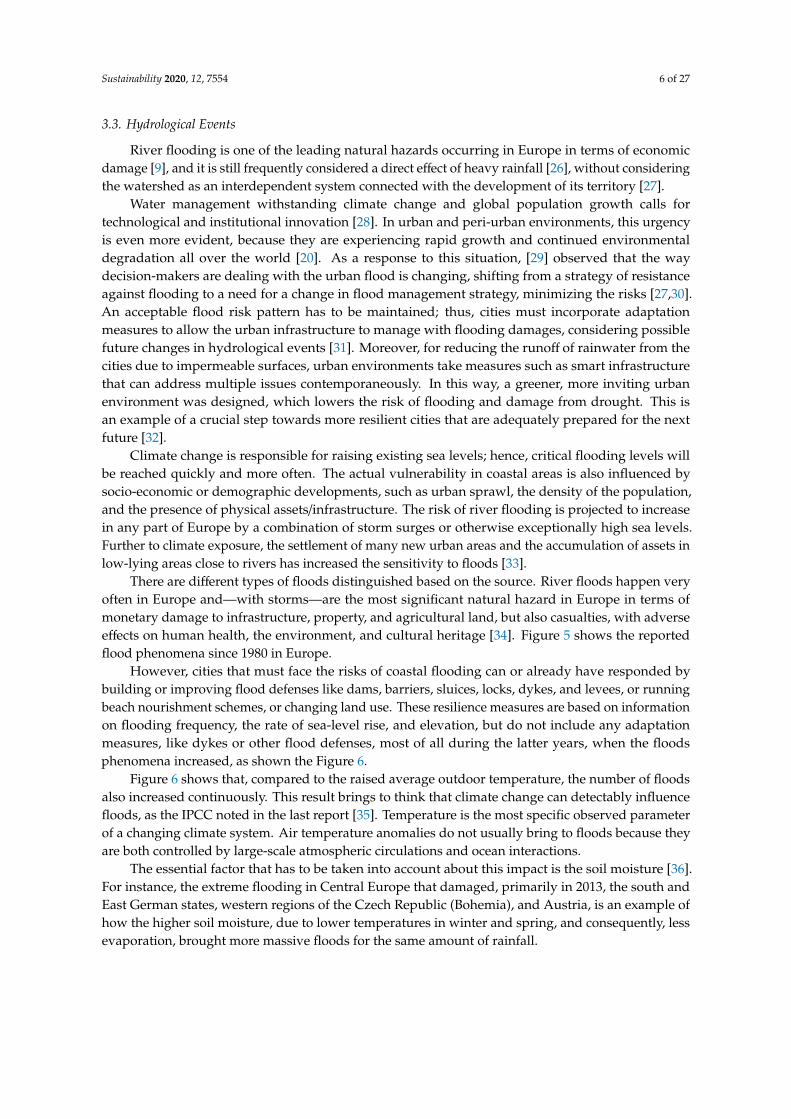
3.3. Hydrological Events
River flooding is one of the leading natural hazards occurring in Europe in terms of economicdamage [9], and it is still frequently considered a direct effect of heavy rainfall [26], without consideringthe watershed as an interdependent system connected with the development of its territory [27].
Water management withstanding climate change and global population growth calls fortechnological and institutional innovation [28]. In urban and peri-urban environments, this urgencyis even more evident, because they are experiencing rapid growth and continued environmentaldegradation all over the world [20]. As a response to this situation, [29] observed that the waydecision-makers are dealing with the urban flood is changing, shifting from a strategy of resistanceagainst flooding to a need for a change in flood management strategy, minimizing the risks [27,30].An acceptable flood risk pattern has to be maintained; thus, cities must incorporate adaptationmeasures to allow the urban infrastructure to manage with flooding damages, considering possiblefuture changes in hydrological events [31]. Moreover, for reducing the runoff of rainwater from thecities due to impermeable surfaces, urban environments take measures such as smart infrastructurethat can address multiple issues contemporaneously. In this way, a greener, more inviting urbanenvironment was designed, which lowers the risk of flooding and damage from drought. This isan example of a crucial step towards more resilient cities that are adequately prepared for the nextfuture [32].
Climate change is responsible for raising existing sea levels; hence, critical flooding levels willbe reached quickly and more often. The actual vulnerability in coastal areas is also influenced bysocio-economic or demographic developments, such as urban sprawl, the density of the population,and the presence of physical assets/infrastructure. The risk of river flooding is projected to increasein any part of Europe by a combination of storm surges or otherwise exceptionally high sea levels.Further to climate exposure, the settlement of many new urban areas and the accumulation of assets inlow-lying areas close to rivers has increased the sensitivity to floods [33].
There are different types of floods distinguished based on the source. River floods happen veryoften in Europe and—with storms—are the most significant natural hazard in Europe in terms ofmonetary damage to infrastructure, property, and agricultural land, but also casualties, with adverseeffects on human health, the environment, and cultural heritage [34]. Figure 5 shows the reportedflood phenomena since 1980 in Europe.
However, cities that must face the risks of coastal flooding can or already have responded bybuilding or improving flood defenses like dams, barriers, sluices, locks, dykes, and levees, or runningbeach nourishment schemes, or changing land use. These resilience measures are based on informationon flooding frequency, the rate of sea-level rise, and elevation, but do not include any adaptationmeasures, like dykes or other flood defenses, most of all during the latter years, when the floodsphenomena increased, as shown the Figure 6.
Figure 6 shows that, compared to the raised average outdoor temperature, the number of floodsalso increased continuously. This result brings to think that climate change can detectably influencefloods, as the IPCC noted in the last report [35]. Temperature is the most specific observed parameterof a changing climate system. Air temperature anomalies do not usually bring to floods because theyare both controlled by large-scale atmospheric circulations and ocean interactions.
The essential factor that has to be taken into account about this impact is the soil moisture [36].For instance, the extreme flooding in Central Europe that damaged, primarily in 2013, the south andEast German states, western regions of the Czech Republic (Bohemia), and Austria, is an example ofhow the higher soil moisture, due to lower temperatures in winter and spring, and consequently, lessevaporation, brought more massive floods for the same amount of rainfall.

Sustainability 2020, 12, 7554 7 of 27
Sustainability 2020, 12, x FOR PEER REVIEW 7 of 29
Figure 5. Floods per 10,000 km2 in European countries recorded since 1980. Source of data: European Environment Agency (EEA) and Copernicus Programme. Visualization: Author Licia Felicioni.
However, cities that must face the risks of coastal flooding can or already have responded by building or improving flood defenses like dams, barriers, sluices, locks, dykes, and levees, or running beach nourishment schemes, or changing land use. These resilience measures are based on information on flooding frequency, the rate of sea-level rise, and elevation, but do not include any adaptation measures, like dykes or other flood defenses, most of all during the latter years, when the floods phenomena increased, as shown the Figure 6.
Figure 5. Floods per 10,000 km2 in European countries recorded since 1980. Source of data: EuropeanEnvironment Agency (EEA) and Copernicus Programme. Visualization: Author Licia Felicioni.
Figure 7 shows a map with the low-lying urban areas potentially threatened by river/coastalflooding in the period between 2071–2100, but also the areas hypothetically affected by the risk ofcoastal flooding under an assumed sea level rise of 2 m and storm surge events. Among the mostexposed coastal cities in Europe are many situated in the Netherlands, Germany, Belgium, and areasalong the northern Italian coastlines, in particular, Venice.

Sustainability 2020, 12, 7554 8 of 27Sustainability 2020, 12, x FOR PEER REVIEW 8 of 29
Figure 6. The trend of severe past floods (1980–2010) and temperature in Europe analyzed using EEA data related to European surface temperature relative to the pre-industrial period (average temperature between 1850 and 1900). Source of data: European Environment Agency (EEA) and the European Centre for Medium-Range Weather Forecasts (ECMWF). Visualization: Author Licia Felicioni.
Figure 6 shows that, compared to the raised average outdoor temperature, the number of floods also increased continuously. This result brings to think that climate change can detectably influence floods, as the IPCC noted in the last report [35]. Temperature is the most specific observed parameter of a changing climate system. Air temperature anomalies do not usually bring to floods because they are both controlled by large-scale atmospheric circulations and ocean interactions.
The essential factor that has to be taken into account about this impact is the soil moisture [36]. For instance, the extreme flooding in Central Europe that damaged, primarily in 2013, the south and East German states, western regions of the Czech Republic (Bohemia), and Austria, is an example of how the higher soil moisture, due to lower temperatures in winter and spring, and consequently, less evaporation, brought more massive floods for the same amount of rainfall.
Figure 7 shows a map with the low-lying urban areas potentially threatened by river/coastal flooding in the period between 2071–2100, but also the areas hypothetically affected by the risk of coastal flooding under an assumed sea level rise of 2 m and storm surge events. Among the most exposed coastal cities in Europe are many situated in the Netherlands, Germany, Belgium, and areas along the northern Italian coastlines, in particular, Venice.
Figure 6. The trend of severe past floods (1980–2010) and temperature in Europe analyzed using EEAdata related to European surface temperature relative to the pre-industrial period (average temperaturebetween 1850 and 1900). Source of data: European Environment Agency (EEA) and the EuropeanCentre for Medium-Range Weather Forecasts (ECMWF). Visualization: Author Licia Felicioni.
Sustainability 2020, 12, x FOR PEER REVIEW 9 of 29
Figure 7. Percentage of the risk of flooding in European urban areas caused by rivers and by sea-level increase by 2 m. Source of data: European Environment Agency (EEA). Visualization: Author Licia Felicioni.
The main message that these maps shared is which hazard every EU country has to face, in order to help for understanding these stressors for enhancing urban and building resilience. Currently, Europe is in an unusual flood-rich period in term of occurrence and spatial proportions, and that brings flood-risk management strategies and assessment tools adequately focused on this impact under consideration.
Figure 7. Percentage of the risk of flooding in European urban areas caused by rivers and by sea-levelincrease by 2 m. Source of data: European Environment Agency (EEA). Visualization: AuthorLicia Felicioni.

Sustainability 2020, 12, 7554 9 of 27
The main message that these maps shared is which hazard every EU country has to face, in orderto help for understanding these stressors for enhancing urban and building resilience. Currently,Europe is in an unusual flood-rich period in term of occurrence and spatial proportions, and thatbrings flood-risk management strategies and assessment tools adequately focused on this impactunder consideration.
3.4. Climatological Events
Wildfires
Fires are an integral component of the European landscapes, especially in the Mediterraneanregion. The hazard of uncontrolled fires is higher and higher and may cause extensive environmentaland economic damages. About 65,000 fires occur in Europe every year, burning approximately halfa million hectares of greenfield and forest areas [37]. The fire danger series have to be analyzed;thus, the meteorological fire danger indices were used, in particular, the Canadian Fire Weather Index(FWI) [38], which is regularly utilized to rate fire potential owing to climatic conditions. The meanseasonal FWI can explain most of the year-to-year variation in burnt areas in European countries [39].This index is a whole number that ranges between 0 and 40. The primary parameters needed tocalculate it are [40,41]:
• The humidity of the air;• Afternoon temperature (when the value is the highest);• The 24-h total precipitation;• The maximum speed of the average wind.
Past trends (1980–2010) of wildfires have been investigated (Figure 8), and the results showedconsiderable variability from one year to the following, which was strongly determined by the seasonalmeteorological conditions. During this 30-years-period, the burn-areas exponential curve goes down,while the number of floods one increases during the whole period. The explanation of these results canbe, in the case of fires, that it is possible to make some specific provisions because of the awareness ofthis hazard, such as mapping the protected areas and, consequently, ensuring better protection againstwildfires [42]. On the other side, for floods, it is possible to make some safety barriers around themain points (rivers, sea). Still, it is much more challenging to forecast the phenomena and prepareadequate protections.
Sustainability 2020, 12, x FOR PEER REVIEW 10 of 29
3.4. Climatological Events
Wildfires
Fires are an integral component of the European landscapes, especially in the Mediterranean region. The hazard of uncontrolled fires is higher and higher and may cause extensive environmental and economic damages. About 65,000 fires occur in Europe every year, burning approximately half a million hectares of greenfield and forest areas [37]. The fire danger series have to be analyzed; thus, the meteorological fire danger indices were used, in particular, the Canadian Fire Weather Index (FWI) [38], which is regularly utilized to rate fire potential owing to climatic conditions. The mean seasonal FWI can explain most of the year-to-year variation in burnt areas in European countries [39]. This index is a whole number that ranges between 0 and 40. The primary parameters needed to calculate it are [40,41]:
• The humidity of the air; • Afternoon temperature (when the value is the highest); • The 24-h total precipitation; • The maximum speed of the average wind.
Past trends (1980–2010) of wildfires have been investigated (Figure 8), and the results showed considerable variability from one year to the following, which was strongly determined by the seasonal meteorological conditions. During this 30-years-period, the burn-areas exponential curve goes down, while the number of floods one increases during the whole period. The explanation of these results can be, in the case of fires, that it is possible to make some specific provisions because of the awareness of this hazard, such as mapping the protected areas and, consequently, ensuring better protection against wildfires [42]. On the other side, for floods, it is possible to make some safety barriers around the main points (rivers, sea). Still, it is much more challenging to forecast the phenomena and prepare adequate protections.
Figure 8. The trend of burnt areas (1980–2010) and temperature in Europe analyzed using EEA data related to European surface temperature relative to the pre-industrial period (average temperature between 1850 and 1900). Source of data: European Environment Agency (EEA) and the European Centre for Medium-Range Weather Forecasts (ECMWF). Visualization: Author Licia Felicioni.
Figure 8. The trend of burnt areas (1980–2010) and temperature in Europe analyzed using EEA datarelated to European surface temperature relative to the pre-industrial period (average temperaturebetween 1850 and 1900). Source of data: European Environment Agency (EEA) and the EuropeanCentre for Medium-Range Weather Forecasts (ECMWF). Visualization: Author Licia Felicioni.

Sustainability 2020, 12, 7554 10 of 27
Despite a smaller overall area being burnt than in previous years, the absolute fire danger willremain highest in southern Europe, due to above-average temperatures persisting, and the increase infire danger is projected to be mainly significant in western-central Europe (Figure 9), as a consequence ofhigh emission scenarios that brings to more severe fire weather and substantial expansion of fire-proneareas [43,44]. This can create conditions that help the ignition and spread of forest fires, causing higheconomic and environmental losses [45,46].
Sustainability 2020, 12, x FOR PEER REVIEW 11 of 29
Despite a smaller overall area being burnt than in previous years, the absolute fire danger will remain highest in southern Europe, due to above-average temperatures persisting, and the increase in fire danger is projected to be mainly significant in western-central Europe (Figure 9), as a consequence of high emission scenarios that brings to more severe fire weather and substantial expansion of fire-prone areas [43,44]. This can create conditions that help the ignition and spread of forest fires, causing high economic and environmental losses [45,46].
Nevertheless, Portugal, Spain, and Turkey remain the countries with the highest fire hazard. Climate change projections suggest that there will be an increase of heatwave phenomena, as well as droughts across southern Europe, but it would be possible to reduce fire risks with substantial adaption measures, such as improved fire prevention [47,48].
Figure 9. Weather-driven forest fire danger in the projected change scenario (2071–2100). Source of data: European Environment Agency (EEA). Visualization: Author Licia Felicioni.
Figure 9. Weather-driven forest fire danger in the projected change scenario (2071–2100). Source ofdata: European Environment Agency (EEA). Visualization: Author Licia Felicioni.
Nevertheless, Portugal, Spain, and Turkey remain the countries with the highest fire hazard.Climate change projections suggest that there will be an increase of heatwave phenomena, as wellas droughts across southern Europe, but it would be possible to reduce fire risks with substantialadaption measures, such as improved fire prevention [47,48].
Knowing indeed, where or when wildfires will occur precisely is not possible. However, collectinginformation from climate and weather patterns, historical fire occurrence (see Figure 8), projectedforest fire danger (see Figure 9), and many more, it is possible to have a general overview to estimate ofthe likelihood of an area for a hypothetical wildfire. The European Commission has just launched theCopernicus Satellite system, which is used for preparatory and monitoring measures, and mappingforest fires emergencies [42].
3.5. Geophysical Events
Though climate change is a long and slowly progressive process that could be handled withconstant adaptations; an earthquake is an acute shock that strikes suddenly and cannot be foreseen,
Sustainability 2020, 12, 7554 11 of 27
and facing this disaster is necessarily a case of quick response and effective recovery strategies [14,49].Green open spaces contribute to enhance climate resilience, reducing the phenomena of heat islandin the urban areas. In contrast, not only green space, but also built-up and undeveloped open space,has an essential role in urban seismic resilience. Nevertheless, urban and building resilience to bothclimate change and seismic actions could be improved through the process of sustainable urbanmanagement, including participants’ involvement [50]. Life cycle assessment (LCA) methodologyrepresents an essential tool for sustainable structural design. Moreover, it can also result in a tool tohelp decision making, influencing the choice of materials and technologies, the promotion of particulardesign criteria, and recycling [51]. Although LCA is essential, in many rating tools, it is not adequatelyconsidered—see the analysis of the tools in Section 3.8.
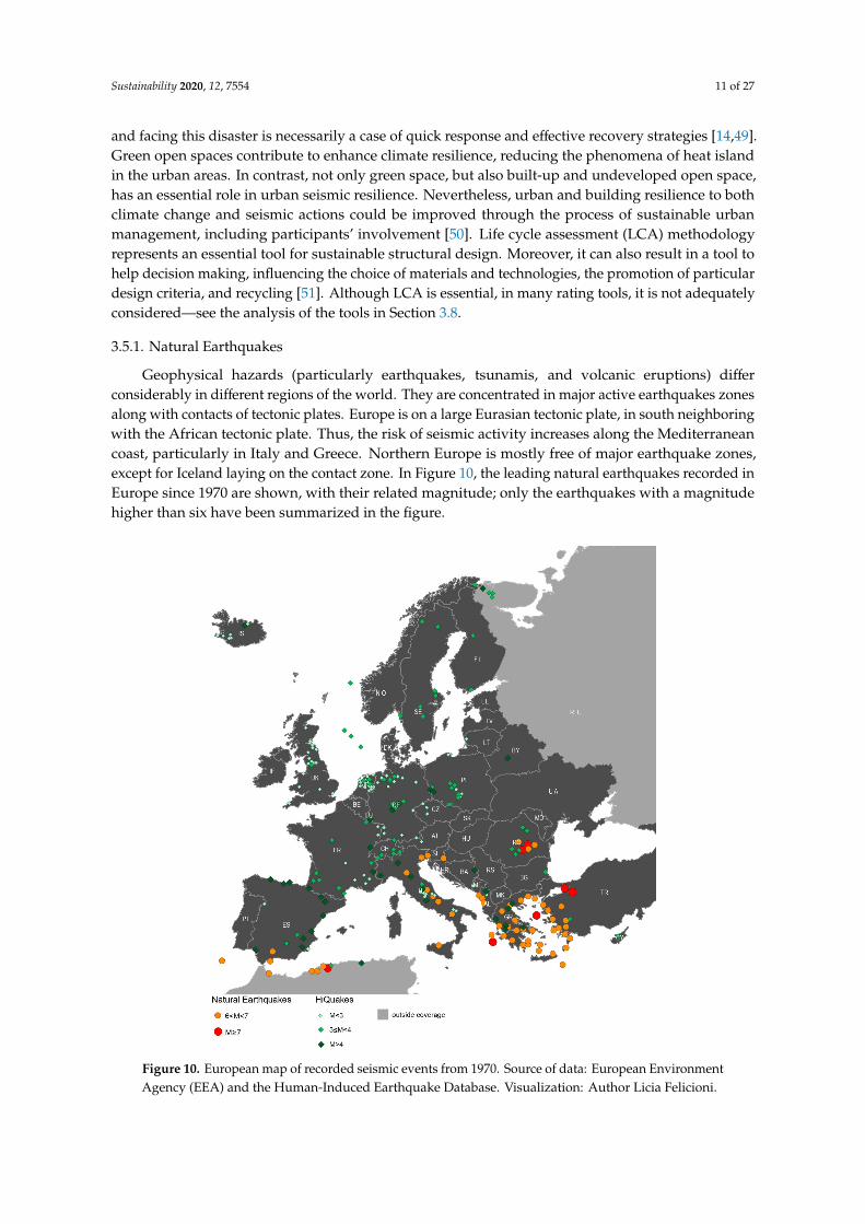
3.5.1. Natural Earthquakes
Geophysical hazards (particularly earthquakes, tsunamis, and volcanic eruptions) differconsiderably in different regions of the world. They are concentrated in major active earthquakes zonesalong with contacts of tectonic plates. Europe is on a large Eurasian tectonic plate, in south neighboringwith the African tectonic plate. Thus, the risk of seismic activity increases along the Mediterraneancoast, particularly in Italy and Greece. Northern Europe is mostly free of major earthquake zones,except for Iceland laying on the contact zone. In Figure 10, the leading natural earthquakes recorded inEurope since 1970 are shown, with their related magnitude; only the earthquakes with a magnitudehigher than six have been summarized in the figure.
Sustainability 2020, 12, x FOR PEER REVIEW 13 of 29
Figure 10. European map of recorded seismic events from 1970. Source of data: European Environment Agency (EEA) and the Human-Induced Earthquake Database. Visualization: Author Licia Felicioni.
3.5.2. Human-Induced Earthquakes
The Human-Induced Earthquakes (HiQuakes) [52], like natural earthquakes, can present apparent hazards to buildings, infrastructure, and human life [53]. Most HiQuakes seismicity has a low magnitude, less than 3 M, as Figure 10 shows. The events are happening mainly in Northern Europe (The Netherlands and Germany), in areas where the oil and gas extraction processes are more often.
HiQuakes could be caused by geothermal operations, reservoir impoundment (water behind dams), wastewater injections, and oil and gas operations such as hydraulic fracturing [54,55]. Due to large volumes of fluid injected into underground formations for storage or disposal, some fluid may move into faults causing pressures and releasing stored energy. This can generate seismicity and possibly an earthquake. In the literature, there is a difference between “induced” and “triggered”
Figure 10. European map of recorded seismic events from 1970. Source of data: European EnvironmentAgency (EEA) and the Human-Induced Earthquake Database. Visualization: Author Licia Felicioni.
Sustainability 2020, 12, 7554 12 of 27
3.5.2. Human-Induced Earthquakes
The Human-Induced Earthquakes (HiQuakes) [52], like natural earthquakes, can present apparenthazards to buildings, infrastructure, and human life [53]. Most HiQuakes seismicity has a lowmagnitude, less than 3 M, as Figure 10 shows. The events are happening mainly in Northern Europe(The Netherlands and Germany), in areas where the oil and gas extraction processes are more often.
HiQuakes could be caused by geothermal operations, reservoir impoundment (water behinddams), wastewater injections, and oil and gas operations such as hydraulic fracturing [54,55]. Due tolarge volumes of fluid injected into underground formations for storage or disposal, some fluid maymove into faults causing pressures and releasing stored energy. This can generate seismicity andpossibly an earthquake. In the literature, there is a difference between “induced” and “triggered”seismicity, based on how the energy is caused; the term “induced” is used when most of the energy ismade by anthropogenic origin meanwhile the term “triggered” is used when the cause is natural [56].
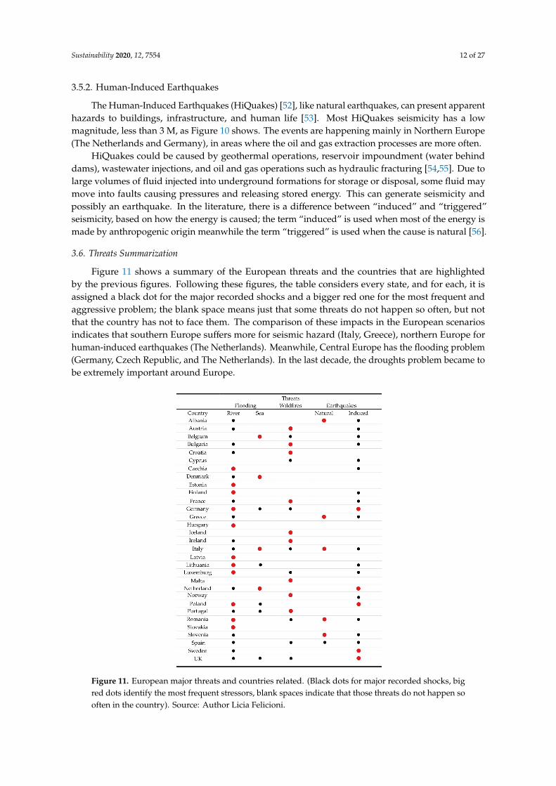
3.6. Threats Summarization
Figure 11 shows a summary of the European threats and the countries that are highlightedby the previous figures. Following these figures, the table considers every state, and for each, it isassigned a black dot for the major recorded shocks and a bigger red one for the most frequent andaggressive problem; the blank space means just that some threats do not happen so often, but notthat the country has not to face them. The comparison of these impacts in the European scenariosindicates that southern Europe suffers more for seismic hazard (Italy, Greece), northern Europe forhuman-induced earthquakes (The Netherlands). Meanwhile, Central Europe has the flooding problem(Germany, Czech Republic, and The Netherlands). In the last decade, the droughts problem became tobe extremely important around Europe.
Sustainability 2020, 12, x FOR PEER REVIEW 14 of 29
seismicity, based on how the energy is caused; the term “induced” is used when most of the energy is made by anthropogenic origin meanwhile the term “triggered” is used when the cause is natural [56].
3.6. Threats Summarization
Figure 11 shows a summary of the European threats and the countries that are highlighted by the previous figures. Following these figures, the table considers every state, and for each, it is assigned a black dot for the major recorded shocks and a bigger red one for the most frequent and aggressive problem; the blank space means just that some threats do not happen so often, but not that the country has not to face them. The comparison of these impacts in the European scenarios indicates that southern Europe suffers more for seismic hazard (Italy, Greece), northern Europe for human-induced earthquakes (The Netherlands). Meanwhile, Central Europe has the flooding problem (Germany, Czech Republic, and The Netherlands). In the last decade, the droughts problem became to be extremely important around Europe.
Figure 11. European major threats and countries related. (Black dots for major recorded shocks, big red dots identify the most frequent stressors, blank spaces indicate that those threats do not happen so often in the country). Source: Author Licia Felicioni.
Figure 11. European major threats and countries related. (Black dots for major recorded shocks, bigred dots identify the most frequent stressors, blank spaces indicate that those threats do not happen sooften in the country). Source: Author Licia Felicioni.

Sustainability 2020, 12, 7554 13 of 27
3.7. Resilience Evaluation Tools
As a result of the increasing amount of shocks previously described, cities are responding ina wide variety of ways [57]. The importance of developing strategies for improving the resilienceor minimizing negative impacts caused by unexpected disruptive events has been recognized andbroadly accepted, and many tools have been developed worldwide [58]; the U.S. Green BuildingCouncil, administrating the Leadership in Energy and Environmental Design (LEED) certification,made resilience a policy priority, writing RELi, a tool entirely focused on resilience.
Resilience tools can be suitable for an extensive range of stakeholders, but it can be tough to find theproper tool for the job. It is essential to focus on the regional level while choosing the appropriate tool.Currently, European countries are developing guidelines [59] suitable for facing those hazards, such asthe Risk Systemicity Questionnaire [60] and the Resilience Maturity Model [61,62], just two of theH2020 funded projects. The Risk Systemicity Questionnaire aims to support cities by enhancing theirrisk assessment through an advanced focus on the interactions between different types of risks that areevaluated within ten main topics (e.g., climate change air pollution and flooding). On the other hand,the Resilience Maturity Model enables cities to assess their maturity stage and to find policies to permitthe city to evolve and move to a more resilient way. Moreover, building sustainability certificationsystems like Building Research Establishment Environmental Assessment Method (BREEAM) [63] orthe Deutsche Gesellschaft für Nachhaltiges Bauen (DGNB) [64] also have some criteria focused onresilience enhancement. Still, their weighting is very light compared to their other topics.
Thus, the paper analyzed some resilience assessment tools that are now used mostly in the UnitedStates for enhancing properly urban and building resilience. The aim is to give some recommendationson how to develop new future resilience assessment systems, because regions, cities, and evencommunities are more-and-more called on to act at their local scale. In fact, for achieving theSustainable Development Goals (SDGs) of the European Union [9], the right tool has to be considered,because different countries and different regions have different conditions. It is crucial to tailor thereview to local situations and challenges. For instance, in Central Europe, the main problems are floodsand droughts, and, more recently, the UK has had to face storms and heavy rain.
In Italy, the primary stressor is the seismic hazard but the Italian rating system, ProtocolloITACA [65], does not consider at all this risk, it is more focused more on a building’s energy efficiency,instead of a building’s robustness.
3.8. Urban Resilience Tools
3.8.1. RELi 2.0
RELi [16] combines a comprehensive and expandable action list with an integrative processfor developing next-generation communities, neighborhoods, buildings, homes, and infrastructure.RELi is a rating system that works in cooperation with LEED [66] to tackle extreme events andstressors, like global warming, sea-level rise, social and economic volatility, and resource shortages [67].The Resilience Action List Credit Catalogue (Figure 12) includes over 190 indicators referred to LEEDcredits and to 2030 Palette [68], a free online platform that sets the principles behind carbon neutral andresilient built environments. Still, there is also a strong emphasis on resilience and sustainability. It ishighlighted that the design method is an integral part of achieving high-performing, resilient designoutcomes [69]. Figure 12 shows the weighting for each of the eight categories of the RELi resilienceassessment tool.
Sustainability 2020, 12, x FOR PEER REVIEW 15 of 29
3.7. Resilience Evaluation Tools
As a result of the increasing amount of shocks previously described, cities are responding in a wide variety of ways [57]. The importance of developing strategies for improving the resilience or minimizing negative impacts caused by unexpected disruptive events has been recognized and broadly accepted, and many tools have been developed worldwide [58]; the U.S. Green Building Council, administrating the Leadership in Energy and Environmental Design (LEED) certification, made resilience a policy priority, writing RELi, a tool entirely focused on resilience.
Resilience tools can be suitable for an extensive range of stakeholders, but it can be tough to find the proper tool for the job. It is essential to focus on the regional level while choosing the appropriate tool. Currently, European countries are developing guidelines [59] suitable for facing those hazards, such as the Risk Systemicity Questionnaire [60] and the Resilience Maturity Model [61,62], just two of the H2020 funded projects. The Risk Systemicity Questionnaire aims to support cities by enhancing their risk assessment through an advanced focus on the interactions between different types of risks that are evaluated within ten main topics (e.g., climate change air pollution and flooding). On the other hand, the Resilience Maturity Model enables cities to assess their maturity stage and to find policies to permit the city to evolve and move to a more resilient way. Moreover, building sustainability certification systems like Building Research Establishment Environmental Assessment Method (BREEAM) [63] or the Deutsche Gesellschaft für Nachhaltiges Bauen (DGNB) [64] also have some criteria focused on resilience enhancement. Still, their weighting is very light compared to their other topics.
Thus, the paper analyzed some resilience assessment tools that are now used mostly in the United States for enhancing properly urban and building resilience. The aim is to give some recommendations on how to develop new future resilience assessment systems, because regions, cities, and even communities are more-and-more called on to act at their local scale. In fact, for achieving the Sustainable Development Goals (SDGs) of the European Union [9], the right tool has to be considered, because different countries and different regions have different conditions. It is crucial to tailor the review to local situations and challenges. For instance, in Central Europe, the main problems are floods and droughts, and, more recently, the UK has had to face storms and heavy rain.
In Italy, the primary stressor is the seismic hazard but the Italian rating system, Protocollo ITACA [65], does not consider at all this risk, it is more focused more on a building’s energy efficiency, instead of a building’s robustness.
3.8. Urban Resilience Tools
3.8.1. RELi 2.0
RELi [16] combines a comprehensive and expandable action list with an integrative process for developing next-generation communities, neighborhoods, buildings, homes, and infrastructure. RELi is a rating system that works in cooperation with LEED [66] to tackle extreme events and stressors, like global warming, sea-level rise, social and economic volatility, and resource shortages [67]. The Resilience Action List Credit Catalogue (Figure 12) includes over 190 indicators referred to LEED credits and to 2030 Palette [68], a free online platform that sets the principles behind carbon neutral and resilient built environments. Still, there is also a strong emphasis on resilience and sustainability. It is highlighted that the design method is an integral part of achieving high-performing, resilient design outcomes [69]. Figure 12 shows the weighting for each of the eight categories of the RELi resilience assessment tool.
Figure 12. RELi assessment categories and their relative weightings. Source: Author Licia Felicioni. Figure 12. RELi assessment categories and their relative weightings. Source: Author Licia Felicioni.

Sustainability 2020, 12, 7554 14 of 27
Hazard mitigation with criteria like fundamental/advanced emergency operations, and communitycohesion with community connectivity, are the areas more influent in the whole system. RELi also actsdirectly on extreme weather, wildfire, and natural and human-made earthquake within the hazardmitigation category. It asks to meet some requirements like National Fire Protection Association(NFPA)for fires prevention [70]. The RELi method is very user-friendly: the criterion is presented withan intent (the aim of the criterion) and requirements (what it should be done to gain the criterion’spoints). For accomplishing these requirements, there are usually different ways that can be followed;then it is necessary to certify that the goal has been met with documents that prove it; precisely thesame pattern of LEED certification. Moreover, as the LEED rating system, also RELi considers the lifecycle assessment (LCA) of the materials in the prerequisite MA 1.0: minimum material effectiveness +
life cycle planning. According to the criteria, it is necessary to consider the environmental productdeclaration (EPD) and the life-cycle stages for comparing every product and choosing the most suitable.
3.8.2. Envision V3
Efforts to combine resilience indicators with sustainability in the United States had already startedwith the adoption of RELi resilience credits [16] in Envision V3 [71]. The Envision® Protocol isthe first rating system to create sustainable infrastructures through an analysis grid, adaptable toany infrastructure development project. Envision provides guidelines on sustainable best practicesto users and serves not only as a design tool but also for evaluating infrastructure projects oncecompleted [17,72].
Developing a framework for sustainability and urban resilience means that they collectivelyprovide a more comprehensive understanding of the issues. The holistic/integration process takesdeep consideration of the location, climate, and type of natural hazards in different geographic areas(Figure 13) [67].
Sustainability 2020, 12, x FOR PEER REVIEW 16 of 29
Hazard mitigation with criteria like fundamental/advanced emergency operations, and community cohesion with community connectivity, are the areas more influent in the whole system. RELi also acts directly on extreme weather, wildfire, and natural and human-made earthquake within the hazard mitigation category. It asks to meet some requirements like National Fire Protection Association (NFPA)for fires prevention [70]. The RELi method is very user-friendly: the criterion is presented with an intent (the aim of the criterion) and requirements (what it should be done to gain the criterion’s points). For accomplishing these requirements, there are usually different ways that can be followed; then it is necessary to certify that the goal has been met with documents that prove it; precisely the same pattern of LEED certification. Moreover, as the LEED rating system, also RELi considers the life cycle assessment (LCA) of the materials in the prerequisite MA 1.0: minimum material effectiveness + life cycle planning. According to the criteria, it is necessary to consider the environmental product declaration (EPD) and the life-cycle stages for comparing every product and choosing the most suitable.
3.8.2. Envision V3
Efforts to combine resilience indicators with sustainability in the United States had already started with the adoption of RELi resilience credits [16] in Envision V3 [71]. The Envision® Protocol is the first rating system to create sustainable infrastructures through an analysis grid, adaptable to any infrastructure development project. Envision provides guidelines on sustainable best practices to users and serves not only as a design tool but also for evaluating infrastructure projects once completed [17,72].
Developing a framework for sustainability and urban resilience means that they collectively provide a more comprehensive understanding of the issues. The holistic/integration process takes deep consideration of the location, climate, and type of natural hazards in different geographic areas (Figure 13) [67].
Figure 13. Envision v3 five main areas and their weightings. There are 1000 available points available among 64 different credits. Source: Author Licia Felicioni.
Minimizing emissions and consequently face climate change and other risks (such as flooding or fires) for ensuring the resilience of infrastructures is the main scope of the climate and resilience category (19% of weighting among the tool—10 credits).
For instance, the CR2.3 Evaluate Risk and Resilience credit requires a comprehensive risk evaluation to understand potential hazards/threats and the project’s vulnerability. For example, flooding might be a hazard to a project; critical structures located below flood levels would be vulnerable to that threat. An evaluation of the flood event’s probability and severity as a factor of the related losses is needed if the critical systems were flooded. Therefore, Envision is required to determine the associated consequences of the occurrence in each sustainability category of social (people, community), environmental (contamination, destruction), or economic (cost of repair, financial losses). Sixty-four non-mandatory criteria characterize the Envision method. Each criterion presents the following parameters:
• Total possible points; • Intent (the credit’s goal); • Metric (how the credit will be measured);
Figure 13. Envision v3 five main areas and their weightings. There are 1000 available points availableamong 64 different credits. Source: Author Licia Felicioni.
Minimizing emissions and consequently face climate change and other risks (such as floodingor fires) for ensuring the resilience of infrastructures is the main scope of the climate and resiliencecategory (19% of weighting among the tool—10 credits).
For instance, the CR2.3 Evaluate Risk and Resilience credit requires a comprehensive riskevaluation to understand potential hazards/threats and the project’s vulnerability. For example,flooding might be a hazard to a project; critical structures located below flood levels would bevulnerable to that threat. An evaluation of the flood event’s probability and severity as a factor ofthe related losses is needed if the critical systems were flooded. Therefore, Envision is required todetermine the associated consequences of the occurrence in each sustainability category of social(people, community), environmental (contamination, destruction), or economic (cost of repair, financiallosses). Sixty-four non-mandatory criteria characterize the Envision method. Each criterion presentsthe following parameters:
• Total possible points;• Intent (the credit’s goal);• Metric (how the credit will be measured);

Sustainability 2020, 12, 7554 15 of 27
• Level of achievement (description of the requirements required to meet each level of achievement);typically, there are five different levels (improved, enhanced, superior, conserving, and restorative)that indicate how much the credit is addressed and consequently how many points will be released;
• Description of the criterion;• Performance improvement (performance benchmarks set);• Criteria evaluation and documentation (what kind of documents have to be submitted to
demonstrate that requirements were met).
Moreover, within Envision v3, it is fundamental to take into account a life-cycle economic approachfor enhancing decision making by encouraging the effective management of resources and assessingthat ultimately lead to more sustainable and resilient projects. The LD3.3 Conduct a Life-CycleEconomic Evaluation credit (max 14 points) aims to conduct a life-cycle cost analysis (LCCA) on thewhole project to identify the total economic impacts of the project.
3.8.3. Comparison between Urban Resilience Tools
In Table 1, it is shown the comparison between RELi and Envision, tools both developed in theUSA but starting to be used worldwide for evaluating urban resilience.
Table 1. Comparison between urban resilience rating systems.
RELi 2.0 Envision v3
Developer USGBC (2018)Institute for Sustainable Infrastructure (ISI)
and Zonfnass Program for SustainableInfrastructure (Harvard University) (2015)
Who is it for? Owners OwnersEnd Users End UsersPlanners Planners
GovernmentMaturity Emerging In use
Number of credits 43 64Maximum total points in the
framework 800 1000
Credit categories 8 5
Costs USD 1200 (GBCI members) The Envision sustainability framework isfree for all ISI members. Open Source
USD 1500 (non—members)Award Levels 300 points—Certified 20% credits—Verified
350 points—Silver 30% credits—Silver450 points—Gold 40% credits—Gold
600 + points—Platinum 50% credits—Platinum
Behind this more generic information, the main difference between these tools is that RELi has abroader background on hazards. For instance, it considers more seismic safety (28.1%) than Envision,which has the same weighting for facing each stressor (2.3%).
3.9. Building Resilience Tools
3.9.1. REDi
The aim of Resilience-based Earthquake Design Initiative (REDi™) [73] Rating System, developedby ARUP, is to provide stakeholders with a framework for implementing a “resilience-based earthquakedesign”. These planning and assessment approaches are within a holistic process that identifies andmitigates earthquake-induced risks, to enable quick recovery of the buildings. The framework isdeveloped by four main steps, as Figure 14 shows.

Sustainability 2020, 12, 7554 16 of 27Sustainability 2020, 12, x FOR PEER REVIEW 18 of 29
Figure 14. Resilience-based Earthquake Design Initiative (REDi) framework and its related four categories weightings, 65 criteria available within the tool. Source: Author Licia Felicioni.
Sixty-five non-mandatory criteria characterize the REDi method. Compared to the other analyzed tools, it is the only one that does not work with a points system; in fact, its rating is assessed by three different factors: downtime, financial loss, and occupant safety (Table 2). Each main category (organizational, building and ambient resilience, and loss assessment) has its criteria, which have other subcriteria that address the satisfaction of the requirements for meeting the rating. For each credit, standards requirements have to be pursued, such as enhancing the structure or the resuming of building operation after the hazard. One of the critical aspects of resilience-based design is preparedness for post-earthquake recovery to ensure continued operation and livable conditions immediately after the extreme event [18,74].
Table 2. REDi thresholds according to three key aspects (downtime, financial loss, and occupant safety) after a shock occurred. Source: REDi, 2013.
Rating Downtime Direct Financial Loss Occupant Safety Silver <6 months 1 <6 months 2 <10% Injuries possible Gold Immediate 1 <1 month 2 <5% Injuries unlikely
Platinum Immediate 1 <72 h 2 <2.5% Injuries unlikely 1 Re-occupancy downtime. 2 Functional recovery downtime.
This tool is handy for seismic resilience mostly (40% of its criteria); in fact, also in RELi, it is used as a guideline for safety measures. On the other hand, it does not treat further hazards properly, but just the threats that are consequences of an earthquake event (3.1% of its criteria about fire). For example, in the category ambient resilience, in the criterion C3.1.5—Assessment of Surrounding Buildings, the assessment should include qualitative external falling evaluation hazards and fire hazard. At the same time, also in the building resilience category, the floods are treated as a consequence (1.5% of its criteria) of storm surge or tsunami and in this way, are given some guidelines for avoiding building electrical system in the lower level.
3.9.2. RESBy
Environmentally Friendly Resilient Residential Buildings (RESBy) was developed in 2017 by the University Centre for Energy Efficient Buildings (UCEEB) of Czech Technical University in Prague. One of the main objectives of RESBy is the development of a methodology for the evaluation of new buildings in the planning phase for resilience, climate change mitigation, and adaptation, with a focus on Central European residential buildings [19]. The list of criteria that have equal weights is shown in Table 3. For evaluating the potential threats for residential buildings, it is developed this assessment method that provides descriptions of indicators, procedures for calculation of the values, and benchmarks for calculating the score for each criterion [75]. Dislike REDi, the RESBy tool does not consider seismic issues, as, in Central Europe, the occurrence of earthquakes is rare and very weak. From the other categories of hazards of concern, the method evaluates means of local mitigation of flash floods, minimization of damage from regular floods, resilience to extreme weather events, and protection against wildfires. In addition to these, the method also assesses the level of preparedness for buildings’ operation in case of infrastructure failures resulting from disasters.
Figure 14. Resilience-based Earthquake Design Initiative (REDi) framework and its related fourcategories weightings, 65 criteria available within the tool. Source: Author Licia Felicioni.
Sixty-five non-mandatory criteria characterize the REDi method. Compared to the other analyzedtools, it is the only one that does not work with a points system; in fact, its rating is assessed bythree different factors: downtime, financial loss, and occupant safety (Table 2). Each main category(organizational, building and ambient resilience, and loss assessment) has its criteria, which have othersubcriteria that address the satisfaction of the requirements for meeting the rating. For each credit,standards requirements have to be pursued, such as enhancing the structure or the resuming of buildingoperation after the hazard. One of the critical aspects of resilience-based design is preparedness forpost-earthquake recovery to ensure continued operation and livable conditions immediately after theextreme event [18,74].
Table 2. REDi thresholds according to three key aspects (downtime, financial loss, and occupant safety)after a shock occurred. Source: REDi, 2013.
Rating Downtime Direct Financial Loss Occupant Safety
Silver <6 months 1 <6 months 2 <10% Injuries possibleGold Immediate 1 <1 month 2 <5% Injuries unlikely
Platinum Immediate 1 <72 h 2 <2.5% Injuries unlikely1 Re-occupancy downtime. 2 Functional recovery downtime.
This tool is handy for seismic resilience mostly (40% of its criteria); in fact, also in RELi, it is used asa guideline for safety measures. On the other hand, it does not treat further hazards properly, but justthe threats that are consequences of an earthquake event (3.1% of its criteria about fire). For example,in the category ambient resilience, in the criterion C3.1.5—Assessment of Surrounding Buildings,the assessment should include qualitative external falling evaluation hazards and fire hazard. At thesame time, also in the building resilience category, the floods are treated as a consequence (1.5% of itscriteria) of storm surge or tsunami and in this way, are given some guidelines for avoiding buildingelectrical system in the lower level.
3.9.2. RESBy
Environmentally Friendly Resilient Residential Buildings (RESBy) was developed in 2017 by theUniversity Centre for Energy Efficient Buildings (UCEEB) of Czech Technical University in Prague.One of the main objectives of RESBy is the development of a methodology for the evaluation of newbuildings in the planning phase for resilience, climate change mitigation, and adaptation, with afocus on Central European residential buildings [19]. The list of criteria that have equal weightsis shown in Table 3. For evaluating the potential threats for residential buildings, it is developedthis assessment method that provides descriptions of indicators, procedures for calculation of thevalues, and benchmarks for calculating the score for each criterion [75]. Dislike REDi, the RESBy tooldoes not consider seismic issues, as, in Central Europe, the occurrence of earthquakes is rare andvery weak. From the other categories of hazards of concern, the method evaluates means of localmitigation of flash floods, minimization of damage from regular floods, resilience to extreme weatherevents, and protection against wildfires. In addition to these, the method also assesses the level ofpreparedness for buildings’ operation in case of infrastructure failures resulting from disasters.

Sustainability 2020, 12, 7554 17 of 27
Table 3. Set of criteria for the assessment of the resilience of multifamily residential building inCentral Europe.
Category Threat
Climatic and atmospheric threats Torrential rains FloodsExtreme summer and winter temperatures
Longer periods of droughtHeat islands
Dust particles in outdoor airFire Effects of external fire
Effects of indoor fireNoise Noise from transportation
Noise from external technological sourcesSocial threats Ageing population
Low architectural and operating quality, low variabilityEnergy poverty
Disorderly conduct, Social riots and CrimeInfrastructural failures Interruptions of electricity supply for more than several hours
Interruptions of supply of heat or gas for heating for more than several hoursInterruptions of freshwater supply for more days
Interruptions of fuel supplies for more weeksRisk of failures of building services Unreliability or over-complexity of building services
The criteria were developed in 2018, according to projections of the future climate in CentralEurope based on the literature [76]. As the previous European maps showed, the most frequent hazardin Central Europe is the floods. In this way, this tool considers many measures to avoid this building’spotential threat. One limitation of this system is that it is suitable just for new residential buildings.
3.9.3. Comparison between Building Resilience Tools
About building resilience, both tools consider the three considered impacts. REDi has criteria forfacing floods and fires, even if it is more focused on seismic safety. Instead, RESBy has several measuresfor tackling floods and fires; moreover, it takes also into account measures for facing droughts. Seismicresilience is not considered in this tool because it is developed in the Czech Republic, a non-seismichazard country.
In Table 4, the comparison between REDi (USA) and RESBy (Czechia) is shown.
Table 4. Comparison of building resilience rating systems.
REDi RESBy
Developer ARUP (2013) UCEEB (2017)Stakeholders Owners Owners
End Users End UsersPlanners Planners
Region Worldwide Central EuropeMaturity Emerging Developing
Number of credits 65 20Maximum total points in the framework - 200
Credit categories 4 6Costs Open Source/Freemium Freely available
Award Levels Silver 1 Under developmentGold 1
Platinum 1
1 According to downtime, financial loss and occupant safety.

Sustainability 2020, 12, 7554 18 of 27
3.10. Comparison between Resilience Assessment Tools
For a general comparison, as the Figure 15 shows, the RIBA Plan of Work [77] was used, a documentthat outlines all stages in the planning, design, and building process, from conception to completionon site. Envision is the tool that covers almost all the whole life cycle of the infrastructure.
Sustainability 2020, 12, x FOR PEER REVIEW 20 of 29
3.10. Comparison between Resilience Assessment Tools
For a general comparison, as the Figure 15 shows, the RIBA Plan of Work [77] was used, a document that outlines all stages in the planning, design, and building process, from conception to completion on site. Envision is the tool that covers almost all the whole life cycle of the infrastructure.
Figure 15. The RIBA Plan of Work 2013. Source: Author Licia Felicioni.
On the other hand, Figure 16 shows the comparison between the analyzed resilience assessment tools and other international rating systems about their weightings for the significant European threats (floods, forest fires, droughts, and earthquakes). The popular rating systems, such as LEED or DGNB, present some criteria for hazards facing (e.g., sensitive land protection in LEED’s location and transportation category [78] for floods, or local environment in DGNB’s site quality category [79] for floods and forest fires). Even though they are considered in the framework, they are not specific enough to give sufficient guidelines for enhancing resilience; only about 5% of their criteria (for both LEED and DGNB) can cover such hazards. On the other hand, these sustainable tools are used mostly in different topics such as energy optimization or decarbonization; in fact, 28% of LEED criteria and almost 19% of DGNBs’ ones are about energy savings.
Figure 16. Comparison between international rating systems and resilience assessment tools. Source: Author Licia Felicioni.
4. Discussion
Resilience is seen as an essential characteristic of the built environment that helps to reduce the vulnerability of citizens to weather-related hazards. In the presented maps, different risks in different European countries, and some related tables with the recorded frequency since 1980 are shown.
Figure 15. The RIBA Plan of Work 2013. Source: Author Licia Felicioni.
On the other hand, Figure 16 shows the comparison between the analyzed resilience assessmenttools and other international rating systems about their weightings for the significant Europeanthreats (floods, forest fires, droughts, and earthquakes). The popular rating systems, such as LEEDor DGNB, present some criteria for hazards facing (e.g., sensitive land protection in LEED’s locationand transportation category [78] for floods, or local environment in DGNB’s site quality category [79]for floods and forest fires). Even though they are considered in the framework, they are not specificenough to give sufficient guidelines for enhancing resilience; only about 5% of their criteria (for bothLEED and DGNB) can cover such hazards. On the other hand, these sustainable tools are used mostlyin different topics such as energy optimization or decarbonization; in fact, 28% of LEED criteria andalmost 19% of DGNBs’ ones are about energy savings.
Sustainability 2020, 12, x FOR PEER REVIEW 20 of 29
3.10. Comparison between Resilience Assessment Tools
For a general comparison, as the Figure 15 shows, the RIBA Plan of Work [77] was used, a document that outlines all stages in the planning, design, and building process, from conception to completion on site. Envision is the tool that covers almost all the whole life cycle of the infrastructure.
Figure 15. The RIBA Plan of Work 2013. Source: Author Licia Felicioni.
On the other hand, Figure 16 shows the comparison between the analyzed resilience assessment tools and other international rating systems about their weightings for the significant European threats (floods, forest fires, droughts, and earthquakes). The popular rating systems, such as LEED or DGNB, present some criteria for hazards facing (e.g., sensitive land protection in LEED’s location and transportation category [78] for floods, or local environment in DGNB’s site quality category [79] for floods and forest fires). Even though they are considered in the framework, they are not specific enough to give sufficient guidelines for enhancing resilience; only about 5% of their criteria (for both LEED and DGNB) can cover such hazards. On the other hand, these sustainable tools are used mostly in different topics such as energy optimization or decarbonization; in fact, 28% of LEED criteria and almost 19% of DGNBs’ ones are about energy savings.
Figure 16. Comparison between international rating systems and resilience assessment tools. Source: Author Licia Felicioni.
4. Discussion
Resilience is seen as an essential characteristic of the built environment that helps to reduce the vulnerability of citizens to weather-related hazards. In the presented maps, different risks in different European countries, and some related tables with the recorded frequency since 1980 are shown.
Figure 16. Comparison between international rating systems and resilience assessment tools. Source:Author Licia Felicioni.
4. Discussion
Resilience is seen as an essential characteristic of the built environment that helps to reducethe vulnerability of citizens to weather-related hazards. In the presented maps, different risks indifferent European countries, and some related tables with the recorded frequency since 1980 are shown.

Sustainability 2020, 12, 7554 19 of 27
Selected tools covering resilience were analyzed, but they were developed for specific situations insome countries, and are not applicable to other states. The target of this analysis was to identify howthe European countries can mitigate the threats. Each area is affected by different hazards, so eachcountry should have, in a specific rating tool, the criteria for the assessment of these particular relevantimpacts like floods, earthquakes, HiQuakes, droughts, and many more. It cannot be covered by aunified general system, which cannot sufficiently address all specifics of the country and its regions.On the other hand, these tools are not appropriate to solve all the problems in the country because,as Figure 16 shows, they have different weightings for each impact. The proper location-contextualizedweighting is a topic for further research in the field.
Now, according to the previous maps and the analysis of the tools, it could be possible for thestakeholders, such as city and urban planners, to find the right balance between lower environmentalimpacts and urban resilience in the paradigm of smart cities. A smart city is a consequence of smartplanning that has resilience as one of its principal aims [80]. For instance, smart planning can encourageresilience and river flood protection with shields or disposition of the building installations on thehigher floors but, at the same time, gives guidelines to minor adjustments, such as rain gardenson the streets for slowing runoff and consequently avoiding the paralysis of the sewer systems.These urban strategies will not only provide a more resilient urban environment, but they will alsoenhance spaces more pleasantly and attractively for the community. The challenge now is to measurethe state of human development (indicators of wellbeing), shocks (projections of future hazardssuch as flooding), and social-ecological conditions (indicators of determinants of resilience) [81–83].Resilience assessment should be based on wellbeing [84], ensuring safety, and minimizing nuisances(including light pollution, noise, and vibration). Envision v3 considers these components in thesubcategory “wellbeing” (six related credits) within the category quality of life. These credits arefocused mostly on improving community quality of life (max. 26 points) and enhance health and safety(up to 20 points). Moreover, it should take into account poverty measures [85] following Goal 11 ofEuropean SDGs, which promotes making cities and human settlements inclusive, safe, resilient, andsustainable [9]. In this way, with social-ecological resilience, it will be able to face the unpredictedchange to support human wellbeing [82]. In conclusion, assessment tools, such as RELi and Envisionv3, are suitable systems to assess and predict onsite hazards, and to suggest preventative solutions,leveraging technology to identify stressors, and improving the health and wellbeing of the communityand built environment.
Summary and Trends of Floods, Wildfires and Seismic Hazards in EU
As a result of human development and the growth of the built environment, floods and firesimpact in term of costs and benefits on ecological and social systems. Natural seismic hazard is aresult of geophysical activities, while human-induced seismicity is like floods and fires result of humandevelopment. Investing in resilience measures and disaster risk reduction needs a comprehensivecomprehension of multi-hazard risk [86].
The analyzed maps (see Sections 3.3 and 3.4) of the past trends floods and wildfires show anincreasing trend for floods, while, for the burnt areas, the exponential curve is slowly going downcompared to the past. This means that the wildfire situation in Europe seems to have been broughtunder control in a better way than previously, thanks to many efforts made for guaranteeing betterprotection and fire preparedness. These measures have brought about a better containment of thespread of the fire, consequently reducing burnt areas. In many countries, such as Finland, for instance,more attention is being given to keeping the authorities involved in preparedness for forest fires, awareof the current situation [87]. This is mainly because poor forest management is one of the main reasonsfor many fires.
For enhancing the fire prevention management, the EU updated its preparedness for forest firesin 2019 with a settle up of a transition fleet for firefighting aircraft [88]. The Commission will also takeinto account measures regarding deforestation and forest degradation.

Sustainability 2020, 12, 7554 20 of 27
On the contrary, in the last decade in Europe, many episodes of floods paralyzed cities andkilled people [45]. Flooding is harder to predict and be prepared for. To better face floods, defensesand strategies are needed. That would mean thoughtfully considering the danger of building in thefloodplain and planning away from these areas to reduce the risk. If this first strategy is not considered,then the flood-proof design standards must be considerably higher. Flood risk-reduction actions canbe held at any stage in the disaster management process.
Generally, flood prevention measures such as structural engineering works (e.g., dikes) andnature-based measures (e.g., restoration of rivers to their natural courses) are the most common waysof reducing risk. Even if risk-reduction strategies are taken into account, it is better to be aware of therisk using software able to translate flood forecasts into flood risk-reduction actions [89]. Ecosystemconditions may increase or reduce both costs and benefits at various temporal and spatial scales.Examples of these services include sediment and nutrient deposition in floodplains and deltas andnatural fire regimes that help to sustain and rejuvenate ecosystems through periodic burning.
As shown in Section 3.5, many southern European countries suffer from seismic hazards. Despitethis, their buildings present structures built before the implementation required by the currentseismic codes, and before the updating of the European seismic classification [90]. For this reason,after earthquakes, many buildings manifest evident damages, and consequently, significant economiclosses. Even though no earthquake prediction methods are currently reliable [91] for inducedseismicity, there are different approaches able to forecast the maximum magnitude of injection-inducedearthquakes, as a fluid injection into geothermal reservoirs is manageable and mostly affects theregional stress fields. Accordingly, the damage level could be predicted [92]. This proves that, for facingthe geohazards and avoiding unsafe buildings, it should be taken into account the assessment andmitigation of possible building structural vulnerabilities, mostly in seismic high-hazard areas (southernEurope for natural earthquakes and the rest of EU for induced ones) [90].
5. Conclusions
Humanity is now facing an increasing number of extreme events and economic and social issues,i.e., population growth, economic development, and rapid and often risk-blind urbanization, that placemore people in harm’s way. These impacts threaten human health by affecting the quality of food,water, air, and the entire variety of the environment in which we live. These impacts on differentregions of the world differ considerably.
After consideration of these trends, new strategies must be considered to design new buildingsand enhance the existing ones for guaranteeing a safe life for the whole population in the future.
Reducing disaster losses is vital for eliminating poverty. Still, for reaching this goal, it is necessaryto be resilient and adopt tools and strategies to pursue the scope. This paper is designated for expertswho are willing to build or retrofit buildings in a resilient way and may be useful for public authoritiesthat are eager to build resilient cities as well.
Reducing disaster risk is an issue highlighted in the 2030 Agenda for Sustainable Development [93]and its global goals [9], which is supported by the United Nations Office for Disaster Risk Reduction’sguidebook (UNDRR) [46], which advises local governments on developing and implementing aholistic and integrated local disaster risk reduction (DRR) and resilience strategy. It proposes a setof “Ten Essentials for Making Cities Resilient” [94]. Assessments of local disaster risk reductionstrategies (DRRS) support the implementation of the “Sendai Framework for Disaster Risk Reduction2015–2030” [95], adopted by the United Nations Member States in March 2015 in Sendai, Japan. It mapsout an approach for achieving a substantial reduction in disaster losses from extreme events and amove from calamity managing to disaster risk management [24].
The comparison of these main hazards in the European countries indicated that southern Europesuffers more for seismic hazard (Italy, Greece), northern Europe for human-induced earthquakes(the Netherlands). Meanwhile, Central Europe has the flooding problem (Germany, Czech Republic,and the Netherlands). In the last decade, the droughts problem became to be extremely important

Sustainability 2020, 12, 7554 21 of 27
around Europe. It is clear that every state is aware of the stressors, but not too many efforts have beentaken into account to face those. An example is in Italy, where there is not a proper tool for assessingstructural safety and improving the earthquakes resilience.
On the other hand, based on the literature research, analysis, and the evaluation of the tools, mostof these ratings are more focused on seismic safety (earthquakes) like REDi. This means that they arenot covering the other hazards like flooding problems in the proper way. The new tools should befocused not only on sustainability in general but sustainability that also covers resilience and includessome resilience criteria in the existing rating systems.
The authors are writing this paper in a situation where all the world is trying to find how to solvethe coronavirus pandemic-problem, and this is about the resilience of the whole society. This is a newthreat and teaches everyone that for the future, it is necessary to extend the requirements for buildingquality and resilience, e.g., to keep a healthy indoor environment in situations like the current one.This could be a new focus within social resilience—as resilience is influencing all the three pillarsof sustainability.
Author Contributions: All authors contributed to the paper. Introduction, state of the art, methodology, resultfrom discussion and conclusion, L.F., A.L., P.H.; Visualization, L.F.; Writing—Original Draft Preparation, L.F.;Writing, review and editing, L.F., A.L., P.H.; Supervision, A.L., P.H. All authors have read and agreed to thepublished version of the manuscript.
Funding: This research was funded by the Ministry of Education, Youth and Sports within the NationalSustainability Programme I (NPU I), project No. LO1605—University Centre for Energy EfficientBuildings—Sustainability Phase.
Acknowledgments: We would like to thank Paolo Negro for his remarks proposed while we were preparingthe manuscript. This work has been supported by the Ministry of Education, Youth and Sports withinNational Sustainability Programme I (NPU I), project No. LO1605—University Centre for Energy EfficientBuildings—Sustainability Phase.
Conflicts of Interest: The authors declare no conflict of interest.
Nomenclature
CC Climate ChangeDGNB Deutsche Gesellschaft für Nachhaltiges BauenDRR Disaster Risk ReductionDDRS Disaster Risk Reduction StrategiesECMWF European Centre for Medium-Range Weather ForecastsEEA European Environment AgencyEPD Environmental Product DeclarationEU European UnionFWI Fire Weather IndexGDP Gross domestic productHI Human-InducedIPCC Intergovernmental Panel on Climate ChangeLCA Life Cycle AssessmentLCCA Life Cycle Cost AnalysisLEED Leadership in Energy and Environmental DesignREDi Resilience-based Earthquake Design InitiativeRESBy Environmentally Friendly Resilient Residential BuildingsSDGs Sustainable Development GoalsSPI Standardized Precipitation IndexUCEEB University Centre for Energy Efficient BuildingsUNDRR United Nations Office for Disaster Risk Reduction
Appendix A
Definition of building resilience

Sustainability 2020, 12, 7554 22 of 27
Resilience is seen as the structure’s ability to balance between resisting, adapting to, and recovering fromextreme events. It can be further defined as consisting of the following features [96,97] for both physical andsocial systems:
• Robustness: design the structure to be more reliable in the specific situation tolerating stress without anydamages or collapses; in this view, robustness is seen as part of resilience; Building parameters considered:
# Columns;# Structural connections.
• Redundancy: the extent to which elements or systems that are substitutable, i.e., capable of satisfyingfunctional requirements, degradation, or loss of functionality; Building parameters considered:
# Columns;# Main water pipes into the building;# Electric and power lines.
• Resourcefulness: the capability to identify problems, establish priorities, and activate resources whenconditions exist that threaten to disrupt some element, systems, or another unit of analysis; it can befurther hypothesized as consisting of the capability to apply materials (such as monetary, physical,technological, and informational) and human resources to meet established priorities and reach goals;Building parameters considered:
# Maintenance of building;# Memorandum of understanding between different organizations.
• The rapidity of recovery: the capacity to meet priorities and appropriately achieve goals to contain lossesand avoid future disruption; Building parameters considered:
# Roadways leading to the building;# Training.
Appendix B
Definition of urban resilience
1. 100 Resilient Cities: Urban Resilience is the capacity of individuals, communities, institutions, businesses, and systemswithin a city to survive, adapt and grow no matter what kinds of chronic stresses and acute shocks they experience [22].
2. DFID: Disaster Resilience is the ability of countries, communities, and households to manage change, by maintaining ortransforming living standards in the face of shocks or stresses - such as earthquakes, drought or violent conflict-withoutcompromising their long-term prospects [98].
3. NYC, A Stronger more resilient New York: A resilient city is one that is: first, protected by effective defencesand adapted to mitigate most climate impacts; and second, able to bounce back more quickly when those defences arebreached from time to time [99].
4. *New term from Global risks report, 2016: ‘Resilience imperative’ – an urgent necessity to find new avenues andmore opportunities to mitigate, adapt to and build resilience against global risks and threats through collaborationamong different stakeholders [23].
5. Resilientcity.org: A Resilient City is one that has developed capacities to help absorb future shocks and stresses to itssocial, economic, and technical systems and infrastructures to be still able to maintain substantially the same functions,structures, systems, and identity [100].
6. Resilience Alliance: Resilience is the capacity of a social-ecological system to absorb or withstand perturbations andother stressors such that the system remains within the same regime, mostly maintaining its structure and functions.It describes the degree to which the system is capable of self-organization, learning, and adaptation [101].
7. Rockefeller Foundation: Resilience is the capacity of individuals, communities, and systems to survive, adapt,and grow in the face of stress and shocks, and even transform when conditions require it [22].
8. UN-Habitat: Resilience refers to the ability of an urban system to withstand and to recover quickly from multipleshocks and stresses and maintain continuity of service [102].
9. USAID: Resilience is the ability of people, households, communities, countries, and systems to mitigate, adapt to andrecover from shocks and stresses in a manner that reduces chronic vulnerability and facilitates inclusive growth [103].
10. World Economic Forum, Global Risk: A resilient country is “one that has the capability to
• adapt to changing contexts;• withstand sudden shocks;• recover to the desired equilibrium, either the previous one or a new one, while preserving the continuity of its
operations.”

Sustainability 2020, 12, 7554 23 of 27
References
1. IPCC. Summary for Policymakers. In Global Warming of 1.5 ◦C. An IPCC Special Report on the Impacts of GlobalWarming; IPCC: Geneva, Switzerland, 2018; ISBN 9789291691517.
2. NASA Global Climate Change: Vital Signs of the Planet. Available online: https://climate.nasa.gov/ (accessedon 10 April 2020).
3. Lomba-Fernández, C.; Hernantes, J.; Labaka, L. Guide for climate-resilient cities: An urban criticalinfrastructures approach. Sustainability 2019, 11, 4727. [CrossRef]
4. Diaz-Sarachaga, J.M.; Jato-Espino, D. Do sustainable community rating systems address resilience? Cities2019, 93, 62–71. [CrossRef]
5. Mallawarachchi, H.; De Silva, L.; Rameezedeen, R. Green buildings, resilience ability and the challenge ofdisaster risk. In Proceedings of the International Conference on Building Resilience, Ahungalla, Sri Lanka,17–19 September 2013.
6. Wang, Y.; Du, M.; Zhou, L.; Cai, G.; Bai, Y. A novel evaluation approach of county-level city disaster resilienceand urban environmental cleanliness based on SDG11 and Deqing County’s situation. Sustainability 2019, 11,5713. [CrossRef]
7. Fastenrath, S.; Coenen, L.; Davidson, K. Urban resilience in action: The resilient Melbourne strategy astransformative urban innovation policy? Sustainability 2019, 11, 693. [CrossRef]
8. UN—United Nations. The Sustainable Development Goals Report 2019; United Nations Publications: Geneva,Switzerland, 2019.
9. Siragusa, A.; Vizcaino, P.; Proietti, P.; Lavalle, C. European Handbook for SDG Voluntary Local Reviews;Publications Office of the European Union: Luxembourg, 2020; ISBN 9789276154037.
10. Ritchie, H.; Roser, M. Natural Disaster. Available online: https://ourworldindata.org/natural-disasters(accessed on 5 April 2020).
11. Sabunas, A.; Kanapickas, A. Estimation of climate change impact on energy consumption in a residentialbuilding in Kaunas, Lithuania, using HEED Software. Energy Procedia 2017, 128, 92–99. [CrossRef]
12. Jiang, A.; Liu, X.; Czarnecki, E.; Zhang, C. Hourly weather data projection due to climate change for impactassessment on building and infrastructure. Sustain. Cities Soc. 2019, 50, 101688. [CrossRef]
13. Chen, Y.; Liu, T.; Chen, R.; Zhao, M. Influence of the built environment on community flood resilience:Evidence from Nanjing City, China. Sustainability 2020, 12, 2401. [CrossRef]
14. Proag, V. The Concept of Vulnerability and Resilience. Procedia Econ. Financ. 2014, 18, 369–376. [CrossRef]15. Kim, D.; Lim, U. Urban resilience in climate change adaptation: A conceptual framework. Sustainability 2016,
8, 405. [CrossRef]16. USGBC. RELi 2.0 Rating Guidelines for Resilient Design + Construction; U.S. Green Building Council: Washington,
DC, USA, 2018.17. Institute for Sustainable Infrastructure. ENVISION V3: What You Need to Know. 2018. Available
online: https://sustainableinfrastructure.org/wp-content/uploads/ENVISION-V3-Need-to-Know-and-FAQ.pdf (accessed on 15 February 2020).
18. Almufti, I.; Willford, M. The REDiTM rating system: A framework to implement resilience-based earthquakedesign for new buildings. In Proceedings of the 10th US National Conference on Earthquake Engineering,Frontiers of Earthquake Engineering, Anchorage, AK, USA, 21–25 July 2014. [CrossRef]
19. University Centre for Energy Efficient Building (UCEEB). RESBY—Environmentally Friendly ResilientResidential Buildings. 2017. Available online: https://www.uceeb.cz/en/projects/resby-environmentally-friendly-resilient-residential-buildings (accessed on 10 February 2020).
20. Bichai, F.; Ashbolt, N. Public health and water quality management in low-exposure stormwater schemes: Acritical review of regulatory frameworks and path forward. Sustain. Cities Soc. 2017, 28, 453–465. [CrossRef]
21. Rus, K.; Kilar, V.; Koren, D. Resilience assessment of complex urban systems to natural disasters: A newliterature review. Int. J. Disaster Risk Reduct. 2018, 31, 311–330. [CrossRef]
22. The Rockefeller Foundation. 100 Resilient Cities. Available online: https://www.rockefellerfoundation.org/
100-resilient-cities/ (accessed on 20 March 2020).23. World Economic Forum. Global Risks Report 2019; World Economic Forum: Geneva, Switzerland, 2019; ISBN
9781944835156.

Sustainability 2020, 12, 7554 24 of 27
24. Wallemacq, P. Economic Losses, Poverty and Disasters 1998-2017; United Nations Office for Disaster RiskReduction: Geneva, Switzerland, 2018.
25. European Environmental Agency (EEA). Economic Losses from Climate-Related Extremes inEurope. Available online: https://www.eea.europa.eu/data-and-maps/indicators/direct-losses-from-weather-disasters-3/assessment-2 (accessed on 5 February 2020).
26. Harrison, C.G.; Williams, P.R. A systems approach to natural disaster resilience. Simul. Model. Pract. Theory2016, 65, 11–31. [CrossRef] [PubMed]
27. Moura Rezende, O.; Ribeiro da Cruz de Franco, A.B.; de Oliveira, A.K.B.; Pitzer Jacob, A.C.; Gomes Miguez, M.A framework to introduce urban flood resilience into the design of flood control alternatives. J. Hydrol. 2019,576, 478–493. [CrossRef]
28. Schewe, J.; Heinke, D.; Gerten, I.; Haddeland, N.W.; Arnell, D.B. Multimodel assessment of water scarcityunder climate change. Proc. Natl. Acad. Sci. USA 2014, 111, 3245–3250. [CrossRef]
29. Pender, G.; Neelz, S. Use of computer models of flood inundation to facilitate communication in flood riskmanagement. Environ. Hazards 2007, 7, 106–114. [CrossRef]
30. Faber, R. Flood Risk Analysis: Residual Risks and Uncertainties in an Austrian Context; University of NaturalResources and Applied Life Sciences: Vienna, Austria, 2006.
31. Arnbjerg-Nielsen, K.; Fleischer, H. Feasible adaptation strategies for increased risk of flooding in cities dueto climate change. Water Sci. Technol. 2009, 60, 273–281. [CrossRef]
32. Fridell, K.; Thynell, A.; Bruhn, F.; Fors, J.; Sixtensson, S.; Vysoký, M. Livable Streets—A Handbook of BluegreengreySystems Version 2.0; Edge: Malmö, Sweden, 2020.
33. European Environmental Agency (EEA). Urban Areas at Risk of River Flooding. Available online: https://www.eea.europa.eu/data-and-maps/figures/share-of-the-citys-urban-1 (accessed on 5 February 2020).
34. European Environmental Agency (EEA). River Floods. Available online: https://www.eea.europa.eu/data-and-maps/indicators/river-floods-3/assessment (accessed on 5 February 2020).
35. IPCC. Global WARMING of 1.5 ◦C. An IPCC Special Report on the Impacts of Global WARMING of 1.5 ◦C abovePre-Industrial Levels and Related Global Greenhouse Gas Emission Pathways, in the Context of Strengthening theGlobal Response to the Threat of Cli; IPCC: Geneva, Switzerland, 2018; Volume 291.
36. Blöschl, G.; Kiss, A.; Viglione, A.; Barriendos, M.; Böhm, O.; Brázdil, R.; Coeur, D.; Demarée, G.; Llasat, M.C.;Macdonald, N.; et al. Current European flood-rich period exceptional compared with past 500 years. Nature2020, 583, 560–566. [CrossRef]
37. San-Miguel-Ayanz, J.; Schulte, E.; Schmuck, G.; Camia, A.; Strobl, P.; Liberta, G.; Giovando, C.; Boca, R.;Sedano, F.; Kempeneers, P.; et al. Comprehensive Monitoring of Wildfires in Europe: The European ForestFire Information System (EFFIS). Approaches Manag. Disaster Assess. Hazards Emerg. Disaster Impacts 2012.[CrossRef]
38. Van Wagner, C.E. Development and Structure of the Canadian Forest Fire Weather Index System; Canadian ForestryService: Ottawa, ON, Canada, 1987.
39. Venäläinen, A.; Korhonen, N.; Hyvärinen, O.; Koutsias, N.; Xystrakis, F.; Urbieta, I.R.; Moreno, J.M. Temporalvariations and change in forest fire danger in Europe for 1960–2012. Nat. Hazards Earth Syst. Sci. 2014, 14,1477–1490. [CrossRef]
40. Wu, M.; Knorr, W.; Thonicke, K.; Schurgers, G.; Camia, A.; Arneth, A. Sensitivity of burned area in Europe toclimate change, atmospheric CO2 levels, and demography: A comparison of two fire-vegetation models. J.Geophys. Res. Biogeosci. 2015, 120, 2256–2272. [CrossRef]
41. Joint Research Centre (JRC). Forest Fire Danger Extremes in Europe under Climate Change: Variability andUncertainty; Publications Office of the European Union: Luxembourg, 2018.
42. European Commission. Copernicus Programme. Available online: https://www.copernicus.eu (accessed on31 August 2020).
43. Khabarov, N.; Krasovskii, A.; Obersteiner, M.; Swart, R.; Dosio, A.; San-Miguel-Ayanz, J.; Durrant, T.;Camia, A.; Migliavacca, M. Forest fires and adaptation options in Europe. Reg. Environ. Chang. 2016, 16,21–30. [CrossRef]
44. Turco, M.; Rosa-Cánovas, J.J.; Bedia, J.; Jerez, S.; Montavez, J.P.; Llsat, M.C.; Provenzale, A. Exacerbated firesin Mediterranean Europe due to anthropogenic warming projected with non-stationary climate-fire models.Nat. Commun. 2018, 9, 1–9. [CrossRef] [PubMed]

Sustainability 2020, 12, 7554 25 of 27
45. European Commission. Forest Fires in Europe, Middle East and North Africa 2018; European Commission:Brussels, Belgium, 2018.
46. United Nations. United Nations Office for Disaster Risk Reduction—2018 Annual Report; United NationsPublications: Geneva, Switzerland, 2019.
47. Turco, M.; Bedia, J.; Di Liberto, F.; Von Hardenberg, J.; Koutsias, N. Decreasing fires in Mediterranean Europe.PLoS ONE 2016, 11, e0150663. [CrossRef]
48. European Environmental Agency (EEA). Climate Change, Impacts and Vulnerability in Europe 2016; PublicationsOffice of the European Union: Luxembourg, 2017.
49. Tornaghi, M.L.; Loli, A.; Negro, P. Balanced Evaluation of Building Design. Buildings 2018, 8, 52. [CrossRef]50. Sikder, S.K.; Asadzadeh, A.; Kuusaana, E.D.; Mallik, B.; Kotter, T. Stakeholders partecipation for urban
climate resilience: A case of informal settlements regularization in Khulna city, Bangladesh. J. Urban Reg.Anal. 2015, 7, 5–20.
51. Romano, E.; Negro, P.; Taucer, F. Seismic Performance Assessment Addressing Sustainability and Energy Efficiency;European Commission: Brussels, Belgium, 2014.
52. The Human-Induced Earthquake Database (HiQuake). Available online: https://inducedearthquakes.org/
(accessed on 30 January 2020).53. Reed, S.; Earthquakes Are Jolting the Netherlands. Gas Drilling Is to Blame. Available online: https:
//www.nytimes.com/2019/10/24/business/energy-environment/netherlands-gas-earthquakes.html (accessedon 1 February 2020).
54. Valagussa, A.; Marc, O.; Frattini, P.; Crosta, G.B. Seismic and geological controls on earthquake-inducedlandslide size. Earth Planet. Sci. Lett. 2019, 506, 268–281. [CrossRef]
55. Wang, P.; Zhao, M.; Du, X.; Cheng, X. A finite element solution of earthquake-induced hydrodynamic forcesand wave forces on multiple circular cylinders. Ocean Eng. 2019, 189, 106336. [CrossRef]
56. EarthDate Human-Induced Earthquakes. Available online: https://www.earthdate.org/human-induced-earthquakes (accessed on 1 February 2020).
57. Sellberg, M.M.; Borgström, S.T.; Norström, A.V.; Peterson, G.D. Improving participatory resilience assessmentby cross-fertilizing the Resilience Alliance and Transition Movement approaches. Ecol. Soc. 2017, 22, 28.[CrossRef]
58. Nan, C.; Sansavini, G. A quantitative method for assessing resilience of interdependent infrastructures.Reliab. Eng. Syst. Saf. 2017, 157, 35–53. [CrossRef]
59. Smart Mature Resilience. European Resilience Management Guideline; Tecnun: Donostia, Spain, 2018; Availableonline: https://smr-project.eu/fileadmin/user_upload/Documents/Resources/WP_5/SMR-EMRG-handbook-WWW_s.pdf (accessed on 1 June 2020).
60. Smart Mature Resilience. Risk Systemicity Questionnaire User Manual; Tecnun: Donostia, Spain, 2018;Available online: https://smr-project.eu/fileadmin/user_upload/Documents/Resources/WP_3/SMR-RSQ-manual-WWW.compressed.pdf (accessed on 1 June 2020).
61. Smart Mature Resilience. Resilience Maturity Model; Tecnun: Donostia, Spain, 2018; Available online:https://smr-project.eu/tools/maturity-model-guide/ (accessed on 1 June 2020).
62. Smart Mature Resilience. Resilience Maturity Model Handbook; Tecnun: Donostia, Spain, 2018; Available online:https://smr-project.eu/fileadmin/user_upload/Documents/Resources/WP_7/SMR-A1-www.pdf (accessed on1 June 2020).
63. BREEAM. BREEAM UK New Construction 2018 Scheme Assessment Timeline; BRE Global Ltd.: Watford, UK,2018; Available online: https://www.bregroup.com/brebreeam/wp-content/uploads/sites/3/2018/08/GN37_BREEAM_UK_New_Construction_2018_Scheme_Assessment_Timeline_v1.0.pdf (accessed on 15 April 2020).
64. DGNB. DGNB System Criteria Set New Construction Building; DGNB: Stuttgart, Germany, 2018.65. iiSBE Italia. Protocollo ITACA Nazionale; iiSBE Italia: Rome, Italy, 2012.66. USGBC. LEED Rating Systems; USGBC: Washigton, DC, USA; Available online: https://www.usgbc.org/leed
(accessed on 16 April 2020).67. Roostaie, S.; Nawari, N.; Kibert, C.J. Integrated sustainability and resilience assessment framework: From
theory to practice. J. Clean. Prod. 2019, 232, 1158–1166. [CrossRef]68. Architecture 2030 2030 Palette. Available online: https://architecture2030.org/2030-palette/ (accessed on 20
April 2020).

Sustainability 2020, 12, 7554 26 of 27
69. USGBC. Introducing the USGBC’s New RELi Resilience Rating System. Available online: https://www.usgbc.org/education/sessions/blc-2018/introducing-usgbcs-new-reli-resilience-rating-system-11685252 (accessedon 12 April 2020).
70. National Fire Protection Association. NFPA 1144 Standard for Reducing Structure Ignition Hazards fromWildland Fire. 2018. Available online: https://www.nfpa.org/codes-and-standards/all-codes-and-standards/list-of-codes-and-standards/detail?code=1144 (accessed on 2 June 2020).
71. Institute for Sustainable Infrastructure. Envision Sustainable Infrastructure Framework Version 3; Institute forSustainable Infrastructure: Washington, DC, USA, 2018.
72. Trop, T. Using EnvisionTM rating tool to assess the sustainability of public bike sharing systems: A casestudy of the Tel-O-Fun project in Tel Aviv-Yafo. Sustain. Cities Soc. 2018, 40, 704–712. [CrossRef]
73. Almufti, I.; Willford, M.; Delucchi, M.; Davis, C.; Hanson, B.; Langdon, D.; Friedman, D.; Johnson, L.;Nielsen, G.; Riordan, N.O.; et al. REDi TM Rating System; ARUP: San Francisco, CA, USA, 2013; Availableonline: https://www.arup.com/perspectives/publications/research/section/redi-rating-system (accessed on 3April 2020).
74. Almufti, I.; Willford, M.; Delucchi, M.; Davis, C.; Hanson, B.; Langdon, D.; Friedman, D.; Johnson, L.;Nielsen, G.; Riordan, N.O.; et al. REDi TM Rating System Resilience-based Earthquake Design Initiative for theNext Generation of Buildings; ARUP: San Francisco, CA, USA, 2014; pp. 1–133.
75. Lupíšek, A.; Ružicka, J.; Tywoniak, J.; Hájek, P.; Volf, M. Criteria for evaluation of resilience of residentialbuildings in central Europe. Int. Rev. Appl. Sci. Eng. 2018, 9, 89–93. [CrossRef]
76. UCEEB. Resilient Apartment Buildings. Criteria for the Evaluation of Apartment Buildings from the Point of View ofResilience, Mitigation of Climate Change and Adaptation to Climate Change; UCEEB: Buštehrad, Czech Republic,2018.
77. RIBA. RIBA Plan of Work. Available online: https://www.architecture.com/knowledge-and-resources/resources-landing-page/riba-plan-of-work (accessed on 25 June 2020).
78. USGBC. LEED v4 for Building Design and Construction; USGBC: Washington, DC, USA, 2019; Available online:https://www.usgbc.org/sites/default/files/LEED%20v4%20BDC_07.25.19_current.pdf (accessed on 16 April2020).
79. DGNB. DGNB System New Construction Buildings Criteria Set; DGNB: Stuttgart, Germany, 2020.80. Moraci, F.; Errigo, M.F.; Fazia, C.; Burgio, G.; Foresta, S. Making less vulnerable cities: Resilience as a new
paradigm of smart planning. Sustainability 2018, 10, 755. [CrossRef]81. Walker, B.; Holling, C.S.; Carpenter, S.R.; Kinzig, A. Resilience, Adaptability and Transformability in
Social–ecological Systems. Ecol. Soc. 2004, 9. [CrossRef]82. Folke, C.; Carpenter, S.R.; Walker, B.; Scheffer, M.; Chapin, T.; Rockström, J. Resilience thinking: Integrating
resilience, adaptability and transformability. Ecol. Soc. 2010, 15, 43. [CrossRef]83. Folke, C.; Biggs, R.; Norström, A.V.; Reyers, B.; Rockström, J. Social-ecological resilience and biosphere-based
sustainability science. Ecol. Soc. 2016, 21, 41. [CrossRef]84. Barrett, C.B.; Constas, M.A. Toward a theory of resilience for international development applications. Proc.
Natl. Acad. Sci. USA 2014, 111, 14625–14630. [CrossRef]85. Bousquet, F.; Botta, A.; Alinovi, L.; Barreteau, O.; Bossio, D.; Brown, K.; Caron, P.; Cury, P.; D’Errico, M.;
DeClerck, F.; et al. Resilience and development: Mobilizing for transformation. Ecol. Soc. 2016, 21, 40.[CrossRef]
86. Dabbeek, J.; Silva, V.; Galasso, C.; Smith, A. Probabilistic earthquake and flood loss assessment in the MiddleEast. Int. J. Disaster Risk Reduct. 2020, 49, 101662. [CrossRef]
87. Finnish Forest Association. Forest.fi. Available online: https://forest.fi (accessed on 31 August 2020).88. European Commission. rescEU: EU Establishes Initial Firefighting Fleet for Next Forest Fire Season. Available
online: https://www.pubaffairsbruxelles.eu/resceu-eu-establishes-initial-firefighting-fleet-for-next-forest-fire-season-eu-commission-press/ (accessed on 31 August 2020).
89. Bischiniotis, K.; de Moel, H.; van den Homberg, M.; Couasnon, A.; Aerts, J.; Guimarães Nobre, G.; Zsoter, E.;van den Hurk, B. A framework for comparing permanent and forecast-based flood risk-reduction strategies.Sci. Total Environ. 2020, 720. [CrossRef]
90. Belleri, A.; Marini, A. Does seismic risk affect the environmental impact of existing buildings? Energy Build.2016, 110, 149–158. [CrossRef]

Sustainability 2020, 12, 7554 27 of 27
91. Foulger, G.R.; Wilson, M.P.; Gluyas, J.G.; Julian, B.R.; Davies, R.J. Earth-Science Reviews Global review ofhuman-induced earthquakes. Earth Sci. Rev. 2018, 178, 438–514. [CrossRef]
92. Rathnaweera, T.D.; Wu, W.; Ji, Y.; Gamage, R.P. Understanding injection-induced seismicity in enhancedgeothermal systems: From the coupled thermo-hydro-mechanical-chemical process to anthropogenicearthquake prediction. Earth Sci. Rev. 2020, 205, 103182. [CrossRef]
93. United Nations. Transforming Our World: The 2030 Agenda for Sustainable Development; United NationsPublications: Geneva, Switzerland, 2016.
94. UNDRR. The Ten Essentials for Making Cities Resilient. Available online: https://www.unisdr.org/campaign/
resilientcities/toolkit/article/the-ten-essentials-for-making-cities-resilient (accessed on 25 May 2020).95. United Nations. Sendai Framework for Disaster Risk Reduction 2015–2030; United Nations Publications: Geneva,
Switzerland, 2009.96. Bruneau, M.; Chang, S.E.; Eguchi, R.T.; Lee, G.C.; O’Rourke, T.D.; Reinhorn, A.M.; Shinozuka, M.; Tierney, K.;
Wallace, W.A.; Von Winterfeldt, D. A Framework to Quantitatively Assess and Enhance the Seismic Resilienceof Communities. Earthq. Spectra 2003, 19, 733–752. [CrossRef]
97. Devès, M.H.; Lang, M.; Bourrelier, P.H.; Valérian, F. Why the IPCC should evolve in response to the UNFCCCbottom-up strategy adopted in Paris? An opinion from the French Association for Disaster Risk Reduction.Environ. Sci. Policy 2017, 78, 142–148. [CrossRef]
98. Dfid. Defining Disaster Resilience: A DFID Approach Paper; Department for International Development:London, UK, 2011.
99. The City of New York. A Stronger, More Resilient New York; City of New York: New York, NY, USA, 2013.100. Post Carbon Institute. Resilience. Available online: https://www.resilience.org/ (accessed on 30 May 2020).101. Resilience Alliance Resilience. Available online: https://www.resalliance.org/ (accessed on 30 May 2020).102. Urban Resilient Hub. Divergent Definitions—Embracing a Holistic Understanding of Urban Resilience; Urban
Resilient Hub: Barcelona, Spain, 2018; Available online: https://urbanresiliencehub.org/article/understanding-urban-resilience/ (accessed on 30 May 2020).
103. USAID. Building Resilience to Recurrent Crisis—USAID Policy and Program Guidance. 2012.Available online: https://www.usaid.gov/sites/default/files/documents/1866/Policy%20%26%20Program%20Guidance%20-%20Building%20Resilience%20to%20Recurrent%20Crisis_Dec%202012.pdf (accessed on 1June 2020).
© 2020 by the authors. Licensee MDPI, Basel, Switzerland. This article is an open accessarticle distributed under the terms and conditions of the Creative Commons Attribution(CC BY) license (http://creativecommons.org/licenses/by/4.0/).