MAHARASHATRA POLLUTION CONTROL BOARD
166
MPCB /JD-WPC/B - WH01 Date: - 31/ 03/2020 To, The Member Secretary, Central Pollution Control Board, Parivesh Bhavan, East Arjun Nagar, Delhi-110032 Sub: Compliance w.r.t H’ble NGT Order in MA no 26/2019 in OA no. 325/2015 in the matter of Lt.Col Sarvadaman Singh Oberoi Vs UOI& Ors. Ref: 1. CPCB letter F.No.A14011/1/2019-WQM-I 4489 Dated 26.07.2019. 2. H’ble NGT Order in MA no 26/2019 in OA no. 325/2015 in the matter of Lt.Col Sarvadaman Singh Oberoi Vs UOI& Ors. The Hon’ble NGT Principal Bench had passed an order on 10.05.2019 in aforesaid matter and directed that, State to review the existing framework of restoration of all the water bodies (Stagnated surface water bodies such as Ponds/lakes and rolling surface water bodies such as river or streams ) by preparing an appropriate action plan. In compliance to the said orders, information of Ponds/Lakes which is having water quality deteriorated compiled based on receipt of plan from Local Bodies and Urban Dev Dept, GoM. In view of the above, we are submitting information of ponds and lakes collected from Urban local bodies of Maharashtra state, in prescribed format. E. Ravendiran, IAS Member Secretary Copy Submitted for information to; H’ble Chairman MPC Board, Mumbai Copy to: 1. Principal Secretary, Environment Department,GoM, Mantralaya, Mumbai 2. Principal Secretary,Urban Development Dept.,GoM,Mantralaya,Mumbai 3. JD( Water)/Law Officer, MPC Board, Mumbai – for information MAHARASHATRA POLLUTION CONTROL BOARD Phone : 2402 0781/2401 0437 Kapataru Point, 02 nd ,03 rd & 04 th floor Opp. Cineplanet Cinema, Near Sion Circle, Sion (E), Fax : 2402 4068 Email : [email protected] Mumbai- 400 022. Visit At : http://mpcb.gov.in
-
Upload
khangminh22 -
Category
Documents
-
view
0 -
download
0
Transcript of MAHARASHATRA POLLUTION CONTROL BOARD
MPCB /JD-WPC/B - WH01 Date: - 31/ 03/2020 To, The Member Secretary, Central Pollution Control Board, Parivesh Bhavan, East Arjun Nagar, Delhi-110032
Sub: Compliance w.r.t H’ble NGT Order in MA no 26/2019 in OA no. 325/2015 in the
matter of Lt.Col Sarvadaman Singh Oberoi Vs UOI& Ors.
Ref: 1. CPCB letter F.No.A14011/1/2019-WQM-I 4489 Dated 26.07.2019.
2. H’ble NGT Order in MA no 26/2019 in OA no. 325/2015 in the matter of Lt.Col
Sarvadaman Singh Oberoi Vs UOI& Ors.
The Hon’ble NGT Principal Bench had passed an order on 10.05.2019 in
aforesaid matter and directed that, State to review the existing framework of
restoration of all the water bodies (Stagnated surface water bodies such as
Ponds/lakes and rolling surface water bodies such as river or streams ) by preparing
an appropriate action plan. In compliance to the said orders, information of
Ponds/Lakes which is having water quality deteriorated compiled based on receipt of
plan from Local Bodies and Urban Dev Dept, GoM.
In view of the above, we are submitting information of ponds and lakes
collected from Urban local bodies of Maharashtra state, in prescribed format.
E. Ravendiran, IAS
Member Secretary
Copy Submitted for information to;
H’ble Chairman MPC Board, Mumbai
Copy to:
1. Principal Secretary, Environment Department,GoM, Mantralaya, Mumbai
2. Principal Secretary,Urban Development Dept.,GoM,Mantralaya,Mumbai
3. JD( Water)/Law Officer, MPC Board, Mumbai – for information
MAHARASHATRA POLLUTION CONTROL BOARD Phone : 2402 0781/2401 0437
Kapataru Point, 02nd,03rd & 04th floor
Opp. Cineplanet Cinema, Near Sion Circle, Sion (E),
Fax :
2402 4068
Email : [email protected] Mumbai- 400 022.
Visit At : http://mpcb.gov.in
Action plan for restoration of lake/water bodies in
Maharashtra
Prepared by
Maharashtra Pollution Control Board
March 2020
Action plan for restoration of lake/water bodies in Maharashtra
Prepared by Maharashtra Pollution Control Board Page 1
INDEX
1.0. Preface ................................................................................................................................................ 3
2.0. Introduction ........................................................................................................................................ 4
3.0. Recognition of water bodies .............................................................................................................. 6
4.0. Restoration of water bodies ............................................................................................................... 7
4.1 Building environment and setting up restoration team ................................................................ 8
4.2 Preparation of Restoration plan / Detailed Project Report for individual water body .................. 8
4.3 Feasibility of Treatment ................................................................................................................. 9
4.3.1 Phytoremediation Technology............................................................................................... 9
4.3.2 Circular Economic Floating Wetland / Floating rafter technology ......................................11
4.4 Monitoring to review timely progress, effectiveness of the projects and maintenance .............12
4.5 Identification of other associated issues which requires attention as a part of restoration of
pond or lake ..............................................................................................................................................13
5.0. Protection of restored water bodies ................................................................................................13
5.1 Creation of Buffer Zone ................................................................................................................14
5.2 Control of Liquid Waste Pollution ................................................................................................14
5.3 Control of Solid Waste Pollution ..................................................................................................15
5.4 De-silting and Dredging: ...............................................................................................................17
6.0. Improvement of restored water bodies ...........................................................................................20
6.1 Adoption of In-situ techniques for in-situ remediation of ponds or lakes ...................................20
6.1.1 Physical treatment approaches ...........................................................................................20
6.1.2 Chemical treatment approaches .........................................................................................20
6.1.3 In-situ techniques by development of Ecosystem in the Moat ...........................................21
6.1.4 Using biological techniques .................................................................................................22
6.1.4.1 Constructing a Healthy Food Web in the Core Lake ........................................................22
6.2 Green or Buffer Zone ...................................................................................................................23
6.3 Lake front area development plan: ..............................................................................................24
7.0. Sustenance of rejuvenated water bodies.........................................................................................25
7.1 Revenue Generating Activities .....................................................................................................26
7.1.1 Revenues from lake rejuvenation: These revenues will be coming irrespective of the lake
front development. ..............................................................................................................................26
7.1.2 Revenues from lake front development: .............................................................................26
Action plan for restoration of lake/water bodies in Maharashtra
Prepared by Maharashtra Pollution Control Board Page 2
List of Tables
Table 1 Processes Involved In Treatment ............................................................................... 10
Table 2 Slope Stabilization methods ....................................................................................... 19
Table 3 Plant, fish and birds that can be used for development of ecosystem in the moat .... 21
Table 4 Revenue streams in the first year From Lake rejuvenation ........................................ 26
List of Figures
Figure 1 Water bodies in Maharashtra ....................................................................................... 7
Figure 2 Contaminant Removal Mechanisms in phytoremediation / CEWT ............................ 10
Figure 3 Images of Floating rafter ............................................................................................. 11
Figure 4 Pictorial presentation of embankment ........................................................................ 14
Figure 5 Typical Bathymetric Map............................................................................................. 17
Figure 6 Schematic Representation of Hydraulic Dredging ...................................................... 18
Figure 7 Solar / Diffused aerators ............................................................................................. 20
Figure 8 Schematic representation of a healthy aquatic ecosystem ........................................ 23
Figure 9 Typical Model for project Financial ............................................................................. 25
List of Annexure Annexure I - Water body data received from Urban Local Bodies
Annexure II - Typical components of floating wetland / floating rafter system
Annexure III - ‘Water quality criteria-designated best use’ as per Central Pollution Control
Board
Action plan for restoration of lake/water bodies in Maharashtra
Prepared by Maharashtra Pollution Control Board Page 3
1.0. Preface Hon’ble National Green Tribunal, Principal Bench, New Delhi, while delivering its order dated
10.05.2019 in M.A. No. 26/2019 in O.A. No. 325/2015 filed by Lt. Col. Sarvadaman Singh
Oberoi vs. Union of India and Ors. to the state of Haryana, has directed as follows:
“13. Thus, to give effect to ‘Precautionary’ principle and ‘Sustainable Development’ principle, we direct all the states and UTs to review the existing framework of restoration of all the water bodies by preparing an appropriate action plan. Such action plans may be prepared within three months and a report furnished to CPCB. The CPCB may examine all such plans and furnish its comments to this Tribunal within two months thereafter. The Chief Secretaries of all the States/UTs in the course of undertaking monitoring exercise in pursuance of the order of this Tribunal in O.A. No. 606/2018, compliance of MSW Rules, 2016, may also include restoration of water bodies as one of the items as the same is also incidental to waste management which are covered by orders in O.A. No. 606/2018, Compliance of MSW Rules, 2016.” Hon’ble NGT, while clarifying about the area of ponds etc. for restoration has also observed
that the focus may be on ponds etc. recorded in the revenue records. It has also been
observed by the NGT in the order that:
“6. …….The threat caused to water bodies is by dumping of waste, discharge of effluents and encroachments. The steps required for restoration will include preparation and implementation of catchment area treatment plans, setting up of green belt and wherever viable setting up of bio-diversity parks around the water bodies, cleaning up of the garbage/ debris and demarcation by the Revenue Department on identification survey and demarcation. Each water body is required to be given a geo-referenced-UID and an action plan is required for restoration and protection of each of the water bodies. Hon’ble NGT has also directed CPCB to prepare and place on its website guidelines in the
matter of restoration of water bodies in the light of above order and the same has been
published by CPCB which is available on the website as “Indicative Guidelines for Restoration
of Water Bodies” The indicative guidelines envisage understanding on the status of water
bodies, their suitable use, need for management and conservation so that they serve as a
good resource for future. It should include (i) Recognition Phase (ii) Restoration Phase (iii)
Protection Phase (iv) Improvement Phase (v) Sustenance Phase. The CPCB further
requested to the Board to submit an action Plan for restoration of water bodies.
Hon'ble Chief Secretary Govt. of Maharashtra has directed in fourth meeting held on
30.08.2019 in compliance with Hon'ble NGT Orders in OA No. 606/2018, all local bodies to
map water bodies in their jurisdiction before next appearance before Hon'ble NGT in the matter
of OA No. 325/2015, in the matter of Lt. Col. Sarvadaman Singh Oberoi Vs UOI& Ors. Principal
Secretary UD-11 to send letter to all ULBs in this regard.
To comply with the directives issued by Hon'ble NGT it is necessary to identify Ponds/Lakes
which is having water quality deteriorated, this aspect can be verified by pond/lake water the
Action plan for restoration of lake/water bodies in Maharashtra
Prepared by Maharashtra Pollution Control Board Page 4
sampling and analysis for minimum 3 times in a month with interval of 8 days or fortnight and
the water quality must be compared with the standards related to designated best use. In view
of the above, identification and recognition of surface water bodies is necessary. All
Regional/Sub Regional Officers shall collect the information of stagnated surface water bodies
such as Ponds/lakes from respective Urban Local Bodies in their jurisdiction and shall prepare
the inventory and progress of remediation in the prescribed format attached herewith as
Annexure I. In view of above, District wise Nodal Officer are deputed by Maharashtra Pollution
Control Board (MPCB) for coordination during the above said compliance which is further
given in details in preceding sections of this report.
However due to the “COVID-19” pandemic, very limited data could be collected in the meantime and the report is prepared based on the same considering the timelines. 2.0. Introduction Water scarcity is an abstract concept to many and a stark reality for others. It is the result of
myriad environmental, political, economic, and social forces. While nearly 70 percent of the
world is covered by water, only 2.5 percent of it is fresh water. Only 0.007 percent of the
planet’s water is available to feed its 6.8 billion people. In the developing countries, clean water
is either hard to come by or a commodity that requires laborious work or significant currency
to obtain. The human body contains 60 percent water. The human body contains 60 percent
water. Ironically, humans continue to be inefficient water users. Hence the challenge: how to
effectively conserve, manage, and distribute water. Therefore, it is essential to assess where
freshwater resources exist, how they are used, and how climate, technology, policy, and
people can play a role in finding solutions. While the quantity of freshwater has remained
constant, continually recycled through the atmosphere and back in to use, the population has
exploded. This means competition for a clean, copious supply of water for drinking, cooking,
bathing, and sustaining life intensifies.1
Water is the vital factor for sustenance of life. It exists in different forms such as rainfall, river
water, ground water, ponds and lakes etc. In urban areas, water bodies play an important role
as a source of drinking water, and a conduit for ground water recharge. Water Bodies also
serve as storage reservoirs in the monsoon-dependent areas of the economy. Surface water
bodies are the blessings of nature and were treated as community resource or asset over the
centuries. They were being nurtured, protected, conserved and managed by the active
participation of the local community without any code of conduct or rule. In turn, these water
bodies have been catering to the need of the local human and livestock populations. India has
1 Advisory on Conservation and Restoration of Water Bodies in Urban Areas
Action plan for restoration of lake/water bodies in Maharashtra
Prepared by Maharashtra Pollution Control Board Page 5
had abundant supply of water resources in the past, but in the recent past the country is
gradually progressing towards water scarcity due to increasing population pressure,
urbanization and uncontrolled growth. The management of water resources, therefore, call for
integrated management of all these components as a system. This requires an understanding
on the status of the water bodies, their suitable use, need for management and conservation
so that they serve as a good resource for future, potential strategies for long-term
management especially in the urban areas, which are facing severe water shortage.
In order to revive, restore and rehabilitate the traditional water bodies, the Government of India
launched a Scheme for Repair, Renovation and Restoration (RRR) of water bodies, under
which funds were made available for irrigation. The Ministry of Environment, Forest and
Climate Change is implementing a Centrally Sponsored Scheme of National Plan for
Conservation of Aquatic Eco-systems (NPCA) since February, 2013 for conservation and
management of identified lakes and wetlands in the country in a holistic and integrated
manner. Under the scheme financial assistance is provided to the concerned State
Governments for undertaking various activities for conservation of wetlands and lakes, which
also include a small component of lake front development and beautification, especially in
urban lakes.
Out of the five major rivers in India, three flow through the state of Maharashtra. The Godavari,
Krishna and Tapti. The other four major rivers of India are the Ganga, the Yamuna, the
Narmada, and the Saraswati Rivers. River Narmada also flows through the state but is not the
major river of the state. These rivers form river basins in the regions towards which they drain
and cover maximum fertile of the state. Maharashtra Pollution Control Board has prepared
Action plan for 53 Rivers in the state as per Hon'ble NGT order dated 20.09.2018 In the matter
of OA No. 673 of 2018-"More river stretches are critically polluted now: CPCB", and have
submitted the same to Central Pollution Control Board.
Maharashtra has been also blessed with a number of lakes. Out of all the cities which are
famous for the lakes, Thane stands out. The city has been named the 'city of lakes' having a
reservoir of 30 lakes. These lakes and ponds are used for a variety of purposes like irrigation,
pisciculture, drinking and in some cases for household activities also. But due to its continuous
use and in some cases, especially in urban areas, dumping of debris, the quality of the ponds
and lakes has deteriorated. There has also been a shrinking of size due to encroachments
and thereby disturbing the natural waterways. Subsequently there has been a tendency to get
the shrinking water bodies filled up for using it for construction purposes. This has further
resulted in occurrence of floods. Due to the continued increase in the population pressure,
ground water had to be harnessed to fulfill the daily needs of the people. Without proper
Action plan for restoration of lake/water bodies in Maharashtra
Prepared by Maharashtra Pollution Control Board Page 6
recharging measures, the ground water level is also getting depleted, which is also a cause of
concern. Currently, availability of water resources is a major issue and also a big challenge,
which requires drastic measures. Therefore, management of water resources has assumed
great importance in terms of the significant role of water bodies, its threats and the need for
restoration of all the water bodies and hence it has become extremely necessary for
preparation of this action plan. However to prepare or implement any action plan it is very
important to first identify the water body and its status.
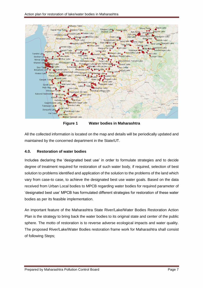
3.0. Recognition of water bodies In this phase, the information like name of the lake/pond, location, address (Khasra No./ Plot
No./ Survey No. in which the water body is located), Latitude and Longitude and all
geographical data is identified using Google Maps, MRSAC (geomapping) and secondary
data. This data is also acquired with reference to the toposheets and the data received from
the 383 Urban Local Bodies (ULBs). The location of each lake is marked on the toposheet
with the help of GIS software as well as marked on Google Earth. By analysis of the data is
found out that there are more than 350 lakes in Maharashtra state however only those falling
in territory of Urban Local bodies are considered in this study. The data has been received
from 103 Urban Local Bodies for total 91 lakes/ water bodies. Most of the ULBs don’t have
any water body pertaining to their jurisdiction. The identified lakes/ponds/ water bodies are
marked on Google Map as represented in Figure 1 and as per guideline provided by Central
Pollution Control Board (CPCB) for recognition activity MPCB has collected geographical
details, hydrological description and catchment description of the water bodies from ULBs and
is represented in attached Annexure I. The total number of water bodies in the state is around
354 including ponds, lakes, dams, reservoirs etc.
Data for water bodies have also been received from Urban Development Department,
Government of Maharashtra (MoUD), however most of the data is pertaining to reservoirs
dams and rivers, which is not the defined scope of the study in this report. Also most of these
water bodies are beyond the jurisdiction of the ULBS and this report includes details of only
water bodies that fall within the jurisdiction of Urban Local Bodies.
Action plan for restoration of lake/water bodies in Maharashtra
Prepared by Maharashtra Pollution Control Board Page 7
Figure 1 Water bodies in Maharashtra
All the collected information is located on the map and details will be periodically updated and
maintained by the concerned department in the State/UT.
4.0. Restoration of water bodies Includes declaring the ‘designated best use’ in order to formulate strategies and to decide
degree of treatment required for restoration of such water body, if required, selection of best
solution to problems identified and application of the solution to the problems of the land which
vary from case-to case, to achieve the designated best use water goals. Based on the data
received from Urban Local bodies to MPCB regarding water bodies for required parameter of
‘designated best use’ MPCB has formulated different strategies for restoration of these water
bodies as per its feasible implementation.
An important feature of the Maharashtra State River/Lake/Water Bodies Restoration Action
Plan is the strategy to bring back the water bodies to its original state and center of the public
sphere. The motto of restoration is to reverse adverse ecological impacts and water quality.
The proposed River/Lake/Water Bodies restoration frame work for Maharashtra shall consist
of following Steps;
Action plan for restoration of lake/water bodies in Maharashtra
Prepared by Maharashtra Pollution Control Board Page 8
4.1 Building environment and setting up restoration team The first step towards water body restoration is to create the necessary environment and build
a restoration team to take responsibility for the river. Such a team should comprise of
representatives of local community, technical experts, government officials and NGOs. The
experts involved in the restoration team may be according to the skill required for the
restoration job and this may change over the time.
4.2 Preparation of Restoration plan / Detailed Project Report for individual water body The DPR shall be prepared for each water which includes;
Baseline survey of the area under investigation - Total Station & Topography
Lake water quality assessment for determination of “Designated Best Use”. Water
quality of all the designated best use water bodies are required to be monitored for
relevant parameters and as per frequency prescribed under ‘guidelines for water
quality monitoring 2017’ by Ministry of Environment, Forest and Climate Change
(MoEF & CC).
Flow assessment and characterization of source of lake contamination, if any or
studying lake rejuvenation potential
Gap analysis with respect to wastewater generation and available infrastructure
nearby water body
Feasibility of technology for source treatment and lake rejuvenation
Detailed Designing for treatment of water bodies using various technology (Phytorid,
Floating Wetland, MBBR, SBR etc.) having different capacities including tapping, lifting
of wastewater from nearby nallah & conveyance to treatment plant
Potential for Silt removal and lake front design for siltation control
Reuse potential through ground water recharge system design
Detailed Bill of Quantities & Cost - Civil, Mechanical / Plumbing & Electrical as per
latest DSR
Detailed analysis of Operation & Maintenance needs and its costing
Justification of rates, quotations for Non-scheduled items
Preparation of Structural Design and drawings
Preparation of related Drawings - Layout, Section, Hydraulic, P&ID etc.
Project implementation plan

Action plan for restoration of lake/water bodies in Maharashtra
Prepared by Maharashtra Pollution Control Board Page 9
4.3 Feasibility of Treatment Lake / pond water depending on its characteristics is subjected to different treatment options.
Basic wastewater treatment consists of a combination of physical, chemical, and biological
processes and operations to remove solids, organic matter and, sometimes, nutrients from
wastewater. General terms used to describe different degrees of treatment, in order of
increasing treatment level, are preliminary, primary, secondary, and tertiary and/or advanced
wastewater treatment. Design of the actual treatment system for a STP involves selection of
alternative processes based on the ability of individual treatment processes to remove specific
waste constituents.
There are various in-situ and ex-situ treatment options are available; however, the most
feasible technologies that can be easily implemented in Indian Scenario are discussed below:
4.3.1 Phytoremediation Technology In this ex-situ technology, the source water can be tapped before it reaches water body and
can be treated using this technology to the degree of treatment required and then the treated
water can be released into the lake/ water body. In this system, use of wetland plants and
combined working of their root system in a designed ecosystem, along with the natural
attenuation processes can be combined together to achieve the possible solution for
wastewater treatment. It is one such technological solution, which can be easily implemented
in urban, rural and industrial areas. Phytorids / CEWT are natural processes similar to
stabilization ponds. Phytorids/ CEWT are shallow ponds comprising of submerged plants and
floating islands of marshy species. Natural forces including chemical, physical, biological and
solar is involved in the process to achieve wastewater treatment. Thick mats of vegetation trap
suspend solids and biological process takes place at the roots of the plants. It produces the
desired quality of treated sewage but land requirement is very high, though it is less compared
to waste stabilization pond. Running cost is comparatively low.
The system is independent of any mechanical equipment and uses the natural process
of aeration through the roots of plants helping the aerobic microflora to flourish in the
rhizosphere
Area of the tank is calculated using Darcy’s equation
Q = A x d x Ø/HRT
Usually the HRT is based on BOD loads, however being effluents, 1 Day HRT is
sufficient to bring about >95% efficiency of the system
There is no sludge generated through this secondary process since the submerged
flow regulated bacterial activities lead to ecological system development & managed
by detritus feeders
Action plan for restoration of lake/water bodies in Maharashtra
Prepared by Maharashtra Pollution Control Board Page 10
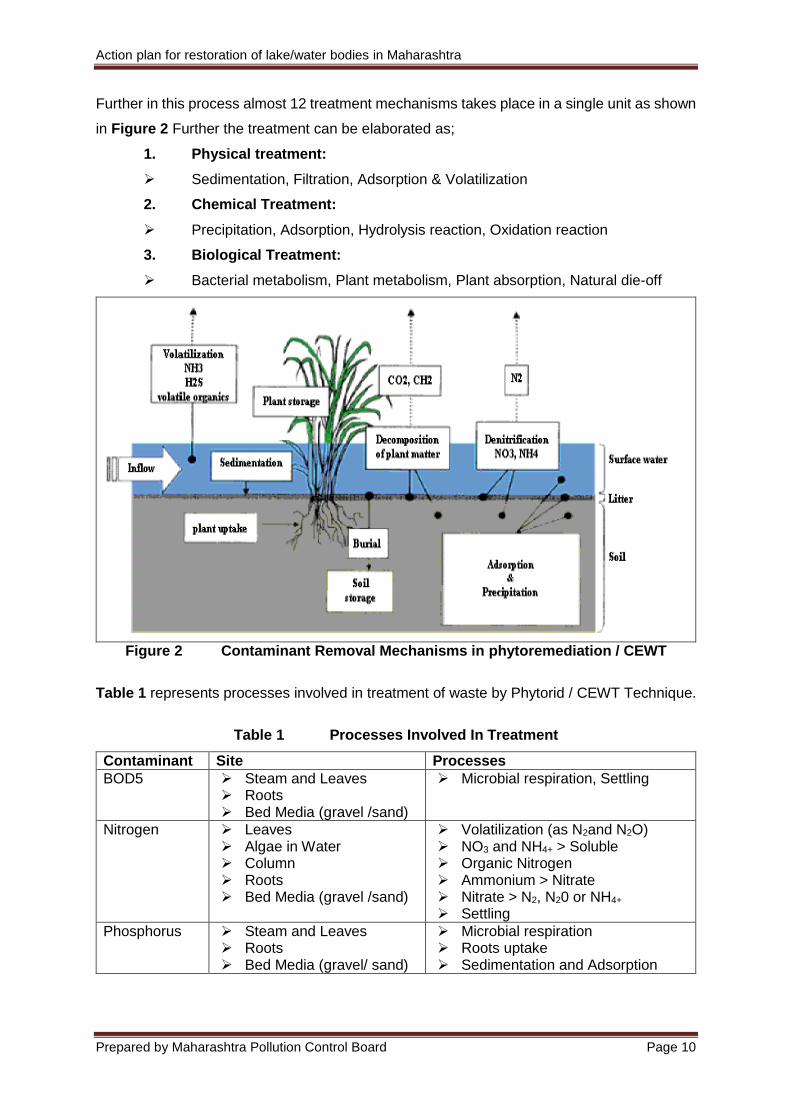
Further in this process almost 12 treatment mechanisms takes place in a single unit as shown
in Figure 2 Further the treatment can be elaborated as;
1. Physical treatment:
Sedimentation, Filtration, Adsorption & Volatilization
2. Chemical Treatment:
Precipitation, Adsorption, Hydrolysis reaction, Oxidation reaction
3. Biological Treatment:
Bacterial metabolism, Plant metabolism, Plant absorption, Natural die-off
Figure 2 Contaminant Removal Mechanisms in phytoremediation / CEWT
Table 1 represents processes involved in treatment of waste by Phytorid / CEWT Technique.
Table 1 Processes Involved In Treatment
Contaminant Site Processes
BOD5 Steam and Leaves Roots Bed Media (gravel /sand)
Microbial respiration, Settling
Nitrogen Leaves Algae in Water Column Roots Bed Media (gravel /sand)
Volatilization (as N2and N2O) NO3 and NH4+ > Soluble Organic Nitrogen Ammonium > Nitrate Nitrate > N2, N20 or NH4+ Settling
Phosphorus Steam and Leaves Roots Bed Media (gravel/ sand)
Microbial respiration Roots uptake Sedimentation and Adsorption
Action plan for restoration of lake/water bodies in Maharashtra
Prepared by Maharashtra Pollution Control Board Page 11
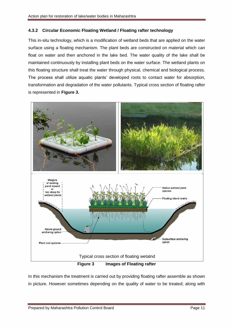
4.3.2 Circular Economic Floating Wetland / Floating rafter technology This in-situ technology, which is a modification of wetland beds that are applied on the water
surface using a floating mechanism. The plant beds are constructed on material which can
float on water and then anchored in the lake bed. The water quality of the lake shall be
maintained continuously by installing plant beds on the water surface. The wetland plants on
this floating structure shall treat the water through physical, chemical and biological process.
The process shall utilize aquatic plants’ developed roots to contact water for absorption,
transformation and degradation of the water pollutants. Typical cross section of floating rafter
is represented in Figure 3.
Typical cross section of floating wetalnd
Figure 3 Images of Floating rafter
In this mechanism the treatment is carried out by providing floating rafter assemble as shown
in picture. However sometimes depending on the quality of water to be treated; along with
Action plan for restoration of lake/water bodies in Maharashtra
Prepared by Maharashtra Pollution Control Board Page 12
floating rafter unit few additional components in the treatment system needs to be considered
to achieve the desired treated water quality such as;
Additional oxygen (in-situ aeration with help of blowers)
Microbial housing
Bioneer culture application
Primary Chemical treatment
Sedimentation basin using check dams The calculations are based on potential of floating wetland plants to oxygenate the system,
overturn in general limnology terms, artificial oxygen requirements to augment gaps on in-situ
treatment potential and required days to bring the water quality to desired levels. These values
will be achieved only when the floating rafter installation is proper and maintenance schedule
is strictly adhered to. The typical components of the system are described in attached
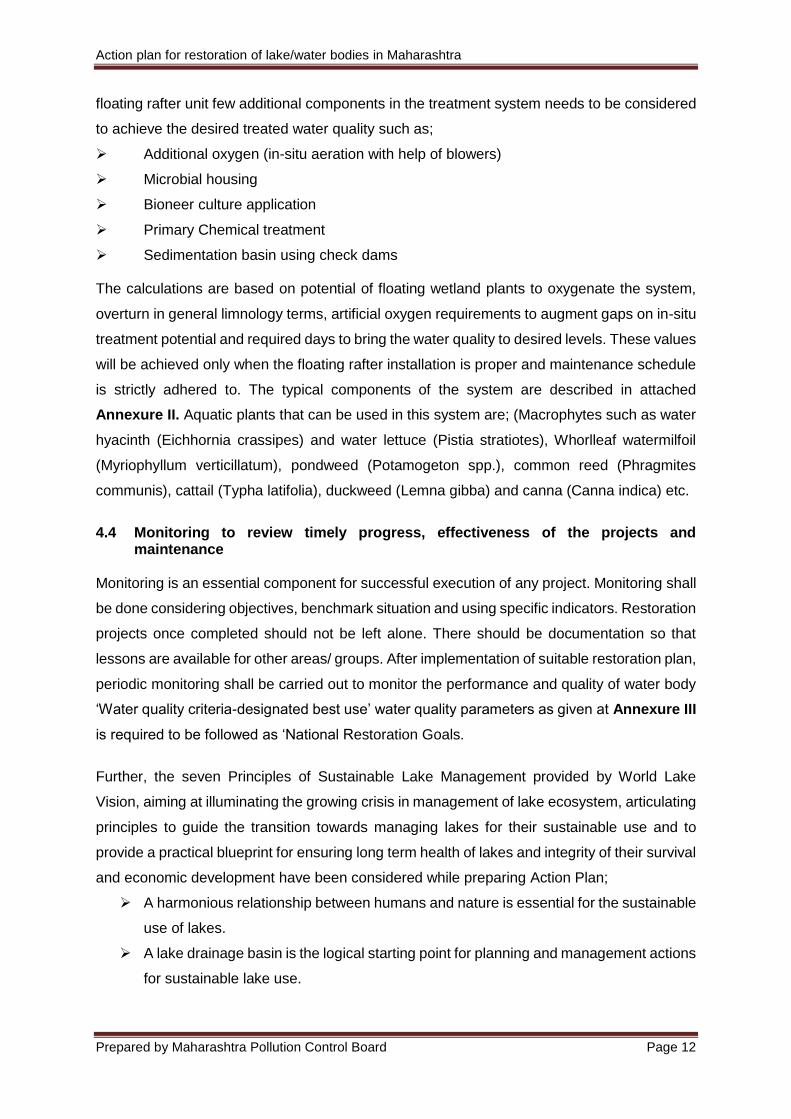
Annexure II. Aquatic plants that can be used in this system are; (Macrophytes such as water
hyacinth (Eichhornia crassipes) and water lettuce (Pistia stratiotes), Whorlleaf watermilfoil
(Myriophyllum verticillatum), pondweed (Potamogeton spp.), common reed (Phragmites
communis), cattail (Typha latifolia), duckweed (Lemna gibba) and canna (Canna indica) etc.
4.4 Monitoring to review timely progress, effectiveness of the projects and
maintenance Monitoring is an essential component for successful execution of any project. Monitoring shall
be done considering objectives, benchmark situation and using specific indicators. Restoration
projects once completed should not be left alone. There should be documentation so that
lessons are available for other areas/ groups. After implementation of suitable restoration plan,
periodic monitoring shall be carried out to monitor the performance and quality of water body
‘Water quality criteria-designated best use’ water quality parameters as given at Annexure III
is required to be followed as ‘National Restoration Goals.
Further, the seven Principles of Sustainable Lake Management provided by World Lake
Vision, aiming at illuminating the growing crisis in management of lake ecosystem, articulating
principles to guide the transition towards managing lakes for their sustainable use and to
provide a practical blueprint for ensuring long term health of lakes and integrity of their survival
and economic development have been considered while preparing Action Plan;
A harmonious relationship between humans and nature is essential for the sustainable
use of lakes.
A lake drainage basin is the logical starting point for planning and management actions
for sustainable lake use.
Action plan for restoration of lake/water bodies in Maharashtra
Prepared by Maharashtra Pollution Control Board Page 13
A long-term, preventive approach directed to preventing the causes of lake
degradation is essential.
Policy development and decision making for lake management should be based on
sound science and best available information.
The management of lakes for their sustainable use requires the resolution of conflicts
among competing users of lake resources taking into account the needs of present
and future generations and of nature.
Citizens and other stakeholders should be encouraged to participate meaningfully in
identifying and resolving critical lake problems.
Good governance, based on fairness, transparency and empowerment of all
stakeholders, is essential for sustainable lake use.
4.5 Identification of other associated issues which requires attention as a part of
restoration of pond or lake Apart from identification of all possible pollution sources, detailed gap analysis, additional
measures required on case-to-case basis to be identified especially in case of ponds or lakes
w.r.t the following aspects: -
Buffer Zone development - Acquiring at least 1or 0.5 Acre of land of water body
periphery for creation of buffer/green zone
Feasibility for Bio-diversity park in case adequate land is available in the vicinity of
ponds or lakes.
Greenery development in the vicinity of the ponds or lakes
Introduction of recreation facilities such as paddle boats, building jetty.
Machinery and the man power requirement for maintenance of 16 the restored water
body.
Existing provision for disposal of waste arising from the desiltation and de-weeding
activity of a pond or lake.
Awareness and training requirements.
Any other related measures required also be analyzed for inclusion of such actions
while making action plans for restoration of water body (E.g., aesthetic point of view,
bins for rubbish management which may be generated due to visitors).
5.0. Protection of restored water bodies This is a phase that takes care of the general health of the water body and ensures normal
functioning. A long-term, preventive approach directed to preventing the causes of water body
degradation is essential. Following activities shall be carried out for protection of water bodies;
Action plan for restoration of lake/water bodies in Maharashtra
Prepared by Maharashtra Pollution Control Board Page 14
5.1 Creation of Buffer Zone
Acquiring at least 1Acre or 0.5 Acre of land of water body periphery for creation of
buffer/green zone
Fencing of Lake /water body shall be done to define boundary for prevention of any
unauthorized entry and smooth operation
Proper design and construction of ponds or lakes including leveling and smoothing of
banks and embankment shall be done. Stabilization of earthen bunds and the drainage
channels as well as silt and soil erosion control measures will be taken.
Engineering works in respect of bund shall be minimized with naturalization of bund as
a preferred option. The cost towards shaping/strengthening including slope revetment,
provision for construction of retaining wall, if any etc. shall not exceed 10-15% of the
total project cost. Stone revetment along the inner slope of the earthen bund, to be
resorted to in cases where strengthening of burnt required. As far as possible
naturalisation of slops shall be done by providing suitable vegetation with proper
selection of species
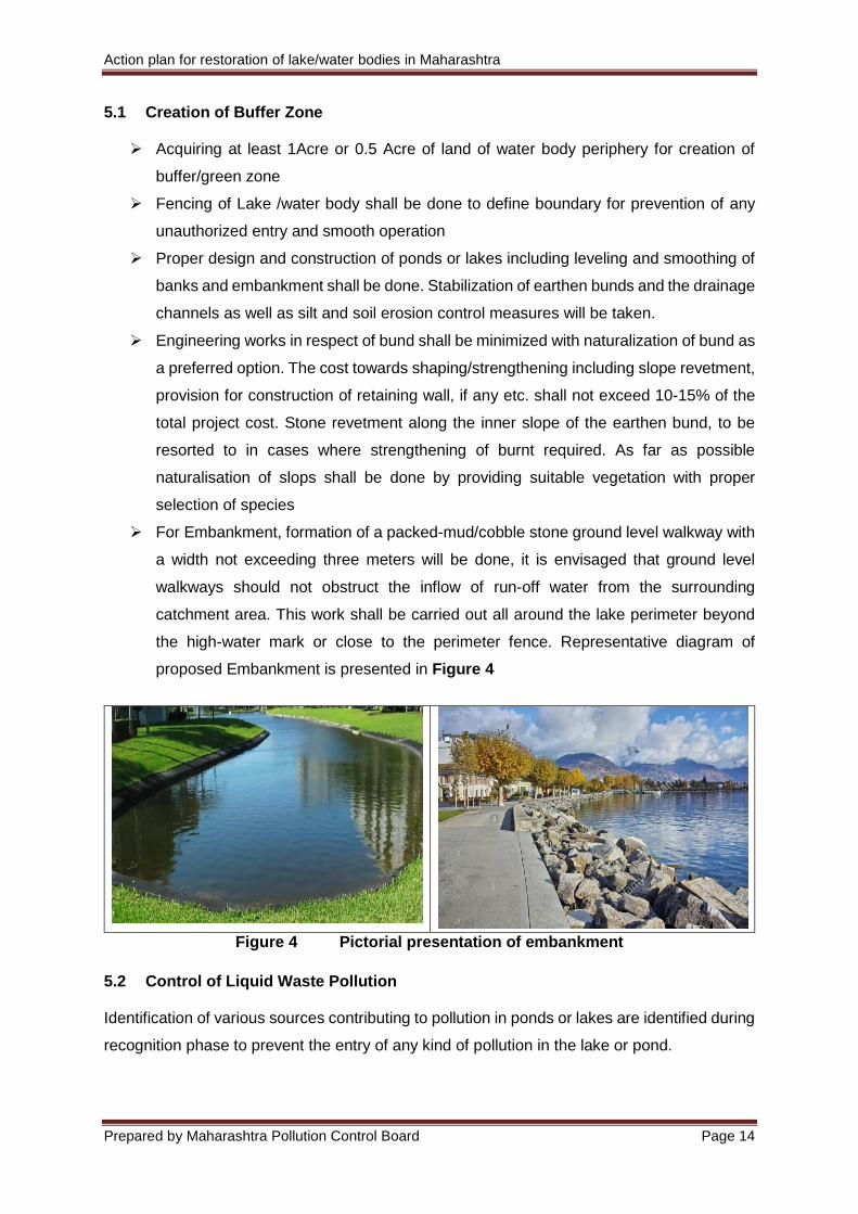
For Embankment, formation of a packed-mud/cobble stone ground level walkway with
a width not exceeding three meters will be done, it is envisaged that ground level
walkways should not obstruct the inflow of run-off water from the surrounding
catchment area. This work shall be carried out all around the lake perimeter beyond
the high-water mark or close to the perimeter fence. Representative diagram of
proposed Embankment is presented in Figure 4
Figure 4 Pictorial presentation of embankment
5.2 Control of Liquid Waste Pollution Identification of various sources contributing to pollution in ponds or lakes are identified during
recognition phase to prevent the entry of any kind of pollution in the lake or pond.
Action plan for restoration of lake/water bodies in Maharashtra
Prepared by Maharashtra Pollution Control Board Page 15
MPCB shall identify open channels or drainage channels contributing untreated
sewage or untreated or partially treated effluent discharge from nearby vicinity areas
and shall divert or close such channel to the existing treatment facility
MPCB shall, in coordination with implementing agencies / custodians of the lake,
construct STPs /ETPs and use them optimally to ensure that untreated sewage is not
let into the lakes
MPCB shall, coordination with implementing agencies / custodians of the lake, make
provision of community toilets around periphery to prevent pollution from human
wastes.
Prohibition of washing activity by Dhobis/Cow/Buffalo within the lake premises, placing
warning boards for restriction of washing activity
MPCB shall, in coordination with implementing agencies / custodians of the lake, shall
impose restrictions and guidelines on Idol immersions and designing immersion ponds
Levying of fine or Environmental Compensation on the violators for improper disposal
of sewage or industrial effluent or discharging washing waste into lakes or ponds
5.3 Control of Solid Waste Pollution Significant amount of solid waste is expected to be generated post development of lake/water
bodies which needs to be managed scientifically w.r.t quantification, characterization,
collection, treatment & disposal. Following method shall be adopted for solid waste
management;
Segregation at source: Segregation at source of waste refers to procedure, wherein different
constituents of waste streams are segregated and stored separately at the generator’s
premises.
Organic Waste Stream: This waste stream will contain refuse from food waste,
horticulture waste from landscaped area, textiles and wood pieces. It is expected to
constitute about 45 – 50 of the total waste generated
Inorganic Waste & Recyclables: This waste stream will consist of all potentially
recyclable material such as paper, plastic glass, metals and rubber, along with other
inert material
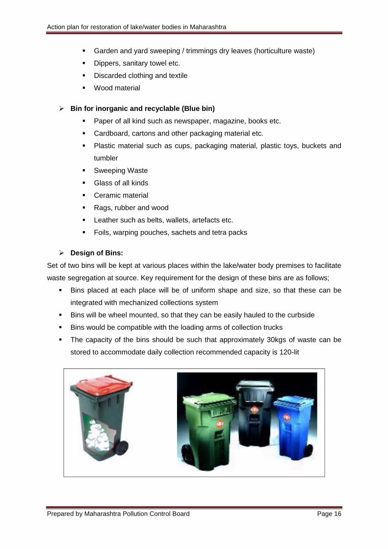
Provision of Bins: Green & Blue Colored Bins shall be provided at various place within the
lake/water bodies premises for collection and segregation of solid waste w.r.t. its nature.
Bin for organic waste (Green bin)
Food waste of all kind including fruits and vegetable peeling, discarded cooked
or uncooked food, meat / fish waste, butchery waste, eggshell etc.
Action plan for restoration of lake/water bodies in Maharashtra
Prepared by Maharashtra Pollution Control Board Page 16
Garden and yard sweeping / trimmings dry leaves (horticulture waste)
Dippers, sanitary towel etc.
Discarded clothing and textile
Wood material
Bin for inorganic and recyclable (Blue bin)
Paper of all kind such as newspaper, magazine, books etc.
Cardboard, cartons and other packaging material etc.
Plastic material such as cups, packaging material, plastic toys, buckets and
tumbler
Sweeping Waste
Glass of all kinds
Ceramic material
Rags, rubber and wood
Leather such as belts, wallets, artefacts etc.
Foils, warping pouches, sachets and tetra packs
Design of Bins:
Set of two bins will be kept at various places within the lake/water body premises to facilitate
waste segregation at source. Key requirement for the design of these bins are as follows;
Bins placed at each place will be of uniform shape and size, so that these can be
integrated with mechanized collections system
Bins will be wheel mounted, so that they can be easily hauled to the curbside
Bins would be compatible with the loading arms of collection trucks
The capacity of the bins should be such that approximately 30kgs of waste can be
stored to accommodate daily collection recommended capacity is 120-lit
Action plan for restoration of lake/water bodies in Maharashtra
Prepared by Maharashtra Pollution Control Board Page 17
Specification of Bins
Height [cm] : 101.6
Width [cm] : 38.1
Depth [cm] : 38.1
Capacity [kg] : 36.0
Wheels diameter [cm] : 15.25
5.4 De-silting and Dredging: Water flowing into a lake brings silt. Increased deforestation loosens the top soil, which finds
its way into lakes. Some of the silt is washed out when the lake overflows. However, the
outflow of silt does not always match the inflow and the silt settles at the bottom of the lake.
Hence de-siltation is at regular interval is necessary. Augorbore test shall be done to
determine/estimate the quantity of silt to be removed and also to analyze silt. De-siltation
activity shall be supported by bathymetry of the lake as per the standard methodology and its
planning and execution shall be carried out scientifically under expert guidance.
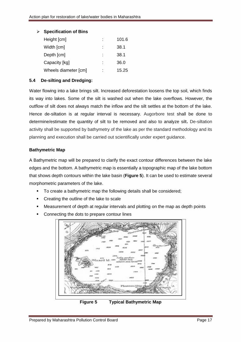
Bathymetric Map
A Bathymetric map will be prepared to clarify the exact contour differences between the lake
edges and the bottom. A bathymetric map is essentially a topographic map of the lake bottom
that shows depth contours within the lake basin (Figure 5). It can be used to estimate several
morphometric parameters of the lake.
To create a bathymetric map the following details shall be considered;
Creating the outline of the lake to scale
Measurement of depth at regular intervals and plotting on the map as depth points
Connecting the dots to prepare contour lines
Figure 5 Typical Bathymetric Map
Action plan for restoration of lake/water bodies in Maharashtra
Prepared by Maharashtra Pollution Control Board Page 18
Removal of silt [nutrient enriched accumulated sludge] and removal of contaminated
sediments shall be done Yearly /Half Yearly from ponds and lakes to help in ground water
recharge potential and increase storage capacity of lakes or ponds. Quarterly dredging of 80
% of dense and thickly covered aquatic plants viz., floating plants such as algae, duckweed,
water meal, water hyacinth; submerged plants such as milfoil, hydrilla, water lettuce, curly-leaf
pondweed, clasping-leaf pondweed, coontail, sago pondweed, water lilly, water shield shall
be done by means of (Biological, Chemical, Mechanical and Manual measures.
While design has been sensitive enough against dredge and soil run-off deposit into the lake,
the droppings and dead remains of the species in the lake ecosystem will still happen. Lake
depth will need to be measured annually. A significant reduction in depth may require
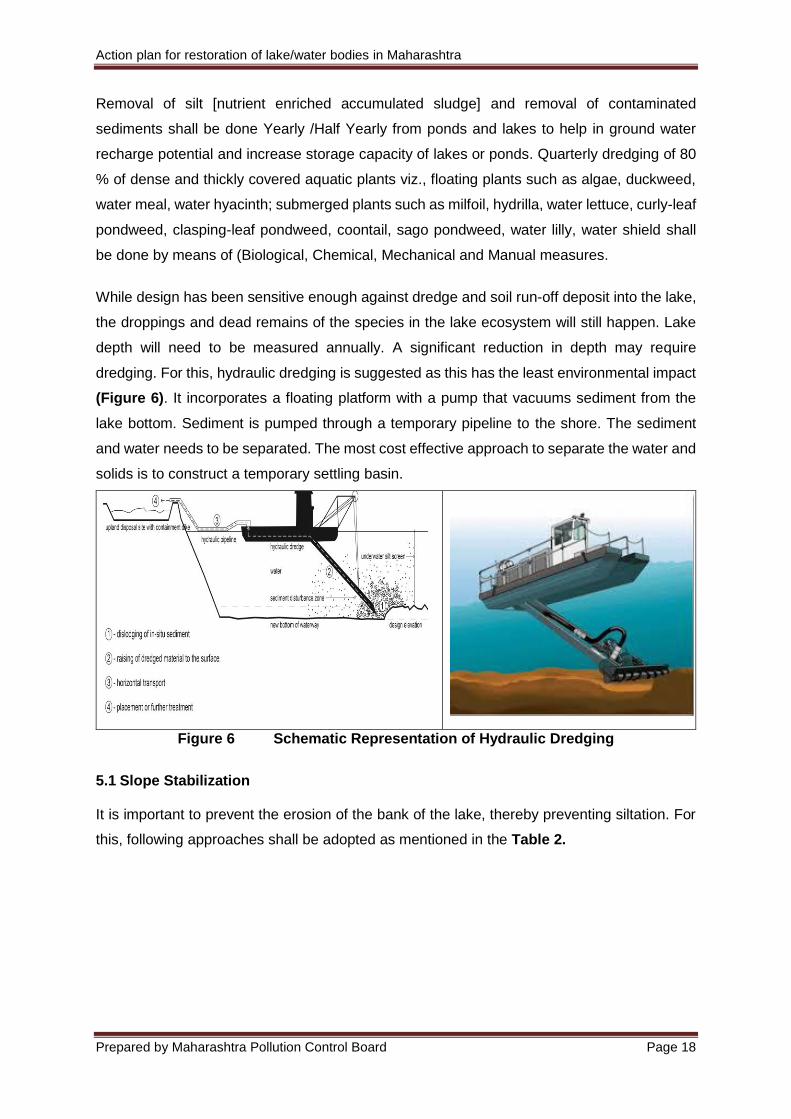
dredging. For this, hydraulic dredging is suggested as this has the least environmental impact
(Figure 6). It incorporates a floating platform with a pump that vacuums sediment from the
lake bottom. Sediment is pumped through a temporary pipeline to the shore. The sediment
and water needs to be separated. The most cost effective approach to separate the water and
solids is to construct a temporary settling basin.
Figure 6 Schematic Representation of Hydraulic Dredging
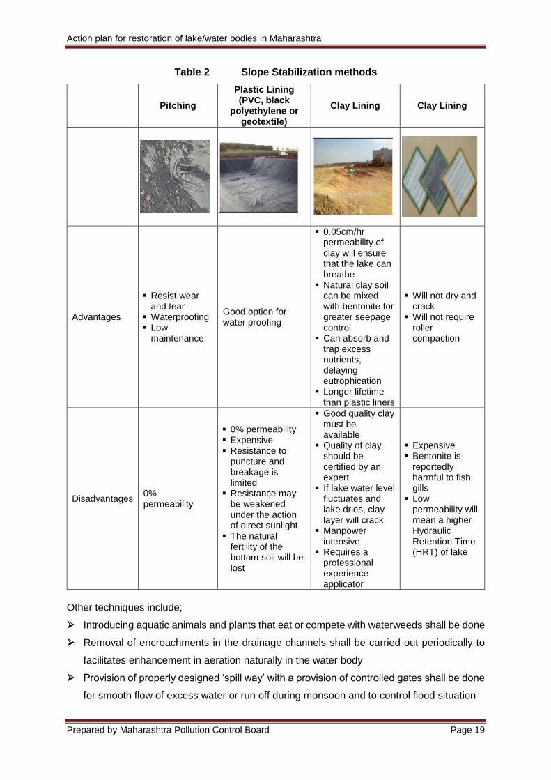
5.1 Slope Stabilization It is important to prevent the erosion of the bank of the lake, thereby preventing siltation. For
this, following approaches shall be adopted as mentioned in the Table 2.
Action plan for restoration of lake/water bodies in Maharashtra
Prepared by Maharashtra Pollution Control Board Page 19
Table 2 Slope Stabilization methods
Pitching
Plastic Lining (PVC, black
polyethylene or geotextile)
Clay Lining Clay Lining
Advantages
Resist wear and tear
Waterproofing Low
maintenance
Good option for water proofing
0.05cm/hr permeability of clay will ensure that the lake can breathe
Natural clay soil can be mixed with bentonite for greater seepage control
Can absorb and trap excess nutrients, delaying eutrophication
Longer lifetime than plastic liners
Will not dry and crack
Will not require roller compaction
Disadvantages 0% permeability
0% permeability Expensive Resistance to
puncture and breakage is limited
Resistance may be weakened under the action of direct sunlight
The natural fertility of the bottom soil will be lost
Good quality clay must be available
Quality of clay should be certified by an expert
If lake water level fluctuates and lake dries, clay layer will crack
Manpower intensive
Requires a professional experience applicator
Expensive Bentonite is
reportedly harmful to fish gills
Low permeability will mean a higher Hydraulic Retention Time (HRT) of lake
Other techniques include;
Introducing aquatic animals and plants that eat or compete with waterweeds shall be done
Removal of encroachments in the drainage channels shall be carried out periodically to
facilitates enhancement in aeration naturally in the water body
Provision of properly designed ‘spill way’ with a provision of controlled gates shall be done
for smooth flow of excess water or run off during monsoon and to control flood situation
Action plan for restoration of lake/water bodies in Maharashtra
Prepared by Maharashtra Pollution Control Board Page 20
Removal all blockades at inlet or outlets shall be done to avoid stagnation or blockage of
storm water
6.0. Improvement of restored water bodies Deals with overall improvement in the water body and its uses including resolution of conflicts
among competing users of lake resources taking into account the needs of present and future
generations and of nature.
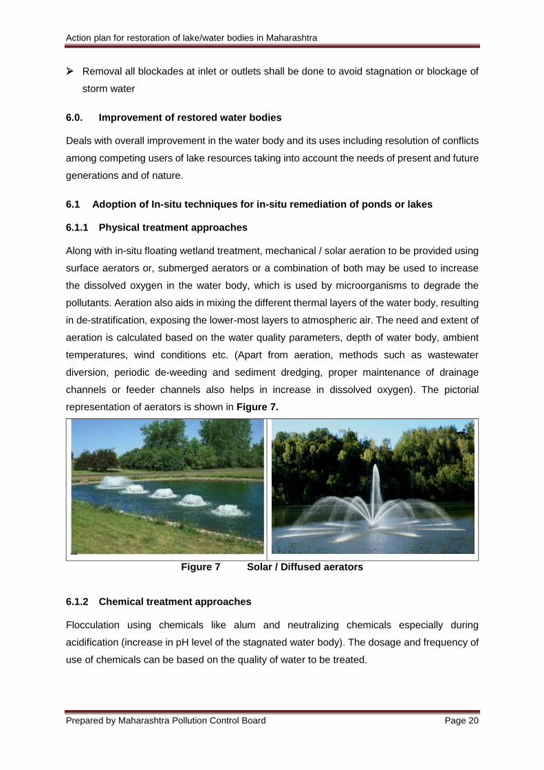
6.1 Adoption of In-situ techniques for in-situ remediation of ponds or lakes 6.1.1 Physical treatment approaches Along with in-situ floating wetland treatment, mechanical / solar aeration to be provided using
surface aerators or, submerged aerators or a combination of both may be used to increase
the dissolved oxygen in the water body, which is used by microorganisms to degrade the
pollutants. Aeration also aids in mixing the different thermal layers of the water body, resulting
in de-stratification, exposing the lower-most layers to atmospheric air. The need and extent of
aeration is calculated based on the water quality parameters, depth of water body, ambient
temperatures, wind conditions etc. (Apart from aeration, methods such as wastewater
diversion, periodic de-weeding and sediment dredging, proper maintenance of drainage
channels or feeder channels also helps in increase in dissolved oxygen). The pictorial
representation of aerators is shown in Figure 7.
Figure 7 Solar / Diffused aerators
6.1.2 Chemical treatment approaches Flocculation using chemicals like alum and neutralizing chemicals especially during
acidification (increase in pH level of the stagnated water body). The dosage and frequency of
use of chemicals can be based on the quality of water to be treated.
Action plan for restoration of lake/water bodies in Maharashtra
Prepared by Maharashtra Pollution Control Board Page 21
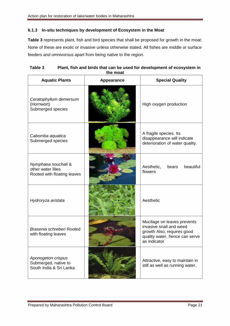
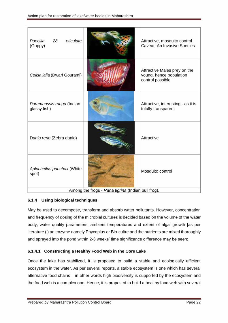
6.1.3 In-situ techniques by development of Ecosystem in the Moat Table 3 represents plant, fish and bird species that shall be proposed for growth in the moat:
None of these are exotic or invasive unless otherwise stated. All fishes are middle or surface
feeders and omnivorous apart from being native to the region.
Table 3 Plant, fish and birds that can be used for development of ecosystem in the moat
Aquatic Plants Appearance Special Quality
Ceratophyllum demersum (Hornwort) Submerged species
High oxygen production
Cabomba aquatica Submerged species
A fragile species. Its disappearance will indicate deterioration of water quality.
Nymphaea nouchali & other water lilies Rooted with floating leaves
Aesthetic, bears beautiful flowers
Hydroryza aristata
Aesthetic
Brasenia schreberi Rooted with floating leaves
Mucilage on leaves prevents invasive snail and weed growth Also, requires good quality water, hence can serve as indicator
Aponogeton crispus Submerged, native to South India & Sri Lanka
Attractive, easy to maintain in still as well as running water,
Action plan for restoration of lake/water bodies in Maharashtra
Prepared by Maharashtra Pollution Control Board Page 22
Poecilia 28 eticulate (Guppy)
Attractive, mosquito control Caveat: An Invasive Species
Colisa lalia (Dwarf Gourami)
Attractive Males prey on the young, hence population control possible
Parambassis ranga (Indian glassy fish)
Attractive, interesting - as it is totally transparent
Danio rerio (Zebra danio)
Attractive
Aplocheilus panchax (White spot)
Mosquito control
Among the frogs - Rana tigrina (Indian bull frog),
6.1.4 Using biological techniques May be used to decompose, transform and absorb water pollutants. However, concentration
and frequency of dosing of the microbial cultures is decided based on the volume of the water
body, water quality parameters, ambient temperatures and extent of algal growth [as per
literature (i) an enzyme namely Phycoplus or Bio-cultre and the nutrients are mixed thoroughly
and sprayed into the pond within 2-3 weeks’ time significance difference may be seen;
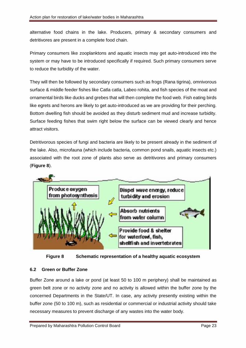
6.1.4.1 Constructing a Healthy Food Web in the Core Lake Once the lake has stabilized, it is proposed to build a stable and ecologically efficient
ecosystem in the water. As per several reports, a stable ecosystem is one which has several
alternative food chains – in other words high biodiversity is supported by the ecosystem and
the food web is a complex one. Hence, it is proposed to build a healthy food web with several
Action plan for restoration of lake/water bodies in Maharashtra
Prepared by Maharashtra Pollution Control Board Page 23
alternative food chains in the lake. Producers, primary & secondary consumers and
detritivores are present in a complete food chain.
Primary consumers like zooplanktons and aquatic insects may get auto-introduced into the
system or may have to be introduced specifically if required. Such primary consumers serve
to reduce the turbidity of the water.
They will then be followed by secondary consumers such as frogs (Rana tigrina), omnivorous
surface & middle feeder fishes like Catla catla, Labeo rohita, and fish species of the moat and
ornamental birds like ducks and grebes that will then complete the food web. Fish eating birds
like egrets and herons are likely to get auto-introduced as we are providing for their perching.
Bottom dwelling fish should be avoided as they disturb sediment mud and increase turbidity.
Surface feeding fishes that swim right below the surface can be viewed clearly and hence
attract visitors.
Detritivorous species of fungi and bacteria are likely to be present already in the sediment of
the lake. Also, microfauna (which include bacteria, common pond snails, aquatic insects etc.)
associated with the root zone of plants also serve as detritivores and primary consumers
(Figure 8).
Figure 8 Schematic representation of a healthy aquatic ecosystem
6.2 Green or Buffer Zone Buffer Zone around a lake or pond (at least 50 to 100 m periphery) shall be maintained as
green belt zone or no activity zone and no activity is allowed within the buffer zone by the
concerned Departments in the State/UT. In case, any activity presently existing within the
buffer zone (50 to 100 m), such as residential or commercial or industrial activity should take
necessary measures to prevent discharge of any wastes into the water body.
Action plan for restoration of lake/water bodies in Maharashtra
Prepared by Maharashtra Pollution Control Board Page 24
The plant species used for landscaping purposes will include deciduous and evergreen trees
& flowering plants that can be easily procured and grown in the local region. Most importantly,
the trees that are already present there will not be uprooted as old and healthy trees are
valuable to an ecosystem.
The consolidated list may include: Polyalthia longifolia (Ashok), Peltophorum ferrugineum
(Copper pod), Callistemon lanceolatus (Bottle brush), Ficus religiosa (Peepal), F. infectoria
(Pakad), F. panda, Mimusops elengi (Maulsari), Morus sp. (Mulberry/Shahtoot), Grevillea
robusta (Silver oak), Syzygium cumini (Jamun), Eucalyptus, Dalbergia sissoo (Shisham),
Delonix regia (Gulmohar), Santalum album (Chandan), Bombax ceiba (Semal/Shalmali),
Alstonia scholaris, Jacaranda mimosifolia, Azadirachta indica (Neem), Madhuca latifolia
(Mahua), Lagerstroemia flos reginae, Junipers, Hibiscus rosa sinensis (Urhul), Ixora coccinea
(Jungle Geranium), Jasminum sambac (Bela), Nycanthes arbor tristis (Harsingar),
Mussaenda, Plumeria alba (Frangipani), Thevetia peruviana (Oleander/Kaner), Hyophorbe
lagenicaulis (Bottle palm), Bauhinia variegata (Kachnar) etc.
6.3 Lake front area development plan: In addition to the landscape plan, the following features shall be created with a view to high
functionality of the water body as per availability of funds or phase-wise development shall be
adopted.
Activities Details
Pathways & Jogging tracks Pathways in paver blocks and Kota stones and mud track for Jogging
Brick works in to works etc. To define small planters and level differences
Overlooking decks Along the lake side
Play equipment for children in the children play area
Slides, see-saw, swings, bar, multi-play stations
Parking Area Sub-base, permeable paver blocks, Kerb stones
Signage’s Main entry signage, direction signage inside park, identity signage of each area, warning messages against waste disposal & flower, grass or leaf plucking
Rocks Natural rocks of size 0.5×0.5m and 1.0×1.0m, including transportation to site and laying in position with the help of 12 metric ton hydra
Boating Activity Jetty for leading to the main boating area, boats, oars, boathouse for ticketing
Lighting and electrical works
4m along pedestrian paths - approximately 250 light poles, wiring, panels, feeder pillars and special light fixing at the entry plaza and around the Phytorid tanks.
Irrigation & plumbing Including water supply, sprinkler & garden hydrants, storm water structures, rainwater harvesting structures
Action plan for restoration of lake/water bodies in Maharashtra
Prepared by Maharashtra Pollution Control Board Page 25
7.0. Sustenance of rejuvenated water bodies Good governance, based on fairness, transparency and empowerment of all stakeholders, is
essential to sustain the restoration efforts. Also, ownership of each water body should be
decided, as most of them face indefinite sustenance due to multiplicity of administrative control
and/or lack of specific action by singular authority. The in charge authority should treat the
water body as ‘natural resources’, to act as the potential catalysts to better civic health, provide
recreation, improve tourism, possibly meet water-needs of local people, etc. Such gains shall
be attained only after the water bodies are treated on ecosystem based approach. While
rejuvenating lake or water body, it is necessary to prepare rejuvenation model which is self-
sustainable and can maintain the lake or water body for a long period. A representative model
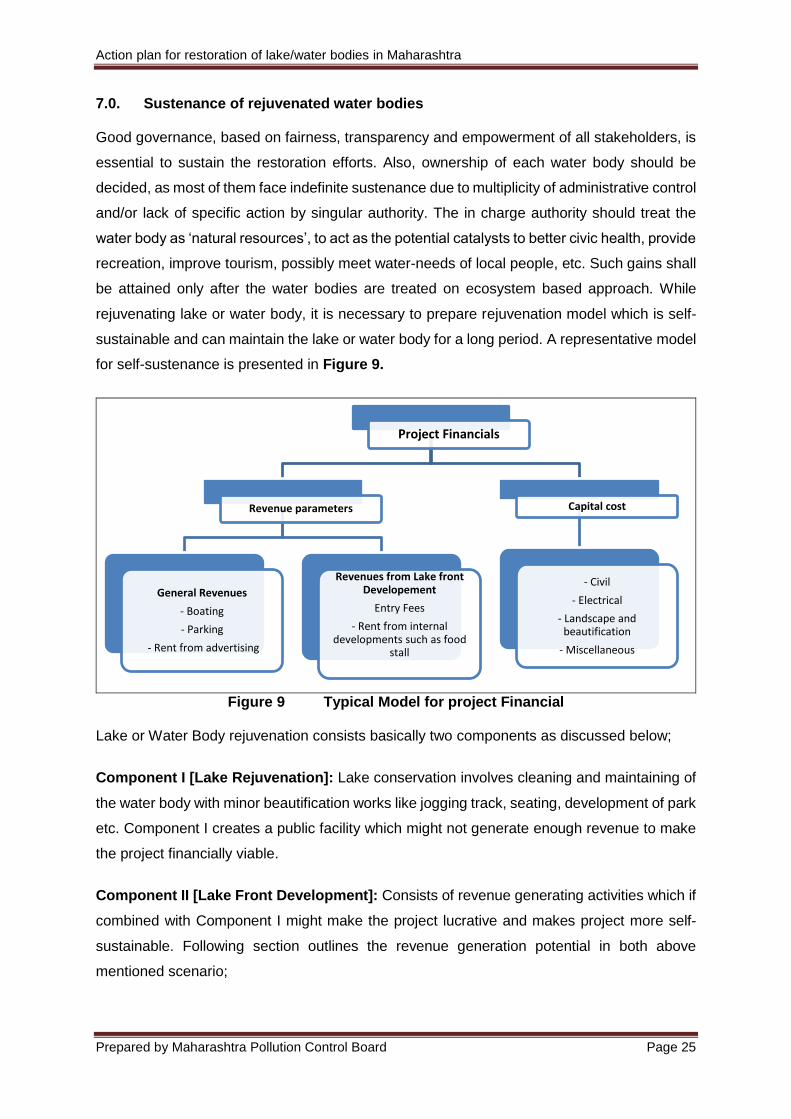
for self-sustenance is presented in Figure 9.
Figure 9 Typical Model for project Financial Lake or Water Body rejuvenation consists basically two components as discussed below;
Component I [Lake Rejuvenation]: Lake conservation involves cleaning and maintaining of
the water body with minor beautification works like jogging track, seating, development of park
etc. Component I creates a public facility which might not generate enough revenue to make
the project financially viable.
Component II [Lake Front Development]: Consists of revenue generating activities which if
combined with Component I might make the project lucrative and makes project more self-
sustainable. Following section outlines the revenue generation potential in both above
mentioned scenario;
Project Financials
Revenue parameters
General Revenues
- Boating
- Parking
- Rent from advertising
Revenues from Lake front Developement
Entry Fees
- Rent from internal developments such as food
stall
Capital cost
- Civil
- Electrical
- Landscape and beautification
- Miscellaneous
Action plan for restoration of lake/water bodies in Maharashtra
Prepared by Maharashtra Pollution Control Board Page 26
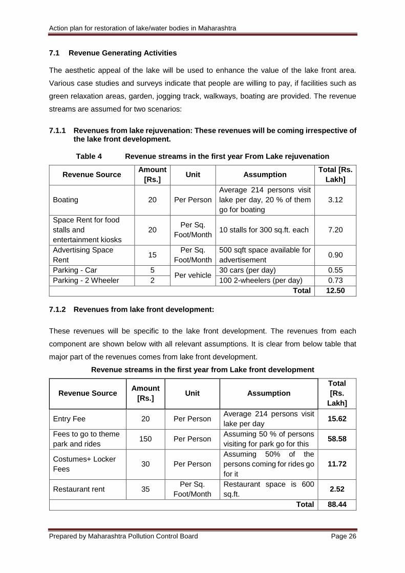
7.1 Revenue Generating Activities The aesthetic appeal of the lake will be used to enhance the value of the lake front area.
Various case studies and surveys indicate that people are willing to pay, if facilities such as
green relaxation areas, garden, jogging track, walkways, boating are provided. The revenue
streams are assumed for two scenarios:
7.1.1 Revenues from lake rejuvenation: These revenues will be coming irrespective of
the lake front development.
Table 4 Revenue streams in the first year From Lake rejuvenation
Revenue Source Amount
[Rs.] Unit Assumption
Total [Rs.
Lakh]
Boating 20 Per Person
Average 214 persons visit
lake per day, 20 % of them
go for boating
3.12
Space Rent for food
stalls and
entertainment kiosks
20 Per Sq.
Foot/Month 10 stalls for 300 sq.ft. each 7.20
Advertising Space
Rent 15
Per Sq.
Foot/Month
500 sqft space available for
advertisement 0.90
Parking - Car 5 Per vehicle
30 cars (per day) 0.55
Parking - 2 Wheeler 2 100 2-wheelers (per day) 0.73
Total 12.50
7.1.2 Revenues from lake front development:
These revenues will be specific to the lake front development. The revenues from each
component are shown below with all relevant assumptions. It is clear from below table that
major part of the revenues comes from lake front development.
Revenue streams in the first year from Lake front development
Revenue Source Amount
[Rs.] Unit Assumption
Total
[Rs.
Lakh]
Entry Fee 20 Per Person Average 214 persons visit
lake per day 15.62
Fees to go to theme
park and rides 150 Per Person
Assuming 50 % of persons
visiting for park go for this 58.58
Costumes+ Locker
Fees 30 Per Person
Assuming 50% of the
persons coming for rides go
for it
11.72
Restaurant rent 35 Per Sq.
Foot/Month
Restaurant space is 600
sq.ft. 2.52
Total 88.44
Action plan for restoration of lake/water bodies in Maharashtra
Prepared by Maharashtra Pollution Control Board Page 27
Assumption Considered for Footfall of Visitors
Key assumptions in calculating footfalls Numbers
No of persons visiting per day in weekdays 100
Total Weekdays in a year 261
No of persons visiting per day in weekends 500
Total Weekends in a year 104
Average person’s visiting per day 214
7.2 Maintenance
The over-all upkeep of the place needs to combine with the functionality of the whole place.
The following aspects will need to be integrated in the operation and maintenance of the Lake
/ water body:
Increased awareness among the public regarding the importance of keeping the lake
clean - this is the most significant aspect of lake conservation and sustainable
management.
Creation of a permanent body or empowering an existing one to be entrusted with the
task of vigilance. This body can be authorized to carry out sustainable fishing in the
lake and use the revenue generated for lake maintenance
Strict prevention of idol immersion activities
Setting up of signages that reveal services provided by lake ecosystems and their
inherent worth
Regular raking out of leaf litter fallen into the lake or moat water
Use of low phosphate fertilizers and manures for tree plantations in the lake front area,
as run-off from this area may enter the lake and disturb the nutrient dynamics therein
Adequate protection of the lake and its landscaped surroundings by high walls (without
restricting view from outside), with inclined nets against solid waste disposal
Provision of adequate no. of dustbins
Community toilet construction to prevent fecal pollution in the drains around the lake
area
Strict vigilance to prevent throwing of solid waste in the lake - installation of direction
boards and signage displaying suitable warning messages
Fine as a punishment for those caught disposing waste in the lake
Strict prevention of encroachment activities if any 7.3 Generating Public Awareness and sensitization
The best possible approach towards sustainable maintenance of wetland ecosystems is by
involving the general public in the task of upkeep - if the general public that draws maximal
Action plan for restoration of lake/water bodies in Maharashtra
Prepared by Maharashtra Pollution Control Board Page 28
benefits from a wetland is made a direct stakeholder, it will go a long way towards
conservation. Community participation is the key to sustainable conservation and enhancing
ecological literacy in general is extremely crucial.
7.4 Lake Monitoring program Lake Water Quality Survey - For baseline monitoring, seasonal analysis (4 times a year) of
the lake water must be carried out. At least 7 sampling points will be demarcated. One
sampling point will be at the center of the lake, another at the point where water from the moat
enters the lake, and a third at the point where water drains out. The other 4 points will be along
the boundaries of the lake.
(A) Pre-monsoon: Once a year - Analyze 25 parameters as listed below:
General: Color, odor, temp, pH, EC, DO, turbidity, TDS
Nutrients: NH3-N, NO2 + NO3, Total P
Organic Matter : BOD, COD
Major ions : K, Na, Ca, Mg, CO3, HCO3, Cl, SO4
Microbiological : Total and Faecal Coliforms (B) Rest of the year (after the pre-monsoon sampling) at every three months’ interval:
Analyze 10 parameters: Colour, Odour, Temp., pH, EC, DO., NO2 + NO3, BOD, Total and
Fecal Coliforms. (As per CPCB)
7.5 Landscape Management - Staff dedicated to cleaning the lakefront will have to be
appointed. Litter and solid waste along the moat and party lawn will have to be swept, and
dustbins and toilets cleaned and maintained. Adequate guarding and fining against waste
disposal will have to be provided. This is especially important considering that entry into the
premises is free of cost and cannot be restricted. In the absence of adequate cleanliness and
guarding against waste disposal, the lake can easily degrade.
The fertilizers used (if any) should be low phosphorus.
7.6 Encouraging Participation of Local Population
Involving the local population in the lake management program will make it an easier process.
This will include generating public awareness and enhancing environmental literacy through
educative signage’s and guided tours.
Public Participation can also be used to directly incorporate the general public into the project.
This will give them a direct interest in the management, maintenance and conservation of the
newly developed lake/water body. Donors shall be encouraged by maintaining marble slabs
bearing the names of high donors.
Action plan for restoration of lake/water bodies in Maharashtra
Prepared by Maharashtra Pollution Control Board Page 29
In the absence of proper public education the lake can easily degrade and require high
expenditure on maintenance.
Summary:
Total ULBs in Maharashtra : 391
Data received from ULBs : 103
Number of ULBs that do not have any water body : 44 (Out of received data)
Number of ULBs having water body restoration plans : 8
Number of ULBs that have already restored water bodies : 15
Number of action plans already developed and waiting for funds : Nil The goals for conservation of lakes have to be tailored to individual regions, specific to the
problems of degradation and based on the level of dependence. This requires reconstruction
of the physical conditions; chemical adjustment of both the soil and water; biological
manipulation, reintroduction of native flora and fauna, etc. The interpretation of existing trends
and scenarios in the process of conservation of lakes as presented in this report is based on
interactions with limited key players namely government stakeholders, developers involved in
similar projects and personnel involved in the field work. Hence, they are indicative of the
situations prevalent at the time of conducting the study.
The identification of lakes shall be done on the certain defined parameters based on detailed
of Annexure I. While the causes of degradation of lakes are many, in view of the limited
resources available, it is not possible to take up all degraded lakes for conservation. It is,
therefore, necessary to prioritize lakes along with the catchments, where conservation needs
to be taken up first. It is important to give priority to revive those lakes that would have lost
without any form of intervention. A framework can be developed categorizing by the level of
interventions required for prioritization as follows:
PRIORITY 1- Lakes that recover without any intervention
PRIORITY 2- Lakes that can be restored close to their former condition to serve their earlier
functions considering cost involved, technical review of the restoration plan etc. based on the
goals and objectives set
PRIORITY 3- Lakes that cannot be restored to any agreeable degree viably
Further a standard development plan / action is prepared for a lake of approximately 1 acre
area considering the phases mentioned in the report and a case study is presented in the
following section of this report which can be used as a standard for preparing action plans for
lakes proposed to be developed.
Action plan for restoration of lake/water bodies in Maharashtra
Prepared by Maharashtra Pollution Control Board Page 30
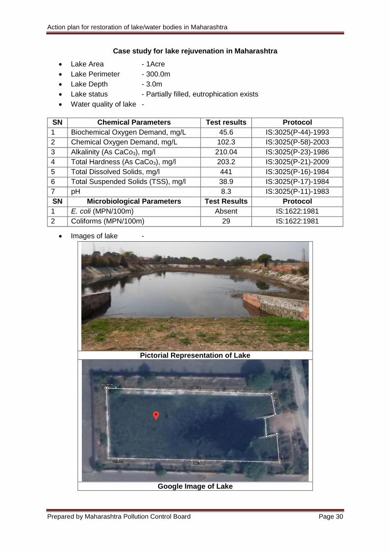
Case study for lake rejuvenation in Maharashtra
Lake Area - 1Acre
Lake Perimeter - 300.0m
Lake Depth - 3.0m
Lake status - Partially filled, eutrophication exists
Water quality of lake -
SN Chemical Parameters Test results Protocol
1 Biochemical Oxygen Demand, mg/L 45.6 IS:3025(P-44)-1993
2 Chemical Oxygen Demand, mg/L 102.3 IS:3025(P-58)-2003
3 Alkalinity (As CaCo3), mg/l 210.04 IS:3025(P-23)-1986
4 Total Hardness (As CaCo3), mg/l 203.2 IS:3025(P-21)-2009
5 Total Dissolved Solids, mg/l 441 IS:3025(P-16)-1984
6 Total Suspended Solids (TSS), mg/l 38.9 IS:3025(P-17)-1984
7 pH 8.3 IS:3025(P-11)-1983
SN Microbiological Parameters Test Results Protocol
1 E. coli (MPN/100m) Absent IS:1622:1981
2 Coliforms (MPN/100m) 29 IS:1622:1981
Images of lake -
Pictorial Representation of Lake
Google Image of Lake
Action plan for restoration of lake/water bodies in Maharashtra
Prepared by Maharashtra Pollution Control Board Page 31
1. Treatment Philosophy
Considering the basic objective to achieve recreational standards for water quality Schedule
VI of EPA, Circular Economic Wetland Technology (CEWT - Scientific Wetlands with Active
Biodegradation) treatment technology followed by Floating rafters is proposed to treat and
rejuvenate the lake, mechanical aeration is proposed to maintain the quality of the lake water
& ultimately to increase/recharge the ground water table.
The philosophy of treatment scheme proposed is using the conventional primary treatment
mechanism followed by replacement of the conventional secondary treatment process with
phytoremediation systems i.e. CEWT. The objective of the proposed system is to provide a
simple, feasible, practically sound, eco-friendly and cost-effective technology, which can
handle the domestic waste treatment leading to use of treated water gainfully. The system is
based on use of specific plants normally found in natural reed with filtration and treatment
capability.
2. Capacity of treatment system
The capacity of lake having 3.0m depth is approximately 12,500.0m3 as the surface area of
lake is approximately 1.0 Acre. The total flow from inlet from nearby nalla source to feed the
proposed lake is taken to be 500m3/day considering the volume of lake which is to be filled in
approximately 30 days to its full capacity.
It is expected that BOD of treated water (Outlet of CEWT) shall be less than 30mg/lit. However
to bring it down to the level of 10mg/lit & also to maintain the quality of lake water throughout;
floating rafters along with mechanical aeration system are proposed. Considering the lake
area & BOD of the lake water total 833 nos of floating rafters & mechanical aeration of capacity
182m3/hr is proposed in the lake with approximately 60 numbers of diffusers. The calculations
are based on potential of floating wetland plants to oxygenate the system, overturn in general
limnology terms, artificial oxygen requirements to augment gaps on in-situ treatment potential
and 60 days to bring the DO levels to 5 mg/l, Biological oxygen demand (BOD) less than 10
mg/l. These values will be achieved only when the floating rafter installation is proper and
maintenance schedule is strictly adhered to. Further landscaping and beautification shall be
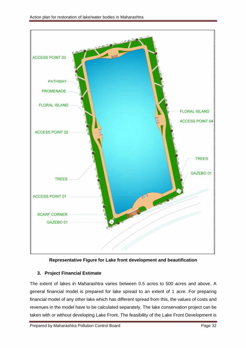
carried out to develop the lake front as per landscape represented in Figure below;
Action plan for restoration of lake/water bodies in Maharashtra
Prepared by Maharashtra Pollution Control Board Page 32
Representative Figure for Lake front development and beautification
3. Project Financial Estimate
The extent of lakes in Maharashtra varies between 0.5 acres to 500 acres and above. A
general financial model is prepared for lake spread to an extent of 1 acre. For preparing
financial model of any other lake which has different spread from this, the values of costs and
revenues in the model have to be calculated separately. The lake conservation project can be
taken with or without developing Lake Front. The feasibility of the Lake Front Development is
Action plan for restoration of lake/water bodies in Maharashtra
Prepared by Maharashtra Pollution Control Board Page 33
dependent on the availability of land around the lake. It is assumed that a parcel of 1 acre is
available next to the lake for the development of various facilities like jogging track, park etc.
The micro and macro assumptions used to prepare financial model are listed below;
Area of Lake 1 Acres
Construction period 1 Year
Contingency cost 2% of hard cost
Lease period 5 years
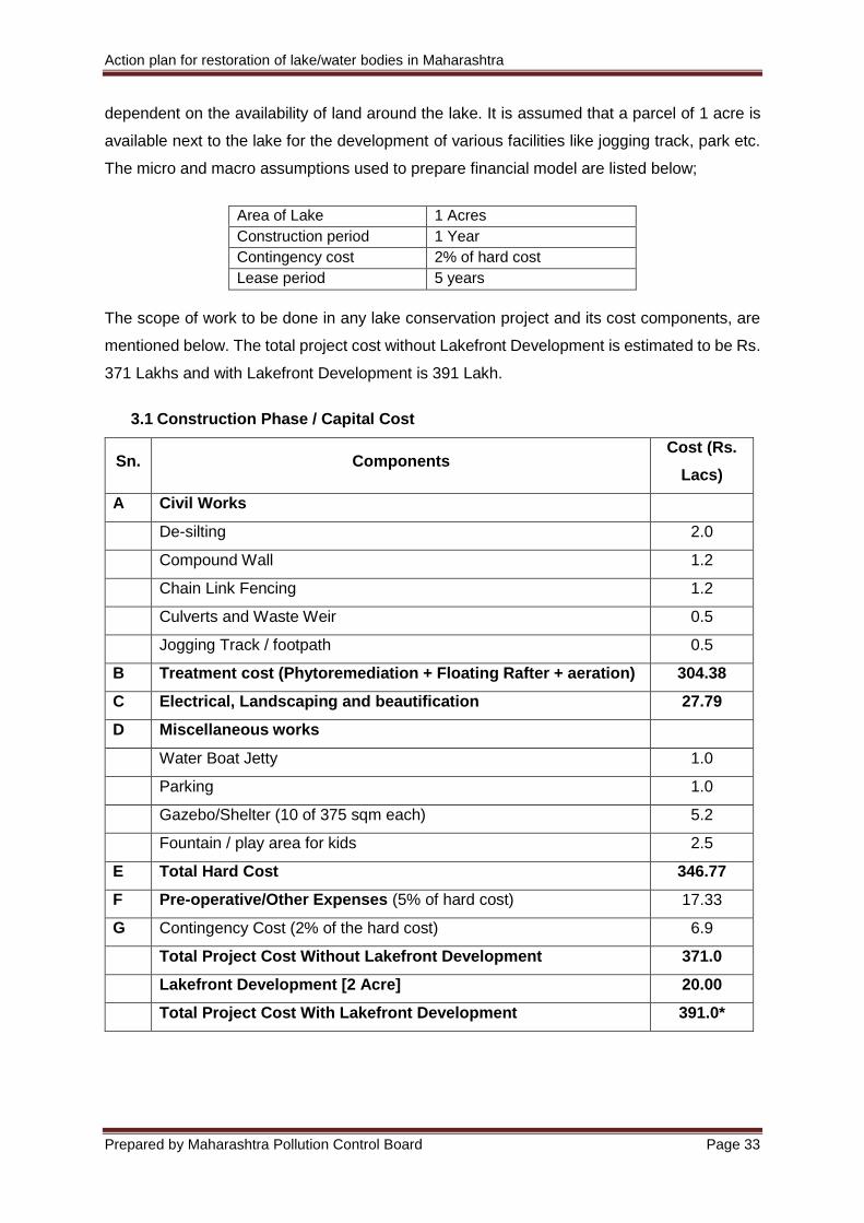
The scope of work to be done in any lake conservation project and its cost components, are
mentioned below. The total project cost without Lakefront Development is estimated to be Rs.
371 Lakhs and with Lakefront Development is 391 Lakh.
3.1 Construction Phase / Capital Cost
Sn. Components Cost (Rs.
Lacs)
A Civil Works
De-silting 2.0
Compound Wall 1.2
Chain Link Fencing 1.2
Culverts and Waste Weir 0.5
Jogging Track / footpath 0.5
B Treatment cost (Phytoremediation + Floating Rafter + aeration) 304.38
C Electrical, Landscaping and beautification 27.79
D Miscellaneous works
Water Boat Jetty 1.0
Parking 1.0
Gazebo/Shelter (10 of 375 sqm each) 5.2
Fountain / play area for kids 2.5
E Total Hard Cost 346.77
F Pre-operative/Other Expenses (5% of hard cost) 17.33
G Contingency Cost (2% of the hard cost) 6.9
Total Project Cost Without Lakefront Development 371.0
Lakefront Development [2 Acre] 20.00
Total Project Cost With Lakefront Development 391.0*
Action plan for restoration of lake/water bodies in Maharashtra
Prepared by Maharashtra Pollution Control Board Page 34
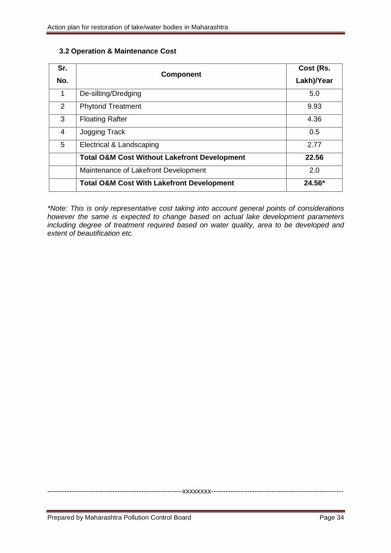
3.2 Operation & Maintenance Cost
*Note: This is only representative cost taking into account general points of considerations however the same is expected to change based on actual lake development parameters including degree of treatment required based on water quality, area to be developed and extent of beautification etc.
--------------------------------------------------------xxxxxxxx-------------------------------------------------------
Sr.
No. Component
Cost (Rs.
Lakh)/Year
1 De-silting/Dredging 5.0
2 Phytorid Treatment 9.93
3 Floating Rafter 4.36
4 Jogging Track 0.5
5 Electrical & Landscaping 2.77
Total O&M Cost Without Lakefront Development 22.56
Maintenance of Lakefront Development 2.0
Total O&M Cost With Lakefront Development 24.56*
Action plan for restoration of lake/water bodies in Maharashtra Annexure I
Prepared by Maharashtra Pollution Control Board Page 35
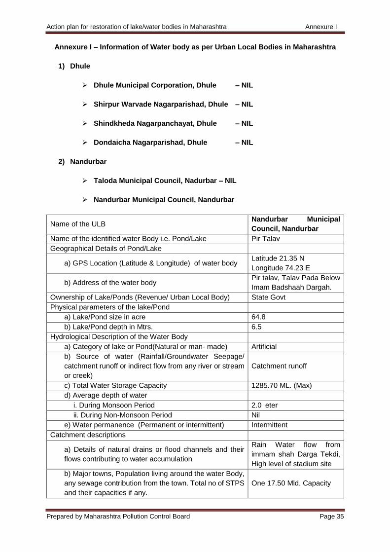
Annexure I – Information of Water body as per Urban Local Bodies in Maharashtra
1) Dhule
Dhule Municipal Corporation, Dhule – NIL
Shirpur Warvade Nagarparishad, Dhule – NIL
Shindkheda Nagarpanchayat, Dhule – NIL
Dondaicha Nagarparishad, Dhule – NIL
2) Nandurbar
Taloda Municipal Council, Nadurbar – NIL
Nandurbar Municipal Council, Nandurbar
Name of the ULB Nandurbar Municipal
Council, Nandurbar
Name of the identified water Body i.e. Pond/Lake Pir Talav
Geographical Details of Pond/Lake
a) GPS Location (Latitude & Longitude) of water body Latitude 21.35 N
Longitude 74.23 E
b) Address of the water body Pir talav, Talav Pada Below
Imam Badshaah Dargah.
Ownership of Lake/Ponds (Revenue/ Urban Local Body) State Govt
Physical parameters of the lake/Pond
a) Lake/Pond size in acre 64.8
b) Lake/Pond depth in Mtrs. 6.5
Hydrological Description of the Water Body
a) Category of lake or Pond(Natural or man- made) Artificial
b) Source of water (Rainfall/Groundwater Seepage/
catchment runoff or indirect flow from any river or stream
or creek)
Catchment runoff
c) Total Water Storage Capacity 1285.70 ML. (Max)
d) Average depth of water
i. During Monsoon Period 2.0 eter
ii. During Non-Monsoon Period Nil
e) Water permanence (Permanent or intermittent) Intermittent
Catchment descriptions
a) Details of natural drains or flood channels and their
flows contributing to water accumulation
Rain Water flow from
immam shah Darga Tekdi,
High level of stadium site
b) Major towns, Population living around the water Body,
any sewage contribution from the town. Total no of STPS
and their capacities if any.
One 17.50 Mld. Capacity
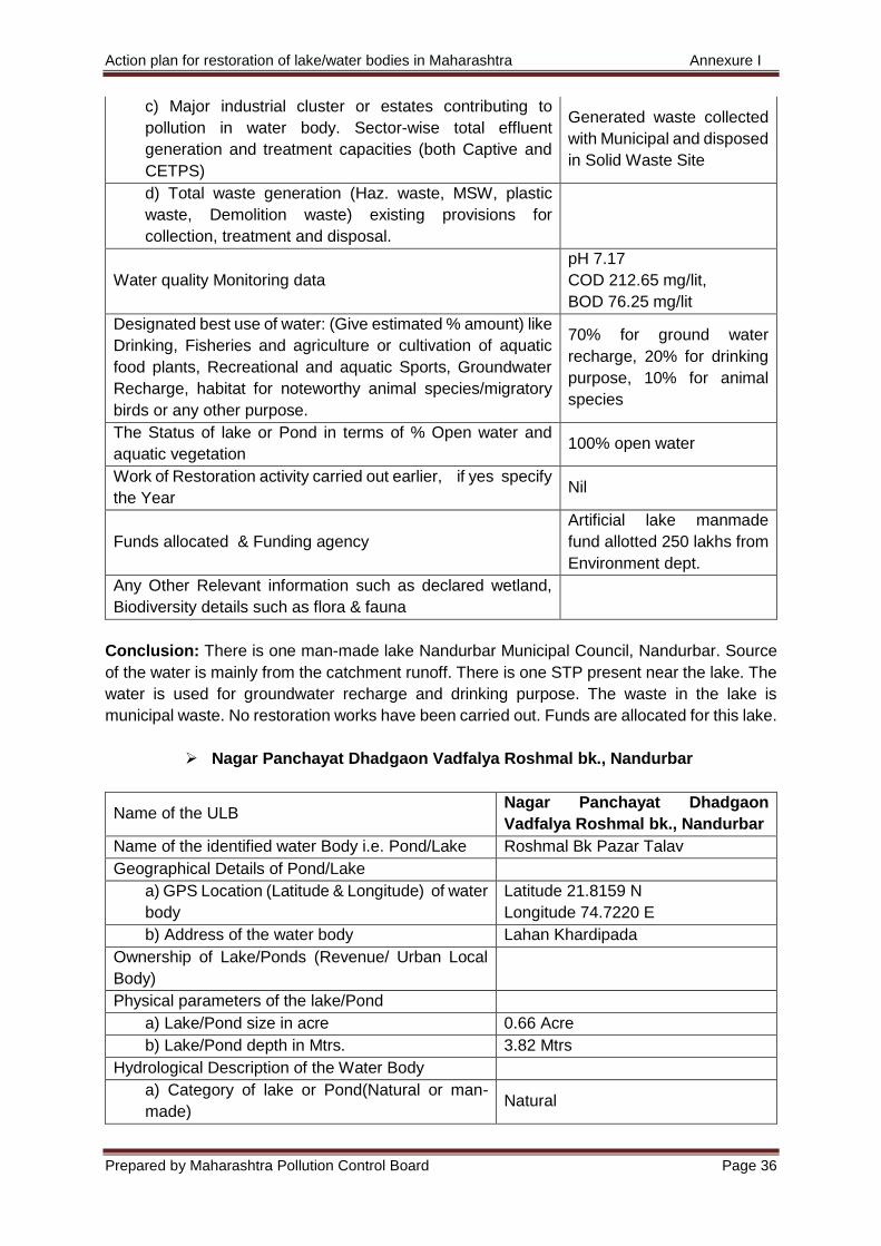
Action plan for restoration of lake/water bodies in Maharashtra Annexure I
Prepared by Maharashtra Pollution Control Board Page 36
c) Major industrial cluster or estates contributing to
pollution in water body. Sector-wise total effluent
generation and treatment capacities (both Captive and
CETPS)
Generated waste collected
with Municipal and disposed
in Solid Waste Site
d) Total waste generation (Haz. waste, MSW, plastic
waste, Demolition waste) existing provisions for
collection, treatment and disposal.
Water quality Monitoring data
pH 7.17
COD 212.65 mg/lit,
BOD 76.25 mg/lit
Designated best use of water: (Give estimated % amount) like
Drinking, Fisheries and agriculture or cultivation of aquatic
food plants, Recreational and aquatic Sports, Groundwater
Recharge, habitat for noteworthy animal species/migratory
birds or any other purpose.
70% for ground water
recharge, 20% for drinking
purpose, 10% for animal
species
The Status of lake or Pond in terms of % Open water and
aquatic vegetation 100% open water
Work of Restoration activity carried out earlier, if yes specify
the Year Nil
Funds allocated & Funding agency
Artificial lake manmade
fund allotted 250 lakhs from
Environment dept.
Any Other Relevant information such as declared wetland,
Biodiversity details such as flora & fauna
Conclusion: There is one man-made lake Nandurbar Municipal Council, Nandurbar. Source
of the water is mainly from the catchment runoff. There is one STP present near the lake. The
water is used for groundwater recharge and drinking purpose. The waste in the lake is
municipal waste. No restoration works have been carried out. Funds are allocated for this lake.
Nagar Panchayat Dhadgaon Vadfalya Roshmal bk., Nandurbar
Name of the ULB Nagar Panchayat Dhadgaon
Vadfalya Roshmal bk., Nandurbar
Name of the identified water Body i.e. Pond/Lake Roshmal Bk Pazar Talav
Geographical Details of Pond/Lake
a) GPS Location (Latitude & Longitude) of water
body
Latitude 21.8159 N
Longitude 74.7220 E
b) Address of the water body Lahan Khardipada
Ownership of Lake/Ponds (Revenue/ Urban Local
Body)
Physical parameters of the lake/Pond
a) Lake/Pond size in acre 0.66 Acre
b) Lake/Pond depth in Mtrs. 3.82 Mtrs
Hydrological Description of the Water Body
a) Category of lake or Pond(Natural or man-
made) Natural
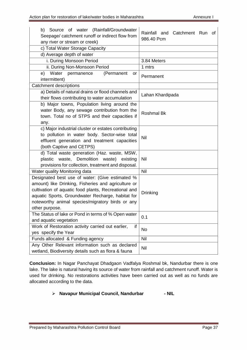
Action plan for restoration of lake/water bodies in Maharashtra Annexure I
Prepared by Maharashtra Pollution Control Board Page 37
b) Source of water (Rainfall/Groundwater
Seepage/ catchment runoff or indirect flow from
any river or stream or creek)
Rainfall and Catchment Run of
986.40 Pcm
c) Total Water Storage Capacity
d) Average depth of water
i. During Monsoon Period 3.84 Meters
ii. During Non-Monsoon Period 1 mtrs
e) Water permanence (Permanent or
intermittent) Permanent
Catchment descriptions
a) Details of natural drains or flood channels and
their flows contributing to water accumulation Lahan Khardipada
b) Major towns, Population living around the
water Body, any sewage contribution from the
town. Total no of STPS and their capacities if
any.
Roshmal Bk
c) Major industrial cluster or estates contributing
to pollution in water body. Sector-wise total
effluent generation and treatment capacities
(both Captive and CETPS)
Nil
d) Total waste generation (Haz. waste, MSW,
plastic waste, Demolition waste) existing
provisions for collection, treatment and disposal.
Nil
Water quality Monitoring data Nil
Designated best use of water: (Give estimated %
amount) like Drinking, Fisheries and agriculture or
cultivation of aquatic food plants, Recreational and
aquatic Sports, Groundwater Recharge, habitat for
noteworthy animal species/migratory birds or any
other purpose.
Drinking
The Status of lake or Pond in terms of % Open water
and aquatic vegetation 0.1
Work of Restoration activity carried out earlier, if
yes specify the Year No
Funds allocated & Funding agency Nil
Any Other Relevant information such as declared
wetland, Biodiversity details such as flora & fauna Nil
Conclusion: In Nagar Panchayat Dhadgaon Vadfalya Roshmal bk, Nandurbar there is one
lake. The lake is natural having its source of water from rainfall and catchment runoff. Water is
used for drinking. No restorations activities have been carried out as well as no funds are
allocated according to the data.
Navapur Municipal Council, Nandurbar - NIL
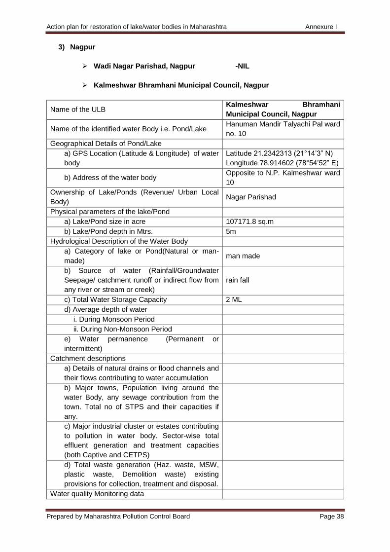
Action plan for restoration of lake/water bodies in Maharashtra Annexure I
Prepared by Maharashtra Pollution Control Board Page 38
3) Nagpur
Wadi Nagar Parishad, Nagpur -NIL
Kalmeshwar Bhramhani Municipal Council, Nagpur
Name of the ULB Kalmeshwar Bhramhani
Municipal Council, Nagpur
Name of the identified water Body i.e. Pond/Lake Hanuman Mandir Talyachi Pal ward
no. 10
Geographical Details of Pond/Lake
a) GPS Location (Latitude & Longitude) of water
body
Latitude 21.2342313 (21°14’3” N)
Longitude 78.914602 (78°54’52” E)
b) Address of the water body Opposite to N.P. Kalmeshwar ward
10
Ownership of Lake/Ponds (Revenue/ Urban Local
Body) Nagar Parishad
Physical parameters of the lake/Pond
a) Lake/Pond size in acre 107171.8 sq.m
b) Lake/Pond depth in Mtrs. 5m
Hydrological Description of the Water Body
a) Category of lake or Pond(Natural or man-
made) man made
b) Source of water (Rainfall/Groundwater
Seepage/ catchment runoff or indirect flow from
any river or stream or creek)
rain fall
c) Total Water Storage Capacity 2 ML
d) Average depth of water
i. During Monsoon Period
ii. During Non-Monsoon Period
e) Water permanence (Permanent or
intermittent)
Catchment descriptions
a) Details of natural drains or flood channels and
their flows contributing to water accumulation
b) Major towns, Population living around the
water Body, any sewage contribution from the
town. Total no of STPS and their capacities if
any.
c) Major industrial cluster or estates contributing
to pollution in water body. Sector-wise total
effluent generation and treatment capacities
(both Captive and CETPS)
d) Total waste generation (Haz. waste, MSW,
plastic waste, Demolition waste) existing
provisions for collection, treatment and disposal.
Water quality Monitoring data
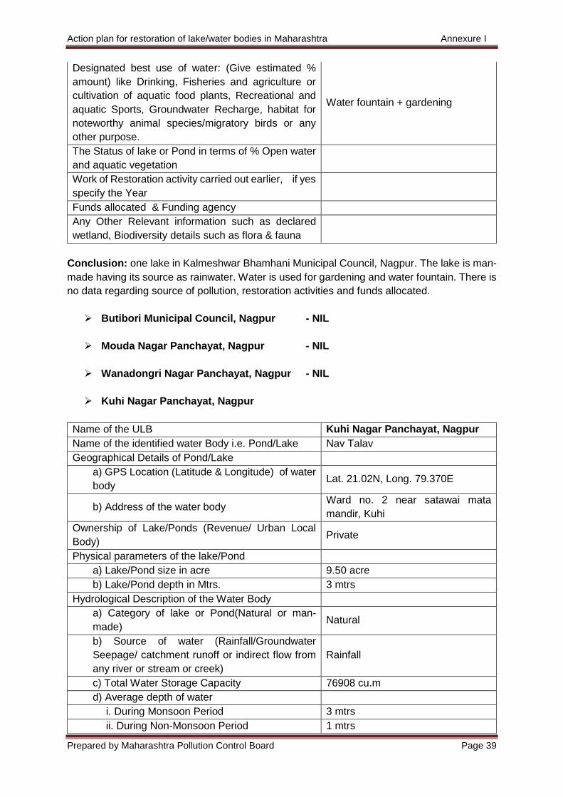
Action plan for restoration of lake/water bodies in Maharashtra Annexure I
Prepared by Maharashtra Pollution Control Board Page 39
Designated best use of water: (Give estimated %
amount) like Drinking, Fisheries and agriculture or
cultivation of aquatic food plants, Recreational and
aquatic Sports, Groundwater Recharge, habitat for
noteworthy animal species/migratory birds or any
other purpose.
Water fountain + gardening
The Status of lake or Pond in terms of % Open water
and aquatic vegetation
Work of Restoration activity carried out earlier, if yes
specify the Year
Funds allocated & Funding agency
Any Other Relevant information such as declared
wetland, Biodiversity details such as flora & fauna
Conclusion: one lake in Kalmeshwar Bhamhani Municipal Council, Nagpur. The lake is man-
made having its source as rainwater. Water is used for gardening and water fountain. There is
no data regarding source of pollution, restoration activities and funds allocated.
Butibori Municipal Council, Nagpur - NIL
Mouda Nagar Panchayat, Nagpur - NIL
Wanadongri Nagar Panchayat, Nagpur - NIL
Kuhi Nagar Panchayat, Nagpur
Name of the ULB Kuhi Nagar Panchayat, Nagpur
Name of the identified water Body i.e. Pond/Lake Nav Talav
Geographical Details of Pond/Lake
a) GPS Location (Latitude & Longitude) of water
body Lat. 21.02N, Long. 79.370E
b) Address of the water body Ward no. 2 near satawai mata
mandir, Kuhi
Ownership of Lake/Ponds (Revenue/ Urban Local
Body) Private
Physical parameters of the lake/Pond
a) Lake/Pond size in acre 9.50 acre
b) Lake/Pond depth in Mtrs. 3 mtrs
Hydrological Description of the Water Body
a) Category of lake or Pond(Natural or man-
made) Natural
b) Source of water (Rainfall/Groundwater
Seepage/ catchment runoff or indirect flow from
any river or stream or creek)
Rainfall
c) Total Water Storage Capacity 76908 cu.m
d) Average depth of water
i. During Monsoon Period 3 mtrs
ii. During Non-Monsoon Period 1 mtrs
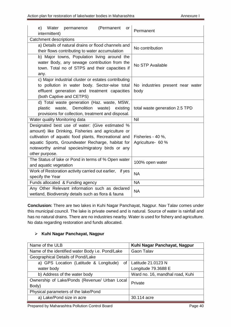
Action plan for restoration of lake/water bodies in Maharashtra Annexure I
Prepared by Maharashtra Pollution Control Board Page 40
e) Water permanence (Permanent or
intermittent) Permanent
Catchment descriptions
a) Details of natural drains or flood channels and
their flows contributing to water accumulation No contribution
b) Major towns, Population living around the
water Body, any sewage contribution from the
town. Total no of STPS and their capacities if
any.
No STP Available
c) Major industrial cluster or estates contributing
to pollution in water body. Sector-wise total
effluent generation and treatment capacities
(both Captive and CETPS)
No industries present near water
body
d) Total waste generation (Haz. waste, MSW,
plastic waste, Demolition waste) existing
provisions for collection, treatment and disposal.
total waste generation 2.5 TPD
Water quality Monitoring data Nil
Designated best use of water: (Give estimated %
amount) like Drinking, Fisheries and agriculture or
cultivation of aquatic food plants, Recreational and
aquatic Sports, Groundwater Recharge, habitat for
noteworthy animal species/migratory birds or any
other purpose.
Fisheries - 40 %,
Agriculture- 60 %
The Status of lake or Pond in terms of % Open water
and aquatic vegetation 100% open water
Work of Restoration activity carried out earlier, if yes
specify the Year NA
Funds allocated & Funding agency NA
Any Other Relevant information such as declared
wetland, Biodiversity details such as flora & fauna NA
Conclusion: There are two lakes in Kuhi Nagar Panchayat, Nagpur. Nav Talav comes under
this municipal council. The lake is private owned and is natural. Source of water is rainfall and
has no natural drains. There are no industries nearby. Water is used for fishery and agriculture.
No data regarding restoration and funds allocated.
Kuhi Nagar Panchayat, Nagpur
Name of the ULB Kuhi Nagar Panchayat, Nagpur
Name of the identified water Body i.e. Pond/Lake Gaon Talav
Geographical Details of Pond/Lake
a) GPS Location (Latitude & Longitude) of
water body
Latitude 21.0123 N
Longitude 79.3688 E
b) Address of the water body Ward no. 16, mandhal road, Kuhi
Ownership of Lake/Ponds (Revenue/ Urban Local
Body) Private
Physical parameters of the lake/Pond
a) Lake/Pond size in acre 30.114 acre
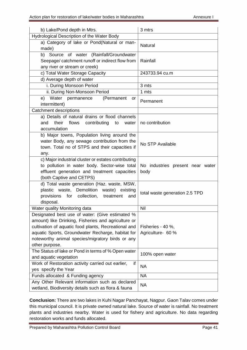
Action plan for restoration of lake/water bodies in Maharashtra Annexure I
Prepared by Maharashtra Pollution Control Board Page 41
b) Lake/Pond depth in Mtrs. 3 mtrs
Hydrological Description of the Water Body
a) Category of lake or Pond(Natural or man-
made) Natural
b) Source of water (Rainfall/Groundwater
Seepage/ catchment runoff or indirect flow from
any river or stream or creek)
Rainfall
c) Total Water Storage Capacity 243733.94 cu.m
d) Average depth of water
i. During Monsoon Period 3 mts
ii. During Non-Monsoon Period 1 mts
e) Water permanence (Permanent or
intermittent) Permanent
Catchment descriptions
a) Details of natural drains or flood channels
and their flows contributing to water
accumulation
no contribution
b) Major towns, Population living around the
water Body, any sewage contribution from the
town. Total no of STPS and their capacities if
any.
No STP Available
c) Major industrial cluster or estates contributing
to pollution in water body. Sector-wise total
effluent generation and treatment capacities
(both Captive and CETPS)
No industries present near water
body
d) Total waste generation (Haz. waste, MSW,
plastic waste, Demolition waste) existing
provisions for collection, treatment and
disposal.
total waste generation 2.5 TPD
Water quality Monitoring data Nil
Designated best use of water: (Give estimated %
amount) like Drinking, Fisheries and agriculture or
cultivation of aquatic food plants, Recreational and
aquatic Sports, Groundwater Recharge, habitat for
noteworthy animal species/migratory birds or any
other purpose.
Fisheries - 40 %,
Agriculture- 60 %
The Status of lake or Pond in terms of % Open water
and aquatic vegetation 100% open water
Work of Restoration activity carried out earlier, if
yes specify the Year NA
Funds allocated & Funding agency NA
Any Other Relevant information such as declared
wetland, Biodiversity details such as flora & fauna NA
Conclusion: There are two lakes in Kuhi Nagar Panchayat, Nagpur. Gaon Talav comes under
this municipal council. It is private owned natural lake. Source of water is rainfall. No treatment
plants and industries nearby. Water is used for fishery and agriculture. No data regarding
restoration works and funds allocated.
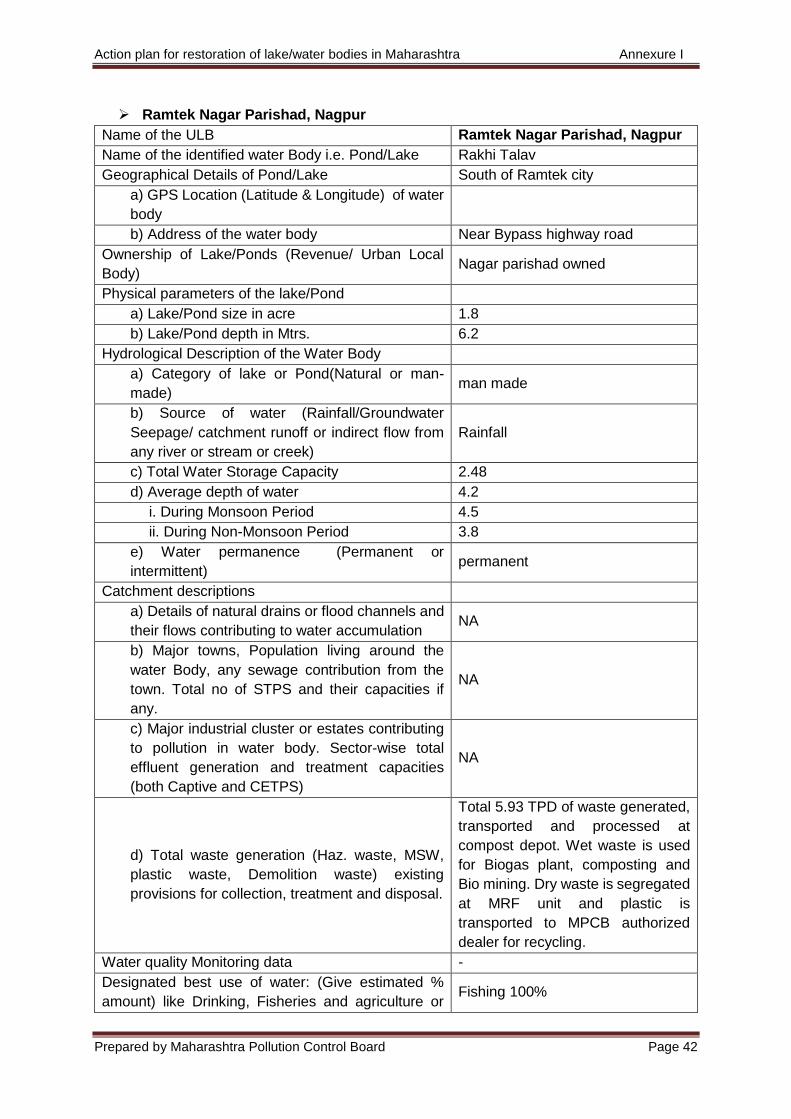
Action plan for restoration of lake/water bodies in Maharashtra Annexure I
Prepared by Maharashtra Pollution Control Board Page 42
Ramtek Nagar Parishad, Nagpur
Name of the ULB Ramtek Nagar Parishad, Nagpur
Name of the identified water Body i.e. Pond/Lake Rakhi Talav
Geographical Details of Pond/Lake South of Ramtek city
a) GPS Location (Latitude & Longitude) of water
body
b) Address of the water body Near Bypass highway road
Ownership of Lake/Ponds (Revenue/ Urban Local
Body) Nagar parishad owned
Physical parameters of the lake/Pond
a) Lake/Pond size in acre 1.8
b) Lake/Pond depth in Mtrs. 6.2
Hydrological Description of the Water Body
a) Category of lake or Pond(Natural or man-
made) man made
b) Source of water (Rainfall/Groundwater
Seepage/ catchment runoff or indirect flow from
any river or stream or creek)
Rainfall
c) Total Water Storage Capacity 2.48
d) Average depth of water 4.2
i. During Monsoon Period 4.5
ii. During Non-Monsoon Period 3.8
e) Water permanence (Permanent or
intermittent) permanent
Catchment descriptions
a) Details of natural drains or flood channels and
their flows contributing to water accumulation NA
b) Major towns, Population living around the
water Body, any sewage contribution from the
town. Total no of STPS and their capacities if
any.
NA
c) Major industrial cluster or estates contributing
to pollution in water body. Sector-wise total
effluent generation and treatment capacities
(both Captive and CETPS)
NA
d) Total waste generation (Haz. waste, MSW,
plastic waste, Demolition waste) existing
provisions for collection, treatment and disposal.
Total 5.93 TPD of waste generated,
transported and processed at
compost depot. Wet waste is used
for Biogas plant, composting and
Bio mining. Dry waste is segregated
at MRF unit and plastic is
transported to MPCB authorized
dealer for recycling.
Water quality Monitoring data -
Designated best use of water: (Give estimated %
amount) like Drinking, Fisheries and agriculture or Fishing 100%
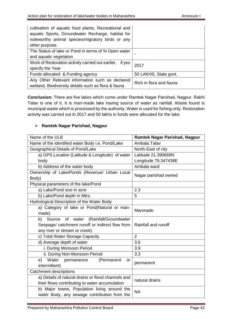
Action plan for restoration of lake/water bodies in Maharashtra Annexure I
Prepared by Maharashtra Pollution Control Board Page 43
cultivation of aquatic food plants, Recreational and
aquatic Sports, Groundwater Recharge, habitat for
noteworthy animal species/migratory birds or any
other purpose.
The Status of lake or Pond in terms of % Open water
and aquatic vegetation -
Work of Restoration activity carried out earlier, if yes
specify the Year 2017
Funds allocated & Funding agency 50 LAKHS, State govt.
Any Other Relevant information such as declared
wetland, Biodiversity details such as flora & fauna Rich in flora and fauna
Conclusion: There are five lakes which come under Ramtek Nagar Parishad, Nagpur. Rakhi
Talav is one of it. It is man-made lake having source of water as rainfall. Waste found is
municipal waste which is processed by the authority. Water is used for fishing only. Restoration
activity was carried out in 2017 and 50 lakhs in funds were allocated for the lake.
Ramtek Nagar Parishad, Nagpur
Name of the ULB Ramtek Nagar Parishad, Nagpur
Name of the identified water Body i.e. Pond/Lake Ambala Talav
Geographical Details of Pond/Lake North-East of city
a) GPS Location (Latitude & Longitude) of water
body
Latitude 21.390669N
Longitude 79.347438E
b) Address of the water body Ambala ward
Ownership of Lake/Ponds (Revenue/ Urban Local
Body) Nagar parishad owned
Physical parameters of the lake/Pond
a) Lake/Pond size in acre 2.3
b) Lake/Pond depth in Mtrs. 5
Hydrological Description of the Water Body
a) Category of lake or Pond(Natural or man-
made) Manmade
b) Source of water (Rainfall/Groundwater
Seepage/ catchment runoff or indirect flow from
any river or stream or creek)
Rainfall and runoff
c) Total Water Storage Capacity 2
d) Average depth of water 3.6
i. During Monsoon Period 3.9
ii. During Non-Monsoon Period 3.3
e) Water permanence (Permanent or
intermittent) permanent
Catchment descriptions
a) Details of natural drains or flood channels and
their flows contributing to water accumulation natural drains
b) Major towns, Population living around the
water Body, any sewage contribution from the NA
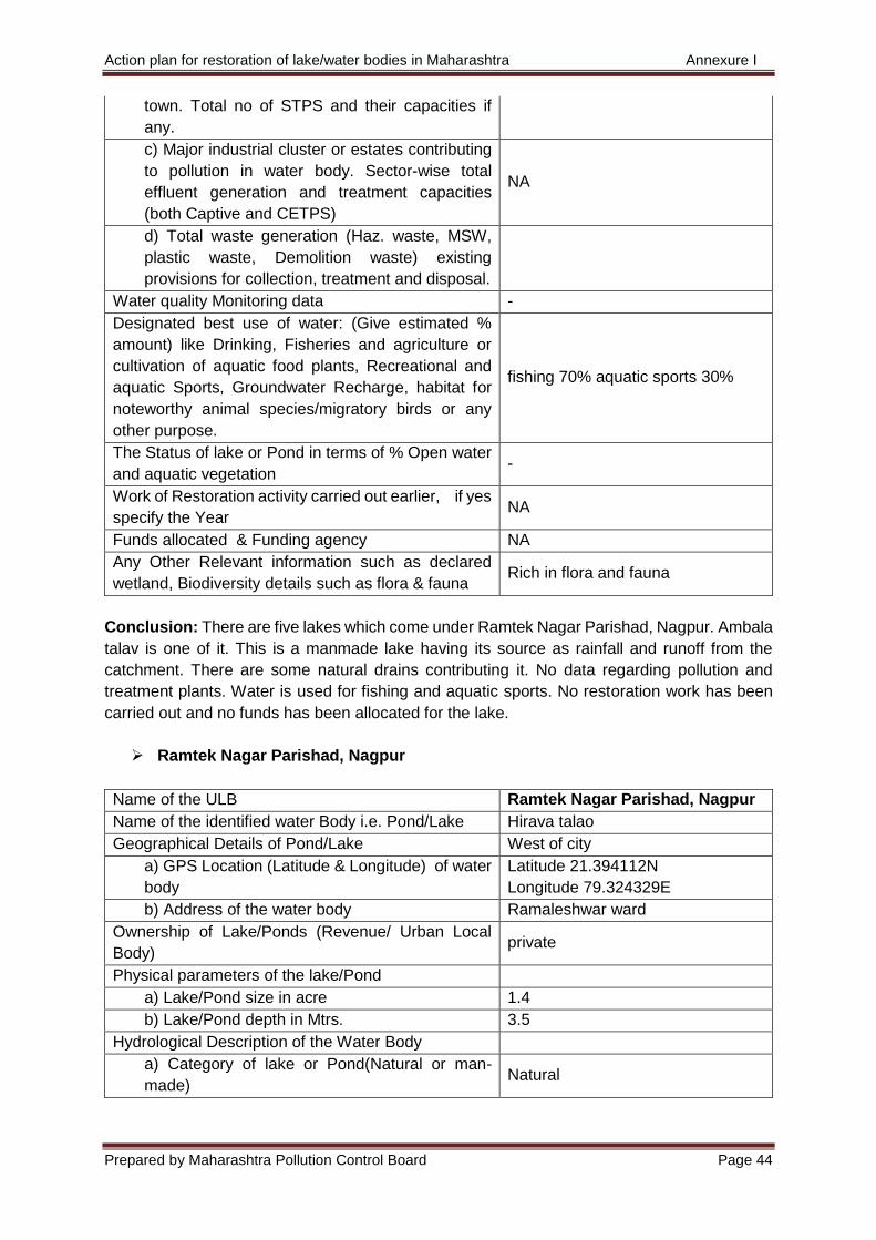
Action plan for restoration of lake/water bodies in Maharashtra Annexure I
Prepared by Maharashtra Pollution Control Board Page 44
town. Total no of STPS and their capacities if
any.
c) Major industrial cluster or estates contributing
to pollution in water body. Sector-wise total
effluent generation and treatment capacities
(both Captive and CETPS)
NA
d) Total waste generation (Haz. waste, MSW,
plastic waste, Demolition waste) existing
provisions for collection, treatment and disposal.
Water quality Monitoring data -
Designated best use of water: (Give estimated %
amount) like Drinking, Fisheries and agriculture or
cultivation of aquatic food plants, Recreational and
aquatic Sports, Groundwater Recharge, habitat for
noteworthy animal species/migratory birds or any
other purpose.
fishing 70% aquatic sports 30%
The Status of lake or Pond in terms of % Open water
and aquatic vegetation -
Work of Restoration activity carried out earlier, if yes
specify the Year NA
Funds allocated & Funding agency NA
Any Other Relevant information such as declared
wetland, Biodiversity details such as flora & fauna Rich in flora and fauna
Conclusion: There are five lakes which come under Ramtek Nagar Parishad, Nagpur. Ambala
talav is one of it. This is a manmade lake having its source as rainfall and runoff from the
catchment. There are some natural drains contributing it. No data regarding pollution and
treatment plants. Water is used for fishing and aquatic sports. No restoration work has been
carried out and no funds has been allocated for the lake.
Ramtek Nagar Parishad, Nagpur
Name of the ULB Ramtek Nagar Parishad, Nagpur
Name of the identified water Body i.e. Pond/Lake Hirava talao
Geographical Details of Pond/Lake West of city
a) GPS Location (Latitude & Longitude) of water
body
Latitude 21.394112N
Longitude 79.324329E
b) Address of the water body Ramaleshwar ward
Ownership of Lake/Ponds (Revenue/ Urban Local
Body) private
Physical parameters of the lake/Pond
a) Lake/Pond size in acre 1.4
b) Lake/Pond depth in Mtrs. 3.5
Hydrological Description of the Water Body
a) Category of lake or Pond(Natural or man-
made) Natural
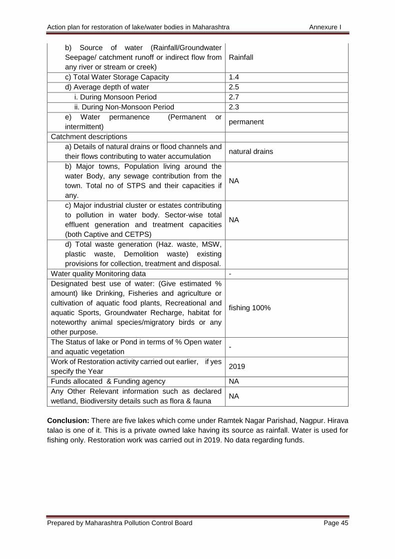
Action plan for restoration of lake/water bodies in Maharashtra Annexure I
Prepared by Maharashtra Pollution Control Board Page 45
b) Source of water (Rainfall/Groundwater
Seepage/ catchment runoff or indirect flow from
any river or stream or creek)
Rainfall
c) Total Water Storage Capacity 1.4
d) Average depth of water 2.5
i. During Monsoon Period 2.7
ii. During Non-Monsoon Period 2.3
e) Water permanence (Permanent or
intermittent) permanent
Catchment descriptions
a) Details of natural drains or flood channels and
their flows contributing to water accumulation natural drains
b) Major towns, Population living around the
water Body, any sewage contribution from the
town. Total no of STPS and their capacities if
any.
NA
c) Major industrial cluster or estates contributing
to pollution in water body. Sector-wise total
effluent generation and treatment capacities
(both Captive and CETPS)
NA
d) Total waste generation (Haz. waste, MSW,
plastic waste, Demolition waste) existing
provisions for collection, treatment and disposal.
Water quality Monitoring data -
Designated best use of water: (Give estimated %
amount) like Drinking, Fisheries and agriculture or
cultivation of aquatic food plants, Recreational and
aquatic Sports, Groundwater Recharge, habitat for
noteworthy animal species/migratory birds or any
other purpose.
fishing 100%
The Status of lake or Pond in terms of % Open water
and aquatic vegetation -
Work of Restoration activity carried out earlier, if yes
specify the Year 2019
Funds allocated & Funding agency NA
Any Other Relevant information such as declared
wetland, Biodiversity details such as flora & fauna NA
Conclusion: There are five lakes which come under Ramtek Nagar Parishad, Nagpur. Hirava
talao is one of it. This is a private owned lake having its source as rainfall. Water is used for
fishing only. Restoration work was carried out in 2019. No data regarding funds.
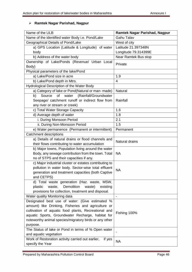
Action plan for restoration of lake/water bodies in Maharashtra Annexure I
Prepared by Maharashtra Pollution Control Board Page 46
Ramtek Nagar Parishad, Nagpur
Name of the ULB Ramtek Nagar Parishad, Nagpur
Name of the identified water Body i.e. Pond/Lake Gahu Talav
Geographical Details of Pond/Lake West of city
a) GPS Location (Latitude & Longitude) of water
body
Latitude 21.397348N
Longitude 79.314399E
b) Address of the water body Near Ramtek Bus stop
Ownership of Lake/Ponds (Revenue/ Urban Local
Body) Private
Physical parameters of the lake/Pond
a) Lake/Pond size in acre 1.9
b) Lake/Pond depth in Mtrs. 4
Hydrological Description of the Water Body
a) Category of lake or Pond(Natural or man- made) Natural
b) Source of water (Rainfall/Groundwater
Seepage/ catchment runoff or indirect flow from
any river or stream or creek)
Rainfall
c) Total Water Storage Capacity 1.6
d) Average depth of water 1.8
i. During Monsoon Period 2.1
ii. During Non-Monsoon Period 1.5
e) Water permanence (Permanent or intermittent) Permanent
Catchment descriptions
a) Details of natural drains or flood channels and
their flows contributing to water accumulation Natural drains
b) Major towns, Population living around the water
Body, any sewage contribution from the town. Total
no of STPS and their capacities if any.
NA
c) Major industrial cluster or estates contributing to
pollution in water body. Sector-wise total effluent
generation and treatment capacities (both Captive
and CETPS)
NA
d) Total waste generation (Haz. waste, MSW,
plastic waste, Demolition waste) existing
provisions for collection, treatment and disposal.
Water quality Monitoring data -
Designated best use of water: (Give estimated %
amount) like Drinking, Fisheries and agriculture or
cultivation of aquatic food plants, Recreational and
aquatic Sports, Groundwater Recharge, habitat for
noteworthy animal species/migratory birds or any other
purpose.
Fishing 100%
The Status of lake or Pond in terms of % Open water
and aquatic vegetation -
Work of Restoration activity carried out earlier, if yes
specify the Year NA
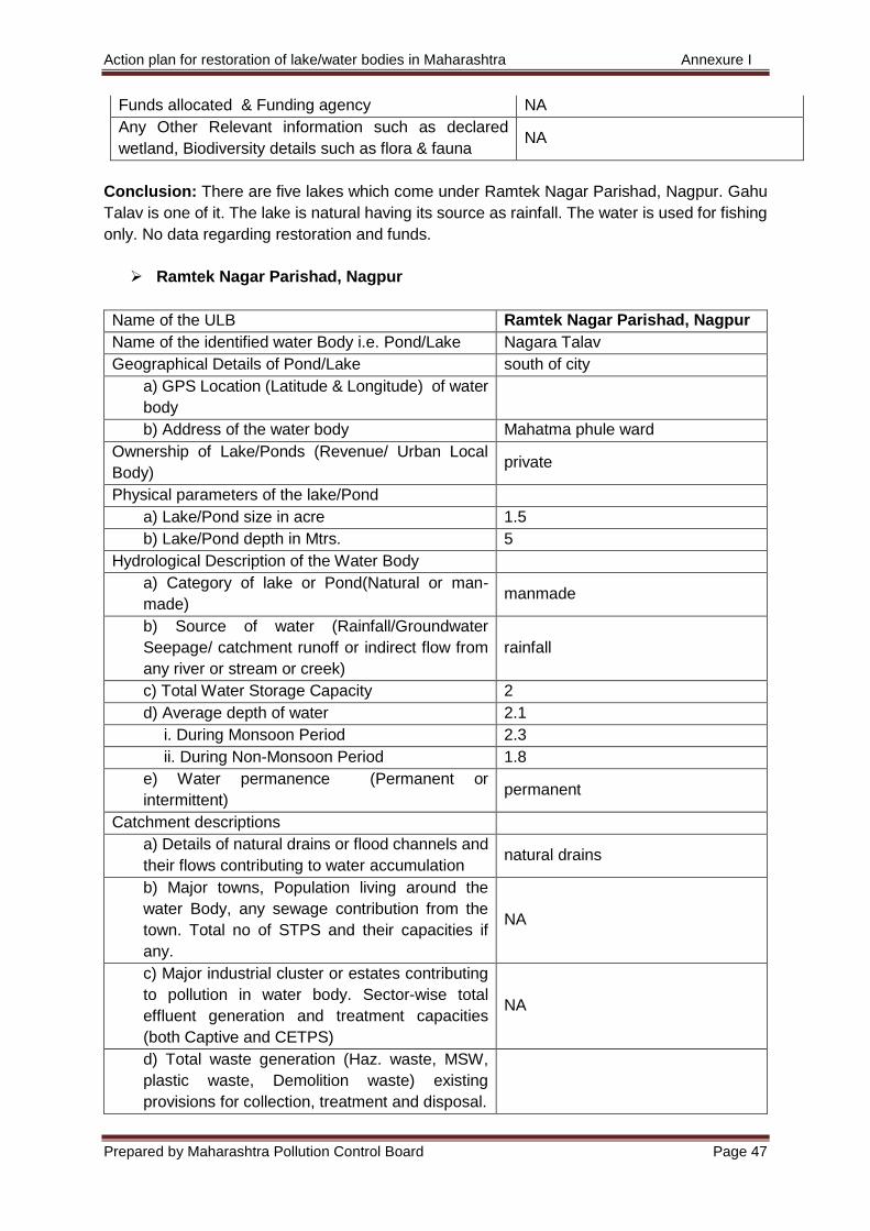
Action plan for restoration of lake/water bodies in Maharashtra Annexure I
Prepared by Maharashtra Pollution Control Board Page 47
Funds allocated & Funding agency NA
Any Other Relevant information such as declared
wetland, Biodiversity details such as flora & fauna NA
Conclusion: There are five lakes which come under Ramtek Nagar Parishad, Nagpur. Gahu
Talav is one of it. The lake is natural having its source as rainfall. The water is used for fishing
only. No data regarding restoration and funds.
Ramtek Nagar Parishad, Nagpur
Name of the ULB Ramtek Nagar Parishad, Nagpur
Name of the identified water Body i.e. Pond/Lake Nagara Talav
Geographical Details of Pond/Lake south of city
a) GPS Location (Latitude & Longitude) of water
body
b) Address of the water body Mahatma phule ward
Ownership of Lake/Ponds (Revenue/ Urban Local
Body) private
Physical parameters of the lake/Pond
a) Lake/Pond size in acre 1.5
b) Lake/Pond depth in Mtrs. 5
Hydrological Description of the Water Body
a) Category of lake or Pond(Natural or man-
made) manmade
b) Source of water (Rainfall/Groundwater
Seepage/ catchment runoff or indirect flow from
any river or stream or creek)
rainfall
c) Total Water Storage Capacity 2
d) Average depth of water 2.1
i. During Monsoon Period 2.3
ii. During Non-Monsoon Period 1.8
e) Water permanence (Permanent or
intermittent) permanent
Catchment descriptions
a) Details of natural drains or flood channels and
their flows contributing to water accumulation natural drains
b) Major towns, Population living around the
water Body, any sewage contribution from the
town. Total no of STPS and their capacities if
any.
NA
c) Major industrial cluster or estates contributing
to pollution in water body. Sector-wise total
effluent generation and treatment capacities
(both Captive and CETPS)
NA
d) Total waste generation (Haz. waste, MSW,
plastic waste, Demolition waste) existing
provisions for collection, treatment and disposal.
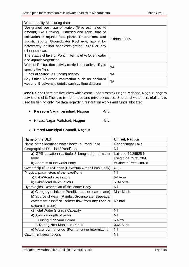
Action plan for restoration of lake/water bodies in Maharashtra Annexure I
Prepared by Maharashtra Pollution Control Board Page 48
Water quality Monitoring data -
Designated best use of water: (Give estimated %
amount) like Drinking, Fisheries and agriculture or
cultivation of aquatic food plants, Recreational and
aquatic Sports, Groundwater Recharge, habitat for
noteworthy animal species/migratory birds or any
other purpose.
Fishing 100%
The Status of lake or Pond in terms of % Open water
and aquatic vegetation -
Work of Restoration activity carried out earlier, if yes
specify the Year NA
Funds allocated & Funding agency NA
Any Other Relevant information such as declared
wetland, Biodiversity details such as flora & fauna NA
Conclusion: There are five lakes which come under Ramtek Nagar Parishad, Nagpur. Nagara
talav is one of it. The lake is man-made and privately owned. Source of water is rainfall and is
used for fishing only. No data regarding restoration works and funds allocated.
Parseoni Nagar parishad, Nagpur -NIL
Khapa Nagar Parishad, Nagpur -NIL
Umred Municipal Council, Nagpur
Name of the ULB Umred, Nagpur
Name of the identified water Body i.e. Pond/Lake Gandhisagar Lake
Geographical Details of Pond/Lake Nil
a) GPS Location (Latitude & Longitude) of water
body
Latitude 20.85525 N
Longitude 79.31796E
b) Address of the water body Budhwari Peth Umred
Ownership of Lake/Ponds (Revenue/ Urban Local Body) ULB
Physical parameters of the lake/Pond Nil
a) Lake/Pond size in acre 54 Acre
b) Lake/Pond depth in Mtrs. 6.09 Mtrs.
Hydrological Description of the Water Body Nil
a) Category of lake or Pond(Natural or man- made) Man-Made
b) Source of water (Rainfall/Groundwater Seepage/
catchment runoff or indirect flow from any river or
stream or creek)
Rainfall
c) Total Water Storage Capacity Nil
d) Average depth of water Nil
i. During Monsoon Period 5 Mtrs
ii. During Non-Monsoon Period 3.65 Mtrs.
e) Water permanence (Permanent or intermittent) Nil
Catchment descriptions Nil

Action plan for restoration of lake/water bodies in Maharashtra Annexure I
Prepared by Maharashtra Pollution Control Board Page 49
a) Details of natural drains or flood channels and
their flows contributing to water accumulation Nil
b) Major towns, Population living around the water
Body, any sewage contribution from the town. Total
no of STPS and their capacities if any.
Nil
c) Major industrial cluster or estates contributing to
pollution in water body. Sector-wise total effluent
generation and treatment capacities (both Captive
and CETPS)
Nil
d) Total waste generation (Haz. waste, MSW,
plastic waste, Demolition waste) existing provisions
for collection, treatment and disposal.
Total Waste Generatio- 13.8
DHW -0.03 TPD , MSW Waste-
13.48TPD & Plastic Waste-
0.300 TPD
Water quality Monitoring data Chemical Testing
Designated best use of water: (Give estimated %
amount) like Drinking, Fisheries and agriculture or
cultivation of aquatic food plants, Recreational and
aquatic Sports, Groundwater Recharge, habitat for
noteworthy animal species/migratory birds or any other
purpose.
0.6
The Status of lake or Pond in terms of % Open water
and aquatic vegetation Nil
Work of Restoration activity carried out earlier, if yes
specify the Year Not Yet
Funds allocated & Funding agency NA
Any Other Relevant information such as declared
wetland, Biodiversity details such as flora & fauna NA
Conclusion: Gandhisagar Lake comes under Umred Municipal Council, Nagpur. It is a man-
made lake having its source as rainfall only. No data regarding restoration works and funds
allocated.
Umred Municipal Council, Nagpur
Name of the ULB Umred Municipal Council,
Nagpur
Name of the identified water Body i.e. Pond/Lake Green Tank
Geographical Details of Pond/Lake Nil
a) GPS Location (Latitude & Longitude) of water
body
Latitude 20.85416 N
Longitude 79.32974E
b) Address of the water body Mangalwari Peth Umred
Ownership of Lake/Ponds (Revenue/ Urban Local
Body) ULB
Physical parameters of the lake/Pond Nil
a) Lake/Pond size in acre 7 Acre
b) Lake/Pond depth in Mtrs. 3.04 Mtrs.
Hydrological Description of the Water Body Nil
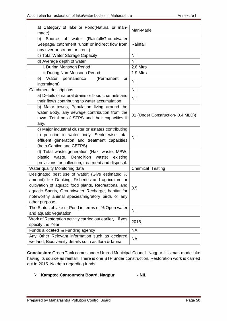
Action plan for restoration of lake/water bodies in Maharashtra Annexure I
Prepared by Maharashtra Pollution Control Board Page 50
a) Category of lake or Pond(Natural or man-
made) Man-Made
b) Source of water (Rainfall/Groundwater
Seepage/ catchment runoff or indirect flow from
any river or stream or creek)
Rainfall
c) Total Water Storage Capacity Nil
d) Average depth of water Nil
i. During Monsoon Period 2.8 Mtrs
ii. During Non-Monsoon Period 1.9 Mtrs.
e) Water permanence (Permanent or
intermittent) Nil
Catchment descriptions Nil
a) Details of natural drains or flood channels and
their flows contributing to water accumulation Nil
b) Major towns, Population living around the
water Body, any sewage contribution from the
town. Total no of STPS and their capacities if
any.
01 (Under Construction- 0.4 MLD))
c) Major industrial cluster or estates contributing
to pollution in water body. Sector-wise total
effluent generation and treatment capacities
(both Captive and CETPS)
Nil
d) Total waste generation (Haz. waste, MSW,
plastic waste, Demolition waste) existing
provisions for collection, treatment and disposal.
Water quality Monitoring data Chemical Testing
Designated best use of water: (Give estimated %
amount) like Drinking, Fisheries and agriculture or
cultivation of aquatic food plants, Recreational and
aquatic Sports, Groundwater Recharge, habitat for
noteworthy animal species/migratory birds or any
other purpose.
0.5
The Status of lake or Pond in terms of % Open water
and aquatic vegetation Nil
Work of Restoration activity carried out earlier, if yes
specify the Year 2015
Funds allocated & Funding agency NA
Any Other Relevant information such as declared
wetland, Biodiversity details such as flora & fauna NA
Conclusion: Green Tank comes under Umred Municipal Council, Nagpur. It is man-made lake
having its source as rainfall. There is one STP under construction. Restoration work is carried
out in 2015. No data regarding funds.
Kamptee Cantonment Board, Nagpur - NIL
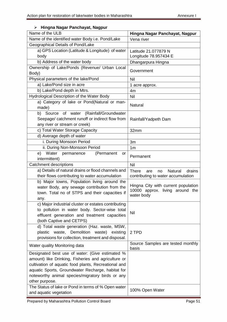
Action plan for restoration of lake/water bodies in Maharashtra Annexure I
Prepared by Maharashtra Pollution Control Board Page 51
Hingna Nagar Panchayat, Nagpur
Name of the ULB Hingna Nagar Panchayat, Nagpur
Name of the identified water Body i.e. Pond/Lake Vena river
Geographical Details of Pond/Lake
a) GPS Location (Latitude & Longitude) of water
body Latitude 21.077879 N Longitude 78.957434 E
b) Address of the water body Dhangarpura Hingna
Ownership of Lake/Ponds (Revenue/ Urban Local
Body) Government
Physical parameters of the lake/Pond Nil
a) Lake/Pond size in acre 1 acre approx.
b) Lake/Pond depth in Mtrs. 4m
Hydrological Description of the Water Body Nil
a) Category of lake or Pond(Natural or man-
made) Natural
b) Source of water (Rainfall/Groundwater
Seepage/ catchment runoff or indirect flow from
any river or stream or creek)
Rainfall/Yadpeth Dam
c) Total Water Storage Capacity 32mm
d) Average depth of water
i. During Monsoon Period 3m
ii. During Non-Monsoon Period 1m
e) Water permanence (Permanent or
intermittent) Permanent
Catchment descriptions Nil
a) Details of natural drains or flood channels and
their flows contributing to water accumulation There are no Natural drains contributing to water accumulation
b) Major towns, Population living around the
water Body, any sewage contribution from the
town. Total no of STPS and their capacities if
any.
Hingna City with current population 10000 approx. living around the water body
c) Major industrial cluster or estates contributing
to pollution in water body. Sector-wise total
effluent generation and treatment capacities
(both Captive and CETPS)
Nil
d) Total waste generation (Haz. waste, MSW,
plastic waste, Demolition waste) existing
provisions for collection, treatment and disposal.
2 TPD
Water quality Monitoring data Source Samples are tested monthly basis
Designated best use of water: (Give estimated %
amount) like Drinking, Fisheries and agriculture or
cultivation of aquatic food plants, Recreational and
aquatic Sports, Groundwater Recharge, habitat for
noteworthy animal species/migratory birds or any
other purpose.
The Status of lake or Pond in terms of % Open water
and aquatic vegetation 100% Open Water

Action plan for restoration of lake/water bodies in Maharashtra Annexure I
Prepared by Maharashtra Pollution Control Board Page 52
Work of Restoration activity carried out earlier, if
yes specify the Year 2019
Funds allocated & Funding agency ULB
Any Other Relevant information such as declared
wetland, Biodiversity details such as flora & fauna Nil
Conclusion: Vena river comes under Hingna Nagar Panchayat, Nagpur. It is natural and
source of water is rainfall. Restoration work was carried out in 2019. Local body funds the river
works.

Action plan for restoration of lake/water bodies in Maharashtra Annexure I
Prepared by Maharashtra Pollution Control Board Page 53
4) Bhandara
Bhandara Nagar Parishad, Bhandara
Name of the ULB Bhandara Nagar Parishad,
Bhandara
Name of the identified water Body i.e. Pond/Lake Kham Talav
Geographical Details of Pond/Lake Nil
a) GPS Location (Latitude & Longitude) of water
body
Latitude 21.72334 N
Longitude 79.650629 E
b) Address of the water body Kham Talav Bhandara
Ownership of Lake/Ponds (Revenue/ Urban Local
Body) MC Bhanddara
Physical parameters of the lake/Pond
a) Lake/Pond size in acre 9.55 acre
b) Lake/Pond depth in Mtrs. 4 mtr
Hydrological Description of the Water Body
a) Category of lake or Pond(Natural or man-
made) Natural
b) Source of water (Rainfall/Groundwater
Seepage/ catchment runoff or indirect flow from
any river or stream or creek)
Rainfall
c) Total Water Storage Capacity 154830 cum
d) Average depth of water 1.95 mtr
i. During Monsoon Period 2.5 mtr
ii. During Non-Monsoon Period 1.4 mtr
e) Water permanence (Permanent or
intermittent) Permanent
Catchment descriptions Nil
a) Details of natural drains or flood channels and
their flows contributing to water accumulation
No any natural drains or flood
channels
b) Major towns, Population living around the
water Body, any sewage contribution from the
town. Total no of STPS and their capacities if
any.
Nil
c) Major industrial cluster or estates contributing
to pollution in water body. Sector-wise total
effluent generation and treatment capacities
(both Captive and CETPS)
Nil
d) Total waste generation (Haz. waste, MSW,
plastic waste, Demolition waste) existing
provisions for collection, treatment and disposal.
Nil
Water quality Monitoring data Nil
Designated best use of water: (Give estimated %
amount) like Drinking, Fisheries and agriculture or
cultivation of aquatic food plants, Recreational and
aquatic Sports, Groundwater Recharge, habitat for
100% Fisheries
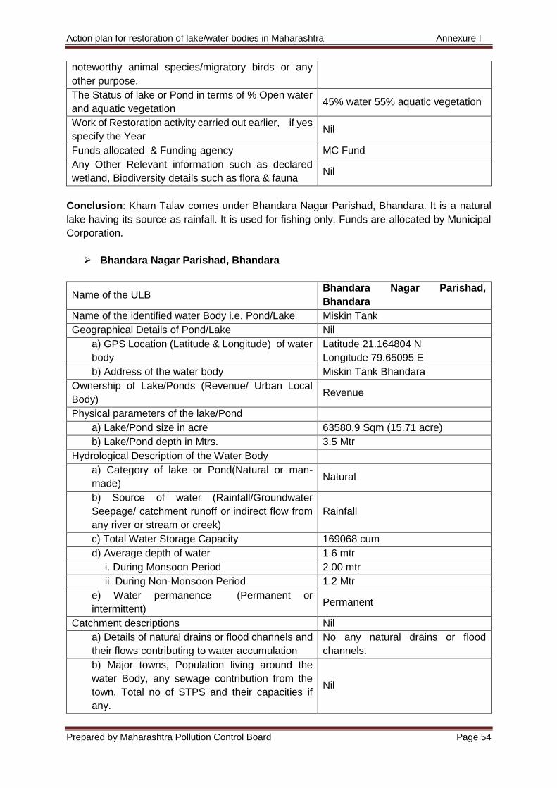
Action plan for restoration of lake/water bodies in Maharashtra Annexure I
Prepared by Maharashtra Pollution Control Board Page 54
noteworthy animal species/migratory birds or any
other purpose.
The Status of lake or Pond in terms of % Open water
and aquatic vegetation 45% water 55% aquatic vegetation
Work of Restoration activity carried out earlier, if yes
specify the Year Nil
Funds allocated & Funding agency MC Fund
Any Other Relevant information such as declared
wetland, Biodiversity details such as flora & fauna Nil
Conclusion: Kham Talav comes under Bhandara Nagar Parishad, Bhandara. It is a natural
lake having its source as rainfall. It is used for fishing only. Funds are allocated by Municipal
Corporation.
Bhandara Nagar Parishad, Bhandara
Name of the ULB Bhandara Nagar Parishad,
Bhandara
Name of the identified water Body i.e. Pond/Lake Miskin Tank
Geographical Details of Pond/Lake Nil
a) GPS Location (Latitude & Longitude) of water
body
Latitude 21.164804 N
Longitude 79.65095 E
b) Address of the water body Miskin Tank Bhandara
Ownership of Lake/Ponds (Revenue/ Urban Local
Body) Revenue
Physical parameters of the lake/Pond
a) Lake/Pond size in acre 63580.9 Sqm (15.71 acre)
b) Lake/Pond depth in Mtrs. 3.5 Mtr
Hydrological Description of the Water Body
a) Category of lake or Pond(Natural or man-
made) Natural
b) Source of water (Rainfall/Groundwater
Seepage/ catchment runoff or indirect flow from
any river or stream or creek)
Rainfall
c) Total Water Storage Capacity 169068 cum
d) Average depth of water 1.6 mtr
i. During Monsoon Period 2.00 mtr
ii. During Non-Monsoon Period 1.2 Mtr
e) Water permanence (Permanent or
intermittent) Permanent
Catchment descriptions Nil
a) Details of natural drains or flood channels and
their flows contributing to water accumulation
No any natural drains or flood
channels.
b) Major towns, Population living around the
water Body, any sewage contribution from the
town. Total no of STPS and their capacities if
any.
Nil
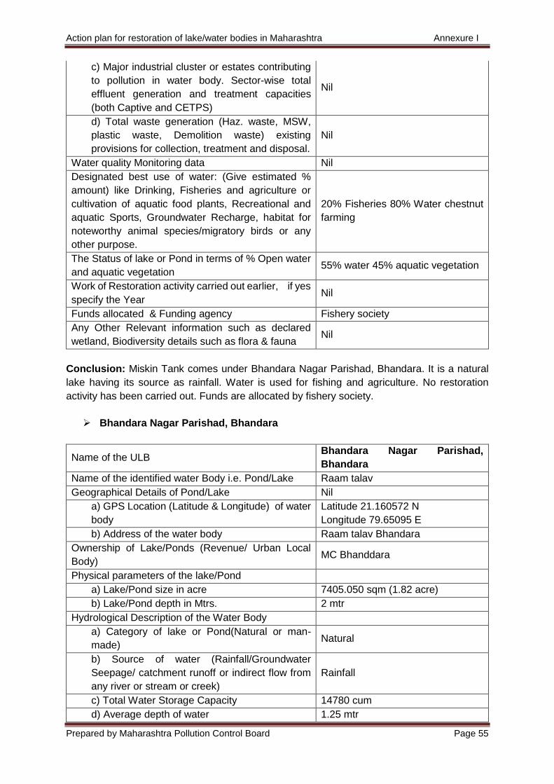
Action plan for restoration of lake/water bodies in Maharashtra Annexure I
Prepared by Maharashtra Pollution Control Board Page 55
c) Major industrial cluster or estates contributing
to pollution in water body. Sector-wise total
effluent generation and treatment capacities
(both Captive and CETPS)
Nil
d) Total waste generation (Haz. waste, MSW,
plastic waste, Demolition waste) existing
provisions for collection, treatment and disposal.
Nil
Water quality Monitoring data Nil
Designated best use of water: (Give estimated %
amount) like Drinking, Fisheries and agriculture or
cultivation of aquatic food plants, Recreational and
aquatic Sports, Groundwater Recharge, habitat for
noteworthy animal species/migratory birds or any
other purpose.
20% Fisheries 80% Water chestnut
farming
The Status of lake or Pond in terms of % Open water
and aquatic vegetation 55% water 45% aquatic vegetation
Work of Restoration activity carried out earlier, if yes
specify the Year Nil
Funds allocated & Funding agency Fishery society
Any Other Relevant information such as declared
wetland, Biodiversity details such as flora & fauna Nil
Conclusion: Miskin Tank comes under Bhandara Nagar Parishad, Bhandara. It is a natural
lake having its source as rainfall. Water is used for fishing and agriculture. No restoration
activity has been carried out. Funds are allocated by fishery society.
Bhandara Nagar Parishad, Bhandara
Name of the ULB Bhandara Nagar Parishad,
Bhandara
Name of the identified water Body i.e. Pond/Lake Raam talav
Geographical Details of Pond/Lake Nil
a) GPS Location (Latitude & Longitude) of water
body
Latitude 21.160572 N
Longitude 79.65095 E
b) Address of the water body Raam talav Bhandara
Ownership of Lake/Ponds (Revenue/ Urban Local
Body) MC Bhanddara
Physical parameters of the lake/Pond
a) Lake/Pond size in acre 7405.050 sqm (1.82 acre)
b) Lake/Pond depth in Mtrs. 2 mtr
Hydrological Description of the Water Body
a) Category of lake or Pond(Natural or man-
made) Natural
b) Source of water (Rainfall/Groundwater
Seepage/ catchment runoff or indirect flow from
any river or stream or creek)
Rainfall
c) Total Water Storage Capacity 14780 cum
d) Average depth of water 1.25 mtr

Action plan for restoration of lake/water bodies in Maharashtra Annexure I
Prepared by Maharashtra Pollution Control Board Page 56
i. During Monsoon Period 1.5 mtr
ii. During Non-Monsoon Period 1.0mtr
e) Water permanence (Permanent or
intermittent) Permanent
Catchment descriptions Nil
a) Details of natural drains or flood channels and
their flows contributing to water accumulation
No any natural drains or flood
channels
b) Major towns, Population living around the
water Body, any sewage contribution from the
town. Total no of STPS and their capacities if
any.
Nil
c) Major industrial cluster or estates contributing
to pollution in water body. Sector-wise total
effluent generation and treatment capacities
(both Captive and CETPS)
Nil
d) Total waste generation (Haz. waste, MSW,
plastic waste, Demolition waste) existing
provisions for collection, treatment and disposal.
Nil
Water quality Monitoring data Nil
Designated best use of water: (Give estimated %
amount) like Drinking, Fisheries and agriculture or
cultivation of aquatic food plants, Recreational and
aquatic Sports, Groundwater Recharge, habitat for
noteworthy animal species/migratory birds or any
other purpose.
100% Fisheries
The Status of lake or Pond in terms of % Open water
and aquatic vegetation
40% water,
60% aquatic vegetation
Work of Restoration activity carried out earlier, if yes
specify the Year Nil
Funds allocated & Funding agency MC Fund
Any Other Relevant information such as declared
wetland, Biodiversity details such as flora & fauna Nil
Conclusion: Raam talav comes under Bhandara Nagar Parishad, Bhandara. The lake is
natural having rainfall as its source. Water is used for fishing only. No restoration activates
have been carried out. Municipal council funds this lake.
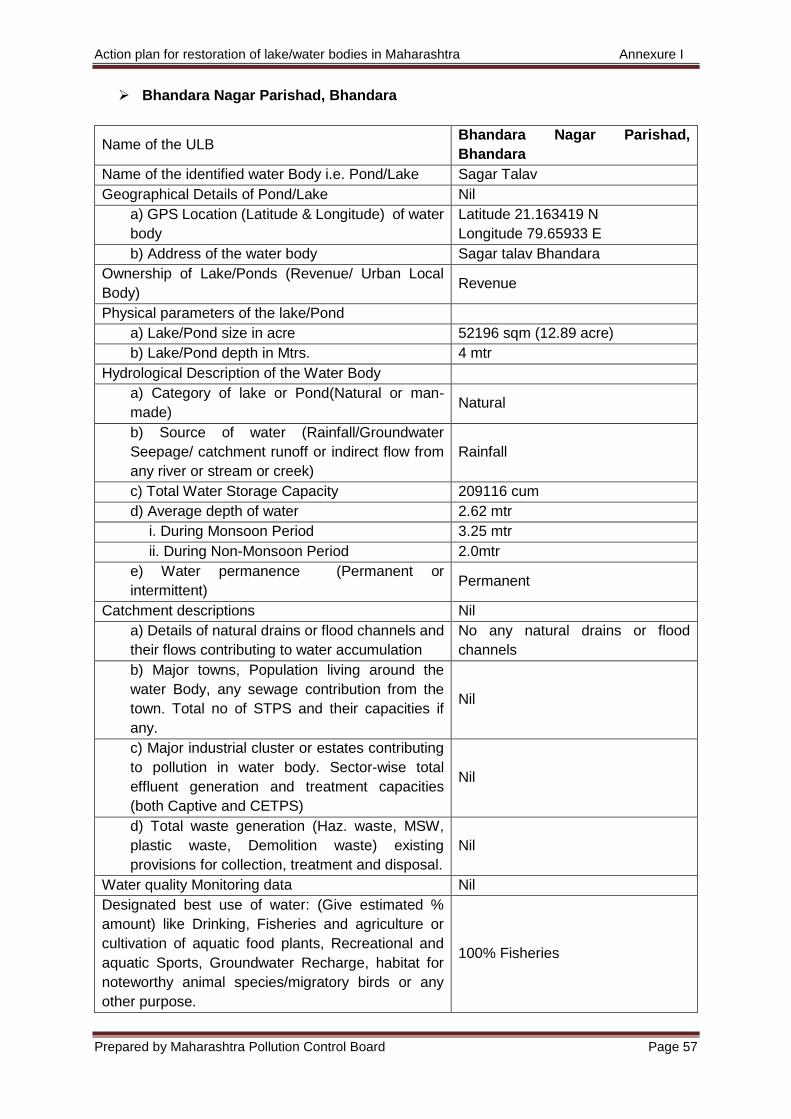
Action plan for restoration of lake/water bodies in Maharashtra Annexure I
Prepared by Maharashtra Pollution Control Board Page 57
Bhandara Nagar Parishad, Bhandara
Name of the ULB Bhandara Nagar Parishad,
Bhandara
Name of the identified water Body i.e. Pond/Lake Sagar Talav
Geographical Details of Pond/Lake Nil
a) GPS Location (Latitude & Longitude) of water
body
Latitude 21.163419 N
Longitude 79.65933 E
b) Address of the water body Sagar talav Bhandara
Ownership of Lake/Ponds (Revenue/ Urban Local
Body) Revenue
Physical parameters of the lake/Pond
a) Lake/Pond size in acre 52196 sqm (12.89 acre)
b) Lake/Pond depth in Mtrs. 4 mtr
Hydrological Description of the Water Body
a) Category of lake or Pond(Natural or man-
made) Natural
b) Source of water (Rainfall/Groundwater
Seepage/ catchment runoff or indirect flow from
any river or stream or creek)
Rainfall
c) Total Water Storage Capacity 209116 cum
d) Average depth of water 2.62 mtr
i. During Monsoon Period 3.25 mtr
ii. During Non-Monsoon Period 2.0mtr
e) Water permanence (Permanent or
intermittent) Permanent
Catchment descriptions Nil
a) Details of natural drains or flood channels and
their flows contributing to water accumulation
No any natural drains or flood
channels
b) Major towns, Population living around the
water Body, any sewage contribution from the
town. Total no of STPS and their capacities if
any.
Nil
c) Major industrial cluster or estates contributing
to pollution in water body. Sector-wise total
effluent generation and treatment capacities
(both Captive and CETPS)
Nil
d) Total waste generation (Haz. waste, MSW,
plastic waste, Demolition waste) existing
provisions for collection, treatment and disposal.
Nil
Water quality Monitoring data Nil
Designated best use of water: (Give estimated %
amount) like Drinking, Fisheries and agriculture or
cultivation of aquatic food plants, Recreational and
aquatic Sports, Groundwater Recharge, habitat for
noteworthy animal species/migratory birds or any
other purpose.
100% Fisheries
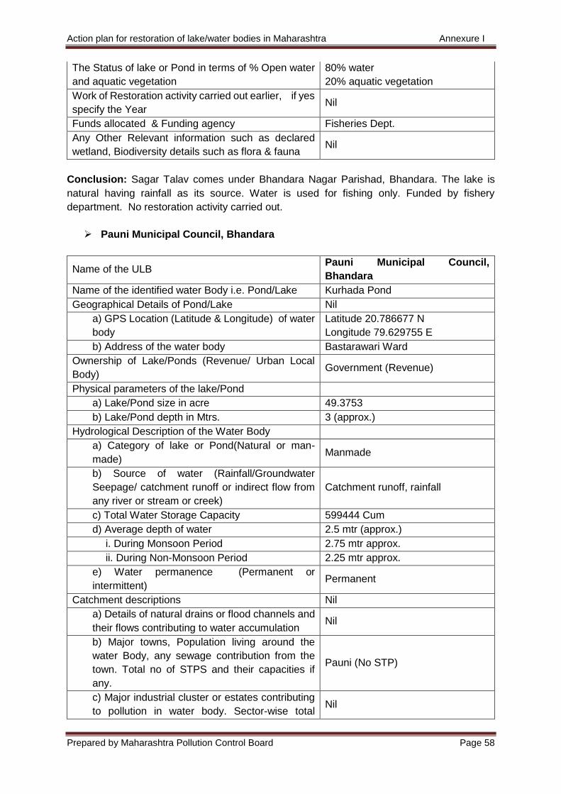
Action plan for restoration of lake/water bodies in Maharashtra Annexure I
Prepared by Maharashtra Pollution Control Board Page 58
The Status of lake or Pond in terms of % Open water
and aquatic vegetation
80% water
20% aquatic vegetation
Work of Restoration activity carried out earlier, if yes
specify the Year Nil
Funds allocated & Funding agency Fisheries Dept.
Any Other Relevant information such as declared
wetland, Biodiversity details such as flora & fauna Nil
Conclusion: Sagar Talav comes under Bhandara Nagar Parishad, Bhandara. The lake is
natural having rainfall as its source. Water is used for fishing only. Funded by fishery
department. No restoration activity carried out.
Pauni Municipal Council, Bhandara
Name of the ULB Pauni Municipal Council,
Bhandara
Name of the identified water Body i.e. Pond/Lake Kurhada Pond
Geographical Details of Pond/Lake Nil
a) GPS Location (Latitude & Longitude) of water
body
Latitude 20.786677 N
Longitude 79.629755 E
b) Address of the water body Bastarawari Ward
Ownership of Lake/Ponds (Revenue/ Urban Local
Body) Government (Revenue)
Physical parameters of the lake/Pond
a) Lake/Pond size in acre 49.3753
b) Lake/Pond depth in Mtrs. 3 (approx.)
Hydrological Description of the Water Body
a) Category of lake or Pond(Natural or man-
made) Manmade
b) Source of water (Rainfall/Groundwater
Seepage/ catchment runoff or indirect flow from
any river or stream or creek)
Catchment runoff, rainfall
c) Total Water Storage Capacity 599444 Cum
d) Average depth of water 2.5 mtr (approx.)
i. During Monsoon Period 2.75 mtr approx.
ii. During Non-Monsoon Period 2.25 mtr approx.
e) Water permanence (Permanent or
intermittent) Permanent
Catchment descriptions Nil
a) Details of natural drains or flood channels and
their flows contributing to water accumulation Nil
b) Major towns, Population living around the
water Body, any sewage contribution from the
town. Total no of STPS and their capacities if
any.
Pauni (No STP)
c) Major industrial cluster or estates contributing
to pollution in water body. Sector-wise total Nil
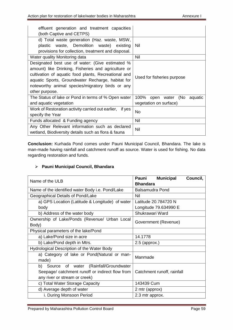
Action plan for restoration of lake/water bodies in Maharashtra Annexure I
Prepared by Maharashtra Pollution Control Board Page 59
effluent generation and treatment capacities
(both Captive and CETPS)
d) Total waste generation (Haz. waste, MSW,
plastic waste, Demolition waste) existing
provisions for collection, treatment and disposal.
Nil
Water quality Monitoring data Nil
Designated best use of water: (Give estimated %
amount) like Drinking, Fisheries and agriculture or
cultivation of aquatic food plants, Recreational and
aquatic Sports, Groundwater Recharge, habitat for
noteworthy animal species/migratory birds or any
other purpose.
Used for fisheries purpose
The Status of lake or Pond in terms of % Open water
and aquatic vegetation
100% open water (No aquatic
vegetation on surface)
Work of Restoration activity carried out earlier, if yes
specify the Year No
Funds allocated & Funding agency Nil
Any Other Relevant information such as declared
wetland, Biodiversity details such as flora & fauna Nil
Conclusion: Kurhada Pond comes under Pauni Municipal Council, Bhandara. The lake is
man-made having rainfall and catchment runoff as source. Water is used for fishing. No data
regarding restoration and funds.
Pauni Municipal Council, Bhandara
Name of the ULB Pauni Municipal Council,
Bhandara
Name of the identified water Body i.e. Pond/Lake Balsamudra Pond
Geographical Details of Pond/Lake Nil
a) GPS Location (Latitude & Longitude) of water
body
Latitude 20.784720 N
Longitude 79.634990 E
b) Address of the water body Shukrawari Ward
Ownership of Lake/Ponds (Revenue/ Urban Local
Body) Government (Revenue)
Physical parameters of the lake/Pond
a) Lake/Pond size in acre 14.1778
b) Lake/Pond depth in Mtrs. 2.5 (approx.)
Hydrological Description of the Water Body
a) Category of lake or Pond(Natural or man-
made) Manmade
b) Source of water (Rainfall/Groundwater
Seepage/ catchment runoff or indirect flow from
any river or stream or creek)
Catchment runoff, rainfall
c) Total Water Storage Capacity 143439 Cum
d) Average depth of water 2 mtr (approx)
i. During Monsoon Period 2.3 mtr approx.
Action plan for restoration of lake/water bodies in Maharashtra Annexure I
Prepared by Maharashtra Pollution Control Board Page 60
ii. During Non-Monsoon Period 1.7 mtr approx.
e) Water permanence (Permanent or
intermittent) Permanent
Catchment descriptions Nil
a) Details of natural drains or flood channels and
their flows contributing to water accumulation Nil
b) Major towns, Population living around the
water Body, any sewage contribution from the
town. Total no of STPS and their capacities if
any.
Pauni (No STP)
c) Major industrial cluster or estates contributing
to pollution in water body. Sector-wise total
effluent generation and treatment capacities
(both Captive and CETPS)
Nil
d) Total waste generation (Haz. waste, MSW,
plastic waste, Demolition waste) existing
provisions for collection, treatment and disposal.
Nil
Water quality Monitoring data Nil
Designated best use of water: (Give estimated %
amount) like Drinking, Fisheries and agriculture or
cultivation of aquatic food plants, Recreational and
aquatic Sports, Groundwater Recharge, habitat for
noteworthy animal species/migratory birds or any
other purpose.
Used for fisheries purpose
The Status of lake or Pond in terms of % Open water
and aquatic vegetation
100% open water (No aquatic
vegetation on surface)
Work of Restoration activity carried out earlier, if yes
specify the Year No
Funds allocated & Funding agency Nil
Any Other Relevant information such as declared
wetland, Biodiversity details such as flora & fauna Nil
Conclusion: Balsamudra Pond comes under Pauni Municipal Council, Bhandara. The lake is
man-made having source of water as rainfall and runoff catchment. Water is used for fishing.
No data regarding restoration and funds.
Pauni Municipal Council, Bhandara
Name of the ULB Pauni Municipal Council,
Bhandara
Name of the identified water Body i.e. Pond/Lake Bhai Talav
Geographical Details of Pond/Lake Nil
a) GPS Location (Latitude & Longitude) of water
body
Latitude 20.791609 N
Longitude 79.634840 E
b) Address of the water body Bhai talao Ward
Ownership of Lake/Ponds (Revenue/ Urban Local
Body) Government (Revenue)
Physical parameters of the lake/Pond
Action plan for restoration of lake/water bodies in Maharashtra Annexure I
Prepared by Maharashtra Pollution Control Board Page 61
a) Lake/Pond size in acre 3.6803
b) Lake/Pond depth in Mtrs. 1.5 (Approx.)
Hydrological Description of the Water Body
a) Category of lake or Pond(Natural or man-
made) Manmade
b) Source of water (Rainfall/Groundwater
Seepage/ catchment runoff or indirect flow from
any river or stream or creek)
Catchment runoff, rainfall
c) Total Water Storage Capacity 22341 Cum
d) Average depth of water 1 mtr (approx.)
i. During Monsoon Period 1.2 mtr approx.
ii. During Non-Monsoon Period 0.8 mtr approx.
e) Water permanence (Permanent or
intermittent) Permanent
Catchment descriptions Nil
a) Details of natural drains or flood channels and
their flows contributing to water accumulation Nil
b) Major towns, Population living around the
water Body, any sewage contribution from the
town. Total no of STPS and their capacities if
any.
Pauni (No STP)
c) Major industrial cluster or estates contributing
to pollution in water body. Sector-wise total
effluent generation and treatment capacities
(both Captive and CETPS)
Nil
d) Total waste generation (Haz. waste, MSW,
plastic waste, Demolition waste) existing
provisions for collection, treatment and disposal.
Nil
Water quality Monitoring data Nil
Designated best use of water: (Give estimated %
amount) like Drinking, Fisheries and agriculture or
cultivation of aquatic food plants, Recreational and
aquatic Sports, Groundwater Recharge, habitat for
noteworthy animal species/migratory birds or any
other purpose.
Used for fisheries purpose
The Status of lake or Pond in terms of % Open water
and aquatic vegetation
100% open water (No aquatic
vegetation on surface)
Work of Restoration activity carried out earlier, if yes
specify the Year No
Funds allocated & Funding agency Nil
Any Other Relevant information such as declared
wetland, Biodiversity details such as flora & fauna Nil
Conclusion: Bhai Talav comes under Pauni Municipal Council, Bhandara. The lake is man-
made having source of water as rainfall and runoff catchment. Water is used for fishing. No
data regarding restoration and funds.
Lakhandur Nagar Parishad, Bhandara
Action plan for restoration of lake/water bodies in Maharashtra Annexure I
Prepared by Maharashtra Pollution Control Board Page 62
Name of the ULB Lakhandur Nagar Parishad,
Bhandara
Name of the identified water Body i.e. Pond/Lake Pimpalgaon Talav
Geographical Details of Pond/Lake Nil
a) GPS Location (Latitude & Longitude) of water
body
Latitude 20.4647.78 N
Longitude 79.5547.72 E
b) Address of the water body Pimpalgaon Filter Plant
Ownership of Lake/Ponds (Revenue/ Urban Local
Body) Revenue
Physical parameters of the lake/Pond
a) Lake/Pond size in acre 26 Acres
b) Lake/Pond depth in Mtrs. 2.43 Mtrs
Hydrological Description of the Water Body
a) Category of lake or Pond(Natural or man-
made) Natural
b) Source of water (Rainfall/Groundwater
Seepage/ catchment runoff or indirect flow from
any river or stream or creek)
Rainfall
c) Total Water Storage Capacity 255679 cum
d) Average depth of water 1.7 Mtrs
i. During Monsoon Period 2.3 Mtrs
ii. During Non-Monsoon Period 1.4 Mtrs
e) Water permanence (Permanent or
intermittent) Permanent
Catchment descriptions Nil
a) Details of natural drains or flood channels and
their flows contributing to water accumulation NA
b) Major towns, Population living around the
water Body, any sewage contribution from the
town. Total no of STPS and their capacities if
any.
Major town Lakhandur,
Population of Lakhandur - 9795 as
per 2011 census
No sewage contribution
No. of STPs - 00
c) Major industrial cluster or estates contributing
to pollution in water body. Sector-wise total
effluent generation and treatment capacities
(both Captive and CETPS)
NA
d) Total waste generation (Haz. waste, MSW,
plastic waste, Demolition waste) existing
provisions for collection, treatment and disposal.
3.00 Tones/Day
Water quality Monitoring data NA
Designated best use of water: (Give estimated %
amount) like Drinking, Fisheries and agriculture or
cultivation of aquatic food plants, Recreational and
aquatic Sports, Groundwater Recharge, habitat for
noteworthy animal species/migratory birds or any
other purpose.
Fisheries and Cultivation of Aquatic
food plant
Action plan for restoration of lake/water bodies in Maharashtra Annexure I
Prepared by Maharashtra Pollution Control Board Page 63
The Status of lake or Pond in terms of % Open water
and aquatic vegetation
Open water 90%, Aquatic
Vegetation 10%
Work of Restoration activity carried out earlier, if yes
specify the Year NA
Funds allocated & Funding agency NA
Any Other Relevant information such as declared
wetland, Biodiversity details such as flora & fauna NA
Conclusion: Pimpalgaon Talav comes under Lakhandur Nagar Parishad, Bhandara. It is a
natural lake having rainfall as its source. Lake is used for fishing. No data regarding restoration
and funds.
Sakoli Nagar Parishad, Bhandara
Name of the ULB Sakoli Nagar Parishad, Bhandara
Name of the identified water Body i.e. Pond/Lake Mai Tank Lake 1
Geographical Details of Pond/Lake Nil
a) GPS Location (Latitude & Longitude) of water
body
Latitude 21.079487 N
Longitude 79.993394 E
b) Address of the water body Mai Tank Gat no. 241 Sakoli Talav
Ward
Ownership of Lake/Ponds (Revenue/ Urban Local
Body) Local Body - ZP Bhandara
Physical parameters of the lake/Pond Tank Bund, Gate, Canal Waste weir
a) Lake/Pond size in acre 87.24 Acre
b) Lake/Pond depth in Mtrs. 6 mtrs
Hydrological Description of the Water Body
a) Category of lake or Pond(Natural or man-
made) Man Made
b) Source of water (Rainfall/Groundwater
Seepage/ catchment runoff or indirect flow from
any river or stream or creek)
Rainfall
c) Total Water Storage Capacity 350 Tcm
d) Average depth of water 2 m
i. During Monsoon Period 4 m
ii. During Non-Monsoon Period 1m
e) Water permanence (Permanent or
intermittent) Intermittent
Catchment descriptions 0.21 sq.m.
a) Details of natural drains or flood channels and
their flows contributing to water accumulation Natural drains / Fields
b) Major towns, Population living around the
water Body, any sewage contribution from the
town. Total no of STPS and their capacities if
any.
Talav Ward
c) Major industrial cluster or estates contributing
to pollution in water body. Sector-wise total No
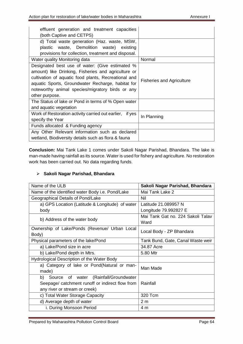
Action plan for restoration of lake/water bodies in Maharashtra Annexure I
Prepared by Maharashtra Pollution Control Board Page 64
effluent generation and treatment capacities
(both Captive and CETPS)
d) Total waste generation (Haz. waste, MSW,
plastic waste, Demolition waste) existing
provisions for collection, treatment and disposal.
Water quality Monitoring data Normal
Designated best use of water: (Give estimated %
amount) like Drinking, Fisheries and agriculture or
cultivation of aquatic food plants, Recreational and
aquatic Sports, Groundwater Recharge, habitat for
noteworthy animal species/migratory birds or any
other purpose.
Fisheries and Agriculture
The Status of lake or Pond in terms of % Open water
and aquatic vegetation
Work of Restoration activity carried out earlier, if yes
specify the Year In Planning
Funds allocated & Funding agency
Any Other Relevant information such as declared
wetland, Biodiversity details such as flora & fauna
Conclusion: Mai Tank Lake 1 comes under Sakoli Nagar Parishad, Bhandara. The lake is
man-made having rainfall as its source. Water is used for fishery and agriculture. No restoration
work has been carried out. No data regarding funds.
Sakoli Nagar Parishad, Bhandara
Name of the ULB Sakoli Nagar Parishad, Bhandara
Name of the identified water Body i.e. Pond/Lake Mai Tank Lake 2
Geographical Details of Pond/Lake Nil
a) GPS Location (Latitude & Longitude) of water
body
Latitude 21.089957 N
Longitude 79.992827 E
b) Address of the water body Mai Tank Gat no. 224 Sakoli Talav
Ward
Ownership of Lake/Ponds (Revenue/ Urban Local
Body) Local Body - ZP Bhandara
Physical parameters of the lake/Pond Tank Bund, Gate, Canal Waste weir
a) Lake/Pond size in acre 34.87 Acre
b) Lake/Pond depth in Mtrs. 5.80 Mtr
Hydrological Description of the Water Body
a) Category of lake or Pond(Natural or man-
made) Man Made
b) Source of water (Rainfall/Groundwater
Seepage/ catchment runoff or indirect flow from
any river or stream or creek)
Rainfall
c) Total Water Storage Capacity 320 Tcm
d) Average depth of water 2 m
i. During Monsoon Period 4 m
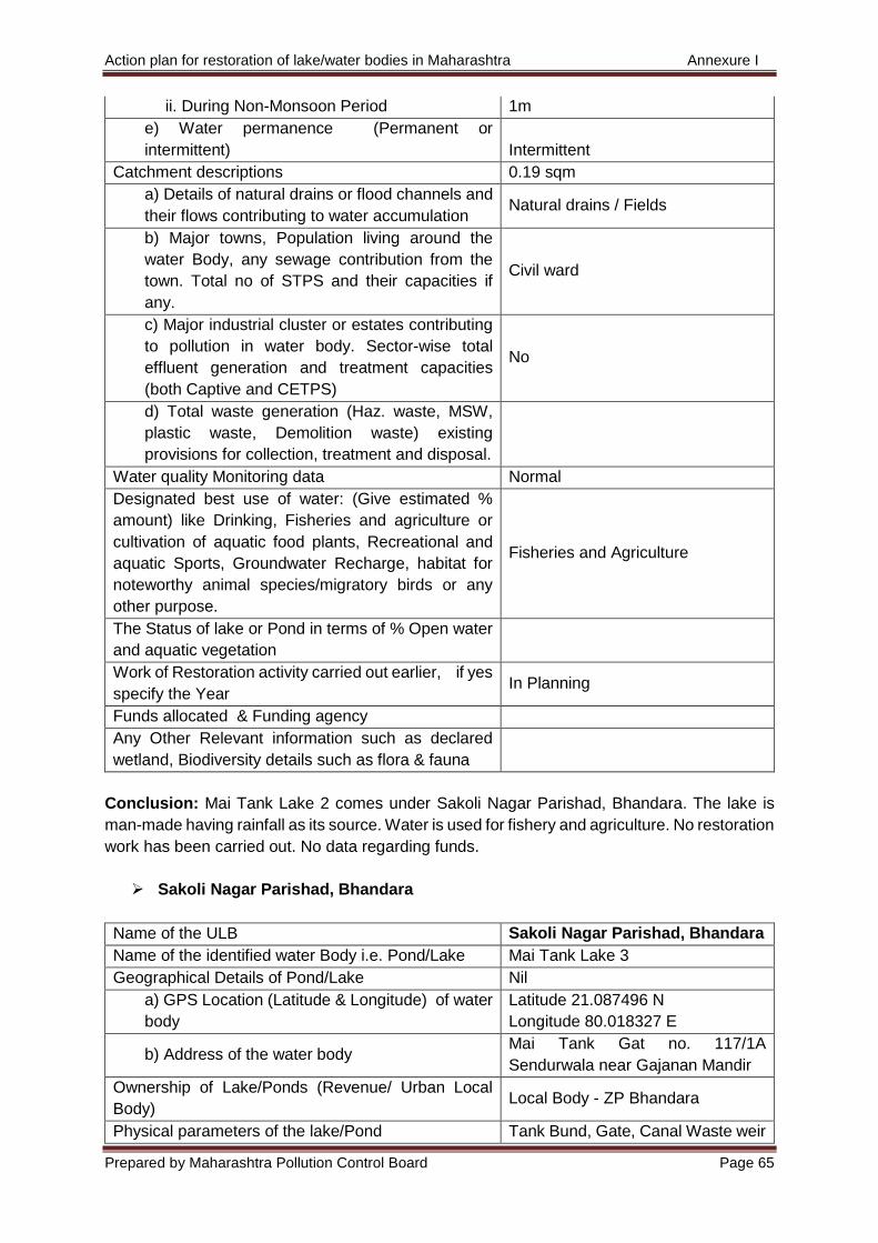
Action plan for restoration of lake/water bodies in Maharashtra Annexure I
Prepared by Maharashtra Pollution Control Board Page 65
ii. During Non-Monsoon Period 1m
e) Water permanence (Permanent or
intermittent) Intermittent
Catchment descriptions 0.19 sqm
a) Details of natural drains or flood channels and
their flows contributing to water accumulation Natural drains / Fields
b) Major towns, Population living around the
water Body, any sewage contribution from the
town. Total no of STPS and their capacities if
any.
Civil ward
c) Major industrial cluster or estates contributing
to pollution in water body. Sector-wise total
effluent generation and treatment capacities
(both Captive and CETPS)
No
d) Total waste generation (Haz. waste, MSW,
plastic waste, Demolition waste) existing
provisions for collection, treatment and disposal.
Water quality Monitoring data Normal
Designated best use of water: (Give estimated %
amount) like Drinking, Fisheries and agriculture or
cultivation of aquatic food plants, Recreational and
aquatic Sports, Groundwater Recharge, habitat for
noteworthy animal species/migratory birds or any
other purpose.
Fisheries and Agriculture
The Status of lake or Pond in terms of % Open water
and aquatic vegetation
Work of Restoration activity carried out earlier, if yes
specify the Year In Planning
Funds allocated & Funding agency
Any Other Relevant information such as declared
wetland, Biodiversity details such as flora & fauna
Conclusion: Mai Tank Lake 2 comes under Sakoli Nagar Parishad, Bhandara. The lake is
man-made having rainfall as its source. Water is used for fishery and agriculture. No restoration
work has been carried out. No data regarding funds.
Sakoli Nagar Parishad, Bhandara
Name of the ULB Sakoli Nagar Parishad, Bhandara
Name of the identified water Body i.e. Pond/Lake Mai Tank Lake 3
Geographical Details of Pond/Lake Nil
a) GPS Location (Latitude & Longitude) of water
body
Latitude 21.087496 N
Longitude 80.018327 E
b) Address of the water body Mai Tank Gat no. 117/1A
Sendurwala near Gajanan Mandir
Ownership of Lake/Ponds (Revenue/ Urban Local
Body) Local Body - ZP Bhandara
Physical parameters of the lake/Pond Tank Bund, Gate, Canal Waste weir
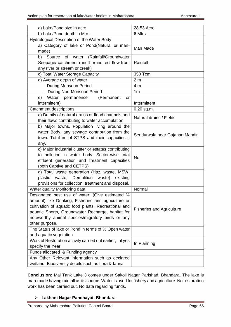
Action plan for restoration of lake/water bodies in Maharashtra Annexure I
Prepared by Maharashtra Pollution Control Board Page 66
a) Lake/Pond size in acre 28.53 Acre
b) Lake/Pond depth in Mtrs. 6 Mtrs
Hydrological Description of the Water Body
a) Category of lake or Pond(Natural or man-
made) Man Made
b) Source of water (Rainfall/Groundwater
Seepage/ catchment runoff or indirect flow from
any river or stream or creek)
Rainfall
c) Total Water Storage Capacity 350 Tcm
d) Average depth of water 2 m
i. During Monsoon Period 4 m
ii. During Non-Monsoon Period 1m
e) Water permanence (Permanent or
intermittent) Intermittent
Catchment descriptions 0.20 sq.m.
a) Details of natural drains or flood channels and
their flows contributing to water accumulation Natural drains / Fields
b) Major towns, Population living around the
water Body, any sewage contribution from the
town. Total no of STPS and their capacities if
any.
Sendurwala near Gajanan Mandir
c) Major industrial cluster or estates contributing
to pollution in water body. Sector-wise total
effluent generation and treatment capacities
(both Captive and CETPS)
No
d) Total waste generation (Haz. waste, MSW,
plastic waste, Demolition waste) existing
provisions for collection, treatment and disposal.
Water quality Monitoring data Normal
Designated best use of water: (Give estimated %
amount) like Drinking, Fisheries and agriculture or
cultivation of aquatic food plants, Recreational and
aquatic Sports, Groundwater Recharge, habitat for
noteworthy animal species/migratory birds or any
other purpose.
Fisheries and Agriculture
The Status of lake or Pond in terms of % Open water
and aquatic vegetation
Work of Restoration activity carried out earlier, if yes
specify the Year In Planning
Funds allocated & Funding agency
Any Other Relevant information such as declared
wetland, Biodiversity details such as flora & fauna
Conclusion: Mai Tank Lake 3 comes under Sakoli Nagar Parishad, Bhandara. The lake is
man-made having rainfall as its source. Water is used for fishery and agriculture. No restoration
work has been carried out. No data regarding funds.
Lakhani Nagar Panchayat, Bhandara
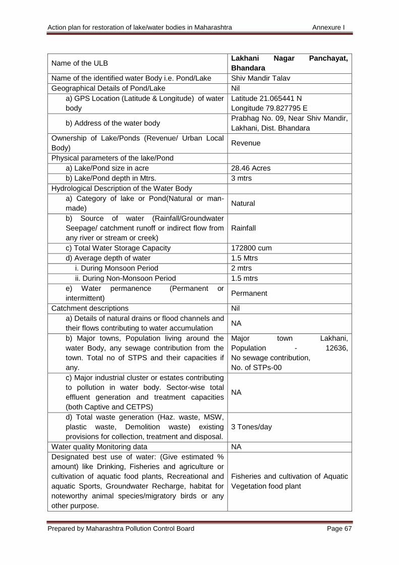
Action plan for restoration of lake/water bodies in Maharashtra Annexure I
Prepared by Maharashtra Pollution Control Board Page 67
Name of the ULB Lakhani Nagar Panchayat,
Bhandara
Name of the identified water Body i.e. Pond/Lake Shiv Mandir Talav
Geographical Details of Pond/Lake Nil
a) GPS Location (Latitude & Longitude) of water
body
Latitude 21.065441 N
Longitude 79.827795 E
b) Address of the water body Prabhag No. 09, Near Shiv Mandir,
Lakhani, Dist. Bhandara
Ownership of Lake/Ponds (Revenue/ Urban Local
Body) Revenue
Physical parameters of the lake/Pond
a) Lake/Pond size in acre 28.46 Acres
b) Lake/Pond depth in Mtrs. 3 mtrs
Hydrological Description of the Water Body
a) Category of lake or Pond(Natural or man-
made) Natural
b) Source of water (Rainfall/Groundwater
Seepage/ catchment runoff or indirect flow from
any river or stream or creek)
Rainfall
c) Total Water Storage Capacity 172800 cum
d) Average depth of water 1.5 Mtrs
i. During Monsoon Period 2 mtrs
ii. During Non-Monsoon Period 1.5 mtrs
e) Water permanence (Permanent or
intermittent) Permanent
Catchment descriptions Nil
a) Details of natural drains or flood channels and
their flows contributing to water accumulation NA
b) Major towns, Population living around the
water Body, any sewage contribution from the
town. Total no of STPS and their capacities if
any.
Major town Lakhani,
Population - 12636,
No sewage contribution,
No. of STPs-00
c) Major industrial cluster or estates contributing
to pollution in water body. Sector-wise total
effluent generation and treatment capacities
(both Captive and CETPS)
NA
d) Total waste generation (Haz. waste, MSW,
plastic waste, Demolition waste) existing
provisions for collection, treatment and disposal.
3 Tones/day
Water quality Monitoring data NA
Designated best use of water: (Give estimated %
amount) like Drinking, Fisheries and agriculture or
cultivation of aquatic food plants, Recreational and
aquatic Sports, Groundwater Recharge, habitat for
noteworthy animal species/migratory birds or any
other purpose.
Fisheries and cultivation of Aquatic
Vegetation food plant
Action plan for restoration of lake/water bodies in Maharashtra Annexure I
Prepared by Maharashtra Pollution Control Board Page 68
The Status of lake or Pond in terms of % Open water
and aquatic vegetation
Open water 90% Aquatic
Vegetation food plant10 %
Work of Restoration activity carried out earlier, if yes
specify the Year NA
Funds allocated & Funding agency NA
Any Other Relevant information such as declared
wetland, Biodiversity details such as flora & fauna NA
Conclusion: Shiv Mandir Talao comes under Lakhani Nagar Panchayat, Bhandara. It is a
natural lake having rainfall as its source. Water is used for fishery and cultivation of aquatic
plants.
Action plan for restoration of lake/water bodies in Maharashtra Annexure I
Prepared by Maharashtra Pollution Control Board Page 69
5) Gondia
Gondia Nagar Parishad, Gondia
Name of the ULB Gondia Nagar Parishad, Gondia
Name of the identified water Body i.e. Pond/Lake Kanaiya Lake
Geographical Details of Pond/Lake Nil
a) GPS Location (Latitude & Longitude) of water
body
Latitude 21°24’43” N
Longitude 79°56’00” E
b) Address of the water body Subhash ward Tirora
Ownership of Lake/Ponds (Revenue/ Urban Local
Body) Ulb Tirora
Physical parameters of the lake/Pond
a) Lake/Pond size in acre 3
b) Lake/Pond depth in Mtrs. 1
Hydrological Description of the Water Body
a) Category of lake or Pond(Natural or man-
made) Natural
b) Source of water (Rainfall/Groundwater
Seepage/ catchment runoff or indirect flow from
any river or stream or creek)
Rainfall
c) Total Water Storage Capacity 12140 m3
d) Average depth of water
i. During Monsoon Period 2
ii. During Non-Monsoon Period 1
e) Water permanence (Permanent or
intermittent) Permanent
Catchment descriptions Nil
a) Details of natural drains or flood channels and
their flows contributing to water accumulation No Natural Drains
b) Major towns, Population living around the
water Body, any sewage contribution from the
town. Total no of STPS and their capacities if
any.
No sewage contribution, STP under
propose.
c) Major industrial cluster or estates contributing
to pollution in water body. Sector-wise total
effluent generation and treatment capacities
(both Captive and CETPS)
No industrial cluster Contribution
d) Total waste generation (Haz. waste, MSW,
plastic waste, Demolition waste) existing
provisions for collection, treatment and disposal.
Total waste generation solid waste
collection and processed at SWM
Plant Bhivapur Tah. Tirora, Dist.
Gondia
Water quality Monitoring data Water Quality Checked whenever
required
Designated best use of water: (Give estimated %
amount) like Drinking, Fisheries and agriculture or
cultivation of aquatic food plants, Recreational and
Drinking-0%,
Fisheries-100%
Action plan for restoration of lake/water bodies in Maharashtra Annexure I
Prepared by Maharashtra Pollution Control Board Page 70
aquatic Sports, Groundwater Recharge, habitat for
noteworthy animal species/migratory birds or any
other purpose.
The Status of lake or Pond in terms of % Open water
and aquatic vegetation
Open water 98%
Aquatic Vegetation 2%
Work of Restoration activity carried out earlier, if yes
specify the Year No
Funds allocated & Funding agency Ulb Tirora provide fund whenever
required
Any Other Relevant information such as declared
wetland, Biodiversity details such as flora & fauna NA
Conclusion: Kanaiya Lake comes under Gondia Nagar Parishad, Gondia. It is a natural lake
which has its source as rainfall. There are no natural drains. Water is used for fisheries. No
restoration works have been carried out.
Gondia Nagar Parishad, Gondia
Name of the ULB Gondia Nagar Parishad, Gondia
Name of the identified water Body i.e. Pond/Lake Marbat Bodi, Gondia
Geographical Details of Pond/Lake Nil
a) GPS Location (Latitude & Longitude) of water
body
Latitude 21°24’35” N
Longitude 79°56’00” E
b) Address of the water body Sant Kavaram ward Tirora
Ownership of Lake/Ponds (Revenue/ Urban Local
Body) Ulb Tirora
Physical parameters of the lake/Pond
a) Lake/Pond size in acre 1.5
b) Lake/Pond depth in Mtrs. 0.5
Hydrological Description of the Water Body
a) Category of lake or Pond(Natural or man-
made) Natural
b) Source of water (Rainfall/Groundwater
Seepage/ catchment runoff or indirect flow from
any river or stream or creek)
Rainfall
c) Total Water Storage Capacity 3035m3
d) Average depth of water
i. During Monsoon Period 1.5
ii. During Non-Monsoon Period 0.5
e) Water permanence (Permanent or
intermittent) Permanent
Catchment descriptions Nil
a) Details of natural drains or flood channels and
their flows contributing to water accumulation No Natural Drains
b) Major towns, Population living around the
water Body, any sewage contribution from the
No sewage contribution, STP under
propose.
Action plan for restoration of lake/water bodies in Maharashtra Annexure I
Prepared by Maharashtra Pollution Control Board Page 71
town. Total no of STPS and their capacities if
any.
c) Major industrial cluster or estates contributing
to pollution in water body. Sector-wise total
effluent generation and treatment capacities
(both Captive and CETPS)
No industrial cluster Contribution
d) Total waste generation (Haz. waste, MSW,
plastic waste, Demolition waste) existing
provisions for collection, treatment and disposal.
Total waste generation solid waste
collection and processed at SWM
Plant Bhivapur Tah. Tirora, Dist.
Gondia
Water quality Monitoring data Water Quality Checked whenever
required
Designated best use of water: (Give estimated %
amount) like Drinking, Fisheries and agriculture or
cultivation of aquatic food plants, Recreational and
aquatic Sports, Groundwater Recharge, habitat for
noteworthy animal species/migratory birds or any
other purpose.
No Use
The Status of lake or Pond in terms of % Open water
and aquatic vegetation
Open water 50%
Aquatic Vegetation 50%
Work of Restoration activity carried out earlier, if yes
specify the Year No
Funds allocated & Funding agency Ulb Tirora provide fund whenever
required
Any Other Relevant information such as declared
wetland, Biodiversity details such as flora & fauna NA
Conclusion: Marbat Bodi comes under Gondia Nagar Parishad, Gondia. It is a natural lake
which has its source as rainfall. There are no natural drains. Water is not in use. No restoration
works have been carried out.
Deori Nagar Panchayat, Gondia
Name of the ULB Deori Nagar Panchayat, Gondia
Name of the identified water Body i.e. Pond/Lake Mata Dhukeshwari Mandir Pond
Geographical Details of Pond/Lake Nil
a) GPS Location (Latitude & Longitude) of water
body
Latitude 21.074599 N
Longitude 80.362093 E
b) Address of the water body Opposite to Bus Stand Deori, Near
Dhukeshwari Mandir
Ownership of Lake/Ponds (Revenue/ Urban Local
Body) Taluka Agriculture Office
Physical parameters of the lake/Pond
a) Lake/Pond size in acre 7.41 acre
b) Lake/Pond depth in Mtrs. 4mtrs
Hydrological Description of the Water Body
a) Category of lake or Pond(Natural or man-
made) Natural
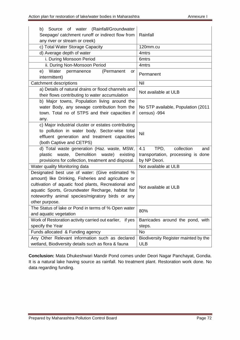
Action plan for restoration of lake/water bodies in Maharashtra Annexure I
Prepared by Maharashtra Pollution Control Board Page 72
b) Source of water (Rainfall/Groundwater
Seepage/ catchment runoff or indirect flow from
any river or stream or creek)
Rainfall
c) Total Water Storage Capacity 120mm.cu
d) Average depth of water 4mtrs
i. During Monsoon Period 6mtrs
ii. During Non-Monsoon Period 4mtrs
e) Water permanence (Permanent or
intermittent) Permanent
Catchment descriptions Nil
a) Details of natural drains or flood channels and
their flows contributing to water accumulation Not available at ULB
b) Major towns, Population living around the
water Body, any sewage contribution from the
town. Total no of STPS and their capacities if
any.
No STP available, Population (2011
census) -994
c) Major industrial cluster or estates contributing
to pollution in water body. Sector-wise total
effluent generation and treatment capacities
(both Captive and CETPS)
Nil
d) Total waste generation (Haz. waste, MSW,
plastic waste, Demolition waste) existing
provisions for collection, treatment and disposal.
4.1 TPD, collection and
transportation, processing is done
by NP Deori.
Water quality Monitoring data Not available at ULB
Designated best use of water: (Give estimated %
amount) like Drinking, Fisheries and agriculture or
cultivation of aquatic food plants, Recreational and
aquatic Sports, Groundwater Recharge, habitat for
noteworthy animal species/migratory birds or any
other purpose.
Not available at ULB
The Status of lake or Pond in terms of % Open water
and aquatic vegetation 80%
Work of Restoration activity carried out earlier, if yes
specify the Year
Barricades around the pond, with
steps.
Funds allocated & Funding agency No
Any Other Relevant information such as declared
wetland, Biodiversity details such as flora & fauna
Biodiversity Register mainted by the
ULB
Conclusion: Mata Dhukeshwari Mandir Pond comes under Deori Nagar Panchayat, Gondia.
It is a natural lake having source as rainfall. No treatment plant. Restoration work done. No
data regarding funding.
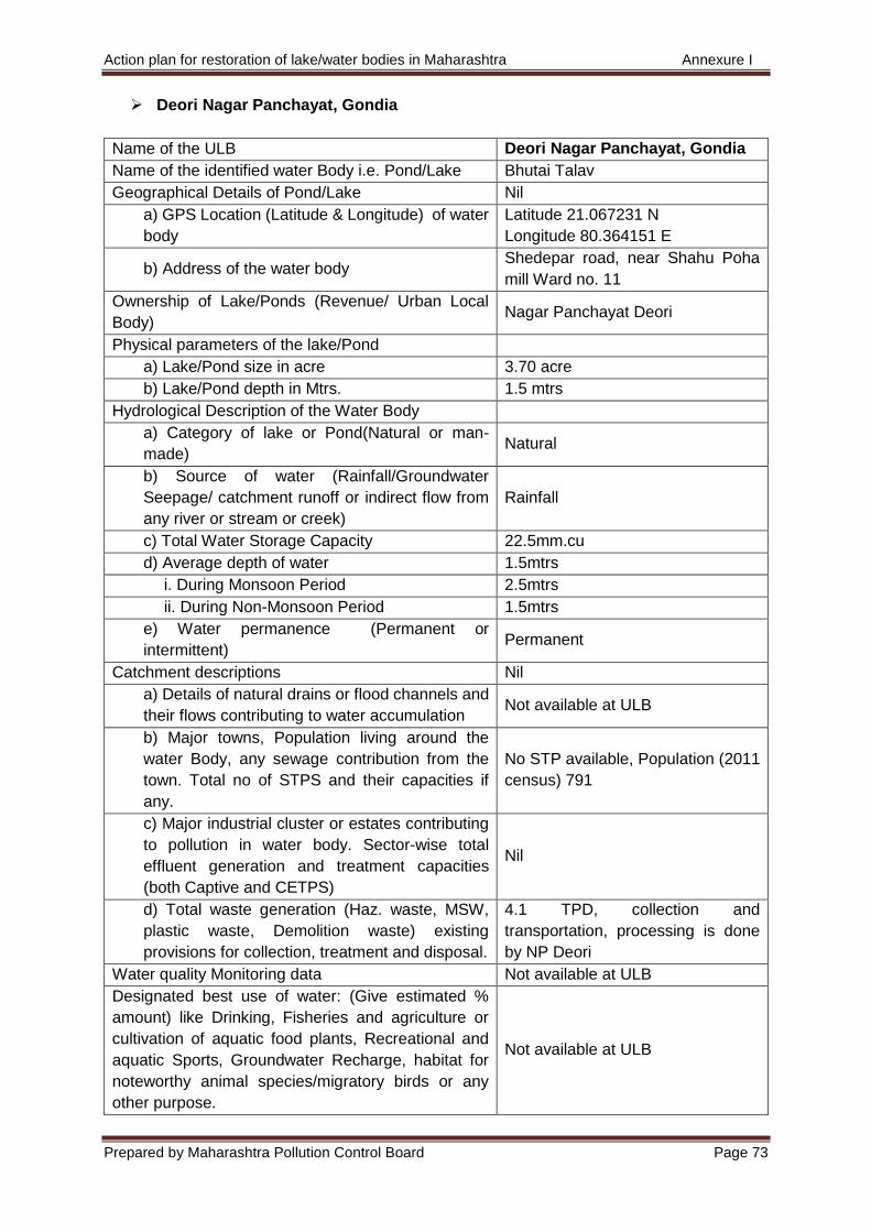
Action plan for restoration of lake/water bodies in Maharashtra Annexure I
Prepared by Maharashtra Pollution Control Board Page 73
Deori Nagar Panchayat, Gondia
Name of the ULB Deori Nagar Panchayat, Gondia
Name of the identified water Body i.e. Pond/Lake Bhutai Talav
Geographical Details of Pond/Lake Nil
a) GPS Location (Latitude & Longitude) of water
body
Latitude 21.067231 N
Longitude 80.364151 E
b) Address of the water body Shedepar road, near Shahu Poha
mill Ward no. 11
Ownership of Lake/Ponds (Revenue/ Urban Local
Body) Nagar Panchayat Deori
Physical parameters of the lake/Pond
a) Lake/Pond size in acre 3.70 acre
b) Lake/Pond depth in Mtrs. 1.5 mtrs
Hydrological Description of the Water Body
a) Category of lake or Pond(Natural or man-
made) Natural
b) Source of water (Rainfall/Groundwater
Seepage/ catchment runoff or indirect flow from
any river or stream or creek)
Rainfall
c) Total Water Storage Capacity 22.5mm.cu
d) Average depth of water 1.5mtrs
i. During Monsoon Period 2.5mtrs
ii. During Non-Monsoon Period 1.5mtrs
e) Water permanence (Permanent or
intermittent) Permanent
Catchment descriptions Nil
a) Details of natural drains or flood channels and
their flows contributing to water accumulation Not available at ULB
b) Major towns, Population living around the
water Body, any sewage contribution from the
town. Total no of STPS and their capacities if
any.
No STP available, Population (2011
census) 791
c) Major industrial cluster or estates contributing
to pollution in water body. Sector-wise total
effluent generation and treatment capacities
(both Captive and CETPS)
Nil
d) Total waste generation (Haz. waste, MSW,
plastic waste, Demolition waste) existing
provisions for collection, treatment and disposal.
4.1 TPD, collection and
transportation, processing is done
by NP Deori
Water quality Monitoring data Not available at ULB
Designated best use of water: (Give estimated %
amount) like Drinking, Fisheries and agriculture or
cultivation of aquatic food plants, Recreational and
aquatic Sports, Groundwater Recharge, habitat for
noteworthy animal species/migratory birds or any
other purpose.
Not available at ULB
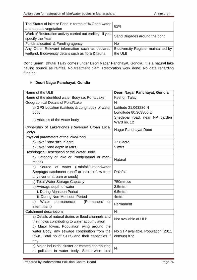
Action plan for restoration of lake/water bodies in Maharashtra Annexure I
Prepared by Maharashtra Pollution Control Board Page 74
The Status of lake or Pond in terms of % Open water
and aquatic vegetation 82%
Work of Restoration activity carried out earlier, if yes
specify the Year Sand Brigades around the pond
Funds allocated & Funding agency No
Any Other Relevant information such as declared
wetland, Biodiversity details such as flora & fauna
Biodiversity Register maintained by
the ULB
Conclusion: Bhutai Talav comes under Deori Nagar Panchayat, Gondia. It is a natural lake
having source as rainfall. No treatment plant. Restoration work done. No data regarding
funding.
Deori Nagar Panchayat, Gondia
Name of the ULB Deori Nagar Panchayat, Gondia
Name of the identified water Body i.e. Pond/Lake Keshori Talav
Geographical Details of Pond/Lake Nil
a) GPS Location (Latitude & Longitude) of water
body
Latitude 21.063286 N
Longitude 80.363806 E
b) Address of the water body Shedepar road, near NP garden
Ward no. 12
Ownership of Lake/Ponds (Revenue/ Urban Local
Body) Nagar Panchayat Deori
Physical parameters of the lake/Pond
a) Lake/Pond size in acre 37.6 acre
b) Lake/Pond depth in Mtrs. 5 mtrs
Hydrological Description of the Water Body
a) Category of lake or Pond(Natural or man-
made) Natural
b) Source of water (Rainfall/Groundwater
Seepage/ catchment runoff or indirect flow from
any river or stream or creek)
Rainfall
c) Total Water Storage Capacity 750mm.cu
d) Average depth of water 3.5mtrs
i. During Monsoon Period 6.5mtrs
ii. During Non-Monsoon Period 4mtrs
e) Water permanence (Permanent or
intermittent) Permanent
Catchment descriptions Nil
a) Details of natural drains or flood channels and
their flows contributing to water accumulation Not available at ULB
b) Major towns, Population living around the
water Body, any sewage contribution from the
town. Total no of STPS and their capacities if
any.
No STP available, Population (2011
census) 872
c) Major industrial cluster or estates contributing
to pollution in water body. Sector-wise total Nil
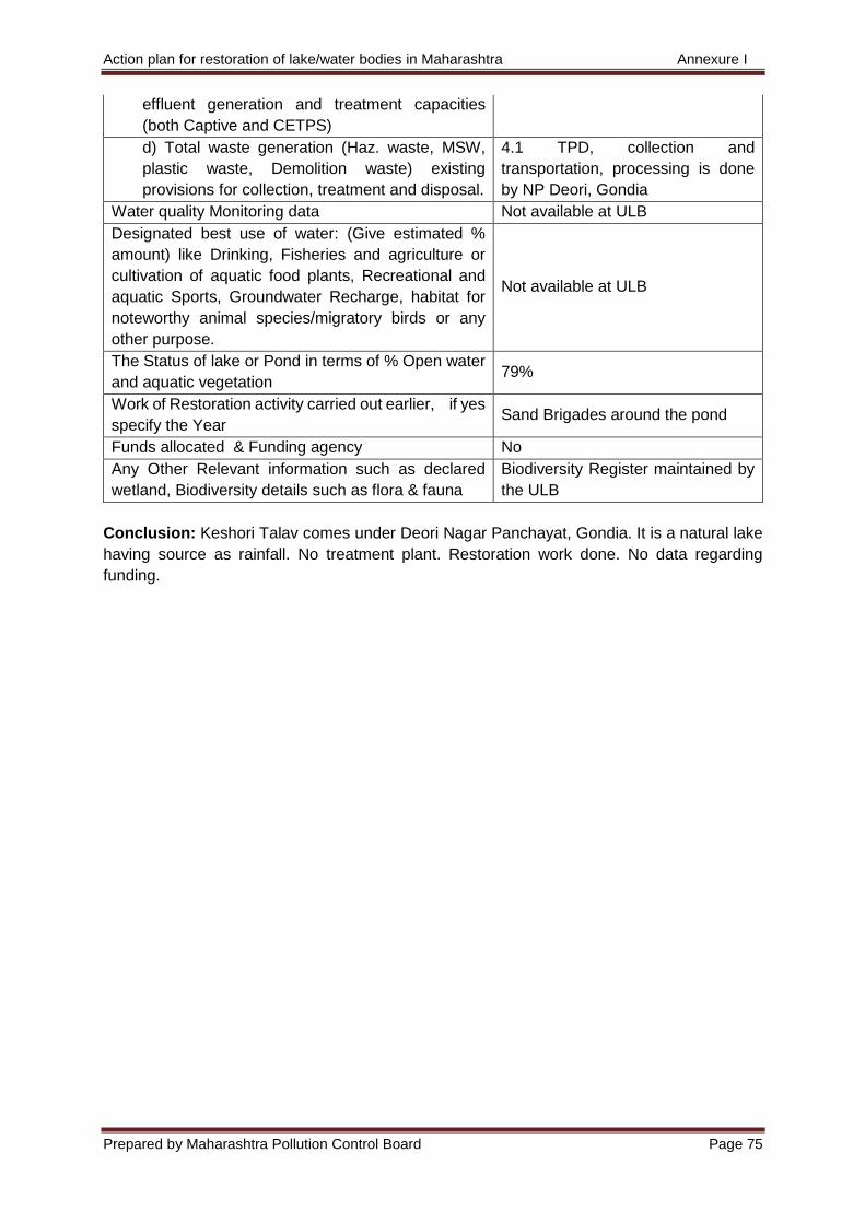
Action plan for restoration of lake/water bodies in Maharashtra Annexure I
Prepared by Maharashtra Pollution Control Board Page 75
effluent generation and treatment capacities
(both Captive and CETPS)
d) Total waste generation (Haz. waste, MSW,
plastic waste, Demolition waste) existing
provisions for collection, treatment and disposal.
4.1 TPD, collection and
transportation, processing is done
by NP Deori, Gondia
Water quality Monitoring data Not available at ULB
Designated best use of water: (Give estimated %
amount) like Drinking, Fisheries and agriculture or
cultivation of aquatic food plants, Recreational and
aquatic Sports, Groundwater Recharge, habitat for
noteworthy animal species/migratory birds or any
other purpose.
Not available at ULB
The Status of lake or Pond in terms of % Open water
and aquatic vegetation 79%
Work of Restoration activity carried out earlier, if yes
specify the Year Sand Brigades around the pond
Funds allocated & Funding agency No
Any Other Relevant information such as declared
wetland, Biodiversity details such as flora & fauna
Biodiversity Register maintained by
the ULB
Conclusion: Keshori Talav comes under Deori Nagar Panchayat, Gondia. It is a natural lake
having source as rainfall. No treatment plant. Restoration work done. No data regarding
funding.
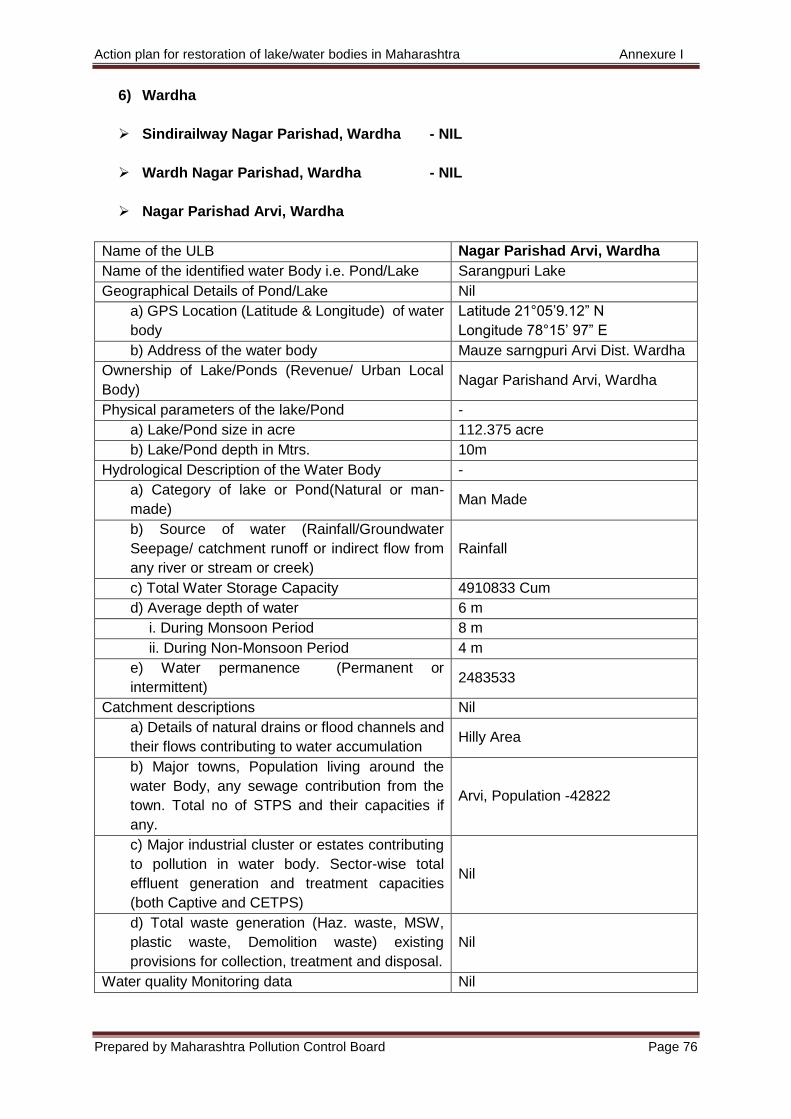
Action plan for restoration of lake/water bodies in Maharashtra Annexure I
Prepared by Maharashtra Pollution Control Board Page 76
6) Wardha
Sindirailway Nagar Parishad, Wardha - NIL
Wardh Nagar Parishad, Wardha - NIL
Nagar Parishad Arvi, Wardha
Name of the ULB Nagar Parishad Arvi, Wardha
Name of the identified water Body i.e. Pond/Lake Sarangpuri Lake
Geographical Details of Pond/Lake Nil
a) GPS Location (Latitude & Longitude) of water
body
Latitude 21°05’9.12” N
Longitude 78°15’ 97” E
b) Address of the water body Mauze sarngpuri Arvi Dist. Wardha
Ownership of Lake/Ponds (Revenue/ Urban Local
Body) Nagar Parishand Arvi, Wardha
Physical parameters of the lake/Pond -
a) Lake/Pond size in acre 112.375 acre
b) Lake/Pond depth in Mtrs. 10m
Hydrological Description of the Water Body -
a) Category of lake or Pond(Natural or man-
made) Man Made
b) Source of water (Rainfall/Groundwater
Seepage/ catchment runoff or indirect flow from
any river or stream or creek)
Rainfall
c) Total Water Storage Capacity 4910833 Cum
d) Average depth of water 6 m
i. During Monsoon Period 8 m
ii. During Non-Monsoon Period 4 m
e) Water permanence (Permanent or
intermittent) 2483533
Catchment descriptions Nil
a) Details of natural drains or flood channels and
their flows contributing to water accumulation Hilly Area
b) Major towns, Population living around the
water Body, any sewage contribution from the
town. Total no of STPS and their capacities if
any.
Arvi, Population -42822
c) Major industrial cluster or estates contributing
to pollution in water body. Sector-wise total
effluent generation and treatment capacities
(both Captive and CETPS)
Nil
d) Total waste generation (Haz. waste, MSW,
plastic waste, Demolition waste) existing
provisions for collection, treatment and disposal.
Nil
Water quality Monitoring data Nil
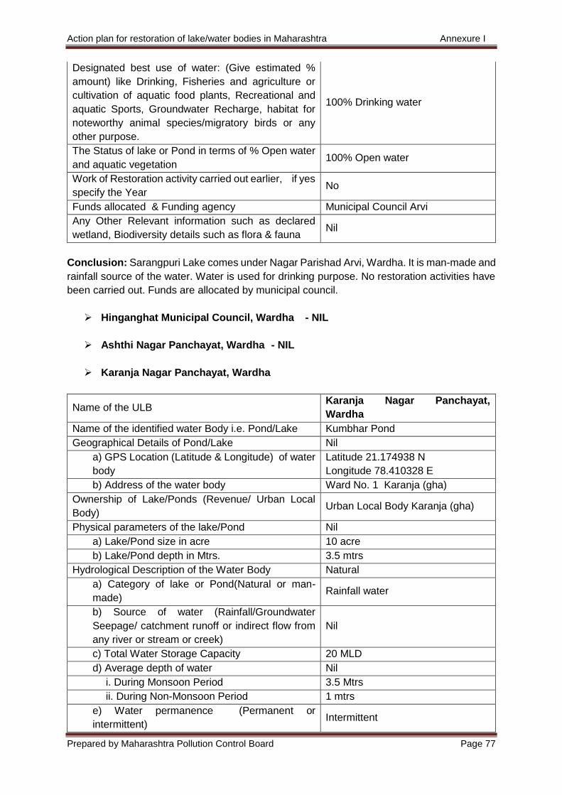
Action plan for restoration of lake/water bodies in Maharashtra Annexure I
Prepared by Maharashtra Pollution Control Board Page 77
Designated best use of water: (Give estimated %
amount) like Drinking, Fisheries and agriculture or
cultivation of aquatic food plants, Recreational and
aquatic Sports, Groundwater Recharge, habitat for
noteworthy animal species/migratory birds or any
other purpose.
100% Drinking water
The Status of lake or Pond in terms of % Open water
and aquatic vegetation 100% Open water
Work of Restoration activity carried out earlier, if yes
specify the Year No
Funds allocated & Funding agency Municipal Council Arvi
Any Other Relevant information such as declared
wetland, Biodiversity details such as flora & fauna Nil
Conclusion: Sarangpuri Lake comes under Nagar Parishad Arvi, Wardha. It is man-made and
rainfall source of the water. Water is used for drinking purpose. No restoration activities have
been carried out. Funds are allocated by municipal council.
Hinganghat Municipal Council, Wardha - NIL
Ashthi Nagar Panchayat, Wardha - NIL
Karanja Nagar Panchayat, Wardha
Name of the ULB Karanja Nagar Panchayat,
Wardha
Name of the identified water Body i.e. Pond/Lake Kumbhar Pond
Geographical Details of Pond/Lake Nil
a) GPS Location (Latitude & Longitude) of water
body
Latitude 21.174938 N
Longitude 78.410328 E
b) Address of the water body Ward No. 1 Karanja (gha)
Ownership of Lake/Ponds (Revenue/ Urban Local
Body) Urban Local Body Karanja (gha)
Physical parameters of the lake/Pond Nil
a) Lake/Pond size in acre 10 acre
b) Lake/Pond depth in Mtrs. 3.5 mtrs
Hydrological Description of the Water Body Natural
a) Category of lake or Pond(Natural or man-
made) Rainfall water
b) Source of water (Rainfall/Groundwater
Seepage/ catchment runoff or indirect flow from
any river or stream or creek)
Nil
c) Total Water Storage Capacity 20 MLD
d) Average depth of water Nil
i. During Monsoon Period 3.5 Mtrs
ii. During Non-Monsoon Period 1 mtrs
e) Water permanence (Permanent or
intermittent) Intermittent
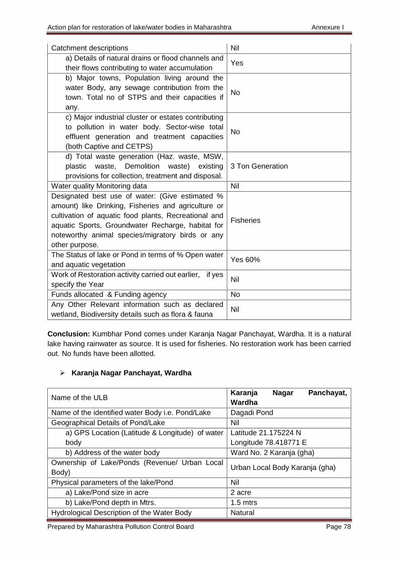
Action plan for restoration of lake/water bodies in Maharashtra Annexure I
Prepared by Maharashtra Pollution Control Board Page 78
Catchment descriptions Nil
a) Details of natural drains or flood channels and
their flows contributing to water accumulation Yes
b) Major towns, Population living around the
water Body, any sewage contribution from the
town. Total no of STPS and their capacities if
any.
No
c) Major industrial cluster or estates contributing
to pollution in water body. Sector-wise total
effluent generation and treatment capacities
(both Captive and CETPS)
No
d) Total waste generation (Haz. waste, MSW,
plastic waste, Demolition waste) existing
provisions for collection, treatment and disposal.
3 Ton Generation
Water quality Monitoring data Nil
Designated best use of water: (Give estimated %
amount) like Drinking, Fisheries and agriculture or
cultivation of aquatic food plants, Recreational and
aquatic Sports, Groundwater Recharge, habitat for
noteworthy animal species/migratory birds or any
other purpose.
Fisheries
The Status of lake or Pond in terms of % Open water
and aquatic vegetation Yes 60%
Work of Restoration activity carried out earlier, if yes
specify the Year Nil
Funds allocated & Funding agency No
Any Other Relevant information such as declared
wetland, Biodiversity details such as flora & fauna Nil
Conclusion: Kumbhar Pond comes under Karanja Nagar Panchayat, Wardha. It is a natural
lake having rainwater as source. It is used for fisheries. No restoration work has been carried
out. No funds have been allotted.
Karanja Nagar Panchayat, Wardha
Name of the ULB Karanja Nagar Panchayat,
Wardha
Name of the identified water Body i.e. Pond/Lake Dagadi Pond
Geographical Details of Pond/Lake Nil
a) GPS Location (Latitude & Longitude) of water
body
Latitude 21.175224 N
Longitude 78.418771 E
b) Address of the water body Ward No. 2 Karanja (gha)
Ownership of Lake/Ponds (Revenue/ Urban Local
Body) Urban Local Body Karanja (gha)
Physical parameters of the lake/Pond Nil
a) Lake/Pond size in acre 2 acre
b) Lake/Pond depth in Mtrs. 1.5 mtrs
Hydrological Description of the Water Body Natural
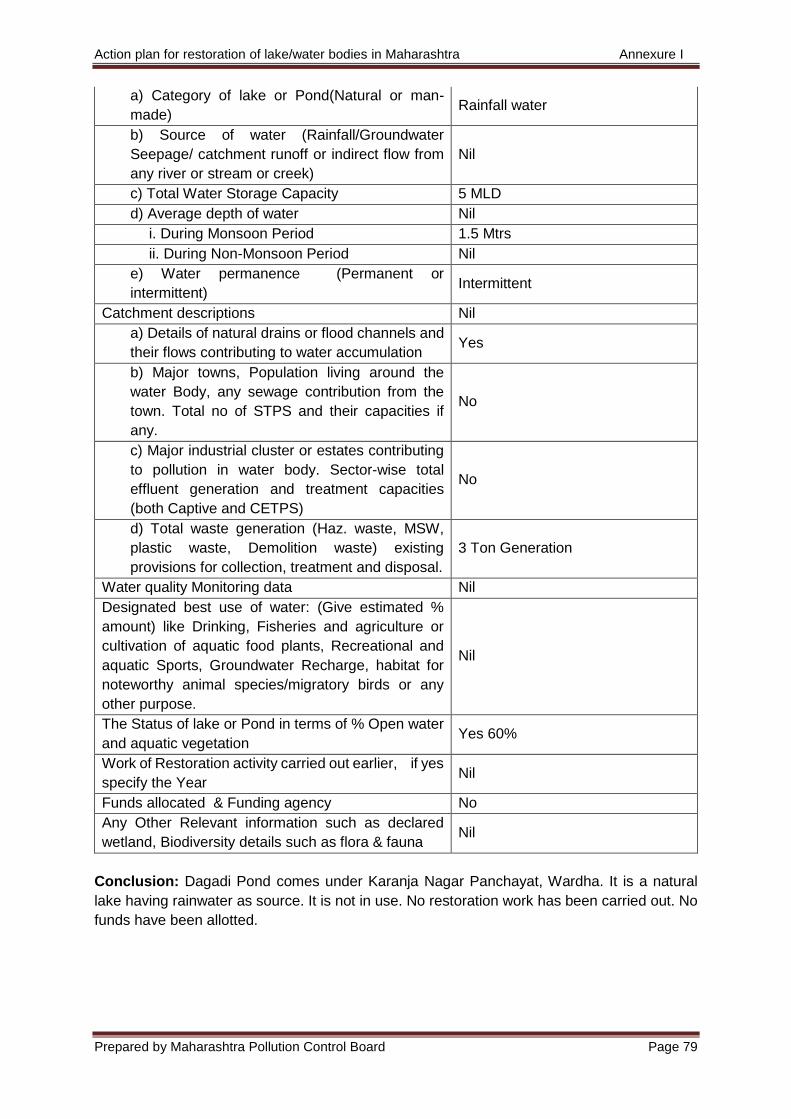
Action plan for restoration of lake/water bodies in Maharashtra Annexure I
Prepared by Maharashtra Pollution Control Board Page 79
a) Category of lake or Pond(Natural or man-
made) Rainfall water
b) Source of water (Rainfall/Groundwater
Seepage/ catchment runoff or indirect flow from
any river or stream or creek)
Nil
c) Total Water Storage Capacity 5 MLD
d) Average depth of water Nil
i. During Monsoon Period 1.5 Mtrs
ii. During Non-Monsoon Period Nil
e) Water permanence (Permanent or
intermittent) Intermittent
Catchment descriptions Nil
a) Details of natural drains or flood channels and
their flows contributing to water accumulation Yes
b) Major towns, Population living around the
water Body, any sewage contribution from the
town. Total no of STPS and their capacities if
any.
No
c) Major industrial cluster or estates contributing
to pollution in water body. Sector-wise total
effluent generation and treatment capacities
(both Captive and CETPS)
No
d) Total waste generation (Haz. waste, MSW,
plastic waste, Demolition waste) existing
provisions for collection, treatment and disposal.
3 Ton Generation
Water quality Monitoring data Nil
Designated best use of water: (Give estimated %
amount) like Drinking, Fisheries and agriculture or
cultivation of aquatic food plants, Recreational and
aquatic Sports, Groundwater Recharge, habitat for
noteworthy animal species/migratory birds or any
other purpose.
Nil
The Status of lake or Pond in terms of % Open water
and aquatic vegetation Yes 60%
Work of Restoration activity carried out earlier, if yes
specify the Year Nil
Funds allocated & Funding agency No
Any Other Relevant information such as declared
wetland, Biodiversity details such as flora & fauna Nil
Conclusion: Dagadi Pond comes under Karanja Nagar Panchayat, Wardha. It is a natural
lake having rainwater as source. It is not in use. No restoration work has been carried out. No
funds have been allotted.
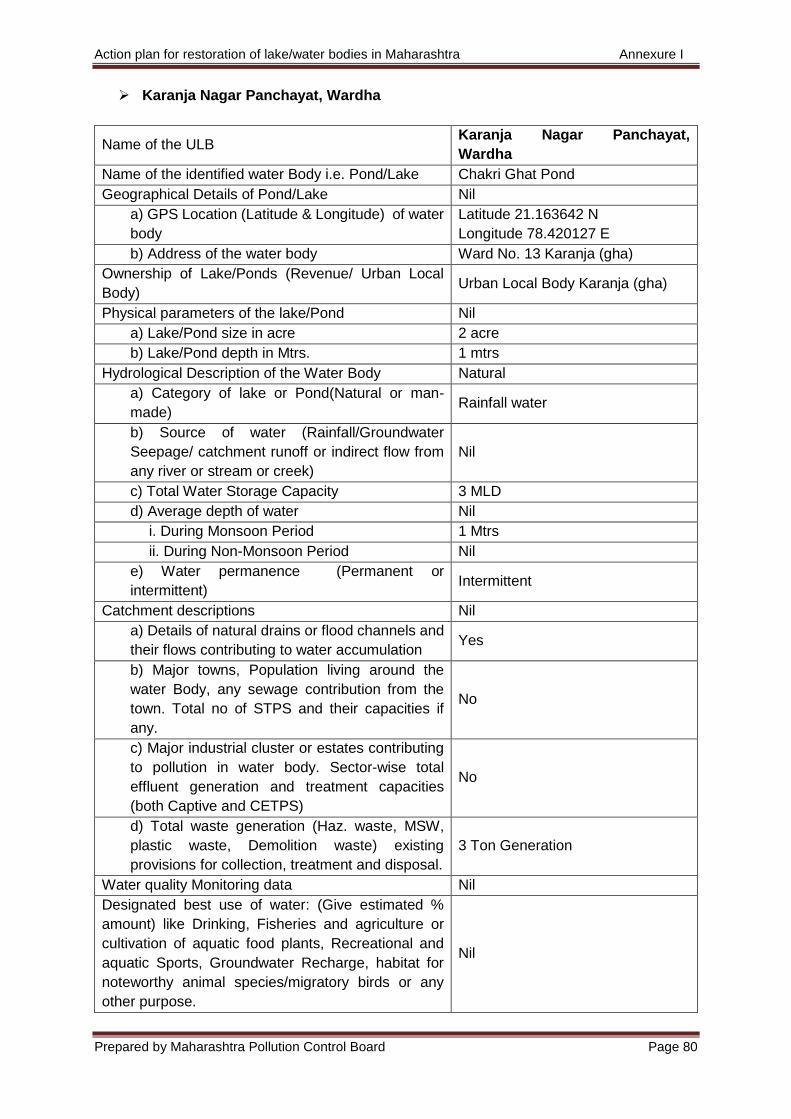
Action plan for restoration of lake/water bodies in Maharashtra Annexure I
Prepared by Maharashtra Pollution Control Board Page 80
Karanja Nagar Panchayat, Wardha
Name of the ULB Karanja Nagar Panchayat,
Wardha
Name of the identified water Body i.e. Pond/Lake Chakri Ghat Pond
Geographical Details of Pond/Lake Nil
a) GPS Location (Latitude & Longitude) of water
body
Latitude 21.163642 N
Longitude 78.420127 E
b) Address of the water body Ward No. 13 Karanja (gha)
Ownership of Lake/Ponds (Revenue/ Urban Local
Body) Urban Local Body Karanja (gha)
Physical parameters of the lake/Pond Nil
a) Lake/Pond size in acre 2 acre
b) Lake/Pond depth in Mtrs. 1 mtrs
Hydrological Description of the Water Body Natural
a) Category of lake or Pond(Natural or man-
made) Rainfall water
b) Source of water (Rainfall/Groundwater
Seepage/ catchment runoff or indirect flow from
any river or stream or creek)
Nil
c) Total Water Storage Capacity 3 MLD
d) Average depth of water Nil
i. During Monsoon Period 1 Mtrs
ii. During Non-Monsoon Period Nil
e) Water permanence (Permanent or
intermittent) Intermittent
Catchment descriptions Nil
a) Details of natural drains or flood channels and
their flows contributing to water accumulation Yes
b) Major towns, Population living around the
water Body, any sewage contribution from the
town. Total no of STPS and their capacities if
any.
No
c) Major industrial cluster or estates contributing
to pollution in water body. Sector-wise total
effluent generation and treatment capacities
(both Captive and CETPS)
No
d) Total waste generation (Haz. waste, MSW,
plastic waste, Demolition waste) existing
provisions for collection, treatment and disposal.
3 Ton Generation
Water quality Monitoring data Nil
Designated best use of water: (Give estimated %
amount) like Drinking, Fisheries and agriculture or
cultivation of aquatic food plants, Recreational and
aquatic Sports, Groundwater Recharge, habitat for
noteworthy animal species/migratory birds or any
other purpose.
Nil
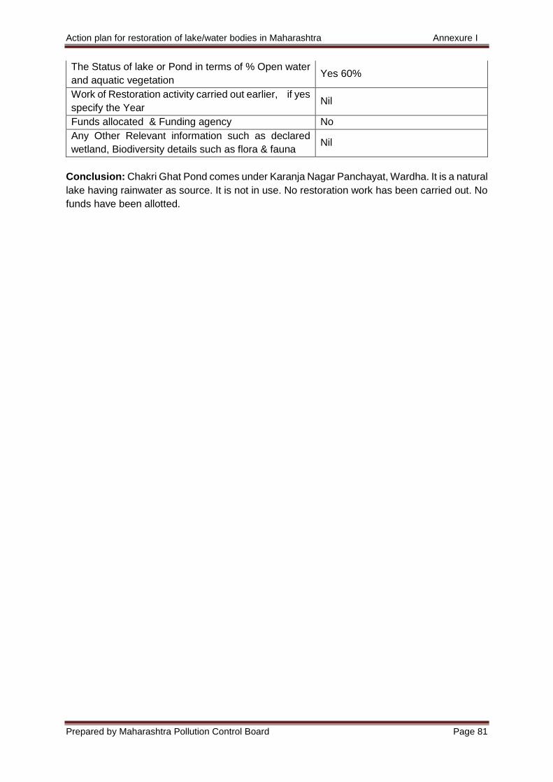
Action plan for restoration of lake/water bodies in Maharashtra Annexure I
Prepared by Maharashtra Pollution Control Board Page 81
The Status of lake or Pond in terms of % Open water
and aquatic vegetation Yes 60%
Work of Restoration activity carried out earlier, if yes
specify the Year Nil
Funds allocated & Funding agency No
Any Other Relevant information such as declared
wetland, Biodiversity details such as flora & fauna Nil
Conclusion: Chakri Ghat Pond comes under Karanja Nagar Panchayat, Wardha. It is a natural
lake having rainwater as source. It is not in use. No restoration work has been carried out. No
funds have been allotted.
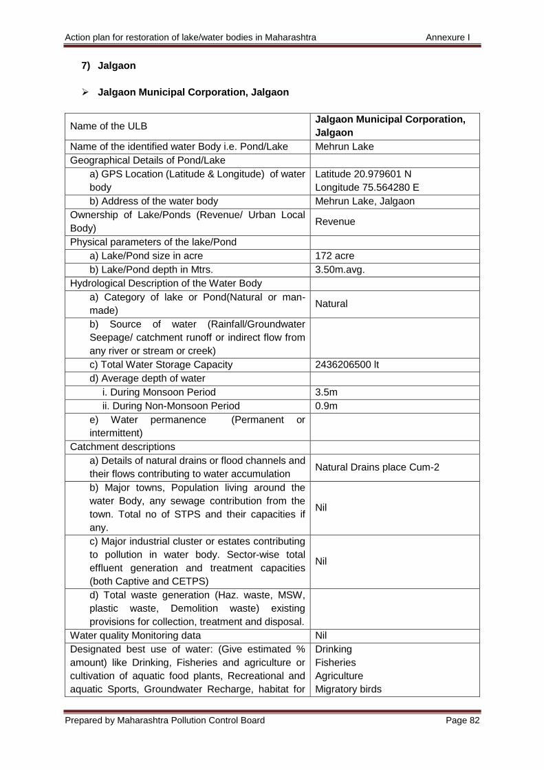
Action plan for restoration of lake/water bodies in Maharashtra Annexure I
Prepared by Maharashtra Pollution Control Board Page 82
7) Jalgaon
Jalgaon Municipal Corporation, Jalgaon
Name of the ULB Jalgaon Municipal Corporation,
Jalgaon
Name of the identified water Body i.e. Pond/Lake Mehrun Lake
Geographical Details of Pond/Lake
a) GPS Location (Latitude & Longitude) of water
body
Latitude 20.979601 N
Longitude 75.564280 E
b) Address of the water body Mehrun Lake, Jalgaon
Ownership of Lake/Ponds (Revenue/ Urban Local
Body) Revenue
Physical parameters of the lake/Pond
a) Lake/Pond size in acre 172 acre
b) Lake/Pond depth in Mtrs. 3.50m.avg.
Hydrological Description of the Water Body
a) Category of lake or Pond(Natural or man-
made) Natural
b) Source of water (Rainfall/Groundwater
Seepage/ catchment runoff or indirect flow from
any river or stream or creek)
c) Total Water Storage Capacity 2436206500 lt
d) Average depth of water
i. During Monsoon Period 3.5m
ii. During Non-Monsoon Period 0.9m
e) Water permanence (Permanent or
intermittent)
Catchment descriptions
a) Details of natural drains or flood channels and
their flows contributing to water accumulation Natural Drains place Cum-2
b) Major towns, Population living around the
water Body, any sewage contribution from the
town. Total no of STPS and their capacities if
any.
Nil
c) Major industrial cluster or estates contributing
to pollution in water body. Sector-wise total
effluent generation and treatment capacities
(both Captive and CETPS)
Nil
d) Total waste generation (Haz. waste, MSW,
plastic waste, Demolition waste) existing
provisions for collection, treatment and disposal.
Water quality Monitoring data Nil
Designated best use of water: (Give estimated %
amount) like Drinking, Fisheries and agriculture or
cultivation of aquatic food plants, Recreational and
aquatic Sports, Groundwater Recharge, habitat for
Drinking
Fisheries
Agriculture
Migratory birds
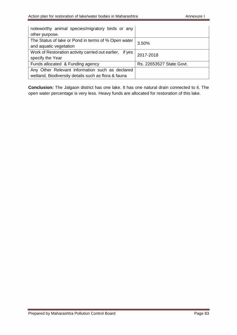
Action plan for restoration of lake/water bodies in Maharashtra Annexure I
Prepared by Maharashtra Pollution Control Board Page 83
noteworthy animal species/migratory birds or any
other purpose.
The Status of lake or Pond in terms of % Open water
and aquatic vegetation 3.50%
Work of Restoration activity carried out earlier, if yes
specify the Year 2017-2018
Funds allocated & Funding agency Rs. 22653527 State Govt.
Any Other Relevant information such as declared
wetland, Biodiversity details such as flora & fauna
Conclusion: The Jalgaon district has one lake. It has one natural drain connected to it. The
open water percentage is very less. Heavy funds are allocated for restoration of this lake.
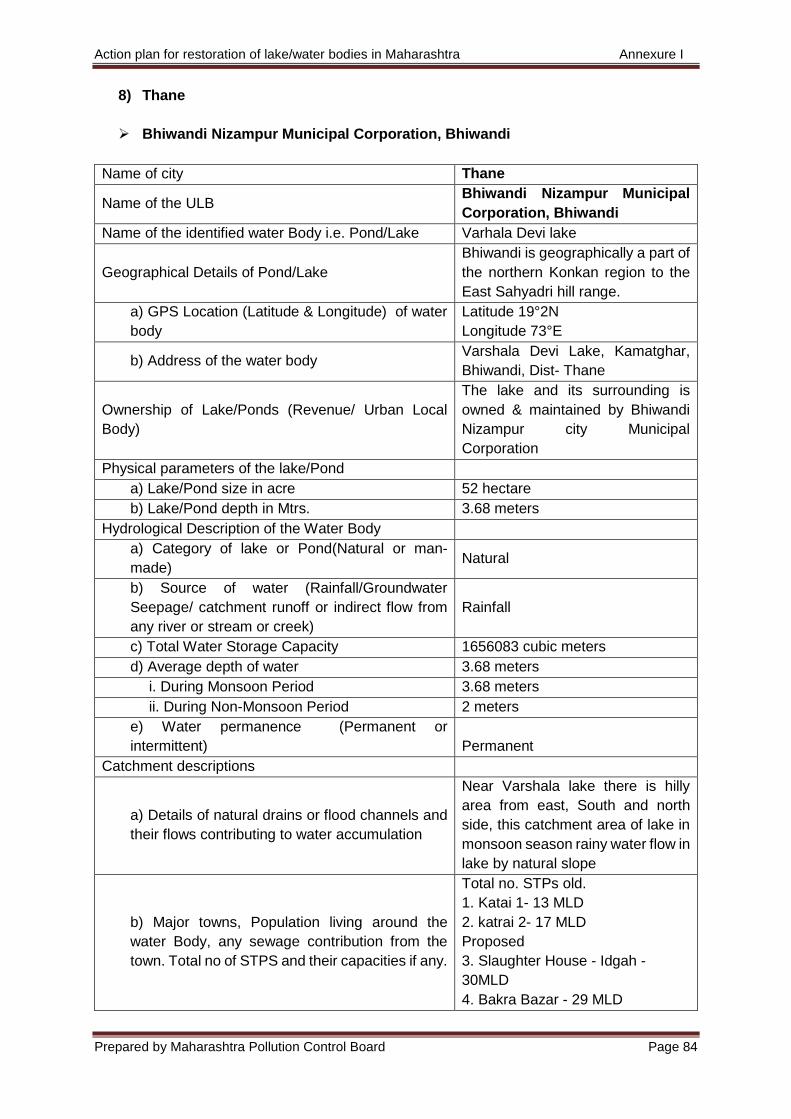
Action plan for restoration of lake/water bodies in Maharashtra Annexure I
Prepared by Maharashtra Pollution Control Board Page 84
8) Thane
Bhiwandi Nizampur Municipal Corporation, Bhiwandi
Name of city Thane
Name of the ULB Bhiwandi Nizampur Municipal
Corporation, Bhiwandi
Name of the identified water Body i.e. Pond/Lake Varhala Devi lake
Geographical Details of Pond/Lake
Bhiwandi is geographically a part of
the northern Konkan region to the
East Sahyadri hill range.
a) GPS Location (Latitude & Longitude) of water
body
Latitude 19°2N
Longitude 73°E
b) Address of the water body Varshala Devi Lake, Kamatghar,
Bhiwandi, Dist- Thane
Ownership of Lake/Ponds (Revenue/ Urban Local
Body)
The lake and its surrounding is
owned & maintained by Bhiwandi
Nizampur city Municipal
Corporation
Physical parameters of the lake/Pond
a) Lake/Pond size in acre 52 hectare
b) Lake/Pond depth in Mtrs. 3.68 meters
Hydrological Description of the Water Body
a) Category of lake or Pond(Natural or man-
made) Natural
b) Source of water (Rainfall/Groundwater
Seepage/ catchment runoff or indirect flow from
any river or stream or creek)
Rainfall
c) Total Water Storage Capacity 1656083 cubic meters
d) Average depth of water 3.68 meters
i. During Monsoon Period 3.68 meters
ii. During Non-Monsoon Period 2 meters
e) Water permanence (Permanent or
intermittent) Permanent
Catchment descriptions
a) Details of natural drains or flood channels and
their flows contributing to water accumulation
Near Varshala lake there is hilly
area from east, South and north
side, this catchment area of lake in
monsoon season rainy water flow in
lake by natural slope
b) Major towns, Population living around the
water Body, any sewage contribution from the
town. Total no of STPS and their capacities if any.
Total no. STPs old.
1. Katai 1- 13 MLD
2. katrai 2- 17 MLD
Proposed
3. Slaughter House - Idgah -
30MLD
4. Bakra Bazar - 29 MLD
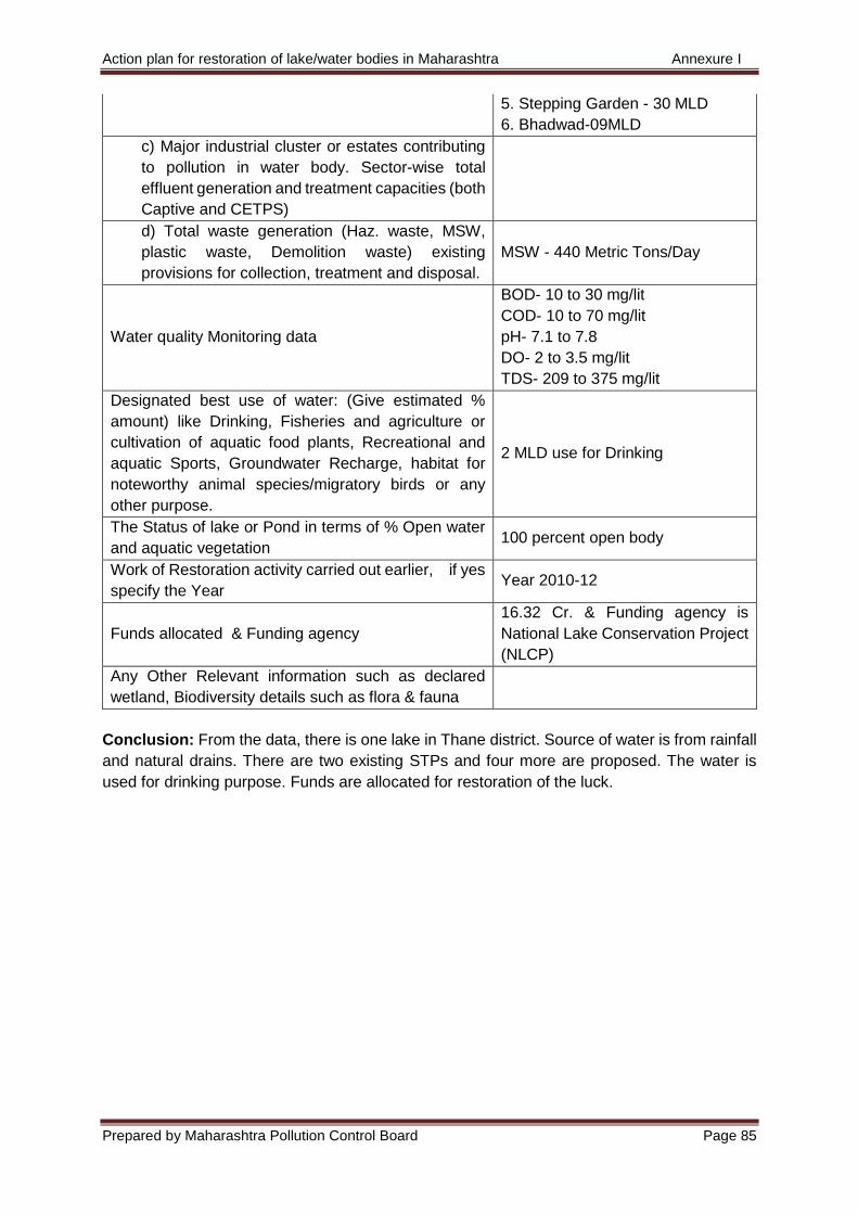
Action plan for restoration of lake/water bodies in Maharashtra Annexure I
Prepared by Maharashtra Pollution Control Board Page 85
5. Stepping Garden - 30 MLD
6. Bhadwad-09MLD
c) Major industrial cluster or estates contributing
to pollution in water body. Sector-wise total
effluent generation and treatment capacities (both
Captive and CETPS)
d) Total waste generation (Haz. waste, MSW,
plastic waste, Demolition waste) existing
provisions for collection, treatment and disposal.
MSW - 440 Metric Tons/Day
Water quality Monitoring data
BOD- 10 to 30 mg/lit
COD- 10 to 70 mg/lit
pH- 7.1 to 7.8
DO- 2 to 3.5 mg/lit
TDS- 209 to 375 mg/lit
Designated best use of water: (Give estimated %
amount) like Drinking, Fisheries and agriculture or
cultivation of aquatic food plants, Recreational and
aquatic Sports, Groundwater Recharge, habitat for
noteworthy animal species/migratory birds or any
other purpose.
2 MLD use for Drinking
The Status of lake or Pond in terms of % Open water
and aquatic vegetation 100 percent open body
Work of Restoration activity carried out earlier, if yes
specify the Year Year 2010-12
Funds allocated & Funding agency
16.32 Cr. & Funding agency is
National Lake Conservation Project
(NLCP)
Any Other Relevant information such as declared
wetland, Biodiversity details such as flora & fauna
Conclusion: From the data, there is one lake in Thane district. Source of water is from rainfall
and natural drains. There are two existing STPs and four more are proposed. The water is
used for drinking purpose. Funds are allocated for restoration of the luck.
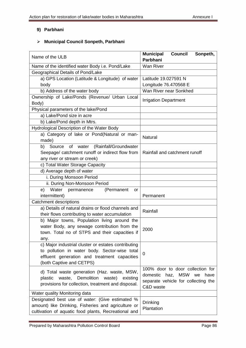
Action plan for restoration of lake/water bodies in Maharashtra Annexure I
Prepared by Maharashtra Pollution Control Board Page 86
9) Parbhani
Municipal Council Sonpeth, Parbhani
Name of the ULB Municipal Council Sonpeth,
Parbhani
Name of the identified water Body i.e. Pond/Lake Wan River
Geographical Details of Pond/Lake
a) GPS Location (Latitude & Longitude) of water
body
Latitude 19.027591 N
Longitude 76.470568 E
b) Address of the water body Wan River near Sonkhed
Ownership of Lake/Ponds (Revenue/ Urban Local
Body) Irrigation Department
Physical parameters of the lake/Pond
a) Lake/Pond size in acre
b) Lake/Pond depth in Mtrs.
Hydrological Description of the Water Body
a) Category of lake or Pond(Natural or man-
made) Natural
b) Source of water (Rainfall/Groundwater
Seepage/ catchment runoff or indirect flow from
any river or stream or creek)
Rainfall and catchment runoff
c) Total Water Storage Capacity
d) Average depth of water
i. During Monsoon Period
ii. During Non-Monsoon Period
e) Water permanence (Permanent or
intermittent) Permanent
Catchment descriptions
a) Details of natural drains or flood channels and
their flows contributing to water accumulation Rainfall
b) Major towns, Population living around the
water Body, any sewage contribution from the
town. Total no of STPS and their capacities if
any.
2000
c) Major industrial cluster or estates contributing
to pollution in water body. Sector-wise total
effluent generation and treatment capacities
(both Captive and CETPS)
0
d) Total waste generation (Haz. waste, MSW,
plastic waste, Demolition waste) existing
provisions for collection, treatment and disposal.
100% door to door collection for
domestic haz, MSW we have
separate vehicle for collecting the
C&D waste
Water quality Monitoring data
Designated best use of water: (Give estimated %
amount) like Drinking, Fisheries and agriculture or
cultivation of aquatic food plants, Recreational and
Drinking
Plantation
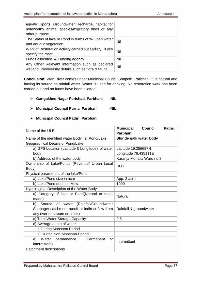
Action plan for restoration of lake/water bodies in Maharashtra Annexure I
Prepared by Maharashtra Pollution Control Board Page 87
aquatic Sports, Groundwater Recharge, habitat for
noteworthy animal species/migratory birds or any
other purpose.
The Status of lake or Pond in terms of % Open water
and aquatic vegetation Nil
Work of Restoration activity carried out earlier, if yes
specify the Year Nil
Funds allocated & Funding agency Nil
Any Other Relevant information such as declared
wetland, Biodiversity details such as flora & fauna Nil
Conclusion: Wan River comes under Municipal Council Sonpeth, Parbhani. It is natural and
having its source as rainfall water. Water is used for drinking. No restoration work has been
carried out and no funds have been allotted.
Gangakhed Nagar Parishad, Parbhani -NIL
Municipal Council Purna, Parbhani -NIL
Municipal Council Pathri, Parbhani
Name of the ULB Municipal Council Pathri,
Parbhani
Name of the identified water Body i.e. Pond/Lake Shinde galli water body
Geographical Details of Pond/Lake
a) GPS Location (Latitude & Longitude) of water
body
Latitude 19.256687N
Longitude 76.435111E
b) Address of the water body Karanja Mohalla Ward no.8
Ownership of Lake/Ponds (Revenue/ Urban Local
Body) ULB
Physical parameters of the lake/Pond
a) Lake/Pond size in acre App. 2 acre
b) Lake/Pond depth in Mtrs. 1000
Hydrological Description of the Water Body
a) Category of lake or Pond(Natural or man-
made) Natural
b) Source of water (Rainfall/Groundwater
Seepage/ catchment runoff or indirect flow from
any river or stream or creek)
Rainfall & groundwater
c) Total Water Storage Capacity 0.5
d) Average depth of water
i. During Monsoon Period
ii. During Non-Monsoon Period
e) Water permanence (Permanent or
intermittent) Intermittent
Catchment descriptions
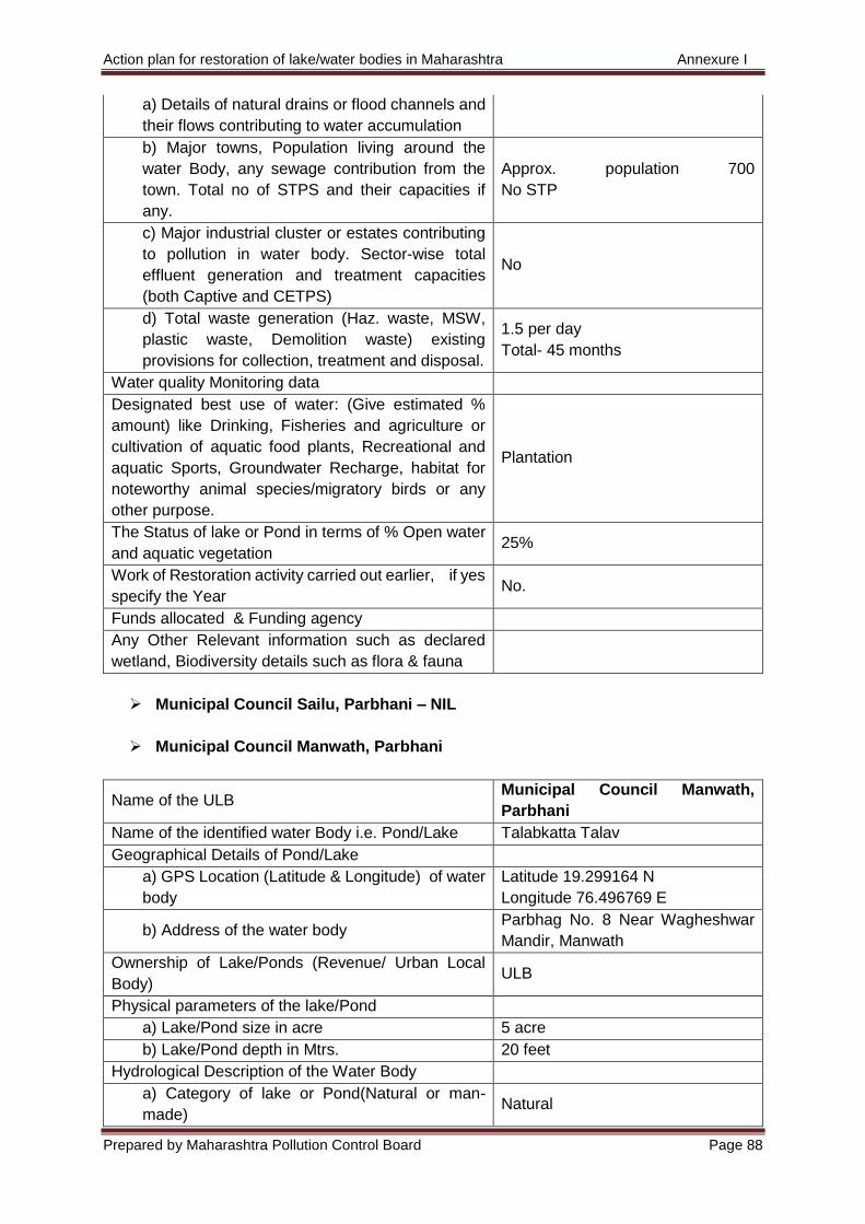
Action plan for restoration of lake/water bodies in Maharashtra Annexure I
Prepared by Maharashtra Pollution Control Board Page 88
a) Details of natural drains or flood channels and
their flows contributing to water accumulation
b) Major towns, Population living around the
water Body, any sewage contribution from the
town. Total no of STPS and their capacities if
any.
Approx. population 700
No STP
c) Major industrial cluster or estates contributing
to pollution in water body. Sector-wise total
effluent generation and treatment capacities
(both Captive and CETPS)
No
d) Total waste generation (Haz. waste, MSW,
plastic waste, Demolition waste) existing
provisions for collection, treatment and disposal.
1.5 per day
Total- 45 months
Water quality Monitoring data
Designated best use of water: (Give estimated %
amount) like Drinking, Fisheries and agriculture or
cultivation of aquatic food plants, Recreational and
aquatic Sports, Groundwater Recharge, habitat for
noteworthy animal species/migratory birds or any
other purpose.
Plantation
The Status of lake or Pond in terms of % Open water
and aquatic vegetation 25%
Work of Restoration activity carried out earlier, if yes
specify the Year No.
Funds allocated & Funding agency
Any Other Relevant information such as declared
wetland, Biodiversity details such as flora & fauna
Municipal Council Sailu, Parbhani – NIL
Municipal Council Manwath, Parbhani
Name of the ULB Municipal Council Manwath,
Parbhani
Name of the identified water Body i.e. Pond/Lake Talabkatta Talav
Geographical Details of Pond/Lake
a) GPS Location (Latitude & Longitude) of water
body
Latitude 19.299164 N
Longitude 76.496769 E
b) Address of the water body Parbhag No. 8 Near Wagheshwar
Mandir, Manwath
Ownership of Lake/Ponds (Revenue/ Urban Local
Body) ULB
Physical parameters of the lake/Pond
a) Lake/Pond size in acre 5 acre
b) Lake/Pond depth in Mtrs. 20 feet
Hydrological Description of the Water Body
a) Category of lake or Pond(Natural or man-
made) Natural
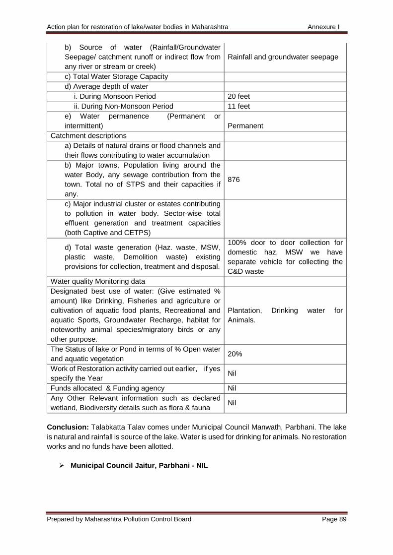
Action plan for restoration of lake/water bodies in Maharashtra Annexure I
Prepared by Maharashtra Pollution Control Board Page 89
b) Source of water (Rainfall/Groundwater
Seepage/ catchment runoff or indirect flow from
any river or stream or creek)
Rainfall and groundwater seepage
c) Total Water Storage Capacity
d) Average depth of water
i. During Monsoon Period 20 feet
ii. During Non-Monsoon Period 11 feet
e) Water permanence (Permanent or
intermittent) Permanent
Catchment descriptions
a) Details of natural drains or flood channels and
their flows contributing to water accumulation
b) Major towns, Population living around the
water Body, any sewage contribution from the
town. Total no of STPS and their capacities if
any.
876
c) Major industrial cluster or estates contributing
to pollution in water body. Sector-wise total
effluent generation and treatment capacities
(both Captive and CETPS)
d) Total waste generation (Haz. waste, MSW,
plastic waste, Demolition waste) existing
provisions for collection, treatment and disposal.
100% door to door collection for
domestic haz, MSW we have
separate vehicle for collecting the
C&D waste
Water quality Monitoring data
Designated best use of water: (Give estimated %
amount) like Drinking, Fisheries and agriculture or
cultivation of aquatic food plants, Recreational and
aquatic Sports, Groundwater Recharge, habitat for
noteworthy animal species/migratory birds or any
other purpose.
Plantation, Drinking water for
Animals.
The Status of lake or Pond in terms of % Open water
and aquatic vegetation 20%
Work of Restoration activity carried out earlier, if yes
specify the Year Nil
Funds allocated & Funding agency Nil
Any Other Relevant information such as declared
wetland, Biodiversity details such as flora & fauna Nil
Conclusion: Talabkatta Talav comes under Municipal Council Manwath, Parbhani. The lake
is natural and rainfall is source of the lake. Water is used for drinking for animals. No restoration
works and no funds have been allotted.
Municipal Council Jaitur, Parbhani - NIL
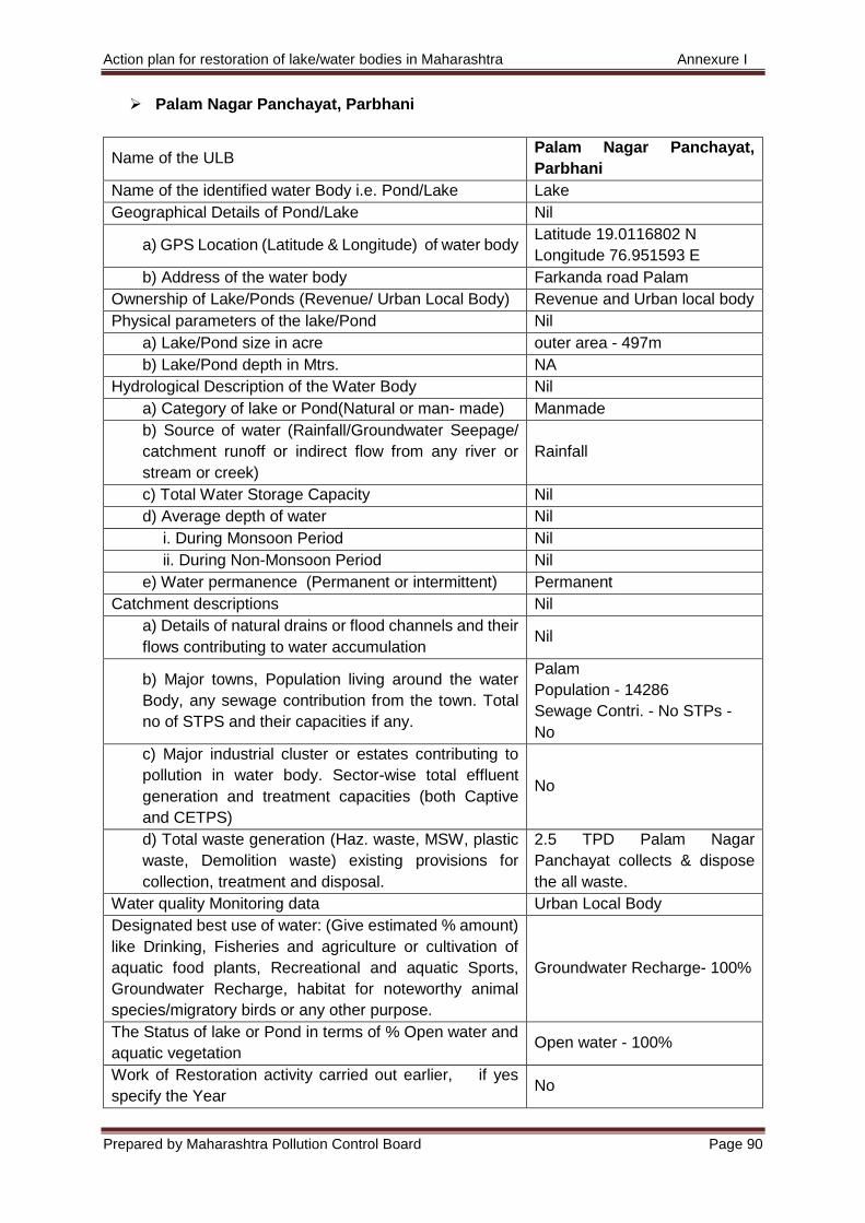
Action plan for restoration of lake/water bodies in Maharashtra Annexure I
Prepared by Maharashtra Pollution Control Board Page 90
Palam Nagar Panchayat, Parbhani
Name of the ULB Palam Nagar Panchayat,
Parbhani
Name of the identified water Body i.e. Pond/Lake Lake
Geographical Details of Pond/Lake Nil
a) GPS Location (Latitude & Longitude) of water body Latitude 19.0116802 N
Longitude 76.951593 E
b) Address of the water body Farkanda road Palam
Ownership of Lake/Ponds (Revenue/ Urban Local Body) Revenue and Urban local body
Physical parameters of the lake/Pond Nil
a) Lake/Pond size in acre outer area - 497m
b) Lake/Pond depth in Mtrs. NA
Hydrological Description of the Water Body Nil
a) Category of lake or Pond(Natural or man- made) Manmade
b) Source of water (Rainfall/Groundwater Seepage/
catchment runoff or indirect flow from any river or
stream or creek)
Rainfall
c) Total Water Storage Capacity Nil
d) Average depth of water Nil
i. During Monsoon Period Nil
ii. During Non-Monsoon Period Nil
e) Water permanence (Permanent or intermittent) Permanent
Catchment descriptions Nil
a) Details of natural drains or flood channels and their
flows contributing to water accumulation Nil
b) Major towns, Population living around the water
Body, any sewage contribution from the town. Total
no of STPS and their capacities if any.
Palam
Population - 14286
Sewage Contri. - No STPs -
No
c) Major industrial cluster or estates contributing to
pollution in water body. Sector-wise total effluent
generation and treatment capacities (both Captive
and CETPS)
No
d) Total waste generation (Haz. waste, MSW, plastic
waste, Demolition waste) existing provisions for
collection, treatment and disposal.
2.5 TPD Palam Nagar
Panchayat collects & dispose
the all waste.
Water quality Monitoring data Urban Local Body
Designated best use of water: (Give estimated % amount)
like Drinking, Fisheries and agriculture or cultivation of
aquatic food plants, Recreational and aquatic Sports,
Groundwater Recharge, habitat for noteworthy animal
species/migratory birds or any other purpose.
Groundwater Recharge- 100%
The Status of lake or Pond in terms of % Open water and
aquatic vegetation Open water - 100%
Work of Restoration activity carried out earlier, if yes
specify the Year No

Action plan for restoration of lake/water bodies in Maharashtra Annexure I
Prepared by Maharashtra Pollution Control Board Page 91
Funds allocated & Funding agency 156.00 State Govt.
Any Other Relevant information such as declared wetland,
Biodiversity details such as flora & fauna No
Conclusion: Lake comes under Palam Nagar Panchayat, Parbhani. Lake is manmade having
rainfall as its source. Water is used for groundwater recharge. No restoration works have been
carried out. Funds have been allocated by state government.
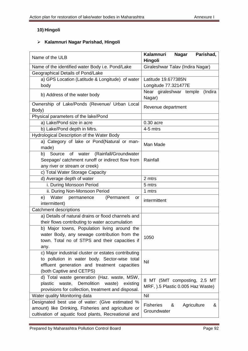
Action plan for restoration of lake/water bodies in Maharashtra Annexure I
Prepared by Maharashtra Pollution Control Board Page 92
10) Hingoli
Kalamnuri Nagar Parishad, Hingoli
Name of the ULB Kalamnuri Nagar Parishad,
Hingoli
Name of the identified water Body i.e. Pond/Lake Giraleshwar Talav (Indira Nagar)
Geographical Details of Pond/Lake
a) GPS Location (Latitude & Longitude) of water
body
Latitude 19.677385N
Longitude 77.321477E
b) Address of the water body Near giraleshwar temple (Indira
Nagar)
Ownership of Lake/Ponds (Revenue/ Urban Local
Body) Revenue department
Physical parameters of the lake/Pond
a) Lake/Pond size in acre 0.30 acre
b) Lake/Pond depth in Mtrs. 4-5 mtrs
Hydrological Description of the Water Body
a) Category of lake or Pond(Natural or man-
made) Man Made
b) Source of water (Rainfall/Groundwater
Seepage/ catchment runoff or indirect flow from
any river or stream or creek)
Rainfall
c) Total Water Storage Capacity
d) Average depth of water 2 mtrs
i. During Monsoon Period 5 mtrs
ii. During Non-Monsoon Period 1 mtrs
e) Water permanence (Permanent or
intermittent) intermittent
Catchment descriptions
a) Details of natural drains or flood channels and
their flows contributing to water accumulation
b) Major towns, Population living around the
water Body, any sewage contribution from the
town. Total no of STPS and their capacities if
any.
1050
c) Major industrial cluster or estates contributing
to pollution in water body. Sector-wise total
effluent generation and treatment capacities
(both Captive and CETPS)
Nil
d) Total waste generation (Haz. waste, MSW,
plastic waste, Demolition waste) existing
provisions for collection, treatment and disposal.
8 MT (5MT composting, 2.5 MT
MRF, ).5 Plastic 0.005 Haz Waste)
Water quality Monitoring data Nil
Designated best use of water: (Give estimated %
amount) like Drinking, Fisheries and agriculture or
cultivation of aquatic food plants, Recreational and
Fisheries & Agriculture &
Groundwater
Action plan for restoration of lake/water bodies in Maharashtra Annexure I
Prepared by Maharashtra Pollution Control Board Page 93
aquatic Sports, Groundwater Recharge, habitat for
noteworthy animal species/migratory birds or any
other purpose.
The Status of lake or Pond in terms of % Open water
and aquatic vegetation 80:20%
Work of Restoration activity carried out earlier, if yes
specify the Year No
Funds allocated & Funding agency No
Any Other Relevant information such as declared
wetland, Biodiversity details such as flora & fauna No
Conclusion: Giraleshwar Talav (Indira Nagar) comes under Kalamnuri Nagar Parishad,
Hingoli. It is a manmade lake having rainfall as its primary source. Water is used for fishery,
agriculture and ground water recharging. No restoration works have been carried out and no
funds have been allocated.
Sengaon Nagar Panchayat, Hingoli - NIL
Hingoli Nagar Parishad, Hingoli
Name of the ULB Hingoli Nagar Parishad, Hingoli
Name of the identified water Body i.e. Pond/Lake Chiragshah baba Dargah Talav
Geographical Details of Pond/Lake Nil
a) GPS Location (Latitude & Longitude) of water
body
Latitude 19.721061N
Longitude 77.15301E
b) Address of the water body Chiragshsah Baba Dargah Hingoli
Ownership of Lake/Ponds (Revenue/ Urban Local
Body) Valu Mata Prakshepan Kendra
Physical parameters of the lake/Pond Nil
a) Lake/Pond size in acre 10 acre
b) Lake/Pond depth in Mtrs. 25 feet
Hydrological Description of the Water Body Nil
a) Category of lake or Pond(Natural or man-
made) Natural
b) Source of water (Rainfall/Groundwater
Seepage/ catchment runoff or indirect flow from
any river or stream or creek)
Rainfall and groundwater seepage
c) Total Water Storage Capacity Nil
d) Average depth of water Nil
i. During Monsoon Period Nil
ii. During Non-Monsoon Period Nil
e) Water permanence (Permanent or
intermittent) Permanent
Catchment descriptions Nil
a) Details of natural drains or flood channels and
their flows contributing to water accumulation Nil
Action plan for restoration of lake/water bodies in Maharashtra Annexure I
Prepared by Maharashtra Pollution Control Board Page 94
b) Major towns, Population living around the
water Body, any sewage contribution from the
town. Total no of STPS and their capacities if
any.
Population - 541
c) Major industrial cluster or estates contributing
to pollution in water body. Sector-wise total
effluent generation and treatment capacities
(both Captive and CETPS)
0
d) Total waste generation (Haz. waste, MSW,
plastic waste, Demolition waste) existing
provisions for collection, treatment and disposal.
100% door to door collection for
domestic haz., MSW and we have
separate vehicle for collecting the
C&D waste.
Water quality Monitoring data Nil
Designated best use of water: (Give estimated %
amount) like Drinking, Fisheries and agriculture or
cultivation of aquatic food plants, Recreational and
aquatic Sports, Groundwater Recharge, habitat for
noteworthy animal species/migratory birds or any
other purpose.
Plantation
The Status of lake or Pond in terms of % Open water
and aquatic vegetation 20%
Work of Restoration activity carried out earlier, if yes
specify the Year Nil
Funds allocated & Funding agency Nil
Any Other Relevant information such as declared
wetland, Biodiversity details such as flora & fauna Nil
Conclusion: Chiragshah baba Dargah Talav comes under Hingoli Nagar Parishad, Hingoli.
The lake is natural and having rainfall and groundwater seepage as source of water. Water is
used for plantation. No restoration works carried out and no funds have been allocated.
Hingoli Nagar Parishad, Hingoli
Name of the ULB Hingoli Nagar Parishad, Hingoli
Name of the identified water Body i.e. Pond/Lake Jaleshvar Talav
Geographical Details of Pond/Lake Nil
a) GPS Location (Latitude & Longitude) of water
body
Latitude 19.712299N
Longitude 77.142944E
b) Address of the water body Talabjatta Hingoli
Ownership of Lake/Ponds (Revenue/ Urban Local
Body) Tehsil
Physical parameters of the lake/Pond Nil
a) Lake/Pond size in acre 30 acre
b) Lake/Pond depth in Mtrs. 40 feet
Hydrological Description of the Water Body Nil
a) Category of lake or Pond(Natural or man-
made) Natural
Action plan for restoration of lake/water bodies in Maharashtra Annexure I
Prepared by Maharashtra Pollution Control Board Page 95
b) Source of water (Rainfall/Groundwater
Seepage/ catchment runoff or indirect flow from
any river or stream or creek)
Rainfall and groundwater seepage
c) Total Water Storage Capacity Nil
d) Average depth of water Nil
i. During Monsoon Period Nil
ii. During Non-Monsoon Period Nil
e) Water permanence (Permanent or
intermittent) Permanent
Catchment descriptions Nil
a) Details of natural drains or flood channels and
their flows contributing to water accumulation Nil
b) Major towns, Population living around the
water Body, any sewage contribution from the
town. Total no of STPS and their capacities if
any.
Population -975
c) Major industrial cluster or estates contributing
to pollution in water body. Sector-wise total
effluent generation and treatment capacities
(both Captive and CETPS)
0
d) Total waste generation (Haz. waste, MSW,
plastic waste, Demolition waste) existing
provisions for collection, treatment and disposal.
100% door to door collection for
domestic haz., MSW and we have
separate vehicle for collecting the
C&D waste.
Water quality Monitoring data Nil
Designated best use of water: (Give estimated %
amount) like Drinking, Fisheries and agriculture or
cultivation of aquatic food plants, Recreational and
aquatic Sports, Groundwater Recharge, habitat for
noteworthy animal species/migratory birds or any
other purpose.
Plantation and Fisheries
The Status of lake or Pond in terms of % Open water
and aquatic vegetation 10%
Work of Restoration activity carried out earlier, if yes
specify the Year Nil
Funds allocated & Funding agency Nil
Any Other Relevant information such as declared
wetland, Biodiversity details such as flora & fauna Nil
Conclusion: Jaleshvar Talav comes under Hingoli Nagar Parishad, Hingoli. The lake is natural
and having rainfall and groundwater seepage as source of water. Water is used for plantation.
No restoration works carried out and no funds have been allocated.
Action plan for restoration of lake/water bodies in Maharashtra Annexure I
Prepared by Maharashtra Pollution Control Board Page 96
Basmat Nagar parishad, Hingoli
Name of the ULB Basmat Nagar parishad, Hingoli
Name of the identified water Body i.e. Pond/Lake Baba Talab Basmath
Geographical Details of Pond/Lake Nil
a) GPS Location (Latitude & Longitude) of water
body
Latitude 19°20'08.1"N
Longitude 77°09'23.3"E
b) Address of the water body Khajipura Basmath
Ownership of Lake/Ponds (Revenue/ Urban Local
Body) Private ownership
Physical parameters of the lake/Pond Nil
a) Lake/Pond size in acre 3 acre
b) Lake/Pond depth in Mtrs. 7 meter
Hydrological Description of the Water Body Nil
a) Category of lake or Pond(Natural or man-
made) Natural
b) Source of water (Rainfall/Groundwater
Seepage/ catchment runoff or indirect flow from
any river or stream or creek)
Rainfall / catchment runoff
c) Total Water Storage Capacity Nil
d) Average depth of water Nil
i. During Monsoon Period Nil
ii. During Non-Monsoon Period Nil
e) Water permanence (Permanent or
intermittent) Permanent
Catchment descriptions Nil
a) Details of natural drains or flood channels and
their flows contributing to water accumulation Nil
b) Major towns, Population living around the
water Body, any sewage contribution from the
town. Total no of STPS and their capacities if
any.
50
c) Major industrial cluster or estates contributing
to pollution in water body. Sector-wise total
effluent generation and treatment capacities
(both Captive and CETPS)
Nil
d) Total waste generation (Haz. waste, MSW,
plastic waste, Demolition waste) existing
provisions for collection, treatment and disposal.
100% door to door collection for
domestic haz., MSW
Water quality Monitoring data Nil
Designated best use of water: (Give estimated %
amount) like Drinking, Fisheries and agriculture or
cultivation of aquatic food plants, Recreational and
aquatic Sports, Groundwater Recharge, habitat for
noteworthy animal species/migratory birds or any
other purpose.
Plantation
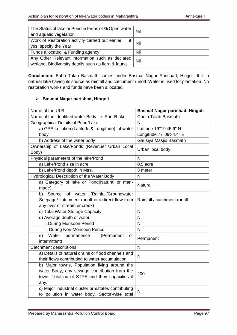
Action plan for restoration of lake/water bodies in Maharashtra Annexure I
Prepared by Maharashtra Pollution Control Board Page 97
The Status of lake or Pond in terms of % Open water
and aquatic vegetation Nil
Work of Restoration activity carried out earlier, if
yes specify the Year Nil
Funds allocated & Funding agency Nil
Any Other Relevant information such as declared
wetland, Biodiversity details such as flora & fauna Nil
Conclusion: Baba Talab Basmath comes under Basmat Nagar Parishad, Hingoli. It is a
natural lake having its source as rainfall and catchment runoff. Water is used for plantation. No
restoration works and funds have been allocated.
Basmat Nagar parishad, Hingoli
Name of the ULB Basmat Nagar parishad, Hingoli
Name of the identified water Body i.e. Pond/Lake Chota Talab Basmath
Geographical Details of Pond/Lake Nil
a) GPS Location (Latitude & Longitude) of water
body
Latitude 19°19'45.6" N
Longitude 77°09'34.4" E
b) Address of the water body Gausiya Masjid Basmath
Ownership of Lake/Ponds (Revenue/ Urban Local
Body) Urban local body
Physical parameters of the lake/Pond Nil
a) Lake/Pond size in acre 0.5 acre
b) Lake/Pond depth in Mtrs. 3 meter
Hydrological Description of the Water Body Nil
a) Category of lake or Pond(Natural or man-
made) Natural
b) Source of water (Rainfall/Groundwater
Seepage/ catchment runoff or indirect flow from
any river or stream or creek)
Rainfall / catchment runoff
c) Total Water Storage Capacity Nil
d) Average depth of water Nil
i. During Monsoon Period Nil
ii. During Non-Monsoon Period Nil
e) Water permanence (Permanent or
intermittent) Permanent
Catchment descriptions Nil
a) Details of natural drains or flood channels and
their flows contributing to water accumulation Nil
b) Major towns, Population living around the
water Body, any sewage contribution from the
town. Total no of STPS and their capacities if
any.
200
c) Major industrial cluster or estates contributing
to pollution in water body. Sector-wise total Nil
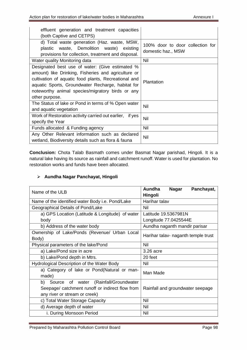
Action plan for restoration of lake/water bodies in Maharashtra Annexure I
Prepared by Maharashtra Pollution Control Board Page 98
effluent generation and treatment capacities
(both Captive and CETPS)
d) Total waste generation (Haz. waste, MSW,
plastic waste, Demolition waste) existing
provisions for collection, treatment and disposal.
100% door to door collection for
domestic haz., MSW
Water quality Monitoring data Nil
Designated best use of water: (Give estimated %
amount) like Drinking, Fisheries and agriculture or
cultivation of aquatic food plants, Recreational and
aquatic Sports, Groundwater Recharge, habitat for
noteworthy animal species/migratory birds or any
other purpose.
Plantation
The Status of lake or Pond in terms of % Open water
and aquatic vegetation Nil
Work of Restoration activity carried out earlier, if yes
specify the Year Nil
Funds allocated & Funding agency Nil
Any Other Relevant information such as declared
wetland, Biodiversity details such as flora & fauna Nil
Conclusion: Chota Talab Basmath comes under Basmat Nagar parishad, Hingoli. It is a
natural lake having its source as rainfall and catchment runoff. Water is used for plantation. No
restoration works and funds have been allocated.
Aundha Nagar Panchayat, Hingoli
Name of the ULB Aundha Nagar Panchayat,
Hingoli
Name of the identified water Body i.e. Pond/Lake Harihar talav
Geographical Details of Pond/Lake Nil
a) GPS Location (Latitude & Longitude) of water
body
Latitude 19.5367981N
Longitude 77.0425544E
b) Address of the water body Aundha naganth mandir parisar
Ownership of Lake/Ponds (Revenue/ Urban Local
Body) Harihar talav- naganth temple trust
Physical parameters of the lake/Pond Nil
a) Lake/Pond size in acre 3.26 acre
b) Lake/Pond depth in Mtrs. 20 feet
Hydrological Description of the Water Body Nil
a) Category of lake or Pond(Natural or man-
made) Man Made
b) Source of water (Rainfall/Groundwater
Seepage/ catchment runoff or indirect flow from
any river or stream or creek)
Rainfall and groundwater seepage
c) Total Water Storage Capacity Nil
d) Average depth of water Nil
i. During Monsoon Period Nil
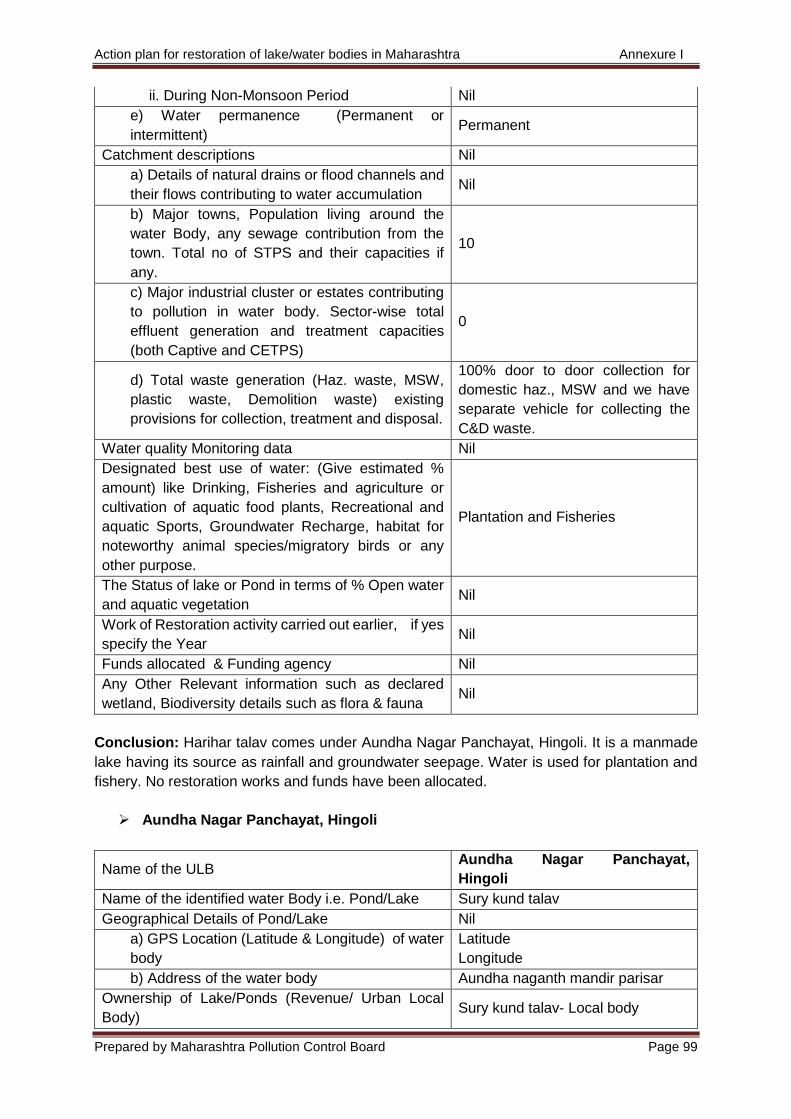
Action plan for restoration of lake/water bodies in Maharashtra Annexure I
Prepared by Maharashtra Pollution Control Board Page 99
ii. During Non-Monsoon Period Nil
e) Water permanence (Permanent or
intermittent) Permanent
Catchment descriptions Nil
a) Details of natural drains or flood channels and
their flows contributing to water accumulation Nil
b) Major towns, Population living around the
water Body, any sewage contribution from the
town. Total no of STPS and their capacities if
any.
10
c) Major industrial cluster or estates contributing
to pollution in water body. Sector-wise total
effluent generation and treatment capacities
(both Captive and CETPS)
0
d) Total waste generation (Haz. waste, MSW,
plastic waste, Demolition waste) existing
provisions for collection, treatment and disposal.
100% door to door collection for
domestic haz., MSW and we have
separate vehicle for collecting the
C&D waste.
Water quality Monitoring data Nil
Designated best use of water: (Give estimated %
amount) like Drinking, Fisheries and agriculture or
cultivation of aquatic food plants, Recreational and
aquatic Sports, Groundwater Recharge, habitat for
noteworthy animal species/migratory birds or any
other purpose.
Plantation and Fisheries
The Status of lake or Pond in terms of % Open water
and aquatic vegetation Nil
Work of Restoration activity carried out earlier, if yes
specify the Year Nil
Funds allocated & Funding agency Nil
Any Other Relevant information such as declared
wetland, Biodiversity details such as flora & fauna Nil
Conclusion: Harihar talav comes under Aundha Nagar Panchayat, Hingoli. It is a manmade
lake having its source as rainfall and groundwater seepage. Water is used for plantation and
fishery. No restoration works and funds have been allocated.
Aundha Nagar Panchayat, Hingoli
Name of the ULB Aundha Nagar Panchayat,
Hingoli
Name of the identified water Body i.e. Pond/Lake Sury kund talav
Geographical Details of Pond/Lake Nil
a) GPS Location (Latitude & Longitude) of water
body
Latitude
Longitude
b) Address of the water body Aundha naganth mandir parisar
Ownership of Lake/Ponds (Revenue/ Urban Local
Body) Sury kund talav- Local body
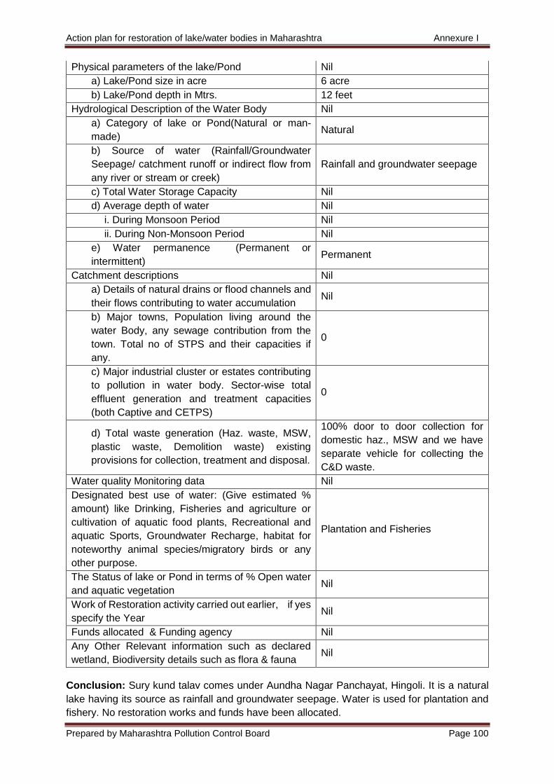
Action plan for restoration of lake/water bodies in Maharashtra Annexure I
Prepared by Maharashtra Pollution Control Board Page 100
Physical parameters of the lake/Pond Nil
a) Lake/Pond size in acre 6 acre
b) Lake/Pond depth in Mtrs. 12 feet
Hydrological Description of the Water Body Nil
a) Category of lake or Pond(Natural or man-
made) Natural
b) Source of water (Rainfall/Groundwater
Seepage/ catchment runoff or indirect flow from
any river or stream or creek)
Rainfall and groundwater seepage
c) Total Water Storage Capacity Nil
d) Average depth of water Nil
i. During Monsoon Period Nil
ii. During Non-Monsoon Period Nil
e) Water permanence (Permanent or
intermittent) Permanent
Catchment descriptions Nil
a) Details of natural drains or flood channels and
their flows contributing to water accumulation Nil
b) Major towns, Population living around the
water Body, any sewage contribution from the
town. Total no of STPS and their capacities if
any.
0
c) Major industrial cluster or estates contributing
to pollution in water body. Sector-wise total
effluent generation and treatment capacities
(both Captive and CETPS)
0
d) Total waste generation (Haz. waste, MSW,
plastic waste, Demolition waste) existing
provisions for collection, treatment and disposal.
100% door to door collection for
domestic haz., MSW and we have
separate vehicle for collecting the
C&D waste.
Water quality Monitoring data Nil
Designated best use of water: (Give estimated %
amount) like Drinking, Fisheries and agriculture or
cultivation of aquatic food plants, Recreational and
aquatic Sports, Groundwater Recharge, habitat for
noteworthy animal species/migratory birds or any
other purpose.
Plantation and Fisheries
The Status of lake or Pond in terms of % Open water
and aquatic vegetation Nil
Work of Restoration activity carried out earlier, if yes
specify the Year Nil
Funds allocated & Funding agency Nil
Any Other Relevant information such as declared
wetland, Biodiversity details such as flora & fauna Nil
Conclusion: Sury kund talav comes under Aundha Nagar Panchayat, Hingoli. It is a natural
lake having its source as rainfall and groundwater seepage. Water is used for plantation and
fishery. No restoration works and funds have been allocated.
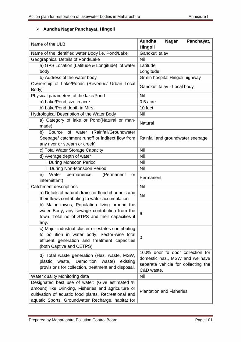
Action plan for restoration of lake/water bodies in Maharashtra Annexure I
Prepared by Maharashtra Pollution Control Board Page 101
Aundha Nagar Panchayat, Hingoli
Name of the ULB Aundha Nagar Panchayat,
Hingoli
Name of the identified water Body i.e. Pond/Lake Gandkuti talav
Geographical Details of Pond/Lake Nil
a) GPS Location (Latitude & Longitude) of water
body
Latitude
Longitude
b) Address of the water body Grmin hospital Hingoli highway
Ownership of Lake/Ponds (Revenue/ Urban Local
Body) Gandkuti talav - Local body
Physical parameters of the lake/Pond Nil
a) Lake/Pond size in acre 0.5 acre
b) Lake/Pond depth in Mtrs. 10 feet
Hydrological Description of the Water Body Nil
a) Category of lake or Pond(Natural or man-
made) Natural
b) Source of water (Rainfall/Groundwater
Seepage/ catchment runoff or indirect flow from
any river or stream or creek)
Rainfall and groundwater seepage
c) Total Water Storage Capacity Nil
d) Average depth of water Nil
i. During Monsoon Period Nil
ii. During Non-Monsoon Period Nil
e) Water permanence (Permanent or
intermittent) Permanent
Catchment descriptions Nil
a) Details of natural drains or flood channels and
their flows contributing to water accumulation Nil
b) Major towns, Population living around the
water Body, any sewage contribution from the
town. Total no of STPS and their capacities if
any.
6
c) Major industrial cluster or estates contributing
to pollution in water body. Sector-wise total
effluent generation and treatment capacities
(both Captive and CETPS)
0
d) Total waste generation (Haz. waste, MSW,
plastic waste, Demolition waste) existing
provisions for collection, treatment and disposal.
100% door to door collection for
domestic haz., MSW and we have
separate vehicle for collecting the
C&D waste.
Water quality Monitoring data Nil
Designated best use of water: (Give estimated %
amount) like Drinking, Fisheries and agriculture or
cultivation of aquatic food plants, Recreational and
aquatic Sports, Groundwater Recharge, habitat for
Plantation and Fisheries
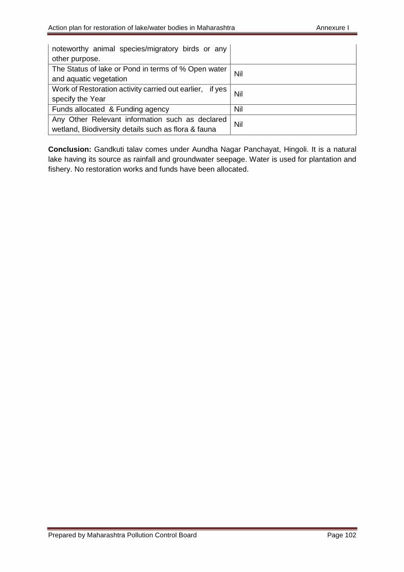
Action plan for restoration of lake/water bodies in Maharashtra Annexure I
Prepared by Maharashtra Pollution Control Board Page 102
noteworthy animal species/migratory birds or any
other purpose.
The Status of lake or Pond in terms of % Open water
and aquatic vegetation Nil
Work of Restoration activity carried out earlier, if yes
specify the Year Nil
Funds allocated & Funding agency Nil
Any Other Relevant information such as declared
wetland, Biodiversity details such as flora & fauna Nil
Conclusion: Gandkuti talav comes under Aundha Nagar Panchayat, Hingoli. It is a natural
lake having its source as rainfall and groundwater seepage. Water is used for plantation and
fishery. No restoration works and funds have been allocated.

Action plan for restoration of lake/water bodies in Maharashtra Annexure I
Prepared by Maharashtra Pollution Control Board Page 103
11) Pune
Pimpri Chinchwad Municipal Corporation
Name of the ULB Pimpri Chinchwad Municipal
Corporation
Name of the identified water Body i.e. Pond/Lake Ganesh Talav
Geographical Details of Pond/Lake
a) GPS Location (Latitude & Longitude) of water
body
Latitude 18°39'17.2" N
Longitude 73°45'47" E
b) Address of the water body Nighdi Pradhikaran
Ownership of Lake/Ponds (Revenue/ Urban Local
Body)
Pimpri Chinchwad Municipal
Corporation
Physical parameters of the lake/Pond
a) Lake/Pond size in acre Approx. 1.60 Acres
b) Lake/Pond depth in Mtrs. 3M
Hydrological Description of the Water Body
a) Category of lake or Pond(Natural or man-
made) Man Made
b) Source of water (Rainfall/Groundwater
Seepage/ catchment runoff or indirect flow from
any river or stream or creek)
Rainfall and Backwah water from
WTP
c) Total Water Storage Capacity
d) Average depth of water
i. During Monsoon Period 3 M
ii. During Non-Monsoon Period 3 M
e) Water permanence (Permanent or
intermittent) Intermittent
Catchment descriptions
a) Details of natural drains or flood channels and
their flows contributing to water accumulation Catchment area rainfall
b) Major towns, Population living around the
water Body, any sewage contribution from the
town. Total no of STPS and their capacities if
any.
Nighdi Pradhikaran
c) Major industrial cluster or estates contributing
to pollution in water body. Sector-wise total
effluent generation and treatment capacities
(both Captive and CETPS)
Nil
d) Total waste generation (Haz. waste, MSW,
plastic waste, Demolition waste) existing
provisions for collection, treatment and disposal.
Total Municipal Solid Waste
Generation of PCMC city is 950 to
1000TPD
Water quality Monitoring data Yes monitoring is done
Designated best use of water: (Give estimated %
amount) like Drinking, Fisheries and agriculture or
cultivation of aquatic food plants, Recreational and
aquatic Sports, Groundwater Recharge, habitat for
Only for gardening purpose
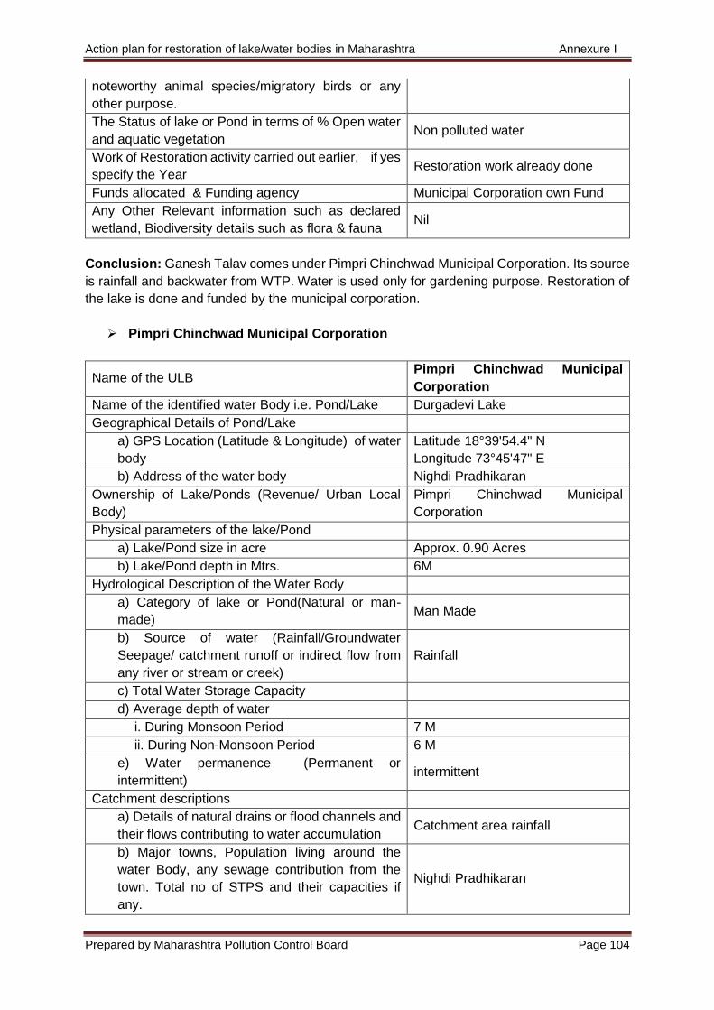
Action plan for restoration of lake/water bodies in Maharashtra Annexure I
Prepared by Maharashtra Pollution Control Board Page 104
noteworthy animal species/migratory birds or any
other purpose.
The Status of lake or Pond in terms of % Open water
and aquatic vegetation Non polluted water
Work of Restoration activity carried out earlier, if yes
specify the Year Restoration work already done
Funds allocated & Funding agency Municipal Corporation own Fund
Any Other Relevant information such as declared
wetland, Biodiversity details such as flora & fauna Nil
Conclusion: Ganesh Talav comes under Pimpri Chinchwad Municipal Corporation. Its source
is rainfall and backwater from WTP. Water is used only for gardening purpose. Restoration of
the lake is done and funded by the municipal corporation.
Pimpri Chinchwad Municipal Corporation
Name of the ULB Pimpri Chinchwad Municipal
Corporation
Name of the identified water Body i.e. Pond/Lake Durgadevi Lake
Geographical Details of Pond/Lake
a) GPS Location (Latitude & Longitude) of water
body
Latitude 18°39'54.4" N
Longitude 73°45'47" E
b) Address of the water body Nighdi Pradhikaran
Ownership of Lake/Ponds (Revenue/ Urban Local
Body)
Pimpri Chinchwad Municipal
Corporation
Physical parameters of the lake/Pond
a) Lake/Pond size in acre Approx. 0.90 Acres
b) Lake/Pond depth in Mtrs. 6M
Hydrological Description of the Water Body
a) Category of lake or Pond(Natural or man-
made) Man Made
b) Source of water (Rainfall/Groundwater
Seepage/ catchment runoff or indirect flow from
any river or stream or creek)
Rainfall
c) Total Water Storage Capacity
d) Average depth of water
i. During Monsoon Period 7 M
ii. During Non-Monsoon Period 6 M
e) Water permanence (Permanent or
intermittent) intermittent
Catchment descriptions
a) Details of natural drains or flood channels and
their flows contributing to water accumulation Catchment area rainfall
b) Major towns, Population living around the
water Body, any sewage contribution from the
town. Total no of STPS and their capacities if
any.
Nighdi Pradhikaran
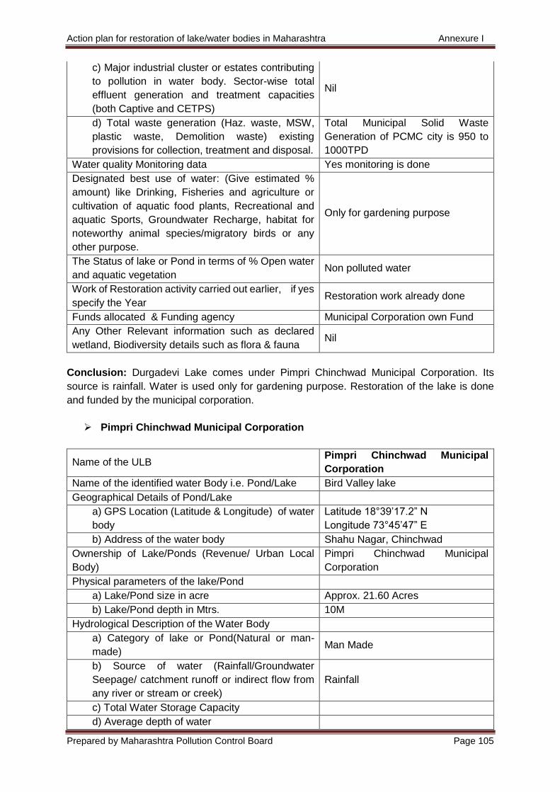
Action plan for restoration of lake/water bodies in Maharashtra Annexure I
Prepared by Maharashtra Pollution Control Board Page 105
c) Major industrial cluster or estates contributing
to pollution in water body. Sector-wise total
effluent generation and treatment capacities
(both Captive and CETPS)
Nil
d) Total waste generation (Haz. waste, MSW,
plastic waste, Demolition waste) existing
provisions for collection, treatment and disposal.
Total Municipal Solid Waste
Generation of PCMC city is 950 to
1000TPD
Water quality Monitoring data Yes monitoring is done
Designated best use of water: (Give estimated %
amount) like Drinking, Fisheries and agriculture or
cultivation of aquatic food plants, Recreational and
aquatic Sports, Groundwater Recharge, habitat for
noteworthy animal species/migratory birds or any
other purpose.
Only for gardening purpose
The Status of lake or Pond in terms of % Open water
and aquatic vegetation Non polluted water
Work of Restoration activity carried out earlier, if yes
specify the Year Restoration work already done
Funds allocated & Funding agency Municipal Corporation own Fund
Any Other Relevant information such as declared
wetland, Biodiversity details such as flora & fauna Nil
Conclusion: Durgadevi Lake comes under Pimpri Chinchwad Municipal Corporation. Its
source is rainfall. Water is used only for gardening purpose. Restoration of the lake is done
and funded by the municipal corporation.
Pimpri Chinchwad Municipal Corporation
Name of the ULB Pimpri Chinchwad Municipal
Corporation
Name of the identified water Body i.e. Pond/Lake Bird Valley lake
Geographical Details of Pond/Lake
a) GPS Location (Latitude & Longitude) of water
body
Latitude 18°39’17.2” N
Longitude 73°45’47” E
b) Address of the water body Shahu Nagar, Chinchwad
Ownership of Lake/Ponds (Revenue/ Urban Local
Body)
Pimpri Chinchwad Municipal
Corporation
Physical parameters of the lake/Pond
a) Lake/Pond size in acre Approx. 21.60 Acres
b) Lake/Pond depth in Mtrs. 10M
Hydrological Description of the Water Body
a) Category of lake or Pond(Natural or man-
made) Man Made
b) Source of water (Rainfall/Groundwater
Seepage/ catchment runoff or indirect flow from
any river or stream or creek)
Rainfall
c) Total Water Storage Capacity
d) Average depth of water
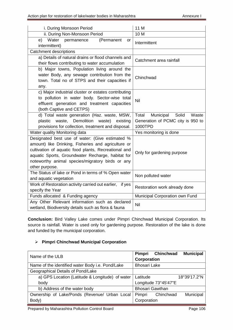
Action plan for restoration of lake/water bodies in Maharashtra Annexure I
Prepared by Maharashtra Pollution Control Board Page 106
i. During Monsoon Period 11 M
ii. During Non-Monsoon Period 10 M
e) Water permanence (Permanent or
intermittent) Intermittent
Catchment descriptions
a) Details of natural drains or flood channels and
their flows contributing to water accumulation Catchment area rainfall
b) Major towns, Population living around the
water Body, any sewage contribution from the
town. Total no of STPS and their capacities if
any.
Chinchwad
c) Major industrial cluster or estates contributing
to pollution in water body. Sector-wise total
effluent generation and treatment capacities
(both Captive and CETPS)
Nil
d) Total waste generation (Haz. waste, MSW,
plastic waste, Demolition waste) existing
provisions for collection, treatment and disposal.
Total Municipal Solid Waste
Generation of PCMC city is 950 to
1000TPD
Water quality Monitoring data Yes monitoring is done
Designated best use of water: (Give estimated %
amount) like Drinking, Fisheries and agriculture or
cultivation of aquatic food plants, Recreational and
aquatic Sports, Groundwater Recharge, habitat for
noteworthy animal species/migratory birds or any
other purpose.
Only for gardening purpose
The Status of lake or Pond in terms of % Open water
and aquatic vegetation Non polluted water
Work of Restoration activity carried out earlier, if yes
specify the Year Restoration work already done
Funds allocated & Funding agency Municipal Corporation own Fund
Any Other Relevant information such as declared
wetland, Biodiversity details such as flora & fauna Nil
Conclusion: Bird Valley Lake comes under Pimpri Chinchwad Municipal Corporation. Its
source is rainfall. Water is used only for gardening purpose. Restoration of the lake is done
and funded by the municipal corporation.
Pimpri Chinchwad Municipal Corporation
Name of the ULB Pimpri Chinchwad Municipal
Corporation
Name of the identified water Body i.e. Pond/Lake Bhosari Lake
Geographical Details of Pond/Lake
a) GPS Location (Latitude & Longitude) of water
body
Latitude 18°39'17.2"N
Longitude 73°45'47"E
b) Address of the water body Bhosari Gawthan
Ownership of Lake/Ponds (Revenue/ Urban Local
Body)
Pimpri Chinchwad Municipal
Corporation
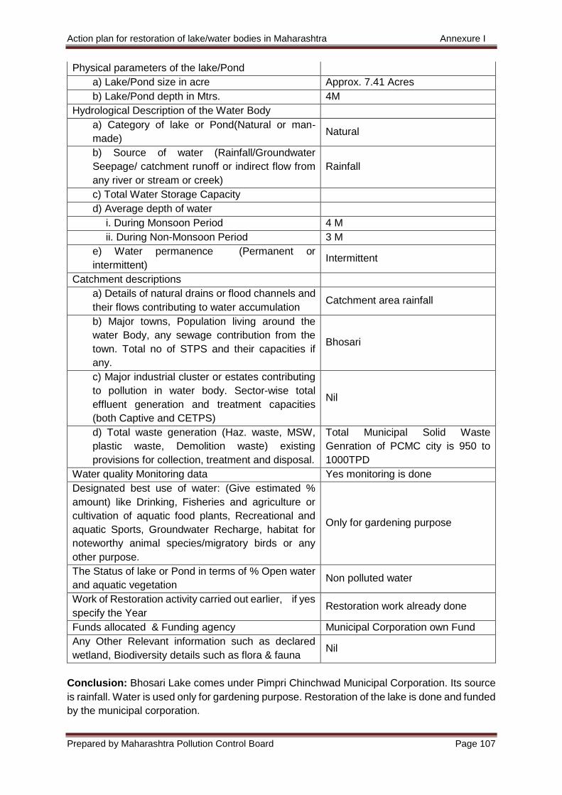
Action plan for restoration of lake/water bodies in Maharashtra Annexure I
Prepared by Maharashtra Pollution Control Board Page 107
Physical parameters of the lake/Pond
a) Lake/Pond size in acre Approx. 7.41 Acres
b) Lake/Pond depth in Mtrs. 4M
Hydrological Description of the Water Body
a) Category of lake or Pond(Natural or man-
made) Natural
b) Source of water (Rainfall/Groundwater
Seepage/ catchment runoff or indirect flow from
any river or stream or creek)
Rainfall
c) Total Water Storage Capacity
d) Average depth of water
i. During Monsoon Period 4 M
ii. During Non-Monsoon Period 3 M
e) Water permanence (Permanent or
intermittent) Intermittent
Catchment descriptions
a) Details of natural drains or flood channels and
their flows contributing to water accumulation Catchment area rainfall
b) Major towns, Population living around the
water Body, any sewage contribution from the
town. Total no of STPS and their capacities if
any.
Bhosari
c) Major industrial cluster or estates contributing
to pollution in water body. Sector-wise total
effluent generation and treatment capacities
(both Captive and CETPS)
Nil
d) Total waste generation (Haz. waste, MSW,
plastic waste, Demolition waste) existing
provisions for collection, treatment and disposal.
Total Municipal Solid Waste
Genration of PCMC city is 950 to
1000TPD
Water quality Monitoring data Yes monitoring is done
Designated best use of water: (Give estimated %
amount) like Drinking, Fisheries and agriculture or
cultivation of aquatic food plants, Recreational and
aquatic Sports, Groundwater Recharge, habitat for
noteworthy animal species/migratory birds or any
other purpose.
Only for gardening purpose
The Status of lake or Pond in terms of % Open water
and aquatic vegetation Non polluted water
Work of Restoration activity carried out earlier, if yes
specify the Year Restoration work already done
Funds allocated & Funding agency Municipal Corporation own Fund
Any Other Relevant information such as declared
wetland, Biodiversity details such as flora & fauna Nil
Conclusion: Bhosari Lake comes under Pimpri Chinchwad Municipal Corporation. Its source
is rainfall. Water is used only for gardening purpose. Restoration of the lake is done and funded
by the municipal corporation.
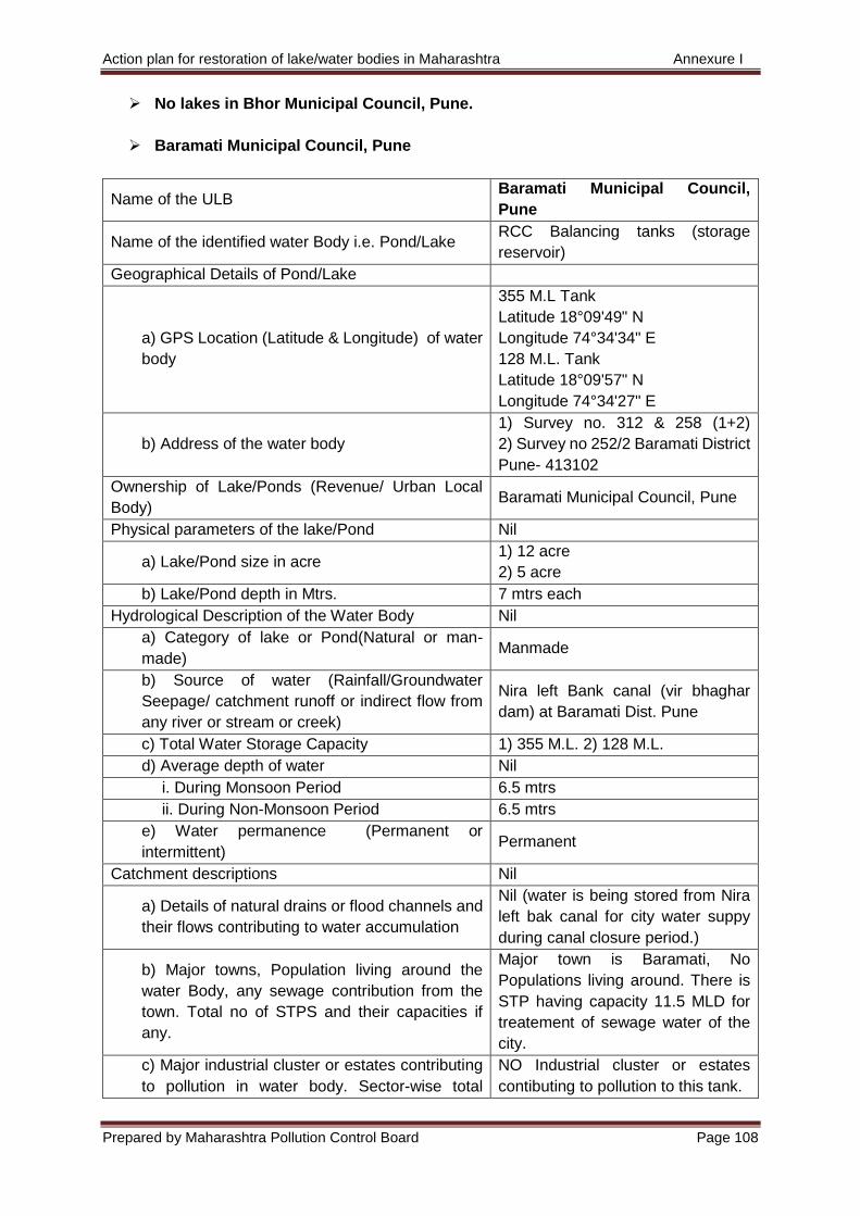
Action plan for restoration of lake/water bodies in Maharashtra Annexure I
Prepared by Maharashtra Pollution Control Board Page 108
No lakes in Bhor Municipal Council, Pune.
Baramati Municipal Council, Pune
Name of the ULB Baramati Municipal Council,
Pune
Name of the identified water Body i.e. Pond/Lake RCC Balancing tanks (storage
reservoir)
Geographical Details of Pond/Lake
a) GPS Location (Latitude & Longitude) of water
body
355 M.L Tank
Latitude 18°09'49" N
Longitude 74°34'34" E
128 M.L. Tank
Latitude 18°09'57" N
Longitude 74°34'27" E
b) Address of the water body
1) Survey no. 312 & 258 (1+2)
2) Survey no 252/2 Baramati District
Pune- 413102
Ownership of Lake/Ponds (Revenue/ Urban Local
Body) Baramati Municipal Council, Pune
Physical parameters of the lake/Pond Nil
a) Lake/Pond size in acre 1) 12 acre
2) 5 acre
b) Lake/Pond depth in Mtrs. 7 mtrs each
Hydrological Description of the Water Body Nil
a) Category of lake or Pond(Natural or man-
made) Manmade
b) Source of water (Rainfall/Groundwater
Seepage/ catchment runoff or indirect flow from
any river or stream or creek)
Nira left Bank canal (vir bhaghar
dam) at Baramati Dist. Pune
c) Total Water Storage Capacity 1) 355 M.L. 2) 128 M.L.
d) Average depth of water Nil
i. During Monsoon Period 6.5 mtrs
ii. During Non-Monsoon Period 6.5 mtrs
e) Water permanence (Permanent or
intermittent) Permanent
Catchment descriptions Nil
a) Details of natural drains or flood channels and
their flows contributing to water accumulation
Nil (water is being stored from Nira
left bak canal for city water suppy
during canal closure period.)
b) Major towns, Population living around the
water Body, any sewage contribution from the
town. Total no of STPS and their capacities if
any.
Major town is Baramati, No
Populations living around. There is
STP having capacity 11.5 MLD for
treatement of sewage water of the
city.
c) Major industrial cluster or estates contributing
to pollution in water body. Sector-wise total
NO Industrial cluster or estates
contibuting to pollution to this tank.
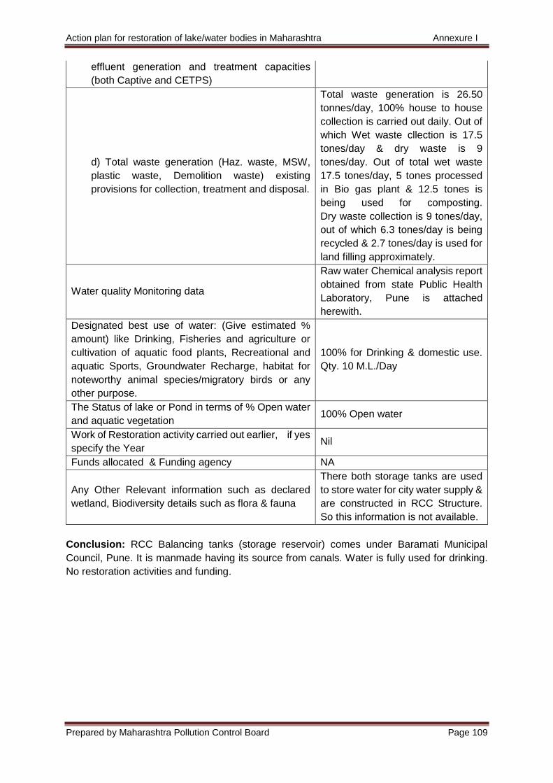
Action plan for restoration of lake/water bodies in Maharashtra Annexure I
Prepared by Maharashtra Pollution Control Board Page 109
effluent generation and treatment capacities
(both Captive and CETPS)
d) Total waste generation (Haz. waste, MSW,
plastic waste, Demolition waste) existing
provisions for collection, treatment and disposal.
Total waste generation is 26.50
tonnes/day, 100% house to house
collection is carried out daily. Out of
which Wet waste cllection is 17.5
tones/day & dry waste is 9
tones/day. Out of total wet waste
17.5 tones/day, 5 tones processed
in Bio gas plant & 12.5 tones is
being used for composting.
Dry waste collection is 9 tones/day,
out of which 6.3 tones/day is being
recycled & 2.7 tones/day is used for
land filling approximately.
Water quality Monitoring data
Raw water Chemical analysis report
obtained from state Public Health
Laboratory, Pune is attached
herewith.
Designated best use of water: (Give estimated %
amount) like Drinking, Fisheries and agriculture or
cultivation of aquatic food plants, Recreational and
aquatic Sports, Groundwater Recharge, habitat for
noteworthy animal species/migratory birds or any
other purpose.
100% for Drinking & domestic use.
Qty. 10 M.L./Day
The Status of lake or Pond in terms of % Open water
and aquatic vegetation 100% Open water
Work of Restoration activity carried out earlier, if yes
specify the Year Nil
Funds allocated & Funding agency NA
Any Other Relevant information such as declared
wetland, Biodiversity details such as flora & fauna
There both storage tanks are used
to store water for city water supply &
are constructed in RCC Structure.
So this information is not available.
Conclusion: RCC Balancing tanks (storage reservoir) comes under Baramati Municipal
Council, Pune. It is manmade having its source from canals. Water is fully used for drinking.
No restoration activities and funding.
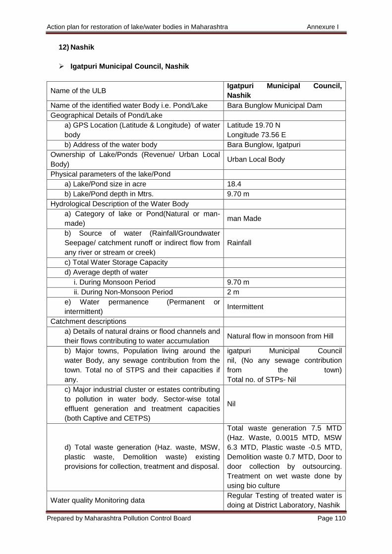
Action plan for restoration of lake/water bodies in Maharashtra Annexure I
Prepared by Maharashtra Pollution Control Board Page 110
12) Nashik
Igatpuri Municipal Council, Nashik
Name of the ULB Igatpuri Municipal Council,
Nashik
Name of the identified water Body i.e. Pond/Lake Bara Bunglow Municipal Dam
Geographical Details of Pond/Lake
a) GPS Location (Latitude & Longitude) of water
body
Latitude 19.70 N
Longitude 73.56 E
b) Address of the water body Bara Bunglow, Igatpuri
Ownership of Lake/Ponds (Revenue/ Urban Local
Body) Urban Local Body
Physical parameters of the lake/Pond
a) Lake/Pond size in acre 18.4
b) Lake/Pond depth in Mtrs. 9.70 m
Hydrological Description of the Water Body
a) Category of lake or Pond(Natural or man-
made) man Made
b) Source of water (Rainfall/Groundwater
Seepage/ catchment runoff or indirect flow from
any river or stream or creek)
Rainfall
c) Total Water Storage Capacity
d) Average depth of water
i. During Monsoon Period 9.70 m
ii. During Non-Monsoon Period 2 m
e) Water permanence (Permanent or
intermittent) Intermittent
Catchment descriptions
a) Details of natural drains or flood channels and
their flows contributing to water accumulation Natural flow in monsoon from Hill
b) Major towns, Population living around the
water Body, any sewage contribution from the
town. Total no of STPS and their capacities if
any.
igatpuri Municipal Council
nil, (No any sewage contribution
from the town)
Total no. of STPs- Nil
c) Major industrial cluster or estates contributing
to pollution in water body. Sector-wise total
effluent generation and treatment capacities
(both Captive and CETPS)
Nil
d) Total waste generation (Haz. waste, MSW,
plastic waste, Demolition waste) existing
provisions for collection, treatment and disposal.
Total waste generation 7.5 MTD
(Haz. Waste, 0.0015 MTD, MSW
6.3 MTD, Plastic waste -0.5 MTD,
Demolition waste 0.7 MTD, Door to
door collection by outsourcing.
Treatment on wet waste done by
using bio culture
Water quality Monitoring data Regular Testing of treated water is
doing at District Laboratory, Nashik
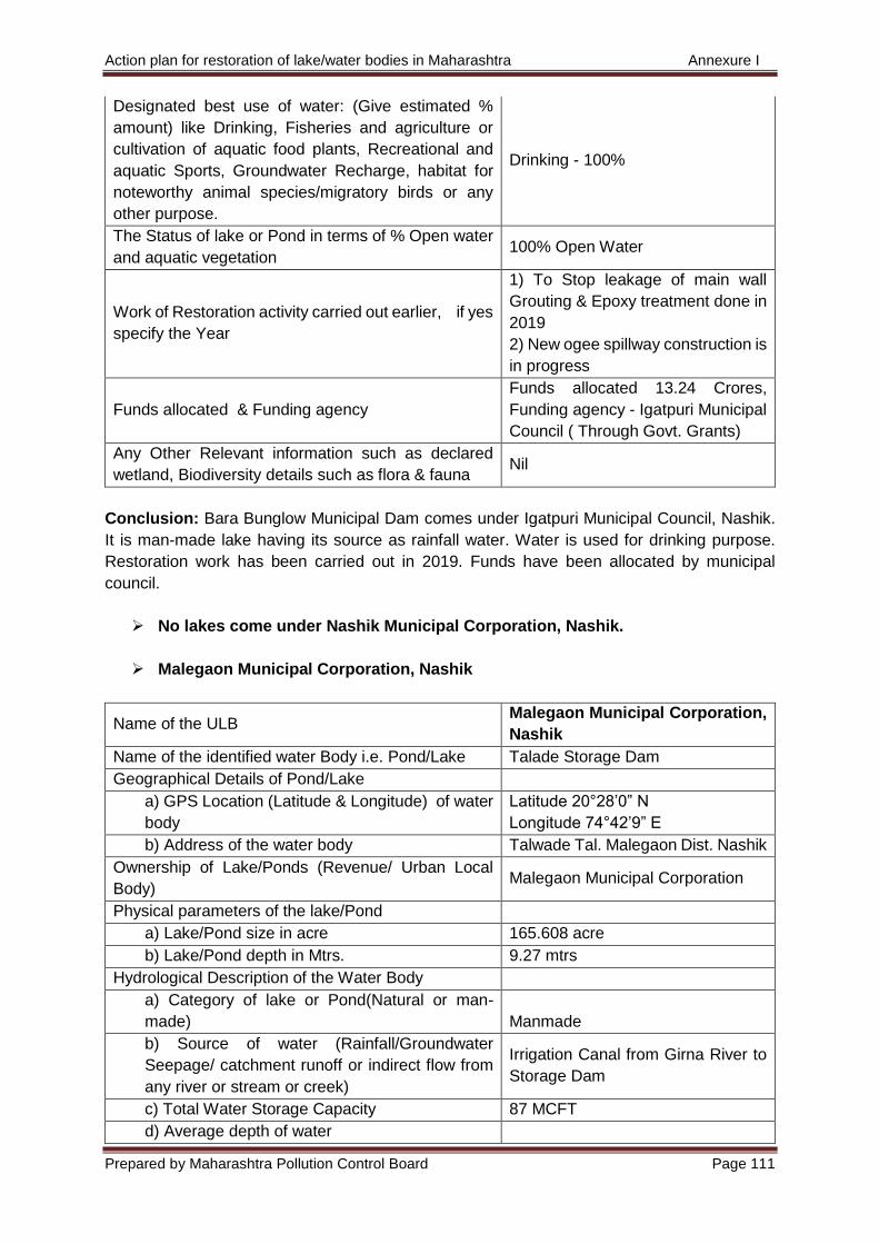
Action plan for restoration of lake/water bodies in Maharashtra Annexure I
Prepared by Maharashtra Pollution Control Board Page 111
Designated best use of water: (Give estimated %
amount) like Drinking, Fisheries and agriculture or
cultivation of aquatic food plants, Recreational and
aquatic Sports, Groundwater Recharge, habitat for
noteworthy animal species/migratory birds or any
other purpose.
Drinking - 100%
The Status of lake or Pond in terms of % Open water
and aquatic vegetation 100% Open Water
Work of Restoration activity carried out earlier, if yes
specify the Year
1) To Stop leakage of main wall
Grouting & Epoxy treatment done in
2019
2) New ogee spillway construction is
in progress
Funds allocated & Funding agency
Funds allocated 13.24 Crores,
Funding agency - Igatpuri Municipal
Council ( Through Govt. Grants)
Any Other Relevant information such as declared
wetland, Biodiversity details such as flora & fauna Nil
Conclusion: Bara Bunglow Municipal Dam comes under Igatpuri Municipal Council, Nashik.
It is man-made lake having its source as rainfall water. Water is used for drinking purpose.
Restoration work has been carried out in 2019. Funds have been allocated by municipal
council.
No lakes come under Nashik Municipal Corporation, Nashik.
Malegaon Municipal Corporation, Nashik
Name of the ULB Malegaon Municipal Corporation,
Nashik
Name of the identified water Body i.e. Pond/Lake Talade Storage Dam
Geographical Details of Pond/Lake
a) GPS Location (Latitude & Longitude) of water
body
Latitude 20°28’0” N
Longitude 74°42’9” E
b) Address of the water body Talwade Tal. Malegaon Dist. Nashik
Ownership of Lake/Ponds (Revenue/ Urban Local
Body) Malegaon Municipal Corporation
Physical parameters of the lake/Pond
a) Lake/Pond size in acre 165.608 acre
b) Lake/Pond depth in Mtrs. 9.27 mtrs
Hydrological Description of the Water Body
a) Category of lake or Pond(Natural or man-
made) Manmade
b) Source of water (Rainfall/Groundwater
Seepage/ catchment runoff or indirect flow from
any river or stream or creek)
Irrigation Canal from Girna River to
Storage Dam
c) Total Water Storage Capacity 87 MCFT
d) Average depth of water
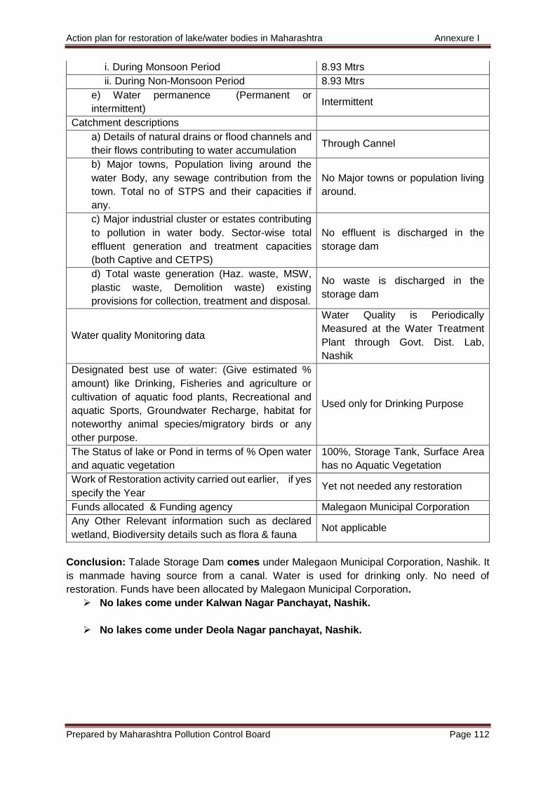
Action plan for restoration of lake/water bodies in Maharashtra Annexure I
Prepared by Maharashtra Pollution Control Board Page 112
i. During Monsoon Period 8.93 Mtrs
ii. During Non-Monsoon Period 8.93 Mtrs
e) Water permanence (Permanent or
intermittent) Intermittent
Catchment descriptions
a) Details of natural drains or flood channels and
their flows contributing to water accumulation Through Cannel
b) Major towns, Population living around the
water Body, any sewage contribution from the
town. Total no of STPS and their capacities if
any.
No Major towns or population living
around.
c) Major industrial cluster or estates contributing
to pollution in water body. Sector-wise total
effluent generation and treatment capacities
(both Captive and CETPS)
No effluent is discharged in the
storage dam
d) Total waste generation (Haz. waste, MSW,
plastic waste, Demolition waste) existing
provisions for collection, treatment and disposal.
No waste is discharged in the
storage dam
Water quality Monitoring data
Water Quality is Periodically
Measured at the Water Treatment
Plant through Govt. Dist. Lab,
Nashik
Designated best use of water: (Give estimated %
amount) like Drinking, Fisheries and agriculture or
cultivation of aquatic food plants, Recreational and
aquatic Sports, Groundwater Recharge, habitat for
noteworthy animal species/migratory birds or any
other purpose.
Used only for Drinking Purpose
The Status of lake or Pond in terms of % Open water
and aquatic vegetation
100%, Storage Tank, Surface Area
has no Aquatic Vegetation
Work of Restoration activity carried out earlier, if yes
specify the Year Yet not needed any restoration
Funds allocated & Funding agency Malegaon Municipal Corporation
Any Other Relevant information such as declared
wetland, Biodiversity details such as flora & fauna Not applicable
Conclusion: Talade Storage Dam comes under Malegaon Municipal Corporation, Nashik. It
is manmade having source from a canal. Water is used for drinking only. No need of
restoration. Funds have been allocated by Malegaon Municipal Corporation.
No lakes come under Kalwan Nagar Panchayat, Nashik.
No lakes come under Deola Nagar panchayat, Nashik.
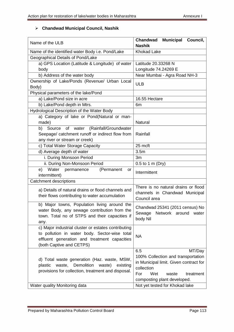
Action plan for restoration of lake/water bodies in Maharashtra Annexure I
Prepared by Maharashtra Pollution Control Board Page 113
Chandwad Municipal Council, Nashik
Name of the ULB Chandwad Municipal Council,
Nashik
Name of the identified water Body i.e. Pond/Lake Khokad Lake
Geographical Details of Pond/Lake
a) GPS Location (Latitude & Longitude) of water
body
Latitude 20.33268 N
Longitude 74.24269 E
b) Address of the water body Near Mumbai - Agra Road NH-3
Ownership of Lake/Ponds (Revenue/ Urban Local
Body) ULB
Physical parameters of the lake/Pond
a) Lake/Pond size in acre 16.55 Hectare
b) Lake/Pond depth in Mtrs. 6m
Hydrological Description of the Water Body
a) Category of lake or Pond(Natural or man-
made) Natural
b) Source of water (Rainfall/Groundwater
Seepage/ catchment runoff or indirect flow from
any river or stream or creek)
Rainfall
c) Total Water Storage Capacity 25 mcft
d) Average depth of water 3.5m
i. During Monsoon Period 3m
ii. During Non-Monsoon Period 0.5 to 1 m (Dry)
e) Water permanence (Permanent or
intermittent) Intermittent
Catchment descriptions
a) Details of natural drains or flood channels and
their flows contributing to water accumulation
There is no natural drains or flood
channels in Chandwad Municipal
Council area
b) Major towns, Population living around the
water Body, any sewage contribution from the
town. Total no of STPS and their capacities if
any.
Chandwad 25341 (2011 census) No
Sewage Network around water
body Nil
c) Major industrial cluster or estates contributing
to pollution in water body. Sector-wise total
effluent generation and treatment capacities
(both Captive and CETPS)
NA
d) Total waste generation (Haz. waste, MSW,
plastic waste, Demolition waste) existing
provisions for collection, treatment and disposal.
6.5 MT/Day
100% Collection and transportation
in Municipal limit. Given contract for
collection
For Wet waste treatment
composting plant developed.
Water quality Monitoring data Not yet tested for Khokad lake
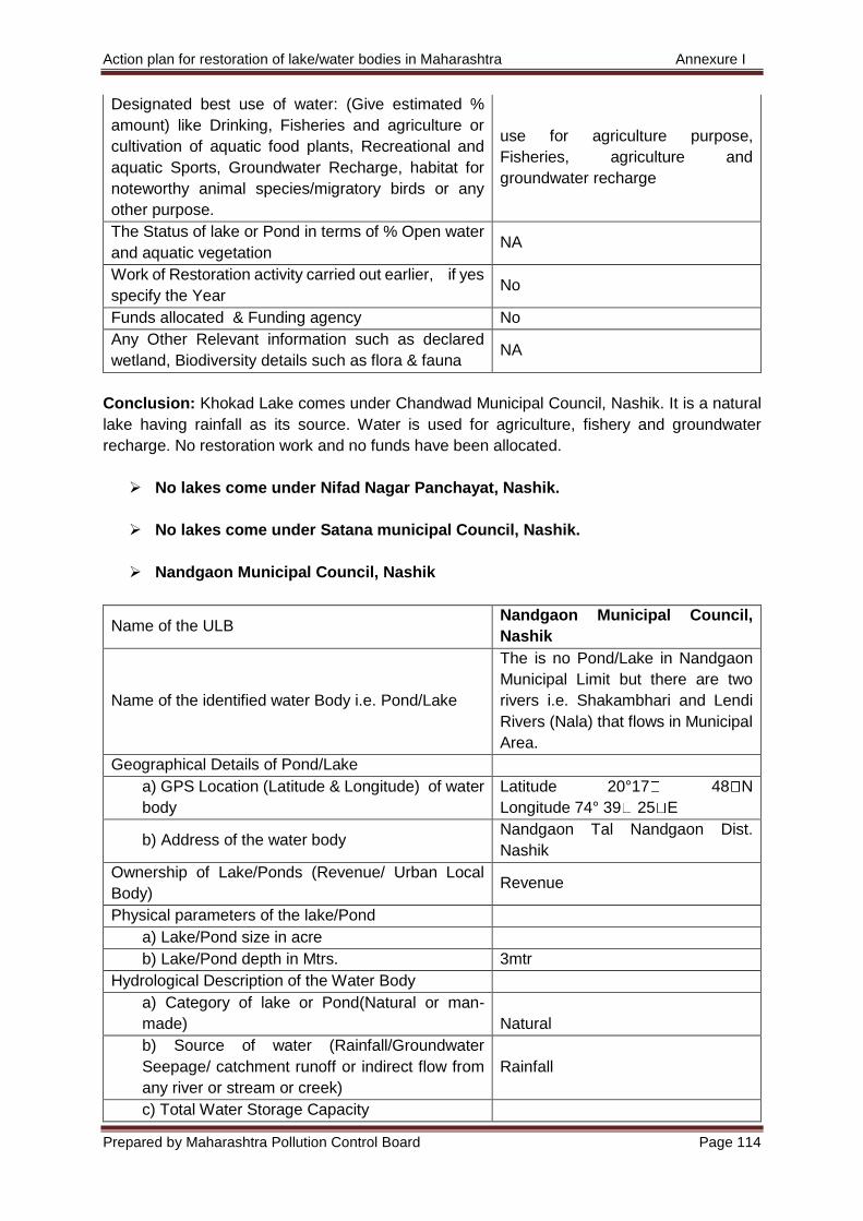
Action plan for restoration of lake/water bodies in Maharashtra Annexure I
Prepared by Maharashtra Pollution Control Board Page 114
Designated best use of water: (Give estimated %
amount) like Drinking, Fisheries and agriculture or
cultivation of aquatic food plants, Recreational and
aquatic Sports, Groundwater Recharge, habitat for
noteworthy animal species/migratory birds or any
other purpose.
use for agriculture purpose,
Fisheries, agriculture and
groundwater recharge
The Status of lake or Pond in terms of % Open water
and aquatic vegetation NA
Work of Restoration activity carried out earlier, if yes
specify the Year No
Funds allocated & Funding agency No
Any Other Relevant information such as declared
wetland, Biodiversity details such as flora & fauna NA
Conclusion: Khokad Lake comes under Chandwad Municipal Council, Nashik. It is a natural
lake having rainfall as its source. Water is used for agriculture, fishery and groundwater
recharge. No restoration work and no funds have been allocated.
No lakes come under Nifad Nagar Panchayat, Nashik.
No lakes come under Satana municipal Council, Nashik.
Nandgaon Municipal Council, Nashik
Name of the ULB Nandgaon Municipal Council,
Nashik
Name of the identified water Body i.e. Pond/Lake
The is no Pond/Lake in Nandgaon
Municipal Limit but there are two
rivers i.e. Shakambhari and Lendi
Rivers (Nala) that flows in Municipal
Area.
Geographical Details of Pond/Lake
a) GPS Location (Latitude & Longitude) of water
body
Latitude 20°17 48 N
Longitude 74° 39 25 E
b) Address of the water body Nandgaon Tal Nandgaon Dist.
Nashik
Ownership of Lake/Ponds (Revenue/ Urban Local
Body) Revenue
Physical parameters of the lake/Pond
a) Lake/Pond size in acre
b) Lake/Pond depth in Mtrs. 3mtr
Hydrological Description of the Water Body
a) Category of lake or Pond(Natural or man-
made) Natural
b) Source of water (Rainfall/Groundwater
Seepage/ catchment runoff or indirect flow from
any river or stream or creek)
Rainfall
c) Total Water Storage Capacity
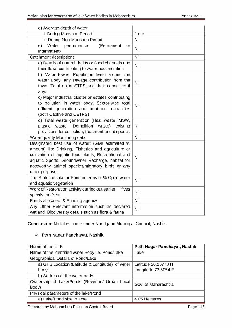
Action plan for restoration of lake/water bodies in Maharashtra Annexure I
Prepared by Maharashtra Pollution Control Board Page 115
d) Average depth of water
i. During Monsoon Period 1 mtr
ii. During Non-Monsoon Period Nil
e) Water permanence (Permanent or
intermittent) Nil
Catchment descriptions Nil
a) Details of natural drains or flood channels and
their flows contributing to water accumulation Nil
b) Major towns, Population living around the
water Body, any sewage contribution from the
town. Total no of STPS and their capacities if
any.
Nil
c) Major industrial cluster or estates contributing
to pollution in water body. Sector-wise total
effluent generation and treatment capacities
(both Captive and CETPS)
Nil
d) Total waste generation (Haz. waste, MSW,
plastic waste, Demolition waste) existing
provisions for collection, treatment and disposal.
Nil
Water quality Monitoring data Nil
Designated best use of water: (Give estimated %
amount) like Drinking, Fisheries and agriculture or
cultivation of aquatic food plants, Recreational and
aquatic Sports, Groundwater Recharge, habitat for
noteworthy animal species/migratory birds or any
other purpose.
Nil
The Status of lake or Pond in terms of % Open water
and aquatic vegetation Nil
Work of Restoration activity carried out earlier, if yes
specify the Year Nil
Funds allocated & Funding agency Nil
Any Other Relevant information such as declared
wetland, Biodiversity details such as flora & fauna Nil
Conclusion: No lakes come under Nandgaon Municipal Council, Nashik.
Peth Nagar Panchayat, Nashik
Name of the ULB Peth Nagar Panchayat, Nashik
Name of the identified water Body i.e. Pond/Lake Lake
Geographical Details of Pond/Lake
a) GPS Location (Latitude & Longitude) of water
body
Latitude 20.25778 N
Longitude 73.5054 E
b) Address of the water body
Ownership of Lake/Ponds (Revenue/ Urban Local
Body) Gov. of Maharashtra
Physical parameters of the lake/Pond
a) Lake/Pond size in acre 4.05 Hectares
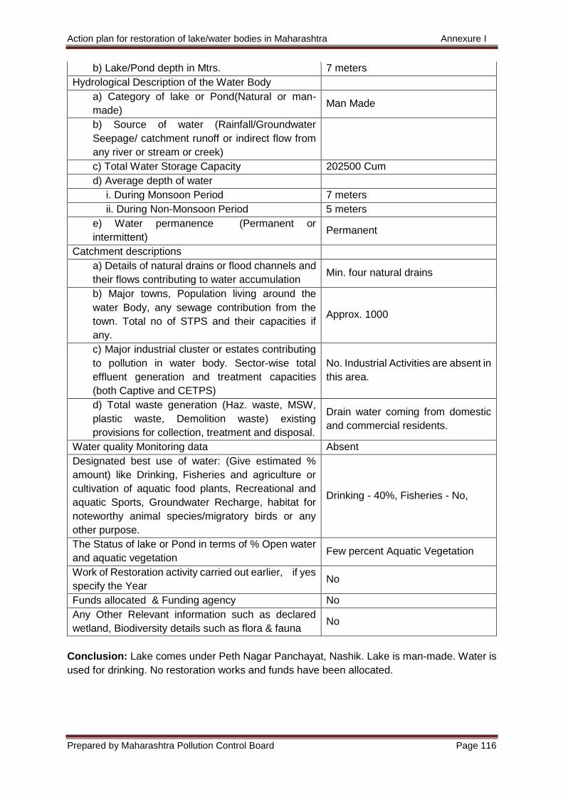
Action plan for restoration of lake/water bodies in Maharashtra Annexure I
Prepared by Maharashtra Pollution Control Board Page 116
b) Lake/Pond depth in Mtrs. 7 meters
Hydrological Description of the Water Body
a) Category of lake or Pond(Natural or man-
made) Man Made
b) Source of water (Rainfall/Groundwater
Seepage/ catchment runoff or indirect flow from
any river or stream or creek)
c) Total Water Storage Capacity 202500 Cum
d) Average depth of water
i. During Monsoon Period 7 meters
ii. During Non-Monsoon Period 5 meters
e) Water permanence (Permanent or
intermittent) Permanent
Catchment descriptions
a) Details of natural drains or flood channels and
their flows contributing to water accumulation Min. four natural drains
b) Major towns, Population living around the
water Body, any sewage contribution from the
town. Total no of STPS and their capacities if
any.
Approx. 1000
c) Major industrial cluster or estates contributing
to pollution in water body. Sector-wise total
effluent generation and treatment capacities
(both Captive and CETPS)
No. Industrial Activities are absent in
this area.
d) Total waste generation (Haz. waste, MSW,
plastic waste, Demolition waste) existing
provisions for collection, treatment and disposal.
Drain water coming from domestic
and commercial residents.
Water quality Monitoring data Absent
Designated best use of water: (Give estimated %
amount) like Drinking, Fisheries and agriculture or
cultivation of aquatic food plants, Recreational and
aquatic Sports, Groundwater Recharge, habitat for
noteworthy animal species/migratory birds or any
other purpose.
Drinking - 40%, Fisheries - No,
The Status of lake or Pond in terms of % Open water
and aquatic vegetation Few percent Aquatic Vegetation
Work of Restoration activity carried out earlier, if yes
specify the Year No
Funds allocated & Funding agency No
Any Other Relevant information such as declared
wetland, Biodiversity details such as flora & fauna No
Conclusion: Lake comes under Peth Nagar Panchayat, Nashik. Lake is man-made. Water is
used for drinking. No restoration works and funds have been allocated.
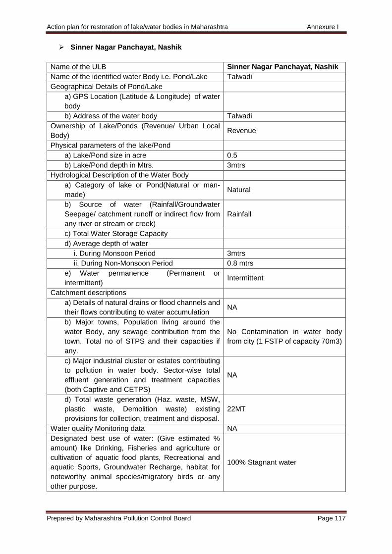
Action plan for restoration of lake/water bodies in Maharashtra Annexure I
Prepared by Maharashtra Pollution Control Board Page 117
Sinner Nagar Panchayat, Nashik
Name of the ULB Sinner Nagar Panchayat, Nashik
Name of the identified water Body i.e. Pond/Lake Talwadi
Geographical Details of Pond/Lake
a) GPS Location (Latitude & Longitude) of water
body
b) Address of the water body Talwadi
Ownership of Lake/Ponds (Revenue/ Urban Local
Body) Revenue
Physical parameters of the lake/Pond
a) Lake/Pond size in acre 0.5
b) Lake/Pond depth in Mtrs. 3mtrs
Hydrological Description of the Water Body
a) Category of lake or Pond(Natural or man-
made) Natural
b) Source of water (Rainfall/Groundwater
Seepage/ catchment runoff or indirect flow from
any river or stream or creek)
Rainfall
c) Total Water Storage Capacity
d) Average depth of water
i. During Monsoon Period 3mtrs
ii. During Non-Monsoon Period 0.8 mtrs
e) Water permanence (Permanent or
intermittent) Intermittent
Catchment descriptions
a) Details of natural drains or flood channels and
their flows contributing to water accumulation NA
b) Major towns, Population living around the
water Body, any sewage contribution from the
town. Total no of STPS and their capacities if
any.
No Contamination in water body
from city (1 FSTP of capacity 70m3)
c) Major industrial cluster or estates contributing
to pollution in water body. Sector-wise total
effluent generation and treatment capacities
(both Captive and CETPS)
NA
d) Total waste generation (Haz. waste, MSW,
plastic waste, Demolition waste) existing
provisions for collection, treatment and disposal.
22MT
Water quality Monitoring data NA
Designated best use of water: (Give estimated %
amount) like Drinking, Fisheries and agriculture or
cultivation of aquatic food plants, Recreational and
aquatic Sports, Groundwater Recharge, habitat for
noteworthy animal species/migratory birds or any
other purpose.
100% Stagnant water
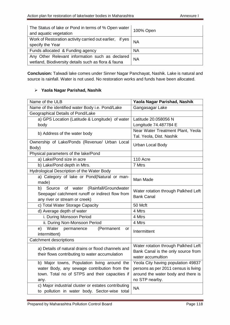
Action plan for restoration of lake/water bodies in Maharashtra Annexure I
Prepared by Maharashtra Pollution Control Board Page 118
The Status of lake or Pond in terms of % Open water
and aquatic vegetation 100% Open
Work of Restoration activity carried out earlier, if yes
specify the Year NA
Funds allocated & Funding agency NA
Any Other Relevant information such as declared
wetland, Biodiversity details such as flora & fauna NA
Conclusion: Talwadi lake comes under Sinner Nagar Panchayat, Nashik. Lake is natural and
source is rainfall. Water is not used. No restoration works and funds have been allocated.
Yaola Nagar Parishad, Nashik
Name of the ULB Yaola Nagar Parishad, Nashik
Name of the identified water Body i.e. Pond/Lake Gangasagar Lake
Geographical Details of Pond/Lake
a) GPS Location (Latitude & Longitude) of water
body
Latitude 20.058056 N
Longitude 74.487784 E
b) Address of the water body Near Water Treatment Plant, Yeola
Tal. Yeola, Dist. Nashik
Ownership of Lake/Ponds (Revenue/ Urban Local
Body) Urban Local Body
Physical parameters of the lake/Pond
a) Lake/Pond size in acre 110 Acre
b) Lake/Pond depth in Mtrs. 7 Mtrs
Hydrological Description of the Water Body
a) Category of lake or Pond(Natural or man-
made) Man Made
b) Source of water (Rainfall/Groundwater
Seepage/ catchment runoff or indirect flow from
any river or stream or creek)
Water rotation through Palkhed Left
Bank Canal
c) Total Water Storage Capacity 50 Mcft
d) Average depth of water 4 Mtrs
i. During Monsoon Period 4 Mtrs
ii. During Non-Monsoon Period 4 Mtrs
e) Water permanence (Permanent or
intermittent) Intermittent
Catchment descriptions
a) Details of natural drains or flood channels and
their flows contributing to water accumulation
Water rotation through Palkhed Left
Bank Canal is the only source from
water accumultion
b) Major towns, Population living around the
water Body, any sewage contribution from the
town. Total no of STPS and their capacities if
any.
Yeola City having population 49837
persons as per 2011 census is living
around the water body and there is
no STP nearby.
c) Major industrial cluster or estates contributing
to pollution in water body. Sector-wise total NA
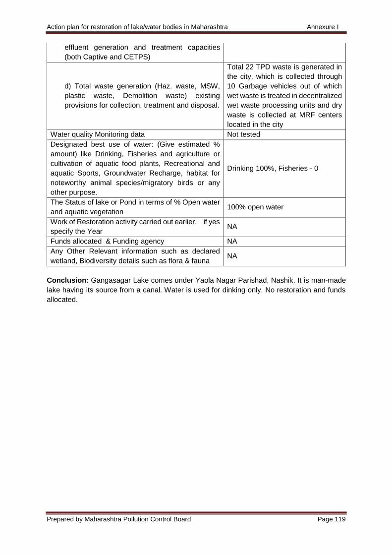
Action plan for restoration of lake/water bodies in Maharashtra Annexure I
Prepared by Maharashtra Pollution Control Board Page 119
effluent generation and treatment capacities
(both Captive and CETPS)
d) Total waste generation (Haz. waste, MSW,
plastic waste, Demolition waste) existing
provisions for collection, treatment and disposal.
Total 22 TPD waste is generated in
the city, which is collected through
10 Garbage vehicles out of which
wet waste is treated in decentralized
wet waste processing units and dry
waste is collected at MRF centers
located in the city
Water quality Monitoring data Not tested
Designated best use of water: (Give estimated %
amount) like Drinking, Fisheries and agriculture or
cultivation of aquatic food plants, Recreational and
aquatic Sports, Groundwater Recharge, habitat for
noteworthy animal species/migratory birds or any
other purpose.
Drinking 100%, Fisheries - 0
The Status of lake or Pond in terms of % Open water
and aquatic vegetation 100% open water
Work of Restoration activity carried out earlier, if yes
specify the Year NA
Funds allocated & Funding agency NA
Any Other Relevant information such as declared
wetland, Biodiversity details such as flora & fauna NA
Conclusion: Gangasagar Lake comes under Yaola Nagar Parishad, Nashik. It is man-made
lake having its source from a canal. Water is used for dinking only. No restoration and funds
allocated.
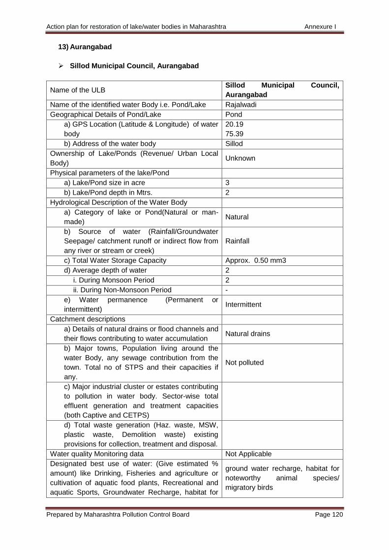
Action plan for restoration of lake/water bodies in Maharashtra Annexure I
Prepared by Maharashtra Pollution Control Board Page 120
13) Aurangabad
Sillod Municipal Council, Aurangabad
Name of the ULB Sillod Municipal Council,
Aurangabad
Name of the identified water Body i.e. Pond/Lake Rajalwadi
Geographical Details of Pond/Lake Pond
a) GPS Location (Latitude & Longitude) of water
body
20.19
75.39
b) Address of the water body Sillod
Ownership of Lake/Ponds (Revenue/ Urban Local
Body) Unknown
Physical parameters of the lake/Pond
a) Lake/Pond size in acre 3
b) Lake/Pond depth in Mtrs. 2
Hydrological Description of the Water Body
a) Category of lake or Pond(Natural or man-
made) Natural
b) Source of water (Rainfall/Groundwater
Seepage/ catchment runoff or indirect flow from
any river or stream or creek)
Rainfall
c) Total Water Storage Capacity Approx. 0.50 mm3
d) Average depth of water 2
i. During Monsoon Period 2
ii. During Non-Monsoon Period -
e) Water permanence (Permanent or
intermittent) Intermittent
Catchment descriptions
a) Details of natural drains or flood channels and
their flows contributing to water accumulation Natural drains
b) Major towns, Population living around the
water Body, any sewage contribution from the
town. Total no of STPS and their capacities if
any.
Not polluted
c) Major industrial cluster or estates contributing
to pollution in water body. Sector-wise total
effluent generation and treatment capacities
(both Captive and CETPS)
d) Total waste generation (Haz. waste, MSW,
plastic waste, Demolition waste) existing
provisions for collection, treatment and disposal.
Water quality Monitoring data Not Applicable
Designated best use of water: (Give estimated %
amount) like Drinking, Fisheries and agriculture or
cultivation of aquatic food plants, Recreational and
aquatic Sports, Groundwater Recharge, habitat for
ground water recharge, habitat for
noteworthy animal species/
migratory birds
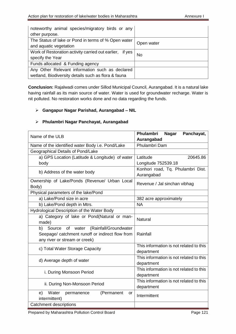
Action plan for restoration of lake/water bodies in Maharashtra Annexure I
Prepared by Maharashtra Pollution Control Board Page 121
noteworthy animal species/migratory birds or any
other purpose.
The Status of lake or Pond in terms of % Open water
and aquatic vegetation Open water
Work of Restoration activity carried out earlier, if yes
specify the Year No
Funds allocated & Funding agency
Any Other Relevant information such as declared
wetland, Biodiversity details such as flora & fauna
Conclusion: Rajalwadi comes under Sillod Municipal Council, Aurangabad. It is a natural lake
having rainfall as its main source of water. Water is used for groundwater recharge. Water is
nit polluted. No restoration works done and no data regarding the funds.
Gangapur Nagar Parishad, Aurangabad – NIL
Phulambri Nagar Panchayat, Aurangabad
Name of the ULB Phulambri Nagar Panchayat,
Aurangabad
Name of the identified water Body i.e. Pond/Lake Phulambri Dam
Geographical Details of Pond/Lake
a) GPS Location (Latitude & Longitude) of water
body
Latitude 20645.86
Longitude 752539.18
b) Address of the water body Konhori road, Tq. Phulambri Dist.
Aurangabad
Ownership of Lake/Ponds (Revenue/ Urban Local
Body) Revenue / Jal sinchan vibhag
Physical parameters of the lake/Pond
a) Lake/Pond size in acre 382 acre approximately
b) Lake/Pond depth in Mtrs. NA
Hydrological Description of the Water Body
a) Category of lake or Pond(Natural or man-
made) Natural
b) Source of water (Rainfall/Groundwater
Seepage/ catchment runoff or indirect flow from
any river or stream or creek)
Rainfall
c) Total Water Storage Capacity This information is not related to this
department
d) Average depth of water This information is not related to this
department
i. During Monsoon Period This information is not related to this
department
ii. During Non-Monsoon Period This information is not related to this
department
e) Water permanence (Permanent or
intermittent) Intermittent
Catchment descriptions
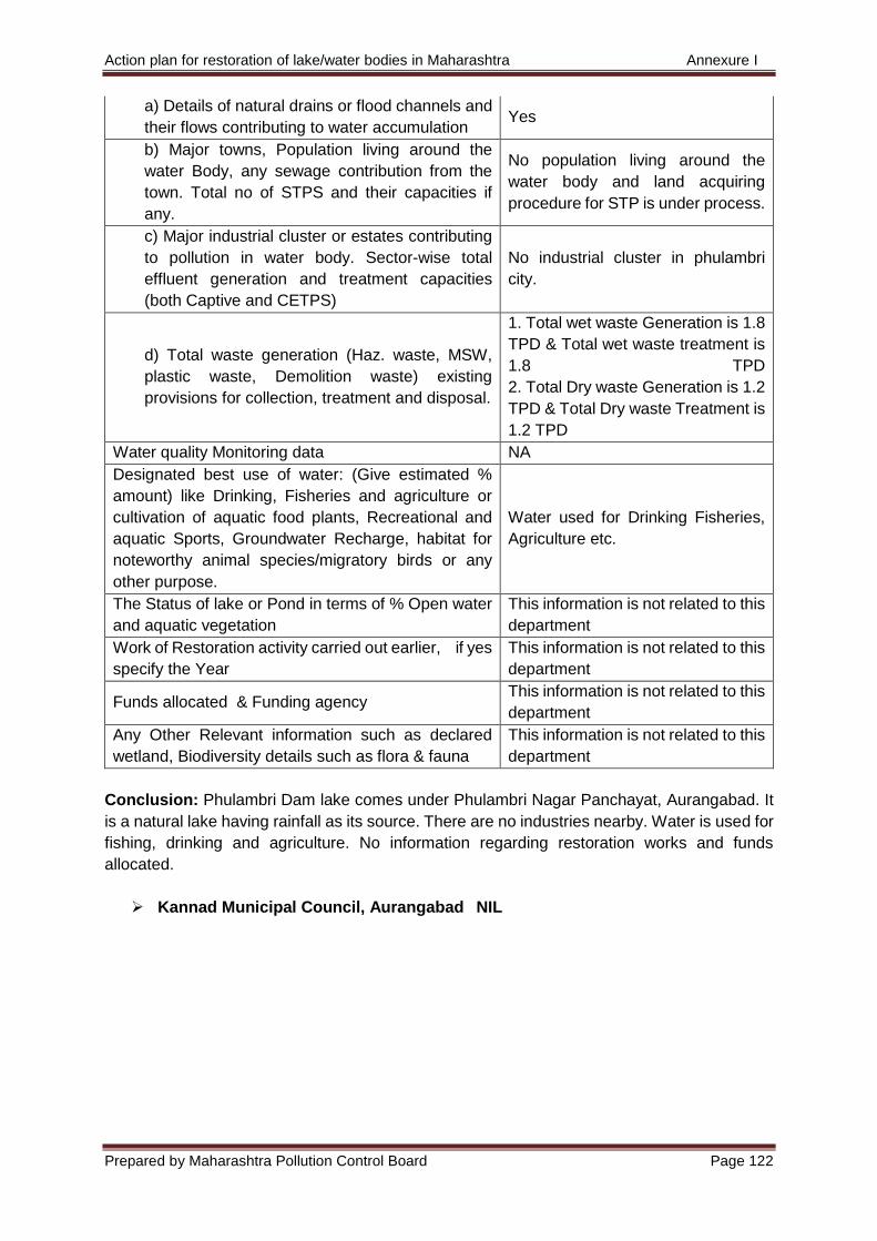
Action plan for restoration of lake/water bodies in Maharashtra Annexure I
Prepared by Maharashtra Pollution Control Board Page 122
a) Details of natural drains or flood channels and
their flows contributing to water accumulation Yes
b) Major towns, Population living around the
water Body, any sewage contribution from the
town. Total no of STPS and their capacities if
any.
No population living around the
water body and land acquiring
procedure for STP is under process.
c) Major industrial cluster or estates contributing
to pollution in water body. Sector-wise total
effluent generation and treatment capacities
(both Captive and CETPS)
No industrial cluster in phulambri
city.
d) Total waste generation (Haz. waste, MSW,
plastic waste, Demolition waste) existing
provisions for collection, treatment and disposal.
1. Total wet waste Generation is 1.8
TPD & Total wet waste treatment is
1.8 TPD
2. Total Dry waste Generation is 1.2
TPD & Total Dry waste Treatment is
1.2 TPD
Water quality Monitoring data NA
Designated best use of water: (Give estimated %
amount) like Drinking, Fisheries and agriculture or
cultivation of aquatic food plants, Recreational and
aquatic Sports, Groundwater Recharge, habitat for
noteworthy animal species/migratory birds or any
other purpose.
Water used for Drinking Fisheries,
Agriculture etc.
The Status of lake or Pond in terms of % Open water
and aquatic vegetation
This information is not related to this
department
Work of Restoration activity carried out earlier, if yes
specify the Year
This information is not related to this
department
Funds allocated & Funding agency This information is not related to this
department
Any Other Relevant information such as declared
wetland, Biodiversity details such as flora & fauna
This information is not related to this
department
Conclusion: Phulambri Dam lake comes under Phulambri Nagar Panchayat, Aurangabad. It
is a natural lake having rainfall as its source. There are no industries nearby. Water is used for
fishing, drinking and agriculture. No information regarding restoration works and funds
allocated.
Kannad Municipal Council, Aurangabad NIL
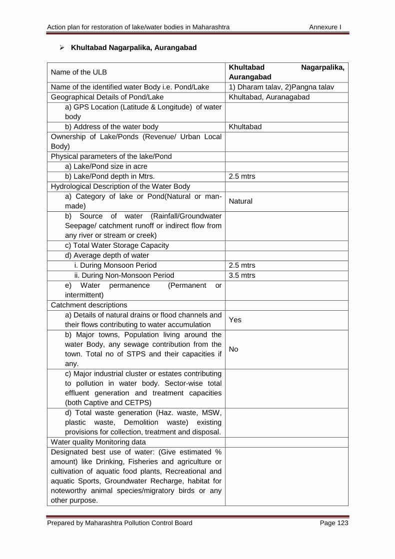
Action plan for restoration of lake/water bodies in Maharashtra Annexure I
Prepared by Maharashtra Pollution Control Board Page 123
Khultabad Nagarpalika, Aurangabad
Name of the ULB Khultabad Nagarpalika,
Aurangabad
Name of the identified water Body i.e. Pond/Lake 1) Dharam talav, 2)Pangna talav
Geographical Details of Pond/Lake Khultabad, Auranagabad
a) GPS Location (Latitude & Longitude) of water
body
b) Address of the water body Khultabad
Ownership of Lake/Ponds (Revenue/ Urban Local
Body)
Physical parameters of the lake/Pond
a) Lake/Pond size in acre
b) Lake/Pond depth in Mtrs. 2.5 mtrs
Hydrological Description of the Water Body
a) Category of lake or Pond(Natural or man-
made) Natural
b) Source of water (Rainfall/Groundwater
Seepage/ catchment runoff or indirect flow from
any river or stream or creek)
c) Total Water Storage Capacity
d) Average depth of water
i. During Monsoon Period 2.5 mtrs
ii. During Non-Monsoon Period 3.5 mtrs
e) Water permanence (Permanent or
intermittent)
Catchment descriptions
a) Details of natural drains or flood channels and
their flows contributing to water accumulation Yes
b) Major towns, Population living around the
water Body, any sewage contribution from the
town. Total no of STPS and their capacities if
any.
No
c) Major industrial cluster or estates contributing
to pollution in water body. Sector-wise total
effluent generation and treatment capacities
(both Captive and CETPS)
d) Total waste generation (Haz. waste, MSW,
plastic waste, Demolition waste) existing
provisions for collection, treatment and disposal.
Water quality Monitoring data
Designated best use of water: (Give estimated %
amount) like Drinking, Fisheries and agriculture or
cultivation of aquatic food plants, Recreational and
aquatic Sports, Groundwater Recharge, habitat for
noteworthy animal species/migratory birds or any
other purpose.

Action plan for restoration of lake/water bodies in Maharashtra Annexure I
Prepared by Maharashtra Pollution Control Board Page 124
The Status of lake or Pond in terms of % Open water
and aquatic vegetation 30%
Work of Restoration activity carried out earlier, if yes
specify the Year No
Funds allocated & Funding agency No
Any Other Relevant information such as declared
wetland, Biodiversity details such as flora & fauna No
Conclusion: Dharam talav and Pangna talav come under Khultabad Nagarpalika,
Aurangabad. They are natural lakes. It has no restoration works and no data regarding the
funds allocated.
Paithan Municipal Council, Aurangabad - NIL
No lakes come under Soygaon Nagar Panchayat, Aurangabad.
No lakes come under Vaijapur Municipal Council, Aurangabad.
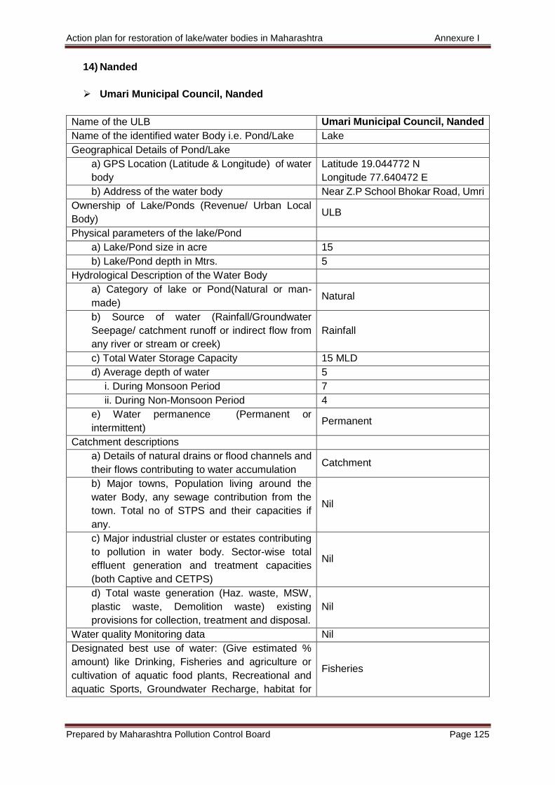
Action plan for restoration of lake/water bodies in Maharashtra Annexure I
Prepared by Maharashtra Pollution Control Board Page 125
14) Nanded
Umari Municipal Council, Nanded
Name of the ULB Umari Municipal Council, Nanded
Name of the identified water Body i.e. Pond/Lake Lake
Geographical Details of Pond/Lake
a) GPS Location (Latitude & Longitude) of water
body
Latitude 19.044772 N
Longitude 77.640472 E
b) Address of the water body Near Z.P School Bhokar Road, Umri
Ownership of Lake/Ponds (Revenue/ Urban Local
Body) ULB
Physical parameters of the lake/Pond
a) Lake/Pond size in acre 15
b) Lake/Pond depth in Mtrs. 5
Hydrological Description of the Water Body
a) Category of lake or Pond(Natural or man-
made) Natural
b) Source of water (Rainfall/Groundwater
Seepage/ catchment runoff or indirect flow from
any river or stream or creek)
Rainfall
c) Total Water Storage Capacity 15 MLD
d) Average depth of water 5
i. During Monsoon Period 7
ii. During Non-Monsoon Period 4
e) Water permanence (Permanent or
intermittent) Permanent
Catchment descriptions
a) Details of natural drains or flood channels and
their flows contributing to water accumulation Catchment
b) Major towns, Population living around the
water Body, any sewage contribution from the
town. Total no of STPS and their capacities if
any.
Nil
c) Major industrial cluster or estates contributing
to pollution in water body. Sector-wise total
effluent generation and treatment capacities
(both Captive and CETPS)
Nil
d) Total waste generation (Haz. waste, MSW,
plastic waste, Demolition waste) existing
provisions for collection, treatment and disposal.
Nil
Water quality Monitoring data Nil
Designated best use of water: (Give estimated %
amount) like Drinking, Fisheries and agriculture or
cultivation of aquatic food plants, Recreational and
aquatic Sports, Groundwater Recharge, habitat for
Fisheries
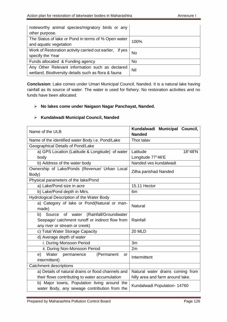
Action plan for restoration of lake/water bodies in Maharashtra Annexure I
Prepared by Maharashtra Pollution Control Board Page 126
noteworthy animal species/migratory birds or any
other purpose.
The Status of lake or Pond in terms of % Open water
and aquatic vegetation 100%
Work of Restoration activity carried out earlier, if yes
specify the Year No
Funds allocated & Funding agency No
Any Other Relevant information such as declared
wetland, Biodiversity details such as flora & fauna Nil
Conclusion: Lake comes under Umari Municipal Council, Nanded. It is a natural lake having
rainfall as its source of water. The water is used for fishery. No restoration activities and no
funds have been allocated.
No lakes come under Naigaon Nagar Panchayat, Nanded.
Kundalwadi Municipal Council, Nanded
Name of the ULB Kundalwadi Municipal Council,
Nanded
Name of the identified water Body i.e. Pond/Lake Thor talav
Geographical Details of Pond/Lake
a) GPS Location (Latitude & Longitude) of water
body
Latitude 18°48'N
Longitude 77°46'E
b) Address of the water body Nanded ves kundalwadi
Ownership of Lake/Ponds (Revenue/ Urban Local
Body) Zilha parishad Nanded
Physical parameters of the lake/Pond
a) Lake/Pond size in acre 15.11 Hector
b) Lake/Pond depth in Mtrs. 6m
Hydrological Description of the Water Body
a) Category of lake or Pond(Natural or man-
made) Natural
b) Source of water (Rainfall/Groundwater
Seepage/ catchment runoff or indirect flow from
any river or stream or creek)
Rainfall
c) Total Water Storage Capacity 20 MLD
d) Average depth of water
i. During Monsoon Period 3m
ii. During Non-Monsoon Period 2m
e) Water permanence (Permanent or
intermittent) Intermittent
Catchment descriptions
a) Details of natural drains or flood channels and
their flows contributing to water accumulation
Natural water drains coming from
hilly area and farm around lake.
b) Major towns, Population living around the
water Body, any sewage contribution from the Kundalwadi Population- 14760
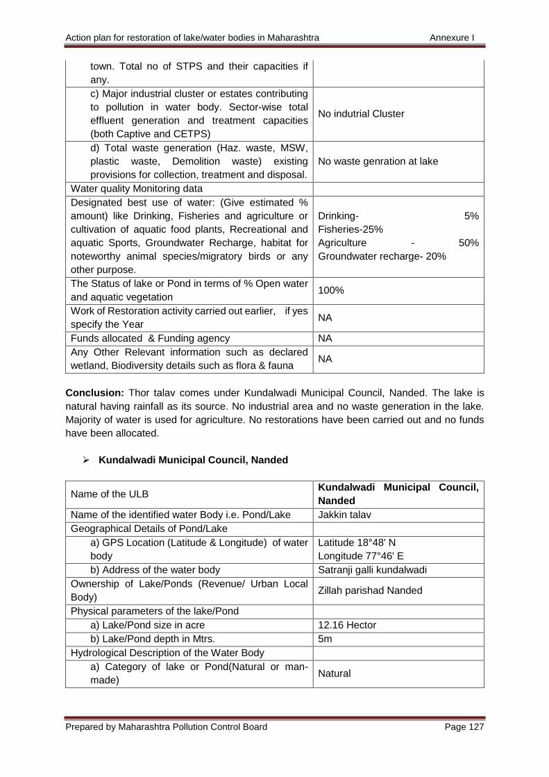
Action plan for restoration of lake/water bodies in Maharashtra Annexure I
Prepared by Maharashtra Pollution Control Board Page 127
town. Total no of STPS and their capacities if
any.
c) Major industrial cluster or estates contributing
to pollution in water body. Sector-wise total
effluent generation and treatment capacities
(both Captive and CETPS)
No indutrial Cluster
d) Total waste generation (Haz. waste, MSW,
plastic waste, Demolition waste) existing
provisions for collection, treatment and disposal.
No waste genration at lake
Water quality Monitoring data
Designated best use of water: (Give estimated %
amount) like Drinking, Fisheries and agriculture or
cultivation of aquatic food plants, Recreational and
aquatic Sports, Groundwater Recharge, habitat for
noteworthy animal species/migratory birds or any
other purpose.
Drinking- 5%
Fisheries-25%
Agriculture - 50%
Groundwater recharge- 20%
The Status of lake or Pond in terms of % Open water
and aquatic vegetation 100%
Work of Restoration activity carried out earlier, if yes
specify the Year NA
Funds allocated & Funding agency NA
Any Other Relevant information such as declared
wetland, Biodiversity details such as flora & fauna NA
Conclusion: Thor talav comes under Kundalwadi Municipal Council, Nanded. The lake is
natural having rainfall as its source. No industrial area and no waste generation in the lake.
Majority of water is used for agriculture. No restorations have been carried out and no funds
have been allocated.
Kundalwadi Municipal Council, Nanded
Name of the ULB Kundalwadi Municipal Council,
Nanded
Name of the identified water Body i.e. Pond/Lake Jakkin talav
Geographical Details of Pond/Lake
a) GPS Location (Latitude & Longitude) of water
body
Latitude 18°48' N
Longitude 77°46' E
b) Address of the water body Satranji galli kundalwadi
Ownership of Lake/Ponds (Revenue/ Urban Local
Body) Zillah parishad Nanded
Physical parameters of the lake/Pond
a) Lake/Pond size in acre 12.16 Hector
b) Lake/Pond depth in Mtrs. 5m
Hydrological Description of the Water Body
a) Category of lake or Pond(Natural or man-
made) Natural
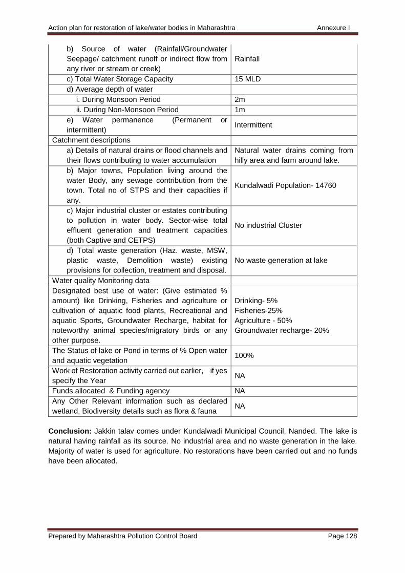
Action plan for restoration of lake/water bodies in Maharashtra Annexure I
Prepared by Maharashtra Pollution Control Board Page 128
b) Source of water (Rainfall/Groundwater
Seepage/ catchment runoff or indirect flow from
any river or stream or creek)
Rainfall
c) Total Water Storage Capacity 15 MLD
d) Average depth of water
i. During Monsoon Period 2m
ii. During Non-Monsoon Period 1m
e) Water permanence (Permanent or
intermittent) Intermittent
Catchment descriptions
a) Details of natural drains or flood channels and
their flows contributing to water accumulation
Natural water drains coming from
hilly area and farm around lake.
b) Major towns, Population living around the
water Body, any sewage contribution from the
town. Total no of STPS and their capacities if
any.
Kundalwadi Population- 14760
c) Major industrial cluster or estates contributing
to pollution in water body. Sector-wise total
effluent generation and treatment capacities
(both Captive and CETPS)
No industrial Cluster
d) Total waste generation (Haz. waste, MSW,
plastic waste, Demolition waste) existing
provisions for collection, treatment and disposal.
No waste generation at lake
Water quality Monitoring data
Designated best use of water: (Give estimated %
amount) like Drinking, Fisheries and agriculture or
cultivation of aquatic food plants, Recreational and
aquatic Sports, Groundwater Recharge, habitat for
noteworthy animal species/migratory birds or any
other purpose.
Drinking- 5%
Fisheries-25%
Agriculture - 50%
Groundwater recharge- 20%
The Status of lake or Pond in terms of % Open water
and aquatic vegetation 100%
Work of Restoration activity carried out earlier, if yes
specify the Year NA
Funds allocated & Funding agency NA
Any Other Relevant information such as declared
wetland, Biodiversity details such as flora & fauna NA
Conclusion: Jakkin talav comes under Kundalwadi Municipal Council, Nanded. The lake is
natural having rainfall as its source. No industrial area and no waste generation in the lake.
Majority of water is used for agriculture. No restorations have been carried out and no funds
have been allocated.
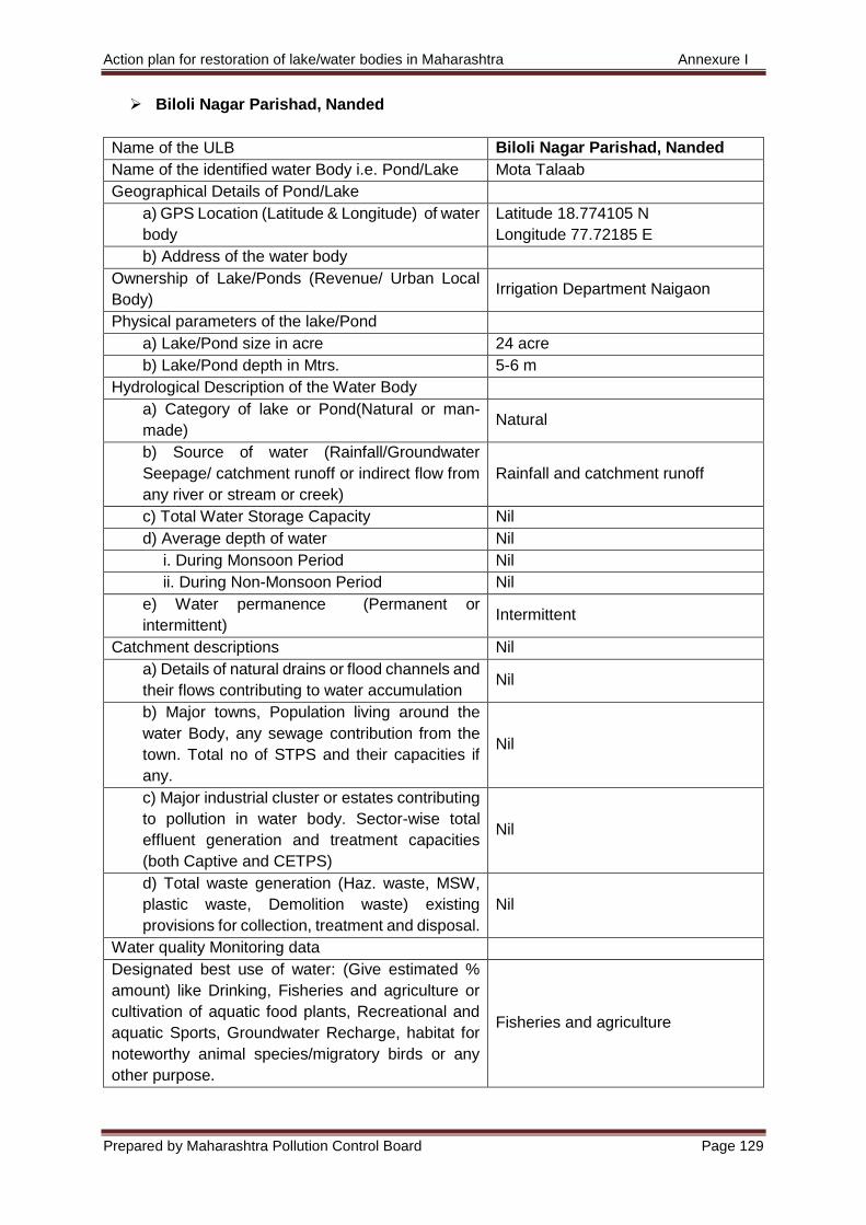
Action plan for restoration of lake/water bodies in Maharashtra Annexure I
Prepared by Maharashtra Pollution Control Board Page 129
Biloli Nagar Parishad, Nanded
Name of the ULB Biloli Nagar Parishad, Nanded
Name of the identified water Body i.e. Pond/Lake Mota Talaab
Geographical Details of Pond/Lake
a) GPS Location (Latitude & Longitude) of water
body
Latitude 18.774105 N
Longitude 77.72185 E
b) Address of the water body
Ownership of Lake/Ponds (Revenue/ Urban Local
Body) Irrigation Department Naigaon
Physical parameters of the lake/Pond
a) Lake/Pond size in acre 24 acre
b) Lake/Pond depth in Mtrs. 5-6 m
Hydrological Description of the Water Body
a) Category of lake or Pond(Natural or man-
made) Natural
b) Source of water (Rainfall/Groundwater
Seepage/ catchment runoff or indirect flow from
any river or stream or creek)
Rainfall and catchment runoff
c) Total Water Storage Capacity Nil
d) Average depth of water Nil
i. During Monsoon Period Nil
ii. During Non-Monsoon Period Nil
e) Water permanence (Permanent or
intermittent) Intermittent
Catchment descriptions Nil
a) Details of natural drains or flood channels and
their flows contributing to water accumulation Nil
b) Major towns, Population living around the
water Body, any sewage contribution from the
town. Total no of STPS and their capacities if
any.
Nil
c) Major industrial cluster or estates contributing
to pollution in water body. Sector-wise total
effluent generation and treatment capacities
(both Captive and CETPS)
Nil
d) Total waste generation (Haz. waste, MSW,
plastic waste, Demolition waste) existing
provisions for collection, treatment and disposal.
Nil
Water quality Monitoring data
Designated best use of water: (Give estimated %
amount) like Drinking, Fisheries and agriculture or
cultivation of aquatic food plants, Recreational and
aquatic Sports, Groundwater Recharge, habitat for
noteworthy animal species/migratory birds or any
other purpose.
Fisheries and agriculture
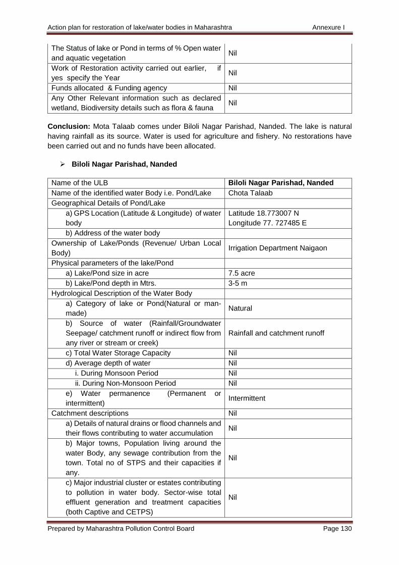
Action plan for restoration of lake/water bodies in Maharashtra Annexure I
Prepared by Maharashtra Pollution Control Board Page 130
The Status of lake or Pond in terms of % Open water
and aquatic vegetation Nil
Work of Restoration activity carried out earlier, if
yes specify the Year Nil
Funds allocated & Funding agency Nil
Any Other Relevant information such as declared
wetland, Biodiversity details such as flora & fauna Nil
Conclusion: Mota Talaab comes under Biloli Nagar Parishad, Nanded. The lake is natural
having rainfall as its source. Water is used for agriculture and fishery. No restorations have
been carried out and no funds have been allocated.
Biloli Nagar Parishad, Nanded
Name of the ULB Biloli Nagar Parishad, Nanded
Name of the identified water Body i.e. Pond/Lake Chota Talaab
Geographical Details of Pond/Lake
a) GPS Location (Latitude & Longitude) of water
body
Latitude 18.773007 N
Longitude 77. 727485 E
b) Address of the water body
Ownership of Lake/Ponds (Revenue/ Urban Local
Body) Irrigation Department Naigaon
Physical parameters of the lake/Pond
a) Lake/Pond size in acre 7.5 acre
b) Lake/Pond depth in Mtrs. 3-5 m
Hydrological Description of the Water Body
a) Category of lake or Pond(Natural or man-
made) Natural
b) Source of water (Rainfall/Groundwater
Seepage/ catchment runoff or indirect flow from
any river or stream or creek)
Rainfall and catchment runoff
c) Total Water Storage Capacity Nil
d) Average depth of water Nil
i. During Monsoon Period Nil
ii. During Non-Monsoon Period Nil
e) Water permanence (Permanent or
intermittent) Intermittent
Catchment descriptions Nil
a) Details of natural drains or flood channels and
their flows contributing to water accumulation Nil
b) Major towns, Population living around the
water Body, any sewage contribution from the
town. Total no of STPS and their capacities if
any.
Nil
c) Major industrial cluster or estates contributing
to pollution in water body. Sector-wise total
effluent generation and treatment capacities
(both Captive and CETPS)
Nil
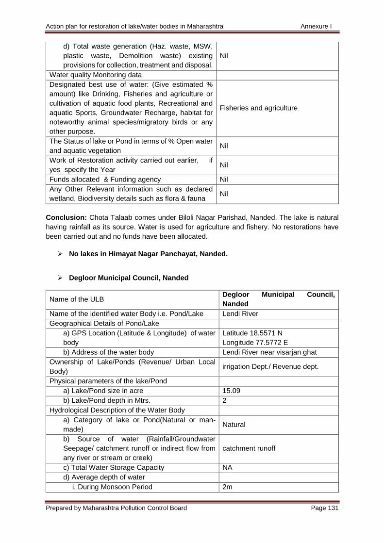
Action plan for restoration of lake/water bodies in Maharashtra Annexure I
Prepared by Maharashtra Pollution Control Board Page 131
d) Total waste generation (Haz. waste, MSW,
plastic waste, Demolition waste) existing
provisions for collection, treatment and disposal.
Nil
Water quality Monitoring data
Designated best use of water: (Give estimated %
amount) like Drinking, Fisheries and agriculture or
cultivation of aquatic food plants, Recreational and
aquatic Sports, Groundwater Recharge, habitat for
noteworthy animal species/migratory birds or any
other purpose.
Fisheries and agriculture
The Status of lake or Pond in terms of % Open water
and aquatic vegetation Nil
Work of Restoration activity carried out earlier, if
yes specify the Year Nil
Funds allocated & Funding agency Nil
Any Other Relevant information such as declared
wetland, Biodiversity details such as flora & fauna Nil
Conclusion: Chota Talaab comes under Biloli Nagar Parishad, Nanded. The lake is natural
having rainfall as its source. Water is used for agriculture and fishery. No restorations have
been carried out and no funds have been allocated.
No lakes in Himayat Nagar Panchayat, Nanded.
Degloor Municipal Council, Nanded
Name of the ULB Degloor Municipal Council,
Nanded
Name of the identified water Body i.e. Pond/Lake Lendi River
Geographical Details of Pond/Lake
a) GPS Location (Latitude & Longitude) of water
body
Latitude 18.5571 N
Longitude 77.5772 E
b) Address of the water body Lendi River near visarjan ghat
Ownership of Lake/Ponds (Revenue/ Urban Local
Body) irrigation Dept./ Revenue dept.
Physical parameters of the lake/Pond
a) Lake/Pond size in acre 15.09
b) Lake/Pond depth in Mtrs. 2
Hydrological Description of the Water Body
a) Category of lake or Pond(Natural or man-
made) Natural
b) Source of water (Rainfall/Groundwater
Seepage/ catchment runoff or indirect flow from
any river or stream or creek)
catchment runoff
c) Total Water Storage Capacity NA
d) Average depth of water
i. During Monsoon Period 2m
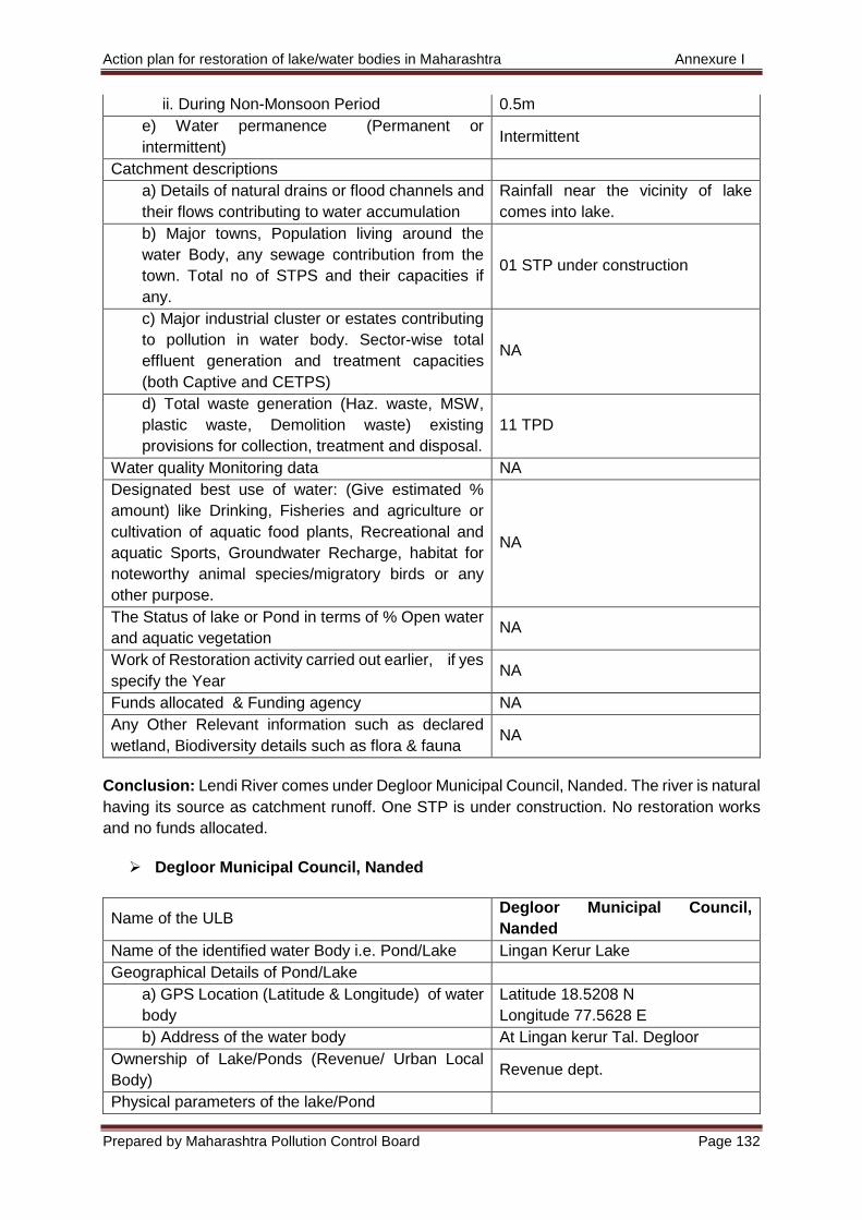
Action plan for restoration of lake/water bodies in Maharashtra Annexure I
Prepared by Maharashtra Pollution Control Board Page 132
ii. During Non-Monsoon Period 0.5m
e) Water permanence (Permanent or
intermittent) Intermittent
Catchment descriptions
a) Details of natural drains or flood channels and
their flows contributing to water accumulation
Rainfall near the vicinity of lake
comes into lake.
b) Major towns, Population living around the
water Body, any sewage contribution from the
town. Total no of STPS and their capacities if
any.
01 STP under construction
c) Major industrial cluster or estates contributing
to pollution in water body. Sector-wise total
effluent generation and treatment capacities
(both Captive and CETPS)
NA
d) Total waste generation (Haz. waste, MSW,
plastic waste, Demolition waste) existing
provisions for collection, treatment and disposal.
11 TPD
Water quality Monitoring data NA
Designated best use of water: (Give estimated %
amount) like Drinking, Fisheries and agriculture or
cultivation of aquatic food plants, Recreational and
aquatic Sports, Groundwater Recharge, habitat for
noteworthy animal species/migratory birds or any
other purpose.
NA
The Status of lake or Pond in terms of % Open water
and aquatic vegetation NA
Work of Restoration activity carried out earlier, if yes
specify the Year NA
Funds allocated & Funding agency NA
Any Other Relevant information such as declared
wetland, Biodiversity details such as flora & fauna NA
Conclusion: Lendi River comes under Degloor Municipal Council, Nanded. The river is natural
having its source as catchment runoff. One STP is under construction. No restoration works
and no funds allocated.
Degloor Municipal Council, Nanded
Name of the ULB Degloor Municipal Council,
Nanded
Name of the identified water Body i.e. Pond/Lake Lingan Kerur Lake
Geographical Details of Pond/Lake
a) GPS Location (Latitude & Longitude) of water
body
Latitude 18.5208 N
Longitude 77.5628 E
b) Address of the water body At Lingan kerur Tal. Degloor
Ownership of Lake/Ponds (Revenue/ Urban Local
Body) Revenue dept.
Physical parameters of the lake/Pond
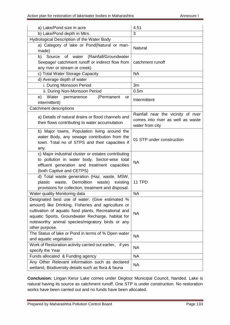
Action plan for restoration of lake/water bodies in Maharashtra Annexure I
Prepared by Maharashtra Pollution Control Board Page 133
a) Lake/Pond size in acre 4.51
b) Lake/Pond depth in Mtrs. 3
Hydrological Description of the Water Body
a) Category of lake or Pond(Natural or man-
made) Natural
b) Source of water (Rainfall/Groundwater
Seepage/ catchment runoff or indirect flow from
any river or stream or creek)
catchment runoff
c) Total Water Storage Capacity NA
d) Average depth of water
i. During Monsoon Period 3m
ii. During Non-Monsoon Period 0.5m
e) Water permanence (Permanent or
intermittent) Intermittent
Catchment descriptions
a) Details of natural drains or flood channels and
their flows contributing to water accumulation
Rainfall near the vicinity of river
comes into river as well as waste
water from city
b) Major towns, Population living around the
water Body, any sewage contribution from the
town. Total no of STPS and their capacities if
any.
01 STP under construction
c) Major industrial cluster or estates contributing
to pollution in water body. Sector-wise total
effluent generation and treatment capacities
(both Captive and CETPS)
NA
d) Total waste generation (Haz. waste, MSW,
plastic waste, Demolition waste) existing
provisions for collection, treatment and disposal.
11 TPD
Water quality Monitoring data NA
Designated best use of water: (Give estimated %
amount) like Drinking, Fisheries and agriculture or
cultivation of aquatic food plants, Recreational and
aquatic Sports, Groundwater Recharge, habitat for
noteworthy animal species/migratory birds or any
other purpose.
NA
The Status of lake or Pond in terms of % Open water
and aquatic vegetation NA
Work of Restoration activity carried out earlier, if yes
specify the Year NA
Funds allocated & Funding agency NA
Any Other Relevant information such as declared
wetland, Biodiversity details such as flora & fauna NA
Conclusion: Lingan Kerur Lake comes under Degloor Municipal Council, Nanded. Lake is
natural having its source as catchment runoff. One STP is under construction. No restoration
works have been carried out and no funds have been allocated.
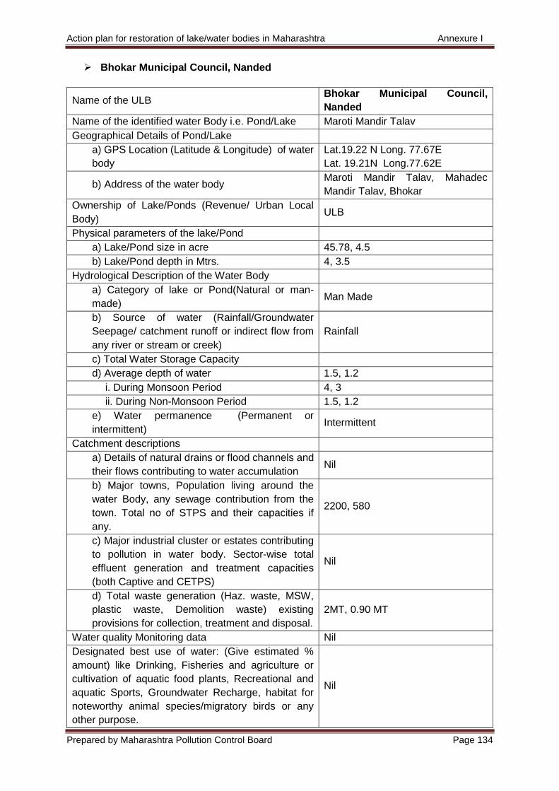
Action plan for restoration of lake/water bodies in Maharashtra Annexure I
Prepared by Maharashtra Pollution Control Board Page 134
Bhokar Municipal Council, Nanded
Name of the ULB Bhokar Municipal Council,
Nanded
Name of the identified water Body i.e. Pond/Lake Maroti Mandir Talav
Geographical Details of Pond/Lake
a) GPS Location (Latitude & Longitude) of water
body
Lat.19.22 N Long. 77.67E
Lat. 19.21N Long.77.62E
b) Address of the water body Maroti Mandir Talav, Mahadec
Mandir Talav, Bhokar
Ownership of Lake/Ponds (Revenue/ Urban Local
Body) ULB
Physical parameters of the lake/Pond
a) Lake/Pond size in acre 45.78, 4.5
b) Lake/Pond depth in Mtrs. 4, 3.5
Hydrological Description of the Water Body
a) Category of lake or Pond(Natural or man-
made) Man Made
b) Source of water (Rainfall/Groundwater
Seepage/ catchment runoff or indirect flow from
any river or stream or creek)
Rainfall
c) Total Water Storage Capacity
d) Average depth of water 1.5, 1.2
i. During Monsoon Period 4, 3
ii. During Non-Monsoon Period 1.5, 1.2
e) Water permanence (Permanent or
intermittent) Intermittent
Catchment descriptions
a) Details of natural drains or flood channels and
their flows contributing to water accumulation Nil
b) Major towns, Population living around the
water Body, any sewage contribution from the
town. Total no of STPS and their capacities if
any.
2200, 580
c) Major industrial cluster or estates contributing
to pollution in water body. Sector-wise total
effluent generation and treatment capacities
(both Captive and CETPS)
Nil
d) Total waste generation (Haz. waste, MSW,
plastic waste, Demolition waste) existing
provisions for collection, treatment and disposal.
2MT, 0.90 MT
Water quality Monitoring data Nil
Designated best use of water: (Give estimated %
amount) like Drinking, Fisheries and agriculture or
cultivation of aquatic food plants, Recreational and
aquatic Sports, Groundwater Recharge, habitat for
noteworthy animal species/migratory birds or any
other purpose.
Nil
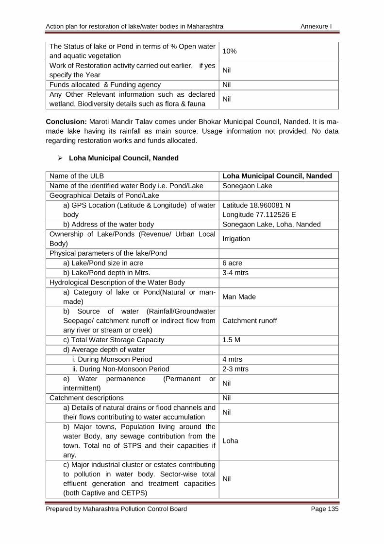
Action plan for restoration of lake/water bodies in Maharashtra Annexure I
Prepared by Maharashtra Pollution Control Board Page 135
The Status of lake or Pond in terms of % Open water
and aquatic vegetation 10%
Work of Restoration activity carried out earlier, if yes
specify the Year Nil
Funds allocated & Funding agency Nil
Any Other Relevant information such as declared
wetland, Biodiversity details such as flora & fauna Nil
Conclusion: Maroti Mandir Talav comes under Bhokar Municipal Council, Nanded. It is ma-
made lake having its rainfall as main source. Usage information not provided. No data
regarding restoration works and funds allocated.
Loha Municipal Council, Nanded
Name of the ULB Loha Municipal Council, Nanded
Name of the identified water Body i.e. Pond/Lake Sonegaon Lake
Geographical Details of Pond/Lake
a) GPS Location (Latitude & Longitude) of water
body
Latitude 18.960081 N
Longitude 77.112526 E
b) Address of the water body Sonegaon Lake, Loha, Nanded
Ownership of Lake/Ponds (Revenue/ Urban Local
Body) Irrigation
Physical parameters of the lake/Pond
a) Lake/Pond size in acre 6 acre
b) Lake/Pond depth in Mtrs. 3-4 mtrs
Hydrological Description of the Water Body
a) Category of lake or Pond(Natural or man-
made) Man Made
b) Source of water (Rainfall/Groundwater
Seepage/ catchment runoff or indirect flow from
any river or stream or creek)
Catchment runoff
c) Total Water Storage Capacity 1.5 M
d) Average depth of water
i. During Monsoon Period 4 mtrs
ii. During Non-Monsoon Period 2-3 mtrs
e) Water permanence (Permanent or
intermittent) Nil
Catchment descriptions Nil
a) Details of natural drains or flood channels and
their flows contributing to water accumulation Nil
b) Major towns, Population living around the
water Body, any sewage contribution from the
town. Total no of STPS and their capacities if
any.
Loha
c) Major industrial cluster or estates contributing
to pollution in water body. Sector-wise total
effluent generation and treatment capacities
(both Captive and CETPS)
Nil
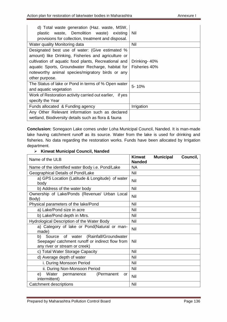
Action plan for restoration of lake/water bodies in Maharashtra Annexure I
Prepared by Maharashtra Pollution Control Board Page 136
d) Total waste generation (Haz. waste, MSW,
plastic waste, Demolition waste) existing
provisions for collection, treatment and disposal.
Nil
Water quality Monitoring data Nil
Designated best use of water: (Give estimated %
amount) like Drinking, Fisheries and agriculture or
cultivation of aquatic food plants, Recreational and
aquatic Sports, Groundwater Recharge, habitat for
noteworthy animal species/migratory birds or any
other purpose.
Drinking- 40%
Fisheries 40%
The Status of lake or Pond in terms of % Open water
and aquatic vegetation 5- 10%
Work of Restoration activity carried out earlier, if yes
specify the Year
Funds allocated & Funding agency Irrigation
Any Other Relevant information such as declared
wetland, Biodiversity details such as flora & fauna
Conclusion: Sonegaon Lake comes under Loha Municipal Council, Nanded. It is man-made
lake having catchment runoff as its source. Water from the lake is used for drinking and
fisheries. No data regarding the restoration works. Funds have been allocated by Irrigation
department.
Kinwat Municipal Council, Nanded
Name of the ULB Kinwat Municipal Council, Nanded
Name of the identified water Body i.e. Pond/Lake NA
Geographical Details of Pond/Lake Nil
a) GPS Location (Latitude & Longitude) of water body
Nil
b) Address of the water body Nil
Ownership of Lake/Ponds (Revenue/ Urban Local Body)
Nil
Physical parameters of the lake/Pond Nil
a) Lake/Pond size in acre Nil
b) Lake/Pond depth in Mtrs. Nil
Hydrological Description of the Water Body Nil
a) Category of lake or Pond(Natural or man- made)
Nil
b) Source of water (Rainfall/Groundwater Seepage/ catchment runoff or indirect flow from any river or stream or creek)
Nil
c) Total Water Storage Capacity Nil
d) Average depth of water Nil
i. During Monsoon Period Nil
ii. During Non-Monsoon Period Nil
e) Water permanence (Permanent or intermittent)
Nil
Catchment descriptions Nil
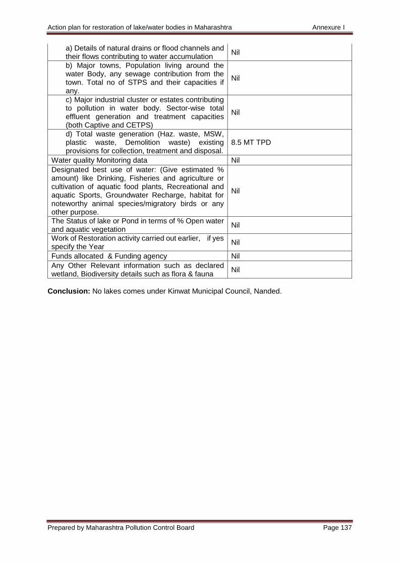
Action plan for restoration of lake/water bodies in Maharashtra Annexure I
Prepared by Maharashtra Pollution Control Board Page 137
a) Details of natural drains or flood channels and their flows contributing to water accumulation
Nil
b) Major towns, Population living around the water Body, any sewage contribution from the town. Total no of STPS and their capacities if any.
Nil
c) Major industrial cluster or estates contributing to pollution in water body. Sector-wise total effluent generation and treatment capacities (both Captive and CETPS)
Nil
d) Total waste generation (Haz. waste, MSW, plastic waste, Demolition waste) existing provisions for collection, treatment and disposal.
8.5 MT TPD
Water quality Monitoring data Nil
Designated best use of water: (Give estimated % amount) like Drinking, Fisheries and agriculture or cultivation of aquatic food plants, Recreational and aquatic Sports, Groundwater Recharge, habitat for noteworthy animal species/migratory birds or any other purpose.
Nil
The Status of lake or Pond in terms of % Open water and aquatic vegetation
Nil
Work of Restoration activity carried out earlier, if yes specify the Year
Nil
Funds allocated & Funding agency Nil
Any Other Relevant information such as declared wetland, Biodiversity details such as flora & fauna
Nil
Conclusion: No lakes comes under Kinwat Municipal Council, Nanded.
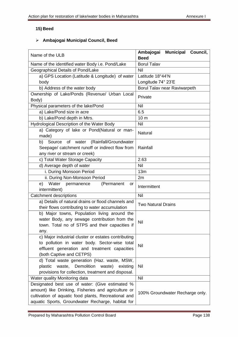
Action plan for restoration of lake/water bodies in Maharashtra Annexure I
Prepared by Maharashtra Pollution Control Board Page 138
15) Beed
Ambajogai Municipal Council, Beed
Name of the ULB Ambajogai Municipal Council,
Beed
Name of the identified water Body i.e. Pond/Lake Borul Talav
Geographical Details of Pond/Lake Nil
a) GPS Location (Latitude & Longitude) of water
body
Latitude 18°44'N
Longitude 74° 23’E
b) Address of the water body Borul Talav near Raviwarpeth
Ownership of Lake/Ponds (Revenue/ Urban Local
Body) Private
Physical parameters of the lake/Pond Nil
a) Lake/Pond size in acre 6.5
b) Lake/Pond depth in Mtrs. 10 m
Hydrological Description of the Water Body Nil
a) Category of lake or Pond(Natural or man-
made) Natural
b) Source of water (Rainfall/Groundwater
Seepage/ catchment runoff or indirect flow from
any river or stream or creek)
Rainfall
c) Total Water Storage Capacity 2.63
d) Average depth of water Nil
i. During Monsoon Period 13m
ii. During Non-Monsoon Period 2m
e) Water permanence (Permanent or
intermittent) Intermittent
Catchment descriptions Nil
a) Details of natural drains or flood channels and
their flows contributing to water accumulation Two Natural Drains
b) Major towns, Population living around the
water Body, any sewage contribution from the
town. Total no of STPS and their capacities if
any.
Nil
c) Major industrial cluster or estates contributing
to pollution in water body. Sector-wise total
effluent generation and treatment capacities
(both Captive and CETPS)
Nil
d) Total waste generation (Haz. waste, MSW,
plastic waste, Demolition waste) existing
provisions for collection, treatment and disposal.
Nil
Water quality Monitoring data Nil
Designated best use of water: (Give estimated %
amount) like Drinking, Fisheries and agriculture or
cultivation of aquatic food plants, Recreational and
aquatic Sports, Groundwater Recharge, habitat for
100% Groundwater Recharge only.
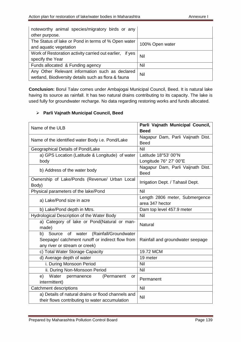
Action plan for restoration of lake/water bodies in Maharashtra Annexure I
Prepared by Maharashtra Pollution Control Board Page 139
noteworthy animal species/migratory birds or any
other purpose.
The Status of lake or Pond in terms of % Open water
and aquatic vegetation 100% Open water
Work of Restoration activity carried out earlier, if yes
specify the Year Nil
Funds allocated & Funding agency Nil
Any Other Relevant information such as declared
wetland, Biodiversity details such as flora & fauna Nil
Conclusion: Borul Talav comes under Ambajogai Municipal Council, Beed. It is natural lake
having its source as rainfall. It has two natural drains contributing to its capacity. The lake is
used fully for groundwater recharge. No data regarding restoring works and funds allocated.
Parli Vajnath Municipal Council, Beed
Name of the ULB Parli Vajnath Municipal Council,
Beed
Name of the identified water Body i.e. Pond/Lake Nagapur Dam, Parli Vaijnath Dist.
Beed
Geographical Details of Pond/Lake Nil
a) GPS Location (Latitude & Longitude) of water
body
Latitude 18°53' 00"N
Longitude 76° 27' 00"E
b) Address of the water body Nagapur Dam, Parli Vaijnath Dist.
Beed
Ownership of Lake/Ponds (Revenue/ Urban Local
Body) Irrigation Dept. / Tahasil Dept.
Physical parameters of the lake/Pond Nil
a) Lake/Pond size in acre Length 2806 meter, Submergence
area 347 hector
b) Lake/Pond depth in Mtrs. Dam top level 457.9 meter
Hydrological Description of the Water Body Nil
a) Category of lake or Pond(Natural or man-
made) Natural
b) Source of water (Rainfall/Groundwater
Seepage/ catchment runoff or indirect flow from
any river or stream or creek)
Rainfall and groundwater seepage
c) Total Water Storage Capacity 19.72 MCM
d) Average depth of water 19 meter
i. During Monsoon Period Nil
ii. During Non-Monsoon Period Nil
e) Water permanence (Permanent or
intermittent) Permanent
Catchment descriptions Nil
a) Details of natural drains or flood channels and
their flows contributing to water accumulation Nil
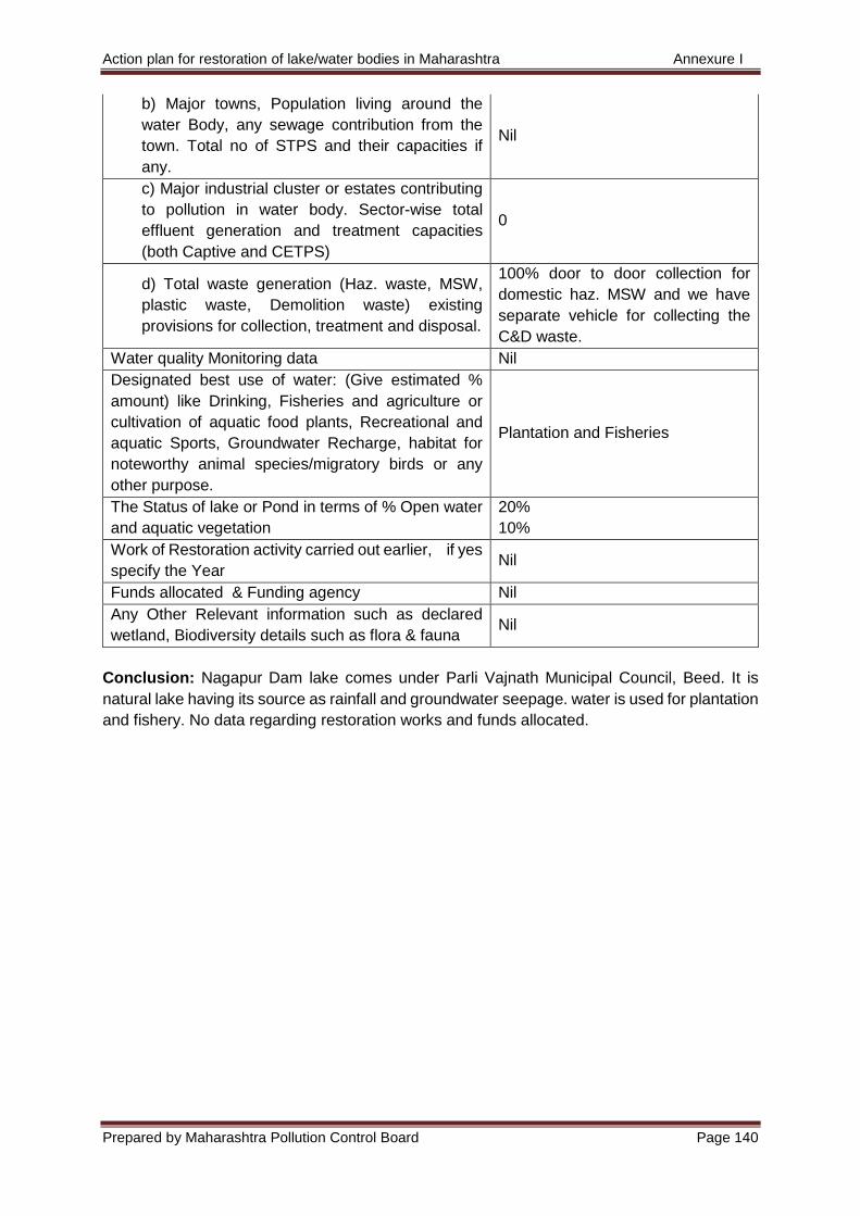
Action plan for restoration of lake/water bodies in Maharashtra Annexure I
Prepared by Maharashtra Pollution Control Board Page 140
b) Major towns, Population living around the
water Body, any sewage contribution from the
town. Total no of STPS and their capacities if
any.
Nil
c) Major industrial cluster or estates contributing
to pollution in water body. Sector-wise total
effluent generation and treatment capacities
(both Captive and CETPS)
0
d) Total waste generation (Haz. waste, MSW,
plastic waste, Demolition waste) existing
provisions for collection, treatment and disposal.
100% door to door collection for
domestic haz. MSW and we have
separate vehicle for collecting the
C&D waste.
Water quality Monitoring data Nil
Designated best use of water: (Give estimated %
amount) like Drinking, Fisheries and agriculture or
cultivation of aquatic food plants, Recreational and
aquatic Sports, Groundwater Recharge, habitat for
noteworthy animal species/migratory birds or any
other purpose.
Plantation and Fisheries
The Status of lake or Pond in terms of % Open water
and aquatic vegetation
20%
10%
Work of Restoration activity carried out earlier, if yes
specify the Year Nil
Funds allocated & Funding agency Nil
Any Other Relevant information such as declared
wetland, Biodiversity details such as flora & fauna Nil
Conclusion: Nagapur Dam lake comes under Parli Vajnath Municipal Council, Beed. It is
natural lake having its source as rainfall and groundwater seepage. water is used for plantation
and fishery. No data regarding restoration works and funds allocated.
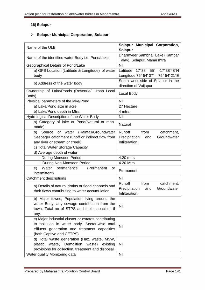
Action plan for restoration of lake/water bodies in Maharashtra Annexure I
Prepared by Maharashtra Pollution Control Board Page 141
16) Solapur
Solapur Municipal Corporation, Solapur
Name of the ULB Solapur Municipal Corporation,
Solapur
Name of the identified water Body i.e. Pond/Lake Dharmveer Sambhaji Lake (Kambar
Talav), Solapur, Maharshtra
Geographical Details of Pond/Lake Nil
a) GPS Location (Latitude & Longitude) of water
body
Latitude 17°38' 55" -17°38'48"N
Longitude 75° 54' 07" - 75° 54' 21"E
b) Address of the water body South west side of Solapur in the
direction of Vaijapur
Ownership of Lake/Ponds (Revenue/ Urban Local
Body) Local Body
Physical parameters of the lake/Pond Nil
a) Lake/Pond size in acre 27 Hectare
b) Lake/Pond depth in Mtrs. 4 mtrs.
Hydrological Description of the Water Body Nil
a) Category of lake or Pond(Natural or man-
made) Natural
b) Source of water (Rainfall/Groundwater
Seepage/ catchment runoff or indirect flow from
any river or stream or creek)
Runoff from catchment,
Precipitation and Groundwater
Infilteration.
c) Total Water Storage Capacity
d) Average depth of water
i. During Monsoon Period 4.20 mtrs
ii. During Non-Monsoon Period 4.20 Mtrs
e) Water permanence (Permanent or
intermittent) Permanent
Catchment descriptions Nil
a) Details of natural drains or flood channels and
their flows contributing to water accumulation
Runoff from catchment,
Precipitation and Groundwater
Infilteration.
b) Major towns, Population living around the
water Body, any sewage contribution from the
town. Total no of STPS and their capacities if
any.
Nil
c) Major industrial cluster or estates contributing
to pollution in water body. Sector-wise total
effluent generation and treatment capacities
(both Captive and CETPS)
Nil
d) Total waste generation (Haz. waste, MSW,
plastic waste, Demolition waste) existing
provisions for collection, treatment and disposal.
Nil
Water quality Monitoring data Nil
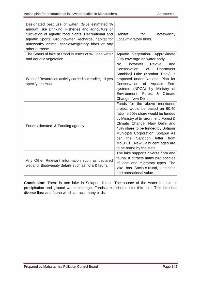
Action plan for restoration of lake/water bodies in Maharashtra Annexure I
Prepared by Maharashtra Pollution Control Board Page 142
Designated best use of water: (Give estimated %
amount) like Drinking, Fisheries and agriculture or
cultivation of aquatic food plants, Recreational and
aquatic Sports, Groundwater Recharge, habitat for
noteworthy animal species/migratory birds or any
other purpose.
Habitat for noteworthy
Local/migratory birds.
The Status of lake or Pond in terms of % Open water
and aquatic vegetation
Aquatic Vegetation- Approximate
90% coverage on water body.
Work of Restoration activity carried out earlier, if yes
specify the Year
No, however Revival and
Conservation of Dharmveer
Sambhaji Lake (Kambar Talav) is
proposed under National Plan for
Conservation of Aquatic Eco-
systems (NPCA) by Ministry of
Environment, Forest & Climate
Change, New Delhi.
Funds allocated & Funding agency
Funds for the above mentioned
project would be based on 60:40
ratio i.e 60% share would be funded
by Ministry of Environment, Forest &
Climate Change, New Delhi and
40% share to be funded by Solapur
Municipal Corporation, Solapur As
per the Sanction letter from
MoEFCC, New Delhi cent ages are
to be borne by the state.
Any Other Relevant information such as declared
wetland, Biodiversity details such as flora & fauna
The lake supports diverse flora and
fauna. It attracts many bird species
of local and migratory types. The
lake has Socio-cultural, aesthetic
and recreational value.
Conclusion: There is one lake in Solapur district. The source of the water for lake is
precipitation and ground water seepage. Funds are disbursed for this lake. This lake has
diverse flora and fauna which attracts many birds.

Action plan for restoration of lake/water bodies in Maharashtra Annexure I
Prepared by Maharashtra Pollution Control Board Page 143
17) Ratnagiri
Khed Municipal Council, Ratnagiri
Name of the ULB Khed Municipal Council,
Ratnagiri
Name of the identified water Body i.e. Pond/Lake Khamb lake
Geographical Details of Pond/Lake Nil
a) GPS Location (Latitude & Longitude) of water
body
Latitude 17.719388 N
Longitude 73.393259 E
b) Address of the water body Khamb lake, Khed
Ownership of Lake/Ponds (Revenue/ Urban Local
Body) Urban Local Body
Physical parameters of the lake/Pond
a) Lake/Pond size in acre 3.04 acre
b) Lake/Pond depth in Mtrs. 7 meter
Hydrological Description of the Water Body
a) Category of lake or Pond(Natural or man-
made) Natural
b) Source of water (Rainfall/Groundwater
Seepage/ catchment runoff or indirect flow from
any river or stream or creek)
Rainfall, Groundwater seepage, and
catchment runoff
c) Total Water Storage Capacity 61,585 Cum
d) Average depth of water
i. During Monsoon Period 5 mtrs
ii. During Non-Monsoon Period 5 Mtrs
e) Water permanence (Permanent or
intermittent) Permanent
Catchment descriptions
a) Details of natural drains or flood channels and
their flows contributing to water accumulation Nil
b) Major towns, Population living around the
water Body, any sewage contribution from the
town. Total no of STPS and their capacities if
any.
Nil
c) Major industrial cluster or estates contributing
to pollution in water body. Sector-wise total
effluent generation and treatment capacities
(both Captive and CETPS)
Nil
d) Total waste generation (Haz. waste, MSW,
plastic waste, Demolition waste) existing
provisions for collection, treatment and disposal.
Total generation of waste is 8TPD,
provision for collection- Khed
municipal council having 6 Vehicle
for collection of waste, Treatment-
Composting on wet waste and
recycling of dry waste through rag
picker and ghanta gadi contractual
workers.
Water quality Monitoring data Nil
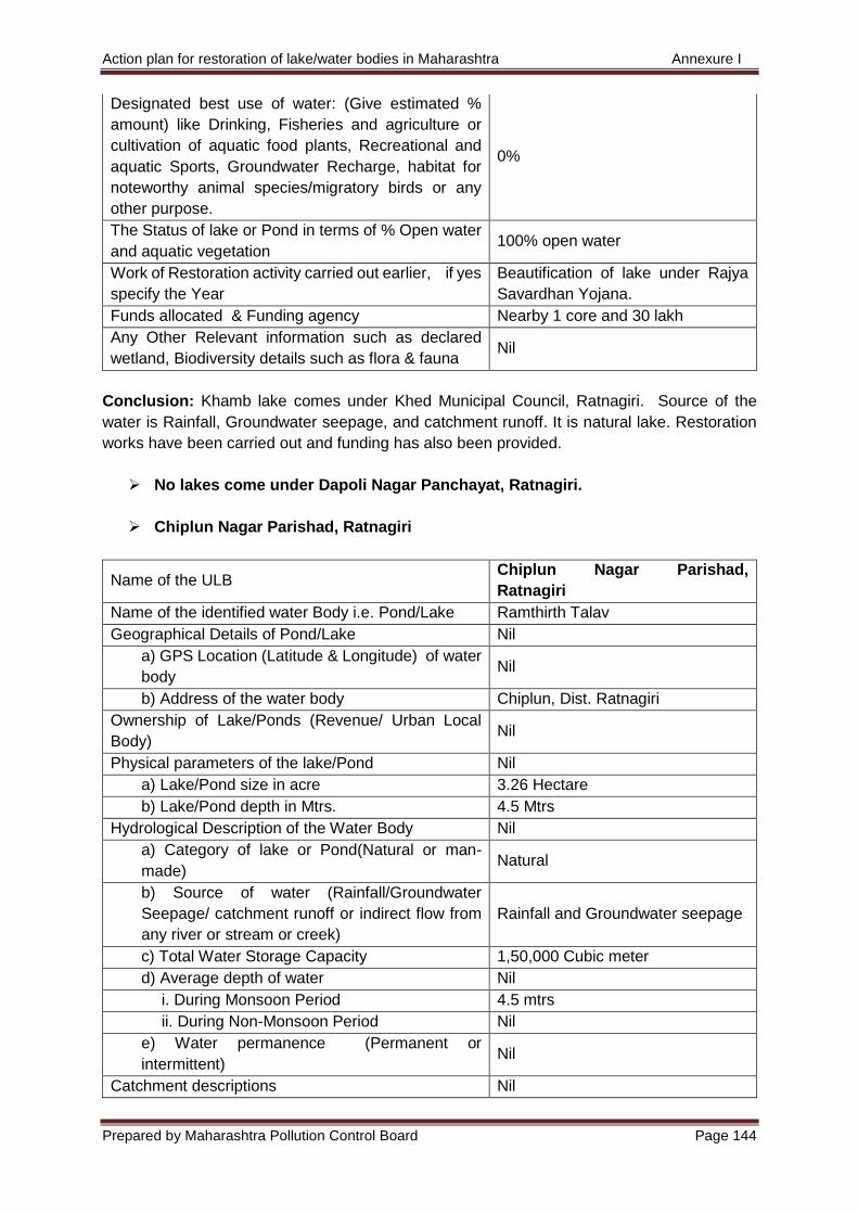
Action plan for restoration of lake/water bodies in Maharashtra Annexure I
Prepared by Maharashtra Pollution Control Board Page 144
Designated best use of water: (Give estimated %
amount) like Drinking, Fisheries and agriculture or
cultivation of aquatic food plants, Recreational and
aquatic Sports, Groundwater Recharge, habitat for
noteworthy animal species/migratory birds or any
other purpose.
0%
The Status of lake or Pond in terms of % Open water
and aquatic vegetation 100% open water
Work of Restoration activity carried out earlier, if yes
specify the Year
Beautification of lake under Rajya
Savardhan Yojana.
Funds allocated & Funding agency Nearby 1 core and 30 lakh
Any Other Relevant information such as declared
wetland, Biodiversity details such as flora & fauna Nil
Conclusion: Khamb lake comes under Khed Municipal Council, Ratnagiri. Source of the
water is Rainfall, Groundwater seepage, and catchment runoff. It is natural lake. Restoration
works have been carried out and funding has also been provided.
No lakes come under Dapoli Nagar Panchayat, Ratnagiri.
Chiplun Nagar Parishad, Ratnagiri
Name of the ULB Chiplun Nagar Parishad,
Ratnagiri
Name of the identified water Body i.e. Pond/Lake Ramthirth Talav
Geographical Details of Pond/Lake Nil
a) GPS Location (Latitude & Longitude) of water
body Nil
b) Address of the water body Chiplun, Dist. Ratnagiri
Ownership of Lake/Ponds (Revenue/ Urban Local
Body) Nil
Physical parameters of the lake/Pond Nil
a) Lake/Pond size in acre 3.26 Hectare
b) Lake/Pond depth in Mtrs. 4.5 Mtrs
Hydrological Description of the Water Body Nil
a) Category of lake or Pond(Natural or man-
made) Natural
b) Source of water (Rainfall/Groundwater
Seepage/ catchment runoff or indirect flow from
any river or stream or creek)
Rainfall and Groundwater seepage
c) Total Water Storage Capacity 1,50,000 Cubic meter
d) Average depth of water Nil
i. During Monsoon Period 4.5 mtrs
ii. During Non-Monsoon Period Nil
e) Water permanence (Permanent or
intermittent) Nil
Catchment descriptions Nil
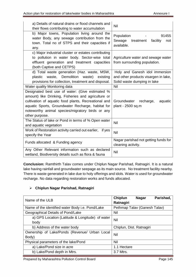
Action plan for restoration of lake/water bodies in Maharashtra Annexure I
Prepared by Maharashtra Pollution Control Board Page 145
a) Details of natural drains or flood channels and
their flows contributing to water accumulation Nil
b) Major towns, Population living around the
water Body, any sewage contribution from the
town. Total no of STPS and their capacities if
any.
Population - 91455
Sewage treatment facility not
available.
c) Major industrial cluster or estates contributing
to pollution in water body. Sector-wise total
effluent generation and treatment capacities
(both Captive and CETPS)
Agriculture water and sewage water
from surrounding population.
d) Total waste generation (Haz. waste, MSW,
plastic waste, Demolition waste) existing
provisions for collection, treatment and disposal.
Holy and Ganesh idol immersion
and other products visargen in lake,
Solid waste dumping in lake
Water quality Monitoring data Nil
Designated best use of water: (Give estimated %
amount) like Drinking, Fisheries and agriculture or
cultivation of aquatic food plants, Recreational and
aquatic Sports, Groundwater Recharge, habitat for
noteworthy animal species/migratory birds or any
other purpose.
Groundwater recharge, aquatic
plant - 2500 sq.m
The Status of lake or Pond in terms of % Open water
and aquatic vegetation Nil
Work of Restoration activity carried out earlier, if yes
specify the Year Nil
Funds allocated & Funding agency Nagar parishad not getting funds for
cleaning activity.
Any Other Relevant information such as declared
wetland, Biodiversity details such as flora & fauna Nil
Conclusion: Ramthirth Talav comes under Chiplun Nagar Parishad, Ratnagiri. It is a natural
lake having rainfall and groundwater seepage as its main source. No treatment facility nearby.
There is waste generated in lake due to holy offerings and idols. Water is used for groundwater
recharge. No data regarding restoration works and funds allocated.
Chiplun Nagar Parishad, Ratnagiri
Name of the ULB Chiplun Nagar Parishad,
Ratnagiri
Name of the identified water Body i.e. Pond/Lake Pethmap Talav (Ganesh Talav)
Geographical Details of Pond/Lake Nil
a) GPS Location (Latitude & Longitude) of water
body Nil
b) Address of the water body Chiplun, Dist. Ratnagiri
Ownership of Lake/Ponds (Revenue/ Urban Local
Body) Nil
Physical parameters of the lake/Pond Nil
a) Lake/Pond size in acre 1.1 Hectare
b) Lake/Pond depth in Mtrs. 3.7 Mtrs.
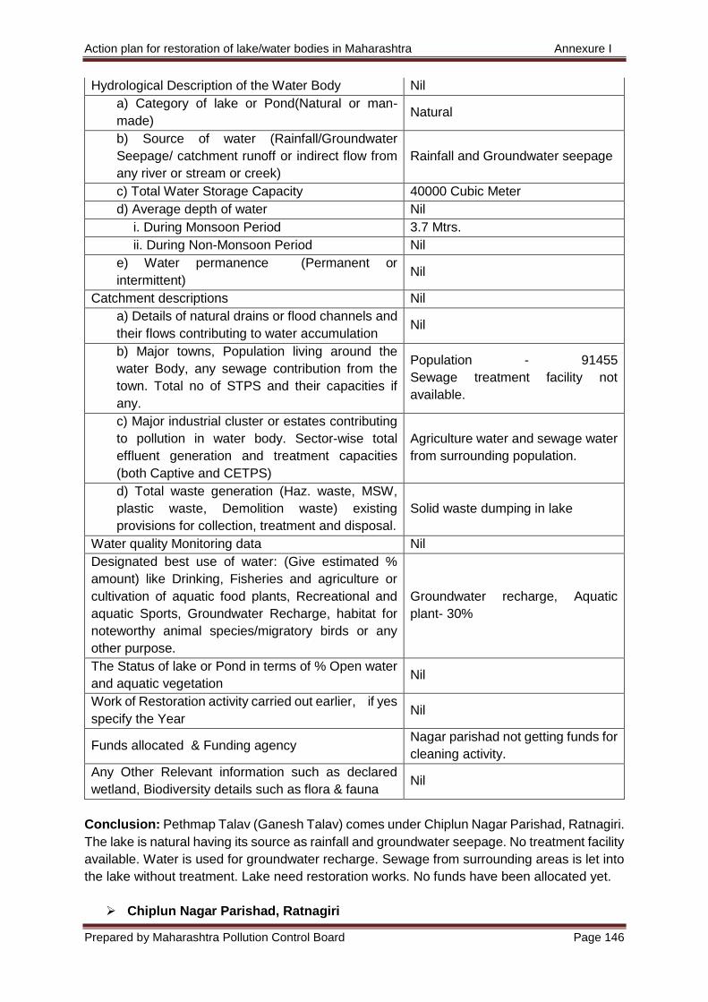
Action plan for restoration of lake/water bodies in Maharashtra Annexure I
Prepared by Maharashtra Pollution Control Board Page 146
Hydrological Description of the Water Body Nil
a) Category of lake or Pond(Natural or man-
made) Natural
b) Source of water (Rainfall/Groundwater
Seepage/ catchment runoff or indirect flow from
any river or stream or creek)
Rainfall and Groundwater seepage
c) Total Water Storage Capacity 40000 Cubic Meter
d) Average depth of water Nil
i. During Monsoon Period 3.7 Mtrs.
ii. During Non-Monsoon Period Nil
e) Water permanence (Permanent or
intermittent) Nil
Catchment descriptions Nil
a) Details of natural drains or flood channels and
their flows contributing to water accumulation Nil
b) Major towns, Population living around the
water Body, any sewage contribution from the
town. Total no of STPS and their capacities if
any.
Population - 91455
Sewage treatment facility not
available.
c) Major industrial cluster or estates contributing
to pollution in water body. Sector-wise total
effluent generation and treatment capacities
(both Captive and CETPS)
Agriculture water and sewage water
from surrounding population.
d) Total waste generation (Haz. waste, MSW,
plastic waste, Demolition waste) existing
provisions for collection, treatment and disposal.
Solid waste dumping in lake
Water quality Monitoring data Nil
Designated best use of water: (Give estimated %
amount) like Drinking, Fisheries and agriculture or
cultivation of aquatic food plants, Recreational and
aquatic Sports, Groundwater Recharge, habitat for
noteworthy animal species/migratory birds or any
other purpose.
Groundwater recharge, Aquatic
plant- 30%
The Status of lake or Pond in terms of % Open water
and aquatic vegetation Nil
Work of Restoration activity carried out earlier, if yes
specify the Year Nil
Funds allocated & Funding agency Nagar parishad not getting funds for
cleaning activity.
Any Other Relevant information such as declared
wetland, Biodiversity details such as flora & fauna Nil
Conclusion: Pethmap Talav (Ganesh Talav) comes under Chiplun Nagar Parishad, Ratnagiri.
The lake is natural having its source as rainfall and groundwater seepage. No treatment facility
available. Water is used for groundwater recharge. Sewage from surrounding areas is let into
the lake without treatment. Lake need restoration works. No funds have been allocated yet.
Chiplun Nagar Parishad, Ratnagiri
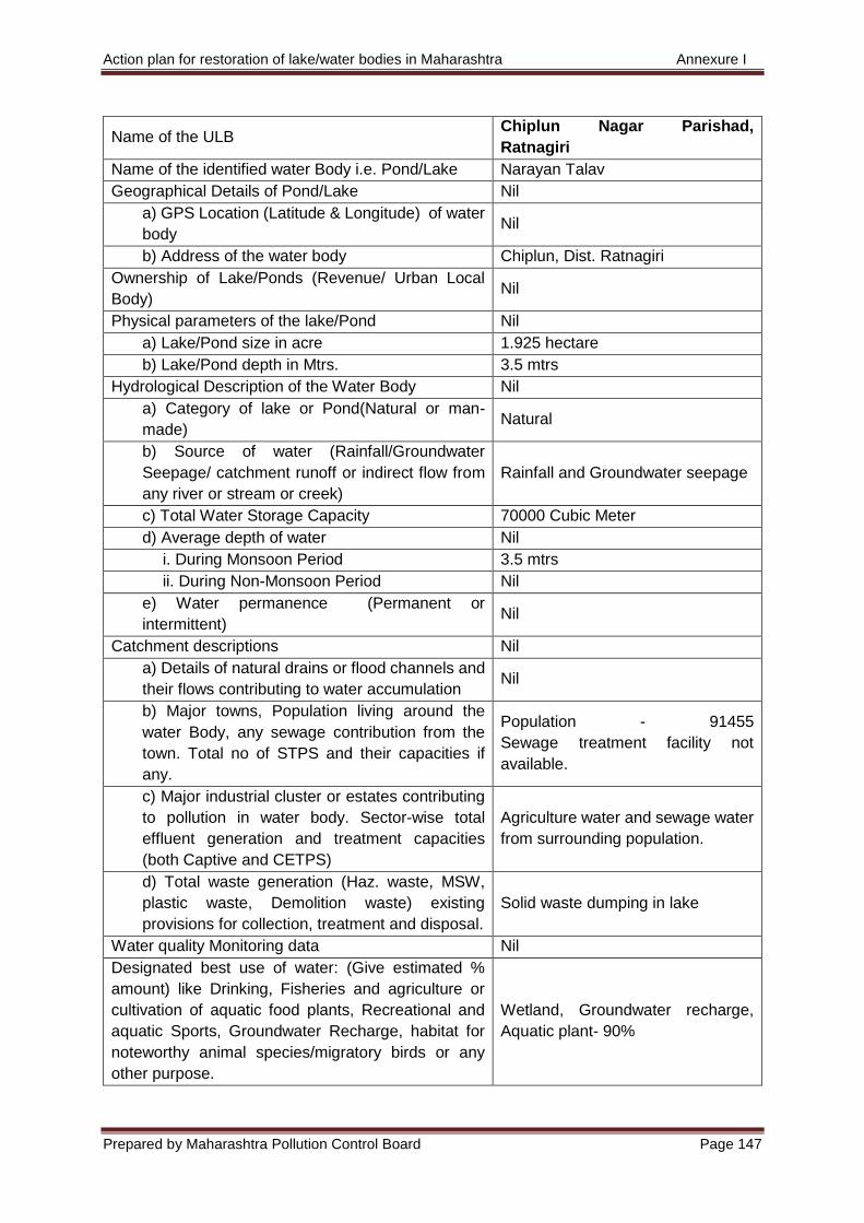
Action plan for restoration of lake/water bodies in Maharashtra Annexure I
Prepared by Maharashtra Pollution Control Board Page 147
Name of the ULB Chiplun Nagar Parishad,
Ratnagiri
Name of the identified water Body i.e. Pond/Lake Narayan Talav
Geographical Details of Pond/Lake Nil
a) GPS Location (Latitude & Longitude) of water
body Nil
b) Address of the water body Chiplun, Dist. Ratnagiri
Ownership of Lake/Ponds (Revenue/ Urban Local
Body) Nil
Physical parameters of the lake/Pond Nil
a) Lake/Pond size in acre 1.925 hectare
b) Lake/Pond depth in Mtrs. 3.5 mtrs
Hydrological Description of the Water Body Nil
a) Category of lake or Pond(Natural or man-
made) Natural
b) Source of water (Rainfall/Groundwater
Seepage/ catchment runoff or indirect flow from
any river or stream or creek)
Rainfall and Groundwater seepage
c) Total Water Storage Capacity 70000 Cubic Meter
d) Average depth of water Nil
i. During Monsoon Period 3.5 mtrs
ii. During Non-Monsoon Period Nil
e) Water permanence (Permanent or
intermittent) Nil
Catchment descriptions Nil
a) Details of natural drains or flood channels and
their flows contributing to water accumulation Nil
b) Major towns, Population living around the
water Body, any sewage contribution from the
town. Total no of STPS and their capacities if
any.
Population - 91455
Sewage treatment facility not
available.
c) Major industrial cluster or estates contributing
to pollution in water body. Sector-wise total
effluent generation and treatment capacities
(both Captive and CETPS)
Agriculture water and sewage water
from surrounding population.
d) Total waste generation (Haz. waste, MSW,
plastic waste, Demolition waste) existing
provisions for collection, treatment and disposal.
Solid waste dumping in lake
Water quality Monitoring data Nil
Designated best use of water: (Give estimated %
amount) like Drinking, Fisheries and agriculture or
cultivation of aquatic food plants, Recreational and
aquatic Sports, Groundwater Recharge, habitat for
noteworthy animal species/migratory birds or any
other purpose.
Wetland, Groundwater recharge,
Aquatic plant- 90%
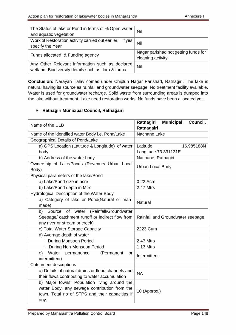
Action plan for restoration of lake/water bodies in Maharashtra Annexure I
Prepared by Maharashtra Pollution Control Board Page 148
The Status of lake or Pond in terms of % Open water
and aquatic vegetation Nil
Work of Restoration activity carried out earlier, if yes
specify the Year Nil
Funds allocated & Funding agency Nagar parishad not getting funds for
cleaning activity.
Any Other Relevant information such as declared
wetland, Biodiversity details such as flora & fauna Nil
Conclusion: Narayan Talav comes under Chiplun Nagar Parishad, Ratnagiri. The lake is
natural having its source as rainfall and groundwater seepage. No treatment facility available.
Water is used for groundwater recharge. Solid waste from surrounding areas is dumped into
the lake without treatment. Lake need restoration works. No funds have been allocated yet.
Ratnagiri Municipal Council, Ratnagairi
Name of the ULB Ratnagiri Municipal Council,
Ratnagairi
Name of the identified water Body i.e. Pond/Lake Nachane Lake
Geographical Details of Pond/Lake
a) GPS Location (Latitude & Longitude) of water
body
Latitude 16.985188N
Longitude 73.331131E
b) Address of the water body Nachane, Ratnagiri
Ownership of Lake/Ponds (Revenue/ Urban Local
Body) Urban Local Body
Physical parameters of the lake/Pond
a) Lake/Pond size in acre 0.22 Acre
b) Lake/Pond depth in Mtrs. 2.47 Mtrs
Hydrological Description of the Water Body
a) Category of lake or Pond(Natural or man-
made) Natural
b) Source of water (Rainfall/Groundwater
Seepage/ catchment runoff or indirect flow from
any river or stream or creek)
Rainfall and Groundwater seepage
c) Total Water Storage Capacity 2223 Cum
d) Average depth of water
i. During Monsoon Period 2.47 Mtrs
ii. During Non-Monsoon Period 1.13 Mtrs
e) Water permanence (Permanent or
intermittent) Intermittent
Catchment descriptions
a) Details of natural drains or flood channels and
their flows contributing to water accumulation NA
b) Major towns, Population living around the
water Body, any sewage contribution from the
town. Total no of STPS and their capacities if
any.
10 (Approx.)
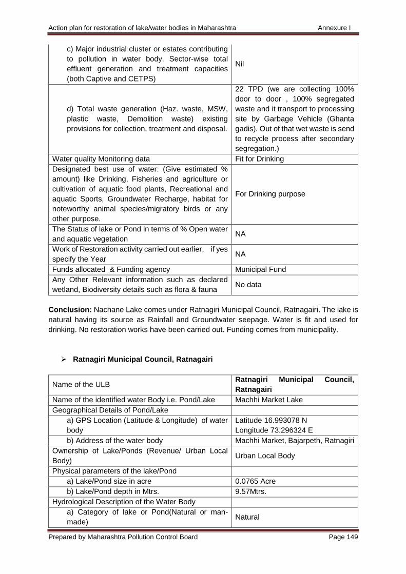
Action plan for restoration of lake/water bodies in Maharashtra Annexure I
Prepared by Maharashtra Pollution Control Board Page 149
c) Major industrial cluster or estates contributing
to pollution in water body. Sector-wise total
effluent generation and treatment capacities
(both Captive and CETPS)
Nil
d) Total waste generation (Haz. waste, MSW,
plastic waste, Demolition waste) existing
provisions for collection, treatment and disposal.
22 TPD (we are collecting 100%
door to door , 100% segregated
waste and it transport to processing
site by Garbage Vehicle (Ghanta
gadis). Out of that wet waste is send
to recycle process after secondary
segregation.)
Water quality Monitoring data Fit for Drinking
Designated best use of water: (Give estimated %
amount) like Drinking, Fisheries and agriculture or
cultivation of aquatic food plants, Recreational and
aquatic Sports, Groundwater Recharge, habitat for
noteworthy animal species/migratory birds or any
other purpose.
For Drinking purpose
The Status of lake or Pond in terms of % Open water
and aquatic vegetation NA
Work of Restoration activity carried out earlier, if yes
specify the Year NA
Funds allocated & Funding agency Municipal Fund
Any Other Relevant information such as declared
wetland, Biodiversity details such as flora & fauna No data
Conclusion: Nachane Lake comes under Ratnagiri Municipal Council, Ratnagairi. The lake is
natural having its source as Rainfall and Groundwater seepage. Water is fit and used for
drinking. No restoration works have been carried out. Funding comes from municipality.
Ratnagiri Municipal Council, Ratnagairi
Name of the ULB Ratnagiri Municipal Council,
Ratnagairi
Name of the identified water Body i.e. Pond/Lake Machhi Market Lake
Geographical Details of Pond/Lake
a) GPS Location (Latitude & Longitude) of water
body
Latitude 16.993078 N
Longitude 73.296324 E
b) Address of the water body Machhi Market, Bajarpeth, Ratnagiri
Ownership of Lake/Ponds (Revenue/ Urban Local
Body) Urban Local Body
Physical parameters of the lake/Pond
a) Lake/Pond size in acre 0.0765 Acre
b) Lake/Pond depth in Mtrs. 9.57Mtrs.
Hydrological Description of the Water Body
a) Category of lake or Pond(Natural or man-
made) Natural
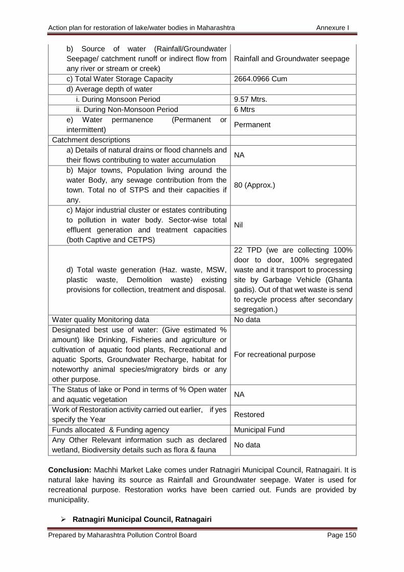
Action plan for restoration of lake/water bodies in Maharashtra Annexure I
Prepared by Maharashtra Pollution Control Board Page 150
b) Source of water (Rainfall/Groundwater
Seepage/ catchment runoff or indirect flow from
any river or stream or creek)
Rainfall and Groundwater seepage
c) Total Water Storage Capacity 2664.0966 Cum
d) Average depth of water
i. During Monsoon Period 9.57 Mtrs.
ii. During Non-Monsoon Period 6 Mtrs
e) Water permanence (Permanent or
intermittent) Permanent
Catchment descriptions
a) Details of natural drains or flood channels and
their flows contributing to water accumulation NA
b) Major towns, Population living around the
water Body, any sewage contribution from the
town. Total no of STPS and their capacities if
any.
80 (Approx.)
c) Major industrial cluster or estates contributing
to pollution in water body. Sector-wise total
effluent generation and treatment capacities
(both Captive and CETPS)
Nil
d) Total waste generation (Haz. waste, MSW,
plastic waste, Demolition waste) existing
provisions for collection, treatment and disposal.
22 TPD (we are collecting 100%
door to door, 100% segregated
waste and it transport to processing
site by Garbage Vehicle (Ghanta
gadis). Out of that wet waste is send
to recycle process after secondary
segregation.)
Water quality Monitoring data No data
Designated best use of water: (Give estimated %
amount) like Drinking, Fisheries and agriculture or
cultivation of aquatic food plants, Recreational and
aquatic Sports, Groundwater Recharge, habitat for
noteworthy animal species/migratory birds or any
other purpose.
For recreational purpose
The Status of lake or Pond in terms of % Open water
and aquatic vegetation NA
Work of Restoration activity carried out earlier, if yes
specify the Year Restored
Funds allocated & Funding agency Municipal Fund
Any Other Relevant information such as declared
wetland, Biodiversity details such as flora & fauna No data
Conclusion: Machhi Market Lake comes under Ratnagiri Municipal Council, Ratnagairi. It is
natural lake having its source as Rainfall and Groundwater seepage. Water is used for
recreational purpose. Restoration works have been carried out. Funds are provided by
municipality.
Ratnagiri Municipal Council, Ratnagairi
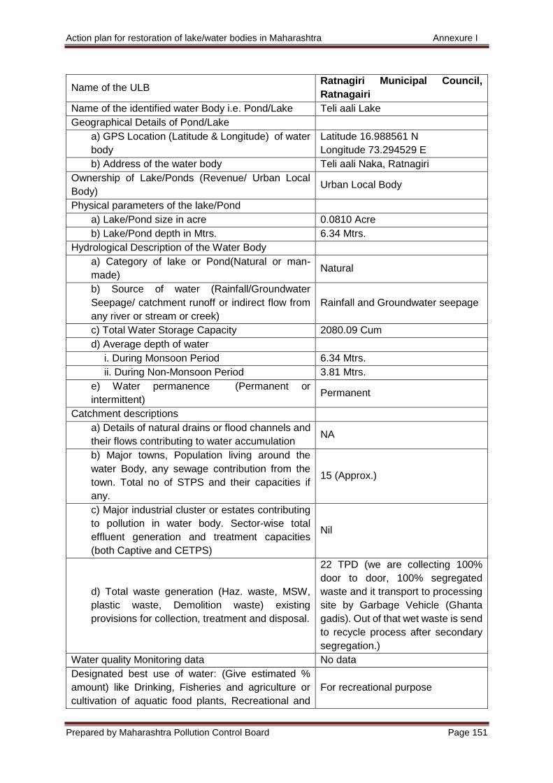
Action plan for restoration of lake/water bodies in Maharashtra Annexure I
Prepared by Maharashtra Pollution Control Board Page 151
Name of the ULB Ratnagiri Municipal Council,
Ratnagairi
Name of the identified water Body i.e. Pond/Lake Teli aali Lake
Geographical Details of Pond/Lake
a) GPS Location (Latitude & Longitude) of water
body
Latitude 16.988561 N
Longitude 73.294529 E
b) Address of the water body Teli aali Naka, Ratnagiri
Ownership of Lake/Ponds (Revenue/ Urban Local
Body) Urban Local Body
Physical parameters of the lake/Pond
a) Lake/Pond size in acre 0.0810 Acre
b) Lake/Pond depth in Mtrs. 6.34 Mtrs.
Hydrological Description of the Water Body
a) Category of lake or Pond(Natural or man-
made) Natural
b) Source of water (Rainfall/Groundwater
Seepage/ catchment runoff or indirect flow from
any river or stream or creek)
Rainfall and Groundwater seepage
c) Total Water Storage Capacity 2080.09 Cum
d) Average depth of water
i. During Monsoon Period 6.34 Mtrs.
ii. During Non-Monsoon Period 3.81 Mtrs.
e) Water permanence (Permanent or
intermittent) Permanent
Catchment descriptions
a) Details of natural drains or flood channels and
their flows contributing to water accumulation NA
b) Major towns, Population living around the
water Body, any sewage contribution from the
town. Total no of STPS and their capacities if
any.
15 (Approx.)
c) Major industrial cluster or estates contributing
to pollution in water body. Sector-wise total
effluent generation and treatment capacities
(both Captive and CETPS)
Nil
d) Total waste generation (Haz. waste, MSW,
plastic waste, Demolition waste) existing
provisions for collection, treatment and disposal.
22 TPD (we are collecting 100%
door to door, 100% segregated
waste and it transport to processing
site by Garbage Vehicle (Ghanta
gadis). Out of that wet waste is send
to recycle process after secondary
segregation.)
Water quality Monitoring data No data
Designated best use of water: (Give estimated %
amount) like Drinking, Fisheries and agriculture or
cultivation of aquatic food plants, Recreational and
For recreational purpose
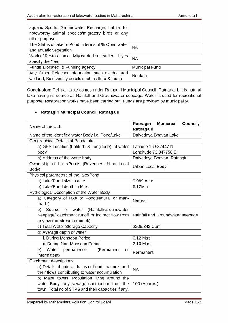
Action plan for restoration of lake/water bodies in Maharashtra Annexure I
Prepared by Maharashtra Pollution Control Board Page 152
aquatic Sports, Groundwater Recharge, habitat for
noteworthy animal species/migratory birds or any
other purpose.
The Status of lake or Pond in terms of % Open water
and aquatic vegetation NA
Work of Restoration activity carried out earlier, if yes
specify the Year NA
Funds allocated & Funding agency Municipal Fund
Any Other Relevant information such as declared
wetland, Biodiversity details such as flora & fauna No data
Conclusion: Teli aali Lake comes under Ratnagiri Municipal Council, Ratnagairi. It is natural
lake having its source as Rainfall and Groundwater seepage. Water is used for recreational
purpose. Restoration works have been carried out. Funds are provided by municipality.
Ratnagiri Municipal Council, Ratnagairi
Name of the ULB Ratnagiri Municipal Council,
Ratnagairi
Name of the identified water Body i.e. Pond/Lake Daivednya Bhavan Lake
Geographical Details of Pond/Lake
a) GPS Location (Latitude & Longitude) of water
body
Latitude 16.987447 N
Longitude 73.347758 E
b) Address of the water body Daivednya Bhavan, Ratnagiri
Ownership of Lake/Ponds (Revenue/ Urban Local
Body) Urban Local Body
Physical parameters of the lake/Pond
a) Lake/Pond size in acre 0.089 Acre
b) Lake/Pond depth in Mtrs. 6.12Mtrs
Hydrological Description of the Water Body
a) Category of lake or Pond(Natural or man-
made) Natural
b) Source of water (Rainfall/Groundwater
Seepage/ catchment runoff or indirect flow from
any river or stream or creek)
Rainfall and Groundwater seepage
c) Total Water Storage Capacity 2205.342 Cum
d) Average depth of water
i. During Monsoon Period 6.12 Mtrs.
ii. During Non-Monsoon Period 2.10 Mtrs
e) Water permanence (Permanent or
intermittent) Permanent
Catchment descriptions
a) Details of natural drains or flood channels and
their flows contributing to water accumulation NA
b) Major towns, Population living around the
water Body, any sewage contribution from the
town. Total no of STPS and their capacities if any.
160 (Approx.)
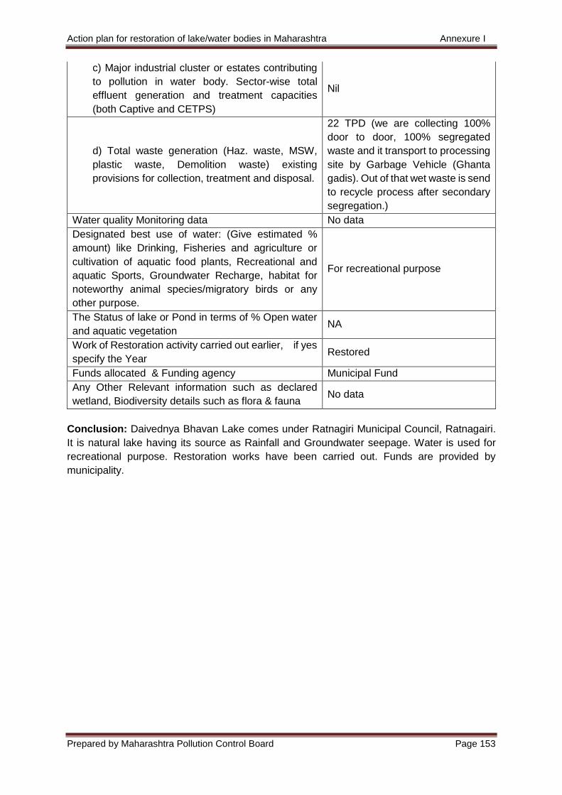
Action plan for restoration of lake/water bodies in Maharashtra Annexure I
Prepared by Maharashtra Pollution Control Board Page 153
c) Major industrial cluster or estates contributing
to pollution in water body. Sector-wise total
effluent generation and treatment capacities
(both Captive and CETPS)
Nil
d) Total waste generation (Haz. waste, MSW,
plastic waste, Demolition waste) existing
provisions for collection, treatment and disposal.
22 TPD (we are collecting 100%
door to door, 100% segregated
waste and it transport to processing
site by Garbage Vehicle (Ghanta
gadis). Out of that wet waste is send
to recycle process after secondary
segregation.)
Water quality Monitoring data No data
Designated best use of water: (Give estimated %
amount) like Drinking, Fisheries and agriculture or
cultivation of aquatic food plants, Recreational and
aquatic Sports, Groundwater Recharge, habitat for
noteworthy animal species/migratory birds or any
other purpose.
For recreational purpose
The Status of lake or Pond in terms of % Open water
and aquatic vegetation NA
Work of Restoration activity carried out earlier, if yes
specify the Year Restored
Funds allocated & Funding agency Municipal Fund
Any Other Relevant information such as declared
wetland, Biodiversity details such as flora & fauna No data
Conclusion: Daivednya Bhavan Lake comes under Ratnagiri Municipal Council, Ratnagairi.
It is natural lake having its source as Rainfall and Groundwater seepage. Water is used for
recreational purpose. Restoration works have been carried out. Funds are provided by
municipality.
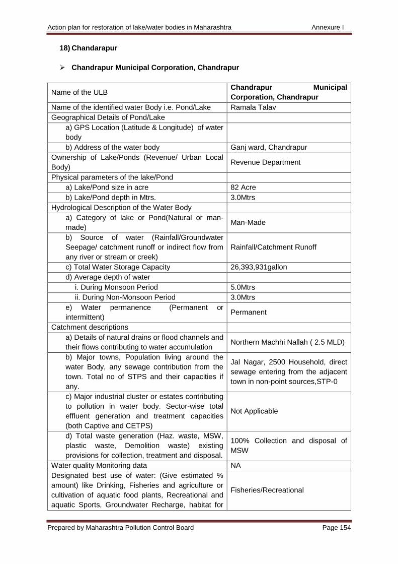
Action plan for restoration of lake/water bodies in Maharashtra Annexure I
Prepared by Maharashtra Pollution Control Board Page 154
18) Chandarapur
Chandrapur Municipal Corporation, Chandrapur
Name of the ULB Chandrapur Municipal
Corporation, Chandrapur
Name of the identified water Body i.e. Pond/Lake Ramala Talav
Geographical Details of Pond/Lake
a) GPS Location (Latitude & Longitude) of water
body
b) Address of the water body Ganj ward, Chandrapur
Ownership of Lake/Ponds (Revenue/ Urban Local
Body) Revenue Department
Physical parameters of the lake/Pond
a) Lake/Pond size in acre 82 Acre
b) Lake/Pond depth in Mtrs. 3.0Mtrs
Hydrological Description of the Water Body
a) Category of lake or Pond(Natural or man-
made) Man-Made
b) Source of water (Rainfall/Groundwater
Seepage/ catchment runoff or indirect flow from
any river or stream or creek)
Rainfall/Catchment Runoff
c) Total Water Storage Capacity 26,393,931gallon
d) Average depth of water
i. During Monsoon Period 5.0Mtrs
ii. During Non-Monsoon Period 3.0Mtrs
e) Water permanence (Permanent or
intermittent) Permanent
Catchment descriptions
a) Details of natural drains or flood channels and
their flows contributing to water accumulation Northern Machhi Nallah ( 2.5 MLD)
b) Major towns, Population living around the
water Body, any sewage contribution from the
town. Total no of STPS and their capacities if
any.
Jal Nagar, 2500 Household, direct
sewage entering from the adjacent
town in non-point sources,STP-0
c) Major industrial cluster or estates contributing
to pollution in water body. Sector-wise total
effluent generation and treatment capacities
(both Captive and CETPS)
Not Applicable
d) Total waste generation (Haz. waste, MSW,
plastic waste, Demolition waste) existing
provisions for collection, treatment and disposal.
100% Collection and disposal of
MSW
Water quality Monitoring data NA
Designated best use of water: (Give estimated %
amount) like Drinking, Fisheries and agriculture or
cultivation of aquatic food plants, Recreational and
aquatic Sports, Groundwater Recharge, habitat for
Fisheries/Recreational
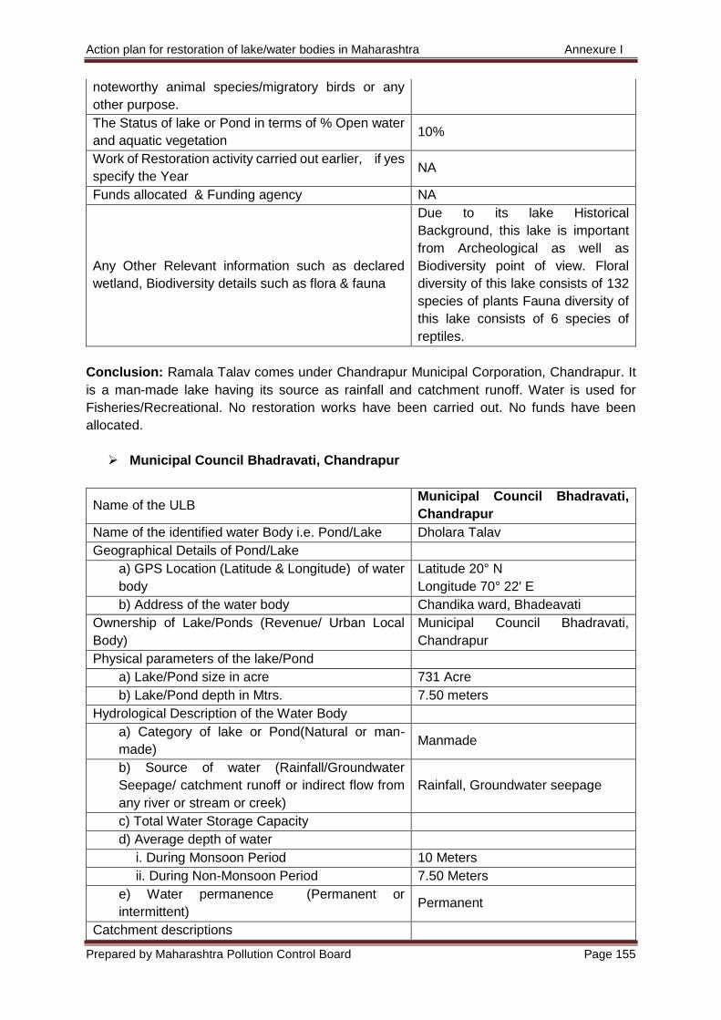
Action plan for restoration of lake/water bodies in Maharashtra Annexure I
Prepared by Maharashtra Pollution Control Board Page 155
noteworthy animal species/migratory birds or any
other purpose.
The Status of lake or Pond in terms of % Open water
and aquatic vegetation 10%
Work of Restoration activity carried out earlier, if yes
specify the Year NA
Funds allocated & Funding agency NA
Any Other Relevant information such as declared
wetland, Biodiversity details such as flora & fauna
Due to its lake Historical
Background, this lake is important
from Archeological as well as
Biodiversity point of view. Floral
diversity of this lake consists of 132
species of plants Fauna diversity of
this lake consists of 6 species of
reptiles.
Conclusion: Ramala Talav comes under Chandrapur Municipal Corporation, Chandrapur. It
is a man-made lake having its source as rainfall and catchment runoff. Water is used for
Fisheries/Recreational. No restoration works have been carried out. No funds have been
allocated.
Municipal Council Bhadravati, Chandrapur
Name of the ULB Municipal Council Bhadravati,
Chandrapur
Name of the identified water Body i.e. Pond/Lake Dholara Talav
Geographical Details of Pond/Lake
a) GPS Location (Latitude & Longitude) of water
body
Latitude 20° N
Longitude 70° 22' E
b) Address of the water body Chandika ward, Bhadeavati
Ownership of Lake/Ponds (Revenue/ Urban Local
Body)
Municipal Council Bhadravati,
Chandrapur
Physical parameters of the lake/Pond
a) Lake/Pond size in acre 731 Acre
b) Lake/Pond depth in Mtrs. 7.50 meters
Hydrological Description of the Water Body
a) Category of lake or Pond(Natural or man-
made) Manmade
b) Source of water (Rainfall/Groundwater
Seepage/ catchment runoff or indirect flow from
any river or stream or creek)
Rainfall, Groundwater seepage
c) Total Water Storage Capacity
d) Average depth of water
i. During Monsoon Period 10 Meters
ii. During Non-Monsoon Period 7.50 Meters
e) Water permanence (Permanent or
intermittent) Permanent
Catchment descriptions
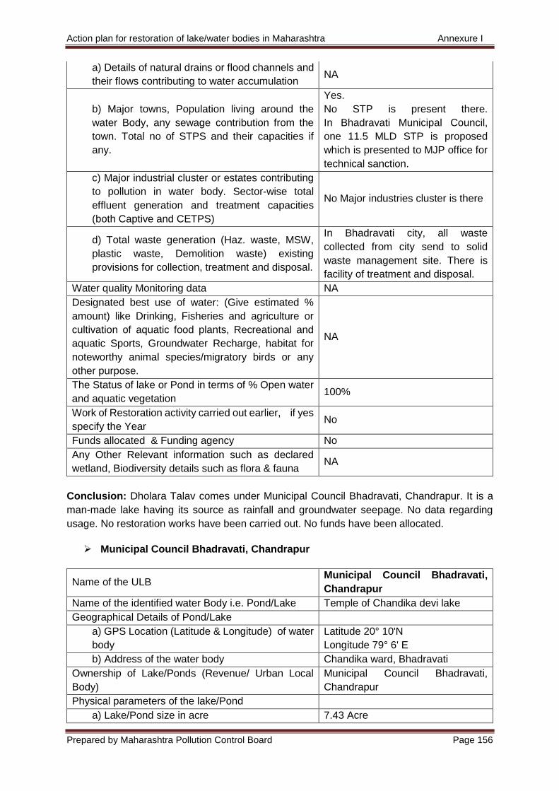
Action plan for restoration of lake/water bodies in Maharashtra Annexure I
Prepared by Maharashtra Pollution Control Board Page 156
a) Details of natural drains or flood channels and
their flows contributing to water accumulation NA
b) Major towns, Population living around the
water Body, any sewage contribution from the
town. Total no of STPS and their capacities if
any.
Yes.
No STP is present there.
In Bhadravati Municipal Council,
one 11.5 MLD STP is proposed
which is presented to MJP office for
technical sanction.
c) Major industrial cluster or estates contributing
to pollution in water body. Sector-wise total
effluent generation and treatment capacities
(both Captive and CETPS)
No Major industries cluster is there
d) Total waste generation (Haz. waste, MSW,
plastic waste, Demolition waste) existing
provisions for collection, treatment and disposal.
In Bhadravati city, all waste
collected from city send to solid
waste management site. There is
facility of treatment and disposal.
Water quality Monitoring data NA
Designated best use of water: (Give estimated %
amount) like Drinking, Fisheries and agriculture or
cultivation of aquatic food plants, Recreational and
aquatic Sports, Groundwater Recharge, habitat for
noteworthy animal species/migratory birds or any
other purpose.
NA
The Status of lake or Pond in terms of % Open water
and aquatic vegetation 100%
Work of Restoration activity carried out earlier, if yes
specify the Year No
Funds allocated & Funding agency No
Any Other Relevant information such as declared
wetland, Biodiversity details such as flora & fauna NA
Conclusion: Dholara Talav comes under Municipal Council Bhadravati, Chandrapur. It is a
man-made lake having its source as rainfall and groundwater seepage. No data regarding
usage. No restoration works have been carried out. No funds have been allocated.
Municipal Council Bhadravati, Chandrapur
Name of the ULB Municipal Council Bhadravati,
Chandrapur
Name of the identified water Body i.e. Pond/Lake Temple of Chandika devi lake
Geographical Details of Pond/Lake
a) GPS Location (Latitude & Longitude) of water
body
Latitude 20° 10'N
Longitude 79° 6' E
b) Address of the water body Chandika ward, Bhadravati
Ownership of Lake/Ponds (Revenue/ Urban Local
Body)
Municipal Council Bhadravati,
Chandrapur
Physical parameters of the lake/Pond
a) Lake/Pond size in acre 7.43 Acre
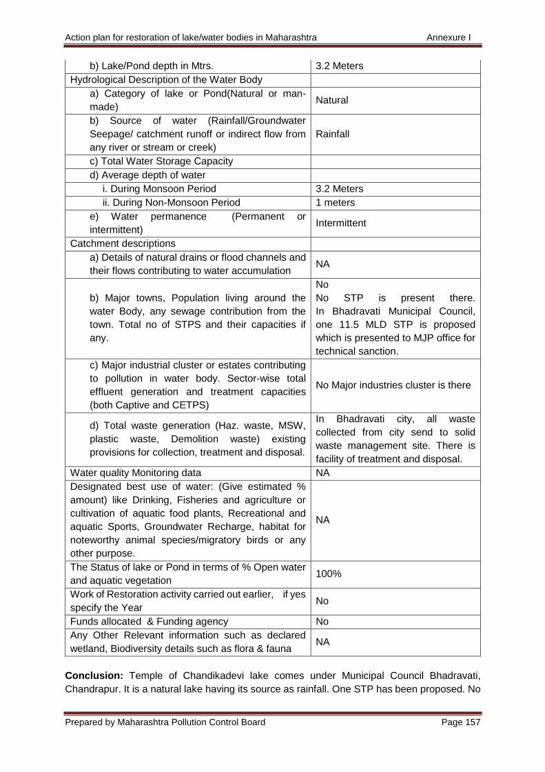
Action plan for restoration of lake/water bodies in Maharashtra Annexure I
Prepared by Maharashtra Pollution Control Board Page 157
b) Lake/Pond depth in Mtrs. 3.2 Meters
Hydrological Description of the Water Body
a) Category of lake or Pond(Natural or man-
made) Natural
b) Source of water (Rainfall/Groundwater
Seepage/ catchment runoff or indirect flow from
any river or stream or creek)
Rainfall
c) Total Water Storage Capacity
d) Average depth of water
i. During Monsoon Period 3.2 Meters
ii. During Non-Monsoon Period 1 meters
e) Water permanence (Permanent or
intermittent) Intermittent
Catchment descriptions
a) Details of natural drains or flood channels and
their flows contributing to water accumulation NA
b) Major towns, Population living around the
water Body, any sewage contribution from the
town. Total no of STPS and their capacities if
any.
No
No STP is present there.
In Bhadravati Municipal Council,
one 11.5 MLD STP is proposed
which is presented to MJP office for
technical sanction.
c) Major industrial cluster or estates contributing
to pollution in water body. Sector-wise total
effluent generation and treatment capacities
(both Captive and CETPS)
No Major industries cluster is there
d) Total waste generation (Haz. waste, MSW,
plastic waste, Demolition waste) existing
provisions for collection, treatment and disposal.
In Bhadravati city, all waste
collected from city send to solid
waste management site. There is
facility of treatment and disposal.
Water quality Monitoring data NA
Designated best use of water: (Give estimated %
amount) like Drinking, Fisheries and agriculture or
cultivation of aquatic food plants, Recreational and
aquatic Sports, Groundwater Recharge, habitat for
noteworthy animal species/migratory birds or any
other purpose.
NA
The Status of lake or Pond in terms of % Open water
and aquatic vegetation 100%
Work of Restoration activity carried out earlier, if yes
specify the Year No
Funds allocated & Funding agency No
Any Other Relevant information such as declared
wetland, Biodiversity details such as flora & fauna NA
Conclusion: Temple of Chandikadevi lake comes under Municipal Council Bhadravati,
Chandrapur. It is a natural lake having its source as rainfall. One STP has been proposed. No
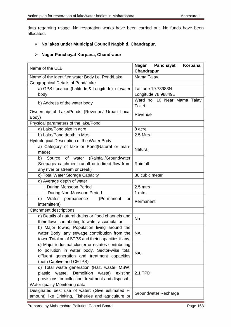
Action plan for restoration of lake/water bodies in Maharashtra Annexure I
Prepared by Maharashtra Pollution Control Board Page 158
data regarding usage. No restoration works have been carried out. No funds have been
allocated.
No lakes under Municipal Council Nagbhid, Chandrapur.
Nagar Panchayat Korpana, Chandrapur
Name of the ULB Nagar Panchayat Korpana,
Chandrapur
Name of the identified water Body i.e. Pond/Lake Mama Talav
Geographical Details of Pond/Lake
a) GPS Location (Latitude & Longitude) of water
body
Latitude 19.73983N
Longitude 78.98849E
b) Address of the water body Ward no. 10 Near Mama Talav
Toilet
Ownership of Lake/Ponds (Revenue/ Urban Local
Body) Revenue
Physical parameters of the lake/Pond
a) Lake/Pond size in acre 8 acre
b) Lake/Pond depth in Mtrs. 2.5 Mtrs
Hydrological Description of the Water Body
a) Category of lake or Pond(Natural or man-
made) Natural
b) Source of water (Rainfall/Groundwater
Seepage/ catchment runoff or indirect flow from
any river or stream or creek)
Rainfall
c) Total Water Storage Capacity 30 cubic meter
d) Average depth of water
i. During Monsoon Period 2.5 mtrs
ii. During Non-Monsoon Period 1 mtrs
e) Water permanence (Permanent or
intermittent) Permanent
Catchment descriptions
a) Details of natural drains or flood channels and
their flows contributing to water accumulation Na
b) Major towns, Population living around the
water Body, any sewage contribution from the
town. Total no of STPS and their capacities if any.
NA
c) Major industrial cluster or estates contributing
to pollution in water body. Sector-wise total
effluent generation and treatment capacities
(both Captive and CETPS)
NA
d) Total waste generation (Haz. waste, MSW,
plastic waste, Demolition waste) existing
provisions for collection, treatment and disposal.
2.1 TPD
Water quality Monitoring data
Designated best use of water: (Give estimated %
amount) like Drinking, Fisheries and agriculture or Groundwater Recharge
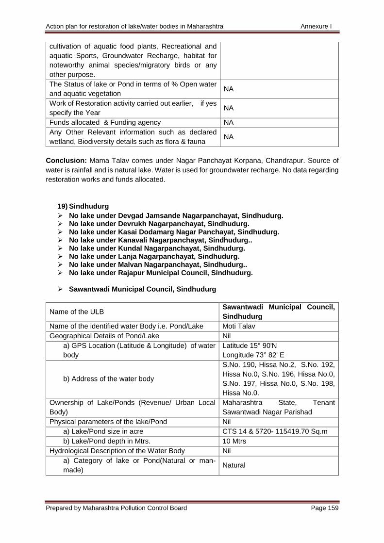
Action plan for restoration of lake/water bodies in Maharashtra Annexure I
Prepared by Maharashtra Pollution Control Board Page 159
cultivation of aquatic food plants, Recreational and
aquatic Sports, Groundwater Recharge, habitat for
noteworthy animal species/migratory birds or any
other purpose.
The Status of lake or Pond in terms of % Open water
and aquatic vegetation NA
Work of Restoration activity carried out earlier, if yes
specify the Year NA
Funds allocated & Funding agency NA
Any Other Relevant information such as declared
wetland, Biodiversity details such as flora & fauna NA
Conclusion: Mama Talav comes under Nagar Panchayat Korpana, Chandrapur. Source of
water is rainfall and is natural lake. Water is used for groundwater recharge. No data regarding
restoration works and funds allocated.
19) Sindhudurg
No lake under Devgad Jamsande Nagarpanchayat, Sindhudurg. No lake under Devrukh Nagarpanchayat, Sindhudurg. No lake under Kasai Dodamarg Nagar Panchayat, Sindhudurg. No lake under Kanavali Nagarpanchayat, Sindhudurg.. No lake under Kundal Nagarpanchayat, Sindhudurg. No lake under Lanja Nagarpanchayat, Sindhudurg. No lake under Malvan Nagarpanchayat, Sindhudurg.. No lake under Rajapur Municipal Council, Sindhudurg.
Sawantwadi Municipal Council, Sindhudurg
Name of the ULB Sawantwadi Municipal Council,
Sindhudurg
Name of the identified water Body i.e. Pond/Lake Moti Talav
Geographical Details of Pond/Lake Nil
a) GPS Location (Latitude & Longitude) of water
body
Latitude 15° 90'N
Longitude 73° 82' E
b) Address of the water body
S.No. 190, Hissa No.2, S.No. 192,
Hissa No.0, S.No. 196, Hissa No.0,
S.No. 197, Hissa No.0, S.No. 198,
Hissa No.0.
Ownership of Lake/Ponds (Revenue/ Urban Local
Body)
Maharashtra State, Tenant
Sawantwadi Nagar Parishad
Physical parameters of the lake/Pond Nil
a) Lake/Pond size in acre CTS 14 & 5720- 115419.70 Sq.m
b) Lake/Pond depth in Mtrs. 10 Mtrs
Hydrological Description of the Water Body Nil
a) Category of lake or Pond(Natural or man-
made) Natural
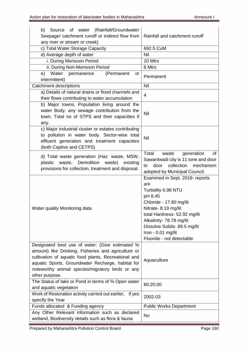
Action plan for restoration of lake/water bodies in Maharashtra Annexure I
Prepared by Maharashtra Pollution Control Board Page 160
b) Source of water (Rainfall/Groundwater
Seepage/ catchment runoff or indirect flow from
any river or stream or creek)
Rainfall and catchment runoff
c) Total Water Storage Capacity 692.5 CuM
d) Average depth of water Nil
i. During Monsoon Period 10 Mtrs
ii. During Non-Monsoon Period 6 Mtrs
e) Water permanence (Permanent or
intermittent) Permanent
Catchment descriptions Nil
a) Details of natural drains or flood channels and
their flows contributing to water accumulation 4
b) Major towns, Population living around the
water Body, any sewage contribution from the
town. Total no of STPS and their capacities if
any.
Nil
c) Major industrial cluster or estates contributing
to pollution in water body. Sector-wise total
effluent generation and treatment capacities
(both Captive and CETPS)
Nil
d) Total waste generation (Haz. waste, MSW,
plastic waste, Demolition waste) existing
provisions for collection, treatment and disposal.
Total waste generation of
Sawantwadi city is 11 tone and door
to door collection mechanism
adopted by Municipal Council.
Water quality Monitoring data
Examined in Sept. 2018- reports
are
Turbidity 6.98 NTU
pH 8.45
Chloride - 17.80 mg/lit
Nitrate- 8.19 mg/lit
total Hardness- 52.92 mg/lit
Alkalinity- 78.78 mg/lit
Dissolve Solids- 89.5 mg/lit
Iron - 0.01 mg/lit
Fluoride - not detectable
Designated best use of water: (Give estimated %
amount) like Drinking, Fisheries and agriculture or
cultivation of aquatic food plants, Recreational and
aquatic Sports, Groundwater Recharge, habitat for
noteworthy animal species/migratory birds or any
other purpose.
Aquaculture
The Status of lake or Pond in terms of % Open water
and aquatic vegetation 80:20:00
Work of Restoration activity carried out earlier, if yes
specify the Year 2002-03
Funds allocated & Funding agency Public Works Department
Any Other Relevant information such as declared
wetland, Biodiversity details such as flora & fauna No
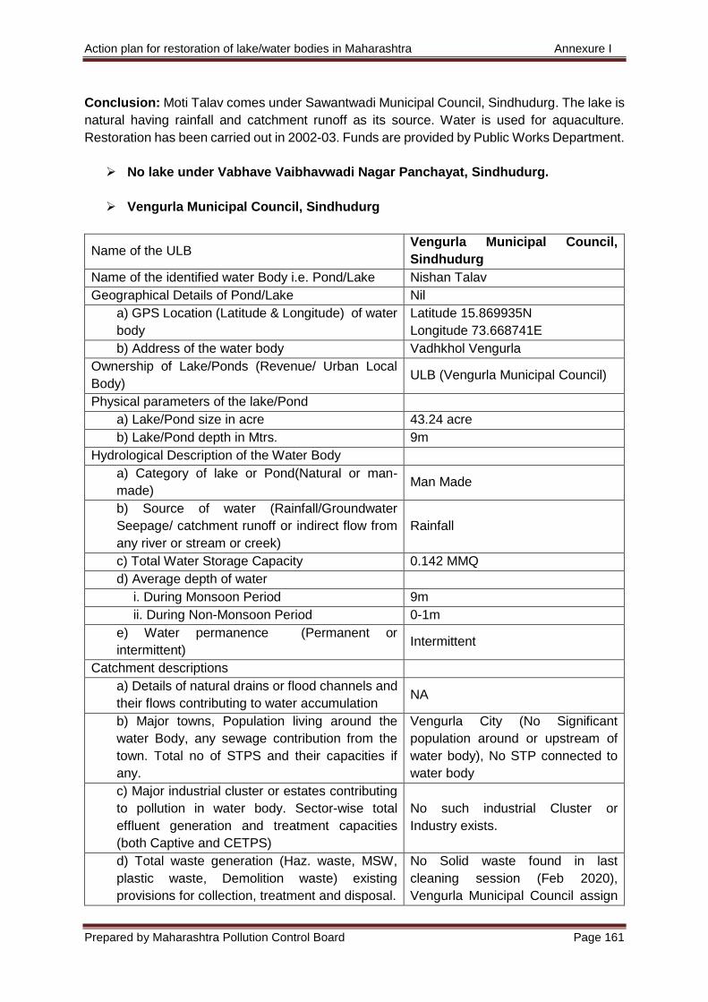
Action plan for restoration of lake/water bodies in Maharashtra Annexure I
Prepared by Maharashtra Pollution Control Board Page 161
Conclusion: Moti Talav comes under Sawantwadi Municipal Council, Sindhudurg. The lake is
natural having rainfall and catchment runoff as its source. Water is used for aquaculture.
Restoration has been carried out in 2002-03. Funds are provided by Public Works Department.
No lake under Vabhave Vaibhavwadi Nagar Panchayat, Sindhudurg.
Vengurla Municipal Council, Sindhudurg
Name of the ULB Vengurla Municipal Council,
Sindhudurg
Name of the identified water Body i.e. Pond/Lake Nishan Talav
Geographical Details of Pond/Lake Nil
a) GPS Location (Latitude & Longitude) of water
body
Latitude 15.869935N
Longitude 73.668741E
b) Address of the water body Vadhkhol Vengurla
Ownership of Lake/Ponds (Revenue/ Urban Local
Body) ULB (Vengurla Municipal Council)
Physical parameters of the lake/Pond
a) Lake/Pond size in acre 43.24 acre
b) Lake/Pond depth in Mtrs. 9m
Hydrological Description of the Water Body
a) Category of lake or Pond(Natural or man-
made) Man Made
b) Source of water (Rainfall/Groundwater
Seepage/ catchment runoff or indirect flow from
any river or stream or creek)
Rainfall
c) Total Water Storage Capacity 0.142 MMQ
d) Average depth of water
i. During Monsoon Period 9m
ii. During Non-Monsoon Period 0-1m
e) Water permanence (Permanent or
intermittent) Intermittent
Catchment descriptions
a) Details of natural drains or flood channels and
their flows contributing to water accumulation NA
b) Major towns, Population living around the
water Body, any sewage contribution from the
town. Total no of STPS and their capacities if
any.
Vengurla City (No Significant
population around or upstream of
water body), No STP connected to
water body
c) Major industrial cluster or estates contributing
to pollution in water body. Sector-wise total
effluent generation and treatment capacities
(both Captive and CETPS)
No such industrial Cluster or
Industry exists.
d) Total waste generation (Haz. waste, MSW,
plastic waste, Demolition waste) existing
provisions for collection, treatment and disposal.
No Solid waste found in last
cleaning session (Feb 2020),
Vengurla Municipal Council assign
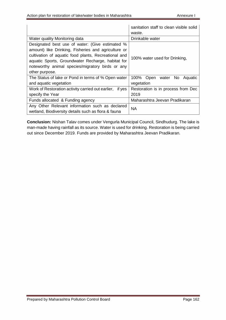
Action plan for restoration of lake/water bodies in Maharashtra Annexure I
Prepared by Maharashtra Pollution Control Board Page 162
sanitation staff to clean visible solid
waste.
Water quality Monitoring data Drinkable water
Designated best use of water: (Give estimated %
amount) like Drinking, Fisheries and agriculture or
cultivation of aquatic food plants, Recreational and
aquatic Sports, Groundwater Recharge, habitat for
noteworthy animal species/migratory birds or any
other purpose.
100% water used for Drinking,
The Status of lake or Pond in terms of % Open water
and aquatic vegetation
100% Open water No Aquatic
vegetation
Work of Restoration activity carried out earlier, if yes
specify the Year
Restoration is in process from Dec
2019
Funds allocated & Funding agency Maharashtra Jeevan Pradikaran
Any Other Relevant information such as declared
wetland, Biodiversity details such as flora & fauna NA
Conclusion: Nishan Talav comes under Vengurla Municipal Council, Sindhudurg. The lake is
man-made having rainfall as its source. Water is used for drinking. Restoration is being carried
out since December 2019. Funds are provided by Maharashtra Jeevan Pradikaran.
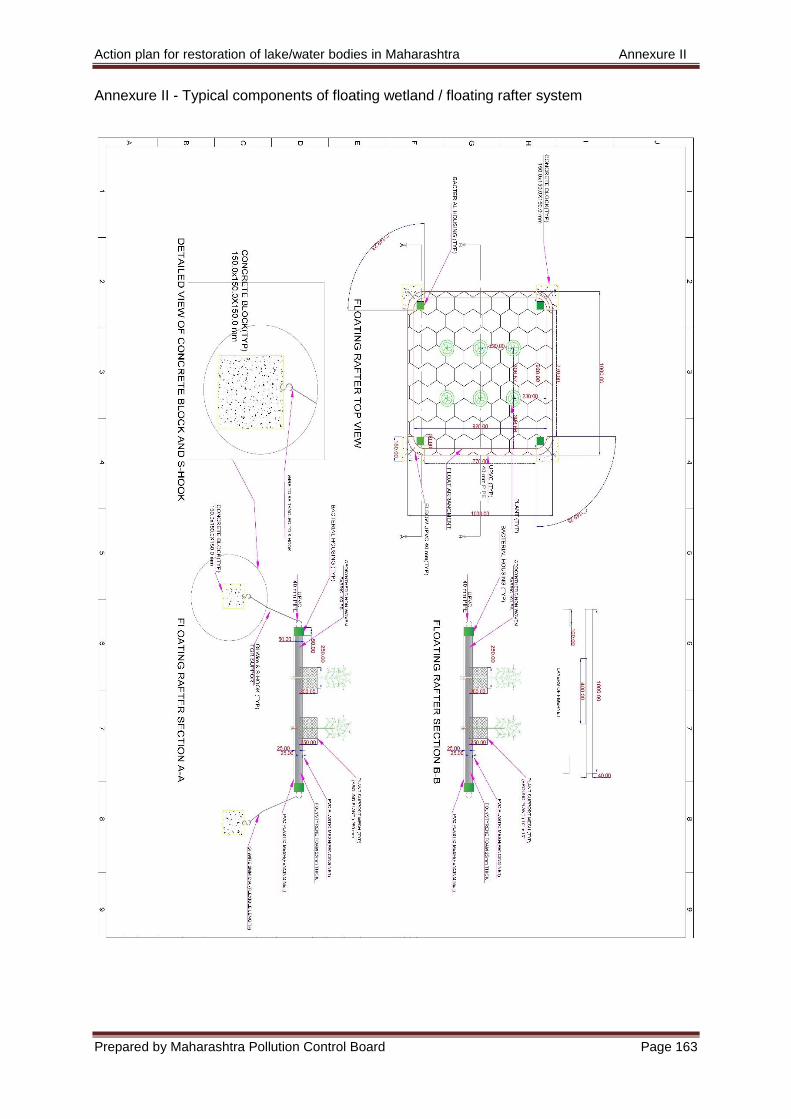
Action plan for restoration of lake/water bodies in Maharashtra Annexure II
Prepared by Maharashtra Pollution Control Board Page 163
Annexure II - Typical components of floating wetland / floating rafter system
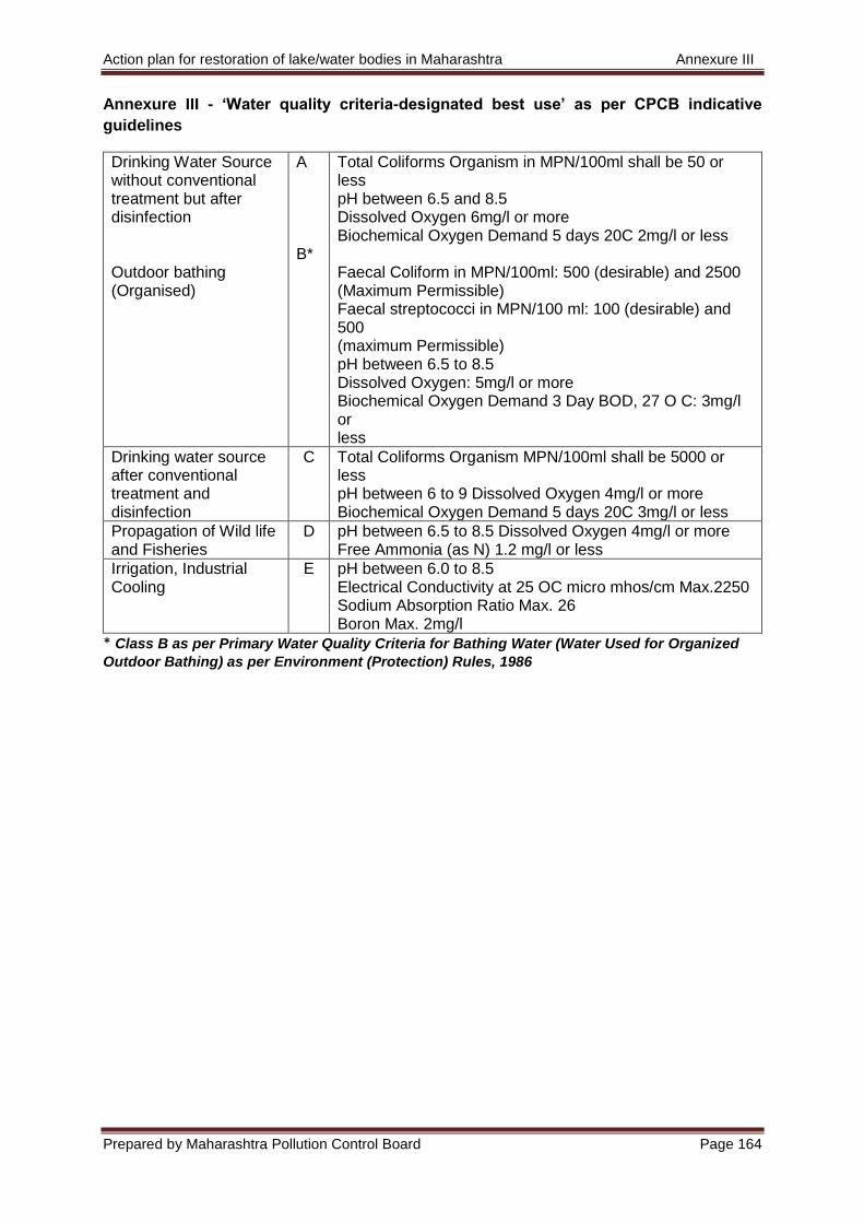
Action plan for restoration of lake/water bodies in Maharashtra Annexure III
Prepared by Maharashtra Pollution Control Board Page 164
Annexure III - ‘Water quality criteria-designated best use’ as per CPCB indicative
guidelines
Drinking Water Source without conventional treatment but after disinfection Outdoor bathing (Organised)
A B*
Total Coliforms Organism in MPN/100ml shall be 50 or less pH between 6.5 and 8.5 Dissolved Oxygen 6mg/l or more Biochemical Oxygen Demand 5 days 20C 2mg/l or less Faecal Coliform in MPN/100ml: 500 (desirable) and 2500 (Maximum Permissible) Faecal streptococci in MPN/100 ml: 100 (desirable) and 500 (maximum Permissible) pH between 6.5 to 8.5 Dissolved Oxygen: 5mg/l or more Biochemical Oxygen Demand 3 Day BOD, 27 O C: 3mg/l or less
Drinking water source after conventional treatment and disinfection
C Total Coliforms Organism MPN/100ml shall be 5000 or less pH between 6 to 9 Dissolved Oxygen 4mg/l or more Biochemical Oxygen Demand 5 days 20C 3mg/l or less
Propagation of Wild life and Fisheries
D pH between 6.5 to 8.5 Dissolved Oxygen 4mg/l or more Free Ammonia (as N) 1.2 mg/l or less
Irrigation, Industrial Cooling
E pH between 6.0 to 8.5 Electrical Conductivity at 25 OC micro mhos/cm Max.2250 Sodium Absorption Ratio Max. 26 Boron Max. 2mg/l
* Class B as per Primary Water Quality Criteria for Bathing Water (Water Used for Organized
Outdoor Bathing) as per Environment (Protection) Rules, 1986