M. Petropoulos, A. Rizakis, Ancient Patrai
58
-
Upload
independent -
Category
Documents
-
view
2 -
download
0
Transcript of M. Petropoulos, A. Rizakis, Ancient Patrai

PATRAS
UNDER THE AEGIS OF THE
EUROPEAN CAPITAL OF CULTURE
«PATRAS 2006»
PATRAS
CHAPTER I
Ancient Patrai
THANASIS RIZAKIS
MICHALIS PETROPOULOS
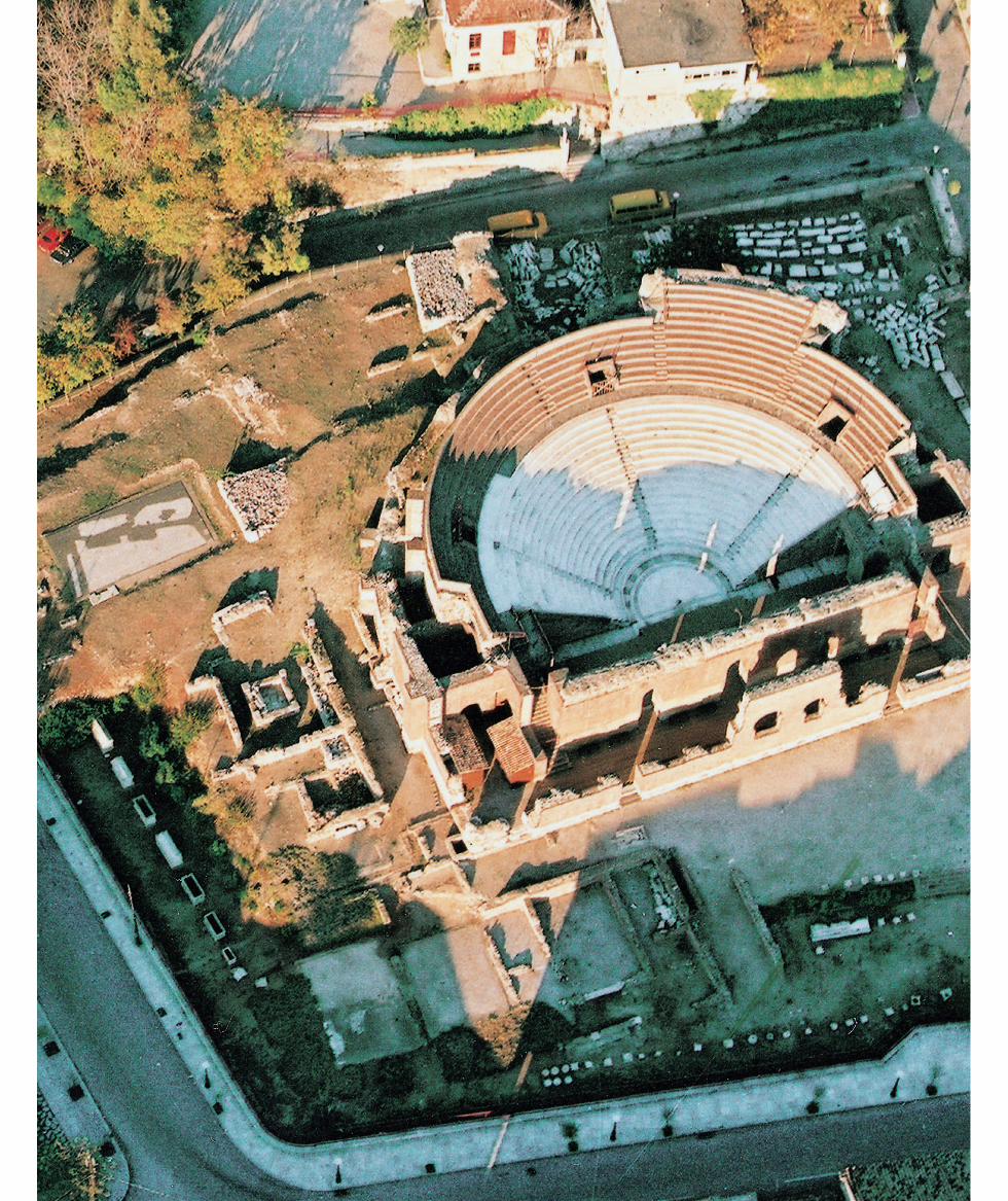
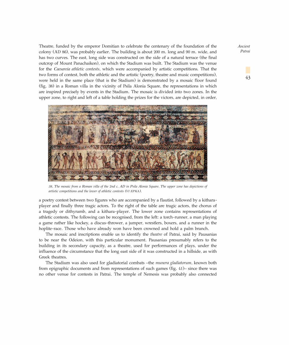
1. General picture of the Roman Odeion of Patrai, which was built about AD 160 according to Pausanias.Beneath it are houses of the first Roman period, which were demolished to make way for the Odeion. Thewhole or part of the cavea was probably roofed (VI EPKA).
☞
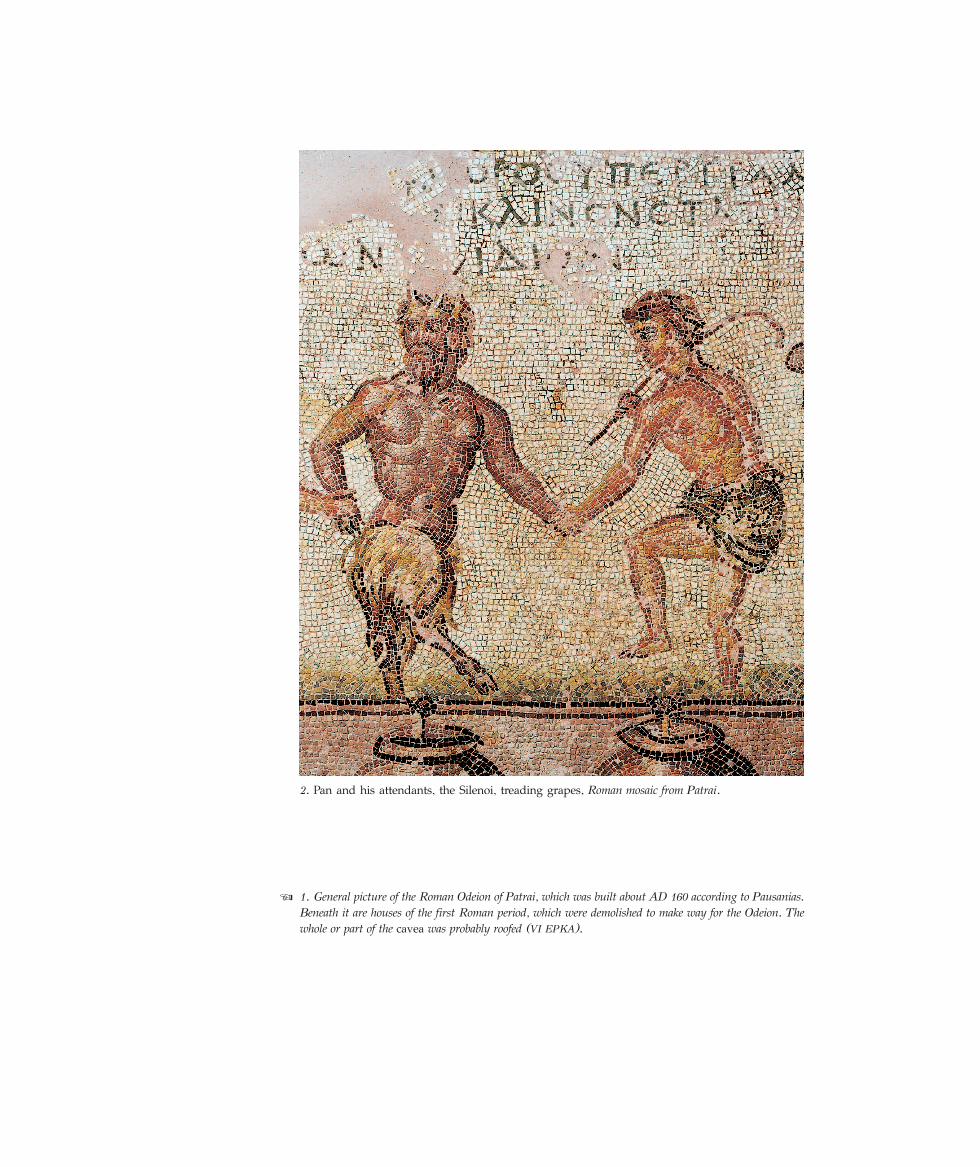
2. Pan and his attendants, the Silenoi, treading grapes, Roman mosaic from Patrai.
THANASIS RIZAKIS – MICHALIS PETROPOULOS
Ancient Patrai
Patras has a horizon that is at once closed and open. It is open, more specifically, to the west. Andthis is psychologically important. When the day departs, its light, its sun, is not closed off by a doorraised before us like a gloomy territorial wall. The day departs in the direction of the boundless, thestretch of boundless sea; and the soul goes with it and travels. But Patras only has an open horizonto the west.*
Ancient Patrai occupied the same site as the modern town, at the centre of the Patraike, afertile plain in Achaia which, from at least the Classical period onwards, was its chora – itsterritory (map 1 = fig. 7).
According to the local myth, which is reported by Pausanias, the city took its name fromthe Spartan Achaian Patreus, son of Preugenes. Patreus fortified the city with a large circuitwall that enclosed the ancient village of Aroe. In ancient times, the city’s name is cited in theplural (Patrai), and the most common ethnikon is Patreus. According to the literary tradition,this name is owed to Patreus, son of Preugenes, who led the Achaians of Sparta here at theend of the Mycenaean period (about 1100 BC). Modern scholars, however, take the view thatthe place-name is connected with the noble clans called patrai (=phratrai) that tookpart in the synoecism which created the city, as, indeed, occurred in the case ofneighbouring Pharai (pharai=phratrai). The choice of this neutral name is accountedfor by the absence of any powerful settlement that might have imposed its ownname, on the model of eastern Achaia, where cities created by synoecisms adopted the nameof earlier, powerful centres (e.g. Aigion, Aigeira, Pellene and Helike). In the time of Herodotus,the synoecism of the phratries of the Patraike at Aroe had apparently not yet been completed,and the catalogue of cities of Achaia recorded by the historian refers to Patreis. The first useof the place-name Patrai and the corresponding ethnikon goes back to the Peloponnesian War,implying that the synoecism of the phratries in the Aroe plain, that formed the later city ofPatrai, had taken place in the meantime.
Name
* From P. Kanellopoulos’s introduction to the second edition of History of the Town of Patras by S.N. Thomopoulos,ed. K.N. Triandaphyllou, Patras 1950.
According to a tradition recorded by Pausanias, the first inhabitant of Aroe was Eumelos, whowas taught the art of farming by Triptolemos. Aroe owes its name to ploughing (arosis), astage in the process of farming. According to the same traveller, the earliest inhabitants ofPatrai were Ionians, who were forcibly expelled by the Achaian Spartans after the capture ofSparta by the Dorians, about 1100 BC. The literary tradition also assigns to Patrai’s Ionianperiod the arrival of a Thessalian king named Eurypylos, who, in response to a Delphic oracle,came to Patrai, suppressed the human sacrifices held to propitiate Artemis Triklaria, andintroduced the worship of a new god (Dionysos). In the eyes of some scholars, this mythaccounts for the presence of elements of the Aeolic dialect preserved sporadically in the laterAchaian dialect, which are attributed to the settlement of Aeolian tribes.
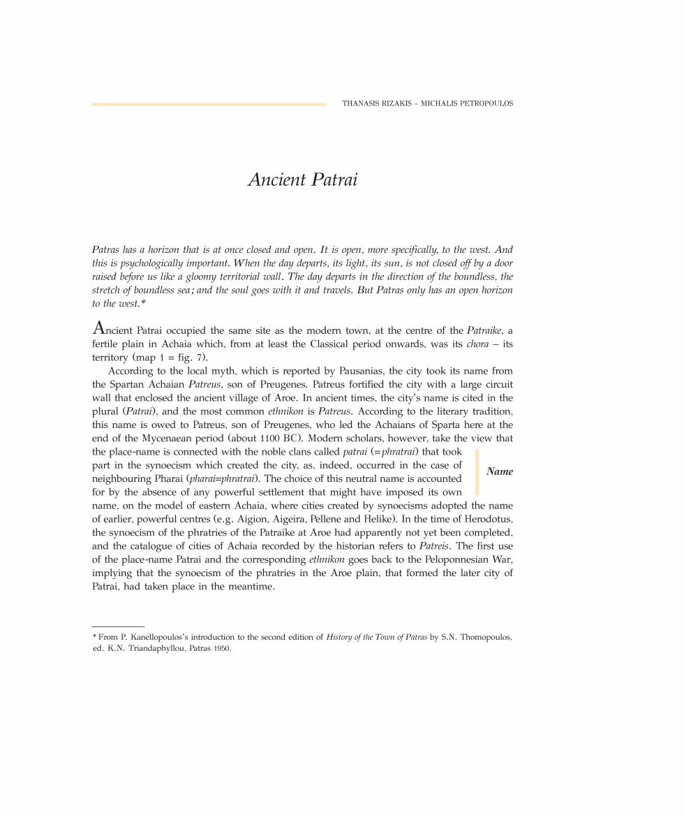
Archaeological excavation, of course, can neither confirm nor disprove this tradition. Itdoes, however, take us even further back, to the distant past of the region: the securely attestedtraces of its history are much earlier, dating from the middle of the 3rd millennium BC, about2500 BC – the period known as Early Helladic II. The presence of even earlier, Palaeolithic andNeolithic, remains in regions marching with Patrai, such as western Achaia and Chalandritsa,make it very probable that the surrounding area of Patrai was also inhabited during theseperiods. This area consists of a fertile plain surrounded by low hills, with several rivers –indispensable features for the growth of civilisations at this remote period – while the sea ofthe gulf of Patrai will have provided its own products.
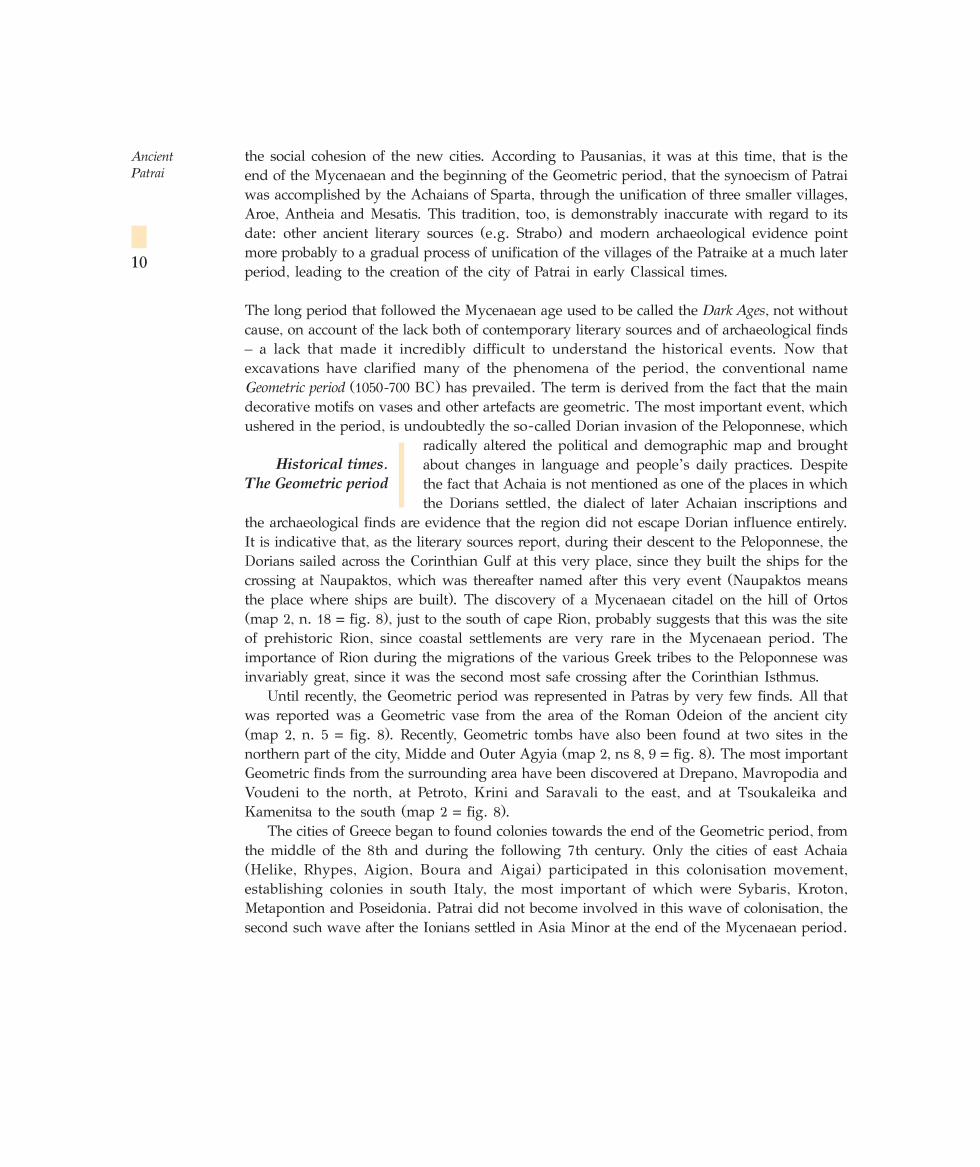
The most important archaeological remains of the Early Helladic II period have been foundat Pagona (map 2, n. 1 = fig. 8) to the east of the Classical acropolis, which had probably alsobeen the Mycenaean citadel, and on which the Byzantine Castle of Patras was also built (map
2, n. 2 = fig. 8). Pagona was also occupied during the next twoperiods, the Middle Helladic (1900-1589 BC) (fig. 3) and LateHelladic or Mycenaean period (1580-1100 BC), though it is notthe only site that was used during these periods. A Middle
Helladic cemetery was excavated a good distance to the north-west of Pagona, at SmyrnisStreet 145 and Laskareos Street (map 2, n. 3 = fig. 8), which suggests the existence of a secondsettlement at this period.
Within the boundaries of the present area covered by the town, a Mycenaean cemetery wasdiscovered in Yermanou St. (map 2, n. 4 = fig. 8), to the south of the citadel. This cemeteryis a considerable distance from the settlement of Pagona and therefore appears to belong to asecond settlement (fig. 4), which probably developed on the hill with the citadel, though theexistence of the later Castle prevents the lower levels being excavated to confirm thishypothesis. It is clear from a number of trial trenches sunk in the 1950s that the horizon ofthe Classical acropolis is about 20 metres deeper than that of the modern surface of the hill.If the Mycenaean settlement exists, it will be even lower. The cemetery of the Mycenaeansettlement of Pagona is probably the one located earlier in the region of Samarakia, thoughthe precise position of this is now unknown. It was presumably on the site of the formerMilitary Hospital (map 2, n. 7 = fig. 8).
In any event, Patrai, like western Achaia in general, played no part in the major event of
Ancient Patrai
6
Brief historical review.
The prehistoric period
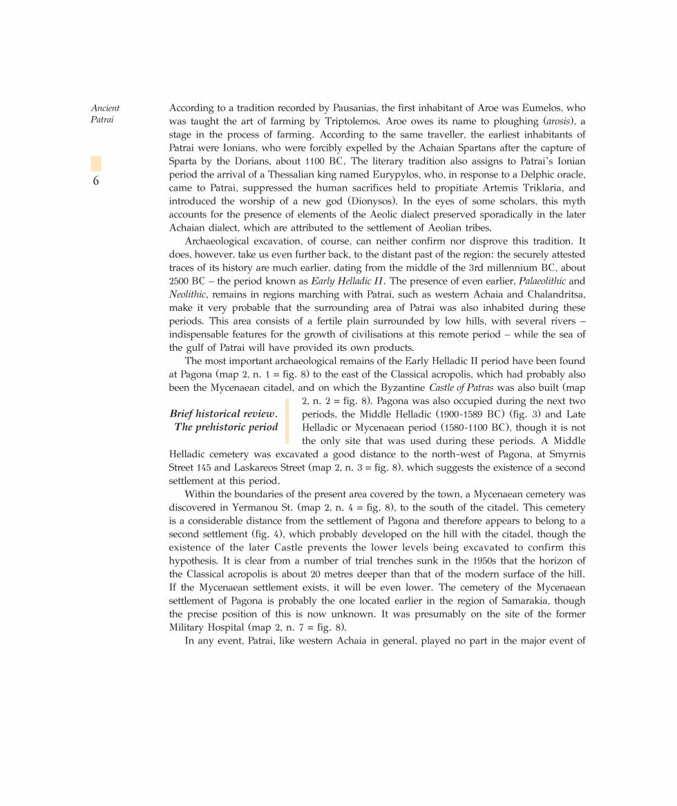
the Mycenaean period, the Trojan War. By con-trast, the cities of eastern Achaia, modern Ai-gialeia (map 1 = fig. 7), which seem from Homerto have belonged to the kingdom, or the sphereof influence, of Agamemnon of Mycenae, doseem to have taken part in it. The distinctionbetween eastern and western Achaia is also quiteclear not only from the evidence derived fromthe literary sources, but also from the archaeo-logical record. The small finds, particularly theclay vases, of eastern Achaia, are either imported,mainly from the north-eastern Peloponnese, orare influenced by the corresponding pottery fromthis area, while those of western Achaia aresignificantly different. Here the local outputpredominated, and was also exported to otherareas (fig. 5).
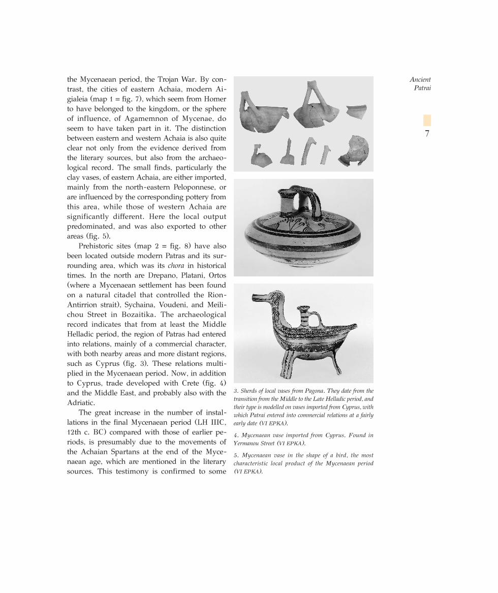
Prehistoric sites (map 2 = fig. 8) have alsobeen located outside modern Patras and its sur-rounding area, which was its chora in historicaltimes. In the north are Drepano, Platani, Ortos(where a Mycenaean settlement has been foundon a natural citadel that controlled the Rion-Antirrion strait), Sychaina, Voudeni, and Meili-chou Street in Bozaitika. The archaeologicalrecord indicates that from at least the MiddleHelladic period, the region of Patras had enteredinto relations, mainly of a commercial character,with both nearby areas and more distant regions,such as Cyprus (fig. 3). These relations multi-plied in the Mycenaean period. Now, in additionto Cyprus, trade developed with Crete (fig. 4)and the Middle East, and probably also with theAdriatic.
The great increase in the number of instal-lations in the final Mycenaean period (LH IIIC,12th c. BC) compared with those of earlier pe-riods, is presumably due to the movements ofthe Achaian Spartans at the end of the Myce-naean age, which are mentioned in the literarysources. This testimony is confirmed to some
Ancient Patrai
7
3. Sherds of local vases from Pagona. They date from thetransition from the Middle to the Late Helladic period, andtheir type is modelled on vases imported from Cyprus, withwhich Patrai entered into commercial relations at a fairlyearly date (VI EPKA).
4. Mycenaean vase imported from Cyprus. Found inYermanou Street (VI EPKA).
5. Mycenaean vase in the shape of a bird, the mostcharacteristic local product of the Mycenaean period (VI EPKA).
extent by the presence, for the first time, of weapons and warriors in tombs of the middle ofthe 12th c. BC, and by the population explosion that can be observed, indicating precisely thatsomething is going on in the region. The installation of the newcomers seems to have beenpeaceful, since there is no archaeological evidence to suggest the contrary. Archaeologyconfirms the later literary tradition of a change in population in the Mycenaean settlements ofthe period, and provides valuable information about their weapons and vases, and alsofunerary practices. It does not help us, however, to comprehend the nature of the politicalstructure or the organisation of these new tribes.
In the buildings of the three prehistoric periods, the foundations and lower part of thewalls were made of unworked blocks of stone and mud, while the superstructure was of
unbaked bricks. No building has beenexcavated sufficiently to reveal its archi-tectural design. It appears, however, thatthe houses consisted of small, mostlyrectangular rooms. No cemeteries of theEarly Helladic period have been located.However, a cemetery excavated atKalamaki, Elaiochori, in Western Achaia(map 1 = fig. 7) reveals that the graveswere chamber tombs built above ground,with a perpendicular trench in front ofthe entrance. The Middle Helladic ceme-tery at Patras consisted of cist graves.The cemeteries of Mycenaean date were
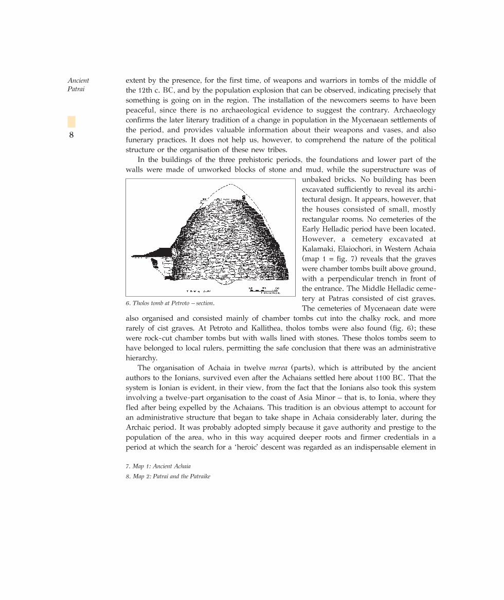
also organised and consisted mainly of chamber tombs cut into the chalky rock, and morerarely of cist graves. At Petroto and Kallithea, tholos tombs were also found (fig. 6); thesewere rock-cut chamber tombs but with walls lined with stones. These tholos tombs seem tohave belonged to local rulers, permitting the safe conclusion that there was an administrativehierarchy.
The organisation of Achaia in twelve merea (parts), which is attributed by the ancientauthors to the Ionians, survived even after the Achaians settled here about 1100 BC. That thesystem is Ionian is evident, in their view, from the fact that the Ionians also took this systeminvolving a twelve-part organisation to the coast of Asia Minor – that is, to Ionia, where theyfled after being expelled by the Achaians. This tradition is an obvious attempt to account foran administrative structure that began to take shape in Achaia considerably later, during theArchaic period. It was probably adopted simply because it gave authority and prestige to thepopulation of the area, who in this way acquired deeper roots and firmer credentials in aperiod at which the search for a ‘heroic’ descent was regarded as an indispensable element in
Ancient Patrai
8
7. Map 1: Ancient Achaia
8. Map 2: Patrai and the Patraike
6. Tholos tomb at Petroto – section.
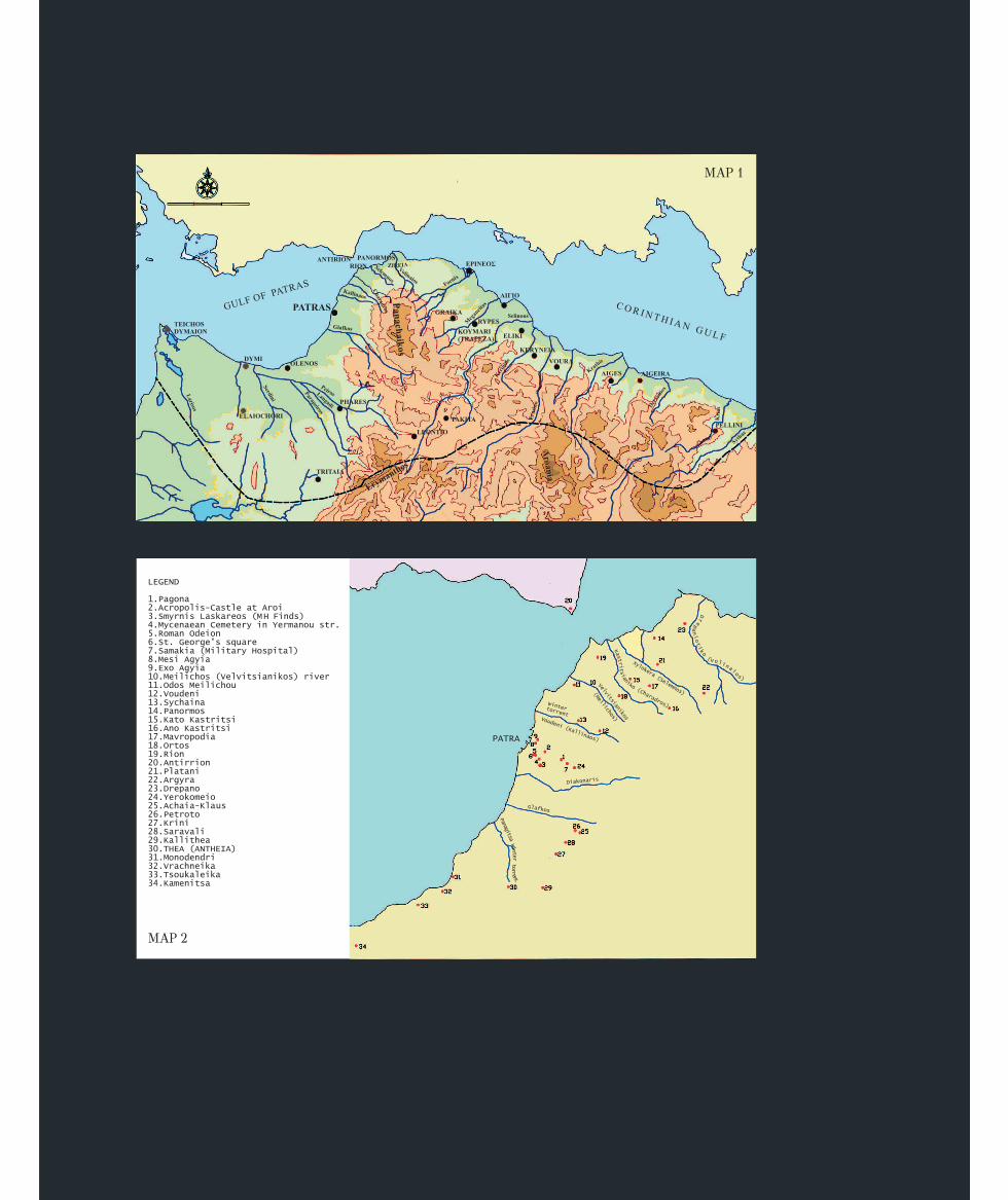
MAP 1
MAP 2
the social cohesion of the new cities. According to Pausanias, it was at this time, that is theend of the Mycenaean and the beginning of the Geometric period, that the synoecism of Patraiwas accomplished by the Achaians of Sparta, through the unification of three smaller villages,Aroe, Antheia and Mesatis. This tradition, too, is demonstrably inaccurate with regard to itsdate: other ancient literary sources (e.g. Strabo) and modern archaeological evidence pointmore probably to a gradual process of unification of the villages of the Patraike at a much laterperiod, leading to the creation of the city of Patrai in early Classical times.
The long period that followed the Mycenaean age used to be called the Dark Ages, not withoutcause, on account of the lack both of contemporary literary sources and of archaeological finds– a lack that made it incredibly difficult to understand the historical events. Now thatexcavations have clarified many of the phenomena of the period, the conventional nameGeometric period (1050-700 BC) has prevailed. The term is derived from the fact that the maindecorative motifs on vases and other artefacts are geometric. The most important event, whichushered in the period, is undoubtedly the so-called Dorian invasion of the Peloponnese, which
radically altered the political and demographic map and broughtabout changes in language and people’s daily practices. Despitethe fact that Achaia is not mentioned as one of the places in whichthe Dorians settled, the dialect of later Achaian inscriptions and
the archaeological finds are evidence that the region did not escape Dorian influence entirely.It is indicative that, as the literary sources report, during their descent to the Peloponnese, theDorians sailed across the Corinthian Gulf at this very place, since they built the ships for thecrossing at Naupaktos, which was thereafter named after this very event (Naupaktos meansthe place where ships are built). The discovery of a Mycenaean citadel on the hill of Ortos(map 2, n. 18 = fig. 8), just to the south of cape Rion, probably suggests that this was the siteof prehistoric Rion, since coastal settlements are very rare in the Mycenaean period. Theimportance of Rion during the migrations of the various Greek tribes to the Peloponnese wasinvariably great, since it was the second most safe crossing after the Corinthian Isthmus.
Until recently, the Geometric period was represented in Patras by very few finds. All thatwas reported was a Geometric vase from the area of the Roman Odeion of the ancient city(map 2, n. 5 = fig. 8). Recently, Geometric tombs have also been found at two sites in thenorthern part of the city, Midde and Outer Agyia (map 2, ns 8, 9 = fig. 8). The most importantGeometric finds from the surrounding area have been discovered at Drepano, Mavropodia andVoudeni to the north, at Petroto, Krini and Saravali to the east, and at Tsoukaleika andKamenitsa to the south (map 2 = fig. 8).
The cities of Greece began to found colonies towards the end of the Geometric period, fromthe middle of the 8th and during the following 7th century. Only the cities of east Achaia(Helike, Rhypes, Aigion, Boura and Aigai) participated in this colonisation movement,establishing colonies in south Italy, the most important of which were Sybaris, Kroton,Metapontion and Poseidonia. Patrai did not become involved in this wave of colonisation, thesecond such wave after the Ionians settled in Asia Minor at the end of the Mycenaean period.
Ancient Patrai
10
Historical times.
The Geometric period
This was presumably because the factor that obliged the east Achaians to leave their homelanddid not apply in its case – namely the restricted extent of the cultivable land of eastern Achaiawhich could not sustain a large population. The plain of Patrai, like the others in west Achaia– the plains of Pharai and Dyme (map 1 = fig. 7) – was much larger than the narrow coastalplains of east Achaia.
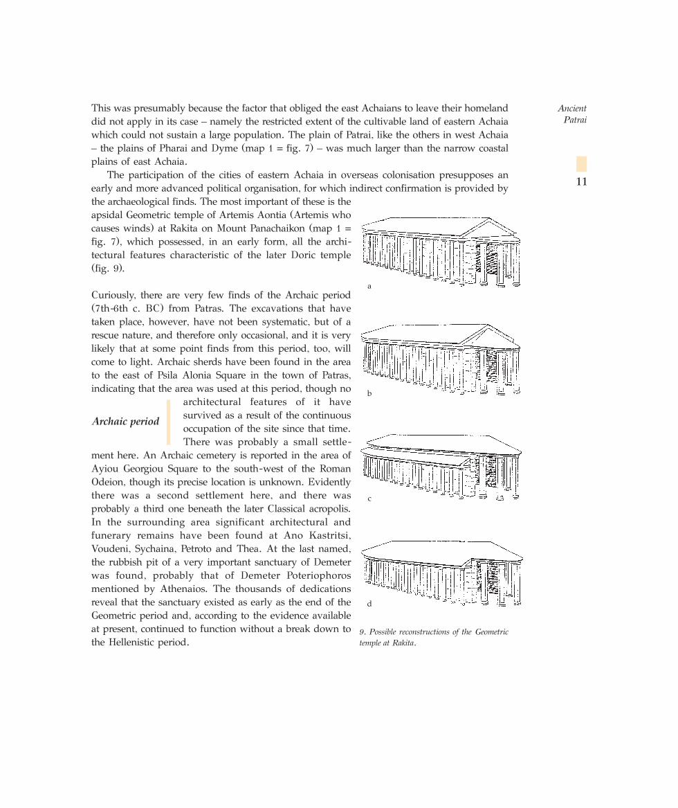
The participation of the cities of eastern Achaia in overseas colonisation presupposes anearly and more advanced political organisation, for which indirect confirmation is provided bythe archaeological finds. The most important of these is theapsidal Geometric temple of Artemis Aontia (Artemis whocauses winds) at Rakita on Mount Panachaikon (map 1 =fig. 7), which possessed, in an early form, all the archi-tectural features characteristic of the later Doric temple(fig. 9).
Curiously, there are very few finds of the Archaic period(7th-6th c. BC) from Patras. The excavations that havetaken place, however, have not been systematic, but of arescue nature, and therefore only occasional, and it is verylikely that at some point finds from this period, too, willcome to light. Archaic sherds have been found in the areato the east of Psila Alonia Square in the town of Patras,indicating that the area was used at this period, though no
architectural features of it havesurvived as a result of the continuousoccupation of the site since that time.There was probably a small settle-
ment here. An Archaic cemetery is reported in the area ofAyiou Georgiou Square to the south-west of the RomanOdeion, though its precise location is unknown. Evidentlythere was a second settlement here, and there wasprobably a third one beneath the later Classical acropolis.In the surrounding area significant architectural andfunerary remains have been found at Ano Kastritsi,Voudeni, Sychaina, Petroto and Thea. At the last named,the rubbish pit of a very important sanctuary of Demeterwas found, probably that of Demeter Poteriophorosmentioned by Athenaios. The thousands of dedicationsreveal that the sanctuary existed as early as the end of theGeometric period and, according to the evidence availableat present, continued to function without a break down tothe Hellenistic period.
Ancient Patrai
11
9. Possible reconstructions of the Geometrictemple at Rakita.
Archaic period
d
c
b
a
Although there is a dearth of significantevidence for Patras during this period, the situa-tion is different in the rest of Achaia. Archaictemples at Greka and Koumari (probably ancientRhypes) in Aigialeia (map 1 = fig. 7) mark a de-velopment of the temple at Rakita. The rectan-gular Doric temple is clearly represented in them.Support also seems to forthcoming for theexcellent German archaeologist A. Malwitz, whosought the origins of the Doric temple somewherein the north Peloponnese: its birthplace wasprobably Achaia, more specifically east Achaia.
The discouraging picture of Patrai at this timeis of little assistance to our understanding of thetransition that took place at the end of the Archaicand beginning of the Classical period, from asystem of villages to a new form of politicalorganisation: the city-state. The tradition that atthe end of the Mycenaean period the SpartanAchaian Preugenes unified the three villages ofthe Patraike into a new city that was called Patrai,after his son Patreus, is not accurate of course.The archaeological record demonstrates that atleast down to the middle of the 5th c. BC, no cityhad been created in the region. The most probableeventuality is that Preugenes and Patreus, if theyreally existed and are not a later invention toaccount for the name Patrai, created a religiousunion of the three kleroi-klaroi, that is three tribes,in honour of Artemis, who was given the epithetTriklaria for this precise reason. The three Ionianvillages, apart from Aroe, which, according toPausanias, was located on the site on which thelater city of Patrai was founded, had not beenidentified until recently. Various sites had beensuggested, each supported by strong arguments,but the problem has now been solved by findsfrom recent excavations. According to epigraphicevidence dating from Roman times, Mesatis wasat modern Voudeni (map 2, n. 12 = fig. 8), whileAntheia was probably located at modern Thea
Ancient Patrai
12
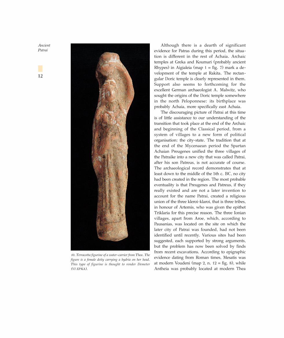
10. Terracotta figurine of a water-carrier from Thea. Thefigure is a female deity carrying a hydria on her head.This type of figurine is thought to render Demeter (VI EPKA).
(map 2, n. 30 = fig. 8). This last identification is based mainly on the results of a recentexcavation that brought to light the rubbish pits of a sanctuary which, according to a votiveinscription, belonged to Demeter. The large number of finds, such as female figurines of womencarrying hydrias (fig. 10), and many types of small drinking vessels, are firm indications thatthe sanctuary should be attributed to Demeter Poteriophoros, which was at Antheia accordingto the literary sources. And if the statements in the literary sources that all three villages existedat least from Mycenaean times are regarded as accurate, it is characteristic that at all three werefound remains dating from the Mycenaean period: building remains and tombs at Aroe (Patras)and Mesatis (Voudeni) and tombs at Antheia (Thea), which certainly belonged to a settlementthat has not yet been located. In any event, it seems that even before the completion of thisdevelopment, presumably at the beginning of the Classical period, the villages of the Patraikeas a whole formed one of the twelve parts comprising the ethnos of the Achaians.
This period, which covers the 5th c. BC from the end of the Persian Wars and the 4th c. BCdown to the death of Alexander the Great in 323 BC, is one of striking changes in the politicalgeography and rural design of the Patraike.
Small settlements grew up all over the Patraike down to the middle of the 5th c. BC whenexcavations reveal that the city of Patrai was formed from the unification of smallersettlements. The names of the settlements or villages preserved in the literary sources are few.According to these sources, the earliest of the settlements, going back until at least theMycenaean period, are Aroe, Antheia and Mesatis.
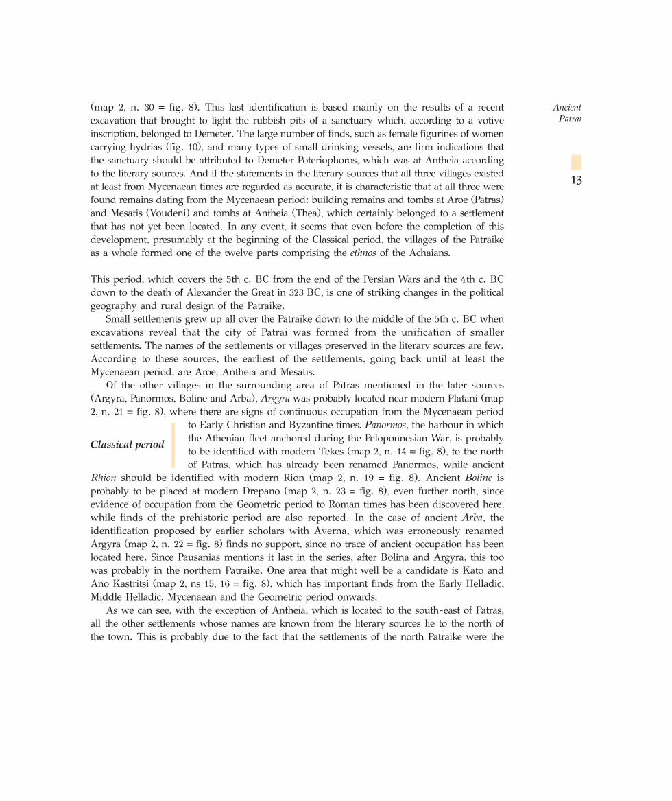
Of the other villages in the surrounding area of Patras mentioned in the later sources(Argyra, Panormos, Boline and Arba), Argyra was probably located near modern Platani (map2, n. 21 = fig. 8), where there are signs of continuous occupation from the Mycenaean period
to Early Christian and Byzantine times. Panormos, the harbour in whichthe Athenian fleet anchored during the Peloponnesian War, is probablyto be identified with modern Tekes (map 2, n. 14 = fig. 8), to the northof Patras, which has already been renamed Panormos, while ancient
Rhion should be identified with modern Rion (map 2, n. 19 = fig. 8). Ancient Boline isprobably to be placed at modern Drepano (map 2, n. 23 = fig. 8), even further north, sinceevidence of occupation from the Geometric period to Roman times has been discovered here,while finds of the prehistoric period are also reported. In the case of ancient Arba, theidentification proposed by earlier scholars with Averna, which was erroneously renamedArgyra (map 2, n. 22 = fig. 8) finds no support, since no trace of ancient occupation has beenlocated here. Since Pausanias mentions it last in the series, after Bolina and Argyra, this toowas probably in the northern Patraike. One area that might well be a candidate is Kato andAno Kastritsi (map 2, ns 15, 16 = fig. 8), which has important finds from the Early Helladic,Middle Helladic, Mycenaean and the Geometric period onwards.
As we can see, with the exception of Antheia, which is located to the south-east of Patras,all the other settlements whose names are known from the literary sources lie to the north ofthe town. This is probably due to the fact that the settlements of the north Patraike were the
Ancient Patrai
13
Classical period
MAP 3
more important, since, in addition to their economic importance to the city, with theiragricultural and stock-breeding output, they also had a timeless strategic significance, controllingas they did the route from Rion to Patras, and for this reason they never ceased to be inhabited.
For the larger part of the 5th century BC, Patrai does not seem to have played an importantrole in the political affairs of Greece. It took no part in the Persian wars, just as earlier it hadnot been involved in the Trojan War. This is presumably due to the fact that it lay on theperiphery of the Greek world and was not one of the large or powerful cities of the time, suchas Athens, Sparta, Thebes or Corinth, which played a leading role.
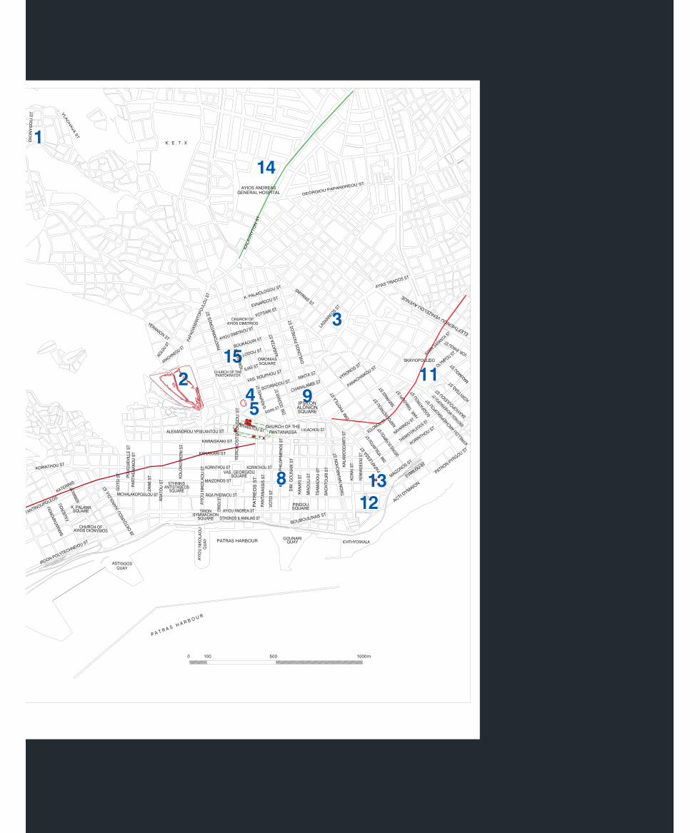
The first historical reference to the city is made by Thucydides, who refers to it as adockyard for the Corinthian-Peloponnesian fleet during the battle with the Athenian fleet offRion (summer 429 BC). The city made no secret of its pro-Athenian sympathies and in 419
BC, Alcibiades, the admiral of the Athenian fleet, sought to persuade the inhabitants, as partof Athenian policy, to construct long walls connecting the city with the harbour, with theulterior aim of its use as a naval station by the Athenians. Thucydides does not tell us if thisproject was carried out. Recently, however, part of a fortification wall has been identified inPhilopimenos and Maizonos Streets (map 3, n. 8 = fig. 11). Since this wall, if extended, endsin the agora and the harbour, it is evident that it is one of Alcibiades’ two parallel long wallsand demonstrates that the people of Patrai yielded to the Athenian suggestion, and also thatwe may take for granted their active participation in the Peloponnesian War. The existence ofthe fortification wall also proves that Patrai had already (that is, before 419 BC) been formedinto a city. Just after the middle of the 5th c. BC, an organised cemetery was created for thefirst time – the North Cemetery, the most official one in the city, which was in continuous usedown to at least the 7th c. AD. The archaeological evidence – the beginning of the functioningof the organised cemetery and the construction of the Long Walls – chimes with the fact thatThucydides is the first to speak of the city of Patrai, while his immediate predecessor,Herodotus, refers to the Patreis (people of Patrai) and not to the city Patrai.
The majority of the archaeological remains of the period, mainly the foundations of housewalls, are located in Psila Alonia Square (map 3, n. 9 = fig. 11). Unfortunately, the buildings, suchas temples, inside the Classical acropolis have not yet been excavated, as we have already seen.The North Cemetery extends alongside the road from Patras to Aigio (map 3, n. 10 = fig. 11).
From the end of the 5th c. BC onwards, Patrai began to play a more active role in theaffairs of Greece, a circumstance that is certainly due to the creation of the city in the middleof this same century.
Notable events in the 4th c. BC include the survival of the city, naturally with somedamage, after the terrible earthquake of 373 BC, which destroyed the cities of Boura andHelike in eastern Achaia. During the collapse of the Theban hegemony, Patrai was to be foundon the side of the Lakedaimonians, since at the battle of Mantineia (362 BC), at whichEpameinondas was killed, the Achaians are said to have fought against him.
Ancient Patrai
16
11. Map 3: Map of modern Patras.☞
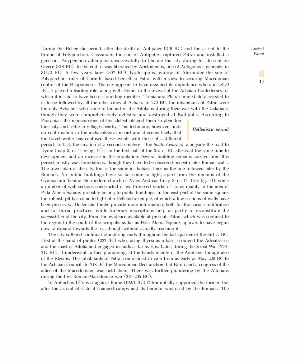
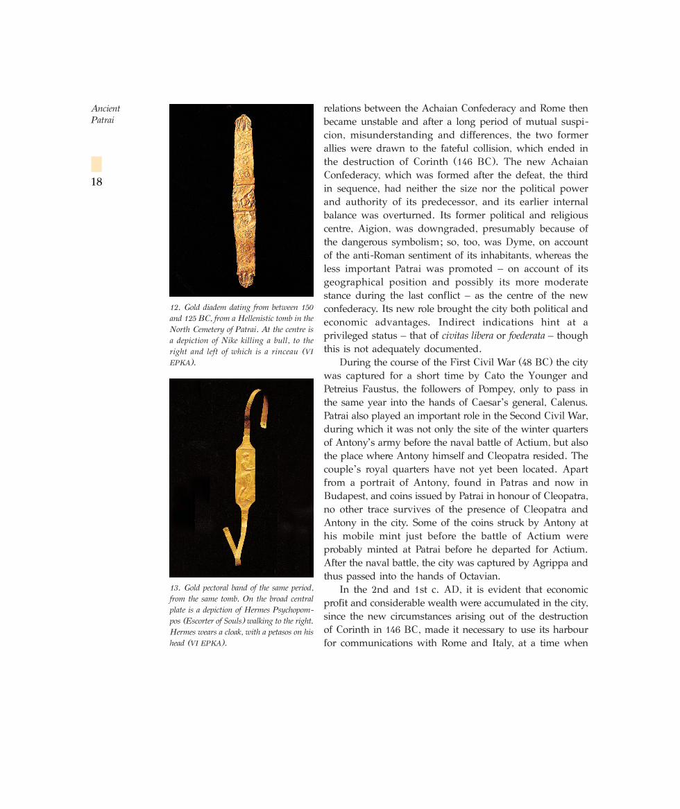
During the Hellenistic period, after the death of Antipater (319 BC) and the ascent to thethrone of Polyperchon, Cassander, the son of Antipater, captured Patrai and installed agarrison. Polyperchon attempted unsuccessfully to liberate the city during his descent onGreece (318 BC). In the end, it was liberated by Aristodemos, one of Antigonos’s generals, in314/2 BC. A few years later (307 BC), Kratesipolis, widow of Alexander the son ofPolyperchon, ruler of Corinth, based herself in Patrai with a view to securing Macedoniancontrol of the Peloponnese. The city appears to have regained its importance when, in 281/0
BC, it played a leading role, along with Dyme, in the revival of the Achaian Confederacy, ofwhich it is said to have been a founding member. Tritaia and Pharai immediately acceded toit, to be followed by all the other cities of Achaia. In 279 BC, the inhabitants of Patrai werethe only Achaians who came to the aid of the Aitolians during their war with the Galatians,though they were comprehensively defeated and destroyed at Kallipolis. According toPausanias, the repercussions of this defeat obliged them to abandontheir city and settle in villages nearby. This testimony, however, findsno confirmation in the archaeological record and it seems likely thatthe travel-writer has confused these events with those of a differentperiod. In fact, the creation of a second cemetery – the South Cemetery, alongside the road toDyme (map 3, n. 11 = fig. 11) – in the first half of the 3rd c. BC attests at the same time todevelopment and an increase in the population. Several building remains survive from thisperiod, mostly wall foundations, though they have to be observed beneath later Roman walls.The town plan of the city, too, is the same in its basic lines as the one followed later by theRomans. No public buildings have so far come to light, apart from the remains of theGymnasium, behind the modern church of Ayios Andreas (map 3, ns 12, 13 = fig. 11), whilea number of wall sections constructed of well-dressed blocks of stone, mainly in the area ofPsila Alonia Square, probably belong to public buildings. In the east part of the same square,the rubbish pit has come to light of a Hellenistic temple, of which a few sections of walls havebeen preserved. Hellenistic tombs provide more information, both for the social stratificationand for burial practices, while funerary inscriptions help us partly to reconstitute theonomastikon of the city. From the evidence available at present, Patrai, which was confined tothe region to the south of the acropolis as far as Psila Alonia Square, appears to have begunnow to expand towards the sea, though without actually reaching it.
The city suffered continual plundering raids throughout the last quarter of the 3rd c. BC.First at the hand of pirates (232 BC) who, using Illyria as a base, scourged the Adriatic seaand the coast of Aitolia and engaged in raids as far as Elis. Later, during the Social War (220-
217 BC), it underwent further plundering, at the hands mainly of the Aitolians, though alsoof the Eleians. The inhabitants of Patrai complained in vain from as early as May 220 BC tothe Achaian Council. In 218 BC the Macedonian fleet anchored at Patrai and a congress of theallies of the Macedonians was held there. There was further plundering by the Aitoliansduring the first Roman-Macedonian war (215-205 BC).
In Antiochos III’s war against Rome (192/1 BC) Patrai initially supported the former, butafter the arrival of Cato it changed camps and its harbour was used by the Romans. The
Ancient Patrai
17
Hellenistic period
relations between the Achaian Confederacy and Rome thenbecame unstable and after a long period of mutual suspi-cion, misunderstanding and differences, the two formerallies were drawn to the fateful collision, which ended inthe destruction of Corinth (146 BC). The new AchaianConfederacy, which was formed after the defeat, the thirdin sequence, had neither the size nor the political powerand authority of its predecessor, and its earlier internalbalance was overturned. Its former political and religiouscentre, Aigion, was downgraded, presumably because ofthe dangerous symbolism; so, too, was Dyme, on accountof the anti-Roman sentiment of its inhabitants, whereas theless important Patrai was promoted – on account of itsgeographical position and possibly its more moderatestance during the last conflict – as the centre of the newconfederacy. Its new role brought the city both political andeconomic advantages. Indirect indications hint at aprivileged status – that of civitas libera or foederata – thoughthis is not adequately documented.
During the course of the First Civil War (48 BC) the citywas captured for a short time by Cato the Younger andPetreius Faustus, the followers of Pompey, only to pass inthe same year into the hands of Caesar’s general, Calenus.Patrai also played an important role in the Second Civil War,during which it was not only the site of the winter quartersof Antony’s army before the naval battle of Actium, but alsothe place where Antony himself and Cleopatra resided. Thecouple’s royal quarters have not yet been located. Apartfrom a portrait of Antony, found in Patras and now inBudapest, and coins issued by Patrai in honour of Cleopatra,no other trace survives of the presence of Cleopatra andAntony in the city. Some of the coins struck by Antony athis mobile mint just before the battle of Actium wereprobably minted at Patrai before he departed for Actium.After the naval battle, the city was captured by Agrippa andthus passed into the hands of Octavian.
In the 2nd and 1st c. AD, it is evident that economicprofit and considerable wealth were accumulated in the city,since the new circumstances arising out of the destructionof Corinth in 146 BC, made it necessary to use its harbourfor communications with Rome and Italy, at a time when
Ancient Patrai
18
12. Gold diadem dating from between 150
and 125 BC, from a Hellenistic tomb in theNorth Cemetery of Patrai. At the centre isa depiction of Nike killing a bull, to theright and left of which is a rinceau (VI
EPKA).
13. Gold pectoral band of the same period,from the same tomb. On the broad centralplate is a depiction of Hermes Psychopom-pos (Escorter of Souls) walking to the right.Hermes wears a cloak, with a petasos on hishead (VI EPKA).
such communications were beginning to be-come more intensive: diplomats, politicians,exiles, travellers, businessmen and merchantspreferred the swifter and less dangerous searoute to the East that passed through theCorinthian gulf.
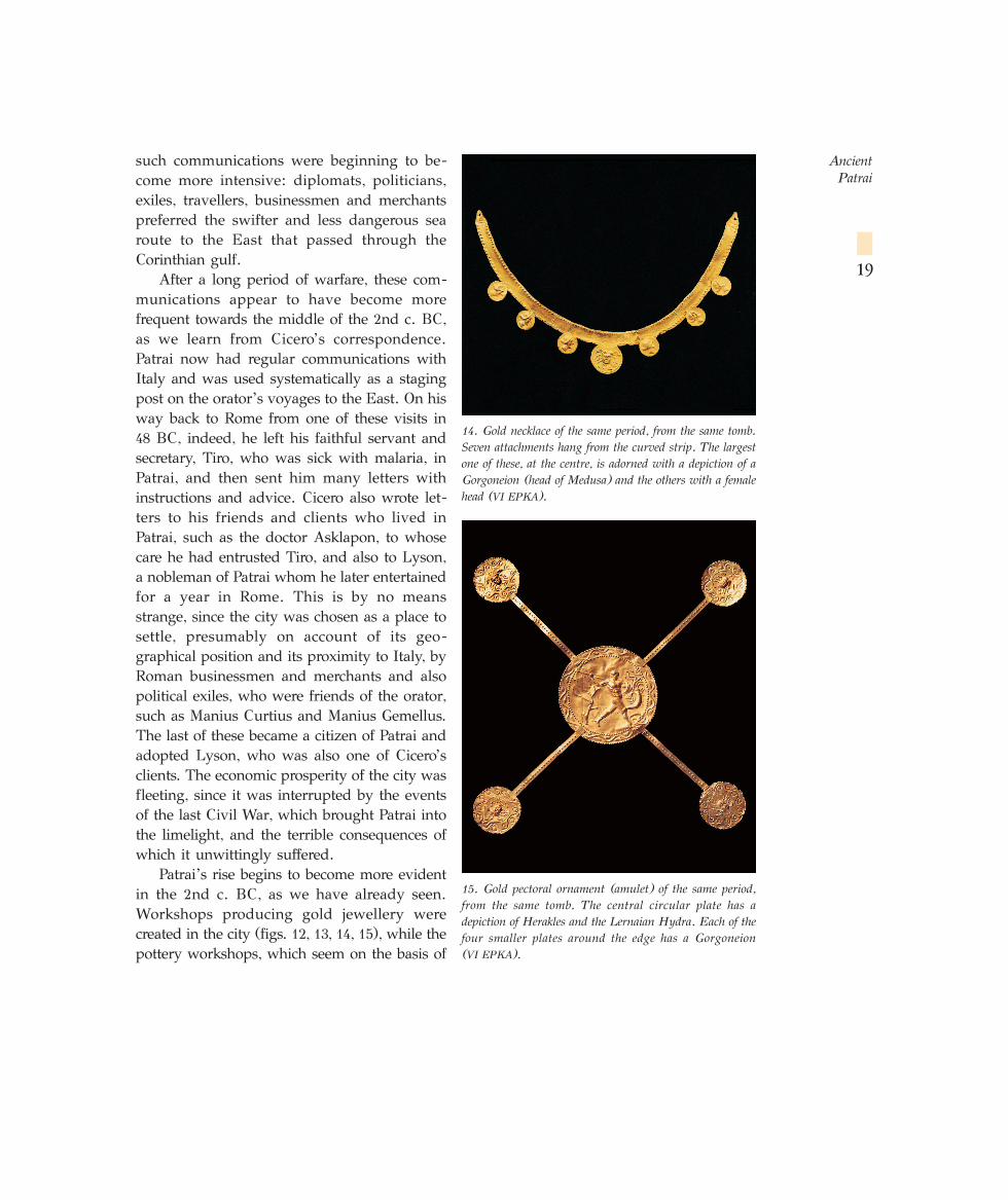
After a long period of warfare, these com-munications appear to have become morefrequent towards the middle of the 2nd c. BC,as we learn from Cicero’s correspondence.Patrai now had regular communications withItaly and was used systematically as a stagingpost on the orator’s voyages to the East. On hisway back to Rome from one of these visits in48 BC, indeed, he left his faithful servant andsecretary, Tiro, who was sick with malaria, inPatrai, and then sent him many letters withinstructions and advice. Cicero also wrote let-ters to his friends and clients who lived inPatrai, such as the doctor Asklapon, to whosecare he had entrusted Tiro, and also to Lyson,a nobleman of Patrai whom he later entertainedfor a year in Rome. This is by no meansstrange, since the city was chosen as a place tosettle, presumably on account of its geo-graphical position and its proximity to Italy, byRoman businessmen and merchants and alsopolitical exiles, who were friends of the orator,such as Manius Curtius and Manius Gemellus.The last of these became a citizen of Patrai andadopted Lyson, who was also one of Cicero’sclients. The economic prosperity of the city wasfleeting, since it was interrupted by the eventsof the last Civil War, which brought Patrai intothe limelight, and the terrible consequences ofwhich it unwittingly suffered.
Patrai’s rise begins to become more evidentin the 2nd c. BC, as we have already seen.Workshops producing gold jewellery werecreated in the city (figs. 12, 13, 14, 15), while thepottery workshops, which seem on the basis of
Ancient Patrai
19
15. Gold pectoral ornament (amulet) of the same period,from the same tomb. The central circular plate has adepiction of Herakles and the Lernaian Hydra. Each of thefour smaller plates around the edge has a Gorgoneion (VI EPKA).
14. Gold necklace of the same period, from the same tomb.Seven attachments hang from the curved strip. The largestone of these, at the centre, is adorned with a depiction of aGorgoneion (head of Medusa) and the others with a femalehead (VI EPKA).
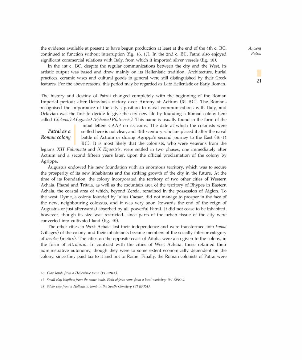
the evidence available at present to have begun production at least at the end of the 4th c. BC,continued to function without interruption (fig. 16, 17). In the 2nd c. BC, Patrai also enjoyedsignificant commercial relations with Italy, from which it imported silver vessels (fig. 18).
In the 1st c. BC, despite the regular communications between the city and the West, itsartistic output was based and drew mainly on its Hellenistic tradition. Architecture, burialpractices, ceramic vases and cultural goods in general were still distinguished by their Greekfeatures. For the above reasons, this period may be regarded as Late Hellenistic or Early Roman.
The history and destiny of Patrai changed completely with the beginning of the RomanImperial period; after Octavian’s victory over Antony at Actium (31 BC). The Romansrecognised the importance of the city’s position to naval communications with Italy, andOctavian was the first to decide to give the city new life by founding a Roman colony herecalled C(olonia) A(ugusta) A(chaica) P(atrensis). This name is usually found in the form of the
initial letters CAAP on its coins. The date at which the colonists weresettled here is not clear, and 19th-century scholars placed it after the navalbattle of Actium or during Agrippa’s second journey to the East (16-14
BC). It is most likely that the colonists, who were veterans from thelegions XII Fulminata and X Equestris, were settled in two phases, one immediately afterActium and a second fifteen years later, upon the official proclamation of the colony byAgrippa.
Augustus endowed his new foundation with an enormous territory, which was to securethe prosperity of its new inhabitants and the striking growth of the city in the future. At thetime of its foundation, the colony incorporated the territory of two other cities of WesternAchaia, Pharai and Tritaia, as well as the mountain area of the territory of Rhypes in EasternAchaia, the coastal area of which, beyond Zereia, remained in the possession of Aigion. Tothe west, Dyme, a colony founded by Julius Caesar, did not manage to prosper in the face ofthe new, neighbouring colossus, and it was very soon (towards the end of the reign ofAugustus or just afterwards) absorbed by all-powerful Patrai. It did not cease to be inhabited,however, though its size was restricted, since parts of the urban tissue of the city wereconverted into cultivated land (fig. 19).
The other cities in West Achaia lost their independence and were transformed into komai(villages) of the colony, and their inhabitants became members of the socially inferior categoryof incolae (metics). The cities on the opposite coast of Aitolia were also given to the colony, inthe form of attributio. In contrast with the cities of West Achaia, these retained theiradministrative autonomy, though they were to some extent economically dependent on thecolony, since they paid tax to it and not to Rome. Finally, the Roman colonists of Patrai were
Ancient Patrai
21
16. Clay kotyle from a Hellenistic tomb (VI EPKA).
17. Small clay lekythos from the same tomb. Both objects come from a local workshop (VI EPKA).
18. Silver cup from a Hellenistic tomb in the South Cemetery (VI EPKA).
Patrai as a
Roman colony
granted the right to exploit the lake of Kalydon, while the Greek inhabitants of the city werecompensated financially for the loss of the land that was given to the colonists by beingallowed to receive for a time the tributum from the cities in West Lokris, all of which, withthe exception of Amphissa, were subject to pay taxes to Rome.
The plain of Patras is surrounded by low hills, outcrops of Mount Panachaikon, which is themost central and most important mountain massif in Achaia. The boundaries of the plainreach as far as Zereia in the north, Omblos, Kallithea and Thea (outcrops of Panachaikon) inthe east, and the hills of Monodendri and Vrachneika in the south. This plain, the Patraike,was also the city’s natural lebensraum, at least until the foundation of the Roman colony, whenit was increased by the addition of the territories of the neighbouring cities in West Achaia.
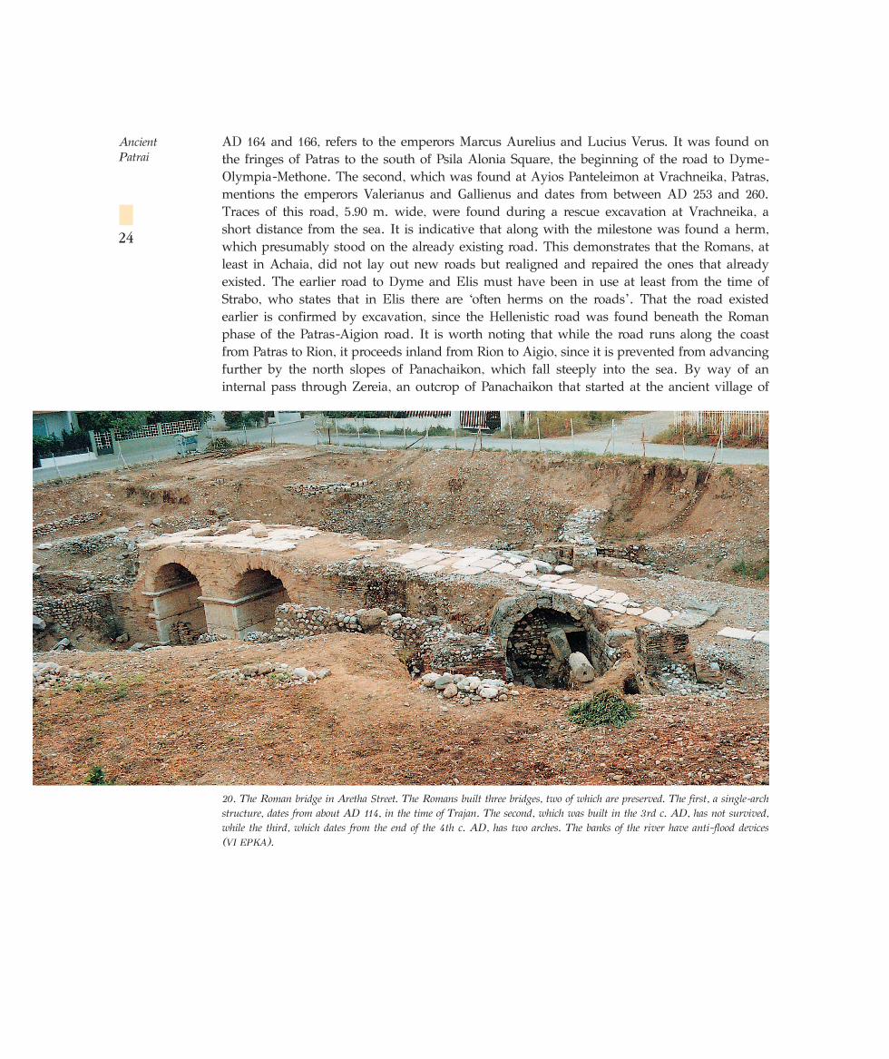
The Patraike bordered with the Rhypike on the west, the Pharaike on the east and withthe territory of Olenos and Dyme on the south (map 1 = fig. 7). Its fertileplain is criss-crossed by 13 winter torrents, some of which were probablyregular rivers, flowing with water also in the summer in ancient times. Therivers whose names are known from the literary sources are, from north tosouth (map 2 = fig. 8): the Bolinaios (modern Drepaniotiko), Selemnos (Xylokera), Charadros(Kastritsianiko) and Meilichos (Velvitsianiko). The temple of Artemis Triklaria was probablylocated near the last of these. The three Classical torsoes on display in the ArchaeologicalMuseum of Patras (see below, Archaeological Museum) come from the pediment of thistemple. The river Sychainiotiko just outside Patras had been identified with the Meilichos, buta recently discovered inscription suggests that in ancient times the name of the Sychainiotikowas Kallinaos. On this river is preserved a bridge of Roman date, with three building phasescorresponding with three Roman road-building programmes known from milestones.
From the first phase, carried out during Trajan’s programme (AD 114/5) is preserved asingle-arch bridge (fig. 20) which was replaced by a second bridge. No trace of this hassurvived but we know from the same inscription, which was used as building material in thethird bridge, that its construction was funded by Artemios of Mesatis. This second bridge wasincorporated in the road repairs programme of the emperors Carus, Carinus, Numerianus andMarcus Aurelius Probus, and dates from between AD 276 and 283. The third bridge, a two-arch structure which still survives in a very good state of preservation, dates from the 4th c.AD. Its construction may be associated with a further repair of the road, known from a secondinscription carved on a milestone of Trajan, which was carried out by the emperors Arcadiusand Honorius (AD 397). This repair was connected with the reconstruction of the road afterthe expulsion of Stilicho and the Goths from the Peloponnese. A second, similar milestone,now lost, was seen by Cyriacus of Ancona in the church of Ayios Nikolaos in Patras, thoughit is not known whether it was brought there from an area to the north or to the south ofPatras. If the latter, it would have signalled a repair of the road to Dyme-Olympia-Methone,but a repair of this road is known from two more milestones. The first, dating from between
Ancient Patrai
22
19. Kato Achayia (ancient Dyme): viticulture channels.
City and
countryside
AR
ISTEN
ETO
U S
T.
SQUARE
AG. IOANNOU ST.
SECTION µ - µ ã
SECTION ∞ - ∞
DETAIL OF PLAN
ARISTENETOU ST.
PA
FS
AN
IOU
ST.
AC
H.
SIM
PO
LIT
IAS
ST.
AD 164 and 166, refers to the emperors Marcus Aurelius and Lucius Verus. It was found onthe fringes of Patras to the south of Psila Alonia Square, the beginning of the road to Dyme-Olympia-Methone. The second, which was found at Ayios Panteleimon at Vrachneika, Patras,mentions the emperors Valerianus and Gallienus and dates from between AD 253 and 260.Traces of this road, 5.90 m. wide, were found during a rescue excavation at Vrachneika, ashort distance from the sea. It is indicative that along with the milestone was found a herm,which presumably stood on the already existing road. This demonstrates that the Romans, atleast in Achaia, did not lay out new roads but realigned and repaired the ones that alreadyexisted. The earlier road to Dyme and Elis must have been in use at least from the time ofStrabo, who states that in Elis there are ‘often herms on the roads’. That the road existedearlier is confirmed by excavation, since the Hellenistic road was found beneath the Romanphase of the Patras-Aigion road. It is worth noting that while the road runs along the coastfrom Patras to Rion, it proceeds inland from Rion to Aigio, since it is prevented from advancingfurther by the north slopes of Panachaikon, which fall steeply into the sea. By way of aninternal pass through Zereia, an outcrop of Panachaikon that started at the ancient village of
Ancient Patrai
24
20. The Roman bridge in Aretha Street. The Romans built three bridges, two of which are preserved. The first, a single-archstructure, dates from about AD 114, in the time of Trajan. The second, which was built in the 3rd c. AD, has not survived,while the third, which dates from the end of the 4th c. AD, has two arches. The banks of the river have anti-flood devices (VI EPKA).
Argyra (probably near modern Platani) and passed through the modern villages of Sella,Argyra, Pititsa and Salmeniko, this road came back to the sea at the hill of Kamarai, Aigion,an area that belonged to the Rhypike, the territory of Rhypes.
The great importance of the three road axes Patrai-Dyme-Olympia-Methone, Patrai-Aigion-Corinth-Athens and Patrai-Kalydon-Nikopolis is also clear from the many repairs theyunderwent, which indicate that Patrai was also an important node in the communicationsnetwork, especially during the Roman period.
In the central and southern Patraike, are to be found, in order, the small river Diakoniaris,whose ancient name is not known. The Roman aqueduct, several sections of which arepreserved, began at the source of this river, at the village of Romanos. Despite its small sizethe Diakoniaris has caused significant damage and flooding in both ancient and modern times.The important grave monument in the area of Langoura, which will be discussed below, waspreserved thanks to one of these floods. After the Diakoniaris, we come to the Glaukos(modern Lefka), a large river, in thebed of which, near Perivola, anancient bridge was preserved until afew years ago. A series of smallerwinter-torrents, such as the Panag-itsa, criss-cross the rest of the Pa-traike.
In Western Achaia were to befound all the forms of settlementorganisation associated with thecountryside known from the Hel-lenistic tradition: villages and small,scattered, isolated country houses.These are very dense in a circularzone of about 5-10 km around Patrasand may be called villae rusticae(country villas), though only con-ventionally, because they do not cor-respond exactly to the size and economic and social dimension of these units as known fromthe western provinces of the empire. In the case of Achaia, they are relatively smallinstallations, some of which recall the well-known villae suburbanae (suburban villas), sincethey are located in the suburbs of the city and have some amenities (decorated rooms,bathrooms, etc.), though they are not completely lacking in purely agricultural rooms andfacilities. The greatest density of Roman villas is to be observed within the old, pre-Romanboundaries of the territory of Patrai (north coastal zone and the Glaukos basin). It is clear fromthe archaeological record that this area also has the greatest density of habitation, indicatingthat it was the most intensively farmed in the imperial period. Some of the country housesoccupy the low hills surrounding the plain, and their main focus was on stock-raising, while
Ancient Patrai
25
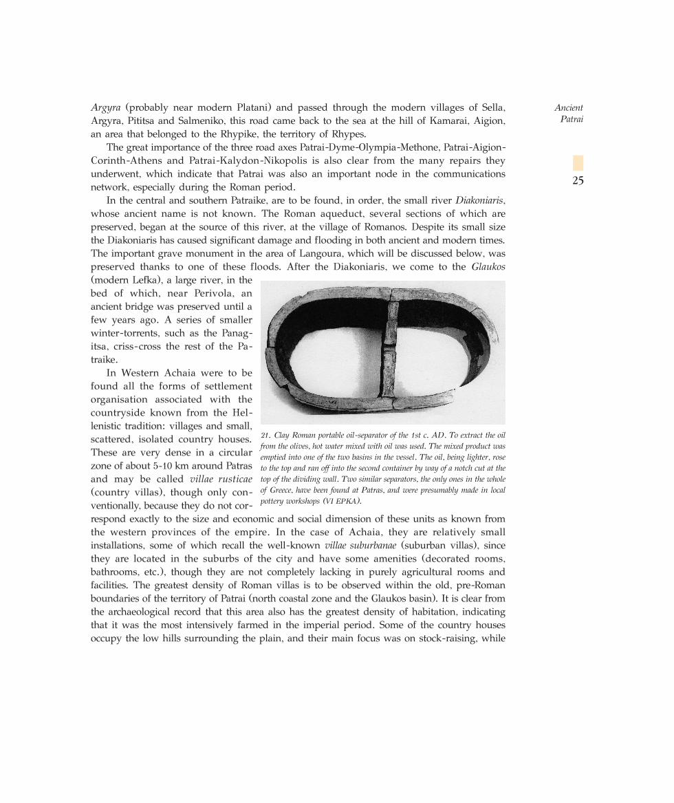
21. Clay Roman portable oil-separator of the 1st c. AD. To extract the oilfrom the olives, hot water mixed with oil was used. The mixed product wasemptied into one of the two basins in the vessel. The oil, being lighter, roseto the top and ran off into the second container by way of a notch cut at thetop of the dividing wall. Two similar separators, the only ones in the wholeof Greece, have been found at Patras, and were presumably made in localpottery workshops (VI EPKA).
features associated with the processing of fish have been found in some of those on the coast.An excavation conducted at Kato Achayia (ancient Dyme) revealed that, for the purposes ofviticulture, parallel channels were cut in the ground at regular distances between each other,in which the vines were planted (fig. 19). Most of the country houses have installations forproducing wine (such as wine-presses with hypolenia – vats to collect the wine (fig. 22) – andstorerooms), or oil (oil-presses, separators (fig. 21) and storerooms.
In addition to agricultural and stock-raising products, the country houses produced vasesfor storing and transporting their produce, and also textiles, as it is evident from the largequantities of clay loomweights found in them.
All the country houses are near roads which led to the harbour of Patrai, presumably tofacilitate the export trade. This new form of economic exploitation and social organisationcertainly brought about a striking disturbance of the ages-old balance between the city andthe countryside, the details of which are not yet known. The archaeological record, however,points to intensive exploitation of the land, especially in the context of the country houses: inonly a very few cases can we speak of the abandonment of the land, at least in West Achaia.
Ancient Patrai
26
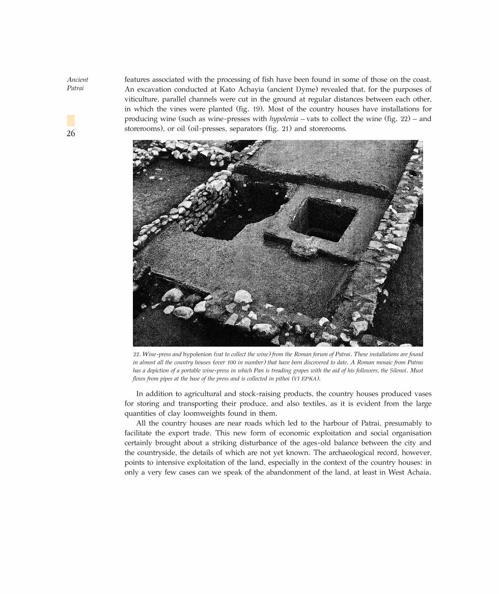
22. Wine-press and hypolenion (vat to collect the wine) from the Roman forum of Patrai. These installations are foundin almost all the country houses (over 100 in number) that have been discovered to date. A Roman mosaic from Patrashas a depiction of a portable wine-press in which Pan is treading grapes with the aid of his followers, the Silenoi. Mustflows from pipes at the base of the press and is collected in pithoi (VI EPKA).
By contrast, we are in a position to assert that the pax romana and the generally favourableconditions arrested the catastrophic trend to abandonment and demographic haemorrhagingobservable in this area during the Late Hellenistic period. The great wealth of Patrai in theimperial period is due in many respects to the agricultural and stock-raising output of thecountryside, which was the product of the toil of its anonymous inhabitants.
The settlement of the Roman colonists brought about tremendous changes not only in thepolitical and economic, but also in the social sphere. It led inevitably to the mass seizure ofland from the earlier inhabitants, who suddenly found themselves marginalised politically,economically and socially. The project of compiling a land register, which reshaped andreorganised the agricultural landscape on an objective, universally valid basis, was aimed atthe smooth integration of the newcomers, and also at the political and economic control of thecities through the exaction of taxes. This reorganisation of the agricultural space, which wasbased on the schema of the Roman centuriatio, has still left traces on the land of Achaia.
The political organisation and institutions of pre-Roman Patrai were based on a tripartitedivision between the popular assembly, the council, and the annual officials, which was to befound in all Greek cities, with a varying relationship between the three. In the absence of anyevidence, we are unfortunately unaware of the details of theinstitutions of Patrai in the Classical and Hellenistic period, and itis only an assumption that the institutions and officials of the citywere similar to those in other cities in the Achaian Confederacy,despite the unhappy assertion by Polybius that all the cities in the League had the sameinstitutions.
In contrast, the political organisation and institutions of the Roman colony are fully known,thanks mainly to the wealth of epigraphic evidence. The Roman emperors gave Patrai the rightto mint its own coins. From one of these coins we learn the full Roman name of the city,Colonia Augusta Achaica Patrensis.
The Roman colonies copied the political organisation of Rome. This principle is translatedin the topography with the presence of the Capitol in the forum of the colony. Here, the Romantrinity of Jupiter, Juno and Minerva (Zeus, Hera and Athens) were initially worshipped, andlater Roma and the emperor. Internally, the administrative basis of the colony was formed ofthree bodies, as in Rome: the populus (popular assembly), the council (ordo decurionum), andthe annual officials, the most important of which were the duoviri, who were divided into theduoviri iure dicundo, who had judicial competence, and the duoviri aediles, who had financialduties. Lower down the hierarchy of officials came the aediles (market inspectors) and quaestors(treasurers). Every five years, these four categories of officials, whether organised as a bodyor not, conducted a census of the population, inspected the list of members of the ordodecurionum, drew up a balance sheet of expenses and compiled a budget for the following fiveyears. These were the duumviri quinquennales, an office to which only the elite of the city couldaspire. The organisation of athletic games was undertaken by the munerarii, a kind of wealthysponsor who belonged to the Roman aristocracy of the city.
Ancient Patrai
27
Political organisation
and institutions
The main source for study of the cults of Patrai, at least in the imperial period, is the detaileddescription of the monuments and cults of the city by the travel-writer Pausanias, who visitedit in about AD 170 and devoted 15 chapters of his work to it. The information provided bythe traveller is supported by the rich iconography of the coins of the city at this period, since
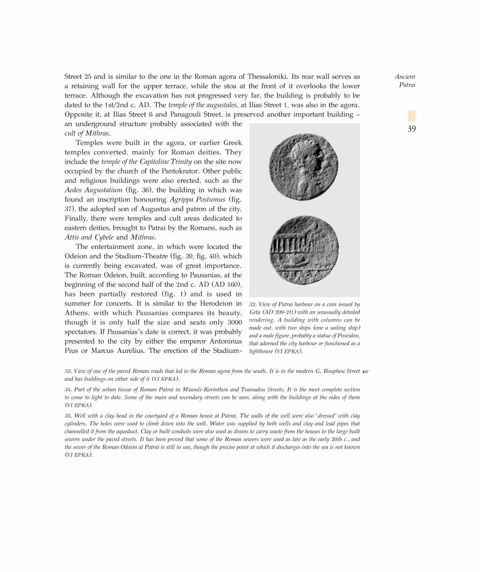
the obverse of the issues was adorned with mainly religious subjects. Animportant contribution is also made by inscriptions and archaeology ingeneral, which supplement the sources mentioned above by revealing thepresence of other cults: of Hermes, the Naiads, the Nymphs and Mithras
(fig. 23). The cult of the last named is associated in general with veteran soldiers.The great variety of the cults of the city reveals that in the Hellenistic and especially the
imperial period Patrai was a metropolis open to all the influences that came to its harbour,whether from the West or from the East. It was also a melting pot of different cults that wereintermingled and mixed and produced a new and highly complex pantheon of deities – apatchwork-Kulte in the felicitous phrase of Chr. Auffarth – so that it is now a very difficulttask to determine the origins and development of, or to interpret, the details of the ritual.
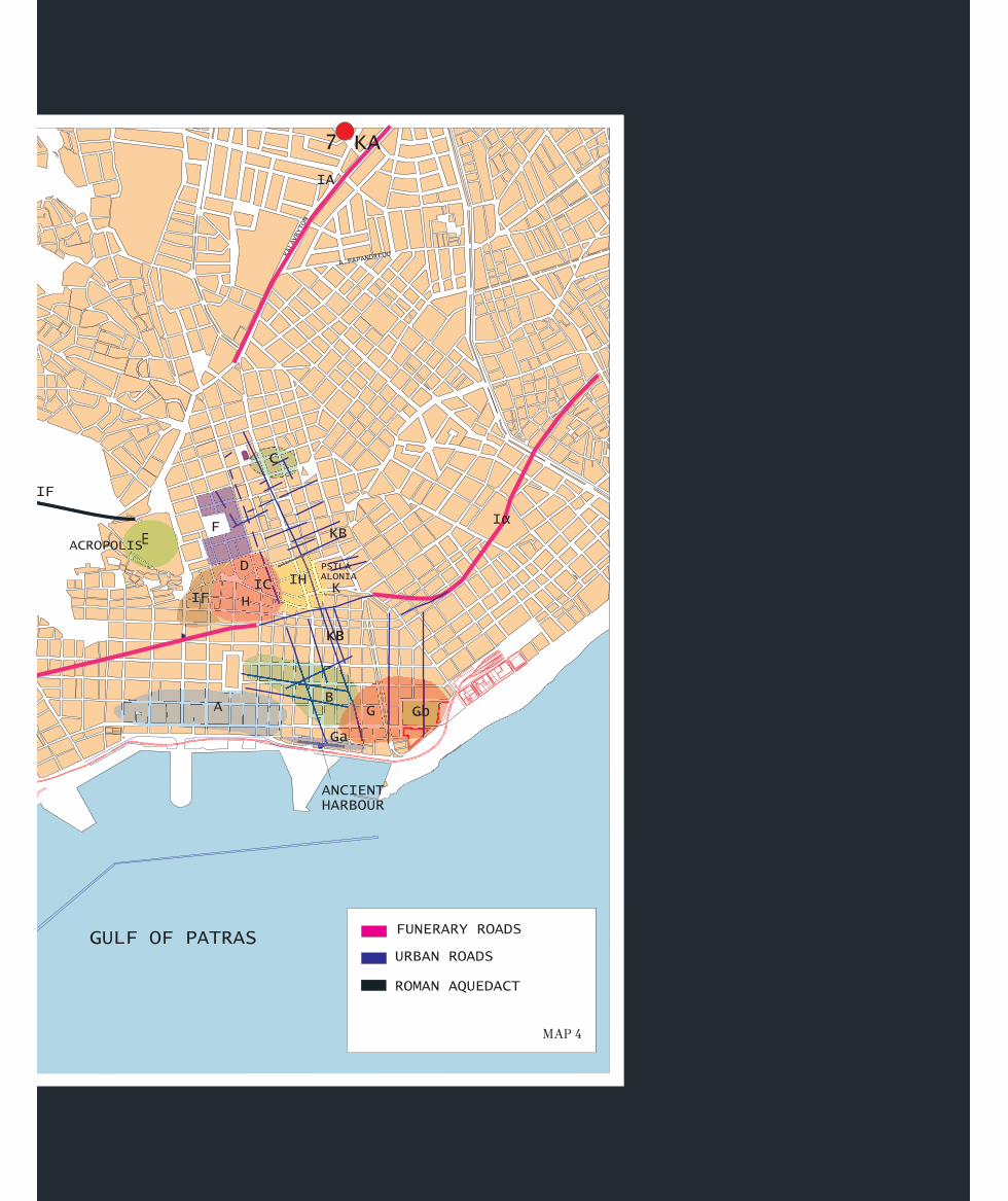
Pausanias preserves a geographical distribution of the cults of the city, which are assignedto four basic areas (map 4 = fig. 28):
a. Cults on the acropolis, which are the most important cults of the city – that is, whichhad the largest number of symbols and the richest ritual (Artemis Laphria, Artemis Triklaria-Eurypylos and Demeter Panachaia).
b. Cults in the forum, on which the cults of the official Olympian pantheon, which lackedany particular local character, were mainly concentrated.
c. Cults around the forum and the Stadium-Theatre, where one encounters both deitieswho belong to the local tradition of the city (local woman, Artemis Limnatis) and a numberof newly-introduced deities, whether Greek (Dionysios Kalydonios) or eastern, such as the cultof Dindymene.
d. Cults around the city harbour, where deities known to have been associated with thesea and harbours are found (Aphrodite, Apollo, Poseidon), as well as Egyptian cults newlyintroduced by the Romans. The presence in this area of Demeter, who had no connection withthe sea, is due to the existence of a prophetic spring, with which her worship was inextricablyconnected.
The acropolis was the religious centre on which were concentrated both the earlier and anumber of newly introduced cults. At the time of Pausanias, the most important cult was that
of Artemis Laphria, though her epithet, as the traveller observes, is foreignand her name imported. In fact, this cult was introduced at the initiative ofAugustus, and the temple of the goddess was sited in a place dedicated tothe guardian deities of the city. Augustus did not merely introduce the cult
of Artemis Laphria, but gave her the Latin name Diana, to which the epithet Augusta was nowadded, betraying a connection with the imperial cult. From this point of view, it is characteristicthat the two deities share the same priestess, a young Roman girl from the city elite. Augustus
Ancient Patrai
28 Cults in Patrai
Cults on the
acropolis
succeeded in this way in linking himselfwith the traditional founders of the city,Preugenes, who also introduced a cult,and his son Patreus, who was responsiblefor the synoecism of the city.
Between the temple of Laphria andits altar is the tomb of Eurypylos, whosecult was introduced, according to thetradition, as early as the time when theIonians dwelt in the three villages (Aroe,Antheia and Mesatis) and had formed akind of religious federation, since all threeworshipped Artemis with the epithetTriklaria. At this time the goddess’s cultdemanded human sacrifices as expiationfor the sacrilege committed by Komaitho.The myth, preserved for us by Pausanias,relates how Komaitho, the priestess of thetemple of Artemis Triklaria, the mostimportant temple in the region, whichwas located outside the later city next toa river, made love with a young shepherdcalled Melanippos inside the temple. Thegoddess gave orders to the inhabitants,through the Oracle at Delphi, to sacrificethe sacrilegious pair and to sacrifice ayoung man and a young woman everyyear thereafter. On account of this severepunishment, the river next to the templewas given the name Ameilichos (‘merci-less’). A later prophecy issued by theOracle predicted that they would bedelivered from this deadly blood tax bythe arrival of a foreign king who broughta foreign god with him. And in fact,Eurypylos, the king of Thessaly, came toPatrai after the Trojan War, bringing asspoils a coffer containing a statue ofDionysos made by Hephaistos. Eurypy-los himself had opened the coffer whilehe was at Troy and went mad because he
Ancient Patrai
29
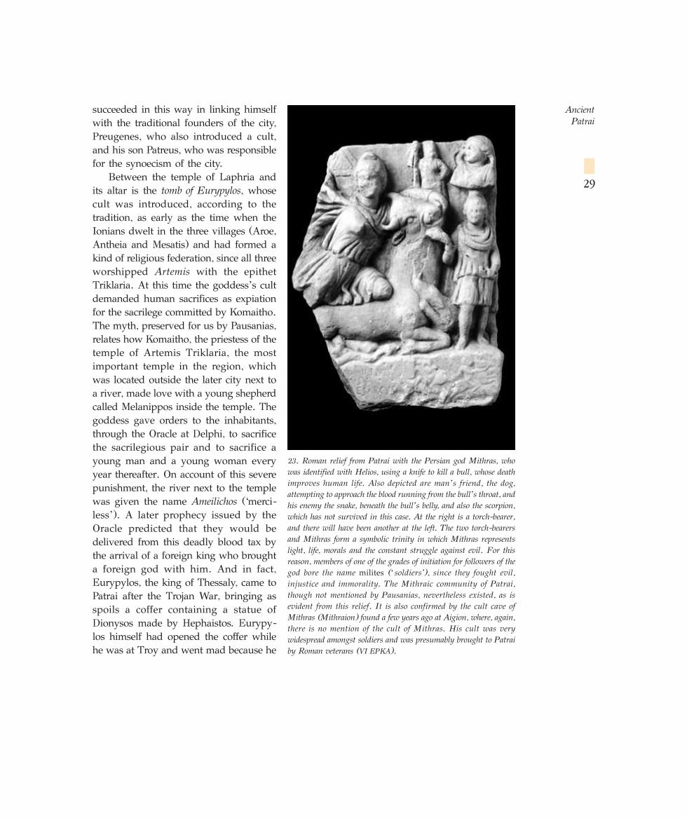
23. Roman relief from Patrai with the Persian god Mithras, whowas identified with Helios, using a knife to kill a bull, whose deathimproves human life. Also depicted are man’s friend, the dog,attempting to approach the blood running from the bull’s throat, andhis enemy the snake, beneath the bull’s belly, and also the scorpion,which has not survived in this case. At the right is a torch-bearer,and there will have been another at the left. The two torch-bearersand Mithras form a symbolic trinity in which Mithras representslight, life, morals and the constant struggle against evil. For thisreason, members of one of the grades of initiation for followers of thegod bore the name milites (‘soldiers’), since they fought evil,injustice and immorality. The Mithraic community of Patrai,though not mentioned by Pausanias, nevertheless existed, as isevident from this relief. It is also confirmed by the cult cave ofMithras (Mithraion) found a few years ago at Aigion, where, again,there is no mention of the cult of Mithras. His cult was verywidespread amongst soldiers and was presumably brought to Patraiby Roman veterans (VI EPKA).
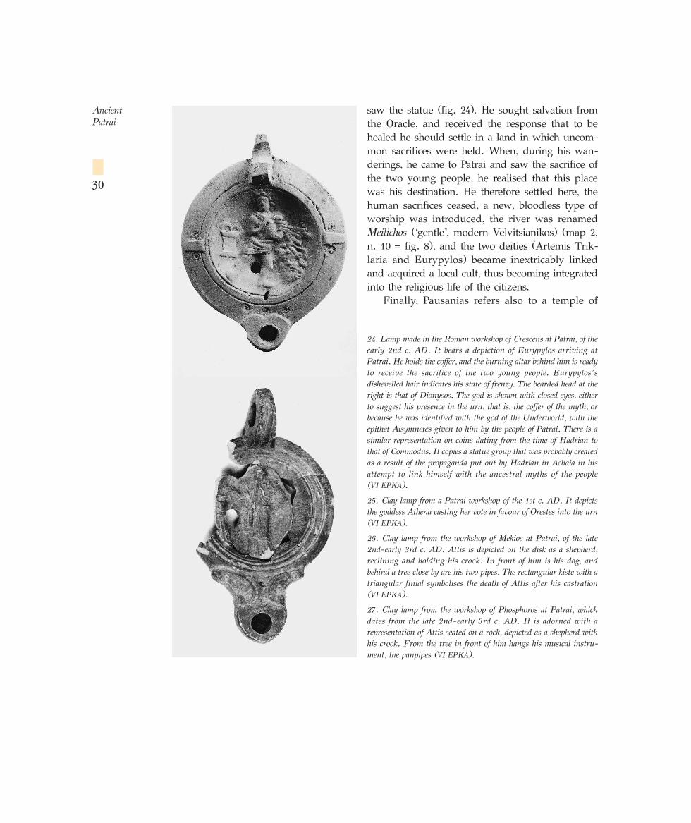
saw the statue (fig. 24). He sought salvation fromthe Oracle, and received the response that to behealed he should settle in a land in which uncom-mon sacrifices were held. When, during his wan-derings, he came to Patrai and saw the sacrifice ofthe two young people, he realised that this placewas his destination. He therefore settled here, thehuman sacrifices ceased, a new, bloodless type ofworship was introduced, the river was renamedMeilichos (‘gentle’, modern Velvitsianikos) (map 2,n. 10 = fig. 8), and the two deities (Artemis Trik-laria and Eurypylos) became inextricably linkedand acquired a local cult, thus becoming integratedinto the religious life of the citizens.
Finally, Pausanias refers also to a temple of
Ancient Patrai
30
24. Lamp made in the Roman workshop of Crescens at Patrai, of theearly 2nd c. AD. It bears a depiction of Eurypylos arriving atPatrai. He holds the coffer, and the burning altar behind him is readyto receive the sacrifice of the two young people. Eurypylos’ sdishevelled hair indicates his state of frenzy. The bearded head at theright is that of Dionysos. The god is shown with closed eyes, eitherto suggest his presence in the urn, that is, the coffer of the myth, orbecause he was identified with the god of the Underworld, with theepithet Aisymnetes given to him by the people of Patrai. There is asimilar representation on coins dating from the time of Hadrian tothat of Commodus. It copies a statue group that was probably createdas a result of the propaganda put out by Hadrian in Achaia in hisattempt to link himself with the ancestral myths of the people (VI EPKA).
25. Clay lamp from a Patrai workshop of the 1st c. AD. It depictsthe goddess Athena casting her vote in favour of Orestes into the urn(VI EPKA).
26. Clay lamp from the workshop of Mekios at Patrai, of the late2nd-early 3rd c. AD. Attis is depicted on the disk as a shepherd,reclining and holding his crook. In front of him is his dog, andbehind a tree close by are his two pipes. The rectangular kiste with atriangular finial symbolises the death of Attis after his castration (VI EPKA).
27. Clay lamp from the workshop of Phosphoros at Patrai, whichdates from the late 2nd-early 3rd c. AD. It is adorned with arepresentation of Attis seated on a rock, depicted as a shepherd withhis crook. From the tree in front of him hangs his musical instru-ment, the panpipes (VI EPKA).
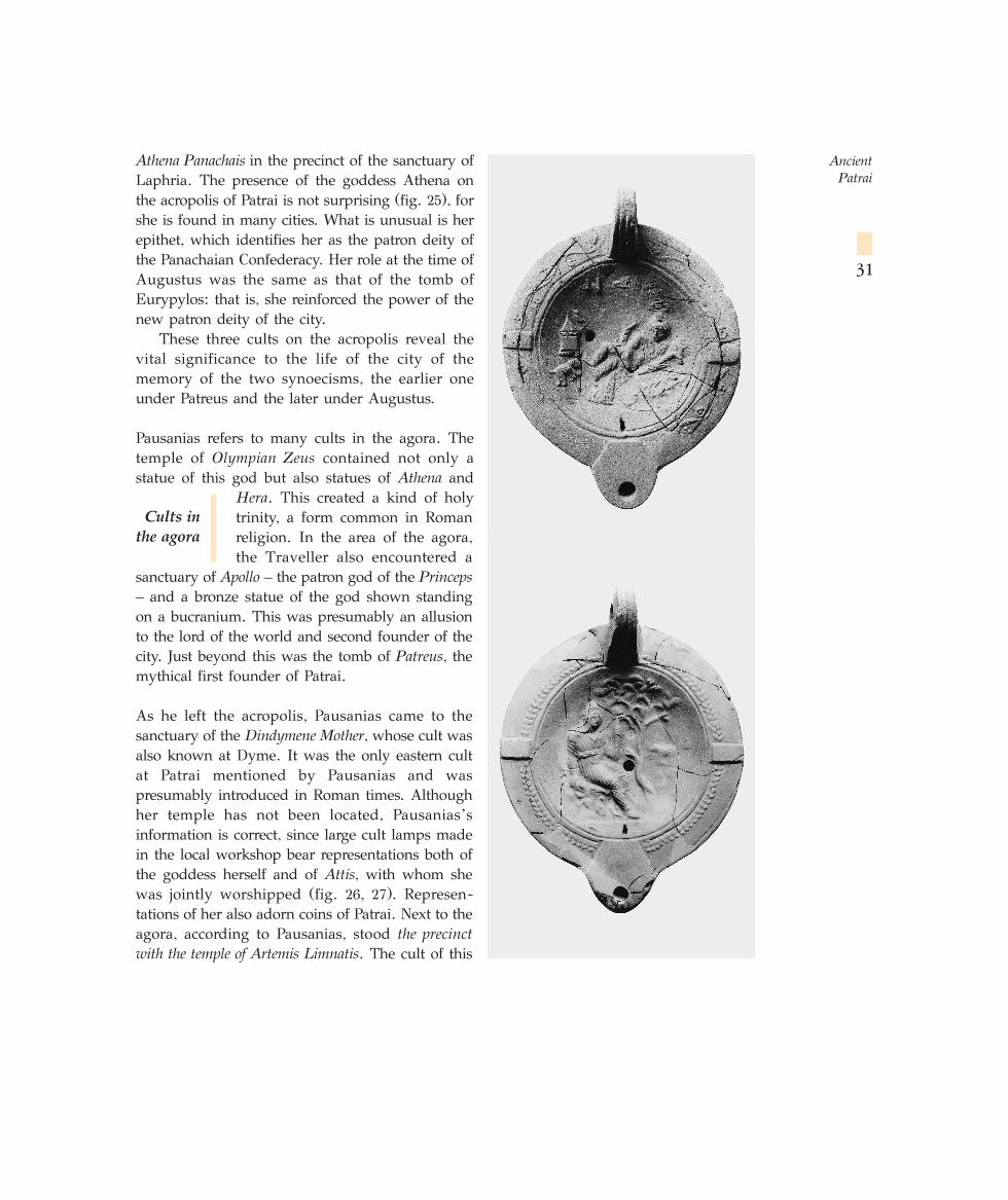
Athena Panachais in the precinct of the sanctuary ofLaphria. The presence of the goddess Athena onthe acropolis of Patrai is not surprising (fig. 25), forshe is found in many cities. What is unusual is herepithet, which identifies her as the patron deity ofthe Panachaian Confederacy. Her role at the time ofAugustus was the same as that of the tomb ofEurypylos: that is, she reinforced the power of thenew patron deity of the city.
These three cults on the acropolis reveal thevital significance to the life of the city of thememory of the two synoecisms, the earlier oneunder Patreus and the later under Augustus.
Pausanias refers to many cults in the agora. Thetemple of Olympian Zeus contained not only astatue of this god but also statues of Athena and
Hera. This created a kind of holytrinity, a form common in Romanreligion. In the area of the agora,the Traveller also encountered a
sanctuary of Apollo – the patron god of the Princeps– and a bronze statue of the god shown standingon a bucranium. This was presumably an allusionto the lord of the world and second founder of thecity. Just beyond this was the tomb of Patreus, themythical first founder of Patrai.
As he left the acropolis, Pausanias came to thesanctuary of the Dindymene Mother, whose cult wasalso known at Dyme. It was the only eastern cultat Patrai mentioned by Pausanias and waspresumably introduced in Roman times. Althoughher temple has not been located, Pausanias’sinformation is correct, since large cult lamps madein the local workshop bear representations both ofthe goddess herself and of Attis, with whom shewas jointly worshipped (fig. 26, 27). Represen-tations of her also adorn coins of Patrai. Next to theagora, according to Pausanias, stood the precinctwith the temple of Artemis Limnatis. The cult of this
Ancient Patrai
31
Cults in
the agora
MAP 4
goddess was brought by Preugenes from Sparta, and the myth symbolises the migration andsettlement of Preugenes, an Achaian, in the hitherto Ionian area of Patrai. The carrying of thestatue of the goddess during her festival from Mesoa (Mesatis) to the city recalls the firstmovement of the Achaians from Lakonia to Patrai. Inside the sanctuary precinct were the
sanctuaries of Asklepios and Athena and the tomb ofPreugenes.
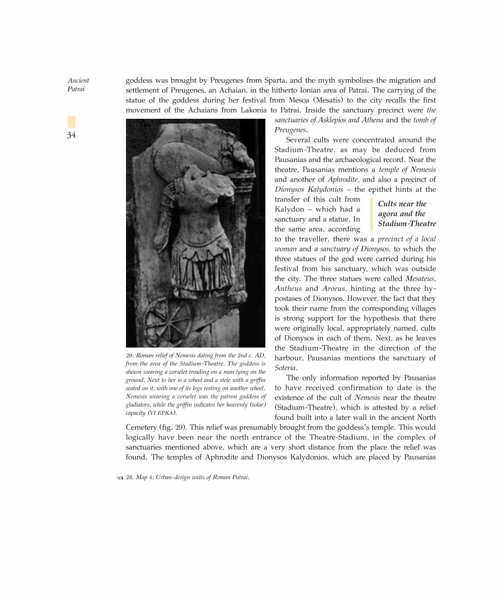
Several cults were concentrated around theStadium-Theatre, as may be deduced fromPausanias and the archaeological record. Near thetheatre, Pausanias mentions a temple of Nemesisand another of Aphrodite, and also a precinct ofDionysos Kalydonios – the epithet hints at thetransfer of this cult fromKalydon – which had asanctuary and a statue. Inthe same area, accordingto the traveller, there was a precinct of a localwoman and a sanctuary of Dionysos, to which thethree statues of the god were carried during hisfestival from his sanctuary, which was outsidethe city. The three statues were called Mesateus,Antheus and Aroeus, hinting at the three hy-postases of Dionysos. However, the fact that theytook their name from the corresponding villagesis strong support for the hypothesis that therewere originally local, appropriately named, cultsof Dionysos in each of them. Next, as he leavesthe Stadium-Theatre in the direction of theharbour, Pausanias mentions the sanctuary ofSoteria.
The only information reported by Pausaniasto have received confirmation to date is theexistence of the cult of Nemesis near the theatre(Stadium-Theatre), which is attested by a relieffound built into a later wall in the ancient North
Cemetery (fig. 29). This relief was presumably brought from the goddess’s temple. This wouldlogically have been near the north entrance of the Theatre-Stadium, in the complex ofsanctuaries mentioned above, which are a very short distance from the place the relief wasfound. The temples of Aphrodite and Dionysos Kalydonios, which are placed by Pausanias
Ancient Patrai
34
28. Map 4: Urban-design units of Roman Patrai.☞
29. Roman relief of Nemesis dating from the 2nd c. AD,from the area of the Stadium-Theatre. The goddess isshown wearing a corselet treading on a man lying on theground. Next to her is a wheel and a stele with a griffinseated on it, with one of its legs resting on another wheel.Nemesis wearing a corselet was the patron goddess ofgladiators, while the griffin indicates her heavenly (solar)capacity (VI EPKA).
Cults near the
agora and the
Stadium-Theatre
along with the temple of Nemesis near the theatre, were probably in the same area, as was theprecinct of the local woman with the three statues of Dionysos, which, as we have seen, boreepithets derived from the three most ancient villages. This sanctuary, too, should be placed tothe north of the Stadium-Theatre, since Pausanias goes on immediately to mention thesanctuary of Dionysos Aisymnetes, (to which the three statues were carried during his festival).According to the traveller, this was on the road from the agora to the harbour – that is, in theopposite direction and therefore to the south of the Stadium. The temple of Aisymnetes mustcertainly be earlier than the Roman period, since there are reconstructions of this myth onHellenistic coins of Patrai dating from the 2nd c. BC.
As he approached the harbour, Pausanias saw a temple of Poseidon, with three sanctuaries ofAphrodite near it. The proximity of these two deities is not surprising, since they were bothassociated with the sea, the latter as patron goddess of seafaring. Pausanias’sdescription of Patrai closes with the sanctuary of Demeter, which containedstatues of the goddess, Kore and Gaia. Demeter is very frequently associatedwith Gaia. Inside the sanctuary there was also an oracular spring (fig. 30).Demeter is also identified with Isis, and the existence of the neighbouring sanctuary of Serapisis therefore no surprise. There was probably also a separate temple to Isis.
Many of the old cults of Patrai had two sanctuaries, an urban sanctuary in the city and anotherin one of the three villages (Antheia, Mesatis and Aroe) that were unified in the synoecism toform Patrai. The cults in question are those of Artemis Mesatis (at the village of Mesatis),Demeter Poteriophoros (at Antheia), Artemis Limnatis (at Mesatis), whosecult was introduced by Preugenes, father of the founder of Patrai, and finallyDionysios Aisymnetes (Antheia, Mesatis and Aroe). Many cults are asso-ciated with the first foundation of Patrai, some of them local, though othersappear to have been introduced at the time of the foundation and were in time amalgamatedand assimilated with the local traditions. These are Artemis Limnatis, whose cult wasintroduced from Sparta, Dionysos Aisymnetes, whose cult was adopted on the arrival of thehero Eurypylos, and finally Dionysos Kalydonios and Artemis Laphria, whose cults wereintroduced from Kalydon in the Roman period.
Most of the Olympian deities at Patrai do not seem to have a long history and are notconnected with the old local tradition. They were presumably introduced as official gods onthe occasion of the city’s foundation, as elsewhere. When, much later, the Roman colonistssettled in Patrai, the authorities of the colonia had to reconcile all these cults, both eastern andof a strictly local or panhellenic character, with the Roman religious tradition. The richiconography of the gods of the Olympian pantheon on the coins demonstrates that theauthorities of the colony found in these gods points of contact between the two peoples. Thesedeities, therefore – along with some later ones introduced after the foundation of the coloniaand strengthened by Rome for political reasons (e.g. Artemis Laphria) – form the officialpantheon of the colonia and were worshipped by both Greeks and Roman colonists and their
Ancient Patrai
35
Cults around
the harbour
Conclusions
on the cults
of Patrai
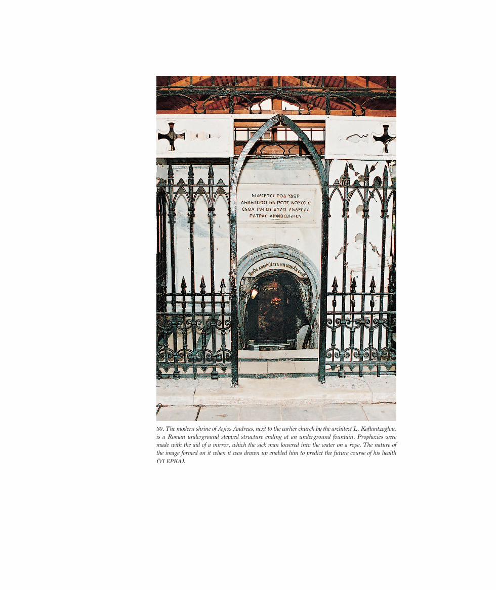
30. The modern shrine of Ayios Andreas, next to the earlier church by the architect L. Kaftantzoglou,is a Roman underground stepped structure ending at an underground fountain. Prophecies weremade with the aid of a mirror, which the sick man lowered into the water on a rope. The nature ofthe image formed on it when it was drawn up enabled him to predict the future course of his health(VI EPKA).
descendants. This does not mean, of course, that the cult of other gods, not well representedon the coins, did not meet with a response, for a distinction should be drawn between theofficial character of a cult and its popularity. The most popular cults of the city appear to havebeen those of Artemis Laphria and Triklaria, whose annual festivals, involving a wealth ofritual, described in detail by Pausanias, attracted the greatest number of worshippers. This isalso true of Aphrodite, who had four sanctuaries and whose cult had a great following, if weare to believe Pausanias, particularly amongst the female population of the city. The sameapplies to a number of eastern cults, as is indirectly attested by the great number of smalldedications found during the excavations.
Of the Roman cults introduced into Patrai, the only ones to survive were those that werelinked with or assimilated by the local cults. Those that had no feature that could be linkedwith the Greek tradition met with no popular response. The Roman colonists, as we have seen,quickly and easily became familiar with those of the Greek deities whose image, or elementsof their theology and daily cult practice, reminded them of their own national gods. All thesecults, of course, underwent various processes of syncretism, leading to changes that are, inmost cases, incomprehensible to modern scholars.
The evidence available at present suggests that Christianity made no progress, at least inthe first three centuries. This conflicts with the Christian tradition of the teaching of the Gospeland the Martyrdom of St Andrew in Patras.
The Romans retained the basic town plan of the Hellenistic city, though they engaged in aseries of extensions to it, with the result that there is no uniform orientation of the streets ofthe various neighbourhoods. Patrai acquired infrastructure buildings, and monuments toembellish the city, which elevated it to the status of one of the finest cities of the period. Thestreets, for example, were paved and large, vaulted sewers were constructed beneath the main
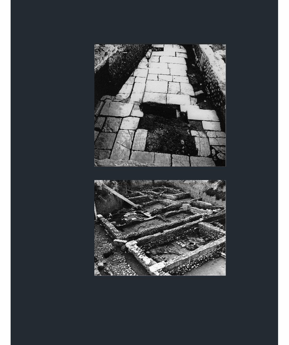
arteries. Sections of a paved Roman road leading to the agorafrom the south, and buildings that stood alongside it (fig. 33) arepreserved in G. Rouphou Street, just south of the Odeion. Part ofthe urban tissue of the city, with streets and the buildings next
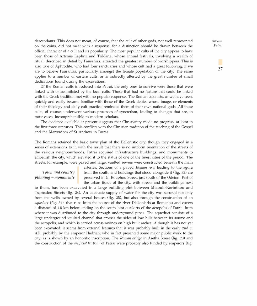
to them, has been excavated in a large building plot between Miaouli-Korinthou andTsamadou Streets (fig. 34). An adequate supply of water for the city was secured not onlyfrom the wells owned by several houses (fig. 35), but also through the construction of anaqueduct (fig. 31), that runs from the source of the river Diakoniaris at Romanou and coversa distance of 7.5 km before ending on the south-east outskirts of the acropolis of Patrai, fromwhere it was distributed to the city through underground pipes. The aqueduct consists of alarge underground vaulted channel that crosses the sides of low hills between its source andthe acropolis, and which is carried across ravines on high built arches. Although it has not yetbeen excavated, it seems from external features that it was probably built in the early 2nd c.AD, probably by the emperor Hadrian, who in fact presented some major public work to thecity, as is shown by an honorific inscription. The Roman bridge in Aretha Street (fig. 20) andthe construction of the artificial harbour of Patrai were probably also funded by emperors (fig.
Ancient Patrai
37
Town and country
planning – monuments
32, 44). During this period, Patrai now extended down to the sea, apart from the coastal zone,which was probably occupied by marshes, and a number of specific urban design units werecreated (map 4 = fig. 28).
Effectively geomorphology imposed a two-fold town plan, as today: the Upper Town,together with the acropolis and agora, and the Lower Town, ‘the area by the sea’, to use anexpression drawn from the travel-writer Pausanias. The main town-planning zones, four innumber, along with the activities carried out in them, were precisely defined. One zoneconsisted of the acropolis, which coincides with the village of Aroe, and a second of the agora,which corresponds with the Roman forum and lies to the south of the acropolis. Next to theagora is the zone that contained buildings associated with spectacles and entertainment
(Odeion, Stadium-Theatre), part of which is in the Upper Town (Odeion) and part in theLower (Stadium-Theatre) (fig. 39, 40). The final zone is the one that developed around theharbour. Many cosmopolitan cults were concentrated here and a range of commercial activitiesemerged.
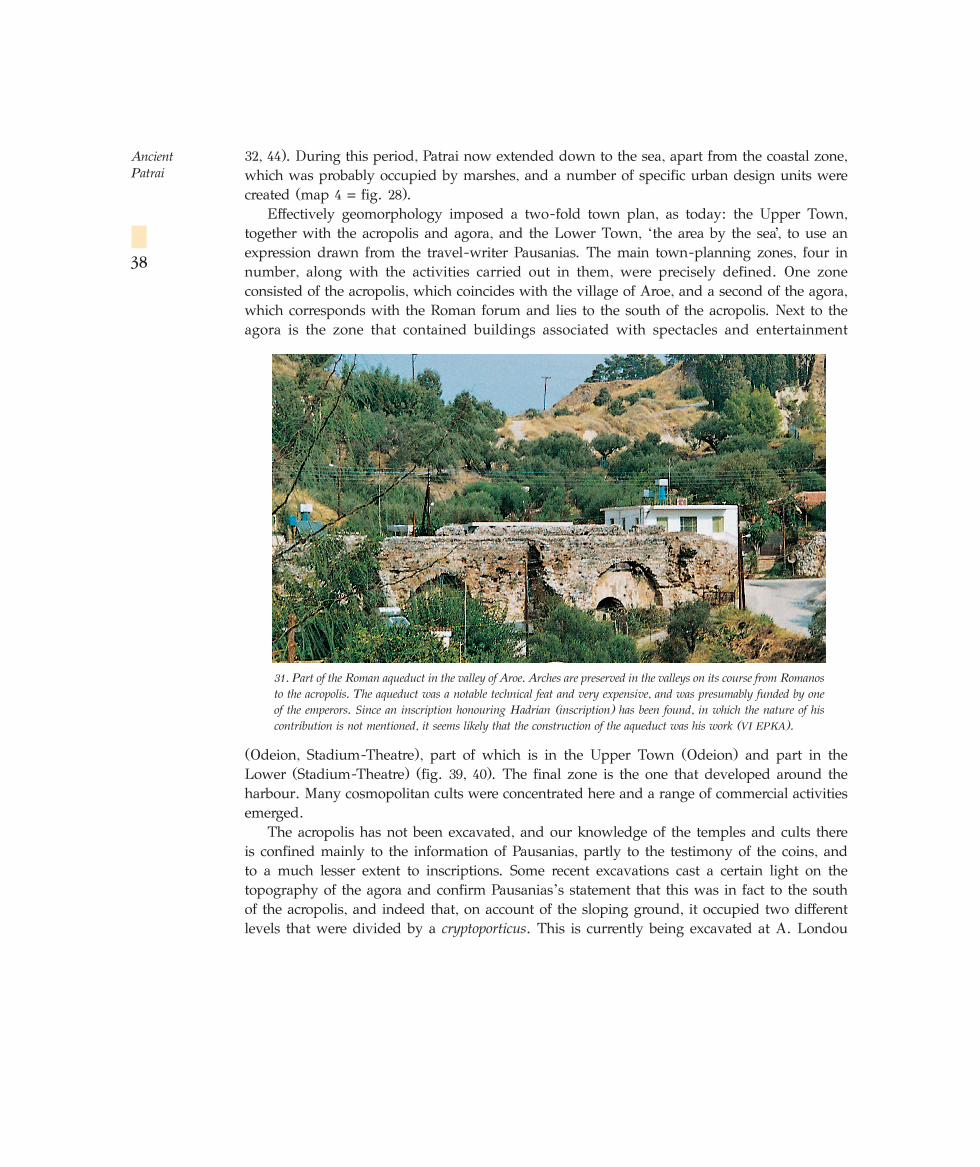
The acropolis has not been excavated, and our knowledge of the temples and cults thereis confined mainly to the information of Pausanias, partly to the testimony of the coins, andto a much lesser extent to inscriptions. Some recent excavations cast a certain light on thetopography of the agora and confirm Pausanias’s statement that this was in fact to the southof the acropolis, and indeed that, on account of the sloping ground, it occupied two differentlevels that were divided by a cryptoporticus. This is currently being excavated at A. Londou
Ancient Patrai
38
31. Part of the Roman aqueduct in the valley of Aroe. Arches are preserved in the valleys on its course from Romanosto the acropolis. The aqueduct was a notable technical feat and very expensive, and was presumably funded by oneof the emperors. Since an inscription honouring Hadrian (inscription) has been found, in which the nature of hiscontribution is not mentioned, it seems likely that the construction of the aqueduct was his work (VI EPKA).
Street 25 and is similar to the one in the Roman agora of Thessaloniki. Its rear wall serves asa retaining wall for the upper terrace, while the stoa at the front of it overlooks the lowerterrace. Although the excavation has not progressed very far, the building is probably to bedated to the 1st/2nd c. AD. The temple of the augustales, at Ilias Street 1, was also in the agora.Opposite it, at Ilias Street 6 and Panagouli Street, is preserved another important building –an underground structure probably associated with thecult of Mithras.
Temples were built in the agora, or earlier Greektemples converted, mainly for Roman deities. Theyinclude the temple of the Capitoline Trinity on the site nowoccupied by the church of the Pantokrator. Other publicand religious buildings were also erected, such as theAedes Augustalium (fig. 36), the building in which wasfound an inscription honouring Agrippa Postumus (fig.37), the adopted son of Augustus and patron of the city.Finally, there were temples and cult areas dedicated toeastern deities, brought to Patrai by the Romans, such asAttis and Cybele and Mithras.
The entertainment zone, in which were located theOdeion and the Stadium-Theatre (fig. 39, fig. 40), whichis currently being excavated, was of great importance.The Roman Odeion, built, according to Pausanias, at thebeginning of the second half of the 2nd c. AD (AD 160),has been partially restored (fig. 1) and is used insummer for concerts. It is similar to the Herodeion inAthens, with which Pausanias compares its beauty,though it is only half the size and seats only 3000
spectators. If Pausanias’s date is correct, it was probablypresented to the city by either the emperor AntoninusPius or Marcus Aurelius. The erection of the Stadium-
Ancient Patrai
39
33. View of one of the paved Roman roads that led to the Roman agora from the south. It is in the modern G. Rouphou Streetand has buildings on either side of it (VI EPKA).
34. Part of the urban tissue of Roman Patrai in Miaouli-Korinthou and Tsamadou Streets. It is the most complete section to come to light to date. Some of the main and secondary streets can be seen, along with the buildings at the sides of them (VI EPKA).
35. Well with a clay head in the courtyard of a Roman house at Patrai. The walls of the well were also ‘dressed’ with claycylinders. The holes were used to climb down into the well. Water was supplied by both wells and clay and lead pipes thatchannelled it from the aqueduct. Clay or built conduits were also used as drains to carry waste from the houses to the large builtsewers under the paved streets. It has been proved that some of the Roman sewers were used as late as the early 20th c., andthe sewer of the Roman Odeion at Patrai is still in use, though the precise point at which it discharges into the sea is not known(VI EPKA).
☞
32. View of Patrai harbour on a coin issued byGeta (AD 209-211) with an unusually detailedrendering. A building with columns can bemade out, with two ships (one a sailing ship)and a male figure, probably a statue of Poseidon,that adorned the city harbour or functioned as alighthouse (VI EPKA).
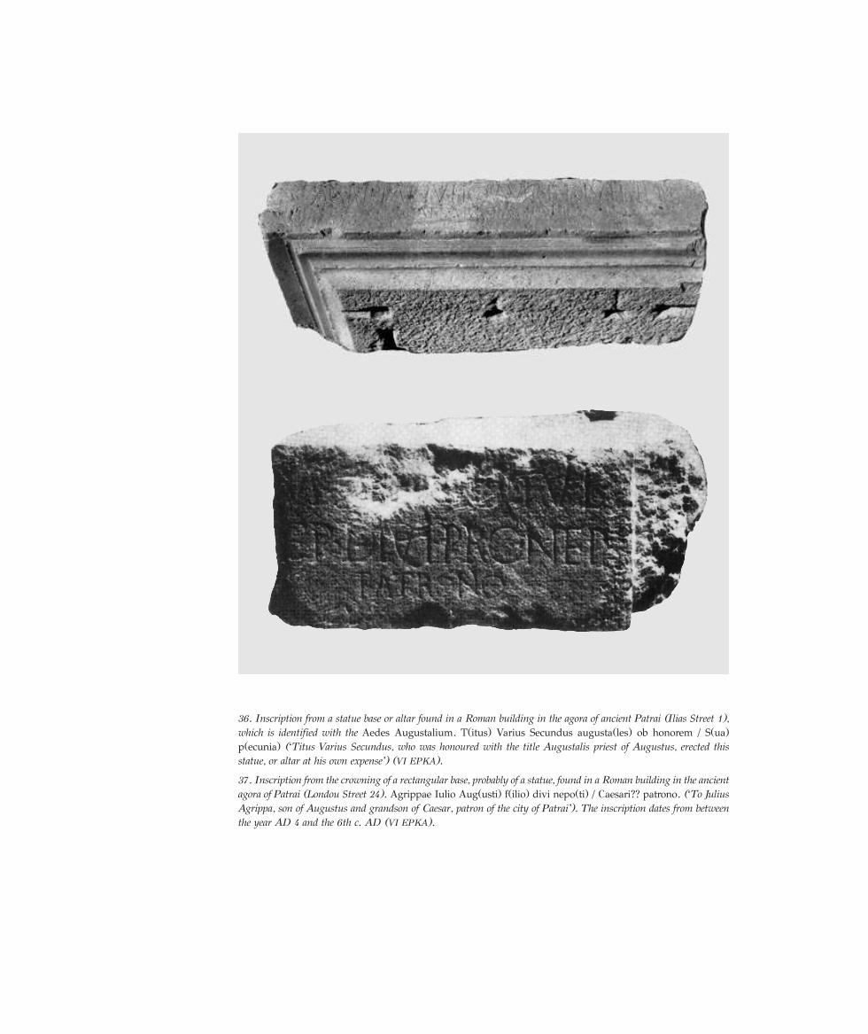
36. Inscription from a statue base or altar found in a Roman building in the agora of ancient Patrai (Ilias Street 1),which is identified with the Aedes Augustalium. T(itus) Varius Secundus augusta(les) ob honorem / S(ua)p(ecunia) (‘Titus Varius Secundus, who was honoured with the title Augustalis priest of Augustus, erected thisstatue, or altar at his own expense’) (VI EPKA).
37. Inscription from the crowning of a rectangular base, probably of a statue, found in a Roman building in the ancientagora of Patrai (Londou Street 24). Agrippae Iulio Aug(usti) f(ilio) divi nepo(ti) / Caesari?? patrono. (‘To JuliusAgrippa, son of Augustus and grandson of Caesar, patron of the city of Patrai’). The inscription dates from betweenthe year AD 4 and the 6th c. AD (VI EPKA).
Ancient Patrai
43
Theatre, funded by the emperor Domitian to celebrate the centenary of the foundation of thecolony (AD 86), was probably earlier. The building is about 200 m. long and 90 m. wide, andhas two curves. The east, long side was constructed on the side of a natural terrace (the finaloutcrop of Mount Panachaikon), on which the Stadium was built. The Stadium was the venuefor the Caesareia athletic contests, which were accompanied by artistic competitions. That thetwo forms of contest, both the athletic and the artistic (poetry, theatre and music competitions),were held in the same place (that is the Stadium) is demonstrated by a mosaic floor found(fig. 38) in a Roman villa in the vicinity of Psila Alonia Square, the representations in whichare inspired precisely by events in the Stadium. The mosaic is divided into two zones. In theupper zone, to right and left of a table holding the prizes for the victors, are depicted, in order,
a poetry contest between two figures who are accompanied by a flautist, followed by a kithara-player and finally three tragic actors. To the right of the table are tragic actors, the chorus ofa tragedy or dithyramb, and a kithara-player. The lower zone contains representations ofathletic contests. The following can be recognised, from the left: a torch-runner, a man playinga game rather like hockey, a discus-thrower, a jumper, wrestlers, boxers, and a runner in thehoplite-race. Those who have already won have been crowned and hold a palm branch.
The mosaic and inscriptions enable us to identify the theatre of Patrai, said by Pausaniasto be near the Odeion, with this particular monument. Pausanias presumably refers to thebuilding in its secondary capacity, as a theatre, used for performances of plays, under theinfluence of the circumstance that the long east side of it was constructed in a hillside, as withGreek theatres.
The Stadium was also used for gladiatorial combats –the munera gladiatorum, known bothfrom epigraphic documents and from representations of such games (fig. 41)– since there wasno other venue for contests in Patrai. The temple of Nemesis was probably also connected
38. The mosaic from a Roman villa of the 2nd c. AD in Psila Alonia Square. The upper zone has depictions ofartistic competitions and the lower of athletic contests (VI EPKA).
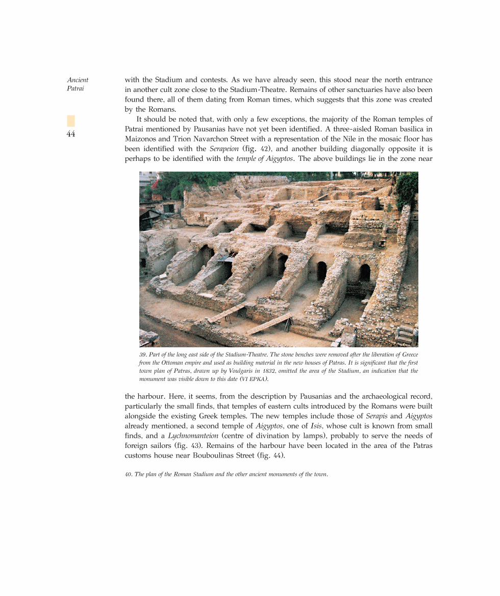
with the Stadium and contests. As we have already seen, this stood near the north entrancein another cult zone close to the Stadium-Theatre. Remains of other sanctuaries have also beenfound there, all of them dating from Roman times, which suggests that this zone was createdby the Romans.
It should be noted that, with only a few exceptions, the majority of the Roman temples ofPatrai mentioned by Pausanias have not yet been identified. A three-aisled Roman basilica inMaizonos and Trion Navarchon Street with a representation of the Nile in the mosaic floor hasbeen identified with the Serapeion (fig. 42), and another building diagonally opposite it isperhaps to be identified with the temple of Aigyptos. The above buildings lie in the zone near
the harbour. Here, it seems, from the description by Pausanias and the archaeological record,particularly the small finds, that temples of eastern cults introduced by the Romans were builtalongside the existing Greek temples. The new temples include those of Serapis and Aigyptosalready mentioned, a second temple of Aigyptos, one of Isis, whose cult is known from smallfinds, and a Lychnomanteion (centre of divination by lamps), probably to serve the needs offoreign sailors (fig. 43). Remains of the harbour have been located in the area of the Patrascustoms house near Bouboulinas Street (fig. 44).
Ancient Patrai
44
39. Part of the long east side of the Stadium-Theatre. The stone benches were removed after the liberation of Greecefrom the Ottoman empire and used as building material in the new houses of Patras. It is significant that the firsttown plan of Patras, drawn up by Voulgaris in 1832, omitted the area of the Stadium, an indication that themonument was visible down to this date (VI EPKA).
40. The plan of the Roman Stadium and the other ancient monuments of the town.
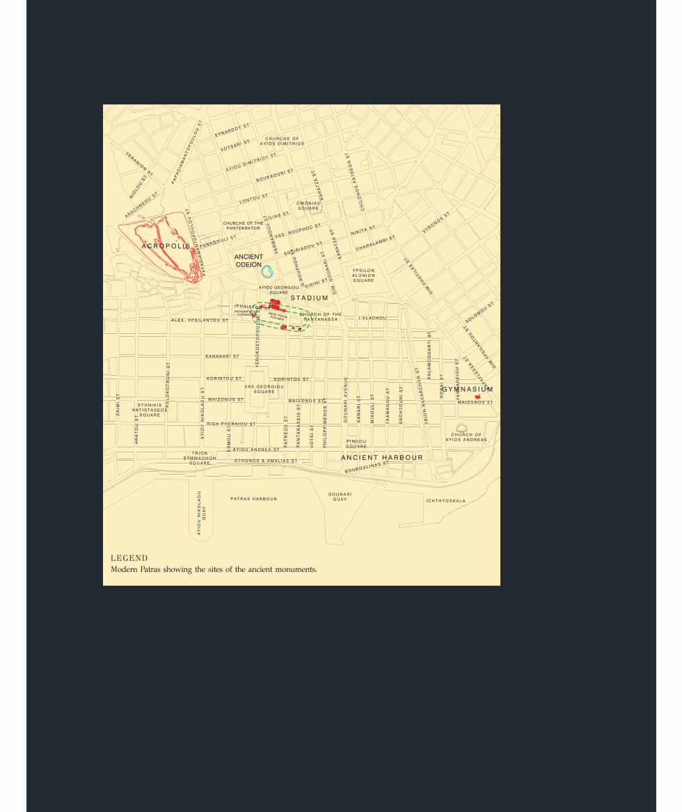
LEGENDModern Patras showing the sites of the ancient monuments.
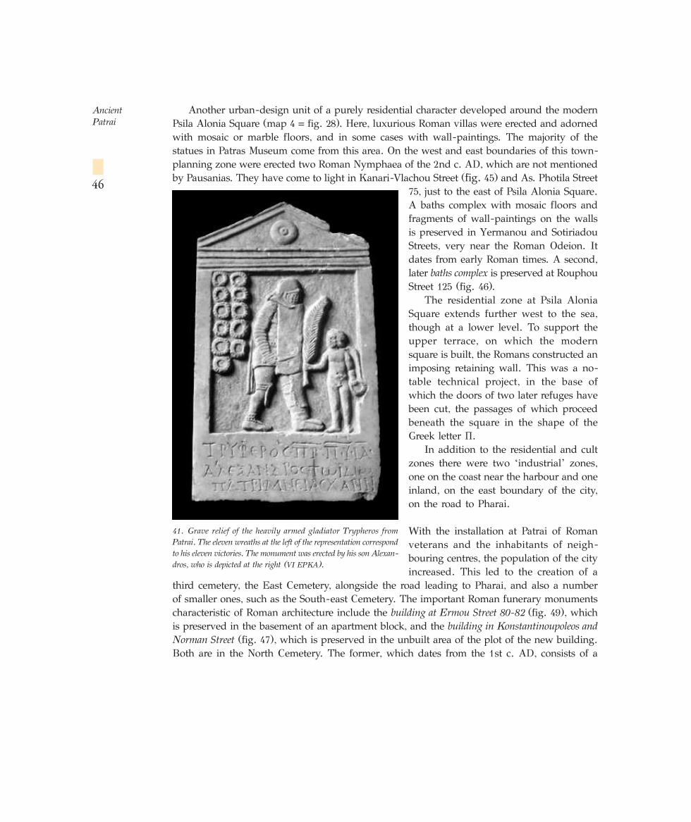
Another urban-design unit of a purely residential character developed around the modernPsila Alonia Square (map 4 = fig. 28). Here, luxurious Roman villas were erected and adornedwith mosaic or marble floors, and in some cases with wall-paintings. The majority of thestatues in Patras Museum come from this area. On the west and east boundaries of this town-planning zone were erected two Roman Nymphaea of the 2nd c. AD, which are not mentionedby Pausanias. They have come to light in Kanari-Vlachou Street (fig. 45) and As. Photila Street
75, just to the east of Psila Alonia Square.A baths complex with mosaic floors andfragments of wall-paintings on the wallsis preserved in Yermanou and SotiriadouStreets, very near the Roman Odeion. Itdates from early Roman times. A second,later baths complex is preserved at RouphouStreet 125 (fig. 46).
The residential zone at Psila AloniaSquare extends further west to the sea,though at a lower level. To support theupper terrace, on which the modernsquare is built, the Romans constructed animposing retaining wall. This was a no-table technical project, in the base ofwhich the doors of two later refuges havebeen cut, the passages of which proceedbeneath the square in the shape of theGreek letter ¶.
In addition to the residential and cultzones there were two ‘industrial’ zones,one on the coast near the harbour and oneinland, on the east boundary of the city,on the road to Pharai.
With the installation at Patrai of Romanveterans and the inhabitants of neigh-bouring centres, the population of the cityincreased. This led to the creation of a
third cemetery, the East Cemetery, alongside the road leading to Pharai, and also a numberof smaller ones, such as the South-east Cemetery. The important Roman funerary monumentscharacteristic of Roman architecture include the building at Ermou Street 80-82 (fig. 49), whichis preserved in the basement of an apartment block, and the building in Konstantinoupoleos andNorman Street (fig. 47), which is preserved in the unbuilt area of the plot of the new building.Both are in the North Cemetery. The former, which dates from the 1st c. AD, consists of a
Ancient Patrai
46
41. Grave relief of the heavily armed gladiator Trypheros fromPatrai. The eleven wreaths at the left of the representation correspondto his eleven victories. The monument was erected by his son Alexan-dros, who is depicted at the right (VI EPKA).
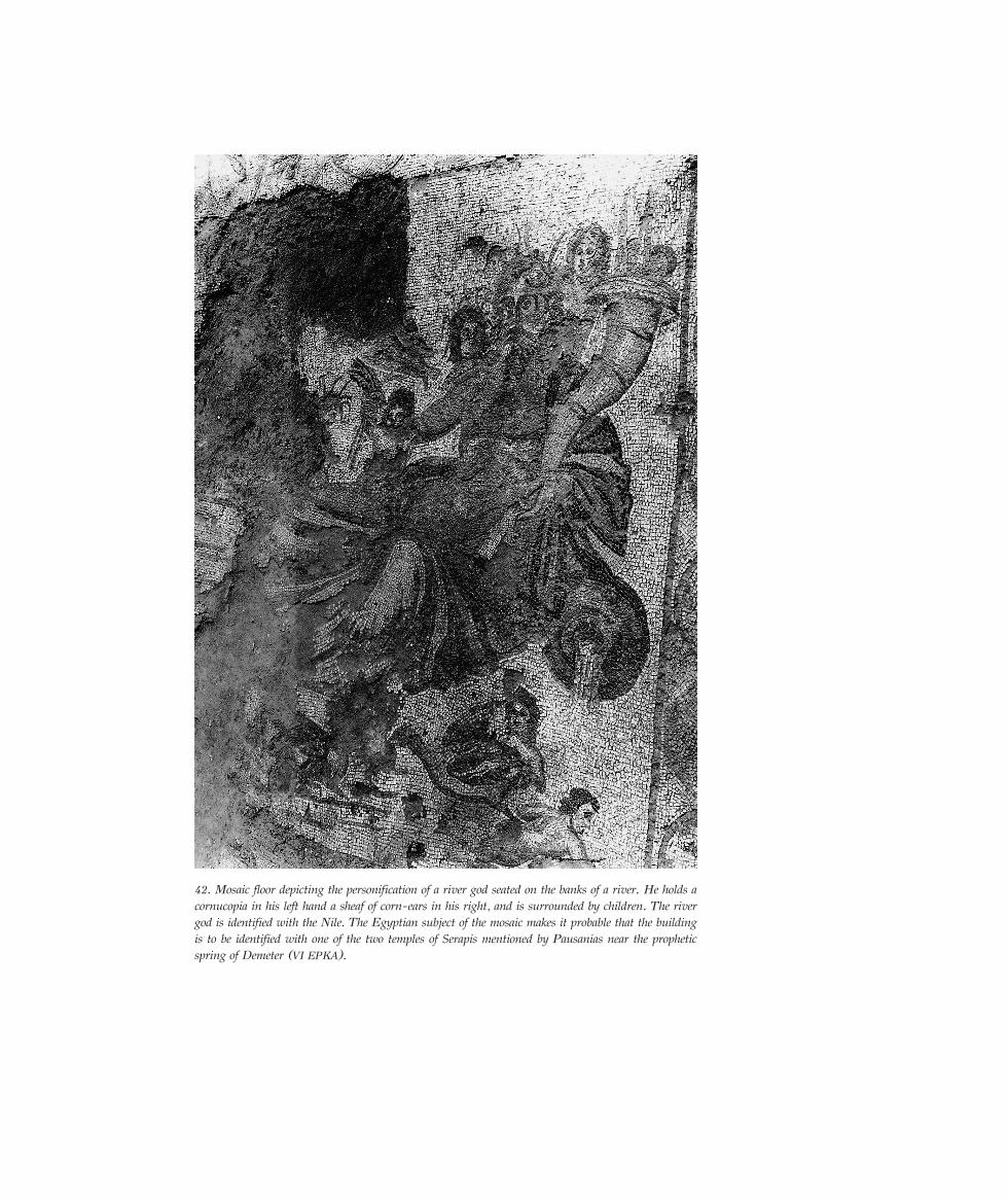
42. Mosaic floor depicting the personification of a river god seated on the banks of a river. He holds acornucopia in his left hand a sheaf of corn-ears in his right, and is surrounded by children. The rivergod is identified with the Nile. The Egyptian subject of the mosaic makes it probable that the buildingis to be identified with one of the two temples of Serapis mentioned by Pausanias near the propheticspring of Demeter (VI EPKA).
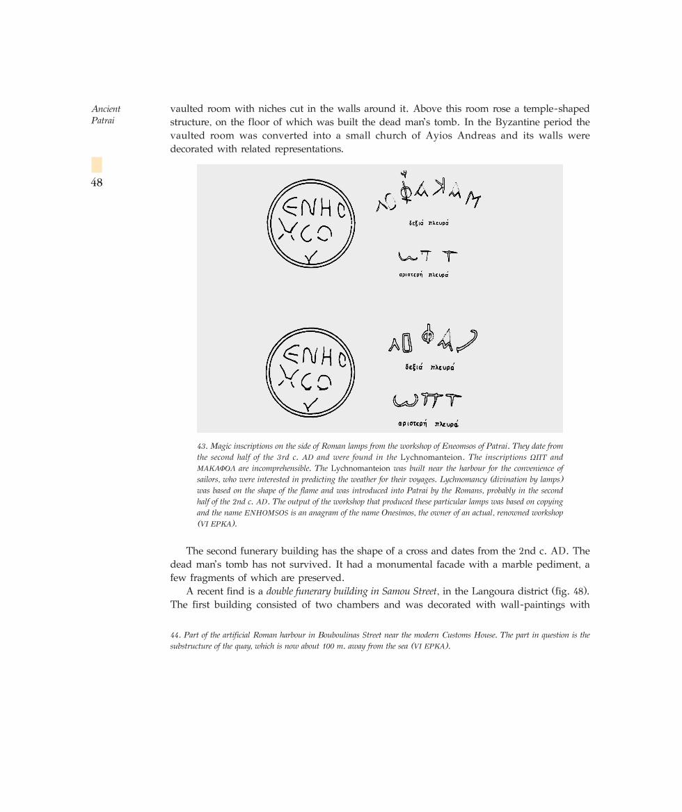
vaulted room with niches cut in the walls around it. Above this room rose a temple-shapedstructure, on the floor of which was built the dead man’s tomb. In the Byzantine period thevaulted room was converted into a small church of Ayios Andreas and its walls weredecorated with related representations.
The second funerary building has the shape of a cross and dates from the 2nd c. AD. Thedead man’s tomb has not survived. It had a monumental facade with a marble pediment, afew fragments of which are preserved.
A recent find is a double funerary building in Samou Street, in the Langoura district (fig. 48).The first building consisted of two chambers and was decorated with wall-paintings with
Ancient Patrai
48
44. Part of the artificial Roman harbour in Bouboulinas Street near the modern Customs House. The part in question is thesubstructure of the quay, which is now about 100 m. away from the sea (VI EPKA).
43. Magic inscriptions on the side of Roman lamps from the workshop of Eneomsos of Patrai. They date fromthe second half of the 3rd c. AD and were found in the Lychnomanteion. The inscriptions ø¶∆ andª∞∫∞º√§ are incomprehensible. The Lychnomanteion was built near the harbour for the convenience ofsailors, who were interested in predicting the weather for their voyages. Lychnomancy (divination by lamps)was based on the shape of the flame and was introduced into Patrai by the Romans, probably in the secondhalf of the 2nd c. AD. The output of the workshop that produced these particular lamps was based on copyingand the name ENHOMSOS is an anagram of the name Onesimos, the owner of an actual, renowned workshop(VI EPKA).
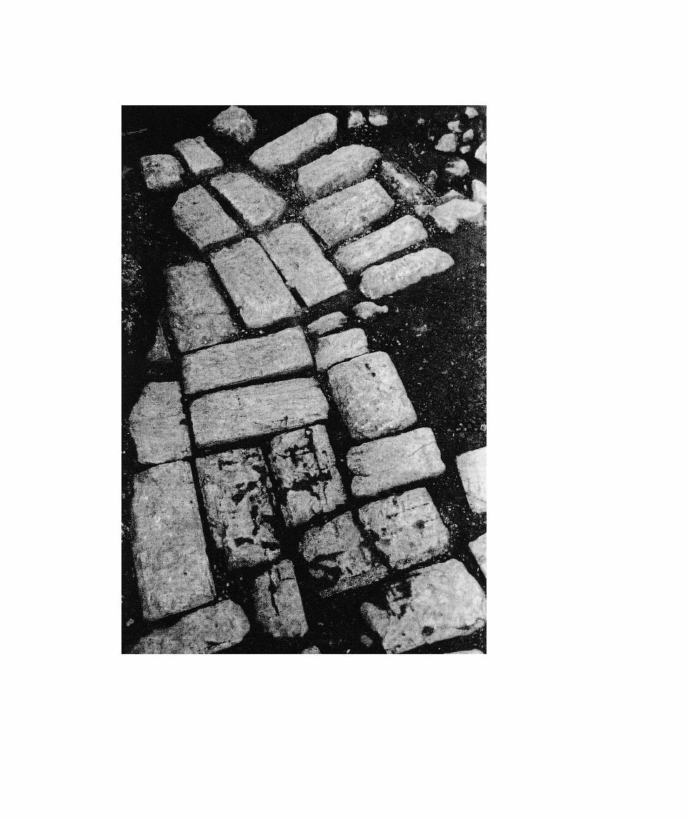
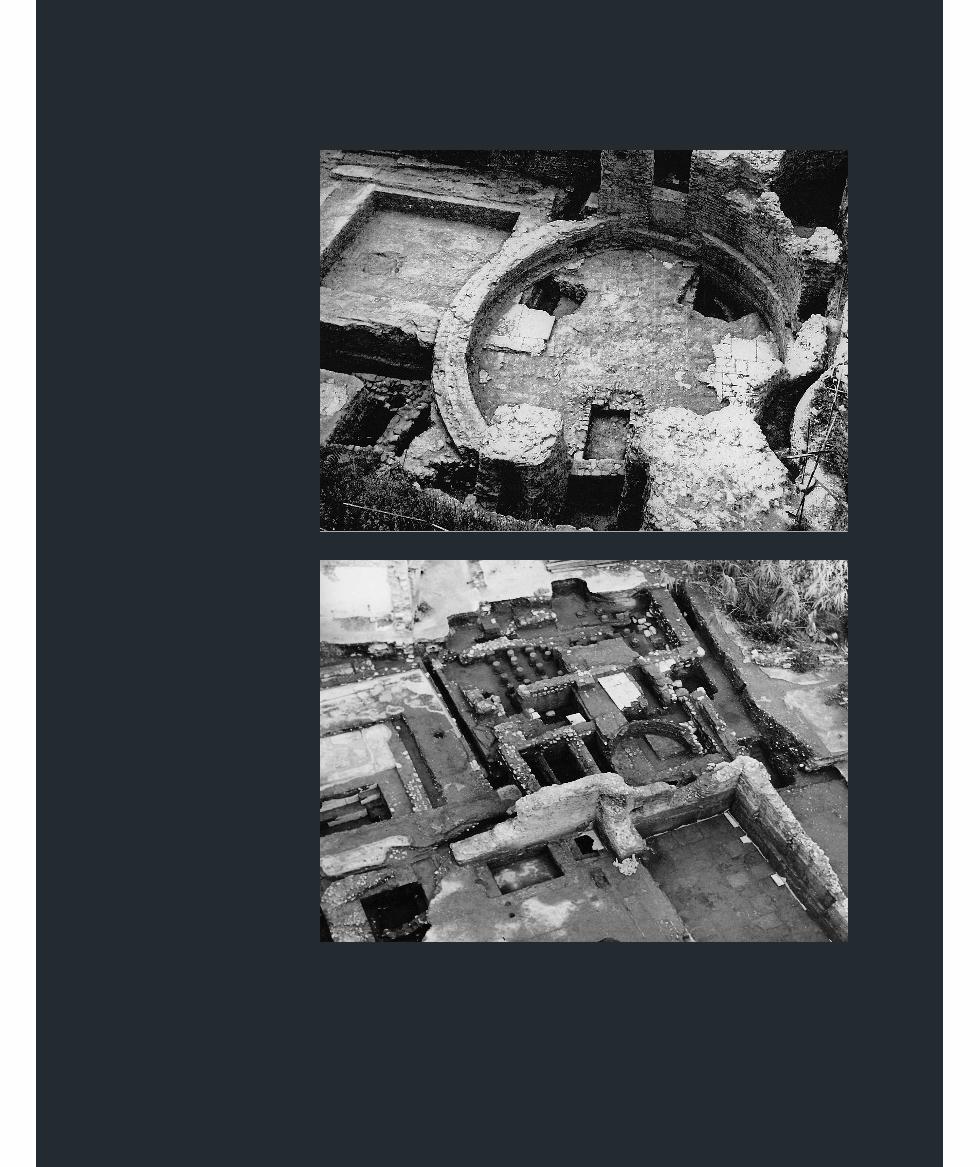
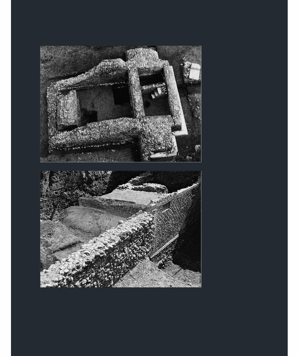
simple floral ornaments and red bands tied in bows. It belonged to a family of Romanveterans, as is clear from the inscription set in the outer wall of the building: Marciae MaximaeC(aii) Laetili Clementis uxori Pavit mater. On the floor of the main chamber was found thefamily tomb, which had been robbed at a later period, while niches in the north wall containedtwo female marble busts probably of Marcia Maxima and her mother (fig. 51). The secondbuilding, of which the double barrel-vaulted roof was preserved, was laterthan the first, though no tomb survived inside it. The complex belonged to acountry house that had been excavated several years previously. It wascovered with sand and pebbles as a result of being flooded by the riverDiakoniaris, which preserved it to the present day. Strong retaining walls had been constructedon the banks of the river, but these failed to prevent the flood. This complex belonged to thefirst generation of veterans settled by Augustus at Patrai. It was built at the time of Augustusand destroyed in the 2nd or 3rd century AD.
The great importance of the harbour of Patrai, the settlement here of Greek, Roman andforeign colonists, and the development of industry (local lamps, which flooded the markets,textile industry, jewellery, glass-works, etc.), of farming (wine, oil, and corn), and of stock-raising, together with the right of the city to mint its own coins, led to a flowering of theeconomy of Patrai, which acquired a cosmopolitan character. The Roman emperors endowedit with important public buildings, in recognition of its importance.
The technical works constructed by the Romans, the harbour, roads, the retaining wall atPsila Alonia Square, bridges, the anti-flood walls on rivers (Sychainiotiko and Diakoniaris),and the important buildings, all testify not only to the wealth of Patrai in the Roman period,but also to the complete Romanisation of the city. This is clear both from the prevalence ofRoman architecture and Roman construction systems (opus reticulatum, opus mixtum, opustestaceum, etc.) and from the large number of Latin inscriptions, which are predominant in the
Ancient Patrai
52
45. General view of the Roman Nymphaeum, dating from the 2nd c. AD, in Kanari and I. Vlachou Streets. The cult of theNymphs is not mentioned by Pausanias, but must have been popular, since a second Nymphaeum has been found in As. PhotilaStreet. The two complexes are on the west and east boundaries of the town-planning zone containing the Roman villas. TheNymphs were connected with water, and water therefore ran from holes in the perimeter wall of the complex and was collectedin a large circular cistern. During the period of Ottoman rule the Nymphaeum was converted into a Christian church (VI EPKA).
46. View of the Roman baths at Vas. Rouphou Street 125. The process of bathing involved three stages: a cold bath, a tepid bathand a hot bath. To heat the latter two rooms, their floors were supported on short pillars, creating an open space in which hotair circulated (VI EPKA).
47. Temple-shaped funerary building dating from the 2nd c. AD in the North Cemetery, found in Konstantinoupoleos andNorman Streets. The tomb of the dead man has not been preserved because the building was reused in the Byzantine periodand a wine-press was built in one of the rooms. Part of the Hellenistic cemetery of the city was found beneath the building(VI EPKA).
48. Part of the double funerary building dating from the 1st c. AD in Samou Street at Langoura. The inscription can be seenon the wall of one of the buildings. The wall was built according to the Roman system of opus reticulatum, one of the principlemeans used by Augustus to exercise Roman propaganda (VI EPKA).
☞
Cemeteries
of Patrai
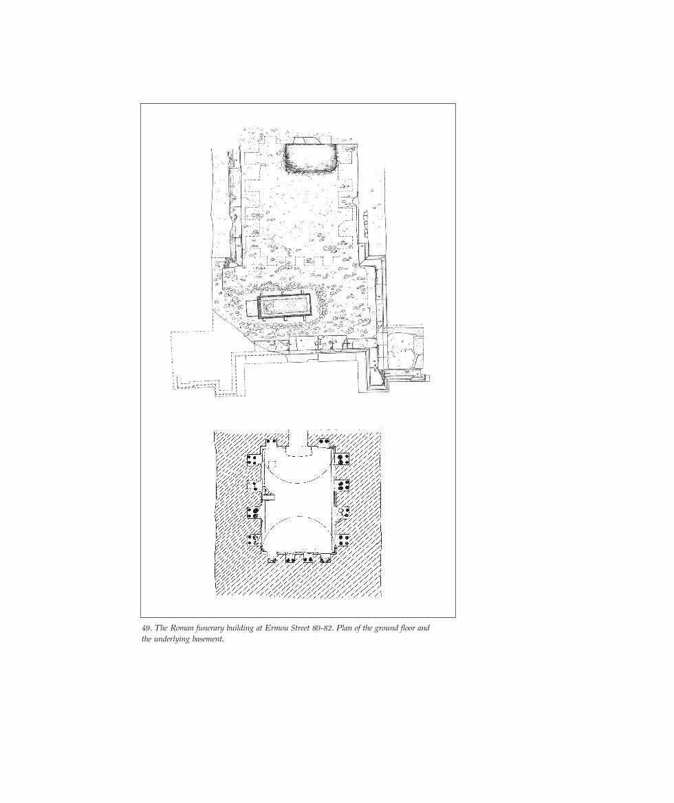
49. The Roman funerary building at Ermou Street 80-82. Plan of the ground floor andthe underlying basement.
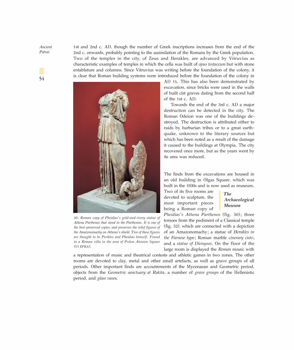
1st and 2nd c. AD, though the number of Greek inscriptions increases from the end of the2nd c. onwards, probably pointing to the assimilation of the Romans by the Greek population.Two of the temples in the city, of Zeus and Herakles, are advanced by Vitruvius ascharacteristic examples of temples in which the cella was built of opus testaceum but with stoneentablature and columns. Since Vitruvius was writing before the foundation of the colony, itis clear that Roman building systems were introduced before the foundation of the colony in
AD 14. This has also been demonstrated byexcavation, since bricks were used in the wallsof built cist graves dating from the second halfof the 1st c. AD.
Towards the end of the 3rd c. AD a majordestruction can be detected in the city. TheRoman Odeion was one of the buildings de-stroyed. The destruction is attributed either toraids by barbarian tribes or to a great earth-quake, unknown to the literary sources butwhich has been noted as a result of the damageit caused to the buildings at Olympia. The cityrecovered once more, but as the years went byits area was reduced.
The finds from the excavations are housed inan old building in Olgas Square, which wasbuilt in the 1930s and is now used as museum.Two of its five rooms aredevoted to sculpture, themost important piecesbeing a Roman copy ofPheidias’ s Athena Parthenos (fig. 50); threetorsoes from the pediment of a Classical temple(fig. 52), which are connected with a depictionof an Amazonomachy; a statue of Herakles inthe Farnese type; Roman marble cinerary cists;and a statue of Dionysos. On the floor of thelarge room is displayed the Roman mosaic with
a representation of music and theatrical contests and athletic games in two zones. The otherrooms are devoted to clay, metal and other small artefacts, as well as grave groups of allperiods. Other important finds are accoutrements of the Mycenaean and Geometric period,objects from the Geometric sanctuary at Rakita, a number of grave groups of the Hellenisticperiod, and glass vases.
Ancient Patrai
54
50. Roman copy of Pheidias’ s gold-and-ivory statue ofAthena Parthenos that stood in the Parthenon. It is one ofthe best-preserved copies, and preserves the relief figures ofthe Amazonomachy on Athena’s shield. Two of these figuresare thought to be Perikles and Pheidias himself. Found in a Roman villa in the area of Psilon Alonion Square (VI EPKA).
The
Archaeological
Museum
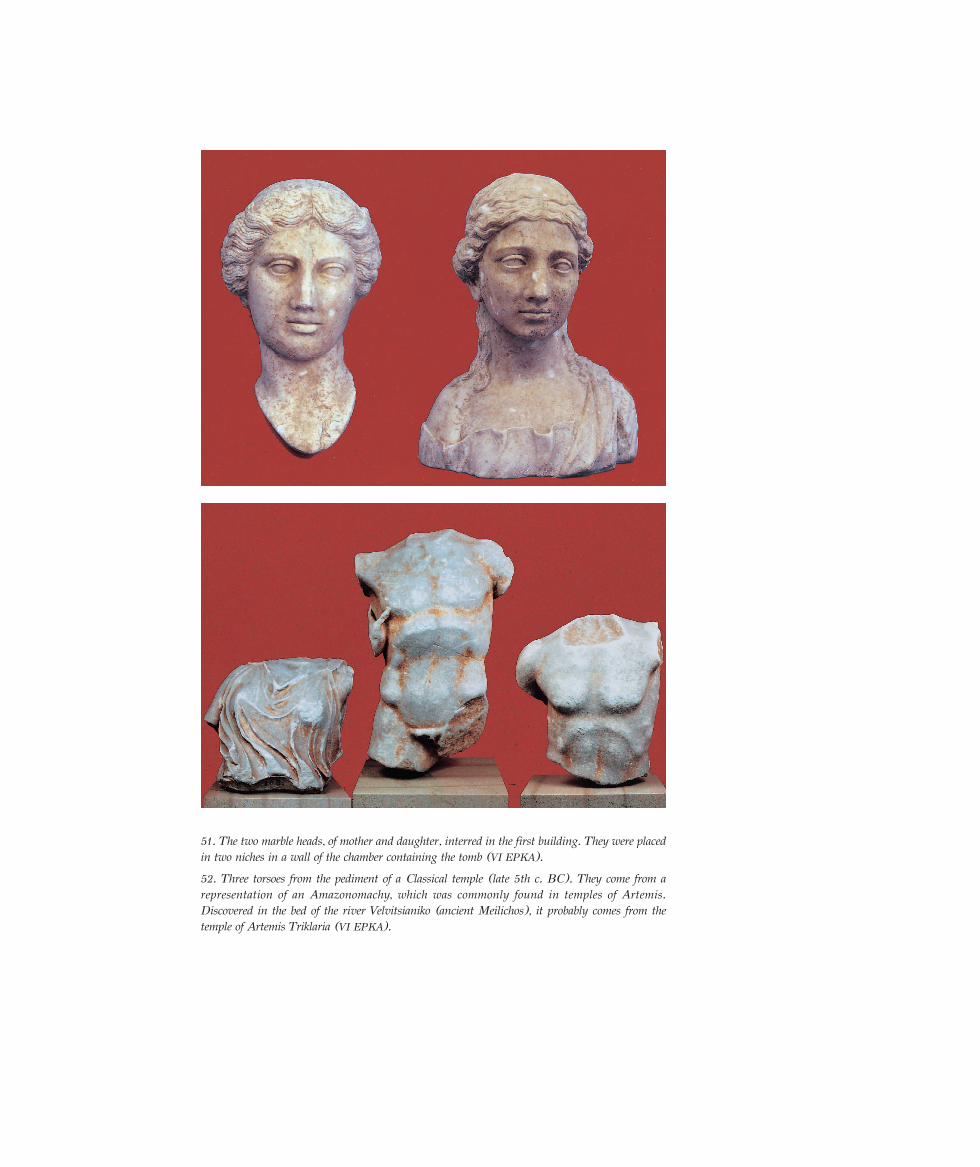
51. The two marble heads, of mother and daughter, interred in the first building. They were placedin two niches in a wall of the chamber containing the tomb (VI EPKA).
52. Three torsoes from the pediment of a Classical temple (late 5th c. BC). They come from arepresentation of an Amazonomachy, which was commonly found in temples of Artemis.Discovered in the bed of the river Velvitsianiko (ancient Meilichos), it probably comes from thetemple of Artemis Triklaria (VI EPKA).
ABBREVIATIONS
∞∞∞ Archaeologika Analekta Athinon
∞D Archaeologikon Deltion
∞E Archaeologiki Ephemeris
BCH Bulletin de Correspondance Hellénique
CH Cahiers d’ Histoire
6th ∂µ∞ 6th Ephorate of Byzantine Antiquities
∂∂µS Annual of the Society for Byzantine Studies
∂∫∫∂ National Centre for Social Research
∂Lπ∞ Hellenic Literary and Historical Archive
VI EPKA VI Ephorate of Prehistoric and Classical Antiquities
IBR-INR/NHRF Institute of Byzantine Research-Institute of Neohellenic Research/National Hellenic ResearchFoundation
JRA Journal of Roman Archaeology
∆∞P∞ Archaeological Receipts Fund
À¡∂ª∆∂D∂ Service of Modern Monuments and Technical Works of Western Greece
ZPE Zeitschrift für Epigraphie und Papyrologie
BIBLIOGRAPHY
Ancient Achaia and Elis, First International Symposium on ancient Achaia and Elis, Athens, Meletemata 13
(1991).
Dekoulakou, Iph., ‘ƒˆÌ·˚Îfi ª·˘ÛˆÏÂ›Ô ÛÙËÓ ¶¿ÙÚ·’, ™Ù‹ÏË. ∆fiÌÔ˜ ÂȘ ÌÓ‹ÌËÓ ¡. ∫ÔÓÙÔϤÔÓÙÔ˜, Athens 1980,
556-575.
Papageorgiadou-Bani, H., The Numismatic Iconography of the Roman Colonies in Greece. Local Spirit and theexpression of Imperial Policy, Athens 2004, 38, no. 36.
Papapostolou, I.A., ‘∆ÔÔÁÚ·ÊÈο ÙˆÓ ¶·ÙÚÒÓ’, ∞∞∞ IV, 3 (1971), 305-319.
——, ‘∂ÏÏËÓÈÛÙÈÎÔ› Ù¿ÊÔÈ Ù˘ ¶¿ÙÚ·˜ π’, ∞D 32 (1977), studies, 281-342.
——, ‘∂ÏÏËÓÈÛÙÈÎÔ› Ù¿ÊÔÈ Ù˘ ¶¿ÙÚ·˜ ππ’, ∞D 33 (1978), studies, 354-385.
——, ‘∫ÙÂÚ›ÛÌ·Ù· Ù·Ê‹˜ Û ڈ̷˚Îfi Ì·˘ÛˆÏÂ›Ô ÛÙËÓ ¶¿ÙÚ·’, ∞∂, 1983, 1-34.
——, ‘Aedes Augustalium ÛÙËÓ ¶¿ÙÚ·’, Dodoni XV, 1 (1986), 262-271.
——, ‘Monuments des combats de Gladiateurs à Patras’, BCH 113 (1989), 351-401.
——, ‘πÛÙÔÚÈΤ˜ Ì·ÚÙ˘Ú›Â˜ Î·È ·Ú¯·ÈÔÏÔÁÈο Â˘Ú‹Ì·Ù· Ù˘ ÎÏ·ÛÈ΋˜ Î·È ÂÏÏËÓÈÛÙÈ΋˜ fiÏ˘ ÙˆÓ ¶·ÙÚÒÓ’,
Festschrift for K.N. Triantaphyllou, vol. I, Patras 1990, 465-471.
Ancient Patrai
56
——, ‘∫ÔÛÌ‹Ì·Ù· ¶·ÙÚÒÓ Î·È ¢‡Ì˘’, ∞∂, 1990, 83-139.
——, ‘£¤Ì·Ù· ÙÔÔÁÚ·Ê›·˜ Î·È ÔÏÂÔ‰ÔÌ›·˜ ÙˆÓ ¶·ÙÚÒÓ Î·Ù¿ ÙË ÚˆÌ·ÈÔÎÚ·Ù›·’, Meletemata 13 (1991), 305-
320.
——, (Epigraphical notes Ath. Rizakis), Achaean Grave Stelai, Athens 1993.
Pausanias, ∂ÏÏ¿‰Ô˜ ¶ÂÚÈ‹ÁËÛȘ, ∞¯·˚ο, translation and notes by N. Papachatzis, Athens 1980.
Petropoulos, M., ‘ÕÙÙ˘ Î·È ∑ˆ‰È·Îfi˜ ∫‡ÎÏÔ˜ ÛÂ Ï˘¯Ó¿ÚÈ· Ù˘ ¶¿ÙÚ·˜’, ∞D 33 (1978), studies, 296-317.
——, ‘∞Ú¯·ÈÔÏÔÁÈΤ˜ ¤Ú¢Ó˜ ÛÙËÓ ∞¯·˝·’, Triantaphyllou, op. cit., vol. I, 495-537.
——, ‘∆ÔÔÁÚ·ÊÈο Ù˘ ¯ÒÚ·˜ ÙˆÓ ¶·ÙÚ¤ˆÓ’, Meletemata 13 (1991), 249-258.
——, ‘∞ÁÚÔÈ˘ ¶·ÙÚ·˚΋˜’, Structures Rurales et sociétés antiques, Actes du Colloque du Corfu (14-16 mai1992), Paris 1994, 405-424.
——, ∆· ÂÚÁ·ÛÙ‹ÚÈ· ÙˆÓ ÚˆÌ·˚ÎÒÓ Ï˘¯Ó·ÚÈÒÓ Ù˘ ¶¿ÙÚ·˜ Î·È ÙÔ §˘¯ÓÔÌ·ÓÙ›Ô, Athens 1999.
——, ‘°ÂˆÌÂÙÚÈÎfi˜ Ó·fi˜ ƒ·Î›Ù·˜ - §·ÙÚ¢fiÌÂÓË £ÂfiÙËÙ·’, Akten des Symposions anlässlich der Feier ‘100
Jahre Österreichisches Archäologisches Institut Athen’ (Athen 5-7/3/1998), Athen 2001, 39-45, with fullearlier bibliography.
——, ‘√È ÚˆÌ·˚ÎÔ› ÏËÓÔ› Ù˘ ¶¿ÙÚ·˜’, Proceedings of the Academic Symposium ‘The History of Vines andWines and the Archaeology of the North-West Peloponnese’ (Korachori, Eleia 2001), Athens 2001, 37-51.
——, ‘∏ ·Ú¯·›· ªÂÛ¿ÙȘ Ù˘ ¶¿ÙÚ·˜’, Proceedings of the Sixth International Conference of PeloponnesianStudies (Tripolis 24-29/9/2000), Athens 2001-2002, 399-422.
——, ‘¶¿ÙÚ·-¡ÈÎfiÔÏË Ì¤Ûˆ ∞ÈÙˆÏԷηÚÓ·Ó›·˜’, Proceedings of the Second Conference on Ancient Nikopolis,Preveza 2002 (in press).
——, ‘The Archaeological Museum of Patras and the History of the city through the Excavations’, Papers fromthe Colloquium held at the Swedish Institute in Alexandria, Museums in the Mediterranean Region: NewPerspectives and New Concepts (Alexandria 14-16/10/2002), Medelhavsmuseet 1 (2004), 40-47.
——, ‘∆Ô ÚˆÌ·˚Îfi ÛÙ¿‰ÈÔ Ù˘ ¶¿ÙÚ·˜’, CORPUS: πÛÙÔÚ›· ÙˆÓ ¶ÔÏÈÙÈÛÌÒÓ, ·Ú. 6, 104-109.
Petropoulos, M. – Rizakis, A., ‘The Achaea Project. The Coastal Area of Patras in the Northwest Peloponnese:Settlements patterns and Landscape in the coastal area of Patras. Preliminary report’, JRA 7 (1994), 183-207.
Rizakis, A.D., ‘Achaïe I. Sources textuelles et histoire régionale’, Meletemata 20, Athènes 1995.
——, ‘Achaïe II. La cité de Patras. Épigraphie et histoire’, Meletemata 25, Athènes 1998.
——, ‘Munera gladiatoria à Patras’, BCH 108 (1984), 533-542.
——, ‘Munera gladiatoria à Patras II’, ZPE 82 (1990), 201-208 et pl. VI-VII.——, ‘Les Maurétaniens et la couleur du bronze de Corinthe’, Karthago 22 (1990), 55-62.
——, ‘EÈÊ·ÓÂȷ΋ ·Ú¯·ÈÔÏÔÁÈ΋ ¤Ú¢ӷ ÛÙËÓ ·ÙÚ·˚΋: Ë fiÏË Î·È Ë ¯ÒÚ· Ù˘ ¶¿ÙÚ·˜ ηٿ ÙËÓ ·˘ÙÔÎÚ·-
ÙÔÚÈ΋ ÂÚ›Ô‰Ô’, First Archaeological Conference on South and West Greece, Patras 9-12/6/1996 (in press).——, ‘Le port de Patras et les communications avec l’Italie sous la République’, CH 33. 3-4 (1988), 453-472=
‘Il porto di Patrasso e la communicazione con l’Italia durante l’era republicana’, N. Moschonas (ed.),Studi di storia Italo-ellenica, Atene 1998, 25-38.
——, ‘√ ∞‡ÁÔ˘ÛÙÔ ,̃ Ë Ó¤· ڈ̷˚΋ Ù¿ÍË Î·È Ë ·ÔÈΛ· Ù˘ ¶¿ÙÚ·˜’, Triantaphyllou, op. cit., vol. II, 765-771.
Ancient Patrai
57


![A Concise History of Ancient Kurdistan [in Kurdish]](https://static.fdokumen.com/doc/165x107/63335467b6829c19b80c5cc1/a-concise-history-of-ancient-kurdistan-in-kurdish.jpg)


![Thracian Religion [A Companion to Ancient Thrace]](https://static.fdokumen.com/doc/165x107/63461a68f474639c9b05265b/thracian-religion-a-companion-to-ancient-thrace.jpg)