Luton Level 1 SFRA Update
107
Luton Level 1 SFRA Update February 2013
-
Upload
khangminh22 -
Category
Documents
-
view
0 -
download
0
Transcript of Luton Level 1 SFRA Update

Luton Level 1 SFRA Update
February 2013

Quality Management
Job No CS/060431
Title Luton Level 1 SFRA update
Location Luton Borough Council
Document Ref N/A Issue / Revision Final
Date 8 February 2013
Prepared by Louise Tattersall Signature (for file)
Sharla McGavock Signature (for file)
Checked by Louise Tattersall Signature (for file)
Authorised by Michael Arthur Signature (for file)
Revision Status
Rev Date Issue / Purpose/ Comment Prepared Checked Authorised
Draft 02/11/2012 Issue draft for comment LT / SM LT MA
Final 08/02/2013 Final GA MA MA
Rev 14/07/2014 Erratum – section 3.6.2 KO KW KW
This document and related appendices have been updated on behalf of Luton Borough Council by:
Level 7, 52 Grosvenor Gardens, Belgravia, London SW1W 0AU
Tel 020 7808 4520 www.capitasymonds.co.uk
i

Contents 1. Introduction 7
1.1 Background 7 1.2 SFRA Structure 8
1.2.1 Level 1 – Area Flood Source Review and Sequential Test 8 1.2.2 Level 2 – Development Site Assessments for Exception Testing 8 1.2.3 Aim of the SFRA 9
1.3 SFRA Objectives 9 1.4 Level 1 SFRA Structure 9
2. The Luton BC Study Area 11 2.1 Upper Lea 11 2.2 Hydrogeology / Groundwater 12 2.3 Sewers 12 2.4 Overland Flow 12 2.5 Artificial Sources 12
3. Policy Context 13 3.1 Role and Responsibilities 13
3.1.1 Environment Agency 13 3.1.2 Local Planning Authority 14 3.1.3 Sewerage Undertakers 14 3.1.4 Highways Agency 14 3.1.5 Landowner 14
3.2 European Policies (EU) 15 3.2.1 Water Framework Directive 15 3.2.2 Floods Directive 15
3.3 National Policies 15 3.3.1 Flood and Water Management Act, 2010 15 3.3.2 National Planning Policy Framework (NPPF) 16 3.3.3 Technical Guidance to the National Planning Policy Framework 17
3.4 Transition from PPS25 to NPPF 17 3.5 Other Relevant Policy 24
3.5.1 Code for Sustainable Homes – Technical Guide November 2010 24 3.5.2 Sewers for Adoption 6th Edition (March 2006) 25 3.5.3 BREEAM New Construction Non-Domestic Buildings Technical Manual 25 3.5.4 Adapting to Climate Change Advice for Flood and Coastal Erosion Risk Management Authorities (2011) 25
3.6 Local Policies 26 3.6.1 Regional Spatial Strategy 26 3.6.2 Luton Local Plan 2001-2011 26 3.6.3 Surface Water Management Plan 26 3.6.4 Preliminary Flood Risk Assessment 26
3.7 Environment Agency Policies 27 3.7.1 Catchment Flood Management Plans (CFMP) 27
4. Data Collection and Review 29
ii

4.1 Project Approach 29 4.1.1 Stakeholders 29 4.1.2 Data Information Requested 29
4.2 Data Review / Overview 30 4.2.1 Environment Agency Flood Zones Maps 30 4.2.2 Hydraulic Modelling 30 4.2.3 Luton 2D Flood Risk Mapping Study 2012 30 4.2.4 Upper Lee 30 4.2.5 Historical Flooding Records 31
4.3 Flood Defences 32 4.3.1 Flood Warning 32 4.3.2 Flood Defences 33 4.3.3 NFCDD defences 33 4.3.4 Topographic Data 33
4.4 Overland Flow / Pluvial Flooding 34 4.4.2 Surface Water and Ordinary Watercourse Flooding 34
4.5 Groundwater Flooding 36 4.6 Sewer Flooding 36 4.7 Other Sources of Flooding 37
4.7.1 Highways Flooding Records 37 4.7.2 Artificial Sources / Infrastructure Failure 39
4.8 Vulnerable Watercourses / Infrastructure 40 4.8.1 Upper Lee Corridor (VW_EA_2) 40 4.8.2 Houghton Brook near the Hedgerows (VW_EA_3) 40
5. SFRA Mapping 42 5.1 Requirements of NPPF 42 5.2 Fluvial Flooding 42
5.2.1 Requirements 42 5.2.2 Climate Change 43 5.2.3 Data Sources 43 5.2.4 Mapping 45
5.3 Sewer Flooding 45 5.3.1 Climate Change 45 5.3.2 Mapping 45
5.4 Groundwater Flooding 45 5.4.1 Climate Change 45 5.4.2 Mapping 45
5.5 Overland Flow / Pluvial Flooding 46 5.5.1 Data Sources 46 5.5.2 Mapping 46
5.6 Artificial Sources (Infrastructure Failure) 46 5.7 Residual Risk 46
6. Guidance on Applying the NPPF Sequential Test 47 6.1 What is the Sequential Test? 47 6.2 How should the SFRA be used to apply the Sequential Test? 48 6.3 Additional Guidance 50
iii

7. Guidance on Applying the NPPF Exception Test 52 7.1 What is the Exception Test? 52 7.2 Why is there an Exception Test? 52 7.3 What is required to pass the Exception Test? 52
8. Future Flood Risk Management Practices 55 8.1 Strategic Flood Defences 55
8.1.1 Flood Warning 55 8.1.2 Flood Alleviation Scheme Maintenance 56 8.1.3 Flood Mitigation on site 56 8.1.4 Flood Avoidance 56 8.1.5 Flood Resistance 56 8.1.6 Flood Resilience/Repairable 57
9. Drainage of Development Sites 58 9.1 Background 58 9.2 What are SuDS? 58 9.3 SuDS Policies 59
9.3.1 SuDS Approval body (SAB) 59 9.3.2 Building Regulations 2008 H3 Rainwater Drainage 59 9.3.3 Code for Sustainable Homes Technical Guide 2010 60 9.3.4 Environment Agency Policies 61
9.4 Achieving SuDS in Developments 61 9.5 SuDS Techniques 62 9.6 SuDS Design 64 9.7 Where can SuDS be utilised 64 9.8 SuDS Constraints 64 9.9 Groundwater Vulnerability 65
9.9.1 Groundwater Source Protection Zones 65 9.9.2 Water Quality 65 9.9.3 Contaminated Land 65 9.9.4 High Development Densities 65
9.10 Further Information 66 10. Policy Recommendations 67
10.1 Flood Risk 67 10.1.1 Study Area Wide Policy Recommendations 67 10.1.2 Specific Area Policy Recommendations 68
10.2 Flood Mitigation Measures 68 10.2.1 Study Area Wide Policy Recommendations 68 10.2.2 Specific Area Policy Recommendations 69
10.3 Drainage Systems 70 10.3.1 Study Area Wide Policy Recommendations 70 10.3.2 Specific Area Policy Recommendations 71
10.4 Water Resources and Environment 72 10.4.1 Study Area Wide Recommendations 72
11. Site Specific Flood Risk Assessment Guidance 74
iv

11.1 When are Flood Risk Assessments Required? 75 11.2 Flood Risk Assessments Requirements 76
11.2.1 Level 1- Screening Study 77 11.2.2 Level 2 – Scoping Study 77 11.2.3 Level 3- Detailed Study 77
11.3 Flood Risk Assessment Guidance Table 77 11.3.1 FRA Guidance Table 11-1 Accompanying Notes 77
12. Emergency Planning 89 12.1 Developing an Emergency Flood Plan 89
12.1.1 Identifying at Risk Installations 89 12.1.2 Individual Flood Responses/Mitigation Measures 89 12.1.3 Coordinated Flood Emergency Planning 90
12.2 Use of the Emergency Plan in the Planning System 90 13. Conclusions and Recommendations 91
13.1 Conclusions 91 13.2 The Next Stage 91
13.2.1 Strategic Planning Policy 91
13.3 Recommendations 91 13.3.1 Requirement for a Level 2 SFRA 91 13.3.2 Development Control 91 13.3.3 Emergency Planning 92 13.3.4 Upper River Lea River Bank Strategy 92
13.4 When should the SFRA be updated 92 14. References 93
v

Figures Figure 2-1: Study area 11 Figure 7-1: Application of the Exception Test 53 Figure 7-2: Site-specific aspects to consider with respect to what is ‘safe?’ 54
Tables Table 1-1: Differences between PPS25 and NPPF 19 Table 4-1: Watercourses in the Study Area 35 Table 4-2: Groundwater Flooding Records in the LBC SFRA Study Area 36 Table 4-3: Sewer Flooding Records in 37 Table 4-4: Location of Highway Flooding sites 39 Table 5-1: NPPF Flood Zone definitions 42 Table 5-2: Fluvial Flood Zone Mapping Data Sources 44 Table 6-1: Flood Risk Vulnerability Classification (from NPPF Technical Guidance, Table 2) 47 Table 6-2: Flood Risk Vulnerability and Flood Zone ‘Compatibility’ from NPPF Technical Guide 49 Table 9-1: Summary of the measurement criteria for water use 60 Table 9-2: Summary of the measurement criteria for surface water runoff 61 Table 9-3: Summary of SuDS Techniques and their Suitability to meet the three goals of sustainable drainage systems 63 Table 11-1: Flood Risk Assessment Guidance Table 88
Appendices Appendix A - Data Document Registers Appendix B - Luton Borough Council Historic Flood Incident Records Appendix C - Example Tables
vi

1. Introduction 1.1 Background
The 2008 Level 1 Strategic Flood Risk Assessment (SFRA) was carried out on behalf of Luton and South Bedfordshire Joint Committee. The SFRA was produced to inform the Sustainability Appraisal which formed part of the Local Development Framework (LDF) portfolio of documents. The SFRA was developed in line with the now superseded Planning Policy Statement 25 – Development and Flood Risk (PPS25) (DCLG, 2006)1.
South Bedfordshire District merged with Mid Bedfordshire District Council in April 2010 to form the new unitary council of Central Bedfordshire. The Luton and South Bedfordshire Joint Committee was discontinued in April 2012. Capita Symonds were commissioned in September 2012 to revise the Level 1 SFRA document to reflect the entire hydrological catchment which includes the entire Luton administrative area plus parts of Bedfordshire and North Hertfordshire. The 2008 SFRA was largely retained however several updates and reviews were carried out. The following summaries the scope of works for this updated document:-
Identify policy updates since 2008 in particular the introduction of National Planning Policy Framework (NPPF) and its Technical Guidance;
Identify updates related to new information available from the Luton Surface Water Management Plan (SWMP);
Identify changes in revised geographic area
Review and update new data sources
The release of Planning Policy Statement 25: Development and Flood Risk in December 2006 (PPS25) (DCLG, 2006) emphasised the responsibility that LPAs have to ensure that flood risk is understood and managed effectively using a risk-based approach as an integral part of the strategic planning process. PPS25 encourages LPAs to undertake SFRAs and to use their findings and those of other studies to inform strategic land use planning. The National Planning Policy Framework (NPPF) document replaced the suite of Planning Policy Statements, including PPS25, on 27 March 2012.
NPPF states “A Strategic Flood Risk Assessment is a study carried out by one or more planning authorities to assess the risk to an area from flooding from all sources, now and in the future, taking account of climate change, and to assess the impact that changes or development in the area will have on flood risk”.
The NPPF and its accompanying Technical Guidance maintain the requirement to apply a risk-based, sequential approach to the location of development in order to avoid flood risk to people and property. The key difference for flood risk policy compared to PPS25 is that the NPPF gives local authorities a wider remit to interpret and implement local policies. This makes the SFRA process all the more important in establishing suitable, reasonable and practical local development policies to manage local flood risk. Refer to Chapter 3 of this document for further discussion on the introduction of NPPF and its implications for the management of flood risk. The key differences between NPPF and PPS25 for flood risk are discussed in Section 3.4
1 Planning Policy Statement 25: Development and Flood Risk, March 2010.
7

1.2 SFRA Structure
NPPF recommends that SFRAs are completed in two consecutive stages. This provides the LPA with tools throughout the Local Plan and SFRA process sufficient to inform decisions regarding development sites. The two stages are: -
Level 1 SFRA – Study Area Flood Source Review & Sequential Test
Level 2 SFRA – Development Site Assessments for Exception Testing.
The results of the Level 1 SFRA should enable LBC to clearly identify where development is appropriate according to NPPF and where development is necessary and requires justification through application of the Exception Test. The Level 1 SFRA should therefore enable a prompt start to the commencement of Level 2 (where required). The data review element of Level 1 also enables a robust specification and programme to be developed for a Level 2 SFRA. The location and scale of future development is currently unknown due to the recent changes in the local planning policy, therefore only catchment wide general guidance is given within this report.
1.2.1 Level 1 – Area Flood Source Review and Sequential Test
A Level 1 SFRA presents sufficient information to enable the LPA to apply the Sequential Test to potential development sites and assists in identifying if application of the Exception Test will be necessary. The Level 1 SFRA also provides background information, a review of local policies, and guidance for site specific flood risk assessment and the potential for application of Sustainable Drainage Systems (SuDS). The review of policies is allied to guidance on the requirements for site-specific Flood Risk Assessments (FRAs) throughout the study area.
The outcomes from the Level 1 SFRA should be used by the LPA to identify the most suitable locations for development in line with NPPF and other planning drivers. Where sites cannot be located in line with the principles of NPPF further investigation may be required through a Level 2 SFRA. This report presents the information generated during Level 1 of the SFRA.
The Level 1 SFRA is based on existing published information held by local stakeholders. In some parts of the study area insufficient information is available for a complete assessment in line with the full requirements of NPPF. Whilst best use has been made of the available data, works required to overcome deficiencies in the data/information have not been undertaken as part of the Level 1 SFRA. To account for this a conservative approach has been used where the current data results in uncertainty which, depending on the location of allocations promoted by LBC may require further investigation during the Level 2 SFRA.
1.2.2 Level 2 – Development Site Assessments for Exception Testing
The objective of a Level 2 SFRA is to use information obtained in the Level 1 SFRA where suitable and additional works where necessary to reduce uncertainty regarding flood risk to those developments/development sites that cannot be located in low risk flood zones (therefore requiring application of the Exception Test). The information presented for each development site should be sufficient to:
“demonstrate the development will be safe for its lifetime, without increasing flood risk elsewhere, and, where possible, will reduce flood risk overall” (paragraph 102 of NPPF).
Information provided in the Level 2 SFRA should be used to supplement information presented in the Level 1 SFRA and where possible assist the LPA in developing justification for development in flood risk areas through application of the NPPF Exception Test.
Due to the challenging growth targets faced by LBC additional growth will need to be accommodated within the town. Approximately 6,000 dwellings could be provided based upon the Council’s capacity-based assessment. If the housing figures in the recently abolished Regional Spatial Strategy were to
8

be met then a total of 8,000 additional dwellings would need to be provided. A Level 2 SFRA has not been commissioned as yet due to the unknown location and nature of development (or re-development) within the LBC area. This may be commissioned at a later date at the discretion of LBC.
1.2.3 Aim of the SFRA
The aim of the LBC Level 1 SFRA is to present sufficient information to enable the LPA to apply the Sequential Test (explained further in Section 6.2) to site allocations and to assist in identifying if application of the Exception Test will be necessary. In addition the SFRA should form a reference document for use by development control officers for advising and determining decisions on windfall and allocated sites.
Where development must be located in areas of flood risk the LPA will be required to justify the development through application of the Exception Test. To assist the LPA in understanding the flood risk posed to developments in the floodplain, a Level 2 SFRA will be required and should present sufficient information to assist in determining if proposed developments in flood risk areas will be safe from the risks of flooding for their lifetime.
1.3 SFRA Objectives
In keeping with guidance presented in the NPPF and its accompanying Technical Guide, the objectives of the LBC Level 1 SFRA are:
1. Identify the extent of all Flood Zones;
2. Identify areas at risk of flooding from all flood sources present in the study area, providing LBC with the tools required to apply the Sequential Test;
3. Provide evidence-based report which inform LBC’s LDF and other Development Plan Documents about managing potential flood risk which are also suitable to inform the Sustainability Appraisal of related documents;
4. Advise LBC on suitable policies to address flood risk management in a consistent manner;
5. Advise LBC on the requirements of site specific flood risk assessments based on local conditions and policy recommendations;
6. Advise LBC on the principles, objectives and applicability of Sustainable Drainage Systems (SuDS) throughout the study area; and
7. Present information to inform LBC of the flood considerations necessary in developing and progressing flood emergency planning.
Note that the above objectives have not changed and remain the same (updated to account for policy changes) as the 2008 Level 1 SFRA. The potential impact of growth on future flood risk is a key driver for development of the SFRA and to provide a consistent and robust evidence base for assessment of new development.
1.4 Level 1 SFRA Structure
This report presents the information generated during Level 1 of the SFRA. Section 2 of the report provides an overview of the LBC SFRA study area, Section 3 of the report provides an overview of the planning policy framework relevant to the study area. Section 4 of the report describes the data collection process, presents the available data and discusses its benefits and limitations. Section 5 illustrates how the available data has been used in the production of mapping and GIS (Geographical Information Systems) deliverables to meet the requirements of NPPF.
Section 6 should be used by the LPA and developers seeking to understand and apply the Sequential Test. Section 7 should be employed by developers, development control and strategic planning officers where application of the Exception Test is required.
9

Section 8 identifies the flood risk management measures proposed or suitable for the study area in the future, with Section 9 summarising where and how SuDS can be utilised. Section 10 provides catchment wide and specific area policy recommendations that have been developed under the headings Flood Risk, Flood Mitigation Measures, Drainage Systems and the Water Environment. Section 11 provides site-specific FRA advice, which should be utilised by developers and the LPA.
Section 12 illustrates the emergency planning issues that should be considered in tandem with flood risk whilst Section 13 provides the conclusions of this Level 1 SFRA and recommendations for further work.
10

2. The Luton BC Study Area The study area for this updated Level 1 SFRA is the same as the SWMP study area which was defined as the entire hydrological catchment for Luton plus parts of Bedfordshire and North Hertfordshire (Figure 2-1). The area outside of Luton Borough Council Administrative Area incorporates potential development areas. The location and scale of future development is currently unknown due to the recent changes in the local planning policy.
The River Lea originates in Luton in the north of the borough and includes the Houghton Brook and Lewsey Brook tributaries. Luton Borough Council area occupies an area of 43km2 and the River Lea hydrological boundary is 88km2. The area is bounded by the local authority area of South Bedfordshire to the north, west and south and by North Hertfordshire to the east.
N
Luton Borough Council
Boundary
Study Area
Figure 2-1: Study area
2.1 Upper Lea
The Upper Lee catchment covers an area of approximately 71km2 draining from its source at Leagrave, north of Luton, including the Houghton Brook and Lewsey Brook tributaries, to south of Wheathampstead (outside the study area) where it becomes the Middle Lee. Apart from the urban areas of Luton and Dunstable in its headwaters, the catchment is predominantly used for arable farming on unconfined chalky soils. Luton and Dunstable are major urban areas within the catchment; the M1 and London-Luton airport are major transport links that also fall within the catchment.
11

2.2 Hydrogeology / Groundwater
The geology of the study area consists of Chalk with the Lambeth Group along the north east and south west sides of the borough and Glaciofluvial Deposits along the River Lea. The topography of Luton generally slopes towards the River Lea which runs in a south easterly direction through the centre of the town. The highest elevations are in the north west and the lowest in the south east.
Due to the local geology the study area has extensive aquifers, many being used for potable and/or industrial water supply. In addition, most of the watercourses in the area are spring-fed, indicating groundwater levels are at or very close to the ground surface in some locations throughout the study area.
2.3 Sewers
Modern sewer systems are typically designed to accommodate rainstorms with a 30 year return period. Older sewer systems were often constructed without consideration of a design standard and may in some areas (served by Victorian sewers) have an effective design standard of less than 30 years. Consequently rainstorm events with a return period greater than 30 years would be expected to result in flooding of some parts of the sewer system.
In addition, as towns and villages expand to accommodate growth, their original sewer systems are rarely upgraded, eventually becoming overloaded and reducing their effective design standard of 30 years. Compounding this problem are the effects of climate change. Climate change is forecast to result in milder wetter winters and increased rainfall intensity in summer months. This combination will increase the pressure on existing sewer systems effectively reducing their design standard, leading to more frequent flooding.
Historically, areas of Luton have experienced flooding due to surcharged sewers. This is thought to be associated with rapid expansion to the north of the town in the 1950’s and 60’s, without upgrade of the sewer system in the centre of the town.
2.4 Overland Flow
Areas of steep ground have the potential to generate runoff which can present a flood source. The steep topography in parts of the study area may present a flood source to areas down slope of them.
2.5 Artificial Sources
Artificial sources include reservoirs, canals and lakes where water is retained above natural ground level and operational and redundant industrial processes including mining, quarrying and sand and gravel extraction. The Sundan reservoir is located outside the borough at Streatley, however should a breach occur there is the potential for flood waters to be conveyed through the study area. Refer to Section 4.7.2 for further discussion. There are no other artificial sources within the study area.
12

3. Policy Context This section provides an overview of the roles and responsibilities of those involved with water management and the planning policy framework relevant to the LBC study area for flood and/or water management. Information contained in this Level 1 SFRA on flooding and flood risk reviewed in tandem with the policies identified below will enable the preparation of sustainable policies for flood risk management (Section 10) to be incorporated into the LBC Local Plan (currently being developed). The location and scale of future development is currently unknown due to the recent changes in the local planning policy.
3.1 Role and Responsibilities
3.1.1 Environment Agency
The Environment Agency is a governmental organisation whose overarching objective is to protect and enhance the environment in England and Wales. The Environment Agency has a statutory duty to:
Maintain or improve any watercourses which are designed as Main Rivers;
Maintain or improve an sea or tidal defences;
Install and operate flood warning equipment;
Control actions by riparian owners and occupiers which might interfere with the free flow of watercourses; and,
Supervise internal drainage boards.
Statutory powers means that the Environment Agency is required by law to fulfil the activities listed above. The Environment Agency are a statutory consultee in the planning process within areas of flood risk (except minor developments). The Environment Agency’s Standing Advice2 also sets out when the Environment Agency should be consulted on planning applications (consultation matrix); it includes the following planning application scenarios:
Householder development and alterations within 20 m of the top of a bank of a Main River and/or includes culverting or control of flow of any river or stream;
Non-residential extensions with a footprint of less than 250 m² that is within 20 m of the top of bank of a Main River and/or includes culverting or control of any river or stream;
Change of use FROM ‘water-compatible’ TO ‘less vulnerable’ development within 20 m of the top of bank of a Main River AND if the site falls within Flood Zone 3;
Change of use RESULTING IN ‘highly vulnerable’ development within 20 m of the top of bank of a Main River AND if the site falls within Flood Zone 2 or 3; and,
Operational development of 1 hectare or greater if the development includes culverting or control of flow of any river or stream and/or the development is within Flood Zone 2 or 3.
Section 11 and the Environment Agency’s standing advice3 provides further information on when the Environment Agency should be consulted in the planning application process. The study area is within the Environment Agency Thames Region.
2 http://www.environment-agency.gov.uk/research/planning/33098.aspx 3 http://www.environment-agency.gov.uk/research/planning/33098.aspx
13

3.1.2 Local Planning Authority
The local authority has responsibility to ensure that all watercourses, for which the Environment Agency is not the responsible authority, are appropriately managed by the riparian landowner. Watercourses that are not main rivers are defined as Ordinary Watercourses. There is only one such watercourse in the study area – The Riddy Brook.
The LPA is also responsible for determining planning applications, requiring consultation with the Environment Agency in areas of flood risk. Note there are no Internal Drainage Boards within the study area.
3.1.3 Sewerage Undertakers
Sewerage undertakers are responsible for surface water and foul drainage from developments, where this is adopted via adopted sewers. Thames Water and Anglian Water are the sewerage undertakers within the study area.
The Flood and Water Management Act 2010 is set to remove the automatic right to connect to public surface water sewers. This may require developers to provide more justification than is currently required in order to connect to the Thames Water or Anglian Water sewer network. It may in future be necessary to provide evidence that surface water runoff cannot be appropriately managed within the site through the use of soakaways or direct discharge to surface water in order to gain approval for connection to the public surface water sewer. Additionally, they have a role of providing information to LPAs so that an SFRA takes into account any areas of critical drainage problems.
The Flood and Water Management Act 2010 is also set to establish SuDS Approval Bodies (SABs) within county, county borough or unitary local authorities. The SAB will have the responsibility for approving, adopting and maintaining drainage plans and schemes that meet National Standards for sustainable drainage. Drainage schemes will need to be approved before construction and this process is therefore likely to run in parallel with the planning approval process. The SAB elements of the FMWA have not yet been enacted; however, it will require developers to ensure drainage is designed to National Standards for SuDS and to consult with Luton Borough Council or the relevant SAB when designing drainage systems.
3.1.4 Highways Agency
The Highways Agency is responsible for maintaining major roads throughout England; this includes the upkeep of the surface water drainage infrastructure associated with the road network. Major roads within the study area include the M1, A6 and the A505.
3.1.5 Landowners
Landowners have the responsibility for safeguarding their land and other property against natural hazards, such as flooding. It is also the responsibility of landowners to manage the drainage of their land in such a way to prevent, as far as practicable, adverse impacts on neighbouring properties.
14
3.2 European Policies (EU)
3.2.1 Water Framework Directive
The EU Water Framework Directive was developed following a review of EU water policy. It seeks to restore and improve water quality in rivers, coastal waters and groundwater in an integrated way. It seeks to achieve ‘good ecological status’ of water bodies through integrated river basin management. This is a method of ensuring all requirements and pressures on the water environment are taken into account within a river basin. The implications of the Water Framework Directive on flood risk are likely to include controls on the type of flood alleviation schemes that can be implemented and that any flood alleviation schemes should also contribute to achieving ‘good ecological status’ through methods such as restoration of floodplains to their natural state and purpose.
3.2.2 Floods Directive
The European Directive on the Assessment and Management of Flood Risks (European Union, 2007) came into force on the 26th November 2007. The directive was transposed into English and Welsh law as the Flood Risk Regulations in December 2009. The directive requires member states to consider the potential impacts that domestic policies might have on flood risks and the management of flood risks to neighbouring member states. It recognises that objectives regarding the management of flood risk should be determined by the Member States themselves and should be based on local and regional circumstances.
The directive requires Member States to designate competent authorities to implement the Directive; for England, this will be the Environment Agency. The directive requires the following elements to be undertaken:
Preliminary Flood Risk Assessments to identify areas that are at potentially significant flood risk, to be completed by 20 December 2011;
Flood hazard maps (showing the likelihood and flow of the potential flooding) and flood risk maps (showing the impact), to be completed by 20 December 2013;
Flood risk management plans (showing measures to decrease the likelihood or impact of flooding), to be completed by 22 December 2015; and
Updates every 6 years thereafter that take into account the impact of climate change.
The Luton Preliminary Flood Risk Assessment (2011) confirmed that Luton is not in a significant Flood Risk Area and is therefore not required to deliver flood hazard / risk maps or a flood risk management plan under the Regulations. However, the council must complete another preliminary flood risk assessment in 2017 and may be classified as a Flood Risk Area at that time.
3.3 National Policies
3.3.1 Flood and Water Management Act, 2010
The Flood and Water Management Act 2010 places significantly greater responsibility on Local Authorities to manage and lead on local flooding issues. The Act and Regulations together set out the requirements and targets Local Authorities need to meet, including:
Taking an active role leading flood risk management as Lead Local Flood Authorities (LLFAs) Cooperating with other relevant authorities to manage local flood risk Duty to investigate flood incidents and report upon them
15

Maintain an ‘Asset Register’ of assets that have a significant influence on local flood risk Designate ‘features’ that have a significant influence on local flood risk Regulation of works on ‘ordinary watercourses’ Development and implementation of Local Flood Risk Management Strategies (LFRMS) Responsibility for first approval, then adoption, management and maintenance of Sustainable Urban
Drainage System (SUDS) where they service more than one property (not currently enacted – expected to be enacted in 2013)
The Flood and Water Management Act also clarifies three key areas that influence development:
Sustainable drainage (SuDS) - the Act makes provision for a national standard to be prepared on SuDS. Developers will be required to obtain local authority approval for the SuDS in accordance with the standards, likely with conditions. When they are designed and constructed robustly, local authorities will be required to adopt and maintain the SuDS that serve more than one property.
Flood risk management structures - the Act enables the EA and local authorities to designate structures such as flood defences or embankments owned by third parties for protection if they affect flooding or coastal erosion. A developer or landowner will not be able to alter, remove or replace a designated structure or feature without first obtaining consent.
Permitted flooding of third party land - The EA and local authorities have the power to carry out work which may cause flooding to third party land where the works are deemed to be in the interest of nature conservation, the preservation of cultural heritage or people’s enjoyment of the environment or of cultural heritage.
3.3.2 National Planning Policy Framework (NPPF)
The National Planning Policy Framework4 was issued in March 2012 and outlines the national policy including on development and flood risk assessment. This replaced with immediate effect national policy including Planning Policy Statement 25 – Development and Flood Risk.
The NPPF requires Local Plans to be supported by a Strategic Flood Risk Assessment and develop policies to manage flood risk from all sources. Advice should be sought from the Environment Agency and other relevant flood risk management bodies, such as Lead Local Flood Authorities (LLFAs) and Internal Drainage Boards (IDBs). In developing policies, Local Plans should apply a sequential, risk-based approach to the location of development in order to avoid flood risk to people and property, to manage any residual risk, and to take account of the impacts of climate change.
In general, these requirements will be met by:
Applying the Sequential Test and where appropriate and necessary the Exception Test;
Safeguarding land from development that is required for current and future flood risk management;
Using opportunities offered by new development to reduce the causes and impacts of flooding; and
Seeking opportunities to facilitate the relocation of development, including housing, to more sustainable locations where climate change is expected to increase flood risk to existing development.
Development should not be allocated or permitted if there are reasonably available sites appropriate for the proposed development in areas with a lower probability of flooding. The SFRA will be the basis for applying this test and a sequential approach should be used in areas known to be at risk from any form of flooding.
4 National Planning Policy Framework (DCLG, 2012)
16

Following application of the Sequential Test, if it is not possible for the development to be located in zones with a lower probability of flooding, the Exception Test can be applied. It should only be applied if appropriate to the type of development and flood zone and if consistent with wider sustainability objectives.
For the exception test to be passed it must be demonstrated that the development provides wider sustainability benefits to the community that outweigh flood risk, informed by a SFRA. It must also be demonstrated within a site specific FRA that the development will be safe for its lifetime without increasing flood risk elsewhere and where possible reducing flood risk.
When determining planning application, Local Planning Authorities should ensure that flood risk is not increased elsewhere and should only consider development in areas at risk from flooding where it can be demonstrated that a sequential approach has been taken, that the development is appropriately flood resilient, that residual risks can be managed and that priority is given to the use of sustainable drainage systems.
3.3.3 Technical Guidance to the National Planning Policy Framework
The Technical Guidance to the National Planning Policy Framework5 provides additional guidance to Local Planning Authorities to ensure the effective implementation of the planning policy set out in the National Planning Policy Framework on development in areas at risk of flooding. The guidance retains key elements of the now superseded PPS 25. The document provides supporting information on:
The definition of Flood Zones;
Flood risk vulnerability of different land uses;
The application of the sequential approach and Sequential and Exception Tests;
Flood risk assessment at the strategic and site level; and
Climate change and managing residual risks.
The Technical Guidance clarifies that the SFRA refines information on the probability of flooding by taking into account information on other sources of flooding and, where information is available, the effect of climate change. The document also clarifies that the SFRA should support the Local Plan, should be prepared in consultation with the Environment Agency, a Local Planning Authorities’ own emergency planning and drainage functions and any internal drainage boards. The SFRA should also inform appropriate flood risk management policies, the sustainability appraisal of the development plan documents and will form the basis of applying the Sequential and Exception Test in the development allocation and development control process.
3.4 Transition from PPS25 to NPPF The table below summarises key differences between the PPS25 and NPPF. The table includes impacts on existing local policy. Recommendations on how the transition from PPS25 to NPPF can be managed and when to apply changes into local policy are summarised below.
The NPPF allows for a twelve month transition period for local authorities to adjust local plans to conform. The period started on 27 March 2012 when the NPPF was published. During the transition period, the NPPF allows for the following (as per paragraphs 214, 215 and 516 of the NPPF):
5 Technical Guidance to the National Planning Policy Framework (DCLG, 2012)
17

Paragraph 214: For 12 months from the day of publication, decision-takers may continue to give full weight to relevant policies adopted since 20046 even if there is a limited degree of conflict with this Framework.
Paragraph 215: In other cases and following this 12-month period, due weight should be given to relevant policies in existing plans according to their degree of consistency with this framework (the closer the policies in the plan to the policies in the Framework, the greater the weight that may be given).
Paragraph 216: From the day of publication, decision-takers may also give weight7 to relevant policies in emerging plans according to:
the stage of preparation of the emerging plan (the more advanced the preparation, the greater the weight that may be given);
the extent to which there are unresolved objections to relevant policies (the less significant the unresolved objections, the greater the weight that may be given); and
the degree of consistency of the relevant policies in the emerging plan to the policies in this Framework (the closer the policies in the emerging plan to the policies in the Framework, the greater the weight that may be given).
It is recommended that the LBC use the time available to review current policy in light of the NPPF and prioritise changes based on their level of conflict with the NPPF. It should be noted that the NPPF is not a spatial document – it is essentially a series of prescriptions on how local authorities produce their frameworks. It leaves substantial room for local debate and decisions to be made on a local basis.
6 In development plan documents adopted in accordance with the Planning and Compulsory Purchase Act 2004 or published in the
London Plan 7 Unless other material considerations indicate otherwise
18

Table 3-1-1: Differences between PPS25 and NPPF PPS25 NPPF and Technical Guidance Difference Impact on Local Policy
Risk based approach using the source-pathway- Local Plans should apply a sequential, risk- The NPPF simplifies the LBC will need to make receptor model for planning of development based approach to the location of development PPS25 approach by their own decisions on (PPS25 – Main Text / Practice Guide – Section 3) to avoid where possible flood risk to people and
property and manage any residual risk, taking account of the impacts of climate change (Paragraph 99)
omitting clear definitions for the ‘risk based approach’ and not providing a specified ‘model’ for risk assessment.
how to apply the ‘risk based approach’ to assessment of flood risk.
It is recommended that LBC apply the definitions used in the Flood and Water Management Act 2010. The definitions in the Practice Guide should also still be referred to alongside the slightly less detailed ones in the NPPF.
Exception Test – Requires the site to be Brownfield
The Exception Test is only appropriate for use when there are large areas in Flood Zones 2 and 3, where the Sequential Test alone cannot deliver acceptable sites, but where some continuing development is necessary for wider sustainable development reasons, taking into account the need to avoid social or economic blight and the need for essential civil infrastructure to remain operational during floods (PPS25 – Paragraph 19)
Exception Test – No longer requires the site to be Brownfield to pass the test
For the Exception Test to be passed it must be demonstrated that the development provides wider sustainability benefits to the community that outweigh flood risk, informed by a Strategic Flood Risk Assessment where one has been prepared; and a site-specific flood risk assessment must demonstrate that the development will be safe for its lifetime taking account of the vulnerability of its users, without increasing flood risk elsewhere, and, where possible, will reduce flood risk overall. Both elements of the test will have to be passed for development to be allocated or permitted (Main Text Paragraph 102)
A site does not need to be Brownfield to pass the Exception Test.
A wider range of sites may pass the exception test.
It is recommended that LBC carefully apply the knowledge gained through the local SFRA document and the SWMP investigations to ensure flood risk on individual sites is fully understood and that only fundamentally safe developments are approved.
19
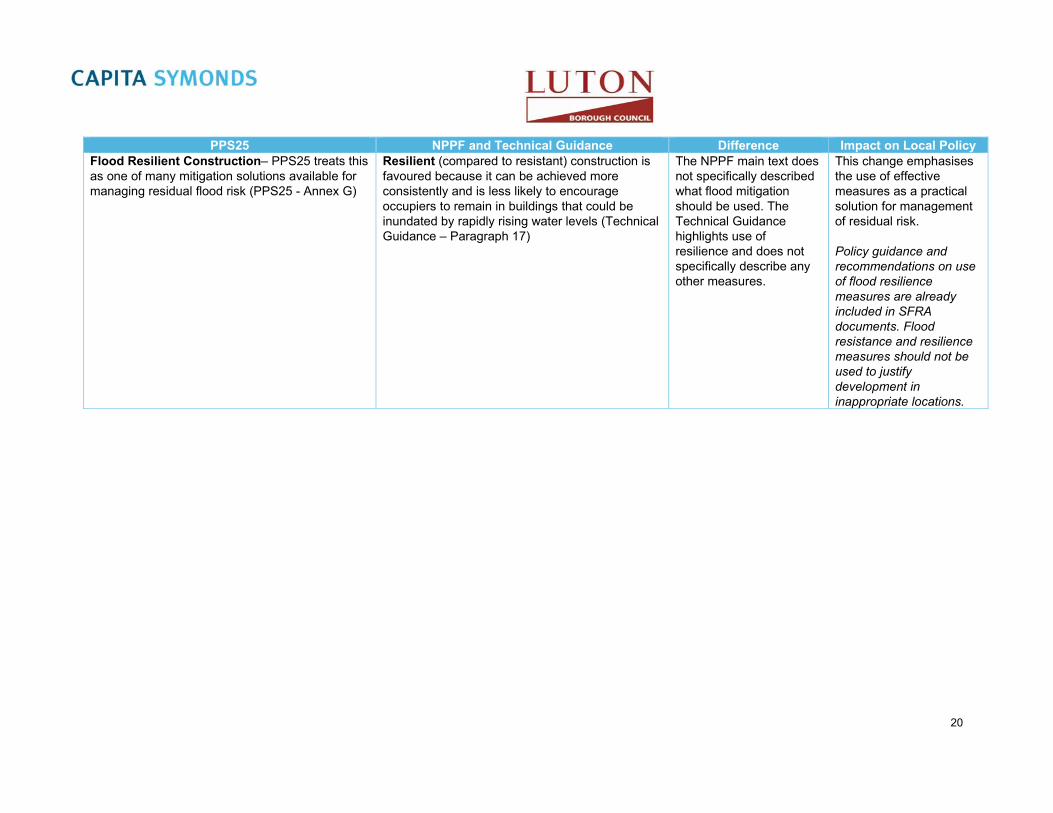
PPS25 NPPF and Technical Guidance Difference Impact on Local Policy Flood Resilient Construction– PPS25 treats this Resilient (compared to resistant) construction is The NPPF main text does This change emphasises as one of many mitigation solutions available for favoured because it can be achieved more not specifically described the use of effective managing residual flood risk (PPS25 - Annex G) consistently and is less likely to encourage
occupiers to remain in buildings that could be inundated by rapidly rising water levels (Technical Guidance – Paragraph 17)
what flood mitigation should be used. The Technical Guidance highlights use of resilience and does not specifically describe any other measures.
measures as a practical solution for management of residual risk.
Policy guidance and recommendations on use of flood resilience measures are already included in SFRA documents. Flood resistance and resilience measures should not be used to justify development in inappropriate locations.
20

PPS25 NPPF and Technical Guidance Difference Impact on Local Policy Assessment of Flood Defence Breach and Overtopping / Safe Access (Residual Risk) -The Flood Zones refer to the probability of flooding from rivers, the sea and tidal sources and ignore the presence of existing defences, because these can be breached, overtopped and may not be in existence for the lifetime of the development (PPS25 – Paragraph 17)
Section S3.2 of FD2320 Flood Risk Assessment Guidance for New Development Phase 2, Defra/Environment Agency R & D Project 2004, provides guidance on the assessment of the risk to people behind flood defences. Assessment of flood defence breaching should generally be undertaken on the basis of a design event of the appropriate design standard (1 per cent for river flooding, 0.5 per cent for flooding from the sea), including an allowance for climate change (Practice Guide – Paragraph 3.36)
LPAs should in determining planning applications … ensure that all new development in flood risk areas is appropriately flood resilient and resistant, including safe access and escape routes where required, and that any residual risk can be safely managed (Practice Guide Annex G)
When determining planning applications, local planning authorities should ensure flood risk is not increased elsewhere and only consider development appropriate in areas at risk of flooding where, informed by a site-specific flood risk assessment following the Sequential Test, and if required the Exception Test, it can be demonstrated that: within the site, the most vulnerable development is located in areas of lowest flood risk unless there are overriding reasons to prefer a different location; and development is appropriately flood resilient and resistant, including safe access and escape routes where required, and that any residual risk can be safely managed, including by emergency planning; and it gives priority to the use of sustainable drainage systems (Main Text – Paragraph 103)
Residual risks are those remaining after applying the sequential approach and taking mitigating actions. It is the responsibility of those planning development to fully assess flood risk, propose measures to mitigate it and demonstrate that any residual risks can be safely managed. Flood resistance and resilience measures should not be used to justify development in inappropriate locations (Technical Guidance – Paragraph 16)
No explicit reference is made to the best practice Defra Guidance document (FD2320 Flood Risk Assessment Guidance for New Development Phase 2, Defra/Environment Agency R & D Project 2004) for assessment and management of residual risk
The LBC will need to develop their own policy on the standards required for assessment and management of residual risk.
It is recommended that LBC review residual risk guidance in the SFRA and ensure that this is combined with the best practice guidance available from Defra to form a high standard evidence base for assessing development applications.
21

PPS25 NPPF and Technical Guidance Difference Impact on Local Policy Sustainable flood plain development – PPS25 and the Practice Guide refer to PPS1 (Delivering Sustainable Development – now superseded by NPPF) for general sustainability principles of development. Sustainable urban drainage systems (SUDS) are the main focus of both PPS25 and the Practice Guide
The NPPF specifically states that Local Plans should use opportunities offered by new development to reduce the causes and impacts of flooding (Main Text – Paragraph 100)
PPS25 focuses on sustainability within individual developments in isolation, while the NPPF encourages local authorities to look at combinations of development sites holistically to identify opportunities.
LBC should be aware of potential cumulative impacts of sites and should identify opportunities to develop catchment wide approach to development planning.
Sustainable Urban Drainage Systems – The NPPF specifies SUDS must be prioritised (Main Less detail on SUDS is Following commencement Practice Guide has detailed guidance on how Text – Paragraph 103), but refers to the Flood and provided in planning of Section 32 of the Flood SUDS should be implemented within development Water Management Act for further detail guidance – but this will be
balanced by new responsibilities of LBC as the Lead Local Flood Authorities to become SUDS Approval Bodies (SABs) under the Flood and Water Management Act
and Water Management Act, Luton Borough Council will have the responsibility for review, approval and adoption of SUDS systems serving more than one property.
Roles and Responsibilities of Parties – Comprehensive definition of the responsibilities and roles of various entities involved with flood risk managements (PPS25 – Paragraphs 21 to 34 and Annex H)
No equivalent content Definitions of roles and responsibilities are not covered.
Roles and responsibilities of flood ‘risk management authorities’ are now defined in the Flood and Water Management Act 2010.
Responsibilities of owners / developers with regard to flood risk are now only defined in the SFRA documents.
22

PPS25 NPPF and Technical Guidance Difference Impact on Local Policy Regional Flood Risk Appraisals (RFRAs) - Regional Planning Bodies should prepare RFRAs in consultation with the Environment Agency to inform their Regional Spatial Strategies (RSSs) on flood risk issues.
No equivalent content RFRAs and RSSs are no longer required
LBC will need to rely on SFRA documents for flood risk information evidence base.
23

3.5 Other Relevant Policy
3.5.1 Code for Sustainable Homes – Technical Guide November 2010
The Code for Sustainable Homes Technical Guide is an environmental assessment method for rating and certifying the performance of new homes, with a view to encouraging continuous improvement in sustainable home building. The code aims to ensure that sustainable homes deliver real improvements in key areas such as carbon dioxide emissions and water use. Where building regulations apply, compliance is necessary at all times.
The code for sustainable homes covers nine categories of sustainable design including:
Energy and CO2 Emissions
Water
Materials
Surface Water Run-off
Waste
Pollution
Health and Wellbeing
Management
Ecology
Each category includes a number of environmental issues, with each issue being a source of impact on the environment. These can be assessed against a performance and awarded one or more credits.
Category 4 of the code relates to the management of surface water runoff from developments, with a total of 2 credits achievable to the developer under SUR 1 – Management of Surface Water Runoff from Developments. The aim of this category is to design housing developments which avoid, reduce, and delay the discharge of rainfall to public sewers and watercourses. This will protect watercourses and reduce the risk of localised flooding, pollution and other environmental damage.
Mandatory requirements include;
Ensuring that the peak rate of runoff into watercourses is no greater for the developed site that it was for the pre-developed site, for at least the 1 year and 100 year return period event; and
Ensuring that the additional predicted volume of rainwater discharge caused by the new development for a 1 in 100 year return period event of 6 hour duration (with climate change) is entirely reduced.
This can be achieved by using infiltration and / or making excess water available for use in the dwelling as a replacement for potable water use in non-potable applications such as WC flushing or washing machine operation.
Two credits are achievable for using SuDS to improve water quality of the rainwater discharged or for protecting the quality of the receiving waters by:
1. Ensuring no discharge to the watercourse for rainfall depths up to 5mm.
Or
2. Establish agreements for the ownership, long term operation and maintenance of all sustainable drainage elements used.
24

Up to an additional 2 credit points, under SUR 2 – Flood Risk, can be achieved based on the developments location:
Locating a development in Flood Zone 1 (2 credit points); or
When locating a development within Flood Zone 2 and 3a the finished ground levels of habitable parts of the dwelling (and access routes to the ground level and site) are at least 600mm above the design flood level of the flood zone.(1 credit point).
3.5.2 Sewers for Adoption 6th Edition (March 2006)
This document is the definitive guide for those planning, designing and constructing sewers and pumping stations for subsequent adoption by water companies in England and Wales under Section 104 of the Water Industry Act.
This guidance provides best practice on planning, design, construction, operation and maintenance of SUDS to facilitate their effective implementation within developments.
3.5.3 BREEAM New Construction Non-Domestic Buildings Technical Manual
Similar to the code for sustainable homes there is also a guide for Non-Domestic Buildings. The primary aim of BREEAM New Construction SD50738 is to mitigate the life cycle impacts of new buildings on the environment in a robust and cost effective manner.
Policy 03 Surface Water Runoff aims to avoid, reduce and delay the discharge of rainfall to public sewers and watercourse, therefore minimising the risk of localised flooding on and off site, watercourse pollution and other environmental damage.
The guidance is split into three parts;
Flood Risk – 2 credits Surface water runoff- 2 credits Minimising water course pollution – 1 credit
There is extensive guidance contained in the document and it is recommended that the reader is referred to page 334 of the guidance document.
3.5.4 Adapting to Climate Change Advice for Flood and Coastal Erosion Risk Management Authorities (2011)
This advice9 replaces Defra’s Supplementary Note to Operating Authorities – Climate Change Impacts, October 2006. The advice is based on Governments policy for climate change adaption, and is specifically intended for projects or strategies seeking Government Flood Defence Grant in Aid (FDGiA). The purpose of this advice is to ensure that an economically credible appraisal, taking account of the uncertainties decisions. The guidance uses the latest guidance from UKCP09 to provide projections of rainfall and sea level rise through the century.
This guidance should be used by Luton Borough Council if and when it requests FDGiA or it may be used in developing plans for making Flood and Coastal Erosion Risk Management Appraisal (FCERM-AG) investment decisions.
Note the projections contained in the advice should not be used to inform FRAs and development design. The guidance contained within Table 4 and 5 of the NPPF Technical Guide should be used.
8 BRE Global Limited, BREEAM New Construction, Non Domestic Buildings Technical Manual SD5073 – 2.0:2011 9 Environment Agency, 2011, Adapting to Climate Change Advice for Flood and Coastal Erosion Risk Management Authorities,
Environment Agency Bristol
25

3.6 Local Policies
3.6.1 Regional Spatial Strategy
In May 2010 the new Government announced the abolition of Regional Spatial Strategies (RSS), which was enabled by the Localism Act 2011. The RSS for this area, the East of England Plan, was abolished in January 2013. Local planning authorities are now responsible for establishing the right level of local housing provision in their area, and identifying a long term supply of housing land without regional housing targets.
3.6.2 Luton Local Plan 2001-2011
The Local Plan sets out the Councils detailed policies and specific proposals for the development and use of land. A new Local Plan is currently being developed by Luton Borough Council for the period 2011-2031. The following saved policy is currently relevant, however following the finalising of the Local Plan for 2011-2031 it is recommended that the following section is reviewed.
Policy ENV14 The Water Environment
Planning permission will not be granted for development that:
a) would result in increased flood risk either on-site or elsewhere; or
b) does not incorporate appropriate water conservation measures; or
c) would pose unacceptable risk of pollution to groundwater or surface water; or
d) would have an adverse impact upon the ecology of the River Lee or its tributaries or their banks or corridors; or
e) fails to facilitate the opening up of culverts and the removal of concrete channels along the River Lee or its tributaries, except where the scale of the scheme does not make it feasible.
3.6.3 Surface Water Management Plan
Capita Symonds were commissioned in 2011 to undertake the Surface Water Management Plan (SWMP) on behalf of Luton Borough Council. The report outlines the preferred surface water management strategy for the borough and for the part of the catchment that lies within Central Bedfordshire. The work involved a four phase approach, collection and review, risk assessment, option assessment and the development of a long term action plan for Luton Borough Council.
Within the study area 17 Critical Drainage Areas were identified. For each of the CDAs identified within the study area, site-specific measures were identified that could be considered to help alleviate surface water flooding. Analysis of the number of properties at risk of flooding was undertaken for the rainfall event with a 1 in 100 probability of occurrence in any given year. A review of the results demonstrate that 6,085 properties in the study area could be at risk of surface water flooding of a depth greater than 0.1m during a 100 year rainfall event (above an assumed 0.1m building threshold).
3.6.4 Preliminary Flood Risk Assessment
A Preliminary Flood Risk Assessment (PFRA) was prepared by Capita Symonds for Luton Borough Council in June 2011. The report was prepared to ensure Luton Borough Council met their duty to deliver the requirements of the Flood Risk Regulations (2009).
26

The PFRA is aimed at providing high level overview of flood risk from all sources of flooding within the local area, including consideration of surface water, groundwater, ordinary watercourses and canals. The geographic area covered by Luton Borough Council was not identified as an ‘Indicative Flood Risk Area’ by the national assessment undertaken by the EA and Defra. Similarly, locally collected information does not suggest that Luton should be classified as a ‘Flood Risk Area’.
3.7 Environment Agency Policies
3.7.1 Catchment Flood Management Plans (CFMP)
Catchment Flood Management Plans (CFMPs) are the Environment Agency’s high level strategic plans for the sustainable management of flood risk at a river catchment scale. The documents seek to identify those factors that influence flooding in an area and through liaison with key decision makers identify broad policies for the long term management of flood risk in a sustainable manner.
The LBC SFRA study area is covered by one CFMP the catchment of the Upper River Lee is discussed in the Thames Catchment Flood Management Plan (Environment Agency, January 2007). This section identifies the key issues and polices from this document.
The Thames CFMP identifies the characteristics of Luton to be:
Typically an area of heavily developed floodplain with concrete river channels.
An area where structural flood defence schemes are unlikely to be built to protect properties in the near future.
The Thames CFMP also identifies the key flooding characteristics of Luton to be:
Flood risk will increase as a result of urbanisation and climate change.
Existing flood defence assets are deteriorating.
Flooding in the area occurs from or is exacerbated by the:
Overtopping of river banks and the channel.
Overflow of surface water drains.
Inundation of sewers.
Rapid runoff from urban expansion.
In-channel blockages and constrictions.
Groundwater flooding.
Currently the flood risk management measures employed in Luton involve the rapid conveyance of flood waters in concrete channels, with the aim of transferring flood waters out of the town as fast as is possible. However the poor condition of many structures and/or blockage by fly-tipped waste and debris significantly reduces the effectiveness of this approach.
To alleviate flood risks to current development in Luton the Environment Agency advocates:
Use of the Sequential Test to locate new development in areas of lowest flood risk
Use the Sequential Test to guide development within allocated areas, seeking to match flood risk to development vulnerability.
Where development in the floodplain must take place seek opportunities to reduce risk through consideration of development vulnerability, reduction in development footprint, replacement of existing buildings with development on stilts.
Incorporating flood resilience into a site’s design (e.g. flood-proofing, raised floor levels).
In terms of riverside development the CFMP seeks to ensure that:
Developments are set back from rivers, seeking an 8 metre wide undeveloped buffer strip.
27
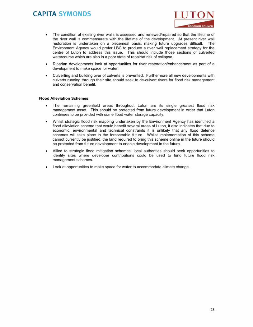
The condition of existing river walls is assessed and renewed/repaired so that the lifetime of the river wall is commensurate with the lifetime of the development. At present river wall restoration is undertaken on a piecemeal basis, making future upgrades difficult. The Environment Agency would prefer LBC to produce a river wall replacement strategy for the centre of Luton to address this issue. This should include those sections of culverted watercourse which are also in a poor state of repair/at risk of collapse.
Riparian developments look at opportunities for river restoration/enhancement as part of a development to make space for water.
Culverting and building over of culverts is prevented. Furthermore all new developments with culverts running through their site should seek to de-culvert rivers for flood risk management and conservation benefit.
Flood Alleviation Schemes:
The remaining greenfield areas throughout Luton are its single greatest flood risk management asset. This should be protected from future development in order that Luton continues to be provided with some flood water storage capacity.
Whilst strategic flood risk mapping undertaken by the Environment Agency has identified a flood alleviation scheme that would benefit several areas of Luton, it also indicates that due to economic, environmental and technical constraints it is unlikely that any flood defence schemes will take place in the foreseeable future. Whilst implementation of this scheme cannot currently be justified, the land required to bring this scheme online in the future should be protected from future development to enable development in the future.
Allied to strategic flood mitigation schemes, local authorities should seek opportunities to identify sites where developer contributions could be used to fund future flood risk management schemes.
Look at opportunities to make space for water to accommodate climate change.
28

4. Data Collection and Review The objective of this Level 1 report is to collate and review the information available relating to flooding in the study area and present this in a manner suitable for LBC to apply the Sequential Test.
This section describes the data collection process, presents the available data and discusses its benefits and limitations. A comprehensive record of all the data collected through the production of the Level 1 SFRA is presented in a document register in Appendix A.
The information presented in this Level 1 report should not be considered as an exhaustive list of all available flood related data for the study area. The Level 1 SFRA report is a presentation of the data collected following consultation with and input from the partnering local authorities and agencies within the timeframe available.
4.1 Project Approach
The Level 1 SFRA assessment methodology is based on using available existing information and data where suitable. As a result, there has been no new investigation undertaken for this Level 1 SFRA.
4.1.1 Stakeholders
The information used in this SFRA has been sourced from a variety of stakeholders including
Luton Borough Council;
Environment Agency - The study area is within the Environment Agency Thames Region (northern area), which is responsible for the Upper River Lee,
Thames Water and Anglian Water - surface water and foul water management responsibilities for the study area are split between Thames Water and Anglian Water;
British Geological Survey – Geological data used to derive SUDS suitability maps
English Partnerships; and,
Scott Wilson departments working on behalf of the Highways Agency for the M1 Widening Scheme (junction 6a to 10). Scott Wilson has modelled a 2050 climate change scenario for the Upper Lee as part of the works required for the M1 widening project. A small section of the Halcrow model was used and converted from ISIS into InfoWorks RS to concentrate on Houghton and Lewsey Brooks.
4.1.2 Data Information Requested
Information and data requested from the stakeholders was based on the following categories:
Terrain Information e.g. LiDAR, SAR, river cross-sections;
Hydrology e.g. the main and ordinary watercourses;
Hydrogeology e.g. groundwater vulnerability zones;
Flood Defence e.g. flood banks, sluices;
Environment Agency Flood Levels e.g. at flood monitoring points;
Flood Risk Assessments e.g. on previous development sites;
Environment Agency Flood Zone Maps;
Local Authority Information e.g. Local Development Schemes; and,
29

Drainage Standards.
All of the data was registered on receipt and reviewed to assess its contribution to the Level 1 SFRA. Details of all data collected are presented in Appendix A.
4.2 Data Review / Overview
4.2.1 Environment Agency Flood Zones Maps
The Environment Agency has provided an extract of their Flood Map for the study area (Figure 4). The Flood Map shows the estimated extent of Flood Zones 2 and 3 (ignoring the presence of flood defences) for all main rivers and/or watercourses with identified critical drainage problems. The Flood Map gives a good indication of the areas at risk of flooding in the study area; however it does not provide detail on individual properties. The Flood Map in this area is based on an undefended model run of the Halcrow 2007 ISIS model from the Lee Modelling and Mapping Study.
The Flood Map does not provide information on flood depth, speed or volume of flow. It also does not show flooding from other sources, such as groundwater, direct runoff from fields, or overflowing sewers.
4.2.2 Hydraulic Modelling
Hydraulic models enable the estimation of accurate flood plains and flood depths based on detailed topographic data of river channels including structures (bridges, culverts etc) and flood defences. The flood plains are also compiled using rigorously developed statistically derived flow estimates. Currently the only hydraulic model relevant to the study area is the 2007 Upper Lea ISIS model undertaken by Halcrow as part of the Lea Modelling and Mapping Study. Figure 5 illustrates the extent of the hydraulic model in the study area.
4.2.3 Luton 2D Flood Risk Mapping Study 2012
At the time of writing this update (October 2012) Capita Symonds are currently updating the 2007 Upper Lea ISIS model as part of the River Lea in Luton 2D Flood Risk Mapping Study 2012. The project is being carried out on behalf of the Environment Agency as part of the SFRM2 framework. The aim of the project is to create an updated and calibrated 1D-2D hydraulic model of the River Lea and its tributaries through the town of Luton. The existing 1D ISIS model of the River Lea is currently being updated to take account of newly available channel survey from 2011 and 2012. The work is expected to be completed in March 2013. It is recommended that this document is updated to account for the updated model outputs as they may alter the current flood zone extents.
4.2.4 Upper Lee
The Lee Modelling and Mapping Study (Halcrow, 2007) has been undertaken on behalf of the Environment Agency (Thames Region) as part of the Environment Agency’s Strategic Flood Risk Mapping (SFRM) for the area. The study includes the upper reaches of the River Lee through Luton including Houghton Brook and Lewsey Brook. The model developed as part of the study has been run for the 2, 5, 10, 20, 25, 50, 100, 100 plus climate change, 200 and 1000 year return periods. The hydraulic model has not been made available for the Level 1 SFRA, however defended and undefended flood plain outlines and flood levels from this model have been provided. Due to the availability of detailed hydraulic modelling, the Environment Agency considers further study of the fluvial flood risk from the River Lee is not necessary.
30

As part of the 2008 SFRA the 2050 climate change scenario was modelled for the Upper Lee as part of the works required for the M1 widening project. A small section of the Halcrow model was used and converted from ISIS into InfoWorks RS to concentrate on Houghton and Lewsey Brooks. This work will be superseded by the study being completed in 2012/13 described in the previous section.
4.2.5 Historical Flooding Records
A list of locations throughout the study area that have experienced flooding in the past has been produced through discussions with the Environment Agency (Thames Region). The information is largely anecdotal, with no record of the antecedent conditions giving rise to the flooding (therefore typically not attributed to a flood source) or reference to a flood return period.
Considerable flooding has been experienced in areas of Luton. Most commonly as a result of an inadequate drainage system that has not been upgraded since the town saw rapid growth in the 1950s and 1960s.
The areas of Wardown Park, the Telford Way roundabout and the confluence of Houghton Brook with the Upper Lee (within the LBC administrative boundary) are known to experience flooding problems.
The Environment Agency (Thames Region) has provided a GIS layer presenting historical flood outlines for the Upper Lee and its tributaries through Luton. GIS outlines have been provided for the flood events in 1947, 1987, 1990, 1992, 1995, 1998, 2005 and 2006.
The Environment Agency (Thames Region) has also provided documents presenting their observations on flood events that affected areas of Luton on the:
29th and 30th June 2005, and
27th, 28th and 29th of May 2007.
The Environment Agency’s observations (including historical flood outlines) are presented below and in Figure 6.
4.2.5.1 The Upper Lee
The Limbury area of Luton is identified from the Environment Agency’s Flood Zone maps to be an area of flood risk. This has been confirmed by observed flood events which have resulted in flooding to properties. Whilst the main flood source for the area is the nearby River Lee and its tributaries, much of the flooding problems for the area arise from the surface water sewer system. With much of the surface water sewer system discharging to the River Lee, when levels on the Lee are high the sewer is prevented from discharging. In such cases the system backs up and surcharges, resulting in localised flooding in isolation from the local watercourse. Detailed records of flooding along the Upper Lee have been provided by the Environment Agency:
FL_EA_1, 2 – Flooding on the 28th June 2005 from the River Lee came out of bank on tight bend in the river downstream of properties at Midhurst Gardens. At No. 32 flood waters reached road outside the property and flooded the driveway of No. 33. Flooding on the 27th
May 2007 (FL_EA_18), approached the front door of number 32 Midhurst Gardens but did not enter internal areas.
FL_EA_11-14 – Flooding on the 28th June 2005 from the River Lee overtopped left and right banks in playing fields, this also flooded paths (right banks), playground (right banks) and allotments (left bank). On the left bank a large area of standing water remained. This appeared to be caused from fluvial flooding and a blown manhole which probably blew as water backed up in a surface water outfall.
FL_EA_16 – Flooding from the River Lee on the 27th May 2007 resulted in minor out of bank flooding at the downstream end of Wardown Park.
31

4.2.5.2 Lewsey Brook & Houghton Brook
Discussions with the Environment Agency throughout preparation of the Level 1 SFRA have identified a historical flooding problem associated with the upper reaches of the River Lee, namely Lewsey Brook & Houghton Brook. Due to expansion of urban developed area n the upper reaches of the River Lee catchment, flooding from Lewsey Brook & Houghton Brook has resulted in widespread flooding of several properties in the area. This is caused in part as a result of culvert incapacity (through poor design and/or debris blockage) and rapid delivery of rainwater to the Brooks via the surface water sewer system. Detailed records of flooding from Houghton and Lewsey Brook include:
FL_EA_3-10 - Flooding from Houghton Brook on the 28th of June 2005 affected internal areas of properties 1 - 9 (excluding No. 8) at The Hedgerow, Luton. Flood water approached the properties from the front and the back via disabled access routes. All possessions on the ground floors were lost due to flood water damage.
FL_EA_17 – Houghton Brook was observed to be out of bank at a foot bridge with a low soffit. No flooding of local properties (The Hedgerow) was experienced, although flood water did approach properties. Residents protected their property with sand bags.
FL_EA_15 – The area of Barley Lane in Luton was inspected on the 30th June 2005 and inspected for flooding. There was evidence of a small amount of flooding in the park area downstream of Nayne Avenue arising from the left bank of Lewsey Brook.
4.2.5.3 Methodology for Assessing Ordinary Watercourses
Ordinary watercourses have been included in the pluvial flood modelling carried out as part of the SWMP for Luton Borough Council in 2011. Watercourses have been defined by digitising ‘breaklines’ along the centre line of each watercourse. ‘Breaklines’ are used primarily to raise the elevation of the watercourse to the level of the surrounding banks to represent a “bank full” scenario. Elevations of watercourses have been determined from LiDAR.
Structures along the watercourse have been modelled as either 1D or 2D elements, depending on the length and location of the structure. The dimensions of structures have been determined from asset information obtained in the data collection stage where available or inferred from site visits or LiDAR data.
The assessment of flood risk from ordinary watercourses has been based on outputs from the pluvial modelling process described in 4.3.5.2 and presented in Figures 9-1 and 9-2.
4.3 Flood Defences
Flood management measures are those measures put in place to reduce the risk to people and property from the hazards of flooding. These management measures can be divided in to two types:
Flood Warning
Flood Defences
4.3.1 Flood Warning
Ensuring people in areas of flood risk are aware of potential flooding is key to ensuring they are prepared, facilitating the protection of property and evacuation where necessary.
The Environment Agency seeks to provide a flood warning service in all areas at risk of flooding. It consists of four flood warning codes from ‘All Clear’ to ‘Severe Flood Warning’ that indicate the level of danger. The flood warnings are disseminated through a variety of mediums that include TV, radio, an automated voice messaging service direct to a phone/fax/pager, the Internet and/or loudhailer.
32

There is also an emergency Floodline number (0845 988 1188) and a quick dial number for individual rivers.
Houghton Brook and Lewsey Brook respond too quickly to rainfall events to enable the Environment Agency to issue flood warnings based on monitoring of river flows and levels (as commonly practiced for other flood warning services), this can leave insufficient time for local residents to prepare and protect property. Consequently the only warning that can be provided is by monitoring weather forecasts and estimating the effect forecasted rain may have. This system can be unreliable leading to false alarms or missing flood events.
4.3.2 Flood Defences
Flood defences are typically engineered structures designed to limit the impact of flooding. Flood defences take several forms including bunds/embankments, canalised channels, culverts and flood storage areas.
Information on flood defences throughout the study area has been provided by the Environment Agency. The Environment Agency has provided a GIS layer of the National Flood and Coastal Defence Database (NFCDD), listing details of structures and flood defences. The NFCDD aims to provide the following information:
The location, composition and condition of fluvial defences and watercourses referenced to identified risk areas,
The types of asset (i.e. property, infrastructure, environmental) at risk within identified risk areas and including those protected by fluvial, tidal and coastal defences,
The extent of floods related to different flooding scenarios (e.g. different return periods and different types of flood event such as overtopping or embankment failure).
The NFCDD details the asset reference, the location, and level of protection that the structure provides and the geographic extent of the structure or defence. Details of all NFCDD flood defences in the study area are presented in Figure 7.
4.3.3 NFCDD defences
Whilst the NFCDD identifies several flood defences throughout the study area, many of these relate to open channels or culverts designed to convey river flows through the areas as quickly as possible. In addition many of the defences have a design standard less than 100 years and consequently the 100 year flood would be expected to result in flooding despite the presence of a flood defence.
4.3.3.1 Area Benefitting from defences
Despite the suggestion of the NFCDD that the majority of the study area does not benefit from flood defences the Environment Agency has mapped areas benefitting from flood defences through their strategic modelling studies. The areas benefitting from defences are illustrated in Figure 7.
4.3.4 Topographic Data
LiDAR data used in the 2011 SWMP has been referenced in this updated SFRA. The EA LiDAR information provides good coverage along the River Lea, but omits large parts of the Luton / Dunstable urban area. Additional LiDAR base elevation data was obtained from InfoTerra and was used to cover the missing urban areas within Luton and Dunstable. No LiDAR data was available for the rural areas around the north, east and western parts of the study area. To cover these areas, photogrammetry data was obtained from InfoTerra. The elevation data is therefore a combination of these three data sources. Figure 8 shows the topographic data available for Luton.
33

4.4 Overland Flow / Pluvial Flooding
4.4.1.1 Description
Pluvial flooding is the term used to describe flooding which occurs when intense, often short duration rainfall is unable to soak into the ground or to enter drainage systems and therefore runs over the land surface causing flooding. It is most likely to occur when soils are saturated so that they cannot infiltrate any additional water or in urban areas where buildings tarmac and concrete prevent water soaking into the ground. The excess water can pond (collect) in low points and result in the development of flow pathways often along roads but also through built up areas and open spaces. This type of flooding is usually short lived and associated with heavy downpours of rain.
The potential volume of surface runoff in catchments is directly related to the size and shape of the catchment to that point. The amount of runoff is also a function of geology, slope, climate, rainfall, saturation, soil type, urbanisation and vegetation.
4.4.2 Surface Water and Ordinary Watercourse Flooding
All watercourses in England and Wales are classified as either ‘Main Rivers’ or ‘Ordinary Watercourses’. The difference between the two classifications is based largely on the perceived importance of a watercourse, and in particular potential to cause significant and widespread flooding. However, this is not to say watercourses classified as Ordinary Watercourses cannot cause localised flooding. The Water Resources Act (1991) defines a ‘Main River’ as “a watercourse shown as such on a Main River Map”. The Environment Agency keep and maintain information on the spatial extent of the Main River designations. The Floods and Water Management Act (2010) defines any watercourse that is not a Main River an Ordinary Watercourse – including ditches, dykes, rivers, streams and drains (as in ‘land drains’) but not public sewers.
The Environment Agency have duties and powers in relation to Main Rivers. Local Authorities, or in some cases Internal Drainage Boards, have powers and duties in relation to Ordinary Watercourses. The only Ordinary Watercourse in the Luton area is the Riddy Brook.
Flooding from Ordinary Watercourses occurs when water levels in the stream or river channel rise beyond the capacity of the channel, causing floodwater to spill over the banks of the watercourse and onto the adjacent land. The main reasons for water levels rising in ordinary watercourses are:
Intense or prolonged rainfall causing rapid run-off increasing flow in watercourses, exceeding the capacity of the channel. This can be exacerbated by wet antecedent (the preceding time period) conditions and where there are significant contributions of groundwater;
Constrictions/obstructions within the channel causing flood water to backup;
Blockage/obstructions of structures causing flood water to backup and overtop the banks; and
High water levels in rivers preventing discharge at the outlet of the Ordinary Watercourse (often into a Main River).
Table 4-1 summaries the watercourses present in the borough and the classification. These watercourses are also shown in Figure 2.
34

Table 4-1: Watercourses in the Study Area
Watercourse Classification Responsibility under the FWMA 2010
River Lea (Lee*) Main River EA Houghton Brook Main River (primary reach from Leagrave
Common to Houghton Hall)
Ordinary Watercourse (culverted section upstream of Houghton Hall and minor
tributaries in Houghton Park)
EA
Central Bedfordshire Council
Lewsey Brook Main River (from confluence with Houghton Brook at Montague Ave to western end of
Lewsey Park) EA
Catbrook Main River (from confluence with River Lea to Duxford Close)
EA
Riddy Brook Ordinary Watercourse (culverted and open sections upstream of confluence with the
River Lea at New Bedford Road)
Luton Borough Council
Ouzel Brook and associated field
drainage system – Houghton Regis
Ordinary Watercourse Central Bedfordshire Council
Ordinary watercourses were modelled as part of the pluvial flood modelling carried out as part of the Luton SWMP. The assessment of flood risk for ordinary watercourses has been based on outputs from the pluvial modelling process which is described in Sections 4.4.2.1 and 4.2.5.3 below. The outputs are shown in Figures 9-1 and 9-2.
4.4.2.1 SWMP Surface Water Modelling
As part of the SWMP process, hydraulic modelling was undertaken for the study area. Two 2-dimensional direct rainfall models were created using TUFLOW software to determine the likelihood, mechanisms and consequences of pluvial flooding. The extents of the models have been based upon catchment boundaries as agreed with LBC. Two models were required to cover the study area at the agreed resolution of 5m.
The hydraulic models were run for the following rainfall events:
1 in 30 chance of occurring in any given year
1 in 75 chance of occurring in any given year
1 in 100 chance of occurring in any given year
1 in 100 chance of occurring in any given year with allowance for climate change (30% increase in rainfall)
1 in 200 chance of occurring in any given year
As part of the study, maps of maximum water depth and hazard for each of the return periods above have been prepared and are presented in Figure 9-1 and 9-2. When viewing the maps, it is important that the limitations of the modelling are considered. The key assumptions include the use of a
35

continuous loss (6.5mm/hr10) to represent the presence of the underground drainage network. The model does not take into account any capacity issues associated with the drainage network such as surcharging of manholes leading to backing up of surface water or blocked outfalls.
Figures 9-1 and 9-2 indicate that water is predicted to pond over a number of roads and residential properties. These generally occur at low points in the topography or where water is constricted behind an obstruction or embankment. An example of this flooding mechanism within the study area is in the Kingsway area, where water is observed to back up behind an artificial embankment. Overland flowpaths have been observed to follow natural valleys within the study area such as one shown running along Vauxhall Way. Railway lines with ‘cuttings’ may also be particularly susceptible, such as the stretch exiting the study area to the north.
4.5 Groundwater Flooding
The geology of the study area consists of Chalk. Due to the local geology the study area has extensive aquifers, with many used for potable and/or industrial water supply. In addition most of the watercourses in the area are spring-fed, indicating groundwater levels are at or very close to the ground surface in some locations throughout the study area.
Despite this, groundwater flooding is not a regular or frequently occurring source of flooding within the study area. There are only two records of groundwater flooding within the study area. This information has been provided by the Environment Agency from their groundwater flooding database. Table 4-2 presents the Environment Agency’s records for the area; groundwater flooding locations are also illustrated in Figure 15.
Table 4-2: Groundwater Flooding Records in the LBC SFRA Study Area GIS
Reference Grid Reference Address Date Reported Description
GW_EA_2 TL 06661 24971 Not Known 01/03/2007 underground spring affecting the street and local gardens
GW_EA_3 TL 08734 23865 Not Known 20/07/2007 None Available
Groundwater level data is more plentiful throughout the study area. The Environment Agency has provided groundwater monitoring data for 114 locations throughout the study area, collected within the last 30 years. This data has been queried to establish trends in groundwater levels. Trends were established based on a review of the groundwater record at each location and assigned a ‘rising’, ‘falling’ or ‘constant’ classification. Figure 10 presents the groundwater trends for each groundwater monitoring location within the study area.
As part of the 2011 SWMP a number of data sources were reviewed to gain an understanding of groundwater behaviour in the study area. The basis for the groundwater flood risk assessment was predominantly based on the BGS Groundwater Flood Susceptibility Map. As shown in Figure 17 the higher vulnerability areas were generally associated with the path of the River Lea. Refer to Section 3.5 of the 2011 SWMP for more information on the groundwater flood risk.
4.6 Sewer Flooding
Typically sewer systems are constructed to accommodate rainstorms with a 30 year return period or less, depending on their age. Consequently rainstorm events greater than 30 years would be expected to result in surcharging of some parts of the sewer system.
10 This value was selected on the basis of historic design standards for sewer systems in the UK – 6.5mm/hr = ¼ inch of rainfall per hour
36

Historically, areas of Luton have experienced flooding due to surcharged sewers. This is thought to be associated with rapid expansion to the north of the town in the 1950s and 1960s, without upgrade of the sewer system downstream (in the centre of the town).
Records of sewer flooding were obtained from Thames Water and Anglian Water through a query of their DG5 registers. The records in Table 4-3 were obtained April 2012. In order to fulfil statutory commitments set by OFWAT, water companies must maintain verifiable records of sewer flooding and this is achieved through their DG5 registers. Water companies are required to record flooding arising from public foul, combined or surface water sewers and identify where properties suffered internal or external flooding.
Regrettably the data provided by the water companies is limited to postcode data, resulting in the coverage of relatively large areas by comparatively limited and isolated recorded flood events. The data also only covers the last ten years of record.
In addition, the records of flooding do not account for the affect of any capital works designed to alleviate flooding. In areas exposed to frequent flooding from overloaded sewers, water companies will typically undertake alleviation works to reduce the severity and/or frequency of the flood events. Neither Thames Water nor Anglian Water has provided details of any capital works within the study area or indication of where recorded flood events have been investigated and mitigated.
In addition to the flooding records shown here there are five flooding records from 1980 from LBC shown on Figure 6 derived from personal recollections of LBC officers from the July / August 1980 flood events.
Table 4-3: Sewer Flooding Records in the LBC SFRA Study Area3 presents the flooding records available for the study area; these are also illustrated in Figure 11.
Table 4-3: Sewer Flooding Records in the LBC SFRA Study Area
Post Code Internal / External Flooding
LU1 1 12 LU1 2 21 LU1 3 8 LU1 4 1 LU1 5 9 LU2 0 1 LU2 7 3 LU2 8 12 LU2 9 4 LU3 1 6 LU3 2 22 LU3 3 0 LU3 4 1 LU4 0 6 LU4 8 16 LU4 9 4 Total 126
Observations by the Environment Agency following fluvial flood events have also attributed a flood event to surcharging sewers. The single event relates to flooding of the front gardens of even numbered properties between 64 and 74 Neville Road on the 28th June 2005 (SR_EA_1-6).
4.7 Other Sources of Flooding
4.7.1 Highways Flooding Records
37

Luton Borough Council has provided records from its FLARE database, which is used to log calls, letters, inquiries and complaints called. The records are primarily descriptions of flooding that occur on roads throughout Luton. There is no information associated with the records to enable an assessment of flooding frequency or severity, however most are associated with a lack of capacity in the local highways drainage and occur during storm conditions and not periods of prolonged rainfall. Table 4-4 presents a summary of the records provided in the FLARE database. The location reference relates to the flood incident location as shown on Figure 6. Full records are provided in Appendix B. Locations of highway flooding are also shown on Figure 6.
38

Table 4-4: Location of Highway Flooding sites Location Reference
on Figure 6 Road
1 Black Swan Lane near junction Bancroft Road 2 Putteridge Road near Shops 3 Acworth Crescent/Pirton Road 4 Icknield Way near 133 5 Pastures Way 6 Icknield Way numbers 1 to 7 7 Icknield Road 8 Midhurst Gardens 9 Bushmead Road
10 Mayfield Road 11 The Avenue 12 Montague Avenue Area 13 Handcross Road 14 Eighth Avenue 15 Blenheim Crescent 16 Castle Street 17 Enderby Road 73 and 75 18 Old Bedford Road 324 19 Chapter House Road properties 14 to 20 and 7 to
13
The Bedfordshire Fire Brigade have recorded incidents of call outs related to flooding, however there is no information on the source of flooding (e.g. pipe bursts or rainfall), or probability, hazard or consequence of the flooding. The data received from Bedfordshire Fire Brigade is shown on Figure 6.
4.7.2 Artificial Sources / Infrastructure Failure
Artificial sources of flooding can include reservoirs, canals and lakes where water is retained above natural ground level. The Grand Union Canal flows approximately 15km west of the study area and there are no lakes within the study area. There are no reservoirs within the Borough of Luton; however areas in the north east of the borough are affected by flooding from reservoirs located outside of the borough. Figure 2 shows the Sudan Reservoir located just outside the Luton Borough boundary at Streatley
The Environment Agency is the enforcement authority for the Reservoir Act 197511 in England and Wales. The Environment Agency ensures that reservoirs are regularly inspected and essential safety work is carried out. LBC is responsible for co-ordinating emergency plans for reservoir flooding and ensuring that communities are well prepared.
The Reservoirs Act 1975 is in the process of being updated by the Flood and Water Management Act 2010. The Flood and Water Management Act reflects a more risk-based approach to reservoir regulation through:-
Reducing Capacity at which a reservoir will be regulated from 25,000m3 to 10,000m3;
Ensuring that only those reservoirs assessed as high risk are subject to regulation;
11 Reservoirs Act, 1975.
39

Ensuring that all undertakers with reservoirs over 10,000m3 register their reservoirs with the Environment Agency;
Inspecting engineers must provide a report on their inspection within 6 months;
All undertakers must prepare a reservoir flood plan; and
All incidents at reservoirs must be reported.
Reservoir owners will in due course be required to prepare on-site emergency plans. On-site emergency plans detail how reservoir owners or those responsible for the operation of a reservoir will respond to a potential or real reservoir failure. It is good practice for all reservoirs to have on-site plans and all reservoir owners are recommended to prepare one.
In 2009 the Environment Agency produced a series of reservoir inundation flood maps. Only large reservoirs that hold over 25,000 cubic meters of water were assessed. Maps of the maximum flood extent are available on the Environment Agency’s website.
Sundan Reservoir is owned and maintained by Anglian Water Services Ltd and is located at NGR 506255 228275, just outside the Luton Borough boundary at Strealey. The path for floodwater from a reservoir failure at Sundan Reservoir would head south towards Luton, where is could impact properties on Quantock Rise / Holford Way and Whitehorse Vale. Flood extents are not predicted to extend any further south than the junction of Icknield Way and Bramingham Road. The probability of reservoir failure is low and there has not been a loss of life in the UK since 1925. Although the probability of failure is very low, the consequences of a failure are potentially high.,
The active management and regular maintenance of these structures mean that there is a low to very low probability of failure, however, the extent of areas shown to be potentially at risk is large and the consequences of flooding if it were to occur are likely to be very high. This assessment therefore concludes that there is a medium risk of flooding from this source.
In light of this, the risk of reservoir flooding should be considered to be a residual risk to new development. This should be acknowledged when assessing the risks to a site and which should, if possible be included in measures proposed to manage flood risk. As a residual risk, however, it should not be used to determine whether development should take place on a site or not.
4.8 Vulnerable Watercourses / Infrastructure
In the course of discussion with the Environment Agency’s Thames Region a number of vulnerable watercourses or flood risk management structures have been identified. These are defined in more detail below and presented in the development constraints map Figure 13.
4.8.1 Upper Lee Corridor (VW_EA_2)
Significant lengths of the River Lee through Luton have been canalised and/or culverted. A survey undertaken in November 2006, commissioned by the Environment Agency, identified that sections of the culverts and retaining walls (near Guildford Street) are in a poor state of repair with some sections at risk of collapse or already collapsed. This has arisen as a result of neglect and lack of routine maintenance by riparian landowners. The culvert and canalised sections fulfil an important flood risk management role to Luton Town Centre and surrounding properties. Failure of the culverts could result in widespread flooding, damage to property and risk to life.
4.8.2 Houghton Brook near the Hedgerows (VW_EA_3)
Observations made by the Environment Agency during flooding of Houghton Brook which affected properties at The Hedgerows noted flooding may have been exacerbated by the low soffit of a footbridge that facilitated the build up of debris. The Brook has also been observed to burst its banks
40

downstream of The Hedgerows and back flow towards the site. This was observed to be as a consequence of surface water discharges from twin 500mm culverts into Houghton Brook.
The lag time (delay between the peak of a rainfall event and the peak of a flood) on Houghton Brook is estimated to be less than 15 minutes. The speed at which flooding occurs means effective flood warnings for this area can not be issued by monitoring river flows (as the flood passes too quick to implement flood warning), therefore warnings can only be issued based on a review of weather forecasts and prediction of the effects of forecasted rain.
41

5. SFRA Mapping This section describes the data used in the production of mapping for the project. To facilitate production of the maps, some of the data received from the stakeholders has been standardised and/or combined. As part of this update a review of the data sources used in the 2008 SFRA was carried out. Where updated information was available this was incorporated into the SFRA the following provides a summary of new and updated data sets:-
Reservoir inundation mapping
Outputs from the Luton SMWP plan (depth and hazard data)
Updated historic flooding records for all sources of flooding
Latest NFCDD download
The Level 1 SFRA assessment methodology is based on using available existing information and data where this suitable. As a result, there has been no new investigation undertaken for this stage of the SFRA process. The information presented is sufficient to enable application of the Sequential Test and to identify where further investigation is required through either a Level 2 SFRA or those elements requiring consideration in a site specific Flood Risk Assessment.
5.1 Requirements of NPPF
NPPF and its accompanying Technical Guidance requires Strategic Flood Risk Assessments to present sufficient information on all flood sources to enable local planning authorities to apply the Sequential Test in their administrative areas. In order to apply the Sequential Test information is required on the probability (High, Medium and Low) associated with flooding from the different flood sources. This information should be presented graphically where possible as a series of figures and/or maps.
In addition, the assessment of probability should also account for the effects of climate change on a flood source for the lifetime of any development that would be approved through the emerging Local Plan. The following sections explain how the available data has been used to develop strategic flood risk mapping for use in undertaking the Sequential Test.
5.2 Fluvial Flooding
5.2.1 Requirements
Table 5-1: NPPF Flood Zone definitions Flood Zone 1 The low flood risk zone which is defined as having a less than 0.1% (or 1 in
1000 year) probability of flooding each year;
Flood Zone 2 The medium flood risk zone which is defined as having between 0.1% and 1% (or between 1 in 1000 and 1 in 100 year) probability of flooding each year;
Flood Zone 3a The high flood risk zone which is defined as having a 1% or greater (or 1 in 100 or greater) probability of flooding each year.
Flood Zone 3b Functional floodplain which is defined as land where water has to flow or be stored in times of flood. Defined as the 5% (1 in 20 year) annual probability floodplain or an area designed to flood in an extreme (0.1%) flood, or another probability agreed between the Local Planning Authority (LPA) and the Environment Agency. (The Environment Agency are not required to produce Flood Zone 3b mapping for England and Wales, however recent model outputs often include a 5% annual probability model run). The definition of Functional Floodplain is only required for fluvial and tidal flood sources.
42

All areas within Flood Zone 3 should be considered as Flood Zone 3b unless, or until, appropriate assessment shows to the satisfaction of the Environment Agency that the area falls within Flood Zone 3a. Therefore in areas where the functional floodplain has not been defined and no suitable surrogate data is available the functional floodplain (Flood Zone 3b) has been defined as the extent of Flood Zone 3a (where this is available).
The functional floodplain should be determined considering the effects of defences and other flood risk management infrastructure. The functional floodplain relates only to river and coastal flooding, it does not include areas at risk of flooding solely from other sources of flooding (e.g., surface water, sewers).
5.2.2 Climate Change
In addition, the Flood Zones should also be defined considering the effects of climate change. For fluvial systems NPPF requires an increase of 20% in peak flows to be used when mapping climate change Flood zones up to 2115.
5.2.3 Data Sources
Table 5-2: Fluvial Flood Zone Mapping Data Sources2 identifies the sources of data used to map the fluvial Flood Zones required by NPPF. The mapping has been produced through the use of flood outlines from the Lea hydraulic model and mapping study (2007 and updated in 2009). It should be noted that the River Lea in Luton is currently being re-modelled and revised Flood Zones will be available in mid 2013.
43

Table 5-2: Fluvial Flood Zone Mapping Data Sources Current Flood Zones (2013)
Flood Zone 2 Flood Zone 3a Flood Zone 3b Houghton
Brook Environment Agency Flood Map Flood Zone 2*
Lee Modelling and Mapping Study 100 year undefended model run
Lee Modelling and Mapping Study 20 year defended model run
Upper Lee
Environment Agency Flood Map Flood Zone 2*
Lee Modelling and Mapping Study 100 year undefended model run
Lee Modelling and Mapping Study 20 year defended model run
Lewsey Brook
Environment Agency Flood Map Flood Zone 2*
Lee Modelling and Mapping Study 100 year undefended model run
Lee Modelling and Mapping Study 20 year defended model run
* Environment Agency Flood Map includes detailed hydraulic modelling outputs for 1000 year undefended model run from the Lee Modelling and Mapping Study plus worst historic outlines.
44

5.2.4 Mapping
The extent of the fluvial Flood Zones is presented in the Flood Zone Maps (Figure 14). These have been produced using data from the Lea hydraulic model and mapping study (2007).
5.3 Sewer Flooding
Areas at risk from sewer flooding have been determined through a review of records from the DG5 registers provided by Thames Water as part of the SWMP.
The data provided by Thames Water for use in this SWMP shows postcodes where properties are known to have experienced sewer flooding prior to February 2012. The data provides a broad overview of flood incidents in the borough as it is not property specific, instead providing information in postcode sectors (a four digit postcode).
The majority of the incidents of sewer flooding are located in the Limbury area of Luton – but no further location details are available. A similar dataset was not supplied by Anglian Water. However, as the portion of the study area controlled by Anglian Water is small, this is of little impact to the overall study.
5.3.1 Climate Change
Climate change is estimated to result in milder wetter winters and increased summer rainfall intensity. This combination will increase the pressure on existing sewer systems effectively reducing their design standard, leading to more frequent flooding.
The current data does not enable a robust assessment of the effects of climate change on sewer flooding to be undertaken. Therefore in the absence of accurate data the effects of climate change should be taken to result in an increase in the flooding probability of each post code area by one category. For example where a post code area is currently identified to have a medium probability, accounting for the effects of climate change the area has been defined as high probability.
5.3.2 Mapping
Figure 11 provides a summary of the historic records of flooding attributed to the sewerage network in the study area along with the key components of the surface water sewer network.
5.4 Groundwater Flooding
As part of the 2011 SWMP a number of data sources were reviewed to gain an understanding of groundwater behaviour in the study area. The basis for the groundwater flood risk assessment was predominantly based on the BGS Groundwater Flood Susceptibility Map. Refer to Section 3.5 of the 2011 Luton SWMP for more information on the groundwater flood risk. The dataset is based on geological and hydrogeological information; the digital data can be used to identify areas where geological conditions could enable groundwater flooding to occur and where groundwater may come close to the ground surface.
5.4.1 Climate Change
As the available information only allows an assessment of susceptibility, no allowance for climate change can be made.
5.4.2 Mapping
Mapping of the Groundwater Flood Susceptibility dataset across the study area is presented in Figure 17.
45

5.5 Overland Flow / Pluvial Flooding
The figures presented in Figure 9-1 and 9-2 indicate that water is predicted to pond over a number of roads and residential properties. These generally occur at low points in the topography or where water is constricted behind an obstruction or embankment.
5.5.1 Data Sources
Hydraulic model outputs from the LBC SWMP (2011) which show the likelihood, mechanisms and consequences of pluvial flooding were used to identify those areas potentially at risk from surface water flooding.
5.5.2 Mapping
As part of the LBC SWMP maps of maximum water depth and hazard for a range of return periods were prepared and a sub-set of these are are presented in Figures 9-1 and 9-2 of this SFRA.
5.6 Artificial Sources (Infrastructure Failure)
The majority of the study area is not at risk from reservoir flooding. However, a small area in the north west of the borough is at risk should a reservoir failure occur at Sundan Reservoir. The 2009 reservoir inundation maps were obtained from the Environment Agency and are shown in Figure 12. The maps only show the maximum extent, although information is available on depth and hazard this information was not made available for the SFRA.
5.7 Residual Risk
Section 4.3 and Figure 7 identifies a number of flood defences throughout the study area.
From a review of the information presented in the NFCDD it is clear there are several defences in the study area, however, the reported design standard of the defences is predominantly 5 years. Consequently, the suggestion from the data is that for flood events greater than 5 years (i.e. the 100 year flood) these defences would not offer protection from flooding.
On this basis Luton is considered to be undefended against the 100 and 1000 year flood events on the Upper Lee and this reflects the relatively low design standard of many of the flood defences along the River Lee throughout Luton.
Based on the available information the LBC study area is considered to be undefended and consequently there is no residual risk associated with a failure in flood defences. The Flood Zone maps present a precautionary approach to defining flood risk throughout the study area.
46
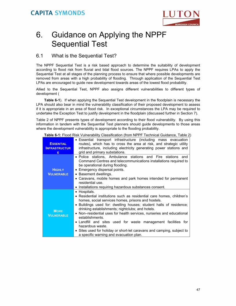
6. Guidance on Applying the NPPF Sequential Test
6.1 What is the Sequential Test?
The NPPF Sequential Test is a risk based approach to determine the suitability of development according to flood risk from fluvial and tidal flood sources. The NPPF requires LPAs to apply the Sequential Test at all stages of the planning process to ensure that where possible developments are removed from areas with a high probability of flooding. Through application of the Sequential Test LPAs are encouraged to guide new development towards areas of the lowest flood probability.
Allied to the Sequential Test, NPPF also assigns different vulnerabilities to different types of development (
Table 6-1). If when applying the Sequential Test development in the floodplain is necessary the LPA should also bear in mind the vulnerability classification of their proposed development to assess if it is appropriate in an area of flood risk. In exceptional circumstances the LPA may be required to undertake the Exception Test to justify development in the floodplain (discussed further in Section 7).
Table 2 of NPPF presents types of development according to their flood vulnerability. By using this information in tandem with the Sequential Test planners should guide developments to those areas where the development vulnerability is appropriate to the flooding probability.
Table 6-1: Flood Risk Vulnerability Classification (from NPPF Technical Guidance, Table 2)
ESSENTIAL INFRASTRUCTUR
E
Essential transport infrastructure (including mass evacuation routes), which has to cross the area at risk, and strategic utility infrastructure, including electricity generating power stations and grid and primary substations.
HIGHLY VULNERABLE
Police stations, Ambulance stations and Fire stations and Command Centres and telecommunications installations required to be operational during flooding.
Emergency dispersal points. Basement dwellings. Caravans, mobile homes and park homes intended for permanent
residential use. Installations requiring hazardous substances consent.
MORE VULNERABLE
Hospitals. Residential institutions such as residential care homes, children’s
homes, social services homes, prisons and hostels. Buildings used for: dwelling houses; student halls of residence;
drinking establishments; nightclubs; and hotels. Non–residential uses for health services, nurseries and educational
establishments. Landfill and sites used for waste management facilities for
hazardous waste. Sites used for holiday or short-let caravans and camping, subject to
a specific warning and evacuation plan.
47

LESS VULNERABLE
Buildings used for: shops; financial, professional and other services; restaurants and cafes; hot food takeaways; offices; general industry; storage and distribution; non–residential institutions not included in ‘more vulnerable’; and assembly and leisure.
Land and buildings used for agriculture and forestry. Waste treatment (except landfill and hazardous waste facilities). Minerals working and processing (except for sand and gravel
working). Water treatment plants. Sewage treatment plants (if adequate pollution control measures
are in place).
WATER-COMPATIBLE
DEVELOPMENT
Flood control infrastructure. Water transmission infrastructure and pumping stations. Sewage transmission infrastructure and pumping stations. Sand and gravel workings. Docks, marinas and wharves. Navigation facilities. MOD defence installations. Ship building, repairing and dismantling, dockside fish processing
and refrigeration and compatible activities requiring a waterside location.
Water-based recreation (excluding sleeping accommodation). Lifeguard and coastguard stations. Amenity open space, nature conservation and biodiversity, outdoor
sports and recreation and essential facilities such as changing rooms.
Essential ancillary sleeping or residential accommodation for staff required by uses in this category, subject to a specific warning and evacuation plan.
NPPF acknowledges that some areas could also be at risk of flooding from flood sources other than fluvial and tidal systems. Consequently all sources of flooding must be considered when looking to locate development. Other sources of flooding requiring consideration when situating new development allocations in the LBC administrative area include:
Pluvial;
Groundwater;
Sewers; and
Artificial Sources.
6.2 How should the SFRA be used to apply the Sequential Test?
The LPA should use the information presented and mapped (Figure 14) in this Level 1 SFRA to undertake the Sequential Test. The Sequential Test should be accurately documented to ensure that the decision processes followed for the locating of a development are consistent and transparent.
The Sequential Test should be carried out on all development sites and seek to guide development to the lowest flood risk areas (i.e. Flood Zone 1). Where there are no reasonably available alternative sites in Flood Zone 1 to accommodate development, sites in Flood Zones 2 or 3 may be considered but must balance the flood probability and development vulnerability of sites. This should be based on the Flood Zone and Flood Risk Vulnerability Compatibility which is summarised detailed in Section
Table 6-2.
6.3
48

6.3
The Level 1 SFRA mapping provides the tools by which LBC can undertake the Sequential Test. This is achieved by presenting information to identify the variation in flood risk across a local authority administrative area, allowing an area-wide comparison of future development sites with respect to flood risk considerations. The following flow diagram (Diagram 6-1); is taken from the Practice Guide to PPS25 which although has been superseded by NPPF it still remains a useful illustration of how the Sequential Test should be applied. The Flood Risk Matrix illustrates how the Sequential Test should be undertaken and is taken from Table 3 of the NPPF Technical Guidance document.
Additional guidance to assist LBC to strategically undertake the Sequential Test is detailed in Section
Table 6-2: Flood Risk Vulnerability and Flood Zone ‘Compatibility’ from NPPF Technical Guide
FLOOD RISK ESSENTIAL WATER HIGHLY MORE LESS VULNERABILITY INFRASTRUCTUR COMPATIBLE VULNERABLE VULNERABLE VULNERABLE CLASSIFICATION E
FLO
OD
ZO
NE
1
2 Exception Test
Required
3A Exception Test Required
Exception Test
Required
3B Exception Test Required
49
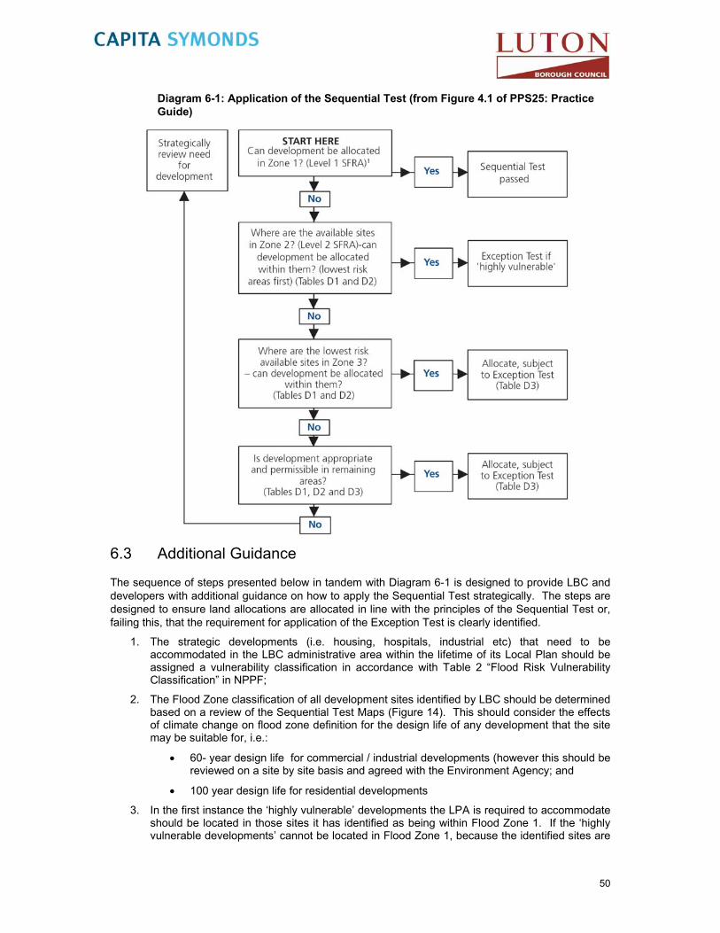
Diagram 6-1: Application of the Sequential Test (from Figure 4.1 of PPS25: Practice Guide)
6.3 Additional Guidance
The sequence of steps presented below in tandem with Diagram 6-1 is designed to provide LBC and developers with additional guidance on how to apply the Sequential Test strategically. The steps are designed to ensure land allocations are allocated in line with the principles of the Sequential Test or, failing this, that the requirement for application of the Exception Test is clearly identified.
1. The strategic developments (i.e. housing, hospitals, industrial etc) that need to be accommodated in the LBC administrative area within the lifetime of its Local Plan should be assigned a vulnerability classification in accordance with Table 2 “Flood Risk Vulnerability Classification” in NPPF;
2. The Flood Zone classification of all development sites identified by LBC should be determined based on a review of the Sequential Test Maps (Figure 14). This should consider the effects of climate change on flood zone definition for the design life of any development that the site may be suitable for, i.e.:
60- year design life for commercial / industrial developments (however this should be reviewed on a site by site basis and agreed with the Environment Agency; and
100 year design life for residential developments
3. In the first instance the ‘highly vulnerable’ developments the LPA is required to accommodate should be located in those sites it has identified as being within Flood Zone 1. If the ‘highly vulnerable developments’ cannot be located in Flood Zone 1, because the identified sites are
50

unsuitable or there are insufficient sites in Flood Zone 1 then sites in Flood Zone 2 can be considered. If sites in Flood Zones 1 and 2 are inadequate, then to accommodate the development the LPA may have to identify additional sites in Flood Zones 1 or 2 or seek opportunities to locate the development outside their administrative area.
4. Once all ‘highly vulnerable’ developments have been allocated to a development site, the LPA can consider those development types defined as ‘more vulnerable’. In the first instance ‘more vulnerable’ development should be located in any unallocated sites in Flood Zone 1. Where these sites are unsuitable or there are insufficient sites, sites in Flood Zone 2 can be considered. If there are insufficient sites in Flood Zone 1 or 2 to accommodate the ‘more vulnerable’ development types, sites in Flood Zone 3a can be considered. However, any ‘more vulnerable’ developments in Flood Zone 3a will require application of the Exception Test (described in Section 7).
5. Once all ‘more vulnerable’ developments have been allocated to a development site, the LPA can consider those development types defined as ‘less vulnerable’. In the first instance ‘less vulnerable’ development should be located in any remaining unallocated sites in Flood Zone 1, 2 or 3a (in that order). Less vulnerable development types are not appropriate in Flood Zone 3b – Functional Floodplain.
6. ‘Essential infrastructure’ developments should also be preferentially located in the lowest flood risk zone, however this type of development can be located in Flood Zones 3a and 3b, where necessary, through application of the Exception Test.
7. Finally, it is recommended that water compatible development is located. Water compatible developments typically have the least flood risk constraints and therefore it is considered appropriate to consider them last when allocating development sites.
8. For decisions made through steps 4 to 7 it will also be necessary to consider the risks posed to the site from other flood sources and where comparable development sites in the same flood zone may be more suitable due to:
flood risk management measures,
the rate of flooding,
flood water depth, or,
flood water velocity.
Table 1 in Appendix C is provided as a suggested pro-forma for LBC to follow when undertaking the Sequential Test. The table has been prepared to assist the LPA in providing a transparent and structured reporting system and to assist in identifying where developments/development sites may require application of the Exception Test.
51

7. Guidance on Applying the NPPF Exception Test
7.1 What is the Exception Test?
After application of the Sequential Test, if it is has not been possible for a development to be located in a low risk flood zone, or a flood zone where the development vulnerability is appropriate then it may be necessary and appropriate to apply the Exception Test to the allocation, providing the development is consistent with the wider sustainability objectives of the area.
Table 6-1 provides guidance on the vulnerability of types of development in conjunction withdetailed in Section 6.3
Table 6-2, where various types of development are appropriate with regards to flood risk and where it may be appropriate for the Exception Test to be applied.
7.2 Why is there an Exception Test?
The Exception Test is essential in cases where the Sequential Test is unable to deliver acceptable sites for allocations. In some areas of flood risk development may be required to ensure social or economic, blight does not occur, thus ensuring continued sustainable development or constraints on land elsewhere (i.e. areas protected by nature conservation designations preclude the identification of additional lower risk areas).
7.3 What is required to pass the Exception Test?
The Exception Test can be applied, when appropriate and following the application of the Sequential Test, where it is not possible to locate development within flood zones that have a lower probability of flooding (NPPF, Section 102).
Figure 6-1 in Section 6.2 highlights the stages in the Sequential Test at which the Exception Test may need to be applied. The Test provides a method of managing flood risk whilst still allowing necessary development to occur. It may not always be appropriate to apply the Exception Test, however if applied, both of the following elements must be passed.
it must be demonstrated that the development provides wider sustainability benefits to the community that outweigh flood risk, informed by a SFRA where one has been prepared; and
a site-specific FRA must demonstrate that the development will be safe taking account of the vulnerability of its users, without increasing flood risk elsewhere, and, where possible, will reduce flood risk overall.
Figure 7-1 presents the process that should be followed by LBC in its application of the Exception Test under the NPPF.
52

START HERE Has the Sequential Test been
applied?
No Apply the Sequential Test. Exception Test cannot be
passed
Is the Exception Test required (Table 3 of the Technical
Guidance to NPPF) No
Appropriate development can be allocated or
permitted (Tables 1, 2 and 3 of the Technical Guidance to NPPF
Yes
Are all the criteria satisfied? (Para 102 NPPF)
No Development cannot be allocated or permitted
Yes
Development can be allocated or permitted
Yes
Figure 7-1: Application of the Exception Test
The first part of the test reflects on the wider sustainability benefits of the development, which should be tested against the aims and objectives of the Sustainability Appraisal and other Local Plan policy. As indicated above, other spatial planning issues such as transport, housing, economic growth, natural resources, regeneration, biodiversity, the historic environment and other hazards can influence the overall suitability and sustainability of development at a site and these issues should be considered in relation to whether the site meets the first criteria of the Exception Test.
The second part of the Exception Test relates to the safety of the development and the need to not increase flood risk elsewhere. There are no fixed criteria for what constitutes ‘safe’ development, as it will depend upon not only the nature of the development but also the source and mechanism of flood risk. Appropriate application of the flood risk management hierarchy of ‘Avoid – Substitute – Control – Mitigate’ can increase the safety of a development, however, it is the responsibility of the developer to show that the measures proposed are sufficient.
It is important that Luton Borough Council retain a record of all its assumptions and decisions with regard to both the Sequential and Exception Tests, in order to demonstrate that they have performed the process appropriately.
Figure 7-2 identifies the key concepts to consider when assessing whether a site will be safe over the lifetime of the development.
Flood events, more than many other emergencies, can affect a wide number of homes and properties and the time to recover from a flood emergency can be prolonged. Accordingly it should be remembered that the level of “safety” will vary depending on the vulnerability of the community and land use affected. More vulnerable residents will potentially be more severely affected by the consequences of flooding and levels of safety should be commensurate with the risk.
Because of the variability in the definition of safety there can be no fixed specification of what is safe. Figure 7-2 should therefore be used when considering the risks to a site to assist in making a judgment on whether a site can be considered safe given its proposed use and users. Where
53

possible, however, the following should be considered for new development that is within the floodplain and justification should be provided where this cannot be achieved:
Development ground floor levels and access should be dry, particularly for More or Highly Vulnerable uses; and
The Flood Hazard should be less than Significant (Dangerous for Most People), as defined within DEFRA/EA FD2321/TR1 Report Flood Risks to People12. This implies a Hazard rating of less than 1.25, which correlates to fast flowing shallow water and/or slow flowing deep water.
Less More Greater Higher Less Frequent Depth Velocity WarningSafe e.g. 1 in e.g. e.g. < 2hrs
20-yr >0.3m >1.0m/s
e.g. 1 in e.g. e.g. > 2hrs 1000-yr <0.3m <1.0m/s
Less Lower Lower More Safer Frequent Depth Velocity Warning
Figure 7-2: Site-specific aspects to consider with respect to what is ‘safe?’
Note: hazard data is not currently available for fluvial modelling; however it will be available following the completion of the Luton 2D Flood Risk Mapping Study in mid 2013 as discussed in Section 4.2.3.
12 DEFRA/EA FD2321/TR1 Report Flood Risks to People, March 2006.
54

8. Future Flood Risk Management Practices Current flood risk management practises within the LBC SFRA study area have been described in Section 3. This section describes the practises that are planned for the area or can be incorporated into new developments.
8.1 Strategic Flood Defences
Flood defences are typically designed and constructed to protect people and property from a given magnitude of flood. This is referred to as the design standard and may vary depending on the age of the structure, the value attributed to the people and property it is designed to serve and the scale of works necessary to construct the defence. For new defences, these issues and others are balanced through a cost benefit analysis to determine if investment in defence schemes can be justified. The Environment Agency continues to investigate the potential for the Upper Lee Flood Risk Management Strategy, a flood alleviation scheme.
Upper River Lee Flood Risk Management Strategy
The Environment Agency’s Thames Region has investigated a flood alleviation scheme for Luton. The current investigation (under the Upper River Lee Flood Risk Management Strategy Study) seeks to alleviate flood risk in the headwaters of the Upper Lee, namely flooding from Houghton Brook, Lewsey Brook and on the River Lee affecting the Limbury area of Luton.
Elements of the current flood alleviation options under consideration, within the study area include:
The construction of flood storage areas on Houghton Brook between the M1 and Houghton Park (at NGR TL 044 244) and / or on Lewsey Brook near the Lewsey Farm recreation ground (at NGR TL 046 234), or
The construction of a bund(s) around the Fallowfield area of Luton.
Whilst the options identified are economically viable, environmentally acceptable and sustainable, they do not currently satisfy the cost benefit criteria necessary to develop the schemes. However, should the assessment criteria change or external funding be made available the attractiveness of the scheme may improve. In order to allow for changes in the cost benefit of this scheme and due to the potential role these areas have in alleviating flood risk through Luton, they should be protected from future development.
8.1.1 Flood Warning
Flood Warning is an essential component of the strategy to reduce flood risk. The current flood warning systems provided by the Environment Agency are described in Section 4.3.1. However, the flood warning system only operates for fluvial flooding taking into consideration that a significant number of properties within urban areas of the study area at risk from surface water flooding or experience flooding too quickly for current warning systems to be effective, means that most flooding incidents are likely to occur without any warning.
Sir Michael Pitt’s reviewi of the summer 2007 floods stresses the importance of developing a flood warning system for surface water flooding. One of the reports interim conclusions (IC3) was “the Environment Agency further develops tools and techniques for predicting and modelling river flooding, especially to take account of extreme multiple events; and takes forward work to develop similar tools and techniques to model surface water flooding.”
55

8.1.2 Flood Alleviation Scheme Maintenance
The potential for flooding can be increased in areas where flood alleviation measures are not maintained regularly and/or adequately. Breaches in raised flood defences, for example, are most likely to occur where the defence has been degraded or not maintained to its design standard. Drainage infrastructure in urban areas can also frequently become blocked with debris which, if not removed, can lead to blockages in culverts and backing up of a watercourse resulting in flooding of property and infrastructure.
It is an essential aspect of flood risk management practise that all flood alleviation schemes and hydraulic structures are regularly maintained to a specified design standard. It is the responsibility of the riparian owner to maintain the watercourses or defences to a suitable standard. The Local Authority or Environment Agency has permissive powers to act should the riparian owner not satisfy their maintenance requirements.
8.1.3 Flood Mitigation on site
Flood mitigation measures can also be incorporated within a development and are usually more appropriate in areas of residual flood risk. The Pitt Review (Sir Michael Pitt, 2008) recognised the importance of flood resilient and resistant techniques and came to an interim conclusion (IC11) that “no new building should be allowed in a flood risk area that is not flood-resilient, and that Government should work with organisations such as the Royal Institute of British Architects and the building industry to encourage flood-resilient building and development design.”
The Code for Sustainable Homes (CLG, April 2010) also offers credits for developments that consider flood risk. Preference is given to sites located in low flood risk zones, commensurate with policies presented in NPPF. One credit is made available for developments in Flood Zones 2 or 3 that are appropriately flood resilient and resistant.
Similar to the code for sustainable homes there is also a guide for Non-Domestic Buildings (CLG 2011). One credit is made available for developments in Flood Zone 2 or 3 and 2 credits are available for developments in Flood Zone 1.
When including flood avoidance (which should always be the first consideration through application of the Sequential Test) flood risk mitigation measures that can be employed on individual sites can be split into three categories:
Flood Avoidance
Flood Resistance
Flood Resilience
8.1.4 Flood Avoidance
This is defined as: -
‘Constructing a building and its surrounds (at site level) in such a way to avoid it being flooded (e.g. by raising it above the flood level, re-sitting outside flood risk area etc.)’.
These are used to restrict the pathway between the flooding source and the receptor. The preferential option is to locate the building outside a flood risk area through rearranging the site layout if possible, alternatives within this category could include a permanent or temporary defence such as raised kerbs to contain and route flood water through a site or demountable barriers.
8.1.5 Flood Resistance
This is defined as:-
56

‘Constructing a building in such a way to prevent floodwater entering the building and damaging its fabric’.
Floodwaters will enter buildings through the weakest points in the construction which maybe in the brickwork, party walls of terraced or semi-detached buildings, expansion joints between walls where different construction materials meet, vents, door thresholds, seepage from below ground through floors and basements and/or sanitary appliances from backflow from surcharged drainage systems.
Flood resistance techniques can be employed on buildings. The can include raising finished floor levels 300mm above the design flood level including an allowance for climate change and the use of appropriate materials that can withstand periodic flooding. They include the use of low permeability materials in the construction of the building and are likely to only be effective for short duration flood events and of low flooding depths (less than 0.3 m). They may be used in conjunction with flood resilience techniques when the predicted flood level is between 0.3 - 0.6 m.
8.1.6 Flood Resilience/Repairable
This is defined as:-
‘Constructing a building in such a way that although floodwater may enter the building its impact is reduced (i.e. no permanent damage is caused, structural integrity is maintained and drying and cleaning is facilitated)’.
Flood resilience techniques are also employed on buildings within the floodplain. This type of approach is often more appropriate when the predicted depth of flooding is greater than 0.3 m or flooding is expected to last for a long time. In these cases the use of more durable materials that will not be easily damaged by floodwaters as well as the use of construction materials that are more effective at draining and drying are recommended.
There is currently no guidance with the UK Building Regulations for appropriate means of construction for properties in flood risk areas. For more information on flood resistant construction refer to the Communities and Local Government publication ‘Improving the Flood Performance of New Buildings: Flood Resilient Construction’ (May, 2007).
57
9. Drainage of Development Sites Objective 6 of this Level 1 SFRA is to ‘advise LBC on the principles, objectives and applicability of Sustainable Drainage Systems (SuDS) throughout the study area’. In keeping with the guidance of NPPF, local authorities should encourage the application of Sustainable Drainage Systems (SuDS). This section and supporting appendices present a summary of a selection of the SuDS techniques available and a review of the soils and geology of the study area, enabling LBC to identify what type of SuDS techniques could be employed in development schemes within the SFRA study area.
9.1 Background
Traditionally, built developments have utilised piped drainage systems to manage surface water and convey surface water run-off away from developed areas as quickly as possible. Typically these systems connect to the public sewer system for treatment and/or discharge to local watercourses. Whilst this approach rapidly transfers surface water from developed areas, the alteration of natural drainage processes can potentially impact on downstream areas by increasing flood risk and reducing water quality. Receiving watercourses are therefore much more sensitive to rainfall intensity, volume and catchment land uses after a catchment or areas of a catchment have been developed.
Flooding from sewers is typically less well publicised than flooding from rivers or the sea, in part due to the often greater frequency with which sewer flooding can occur but predominately because it typically affects geographically small areas for relatively short periods of time. However, the hazards and nuisance of sewer flooding remain of particular concern in areas of growth.
Due to the difficulties and inconvenience associated with upgrading sewer systems it is uncommon for sewer and drainage systems to keep pace with the rate of development/re-development. As development progresses and/or urban areas expand, the drainage systems become inadequate for the volumes and rates of surface water they receive, resulting in increased flood risk and/or pollution of watercourses. Allied to this the implications of climate change on rainfall intensities, is predicted to lead to flashier catchment/site responses and surcharging of piped systems.
In addition, as flood risk has increased in importance within planning policy, a disparity has emerged between the design standard required of new conventional sewer systems and the return period against which development should be safeguarded from flooding. New sewer systems are typically designed to accommodate the 3.3% annual probability storm without flooding at the ground surface in accordance with Sewers for Adoption13 whilst new developments are typically required to mitigate against the risks from the 1% annual probability flood. This results in drainage inadequacies for the flood return period developments need to consider. Whilst the risk of flooding from fluvial systems may be managed, an inappropriately designed site drainage system could generate a new flood risk to development and existing property.
A sustainable solution to these issues is to reduce the volume and/or rate of water entering the sewer system and watercourses. The Government’s preferred method to achieve this is through the use of SuDS.
9.2 What are SuDS?
SuDS are a varied collection of techniques designed to manage surface water in a sustainable manner. SuDS achieve this by seeking to manage surface water from new developments as close to its source as possible and by mimicking the surface water flow regime present on a site prior to development. Typically this approach involves a move away from conventional piped systems to softer engineering solutions inspired by natural drainage processes.
13 Sewers for Adoption , 7th Edition A Design and Construction Guide for Developer, September 2012
58

For SuDS to be fully sustainable they should seek to contribute to each of the three goals of sustainability (identified below), with the favoured system contributing equally to each goal. The three goals of sustainable drainage systems are:
1. Reduce flood risk (to the site and neighbouring areas),
2. Reduce pollution, and,
3. Provide landscape and wildlife benefits.
In addition, SuDS should also be designed to ensure they remain effective for storm events up to and including the 1% annual probability storm event including an increase in peak rainfall intensities to account for the predicted effects of climate change.
9.3 SuDS Policies
Section 3 outlines the policies that govern development and flood risk management in the LBC area. It is widely recognised that SuDS are a useful tool in the management of flood risk and water quality. As a result, the use of SuDS in individual planning applications should be promoted. Whilst NPPF does not contain the detailed specific guidance of PPS 25, the essence of PPS 25 is still applicable to any development site. Therefore the following general principal should be followed:-
“The surface water drainage arrangements for any development site should be such that the volumes and peak flow rates of surface water leaving a developed site are no greater than rates prior to the proposed development, unless specific off-site arrangements are made and result in the same net effect.”
This is to alleviate the pressure on sewer systems that may be old or serving a catchment area greater than their original design or designed to a standard less than the 1% annual probability event now required.
If a proposed development results in an increase in surface water runoff, the Environment Agency (and Local Authority following the introduction of SuDS Approval Bodies) will expect to see SuDS forming part of the proposed mitigation. With their powers of direction, developments that do not incorporate SuDS without sound reasons can expect them to be required through Section 106 conditions to their planning permissions. Where the consented discharge rates are low, retrofitting of SuDS can significantly impact development proposals.
9.3.1 SuDS Approval body (SAB)
The Flood and Water Management Act 2010 set out in Schedule 3 details for the establishment of a SuDS Approval Body (SAB) which will be the responsibility of LBC as the Lead Local Flood Authority (LLFA). The SAB will be a statutory consultee of the planning process.
Schedule 3 of the Act, which is yet to be commenced, will require new drainage systems to be assessed and approved prior to construction. It requires that the drainage system meet new national standards (currently being consulted upon) for the design, construction, operation and maintenance of SuDS. If these National Standards are met then the SAB will be required to adopt and maintain the SuDS where they serve more than one property.
The Act also amends Section 106 of Water Industry Act (1991)14 to make the right to connect surface water to public sewers conditional on the SAB approving the drainage system as meeting the National Standards. The SuDS provisions in Schedule 3 of the Act make no changes to the right to connect foul water to the public sewer system.
9.3.2 Building Regulations 2008 H3 Rainwater Drainage
The Building Regulations 2008 (Approved UK Building Regulations 2008) enable the principles of the NPPF to be enforced during construction by stipulating that:
14 Water Industry Act, July 1991.
59

1. Adequate provision shall be made for rainwater to be carried from the roof of the building;
2. Paved areas around the building shall be so constructed as to be adequately drained;
3. Rainwater from a system provided pursuant to sub-paragraphs (1) or (2) shall discharge to one of the following, listed in order of priority:
an adequate soakaway or some other adequate infiltration system; or, where that is not reasonably practicable,
a watercourse; or, where that is not reasonably practicable,
a sewer.
As the Environment Agency are the consenting authority for discharges to controlled waters (i.e. groundwater or watercourses), SuDS will be favoured for the removal of pollutants and attenuation of discharge rates.
9.3.3 Code for Sustainable Homes Technical Guide 2010
The Code for Sustainable Homes (CLG, November 2010) sets out the requirements of the latest version of the Code for Sustainable Homes and the process by which a Code assessment is reached. It replaces the May 2009 Version 2 of the Code Technical Guidance.
Proposed developments are assessed against a number of sustainability criteria that include ‘water use’ and ‘surface water run-off’. For each category points are awarded depending on the sustainability of the management technique proposed (i.e. the more sustainable the more points are awarded). The points for each category are collated and the development is given an overall code level from 1 – 6. Under the Code ‘internal water use’ and ‘management of surface water runoff from developments’ will be assessed as mandatory elements, requiring developments to demonstrate their sustainability against these criteria.
Table 9-1 and Sur 1 Aim: To design surface water drainage for housing developments which avoid, reduce and delay the discharge of rainfall runoff to watercourses and public sewers using SuDS techniques. This will protect receiving waters from pollution and minimise the risk of flooding and other environmental damage in watercourse.
Table 9-2 summarises the measurement criteria used for both potable water consumption and surface water runoff in the Code for Sustainable Homes.
Wat 1 Aim: To reduce the consumption of potable water in the home from all sources, including borehole well water, through the use of water efficient fittings, appliances and water recycling systems.
Table 9-1: Summary of the measurement criteria for water use CATEGORY 2 WATER
CRITERIA WATER CONSUMPTION CREDITS
AVAILABLE Indoor Water
Use (Mandatory
element)
Where predicted water consumption (calculated using the Code water calculator) accords with the following
levels:
One of the following point
scores ≤ 120 l/p/d ≤ 110 l/p/d ≤ 105 l/p/d ≤ 90 l/p/d ≤ 80 l/p/d
1 2 3 4 5
External water use
For providing a system to collect rain water for use in irrigation e.g. water butts.
1
60

Sur 1 Aim: To design surface water drainage for housing developments which avoid, reduce and delay the discharge of rainfall runoff to watercourses and public sewers using SuDS techniques. This will protect receiving waters from pollution and minimise the risk of flooding and other environmental damage in watercourse.
Table 9-2: Summary of the measurement criteria for surface water runoff
ISSUE
CATEGORY 4 SURFACE WATER RUNOFF
MEASUREMENT CRITERIA CREDITS
AVAILABLE Management
of surface water runoff
from developments
(Mandatory element)
Where rainwater holding facilities/sustainable drainage (SuDS) is used to provide attenuation of water run-off to either natural watercourses or municipal systems. Points for attenuation covering hard surfaces
0
Water Quality Criteria 1. One credit can be awarded by ensuring there is
no discharge from the developed site for rainfall depths up to 5mm
2. One credit can be awarded by ensuring that: The run off from all hard surfaces shall
receive an appropriate level of treatment in accordance with The SuDS Manual to minimise the risk of pollution.
2
9.3.4 Environment Agency Policies
The Thames Catchment Flood Management Plan (Environment Agency, January 2007) also advocates policies relating to SuDS, these are:
All sites greater than 1 hectare in size require the following:
o SuDS,
o Greenfield discharge rates,
o Attenuation of the 1 in 100 year storm event including allowance for climate change.
Allocated land should set-aside space for SuDS.
9.4 Achieving SuDS in Developments
The application of SuDS techniques is not limited to one technique per site. Often a successful SuDS solution will utilise a number of techniques in combination, providing flood risk, pollution and landscape/wildlife benefits to the site and surrounding area.
A common issue with incorporating SuDS in developments is the belief that all SuDS are ‘land hungry’ and significantly impact on the developable area of sites. However, SuDS can be designed to achieve the above goals without significantly impacting on development. In addition, SuDS can be employed on a strategic scale, for example with a number of sites contributing to large scale jointly funded and managed SuDS, however, each development site must offset its own increase in runoff; attenuation cannot be “traded” between developments.
Such an approach is advocated by the ‘Management Train’, which recommends incorporating a chain of techniques throughout a development, (as outlined in CIRIA C697 (Woods Ballard et al, 2007), where each component adds to the performance of the whole system, the total SuDS system can be spread throughout a site and more readily incorporated into the sites infrastructure. The Management Train approach consists of four stages:
61

Prevention good site design and upkeep to prevent runoff and pollution (e.g. limited paved areas, regular pavement sweeping)
Source control runoff control at/near to source (e.g. rainwater harvesting, green roofs, pervious pavements)
Site control water management from a multitude of catchments (e.g. route water from roofs, impermeable paved areas to one infiltration/holding site)
Regional control integrate runoff management from a number of sites (e.g. into a wetland).
9.5 SuDS Techniques
There are a wide range of SuDS techniques available for use throughout the four stages of the Management Train. Techniques available to manage the quantity of surface water typically operate in combination or solely on the basis of the following two main principles:
Infiltration
Attenuation
The effectiveness of techniques in achieving the goals of attenuating discharges, reducing pollution and providing amenity benefit will depend on a number of other factors such as filtration, settlement and oxidation.
The SuDS Manual (C697)15 provides a summary of SuDS techniques and their suitability to meet the three goals of sustainable drainage systems and their suitability within the stages of the Management Train. Table 9-3 presents a summary of a variety of SuDS techniques along with their suitability in achieving the goals of sustainability and their place within the Management Train.
15 CIRIA, The SUDS Manual (C697), March 2007
62

Table 9-3: Summary of SuDS Techniques and their Suitability to meet the three goals of sustainable drainage systems MANAGEMENT
TRAIN SUDS TECHNIQUE DESCRIPTION
SUDS PRINCIPLE
WATER QUANTITY
WATER QUALITY
AMENITY BIODIVERSITY
Sou
rce
Pre
vent
ion
Green roofs Layer of vegetation or gravel on roof areas providing absorption and storage.
Attenuation ● ● ● Rainwater harvesting Capturing and reusing rainwater for domestic or
irrigation uses. Attenuation ● ○ ○
Permeable pavements
Infiltration through the surface into underlying layer. Infiltration ● ● ○ Filter drains Drain filled with permeable material with a perforated
pipe along the base. Infiltration ● ● X
Infiltration trenches Similar to filter drains but allows infiltration through sides and base.
Infiltration ● ● X
Soakaway Underground structure used for store and infiltration. Attenuation ● ● X
Bio-retention areas Vegetated areas used for treating runoff prior to discharge into receiving water or infiltration
Attenuation ● ● ●
Site
Swales Grassed depressions, provides temporary storage, conveyance, treatment and possibly infiltration.
Attenuation ● ● ○ Sand filters Provides treatment by filtering runoff through a filter
media consisting of sand. Infiltration ● ● X
Reg
ion
al
Basins Dry depressions outside of storm periods, provides temporary attenuation, treatment and possibly
infiltration.
Attenuation ● ● ○ Ponds Designed to accommodate water at all times, provides
attenuation, treatment and enhances site amenity value.
Attenuation ● ● ● Wetland Similar to ponds, but are designed to provide
continuous flow through vegetation. Attenuation ● ● ●
Key: ● – highly suitable, ○ - suitable depending on design, X – unsuitable
63

9.6 SuDS Design
Detailed guidance for the design of SuDS is available in the CIRIA SuDS Manual C697, and the associated document ‘Site Handbook for the Construction of SuDS, C698 (Woods Ballard et al, 2007a). These publications provide best practice guidance on the planning, design, construction, operation and maintenance of SuDS, to ensure effective implementation within developments.
The design of SuDS measures should be undertaken as part of a drainage strategy and design for a development site. A ground investigation should form part of the SuDS assessment to determine ground conditions and the most appropriate SuDS technique(s). Hydrological analysis should be undertaken using industry approved procedures, to ensure an appropriate design is developed. This should account for the effects of climate change over the lifetime of the proposed system/development and based on an agreed permitted rate of discharge from the site.
During the design process, liaison should take place with the authority responsible for the receiving water body and any organisations involved in the long term maintenance of the system. This may include liaison with LBC, the Environment Agency (Thames region), Thames Water or Anglian Water. Liaison with these organisations should focus on establishing a suitable design methodology, any restrictions and provision for the long-term maintenance of the SuDS system.
9.7 Where can SuDS be utilised
The underlying ground conditions of a development site will often influence the type of SuDS technique suitable at an individual site. While this will need to be determined through ground investigations carried out on-site, an initial assessment of a sites suitability to the use of SuDS can be obtained from a review of the available soils/geological survey of the area.
As part of the Luton SWMP a ‘SUDS Suitability Map’ was produced. The map was developed using permeability information obtained from the BGS and groundwater source protection zones supplied by the EA. This figure should be reviewed to indicate the type of SUDS that can be implemented to manage surface water flooding. Refer to Figure 4-1 of the Luton SMWP.
Tables presented in Appendix C are provided as a guide alone and should not be used to accept or refuse SuDS techniques. Overall the suitability and design of a SuDS system should be determined on a site by site basis through consultation with the authority responsible for the receiving water body.
It is recommended that LBC completes Appendix Table 3 (Appendix C) to assist in identifying suitable SuDS for development sites in the area. Completion of the table in Appendix C will assist in identifying where various types of SuDS are most suitable and enable developers to account for SuDS when developing master plans for development sites.
9.8 SuDS Constraints
During the design process, in addition to considering the properties of the underlying soils and strata it is necessary to also consider the sensitivity of the receiving water body and any previous uses of the site.
The use of SuDS can be limited based on a number of issues, which include:
Groundwater vulnerability and potential contamination of an aquifer;
Current or target water quality of a receiving watercourse;
The presence of groundwater Source Protection Zones and potential contamination of a potable water source;
Restrictions on infiltration on contaminated land to prevent the spread of contamination; and,
Restricted area on development sites where housing densities are high.
64

9.9 Groundwater Vulnerability
Groundwater resources can be vulnerable to contamination from both direct sources (e.g. into groundwater) or indirect sources (e.g. infiltration of discharges onto land). Groundwater vulnerability within the study area has been determined by the Environment Agency based on a review of aquifer characteristics, local geology and the leachability of overlying soils.
The vulnerability of the groundwater is important when advising on the suitability of SuDS. The Environment Agency is the responsible drainage authority for any discharges to groundwater and should be consulted on proposals to discharge to ground. Figure 16 presents the groundwater vulnerability for the study area.
9.9.1 Groundwater Source Protection Zones
In addition to groundwater vulnerability, the Environment Agency also defines groundwater Source Protection Zones (SPZs) around groundwater abstraction points. Source Protection Zones are defined to protect areas of groundwater that are used for potable supply, including public/private potable supply, (including mineral and bottled water) or for use in the production of commercial food and drinks.
SPZs are defined based on the time it takes for pollutants to reach an abstraction point. Depending on the nature of the proposed development and the location of the development site with regards to the SPZs, restrictions may be placed on the types of SuDS appropriate to certain areas.
Any restrictions imposed on the discharge of site generated runoff by the Environment Agency will be determined on a site by site basis using a risk based approach. The SPZ for the study area are displayed in Figure 16.
9.9.2 Water Quality
Under the Water Framework Directive all member states are required to take steps to achieve good ecological status of water bodies by 2015. To achieve this, discharges to watercourses draining development areas will require pre-treatment to remove oils and contaminants. Appropriately designed SuDS can assist developments improve water quality discharges through passive treatment, whilst additionally providing ecological benefit to a development or local area.
9.9.3 Contaminated Land
Previous site uses can leave a legacy of contamination that if inappropriately managed can cause damage to local water bodies. During the design of SuDS it is essential to have regard to the nature of potential ground contamination.
Particular restrictions may be placed on infiltration based SuDS, forcing consideration of attenuation based systems. Early discussion with the authority responsible for the receiving water body should be undertaken to establish the requirements of SuDS on contaminated sites.
9.9.4 High Development Densities
Where developments are required to achieve high development densities it is essential that the requirement for SuDS and their constraints are identified early in the site master planning process. High development densities can restrict the land area available for SuDS, which if mandatory can affect the ability of a site to gain planning permission.
65

Early consideration of SuDS enables the drainage requirements to be integrated with the design, limiting the impact they have on developable area and development densities.
9.10 Further Information
The above information is intended to provide an introduction to the use of SuDS. The options available for the provision of SuDS is not limited to those presented here and new techniques are frequently developed.
The following reference documents provide further information on SuDS, their benefits and limitations and how they can be employed:
BRE. Digest 365 (2003) Soakaway Design. Building Research Establishment.
British Water (2005) Technical Guidance, Guidance to Proprietary Sustainable Drainage Systems and Components – SuDS. In partnership with the Environment Agency
BSRIA Ltd. (1997) Water Conservation: Implications of Using Recycled Greywater and Stored Rainwater in the UK. Report 13034/1. Drinking Water Inspectorate, Department of the Environment.
CIRIA 625 (2003) Model Agreements for Sustainable Water Management Systems – Review of Existing Legislation. RP664.
CIRIA 626 (2003) Model Agreements for Sustainable Water Management Systems – Model Agreement for Rainwater and Greywater Use Systems. P Shaffer, C Elliott, J Reed, J Holmes and M Ward.
CIRIA C521 (2000) Sustainable Urban Drainage Systems - Design Manual for Scotland and Northern Ireland. Sustainable Urban Drainage Scottish Working Party.
CIRIA C522 (2000) Sustainable Urban Drainage Systems - Design Manual for England and Wales. Department of Environment Transport Regions.
CIRIA C523 (2001) Sustainable Urban Drainage Systems, Best Practice Manual for England, Scotland, Wales and Northern Ireland.
CIRIA C539 (2001 Rainwater and Greywater Use in Buildings: Best Practice Guidance. D J Leggett, R Brown, D Brewer, G Stanfield and E Holiday. Department of Trade and Industry.
CIRIA C609 (2004 Sustainable Drainage Systems, Hydraulic, Structural and Water Quality Advice. S Wilson, R Bray and P Cooper. Department of Trade and Industry.
CIRIA C697 (2007) The SuDS Manual. Woods Ballard B; Kellagher R et al.
Construction Industry Research and Information Association. 1996. Report 156 – Infiltration Drainage – Manual of Good Practice. Roger Bettess. Highways Agency and National Rivers Authority.
National SuDS Working Group. 2004. Interim Code of Practice for Sustainable Drainage Systems. National SuDS Working Group. ISBN 0-86017-904-4.
66

10. Policy Recommendations Objective 4 of this Level 1 SFRA is ‘to advise LBC on suitable policies to address flood risk issues in a consistent manner across its administrative area’. To meet this objective, national and local policies have been reviewed (Section 3) along with the objectives and aspirations identified by the Environment Agency (outlined in the Thames CFMP) and with consideration of the currently anticipated level of development within the LBC area.
From a review of these existing policies and the information on flood risk collated through this Level 1 SFRA the following ‘study area wide’ and ‘specific area’ policy recommendations have been developed. The policy recommendations are proposed under the headings Flood Risk, Flood Mitigation Measures, Drainage Systems and the Water Environment
Integration of these suggested policy recommendations into the emerging Local Plan should ensure that the objectives of national policy are embedded within the local planning system. The policy recommendations ensure national policy is met whilst strengthening the position of the LPA with regard to flood risk. These will also provide consistent guidance for LBC to apply to developments in those growth areas that span its administrative boundary.
The policy recommendations highlighted with italicised text are those requested by the Environment Agency. The policies in normal text are those that have been developed through a review of the data as part of this SFRA.
10.1 Flood Risk
To achieve the aims of NPPF the following recommendations are made:
10.1.1 Study Area Wide Policy Recommendations
Liaise closely with the Environment Agency to ensure that all flood risk concerns and issues are dealt with.
Have regard to the cumulative impact of development on flood risk. Consider the two main development scenarios of internal sites of approximately 6,000 and 8,000 dwellings up to 2031. The two largest potential redevelopment sites are at Power Court in the town centre and at Napier Park, the former Vauxhall car plant. Other sites are primarily small in scale.
Determine decisions for windfall development through application of the Sequential Test. Where this is not practical LBC should define areas where windfall development would be appropriate across the study area, and assess what type of development would be appropriate in each area, based on the sequential approach. Where the area of a windfall site has not been sequentially tested. LBC should assess the flood risk at an individual site against the type of development proposed. In addition emergency planning arrangements and the contribution the development would make to the wider sustainability of the area should be considered before determining a decision. The developer should provide evidence to LBC that they have considered other reasonably available sites, through comparing windfall sites against allocated sites in the LDPs.
Consider flood risk as one of a number of policies that in tandem can provide mechanisms to deliver sustainable developments with multiple benefits.
Engage with developers and local regulators such as the Environment Agency, Thames Water Anglian Water and the highways authority, throughout the development/planning process to develop and instigate initiatives for the reduction of flood risk.
Due to the criteria under which the Environment Agency are consulted (Section 3), the LPA is required to request, review and approve Flood Risk Assessments (FRAs) for developments at risk from flood sources other than fluvial (such as groundwater, surface water, drainage and infrastructure failure) or developments less than 1 hectare in size in Flood Zone 1. To ensure continuity between
67

the policies operated by the different drainage authorities throughout the study area the local authorities should also:
require FRAs for all scenarios identified in Table 11-1 that would not automatically trigger Environment Agency consultation;
require that FRAs are prepared for any planning application for developments of 5 dwellings or more or for areas greater than 0.5ha;
consult with the Environment Agency for all planning applications within 20m of watercourses; and
ensure that FRAs prepared for developments conform to national policy and the additional elements identified in this SFRA (Table 11-1),
10.1.2 Specific Area Policy Recommendations
The areas of Lewsey Farm, Parkside up to Marsh Farm and Limbury experience rapid flooding as a result of overloading of the sewer system and culvert incapacity either though overloading and/or blockage. Planning applications for developments in these areas should submit a Flood Risk Assessment that considers flooding from the sewer system and the consequences of a failure of the drainage system through blockage.
10.2 Flood Mitigation Measures
Evidence collected through the Level 1 SFRA suggests flood risk throughout the study area is or has the potential to be exacerbated by poor conveyance of numerous structures (bridges, culverts etc). With the impact of climate change, flooding as a result of poor capacity of structures is expected to increase.
10.2.1 Study Area Wide Policy Recommendations
To mitigate for this the local authorities should consider the following policy recommendations.
Protect floodplains from future development and where opportunities arise seek to increase the area of floodplain within urban areas, to restore natural river forms and floodplains (through managed reinstatement of floodplain where possible) and in so doing restore river corridors and floodplains as areas of biodiversity and improved amenity value.
Safeguard floodplains from development, ensuring the maximum possible capacity is available to attenuate floodwater and thereby safeguard existing property. This will include:
o a 9 metre wide undeveloped buffer strip alongside the river channel of Main Rivers,
o a 5 metre wide undeveloped buffer strip alongside the river channel of Ordinary Watercourses.
Where development in the floodplain is unavoidable and flood plain storage is removed, the development should provide compensatory storage on a level for level basis to ensure that there is no loss in flood storage capacity.
Further culverting of rivers should be discouraged and opportunities should be sought to deculvert rivers, where possible, to return them to a natural system, reducing back up of flows and under capacity where this does not exacerbate the flooding elsewhere.
Where culverting of watercourses is unavoidable, culverted main rivers will require an 8 metre wide undeveloped buffer strip alongside the culverted rivers.
68

Where removal of culverts is not possible, opportunities to facilitate the investigation and where necessary and suitable the upgrade of, bridges, culverts, drainage systems etc in line with current climate change considerations, through local development schemes.
Have regard to the role development sites could have to alleviate flood risk elsewhere.
Favour mitigation of flood risk to and from developments through development of flood storage schemes which will also provide amenity benefit.
Review the condition of existing local defences, the dependence of proposed and existing development on them for flood mitigation and where necessary the local authorities should ensure defences are maintained and or improved to be commensurate with the lifetime of the development.
Where a development identified as located within Flood Zone 3b, 3a or 2 is applying for a change of use flood evacuation plans should be developed through liaison with the emergency services.
Where new development is proposed that incorporates riparian areas, the developer should include where necessary plans for the improvement of river channels and flood defences within their ownership and demonstrate how the channels and/or flood defence will be maintained over the lifetime of the proposed development.
Adopt a policy for the routine maintenance of all watercourses ensuring they are clear of debris that could affect flood flow conveyance and water quality.
Emergency Plans should be formulated to accompany FRAs for all ‘more and highly vulnerable’ developments as well as ‘less vulnerable’ developments with greater than 10 people working/living at the site. The emergency plans should be allied to those developed (Section 12) by LBC.
10.2.2 Specific Area Policy Recommendations
Areas in the Upper Lea catchment (near Lewsey Farm, on Houghton Brook and near Limbury have been investigated by the Environment Agency as possible locations for future flood management measures (Section 8).
The local authorities should adopt policies to safeguard these areas against future development, ensuring these areas are available for flood defence works as necessary and when funds become available.
Seek opportunities for developers to contribute to the flood defence of existing developments through commuted sums,
Houghton Brook and Lewsey Brook receive a significant flow contribution from the surface water sewer system. These flows are delivered directly and swiftly resulting in reduced capacity within the existing drainage infrastructure. Due to the speed of delivery of surface water, the response time of Houghton Brook to flood events is extremely quick with the delay from the peak of a rainstorm to the peak of a flood event (i.e. lag time) estimated to be 15 minutes. This makes emergency planning and evacuation for properties in parts of the Lewsey Farm, Parkside up to Marsh Farm and Limbury areas almost impossible to implement before people and property are affected by flooding.
The local authority should ensure new developments in the area do not increase the burden on the existing drainage system either though restricting site discharge rates to greenfield rates or less and/or through capital contributions to improvements works of the existing drainage infrastructure. The local authority should also seek opportunities through development or strategic planning to deliver schemes to alleviate flooding from this source to existing properties.
Existing defence structures on the Upper Lee through Luton are, in places, in poor condition with some sections having already collapsed or at risk of collapse. This has arisen as a result of inadequate maintenance. Failure of these defences could significantly increase the flood risk to several areas of Luton.
69

LBC should require new developments on the margins and/or within 8m of the River Lea to upgrade/replace and maintain the banks of the River Lea and thereby the standard of defence currently offered to the rest of Luton by their presence. In doing so the developers should consult the Environment Agency to ensure the works proposed to replace/upgrade and maintain the existing defences are commensurate with their policies and aspirations for the Upper River Lee Corridor.
10.3 Drainage Systems
Due to expansion of developed areas, the drainage systems designed to serve the original settlements can become overloaded as development/expansion takes place on their periphery, leading to flooding of old centres. In addition newer sewer systems are typically designed to accommodate the 30 year storm, with events in excess of this expected to result in flooding. With the impacts of climate change the effective design standard of the sewer system is expected to decrease leading to more frequent flooding and more sever flooding within the design standard of the defence.
In addition, conventional drainage systems typically discharge surface water to nearby watercourses. As urbanisation and intensification of development in catchments increases, surface water inputs have the potential to impact on water quality. With the incorporation of the Water Framework Directive into UK law the Council should seek opportunities to contribute to the goal of improving the quality of local watercourses. To mitigate these issues the councils should consider the following policy recommendations.
10.3.1 Study Area Wide Policy Recommendations
In accordance with the policies of the Environment Agency’s Catchment Flood Management Plans, the local authorities should:
Surface water flooding should be investigated in detail as part of FRAs for developments located in moderate to extreme hazard areas (Figure 9-2), and comprehensive surface water runoff calculations undertaken. Planning applications for developments in these areas should submit a FRA that considers flooding from the sewer system and the consequences of a failure of the drainage system through blockage.
Development proposals should demonstrate that flooding up to the 1% annual probability storm event including the effects of climate change can be controlled on site.
Consider the potential benefits an appropriately designed Sustainable Drainage System could have for the biodiversity, amenity value, water quality and resource value of a development and/or surrounding area.
Require sustainable drainage design to take account of the impacts of climate change for the lifetime of the development at the site and downstream.
Consider the potential benefits an appropriately designed Sustainable Drainage System could have for the biodiversity, amenity value, water quality and resource value of a development and/or surrounding area.
Consider the vulnerability and importance of local water resources and key infrastructure when determining the suitability of drainage strategies/SuDS.
Developments that are greater than 1 hectare in area should restrict discharge rates to greenfield rates up to an including the 1 in 100 year rainfall event accounting for climate change through the use of SuDS.
On sites which are less that 1 hectare, SuDS should be incorporated. A reduction in runoff rates during the 1 in 100 year storm event plus climate change to greenfield rates is the ideal, however, where space does not allow for attenuation to greenfield rates, the development must prove that a betterment has been achieved in the reduction of runoff rates, with SuDS being utilised where possible.
70

Seek opportunities to utilise SuDS in areas shown to be potentially at risk of overland flow flooding.
In addition to the above policies, the Luton SWMP has identified the following LBC-Wide Policies:
Policy 1: All developments across the catchment (excluding minor house extensions less than 250m2) which relate to a net increase in impermeable area are to include at least one 'at source' SUDS measure (e.g. water butt, rainwater harvesting tank, bio-retention planter box etc). This is to assist in reducing the peak volume of runoff discharging from the site.
Policy 2: Proposed ‘brownfield’ redevelopments of more than one property or area greater than 0.1 hectare are required to reduce pos- development runoff rates for events up to and including the 1 in 100 year return period event with an allowance for climate change (in line with PPS25 and UKCIP guidance) to 50% of the existing site conditions. If this results in a discharge rate lower than the Greenfield conditions it is recommended that the Greenfield rate (calculated in accordance with IoH12416) are used.
Policy 4: Best Management Practices (BMP) are required to be demonstrated for development applications greater than 0.1 hectare within the catchment. The following load-reduction targets must be achieved when assessing the post-developed sites SUDS treatment train (comparison of unmitigated developed scenario versus developed mitigated scenario):
- 80% reduction in Total Suspended Sediment (TSS);
- 45% reduction in Total Nitrogen (TN);
- 60% reduction in Total Phosphorus (TP); and
- 90% reduction in litter (sized 5mm or greater).
10.3.2 Specific Area Policy Recommendations
The areas surrounding Lewsey Brook and Houghton Brook suffer from flooding as a result of incapacity in the existing drainage infrastructure and/or the speed at which surface water is delivered to the Brooks. In accordance with the polices of the Environment Agency’s Catchment Flood Management Plans, the local authorities should:
ensure all proposed developments in this area restrict their discharge rates (for events up to the 100 year storm) to greenfield rates or as a minimum, less than that currently contributed to the sewer system, and that this reduction should be achieved through the use of SuDS.
ensure all developments located in Critical Drainage Areas (CDAs) and redevelopments of more than one property or area greater than 0.1 hectare reduce their runoff to that of a predevelopment Greenfield runoff rate (calculated in accordance with IoH124). It is recommended that a SUDS treatment train is utilised to assist in this reduction.
The Luton SWMP also defined areas of specific development policy within the LBC areaThis section provides an outline of planning policy tailored to specific areas within the Luton hydrogeological catchment area that are be implemented to manage general surface water flood risk. These are referred to as Policy Areas (PAs) and the purpose of this type of policy is to address the non-point source flooding that occurs in:
parts of Critical Drainage Areas (CDAs - see Surface Water Management Plan (SWMP) for definition) that are not specifically addressed by a capital works solution;
areas not defined as CDAs.
PAs were defined in the SWMP and will be reproduced in the Luton Flood Risk Management Strategy (LFRMS), so reference should be made to the LFRMS for further details.The PAs have been defined
16 Defra/Environment Agency, September 2005, Flood and Coastal Defence R&D Programme: Preliminary Rainfall Runoff Management for Developments (R&D Technical Report W5-074/A/TR/1 Revision D)
71

based on geological suitability to accommodate Sustainable Drainage Systems (SuDS) and on groundwater source protection zones. Both of these factors influence the type of SuDS that can be implemented to manage property-level surface water runoff, and are shown on Figure 1 below. The two main types of SuDS are i) infiltration based and ii) storage based. Infiltration based SuDS are generally limited to areas with good soil permeability away from areas that are used for groundwater abstraction because infiltration type SuDS can introduce groundwater contamination in certain situations.
The purpose of PAs is twofold. Firstly to give the Council a clear framework to manage ongoing re-development within existing urban areas, and secondly to influence development in rural areas outside the Luton Borough boundary that has the potential to impact on local flood risk in the catchment. The PAs outside the LBC boundary but within the hydrogeological catchment have been defined to give the Council guidance on how they could respond to development in these areas.
Implementation of this type of policy is closely linked to the new SuDS Approval Body role for the Council acting as the Lead Local Flood Authority so, as with the borough-wide policy, the focus should be on integrating this type of policy into current planning documents and procedures as part of the development of this role.
This method provides the opportunity to integrate the concept of Urban Blue Corridors (Defra Scoping Study FD2619 – 2011) into the planning process. The development and delivery of Urban Blue Corridors offers the potential for the delivery of multiple social, environmental and economic benefits from multifunctional land use, and the opportunity to deliver climate change resilient development.
Large parts of Luton have historically experienced flooding due to surcharged drains and/or a combination of surcharged drains with fluvial flooding. Current flood maps do not consider the cumulative impact of a fluvial flood on sewer flooding.
10.4 Water Resources and Environment
As populations increase and climate change leads to hotter drier summers, the prospect of droughts may increase. New development can tackle this by incorporating water efficiency measures such as grey-water recycling, rainwater harvesting and water use minimisation technologies. In doing so, knock-on benefits could be felt by the sewer system which will receive less wastewater from properties, potentially freeing up capacity during flood events.
In addition, increasing people’s awareness of the water environment around them together with its importance and its hazards, will contribute to their understanding of where floods come from and what they can do to limit the consequences of flooding and resource shortages in line with the governments objectives which are set out in Making Space for Water (Defra, 2005).
10.4.1 Study Area Wide Recommendations
The council should:
Ensure that proposed developments can be accommodated by the existing resource provision/strategic infrastructure. Where a development cannot be accommodated by current resources, ensure that the phasing of development is in tandem with resource infrastructure investment.
Seek opportunities to implement flood defence schemes that will contribute towards ‘Good Ecological Status’ which is required under the Water Framework Directive.
Seek opportunities to contribute to the goal of improving the quality of local watercourses in line with the Water Framework Directive through improving the quality of surface water discharges from developments to watercourses.
Adoption of policies to address the recommendations identified above will ensure the emerging LDDs and LDF for LBC are in agreement with the policy and planning documents presented in Section 3. In addition the suggested policy recommendations will ensure several of the existing policies are
72

strengthened to ensure flooding is a key consideration for new developments, especially in light of information specific to the study area.
73
11. Site Specific Flood Risk Assessment Guidance
Objective 5 of this Level 1 SFRA is to ‘advise LBC on the requirements of site specific flood risk assessments based on local conditions and policy recommendations’.
Flood risk is a fundamental consideration for any development project regardless of scale or type. Understanding the flood risk to and arising from a development is essential to managing the risk to people and property reducing the risk of injury, property damage or even death. Climate change is of particular concern to flood risk, with current predictions suggesting the UK will experience milder wetter winters and on average hotter drier summers, whilst sea levels will continue to rise. This will lead to an increase in rainfall and therefore flood events in winter months and increase the risk of thunderstorms in the summer months, as well as increasing the unpredictability of our weather.
Evidence collected through this Level 1 SFRA demonstrates flooding in the study area is not limited to just rivers (although it may be exacerbated by fluvial flooding). In fact flooding is proven to arise from a number of sources, each presenting their own type of risk and requiring management. In addition some areas currently defended from flooding may be at risk in the future as the effects of climate change take hold, as the condition of defences deteriorates with age, as defence strategies change or a combination of these causes.
A failure to adequately consider flood risk in development proposals can have significant implications for the planning and development processes and longer term on the residents of new or existing developments. Issues that may arise through inappropriate consideration of flood risk include:
Failure to consider wider plans prepared by the Environment Agency or other operating authorities may result in an objection to a proposed scheme.
Failure to identify flood risk issues early in a development project could result in failure of a development proposal, requiring redesign of the site to mitigate flood risk.
Failure to adequately assess all flood risk sources and construct a development that is safe over its lifetime could increase the number of people at risk from flooding and/or increase the risk to existing populations.
If an adverse effect can be demonstrated (i.e. flooding did not occur prior to development) by neighbouring properties or residents.
Properties may be uninsurable and therefore effectively unable to be sold if flood risk management is not adequately provided for the lifetime of the development.
However, development can work with flood risk if it is accurately understood and managed. Using a sound understanding of flood risk to locate, and design developments enables flood risks to be managed through positive planning. This positive planning needs to consider the risks to a development from local flood sources but also the consequences a development may have on increasing flood risk. Early identification of flood risk constraints can ensure developments maximise development potential whilst achieving the principles of sustainability.
This Level 1 Strategic Flood Risk Assessment presents sufficient information to assist LBC to apply the ‘Sequential Test’ and identify where the Exception Test may be required. However, the scale of assessment undertaken for a Level 1 Strategic Flood Risk Assessment is typically inadequate to accurately assess the risks faced by a particular discrete development at a given location with the study area. This Level 1 SFRA has attempted to identify all sources of flood risk at the catchment and district scale using the best available information. However, more local and site specific sources of flooding may become apparent during a Level 2 SFRA or during the course of a site specific FRA.
In addition, the information presented in the Level 1 SFRA does not necessarily fully address all the flood sources. For example, Flood Zones provided by the Environment Agency are not defined for all watercourses; typically watercourses with a catchment area less than 3km2 are omitted from Environment Agency mapping unless there is a history of flooding affecting a population.
74

Consequently there will be some locations adjacent to watercourses where on first inspection it is suggested there is no flood risk. This should be fully investigated to ensure more people are not placed at risk through inappropriate development.
Therefore, as part of the planning applications which come forward in future for both allocated and non-allocated sites, site specific FRAs will be required to assess the flood risk posed to individual discrete proposed developments and to ensure that where necessary, and appropriate, suitable mitigation measures are included in the development.
This section presents the recommendations for site specific FRAs, the circumstances under which they should be prepared and their requirements for submission with planning applications to LBC.
The site specific Flood Risk Assessment guidance presented in the following sections has been developed based on:
The recommendations presented in NPPF and its accompanying Technical Guidance Document
The Environment Agency’s standing advice to LPAs through their Piper Networking website;
A review of local policies and bye-laws throughout the study area; and,
The information and findings gathered and developed during preparation of this Level 1 SFRA.
11.1 When are Flood Risk Assessments Required?
When informing developers of the requirements of a Flood Risk Assessment for a development site, consideration should be given to the position of the development relative to flood sources, the vulnerability of the proposed development and its scale.
In accordance with NPPF and the General Development Procedure Order (GDPO)17 FRAs should always be provided with planning applications in the following situations:
The development site is located in Flood Zone 2 or 3;
The development site is equal or greater than 1 hectare in area in Flood Zone 1;
The development site is located in Flood Zone 1 but the Environment Agency, Internal Drainage Board and/or other bodies have identified critical drainage problems;
The development is located within 20m of any watercourse regardless of flood zone classification; or,
The development involves any culverting operation or development which controls the flow of any river or stream.
The Environment Agency is a statutory consultee for planning applications that fall into the above situations with the exception of minor developments in flood zones 2 and 3. Minor development is defined as any non major development, which is defined as:
For residential development, the number of dwellings to the provided is 10 or more, or the site area is 0.5 hectares or more, or
For non-residential development, the new floorspace to be provided is 1,000 square meters or more, or the site area is 1 hectare or more.
For minor development in Flood Zone 2 and 3 it is the responsibility of the LPA to determine the suitability of development against flood risk. In addition the LPA is also responsible for determining the suitability of development against other forms of flooding (identified through this Level 1 SFRA).
17 The Town and Country Planning (General Development Procedure) (Amendment) (No.2) (England) Order 2006 http://www.legislation.gov.uk/uksi/2006/2375/contents/made
75

In summary the LPA is responsible for determining the suitability of developments in the following situations:
Development sites less than 1 hectare in area;
Minor developments in Flood Zones 2 and 3; and,
Developments at risk of flooding from flood sources other than fluvial or tidal (i.e. groundwater, surface water and infrastructure failures.
For developments in these situations the LPA must establish the requirements for FRAs and assess their suitability as part of the planning application. Such development situations can established through a review of the Sequential Test Maps (Figure 14 and 15), with guidance on the requirements for FRAs provided in the following sections and Table 11-1.
11.2 Flood Risk Assessments Requirements
In general for all planning applications where a FRA is required under the NPPF it will be necessary to prepare a document to the satisfaction of the Environment Agency.
Table 11-1 presents an indication of the requirements for FRAs meeting these criteria; however the precise requirements should be agreed and established with the Environment Agency at the outset of the project.
In scenarios where the LPA is the consultee the requirements of the FRA should be based on the guidance presented in Table 11-1 and discussed with the LPA at the outset of the assessment.
Although not as well defined as in PPS 25 the NPPF states “there should be iteration between the different levels of flood risk assessment”. Using the previous guidance in PPS 25 the following staged approach comprises of:
The staged approach comprises:
Level 1 FRA - Screening Study
Level 2 FRA - Scoping Study
Level 3 FRA - Detailed Study
However it will not always be necessary to prepare each of the documents, in some cases where a site is known to flood it may be appropriate to prepare a Level 2 or 3 assessment directly.
The following outlines the minimum requirements for FRA at each stage in the process. These include:
Considering the risk of flooding arising from the development in addition to the risk of flooding to the development;
Identifying and quantifying the vulnerability of the development to flooding from different sources and identify potential flood risk reduction measures;
Assessments of the remaining ‘residual’ risk after risk reduction measures have been taken into account and demonstrate that this is acceptable for the particular development;
The vulnerability of those that could occupy and use the development, taking account of the Sequential and Exception Tests and the vulnerability classification, including arrangements for safe access;
Considering how the ability of water to soak into the ground may change with development, along with how the proposed layout of development may affect drainage systems.
Fully account for current climate change scenarios and their effect on flood zoning and risk.
76

Where a particular element of the FRA cannot be achieved to the satisfaction of the EA or LPA it will be necessary to advance the next level of FRA.
11.2.1 Level 1- Screening Study
A Level 1 Screening Study is intended to identify if a development site has any flood risk issues that warrant further investigation. This should be based on existing information such as that presented in this Level 1 SFRA. Therefore this type of study could be undertaken by a development control officer in response to the developer query or by a developer where the Level 1 SFRA is available. Using the information presented in the Level 1 SFRA and associated GIS layers a development control officer could advise a developer of any flooding issues affecting the site. This information could then be used by the developer as a basis to further their understanding of how the flood risks could potentially affect their development.
11.2.2 Level 2 – Scoping Study
A level 2 Scoping Study is predominately a qualitative assessment designed to further understanding of how the flood sources affect the site and the options available for mitigation. The Level 2 FRA should be based on existing information to further a developers understanding of the flood risk and how it affects their development. This type of assessment should also be used to inform site master plans raising a developer’s awareness of the flood management elements the proposed development may need to consider.
11.2.3 Level 3- Detailed Study
Where the quality and/or quantity of information for any of the flood sources affecting a site is insufficient to enable a robust assessment of the flood risks, further investigation will be required. For example it is considered inappropriate to base a flood risk assessment for a residential care home at risk of flooding from fluvial sources on Flood Zone maps alone. In such cases the results of hydraulic modelling are required to ensure details of flood flow velocity, onset of flooding and depth of flood water is fully understood and that the proposed development incorporates appropriate mitigation measures.
11.3 Flood Risk Assessment Guidance Table
The FRA Guidance Table 11-1 is intended to provide guidance to developers and LBC on the requirements of site-specific FRA for flooding from all sources present in the study area and for the common range of development scenarios.
11.3.1 FRA Guidance Table 11-1 Accompanying Notes
The following sets of notes have been developed with the intention of being used in conjunction with Table 11-1. The notes below are provided to assist the LPA and developers understand the minimum requirements of flood risk assessments for development scenarios where the LPA will determine if development is appropriate against some flood risks.
Using Table 11-1 and information provided in the Maps (Figure 14) the LPA/developer should identify the nature of the proposed development (e.g. ‘Change of use RESULTING IN ‘highly vulnerable’ or ‘more vulnerable’ development’) and location relative to the various flood sources (e.g. within a ‘high or medium area of risk from groundwater flooding’). Using Table 11-1 the LPA/developer can then establish that the LPA should be consulted for developments in these areas and that a flood risk assessment will be required that conforms to NPPF and addresses the elements of Groundwater Flood Note 1.
77

Flood Evacuation Plan Note
Where Flood Evacuation Plans (FEP) are required as part of a planned development, these should be prepared in conjunction with the guidance presented below and in liaison with the LPA, and emergency services. Where available the FEP should also demonstrate how it integrates with Emergency Plans developed by the local authority and/or county council.
A suitable FEP will be bespoke to the position of a development, nature of site occupants and flood risk. The fundamental points a suitable FEP must address are as follows
1. Emergency Route Plan - The Health and Safety Plan for each building should include an emergency route plan showing recommended routes offsite to nominated reception centres. Alternatively, where evacuation is not possible, routes to the upper floors and possible rescue or resupply locations.
2. Practical Flood Advice – Checklists of flood ‘dos and don’ts’. This will make reference to how floodwaters enter a building, the risks they pose, how to react, as well as describe other potential hazards, for example floodwaters are likely to enter the building via the front door therefore do no attempt to exit via this route.
3. Education and Training - increase awareness regarding the risk of flooding. This can be achieved by ensuring that all people are familiar with the flood evacuation strategy and the emergency route plan provided for each building. This could be achieved with posters displayed in communal areas and/or flood evacuation training.
4. Flood Warning Service and Flood Wardens - Each building should be linked to the Environment Agency’s Flood Warning Service, if available. This system issues warnings of flood events for areas at risk of fluvial and/or tidal flooding. If appropriate to the nature of development, a Flood Warden can be nominated to ensure an appropriate system within the building for receiving the warnings is set up and that appropriate action is taken.
78

Drainage Strategy Note
A drainage strategy should be designed to demonstrate to the Environment Agency/LPA that a site can be drained in a sustainable manner. It should show that through redevelopment flood risk to properties downstream of the site will not be exacerbated. A drainage strategy should include the following information:
1. Permitted discharge rates derived in consultation with the Environment Agency/LPA;
2. Surface water runoff calculations from parcels of land on the site including allowances for climate change for the lifetime of the development;
3. Attenuation required on each parcel of land to restrict runoff to permitted discharge rates;
4. Proposed means of attenuation;
5. Distribution of surface water attenuation across the site;
6. Design standards and parameters of the proposed storm drainage techniques;
7. To demonstrate control of flooding on site for storm events up to the 1% annual probability including the effects of climate change; and,
8. Provide details of the long maintenance requirements and arrangements for the drainage systems, including SuDS where utilised.
This list should not be considered as exhaustive and may require additional elements depending on the nature and scale of the proposed development and mitigation required.
Further Information
Code for Sustainable Homes 2010
Building Regulations 2000 Approved Document H3 Rainwater Drainage
Preliminary rainfall runoff management for developments – R&D Technical report W5-074/A/TR/1 Revision E 2012
BRE 365 Soakaway Design
CIRIA C697 The SuDS Manual 2007
79

Runoff Calculations Assessment Note
Surface water runoff calculations should be undertaken for the following development scenarios:
1. Greenfield;
2. Existing site pre-development;
3. Post development.
For areas at risk of flooding from overland flow it is necessary
Further Information
Preliminary rainfall runoff management for developments – RD Technical report W5-074/A/TR/1 Revision E 2012.
80

Floodplain Definition Note (FDN1)
In areas where development sites lie within indicative floodplains the developer/local authority should refine the definition of the floodplain to establish if the proposed development is appropriate in line with NPPF and its accompanying Technical Guidance.
Pre application consultation is essential in areas of indicative floodplain to ensure developments are not objected to on principle (due to their flood zone) and that the basis for definition of floodplains is clearly established.
Definition of floodplains should be undertaken in consultation with the Environment Agency and LPA and will require hydraulic modelling. Hydraulic modelling will be required to define the extent of flood zones 3b, 3a and 2.
Hydraulic modelling for the purpose of defining floodplains and flood zones will need to be undertaken to the satisfaction of the Environment Agency with the results shared freely for incorporation in subsequent revisions to the strategic Flood Risk Assessment.
Once floodplains have been defined through hydraulic modelling the developer/local authority should establish if the proposed development is appropriate in line with NPPF and where necessary where additional requirements may be required in accordance with Table 11-1 of the LBC Level 1 SFRA.
NOTE: definition of the floodplains may identify the proposed development is not appropriate under NPPF.
Further Information
Environment Agency Best Practice Document – Using computer modelling as Part of a flood risk assessment.
81

Sewer/Drainage Flooding Note 1 (SFN 1)
In addition to following the principles of NPPF an appropriate FRA for areas at risk of sewer/drainage flooding will:
1. Review LBC Flooding Database for historical flooding incidents;
2. Review asset improvement schemes;
3. If the application site or adjacent property has experienced flooding to determine the frequency and depth; and,
4. If building interiors of the site (or neighbouring) experienced flooding employ mitigation methods e.g. pressure sealing doors, strategic placement of cables (see Flood Resilient construction).
Possible mitigation may include:
Raising finished floor levels
Construct buildings with solid floors
Provide raised walkways to ensure safe access and egress during a flood event
Incorporate SuDS to limit runoff
If step 1 identifies the application site has previously flooded and the application is for a ‘major development’ (defined by NPPF) please also refer to Sewer Flooding Note 2 (SFN 2).
Further Information
DCLG Improving the Flood Performance of New Buildings – Flood Resilient Construction 2007
Building Regulations 2000 Approved Document H3 Rainwater Drainage
Code for Sustainable Homes 2010
82

Sewer/Drainage Flooding Note 2 (SFN 2) (for ‘major developments’)
In addition to following the principles of NPPF and SFN 1 an appropriate FRA will:
1. undertake hydraulic modelling or a capacity assessment of the receiving sewer to confirm the sewer has sufficient capacity to drain the sites surface water.
Where modelling or the capacity assessment demonstrates there is in sufficient capacity in the receiving sewer please also refer to SFN 3.
Further Information
DCLG Improving the Flood Performance of New Buildings – Flood Resilient Construction 2007
Building Regulations 2000 Approved Document H3 Rainwater Drainage
Code for Sustainable Homes 2010
Sewer/Drainage Flooding Note 3 (SFN 3) (for ‘major developments’)
In addition to following the principles of NPPF and SFN 1 and SFN2, appropriate FRA will:
1. If step 1 of SFN 1 identifies the application site has previously flooded, mitigation through SuDS should be provided (CIRIA 697). To determine the appropriate SuDS technique infiltration testing will need to be carried out following the methodology in BRE 365; and,
2. A Drainage Strategy should be developed incorporating SuDS to manage risk from sewer flooding.
Further Information
DCLG Improving the Flood Performance of New Buildings – Flood Resilient Construction 2007
Building Regulations 2000 Approved Document H3 Rainwater Drainage
Code for Sustainable Homes 2010
83

Groundwater Flooding Note 1 (GWFN 1)
In addition to following the principles of NPPF an appropriate FRA will:
1. Review the WDC Flooding Database for historical flooding incidents;
2. Review geology and hydrogeological mapping available from British Geological Survey;
3. Review groundwater/borehole data held by the Environment Agency for trends;
4. If the application site is within a high or medium risk area of flooding from groundwater on an aquifer with a rising groundwater trend then appropriate mitigation should be provided. It is advisable that basement dwellings are not appropriate in this situation.
Possible mitigation could include:
Raising finished floor levels – to be considered on site by site basis
Constructing buildings with solid floors
Providing raised walkways to ensure safe access and egress during a flood event.
Further Information
DCLG Improving the Flood Performance of New Buildings – Flood Resilient Construction 2007
Groundwater Flooding Note 2 (GWFN 2)
In addition to following the principles of NPPF an appropriate FRA will, as well as GWFN 1:
1. Carry out pre and post development groundwater monitoring with site-specific boreholes. Where the foundations of the development disturb penetrate groundwater the FRA will demonstrate that groundwater flow paths are not adversely affected.
Possible mitigation could include:
Ensure that building foundations and piling do not disrupt groundwater flow routes.
Further Information
DCLG Improving the Flood Performance of New Buildings – Flood Resilient Construction 2007
84

Artificial Sources Flooding Note 1 (ASFN 1) In addition to following the principles of NPPF an appropriate FRA will:
1. Review latest WDC Flooding Database;
2. Review Environment Agency reservoir inundation mapping;
3. Review Flood Plans for ‘large-raised reservoirs’; and,
4. Ensure that site occupants are aware of local Evacuation Plans.
Artificial Sources Flooding Note 2 (ASFN 2) In addition to following the principles of NPPF an appropriate FRA will, as well as ASFN 1:
1. Develop a Flood Evacuation Plan.
Artificial Sources Flooding Note 3 (ASFN 3)
In addition to following the principles of NPPF an appropriate FRA will:
1. Assessment of Residual Risk from failure of ‘large-raised reservoirs’;
Possible mitigation could include:
strategic orientation of buildings to limit impedance of overland flow routes.
85

Fluvial Flooding Note 1 (FFN Note 1) In addition to following the principles of NPPF an appropriate FRA will:
1. Ensure the developer is aware of local Evacuation Plans;
2. Advise the developer to sign up to Environment Agency Flood Warning Service;
3. Exception Test may be required depending on NPPF vulnerability classification;
4. If the site is considered within the undefended floodplain, any increases in building footprint may require flood compensation storage on a level for level basis.
5. If the site is considered defended, residual risk must be identified in the FRA in the event of a failure of the defences, either through overtopping or breach (depending on the nature of the defences). Flow paths to the site should be identified to determine the level of residual flood risk to the site and potential egress/access routes.
Possible mitigation may include:
Set floor levels no lower than existing levels AND include flood proofing where appropriate,
OR, set floor levels 300mm above the 1% annual probability flood level including an allowance for climate change for the lifetime of the development.
Flood resilience or resistant techniques.
Fluvial Flooding Note 2 (FFN Note 2) In addition to following the principles of NPPF an appropriate FRA will, as well as FFN Note 1:
1. A Flood Evacuation Plan should be developed.
Fluvial Flooding Note 3 (FFN Note 3) In addition to following the principles of NPPF an appropriate FRA will, as well as FFN Note 1 and 2:
1. A Drainage Strategy should be developed, refer to the Drainage Strategy Note.
86

River Margin Management Plan (RMMP)
The current and future management of river margins (riparian zones) is essential to limiting the effect of current and future flood events and maintaining the integrity of existing river structures. The purpose of River Margin Management Plans is to clarify the role riparian owners have in maintaining waterways and embedding them within the planning process.
For developments within 20m of a watercourse, developers should prepare a River Margin Management Plan to identify how (if at all) their development will interact with local watercourses.
Where developments will interact with local watercourses and/or include riparian areas the RMMP should also include details on:
river margin access (required by the Environment Agency);
river bank restoration/naturalisation;
details of any structures in, adjacent to or over the watercourse;
flood defence schemes;
details of future proofing for proposed flood defence schemes (i.e. how will flood defence schemes be upgraded to keep pace with the effects of climate change beyond current estimates);
details of maintenance arrangements for riparian areas and structures; and
demonstration that the proposed works and maintenance arrangements are sympathetic with wider policies for river management.
87

Table 11-1: Flood Risk Assessment Guidance Table
88

12. Emergency Planning Objective 7 of this Level 1 SFRA is ‘to present sufficient information to inform LBC of the flood considerations necessary in developing and progressing flood emergency planning’.
In Sir Michael Pitt’s Review of the 2007 floods he recognises the ‘dedicated and quick response’ of emergency services which prevented the worsening of many situations. However, he also identified a number of failings and opportunities to improve our preparedness for future flood events. In particular he advises that with ‘stronger local leadership of flood risk management, clarification of roles, more effective co-operation between responsible organisations, better protection of infrastructure and wider and deeper public engagement’ the impact of flooding on communities could be significantly reduced.
For many of these opportunities identified by Sir Michael Pitt to be achieved, the role local authorities have in planning and responding to flood events must be clearly defined. To assist local authorities in understanding their role it is essential to have a technically sound emergency plan in place to provide clear procedural instructions to the organisations, companies and individuals involved and affected.
The mobilisation and organisation of the emergency services and supporting agencies (for example LBC) can be integral to the coordinated rescue, treatment and transport of potentially large numbers of displaced residents or casualties. Similarly, during and after a flood event the role of the local authority can include providing transport for the evacuees and safe rest centres in the event of homes being flooded. Further health and welfare issues are inevitable as a result of serious flood events, which may impact on the ability of people to return to their homes or places of business.
Whilst this SFRA is not designed to fulfil the role of providing an emergency plan it does contain useful information for LBC and other key organisations to assist them in understanding their risks (direct and indirect) and begin the process of developing an appropriate co-ordinated response.
12.1 Developing an Emergency Flood Plan
The existing Bedfordshire and Luton Local Resilience Forum (BLLRF) Multi-Agency Flood Plan is predominately a statement of facts regarding flooding. The document demonstrates a proactive approach to an appreciation of flood risks in emergency planning but lacks the data necessary to develop robust plans to tackle the following:
where to coordinate and focus efforts during a flood, and
which routes are likely to be affected during a flood
Fortunately the partner agencies have more detailed plans that cover these points and are used to inform the way
flooding events are handled. These plans are held in LBC by the Civil Protection Officer who, through regular
liaison with the EA and LBC’s flood management team, is kept informed about flooding issues.
12.1.1 Identifying at Risk Installations
These plans include maps showing the installations listed in the BLLRF Plan that cover such premises as emergency services, hospitals and telecommunications as well as premises to be evacuated or that act as receiving centres.
12.1.2 Individual Flood Responses/Mitigation Measures
The Luton Flood Management Group, established in 2009 to deal with flooding issues and subsequently to also carry out the duty of liaison between flood risk management agencies bestowed on LBC by FWMA, exchanged information with the statutory undertakers relating to locations of and risk of flooding to their plant and equipment, and this information was incorporated into the BLLRF Plan.
89

12.1.3 Coordinated Flood Emergency Planning
The BLLRF referred to in Section 12.1 above is a forum comprising local authorities and other risk managers in Luton and Bedfordshire that was set up to coordinate and carry out emergency planning functions. It was established at an early stage that the most likely emergency to arise in the area related to flooding, so the primary focus of the Forum is on managing the impacts and aftermaths of flooding events.
The BLLRF Plan is subject to review every two years to keep it up to date. It is also reviewed on an as-needed basis to resolve any problems highlighted in the outcome of a flooding event. This could include issues such as changes to the highway network necessitating changes to emergency evacuation routes, or the addition of new establishments requiring evacuation or providing temporary refuges, etc.
This review process includes a representative from the flood management team to ensure that the inter-related processes can accommodate any changes that might affect either or both functions.
12.2 Use of the Emergency Plan in the Planning System
With the appropriate management of flooding taking increasing importance in the planning system, more developments will be required to ensure they appropriately manage their risks and do not exacerbate the risks to surrounding property and residents as a consequence of development.
Whilst much of the impact of development should be mitigated through appropriate proactive planning (through application of the Sequential Test), there will remain some developments that will take place in areas at risk of flooding. In such circumstances, developments should be constructed in such a way as to safeguard them and their residents from flooding; however the impact of the development on the ability of emergency services to maintain current standards of service should also be considered.
Ensuring a robust emergency plan is in place will enable the LBC to establish where a proposed development will place an unreasonable pressure on emergency services and may increase risks to the existing population. Similarly it will enable developers to incorporate appropriate mitigation measures into their developments to minimise the impact it will have on the existing emergency service provision.
90
13. Conclusions and Recommendations 13.1 Conclusions
Evidence collected through this Level 1 SFRA proves the area administered by LBC is susceptible to flooding from a variety of flood sources. Flood sources include:
Fluvial;
Surface Water ;
Drainage/Sewers; and,
Groundwater.
In many areas current flooding is exacerbated by unattenuated discharges of surface water to fluvial systems and/or the poor conveyance of hydraulic structures. With the prospect of climate change it is considered that these causes of flood risk will worsen unless management practices are changed and/or mitigation measures are implemented.
13.2 The Next Stage
13.2.1 Strategic Planning Policy
Using the information presented in this Level 1 SFRA, LBC should apply the NPPF Sequential Test to their strategic land allocations and future windfall sites, seeking to guide development to areas of lowest flood risk wherever possible.
Where there are insufficient sites in areas of low flood risk to accommodate the required growth, consideration can be given to development in flood zones, but LBC should give consideration to the vulnerability of developments, seeking to match development vulnerability to acceptable levels of flood risk.
In addition LBC should give consideration to the policy recommendations within Section 10, as it develops its Local Plan.
13.3 Recommendations
13.3.1 Requirement for a Level 2 SFRA
In some cases this may require application of the Exception Test. Should this be the case a Level 2 SFRA will be required which should improve the quantity/quality of data available in those areas requiring the Exception Test such that decisions regarding the safety and impact of the proposed developments can be made on robust data.
Such situations will include any development allocations in areas of Flood Zone 3 and some locations in Flood Zone 2 where the development vulnerability dictates. Any proposed development allocations that extend across the indicative floodplains defined on the Figures included with this document will also require assessment through a Level 2 SFRA. There is currently uncertainty in the development area locations in Luton. The need for a Level 2 SFRA should be assessed following confirmation of future development plan locations.
13.3.2 Development Control
Development Control Officers within LBC should familiarise themselves with the SFRA and ensure that site specific Flood Risk Assessments are provided where necessary and prepared against the recommendations of Table 11-1.
91

13.3.3 Emergency Planning
LBC should use the findings of this Level 1 SFRA to refine and inform emergency plans developed for the area. This should include liaison with local emergency services to share and discuss the available data and its implications for emergency planning. When developed; the emergency plans can then be integrated with the planning system for those developments that cannot be located in lower risk flood zones.
13.3.4 Upper River Lea River Bank Strategy
LBC should produce a strategy to advise riparian owners and future property developers on their obligations for the maintenance of riparian areas including a strategy for maintaining and where necessary improving the standard of defence offered by flood defence structures along the Upper River Lea through Luton.
Such a strategy should give strong consideration to the policy recommendations made in Section 10 and be developed in liaison with the Environment Agency.
13.4 When should the SFRA be updated
NPPF and the Environment Agency intend for SFRAs to be living documents, updated as new data is available. New sources of data become available all the time and as such LBC should liaise with the Environment Agency to determine a suitable period for review and update of the SFRA that is acceptable to all parties. This may include consideration of:
New climate change updates;
Modelling result updates;
Development of new flood alleviation measures;
New model data;
Issue of new guidance documentation; and/or,
Development of all allocations; or
Developments through the EU Flooding Directive.
92

14. References ‘Approved UK Building Regulations 2008’
BRE Global Limited, (2011). BREEAM New Construction, Non Domestic Buildings Technical Manual SD5073 – 2.0:2011, BRE Global
Communities and Local Government (May 2007). Improving the Flood Performance of New Buildings: Flood Resilient Construction’. RIBA Publishing, London.
DEFRA (March 2005) ‘Making Space for Water,’ DEFRA Publications: London. Available at http://www.defra.gov.uk/environ/fcd/policy/strategy.htm
Department for Communities and Local Government (March 2012). National Planning Policy Framework. Communities and Local Government Publications, London.
Department for Communities and Local Government (March 2012). National Planning Policy Framework. Technical Guide. Communities and Local Government Publications, London.
Environment Agency (December 2009). Thames Catchment Flood Management Plan: Summary Report: Consultation Environment Agency, Bristol.
Environment Agency, (2011). Adapting to Climate Change Advice for Flood and Coastal Erosion Risk Management Authorities, Environment Agency Bristol
Geological Survey of Great Britain (England and Wales) (1946). 1:50,000 Drift Edition Sheet 238 Aylesbury, British Geological Survey, Keyworth (1946);
Geological Survey of Great Britain (England and Wales) (1978). 1:50,000 Drift Edition Sheet 239 (1978) Hertford, British Geological Survey, Keyworth.
Geological Survey of Great Britain (England and Wales) (1990). 1:50,000 Series Solid and Drift Edition Sheet 220 Leighton Buzzard, British Geological Survey, Keyworth
Geological Survey of Great Britain (England and Wales) (1995). 1:50,000 Series Solid and Drift Edition Sheet 221 (1995) Hitchin, British Geological Survey, Keyworth
Luton Borough Council (2011). Surface Water Management Plan, Luton Borough Council, Luton
Luton Borough Council (2011). Preliminary Flood Risk Assessment, Luton Borough Council, Luton
Luton Borough Council (2001). Luton Local Plan 2001-2011, Luton Borough Council, Luton.
Office of the Public Sector Information (1991) ‘Water Industry Act 1991 c.56’, OPSI.
Sir Michael Pitt (2008). Floods Review (http://www.cabinetoffice.gov.uk/thepittreview.aspx).
Soil Survey of England and Wales (1983). 1:250,000 Soil Map Sheet 4.
Woods Ballard B; Kellagher R; Martin, P; Jefferies, C; Bray, R; Shaffer, P (2007). CIRIA C697 The SuDS Manual, CIRIA, London.
Woods Ballard, B., Kellagher, R., (2007a) Site Handbook for the Construction of SuDS (C698), (CIRIA; London)
WRc (2012) ‘Sewers for Adoption’, WRc Ltd: Swindon.
http://www.environment-agency.gov.uk/research/planning/33098.aspx
93


Appendix A - Data Document Registers

Appendix B - Luton Borough Council Historic Flood Incident Records
List of known Highway flooding sites at 5th July 2010
Unless otherwise stated the flooding is caused in storm conditions and not in periods of prolonged rainfall.
Black Swan Lane nr jct Bancroft Road Carriageway and 2 to 3 properties have been known to flood. We are investigating in conjunction with Thames Water and The Environment Agency. Thames Water have produced a scheme to alleviate the problem, however funding is not currently available.
Putteridge Road nr Shops For many years the carriageway has flooded at the low point nr the shops, we understand that there is property flooding on occasion but we never receive complaints in this office. The scheme in Swifts Green Road is likely to be beneficial to this site, Putteridge Rd being just downstream of Swifts Green Rd.
Acworth Crescent / Pirton Road The highway flooding at this location is thought to be caused by Houghton Brook backing up through the surface water system.
Pastures Way Flooding affecting the Highway, park and properties occurs adjacent to Lewsey Park and is thought to be a combination of sewer capacity and the capacity of the brook. Thames Water are aware.
Icknield Way nr 133 Carriageway flooding occurs and flows over the footway in to the property at 133 and on occasion 2 other properties. The surface water system surcharges at this point, further downstream the system outfalls in to Catsbrook. Thames Water have indicated that they think the outfall is too shallow. The responsibility for the brook at the outfall and just downstream is with the property owners. Following meeting with Thames Water an option to connect the minor SWS that outfalls to Catsbrook to the Culvert on the other side of the green is to be explored however this is fairly major work and funding is not currently available.
Icknield Way no’s 1 to 7 Surface water run off described as coming from Warden Hill Road and Barton Road as well as surcharging manhole in Icknield Way floods gardens and under floors of properties, Thames Water survey found no defects in Sept 08, LBC suspect Sewer Capacity combined with surface run off from Warden Hills. Need to visit in heavy rain. Carriageway flooding occurs and flows over the footway in to the property at 1 to 7. The surface water system surcharges at this point, further downstream the system outfalls in to Catsbrook.
Icknield Road The carriageway floods at the rear of property no’s. 96 to 106 Limbury Road and on one occasion the floodwater has entered a property there. This is likely to be as a result of the sewer surcharging. Will continue to monitor.

Aug 09 No further reports received. Jul 10 1 further report received and referred to Thames Water.
Midhurst Gardens The River Lea overflows and on occasion floods a number of properties in Midhurst Gardens. Environment Agency issue of which they are aware. The residents don’t complain to Highways as a rule.
Bushmead Road There is some highway flooding and 4 properties that flood in the region of no. 50 to 60. Thames Water have just completed the installation of a remedial scheme. Will monitor. One further incidence of flooding reported in Jul 09, could be related to reprofiling of roundabout or may be complainants own SW drainage, will monitor and arrange a level survey of the roundabout. Jul 10 Further investigation shows a great deal of surface water is failing to get into the system in storm conditions, further gullies to be installed and their connection point agreed with Thames Water.
Mayfield Road There is Highway flooding and flooding of private gardens at this location believed to be the Surface Water system surcharging. Thames Water have been made aware of the situation. This site is downstream of the Swifts Green Rd site and the remedial scheme proposed from there may benefit this site.
The Avenue A single property in The Avenue and another in Onslow Road flood (the Onslow Rd property backs on to the one in The Avenue), it’s thought that the surface water system backs up in heavy rain from Houghton Brook and surcharges at this point. Thames Water and the Environment Agency have been made aware of this issue. No complaints this year. No complaints in 2010.
Montague Avenue Area The Houghton Brook surcharges in this area and on occasion floods some properties, we have received no complaints in this office but understand that the Environment Agency are aware of the issue.
Handcross Road There is highway flooding in this area which occasionally floods garages to properties. The flooding occurs at the low point in the road, it is likely to be a sewer capacity issue as the system surcharges. This road is some way downstream from Swifts Green Rd and there may be some benefit from the proposed Swifts Grn Rd scheme.
Eighth Avenue Flooding inc foul flooding occurs in the Highway and 1 property, investigations found a substantially blocked surface water system that had an overflow in to the foul system Thames Water visited and cleared the system in Jan 2008. We are waiting to see if this has resolved the issue.
Nov 08 No complaints in 08 to date.
1 Further complaint in 2010, need to investigate the sewers for blockages and advise Thames as required.

Blenheim Crescent O/S 100 flooding in heavy rain threatening property. Need to check in heavy rain, sewer capacity suspected.
Castle Street O/S Methodist church water described as coming up through footway flooding church property, suspect ntl trench in London Road is acting as a land drain and surcharging at low point o/s church.
Enderby Road 73 and 75 Sewers described as surcharging in storm conditions (from gullies and manholes) water flows off highway and surrounds the above two properties flooding garages and threatening to flood properties.
Old Bedford Road 324 Low point of carriageway, gullies and connections fine, flooding to garages and frontages in storm conditions. Believed Thames Water capacity issue, Thames are to check for sewer problems.
Chapter House Road properties 14 to 20 and 7 to 13, added Jul 10 Carriageway floods under storm conditions, water can also enter front and rear gardens of 2 properties flooding them and a garage on 1 occasion. Believed sewer capacity given rate water rises and falls and, by eye, pipe sizes look inadequate given area drained. Advised residents to contact Thames Water on each occurrence.

Appendix C - Example Tables

SITE EASTING NORTHI
NG
FLUVIAL FLOOD ZONE
TIDAL FLOOD ZONE GROUNDW
ATER DRAINAG
E PLUVIA
L DEVELOPMENT VULNERABILITY
EXCEPTION TEST CANDIDATE (Y/N)
1 2 3a 3b 1 2 3a 3b (Y/N) (Y/N) (Y/N) Essential Infrastructure /
Water Compatible / Highly / More / Less
Compare Flood Zone and Development
Vulnerability within NPPF
Example ###### ###### Residential - More Vulnerable
Exception Test
Appendix Table 1: Sequential Test Table

Those sites considered necessary for application of the Exception Test should be presented in Appendix Table 2. The table should be completed to include the LPAs justification under parts ‘a’ and ‘b’ of the Exception Test for discussion and review with the Environment Agency before commencing with the Level 2 SFRA. Appendix Table 2: Sites for Application of the Exception Test (copy as necessary)
SITE FLOOD ZONE
DEVELOPMENT VULNERABILITY EXCEPTION TEST
PART A PART B PART C
Essential Infrastructure / Water Compatible
/ Highly / More / Less Wider Sustainability Brownfield Land (Y/N)
To be addressed in the Level 2 SFRA
Example Flood Zone 3a
More Vulnerable Close proximity to transport infrastructure
Gentrification Intensification to
reduce pressure for Greenbelt review
Development of brownfield site assists LPA to satisfy government targets

SITE NAME
NOTES GENERAL GEOLOGY
GENERAL DRAINAGE
ASSESSMENT
AQUIFER TYPE
GROUNDWATER VULNERABILITY
APPROPRIATE SUDS SITE AREA
FRA REQUIREMENTS
Appendix Table 3 : Sustainable Drainage Systems Summary for Allocation Sites


Capita Symonds Ltd Level Seven 52 Grosvenor Gardens Belgravia London SW1W 0AU
Tel +44 (0)20 7808 4520 Fax +44 (0)207 901 9901 www.capitasymonds.com