LTC Research Paper - USAID
190
University of Wisconsin-Madison 175A Science Hall 550 North Park Street Madison, WI 53706 http://www.ies.wisc.edu/ltc/ Research Paper U.S. ISSN 0084-0815 LTC Research Paper Land Tenure, Agrarian Structure, and Comparative Land Use Efficiency in Zimbabwe: Options for Land Tenure Reform and Land Redistribution by Michael R. Roth and John W. Bruce LTC Research Paper 117, originally published in 1994
-
Upload
khangminh22 -
Category
Documents
-
view
3 -
download
0
Transcript of LTC Research Paper - USAID
University of Wisconsin-Madison175A Science Hall
550 North Park StreetMadison, WI 53706
http://www.ies.wisc.edu/ltc/
Research PaperU.S. ISSN 0084-0815
L T C R e s e a r c h P a p e r
Land Tenure, Agrarian Structure, andComparative Land Use Efficiency in Zimbabwe:
Options for Land Tenure Reformand Land Redistribution
by
Michael R. Roth and John W. Bruce
LTC Research Paper 117,originally published in 1994

LAND TENURE, AGRARIAN STRUCTURE, AND COMPARATIVE LAND USE EFFICIENCY IN ZIMBABWE:
OPTIONS FOR LAND TENURE REFORM AND LAND REDISTRIBUTION by
Michael R. Roth and John W. Bruce*
* Michael Roth is associate research scientist with the Land Tenure Center and the Department of Agricultural Economics, University of Wisconsin-Madison, and John Bruce is senior research scientist and Director of the Land Tenure Center, University of Wisconsin-Madison, USA.
All views, interpretations, recommendations, and conclusions expressed in this publication are those of the authors and not necessarily those of the supporting or cooperating organizations.
LTC Research Paper 117 Land Tenure Center University of Wisconsin-Madison
August 1994
ii
TABLE OF CONTENTS Page
List of Tables List of Figures List of Acronyms Preface Chapter 1 Introduction: Land Reform at a Crossroads
1.1 Issues 1.2 Agrarian structure and resettlement 1.3 Land reform policy 1.4 Overview of report
Chapter 2 Data
2.1 Regional disaggregation 2.1.1 Provinces 2.1.2 Natural regions 2.1.3 Spatial overlap
2.2 Data sources 2.2.1 Census data—large-scale and small-scale commercial
sectors 10 2.2.2 Agricultural census of resettlement schemes 11 2.2.3 National household survey of communal areas 11 2.2.4 Crop Forecasting Committee estimates 12
2.3 Summary 12 Chapter 3 Agrarian Structure
3.1 Historical changes in the agrarian structure 3.2 Land classification by farm category and region
3.2.1 Communal areas 3.2.2 Large-scale commercial sector 3.2.3 Small-scale commercial sector 3.2.4 Resettlement 3.2.5 The state farm sector
3.3 Summary Chapter 4 Evolution of Formal and Informal Land Law 4.1
Freehold tenure in the commercial sectors 4.1.1 Legal aspects
4.1.2 Gender biases in land rights
v vi vii vii
1 1 1 2 4 5 5 5 8 9 10 10
13 13 17 19 19 19 21 29 30
31 31 31 32
iii
4.2 Communal tenure 33 4.2.1 Customary land tenure 33 4.2.2 A critique of customary land tenure: investment, credit,
and productivity effects 35 4.2.3 The potential for effective tenure reform 38 4.2.4 Women's rights 42 4.2.5 Land use planning and commons management 45
4.3 Legal dimensions of land acquisition 49 4.3.1 The Lancaster House Constitution, 1981 49 4.3.2 The Land Acquisition Act, 1985 49
4.4 Legal dimensions of resettlement 51 4.4.1 Model A 51 4.4.2 Model B 54
4.5 Land taxation 55 Chapter 5 Land Market and Changes in Agrarian Structure 57
5.1 Rationale for a land market-based reform 57 5.2 Land market restrictions—subdivision 58 5.3 Land transfers 60
5.3.1 Land purchases and offers (lscs) 61 5.3.2 Land prices 61 5.3.3 Agrarian structure 66 5.3.4 Blocks of land for resettlement 67
5.4 Summary 68 Chapter 6 Changes in Land Use Patterns 69
6.1 Introduction 69 6.2 Large-scale commercial sector 69
6.2.1 Changes in cropping patterns 69 6.2.2 Changes in livestock production 74
6.3 Communal sector 76 6.3.1 Changes in cropping patterns 76 6.3.2 Changes in livestock production 79
6.4 Primary factors influencing land use patterns 80 6.4.1 Large-scale commercial sector: commodity prices and
technology 80 6.4.2 Communal sector: market access 82
6.5 Employment in the Lscs 82 6.6 Summary 89
Chapter 7 Rates of Protection and Comparative Advantage 91
7.1 Nominal and effective rates of protection 91 7.2 Private and social profitability indicators 94 7.3 Domestic resource costs 96 7.4 Summary and implications 99
iv
Chapter 8 Land Utilization in the Large-Scale Commercial Sector 101 8.1 Background 101 8.2 Land utilization 102 8.2.1 Crop production on arable land 102 8.2.2 Utilization of grazing land 106 8.3 Summary and implications 108
Chapter 9 Policy Considerations 111 9.1 Background 111 9.2 1992 Land legislation 112 9.3 Land utilization and comparative advantage 113 9.4 Options for land acquisition 116 9.4.1 Controls on number of farms and farm size 116 9.4.2 Controls on land prices 120 9.4.3 Designated areas for land acquisition and resettlement 121 9.4.4 Land tax 124 9.4.5 Summary and implications 128 9.5 Land tenure reform 130 9.5.1 Communal sector 130 9.5.2 Commercial sector 131 9.5.3 Resettlement sector 132 9.6 Agrarian structure in a postreform land tenure system 134
Annex A Area in Parks and Wildlife Sanctuaries, 1988 139Annex B Number and Area of Farms in the Large Farm Commercial Sector, by
Province, for 1979, 1984, and 1988 141Annex C Area and Settlers in Resettlement Schemes 145Annex D Growth Rates in Crop Production 147Annex E Cropping Patterns in the Large-Scale Commercial Sector 159Annex F Cropping and Livestock Producer Prices 161Annex G Communal Area Cropping Patterns 163Annex H Employment in the Large-Scale Commercial Sector 169Annex I Crop Adjustment Factors 171Annex J Crops Yields in Resettlement and Large-Scale Sectors by Natural
Region 173
References 175

v
LIST OF TABLES Page
2.1 Changes in provincial data reporting 52.2 Provincial areas by natural region 92.3 Data sources and years of availability 11
3.1 Land tenure categories in Southern Rhodesia 153.2 Land distribution by farm sector and natural region, 1988 183.3 Ownership of land in the large-scale commercial sector 203.4 Provincial distribution of land acquired for resettlement 22
4.1 Tax rates levied by province, 1989 56
5.1 Structural change in the large-scale commercial sector, 1979-1988 625.2 Sample of land offers refused by the government 635.3 AGRITEX estimates of net crop returns, 1988 65
6.1 Changes in crop area, large-scale commercial sector 706.2 Cropping patterns by natural region, large-scale commercial sector, 1988 crop
season 726.3 Changes in livestock numbers, large-scale commercial sector, 1980-1989 756.4 Changes in livestock numbers, communal sector 796.5 Real crop and livestock prices paid to producers 816.6 Employment indicators, large-scale commercial sector 846.7 Relationship between labor demand and employment policy, large-scale sector 87
7.1 Nominal and effective rates of protection 937.2 Private and social profitability indicators 957.3 Domestic resource cost ratios 977.4 Domestic resource costs by natural region 98
8.1 Efficiency of arable land use for crop production 1048.2 Grazing land efficiency 107
A. Area in parks and wildlife sanctuaries, 1988 139
B1. Number and area of farms in the commercial sector, 1979 142B2. Number and area of farms in the commercial sector, 1984 143B3. Number and area of farms in the commercial sector, 1988 144
C. Area and settlers in resettlement schemes 145
D1. Rates of growth in crop area, national 147D2. Rates of growth in crop production, national 148D3. Rates of growth in crop yield, national 148
vi
D4. Rates of growth D5. Rates of growth D6. Rates of growth D7. Rates of growth D8. Rates of growth D9. Rates of growth D 10. Rates of growth D 11. Rates of growth D12. Rates of growth D13. Rates of growth D14. Rates of growth D15. Rates of growth D16. Rates of growth D17. Rates of growth D18. Rates of growth
in crop area, Manicaland in crop production, Manicaland in crop yield, Manicaland in crop area, Mashonaland in crop production, Mashonaland in crop yield, Mashonaland in crop area, Matabeleland in crop production, Matabeleland in crop yield, Matabeleland in crop area, Midlands in crop production, Midlands in crop yield, Midlands in crop area, Masvingo in crop production, Masvingo in crop yield, Masvingo
El. Land use in the large-scale commercial sector E2. Historical area and production of principal crops, large-scale commercial sector F l . Crop prices paid to producers, 1980 to 1989 F2. Prices paid to producers of animals and milk G1. Historical area and production of principal crops G2. Communal area cropping patterns G3. Communal area cropping patterns by natural region, 1986—1989 G4. Rates of growth in crop area, communal areas, national G5. Rates of growth in crop production, communal areas, national G6. Rates of growth in crop yield, communal areas, national H1. Employment in the large-scale commercial sector H2. Permanent farm and forest employees by province I1. Ley or discount factors for adjusting cropping area J1. Crop yields in resetttlement and large-scale sectors by natural region
LIST OF FIGURES Figure 2.1 Provincial boundary map of Zimbabwe Figure 2.2 Map of natural regions in Zimbabwe Figure 9.1 Relationship between crop yields and crop area planted
149 150 150 151 152 152 153 154 154 155 156 156 157 158 158
159 160 161 162 163 164 165 166 166 167 169 170 172
173
6 7
118

vii
LIST OF ACRONYMS AFc Agricultural Finance Corporation AGRITEX Department of Agricultural, Technical and Extension Services, Crop Production Branch,
MLARR ARDA Agricultural and Rural Development Authority BsAC British South Africa Company CPI consumer price index CMB Cotton Marketing Board Cso Central Statistics Office DERUDE Department of Rural Development EPC effective rate of protection GDP gross domestic product GMB Grain Marketing Board Lscs large-scale commercial sector LU livestock unit MLARR Ministry of Lands, Agriculture, and Rural Resettlement MLRRD Ministry of Lands, Resettlement, and Rural Development NGO non-governmental organization NLHA Native Land Husbandry Act NPC nominal rate of protection coefficient NR natural region sscs small-scale commercial sector UDI unilateral declaration of independence USAID US Agency for International Development
VIDCO village development committee
WADCO ward development committee

viii
PREFACE
The fieldwork for this report was undertaken from 29 April to 2 June 1990, followed by a five-week period ending 26 July for data analysis. Funding was provided by the Zimbabwe mission of the US Agency for International Development (USAID). Papers were produced for the World Bank to assist the Ministry of Lands, Agriculture, and Rural Resettlement (MLARR) in addressing the land-policy issues covered in this report. During the mission, visits were made to the crop, animal, and land-use planning units of AGRITEX, ADA Estates, Commercial Farmers Union, Standard Charter Bank, Land Acquisitions Office, Agricultural Finance Corporation, Ministry of Local Government, Central Statistics Office, and Windmill (Pvt.), Ltd. Field visits were also conducted to the Makoni District Council, Maungu Model A Resettlement Scheme, ADA Middle Savi Estate, Commercial Farms in Burma Valley of Manicaland, Simukai Model B Cooperative, and Mana Pools National Park.
We gratefully acknowledge the special assistance provided by numerous individuals and the financial support supplied by USAID, without whose help this study would not have been possible. While in Zimbabwe, the authors worked closely with Mr. Msindo, Mr. Godfrey Makombe, Mr. Dennis Mungate, Mr. Aggrey Pilime, Mr. Vudjizena, and Dr. Hans Walker of the Central Planning Unit of MLARR. Their assistance was invaluable in generating ideas, identifying data sources, making contacts, arranging schedules, assisting in meetings, and helping to provide substantive direction for this report. Valuable assistance was also provided by Mr. Ben Cousins and Mr. James Murombedzi, who helped with data collection, and Mr. Jeff Cochrane, who assisted with statistical analysis. Special thanks are extended to Mr. Will Masters in MLARR who generously gave the mission access to his data bases and use of his crop-budget models to estimate the rates of protection and domestic resource costs cited in this study. The authors also acknowledge the timeless efforts of Ms. Paula Despins, Mr. Steven Smith, and Ms. Jane Dennis, who assisted with editing and report preparation.

Chapter 1
INTRODUCTION: LAND REFORM AT A CROSSROADS
1.1 ISSUES
Zimbabwe reached a crucial crossroads in its land reform with the expiration of theLancaster House Constitution in April 1990, which opened the door for policy debate onalternative land-redistribution options. Proponents of the land reform have aggressively calledfor an expansion of the resettlement program to help redress the unequal distribution of landresources and to rectify acute land scarcity in communal areas. Opponents of rapid andsubstantial land reform have emphasized the superior efficiency of the commercial farmingsector and the adverse consequences that a substantially expanded resettlement sector wouldhave on agricultural output and the balance of trade.
Many key questions lie at the heart of the land policy debate. First, what tenurearrangements might best serve farmers in the different sectors—communal, commercial, andresettlement—and how might they be instituted to provide equitable access, secure tenure, andflexibility in the face of changing economic conditions? Second, what legal framework oughtto be instituted to facilitate the movement of land between farmers and enterprises within thesystem and what outcomes would be expected in terms of the distribution of agriculturallandholdings among individuals and groups in society? Third, how would the process of landreform influence output, trade, and income distribution? Specifically, should land reformcontinue, and if so, what form should it take? What is the comparative efficiency ofproduction in the commercial and communal sectors, and what gains or losses might beanticipated from resettlement? What legislative, institutional, and market reforms are neededto complement resettlement and to resolve the problems of land resource degradation incommunal areas? These and other questions serve to focus this study.
1.2 AGRARIAN STRUCTURE AND RESETTLEMENT
Over a century ago, the British South Africa Co. (BSAc) moved into what is nowZimbabwe in search of minerals. Failing in that endeavor, it turned to granting land tosoldiers as payment for services and later to the sale of land to white settlers for profit. TheSouthern Rhodesia 1898 Order in Council led to the designation of native reserves. Underpressure from the settlers, BSAC selected the most productive lands for European settlementon the recommendations of the Native Reserves Commission of 1914. The Land Apportion-ment Act of 1931 legalized the segregation of land between European settlers and Africans.By 1931, 19.7 million hectares, including most of Zimbabwe's best agricultural land had beendesignated as "European," and 11.6 million hectares, as African reserves (World Bank 1986).

2
Between 1945 and 1960, fifteen amendments to the Land Apportionment Act addressedconcerns of land scarcity and resource degradation in the reserves. However, by 1969, thesize of "European areas" had declined only slightly to 18.1 million hectares. Land in theAfrican reserves had increased to 18.2 million hectares mainly due to the reallocation ofpreviously "unassigned" lands (Moyo 1987). This skewness in land distribution prevailed upto the time of Zimbabwe's independence in 1980.
At independence, targets were established for the resettlement of 162,000 families on9 million hectares of land. Over the period spanning from 1980 to July 1989, 3.2 millionhectares were redistributed to 53,968 settler families, including 0.5 million hectares of stateland and 2.7 million hectares acquired by government from the large-scale commercial sector(LSCS) on a "willing buyer-willing seller" basis at a cost of Z$68.9 million.' Over 83 percentof the 3.2 million hectares had been acquired by 1983/84. The land acquisition andresettlement program slowed substantially in the late 1980s as the government experienceddifficulties in acquiring land and providing infrastructure for the resettlement schemes.
Despite past achievements with land reform, Zimbabwe's land distribution stillremains highly skewed. As of 1988, 4,660 farms still held 11.2 million hectares, while over1 million African families in the communal sector lived on 16.4 million hectares. Critics ofthe willing buyer-willing seller provision assert that it has hampered land acquisition becauseprices are high due to speculation, and the land offered is too small or located in low rainfallzones.
1.3 LAND REFORM POLICY
Following the expiration of the Lancaster House Constitution, the constitution ofZimbabwe Amendment Bill No. 11 was passed by Parliament in December 1990, and theLand Acquisition Bill, in March 1992. Under the 1992 Land Act, 6.9 million hectares wouldbe acquired by the government from the LSCS. Of this amount, 5.0 million hectares wouldbe added to the resettlement sector, expanding its size from 3.3 million hectares to 8.3million hectares, and 1.9 million hectares would be added to the state farm sector, increasingits size from 0.5 million hectares to 2.4 million hectares. Land allocations in the communaland small-scale commercial sectors would remain unchanged at 16.3 million hectares and 1.2million hectares, respectively. Only land in "designated" areas will be acquired. Thegovernment has stated its intent to concentrate first on acquiring underutilized land, and onlyafter these farms have been acquired will it begin procuring more intensively utilized farms.More resources will be provided to the Rural State Land Office and the Farm ManagementSection of the Ministry of Land, Agriculture, and Rural Resettlement (MLARR) to strengthentheir capacity in carrying out land inspections for land underutilization and absenteelandlordism. To facilitate government land acquisition, the new land policy stipulates statecontrol of land prices, limits on size and number of farms, and "designation" of areas for
1. In June 1990, Z$2 = US$1.
3
land acquisition and resettlement. The policy seeks a politically acceptable land distributionwhile maintaining or increasing agricultural production and exports. Achieving these multiplegoals will not be easy. In implementing the reforms, three principal issues will have to begiven careful consideration.
First, resettlement cannot solve the problems of poverty and landlessness in communalareas. Based on an existing population of 1 million families and an annual population growthrate of 3.0 percent in communal areas, the resettlement of 110,000 families would lower thecommunal population for only 4-5 years before the original population of 1 million familiesis surpassed. Combatting poverty in the communal areas will thus require a morecomprehensive set of policies than land reform alone.
Second, land redistribution runs the risk of destabilizing agricultural investment,employment, food security, and export earnings. The LSCS employs 231,589 workers andgenerates 75 percent of gross agricultural output, 82 percent of commercial crop sales, 94percent of livestock sales, and 50 percent of total export earnings. Redistributing 6.9 millionhectares of land from the LSCS to the resettlement sector raises important unansweredquestions about the impact of the reforms on white-farmer confidence, investment, andagricultural production. The status of the country's two pressing problems—high unem-ployment and foreign exchange shortages—will depend crucially on the magnitude and processof land reform.
Third, the process used to acquire land is as important as the amount of land beingredistributed because efficiency varies among producers and the process determines fromwhom and where the land is acquired. Bratton (1993) discusses numerous policy options toredistribute land, including land taxation to encourage sales, lengthening the time forgovernment to exercise its right of first refusal on land offered for sale, controls on landpurchases for land not consolidated into blocks or without access to rural infrastructure, andmandatory acquisition of unused, misused, and underutilized commercial farmland in theevent that the above measures fail to provide sufficient land for accelerated resettlement. Theland acquisition bill calls for land valuation procedures to replace the willing buyer-willingseller provision in determining the purchase price; for limits on the number of farms owned,on farm size, on absentee landlords, and on foreign ownership; and for designated areas forland acquisition and resettlement (Masoka 1993).
The government's land policy and to a lesser extent Bratton's proposals seeknonmarket solutions and greater government intervention to resolve the land question inZimbabwe. Other authors (Bruce 1990a; Roth 1993) have recommended greater reliance onquasi-land market mechanisms and less emphasis on these nonmarket solutions. The landquestion in Zimbabwe thus engenders an economic and political debate over the appropriatepolicy framework: that is, quasi-land market versus nonmarket approaches to government landacquisition, and dispersed land acquisition and resettlement versus "block" acquisition andlarge-scale resettlement schemes in designated areas.

4
While most would agree that land reform is necessary to achieve both more equitableland distribution and certain social objectives, there is also considerable agreement withingovernment that:
► a "core" commercial sector comprised of large-scale farms is needed tomaintain agricultural productivity, exports, and farm employment;
► the confidence of the white minority population in commercial farming isessential to ensure the economic health and vitality of the economy;
► sustained growth will depend on a more equitable and integrated agrarianstructure with equal access to markets; and
► land is a valuable asset and must be allocated to those best able to use itproductively; new settler criteria must emphasize farm management skills andfarm experience.
How to achieve these goals while at the same time minimizing the social and economicdisruption of land redistribution is the greatest challenge that the government now faces.
1.4 OVERVIEW OF REPORT
After this introductory chapter, chapter 2 defines the two macro levels of disaggrega-tion—natural region and administrative province—by which data are presented and analyzedin the paper, followed by an examination of data sources, strengths, and weaknesses. Thehistorical evolution of land distribution in Zimbabwe is explored in chapter 3, whichintroduces both the tenure categories in which land is held and the system of landclassification by agricultural potential and examines the relationship between them. Chapter4 reviews in greater detail the rules governing land access and use in the different tenurecategories, the legal mechanisms for land reform, and the legal framework for resettlementof land acquired. Chapter 5 introduces the idea of a market-based land reform, evaluates theoperation of the land market under the government program of land acquisition, and examineschanges in the agrarian structure from 1900 to the present. In chapter 6, the focus shifts tochanges in land use patterns in the 1970s and 1980s, and the influence of market andnonmarket forces on determining these changes. Chapter 7 investigates rates of protection inthe agricultural sector and the comparative advantage of selected commodities among sectorsand natural regions. In chapter 8, data on cropping patterns and land resource endowmentsare used to estimate rates of arable land utilization for crop production and grazing landutilization for livestock production. Chapter 9 analyzes various government policy optionsbeing legislated for land reform.
5
Chapter 2
DATA
The scope of analysis in this paper fundamentally depends on data availability,coverage by sector, length of time series, and content (whether census, forecast, or surveyby sampling). The subsequent investigation thus warrants some discussion at the outset of dataorigin and availability. This chapter focuses on official data sources and specifically isconcerned with agricultural data. No primary data collection was undertaken for this study,though the statistical results of several official data sets, which had not been previouslyanalyzed or published, are reported here for the first time. Despite perceptions that Zimbabweis relatively well endowed with data compared to other African countries, significant datavoids or weaknesses are apparent for certain types of information (e.g., inputs) and forcertain sectors (e.g., communal, resettlement). In some cases, information is collected butdata-processing constraints and limited funds for publishing prevent wider public dissemina-tion.
2.1 REGIONAL DISAGGREGATION
2.1.1 PROVINCES
Regional data are published by province, providing some indication of variability inland use according to climatic factors. But data are limited by two problems. First, provincescomprise one or more natural regions. Second, the number and boundaries of provinceschanged in 1983, affecting data reporting. Current provincial boundaries are illustrated infigure 2.1. Boundary demarcations prior to and after 1983 are illustrated in table 2.1.
TABLE 2.1Changes in provincial data reporting
PRE-1983 PoST-1983
ManicalandMashonaland NorthMashonaland South
Matabeleland
Midlands
ManicalandMashonaland WestMashonaland EastMashonaland CentralMatabeleland NorthMatabeleland SouthMidlands
Masvingo Masvingo

6
FIGURE 2.1Provincial Boundary Map of Zimbabwe
Mashonaland Central
Mashonaland West
MashonalandEast
Matabeleland North
MidlandsManicaland
Masvingo
Matabeleland South
Land Area by Provinces Land Area (km2 )
Manicaland 34 870Mashonaland Central 27 284Mashonaland East 24 934Mashonaland West 60 467Matebeleland North 73 537Matebeleland South 66 390Midlands 58 967Masvingo 44 310
Total 390 759
Map Source: Zimbabwe, 1987 Statistical Yearbook (Harare: Central Statistics Office, 1987)Map Produced By: Land Tenure Center and ANNAGRAPHICS, Madison, WI, 1994
7
FIGURE 2.2Map of Natural Regions in Zimbabwe
Legend
Map Source: " Zimbabwe, 1:1,000,000," Zimbabwe Natural Regions and Farming
Areas, 2nd ed. (Harare: Surveyor-General, 1984); and Zimbabwe,1987 Statistical Yearbook (Harare: Central Statistics Office, 1987)
Map Produced By: Land Tenure Center and ANNAGRAPHICS, Madison, WI. 1994
1 Specialized and Diversified Farming Region
2a Intensive Farming Region
2b Intensive Farming Region(crop yields in certain years affected by relativelyshort rainy seasons or dry spells during the seasons)
3 Semi-Intensive Farming Region
4 Semi-Extensive Fanning Region
5 Extensive Farming Region
■

8
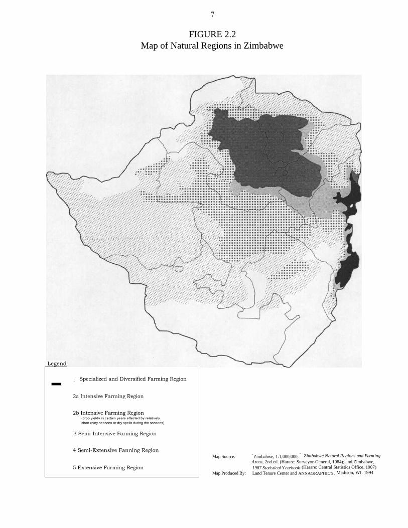
2.1.2 NATURAL REGIONS
The concept and delineation of natural regions in Zimbabwe were first put to use inthe work of Vincent, Thomas, and Staples (1962) starting in the early 1950s. This classicalwork demarcated natural land-use regions on the basis of climate, soil, and topography;assessed arable and nonarable landholdings by sector; and evaluated current and potentialland-use practices within each natural region.
Zimbabwe is divided into five natural regions (NR) on the basis of soil type, rainfall,and other climatic factors (figure 2.2):
NR I. Specialized and diversified farming: 700,000 hectares; rainfall is relatively highwith more than 1,000 millimeters per annum in areas lying below 1,700 meters andmore than 900 millimeters per annum at greater altitudes; normally some precipitationis received in all months of the year. Relatively low temperatures and high rainfallenable forestation, fruit, and intensive livestock production. In frost-free areas,plantation crops such as tea, coffee, and macadamia nuts are possible.
NR II. Intensive farming: 5,860,000 hectares; rainfall is moderately high (750-1,000mm), but is confined to the summer months. Two subregions have been defined.Subregion IIA receives an average of at least 18 rainy pentads per season and isnormally reliable, rarely experiencing severe dry spells in summer. 2 The region issuitable for intensive crop or livestock farming systems. Subregion IIB receives anaverage of 16-18 pentads per season, but is subject to severe dry spells during therainy season or to relatively short rainy seasons. Crop yields are affected in certainyears, but not frequently enough to justify shifting cropping practices away fromintensive farming systems.
NR III. Semi-intensive farming: 7,290,000 hectares; precipitation is moderate(650-800 mm), but its effectiveness is limited by severe midseason dry spells and hightemperatures. Growing conditions are marginal for maize, tobacco, and cottonproduction or for enterprises based on crop production alone. Farming systems aresuited to livestock production and to fodder crops and cash crops on soils with goodmoisture retention.
NR IV. Semi-extensive farming: 14,780,000 hectares; rainfall is relatively low(450-600 mm) and is subject to periodic seasonal droughts and severe dry spellsduring the rainy season. Low and uncertain rainfall make cash cropping risky exceptfor drought-resistant crops and soils with better water retention. Farming systems aresuited to livestock production with some intensification possible with drought-resistantfodder crops.
2. A rainy pentad is defined as the center period of three 5-day periods (pentads) which togetherreceive more than 40-mm rainfall, two of which receive at least 8-mm rainfall.

9
NR V. Extensive farming: 10,440,000 hectares; rainfall is too low and erratic forreliable production of even drought-resistant fodder and grain crops. Included in thisregion are areas below 900 meters in altitude, where the mean rainfall is below 650millimeters in the Zambezi Valley and below 600 millimeters in the Sabi-Limpopovalleys. Farming systems based on extensive cattle or game ranching are best suitedto these conditions.
While natural regions now form the basis of land use planning in most governmentministries, data on land use patterns by natural region are available only since 1987, and thenonly for the large-scale commercial sector.
2.1.3 SPATIAL OVERLAP
Despite the widespread use of natural regions in land-use planning, most agriculturaldata, particularly time-series data, are available only at the provincial level. Analysis bynatural region thus requires some knowledge of the proportion of each province in eachecological zone. Unfortunately, such a breakdown proved difficult to locate. One study, bythe Zimbabwe Energy Accounting Office, provides such data, but with slight modifications.It combines regions IIB and III into just one region III, and regions IV and V into just regionIV. While not strictly comparable with AGRITEX plans, it provides a useful construct forevaluating provincial data (table 2.2).
TABLE 2.2
Provincial areas by natural region
NR I NR II NR III NR IV(%) (%) (%) (%)
Manicaland 17.0 5.3 42.4 35.3
Mashonaland Central 42.1 18.2 39.7
Mashonaland East 31.5 40.9 27.6
Mashonaland West 36.9 34.0 29.1
Midlands 64.2 35.8
Masvingo 14.9 85.1
Matabeleland North 6.2 93.8
Matabeleland South 100.0
Source: D.K. Munasirei, "Methodology for the Assessment of Land-Used inZimbabwe" (Harare, n.d.).
10
Ecological diversity is greatest in Manicaland, with widely varying altitude, rainfall,and soils. Yet 64.7 percent of its land mass falls in either NR I, NR II, or NR III. A sizablearea of Mashonaland Central, East, and West also lies in these more productive rainfallzones, that is, 60.3, 72.4, and 70.9 percent, respectively. Conversely, Matabeleland North,Matabeleland South, and Masvingo all have at least 85 percent of their land area in NRs IVand V, which are the most arid and least productive rainfall zones.
2.2 DATA SOURCES
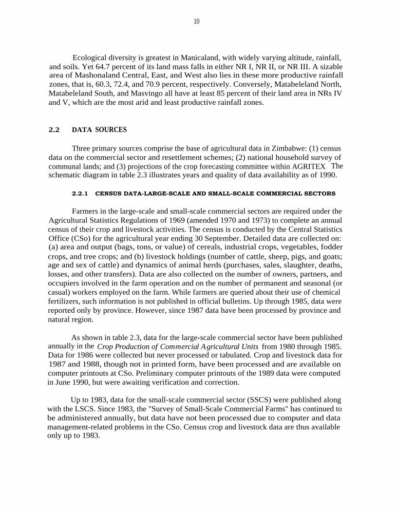
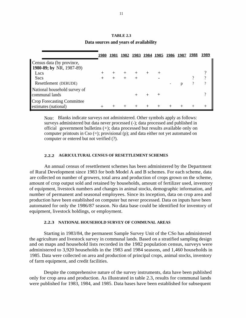
Three primary sources comprise the base of agricultural data in Zimbabwe: (1) censusdata on the commercial sector and resettlement schemes; (2) national household survey ofcommunal lands; and (3) projections of the crop forecasting committee within AGRITEX . Theschematic diagram in table 2.3 illustrates years and quality of data availability as of 1990.
2.2.1 CENSUS DATA-LARGE-SCALE AND SMALL-SCALE COMMERCIAL SECTORS
Farmers in the large-scale and small-scale commercial sectors are required under theAgricultural Statistics Regulations of 1969 (amended 1970 and 1973) to complete an annualcensus of their crop and livestock activities. The census is conducted by the Central StatisticsOffice (CSo) for the agricultural year ending 30 September. Detailed data are collected on:(a) area and output (bags, tons, or value) of cereals, industrial crops, vegetables, foddercrops, and tree crops; and (b) livestock holdings (number of cattle, sheep, pigs, and goats;age and sex of cattle) and dynamics of animal herds (purchases, sales, slaughter, deaths,losses, and other transfers). Data are also collected on the number of owners, partners, andoccupiers involved in the farm operation and on the number of permanent and seasonal (orcasual) workers employed on the farm. While farmers are queried about their use of chemicalfertilizers, such information is not published in official bulletins. Up through 1985, data werereported only by province. However, since 1987 data have been processed by province andnatural region.
As shown in table 2.3, data for the large-scale commercial sector have been publishedannually in the Crop Production of Commercial Agricultural Units from 1980 through 1985.Data for 1986 were collected but never processed or tabulated. Crop and livestock data for1987 and 1988, though not in printed form, have been processed and are available oncomputer printouts at CSo. Preliminary computer printouts of the 1989 data were computedin June 1990, but were awaiting verification and correction.
Up to 1983, data for the small-scale commercial sector (SSCS) were published alongwith the LSCS. Since 1983, the "Survey of Small-Scale Commercial Farms" has continued tobe administered annually, but data have not been processed due to computer and datamanagement-related problems in the CSo. Census crop and livestock data are thus availableonly up to 1983.
11
TABLE 2.3
Data sources and years of availability
1980 1981 1982 1983 1984 1985 1986 1987 1988 1989
Census data (by province,1980-89; by NR, 1987-89)
Lscs + + + + + + ?Sscs + + + + - ? ?Resettlement (DERUDE) - p ? ?
National household survey ofcommunal lands + + + ?
Crop Forecasting Committeeestimates (national) + + + + + + + + + +
Note: Blanks indicate surveys not administered. Other symbols apply as follows:surveys administered but data never processed (-); data processed and published inofficial government bulletins (+); data processed but results available only oncomputer printouts in Cso (=); provisional (p); and data either not yet automated oncomputer or entered but not verified (?).
2.2.2 AGRICULTURAL CENSUS OF RESETTLEMENT SCHEMES
An annual census of resettlement schemes has been administered by the Departmentof Rural Development since 1983 for both Model A and B schemes. For each scheme, dataare collected on number of growers, total area and production of crops grown on the scheme,amount of crop output sold and retained by households, amount of fertilizer used, inventoryof equipment, livestock numbers and changes in animal stocks, demographic information, andnumber of permanent and seasonal employees. Since its inception, data on crop area andproduction have been established on computer but never processed. Data on inputs have beenautomated for only the 1986/87 season. No data base could be identified for inventory ofequipment, livestock holdings, or employment.
2.2.3 NATIONAL HOUSEHOLD SURVEY OF COMMUNAL AREAS
Starting in 1983/84, the permanent Sample Survey Unit of the CSo has administeredthe agriculture and livestock survey in communal lands. Based on a stratified sampling designand on maps and household lists recorded in the 1982 population census, surveys wereadministered to 3,920 households in the 1983 and 1984 seasons, and 1,460 households in1985. Data were collected on area and production of principal crops, animal stocks, inventoryof farm equipment, and credit facilities.
Despite the comprehensive nature of the survey instruments, data have been publishedonly for crop area and production. As illustrated in table 2.3, results for communal landswere published for 1983, 1984, and 1985. Data bases have been established for subsequent

12
years, but constraints on data processing have prevented analysis. Published data are reportedonly by province.
2.2.4 CROP FORECASTING COMMITTEE ESTIMATES
Annual estimates of crop area and production are also made by the Crop ForecastingCommittee of the CSo, derived from AGRITEX field worker estimates. Forecasts are made forthe LSCS, SSCS, communal, and resettlement sectors at the national level. Because data aresummed upward from district-level measurement, breakdowns by province and natural regionare theoretically possible. For example, the MLARR (Will Masters, personal conversations)has disaggregated district-level data on crop area for communal areas into natural regions byapproximating on maps the proportion of a district lying in a natural region and by assumingthat crops are evenly distributed among natural regions within that district. While thisapproach enables a rough calculation of crop area, large potential errors are possible whendisaggregating production data since yields are strongly influenced by rainfall across naturalregions.
2.3 SUMMARY
The above analysis points out several problems with data that have importantimplications for a regional analysis of land use by sector. First, only for the LSCS are regionaldata on crop area and production reasonably current and complete. Published data for theSSCS, the communal areas, and the resettlement schemes are either out of date, incomplete,or have never been analyzed or published. Second, compared with many African countrieswhich underinvest in primary data collection, the annual surveys employed in Zimbabwe arequite thorough and comprehensive across sectors. The principal problem is that data arecollected but not processed in a timely manner due to an underinvestment in computer-processing capacity and public dissemination.

13
Chapter 3
AGRARIAN STRUCTURE
3.1 HISTORICAL CHANGES IN THE AGRARIAN STRUCTURE3
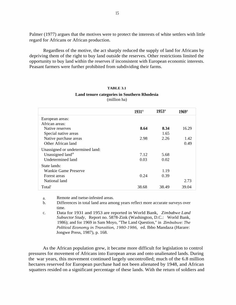
The land problem in Zimbabwe fundamentally derives from the patterns whichoriginated in the colonial era. This chapter briefly examines the history of land administrationfrom the early 1900s to present and shows that despite the substantial land redistribution thathas already taken place, Zimbabwe's agrarian structure still remains highly skewed. Farmsin the large farm sector have land in the best rainfall zones, while the majority of the ruralpopulation in communal areas farm the most arid lands.
One of the legacies of European settlement in Zimbabwe is a highly unequal landdistribution. The land problem stems from the British South Africa Company's (BSAC) moveinto southern Zimbabwe in 1890 for gold and mineral exploration. After prospects for goldfaded, the company, led by Cecil Rhodes, turned to using land as payment to soldiers andlater for sales to white settlers for profit. By 1894, most of the Matabeleland lands with heavyred and black loamy soils had been granted as concessions to both individuals and companies.By 1906, one-sixth of the country, including the majority of prime agricultural land, had beenallocated to settlers (World Bank 1986). Native commissioners were entrusted withdemarcating land for the indigenous African inhabitants. 4 But the fertile highlands werelargely reserved for the Europeans.
In 1901, based on very rough estimates, Zimbabwe's total population was 712,600,including about 700,000 Africans and 12,600 Europeans, Asians, and "coloureds" (CSo1985). 5 Land set aside for Africans in reserves amounted to about 8.4 million hectares, withthe remaining 32 million hectares being allocated for purchase by Europeans. Africans couldalso purchase land, but were generally unable to do so due to high land prices and lowpurchasing power. Spurred by settlers' growing demand for land, the company graduallyshifted its focus to land dealings for profit, leading in 1908 to the Colonial Secretary
3. This section draws heavily on the World Bank (1986, pp. 1-12).
4. "Africans" as used during the colonial era shall also be used here to designate indigenous or"non-European" Zimbabweans, for lack of a more precise and inoffensive alternative. This is in noway intended to imply that Zimbabweans of European ancestry may not be considered "African" aswell.
5. The term "coloured" came to be used as part of the colonial state's racial classification systemand refers largely to persons having historically bi- or multiracial ancestry.

14
approving reserve boundaries, and to the BSAC opening an Estates Department to promoteEuropean settlement.
Growing demand for land for European settlement and the spillover of Africans outof the reserves into unalienated areas and onto European land eventually led to theappointment of the Southern Rhodesia Native Reserve Commission by the British governmentin 1914. It was not until 1920, however, that the commission's recommendations werefinalized in an Order-in-Council. This order made a "final disposition" allocating about 8.7million hectares for tribal reserves for the roughly 1.1 million Africans. The settlers by thistime had increased in number and power and the forces that ultimately led to separation hadbegun to mount. To help preserve its dwindling power, the BSAC felt compelled in turn togrant more concessions to meet growing settler demands.
Rhodesia attained self-government in 1923. According to its constitution, allunalienated land belonged to the state. Authority over the reserves (8.7 million ha) was vestedin the British High Commissioner. The "Cape Clause," which since 1894 had theoreticallypermitted Africans to purchase land, continued in effect, albeit to the agitation of the settlers.By 1925, only 19 farms comprising 19,000 hectares had been sold to Africans. Accordingto the settlers, this was evidence that Africans preferred living on reserves and were notinclined to want individualized land rights.
The Morris-Carter Land Commission in 1925 was charged with examining thedesirability of defining separate areas for use and occupation by Africans and Europeans. Itrecommended that the "Cape Clause" be repealed, and that specific areas of the colony beset aside in which Africans alone could purchase and hold freehold title to land. Thecommission's recommendations were later embodied in the Land Apportionment Act of 1930,which partitioned all lands in the colony into European and African reserves. This set aside6.8 million hectares as reserves for European purchase and some 3.0 million hectares asAfrican freehold, called native purchase areas (table 3.1), that is, areas where Africans couldpurchase freehold farms of between 30 and 300 acres from the crown. Earlier, the "CapeClause" in the original Order-in-Council creating Southern Rhodesia in 1898 had recognizedthe right of Africans to hold and dispose of land on the same conditions as non-Africans, butonly small amounts had been purchased. Now future land purchases by blacks were placedon a geographically segregated basis.
This legal segregation within the freehold sector persisted until the Land Tenure(Amendment) Act of 1977 removed racial restrictions on the ownership of freehold land.Legally, the two freehold sectors became one at this point in time. Structurally, however, thedualism remains both in racial patterns of ownership and in the disparate farm sizes. Theunderlying motivations for this partitioning are not entirely clear. According to Cheater(1984), the purchase areas were intended to reserve some land for Africans before all landwas purchased by whites. Weinrich (1975) claims that the apportionment was intended toprevent progressive and wealthy African farmers from opening up farms in predominantlyEuropean areas, but also that there was a genuine interest in assisting progressive peasants.
15
Palmer (1977) argues that the motives were to protect the interests of white settlers with littleregard for Africans or African production.
Regardless of the motive, the act sharply reduced the supply of land for Africans bydepriving them of the right to buy land outside the reserves. Other restrictions limited theopportunity to buy land within the reserves if inconsistent with European economic interests.Peasant farmers were further prohibited from subdividing their farms.
TABLE 3.1
Land tenure categories in Southern Rhodesia(million ha)
1931° 1953° 1969°
European areas:African areas:
Native reserves 8.64 8.34 16.29Special native areas 1.65Native purchase areas 2.98 2.26 1.42Other African land 0.49
Unassigned or undetermined land:Unassigned landa 7.12 5.68Undetermined land 0.03 0.02
State lands:Wankie Game Preserve 1.19Forest areas 0.24 0.39National land 2.73
Total' 38.68 38.49 39.04
Remote and tsetse-infested areas.Differences in total land area among years reflect more accurate surveys overtime.
c. Data for 1931 and 1953 are reported in World Bank, Zimbabwe LandSubsector Study, Report no. 5878-Zink (Washington, D.C.: World Bank,1986); and for 1969 in Sam Moyo, "The Land Question," in Zimbabwe: ThePolitical Economy in Transition, 1980-1986, ed. Ibbo Mandaza (Harare:Jongwe Press, 1987), p. 168.
As the African population grew, it became more difficult for legislation to controlpressures for movement of Africans into European areas and onto unalienated lands. Duringthe war years, this movement continued largely uncontrolled; much of the 6.8 millionhectares reserved for European purchase had not been alienated by 1948, and Africansquatters resided on a significant percentage of these lands. With the return of soldiers and
a.b.

16
returned. Attempts to resettle squatters, some onto reserves, resulted in unrest and violence.A special committee appointed in 1948 to examine the African need for additional landgradually added to the reserves mainly by reallocating land from the unassigned and purchaseareas, as did subsequent committees. The new reserves, called Special Native Reserves, wereno different than the earlier reserves with regard to land rights. With the new reserves pluspurchase areas, the African areas increased from 11.62 million hectares in 1931 to 12.3million hectares in 1953. State lands grew with the establishment of the Wankie GameReserve, decreasing unassigned lands from 7.2 to 5.7 million hectares.
Prior to colonization, land was plentiful and labor was the scarce factor of production.By the 1940s, however, with the alienation of land to white settlers, the introduction of theoxen plow, and rapid population growth due to improved medical services, land became themore limiting factor in communal areas (Mansell and Johnson 1966; Weinrich 1975).Population data prior to the 1982 census are very imprecise. Based on crude estimates,population densities in African areas grew steadily from 8.3 persons/km2 in 1901 (8.4 millionha), to 12.1 persons/km 2 by 1931 (11.62 million ha), and to 16.6 persons/km 2 (18.2 millionha) by 1969. 6 "As the African population grew and could obtain no new land outside the .. .fixed tribal boundaries, shifting cultivation became impossible [and fertility declined]"(Weinrich 1975, p. 67). Today, most communal areas are heavily populated and experiencingecological degradation (Cheater 1984).
Establishing the purchase areas also proved to be difficult. Most land suited forfarming had already been alienated. Approximately 1.6 million hectares were ultimatelydesignated, but in remote areas of the northern and southern parts of the country which werepoorly suited for agricultural development due to harsh ecological conditions (Weinrich 1975;Whitlow 1988).
Compared with the overcrowded African reserves, however, the purchase lands werelocated in higher rainfall zones, and strict criteria in selecting settlers resulted in a moreprogressive farmer. Following World War II, the government adopted increasingly strictrequirements for settler applicants as the demand for freehold in purchase areas intensified.Weinrich (1975, p. 145) notes that "[u]ntil 1952, only some agricultural knowledge wasrequired [to obtain freehold in the purchase areas]. In 1953, the master [farmer] certificatebecame a prerequisite. By 1957, applicants had to possess, in addition, capital assets in cashor kind to the value of £300. By the 1960s, a points system was introduced by which .. .points were given for capital equipment, agricultural experience, [and] proved character ofthe applicant." These requirements ensured that settlers in newer purchase areas were moreskilled and better financed than farmers in older purchase areas or in communal areas.
6. According to the Cso (1985, p. 10), the African population was 700.0 thousand in 1901 and1.41 million in 1931. Since some unknown, but probably small, number of Africans lived in citieswhile others lived as permanent workers on European commercial farms, densities based on theseapproximates are somewhat overestimated. In 1969, the population of district councils, which consistof both communal lands and the Sscs, was 3.02 million, based on a land area of 169,556 km2 and17.8 persons/km2 reported by the Cso (1985, p. 47).

17
the applicant." These requirements ensured that settlers in newer purchase areas were moreskilled and better financed than farmers in older purchase areas or in communal areas.
Responsibility for managing the native reserves was transferred to the tribal authoritiesin the Tribal Trust Land Act of 1967, and later reconfirmed in the Land Tenure Act of 1969.The 1969 Constitution of Rhodesia fixed these tribal trust lands, previously native reserves,at about 18.2 million hectares, set all European land at 18.1 million hectares, and reserved2.7 million hectares as national land. Of the 6.3-million-hectare increase in African reserves,0.8 million hectares were taken from former African purchase areas and 5.5 million hectaresfrom previously unassigned land.
Numerous laws were passed in the decade before independence. The Tribal Trust LandAuthority was replaced by the Tribal Land Development Corporation in 1970. In 1977, the1941 Land Apportionment Act was amended once more to allow Africans to purchase landin the European areas. In 1979, the Tribal Trust Land Act was amended and all reservesbecame the responsibility of the president. In the same year, the Rural Land Act provided thelegal basis for resettlement schemes.
3.2 LAND CLASSIFICATION BY FARM CATEGORY AND REGION
After independence in 1980, land categories in the previous land acts have beenredefined: the LSCS contains the lands formerly held by Europeans; the SSCS contains thoselands formerly classified as Native Purchase Areas; the communal areas contain those landsformerly held by Africans in the reserves; the resettlement areas are those lands acquired andredistributed to smallholders under state-sponsored resettlement schemes since 1980; andpublic lands contain the former parks, preserves, and unassigned lands. Data in table 3.2indicate landholdings by each of these tenure categories by natural region drawn from varioussources.
The column labeled "other" is the difference between the sum of land areas acrosstenure categories and total land area. The total area of other land—1,494.8 thousandhectares—seems reasonably accurate. It comprises the 198,082 hectares of inactive farms inthe LSCS, approximately 200,000 hectares for urban areas, and another 900,000 hectares forforest areas (Chavunduka 1982, p. 63), leaving only 196,000 hectares truly unaccounted foras other. Yet, regional breakdowns illustrate a problem. Despite careful accounting and fairlystrong sources of regional data for the LSCS, SSCS, and communal sectors, total area acrosstenure categories exceeds total land availability for NR III by 319.6 thousand hectares. Unlikeprovinces, which form a well-defined administrative boundary for data collection, lines fornatural regions are more diffuse and less clearly delineated for data collection in practice.Weak data on the regional distribution of land in parks, wildlife sanctuaries, and forestsfurther exacerbate accurate accounting of the land area.

TABLE 3.2Land distribution by farm sector and natural region, 1988
(000 ha)
LARGE-SCALE SMALL-SCALE - - - -NATURAL COMMUNAL AREAS ' COMMERCIAL COMMERCIAL RESETTLEMENT STATE FARMS` WILDLIFE AREAS PARKS ANDY TOTAL AREA'
REGION FARMS' FARMS` AREASd OTHER
(ha) (%) (ha) (%) (ha) (%) (ha) (%) (ha) (%) (ha) (%) (ha) (%) (ha) (%)
I 135.0 0.8 202.2 1.8 7.3 0.6 30.0 0.9 10.0 2.0 50.1 1.0 265.4 17.8 700.0 1.8
II 1,270.0 7.8 3,687.0 32.8 222.2 17.9 590.0 17.9 10.0 2.0 25.0 0.5 55.8 3.7 5,860.0 15.0III 2,820.0 17.2 2,405.4 21.5 438.3 35.4 1,240.0 37.8 160.0 32.0 545.9 11.0 -319.6 -21.4 7,290.0 18.7
IV 7,340.0 44.9 2,429.1 21.7 473.3 38.2 810.0 24.6 60.0 12.0 2,514.1 50.3 1,153.5 77.2 14,780.0 37.8V 4,790.0 29.3 2,489.7 22.2 97.6 7.9 620.0 18.8 260.0 52.0 1,843.0 37.2 339.7 22.7 10,440.0 26.7
Total 16,355.0 11,213.4 1,238.7 3,290.0 500.0 4,978.1 1,494.8 39,070.0
a. Adapted from G.L. Chavunduka, Report of the Commission of Inquiry into the Agricultural Industry (Harare: Government Printer,I982); and 1987 Statistical Yearbook (Harare: Central Statistics Office, 1987).
b. Cso data as of 30 September 1988; excludes I98,082 ha of farms that are inactive.c. Based on data by natural regions in Dan Weiner et al., "Land Use and Agricultural Productivity in Zimbabwe," Journal of
Modern African Studies 23 (I985), p. 259, less areas acquired for resettlement-Vuti (29,856 ha, NR II), Chenjiri (56,871 ha,NR III), Copper Queen (40,958 ha, NR III; 48,342 ha, NR IV), and Mshawasha (I,38I ha, NR IV). The total area includesapproximately 230,000 ha not yet settled (MLARR).
d. Figures include 2,743.3 ha acquired for resettlement from I979/80 to I988/89 plus 543.7 from former state land (MLARR).
e. ARDA estates held 498,535 ha in I988/89 (ARDA Planning Unit).f. Adapted from Chavunduka (I982) and Annex A.g. Difference between sum of land across tenure categories and total land area.h. From 1987 Statistical Yearbook (p. 14I).i. Percentages are of column totals.

19
3.2.1 COMMUNAL AREAS
Previously referred to as native and special native reserves or as tribal trust lands, thecommunal areas in 1988 accounted for 16.4 million hectares or 41.9 percent of the land areain Zimbabwe. Of this total, 74.2 percent of the land is located in the poorest rainfall zonesof NRs IV and V. The total population in 1988 was roughly 5.1 million persons and1,020,400 households, representing a population density of about 31.1 persons/km 2.'
The communal areas farming system involves rain-fed and ox-plow cultivation focusedheavily on maize production at—until quite recently—very modest levels of productivity.Differences in sizes of landholdings are modest within the communal areas, reflecting for themost part differences in the ability of households to place land under cultivation due toconstraints on ownership of plow oxen and household labor. Roughly half the householdshave 1-5 hectares, while another 40 percent have 6-10+ hectares. Estimates of landlessnessrange between 6 and 12 percent of households (Cliffe 1986, p. 34; Bratton 1990).
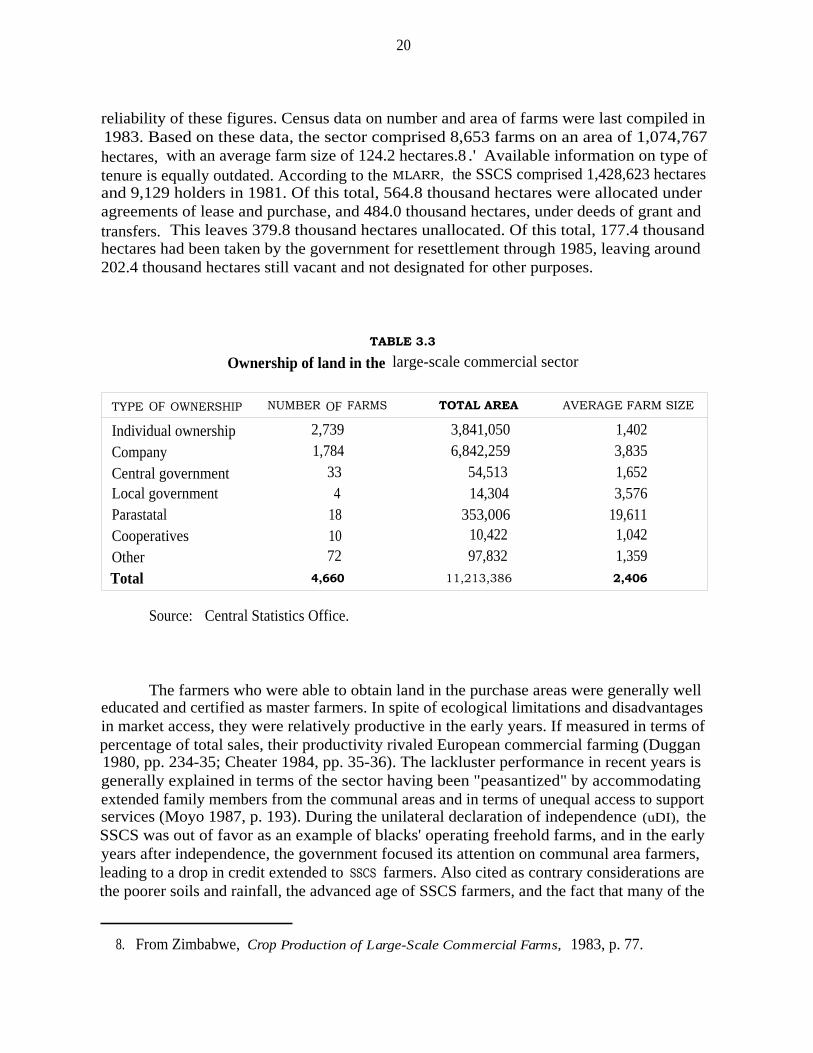
3.2.2 LARGE-SCALE COMMERCIAL SECTOR
Formerly the European areas, this sector comprised 4,660 large commercial farms and11.2 million hectares (28.7% of the land area) in 1988. Most of these farms are still ownedby Zimbabweans of European ancestry, though ownership is obscured by the high levels ofcorporate ownership of farms (61 %) and by the recent influx of black farmers buying landin the sector (estimated to be between 400 and 450). In 1988, the sector employed 227.6thousand permanent and casual workers. Based on the population in rural councils of 1,571.3thousand in 1982 and a 3.0 percent growth rate, 1,876.2 thousand people resided in the sectorin 1988. Owners have full title to the land as governed by the Roman-Dutch law of the CapeColony in 1891, as amended. Farmers are represented by the Commercial Farmers Union.Company ownership represents the most common form of management by area (61.0%),followed by individual ownership (34.3%) (table 3.3). Government, parastatals, cooperatives,and the other categories make up the remaining 4.7 percent. Average farm size is 2,406hectares nationwide; individual farms average 1,402 hectares/farm; companies, 3,835hectares/farm; and parastatals, 19,611 hectares/farm. Farms in the LsCS are also located onthe best agricultural lands. As indicated in table 3.2, 34.6 percent of land in the sector islocated in NRs I and II, 21.5 percent in NR III, and 43.9 percent in NRs IV and V.
3.2.3 SMALL-SCALE COMMERCIAL SECTOR
Formerly called the purchase areas, the SSCS encompasses 1,238.7 thousand hectaresscattered over numerous sites, mainly in NRs III (35.4%) and IV (38.2%). However, the lackof consistent estimates on area and number of farms raises important questions about the
7. The 1988 population is roughly estimated to be 5,102,000 persons, based on populationestimates of 4,272,811 in district councils (communal lands and Sscs) in 1982 and a populationgrowth rate of 3.0% (Cso 1985, pp. 11, 47). Number of households is calculated as 1988 estimatedpopulation divided by an average family size of 5.0 members per household (Cso 1989).
20
reliability of these figures. Census data on number and area of farms were last compiled in1983. Based on these data, the sector comprised 8,653 farms on an area of 1,074,767hectares, with an average farm size of 124.2 hectares.8 .' Available information on type oftenure is equally outdated. According to the MLARR, the SSCS comprised 1,428,623 hectaresand 9,129 holders in 1981. Of this total, 564.8 thousand hectares were allocated underagreements of lease and purchase, and 484.0 thousand hectares, under deeds of grant andtransfers. This leaves 379.8 thousand hectares unallocated. Of this total, 177.4 thousandhectares had been taken by the government for resettlement through 1985, leaving around202.4 thousand hectares still vacant and not designated for other purposes.
TABLE 3.3
Ownership of land in the large-scale commercial sector
TYPE OF OWNERSHIP NUMBER OF FARMS TOTAL AREA AVERAGE FARM SIZE
Individual ownership 2,739 3,841,050 1,402
Company 1,784 6,842,259 3,835
Central government 33 54,513 1,652Local government 4 14,304 3,576Parastatal 18 353,006 19,611Cooperatives 10 10,422 1,042
Other 72 97,832 1,359
Total 4,660 11,213,386 2,406
Source: Central Statistics Office.
The farmers who were able to obtain land in the purchase areas were generally welleducated and certified as master farmers. In spite of ecological limitations and disadvantagesin market access, they were relatively productive in the early years. If measured in terms ofpercentage of total sales, their productivity rivaled European commercial farming (Duggan1980, pp. 234-35; Cheater 1984, pp. 35-36). The lackluster performance in recent years isgenerally explained in terms of the sector having been "peasantized" by accommodatingextended family members from the communal areas and in terms of unequal access to supportservices (Moyo 1987, p. 193). During the unilateral declaration of independence (uDI), theSSCS was out of favor as an example of blacks' operating freehold farms, and in the earlyyears after independence, the government focused its attention on communal area farmers,leading to a drop in credit extended to SSCS farmers. Also cited as contrary considerations arethe poorer soils and rainfall, the advanced age of SSCS farmers, and the fact that many of the
8. From Zimbabwe, Crop Production of Large-Scale Commercial Farms, 1983, p. 77.

21
children, having received better educations, moved into the civil service and other productivesectors.
3.2.4 RESETTLEMENT9
Following independence, the resettlement program became the government's mainpolicy instrument to redress inequities in land distribution. Initiated in 1980 at the LancasterHouse talks which culminated in Zimbabwe independence, the resettlement program wasinitially planned to relocate, over 3 years, 18,000 families on about 1.2 million hectares ofland previously owned by European farmers at a cost of US$60 million. In 1982, however,the target for number of settlers was raised in the Transitional National Development Planto 162,000 families on 10 million hectares of land with capital costs of over $500 million(Cusworth and Walker 1988; MLRRD 1985, p. 2). The target of 162,000 families still holdsto this day, though the appropriate land area remains a widely debated issue.
The Lancaster House Constitution further required that the government acquire landfor the resettlement program on a willing buyer-willing seller basis, through April 1990 whenthe Constitution terminated. The Land Acquisition Act of 1985 both broadened the powersof government in land acquisition and increased the government's access to information onland coming to market. The provision of willing buyer-willing seller was maintained in thisact. But the seller of any private rural land is required first to notify the government ofhis/her "offer" or asking price, giving the minister the right of first refusal to buy the land.Provisions were also spelled out giving government more power in price negotiation.
The progress made in land acquisition and resettlement has been substantial.According to MLARR data, the government acquired 3,248.0 thousand hectares of land at atotal cost of Z$68,903.4 million (table 3.4) between 1980 and 1989. Of this area, 612,534hectares were taken from state land, and 2,635,484 hectares, through purchases in the LSCS.Provincial data on number of schemes, area settled, and number of settlers are given inAnnex C. Of the land acquired, 19 percent is in NR I, 18 percent in NR II, 38 percent inNR III, 25 percent in NR IV, and 19 percent in NR V. All but 230,000 hectares have beensettled. Of the land so far unsettled, 176,000 hectares are located in Matabeleland South,where the security situation delayed work (data provided by MLARR).
Through the course of the resettlement program, 53,968 families have been settled,with room for an estimated 7,000 more families. Of those relocated through July 1989,42,494 families have been settled on family holdings with access to grazing commons (ModelA and accelerated schemes), 6,504 on cooperative production schemes (model B), 508 onindividual holdings associated with core estates run by ARDA, which administers the statefarms, or managed cooperatively (model C), and 4,462 on model D grazing schemes. Per-person cost differs substantially by scheme type: for model A, it is $140/person includingdependents; for model B, $325/person; and for model C, $410/person (MLARR 1988, p. 7).
9. This section draws heavily on Cusworth and Walker (1988) and Kinsey (1982).

22
TABLE 3.4
Provincial distribution of land acquired for resettlement
AREA
(ha)COST
(Z$)
NOMINAL
COST(Z$/ha)
REAL
COST/HA
(Z$/ha)
Acquisition by province to 1989):Manicaland 568,719 14,431,177 25.37Mashonaland Central 402,522 4,256,568 10.57Mashonaland East 240,530 8,489,930 35.30 n.a.Mashonaland West 434,619 11,415,985 26.27Masvingo 408,104 7,309,233 17.91Matabeleland North 197,409 3,695,535 18.72Matabeleland South 508,433 9,614,174 18.91Midlands 487.682 9.311.447 19.09
Total' 3,248,018 68,524,049 21.10
Resettlement allocation:Model A (normal) 2,453,556 50,122,658 20.43Model A (accelerated) 190,859 2,999,920 15.72Model B 182,142 8,815,927 48.40 n.a.Model C 18,864 4,264,222 226.05Model D 402.597 2.321.322 5.77
Total' 3,248,018 68,524,049 21.10Acquisition by year: a
162,555 3,104,380 19.09 20.121979/801980/81 219,152 3,537,172 16.14 16.141981/82 819,155 15,414,248 18.82 16.631982/83 807,573 21,524,782 26.66 21.291983/84 173,848 4,596,078 26.44 17.161984/85 74,848 3,062,930 40.92 22.101985/86 86,187 3,444,610 39.97 19.901986/87 133,515 3,898,335 29.20 12.711987/88 80,554 2,889,328 35.87 13.891988/89 78.097 7.431.575 95.16 34.29
Total' 2,635,484 68,903,438 26.14
a. Real prices are calculated as nominal prices divided by the consumer priceindex for lower income households in Zimbabwe, Quarterly Digest ofStatistics (Harare: Central Statistics Office, 1989).
b. Difference between area acquired and acquisition/year is due to 504,491 haof state land in provincial totals that were acquired at no cost.
23
3.2.4.1 Model A scheme
A "typical" model A scheme as originally envisaged by the MLARR would have about500 families divided into roughly 15 nucleated villages of 25-50 families, with servicesincluding 3-4 schools and a clinic. Land allocations within a scheme replicate on a largerscale the threefold division in land use found in communal areas (residential, arable,commons). Each family is given a residential stand of 2,500 square meters, an arableallocation of 5-6 hectares, and access to communal pasture sufficient to support a herd fordraft power. Land is occupied on the basis of a number of temporary permits. Grazing isshared communally within village grazing areas, and the number of livestock units (LU)varies according to agroecological zone. For NRs I and II, 4-5 LU are assumed, whichtranslates into 20 hectares of communal grazing per family; for NR III, 8 LU and 56hectares; for NR IV, 10 LU and 80 hectares; and for NR V, 15-20 LU and 150-200 hectares(Cliffe 1986, p. 48; MLRRD 1985, p. 15). The net income target set by planners was$400/family/year (ibid.). A typical scheme includes approximately 245-593 settler familieson 21.7 to 25.5 thousand hectares of land, depending on geographic location and resourcebase (Annex C). Schemes are provided with access roads linking all villages with a RuralService Center, where agricultural extension agents, cooperative and health workers, andresettlement officers are situated. The scheme would ultimately be expected to have a healthcenter and primary school established. The majority of resettlement efforts have focused onthe model A scheme, whether measured by population settled (78.7%, Annex C) or areaallocated (81.4%, table 3.4).
Settler selection standards utilized since the first years of the program required thata settler be "effectively landless," poor, or distressed. Specific criteria include: (a) no landor too little land, (b) not employed, (c) poor, (d) married or widowed with dependents, (e)aged 18 to 55 years and physically fit, (g) returned Zimbabwean refugee, or (h) experiencedand master farmer. Settlers must also be prepared to give up all land and grazing rights inthe communal area of origin and wage employment elsewhere (MLRRD 1985, p. 23). Moyo(1987, p. 193) indicates that slightly over 60 percent of settlers have come from the commu-nal areas. A master list of qualified applicants is maintained, and when a resettlement schemeis implemented and the area becomes ready for occupation, the resettlement officer and therural district council draw a specific list of settlers for the scheme from the master list ofapplicants (MLRRD 1985, p. 23).
The selection criteria have subsequently been criticized on grounds that the landlesslacked the plows and draft oxen necessary to bring their full arable allocations undercultivation, and that individual selection criteria and the mixing of settlers from differentbackgrounds and localities may make it more difficult to develop a sense of community andestablish useful practices such as sharing of draft animals (Kinsey 1982, p. 109; Cliffe 1986,p. 93; Bratton 1990). The Zimbabwe National Farmers Union (1987, p. 9) has called for areordering of priorities to emphasize trained and master farmers, arguing that higherproductivity is being achieved by master farmers in the SSCS and the communal areas thanby resettlement scheme farmers. This call for an emphasis on recruiting experienced farmers

24
as settlers has been recently reiterated in a joint declaration by the presidents of the threefarmers' organizations (Joint Presidents' Agricultural Committee 1990, p. 3).
Perhaps the most difficult settler-selection issue facing government now is that ofdisplaced labor from the large-scale commercial farms which are being taken over, a problemthat will grow as the program increasingly appropriates operating units rather than abandonedfarms. A general sense prevails, based largely on anecdotal evidence, that the displacedemployees are less productive than most settlers, partly because their experience in agricultureis so different from farming in the model A schemes and partly because they do not haveoxen, plows, and other implements necessary to begin cultivation. On the other hand, theycannot simply be expelled. They may find the organization of labor in the model B(cooperative) schemes more familiar, but most will need to be accommodated into themodel A schemes and special attention must be paid to their demands for equipment andcredit.
There are continuing concerns, however, about whether the intensity of land use andproductivity in the model A schemes can justify the replacement of large-scale commercialfarms with this model. The fact that the model is less labor absorptive than much commercialfarming was an early concern of commentators on resettlement such as Kinsey (1982,pp. 105-06). A denser model A design is one solution. Underutilization of land on theresettlements early in the program led to suggestions that holding sizes in resettlements inNRs I and II in particular could be reduced (Cliffe 1986, p. 84). Some commentatorssuggested major remodeling such as 2-hectare mechanized holdings in the highland areas(Bratton 1990). Now the ministry is concerned that 27 percent of families on the model Aschemes are significantly exceeding the recommended rotational fallowing requirements, andthat an estimated 43 percent of the total area is getting between one-half the recommendedfallow and no fallow at all (data provided by MLARR). If holdings are to be reduced in futuremodels A, it would be from grazing allowances, where underutilization still exists, or fromboth arable and pasture areas, if mechanical draft is available.
3.2.4.2 Accelerated model A scheme
Whereas in the normal model A scheme substantial infrastructure is provided prior tosettlement, settlers in the accelerated scheme are provided with only limited installations. Themodel is most appropriate in situations: (1) where severe squatting and overpopulation havealready resulted in settlement of land, (2) when resettlement of large numbers of people ina short time frame is advisable, (3) when budget resources for development are limited, and(4) where acquired commercial farms are small and geographically dispersed (Kinsey 1982).Nearly 6 percent of the resettlement program area has been settled under this model (table3.4). Average scheme size is smaller than the model A schemes (7,235 ha), but varies widelyfrom an average of 1,620 hectares in Mashonaland to 15,618 hectares in Matabeleland(Annex C).

25
3.2.4.3 Model B scheme
The model B scheme is based on communal living and a cooperative mode of farming.Livestock may be privately owned, but all other property, including land and equipment, areowned cooperatively. Profits are shared according to a formula devised by settlers. The modelis intended to enable those with limited resources to participate in viable agriculturalactivities. The model B was intended to be the centerpiece of the government's policy ofachieving a socialist transformation of agriculture, while model A schemes were expectedeventually to become collectives (Cusworth and Walker 1988). However, by 1989, less than6 percent of the land area had been resettled using model B (table 3.4).
The properties selected for this model tend to be single, former commercial, farmunits with well-developed infrastructure, such as irrigation or processing facilities, still intact.The ministry's target size for the cooperatives has been in the range of 50-200 members. Alladults are full members, including wives and children of 16 years of age. Property,resources, and equipment plus livestock are held collectively. While in the early days of thescheme stock in the commercial herd is to be individually owned, stock ownership issupposed to shift to cooperative ownership once the group becomes established. The livestockholdings are 20 LU per settler family, including small stock. Cultivation is carried outcollectively and, together with management, purchasing, and marketing, is controlled bycooperative committees. It is possible for members to be allocated small plots of up to 0.5hectare for individual cultivation (MLRRD 1985, pp. 15-16, 21).
Cliffe (1986, pp. 51, 53) notes considerable demand, with 200 registered cooperativesocieties that have put themselves forward to receive land under the model B scheme.Memberships appear to have been somewhat smaller than planned. As of July 1989, 6,504settlers had been resettled on 82 schemes encompassing 182,142 hectares. Actual schemesaveraged 1,163-3,166 ha/scheme and 17-90 settlers/scheme, depending on the province(Annex C).
The performance of the model B schemes has been disappointing. Cliffe (1986) notessome exceptional success stories which suggest that productivity growth is possible, but thegeneral picture is not encouraging. Only a small proportion of the available land has beencultivated, and the irrigation and other infrastructure have not always been maintained (Cliffe1986, p. 51). A 1988 evaluation found that overall farm use was less than one-quarter ofpotential. Problems have also been experienced with the supply of tractors and inputs andwith members, less than a quarter of whom had management training and even fewer hadrelevant agricultural skills (MLARR 1988, p. ii). The indebtedness of the model B cooperativesis also alarming. At the end of FY 1987/88, outstanding loans through the AgriculturalFinance Corporation (AFC) to model B cooperatives stood at Z$2.25 million, of which $1.5million was in arrears. The MLARR estimates that up to $1 million may be irrecoverable. Thepoor performance has been attributed to several factors, including lack of working capital,poor technical skills, and problems of organization and management. There have also beendifficulties with obtaining assistance for the cooperatives from major donors, so that mosthave had to be supported through a combination of Government of Zimbabwe funding and
26
assistance from a variety of NGOS. Many co-ops have not received their establishment grantsin a timely fashion (Moyo 1987, p. 193).
A number of suggestions have been put forward to improve the performance of themodel B schemes. Cliffe (1986, p. 94) saw two choices: either retreat to a limited program,with a restricted number of schemes and carefully selected members, possibly from formercommercial farm laborers; or resolve to invest much more in inputs and resources andprovide trained management for the cooperatives. The 1988 report by MLARR's Monitoringand Evaluation Unit (MLARR 1988) has one set of recommendations for established schemes,another for new ones. For established programs, it suggests that since many are unlikely tobe able to make full use of their land resources in the near future, they should be replannedin light of the capabilities of the membership, with training and advisors provided as needed.If the scheme is near a model A scheme, surplus land would be allocated for smallholder use.If isolated, the land could be subdivided or a surplus made available for a new group to beproperly established. Indebtedness of over a third of these schemes is so high that it isunrealistic to expect any repayment, and a minimum loss of $1 million is to be expected. Fornew schemes, the report recommends that farms be assigned only to cooperatives whosemembers have already received the necessary training; that the cooperative not be allowedto move to the farm until the establishment grant has been received; that memberships be keptsmall (around 50 members) to minimize management problems; and that the prepared farmplan be based on that membership and not on settler projections (MLARR 1988: iii).
Zimbabwe's experience with the cooperative production model has been fairly typicalof experiments carried out in Ethiopia, Tanzania, and Mozambique (Bruce 1989, pp. 3-8;1990b, pp. 3-6). Countries which built their agriculture around this model, such as China,are now abandoning it for smallholder cultivation, with very positive impacts on productivity(Bruce and Harrell 1989, pp. 5-9).
3.2.4.4 Model C scheme
The model C scheme is patterned after the "nucleus estate." A core estate providesproduction and marketing services, and settlers are outgrowers. As in model A, individualsare allocated parcels of arable land, and grazing land is communally managed. Profits fromprivate plots are retained by the occupiers. Estate management is provided by a professionalmanager who is responsible for organizing and coordinating production and marketingactivities. Such schemes were introduced to involve smallholders in such enterprises astobacco and dairy production which require considerable vertical integration of productionand marketing activities, high capital investment in central processing facilities (e.g., tobaccobarns, dairy parlors), specialized technical knowledge, intensive management, and substantialeconomies of scale in processing, input distribution, and output marketing. By 1989, this

27
model represented less than 1 percent of the resettlement area. All model C schemes arelocated in Manicaland; the average scheme contains 169 settlers on 4,316 hectares of land. 10
The core estate is run by a cooperative of the settlers, to which all contribute theirlabor, or by the Agricultural and Rural Development Authority (ARDA), which employs itsown labor force but provides essential services such as mechanical draft, inputs, seedreproduction, and processing and marketing facilities for the settlers. Settlers have smallarable holdings of their own, usually smaller than those in a model A scheme, and residentialland and woodlots are allocated to households. Grazing land is communal. The early versionsof this model all involved ARDA core estates. The scheme, however, was criticized ascreating dependency and control relationships with peasants and engendering "kulakisation"through restricted tenant farmer selection (Moyo 1987, p. 196).
The core estate, which is cooperatively managed by outgrowers rather than ARDA,appears for the first time in the 1985 revision of the "Intensive Settlement Policies andProcedures," and is known as the "Zunde (insimu yabantu) concept." It reflects a vision ofmodel C as an evolutionary bridge between the individual holdings of model A and the morefully cooperative paradigm of model B. Most core estates to date are still ARDA-operated, buteven in that case it is envisaged that eventually the core estate (a state farm) will be takenover and operated by a cooperative of the settlers (MLRRD 1985, pp. 2, 16-17).
Not surprisingly, very little has been written about the performance of the model.Only 3 schemes, covering 18,864 hectares and commissioning 510 settlers, all at sites inManicaland (Annex C), had been established through July 1989. To ARDA personnel, thenucleus estate must seem a minor modification of the nucleus operations which it has run forsmallholder irrigation schemes. The tenure arrangements present a genuine conflict ofaspirations between the settlers and the conceived model C. ARDA has used leasehold tenurefashioned from use in older irrigated settlement schemes. This "Memorandum of anAgreement of Lease" is issued under the Agricultural Land Settlement Act (ch. 137) andprovides spaces for a specific duration and for a rental amount. The provisions fortermination by government are very broad (for no reason, by 3 months' notice; or uponinsolvency, death, or detention of the lessee as mentally defective, without prior notice). Nocompensation is payable for improvements. The lessee is little better off in terms of securityof tenure than a model A settler. But SEC. 16 provides that after a certain number of years(to be specified), if the lessee has complied with the terms and conditions of the lease, s/hemay apply to purchase the leased holding. Nothing is said about the criteria for approval ofthe application beyond compliance with the terms of the lease and the expiration of thespecified number of years. If the application is approved, all rental payments are treated asa part of the purchase price.
10. Tobacco schemes, where the core estate provides the management of centralized production,processing, and marketing, coordination of smallholder tobacco production, and provision of extensionadvice and inputs, represent one possibility for applying this model.
28
A number of settlers have sought to take advantage of this provision. On the ARDAcore estate/outgrower scheme in the Lower Sabi, settlers' leases contained options to purchasetheir irrigated holdings after two years. A large number of settlers sought in 1984 to exercisethis option. About ten applications were approved by the scheme and forwarded to ARDA
headquarters. The settlers complained in 1990 that no action had yet been taken. Withouttitle, many proclaimed an unwillingness to invest in their holdings, especially in housing; theyfurther expressed a sense of insecurity since some had been evicted in the past.
In terms of the future of the model C schemes, the core run by a cooperative ofoutgrowers (as opposed to ARDA) has very little potential. The management limitations ofproduction cooperatives are already clear from a number of other contexts. The core estatesin these cases, ARDA state farms for the most part, are complex operations and well beyondthe management capabilities of a cooperative of outgrowers, even if professional managementis provided. If there is a desire to move away from the state farm core/outgrower model, oneway to do so—short of divestiture and full privatization—is to develop a "responsibilitysystem" similar to that devised in China for the 1978-84 breakup of its communes. Parts ofthe enterprise are assigned to subgroups within the collective which become independentaccounting and profit centers. Minimum performance requirements are set, which, whenexceeded, create profit at open market levels. For instance, outgrowers contract to sell thecooperative a specified amount (which the co-op must commit to purchasing) at a specified,below-market price, but production above the contracted level may be sold on the openmarket. Similarly, processing and marketing can be set up as independent cost centers, whichhas some security but must also bear to some extent the costs of mismanagement (Bruce andHarrell 1989, pp. 3-6).
3.2.4.5 Model D scheme
The model D scheme attempts to integrate acquired grazing land into a land use planfor adjoining communities in the communal areas. It has been tried in only one case, yetencompasses 402.6 thousand hectares or 12.4 percent of the total resettlement area. The pilotprogram, established by AGRITEX at Doddieburn-Manyoli, near Gwanda in MatabelelandSouth, is based on a pocket of freehold land acquired by government and is located in themidst of four communal area communities. The communities are to share the grazing inannual rotations, each utilizing the area for one year in four. The year in which relief isprovided to the communities is seen as an opportunity for "internal resettlement" within theterritories of those communities, which are to paddock their own pasture areas. While themodel was designed with arid NRs IV and V in mind, the ministry intends to replicate itmore broadly through DERUDE (MLRRD 1985, pp. 2, 18-19). However, its performance isdifficult to assess because model D consists of only one pilot scheme—and this in an areawhere security problems in the past have hindered development. This scheme comprises26,000 hectares and 4,462 settlers.
The legal arrangements for the existing model D pilot are unclear. Ideally, such arotational scheme involving several communities calls for a contractual arrangement amongthe communities, creating mutual rights and responsibilities. The acquired land might be

29
leased on a long-term basis to the four communities and eventually deeded to them jointly.Where a single communal area community is involved, the acquired grazing land would bestbe simply merged into the community's land, becoming communal land. The minister has theauthority to do this under SEC. 6 of the Communal Lands Act.
3.2.5 THE STATE FARM SECTOR
This sector has its origins in the colonial period, the first state farms having beenestablished as growth points in relatively arid areas, usually involving irrigation. ARDA, aparastatal under the MLARR, administers the state farms. It has absorbed a number ofsmallholder irrigation schemes, such as those in the Sabi Valley, and has more recentlybecome responsible for the management of model C resettlement schemes. The number ofARDA schemes has grown from 9 in 1980, to 18 in 1985, and to 28 in 1989. Some schemesare pure state farms; others, nucleus estates with tenant producers; and still others, agro-industrial estates. The estates are heavily mechanized, capital-intensive operations whichproduce a wide variety of commercial crops, largely for export, among which tea, wheat, andcotton dominate. ARDA has fixed assets of over Z$50 million, an annual revenue of $45million, and earned $20 million in foreign exchange in 1989. It employs a permanent staffof 4,000, of whom 169 work in the headquarters, and 17,000, as casual laborers. Itadministers about 5,000 hectares of land, of which about 5 percent was cropped in 1988/89,roughly the same figure as the LsCS. If estates with livestock production are excluded, theportion of land cropped rises to 30 percent (figures provided by MLARR).
ARDA has been criticized for being too profit-oriented, resisting the application of anew minimum wage, relying too heavily on seasonal labor (rather than providing moremeaningful full-time employment opportunities), and providing poor living conditions for itslabor (Moyo 1987, p. 196). Nonetheless, ARDA is losing money at an alarming rate. Theauthority's deficits increased from $916,000 in 1984, to over $2 million in 1987, and thento over $2.5 million in 1988. In the 1986-88 period, 7-8 of the estates suffered losses eachyear, though, interestingly, they were not the same farms each year. The ministry attributesthe losses to undercapitalization, inflated staffs, and social functions which ARDA is expectedto undertake. Two very different options have been considered for dealing with this problem:(1) a streamlining, involving layoff of part of the labor force and the turning over of someof the unprofitable schemes for resettlement; and (2) expanding operations and land managed,allowing ARDA to absorb currently large overhead costs.
Opinion in the ministry seems to favor the second option because of the difficulty oflaying off staff in conditions of growing unemployment and the desire to maintain this statefarm sector as a safe backup for the LSCS, which is considered potentially unreliable. Thereis also a general sense that there should be state participation in the agricultural industry. Itis difficult to believe that overhead costs would not continue to rise with the expansion of thissector, and that government would only end up with larger deficits from a larger state sector.It would seem preferable, where possible, to deal with the deficits through new infusions ofcapital from the private sector. Government should give serious consideration to establishingjoint ventures with private business to renovate these schemes.

30
3.3 SUMMARY
Since 1979, 2,635.5 thousand hectares, or more than 18 percent of the 1979 land areain the LsCS, have been acquired for resettlement. The original owners received compensation.Many unemployed, squatting, landless, and communal area farmers received land allocations.Since much of the land procured in early stages of the program consisted of abandoned farms,output from resettlement areas has had a net positive impact on national output.
The land acquisition process based on a willing buyer-willing seller approach has alsobrought about the securing of higher quality land—57 percent is located in NRs I, II, and III,equivalent in percentage terms to the LSCS and greatly in excess of the 26 percent figure forcommunal areas. While the acquisition of high quality land needs to be greater to redress theland problem, the achievements of land accumulation on a willing buyer-willing seller basisshould not be discounted. Land acquisition, however, has slowed in recent years. Nearly 83percent of the land was obtained in the initial five years of the program, 1979 to 1983, andonly 17 percent, in the last five years.
Before turning to problems underlying land acquisition, some attention needs to begiven to the criteria used by the government in obtaining land. According to Kinsey (1982)and personal communications with MLARR officials, land is sought that is: (a) capable ofexploitation for agriculture and is near or adjacent to communal areas, particularly those withhigh population pressure; (b) not actively farmed and preferably already offered to thegovernment; (c) in a block large enough to permit economic development of services andinfrastructure; (d) in an area already adequately served with basic infrastructure (e.g., roadsand water); (e) in a region where basic planning information is available to facilitateimplementation; and (f) priced to reflect "fair" market value. Problems of declining levels ofland acquisition have been attributed to various factors, including overly high land prices,inadequate government funds for procurement and development, insufficient allotments fromNRs I and II coming onto the market, and meager sizes of blocks offered for resettlement.All these issues are intertwined with the legal provisions (ch. 4) and the operation of the landmarket in the LSCS (ch. 5).

31
Chapter 4
EVOLUTION OF FORMAL AND INFORMAL LAND LAW
4.1 FREEHOLD TENURE IN THE COMMERCIAL SECTORS
4.1.1 LEGAL ASPECTS
At independence, Zimbabwe inherited both a colonial statute law and a body ofcommon law, court-made, based not on the precedents in English judiciary but on thedecisions interpreting Roman-Dutch law, which the Dutch had introduced into South Africa.The basic law for colonial Zimbabwe was, by the High Commissioner's Proclamation of 10June 1891, also applicable to the Colony of Good Hope in South Africa up to that date,subject to subsequent legislative acts. There was no statutory restatement of the law ofownership of land, and so the Roman-Dutch common law governs the basic rights ofproperty. That law of ownership is in most respects very similar to ownership under Englishlaw. Some of its particularities, such as quit-rent tenure, have been removed by statutes inZimbabwe. In other cases, the difference is a matter more of Roman-Dutch terminology thanof substance, as in the use of the term "hypotec" rather than "mortgage." The Roman-Dutchlaw of ownership is, in fact, simpler than that of England, the former utilizing a simpleconcept of allodial ownership, uncomplicated by the feudal influences which encumberEnglish land law. Ownership under Roman-Dutch law implies a perpetual and heritable rightto use and alienate land. The land could be left by will by both blacks and whites. In casesof intestacy, inheritance in the case of whites is handled under the Intestate Estates Act, butin the case of blacks is governed by the customary law of the deceased.
Recording and proving title to freehold property are handled under the Deed RegistriesAct (CAP 139). All titles granted from crown land were registered at the time of grant, andthe law requires the registration of all subsequent transactions, subdivisions, and inheritances.All freehold land is thus registered, as are leases for ten years or more or for the life of oneof the parties and mortgage deeds. Contrary to the English rule in deed registration, the factof registration is virtually conclusive evidence of good title, and a chain of title need not betraced. The Survey Act required a fixed (rather than general) boundaries system and a highdegree of accuracy in cadastral survey for freehold land. There is a busy private surveyingprofession—the registry in Harare handles 150-250 registrations a day, and the one inBulawayo, 100-120 per day.
Freehold's unfettered transferability has made it attractive collateral for loans, and,in fact, freehold land has served extensively as security in the LSCS and SSCS sectors. TheAFC makes long-term (20-30-year) loans only against collateral, and commercial banks lendto the agricultural sector almost exclusively against such a guarantee. Availability of collateral
32
helps explain why 4,660 large-scale farming units still receive two-thirds of total agriculturalcredit. The banks depend heavily on foreclosure, barring rights to redeem land easily andregularly. The same is true of the AFC, which under SEC. 40 of the AFC Act (CAP 101) neednot even go to the High Court to get a foreclosure order. A highly developed land marketmakes it easy to dispose of the collateral.
Freehold has been the classically secure tenure and, as such, has been reported toprovide the greatest incentives for long-term investment in land. Tenure security waspreserved by the Lancaster House Constitution. But freehold, and the security with which itis held, is regarded by policymakers with considerable reservation. MLARR ' s draft"Communal Lands Development Plan" (MLARR 1986, p. 46) suggests that "freehold tenurehas resulted in generally acknowledged high standards of land conservation, land improve-ment and agricultural productivity but at the expense of high land concentration and incomeinequalities among the rural population and at the cost of partial underutilization of the land."While indicating that no drastic changes are needed, it notes that the Land Acquisition Actprovides government with new controls over freehold and suggests that a further adjustmentwould involve conversion of the freehold title over land into long-term leasehold title fromthe state for a period of 99 years, with the landholders or their heirs given the first option forrenewal of the leasehold contract.
4.1.2 GENDER BIASES IN LAND RIGHTS
From a production standpoint, women's land rights are less important for the LSCSthan for the SSCS. In the LSCS, women do not act as field managers to any important extent.In the SSCS, women may be performing this role to the extent that it has become "peasant-ized," but are doing so under a legal structure quite different from that in the communalareas.
A freeholder has been able to pass land to a daughter by will, though in cases ofintestacy, customary rules would have excluded a daughter from the heirs. UnderRoman-Dutch law, it has been possible to marry in or out of community property. But thereare many obvious nonlegal impediments, and, in fact, very few women own freehold land.Cheater's 1981 (cited in Gaidzanwa 1988, p. 8) study of small-scale commercial farmersfound that only 4 out of 301 landowners were women. In a more recent investigation,Chimedza (1988, p. 60) found no female nor joint husband/wife registrations on the large-and small-scale commercial farms studied.
While women have long been able to own freehold land and to be registered as theowner, they were treated in legal terms as minors and only very recently have been ableactually to "deal in it." The Legal Age of Majority Act, No. 15 of 1982, gave Africanwomen requisite legal capacity for the first time. However, in spite of the act, it appears thatSEC. 15 of the Deeds Registry Act still limits the ability of women to deal with land in theirown right. This section requires that a married woman have her deed attested by a registraror a legal practitioner, disclose that she is indeed married, and state the name of her husband.She must be assisted by her husband in executing any deed or document required or permitted
33
to be registered in the deeds registry, unless proof is produced to satisfy the registrar that shehas the legal capacity to execute it without the assistance of her husband. Maboreke (1990,pp. 13-14) argues convincingly that this provision was implicitly repealed by the Legal Ageof Majority Act, since it apparently reflects earlier law that women were perpetual minorsand, after marriage, had their husbands as their guardians. Apparently this is not the positionof the Deeds Registry Office, which regards the Deeds Registry Act requirement as still inforce.
In situations of divorce and widowhood, the wives of African freeholders face manyof the same problems as women in the communal areas. If there is a will and it provides forthem, all is well. If not, the law of intestacy will generally be the customary rules, and wivesdo not figure as heirs under those precepts. A marriage in community of property underRoman-Dutch law provides a solution in that on divorce, the matrimonial property ispartitioned and a surviving spouse inherits the matrimonial property on the death of thespouse. Such community of property can be created by a stipulation in an ante-nuptialcontract. But Roman-Dutch community of property is a very unsatisfactory solution for otherreasons. During the marriage, the matrimonial property belongs to both spouses in undividedshares, and the husband is the administrator of the property. He can do whatever he wantswith the matrimonial property without reference to the wife. He need not give her an accountof how he has spent the money, and he can actually sell the property over her objection. Onlythree of the ante-nuptial contracts have been registered since 1929 (Maboreke 1990,pp. 15-16).
4.2 COMMUNAL TENURE
4.2.1 CUSTOMARY LAND TENURE
Despite considerable diversity in rainfall, soil quality, and population density, thecommunal areas share a system of land tenure which is described as "communal," with landrights originating in indigenous practice. The system is generally characterized as one inwhich the community, represented by the chief, "owns" the land but allocates households'heritable rights to cultivable and permits them to graze their livestock on unallocatedcommunity lands as a commons (Holleman 1952). It has been suggested that the systemembodies socialist values (community control of land, relatively egalitarian distribution) whichrender it a valuable source of norms for modem Zimbabwe (Ushewokunze 1990, pp. 1, 3).
There is considerable debate over the origins and essential character of the tenuresystem in communal areas. Recent work by Scoones and Wilson (1989), Cheater (1988), andRanger (1985, 1988) is summarized in Cousins (1990a, pp. 12-14). They question whetherthe system is accurately described as "traditional." The system of land allocation tocommunities originated in disposition by the colonial government, as it rearranged thepopulation to accommodate European settlement. Also, the early twentieth century saw amajor shift in African land-use patterns from intensive, continuous, hoe cultivation of limitedvlei areas to a much more extensive shifting cultivation made possible by introduction of the

34
ox-plow. Evidence of self-selection of land rather than chiefly allocation in the early colonialperiod, of significant inequalities in landholdings, of the early emergence of individualentrepreneurships in farming, and of native readiness to buy land in the freehold areas suggestthat the "communal" nature of the tenure system has been overstated.
These authors further suggest that communal tenure is largely a colonial construct, apart of the pattern of inflation or wholesale creation of powers for chiefs and headmen toconstruct an effective basis for indirect rule and control of land resources through the chiefs.The intensity of colonial interventions in rural society in Zimbabwe makes this thesis tenable,though comparable patterns of evolution took place in other areas of Africa without similardirect intervention. Community control of access to farmland, relatively loose when aresource is plentiful, tends to tighten as the resource becomes scarce, then fall away (or betransformed into a more exclusively dispute-settlement role) once there is no more arable landleft to be allocated (Bruce 1986). The sudden crowding onto the reserves may have been acritical factor in producing (for a time) more active community control of land use. It wouldappear that colonial policy has been more effective (or damaging) in Zimbabwe relative toother attempts by colonial and postindependence governments to alter tenure on the continent,which have largely "bounced off" customary tenure systems. By the same token, a stage maynow have been reached where little arable land remains available for allocation, andcommunity control of arable land would, in the natural course of things, be directed moretoward dispute settlement.
Recent legislation has enshrined the concept of communal tenure. The CommunalLand Act 1982 vests ownership of communal land in the president (SEC. 4) and assigns itsadministration to district councils rather than chiefs and headmen (SEC. 8). The act regulatesaccess to land according to the "customary law relating to the allocation, occupation and useof land" (SEC. 8), but does not attempt to restate the customary rules. The evolving natureof customary law is recognized. By virtue of the Customary Law and Local Courts Act 1990(SEC. 2), "customary law" means the "customary law of the people of Zimbabwe, or of anysection or community of such people, before the 10th of June 1891, as modified anddeveloped since that date." A district council may make bylaws relating to its duties andfunctions (SEC. 13), and the minister may publish model bylaws which district councils mayadopt by reference (SEC. 14). The ministry has enacted Communal Land (Model) (Land Useand Conservation) Bylaws, 1985 (S.I. 166/85), which provide for the preparation of land useplans for all land within a council area, any ward or combination of wards on communalland, any part of a ward or wards on communal land, or any village development committeearea or areas on communal land (SEC. 4). Such plans may in detail regulate landholdings anduse of both pasture and arable land (SEC. 6). An ability to alter custom and a degree ofcontrol is theoretically available, to which, in all probability, no chief would have aspired.The act may be seen as an extension of the colonial drive toward state control via communitycontrol, "subordinating custom to state control" and ignoring the significant individualisticelements within the tenure system (Cheater 1990, p. 22).
The revisionist viewpoint on "communal" tenure in Zimbabwe put forward by scholarsin recent years is of more than historical interest. If tenure in the communal areas is more
35
individualistic than communal tenure models suggest, policymakers should not plan ruraltransformations which rely upon an inherent communal dynamic in rural society. Theseindividualistic elements do not represent a sudden departure from custom, but an extensionof tendencies evident for some time. It is difficult to say how far or how rapidly this processis moving. In particular, not enough is known to assess the nature or implications of theemerging market in land rights, and how far full alienability of land rights is gainingacceptability.
4.2.2 A CRITIQUE OF CUSTOMARY LAND TENURE: INVESTMENT, CREDIT, ANDPRODUCTIVITY EFFECTS
The conventional critique of land tenure arrangements in the communal areas needsto be examined with the above rethinking in mind. The critique has tended to focus on a lackof individual security of tenure implied from communal control of landholdings, which, it issuggested, weakens incentives to invest in agriculture. Similarly, because under customarytenure land cannot be sold and thus cannot be mortgaged, those tenure rules have been citedas a constraint on the ability of communal area farmers to obtain credit for investment. Afurther critique often heard elsewhere, that the absence of a land market freezes land in lessproductive hands, has been raised less frequently in policy discussions in Zimbabwe.
Because land use differs dramatically between the commercial sector and thecommunal areas, there has been an understandable tendency to attribute the difference to landtenure. Simple correlations between tenure and phenomena such as low productivity anderosion are assumed to reflect a causal connection (Whitlow 1988, pp. 21-24). This is thecase in spite of the relatively obvious differences between these tenure areas and other criticalfactors such as rainfall, soil quality, low levels of technology, market access, and crowding.MLARR's draft "Communal Lands Development Plan" (MLARR 1986, pp. 44-46) speaks inthese terms. It cites an inadequate land tenure system as the key to problems of the communalareas, concluding that it is "quite clear that the traditional communal tenure shows strongcomparative advantages with respect to equity but a number of serious disadvantages withrespect to growth stimulation." The opinion is based largely on deductive reasoning andmakes no reference to empirical evidence. Three distinct questions arise: Are all or somecharacteristics of the customary tenure system potential constraints on the behavior desiredof farmers? Are these constraints binding now, or only potentially might become binding atsome time in the future? Do we have alternatives which are cost-effective to put in place?Bratton (1990) notes that there is no consensus on these points.
The lack of a consensus in Zimbabwe mirrors the situation in the literature on landtenure in Africa. Conventional wisdom has long held that communal tenure is an obstacle todevelopment. Security of tenure is a difficult concept with which to work because it concernsa matter of attitude, only imperfectly related to actual probabilities of loss of the holding.Students of African land tenure have become increasingly skeptical about assertions ofinsecurity under customary tenure and its consequences, though insecurity clearly exists insome specific cases (Bruce 1986, 1989). Recent World Bank research in four Africancountries (Place, Hazell, and Lau 1990) suggests that customary land tenure systems tend to
36
evolve toward fuller and more secure individual tenure rights in response to growingpopulation pressure and commercialization of agriculture. This raises questions about thepriority which should be accorded to expensive interventions intended to force the pace oftenure change, such as land titling programs.
Have customary tenure arrangements limited growth of production by discouraginginvestment in agriculture, by limiting access to land for those who wish to expand cultivationin response to market opportunities, or by constraining access to credit because of inabilityto mortgage? There are a few serious economic studies addressing this question in Zimbabwewhich were carried out in the late 1960s and early 1970s. Framed to contrast Africanfreeholders in the native purchase areas with communal area farmers, they suggest that tenureis a factor determining higher levels of productivity in the purchase areas (Massell andJohnson 1966; Johnson 1968; Weinrich 1975; and Cheater 1978, 1982, 1984). However,none of the studies employed a sufficiently rigorous econometric approach to allow anyconclusive disaggregation of tenure impacts from effects of other factors such as farm sizeand/or greater access to capital through off-farm income enjoyed by purchase area farmers.
In more recent policy writing on the topic, these earlier studies tend to be ignored andmore impressionistic criteria used. Cliffe (1986, pp. 26-27) concludes that the evidentwillingness to make investments (e.g., tree planting or fence building) suggests that adequatesecurity of tenure exists, and that there is no demonstrated need for formal title in eitherfreehold or leasehold. The World Bank (1986, pp. 8, 32-33) conjectures that concerns inZimbabwe about security of tenure under the customary tenure system are based onmisapprehensions about the nature of communal tenure systems. Cusworth and Walker (1988,p. 90) reach the same conclusion.
Evidence of successes in peasant production in response to the lifting of otherconstraints suggests that tenure has not been a binding restriction. In the years followingindependence, communal area farmers showed a remarkable ability to respond to newopportunities. The successes in maize and, to a lesser extent, cotton production were due to(1) the lifting in 1980 of marketing disincentives in peasant areas, including abolition of the10 percent marketing levy, raising the net price received by sellers, and increasing thenumber of Grain Marketing Board collection points in and near the communal areas; (2)communal area farmers' receiving the same price as that in the L.SCS from the GrainMarketing Board, at or above international parity levels; (3) better access to high-yieldingvarieties and fertilizers; (4) major expansion of extension services; and (5) greatly increasedaccess to credit (Amin and Chipika 1990, pp. 7-11). Of the 5.3 percent (9.0%) increase inmaize production experienced over the 1970-80 period (1979 to 1989), 2.0 percent (2.2%)came from area expansion, and 3.3 percent (6.7%), from growth in crop yields. Of the -1.1percent decline (26.5%) in cotton production over the same period, area expansionrepresented 1.6 percent (25.0%), and change in yields, -2.6 percent (1.3%) (Annex 1). Theseincreases in production appear to have come about through both expansion and intensificationof cultivation, with wide variation among crops and years. The response to these marketopportunities was unevenly distributed both regionally and locally. Areas that already wereimportant maize producers because of rainfall and better access to institutional support

37
benefited the most. Within communities, established large producers with ox-power soughtand obtained additional land, and credit was skewed to larger producers (Rohrbach 1988,1989).
The fact that very substantial credit resources were directed to the sector without landcollateral might at first glance appear to support the adequacy of the customary tenure system.But, due to low repayment rates, that credit has turned out to be a very expensive propositionfor the AFC. The AFC normally insists on collateral for long-term credit. Long-term loans(6-30 years) for purchase of land, erection of buildings, and installation of improvements aremade only against solid collateral—in the case of land, freehold title. The land used ascollateral may be farmland, urban holdings, or other property. The AFC depends heavily onforeclosure in such cases. The Agricultural Finance Corporation Act (CAP 101, by SEC. 40)makes foreclosure a relatively simple process—it is not necessary for the AFC to go to theHigh Court to get a closing order—and a highly developed land market makes it easy todispose of the security. (The MLARR must, however, give its certificate of no objection beforethe sale.) Medium-term loans (2-6 years) are made against security in movable property suchas farm machinery or livestock. Short-term (seasonal) credit is given unsecured, but AFC isto some extent protected by the Farmers Stop Order Act (CAP 110), which allows it toencumber the farmers' payments from the Grain Marketing Board with their indebtedness.
Lending by the AFC to the communal sector grew from almost nothing to a substantialamount in the years immediately following independence. The number of communal areafarmers receiving its credit increased from near zero in 1979/80 to a peak of 77,500 in1986/87. The AFC's recovery experience with loans to communal farmers has, however, beenpoor and is getting worse in terms of both numbers repaying and amounts refunded. Whilethe AFC can recover its loans from those larger farmers who regularly produce a surplus andwho are registered with the Grain Marketing Board, the producers of small, occasionalsurpluses sell through "approved buyers" (local traders) and can escape the net. AFC has hadto begin to target loans more carefully, reducing its exposure. In the 3 years following1986/87, the number of communal area borrowers fell by 26 percent, and this trend continuedinto the first half of the 1989/90 season, when the number of loans declined 13 percent overthe same 6 months of the previous year (Ushewokunze 1990, p. 12). This trend reflects notjust a tightening of AFC creditworthiness criteria, but also a reduction in applications forcredit from the communal areas.
This record does not mean that credit has successfully been made available tocommunal farmers without recourse to collateral in land. Availability of such collateral mighthave kept costs of AFC credit lower and broadened access to it. On the other hand, one canwonder whether foreclosure commensurate with the broad defaults would have been feasible.There is little experience from elsewhere in Africa to suggest that had these smallholders hadtitles available, commercial lenders would have responded by increasing credit supply. Thereis some impressive evidence to this effect from Thailand (Feder et al. 1988), but nocomparable cases from Africa, where administrative costs of lending tend to be much higher.In the late 1980s, the AFC began a group-lending pilot project to encourage savings. As of1989, it had loaned 34 groups about $0.5 million at 10 percent interest, which the groups
38
were then supposed to lend to members at 13 percent. There is too little experience to assessthis experiment, but it offers a risk-reduction strategy which potentially could compensate forunavailability of title as collateral.
4.2.3 THE POTENTIAL FOR EFFECTIVE TENURE REFORM
If one concludes that customary tenure arrangements confer limited and ambiguousrights, under certain circumstances, what possible interventions might be considered forenhancing tenure security in the communal areas? The current position under the CommunalLand Act is that the state owns all communal land, a sufficient legal basis for varying thetenure system. The administration of land is conferred on the district councils, now the ruraldistrict councils, which are enjoined to follow customary law. But these councils are giventhe authority to enact bylaws which can alter those rules substantially, as indicated by themodel bylaws published by the MLARR.
But who actually administers the land? The current legal position is the latest ofseveral swings of the pendulum. An attempt by government to assume control of landadministration from traditional authorities under the Native Land Husbandry Act of 1951failed, with de facto control shifting back to the chiefs and headmen by the early 1960s andfull legal control of land restored to them by the Land Tenure Act of 1970. There is a paucityof information about how the new attempt at state control represented by the Communal LandAct is faring. The creation of effective local land-administration institutions is a preconditionfor serious planning for changes in land regulation in the communal areas.
At what level could such an institutional capability be created? The districts are toofar removed from farmers and their needs to make decisions on the use and allocation offarmland (Cliffe 1986, p. 36). The structure of local government for the wards into whichdistricts are divided and the villages of which wards consist was specified in a "Statement ofPolicy and a Directive by the Prime Minister" issued in 1984. Further details are given in anundated paper prepared by the Ministry of Local Government and Town Planning, titled"Structure of Village Development Committees, Ward Development Committees andExtension Services." These describe village development committees (VIDCOS), each with sixmembers, at least four of whom are elected by adults from a hundred households, the othertwo representing youth and women's mass organizations. Six IDCOS are to constitute a ward,and each ward, with its approximately six-hundred households, would have a warddevelopment committee (WADCO). Each WADCO consists of the chairperson and secretary ofeach constituent VlDCO , one representative each from youth and women's mass organizations,and the councillor (rural district council member) for the ward, who chairs the WADCO. Thedistrict council is made up of one elected councillor for each ward of the district council areaand councilors appointed by the minister to represent special interests, not to exceedone-quarter of the councilors. The Rural District Councils Act 1988 makes reference to the
WADCOS and IDCOS (ART. 60) but only to specify their membership.
While it appears that the land allocation functions of the district councils maysometimes be carried out by ward development committees or village development

39
committees, formal delegations have not generally been made. It is only these more localunits of government that can hope to take hold of local land administration. In practice, toan extent which is unclear, chiefs and headmen continue to make dispositions concerning land(World Bank 1986, pp. 11, 32). Headmen are sometimes elected to positions in the villageor ward development committees, and it is not always clear upon which source of legitimacythey are drawing in making land administration decisions. The lack of solid information onthis point is critical. If there is no effective implementation ability in these new, lower-levelinstitutions, it will do little good for central ministries to indulge in an plethora of planning.This applies to both tenure change and land-use design. In the absence of convincing evidenceof an ability to implement policy at the local level, the experience in other African countriessuggests that heavy skepticism is in order.
Should an attempt then be made to increase security of tenure, to clarify and enhanceindividual rights in land? In light of the above discussion, it is difficult to make a strong casefor an expensive or ambitious program of tenure reform. Cliffe (1986, pp. 77-79) lists threeoptions: community control and allocation, individual titling in freehold, or conditionalleasehold under state ownership. The primary policy document in this area, the "CommunalLands Development Plan" (MLARR 1986, p. 46), takes the third option and recommends thatall communal land, for residential, arable, and grazing purposes, be owned and allocated bythe state, subject to cadastral survey, proper land-use planning, and demarcation accordingto minimum farm sizes. Allocations could be granted on the basis of family, group, orcooperative/collective farm. Arable and grazing land would be allocated on heritable, 99-yearleaseholds, with size minimums, which could be subdivided or sold without governmentpermission. The 1987 National Symposium on Agrarian Reform in Zimbabwe endorsed thisapproach, arguing that tenure within the communal (and resettlement) areas should be on "anindividual permit basis . . . the permits shall guarantee succession, prevention of sub-division,abidance by environmental regulations and acceptable land and animal husbandry practices"(MLGRUD 1987, recommendation 3.11, p. 29).
There are a number of problems with the state-leasehold approach. Cliffe (1986,p. 79) points out that the lease conditions usually prove difficult to police and enforce. Ifextension agents are charged with this function, it can destroy their rapport with farmers.Because cancellation or reallocation of the lease is the sanction, tenure insecurity is increased,and tenure can become a matter of favoritism and bribery. There is considerable evidencefrom elsewhere in Africa to substantiate Cliffe's concerns (Bruce 1989, pp. 8-18).
Leasehold tenure can, if made very long-term, unconditional, and heritable, be almostas strong as freehold, but it is usually adopted rather than freehold tenure precisely becauseof a desire to build controls of land use into the lease and to make tenure conditional on theirobservance. Such conditions are part of the "command cultivation" mindset, which oftenseeks to make farmers behave in ways for which they lack positive economic incentive ratherthan trying to ensure that motivations are adequate. The approach is ill-conceived, becausesuch planning is based largely on land potential. While land potential is relatively constant,the best use of land depends at least as much on technological change and varying market
40
conditions. Farmers respond to these changes far more effectively than any bureaucracy andneed to be able to do so without worrying about a "development plan" attached to their lease.
Moreover, enforcement of lease conditions generally tends to be sporadic andarbitrary, given shortages of trained staff, vehicles, and petrol and the difficulty of puttinginto practice such phrases as "sound husbandry." Often attention is focused on a farmer'sperformance for the wrong reasons—membership in the "wrong" political party, a personaldisagreement with an official, or someone else coveting the farm. Tenure security isundermined, unnecessarily, because use of freehold land can be regulated adequately, if inless detail, and at lower costs through zoning or other rules enforced by fines.
Is freehold then the answer? The creation of a full private-ownership system (or evena leasehold system) implies that the state or its local agents effectively substitute themselvesfor traditional authorities as the guarantors for titles. This requires the creation of a newinstitutional memory of rights, one based not on knowledge passed down by word of mouthand learned in life in a local community, but on registers and cadastral maps. The investmentneeded to create such a system is considerable. The "Communal Lands Development Plan"(MLARR 1986, p. 46) calls for demarcation and cadastral survey of allocations, and the "LandSubsector Study" (World Bank 1986, p. 33) makes the same suggestion. It is difficult toreconcile the recommendation with the World Bank's "rule of thumb that the cost ofsurveying, mapping and documenting a parcel of land should be about 2 percent of the valueof the land, and should rarely exceed more than 5 percent" (ibid., p. 38). Such costs varywidely, with average parcel size, topography, and extent of tenure conversion figuring in theprocess. In recent projects, costs for registering smallholdings have ranged from $25/hectarein Thailand (Feder et al. 1988) up to $150/hectare in St. Lucia (Barnes 1990) in theCaribbean. Much of the land in the communal areas is marginal, and it is clear that only verymodest portions would be worth registering under that rule of thumb.
Of course, not all holdings need to be brought within the new system. There areeconomies of scale in doing all holdings at the same time, but they may not be economies atall if only a few farmers positioned for expansion and commercialization of their productioncan make productive use of an individual title (Carter et al. 1990). The Joint Presidents'Agricultural Committee (presidents of Commercial Farmers Union, National FarmersAssociation of Zimbabwe, and Zimbabwe National Farmers' Union) (1990, p. 10) proposesthat titles (leasehold or freehold is not specified) be granted selectively "to communal farmerswho have proved that their operations are on a sustainably productive basis." Such a selectiveapproach is reemerging as a viable policy on titling for rain-fed agricultural areas in mostareas of Africa, after having, for many years, been considered less satisfactory thansystematic titling of all holdings (LTC 1990, pp. 21-22). There is a precedent for such anapproach based in the recent announcement that titles may now be available for commercialpremises located at growth points in the communal areas. Under such a system the personseeking the title generally bears a significant part of the costs of demarcation and survey,whereas more generalized titling—because everyone must get a title—is usually done at theexpense of the state to ensure compliance.

41
While a selective approach to establishing freehold or leasehold rights in thecommunal areas is feasible, the question remains how the vast majority of communal lands,which remain unregistered, could be administered. Botswana's land boards, established underits Tribal Lands Act 1968, provide a promising model. The land boards are comprised oflocal land-administration institutions which are representative of local interests but are linkedinto the bottom of the hierarchy of the Ministry of Local Government and Lands. Theyadminister most land according to customary rules, which have been altered in importantparticulars. For instance, boards may allocate land to a "non-tribesman," that is, any citizenof Botswana. They also allocate land on long-term leases for commercial purposes, forlarge-scale ranching, and, where requested, for residences. The system is worth examiningbecause of the seriousness with which it has been implemented and the substantial investmentswhich have gone into support services and the training of board members and staff. Theboards have an executive secretary and a vehicle provided by the ministry. Chiefs, who inBotswana decide land and other disputes under customary laws, need to work closely withthe boards, often serving as members." There is a growing tendency in Botswana torecognize that the boards must use the headmen as sources of information and executingagents if they wish to be effective. Proposals have been made to compensate them for thiswork (Riddell and Dickerman et al. 1986, pp. 10-17; Bruce 1989, p. 23). The strength ofthe Botswana program has been its clear focus on the need to create effective localinstitutional arrangements for dealing with land. The time may have come for Zimbabwe tofill the legal lacuna which exists with respect to ward- and village-level institutions.
An approach which emphasizes institution-building and plans for incremental changein tenure seems appropriate given Zimbabwe's experience with the Native Land HusbandryAct 1951 (NLHA). The act transferred the authority of the chiefs to allocate land to theDepartment of Native Affairs. Numerous rights to both arable and grazing lands weredistributed to individuals. Transactions in these rights were allowed. Holleman notes that by1963, over 700 arable rights and 19,600 grazing rights had been sold to new individualowners (cited in Cheater 1984, p. 11). The "Land Subsector Study" (World Bank 1986)indicates that the act irrevocably introduced the concept of the right to transfer land to thecommunal areas. By the end of 1960, 1,155 family rights had changed hands at an averageprice of £5.9s.7d./acre. In addition, 13,511 grazing rights had been transferred at an averageprice of £4.7s.5d. per animal unit. It is asserted that the land market is still functioning today(ibid., p. 9), but it is unclear what today's land transactions owe to NLHA. Cousins (1987,p. 34), for instance, found no evidence in his three years of research on grazing associationsof transactions in grazing rights.
The NLHA's implementation collapsed in the face of widespread opposition in 1962,and the Tribal Trust Land Act 1967 returned the authority to allocate land to the chiefs. TheCommunal Lands Act 1982 again shifts the authority away from chiefs and to districtcouncils. This vacillation may reflect a reaction to abuses which occur whenever central
11. In Zimbabwe, land disputes are excluded from the jurisdiction of the chiefs' local courts bySEC. 15(1)(d) of the Customary Law and Local Courts Act 1990.

42
government or traditional authorities have full control, suggesting a need for a new systemof checks and balances; the Botswana model merits further study in this regard.
Beyond this basic institutional development, are there any substantive changes incustomary tenure which should be legislated? The most serious candidate for such treatmentwould appear to be transactions in land under customary tenure. There are some indicationsthat land transactions are gaining increasing acceptance. A forthcoming study by Cousins oftwo communities in Masvingo Province indicates that the number of such transactions variesgreatly among communities. Most of the transactions to date represent a buying into thetraditional tenure system or, as Cousins put it, "a negotiated entry into the collectivity of the'community' or the village which brings with it the property rights and obligations held bythe other members of that collectivity" (Cousins, personal communication). This is a limitedform of commoditization, but the fact remains that land is being transferred by individualsrather than the community. If land transactions are emerging in some communities on asignificant scale, as appears to be the case, the time has come to think through a legalframework for them. An amendment to the Communal Lands Act would appear to be themost appropriate legal approach.
4.2.4 WOMEN'S RIGHTS
Women farmers provide most of the labor for communal area agriculture (Cliff 1986).However, studies of the role of women in agriculture in Zimbabwe show that the male headof household, even if only occasionally resident, will insist upon making the basic farm-management decisions. Often he will also claim control of any cash earnings from thewoman's work on the farm or even off-farm (UNICEF 1984).
Gaidzanwa (1988, p. 3) describes the traditional position of women under customaryland tenure in the communal areas:
In Shona and Ndebele custom, women obtained land use rights through theirmembership in particular patrilineages. Male lineage heads obtained land from chiefsand headmen and then allocated this land within their subsistence units. The internalallocation of land use rights within households was very important. Women wereallocated land use rights in their capacities as wives and daughters in patrilineages.Married women were allocated land use rights by husbands. This land was tseu(woman's portion) to which every married woman was entitled amongst the Shona.There was also a family field to which the husband, wife and children contributedlabour. The produce of this family field was used to entertain visitors, pay tribute orfor consumption when the woman's food from her portion ran out.
As daughters, women obtained land from their patrilineages. In their fields,daughters grew crops for food which could be exchanged for other property inreadiness for marriage. Divorced daughters could also look after themselves byworking the land assigned to them by their agnatic patrilineages. Women's land rightswere mediated through the men who headed their agnatic and affinal patrilineages.

43
There do not appear to be significant differences between Ndebele and Shonacustomary laws in these matters (Chimedza 1988, p. 47). Females have no rights ofinheritance from their parents. While this application of customary law under the CommunalLand Act 1982 may appear discriminatory, neither SEC. 23 of the Constitution nor thePrevention of Discrimination Act prevent such discrimination where it is enjoined in law(Maboreke 1990, p. 16).
While women are entitled to acquire rights to land from their husbands upon marriage,not all wives actually have plots. In a recent study, one-third of the married women in asample did not have parcels. Often this was a voluntary decision on the part of women, ifthey had an alternative source of cash. Those women who had plots did not expect to getthem every year. Sometimes there was a rotation system among wives. Asked if they wouldbe interested in greater formal rights in land, the women explained that the real issue wascontrol over the proceeds of the land (Chimedza 1988, p. 41). Another study found that inonly 23 percent of a sample of 123 households were wives allotted land for their exclusiveuse (usually under 0.8 ha) and concludes that the practice of separate allocations for wivesmay be on the decline (Sunga et al. 1990).
When divorce takes place, a woman traditionally has no rights in her husband's land.It has been suggested that the problem has become acute because of the ease of divorce andthe erosion of social control as men have entered the wage market (Pankhurst and Jacobs1988, p. 211). The Matrimonial Causes Act (No. 33/85) provides for a more equitabledivision of matrimonial property on dissolution of marriages by divorce, but it is not clearthat the late husband's land from his patrilineage is part of the matrimonial property. Sungaet al. (1990) concluded that it will not be so treated. This seems to be the message of a recentHigh Court decision (George Khoza and Thembeka Muriel Khoza, HC-B-106/87) indicatingthat after divorce, the wife has no right to live on her husband's communal lands, not evenin a home she built and furnished during the marriage (Maboreke 1990, p. 2). Any impactof the Matrimonial Causes Act would in any case be limited because most divorces areconducted with no legal formalities (Pankhurst and Jacobs 1988, p. 211).
Widows are without even the theoretical protection provided to divorcees by theMatrimonial Causes Act. 12 According to custom, the widow has rights against the heir. Theheir succeeds to the deceased husband's obligation to her (Chinowa v. Margwende SC 84/87),and the heir can only insist on his right to succeed if he makes more than just a show ofcomplying with his customary obligations (Masango v. Masango HC-H-107/87). Widowshave been identified as one of the more needy groups in the communal areas and have beengiven preference in selection of participants in the resettlement schemes (Cliffe 1986, p. 37).
What impact do women's very limited rights in land have upon their incentives toproduce? Chimedza (1988, pp. 47, 51) found no evidence of an adverse effect on production.The issue, as she describes it, is part and parcel of the larger question of power structures
12. The proposed legislation on successions before Parliament in 1988 has not been enacted.
44
and decision-making within the household. Discrete land rights will achieve little ifunaccompanied by an understanding that the land's produce is at the woman's disposal(Pankhurst and Jacobs 1988, p. 204; Chimedza 1988, p. 47; Gaidzanwa 1988, p. 18).
Access to credit for women may be constrained by their inability to produce collateral,but this is the position of all communal area farmers. Credit and marketing of cash crops areoften linked, as when the Grain Marketing Board deducts short- and medium-term loans byAFC from the crop sales of communal area farmers. This is the communal farmers' majorsolution to their lack of collateral. Since men traditionally market these crops, women haveno had independent access to credit. Indeed, until the Legal Age of Majority Act (Act No.15/82) gave women the ability to enter into contracts, women could not incur debts. Now thatthis is possible for females over the age of 18, the AFC has made some loans to women buthas still not created an adequate legal framework for its lending (Chimedza 1988, pp. 47-48).A case in point has been brought by a husband against the AFC for allegedly breachingcustomary law by entering into a loan agreement with his two wives without his knowledgeor approval (Maboreke 1990, p. 1). Group lending may have special importance for women,who can form groups and obtain credit in this way. Chiefs have sometimes given plots towomen's groups, providing access to land outside the family holding, where women can growmarketable crops and divide the proceeds among themselves (Chimedza 1988, p. 47).
Certain reforms in women's land rights were attempted under the ill-fated Native LandHusbandry Act 1951. A detailed description of the provisions is provided by Gaidzanwa(1988, pp. 4-7), and Pankhurst and Jacobs (1988, p. 204) summarize its impact:
Changes in men's rights, which guaranteed individual tenure and inheritance, occurredin the absence of any definition of women's rights of access to land. Married women,particularly, had no legal recourse to prevent men's restriction of their access to landthey had previously cultivated. Widows and divorcees, on the other hand, were, intheory, formally entitled to a plot half the size of those allocated to male heads offamilies. Nevertheless, they could not inherit land or pass it to their children.
There is no consensus among researchers on tenure reform to redress gender biases.Financial autonomy is seen as the real issue, and it is still an open question to what extentthat objective can be attained through greater tenure rights for women (Chimedza 1988,pp. 47, 60). The experience of the NLHA has made commentators leery of individualizationscenarios generally and has led some to a more favorable evaluation of customary rules(Gaidzanwa 1988, pp. 16, 17). Others support freehold tenure specifically for women as theonly reform dramatic enough to provide women with real financial autonomy (Pankhurst andJacobs 1988, p. 222), while still others consider that both private ownership for women andjoint ownership with husbands deserve consideration (Maboreke 1990, p. 24). Cliffe (1986,pp. 38, 78) endorses equal rights for women but in the form of joint rights for the household,husband, and wife together. His preference is grounded in his concern that ". . . todaykinship is still one of the most crucial bases for community solidarity at the grass roots level,a solidarity rooted in the status women have as the 'cement' between families and kinshipgroups."
45
4.2.5 LAND USE PLANNING AND COMMONS MANAGEMENT
Beginning in 1926, "centralization" was introduced on the reserves by the Departmentof Native Agriculture. The core strategy was the demarcation of separate grazing and cropcultivation areas. By 1946, over 3.8 million hectares had been centralized. Contour plowingand grass-stripping were encouraged (Whitlow 1988, p. 9). As human and livestockpopulations continued to grow, the initial efforts based on persuasion gave way to compulsionfollowing enactment of the Natural Resources Act in 1946. Communal tenure arrangementswere blamed for resource degradation and, in 1951, the NLHA removed land administrationfrom native authorities.
An ambitious land-use planning program was implemented. The NLHA prescribedstandard land areas for crop production and grazing to be granted to an individual, thefarming practices that could be ordered, and the number of animal units that could bebrowsed on a given area. It is estimated that two-fifths of adult males in the reserves losttheir farming rights because they had not, as the act required, farmed the land in the seasonimmediately before the act came into effect. Some 20 percent of farmers and their familieshad been removed from their villages to other areas in order to comply with the standard sizeof holdings that the act prescribed. In addition, some 113,000 residents of the reserves wereevicted because there was too little arable land to accommodate all the occupants at thespecified sizes. After collapse of the NLHA, chiefs allocated 71,000 hectares to their peoplein 1962 and 1963, largely from the grazing areas (World Bank 1986, pp. 8-9).
The legal framework put in place since independence recreates possibilities for similarcompulsions. There is a tradition of highly paternalistic conservationism in Southern andCentral Africa, one which can be revitalized through government attempts to superimpose a"communal" tenure system on peasant rationality (Murombedzi 1990, p. 16). The draft"Communal Lands Development Plan" (MLARR 1986, pp. 52-53) calls for a program of"village consolidation," which would involve delineation of village boundaries, consolidationof residential areas, incorporation of arable lands into one contiguous block, combination ofgrazing lands for eventual cooperative grazing, and merging of the remaining "reserved"lands. The VIDCOS (village development committees) would play a key role in this process,and the need for peasant participation is stressed. Once village boundaries are demarcated,each VIDCO would have to spearhead its own consolidation plan. The report notes a numberof potential problems, such as a lack of legal basis for the V IDCOs in enforcing the villageboundaries delineated.
The mention of participation is well advised, but effective entry will need a solid legalbasis and will, in any case, be hard to achieve. Old habits of "educating" the peasants diehard. VIDCOs should not only spearhead their own consolidation plans, but should be able toimplement elements selectively (for instance, consolidation of grazing areas only) or decideto do no such planning at all. This emphasis on the need for local input is especially advisablebecause some elements in the planning process seem questionable. "Villagization," inparticular, has had a poor record elsewhere. While it is recognized that these plans are notnearly as radical as those in Tanzania, that is, they ask only that houses be moved together,

46
the need even for this must be assessed critically. Delivery of services can be facilitated byvillagization, but there is every reason to provide the services first and then allow farmhouseholds to move near them, rather than pressing for consolidation of villages in advanceof the delivery. There are also potential costs, in terms of productivity, in moving farmersoff their holdings, particularly in less efficient use of labor and animal traction. Farmersshould be given the chance to weigh these costs and benefits themselves.
Consolidation of farmland is intended to avoid some of these potential inefficienciesin labor and animal use, but it, too, has a down side. Farmers pursue opportunistic strategiesby farming little pockets of land where there are better soils and moisture. By operating afragmented holding, they sometimes get access to different soils, retard the spread of pestsand crop diseases, and, in mountainous areas, get access to different microclimates.Fragmentation of arable holdings can be a risk-avoidance strategy at both the household andthe village level (Bruce 1986, pp. 43-45). It is not at all clear, as a general proposition, thatconsolidating arable land in a block will increase productivity per hectare or efficiency ininput use.
Consolidation of pastureland is a precondition for gaining control over land use forlivestock grazing. One can be skeptical about the accuracy of current carrying capacityestimates, as is Cousins (1990b, pp. 16-19), but in the long run such control is essential.Consolidation, however, will be a long-term investment. It is a very long way from thedesignation of discrete grazing areas to effective control over their use through enforcementof a paddock system or stock limitations. Support for a grazing association and a consolidatedpasture may help reduce the labor demands of livestock management and "secure preferredaccess to pasture in circumstances of land inequality" among communities, but not necessarilyresult in better pasture management (Scoones and Wilson 1989, pp. 105-07). Commonproperty management requires effective local institutions. Because there do not appear to havebeen traditions of communal management of grazing in Zimbabwe, but rather the"free-for-all" situation usually described as "open access" grazing, this task of institutionalinnovation is likely to be difficult. Cousins (1990b) very correctly directs attention to"co-management" models rather than paradigms that stress the role of either government orcommunity to the exclusion of the other. However, co-management is an idea whose time hascome, not a model for which there are many working examples. It requires significantautonomy for the grazing associations, but there is little sign of real empowerment in the fewgrazing-committee constitutions or bylaws available. Gutu District in Masvingo Province hasadopted the pattern bylaws. The conditions for the Makumbe Vela Management Scheme therestate some specific rules, but for the most part rely on plans to be developed byAGRITEX(part 4): (1) the grazing capacity of the scheme will be determined annually; (2) the grazingsystem to be used in the scheme will be devised; and (3) the community should strictly adhereto the grazing regime scheduled.
Two other grazing-scheme bylaws are reproduced by Cousins (1987, pp. 93-96). Theydo not defer quite so broadly to AGRITEX and yet still do not convey a solid sense of therights of the grazing associations or their governing committees. Cousins (ibid.) found thatwritten bylaws did exist for a large majority of the mature schemes which he studied. On the
47
other hand, alternate sets of popular rules had often developed parallel to the official bylaws.Cousins (ibid., p. 81) concludes that this institutional framework of elected committees, a setof agreed-upon bylaws, and a fair degree of authority in the hands of local governmentcommittees embodies considerable ambiguity and stands in need of clarification.
Cousins (1990b), in a paper on communal area grazing, draws attention to twoimportant points, inter alia: (1) the creation and management of grazing commons is notprimarily a technical planning exercise but is social engineering, that is, the creation ofpatterns of behavior through new rules and institutions to enforce them; and (2) theconstructive development of institutions must proceed on the basis of technical facts aboutwhich those interested can come to agreement, and there are still real doubts about theadequacy of our notions of carrying capacity.
If an adequate institutional basis for commons management could be instituted, arefundamental changes in legal assumptions needed? Cliffe (1986) suggests that people withgood jobs should be excluded from running livestock on the communal pasture, and theNational Symposium on Agrarian Reform (MLGRUD 1987, p. 29) made a similar recommen-dation with respect to those who do not cultivate. These are often the largest stock owners,men of influence in the community. It would need to be clear what was to happen to theirlivestock if they were excluded from communal grazing. A very strong and democraticinstitutional structure would need to be developed to stand a chance of enforcing such a policyin the face of outright opposition and the fairly obvious subterfuges which would be utilized(e.g., token cultivation, lending of stock to relatives).
If commons management is such a difficult business, why is this approach being takenat all? Why not individualize pasture? In areas of high rainfall, the National Symposium onAgrarian Reform (MLGRUD 1987, p. 24) recommended its consideration. As Cousins (1990b)suggests, the issue is whether it is possible to have the feed resources for each family to haveits draft power and still have room for all the families. The preconditions for a positiveanswer would appear to be: (1) intensive fodder cropping; and (2) an operation profitableenough to justify investment in a water source, which probably suggests a mixed farmingoperation with a dairy component. Individualization is not a relevant solution in the more aridareas, where a return which would justify the water source investment on an individualholding basis would require large-scale ranching similar to Botswana's Tribal Grazing LandPolicy. The exclusion of large numbers of traditional users would be too high a cost to pay,and in any case the commercial ranch model should be approached cautiously until a bettersense is gained of why it has not performed well in Botswana.
The above analysis is a more skeptical assessment of land use planning and consoli-dation than that of the World Bank (1986, p. 31), which argued that a nationwide land-useplanning program which deals with large contiguous areas was needed, on the grounds that"as long as grazing schemes are isolated experiments surrounded by the much larger anduniversally accepted communal grazing system, there is no way to prevent non-members fromencroaching on the grazing scheme and the members from reverting to the traditional grazingsystem outside the scheme," especially in times of stress. An argument that government must
48
control all land to control any land is an contention for reassessing our objectives. Even incountries where very considerable donor resources have been placed behind similar programs,as with the regional development areas (RDA) program in Swaziland, production andcommercialization results appear to have been negligible. There the land consolidationelement was dropped out of the program in its later stages (Funnell 1982).
These problems suggest a very cautious approach to land use planning. The proposalby the National Symposium on Agrarian Reform (MLGRUD 1987) is sound: authority forregulation of land use would be devolved to the VIDCO level. The IDCOS would bereconstituted by kraalhead (sabhuku) areas and given appropriate legal powers. Themanagement of the commons, including grazing land, would be undertaken by the IDCOS .VIDCOs should be free to decide how they wish to administer their commons. Simpleillustrative legal forms and extension materials should be made available, but theIDCOsshould be free to modify the models. A VIDCO should be able to decide which categories ofland should be consolidated, if any. Once VIDCO areas are demarcated, a very useful firststep, each community must be encouraged to take charge of its own resources. The role oflocal government should be to provide effective enforcement of VIDCO decisions wherenecessary. Communal areas should not remain vested in the state but be controlled by thecommunities themselves. This is perhaps the only way forcefully to establish local communityresponsibilities for land resources.
In addition to basic legislation to define the roles of WADCOS and IDCOS, the presentlegal framework for bylaws would need to be modified substantially. Rural district councilscan adopt the model bylaws or make regulations of their own for the preservation andconservation of natural resources, the protection of common property, and the location andsituation of structures (Rural District Councils Act 1988, Schedule II). Government hasenacted the Communal Land (Model) (Land Use and Conservation) By-Laws 1985, whichprovide a framework within which the district council adopting them can prepare a plan forall the communal land within the council area, or any ward or combination of wards or anypart of a ward or wards, or any village development committee area or areas. The councilis to prepare a plan for an area under a VIDCO when requested by the VIDCOs . Consultationwith local residents is enjoined by SEC. 4 of the bylaws, but the plan can be approved overcommunity objection, if necessary. There is provision for a review of approved plans by theprovincial administration in all cases, whether or not an objection was made—but with a noteof objection where one has been made—but no provision for an appeal.
The model bylaws set out powers to plan and control land use which are veryextensive. There is no specific provision for the delegation of these powers from rural districtcouncils to WADCOS or IDCOS, not in the model bylaws, the Communal Land Act, or theRural District Councils Act. Once a district adopts the model bylaws promulgated by theministry, they are in force throughout the district without further action at ward or villagelevel (Rural District Councils Act 1988, SEC. 92). The legal approach requires reconsidera-tion.
49
4.3 LEGAL DIMENSIONS OF LAND ACQUISITION
4.3.1 THE LANCASTER HOUSE CONSTITUTION, 1981
One of the factors limiting land acquisition for resettlement has been legal. TheLancaster House Constitution, Zimbabwe's 1981 independence constitution, contained anentrenched provision (not susceptible to amendment or repeal for a period of 10 years) whichsought to protect European landowners against confiscation of their lands. That provision,SEC. 16, stipulates in sub-section (4) that no property may be acquired compulsorily exceptunder a law which requires: (1) adequate notice; (2) public necessity, which specificallyincludes settlement for agricultural purposes, in the case of land which is underutilized; and(3) prompt and adequate compensation. There is also a requirement that the owner have thefreedom to remit overseas the whole of any compensation [SEC. 16(5)]. It is stipulated thatthese provisions are not intended to interfere with acquisition by government of derelict land[SEC. 16(7)].
Before the constitution expired in April 1990, this provision was often cited as theprincipal limitation of the government's program of land acquisition for resettlement on awilling buyer-willing seller basis. It does not explicitly do so, but has had that effect becauseit limits compulsory acquisition to underutilized land and requires that there be a law on suchacquisitions which complies with the constitutional restrictions. That law, the LandAcquisition Act, was not enacted until four years later, in 1985. In the interim, governmenthad no choice but to proceed with land acquisition on a willing buyer-willing seller basis.This basis limited government to what land was offered to it with a (perceived) consequencethat the land which was offered in the early years was largely situated in the arid NRs IVand V. 13
4.3.2 THE LAND ACQUISITION ACT , 1985
This act was the government's response to the constitutional requirement of the lawon compulsory acquisition which meets the constitutional criteria. It provides for compulsoryacquisition of underutilized land, but contains other provisions which have in practice beenmore important. The president may acquire: (1) any land compulsorily for settlement foragricultural purposes, where the land in question is underutilized; and (2) land which has beendeclared derelict (SEC. 3). Underutilization is defined as failure to substantially put the landto appropriate agricultural use for a continuous period of three years, taking into account theextent of the development of the area and disregarding any interruptions of use due to publicdisorder or disaster (SEC. 14). Derelict land is land which has been abandoned by the owner,a determination made taking into account factors such as nonoccupation, noncultivation,inability to locate owner, lack of control by owner, nonpayment of local rates, and so forth(SEC. 16). An owner may demand the acquisition of the whole of a property, where
13. The reality, as documented in ch. 5, is that the government was offered higher quality land butrefused many offers because farm sizes were deemed to small and/or prices too high.

50
government seeks to take a portion of it for underutilization and the taking would render theremainder unsuitable for use (SEC. 12).
A requirement of prompt, adequate compensation is stated in principle for bothunderutilized and derelict land (SEC. 19), but after relatively straightforward statements,which seem to imply market value as the standard, wording is used in relation to judicialreview of the adequacy of compensation which confuses matters considerably. The court isto endeavor to arrive at compensation which is "fair and reasonable, having regard to: (i) theright of the claimant to be paid compensation for the land, materials, interest and right in theland concerned, as the case may be; and (ii) the general public interest in the acquisition ofthe land, materials, interest or right in the land concerned, as the case may be . . ."(SEC. 22). The provision appears to allow for a reduction of compensation where theacquisition is based on a strong public interest. There have been no court decisions construingthis provision and a lack of practice to indicate how the government interprets it.
Through 1989, the provisions on underutilization had not yet been used to acquireland, though small amounts of derelict land had been seized. The reasons appear to beprimarily: (1) the difficulty of judgments concerning underutilization; (2) the fact that the actdefines underutilization very broadly (as no substantial, appropriate agricultural use),seriously limiting its utility for acquiring land; and (3) the difficulty which government wouldhave in meeting the constitutional requirement (not mentioned in the act but still very muchin force) of freedom to remit compensation overseas. As a result, almost all land acquisitionfor resettlement has continued to be on a willing buyer-willing seller basis. That basis, itshould be noted, has the major advantages of not requiring the government to identify orprove underutilization and not requiring overseas remittance of compensation.
The most important provision of the Land Acquisition Act from a practical standpointhas been a provision which facilitates acquisition of land by giving the MLARR the right offirst refusal over any land (in the LSCS) which comes on the market. The owner of any ruralland may not sell the land unless he first offers it to the ministry and the ministry issues a"certificate of no present interest" or fails to respond with an acceptance or a counterofferwithin 30 days (SEC. 6, 7). If a price cannot be agreed upon, the ministry must, within 14days after the failure of the negotiations, either issue a certificate of no present interest orproceed to acquire the land compulsorily, if it is underutilized, or if a provision in theowner's title deed gives the government the right to resume ownership of the land.
The act also reaffirms the right of the state to take advantage of any provision in adeed of grant of land which entitles the state as grantor to resume ownership in certaincircumstances (SEC. 4). The provision has not been widely used and seems unlikely tobecome a quantitatively important means of acquiring land.

51
4.4 LEGAL DIMENSIONS OF RESETTLEMENT
4.4.1 MODEL A
The land tenure system in model A schemes is based on three permits issued by theplan for land use: a permit to reside, a permit to cultivate, and a permit to depasture stock.The permits are issued under the legal authority of SEC. 6 of the Rural Land Act (CAP 155),which confers broad authority on government to lease or alienate state land. An alternativebasis would have been SEC. 11 of the Agricultural Land Settlement Act (CAP 137), which inmany ways seems the more logical provision for government to have relied upon, but it mayhave been avoided because some of the statutory provisions on leaseholds are rather specificand would have reduced government's area of discretion in framing tenure arrangements.
The above permits confer broad rights to the MLARR but remarkably few rights to thepermit holder. In each case, the use of the land is strictly limited to the purpose for whichthe permit is granted, and the permit holder renounces any right to build upon, cultivate, ordepasture livestock on the grazing commons. In the permits to reside and cultivate, theministry may at any time and without notice replace the permit, may terminate the permit forfailure to observe its terms, and may terminate for any reason if compensation (as theminister may determine) is paid. In the permit to depasture stock, it is specified that theminister is the sole judge of reasons for termination. In the permit to reside, it is specifiedthat on expiry or revocation there will be no compensation for improvements, though theymay be removed. (No period is stated in the permit, so it is difficult to see how it would"expire.") In the permit to cultivate, compensation claims for improvements are avoided byprohibiting the holder from constructing any building or other structure on the arable land.None of the permits states how long it remains valid and there is no blank in which to enterthe duration. One suspects that they are technically terminable at the will of the governmentunless the contrary is specified. Cusworth and Walker's evaluation (1988, p. 85) suggests,however, that these permits were initially granted for a five-year period and that in manycases a second set of permits has been issued.
It would be difficult to imagine a less secure form of tenure: uncertain duration, broadpowers of termination on the part of the MLARR, and few rights to compensation forinvestments. On the other hand, the permits are not highly prescriptive. They do not specifya plan of operation with which the holder must comply, but rather refer to generalresponsibilities and duties under specified laws. There is no sense of a command cultivationsystem enforced through the permits. But the very vagueness of the requirements render itadministratively difficult to assess whether or not they have been met, and potentially exposesthe settler to arbitrariness.
How far has insecurity of tenure affected settler commitment and investment? Kinsey(1982, p. 108) expressed concern on this point early on, as has Cheater (1990, p. 15) morerecently. Cliffe (1986, p. 92) notes some evidence that settlers have a sense of insecurityunder the permit system. The ministry has sometimes tended to dismiss these concerns: "Itis now clear that settlers are psychologically secure in their holdings in spite of the

52
theoretically short-term nature of the permit system" (MLRRD 1985, p. 13). But a year later,the "Communal Lands Development Plan" noted "an anxiety on the part of the settlers onwhether they will stay on the schemes permanently," a problem which the report attributesto "the implementation and interpretation of the permit system" (MLARR 1986, p. 64). TheCusworth and Walker (1988, p. 90) evaluation of the resettlement program two years laterindicated adequate security of tenure, citing the building of houses and the planting of fruittrees by the settlers. At present there does not appear to be substantial fear on the part of thesettlers that they will be dispossessed, an understandable perception as there have beenvirtually no evictions.
Has credit been constrained by lack of a marketable title? Short-term seasonal loansand medium-term loans (up to 5 years) have been available for purchases such as Scotch--carts, draft oxen, fencing, and implements (MLRRD 1985, p. 26). Cliffe (1986, p. 50) reports60 percent of settlers receiving AFC loans (as opposed to 10 percent of communal areafarmers), with the average loan being Z$480. Loans for buildings and other long-termimprovements on the land do not appear to be available from AFC, however, and lack ofmortgageable titles is one reason—among others—why commercial banks will not meet thiscredit need. Availability of land security for loans would potentially make it less expensivefor government to extend credit for these purposes.
The scant evidence on these issues has not prevented commentators from suggestingdirections the system should take in the long run. There does appear to be a consensus,shared by the MLARR, that the permits are not an adequate long-term solution, and that thefragile tenure associated with them carries with it the potential for abuse by administrators,whether or not such abuse has so far occurred. The "Communal Area Development Plan"(MLARR 1986, pp. 47-48) recommended that permits should be granted initially for 5 years,then converted to a lease for 25 years with an option to extend to 99 years. The leases areintended to be mortgageable interests. A similar proposal for leasehold has been made by theunion of communal area farmers (National Farmers Association of Zimbabwe 1989, p. 10).Cliffe (1986, pp. 92-93) recommends a system of community rather than state control ofland, urging that it can allow for reallocations of land over time to cope with new householdsand for reallocations which may be required in attempts to intensify land use. Bratton (1990)recommends either an ownership which prevents owners from subletting or selling to anyonebut another smallholder, or a 99-year lease which is transferable within the family. A recentjoint memorandum from the presidents of the three farmers unions (Joint Presidents'Agricultural Committee 1990, p. 3) makes the strong recommendation that "futureresettlement must provide absolute security of tenure to the farmer, by way of a leaseconvertible to title." Further, it makes a striking suggestion that some of the direct costs offarm development be recovered from the beneficiaries over 40 years.
In the absence of good information on what settlers want in Zimbabwe, there is somevirtue in examining the experience of other African countries. Historically, settlementschemes in Africa have generated strong demands for inheritability as the initial generationof settlers has aged (Bruce 1986, pp. 98-100). There is every reason to anticipate that thiswill be the issue raised first and most strongly in Zimbabwe. In addition, recent World Bank
53
studies in Ghana, Burkina Faso, and Rwanda, exploring the impact on investment andproductivity of increments in tenure security, have found that the most significant effectoccurs with the establishment of inheritability, rather than with the later establishment ofalienability (Place, Hazell, and Lau 1990, pp. 32-33).
The objective should be to ensure that settlers enjoy the same intergenerationalsecurity of tenure as do holders of communal land. This means an indefinite term, perpetuallygranted and largely free of provisions for termination by the state. Should subdivision of theseholdings among heirs be permitted? While it is tempting to seek to limit subdivision, thepractical difficulty of enforcing such a provision, as experience in other countries, makes thisa moot question.
Should leasing and borrowing be permitted? As in the communal areas, provisionsneed to be made to provide an orderly basis for such transactions. They serve a verylegitimate function in case of illness or as households age. However, it is important that salesof holdings be strictly limited for some substantial time, perhaps 20 years. Otherwise, somewill apply for land in the resettlement schemes with the intention of shortly taking a profitby selling the land.
Women's access to land, via the permits, is an important issue. It is possible for afemale head of household to have permits issued in her name. Settler selection criteria gavepriority to widows and other female heads of household as beneficiaries because of theirpoverty and the disadvantages under which they cultivate in the communal land sector.Ministry policy specifically affirms that in resettlements, women should have the landassigned to them in their own right (MLA 1985, p. 23). However, a 1988 study (Chimedza1988, p. 53) found that only 7 percent of permits had been issued to such women, and modelschemes are reported to have proportionately more male heads of household than those incommunal areas (Gaidzanwa 1988, p. 12). This last observation is not surprising, since maleheads of household (on resettlement schemes) are prohibited from taking employmentelsewhere. In the case where there is a male head of household, the permits are issued in hisname. If the household head contravenes the regulations and loses his holding, so do his wifeand family.
As in the communal areas, the clearest need is to establish firmly the rights of widowsand divorcees. Presently, if a settler dies, the widow is usually allowed to maintain theholding, not as a matter of right but as a matter of administrative discretion on the part of thescheme administrators. A divorcee usually leaves the scheme and rejoins her father's people(Gaidzanwa 1988, p. 12).
There have been proposals for the issuance of the permit jointly to husband and wife(Chimedza 1988, p. 10), but this appears to contravene SEC. 8 of the Rural Land Act (CAP155), which prohibits leasing or alienating land to two or more individuals jointly without theconsent of the minister (Maboreke 1990, p. 11). The standards for such a consent are notclear, but one supposes that a blanket consent for all husbands and wives would be legallyfeasible if a case could be made for it. There have also been proposals for separate allocations
54
for husband and wife, but, given the instability of marriages, there has been concern that thiswould in the end result in too many substandard holdings (Pankhurst and Jacob 1988, pp.211, 222). Given instability of marriages and the tendency toward subdivision, the sameproblem can be raised with a joint permit, but it has less force in that case.
4.4.2 MODEL B
The legal instruments for assignment of land in a model B scheme differ from thosein model A. A permit to occupy is issued to the cooperative. It is for an unspecified periodand is revokable in the minister's sole discretion if he concludes that the cooperative hasfailed to make proper, beneficial use of the holding; if the cooperative ceases to be registeredas a cooperative society; if the financial affairs of the cooperative are such that it is no longerable to pursue its objectives; or if its membership falls below fifty. As in the case ofindividual holders in model A schemes, there is an obligation to comply with a number oflaws relating to husbandry and conservation. The cooperative cannot without the consent ofthe minister erect any building; carry on or allow any person to carry on a trading,commercial, or industrial operation on the holding; or cut or remove indigenous trees fromthe holding. In case of expiry or revocation of the permit, the cooperative is entitled to nocompensation for improvements, though the improvements may be removed. The bylaws ofthe cooperative cannot be changed without the written approval of the minister.
A second legal instrument is a temporary permit to cultivate, which appears to be forthe 0.5-hectare individual plots permitted to cooperative members. It resembles very closelythe "permit to cultivate" held by model A settlers, except that it limits the right to cultivateto one year and makes no mention of renewal. It also contains a prohibition of subdivisionwhich, strangely, has no parallel in the model A permit to cultivate. There are no permitswhich correspond to the model A permits to reside or depasture stock (MLRRD 1985,pp. 71-76).
It is difficult to believe that the very fragile tenure provided in the cooperative'spermit to occupy does not have some disincentive effect. This is particularly true given thatthe state of land utilization and financial position of many cooperatives leave them quitevulnerable to termination at the discretion of the minister. Cliffe (1986, p. 53) notes thattenure insecurity may be an inhibiting factor to cooperators committing themselves tolong-term improvement. As in the case of local communities in the communal areas, thesoundest approach may be to empower these cooperatives by granting them freehold title overthe land they have been assigned.
Cliffe (1988) suggests that the reform needed is not just a matter of defining moreclearly the rights of the cooperative entity, but of delineating the rights of the cooperators asthey join and leave the cooperative. He suggests a review of the law on cooperatives. Astatute intended for multipurpose cooperatives on the Western model does not meet the needsof a production cooperative. That law should protect the interests of individual cooperativemembers, as Cliffe suggests, but should also confer on them collectively a large degree offreedom to change their bylaws, to determine the extent to which they desire to cooperate,
55
and to permit them, if they wish, to dissolve the cooperative and divide its assets amongthemselves.
Model B schemes present a distinctly different set of issues concerning women'saccess to resources. In the cooperatives, women participate as members in their own right.Indeed, the issues have little to do with tenure, and, on the critical issue, how women farein decision-making about resources in the household, there seems to be little or noinformation.
4.5 LAND TAXATION
A system of land taxation over freehold land has been in force for some time, that is,the system of land development levies which has been used to meet the costs of districtadministration. The legal basis for the system of rates and land development levies hasrecently been renewed in the Rural District Councils Act, No. 8 of 1988. This rating systemapplies not only to freehold land, but to certain specified classes of communal land: landwhich under SEC. 10 of the Communal Land Act 1982 has been set aside by the Minister ofLocal Government and Town Planning by notice published in the Gazette for purposes suchas a township, business center, village, industrial area, or irrigation scheme (SEC. 95 of theRural District Councils Act).
For urban property, the act provides for imposing a supplementary charge to coverthe expenses incurred by the council in the maintenance and administration of the area. Thecouncil may issue bylaws to this effect and base the charge upon any unit of land or,alternatively, a unit of residential or business accommodation. The council can vary thecharges according to the tenure under which the property is held, the value of the propertybased on the value of the land and/or improvements, the area of the property, and the use towhich the property is put (SEC. 89).
For rural property, a council may impose a land development levy on all owners ofrural land (freehold land or communal land set aside by the minister) in accordance with theThird Schedule to the act, or, as a rate, in the same manner as urban land; or may in acommunal or resettlement ward impose a development levy on household heads, assessed ona per-capita basis (SEC. 96). It may also, with the approval of the minister or at the directionof the minister, impose a special land development levy or a special development levy torecover expenses of a development project or service, or to meet expenses of an unusualnature, or which arise from unusual circumstances or from an unequal demand on servicesprovided by the council. Rules on assessment for the special levies are the same as those forthe regular levies (SEC. 97).
A majority of rural district councils (39 of 42) base their land development levies onthe unit taxes provided for in the Third Schedule to the act (rather than a rate system). Thescales for the land development levy are set out in SEC. 2 of the schedule to the act. Thatprovision permits a council in any given year to choose from two scales. One scale is a flat
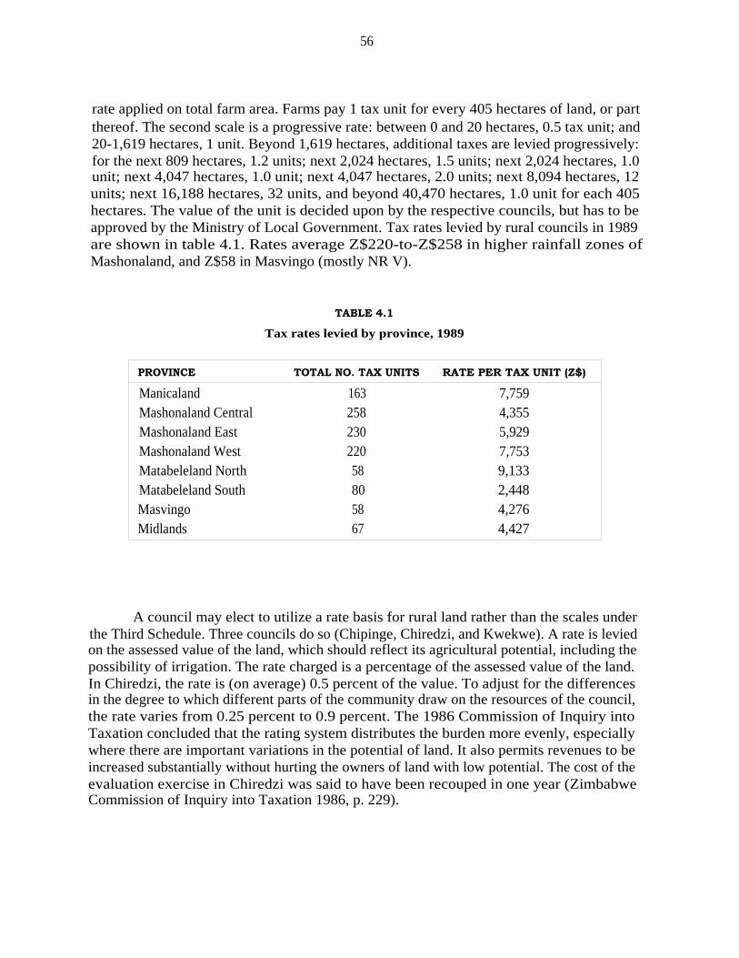
56
rate applied on total farm area. Farms pay 1 tax unit for every 405 hectares of land, or partthereof. The second scale is a progressive rate: between 0 and 20 hectares, 0.5 tax unit; and20-1,619 hectares, 1 unit. Beyond 1,619 hectares, additional taxes are levied progressively:for the next 809 hectares, 1.2 units; next 2,024 hectares, 1.5 units; next 2,024 hectares, 1.0unit; next 4,047 hectares, 1.0 unit; next 4,047 hectares, 2.0 units; next 8,094 hectares, 12units; next 16,188 hectares, 32 units, and beyond 40,470 hectares, 1.0 unit for each 405hectares. The value of the unit is decided upon by the respective councils, but has to beapproved by the Ministry of Local Government. Tax rates levied by rural councils in 1989are shown in table 4.1. Rates average Z$220-to-Z$258 in higher rainfall zones ofMashonaland, and Z$58 in Masvingo (mostly NR V).
TABLE 4.1
Tax rates levied by province, 1989
PROVINCE TOTAL NO. TAX UNITS RATE PER TAX UNIT (Z$)
Manicaland 163 7,759Mashonaland Central 258 4,355Mashonaland East 230 5,929Mashonaland West 220 7,753Matabeleland North 58 9,133Matabeleland South 80 2,448Masvingo 58 4,276Midlands 67 4,427
A council may elect to utilize a rate basis for rural land rather than the scales underthe Third Schedule. Three councils do so (Chipinge, Chiredzi, and Kwekwe). A rate is leviedon the assessed value of the land, which should reflect its agricultural potential, including thepossibility of irrigation. The rate charged is a percentage of the assessed value of the land.In Chiredzi, the rate is (on average) 0.5 percent of the value. To adjust for the differencesin the degree to which different parts of the community draw on the resources of the council,the rate varies from 0.25 percent to 0.9 percent. The 1986 Commission of Inquiry intoTaxation concluded that the rating system distributes the burden more evenly, especiallywhere there are important variations in the potential of land. It also permits revenues to beincreased substantially without hurting the owners of land with low potential. The cost of theevaluation exercise in Chiredzi was said to have been recouped in one year (ZimbabweCommission of Inquiry into Taxation 1986, p. 229).
57
Chapter 5
LAND MARKET AND CHANGES IN AGRARIAN STRUCTURE
5.1 RATIONALE FOR A LAND MARKET-BASED REFORM
The very large farm size of the LSCS was a product of the size of the original grantsof land to European settlers. Cliffe (1986, p. 43) is worth quoting at length on scale of theselarge farms:
The presumption is that they are "economic units" whose size of operation embodiescertain economies of scale. In fact, historically, their size came about in a veryhaphazard way, partly derived from Afrikaner custom in 19th century South Africa,in part so as to deny land to Africans even if not used. The only economic "logic" toany of them is in the case of those farms that have come into existence as a result ofsub-division (or the refusal of subdivision, for permission has always had to be soughtfrom government). The criterion for sub-division, as also seemed to have been thecase with new allocations post-World War II, is on the basis of guaranteeing a certainincome level to the owner/manager. Thus if their existing scale of operation has anyrationale, it is an underlying socio-political judgement about what income largefarmers deserve rather than one based on the economics of production. In fact, acommon practice is for farms in areas with good arable potential to have a portionintensively farmed and the rest used for only light grazing. There may be severalreasons for this ("part-time" farming, speculation, etc.) but the World Bank reviewwas probably right in suggesting a "management constraint"—that the present averagecropped area in the Lscs sector, 130 hectares, is probably close to the optimum farmsize in terms of cropped hectares that can be successfully managed by a farmer andhis family (with existing mechanical equipment), when considering the particular cropsgrown—part of them irrigated—and also taking into account that many of the farmsrun livestock as well.
The illusion survives among Zimbabwean policymakers that mechanized andmodernized agriculture is possible only under large-scale or cooperative farming systems. Themyth of large-scale efficiency was central to the ideology of colonial agriculture in the settlercolonies and may have been reenforced by the Marxist faith in efficiencies of scale. It isobvious that settler agriculture in Zimbabwe achieved levels of productivity which wereimpressively higher in at least limited areas of the large-scale operations. But it is equallyobvious that for historical reasons, large scale went together with access to improvedtechnologies, extension services, markets, and subsidies. The impact of these factors iscommonly confounded with those of scale itself.
Empirical research which attempts to isolate scale as a factor has reached verydifferent conclusions. An inverse relationship between scale and productivity per hectare formost crops has been documented by Berry and Cline (1979). While most of the evidence
58
comes from Asia, the available African data suggest that the relationship may hold there aswell (Levi and Haviden 1982). Greater investments of household labor and the efficiencyadvantage of that labor over wage labor appear to more than compensate for potentialeconomies of scale, which in practice are usually unrealized (Carter 1984). Even where yieldsper hectare are not greater on smaller holdings, the costly inputs required for large-scaleproduction may mean that economic efficiency in terms of domestic resource costs may begreater on the smaller operations, as was recently found in Kenya and Malawi (Lele andAgarwal 1989). 14
There are exceptions to this inverse relationship. While many traditional plantationcrops such as coffee can be grown by contract farmers for a central processing facility,economies of scale in both processing and marketing for some plantation crops such asbananas are transmitted to the scale of farms via the necessity of tight coordination betweenharvesting and processing (Binswanger and Elgin 1988). Characteristics such as skilledmanagement for commercial production in Zimbabwe are historically associated with largescale and confused with efficiencies of scale. The confusion is perhaps understandable giventhat the historical association is a reality which is not easily altered, and the scarcemanagement skill can, for a variety of political and economic reasons, be lost with areduction of scale.
What then is the efficient scale? An efficient scale for maize is likely to be quitedifferent from that for horticulture, and will vary not only by crop but by land capability andcapital and labor endowments of the firm. Market economies recognize that efficient size willvary with a multitude of factors and that any attempt to stipulate it will necessarily involvesubstantial inefficiencies. Farm size or scale is thus allowed to adjust through the operationof the land market.
5.2 LAND MARKET RESTRICTIONS—SUBDIVISION
There has been little opportunity for the land market to promote size efficiency inZimbabwe. Dating from the colonial period, the Town and Country Planning Act (CAP 213)placed limits on subdivision. This is still the case under today's Regional, Town and CountryPlanning Act, No. 22 of 1976. A permit is required for any subdivision and for anythingwhich might be an attempt to accomplish what amounts to a subdivision: an agreement fora change in ownership of any portion of a property; for a lease of any part for ten years ormore or for a lifetime; for a right to occupy for those periods; or for a renewal of a lease orright to occupy which would take the period over ten years (SEC. 40). A permit may beapplied for from the local planning authority, which is the rural district council (SEC. 10).If the permit is not granted within four months, it is deemed to have been refused. Appealsmay be taken to a planning appeals board appointed by the Minister of Local Government(SEC. 61), and appeals on points of law, taken from the board to the Appellate Division.
14. The analysis of domestic resource costs in Zimbabwe is covered in ch. 7.

59
Within the Appellate Division, those appeals go to the administrative court established by theAdministrative Court Act, No. 39 of 1979, from which appeals can be taken to the SupremeCourt. About five subdivision cases a year on average come before the administrative court,and these usually concern urban properties.
An MLARR committee advises the Ministry of Planning regarding the viability ofproposed subdivisions. AGRITEX participates and provides technical criteria. The committeehas recently been reviewing its criteria, which have been relatively informal, in order to beable to demonstrate consistency. In general, the committee has not been willing to permitsubdivision simply on the ground that the land would sell more easily and for higher pricesper hectare in smaller units. There is a reluctance to allow parcels to be fragmented just for"speculative" purposes. There should be a purchaser, with capital and a viable project. TheMLARR (in personal conversations) has suggested that there are not large numbers of potentialblack purchasers who would benefit from a relaxation of the subdivision criteria. Most ofthose interested would be businessmen who lack farming expertise and are involved withsmallholdings not productive enough to warrant managers, unless tobacco is grown.
Further controls with respect to subdivision are built into the Rural Land Act(CAP. 137). Co-ownership is discouraged because of its potential for subdivision (eachco-owner has the right to request "partition," subdivision of the co-owned land). The actprovides that land may not be sold or leased to two or more individuals jointly without theconsent of the minister. A sale to a corporate body, which as a single legal personality doesnot raise the specter of subdivision in the same way, is allowed (SEC. 8). Sharecropping isprohibited except with the approval of the minister (SEC. 10). The sharecropping provisionappears to have been intended to prevent de facto subdivision of large holdings amongsharecropping black tenants. A similar prohibition exists in South African law. Criminalpenalties, including imprisonment for a period up to two years, are prescribed for contraven-tion of these provisions (SEC. 11).
In time it is likely that a relatively free land market would break up many of the largerholdings in the LSCS , as has been the case in the former white highlands of Kenya. Thepersistence of land concentration owes a good deal to the limitations which have been placedupon its marketability through restrictions on subdivision. The same applies to underutiliza-tion of land. While underutilization of freehold land is sometimes blamed on the relativeabsoluteness of freehold tenure (one need not use it to avoid losing it), operation of a landmarket is the mechanism by which a freehold system attempts to ensure that underutilizedland moves into hands which will use it better. Land markets rarely perform these tasksperfectly. Market imperfections abound in developing countries. But the land market, as thedynamic factor in a freehold tenure system, is critical to maintaining efficient scale andutilization. And the operation of a land market and its potential for redressing the highlyunequal land distribution have been largely negated by public policy in Zimbabwe.
Beyond provisions on subdivision and underutilization, one further legal provisionregarding the rules of inheritance restricts land markets in the SSCS sector. The 1933 AfricanWills Act specified that in the absence of a will, the senior male heir at customary law would

60
inherit the entire land in his individual capacity (rather than as a representative for a largergroup of heirs). While customary rules imposed a duty to try to accommodate siblings andtheir descendants who stood in need of land in order to subsist, a study in the 1970s foundthat the number of siblings and their offspring in the SSCS sector was small and decreasingwith time. In fact, heirs of these farms have required the approval of the state even after thetitle has been granted. In the past, successive native land boards have invalidated theprovisions of black landowners' wills which attempted to bequeath the land to more than oneheir, individually or collectively. This particular restriction was removed by the AfricansWills (Amendment) Act 1976, but in practice little seems to have changed. Localadministrators still attempt to ensure that SSCS farms are inherited by single heirs (Cheater1982, pp. 77, 86). Where subdivision on the record is restrained, it takes place anyway butoff the record, leading to patterns of use and perceived rights which have little to do withwhat can be proved under the Deed Registries Act. If this is the case to the extent suspected,a program of resurvey, title adjudication, and re-registration may be necessary. If a morefocused inquiry found extensive confusion of titles in the smallholder areas, enactment of aland adjudication act of the type used in African countries with title registration systemswould be appropriate as a basis for restoring the integrity of the title deed system in theseareas. Such a statute would also be needed if a systematic extension of the title deed systemto parts of the communal lands were desired.
5.3 LAND TRANSFERS
The performance and operation of land markets in the communal areas is difficult toassess due to the paucity of data. According to MLARR officials (personal conversations), landtransfers in the LSCS have been rather modest. While some speculative buying has beenoccurring in peri-urban areas in recent years, most of the transactions are between fathers andsons. Thus far, there are no signs of the emergence of the land-buying companies whichplayed such a major role in the transfer of white settler land to black farmers in Kenya. Interms of racial balance, new large-scale operators seeking to buy land in the LSCS run twoblack purchasers to each white. There is not much market action in the SSCS, and what thereis does not seem to involve scaling-up. There is little leasehold market activity because thosewho want land on lease want smaller units, for which the Rural Land Act requires the ownerto get a subdivision permit. With appeals, obtaining the permit can take several years.
From independence until April 1990, the government acquired land from the LSCS ona willing buyer-willing seller basis. The Land Acquisition Act, enacted in 1985, designatedgovernment as the buyer of first resort, thereby requiring sellers first to "offer" land to thegovernment at the sale price. These processes for land purchases have been criticized bygovernment on three grounds: the land market provides too few transfers and too little landfor resettlement; land prices are excessively high and speculative; and farm sizes are toosmall for resettlement.

61
5.3.1 LAND PURCHASES AND OFFERS (LSCS)
The argument that the land market is not sufficiently robust to bring about redistri-bution of land, or to facilitate the redistribution of the highest quality land, appears to beoverstated given available data. The land market based on voluntary sales has been quiteeffective in redistributing land since independence. Between 1979 and 1988, land acquisitionhas reduced the total number of farmers in the LSCS from 6,113 to 4,660, and total land area,from 15.1 to 11.2 million hectares (table 5.1). The percentages of farm numbers and areasby farm size category remained fairly constant between 1979 and 1988, indicating that theland market did not discriminate against farm size or natural region. Land acquisition throughthe land market has enabled the government to get high quality land; over 57 percent of theland acquired was located in NRs I, II, and III, equivalent in percentage terms to theproportions held by farms in the LSCS .
Also, between April 1986, when the government first started compiling records on"offer-of-sales," and September 1989, 1,691.0 million hectares had been proffered to thegovernment on a willing seller-willing buyer basis, excluding farms < 100 hectares in size.Of this total, 541,128 hectares were ultimately purchased by the state (MLARR ). For thoseoffers rejected, data are provided in table 5.2 on the characteristics of two separate samples:(1) parcels greater than 100 hectares offered to the government between April 1986 andSeptember 1989; and (2) farms greater than 300 hectares offered to the government duringthe same time period.
Three salient points are striking. First, a large number of farms have been offered tothe government. While the total figure is not known, data from sample 1 indicate that at least1,856 offers were made. Second, nearly 53 percent of these offers were for parcels locatedin the high rainfall areas of NRs I and II. If NR III is included as well, total area offered butrejected was in excess of 67 percent. Third, the land market indicated by offers continued toremain robust through September 1989 (sample 2).
If land is coming to market, why has the government not participated more stronglyas a buyer? In the past, a number of reasons have been given by the Land Identification andSelection Committee: (1) land in NRs I and II is too expensive; (2) land is not offered inlarge enough blocks to justify scheme development; (3) land in NR IV is not suitable forhuman settlement because of low or erratic rainfall; and (4) land in NR V is suitable only forlivestock and game ranching (personal conversations, MLARR). Of these, factors (1) and (2)are considered to be the most important.
5.3.2 LAND PRICES
The price of real estate is a function of many factors, including location; access tomarkets; land characteristics (soil fertility, slope, rainfall, access to water, and fixed capitalimprovements); general price inflation in the economy; and use value or profitability of landin agricultural production. Land prices may exceed the implicit value of land in agricultural

62
TABLE 5.1
Structural change in the large-scale commercial sector, 1979-1988
1979 1984 1988SIZE CATEGORY Number Area Number Area Number Area(ha) (#) (ha) (#) (ha) (#) (ha)
< 200 1,324 104,674 1,410 105,202 947 75,136200-399 445 125,805 435 124,197 367 104,000400-599 446 220,176 415 206,161 392 192,344600-799 425 294,387 363 249,640 356 246,837
800-999 423 374,916 346 307,438 348 309,067
1000-1999 1,372 1,931,189 1,156 1,624,882 1,063 1,491,0432000-3999 905 2,503,591 748 2,056,633 673 1,853,1624000-5999 289 1,425,735 222 1,089,370 182 893,705
6000-7999 142 974,229 126 866,023 99 687,039
8000-9999 100 888,225 264' 5,843,440' 233' 5,361,053'
z 10,000 242 6,223,289
Total 6,113 15,064,216 5,485 12,472,986 4,660 11,213,386
Comparable percentages of land area
< 200 21.7 0.7 25.7 0.8 20.3 0.7
200-399 7.3 0.8 7.9 1.0 7.9 0.9
400-599 7.3 1.5 7.6 1.7 8.4 1.7600-799 7.0 2.0 6.6 2.0 7.6 2.2
800-999 6.9 2.5 6.3 2.5 7.5 2.8
1000-1999 22.4 12.8 21.1 13.0 22.8 13.32000-3999 14.8 16.6 13.6 16.5 14.4 16.54000-5999 4.7 9.5 4.1 8.7 3.9 8.0
6000-7999 2.3 6.5 2.3 6.9 2.1 6.1
8000-9999 1.6 5.9 4.8 46.9 5.0 47.8z 10,000 4.0 41.2Total 100.0 100.0 100.0 100.0 100.0 100.0
a. More than 8000 ha.Source: For 1979 and 1984, Zimbabwe, Crop Production of Large Scale CommercialFarms (Harare: Central Statistics Office); and for 1985, Central Statistics Office.
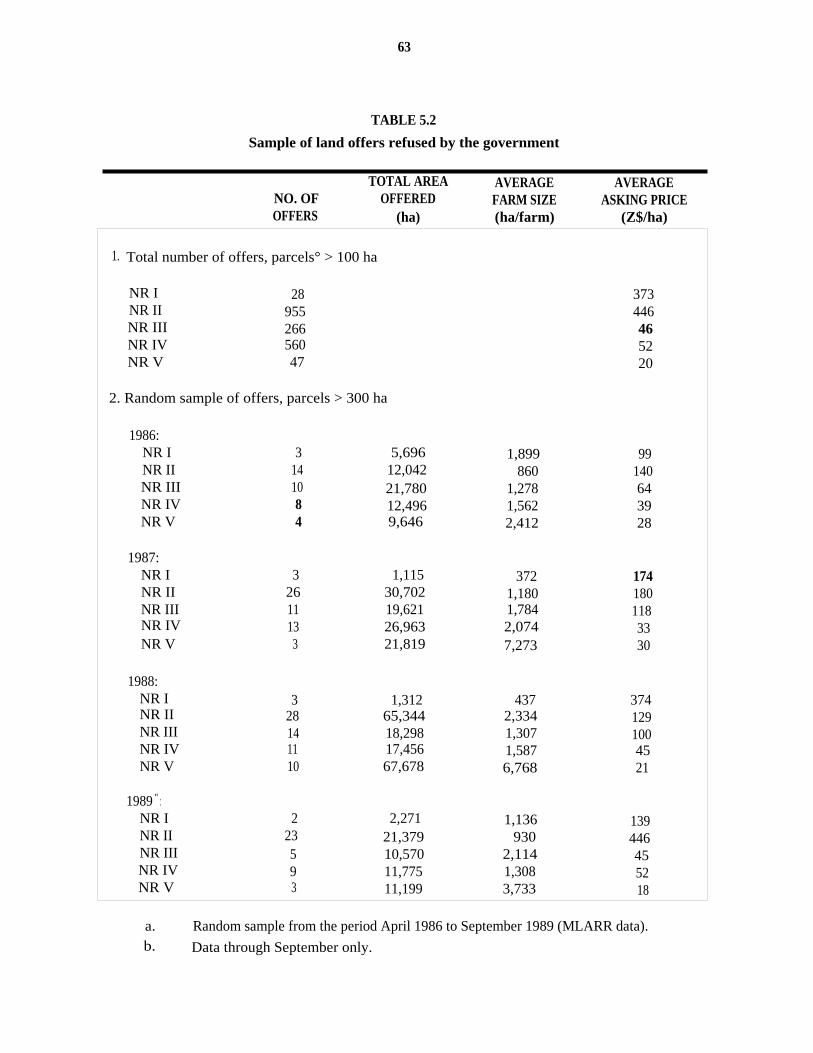
63
TABLE 5.2
Sample of land offers refused by the government
TOTAL AREA AVERAGE AVERAGENO. OF OFFERED FARM SIZE ASKING PRICEOFFERS (ha) (ha/farm) (Z$/ha)
1. Total number of offers, parcels° > 100 ha
NR I 28 373NR II 955 446NR III 266 46NR IV 560 52NR V 47 20
2. Random sample of offers, parcels > 300 ha
1986:NR I 3 5,696 1,899 99NR II 14 12,042 860 140NR III 10 21,780 1,278 64NR IV 8 12,496 1,562 39NR V 4 9,646 2,412 28
1987:NR I 3 1,115 372 174NR II 26 30,702 1,180 180NR III 11 19,621 1,784 118NR IV 13 26,963 2,074 33NR V 3 21,819 7,273 30
1988:NR I 3 1,312 437 374NR II 28 65,344 2,334 129NR III 14 18,298 1,307 100NR IV 11 17,456 1,587 45NR V 10 67,678 6,768 21
1989 " :NR I 2 2,271 1,136 139NR II 23 21,379 930 446NR III 5 10,570 2,114 45NR IV 9 11,775 1,308 52NR V 3 11,199 3,733 18
a. Random sample from the period April 1986 to September 1989 (MLARR data).b. Data through September only.

64
production for resettlement if: the urban (or infrastructure) land value exceeds the agriculturalvalue; general price appreciation from inflation exceeds the nominal interest rate on interest-bearing deposits; or general price inflation is greater than the growth in agricultural profit.When it is stated that the land price is "too high," the implicit meaning is: these nonfarmfactors that influence land prices are not acceptable determinants of rural land prices;commercial farmers are colluding to charge inflated land prices; the government isunderestimating the value of land in agriculture; or budget constraints and ability to pay areimposing negative perceptions about the level of nominal land prices.
During inflationary times, individuals tend to shift to durable assets because inflationerodes the returns of fixed-income securities. Over the period 1980-85, inflation measuredby the GDP deflator averaged 12.7 percent per annum; inflation in 1986 hit 13.7 percentbefore dropping to 9.6 percent in 1987 (World Bank 1989). Over the same period, 12-monthcertificates of deposit averaged 10.3 percent (Zimbabwe, Quarterly Digest of Statistics).Passbook savings would have yielded even less. While these aggregate data mask significantunderlying variations, the aggregate figures indicate that the real value of liquid assets wouldhave declined 2.4 percent if held as certificates of deposit or by even more if held inpassbook savings due to high inflation and low fixed interest rates.
Average land prices paid by the government (table 5.2) indicate that nominal pricespaid increased from Z$19/hectare in 1979 to Z$95/hectare in 1988. Analysis of these pricesis difficult because of the confounding influences of price variation by natural region, withthe proportion of land acquired by natural regions varying from year to year. Also, theseprices show only land acquired by the government, and not land turned down by thegovernment because prices were too high. After adjusting for inflation, real prices variedbetween Z$12.7 and Z$22.1 over much of the decade; real prices in 1986 and 1987 were thelowest in the time period. Only in 1988 did real prices spike upward to Z$34.3/hectare forunknown reasons. From the government's perspective, when faced with tight budgets, therapid escalation in prices poses a severe problem in land acquisition. But it would be difficultto conclude from these data alone that collusion or excessive speculation has been occurring.
Land in NRs I and II is worth more than in NRs III and IV because of its higher yieldpotential. Nonetheless, questions remain whether absolute land prices are too high, andwhether a price premium of 100 to 200 percent is justified for land in NRs I and II. Thesequestions are difficult to answer without detailed analysis of individual parcel-level data. Yet,some feeling for the relative worth of land can be derived from its use value in agriculture:
(5.1) V= U(i + r)
where V =U =
r =
implicit value of agricultural land (Z$/ha);net returns per hectare of land (Z$/ha);opportunity cost of capital, e.g., returns on 12-month certifi-cates of deposit; andrisk premium.
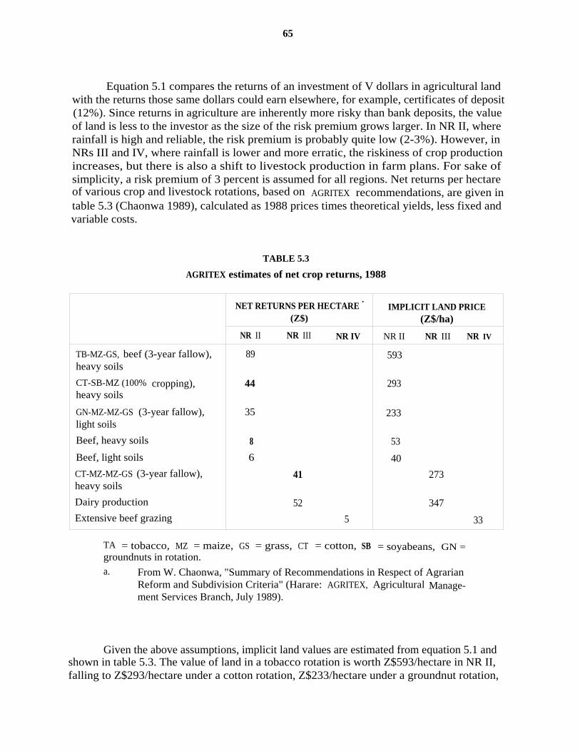
65
Equation 5.1 compares the returns of an investment of V dollars in agricultural landwith the returns those same dollars could earn elsewhere, for example, certificates of deposit(12%). Since returns in agriculture are inherently more risky than bank deposits, the valueof land is less to the investor as the size of the risk premium grows larger. In NR II, whererainfall is high and reliable, the risk premium is probably quite low (2-3%). However, inNRs III and IV, where rainfall is lower and more erratic, the riskiness of crop productionincreases, but there is also a shift to livestock production in farm plans. For sake ofsimplicity, a risk premium of 3 percent is assumed for all regions. Net returns per hectareof various crop and livestock rotations, based on AGRITEX recommendations, are given intable 5.3 (Chaonwa 1989), calculated as 1988 prices times theoretical yields, less fixed andvariable costs.
TABLE 5.3
AGRITEX estimates of net crop returns, 1988
NET RETURNS PER HECTARE '
(Z$)IMPLICIT LAND PRICE
(Z$/ha)
NR II NR III NR IV NR II NR III NR IV
TB-MZ-GS, beef (3-year fallow),heavy soils
CT-SB-MZ (100% cropping),heavy soils
GN-MZ-MZ-GS (3-year fallow),light soils
Beef, heavy soils
Beef, light soils
CT-MZ-MZ-GS (3-year fallow),heavy soils
Dairy production
Extensive beef grazing
89
44
35
8
6
41
52
5
593
293
233
53
40
273
347
33
TA = tobacco, MZ = maize, GS = grass, CT = cotton, SB = soyabeans, GN =groundnuts in rotation.a. From W. Chaonwa, "Summary of Recommendations in Respect of Agrarian
Reform and Subdivision Criteria" (Harare: AGRITEX, Agricultural Manage-ment Services Branch, July 1989).
Given the above assumptions, implicit land values are estimated from equation 5.1 andshown in table 5.3. The value of land in a tobacco rotation is worth Z$593/hectare in NR II,falling to Z$293/hectare under a cotton rotation, Z$233/hectare under a groundnut rotation,
66
and Z$40-53/hectare under a beef rotation. In NR III, the value of land in a cotton rotationis Z$ 273/hectare, and Z$347/hectare in dairy production. Land suitable for extensive grazingproduction in NR IV is worth only Z$33/hectare, and Z$20/hectare in NR V. These estimatesare quite close to the average asking price reported in table 5.2 for the period 1986-89,though calculations are quite sensitive to changes in the interest rate (t) and the risk premium(r). The implicit land value would decline if net profits fall (e.g., because subsidies areremoved or taxes are increased), a higher discount rate or opportunity cost of capital is used,or the riskiness of agriculture is underestimated.
There are three main problems with the above calculations:► not all arable or grazing land may be utilized to its full potential;► farms contain some portion of wasteland with no value that is included in the
offer price; and► some farms have substantial investment in irrigation, tobacco barns, and other
fixed-place assets that, while located on a very small portion of farm area, addsubstantially to total farm value.
Under current statutes prohibiting subdivision of land, factors (1) to (3) artificiallyincrease the value of underutilized or idle land. As farms are normally sold "lock-stock-and-barrel," the price of land is some weighted average of the value of utilized farmland,unutilized farmland, wasteland, land with high-cost fixed-place investment, and natural regionlocation. By removing restrictions on subdivision, the price of underutilized land shouldtheoretically fall as long as land is abundant and underutilized in the aggregate. (The extentof underutilized land is examined in ch. 7.) Even if this argument holds, however, and landprices of unutilized land drop significantly with subdivision permitted, criteria that land beacquired in large blocks would still be a constraint to land acquisition.
Nonetheless, the limited available evidence from 1988 would suggest that the landprice offered (Z$374 in NR I, Z$129 in NR II, Z$100 in NR III, Z$45 in NR IV, and Z$21in NR V) is not excessive given the implicit value of the land in agriculture at that time andthe 1988 nominal prices.
5.3.3 AGRARIAN STRUCTURE
Changes in the structure of the LSCS in table 5.1 reflect the outcome of transactionsand sales to the government that have taken place through the land market. The number andarea of farms by farm size category are shown for three periods-1979, 1984, and 1988.Regional breakdowns are provided in Annex B. A number of conclusions can be drawn fromthe data.
First, there has been a dramatic reduction in number of farms and area in the LSCS .Total number of farms declined from 6,113 in 1979 to 4,660 by 1988. Area of farms declinedfrom 15.1 million hectares to 11.2 million hectares over the same time period. In terms ofland quantity, the land market has clearly been effective in redistributing land.
67
Second, this downsizing has been uniform in terms of both number of farms and area,indicated by the uniform percentages of land in each size category across years. In the lessthan 200-hectares category, for example, number of farms (area in parentheses) represented21.7 (0.7) percent of total farms in 1979 and 20.3 (0.7) percent by 1988, despite a largeabsolute decline in area. At the opposite end of the scale, in the above 8,000-hectarescategory, number of farms (area in parentheses) represented 5.6 (47.1) percent in 1979 and5.0 (47.8) percent by 1988. Similar trends are apparent for other farm size categories inbetween.
Third, aside from differences in land quality among regions (examined shortly), landdistribution still remains highly skewed among farms within the LSCS. In 1988, for example,51.7 percent of the farms less than 1,000 hectares in size controlled only 8.3 percent of totalland area. Nearly 75 percent of the farms less than 2,000 hectares in size controlled only 21.6percent of the land area. However, in the largest farm category—above 8,000 hectares—5.0percent of the farms own 47.8 percent of the land area. Most of these farms, however, arelocated in drier regions, that is, Masvingo, Matabeleland, and Midlands.
5.3.4 BLOCKS OF LAND FOR RESETTLEMENT
The government has generally tried to acquire land in large blocks of upward of 6,000hectares to achieve economies of scale in resettlement. As indicated earlier in table 5.2, asizable number of offers in excess of 1,000 hectares/farm has been rejected partially ongrounds that the price was too high, but also because the farm size was too small. Accordingto resettlement criteria, land sizes must be sufficiently large to spread the costs ofinfrastructure development—access roads, dip tanks, boreholes, staff housing, clinics, andschools—over a greater number of settlers. Three interrelated issues emerge.
First, can the government afford to maintain the large-block criterion and continue topass by parcels that fail to meet size criteria in higher rainfall zones? Land was moreabundant in the early 1980s, in part due to the large area of abandoned farms. But these areashave already been absorbed. In the higher rainfall zones [e.g., provinces of Manicaland;Mashonaland Central, East, and West (Annex B)], only 1.3 million hectares remain on farmsin excess of 4,000 hectares in size. If blocks only greater than 6,000 hectares are considered,only 855.7 thousand hectares remain. Since some fraction of this land is currently utilized[about 50% (ch. 8)], acquisition for resettlement would involve the redistribution of someland out of high-yielding commercial production to low-yielding resettlement production. Theresult would be a net negative loss in aggregate production in at least the intermediate run(see ch. 6 and ch. 7).
Second, smaller farms could be acquired and then pooled. But it would be highlyunnatural for contiguous parcels in a large area to be put up for sale on the market at thesame time. Holding parcels for a prolonged period of time would entail significantopportunity and holding costs for the government.
68
Third, the resettlement models employed by the government involve significanteconomies of scale, but only if infrastructure is provided and only if settlers are considered.Current programs, however, ignore the population of farm laborers on commercial farms.The argument is usually made that the establishment of schools and clinics requires a largenumber of settlers to spread construction and development costs. Yet, by establishing facilitiesonly for resettlement populations, planning disregards potential economies of choosing sizeand location of public schools and clinics on the basis of settlers and farm workers alike, orthe possible diseconomies in planning for each separately. Large commercial farms currentlyprovide schools (government provides the teachers), but the quality of facilities is highlyvariable. If, alternatively, the government centrally locates schools and clinics for populationsof both farm laborers and settlers, which ultimately it must do in the long run, economies toscale are decoupled from issues of land availability for resettlement, allowing for smallerparcels to be acquired and settled.
5.4 SUMMARY
The history of land administration from the early 1900s to the present shows that,despite the redistribution of 3.2 million hectares of land from the LsCS to the resettlementsector, Zimbabwe's agrarian structure still remains highly skewed. Farms in the large farmsector have access to land in the best rainfall zones, while the majority of the rural populationin communal areas farm the most arid lands. The analysis also reveals that the land marketin the LsCS has been quite dynamic. It has provided small-scale settlers access to higherquality lands and has brought about a gradual but stable shrinkage of the sector.
Nominal land prices and parcel size were cited as the major factors curtailinggovernment acquisition of land. However land prices appear to have been driven largely bygeneral inflation in the economy, by the profitability of agriculture, and by the scarce supplyof land in higher rainfall zones. These conclusions are based on limited and very aggregatedata on land transactions and prices and on gross estimates of the opportunity cost of capitalto estimate implicit land values. Nonetheless, it would be difficult to conclude, based on thesemacro data, that land prices are either excessively high or speculative. An analysis of agrarianstructure further shows that the criterion of large block size is beginning to impose aconstraint on land acquisition because of the limited number of large farms remaining in NRsI and II.
The analysis further raises important issues related to land reform: (1) What is theextent of underutilization in the LSCS and, thus, the production implications of land reform?(2) What is the relative efficiency of LsCS, SSCS, communal, and resettlement sectors? (3)How has land use been affected by market and institutional forces? (4) What form should theresettlement process take? (5) What are the efficiency and equity implications of variousoptions—land ceilings, restrictions on land prices, designated areas, and the like—for landredistribution? These issues are dealt with in subsequent chapters.

69
Chapter 6
CHANGES IN LAND USE PATTERNS
6.1 INTRODUCTION
Besides the changes in agrarian structure that have occurred over the decade, dramaticchanges have also been experienced in land use patterns and in the way factors of production(land, labor, and capital inputs) have been combined in farming. In the LSCS , two generalshifts have been apparent: a gradual shift away from maize production to industrial andspecialty crops, and the substitution of capital in the form of machinery for labor. The"miracle" of increased smallholder production in communal areas has mainly been a functionof increased farmers' access to both commercial markets through government expansion ofgrain depots and to new cultivars and fertilizer from government investment in inputdistribution systems. Both sets of trends are closely examined in this chapter to study theimplications of future resettlement activity on output and balance of trade. Implications ofchanges in land use patterns for the efficiency of land utilization in the LSCS is examined inchapter 8.
6.2 LARGE-SCALE COMMERCIAL SECTOR
6.2.1 CHANGES IN CROPPING PATTERNS
Since 1975, total crop area in the CS has declined over 15 percent, from 590.6 to500.6 thousand hectares by 1988 (table 6.1). Total land in the LSCS shrank by 26 percent (seetable 5.1, p. 62), indicating that a large part of the decline in crop area was due to structuralchange. However, the decline in crop area masks two important underlying trends in landuse, indicated by percentage changes in the crop mix (table 6.1). First, farms have tended todecrease their reliance on cereal crops, principally maize (Annex E.1), from 48.5 percent oftotal crop area in 1975-77, to only 39.5 percent by 1987/88. Second, farms have shiftedtoward a greater concentration of industrial crops in the crop mix over time. In 1973-75,industrial crops including mainly tobacco and cotton averaged 34.6 percent of total crop area.By 1987/88, industrial crops averaged 46.6 percent of total crop area. Fodder crops, as apercentage of crop area, have tended to remain stable over time at around 2-3 percent. Treecrops declined from around 0.9 percent of crop area in 1975 to 0.6 percent by the mid-1980s,before increasing sharply in recent years (1.1 percent in 1988).

TABLE 6.1
Changes in crop area, large-scale commercial sector
YEAR CEREAL CROPS° INDUSTRIAL CROPSb FODDER CROPS` TREE CROPS d OTHER ` TOTAL CROP AREA(%) (%) (%) (%) (%) (000 ha)
1975 48.3 35.3 2.7 0.9 12.9 590.6
1976 47.9 33.8 3.3 0.9 14.1 566.4
1977 49.9 34.7 2.6 0.8 12.0 574.8
1978 46.7 38.3 2.3 0.8 12.0 563.5
1979 45.4 40.0 2.3 0.9 11.6 542.2
1980 47.3 39.4 2.0 0.6 10.7 574.8
1981 57.7 30.3 1.8 0.7 9.5 599.9
1982 54.8 33.8 2.0 0.6 8.8 585.0
1983 48.2 39.1 2.5 0.7 9.5 548.41984 44.0 42.5 2.6 0.8 10.2 531.9
1985 47.9 39.3 2.4 0.6 9.9 541.1
19861987 38.5 47.5 2.9 0.8 10.2 484.8
1988 40.5 45.6 2.4 1.1 10.3 500.6
a. Includes maize, sorghum, wheat, barley, munga, rapoko, and other grains.b. Includes tobacco, coffee, cotton, groundnuts, soyabeans, sunflower, sugarcane, tea, and other industrial crops not
specified.c. Includes lucerne, other legume hays, and silage.d. Includes citrus fruits (orange, grapefruit, mangoes), deciduous fruits, strawberries, tropical fruits (banana), avocado,
and tree nuts.e. Includes edible drybeans, sunhemp, nyimo, sweet potatoes, potatoes, onions, peas, tomatoes, other unspecified vegetables,
garden flowers, shrubs, seedlings, and planted pastures.
Source: Zimbabwe, 1987 Statistical Yearbook (Harare: Central Statistics Office), for 1978 to 1983; and Central StatisticsOffice, for 1984 to 1988.

71
A 15-year time series of area, production, and yield was compiled for this study forthe period 1973 to 1988. 15 The resulting crop data for 8 provinces is voluminous, precludingdetailed presentation in this report. Averages of area, production, and yield are providedinstead for the periods 1973-75, 1979-81, and 1987/88 (Annex D). Growth rates in area,production, and yields are further estimated for two separate time series: a 9-year period from1973 to 1980, representing the preindependence period; and an 8-year period from 1979 to1988 (data for 1986 are missing), representing the postindependence era. Although years donot exactly correspond to pre- and post-independence, some adjustment was necessary toachieve a sufficient number of observations for the statistical estimation of growth rates.
Maize. The crop of maize in 1988 was 151.0 thousand hectares or 30.2 percent oftotal cropped area in the LSCS. Of this total, 84.7 percent was grown in NR II, and 12.8percent in NR III (table 6.2). Cropped area has declined sharply over time. Starting from abase of 282.2 thousand hectares in 1973, cultivated area has declined at an average annualrate of 4.3 percent per annum over the period 1973-80, and 5.5 percent over the period1979-88. A number of factors have contributed to this decline: (1) the official policy of theCommercial Farmers Union promoting crop diversification; (2) economic considerationsdiscussed shortly; and (3) the imposition of production controls for a limited period in 1986(Joint Farmers' Unions 1990). Production nationally also declined at a rate of 5.3 percent perannum between 1979 and 1988, mostly due to the decline in area. Yields, nationwide, havegrown at a fairly modest and constant rate of 0.3 percent over the last two decades, indicatinga very slow rate of technological change. The modest improvement that has taken place is asmuch a function of poorer land being taken out of production as technological improvement.Only in Mashonaland did yields increase appreciably over the decade (1.8); Masvingoexperienced the greatest annual rate of decline in yields (-6.1).
Wheat. The area planted in wheat has expanded rapidly over time. Starting from 21.3thousand hectares in 1973, total wheat area nationally reached 41.8 thousand hectares in1988, roughly 8.4 percent of total crop area in the LSCS. Nearly 75 percent of wheat is grownin NR II, followed by NR V (17.3) and NR III (6.5). Over the decade 1973-80, wheat areaexpanded at an average annual rate of 6.9 percent per annum, and production, at 10.2 percentper annum, due to rapid growth in productivity per hectare (3.1 %). However, growth hasslowed in the 1980s. Over the period 1979-88, wheat area nationwide grew less than 1percent per annum; production, 2.1 percent; and yields, 1.2 percent. New cultivars andimproved management have been chiefly responsible for this increase in productivity (JointFarmers' Unions 1990). However, while area and yields have remained stable or increasedin Manicaland and Mashonaland, wheat area since 1979 has declined sharply in Masvingo(-20.2), Matabeleland (-11.1), and Midlands (-14.9).
15. From Zimbabwe, Crop Production of Large Scale Commercial Farms, for 1973 to 1985; andfrom Cso, for 1987 and 1988.

72
TABLE 6.2
Cropping patterns by natural region, large-scale commercial sector, 1988 crop season
NR I(%)
NR II(%)
NR III(%)
NR IV(%)
NR V(%)
TOTAL AREA(ha)
Maize 0.4 84.7 12.8 2.1 0.1 150,989Sorghum 0.7 70.6 13.5 12.5 2.7 3,773Wheat 0.0 74.9 6.5 1.4 17.3 41,846
Barley 0.0 51.5 43.6 4.9 0.0 5,374
Other cereals 13.0 74.3 5.4 7.3 0.1 794
Tobacco 0.7 95.6 3.3 0.0 0.4 54,842Coffee (productive) 59.0 35.7 1.7 0.6 3.0 6,539
Cotton 0.1 73.1 8.9 0.3 17.7 60,095Groundnuts 0.3 87.6 10.8 1.1 0.2 5,201
Soyabeans 0.1 93.0 6.9 0.0 0.1 51,594
Sunflowers 0.1 39.7 56.5 2.6 1.1 10,092
Sugarcane 0.0 0.0 0.3 0.0 99.7 31,853Tea (productive) 62.4 37.0 0.0 0.6 0.0 4,691
Other industrial crops 52.5 34.7 3.8 0.9 8.0 3,502Fodder 2.3 82.9 9.4 5.1 0.3 54,279
Fruit 10.4 69.1 7.8 2.4 10.4 5,710Other 0.6 73.1 6.6 10.5 9.2 9,380
Total crops 2.3 75.8 9.7 1.8 10.5 500,554
Source: Central Statistics Office.
Sorghum. Sorghum area in the LSCS in 1988 covered 3,773 hectares, only 0.8 percentof total crop area. About 15.2 percent of sorghum area is planted in the drought-prone zonesof NRs IV and V; the majority (70.6) is still grown in NR II. Breweries in Zimbabwe require20-30,000 tons of red sorghum annually for beer production; white sorghum is an effectivesupplement to wheat in bread. Like maize, sorghum's importance in the crop mix hasdeclined over time. Since 1973, sorghum area nationwide has declined at a rate of 3.7 to 5.0percent per annum. Yields grew rapidly in the 1970s (9.7%). Since 1980, yields havecontinued to rise at an annual rate of nearly 2 percent.
Barley. Barley is produced for the National Breweries on contract. Historically, therequirement has been 30,000 tons annually, roughly half for beer, the other half exported.Export demand has recently increased, resulting in new production targets of 45,000 tons perannum (Joint Farmers' Unions 1990). Barley was cultivated on 5,374 hectares in 1988,representing 1.1 percent of total cropped area. Because of its drought-resistant qualities,

73
nearly 49 percent is cultivated in the more arid and drought-prone areas of NRs III and IV,though the majority is still grown in NR II (51.5). Unlike maize and sorghum, barley areahas been growing modestly over time (0.2-0.8%). However, these trends mask importantregional differences. Since 1980, barley area has expanded rapidly in Midlands (15.9), whiledeclining sharply in Manicaland (-32.6) and Mashonaland (-4.4). During the 1970s,impressive growth in barley yields was achieved due to varietal improvements. But since1980, growth in yields has flattened while the introduction of new technology has stagnated.
Cotton. Cotton was cultivated on 60.1 thousand hectares in 1988, representing 12.0percent of total crop area in the LSCS. Of this total, 73.1 percent was grown in NR II, 17.7percent in NR V, and 8.9 percent in NR III. Cotton area grew slightly in the 1970s, but hastended to decline in the 1980s (-1.6), though substantially less so than the overall rate ofdecline in total land area in the LSCS. Important regional differences are again masked by thenational trend. While cotton area in Manicaland and Matabeleland has grown 3.8 and 9.4percent per annum, respectively, since 1979, cotton area in Mashonaland has fallen 1.0percent, and in Masvingo, 11.2 percent. Cotton yields have shown moderate but consistentgrowth over time due primarily to the introduction of new cultivars and improvedmanagement, research, and extension. From 1973 to 1980, cotton yields nationally grew 2.7percent, and by 1.9 percent from 1979 to 1988. Growth in productivity has been widespread,indicating high rates of technology diffusion. Yields in Manicaland have grown 0.9 percentper annum, 2.6 percent in Mashonaland, 0.4 percent in Midlands, and 0.1 percent inMatabeleland.
Tobacco. Tobacco was grown on 54.3 thousand hectares in 1988, representing 10.9percent of total cultivated area in the LSCS. Nearly all tobacco production in Zimbabwe isconcentrated in three provinces—Mashonaland West (43.6% of area cultivated), MashonalandCentral (26.7%), and Mashonaland East (22.1 %)—all on lands located primarily in NR II(95.6%). Unlike maize, tobacco area has remained fairly stable over time. Over the period1973-80, tobacco area grew at an average annual rate of 2.3 percent; since 1980, area hasstagnated (0.0% growth). Like cotton, however, this stagnation, combined with the declinein total land area in the LSCS, has resulted in a higher proportion of tobacco in the croppingsystem. Production, on the other hand, grew 7.3 percent between 1973 and 1980, and 2.0percent between 1979 and 1988 due mainly to growth in yields (4.9% and 2.0%, respective-ly). Heavy investment in research and extension have contributed to sustained yield improve-ments. The Tobacco Research Board was responsible for the development of white mold-resistant varieties in the late 1960s and the introduction of suckerides in the late 1970s, whichdramatically increased yields. Concomitantly, the Tobacco Training Institute has served toextend new production methods to growers of flue-cured tobacco.
Soyabeans. Soyabeans are grown mainly on heavy soils in rotation with maize, cotton,and winter wheat. At present, soyabeans provide about 40 percent of Zimbabwe's vegetableoil demand. About 51.6 thousand hectares of soyabeans were cultivated in the LSCS in 1988,representing 10.3 percent of total crop area. Of this total, 93.0 percent was cultivated in NRII, and 96.0 percent in the three provinces of Mashonaland. Soyabeans experienced explosivegrowth in the 1970s. Starting from a base of only 8.2 thousand hectares in 1973, area
74
expanded at an average annual rate of over 26 percent from 1973 to 1980, and 4.2 percentfrom 1979 to 1988. Yields also grew rapidly (7.4%) in the 1970s, though yields have beenstagnant since 1980 (-0.2% and -0.5% percent, respectively, for Zimbabwe and Mashona-land).
Groundnuts. Groundnuts are grown by farmers mainly in the communal farmingareas and the SSCS. Commercial production is principally long-season varieties grown underirrigation in rotation with tobacco. Groundnut area in 1988 was 5.2 thousand hectares, only1 percent of total cropped area. As with soyabeans, most are grown in NR II (87.6%),primarily in the three provinces of Mashonaland (88.9%). Since 1979, groundnut area hasgrown 0.6 percent annually, and production, 1.4 percent. Yields have increased modestly(0.9%) in part due to irrigation.
Coffee. Coffee was cultivated on 8.6 thousand hectares (6.5 ha productive) in 1988,or 1.7 percent of the total cropped area in LSCS. The majority is grown in the CentralHighlands of Manicaland (76.7%), primarily on soils in NR I (59.0%) and NR II (35.7%).Growth expanded rapidly in the 1970s. Between 1973 and 1980, area grew at an annual rateof 6.0 percent; production, 20.3 percent; and yields, 13.5 percent. Although growth hasmoderated in the 1980s, area still grew at an average annual rate of 4.4 percent between 1979and 1988; production, 6.9 percent; and yields, 2.3 percent. These trends are very similar tothose estimated for Manicaland. Systems of coffee production in Zimbabwe have changeddramatically since coffee was first introduced in 1962. Nearly all coffee grown in Zimbabwetoday is irrigated, a factor largely responsible for increased yields. Considerable investmentin research and extension by the Department of Research and Specialist Services, the CoffeeResearch Station at Chipinge, and the Coffee Growers Association has also contributed to thehigh and sustained growth in productivity.
Horticulture. Until recently, horticultural crops have involved only a few large-scalefarms concentrated around the main urban markets. Specific climatic requirements of citrusand deciduous fruit have also led to pockets of producers in outlying areas. Over 69.1 percentof all fruit-tree production is located in NR II, and another 10.4 percent in NR I. Totalproduction of tree crops was 5,710 hectares in 1989, or 1.1 percent of total crop area. Thearea of tree crops declined at a rate of 7.3 percent in the 1970s, but since 1979, area hasexpanded at an annual rate of 2.4 percent nationwide.
6.2.2 CHANGES IN LIVESTOCK PRODUCTION
Regional and national numbers of beef cattle, dairy cattle, sheep, goats, and pigs aregiven in table 6.3 for five two-year periods between 1980 and 1989. Numbers of pigs haveremained fairly constant throughout the decade. Numbers of goats and sheep have generallydeclined nationally, from 156.7 thousand in 1982/83 to 133.3 thousand by 1988/89. Most ofthis decline occurred in Mashonaland (83.4 to 71.7), Matabeleland (30.9 to 24.3), andMidlands (20.2 to 16.4). The most important changes in the livestock sector, however,involved changes in the beef and dairy herds.
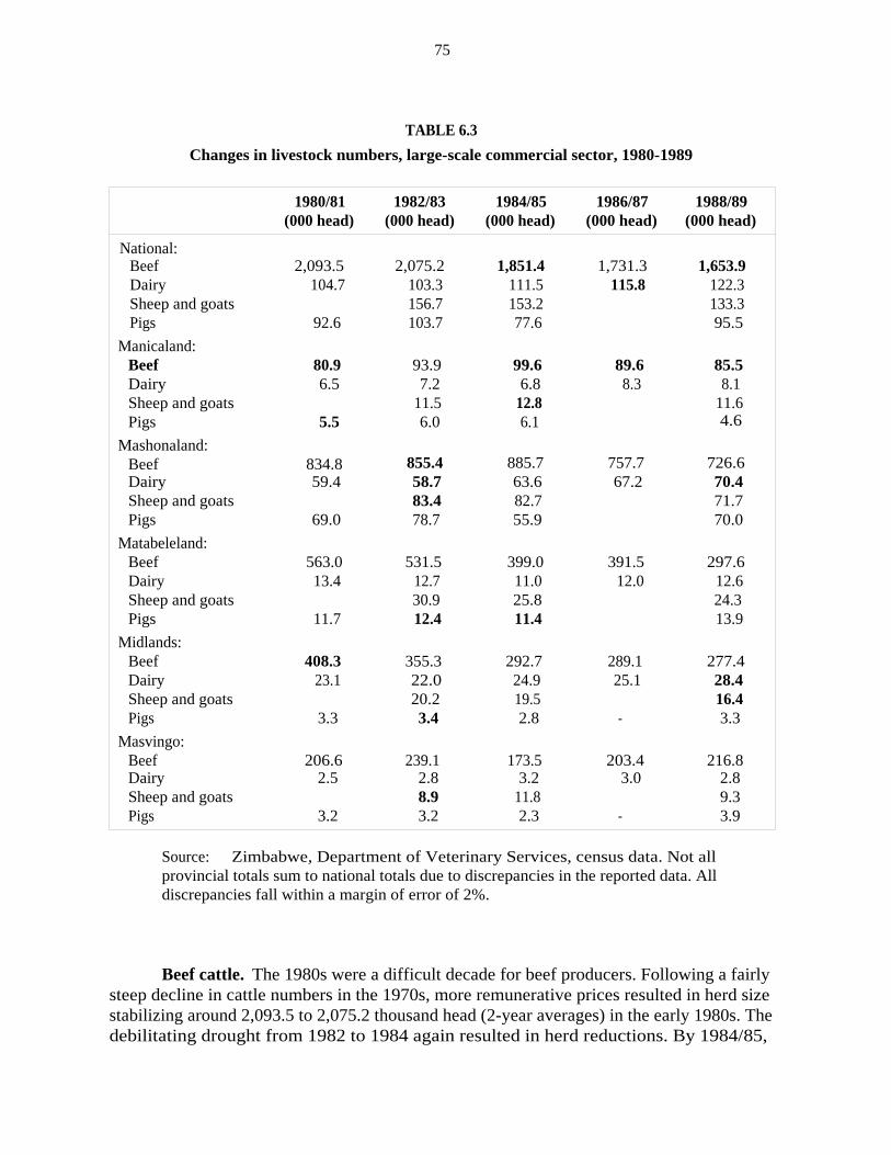
75
TABLE 6.3
Changes in livestock numbers, large-scale commercial sector, 1980-1989
1980/81 1982/83 1984/85 1986/87 1988/89(000 head) (000 head) (000 head) (000 head) (000 head)
National:Beef 2,093.5 2,075.2 1,851.4 1,731.3 1,653.9Dairy 104.7 103.3 111.5 115.8 122.3Sheep and goats 156.7 153.2 133.3Pigs
Manicaland:
92.6 103.7 77.6 95.5
Beef 80.9 93.9 99.6 89.6 85.5Dairy 6.5 7.2 6.8 8.3 8.1Sheep and goats 11.5 12.8 11.6Pigs
Mashonaland:
5.5 6.0 6.1 4.6
Beef 834.8 855.4 885.7 757.7 726.6Dairy 59.4 58.7 63.6 67.2 70.4Sheep and goats 83.4 82.7 71.7Pigs
Matabeleland:
69.0 78.7 55.9 70.0
Beef 563.0 531.5 399.0 391.5 297.6Dairy 13.4 12.7 11.0 12.0 12.6Sheep and goats 30.9 25.8 24.3Pigs
Midlands:
11.7 12.4 11.4 13.9
Beef 408.3 355.3 292.7 289.1 277.4Dairy 23.1 22.0 24.9 25.1 28.4Sheep and goats 20.2 19.5 16.4Pigs
Masvingo:
3.3 3.4 2.8 - 3.3
Beef 206.6 239.1 173.5 203.4 216.8Dairy 2.5 2.8 3.2 3.0 2.8Sheep and goats 8.9 11.8 9.3Pigs 3.2 3.2 2.3 - 3.9
Source: Zimbabwe, Department of Veterinary Services, census data. Not allprovincial totals sum to national totals due to discrepancies in the reported data. Alldiscrepancies fall within a margin of error of 2%.
Beef cattle. The 1980s were a difficult decade for beef producers. Following a fairlysteep decline in cattle numbers in the 1970s, more remunerative prices resulted in herd sizestabilizing around 2,093.5 to 2,075.2 thousand head (2-year averages) in the early 1980s. Thedebilitating drought from 1982 to 1984 again resulted in herd reductions. By 1984/85,

76
average herd size had been reduced to 1,851.4 thousand head. The drought of 1986/87combined with a difficult price-policy environment resulted in further herd reductions to1,731.3 thousand head in 1986/87. Price increases in the late 1980s helped to restoreprofitability, but an outbreak of foot-and-mouth disease in April 1989 resulted in thesuspension of beef exports to Europe and the loss of the 30C/kilogram export bonus paid toproducers. Countrywide restrictions on cattle movement were imposed. By 1988/89, averageherd size was 1,653.9 thousand head nationwide, 21 percent lower than a decade earlier.Some part of this decline can be attributed to the downsizing of the sector. Some provincesfared worse than others. Between 1980/81 and 1988/89, beef cattle numbers fell 47.1 percentin Matabeleland, 32.1 percent in Midlands, and 13.0 percent in Mashonaland. Manicalandand Masvingo, on the other hand, had a slight increase in herd size, but changes arenegligible compared with the massive declines experienced elsewhere.
Dairy cattle. Zimbabwe's dairy industry has shown slow but steady progressthroughout the decade. Increases in real disposable income after independence led to adramatic rise in the demand for liquid milk products. Dairibord, the nation's milk marketingorganization, had to reduce or stop production of certain processed products (cheese, butter,skim milk powder), increase imports of some of these products, and halt exports. Governmentalso responded with remunerative pricing to expand milk supply. Milk prices paid to farmerswere raised fairly substantially between 1979 and 1982 (Annex F), and then more graduallyfor several years thereafter. Dairy cattle numbers increased from 104.7 thousand head in1980/81 to 111.5 thousand head by 1984/85. Producer prices remained constant between 1985and 1987, resulting in an erosion of real prices. However, herd sizes continued to grow to115.8 thousand head by 1986/87 due to improved management and breeding techniques. Thehigh capital investment required for dairying results in considerable asset fixity. Onceinvestments are made, producers continue to produce in the short run as long as variable costsare recovered, though erosion of the capital base affects long-term viability.
6.3 COMMUNAL SECTOR
6.3.1 CHANGES IN CROPPING PATTERNS
As mentioned in chapter 1, data for the communal areas are not broken down bynatural region in official statistics. The MLARR (Masters 1990) has disaggregated croppedarea using district maps, but this approach was unsuitable for disaggregating production andyield data at the time of this study in 1990. A household survey was being conducted by CSOto improve time-series data, but these are published only for provinces, and only three yearshad been compiled as of 1990. The most complete source of time-series data on area,production, and yields is estimates of the Crop Forecasting Committee. These data areprovided for principal crops for the period 1970 to 1989 in Annex G (table G.1). Croppingpatterns by province, based on data from the "National Household Survey of CommunalAreas," are presented in table G.2, and cropping patterns by natural regions, estimated bythe MLARR, are given in table G.3. Note that land acquired from the LSCS was absorbed by

77
either the resettlement sector or the state sector, not by communal areas. Thus changes incrop area in this section are on based on constant total land area.
While the LSCS shows a diversified mix of crop enterprises, cropping patterns incommunal areas show a high reliance on grain production. Based on MLARR data, maize wascultivated on 45.3 percent of the cropped area in 1986-1989, followed by millet (15.0%),sorghum (10.3%), cotton (7.2%), groundnuts (4.7%), sunflower (3.7%), and rapoko (2.8%).In NRs I and II, maize tends to predominate, averaging in excess of 65 percent of total croparea 16 Conversely, in NRs IV and V, millet and sorghum are prevalent, together averaging60 percent or more of cropped area. Groundnuts and sunflower vary only marginally acrossnatural regions. Cotton, on the other hand, is quite important in NR IIB extending intoNR III, occupying nearly a third of the total area.
Growth rates were estimated from the time-series data in table G.1 to measure howcropping patterns and production have changed over time. Results are provided for the mostimportant crops in table G.4 for area, table G.5 for production, and table G.6 for yields.
Maize. Farmers in communal areas grew 920 thousand hectares of maize in 1988,representing 87 percent of total maize planted nationwide (including the LSCS). Productionwas 1,062 thousand tons, or 61 percent of total maize production in all sectors. Ever sincethe early 1970s, maize area has been gradually expanding at a rate of 2 percent per annum,slightly less than population growth (3.0%). Production, however, increased at an annual rateof over 5 percent in the 1970s and 9 percent in the 1980s due mainly to growth in yields-6.7percent annually between 1979 and 1989. Factors contributing to this improvement include:
► Hybrid seed deliveries increased from 3,000 tons in 1975/76 to 10,000 tonsby 1979-1981, to 23,133 tons by 1987-1989.
► Total fertilizer utilization by the SSCS (including the small number ofsmall-scale commercial farms) increased nearly fivefold in the 1970s, risingfrom 21.1 thousand tons in 1974-1976 to 94.5 thousand tons by 1980-1982.Growth in fertilizer use has slowed in the 1980s, rising from 94.5 thousandtons in 1979-1981 to 110.7 thousand tons by 1987-1989 (Windmill 1990).
► Grain depots in communal areas have expanded from four in 1982 to sixteenin 1989. Concomitantly, Grain Marketing Board (GMB) procurements of grainfrom the SSCS and communal sector (communal areas not listed separately)increased from 124.5 thousand metric tons in 1979/80 to 437.8 thousand tonsby 1986-1988. Approximately 73 percent of communal deliveries wasprocured from prime agricultural areas such as Guruve and Chiweshe in NRII. Improved market opportunities have increased cash incomes, improved
16. Provincial data in table G.2 suggest that maize occupies a greater area than this, and that milletand sorghum are less prevalent in the crop mix (see data for Masvingo, Matabeleland North andSouth).

78
purchasing power, and reduced marketing costs. Together these factors haveincreased producer incentives to invest in both nontraditional and traditional(labor, manure, etc.) inputs in agriculture.
► Communal farmers experienced an emerging comparative advantage in maizeproduction compared with the LSCS (see "Domestic resource costs" analysis inch. 7, pp. 96-99).
Rapoko and mhunga. About 120,000 hectares of rapoko and 237,000 hectares ofmhunga were grown in communal areas in 1988 compared with only 179 hectares in theLSCS. Production in 1988 was 84 and 184 thousand tons, respectively. Cropped area of bothrapoko and mhunga expanded rapidly in the 1970s, 13.0 and 5.8 percent per annumrespectively, reflecting a dramatic push of cultivation onto marginal lands in NRs IV and V.Since 1980, areas of both crops have declined around 3 percent per annum. Reasons for thedecline are not entirely clear, but possible explanations include:
► Substantial build-up of stocks combined with limited disposability has led toa curtailment of procurements by the GMB. In 1985, the GMB purchased 31.8thousand tons of mhunga and 10.9 thousand tons of rapoko nationwide. By1988, GMB procurements had declined to 12.3 and 2.1 thousand tons,respectively.
► Crop substitution of cotton and sunflower for millet in NRs III and IV hasbeen occurring.
► Low profitability (see "Domestic resource costs" analysis in ch. 7, pp. 96-99).
Cotton. Cotton has experienced explosive growth in area and output. Since 1980, areahas expanded at an average annual rate of 25 percent; production, 26.5 percent; and yields,1.3 percent. Productivity has grown roughly in line with that of the LSCS. The number ofregistered cotton growers in communal areas has been increasing steadily, from a negligiblenumber in the 1960s to 111.0 thousand in 1987-1988 (AMA 1985). The Cotton MarketingBoard (CMB) has played an important role in encouraging cotton cultivation by expandingmarket opportunities, increasing seed-cotton purchases from 52.3 thousand tons in 1980-1982to 160.4 thousand tons in 1987-1989. Emphasis on extension and training by such agenciesas the Cotton Training Centre at Kadoma have also benefited communal farmers.
Groundnuts. Communal area farmers grew 197,000 hectares of groundnuts in 1988,about 97 percent of total groundnuts planted nationwide. Despite production of 106,000 tons,deliveries to the GMB averaged less than 3,500 tons between 1987-1989, compared withdeliveries of 15-20,000 tons by the LSCS. An unknown but sizable quantity is sold on theprivate market. Despite their importance, groundnuts have been declining in significance.Since 1980, area nationwide has declined 3.9 percent, and production, 1.3 percent, whileyields have increased 2.7 percent.

79
6.3.2 CHANGES IN LIVESTOCK PRODUCTION
Changes in numbers of livestock during the 1980s are shown in table 6.4. Averagenumbers of cattle, sheep and goats, and pigs are given for four two-year periods from 1981through 1988.
TABLE 6.4
Changes in livestock numbers, communal sector
1981/82 1983/84 1985/86 1987/88(000 head) (000 head) (000 head) (000 head)
National:Cattle 3,108.2 3,045.9 3,341.9 3,555.2Sheep and goats 1,265.2 1,415.6 2,057.3 2,455.7Pigs
Manicaland:
102.9 83.9 103.6 118.6
Cattle 399.0 475.7 564.0 566.2Sheep and goats - 186.8 384.3 455.6Pigs
Mashonaland:
4.7 7.7 10.2
Cattle 676.1 749.6 766.8 909.8Sheep and goats 151.9 221.2 353.3Pigs
Matabeleland:
- 35.8 45.8 62.3
Cattle 817.5 681.3 815.4 777.3Sheep and goats 456.8 571.7 732.5Pigs
Midlands:
10.9 17.1 21.3
Cattle 592.8 571.3 578.9 664.7Sheep and goats - 395.3 452.2 471.2Pigs
Masvingo:
10.0 13.8 9.9
Cattle 622.9 567.9 615.9 638.3Sheep and goats 251.7 427.9 412.4Pigs 22.5 18.4 15.0
Source: Zimbabwe, Department of Veterinary Services, census data. Not allprovincial totals sum to national totals due to discrepancies in the reported data. Alldiscrepancies fall within a margin of error of 2 percent.
Beef cattle. Cattle numbers nationwide have grown steadily through the decade, from3,108.2 thousand animals in 1981/82 to 3,555.2 thousand in 1987/88. On average this

80
represents a growth of about 2 percent per annum, roughly in line with the growth rate inmaize. These results are particularly surprising in light of the severe droughts experiencedin 1982-1984 and again in 1986/87. The increase in cattle numbers has been greatest inManicaland (6%), Mashonaland (5%), and Midlands (2%). Cattle numbers in Masvingo andMatabeleland fell sharply in 1983/84 due to the drought. Herds were rebuilt by 1985/86, butnumbers have stagnated or declined slightly since.
Goats and sheep. The number of goats and sheep in the communal sector hasexhibited phenomenal growth. Total number of animals nationwide nearly doubled, increasingfrom 1,265.4 thousand head in 1981/82 to 2,455.7 thousand by 1987/88, an annual growthrate of 10 percent." Goats, being natural browsers, thrive in scrubland not used for otherfarming enterprises. But the fact that the growth in numbers has been widespread across allregions suggests that the growth reflects more than just the expansion of communal areas ontomarginal lands. It is agreed by all that goats are a valuable source of meat and mohair, andsheep, a valuable source of meat and wool, but a more rigorous analysis is needed of theeconomics of livestock production to understand fully why these changes are occurring.
6.4 PRIMARY FACTORS INFLUENCING LAND USE PATTERNS
Changes in land use patterns in the LSCS and communal sectors can be attributed tofive principal factors: (1) reduction of total land area in the LSCS due to resettlement; (2)commodity price shifts; (3) technological improvement; (4) employment markets; and (5)market access. Land use in the LSCS commercial sector has been driven primarily by factors(1) through (4). Changes in land use in the communal areas has been determined largely byfactor (5).
6.4.1 LARGE-SCALE COMMERCIAL SECTOR: COMMODITY PRICES ANDTECHNOLOGY
Net crop returns over time are influenced by three fundamental factors: changingoutput prices; rate of technological change determining growth in crop yields and averagecosts per unit of area; and changing input prices affecting total costs. For maize, which hasexperienced the greatest decline in area in the LSCS, two negative factors have affectedprofitability. Real maize prices have declined over 34 percent between 1981 and 1988,roughly a 7 percent decline per annum on average (table 6.5). Yields, however, haveincreased only 0.3 percent per annum over the decade, resulting in a real net decline inrevenue after accounting for inflation. Wheat also witnessed a 15 percent decline in realoutput prices between 1980 and 1988, equivalent to a decline of roughly 2 percent per annum.Wheat yields, however, grew about 1.2 percent over the decade, slightly offsetting the declinein real output prices. Overall, cropped area of these two crops has been either stagnant in the
17. Goats comprise 80% of the total.

81
case of wheat or sharply declining in the case of maize, explaining in large part the declineof cereal production in the sector.
TABLE 6.5
Real crop and livestock prices paid to producers
YEAR MAIZE(Z$/mt)
WHEAT(Z$/mt)
COTTON(Z$/mt)
TOBACCO(Z$/mt)
SOYABEANS(M$/mt)
CATTLE MILK(Z$/head) (Z$/head)
1979 63.5 120.8 362.5 154.2 145.7 151.21980 89.0 134.7 363.0 795.0 159.6 168.2 175.1
1981 105.3 153.3 336.0 1,615.4 149.9 186.0 190.8
1982 95.5 149.2 397.0 1,339.5 159.0 226.5 220.9
1983 77.6 142.6 320.0 1,223.9 166.7 186.4 199.2
1984 82.1 134.5 297.0 1,115.6 154.4 173.1 188.3
1985 89.1 141.2 321.6 1,336.0 158.8 161.6 194.3
1986 77.5 130.1 314.3 1,364.0 146.5 164.2 173.4
1987 69.5 127.5 286.5 843.6 148.2 192.4 154.11988 69.6 130.5 284.0 1,418.0 150.1 173.0 141.4
The story for industrial crops is mixed. Soyabeans, the only major crop that hasmaintained a fairly constant real price over the decade, also experienced rapid growth inproductivity per hectare, over 4 percent per annum, a major reason for its expansion in termsof area. Tobacco prices have declined in real terms by 12 percent between 1981 and 1988,or slightly over 1.5 percent per annum. But growth in yields of 2 percent annually over thedecade has enabled producers to more or less maintain cultivatedarea. The opposite is true for cotton. Its price has declined more than 21 percent from 1981to 1988, roughly 2.5 percent annually, while yields have increased on average only 1.9percent. As a result, cotton area decreased at an annual rate of 1.6 percent during the 1980s.
Real cattle prices have fallen about 24 percent since 1982, the last year that priceswere considered remunerative by large-scale commercial producers. Real milk prices havealso declined by about 36.0 percent since 1982. While the dairy industry has demonstrateddramatic technological improvements over the decade, milk productivity would have had toincrease at a rate of over 5 percent per annum to offset this magnitude of price decline.
Two important points need stressing. For crops that have experienced slow rates oftechnological change and declining real prices, for example, for maize in the LSCS, profitsand area cultivated have sharply declined. Technological improvement in other crops such as
82
wheat, tobacco, and cotton were sufficient to offset declining real prices, with the result thatcropping areas have remained stable. For soyabeans, which have experienced not onlyremunerative prices but also rapid improvement in yields, area has been expanding rapidly.Conversely, dairy stock numbers have increased slightly despite rapidly declining real milkprices due to high-fixed capital investment and limited opportunities to diversify. A morecareful analysis is made shortly of crop profitability and comparative advantage between theLSCS and the communal sectors.
6.4.2 COMMUNAL SECTOR: MARKET ACCESS
If, as data suggest, net returns to maize in the LSCS have been gradually eroding overtime and led to a decline in maize production, why has maize production in the communalsector increased so strongly? There are a number of contributing factors. First, and mostobvious, is the increased investment in rural infrastructure—in input and marketing servicesand in extension—in communal areas following independence. These investments haveincreased communal farmers' access to inputs, lowered their marketing costs, increased farm-gate prices, and generally resulted in higher levels of commercialization. Second, communalareas are able to value their labor at private opportunity costs, while LSCS farms are requiredby law to pay a minimum agricultural wage rate. Incentives have shifted in the LSCS towardcrops with higher marginal productivity of labor, mainly industrial and specialty crops. Insectors such as maize, which have experienced very slow rates of technological change(LSCS), evidence suggests that smallholders now hold a comparative advantage in itsproduction (see ch. 7).
A number of points stand out from this analysis. First, price policy and technologyhave gradually resulted in a shift of resources away from relatively stagnant sectors with lowprofitability to sectors that have had steady growth in real prices and/or in productivity.Second, growth in maize and cotton in the communal sector is primarily a function ofincreased market access. The rapid technological growth experienced by the LSCS in the 1970sbecame available to communal farmers in the 1980s through technology diffusion andincreased market opportunities. Finally, comparisons of growth in the LSCS and communalsectors reveals that the latter is dynamic, largely due to the relative state of neglect thatexisted at independence. National growth rates in yields since 1980 are as follows: maize(LSCS 0.3, communal area 6.7); sorghum (LSCS 1.9, communal area 1.1); cotton (LSCS 1.9,communal area 1.3); and groundnuts (LSCS 0.9, communal area 2.7).
6.5 EMPLOYMENT IN THE LSCS
The demand for agricultural labor in the LSCS is driven by three fundamental economicforces: (1) the profitability of agriculture, that is, as profitability increases, labor demandincreases particularly for such labor-intensive industries as tobacco, cotton, horticulturalcrops, and vegetables; (2) the cost of labor, determined by the wage rate, as well aslegislation affecting hiring and firing practices; and (3) substitution possibilities that permitthe use of labor-saving technology, mainly mechanization, for skilled and unskilled labor.

83
Over the past two decades, the LSCS has witnessed both a decline in employment oftotal labor and a gradual shift toward more seasonal employment. Some analysts (Chavunduka1982) have noted that declining rates of employment in commercial agriculture are aninevitable outcome of a developing economy, for declining rates of employment are theexpected course of evolution as mechanization increases labor productivity. Agriculturalemployment does tend to decline when opportunities for labor employment in the off-farmsector increase substantially. As off-farm employment opportunities rise and nonfarm wagesincrease, economic pressures build for substituting unskilled labor with mechanization.
It is debatable, however, whether Zimbabwe has reached a point of high labor demandin the nonfarm sector. High levels of unemployment in the economy suggest that opportunitycosts of labor in nonfarm occupations are low, and that the siphoning effect of labor out ofagriculture is weak. Under these circumstances, predictions of the decline of the LSCS and itsinability to absorb labor are premature. An alternative argument reasons that the LSCS hassignificant potential for labor absorption, but that market policies have dampened labordemand and hiring. Given existing problems of unemployment, increasing labor demanddeserves high priority. Yet, if indeed commercial farms are being indirectly taxed, a secondset of important issues arises. By improving the viability of the sector, land utilizationincreases and land prices rise, exacerbating government attempts to acquire land forresettlement.
The history of labor employment in Zimbabwe identifies three unique periods in recenttimes. The preindependence period of 1975 to 1979 was marked by war and the generaleffects of the unilateral declaration of independence (UDI). While the fight for independence,on the one hand, resulted in a general decline of agricultural activity and a reduction in labordemand and supply, UDI, on the other hand, resulted in trade sanctions that restrictedZimbabwe's ability to import capital equipment. UDI also brought about a period of rapideconomic growth in the manufacturing sector, with a shift in resources toward industriesaimed at import substitution. Over the 1973-80 period, total cropped area in the LSCSdeclined from 605.4 to 574.8 thousand hectares (Annex E), and the total number of farm andforest employees, from 301.5 to 271.3 thousand workers (table 6.6). Total land in the LSCSchanged very little between 1969 and 1979 (table 3.1, p. 15, and table 5.1, p. 62), indicatingthat these reductions were a function of an economic decline in agriculture rather than ashrinkage in total landholdings in the sector. Despite these uncertainties, however, croppedarea per worker remained relatively constant at 1.9-2.0 hectares; the ratio of seasonal topermanent employees stayed in the fairly narrow range of 0.22 to 0.33; and real agriculturalwages rose at a relatively gradual and modest rate, from Z$31.4 to Z$35.8.

84
TABLE 6.6
Employment indicators, large-scale commercial sector
TOTAL FARM CROPPED° RATIO OFb NOMINAL AG. WAGE RATE REAL AG. WAGE RATE"
YEAR AND FOREST AREA PER SEASONAL TO Actual` Minimum Actual MinimumEMPLOYEES
(persons)EMPLOYEE(ha/worker)
PERMANENTEMPLOYEES
(Z$/mth) (Z$/mth) (Z$/mth) (Z$/mth)
I989 247,154 .8I I16 -
I988 227,626 2.20 .66 100 - 36.2
I987 2I9,987 2.20 .60 85 - 32.9
I986 - - - 85 - 37.0
1985 2I4,24I 2.53 .45 75 - 37.3
I984 2I6,905 2.45 .34 98.1 65 53.0 28.6
I983 2I6,0I3 2.54 .40 88.4 55 57.4 35.7
I982 220,228 2.66 .35 76.6 50 6I.2 39.9
I98I 242,I49 2.48 - 62.0 30 54.8 26.5
I980 27I,291 2.I2 - 38.0 30 38.0 30.0
I979 286,825 I.89 .24 34.3 - 35.8
1978 283,731 1.99 .22 29.3 - 34.6
I977 295,139 I.95 .24 26.8 - 34.8
I976 307,225 I.84 .31 24.2 - 35.2
1975 303,903 1.94 .33 2I.3 - 34.5
1974 3II,9I3 I.97 .33 I8.3 - 32.6
I973 30I,512 2.0I .32 16.5 - 31.4
a. Cropped area from Annex E.b. Ratio of seasonal to permanent employees is calculated from data in Annex
H.c. Total earnings per annum divided by total employees in agriculture, forestry,
and fishing sector [Zimbabwe, Quarterly Digest of Statistics (Harare: CentralStatistics Office, v.d.) converted to a monthly basis.]
d. Nominal wages adjusted for inflation using the low-income consumer-priceindex (Quarterly Digest of Statistics).
The second period, starting in 1980, marked a period of the new socialist govern-ment's coming to power. Trade sanctions were eliminated. From 1980 to 1984, the economywas extremely buoyant. This period of reconciliation, following years of war, should haveincreased labor-use intensity in the LSCS, resulting in higher levels of labor absorption. Buttwo major acts of labor legislation-the Minimum Wages Act and the Employment Act of1980-imposed countervailing forces to increased labor utilization. The Minimum Wages Actinstituted higher minimum wage rates for all sectors in the economy. The Employment Act

85
of 1980 provided for minimum wages, collective bargaining, and greater rights of workersin the workplace. Further, any employer wishing to fire an employee is required to apply tothe Minister of Labor for exemption. "The inability to fire means the inability to hire" is acommon theme proclaimed by commercial farmers and the business community alike(personal conversations). Cropped area declined from 574.8 thousand hectares in 1980 to541.1 thousand hectares in 1984. Total farm and forest employees in the LSCS declined from271.9 to 214.2 thousand workers over the same period.
At least part of the decline in cropped area and labor force during this second periodcan be attributed to the downsizing of the LSCS due to the resettlement program. Of the total2,743.3 million hectares acquired for resettlement through 1988/89, only 2,365.0 thousandhectares were acquired prior to 1985/86. However, since a large portion of this land ispurported to have been abandoned or underutilized, this downsizing should have resulted inminor labor displacement. Also, the increase in the ratio of cropped area per worker, from2.1 in 1980 to 2.5 by 1985, suggests that mechanization played an important role inexpanding the productivity of workers (by increasing the numerator) and/or in substitutingfor labor (decreasing the denominator). Finally, nominal wages in agriculture increased 67percent between 1980 and 1982. The effect of higher real wages is examined shortly. But itis worthwhile noting that while real wages paid increased 61 percent between 1980 and 1982,the real minimum wage increased only 33 percent, suggesting that rapid growth in real wagesof more highly paid skilled and unskilled workers in the agricultural economy was alsooccurring. Whether this was due to increasing labor productivity or rising opportunity costsin the nonfarm sector is difficult to ascertain.
The third period, 1986 to 1990, can be characterized by acute foreign exchangeshortages, rising unemployment, and the unknown but significant increase of Mozambicanrefugees entering the agricultural work force. The impact of the latter on displacingZimbabweans is difficult to gauge due to poor data, but two impacts can be theorized fromthe influx of migrants: (a) an increased proportion of seasonal to permanent employees; and(b) an increase in total labor utilization on farms. The results in table 6.6 are consistent withthese hypotheses. From 1985 to 1988, cropped area per worker declined from 2.5 to 2.2hectares per worker, indicating more intensive use of labor. The ratio of seasonal topermanent employees increased from 0.45 to 0.81. The difficulty of acquiring spare parts andmachinery, due to tight allocations of foreign exchange to agriculture, would also have tendedto increase total labor employment, other things being equal, but should have had little effecton the mix of permanent and seasonal laborers. Thus, the shift toward seasonal workersseems to reflect in part the higher use of Mozambican migrants and in part the laggedconsequences of employment legislation enacted in 1980 (i.e., inability to fire). Since 1985,real minimum agricultural wage rates have tended to stagnate or decline slightly.
The interplay between the political and economic forces engendered in the employmentissue has important implications for land utilization. The shift toward a higher mix of seasonalto permanent labor has important implications for workers' income security. The followinggeneral model was estimated with OLS regression, assuming a linear functional form, toexamine the relationship between employment legislation and labor employment:

86
(6.1) L = (w/p, I, M, X1 or GDP, Pd
where w/p = real agricultural wages calculated as nominal wages actuallypaid in the Lscs, adjusted for inflation using the consumerprice index for lower-income urban families (Quarterly Digestof Statistics); time series, 1973 to 1988 (Z$/year/worker);
I = dummy variable indicating enactment of employment legisla-tion, I = 1 for 1980,... 1988, 0 otherwise;
M = value of farm machinery imports adjusted for inflation usingthe consumer price index for lower-income urban families(Quarterly Digest ofStatistics) (Z$);
Xi area of the J~ crop, including cereals, industrial crops, treecrops, and vegetables in 000 hectares;
GDP = gross domestic product in agriculture, adjusted for inflationusing the consumer price index for lower-income urbanfamilies (Quarterly Digest ofStatistics) (000,000 Z$); and
Pk dummy variable: 1 for Manicaland, Mashonaland, Matabele-land, and Midlands; 0 for Masvingo.
Equation 6.1 estimates the relationship between total demand for labor in the LSCS andreal wage rates (w/p), the effect of employment legislation since its enactment in 1980 (I),real value of machinery imports (M), gross domestic product in agriculture (GDP), andcropped area (Xi). Crop area serves two functions in the model: it captures labor-generatingactivities and the effect of crop production on the derived demand for labor, and it controlsfor the downsizing of total land area in the LSCS.' 8 Four different models were estimated, theresults of which are included in Table 6.7.
Model A is intended to examine the substitution effects between on-farm machinerydemand and employment. Unfortunately, data only on machinery imports were immediatelyavailable for this study, and then only for the years 1978 to 1987 (1986 missing). Regressionresults are thus based on a nine-year time series. Statistical results are not significant, butsigns seem intuitively correct. For every marginal (1 ha) increase in total crop area, totallabor demand increases by 0.2 workers. The impact of minimum wage legislation has beenminimal due to the erosion of real wage rates over time (employment declines by 110 workers
18. If the shrinkage of land area in the Lscs involved mainly the acquisition of abandoned farmsor idle lands, then crop area would remain unaffected and resettlement would have minimal effect onfarm labor employment. Conversely, if downsizing involved a substantial loss of crop area (whichdoes not appear to have been the case from Annex E.1), then Xi would control for that effect inestimating the impact of labor legislation on farm employment.

87
for every dollar increase in the real wage rate). However, employment legislation enacted in1980 is shown to have had a profound impact on employment, reducing labor employmentby 32,987 workers nationwide. Results for machinery show a negligible effect on labordemand.
TABLE 6.7
Relationship between labor demand and employment policy, large-scale sector
MODEL A MODEL B MODEL C MODEL D
Constant 217,607' 259,317' 329,316" 20,228 '
Total crop area .198
Machinery imports .0094
Agriculture GDP 58.9
Cereal crop area .034 .377*
Industrial crops area -.365 0.223"
Horticulture crops area 15.3` 6.48*
Vegetable crops area -4.70 3.78'
Real wage rate -109.6 12.6 -36.0
1980 labor legislation(dummy = 1, 1980-88) -32,987 -73,686 ' -58,077' -8,474'
Manicaland 4,788
Mashonaland -9,185"
Matabeleland -9,292'
Midlands -12,371'
Number of observations 9 13 13 71
R2 .937 .917 .917 .965
Significant at the 1% confidence level.Significant at the 5% confidence level.
In model B, gross domestic product in agriculture is included to examine the effectof economic activity in agriculture on employment in the LSCS. The GDP times series, from1975 to 1988, was deflated by the GPI for lower-income urban households. The variable forreal wages in agriculture has a positive sign but does not significantly affect laboremployment. For every 1 million increase in real GDP, labor employment in the LSCSincreases by 59 workers, but results are insignificant. However, the dummy variable for
***

88
employment legislation is shown to have reduced employment by 73,686 workers, significantat the 1 percent level.
Using aggregate GDP as an indicator of economic activity has the problem that GDP
includes all economic activity in agriculture across sectors (LSCS, SSCS, communal, andresettlement). Model C uses cropped area planted in the LSCS as a proxy for economic activityto capture the derived demand for labor in agriculture. The time series includes data from1973 to 1988 (1986 missing). As crop area expands, more labor is demanded in the sector.Results indicate that for every 1-hectare increase in cereals area, labor demand increases by0.03 persons, and tree crops, by 15.3 workers. Results for vegetables and industrial cropsshow a reduction of total labor of 4.7 and 0.4 workers, respectively, for each hectare planted.These results are surprising since vegetables, cotton, and tobacco are labor intensive, butresults are not significant. Employment legislation, again, has a profound impact onemployment, having caused a reduction of 58,077 workers since 1980, significant at the 1percent level. However, for every Z$1 increase in real wages, employment drops a negligible36 workers, consistent with estimates in other models.
Model D uses provincial data to increase the degrees of freedom in the statisticalanalysis. Observations include yearly data from 1973 to 1988 for five provinces. Whilemodels A, B, and C are national models, model D is regional. Dummy variables forprovinces help control for regional variations. Wage rates are excluded because data on actualwages paid are unavailable at the regional level. Area variables represent the area of variouscrop categories within each province. Statistical results are highly significant. Each hectareof cereals increases labor demand by 0.38 persons, vegetables by 3.77 persons, industrialcrops by 0.22 persons, and tree crops by 6.48 persons. Employment legislation enacted since1980 has reduced total labor employment by 8,474 workers on average per province.
Inflation has tended to erode minimum wages over time to such an extent that realwages by 1988 were only slightly higher than in 1980. Also, the minimum-wage-rate variableis highly correlated with the employment-legislation variable. It is not surprising, therefore,that real wage rates in the model show only a negligible impact on employment. The dummyvariable for employment legislation, on the other hand, has a profound and highly significanteffect on reducing labor demand. It is possible that the employment variable is picking uptrends that are implicitly occurring over time. Model C was re-estimated with a time variableincluded to help control for this possibility. Coefficients changed only marginally; the effectof the dummy variable for employment legislation is a 60,364 reduction in total labor.
It would be difficult to conclude from this analysis that the employment legislation of1980 and subsequent amendments have not adversely affected employment in the LSCS.Indeed, results suggest that the legislation has reduced employment by somewhere around58.1 to 73.7 thousand workers. These results present an obvious dilemma, however.Removing restrictions on the ability to fire labor should increase employment and landutilization. Yet, a more viable LSCS also will exacerbate government efforts to acquire landfor resettlement.

89
6.6 SUMMARY
A number of important trends in land use have occurred in the LSCS and communalsectors during the 1980s. A general downward trend in total land area in the LSCS has beenunder way due to the resettlement program. Despite this decline, industrial crops have beenincreasing both in nominal terms and as a percentage of crop mix. A sharp decline in maizein the LSCS has been counterbalanced by a strong growth in maize area in the communalsector.
As the 1970s was a decade of strong growth in productivity in the LSCS, the 1980smarked the diffusion of technology to the communal sector. Growth in maize production incommunal areas was primarily a function of improved market access that enhanced productionincentives and provided market opportunities. Changes in land use in the LSCs primarilyreflected changes in real prices and growth in productivity.
A sharp upward spike in labor costs in 1980 also influenced farm labor employmentand land use patterns in the LSCS. Labor costs and hiring practices are fundamentallyinfluenced by the minimum wage (what firms must pay for labor) and restrictions on laboruse (e.g., higher costs associated with firing bad workers or with loss of flexibility todownsize the work force in times of cyclical downturns in the economy). While minimumwage legislation sharply drove up wage costs in the early 1980s, inflation had eroded realwages to near pre-1980 levels by the end of the decade. Consequently, minimum wagelegislation was found to have had negligible effect on labor demand by large-scale commercialfarms. However, other restrictions imposed by employment legislation, specificallyrestrictions on firing labor, were found to have had a profound adverse impact on farmemployment.
This analysis further raises a number of fundamental issues: (1) To what extent hasgovernment market interventions distorted optimal land use? (2) Given the predominance ofmaize in the cropping systems of communal area farmers and growers in resettlementschemes, what are the prospects for improving income from maize production? (3) Whichsectors hold a comparative advantage in crop and livestock production? These questions areaddressed in the next chapter.

91
Chapter 7
RATES OF PROTECTION AND COMPARATIVE ADVANTAGE
Three important studies by Masters (1990), 19 Morris (1988), and Woldu (1990) haveattempted to measure the effect of government pricing and macro policy on the economicsof land use and on implicit levels of taxation and subsidization of primary commodities. Eachstudy estimates rates of protection and the comparative advantage of selected commodities inZimbabwean agriculture. Although empirical assumptions and time frames vary amongstudies, the final outcomes are consistent and complementary.
7.1 NOMINAL AND EFFECTIVE RATES OF PROTECTION
The nominal rate of protection coefficient (NPC) measures the absolute level offinancial (distorted) prices in the economy relative to import and export parity equivalents(i.e., border prices). The effective rate of protection (EPC) measures the combined effect ofdistortions in both commodity and input markets. Financial prices, either the price producersreceive or that consumers pay, may be distorted by quotas, tariffs, subsidies, or taxes ongoods crossing international borders. They may also be affected by official marketingoperations, restrictions on interregional trade, and taxes or subsidies that influenceinterregional input and commodity trade flows. Border prices are also distorted from a globalperspective because of commodity interventions by major producers and consumers elsewherein the world. For small countries like Zimbabwe, however, which are unable to modify pricesby exerting market power, world prices must be considered as a given for the foreseeableplanning horizon. Nominal and effective rates of protection are estimated in equations 7.1 and7.2.
PkNPCk = —
Pkb
19. This chapter draws heavily on the work of Will Masters, from the MLARR, who developed thecrop budget models and who collected the data used to estimate rates of protection, private and socialindicators, and domestic resource costs referred to so extensively in this paper. Any misrepresentationof the model or misinterpretation of results, however, remain the sole responsibility of the author.
(7.1)

92
(7.2) EPCk = (PkQk-wiX~for j =1,...n inputs
b b(Pk Qk-wj Xj)
where Pk = financial price of the km commodity;
Pkb = economic border price of the km commodity;
Qk = output of the km commodity;
w. = financial price of theft input;
wpb = opportunity cost (for nontradables) or economic border
price (for tradables) of the input; and
quantity of the?' input X used in the production of thekth commodity.
An NPC less than 1 indicates that producers of the commodity are being taxed; greaterthan 1 means they are being subsidized. Having an NPC and an EPC less than 1 indicate thatproducers of the commodity overall are being taxed after considering the combined effect ofpolicies in both output and input markets. Having an NPC less than 1 and an EPC equal to 1means that producers are being taxed in the commodity market, but overall are being justcompensated by input subsidies. Having an NPC less than 1 and an EPC greater than 1 meansthat producers are being taxed in commodity markets, but subsidized input prices result innet positive subsidization of producers of the commodity overall.
Official prices in Zimbabwe are usually fixed on a cost-plus margin basis andadministered according to a pan-seasonal pricing system. Woldu's (1990) analysis in table 7.1shows that border parity prices, calculated on the basis of the official exchange rate, wereroughly equivalent to producer prices of maize, wheat, sorghum, and tobacco, indicatingneutral commodity price policy; and below producer prices of groundnuts and cotton,implying positive production incentives. The NPC for soyabeans (.90), on the other hand,suggests that output is implicitly taxed. Woldu points out, however, that the official exchangerate in Zimbabwe was overvalued by about 30 percent at the time of his study, malting exportprices for tobacco and cotton more expensive, and making imports (e.g., for wheat, spareparts, etc.) cheaper than would otherwise be the case. If the exchange rate were valued at itstrue opportunity cost, the analysis indicates that commodity prices of cereals were covertlytaxed in 1988 by 16-24 percent; cotton, 16 percent; tobacco, 23 percent; and soyabeans, 29percent.

93
TABLE 7.1Nominal and effective rates of protection
MZ WT SG SF SB GN CT TB
Nominal rates of protection (NPCS)Woldu (1988):
NPc .98 .99 1.03 .90 1.20 1.19 1.00ANPC' .80 .76 .84 .71 .95 .84 .77
Masters (1989):Lscs .92 .68 1.00 .75 .69 .82Communal .94 1.00 1.00 .99 .79
Morris:(1984) .62 .84(1985) .88 .97(1986) 1.20 1.16
Woldu (1988):Irrigated (Lscs)
Effective rates of protection (EPCs)
1.48 .40 .70.31 1.22 .02Rain-fed (Lscs) .54 .30 .45 .39 .44Rain-fed (communal) .76 .13 .52
Masters (1989):Irrigated (Lscs) .63Rain-fed (Lscs) 2.09 -3.07 .84 .69 1.05Rain-fed (communal) 1.13 1.22 1.10 1.05 .84
MZ = maize; WT = wheat; SG = sorghum; SF = sunflower; SB = soyabeans; GN =groundnuts; CT = cotton; and TB = tobacco.a. NPC is calculated at the official exchange rate; ANPC, at the estimated shadow
exchange rate.
Source: Mathewos Woldu, "Agricultural Pricing Policy in Zimbabwe" (EmenaRegion, Technical, Agriculture Division, January 1990); Will Masters, unpublisheddata, Ministry of Lands, Resettlement and Rural Development, Government ofZimbabwe, Harare, 1990; and Michael L. Morris, "Comparative Advantage andPolicy Incentives for Wheat Production in Zimbabwe," CIMMYT Economics WorkingPaper no. 88/02 (Harare: International Maize and Wheat Improvement Center, 1988).
In Will Masters's (1990) collection, official producer prices are reported for the 1989cropping season. Border prices are calculated as the long-term price of a commodity, that is,average international price (1980-1988) converted by the 1989 official exchange rate. Withregard to large-scale producers, output prices of wheat are effectively taxed 32 percent;groundnuts, 31 percent; soyabeans, 25 percent; cotton, 18 percent; and maize, 8 percent.Communal prices are some unknown weighted average of prices received via official marketsales and prices received from sales on the private market to neighbors and local shops. These

94
weighted prices are generally higher than the official prices received by large-scale producers,reflected in the higher nominal rates of protection. Maize prices in communal areas appearto have been only slightly taxed in 1989, while cotton is heavily taxed at about the same rateas large-scale producers (21%)." Pricing of sorghum, sunflower, and groundnuts indicatesrelatively neutral incentives.
Although producers are generally taxed implicitly in the commodity market, inputsubsidies result in overall positive production incentives for certain crops. By also takingaccount of input prices at their opportunity costs, Woldu's (1990) analysis for 1988 indicatesthat positive production incentives existed for irrigated wheat and groundnuts, while govern-ment policies heavily discriminated against maize, cotton, and tobacco. The EPC of .02 forsoyabeans indicates that financial profits were nearly zero. Masters's (1990) estimates of EPCsfor 1989 shows that once economic prices of inputs are considered, rain-fed production ofmaize and cotton in the LSCS received positive production incentives (EPC = 2.09 and 1.05,respectively), while soyabeans and groundnuts were effectively taxed overall. In thecommunal sector, on the other hand, all commodities with the exception of cotton (.84)received positive production incentives, indicated by EPCS of 1.13 for maize, 1.22 forsorghum, 1.10 for sunflower, and 1.05 for groundnuts.
7.2 PRIVATE AND SOCIAL PROFITABILITY INDICATORS
Private profitability is calculated by valuing inputs and output at their financial prices.Social profitability measures tradable products and inputs at their world equivalent prices,converted at the shadow exchange rate. 21 Social profitability indicators thus removecommodity-specific price and macro-policy distortions.
The three studies in table 7.2 calculate private profitability per hectare under rain-fedand irrigated conditions. Tobacco is the most profitable crop by far, based on either privateor social prices in all studies. Irrigated cotton is the next most profitable crop, followed byirrigated and rain-fed groundnuts. While soyabeans in 1986 were only modestly profitable,by 1988 and 1989 they had become the third most profitable crop, followed generally bywheat then maize. The negative return for sorghum implies that production of this crop underrain-fed conditions is either not profitable in the LSCS or only marginally so in the communalsector. In communal areas, groundnuts appear to be consistently profitable; results for cottonand maize are mixed between the Woldu (1990) and Masters (1990) studies.
20. The fact that communal farmers report an average sale price slightly lower than large-scaleproducers suggests that transport differentials are being capitalized into the sale price.
21. Woldu (1990) estimated that the exchange rate was 30% overvalued in 1988; Masters (1990)estimated that by 1989, it was overvalued by 50%.

95
TABLE 7.2
Private and social profitability indicators
MZ WT SG SF SB GN CT TB
Morris (1986)
Irrigated (PP) 177 178 144 170 751 2,783Irrigated (se) 679 682 255 385 1,550 8,703
Rain-fed (PP) 122 93 82 259 852Rain-fed (se) 315
Woldu (1988)
159 201 637 5,137
Lscs: irrigated (PP) 128 325 12 590 618 4,640Lscs: irrigated (se) 204 266 630 400 815 6,659
Lscs: rain-fed (PP) 99 -32 158 74 -28 2,394Lscs: rain-fed (se) 7 188 684 354 -203 5,422
CA: rain-fed (PP) 75 225 48CA: rain-fed (sP) 95
Masters (1989)
465 -27
Lscs: irrigated (PP) 588Lscs: irrigated (se) 2,667
Lscs: rain-fed (PP) 143 -3 114 107 296Lscs: rain-fed (se) 557 184 875 1,582 1,383
CA: rain-fed (PP) 45 -111 -19 45 169CA: rain-fed (sp) 209 -53 86 212 652
MZ = maize; w r = wheat; SG = sorghum; SF = sunflower; SB = soyabeans; GN =groundnuts; CT = cotton; and TB = tobacco.PP = private profitability; sP = social profitability.
Source: Mathewos Woldu, "Agricultural Pricing Policy in Zimbabwe" (EmenaRegion, Technical, Agriculture Division, January 1990); Will Masters, unpublisheddata, Ministry of Lands, Resettlement and Rural Development, Government ofZimbabwe, Harare, 1990; and Michael L. Morris, "Comparative Advantage andPolicy Incentives for Wheat Production in Zimbabwe," CIMMYT Economics WorkingPaper no. 88/02 (Harare: International Maize and Wheat Improvement Center, 1988).
A number of points are worth highlighting. First, with few exceptions, the ranking ofprofitability of crops has remained relatively constant over time: tobacco followed by cotton,groundnuts or soyabeans, wheat, then maize. Second, since tobacco is nearly 4-8 times moreprofitable than cotton, and cotton is again several times more profitable than cereals, thesecrops are likely to retain their ranking for the foreseeable future. Third, price and marketpolicies sharply reduced the social profitability of all crops in the latter half of the 1980sunder both irrigated and rain-fed conditions. The net difference between private and social
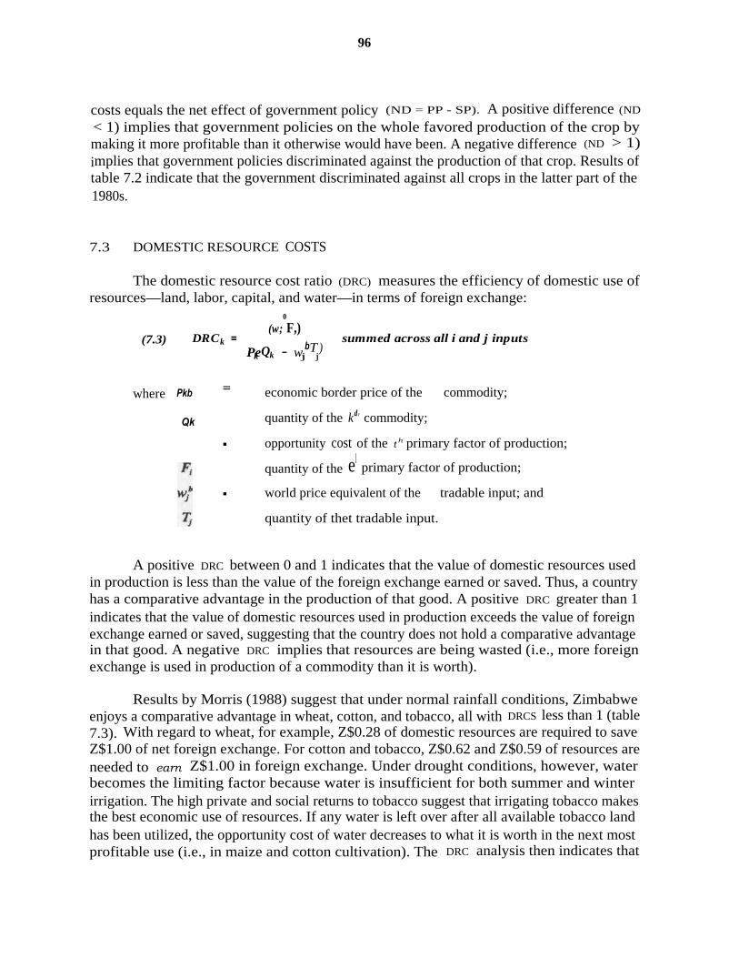
96
costs equals the net effect of government policy (ND = PP - SP). A positive difference (ND
< 1) implies that government policies on the whole favored production of the crop bymaking it more profitable than it otherwise would have been. A negative difference (ND > 1)implies that government policies discriminated against the production of that crop. Results oftable 7.2 indicate that the government discriminated against all crops in the latter part of the1980s.
7.3 DOMESTIC RESOURCE COSTS
The domestic resource cost ratio (DRC) measures the efficiency of domestic use ofresources—land, labor, capital, and water—in terms of foreign exchange:
(w;0
F,)(7.3) DRCk = b summed across all i and j inputs
Pek Qk - wjTj)
where Pkb =
Qk
economic border price of the commodity;
quantity of the kd' commodity;
▪ opportunity cost of the th primary factor of production;
quantity of the elprimary factor of production;
▪ world price equivalent of the tradable input; and
quantity of thet tradable input.
A positive DRC between 0 and 1 indicates that the value of domestic resources usedin production is less than the value of the foreign exchange earned or saved. Thus, a countryhas a comparative advantage in the production of that good. A positive DRC greater than 1indicates that the value of domestic resources used in production exceeds the value of foreignexchange earned or saved, suggesting that the country does not hold a comparative advantagein that good. A negative DRC implies that resources are being wasted (i.e., more foreignexchange is used in production of a commodity than it is worth).
Results by Morris (1988) suggest that under normal rainfall conditions, Zimbabweenjoys a comparative advantage in wheat, cotton, and tobacco, all with DRCS less than 1 (table7.3). With regard to wheat, for example, Z$0.28 of domestic resources are required to saveZ$1.00 of net foreign exchange. For cotton and tobacco, Z$0.62 and Z$0.59 of resources areneeded to earn Z$1.00 in foreign exchange. Under drought conditions, however, waterbecomes the limiting factor because water is insufficient for both summer and winterirrigation. The high private and social returns to tobacco suggest that irrigating tobacco makesthe best economic use of resources. If any water is left over after all available tobacco landhas been utilized, the opportunity cost of water decreases to what it is worth in the next mostprofitable use (i.e., in maize and cotton cultivation). The DRC analysis then indicates that

97
Zimbabwe has a comparative advantage in irrigated maize (DRC = .72) and cotton (DRC =.76), once tobacco lands have been fully exploited. Both the Morris (1988) and Masters(1990) studies indicate a comparative advantage in wheat as long as water is abundant.However, once water is scarce and water prices are assigned to the next most profitable use,wheat represents an inefficient use of resources.
Under rain-fed conditions, commercial farmers hold a comparative advantage in allgoods relative to the rest of the world. The DRC for soyabeans is .22; groundnuts, .24;cotton, .25; maize, .36; and sunflower, .58. With the exception of sorghum, communalfarmers also show a comparative advantage relative to the rest of the world. However, DRCSfor the communal sector indicate that it is relatively less efficient than the LSCS in theproduction of maize, sunflower, groundnuts, and cotton.
Inherent in these DRCS, however, is the problem that production systems and yieldsvary according to differences in ecological region. Unfortunately, two intractable problemsare experienced in estimating DRCS by ecological zone. First, the crop budgets prepared bythe Commercial Farmers Union and National Farmers Union, which are the basis of theWoldu (1990) and Masters (1990) studies, do not give a breakdown of input use by naturalregion. Second, detailed data on input use are not reported in official statistics, despite thefact that fertilizer data are collected.
22
TABLE 7.3
Domestic resource cost ratios
MZ WI' MG SF SB GN CT TB
Morris (1986)
Normal conditions 2.12 .28 4.93 4.06 .62 .59Drought scenario .72 1.56
Masters (1989)
1.51 2.42 .76 .15
Lscs: irrigated .11Lscs: rain-fed .36 .58 .22 .24 .25Communal: rain-fed .51 1.23 .78 .59 .33
Source: Will Masters, unpublished data, Ministry of Lands, Resettlement and RuralDevelopment, Government of Zimbabwe, Harare, 1990; and Michael L. Morris,"Comparative Advantage and Policy Incentives for Wheat Production in Zimbabwe,"CIMMYT Economics Working Paper no. 88/02 (Harare: International Maize andWheat Improvement Center, 1988).
22. These data could presumably be estimated from the original data if they were accessible fromCso.
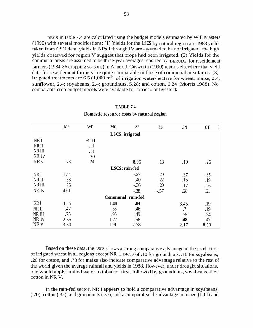
98
DRCS in table 7.4 are calculated using the budget models estimated by Will Masters(1990) with several modifications: (1) Yields for the LSCS by natural region are 1988 yieldstaken from CSO data; yields in NRs I through IV are assumed to be nonirrigated; the highyields observed for region V suggest that crops had been irrigated. (2) Yields for thecommunal areas are assumed to be three-year averages reported by DERUDE for resettlementfarmers (1984-86 cropping seasons) in Annex J. Cusworth (1990) reports elsewhere that yielddata for resettlement farmers are quite comparable to those of communal area farms. (3)Irrigated treatments are 6.5 (1,000 m3) of irrigation water/hectare for wheat; maize, 2.4;sunflower, 2.4; soyabeans, 2.4; groundnuts, 5.28; and cotton, 6.24 (Morris 1988). Nocomparable crop budget models were available for tobacco or livestock.
TABLE 7.4Domestic resource costs by natural region
MZ WI' MG SF SB GN CT l
LSCS: irrigatedNR I -4.34NR II .11NR III .11NR Iv .20NR v .73 .24 8.05 .18 .10 .26
NR I 1.11LSCS: rain-fed
.37 .35-.27 .20NR II .58 -.40 .22 .15 .19NR III .96 -.36 .20 .17 .26NR Iv 4.01 -.38 -.57 .28 .21
NR I 1.15Communal: rain-fed
3.45 .191.08 .84NR II .47 .38 .46 .7 .19NR III .75 .96 .49 .75 .24NR Iv 2.35 1.77 .56 .48 .47NR v -3.30 1.91 2.78 2.17 8.50
Based on these data, the LSCS shows a strong comparative advantage in the productionof irrigated wheat in all regions except NR I. DRCS of .10 for groundnuts, .18 for soyabeans,.26 for cotton, and .73 for maize also indicate comparative advantage relative to the rest ofthe world given the average rainfall and yields in 1988. However, under drought situations,one would apply limited water to tobacco, first, followed by groundnuts, soyabeans, thencotton in NR V.
In the rain-fed sector, NR I appears to hold a comparative advantage in soyabeans(.20), cotton (.35), and groundnuts (.37), and a comparative disadvantage in maize (1.11) and
99
sunflower (-.27). DRCS for NR II suggest a comparative advantage first in groundnuts (.15),followed by cotton (.19), soyabeans (.22), then maize (.58). In NR III, groundnuts (.17)again appear to make the best use of land, followed by cotton (.26) and soyabeans (.20). TheDRC of .96 for maize indicates only a slight comparative advantage. The LSCS is relativelyinefficient in the production of all crops (for which DRCS were calculated) in NR IV. Cropsin NR V are primarily irrigated.
Based on average yields for the 1984-86 season, communal area farms show a strongcomparative advantage in cotton (.19) and sunflower (.84), and a comparative disadvantagein maize, mhunga, and groundnuts relative to the rest of the world. In NR II, communalfarmers are relatively efficient producers of cotton (.19) groundnuts (.27), mhunga (.37),sunflower (.46), and maize (.47). While large-scale farms in NR II appear to be moreefficient producers of groundnuts (.15 vs. .27), given current technology, communal farmersappear to be relatively more efficient producers of sunflower (.46 vs. -.40) and maize (.47vs. .58). Similar patterns hold for NR III. Both large-scale and communal farmers hold acomparative advantage in cotton, groundnuts, and maize compared with the rest of the world.But communal farmers appear to be relatively more efficient producers of sunflower (.49 vs.-.36) and maize (.75 vs. .96). The LSCS is relatively more efficient in groundnut production(.17 vs. .48). Soyabeans and maize appear to be inefficient uses of land in NR IV. Bothsectors continue to hold a comparative advantage in cotton and groundnuts, though farms inthe LSCS appear to be relatively more efficient producers. All crops appear to be inefficientusers of resources in both sectors in NR V, unless irrigated.
7.4 SUMMARY AND IMPLICATIONS
Price policy has established appropriate economic incentives for producers by aligningproducer prices with border parity prices (at the official exchange rate). However, becauseofficial exchange rates are overvalued, the private profitability of all crops is sharply reduced,resulting in taxation of producers. Disincentives are fairly widespread because socialprofitability exceeds private profitability for all crops. Yet, since all prices are taxeduniformly, resource allocation and crop mix do not seem to be grossly distorted.
Although government policies have discriminated against producers on output prices,certain crops have been more than compensated through input subsidies. Current price policyprovides overall net subsidies to commercial producers of irrigated wheat and groundnuts andrain-fed maize and cotton. Farmers receive substantial subsidies on both credit and tradableinputs (fertilizers and chemicals). The LSCS is the major beneficiary of these subsidies, thoughsmall net subsidies are also received on nearly all crops in communal areas.
Results of the DRC analysis for NRs II and III suggest that the LSCS holds acomparative advantage in tobacco, groundnuts, and soyabeans. Communal farmers appear tohave a comparative advantage in maize and sunflowers. Both groups tend to be nearly equallyefficient in cotton production. It is clear from chapter 6 that both sectors have been movingin the direction of their comparative advantage. For the LSCS, cropping patterns have been
100
shifting away from maize toward industrial crops. For the communal sector, cropping patternshave been shifting toward maize and cotton.
A number of policies affect the prices paid by farmers for purchased inputs. Importtariffs and sales taxes exert upward pressure on input prices. But these are more than offsetby an overvalued exchange rate, which makes imports appear cheaper in local currency, andexports, more expensive. Still, given that the exchange rate is estimated to be overvalued by50 percent, there has been considerable incentive to substitute capital imports for land andlabor.
While minimum wage-rate policy had a substantial influence on profitability in theearly 1980s, real minimum-wage rates have now eroded to near pre-1980 levels due toinflation. Nominal wage rates are higher than in the communal sector, but this in part reflectsthe higher marginal value of labor from industrial crop (versus cereal) production.Employment legislation in chapter 6 was shown to have profoundly decreased labor demandon farms. This implies a real cost for hiring new people (given employer uncertaintieswhether or not those hired will prove to be good workers), but does not affect the cost ofalready hired employees.
Agricultural credit policy—specifically, the provision of AFC credit at rates severalpoints lower than formal lending institutions—have reduced borrowing costs and shiftedincentives toward the utilization of capital-intensive technology. LsCS farmers, who receiveabout 80 percent of the credit provided by the AFC, are the main beneficiaries. Tightforeign-exchange allocations to agriculture have helped dampen the substitution of capitalmachinery for labor. But current donor programs to supplement foreign exchange will almostcertainly exacerbate the decline in labor employment in the LSCS, all else being equal.
Comparative advantage is dynamic, constantly changing with investment in humancapital, agricultural research, and extension. Rates of growth in yields in the communal sectorwill continue to converge toward the slower rates in the LSCS as the diffusion of technologyspreads. Communal farmers now hold a comparative advantage in maize production. But dueto record stock levels, slow export demand and scarce foreign exchange in surroundingSADACC countries, and transport constraints (internally and externally), production fromcommunal areas will continue to place downward pressure on maize prices. As long as itscomparative advantage holds, a continuing decline in LSCS maize production is expected.
Under the current situation of transport bottlenecks, there is a high economic rent toscarce transport capacity. Until rents decline, economic incentives will be biased toward theproduction of commodities with high value per unit of volume in transport (e.g., tobacco,cotton, fruits, and vegetables) and against commodities with low value per unit of volume(e.g., grain). As transport costs rise, grain producers will find themselves increasingly at adisadvantage relative to other commodities. Thus, while the communal sector's comparativeadvantage in maize production is apparent, the long-term prospects of a maize-based economyto drive income growth is not encouraging.

101
Chapter 8
LAND UTILIZATION IN THE LARGE-SCALE COMMERCIAL SECTOR
8.1 BACKGROUND
Many attempts have been made to estimate the extent of land utilization in the LSCS.A 1960 study, cited by Cliffe (1986), estimated that only 24 percent of total arable land inthe sector was cultivated, and that the cattle herd operated at only 35 percent of potentialstocking rates. The sector's substantial contribution to agricultural production and exportearnings mask a number of inefficiencies (Riddell 1978a, 1978b). Riddell notes that over 60percent of commercial farms in 1975/76 were not profitable enough for income-tax payments;only 15 percent of the potentially arable land was actually cultivated. A 1982 study byHawkins Associates for the World Bank presents an opposite view. It found that theutilization of net arable land ranged between 58 and 128 percent in five of the six intensiveconservation areas they assessed in the country's main cropping region.
23
A study by Weiner et al. (1985) tried to untangle some of these apparent contradic-tions. It calculated rates of land utilization for 14 districts and 3 provinces of Mashonaland,which incorporate most of NR II and some of NR III. Based on 1981/82 cropped area, only24.7 percent of arable land in Mashonaland West, 33.3 percent of Mashonaland Central, and14.9 percent of Mashonaland East were actually cultivated in crops. Even after making thevery conservative estimate that 20 percent of the arable land is needed for squaring of fields,construction of roads and homesteads, and pockets of inaccessible land, and that another 15percent is needed for mechanical conservation measures (contouring, waterways), landutilization increased to only 36, 49, and 22 percent, respectively. Further, none of thedistrict-level data came even remotely close to the efficiency rates reported in the HawkinsAssociates (1982) study, raising serious doubts about their validity.
A more recent study by the World Bank (1986) divided commercial areas into grazed,cropped, fallow, and unusable land. Actual stocking rates of livestock were then comparedwith safe stocking rates recommended by AGRITEX for grazing areas. It concluded that of the12.7 million hectares in commercial areas, only 1.0 million hectares of truly surplus landwould be available for additional livestock grazing, most of that in NR V. Also, only 549,000hectares out of 3.0-3.5 million hectares of potentially arable land were used for cropcultivation, with the remainder used mainly for livestock grazing. Rather than representingan inefficient use of resources, the study argues that a number of factors have helped makelivestock a lucrative enterprise on this arable land: (1) restrictions until recently on Africans'ability to purchase land in European areas; (2) the low purchasing power of Africans; (3)
23. An "intensive conservation area" is an administrative boundary within the commercial farmingarea.

102
tribal lands in communal areas being off-limits to commercial farmers; (4) restrictions onpurchases and sales in the land market; (5) absence of a formal leasing market; (6) the sharpincrease in minimum agricultural wage rates since independence; and (7) a shortage of capitalequipment brought about by the acute rationing of foreign exchange to the agricultural sector.These market imperfections have tended to keep land prices low by limiting demand forarable land, thus increasing incentives for extensive (i.e., livestock) farming systems.
Since the work of Weiner et al. (1985) in 1981/82, four fundamental forces havecontinued to dramatically shape land-use patterns and thus land utilization:
► The LSCS has declined from 15.0 million hectares in 1979 to 11.2 millionhectares by 1988, a 26.6 percent decline. Some unknown but sizable area ofthis land comprised abandoned farms with high rates of underutilization.
► As a result of pricing policy, there has been a dramatic shift in croppingpatterns away from cereals toward industrial and specialty crops. These cropsare less land intensive, requiring higher inputs of labor per unit of area.
► Total labor employed on farms has declined from 286,825 permanent andcasual farm employees in 1979 to 227,626 employees by 1988, a 20.6 percentdecline.
► The number of beef and dairy cattle has declined from 2.2 million head in1980 to 1.8 million head by 1988; cattle numbers in NRs I and II havedeclined only marginally.
Item (1) should in general have led to increased aggregate land utilization by removingabandoned and inefficient farm enterprises from the sector. However, items (2) through (4)would tend to decrease land utilization in the aggregate depending on the magnitude ofchanges involved. Moreover, changes in land redistribution and land-use patterns have notbeen uniform across either provinces or natural regions. Accordingly, a number offundamental issues arise. The first is concerned with the extent of utilization of arable landfor crop agriculture. The second is concerned with stocking rates of livestock and the extentof underutilization of grazing land. The third is concerned with whether using livestock forarable land constitutes an economically efficient use of resources.
8.2 LAND UTILIZATION
8.2.1 CROP PRODUCTION ON ARABLE LAND
Assessing potential arable land normally requires detailed soil surveys and/or farmplans because of the wide variation in geological formations and soil types in Zimbabwe.Because land utilization is so central to proposals for land redistribution, a number of authorshave recommended that regular studies on land use be undertaken, and that a better data base

103
be established, beyond simple national and regional aggregations (Chavunduka 1982; Cliffe1986). While AGRITEX has continued its work on assimilating farm plans, the work is notsufficiently advanced to permit either ready access to data or immediate analysis.
Two somewhat dated studies have tried to estimate the area of arable land. Asmentioned earlier, the Weiner et al. (1985) study estimated total arable land from a 10percent sample frame of farm plans compiled by the Ministry of Agriculture over a 3-yearperiod prior to 1981, when the study was conducted. Amble land was estimated for threeprovinces, Mashonaland East, Mashonaland Central, and Mashonaland West. The mostcomprehensive study, however, is the now famous work of Vincent, Thomas, and Staples(1962), who conducted a detailed agro-ecological survey of then-Rhodesia from 1950 through1956. This exhaustive survey estimated, in detail, the amount of arable land by naturalregion.
Column A in table 8.1 shows total area of land by province and natural region as of1988 (CSo). Only the three provinces in Mashonaland are selected to take advantage of thedata on arable land from the Weiner et al. (1985) study. Column B contains estimates ofarable land. For the three provinces of Mashonaland, data from Weiner et al. (1985) areused, adjusted downward to reflect land acquired for resettlement.' For natural regions,percentage arable land in column C is adapted from detailed data reported in Vincent,Thomas, and Staples (1962, p. 107).
25
Column D reports crop area by province and natural region for the 1988/89 croppingseason. Only 19 percent of gross arable land in Mashonaland East was planted in crops, 24percent in Mashonaland West, and 34 percent in Mashonaland Central. Comparable figuresin Weiner et al. (1985) were 15, 25, and 33 percent, respectively, for 1981, showing onlymarginal changes in land utilization between 1981 and 1988, the higher utilization inMashonaland East being the exception.
Estimates of cropping efficiency in NRs II and III are generally higher than provincialtotals because all three Mashonaland provinces contain sizable areas of NR IV, which has avery low rate of land utilization (measurement differences are partly responsible as well).Based on the percentage arable land figures taken from Vincent, Thomas, and Staples (1962)in column E, 40 percent of the gross arable land in NR I was cultivated, 36 percent in NR II,
24. Arable land in 1988 was assumed to have the same proportion to total land as in 1981, the timeof the Weiner et al. (1985) study.
25. Arable land, according to Vincent, Thomas, and Staples (1962), is "land which has adequatedepth of soil for satisfactory plant growth, and which can safely be cultivated using normal rotations,cultural practices, and protection methods. This definition excludes certain areas of potentially arableland. For example, much of the land in NR I is not classified as arable because of excessive slope.Yet this land is quite suitable for forestation and for orchards and plantation crops. Land in Nrs IVand V is also potentially arable with irrigation, but would require large capital investment in land.

TABLE 8.1
Efficiency of arable land use for crop production
CROP NET NET ADJUSTEDTOTALAREA
(000 ha)
ARABLELAND
(000 ha)
ARABLELAND(%)
AREAd
PLANTED(000 ha)
CROPPINGEFFICIENCY
(%)
ARABLELAND
(000 ha)`
CROPPINGEFFICIENCY
(%)
ADJUSTEDCROP AREA
(000 ha)
CROPPINGEFFICIENCY
(%)
Mashonaland West
A
1,886.0
B
760.6'
C=B=A
40.3
D
184.6
E=D=B
24.3
F
650.3
G=D=F
28.4
H
270.2
I=H=F
41.6Mashonaland Central 732.6 307.3' 41.9 105.4 34.3 262.7 40.1 152.7 58.1Mashonaland East 957.8 522.1' 54.5 97.6 18.7 446.4 21.9 139.1 31.2
NR Ib 202.2 27.9 13.86 11.7 39.7 23.9 49.0 12.1 50.6NR II 3,686.9 1,047.1 28.4 379.1 36.2 895.3 42.3 556.0 62.1NR III 2,405.4 574.9 23.9 48.4 8.4 491.5 9.9 74.9 15.2NR IV 2,429.1 10.1° 0.0 8.9 88.1 10.1 88.1 10.2 101.0NR V 2,489.7 102.5° 0.0 52.3 51.0 102.5 51.0 53.1 51.8
a. From Dan Weiner et al., "Land Use and Agricultural Productivity in Zimbabwe," Journal of Modern African Studies23 (1985): 252-85, less land acquired for resettlement, assuming that 1988 totals contain the same proportion of arableand nonarable land as in 1981.
b. Percentages for natural regions are adapted from V. Vincent, R.G. Thomas, and R.R. Staples, An Agricultural Surveyof Southern Rhodesia: Part I, Agro-Ecological Survey (Harare: Ministry of Lands, Agriculture and Resettlement,1962), p. 107.
c. Arable land is irrigable land times a cropping intensity of 2.d. Crop area in 1988/89 (Central Statistics Office).e. Arable land less 10% for squaring of fields, tree lines, roads, homesteads, and pockets of inaccessible land, and less
5% for mechanical conservation measures.f. Crop area adjusted to include recommended fallow rotations.

105
and 8 percent in NR III. The amount of arable land in NRs IV and V is zero (column C)because rainfall is too low and variable. Data for arable land in column B are thus area underirrigation times two for double-cropping. Data in column E report fairly high rates ofutilization, at 88 and 51 percent for NRs IV and V, respectively.
As was earlier pointed out in the Weiner et al. (1985) study, however, thesecalculations are misleading because not all arable land is available to farmers. Column F intable 8.1 provides a figure for net arable land which makes the following adjustments:
► arable land in column C is reduced by 10 percent to account for land lost dueto squaring of fields, tree lines, and construction of roads and homesteads, andfor pockets of land that are inaccessible; and
► a further reduction of 5 percent is made to account for land lost for mechanicalconservation measures, contouring, access roads, and artificial waterways.
The Weiner et al. (1985) analysis, in order to remain consistent with Ministry ofAgriculture plans, used the figures of 20 and 15 percent, respectively, to cover the abovelosses. But it later points out that these figures are themselves policy recommendations basedon commercial farming systems. While commercial farms may require surplus land forsquaring of fields and inaccessible pockets, these areas may be quite suitable for small-scaleagriculture. Estimates of net arable land in table 8.1 are thus less conservative than those inWeiner et al. Using net arable land in column F, cropping efficiency increases to between 22and 40 percent in Mashonaland, and to between 10 and 49 percent in NRs I, II, and III.
Actual cropped area ignores two factors in determining rates of land utilization: (1)certain crops such as wheat are irrigated under double-cropping systems and thus result indouble accounting of crop area; and (2) certain crops, principally tobacco, require grassfallow according to AGxITEX recommendations. The first overstates the area of crops actuallyplanted. The second underestimates the effective amount of land required for sustainable cropyields. To account for double-cropping and the need for fallowing the system, crop area incolumn H is adjusted by the formula:
X (1+au ) * Xa for all i crops in region j
adjusted area of crop i in region j;
ley or discount factor for crop i in region j derived fromAnnex I; and
X;,j = actual area of crop i in region j.
As shown in Annex I, 3 hectares of grass are recommended for every hectare oftobacco, resulting in a ley factor of 3. Maize requires 3 hectares of grass for every 2 hectaresof maize on light soils but no rotation on heavy soils. Assuming that 50 percent of soils areheavy and 50 percent light, the ley factor is 3 hectares of grass for every 4 hectares of maize,

106
giving a ley factor of 0.75. A discount factor of -1.0 is assigned to wheat because it isgenerally double-cropped (i.e., two crops per year, one wheat, followed or preceded byanother) and thus its area is already accounted for by other crops. A discount factor of -1.0is also indicated for fodder crops. Aside from the issue of the economic profitability offorages compared with crop production, fodder crops can be substituted for grass fallow inthe tobacco and maize rotations. Finally, other crops are assumed to be cultivated under 100percent cropping systems for lack of more detailed data on type and frequency of rotations.The ley factor for these other crops has thus been set at 0.0.
After making these adjustments for double-cropping and fallow, cropping efficiencyin column I increases to 31 percent in Mashonaland East, 42 percent in Mashonaland West,and 58 percent in Mashonaland Central. In NRs I and II, cropping efficiency increases to 51and 62 percent, respectively, while cropping efficiency in NR III is 15 percent. Although landutilization has increased from a decade ago, approximately 40-50 percent of the arable landin the LSCS in NRs I and II, respectively, remains unutilized for crop production. Arable landin NR III remains grossly underutilized at only 15 percent.
While these data are imperfect, it would be difficult not to reach the conclusion thatthere is a large area of unutilized land in NRs I, II, and III that could potentially beredistributed without depressing commercial crop production and exports. 26 But cropproduction represents only one facet of agriculture. Livestock is also an important industry,raising two fundamental issues: whether stocking rates on remaining arable land and ongrazing land indicate full utilization of grazing areas, and whether grazing livestock on arableland in NRs I, II, and III makes the most economical use of resources.
8.2.2 UTILIZATION OF GRAZING LAND
Use of grazing land for extensive livestock production is examined in table 8.2.Grazing land in column E is calculated as total area in column A, less cropped area in columnC (minus planted fodder crops), less unusable land in column D (estimated at 20% of totalland area). Livestock units in column F were estimated from 1988 numbers of cattle, sheep,and goats, and the conversion factors of 0.7 LU for each head of beef or dairy cattle and 0.15LU for each head of sheep and goats. Unfortunately, livestock numbers are known with somecertainty only at the provincial level. Numbers of livestock units by natural region are thusadapted from national totals and regional percentages reported by the World Bank (1986).Regional results should be viewed with caution since the methodology for estimating livestocknumbers by region is unclear from the World Bank report and data are somewhat dated.Given that more accurate regional numbers become available, results can be updatedaccordingly.
Potential grazing area per livestock unit in column G is compared with three grazingstrategies: column H is the optimal stocking strategy recommended by AGRITEX to permit
26. This of course depends crucially on the process used to redistribute land (see ch. 9).
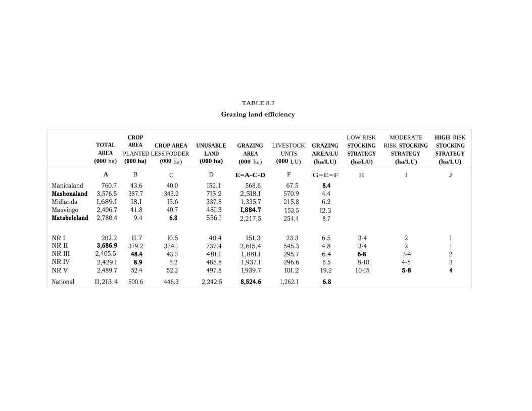
TABLE 8.2
Grazing land efficiency
CROP LOW RISK MODERATE HIGH RISKTOTALAREA
(000 ha)
AREA CROP AREAPLANTED LESS FODDER
UNUSABLELAND
(000 ha)
GRAZINGAREA
(000 ha)
LIVESTOCKUNITS
(000 LU)
GRAZINGAREA/LU(ha/LU)
STOCKINGSTRATEGY
(ha/LU)
RISK STOCKINGSTRATEGY
(ha/LU)
STOCKINGSTRATEGY
(ha/LU)(000 ha) (000 ha)
A B C D E=A-C-D F G=E=F H I J
Manicaland 760.7 43.6 40.0 I52.1 568.6 67.5 8.4Mashonaland 3,576.5 387.7 343.2 7I5.2 2,5I8.I 570.9 4.4Midlands I,689.I I8.I I5.6 337.8 1,335.7 215.8 6.2Masvingo 2,406.7 41.8 40.7 48I.3 I,884.7 153.5 I2.3Matabeleland 2,780.4 9.4 6.8 556.I 2,217.5 254.4 8.7
NR I 202.2 II.7 I0.5 40.4 I5I.3 23.3 6.5 3-4 2 1NR II 3,686.9 379.2 334.I 737.4 2,6I5.4 545.3 4.8 3-4 2 INR III 2,405.5 48.4 43.3 48I.I 1,88I.I 295.7 6.4 6-8 3-4 2NR IV 2,429.I 8.9 6.2 485.8 1,937.I 296.6 6.5 8-I0 4-5 3NR V 2,489.7 52.4 52.2 497.8 I,939.7 I0I.2 19.2 10-I5 5-8 4National II,2I3.4 500.6 446.3 2,242.5 8,524.6 1,262.1 6.8

108
sustainable use of resources with ample capacity for drought years; column I is a moderatelyrisky strategy, enabling higher stocking rates considered by some to be more efficient use ofpasture (this stocking strategy would probably require some destocking in drought years); andcolumn J is a very risky strategy enabling very high stocking rates in ample rainfall years,but requiring extreme destocking in poor rainfall years. Columns I and J are included topresent the arguments of critics that AGRITEX-recommended stocking rates are too low.Conversely, strategy J is probably too optimistic.
Based on recommended stocking rates, the herd in NR I could be grazed on about halfof the grazing area, indicating surplus grazing land. But the surplus area represents onlyabout 75,000 hectares. Stocking rates in NR II (4.8) are not greatly out of line with therecommended stocking rate of 3.5 hectares/LU. However, assuming that regional data arevalid, approximately 700,000 hectares of grazing land could be counted as surplus (2,615.4- 3.5 x 545.3). Stocking rates for NRs III and IV appear to be optimal with perhaps someoverstocking in NR IV. Significant understocking appears to exist in NR V. Based onrecommendations of 15 hectares/LU, about 420,000 hectares of residual land is available.
Overall, about 1.2 million hectares could potentially be considered surplus. If the morerisky stocking rates in column I are considered, perhaps 2.4 million hectares are available.But it remains controversial whether these more liberal estimates can be considered optimal.Because of the high capital investment, time requirements for building a herd, and frequencyof drought, strategy J appears far too optimistic.
8.3 SUMMARY AND IMPLICATIONS
A central issue in the land policy debate concerns the amount of land either idle orunderutilized in the LSCS. Redistributing land that is currently being utilized would entail theprospect of production losses if commercial farmers are more efficient or productive,however defined, than settler farmers. However, if sizable amounts of unutilized land existin the LSCS, then the possibility arises of redistributing this idle land to settler farmers andincreasing aggregate output from the resettlement sector without disrupting commercial farmproduction. Perceptions are pervasive, among government officials, that a sizable amount ofunutilized land does exist, reinforcing demands for an expanded resettlement program.
Using crude and aggregate data, this chapter has tried to estimate the area ofunutilized land in the LSCS by starting with estimates of arable land and crop area, thenmaking the following corrections: (1) calculating net arable land available to farmers,deducting areas lost to squaring of fields, tree lines, roads, homesteads, artificial waterways,and mechanical conservation measures; and (2) adjusting cropped area for double-croppingand required fallow.
Based on this analysis, approximately 50 percent of the arable land in NR I and 40percent of the arable land in NR II are not being fully utilized for crop production (crops andfallow). In area terms, unutilized arable land in NRs I and II amount to 351.1 thousand
109
hectares, and total land area (including nonarable and arable land) of 1,497.2 thousandhectares. The latter figure is most relevant since farms acquired by the government wouldinclude arable, grazing, and waste land. If NR III is considered also, an additional 416.8
thousand hectares of arable land, or 2,039.8 thousand hectares of total land, could beacquired for resettlement without sacrificing commercial crop output and/or exports.
While idle land could conceivably be resettled with minimum adverse impacts onlarge-scale commercial producers, current targets being proposed by government are callingfor the resettlement of 6.0 million hectares. Important issues thus arise about the relativeefficiency of commercial versus resettlement production. Yield comparisons for maize inAnnex J indicate that commercial farmers obtain maize yields 2-3 times higher than thecommunal sector. Acquiring and resettling land beyond the 3.5 million hectares above raisefundamental concerns about the impacts of resettlement on food security and export cropproduction. The weak comparative advantage of communal farmers in maize production andtheir comparative disadvantage in industrial crop production highlight these concerns (seech. 7).
The above estimate of 3.5 million hectares of unutilized land implicitly assumes thatcommunal crop production is a more efficient land use than livestock production. No evidenceeither for or against this assumption is presented in this report. This issue is of fundamentalimportance to the analysis of land use and resettlement, but was beyond the scope andresources of this study. If it is shown in subsequent studies that commercial livestockproduction is more efficient than either settler crop or livestock production, then the data intable 8.2 suggest that only 1.2 million hectares of grazing land (some arable plus nonarableland) are underutilized assuming low-risk stocking rates, and 2.4 million hectares given riskystocking rates. Sixty-five percent of this land is located in NRs I and II.
Questions concerning appropriate policies to identify and acquire land for resettlementare the focus of the following (final) chapter.

111
Chapter 9
POLICY CONSIDERATIONS
9.1 BACKGROUND
After a decade of resettlement, land distribution in Zimbabwe is still highly skewed.About 4,660 farmers in the commercial sector control 29 percent of the nation's land area,located mainly in the highest rainfall zones. More than 1 million families remain inovercrowded communal lands on 42 percent of the nation's land area, located mainly in thepoorest rainfall zones.
Low productivity and natural resource degradation from overcrowding in communalareas are fueling demands for land redistribution. Yet, any radical redistribution of land risksundermining production and export earnings. The LSCS sector provides employment for over225,000 farm laborers and produces 68 percent of the nation's gross agricultural output, 82percent of crop sales, 94 percent of marketed livestock offtake, and 50 percent of exportearnings. The two most pressing problems currently confronting the government—highunemployment and acute shortages of foreign exchange—depend crucially on how theresettlement process is handled and on the confidence of the commercial farming community.In the past, land has been acquired by the government on a willing buyer-willing seller basisunder the provisions of the recently expired (April 1990) Lancaster House Constitution.Critics argue that this provision has hampered the acquisition of the best land because ofcollusion among sellers and high land prices, and/or has resulted in an inadequate supply ofland coming to market.
The currently skewed land distribution and the need to alter it are common groundamong virtually all who have considered these issues and would not be challenged by any ofthe participants in the public policy discussions in Zimbabwe. The issues instead concern howfast and how far rectification can and should go and what mechanisms might work best toachieve it. Given the disparities in landholdings and the cultural barriers impeding the flowof land among sectors, resettlement is the best policy option for achieving both economicgrowth and stability in the long run. The most crucial issues hinge on the process used toacquire land, select settlers, and settle them on the acquired land.
How great a need still exists today? So far, 53,968 families have been settled onroughly 26 percent of the LSCS land that existed in 1979, 60 percent of these coming fromthe communal areas. Government's target is 162,000 families; if present proportions hold,another 40 percent of the LSCS land would be required. The government's target figure of162,000 families seems to have no very clear basis, but other estimates are higher. Bratton(1990) indicates that only a small portion of the real need has been met. He estimates that
112
180,000 households are truly landless, mostly households of young men, while 150,000households are near landless, a total of nearly 42 percent of the total agricultural population.Landlessness figures which include young men who are farming their fathers' land may,however, overstate the need. The more modest figure of between 6 and 12 percent of thepeasant population being without land is probably a better indication (MLGRUD 1987).
About 150,000 families have registered for the resettlement program in variousprovinces (MLARR 1986); it is not clear whether this figure includes the members of the 200registered cooperative societies who are waiting for land in the model B schemes. Thesenumbers of registered applicants for land are probably our best guide because they reflect notjust some inchoate need, but households ready and willing to resettle.
These numbers will be swollen to the extent that the commercial farms taken will havelabor forces which must somehow be accommodated in resettlement schemes. This extent isdifficult to gauge because statistics on the labor force in the LSCS are in terms of laborersrather than households, and because the choice of land acquisition strategies (e.g., acquisitionof underutilized land or block acquisition of whole farms) could dramatically affect thenumbers of laborers who would be released from commercial agriculture.
9.2 1992 LAND LEGISLATION
The Constitution of Zimbabwe, Amendment Bill no. 11, was passed by Parliament inDecember 1990, and the Land Acquisition Bill, in March 1992. Under the 1992 Land Act,6.9 million hectares would be acquired by the government from the LSCS. 27 Of this amount,5.0 million hectares would be added to the resettlement sector, expanding its size from 3.3million hectares to 8.3 million hectares, and 1.9 million hectares would be added to the statefarm sector, increasing its size from 0.5 million hectares to 2.4 million hectares. Landallocations in the communal and small-scale commercial sectors would remain unchanged at16.3 million hectares and 1.2 million hectares, respectively. Only land in "designated" areaswill be acquired. The government has stated its intent to concentrate first on acquiringunderutilized land, and only after these farms have been acquired will it begin acquiring moreintensively utilized farms. 28 More resources will be provided to the Rural State Land Office
27. Zimbabwe's total land area is 39,070.0 thousand ha. In 1988, the communal sector comprised(in 000 units) 16,355.0 ha; the Lscs, 11,213.4 ha; the Sscs, 1,238.7 ha; resettlement areas, 3,290.0ha; state farms, 500.0 ha; parks and wildlife areas, 4,978.1 ha; and "other" land, 1,494.8 ha. Masoka(1993) states that 6.3 million ha will be acquired from the Lscs, but resettlement will receive 5.0million ha, and the state sector, 1.9 million ha, for a total of 6.9 million ha. No explanations areoffered for the source of the additional 0.6 million ha.
28. See Masoka (1993). Despite government's stated intent to keep "efficient" farms on the land,the provision of one farm per individual and the government's desire to establish large-scaleresettlement schemes would eventually compel the government to purchase significant numbers ofintensively utilized farms. This problem could be circumvented if large "pockets" of underutilized
113
and the Farm Management Section of the MLARR to strengthen their capacity in carrying outland inspections to detect land underutilization and absentee landlordism." To facilitate thegovernment's acquisition of land, the new land policy stipulates state control of land prices,limits on number of farms and farm size, and the "designation" of areas for land acquisitionand resettlement. The government asserts that the target of 6.9 million hectares can beacquired and redistributed without reducing agricultural output and export earnings.
9.3 LAND UTILIZATION AND COMPARATIVE ADVANTAGE
Current proposals to resettle 110,000 families on 6.9 million hectares of land withoutcausing significant economic destabilization would appear to be unrealistic.
First, 3.5 million hectares of land can be considered underutilized in NRs I, II, andIII only if crop production is more "efficient" than livestock grazing or wildlife management.To the author's knowledge, there are no studies on Zimbabwe that either support or refutethis argument. Should livestock represent an economically efficient use of land, then only 1.2million hectares would be underutilized assuming low-risk stocking rates, and 2.4 millionhectares assuming risky stocking rates.
Second, while available data suggest that between 1.2 and 3.5 million hectares of landare potentially underutilized, these aggregate figures disguise two important variations: theunderutilized land is spread over many farms (each farm has a core area of utilized land withother land that is less intensively utilized); and not all farmers are equally efficient. Acquiringand redistributing the underutilized "pieces" would have a positive impact on aggregateproduction. However, acquiring and redistributing entire farms within a "designated" areawould have important output implications, either positive or negative depending on thecomparative advantage of resettlement farmers relative to the commercial farmers beingdisplaced.
The domestic resource cost (DRC) coefficient measures the comparative advantage ofa group or region for a given commodity based on foreign exchange earnings or savingsrelative to domestic resources spent. DRC coefficients computed for NRs II and III (see ch. 7)
land containing no operating farms could be designated. However, as Roth (1990) points out, thesepockets have already been largely absorbed into the resettlement program.
29. Unlike Masoka (1993), who feels that criteria can be designed to measure land underutilization,the proposed criteria—output value/hectare, livestock offtake, speculation, and derelict lands—wouldbe empirically intractable, time consuming, and very costly to implement. Commercial farms nowvoluntarily provide data on land use and production. The above criteria would encourage farms tooverstate land use and production in data reporting. The existence of truly derelict land is in practicevery difficult to measure, and nearly impossible to prove in the courts; e.g., the presence of grasslandmight mean either idle land, ley fallow, grazing for livestock, soil conservation, or land reserved forfuture use.
114
indicate that the LSCS holds a comparative advantage in tobacco, groundnuts, and soyabeans,and communal farmers, in maize and sunflower. Both groups tend to be nearly equallyefficient in cotton. Both sectors also appear to be exploiting their comparative advantage.Cropping patterns in the LSCS have been shifting away from maize toward industrial crops.For the communal sector, cropping patterns have been shifting toward maize and cotton.Unfortunately, a DRC analysis of the resettlement sector has not been undertaken. However,average maize yields on resettlement schemes in higher rainfall zones are one-third toone-fourth those achieved in the LSCS, and one-half those in the communal sector (see AnnexJ). While yields are an unsatisfactory proxy for profitability, the data do at least raise aconcern about output effects.
Many structural problems have contributed to the low productivity of resettlementschemes, including past selection of settlers lacking farm management skills and experience,permits of occupations that confer only temporary use rights, poor access to agriculturalresearch and extension, and poor access to input and commodity markets. Also, enoughconsideration has not been given to the importance of social cohesion in the communal sectorin promoting growth and equity, the difficulty of achieving this cohesion in resettlement areaswith settlers taken from around the country, the inability of the government properly toexpand input distribution and marketing services at the scale of resettlement experienced inthe last decade, and inappropriateness of AGRITEX extension advice to small farming systems.These problems imply that benefits to resettlement will require a much longer time horizonthan originally planned. They further suggest that the learning curve of both settlers inschemes and the government in implementation of resettlement programs are much flatter thanoriginally believed.
All else being equal, an overvalued exchange rate makes imports appear cheaper inlocal currency, and exports appear more expensive. The provision of AFC credit at ratesseveral points lower than formal lending institutions has reduced borrowing costs primarilyfor large-scale farmers. Both policies combined are biasing investment toward capital-intensive technology. Tight foreign exchange allocations to agriculture have helped in the pastto dampen imports of capital goods (farm machinery, spare parts) and the substitution ofcapital machinery for labor. Devaluing the exchange rate will increase the export competitive-ness of tobacco, cotton, and beef, and increase the price of wheat imports. Largescaleproducers will be the major beneficiaries to the extent that higher prices are passed on toproducers. Higher cotton prices will benefit communal farmers.
The policy establishing minimum wages adversely affected profits in the large-scalesector in the early 1980s. However, by 1989, due to inflation real minimum wage rates haderoded to near pre-1980 levels. Nominal wage rates are higher than in the communal sector,but this in part reflects the higher marginal value of labor in industrial crop production.Employment legislation, on the other hand, has profoundly decreased labor demand oncommercial farms by driving up the cost of permanent labor. Restrictions on firing haveshifted incentives to hiring seasonal labor. Both the reduction of the work force and the shiftto seasonal labor have had adverse consequences on farm workers' income and employmentstability. Current programs to increase allocations of foreign exchange to agriculture will
115
further exacerbate the substitution of capital for labor on farms, unless provisions in theEmployment Act are modified.
Given the current transportation bottlenecks posed by the deteriorating quality of thetransport fleet and infrastructure, and the foreign exchange constraints affecting imports ofequipment, tools, and parts, there is a high economic rent to scarce transport capacity.Economic incentives are shifting toward commodities with high value per unit of volume intransport—e.g., tobacco, cotton, fruits, and vegetables—and against commodities with lowvalue per unit of volume—e.g., grain. Producers of higher value crops bid up transport rates.As transport costs rise, grains and cereals are increasingly at a disadvantage relative to othercommodities.
Prospects for maize producers, especially communal and resettlement farmers, are notbright. Stock levels of maize in 1989, just prior to the drought, had reached record levels.Due to slow export demand in neighboring countries and transport constraints, thegovernment had had no other recourse but to dampen nominal increases in maize prices, asdemonstrated by the real decline in maize prices over the 1980s. Unless domestic or exportdemand increases, and barring droughts that would bring stocks down to more affordablelevels, production from communal areas will continue to place downward pressure on maizeprices. Maize production in the large-scale sector will continue to decline. Although thecommunal sector's comparative advantage in maize production seems assured, the long-termprospects of a maize-based economy continuing to drive income growth is not encouraging.
Real growth in income in agriculture over the next decade will come from strategiccrops other than maize, specifically, tobacco, cotton, dairy, horticulture crops, and oilseeds.Improvements in management and access to processing facilities will be essential to increasesmallholder participation in these enterprises. Model A schemes as they are currentlydesigned are not suited to developing higher-value crops. Greater attention will need to begiven to model B schemes that give smallholders, through collective action, the means toacquire greater economies of scale in processing and marketing, or to model C schemesinvolving a nucleus estate that provides the technical management, central processing, andmarketing expertise. Unfortunately, both model B and model C schemes have poor trackrecords.
It would be unfair to suggest that settlers have not been provided with sufficientsupport services without applauding the remarkable achievement of settling 3.2 millionhectares of land over the decade. The fact remains that government has its limits. If servicescannot be provided due to limited resources, and models B and C are constrained by lack ofskilled manpower and capital, incentives shift to getting people on the land as soon aspossible. The model A accelerated scheme is most relevant to this end. Since communalfarmers receive an economic gain in the form of a superior land endowment, they should paycompensation accordingly. Payment will act to both supplement resettlement costs and helpallocate limited supplies of resettlement land among the communal population. Good farmerswho have been made destitute by chance or other circumstances can still be accommodatedby reserving some portion of land for resettlement on a no-fee basis.

116
Given the available evidence, the acquisition and resettlement of 6.9 million hectaresin "designated" schemes would have the following consequences:
► Livestock production and exports would fall sharply unless resettlementlivestock production and marketing prove equally competitive with the LSCS.
► Resettlement would lower agricultural productivity on land now intensivelyutilized, at least in the short run; these losses may or may not be offset by theincreased production on currently underutilized land.
► Smallholders lacking capital and markets for higher-value crops would tend toshift cropping patterns toward lower-value maize and oilseeds.
► The displacement of commercial farmers would precipitate a decline in themarketing network, especially for marketing skills and information.
► The government would be unable to provide production and marketing serviceson par with the private sector operations displaced.
9.4 OPTIONS FOR LAND ACQUISITION
There are a number of bases on which compulsory acquisition of land could beexpanded and costs of the program controlled. The first is simple utilization of the existingprovision of the Land Acquisition Act, with its current or an amended definition of underutil-ization. This would become more feasible once the constitutional requirement on remittancesof compensation is deleted, as should and will certainly happen. The underutilization criterionis supported by the Joint Presidents' Agricultural Committee (1990, p. 3), but the argumentsmade earlier against a tax which targets underutilized land apply here as well: the difficultyof definition and application, and the marginal and scattered nature of the land which wouldbe subject to compulsory acquisition. Other alternatives include the imposition of a ceilingon landholdings, a restriction on the number of landholdings per household or person, anda ceiling on land prices paid.
9.4.1 CONTROLS ON NUMBER OF FARMS AND FARM SIZE
Land ceilings have been a classic land approach, utilized extensively in Asian andLatin American reforms. A ceilings approach has one major advantage over a program ofcompulsory acquisition targeted on underutilized land. The Land Acquisition Bill stipulatesone farm per individual or company unless exemptions are justifiable. 3° This policy alsocalls for government to fix minimum and maximum farm sizes for different agro-ecological
30. This policy can be contravened by registering farms in the names of different members of thefamily or kin.

117
regions and farm typologies. AGRITEX has conducted a study of minimum farm sizes forvarious activities in the commercial and small-scale sectors by natural regions (Chaonwa1989). Such studies reflect AGRITEX ' S technocratic approach to farm planning and landredistribution. Ceilings on farm ownership and size are appealing to government administra-tors. They provide a predictable yardstick for determining whose land should be taken andthey are easy to legislate. Once set, they provide clear guidelines for subdividing farms.Perceptions that a strong inverse relationship exists between farm size and efficiency givethem further an economic rationale. Unfortunately, virtually no research on the economicsof farm size has been undertaken in Zimbabwe.
Economic efficiency is concerned with how certain elements of the profit function varywith land size. Of primary importance is the relationship between total farm size and costs,in particular, average costs per unit of land area. Rising average costs with increasing farmsize suggest diseconomies to scale; falling average costs suggest economies to scale. Lackinginformation on costs, data on farm revenue would be illuminating. A positive relationshipbetween revenue per hectare and farm size would provide weak evidence against disecono-mies to scale. Unfortunately, data on neither farm revenues nor farm costs could be locatedfor this study.
The relationship between crop yields and size of crop area planted can be estimatedfrom CSo data. Since prices are pan-seasonal and pan-territorial, crop yields are also a goodproxy for revenue. This relationship is illustrated for maize, wheat, sorghum, flue-curedtobacco, cotton, and soyabeans in figure 9.1. With the exception of sorghum, all crops showa positive relationship between crop area planted and yields. A strong positive trend isindicated for cotton and wheat, providing weak evidence against the argument that largerfarms are more inefficient. The obvious problem remains that large farms may have risingeconomies for certain crops, yet are inefficient overall (e.g., crop area is less than 100hectares while individual farms average 1,402 hectares per farm and companies, 3,885hectares per farm). This hypothesis was untestable given available data.
Even if one could conclude that diseconomies exist in the LSCS, restrictions on thenumber and size of farms should be avoided for the following reasons:
► Policies delimiting allowable farm-size categories create institutional rigiditiesthat increase the cost of adapting to changing market conditions. Small- tomedium-size farms often prefer to have multiple parcels of land in differentlocations and with different soil-quality characteristics (lowland, upland) to"hedge" against ecological risk. Controls on the number or size of farmsprevent smaller commercial farmers from acquiring land in a timely mannerfor inheritance or from expanding in a timely manner to take advantage ofentrepreneurial skills and farming opportunities.
► Policies aimed at limiting the number and size of farms would force thepoorest quality land onto the market, exacerbating government attempts toacquire higher quality land for resettlement. Further, it is not clear what

118
FIGURE 9.1
Relationship between crop yields and crop area planted
,co 5000 - - - - - - - - - -7
v, 4500 - - - - - - - - -.... -.-Maize-.-Wheat
Sorghum
20000-10 20-30 40-50 100+
FARM SIZE (ha planted)
2400
0)1800
0
w 1600
2000-L
2200
----------------------------------------------------------------------------------------------------- -
Flue Tabac
Cotton
Soybeans
1400
12000-10 20-30 40-50 100+
FARM SIZE (ha planted)

119
process government would use to redistribute farms divested from multiplefarm holdings, given its emphasis on large-scale and consolidated resettlement.
► Economies to scale are dynamic, changing with prices and technologicalinnovation. Declining relative prices of mechanization increase incentives forfarm size expansion and industry consolidation. Increased incentives fortobacco and tree crop production increase incentives for more intensive use ofcapital and labor per unit of land area and for smaller farm size. Changingreturns in livestock agriculture from pricing policy affect herd adjustments andgrazing land utilization. The notion of setting land sizes to achieve minimumor maximum returns is based on fixed price ratios and constant technology,while historical data on land use demonstrate that both the LSCS and thecommunal sector are highly price responsive.
► Not all farmers are equally efficient. Land-size ceilings that are set too highprotect or miss smaller, inefficient farms. Set too low, they discriminateagainst larger, efficient producers. Since most farms are partially utilized,forced divestiture of multiple farms (beyond the one allowed) and land inexcess of farm-size ceilings would displace high-yielding commercialproduction on some land. 31 Government policy should seek to encouragekeeping "efficient" farmers in agriculture, regardless of size, and discriminateagainst the "inefficient" producer or land speculator. Controls on number offarms and land ceilings tax the efficient and inefficient alike.
► Ceilings force those farmers affected to designate land in an amount under theceiling to be retained. This process of choice can be complicated and delayimplementation. Also, where corporate ownership of land is extensive, it isdifficult to "pierce the corporate veil" and include shares of interest in land inceilings calculations so as to deal equitably among owners. If the corporationsare largely closely held family corporations, the problems will not be so great;if they are conglomerates of diverse investors, including, for instance, othercorporations, the difficulty will be much greater.
► The land acquired would be scattered and involve the less intensivelydeveloped portion of larger holdings. This disadvantage is at the same time anadvantage. Both the underutilization and ceilings approaches, because theyaffect the less intensively developed areas of farms, would have less of an
31. Mandating one farm per individual raises the unanswered question of which farms to divest.Normally, the government would allow the farmer to choose. For a farm exceeding the maximumsize allowable, subdivision according to current laws would be permitted only as long as the excessland is itself a viable farm (for emerging black commercial farmers) or can be consolidated into aresettlement scheme. The government may thus feel compelled to acquire the largest farms if theseconditions do not hold.
120
impact on intensive production of export crops, which cannot easily beproduced in the resettlement sector, and displace much less wage labor.
9.4.2 CONTROLS ON LAND PRICES
The 1990 Amendment to the Lancaster House Constitution stipulates payment of a"fair price" for land acquired for resettlement. According to government, soaring land pricesno longer reflect the productive potential of agricultural land. To determine a fair price, thegovernment will continue negotiations with farmers using professional land valuation officersof the Ministry of Public Construction and National Housing. Instead of paying compensationpromptly, as stipulated in the old constitution, the new policy stipulates payment in a"reasonable" period, opening the door for staggering of payments.
As long as high-price inflation persists, investors are given the incentive to preservewealth in land rather than keeping money in bank deposits, which yielded low or negative realrates of return in the 1980s. The analysis of implicit land values calculated on the basis ofcrop profitability indicated that land prices did not appear to be greatly distorted from thevalue of land in agricultural use. The analysis further suggests that government pricing policyis being capitalized into land values. The problem remains that not all land is fully utilized,and such land has lower use value. But restrictions on subdivision prevent underutilizedportions from being sold and land prices of such areas from falling in the land market.
Arguments are also made that land value should be based on purchase price of plusinvestments made in the land. Besides more practical problems of how to measure the valueof investments, this argument ignores two fundamental relationships. First, inflation erodesthe purchase price of any asset over time. Selling land at its purchase price at a future datein an inflationary climate would result in a loss in real terms to the landowner. Landownerswould be more reluctant to sell land; in the aggregate there would be a reduction in landoffered for sale on the market. Second, land investments increase costs, but demand for landshould determine what the investment is worth. Otherwise, the government or other investorsare forced to pay for the investment mistakes of others.
Prices can vary considerably, even within a natural region. Land prices tend toincrease with better location to markets and urban centers, better soils and access to water,higher rainfall, and rising profitability of the land investment. Prices tend to decline withpoorer soils, more arid land, and declining profitability. Psychic costs and benefits associatedwith rural lifestyles are also important but in practice immeasurable. Inflation has animportant effect on land prices over time. The ability of the government to perform a betterjob than the land market in determining land prices is slim, and the risk of doing worse ishigh.
Clearly, there are differences of opinion between commercial farmers and governmentover what constitutes a fair price for land. The fact that government has been dissatisfied withpast offers implies a felt need to impose a ceiling on land prices, at least in certain situations.The Land Acquisition Bill shifts economic power from the land seller to the government.

121
Under the former system, the government acted as buyer of first resort and declined theopportunity to purchase land if prices were too high. Under the new policy, the governmenthas the power to "force" sales at predetermined land values. While government hasemphasized its intent to be flexible and to negotiate with farmers, one senses a desire todecouple land values from prices determined by market supply and demand. Land assessmentsin market economies are usually pegged to market prices. The criteria to be used by realestate assessors are far from clear.
Unless sales are coerced, ceilings on land prices will have five principal outcomes:
► The government will have a higher demand for land than will realisticallycome to market (redistributing 6.9 million hectares would thus require somecompulsion to sell).
► Incentives for land improvement will decline. Investment returns are derivedfrom its use and liquidation value to meet future financial uncertainties.Controls on land prices would lessen the expected conversion value of thefixed asset into a financial asset, thus reducing returns on investment.
► The collateral value of agricultural land in designated areas would decline,thereby decreasing the supply of credit in agriculture.
► At any effective land-price ceiling, sellers have the incentive to sell marginallands and keep land with higher use value or intrinsic qualities.
► Urbanization tends to increase the value of land above its use value inagriculture. Basing agricultural land only on its value in agricultural productionwould prevent an adequate supply of land from coming to market for nonfarmuses.
32
9.4.3 DESIGNATED AREAS FOR LAND ACQUISITION AND RESETTLEMENT
Government has long seen the major drawback of the willing buyer-willing sellerapproach as its inability to control the location of the land acquired and to acquire land inblocks of sufficient size. A figure representing government's sense of how large is largeenough has not been seen, but if a typical resettlement scheme is to accommodate 500families, and a settlement of 52,000 families has required 3,387,614 hectares of land, orabout 65 hectares per household, then 500 families require very roughly 32,000 hectares,more than ten times the size of the average LSCS farm. Government's rejection of many farmsconsisting of several thousand hectares of good land offered by willing sellers has beenjustified on the ground that these farms are too small for effective administration as aresettlement scheme.
32. See Roth (1992) for price trends in South African farmland.
122
The block approach was defined by government and incorporated into the draft of theLand Acquisition Act which was submitted to Parliament before the seriousness of theconstitutional impediment became clear. An Interministerial Land Identification AdvisoryCommittee was set up at that time to select large blocks of land on the basis of certaincriteria, including availability of water and suitable soils, and to give advice to a LandSelection Committee, which recommends acquisitions to the minister. Agreements of salewere then to be negotiated with each of the farms within the block. When an agreement wasreached on price, each farm was to be acquired. As presented in the "Intensive SettlementPolicies and Procedures" (MLRRD 1985, p. 11), there is no explicit element of compulsion,and so the scheme might have met constitutional requirements. But without compulsion, suchan approach is clearly unworkable. Some, indeed most, of the holders in the blocks couldrefuse to sell.
According to government, controlling the number and size of farms to acquire landwould result in the acquisition of pieces of farms on scattered farm units. The governmentfeels strongly that large resettlement schemes are required to spread the costs of infrastructuredevelopment—access roads, dip tanks, boreholes, staff housing, clinics, and schools—overa greater number of settlers. By "designating" lands, the government is seeking to acquireblocks sufficient in size to establish large-scale resettlement schemes. While the governmentin the past has tried to acquire land in large blocks of upward of 6,000 hectares to achievethese economies of scale, most of the large farms and blocks of underutilized lands havealready been acquired. In 1988, only 1,267.3 million hectares remained on farms in excessof 4,000 hectares in the higher rainfall zones of Manicaland and Mashonaland. Only 855.7thousand hectares remain if farms greater than 6,000 hectares are considered. Most of thelargest farms are located in Masvingo and Matabeleland in NRs IV and V.
Designating areas would involve the immediate set-aside of blocks of land (e.g.,> 30,000 ha) for resettlement. Their location would be determined by government.Commercial farmers with land in a designated block would be given a fixed time horizon(e.g., 10 years) to sell to the government. 33 Landholders with farms outside the designatedareas are assured that their land will not be claimed by government in the future. Commercialfarmers within the designated areas will be able to acquire farms in other areas withguarantees that they will not be asked to move again. Commercial farms may not immediatelysell out, yet the increased certainty of knowing that land for resettlement will be available ata future date will help soften political demands for immediate large-scale resettlement. Whilecertainty is a major benefit, the policy has severe shortcomings:
33. According to Masoka (1993), the government will let "efficient" farmers stay on the land andlive side-by-side with the settlers to avoid output losses. But this intent is contravened by provisionsmandating maximum farm sizes and one farm per individual. It has yet to be seen how efficientfarmers will be distinguished from the inefficient. The current proposed criteria—underutilized land,derelict land, and speculation—seem too vague to confer genuine security to commercial farmers livingin designated areas.

123
► Smaller farms could be acquired then later pooled to form a block. But itwould be highly unnatural for contiguous parcels in a large area to be put upfor sale on the market at the same time. Holding parcels for long periods oftime entails significant opportunity and holding costs by the government.
► Commercial farmers within designated areas have incentives to acceleratedepreciation of fixed-place investment (by curtailing maintenance), to divestassets, and to mine the land of its natural resources unless there are expecta-tions of full compensation.
► Commercial fanners living in designated areas disproportionately bear thepolicy cost. Sellers must incur the transactions' cost of reallocating wealthfrom land to other assets (stocks, agribusiness, etc.). Land prices in undesig-nated areas would be driven sharply higher due to the added demand offarmers exiting designated areas and to the reduced supply of land in the LSCS,resulting in a loss of purchasing power of those being displaced. 34 Converse-ly, commercial farms outside designated areas receive a windfall gain asfarm-asset values increase. The staggering of payments would further reducethe sale price to the seller because of inflation, unless government raises thepurchase price to take future inflation into account or it makes the payment inthe form of long-term bonds at competitively determined market rates.
► It is questionable whether, after selling out, large-scale farmers would acquireland elsewhere in NRs II, III, and IV. Once uprooted from their homes, thetransaction cost of moving out of agriculture has already been incurred. Capitalwould need to be reallocated to homesteads, farm buildings, utilities, tobaccobarns, and land improvements. The decision to reinvest will depend heavilyon family circumstances (age, children) and on alternative investment andemployment opportunities outside of agriculture.
► The policy does not discriminate against inefficient farmers. For the policy toachieve its outcome of redistributing 5.0 million hectares, most farmers in adesignated area would have to liquidate their landholdings. The losses in farmoutput under the designated area approach are thus higher than underquasi-land market options.
► Rather than achieving a more integrated agricultural sector, the governmentruns the risk of developing enclaves geographically separated from thecommercial sector, and dependent on government for support services.Possibilities for diffusion of technology and improved management skills from
34. Farmers selling land to the government would receive a price pegged to its use value inagricultural production. However, the price they must pay to buy land outside the designated areaswould be market determined and in theory higher due to the same white farming population's biddingfor a reduced supply of agricultural land in the Lscs.
124
large-scale producers to settler farmers are weakened by large-scale resettle-ment. Despite a commendable effort at redistributing land since 1980, thegovernment has done a less than exemplary job at providing infrastructure onschemes and at improving settlers' access to research, extension, and markets.The removal of commercial farmers from designated areas increases theburden of government to provide these services.
► Current resettlement policies ignore the large population of laborers oncommercial farms. By establishing facilities only for resettlement populations,the plan disregards potential economies of scale in locating public schools andclinics according to the total population. Costs per settler may increase, but thesocial cost is lower once school and health costs are spread over settlers andthe families of farm workers combined. Resettlement costs can be recoveredthrough taxation. Those large-scale producers currently providing goodeducation and health care would incur no additional cost (higher taxes areoffset by lower education costs). Commercial farms providing poor care wouldincur higher costs. Overall, the quality of education and health comes undergreater public scrutiny and standards.
Once government policies are cast toward the social development of farm laborers andsettlers alike, most of the justification for large block development is weakened. Possibilitieswould be opened for acquiring and settling smaller parcels of land. Between April 1986 andSeptember 1989, land offers totaling 1.15 million hectares were rejected because either theprice was too high and/or the farm size was too small. The mean sizes of these farms werein excess of 1,000 to 2,000 hectares. Such farms, had they been acquired, would havepermitted a substantial increase in the size of the resettlement sector. A 1,000-hectare farmwould be quite adequate for settling 50 families at 20 hectares per farm. This small-scaleresettlement model would enable smallholders to take advantage of already existing physicalinfrastructure around commercial farms; resettlement based on model A accelerated schemeswould enable immediate settlement of settlers on the land; there is greater possibility fordiffusion of technology from commercial farmers to settlers; and possibilities are opened forcommercial farms in the vicinity of resettlement areas to play the role of a nucleus estateunder the model C construct.
9.4.4 LAND TAX
Land taxation has long been considered an optimal way of raising revenues fromagriculture; bringing about redistribution of land and wealth, chiefly from large- tosmallholders; and inducing more efficient land utilization. An agricultural land tax can bebased either on the value of land or on the size of individual landholdings. Chelliah (1986)has correctly noted that the land asset is price inelastic; an increase or decrease in its pricewill not significantly affect market transactions in the aggregate. But it does affect the veryinefficient users, who, because of lack of resources to invest in land, may have no otheropportunity but to sell. A well-functioning land market would provide them with the chanceto exit agriculture.

125
Governments generally prefer fixed taxes per unit of land area because they are easierto administer. Taxes based on area do not affect incentives to increase output per unit of land.Producers, however, prefer income taxes or taxes levied per unit of output because taxes varyproportionately with drought and other uncertainties that affect yields. Following are severaltax considerations.
A fixed property tax is preferable to an income tax in redistributing wealth sinceincome taxes are zero if land is idle. However, requiring individuals to pay both highproperty taxes and high income taxes is unreasonable and potentially regressive againstagriculture. One option is to make income taxes deductible from property tax payments.
A land tax lowers land values accruing to the landlord, thus decreasing capital assetvalue. Owners of larger farms (assuming they are relatively inefficient) will tend to sell,particularly if tax rate structures are progressive, and costless subdivision enables downsizingof property. Because land prices are highly price inelastic, any increase in land taxes iscapitalized in lower land prices.
Inefficient producers are most affected. Efficient producers must pay higher taxes, butinefficient producers investing the least resources in agriculture are affected the mostnegatively. A tax forces either use of the land to generate income to pay the tax or lease ofthe land for the same purpose. Otherwise, threat of tax foreclosure forces sale of land on themarket.
Large-scale commercial farms already pay taxes to rural councils, which use revenuesfor executing, maintaining, or operating roads and bridges within the council area. The RuralCouncils Act makes provisions for four different types of levy, only two of which can beimposed at the same time: a rural tax, a special rural tax, a rural rate, and a special ruralrate. In urban areas of the council, an urban rate and a special urban rate may also be levied.Hence, a land tax on commercial farms is not without precedent.
Given these considerations, the following recommendations are made with regard totax policy:
► Tax rates should be levied to help raise revenue for resettlement; however, anytaxes levied should be carefully coordinated with the Rural Councils to avoidexcessive taxation.
► The tax base should be broadened to avoid excessive taxation of the commer-cial sector. A head tax imposed on communal areas through district councils.A land tax would be difficult to assess because of communal grazing. Taxrates should be high enough to cover administrative costs and to generatesufficient revenue. Tax revenues should be spent in improving infrastructurein communal areas. Federal resources would be freed for reallocation toresettlement programs.

126
► Any consideration to raising land taxes should involve a thorough evaluationof general taxes in Zimbabwe. Zimbabwe's current tax structures already aresome of the highest in the world.
► Previous studies (Chelliah 1986) have recommended taxes on the basis of ratedvalue of output. Given the precedent established in the rural councils and theunnecessarily complicated nature of output taxing schemes, it is recommendedthat a progressive land tax be levied per unit of land area.
► Powers will need to be widened to allow tax revenues to be spent on educationand health, beyond simple road and bridge development.
Some of the proposals, such as a legislative recommendation discussed in the ministryin the early 1980s, specifically target unutilized or underutilized land and impose a franklypunitive tax, in this case, 20 percent of the value of the land annually. The approach suffersfrom the difficulty of defining and monitoring utilization. As Moyo (1987, p. 173) suggests,in debates about underutilization it is usually not the facts which are in dispute. It is generallyacknowledged that only roughly 5 percent of the land in large-scale commercial farms isunder cultivation at any given time. But there are vast differences in assumptions,interpretations, and definitions. Different assumptions about the extent of arable land (whichdiffers with farming technology), necessary fallow, land required for conservation measures,and the like, make vast differences in conclusions. So do definitions: does underutilized meanunprofitably utilized or not used as profitably as might be the case if resettled?
A tax targeted on underutilized land has the further disadvantage of lack of control ofwhat comes on the market; the pieces of land forced onto the market would likely be of lesserpotential and widely scattered. If a definition of underutilization similar to that in the LandAcquisition Act were used, it is questionable whether much land would be affected.
An obvious alternative is a land tax which is not so directly targeted on underutilizedland, but simply based on the assessed value of land. Such a tax would be to the disadvantageof those who were not using land productively, targeted or not. Its impact on productivelandholders could be reduced or even canceled out by allowing the land tax to be offsetagainst the income tax, as proposed by Green (1985) and endorsed by Cliffe (1986, p. 88).The World Bank's land subsector study (1986, p. 25) endorses a land tax as a stimulant tothe land market. Such a tax has also been recommended as a means of reducing land prices,both because an asset encumbered by a financial obligation is worth less and becausesignificant amounts of land forced onto the market at the same time could even moresubstantially lower land prices. Such a tax could be used as a source of revenue forgovernment to allow it to purchase the land which the tax pushes onto the market, attackingthe problem from both ends (Bratton 1990). There are some obvious trade-offs among theseobjectives; Green's setoff against income taxes would not be so useful for a land taxconceived as a major revenue-earner to finance land acquisitions, nor would it be very helpfulin the case of a tax which was intended to force divestiture of underutilized portions of farmoperations which are relatively profitable overall.

127
The case for a land tax was discussed in the Chavanduka report (1982, p. 165), butit was concluded there that an equitable and efficient land tax would be expensive to initiateand administer. More recently, a thorough review of Zimbabwe's tax system (Commissionof Inquiry into Taxation 1986, pp. 228-36) considered again the case for a land tax. It notedthat a land tax that is less than the rental value of a given piece of land is an efficient wayof raising revenues since it does not penalize productivity. It is not the proper way, the reportcontinues, of obtaining relatively fertile land for resettlement since the land to be first offeredwould be that whose yields could not meet labor and other variable costs and the tax. Becauseutilization is so difficult to evaluate, no tax based on extent of utilization could berecommended. But the commission concluded that a land tax is needed to raise revenue andto mitigate inequalities in the distribution of good quality land. The report suggests that amild progressiveness, based on the rated value of output, would be justified. The consultantconsiders that such an assessment might pose difficulties in assessment and penalizeproductivity. The redistributive objective might be better served by progressiveness basedsimply on area of land held.
A further issue concerns the destination of revenues from a land tax. Some proponentsrecommend the tax as a means of generating revenue for land acquisition by government. ButZimbabwe already has a land tax: the development levies and rates by which rural districtcouncils finance their activities and local infrastructure. Both the Chavanduka report (1982,p. 238) and the Commission of Inquiry into Taxation (1986, p. 236) conclude that theappropriate niche for a land tax in the national system of taxation is the generation ofrevenues to support local government and its activities. This conclusion is supported byexperience elsewhere: a relatively simple land tax can be assessed and administeredeffectively by local government with quite modest capabilities in financial administration,partly because the asset taxed is immovable and local.
There is need to coordinate subdivision policy with any land tax which is calibratedto force land onto the market. Patterns of utilization on commercial farms are very uneven,the typical case being an intensively utilized farm core together with a large area in far lessintensive uses. A land tax will likely incline an owner to dispose of the less intensivelyutilized portion of his farm. Only if subdivision is permitted will this be possible. Ifsubdivision is not permitted, the tax incentives to sell off less intensively utilized land areundermined by requiring simultaneous loss of a more profitable asset.
More information would be needed about the economics of the commercial farms towork out exactly how such a tax might be framed and the level of the tax. It cannot beemphasized too strongly that the effectiveness of this tax approach will depend on getting thelevel of the tax right. But several parameters can be suggested for consideration: such a taxshould not be imposed on "underutilized" land but on all land; it should be progressive witharea of land rather than on some other basis; it should be locally administered; the first callon revenues from the tax should be the expenses of local government, though other revenueproduced might be used to fund land acquisitions; and a liberalization of subdivision policywould be needed to allow the tax to have its desired redistributive effect.

128
Such a tax could be utilized as an adjunct to either a willing buyer-willing sellerprogram or a compulsory acquisition program. In the former case, government wouldcontinue to purchase land and distribute it, but presumably at a somewhat suppressed priceand with coming onto the market from which to choose. In the latter case it would simply beused to lower land prices. As will be suggested later, there are reasons why a compulsoryacquisition approach should not be placed on the underutilized land criterion. Imposition ofsuch a tax would require legislation but not a constitutional amendment.
9.4.5 SUMMARY AND IMPLICATIONS
The pros and cons of the various approaches can be summarized as follows.
Any approach which relies upon a determination of underutilization, whether atax/land market or a compulsory acquisition approach, is likely to become seriously boggeddown in disputes over interpretation and produce extended uncertainty as to impact. A landtax on all the holding (and all holdings) would provide much greater certainty as to impact,as would a ceilings approach which allows the owner to select the portion to be retained.
All the above options, however, would tend to produce land for resettlement whichis scattered and consists of less intensively developed portions of existing farms. While thiswould make resettlement administration and provision of services more complex and possiblymore costly, it would at the same time minimize the problem of LSCS farm-wage labor, whichis concentrated on the more intensively utilized portions of farms which would not beaffected.
Compulsory acquisition of whole farms in large blocks would produce better qualityland under more complex, intensive use and management patterns, would provide a high levelof predictability once announced, and would simplify and possibly reduce the costs ofresettlement administration and provision of services. It would, however, exacerbate the LSCSfarm-wage labor problem.
Any imagined advantage of acquiring whole operational farms should also bediscounted, given that model B, intended for LSCS management in that case, has performedso poorly. On the other hand, the problem of LSCS farm-wage labor seems to be one of themost critical facing the resettlement program, and the acquisition of whole farms wouldgreatly intensify this problem.
Imposing tighter regulations on the land market would release land for resettlement.Commercial farmers in the aggregate would suffer welfare losses. Settler farms would be thedirect beneficiaries of the land transfer. Land released for resettlement would likely besmaller parcels, widely dispersed. Government costs are low once ceilings are set. A numberof limitations, however, make them intractable from the standpoint of implementation.Determining appropriate levels of ceilings or prices is extremely difficult and the risks andcosts of incorrectly setting levels prohibitively high. Land ceilings exacerbate producers'flexibility to respond to changing economies of scale on the upside. Changing prices and

129
technology, which in turn alter economies to scale, greatly confound attempts to establishceilings. Controls on land prices will reduce the flow of land onto the market, and fixed-placeinvestment in land will tend to decline. In the case of both ceilings on land areas and prices,farmers have the incentive to rid themselves of the worst farms. Both policies indiscriminatelyaffect both efficient and inefficient producers alike.
Designating areas for resettlement has different aims, principally to achieve economiesto scale in resettlement, that run counter to the expected effects of tighter regulations on theland market. Land ceilings and to a lesser extent controls on land prices would result insmaller farms with the poorest quality land being sold on the market, or the most marginallands being sold off (if subdivision is possible and the cost low). Both result in manydispersed areas of land available for acquisition. Designating large areas (60,000+ ha each)would achieve economies to scale given current modes of resettlement, but engenders twoproblems. The policy discriminates against the efficient and inefficient producers alike withinthe designated area and provides a windfall gain to commercial producers living outside thearea. By establishing enclaves of settlers of such large magnitudes, the possibility forintegration of smallholder agriculture with commercial agriculture is retarded. Further the"economics of scale" rationale for designated areas is based only on the settler population,and ignores the population of commercial farm workers in the establishment of schools,clinics, and so forth.
As a counter to the above proposals, this paper recommends relaxing restrictions onthe land market to ease the flow of land resources from the commercial sector to theresettlement sector. Available evidence indicates that real land prices offered by commerciallandowners are not excessively high once inflation and the profitability of agriculture aretaken into account. Further, the large number of "offers" of sale of land to the governmentindicates that the market is sufficiently robust. However, restrictions against the subdivisionof farms, allowing smaller portions to be sold off, present a major barrier to the downsizingof the LSCS and to the release of land for resettlement. A land tax (all land)/land marketmeasure, progressive with the size of the holding, coupled with a continued willingbuyer-willing seller program ought to be imposed to help pay for land acquisition and tofacilitate sale of land by the most efficient producers. A better functioning land marketcombined with taxation leaves the decision of who exits agriculture (through the decision ofsale) to current landowners, provides the flexibility to farms of downsizing by selling offunderutilized portions, and further discriminates against the most inefficient of producers.However, while taxation can help provide revenue for land acquisition and drive down thecost of acquired land, donor support will still be needed to help finance land acquisition costsand support for the resettlement program.

130
9.5 LAND TENURE REFORM
9.5.1 COMMUNAL SECTOR
The priority need, and precondition, for any tenure reform in the communal areaswhich will result in other than more confusion is the establishment of an effective institutionalframework at community level for development and land administration.
► Basic legislation to define the roles and powers of the WADCOS and VIDCOsis needed. For purposes of land administration, the VIDCO should be thecritical institution. The objective should be to create an effective localinstitution (a more effective VIDCO), empower it with respect to managementof its land resources, and link it to MLARR in a relationship in which MLARR
plays an advisory and supportive rather than a planning role.
► The VIDCOS should be given legal capacity and made more democratic byhaving their entire membership elected.
► To empower the VIDCOs, title to the land should be transferred to the VIDCOs
from the state.
So far as substantive rules of tenure for arable land are concerned:
► Customary rules can be retained for most arable land, but freehold should beavailable where the VIDCO decides that it is appropriate for the community asa whole, in which case MLARR should carry out the process of demarcationand registration of title on a systematic basis, or on application by an individ-ual landholder for his parcel or parcels for a particular purpose, in which casethe applicant shall bear the legal and survey costs.
► The changing attitude toward transactions in land in communal areas shouldbe legally recognized, the permissible limits of transactions established, andthe enforceability of such contractual relationships affirmed through anamendment to the Communal Lands Act. Research should precede suchlegislation to establish de facto norms.
► The single most urgent need of women with respect to access is creation of alegal framework for widows which gives them a secure right to a portion oftheir late husband's land during their own lifetime. A law on transactionsshould allow a VIDCO to refuse an application to sell based on the wife'sobjections, both for transactions under the customary system and for saleswhere full private ownership has been instituted.
Land use planning should be confined to a pilot basis in a variety of areas and shouldnot be expanded until some positive results—economic results—are evident. VIDCOs should
131
be able to veto any proposed land use plan in whole or in part, and only on adoption by theVIDCO should any plan be implemented.
► Attempts at villagization should be dropped and replaced by a "magnet"strategy whereby social services are provided at a central site and householdsallowed to judge the balance of costs and benefits involved in a move to thatsite.
► Attempts at consolidation of arable land are in most cases likely to produceless efficient land use than current opportunistic strategies. It should beundertaken only where a special case can be made for it, as for a communityirrigation project.
► Land use planning should focus on demarcation of village areas and consoli-dation and demarcation of the grazing commons. The emphasis should be oninstitutional development, with grazing associations being given much moreadequate constitutions, legal personality, and title to grazing commons.
Dispute settlement would need to be handled differently in a system in whichownership rights emerged and in which the legal validity of transactions was recognized.Provision should eventually be made for land disputes to be taken into the court system. Thismight involve restoring the power to hear certain categories of land disputes (e.g., inheritancedisputes) to the local and primary court system.
9.5.2 COMMERCIAL SECTOR
► Government needs to reexamine its assumptions about scale and modernizationof agriculture and adopt a much more flexible approach to subdivision. Sucha liberalization of the land market should produce positive impacts on landdistribution and on production.
► A transition to a state leasehold system would achieve little and has some veryreal dangers based on the potential for favoritism and arbitrariness within suchsystems.
► There is a need to examine the state of titles in the SSCS sector, and if thesystem has lost contact with the reality of landholdings in the sector, system-atic adjudication and redeeding may be necessary. If so, a legal basis for theprocess would need first to be established.
► The system of land development levels is salutary and should be maintained.
► There is a need for a new marital property regime for freehold owners inwhich a husband and wife can own land jointly and make decisions regardingit jointly, and in which the widow shares in the inheritance.

132
9.5.3 RESETTLEMENT SECTOR
9.5.3.1 Model A schemes
► The residential and arable permits should be converted to a limited ownership,which is perpetual and inheritable but cannot be subdivided except with theconsent of the scheme; which can be leased; which can be utilized as securityfor credit with consent of the scheme; and which can be sold but only after asubstantial period, say twenty years.
► These permits should be jointly allocated to husband and wife and beinheritable by the survivor for his or her lifetime.
9.5.3.2 Model B schemes
If MLARR wishes to continue to promote this model, it should limit the number ofthese schemes; accept that a significant degree of subsidization of their operations is likelyto be necessary; and monitor carefully their economic performance under different regimes.Those regimes should include property rights for the cooperatives and more effectiveconstitutions under an improved cooperative law, and must necessarily emphasize institutionalredesign rather than heavier subsidization through machinery, training, and managementassistance. Large investments may increase productivity per hectare and intensiveness of landuse, but they are likely to worsen the economic performance of the cooperatives and makeit impossible to replicate them on a significant scale.
Until more efficient cooperative production models have demonstrated their worth,subdivision of operating farms acquired into model A settlement schemes must be acceptedand other means found of conducting functions (not usually production) which need to bedone on a larger scale. Government should seek to utilize input-supply, marketing, andmultipurpose cooperatives to perform on that larger scale those functions which they haveelsewhere demonstrated themselves capable of performing.
► A new cooperative law is required to provide an adequate framework forcooperative production enterprises and to protect the interests of members asthey enter and leave the cooperative.
► Membership should be recruited primarily from displaced commercial farmlabor.
► The cooperatives should be given ownership of their land and be responsiblefor regulating distribution and use of land among their members.
► The cooperatives should have the right, if they so desire, to dissolvethemselves and distribute the land in ownership among their members, onterms similar to those envisaged above for model A schemes, and create other
133
cooperative forms to meet nonproduction needs such as input purchase andmarketing.
In both model A and model B schemes, common pasture management should generallybe organized on the same basis as in the communal land communities. Where individualiza-tion of pasture is possible given rainfall and other resource endowments, it should be pursued.
9.5.3.3 Model C schemes
► Options to purchase contained in leases should be honored where these exist.
► The Zunde model appears to have little potential because it would attempt toentrust vastly complicated management tasks to a cooperative, which has littleability in this area.
► An alternative which deserves consideration is individualization of mostproduction coupled with use of the Chinese production responsibility systemfor the core estate and particular nonproduction tasks in the larger operation.
9.5.3.4 Model D schemes
► The objective should be the actual integration of the former freehold land intothe landholding on the communal area community by merger with thatcommunity's land or, in case of several communities, by deeding the land tothem jointly, subject to an agreement among the communities on coordinateduse.
9.5.3.5 ARDA projects
► Unprofitable schemes should, if capital-starved, be made the subject of jointventures with the private sector which can supply the capital and managementskills needed.
► Unprofitable schemes whose problems cannot be met in this manner should beconverted to settlement schemes.
► Where options to purchase exist in contracts, the exercise of the option shouldbe permitted, even in irrigation situations, where coordination in fanningactivities can be achieved through water user associations. Again, theproduction responsibility system could provide a useful model for the coreestate.
134
9.6 AGRARIAN STRUCTURE IN A POSTREFORM LAND TENURE SYSTEM
The great danger for Zimbabwe's land tenure system in the long term is that it willcontinue to be largely state administered, generating an ever-larger bureaucracy, nevermaking the transition from reform to a postreform situation, and never allowing MLARR toturn its full attention to the many other urgent needs of agricultural development. On theother hand, government will have a continuing and legitimate concern about land distributionand agrarian structure.
In classic market economies, the agrarian structure is the product of land marketsoperating upon some original pattern of distribution established by simple appropriations ofland by individuals and/or allocations of land by the community or state. Through theoperation of the land market, agrarian structure changes with other transformations in theeconomy as development proceeds. Sizes of units increase or decrease and distributionschange depending on changes in relative factor prices and other economic changes.Interventions in land markets are not at all unusual to manage change. In most socialistsystems, by contrast, agrarian structure is stipulated by planners, with the stipulationsmodified as necessary as other circumstances change, to achieve the objectives of publicpolicy.
Zimbabwe, as part of its colonial heritage, has acquired a stipulated agrarian structure.The colonial state intervened to acquire large areas of the best land in the country forEuropean settlement. That a colonial power whose internal economy relied heavily on marketmechanisms should have put such a stipulated system in place may be a little surprising, butit is only a particular case of a more general phenomenon: market forces in colonial Africawere founded upon an elaborate base of legal and administrative compulsion (Seidman 1968).In Zimbabwe, a large-scale agriculture was created for settlers, and to serve it, the statedeveloped extension and marketing institutions which effectively interfaced with thatagriculture. African landholdings were restricted to reserves on which crowding, a low levelof technology, and restricted market access created a pattern of small peasant holdingsproducing primarily for their owners' family consumption.
A basis was thus created upon which land markets could have begun to operate, buttwo public policies led the colonial government to dramatically restrict the operation of a landmarket. First, lines of racial segregation of landholding hardened over time, excludingAfricans from the land market in the freehold areas. Second, when opportunities to participatein that market did exist, a preoccupation with maintaining a scale of operation which couldprovide a certain standard of living prevented the subdivision of large farms. Smaller holdingsbecame available for Africans only in the small African Purchase Areas—again a stipulated,segregated, tenure sector, which has become today's "Small Commercial Farm Sector." Thisstructure of agriculture and others like it in eastern and central Africa have proved durable.The stark dualism within the land tenure systems of the former settler colonies—LSCS, SSCS,communal, resettlement—has been difficult to erase or even blur.

135
Zimbabwe's program of resettlement seeks to restipulate the country's agrarianstructure. Government has approached the problem of an unacceptable structure of agricultureas a historical imbalance to be redressed by direct intervention to reallocate land. Governmentis planning the emerging agrarian structure through its decisions about which lands topurchase and which to reject, and how to distribute the lands purchased.
The reform seeks to break up some of the very large units into smaller units throughresettlement, and to this extent the structural change sought is consistent with currenteconomic thinking on scale in agriculture. In another sense, however, the structural changessought in the Zimbabwean reform do not accord with current economic thinking. Explanationsof the prosperity of many of the Asian countries which underwent land reforms in the yearsafter World War II now stress that the reforms created "unimodal" rather than "bimodal"distributions of land, thereby distributing increased income from agriculture so as to generatedomestic demand for new goods and services and creating a new stimulus for industrialgrowth (Johnston and Clark 1982). Zimbabwe's reform of its agrarian structure is primarilya shifting of the boundaries between tenure sectors, creating a resettlement sector in whichscale and farming system resemble those in the communal areas. The size of the large-scalecommercial farm sector is reduced but the agrarian structure remains almost as stronglybimodal as before.
The reform is a further stipulation of agrarian structure, with no role for the marketto blur sharp boundaries in recognition of the diversity of agricultural opportunities and theirdifferent implications for scale. In terms of scale, little or no middle ground is created.
Moreover, reform will tend to stretch indefinitely into the future, so long as there areno market mechanisms in place which adjust agricultural structure to meet new needs. Insteadof finite reform, government is liable to be drawn into second-guessing again and again theneeds created by economic change and adjusting and readjusting agrarian structure to meetthose needs. This is not desirable. Reform in its very nature implies the upsetting ofestablished expectations. Its objective should be to establish a new equilibrium within whichpredictability exists, rather than continuing uncertainty. Reform objectives need to beachieved, the reform program brought to closure, and the new interests secured.
Here the question of the mechanisms for adjusting agrarian structure and appropriatetenure for farmers in the different sectors come together. Particular tenures includespecifications as to the marketability of land. Freehold tenure is a readily alienable interestand so "contract" (the market) can act as the basic mechanism for determining agrarianstructure. Policymakers in Zimbabwe need to consider how to bring the reform to closure,and whether markets in land rights can play an increasing role in adjusting agrarian structureto meet new needs over time.
There are a number of suggestions made in the course of this paper concerningstronger individual and group rights in land, implying a relaxation of direct state control overthis resource. Taken together, they can give some sense of the shape of a post-reform tenuresystem for Zimbabwe and the means of arriving at that point.
136
► A land tax would act as a continuing stimulant to a land market which tendedto favor more efficient producers.
► A loosening of government controls on subdivision would allow transactionsto adjust scale to meet the need for diversity of scales for various crops andfarming systems.
► In the commercial areas: ownership of land for the local communities;legalization of leasing and borrowing; and the option for communities to deedto their members ownership of land and, with it, the right to transfer thatownership, subject to community controls for the benefit of householdmembers.
► In the model A schemes, ownership for settlers, but only alienable afterperhaps 20 years.
► In the model B schemes, ownership of land for the cooperatives, with theauthority to confer land rights up to and including ownership on their mem-bers, possibly with a restriction on sales similar to that suggested in model Aschemes.
► In model C and ARDA nucleus/outgrower schemes, use of leaseholds withoptions to purchase and redesign of core operations on the productionresponsibility model.
The scene would then be set for a land market, which would diversify scale and blurdistinctions between the tenure sectors, gradually to begin operation.
Policymakers express understandable concerns about the impact of a land market onland distribution, but these are exaggerated. The present large scale in the LUCS sector is asocial and historical artifact, not the product of economic competition among farms ofdifferent scale. A land market will almost certainly break up those large holdings gradually,especially if there is a significant land tax (if government does not insist upon holding themtogether with prohibitions of subdivision). The possibility of accumulation on the market ofvery large holdings in the communal areas seems unlikely, given the nature of this land andits limited potential. Some degree of concentration might occur in these areas, what criticsmight refer to as "kulakization" or more neutrally "peasant differentiation," but this shouldbe seen as part of a positive process. In the long term, there are complementarities betweendifferentiated households, as that in which a farmer with enough land to allow him topurchase a tractor provides mechanized draft through tractor rental to households which farmless because they are labor-short or rely on other sources of income. A similar process ofmodest differentiation should be expected and accepted in the resettlement schemes withindividual holdings of arable land.
137
Will landlessness be increased by a land market? It is not the market which mayproduce landlessness but the economics of population and land. The market merely providesa mechanism whereby a seller may take capital out of farming with him. His departure maynot be affected by whether he can sell or not. In countries in Africa with very densepopulations and substantial landlessness, such as highland Ethiopia, Lesotho, and centralKenya, people become landless primarily through their leaving their inheritance to theirsiblings and seeking opportunities elsewhere. It is not clear that the presence of a marketaccelerates this creation of landlessness significantly, as opposed to simply providing adifferent mechanism.
Finally, land markets can be regulated to reduce the creation of landlessness. Somepossibilities have already been suggested. The most effective regulation, however, will comeless directly through measures such as taxation, subdivision policy, and sound policies againstsubsidization of mechanization, all of which should favor smaller-scale producers and promotea continued broad distribution of land assets.

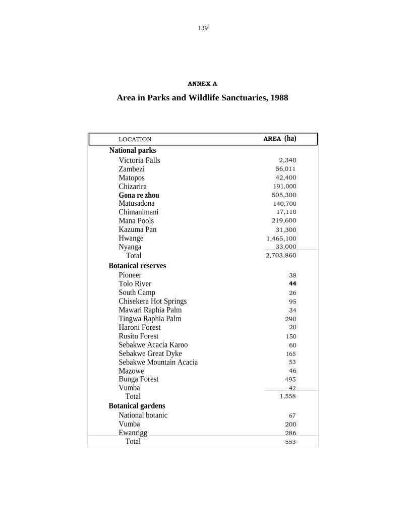
139
ANNEX A
Area in Parks and Wildlife Sanctuaries, 1988
LOCATION AREA (ha)
National parksVictoria Falls 2,340Zambezi 56,011Matopos 42,400Chizarira 191,000Gona re zhou 505,300Matusadona 140,700Chimanimani 17,110Mana Pools 219,600Kazuma Pan 31,300Hwange 1,465,100Nyanga 33.000
Total 2,703,860
Botanical reservesPioneer 38Tolo River 44South Camp 26Chisekera Hot Springs 95Mawari Raphia Palm 34Tingwa Raphia Palm 290Haroni Forest 20Rusitu Forest 150Sebakwe Acacia Karoo 60Sebakwe Great Dyke 165Sebakwe Mountain Acacia 53Mazowe 46Bunga Forest 495Vumba 42
Total 1,558
Botanical gardensNational botanic 67Vumba 200Ewanrigg 286
Total 553

140
SanctuariesManjinji Pan 300Chimanimani Eland 1,800Mbaze Pan 40Mushandike 12,900Tshabalala 1,100Nyamanyetsi 2A80
Total 18,620
Safari areasTull 41,600Chete 108,100Island 52 4Chipinge 26,100Malapati 15,400Chirisa 171,300Hartley 'A' 44,500Sibilobilo 4,400Charara 169,200Hurungwe 289,400Doma 94,500Umfurudzi 76,000Dande 52,300Chewore 339,000Sapi 118,000Deka 51,000Matetsi 295,500
Total 1,896,304Recreational parks
Chibwatata 10Lake Kariba 287,200Kavira 50Ngezi 5,800Umfuli 12,700Lake Robertson 11,200Chinhoyi Caves 120Manjirenji 3,400Bangala 2,700Sebakwe 2,600Robert Mcllwaine 6,180Umzingwane 1,233Kyle 16,900Lake Matopos 2,900Lake Cunningham 4,172
Total 357,165

141
ANNEX B
Number and Area of Farms in the Large FarmCommercial Sector, by Province, for 1979, 1984, and 1988
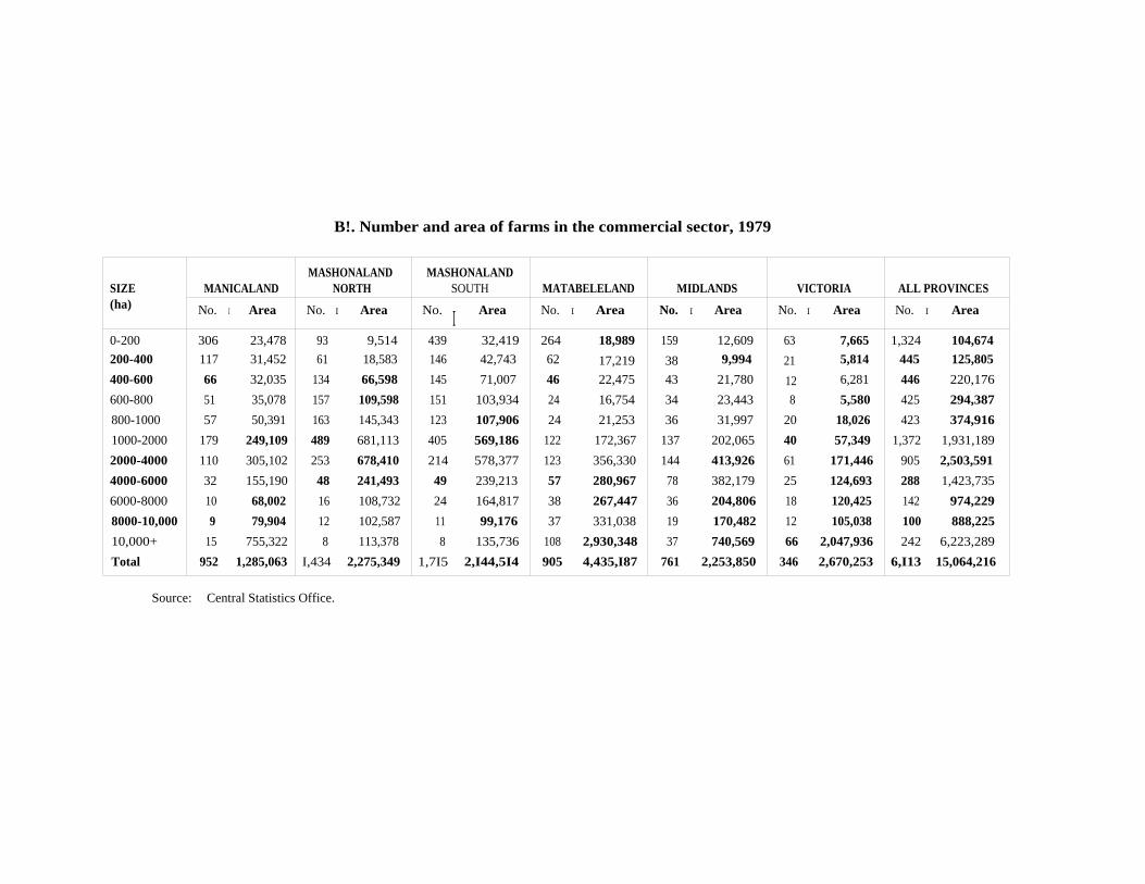
B!. Number and area of farms in the commercial sector, 1979
SIZE MANICALANDMASHONALAND
NORTHMASHONALAND
SOUTH MATABELELAND MIDLANDS VICTORIA ALL PROVINCES(ha) No. I Area No. I Area No. I Area No. I Area No. I Area No. I Area No. I Area
0-200 306 23,478 93 9,514 439 32,419 264 18,989 159 12,609 63 7,665 1,324 104,674
200-400 117 31,452 61 18,583 146 42,743 62 17,219 38 9,994 21 5,814 445 125,805
400-600 66 32,035 134 66,598 145 71,007 46 22,475 43 21,780 12 6,281 446 220,176
600-800 51 35,078 157 109,598 151 103,934 24 16,754 34 23,443 8 5,580 425 294,387
800-1000 57 50,391 163 145,343 123 107,906 24 21,253 36 31,997 20 18,026 423 374,916
1000-2000 179 249,109 489 681,113 405 569,186 122 172,367 137 202,065 40 57,349 1,372 1,931,189
2000-4000 110 305,102 253 678,410 214 578,377 123 356,330 144 413,926 61 171,446 905 2,503,591
4000-6000 32 155,190 48 241,493 49 239,213 57 280,967 78 382,179 25 124,693 288 1,423,735
6000-8000 10 68,002 16 108,732 24 164,817 38 267,447 36 204,806 18 120,425 142 974,229
8000-10,000 9 79,904 12 102,587 11 99,176 37 331,038 19 170,482 12 105,038 100 888,225
10,000+ 15 755,322 8 113,378 8 135,736 108 2,930,348 37 740,569 66 2,047,936 242 6,223,289
Total 952 1,285,063 I,434 2,275,349 1,7I5 2,I44,5I4 905 4,435,I87 761 2,253,850 346 2,670,253 6,I13 15,064,216
Source: Central Statistics Office.

B2. Number and area of farms in the commercial sector, 1984
SIZE MANICALANDMASHONALAND
WESTMASHONALAND
EASTMASHONALAND
CENTRALMATABELELAND
NORTHMATABELELAND
SOUTH MIDLANDS MASVINGO ALL PROVINCES) No. Area No. Area No. Area No. Area No. Area No. Area No. Area No. Area No. Area
0-200 322 23,919 70 5,807 427 29,063 19 1,231 179 12,658 120 8,792 214 17,202 59 6,530 1,410 105,202
200-400 105 29,201 45 14,186 106 30,801 15 4,532 48 13,623 41 11,246 54 14,566 20 6,042 435 124,197
400-600 61 29,286 106 54,091 96 46,875 45 22,476 25 12,659 30 14,223 46 22,813 7 3,728 415 206,161
600-800 39 26,506 122 83,169 79 54,401 44 31,189 12 8,173 26 17,902 31 21,503 10 6,797 363 249,640
800-1000 43 38,638 114 101,637 52 46,128 63 56,413 9 7,965 14 12,071 29 26,758 20 17,828 346 307,4381000-2000 109 151,834 351 485,315 234 333,728 177 247,849 53 73,945 61 83,605 131 186,216 42 61,390 1,156 1,624,8822000-4000 73 203,151 200 549,589 104 278,542 117 305,938 55 150,420 57 163,035 105 302,260 37 103,698 748 2,056,633
4000-6000 12 56,964 50 247,544 29 136,697 12 58,231 23 116,811 20 91,908 54 270,241 22 110,974 222 1,089,370
6000-8000 12 80,057 27 188,885 8 54,205 3 19,905 15 97,323 17 119,580 27 189,090 17 116,978 126 866,0238000+ 10 219,346 29 328,042 3 48,634 3 52,662 45 793,200 65 1,800,318 45 837,104 64 1,764,134 264 5,843,440
Total 786 858,902 1,114 2,058,265 1,138 1,059,074 498 800,426 464 1,286,777 451 2,323,690 736 1,887,753 298 2,198,099 5,485 12,472,986
Source: Central Statistics Office.

B3. Number and area of farms in the commercial sector, 1988
SIZE MANICALANDMASHONALAND
WESTMASHONALAND
EASTMASHONALAND
CENTRALMATABELELAND
NORTHMATABELELAND
SOUTH MIDLANDS MASVINGO ALL PROVINCES) No. I Area No. Area No. Area No. 1 Area No. I Area No. Area No. Area No. Area No. Area
0-200 192 15,379 58 4,739 294 21,476 15 1,033 115 8,849 81 6,466 149 12,154 43 5,040 947 75,136
200-400 79 21,287 44 13,115 91 26,378 11 3,352 31 8,232 35 9,687 57 16,084 19 5,865 367 104,000
400-600 49 23,113 108 54,336 89 42,773 41 20,696 25 12,255 24 11,389 44 21,871 12 5,911 392 192,344
600-800 35 24,246 129 89,148 73 50,123 44 31,215 9 6,200 17 12,008 35 24,192 14 9,705 356 246,837
800-1000 38 33,115 111 98,920 69 61,465 64 57,538 6 5,329 16 13,915 30 26,246 14 12,539 348 309,067
1000-2000 96 133,841 328 454,745 212 299,944 177 247,905 39 55,577 57 81,078 115 164,022 39 53,931 1,063 1,491,043
2000-4000 64 173,166 182 497,109 108 295,902 104 273,778 36 98,666 50 143,089 95 274,115 34 97,337 673 1,853,162
4000-6000 12 55,797 40 194,194 21 99,463 12 62,190 17 87,902 18 89,985 44 214,701 18 89,473 182 893,705
6000-8000 7 47,151 23 162,238 6 38,820 2 13,611 9 63,444 18 127,625 19 131,966 15 102,184 99 687,039
8000+ 9 233,579 28 317,492 1 21,487 1 21,310 37 646,159 49 1,292,585 43 803,759 65 2,024,682 233 5,361,053
Total 581 760,674 1,051 1,886,036 964 957,831 471 732,628 324 992,613 365 1,787,827 631 1,689,110 273 2,406,667 4,660 11,213,386
Source: Central Statistics Office.
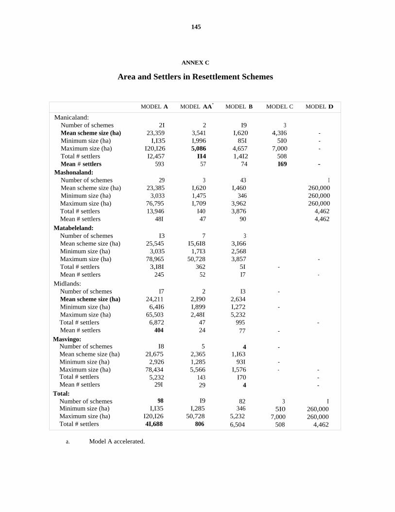
145
ANNEX C
Area and Settlers in Resettlement Schemes
MODEL A MODEL AA' MODEL B MODEL C MODEL D
Manicaland:Number of schemes 2I 2 I9 3Mean scheme size (ha) 23,359 3,541 I,620 4,3I6 -Minimum size (ha) I,I35 I,996 85I 5I0 -Maximum size (ha) I20,I26 5,086 4,657 7,000 -Total # settlers I2,457 II4 1,4I2 508Mean # settlers 593 57 74 I69 -
Mashonaland:Number of schemes 29 3 43 IMean scheme size (ha) 23,385 I,620 I,460 260,000Minimum size (ha) 3,033 1,475 346 260,000Maximum size (ha) 76,795 I,709 3,962 260,000Total # settlers 13,946 I40 3,876 4,462Mean # settlers 48I 47 90 4,462
Matabeleland:Number of schemes I3 7 3Mean scheme size (ha) 25,545 I5,6I8 3,I66Minimum size (ha) 3,035 1,7I3 2,568Maximum size (ha) 78,965 50,728 3,857 -Total # settlers 3,I8I 362 5I -Mean # settlers 245 52 I7 -
Midlands:Number of schemes I7 2 I3 -Mean scheme size (ha) 24,211 2,I90 2,634Minimum size (ha) 6,4I6 I,899 I,272 -Maximum size (ha) 65,503 2,48I 5,232Total # settlers 6,872 47 995 -Mean # settlers 404 24 77 -
Masvingo:Number of schemes I8 5 4 -Mean scheme size (ha) 2I,675 2,365 1,I63Minimum size (ha) 2,926 1,285 93I -Maximum size (ha) 78,434 5,566 I,576 - -Total # settlers 5,232 143 I70 -Mean # settlers 29I 29 4 -
Total:Number of schemes 98 I9 82 3 IMinimum size (ha) I,I35 I,285 346 5I0 260,000Maximum size (ha) I20,I26 50,728 5,232 7,000 260,000Total # settlers 4I,688 806 6,504 508 4,462
a. Model A accelerated.
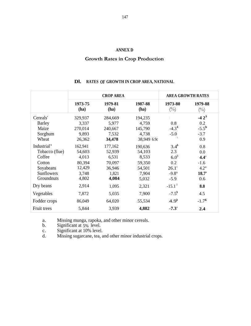
147
ANNEX D
Growth Rates in Crop Production
Dl. RATES OF GROWTH IN CROP AREA, NATIONAL
CROP AREA AREA GROWTH RATES
1973-75 1979-81 1987-88 1973-80 1979-88(ha) (ha) (ha) (%) (%)
Cereals' 329,937 284,669 194,235 -4.8 -4 2 b
Barley 3,337 5,977 4,759 0.8 0.2Maize 270,014 240,667 145,790 -4.3 6 -5.5b
Sorghum 9,893 7,532 4,738 -5.0 -3.7Wheat 26,362 34,478 38,949 6.9c ` 0.9
Industrial s 162,941 177,162 190,636 3.4b 0.8Tobacco (flue) 54,603 52,939 54,103 2.3 0.0Coffee 4,013 6,531 8,533 6.06 4.4'Cotton 80,394 70,097 59,350 0.2 -1.6Soyabeans 12,429 36,946 54,501 26.1' 4.2°Sunflowers 3,748 1,821 7,904 -9.8° 18.7'Groundnuts 4,802 4,084 5,032 -5.9 0.6
Dry beans 2,914 1,095 2,321 -15.1 0 8.8
Vegetables 7,872 5,035 7,900 -7.5b 4.5
Fodder crops 86,049 64,020 55,534 4.9b -1.76
Fruit trees 5,844 3,939 4,882 -7.3' 2.4
a. Missing munga, rapoka, and other minor cereals.b. Significant at 5% level.c. Significant at 10% level.d. Missing sugarcane, tea, and other minor industrial crops.

148
D2. RATES OF GROWTH IN CROP PRODUCTION, NATIONAL
PRODUCTION PRODUCTION GROWTH RATES
1973-75 1979-81 1987-88 1973-80 1979-88(tons) (tons) (tons) (%) (%)
Barley 13,717 33,001 24,724 7.1 -1.1Maize 1,216,124 1,122,894 594,472 -4.0 -5.3Sorghum 13,534 19,832 12,864 4.2 -1.9Wheat 102,142 163,641 202,097 10.2' 2.1Tobacco (flue) 72,196 96,553 113,482 7.3' 2.0
Coffee 2,516 7,359 10,972 20.3' 6.9'Cotton 119,674 131,244 125,282 2.9' 0.3
Soyabeans 20,536 79,572 113,011 35.4'Sunflowers 1,866 1,146 5,084 -7.9 17.5'
Groundnuts 6,463 11,191 14,743 6.5 1.4Dry beans 1,031 547 1,947 -11.3' 15.0'
a. Significant at 5% level.b. Significant at 10% level.
D3. RATES OF GROWTH IN CROP YIELD, NATIONAL
YIELD YIELD GROWTH RATES1973-75 1979-81 1987-88 1973-80 1979-88(tons) (tons) (tons) (%) (%)
Barley 4,110 5,520 5,200 6.3 -1.3
Maize 4,500 4,670 4,080 0.3 0.3Sorghum 1,370 2,630 2,720 9.7' 1.9Wheat 3,870 4,750 5,190 3.1' 1.2'Tobacco (flue) 1,320 1,820 2,100 4.9'Coffee 630 1,130 1,290 13.5' 2.3Cotton 1,490 1,870 2,110 2.7 1.9'Soyabeans 1,650 2,150 2,070 7.4' -0.2Sunflowers 500 630 640 2.1 -1.0Groundnuts 1,350 2,740 2,930 13.2' 0.9Dry beans 350 500 840 4.5 5.7
a. Significant at 5% level.

149
D4. RATES OF GROWTH IN CROP AREA, MANICALAND
CROP AREA AREA GROWTH RATES
1973-75 1979-81 1987-88 1973-80 1979-88(ha) (ha) (ha) (%) (%)
Cereals' 14,588 13,762 11,828 -3.9 -1.8Barley 329 173 19 b -32.6'Maize 13,250 6,901 4,398 -14.2' -4.5Sorghum 78 142 95 16.0 -2.0Wheat 1,150 6,709 7,317 34.8` 0.6
Industrial s 14,910 17,388 19,218 2.3 1.3c
Tobacco (flue) 5,991 4,241 3,718 -2.7 -2.1Coffee 3,902 4,952 6,456 2.9' 4.1'Cotton 3,693 5,765 7,237 3.1 3.8'Soyabeans 129 1,982 975 56.7' -11.0°Sunflowers 291 89 203 -21.6' 7.2Groundnuts 459 69 165 -35.2' 13.4
Dry beans 217 85 182 -14.8° 9.0`
Vegetables 1,163 614 824 -10.6 1.7
Fodder crops 10,001 3,338 3,039 -15.3' -1.4
Fruit trees 1,609 1,310 2,061 5.7
a. Missing munga, rapoka, and other minor cereals.b. Indicates too few nonzero observations to permit the calculation of reasonably
reliable growth rates.c. Significant at 5% level.d. Significant at 10% level.e. Missing sugarcane, tea, and other minor industrial crops.
150
D5. RATES OF GROWTH IN CROP PRODUCTION, MANICALAND
PRODUCTION PRODUCTION GROWTH RATES1973-75 1979-81 1987-88 1973-80 1979-88(tons) (tons) (tons) (%) (%)
Barley 1,071 771 104 -29.8'Maize 46,858 26,930 14,716 -14.5' -4.1Sorghum 61 173 216 19.3 7.1Wheat 4,002 27,689 30,598 41.0' 0.4Tobacco (flue) 8,225 7,205 7,877 0.5 1.4Coffee 2,509 5,580 8,182 16.3' 6.1'Cotton 6,538 12,099 15,217 3.0 4.8Soyabeans 239 4,766 2,273 63.0' -11.8'Sunflowers 139 39 115 -20.9' 9.1Groundnuts 494 162 286 -32.9° 18.1Dry beans 61 58 434 -2.2 21.1°
a. Indicates too few nonzero observations to permit the calculation of reasonablyreliable growth rates.
b. Significant at 5% level.
D6. RATES OF GROWTH IN CROP YIELD, MANICALAND
YIELD YIELD GROWTH RATES1973-75 1979-81 1987-88 1973-80 1979-88(tons) (tons) (tons) (%) (%)
Barley 3,260 4,460 5,590 4.2Maize 3,540 3,900 3,350 -0.3 0.4Sorghum 780 1,220 2,290 2.9 9.3Wheat 3,480 4,130 4,180 4.6' -0.2Tobacco (flue) 1,370 1,700 2,120 3.3° 3.5'Coffee 640 1,130 1,270 13.1' 1.9Cotton 1,770 2,100 2,100 -0.1 0.9Soyabeans 1,850 2,400 2,330 -0.9Sunflowers 480 440 560 0.9 1.7Groundnuts 1,080 2,330 1,740 3.6 4.2Dry beans 280 690 2,390 14.r 11.2
a. Indicates too few nonzero observations to permit the calculation of reasonablyreliable growth rates.
b. Significant at 5% level.c. Significant at 10% level.

151
D7. RATES OF GROWTH IN CROP AREA, MASHONALAND
CROP AREA AREA GROWTH RATES
1973-75 1979-81 1987-88 1973-80 1979-88(ha) (ha) (ha) (%) (%)
Cereals° 247,353 243,401 164,426 -2.6' 4.2'Barley 1,610 3,570 d2,278 4.4Maize 229,982 214,226 128,739 -3.6' -5.6'Sorghum 7,303 6,406 3,794 -2.3 -4.4'Wheat 9,531 21,578 29,616 19.4' 3.7
Industrial' 124,705 141,627 161,900 4.5' 1.6Tobacco (flue) 48,373 48,573 50,060 2.8 0.1Coffee 68 1,348 1,667 d 5.2Cotton 57,247 53,568 47,039 1.2 -1.0Soyabeans 11,373 32,184 51,736 25.3' 5.5'Sunflowers 2,257 1,099 6,255 -12.0° 22.9'Groundnuts 2,908 3,788 4,563 2.0 0.3
Dry beans 2,186 764 1,639 -15.7' 7.6
Vegetables 4,711 3,001 5,533 -8.5' 6.3
Fodder crops 64,695 52,699 45,275 -3.4' -1.7'
Fruit trees 2,504 1,766 2,133 -6.3' 2.1
a. Missing munga, rapoka, and other minor cereals.b. Significant at 5% level.c. Significant at 10% level.d. Indicates too few nonzero observations to permit the calculation of reasonably
reliable growth rates.
152
D8. RATES OF GROWTH IN CROP PRODUCTION, MASHONALAND
PRODUCTION PRODUCTION GROWTH RATES1973-75 1979-81 1987-88 1973-80 1979-88(tons) (tons) (tons) (%) (%)
Barley 6,492 19,245 11,152 -6.7Maize 1,089,884 1,019,844 536,975 -3.7 -3.9Sorghum 8,345 17,739 11,071 10.5 -2.5Wheat 41,647 111,493 162,487 22.36 4.6Tobacco (flue) 63,734 89,204 105,063 8.1 6 2.1Coffee 67 1,579 7,792 21.56
Cotton 77,555 94,324 95,566 5.1 6 1.5
Soyabeans 18,777 69,412 106,992 34.96 5.26
Sunflowers 1,164 777 3,938 -8.6 19.7 6
Groundnuts 4,348 10,545 13,741 13.3 6 1.3Dry beans 740 368 1,199 -11.0 14.2 6
a. Indicates too few nonzero observations to permit the calculation of reasonablyreliable growth rates.
b. Significant at 5% level.
D9. RATES OF GROWTH IN CROP YIELD, MASHONALAND
YIELD YIELD GROWTH RATES1973-75 1979-81 1987-88 1973-80 1979-88(tons) (tons) (tons) (%) (%)
Barley 4,030 5,390 4,900 -2.56
Maize 4,740 4,760 4,170 -0.1 1.8Sorghum 1,140 2,770 2,920 13.06 1.9Wheat 4,370 5,170 5,490 2.46 0.1 6
Tobacco (flue) 1,320 1,840 2,100 5.1 6 1.9 6
Coffee 980 1,130 4,680 15.5Cotton 1,350 1,760 2,100 3.86 2.6 6
Soyabeans 1,650 2,160 2,070 7.76 -0.3Sunflowers 520 710 630 3.9 -2.6Groundnuts 1,500 2,780 3,010 11.1 6 1.0Dry beans 340 480 730 5.6° 6.2
a. Indicates too few nonzero observations to permit the calculation of reasonablyreliable growth rates.
b. Significant at 5% level.c. Significant at 10% level.
153
D10. RATES OF GROWTH IN CROP AREA, MATABELELAND
CROP AREA AREA GROWTH RATES
1973-75 1979-81 1987-88 1973-80 1979-88(ha) (ha) (ha) (%) (%)
Cereals° 8,681 7,481 3,880 -2.06 -8.56
Barley 28 0 132Maize 6,753 5,137 2,437 4.66 -9.46
Sorghum 882 268 413 -18.7 6 4.4Wheat 1,037 2,076 898 18.3 6 -11.1 6
Industrial" 1,091 1,263 1,704 11.7 6 1.8Tobacco (flue) 1 0 0 °Coffee 0 0 2 c
Cotton 573 685 1,345 8.7 9.46
Soyabeans 63 588 125 100.96 -28.2'Sunflowers 110 153 179 5.8` -1.7Groundnuts 366 117 54 -17.3° -13.2
Dry beans 55 67 57 2.2 °
Vegetables 743 736 713 1.9 1.8
Fodder crops 5,147 3,156 2,494 -8.1 6 -3.1 6
Fruit trees 580 432 482 -5.86 0.4
a. Missing munga, rapoka, and other minor cereals.b. Significant at 5% level.c. Indicates too few nonzero observations to permit the calculation of reasonably
reliable growth rates.d. Missing sugarcane, tea, and other minor industrial crops.e. Significant at 10% level.

154
D11. RATES OF GROWTH IN CROP PRODUCTION, MATABELELAND
PRODUCTION PRODUCTION GROWTH RATES
1973-75 1979-81 1987-88 1973-80 1979-88(tons) (tons) (tons) (%) (%)
Barley 72 0 614 a a
Maize 22,089 20,557 9,052 -0.4 -9.6'Sorghum 882 369 637 -13.5 b 11.7Wheat 4,079 7,335 3,789 16.2 b -9.3 b
Tobacco (flue) 2 0 0 a aCoffee 0 0 2 a aCotton 1,001 1,894 3,592 19.1' 9.5'Soyabeans 87 1,156 152 110.9' -30.3'Sunflowers 43 67 109 10.1 5.0Groundnuts 545 368 109 -9.1 -17.9Dry beans 18 26 32 9.8 a
a. Indicates too few nonzero observations to permit the calculation of reasonablyreliable growth rates.
b. Significant at 5% level.
D12. RATES OF GROWTH IN CROP YIELD, MATABELELAND
YIELD YIELD GROWTH RATES
1973-75 1979-81 1987-88 1973-80 1979-88(tons) (tons) (tons) (%) (%)
Barley 2,570 0 4,670 a aMaize 3,270 4,000 3,710 4.4 -0.3Sorghum 1,000 1,380 1,540 6.4 7.0Wheat 3,930 3,530 4,220 -1.8 2.0Tobacco (flue) 2,000 0 0 a a
Coffee 0 0 1,000 a aCotton 1,750 2,760 2,670 9.6b 0.1Soyabeans 1,380 1,970 1,220 5.0 -3.0Sunflowers 390 430 610 4.0 6.9Groundnuts 1,490 3,150 2,010 9.9' -5.4Dry beans 340 390 560 7.4 a
a. Indicates too few nonzero observations to permit the calculation of reasonablyreliable growth rates.
b. Significant at 5% level.
155
D13. RATES OF GROWTH IN CROP AREA, MIDLANDS
CROP AREA AREA GROWTH RATES
1973-75 1979-81 1987-88 1973-80 1979-88(ha) (ha) (ha) (%) (%)
Cereals' 19,657 15,155 10,974 -5.86 -3.5Barley 527 2,011 2,335 24.3 15.9Maize 15,546 11,678 7,781 -6.86 -4.46
Sorghum 1,133 624 150 -9.3 -14.3°Wheat 2,803 2,183 709 -0.9 -14.9
Industrial(' 4,738 3,100 3,601 -1.5 1.2Tobacco (flue) 207 127 176 -11.66
Coffee 0 12 189 °Cotton 2,728 2,028 624 -2.4 -12.9 6
Soyabeans 388 1,288 1,398 23.46 0.1Sunflowers 673 356 1,010 -2.5 11.6Groundnuts 842 70 206 -35.06 12.8
Dry beans 140 99 56 -6.8 -8.7
Vegetables 378 254 246 I . -1.7
Fodder crops 4,208 3,789 2,591 -3.4 -5.66
Fruit trees 141 63 116 -14.1 6 6.7
a. Missing munga, rapoka, and other minor cereals.b. Significant at 5% level.c. Significant at 10% level.d. Missing sugarcane, tea, and other minor industrial crops.e. Indicates too few nonzero observations to permit the calculation of reasonably
reliable growth rates.

156
D14. RATES OF GROWTH IN CROP PRODUCTION, MIDLANDS
PRODUCTION PRODUCTION GROWTH RATES
1973-75 1979-81 1987-88 1973-80 1979-88(tons) (tons) (tons) (%) (%)
Barley 2,252 12,121 12,854 32.2 14.8Maize 43,176 43,538 27,330 -1.6 -3.8Sorghum 1,163 1,368 231 1.9 -17.3'
Wheat 12,072 10,162 3,609 -0.5 -14.1Tobacco (flue) 206 161 270 -7.1 b
Coffee 0 14 252 b b
Cotton 2,968 3,552 1,110 4.8' -12.6`
Soyabeans 549 2,568 3,254 32.1° 1.3
Sunflowers 281 153 713 -1.6 17.3
Groundnuts 779 81 556 -28.2 c 20.8Dry beans 48 40 18 -3.4 -14.8
a. Significant at 10% level.b. Significant at 5% level.c. Indicates too few nonzero observations to permit the calculation of reasonably
reliable growth rates.
D15. RATES OF GROWTH IN CROP YIELD, MIDLANDS
YIELD YIELD GROWTH RATES1973-75 1979-81 1987-88 1973-80 1979-88(tons) (tons) (tons) (%) (%)
Barley 4,270 6,030 5,510 6.4 -1.0Maize 2,780 3,730 3,510 5.5 0.7Sorghum 1,030 2,190 1,550 12.3' -3.5Wheat 4,310 4,660 5,090 0.3 1.0Tobacco (flue) 1,000 1,270 1,540 5.0'Coffee 0 1,140 1,330Cotton 1,090 1,750 1,780 7.3' 0.4Soyabeans 1,410 1,990 2,330 7.1 b 1.1Sunflowers 420 430 710 1.0 5.1Groundnuts 930 1,160 2,170 10.6 7.1Dry beans 340 400 310 3.7 -6.7
a. Significant at 10% level.b. Significant at 5% level.c. Indicates too few nonzero observations to permit the calculation of reasonably
reliable growth rates.

157
D16. RATES OF GROWTH IN CROP AREA, MASVINGO
CROP AREA AREA GROWTH RATES
1973-75 1979-81 1987-88 1973-80 1979-88(ha) (ha) (ha) (%) (%)
Cereals' 17,230 4,496 3,108 -17.8 6 -5.0Barley 1,063 0 0Maize 4,482 2,492 2,435 -11.66 -0.1Sorghum 497 108 289 -28.2 6 17.86
Wheat 11,896 1,932 385 -20.66 -20.26
Industrial(' 15,393 9,391 4,045 -3.4 -10.1 6
Tobacco (flue) 32 66 300 17.9`Coffee 44 141 220 -6.4 18.9Cotton 14,149 8,202 3,105 -4.1 -11.26
Soyabeans 496 801 268 17.26 -14.1 6
Sunflowers 416 283 258 -7.66
Groundnuts 228 53 45 -32.r -1.1
Dry beans 249 76 390 -18.66 16.1
Vegetables 334 106 592 -14.1 6 26.9
Fodder crops 1,901 881 1,475 -10.1' 5.9
Fruit trees 1,010 241 97 -20.06 -11.3 6
a. Missing munga, rapoka, and other minor cereals.b. Significant at 5% level.c. Indicates too few nonzero observations to permit the calculation of reasonably
reliable growth rates.d. Missing sugarcane, tea, and other minor industrial crops.e. Significant at 10% level.

158
D17. RATES OF GROWTH IN CROP PRODUCTION, MASVINGO
PRODUCTION PRODUCTION GROWTH RATES
1973-75 1979-81 1987-88 1973-80 1979-88(tons) (tons) (tons) (%) (%)
Barley 3,830 0 0 _a _a
Maize 14,116 10,980 6,399 -8.0 -6.2
Sorghum 507 201 709 -21.3 26.96
Wheat 40,339 6,962 1,615 -19.76 -20.06
Tobacco (flue) 30 85 545 25.26 a
Coffee 38 159 197 -5.6 17.4
Cotton 32,811 19,428 6,799 -6.26 -11.96
Soyabeans 913 1,670 341 21.86 -18.46
Sunflowers 240 208 211 -6.1 -9.4Groundnuts 296 30 52 -38.4
6
Dry beans 159 72 472 -16.6 23.3
a. Indicates too few nonzero observations to permit the calculation of reasonablyreliable growth rates.
b. Significant at 5% level.
D18. RATES OF GROWTH IN CROP YIELD, MASVINGO
YIELD YIELD GROWTH RATES
1973-75 1979-81 1987-88 1973-80 1979-88(tons) (tons) (tons) (%) (%)
Barley 3,600 0 0 _a _a
Maize 3,150 4,410 2,630 4.0 -6.1Sorghum 1,020 1,870 2,460 9.6 7.7
Wheat 3,390 3,600 4,200 1.1 0.3Tobacco (flue) 950 1,290 1,820 6.2Coffee 880 1,130 900 0.9 -1.3Cotton 2,320 2,370 2,190 -2.2 -0.7Soyabeans 1,840 2,080 1,270 3.9 -5.0Sunflowers 580 740 820 1.6 -1.2
Groundnuts 1,300 570 1,170 -9.2
Dry beans 640 950 1,210 2.4 6.2
a. Indicates too few nonzero observations to permit the calculation of reasonablyreliable growth rates.
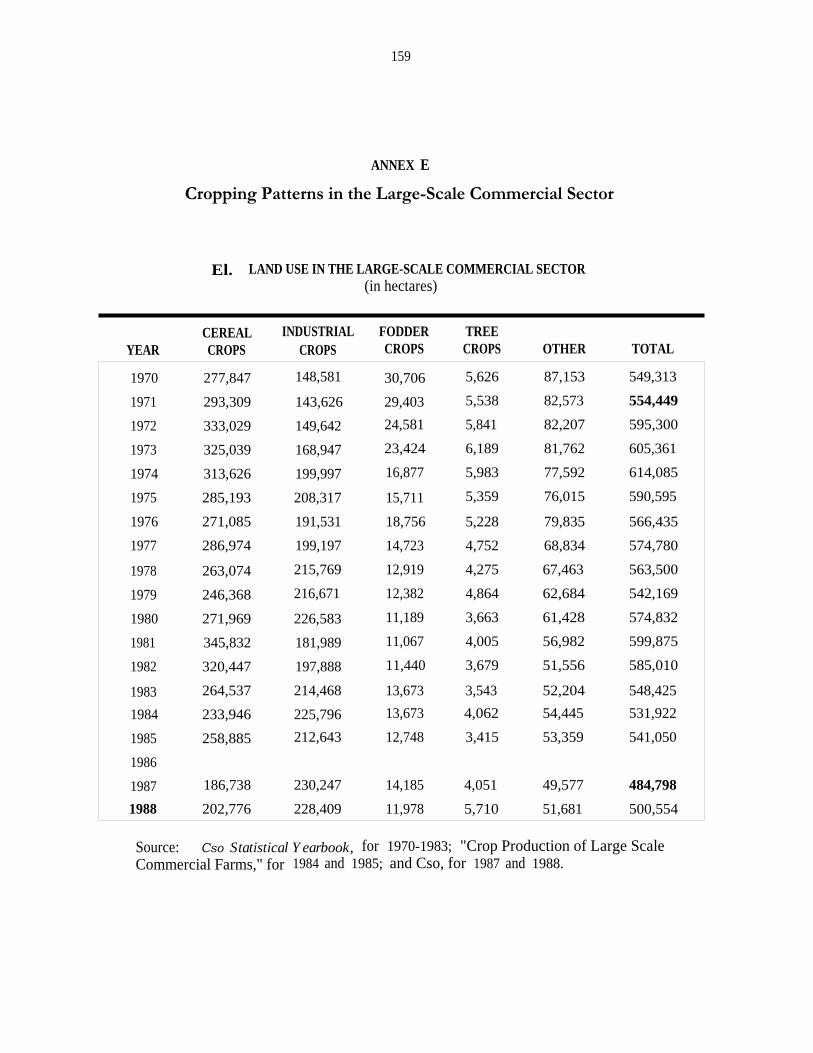
159
ANNEX E
Cropping Patterns in the Large-Scale Commercial Sector
El. LAND USE IN THE LARGE-SCALE COMMERCIAL SECTOR(in hectares)
CEREAL INDUSTRIAL FODDER TREEYEAR CROPS CROPS CROPS CROPS OTHER TOTAL
1970 277,847 148,581 30,706 5,626 87,153 549,313
1971 293,309 143,626 29,403 5,538 82,573 554,449
1972 333,029 149,642 24,581 5,841 82,207 595,300
1973 325,039 168,947 23,424 6,189 81,762 605,361
1974 313,626 199,997 16,877 5,983 77,592 614,085
1975 285,193 208,317 15,711 5,359 76,015 590,595
1976 271,085 191,531 18,756 5,228 79,835 566,435
1977 286,974 199,197 14,723 4,752 68,834 574,780
1978 263,074 215,769 12,919 4,275 67,463 563,500
1979 246,368 216,671 12,382 4,864 62,684 542,169
1980 271,969 226,583 11,189 3,663 61,428 574,832
1981 345,832 181,989 11,067 4,005 56,982 599,875
1982 320,447 197,888 11,440 3,679 51,556 585,010
1983 264,537 214,468 13,673 3,543 52,204 548,425
1984 233,946 225,796 13,673 4,062 54,445 531,922
1985 258,885 212,643 12,748 3,415 53,359 541,050
1986
1987 186,738 230,247 14,185 4,051 49,577 484,798
1988 202,776 228,409 11,978 5,710 51,681 500,554
Source: Cso Statistical Yearbook, for 1970-1983; "Crop Production of Large ScaleCommercial Farms," for 1984 and 1985; and Cso, for 1987 and 1988.

E2. Historical area and production of principal crops, large-scale commercial sector(in 000 units)
HARVEST MAIZE SORGHUM WHEAT GROUNDNUTS SOYABEANS COTTONTOBACCO
FLUE + BURLEYCOMTEEYEAR
Area Prod. Area Prod. Area Prod. Area Prod. Area Prod. Area Prod.Prod.area
Unprod.area Prod. Area Prod.
1973 282.2 793.0 20.5 25.6 21.3 83.9 4.1 4.4 8.2 8.8 70.5 109.7 1.8 2.3 1.6 48.8 68.9
1974 279.5 1,580.7 6.5 10.6 26.0 97.1 5.0 6.7 11.4 21.8 88.4 124.9 2.6 1.3 2.6 58.5 73.6
1975 248.3 1,274.6 2.6 4.4 31.7 125.5 5.4 8.3 17.7 31.1 82.4 124.4 3.0 1.1 3.4 65.4 84.4
1976 226.9 1,219.2 5.8 15.3 32.7 141.1 4.3 9.6 24.5 44.3 57.7 107.7 3.8 0.7 4.9 65.9 108.3
1977 235.1 1,152.2 5.5 14.5 41.9 164.3 3.1 6.3 24.0 46.6 74.6 115.2 3.6 0.9 4.3 57.1 83.8
1978 207.8 1,114.6 6.8 15.6 44.8 202.8 2.5 5.8 34.5 69.4 86.1 129.0 3.9 1.1 5.0 55.4 83.1
1979 199.4 721.9 7.5 18.9 34.3 153.0 3.2 7.5 39.6 83.6 77.0 130.2 5.0 - - 60.1 107.3
1980 227.7 910.7 6.8 16.3 32.6 154.6 3.8 10.7 40.8 89.4 74.9 145.6 6.3 - - 63.7 119.8
1981 294.8 1,736.0 8.4 24.3 36.6 183.4 5.2 15.4 30.5 65.8 58.4 118.0 8.3 - - 39.3 69.1
1982 270.4 1,143.6 7.1 16.9 37.3 191.9 4.8 14.3 48.0 88.5 52.3 104.8 5.0 4.0 6.1 45.4 88.2
1983 235.2 601.8 5.1 7.2 21.5 111.0 3.0 8.5 54.5 78.6 59.9 111.1 7.0 2.3 8.2 46.0 93.2
1984 205.0 694.6 8.8 17.6 16.9 83.8 2.0 5.4 53.5 88.4 72.2 145.3 7.3 1.4 10.0 49.6 115.8
1985 205.0 1,112.5 13.9 53.1 35.1 174.3 1.9 4.4 40.4 84.4 70.3 155.0 7.0 1.7 9.2 51.0 104.6
1986 - - - - - - - - - - - - - - - - -
1987 140.6 506.6 5.7 14.4 36.1 189.8 4.9 13.0 57.4 107.9 58.6 122.6 6.7 1.8 10.6 56.3 119.9
1988 151.0 682.4 3.8 11.4 41.8 214.4 5.2 16.4 51.6 118.1 60.1 127.9 6.5 2.1 11.3 54.3 I12.7
Source: "Crop Production of Large-Scale Commercial Farms," for 1973 to 1985, and Central Statistics Office, for 1987 and 1988.
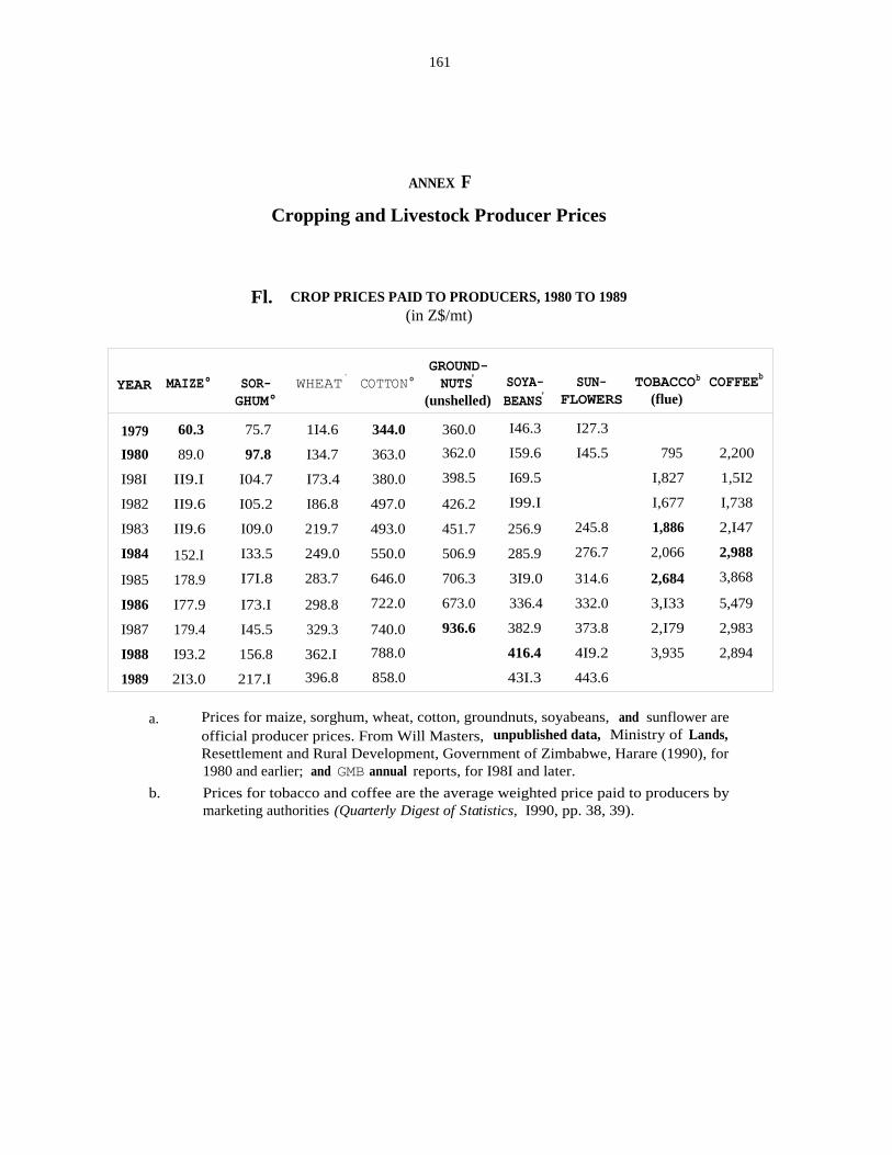
161
ANNEX F
Cropping and Livestock Producer Prices
Fl. CROP PRICES PAID TO PRODUCERS, 1980 TO 1989(in Z$/mt)
YEAR MAIZE° SOR- WHEAT` COTTON°GROUND-NUTS' SOYA- SUN- TOBACCOb COFFEEb
GHUM° (unshelled) BEANS' FLOWERS (flue)
1979 60.3 75.7 1I4.6 344.0 360.0 I46.3 I27.3
I980 89.0 97.8 I34.7 363.0 362.0 I59.6 I45.5 795 2,200
I98I II9.I I04.7 I73.4 380.0 398.5 I69.5 I,827 1,5I2
I982 II9.6 I05.2 I86.8 497.0 426.2 I99.I I,677 I,738
I983 II9.6 I09.0 219.7 493.0 451.7 256.9 245.8 1,886 2,I47
I984 152.I I33.5 249.0 550.0 506.9 285.9 276.7 2,066 2,988
I985 178.9 I7I.8 283.7 646.0 706.3 3I9.0 314.6 2,684 3,868
I986 I77.9 I73.I 298.8 722.0 673.0 336.4 332.0 3,I33 5,479
I987 179.4 I45.5 329.3 740.0 936.6 382.9 373.8 2,I79 2,983
I988 I93.2 156.8 362.I 788.0 416.4 4I9.2 3,935 2,894
1989 2I3.0 217.I 396.8 858.0 43I.3 443.6
a. Prices for maize, sorghum, wheat, cotton, groundnuts, soyabeans, and sunflower areofficial producer prices. From Will Masters, unpublished data, Ministry of Lands,Resettlement and Rural Development, Government of Zimbabwe, Harare (1990), for1980 and earlier; and GMB annual reports, for I98I and later.
b. Prices for tobacco and coffee are the average weighted price paid to producers bymarketing authorities (Quarterly Digest of Statistics, I990, pp. 38, 39).
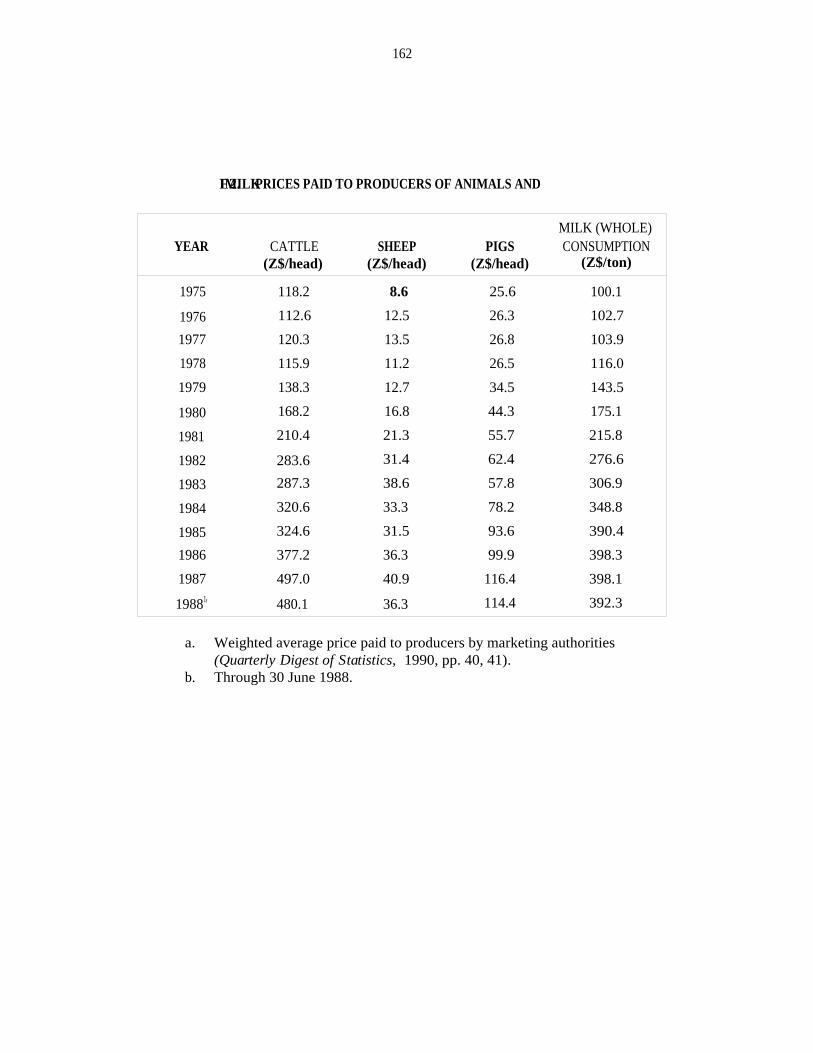
162
F2. PRICES PAID TO PRODUCERS OF ANIMALS ANDMILK
YEAR CATTLE SHEEP PIGSMILK (WHOLE)CONSUMPTION
(Z$/head) (Z$/head) (Z$/head) (Z$/ton)
1975 118.2 8.6 25.6 100.1
1976 112.6 12.5 26.3 102.7
1977 120.3 13.5 26.8 103.9
1978 115.9 11.2 26.5 116.0
1979 138.3 12.7 34.5 143.5
1980 168.2 16.8 44.3 175.1
1981 210.4 21.3 55.7 215.8
1982 283.6 31.4 62.4 276.6
1983 287.3 38.6 57.8 306.9
1984 320.6 33.3 78.2 348.8
1985 324.6 31.5 93.6 390.4
1986 377.2 36.3 99.9 398.3
1987 497.0 40.9 116.4 398.1
19881' 480.1 36.3 114.4 392.3
a. Weighted average price paid to producers by marketing authorities(Quarterly Digest of Statistics, 1990, pp. 40, 41).
b. Through 30 June 1988.

163
ANNEX G
Communal Area Cropping Patterns
G1. HISTORICAL AREA AND PRODUCTION OF PRINCIPAL CROPS
(in 000)
HARVEST MAIZE RAPOKO SORGHUM MHUNGAGROUND-
NUTS BEANS COTTONYEAR Area Prod. Area l Prod. Area Prod. Area l Prod. Area' Prod. Areal Prod. Area[Prod.
tI970 61I 246 53 59 I99 65 I76 55 245 30 33 I3 I4 I7
I97I 672 455 35 5I 240 I37 I9I 73 2I6 16 32 I2 I8 I6
I972 665 555 30 47 240 I20 202 II0 22I 17 27 8 30 27
I973 475 I45 69 56 122 23 225 I09 200 24 30 II 26 I3
I974 725 470 - - 275 I50 - - 290 I87 42 I2 62 55
I975 725 435 76 38 2I0 105 44I I46 310 I10 40 I8 54 40
I976 760 550 120 8I 235 I20 456 165 325 173 - - 35 28
I977 600 400 I41 87 90 36 497 I9I 275 130 35 II 35 22
1978 700 450 35 1I 120 57 254 83 200 101 43 8 41 31
I979 600 420 I50 58 76 30 233 88 240 I00 1I 4 20 15
I980 900 600 I47 6I I20 66 293 I00 I75 67 - - I5 12
198I I,000 1,000 - - 200 100 - - 300 I00 - - 59 45
1982 I,100 595 - - 200 50 - - 240 95 - - 5I 27
I983 I,050 285 - - 280 44 - - 180 23 - - 65 33
1984 I,136 454 - - 156 37 - - 144 19 - - 100 70
1985 I,018 I,558 - - 2II 76 - - II8 6I - - I30 II0
I986 1,074 1,348 - - I50 66 - - I60 64 - - II4 99
I987 943 5I8 I09 40 I64 38 I87 56 I77 55 - - I38 83
I988 I,036 1,450 I20 84 206 I60 237 184 197 106 - - I61 137
1989 920 I,062 II6 44 15I 62 I64 90 160 72 - - 153 123
Source: Data for maize, sorghum, groundnuts, beans, and cotton, for I970-I984, are from the1987 Statistical Yearbook, and for I984-I989, from the Cso Crop Forecasting Committee. Datafor mhunga and rapoko, for 1970-I980, are from Masters (I990).
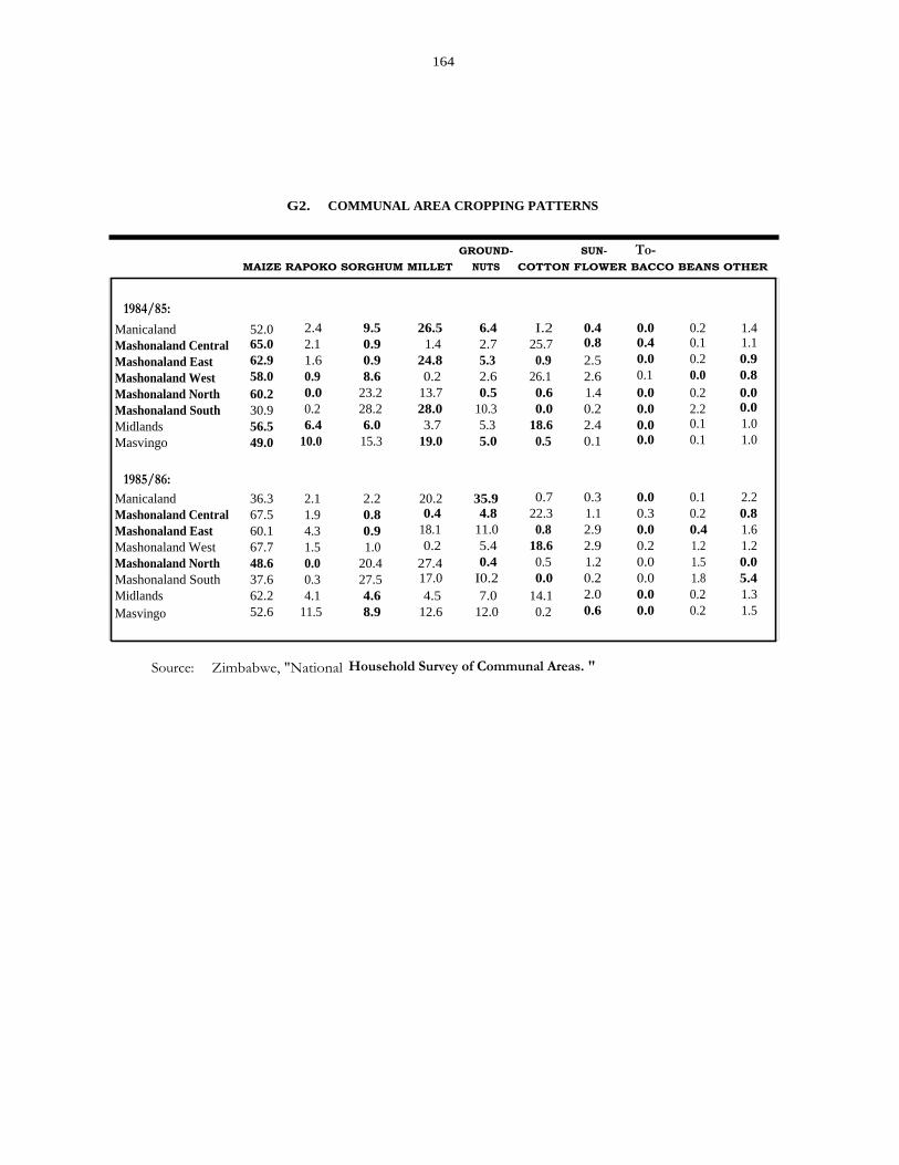
164
G2. COMMUNAL AREA CROPPING PATTERNS
GROUND- SUN- To-MAIZE RAPOKO SORGHUM MILLET NUTS COTTON FLOWER BACCO BEANS OTHER
1984/85:Manicaland 52.0 2.4 9.5 26.5 6.4 I.2 0.4 0.0 0.2 1.4Mashonaland Central 65.0 2.1 0.9 1.4 2.7 25.7 0.8 0.4 0.1 1.1
Mashonaland East 62.9 1.6 0.9 24.8 5.3 0.9 2.5 0.0 0.2 0.9
Mashonaland West 58.0 0.9 8.6 0.2 2.6 26.1 2.6 0.1 0.0 0.8
Mashonaland North 60.2 0.0 23.2 13.7 0.5 0.6 1.4 0.0 0.2 0.0Mashonaland South 30.9 0.2 28.2 28.0 10.3 0.0 0.2 0.0 2.2 0.0
Midlands 56.5 6.4 6.0 3.7 5.3 18.6 2.4 0.0 0.1 1.0
Masvingo 49.0 10.0 15.3 19.0 5.0 0.5 0.1 0.0 0.1 1.0
1985/86:Manicaland 36.3 2.1 2.2 20.2 35.9 0.7 0.3 0.0 0.1 2.2Mashonaland Central 67.5 1.9 0.8 0.4 4.8 22.3 1.1 0.3 0.2 0.8Mashonaland East 60.1 4.3 0.9 18.1 11.0 0.8 2.9 0.0 0.4 1.6Mashonaland West 67.7 1.5 1.0 0.2 5.4 18.6 2.9 0.2 1.2 1.2Mashonaland North 48.6 0.0 20.4 27.4 0.4 0.5 1.2 0.0 1.5 0.0Mashonaland South 37.6 0.3 27.5 17.0 I0.2 0.0 0.2 0.0 1.8 5.4Midlands 62.2 4.1 4.6 4.5 7.0 14.1 2.0 0.0 0.2 1.3
Masvingo 52.6 11.5 8.9 12.6 12.0 0.2 0.6 0.0 0.2 1.5
Source: Zimbabwe, "National Household Survey of Communal Areas. "

G3. Communal area cropping patterns by natural region, 1986-1989
GROUND- SUN- VEGETA- ALLMAIZE RAPOKO SORGHUM MILLET NUTS COTTON FLOWER BLES BEANS FRUIT OTHER FALLOW CROPS
(hectares)NR I 14.5 0.9 0.0 1.4 0.1 0.7 0.0 0.0 0.1 0.2 3.7 3.6 25.3NR IIa 211.2 4.1 3.4 2.6 10.6 29.0 7.4 3.5 1.8 2.9 19.7 129.5 425.5NR IIb 109.8 5.9 2.8 11.2 11.3 2.6 10.0 4.4 1.7 0.9 13.7 74.6 248.9NR IIb, III 54.6 1.2 3.7 0.5 4.1 39.4 6.6 0.0 0.1 0.0 7.0 24.1 141.3NR III 226.4 11.3 16.2 32.0 17.6 49.1 17.3 2.1 1.0 2.1 37.3 138.4 550.5NR III, N 35.4 0.0 6.2 9.1 2.9 4.4 2.3 - 0.0 - 6.8 18.6 93.4NR IV 674.4 55.8 142.2 318.6 90.5 87.4 60.7 12.0 4.2 8.8 177.7 499.0 2,131.6NR IV, V 9.3 3.0 15.7 27.1 2.0 2.1 1.1 - 0.1 - 6.7 16.5 83.5NR V 94.8 7.3 135.7 72.2 9.4 12.5 11.2 0.4 0.2 0.8 20.1 147.1 511.8
National 1,430.4 89.5 326.0 474.7 148.4 227.1 116.6 9.3 292.7 1,051.4 4,211.8
NR I 67.1 4.2 0.0 6.5 0.5
(percentages)
0.0 0.5 0.9 17.13.2 0.0NR IIa 71.3 1.4 1.2 0.9 3.6 9.8 2.5 1.2 0.6 1.0 6.7NR IIb 63.0 3.4 1.6 6.4 6.4 1.5 5.7 2.5 1.0 0.5 7.9NR IIb, III 46.6 1.0 3.2 0.4 3.5 33.6 5.6 0.0 0.1 0.0 6.0NR III 54.9 2.7 3.9 7.8 4.3 11.9 4.2 0.5 0.2 0.5 9.1NR III, IV 47.3 0.0 8.3 12.2 3.9 5.9 3.1 - 0.0 - 9.1NR N 41.3 3.4 8.7 19.5 5.5 5.4 3.7 0.7 0.3 0.5 10.9NR N, V 13.9 4.5 23.4 40.4 3.0 3.1 1.6 - 0.2 - 10.0NR V 26.0 2.0 37.2 19.8 2.6 3.4 3.1 0.1 0.1 0.2 5.5
National 45.3 2.8 10.3 15.0 4.7 7.2 3.7 0.3 9.3
Source: Calculated from district-level data, AGIUPEX Crop Production Section (Will Masters, unpublished data, Ministry of Lands, Resettlement andRural Development, Government of Zimbabwe, Harare, 1990). Crop percentages are calculated on the basis of crop area, excluding fallow, to remainconsistent with table G.1.

166
G4. RATES OF GROWTH IN CROP AREA, COMMUNAL AREAS, NATIONAL
CROP AREA AREA GROWTH RATES
1970-72 1978-80 1987-89 1970-80 1979-89(000 ha) (000 ha) (000 ha) (%) (%)
Maize 649 733 966 2.0 2.2
Sorghum 226 111 174 -_83a ' 3.8
Rapoko 39 105 115 13.Oa ' -2.8'
Mhunga 190 260 196 5.8 -3.4
Cotton 21 25 151 1.6 25.0'
Groundnuts 227 205 178 -0.7 -3.9
Beans 31 27 b -4.0 b
a. Significant at 5% level.b. Indicates too few nonzero observations to permit the calculation of reasonably
reliable growth rates.
G5. RATES OF GROWTH IN CROP PRODUCTION, COMMUNAL AREAS, NATIONAL
PRODUCTION PRODUCTION GROWTH RATES
1970-72 1978-80 1987-89 1970-80 1979-89(000 mt) (000 mt) (000 mt) (%) (%)
Maize 419 490 1,010 5.3 9.0
Sorghum 107 51 87 -6.6 5.0
Rapoko 52 43 56 -2.1 -1.2
Mhunga 79 90 110 4.2 1.1
Cotton 20 19 114 -1.1 26.5'
Groundnuts 21 89 78 19.9' -1.3
Beans 11 6 b -7.1 b
a. Significant at 5% level.b. Indicates too few nonzero observations to permit the calculation of reasonably
reliable growth rates.
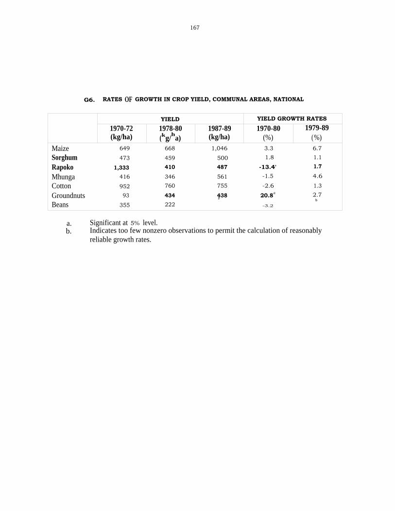
167
G6. RATES OF GROWTH IN CROP YIELD, COMMUNAL AREAS, NATIONAL
YIELD YIELD GROWTH RATES
1970-72 1978-80 1987-89 1970-80 1979-89(kg/ha) (kg/
ha) (kg/ha) (%) (%)
Maize 649 668 1,046 3.3 6.7
Sorghum 473 459 500 1.8 1.1
Rapoko 1,333 410 487 -13.4' 1.7
Mhunga 416 346 561 -1.5 4.6
Cotton 952 760 755 -2.6 1.3
Groundnuts 93 434 438 20.8a 2.7
Beans 355 222b
-3.2b
a. Significant at 5% level.b. Indicates too few nonzero observations to permit the calculation of reasonably
reliable growth rates.


169
ANNEX H
Employment in the Large-Scale Commercial Sector
H1. EMPLOYMENT IN THE LARGE-SCALE COMMERCIAL SECTOR
OWNERS, TOTAL FARM TOTAL MALE TOTAL FEMALEYEAR PARTNERS, AND FOREST PERMANENT SEASONAL WORKERS WORKERS
OCCUPIERS EMPLOYEES EMPLOYEES EMPLOYEES (%) (%)
1989 5,560 247,154 136,860 110,294 74.0 26.0
1988 5,281 227,626 137,154 90,472 76.7 23.3
1987 4,264 219,987 137,746 82,241 77.2 22.8
1986
1985 5,163 214,241 147,842 66,399 79.0 21.0
1984 4,934 216,905 162,325 54,580 79.8 20.8
1983 5,091 216,013 154,738 61,275 79.5 20.5
1982 5,206 220,228 164,044 56,184 80.3 19.7
1981 4,859 242,149
1980 4,926 271,291
1979 4,932 286,825 230,523 56,302 76.8 23.2
1978 5,534 283,731 232,137 51,594 77.7 22.3
1977 6,109 295,139 237,435 57,704 77.2 22.8
1976 6,211 307,225 233,873 73,352 75.6 24.4
1975 6,317 303,903 229,213 74,690 76.0 24.0
1974 6,163 311,913 233,766 78,147 76.5 23.5
1973 6,418 301,512 228,511 73,001 77.4 22.6
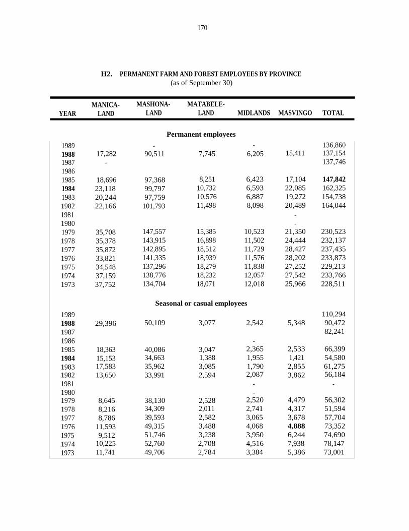
170
H2. PERMANENT FARM AND FOREST EMPLOYEES BY PROVINCE(as of September 30)
MANICA- MASHONA- MATABELE-YEAR LAND LAND LAND MIDLANDS MASVINGO TOTAL
Permanent employees
1989 - - 136,8601988 17,282 90,511 7,745 6,205 15,411 137,1541987 - 137,74619861985 18,696 97,368 8,251 6,423 17,104 147,8421984 23,118 99,797 10,732 6,593 22,085 162,3251983 20,244 97,759 10,576 6,887 19,272 154,7381982 22,166 101,793 11,498 8,098 20,489 164,0441981 -1980 -1979 35,708 147,557 15,385 10,523 21,350 230,5231978 35,378 143,915 16,898 11,502 24,444 232,1371977 35,872 142,895 18,512 11,729 28,427 237,4351976 33,821 141,335 18,939 11,576 28,202 233,8731975 34,548 137,296 18,279 11,838 27,252 229,2131974 37,159 138,776 18,232 12,057 27,542 233,7661973 37,752 134,704 18,071 12,018 25,966 228,511
1989
Seasonal or casual employees
110,2941988 29,396 50,109 3,077 2,542 5,348 90,4721987 82,2411986 -1985 18,363 40,086 3,047 2,365 2,533 66,3991984 15,153 34,663 1,388 1,955 1,421 54,5801983 17,583 35,962 3,085 1,790 2,855 61,2751982 13,650 33,991 2,594 2,087 3,862 56,1841981 - -1980 -1979 8,645 38,130 2,528 2,520 4,479 56,3021978 8,216 34,309 2,011 2,741 4,317 51,5941977 8,786 39,593 2,582 3,065 3,678 57,7041976 11,593 49,315 3,488 4,068 4,888 73,3521975 9,512 51,746 3,238 3,950 6,244 74,6901974 10,225 52,760 2,708 4,516 7,938 78,1471973 11,741 49,706 2,784 3,384 5,386 73,001
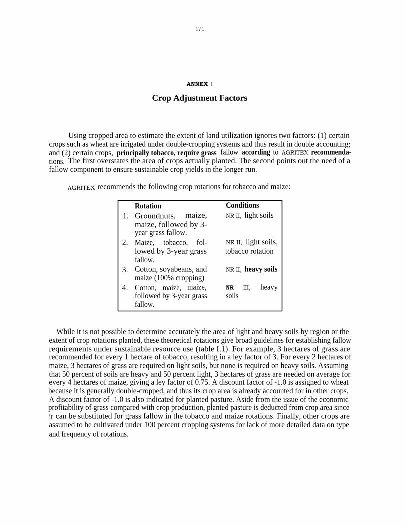
171
ANNEX I
Crop Adjustment Factors
Using cropped area to estimate the extent of land utilization ignores two factors: (1) certaincrops such as wheat are irrigated under double-cropping systems and thus result in double accounting;and (2) certain crops, principally tobacco, require grass fallow according to AGRITEX recommenda-tions. The first overstates the area of crops actually planted. The second points out the need of afallow component to ensure sustainable crop yields in the longer run.
AGRITEX recommends the following crop rotations for tobacco and maize:
While it is not possible to determine accurately the area of light and heavy soils by region or theextent of crop rotations planted, these theoretical rotations give broad guidelines for establishing fallowrequirements under sustainable resource use (table I.1). For example, 3 hectares of grass arerecommended for every 1 hectare of tobacco, resulting in a ley factor of 3. For every 2 hectares ofmaize, 3 hectares of grass are required on light soils, but none is required on heavy soils. Assumingthat 50 percent of soils are heavy and 50 percent light, 3 hectares of grass are needed on average forevery 4 hectares of maize, giving a ley factor of 0.75. A discount factor of -1.0 is assigned to wheatbecause it is generally double-cropped, and thus its crop area is already accounted for in other crops.A discount factor of -1.0 is also indicated for planted pasture. Aside from the issue of the economicprofitability of grass compared with crop production, planted pasture is deducted from crop area sinceit can be substituted for grass fallow in the tobacco and maize rotations. Finally, other crops areassumed to be cultivated under 100 percent cropping systems for lack of more detailed data on typeand frequency of rotations.
Rotation1. Groundnuts, maize,
maize, followed by 3-year grass fallow.
2. Maize, tobacco, fol-lowed by 3-year grassfallow.
3. Cotton, soyabeans, andmaize (100% cropping)
4. Cotton, maize, maize,followed by 3-year grassfallow.
ConditionsNR II, light soils
NR II, light soils,tobacco rotation
NR II, heavy soils
NR III, heavysoils
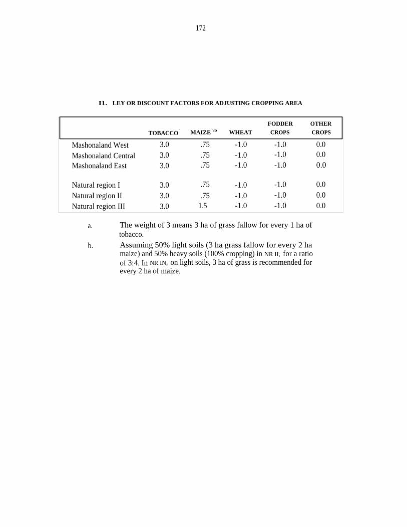
172
I1. LEY OR DISCOUNT FACTORS FOR ADJUSTING CROPPING AREA
TOBACCO` MAIZE`'b WHEAT
FODDER
CROPS
OTHER
CROPS
Mashonaland West 3.0 .75 -1.0 -1.0 0.0
Mashonaland Central 3.0 .75 -1.0 -1.0 0.0
Mashonaland East 3.0 .75 -1.0 -1.0 0.0
Natural region I 3.0 .75 -1.0 -1.0 0.0
Natural region II 3.0 .75 -1.0 -1.0 0.0
Natural region III 3.0 1.5 -1.0 -1.0 0.0
a. The weight of 3 means 3 ha of grass fallow for every 1 ha oftobacco.
b. Assuming 50% light soils (3 ha grass fallow for every 2 hamaize) and 50% heavy soils (100% cropping) in NR II, for a ratioof 3:4. In NR IN, on light soils, 3 ha of grass is recommended forevery 2 ha of maize.
173
ANNEX J
Crops Yields in ReSettlement and Large-Scale Sectors by Natural Region
J1. CROP YIELDS IN RESETTTLEMENT AND LARGE-SCALE SECTORS BY NATURAL REGION
(in kg/ha)
MZ WI MG SF SB GN CT TB I
Large-scale sector'1988 NR I 3,904 2,000 333 2,413 1,769 1,533 2,235
NR II 4,647 5,482 1,220 743 2,280 3,200 2,199 2,070NR III 4,026 5,410 2,170 648 2,410 2,973 1,780 2,022NR IV 3,757 3,858 1,380 696 630 2,070 2,017 2,000NR v 4,315 3,572 - 1,927 2,730 4,667 2,019 1,864
Resettlement'677 - 168 60 1,101 -1986 NR I
NR II 1,207 2,580 187 520 387 322 1,221 1,648NR III 927 2,211 339 392 713 347 746 1,282NR IV 256 192 279 172 556NR V 308 263 199 168 228
1985 NR I 2,204 600 500 333 222NR II 2,585 2,740 1,834 698 1,168 826 1,087 2,094NR III 2,021 2,185 850 893 511 519 1,152 894NR IV 1,344 4,747 432 834 438 548 552NR v 596 547 89 75 48
1984 NR I 342 - 500 - 77NR II 1,814 766 2,022 463 406 413 984 825
NR III 1,141 2,465 465 430 559 242 903 3,000NR IV 794 1,000 363 294 296 181 531NR V 125 - 121 - 239 250 -
MZ = maize; wr = wheat; MG - mhunga; SF = sunflower; SB = soyabeans; GN = groundnuts;CT = cotton; and TB = tobacco.a. From Central Statistics Office.b. Means yields were calculated from two data files compiled by DERUD; area by natural
region for each scheme from the data file "settlers.wrk"; and crop area and productionfrom "Crop8485.wrk," "Crop8586.wrk," and "Crop8687.wrk." If a scheme fell intomore than one natural region, calculations assumed that area and production weredistributed proportionally to the area of scheme falling in each region. The majorityof schemes, however, fell into one natural region only.


175
REFERENCES
AMA (Agricultural Marketing Authority). 1985. Economic Review of the Agricultural Industry ofZimbabwe. Harare: AMA.
Amin, N., and J.T. Chipika. 1990. "The Differentiation of the Peasantry in Zimbabwe: SomeImplications for Land Redistribution." Paper prepared for Conference on Land Policy inZimbabwe after Lancaster (ZAL), 13-15 February 1990, at Harare International ConferenceCenter.
Barnes, Grenville. 1990. "A Comparative Evaluation Framework for Cadastre-based Land InformationSystems (CLIS) in Developing Countries." LTC Research Paper, no. 102. Madison: LandTenure Center, University of Wisconsin, March.
Berry, R. Albert, and William R. Cline. 1979. Agrarian Structure and Productivity in DevelopingCountries. Baltimore: Johns Hopkins University Press.
Binswanger, Hans P., and Miranda Elgin. 1988. "What Are the Prospects for Land Reform?" LatinAmerica and the Caribbean Region Series, Internal Discussion Paper, Report no. IDP-21.Washington, D.C.: World Bank.
Bratton, Michael. 1990. "Ten Years After: Land Redistribution in Zimbabwe." In Agrarian Reformand Grassroots Development: Ten Case Studies, edited by Roy L. Prosterman, Mary N.Temple, and Timothy M. Hanstad; pp. 265-291. Boulder, Colo.: Lynne Rienner Publishers.
Bratton, Michael. 1993. "Land Redistribution, 1980-1990." In Beneath the Surface of Zimbabwe'sAgricultural Revolution, edited by M. Rukuni and E.K. Eicher. Draft. Harare: Departmentof Agricultural Economics and Extension, University of Zimbabwe. Forthcoming, Universityof Zimbabwe Press.
Bruce, John W. 1986. "Land Tenure Issues in Project Design and Strategies for AgriculturalDevelopment in sub-Saharan Africa." Madison: Land Tenure Center, University of Wisconsin,March.
Bruce, John W. 1989. "The Variety of Reform: A Review of Recent Experience with Land Reformand the Reform of Land Tenure, with Particular Reference to the African Experience." Paperprepared for Conference on Human Rights in a Post-Apartheid South African Constitution,at Columbia University, New York, 25-28 September 1989.
Bruce, John W. 1990a. "Legal Issues in Land Use and Resettlement." Background paper prepared forWorld Bank Agricultural Sector Memorandum. Washington, D.C.: World Bank, October.
Bruce, John W. 1990b. "Land Policy and State Farm Divestiture in Mozambique." Madison: LandTenure Center, University of Wisconsin, April.

176
Bruce, John W., and Paula Harrell. 1989. "Land Reform in the People's Republic of China,1978-1988." LTC Research Paper, no. 100. Madison: Land Tenure Center, University ofWisconsin, December.
Carter, Michael. 1984. "Identification of the Inverse Relationship between Farm Size and Productivi-ty." Oxford Economic Papers, no. 36, pp. 131-145.
Carter, Michael R., Keith D. Wiebe, and Benoit Blarel. 1990. "Land Titles, Tenure Security, andAgricultural Productivity: Theoretical Issues and an Econometric Analysis of MediatingFactors in Njoro Division, Kenya." Revised. Madison: Land Tenure Center, University ofWisconsin.
Chaonwa, W. 1989. "Summary of Recommendations in Respect of Agrarian Reform and SubdivisionCriteria." Harare: AGRITEX, Agricultural Management Services Branch, July.
Chavunduka, G.L. 1982. Report of the Commission of Inquiry into the Agricultural Industry. Harare:Government Printers.
Cheater, Angela P. 1978. "Small-scale Freehold as a Model for Commercial Agriculture in Rhodesia-Zimbabwe." Zambezia 5: 117-127.
Cheater, Angela P. 1982. "Formal and Informal Rights to Land in Zimbabwe's Black Freehold Areas:A Case-Study from Msengezi." Africa 52(3): 77-91.
Cheater, Angela P. 1984. Idioms of Accumulation: Rural Development and Class Formation amongFreeholders in Zimbabwe. Gweru, Zimbabwe: Mambo Press.
Cheater, Angela P. 1988. "The Ideology of 'Communal' Land Tenure in Zimbabwe: MythogeniaEnacted?" Forthcoming, Africa.
Cheater, Angela P. 1990. "Socio-Cultural Dimensions of 'Customary' Land Tenure in Zimbabwe."Paper prepared for Conference on Land Policy in Zimbabwe after Lancaster (ZAL), 13-15February 1990, at Harare International Conference Center.
Chelliah, Raja J. 1986. Report of the Commission of Inquiry into Taxation. Harare: GovernmentPrinter, April.
Chimedza, Ruvimbo. 1988. "Women's Access to and Control over Land: The Case of Zimbabwe."Paper, no. 10/88. Harare: University of Zimbabwe, Department of Agricultural Economicsand Extension.
Cliffe, Lionel. 1986. "Policy Options for Agrarian Reform in Zimbabwe: A Technical Appraisal."Rome: Food and Agricultural Organization, February.
Cousins, Ben. 1987. "A Survey of Current Grazing Schemes in the Communal Lands of Zimbabwe."Harare: University of Zimbabwe, Centre for Applied Social Sciences, September.

177
Cousins, Ben. 1990a. "Property and Power in Zimbabwe's Communal Lands; Implications forAgrarian Reform in the 1990s." Paper prepared for Conference on Land Policy in Zimbabweafter Lancaster (ZAL), 13-15 February 1990, at Harare International Conference Center.
Cousins, Ben. 1990b. "Livestock Production and Grazing Rights in Communal Lands andResettlement Schemes in Zimbabwe." Paper submitted to World Bank Agricultural SectorMission, June.
Cusworth, John. 1990. "Land Resettlement." Background paper prepared for World Bank AgriculturalSector Memorandum. Washington, D.C.: World Bank.
Cusworth, John, and Judy Walker. 1988. "Land Resettlement in Zimbabwe: A PreliminaryEvaluation." Evaluation Report, no. EV 434. London: Overseas Development Administration,September.
Duggan, W.J. 1980. "The Native Land Husbandry Act of 1951 and the Rural African Middle Classof Southern Rhodesia." African Affairs 79: 227-240.
Feder, Gershon, Tongroj Onchan, Yongyuth Chalamwong, and Chira Hongladarom. 1988. LandPolicies and Farm Productivity in Thailand. Baltimore: Johns Hopkins University Press.
Funnell, D.C. 1982. "Changes in Farm Incomes and the Rural Development Program in Swaziland."Journal of Developing Areas 16: 271-290.
Gaidzanwa, R.B. 1988. "Women's Land Rights in Zimbabwe: An Overview." RUP Occasional Paper,no. 13. Harare: University of Zimbabwe, Department of Rural and Urban Planning, August.
Green, R.H. 1985. "Parameters, Permutations and Political Economy, Zimbabwe." Paper for Confer-ence on Economic Policies and Planning under Crisis Conditions, sponsored by EconomicsDepartment, University of Zimbabwe, in Harare.
Hawkins Associates. 1982. "Investigation in the Intensity of Land Utilization in Selected FarmingAreas of Zimbabwe." Washington, D.C.
Holleman, J.F. 1952. Shona Customary Law. Cape Town: Oxford University Press.
Johnson, R.W.M. 1968. "The Economics of African Agriculture in Southern Rhodesia." Ph.D. thesis,University of London.
Johnston, Bruce F., and William C. Clark. 1982. Redesigning Rural Development: A StrategicPerspective. Baltimore: Johns Hopkins University Press.
Johnston, Bruce F., and Peter Kilby. 1975. Agriculture and Structural Transformation, EconomicStrategies in Late-Developing Countries. New York: Oxford Univesity Press.
Joint Farmers' Unions. 1990. Commercial Agriculture in Zimbabwe, 10th Anniversary Edition.Harare: Modern Farming Publications, Agriculture House.

178
Joint Presidents' [of Commercial Farmers Union, National Fanners Association of Zimbabwe, andZimbabwe National Farmers' Union] Agricultural Committee. 1989. Commercial Agriculturein Zimbabwe 1989-1990. Harare: Modern Farming Publications.
Joint Presidents' Agricultural Committee. 1990. "Report on Resettlement, Distribution and Utilizationof Agricultural Land in Zimbabwe." Harare, March.
Kinsey, B.H. 1982. "Forever Gained: Resettlement and Land Policy in the Context of NationalDevelopment in Zimbabwe." Journal of the International African Institute 52: 92-113.
Lele, Uma, and Manmohan Agarwal. 1989. "Smallholder and Large-scale Agriculture in Africa: AreThere Tradeoffs between Growth and Equity." MADIA Discussion Paper, no. 6. Washington,D.C.: World Bank.
Levi, J., and M. Haviden. 1982. Economics of African Agriculture. London: Longmans.
LTC (Land Tenure Center). 1990. "Security of Tenure in Africa: Agenda and Briefing Papers" / APresentation to the Agency for International Development: Findings of a program ofcomparative research and their policy and programmatic implications, Washington, D.C., 19-20 April 1990. Madison: Land Tenure Center, University of Wisconsin.
Maboreke, Mary. 1990. "The Gender Dimensions of the Land Question in Zimbabwe." Paperprepared for Conference on Land Policy in Zimbabwe after Lancaster, held 13-15 February1990, at Harare International Conference Center.
Masoka, N. 1993. "A Land Reform Policy and Strategy for Zimbabwe." In Beneath the Surface ofZimbabwe's Agricultural Revolution, edited by M. Rukuni and C.K. Eicher. Draft. Harare:Department of Agricultural Economics and Extension, University of Zimbabwe. Forthcoming,University of Zimbabwe Press.
Massell, B.F., and R.W.M. Johnson. 1966. African Agriculture in Rhodesia: An Econometric Study.Report, no. R-443-RC. Santa Monica, Calif.: Rand Corporation.
Masters, Will. 1990. Unpublished data, Ministry of Lands, Resettlement and Rural Development,Government of Zimbabwe, Harare.
MLARR (Ministry of Lands, Agriculture and Rural Resettlement). 1986. "Communal LandsDevelopment Plan: A 15 Year Development Strategy." Harare, February.
MLARR (Ministry of Lands, Agriculture and Rural Resettlement). Monitoring and Evaluation Unit.1988. "Model B Cooperative Resettlement Schemes, Baseline Survey and TechnicalAppraisal." First Draft. Harare, November.
MLGRUD (Ministry of Local Government, Rural and Urban Development). Department of RuralDevelopment. 1987. "Report on the National Symposium on Agrarian Reform in Zimbabwe "
/ [held in] Nyanga, Zimbabwe, 19-23 October 1987. Draft. Harare.
MLRRD (Ministry of Lands, Resettlement and Rural Development). 1985. "Intensive ResettlementPolicies and Procedures." Revised. Harare: MLRRD, April.
179
Morris, Michael L. 1988. "Comparative Advantage and Policy Incentives for Wheat Production inZimbabwe." CIMMYT Economics Working Paper, no. 88/02. Harare: International Maize andWheat Improvement Center.
Moyo, Sam. 1987. "The Land Question." In Zimbabwe: The Political Economy in Transition,1980-1986, edited by Ibbo Mandaza, pp. 165-202. Harare: Jongwe Press.
Moyo, Sam, and Tor Skalnes. 1990. "Land Reform and Development Strategy in Zimbabwe: StateAutonomy, Class and the Agrarian Lobby." Paper prepared for Conference on Land Policyin Zimbabwe after Lancaster, held 13-15 February 1990, at Harare International ConferenceCenter.
Munasirei, D.K. N.d. "Methodology for the Assessment of Land-Use in Zimbabwe." Harare.
Murombedzi, James C. 1990. "'Communal' Land Tenure and Common Property ResourceManagement. An Evolution of the Prospects for Sustainable Common Property ResourceManagement in Zimbabwe's 'Communal' Areas." Paper prepared for Conference on LandPolicy in Zimbabwe after Lancaster, held 13-15 February 1990, at Harare InternationalConference Center.
National Farmers Association of Zimbabwe. 1989. "Proposals for Land Reform and DistributionPolicy." Draft. Harare: NFAZ, November.
Norman, Dennis. 1990. "Experience of Land Reform in Zimbabwe." Paper presented to Rural LandWorkshop, 9-11 March 1990, sponsored by Institute for a Democratic Alternative for SouthAfrica.
Palmer, Robin. 1977. Land and Racial Domination in Rhodesia. Berkeley: University of CaliforniaPress.
Pankhurst, Donna, and Susie Jacobs. 1988. "Land Tenure, Gender Relations, and AgriculturalProduction: The Case of Zimbabwe's Peasantry." In Women and Land: The AfricanExperience, edited by Jean Davison, pp. 202-227. Boulder, Colo: Westview Press.
Place, Frank, Peter B. Hazell, and Lawrence J. Lau. 1990. "An Econometric Analysis of theRelationship between Land Rights and Agricultural Productivity in sub-Saharan Africa." Paperpresented to Conference on Rural Land Tenure, Credit, Agricultural Investment and FarmProductivity in subsaharan Africa, in Nairobi, Kenya, 4-8 June 1990.
Ranger, Terance. 1985. Peasant Consciousness and Guerrilla War in Zimbabwe. London: LeslieBesant.
Ranger, Terance. 1988. "The Communal Areas of Zimbabwe." Paper presented at Symposium onLand and African Agrarian Systems, University of Illinois at Urbana-Champaign, 10-12 April1988.
Riddell, James C., and Carol Dickerman et al. 1986. "Country Profiles of Land Tenure: Africa1986." LTC Paper, no. 127. Madison: Land Tenure Center, University of Wisconsin, April.

180
Riddell, Roger C. 1978a. The Land Problem in Rhodesia: Alternatives for the Future. Harare: MamboPress.
Riddell, Roger. 1978b. The Land Question. London: Catholic Institute for International Relations.
Rohrbach, David Deems. 1988. "The Growth of Smallholder Maize Production in Zimbabwe: Causesand Implications for Food Security." Ph.D. thesis, Agricultural Economics, Michigan StateUniversity.
Rohrbach, David D. 1989. "The Economics of Smallholder Maize Production in Zimbabwe:Implications for Food Security." Msu International Development Paper, no. 11. East Lansing:Michigan State University, Department of Agricultural Economics.
Roth, Michael. 1990. "Analysis of Agrarian Structure and Land Use Patterns in Zimbabwe."Background paper prepared for World Bank Agricultural Sector Memorandum. Washington,D.C., World Bank, October.
Roth, Michael. 1993. "A Critique of Zimbabwe's 1992 Land Act: Quasi-market versus Non-marketOptions for Land Reform." In Beneath the Surface of Zimbabwe's Agricultural Revolution,edited by M. Rukuni and C.K. Eicher. Draft. Harare: Department of Agricultural Economicsand Extension, University of Zimbabwe. Forthcoming, University of Zimbabwe Press.
Seidman, Robert B. 1968. "Land and Economic Development in Independent, English-Speaking, sub-Saharan Africa." In Africa and Law, edited by Arthur Schiller, pp. 3-74. Madison: Universityof Wisconsin Press.
Scoones, Ian, and Ken Wilson. 1989. "Households, Lineage Groups and Ecological Dynamics: Issuesfor Livestock Development in Zimbabwe's Communal Lands." In People, Land and Livestock:Proceedings of a Workshop on the Socio-Economic Dimensions of Livestock Production in theCommunal Areas of Zimbabwe, edited by Ben Cousins, pp. 17-122. Harare: Centre forApplied Social Sciences, University of Zimbabwe.
Sunga, S. et al. 1990. "Farm Extension Baseline Survey Results." Harare: Zimbabwe Institute ofDevelopment Studies.
Tshuma, L., and K. Makamure. 1990. "The Legal Framework." Paper prepared for Conference onLand Policy in Zimbabwe after Lancaster, held 13-15 February 1990, at Harare InternationalConference Center.
UNICEF (United Nations Children's Fund). 1984. Situation Analysis of Women and Children. Harare:UNICEF and Government of Zimbabwe.
Ushewokunze, C.M. 1990. "Land Redistribution and Challenges of Development." Paper preparedfor Conference on Land Policy in Zimbabwe after Lancaster, held 13-15 February 1990, atHarare International Conference Center.
Vincent, V., R.G. Thomas, and R.R. Staples. 1962. An Agricultural Survey of Southern Rhodesia:Part I, Agro-Ecological Survey. Harare: Ministry of Lands, Agriculture and Resettlement.
181
Weiner, Dan, Sam Moyo, Barry Munslow, and Phil O'Keefe. 1985. "Land Use and AgriculturalProductivity in Zimbabwe. Journal of Modern African Studies 23: 252-285.
Weinrich, A.K.H. 1975. African Farmers in Rhodesia: Old and New Peasant Communities inKarangaland. London: Oxford University Press.
Whitlow, Richard. 1988. "Land Degradation in Zimbabwe." Harare: University of Zimbabwe,Geography Department.
Whitsun Foundation. 1978. "A Strategy for Rural Development and Whitsun Data Bank No. 2: ThePeasant Sector." Harare: Whitsun Foundation, October.
Windmill. 1990. Unpublished data, compiled by Windmill (Pvt.), Ltd., Harare, Zimbabwe.
Woldu, Mathewos. 1990. "Agricultural Pricing Policy in Zimbabwe." Emena Region, Technical,Agriculture Division, January.
World Bank. 1989. African Economic and Financial Data. Washington, D.C.: World Bank,September.
World Bank. Southern Agriculture Division. Eastern and Southern Africa Projects Department. 1986.Zimbabwe Land Subsector Study. Report, no. 5878-Zlm. Washington, D.C.: World Bank, 30September.
Zimbabwe. 1985. Main Demographic Features of the Population of Zimbabwe. Harare: CentralStatistics Office, June.
Zimbabwe. 1986. First Annual Survey of Settler Households in Normal Intensive Model A ResettlementSchemes. Harare: Ministry of Lands, Agriculture and Rural Resettlement, Monitoring andEvaluation Section, Central Planning Unit, September.
Zimbabwe. 1987. 1987 Statistical Yearbook. Harare: Central Statistics Office.
Zimbabwe. 1989. Main Demographic Features of Masvingo. Harare: Central Statistics Office, variousmonths. [Also published for Mashonaland Central, Mashonaland East, Mashonaland West,Midlands.]
Zimbabwe. V.d. Crop Production of Large Scale Commercial Farms. Harare: Central StatisticsOffice, various issues.
Zimbabwe. V.d. Quarterly Digest of Statistics. Harare: Central Statistics Office, various issues.
Zimbabwe. Commission of Inquiry into Taxation. 1986. "Report of the Commission on Taxation. "
Harare.
Zimbabwe. Department of the Surveyor-General. 1984. Zimbabwe Natural Regions and FarmingAreas: Boundaries as at 1st July 1983. 2nd ed. Harare: Surveyor-General.

182
Zimbabwe National Farmers' Union. 1987. "Settlement of Qualified Farmers in Resettlement Areas."Harare: ZNFU.