Towards an organisation-wide process-oriented organisation of care ...

METTE LØVSCHAL
LINES OF LANDSCAPE ORGANIZATION: SKOVBJERGMORAINE (DENMARK) IN THE FIRST MILLENNIUM BC
Summary. This paper presents a comparative landscape perspective on theLate Bronze Age landscape boundaries in southern Britain, obtained fromSkovbjerg Moraine, Denmark. Using Delaunay triangulation as well as classicdistribution analyses, it demonstrates that some forms of landscape divisionarticulated already established use-patterns, while others intercepted thecentral lines of movement and conflicted with previous ways of organizing thelandscape. This pattern is interpreted as a new form of large-scale landholdingin which livestock played a dominant role and boundaries were used toconfiscate land in the zones bordering suitable pastures. This situation showsobvious parallels with southern Britain centuries earlier. The paper discusseshow the study of these physical boundaries provides new insights into theorganization of pre-Roman landscapes, not only demonstrating a continuingengagement with landscape lines, but also pointing to new concurrent andpotentially competing social and economic strategies.
INTRODUCTION
Towards the end of the Late Bronze Age, the intensive construction of barrows insouthern Scandinavia had long since ceased. Nevertheless, the preceding centuries’ barrow-building and the ensuing landscape exploitation played an important role in the generalorganization of the landscape. In western Jutland, in particular, the barrows were distributed inlinear arrangements, normally understood as being closely associated with communication linesand landscapes with potential for pasture (p. 266). Such lines not only constituted a visual relictof ways of exploiting and moving in the landscape, but they continued to constitute aninfrastructural hub for transport, burials, ceremonial activities and new settlements.
At the end of the Late Bronze Age, new kinds of landscape lines began to be inscribedin the landscape. These included Celtic fields, pit alignments, common-fenced villages andfarmstead enclosures. From a landscape in which barrow-lines constituted dominating axes,Skovbjerg Moraine increasingly became a landscape where linear, artificial boundaries werefilling in and becoming a striking visual characteristic. There is reason therefore to assume thatthere is something significant about this focal drift, from lines along (barrow-lines) to linesacross (artificial boundaries), which will repay further investigation.
OXFORD JOURNAL OF ARCHAEOLOGY 34(3) 259–278 2015© 2015 John Wiley & Sons Ltd. 259

However, the relationship between preceding use patterns, such as those manifested inthe barrow-lines, and the new linear boundaries has not been investigated in an analyticalperspective, and the relationship between different kinds of constructed lines and socialorganization consequently remains largely unexplored.1 But what was in fact their relation? Whatwas the specific influence of the boundaries’ linear materialization on infrastructure andmobility? And what role did they play in making tenurial claims to the landscape and enactingnew social strategies on behalf of farmsteads, as well as larger groups of people?
This paper examines the particular relationship between linear, artificial boundaries andbarrow-lines. As a theoretical starting point, the boundaries have been associated with twogeneral socio-demographic levels of organization. The first kind of linear boundaries wereapplied as divisions between individual farmsteads and plots (enclosed farms, field systems andfence lines) called intra-organizational boundaries. The second kind resembled demarcationsbetween larger groups of people and territories (common-fenced enclosures, pit zone alignments,and axial lines in field systems) called inter-organizational boundaries. This paper focusesparticularly on boundaries associated with the second kind. The method is based on a formalizedclassification of the linear distributions of barrows, as well as a classical spatial analysis of howthe boundaries relate to these lines as regards distance and orientation.
The landscape analyses undertaken demonstrate not just that boundaries associated witha supra-farmstead organization were primarily distributed in the immediate vicinity of thebarrow-lines, but that they clearly tend to be constructed with a crosswise orientation, sometimesdeliberately incapacitating these lines. The paper discusses how these forms of supra-farmsteadboundaries may have been associated with new cattle-based economies, which profited from theextensive pastures on the surrounding lands. This represents a landscape situation that, on severalpoints, shows parallels to the situation in parts of southern Britain in the early first millenniumBC, which until now has appeared largely exceptional in comparison with the rest of north-western Europe.
The Late Bronze Age and Pre-Roman Iron Age
The chronology applied follows the Nordic Early Bronze Age I–III (EBA) c.1700–1100BC, Late Bronze Age IV–VI (LBA) c.1100–500 BC, the Early Pre-Roman Iron Age (EpRIA)c.500–250 BC, and the Late Pre-Roman Iron Age (LpRIA) c.250 BC–0 BC (Jensen 2005;Vandkilde 1996).
During the second millennium BC, the Sub-Boreal vegetation gradually changed frompredominantly forest to a more open landscape, with increasing pressure from grazing intensityand agriculture (Aaby 1983; Andersen et al. 1983). In some areas, the opening of the landscapemay already have commenced during the fifth millennium, when the first spread of heathland canbe detected (Odgaard 1994; Odgaard and Rasmussen 2000). By the end of the Late Bronze Age,large parts of western Jutland consisted of open, heather-dominated pastures.2 Local pollendiagrams such as the Solsø diagram continuously show low values for barley in the Early
1 As early as the 1940s, it was concluded that there was no causal relationship between the barrow-lines and theCeltic field systems in Jutland (Hatt 1949, 124).
2 Calluna does not normally spread in a landscape with a short-fallow alternation between pasture and cultivation(Vinter 2011, 139). This could indicate that heathland was laid out for widespread, extensively used pastures ona more or less permanent basis, with systematic burnings (Karg 2008; Nielsen and Odgaard 2010).
LINES OF LANDSCAPE ORGANIZATION
OXFORD JOURNAL OF ARCHAEOLOGY© 2015 John Wiley & Sons Ltd.260

Pre-Roman Iron Age, indicating that the cultivated fields in these areas still made up a relativelylow percentage of the landscape (Odgaard 1985).
The boom in barrow-building over the preceding centuries had left a landscape whichwould have looked very different from before: a landscape where people had abandoned entireareas and settled in new sites (Møller 2013, fig. 11.9, 224). In some areas, there was a cleartendency of settlement contraction, e.g. at Grøntoft, Ristoft and Spjald (Becker 1972).Otherwise, settlements were characterized by dispersed, one-generation farmstead units,re-erected at frequent intervals in a new position in the landscape. Houses were small, probablybuilt for nuclear families, and strikingly similar in architecture, size and orientation (Herschend2009; Webley 2008). The numerous houses with significant byre constructions, as well assamples of bone material, indicate that cattle and livestock played a central role in the individualfarmstead economy (Hvass 1985, 183–6; Kveiborg 2008) and mindset. Concurrently, it wouldhave been crucial for these predominantly autonomous social units to be incorporated in largercooperative units, e.g. for the allocation of land, gathering of livestock, and defence (cf. p. 000).Additionally, during the Late Bronze Age, the societies saw an increase in the number of houses,alongside a sometimes more permanent settlement pattern,which escalated c.250 BC (cf. ‘Newinstitutional realities’).
Towards the end of the Late Bronze Age, embanked field systems (Celtic fields) wereincreasingly filling in the surrounding area of the settlements (Hatt 1949, 92–108, 123–8; Vinter2011; Webley 2008, 40–3). The earliest absolute dates are sampled from Øster Lem Hede, wherethe banks and lynchets accumulated c.795–495 cal BC (Nielsen 2007). Within these parcelled-upareas, merging and partitioning of the individual field-plots were related to the allocation of landwithin farmstead units while others were associated with more obvious common layoutprinciples, such as axial alignments and compartmentalizations (Brongers 1976, 64–5, 15C;Müller-Wille 1965, 52–4). The sometimes very strong podzol horizons as well as ard marksindicate that some of them were applied to already cultivated soils (Hatt 1949). Furthermore,traces of ditches, stone rows and shorter stretches of fences underneath field-banks indicate thatpeople had probably been using some earlier forms of landscape markers (Hatt 1931, 157; 1949,fig. 38, 61; Rindel 1999). Their position in the landscape appears to be associated with a clearconnection to both freshwater resources and lighter soils, in that 84 per cent are situated within1000 m of freshwater sediments and moraine sand/gravel.3
The pit zone alignments, another new type of linear boundary, were constructed as‘belts’ of open holes up to several kilometres long, and were sometimes accompanied by pointedsticks which cut off larger parts of the landscape. Divisions of labour (Mauritsen 2010; Steen2005) and their sometimes strong association with extensive settlements suggest that they werebuilt by larger social groups rather than single farmsteads. Relative stratigraphic observations,C14 dates and their proximity to nucleated settlements indicate a Late Bronze Age–Early Pre-Roman Iron Age date.
A third type of boundary, the enclosed settlements, escalated remarkably in the LatePre-Roman Iron Age (Fig. 1). In most cases, the individual farmsteads were surrounded by theirown fences, which typically adjoined other farmsteads in an aggregate fashion, resembling acontinuous expression of the autonomous status of the farmstead. In other cases, however, peopleexplicitly expressed their group affiliation in common-fenced villages where the fences enclosed
3 According to VSK soil classification.
METTE LØVSCHAL
OXFORD JOURNAL OF ARCHAEOLOGY© 2015 John Wiley & Sons Ltd. 261

entire settlements. Several of these sites showed traces of defensive elements, such as the pointedoak ‘bayonets’ in the moat of Lyngsmose (Eriksen and Rindel 2003), the pit zone demarcationof Brændgaards Hede (Mauritsen 2010), or the palisades of Lysgård (Olesen 2006). These sitesbear witness to new social forms of living, as well as situation-specific needs for the activationof larger groups of people for defending, managing or claiming certain areas.
Chronologically, these linear constructed boundaries appearing at Skovbjerg Moraine fitinto the overall development of linear boundaries in southern Scandinavia, with a slightlydisplaced expansion of landscape and settlement boundaries at c.700 BC and c.250 BC, when theerection of barrows was rapidly declining (Fig. 2).
CONSTRUCTED LINES AS SOCIAL BOUNDARIES
The section above describes a situation where the transition from Late Bronze Age toPre-Roman Iron Age was characterized by a number of fundamental redefinitions of theinstitutional reality, which happened alongside the introduction of new forms of linearboundaries. Artificial linear boundaries have a particular tendency to be triggered or to accelerateunder certain conditions. A frequent prompt is increased group interaction, as well asorganizational changes, both of which can increase competition and the need to emphasizedifferences and the explicit boundaries between groups, as well as within groups (Albert et al.2000; Hogg and Terry 2000; Newman 2006; Paulsen 2003, 23).
One kind of boundary is represented by collective constructions and reproductions ofcommon boundaries (Hernes 2004; Hogg 2012; Paasi 1996; 1999; Paulsen 2003, 19). Such
Grøntoft
Sverigesvej
Lyngsmose
Grøntoft A
Lystbækgaard
Brændgaardshede
Lysgård
200 m
Damgård
Omgård-Sig
Grønbjerg Skole
Lyngsmose
Koustrup
Spjald Syd
Figure 1Selection of enclosed settlement sites from the PRIA on Skovbjerg Moraine, showing a gradual transition betweenenclosed farmsteads, common-fenced villages and larger settlement demarcations, expressing different emphases on
the individual farmsteads.
LINES OF LANDSCAPE ORGANIZATION
OXFORD JOURNAL OF ARCHAEOLOGY© 2015 John Wiley & Sons Ltd.262

boundaries often entail the construction of a social consensus and normative ideals and anerasure of internal social differences (Hogg and Terry 2000, 124). If one is not inside, one isoutside. They are materialized not only as by-products of already existing positive identificationswith a given social group or sets of normative rules; the construction of collective boundaries andother forms of physical distinctions also emerge as a result of general uncertainty towards thesurroundings (Zerubavel 1991, 116). Such boundaries could be called inter-organizationalboundaries (Fig. 3).
Another kind of boundary is represented by internal divisions which segment socialspace in a meaningful way (Hernes 2004, 15). As given areas are fenced or bounded in otherways, they become cut off from their surroundings and transformed into regulated entities wherecertain laws apply. Such boundaries reduce internal uncertainties (Zerubavel 1991, 118) andincrease the incentive to use boundaries as a way of expressing social affiliations and differences.This kind of boundary always has a degree of extroversion: it is at the same time both the end ofone space and the beginning of a new one. Thus, without a boundary, one does not necessarilyhave access to the same kinds of possibilities (or restrictions) as others within the group. Suchboundaries could be called intra-organizational boundaries (Fig. 3).
On Skovbjerg Moraine, two main coexisting socio-demographic levels of organizationcan be identified in the application of linear boundaries, which are comparable to the principlesdescribed above, although it is not characterized by an unambiguous distinction.4 One levelrepresents the continuation of an organization based largely on farmstead autonomy. Theseboundaries were centred on the individual farmstead: there was no prevailing axis of alignmentor overriding enclosing boundary, and field systems as well as fenced farmsteads developed
4 Despite representing two different societies, these principles can nonetheless be compared with Richard Bradley’searly classification of the southern British field systems into cohesive and aggregate (Bradley 1978).
0
20
40
60
80
100
-1500 -1000 -500
Index
Date
Figure 2Upper: Schematic depiction of the chronological peaks of the main landscape lines in southern Scandinavia. Blackdashed line: intensity of barrow construction (Holst et al. 2013, fig. 1, 2). Black line: linear landscape boundaries.
White line: linear settlement boundaries. Lower: Chronological distribution of sites with linear boundaries onSkovbjerg Moraine.
METTE LØVSCHAL
OXFORD JOURNAL OF ARCHAEOLOGY© 2015 John Wiley & Sons Ltd. 263

along an organic, flexible or aggregate topology. These forms of internal divisions arecomparable to the intra-organizational boundaries. The other level was more obviously based onorganization principles and investments of labour that exceeded the farmstead level. Theseboundaries were laid out according to an axial symmetry, or constructed as larger cohesiveenclosures applied as a means of defining landscape compounds and common organizationallines or of demarcating groups of people from their surroundings. These forms of large-scalelandscape and settlement demarcations are comparable to the inter-organizational boundaries.
This distinction between inter- and intra-organizational boundaries will form part of thegeneral classification and analysis of the dataset as explained below.
Data
The material basis consists of a dataset with all registered prehistoric barrows fromDenmark and a dataset with archaeological traces of linear, artificial boundaries from the firstmillennium BC on Skovbjerg Moraine (Supporting information 1). These sites have beenclassified as 89 sites with landscape boundaries (49 intra-org./28 inter-org./12 uncat.) and 71sites with settlement boundaries (55 intra-org./16 inter-org.) (Fig. 4).
THE AREA OF INVESTIGATION
Skovbjerg Moraine covers an area of almost 2000 km2, stretching from Holstebro in thenorth to Herning in the east and Skjern Å in the south (Fig. 5). Three dominating types ofgeological sediments can be discerned: the large Pleistocene sandy and loamy moraines, theopen, flat heath plains with meltwater sand from the Weichsel Ice Age, and the coastal areas andinland sand dunes. The sandy moraines would, for long periods in history, have suffered from awashing out of nutrition, podzolization and sand drift (Jensen 1974; 1977; Møller 2013, 34;Odgaard 1994). The natural landscape boundaries are to a large degree defined by the central
Group 1
Social cohesion
Group 2
Increased difference Subject to similar‘rules of the game’
Intra-organizationalboundaries
Social cohesion
Inter-organizationalboundaries
Divisions of labour
Figure 3Schematic depiction of the two principles: inter-organizational boundaries (left) and intra-organizational boundaries
(right).
LINES OF LANDSCAPE ORGANIZATION
OXFORD JOURNAL OF ARCHAEOLOGY© 2015 John Wiley & Sons Ltd.264

Enclosed field systems and landscape divisions (intra-org.)
Larger, linear landscape demarcations (inter-org.)
Landscape axes
Enclosed farmsteads and settlement divisions (intra-org.)
Larger settlement demarcations and enclosures (inter-org.)
Figure 4The distribution of the different principles of linear boundaries (N = 160).
Figure 5The geographical extent of Skovbjerg Moraine (Smed 1978–82), surrounded by flat moorland plains and other
moraines west of the main Jutish stationary line. Registered burial mounds, 4000 BC–AD 1100 (black dots); siteswith settlement boundaries (white dots) and landscape boundaries (white squares) from Skovbjerg Moraine. LiDAR
model © GST.
METTE LØVSCHAL
OXFORD JOURNAL OF ARCHAEOLOGY© 2015 John Wiley & Sons Ltd. 265

watercourses such as Hover Å, Madum Å and Tim Å, all of which flow into the North Sea. Broadriver valleys, lakes, moors and wetland areas divide the landscape into smaller areas of 20–60km2. Furthermore, the waterways constitute impediments to movement, which would haveattracted terrestrial traffic around certain passages. The ridges form long coherent stretches andplateaux, which constitute the driest parts of the landscape and occasionally provide ‘very longviews across the landscape’ (Madsen 1921, 5–6).
BARROW-LINES AND MOBILITY PATTERNS
The linear distribution of barrows has since the earliest stage of research beeninterpreted as indicating prehistoric road lines (Johansen et al. 2004; Müller 1897; 1904). Theposition of barrows along the edges of the moraines and their association with dry lands, fordsand flat expanses make it likely that they represented relatively stable lines of mobility. They didnot necessarily outline the least-cost path or the exact course of roads in a narrow sense, althoughthey were probably within visual range; when a gradient could be avoided, roads were rerouted.During the Late Bronze Age, reburials continually took place on these barrow-lines (Løvschal2013), continuing into the Early Pre-Roman Iron Age with the application of hillocks along roads(Rindel 1997a). Furthermore, a recent approach has suggested that these linear arrangementswere associated with the marking of collective rights of access to larger pasture zones (Holst andRasmussen 2013, 107). The Wessex barrow alignments have been subject to comparableinterpretations, stressing the correlation between barrow density and population density as wellas their association with potential pastures (Fleming 1971).
In the following analyses, a Delaunay triangulation has been applied as an alternativemathematical basis for distinguishing barrow-lines (Supporting information 2). This generates adepiction of the density of barrows on the basis of a triangulation to three nearby barrows, whichsometimes have a significant ‘breadth’ of up to several kilometres: the lines are ‘corridor-like’.A dense cluster of Delaunay lines is centred within the interval of 2–1000 m and will henceforthbe referred to as ‘corridors’ (n = 9735). This is consistent with the archaeological evidence,which indicates the existence of sometimes very broad traffic corridors (Egeberg 2004).
When measuring how the linear boundaries relate spatially to these corridors, they, as awhole, show a significant proximity to the Delaunay corridors between 0 and 700 m (Supportinginformation 2) but particularly the inter-organizational boundaries. The following section willtherefore provide a further investigation of how these boundaries relate to the corridors.
DEMARCATIONS AND INTER-ORGANIZATIONAL BOUNDARIES
Linear axes within field systems
The Celtic field systems on Skovbjerg Moraine generally appear smaller and less regularthan their older southern British counterparts (Bradley 1978; Johnston 2013). Since the banks areextremely exposed to cultivation, the delineation of registered occurrences is rarely associatedwith the original boundaries. One or sometimes several dominating linear axes can in some casesbe identified, similar to the southern British coaxials. A criterion for identifying these is that aroughly straight continuous line can be followed for at least three-quarters of the breadth of thesystems, interrupted only by topological boundaries or field boundaries which, it can be argued,have been applied subsequently. Such lines can either be ‘built-at-once’ or as a series of adjacent
LINES OF LANDSCAPE ORGANIZATION
OXFORD JOURNAL OF ARCHAEOLOGY© 2015 John Wiley & Sons Ltd.266

fields which together make up a roughly linear course. Subsequent connection of the fieldsystems as a whole by a highly dynamic reorganization has clearly contributed to the obliterationof such structures (Becker 1971, fig. 21, 101).5
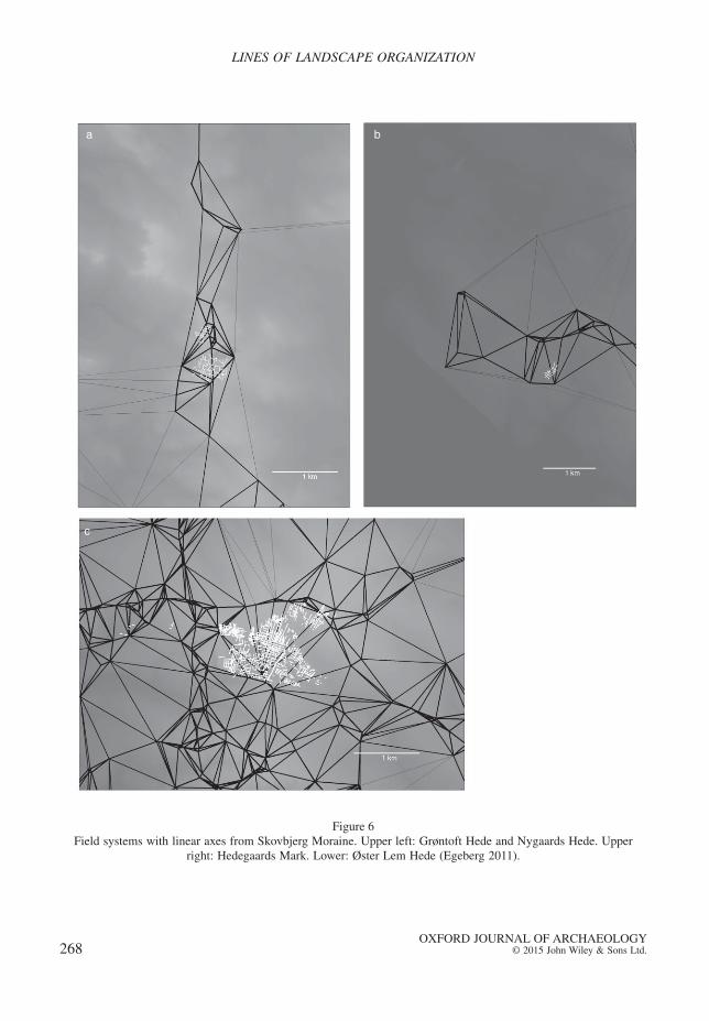
Two Celtic field systems on Skovbjerg Moraine are particularly well investigated: ØsterLem and Grøntoft Hede. Øster Lem Hede covers an area of more than 100 ha (Fig. 6c). Smallerpatches of probably at one time interconnected field systems have been observed on LiDAR,aerial photographs, and excavations in its immediate vicinity (Egeberg 2011; E.S. Mauritsen,pers. com.). The field system is surrounded by, and partly overlaps, four significant Delaunaycorridors, forming an approximately 5 km2 compound in the landscape. It should also be notedthat one of the probably oldest banks, situated in a SSW–NE direction, is precisely perpendicularto the northern barrow-corridor. Grøntoft Hede covers an area of c.20 ha (Fig. 6a), situatedimmediately east of the common-fenced village (SKB30). The field system is likely to havecontinued east and north-west of the registered occurrence (Rindel 1997a, 171). East of theregistered system, hollow-ways run in a north–south direction. An almost straight east–west-bound bank in the southern part of the field system appears to have constituted the focal point forthe layout of several transverse banks. This axial bank is laid out perpendicular to the orientationof the Delaunay corridor. In a larger landscape perspective, the field system is situated at thecrossing between several watersheds (Knudsen 1999) on one of the most central barrow-corridors.
A handful of other axially aligned field systems appears on Skovbjerg Moraine showinga similar pattern, in that they are situated perpendicular to the longitudinal orientation of thebarrow-corridors (cf. Fig. 6b).
Linear pit zone alignments
Numerous pit zone alignments appear to have had a comparable influence on thelandscape (Figs. 7 and 8). They are primarily distributed at the borders of the moraine and in thetransition areas into the heath plains, where the majority of sites are situated at only a fewkilometres’ distance (Supporting information 3). Pit zone alignments are most often identified intest trenches; however, follow-up excavations have demonstrated that they can be severalkilometres long. It appears fair therefore to extend their longitudinal axis a couple of hundredmetres. Once this is done, 13 out of 16 sites show a direct interception of the corridors(Supporting information 3). In conjunction with the rich evidence of coinciding wheel tracks,forts and historical roads (VSK), it seems likely that many pit zone alignments were associatedwith the demarcation of the barrow- lines as well as a blocking of central traffic lines (also seeMauritsen 2010, 33; Steen 2009). However, what is more evident is that they are all situated inthe border-zones of the moraine. In the eastern part of the moraine, the barrow-lines are clearlyless pronounced, and their relation to the pit zone alignments is consequently less clear. Forexample, the pit zone alignment at Gammel Bosig ostensibly runs along one (Fig. 7); however,since there is a ford just south of the site, as well as undated wheel tracks directly on the site(Olesen 2009), it nonetheless appears to have constituted an important barrier to a road.
5 A similar recognition has been made of the extensive coaxial field systems, which also emerged from complex anddynamic topological processes (Johnston 2005).
METTE LØVSCHAL
OXFORD JOURNAL OF ARCHAEOLOGY© 2015 John Wiley & Sons Ltd. 267
a b
c
Figure 6Field systems with linear axes from Skovbjerg Moraine. Upper left: Grøntoft Hede and Nygaards Hede. Upper
right: Hedegaards Mark. Lower: Øster Lem Hede (Egeberg 2011).
LINES OF LANDSCAPE ORGANIZATION
OXFORD JOURNAL OF ARCHAEOLOGY© 2015 John Wiley & Sons Ltd.268
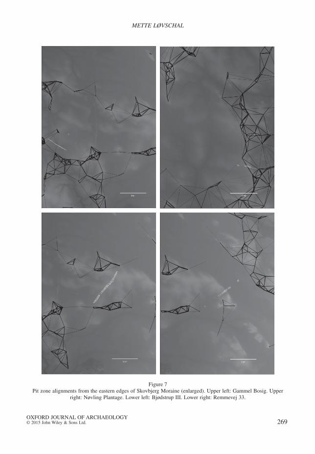
Figure 7Pit zone alignments from the eastern edges of Skovbjerg Moraine (enlarged). Upper left: Gammel Bosig. Upper
right: Nøvling Plantage. Lower left: Bjødstrup III. Lower right: Remmevej 33.
METTE LØVSCHAL
OXFORD JOURNAL OF ARCHAEOLOGY© 2015 John Wiley & Sons Ltd. 269

Figure 8Linear pit zone alignments from the western edges of Skovbjerg Moraine (enlarged). Upper left: Sønder Brorstrup.
Upper right: Femhøjsande. Lower left: Røgind. Lower right: No Stampe.
LINES OF LANDSCAPE ORGANIZATION
OXFORD JOURNAL OF ARCHAEOLOGY© 2015 John Wiley & Sons Ltd.270
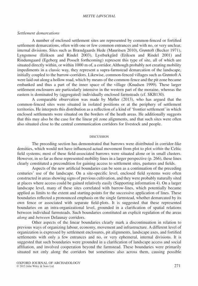
Settlement demarcations
A number of enclosed settlement sites are represented by common-fenced or fortifiedsettlement demarcations, often with one or few common entrances and with no, or very unclear,internal divisions. Sites such as Brændgaards Hede (Mauritsen 2010), Grøntoft (Becker 1971),Lyngsmose (Eriksen and Rindel 2003), Lystbækgård (Eriksen and Rindel 2001) andRindumgaard (Egeberg and Posselt forthcoming) represent this type of site, all of which aresituated directly within, or within 1000 m of, a corridor. Although probably not creating mobilityimpediments in a classic way, they represent a supra-farmstead demarcation of the landscape,initially coupled to the barrow-corridors. Likewise, common-fenced villages such as Grøntoft Awere laid out along a hollow road, which by means of the common-fence and the pit zone becameembanked and thus a part of the inner space of the village (Knudsen 1999). These largersettlement enclosures are particularly intensive in the western part of the moraine, whereas theeastern is dominated by (aggregated) individually enclosed farmsteads (cf. SKB130).
A comparable observation was made by Møller (2013), who has argued that thecommon-fenced sites were situated in isolated positions or at the periphery of settlementterritories. He interprets this distribution as a reflection of a kind of ‘frontier settlement’ in whichenclosed settlements were situated on the borders of the heath areas. He additionally suggeststhat this may also be the case for the linear pit zone alignments, and that such sites were oftenalso situated close to the central communication corridors for livestock and people.
DISCUSSION
The preceding section has demonstrated that barrows were distributed in corridor-likedensities, which would not have influenced actual movement from plot to plot within the Celticfield systems; most of these field-associated barrows were situated alone or in small clusters.However, in so far as these represented mobility lines in a larger perspective (p. 266), these linesclearly constituted a precondition for gaining access to settlement sites, pastures and fields.
Aspects of the new artificial boundaries can be seen as a continuation of the precedingcenturies’ use of the landscape. On a site-specific level, enclosed field systems were oftenconstructed in areas showing signs of previous cultivation, and they were probably naturally sitedat places where access could be gained relatively easily (Supporting information 4). On a largerlandscape level, many of these sites correlated with barrow-lines, which potentially becameapplied as limits to the extent and starting-points for the successive application of lines. Theseboundaries reflected a pronounced emphasis on the single farmstead, whether demarcated by itsown fence or associated with separate field-plots. It is suggested that these representedboundaries on an intra-organizational level, grounded in a clarification of spatial relationsbetween individual farmsteads. Such boundaries constituted an explicit regulation of the areasalong and between Delaunay corridors.
Other aspects of the linear boundaries clearly mark a discontinuation in relation toprevious ways of organizing labour, economy, movement and infrastructure. A different level oforganization is expressed by settlement enclosures, pit alignments, landscape axes, and fortifiedsettlements with only a few entrances and no, or very ephemeral, internal divisions. It issuggested that such boundaries were grounded in a clarification of landscape access and socialaffiliation, and involved cooperation beyond the farmstead. These boundaries were primarilysituated not only along the corridors but sometimes also across them, causing possible
METTE LØVSCHAL
OXFORD JOURNAL OF ARCHAEOLOGY© 2015 John Wiley & Sons Ltd. 271

infrastructural interventions, which are particularly obvious at the peripheries of the morainetowards the surrounding (largely undivided) heath plains. Where corridors were situated inobviously hilly terrain, the relation between mobility lines and linear boundaries is consequentlyless obvious (SKB33, SKB141). These lines probably reflected an extensive structuring of thelandscape in the hands of several farmsteads, which could have caused a significant reduction inmovement, or made a new visual segregation of what was previously considered borderland.
New institutional realities
Towards the end of the Late Bronze Age, there was an increasing tendency for housesto contract within confined and densely settled areas, while other areas appeared more or lessunsettled. The Celtic fields reflected continuous use of certain areas, the formation of banksbeing a result of soil erosion, deliberate constructions or continuous ploughing against fences orunploughed strips (Hatt 1949, 120–3; Nielsen 1993, 115). Equally, it has been noticed that duringthe Pre-Roman Iron Age there was a general tendency for the post-holes in the long-houses tobecome broader and deeper, which has been interpreted as increased emphasis on theconstruction of houses meant to last (Webley 2008). Houses were now also often being rebuiltin several phases. This tendency towards a more sedentary and clustered settlement pattern wasconnected with a much more frequent use of fences, which were also subject to repairs andrenewals (Løvschal 2014). Hence, the suggested shift in linear expression from ‘lines along’ to‘lines across’ (pp. 259, 266–71) was probably coupled with an increased zoning and a gradualtransition towards a more fixed and contracted landscape exploitation.
This inevitably increased social interaction – together with demographic and ecologicalpressure – would have generated a number of new zones of conflict: new spatial loci created bythe reduction in the physical distance between social units that had not previously been spatiallycompared; new demands for the redistribution of land, management of cattle, and marking oftenurial claims; and the new need for cooperation. It is exactly in such tensional areas that linearboundaries were particularly dense – for instance, along central communication lines, in denselysettled areas, or at the transition zones between different types of landscape which werevulnerable to new tenurial claims. At the same time, the boundaries themselves would haveaccelerated this effect, as well as the wish to maintain access and rights to particular parts of thelandscape and to live close to them.
These spatial as well as institutional tensions were solved in quite different ways,sometimes with a pronounced emphasis on the rights and status of individual farmsteads, at othertimes with a more explicit emphasis on social affiliation and landscape regulation in the handsof larger groups of people. The intra-organizational boundaries would have caused a significantreduction in general mobility in the landscape. Hollow-ways, access ramps, and openings in thefield-banks indicate regulated movement within these systems, where the banks would havesecured a controlled number of entrances into the individual plots, comparable to the earlyoccurrences of settlement divisions. Inter-organizational demarcations were used to block,control and change landscape mobility on a much larger scale (Løvschal 2014). The pit zonealignments must have cut off areas that were previously open pasture and heathlands. Inhindering access to and along the barrow-lines, they would not just have constituted localdefence lines, but probably also controlled and regulated mobility between groups, field systemsand larger landscape compounds. Furthermore, the lines would have made a symbolicdemarcation of the linear barrow structures which formed an otherwise stable, long-term
LINES OF LANDSCAPE ORGANIZATION
OXFORD JOURNAL OF ARCHAEOLOGY© 2015 John Wiley & Sons Ltd.272
landscape monument, whose visible dominance was strongly reinforced by differences invegetation, colour and topography (cf. Doorenbosch 2013). Equally, the common-fencedvillages were used to establish new forms of approach to settlements through common entrances,as well as separating their inner space from the surrounding land. They imply not just acoordination of labour by several farmsteads, but also sometimes an obliteration of thedemarcation of the individual farmsteads (Eriksen and Rindel 2003; Rindel 2010). In this way,these larger scale spatial regulations reflected the deliberate strategies of larger groups of peopleto organize labour in new ways, to claim, defend and confiscate new parts of the landscape andto mark the boundary around new competing forms of living.
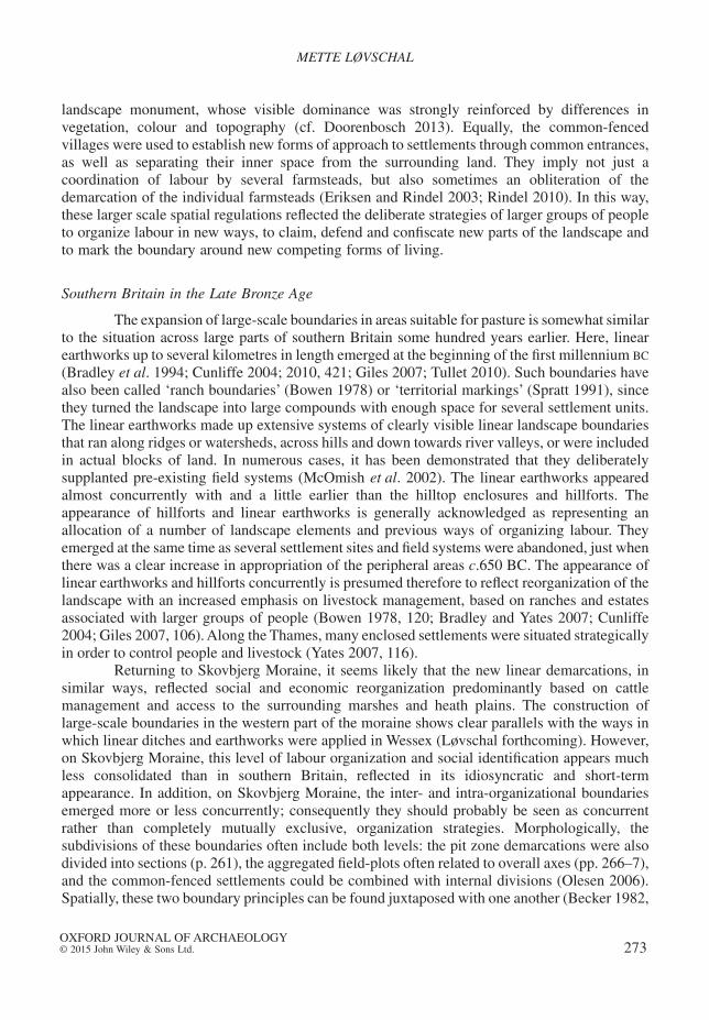
Southern Britain in the Late Bronze Age
The expansion of large-scale boundaries in areas suitable for pasture is somewhat similarto the situation across large parts of southern Britain some hundred years earlier. Here, linearearthworks up to several kilometres in length emerged at the beginning of the first millennium BC
(Bradley et al. 1994; Cunliffe 2004; 2010, 421; Giles 2007; Tullet 2010). Such boundaries havealso been called ‘ranch boundaries’ (Bowen 1978) or ‘territorial markings’ (Spratt 1991), sincethey turned the landscape into large compounds with enough space for several settlement units.The linear earthworks made up extensive systems of clearly visible linear landscape boundariesthat ran along ridges or watersheds, across hills and down towards river valleys, or were includedin actual blocks of land. In numerous cases, it has been demonstrated that they deliberatelysupplanted pre-existing field systems (McOmish et al. 2002). The linear earthworks appearedalmost concurrently with and a little earlier than the hilltop enclosures and hillforts. Theappearance of hillforts and linear earthworks is generally acknowledged as representing anallocation of a number of landscape elements and previous ways of organizing labour. Theyemerged at the same time as several settlement sites and field systems were abandoned, just whenthere was a clear increase in appropriation of the peripheral areas c.650 BC. The appearance oflinear earthworks and hillforts concurrently is presumed therefore to reflect reorganization of thelandscape with an increased emphasis on livestock management, based on ranches and estatesassociated with larger groups of people (Bowen 1978, 120; Bradley and Yates 2007; Cunliffe2004; Giles 2007, 106). Along the Thames, many enclosed settlements were situated strategicallyin order to control people and livestock (Yates 2007, 116).
Returning to Skovbjerg Moraine, it seems likely that the new linear demarcations, insimilar ways, reflected social and economic reorganization predominantly based on cattlemanagement and access to the surrounding marshes and heath plains. The construction oflarge-scale boundaries in the western part of the moraine shows clear parallels with the ways inwhich linear ditches and earthworks were applied in Wessex (Løvschal forthcoming). However,on Skovbjerg Moraine, this level of labour organization and social identification appears muchless consolidated than in southern Britain, reflected in its idiosyncratic and short-termappearance. In addition, on Skovbjerg Moraine, the inter- and intra-organizational boundariesemerged more or less concurrently; consequently they should probably be seen as concurrentrather than completely mutually exclusive, organization strategies. Morphologically, thesubdivisions of these boundaries often include both levels: the pit zone demarcations were alsodivided into sections (p. 261), the aggregated field-plots often related to overall axes (pp. 266–7),and the common-fenced settlements could be combined with internal divisions (Olesen 2006).Spatially, these two boundary principles can be found juxtaposed with one another (Becker 1982,
METTE LØVSCHAL
OXFORD JOURNAL OF ARCHAEOLOGY© 2015 John Wiley & Sons Ltd. 273

fig. 13, 65; Mauritsen 2010). Enclosed settlement sites such as Grøntoft A (SKB30) and SpjaldSyd (SKB123) represent completely different organization principles, which nonetheless wereapplied at the same point in time at a distance of only 6.5 km. These forms of boundaries shouldtherefore probably be considered as different organizational solutions and sometimes competingforms of landholding, which operated side by side.
CONCLUSION
This paper has compared the various kinds of constructed landscape lines appearing onSkovbjerg Moraine, Denmark, during the first millennium BC. The very locations of the sites,together with new forms of spatial segmentation, suggest a continued concern with the long-termlines of orientation which continue to make up a reinterpreted physical framing of the landscape.In this respect, people continued to navigate according to landscape lines, conceptually as wellas spatially. Although the shift in linear repertoire resembles different morphologies and ways ofusing lines, there was still an ongoing semiotic ascription to lines. The continuing application ofthe barrow-lines is particularly evident in the construction of large-scale boundaries, which wasassociated with a new form of landholding and labour division in which cattle probably playeda dominant role and which in some respects is comparable to the situation in southern Britain.This phenomenon is particularly intense towards the borders of the moraine, as well as close tothe main barrow-lines represented by Delaunay corridors.
These new lines, however, no longer represented ‘boundaries along’, but increasingly‘boundaries across’. In this way, the construction of lines for the purpose of explicitlyconfiscating and demarcating the landscape represented a new approach to and perception of thelandscape, as well as social and juridical relations whose long-term culture-historical effectsdeserve further investigation.
Acknowledgements
I am very thankful to Mads Kähler Holst and Esben Schlosser Mauritsen for discussions andcomments on earlier drafts of this paper. I would also like sincerely to thank Martin Winter Olesen,Museum Midtjylland and Torben Egeberg Hansen, Arkvest and Holstebro Museum for providing material.Also thanks to Arkæologisk IT, AU, and Tegnestuen, Moesgaard Museum for help and advice on GIS andlayout.
Department of ArchaeologyAarhus University
Moesgaard Allé 20DK-8270 Højbjerg
DENMARKE-mail: [email protected]
REFERENCES
AABY, B. 1983: Skovudvikling og jordbundsforringelse. Ugeskrift for jordbrug 128, 939–42.ALBERT, S., ASHFORTH, B.E. and DUTTON, J.E. 2000: Organizational identity and identification: charting new
waters and building new bridges. Academy of Management Review 25, 13–17.ANDERSEN, S.T., AABY, B. and ODGAARD, B.V. 1983: Environment and man. Current studies in vegetational
history and the geological survey of Denmark. Journal of Danish Archaeology 2, 184–96.
LINES OF LANDSCAPE ORGANIZATION
OXFORD JOURNAL OF ARCHAEOLOGY© 2015 John Wiley & Sons Ltd.274

AUD: Arkæologiske udgravninger i Danmark: http://www.kulturstyrelsen.dk/publikationer/arkiv-kulturarvs-styrelsen/singlevisning/artikel/arkaeologiske_udgravninger_i_danmark/
BAUDOU, E. 1985: Archaeological source criticism and the history of modern cultivation in Denmark. InKRISTIANSEN, K. (ed.), Archaeological Formation Processes. The Representativity of ArchaeologicalRemains from Danish Prehistory (Copenhagen), 63–80.
BECKER, C.J. 1961: Førromersk jernalder i Syd- og Midtjylland (Copenhagen).BECKER, C.J. 1966: To landsbyer fra tidlig jernalder i Vestjylland. Nationalmuseets Arbejdsmark (1966),
39–50.BECKER, C.J. 1968: Das zweite frühzeitliche Dorf bei Grøntoft, Westjütland. Acta Archaeologica 39,
235–55.BECKER, C.J. 1971: Früheisenzetliche Dörfer bei Grøntoft, Westjütland. 3. Vorbericht: Die Ausgrabungen
1967–68. Acta Archaeologica 42, 79–110.BECKER, C.J. 1972: Hal og hus i yngre bronzealder. Nationalmuseets Arbejdsmark (1972), 5–16.BECKER, C.J. 1980: Bebyggelsesformer i Danmarks yngre bronzealder set i forhold til ældste jernal-
ders landsbysamfund. In THRANE, H. (ed.), Broncealderbebyggelse i Norden: beretning fra detandet nordiske symposium for broncealderforskning: Odense 9.–11. april 1980 (Odense), 127–41.
BECKER, C.J. 1982: Siedlungen der Bronzezeit und der vorrömischen Eisenzeit in Dänemark. Offa 39,53–71.
BOURGEOIS, Q. 2013: Monuments on the Horizon: The Formation of the Barrow Landscape throughout the3rd and 2nd Millennium BC (Leiden).
BOWEN, H.C. 1978: ‘Celtic’ fields and ‘ranch’ boundaries in Wessex. In LIMBREY, S. and EVANS, J. (eds.), TheEffect of Man on the Landscape: The Lowland Zone (London, Council for British Archaeology),115–23.
BRADLEY, R. 1978: Prehistoric field systems in Britain and north-west Europe – a review of some recentwork. World Archaeology 9, 265–80.
BRADLEY, R. and YATES, D. 2007: After ‘Celtic’ fields: the social organisation of Iron Age agriculture. InHASELGROVE, C. and POPE, R. (eds.), The Earlier Iron Age in Britain and the Near Continent (Oxford),94–102.
BRADLEY, R., ENTWISTLE, R. and RAYMOND, F. (eds.) 1994: Prehistoric Land Divisions on Salisbury Plain:The Work of the Wessex Linear Ditches Project (London, English Heritage).
BRONGERS, J.A. 1976: Air Photography and Celtic Field Research in the Netherlands (Amersfoort).CUNLIFFE, B. 2004: Wessex cowboys? Oxford Journal of Archaeology 23(1), 61–81.CUNLIFFE, B. 2010: Iron Age Communities in Britain. An Account of England, Scotland and Wales from the
Seventh Century BC until the Roman Conquest (4th ed.) (London).DOORENBOSCH, M. 2013: A history of open space. Barrow landscapes and the significance of heaths – the
case of the Echoput barrows. In FONTIJN, D.R., LOUWEN, A.J., VAART, S. VAN DER and WENTINK, K. (eds.),Beyond Barrows. Current Research on the Structuration and Perception of the Prehistoric Landscapethrough Monuments (Leiden), 197–223.
EGEBERG, T. 2004: Høje og hjulspor i tusindvis – færdsel i det vestjyske landskab. FRAM (2004), 44–51.
EGEBERG, T. 2011: Jernaldermarkerne på Øster Lem Hede: Danmarks største jernaldermonument.Opdatering (2011), 153–60.
EGEBERG, T. and POSSELT, M.V. forthcoming: Rindumgård Nord.ERIKSEN, P. and RINDEL, P.O. 2001: Lyngsmose og Lystbækgård – et Borremoseanlæg og Cæsars liljer i
Vestjylland. FRAM (2001), 9–21.ERIKSEN, P. and RINDEL, P.O. 2003: Eine befestigte Siedlung der jüngeren vorrömichen Eisenzeit bei
Lyngsmose. Eine neuentdeckte Anlage vom Typ Borremose in Jütland. ArchäologischesKorrespondenzblatt 33, 123–43.
FF: Fund og fortidsminder: http://www.kulturarv.dk/fundogfortidsminder/FLEMING, A. 1971: Territorial patterns in Bronze Age Wessex. Proceedings of the Prehistoric Society 37,
138–66.FORTIDEN SET FRA HIMLEN: http://www.fortidensetfrahimlen.dk [accessed 10 November 2013].GILES, M. 2007: Refiguring rights in the Early Iron Age landscapes of East Yorkshire. In HASELGROVE, C.
and POPE, R. (eds.), The Earlier Iron Age in Britain and the Near Continent (Oxford), 103–18.
METTE LØVSCHAL
OXFORD JOURNAL OF ARCHAEOLOGY© 2015 John Wiley & Sons Ltd. 275

GUIBAS, L., KNUTH, D. and SHARIR, M. 1992: Randomized incremental construction of Delaunay andVoronoi diagrams. Algorithmica 7, 381–413.
HATT, G. 1931: Prehistoric fields in Jylland. Acta Archaeologica 2, 117–59.HATT, G. 1949: Oldtidsagre (Copenhagen).HATT, G. 1957: Nørre Fjand, an Early Iron-Age Village Site in West Jutland (Copenhagen).HENNINGSEN, P. 1995: Hedens hemmeligheder. Livsvilkår i Vestjylland 1750–1900 (Grindsted).HERNES, T. 2004: Studying composite boundaries: a framework of analysis. Human Relations 57, 9–29.HERSCHEND, F. 2009: The Early Iron Age in South Scandinavia: Social Order in Settlement and Landscape
(Uppsala).HERTZ, J. 1987: Danmarks længste udgravning: arkæologi på naturgassens vej 1979–86 (Copenhagen).HOGG, M.A. 2012: Social identity and the psychology of groups. In LEARY, M.R. and TANGNEY, J.P. (eds.),
Handbook of Self and Identity (New York), 502–19.HOGG, M.A. and TERRY, D.J. 2000: Social identity and self-categorization processes in organizational
contexts. Academy of Management Review 25, 121–40.HOLST, M.K. and RASMUSSEN, M. 2013: Herder communities: longhouses, cattle and landscape organisation
in the Nordic Early and Middle Bronze Age. In BERGERBRANT, S. and SABATINI, S. (eds.),Counterpoint: Essays in Archaeology and Heritage Studies in Honour of Professor KristianKristiansen (Oxford, BAR Int. Ser. 2508), 99–110.
HOLST, M.K., RASMUSSEN, M., KRISTIANSEN, K. and BECH, J.-H. 2013: Bronze Age ‘Herostrats’: ritual,political, and domestic economies in Early Bronze Age Denmark. Proceedings of the PrehistoricSociety 79, 1–32.
HVASS, S. 1985: Hodde. Et vestjysk landsbysamfund fra ældre jernalder (Copenhagen).JENSEN, A. 1977: Geologiske undersøgelser omkring Borremosebebyggelsen. Aarbøger for Nordisk
Oldkyndighed og Historie (1975), 96–119.JENSEN, C.K. 2005: Kontekstuel kronologi – en revision af det kronologiske grundlag for førromersk
jernalder i Sydskandinavien. Bind 1 – tekst (Højbjerg, LAG 7).JENSEN, J.A. 1974: Huse i havstokken. Skalk 6, 3.JOHANSEN, K.L., LAURSEN, S.T. and HOLST, M.K. 2004: Spatial patterns of social organization in the Early
Bronze Age of south Scandinavia. Journal of Anthropological Archaeology 23, 33–55.JOHNSTON, R. 2005: Pattern without a plan: rethinking the Bronze Age coaxial field systems on Dartmoor,
south-west England. Oxford Journal of Archaeology 24(1), 1–21.JOHNSTON, R. 2013: Bronze Age fields and land division. In FOKKENS, H. and HARDING, A. (eds.), The
Oxford Handbook of the European Bronze Age (Oxford), 311–27.JØRGENSEN, P.K. 2011: En tidlig jernalderlandsby ved Spjald. Opdatering (2010), 106–12.JØRGENSEN, P.K. 2013: Udgravningsberetning. RSM j.nr. 10.423. Hvidehus, Hulbælte. Arkæologisk
Undersøgelse af Hulbælte og Dyrkningsspor fra Tidlig Jernalder (Ringkøbing-Skjern Museum,Unpublished Excavation Report).
KARG, S. 2008: Direct evidence of heathland management in the early Bronze Age (14th century BC) fromthe gravemound at Skelhøj in western Denmark. Vegetation History and Archaeobotany 17, 41–9.
KNUDSEN, S.A. 1999: Grøntoft and the cultural landscape. In FABECH, C. and RINGTVED, J. (eds.), Settlementand Landscape: A Conference on Landscape and Settlement Archaeology, Århus, Denmark May 4–71998 (Højbjerg), 100–3.
KVEIBORG, J. 2008: Fårehyrder, kvægbønder eller svineavlere. En revurdering af jernalderens dyrehold.Kuml (2008), 59–100.
LEWIS, B. 1984: Overbygård og Nørre Fjand. En analyse af nogle jernalderlandsbyers tilliggender ogøkonomi. Kuml (1985), 123–63.
LØVSCHAL, M. 2013: Ways of wandering – in the Late Bronze Age barrow landscape of the Himmerland-area, Denmark. In FONTIJN, D.R., LOUWEN, A.J., VAART, S. VAN DER and WENTINK, K. (eds.), BeyondBarrows: Current Research on the Structuration and Perception of the Prehistoric Landscape throughMonuments (Leiden), 225–50.
LØVSCHAL, M. 2014: Emerging boundaries: social embedment of landscape and settlement divisions innorthwestern Europe during the first millennium BC. Current Anthropology 55, 725–50.
LØVSCHAL, M. forthcoming: Hulbælterne og de lange linjer i landskabet. In ERIKSEN, P. and RINDEL, P.O.
(eds.), De danske hulbælter.
LINES OF LANDSCAPE ORGANIZATION
OXFORD JOURNAL OF ARCHAEOLOGY© 2015 John Wiley & Sons Ltd.276

MADSEN, A.P. and NEERGAARD, C. 1894: Jydske Gravpladser fra den førromerske Jernalder. Aarbøger forNordisk Oldkyndighed og Historie (1894), 165–212.
MADSEN, V. 1921: Terrainformerne paa Skovbjerg Bakkeø (Copenhagen).MARTENS, J. 2007: Fortified places in low-land northern Europe and Scandinavia during the Pre-Roman
Iron Age. In MÖLLERS, S., SCHLÜTER, W. and SIEVERS, S. (eds.), Keltische Einflüsse im MitteleuropaWährend der mittleren und jüngeren vorrömischen Eisenzeit (Frankfurt am Main), 87–105.
MAURITSEN, E.S. 2010: Brændgaards Hede. A settlement surrounded by pit zone fortifications from theEarly Pre-Roman Iron Age in Denmark. In MEYER, M. (ed.), Haus-Gehöft-Weiler-Dorf: Siedlungen derVorrömischen Eisenzeit im nördlichen Mitteleuropa. Internationale Tagung an der Freien UniversitätBerlin vom 20.–22. März 2009 (Berlin), 262–80.
MCOMISH, D., FIELD, D. and BROWN, G. 2002: The Field Archaeology of the Salisbury Plain Training Area(Swindon).
MØLLER, N.A. 2013: Dynamiske bebyggelser: Vestjylland i ældre jernalder (University of Copenhagen,Unpublished Ph.D. Thesis).
MØLLER-JENSEN, E. 2006: Den romerske villa og fyrsten ved Tjørring. Midtjyske fortællinger (2006),67–106.
MÜLLER, S. 1897: Vor Oldtid: Danmarks forhistoriske Archæologi (Copenhagen).MÜLLER, S. 1904: Vei og bygd i sten- og bronzealderen. Aarbøger for Nordisk Oldkyndighed og Historie
(1904), 1–64.MÜLLER-WILLE, M. 1965: Eisenzeitliche Fluren in den festländischen Nordseegebieten (Münster).MÜLLER-WILLE, M. 1977: Bäuerliche Siedlungen der Bronze- und Eisenzeit in den Nordseegebieten. In
JANKUHN, H., SCHÜTZEICHEL, R. and SCHWIND, F. (eds.), Das Dorf der Eisenzeit und des frühenMittelalters. Siedlungsform – wirtschaftliche Funktion – soziale Struktur (Göttingen), 153–218.
NEWMAN, D. 2006: Borders and bordering: towards an interdisciplinary dialogue. European Journal ofSocial Theory 9, 171–86.
NIELSEN, A.B. and ODGAARD, B.V. 2010: Quantitative landscape dynamics in Denmark through the last threemillennia based on the Landscape Reconstruction Algorithm approach. Vegetation History andArchaeobotany 19, 375–87.
NIELSEN, L.C. 1982: Vestjyske gårde og landsbyer fra bronze- og jernalder. Nationalmuseets Arbejdsmark(1982), 131–41.
NIELSEN, N. 2007: Udgravningsberetning for RIM 9140 – Øster Lem Hede (Aarhus University,Unpublished Excavation Report).
NIELSEN, V. 1993: Jernalderens pløjning – Store Vildmose: undersøgelser i Grishøjgårds Krat, pløjeteknik,gravhøje i Store Vildmose, pløjespor under høje (Hjørring).
ODGAARD, B.V. 1985: A pollen analytical investigation of a Bronze Age and Pre-Roman Iron Age soilprofile from Grøntoft, Western Jutland. Journal of Danish Archaeology 4, 121–8.
ODGAARD, B.V. 1994: The Holocene Vegetation History of Northern West Jutland (Copenhagen).ODGAARD, B.V. and RASMUSSEN, P. 2000: Origin and temporal development of macro-scale vegetation
patterns in the cultural landscape of Denmark. Journal of Ecology 88, 733–48.OLESEN, L.H. 1982: Jernalderagre ved Halgård Bæk. Holstebro Museum Årsskrift (1981), 5–20.OLESEN, L.H. 1983: Vestjyske agersystemer set fra luften og jorden. Antikvariske studier 6, 300–9.OLESEN, L.H. 1996: På sporet af vikingerne i Ulfborg herred? Holstebro Museum Årsskrift (1996), 5–14.OLESEN, M.W. 2000: Tre smedier fra Snejbjerg. FRAM (2000), 23–36.OLESEN, M.W. 2006: Lysgård – en landsby fra ældre jernalder ved Vildbjerg. Midtjyske Fortællinger (2006),
53–66.OLESEN, M.W. 2009: ‘Hulbælter’ – forsvarsanlæg fra ældre jernalder? Fund fra Gammelbosig, Bjødstrup,
Nøvling og Torpgård. Midtjyske Fortællinger (2009), 75–92.PAASI, A. 1996: Inclusion, exclusion and territorial identities – the meanings of boundaries in the
globalizing geopolitical landscape. Nordisk samhällsgeografisk tidsskrift 23, 3–17.PAASI, A. 1999: Boundaries as social processes: territoriality in the world of flows. Geopolitics 3, 669–80.PAULSEN, N. 2003: ‘Who are we now?’: group identity, boundaries, and the (re)organizing process. In
PAULSEN, N. and HERNES, T. (eds.), Managing Boundaries in Organizations: Multiple Perspectives(Basingstoke), 14–34.
PEDERSEN, V.J. 2005: Rugbjergfundet. Skattefund og bopladsfund ved Aulum. Midtjyske fortællinger(2005), 39–55.
METTE LØVSCHAL
OXFORD JOURNAL OF ARCHAEOLOGY© 2015 John Wiley & Sons Ltd. 277

PEDERSEN, V.J. 2007: Munkgårdkvarteret. Endnu en brik til Snejbjergs forhistorie. Midtjyske fortællinger(2007), 93–8.
PEDERSEN, V.J. 2013: HEM 5239 Remmevej 33, Ikast Sogn (Herning Museum, Unpublished ExcavationReport).
POSSELT, M.V. 2009: RSM 10.034 Blæsenborg 3 (Ringkøbing-Skjern Museum, Unpublished ExcavationReport).
RINDEL, P.O. 1997a: Grøntoft – og etableringen af det strukturerede landsbysamfund i Vestjylland i 1.årtusinde f. Kr. Bd. I: Hovedtekst (University of Copenhagen, Unpublished Ph.D. Thesis).
RINDEL, P.O. 1997b: Grøntoft – og etableringen af det strukturerede landsbysamfund i Vestjylland i 1.årtusinde f. Kr. Bd. IIIa–b Lokalitetskatalog (University of Copenhagen, Unpublished Ph.D. Thesis).
RINDEL, P.O. 1999: Development of the village community 500 BC–100 AD in west Jutland, Denmark. InFABECH, C. and RINGTVED, J. (eds.), Settlement and Landscape: A Conference on Landscape andSettlement Archaeology, Århus, Denmark May 4–7 1998 (Højbjerg), 79–99.
RINDEL, P.O. 2010: Grøntoft revisited – new interpretations of the Iron Age settlement. In MEYER, M. (ed.),Haus-Gehöft-Weiler-Dorf: Siedlungen der Vorrömischen Eisenzeit im nördlichen Mitteleuropa.Internationale Tagung an der Freien Universität Berlin vom 20.–22. März 2009 (Berlin), 251–62.
ROSTHOLM, H. 1982: Oldtiden på Herning-egnen (Herning).ROSTHOLM, H. 1995: Holing. Arkæologiske undersøgelser 1992–1995. FRAM (1995), 71–90.ROSTHOLM, H., STEEN, B. and OLESEN, M.W. 1996: Nye jernalderfund fra Vildbjerg. Herning Museums
udgravninger 1986–1996. FRAM (1996), 117–39.SMED, P. 1978–82: Landskabskort over Danmark (Copenhagen).SPRATT, D.A. 1991: Recent British research on prehistoric territorial boundaries. Journal of World
Prehistory 5, 439–80.STEEN, B. 1997: Damgård. En bebyggelse fra sen førromersk jernalder ved Tjørring. FRAM (1997), 57–62.STEEN, B. 2005: Stolpehulsbæltet ved Risum Østergård. Holstebro Museum Årsskrift (2005), 15–27.STEEN, B. 2009: Forsvarsanlæg og bebyggelse ved Tvis Møllevej. Holstebro Museum Årsskrift (2009),
5–16.TULLET, A.V. 2010: Information highways: Wessex linear ditches and the transmission of community. In
STERRY, M., TULLETT, A. and RAY, N. (eds.), In Search of the Iron Age: Proceedings of the Iron AgeResearch Student Seminar 2008 (Leicester), 111–26.
VANDKILDE, H. 1996: From Stone to Bronze Age: The Metalwork of the Late Neolithic and Earliest BronzeAge in Denmark (Højbjerg).
VINTER, M. 2011: Rekonstruktion af det parcellerede dyrkningslandskab i Himmerland. Marker, græsningog bebyggelse belyst i tre mikroregioner. In MØLLER, N.A., QVISTGAARD, S. and JENSEN, S.F. (eds.), Nytfra Vestfronten: Nord- og vestjyske bebyggelser fra ældre jernalder (Copenhagen), 129–54.
WEBLEY, L. 2008: Iron Age Households. Structure and Practice in Western Denmark, 500 B.C.–200 A.D.(Højbjerg).
YATES, D.T. 2007: Land, Power and Prestige: Bronze Age Field Systems in Southern England (Oxford).ZERUBAVEL, E. 1991: The Fine Line: Making Distinctions in Everyday Life (New York).
SUPPORTING INFORMATION
Additional Supporting Information may be found in the online version of this article at thepublisher’s web-site:
Supporting information 1: AppendixSupporting information 2: Delaunay triangulationSupporting information 3: The linear pit zonesSupporting information 4: Linear landscape boundaries, preceding landscape use
LINES OF LANDSCAPE ORGANIZATION
OXFORD JOURNAL OF ARCHAEOLOGY© 2015 John Wiley & Sons Ltd.278
Copyright © 2022 FDOKUMEN