
Louisiana Data Governance Safety Data Case Study
19
Acadiana Planning Commission Data Governance Louisiana’s Local Government Partnerships SAFETY DATA CASE STUDY FHWA-SA-21-017 Federal Highway Administration Office of Safety Roadway Safety Data Program http://safety.fhwa.dot.gov/rsdp
-
Upload
khangminh22 -
Category
Documents
-
view
0 -
download
0
Transcript of Louisiana Data Governance Safety Data Case Study

Acadiana Planning Commission
Data Governance Louisiana’s Local Government Partnerships
SAFETY DATA CASE STUDY
FHWA-SA-21-017
Federal Highway Administration Office of Safety
Roadway Safety Data Program
http://safety.fhwa.dot.gov/rsdp

i SAFETY DATA CASE STUDY FHWA-SA-21-017
Notice This document is disseminated under the sponsorship of the U.S. Department of Transportation in the interest of information exchange. The U.S. Government assumes no liability for the use of the information contained in this document.
The U.S. Government does not endorse products or manufacturers. Trademarks or manufacturers’ names appear in this report only because they are considered essential to the objective of the document.
Quality Assurance Statement The Federal Highway Administration (FHWA) provides high-quality information to serve Government, industry, and the public in a manner that promotes public understanding. Standards and policies are used to ensure and maximize the quality, objectivity, utility, and integrity of its information. FHWA periodically reviews quality issues and adjusts its programs and processes to ensure continuous quality improvement.

ii SAFETY DATA CASE STUDY FHWA-SA-21-017
1. Report No. FHWA-SA-21-017
2. Government Accession No.
3. Recipient's Catalog No.
4. Title and Subtitle Data Governance: Louisiana’s Local Government Partnerships
5. Report Date May 2021
6. Performing Organization Code
7.Author(s) Ian Hamilton, Bob Scopatz, and Catherine Chestnutt
8. Performing Organization Report No.
9. Performing Organization Name and Address Vanasse Hangen Brustlin, Inc. (VHB) 940 Main Campus Drive Raleigh, NC 27606
10. Work Unit No.
11. Contract or Grant No. DTFH61-16-D-00052
12. Sponsoring Agency Name and Address Federal Highway Administration Office of Safety 1200 New Jersey Ave., SE Washington, DC 20590
13. Type of Report and Period Case Study, January 2020-January 2022
14. Sponsoring Agency Code FHWA
15. Supplementary Notes The contract managers for this report were Esther Strawder and Jerry Roche.
16. Abstract The Acadiana Planning Commission (APC) is the metropolitan planning organization (MPO) covering the Lafayette, Louisiana urbanized area. Although Lafayette proper is highly urban, the MPO in total covers a seven-parish area in southern Louisiana that also includes low density rural communities. The number and diversity of local partnerships that comprise APC’s stakeholder base represent a common challenge for transportation agencies as they collect safety-related data and make data-driven decisions. As part of Federal Highway Administration (FHWA)-sponsored data integration and planning projects in Louisiana, APC and the State Department of Transportation and Development (DOTD) created a joint data governance group. From this initial effort, APC developed partnerships and processes that help the region manage the data necessary to support APC’s roadway safety goals. The core lesson of APC’s success has been its leadership in bringing local agencies into the regional data governance group. APC forged the inter-agency and inter-departmental partnerships that are a fundamental feature of their data governance programs. The result is better quality safety data tailored to fit the analytic tools and methods APC and DOTD use. As the region’s highway safety lead agency, APC uses the improved data to support comprehensive local road safety planning and efficient project development. The regional data governance benefited State-level partners like DOTD and the Center for Analytics and Research in Transportation Safety (CARTS) at Louisiana State University. Participating in regional data governance gives the State agencies a venue for communicating standards, providing technical assistance, and collecting safety-related data. State practitioners also gain insights into local road safety issues. This regional approach to data collection and maintenance in Acadiana will serve as an example for the rest of the State as Louisiana promotes shared data governance processes and a unified transportation safety mission.
17. Key Words: Data Governance, Data Integration, Louisiana, Local, Partnership
18. Distribution Statement No restrictions.
19. Security Classif. (of this report) Unclassified
20. Security Classif. (of this page) Unclassified
21. No. of Pages 19
22. Price
Technical Documentation Page

iii SAFETY DATA CASE STUDY FHWA-SA-21-017
Acronyms Acronym Description
APC Acadiana Planning Commission CARTS Center for Analytics and Research in Transportation Safety DOT department of transportation DOTD Department of Transportation and Development EDA Economic Development Administration ETL extract, transform, and load FHWA Federal Highway Administration FME Feature Manipulation Engine GIS geographic information system HPMS Highway Performance Monitoring System LGISC Louisiana Geographic Information Systems Council MIRE Model Inventory of Roadway Elements MPO metropolitan planning organization NAIP National Agriculture Imagery Program OSM OpenStreetMap SDATAP Safety Data and Analysis Technical Assistance Program

iv SAFETY DATA CASE STUDY FHWA-SA-21-017
Table of Contents Introduction ................................................................................................................................... 1
Partnerships ................................................................................................................................... 2
Data Development ........................................................................................................................ 3
Acadiana, DOTD, and Building Data Governance ................................................................... 10
Challenges and Solutions ............................................................................................................ 10
Next Steps ................................................................................................................................... 11
Conclusions and Lessons Learned ............................................................................................. 11
References .................................................................................................................................... 13
List of Figures Figure 1. Chart. Nine-step process for safety data integration (Scopatz et al., 2016). .......... 2
Figure 2. Graphic. APC’s data management process. ............................................................... 4
Figure 3. Graphic. Example of APC’s attribute conflation checks. .......................................... 5
Figure 4. Graphic. Sample NAIP infrared imagery (2013). ....................................................... 6
Figure 5. Graphic. Sample NAIP imagery classification (2013). ............................................... 7
Figure 6. Graphic. Sample NAIP infrared imagery (2019). ....................................................... 7
Figure 7. Graphic. Sample NAIP imagery classification (2019). ............................................... 8
Figure 8. Graphic. Road Asset Collection Application interface. ............................................. 9

v SAFETY DATA CASE STUDY FHWA-SA-21-017
Executive Summary The Acadiana Planning Commission (APC) is the metropolitan planning organization (MPO) covering the Lafayette, Louisiana urbanized area. Although Lafayette proper is highly urban, the MPO in total covers a seven-parish area in southern Louisiana that also includes low density rural communities. The number and diversity of local partnerships that comprise APC’s stakeholder base represent a common challenge for transportation agencies as they collect safety-related data and make data-driven decisions. As part of Federal Highway Administration (FHWA)-sponsored data integration and planning projects in Louisiana, APC and the State Department of Transportation and Development (DOTD) created a joint data governance group. From this initial effort, APC developed partnerships and processes that help the region manage the data necessary to support APC’s roadway safety goals. The core lesson of APC’s success has been its leadership in bringing local agencies into the regional data governance group. APC forged the inter-agency and inter-departmental partnerships that are a fundamental feature of their data governance programs. The result is better quality safety data tailored to fit the analytic tools and methods APC and DOTD use. As the region’s highway safety lead agency, APC uses the improved data to support comprehensive local road safety planning and efficient project development. The regional data governance benefited State-level partners like DOTD and the Center for Analytics and Research in Transportation Safety (CARTS) at Louisiana State University. Participating in regional data governance gives the State agencies a venue for communicating standards, providing technical assistance, and collecting safety-related data. State practitioners also gain insights into local road safety issues. This regional approach to data collection and maintenance in Acadiana will serve as an example for the rest of the State as Louisiana promotes shared data governance processes and a unified transportation safety mission.
1 SAFETY DATA CASE STUDY FHWA-SA-21-017
Introduction Metropolitan planning organizations (MPOs) perform a unique role in the transportation planning process. These federally mandated agencies cover urbanized areas and serve as a hub for local political and administrative authorities, conduct regional planning, and coordinate directly with State departments of transportation (DOTs). The scope of these activities can range from highly quantitative, such as supporting Federal Transportation Performance Management goals (23USC §150(b)) required for Federal funding, to more qualitative and intangible processes that are no less important. MPOs represent a collection of local stakeholder agencies that have varying transportation goals and technical capacity. An MPO serves as a forum for those stakeholders to develop a unified regional vision and plan.
The Acadiana Planning Commission (APC) is the MPO covering the Lafayette, Louisiana urbanized area, approximately 55 miles west of Baton Rouge. Although Lafayette proper is highly urban, the MPO covers a seven-parish area in southern Louisiana that also includes low density rural communities. This contrast in communities within APC’s jurisdiction is reflected in the MPO’s data business processes and needs. Different parish-level agencies, such as public works departments, tax assessors’ offices, and 911 commissions, all have varying quantities and qualities of data available, and the analysis platforms the parish offices use may differ substantially. For instance, some offices maintain records in a geographic information system (GIS) software while others rely on static maps and tables.
The number and diversity of local agencies among APC’s stakeholders mirror a common challenge for State and regional transportation agencies as they seek to collect and manage safety-related data and make data-driven decisions. Each local partner agency has a unique set of data and analytic capabilities which the MPO must understand and work with to gather and use information. APC is a key partner with the Louisiana Department of Transportation and Development (DOTD). They facilitate data collection and performance monitoring at the local level and share information with the State.
APC takes a flexible approach to communication with each stakeholder. The purpose of this case study is to document the success of APC’s approach to building relationships between the organization and its local stakeholder agencies. The case study describes APC’s flexible approach to data collection, integration, and governance in the region and its potential as a model for the State.
Purpose and Need The Federal Highway Administration’s (FHWA’s) Informational Guide for State, Tribal, and Local Safety Data Integration recommends a nine-step process to help public transportation agencies improve their safety data capabilities through strong communication and partnerships. It provides a framework for agencies to address data gaps and needs (figure 1; Scopatz et al., 2016). As a practical example of this approach, APC and DOTD formalized a data governance plan through an FHWA technical assistance effort funded as part of the Safety Data and Analysis Technical Assistance Program (SDATAP). This case study documents how APC’s local government partnerships provide a mutually beneficial data framework for each agency in the region. In addition to its partnerships, APC also piloted innovative data collection and aggregation approaches that have improved the accuracy, timeliness, and completeness of safety data for the region. This effective approach to data integration not only provides benefits for communities within the Acadiana region, it also has the potential to support State-level needs for local road inventories and Model Inventory of Roadway Elements (MIRE) data.

2 SAFETY DATA CASE STUDY FHWA-SA-21-017
Target Audience:
• Local Government Staff. • Local Technical Assistance Programs. • 911 Commissions. • Data Governance Committees. • Data Managers and Stewards.
Partnerships Active collaboration and communication among data stakeholders is the foundation of a data integration initiative (Scopatz et al., 2016). The core lesson of APC’s success has been its leadership with respect to inter-agency and inter-departmental partnerships that are a fundamental feature of successful data governance programs. This section provides an overview of how APC manages its relationships with local partners to coordinate data needs and deliver mutually beneficial services for the region.
Acadiana and the Parishes As an MPO, APC is responsible for a range of planning efforts, including economic development, watershed management, and transportation. This requires the agency to take a leadership role to manage these objectives within the Acadiana region. APC’s jurisdiction is diverse, both geographically and administratively. Each parish has its own professional culture, technologies, and workflow. Furthermore, the number of administrative divisions (e.g., police districts) within each parish increases the number of individuals who could potentially participate in a data governance effort. This not only affects the number and types of datasets that are available, but it also complicates the identification of data owners and managers. Consequently, APC takes a unique approach to engaging each of the stakeholder agencies depending on their data types and level of data management capability.
APC takes a personal approach to building these relationships, and that allows the agency to develop the formal and informal administrative
Figure 1. Chart. Nine-step process for safety data integration (Scopatz et al., 2016).
Source: FHWA

3 SAFETY DATA CASE STUDY FHWA-SA-21-017
structures supporting data governance. For example, APC staff conduct in-person meetings at local parish offices to better understand these stakeholders’ particular environments and unique workflows. The meetings establish an inter-agency line of communication and define how APC and the parish agencies can help each other.
Using relationships among parishes helps APC build connections across agency boundaries. For instance, if there is turnover at a parish’s staff, and new staff are not familiar with APC’s role, staff at a peer agency in another parish (e.g., a peer public works department) can introduce them to the APC’s staff and mission. DOTD outreach on statewide data needs and local road safety planning explains how data support DOTD’s mission and serve the parishes. This outreach helps lay the foundation for APC’s work with the parishes. Rather than a “cold call,” parish engineers already understand why APC staff are contacting them. Both approaches help legitimize APC’s work and facilitate the process before it begins.
As APC collects data from parish agencies, it produces refined data products and maps for external partners. This service is especially beneficial for local agencies that lack GIS departments or specialized staff. For example, APC developed a roadway bridge inventory for Vermilion Parish; the parish lacked the GIS infrastructure to efficiently accomplish this task, and APC developed that map through its access to DOTD’s GIS asset data. APC also helps local parishes produce mapping products in easily accessible formats (e.g., Google EarthTM and MapsTM) and provides training for integrating these data with robust GIS software. APC is also working with the DOTD to provide local agencies with licenses for ESRI ArcGISTM and ArcGIS OnlineTM products. All of these interactions provide reciprocal benefits to APC and the local agencies.
Data Development The goals of data governance include understanding data gaps, identifying data sources, and, ultimately, filling those data gaps through collection, sharing, or derivation. Through the FHWA-sponsored effort with DOTD, APC recognized the importance of adopting a comprehensive basemap, collecting missing information (e.g., traffic volumes), and aligning data with regional and statewide standards. The APC focuses its roadway data collection program on finalizing the official basemap for the region. This requires solutions that can handle data stored in different formats with varying degrees of precision and quality. This section details how APC uses its relationships with its local partners to manage data collection challenges to produce the data it needs to support its goals and objectives.
Acadiana’s Process The APC uses a four-step process to collect, validate, and integrate local road data into its regional basemap:
1. Conflation. 2. Open source. 3. Imagery collection and classification. 4. Local input.
Each of these steps represents a blend of cooperation between the APC and local parishes, as well as innovative pilot efforts to collect data through non-traditional methods. Figure 2 illustrates the goal of

4 SAFETY DATA CASE STUDY FHWA-SA-21-017
this process to create, “seamless regional roadway data for use on the State and local level” (Acadiana Planning Commission, 2020, slide 14).
Conflation Conflation refers to the process of matching local datasets (e.g., road inventories from 911 commissions or public works departments) with the State and regional basemap. This includes checking that data records match spatially and characteristically (figure 3). APC uses a customized extract, transform, and load (ETL) process for spatial data conflation. This process is similar to proprietary Feature Manipulation Engine (FME) software, but it is based on a suite of tools presented at the 2014 ESRI User Conference. This workflow assists GIS data managers with spatial adjustment, attribute transfer, and feature change detection. These tools have demonstrated their practical applicability to traditional ETL workflows (Lee and Ahmed, 2014).
Figure 2. Graphic. APC’s data management process.
© APC

5 SAFETY DATA CASE STUDY FHWA-SA-21-017
Open Source Open source datasets can be a useful resource for data managers to collect crowd-sourced data that may not be included in official datasets. For instance, OpenStreetMapTM (OSM) is a wiki repository of open source basemaps and aerial imagery. Contributors update OSM through aerial imagery classification, global positioning system devices, and other field maps; contributors can update OSM independent of official sources, and updates may occur more frequently or more timely than official sources. APC has used OSM to identify new residential development and road closures that may not have been incorporated in official State or local dataset releases.
Imagery Collection and Classification Based on the agency’s experience with OSM and open source data, aerial imagery has become an integral component of Acadiana’s data collection efforts. APC received a grant from the Federal Economic Development Administration (EDA) to collect aerial imagery. The grant’s stated purpose is to assist with regional post-hurricane recovery efforts and assess changes to the community, but APC also uses it for more routine applications. The entire Acadiana region, including parish-level agencies (e.g., 911 commissions), has used these invaluable data to develop its roadway basemap. These data have been another cornerstone of the data cooperation between the MPO and the parishes.
APC also piloted an effort to use remote sensing techniques to help collect new housing development and roadway information. Remote sensing is a common GIS technique for assessing changes to land cover, vegetation growth, and urban development, but it is rarely used to support transportation
Figure 3. Graphic. Example of APC’s attribute conflation checks.
© APC

6 SAFETY DATA CASE STUDY FHWA-SA-21-017
analysis. APC used aerial imagery from the National Agriculture Imagery Program (NAIP) to determine if new road development could be identified through remote sensing techniques. Figures 4 and 5 show the results of image processing from 2013 imagery, and figures 6 and 7 show the image classification results of the same location in 2019. In this example, the 2013 image shows a dirt road traveling through undeveloped fields; the image classification does not detect any development in this location. However, the 2019 imagery shows that new residential development has replaced the dirt road, and the image classification clearly detects the construction of new paved roads. Although APC has not formally adopted this workflow, this example demonstrates its potential applicability to identify new residential development and road closures.
Figure 4. Graphic. Sample NAIP infrared imagery (2013).
Source: USDA

7 SAFETY DATA CASE STUDY FHWA-SA-21-017
Figure 5. Graphic. Sample NAIP imagery classification (2013).
Figure 6. Graphic. Sample NAIP infrared imagery (2019).
© APC
Source: USDA

8 SAFETY DATA CASE STUDY FHWA-SA-21-017
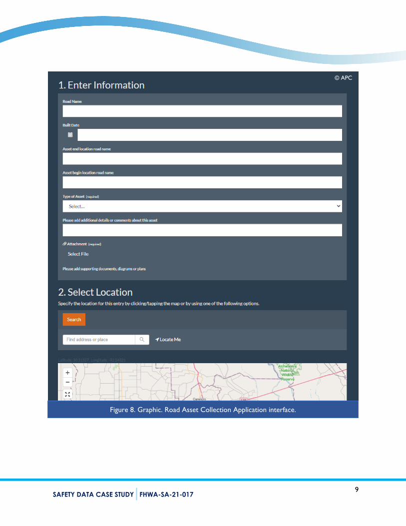
Local Input In addition to data conflation, open source collection, and imagery classification, APC collects roadway data from local agencies in several different formats. Some parish agencies store complete data in GIS, but others, particularly 911 commissions and tax assessors’ offices, house data in Microsoft AccessTM and ExcelTM databases, aerial images, or scanned PDFs. Furthermore, even if some agencies house data in a GIS-compatible format, they may not be fully integrated into a conventional desktop or cloud-based GIS application. APC accepts information in any format available from parish agencies, and APC is piloting a web browser-based application, the Road Asset Collection Application, for local parishes to flag new development and gaps in road inventories. Local users can indicate the name, build date, and beginning and end points of new assets, as well as upload any supporting documents that would help detail the asset (figure 8). This information does not need to come with formal GIS information, and agencies do not need specialized staff to contribute.
Figure 7. Graphic. Sample NAIP imagery classification (2019).
© APC
9 SAFETY DATA CASE STUDY FHWA-SA-21-017
Figure 8. Graphic. Road Asset Collection Application interface.
© APC

10 SAFETY DATA CASE STUDY FHWA-SA-21-017
Knowledge Transfer Although there are no formal training programs in place between APC and parish agencies, consistent communication helps provide opportunities for knowledge transfer. For instance, APC staff helped Vermillion Parish develop an institutional workflow to transfer data from Google EarthTM to an ESRI-based format. Local GIS councils also provide a hub for training, and consistent interaction helps make all partners more familiar with APC’s process and data needs. Furthermore, as DOTD continues to be involved in the data workflow between the State and local agencies, there is an opportunity for the agency to help support similar initiatives at other MPOs.
Acadiana, DOTD, and Building Data Governance As APC works with its local partners to fill its data gaps and refine the region’s data needs, there is an opportunity to expand the scope of the effort to coordinate with the State’s data needs (i.e., figure 2). This is part of the overall data governance goal established through the FHWA technical assistance. The DOTD is an active steward of Louisiana’s roadway and safety-related data. DOTD participates in the Louisiana GIS Council (LGISC)—an inter-agency partnership where State and local representatives coordinate standards and promote the use of GIS in the State. The LGISC’s digital data committee has collaborated with APC and other stakeholders to establish standard dataset schemas. For example, as of fall 2020, the LGISC completed a statewide address schema and is working on standards for land cover and land use data. DOTD also routinely coordinates with the Center for Analytics and Research in Transportation Safety (CARTS) at Louisiana State University. CARTS collects, maintains, integrates, analyzes, and distributes crash data for the State.
DOTD and CARTS collaborate with APC, and they have invited the MPO to join the recurring meetings between the State and university partners. The State-level partnership between DOTD and CARTS supports the integration of traditional crash, traffic, and roadway data. The agencies hope to expand on APC’s data governance and development process to build collaboration that includes more local input. APC’s innovative approach could serve as a model for similar local road initiatives elsewhere in the State. For instance, DOTD is working toward developing similar partnerships with other MPOs in the State, such as the New Orleans Regional Planning Commission and Southwest Louisiana Regional Planning Commission.
Challenges and Solutions APC encountered several challenges as it began its data governance development process:
Parishes have different internal structures and agencies within each local jurisdiction; this complicates the number of partners APC could engage for data-related activities.
Each parish, as well as agencies within the parishes, will have different technologies and technical capacities; this means data are not standardized, may not be comprehensive, or initially stored in common formats.
A region with a mix of highly urban and rural communities will not be successfully managed by a one-size-fits-all approach.
11 SAFETY DATA CASE STUDY FHWA-SA-21-017
To meet these challenges, APC’s approach to data governance has been tailored to meet the challenges present in its jurisdiction. To accommodate a complex network of agencies and potential partners, the MPO takes a personal approach that directly engages individual parishes and uses DOTD support to provide a strong foundation for data conversations. The diversity of technologies and capabilities in the Acadiana region required APC to use a suite of tools to manage data rather than a single vendor solution. Finally, in-person meetings are a valuable way to make connections and better understand the needs of partner agencies, but they also serve a practical purpose. More rural parishes may have poor broadband access that limit the practicality of virtual meetings and events, and in-person activities circumvent this challenge.
Next Steps The most important next step of this data governance and development process for both APC and DOTD is to develop a standard roadway data schema for local and regional agencies to use. This will facilitate and promote the flow of data from local agencies to regional and State databases, and it will support the missions of local agencies by providing comprehensive and integrated data that support planning, engineering, and administrative functions (figure 2). This can be accomplished through traditional data governance forums such as the LGISC and meetings between DOTD, CARTS, and APC. Once the standard is in place, DOTD and its partners can develop an ETL methodology (or combination of methodologies) that can be shared throughout the State. This approach is more flexible than a traditional red-lining methodology and can better accommodate the varying levels of data quality and sophistication in Louisiana.
Conclusions and Lessons Learned Acadiana’s partnerships and process help the region build the data necessary to support APC’s roadway safety goals. These data allow APC to conduct more comprehensive local road safety planning and more efficient project development. To accomplish this result, APC has effectively applied resources from the Federal and State levels (e.g., the SDATAP program, EDA grant, and DOTD’s engagement) to promote data governance and process improvement. Although APC has taken an innovative and multifaceted approach to data collection and aggregation, the foundation of the MPO’s success lies in its working relationships with its partners. The data not only support APC’s mission, but the agency can provide better technical assistance and refined data products that support the goals of each constituent parish. Acadiana has noted three key takeaways and lessons learned from its experience:
1. Keep up-to-date aerial imagery and aerial imagery sources; agencies can use these data to identify the latest changes, particularly in highly rural communities. In addition to open source repositories, APC used a grant from the EDA to collect and validate data.
2. An enterprise system is not always a single vendor solution; different components of the data collection, validation, and integration process may require different solutions depending on a specific agency’s workflow (as well as those of its partners).
3. Be flexible with your solutions—one size does not fit all; Acadiana’s four-step process requires a flexible approach that can accommodate data from a variety of sources with highly variable quality and precision across jurisdictional boundaries. Data format and quality is not, and should not be, an insurmountable barrier.

12 SAFETY DATA CASE STUDY FHWA-SA-21-017
Acadiana’s process is also valuable for State-level partners like DOTD and CARTS. Not only can these State/university/local partnerships become valuable forums for communicating standards, providing technical assistance, and collecting MIRE- and safety-related data, but a local-road focus can lead to significant insights by State transportation practitioners. For instance, the State added 4,000 miles of roads (a roughly 8-percent increase) to its annual Highway Performance Management System (HPMS) submittal in 2020 through an emphasis on collecting local roads. The HPMS is an important metric for allocating Federal transportation funds, and these gains could provide Louisiana with a more representative allocation. This innovative example of data collection and maintenance in Acadiana could serve as an example for the rest of the State as Louisiana continues to work toward common data governance goals, as well as the overall transportation safety mission for the State.

13
References Acadiana Planning Commission. (2020). Innovative Techniques for Managing and Updating Local
Road Data [PowerPoint Slides].
Ashley Moran and Phillip Breaux. (2020, March). Innovative Techniques for Managing and Updating Local Road Data [Presentation]. Available online: https://www.facebook.com/AcadianaPlanningCommission/videos/656780255140468/.
Dan, L., and Ahmed, N. (2014). Geoprocessing Conflation Tools: Getting Started and Building Workflows [PowerPoint Slides]. Available online: https://proceedings.esri.com/library/userconf/proc14/tech-workshops/tw_254.pdf.
Phone Interview on November 20, 2020, with Ashley Moran and Alicia Wiltz (APC), Phillip Breaux (CARTS), and Jason Carr (DOTD).
Scopatz, R.A., Goughnour, E., Abbot, D., Tang, E., Carter, D., Smith, S., and Salzer, T. (2016). Informational Guide for State, Tribal, and Local Safety Data Integration, Federal Highway Administration, Report No. FHWA-SA-16-118, Washington, D.C. Available online: https://safety.fhwa.dot.gov/rsdp/downloads/fhwasa16118.pdf.
Contact Acadiana Planning Commission
Ashley Moran, Transportation Planner
Louisiana Department of Transportation and Development
Jason Carr, GIS Specialist
LSU Center for Analytics & Research in Transportation Safety
Phillip Breaux, Data Analyst