
Llanwern Rail Facilities - Phase 1 Planning - TfW
56
Llanwern Rail Facilities - Phase 1 Planning Ground Conditions and Contamination Report September 2018 Transport for Wales 367590-WTD-CAR-2653
-
Upload
khangminh22 -
Category
Documents
-
view
0 -
download
0
Transcript of Llanwern Rail Facilities - Phase 1 Planning - TfW

Llanwern Rail Facilities - Phase 1 Planning
Ground Conditions and Contamination Report
September 2018
Transport for Wales 367590-WTD-CAR-2653


367590-WTD-CAR-2653 PiMS Mott MacDonald
Mott MacDonald
Fitzalan House
Fitzalan Road
Cardiff CF24 0EL
United Kingdom
T +44 (0)29 2046 7800
F +44 (0)29 2047 1888
mottmac.com
Transport for Wales
Southgate House
Wood Street
Cardiff CF10 1EW
Llanwern Rail Facilities - Phase 1 Planning
Ground Conditions and Contamination Report
September 2018
Mott MacDonald Limited. Registered in England and Wales no. 1243967. Registered office: Mott MacDonald House, 8-10 Sydenham Road, Croydon CR0 2EE, United Kingdom
Transport for Wales 367590-WTD-CAR-2653


Mott MacDonald | Llanwern Rail Facilities - Phase 1 Planning Ground Conditions and Contamination Report
367590-WTD-CAR-2653 | September 2018 PiMS
Issue and Revision Record
Revision Date Originator Checker Approver Description
A 05/09/2018 V. Sin C. Will iams C. Probert Draft Issue – For TfW Review
B 28/09/2018 V. Sin C. Will iams C. Probert Issue for Pre-ApplicationConsultation
Document reference: 367590-WTD-CAR-2653
Information class: Standard
This document is issued for the party which commissioned it and for specific purposes connected with the above-
captioned project only. It should not be relied upon by any other party or used for any other purpose.
We accept no responsibil ity for the consequences of this docum ent being relied upon by any other party, or being
used for any other purpose, or containing any error or omission which is due to an error or omission in data supplied
to us by other parties.
This document contains confidential information and proprietary intellectual property. It should not be shown to other
parties without consent from us and from the party which commissioned it.
This r epor t has been prepared solely for use by the part y which commissioned it (the ‘Client ’) in connection wit h the captioned pr oject . I t should not be used f or any other purpose. No person other than the Client or any party who has expr essly agr eed t er ms of r eliance with us ( the ‘Recipient( s) ’) may r ely on t he cont ent , inf or mat ion or any views expr essed in the repor t. We accept no duty of care, responsibilit y or liabilit y to any ot her recipient of t his document. This report is conf idential and contains pr opriet ar y intellectual proper ty.
No r epr esentation, war rant y or undert aking, expr ess or implied, is made and no r esponsibilit y or liabilit y is accepted by us t o any par ty other t han t he Client or any Recipient (s), as to the accuracy or completeness of t he inf or mation contained in this r eport . For the avoidance of doubt this repor t does not in any way pur port t o include any legal, insurance or financial advice or opinion.
We disclaim all and any liabilit y whether arising in tort or cont ract or ot herwise which it might otherwise have to any par ty other than the Client or the Recipient( s) , in respect of this repor t, or any information attr ibuted to it .
We accept no responsibilit y for any er ror or omission in the repor t which is due to an error or omission in dat a, informat ion or statements supplied t o us by other part ies including the client ( ‘Dat a’) . We have not independently verif ied such Dat a and have assumed it to be accur at e, com plet e, reliable and curr ent as of the date of such inf or mat ion.
For ecast s presented in this document were prepar ed using Data and t he r eport is dependent or based on Data. Inevit ably, some of the assumptions used to develop t he f or ecast s will not be realised and unanticipated event s and circumst ances may occur. Consequent ly Mott MacDonald does not guarant ee or war rant t he conclusions cont ained in t he report as there are likely t o be dif ferences bet ween the forecasts and the act ual result s and those dif ferences may be mater ial. While we consider that t he information and opinions given in t his r eport are sound all part ies must rely on their own skill and judgement when making use of it.
Under no cir cumstances may this repor t or any extract or summary t hereof be used in connection wit h any public or private securit ies of fering including any related memorandum or pr ospectus for any securit ies offering or st ock exchange listing or announcement.

Mott MacDonald | Llanwern Rail Facilities - Phase 1 Planning Ground Conditions and Contamination Report
367590-WTD-CAR-2653 | September 2018 PiMS
Contents
Executive summary 1
1 Introduction 2
1.1 Project Description 2
1.2 Scope of Works 2
1.3 Site Location 2
1.4 Purpose of Report 3
1.5 Sources of Information 3
1.6 Limitations 4
2 Site Walkover Survey 5
2.1 Summary of Field Observations 11
3 Site Description 13
3.1 Topography 13
3.2 Geology 13
3.2.1 Bedrock 13
3.2.2 Superficial Geology 14
3.2.3 Made Ground 14
3.3 Ground Investigation Information 14
3.4 Mining 16
3.5 Hydrology 16
3.6 Hydrogeology 16
3.7 Groundwater Protection Zones 17
3.8 Historical Site Development 17
3.9 Unexploded Ordnance (UXO) 19
3.10 Contaminated Land and Pollution Incidents 19
4 Qualitative Contaminated Land Risk Assessment 21
4.1 Background 21
4.2 Conceptual Site Model 21
4.2.1 Proposed Development 21
4.2.2 Anticipated Contaminants 21
4.2.3 Potential Contamination Sources 22
4.2.4 Potential Contamination Transport Pathways 22
4.2.5 Potential Contamination Receptors 22
4.3 Preliminary Contamination Risk Assessment 22
4.4 Summary 26
Mott MacDonald | Llanwern Rail Facilities - Phase 1 Planning Ground Conditions and Contamination Report
367590-WTD-CAR-2653 | September 2018 PiMS
5 Recommendations for Further Studies and Ground Investigation 27
Appendices 28
A. Site Drainage Plans 29
B. Historic Borehole Records 34
C. UXO Risk Map 45
D. Risk Assessment Methodology 46

Mott MacDonald | Llanwern Rail Facilities - Phase 1 Planning 1 Ground Conditions and Contamination Report
367590-WTD-CAR-2653 | September 2018 PiMS
Executive summary
Mott MacDonald has been commissioned by Transport for Wales (TfW), on behalf of Welsh Government, to prepare and submit a planning application, seeking full planning permission for
the design and construction of a 1.6km long Major Events Stabling Line (MESL) on land
adjacent to the existing Tata Steelworks Service Lines in Llanwern, South Wales. This is Phase
1 of the Llanwern Rail Facilities Programme. The purpose of this report is to provide an
understanding of likely ground conditions, historic land use, the potential for contamination within the Scheme area and surrounding zone of influence.
The Site was in agricultural use until the late 1950’s when the Spencer Steelworks was
constructed on land to the south. In 2004 the western half of the steelworks was closed and
demolished, with the eastern half still in operation. The western half of the historic steelworks is
now the Glan Llyn development, a mixed-use residential and commercial development which
has been partially completed. The Site is vegetated with trees and scrub. Multiple surface drainage ditches are present which flow into an east to west surface reen which in turn drains to
the south into the Gwent Levels. Monks’ Ditch flows south to the east of the site but is
hydraulically isolated from the surrounding land. The ground is uneven and is likely to contain
Made Ground from the construction of the steelworks. The extent of Made Ground is unknown
and not proven.
The recorded underlying geology of the Site is limestone and mudstone of the Blue Lias
Formation, which is mantled by Tidal Flat Deposits comprised of clay with interbedded peat and
sand lenses. Historical boreholes on and near the Site recorded depths of Tidal Flat Deposits up
to 10.9m. Groundwater was recorded within the Tidal Flat Deposits.
A qualitative risk assessment has determined a low risk to human and environmental receptors, with high risk to buried structures from sulphate degradation. A ground investigation will be
necessary to inform the foundation design for the railway line and confirm the levels of
contamination present at the Site.

Mott MacDonald | Llanwern Rail Facilities - Phase 1 Planning 2 Ground Conditions and Contamination Report
367590-WTD-CAR-2653 | September 2018 PiMS
1 Introduction
1.1 Project Description
Mott MacDonald has been commissioned by Transport for Wales (TfW), on behalf of Welsh Government, to prepare and submit a planning application, seeking full planning permission for
the design and construction of a 1.6km long Major Events Stabling Line (MESL) on land
adjacent to the existing Tata Steelworks Service Lines in Llanwern, South Wales. This is Phase
1 of the Llanwern Rail Facilities Programme.
The MESL will be used for stabling of rolling stock for major events in the area, to enable flexibility for future train requirements, and proving of trains prior to use on the rail network. The
MESL will be electrified in a future phase of work. This proposed 1.6km length of MESL to the
west of Monks’ Ditch was formerly known as Option 6a.
The wider Llanwern Rail Facilities Programme will include an extension of the MESL by circa
2.4km east (to achieve a total length of circa 4km), electrification of the MESL, a new Llanwern railway station and passenger line (including Park & Ride and footbridge), and connections to
the South Wales Main Line (Relief Lines). The further phases of the project will be the subject of
a subsequent planning application.
The key parameters for the Scheme are listed below:
● Whole Site area is 3.1 hectares. This land is contained within the red line boundary shown on the Site Location Plan (Drawing number 367590-MMD-48-XX-DR-C-0001); and
● The Site length is approximately 1.6km long and 19m wide.
1.2 Scope of Works
The General Arrangement drawings (Drawing numbers 367590-MMD-48-XX-DR-C-0002 to
367590-MMD-48-XX-DR-C-0005) demonstrate the project scope which includes the design and construction of the following:
● A single track stabling line (MESL) circa 1.6km long;
● Associated earthworks and landscaping; and
● Drainage and other engineering works.
In order to obtain full planning permission for Phase 1, we have carried out the outline design and technical assessment of the above scope, as well as multiple assessments in terms of
ecology, environment, heritage and archaeology.
1.3 Site Location
The proposed rail development Site is located approximately 8 miles east from the centre of
Newport, South Wales (Figure 1.1).
The Site is aligned roughly west – east and bordered by the existing South Wales Mainline to the north and the Tata Steelworks to the south. Along the southern boundary of the steelworks
site runs the A4810 which links the M4 from junction 23A at Magor with the A48 at Liswerry (a
predominantly residential suburb on the south-eastern side of Newport. The site is more widely
bordered by the M4 which runs approximately two and a half miles to the north and the Severn

Mott MacDonald | Llanwern Rail Facilities - Phase 1 Planning 3 Ground Conditions and Contamination Report
367590-WTD-CAR-2653 | September 2018 PiMS
Estuary which lays approximately three miles to the south. The Gwent Levels to the south is a
significant area of wetlands.
The existing South Wales Mainline passes north of the proposed Site and provides opportunity
for transport links for both passengers and freight.
Figure 1.1: Proposed Location Plan
Source: OS Open Data
1.4 Purpose of Report
The purpose of this report is to record the results of a geo-environmental desk study of the Site
to inform the design of the Scheme.
The scope of the report includes detail of the topography, geology, hydrology, hydrogeology,
presence of man-made features, and historical development of the Site. Information has been sought from generally available sources of information and a site walkover that are detailed and
referenced within the following sections. A preliminary qualitative contaminated land risk
assessment is produced and presented within this report.
1.5 Sources of Information
The following sources of information have been consulted in the preparation of this report
utilizing published material that is publicly accessible:
● British Geological Survey (BGS) Onshore GeoIndex1;
● BGS Lexicon2;
1 British Geological Survey (2016). Onshore GeoIndex [Online]. Available at: http://mapapps2.bgs.ac.uk/geoindex/home.html [Accessed
11th May 2017] 2 British Geological Survey (2017). The Lexicon of Named Rock Units [Online]. Available at: http://www.bgs.ac.uk/lexicon/ [Accessed 11th
May 2017]

Mott MacDonald | Llanwern Rail Facilities - Phase 1 Planning 4 Ground Conditions and Contamination Report
367590-WTD-CAR-2653 | September 2018 PiMS
● The Coal Authority Online Interaction Map3;
● Natural Resources Wales (NRW) Long Term Flood Risk Map4;
● BGS 1:125k Hydrogeological Map of South Wales5;
● Lle geo-portal6;
● National Library of Scotland Online Maps7;
● Google Earth Pro;
● Zetica Unexploded Bomb risk maps8; and
● Department for Environment, Food, and Rural Affairs’ (Defra) ‘MAGIC’ Online Interactive
map9.
1.6 Limitations
This document is issued for the party which commissioned it and for specific purposes
connected with the above-captioned Scheme only. It should not be relied upon by any other
party or used for any other purpose.
We accept no responsibility for the consequences of this document being relied upon by any
other party, or being used for any other purpose, or containing any error or omission which is
due to an error or omission in data supplied to us by other parties.
This document contains confidential information and proprietary intellectual property. It should
not be shown to other parties without consent from us and from the party which commissioned it.
To the extent that this document is based on information obtained in previous or recent ground
investigations, persons using or relying on it should recognise that any such investigation can
examine only a fraction of the subsurface conditions. In any ground investigation there remains
a risk that pockets or “hot-spots” of contamination or other ground hazards may not be identified, because investigations are necessarily based on sampling at localised points.
Certain indicators or evidence of hazardous substances or conditions may have been outside
the portion of the subsurface investigated or monitored, and thus may not have been identified
or their full significance appreciated.
Mott MacDonald Ltd is not insured for, and therefore will not undertake surveys to identify
asbestos or provide any guidance on the treatment of asbestos, or similarly for toxic mould. Should the presence of asbestos or toxic mould be suspected during the course of the study,
Mott MacDonald Ltd would recommend the appointment of a specialist contractor to address the
issue and would not provide advice on risk or remedial measures.
3 The Coal Authority (2016). Interactive Map [Online]. Available at: http://mapapps2.bgs.ac.uk/coalauthority/home.html [Accessed 12th
May 2017] 4 Natural Resources Wales (2017). Long term flood risk map [Online]. Available at: https://naturalresources.wales/evidence-and-
data/maps/long-term-flood-risk/?lang=en [Accessed 12th May 2017] 5 British Geology Survey (1986). Hydrogeological Map of South Wales, 1:125,000. London: Ordnance Survey 6 Welsh Gov ernment, Geography & Technology (2017). Lle Geo-Portal [Online]. Available at http://lle.gov.wales/home?lang=en
[Accessed 15th May 2017] 7 National Library of Scotland (2017). Maps [Online]. Available at: http://maps.nls.uk/ [Accessed 12th May 2017] 8 Zetica UXO (2017). Unexploded Bomb Risk Maps [Online]. Available at: http://zeticauxo.com/downloads-and-resources/risk-maps/
[Accessed 11th May 2017] 9 Department for Environment, Food, and Rural Affairs’ (Defra) ‘MAGIC’ Online Interactive map

Mott MacDonald | Llanwern Rail Facilities - Phase 1 Planning 5 Ground Conditions and Contamination Report
367590-WTD-CAR-2653 | September 2018 PiMS
2 Site Walkover Survey
A Site walkover survey was conducted by Mott MacDonald Ltd staff on the 8 and 9 of June 2017. The walkover survey was conducted along the length of the Scheme, with Figure 2.1
presenting the approximate route of the survey. The length of the Scheme is approximately
1.6km, and approximately 19.0m wide. Selected photographs taken during the walkover survey
are presented in this section where potentially contaminative features were identified during the
walkover survey. Due to the dense vegetation present on-site, the walkover survey was not conducted in a continuous route within the Site boundary. It was achieved through walking
along the southern boundary of the Scheme and where possible, gaining access through
openings in the vegetation to visually inspect the conditions.
Figure 2.1: Walkover Route
Source: OpenStreet Map contributors
The walkover survey was undertaken over two days during overcast and rainy conditions.
1
2
3
4
5

Mott MacDonald | Llanwern Rail Facilities - Phase 1 Planning 6 Ground Conditions and Contamination Report
367590-WTD-CAR-2653 | September 2018 PiMS
Figure 2.2: Location 1
Location 1 viewing north-east. Main line can be seen to the centre left, with the dense vegetation seen representative of
what was encountered most of the Site.
Beginning the survey at the western end of the Site, dense vegetation was noted to be present. Figure 2.2 is taken from Location 1 providing an idea of the dense vegetation encountered. The
vegetation is mainly comprised of trees and shrubs, which are dense enough to prevent
continuous access through the Site. This density of vegetation is present across most of the
Site, limiting the amount of information which could be gained of the Site during the walkover
survey.
The Site is noted to be bounded by steep embankments rising to approximately 3.0m to 4.0m,
to the north and south. The main line railway runs along the northern embankment and the Tata
Steel service lines run along the southern boundary. In Figure 2.2 the main line can be seen to
the centre left.
The ground within the vegetated zone is uneven, with slight differences in elevation. The top soil is noted to be clayey with high organic content, which becomes gravelly towards the railway
embankments towards the north and south. The ground was wet, with isolated patches of water
pooling, this is likely attributed to the weather on the day of survey. Anecdotal evidence
provided by Tata Steel staff that the ground can become boggy following rainfall. The gravel
encountered consists of natural rock material along with concrete, clinker, and slag.
These observations are applicable along the length of the Scheme, as there are no significant changes to the vegetation or the material encountered across the Site. Therefore, this section

Mott MacDonald | Llanwern Rail Facilities - Phase 1 Planning 7 Ground Conditions and Contamination Report
367590-WTD-CAR-2653 | September 2018 PiMS
will focus on reporting any deviation from these observations, and any features that are
potentially contaminative.
Figure 2.3: Location 2a
Location 2a viewing north. Gas pipeline signage in the upper centre of the image, along with sheet pile retaining feature
at the centre of the image.

Mott MacDonald | Llanwern Rail Facilities - Phase 1 Planning 8 Ground Conditions and Contamination Report
367590-WTD-CAR-2653 | September 2018 PiMS
Figure 2.4: Location 2b
Location 2b viewing south. A view of the embankment and exposed sheet pile retaining structures
A buried high-pressure gas pipeline is noted at Location 2a (Figure 2.3). The directional
alignment of the pipeline is unknown. Exposed sheet pile retaining features are also noted along the embankment to the service lines and suggest that their use is to act as a retaining structure
to the embankment (Figure 2.4). The embankment to the service lines is mainly comprised of
gravel, with cobble sized fragments dispersed amongst the gravel.

Mott MacDonald | Llanwern Rail Facilities - Phase 1 Planning 9 Ground Conditions and Contamination Report
367590-WTD-CAR-2653 | September 2018 PiMS
Figure 2.5: Location 3
Location 3 looking north. Gravel platform built on to the Site as a storage area for service line track repair.
A gravel platform is noted at Location 3 (Figure 2.5) and built on to the Site. Several of these
platforms are noted to be present at irregular intervals, along the southern boundary of the Site
and have been built using ballast to form a platform to the same topographic level as the service line. The platforms are used as storage areas for railway tracks, sleepers, and any associated
equipment needed for the repair and maintenance of the service lines. The boundary of this
embankment often slopes steeply onto the vegetated zone of the Site.

Mott MacDonald | Llanwern Rail Facilities - Phase 1 Planning 10 Ground Conditions and Contamination Report
367590-WTD-CAR-2653 | September 2018 PiMS
Figure 2.6: Location 4a
Location 4a viewing north-west. Provides a view of the service line, and Site towards the western boundary.
Figure 2.7: Location 4b
Location 4b viewing north-east. Provides view of the service line, and Site towards the eastern boundary.

Mott MacDonald | Llanwern Rail Facilities - Phase 1 Planning 11 Ground Conditions and Contamination Report
367590-WTD-CAR-2653 | September 2018 PiMS
Figures 2.6 and 2.7 provide a view of the Site from the service lines, viewing towards the western and eastern ends of the Scheme. The images provide a view of the difficulty of access
on to Site, due to the dense vegetation. Note the two 132kV overhead power lines which are
present within the western half of the Site.
Figure 2.8: Location 5
Location 5 viewing north-west. View of Monks’ Ditch. To the left of the image is an area of raised ground.
Figure 2.8 provides a view of Monks’ Ditch looking north-west. Monks’ Ditch is a canalised stream that flows north to south immediately to the east of the Site. Monks’ Ditch flows through
a concrete channel and is culverted under the main line and under the sidings. The
embankments on either side are raised above surrounding ground level. Plans of Monks’ Ditch and the other drainage ditches on-site are presented in Appendix A.
2.1 Summary of Field Observations
The Scheme is approximately 1.6km in length and 19.0m in width and is densely vegetated,
limiting the access points on to the Site. This in-turn limited the area which could be visually
inspected, and the amount of information gained. The topography of the Site is generally flat
with the embankment carrying the sidings to the south. The elevation difference between the embankments and the adjacent land is approximately 3.0m to 4.0m.
The ground surface towards the southern boundary contains some ballast which has spilled
down the slope from the sidings. A clayey topsoil overlies most of the Site and is uneven to walk
on. Anecdotal evidence obtained from Tata Steel staff indicate that the ground within the Site
can become boggy after rainfall.

Mott MacDonald | Llanwern Rail Facilities - Phase 1 Planning 12 Ground Conditions and Contamination Report
367590-WTD-CAR-2653 | September 2018 PiMS
Monks’ Ditch and several drainage ditches flow from north to south; culverted under the
mainline railway and sidings. The embankments of these surface water bodies are typically
heavily vegetated by hydrophilic plants. Embankments of drainage ditches within Tata Steel
land are routinely cleared of vegetation.
A marker post for a buried high-pressure gas pipeline was found at the western end of the Site.
Gravel platforms were noted to be built at irregular intervals along the southern boundary of the Site. These were built as storage areas to hold railway tracks and sleepers for track repair and
maintenance of the sidings.
Overall, the walkover survey did not identify signs of direct contamination, and a limited number
of potentially contaminative sources. From the walkover survey, the main interests regarding
potential contamination are as follows:
● Made Ground of gravel platforms built using railway ballast, comprising of natural rocks,
slag, and clinker;
● Made Ground from the construction of overhead power lines, buried pipelines, drainage
ditches and culverts, and raised embankments to the service line and main line; and
● Off-site contamination from service lines to the south, and the main line further to the north.

Mott MacDonald | Llanwern Rail Facilities - Phase 1 Planning 13 Ground Conditions and Contamination Report
367590-WTD-CAR-2653 | September 2018 PiMS
3 Site Description
3.1 Topography
Based on Ordnance Survey mapping the Site does not feature prominent changes in elevation. From the walkover survey the general topography of the Site is flat with raised elevations at the
southern boundary as the land rises to carry the service lines for the steelworks. The intervening
land is uneven with numerous drainage ditches.
3.2 Geology
Based on geological maps published by the British Geological Survey (BGS) and historic borehole records, the following geology can be established for the Site.
3.2.1 Bedrock
The BGS online geo index shows the Site’s bedrock geology is comprised of mudstone and limestone of the Blue Lias Formation (Figure 3.1).
The Blue Lias Formation comprises thinly interbedded limestone and calcareous mudstones. It
rests conformably on the Penarth Group, which is approximately 12.0m of dark grey and grey
mudstone with subordinate sandstones, siltstones, and limestones. Underlying the Penarth
Group are green and grey-green mudstones of the Blue Anchor Formation, which in certain areas can be thinly laminated with thin dolomitic limestone beds. All of which overlies the red
mudstone of the Mercia Mudstone Group, which is suggested to underlie ground near the
intersection between the main railway line and Monks’ Ditch.
An inferred fault with a north to south trend and unknown displacement is marked near the
intersection of the main railway line and Monks’ Ditch.
Table 3.1 presents a summary of the bedrock geology with published descriptions. The BGS publication British Regional Geology of Wales was consulted for supplementary information.
Table
3.1: Bedrock
Geology
Geology
Material Lithological Description
Blue Lias Formation
Limestone and
mudstone
Thinly interbedded limestone (laminated, nodular, or massive and persistent) and calcareous mudstone or siltstone (locally laminated). Individual l imestones are typically
0.1m to 0.3m thick. In some areas, intervening mudstone units with relatively few limestone beds. Also includes littoral l imestone facies of the Radstock Shelf - Mendip area and South
Wales.
Penarth Group
Mudstone Grey to black mudstones with subordinate limestones and sandstones; predominantly marine in origin.
Blue Anchor
Formation (Part of the
Mercia Mudstone
Group)
Mudstone The formation typically comprises pale green-grey, dolomitic silty mudstones and siltstones with thin arenaceous lenses and a few thin, commonly discontinuous beds of hard,
dolomitic, pale yellowish-grey, porcellanous mudstone and siltstone ("Tea Green Marl"). In southern England and Wales only, the "Tea Green Marl" is overlain by the "Grey Marls"
comprising grey, black, green and, rarely, red-brown dolomitic mudstones with, in the higher beds, yellowish-grey dolostones; also present are laminated siltstone beds with mud
cracks, scarce pseudomorphs after halite, and locally abundant gypsum; miospores occur throughout and bivalve fossils and bioturbation become increasingly common upwards.
Mercia Mudstone
Group
Mudstone Dominantly red, less commonly green-grey, mudstones and subordinate siltstones with thick halite-bearing units in some basinal areas. Thin beds of gypsum/anhydrite
widespread; sandstones are also present.

Mott MacDonald | Llanwern Rail Facilities - Phase 1 Planning 14 Ground Conditions and Contamination Report
367590-WTD-CAR-2653 | September 2018 PiMS
Source: BGS
Figure 3.1: Bedrock Geology
Source: BGS Contains British Geological Survey materials © NERC 2018
3.2.2 Superficial Geology
The BGS online geo index shows the Site’s superficial geology is comprised of Tidal Flat
Deposits (TFD). TFD is described by the BGS as “normally a consolidated soft silty clay, with
layers of sand, gravel and peat. TFD is not present on higher ground north of the Site, as it is beyond the range of the Severn Estuary tidal regime for sediment deposition. TFD may overlie
Alluvium within the valley of the Monks’ Ditch.
3.2.3 Made Ground
The BGS does not indicate any areas of Made Ground on or around the Site. However, field
observations have indicated that the mainline and sidings are built on embankments of imported
granular material and there are several platforms built into the Site. These embankments have
been seen to contain clinker and slag, most likely derived from the same source of material that
was used to build the development platform for the steelworks or derived from the operational steelworks.
3.3 Ground Investigation Information
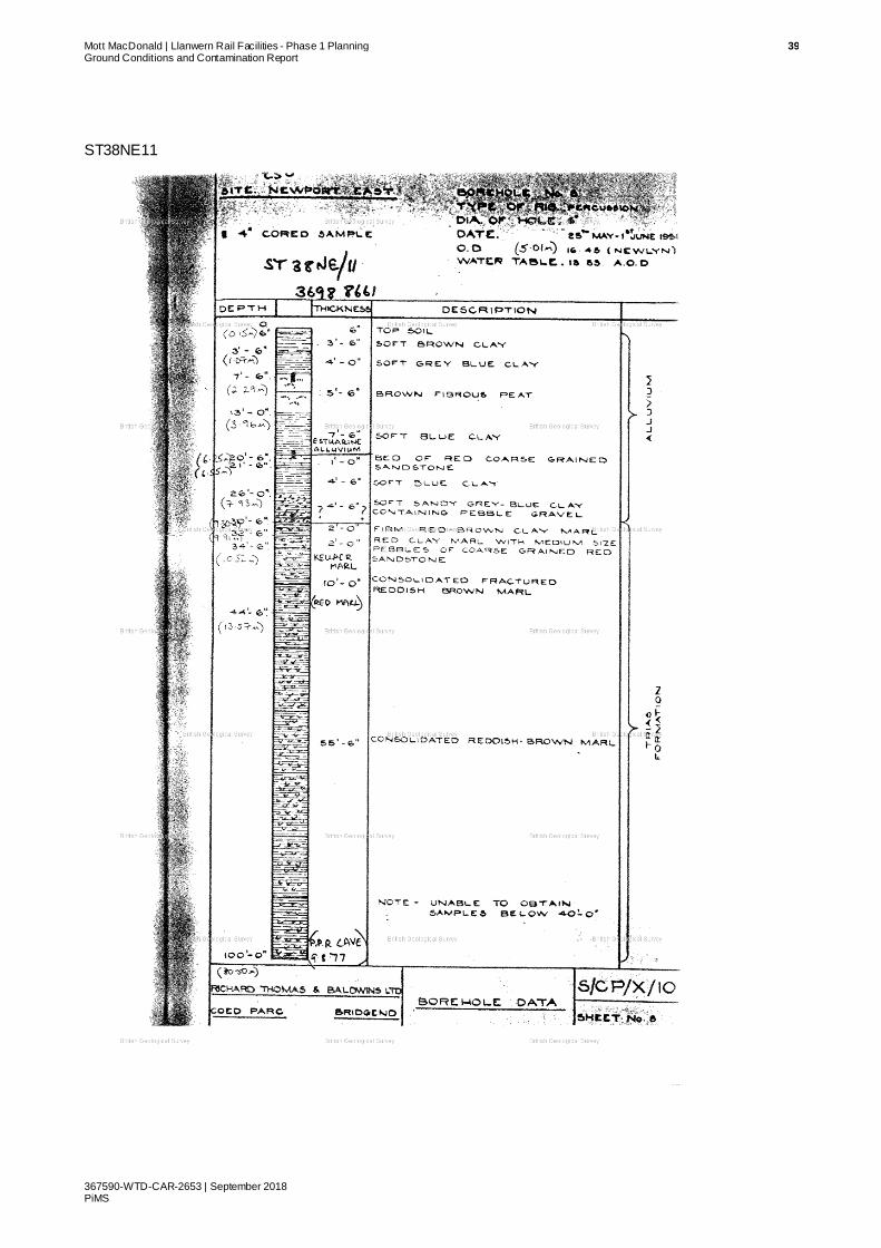
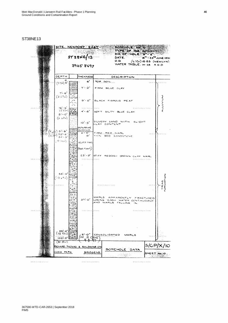
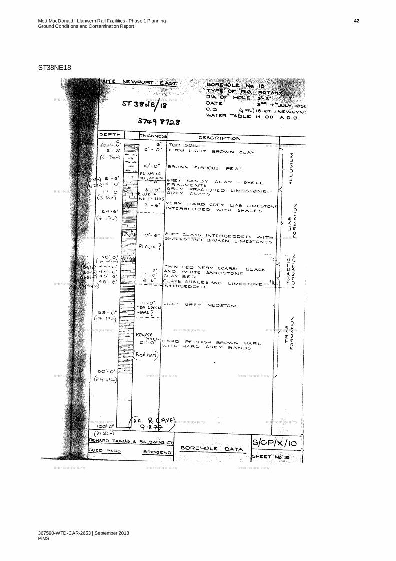
Historic borehole records of exploratory holes on and around the Site are available through the
BGS Onshore GeoIndex. The boreholes that were consulted are summarised in Table 3.2 with
locations shown in Figure 3.2. Scans of the borehole logs are presented in Appendix B.
Mercia
Mudstone
Blue Lias
Penarth
Group
Blue Anchor Fm

Mott MacDonald | Llanwern Rail Facilities - Phase 1 Planning 15 Ground Conditions and Contamination Report
367590-WTD-CAR-2653 | September 2018 PiMS
Table 3.2: Historic Boreholes
BGS Reference British National Grid
Reference Reference within this Report
ST38NE05 ST353872 BH01
ST38NE08 ST360865 BH02
ST38NE07 ST366872 BH03
ST38NE11 ST369866 BH04
ST38NE22 ST374869 BH05
ST38NE18 ST374872 BH06
ST38NE23 ST380866 BH07
ST38NE10 ST383872 BH08
ST38NE16 ST391561 BH09
ST38NE13 ST394870 BH10
Source: BGS
Figure 3.2: Borehole Locations
Source: BGS Contains OS data © Crown Copyright and database 2018 Contains British Geological Survey materials
© NERC 2018
All boreholes were sunk prior to the construction of the steelworks south of the Scheme
location. Therefore, the steelworks effect on ground condition reported from the historical borehole scans are not reflected. Interpreted geology provided by the scans are summarised in
Table 3.3.
Table 3.3: Ground Condition Summary based on Historic Boreholes
Material Description BH
Presence
Thickness
(m)
Depth of top
(m AOD)
Depth of
base (m
AOD)
Topsoil Topsoil 01, 02, 03, 04, 05, 06, 07, 08,
09, 10
0.1 to 0.2 5.7 to 4.5 5.6 to 4.3
Tidal Flat Deposits
Clays with peat,
01, 02, 03, 04, 05, 06, 07, 08,
09, 10
4.1 to 10.8 5.6 to 4.3 0.5 to -6.4
Peat (Layers interbedded within Tidal
Flat Deposits)
Peat 01, 02, 03, 04, 05, 06
0.3 to 3.0 4.3 to 2.7 1.0 to -2.0
Blue Lias Formation
Interbedded limestone and
06 8.0 0.5 -7.4
BH1
BH2
BH3
BH4
BH5
BH6
BH7
BH8
BH9
BH10

Mott MacDonald | Llanwern Rail Facilities - Phase 1 Planning 16 Ground Conditions and Contamination Report
367590-WTD-CAR-2653 | September 2018 PiMS
Material Description BH
Presence
Thickness
(m)
Depth of top
(m AOD)
Depth of
base (m
AOD)
calcareous mudstone
Penarth Group Mudstone 06, 08 1.5 to 2.4 -7.4 -3.7 to -9.8
Mercia Mudstone
Group
Mudstone 01, 02, 03, 04, 05, 06, 07, 08,
09, 10
Unproven -2.6 to -9.8 Unproven
(-25.5)
Source: BGS
Mercia Mudstone Group and TFD were encountered in all boreholes. Peat layers were recorded
to be interbedded within the TFD, with Boreholes BH01, BH02, BH03, and BH05 containing two
separate peat layers. The geological stratigraphy is consistent with the published geology
described in Section 3.2.1.
The historical boreholes record the TFD to be predominantly clay, with sandy clay with gravels and pebbles occurring above the bedrock boundary. Localised pockets of sand within the TFD
may be present, evident from Borehole BH08 where a 5.9m thick sand layer is between
weathered bedrock at the base, and clay above.
Based on the published geology and historic borehole scans, it is expected that the ground
investigation to be conducted on Site will encounter the interbedded limestone and calcareous
mudstone of the Blue Lias Formation, resting conformably above the mudstones of the Penarth Group and Mercia Mudstone Group.
3.4 Mining
Consulting the Coal Authority interactive map, the Site and surrounding area is not within a Coal
Mining Reporting Area.
3.5 Hydrology
The main hydrological features are the drainage ditches which flow along the Site connecting the various north-south drains which are culverted beneath the steelworks. The plans for the
drainage ditches for the Scheme are available in Appendix A.
Monks’ Ditch flows within a concrete channel and is hydraulically isolated from the surrounding
land.
3.6 Hydrogeology
Published BGS hydrogeological mapping (accessed via BGS Onshore GeoIndex) indicates the solid geological formations have low permeability. The Site’s hydrogeology is summarised in
Table 3.4.
Table 3.4: Hydrogeological Summary
Geological Unit Aquifer
Description
BGS Summary (Paraphrased descriptions are w ithout
quotation marks)
Blue Lias Formation Rocks with essentially no
groundwater
1:625k: “Largely mudstone sequence with limestone and Marlstone Rock forming local aquifers yielding small supplies”.
1:125k: The Lower Lias comprises the Blue Lias. Yields from
100mm diameter boreholes into the Lower Lias are generally less than 0.5 l/s, but a 305mm diameter, 122.0m deep borehole into
Blue Lias limestone at Rhoose cement works (ST 064 661) yielded 14.1 l/s.

Mott MacDonald | Llanwern Rail Facilities - Phase 1 Planning 17 Ground Conditions and Contamination Report
367590-WTD-CAR-2653 | September 2018 PiMS
Geological Unit Aquifer
Description
BGS Summary (Paraphrased descriptions are w ithout
quotation marks)
Triassic Rocks (Penarth Group, Blue Anchor Formation,
and Mercia Mudstone Group)
Low productivity aquifer
1:625k: “Largely argillaceous sequence with occasional sandstones yielding less than 0.5 l/s of water that can be highly mineralised”.
1:125k: The Penarth Group yields small quantities of potable water.
The Mercia Mudstone Group commonly yields 3.0 – 8.0l/s, however at Biglis, it yielded 22.0l/s from a 30.0m deep, 200mm
diameter borehole (ST 145 699) and 52.0l/s from a 12.0m shaft (St 147 697). Water levels are normally within a few meters of the
ground surface.
Source: BGS
Historical borehole scans discussed in Section 3.2 of this report also reported groundwater
levels. These are summarised in Table 3.5. The groundwater level on and around the Site
ranges between 3.4mAOD at the shallowest to 4.9mAOD at the deepest, with an average of
4.1mAOD. The historic boreholes indicate the groundwater expected on Site will be shallow,
and within the superficial TFD. It should be noted that the boreholes were sunk prior to the construction of the Steelworks, and the effect on groundwater is not reflected on these historical
groundwater levels. It is likely that a perched water table exists at the base of the Made Ground.
Table 3.5: Groundwater Levels in Historical Boreholes
Borehole Stratum Groundwater level
(mAOD)
Groundwater level
(mbgl)
BH01 TFD 4.9 0.8
BH02 n/a No data No data
BH03 TFD 4.3 0.7
BH04 TFD 4.2 0.8
BH05 TFD 4.2 0.6
BH06 TFD 4.5 0.2
BH07 TFD 3.1 1.4
BH08 TFD 4.4 0.7
BH09 TFD 3.4 1.8
BH10 TFD 4.4 0.4
Source: BGS
Groundwater flows in a southerly direction towards the Severn estuary.
3.7 Groundwater Protection Zones
GIS data obtained from the Lle geo-portal for source protection zones (SPZ) and nitrate
vulnerable zone (NVZ) indicates the Site is not within a SPZ or NVZ. The closest SPZ is approximately 5.5km to the north-east, and the closest NVZ is approximately 17.0km to the
north.
3.8 Historical Site Development
Historical Ordnance Survey mapping and satellite imagery of the Site have been consulted to
obtain the development history of the area. Table 3.6 summarises the historical development of
the Site.

Mott MacDonald | Llanwern Rail Facilities - Phase 1 Planning 18 Ground Conditions and Contamination Report
367590-WTD-CAR-2653 | September 2018 PiMS
Table 3.6: Historical Land Use Summary
Year On-site Off-site
1881 – 1882 Rural and agricultural land use. Drainage ditches likely representing agricultural field
boundaries. Drainage ditch locations are as present-day
outline.
The current Great Western Railway line is present, with Llanwern Station situated on the intersection between Monks’ Ditch and the railway line. Rural and agricultural
land use on-Site and surroundings. Multiple surface watercourses flow beneath the railway line from north to
south. A limekiln is marked north of Cadwaladr’s Church, which is located south-west of Bishton vil lage.
1899 – 1900 (Revised) Little change to land use. Little change to land use. “Old Quarry” marked to the north-west of Llanwern Station. Limekiln north of Cadwaladr’s Church is renamed to quarry.
1917 – 1920 (Revised) Little change to land use. Little change to land use. “Old Quarry” is now marked as “Llanwern Lime Works”, with a “Goods Shed” l ikely to be
related to the lime works constructed on the railway line. Railway line laid between the main railway line to the
lime works.
1938 (Revised, western half of the Site
only)
Little change to land use. Little change to land use. “Llanwern Lime Works” and the associated railway line to the main line are no longer
present, and its land use replaced by a Golf Club House
1949 (Revised) Little change to land use. Little change to land use. Roman Burials marked to the immediate north-west of Llanwern Station. Quarry to the
north of Cadwaladr’s Church is renamed to old limekiln.
1956 Little change to land use. Little change to land use.
1961 (larger scale map used)
Little change to land use. Little change to land use to land north of main railway l ine. Construction of a large “Works” south of the main railway line is marked on the map. Most surface
watercourses are now covered. Monks’ Ditch is sti l l present, with alterations made to the fl ow path of the
watercourse. New railway lines coming off the main line at Liswerry on to the “Works” are now marked, with
railway sidings running parallel to the main line and further in to the “Works”. L lanwern Station is now
unmarked. Residential development of land north-west and west of Scheme begin to resemble the modern
extent.
1968 – 1969 (land use detailed here likely to be present during
1961, but due to larger scale mapped used,
individual structures were not identified)
Slight location changes to drainage ditches to resemble current layout. Construction of
two overhead powerlines.
“Works” is identified as Spencer Steelworks, with l ittle change to land north of the main railway line. The B4004 road is constructed (Footprint of which will subsequently
be the current A48 Ringland Way). Extensive structures and railway sidings are shown within the Spencer
Steelworks.
1973 Little change to land use. Little change to land use to the steelworks and land north of the main railway line. Increase extent of settl ing ponds
on the eastern edge of the steelworks.
1989 – 1994 Little change to land use. Little change to land use to the steelworks and land north of the main railway line. Increased extent of settl ing
ponds on the eastern edge of the steelworks.
2001 (Aerial photograph)
Little change to land use. Little change to land use to the steelworks and land north of the main railway line. Western areas of the steelworks appear to be disused.
2004 – 2006 (Aerial photograph)
Little change to land use. Little change to land use to the land north of the main railway line. Gradual demolition of the buildings and structures in the western areas of the steelworks, to
today’s steelworks extent.
Present (2016 Aerial photograph)
Little change to land use. Land use as present. Small housing development (Part of the Glan Llyn development) on the south-western
corner of the historic steelworks extent. With one commercial structure within the middle area of the
historic steelworks extent.
Source: Ordnance Survey and Google Earth

Mott MacDonald | Llanwern Rail Facilities - Phase 1 Planning 19 Ground Conditions and Contamination Report
367590-WTD-CAR-2653 | September 2018 PiMS
The Site itself has not been subject to development, except for the platforms built out from the
sidings comprising granular Made Ground. The most significant development near the Site is
the construction of the steelworks to the south. The extent of the steelworks and the associated
industrial processes, structures and railway sidings mean there is potential for land
contamination, with a likely presence of a multitude of contaminant types. However the
development site is located up hydraulic gradient from the former steelworks site which has been remediated for residential development and so no significant contamination is anticipated
to remain which could affect the Scheme.
3.9 Unexploded Ordnance (UXO)
According to a UXO risk map obtained from Zetica, the Scheme is located within an area of low
bomb risk. The risk map from Zetica is available in Appendix C.
3.10 Contaminated Land and Pollution Incidents
GIS datasets for historic landfill and pollution incidents were obtained from the Lle geo-portal.
There are no historic landfills within 1.0km of the Site boundary. There is one historic landfill just
over 1.0km to the south of the Site boundary, located south of the current steelworks. It is not
anticipated that this landfill will have any effect on the Site.
There is a landfill within the Tata site which has been used historically during operation of the steel works. The contents of this landfill are not known but given its location down hydraulic
gradient from the Site it is not considered to pose any constraints.
Multiple pollution incidents have been recorded within the surrounding area of the Site. A 1.0km
search distance has been used to narrow down the list of incidents which may affect the Site,
and the Scheme development. Table 3.7 provides pollution incident data stored prior to the 1
March 2016. Pollution incidents on and after the 1 March 2016 are presented with Table 3.8.
Table 3.7: Pollution Incidents Summary Prior to 1 March 2016
Date Location Incident
Number
Impact
to Air
Impact to
Land
Impact to
Water
Pollutant
2016 ST367878 1409510 No Impact
No Impact Minor Sewage Materials, and Storm Sewage.
2013 ST348869 1142480 No Impact
Minor No Impact Inert Materials and Wastes, and
Demolition. Materials and
Wastes.
2013 ST349865 1121870 Minor Significant No Impact Contaminated Water, and other
Contaminated Water.
2015 ST346865 1344970 No Impact
No Impact No Impact Sewage Materials, and Crude
Sewage.
2015 ST372864 1342070 Minor Minor Minor Burning of Waste with Multiple
Pollutants including Smoke.
Source: Lle geo-portal

Mott MacDonald | Llanwern Rail Facilities - Phase 1 Planning 20 Ground Conditions and Contamination Report
367590-WTD-CAR-2653 | September 2018 PiMS
Table 3.8: Pollution Incidents Summary post 1 March 2016
Date Location Incident
Number
Principle
Impact
Secondary
Impact Pollutant
2016 ST368878 1600757 Water No Secondary Impact
Sewage Material, and Grey Water.
2016 ST352876 1606445 Water Land Contaminated Water, and other Contaminated Water.
2016 ST341872 1604343 Flood Water No data.
Source: Lle geo-portal
Pollution incidents 1409510 and 1600757 occurred along the Monks’ Ditch. This watercourse is
hydraulically separate from the surrounding ground.

Mott MacDonald | Llanwern Rail Facilities - Phase 1 Planning 21 Ground Conditions and Contamination Report
367590-WTD-CAR-2653 | September 2018 PiMS
4 Qualitative Contaminated Land Risk
Assessment
4.1 Background
The framework for the assessment of potential land contamination adopted in this report is
based on Contaminated Land Research Report (CLR) 1110, and CIRIA Report C55211. This
section comprises a qualitative contamination risk assessment including the development of a
conceptual model which is done by undertaking a Source-Pathway-Receptor analysis of the Site:
● Sources (S) are potential or known contaminant sources e.g. chemicals or materials present
from a former land use;
● Pathways (P) are environmental systems through which a source could migrate e.g. direct contact, air or groundwater; and
● Receptors (R) are sensitive environmental receptors that could be adversely affected by
contaminants e.g. site occupiers, groundwater resources.
Where a source, relevant pathway and receptor are present, a contaminant linkage is
considered to exist whereby there is a circumstance through which environmental harm could
occur and a potential environmental liability is considered to exist.
4.2 Conceptual Site Model
4.2.1 Proposed Development
The new railway line will be constructed on an extension of the existing earthworks and on
ballast to raise the level of the Site to the same level as the adjacent sidings. The ballast will be
granular rock imported to Site. The track will be used to accommodate trains waiting to be
deployed onto the main line to service peak demand during major events. As such the lines will not be used regularly.
4.2.2 Anticipated Contaminants
Based on the available information, historical land use and walkover survey the following have been identified as potential contaminants likely to be encountered on-site. Department of
Environment industry profiles have been utilised to determine potential contaminants associated
with current and historical land uses (Table 4.1).
Table 4.1: Potential Contaminants
Land Use DoE industry
Profile Potential Contaminants
On-site
Potential Made Ground Identified during walkover
survey
n/a Steelwork waste (e.g. slag, clinker, coal fines), metals and metalloids, hydrocarbons. This material was placed during construction of the original steelworks over 60 years ago.
10 Env ironment Agency (2004). Model Procedures for Management of Land Contamination – Contaminated Land Report 11 11 Construction Industry Research and Information Association (2001). Contaminated land risk assessment A guide to good practice

Mott MacDonald | Llanwern Rail Facilities - Phase 1 Planning 22 Ground Conditions and Contamination Report
367590-WTD-CAR-2653 | September 2018 PiMS
Land Use DoE industry
Profile
Potential Contaminants
Off-sSite
Steelworks. Metal manufacturing, refining and finishing
works: Iron and steelworks.
Metals and metalloids, inorganic compounds (fluoride, ammoniacal l iquor, cyanide, thiocyanate, sulphates, and phosphates),
acids/alkalis, asbestos, hydrocarbons (fuels and oils [coal and coke], tar, PAHs, phenols, and polychlorinated biphenyls (PCBs).
Railway l ine and sidings.
Railway land. Organic compounds (hydrocarbons and herbicides), metals (ferrous residues and metal fines), asbestos, sulphates.
Source: Dept of Environment Industry Profiles
4.2.3 Potential Contamination Sources
On-Site:
S1: Made Ground.
Off-Site:
S2: Current and historical industrial activity, e.g. main line to the north, sidings to the south.
4.2.4 Potential Contamination Transport Pathways
P1: Human uptake pathways:
● Inhalation;
● Ingestion; and,
● Dermal contact;
P2: Vertical migration of leachate in the unsaturated zone;
P3: Horizontal and vertical migration of contaminants in the saturated zone;
P4: Surface water runoff; and
P5: Direct contact with construction materials.
4.2.5 Potential Contamination Receptors
On-site:
R1: Future site users;
R2: Construction and maintenance workers;
R3: Groundwater, e.g. Tidal Flat Deposits, Blue Lias (rocks with essentially no groundwater), and Triassic rocks (low productivity aquifer);
R4: Buried structures and infrastructure, e.g. foundations, services;
R5: Surface water, i.e. drainage ditches, and
R6: Surface water, i.e. Monks’ Ditch.
4.3 Preliminary Contamination Risk Assessment
For each possible contaminant linkage (source-pathway-receptor) identified, the potential risk can be evaluated based on the following principle:
Contamination risk = Probability of event occurring x Consequence of event occurring

Mott MacDonald | Llanwern Rail Facilities - Phase 1 Planning 23 Ground Conditions and Contamination Report
367590-WTD-CAR-2653 | September 2018 PiMS
This relationship can be represented graphically as a matrix (Table 4.2), which is adapted from
the Construction Industry Research and Information Association (CIRIA) 552 guidance.
Appendix D presents the risk assessment methodology. Table 4.3 sets out the assessment of
potential linkages.
Table 4.2: Contamination Risk Matrix
Consequence
Severe Medium Mild Minor
Pro
bab
ilit
y
High
likelihood
Very high risk High risk Moderate risk Low risk
Likely High risk Moderate risk Moderate/Low risk
Low risk
Low
likelihood
Moderate risk Moderate/Low risk
Low risk Very low risk
Unlikely Moderate/Low risk
Low risk Very Low risk Very Low risk
Source: CIRIA C552

Mott MacDonald | Llanwern Rail Facilities - Phase 1 Planning 24 Ground Conditions and Contamination Report
367590-WTD-CAR-2653 | September 2018 PiMS
Table 4.3: Qualitative Conceptual Risk Assessment
Source Pathway Receptor Probability Consequence Risk Category
On-site
S1: Made Ground.
P1: Human uptake pathways:
Inhalation;
Ingestion; and
Dermal contact.
R1: Future site users.
Low likelihood: The stabling line will not be accessible to site users on a regular basis.
Medium: Identified potential contaminants can result in harm to human health.
Low
R2: Construction and
maintenance workers.
Unlikely: The development will comprise placement of clean ballast to provide the development platform. Occasional use by trains will not create significant
contamination for maintenance workers to be exposed to and any contamination present will be
managed through adoption of safe methods of working.
Low
P2: Vertical migration of leachate in the unsaturated zone
R3: Groundwater, e.g. Tidal Flat
Deposits
Unlikely: The site will not provide a source of contamination.
Medium: Contaminants can result in adverse effect on groundwater quality.
Low
P3: Horizontal and vertical migration of contaminants in the saturated zone.
P5: Direct contact with construction materials
R4: Buried structures and
infrastructure, e.g.
foundations, services
Likely: Foundations and buried structures will be in contact with ground material on-site.
Severe: Tidal Flat Deposits proven to contain peat layers, which may
be anoxic. This can cause sulphate attack to concrete structures,
decreasing material’s strength and stability. Bedrock lithologies
contain s sulphate minerals
High
P3: Horizontal and vertical migration of contaminants
in the saturated zone;
P4: Surface water runoff
R5: Surface water, i.e.
drainage ditches.
Unlikely: The site will not provide a source of contamination.
Medium: Contaminants can result in adverse effect on water quality.
Low
R6: Surface water, i.e.
Monks’ Ditch.
Unlikely: Monks’ Ditch flows through a concrete channel and is isolated from groundwater.
Low
Off-site
S2: Current and historical
industrial activity, e.g. Main line to
the north, service line to the south,
current, and historic Llanwern
P4: Surface water runoff. R3: Groundwater,
e.g. Tidal Flat Deposits, Blue
Lias (rocks with essentially no
groundwater), and Triassic
Unlikely: The Site is up hydraulic gradient from sources of contamination.
Medium: Contaminants can result in adverse effect on groundwater
quality.
Low
P2: Horizontal and vertical migration of contaminants in the saturated zone.

Mott MacDonald | Llanwern Rail Facilities - Phase 1 Planning 25 Ground Conditions and Contamination Report
367590-WTD-CAR-2653 | September 2018 PiMS
Source Pathway Receptor Probability Consequence Risk Category
and Spencer Steelworks.
rocks (low productivity
aquifer).
P2: Horizontal and vertical migration of contaminants in the saturated zone.
R4: Buried structures and infrastructure,
e.g. foundations,
services.
Medium: Potential for water soluble sulphate to migrate on-site, leading to sulphate attack to concrete
structures; decreasing material’s strength and stability.
Low

Mott MacDonald | Llanwern Rail Facilities - Phase 1 Planning 26 Ground Conditions and Contamination Report
367590-WTD-CAR-2653 | September 2018 PiMS
4.4 Summary
The qualitative risk assessment has indicated a low risk to the Scheme from residual
contaminants in the surrounding area and a low risk to the environment from the Scheme. The
underlying geology presents a high risk to building materials containing cement; however, these
risks are readily mitigated through use of the appropriate cement type.

Mott MacDonald | Llanwern Rail Facilities - Phase 1 Planning 27 Ground Conditions and Contamination Report
367590-WTD-CAR-2653 | September 2018 PiMS
5 Recommendations for Further Studies
and Ground Investigation
There is insufficient information available from the historical ground investigations undertaken to
allow design of the Scheme. A site-specific ground investigation will be required to confirm the
ground conditions along the route of the railway.
This ground investigation will comprise boreholes and trial pits to invest igate the load bearing capacity of the underlying sediments in order to inform foundation design. Provision for testing
any Made Ground for contamination will be included. Piezometers will be installed to monitor
groundwater levels, and samples of the groundwater analysed for contamination.

Mott MacDonald | Llanwern Rail Facilities - Phase 1 Planning 28 Ground Conditions and Contamination Report
367590-WTD-CAR-2653 | September 2018 PiMS
Appendices
A. Site Drainage Plans 29
B. Historic Borehole Records 34
C. UXO Risk Map 45
D. Risk Assessment Methodology 46

Mott MacDonald | Llanwern Rail Facilities - Phase 1 Planning 29 Ground Conditions and Contamination Report
367590-WTD-CAR-2653 | September 2018 PiMS
A. Site Drainage Plans


edwardskeith
Polygonal Line
edwardskeith
Polygonal Line
edwardskeith
Polygonal Line
edwardskeith
Polygonal Line
edwardskeith
Polygonal Line
edwardskeith
Polygonal Line
edwardskeith
Polygonal Line
edwardskeith
Polygonal Line
edwardskeith
Polygonal Line
edwardskeith
Polygonal Line
edwardskeith
Polygonal Line
edwardskeith
Polygonal Line
edwardskeith
Polygonal Line
edwardskeith
Polygonal Line
edwardskeith
Polygonal Line
edwardskeith
Polygonal Line
edwardskeith
Polygonal Line
edwardskeith
Polygonal Line
edwardskeith
Polygonal Line
edwardskeith
Polygonal Line
edwardskeith
Polygonal Line
edwardskeith
Polygonal Line
edwardskeith
Polygonal Line
edwardskeith
Polygonal Line
edwardskeith
Polygonal Line
edwardskeith
Polygonal Line
edwardskeith
Polygonal Line
edwardskeith
Polygonal Line
edwardskeith
Polygonal Line
edwardskeith
Polygonal Line
edwardskeith
Polygonal Line
edwardskeith
Polygonal Line
edwardskeith
Polygonal Line
edwardskeith
Polygonal Line
edwardskeith
Cloud
edwardskeith
Cloud
edwardskeith
Rectangle
edwardskeith
Rectangle
edwardskeith
Rectangle
edwardskeith
Polygon
edwardskeith
Rectangle
edwardskeith
Polygonal Line
edwardskeith
Polygonal Line
edwardskeith
Polygonal Line
edwardskeith
Polygonal Line
edwardskeith
Polygonal Line
edwardskeith
Polygonal Line
edwardskeith
Polygonal Line
edwardskeith
Polygonal Line
edwardskeith
Polygonal Line
edwardskeith
Polygonal Line
edwardskeith
Polygonal Line
edwardskeith
Polygonal Line
edwardskeith
Polygonal Line
edwardskeith
Polygonal Line
edwardskeith
Rectangle
edwardskeith
Polygonal Line


Mott MacDonald | Llanwern Rail Facilities - Phase 1 Planning 34 Ground Conditions and Contamination Report
367590-WTD-CAR-2653 | September 2018 PiMS
B. Historic Borehole Records
Records included are as follows (in order):
● ST38NE05
● ST38NE07
● ST38NE08
● ST38NE10
● ST38NE11
● ST38NE13
● ST38NE16
● ST38NE18
● ST38NE22
● ST38NE23

Mott MacDonald | Llanwern Rail Facilities - Phase 1 Planning 35 Ground Conditions and Contamination Report
367590-WTD-CAR-2653 | September 2018 PiMS
ST38NE05

Mott MacDonald | Llanwern Rail Facilities - Phase 1 Planning 36 Ground Conditions and Contamination Report
367590-WTD-CAR-2653 | September 2018 PiMS
ST38NE07

Mott MacDonald | Llanwern Rail Facilities - Phase 1 Planning 37 Ground Conditions and Contamination Report
367590-WTD-CAR-2653 | September 2018 PiMS
ST38NE08

Mott MacDonald | Llanwern Rail Facilities - Phase 1 Planning 38 Ground Conditions and Contamination Report
367590-WTD-CAR-2653 | September 2018 PiMS
ST38NE10
Mott MacDonald | Llanwern Rail Facilities - Phase 1 Planning 39 Ground Conditions and Contamination Report
367590-WTD-CAR-2653 | September 2018 PiMS
ST38NE11
Mott MacDonald | Llanwern Rail Facilities - Phase 1 Planning 40 Ground Conditions and Contamination Report
367590-WTD-CAR-2653 | September 2018 PiMS
ST38NE13

Mott MacDonald | Llanwern Rail Facilities - Phase 1 Planning 41 Ground Conditions and Contamination Report
367590-WTD-CAR-2653 | September 2018 PiMS
ST38NE16
Mott MacDonald | Llanwern Rail Facilities - Phase 1 Planning 42 Ground Conditions and Contamination Report
367590-WTD-CAR-2653 | September 2018 PiMS
ST38NE18

Mott MacDonald | Llanwern Rail Facilities - Phase 1 Planning 43 Ground Conditions and Contamination Report
367590-WTD-CAR-2653 | September 2018 PiMS
ST38NE22

Mott MacDonald | Llanwern Rail Facilities - Phase 1 Planning 44 Ground Conditions and Contamination Report
367590-WTD-CAR-2653 | September 2018 PiMS
ST38NE23

Mott MacDonald | Llanwern Rail Facilities - Phase 1 Planning 45 Ground Conditions and Contamination Report
367590-WTD-CAR-2653 | September 2018 PiMS
C. UXO Risk Map

Mott MacDonald | Llanwern Rail Facilities - Phase 1 Planning 46 Ground Conditions and Contamination Report
367590-WTD-CAR-2653 | September 2018 PiMS
D. Risk Assessment Methodology
The following risk assessment methodology has been undertaken, to quantify the potential risk to the proposed development from the potential contamination sources identified. The assessment
uses qualitative descriptors to determine the overall risk category and identify actions which may
be required to further determine to scale of any potential risks.
The methodology requires the classification of:
● The magnitude of the consequence (severity) of a risk occurring; and
● The magnitude of the probability (likelihood) of a risk occurring.
The potential consequences of contamination risks occurring at this Site are classified in accordance with table below, which is adapted from the CIRIA guidance.
Table D.1: Classification of Consequences
Classification Definition of Consequence Examples
Severe Highly elevated concentrations likely to result in “significant harm” to human health as defined by the
EPA 1990, Part 2A, if exposure occurs.
Equivalent to EA Category 1 pollution incident including persistent and/or extensive effects on water
quality; leading to closure of a potable abstraction point; major impact on amenity value or major
damage to agriculture or commerce.
Major damage to aquatic or other ecosystems, which is l ikely to result in a substantial adverse change in
its functioning or harm to a species of special interest that endangers the long-term maintenance of the
population. Catastrophic damage to crops, buildings or property.
Significant harm to humans is defined in circular 01/2006 as death, disease*,
serious injury, genetic mutation, birth defects or the impairment of reproductive
functions.
Major fish kil l in surface water from large spillage of contaminants from site.
Highly elevated concentrations of List I
and II substances present in groundwater close to small potable
abstraction (high sensitivity). Explosion, causing building collapse (can also
equate to immediate human health risk if buildings are occupied).
Medium Elevated concentrations which could result in “significant harm” to human health as defined by the EPA 1990, Part 2A if exposure occurs.
Equivalent to EA Category 2 pollution incident
including significant effect on water quality; notification required to abstractors; reduction in
amenity value or significant damage to agriculture or commerce.
Significant damage to aquatic or other ecosystems,
which may result in a substantial adverse change in its functioning or harm to a species of special interest
that may endanger the long-term maintenance of the population.
Significant damage to crops, buildings or property.
Significant harm to humans is defined in circular 01/2006 as death, disease*, serious injury, genetic mutation, birth
defects or the impairment of reproductive functions.
Damage to building rendering it unsafe
to occupy e.g. foundation damage resulting in instabi lity. Ingress of
contaminants through plastic potable water pipes.
Mild Exposure to human health unlikely to lead to “significant harm”. Equivalent to EA Category 3 pollution incident including minimal or short l ived
effect on water quality; marginal
effect on amenity value, agriculture, or commerce. Minor or short l ived damage to aquatic or other
ecosystems, which is unlikely to result in a substantial adverse change in its functioning or harm
to a species of special interest that would endanger the long-term maintenance of the population. Minor
damage to crops, buildings or property.
Exposure could lead to slight short-term effects (e.g. mild skin rash).
Surface spalling of concrete.
Minor No measurable effect on humans. Equivalent to insubstantial pollution incident with no observed effect on water quality or ecosystems. Repairable
The loss of plants in a landscaping scheme.

Mott MacDonald | Llanwern Rail Facilities - Phase 1 Planning 47 Ground Conditions and Contamination Report
367590-WTD-CAR-2653 | September 2018 PiMS
Classification Definition of Consequence Examples
effects of damage to buildings, structures, and services.
Discoloration of concrete.
Source: EA R&D Report 66
*For these purposes, disease is to be taken to mean an unhealthy condition of the body or a part
of it and can include, for example, cancer, liver dysfunction, or extensive skin ailments. Mental
dysfunction is included only as far as it is attributable to the effects of a pollutant on the body of the person concerned.
The probability of contamination risks occurring at this site will be classified in accordance with
Table D.2 below which is also adapted from the CIRIA guidance. Note that for each category, it
is assumed that a contaminant linkage exists. Where a linkage does not exist, the likelihood is
zero, and so there is no risk.
Table D.2: Classification of Probability
Classification Definition of Probability Examples
High likelihood There is a contaminant l inkage and an event would appear very likely in the short-term and almost inevitable over the long-term, or there
is evidence at the receptor of harm or pollution.
a) Elevated concentrations of toxic contaminants are present in soils in the top 0.5m in a residential garden.
b) Ground/groundwater contamination could be
present from chemical works, containing a number of Underground Storage Tanks (USTs),
having been in operation on the same site for over 50 years.
Likely There is a contaminant l inkage and all the elements are present and in the right place which means that it is probable that an event
will occur. Circumstances are such that an event is not inevitable, but possible in the
short-term and likely over the long term.
a) Elevated concentrations of toxic contaminants are present in soils at depths of 0.5-1.0m in a residential garden, or the top 0.5m in public open
space.
b) Ground/groundwater contamination could be present from an industrial site containing a UST
present between 1970 and 1990. The tank is known to be single skin. There is no evidence of
leakage although there are no records of integrity tests.
Low likelihood There is a contaminant l inkage and circumstances are possible under which an
event could occur. However, it is by no means certain that even over a long period
such an event would take place and is less likely in the shorter term.
a) Elevated concentrations of toxic contaminants are present in soils at depths >1.0m in a
residential garden, or 0.5-1.0m in public open space.
b) Ground/groundwater contamination could be
present on a light industrial unit constructed in the 1990s containing a UST in operation over the
last 10 years – the tank is double skinned but there is no integrity testing or evidence of
leakage.
Unlikely There is a contaminant l inkage but circumstances are such that it is improbable
that an event would occur even in the very long-term.
a) Elevated concentrations of toxic contaminants are present below hardstanding.
b) Light industrial unit <10 years old containing a
double skinned UST with annual integrity testing results available.
Source: EA R&D Report 66
For each possible pollution linkage (source-pathway-receptor) identified, the potential risk can be
evaluated based on the following principle:
Contamination risk = Probability of event occurring x Consequence of event occurring
This relationship can be represented graphically as a matrix presented in Table D.3 below, which
is adapted from the CIRIA guidance.

Mott MacDonald | Llanwern Rail Facilities - Phase 1 Planning 48 Ground Conditions and Contamination Report
367590-WTD-CAR-2653 | September 2018 PiMS
Table D.3: Overall Contamination Risk Matrix
Consequence
Severe Medium Mild Minor
Pro
ba
bili
ty
High likelihood Very high risk High risk Moderate risk Low risk
Likely High risk Moderate risk Moderate/low risk Low risk
Low likelihood Moderate risk Moderate/low risk Low risk Very low risk
Unlikely Moderate/low risk Low risk Very low risk Very low risk
Based upon this, CIRIA C552 presents definitions of the risk categories, together with the investigatory and remedial actions that are likely to be necessary in each case, as in Table D.4
below. These risk categories apply to each pollutant linkage, not simply to each hazard or
receptor.
Table D.4: Definition of Risk Categories and Likely Actions Required
Risk
Category Definition and Likely Actions Required
Very high There is a high probability that severe harm could arise to a designated receptor from an identified hazard at the site without remediation action OR there is evidence that severe harm to a designated receptor is already occurring. Realisation of that risk is l ikely to present a substantial l iabil ity to be site
owner/or occupier. Investigation is required as a matter of urgency and remediation works likely to follow in the short-term.
High Harm is l ikely to arise to a designated receptor from an identified hazard at the site without remediation action. Realisation of the risk is l ikely to present a substantial l iability to the site owner/or occupier.
Investigation is required as a matter of urgency to clarify the risk. Remediation works may be necessary in the short-term and are likely over the longer term.
Moderate It is possible that harm could arise to a designated receptor from an identified hazard. However, it is either relatively unlikely that any such harm would be severe, and if any harm were to occur it is more likely, that the harm would be relatively mild. Further investigative work is normally required to clarify
the risk and to determine the potential l iability to site owner/occupier. Some remediation works may be required in the longer term.
Low It is possible that harm could arise to a designated receptor from identified hazard, but it is l ikely at worst, that this harm if realised would normally be mild. It is unlikely that the site owner/or occupier would face substantial l iabilities from such a risk. Further investigative work (which is l ikely to be
limited) to clarify the risk may be required. Any subsequent remediation works are likely to be relatively l imited.
Very low It is a low possibil ity that harm could arise to a designated receptor, but it is l ikely at worst, that this harm if realised would normally be mild or minor.
No potential risk
There is no potential risk if no pollution linkage has been established.
The preliminary qualitative risk assessment for the Scheme has been summarised in this report. It should be noted that this process considers the risk with the incorporation of only standard
mitigation measures as outlined in the table. Risks may decrease following further investigation,
allowing the refinement of the conceptual model and the incorporation of appropriate mitigation
measures.

Mott MacDonald | Llanwern Rail Facilities - Phase 1 Planning 49 Ground Conditions and Contamination Report
367590-WTD-CAR-2653 | September 2018 PiMS
mottmac.com