Lenggong Valley (Malaysia) No 1396 - UNESCO World ...
16
157 Lenggong Valley (Malaysia) No 1396 Official name as proposed by the State Party Archaeological Heritage of the Lenggong Valley Location The State of Perak Malaysia Brief description The lush Lenggong Valley on the Malay Peninsula contains artefactual evidence in open-air and cave sites spanning all the periods of hominid history outside Africa. A meteorite strike 1.83 million BP preserved Palaeolithic tools at Bukit Bunuh, and a catastrophic Toba volcanic eruption 70,000 BP caused abandonment of a workshop site containing multiple tool types at Kota Tampan. Other workshop sites date from 200,000-100,000 BP at Bukit Jawa, 40,000 BP at Bukit Bunuh and 1,000 BP at Gua Harimau. Perak Man (10,000 BP) was found in Gua Gunung Runtuh cave site. Together these sites represent one of the longest records of early man in a single locality in the world. Category of property In terms of categories of cultural property set out in Article I of the 1972 World Heritage Convention, this is a serial nomination of four sites. In terms of the Operational Guidelines for the Implementation of the World Heritage Convention (January 2008), paragraph 47, the property is nominated also as a cultural landscape. 1 Basic data Included in the Tentative List 4 January 2010 International Assistance from the World Heritage Fund for preparing the Nomination None Date received by the World Heritage Centre 31 January 2011 Background This is a new nomination. Consultations ICOMOS has consulted its International Scientific Committee on Archaeological Heritage Management and several independent experts. Literature consulted (selection) Barker, G.W.W., et al., ‘The ‘human revolution’ in lowland tropical Southeast Asia: the antiquity and behaviour of anatomically modern humans at Niah Cave (Sarawak, Borneo)’, Journal of Human Evolution, 52(3): 243-61, 2007. Gamble, C., and Stringer, C., Potential Fossil Hominid Sites for Inscription on the World Heritage List: A Comparative Study, ICOMOS, Paris, 1997. Sanz, N., and Keenan, P. (eds), Human Evolution: Adaptions, Dispersals and Social Development (HEADS), World Heritage Thematic Programme, World Heritage Papers 29, Paris, UNESCO, 2011. Stringer, C.B., ‘Evolution of early modern humans’ in The Cambridge encyclopedia of human evolution, Cambridge; New York, NY, Cambridge University Press, 1992. Wolpoff, M.H., Paleoanthropology, Knopf, distributed by Random House, New York, c1980. Technical Evaluation Mission An ICOMOS technical evaluation mission visited the property from 11 to 16 September 2011. Additional information requested and received from the State Party A letter was sent to the State Party on 9 September 2011 asking for clarification regarding the selection of sites and relationship to the Niah Caves; length of cultural sequence; property boundaries; ownership; protection; current conservation and management. A response was received from the State Party on 25 October 2011 and the information provided has been incorporated into relevant sections below. Date of ICOMOS approval of this report 14 March 2012 2 The property Description The nominated property comprises four sites in two clusters totalling 398.64 ha. The clusters are located on the Perak River separated by Lenggong town. Each cluster is surrounded by its own buffer zone which together total 1786.77 ha. The Lenggong Valley is located between the Titiwangsa mountain range on the east and the lower Bintang range on the west. The Perak River with its little islands and tributaries flows through the valley, which is today essentially an agricultural landscape including rubber and palm oil plantations threaded with traditional villages and dotted with limestone massifs. Pockets of tropical rainforest associated with the limestone outcrops are considered to be remnants of the Belum-Temengor tropical rainforest which once extended 60 kilometres from the north. Geological evidence indicates that the Perak River has changed its course at various times, resulting in gravel deposits, and creating lakes at Lenggong and nearby Lawin and Gerik in the ancient past. A meteorite impact 1.83 million years ago blocked the river and diverted its course. During the period
-
Upload
khangminh22 -
Category
Documents
-
view
1 -
download
0
Transcript of Lenggong Valley (Malaysia) No 1396 - UNESCO World ...
157
Lenggong Valley (Malaysia) No 1396 Official name as proposed by the State Party Archaeological Heritage of the Lenggong Valley Location The State of Perak Malaysia Brief description The lush Lenggong Valley on the Malay Peninsula contains artefactual evidence in open-air and cave sites spanning all the periods of hominid history outside Africa. A meteorite strike 1.83 million BP preserved Palaeolithic tools at Bukit Bunuh, and a catastrophic Toba volcanic eruption 70,000 BP caused abandonment of a workshop site containing multiple tool types at Kota Tampan. Other workshop sites date from 200,000-100,000 BP at Bukit Jawa, 40,000 BP at Bukit Bunuh and 1,000 BP at Gua Harimau. Perak Man (10,000 BP) was found in Gua Gunung Runtuh cave site. Together these sites represent one of the longest records of early man in a single locality in the world. Category of property In terms of categories of cultural property set out in Article I of the 1972 World Heritage Convention, this is a serial nomination of four sites. In terms of the Operational Guidelines for the Implementation of the World Heritage Convention (January 2008), paragraph 47, the property is nominated also as a cultural landscape.
1 Basic data Included in the Tentative List 4 January 2010 International Assistance from the World Heritage Fund for preparing the Nomination None Date received by the World Heritage Centre 31 January 2011 Background This is a new nomination. Consultations ICOMOS has consulted its International Scientific Committee on Archaeological Heritage Management and several independent experts.
Literature consulted (selection) Barker, G.W.W., et al., ‘The ‘human revolution’ in lowland tropical Southeast Asia: the antiquity and behaviour of anatomically modern humans at Niah Cave (Sarawak, Borneo)’, Journal of Human Evolution, 52(3): 243-61, 2007. Gamble, C., and Stringer, C., Potential Fossil Hominid Sites for Inscription on the World Heritage List: A Comparative Study, ICOMOS, Paris, 1997. Sanz, N., and Keenan, P. (eds), Human Evolution: Adaptions, Dispersals and Social Development (HEADS), World Heritage Thematic Programme, World Heritage Papers 29, Paris, UNESCO, 2011. Stringer, C.B., ‘Evolution of early modern humans’ in The Cambridge encyclopedia of human evolution, Cambridge; New York, NY, Cambridge University Press, 1992. Wolpoff, M.H., Paleoanthropology, Knopf, distributed by Random House, New York, c1980.
Technical Evaluation Mission An ICOMOS technical evaluation mission visited the property from 11 to 16 September 2011. Additional information requested and received from the State Party A letter was sent to the State Party on 9 September 2011 asking for clarification regarding the selection of sites and relationship to the Niah Caves; length of cultural sequence; property boundaries; ownership; protection; current conservation and management. A response was received from the State Party on 25 October 2011 and the information provided has been incorporated into relevant sections below. Date of ICOMOS approval of this report 14 March 2012
2 The property Description The nominated property comprises four sites in two clusters totalling 398.64 ha. The clusters are located on the Perak River separated by Lenggong town. Each cluster is surrounded by its own buffer zone which together total 1786.77 ha. The Lenggong Valley is located between the Titiwangsa mountain range on the east and the lower Bintang range on the west. The Perak River with its little islands and tributaries flows through the valley, which is today essentially an agricultural landscape including rubber and palm oil plantations threaded with traditional villages and dotted with limestone massifs. Pockets of tropical rainforest associated with the limestone outcrops are considered to be remnants of the Belum-Temengor tropical rainforest which once extended 60 kilometres from the north. Geological evidence indicates that the Perak River has changed its course at various times, resulting in gravel deposits, and creating lakes at Lenggong and nearby Lawin and Gerik in the ancient past. A meteorite impact 1.83 million years ago blocked the river and diverted its course. During the period

158
of much lower sea levels 40,000 years ago the valley was part of a tropical savannah. Over a period of two million years the valley provided gravel suitable for prehistoric stone tool making and limestone caves for shelter. The Lenggong Valley is described in the nomination dossier as a relict cultural landscape comprising river gravels, the Bukit Bunuh meteorite impact crater, open-air stone tool workshop sites, limestone massifs and their caves. Cluster 1
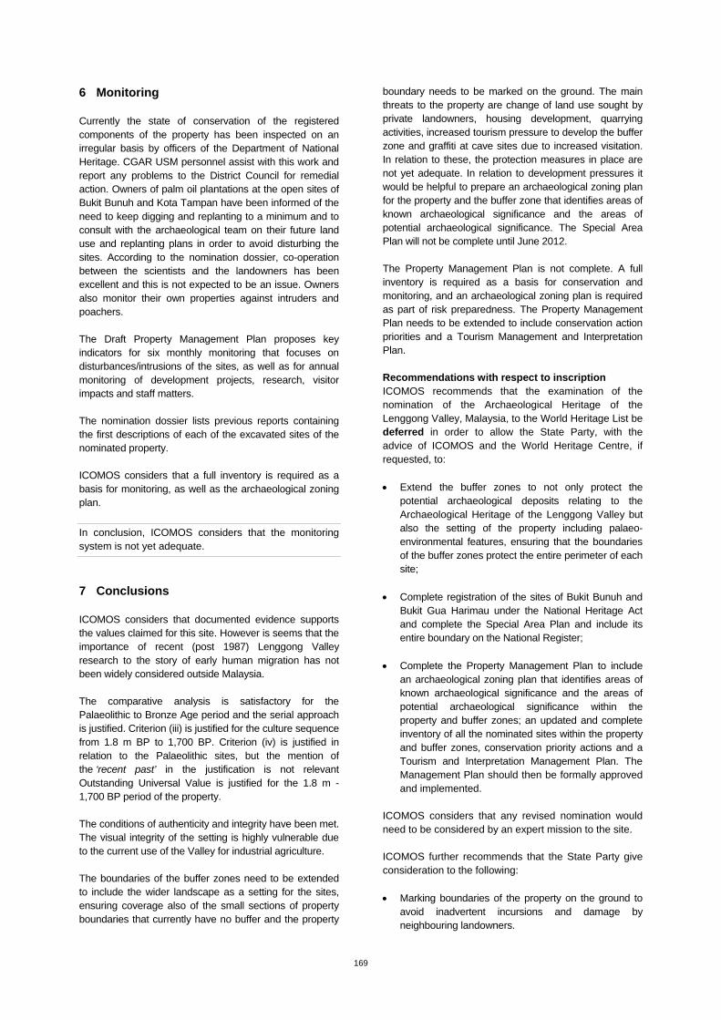
Cluster 1 is located north of a bend in the Perak River and consists of one overall site which includes the open-air stone tool workshop sites at Bukit Bunuh and Kota Tampan approximately 1 km apart located on the ancient lake shore and gravel river terraces. It also includes the Lenggong Archaeological Museum and the University of Science Malaysia Archaeological Field Station, located near the Kota Tampan site. Bukit Bunuh Located today in an oil palm estate, the meteorite impact crater at Bukit Bunuh measures approximately 3.45 km in diameter. Suevite rocks created at the site by high pressures and temperatures from the impact contain embedded stone hand axes chronometrically dated to 1.83 million BP by the fission-track method. These hand axes are the oldest or among the oldest so far discovered outside Africa. An in-situ workshop with stone assemblages has also been excavated here, with finds dating to 40,000 BP, including one hand axe made from suevite. ICOMOS considers that the use of CT scanning to reveal the contours of the hand axe partially embedded in the rock melted by the meteorite’s impact is innovative and yielded important supporting evidence for the identification of these objects as shaped by hominids. Kota Tampan This workshop site is presently on a hill slope but was on a shore of the ancient Chenderoh Lake during the Pleistocene, 70,000 BP. The evidence of the ancient lake can be read in the landscape as high terraces, landslide scars, paddy field valleys indicating streamline remnants of the ancient lake and ancient lake outlets. As an undisturbed Palaeolithic stone tool workshop, the association of artefacts (raw materials, finished and unfinished tools, and tool-making debris) is clearly visible. Its sudden abandonment was apparently due to the catastrophic Toba volcanic eruption, indicated by the presence of volcanic ash. The assemblage of artefacts found at this site has revealed and made possible the identification and classification of multiple tool types with specialised functions, indicating a lithic technology in South-east Asia as sophisticated as anywhere else in the world. As such this site is an important global reference site for Palaeolithic stone tool-making. ICOMOS notes that this site has particular importance in the debates about the expansion of Anatomically Modern Humans out of Africa. While there is no doubt that the
group of material is of human origin, no human fossils have been found at the site so there is lively debate about whether the tools were made by pre-modern Homo erectus or by Homo sapiens. There is no doubt the site is and will remain a site of international importance in the big debates about the origin of our species. Cluster 2
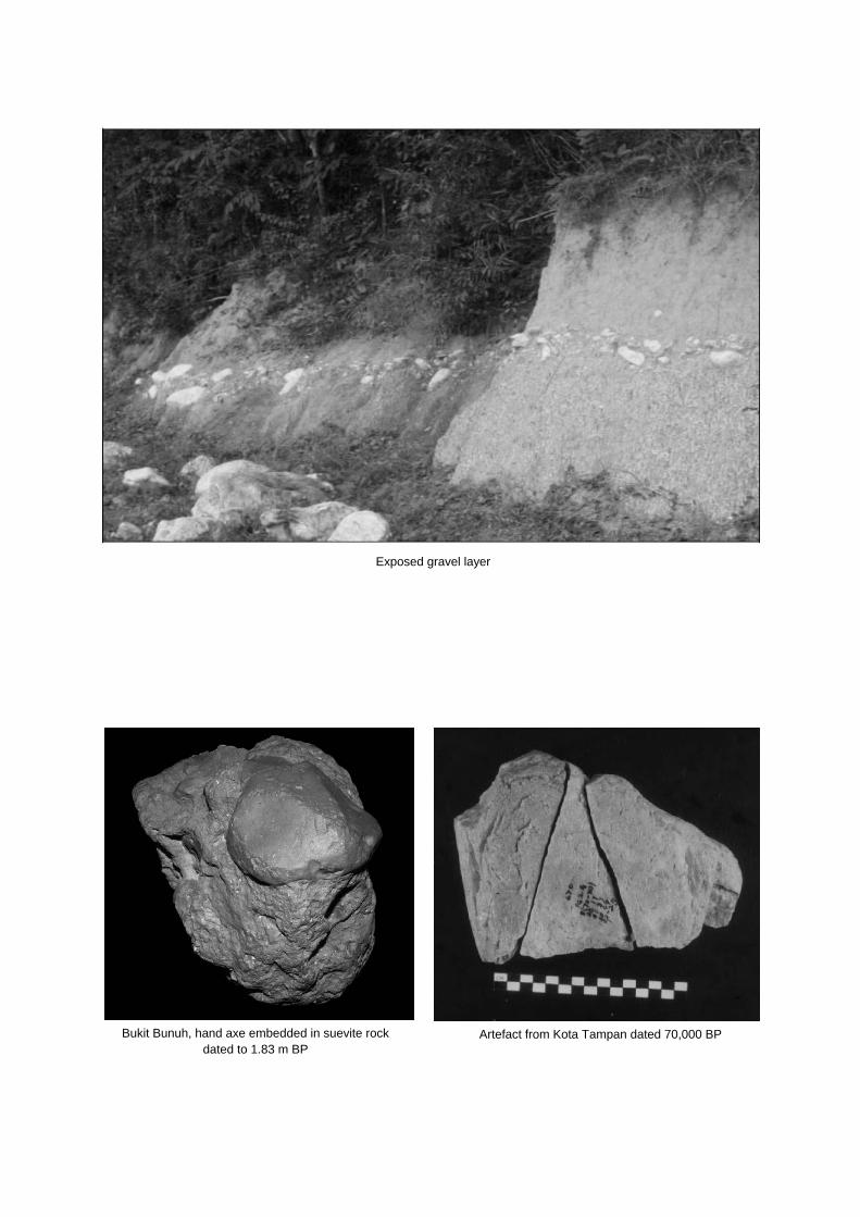
Cluster 2 is located further up the river to the north of Cluster 1, north of Lenggong town and comprises three sites: the limestone outcrop containing the cave Gua Harimau; the open-air workshop site at Bukit Jawa and a third site which consists of the limestone massif Bukit Kepala Gajah containing the caves Gua Gunung Runtuh, Gua Teluk Kelawar and Gua Kajang. The buffer zone of this cluster also contains three other limestone massifs, Bukit Gua Badak, Bukit Batu Tukang and Bukit Gua Dayak which have caves known to contain cultural remains. Bukit Jawa The open-air in situ stone tool workshop site at Bukit Jawa was located on the shores of an island in the ancient lake 200,000-100,000 BP. The technique of tool-making using anvils and hammer stones was similar to but not as technically developed as those found at the later Kota Tampan site. Tools were mostly made from locally available quartz, but finds of sandstone tools led to the discovery of a nearby sandstone source at Bukit Suring (in the buffer zone). Bukit Kepala Gajah This large karst outcrop occupies an area of six square kilometres at its foot, with a summit 258 metres above sea level. It contains more than 20 caves, of which 4 have been excavated. Three of these revealed prehistoric burials: Gua Gunung Runtuh, Gua Teluk Kelawar and Gua Kajang. Gua Gunung Runtuh Perak Man was found in this cave, which has three chambers and was first excavated in 1990. The cave was used for habitation and burial purposes from around 13,000 BP until 2,600 BP. Perak Man is South-east Asia’s oldest most complete human skeleton, radiocarbon dated to 10,120 BP and identified as Australomelanesoid, a hominid type occupying the western part of the Indonesia archipelago and continental South-east Asia at the end of the Pleistocene and early Holocene but now largely confined to east Indonesia, Melanesia and Australia. The smaller left arm and compensatory curvature of the spine exhibited by the skeleton indicate a genetic deformity known as Brachymesophalangia type A2. The burial was accompanied by stone tools, animal bones and shells. Similarities in lithic technology and tools with those produced at Kota Tampan suggest that there was little cultural change between the two sites, which are separated by around 60,000 years, indicating that the Kota Tampan population around 70,000 BP was already anatomically modern man, making tools that earlier hominids could not.
159
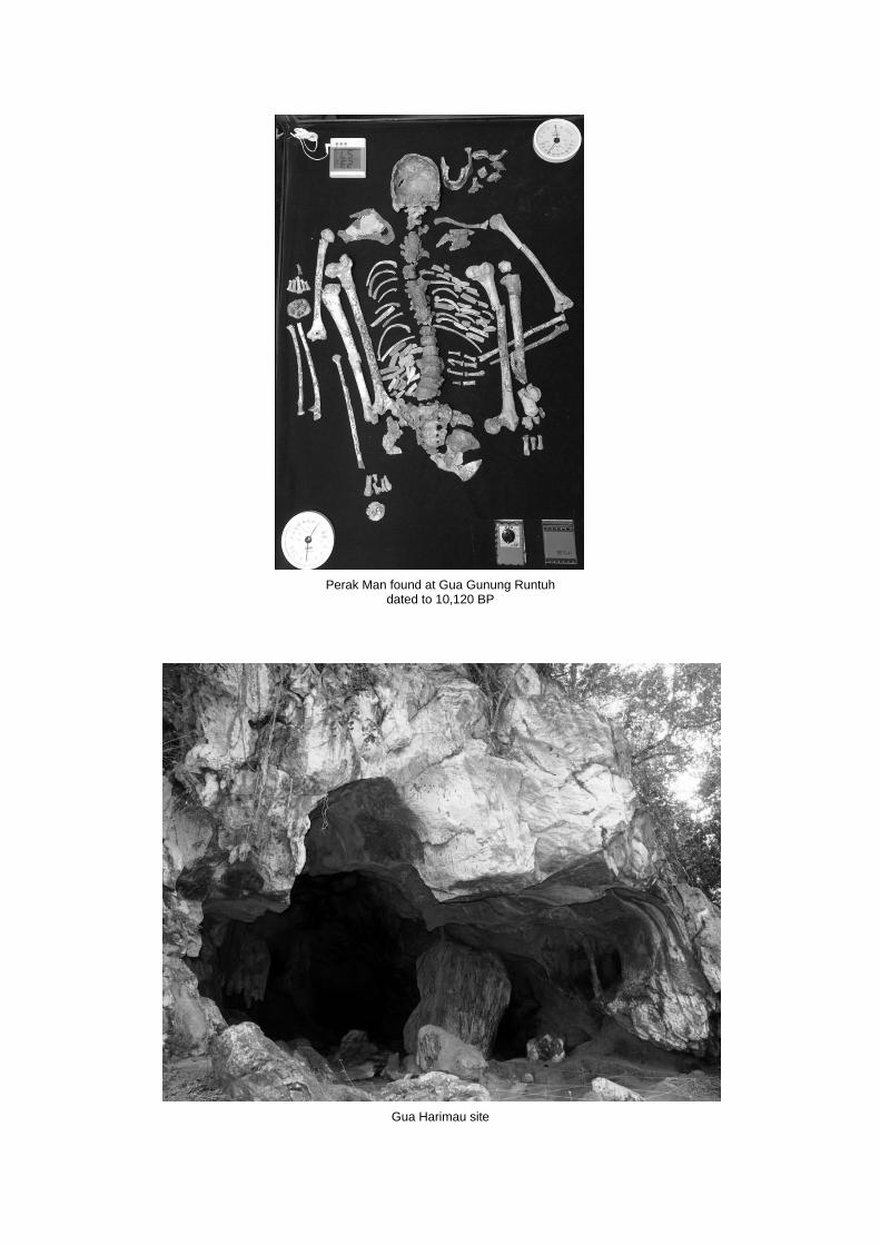
Gua Kajang Located approximately 8 km from Lenggong town, Gua Kajang is a natural limestone tunnel through the Bukit Kepala Gajah comprising three caves. Two human burials excavated there in 2007 were dated to between 10,000 and 7,800 BP, one of which was identified as having Australomelanesoid features, which is consistent with Perak Man and other late Palaeolithic skeletons uncovered so far in the Lenggong Valley. The floor of the tunnel is interspersed with man-made holes, over which crude wooden platforms have been laid to provide passage through the tunnel for wheeled vehicles. According to local knowledge the tunnel was used in the recent past as a thoroughfare for horse or buffalo-drawn carts. Gua Teluk Kelawar This is a rock shelter located about 1 km from Lenggong town. Excavations in 2004 uncovered a partly disturbed human burial dating from around 8,400 BP, associated with similar stone tools, animal bones and Brotia shells as found with Perak Man and in Gua Kajang. The skeleton exhibited Australomelanesoid features. Bukit Gua Harimau This is a limestone massif containing the large cave Gua Harimau, a prehistoric burial site first investigated in 1951. A total of 13 skeletons were uncovered during that and subsequent excavations in 1987-8 and 1995, dating from 1,700 BP to 4,900 BP. There is no evidence of the cave being used for habitation. Burial items included earthenware vessels, stone tools, stone adze, bark-cloth beater, shells and stone ornaments, food remains, bronze items including a bronze celt and the mould in which it was made. The pottery dates from around 3,000 BP and the types were common throughout prehistoric mainland South-east Asia. The pottery was sand-tempered, hand moulded using the slow wheel and fired at 600–800 degrees C. Similar pottery assemblages have been found in southern Thailand. Analysis of the human remains indicates that they were a Mongoloid group similar to others found in Asia dating from the Neolithic period. The bronze finds are the earliest in the Malay Peninsula, and so far this is the only archaeological site containing evidence of occupation in the Lenggong Valley during the metal period. ICOMOS considers that the sequence of occupation n the cave sites is well-documented by an adequate number of carbon dates, but it would have been useful if the calibrated dates were given, as well as the uncalibrated dates. This is because most of the dates are on shell, which can be difficult to interpret, whereas charcoal is more reliable. Fortunately there are some charcoal dates in the tables provided. History and development The evidence from the excavated sites in the Lenggong Valley indicates that humans (probably Homo erectus) first occupied the area at least as early as 1.83 million years ago and again 200,000-100,000 years ago. It is posited in the nomination dossier that the Lenggong Valley was a
corridor through which early man passed intermittently over a long period of time on his way from mainland South-east Asia to Australia. In particular it is proposed that anatomically modern humans represented by the Kota Tampan site of 70,000 BP moved through the valley reaching Australia as represented at Lake Mungo by 50,000 BP. Similarly the Perak Man site of 10,000 BP and the other nearby burial sites in the Bukit Kepala Gajah Massif are thought to represent the later passage of Australomelanesoid man to Indonesia, Melanesia and Australia. The earliest inhabitants in historic times were probably the Semangs who are ethnically Negrito. It is thought that they have an ancestry within the Malay Peninsula going back 50,000 years to initial settlement from Africa. They settled along the Perak River or inhabited caves and rock shelters such as Gua Badak, Gua Harimau, Gua Kajang and Gua Dayak as temporary camps, leaving charcoal drawings in several caves. In the first millennium CE rival empires competed for hegemony and control of trade between India and China. South-east Asia became settled; Melaka became an important entrepot but fell to the Portuguese in 1511. The first ruler of Perak was a son of the former sultan of Melaka. Tin resources brought the British to Penang and in the early 19th century the sultan of Perak sought assistance from the British East India Company to recover territory. The 1826 Burnley Treaty between Britain and Siam gave freedom to Perak, but in the face of troubles due partly to a huge influx of migrant workers, another treaty put Perak under the control of the British. In 1895 Perak, Selangor, Negeri, Sembilan and Pahang together became the Federated Malay States (FMS). Japanese forces invaded the FMS in 1941 and moved down the Perak River, occupying the Lenggong area until falling to the Allied forces in 1945. The holes in the cave floor of Gua Kajang are attributed to use of the cave by soldiers or locals and subsequent treasure-hunting. From 1948 to 1960 disturbances deriving from the Malayan Emergency, a war of National Liberation against the British resulted in new villages being built in which to settle rural Chinese, many of whom were supporting the guerrilla forces. This included the Lenggong Valley where Kota Tampan New Village is one example. Engagements between the British and later Malaysian forces and guerrillas in the vicinity of the nominated cave sites during this period resulted in the disturbance of deposits and artefacts. Since Independence was declared in 1957, development occurred mainly in the urban centres and the western corridor. However current plans for the Northern Corridor Economic Region specifically target Hulu Perak to receive attention in agriculture and tourism which will be reinforced by Perak State’s own economic development plans for its North-east Corridor. Research and archaeological exploration in the area began with investigations by British colonial officers in the period from 1917 to World War II, including work at Gua Kajang, Gua Badak (where relatively recent rock art thought to be of Negrito origin was discovered) and Kota Tampan. These were followed by Williams-Hunt and Sieveking in the 1950s at the same sites, and Williams-
160
Hunt also excavated Gua Harimau. Post-independence work in 1960 by Matthews at Gua Bukit Batu Berdinding located in the proposed buffer zone has not been published. Since 1987 Malaysian archaeologists have been leading research in the area and discovered the open-air in situ stone tool workshop Kota Tampan dated to 70,000 BP which has become a global reference site for the Palaeolithic in South-east Asia, as well as the Bronze Age occupation of Gua Harimau. The discovery of Perak Man in 1990 brought the Malay Peninsula sites further to the forefront of archaeological research into prehistory and in 2008, the discovery of the hand axe embedded in suevite dated to 1.83 million BP provided evidence that the earliest humans in the region inhabited the Lenggong Valley before they were in Java. The Lenggong Archaeological Museum was built to house, exhibit and preserve the artefacts found during research and excavation of the sites and opened to the public in 2003. The University of Science Malaysia (USM) Archaeological Field Station opened in 2005 and will continue research and training under the management of the Centre for Global Archaeological Research (CGAR) with funding from the Department of National Heritage.
3 Outstanding Universal Value, integrity and authenticity
Comparative analysis The State Party has identified four themes within which to compare the nominated property with other Palaeolithic to Neolithic period sites: One of the longest prehistoric culture sequences in a
single locality; In-situ Palaeolithic workshops; Palaeolithic skeleton with Brachymesophalangia type
A2; Evidence for the oldest hominid presence outside
Africa. Sixteen sites have been identified for comparison. In relation to the longest culture sequence, the nominated property has been compared with two World Heritage listed sites: Rock Shelters of Bhimbetka, India (2003, criteria (iii), (iv)); Peking Man Site at Zhoukoudian, China (1987, criteria (iii), (vi)); one site on the Tentative List: Wonderwerk Cave, South Africa (1998), and one not listed: Theopetra, Greece, and found to cover a much longer date range than any of these. ICOMOS notes that habitation over the date range is intermittent, with a long gap between 1.83 million BP and 200,000 BP. However the overall date range is longer than the similar pattern at the World Heritage listed (1996, criteria (iii), (vi)) Sangiran Early Man Site in Indonesia, which contains evidence that hominids have inhabited the area for at Ieast 1.5 million years.
ICOMOS notes that the date range is far less than that of the World Heritage listed (2010, criterion (iv)) Ngorongoro Conservation Area, Tanzania - an area that has been subject to extensive archaeological research for over 80 years and has yielded a long sequence of evidence of human evolution and human-environment dynamics, collectively extending over a span of almost four million years to the early modern era. However ICOMOS considers that it is more appropriate to limit comparison to sites outside Africa since the site is related to the dispersal of early man out of Africa. In comparing the open-air stone tool workshop sites with other in situ Palaeolithic workshops in South-east Asia including the Irrawaddy Valley of Burma, the Kanchanaburi Valley, Thailand and the Cagayan Valley, Philippines, the State Party argues that whereas these are all disturbed Palaeolithic sites, the Lenggong Valley open air sites are considered undisturbed because they contain tool-making equipment and finished tools in association as well as conjoined artefacts. The nomination dossier lists a number of other Palaeolithic stone tool workshop sites in the world (none of which are World Heritage or Tentative lists) that may be comparable in this respect to those found in the nominated property including the English site at Boxgrove, the French Solvieux site, brickyard quarry sites at the Dutch-Belgian border near Maastricht, the Turkish site of Kaletepe Deresi 3 in Central Anatolia, Isampur and Hunsgi valleys in Karnataka, India, the Bose Basin in China and the very old sites at Gona, Ethiopia and Lokalalei, Kenya. These sites share with the nominated sites characteristics of being in-situ Palaeolithic workshop sites found with large stone assemblages and bearing artefacts capable of being refitted – that is it can be shown that discarded flakes have come from nearby cores. However except for Bose they use different raw materials and do not exhibit the same technology required to make quartz and quartzite tools as at the nominated site. At Bose the raw material is similar, but the dating is considered to be controversial because of the unclear association of the tektite used for dating, whereas at Lenggong the chronometric dating is secure. In relation to the third theme, Perak Man is claimed by the State Party to be outstanding as the most complete Palaeolithic skeleton found in South-east Asia, which together with the accompanying grave goods provides extraordinary evidence for his physical and medical condition and unique congenital deformity (Brachymesophalangia type A2) as well as for prehistoric life ways and burial ritual practices. No examples are quoted for comparison however. As evidence for the oldest hominid presence outside Africa, the Bukit Bunuh site of the meteorite crater and hand axe embedded in suevite is said by the State Party to prove a hominid presence of at least 1.83 million BP. This is compared with eight sites located in Pakistan, China, Indonesia, Israel and Spain dated between 2 and 1.2 million BP in Table 3.3 (p. 131) in the nomination dossier. Among them the sites at Zhoukoudian, Sangiran and Atapuerca (Spain) are inscribed on the World
161
Heritage List and Dmanisi (Georgia) is on the Tentative List. The site of Riwat in Pakistan has yielded stone core tools dated from 2 million BP, evidence from ‘Ubeidiya in the Jordan Valley is dated to between 2.6 and 1.7 million BP, but the evidence from the other sites is younger. Within South-east Asia, the skull of Mojokerto Boy from Mojokerto (Indonesia) was dated to 1.81 million BP and Homo erectus skulls from Sangiran in Java have been re-dated to 1.66 million BP. While the nominated property therefore cannot claim to contain the earliest evidence of hominid presence outside Africa, the State Party argues that the evidence is rare for Early Pleistocene dispersal into the further reaches of Asia, which has to be considered in any discussion or theory on the human journey out of Africa. The serial approach is justified by the fact that the sites are in relatively close proximity and demonstrate an exceptionally long culture sequence within that locality. In response to ICOMOS’ request for clarification, the State Party responded that the sites are undisturbed in situ sites which have produced important findings of significance to the prehistory of area and region. ICOMOS considers that the comparative analysis justifies the selection of sites. In response to ICOMOS’ request for clarification on how the nominated property relates to the Niah Caves, Sarawak, the State Party responded that methodological problems with the Niah Caves research meant the findings at Niah could not be compared with the sites in Lenggong Valley. ICOMOS notes that research published in 200è (Barker et al) confirms that the Homo sapiens skull found at Niah by Harrison in the 1950s “is indeed ca. 40,000 years old, and it is thus the earliest example in South-east Asia”, and that the cave now has an extremely detailed and well-dated sequence extending from 40 ka BP into the Holocene and is now “the best documented Upper Pleistocene site in Asia east of Israel.” ICOMOS notes however that the remains comprise primarily a skull, whereas Perak Man is a complete skeleton, and currently the oldest preserved skeleton in Malaysia.
ICOMOS considers that the comparative analysis justifies consideration of this property for the World Heritage List.
Justification of Outstanding Universal Value The nominated property is considered by the State Party to be of Outstanding Universal Value as a cultural property for the following reasons: one of the longest culture sequences in a single
locality in the world; numerous undisturbed in-situ stone tool workshops in
the Lenggong Valley dated in a long chronological
sequence provide a key to the understanding of the development of Palaeolithic human culture in Southeast Asia;
evidence for very early hominid presence outside Africa;
the find of a unique Palaeolithic skeleton with Brachymesophalangia type A2.
ICOMOS considers that there is some ambiguity in the nomination dossier as to whether the culture sequence being represented includes the period of the more recent occupation of the caves. However ICOMOS considers that the justification stated above is appropriate in applying only to the prehistoric culture sequence and excluding the recent past. Integrity and authenticity Integrity
The State Party states that the sites were chosen to illustrate the various phases in the development of early man in the Lenggong Valley. Together they provide the long culture sequence claimed as a major aspect of the Outstanding Universal Value of the property - a sequence that challenges established ideas about the Palaeolithic in general and about South-east Asia in particular. The Lenggong Valley has provided a fertile and environmentally stable habitat for repeated human occupation since early Palaeolithic times. The evidence provided by the selected in situ stone tool workshops and the cave burials demonstrate that the Valley’s resources have been exploited with increasing technological sophistication over 1.83 million years. The spatial association, chronological sequencing and undisturbed character of the archaeological deposits of these sites, together with the discernible palaeo landscape features hold the key to the integrity of the relict cultural landscape. The excavated remains have been documented and conserved, providing evidence for the development of Palaeolithic hominid culture outside Africa which is available for educational purposes and scientific research. ICOMOS considers that description of the ecological relations existing among the plants and animals in the landscape in which the sites are found is lacking. Although the geology of the region is well documented, there has apparently been no effort to collect data such as fossil pollen which would yield insight into previous vegetation and thus climate in this area. ICOMOS notes that Palaeolithic landscape features are still intact but visibility is somewhat masked by the palm oil plantations. The remains of the lake and terraces are still visible; the meteorite crater is intact but is overly masked by the plantation. There is clearly potential for further discoveries within the whole Valley. ICOMOS considers that the visual integrity of the setting of the property overall is problematic. While the setting of the cave sites (Cluster 2) in their limestone massifs and
162
immediate forest surrounds is retained, that of the open stone tool workshop sites has been greatly modified. Bukit Bunuh (in Cluster 1) is hidden in an oil palm plantation, Kota Tampan (Cluster 1) is surrounded by rubber plantation and Bukit Jawa (in Cluster 2) is an unrehabilitated clearing within the rubber plantation. While it is clearly not possible to recover the prehistoric setting of these sites, some linkages need to be made with it in terms of connections to the relict palaeo lake, gravel terraces and other features described in the nomination dossier. ICOMOS considers that the sites are generally in good condition, largely due to low visitation. The exception is Gua Kajang which is easily accessible by car along a flat road from a nearby village. Subsidence from poorly back- filled pits is evident across the uneven floor of the shelter. There is also some graffiti. However ICOMOS considers that damage is reversible and the site’s significance could be realised by careful management and investment in interpretation. Authenticity
The State Party states that documented research and investigation of the site have followed a single system throughout the Valley since 1987. Utilisation of a common scientific research methodology at all sites ensures that comparative studies can be made between sites and testifies to the authenticity of the prehistoric remains. ICOMOS considers that documented evidence supports the values claimed for this site. Much of the documentation has been independently peer reviewed through the academic publishing process and provides evidence of: the extremely early date for hominid presence in
South-east Asia at Bukit Bunuh; the most easterly and early occurrence of hand axes
at Bukit Bunuh; the oldest most complete skeleton in southeast Asia
(found at Gua Gunung Runtuh); possibly the most southern evidence of metal making
in Asia at Gua Harimau; the relative abundance of early sites in a relatively
contained area hinting at relatively large or semi sedentary population.
The value of this evidence lies partially in the number of chronometric dates rather than relative dating techniques which are open to greater contestation. The story that is woven around these sites of a long and continuing tradition is convincing. There is little evidence linking this deep past to the recent historic past however. ICOMOS considers that while the recent (post 1987) Lenggong Valley research to the story of early human migration ensures the reliability and authenticity of the nominated property, this research is apparently not widely known. The research has not been published in a range of widely accessible publications. The key evidence of the
dating of the Bukit Bunuh hand axe in suevite was published only in 2010 (Ariffin et al) in the conference proceedings of the Asian Institute of Physics. There have been no publications yet in international peer reviewed journals to confirm the hand-axe as the oldest so far discovered outside Africa. The evidence of the Bukit Bunuh tool workshop site dating from 40,000 BP (Saidin 2006) was published in the selected papers of the 10th International Conference of the European Association of Southeast Asian Archaeologists, held at the British Museum, London in 2004. Establishment of the 200,000 -100,000 BP date of the stone tool workshop at Kota Tampan (Zuraina Majid and Tjia, H 1988) was published in the Journal of the Malayan Branch of the Royal Asiatic Society. Perak Man and other hominids remains excavated from the cave sites have been published by the University of Science Malaysia Press in The Perak Man and other prehistoric skeletons of Malaysia (Penang 2005). A paper on the Bronze Age remains at Gua Harimau was presented (1988) by Zuraina Majid at the International Conference of Ancient Bronze Drums and Bronze cultures in southern China and Southeast Asia in Kunming, China.
In conclusion, ICOMOS considers that the conditions of integrity and authenticity have been met but the visual integrity of the setting is highly vulnerable.
Criteria under which inscription is proposed The property is nominated on the basis of cultural criteria (iii) and (iv). Criterion (iii): bear a unique or at least exceptional testimony to a cultural tradition or to a civilization which is living or which has disappeared;
This criterion is justified by the State Party on the grounds that the Archaeological Heritage of the Lenggong Valley is one of the longest culture sequences in a single locality in the world, covering an extraordinary range of nearly 2 million years and spanning all the periods of hominid history outside of Africa. The artefactual evidence for this is found in the open-air and cave sites situated in close physical proximity to one another and located in a river valley that has remained geologically and environmentally stable for the past 2 million years. The key markers in this long culture sequence can be seen in the excavated sites of Bukit Bunuh, Kota Tampan, Bukit Jawa, Gua Gunung Runtuh, Gua Harimau and cave drawings by local aboriginal people. ICOMOS considers that this criterion is met through evidence drawn from the archaeological finds at AHLV. The archaeological evidence shows that the human occupation in the Lenggong valley covers Palaeolithic, Neolithic and Metal age cultures, ranging from 1.83 million years ago to 1,700 BP. The AHLV therefore, represents one of the longest archaeological cultural sequences found in a single locality in the world. The archaeological research also reveals that the AHLV has the largest number of in-situ Palaeolithic open-air sites in South-east Asia. Well-preserved, in-situ Palaeolithic sites are

163
extremely rare because over hundreds of thousands of years of natural processes and human activities almost inevitably disturb original archaeological contexts. The Perak Man, which is dated to more than 10,000 years ago, is the oldest complete Palaeolithic skeleton in Southeast Asia. It provides significant information concerning Late Palaeolithic burial traditions and lifeways. ICOMOS considers that the Archaeological Heritage of the Lenggong Valley is exceptional testimony to occupation of the Valley by Palaeolithic, Neolithic and Bronze Age man and their cultural traditions, ranging from 1.83 million years ago to 1,700 BP.
ICOMOS considers that this criterion has been justified.
Criterion (iv): be an outstanding example of a type of building, architectural or technological ensemble or landscape which illustrates (a) significant stage(s) in human history; This criterion is justified by the State Party on the grounds that human existence during the Palaeolithic, the longest period in human history, centred around stone resources. Stones provided the raw material for the earliest tools and the archaeological remains of stone tools and stone tool workshop sites are important evidence of early human technology. Thus, the discovery of numerous undisturbed in-situ stone tool workshops in the Lenggong Valley dated in a long chronological sequence covering the entire Palaeolithic period provides a key to the understanding of the development of human culture in Southeast Asia at this significant stage of human history. An outstanding example of lithic manufacturing at the Kota Tampan site has become an important global reference site for Palaeolithic tool technology. The archaeological sites in the Lenggong Valley preserve an outstanding record of the evolution of human cognitive complexity evidenced by the development of lithic tradition and stone tool technology over an extremely long time sequence from 1.83 million years ago to the recent past. ICOMOS considers that the nomination dossier doesn’t make it clear how the data from the archaeological sites provides insight into ancient minds. The study of cognitive behaviour based on stone tools is still under debate among scholars in modern archaeology. It seems the value of this aspect should not be over-estimated. However ICOMOS considers that the undisturbed in-situ Palaeolithic stone tool workshops located on the shores of a paleolake and ancient river gravel beds and dated in a long chronological sequence are an outstanding technological ensemble. The sequence of significant stages in human history represented at the sites is unrivalled in the region. Whether or not the 1.83 million year old finds are validated, the site is of unique importance for the region’s prehistory remains. ICOMOS does not consider the inclusion of the recent past is justified because the quoted evidence of it – cave
drawings - is not part of the technological ensemble of stone tool workshops.
ICOMOS considers that this criterion has been demonstrated.
ICOMOS considers that the serial approach is justified.
ICOMOS considers that the nominated property meets criteria (iii) and (iv) and conditions of authenticity and integrity but the visual integrity of the setting is highly vulnerable and that Outstanding Universal Value has been demonstrated.
Description of the attributes The attributes carrying the Outstanding Universal Value of the property are: The in situ stone tool workshop sites; The cave sites.
4 Factors affecting the property Development pressures
Lenggong is an agricultural valley targeted for more intensive food production as part of the Northern Corridor Economic Region (NCER). This is likely to result in farms which carry ten to fifty times more animals than they do at present. Landowners within the property and buffer zone are likely to respond to government incentives and funding. The overall impact should be to reduce the number of poor in the area who currently need to engage in guano collection (from the caves) and illegal wood felling, which would benefit the property. Cyclical replanting of oil palms will be a serious threat to the Bukit Bunuh and Kota Tampan sites, damaging gravel beds and in-situ workshops yet to be uncovered. Two other economic sectors have been identified for the NCER: manufacturing and tourism. The nomination dossier proposes that land use within the two clusters should be changed from agricultural to tourism-related, and the requirement for Heritage Impact Assessment be applied. New housing developments have been built and more are planned in the area to eventually accommodate more than 800 people, but these do not encroach on the nominated property. Currently there are no inhabitants within the property boundary. However in 2002 there were 2,513 within the buffer zone of Cluster 1 and 4,350 within the buffer zone of Cluster 2. Building and infrastructure works will create demand for building material and could lead to pressure for quarrying the limestone hills. It is proposed in the nomination dossier that such pressures can be resisted by application of legal instruments and diverting quarrying activities to those hills with demonstrated paucity of significant sites. All limestone hill quarrying is currently embargoed, and
164
quarrying for other materials including granite, earth and sand requires a licence. The nomination dossier states that such activities will be banned within the nominated property and that the Special Area Plan currently being developed will deal with these issues. ICOMOS notes that the area adjacent to the Bukit Jawa excavation was cleared and levelled for a housing development before being stopped by the authorities. The Local District Office is confident that the Special Area Plan will be the appropriate tool to control such issues. It will include controls to trigger assessment of some landowner activities such as change of use. Tourism pressures
Currently the property has few visitors although there are access roads, parking areas and boardwalks around several of the caves. There is no entry point to enable recording of visitor statistics. The components of the property are not actively marketed by government agencies or private travel businesses. However there is an archaeology field station run by the Centre for Global Archaeological Research of the University of Science Malaysia (CGAR USM) near the Kota Tampan site which is the point of entry for researchers and students. Looting is rare but there have been a few cases of pilfered artefacts being offered for sale. There has been some vandalism in the form of graffiti on the walls and roof of some caves. The caves and archaeological sites together with the Lenggong Archaeological Museum are slowly becoming one of the principal tourism products within the district, along with a homestay programme at Tasik Raban and Lake Raban and forests within Lata Kekabu. Tourist facilities include the Lenggong Resthouse and Lake Raban Resort, which together accommodated 12,074 visitors in 2009. Visitors to the Lenggong Archaeological Museum totalled 78,808 in 2009; mostly local visitors with a large proportion of school children. It is expected that the number of visitors to the property will increase due to its inclusion in regional and district tourism development strategies. The Northern Corridor Implementation Authority (NCIA) is developing plans for ecotourism at the Royal Belum State Park and the Temengor and Gerik Forest Reserves enabling visitors to combine visits to the tropical rainforest with visits to the archaeological heritage. ICOMOS considers that a Tourism and Interpretation Plan should be included in the Conservation Management Plan to guide tourism management and the development of tourist facilities for the property. Environmental pressures
It is stated in the nomination dossier that there are no current environmental pressures. Incentives to increase agricultural productivity may cause owners to switch land use and crops. However the conservation of the property will be an important consideration of the Special Area Plan.
ICOMOS notes that most of the area of Cluster 1 is in private ownership as rubber and palm oil plantations. Given that rubber plantations are gaining popularity in line with a world-wide increase in rubber prices, a particular concern is that palms may be replaced with rubber trees. Not only would this involve the disturbance caused by their removal but in the long term the spreading roots of rubber trees would prove a greater hindrance to archaeological investigation and potentially cause greater disturbance to subsurface deposits causing vertical and horizontal migration of artefacts through the deposit. This should also be controlled through the Special Area Plan. Natural disasters
According to the nomination dossier, flooding is considered a low risk to the property. Flooding of the Perak River from unusually heavy rainfall is a possible natural disaster threat to Cluster 1. In the last major flood (2009) the flood did not affect the property but a small area of the buffer zone was flooded in 2009 and 2010 due to lack of capacity of the drainage system. The Lenggong District Flood Action Committee has long and short-term plans for flood mitigation. In the short term the Tasik Raban (canal) will be enlarged and dredged. Long term proposals include the upgrading of 10 bridges and the diversion of a stream. Impact of climate change
According to the nomination dossier there is no risk from climate change.
ICOMOS considers that the main threats to the property are change of land use sought by private landowners, housing development, quarrying activities, increased tourism pressure to develop the buffer zone, and graffiti at cave sites due to increased visitation.
5 Protection, conservation and management
Boundaries of the nominated property and buffer zone The property boundary was selected to enclose significant sites which contribute definitively to the nominated Outstanding Universal Value. The boundary of the buffer zone is designed to include all other areas having been assessed as having archaeological ‘potential’ to contribute further to that story. These are shown on the map provided with the State Party’s response to ICOMOS’ request for clarification of the location of these sites (Appendix A (Map)). ICOMOS notes that design of the buffer zone, while focusing on potential for further research, and to some extent including elements of the palaeo landscape, does not consider the wider landscape as a setting for the sites.
165
Cluster 1 The property boundary enclosing the workshop sites at Bukit Bunuh and Kota Tampan encloses 6 cadastral land lots and was designed to include the known extent of the archaeological sites. The buffer zone boundary follows the natural boundary of the Perak River on the east and then local administrative boundaries and land lot boundaries to the south, the meteorite crater rim on the west and the contour of the palaeo lake and limestone massif boundary to the north. There are three small sections on the north, south and west where the Cluster 1 property does not have a buffer although on the south the Perak River forms a natural buffer zone. Cluster 2 Bukit Jawa The property boundary encloses 7 cadastral land lots and was designed to include the known extent of the archaeological site. Bukit Kepala Gajah The property boundary follows the State Land boundary around the base of the limestone massif. Bukit Gua Harimau The property boundary follows the State Land boundary around the base of the limestone massif. The buffer zone boundary enclosing these three sites follows the natural boundary of the Perak River, local administrative boundaries and land lot boundaries on the east, the contour of the palaeo lake and land lots on the south, land lots and limestone massifs on the west and north. There is a small section along the north-western property boundary of Bukit Kepala Gajah which does not have a buffer. ICOMOS notes that the property boundaries are unmarked and that there is the potential for landowners to intrude into the property area. This was observed by the ICOMOS mission at Bukit Kepala Gajah.
In conclusion, ICOMOS considers that the boundaries of the nominated sites are adequate. ICOMOS recommends that the boundaries of the buffer zones should be extended to include the wider landscape as a setting for the sites, ensuring coverage also of the small sections of property boundaries that currently have no buffer, and the property boundary needs to be marked on the ground.
Ownership Cluster 1 Bukit Bunuh-Kota Tampan is partly in private ownership (2 lots); one lot is owned and occupied by the Lenggong Archaeological Museum and two lots are owned by a statutory authority (MARA), which was persuaded in 1995 not to build a large vocational training complex adjacent to the excavation sites. Plans are being considered for acquisition by the State.
Cluster 2 Bukit Jawa is in private ownership and is currently in the process of being acquired by the State. Bukit Kepala Gajah and Bukit Gua Harimau are owned by the State. Protection Legal Protection
Cluster 1 Kota Tampan and the first hand axe found embedded in suevite are registered under the National Heritage Act 2005. The site of Bukit Bunuh is not yet registered but the amendment is underway and expected to be gazetted by 2012. The boundaries do not coincide with the nominated property. Cluster 2 Bukit Jawa and Bukit Kepala Gajah are registered under the National Heritage Act 2005 and their boundaries coincide with the nominated property boundaries. Bukit Gua Harimau is not yet registered but the amendment is underway and expected to be gazetted by 2012. In response to ICOMOS’ request for information on how the non-registered sites are currently protected the State Party responded that the whole of the nominated property is protected under the National Land Code 1965 and the Town and Country Planning Act 1976, where any removal of soil, rocks and minerals as well as development activities require approval from State and Local Governments. The Special Area Plan currently being prepared will further refine protection measures for the nominated property under the Town and Country Planning Act. ICOMOS notes that archaeological sites have blanket protection in Malaysia under the National Heritage Act of 2005. Under this Act any person discovering any archaeological object must report the find to the Commissioner and any authorized officer or the District Officer of the area (Part VIII s47(1)). All such objects (since enactment of the Act) are the property of the Federal Government (Part VIII s 48 (1)), this includes all undiscovered objects whether on the surface, subsurface or in any river or sea (s 48 (4)). However the section of the Act that relates to ‘Treasure Troves’ (S73-82) suggests that archaeological sites are vulnerable to disturbance unless they have been assessed by the Heritage Commissioner and entered on the Heritage Register. ICOMOS considers that ‘Unauthorised’ excavation with ‘intent to discover’ archaeological material should be prohibited. ICOMOS also notes that the mission was advised that the entire area of property and buffer zones will be protected under the Special Area Plan currently being prepared. Effectiveness of protection measures
ICOMOS notes that in the past the highway development has destroyed part of one site at Bukit Jawa and there
166
have been disturbances at Bukit Bunuh when the oil palm plantation was planted and at Bukit Jawa when an area was cleared for development adjacent to the site. The proposed protective mechanism for the nominated property and buffer zones is far from complete. The process to develop the Special Area Plan has only just commenced and is due to be finished just before the next World Heritage Committee meeting. The Special Area Plan takes about 9 months to complete. The Terms of Reference for the consultant based on local people’s needs and comments have been finalized and the budget allocations are in hand. The programme for completion means that there is little or no time for advisory bodies such as ICOMOS to provide any feedback on the effectiveness of the proposed mechanism. However, the commitment to include the entire boundary of the Special Area Plan on the National Heritage Register means that both the nominated property and the buffer zones would be protected under the highest protection measures available to the State Party.
ICOMOS considers that the protection measures in place are not yet adequate. ICOMOS recommends that the sites of Bukit Bunuh and Bukit Gua Harimau be registered under the National Heritage Act and that the Special Area Plan be completed and its entire boundary included on the National Register.
Conservation Inventories, recording, research
It is stated in the nomination dossier that an inventory of excavations and artefacts has been kept since 1987 by the Upper Perak Archaeological Project, managed by the University of Science Malaysia (USM). Artefacts uncovered during the excavations are displayed or stored in the Lenggong Archaeological Museum; the National Museum in Kuala Lumpur, Taiping Museum, Matang Museum and the Department of Museums in Kuala Lumpur. Artefacts for research and conservation are at the Centre for Global Archaeological Research (CGAR) USM. Records and documentation are kept at the Department of National Heritage in Kuala Lumpur, the CGAR USM and the Lenggong Archaeological Museum. ICOMOS notes that an updated and complete inventory of all the nominated sites within the property and buffer zone will be prepared by the World Heritage Office to be established under the Management Plan for the property. In response to ICOMOS’ request for clarification on the inventory, the State Party responded that the inventory, data and artefacts of the previously excavated sites in the whole Valley is available in the Centre of Global Archaeological Research, University of Science, Malaysia. Present state of conservation
Cluster 1 Kota Tampan The first stone tool workshop site to be excavated (KT 1987) was back-filled in 1999 and is currently in the
process of being exposed for display. Several trenches of the site excavated in 2005 (KT 2005) are currently protected by a pavilion. Bukit Bunuh The excavated remains of the 40,000-year old stone tool workshop (BBH 2001) are exposed and unprotected. At the meteorite crater site (BBH 2007) the hand axe and fourteen other stone tools found embedded in suevite are held at CGAR USM. More than a thousand others remain in situ and have been mapped. Cluster 2 Bukit Jawa The original Bukit Jawa rescue excavations (BJ1 and BJ2) were destroyed by construction of the trunk road FT 76 in 1996. Another area of the site was excavated in 2005 and these trenches with the artefacts have been exposed for display, covered by a pavilion and provided with information panels on the research and findings at Bukit Jawa. Bukit Kepala Gajah The limestone massif has not been subject to human activity; however the three important caves here have long been a source of guano for local villagers to use as fertiliser. The Lenggong Land and District Office ceased issuing guano licenses in 1996, but access to the caves is not restricted or guarded. Gua Gunung Runtuh The cave is accessible by footpath, taking around 45 minutes from the small hamlet, Kampung Gelok. Visitors leave trash and graffiti. The trench from which Perak Man was excavated has been left open as a record. The skeleton was displayed in the 1996 ‘Reviving Pithecanthropus’ exhibition at the National Science Museum, Tokyo, Japan. It is now at the National Museum in Kuala Lumpur, displayed in a custom-made airtight glass cabinet. Two accurate replicas were made for use in other displays. Gua Kajang This cave is accessible by a paved road and is subject to visitor degradation including digging for artefacts and graffiti. Back-filling the trench is therefore being considered. The southern part of the cave is covered by rubble from cave-ins. There is a boardwalk with information panels linking Gua Kajang to other caves with archaeological and natural attractions. Gua Teluk Kelawar This rock shelter is easily accessible via a 15 minute walk from the main road. For the past decade the site has been used for field training archaeology students from the USM. Excavated trenches have not been back-filled. Others made by treasure hunters require back-filling. There are information panels and a gazebo at the site.

167
Bukit Gua Harimau The limestone massif has been subject to quarrying in the past. Gua Harimau The cave is accessible by jeep along a dirt track; 30 minutes on foot. Villagers still take guano from the cave and visitors have left graffiti. The excavation trenches are being considered for back-filling. There are information panels and a gazebo. Active Conservation measures
Research is being undertaken into suitable methods of preserving the in-situ deposits for public viewing. Otherwise exposed trenches will be back-filled. ICOMOS considers that Conservation Action priorities are needed in anticipation of increased visitor impacts and interpretation. This should include guidance on back-filling, safety and related signage. The draft Property Management Plan included as Volume II of the nomination dossier does not cover conservation in sufficient detail. Maintenance
Basic maintenance including grass cutting, sweeping and cleaning, maintaining access to the sites and rubbish collection is carried out by the Lenggong District Council. Effectiveness of conservation measures
ICOMOS considers that the sites are generally robust and conservation has been ‘passive’. The most significant conservation measures have been the interventions by the State Party to stop guano collection and other developments while at the same time raising the public profile of the sites through the museum and the archaeological field research facility. The transition from essentially a specialist field study area to a cultural tourism site such as is planned if the property is inscribed on the World Heritage List will require more active conservation interventions to manage visitor impacts.
In conclusion, ICOMOS considers that Conservation Action priorities are required as part of the overall Management Plan.
Management Management structures and processes, including traditional management processes
The property including all components is managed by the Lenggong District Council (the local authority) with the co-operation of the Department of National Heritage (which is ultimately responsible for the nationally registered sites), and with the occasional assistance of CGAR USM. The District Council includes a Heritage Unit with a technical section, administration section and enforcement section. There is currently no on-site manager to take charge of non-statutory duties.
It is proposed in the nomination dossier that following World Heritage inscription, a Heritage Steering Committee will be set up, chaired by the Chief Minister of the State of Perak, with members representing Federal, State and Local governments, and independent expert members. The role of the proposed Steering Committee is set out in the nomination dossier and will cover all aspects of implementation of the Property Management Plan including fundraising. The Committee will be advised as to implementation of the work plan by a Heritage Technical and Scientific Committee, chaired by the District Officer. The District Council’s Heritage Unit would be upgraded to become the World Heritage Office headed by a General Manager, the staff of which will implement the work plan with external assistance from the University of Science Malaysia and others as required. Policy framework: management plans and arrangements, including visitor management and presentation
The national policies under the Tenth Malaysia Plan (2011-2015) and the regional policies under the Northern Corridor Economic Region Plan focus on development of the Lenggong Valley for agriculture and tourism. In particular Hulu Perak district of Perak State is planned to be a nature and adventure holiday destination centred on Gerik, to the north of the Valley. A Special Area Plan for the Lenggong sub-district focusing on the preservation and conservation of the nominated property will be developed for the nominated property to be incorporated within the Perak Structure Plan (2001-2020). The current Local Plan (2002-2015) touches only briefly on the archaeological discoveries in the nominated property. The Draft Property Management Plan (DPMP) for the Archaeological Heritage of the Lenggong Valley forms Volume II of the nomination dossier. It is expected that this will be implemented by the end of 2011 after approval from all parties concerned. The DPMP sets out objectives including the development of tourism and visitor management strategies, risk management strategies and provision for stakeholder participation and collaboration. At present the Lenggong Archaeological Museum acts as an informal visitors’ centre and recommends individuals who can act as guides to the sites on a fee-paying basis. The Museum is the first and only museum in Malaysia specialising in prehistoric archaeology. It is a two storey building at present comprising two galleries, an administration office, audio visual room, research room, conservation laboratory and a cafeteria. It employs an Assistant Curator, 2 museum assistants and 1 support staff. An issue is that some of the artefacts/cultural objects have been removed from the Valley. The Perak Man skeleton for example has been removed to the Negara Museum in Kuala Lumpur to be housed in special dehumidified display cases in an exhibition that also houses other skeletons from Lenggong that have been repatriated from
168
the United Kingdom. Casts of the bones remain on display in the local museum. Many artefacts are also kept in other places such as at the university (USM). Ultimately, should the site be inscribed on the World Heritage List it would be desirable to have the local facilities upgraded so that the original material can be repatriated to the local area museum as a Cultural Keeping Place. ICOMOS considers that the active involvement of the Lenggong District Office, the Council and the people of the Lenggong Valley in the development of the Special Area Plan is the main mechanism for building a shared understanding of conservation and management requirements. The Draft Property Management Plan needs to be completed, approved and implemented. This needs to include an updated and complete inventory of all the nominated sites within the property and buffer zone, conservation action priorities and a Tourism Management and Interpretation Plan. The latter should be cognizant of the Government’s stated aims to integrate the eco and cultural tourism potential of the nominated property and the Belum-Temengor Tropical Rainforest. Risk preparedness
The development of risk management strategies will be part of the implementation of the Management Plan. As part of risk preparedness, ICOMOS considers that an archaeological zoning plan needs to be prepared for the property and the buffer zone that identifies areas of known archaeological significance and the areas of potential archaeological significance. Involvement of the local communities
The development of strategies to involve local communities in ongoing management will be part of the implementation of the Management Plan. The State Party clarified in response to ICOMOS’ request on this that the members of the State and Local Government sitting on the Steering Committee automatically include residents of the buffer zone in their capacity as Councillor, Assistant Administrative Officer or Village Headman. ICOMOS notes that local communities were involved in the preparation of the nomination through a ‘community carnivale’ held in May 2011. This formed the basis of the brief for the development of the Special Area Plan. However ICOMOS notes that there has been no involvement or consultation with the local ‘aboriginal’ community. Resources, including staffing levels, expertise and training
Operational funds to ensure administrative functions are provided by the State of Perak. Project funds may come from both Federal and State budgets under specific programmes. Additional funds may also be sought from non-government sources. A 5-year development budget
will be sought by the General Manager of the World Heritage office on the basis of the proposed work plan. Fees collected from visitors and services will be placed in a special fund for conservation and outreach programmes. The primary source of expertise available to the property is the University of Science Malaysia Archaeological Field Station established in 2004 near the Kota Tampan site in the buffer zone of Cluster 1. The field station comprises laboratory space, accommodation for staff and students, an office and a seminar room and is managed and operated by the CGAR with 10 highly qualified staff. It provides training for students from the USM and staff from the Department of Museums and the Department of National Heritage, and hosts visiting scientists who wish to participate in research. A list of workshops and courses provided since 2004 is included in the nomination dossier, as well as a list of undergraduate courses that can be converted into training modules for specialist guides and heritage site management staff. ICOMOS notes that currently the nearest dedicated heritage staff are at Taiping, around 60 km away. It is intended that the proposed World Heritage Office would be established locally, if the property is inscribed. Many of the local people have a great deal of experience managing and working on archaeological sites because of the 27 years of regular archaeological research in the Lenggong Valley. In response to ICOMOS’ request for clarification on staff numbers and qualifications, the State Party responded that the District Council’s Heritage Unit comprises 6 staff: Head (BSc Town and Country Planning); Technical - Assistant Engineer (Diploma in Engineering); Enforcement- Assistant legal officer (Diploma in Law) and 2 Assistant enforcement officers (Malaysian Certificate of Education); Administration-Clerk (Malaysian Certificate of Education). Effectiveness of current management
ICOMOS considers that there is a heavy reliance on the successful inscription of the site before committing to many of the management tasks that need to be done. Increased funding will be released if the site is recognized as being of World Heritage status. However for a site of such importance the State Party needs to have a strategy in place that will ensure the reasonable conservation of the site.
ICOMOS considers that the Property Management Plan should be extended to include an archaeological zoning plan that identifies areas of known archaeological significance and the areas of potential archaeological significance within the property and buffer zones; an updated and complete inventory of all the nominated sites within the property and buffer zone; conservation action priorities and a Tourism Management and Interpretation Plan. The Management Plan should then be formally approved and implemented.
169
6 Monitoring Currently the state of conservation of the registered components of the property has been inspected on an irregular basis by officers of the Department of National Heritage. CGAR USM personnel assist with this work and report any problems to the District Council for remedial action. Owners of palm oil plantations at the open sites of Bukit Bunuh and Kota Tampan have been informed of the need to keep digging and replanting to a minimum and to consult with the archaeological team on their future land use and replanting plans in order to avoid disturbing the sites. According to the nomination dossier, co-operation between the scientists and the landowners has been excellent and this is not expected to be an issue. Owners also monitor their own properties against intruders and poachers. The Draft Property Management Plan proposes key indicators for six monthly monitoring that focuses on disturbances/intrusions of the sites, as well as for annual monitoring of development projects, research, visitor impacts and staff matters. The nomination dossier lists previous reports containing the first descriptions of each of the excavated sites of the nominated property. ICOMOS considers that a full inventory is required as a basis for monitoring, as well as the archaeological zoning plan.
In conclusion, ICOMOS considers that the monitoring system is not yet adequate.
7 Conclusions ICOMOS considers that documented evidence supports the values claimed for this site. However is seems that the importance of recent (post 1987) Lenggong Valley research to the story of early human migration has not been widely considered outside Malaysia. The comparative analysis is satisfactory for the Palaeolithic to Bronze Age period and the serial approach is justified. Criterion (iii) is justified for the culture sequence from 1.8 m BP to 1,700 BP. Criterion (iv) is justified in relation to the Palaeolithic sites, but the mention of the ‘recent past’ in the justification is not relevant Outstanding Universal Value is justified for the 1.8 m -1,700 BP period of the property. The conditions of authenticity and integrity have been met. The visual integrity of the setting is highly vulnerable due to the current use of the Valley for industrial agriculture. The boundaries of the buffer zones need to be extended to include the wider landscape as a setting for the sites, ensuring coverage also of the small sections of property boundaries that currently have no buffer and the property
boundary needs to be marked on the ground. The main threats to the property are change of land use sought by private landowners, housing development, quarrying activities, increased tourism pressure to develop the buffer zone and graffiti at cave sites due to increased visitation. In relation to these, the protection measures in place are not yet adequate. In relation to development pressures it would be helpful to prepare an archaeological zoning plan for the property and the buffer zone that identifies areas of known archaeological significance and the areas of potential archaeological significance. The Special Area Plan will not be complete until June 2012. The Property Management Plan is not complete. A full inventory is required as a basis for conservation and monitoring, and an archaeological zoning plan is required as part of risk preparedness. The Property Management Plan needs to be extended to include conservation action priorities and a Tourism Management and Interpretation Plan. Recommendations with respect to inscription ICOMOS recommends that the examination of the nomination of the Archaeological Heritage of the Lenggong Valley, Malaysia, to the World Heritage List be deferred in order to allow the State Party, with the advice of ICOMOS and the World Heritage Centre, if requested, to: Extend the buffer zones to not only protect the
potential archaeological deposits relating to the Archaeological Heritage of the Lenggong Valley but also the setting of the property including palaeo-environmental features, ensuring that the boundaries of the buffer zones protect the entire perimeter of each site;
Complete registration of the sites of Bukit Bunuh and Bukit Gua Harimau under the National Heritage Act and complete the Special Area Plan and include its entire boundary on the National Register;
Complete the Property Management Plan to include an archaeological zoning plan that identifies areas of known archaeological significance and the areas of potential archaeological significance within the property and buffer zones; an updated and complete inventory of all the nominated sites within the property and buffer zones, conservation priority actions and a Tourism and Interpretation Management Plan. The Management Plan should then be formally approved and implemented.
ICOMOS considers that any revised nomination would need to be considered by an expert mission to the site. ICOMOS further recommends that the State Party give consideration to the following: Marking boundaries of the property on the ground to
avoid inadvertent incursions and damage by neighbouring landowners.

Map showing the boundaries of the nominated properties
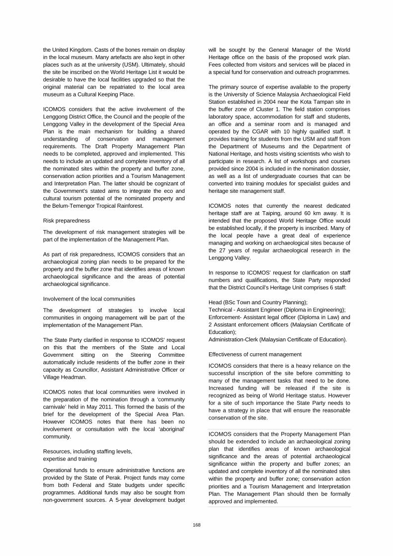
Exposed gravel layer
Artefact from Kota Tampan dated 70,000 BP Bukit Bunuh, hand axe embedded in suevite rock dated to 1.83 m BP
Perak Man found at Gua Gunung Runtuh dated to 10,120 BP
Gua Harimau site