Weathering of the primary rock-forming minerals - Cambridge ...
Upload
uni-heidelbergCategory
view
1download
0
www.elsevier.com/locate/yqres
Quaternary Research 6
Late Quaternary climatic control on erosion and weathering in the eastern
Tibetan Plateau and the Mekong Basin
Zhifei Liua,T, Christophe Colinb, Alain Trentesauxc, Giuseppe Sianib, Norbert Frankd,
Dominique Blamartd, Segueni Faridb
aLaboratory of Marine Geology, Tongji University, Shanghai 200092, ChinabLaboratoire Orsayterre, FRE 2566, BAT. 504, Universite de Paris XI, 91 405 Orsay, FrancecPBDS Laboratory, UMR 8110 CNRS, University of Lille 1, 59 655 Villeneuve d’Ascq, France
dLaboratoire des Sciences du Climat et de l’Environnement, Laboratoire mixte CNRS-CEA, Avenue de la Terrasse, 91 198 Gif-sur-Yvette Cedex, France
Received 23 July 2004
Abstract
High-resolution siliciclastic grain size and bulk mineralogy combined with clay mineralogy, rubidium, strontium, and neodymium isotopes
of Core MD01-2393 collected off the Mekong River estuary in the southwestern South China Sea reveals a monsoon-controlled chemical
weathering and physical erosion history during the last 190,000 yr in the eastern Tibetan Plateau and the Mekong Basin. The ranges of isotopic
composition are limited throughout sedimentary records: 87Sr/86Sr = 0.7206–0.7240 and eNd(0) =�11.1 to�12.1. These values match well to
those of Mekong River sediments and they are considered to reflect this source region. Smectites/(illite + chlorite) and smectites/kaolinite
ratios are used as indices of chemical weathering rates, whereas the bulk kaolinite/quartz ratio is used as an index of physical erosion rates in
the eastern Tibetan Plateau and the Mekong Basin. Furthermore, the 2.5–6.5 Am/15–55 Am siliciclastic grain size population ratio represents
the intensity of sediment discharge of the Mekong River and, in turn, the East Asian summer monsoon intensity. Strengthened chemical
weathering corresponds to increased sediment discharge and weakened physical erosion during interglacial periods. In contrast, weakened
chemical weathering associated with reduced sediment discharge and intensified physical erosion during glacial periods. Such strong glacial–
interglacial correlations between chemical weathering/erosion and sediment discharge imply the monsoon-controlled weathering and erosion.
D 2005 University of Washington. All rights reserved.
Keywords: Erosion; Chemical weathering; Grain size; Clay minerals; Neodymium isotope; Fourier Transform Infra-Red (FTIR) spectroscopy; East Asian
monsoon; Tibetan Plateau; Mekong River; South China Sea
Introduction
Temporal changes in continental erosion and weathering
reflect tectonic uplift (Raymo et al., 1988) and/or climate
changes (Molnar and England, 1990), but the importance of
each effect still remains uncertain. For the million-year scale
since the Miocene, tectonically controlled climate change
was expressed by an evolution of Asian monsoons in phase
with the uplift of the Himalaya and the Tibetan Plateau (An
et al., 2001; Kutzbach et al., 1993).
0033-5894/$ - see front matter D 2005 University of Washington. All rights rese
doi:10.1016/j.yqres.2005.02.005
T Corresponding author. Fax: +86 21 6598 8808.
E-mail address: [email protected] (Z. Liu).
Much of the sediment derived from erosion of the
Himalayas is well preserved, especially in the Arabian Sea
and the Bay of Bengal, providing an opportunity to
examine how clastic sediments record erosion and weath-
ering processes (Curray, 1994; Derry and France-Lanord,
1997). Results from sediments stored in the Bay of Bengal
indicate that the strength of summer monsoon rainfall is an
important factor driving weathering and erosion of the
Himalayas (Bouquillon et al., 1990; Derry and France-
Lanord, 1996). Over the last two glacial/interglacial cycles,
smectite/(illite + chlorite) and kaolinite/quartz ratios
combined with a chemical index of alteration for sediments
from Andaman Sea and Bay of Bengal indicate that the
weathering intensity of the Himalayan and Burman ranges
3 (2005) 316–328
rved.
Z. Liu et al. / Quaternary Research 63 (2005) 316–328 317
is mainly controlled by the summer monsoon rainfall
intensity (Colin et al., 1999, 2001). Therefore, similar
monsoon-controlled weathering and erosion would be
expected to occur over the eastern Tibetan Plateau and
the Mekong Basin, where the relation of erosion and
climate remains poorly understood (Schafer et al., 2002).
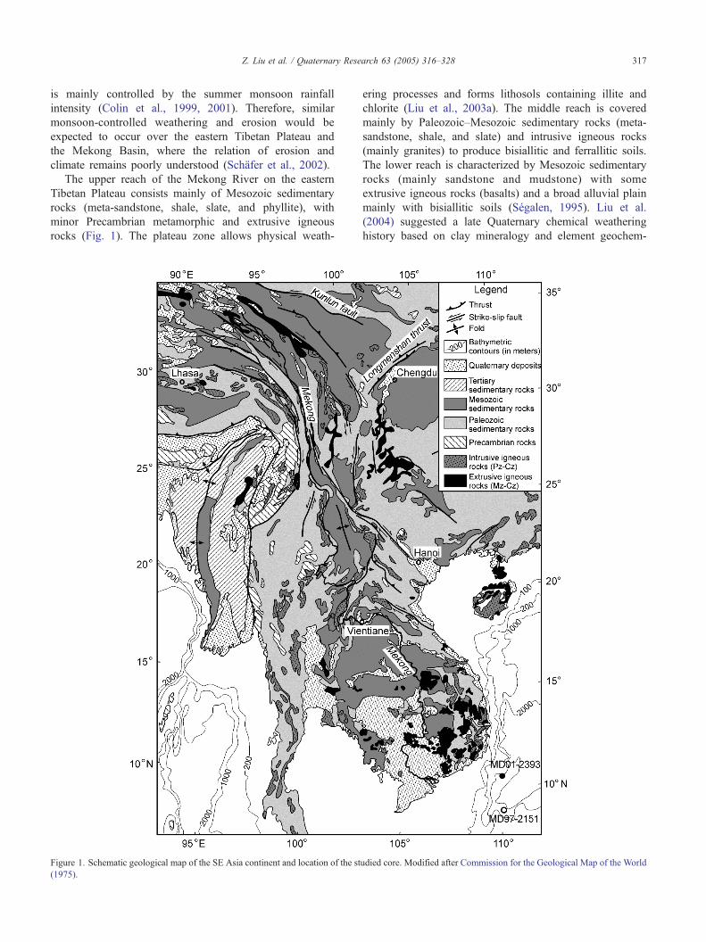
The upper reach of the Mekong River on the eastern
Tibetan Plateau consists mainly of Mesozoic sedimentary
rocks (meta-sandstone, shale, slate, and phyllite), with
minor Precambrian metamorphic and extrusive igneous
rocks (Fig. 1). The plateau zone allows physical weath-
Figure 1. Schematic geological map of the SE Asia continent and location of the st
(1975).
ering processes and forms lithosols containing illite and
chlorite (Liu et al., 2003a). The middle reach is covered
mainly by Paleozoic–Mesozoic sedimentary rocks (meta-
sandstone, shale, and slate) and intrusive igneous rocks
(mainly granites) to produce bisiallitic and ferrallitic soils.
The lower reach is characterized by Mesozoic sedimentary
rocks (mainly sandstone and mudstone) with some
extrusive igneous rocks (basalts) and a broad alluvial plain
mainly with bisiallitic soils (Segalen, 1995). Liu et al.
(2004) suggested a late Quaternary chemical weathering
history based on clay mineralogy and element geochem-
udied core. Modified after Commission for the Geological Map of the World
Z. Liu et al. / Quaternary Research 63 (2005) 316–328318
istry of sediments off the Mekong River mouth in the
southwestern South China Sea. But no physical erosion
and monsoon rainfall information have been revealed from
previous studies for this region.
This paper presents a high-resolution study of siliciclastic
grain size and bulk mineralogy combined with clay
mineralogy, rubidium, strontium, and neodymium isotopes
reported for an International Marine Past Global Change
Study (IMAGES) of Core MD01-2393 located off the
Mekong River in the southwestern South China Sea
(Bassinot and Baltzer, 2002) (Fig. 1). Sediments retrieved
from the core were analyzed in the present study in order to
reconstruct the erosional and weathering history of the
eastern Tibetan Plateau and the Mekong Basin during the late
Quaternary (the last 190,000 yr). No major changes in
tectonic activity occurred during this short time period,
allowing us (i) to establish a relationship between past
changes in the intensity of the East Asian monsoon rainfall
and in the intensity of chemical and physical weathering in
the eastern Tibetan Plateau and the Mekong Basin, and (ii) to
assess the effect of sea-level changes induced by glacial–
interglacial changes on the transport of sediments to the
southern margin of the South China Sea. The results indicate
that strengthened chemical weathering corresponds to
increased sediment discharge and weakened physical erosion
during interglacial periods and that weakened chemical
weathering is associated with reduced sediment discharge
and intensified physical erosion during glacial periods,
implying the monsoon-controlled weathering and erosion.
Materials and methods
Core MD01-2393 (10830.15VN, 110803.68VE, 1230 m
water depth), located on the continental slope 400 km from
the mouth of the Mekong River, was collected during the
Figure 2. Topographic profile based on high-resolution bathymetric contours of th
mouth, the studied core, and the last glacial maximum (LGM) sea level.
IMAGES cruise VII-WEPAMA in 2001 (Bassinot and
Baltzer, 2002) (Figs. 1 and 2). The lithology is homoge-
neous, dominated by olive gray foraminifer-rich or diatom-
bearing nannofossil ooze with terrigenous clay. Binocular
investigation indicates that biogenic silica (e.g., diatom and
radiolarian) comprises around 5–10% in volume of
particles N63 Am. Samples were collected at 10- to 20-cm
intervals for the last 74,000 yr and 20- to 40-cm intervals
for the older part to analyze siliciclastic grain size, bulk,
and clay mineralogy with average temporal resolutions of
300–600 yr for the younger part and a lesser resolution of
1000–2000 yr for the older part. Additionally, 15 samples
were selected for Rb, Sr, and Nd isotopic measurements
according to clay mineralogy variations.
Grain size distribution measurements of carbonate- and
biogenic silica-free sediments were carried out on a Laser
Particle Size Analyzer LS130 at the Orsayterre Laboratory,
University of Paris XI. Bulk sediments were first decarbo-
nated via reaction with 0.2 N HCl, followed by successive
washing with distilled water. Sediments were then treated
with 1 N Na2CO3 solution to remove biogenic silica, which
mainly presents as opal. The reaction was performed in a
water bath at a temperature of 858C for 4 h. The Na2CO3
solution was then neutralized by a series of distilled water
rinsing steps followed by centrifugation. Binocular observa-
tion of selected samples shows that biogenic silica can be
removed completely.
The kaolinite, quartz, and calcite contents of the bulk
fraction were determined by Fourier Transform Infra-Red
(FTIR) spectroscopy (Pichard and Frohlich, 1986) at the IRD
(Bondy, France) following the procedure described by Colin
et al. (1999). Bulk samples were ground in acetone to a
particle size of b2 Am with small agate balls in an agate vial
and kept at 48C to prevent heating and structural changes. The
powder was then mixed with KBr in an agate mortar with a
dilution factor of 0.25%. A 300-mg pellet, 13mm in diameter,
e southwestern South China Sea, indicating locations of the Mekong River

Z. Liu et al. / Quaternary Research 63 (2005) 316–328 319
was pressed into a vacuum die with up to 8� 107 Pa. For each
sample, an infrared spectrum averaging 50 scans in the 4000-
to 250-cm�1 energy range with a 2-cm�1 resolution was
recorded.
Rb, Sr, and Nd isotopic measurements were performed
on the carbonate-free fraction using static multicollection
on a Finnigan MAT-262 at the Laboratoire des Sciences du
Climat et de l’Environement (CEA-CNRS, Gif/Yvette)
following the procedure described by Colin et al. (1999).
Samples were decarbonated and then dissolved in HF–
HClO4 and HNO3–HCl mixtures. Sr and Rb were eluted
with 2 N HCl and the light rare-earth elements with 2.5 N
HNO3. Nd was isolated by reverse-phase chromatography
on HDEHP-coated Teflon powder. 87Sr/86Sr ratios have
been corrected from mass fractionation using normalization
to an 88Sr/86Sr ratio = 0.1194. Similarly, 144Nd/146Nd
ratios have been corrected from mass fractionation using a
normalization to the natural 143Nd/144Nd ratio = 0.7219.
Nd results are expressed as eNd(0) = [((143Nd/144Ndmeas) /
0.512638) � 1] � 1000, using the CHUR value given by
Jacobsen and Wasserburg (1980).
Figure 3. Planktonic foraminifera G. ruber (white) y18O record of Core MD01-239
foraminifera G. ruber (white) y18O record with planktonic foraminifera G. saccu
(Lee et al., 1999) for the last 18,000 yr and with the SPECMAP oxygen isotope str
Tuff (YTT) and the last occurrence (LO) of G. ruber (pink) from Core MD01-23
Chronological framework
The chronology of Core MD01-2393 has been established
by correlating the marine oxygen isotope record for the
planktonic foraminifera Globigerinoides ruber (white) y18Owith Core MD97-2151 (8843.73VN, 109852.17VE, 1550-mwater depth, Fig. 1). The chronology for the latter core is
constrained by twelve AMS 14C dates (Lee et al., 1999) over
the last 18,000 yr (Fig. 3). For the older period, chronology
was established using the SPECMAP oxygen isotope
stratigraphy (Martinson et al., 1987) (Fig. 3). High-resolution
calcium carbonate stratigraphy, the occurrence of the Young-
est Toba Tuff dated at 74,000 F 2000 yr (Ninkovich et al.,
1978), and the last occurrence of G. ruber (pink) dated at
120,000 yr (Thompson et al., 1979) were also used to
constrain the age scale model for Core MD01-2393 (Liu
et al., 2004).
The core provides a continuous sedimentary record
extending to early marine oxygen isotope stage (MIS) 6
(~190,000 yr ago) with a higher average sedimentation rate of
37.1 cm/103 yr for the Holocene, and of ~23 cm/103 yr for
3. The chronology has been established mainly by correlating its planktonic
lifer y18O record of Core MD97-2151 that presents twelve AMS 14C dates
atigraphy (Martinson et al., 1987) before 18,000 yr ago. The Youngest Toba
93 were observed (Liu et al., 2004). MIS: marine oxygen isotope stage.

Z. Liu et al. / Quaternary Research 63 (2005) 316–328320
glacialMIS 3, 4, and 6, and a lower sedimentation rate of 14.0
cm/103 yr for interglacial MIS 5 (Fig. 4).
Results
Siliciclastic grain size
Mean grain size of siliciclast of the core shows large
variations between 6 and 30 Am (Fig. 5). For the last 60,000
yr, the sediment is coarser with an average mean grain size of
13 Am, while between 60,000 and 190,000 yr the sediment is
finer with a mean grain size of 8 Am. Besides, long-term
variations in mean grain size values are characterized by
glacial–interglacial changes with higher values in Holocene
and MIS 2, 3, 4, and 6, and lower values in MIS 5 (Fig. 5).
The classification of grain size variations was suggested
previously on the basis of South China Sea sediments in two
classes: clay (b6.3 Am) and silt (6.3–63 Am), considering that
the clay content was defined as the percentage of the acid-
insoluble grain size fraction smaller than 6.3 Am (Wang et al.,
1999). Here, we prefer to define the most sensitive grain size
class using the method of the highest standard deviation
(Boulay et al., 2003), which provides easy identification of
the grain size intervals. For each 72 grain size classes probed
by the Laser Particle Size Analyzer, standard deviations of
each class grain size were calculated for all samples. Standard
Figure 4. Depth (cm) vs. age (103 yr) diagram showing variations in
sedimentation rates for Core MD01-2393. Average sedimentation rates of
different parts of the core are also given. The tilted triangles presents age-
controlled points, which were obtained from the oxygen isotope strati-
graphy combined with tephrostratigraphy (Liu et al., 2004).
deviation values vs. grain size classes are displayed in Figure
6. Two peaks with larger standard deviations are observed in
the 2.5–6.5 Am and 15–55 Am grain size intervals. Both size
classes represent the populations of grains with the highest
variability through time. On the contrary, other intervals, such
as the intermediate 8–12 Am size class, are characterized by
low standard-deviation values, implying no important change
of the proportion of this grain size population in the
siliciclastic fraction through time. This different behavior is
well expressed by the variations of the 2.5–6.5 Am, 8–12 Am,
and 15–55 Am size class contents through time (Fig. 5). Both
the 2.5–6.5 Am and 15–55 Am grain size populations vary
significantly with glacial–interglacial changes. No significant
variation can be observed in the 8–12 Am grain size
population, and long-term fluctuations of the 2.5–6.5 Amsize class distribution are inversely correlated to those of the
15–55 Am size class. Interglacial stages are characterized by
high proportions (32–35%) of the 2.5–6.5 Am and low
proportions (5–12%) of 15–55 Am size intervals, while
glacial stages present low proportions (15–25%) of the 2.5–
6.5 Am and high proportions (17–35%) of 15–55 Am size
intervals (Fig. 5).
Bulk and clay mineralogy
Kaolinite, quartz, and calcite contents of bulk samples
were determined using FTIR spectroscopy for the core. As
dolomite and aragonite are absent in our FTIR results,
kaolinite and quartz proportions were corrected from
carbonate dilution using the following relationship:
% Mineral cor:bulk
¼ % Mineral mesbulk= 100�% CaCO3mesbulkð Þ � 100
Carbonate contents vary between 5% and 22%, with
higher values during interglacial periods. Bulk kaolinite
proportions are 6–18% in detrital minerals and vary
generally with climate changes (Fig. 7). MIS 4, late MIS
5, and early MIS 6 are characterized by lower values than
MIS 1, 2, 3, early MIS 5, and late MIS 6. Bulk quartz
contents vary between 11% and 24%, with an average of
16%. Except for MIS 4, when values of quartz contents
were higher, their variations do not follow the glacial–
interglacial fluctuations (Fig. 7). This relationship between
glacial–interglacial changes and bulk kaolinite and quartz
content variations is also observed in results obtained by
Liu et al. (2004) in the b2-Am size fraction. Smectites (22–
58%) and illite (21–40%) are the dominant clay minerals in
the b2-Am size fraction; kaolinite (11–25%) and chlorite
(10–25%) are less abundant (Fig. 7). Globally, illite,
chlorite, and kaolinite distributions are similar and inver-
sely correlate to the smectite distribution. Kaolinite content
in the clay fraction presents a general trend similar to those
obtained by IRTF on the bulk sample, suggesting their
same sedimentary source. Glacial MIS 2, 3, 4, and 6 are
characterized by higher contents of illite, chlorite, and
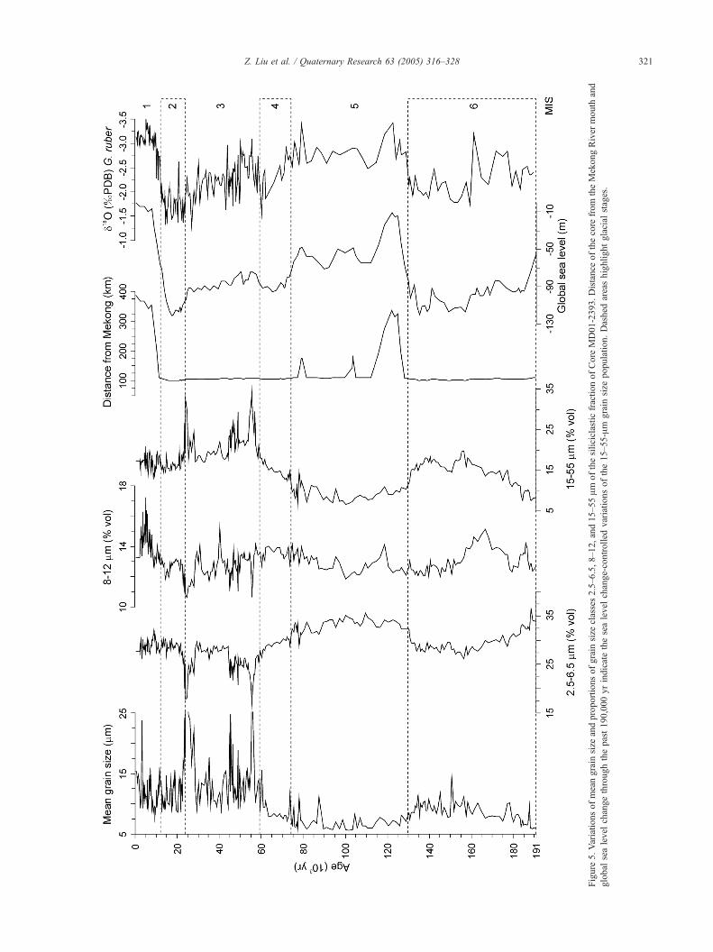
Figure
5.Variationsofmeangrain
size
andproportionsofgrain
size
classes2.5–6.5,8–12,and15–55Am
ofthesiliciclasticfractionofCore
MD01-2393.Distance
ofthecore
from
theMekongRiver
mouth
and
global
sealevel
changethroughthepast190,000yrindicatethesealevel
change-controlled
variationsofthe15–55-Am
grain
size
population.Dashed
areashighlightglacial
stages.
Z. Liu et al. / Quaternary Research 63 (2005) 316–328 321

Figure 6. Standard deviation values vs. grain size class diagram of Core MD01-2393. Gray squares indicate classes taking into account the limited three
populations: 2.5–6.5, 8–12, and 15–55 Am.
Z. Liu et al. / Quaternary Research 63 (2005) 316–328322
kaolinite, and by lower contents of smectites than
interglacial MIS 1 and 5.
Rb, Sr, and Nd isotopic results
Rb, Sr, and Nd concentrations and isotopic ratios
measured on carbonate-free fraction are listed in Table 1.
The Sr and Nd concentrations vary between 96–110 ppm
and 28.9–33.6 ppm, respectively.
The 87Sr/86Sr ratio presents a narrow range between
0.7206 and 0.7240 and the eNd(0) between �11.1 and �12.1(Fig. 7). These values are consistent with the previously
published South China Sea data (Wei et al., 2000) and do not
present any significant changes with the glacial/interglacial
oscillations, suggesting no significant changes in the
sedimentary source during the last 140,000 yr.
Discussion
Sediment sources
Considering the clay mineral assemblage of Core MD01-
2393 and mineralogical components of soils in the Mekong
Basin, Liu et al. (2004) suggested that the Mekong River
basin could be the major detrital source for the core.
However, other sources are possible, such as eolian dust,
the Sunda shelf, the Indonesian Islands, and the Red River.
We will now examine each of these sources.87Sr/86Sr vs. Rb/Sr and eNd(0) vs.
87Sr/86Sr measured at
the core sediments are presented in Figures 8a and b with a
compilation of previously published data from potential
sedimentary sources: the Mekong River, the Red River, the
Pearl River (J. Gaillardet, personal communication, 2003),
the Java-Sumatra volcanic arcs (Whitford, 1975), and
Chinese Loess deposits (Jahn et al., 2001). 87Sr/86Sr ratios
and eNd(0) values of Core MD01-2393 sediments (Fig. 8) are
similar from one Mekong River sample (87Sr/86Sr = 0.72354;
eNd(0) = �11.2) (J. Gaillardet, personal communication,
2003), confirming that the Mekong River is the major source
of sediments to the margin close to the Mekong River mouth.
Chinese loess isotopic compositions are different from
those of the core sediments (Fig. 8), suggesting a limited
contribution of eolian input to the core. During the Plio-
Pleistocene, the eolian contribution was reported as 15–30%
of the total sediment accumulation for the northern South
China Sea (Wang et al., 1999; Wehausen and Brumsack,
2002). In contrast, the southern South China Sea seems to be
dominated strongly by fluvial input (Tamburini et al., 2003).
An estimated aerosol flux (at maximum, accounting for 12%
of the total sediment accumulation) and carbonate-free TiO2/
Al2O3 contents during the Pliocene defined at ODP Site 1143
in the southern South China Sea suggest a minor eolian
contribution to the terrigenous accumulation (Wehausen et
al., 2003). For Core MD01-2393, considering an average
sedimentation rate of 40.7 cm/103 yr, carbonate content of
16%, and an average dry density of 0.592 g/cm3 (reported
from similar carbonate content sediments of ODP Site 1143
in the southern South China Sea; Shipboard Scientific Party,
2000), Liu et al. (2004) estimated the maximum eolian
sediment flux may only account for about 2.5% of the total
terrigenous accumulation, in agreement with a negligible
eolian contribution for the core.
The Sunda shelf and the Indonesian Islands produce
sediments with not only high concentration of smectites
(25–40%), but also high concentration of kaolinite (30–
40%) (Gingele et al., 2001). These minerals could feed the
South China Sea through the Borneo Strait following

Figure7.Bulk
quartzandkaolinitecontents(correctedfrom
carbonatedilution),clay
mineralproportions(%
)ontheb2-Am
size
fraction(Liu
etal.,2004),
87Sr/86Srratio,and
e Nd(0)values
vs.age(103yr)forCore
MD01-2393.
Z. Liu et al. / Quaternary Research 63 (2005) 316–328 323

Table 1
Rb, Sr, and Nd isotope data of Core MD01-2393
Depth (cm) Agea (103 yr) MISb Sr (ppm) Rb (ppm) Nd (ppm) Rb/Sr 87Sr/86Sr 143Nd/144Nd eNd(0)
30 0.75 1 98.8 187.1 32.8 1.89 0.72202 0.512051 �11.5110 2.71 1 107.0 176.5 31.7 1.65 0.72065 0.512049 �11.5270 6.65 1 105.4 190.9 32.3 1.81 0.72087 0.512068 �11.1390 9.59 1 103.6 202.2 33.6 1.95 0.72170 0.512039 �11.7570 14.26 2 105.1 159.7 32.4 1.52 0.72258 0.512055 �11.4870 23.17 2 105.1 180.3 31.3 1.72 0.72221 0.512049 �11.51180 44.16 3 102.1 223.9 31.7 2.19 0.72224 0.512054 �11.41620 60.93 4 96.5 258.8 33.1 2.68 0.72403 0.512049 �11.51910 73.03 4 108.9 239.8 32.2 2.20 0.72268 0.512050 �11.52120 76.91 5 106.1 216.9 30.6 2.05 0.72310 0.512037 �11.72300 85.10 5 109.9 238.4 31.3 2.17 0.72268 0.512018 �12.12460 95.58 5 106.2 191.7 28.9 1.81 0.72295 0.512028 �11.92860 127.57 5 100.3 193.4 31.5 1.93 0.72264 0.512054 �11.43070 135.90 6 104.2 186.0 31.9 1.78 0.72207 0.512070 �11.13370 146.96 6 103.5 206.4 32.4 1.99 0.72272 0.512043 �11.6a The age uncertainty is estimated as F90 14C yr over the last 18,000 yr (Lee et al., 1999) and F5000 yr before 18,000 yr (Martinson et al., 1987).b MIS: marine oxygen isotope stage.
Z. Liu et al. / Quaternary Research 63 (2005) 316–328324
northeasterly sea surface currents, which are driven by the
East Asian summer monsoon. However, in Core MD01-
2393, the increase in smectite is not associated with lower Sr
radiogenic ratios (Fig. 7) and there is no suggestion of
mixing of the Mekong River sediments with a potential end-
member such as volcanic rocks from Java and Sumatra
(Whitford, 1975) (Fig. 8). This implies that smectite could
not be derived from weathering of volcanic rocks from the
Indonesian Islands.
This leads us to conclude that the terrigenous source for
Core MD01-2393 is the Mekong River. We, therefore, can
constrain the origin of the different clay minerals:
(1) Illite and chlorite derived mainly from the eastern
Tibetan Plateau, where physical erosion of metamor-
phic and granitic parent rocks is dominant. Both illite
and chlorite may derive either from the degradation
of micas of metamorphic and igneous formations or
from the erosion of sedimentary rocks. Consequently,
illite and chlorite can be considered as mainly
primary minerals, deriving from physical erosion or
moderate chemical weathering and glacial scour such
as those mainly present in the highland of the
Mekong Basin.
(2) Smectite could be produced by chemical weathering
of parent aluminosilicate and ferromagnesian silicates
under warm and humid conditions in the middle to
lower reaches of the Mekong River, where bisiallitic
soils are well developed. But the weathering of
extrusive basalt of the lower part of the Mekong
Basin (Fig. 1) has a potential significant contribution
of smectite to the core sedimentation. Because87Sr/86Sr ratios and eNd(0) values do not show any
relationship with the smectite content variability and
there is a low volume of such volcanic rocks in the
huge Mekong Basin, we exclude smectite derived
from weathering of volcanic material.
(3) Generally, in tropical conditions, kaolinite is mainly
considered to be derived from ferrallitic soils which
are well developed in a plain environment where
hydrolysis processes are very active. In Core MD01-
2393, bulk and clay fraction (b2 Am) kaolinite
contents indicate a similar pattern to those of illite
and chlorite with higher content during glacial
periods (Fig. 7), suggesting that most of the kaolinite
could also derive from active erosion of inherited
clays from reworked sediments in the middle reach of
the Mekong River.
Significance of grain size and mineralogical changes
The siliciclastic grain size measurement (Fig. 5) displays
a definite correlation between the variation of the 15–55 Amsize fraction and the mean grain size curves, indicating that
the silt population, 15–55 Am, is the main factor controlling
mean grain size variations for this period. These fluctuations
are generally reversely correlated with the distance from the
Mekong River and global sea-level change, as is also visible
from Figure 5.
The scanning electron microscopy (SEM) investigation
on the silt population 15–55 Am size fraction from selected
samples reveals that detrital minerals mainly include quartz,
mica, and rock fragments with minor feldspar in different
sizes and shapes. Generally, quartz is angular with irregular
recesses on its surface; feldspar is also angular but with flat
and cleaved surface; mica is always rounded and sheet-
shaped. All those characteristics suggest a fluvial origin for
the silt fraction. When sea level dropped during glacial
periods, the position of Core MD01-2393 was closer to the
paleo-Mekong River mouth (Fig. 5) and thus could easily be
reached by more silt-size sediments mainly from the
exposed continental shelf (Fig. 2). The more silt-sized
sediments could also reflect a reworking of the coarse
detrital material deposited on the continental shelf during

Figure
8.87Sr/86Srvs.Rb/Sr(a)and
87Sr/86Srvs.
e Nd(0)(b)diagramsindicatingtheisotopicdistributionofboth
interglacialandglacialsamplesfrom
Core
MD01-2393.DataoftheRed
River,thePearlRiver,the
MekongRiver
(J.Gaillardet,personal
communication,2003),theChineseLoess(Jahnet
al.,2001),andvolcanic
rocksofJavaandSumatra
(Whitford,1975)arepresentedforcomparison.
Z. Liu et al. / Quaternary Research 63 (2005) 316–328 325

Z. Liu et al. / Quaternary Research 63 (2005) 316–328326
periods of low sea level. Therefore, the proportion of the silt
fraction could be controlled mainly by the sea-level change.
We find that the mean grain size distribution during
interglacial Holocene is similar to those for MIS 2–3 and
is different from MIS 5 (Fig. 5). Its silt fraction, however, is
much closer to the interglacial MIS 5. This could imply that
other grain size distributions (e.g., 8–12 Am) could
contribute the coarser size during Holocene, and the
fundamental change may need further investigation.
On the other hand, the grain size in the clay population
(2.5–6.5 Am) has an inverse distribution compared to that of
the silt population (Fig. 5). According to various studies on
similar sediments (Liu et al., 2003b; Wehausen and
Brumsack, 2002), clay minerals are preferably transported
by rivers into the South China Sea. The 2.5–6.5-Am grain
size population could represent the intensity of the sediment
discharge of the Mekong River.
Therefore, we adopt the grain size ratio of 2.5–6.5 Am/
15–55 Am to represent the sediment discharge of the
Mekong River. The Mekong’s discharge is derived mainly
from the East Asian summer monsoon rainfall between
May and October and partly from the summer snowmelt in
the eastern Tibetan Plateau (Gupta et al., 2002). This ratio
indicates a higher sediment discharge during MIS 5 and, in
turn, a stronger summer monsoon rainfall for that period
Figure 9. Comparison of grain size population (2.5–6.5 Am)/(15–55 Am), bulk ka
kaolinite ratios with planktonic foraminifera G. ruber (white) y18O record of Cor
with lower discharge levels during MIS 1, 2, 3, 4, and 6
(Fig. 9).
Kaolinite seems to be derived mainly from active erosion
of inherited clays from reworked sediments in the middle part
of the Mekong Basin. The reworked kaolinitic paleoweather-
ing materials in the landscapes may seriously alter the
paleoclimatic signal of kaolinite in the sedimentary record
(Thiry, 2000). Therefore, the kaolinite contents reflect the
erosion level that occurred in the Mekong Basin, instead of
reflecting contemporary climates. Quartz is a common
mineral present in sedimentary and igneous rocks in the
Mekong Basin and also on continental shelves. Therefore, the
values of quartz contents do not follow the glacial–
interglacial fluctuations (Fig. 7). Thus, the quartz-normalized
bulk kaolinite, i.e., the bulk kaolinite/quartz ratio, is used to
indicate the intensity of physical erosion that occurred in the
eastern Tibetan Plateau and the Mekong Basin to avoid the
dilution of individual component. The result suggests that the
physical erosion was strong during late MIS 6 and early MIS
5 (115,000–135,000 yr ago) and MIS 1, 2, and late MIS 3 (0–
45,000 yr ago) (Fig. 9). The physical erosion suggests a
stepwise strengthening during MIS 6 and MIS 1, 2, and 3,
respectively, with a negative correlation to the sediment
discharge indicator of the 2.5–6.5 Am/15–55 Am grain size
ratio (Fig. 9).
olinite/quartz, clay-size fraction smectites/(illite + chlorite), and smectites/
e MD01-2393.

Z. Liu et al. / Quaternary Research 63 (2005) 316–328 327
Besides kaolinite in clay minerals, illite and chlorite
were derived mainly from the eastern Tibetan Plateau,
where physical erosion of metamorphic and granite parent
rocks was dominant, and they are also representative of the
physical erosion ability. However, smectites originated
mainly through chemical weathering of parent aluminosi-
licate and ferromagnesian silicate under warm and humid
conditions that are dominant in the middle to lower reach
of the Mekong River. Therefore, we adopt ratios of
smectites/(illite + chlorite) and smectites/kaolinite as clay
mineralogical indicators to reconstruct history of the
chemical weathering vs. physical erosion as it occurred
in the eastern Tibetan Plateau and the Mekong Basin (Liu
et al., 2004). In the core, variations in smectites/(illite +
chlorite) and smectites/kaolinite ratios show similar varia-
tions during the last 70,000 yr (Fig. 9). The relatively
higher ratios, observed during interglacial periods through-
out the past 190,000 yr, suggest a strengthened chemical
weathering and weak physical erosion; by contrast, the
lower ratios corresponding to glacial periods indicate
intensified physical erosion and weakened chemical weath-
ering (Fig. 9).
Along with the chemical weathering history obtained by
Liu et al. (2004), our results indicate that the sediment
discharge (revealed by the 2.5–6.5 Am/15–55 Am grain size
ratio) is well correlated with the chemical weathering
(revealed by the smectites/(illite + chlorite) and smectites/
kaolinite ratios) during the late Quaternary (the last
190,000 yr), with the exception of the Holocene (Fig. 9).
This demonstrates that enhanced summer monsoon precip-
itation, i.e., increased chemical weathering and runoff, causes
the increase in the sediment discharge. Similarly, variations
in the physical erosion (revealed by the bulk kaolinite/quartz
ratio) have an inverse correlation with those of the chemical
weathering, with the exceptions of the Holocene (Fig. 9).
This would then imply intensified physical erosion coincides
with to weaker summer monsoon rainfall. Our results provide
strong evidence of monsoon-controlled erosion and weath-
ering processes in the eastern Tibetan Plateau and the
Mekong Basin over the past 190,000 yr.
However, the Holocene is an exception for some proxies
of erosion and weathering processes (Fig. 9). The clay
mineral assemblages indicate the same pattern of illite and
chlorite variations but an inverse behavior of smectites and
kaolinite fluctuations (Figs. 7 and 9). These could be the
effect of differential settling of smectites, which could be
transported more easily over a greater distance from the
Mekong River mouth. The relative increase in smectites
will result in the relative decrease in kaolinite. It is the
same reason for the increase in bulk kaolinite during the
Holocene for the core (Fig. 7). Additionally, the fine silt
proportion 8–12 Am size fraction increased abruptly in the
middle of Holocene (Fig. 5). This could be relative to the
fast drop of local sea level, which started to decrease
around 5000 yr ago (Ta et al., 2002). Both differential
settling of clay minerals and local sea level changes may
contribute inverse behaviors for our proxies of monsoon-
controlled erosion and weathering history and need to be
examined further.
Summary and conclusions
High-resolution siliciclastic grain size and bulk miner-
alogy combined with clay mineralogy, rubidium, strontium,
and neodymium isotopes of Core MD01-2393 were
analyzed to establish a relationship between past changes
in erosion and chemical weathering with East Asian
monsoon rainfall during the late Quaternary (the last
190,000 yr) in the eastern Tibetan Plateau and the Mekong
Basin.
(1) Source analysis indicates that the Mekong River has
provided most of the siliciclastic materials found in
the core, appearing to be ideally suited for the study
of the interaction of climate change with erosion and
weathering processes. The silt fractions of siliciclasts
were derived mainly from the exposed continental
shelf during the glacial low sea-level stands.
(2) Smectites/(illite + chlorite) and smectites/kaolinite
ratios reveal a history of chemical weathering rates
relative to physical weathering rates, whereas bulk
kaolinite/quartz ratio reflects the physical erosion
history. Furthermore, siliciclastic 2.5–6.5 Am/15–55
Am grain size ratio suggests the intensity of sediment
discharge of the Mekong River and, in turn, the East
Asian summer monsoon intensity.
(3) Strengthened chemical weathering corresponds to
increased sediment discharge and weakened physical
erosion during interglacial periods. In contrast, weak-
ened chemical weathering associated with reduced
sediment discharge and intensified physical erosion
during glacial periods. Such strong correlations
between chemical weathering and sediment discharge
imply the monsoon-controlled weathering and erosion
occurred in the eastern Tibetan Plateau and theMekong
Basin.
Acknowledgments
This research used samples provided by the International
Marine Past Global Change Study (IMAGES) program. We
thank Richard J. Stewart, Alan Gillespie, and one anonymous
reviewer for their constructive reviews, which significantly
helped to improve this work. This study was supported by the
Ministere de la Recherche of France, the National Natural
Science Foundation of China (40102010, 40446003,
40331002, and 40321603), the National Key Basic Research
Special Foundation Project of China (G2000078500), the
Shanghai Rising-Star Program (03QE14051), and the Excel-
lent Young Teachers Program and the Program for New

Z. Liu et al. / Quaternary Research 63 (2005) 316–328328
Century Excellent Talents in University of the Ministry of
Education of China.
References
An, Z., Kutzbach, J.E., Prell, W.L., Porter, S.C., 2001. Evolution of Asian
monsoons and phased uplift of the Himalaya-Tibetan plateau since Late
Miocene times. Nature 411, 62–66.
Bassinot, F., Baltzer, A., 2002. Les Rapports des Campagnes a la Mer
WEPAMA Cruise MD 122/IMAGES VII on Board RV bMarion
DufresneQ (2001). Institut Polaire Francais-Paul Emile Victor (IPEV),
Plouzane, (p. 453).
Boulay, S., Colin, C., Trentesaux, A., Pluquet, F., Bertaux, J., Blamart, D.,
Buehring, C., Wang, P., 2003. Mineralogy and sedimentology of
Pleistocene sediment in the South China Sea (ODP Site 1144) In: Prell,
W.L., Wang, P., Blum, P., Rea, D.K., Clemens, S.C. (Eds.), Proceedings
of Ocean Drilling Program Scientific Results, vol. 184. pp. 1–21.
(Online). Available:http://www-odp.tamu.edu/publications/184_SR/
(Cited 30-04-2003).
Bouquillon, A., France-Lanord, C., Michard, A., Tiercelin, J.J., 1990.
Sedimentology and isotopic chemistry of the Bengal Fan sediments: the
denudation of the Himalaya. In: Cochran, J.R., Curray, J.R., Sager,
W.W., Stow, D.A.V. (Eds.), Proceedings of Ocean Drilling Program
Scientific Results vol. 116. pp. 43–58.
Colin, C., Turpin, L., Bertaux, J., Desprairies, A., Kissel, C., 1999.
Erosional history of the Himalayan and Burman ranges during the last
two glacial–interglacial cycles. Earth and Planetary Science Letters 171,
647–660.
Colin, C., Bertaux, J., Turpin, L., Kissel, C., 2001. Dynamique de l’erosion
dans le bassin versant de l’Irrawaddy au cours des deux derniers cycles
climatiques (280–0 ka). Comptes Rendus de l’Academie des Sciences
Paris 332, 483–489.
Commission for the Geological Map of the World, 1975. Geological World
Atlas, scale 1:10,000,000, UNESCO, Paris.
Curray, J.R., 1994. Sediment volume and mass beneath the Bay of Bengal.
Earth and Planetary Science Letters 125, 371–383.
Derry, L.A., France-Lanord, C., 1996. Neogene Himalayan weathering
history and river 87Sr/86Sr: impact on the marine Sr record. Earth and
Planetary Science Letters 142, 59–74.
Derry, L.A., France-Lanord, C., 1997. Himalayan weathering and erosion
fluxes: climate and tectonic controls. In: Ruddiman, W.F. (Ed.), Tectonic
Uplift and Climate Change. Plenum Press, New York, pp. 289–312.
Gingele, F.X., Deckker, P.D., Hillenbrand, C.-D., 2001. Clay mineral
distribution in surface sediments between Indonesia and NW Aus-
tralia—Source and transport by ocean currents. Marine Geology 179,
135–146.
Gupta, A., Hock, L., Huang, X., Chen, P., 2002. Evaluation of part of the
Mekong River using satellite imagery. Geomorphology 44, 221–239.
Jacobsen, S.B., Wasserburg, G.J., 1980. Sm–Nd isotopic evolution of
chondrites. Earth and Planetary Science Letters 50, 139–155.
Jahn, B.-m., Gallet, S., Han, J., 2001. Geochemistry of the Xining, Xifeng
and Jixian sections, Loess Plateau of China: eolian dust provenance
and paleosol evolution during the last 140 ka. Chemical Geology 178,
71–94.
Kutzbach, J.E., Prell, W.L., Ruddiman, W.F., 1993. Sensitivity of Eurasian
climate to surface uplift of the Tibetan Plateau. Journal of Geology 101,
177–190.
Lee, M.-Y., Wei, K.-Y., Chen, Y.-G., 1999. High resolution oxygen isotope
stratigraphy for the last 150,000 years in the southern South China Sea:
core MD972151. Tao 10, 239–254.
Liu, Z., Trentesaux, A., Clemens, S.C., Colin, C., Wang, P., Huang, B.,
Boulay, S., 2003a. Clay mineral assemblages in the northern South
China Sea: implications for East Asian monsoon evolution over the past
2 million years. Marine Geology 201, 133–146.
Liu, Z., Wang, C., Trentesaux, A., Zhao, X., Yi, H., Hu, X., Jin, W., 2003b.
Paleoclimate changes during early Oligocene in the Hoh Xil region,
northern Tibetan Plateau. Acta Geologica Sinica 77, 504–513.
Liu, Z., Colin, C., Trentesaux, A., Blamart, D., Bassinot, F., Siani, G., Sicre,
M.-A., 2004. Erosional history of the eastern Tibetan Plateau over the
past 190 kyr: clay mineralogical and geochemical investigations from
the southwestern South China Sea. Marine Geology 209, 1–18.
Martinson, D.G., Pisias, N.G., Hays, J.D., Imbrie, J., Moore, T.C.,
Shackleton, N.J., 1987. Age dating and the orbital theory of the ice
ages: development of a high-resolution 0 to 3000,000-year chronostra-
tigraphy. Quaternary Research 27, 1–29.
Molnar, P., England, P., 1990. Late Cenozoic uplift of mountain ranges and
global climate change: chicken or egg? Nature 346, 29–34.
Ninkovich, D., Shackleton, N.J., Abdel-Monem, A.A., Obradovich, J.D.,
Izett, G., 1978. K–Ar age of the late Pleistocene eruption of Toba, north
Sumatra. Nature 276, 574–577.
Pichard, C., Frfhlich, F., 1986. Analyses IR quantitatives des sediments:
exemple du dosage du quartz et de la calcite. Revue de l’Institut
Francais du Petrole 41, 809–819.
Raymo, M., Ruddiman, W.F., Froehlich, P.N., 1988. Influence of late
Cenozoic mountain building on ocean geochemical cycles. Geology 16,
649–653.
Schafer, J.M., Tschudi, S., Zhao, Z., Wu, X., Ivy-Ochs, S., Wieler, R., Baur,
H., Kubik, P.W., Schlqchter, C., 2002. The limited influence of
glaciations in Tibet on global climate over the past 170 000 yr. Earth
and Planetary Science Letters 194, 287–297.
Segalen, P. 1995. Les Sols Ferrallitiques Et Leur Repartition Geographique,
Tome 3, editions De l’Orstom, Collection des Etudes et Theses, Paris,
201.
Shipboard Scientific Party, 2000. Leg 184 summary: exploring the Asian
monsoon through drilling in the South China Sea. In: Wang, P., Prell,
W.L., Blum, P. (Eds.), Proceedings of Initial Reports, vol. 184. Ocean
Drilling Program, College Station, TX, pp. 1–77.
Ta, T.K.O., Nguyen, V.L., Tateishi, M., Kobayashi, I., Tanabe, S., Saito, Y.,
2002. Holocene delta evolution and sediment discharge of the Mekong
River, southern Vietnam. Quaternary Science Reviews 21, 1807–1819.
Tamburini, F., Adatte, T., Ffllmi, K., Bernasconi, S.M., Steinmann, P.,
2003. Investigating the history of East Asian monsoon and climate
during the last glacial interglacial period (0–140,000 years): mineralogy
and geochemistry of ODP sites 1143 and 1144, South China Sea.
Marine Geology 201, 147–168.
Thiry, M., 2000. Palaeoclimatic interpretation of clay minerals in marine
deposits: an outlook from the continental origin. Earth-Science Reviews
49, 201–221.
Thompson, P.R., Be, A.W.H., Duplessy, J.C., Shackleton, N.J., 1979.
Disappearance of pink-pigmented Globigerinoides ruber at 120,000 yr
B.P. in the Indian and Pacific Oceans. Nature 280, 554–558.
Wang, L., Sarnthein, M., Erlenkeuser, H., Grimalt, J., Grootes, P., Heilig,
S., Ivanova, E., Kienast, M., Pelejero, C., Pflaumann, U., 1999. East
Asian monsoon climate during the Late Pleistocene: high-resolution
sediment records from the South China Sea. Marine Geology 156,
245–284.
Wehausen,R., Brumsack,H.-J., 2002.Astronomical forcing of the East Asian
monsoon mirrored by the composition of Pliocene South China Sea
sediments. Earth and Planetary Science Letters 201, 621–636.
Wehausen, R., Tian, J., Brumsack, H.-J., Cheng, X., Wang, P., 2003.
Geochemistry of Pliocene sediments from ODP Site 1143 (southern
South China Sea). In: Prell, W.L., Wang, P., Blum, P., Rea, D.K.,
Clemens, S.C. (Eds.), Proceedings of Ocean Drilling Program
Scientific Results vol. 184. pp. 1–21. (Online). Available: http://
www-odp.tamu.edu/publications/184_SR/ (Cited 30-04-2003).
Wei, G., Gui, X., Li, X., Chen, Y., Yu, J., 2000. Strontium and neodymium
isotopic compositions of detrital sediment of NS90-103 from South
China Sea: variations and their paleoclimate implication. Science in
China, Series D 43, 596–604.
Whitford, D.J., 1975. Strontium isotopic studies of the volcanic rocks of the
Saunda arc, Indonesia, and their petrogenetic implications. Geochimica
et Cosmochimica Acta 39, 1287–1302.
Copyright © 2022 FDOKUMEN