Late Pleistocene–Holocene hydrologic changes in the interfluve areas of the central Ganga Plain,...
14
Late Pleistocene–Holocene hydrologic changes in the interfluve areas of the central Ganga Plain, India Pradeep Srivastava a,1 , Indra Bir Singh b , Shikha Sharma b , Uma Kant Shukla c , Ashok Kumar Singhvi a, * a Planetary and Geoscience Division, Physical Research Laboratory, Navrangpura, Ahmedabad-380 009, India b Department of Geology, Lucknow University, Lucknow-226007, India c Department of Geology, Kumaun University, Nainital-263 002, India Received 11 October 2000; received in revised form 4 November 2002; accepted 5 December 2002 Abstract Abandoned channel belts, ponds and point bar deposits of palaeochannels in the interfluve regions of the central Ganga Plain suggest changes in the morphohydrologic conditions during the Latest Pleistocene – Holocene. Stratigraphy of these ponds comprises channel sand at the base overlain by shell-bearing clayey silt. The contact of the two facies marks the phase when channels converted into standing water bodies. Point bar deposits of some palaeochannels are overlain by oxidised aeolian sand, indicating that the channel abandonment possibly occurred due to the desiccation and aridity in the region. Optically stimulated luminescence (OSL) chronometry of the pond sediments suggests that the deposition of the basal channel sand started before 13 ka and continued up to f 8 ka. The ponds formed around 8 – 6 ka when the channel activity ceased. Evidence from the point bar deposits also indicates that the fluvial activity in the region ended sometime during 7 – 5 ka. This was followed by aeolian aggradation. The present study thus suggests that the hydrologic conditions in the Gangetic plains, i.e. initiation of channels and their abandonment, formation of microgeomorphologic features such as ponds and their eventual siltation, were controlled largely by climatic changes (i.e. monsoon changes) supported by tectonic activity. For the past 2 ka, increasing human and related agricultural activity has substantially accentuated the natural siltation rate of ponds. D 2003 Elsevier Science B.V. All rights reserved. Keywords: Ganga Plain; Interfluve; Ponds; Alluvial ridges; Luminescence dating; Holocene climate change 1. Introduction Abandoned channel belts, ponds and palaeo point bar deposits have been useful in palaeohydrologic reconstructions. Palaeo river changes in response to climate changes have been investigated in detail in South East Asia, Australia, Africa and South America (Bishop and Godley, 1984; Rotnicki, 1991; Thomas, 2000). However, in the Indian context, such studies have been minimal. The Ganga Plain in northern India is a major component of the Himalayan foreland basin and is one of the largest, fluvially controlled depositional systems of the world. This region has three distinc- 0169-555X/03/$ - see front matter D 2003 Elsevier Science B.V. All rights reserved. doi:10.1016/S0169-555X(02)00361-6 * Corresponding author. Tel.: +91-79-6302129x4366; fax: +91- 79-6301502. E-mail address: [email protected] (A.K. Singhvi). 1 Present address: Department of Geography, University of Georgia, Athens, GA 30602, USA. www.elsevier.com/locate/geomorph Geomorphology 54 (2003) 279 – 292
-
Upload
independent -
Category
Documents
-
view
4 -
download
0
Transcript of Late Pleistocene–Holocene hydrologic changes in the interfluve areas of the central Ganga Plain,...
Late Pleistocene–Holocene hydrologic changes in the interfluve
areas of the central Ganga Plain, India
Pradeep Srivastavaa,1, Indra Bir Singhb, Shikha Sharmab, Uma Kant Shuklac,Ashok Kumar Singhvia,*
aPlanetary and Geoscience Division, Physical Research Laboratory, Navrangpura, Ahmedabad-380 009, IndiabDepartment of Geology, Lucknow University, Lucknow-226007, IndiacDepartment of Geology, Kumaun University, Nainital-263 002, India
Received 11 October 2000; received in revised form 4 November 2002; accepted 5 December 2002
Abstract
Abandoned channel belts, ponds and point bar deposits of palaeochannels in the interfluve regions of the central Ganga Plain
suggest changes in the morphohydrologic conditions during the Latest Pleistocene–Holocene. Stratigraphy of these ponds
comprises channel sand at the base overlain by shell-bearing clayey silt. The contact of the two facies marks the phase when
channels converted into standing water bodies. Point bar deposits of some palaeochannels are overlain by oxidised aeolian sand,
indicating that the channel abandonment possibly occurred due to the desiccation and aridity in the region.
Optically stimulated luminescence (OSL) chronometry of the pond sediments suggests that the deposition of the basal
channel sand started before 13 ka and continued up to f 8 ka. The ponds formed around 8–6 ka when the channel activity
ceased. Evidence from the point bar deposits also indicates that the fluvial activity in the region ended sometime during 7–5 ka.
This was followed by aeolian aggradation. The present study thus suggests that the hydrologic conditions in the Gangetic plains,
i.e. initiation of channels and their abandonment, formation of microgeomorphologic features such as ponds and their eventual
siltation, were controlled largely by climatic changes (i.e. monsoon changes) supported by tectonic activity. For the past 2 ka,
increasing human and related agricultural activity has substantially accentuated the natural siltation rate of ponds.
D 2003 Elsevier Science B.V. All rights reserved.
Keywords: Ganga Plain; Interfluve; Ponds; Alluvial ridges; Luminescence dating; Holocene climate change
1. Introduction
Abandoned channel belts, ponds and palaeo point
bar deposits have been useful in palaeohydrologic
reconstructions. Palaeo river changes in response to
climate changes have been investigated in detail in
South East Asia, Australia, Africa and South America
(Bishop and Godley, 1984; Rotnicki, 1991; Thomas,
2000). However, in the Indian context, such studies
have been minimal.
The Ganga Plain in northern India is a major
component of the Himalayan foreland basin and is
one of the largest, fluvially controlled depositional
systems of the world. This region has three distinc-
0169-555X/03/$ - see front matter D 2003 Elsevier Science B.V. All rights reserved.
doi:10.1016/S0169-555X(02)00361-6
* Corresponding author. Tel.: +91-79-6302129x4366; fax: +91-
79-6301502.
E-mail address: [email protected] (A.K. Singhvi).1 Present address: Department of Geography, University of
Georgia, Athens, GA 30602, USA.
www.elsevier.com/locate/geomorph
Geomorphology 54 (2003) 279–292
tive geomorphic surfaces of regional extent. It has
been suggested that these surfaces formed as a
consequence of climatic change and associated base
level conditions during the Late Pleistocene–Holo-
cene (Singh, 1996).
The Upland Interfluve Surface is the most prom-
inent and widespread geomorphic surface of the
Ganga Plain. In the present study, geomorphic and
sedimentological analysis of the sediments of aban-
doned channel belts, associated point bar deposits
(alluvial ridges), ponds and lakes on this surface along
with their luminescence dating were used to recon-
struct palaeohydrologic changes through time.
2. Geomorphic setting
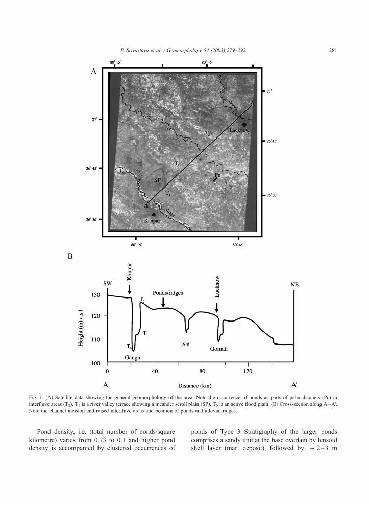
The study area spans part of rivers Ghaghara–
Gomati, Gomati–Sai and Sai–Ganga interfluves
(Figs. 1 and 2). Satellite data (Fig. 1a) show that,
(i) the river Ganga (SW corner of the imagery) is
strictly braided and has f 12 km broad flood plain
with meander scars on its river valley terrace (T1
terrace) and, (ii) the Sai and the Gomati Rivers
(extreme NE corner) are meandering streams with
narrower (f 1 km) flood plains. Regional slope of
the area is NW–SE. A cross-section along A–AVshows that River Ganga is incised by f 25 m into
the upland terrace (T2 terrace), the Gomati up to 10
m and the Sai up to f 7 m (Fig. 1b). The region
between the two river valleys occurs as a raised 20–
50 km broad interfluve area on which smaller sub-
watersheds (up to fourth order), abandoned channels
belts and alluvial ridges occur. The inference that
interfluves (T2 terrrace) are the oldest geomorphic
surfaces is based on the fact that all the other
surfaces are either superimposed or incised into it.
Earlier luminescence ages from near the top of this
surface in the region suggest that its aggradation
continued at least until 7 ka (Srivastava et al.,
2003a). The sedimentary sequence of this surface
comprises fine sand and silt with calcrete layers,
suggesting its formation due to the activation and
abandonment of smaller river channels, lake activity
and sheet flows on flat surfaces (Singh et al., 1999).
Presently, f 30% of the interfluve area is being
drained by small, highly sinuous, underfit channels
that are incapable of transporting any appreciable
quantities of sediment load. Locally referred to as
Tals, ponds are small, closed water bodies that act as
sediment sinks for the rest of the area. Alluvial
ridges occur as sandy mounds within abandoned
channel belts and often preserve the point bar depos-
its of the paleochannels (Pc).
In the present study (spanning f 4000 km2 area),
three representative ponds and two alluvial ridges
from Gomati–Sai and Sai–Ganga River interfluves
were examined and based on their sedimentary suc-
cessions, luminescence chronology and the regional/
global climatic record, palaeohydrologic changes in
the region are inferred.
3. Morphology and sedimentology of ponds
The dimensions of the ponds are variable and their
depth ranges between 1 and 5 m. They are local sinks,
where sediment–water transfer into the pond occurs
by sheet flow and minor rills. No delta building takes
place and no outflow channels that could drain out the
pond water, exist. The water budget of the ponds
shows seasonality such that during the summer
months some of the ponds dry out.
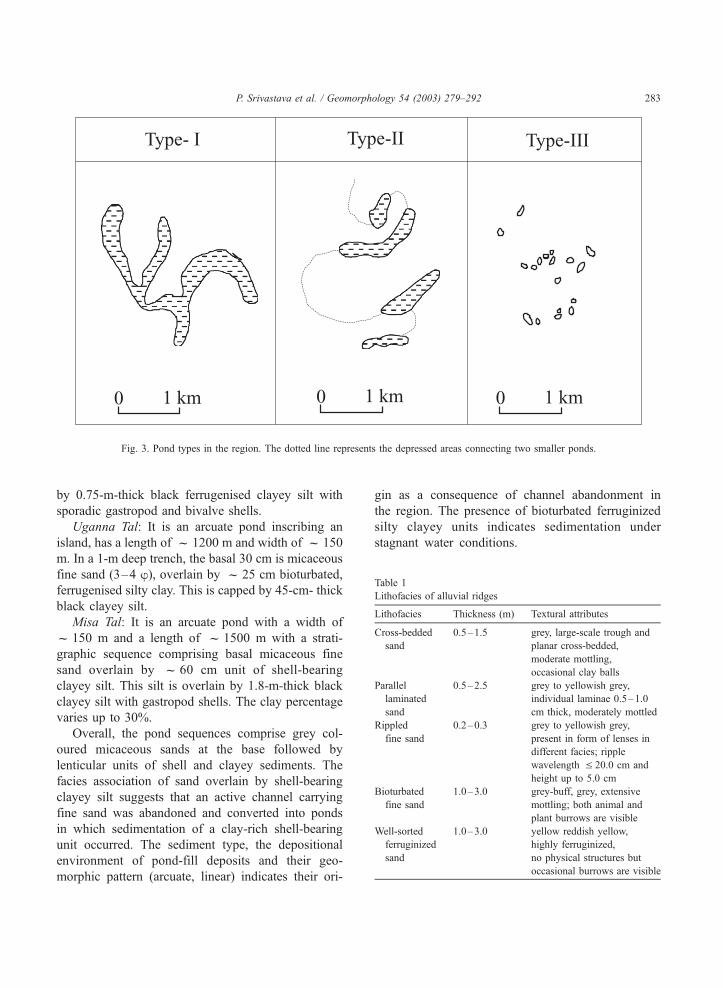
Based on an analysis of shapes and sizes of 1388
ponds, three basic pond types were identified (Figs. 2
and 3):
1. Type 1 ponds have an area of >0.1–2.7 km2. These
ponds are perennial and occur as chains of arcuate
and linear lakes associated with linear belts of
abandoned channels and their cutoff meanders.
Occasionally, circular or subcircular shapes also
occur. About 14% of the ponds accounting for
f 50% of the total ponded area belong to this
category.
2. Type 2 ponds occur as small and arcuate, linear or
oval-shaped water bodies and, have an area of
f 0.05–0.1 km2. About 7% of the ponds occupy-
ing >20% of the total ponded area belong to this
category.
3. Type 3 ponds occur in clusters, at times scattered
throughout the area and are generally located in
linear depressions. Such ponds have an area of
< 0.05 km2 and f 79% of the ponds covering
f 30% of total ponded area belong to this group.
P. Srivastava et al. / Geomorphology 54 (2003) 279–292280
Pond density, i.e. (total number of ponds/square
kilometre) varies from 0.73 to 0.1 and higher pond
density is accompanied by clustered occurrences of
ponds of Type 3 Stratigraphy of the larger ponds
comprises a sandy unit at the base overlain by lensoid
shell layer (marl deposit), followed by f 2–3 m
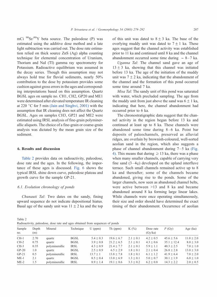
Fig. 1. (A) Satellite data showing the general geomorphology of the area. Note the occurrence of ponds as parts of paleochannels (Pc) in
interfluve areas (T2). T1 is a river valley terrace showing a meander scroll plain (SP). T0 is an active flood plain. (B) Cross-section along A–AV.Note the channel incision and raised interfluve areas and position of ponds and alluvial ridges.
P. Srivastava et al. / Geomorphology 54 (2003) 279–292 281
thick clayey silty sediment. The shell layer marks the
initiation of pond activity and has been radiocarbon
dated to 9–8 ka BP (Agarwal et al., 1992; Singh,
1996). In the present study, the ponds with clear
geomorphic evidences of an association with aban-
doned channel belt (sinuous and linear geometry)
were selected for sedimentological study and are
discussed below (Fig. 1).
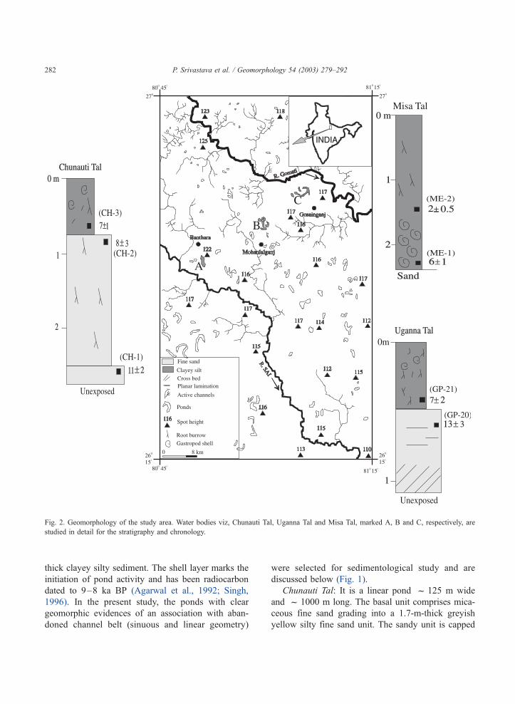
Chunauti Tal: It is a linear pond f 125 m wide
and f 1000 m long. The basal unit comprises mica-
ceous fine sand grading into a 1.7-m-thick greyish
yellow silty fine sand unit. The sandy unit is capped
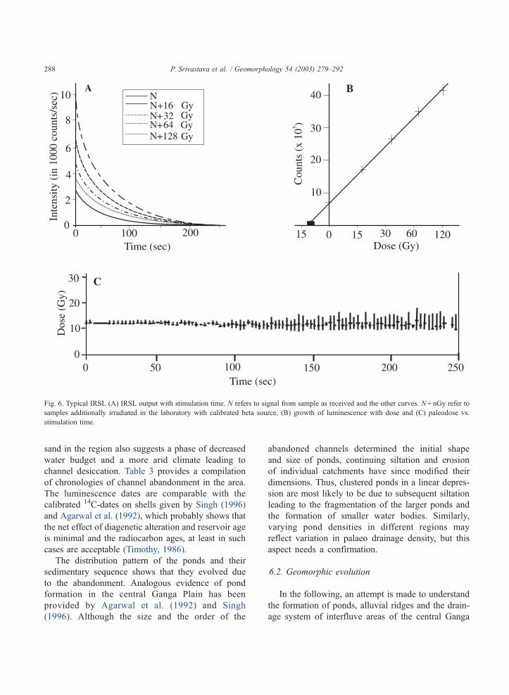
Fig. 2. Geomorphology of the study area. Water bodies viz, Chunauti Tal, Uganna Tal and Misa Tal, marked A, B and C, respectively, are
studied in detail for the stratigraphy and chronology.
P. Srivastava et al. / Geomorphology 54 (2003) 279–292282
by 0.75-m-thick black ferrugenised clayey silt with
sporadic gastropod and bivalve shells.
Uganna Tal: It is an arcuate pond inscribing an
island, has a length of f 1200 m and width of f 150
m. In a 1-m deep trench, the basal 30 cm is micaceous
fine sand (3–4 B), overlain by f 25 cm bioturbated,
ferrugenised silty clay. This is capped by 45-cm- thick
black clayey silt.
Misa Tal: It is an arcuate pond with a width of
f 150 m and a length of f 1500 m with a strati-
graphic sequence comprising basal micaceous fine
sand overlain by f 60 cm unit of shell-bearing
clayey silt. This silt is overlain by 1.8-m-thick black
clayey silt with gastropod shells. The clay percentage
varies up to 30%.
Overall, the pond sequences comprise grey col-
oured micaceous sands at the base followed by
lenticular units of shell and clayey sediments. The
facies association of sand overlain by shell-bearing
clayey silt suggests that an active channel carrying
fine sand was abandoned and converted into ponds
in which sedimentation of a clay-rich shell-bearing
unit occurred. The sediment type, the depositional
environment of pond-fill deposits and their geo-
morphic pattern (arcuate, linear) indicates their ori-
gin as a consequence of channel abandonment in
the region. The presence of bioturbated ferruginized
silty clayey units indicates sedimentation under
stagnant water conditions.
Table 1
Lithofacies of alluvial ridges
Lithofacies Thickness (m) Textural attributes
Cross-bedded
sand
0.5–1.5 grey, large-scale trough and
planar cross-bedded,
moderate mottling,
occasional clay balls
Parallel
laminated
sand
0.5–2.5 grey to yellowish grey,
individual laminae 0.5–1.0
cm thick, moderately mottled
Rippled
fine sand
0.2–0.3 grey to yellowish grey,
present in form of lenses in
different facies; ripple
wavelength V 20.0 cm and
height up to 5.0 cm
Bioturbated
fine sand
1.0–3.0 grey-buff, grey, extensive
mottling; both animal and
plant burrows are visible
Well-sorted
ferruginized
sand
1.0–3.0 yellow reddish yellow,
highly ferruginized,
no physical structures but
occasional burrows are visible
Fig. 3. Pond types in the region. The dotted line represents the depressed areas connecting two smaller ponds.
P. Srivastava et al. / Geomorphology 54 (2003) 279–292 283
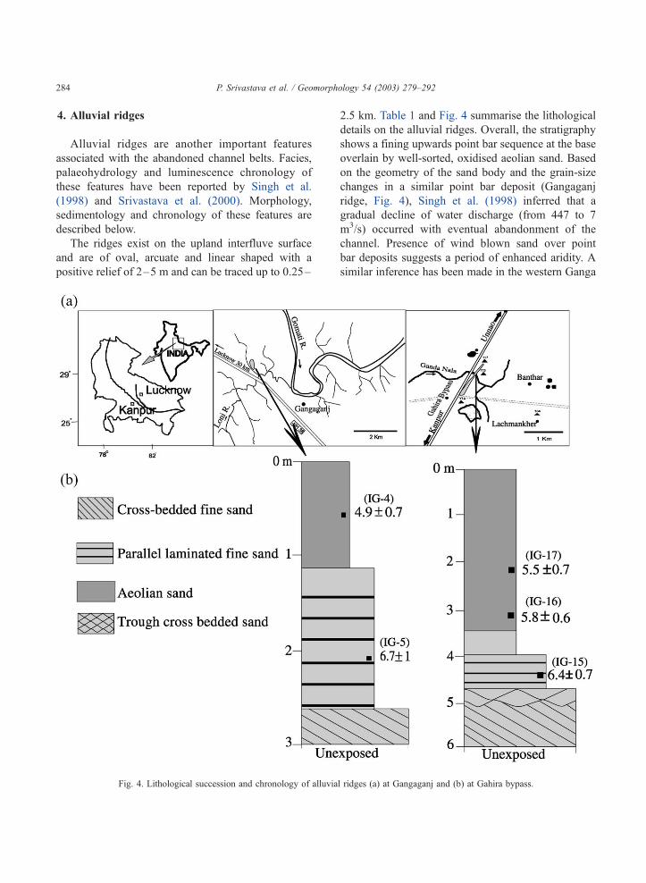
4. Alluvial ridges
Alluvial ridges are another important features
associated with the abandoned channel belts. Facies,
palaeohydrology and luminescence chronology of
these features have been reported by Singh et al.
(1998) and Srivastava et al. (2000). Morphology,
sedimentology and chronology of these features are
described below.
The ridges exist on the upland interfluve surface
and are of oval, arcuate and linear shaped with a
positive relief of 2–5 m and can be traced up to 0.25–
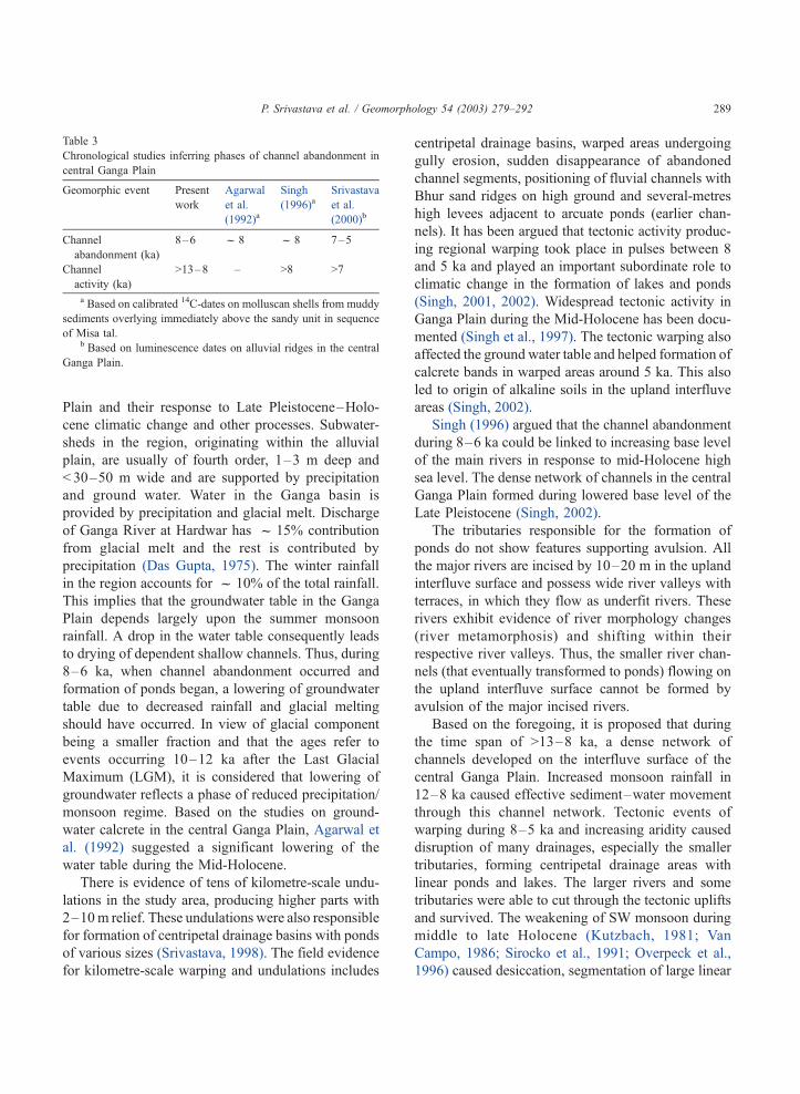
2.5 km. Table 1 and Fig. 4 summarise the lithological
details on the alluvial ridges. Overall, the stratigraphy
shows a fining upwards point bar sequence at the base
overlain by well-sorted, oxidised aeolian sand. Based
on the geometry of the sand body and the grain-size
changes in a similar point bar deposit (Gangaganj
ridge, Fig. 4), Singh et al. (1998) inferred that a
gradual decline of water discharge (from 447 to 7
m3/s) occurred with eventual abandonment of the
channel. Presence of wind blown sand over point
bar deposits suggests a period of enhanced aridity. A
similar inference has been made in the western Ganga
Fig. 4. Lithological succession and chronology of alluvial ridges (a) at Gangaganj and (b) at Gahira bypass.
P. Srivastava et al. / Geomorphology 54 (2003) 279–292284
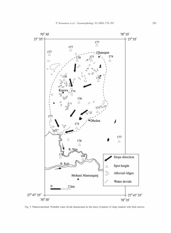
Fig. 5. Palaeowatershed. Probable water divide demarcated on the basis of pattern of slope marked with thick arrows.
P. Srivastava et al. / Geomorphology 54 (2003) 279–292 285
Plain. Slope and geomorphic analysis of the Survey of
India toposheets (1:50,000 scale) indicates a palae-
owatershed with 55 alluvial ridges within the palaeo
water-divide (Fig. 5).
5. Luminescence dating
Luminescence dating of sediments relies on the fact
that, during their predepositional weathering and trans-
port, daylight exposure of minerals constituting the
sediments bleaches their geological luminescence to a
near zero residual level (I0). Thus, at the time of their
sedimentation, the grains have zero or near zero
luminescence. On burial, further daylight exposure
ceases and reaccumulation of the luminescence signal
starts due to radiation exposure arising from the decay
of natural radioactivity viz. 232Th, 238U and 40K in the
sediment. A small contribution additionally comes
from the cosmic rays. Thus, reaccumulation of the
luminescence signal continues until the excavation and
sample collection. The total luminescence signal (Inat)
comprises the initial residual level I0 and the lumines-
cence (Id) acquired since burial (i.e. Inat = Id + I0). Id can
be related to the age of burial via the annual rate of
luminescence induction by the relation,
Age ¼ Paleodose=Annual dose ¼ P=DT
Where P is the equivalent dose or the paleodose
representing the laboratory radiation dose that induces
luminescence intensity Id. DT represents the total
annual radiation dose and is computed using the
elemental concentrations of natural radioactivity. The
event dated by the luminescence technique is the most
recent transport and burial event (see e.g. Aitken,
1985, 1998).
Aeolian sediments are transported by saltation and/
or suspension over long distances and consequently
experience direct daylight exposure for an extended
duration. This enables a reasonable assumption that
their geological luminescence is bleached to an opti-
mum residual level. Contrastingly, fluvially trans-
ported sediments experience a wide variety of day-
light exposure before deposition. This is due to
attenuation and modification of daylight and its spec-
trum, by the water column, turbulence, the grain size
and the sediment load. Thus, in general, the daylight
bleaching of fluvially transported sediments is hetero-
geneous and partial. The advent of Optically Stimu-
lated Luminescence (OSL) dating technique with
rapid bleachability of OSL signal helped in minimis-
ing some of these problems. The feasibility of using
infrared stimulated luminescence dating (IRSL) in
Ganga Plain was first demonstrated by Someshwarrao
et al. (1997) and Srivastava et al. (2003b) have app-
lied these methods in the region.
In the present study, samples from the basal chan-
nel sand and overlying clayey units were dated to
develop a chronology of the events of channel activ-
ity, their abandonment and the development of the
ponds. Sample nos. CH 1–3 were collected from
Chunauti Tal sequence, GP 20–21 from Uganna Tal
and ME 1–2 from Misa Tal. Fig. 1 provides the
sample locations and stratigraphic logs.
All the samples were pretreated with 10% HCl and
30% H2O2 to remove carbonates and organic matter.
The samples were then dry sieved to obtain the 105–
150 Am grain size fraction. Density separation using
Na-polytungstate (q = 2.58 g/cm3) was carried out to
separate Quartz and K-feldspar fractions. The Quartz
fraction was further etched with 40% HF for 80 min
followed by 12N HCl for 30 min to remove the alpha
skin. The separated mineral grains were mounted as a
monolayer on stainless steel discs using Silkospray.
For silt-rich sediments, the analysis was carried out on
4–11 Am polyminerallic samples extracted through a
sequential pretreatment of the sample with 1N HCl,
30% H2O2 followed by deflocculation using 0.01N
Na-oxalate and eventual extraction of the desired
grain size using Stokes settling times appropriate for
a 6-cm column of acetone. The extracted fine silt
fraction was resuspended in acetone and equal vol-
umes were pipetted onto aluminium discs kept in
small glass cylinders with acetone, and finally dried
at 50 jC in the dark.
Blue-Green light Stimulated Luminescence (BGSL)
and Infrared light stimulated luminescence (IRSL)
measurements were carried out on a Riso TL-DA-15
reader. IR stimulation used TEMT-484 infrared diode
arrays and a filtered halogen lamp was used for BGSL.
For IRSL, the detection optics comprised Corning 7-59
and Schott BG-39 filters coupled to an EMI 9635 QA
photomultiplier tube, whereas for BGSL, the detection
optics channel comprised two Hoya U-340 and Schott
BG-39 filters. Beta irradiation was made using a 25-
P. Srivastava et al. / Geomorphology 54 (2003) 279–292286
mCi 90Sr/90Y beta source. The paleodose (P) was
estimated using the additive dose method and a late
light subtraction was carried out. The dose rate estima-
tion relied on thick source ZnS (Ag) alpha counting
technique for elemental concentration of Uranium,
Thorium and NaI (TI) gamma ray spectrometry for
Potassium. Radioactive equilibrium was assumed in
the decay series. Though this assumption may not
always hold true for fluvial sediments, nearly 50%
contribution to the dose by potassium provides some
cushion against gross errors in the ages and correspond-
ing interpretations based on this assumption. Quartz
BGSL ages on sample no. CH1, CH2, GP20 and ME1
were determined after elevated temperature IR cleaning
at 220 jC for 5 min (Jain and Singhvi, 2001) with the
assumption that IR cleaning does not affect the Quartz
BGSL. Ages on samples CH3, GP21 and ME2 were
estimated using IRSL analysis of fine-grain polyminer-
allic aliquots. The choice of a fine-grain or coarse-grain
analysis was dictated by the mean grain size of the
sediment.
6. Results and discussion
Table 2 provides data on radioactivity, paleodose,
dose rate and the ages. In the following, the impor-
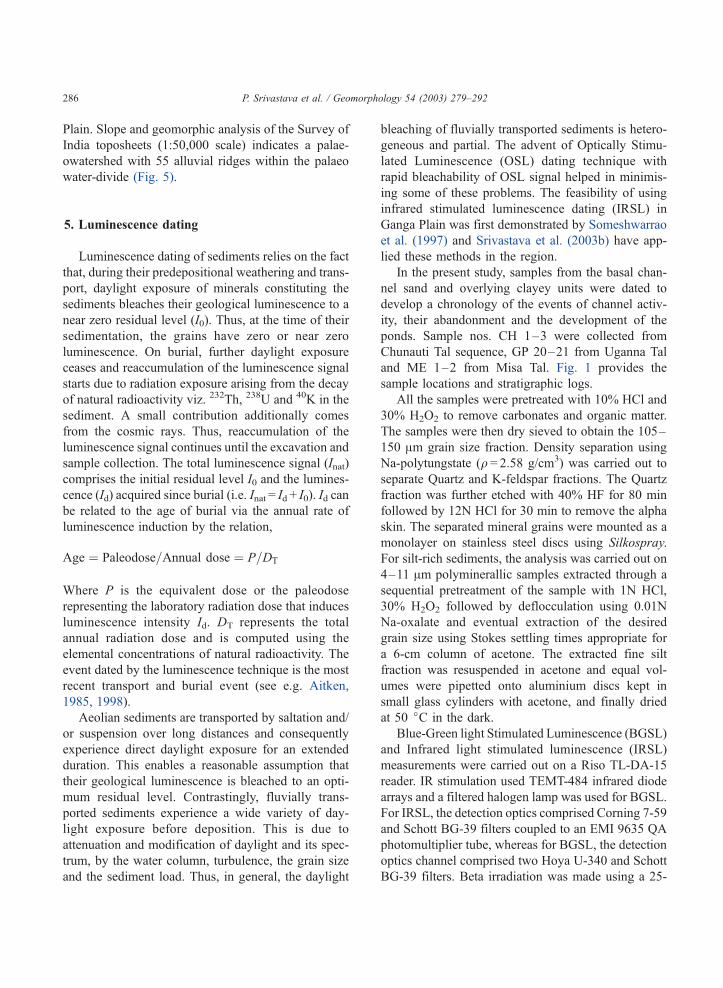
tance of these ages is discussed. Fig. 6 shows the
typical IRSL shine down curve, paleodose plateau and
growth curve for the sample GP-21.
6.1. Evolution chronology of ponds
Chunauti Tal: Two dates on the sandy, fining
upward sequence do not indicate depositional hiatus.
Basal age of the sandy unit was 11F 2 ka and the top
of this unit was dated to 8F 3 ka. The base of the
overlying muddy unit was dated to 7F 1 ka. These
ages suggest that the channel activity was established
prior to 11 ka and continued until 8 ka and the channel
abandonment occurred some time during f 8–7 ka.
Uganna Tal: The channel sand gave an age of
13F 3 ka, showing that this channel was initiated
before 13 ka. The age of the initiation of the muddy
unit was 7F 2 ka, indicating that the abandonment of
the channel and the formation of this pond occurred
some time around 7 ka.
Misa Tal: The sandy unit of this pond was saturated
with water, which precluded sampling. The age from
the muddy unit from just above the sand was 6F 1 ka,
indicating that here, the channel abandonment had
occurred prior to 6 ka.
The chronostratigraphic data suggest that the chan-
nel activity in the region began before 13 ka and
continued at least up to 8 ka. These channels were
abandoned some time during 8–6 ka. Point bar
deposits of paleochannels, preserved as alluvial
ridges, are overlain by brownish-coloured, well-sorted
aeolian sand in the region, which also suggests a
phase of channel abandonment during 7–5 ka (Fig.
4). This means that during z 13 ka, there was a phase
when many smaller channels, capable of carrying very
fine sand (3–4B) developed on the upland interfluve
terrace. Such small channels remained active up to 8
ka and thereafter; some of the channels became
abandoned, giving rise to the ponds. Some of the
larger channels, now seen as abandoned channel belts,
were active between >13 and 8 ka and became
abandoned around 8 ka forming large linear lakes.
While channels were once operating simultaneously,
their size and order should have determined the exact
timing of their abandonment. Occurrence of aeolian
Table 2
Radioactivity, paleodose, dose rate and ages obtained from sequences of ponds
Sample
no.
Depth
(m)
Mineral Technique U (ppm) Th (ppm) K (%) Dose rate
(Gy/ka)
P (Gy) Age (ka)
CH-1 2.70 quartz BGSL 5.4F 0.3 19.6F 6.7 2.1F 0.1 4.2F 0.5 45.6F 5.6 11.0F 2.0
CH-2 0.75 quartz BGSL 3.9F 0.8 21.2F 6.5 2.1F 0.1 4.3F 0.6 35.1F12.4 8.0F 3.0
CH-3 0.35 polyminerallic IRSL 4.3F 0.9 21.4F 7.7 2.1F 0.1 5.9F 1.1 40.3F 2.5 7.0F 1.0
GP-20 1.0 quartz BGSL 2.5F 0.9 6.5F 2.9 1.8F 0.1 2.1F 0.4 26.8F 2.8 13.0F 3.0
GP-21 0.5 polyminerallic IRSL 13.7F 1 13.8F 7.8 1.8F 0.1 6.1F1.2 41.9F 6.4 7.0F 2.0
ME-1 2.1 quartz BGSL 8.5F 0.4 13.0F 6.9 1.3F 0.1 5.0F 0.7 30.1F1.9 6.0F 1.0
ME-2 1.5 polyminerallic IRSL 8.9F 1.4 19.1F 8.6 3.3F 0.2 6.2F 0.8 14.3F 2.2 2.0F 0.5
P. Srivastava et al. / Geomorphology 54 (2003) 279–292 287
sand in the region also suggests a phase of decreased
water budget and a more arid climate leading to
channel desiccation. Table 3 provides a compilation
of chronologies of channel abandonment in the area.
The luminescence dates are comparable with the
calibrated 14C-dates on shells given by Singh (1996)
and Agarwal et al. (1992), which probably shows that
the net effect of diagenetic alteration and reservoir age
is minimal and the radiocarbon ages, at least in such
cases are acceptable (Timothy, 1986).
The distribution pattern of the ponds and their
sedimentary sequence shows that they evolved due
to the abandonment. Analogous evidence of pond
formation in the central Ganga Plain has been
provided by Agarwal et al. (1992) and Singh
(1996). Although the size and the order of the
abandoned channels determined the initial shape
and size of ponds, continuing siltation and erosion
of individual catchments have since modified their
dimensions. Thus, clustered ponds in a linear depres-
sion are most likely to be due to subsequent siltation
leading to the fragmentation of the larger ponds and
the formation of smaller water bodies. Similarly,
varying pond densities in different regions may
reflect variation in palaeo drainage density, but this
aspect needs a confirmation.
6.2. Geomorphic evolution
In the following, an attempt is made to understand
the formation of ponds, alluvial ridges and the drain-
age system of interfluve areas of the central Ganga
Fig. 6. Typical IRSL (A) IRSL output with stimulation time. N refers to signal from sample as received and the other curves. N+ nGy refer to
samples additionally irradiated in the laboratory with calibrated beta source, (B) growth of luminescence with dose and (C) paleodose vs.
stimulation time.
P. Srivastava et al. / Geomorphology 54 (2003) 279–292288
Plain and their response to Late Pleistocene–Holo-
cene climatic change and other processes. Subwater-
sheds in the region, originating within the alluvial
plain, are usually of fourth order, 1–3 m deep and
< 30–50 m wide and are supported by precipitation
and ground water. Water in the Ganga basin is
provided by precipitation and glacial melt. Discharge
of Ganga River at Hardwar has f 15% contribution
from glacial melt and the rest is contributed by
precipitation (Das Gupta, 1975). The winter rainfall
in the region accounts for f 10% of the total rainfall.
This implies that the groundwater table in the Ganga
Plain depends largely upon the summer monsoon
rainfall. A drop in the water table consequently leads
to drying of dependent shallow channels. Thus, during
8–6 ka, when channel abandonment occurred and
formation of ponds began, a lowering of groundwater
table due to decreased rainfall and glacial melting
should have occurred. In view of glacial component
being a smaller fraction and that the ages refer to
events occurring 10–12 ka after the Last Glacial
Maximum (LGM), it is considered that lowering of
groundwater reflects a phase of reduced precipitation/
monsoon regime. Based on the studies on ground-
water calcrete in the central Ganga Plain, Agarwal et
al. (1992) suggested a significant lowering of the
water table during the Mid-Holocene.
There is evidence of tens of kilometre-scale undu-
lations in the study area, producing higher parts with
2–10m relief. These undulations were also responsible
for formation of centripetal drainage basins with ponds
of various sizes (Srivastava, 1998). The field evidence
for kilometre-scale warping and undulations includes
centripetal drainage basins, warped areas undergoing
gully erosion, sudden disappearance of abandoned
channel segments, positioning of fluvial channels with
Bhur sand ridges on high ground and several-metres
high levees adjacent to arcuate ponds (earlier chan-
nels). It has been argued that tectonic activity produc-
ing regional warping took place in pulses between 8
and 5 ka and played an important subordinate role to
climatic change in the formation of lakes and ponds
(Singh, 2001, 2002). Widespread tectonic activity in
Ganga Plain during the Mid-Holocene has been docu-
mented (Singh et al., 1997). The tectonic warping also
affected the ground water table and helped formation of
calcrete bands in warped areas around 5 ka. This also
led to origin of alkaline soils in the upland interfluve
areas (Singh, 2002).
Singh (1996) argued that the channel abandonment
during 8–6 ka could be linked to increasing base level
of the main rivers in response to mid-Holocene high
sea level. The dense network of channels in the central
Ganga Plain formed during lowered base level of the
Late Pleistocene (Singh, 2002).
The tributaries responsible for the formation of
ponds do not show features supporting avulsion. All
the major rivers are incised by 10–20 m in the upland
interfluve surface and possess wide river valleys with
terraces, in which they flow as underfit rivers. These
rivers exhibit evidence of river morphology changes
(river metamorphosis) and shifting within their
respective river valleys. Thus, the smaller river chan-
nels (that eventually transformed to ponds) flowing on
the upland interfluve surface cannot be formed by
avulsion of the major incised rivers.
Based on the foregoing, it is proposed that during
the time span of >13–8 ka, a dense network of
channels developed on the interfluve surface of the
central Ganga Plain. Increased monsoon rainfall in
12–8 ka caused effective sediment–water movement
through this channel network. Tectonic events of
warping during 8–5 ka and increasing aridity caused
disruption of many drainages, especially the smaller
tributaries, forming centripetal drainage areas with
linear ponds and lakes. The larger rivers and some
tributaries were able to cut through the tectonic uplifts
and survived. The weakening of SW monsoon during
middle to late Holocene (Kutzbach, 1981; Van
Campo, 1986; Sirocko et al., 1991; Overpeck et al.,
1996) caused desiccation, segmentation of large linear
Table 3
Chronological studies inferring phases of channel abandonment in
central Ganga Plain
Geomorphic event Present
work
Agarwal
et al.
(1992)a
Singh
(1996)aSrivastava
et al.
(2000)b
Channel
abandonment (ka)
8–6 f 8 f 8 7–5
Channel
activity (ka)
>13–8 – >8 >7
a Based on calibrated 14C-dates on molluscan shells from muddy
sediments overlying immediately above the sandy unit in sequence
of Misa tal.b Based on luminescence dates on alluvial ridges in the central
Ganga Plain.
P. Srivastava et al. / Geomorphology 54 (2003) 279–292 289
lakes into a series of ponds. The arid climate and
tectonically enhanced relief caused increased sedi-
ment supply into the ponds around 5 ka. Lowering
of the water table and increased aridity initiated
fragmentation and drying of the ponds.
For the mid-Holocene, evidence from western
Indian lakes indicates lake desiccation f 4.8 ka BP
(Swain et al., 1983; Singh et al., 1990). Increased
dune building activity f 5 ka in the Thar Desert also
indicates a more arid climate in the region (Thomas et
al., 1999). The present inference of a reduced hydro-
logic budget in the mid-Holocene thus accords with
the regional climatic records. The exact timing of the
events in the different regions is however likely to be
different on account of differences in geomorphic
thresholds for lake hydrological changes, dune build-
ing activity, vis-a-vis alluvial processes in the Ganga
valley. Thus, the same overall climatic forcing via the
reduced summer rainfall manifested itself differently
at different spatial locations.
Two dates of 6 ka at 2.2 m and 2 ka at 1.5 m in the
Misa Tal gives additional information. Sedimentation
of the basal 70 cm (2.2–1.5 m) occurred in 4 ka
(f 17.5 cm/ka) whereas 1.5 m of the sedimentation
occurred in only f 2 ka (i.e. 75 cm/ka). Such a
fourfold enhanced siltation rate during the past 2 ka
should be due to enhanced erosion linked to anthro-
pogenic activity. Archaeological evidence in the form
of habitational mounds adjacent to Misa Tal indicates
human settlement at Misa Tal at least for 1700 years
(unpublished data).
In the study region of the Ganga–Gomati inter-
fluve, few archaeological sites are dated around 3.5
ka. However, large-scale inhabitation of this region
was initiated between 3 and 2.5 ka and continued later
without interruption. Most of these habitation sites are
located on the mounds adjacent to the ponds (Singh,
2002). The agricultural activity of these settlers must
have resulted in increased rates of soil erosion and
silting up of the lakes and ponds. At Sarai Nahar Rai,
an archaeological site about 100 km east of the area,
palynological studies of lake sediments revealed
cereal pollen grains in the middle to late Holocene
(f 4.5 ka BP) (Gupta, 1976). The archaeological
studies indicate that during the late Holocene human
activity in this region increased to the extent that such
processes overtook the landscape changes caused by
climate alone.
In summary, the present studies show that in the
central Ganga Plain, formation and evolution of
microgeomorphological features (ponds) was con-
trolled by changes in the hydrological regime, which
in turn was climate/monsoon controlled. Tectonic
activity and base level changes played subsidiary,
supportive roles. In some cases, e.g. at Misa Tal,
human activity became the key factor in the landscape
evolution (siltation), overtaking the climate-induced
changes of the last about 2 ka. The sequence of events
in the evolution of ponds was as follows:
1. Around 13 ka with climate shifting towards a warm
and humid phase, the surface water budget should
have been higher due to glacial melting of
Himalayan glaciers and reestablishment of SW
monsoon during k13–11 ka. This resulted in the
formation of numerous subwatersheds with high
stream frequency and density on the interfluve
surface. Such conditions prevailed till 8 ka.
2. During 8–6 ka, large lakes were formed due to
disruption of drainage system due to tectonic
warping and higher rainfall.
3. During 6–5 ka, increased aridity set in that
enhanced channel abandonment. The water table
lowered and as a consequence a large number of
small subwatersheds and small channels (that
primarily survived on monsoon rains for their
water budget), decayed, forming smaller ponds.
The Monsoon, though weaker, was able to support
these water bodies, at least seasonally. With
increasing aridity, deposition of aeolian sand over
the exposed point bars of abandoned channels
occurred leading to the formation of the alluvial
ridges in the region.
4. Around 5 ka, aridity was accentuated and the
ponds started shrinking and becoming abandoned
due to increased rates of siltation. Enhancement of
relief due to tectonic activity accelerated the
erosion in the watersheds of the ponds. Siltation
of ponds was further accelerated by human impacts
that became significant by f 2 ka.
7. Conclusions
The present study demonstrates that in certain sit-
uations, even microgeomorphological features respond
P. Srivastava et al. / Geomorphology 54 (2003) 279–292290
to global changes and that their sedimentary succes-
sions can help palaeoclimatic reconstruction. The
ponds in the central Ganga Plain developed due to
disruption of drainage systems, in response to climatic
(monsoon) changes, supported by tectonic activity and
possible base level changes. Lowering of the water
table and increased aridity in the Gangetic Plains
caused further fragmentation and desiccation of the
ponds. These events occurred during 8–5 ka and have a
clear monsoon connection. The enhanced siltation of
ponds during the last 2 ka indicates human impact and
increased erosion in the central Ganga Plain.
Acknowledgements
PS and SS acknowledge Council of Scientific and
Industrial Research, New Delhi, for research fellow-
ship. Dr. A.K. Tangri, Uttar Pradesh Remote Sensing
Application Centre, Lucknow is thanked for help with
the remote sensing data. Constructive comments by
Prof. Vishwas Kale, Pune, Prof. Avijit Gupta and an
anonymous reviewer helped in improving the pre-
sentation. UKS thanks the Department of Geology,
Kumaun University for working facilities.
References
Agarwal, A.K., Rizvi, M.H., Singh, I.B., Kumar, A., Chandra, S.,
1992. Carbonate deposits in Ganga Plain. In: Singh, I.B. (Ed.),
Gangetic Plain: Terra Incognita. Geology Department, Lucknow
University, Lucknow, pp. 35–43.
Aitken, M.J., 1985. Thermoluminescence Dating. Academic Press,
London. 267 pp.
Aitken, M.J., 1998. An Introduction to Optical Dating. Academic
Press, London. 359 pp.
Bishop, P., Godley, D., 1984. Holocene palaeochannels at Sisatch-
analai, north–central Thailand: ages, significance and palaeoen-
vironmental indications. Holocene 4, 21–41.
Das Gupta, S.P., 1975. The Upper Gangetic Flood Plain: A Re-
gional Survey. National Atlas Organization Monograph, Calcut-
ta. 194 pp.
Gupta, H.P., 1976. Holocene palynology from meander lake in
the Ganga valley, district Pratapgarh U.P. Palaeobotanist 25,
109–119.
Jain, M., Singhvi, A.K., 2001. Limits to depletion of green light
stimulated luminescence in feldspars: implications for quartz
dating. Radiation Measurements 33, 883–892.
Kutzbach, J.E., 1981. Monsoon climate of Early Holocene: climate
experiment with the earth’s orbital parameters for 9000 years
ago. Science 214, 59–61.
Overpeck, J., Anderson, D., Trumbore, S., Prell, W., 1996. The
southwest Indian monsoon over the last 18,000 years. Climate
Dynamics 12, 213–225.
Rotnicki, K., 1991. Retro-diction of discharges—discharges of me-
andering and sinuous alluvial rivers and its implications. In:
Starkel, L., Gregory, K.J., Thornes, J.B. (Eds.), Temperate Pa-
laeohydrology: Fluvial Processes in the Temperate Zone During
the last 15,000 years. Wiley, Chichester, pp. 430–471.
Singh, I.B., 1996. Geological evolution of Ganga Plain—an over-
view. Journal of the Palaeontological Society of India 41,
99–137.
Singh, I.B., 2001. Proxy records of neotectonics, climate changes
and anthropogenic activity in the late quaternary Ganga Plain.
National symposium on the roles of earth sciences in integrated
development and related societal issues. Special Publication -
Geological Survey of India 65 (1), xxxiii–1.
Singh, I.B., 2002. Late quaternary evolution of the Ganga Plain and
proxy records of climatic change, neotectonics and anthropo-
genic activity. Pragdhara. Journal of the U. P. State Archeolog-
ical Department 12, 1–25.
Singh, G., Wasson, R.J., Agarwal, D.P., 1990. Vegetational and
seasonal climatic changes since the last full glacial in the Thar
Desert, northwestern India. Review of Palaeobotany and Paly-
nology 64, 351–358.
Singh, I.B., Rajagopaln, G., Agarwal, K.K., Srivastava, P., Sharma,
M., Sharma, S., 1997. Evidence of middle to late Holocene
neotectonic activity in the Ganga Plain. Current Science 73,
1114–1117.
Singh, I.B., Shukla, U.K., Srivastava, P., 1998. Point bar complex
of an exhumed channel in upland interfluve of Ganga Plain.
Journal of the Geological Society of India 51, 315–322.
Singh, I.B., Srivastava, P., Sharma, S., Sharma, M., Singh, D.S.,
Rajagopalan, G., Shukla, U.K., 1999. Upland interfluve (Doab)
deposition: alternative model to muddy overbank deposits. Fa-
cies 40, 197–210.
Sirocko, F., Sarnthein, M., Lange, H., Erlenkeuser, H., 1991. At-
mospheric summer circulation and coastal upwelling in the Ara-
bian Sea during the Holocene and last glaciation. Quaternary
Research 36, 72–93.
Someshwarrao, M., Bisaria, B.K., Singhvi, A.K., 1997. A feasibil-
ity study towards absolute dating of Indo–Gangetic alluvium
using thermoluminescence and infrared-stimulated lumines-
cence techniques. Current Science 72, 663–669.
Srivastava, P., 1998. Sedimentology and geomorphology of inter-
fluve areas of central Ganga Plain. PhD thesis. Geology Depart-
ment. Lucknow University, Lucknow, India. 141 pp.
Srivastava, P., Shukla, U.K., Mishra, P., Sharma, M., Sharma, S.,
Singh, I.B., Singhvi, A.K., 2000. Luminescence chronology and
facies development of Bhur sands in the interfluve region of
central Ganga Plain, India. Current Science 78, 498–503.
Srivastava, P., Sharma, M., Singhvi, A.K., 2003a. Luminescence
chronology of incision and channel pattern changes in River
Ganga at Kanpur, India. Geomorphology (this issue).
Srivastava, P., Singh, I.B., Singhvi, A.K., 2003b. Luminescence
chronometry and late quaternary geomorphic history of the
Ganga Plains. Palaeocol. Palaeogeograph. Palaeoclimatol. (in
press).
P. Srivastava et al. / Geomorphology 54 (2003) 279–292 291

Swain, A.M., Kutzbach, J.E., Hastenrath, S., 1983. Estimate of
Holocene precipitation for Rajasthan, India, based on pollen
and lake level data. Quaternary Research 19, 1–17.
Thomas, M.F., 2000. Late Quaternary environmental changes and
the alluvial record in humid tropical environments. Quaternary
International 72, 23–36.
Thomas, J.V., Kar, A., Kailath, A.J., Juyal, N., Rajaguru, S.N.,
Singhvi, A.K., 1999. Late Pleistocene–Holocene history of aeo-
lian accumulation in the Thar Desert, India. Zeitschrift fur Geo-
morphologie N.F. 116, 181–194.
Timothy, Y., 1986. Studies of non-marine molluscs for the selec-
tion of shell samples for radiocarbon dating. Radiocarbon 28,
457–463.
Van Campo, E., 1986. Monsoon fluctuations in two 20,000-Yr B.P.
Oxygen-isotope/pollen records off southwest India. Quaternary
Research 26, 376–388.
P. Srivastava et al. / Geomorphology 54 (2003) 279–292292