Calcretes from a Late Quaternary interfluve in the Ganga Plains, India: Carbonate types and isotopic...
26
Calcretes from a Late Quaternary interfluve in the Ganga Plains, India: Carbonate types and isotopic systems in a monsoonal setting R. Sinha a, ⁎ , S.K. Tandon b , P. Sanyal c , M.R. Gibling d , D. Stuben e , Z. Berner e , P. Ghazanfari b a Engineering Geosciences Group, Indian Institute of Technology, Kanpur 208016, India b Department of Geology, University of Delhi, Delhi 110007, India c Department of Geology and Geophysics, Indian Institute of Technology, Kharagpur 721302, India d Department of Earth Sciences, Dalhousie University, Halifax, Nova Scotia, Canada B3H 3J5 e Institute of Mineralogy and Geochemistry, University of Karlsruhe, 76131, Karlsruhe, Germany Received 4 December 2005; received in revised form 6 May 2006; accepted 28 May 2006 Abstract Calcretes are abundant in Late Quaternary channel and floodplain strata of the southern Ganga plains. In a key section at Kalpi, pedogenic carbonates (nodules, rhizoconcretions, and powdery carbonate) are present within aggradational floodplain deposits, where they correspond to relatively high monsoonal precipitation and river discharge. In contrast, groundwater carbonate has cemented degradational surfaces (discontinuities), which correspond with periods of relatively low precipitation. Mixed groundwater and pedogenic calcretes are present in the deposits of small interfluve channels, and reworked nodules line degradational surfaces and locally fill channels. Most carbonates show alpha fabrics that include floating textures, shrinkage crack fills, and grain coatings. The predominance of alpha fabrics is unexpected, but is characteristic of calcretes across dryland and seasonal parts of northern India, where soil formation led to only weakly developed or poorly preserved beta fabrics. Interpretation of δ 13 C and δ 18 O values of bulk and microdrilled calcrete samples suggests relatively little variation in precipitation and vegetation types through the sampled interval at Kalpi. Floodplain deposits were vegetated with a mixture of C 4 and C 3 plants (predominantly C 4 ), with a higher proportion of C 3 plants associated with channel deposits. This apparent lack of variation is surprising because the sampled interval represents at least 60,000 years of Marine Isotope Stages 3–5, during which climate models suggest that Asia experienced radical fluctuations in monsoon intensity and precipitation. Some of the apparent lack of variation may be explained by preferential preservation of aggradational strata that represent relatively active monsoonal periods, as well as by the mixing of drier floodplain (C 4 ) and riparian (C 3 ) vegetation. However, local departures from the regionally based climate model cannot be ruled out. A modest upsection increase in C 4 plants may represent increased aridity and lower atmospheric CO 2 . Isotopic analysis of organic matter from floodplain pedogenic nodules suggests a higher C 3 plant contribution than carbonate-based data would suggest. The preserved organic matter may reflect the annual average biomass in the soil, whereas carbonate formation may have taken place mainly during the drier season when respiration of C 4 plants was more important. Palaeogeography, Palaeoclimatology, Palaeoecology xx (2006) xxx – xxx + MODEL PALAEO-04088; No of Pages 26 www.elsevier.com/locate/palaeo ⁎ Corresponding author. E-mail address: [email protected] (R. Sinha). 0031-0182/$ - see front matter © 2006 Elsevier B.V. All rights reserved. doi:10.1016/j.palaeo.2006.05.015 ARTICLE IN PRESS
Transcript of Calcretes from a Late Quaternary interfluve in the Ganga Plains, India: Carbonate types and isotopic...
alaeoecology xx (2006) xxx–xxx
+ MODEL
www.elsevier.com/locate/palaeo
ARTICLE IN PRESS
Palaeogeography, Palaeoclimatology, P
Calcretes from a Late Quaternary interfluve in the Ganga Plains,India: Carbonate types and isotopic systems in a monsoonal setting
R. Sinhaa,⁎, S.K. Tandonb, P. Sanyalc, M.R. Giblingd, D. Stubene,Z. Bernere, P. Ghazanfarib
a Engineering Geosciences Group, Indian Institute of Technology, Kanpur 208016, Indiab Department of Geology, University of Delhi, Delhi 110007, India
c Department of Geology and Geophysics, Indian Institute of Technology, Kharagpur 721302, Indiad Department of Earth Sciences, Dalhousie University, Halifax, Nova Scotia, Canada B3H 3J5
e Institute of Mineralogy and Geochemistry, University of Karlsruhe, 76131, Karlsruhe, Germany
Received 4 December 2005; received in revised form 6 May 2006; accepted 28 May 2006
Abstract
Calcretes are abundant in Late Quaternary channel and floodplain strata of the southern Ganga plains. In a key section atKalpi, pedogenic carbonates (nodules, rhizoconcretions, and powdery carbonate) are present within aggradational floodplaindeposits, where they correspond to relatively high monsoonal precipitation and river discharge. In contrast, groundwatercarbonate has cemented degradational surfaces (discontinuities), which correspond with periods of relatively low precipitation.Mixed groundwater and pedogenic calcretes are present in the deposits of small interfluve channels, and reworked nodulesline degradational surfaces and locally fill channels. Most carbonates show alpha fabrics that include floating textures,shrinkage crack fills, and grain coatings. The predominance of alpha fabrics is unexpected, but is characteristic of calcretesacross dryland and seasonal parts of northern India, where soil formation led to only weakly developed or poorly preservedbeta fabrics.
Interpretation of δ13C and δ18O values of bulk and microdrilled calcrete samples suggests relatively little variation inprecipitation and vegetation types through the sampled interval at Kalpi. Floodplain deposits were vegetated with a mixture of C4
and C3 plants (predominantly C4), with a higher proportion of C3 plants associated with channel deposits. This apparent lack ofvariation is surprising because the sampled interval represents at least 60,000 years of Marine Isotope Stages 3–5, during whichclimate models suggest that Asia experienced radical fluctuations in monsoon intensity and precipitation. Some of the apparent lackof variation may be explained by preferential preservation of aggradational strata that represent relatively active monsoonalperiods, as well as by the mixing of drier floodplain (C4) and riparian (C3) vegetation. However, local departures from theregionally based climate model cannot be ruled out. A modest upsection increase in C4 plants may represent increased aridity andlower atmospheric CO2.
Isotopic analysis of organic matter from floodplain pedogenic nodules suggests a higher C3 plant contribution thancarbonate-based data would suggest. The preserved organic matter may reflect the annual average biomass in the soil, whereascarbonate formation may have taken place mainly during the drier season when respiration of C4 plants was more important.
PALAEO-04088; No of Pages 26
⁎ Corresponding author.E-mail address: [email protected] (R. Sinha).
0031-0182/$ - see front matter © 2006 Elsevier B.V. All rights reserved.doi:10.1016/j.palaeo.2006.05.015
2 R. Sinha et al. / Palaeogeography, Palaeoclimatology, Palaeoecology xx (2006) xxx–xxx
ARTICLE IN PRESS
In interfluve settings such as Kalpi, seasonality may strongly affect the C3–C4 system, with preferential preservation of onlypart of the biomass.© 2006 Elsevier B.V. All rights reserved.
Keywords: Calcrete; Pedogenic and groundwater carbonate; Interfluve; Discontinuity; Carbon and oxygen isotopes; C4 and C3 plants; Vegetation;Monsoon precipitation; India; Quaternary
1. Introduction
Many types of carbonate occur in the channel andfloodplain successions of modern and ancient riverdeposits (Friend and Moody-Stuart, 1972; Wright andTucker, 1991; Tandon and Kumar, 1999; Mack et al.,2000; Nash and Smith, 2003). They includepedogenic, groundwater, mixed pedogenic–ground-water, palustrine and pond carbonates, valley cal-cretes, and reworked materials. The term “calcrete”has been applied to all of these types, and commonlydenotes secondary carbonate introduced into surfaceand near-surface soil, sediment, and rock throughreplacive and displacive processes and/or passivecementation (Goudie, 1983). The term is used here tocover a wide range of floodplain and channelcarbonates. Such carbonates are common in areasthat have a dry climate, as well as in sub-humidareas with a marked dry season, and have been usedas paleoenvironmental indicators in alluvial succes-sions, especially for understanding fluctuations in thevadose and phreatic zones. In particular, effortscontinue to be made to distinguish pedogeniccarbonates from other forms (Tandon and Narayan,1981; Mack et al., 2000).
A comprehensive model for alluvial carbonate hasyet to emerge (Mack et al., 2000). The creation of sucha model requires a large amount of information aboutQuaternary and older alluvial carbonates that representlarge and small river systems, as well as for successionsfrom different climatic regimes. A comprehensivemodel (or multiple models for different climatic–latitudinal belts) is desirable because of the increasinguse of pedogenic carbonate as a proxy for atmosphericpCO2 (e.g. Cerling, 1991; Andrews et al., 1995; Moraet al., 1996; Ghosh et al., 2004), as well as forpaleoclimatic and paleoecological reconstruction. Thepioneering studies of the Neogene Siwalik Group ofsouthern Asia illustrate the importance of suchreconstructions (Cerling, 1984; Quade et al., 1989;Cerling et al., 1989, 1997; Cerling and Quade, 1993;Quade and Roe, 1999). Significantly, Budd et al.(2002) highlighted numerous pitfalls in the use of
pedogenic carbonates for these purposes, includingoverprinting and diagenesis which commonly affectboth pedogenic and non-pedogenic carbonates inmonsoon-dominated regions. The importance of theseeffects is magnified where large water-table fluctua-tions are associated with wet and dry seasons (Tandonand Kumar, 1999).
Despite continuing interest globally in exploiting thepotential of alluvial carbonate, surprisingly little isknown about the alluvial carbonates of the GangaPlains in the Himalayan Foreland Basin (see earlierstudies by Sehgal and Stoops, 1972; Pendall andAmundson, 1990; Agarwal et al., 1992; Srivastava etal., 1994; Srivastava, 2001). Carbonate accumulationsof all kinds, particularly pedogenic and groundwatertypes, are abundant in this area, and are termed“kankar”. This paucity of information is all the moresurprising because much of our understanding ofalluvial carbonate systems originated from studies ofexhumed Himalayan foreland-basin strata of theSiwalik Group.
The present study has two purposes. Firstly, wedocument from field and microscopic analysis anunusually wide range of carbonate types associatedwith a Late Quaternary floodplain (interfluve) succes-sion at Kalpi in the southern Ganga Plains. The rivercliffs at Kalpi are high and extend for severalkilometers, constituting one of the best exposures inthe plains, and the carbonates can be placed in areliable stratigraphic and depositional context. Sec-ondly, we use the carbonates to explore the carbonand oxygen isotopic system of the section, for whichan age model spans more than 60,000 years (much ofMarine Isotope Stages 3 to 5: Gibling et al., 2005).Because the strength of the monsoon is known fromregional climatic modeling to have varied greatlyduring this period, the carbonate sampling programmewas designed to test the response of the isotopicsystem and vegetation to precipitation changes.Surprisingly, there is only evidence in our data formodest changes in the isotopic system and vegetationmeaning either less precipitation variation thanimplied by climatic models, or less forcing of
3R. Sinha et al. / Palaeogeography, Palaeoclimatology, Palaeoecology xx (2006) xxx–xxx
ARTICLE IN PRESS
precipitation on the isotopic and vegetation systems.Local departures from the general climatic model arepossible. However, we suggest that the results havebeen affected also by preferential sampling of shortaggradational periods that represent a restrictedclimatic condition, as well as by the presence oflocal riparian (river-related) vegetation within a drierbiome. Our results have implications for the inter-pretation of isotopic data in alluvial settings.
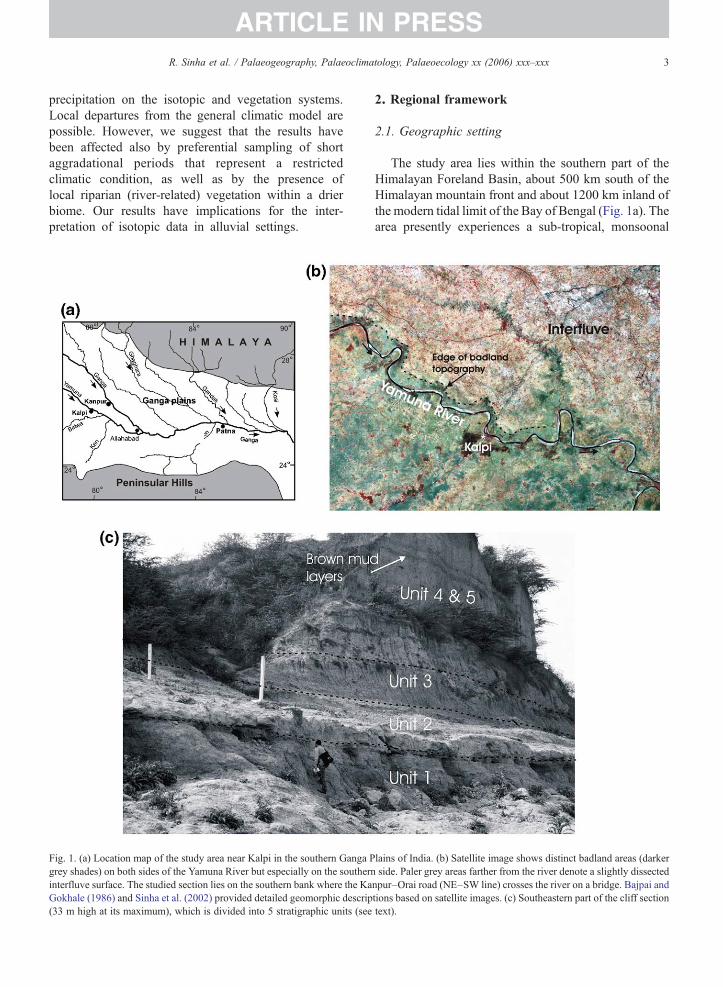
Fig. 1. (a) Location map of the study area near Kalpi in the southern Ganga Pgrey shades) on both sides of the Yamuna River but especially on the southerninterfluve surface. The studied section lies on the southern bank where the KaGokhale (1986) and Sinha et al. (2002) provided detailed geomorphic descrip(33 m high at its maximum), which is divided into 5 stratigraphic units (see
2. Regional framework
2.1. Geographic setting
The study area lies within the southern part of theHimalayan Foreland Basin, about 500 km south of theHimalayan mountain front and about 1200 km inland ofthe modern tidal limit of the Bay of Bengal (Fig. 1a). Thearea presently experiences a sub-tropical, monsoonal
lains of India. (b) Satellite image shows distinct badland areas (darkerside. Paler grey areas farther from the river denote a slightly dissected
npur–Orai road (NE–SW line) crosses the river on a bridge. Bajpai andtions based on satellite images. (c) Southeastern part of the cliff sectiontext).
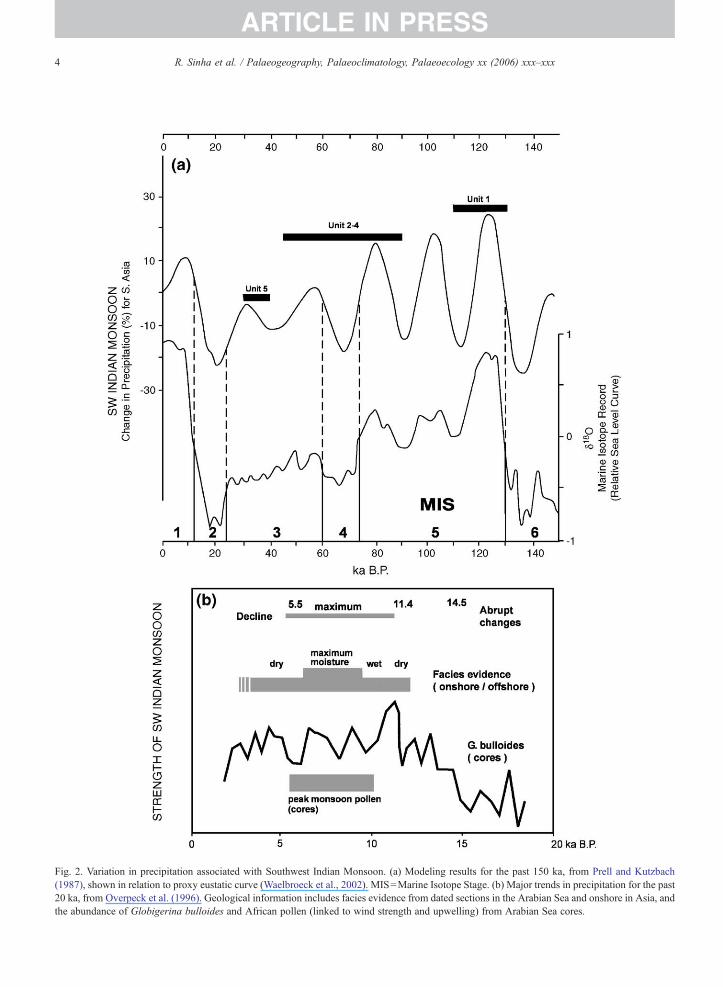
Fig. 2. Variation in precipitation associated with Southwest Indian Monsoon. (a) Modeling results for the past 150 ka, from Prell and Kutzbach(1987), shown in relation to proxy eustatic curve (Waelbroeck et al., 2002). MIS=Marine Isotope Stage. (b) Major trends in precipitation for the past20 ka, from Overpeck et al. (1996). Geological information includes facies evidence from dated sections in the Arabian Sea and onshore in Asia, andthe abundance of Globigerina bulloides and African pollen (linked to wind strength and upwelling) from Arabian Sea cores.
4 R. Sinha et al. / Palaeogeography, Palaeoclimatology, Palaeoecology xx (2006) xxx–xxx
ARTICLE IN PRESS
5R. Sinha et al. / Palaeogeography, Palaeoclimatology, Palaeoecology xx (2006) xxx–xxx
ARTICLE IN PRESS
regime, with average precipitation of 800–1000 mm/year, mean maximum temperature of 30–32 °C, andmean minimum temperature of 15–18 °C (Singh, 1994).The maximum temperature in the summer frequentlyexceeds 45 °C and the minimum temperature in winteroccasionally drops below 2 °C. The monsoon typicallyarrives in mid-June preceded by pre-monsoon showers,and provides more than 85% of the annual rainfallthrough to September.
The study area constitutes part of the interfluvebetween the Yamuna and Ganga rivers, which is about75 km wide in this region and mostly beyond the reachof the highest floods on these two big rivers (Kale,1998), which are deeply incised. The interfluve isabove 130 m above mean sea level near Kanpur, anddecreases in elevation southeastward, with relief on atraverse across the interfluve of only a few meters.Brickpit sections up to 2 m thick in the interfluvecommonly show brown floodplain clays with carbonatenodules and interbeds of yellow-brown silt. Previousinvestigations (Agarwal et al., 1992; Srivastava et al.,1994; Srivastava, 2001) have reported widely occurringand patchy kankar deposits in the shallow sub-surface,in layers up to 1 m thick and as scattered centimeter-scale nodules. Soils in this area are mainly typicalHaplustepts, with local fluventical and vertical Haplus-tepts and Fluvaquents (D.K. Pal, written communica-tion, 2003).
The Kalpi section is located on the bank of theYamuna River, where a NW–SE oriented cliff nearly1500 m long exposes 33 m of strata along the southernbank at low-flow stage (Fig. 1b, c). Alluvial bars flank anarrow active floodplain on the northern bank. On theremote sensing image (Fig. 1b), “badland topography”is the most distinctive landform near the cliff (Sinha etal., 2002), and is characterized by intensive gullyerosion of strata equivalent to those in the cliff andvariable but locally dense vegetation cover. The cliff topis not an active floodplain, although the river levelapproaches the cliff top during exceptional monsoonseasons. Badlands extend for up to 3 km on either sideof the Yamuna, and their limit is marked by an irregularbut distinctive boundary (Fig. 1b) that reflects the extentof headward erosion. The badland terrain lies on averageabout 20 m above the low-stage river level, with aprogressive increase in elevation of about 10 m to aninactive but only slightly dissected interfluve surface.This extensive level has scanty vegetation and a fewsmall channels that rise on the interfluve (plains-fedrivers).
The exposed cliff strata belong to the Older Alluvium(Bhangar), one of two morphostratigraphic units
recognized for the Ganga Plains (Pascoe, 1917; Narulaet al., 2000). The Newer Alluvium (Khadar) occupiesthe modern river valleys. Singh et al. (1999) brieflydescribed the Kalpi section and divided the strata intothree “events” (I–III) that correspond broadly with Units1, 2 and 3–5, respectively, of the present study. Agedates (see below) indicate that the bulk of the strata inthe Kalpi section are in the age range of ∼35 to 120 ka,and thus the section represents an exceptionally fineLate Quaternary “window” through southern Gangainterfluve deposits, spanning a substantial proportion ofthe period between the last and penultimate glacialperiods (MIS 2 and MIS 6, respectively).
2.2. Long-term record of the monsoon
The Southwest Monsoon exerts a dominatinginfluence on the Ganga Plains. The strength of themonsoon, which is affected by solar insolation patternsand glacial boundary conditions (Prell and Kutzbach,1987; Clemens et al., 1991), has been modeled in detailfor the Late Quaternary of southern Asia (Prell andKutzbach, 1987, 1992; Anderson and Prell, 1993;Overpeck et al., 1996). Precipitation changes areestimated to have been as much as ±30% regionallyover the past 150 ka (Fig. 2a).
Although model-based estimates provide only ageneral assessment of local precipitation, field-basedestimates have broadly confirmed the model results,especially for the past 30 ka for which there is goodstratigraphic coverage. The lowering of precipitationpredicted for the Last Glacial Maximum (MarineIsotope Stage 2) is demonstrated from the presence oflakes and eolian dunes in parts of the Ganga Valleyafter about 27 ka (Gibling et al., 2005). The predictedintensification of the monsoon during Marine IsotopeStage 1 (Fig. 2b) is evident in northwest India whereprecipitation at about 10 ka was twice the presentvalues (Swain et al., 1983), with a correspondingincrease in sediment flux to the Ganga–Brahmaputradelta in the 7–11 ka period (Goodbred and Kuehl,2000). Goodbred (2003) presented compelling evi-dence that secular variation in Southwest Monsoonprecipitation has influenced water and sedimentdischarge in the Ganga system over the past ∼60 ka,affecting patterns of aggradation and degradation fromsource to sink.
3. Methods
Serial photographs of the 33 m cliff section werecombined to form a photomosaic, from which a detailed
6 R. Sinha et al. / Palaeogeography, Palaeoclimatology, Palaeoecology xx (2006) xxx–xxx
ARTICLE IN PRESS
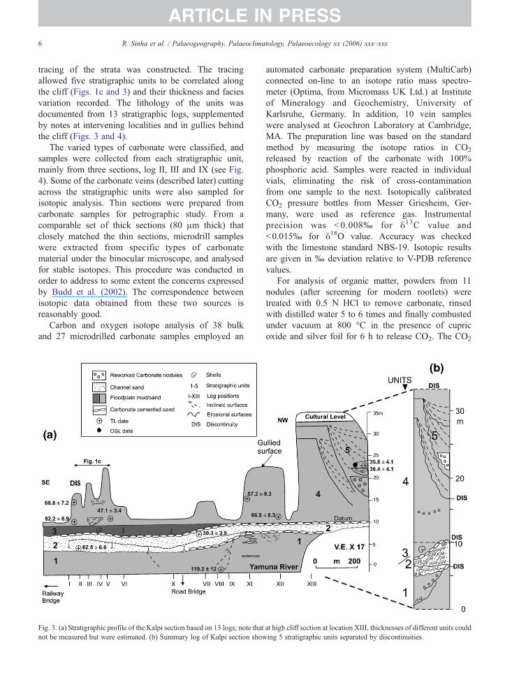
tracing of the strata was constructed. The tracingallowed five stratigraphic units to be correlated alongthe cliff (Figs. 1c and 3) and their thickness and faciesvariation recorded. The lithology of the units wasdocumented from 13 stratigraphic logs, supplementedby notes at intervening localities and in gullies behindthe cliff (Figs. 3 and 4).
The varied types of carbonate were classified, andsamples were collected from each stratigraphic unit,mainly from three sections, log II, III and IX (see Fig.4). Some of the carbonate veins (described later) cuttingacross the stratigraphic units were also sampled forisotopic analysis. Thin sections were prepared fromcarbonate samples for petrographic study. From acomparable set of thick sections (80 μm thick) thatclosely matched the thin sections, microdrill sampleswere extracted from specific types of carbonatematerial under the binocular microscope, and analysedfor stable isotopes. This procedure was conducted inorder to address to some extent the concerns expressedby Budd et al. (2002). The correspondence betweenisotopic data obtained from these two sources isreasonably good.
Carbon and oxygen isotope analysis of 38 bulkand 27 microdrilled carbonate samples employed an
Fig. 3. (a) Stratigraphic profile of the Kalpi section based on 13 logs; note thatnot be measured but were estimated. (b) Summary log of Kalpi section show
automated carbonate preparation system (MultiCarb)connected on-line to an isotope ratio mass spectro-meter (Optima, from Micromass UK Ltd.) at Instituteof Mineralogy and Geochemistry, University ofKarlsruhe, Germany. In addition, 10 vein sampleswere analysed at Geochron Laboratory at Cambridge,MA. The preparation line was based on the standardmethod by measuring the isotope ratios in CO2
released by reaction of the carbonate with 100%phosphoric acid. Samples were reacted in individualvials, eliminating the risk of cross-contaminationfrom one sample to the next. Isotopically calibratedCO2 pressure bottles from Messer Griesheim, Ger-many, were used as reference gas. Instrumentalprecision was <0.008‰ for δ13C value and<0.015‰ for δ18O value. Accuracy was checkedwith the limestone standard NBS-19. Isotopic resultsare given in ‰ deviation relative to V-PDB referencevalues.
For analysis of organic matter, powders from 11nodules (after screening for modern rootlets) weretreated with 0.5 N HCl to remove carbonate, rinsedwith distilled water 5 to 6 times and finally combustedunder vacuum at 800 °C in the presence of cupricoxide and silver foil for 6 h to release CO2. The CO2
at high cliff section at location XIII, thicknesses of different units coulding 5 stratigraphic units separated by discontinuities.
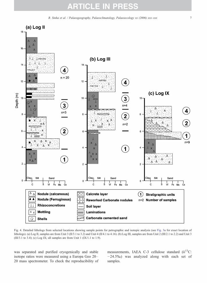
Fig. 4. Detailed lithologs from selected locations showing sample points for petrographic and isotopic analysis (see Fig. 3a for exact location oflithologs). (a) Log II, samples are from Unit 3 (II/3.1 to 3.2) and Unit 4 (II/4.1 to 4.16). (b) Log III, samples are from Unit 2 (III/2.1 to 2.2) and Unit 3(III/3.1 to 3.4); (c) Log IX; all samples are from Unit 1 (IX/1.1 to 1.9).
7R. Sinha et al. / Palaeogeography, Palaeoclimatology, Palaeoecology xx (2006) xxx–xxx
ARTICLE IN PRESS
was separated and purified cryogenically and stableisotope ratios were measured using a Europa Geo 20–20 mass spectrometer. To check the reproducibility of
measurements, IAEA C-3 cellulose standard (δ13C:−24.5‰) was analyzed along with each set ofsamples.
8 R. Sinha et al. / Palaeogeography, Palaeoclimatology, Palaeoecology xx (2006) xxx–xxx
ARTICLE IN PRESS
4. Kalpi section
4.1. Stratigraphic units and paleoenvironmentalinterpretation
Details of the stratigraphic units in the Kalpi section(Fig. 2) and lithofacies interpretations are given inGibling et al. (2005). The units are outlined here withspecial emphasis on carbonate materials, the mega-scopic and microscopic appearance of which aredescribed more fully below. The Kalpi section includesa wide range of carbonate types, and also appearsrepresentative of types noted in several other smallersections in the southern Ganga Plains (Gibling et al.,2005; Sinha et al., 2005a,b).
The basal Unit 1 consists of at least 6.6 m offloodplain deposits (Gibling et al., 2005), represented byred-brown silty clay with discontinuous horizons ofrhizoconcretions (growth of carbonate around living ordead plant roots: Klappa, 1983) and carbonate nodules,as well as disseminations of whitish powdery carbonate.Drab mottles indicate that the muds were affected bypedogenesis, and the presence of drab mottles andrhizoconcretions testifies to the former presence anddecay of vegetation. Carbonates and subordinate Fe/Mgsegregations within the paleosols suggest seasonalclimates. Rhizoconcretions are concentrated at somelevels, but horizonation is weak and no sesquioxidehorizons indicative of sustained soil formation werenoted. Medium-grained sand at the base of the sectionrepresents a channel fill.
In the upper part of the unit in the north-western partof the section (log IX and beyond: Figs. 3 and 4),degradation of the floodplain deposits generated gullyfills, at least 6 m thick, that contain lenses of reworkedcarbonate gravel on inclined surfaces. The top of Unit 1represents a prominent discontinuity, and is marked byan irregular surface of carbonate-cemented sand with apatchy distribution, locally overlain by carbonate gravel(Fig. 5a). The carbonate-cemented layer follows adegraded paleosurface (between Units 1 and 2) thatrepresents a former erosional landscape. The cap ofcarbonate gravel indicates that cementation took place ata depth shallow enough for erosional reworking.
Unit 2 is up to 4.2 m thick and consists of twosuperimposed channel bodies (each up to 3 m thick) thatrepresent small, plains-fed rivers (Gibling et al., 2005).The lower channel body consists of sand sheets andlenses (Fig. 3) with distorted stratification (possiblyindicative of seismically induced dewatering) above abasal lag of reworked carbonate gravel. The sandcontains abundant carbonate in the form of rhizoconcre-
tions (especially prominent in the upper parts: Fig. 5b),nodules (some coated with pyrolusite), and ball-likemasses of cemented sand (Fig. 5c), as well as some Fe/Mn nodules. Rhizoconcretions and carbonate nodulesare also prominent in the upper channel body. Theabundance of rhizoconcretions indicates that vegetationwas a prominent feature of the landscape during and/orfollowing channel deposition, and the varied carbonatetypes suggest both pedogenic and groundwater cemen-tation in this unit.
A prominent carbonate-cemented sand caps theupper channel body of Unit 2 (Figs. 3 and 4). Thesand fills scours on a gullied surface and is associatedwith lenses of cross-bedded carbonate gravel. Thesefeatures indicate that the unit top marks a strongdiscontinuity, and the cemented surface also suggestsphreatic and capillary zone cementation of a gulliedpalaeosurface (groundwater origin). Many carbonateveins cut Units 1 and 2 (Fig. 5d), and are inferred torepresent joints generated by seismic action and latercemented by carbonate from groundwater systems. Theseismic event predated Unit 3, which is not cut by theveins.
Unit 3 comprises 3 m of floodplain sediment (Giblinget al., 2005) that fills an extensive hollow on top of Unit1 (Fig. 3). It consists of unstratified clay-rich mud withgastropods and bivalves at one locality. Other featuresinclude rhizoconcretions (Fig. 5e), small carbonatenodules, dark Fe/Mn patches, and vertical drab mottles,with a few slickensides. Patches of relict stratificationimply that the muds have been intensively destratified,and a locally prominent vertical fabric is associated withvertically elongate rhizoconcretions and carbonatesheets, suggestive of vertical, shrink–swell effects.Pedality is weakly developed. These features collec-tively indicate that the Unit 3 muds have undergonestrong pedogenesis.
Unit 4 comprises a thick (23.3 m) succession ofinterbedded mud and sand that rests gradationally onUnit 3, from which it is demarcated by the incoming ofsand sheets. It is best exposed in the large cliff in thenorthwest area, although it was most fully examined inshorter, accessible logs (II–V; Figs. 3 and 4) and ingullies behind the cliff face. The unit comprises sheetsof silt and sand interbedded with mottled and biotur-bated brown mud; two prominent, closely spaced brownmuds (Fig. 1c) can be traced for at least 200 m in thesoutheastern cliffs. Rhizoconcretions, small nodules,and soft carbonate patches are common, and largecarbonate nodules form discontinuous bands in thelower part. Small dark nodules and red ferruginous,millimeter-sized nodules are present locally.
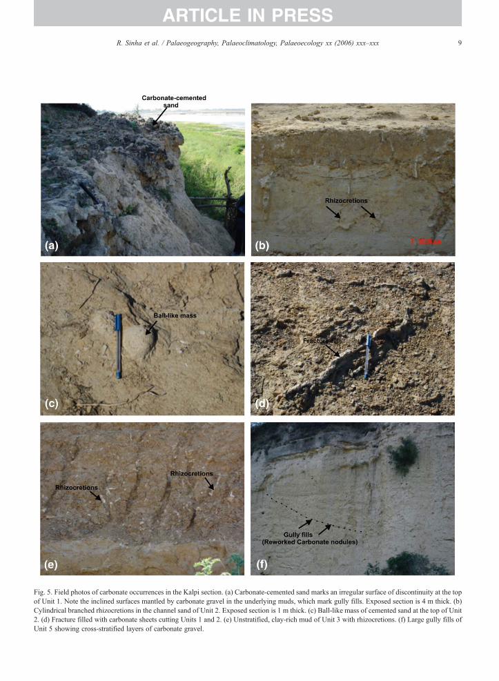
Fig. 5. Field photos of carbonate occurrences in the Kalpi section. (a) Carbonate-cemented sand marks an irregular surface of discontinuity at the topof Unit 1. Note the inclined surfaces mantled by carbonate gravel in the underlying muds, which mark gully fills. Exposed section is 4 m thick. (b)Cylindrical branched rhizocretions in the channel sand of Unit 2. Exposed section is 1 m thick. (c) Ball-like mass of cemented sand at the top of Unit2. (d) Fracture filled with carbonate sheets cutting Units 1 and 2. (e) Unstratified, clay-rich mud of Unit 3 with rhizocretions. (f) Large gully fills ofUnit 5 showing cross-stratified layers of carbonate gravel.
9R. Sinha et al. / Palaeogeography, Palaeoclimatology, Palaeoecology xx (2006) xxx–xxx
ARTICLE IN PRESS
10 R. Sinha et al. / Palaeogeography, Palaeoclimatology, Palaeoecology xx (2006) xxx–xxx
ARTICLE IN PRESS
Unit 4 represents the accumulation of thick, exten-sive floodplain sand and mud sheets (Gibling et al.,2005) above the muddy backswamp deposits of Unit 3.The basal sand layer suggests the invasion of thebackswamps by crevasse splays or levee sheets. Amodest degree of pedogenesis is evident from mottling,carbonate and ferruginous nodule formation. One layerof reworked carbonate indicates that at least one periodof floodplain degradation intervened during the deposi-tion of this predominantly aggradational unit.
Unit 5 represents three episodes of gully cutting andfilling (Gibling et al., 2005), with gully filling up to10 m thick (Fig. 3) and composed largely of colluvialmaterial (Fig. 5f). It is of relevance here to note that onegully fill includes two (largely inaccessible, NW end ofthe cliff, Fig. 3a) lensoid channel bodies up to 5 m thick,composed of cross-stratified carbonate gravel. Theseindicate that the gullies were locally sites of through-going drainage.
4.2. Age of strata
A summary account of the age of the strata is given inGibling et al. (2005) and the ages are shown in Fig. 3a.Because dated samples from the upper part of Units 4and 5 were the only samples to yield finite dates basedon optically stimulated luminescence (OSL) of quartz,the older units have been dated using thermolumines-cence (TL) ages of quartz. Excellent correspondencewas obtained between TL and finite OSL dates in Units4 and 5, confirming the validity of this approach todating the section. The units can be correlated broadlywith Marine Isotope Stages (MIS). The age of thecarbonate materials could not be determined directly.Srivastava et al. (2003) dated the base of the section to76±11 ka and cliff-top strata to 32±5 ka using OSLmethods.
Based on these dates, the Kalpi cliff section isinferred to span part of the Late Quaternary (MIS 3–5),and may perhaps extend into the Mid-Quaternary(>125 ka). In view of the large error bars for the OSLand TL dates, as well as one apparently anomalous date,the age model for the section is only broadlyconstrained. Nevertheless, if error bars are taken intoaccount, the sampled interval of ∼18 m probablyrepresents a period of 60,000 to 90,000 years, spanningpart or all of three marine isotope stages.
4.3. Discontinuity-bounded units
A key feature of the Kalpi section, as well as othersections in the region (Williams and Clarke, 1995;
Gibling et al., 2005; Sinha et al., 2005a) is theprominence of erosional discontinuities. The stratalarchitecture is that of discontinuity-bounded units(sequences) that represent alternate phases of floodplainaggradation and degradation (Fig. 3b). The disconti-nuities between Units 1 and 2 and Units 2 and 3 aremarked by erosional relief, calcite cementation, andpaleosols. Because of limited exposure, the areal extentof the units and discontinuities is not known, but thosein the Kalpi section can be traced for the full cliff lengthof 1.5 km (Fig. 3a).
Discontinuities such as these may reflect floodplaingullying and headward erosion associated with incisionalong major drainage lines. Based on facies in exposedsections and age models, Gibling et al. (2005) reasonedthat the discontinuity-bounded sequences are trackingclimatic changes on the scale of marine isotope stages(104 year timescales). The sequences are probablyrelated to large fluctuations of monsoonal precipitation(Prell and Kutzbach, 1987), leading to large variationsin river discharge and sediment transport. Thesevariations reflect the hydrological response of uplandcatchment systems to monsoonal strengthening andweakening, supplemented by drainage from the localplains.
5. Carbonate types: field and petrographiccharacteristics
5.1. Classification
Eight types of carbonate (Table 1) are distinguishedon the basis of megascopic physical appearance (sizeand form), host sediment (sand or mud), degree ofinduration (indurated or powdery), relationship todiscontinuities and tectonic structures, and petrographiccharacter.
Indurated, sub-equant nodules, a few centimeters indiameter, are common in all the Kalpi units, where theyare disseminated or concentrated in discontinuouszones. This carbonate is the most abundant type in thesouthern Ganga plains alluvium, based on outcrops anddrill cores, and commonly ranges from a few percent to20% by volume of floodplain deposits. In view of thepoor development of internal layering, the bodies aretermed “nodules” rather than “concretions” (Brewer,1964). The petrographic features of nodules in sandy ormuddy sediment were studied separately. Powderycarbonate and rhizoconcretions, are also common,although they rarely form more than a few percent ofthe floodplain deposits. These types are composedpredominantly of micrite with local sparry patches, and
Table 1Classification of carbonate types in the Kalpi section
Carbonate type Genetic type Stratigraphic occurrence
1. Carbonate hosted in sand1.1. Nodules Mixed pedogenic-groundwater Units 1, 41.2. Rhizoconcretions and ball-like masses of cemented sand Mixed pedogenic-groundwater Unit 21.3. Groundwater-cemented sand (nodular and brecciated-irregularcemented sandy horizons associated with discontinuities)
Mixed groundwater-pedogenic Units 1 to 4 (Units 1–2 and2–3 boundaries)
2. Carbonate hosted in mud2.1. Nodules Pedogenic Units 1, 2, 32.2. Rhizoconcretions Pedogenic Units 1, 2, 3, 42.3. Powdery Pedogenic Unit 1
3. Fracture fill (vein fills) (cemented sandy silt,in places nodular appearance)
Vadose/Groundwater (?) Cross-cutting Units 1 and 2
4. Reworked carbonate nodules Sheet flow/Channel flow Units 1 and 2
11R. Sinha et al. / Palaeogeography, Palaeoclimatology, Palaeoecology xx (2006) xxx–xxx
ARTICLE IN PRESS
the setting and petrographic character of all these typessuggests that they are predominantly pedogenic.
Cemented sand and ball-like masses of cementedsand occur as sheets and lenses along discontinuities atKalpi and elsewhere, and are interpreted as non-pedogenic, formed through the influence of ground-water. The carbonate is predominantly sparry, andshrinkage-related fabrics, alveolar fabrics, and clottedmicrite are largely absent. Also attributed to ground-water are vein fills, which are common in the lower partof the Kalpi section but rare elsewhere in the region.Reworked carbonate nodules are associated with bothpedogenic and non-pedogenic carbonates at numerouslevels.
5.2. Carbonate hosted in sand
5.2.1. NodulesThree types of calcite are observed within the
nodules. Mosaics of subhedral calcite, with thickerzones between subhedral crystals, indicate re-precipita-tion along dissolutional boundaries (cf. Tandon andKumar, 1999). Areas of calcite spar have incorporateddetrital grains which have etched margins and appear tobe floating (Nagtegaal, 1969; Watts, 1978). Thirdly,patches of micrite and microspar are present, with themicrite crystals of uniform size in any patch but varyingin size from patch to patch.
5.2.2. Rhizoconcretions and ball-like masses ofcemented sand
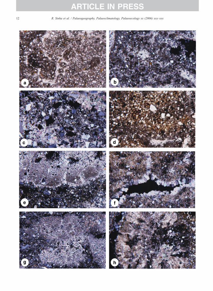
These two types are intimately associated in Unit 2.Cylindrical, branched rhizoconcretions are typically 1–5 cm in diameter but up to 30 cm in diameter. Theyconsist of dark micrite with detrital grains (Fig. 6a).Some root-related fabrics resemble alveolar fabrics(Esteban and Klappa, 1983; Wright and Tucker, 1991),
and networks of spar-filled microchannels of varied sizehave micritic walls (Fig. 6b).
Ball-like masses of cemented sand are present in bothUnit 2 channel bodies, where the ‘porous’ sand hasprobably contributed to the growth of large nodules.Masses within the lower body show a crisscross veinnetwork of calcite. Lenses of carbonate-cemented sandcap the upper body, and fill scours on a gullied surfacethat extends for the length of the outcrop. Thin sectionsreveal detrital grains floating in a carbonate groundmass(Fig. 6b). In grain-rich areas, micrite shows a patchydistribution and is locally rusty-brown. Micrite-domi-nated areas show local patches of spar that were variablyshaped open spaces in which calcite precipitated, mostlyas subhedral mosaics.
5.2.3. Carbonate-cemented sandThe irregular discontinuity at the top of Unit 1 is
marked by several decimeters of carbonate-cementedsand with local carbonate gravel (Fig. 3a,b). In places,the cemented material appears nodular and brecciated. Aless pronounced nodular-cemented layer is also presentat the Unit 2/3 discontinuity. Thin sections showabundant floating grains (mainly quartz) in a spargroundmass, with some spar mosaics that may representcavity fills (Fig. 6c).
5.3. Carbonate hosted in mud
5.3.1. NodulesNodules developed in mud predominate in the Kalpi
section. Nodules in Unit 3 represent a homogeneouscarbonate impregnation of the host sediment. Micriticareas vary from light to dark brown, and mica plateletsare present. Linear unfilled spaces may be shrinkagerelated. Nodules in Unit 4 have a predominantly micritegroundmass, with abundant silt-sized quartz and a few
12 R. Sinha et al. / Palaeogeography, Palaeoclimatology, Palaeoecology xx (2006) xxx–xxx
ARTICLE IN PRESS
13R. Sinha et al. / Palaeogeography, Palaeoclimatology, Palaeoecology xx (2006) xxx–xxx
ARTICLE IN PRESS
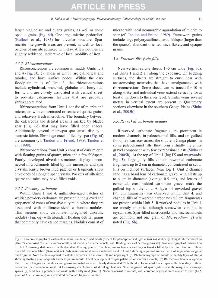
larger plagioclase and quartz grains, as well as someopaque grains (Fig. 6d). One large micrite ‘pedorelict’(Bullock et al., 1985) has alveolar structure. Spar-micrite intergrowth areas are present, as well as localpatches of micrite admixed with clay. A few nodules areslightly reddened, indicative of local mobility of iron.
5.3.2. RhizoconcretionsRhizoconcretions are common in muddy Units 1, 3
and 4 (Fig. 5b, e). Those in Unit 1 are cylindrical andtubular, and have surface nodes. Within the darkfloodplain muds of Unit 3, the rhizoconcretionsinclude cylindrical, branched, globular and botryoidalforms, and are closely associated with vertical sheet-to rod-like calcareous features that are probablyshrinkage-related.
Rhizoconcretions from Unit 1 consist of micrite andmicrospar, with concentrated or scattered quartz grains,and relatively fresh microcline. The boundary betweenthe calcareous and detrital areas is marked by bladedspar (Fig. 6e) that may have filled open spaces.Additionally, several microspar-spar areas display asucrosic fabric. Shrinkage cracks filled by spar (Fig. 6f)are common (cf. Tandon and Friend, 1989; Tandon etal., 1998).
Rhizoconcretions from Unit 3 consist of dark micritewith floating grains of quartz, mica and a few feldspars.Poorly developed alveolar structures display uncon-nected microchannels filled by tiny microspar and sparcrystals. Rusty brown mud patches or fragments showenvelopes of elongate spar crystals. Pockets of silt-sizedquartz and mica may have filled voids.
5.3.3. Powdery carbonateWithin Units 1 and 4, millimeter-sized patches of
whitish powdery carbonate are present in the gleyed andgrey-mottled zones of massive silty mud, where they areassociated with millimeter-sized carbonate nodules.Thin sections show carbonate-impregnated disorthicnodules (Fig. 6g) with abundant floating detrital grainsthat commonly have etched margins. Nodules consist of
Fig. 6. Photomicrographs of carbonate materials under crossed nicols (except(Unit 2), composed of micritic micronodules and spar-filled microchannels, wof Unit 2 showing dark micrite with abundant floating grains. Chambers,resemble alveolar fabric (X-nicols). (c) Carbonate-cemented masses in brownquartz grains. Note the development of calcite spar areas in the lower left andshowing floating grain of quartz and feldspar in micrite. Local development oUnit 1 muds. Fragmented nodules and grain-dominated areas are clearly demtwo areas. (f) Rhizoconcretion (Unit 1) showing development of shrinkage fspaces. (g) Nodules in powdery carbonate within silty mud (Unit 1). Nodulegrain of Microcodium(?) in a reworked carbonate fragment in Unit 1.
micrite with local neomorphic aggradation of micrite tospar (cf. Tandon and Friend, 1989). Framework grainsinclude large polycrystalline quartz, feldspar (larger thanthe quartz), abundant oriented mica flakes, and opaquegrains.
5.4. Fracture fills (vein fills)
Near-vertical calcite sheets, 1–5 cm wide (Fig. 5d),cut Units 1 and 2 all along the exposure. On beddingsurfaces, the sheets are straight to curvilinear withanastomosing networks that have amalgamated withrhizoconcretions. Some sheets can be traced for 10 malong strike, and individual veins extend vertically for atleast 6 m, down to the river level. Similar veins severalmeters in vertical extent are present in Quaternarysections elsewhere in the southern Ganga Plains (Sinhaet al., 2005b).
5.5. Reworked carbonate nodules
Reworked carbonate fragments are prominent inmodern channels, in paleochannel fills, and on gulliedfloodplain surfaces across the southern Ganga plains. Insome paleochannel fills, they form virtually the entiregravel component with few extrabasinal clasts (Sinha etal., 2005b). At the top of Unit 1 (log IX and westwards:Fig. 3), large gully fills contain reworked carbonatefragments up to 2 cm in diameter, concentrated in scourfills on inclined surfaces. Near log 1, Unit 2 channelsand has a basal lens of carbonate gravel with clasts upto 4 cm in diameter (average 0.5 cm), and lenses ofcemented, cross-bedded carbonate gravel mark thegullied top of the unit. A layer of reworked gravel(<1 cm fragments) was observed within Unit 4, andchannel fills of reworked carbonate (<2 cm fragments)are present within Unit 5. Reworked nodules in Unit 1are mostly micritic, although somewhat variable incrystal size. Spar-filled microcracks and microchannelsare common, and one grain of Microcodium (?) wasnoted (Fig. 6h).
for plane-polarised light in (a)). (a) Vertically elongate rhizoconcretionith floating fabric of detrital grains. (b) Photomicrograph of rhizocretionmicrochannels and lacy networks filled by spar are observed. Thesesand of Unit 2 showing a grain-dominated area of angular/sub-angularupper right. (d) Photomicrograph of nodule of muddy layer of Unit 4
f spar patches is observed (X-nicols). (e) Rhizoconcretion developed inarcated. Note the development of bladed spar at the boundary of theseeatures. Note the growth of spar crystals from the margin of shrinkages consist of micrite, with common segregation of micrite to spar. (h) A
14 R. Sinha et al. / Palaeogeography, Palaeoclimatology, Palaeoecology xx (2006) xxx–xxx
ARTICLE IN PRESS
5.6. Carbonate genesis and environmental implications
In pedogenic calcretes, alpha and beta fabrics areconsidered as petrographic (micromorphological) endmembers, with many calcretes exhibiting mixtures ofthe two (Wright and Tucker, 1991). Nash and McLaren(2003) pointed out that calcretes formed predominantlyby soil-forming processes exhibit beta fabrics withstrong evidence of biological activity (cf. Wright andTucker, 1991). Such beta calcretes are considered to bebest developed in vegetated semi-arid to sub-humidbelts.
Despite the above observations, most fabricsdocumented in this study, including those fromnodules, rhizoconcretions, powdery carbonate,reworked nodules, and many groundwater calcrete,are of alpha type (e.g. Tandon and Narayan, 1981;Wright and Tucker, 1991). Distinctive fabric elementsinclude floating textures, micrite–microspar patches,nodule development, calcite cement (passively pre-cipitated in shrinkage spaces), grain-coating micrite,and bladed spar on the walls of shrinkage spaces. Thissuggests that the calcretes formed mainly throughevaporation or evapotranspiration and degassing, withlimited biological activity. Microbes present in rootsystems may have played some role in carbonateprecipitation as has been demonstrated by Monger et al.(1991).
Some rhizoconcretions and calcareous sandstonemasses show alpha-type fabrics, with some weaklydeveloped alveolar fabrics in the form of spar-filledmicrochannels with walls of micrite (Fig. 6b), as well asone probable Microcodium grain (Fig. 6h). Apart fromthese cryptic indications of beta fabrics, no otherevidence has been recorded. Fabric elements that weresearched for but not recorded include calcified fila-ments, needle fiber calcite, microbial tubes, root mats,and calcified faecal pellets (Bal, 1975; Klappa, 1978,1979; Mount and Cohen, 1984; Wright and Tucker,1991; Verrecchia and Verrecchia, 1994).
Carbonate-cemented sandstones (non-pedogenic cal-crete) show an irregular appearance, partly because theyare related to gullied surfaces. They mainly consist ofintergranular spar and cavity-filling spar. In terms oftheir micromorphology, they are a relatively uniformgroup, in contrast with pedogenic or mixed-origin alphacalcretes in the sample set and are interpreted asgroundwater calcretes. Sparry cement predominates ingroundwater calcrete associated with the interfluvechannels of Unit 2, resembling groundwater calcretesof the Siwalik Group (Tandon and Varshney, 1991;Quade and Roe, 1999). They consist largely of
intergranular spar cement and have floating-graintextures, with no indication of beta fabrics.
In summary, pedogenic nodules in the Kalpi sectionshow a predominance of alpha fabrics, whereasrhizoconcretions and calcareous sandstone massesinclude some weakly developed alveolar fabrics.Pedogenic calcretes are associated with aggradationalfloodplain deposits (Units 1, 3, and 4), and probablycorrespond with periods of relatively high monsoonalprecipitation and river discharge. In contrast, cementeddegradational surfaces along discontinuities (boundariesof Units 1 and 2, and 3 and 4) probably correspond toperiods of relatively low monsoonal precipitation. Thestrongly cemented channel bodies of Unit 2 have beenindurated through groundwater and groundwater–pedo-genic action in a valley setting. Alpha calcretespredominate in both pedogenic and groundwatercarbonate in this part of the Ganga plains.
Wright and Tucker (1991) argued that the preferentialdevelopment of alpha calcretes in silicate-rich sedimentsmay reflect the “preference of calcites to form bondswith other calcites to displace other grains” (Chadwickand Nettleton, 1990). Alpha fabrics also exhibitevidence of neomorphic spar or microspar, suggestingreplacement of finer by coarser crystals (Sehgal andStoops, 1972; Tandon and Narayan, 1981; Wieder andYaalon, 1982; Drees and Wilding, 1987). The predomi-nance of alpha fabrics in Kalpi pedogenic calcrete mayreflect (a) weak pedogenesis, (b) cohesive bonding ofcalcite to calcite, and/or (c) replacement and neo-morphic aggradation, leading to poor preservation ofbiological fabrics.
Extensively developed Quaternary calcretes in thesemi-arid to arid region of the Thar Desert in northwestIndia also show predominantly alpha fabrics (Dhir et al.,2004). Taken together with the present study, alphacalcretes appear to predominate in the Quaternarylandscapes of northern and western India, where modernrainfall ranges from 200 to 1000 mm/year. Beta fabricsin calcretes formed by soil-forming processes appear tohave been weakly developed or poorly preserved, incontrast to studies elsewhere (Nash and McLaren,2003).
6. Carbon and oxygen isotopic composition ofcalcrete
Carbon and oxygen isotope data were obtained fromcarbonates in Units 1, 2, 3 and the lower part of Unit 4(Table 2). For some rhizoconcretions, nodules, andpowdery carbonate, measurements were also made onmicrodrilled separates of micrite and sparite. Bulk and
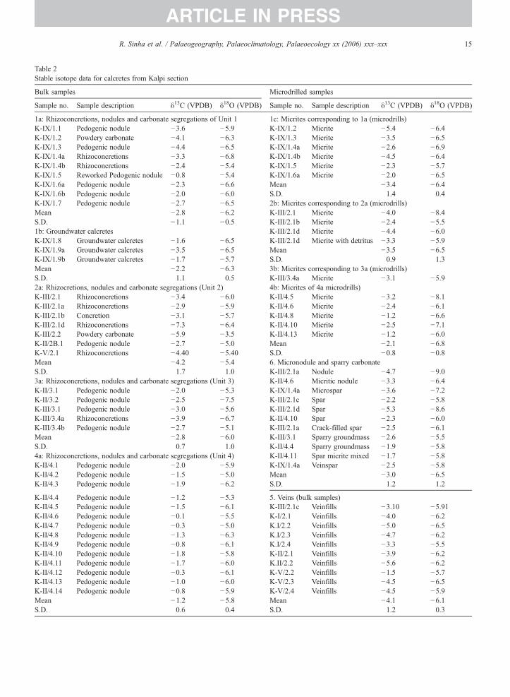
Table 2Stable isotope data for calcretes from Kalpi section
Bulk samples Microdrilled samples
Sample no. Sample description δ13C (VPDB) δ18O (VPDB) Sample no. Sample description δ13C (VPDB) δ18O (VPDB)
1a: Rhizoconcretions, nodules and carbonate segregations of Unit 1 1c: Micrites corresponding to 1a (microdrills)K-IX/1.1 Pedogenic nodule −3.6 −5.9 K-IX/1.2 Micrite −5.4 −6.4K-IX/1.2 Powdery carbonate −4.1 −6.3 K-IX/1.3 Micrite −3.5 −6.5K-IX/1.3 Pedogenic nodule −4.4 −6.5 K-IX/1.4a Micrite −2.6 −6.9K-IX/1.4a Rhizoconcretions −3.3 −6.8 K-IX/1.4b Micrite −4.5 −6.4K-IX/1.4b Rhizoconcretions −2.4 −5.4 K-IX/1.5 Micrite −2.3 −5.7K-IX/1.5 Reworked Pedogenic nodule −0.8 −5.4 K-IX/1.6a Micrite −2.0 −6.5K-IX/1.6a Pedogenic nodule −2.3 −6.6 Mean −3.4 −6.4K-IX/1.6b Pedogenic nodule −2.0 −6.0 S.D. 1.4 0.4K-IX/1.7 Pedogenic nodule −2.7 −6.5 2b: Micrites corresponding to 2a (microdrills)Mean −2.8 −6.2 K-III/2.1 Micrite −4.0 −8.4S.D. −1.1 −0.5 K-III/2.1b Micrite −2.4 −5.51b: Groundwater calcretes K-III/2.1d Micrite −4.4 −6.0K-IX/1.8 Groundwater calcretes −1.6 −6.5 K-III/2.1d Micrite with detritus −3.3 −5.9K-IX/1.9a Groundwater calcretes −3.5 −6.5 Mean −3.5 −6.5K-IX/1.9b Groundwater calcretes −1.7 −5.7 S.D. 0.9 1.3Mean −2.2 −6.3 3b: Micrites corresponding to 3a (microdrills)S.D. 1.1 0.5 K-III/3.4a Micrite −3.1 −5.92a: Rhizocretions, nodules and carbonate segregations (Unit 2) 4b: Micrites of 4a microdrills)K-III/2.1 Rhizoconcretions −3.4 −6.0 K-II/4.5 Micrite −3.2 −8.1K-III/2.1a Rhizoconcretions −2.9 −5.9 K-II/4.6 Micrite −2.4 −6.1K-III/2.1b Concretion −3.1 −5.7 K-II/4.8 Micrite −1.2 −6.6K-III/2.1d Rhizoconcretions −7.3 −6.4 K-II/4.10 Micrite −2.5 −7.1K-III/2.2 Powdery carbonate −5.9 −3.5 K-II/4.13 Micrite −1.2 −6.0K-II/2B.1 Pedogenic nodule −2.7 −5.0 Mean −2.1 −6.8K-V/2.1 Rhizoconcretions −4.40 −5.40 S.D. −0.8 −0.8Mean −4.2 −5.4 6. Micronodule and sparry carbonateS.D. 1.7 1.0 K-III/2.1a Nodule −4.7 −9.03a: Rhizoconcretions, nodules and carbonate segregations (Unit 3) K-II/4.6 Micritic nodule −3.3 −6.4K-II/3.1 Pedogenic nodule −2.0 −5.3 K-IX/1.4a Microspar −3.6 −7.2K-II/3.2 Pedogenic nodule −2.5 −7.5 K-III/2.1c Spar −2.2 −5.8K-III/3.1 Pedogenic nodule −3.0 −5.6 K-III/2.1d Spar −5.3 −8.6K-III/3.4a Rhizoconcretions −3.9 −6.7 K-II/4.10 Spar −2.3 −6.0K-III/3.4b Pedogenic nodule −2.7 −5.1 K-III/2.1a Crack-filled spar −2.5 −6.1Mean −2.8 −6.0 K-III/3.1 Sparry groundmass −2.6 −5.5S.D. 0.7 1.0 K-II/4.4 Sparry groundmass −1.9 −5.84a: Rhizoconcretions, nodules and carbonate segregations (Unit 4) K-II/4.11 Spar micrite mixed −1.7 −5.8K-II/4.1 Pedogenic nodule −2.0 −5.9 K-IX/1.4a Veinspar −2.5 −5.8K-II/4.2 Pedogenic nodule −1.5 −5.0 Mean −3.0 −6.5K-II/4.3 Pedogenic nodule −1.9 −6.2 S.D. 1.2 1.2
K-II/4.4 Pedogenic nodule −1.2 −5.3 5. Veins (bulk samples)K-II/4.5 Pedogenic nodule −1.5 −6.1 K-III/2.1c Veinfills −3.10 −5.91K-II/4.6 Pedogenic nodule −0.1 −5.5 K-I/2.1 Veinfills −4.0 −6.2K-II/4.7 Pedogenic nodule −0.3 −5.0 K.I/2.2 Veinfills −5.0 −6.5K-II/4.8 Pedogenic nodule −1.3 −6.3 K.I/2.3 Veinfills −4.7 −6.2K-II/4.9 Pedogenic nodule −0.8 −6.1 K.I/2.4 Veinfills −3.3 −5.5K-II/4.10 Pedogenic nodule −1.8 −5.8 K-II/2.1 Veinfills −3.9 −6.2K-II/4.11 Pedogenic nodule −1.7 −6.0 K.II/2.2 Veinfills −5.6 −6.2K-II/4.12 Pedogenic nodule −0.3 −6.1 K-V/2.2 Veinfills −1.5 −5.7K-II/4.13 Pedogenic nodule −1.0 −6.0 K-V/2.3 Veinfills −4.5 −6.5K-II/4.14 Pedogenic nodule −0.8 −5.9 K-V/2.4 Veinfills −4.5 −5.9Mean −1.2 −5.8 Mean −4.1 −6.1S.D. 0.6 0.4 S.D. 1.2 0.3
15R. Sinha et al. / Palaeogeography, Palaeoclimatology, Palaeoecology xx (2006) xxx–xxx
ARTICLE IN PRESS
16 R. Sinha et al. / Palaeogeography, Palaeoclimatology, Palaeoecology xx (2006) xxx–xxx
ARTICLE IN PRESS
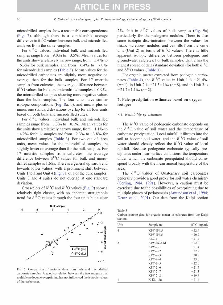
microdrilled samples show a reasonable correspondence(Fig. 7), although there is a considerable averagedifference in δ13C values between bulk and microdrilledanalyses from the same samples.
For δ18O values, individual bulk and microdrilledsamples range from −9.0‰ to −3.5‰. Mean values forthe units show a relatively narrow range, from −5.4‰ to−6.3‰ for bulk samples, and from −6.4‰ to −7.0‰for microdrilled samples (Table 3). Mean values for themicrodrilled carbonates are slightly more negative onaverage than for the bulk samples. For 17 micriticsamples from calcretes, the average difference betweenδ18O values for bulk and microdrilled samples is 0.9‰,the microdrilled samples showing more negative valuesthan the bulk samples. The four units have similarisotopic compositions (Fig. 8a, b), and means plus orminus one standard deviations overlap for all four unitsbased on both bulk and microdrilled suites.
For δ13C values, individual bulk and microdrilledsamples range from −7.3‰ to −0.1‰. Mean values forthe units show a relatively narrow range, from −1.1‰ to−4.2‰ for bulk samples and from −2.3‰ to −3.8‰ formicrodrilled samples (Table 3). For two out of threeunits, mean values for the microdrilled samples areslightly lower on average than for the bulk samples. For17 micritic samples from calcretes, the averagedifference between δ13C values for bulk and micro-drilled samples is 1.6‰. There is a general upward trendtowards lower values, with a prominent shift betweenUnits 1 to 3 and Unit 4 (Fig. 8a, c). For the bulk samples,Units 3 and 4 suites do not overlap at one standarddeviation.
Cross-plots of δ13C and δ18O values (Fig. 9) show arelatively tight cluster, with no apparent stratigraphictrend for δ18O values through the four units but a clear
Fig. 7. Comparison of isotopic data from bulk and microdrilledcarbonate samples. A good correlation between the two suggests thatmultiple pedogenic overprinting has not influenced the isotopic valuesof the carbonates.
2‰ shift in δ13C values of bulk samples (Fig. 9a)particularly for the pedogenic nodules. There is alsosome isotopic discrimination between the values forrhizoconcretions, nodules, and veinfills from the sameunit (Unit 2) in terms of δ13C values. There is littleapparent isotopic difference between pedogenic andgroundwater calcretes. For bulk samples, Unit 2 has thehighest spread of data (standard deviation) for both δ13Cand δ18O values (Table 3).
For organic matter extracted from pedogenic carbo-nates (Table 4), the δ13C value in Unit 1 is −21.4‰(n=1), in Unit 2 is −21.5±1‰ (n=8), and in Unit 3 is−21.7±1.1‰ (n=2).
7. Paleoprecipitation estimates based on oxygenisotopes
7.1. Reliability of estimates
The δ18O value of pedogenic carbonate depends onthe δ18O value of soil water and the temperature ofcarbonate precipitation. Local rainfall infiltrates into thesoil to become soil water, and the δ18O value of soilwater should closely reflect the δ18O value of localrainfall. Because pedogenic carbonate typically pre-cipitates under near-surface conditions, the temperatureunder which the carbonate precipitated should corre-spond broadly with the mean annual temperature of thearea.
The δ18O values of Quaternary soil carbonatesgenerally provide a good proxy for soil water chemistry(Cerling, 1984, 1991). However, a caution must beexercised due to the possibilities of overprinting due tomultiple phases of pedogenesis (Amundson et al., 1994;Deutz et al., 2001). Our data from the Kalpi section
Table 3Carbon isotope data for organic matter in calcretes from the Kalpisection
Unit Sample no. δ13C organic
4 KPY-II/4.5 −22.4KPY-II/4.5 −20.9RZC-1 −21.4
2 KPY-IX-2.1d −22.0KPY-2–1 −21.4KPY-2–2 −22.2KPY-2–3 −20.8KPY-2–4 −23.0KPY-2–5 −22.0KPY-2–6 −21.7KPY-2–7 −21.3KPY-2–8 −19.6
1 K-IX/1.4a −21.4
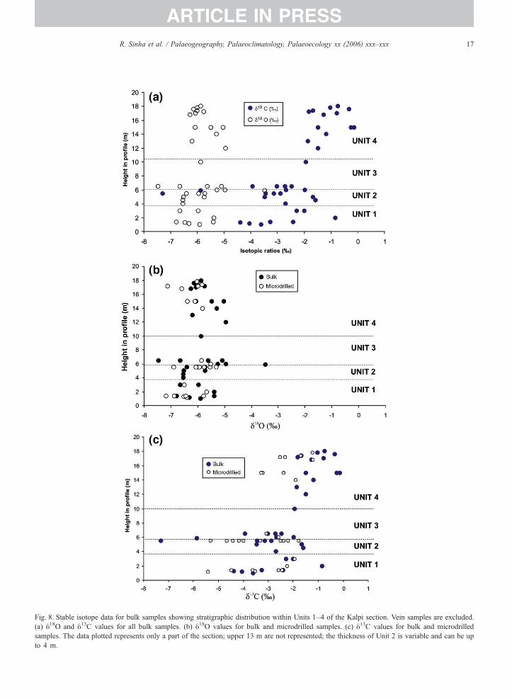
Fig. 8. Stable isotope data for bulk samples showing stratigraphic distribution within Units 1–4 of the Kalpi section. Vein samples are excluded.(a) δ18O and δ13C values for all bulk samples. (b) δ18O values for bulk and microdrilled samples. (c) δ13C values for bulk and microdrilledsamples. The data plotted represents only a part of the section; upper 13 m are not represented; the thickness of Unit 2 is variable and can be upto 4 m.
17R. Sinha et al. / Palaeogeography, Palaeoclimatology, Palaeoecology xx (2006) xxx–xxx
ARTICLE IN PRESS
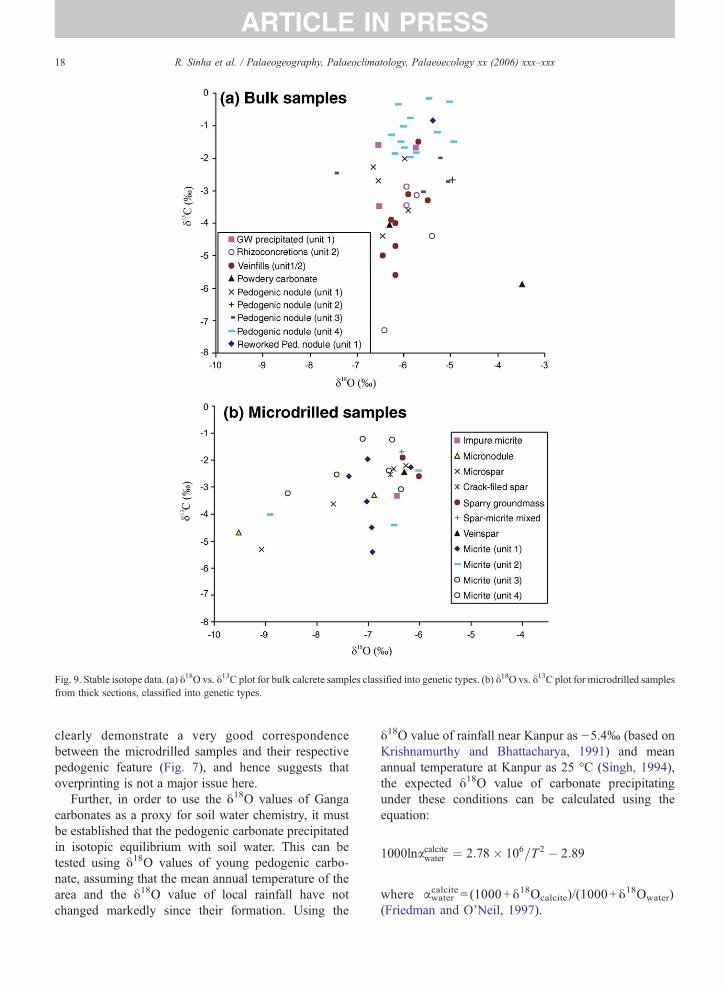
Fig. 9. Stable isotope data. (a) δ18O vs. δ13C plot for bulk calcrete samples classified into genetic types. (b) δ18O vs. δ13C plot for microdrilled samplesfrom thick sections, classified into genetic types.
18 R. Sinha et al. / Palaeogeography, Palaeoclimatology, Palaeoecology xx (2006) xxx–xxx
ARTICLE IN PRESS
clearly demonstrate a very good correspondencebetween the microdrilled samples and their respectivepedogenic feature (Fig. 7), and hence suggests thatoverprinting is not a major issue here.
Further, in order to use the δ18O values of Gangacarbonates as a proxy for soil water chemistry, it mustbe established that the pedogenic carbonate precipitatedin isotopic equilibrium with soil water. This can betested using δ18O values of young pedogenic carbo-nate, assuming that the mean annual temperature of thearea and the δ18O value of local rainfall have notchanged markedly since their formation. Using the
δ18O value of rainfall near Kanpur as −5.4‰ (based onKrishnamurthy and Bhattacharya, 1991) and meanannual temperature at Kanpur as 25 °C (Singh, 1994),the expected δ18O value of carbonate precipitatingunder these conditions can be calculated using theequation:
1000lnacalcitewater ¼ 2:78� 106=T2 � 2:89
where αwatercalcite = (1000+δ18Ocalcite)/(1000+δ
18Owater)(Friedman and O'Neil, 1997).
Table 4Oxygen and carbon isotopic values in carbonate and organic matter for stratigraphic units of the Kalpi section, expressed as mean±S.D.
Unit Carbonate type Facies type δ13C in organicmatter in nodules
δ18O in carbonate δ13C in carbonate No.(B/M)
Bulk Microdrilled Bulk Microdrilled
4 Rhizoconcretions,nodules+powdery
Floodplain(sand+mud)
n.d. −5.8±0.4 −6.7±0.77 −1.2±0.6 −2.3±0.9 14/6
3 Rhizoconcretions,nodules+powdery
Floodplain(mud dominated)
−21.7±1.1 (n=2) −5.8±0.8 n.d. −3.3±0.6 n.d. 5
2/3 Veins Tectonic event afterdeposition of Unit 2
n.d. −6.1±0.3 n.d. −4.1±1.2 n.d. 9
2 Rhizoconcretions,nodules+powdery
Plains-fed Channels,with discontinuityabove
−21.5±1.0 (n=8) −5.4±1.1 −7.0±1.6 −4.2±1.9 −3.8±0.9 6/5
1 Rhizoconcretions,nodules+powdery
Floodplain(sand+mud)
−21.4 (n=1) −6.2±0.5 −6.4±0.4 −2.8±1.1 −3.4±1.4 8/6
1 Groundwatercalcrete
Discontinuity attop of Unit 1
n.d. −6.3±0.5 n.d. −2.2±1.1 n.d. 3
n.d.=not determined.
19R. Sinha et al. / Palaeogeography, Palaeoclimatology, Palaeoecology xx (2006) xxx–xxx
ARTICLE IN PRESS
The calculated value is −7.3‰. This is very close tothe average δ18O value (−7‰) obtained from carbonatesamples from the topmost part of cores from the GangaValley at Jagdishpur and Firozpur, close to Kanpur (P.Sanyal, unpublished results). The close agreementbetween observed and expected δ18O values stronglysuggests that soil carbonate has precipitated in equili-brium with soil water, and that δ18O values of soilcarbonate can be used to estimate paleoprecipitationreliably.
7.2. Paleoprecipitation for the Kalpi area
The mean δ18O value is −5.8‰ for bulk samples and−6.7‰ for microdrilled samples (pedogenic types,excluding groundwater calcretes and fracture fills) –on average slightly higher than the calculated value forpresent rainfall in the Kanpur area.
Table 5Computation of paleoprecipitation (soil water) and relative abundance of pla
Units Paleoprecipitation Plant gr
Ave. δ18O (VPDB)(pedogenic carbonates)
Soil water δ18O(VSMOW)
Ave. δ1
(micrite
Mean annual temperature=25 °C δ13C vaα (water−carbonate)=1.028822 δ13C va
Δ (Carb
Unit 4 −5.8±0.4 −3.8 −2.1±Unit 3 −5.6±1.1 −3.6 −3.1 a
Unit 2 −5.0 a −3.0 −3.6±Unit 1 −6.3±0.3 −4.3 −3.4±Average −5.6 −3.7 −3.04a Based on one sample only.
Table 5 lists the average δ18O values of the pedogeniccarbonates for each stratigraphic unit at Kalpi and thecomputed δ18O values for soil water for the correspond-ing units. The computed soil water δ18O values rangefrom −3.0‰ to −4.3‰ with an average of −3.7‰.Given the fact that for each of the Kalpi stratigraphicunits, δ18O value shows a range of ∼2‰ (Fig. 8a, b),these variations are negligible. In low-latitude areas, a100 mm increase in rainfall causes a decrease in δ18O ofrainwater by 1.5‰ (Yurtsever and Gat, 1981). Given thecurrent average rainfall of 800–1000 mm in the region,the range of variation in δ18O value documented for eachunit may reasonably be inferred to reflect just subtlevariations in the amount of monsoonal rainfall overperiods of a marine isotope stage or less.
The similarity of values for the four stratigraphicunits at Kalpi therefore implies that no large shifts in theamount of precipitation took place in this part of the
nt groups
oups3C (VPDB)s)
% C4 plants Ave. δ13C (VPDB)(organic matter)
% C4
plants
lue of C4 plants=−12.5‰lue of C3 plants=−26.5‰onate−Soil respired CO2)=14.4‰
0.9 71 −21.6±0.8 3564 n.d. n.d.
1.1 60 −21.6±0.9 351.4 62 −21.4 a 36
64 −21.5 35
20 R. Sinha et al. / Palaeogeography, Palaeoclimatology, Palaeoecology xx (2006) xxx–xxx
ARTICLE IN PRESS
Ganga plains during the period represented by thesample suite –MIS 5 for Units 1 and 2 to MIS 3 for Unit4. Model calculations for monsoonal precipitation insouthern Asia suggest that rainfall was about 35%greater or less than present values at times during MIS 5,and about 15% less than at present during MIS 3 (Prelland Kutzbach, 1987). Thus, there is an apparentdiscrepancy between the model results and the lack ofvariation observed in the study area.
8. Vegetation analysis based on carbon isotopesfrom carbonates
Cerling (1984, 1991) showed that the δ13C value ofsoil carbonate can be used to calculate the relativeproportion of C3 and C4 plants at the time of soilcarbonate formation. The computations proposed byCerling account for depth of nodule formation, atmo-spheric pCO2, and isotopic fractionation between soilCO2 and plant respired CO2. The net outcome ofCerling's model is that pedogenic carbonate formed atleast 25 cm below the land surface should be 14‰ to17‰ higher than the coeval soil organic matter. Usingan average difference of 14.4‰ between the two, onethus derives the δ13C of the soil carbon from measuredδ13C of soil carbonate. The estimated δ13C of the soilorganic matter, in turn reflects the mixture of C3 plants(−20‰ to −35‰, average of −26.5‰) and C4 plants(−10‰ to −16‰, average of −12.5‰), and the relativeproportions of the two can be estimated from a simplemass balance calculation (Cerling, 1984). The appear-ance and expansion of C4 plants took place ∼7 Ma agobased on data from the Siwalik Group of Pakistan andvegetational reconstruction from Siwalik strata (up toabout 1 Ma) suggests that lowland vegetation wasdominated by C4 plants (Quade et al., 1989). CAMincludes all desert plants, and they have δ13C valuesbetween those of C3 and C4 plants.
For the floodplain deposits of Kalpi Units 1, 3 and 4,the δ13C values for bulk carbonate samples are shown inTable 3. Mean unit values are more negative for Unit 2than for other units (−4.22‰ for bulk samples, and−3.76‰ for microdrilled samples). Based on micriticsamples from Units 1, 2 and 4, the proportion of C4
plants is estimated at 62%, 60% and 71%, respectively(Table 5). One sample from Unit 3 yielded an estimateof 64%. These estimates suggest that C4-dominatedsystems were favored during accumulation of most ofthe Kalpi strata. The upward trend of higher valueswithin Unit 1 (Fig. 8c) suggests an increased C4
contribution from the lower floodplain deposits towardsthe discontinuity at the unit top.
The C4 plant contribution can also be estimated fromthe δ13C value of organic matter in the nodules. ForUnits 1, 2 and 3, for which data are available (Table 4),there is no real difference in δ13C values among thedifferent stratigraphic units, and the average value is−21.5‰. The proportion of C4 plants is thereforeestimated at ∼35% – a much lower proportion than forcarbonate-based estimates. This apparent discrepancymay perhaps be explained by considering the timing ofcarbon fixation in the system. Organic matter reflects theannual average biomass in the soil – with an especiallyhigh contribution probable during the wetter, growingseason – whereas carbonate formation may take placeduring a certain part of year, probably the drier season.The higher proportion of C4 plants estimated fromcarbonate isotopes suggests that C4 plant respirationpredominated during carbonate formation, whereas thelower proportion based on organic matter suggests thatC3 plants predominated in the ecosystem during thewetter season and, on average, throughout the year. In arecent work, Stevenson et al. (2005) has shown thatδ13C values in soil organic matter are affected bydrought stress (seasonality), apart from the primaryfactors of depositional processes and turnover rate ofcarbon. On the other hand, the primary determinants ofthe δ13C values of pedogenic carbonates are the soilCO2 isotopic composition, the amount and isotopicsignature of diffused atmospheric CO2 and temperature(Cerling, 1984). We therefore infer that seasonalityexerted a noticeable influence on the C3–C4 system ofthe Kalpi section in the Ganga plains.
Alternate explanations for the discrepancy of C4
plant estimates from the pedogenic carbonates andorganic matter include (a) subsequent diagenesis ofpedogenic nodules, (b) selective preservation of ligins(generally being 1–3‰more negative than bulk organicmatter) and (c) The assumption of 14–17‰ differencebetween soil carbonate and soil organic matter is notvalid. The explanation (a) is ruled out mainly due toclose correspondence between bulk and microdrilledsamples. The explanations (b) and (c) need to be testedusing data from other sections in the region shouldfurther resolve this issue.
9. Reconciling climate model predictions with Kalpiisotopic data
Units 1 to 4 at Kalpi span an age range from about119±12 ka to 47.1±3.4 ka. As noted above, thesampled interval probably represents a period of 60,000to 90,000 years during Marine Isotope Stages 3 to 5.Major changes in monsoonal precipitation were
21R. Sinha et al. / Palaeogeography, Palaeoclimatology, Palaeoecology xx (2006) xxx–xxx
ARTICLE IN PRESS
inferred from climate modeling for this period (Fig. 2;Prell and Kutzbach, 1987; Overpeck et al., 1996), andare supported by a variety of field-based evidence insouthern Asia.
The present analysis was designed to test for shifts inpaleoprecipitation and vegetation type at Kalpi, wherethe stratal record spans periods of known strongprecipitation variation. Surprisingly, however, suchshifts are not apparent from our data. The oxygenisotope record suggests that the area did not experiencemajor changes in precipitation during this period. In agiven monsoonal state, there is some variability (∼10%)around the mean precipitation value, and our Kalpi dataseems to have identified only this level of variability.The carbon isotope record also shows little systematicchange, with the inference of mixed (C3–C4 type)vegetation and a predominance of C4 plants. The recorddoes, however, suggest a modest increase in theproportion of C4 plants in the upper part of Unit 1 andin Unit 4, and a higher C3 (riparian?) plant contributionin the channel deposits of Unit 2.
Some possible explanations may be offered for thisapparent discrepancy between model and isotopicresults:
(a) The climate modeling is based on regional(global) considerations, and may be inaccuratefor this local area. Field data in Rajasthan suggestthat precipitation was double of the present valuesabout 10 ka ago, but model data suggest onlyabout 30% change (Swain et al., 1983 comparedwith Prell and Kutzbach, 1987). Given such adivergence between regional models and localfield-based estimates, it is possible that thevariation in precipitation for the southern Gangaplains was considerably different (in this case lesspronounced) than the models would suggest.Possible contributing factors might include themigration of the Inter-Tropical ConvergenceZone, which could have exerted an importantlocal effect on precipitation patterns (Goodbred,2003), and the influence of the NortheastMonsoon (Enzel et al., 1999).
(b) The Ganga plains near Kalpi may not have beenclose to a threshold for change in vegetation type,even if precipitation showed considerable varia-tion. Alternatively, vegetation change, being oflow intensity and subject to considerable localvariation, may not reflect adequately majorchanges in precipitation. These suggestions aredifficult to test in view of the lack of δ18O valueevidence for precipitation fluctuations.
(c) The sampled strata represent periods of floodplainaggradation. Few samples – principally fromgroundwater-cemented discontinuity surfaces –represent degradational episodes. Thus, the sec-tion may have selectively preserved the periodsduring which precipitation and river dischargewere relatively high, and floodplain accumulationwas enhanced, leading to the recording of arestricted precipitation range. Additionally, ifaggradation was rapid, thick stratal intervalsmay represent relatively short periods, and muchof the time represented by the overall section maybe missing from the sample suite. The upwardchange in δ13C value in Unit 1 suggests that planttype changed as the floodplain ceased to aggrade,leading to carbonate cementation of degradationalsurfaces.
(d) The strata include channel deposits (Unit 2). Unit2 yields a relatively high proportion of C3
vegetation and an unusually great variability inisotopic composition. The availability of watermay have promoted the growth of C3 (riparian)vegetation in addition to C4 vegetation, resultingin a varied, mixed isotopic sample suite. Bothpedogenic and groundwater carbonates are pre-sent in the unit, perhaps resulting in a variedisotopic system. In addition to the ambientrainwater, the channels may have provided waterwith a more varied composition, for example fromlocal groundwater systems.
(e) The isotopic values may reflect in part the timingof fixation of carbon and oxygen in the mon-soonal, strongly seasonal setting of the Gangaplains. This is demonstrated by the contrastbetween vegetation types inferred from analysisof carbonate and organic matter from the samenodules. Seasonal effects may have contributed tosome variability in the data set.
(f) Diagenetic overprinting of the original carbonatemay have blurred the results. Although this cannotbe entirely ruled out, the pedogenic samples werecomposed predominantly of micrite (rather thanmicrospar or coarser sparite which might indicatesome recrystallization). Where possible, compar-isons were made between micrite-rich compo-nents. Also, the broad similarity between bulk andmicrodrilled samples suggests that later diageneticeffects were modest.
(g) The age model for the strata may be inaccurate.However, where they could be compared, ourOSL and TL dates showed a close correspon-dence, and our ages are broadly comparable with
22 R. Sinha et al. / Palaeogeography, Palaeoclimatology, Palaeoecology xx (2006) xxx–xxx
ARTICLE IN PRESS
those of Srivastava et al. (2003). For othersections in the Ganga plains, good correspon-dence was obtained between OSL and radio-carbon dates (Gibling et al., 2005).
Although none of the above explanations can beentirely confirmed or ruled out, we tentativelysuggest that the lack of evidence for climatic andvegetation change reflects three principal factors:preferential preservation of aggradational periods; thelocal predominance of riparian vegetation whichwould yield a record of mixed plant groups; andseasonal effects (explanations c, d, and e). Thesefactors are related to the local floodplain setting or tolocal climatic seasonality. Departure of local pre-cipitation fluctuations from the climatic model (muchlower than predicted) needs further testing becausestrong isotopic excursions have been documented inother parts of the Himalayan Foreland Basin (seeSection 10).
An additional factor is the CO2 concentration in theatmosphere. The physiology of C4 plants suggests thatthey are favored under conditions of low CO2
concentration (Cerling et al., 1997). Estimation ofatmospheric CO2 concentration from the Vostok icecore for the last 100 ka shows a decrease from290 ppmV to 180 ppmV up to LGM time (Barnola etal., 1991), and atmospheric levels should have beendecreasing through the studied interval. Modern C4
plants are favoured by aridity and a high degree ofseasonality. Thus, a combination of increase in aridityand lowering of CO2 from Units 1 and 2 to Unit 4 mayexplain in part the increase in abundance of C4 plantsthrough the period of MIS 5 to MIS 3. Monsoonvariation along with lowering of atmospheric CO2
concentration was cited as the cause for the appearanceand expansion of C4 plants documented in the SiwalikGroup (Sanyal et al., 2004). However, the appearance ofabundant C4 plants in the Siwalik Group varied by up to2 Myr locally (Quade et al., 1989; Sanyal et al., 2004,2005), suggesting that local controlling factors (inaddition to global CO2 concentration) were of consider-able importance.
10. Spatial variation in climatic parameters in theHimalayan Foreland Basin
Data on the stable isotope composition of con-tinental carbonates and shells from the Ganga plainsis meager (Pendall and Amundson, 1990; Alam et al.,1997; Srivastava, 2001; Sharma et al., 2004). Con-sidering the wide variations in temperature and
precipitation patterns that exist over this vast area(∼1 million km2), it is important to understandwhether the stable isotope composition of thecontinental carbonates is a useful proxy for climateand vegetation type. Such an assessment is neededboth for the modern context and for the Holocene andlate Pleistocene context. Alam et al. (1997) andSrivastava (2001) concluded that the isotope composi-tion of Pleistocene and Holocene pedogenic carbo-nates is a useful paleoclimate indicator for the Gangaplains. In a recent comprehensive study of stableisotopes of shells and organic matter (coupled withelemental geochemistry and pollen analysis) of asediment profile from Sanai Tal (lake) on the centralGanga plain, Sharma et al. (2004) inferred that‘millennium-scale climate oscillations …correlate wellwith records from other parts of the Indian sub-continent indicating that the recorded changes are anexpression of broad scale, probably global andclimatic change’. This latter study spans the last15 ka.
In Fig. 10, we plot our data together with pedogeniccarbonate data from Middle–Upper Pleistocene strata ofnorthwestern Bangladesh (Alam et al., 1997) and datafrom Holocene strata between the Ramganga and Raptirivers of the eastern Ganga plains (Srivastava, 2001).Our data are more tightly clustered than those of theother two data sets. Both show subsets with significantseparation or only narrow overlap, with sharp changes inthe isotopic composition. They appear to represent awide range of monsoonal conditions, although the lackof age data restricts a fuller analysis. Alam et al. (1997)estimated shifts in C4 percentage from 1–12% to 92–97% and from 8–28% to 94–99% for sample groups.The data of Srivastava (2001) for Type 1 calcretesassociated with old soils (estimated at 6500–13,500 years BP) show large variations in δ13C valuefrom +1.6‰ to −6.9‰. The youngest Type 3 calcreteδ13C values, however, cluster in a narrow range between+0.3‰ and +1.8‰. The δ18O values for these twogroups of calcrete vary from −6.1‰ to −10.5‰(Srivastava, 2001).
The available data suggest that strong monsoon-induced vegetational shifts from C3-dominated to C4-dominated are apparent for the Ganga–Brahmaputradelta and eastern Ganga plains during the Pleistoceneand Holocene, respectively. Variation in the oxygenisotopic compositions of pedogenic carbonates forthese data subsets is typically ∼2‰, except for theType 2 calcrete of the Ramganga–Rapti area. Similarshifts have yet to be demonstrated for interfluvepalaeosol carbonates in the southern Ganga plains
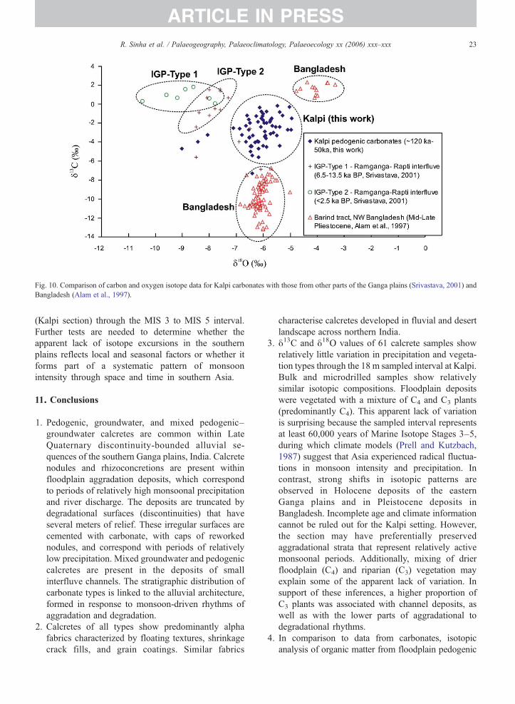
Fig. 10. Comparison of carbon and oxygen isotope data for Kalpi carbonates with those from other parts of the Ganga plains (Srivastava, 2001) andBangladesh (Alam et al., 1997).
23R. Sinha et al. / Palaeogeography, Palaeoclimatology, Palaeoecology xx (2006) xxx–xxx
ARTICLE IN PRESS
(Kalpi section) through the MIS 3 to MIS 5 interval.Further tests are needed to determine whether theapparent lack of isotope excursions in the southernplains reflects local and seasonal factors or whether itforms part of a systematic pattern of monsoonintensity through space and time in southern Asia.
11. Conclusions
1. Pedogenic, groundwater, and mixed pedogenic–groundwater calcretes are common within LateQuaternary discontinuity-bounded alluvial se-quences of the southern Ganga plains, India. Calcretenodules and rhizoconcretions are present withinfloodplain aggradation deposits, which correspondto periods of relatively high monsoonal precipitationand river discharge. The deposits are truncated bydegradational surfaces (discontinuities) that haveseveral meters of relief. These irregular surfaces arecemented with carbonate, with caps of reworkednodules, and correspond with periods of relativelylow precipitation. Mixed groundwater and pedogeniccalcretes are present in the deposits of smallinterfluve channels. The stratigraphic distribution ofcarbonate types is linked to the alluvial architecture,formed in response to monsoon-driven rhythms ofaggradation and degradation.
2. Calcretes of all types show predominantly alphafabrics characterized by floating textures, shrinkagecrack fills, and grain coatings. Similar fabrics
characterise calcretes developed in fluvial and desertlandscape across northern India.
3. δ13C and δ18O values of 61 calcrete samples showrelatively little variation in precipitation and vegeta-tion types through the 18 m sampled interval at Kalpi.Bulk and microdrilled samples show relativelysimilar isotopic compositions. Floodplain depositswere vegetated with a mixture of C4 and C3 plants(predominantly C4). This apparent lack of variationis surprising because the sampled interval representsat least 60,000 years of Marine Isotope Stages 3–5,during which climate models (Prell and Kutzbach,1987) suggest that Asia experienced radical fluctua-tions in monsoon intensity and precipitation. Incontrast, strong shifts in isotopic patterns areobserved in Holocene deposits of the easternGanga plains and in Pleistocene deposits inBangladesh. Incomplete age and climate informationcannot be ruled out for the Kalpi setting. However,the section may have preferentially preservedaggradational strata that represent relatively activemonsoonal periods. Additionally, mixing of drierfloodplain (C4) and riparian (C3) vegetation mayexplain some of the apparent lack of variation. Insupport of these inferences, a higher proportion ofC3 plants was associated with channel deposits, aswell as with the lower parts of aggradational todegradational rhythms.
4. In comparison to data from carbonates, isotopicanalysis of organic matter from floodplain pedogenic
24 R. Sinha et al. / Palaeogeography, Palaeoclimatology, Palaeoecology xx (2006) xxx–xxx
ARTICLE IN PRESS
nodules suggests a much greater contribution from C3
plants. The preserved organic matter may reflect theannual average biomass in the soil and the effects of thewetter growing season, with a higher proportion of C3
plants, whereas carbonate formation may have takenplace mainly during the drier season when respirationof C4 plants made a more important contribution. Ininterfluve settings such as Kalpi, seasonality maystrongly affect the C3–C4 system, with preferentialpreservation of only part of the biomass, enhancing theapparent uniformity of the system.
5. TheKalpi section contains an unusually wide range ofpedogenic and groundwater carbonate, associatedwith a Late Quaternary floodplain (interfluve)succession. The section constitutes one of the mostcomplete and fully dated exposures in the Gangaplains, and the carbonates can be placed in a reliablestratigraphic context, spanning at least 60,000 yearsand part or all of three marine isotope stages. Becauseof this unusually high degree of stratigraphic preci-sion, our analysis was designed to test the effects ofmajor monsoonal variations on an interfluve system.Nevertheless, the isotopic results are difficult tointerpret, and the isotopic systems appear to havebeen subject to local influences, including short-termaggradation, local vegetational biomes, and seasonaleffects. Some of these effects may have causedpreservational bias. Alternatively, regional climaticmodels may not adequately represent local climaticpatterns. Further tests are needed to determinewhether southern Ganga plains successions else-where record a more consistent correlation betweenclimatic variation and carbonate systems.
Acknowledgements
The manuscript was conceived while RS and SKTwere at the Institute of Mineralogy and Geochemistry atKarlsruhe, Germany supported by Alexander vonHumboldt foundation and INSA–DFG, respectively,during the summer of 2002. The stratigraphic work in theregion was supported by a grant from Department ofScience and Technology, Government of India and froma grant to MRG from the Natural Sciences andEngineering Research Council of Canada. We thank allthese institutions and organizations for their support. Wesincerely thank Gesine Peruss at IMG, Karlsruhe for herhelp in generating isotope data, and for geochemicalanalysis. We are thankful to the Steven G. Driese, DavidA. Budd and an anonymous reviewer as well as the editorfor their very constructive comments. The paper hasbenefited immensely from these comments.
References
Agarwal, A.K., Rizvi, M.H., Singh, I.B., Kumar, A., Chandra, S.,1992. Carbonate deposits in Ganga Plain. In: Singh, I. (Ed.),Gangetic Plain: Terra Incognita. Geology Department, LucknowUniversity, pp. 35–43.
Alam, M.S., Keppens, E., Paepe, R., 1997. The use of oxygen andcarbon isotope composition of pedogenic carbonates fromPleistocene palaeosols in NW Bangladesh, as palaeoclimaticindicators. Quaternary Science Reviews 16, 161–168.
Amundson, R., Francovizcaino, E., Graham, R.C., DeNiro, M., 1994.The relationship of precipitation seasonality to the flora and stable-isotope chemistry of soils in the Vizcaino Desert, Baja-California,Mexico. Journal of Arid Environments 28 (4), 265–279.
Anderson, D.M., Prell, W.L., 1993. A 300 kyr record of upwelling offOman during the Late Quaternary. Evidence of the AsianSouthwest Monsoon. Paleoceanography 8, 193–208.
Andrews, J.E., Tandon, S.K., Dennis, P.F., 1995. Concentration ofcarbon dioxide in the Late Cretaceous atmosphere. Journal of theGeological Society (London) 152, 1–3.
Bajpai, V.N., Gokhale, K.V.G.K., 1986. Hydrogeomorphic classifica-tion of the Marginal Gangetic Alluvial plain in Uttar Pradesh,India, using satellite imageries. Journal of Geological Society ofIndia 28 (1), 9–20.
Bal, L., 1975. Carbonate in soils: a theoretical consideration on, andproposal for its fabric analysis: I and II. Netherlands Journal ofAgricultural Science, 23: 18–35, 163–176.
Barnola, J.M., Pimienta, P., Raynaud, D., Korotkevich, Y.S., 1991.CO2 climate relationship as deduced from the Vostok ice core: a re-examination based on new measurements and on a re-evaluation ofthe air dating. Tellus 43B (2), 83–91.
Brewer, R., 1964. Fabric and Mineral Analysis of Soils. John Wileyand Sons, New York.
Budd, D.A., Pack, S.M., Fogel, M.L., 2002. The destruction ofpaleoclimatic isotopic signals in Pleistocene carbonate soil nodulesof western Australia. Palaeogeography, Palaeoclimatology,Palaeoecology 188, 249–273.
Bullock, P., Fedoroff, M., Jongerius, A., Stoops, G., Tursina, T., 1985.Handbook for Soil Thin Section Description.
Cerling, T.E., 1984. The stable isotopic composition of modern soilcarbonate and its relationship to climate. Earth and PlanetaryScience Letters 71, 229–240.
Cerling, T.E., 1991. Carbon dioxide in the atmosphere: evidence fromMesozoic palaeosols. American Journal of Science 291, 377–400.
Cerling, T.E., Quade, J., 1993. Stable carbon and oxygen isotopes insoil carbonates. In: Swartz, P., Lohmann, K., McKenzie, J. (Eds.),Continental Isotopic Indicators of Climate. AGU Monograph.
Cerling, T.E., Quade, J., Wang, Y., Bowman, J.R., 1989. Carbonisotopes in soils and palaeosols as ecology and palaeoecologyindicators. Nature 34, 138–139.
Cerling, T.E., Harris, M.J., MacFadden, J.B., Leaky, G.M., Quade, J.,Eisenmann, V., Ehleringer, R.J., 1997. Global vegetational changethrough the Miocene/Pliocene boundary. Nature 389, 153–158.
Chadwick, O., Nettleton, W.D., 1990. Micromorphological evidenceof adhesive and cohesive forces in soil cementation. In: Dauglas,L. (Ed.), Soil Micromorphology: A Basic and Applied Science.Elsevier, pp. 207–212.
Clemens, S., Prell, W., Murray, D., Shimmield, G., Weedon, G., 1991.Forcing mechanisms of the Indian Ocean monsoon. Nature 353,720–725.
Dhir, R.P., Tandon, S.K., Sareen, B.K., Ramesh, R., Rao, T.K.G.,Kailath, A.J., Sharma, N., 2004. Calcretes in the Thar Desert:
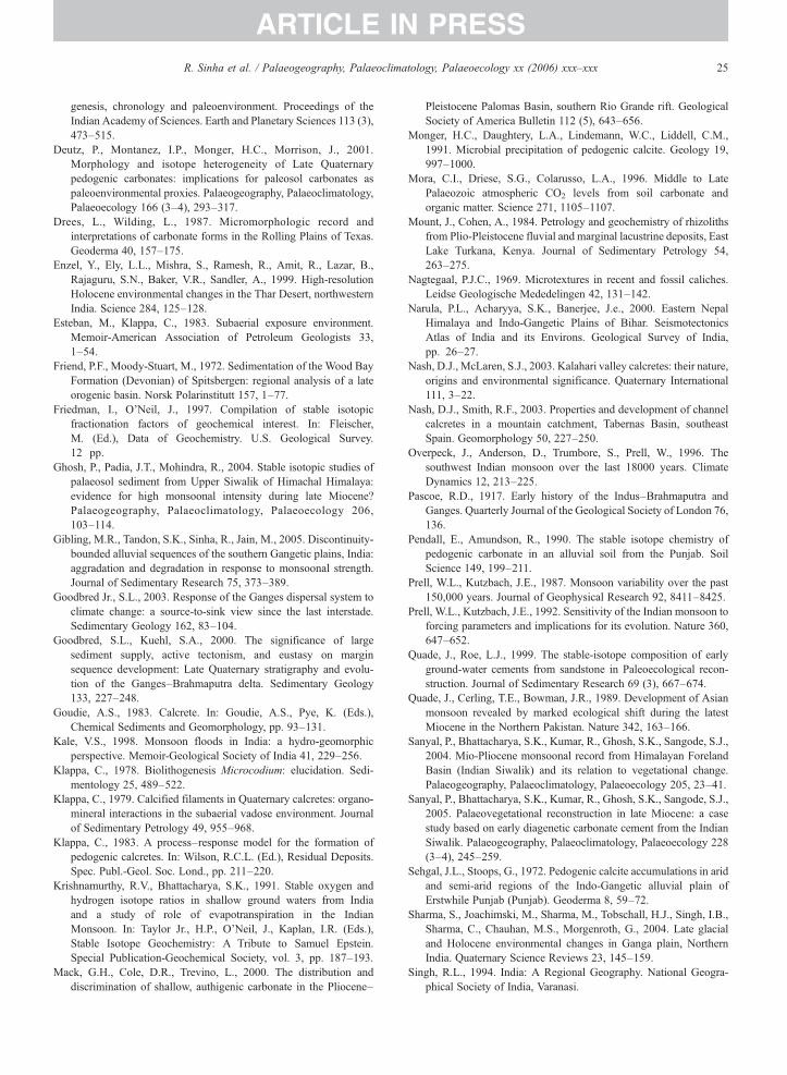
25R. Sinha et al. / Palaeogeography, Palaeoclimatology, Palaeoecology xx (2006) xxx–xxx
ARTICLE IN PRESS
genesis, chronology and paleoenvironment. Proceedings of theIndian Academy of Sciences. Earth and Planetary Sciences 113 (3),473–515.
Deutz, P., Montanez, I.P., Monger, H.C., Morrison, J., 2001.Morphology and isotope heterogeneity of Late Quaternarypedogenic carbonates: implications for paleosol carbonates aspaleoenvironmental proxies. Palaeogeography, Palaeoclimatology,Palaeoecology 166 (3–4), 293–317.
Drees, L., Wilding, L., 1987. Micromorphologic record andinterpretations of carbonate forms in the Rolling Plains of Texas.Geoderma 40, 157–175.
Enzel, Y., Ely, L.L., Mishra, S., Ramesh, R., Amit, R., Lazar, B.,Rajaguru, S.N., Baker, V.R., Sandler, A., 1999. High-resolutionHolocene environmental changes in the Thar Desert, northwesternIndia. Science 284, 125–128.
Esteban, M., Klappa, C., 1983. Subaerial exposure environment.Memoir-American Association of Petroleum Geologists 33,1–54.
Friend, P.F., Moody-Stuart, M., 1972. Sedimentation of the Wood BayFormation (Devonian) of Spitsbergen: regional analysis of a lateorogenic basin. Norsk Polarinstitutt 157, 1–77.
Friedman, I., O'Neil, J., 1997. Compilation of stable isotopicfractionation factors of geochemical interest. In: Fleischer,M. (Ed.), Data of Geochemistry. U.S. Geological Survey.12 pp.
Ghosh, P., Padia, J.T., Mohindra, R., 2004. Stable isotopic studies ofpalaeosol sediment from Upper Siwalik of Himachal Himalaya:evidence for high monsoonal intensity during late Miocene?Palaeogeography, Palaeoclimatology, Palaeoecology 206,103–114.
Gibling, M.R., Tandon, S.K., Sinha, R., Jain, M., 2005. Discontinuity-bounded alluvial sequences of the southern Gangetic plains, India:aggradation and degradation in response to monsoonal strength.Journal of Sedimentary Research 75, 373–389.
Goodbred Jr., S.L., 2003. Response of the Ganges dispersal system toclimate change: a source-to-sink view since the last interstade.Sedimentary Geology 162, 83–104.
Goodbred, S.L., Kuehl, S.A., 2000. The significance of largesediment supply, active tectonism, and eustasy on marginsequence development: Late Quaternary stratigraphy and evolu-tion of the Ganges–Brahmaputra delta. Sedimentary Geology133, 227–248.
Goudie, A.S., 1983. Calcrete. In: Goudie, A.S., Pye, K. (Eds.),Chemical Sediments and Geomorphology, pp. 93–131.
Kale, V.S., 1998. Monsoon floods in India: a hydro-geomorphicperspective. Memoir-Geological Society of India 41, 229–256.
Klappa, C., 1978. Biolithogenesis Microcodium: elucidation. Sedi-mentology 25, 489–522.
Klappa, C., 1979. Calcified filaments in Quaternary calcretes: organo-mineral interactions in the subaerial vadose environment. Journalof Sedimentary Petrology 49, 955–968.
Klappa, C., 1983. A process–response model for the formation ofpedogenic calcretes. In: Wilson, R.C.L. (Ed.), Residual Deposits.Spec. Publ.-Geol. Soc. Lond., pp. 211–220.
Krishnamurthy, R.V., Bhattacharya, S.K., 1991. Stable oxygen andhydrogen isotope ratios in shallow ground waters from Indiaand a study of role of evapotranspiration in the IndianMonsoon. In: Taylor Jr., H.P., O'Neil, J., Kaplan, I.R. (Eds.),Stable Isotope Geochemistry: A Tribute to Samuel Epstein.Special Publication-Geochemical Society, vol. 3, pp. 187–193.
Mack, G.H., Cole, D.R., Trevino, L., 2000. The distribution anddiscrimination of shallow, authigenic carbonate in the Pliocene–
Pleistocene Palomas Basin, southern Rio Grande rift. GeologicalSociety of America Bulletin 112 (5), 643–656.
Monger, H.C., Daughtery, L.A., Lindemann, W.C., Liddell, C.M.,1991. Microbial precipitation of pedogenic calcite. Geology 19,997–1000.
Mora, C.I., Driese, S.G., Colarusso, L.A., 1996. Middle to LatePalaeozoic atmospheric CO2 levels from soil carbonate andorganic matter. Science 271, 1105–1107.
Mount, J., Cohen, A., 1984. Petrology and geochemistry of rhizolithsfrom Plio-Pleistocene fluvial and marginal lacustrine deposits, EastLake Turkana, Kenya. Journal of Sedimentary Petrology 54,263–275.
Nagtegaal, P.J.C., 1969. Microtextures in recent and fossil caliches.Leidse Geologische Mededelingen 42, 131–142.
Narula, P.L., Acharyya, S.K., Banerjee, J.e., 2000. Eastern NepalHimalaya and Indo-Gangetic Plains of Bihar. SeismotectonicsAtlas of India and its Environs. Geological Survey of India,pp. 26–27.
Nash, D.J., McLaren, S.J., 2003. Kalahari valley calcretes: their nature,origins and environmental significance. Quaternary International111, 3–22.
Nash, D.J., Smith, R.F., 2003. Properties and development of channelcalcretes in a mountain catchment, Tabernas Basin, southeastSpain. Geomorphology 50, 227–250.
Overpeck, J., Anderson, D., Trumbore, S., Prell, W., 1996. Thesouthwest Indian monsoon over the last 18000 years. ClimateDynamics 12, 213–225.
Pascoe, R.D., 1917. Early history of the Indus–Brahmaputra andGanges. Quarterly Journal of the Geological Society of London 76,136.
Pendall, E., Amundson, R., 1990. The stable isotope chemistry ofpedogenic carbonate in an alluvial soil from the Punjab. SoilScience 149, 199–211.
Prell, W.L., Kutzbach, J.E., 1987. Monsoon variability over the past150,000 years. Journal of Geophysical Research 92, 8411–8425.
Prell, W.L., Kutzbach, J.E., 1992. Sensitivity of the Indian monsoon toforcing parameters and implications for its evolution. Nature 360,647–652.
Quade, J., Roe, L.J., 1999. The stable-isotope composition of earlyground-water cements from sandstone in Paleoecological recon-struction. Journal of Sedimentary Research 69 (3), 667–674.
Quade, J., Cerling, T.E., Bowman, J.R., 1989. Development of Asianmonsoon revealed by marked ecological shift during the latestMiocene in the Northern Pakistan. Nature 342, 163–166.
Sanyal, P., Bhattacharya, S.K., Kumar, R., Ghosh, S.K., Sangode, S.J.,2004. Mio-Pliocene monsoonal record from Himalayan ForelandBasin (Indian Siwalik) and its relation to vegetational change.Palaeogeography, Palaeoclimatology, Palaeoecology 205, 23–41.
Sanyal, P., Bhattacharya, S.K., Kumar, R., Ghosh, S.K., Sangode, S.J.,2005. Palaeovegetational reconstruction in late Miocene: a casestudy based on early diagenetic carbonate cement from the IndianSiwalik. Palaeogeography, Palaeoclimatology, Palaeoecology 228(3–4), 245–259.
Sehgal, J.L., Stoops, G., 1972. Pedogenic calcite accumulations in aridand semi-arid regions of the Indo-Gangetic alluvial plain ofErstwhile Punjab (Punjab). Geoderma 8, 59–72.
Sharma, S., Joachimski, M., Sharma, M., Tobschall, H.J., Singh, I.B.,Sharma, C., Chauhan, M.S., Morgenroth, G., 2004. Late glacialand Holocene environmental changes in Ganga plain, NorthernIndia. Quaternary Science Reviews 23, 145–159.
Singh, R.L., 1994. India: A Regional Geography. National Geogra-phical Society of India, Varanasi.
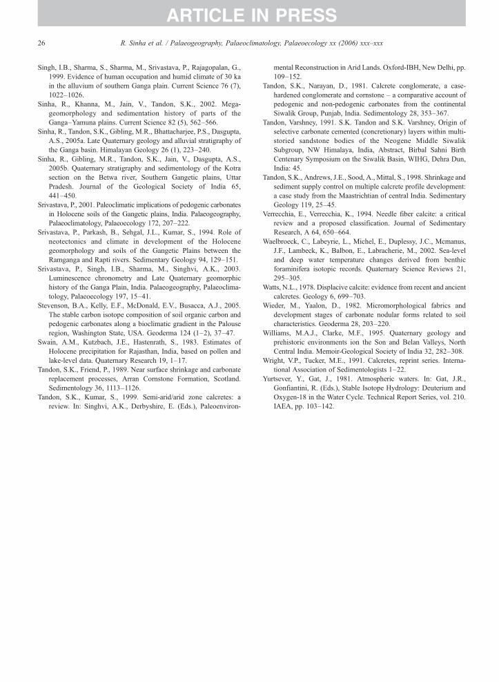
26 R. Sinha et al. / Palaeogeography, Palaeoclimatology, Palaeoecology xx (2006) xxx–xxx
ARTICLE IN PRESS
Singh, I.B., Sharma, S., Sharma, M., Srivastava, P., Rajagopalan, G.,1999. Evidence of human occupation and humid climate of 30 kain the alluvium of southern Ganga plain. Current Science 76 (7),1022–1026.
Sinha, R., Khanna, M., Jain, V., Tandon, S.K., 2002. Mega-geomorphology and sedimentation history of parts of theGanga–Yamuna plains. Current Science 82 (5), 562–566.
Sinha, R., Tandon, S.K., Gibling, M.R., Bhattacharjee, P.S., Dasgupta,A.S., 2005a. Late Quaternary geology and alluvial stratigraphy ofthe Ganga basin. Himalayan Geology 26 (1), 223–240.
Sinha, R., Gibling, M.R., Tandon, S.K., Jain, V., Dasgupta, A.S.,2005b. Quaternary stratigraphy and sedimentology of the Kotrasection on the Betwa river, Southern Gangetic plains, UttarPradesh. Journal of the Geological Society of India 65,441–450.
Srivastava, P., 2001. Paleoclimatic implications of pedogenic carbonatesin Holocene soils of the Gangetic plains, India. Palaeogeography,Palaeoclimatology, Palaeoecology 172, 207–222.
Srivastava, P., Parkash, B., Sehgal, J.L., Kumar, S., 1994. Role ofneotectonics and climate in development of the Holocenegeomorphology and soils of the Gangetic Plains between theRamganga and Rapti rivers. Sedimentary Geology 94, 129–151.
Srivastava, P., Singh, I.B., Sharma, M., Singhvi, A.K., 2003.Luminescence chronometry and Late Quaternary geomorphichistory of the Ganga Plain, India. Palaeogeography, Palaeoclima-tology, Palaeoecology 197, 15–41.
Stevenson, B.A., Kelly, E.F., McDonald, E.V., Busacca, A.J., 2005.The stable carbon isotope composition of soil organic carbon andpedogenic carbonates along a bioclimatic gradient in the Palouseregion, Washington State, USA. Geoderma 124 (1–2), 37–47.
Swain, A.M., Kutzbach, J.E., Hastenrath, S., 1983. Estimates ofHolocene precipitation for Rajasthan, India, based on pollen andlake-level data. Quaternary Research 19, 1–17.
Tandon, S.K., Friend, P., 1989. Near surface shrinkage and carbonatereplacement processes, Arran Cornstone Formation, Scotland.Sedimentology 36, 1113–1126.
Tandon, S.K., Kumar, S., 1999. Semi-arid/arid zone calcretes: areview. In: Singhvi, A.K., Derbyshire, E. (Eds.), Paleoenviron-
mental Reconstruction in Arid Lands. Oxford-IBH, New Delhi, pp.109–152.
Tandon, S.K., Narayan, D., 1981. Calcrete conglomerate, a case-hardened conglomerate and cornstone – a comparative account ofpedogenic and non-pedogenic carbonates from the continentalSiwalik Group, Punjab, India. Sedimentology 28, 353–367.
Tandon, Varshney, 1991. S.K. Tandon and S.K. Varshney, Origin ofselective carbonate cemented (concretionary) layers within multi-storied sandstone bodies of the Neogene Middle SiwalikSubgroup, NW Himalaya, India, Abstract, Birbal Sahni BirthCentenary Symposium on the Siwalik Basin, WIHG, Dehra Dun,India: 45.
Tandon, S.K., Andrews, J.E., Sood, A., Mittal, S., 1998. Shrinkage andsediment supply control on multiple calcrete profile development:a case study from the Maastrichtian of central India. SedimentaryGeology 119, 25–45.
Verrecchia, E., Verrecchia, K., 1994. Needle fiber calcite: a criticalreview and a proposed classification. Journal of SedimentaryResearch, A 64, 650–664.
Waelbroeck, C., Labeyrie, L., Michel, E., Duplessy, J.C., Mcmanus,J.F., Lambeck, K., Balbon, E., Labracherie, M., 2002. Sea-leveland deep water temperature changes derived from benthicforaminifera isotopic records. Quaternary Science Reviews 21,295–305.
Watts, N.L., 1978. Displacive calcite: evidence from recent and ancientcalcretes. Geology 6, 699–703.
Wieder, M., Yaalon, D., 1982. Micromorphological fabrics anddevelopment stages of carbonate nodular forms related to soilcharacteristics. Geoderma 28, 203–220.
Williams, M.A.J., Clarke, M.F., 1995. Quaternary geology andprehistoric environments ion the Son and Belan Valleys, NorthCentral India. Memoir-Geological Society of India 32, 282–308.
Wright, V.P., Tucker, M.E., 1991. Calcretes, reprint series. Interna-tional Association of Sedimentologists 1–22.
Yurtsever, Y., Gat, J., 1981. Atmospheric waters. In: Gat, J.R.,Gonfiantini, R. (Eds.), Stable Isotope Hydrology: Deuterium andOxygen-18 in the Water Cycle. Technical Report Series, vol. 210.IAEA, pp. 103–142.