Late Pleistocene dust deposition in the Patagonian steppe - extending and refining the...
13
Late Pleistocene dust deposition in the Patagonian steppe - extending and refining the paleoenvironmental and tephrochronological record from Laguna Potrok Aike back to 55 ka Torsten Haberzettl a, b, * , Flavio S. Anselmetti c , Sabine W. Bowen d , Michael Fey e , Christoph Mayr f , Bernd Zolitschka e , Daniel Ariztegui g , Barbara Mauz h , Christian Ohlendorf e , Stephanie Kastner e , Andreas Lu ¨ cke i , Frank Scha ¨ bitz j , Michael Wille j a Institut des sciences de la mer de Rimouski (ISMER), University of Que´bec at Rimouski (UQAR), 310, alle ´e des Ursulines, Rimouski, Que´bec, G5L 3A1, Canada b GEOTOP Research Centre, P.O. Box 8888, Succ. Centre-ville, Montre ´al, Que´bec, H3C 3P8, Canada c Eawag, Swiss Federal Institute of Aquatic Science and Technology, Department of Surface Waters, U ¨ berlandstr. 133, 8600 Du ¨bendorf, Switzerland d Institute for Geophysics, Jackson School of Geosciences, The University of Texas at Austin,10100 Burnet Rd., Austin, TX 78758, USA e Geomorphology and Polar Research (GEOPOLAR), Institute of Geography, University of Bremen, Celsiusstr. FVG-M, 28359 Bremen, Germany f GeoBio-Center and Department of Earth and Environmental Sciences, University of Munich, Richard-Wagner-Str.10, 80333 Munich, Germany g Section of Earth & Environmental Sciences, University of Geneva, Rue de Maraı ˆchers 13, 1205 Geneva, Switzerland h Department of Geography, University of Liverpool, Liverpool L69 7ZT, UK i Institute for Chemistry and Dynamics of the Geosphere (ICG) V: Sedimentary Systems, Research Center Ju ¨lich, 52425 Ju ¨lich, Germany j Seminar for Geography and Education, University of Cologne, Gronewaldstr. 2, 50931 Cologne, Germany article info Article history: Received 26 March 2009 Received in revised form 29 July 2009 Accepted 31 July 2009 abstract Paleoenvironmental records extending well into the last glacial period are scarce in the steppe regions of southern South America. Here, we present a continuous record for the past 55 ka from the maar lake Laguna Potrok Aike (51 58 0 S, 70 23 0 W, southern Patagonia, Argentina). Previous studies on a sedi- mentary core from a lake level terrace near the northern margin of the lake covered parts of Oxygen Isotope Stage (OIS) 3 (59–29 ka) whereas a second core from the centre of the basin comprised the last 16 ka. Tephrostratigraphical constraints and OSL ages from a third core located below the lake level terrace provide the crucial piece to close the gap between the previous coring sites. High-resolution XRF and magnetic susceptibility as well as grain size data indicate a positive hydrological balance alongside with relatively high aeolian activity during the glacial which is contemporaneous with increased dust fluxes in Antarctica. This is therefore the first evidence for contemporaneity of aeolian deposition in both the target area (Antarctica) and in the major source area of Patagonia. During the Holocene climatic conditions driving sediment deposition seem to have been more variable and less dominated by wind compared to glacial times. The identification of a minor lake level lowering at approximately 4 cal ka BP allows to refine earlier paleoenvironmental reconstructions for the Holocene. Within error margins the OSL ages are consistent with published radiocarbon-dated records offering hence a valuable tool for further studies of the sediments from Laguna Potrok Aike. The new chronology confirms the age of three tephra layers up to now only found in Laguna Potrok Aike sediments and ascribed to OIS 3. Ó 2009 Elsevier Ltd. All rights reserved. 1. Introduction An increasing number of terrestrial paleoclimatic records from southern South America has been published during the last decade (Gilli et al., 2001; Markgraf et al., 2003; Gilli et al., 2005a,b; Mayr et al., 2005; Villa-Martı ´nez and Moreno, 2007; Whitlock et al., 2007; Unkel et al., 2008). These archives mostly cover the Lateglacial and/or the Holocene. Hence, little is known about the Patagonian climate before the Last Glacial Maximum (Roig et al., 2001; Kaplan et al., 2008; Mancini et al., 2008). Attempts have already been made to reconstruct wind patterns in Patagonia indirectly on longer time periods using aeolian dust deposited in Antarctic ice cores, as Pata- gonia proved to be the main dust source for central East Antarctica during cold periods within the late Quaternary (Basile et al., 1997; Petit et al., 1999; Delmonte et al., 2004, 2008). * Corresponding author: Tel.: þ1 418 723 1986x1664; fax: þ1 418 724 1842. E-mail address: [email protected] (T. Haberzettl). Contents lists available at ScienceDirect Quaternary Science Reviews journal homepage: www.elsevier.com/locate/quascirev 0277-3791/$ – see front matter Ó 2009 Elsevier Ltd. All rights reserved. doi:10.1016/j.quascirev.2009.07.021 Quaternary Science Reviews 28 (2009) 2927–2939
Transcript of Late Pleistocene dust deposition in the Patagonian steppe - extending and refining the...

lable at ScienceDirect
Quaternary Science Reviews 28 (2009) 2927–2939
Contents lists avai
Quaternary Science Reviews
journal homepage: www.elsevier .com/locate/quascirev
Late Pleistocene dust deposition in the Patagonian steppe - extending and refiningthe paleoenvironmental and tephrochronological record from Laguna Potrok Aikeback to 55 ka
Torsten Haberzettl a,b,*, Flavio S. Anselmetti c, Sabine W. Bowen d, Michael Fey e, Christoph Mayr f,Bernd Zolitschka e, Daniel Ariztegui g, Barbara Mauz h, Christian Ohlendorf e, Stephanie Kastner e,Andreas Lucke i, Frank Schabitz j, Michael Wille j
a Institut des sciences de la mer de Rimouski (ISMER), University of Quebec at Rimouski (UQAR), 310, allee des Ursulines, Rimouski, Quebec, G5L 3A1, Canadab GEOTOP Research Centre, P.O. Box 8888, Succ. Centre-ville, Montreal, Quebec, H3C 3P8, Canadac Eawag, Swiss Federal Institute of Aquatic Science and Technology, Department of Surface Waters, Uberlandstr. 133, 8600 Dubendorf, Switzerlandd Institute for Geophysics, Jackson School of Geosciences, The University of Texas at Austin, 10100 Burnet Rd., Austin, TX 78758, USAe Geomorphology and Polar Research (GEOPOLAR), Institute of Geography, University of Bremen, Celsiusstr. FVG-M, 28359 Bremen, Germanyf GeoBio-Center and Department of Earth and Environmental Sciences, University of Munich, Richard-Wagner-Str. 10, 80333 Munich, Germanyg Section of Earth & Environmental Sciences, University of Geneva, Rue de Maraıchers 13, 1205 Geneva, Switzerlandh Department of Geography, University of Liverpool, Liverpool L69 7ZT, UKi Institute for Chemistry and Dynamics of the Geosphere (ICG) V: Sedimentary Systems, Research Center Julich, 52425 Julich, Germanyj Seminar for Geography and Education, University of Cologne, Gronewaldstr. 2, 50931 Cologne, Germany
a r t i c l e i n f o
Article history:Received 26 March 2009Received in revised form29 July 2009Accepted 31 July 2009
* Corresponding author: Tel.: þ1 418 723 1986x166E-mail address: [email protected] (T.
0277-3791/$ – see front matter � 2009 Elsevier Ltd.doi:10.1016/j.quascirev.2009.07.021
a b s t r a c t
Paleoenvironmental records extending well into the last glacial period are scarce in the steppe regions ofsouthern South America. Here, we present a continuous record for the past 55 ka from the maar lakeLaguna Potrok Aike (51�580 S, 70�230 W, southern Patagonia, Argentina). Previous studies on a sedi-mentary core from a lake level terrace near the northern margin of the lake covered parts of OxygenIsotope Stage (OIS) 3 (59–29 ka) whereas a second core from the centre of the basin comprised the last16 ka. Tephrostratigraphical constraints and OSL ages from a third core located below the lake levelterrace provide the crucial piece to close the gap between the previous coring sites. High-resolution XRFand magnetic susceptibility as well as grain size data indicate a positive hydrological balance alongsidewith relatively high aeolian activity during the glacial which is contemporaneous with increased dustfluxes in Antarctica. This is therefore the first evidence for contemporaneity of aeolian deposition in boththe target area (Antarctica) and in the major source area of Patagonia. During the Holocene climaticconditions driving sediment deposition seem to have been more variable and less dominated by windcompared to glacial times. The identification of a minor lake level lowering at approximately 4 cal ka BPallows to refine earlier paleoenvironmental reconstructions for the Holocene. Within error margins theOSL ages are consistent with published radiocarbon-dated records offering hence a valuable tool forfurther studies of the sediments from Laguna Potrok Aike. The new chronology confirms the age of threetephra layers up to now only found in Laguna Potrok Aike sediments and ascribed to OIS 3.
� 2009 Elsevier Ltd. All rights reserved.
1. Introduction
An increasing number of terrestrial paleoclimatic records fromsouthern South America has been published during the last decade(Gilli et al., 2001; Markgraf et al., 2003; Gilli et al., 2005a,b; Mayret al., 2005; Villa-Martınez and Moreno, 2007; Whitlock et al., 2007;
4; fax: þ1 418 724 1842.Haberzettl).
All rights reserved.
Unkel et al., 2008). These archives mostly cover the Lateglacial and/orthe Holocene. Hence, little is known about the Patagonian climatebefore the Last Glacial Maximum (Roig et al., 2001; Kaplan et al.,2008; Mancini et al., 2008). Attempts have already been made toreconstruct wind patterns in Patagonia indirectly on longer timeperiods using aeolian dust deposited in Antarctic ice cores, as Pata-gonia proved to be the main dust source for central East Antarcticaduring cold periods within the late Quaternary (Basile et al., 1997;Petit et al., 1999; Delmonte et al., 2004, 2008).

T. Haberzettl et al. / Quaternary Science Reviews 28 (2009) 2927–29392928
Recently, sediment cores from the maar lake Laguna Potrok Aikein southern Patagonia (51�580S, 70�230W, Figs. 1 and 2) providedterrestrial paleoclimatic and paleoenvironmental data not onlyfrom the Lateglacial (since 16,000 cal BP) and the Holocene (Hab-erzettl et al., 2005, 2006; Zolitschka et al., 2006; Haberzettl et al.,2007a,b; Mayr et al., 2007b; Wille et al., 2007; Anselmetti et al.,2009; Mayr et al., 2009) but also for a hitherto temporally notprecisely defined part of OIS 3 (Haberzettl et al., 2008). This sedi-mentary record (core 6, Fig. 2) extending back into the last glacial(OIS 3) is located in a subaquatic lake level terrace and containsa hiatus, which was identified during a high-resolution 3.5 kHzseismic survey (Anselmetti et al., 2009). Sediments above thishiatus show a continuous deposition from 6.75 cal ka BP to thepresent whereas the only existing age below it was provided bya 14C date of 44.8� 2 ka BP (uncalibrated as beyond the southernand northern hemisphere calibration curves of CALIB 5.0.2)(Haberzettl et al., 2008). Hence, it was impossible to set up a chro-nology below the hiatus in order to establish time constraints ofenvironmental changes. In this study, we extend the continuousand high-resolution 16 ka paleoenvironmental record from thecentre of Laguna Potrok Aike (core 12 in Fig. 2) (Haberzettl et al.,2007a) back in time to 55 ka. We combine the discontinuous littoralrecord of core 6 with the new littoral core 5 continuously andconformably spanning the time interval across this hiatus.
Furthermore, we present the first optically stimulated lumi-nescence (OSL) ages for this combined littoral record and for the16 ka spanning profundal sediment core 12 assessing the applica-bility of optical dating to sediments from Laguna Potrok Aike. Thelatter will potentially provide a reliable chronology beyond thelimit of radiocarbon dating of sediments from Laguna Potrok Aikerecovered during the ICDP (International Continental ScientificDrilling Program) deep drilling project PASADO (Potrok Aike maarlake Sediment Archive Drilling prOject).
2. Regional setting
The circular maar lake Laguna Potrok Aike is located in southernSanta Cruz (Patagonia, Argentina), 85 km west of the city of Rıo
Fig. 1. Location of Laguna Potrok Aike a
Gallegos and w80 km north of the Strait of Magellan. It is situated inthe western part of the Pali Aike Volcanic Field (Fig. 1). Witha maximum W–E-extension of about 150 km and a maximum N–S-extension of ca 50 km this tectonovolcanic belt has an area ofw4500 km2 (Mazzarini and D0Orazio, 2003). Petrologically, itconsists of alkali-olivine basalts with an age range from 3.8 Ma in thewestern part to 0.01 Ma in the east (Corbella, 2002). The detailedgeological and volcanological development of these back arc Pata-gonian plateau lavas has been discussed before (Skewes, 1978;D0Orazio et al., 2000; Corbella, 2002; Mazzarini and D0Orazio, 2003).
Laguna Potrok Aike itself was created by an explosive eruptioncaused by the contact of rising magma with groundwater. Itsformation is Ar/Ar-dated from the phreatomagmatic tephra onglass fragments as 0.77� 0.24 Ma (Zolitschka et al., 2006).The immediate surrounding of Laguna Potrok Aike is formed byPleistocene basal till exceeding this age. However, since the latePleistocene the studied area was not glaciated as the so calledLlanquihue Glaciation, equivalent to the Weichselian or Wisconsin(Rabassa and Clapperton, 1990), did not reach the Pali Aike VolcanicField (Zolitschka et al., 2006).
In 2003 the lake level of Laguna Potrok Aike was at 113 m asl. Atthat point the lake had a maximum water depth of 100 m anda diameter of 3.5 km (Fig. 2). Recent observations indicate thatannual lake level fluctuations are less than 1 m. However, the lakelevel has been rising by more than 1 m since March 2003 (Haberzettlet al., 2007a). Although the morphological catchment area of the lakeexceeds 200 km2 reaching far south into the Chilean part of the PaliAike Volcanic Field, model calculations imply that the modern highevaporation/precipitation ratio (E/P) of up to 24 (Haberzettl et al.,2005) is responsible that ca 60% of the runoff to Laguna Potrok Aikeundergoes evaporation (Mayr et al., 2007a). These high evaporationrates originate from the high wind speeds from predominantlywesterly directions reaching average monthly speeds of up to 9 m s�1
during early summer (Endlicher, 1993). Owing to the strong windsthat enforce polymictic conditions today, there is almost no stratifi-cation of the waterbody in summer and freezing inwinter is inhibited(Zolitschka et al., 2006). In combination with the rain shadow effectof the Andes the high wind speeds cause a precipitation decrease
nd other sites discussed in the text.

Fig. 2. Seismic profiles of Laguna Potrok Aike. Drilling sites of sediment cores 5, 6 and 12 are shown. Black line of the magnified seismic section (inset in the center) indicates thecorrelation marker layer (older Reclus tephra) combining the records of core 5 and core 6. Arrows indicate location of the hiatus related to core 6. The inset on the right bottom areashows the bathymetry including positions of drilling sites as well as the seismic line.
T. Haberzettl et al. / Quaternary Science Reviews 28 (2009) 2927–2939 2929
from west to east resulting in semiarid conditions with less than300 mm annual precipitation in the area. Precipitation is almostequally distributed around the wind rose, with maxima fromsouthwestern and northern directions (Haberzettl, 2006). However,compared to the frequency of wind directions, more precipitation isbrought in with air masses of easterly origin than from other direc-tions. Thus, a relatively moderate increase in the occurrence ofeasterly wind directions results in a considerable increase ofprecipitation (Mayr et al., 2007b).
In the past Laguna Potrok Aike experienced distinct lake levelvariations with a pronounced recession during the Mid-Holoceneclimate optimum (Haberzettl et al., 2008; Anselmetti et al., 2009)and a high lake level during the northern hemisphere Little Ice Agechronozone (Haberzettl et al., 2005). As a result of these ancientlake level fluctuations numerous well-preserved subaerial as wellas subaquatic lake level terraces have developed around the lakecovered with different vegetation above the present shore line.Laguna Potrok Aike belongs to the few permanent lakes in the drylands of southern Patagonia which assures a continuous sedimentrecord even during dry periods (Haberzettl et al., 2005). Today,Laguna Potrok Aike is a terminal lake. However, there is geomor-phological evidence for an overflow 21 m above the present (2003)lake level. The exact timing of this overflow is still unknown butpaleoclimatic interpretations indicate that an overflowing regimeexisted before 13.1 ka (Haberzettl et al., 2007a).
3. Material and methods
3.1. Field methods
A w70 km-long grid of high-resolution single-channel seismicdata was acquired in February 2003 using a 3.5 kHz pinger system
with a vertical resolution of w10 cm (Fig. 2). The survey was per-formed with the steel-hulled catamaran RV ‘‘Lago Cardiel’’ and GPS-based navigation. Seismic data were stored digitally in SEG-Y formatallowing further processing and interpretation. A 2–6.5 kHz band-pass filter was applied to the raw data (Anselmetti et al., 2009). Coringlocations were selected based on this seismic survey as follows: a)three parallel cores (PTA03/12, PTA03/13 and PTA02/4) from thecentre of the lake at 100 m water depth form a composite record heretermed core 12 (Haberzettl et al., 2007a); b) core PTA03/6 (termedcore 6) retrieved from a lake level terrace at 30 m water depthcomprising an unconformity caused by a hiatus which is related toa low lake level (Haberzettl et al., 2008); and c) core PTA03/5 (core 5,this study) located in a conformable sedimentary succession at 47 mwater depth i.e., below the lake level terrace (all Fig. 2). Overlappingsediment cores from these three sites were recovered using a hand-driven UWITEC piston coring system (www.uwitec.at) with acrylicliners of 60 mm inner diameter.
3.2. Non-destructive laboratory methods
In the laboratory, cores were stored in darkness at 4 �C beforebeing split, photographed and described in detail. Non-destructivemagnetic susceptibility (k) and XRF of cores 12 and 6 were scanned in1 cm-increments using a Bartington MS2E point sensor (Zolitschkaet al., 2001) and a CORTEX (Corescanner Texel) XRF-scanner (Jansenet al.,1998; Zolitschka et al., 2001; Richter et al., 2006). k of core 5 wasscanned with 4 mm-resolution using the same type of point sensor.The XRF-scanning step size for the uppermost section of core 5(PTA03/5-1: 87.1 cm) was 1 mm using an ITRAX core scanner(Croudace et al., 2006; St-Onge et al., 2007). For the remainingsections of the record a step size of 5 mm was applied. Ca-profilesobtained by XRF-scanning, magnetic susceptibility data and

T. Haberzettl et al. / Quaternary Science Reviews 28 (2009) 2927–29392930
photographs were used for correlation of overlapping core sectionsand for establishment of composite records. Other elementsobtained by XRF-scanning were only used in critical parts. All depthscorrespond to these composite depth scales. The latter also applies toa combined profile of cores 5 and 6, hereafter termed profile 5þ 6.
3.3. Dating
3.3.1. Proximal tephras from other sedimentary archivesRadiocarbon ages of proximal tephra deposits from other sedi-
mentary archives were taken from literature (Stern, 1990; Naranjoand Stern, 1998; Kilian et al., 2003; McCulloch et al., 2005). Theywere calibrated using the Calib 5.0.2 software with the IntCal04calibration curve (Stuiver and Reimer,1993; Reimer et al., 2004) andpetrologically correlated with tephra layers from cores 12 and 5.
3.3.2. Radiocarbon datingAMS 14C age determinations on cores 12 and 6 (stems of aquatic
mosses, calcite fraction of bulk samples, twig of Berberis, bone ofrodent, etc.) were carried out at the Poznan Radiocarbon Laboratory(Poland). The detailed methodology and results are publishedelsewhere (Haberzettl et al., 2007a, 2008). Unfortunately, nomacrofossil remains suitable for radiocarbon dating were availablein core 5. The previously uncalibrated radiocarbon age below thehiatus in core 6 (POZ-6098, Table 1, Figs. 3 and 4) was calibratedwith the software CalPal (Weninger et al., 2004) because it exceedsthe calibration curves of CALIB 5.0.2 (McCormac et al., 2004; Reimeret al., 2004).
3.3.3. Optical datingFor optically stimulated luminescence dating (OSL), 8–20 cm
long sediment sections were sampled in subdued laboratory safelight. The outer rim of the sediment was removed from the sampleto avoid contamination with material that could have been exposedto light after core recovery. Analyses were performed at theLuminescence Dating Laboratory of the Department of Geography,University of Liverpool (LV). Three OSL samples (LV 125, 126, 127)were taken from core 12, two samples (LV 122, 123) from core 5 andone sample (LV 124) from core 6 (Table 2, Figs. 3–5).
The samples did not provide quartz and therefore feldspargrains of 4–15 mm were extracted from the sediment usingconventional techniques. This laboratory procedure involvedremoval of organic matter using hydrogen peroxide (30%), andremoval of calcium carbonate using hydrochloric acid (30%). Grainswere then separated by settling in cylinders following Stokes’ Law,first in slightly alkaline water and then in acetone. An acetonesuspension of the subsample was pipetted onto aluminium discsmaking up 2.5 mg aliquots. A Risø DA-15 TL/OSL reader equipped
Table 1Dating results for profile 5þ 6 in stratigraphic order.
Type of date Material Depth incore (cm)
Age (BP) Error
14C Hudson tephra Hudson tephra 78 6915a 7635a 40 40
14C Mt Burney tephra Mt Burney tephra 96 7635a 7890a 40 40
OSL feldspars 111.514C Reclus tephra Reclus tephra 142.5 12,638a 60
OSL feldspars 179radiocarbon macrofossil 988.5 44,800 2000
OSL feldspars 1165.75
a Tephra dates from literature were (re-)calibrated with Calib 5.0.2 (Haberzettl et al. 2
with an EMI 9235QB photomultiplier tube and 21 LEDs providingw30 mW cm�2 at 870 nm was used for luminescence measure-ments. The OSL light was detected through a filter combination(2� BG3, 3 mm; 1� BG39, 8 mm; 1�GG400, 3 mm) providing390–450 nm transmission.
For De-estimation the multiple aliquot additive dose protocolwas employed. This protocol requires around 80 aliquots to deter-mine the alpha and beta equivalent dose (Dea, Deb), the a-value andthe anomalous fading rate. All irradiated aliquots were stored atroom temperature for at least 30 days before IRSL measurements.Annual dose rates were calculated from radionuclide concentra-tions determined using high-resolution, low-level g-spectrometryand the burial depth of the sample. Gaussian error propagation atthe 1s-level was applied including all known systematic andrandom errors. Further details about the method is publishedelsewhere (Mauz et al., 2002).
3.4. Tephra analyses
Distal tephras from core 12 (sections PTA03/12-12, PTA03/12-15,and PTA03/12-22, hereafter termed t12-12, t12-15, t12-22) at1075 cm, 1320 cm, and 1861 cm sediment depth (Figs. 4 and 5), andcore 6 (sections PTA03/6-4, PTA03/6-8, and PTA03/6-10, hereaftert6-4, t6-8, t6-10) at 379 cm, 643 cm, and 859 cm sediment depth(Fig. 4) have been geochemically analysed in former studies, andcorrelated with specific eruptive events of Mt Burney, Reclus andHudson volcanoes (Haberzettl et al., 2007a, 2008). In core 5, fourdistinct tephras have been identified at 78 cm (section PTA03/5-1,hereafter t5-1), 96 cm, 142.5 cm (both section PTA03/5-2, hereaftert5-2a, t5-2b) and 640 cm (section PTA03/5-8, hereafter t5-8) sedi-ment depth (Fig. 4). In order to enable a stratigraphic correlationwith cores 6 and 12, the two oldest tephras in core 5 (t5-2b, t5-8;Fig. 4) were additionally analysed using comparable preparationtechniques. Ash samples were soaked in a 10% hydrogen peroxidesolution in order to remove organic matter before drying. Polishedthin sections of volcanic glass shards were prepared for microprobeanalyses. A JEOL-8200 instrument at the Department of GeologicalSciences, The University of Texas at Austin, was used with thefollowing measuring conditions: 15 kV voltage, 10 nA beamcurrent, a 10 mm beam size, and sodium analysed first. Internationalmineral and glass standards (KN18) were applied for calibration.The data of analyses of individual tephra layers were recalculated to100wt.% and given as a mean with 1s standard deviation of n glassshards. Geochemical data for the other tephra layers have beenpublished previously (Haberzettl et al., 2007a, 2008). The twoyoungest tephras in the uppermost sections of core 5 (t5-1, t5-2a)were correlated based on their stratigraphic position in the profile(Fig. 4) and on their sedimentological-mineralogical composition
Median cal. age /OSL age (years)
Min age (2s) Max age (2s) Lab No/reference
8100 7670 8535 Kilian et al. 2003/Haberzettl et al. 2007a
8680 8380 8975 Kilian et al. 2003/Haberzettl et al. 2007a
8500 7500 9500 LV 12314,900 14,605 15,190 McCulloch et al. 2005/
Haberzettl et al. 2007a13,300 11,500 15,100 LV 12248,500 45,975 51,025 POZ-6098/
Haberzettl et al. 2007a53,000 47,000 59,000 LV 124
007a).

Fig. 3. Age-depth model of profile 5þ6 indicating stratigraphic positions of tephra layers. Note that t5-8 and t6-4 are geochemically identical tephra layers (older Reclus tephra)used as marker layers for combining the two sedimentary records. OSL ages are plotted for comparison. Error bars for radiocarbon dated tephra layers are smaller than therespective symbol.
T. Haberzettl et al. / Quaternary Science Reviews 28 (2009) 2927–2939 2931
(thickness of tephra layers, grain size of tephra components andmineral-lithic assemblages).
4. Results
4.1. Tephra analyses
The tephra t5-2b located at 142.5 cm sediment depth in core 5(Fig. 4) is a 1.5 cm-thick, beige vitric ash layer (maximum diameter:160 mm, mean diameter: 30 mm) comprising abundant phenocrystsof clinopyroxene, orthopyroxene, zoned plagioclase and rareamphibole. Corroded quartz xenocrysts and clasts of plagioclasecrystals are common. The chemical composition of micro-pumicesand glass shards is heterogeneous and dominantly rhyolitic and
Fig. 4. Correlation of cores 5, 6 and 12. Also indicated are the hiatus which causes the unconThe older Reclus (OIS 3) tephra represents the catenation between core 5 and core 6. The linethe hiatus
dacitic (Table 3). The main rhyolitic glass component is character-ized by high concentrations in SiO2 (76.3–77.5 wt%, normalizeddata), relatively low Al2O3 values (12.7–14.0 wt%) and a K2O/Na2Oratio of 0.6. The dacitic glass component shows a lower silicaconcentration of ca 66.7 wt%, a higher content in Al2O3 (ca 17.5 wt%)and a lower K2O/Na2O ratio of 0.4 (Table 3). The t5-2b tephracorresponds to a Late Pleistocene distal tephra layer from Reclusvolcano and is geochemically the same ash as t12-22, 1885 cm (Figs.4–6) showing an age of 14.9 cal ka BP (Haberzettl et al., 2007a).
The oldest tephra layer t5-8 in core 5 at 640 cm sediment depth(Fig. 4) is a 2.5 cm-thick, beige vitric ash (maximum diameter:210 mm, mean diameter: 40 mm). Glass shards dominate among thetephra components revealing two different major-element chemis-tries: the main glass population is rhyo-dacitic in composition
formity, OSL dates, the radiocarbon date below the hiatus in core 6, and tephra layers.graph at the bottom shows the water depths of the recovered records and the depth of

Table 2Analytical data used for optical age (OSL) estimates
Corenumber
Mean depth in respectivecore (cm)/Depth incomposit profile (cm)
Age(years)
�1s(years)
Mineral Watercontent(%)
Grainsize(mm)
U(mg g�1)
Th(mg g�1)
K(wt %)
a-value _Deffective(Gy ka�1)
De(Gy)
Lab No
core 5 111.5/111.5 8,500 800 feldspars 70� 9 4–15 1.68� 0.06 6.07� 0.16 1.38� 0.03 0.06� 0.005 1.49� 0.04 12.56� 0.60 LV 123core 5 179/179 13,300 500 feldspars 84� 9 4–15 1.66� 0.07 6.97� 0.17 1.62� 0.04 0.06� 0.004 1.52� 0.04 20.17� 0.98 LV 122core 6 905.25/1165.75 53,000 3,000 feldspars 33� 7 4–15 2.79� 0.13 6.78� 0.56 1.38� 0.03 0.06� 0.003 2.31� 0.1 122� 5 LV 124core 12 981 7,400 500 feldspars 88� 9 4–15 2.86� 0.16 6.08� 0.64 1.62� 0.04 0.08� 0.01 1.75� 0.05 12.95� 0.68 LV 127core 12 1430 11,300 600 feldspars 84� 9 4–15 1.77� 0.07 5.70� 0.17 1.44� 0.04 0.06� 0.004 1.69� 0.06 15.62� 0.66 LV 125core 12 1882 7,500 400 feldspars 48� 7 4–15 2.12� 0.16 5.18� 0.62 1.18� 0.04 0.07� 0.01 1.69� 0.06 12.72� 0.59 LV 126
Fig. 5. Age-depth model of core 12. OSL ages are plotted for comparison.
T. Haberzettl et al. / Quaternary Science Reviews 28 (2009) 2927–29392932
showing a homogenous silica concentration of ca 70.6 wt%(normalized data), relatively high Al2O3 concentrations (14.9–15.6 wt%), and a K2O/Na2O ratio of ca 0.6. The secondary glasscomponent displays a rhyolitic composition with relatively highsilica (77.7 wt%) and potassium concentrations (3.4 wt%, Table 3).Minerals are rare and comprise plagioclase, orthopyroxene, amphi-bole and apatite phenocrysts. Sporadically, corroded xenocrysts ofquartz, biotite and clinopyroxene occur most likely representingcomponents of granodioritic rock fragments. The t5-8 tephra isgeochemically and mineralogical similar to tephra t6-4, at 379 cmsediment depth in core 6, deposited directly below the unconformity(Figs. 2, 4 and 6). Therefore it is attributed to an older eruption ofReclus volcano during OIS 3 (Haberzettl et al., 2008).
Geochemical tephra analyses show that tephras t5-2b and t12-22 (younger Reclus tephra) as well as t5-8 and t6-4 (older Reclustephra) originate from two eruptions of the same volcano (Fig. 6).Therefore, the first pair can be used to date the upper section ofprofile 5þ 6. The second pair can be used to link core 5 to core 6(Figs. 3 and 4).
Tephras t5-1, 78 cm and t5-2a, 96 cm from the upper sectionof core 5 resemble petrographically and stratigraphically tephrast12-12, 1075 cm and t12-15, 1320 cm in core 12 and therefore havebeen allocated to the Hudson eruption (8100 cal BP) and the MtBurney eruption (8680 cal BP), respectively (Fig. 4). Tephra results ofthe three cores 5, 6, and 12 indicate that volcanic ashes were at leastin the northern part of Laguna Potrok Aike homogenously deposited.
4.2. Lithologies and age-depth modeling
The 740 cm long sediment core 5 consists of homogeneous greylacustrine mud with grain sizes ranging from clay to fine sandintercalated with volcanic ash layers. The correlation of cores 5 and6 is based on the results of tephrochronological investigations andcomparisons of k in concert with the visual correlation of highresolution digital photographs of the two cores (Fig. 7) as well as onseismic profiles (Fig. 2). Both cores were merged into a compositerecord (profile 5þ 6) taking advantage of the tephra layers t5-2band t6-4 as most prominent marker horizons for the catenation(Fig. 4). The lower part of core 6 (below 379 cm in core 6) was usedfor the bottom whereas the uppermost part of core 5 provided thetop of the composite section (surface to 640 cm depth, both in core5 and profile 5þ 6). Comparisons of k profiles and the photographsof cores 5 and 6 indicate similar sedimentation rates for core 5 andcore 6 below t6-4 (Fig. 7) which means below the hiatus, as t6-4provides the first evidence for undisturbed deposition below thehiatus (Haberzettl et al., 2008).
The age-depth model for profile 5þ 6 was established by linearinterpolation of radiocarbon ages of tephras identified in core 5 andthe radiocarbon date of 48 500� 2525 cal BP obtained from core6 (Table 1, Fig. 3). No other material for radiocarbon dating wasavailable to further refine the chronology. The complete profile5þ 6 is 1171 cm long and provides a continuous record of sedi-mentation spanning 55 ka (Fig. 3). This indicates that this
composite record continuously covers Oxygen Isotope Stage (OIS) 1(Holocene) to OIS 3 (59–29 ka). Although the age model is rathercoarse, the chronology of profile 5þ 6 already indicates variationsin the sedimentation rate (Fig. 3): above the younger Reclus tephra(t5-2b) only minor variations occur except for the part between theHudson (t5-1) and Mt Burney (t5-2a) tephras. Before the Mt Burneyand after the Hudson tephra sedimentation rates are similar(0.1 mm a�1) (Fig. 3). The same pattern was previously observed incore 12 from the centre of the lake (Fig. 5) and attributed to a lowlake level enabling erosion of emerging lacustrine sediments(Haberzettl et al., 2007a; Anselmetti et al., 2009; Mayr et al., 2009).The latter might have also caused the higher sedimentation ratesdepicted in profile 5þ 6 although to a lesser degree than in thedepocentre of the lake centre, because this record originates fromthe flanks of Laguna Potrok Aike (Fig. 2).
The age model of profile 5þ 6 points towards another change tohigher sedimentation rates (0.3 mm a�1) below the younger Reclustephra (t5-2b, 142.5 cm sediment depth). This may indicatea change in sediment availability or a change in the mode of sedi-ment transport. The hitherto undated tephra layers included in thissection of higher sedimentation rates show ages of 34 ka (Reclust5-8/t6-4), 45 ka (Mt Burney t6-8) and 54 ka (also Mt Burney t6-10)and were all deposited during OIS 3 (Fig. 3).
The age-depth model of core 12 (Fig. 5) using calibrated radio-carbon dates and the same tephra layers was already discussedbefore (Haberzettl et al., 2007a). In order to obtain comparable age–depth models, only calibrated 14C dates were used to build upchronologies. The absence of a reservoir effect in Laguna Potrok Aikeat least for the past 16 000 cal BP was previously demonstrated by14C-dating of modern aquatic plants and the total inorganic carbonfraction of a number of bulk samples distributed all over the record.Many different materials (terrestrial and aquatic) were used for

Table 3Mean major element oxide concentrations (normalized data) of glass shardsextracted from tephra layers t5-2 and t5-8. n¼ number of shards analyzed. 1sstandard deviations are shown as numbers in parentheses.
t5-2 t5-8
glass a glass b glass a glass b
SiO2 76.81 (0.51) 66.71 70.58 (0.19) 77.72TiO2 0.18 (0.12) 0.27 0.64 (0.24) 0.05Al2O3 12.94 (0.22) 17.46 15.29 (0.26) 13.14FeO 1.25 (0.06) 3.60 2.80 (0.10) 1.10MnO 0.07 (0.05) 0.08 0.07 (0.02) 0.00MgO 0.21 (0.02) 1.69 0.83 (0.05) 0.17CaO 1.51 (0.07) 4.82 3.16 (0.16) 1.29Na2O 4.38 (0.63) 3.90 4.11 (0.28) 3.15K2O 2.65 (0.09) 1.47 2.50 (0.10) 3.38Total 100.00 100.00 100.00 100.00
n¼ 4 n¼ 1 n¼ 7 n¼ 1
T. Haberzettl et al. / Quaternary Science Reviews 28 (2009) 2927–2939 2933
dating which resulted in a consistent age-depth model thus alsominimizing the effect of incorporation of old organic carbon as itwould be the case with bulk samples (Haberzettl et al., 2005, 2007a).OSL ages (Tables 1 and 2) were plotted only for comparison in/withthe respective 14C age model (Figs. 3 and 5).
Fig. 7. Comparison of magnetic susceptibility (k) records and photographs of core 5and core 6 below the isochronous marker layer (older Reclus tephra) showing goodcorrelation. As data for k of core 5 was measured in 4 mm resolution and data for core6 in 1 cm resolution, data for core 5 was smoothed with a 3-point moving average inorder to make records comparable to each other.
4.3. OSL dating
The optical ages from core 12 and from profile 5þ 6 in mostcases show a slight offset to the age-depth model which is based onmedian ages of calibrated radiocarbon dates (Figs. 3 and 5). In core12 (Fig. 5) one date at 1430 cm sediment depth (LV 125) matchesthe age-depth model. The OSL ages at 981 cm (LV 127) and 1882 cm(LV 126) show an offset of w850 years and 8300 years, respectively.In the upper part of profile 5þ 6 the OSL ages of LV 122 and LV 123are in correct stratigraphic order but also in slight offset to theradiocarbon age model (see younger Reclus, Hudson and Mt Burneytephras, Fig. 3). With increasing age (sample LV 124 at the bottom of
Fig. 6. Geochemical characterization (silica versus potassium of normalized data) ofglass shards of tephra layers from Laguna Potrok Aike showing that t5-2b and t12-22as well as t5-8 and t6-4 are geochemically identical. Volcanic glass data of proximalcorrelatives (white fields) and distal tephra layers from Lago Cardiel (grey fields) areplotted for comparison. Data from: (A) Naranjo and Stern (1998), Kilian et al. (2003);(B) Stern (1990); (C) Kilian et al. (2003); (D) Stern (1990), Kilian et al. (2003); (E) LagoCardiel: Haberzettl et al. (2007a), this study.
profile 5þ 6) the offset disappears due to increasing error of thedating methods (Fig. 3).
4.4. Geochemical and geophysical data
Fig. 8 shows the combined magnetic susceptibility (k) as well asthe combined Ca/Ti ratio curves for profile 5þ 6 converted to a timescale. The oldest sediments of profile 5þ 6 show constant but lowCa/Ti values. This ratio is higher in the upper part with distinctpeaks at 8, 4, 0.5 and 0.1 cal ka BP. Conversely, k exhibits an oppositepattern: low values with minor peaks during the Holocene arefollowed by much higher values during OIS 2 and 3 (only visiblebefore 16 cal ka BP in Fig. 8). From 38 to 33 cal ka BP, the magneticsusceptibility values are comparatively lower although not as lowas during the Holocene (Fig. 8). The interval between 33 and 17 calka BP displays high k values with some kind of cyclical pattern asshown by minima at 28, 23 and 19 cal ka BP. Missing element ratiosand k values are a sampling artefact since the cores were sampledfor other purposes prior to the measurement of these parameters.
A comparison of the Ca variations during the past 9000 cal BPbetween core 5 and core 12 (centre of the lake) as well as core 6(above the unconformity) allows to correlate the main peaks(Fig. 9). Different units are caused by the use of different XRF-scanners. The slight time shift between the intervals yielding highCa values in the different cores during the Medieval ClimateAnomaly (Stine, 1998; Haberzettl et al., 2005) is most probably dueto the short duration of this interval and age interpolation errorsdue to the absence of radiocarbon dates from cores 5 and 6 close tothis period (Fig. 9). Moreover, in the individual Ca records of cores 5and 6 (Fig. 9) and in the Ca/Ti ratio of profile 5þ 6 (Fig. 8) anadditional peak can be observed between 4500 and 4000 cal BPwhich is ambiguous in core 12 (Fig. 9).

Fig. 8. Ca/Ti ratios and magnetic susceptibility data (k) from profile 5þ 6 plotted vs. time (left, center). The non-sea-salt calcium (nss-Ca) flux from the Dome C ice core record fromAntarctica (right, Rothlisberger, 2005) is plotted for comparison with the k record from Laguna Potrok Aike. The bars on the right refer to the climatic stage of the differentchronostratigraphic units. Data for k of core 5 is smoothed with a 11-point moving average and for nss-Ca with a 3-point moving average. Different moving averages were used toaccount for different resolutions of data points. Missing sections of the k record are related to gaps resulting from prior sampling for other parameters. Locations of Mt Burney tephralayers (trapezes) were indicated in core 6 for comparison. The line separating core 5 and core 6 is the older Reclus tephra (correlating marker layer).
T. Haberzettl et al. / Quaternary Science Reviews 28 (2009) 2927–29392934
5. Discussion
5.1. Dating
Except for sample LV 126 all optical dates approximate theages determined by 14C dating and the disappearing offsets forolder sediments imply that optical dating is a promising tool fordating sediments of Laguna Potrok Aike exceeding the radio-carbon dating range. The slight offset between radiocarbon andoptical ages maybe caused by one or several factors: (i) differentsampling positions, (ii) old organic carbon incorporated in plantsused for radiocarbon dating, (iii) anomalous fading of the feld-spar-derived OSL signal (Wintle, 1973) leading to an underesti-mation of the true age. It is therefore likely that the truechronology of the lake sediments is situated in between the OSL-and the radiocarbon-derived data points. The sample LV 126,however, remains a hard to explain outlier. Even if we account for
anomalous signal fading (usually 20%) and underestimated watercontent, the age of the sample would not exceed w12 ka, an agewhich still underestimates the radiocarbon age of the Reclustephra.
For younger sediments, as the covered time period of this studyradiocarbon ages are more precise. For this and the followingreasons we stick to these calibrated dates for age modeling: (a) Inearlier studies the absence of a reservoir effect was demonstratedfor the past 16 000 cal BP for the sediments of Laguna Potrok Aike(Haberzettl et al., 2005, 2007a), (b) no carbonates which could betransported to the lake during times of increased precipitation(rain or snow) were found in the catchment area (Haberzettl et al.,2005), (c) OSL ages show an offset for time intervals for which theradiocarbon ages are in agreement with other regional archives(Haberzettl et al., 2007a), indicating that OSL slightly underesti-mates the true ages in younger sediments from Laguna PotrokAike.

Fig. 9. Comparison of Ca records (cps: counts per second, pa: peak area) from the flanks (core 5 and core 6) and the center of Laguna Potrok Aike (core 12) showing correlations exceptfor ca 4 cal ka BP. Dots indicate calibrated radiocarbon dates in the individual records whereas trapezes indicate locations of Hudson and Mt Burney tephras found in cores 5 and 12.Please note that due to the use of different XRF-scanners ranges are different.
T. Haberzettl et al. / Quaternary Science Reviews 28 (2009) 2927–2939 2935
5.2. Indicators for lake level variations
Earlier studies have allocated high values of Ca to the precipi-tation of autochthonous calcite (Haberzettl et al., 2005, 2007a). Dueto ion concentration and dilution effects in the water column,calcite precipitation provides a qualitative estimation for lake-levelvariations. Low Ca values are indicative for a rising or high lake-level whereas high Ca values indicate a falling or low lake-level(Haberzettl et al., 2008). It was also demonstrated for LagunaPotrok Aike that Ti is associated with allochthonous input resultingfrom runoff and hence, reflecting hydrological variability (Haber-zettl et al., 2005, 2007a). Therefore, Ti can be used as a comple-mentary indicator for lake level fluctuations. Potentially, theremight be some loss of fluvially derived matter during overflowsituations. This would be caused by a loss of at least parts of sus-pended material through the outflow rather than deposition in thelake (Haberzettl et al., 2007a). Following these considerationsconcerning Ca and Ti, the Ca/Ti ratio in Laguna Potrok Aike sedi-ments reflects hydrological variability with high values during drierphases and low values responding to times of increased moistureavailability.
5.3. Hydrological reconstruction of the past 55 ka
The Ca/Ti ratios of profile 5þ 6 indicate a variable lake levelduring the Holocene with punctuated regressions at 8, 4, 0.5 and0.1 cal ka BP (Fig. 8). Three of these four phases were previouslydetected in sediment core 12 from the centre of the lake using
a multi-proxy approach (Haberzettl et al., 2005, 2007b; Wille et al.,2007; Mayr et al., 2009) and are highlighted in Fig. 9. These wereattributed to the Mid-Holocene Climate Optimum, the MedievalClimate Anomaly and the 20th Century Global Warming, respec-tively (Haberzettl et al., 2005, 2007a). The new long recordsrecovered from Laguna Potrok Aike (Fig. 9) imply that on a longertimescale the dry phase of the Medieval Climate Anomaly is not asexceptional as previously assumed based on shorter records(Haberzettl et al., 2005). However, it remains a distinct featurepresent in all cores. Although the age-depth models of the Holo-cene sections in cores 5 and 6 are only based on linear interpolationof a few ages, the Ca content allows the correlation of the mainevents. This indicates consistent sedimentation patterns for thethree coring locations. The Ca peak at 4 cal ka BP, however, is onlyfound in the littoral, i.e., in core 5 and core 6 (Figs. 2 and 9). Sedi-mentation rates for core 12 increased during that period in thecentre of the lake (Fig. 5). Considering that sedimentation ratesincreased in all cores during the sharp lake level drop at 8 cal ka BPdue to erosion of formerly submerged littoral areas (Haberzettlet al., 2007b, 2008; Mayr et al., 2009), the increase of profundalsedimentation rates around 4 cal ka BP (Fig. 5) might also be relatedto a lake level lowering. Such a reworking of former littoral sedi-ments containing no or only little amounts of calcite as they weredeposited during a lake-level high stand, would also lead toa dilution of the autochthonously precipitated calcite in the centreof the lake. Furthermore, warmer waters in the shallower areas oflittoral cores 5 and 6 might favour calcite precipitation resulting ina more pronounced signal here compared to the centre of the lake.
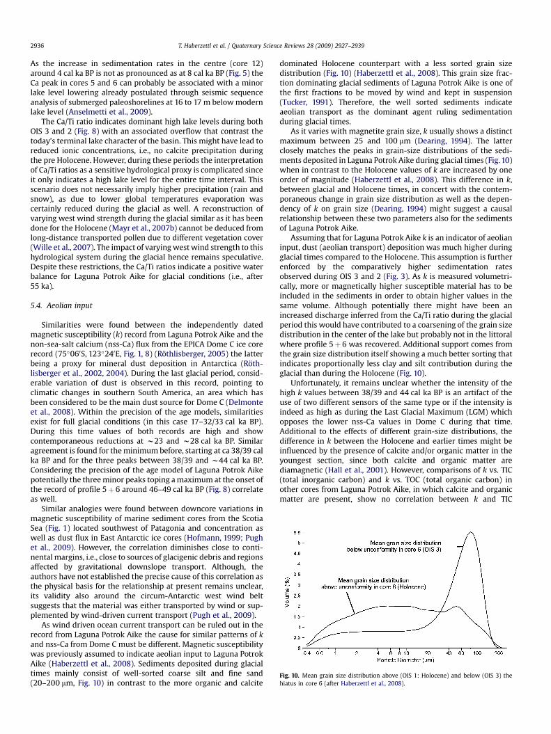
Fig. 10. Mean grain size distribution above (OIS 1: Holocene) and below (OIS 3) thehiatus in core 6 (after Haberzettl et al., 2008).
T. Haberzettl et al. / Quaternary Science Reviews 28 (2009) 2927–29392936
As the increase in sedimentation rates in the centre (core 12)around 4 cal ka BP is not as pronounced as at 8 cal ka BP (Fig. 5) theCa peak in cores 5 and 6 can probably be associated with a minorlake level lowering already postulated through seismic sequenceanalysis of submerged paleoshorelines at 16 to 17 m below modernlake level (Anselmetti et al., 2009).
The Ca/Ti ratio indicates dominant high lake levels during bothOIS 3 and 2 (Fig. 8) with an associated overflow that contrast thetoday’s terminal lake character of the basin. This might have lead toreduced ionic concentrations, i.e., no calcite precipitation duringthe pre Holocene. However, during these periods the interpretationof Ca/Ti ratios as a sensitive hydrological proxy is complicated sinceit only indicates a high lake level for the entire time interval. Thisscenario does not necessarily imply higher precipitation (rain andsnow), as due to lower global temperatures evaporation wascertainly reduced during the glacial as well. A reconstruction ofvarying west wind strength during the glacial similar as it has beendone for the Holocene (Mayr et al., 2007b) cannot be deduced fromlong-distance transported pollen due to different vegetation cover(Wille et al., 2007). The impact of varying west wind strength to thishydrological system during the glacial hence remains speculative.Despite these restrictions, the Ca/Ti ratios indicate a positive waterbalance for Laguna Potrok Aike for glacial conditions (i.e., after55 ka).
5.4. Aeolian input
Similarities were found between the independently datedmagnetic susceptibility (k) record from Laguna Potrok Aike and thenon-sea-salt calcium (nss-Ca) flux from the EPICA Dome C ice corerecord (75�060S, 123�240E, Fig. 1, 8) (Rothlisberger, 2005) the latterbeing a proxy for mineral dust deposition in Antarctica (Roth-lisberger et al., 2002, 2004). During the last glacial period, consid-erable variation of dust is observed in this record, pointing toclimatic changes in southern South America, an area which hasbeen considered to be the main dust source for Dome C (Delmonteet al., 2008). Within the precision of the age models, similaritiesexist for full glacial conditions (in this case 17–32/33 cal ka BP).During this time values of both records are high and showcontemporaneous reductions at w23 and w28 cal ka BP. Similaragreement is found for the minimum before, starting at ca 38/39 calka BP and for the three peaks between 38/39 and w44 cal ka BP.Considering the precision of the age model of Laguna Potrok Aikepotentially the three minor peaks toping a maximum at the onset ofthe record of profile 5þ 6 around 46–49 cal ka BP (Fig. 8) correlateas well.
Similar analogies were found between downcore variations inmagnetic susceptibility of marine sediment cores from the ScotiaSea (Fig. 1) located southwest of Patagonia and concentration aswell as dust flux in East Antarctic ice cores (Hofmann, 1999; Pughet al., 2009). However, the correlation diminishes close to conti-nental margins, i.e., close to sources of glacigenic debris and regionsaffected by gravitational downslope transport. Although, theauthors have not established the precise cause of this correlation asthe physical basis for the relationship at present remains unclear,its validity also around the circum-Antarctic west wind beltsuggests that the material was either transported by wind or sup-plemented by wind-driven current transport (Pugh et al., 2009).
As wind driven ocean current transport can be ruled out in therecord from Laguna Potrok Aike the cause for similar patterns of kand nss-Ca from Dome C must be different. Magnetic susceptibilitywas previously assumed to indicate aeolian input to Laguna PotrokAike (Haberzettl et al., 2008). Sediments deposited during glacialtimes mainly consist of well-sorted coarse silt and fine sand(20–200 mm, Fig. 10) in contrast to the more organic and calcite
dominated Holocene counterpart with a less sorted grain sizedistribution (Fig. 10) (Haberzettl et al., 2008). This grain size frac-tion dominating glacial sediments of Laguna Potrok Aike is one ofthe first fractions to be moved by wind and kept in suspension(Tucker, 1991). Therefore, the well sorted sediments indicateaeolian transport as the dominant agent ruling sedimentationduring glacial times.
As it varies with magnetite grain size, k usually shows a distinctmaximum between 25 and 100 mm (Dearing, 1994). The latterclosely matches the peaks in grain-size distributions of the sedi-ments deposited in Laguna Potrok Aike during glacial times (Fig. 10)when in contrast to the Holocene values of k are increased by oneorder of magnitude (Haberzettl et al., 2008). This difference in k,between glacial and Holocene times, in concert with the contem-poraneous change in grain size distribution as well as the depen-dency of k on grain size (Dearing, 1994) might suggest a causalrelationship between these two parameters also for the sedimentsof Laguna Potrok Aike.
Assuming that for Laguna Potrok Aike k is an indicator of aeolianinput, dust (aeolian transport) deposition was much higher duringglacial times compared to the Holocene. This assumption is furtherenforced by the comparatively higher sedimentation ratesobserved during OIS 3 and 2 (Fig. 3). As k is measured volumetri-cally, more or magnetically higher susceptible material has to beincluded in the sediments in order to obtain higher values in thesame volume. Although potentially there might have been anincreased discharge inferred from the Ca/Ti ratio during the glacialperiod this would have contributed to a coarsening of the grain sizedistribution in the center of the lake but probably not in the littoralwhere profile 5þ 6 was recovered. Additional support comes fromthe grain size distribution itself showing a much better sorting thatindicates proportionally less clay and silt contribution during theglacial than during the Holocene (Fig. 10).
Unfortunately, it remains unclear whether the intensity of thehigh k values between 38/39 and 44 cal ka BP is an artifact of theuse of two different sensors of the same type or if the intensity isindeed as high as during the Last Glacial Maximum (LGM) whichopposes the lower nss-Ca values in Dome C during that time.Additional to the effects of different grain-size distributions, thedifference in k between the Holocene and earlier times might beinfluenced by the presence of calcite and/or organic matter in theyoungest section, since both calcite and organic matter arediamagnetic (Hall et al., 2001). However, comparisons of k vs. TIC(total inorganic carbon) and k vs. TOC (total organic carbon) inother cores from Laguna Potrok Aike, in which calcite and organicmatter are present, show no correlation between k and TIC

T. Haberzettl et al. / Quaternary Science Reviews 28 (2009) 2927–2939 2937
(R2¼ 0.07) or TOC (R2¼ 0.02) (Haberzettl et al., 2007a). Sedimentsbelow the unconformity in core 6 yield TIC values below detectionlimits which prevents a correlation. These sediments further givea correlation of R2¼ 0.07 for TOC vs. k, confirming a negligibleinfluence of calcite and organic matter on k during glacial times(Haberzettl et al., 2008).
Alternatively, aeolian transport might provide sediments ofdifferent provenance, potentially bearing higher magnetic suscep-tibility. This might for example be associated with an additionalglacial source which is not active during the Holocene (Ackert,2009; Sugden et al., 2009) when the k signal is lower. Studies inmarine sediment cores from mid latitudes in the South IndianOcean, eastward of the Kerguelen Islands (Fig. 1) show thatmagnetic susceptibility is not related to variations in grain sizes butreflects changes in the flux of magnetite (Mazaud et al., 2007).Although the authors do not discuss their results in terms of aeolianinput magnetic susceptibility profiles strongly resemble variationsin Antarctic dust concentrations (Dezileau et al., 2000; Mazaudet al., 2007; Pugh et al., 2009). Potentially, in Laguna Potrok Aikegrain size could only act as an indicator for aeolian activity butchanges in the magnetic susceptibility signal might also beenhanced or solely related to changes in the flux of highlysusceptible material. However, the existence and exact role of thesepotential contributions have to be further explored in futurestudies.
Changes in grain size (Haberzettl et al., 2008) as well as thehigher k found during glacial times in sediments of Laguna PotrokAike either imply a) stronger westerly winds leading to intensifieddeflation and improved transport conditions; b) favoured condi-tions for wind erosion for example due to reduced vegetation cover(Wille et al., 2007) or (peri-)glacial processes (Ackert, 2009; Sugdenet al., 2009); or c) a combination of both. A relatively open vege-tation during the Lateglacial due to lower temperatures waspreviously suggested for the investigated environment (Wille et al.,2007). Investigations in the region surrounding the Strait ofMagellan (Fig. 1) also show that dust peaks in Antarctica coincidewith periods when rivers of glacial meltwater deposited sedimentonto outwash plains from where it could easily be mobilized bywind (Sugden et al., 2009). Lake level reconstructions for LagoCardiel (morphometrically different and located 350 km north ofLaguna Potrok Aike) indicate dry conditions during the Last GlacialMaximum (Gilli et al., 2001) coinciding with an enhanced Patago-nian dust deposition on the Antarctic ice-shield (Yung et al., 1996).Furthermore, GCM simulations show that atmospheric transportpotentially carrying dust from Patagonia to Antarctica was fasterduring the Last Glacial Maximum (Krinner and Genthon, 2003). Allthese evidence suggest that the scenario proposed from LagunaPotrok Aike is realistic. The ultimate reason for the dust increaseduring glacial times, however, cannot be solved from this recordalone.
Possibly magnetic susceptibility could be used to transfer an icecore age model to the sediments recovered within the ICDP(International Continental Scientific Drilling Program) projectPASADO (Potrok Aike maar lake Sediment Archive Drilling prOject)as it was proposed for marine sediments in the Scotia Sea (Pughet al., 2009). This would give additional time control to the antici-pated radiocarbon, OSL, tephrochronology and stratigraphic efforts(paleomagnetics, pollen, stable isotopes).
6. Conclusions
Sediment core 5 from Laguna Potrok Aike closes the gap causedby a hiatus in littoral core 6. The combination of both cores allowedto produce the composite profile 5þ 6 containing a continuouspaleoenvironmental record for the past 55 ka. The latter is unique
for the southern Patagonian steppe, an area with no comparablecontinuous records covering that age range so far. Refining theHolocene record, a sharp increase in calcite was detected in thelittoral cores. This augmentation in autochthonous carbonateprecipitation is ascribed to a minor lake level lowering dated to 4.5to 4 cal ka BP and possibly related to a submerged paleoshoreline at16/17 m below today’s lake level. Apart from this peak in Ca, therecords of this element and the tephras indicate a similar sedi-mentation pattern for the three coring sites. During glacial timesa very high lake level indicates a positive hydrological balancewhich probably triggered an overflow of the lake. In accordancewith the Dome C ice core record from Antarctica, aeolian transportin Patagonia itself was more vigorous during glacial times thanduring the Holocene. This is the first evidence for temporallysimilar dust deposition patterns in Antarctica and in the mainsource area of Patagonia. In concert with OSL dates magneticsusceptibility might be used to provide chronological information(transfer of ice core age model) for the extension of the record backin time using the sediment records recovered in the ICDP (Inter-national Continental Scientific Drilling Program) deep drillingproject PASADO (Potrok Aike maar lake Sediment Archive DrillingprOject). OSL dates from Laguna Potrok Aike show a goodapproximation to radiocarbon ages in older sediments where bothdating methods delivered the smallest difference.
Acknowledgements
We thank Regine Rothlisberger for providing us with her non-sea-salt calcium data from Dome C. Sabine Stahl and Ellen Reid areacknowledged for assistance with geochemical and tephra analysesas well as Guillaume St-Onge for comments on parts of an earlierdraft of this manuscript. Raimon Tolosana-Delgado, Hilmar vonEynatten, Hans Ruppert, Istvan Dunkl and Volker Karius providedfruitful discussions. We also acknowledge the helping hands ofPhilipp Bluszcz during core processing. Finally, we would like tothank Barbara Delmonte and an anonymous reviewer for theirsubstantial comments which improved an earlier version of themanuscript distinctively. This is a contribution to the GermanClimate Research Program DEKLIM (grants 01 LD 0034 and 0035) ofthe German Federal Ministry of Education and Research (BMBF).Seismic surveys were funded by the German Research Foundation(DFG Zo102/5-1, 2, 3) in the framework of the priority programICDP. Torsten Haberzettl is currently supported by a postdoctoralfellowship scholarship provided by Le Fonds quebecois de larecherche sur la nature et les technologies (FQRNT). This consti-tutes GEOTOP contribution n� 2009-0017.
References
Ackert, R.P.J., 2009. Palaeoclimate: Patagonian dust machine. Nature Geoscience2, 244–245.
Anselmetti, F.S., Ariztegui, D., Batist, M.D., Gebhardt, A.C., Haberzettl, T., Niessen, F.,Ohlendorf, C., Zolitschka, B., 2009. Environmental history of southern Patagoniaunravelled by the seismic stratigraphy of Laguna Potrok Aike. Sedimentology56, 873–892.
Basile, I., Grousset, F.E., Revel, M., Petit, J.R., Biscaye, P.E., Barkov, N.I., 1997. Patagonianorigin of glacial dust deposited in East Antarctica (Vostok and Dome C) duringglacial stages 2, 4 and 6. Earth and Planetary Science Letters 146, 573–589.
Corbella, H., 2002. El campo volcano-tectonico de Pali Aike. In: Haller, M. (Ed.),Geologıa y Recursos Naturales de Santa Cruz. Asociacion Geologica Argentina,Buenos Aires, pp. 285–302.
Croudace, I.W., Rindby, A., Rothwell, R.G., 2006. ITRAX: description and evaluationof a new multi-function X-ray core scanner. In: Rothwell, R.G. (Ed.), NewTechniques in Sediment Core Analysis. Geological Society, London, pp. 51–63.
D0Orazio, M., Agostini, S., Mazzarini, F., Innocenti, F., Manetti, P., Haller, M.J.,Lahsen, A., 2000. The Pali Aike Volcanic Field, Patagonia: slab-window mag-matism near the tip of South America. Tectonophysics 321, 407–427.
Dearing, J., 1994. Environmental Magnetic Susceptibility. Using the Bartington MS2System. Chi Publishing, Kentworth.

T. Haberzettl et al. / Quaternary Science Reviews 28 (2009) 2927–29392938
Delmonte, B., Basile-Doelsch, I., Petit, J.R., Maggi, V., Revel-Rolland, M., Michard, A.,Jagoutz, E., Grousset, F., 2004. Comparing the Epica and Vostok dust recordsduring the last 220,000 years: stratigraphical correlation and provenance inglacial periods. Earth-Science Reviews 66, 63–87.
Delmonte, B., Andersson, P.S., Hansson, M., Schonberg, H., Petit, J.R., Basile-Doelsch, I., Maggi, V., 2008. Aeolian dust in East Antarctica (EPICA-Dome C andVostok): provenance during glacial ages over the last 800 kyr. GeophysicalResearch Letters 35, L07703. doi:10.1029/2008GL033382.
Dezileau, L., Bareille, G., Reyss, J.L., Lemoine, F., 2000. Evidence for strong sedimentredistribution by bottom currents along the southeast Indian ridge. Deep SeaResearch Part I: Oceanographic Research Papers 47, 1899–1936.
Endlicher, W., 1993. Klimatische Aspekte der Weidedegradation in Ost-Patagonien.In: Hornetz, B., Zimmer, D. (Eds.), Beitrage zur Kultur- und Regionalgeographie.Festschrift fur Ralph Jatzold. Trierer Geographische Studien. GeographischeGesellschaft Trier, Trier, pp. 91–103.
Gilli, A., Anselmetti, F., Ariztegui, D., Bradbury, J., Kelts, K., Markgraf, V., McKenzie, J.,2001. Tracking abrupt climate change in the Southern Hemisphere: a seismicstratigraphic study of Lago Cardiel, Argentina (49�S). Terra Nova 13, 443–448.
Gilli, A., Anselmetti, F.S., Ariztegui, D., Beres, M., McKenzie, J.A., Markgraf, V., 2005a.Seismic stratigraphy, buried beach ridges and contourite drifts: the LateQuaternary history of the closed Lago Cardiel basin, Argentina (49�S). Sedi-mentology 52, 1–23.
Gilli, A., Ariztegui, D., Anselmetti, F.S., McKenzie, J.A., Markgraf, V., Hajdas, I.,McCulloch, R.D., 2005b. Mid-Holocene strengthening of the Southern West-erlies in South America – sedimentological evidences from Lago Cardiel,Argentina (49�S). Global and Planetary Change 49, 75–93.
Haberzettl, T., 2006. Late Quaternary Hydrological Variability in SoutheasternPatagonia - 45,000 Years of Terrestrial Evidence from Laguna Potrok Aike. PhDThesis University of Bremen. http://nbn-resolving.de/urn:nbn:de:gbv:46-diss000103918.
Haberzettl, T., Fey, M., Lucke, A., Maidana, N., Mayr, C., Ohlendorf, C., Schabitz, F.,Schleser, G.H., Wille, M., Zolitschka, B., 2005. Climatically induced lake levelchanges during the last two millennia as reflected in sediments of LagunaPotrok Aike, southern Patagonia (Santa Cruz, Argentina). Journal of Paleo-limnology 33, 283–302.
Haberzettl, T., Wille, M., Fey, M., Janssen, S., Lucke, A., Mayr, C., Ohlendorf, C.,Schabitz, F., Schleser, G., Zolitschka, B., 2006. Environmental change and firehistory of southern Patagonia (Argentina) during the last five centuries.Quaternary International 158, 72–82.
Haberzettl, T., Corbella, H., Fey, M., Janssen, S., Lucke, A., Mayr, C., Ohlendorf, C.,Schabitz, F., Schleser, G.H., Wille, M., Wulf, S., Zolitschka, B., 2007a. Lateglacialand Holocene wet-dry cycles in southern Patagonia: chronology, sedimentologyand geochemistry of a lacustrine record from Laguna Potrok Aike, Argentina.The Holocene 17, 297–310.
Haberzettl, T., Mayr, C., Wille, M., Zolitschka, B., 2007b. Linkages between SouthernHemisphere Westerlies and hydrological changes in semi-arid Patagonia duringthe last 16,000 years. PAGES News 15, 22–23.
Haberzettl, T., Kuck, B., Wulf, S., Anselmetti, F., Ariztegui, D., Corbella, H., Fey, M.,Janssen, S., Lucke, A., Mayr, C., Ohlendorf, C., Schabitz, F., Schleser, G.H.,Wille, M., Zolitschka, B., 2008. Hydrological variability in southeastern Pata-gonia and explosive volcanic activity in the southern Andean Cordillera duringOxygen Isotope Stage 3 and the Holocene inferred from lake sediments ofLaguna Potrok Aike, Argentina. Palaeogeography, Palaeoclimatology, Palae-oecology 259, 213–229.
Hall, F.R., Andrews, J.T., Kerwin, M., Smith, L.M., 2001. Studies of sedimentcolour, whole-core magnetic susceptibility, and sediment magnetism of theHudson Strait-Labrador Shelf region: CSS Hudson cruise 90023 and 93034.In: MacLean, B. (Ed.), Marine Geology of Hudson Strait and Ungava Bay,Eastern Arctic Canada: Late Quaternary Sediments, Depositional Environ-ments, and Late Glacial–Deglacial History Derived from Marine andTerrestrial Studies. Geological Survey of Canada Bulletin, vol. 566, pp. 161–170.
Hofmann, A., 1999. Kurzfristige Klimaschwankungen im Scotiameer und Ergebnissezur Kalbungsgeschichte der Antarktis wahrend der letzten 200 000 Jahre. RapidClimate Oscillations in the Scotia Sea and Results of the Calving History ofAntarctica During the Last 200000 Years (Berichte zur Polarforschung 345). PhDthesis, University of Bremen.
Jansen, J.H.F., Van der Gaast, S.J., Kloster, B., Vaars, A.J., 1998. CORTEX, a shipboard XRF-scanner for element analyses in split sediment cores. Marine Geology 151,143–153.
Kaplan, M.R., Moreno, P.I., Rojas, M., 2008. Glacial dynamics in southernmost SouthAmerica during Marine Isotope Stage 5e to the Younger Dryas chron: a briefreview with a focus on cosmogenic nuclide measurements. Journal of Quater-nary Science 23, 649–658.
Kilian, R., Hohner, M., Biester, H., Wallrabe-Adams, H.J., Stern, C.R., 2003. Holocenepeat and lake sediment tephra record from the southernmost Chilean Andes(53–55�S). Revista Geologica de Chile 30, 23–37.
Krinner, G., Genthon, C., 2003. Tropospheric transport of continental tracerstowards Antarctica under varying climatic conditions. Tellus B 55, 54–70.
Mancini, M.V., Prieto, A.R., Paez, M.M., Schabitz, F., 2008. Late quaternary vegetationand climate of patagonia. In: Rabassa, J. (Ed.), Developments in QuaternaryScience. Elsevier, pp. 351–367.
Markgraf, V., Bradbury, J.P., Schwalb, A., Burns, S.J., Stern, C., Ariztegui, D., Gilli, A.,Anselmetti, F.S., Stine, S., Maidana, N., 2003. Holocene palaeoclimates ofsouthern Patagonia: limnological and environmental history of Lago Cardiel,Argentina. The Holocene 13, 581–591.
Mauz, B., Bode, T., Mainz, E., Blanchard, H., Hilger, W., Dikau, R., Zoller, L., 2002. Theluminescence dating laboratory at the University of Bonn: equipment andprocedures. Ancient TL 20, 53–61.
Mayr, C., Fey, M., Haberzettl, T., Janssen, S., Lucke, A., Maidana, N.I., Ohlendorf, C.,Schabitz, F., Schleser, G.H., Struck, U., Wille, M., Zolitschka, B., 2005. Palae-oenvironmental changes in southern Patagonia during the last millenniumrecorded in lake sediments from Laguna Azul (Argentina). Palaeogeography,Palaeoclimatology, Palaeoecology 228, 203–227.
Mayr, C., Lucke, A., Stichler, W., Trimborn, P., Ercolano, B., Oliva, G., Ohlendorf, C.,Soto, J., Fey, M., Haberzettl, T., Janssen, S., Schabitz, F., Schleser, G.H., Wille, M.,Zolitschka, B., 2007a. Precipitation origin and evaporation of lakes in semi-aridPatagonia (Argentina) inferred from stable isotopes (d18O, d2H). Journal ofHydrology 334, 53–63.
Mayr, C., Wille, M., Haberzettl, T., Fey, M., Janssen, S., Lucke, A., Ohlendorf, C.,Oliva, G., Schabitz, F., Schleser, G.H., Zolitschka, B., 2007b. Holocene variability ofthe Southern Hemisphere westerlies in Argentinean Patagonia (52�S). Quater-nary Science Reviews 26, 579–584.
Mayr, C., Lucke, A., Maidana, N., Wille, M., Haberzettl, T., Corbella, H., Ohlendorf, C.,Schabitz, F., Fey, M., Janssen, S., Zolitschka, B., 2009. Isotopic fingerprints onlacustrine organic matter from Laguna Potrok Aike (southern Patagonia,Argentina) reflect environmental changes during the last 16,000 years. Journalof Paleolimnology 42, 81–102.
Mazaud, A., Kissel, C., Laj, C., Sicre, M.A., Michel, E., Turon, J.L., 2007. Variations of the ACC-CDW during MIS3 traced by magnetic grain deposition in midlatitude South IndianOcean cores: connections with the northern hemisphere and with centralAntarctica. Geochemistry Geophysics Geosystems 8, doi:10.1029/2006GC001532.
Mazzarini, F., D0Orazio, M., 2003. Spatial distribution of cones and satellite-detectedlineaments in the Pali Aike Volcanic Field (southernmost Patagonia): insightsinto the tectonic setting of a Neogene rift system. Journal of Volcanology &Geothermal Research 125, 291–305.
McCormac, F., Hogg, A., Blackwell, P., Buck, C., Higham, T., Reimer, P., 2004. SHCal104Southern Hemisphere Calibration 0–11.0 cal kyr BP. Radiocarbon 46, 1087–1092.
McCulloch, R.D., Fogwill, C.J., Sugden, D.E., Bentley, M.J., Kubik, P.W., 2005. Chro-nology of the Last Glaciation in central strait of Magellan and Bahıa Inutil,Southernmost South America. Geografiska Annaler, Series A: Physical Geog-raphy 87, 289–312.
Naranjo, J.A., Stern, C.R., 1998. Holocene explosive activity of Hudson Volcano,southern Andes. Bulletin of Volcanology 59, 291–306.
Petit, J.R., Jouzel, J., Raynaud, D., Barkov, N.I., Barnola, J.M., Basile, I., Bender, M.,Chappellaz, J., Davis, M., Delaygue, G., Delmotte, M., Kotlyakov, V.M.,Legrand, M., Lipenkov, V.Y., Lorius, C., Pepin, L., Ritz, C., Saltzman, E.,Stievenard, M., 1999. Climate and atmospheric history of the past 420,000 yearsfrom the Vostok ice core, Antarctica. Nature 399, 429–436.
Pugh, R.S., McCave, I.N., Hillenbrand, C.D., Kuhn, G., 2009. Circum-Antarctic agemodelling of Quaternary marine cores under the Antarctic circumpolar current: ice-core dust-magnetic correlation. Earth and Planetary Science Letters 284, 113–123.
Rabassa, J., Clapperton, C.M., 1990. Quaternary glaciations of the southern Andes.Quaternary Science Reviews 9, 153–174.
Reimer, P.J., Baillie, M.G.L., Bard, E., Bayliss, A., Beck, J.W., Bertrand, C.J.H.,Blackwell, P.G., Buck, C.E., Burr, G.S., Cutler, K.B., Damon, P.E., Edwards, R.L.,Fairbanks, R.G., Friedrich, M., Guilderson, T.P., Hogg, A.G., Hughen, K.A.,Kromer, B., McCormac, G., Manning, S., Ramsey, C.B., Reimer, R.W., Remmele, S.,Southon, J.R., Stuiver, M., Talamo, S., Taylor, F.W., van der Plicht, J.,Weyhenmeyer, C.E., 2004. IntCal04 terrestrial radiocarbon age calibration, 0–26Cal Kyr BP. Radiocarbon 46, 1029–1058.
Richter, T., Van der Gaast, S., Koster, B., Vaars, A., Gieles, R., De Stigter, H., DeHaas, H., Van Weering, T., 2006. The Avaatech XRF core scanner: technicaldescription and applications to NE Atlantic sediments. In: Rothwell, R.G. (Ed.),New Techniques in Sediment Core analysis. Geological Society, London, SpecialPublications, pp. 39–50.
Roig, F.A., Le-Quesne, C., Boninsegna, J.A., Briffa, K.R., Lara, A., Grudd, H., Jones, P.D.,Villagran, C., 2001. Climate variability 50,000 years ago in mid-latitude Chile asreconstructed from tree rings. Nature 410, 567–570.
Rothlisberger, R., 2005. IGBP PAGES/World Data Center for Paleoclimatology. EPICADome C Ice Core nss-Ca and Na Data. ftp://ftp.ncdc.noaa.gov/pub/data/paleo/icecore/antarctica/epica_domec/edc-ca-na.txt (accessed 21.12.07).
Rothlisberger, R., Bigler, M., Wolff, E.W., Joos, F., Monnin, E., Hutterli, M.A., 2004. Icecore evidence for the extent of past atmospheric CO2 change due to iron fer-tilisation. Geophysical Research Letters 31, L16207. doi:10.1029/2004GL020338.
Rothlisberger, R., Mulvaney, R., Wolff, E.W., Hutterli, M.A., Bigler, M., Sommer, S.,Jouzel, J., 2002. Dust and sea salt variability in central East Antarctica (Dome C)over the last 45 kyrs and its implications for southern high-latitude climate.Geophysical Research Letters 29, doi:10.1029/2002GL015186.
Skewes, M.A., 1978. Geologıa, petrologıa, quimismo y origen de los volcanes del areade Pali-Aike, Magallanes, Chile. Anales del Instituto de la Patagonia 9, 95–106.
St-Onge, G., Mulder, T., Francus, P., Long, B., 2007. Chapter two. Continuous physicalproperties of cored marine sediments. In: Hillaire-Marcel, C., De Vernal, A.(Eds.), Developments in Marine Geology. Elsevier, pp. 63–98.
Stern, C.R., 1990. Tephrochronology of southernmost Patagonia. NationalGeographic Research 6, 110–126.
Stine, S., 1998. Medieval climatic anomaly in the Americas. In: Issar, A.S., Brown, N.(Eds.), Water, Environment and Society in Times of Climatic change. KluwerAcademic Publishers, Dordrecht, pp. 43–67.
Stuiver, M., Reimer, P., 1993. Extended 14C database and revised CALIB radiocarboncalibration program. Radiocarbon 35, 215–230.

T. Haberzettl et al. / Quaternary Science Reviews 28 (2009) 2927–2939 2939
Sugden, D.E., McCulloch, R.D., Bory, A.J.-M., Hein, A.S., 2009. Influence of Patagonianglaciers on Antarctic dust deposition during the last glacial period. NatureGeoscience 2, 281–285.
Tucker, M.E., 1991. Sedimentary petrology: an introduction to the origin of sedi-mentary rocks. Blackwell Science Publications, Cambridge.
Unkel, I., Bjorck, S., Wohlfarth, B., 2008. Deglacial environmental changes on Isla delos Estados (54.4�S), southeastern Tierra del Fuego. Quaternary Science Reviews27, 1541–1554.
Villa-Martınez, R., Moreno, P.I., 2007. Pollen evidence for variations in the southernmargin of the westerly winds in SW Patagonia over the last 12,600 years.Quaternary Research 68, 400–409.
Weninger, B., Joris, O., Danzeglocke, U., 2004. Calpal - the Cologne radiocarbonCALibration and PALaeoclimate research package. http://www.calpal.de.
Whitlock, C., Moreno, P.I., Bartlein, P., 2007. Climatic controls of Holocene firepatterns in southern South America. Quaternary Research 68, 28–36.
Wille, M., Maidana, N.I., Schabitz, F., Fey, M., Haberzettl, T., Janssen, S., Lucke, A.,Mayr, C., Ohlendorf, C., Schleser, G.H., Zolitschka, B., 2007. Vegetation and
climate dynamics in southern South America: the microfossil record of LagunaPotrok Aike, Santa Cruz, Argentina. Review of Palaeobotany and Palynology 146,234–246.
Wintle, A.G., 1973. Anomalous fading of thermoluminescence in mineral samples.Nature 245, 143–144.
Yung, Y.L., Lee, T., Wang, C.-H., Shieh, Y.-T., 1996. Dust: a diagnostic of the hydrologiccycle during the last glacial maximum. Science 271, 962–963.
Zolitschka, B., Mingram, J., Van der Gaast, S., Jansen, J.H.F., Naumann, R., 2001.Sediment logging techniques. In: Last, W.M., Smol, J.P. (Eds.), Tracking Envi-ronmental Change Using Lake Sediments. Basin Analysis, Coring, and Chrono-logical Techniques, vol. 1. Kluwer Academic Press, Dordrecht, pp. 137–153.
Zolitschka, B., Schabitz, F., Lucke, A., Corbella, H., Ercolano, B., Fey, M., Haberzettl, T.,Janssen, S., Maidana, N., Mayr, C., Ohlendorf, C., Oliva, G., Paez, M.M.,Schleser, G.H., Soto, J., Tiberi, P., Wille, M., 2006. Crater lakes of the Pali AikeVolcanic Field as key sites for paleoclimatic and paleoecological reconstructionsin southern Patagonia, Argentina. Journal of South American Earth Sciences 21,294–309.