Late Noachian to Hesperian climate change on Mars: Evidence of episodic warming from transient...
29
Click Here for Full Article Late Noachian to Hesperian climate change on Mars: Evidence of episodic warming from transient crater lakes near Ares Vallis Nick Warner, 1 Sanjeev Gupta, 1 Shih‐Yuan Lin, 2 Jung‐Rack Kim, 2 Jan‐Peter Muller, 2 and Jeremy Morley 3 Received 7 October 2009; revised 2 December 2009; accepted 28 December 2009; published 24 June 2010. [1] The Ares Vallis region is surrounded by highland terrain containing both degraded and pristine large impact craters that suggest a change in climate during the Late Noachian‐Early Hesperian, from warmer, wetter conditions to colder, dryer conditions. However, the regional occurrence of Hesperian‐age crater outlet channels indicates that this period on Mars was characterized by episodic climate fluctuations that caused transient warming, facilitating the stability of liquid water at the surface. An extensive survey of the morphology and topography of 75 impact basins in the region indicates that of the largest degraded craters, 4 were identified with single outlet channels that suggest the former presence of water infill. These basins lack inlets indicating that water influx was likely derived from sapping of groundwater. A comparison of measured crater rim heights to modeled rim heights suggests that the bulk of the depth/diameter reduction on these craters was the result of infilling, possibly by sediments. Crater statistics indicate that crater degradation and infill occurred during a short 200 Ma interval in the Late Noachian, from 3.8 Ga to 3.6 Ga. Craters that formed after 3.6 Ga exhibit a near‐pristine morphology. Our results support the hypothesis of rapid climate change at the end of the Noachian period. However, geologic relationships between the crater outlet channels and Ares Vallis indicate that drainage occurred only after the period of intense crater modification, during the Hesperian (3.5–2.9 Ga). This suggests a delay between the time of infill of the craters and the time of drainage. Citation: Warner, N., S. Gupta, S.‐Y. Lin, J.‐R. Kim, J.‐P. Muller, and J. Morley (2010), Late Noachian to Hesperian climate change on Mars: Evidence of episodic warming from transient crater lakes near Ares Vallis, J. Geophys. Res., 115, E06013, doi:10.1029/2009JE003522. 1. Introduction [2] A significant transition in the climate of Mars may have occurred near 3.8 Ga to 3.5 Ga at the boundary of the Noachian and Hesperian periods [Hartmann and Neukum, 2001]. This period of Martian geologic time is marked by a distinct change in landform morphology and mineralogy, with a diminishing occurrence of well‐developed valley networks [Carr, 1996; Craddock and Maxwell, 1990, 1993; Fassett and Head, 2008a; Harrison and Grimm, 2005; Irwin and Howard, 2002; Irwin et al., 2004; Tanaka, 1986] and an overall disappearance of phyllosilicates within layered de- posits [Chevrier et al., 2007; Milliken et al., 2007; Mustard et al., 2008]. Currently, it is unclear whether this climate change was gradual, occurring throughout the Noachian and into the Hesperian, or punctuated by specific events at the Noachian‐Hesperian boundary [Howard et al., 2005; Irwin et al., 2005]. Furthermore, the causes of this climate change remain enigmatic, and may have been the result of atmo- spheric losses due to a combination of exogenic and endo- genic changes that included, atmospheric erosion by impact events during the Late Heavy Bombardment (4.1–3.8 Ga) [Melosh and Vickery, 1989; Pham et al., 2009], escape of atmospheric gases to space [Jakosky et al., 1994; Terada et al., 2009], termination of the Mars dynamo [Jakosky et al., 1994; Stevenson, 2001], the end of plate tectonics in the Noachian [Fairen et al., 2002; Fairen and Dohm, 2004; Sleep, 1994], and the overall diminished internal heat [Zuber, 2001] that resulted in a long‐term decline in surface volca- nism into the Amazonian [Carr, 1973; Greeley and Spudis, 1981; Werner, 2009]. In addition, an overall decrease in water abundance during this period on Mars may have sig- nificantly altered the planetary hydrologic cycle, affecting the extent of fluvial modification on the surface [ Andrews‐ Hanna et al., 2008]. Less large bolide impacts at the end of 1 Department of Earth Science and Engineering, Imperial College London, London, UK. 2 Mullard Space Science Laboratory, Department of Space and Climate Physics, University College London, Dorking, UK. 3 Centre for Geospatial Science, University of Nottingham, Nottingham, UK. Copyright 2010 by the American Geophysical Union. 0148‐0227/10/2009JE003522 JOURNAL OF GEOPHYSICAL RESEARCH, VOL. 115, E06013, doi:10.1029/2009JE003522, 2010 E06013 1 of 29
Transcript of Late Noachian to Hesperian climate change on Mars: Evidence of episodic warming from transient...

ClickHere
for
FullArticle
Late Noachian to Hesperian climate change on Mars:Evidence of episodic warming from transient crater lakesnear Ares Vallis
Nick Warner,1 Sanjeev Gupta,1 Shih‐Yuan Lin,2 Jung‐Rack Kim,2 Jan‐Peter Muller,2
and Jeremy Morley3
Received 7 October 2009; revised 2 December 2009; accepted 28 December 2009; published 24 June 2010.
[1] The Ares Vallis region is surrounded by highland terrain containing both degradedand pristine large impact craters that suggest a change in climate during the LateNoachian‐Early Hesperian, from warmer, wetter conditions to colder, dryer conditions.However, the regional occurrence of Hesperian‐age crater outlet channels indicates thatthis period on Mars was characterized by episodic climate fluctuations that caused transientwarming, facilitating the stability of liquid water at the surface. An extensive survey ofthe morphology and topography of 75 impact basins in the region indicates that of thelargest degraded craters, 4 were identified with single outlet channels that suggest theformer presence of water infill. These basins lack inlets indicating that water influx waslikely derived from sapping of groundwater. A comparison of measured crater rim heightsto modeled rim heights suggests that the bulk of the depth/diameter reduction on thesecraters was the result of infilling, possibly by sediments. Crater statistics indicate thatcrater degradation and infill occurred during a short 200 Ma interval in the Late Noachian,from 3.8 Ga to 3.6 Ga. Craters that formed after 3.6 Ga exhibit a near‐pristine morphology.Our results support the hypothesis of rapid climate change at the end of the Noachianperiod. However, geologic relationships between the crater outlet channels and Ares Vallisindicate that drainage occurred only after the period of intense crater modification,during the Hesperian (3.5–2.9 Ga). This suggests a delay between the time of infill of thecraters and the time of drainage.
Citation: Warner, N., S. Gupta, S.‐Y. Lin, J.‐R. Kim, J.‐P. Muller, and J. Morley (2010), Late Noachian to Hesperian climatechange on Mars: Evidence of episodic warming from transient crater lakes near Ares Vallis, J. Geophys. Res., 115, E06013,doi:10.1029/2009JE003522.
1. Introduction
[2] A significant transition in the climate of Mars mayhave occurred near 3.8 Ga to 3.5 Ga at the boundary of theNoachian and Hesperian periods [Hartmann and Neukum,2001]. This period of Martian geologic time is marked bya distinct change in landform morphology and mineralogy,with a diminishing occurrence of well‐developed valleynetworks [Carr, 1996; Craddock and Maxwell, 1990, 1993;Fassett and Head, 2008a; Harrison and Grimm, 2005; Irwinand Howard, 2002; Irwin et al., 2004; Tanaka, 1986] and anoverall disappearance of phyllosilicates within layered de-posits [Chevrier et al., 2007; Milliken et al., 2007; Mustard
et al., 2008]. Currently, it is unclear whether this climatechange was gradual, occurring throughout the Noachian andinto the Hesperian, or punctuated by specific events at theNoachian‐Hesperian boundary [Howard et al., 2005; Irwin etal., 2005]. Furthermore, the causes of this climate changeremain enigmatic, and may have been the result of atmo-spheric losses due to a combination of exogenic and endo-genic changes that included, atmospheric erosion by impactevents during the Late Heavy Bombardment (4.1–3.8 Ga)[Melosh and Vickery, 1989; Pham et al., 2009], escape ofatmospheric gases to space [Jakosky et al., 1994; Terada etal., 2009], termination of the Mars dynamo [Jakosky et al.,1994; Stevenson, 2001], the end of plate tectonics in theNoachian [Fairen et al., 2002; Fairen and Dohm, 2004;Sleep, 1994], and the overall diminished internal heat [Zuber,2001] that resulted in a long‐term decline in surface volca-nism into the Amazonian [Carr, 1973; Greeley and Spudis,1981; Werner, 2009]. In addition, an overall decrease inwater abundance during this period on Mars may have sig-nificantly altered the planetary hydrologic cycle, affecting theextent of fluvial modification on the surface [Andrews‐Hanna et al., 2008]. Less large bolide impacts at the end of
1Department of Earth Science and Engineering, Imperial CollegeLondon, London, UK.
2Mullard Space Science Laboratory, Department of Space and ClimatePhysics, University College London, Dorking, UK.
3Centre for Geospatial Science, University of Nottingham, Nottingham,UK.
Copyright 2010 by the American Geophysical Union.0148‐0227/10/2009JE003522
JOURNAL OF GEOPHYSICAL RESEARCH, VOL. 115, E06013, doi:10.1029/2009JE003522, 2010
E06013 1 of 29
the Late Heavy Bombardment may have contributed to thisprocess by supplying volatiles at a rate that was lower relativeto losses to space [Carr, 1999; Pepin, 1994; Zhang et al.,1993].[3] As a key geomorphologic indicator of climate change
on Mars, the morphology of impact craters has long beenused to estimate global erosion rates [Arvidson et al., 1979;Carr, 1992; Craddock and Maxwell, 1993; Craddock et al.,1997; Hartmann et al., 1999]. The Noachian‐age southernhighlands exhibit numerous poorly preserved impact cratersthat show subdued rims, have degraded primary ejectablankets and contain postemplacement volcanic or sedi-mentary infill [Arvidson, 1974; Craddock et al., 1997;Forsberg‐Taylor et al., 2004; Grant and Schultz, 1993;Neukum and Hiller, 1981; Strom et al., 1992]. In particular,the relative heights of the degraded crater rims to pristinecrater rims have been used to estimate erosion rates of 102‐104 nm yr−1 for the Noachian period [Carr, 1992; Craddockand Maxwell, 1993; Craddock et al., 1997; Hartmann et al.,1999]. Although low by terrestrial standards (driest regionson Earth have similar measured erosion rates of 102–104 nm yr−1) [Bierman and Turner, 1995; Kong et al., 2007;Nishiizumi et al., 1991], this relatively intense period ofMartian surface erosion is well documented and was likelythe result of wind abrasion and erosion by stable surfaceliquid water in a thicker early atmosphere.[4] By comparison, the Hesperian period on Mars is noted
for surface conditions that were generally below the triplepoint of water [Carr, 2007], with possible brief periods of
climate warming resulting from sporadic but major mag-matic activity [Harrison and Grimm, 2005], impact crater-ing [Segura et al., 2002], and catastrophic outflow events[Baker et al., 1991; Santiago et al., 2005]. As a result ofNoachian‐Hesperian volcanism and an influx of SO2 intothe Martian atmosphere/hydrosphere [Bullock and Moore,2007], acid sulfate weathering was an important aqueoussurface alteration process in regions with limited/temporaryaccess to water, forming isolated units with detectable sul-fate [Glotch and Rogers, 2007; Grotzinger et al., 2005;Elwood Madden et al., 2009; Mangold et al., 2008; Squyresand Knoll, 2005; Wiseman et al., 2008].[5] In contrast to Noachian morphologies, impact craters
from Hesperian surfaces show distinct crater rims, centralpeaks, and obvious primary and secondary ejecta, fromwhich, a low global erosion rate has been inferred [Arvidson,1974; Craddock et al., 1997; Forsberg‐Taylor et al., 2004;Grant and Schultz, 1993; Neukum and Hiller, 1981; Strom etal., 1992]. Estimates from image and topographic analysis ofcrater rim degradation indicate a rate of 100–101 nm yr−1
[Arvidson et al., 1979; Carr, 1992]. By comparison, fromdirect observations of wind‐deflated surfaces in ChrysePlanitia, the Mars Pathfinder Rover provided a minimumHesperian erosion rate of 0.01–0.04 nm yr−1 [Golombekand Bridges, 2000]. At the Meridiani Planum OpportunityRover landing site a maximum Hesperian erosion rate of10 nm yr−1 was obtained [Golombek et al., 2006]. The pri-mary agents of crater modification during this period werelikely wind abrasion, mass wasting, crater infilling (air falldust, impact ejecta, volcanic products), and crater rimembayment by coverage from aeolian deposits and lavaflows/pyroclastic deposits.[6] The stability of water on the surface of Mars during
the Noachian‐Hesperian climate shift is of paramountimportance with regard to the development and sustain-ability of habitable environments for microbial life. OnEarth, life originated within aqueous environments follow-ing the end of the Late Heavy Bombardment at 3.5–3.3 Ga[Brasier et al., 2005; Schopf and Packer, 1987]. On Mars,atmospheric losses and the resulting surface desiccation thatfollowed the Late Heavy Bombardment would have in-hibited life’s ability to evolve and distribute across thesurface. However, if isolated pockets of liquid water weresustained throughout this period, life may have evolved on alocal scale. Several recent studies have identified geomor-phologic indicators of transiently stable liquid water onpurported Hesperian‐age surfaces. These localized featuresare ideal target sites for astrobiology and include localizedvalley networks [Ansan and Mangold, 2006; Fassett andHead, 2006, 2007; Harrison and Grimm, 2005; Mangoldand Ansan, 2006], ponded water within isolated depres-sions or craters [Di Achille et al., 2009;Mangold and Ansan,2006; Pondrelli et al., 2005], and ponded water within smallthermokarst lakes [Warner et al., 2010].[7] In this analysis we describe the surface and crater
morphology of a region on Mars previously defined bycrater statistics to have formed during this critical period ofclimate change. The equatorial highland surfaces of XantheTerra and Arabia Terra (Figure 1) are heavily cratered LateNoachian to Early Hesperian‐age terrain that containsnumerous large catastrophic outflow channels [Greeley etal., 1977; Nelson and Greeley, 1999; Rotto and Tanaka,
Figure 1. THEMIS VIS mosaic of the Ares Vallis outflowchannel, Xanthe Terra, and Arabia Terra. The image illus-trates the location of the 75 large diameter impact craters(D > 8 km) measured in this study. Impact craters with chan-nels are marked by asterisks (crater 42 has an inlet channel).The region of coverage of HRSC DTMs is outlined.
WARNER ET AL.: HESPERIAN CRATER LAKES NEAR ARES VALLIS E06013E06013
2 of 29

1995; Scott and Tanaka, 1986; Wilhelms, 1976]. Specifi-cally, we focus our analysis on the regions of Xanthe Terraand Arabia Terra that immediately surround the Ares Valliscatastrophic outflow channel (Figure 1). Here we haveidentified several previously undescribed crater basins thatexhibit small outlet channels. Importantly, these crater basinslack inlets and suggest that water ponded, overspilled, and/orcatastrophically drained through a breach in the crater rim(Figure 1).[8] Using complimentary data sets of Mars Reconnais-
sance Orbiter Context Camera Images (6 m pixel−1), HighResolution Stereo Camera (HRSC) Digital Terrain Models(DTMs) (50–75 m grid spacing), HRSC orthoimages (12 mpixel−1), Thermal Emission Imaging System (THEMIS)visible light (VIS) images (18 m pixel−1), and THEMISthermal infrared (IR) images (100 m pixel−1) (day and night)we describe the morphology of the impact craters in theAres Vallis region that exhibit associated outlet channels.Furthermore, we extend our observations to all large diameter(D > 8 km) craters in the study region to relate cratermorphology to regional surface degradation and climatechange. Crater statistics were obtained from the highlandterrains and the crater floors to constrain the timing of craterformation, crater modification, and outlet channel formation.We hypothesize that some of the large craters in the regionwere filled with liquid water during this critical period ofMartian history where water was likely to only be tran-siently stable at the surface. The primary outstandingquestions that we look to address are as follows: (1) Whatwas the regional extent of crater lakes in the highland terrainsurrounding Ares Vallis and how do the morphologies ofthe water‐filled craters compare to other craters that lackevidence for infilling? (2) Do these crater lakes representlocal occurrences of water infilling or do they represent abroader hydrologic cycle (precipitation or groundwater influx).(3) What is the timing of water infilling and how does it relateto the timing of drainage? (4) Were the crater lakes formedby an influx of water related to Ares Vallis outflow events?(5) Doesmorphologic evidence remain for infilling sedimentsand what is the age of these sediments? (6) What do the rimtopography, crater depth/diameter ratios, and regional craterstatistics indicate about regional erosion rates before, during,and after crater lake formation? (7) What are the broaderimplications regarding the climate of Mars and surfacehabitability within the crater lakes?
2. Methods
2.1. HRSC DTM Construction
[9] To describe the morphology of the large diametercraters, including those with associated outlet channels, weutilized a number of new HRSC DTMs. These includeDTMs with 70 m grid spacing and with 50 m grid spacing,covering the entire channelized length of Ares Vallis, pre-viously described by Warner et al. [2009]. Comparisonswith MOLA height profiles indicate ± 25 m vertical accu-racy and zero bias [Warner et al., 2009]. The HRSC DTMsof Ares Vallis were created based on the MOLA DTM afterrefinement using the surface matching technique [Lin et al.,2010]. Small detailed DTMs were also created for theidentified craters with outlet channels at higher resolutionsusing the iterative feed‐forward technique [Kim and Muller,
2009] and were stereo noise reduced using the methodpreviously referenced. These high resolution (50–75 m)DTMs have been created using a unique processing systemdeveloped at UCL [Kim and Muller, 2009] which is furtherdescribed by Warner et al. [2009].
2.2. Impact Crater Morphology
[10] By measuring the depth (d) to diameter (D) ratio ofpristine, complex (D = 7–100 km) impact craters on theMartian surface, Garvin et al. [2003] established a modeledd/D relationship which can be used to compare the relativestate of crater preservation and extent of modification(equation (1)).
d ¼ 0:36D0:49 ð1Þ
Figure 1 is a THEMIS IR, daytime mosaic of the Ares Vallisregion with the locations of 75 large diameter (D > 8 km)impact craters measured in this analysis and the outline ofthe DTM coverage regions. For each impact crater, thedepth and diameter was measured from HRSC DTM derivedtopography profiles to determine the extent of crater deg-radation. The d/D ratios for each impact crater were com-pared directly to modeled ratios for similar diameter pristinecraters on Mars (equation (1)) [Garvin et al., 2003]. Previousmapping studies described the Xanthe Terra and Arabia Terraregions as highland plains material, composed of layered tobrecciated Late Noachian volcanics [Nelson and Greeley,1999; Rotto and Tanaka, 1995]. From the mapped distribu-tion of impact craters on the highland plains, we assume thatall craters in this study were emplaced into similarly coherentbedrock.[11] From the topography data and image analysis of
crater morphology, craters with measured d/D ratios that arereduced by > 20% from modeled pristine ratios are classi-fied here as modified impact craters. Craters with d/Dreduction at < 20% are classified as near pristine impactcraters. The selection of 20% from modeled d/D as theboundary condition for modified and unmodified impactcraters was determined by two methods. First, if we assumea maximum erosion rate of 10 nm year−1 for the modernsurface of Mars, as estimated for Hesperian‐Amazonian agesurfaces by the Opportunity Lander at Meridiani Planum[Golombek et al., 2006], a 10 km diameter crater exposed onthe Martian surface for 4 Ga would only be reduced fromthe pristine modeled d/D ratio (through rim erosion andassuming no infilling) by ∼ 6%. For a crater with a diameterapproaching 100 km, the percent reduction by modern ero-sive processes operating over the history of Mars would onlybe ∼2%. If we assume a minimum Hesperian‐Amazonianerosion rate for modern Mars of 0.01 nm year−1, as deter-mined from Mars Pathfinder [Golombek and Bridges, 2000],the percent d/D reduction would be two orders of magnitudeless. Any measured reduction in d/D that exceeds thesepercentages must be the result of either an increased erosionrate relative to the modern erosion rates or infilling bysecondary materials. Second, and most importantly, giventhe vertical and lateral measurement accuracies of HRSCDTMs, the ± accuracy of the percent from modeled d/Dmeasurements ranges from ± 3% for the large diametercraters to ± 20% for the smaller diameter craters. Therefore,we suggest that a conservative criterion for the determination
WARNER ET AL.: HESPERIAN CRATER LAKES NEAR ARES VALLIS E06013E06013
3 of 29

of a highly modified impact crater in this analysis usingsolely d/D ratios are those that show d/D reduction frommodeled by > 20%. Generally, the image based observationsin the Ares Vallis region of the preservation state of thecraters are in good agreement with the ∼20% cutoff. Impactcraters that show a < 20% reduction in d/D from pristineratios tend to have distinct crater rims, no infill material,lobate ejecta blankets, and central peaks. Furthermore, only7 impact craters measured in this analysis have transitionalmorphologies with a measured d/D reduction of 15–25%.Impact craters with d/D reduced by > 20% from modeledrepresent surface features that were modified by processesunique to modern Martian surface erosive mechanisms orcraters that were partially filled.[12] To further classify the impact crater morphology and
to determine the relationship of rim reduction to crater in-filling, HRSC topography was used to measure the present‐day rim heights (h) of the 75 impact craters. Crater rimheights were measured and averaged from 4 points,corresponding to an azimuth of 0°, 90°, 180°, and 270°around the circumference of the crater. The values were thendirectly compared to modeled heights after Garvin et al.[2003] to estimate the erosion rate of surfaces in the AresVallis region (equation (2)).
h ¼ 0:02D0:84 ð2Þ
2.3. Chronology From Crater Statistics
[13] Previous crater counts from the Ares Vallis channeland the Xanthe Terra and Arabia Terra highland terrainswere acquired from Viking Orbiter images using craterswith D > 2 km or D > 5 km [Marchenko et al., 1998; Nelsonand Greeley, 1999; Rotto and Tanaka, 1995; Tanaka andSkinner, 2004]. The highland terrains surrounding theAres Vallis region were dated in these analyses to the LateNoachian‐Early Hesperian periods (3.8–3.5 Ga). The timingof flood erosion in Ares Vallis has more recently been datedto the Late Noachian‐Early Amazonian periods (3.6–2.5 Ga)[Warner et al., 2009]. In our analysis, we utilized cratercounting and the absolute dating techniques establishedby Hartmann and Neukum [2001] and Ivanov [2001] to(1) independently confirm the age of the large diameter craterpopulation in the Ares Vallis region, (2) determine (using thecrater morphology data) the timing of intense crater modi-fication, (3) relate the absolute and relative ages of the fillmaterial on the floors of the craters, and (4) determine therelative and absolute timing of crater lake outlet channelformation.[14] Counts of the large (D > 8 km) highland craters were
made using HRSC orthoimages and DTMs. For the craterfill material and terrain underlying crater outlet channels,craters with D > 100 m were counted from CTX imagemosaics using the Mars Editing and Assessment toolset[Simpson et al., 2008]. Where CTX has only partial cover-age, HRSC images were used to supplement the crater sta-tistics, including counts for D > 500 m. The freewareprogram Craterstats was used to plot the crater statistics andto fit isochrons (with error) to provide a model age for allsurfaces [Michael and Neukum, 2008]. For the crater infilland outlet channel analysis, all randomly distributed impactcraters were counted. Nonrandomly distributed secondary
craters found in chains or clusters were excluded. Mostrecently, it has been concluded that the majority of ran-domly distributed impact craters from 100 m to 1 km indiameter are primary in origin with limited enhancement ofcrater model ages due to contamination by secondary im-pacts [Hartmann, 2007; Hartmann et al., 2008]. It wassuggested by these authors that the determination of modelages from this impact crater population is useful for con-straining relative and absolute ages of surfaces with limitedaerial exposure and limited abundance of large diameterimpact craters. Crater statistics are presented here in tableform as crater densities for N(0.1), N(0.5), N(1), N(8) (whereN represents the cumulative number of craters counted for106 km2) and on log10 cumulative frequency plots [Hartmannand Neukum, 2001].
3. Impact Crater Morphology
3.1. Large (D > 8 km) Crater Classification From d/DRelationships and Rim Degradation
[15] Table 1 illustrates the measured d/D ratios for 75large diameter impact craters in the Ares Vallis region andthe percent reduction of these ratios from the modeledvalues for pristine impact craters. Table 2 illustrates theaverage measured reduction of the rim heights frommodeled, the modeled rim heights of pristine craters ofequal diameter, the percent reduction in d/D from pristineaccounting for only rim destruction, and the estimatedthickness of crater infill. The data indicate that 46 of the75 measured impact craters in the Ares Vallis region haved/D ratios that are reduced by > 20% from modeled ratiosfor pristine craters of equal diameter (Table 1). Additionally,the data reveal that the majority of impact craters in theregion show some measurable reduction from modeled rimheights (Table 2), indicating that erosive scour or embaymentof plains material modified the craters. To compare therelative contribution of crater rim height reduction to craterinfilling, we calculated d/D ratios for the 75 impact cratersassuming that a decrease in d was only the result of themeasured rim reduction. These d/D values were thencompared directly to the d/D ratios measured from theHRSC topography.[16] Figure 2 compares the calculated percent decrease of
d/D from pristine ratios assuming only rim height reductionto the actual measured percent decrease of d/D. The dataindicate that for most large diameter craters in the AresVallis region, rim height reduction cannot account for thetotal measured reduction of d/D. As an example, craternumber 56 has a diameter of 15 km and shows an 82%reduction in d/D from modeled. Furthermore, the rim heightof this crater is reduced by ∼190 m from its modeled rimheight. The model depth of a pristine 15 km diameter impactcrater is ∼840 m (equation (1)). Subtracting 190 m from840 m results only in a d/D reduction of 23%. We concludethat for similar impact craters in the region, crater infillingmust explain the majority of the remainder of the craterdegradation with crater widening accounting for a smallerpercentage of the total d/D reduction. Through an analysis ofthe morphometry of modeled Martian impact craters,Craddock et al. [1997] determined that craters modified byfluvial processes may increase in diameter by up to 30% inthe final stages of degradation due to backwasting of the
WARNER ET AL.: HESPERIAN CRATER LAKES NEAR ARES VALLIS E06013E06013
4 of 29

interior of the crater rim. This advanced state of degradationin actual impact craters would be measured as a maximumd/D reduction of ∼12%. Because the initial diameters ofthe impact craters in the Ares Vallis region are unknown,and given that there is little evidence for rim modificationby fluvial influx for most of the craters (see section 3.3), weassume a 0% increase in D when using d/D relationships toestimate infill thicknesses. The resulting infill depths pre-sented in Table 2 are therefore maximum estimates.[17] In addition, from the morphologic data, we have
identified 4 unique classes of impact craters (D > 8 km).[18] 1. The first class includes near pristine impact craters
that show only a marginal reduction in measured d/D frommodeled pristine ratios (∼0%–20%) and a small reduction inrim heights from modeled. For this class, the percentdecrease in d/D from rim height destruction contributes only∼5% to the total measured reduction. The average amount ofrim degradation is ∼40 m. Of the 75 impact craters measuredin this analysis, 29 craters are representative of this class. Ofthe 29 craters, only 3 have d/D values that are reduced by15% to 20% from pristine, indicating that the majority ofcraters in this class are near pristine.[19] 2. The second is represented by craters that are
bisected by fluvial channels associated with Ares Vallis.These craters show a large average reduction in rim heights(∼280 m), resulting from partial destruction of the rim bybisecting channels. For this class, the mean reduction in d/Dfrom pristine ratios is ∼50%. Rim height estimates indicatethat rim degradation accounts for up to half of the totalreduction in measured d/D ratios. The additional reduction islikely due to crater infilling (possibly by flood sediments)and crater widening by backwasting of the interior craterwall during flood erosion.[20] 3. The third class includes large (D > 20 km) modi-
fied impact craters that sometimes contain small outletchannels and show moderate amounts of crater rim andejecta degradation. Within this class, 4 craters were identi-fied with small outlet channels and 1 with a single inletchannel. The percent reduction in d/D from pristine forthese craters is ∼40% and is largely the result of craterinfilling, with rim degradation contributing ∼14% to thetotal d/D reduction. The average amount of rim degrada-tion is ∼140 m.[21] 4. Finally, the fourth class is represented by highly
modified, smaller diameter craters (D < 20 km), showing upto ∼90% decrease from modeled d/D ratios of pristine cra-ters, with a mean of ∼70%. This decrease is largely due tocrater infilling, with only ∼15% of the reduction in d/D the
Table 1. Measured Values of Depth and Diameter for 75 ImpactCraters in the Ares Vallis Regiona
ID D (km) d (km) d/DPercent FromPristine d/D
PositiveError (%)
NegativeError (%)
1 20 0.8 0.040 20 6 72 34 1 0.029 24 4 53 23 1.2 0.052 0 6 64 16 1 0.063 0 7 85 9.6 0.7 0.073 0 6 256 17 1.2 0.071 0 9 107 12 1 0.083 0 10 128 48 1 0.021 38 3 59 37 0.9 0.024 34 4 510 24 0.7 0.029 35 7 611 9 0.8 0.089 0 20 1312 9.2 0.4 0.043 39 11 1313 8.9 0.4 0.045 36 12 1014 8.3 0.8 0.096 0 18 1215 35 0.5 0.014 63 4 416 24 0.7 0.029 35 7 617 17 0.5 0.029 44 7 718 18 0.4 0.022 58 6 719 39 1.9 0.049 0 6 020 28 0.6 0.021 49 5 621 10 0.7 0.070 0 13 822 13 0.1 0.008 87 4 423 11 0.7 0.064 6 10 1324 11 0.7 0.064 6 10 1325 11 0.3 0.027 66 8 926 15 0.3 0.020 66 5 1027 16 0.7 0.044 22 6 828 35 0.8 0.023 41 4 429 42 0.4 0.010 77 3 430 18 0.8 0.044 17 7 831 23 1 0.043 4 8 932 18 1 0.056 0 6 633 11 0.5 0.045 32 10 1134 12 0.6 0.050 20 10 935 14 0.3 0.021 64 7 836 11 0.6 0.055 17 12 1037 9 0.4 0.044 39 9 1338 38 0.5 0.013 64 5 439 10 0.2 0.020 77 5 540 17 1 0.059 0 6 741 68 1.8 0.026 8 2 542 41 0.7 0.017 53 3 543 35 1.1 0.031 19 5 644 9.3 0.8 0.086 0 9 2345 84 1 0.012 54 2 346 35 0.5 0.014 63 4 447 9.9 0.3 0.030 55 9 1148 19 1.1 0.058 0 12 049 9 0.7 0.078 0 14 2050 8 0.4 0.050 33 13 951 18 0.9 0.050 3 11 952 29 1.1 0.038 8 6 453 15 0.5 0.033 40 7 954 16 0.4 0.025 55 7 855 16 0.3 0.019 66 7 756 15 0.2 0.013 82 3 457 16 0.4 0.025 55 7 858 27 1.2 0.044 0 4 1059 9.4 0.2 0.021 78 4 560 13 0.1 0.008 87 4 461 71 1 0.014 49 3 362 40 0.7 0.018 51 4 463 23 1.1 0.048 0 5 564 25 0.8 0.032 29 6 565 18 0.4 0.022 58 6 766 10 0.6 0.060 12 9 1267 54 0.8 0.015 56 3 468 52 0.6 0.012 64 3 369 9 0.6 0.067 7 11 15
Table 1. (continued)
ID D (km) d (km) d/DPercent FromPristine d/D
PositiveError (%)
NegativeError (%)
70 12 0.1 0.008 91 3 471 20 0.6 0.030 39 7 672 8.7 0.4 0.046 36 10 1473 11 0.8 0.073 0 6 1574 9 0.7 0.078 0 13 1775 21 0.2 0.010 85 5 5
aDepth, d; diameter, D. Depth to diameter (d/D) ratios and the percentdecrease (with error) from modeled pristine ratios are also given.
WARNER ET AL.: HESPERIAN CRATER LAKES NEAR ARES VALLIS E06013E06013
5 of 29

result of crater rim degradation. The average amount of rimdegradation is ∼130 m.
3.2. Morphology of Near Pristine Impact Craters
[22] The topographic data obtained from HRSC DTMsindicates that 29 out of the 75 measured large diameterimpact craters (D > 8 km) in the Ares Vallis region showlittle evidence for modification, either by crater infilling orby crater rim degradation. From CTX and HRSC imagesthis class of impact features is defined by craters with sharprims, obvious lobate ejecta blankets, little to no infilling,distinct central peaks, and discrete deposits resulting fromslumping of the interior crater rim (Figure 3a). Those incontact with Ares Vallis flood channels are superimposedupon flood grooves and channel walls. In addition, thepristine crater class often overlies small flat‐floored putativethermokarst depressions [Costard and Baker, 2001; Pacificiet al., 2009; Warner et al., 2010] and small, poorly devel-oped channel systems. The thermokarst‐like features areubiquitous on the highland terrain surrounding Ares Vallisand may be relic depressions leftover from regional degra-dation (melting or sublimation) of near‐surface ice. Interiorcrater wall slumps, along with aeolian material and air fallderived dust deposits, represent the only fill materialspresent within these craters.[23] THEMIS day/night thermal IR images of the Ares
Vallis region reveal important physical characteristics of thepristine crater class that allow for differentiation of theseimpacts from the modified crater classes (Figure 4). In nightIR images, the pristine craters show distinct central peaksmarked by a bright, high thermal inertia signature, sug-gesting the presence of solid bedrock [Christensen et al.,2001; Jakosky, 1986; Kieffer et al., 1973; Presley andChristensen, 1997]. Additional high thermal inertiaregions are visible in concentric bedrock outcrops along therim and interior of the craters. Low thermal inertia “dark”regions characterize the crater floors between the centralpeaks and the interior rims in the night IR images. Thisobservation is consistent with the presence of poorly con-solidated fine‐grained material (air fall dust or windblowndeposits). In daytime IR images, the thermal signature islargely controlled by topography and sun angle.
Table 2. Rim Height Measurements and Values for the EstimatedReduction in Rim Height From Modeled Pristine Cratersa
ID
PristineRim
Heightb
(m)
MeasuredRim
Reduction(m)
PercentFromPristined/D
PositiveError(%)
NegativeError(%)
Infill(m)
1 248 80 8 3 3 1102 387 170 13 2 2 1503 279 30 3 2 2 04 205 30 3 3 3 05 134 0 0 5 2 06 216 70 8 3 3 07 161 0 0 5 2 08 517 200 13 2 2 3909 415 60 4 2 2 43010 289 130 12 2 2 26011 127 0 0 6 2 012 129 50 8 4 4 18013 125 120 19 4 4 12014 118 0 0 5 3 015 396 140 10 2 2 70016 289 130 12 2 2 27017 216 40 4 3 3 36018 227 50 5 3 3 48019 434 60 4 2 2 020 329 200 17 2 2 39021 138 0 0 6 1 022 172 0 0 5 2 69023 150 0 0 8 0 4024 150 30 4 4 4 025 150 130 18 4 4 33026 195 140 17 3 3 40027 205 60 7 3 3 11028 396 190 14 2 2 35029 462 320 22 2 2 81030 227 30 3 3 3 10031 279 120 11 2 2 032 227 90 10 3 3 033 150 90 13 4 4 12034 161 120 16 3 3 2035 184 130 16 3 3 39036 150 0 0 6 1 13037 127 90 14 4 4 15038 425 310 22 2 2 59039 138 80 12 4 4 44040 216 10 1 3 3 041 692 340 18 1 1 042 453 340 23 2 2 43043 396 350 26 2 2 044 130 0 0 4 4 045 827 510 23 1 1 67046 396 350 26 2 2 49047 137 0 0 4 3 38048 237 90 9 3 3 049 127 20 3 4 4 050 115 80 13 4 4 12051 227 120 13 3 3 052 338 40 3 2 2 8053 195 100 12 3 3 24054 205 180 21 3 3 29055 205 130 15 3 3 44056 195 190 23 3 3 51057 205 180 21 3 3 29058 319 20 2 2 2 059 131 50 8 4 4 44060 172 110 14 3 3 57061 718 420 21 1 1 56062 443 390 27 2 2 36063 279 50 5 2 2 064 299 170 15 2 2 15065 227 210 23 3 3 32066 138 10 1 4 4 6067 570 340 20 1 1 620
Table 2. (continued)
ID
PristineRim
Heightb
(m)
MeasuredRim
Reduction(m)
PercentFromPristined/D
PositiveError(%)
NegativeError(%)
Infill(m)
68 553 330 20 1 1 74069 127 0 0 4 4 3070 161 140 19 3 3 54071 248 200 20 3 3 19072 123 60 10 4 4 17073 150 10 1 4 4 074 127 20 3 4 4 075 258 170 17 2 2 690
aThe percent reduction of the depth to diameter (d/D) ratios (with error)from pristine ratios is given for all craters, assuming rim height reductiononly. Thickness of infill is estimated by comparing the actual measuredd/D values (Table 1) to the d/D values that assume only rim heightreduction. The infill depths represent maximum estimates and assumenegligible reduction in d/D from crater widening.
bPristine rim height is calculated with equation (2).
WARNER ET AL.: HESPERIAN CRATER LAKES NEAR ARES VALLIS E06013E06013
6 of 29

3.3. Morphology of Flood Modified Impact Craters
[24] The impact craters bisected by Ares Vallis outflowchannels show a large reduction from pristine d/D ratios (upto 50%) and exhibit the highest average estimated rimreduction, at ∼280 m (Figure 2). Here we identify 9 impactcraters that are crosscut by Ares Vallis related outflowchannels, including craters 15, 16, 29, 43, 45, 46, 50, 68,and 71 (Figures 1 and 3b). The rims of these craters wereeither partially destroyed by single discrete channels (craters43 and 45), or completely subdued by sheet floods/a seriesof downcutting channelized floods (crater 46). In mostcases, the ejecta blankets of these craters are highly modi-fied or completely destroyed. As an example, the resistantrim and ejecta material of crater 46 forms several isolatedbedrock remnants that were leftover by bisecting floods inproximal Ares Vallis (Figure 3b).[25] The crater rim data indicate a dichotomy in rim
heights for some of the flood‐modified craters, includingcraters 15, 16, and 29. These craters are present along theeastern canyon wall of the main channel of Ares Vallis. Thewestern and southern edges of the channel‐proximal cratersshow a marked reduction in rim heights where erosive floodwaters from Ares Vallis were likely present. This is com-pared to the eastern and northern edges of the craters wherecrater rims show less degradation and where floods arepresumed to have been absent. Figure 5 is a HRSC topo-graphic profile across crater 15 illustrating the rim heightdichotomy. This profile suggests that floodwaters extended
to the northeast for at least 10 km (measured from thecenterline of the main Ares Vallis canyon), beyond theconfines of the deepest portion of the primary channel.[26] CTX, HRSC and THEMIS images were used to
describe the interior morphology of the flood‐modifiedcraters. Unlike the pristine crater class, none of the flood‐modified craters show evidence for central peaks (Figure 3b).Small interior rim slump deposits are present and overlysmooth crater floor materials, however, a smooth interior unitembays some of the crater rim slumps. Figure 6 displays aCTX mosaic from the floor of crater 45 highlighting thepresence of irregular flat‐floored depressions within a smoothunit of layered floor materials. The layered crater floormaterials embay the interior walls of crater 45 suggestingthat they represent secondary infill deposits. The irregulardepressions within these materials have been interpreted asthermokarst features, generated through sublimation or melt-ing of a near‐surface ice layer [Costard and Baker, 2001;Pacifici et al., 2009; Warner et al., 2010]. Ice, within semi-enclosed crater basins at Ares Vallis, may have originatedfrom the deceleration of floodwaters and deposition of ice‐rich sediments. We additionally interpret the crater floorcovering smooth units within other flood‐modified craters asputative flood sediments related to outflow activity. Analysisof model rim heights, rim degradation, and d/D ratios indicatesa maximum infill thickness (assuming a 0% increase in Dduring modification) of ∼670 m for crater 45. Estimatedmaximum infill thicknesses for other craters in the region areprovided in Table 2.
Figure 2. Histogram illustrating the measured percent decrease of depth/diameter (d/D) for craters in theAres Vallis region relative to modeled ratios for pristine impact craters (dark gray) compared to the per-cent decrease of d/D assuming rim degradation only (light gray). Four impact crater classes were identi-fied, including near‐pristine craters, flood‐modified craters, large modified craters (some with outletchannels), and smaller highly modified craters. The data indicate that rim degradation only accountsfor a portion of the total reduction of measured d/D for each crater type. Filling of the craters likelyaccounts for the remaining percent decrease.
WARNER ET AL.: HESPERIAN CRATER LAKES NEAR ARES VALLIS E06013E06013
7 of 29

[27] THEMIS night IR images of the flood‐modifiedcraters lack bright central peaks but show evidence for highthermal inertia bedrock exposures along the interiors of thecrater walls (Figure 4). The floors of the craters are definedby patchy signatures of moderate to high thermal inertia,likely indicating various levels of induration of the infillmaterial or a mixture of fines with solid bedrock[Christensen et al., 2001; Jakosky, 1986; Kieffer et al., 1973;
McDowell and Hamilton, 2007; Presley and Christensen,1997]. CTX observations across the floors of these cratersindicate a variation from complete to partial dust cover oversmaller (∼100 m diameter, ∼20 m deep) impact craters. Thebright, high thermal inertia patches in the THEMIS IR datamay therefore represent windows through this dust unit thatreveal a highly indurated surface. Lava flow infilling mayexplain the high thermal inertias seen on some of the crater
Figure 3. Example HRSC perspective orthoimages and topographic profiles of the four impact craterclasses identified in the Ares Vallis region. (a) Near‐pristine crater, crater 24. (b) Flood‐modified crater,crater 46. (c) Large modified crater basin with outlet channel, crater 28. (d) Smaller highly modifiedimpact crater, crater 26.
WARNER ET AL.: HESPERIAN CRATER LAKES NEAR ARES VALLIS E06013E06013
8 of 29

floors in the region. However, the flood‐modified cratersurfaces show no evidence for flow lobes, vents, or wrinkleridges, features that have been used as morphologicindicators of secondary lava infill in crater basins in thesouthern highlands [Fassett and Head, 2008b; Leveringtonand Maxwell, 2004; Leverington, 2006].
3.4. Morphology of Large Modified Crater Basins
3.4.1. Craters With Outlet Channels[28] At the margins of Ares Vallis, HRSC and THEMIS
imagery reveal large, flat‐floored craters with outlet chan-nels emanating from breaches in the crater rims (Figures 1and 3c). As a group, these craters have undergone a mod-erate amount of rim degradation (∼14% contribution to thetotal measured reduction in d/D, ∼140 m removed) and
show evidence for infilling by as much as 30% from thetotal modeled depth (Table 1 and Figure 3c). The craters thatexhibit outlet channels tend to be the largest craters in theregion, with diameters ranging from 35 km to 71 km anddepths exceeding 700 m. Despite the presence of outletchannels, and unlike those craters that were directly modi-fied by Ares Vallis floods, these craters lack inlets and donot appear to be associated with regions of Ares Vallisderived water flow. In many cases, the outlet channel thatexits a crater is incised into the canyon wall of Ares Vallis.We infer from the sinuous morphology of the outlet chan-nels, the lack of associated volcanic features (emanatinglava flows, channel levees, source vents), and the surfacemorphology of crater fill material that the channels werecarved by water, implying that the craters were also once
Figure 4. THEMIS IR night mosaic of medial Ares Vallis illustrating the relative thermal inertia of cra-ter floor materials for the four identified crater classes. Near‐pristine impact craters contain central peakswith warm night signatures indicating a material with a relatively high thermal inertia (solid bedrock).Flood modified craters and craters with outlet channels have a patchy distribution of warm night signa-tures on their floors. This may indicate the presence of a well‐indurated surface that lies beneath a patchydust cover.
Figure 5. HRSC topographic profile of a flood‐modified crater (crater 15) located on the eastern bank ofthe main channel of Ares Vallis. Large impact craters located along the banks of the flood channel showan obvious rim height dichotomy with highly subdued channel‐proximal rims that were likely destroyedby flood activity. Smooth units on the floors of these craters may represent deposits from these floodevents.
WARNER ET AL.: HESPERIAN CRATER LAKES NEAR ARES VALLIS E06013E06013
9 of 29

filled with water. Furthermore, enclosed crater basins withoutlet channels are present at several locations throughoutthe highlands surrounding Ares Vallis (including the cratercontaining Aram Chaos) (Figure 1), indicating that the waterinfilling process operated over a large region.[29] The relative thermal inertia of the smooth floor
material in the outlet channel craters is similar compared tothe flood modified impact craters. The THEMIS night IRimages show no evidence for bright central peaks, butindicate an irregular distribution of moderate to high thermalinertia signatures that is suggestive of patchy dust cover overan indurated/bedrock surface [McDowell and Hamilton,2007] (Figure 4). Daytime IR images reveal a similarvariation in thermal characteristics, indicating cooler, darkregions (solid bedrock or indurated sediment) surroundedby brighter, warm regions (fines). Below we provide spe-cific examples of craters from this class, emphasizing themorphology of their associated outlet channels, their d/Drelationships, and the morphology and thicknesses of thecrater floor materials.3.4.1.1. Crater 28[30] Crater 28 is a 35 km diameter, 0.8 km deep crater on
the northeastern margin of proximal Ares Vallis (Figures 1and 8a). The crater shows a reduction from pristine d/D of41%. The rim and continuous ejecta blanket are highlydegraded. Analysis of rim degradation indicates a reductionfrom modeled pristine rim height by ∼190 m. A comparisonof rim degradation to the measured d/D ratio suggests amaximum infill thickness of 350 m (Table 2). HRSC andTHEMIS images from crater 28 confirm the presence of asmooth interior unit that embays the interior crater wall(Figure 7). There is no evidence for terracing within theinterior unit, as might be expected if the former crater lakedrained through its outlet channel on multiple occasions.Although at the limits of THEMIS (18 m pixel−1) and HRSC(12 m pixel−1) resolution, the surface of the interior unitexhibits a polygonal fracture pattern that is unique from thesurface morphology of the surrounding ridged, highlandlava plains (Figure 7). The polygons are approximately 40–100 m wide and are similar in morphology to the small
patterned ground polygons identified at the midlatitude andpolar regions of Mars [Kuzmin et al., 2002; Levy et al.,2009; Mustard et al., 2001; Seibert and Kargel, 2001].The THEMIS observations of moderate to high thermalinertia on the floor of crater 28 are consistent with a well‐indurated surface with variable dust cover (Figure 8a).[31] The single outlet channel for crater 28 exits through a
large v‐shaped notch in the western rim of the crater(Figures 1 and 8a). The floor of the outlet occurs at anelevation of −3100 m, and lies ∼400 m above the craterfloor. The triangular breach in the crater rim is ∼500 m deepand ∼4 km wide. The single outlet channel that emergesfrom the breach is ∼1 km wide and ∼100 m deep, but widensslightly and deepens by up to ∼200 m downstream where itjoins a second sinuous channel that is derived from thehighland terrain north of the crater. In its distal reach, thechannel system takes a sinuous course down the flanks ofAres Vallis. Here it incises across the valley margin, su-perimposing flood‐eroded grooves in the valley bedrockuntil it is truncated ∼120 m above the floor of the mainchannel of Ares Vallis (Figure 9a). This indicates that ero-sion of the outlet postdates the flood grooving in the upperreaches of the Ares Vallis eastern canyon wall, but predatesthe final incision that was responsible for that last ∼120 m ofdeepening in the canyon. In addition, CTX, HRSC andTHEMIS images reveal two broad flat‐floored depressions,one of which is crosscut by the channel system (Figures 8aand 9a). These features are similar in morphology to thethermokarst depressions described in crater 45 and mayindicate degradation of a near‐surface ice layer prior to theformation of the outlet channel.3.4.1.2. Crater 9[32] Crater 9 is a 37 km diameter, 0.9 km deep impact
crater located on the western margin of proximal Ares Vallis(Figures 1 and 8b). The crater is degraded, lacking anextensive continuous ejecta blanket, and shows a reductionin d/D from pristine ratios by 34% (Table 1). The amount ofrim degradation, determined from HRSC topography mea-surements of rim heights, is ∼60 m. This indicates that themajority of d/D reduction is related to infill (Figure 2 and
Figure 6. CTX mosaic of fill material in crater 45 in proximal Ares Vallis (CTX imagesP17_007823_1833 and P01_001520_1825). The fill material contains obvious kilometer scale flat‐floored depressions that are similar to other thermokarst depressions identified on Mars. These featureslikely formed as a result of permafrost degradation either through sublimation or melting. Ice in thisregion may have been deposited by flood events related to Ares Vallis outflow activity. Warner et al.[2010] identified small, sinuous depression‐connecting channels in crater 45 that likely indicate meltingof near‐surface ice. Climate warming in the Hesperian is a possible mechanism for this melting.
WARNER ET AL.: HESPERIAN CRATER LAKES NEAR ARES VALLIS E06013E06013
10 of 29

Table 2). Through comparisons with modeled rim heightsand d/D ratios, the maximum estimated thickness of infill is∼430 m. Similar to crater 28, crater 9 shows a distinctsmooth interior unit with moderate to high thermal inertia,marked by obvious polygonal patterned ground in CTXimages (Figure 10). A bright (warm) night signature inTHEMIS IR and dark (cool) day signature is concentrated atthe northeast portion of the crater where dust cover islacking (Figure 8b) and where polygonal terrain is bestexposed. The polygons measured from CTX images areapproximately 30–100 m in diameter, similar in scale tothose identified in crater 28.
[33] A prominent single outlet is located on the crater’snorthern rim (Figures 1 and 8b). The breach in the crater rimconnects to a single thread outlet channel that is ∼75 kmlong, ∼150 m deep, and ∼800 m wide in its proximal reach.The floor of the outlet lies at an elevation of −2950 m,∼150 m above the floor of the crater. The outlet is ∼1.2 kmwide and ∼150 m deep at its head. Within the crater, apartially dissected terrace (∼2 km wide and ∼120 m abovethe crater floor) extends around the crater interior and mayrepresent the initial level of infill before crater drainage.Beyond the crater rim, the outlet drains through a smallchaos feature and over the western canyon wall of AresVallis. The formation of small chaos terrains associatedwith outflow channels has been attributed to remobilizationand melting of a near‐surface ice unit by overlying waterflow [Coleman, 2005; Rodriguez et al., 2005]. However,given the regional occurrence of the small chaos featuresand flat‐floored depressions (thermokarst‐like features) onthe highland terrain surrounding Ares Vallis and in areasnot associated with outflow channels, a more regional icedegradation mechanism is required to explain their for-mation. Beyond the small chaos terrain and along thewestern canyon wall of Ares Vallis, the outlet channel istruncated at a height of ∼250 m above the canyon floor(Figure 9b).3.4.1.3. Crater 8: Adjacent to Hydapsis Chaos OutflowChannel B[34] Crater 8 is a 48 km diameter, 1.0 km deep crater that
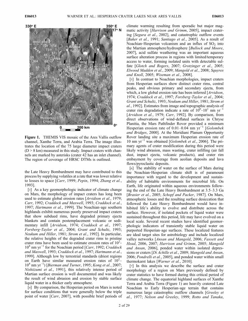
lies 110 km southwest of Ares Vallis, and 45 km south ofone of the outflow channels that derives from HydapsisChaos (Figures 1 and 8c). This Hydapsis Chaos channel(referred to here as Hydapsis outflow channel B) is con-fluent with Ares Vallis. The d/D ratio of crater 8 is reducedby 38% from modeled pristine ratios (Table 1). The averagemeasured rim height is ∼310 m, which is less than the modelrim height of 520 m. Rim degradation only accounts for13% of the total reduction in d/D ratio. The remaining 25%reduction is likely the result of crater infilling (Figure 2 andTable 2). From the analysis of crater rim degradation andmodeled d/D ratios we estimate a maximum thickness of∼390 m for the crater infill material. This estimate is similarto infill thicknesses determined for crater 28 (∼350 m) andcrater 9 (∼430 m).[35] CTX images of the floor of crater 8 reveal a smooth
unit that embays the interior crater walls. Along the westerninterior wall a single unit/layer of the infill material forms athin (10s of meters) lobate to linear scarp that suggests anoverall layered morphology. The surface of the interior unitis characterized in THEMIS IR images as having a patchydistribution of materials with moderate to high thermalinertia (Figure 8c). A bright (warm) night signature and dark(cool) day signature is also concentrated at the north portionof the crater where dust cover is lacking. Small impactcraters (D < 50 m) that exhumed the crater floor materialthrough regions of apparent dust cover reveal underlyinglow albedo ejecta in visible light images and high thermalinertia materials in IR images suggesting that the dust isonly a thin veneer. Unlike craters 28 and 9, polygonalfractures are not obvious on the surface of the infill material.Uniquely, the interior crater floor exhibits numerous smallmounds (Figure 11a). These mounds are 10s of meters inheight, are on average ∼120 m in diameter, are circular to
Figure 7. THEMIS VIS image V17437024 of crater 28displaying a crater fill unit with polygonal fractures. Polyg-onal fractures are common on the floors of the craters withoutlet channels and may indicate a formerly hydrated surface.
WARNER ET AL.: HESPERIAN CRATER LAKES NEAR ARES VALLIS E06013E06013
11 of 29

Figure 8. (left) HRSC DTM, (middle) HRSC orthoimage, and (right) THEMIS IR night images of thecraters with outlet channels in the Ares Vallis region. The channel emanating from crater 42 is interpretedfrom the topography data as an inlet channel.
WARNER ET AL.: HESPERIAN CRATER LAKES NEAR ARES VALLIS E06013E06013
12 of 29

elongate, are flat topped or show summit depressions, andare commonly surrounded by higher albedo debris apronsthat superpose the upper unit of the crater floor infill. Thesummit depressions are rarely circular, thus excluding apedestal impact crater origin, and are often elongate and/orbreached. The features are ubiquitous across the crater floorbut show no apparent pattern or alignment. The scale andmorphology of the small mounds are similar to the contro-versial mound features identified on the floor of AthabascaVallis [Burr et al., 2005, 2009a; Lanagan et al., 2001; Pageand Murray, 2006] (Figure 11b). Athabasca Vallis, a cata-strophic outflow channel in the Cerberus Plains in thenorthern hemisphere, contains a channel floor draping unitthat may represent young lava flows associated withAmazonian‐age volcanism [Jaeger et al., 2007; Keszthelyiet al., 2000; Plescia, 2003] or ice‐rich deposits leftoverfrom Amazonian‐age water eruptions at Cerberus Fossae[Page and Murray, 2006; Page, 2008]. The conical fea-tures on top of this unit have been argued to represent eitherrootless volcanic cones [Lanagan et al., 2001], formed fromthe flow of lava over an ice/water‐rich substrate, or ice coredpingos [Burr et al., 2005; Page and Murray, 2006]. Thesummit pits of the Athabasca Vallis mounds therefore rep-resent either explosive features from the eruption of volatile‐charged lava or collapse features derived from sublimation ofan ice‐rich core. Similar explanations are likely for the
mounds in crater 8. These mounds superpose a thin lobateunit that may represent a single thin lava flow or a unit oflacustrine sediment. Given the available information, the twohypotheses cannot be excluded. However, the presence of anapparent fluvial outlet channel suggests that water waspresent in the crater, and that it may have played an importantrole in deposition of the interior unit and formation of themounds.[36] The outlet channel of crater 8 is ∼1.2 km wide and
∼200 m deep at the outlet head (Figures 1 and 8c). Thechannel that emerges form the outlet, incised into thedegraded ejecta material along the western rim of the crater,is a single thread channel with well‐defined margins.Beyond the crater rim notch, the channel is ∼800 m wideand ∼80 m deep, showing a relatively constant width alonglength. It follows an approximately linear course until itdebouches onto the floor of the Hydapsis outflow channel B(Figure 1). Here, CTX imagery shows that the channel isincised into a bedrock surface that is characterized by lon-gitudinal grooves (Figure 12). These grooves are indicativeof erosion by high‐magnitude floods [Carr, 1979; Komatsuand Baker, 1997]. The small outlet channel shows no evi-dence of subsequent erosion by later floods, thus indicatingthat the channel postdates final flood erosion in theHydapsis channel B (Figure 12b). While within the outflowchannel, the crater outlet follows a SW‐NE course, where it
Figure 9. CTX images displaying the outlet channels of craters 28 and 9. (a) At its distal end, the outletchannel of crater 28 superimposes a thermokarst‐like depression before terminating at a height of ∼120 mabove the floor of Ares Vallis (CTX image P18_007889_1866). (b) The outlet channel of crater 9 extendseastward into Ares Vallis, passing through several thermokarst‐like depressions and small chaos terrainsthat may have formed before or contemporaneous with the drainage event (CTX imagesP15_006808_1860 and P22_009458_1869). Similar to crater 28, this outlet channel forms a hanging val-ley above the floor of Ares Vallis at a height of ∼250 m. This morphology suggests that the final phase ofdowncutting in Ares Vallis postdates outlet channel formation.
WARNER ET AL.: HESPERIAN CRATER LAKES NEAR ARES VALLIS E06013E06013
13 of 29

disappears into a small chaos feature on the canyon floor.No single channel feature crosscuts the chaos terrain. Thisindicates that the chaos collapse formed either after theoutlet channel formed or during, and possibly as a result ofthe outlet flow from crater 8. A single, small channelemanates from the NE end of the chaos terrain toward themain canyon of Ares Vallis and might be the downstreamextension of the outlet channel or a second channel derivedfrom flow out of the chaos feature (Figure 12c). Where theHydapsis outflow channel B is confluent with Ares Valliscanyon, the small crater outlet channel merges into anextensive network of branching channels that represents thelast stage of fluvial activity in the Hydapsis channel Bsystem.3.4.1.4. Crater 61: Barsukov Crater and Silinka Vallis[37] Barsukov Crater (Crater 61) is a 71 km diameter,
1 km deep impact crater on the southern margin of medialAres Vallis, located approximately 90 km from the valleyedge (Figures 1 and 8d). The measured d/D ratio of crater 61is reduced by 49% from modeled pristine ratios (Table 1).The crater rim appears highly degraded, with only smallremnants of a continuous ejecta blanket. HRSC topographymeasurements of the rim height indicate an average degra-dation of the crater rim of ∼420 m (equation (2)). Theremoval of rim material accounts for 21% of the total mea-sured reduction in d/D (Figure 2). The remaining reduction islikely due to crater infilling which is estimated at a maximumthickness of ∼560 m. CTX imagery reveals that the infillfloor material embays the crater’s interior walls and exhibits
extensive polygonal fracturing on wind‐scoured surfacesnear the center of the crater (Figure 13). The width of thepolygons ranges from 50 m to 150 m. Night THEMIS IRimages indicate that the center of the impact crater has thehighest thermal inertia, suggesting that the crater floorhas little dust cover and may be indurated [McDowell andHamilton, 2007] (Figure 8d).[38] The crater exhibits three breaches eroded into the
northern crater rim. Two of these breaches disappear quicklynorth of the rim, however one breach continues and formsa single well defined channel, Silinka Vallis, that travels∼100 km to the edge of a perched abandoned channel atthe margin of Ares Vallis (Figures 1 and 14). The SilinkaVallis outlet breach is ∼2.4 km wide, ∼230 m deep at its headand rests ∼250 m above the crater floor. In the proximal reachof the channel, Silinka Vallis is ∼250 m deep and ∼1.8 kmwide. It largely lacks tributaries, though in places it is joinedby small channels that emerge from possible thermokarstdepressions. This suggests that crater drainage was contem-poraneous with thermokarst formation (Figure 14b). Thechannel maintains a constant width throughout its ∼100 kmlength, but the depth of incision shallows in its distal reach to∼150–200 m. Here it flows into shallow, flat‐floored de-pressions that we also interpret as thermokarst‐like features(Figure 14c).3.4.2. Craters Lacking an Outlet Channel[39] Several medium to large diameter impact craters
(D > 8 km, d > 500 m) lack outlet channels but exhibit similarreductions in d/D from pristine (Table 1) and have similar
Figure 10. CTX image P15_006808_1860 of the floor material of crater 9 illustrating polygonal frac-tures that might be representative of a formerly hydrated surface. The average width of the polygonsranges from 30 m to 100 m. This image illustrates that the infill material is currently undergoing localdegradation, showing evidence for removal of the uppermost fractured layer.
WARNER ET AL.: HESPERIAN CRATER LAKES NEAR ARES VALLIS E06013E06013
14 of 29

estimated thicknesses of infill to those with outlet channels(Table 2). This suggests that some impact craters may havebeen influenced by similar modification mechanisms to theoutlet channel craters, and further implies, despite the lack ofoutlet or inlets, that water may have played a role in influ-encing their final morphology. Table 1 identifies 12 largediameter impact craters in the Ares Vallis region that exhibitmoderate modification (reduction in d/D from 20% to 50%)but lack outlet channels. As an example, crater 20 is 28 km indiameter (Figure 1), has a depth of ∼600 m, shows a d/Dreduction from pristine of 49%, has undergone ∼200 m ofrim degradation, and has an estimated maximum infillthickness of ∼390 m. HRSC and THEMIS images (CTXcoverage is lacking) reveal that several of these craterscontain smooth units that embay the interiors of the craterwalls. Polygonal fracturing is not obvious in the HRSC andTHEMIS data. Similar to the craters with outlet channels andcraters modified by Ares Vallis flooding, the THEMIS nightIR images display floor material that has a low thermalinertia with exposed patches exhibiting relatively high ther-mal inertia. Given the regional occurrence of craters withoutlet channels and the possible compositional/textural
similarity of the floor deposits, we propose that the sameprocess or processes responsible for filling the outlet channelimpact craters with water and sediment (and possibly eva-porites) may have also operated to fill these craters. There-fore, channel outlet formation may have been restricted toonly those craters where the critical rim failure conditionswere met. Alternatively, regional infilling of the craters withvolcanics, aeolian material, dust air fall or impact brecciaswas likely to have occurred to some unknown extent withinmany or all craters in the region.3.4.3. Crater 42: Possible Inlet Channel[40] Crater 42 is a 41 km diameter, 0.7 km deep crater
basin located ∼220 km from the northeast bank of AresVallis and ∼330 km from the eastern margin of crater 9(Figures 1 and 8e). The measured reduction in d/D frompristine is 53%. The measured reduction in rim height frommodeled is ∼340 m, accounting for 23% (nearly half) of themeasured reduction in d/D. The remaining 30% d/Dreduction can be accounted for by ∼430 m of infill. Thefloor of the crater contains smooth infill material that showsno evidence for polygonal fracturing in CTX images and hasan unusually bright night thermal IR signature relative toother large diameter craters in the region (Figure 8e). Thebright (night) IR signature extends for ∼4 km into a mod-erately sinuous channel that breaches the SE flank of thecrater rim and shows embayment with the channel walls.This suggests that the thermally distinct unit, which is likelywell indurated sediment or solid bedrock (possibly lava),postdates channel formation.[41] HRSC topography data indicates that the crater 42
channel is more likely an inlet that is sourced by a series offlat‐floored depressions located approximately 35 kmupstream from the rim breach (Figure 8e). The rim breachforms an elevated notch that is ∼60 m above the floor of thecrater, is ∼450 m deep and ∼4 km wide. The width of theinlet channel changes dramatically from 0.9 km at its headto 2.5 km where the channel enters the crater. Likewise, thedepth of the channel increases from 80 m to 350 m alonglength.
3.5. Morphology of Highly Modified Ancient Craters
[42] The final class of large diameter (D > 8 km) impactcraters present in the Ares Vallis region are characterized bysubdued rims (either by rim erosion or embayment, averageof ∼130 m rim reduction), lack obvious ejecta blankets andcentral peaks, and contain smooth interior units (Figure 3d).The majority of craters in this class are < 20 km in diameterand likely represent smaller, more easily degraded featuresthat formed during a period with a relatively high surfaceerosion rate. Table 2 illustrates that the mean rim degrada-tion for this class contributes ∼15% to the total measuredreduction in d/D, compared to ∼14% for the larger outletcrater basins, ∼20% for flood modified craters, and ∼5% forthe near pristine craters. This indicates that the relativeimportance of crater infilling to rim degradation is similarfor the highly degraded craters compared to the large craterbasins with outlet channels (Figure 2). Maximum estimatesfor the thickness of crater infill range from ∼ 290 m to 690 m,similar to the large crater basins. Some craters, includingcrater 22, show a ∼90% reduction in d/D from modeled, withup to ∼70% of the total reduction explained by infilling.CTX, HRSC and THEMIS images reveal smooth interior fill
Figure 11. (a) CTX image P21_009313_1877 showing pit-ted conical features on the floor of crater 8. These featuresare morphologically analogous to the pitted mounds identi-fied on (b) the floor of Athabasca Vallis and may representice cored pingos or rootless cones. Both hypotheses requirethe past presence of water or ice.
WARNER ET AL.: HESPERIAN CRATER LAKES NEAR ARES VALLIS E06013E06013
15 of 29
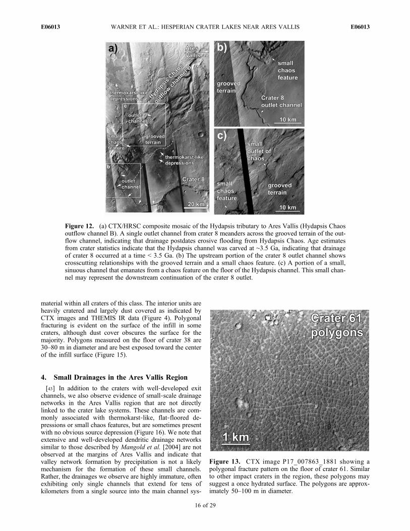
material within all craters of this class. The interior units areheavily cratered and largely dust covered as indicated byCTX images and THEMIS IR data (Figure 4). Polygonalfracturing is evident on the surface of the infill in somecraters, although dust cover obscures the surface for themajority. Polygons measured on the floor of crater 38 are30–80 m in diameter and are best exposed toward the centerof the infill surface (Figure 15).
4. Small Drainages in the Ares Vallis Region
[43] In addition to the craters with well‐developed exitchannels, we also observe evidence of small‐scale drainagenetworks in the Ares Vallis region that are not directlylinked to the crater lake systems. These channels are com-monly associated with thermokarst‐like, flat‐floored de-pressions or small chaos features, but are sometimes presentwith no obvious source depression (Figure 16). We note thatextensive and well‐developed dendritic drainage networkssimilar to those described by Mangold et al. [2004] are notobserved at the margins of Ares Vallis and indicate thatvalley network formation by precipitation is not a likelymechanism for the formation of these small channels.Rather, the drainages we observe are highly immature, oftenexhibiting only single channels that extend for tens ofkilometers from a single source into the main channel sys-
Figure 12. (a) CTX/HRSC composite mosaic of the Hydapsis tributary to Ares Vallis (Hydapsis Chaosoutflow channel B). A single outlet channel from crater 8 meanders across the grooved terrain of the out-flow channel, indicating that drainage postdates erosive flooding from Hydapsis Chaos. Age estimatesfrom crater statistics indicate that the Hydapsis channel was carved at ∼3.5 Ga, indicating that drainageof crater 8 occurred at a time < 3.5 Ga. (b) The upstream portion of the crater 8 outlet channel showscrosscutting relationships with the grooved terrain and a small chaos feature. (c) A portion of a small,sinuous channel that emanates from a chaos feature on the floor of the Hydapsis channel. This small chan-nel may represent the downstream continuation of the crater 8 outlet.
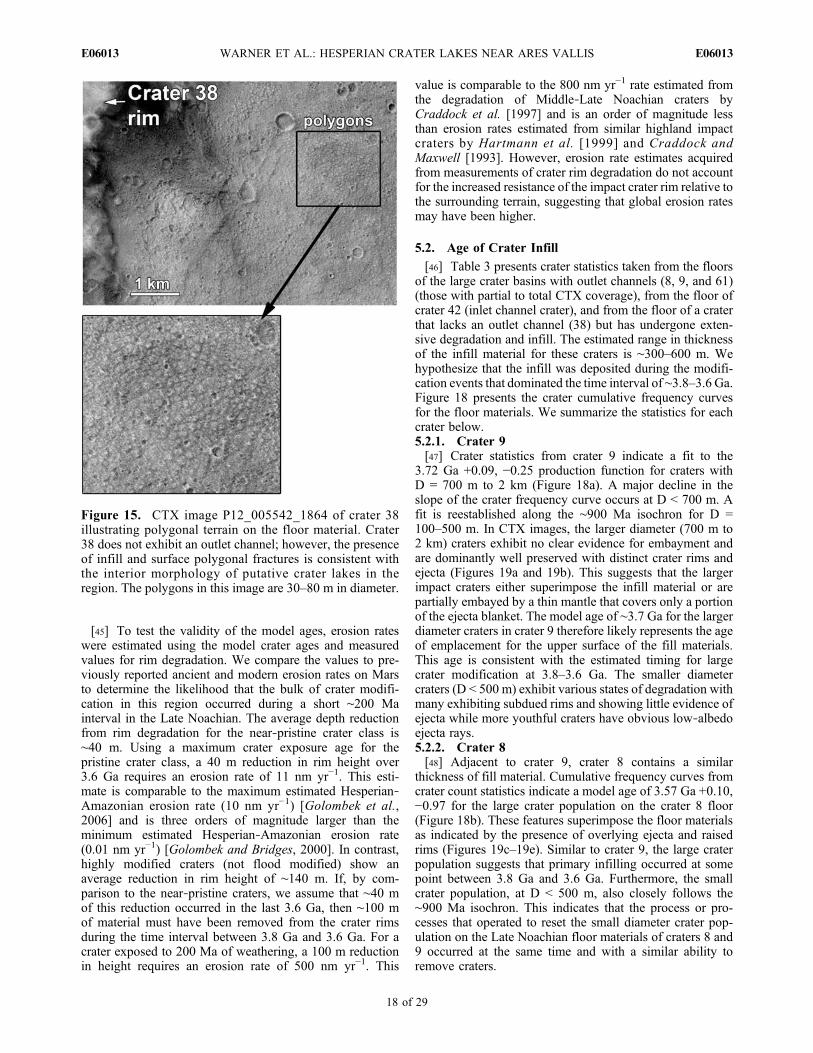
Figure 13. CTX image P17_007863_1881 showing apolygonal fracture pattern on the floor of crater 61. Similarto other impact craters in the region, these polygons maysuggest a once hydrated surface. The polygons are approx-imately 50–100 m in diameter.
WARNER ET AL.: HESPERIAN CRATER LAKES NEAR ARES VALLIS E06013E06013
16 of 29

tem of Ares Vallis. As examples, Figure 16a illustratessinuous channels that emanate from small thermokarst‐likedepressions on the west bank of Ares Vallis. In most cases,the channel features, thermokarst‐like depressions, andchaos terrains superimpose flood‐related grooves and largeoutflow channels of Ares Vallis. However, analysis of CTXimages indicates that several small tributary channels toAres Vallis sharply terminate ∼150–250 m above the floorof the main canyon (Figures 16a and 16d). This indicatesthat the final downcutting event that formed the modernlevel of Ares Vallis postdates formation of these features.This is in agreement with observations of crater outletchannels that are similarly truncated above the floor of AresVallis (Figure 9).
5. Age Relationships From Crater Statistics
5.1. Age of Large Crater Formation and Modification
[44] Table 3 provides the cumulative crater density andestimated absolute age of the highland terrain in the studyregion surrounding Ares Vallis from counts of the 75 largediameter (D > 8 km) impact craters. The statistics provide amodel age of 3.82 Ga +0.02, −0.03, confirming that theaverage age of formation of highland terrain units in theregion is Late Noachian [Hartmann and Neukum, 2001].This age is similar to previous crater model ages, determinedfrom mapped geologic units within the highland terrainsurrounding Ares Vallis [Nelson and Greeley, 1999; Rottoand Tanaka, 1995]. The poor state of preservation for themajority of impact craters on this surface is consistent with
the assertion of high erosion rates during a warmer andwetter Noachian period [Carr, 1992; Craddock andMaxwell, 1993; Craddock et al., 1997; Hartmann et al.,1999]. However, our analysis of crater d/D ratios and rimdegradation indicates that 29 out of the 75 measured impactcraters show a near pristine morphology. If we assume thatthe modification processes that operated to infill craters,subdue crater rims, and destroy ejecta blankets occurred atsome time in the past over the entire Ares Vallis region, thenany crater that was present while such processes operatedshould show evidence for degradation. The assumption ofwidespread modification is validated by the regionaloccurrence of highly modified craters on Arabia and XantheTerra. Furthermore, we make the assumption that the near‐pristine craters of this region formed once the modificationprocesses ceased, at a time after formation of the modifiedcraters. Therefore, if we exclude the highly modified impactfeatures (d/D reduction from pristine > 20%) from theoverall regional crater statistics, the cumulative crater den-sity of the remaining near‐pristine crater population shouldbe representative of the age since intense modification.Table 3 provides the cumulative crater density for D > 8 kmfor only the near‐pristine impact craters in the study region.The model age for this crater class is 3.62 Ga +0.05, −0.08,approximately 200 Ma younger than the age determined forthe highland terrain (Figure 17). This indicates that intensemodification of craters occurred during a short intervalbetween the formation of the highland terrain (3.8 Ga) andformation of the near‐pristine population of impact craters(3.6 Ga).
Figure 14. (a) CTX/HRSC composite mosaic of crater 61 and its outlet channel Silinka Vallis. Along itscourse, Silinka Vallis crosscuts (b) thermokarst‐like depressions, ending in (c) two small depressions atthe western margin of Ares Vallis. The presence of thermokarst‐like features and small chaos terrains inassociation with putative crater lakes in the Ares Vallis region indicates that a regional near‐surfacegroundwater/ice reservoir was once present.
WARNER ET AL.: HESPERIAN CRATER LAKES NEAR ARES VALLIS E06013E06013
17 of 29
[45] To test the validity of the model ages, erosion rateswere estimated using the model crater ages and measuredvalues for rim degradation. We compare the values to pre-viously reported ancient and modern erosion rates on Marsto determine the likelihood that the bulk of crater modifi-cation in this region occurred during a short ∼200 Mainterval in the Late Noachian. The average depth reductionfrom rim degradation for the near‐pristine crater class is∼40 m. Using a maximum crater exposure age for thepristine crater class, a 40 m reduction in rim height over3.6 Ga requires an erosion rate of 11 nm yr−1. This esti-mate is comparable to the maximum estimated Hesperian‐Amazonian erosion rate (10 nm yr−1) [Golombek et al.,2006] and is three orders of magnitude larger than theminimum estimated Hesperian‐Amazonian erosion rate(0.01 nm yr−1) [Golombek and Bridges, 2000]. In contrast,highly modified craters (not flood modified) show anaverage reduction in rim height of ∼140 m. If, by com-parison to the near‐pristine craters, we assume that ∼40 mof this reduction occurred in the last 3.6 Ga, then ∼100 mof material must have been removed from the crater rimsduring the time interval between 3.8 Ga and 3.6 Ga. For acrater exposed to 200 Ma of weathering, a 100 m reductionin height requires an erosion rate of 500 nm yr−1. This
value is comparable to the 800 nm yr−1 rate estimated fromthe degradation of Middle‐Late Noachian craters byCraddock et al. [1997] and is an order of magnitude lessthan erosion rates estimated from similar highland impactcraters by Hartmann et al. [1999] and Craddock andMaxwell [1993]. However, erosion rate estimates acquiredfrom measurements of crater rim degradation do not accountfor the increased resistance of the impact crater rim relative tothe surrounding terrain, suggesting that global erosion ratesmay have been higher.
5.2. Age of Crater Infill
[46] Table 3 presents crater statistics taken from the floorsof the large crater basins with outlet channels (8, 9, and 61)(those with partial to total CTX coverage), from the floor ofcrater 42 (inlet channel crater), and from the floor of a craterthat lacks an outlet channel (38) but has undergone exten-sive degradation and infill. The estimated range in thicknessof the infill material for these craters is ∼300–600 m. Wehypothesize that the infill was deposited during the modifi-cation events that dominated the time interval of ∼3.8–3.6 Ga.Figure 18 presents the crater cumulative frequency curvesfor the floor materials. We summarize the statistics for eachcrater below.5.2.1. Crater 9[47] Crater statistics from crater 9 indicate a fit to the
3.72 Ga +0.09, −0.25 production function for craters withD = 700 m to 2 km (Figure 18a). A major decline in theslope of the crater frequency curve occurs at D < 700 m. Afit is reestablished along the ∼900 Ma isochron for D =100–500 m. In CTX images, the larger diameter (700 m to2 km) craters exhibit no clear evidence for embayment andare dominantly well preserved with distinct crater rims andejecta (Figures 19a and 19b). This suggests that the largerimpact craters either superimpose the infill material or arepartially embayed by a thin mantle that covers only a portionof the ejecta blanket. The model age of ∼3.7 Ga for the largerdiameter craters in crater 9 therefore likely represents the ageof emplacement for the upper surface of the fill materials.This age is consistent with the estimated timing for largecrater modification at 3.8–3.6 Ga. The smaller diametercraters (D < 500 m) exhibit various states of degradation withmany exhibiting subdued rims and showing little evidence ofejecta while more youthful craters have obvious low‐albedoejecta rays.5.2.2. Crater 8[48] Adjacent to crater 9, crater 8 contains a similar
thickness of fill material. Cumulative frequency curves fromcrater count statistics indicate a model age of 3.57 Ga +0.10,−0.97 for the large crater population on the crater 8 floor(Figure 18b). These features superimpose the floor materialsas indicated by the presence of overlying ejecta and raisedrims (Figures 19c–19e). Similar to crater 9, the large craterpopulation suggests that primary infilling occurred at somepoint between 3.8 Ga and 3.6 Ga. Furthermore, the smallcrater population, at D < 500 m, also closely follows the∼900 Ma isochron. This indicates that the process or pro-cesses that operated to reset the small diameter crater pop-ulation on the Late Noachian floor materials of craters 8 and9 occurred at the same time and with a similar ability toremove craters.
Figure 15. CTX image P12_005542_1864 of crater 38illustrating polygonal terrain on the floor material. Crater38 does not exhibit an outlet channel; however, the presenceof infill and surface polygonal fractures is consistent withthe interior morphology of putative crater lakes in theregion. The polygons in this image are 30–80 m in diameter.
WARNER ET AL.: HESPERIAN CRATER LAKES NEAR ARES VALLIS E06013E06013
18 of 29

5.2.3. Crater 61: Barsukov Crater[49] Figure 18c illustrates the cumulative frequency curve
for crater 61. Crater statistics from the eastern half of crater61 were obtained using CTX images and include all craterswith D > 100 m. Using a single HRSC strip, crater statisticsfor D > 500 m were obtained for the entire crater floor.Similar to craters 8 and 9, the morphology and superpositionrelationships of the larger crater population in crater 61indicate postfill emplacement (Figure 19f). The majority ofcraters on the floor of crater 61 are < 600 m in diameterand follow an established isochron suggesting a surfaceage of ∼ 900 Ma, similar to the small crater model agedetermined for other large crater basins with outlet channels.For D > 700 m, a model age of 3.81 Ga +0.07, −0.16 in-dicates a Late Noachian age for emplacement of the upperunit of crater infill.
Figure 16. A CTX montage of poorly developed fluvialsystems in the Ares Vallis region. (a) Single sinuous chan-nels that extend from thermokarst‐like depressions on thewest bank of Ares Vallis. (b) Depression‐connecting chan-nels on the thermokarst terrain in crater 45. (c) The headof a single sinuous channel on Arabia Terra, near crater28. (d) Small individual tributaries to Ares Vallis that lacksmall source depressions.
Tab
le3.
CraterStatisticsforHighlandCratersin
theAresVallis
Region,
Craterson
theFlood
Surfacesof
AresVallis
andHyd
apsisOutflow
Chann
elB,and
ImpactCratersThatR
esto
nthe
Surface
ofCraterBasin
Fill
Materiala
Area(km
2)
Cou
nts
N(0.1)
N(0.5)
N(1)
N(8)
Mod
elAge
(Ga)
RelativeAge
Highlandcraters
All(D
>8km
)25
6,50
075
NA
NA
NA
2.9×10
23.82
+0.02
/−0.03
LN,bLNc
Pristine(D
>8km
)25
6,50
029
NA
NA
NA
1.1×10
23.62
+0.05
/−0.08
LN,bLHc
Outflow
channels
Hyd
apsischannelB
6,97
06,48
69.3×10
51.3×10
42.2×10
3NA
3.50
+0.08
/−0.22
EH,bEAc
Proximal
AresVallis,
lowestsurface
5,74
03,07
85.4×10
59.9×10
31.7×10
3NA
2.86
+0.39
/−0.76
LH,bEAc
CraterInfill
Area(km
2)
Cou
nts
N(0.1)
N(0.5)
N(1)
N(8)
Infill
D<40
0m
Mod
elAge
(Ga)
RelativeAge
Mod
elAge
(Ga)
RelativeAge
970
057
88.3×10
58.6×10
34.3×10
3NA
3.72
+0.09
/−0.25
LN,bEHc
0.90
+0.06
/−0.06
MA,bMAc
81,13
01,37
41.2×10
61.4×10
43.5×10
3NA
3.57
+0.10
/−0.97
LN,bLHc
0.94
+0.04
/−0.04
MA,bMAc
6187
0(2,820
d)
965(27d)
1.1×10
69.6×10
3d
2.1×10
3d
NA
3.81
+0.07
/−0.16
LN,bLNc
0.76
+0.04
/−0.04
MA,bMAc
4231
0(910
d)
483(14d)
1.6×10
61.5×10
4d
3.3×10
3d
NA
3.57
+0.11
/−0.89
LN,bLHc
1.11
+0.07
/−0.07
EA,bMAc
3856
060
91.1×10
61.3×10
43.6×10
3NA
3.88
+0.09
/−0.69
MN,bMNc
0.86
+0.05
/−0.05
MA,bMAc
a The
cumulativenu
mberof
impactcraterspermillionkm
2isgivenforcraterswith
diam
etersgreaterthan
0.1km
(N(0.1)),0
.5km
(N(0.5)),1
km(N
(1)),and
8km
(N(8)).M
odelages
afterHartman
nan
dNeukum
[200
1].NA,no
tavailable.
bHartm
annagesystem
:Noachian(N
),Hesperian
(H),Amazon
ian(A
),Early
(E),Middle(M
),Late(L).
c Neuku
magesystem
.dHRSC
coun
tsandmeasurements.
WARNER ET AL.: HESPERIAN CRATER LAKES NEAR ARES VALLIS E06013E06013
19 of 29

5.2.4. Crater 42[50] Crater statistics were also obtained from the floor of
the only crater identified in the region with an inlet channel,crater 42. Counts were made from a single CTX image(D > 100 m) (Table 3) covering only the eastern half of thecrater and from a single HRSC strip (D > 500 m) that coversthe entire crater. Figure 18d illustrates the cumulative fre-quency curve and the model age determined from theavailable crater population. From CTX counts, a well con-strained model age of ∼1.1 Ga is indicated from the < 400 mdiameter crater population and is consistent with the MiddleAmazonian ages provided by the small crater population incraters with outlet channels. From HRSC images, cratercounts from the entire crater floor surface provide a modelage for craters with D > 800 m of 3.57 Ga +0.11, −0.89,also similar to the infill age of craters with outlet channels.The large kink in the cumulative frequency curve at D =400–700 m is consistent with the crater statistics of allcraters with outlet channels.5.2.5. Crater 38[51] Crater 38 is a 38 km diameter, 0.5 km deep impact
crater basin located ∼100 km east of the main westernbranch of the Ares Vallis channel and ∼60 km north of thesmaller eastern branch of Ares Vallis (Figure 1). This featurelacks an outlet or inlet channel but contains an estimated∼500 m of infill with polygonal fractures exposed on thesurface. We hypothesize, based on the similarity in mor-
phology and depth of the infill, that crater 38 was filledduring the same time and by the same mechanismsresponsible for infill of the outlet channel craters. We testthis hypothesis with crater statistics from the floor of crater38. These statistics provide a Middle‐Late Noachian modelage of 3.88 Ga + 0.09, −0.69 for the largest diameter cratersthat superimpose the infill surface (>1 km) (Figures 18e and19h). Furthermore, the small diameter crater population, atD < 500 m follows a similar close fit to the ∼850 Ma iso-chron, further indicating that some process operated on aregional scale to reset the crater floor ages.
5.3. Timing of Crater Lake Outlet Channel Formation
[52] The crater model ages suggest infilling and intensemodification of large crater basins in the Ares Vallis regionat some time in the Late Noachian between 3.8 Ga and3.6 Ga. The presence of outlet channels that drain thecraters implies that crater modification by infilling was atleast partially the result of an influx of water and sediment.The sediment was likely derived from the degradation ofthe interior of the craters or from evaporation, leavingbehind evaporite deposits. The relative timing of subse-quent crater draining events is determined here usingsuperposition relationships of the outlet channels withfluvial features associated with Ares Vallis. Figure 12 pre-sents a CTX/HRSC mosaic over the Hydapsis outflowchannel B. The crater outlet channel from crater 8 crosscutsflood grooves on the floor of the Hydapsis channel indi-cating that crater lake drainage postdates the larger erosiveoutflow (Figure 12b).[53] To constrain the absolute timing of Hydapsis outflow
channel B flooding, we obtained high‐resolution craterstatistics (D > 100 m) from CTX images of the channel floor(Table 3). We assume that the flooding was responsible forcomplete resurfacing of craters exposed on older bedrockunits. The depth of the Hydapsis channel determined fromHRSC DTMs (∼600 m) was used to determine the criticaldiameter below which craters were completely removed byflooding. From established d/D ratios for simple (D < 6 km)impact craters on Mars [Garvin et al., 2003] craters withD < 3.6 km should have been completely obliterated byHydapsis flooding. From image based morphologic analysisof craters on the flood channel surface, we confirm that allcraters < 2 km in diameter postdate flooding and provide apostflood crater retention age. These postflood impact fea-tures have distinct ejecta blankets, sharp rims, and super-impose flood grooves. Few flood modified impact craterswere available to include in the data owing to the magnitudeof the floods.[54] Figure 20a illustrates the cumulative frequency his-
togram for Hydapsis outflow channel B. A model fit tocraters with D = 700 m to 2 km indicates a flood resurfacingage of 3.5 Ga +0.08, −0.22. This provides an upper boundage of 3.5 Ga for crater 8 drainage and indicates that outletchannel formation did not immediately follow the intenseperiod of crater modification and crater infilling thatoccurred between 3.8 Ga and 3.6 Ga.[55] Other crater outlet channels in the region show re-
lationships that may provide a constraint for the minimumage of crater lake drainage. The crater outlet channelsassociated with craters 9 and 28 are truncated at a height of∼150–250 m above the main canyon floor of Ares Vallis
Figure 17. A comparison of the binned crater cumulativefrequency curve for highland craters surrounding AresVallis (D > 8 km) with the curve that includes only thenear‐pristine craters in the region. The overall crater sta-tistics of the highland surface indicates a Late Noachiansurface age of 3.8 Ga and includes both highly modifiedand pristine impact craters. The model age obtained fromthe cumulative number of only pristine craters suggeststhat intense modification by infilling and rim degradationceased after ∼3.6 Ga in the Early Hesperian.
WARNER ET AL.: HESPERIAN CRATER LAKES NEAR ARES VALLIS E06013E06013
20 of 29

(Figure 9). Furthermore, several poorly developed channelnetworks on the western wall of Ares Vallis are alsoabruptly terminated, forming hanging valleys (Figure 16).This observation suggests that formation of the outletchannels and isolated channel networks predates the finalincision of Ares Vallis. Crater statistics acquired from CTXimages of the Ares Vallis floor indicate a flood resurfacingage of ∼2.86 Ga +0.39, −0.76 (Figure 20b). This provides apossible range for crater lake drainage in the Ares Vallisregion of 3.5–2.9 Ga, corresponding with the time of regionalcatastrophic outflow activity [Marchenko et al., 1998;Nelsonand Greeley, 1999; Rotto and Tanaka, 1995; Tanaka andSkinner, 2004; Warner et al., 2009]. The apparent delaytime between crater infilling/modification and drainage sug-gests that water may have ponded within the crater for astatistically significant period of time (100–900 Ma) fol-
lowing infill in the Late Noachian until it drained through theoutlet channels in the Hesperian‐Early Amazonian.
6. Discussion
6.1. Crater Modification and Climate Change: LateNoachian (3.8 Ga)–Early Hesperian (3.6 Ga)
[56] The crater morphology data indicate that climateconditions on Mars changed dramatically during a ∼200 Matransition period from 3.8 Ga to 3.6 Ga. This result suggestsa relatively rapid climatic shift from possibly warmer/wetterconditions in the Noachian to colder/drier conditions in theHesperian. The bulk of crater modification during the LateNoachian period, as indicated by the topography data, wasthe result of crater infilling. The presence of crater outletchannels indicates that water filled many of the craters in the
Figure 18. Binned cumulative crater frequency diagrams (a, b, and c) for the floors of craters with outletchannels (9, 8, and 61), (d) for a crater with an inlet channel (42), and (e) for a crater that contains infillbut lacks a channel (38). The pattern of the cumulative frequency curve is similar for the 5 impact craters.The larger crater population (D > 800 m ± 200 m) consistently provides a Late Noachian model age. FromCTX image analysis, this population superimposes the upper surface of the infill material, suggesting thatthe model age is representative of the timing of infill. A significant kink in the cumulative frequency curveoccurs at D < 800 m ± 200 m. At D < 500 m the crater statistics show a good fit to a Middle Amazonianisochron, indicating a model age of 1.1 Ga to 760 Ma. This youthful age is likely representative of a res-urfacing event or may be indicative of the inability of the surface to retain small impact craters after sur-face hydration until the Middle Amazonian.
WARNER ET AL.: HESPERIAN CRATER LAKES NEAR ARES VALLIS E06013E06013
21 of 29

region. Water influx may have caused erosion of the inter-iors of the impact basins, contributing fill to the crater floors(maximum of ∼300–600 m). In addition, externally derivedaeolian material, dust air fall, volcanics (lava and pyr-oclastics), or evaporite deposits may have contributed toinfill. Polygonal fracturing on the surface of the crater infillmaterial is observed in most of the crater basins containingoutlet channels. We suggest that the polygonal fractures areindicators of the past presence of water in these basins andare the result of either (1) expansion and contraction of ice‐rich sediments during diurnal/seasonal temperature/pressurechanges or during episodic climate shifts [Kuzmin et al.,2002; Levy et al., 2009; Mustard et al., 2001; Seibert andKargel, 2001], or (2) dehydration of hydrated sedimentssuch as sulfates, chlorides, or clays [Mustard et al., 2008;
Osterloo et al., 2008]. Furthermore, putative pingo‐likemounds or rootless cones in crater 8 are indicative of thepast occurrence of a hydrated surface [Burr et al., 2005,2009b; Lanagan et al., 2001; Page and Murray, 2006].Recently, Osterloo et al. [2008] described thermal infraredspectral signatures from THEMIS indicating the presence ofchlorides within crater basins in the southern highlands (notincluding equatorial craters in the Ares Vallis region). Theseauthors hypothesized that the chlorides represent evaporitedeposits left behind from saline crater lakes. Polygonalfractures on the floors of these craters, in association withthe spectral signatures, were also suggested to be indicatorsof a formerly hydrated surface.[57] The source of water for crater infilling is not directly
obvious. We have not identified evidence for well‐developed
Figure 19. CTX images of impact craters on the floors of the large modified crater basins. The whiteoutline maps the extent of observable ejecta rays. (a and b) Examples of the large diameter populationof impact craters on the floor of crater 9. (c–e) Example impact craters on the floor of crater 8. (f) A3.4 km diameter impact crater on the floor of crater 61. (g) Example impact crater on the floor of crater42. This crater is unique to others identified in this analysis due to the presence of layered infill. (h) Ex-amples of larger diameter impact craters on the floor of crater 38.
Figure 20. Binned cumulative frequency diagrams displaying model age fits for crater counts taken(a) from Hydapsis outflow channel B and (b) from the primary (topographically lowest) channel of AresVallis. The data indicate that Hydapsis related flooding predates final incision of the main channel of AresVallis. Topography data confirm that the Ares Vallis flood channel lies 800 m to 1 km below the channelfloor of the Hydapsis tributary. A single outlet channel from crater 8 superimposes flood grooves on thefloor of the Hydapsis tributary, indicating that crater lake drainage occurred after 3.5 Ga in the Hesperian.
WARNER ET AL.: HESPERIAN CRATER LAKES NEAR ARES VALLIS E06013E06013
22 of 29

dendritic stream networks or gullies in the study area thatmight indicate a water source from rainfall [Mangold et al.,2004]. In addition, the timing of formation (Late Noachian)of the infilled craters and their location relative to the AresVallis outflow channel do not correspond with Ares Vallisoutflow events [Warner et al., 2009]. This indicates thatbesides those craters that occur within flood channels and areclearly modified, the majority of infilled craters were notfilled by sediment or water from flooding events. We there-fore suggest that the most likely source of water for the craterswith outlet channels is groundwater.[58] In support of the groundwater hypothesis, the poorly
developed drainage networks identified in Figure 16 are inclose proximity to craters with outlet channels. The smallchannels are sourced, in many cases, by small (1–10 km),shallow (100–200 m) chaos terrains or thermokarst‐likedepressions that may indicate melting of near‐surface iceand release of liquid water [Warner et al., 2010]. Wheresuperposition relationships are present, the depressions mayeither superimpose or be superimposed by the crater outletchannels indicating that a near surface liquid water/ice res-ervoir was present within the terrain surrounding the impactcraters before, during, and after the time of outlet channelformation. Furthermore, the inlet channel to crater 42 issourced by morphologically similar flat‐floored putativethermokarst depressions. In a previous liquid form, thisnear‐surface ice reservoir may have provided the waterrequired for regional crater infilling.[59] The presence of an extensive, Noachian‐Hesperian
age near‐surface groundwater network within the AresVallis, Xanthe Terra, and Arabia Terra regions of Mars hasbeen recently suggested [Andrews‐Hanna et al., 2007;Fassett and Head, 2008b]. Models of this shallow ground-water network [Andrews‐Hanna et al., 2007] suggestregional upwelling and predict the formation of evaporitedeposits throughout Arabia and Xanthe Terra. Thisupwelling likely occurred into the Late Noachian‐EarlyHesperian where surface flow was quickly counterbalancedby evaporation, infiltration, freezing, and/or sublimation. Inaddition, Fassett and Head [2008a] identified other fluvialsystems associated with open and closed crater lakes in theLate Noachian‐Early Hesperian southern highlands. Thesefeatures were suggested to be definitive morphologic evi-dence of this extensive near‐surface groundwater reservoir.Our analysis extends the morphologic observations to LateNoachian‐Early Hesperian crater lake systems in the AresVallis region and suggests that groundwater release at thislocation occurred at a rate that at times, exceeded losses tothe atmosphere and losses due to ground infiltration,allowing for ponding and eventual drainage. Furthermore,capping of these crater lakes with ice may have facilitatedcrater lake stabilization during periods when atmosphericconditions did not favor stable surface liquid water.[60] The lack of evidence for infill within pristine, large
crater basins that are < 3.6 Ga in age suggests that regionalgroundwater release may have ceased during the Hesperianperiod. In contrast, the larger diameter floor craters (750 mto 4 km) that superimpose the crater infill of the modifiedcrater basins provide a model surface age of 3.9–3.6 Ga.This population of impact craters was therefore likely es-tablished on the floor of the basins during the last phase(s)of Late Noachian groundwater infill and sediment deposi-
tion. We attribute the cessation of infill activity after 3.6 Gato a climate shift that likely froze, sublimated, or evaporatedany water that reached the surface. The preservation state ofcrater rims and the estimated erosion rates supports thishypothesis and indicates that crater rim degradation occurredat an order of magnitude lower rate following 3.6 Ga.
6.2. Crater Lake Drainage and Transient ClimateWarming: Early Hesperian (3.5 Ga)–Late Amazonian(2.9 Ga)
[61] Geologic relationships indicate that crater lakedrainage in the Ares Vallis region occurred after carving ofthe Hydapsis outflow channel B, but likely before the finalincision of the Ares Vallis outflow channel. From craterstatistics, this constrains the time of crater lake drainage tobetween 3.5 Ga and 2.9 Ga, during the Hesperian‐EarlyAmazonian. The apparent lag time (100–900 Ma) betweencrater infill/rim degradation (3.8–3.6 Ga) and drainage of thecrater lakes indicates that water was temporarily stagnantwithin the craters.[62] The primary question regarding the stagnant crater
lakes is whether the water remained entirely liquid from thetime of infill until drainage. Given the non‐Earth‐like ero-sion rates (11 nm yr−1) determined for the period followinginfill (<3.6 Ga), we suggest that any water near the surfaceof Mars during this time was typically present as ice.Therefore, along with the near‐surface groundwater reser-voir, the crater lakes were likely either partially frozen (fromthe surface down) or completely frozen during the timebefore crater outlet formation. However, the occurrence ofcrater outlet channels and thermokarst‐like depressions withemanating channels throughout the Ares Vallis region sug-gests that near‐surface ice must have undergone a singleepisode or many episodes of melting (Figures 9, 12, 14,and 16). A recent analysis of thermokarst‐like terrains withinthe flood channel of Ares Vallis suggests that ice meltedwithin ice‐rich flood sediments during the Hesperian [Warneret al., 2010]. This work identified small sinuous channels thatconnect thermokarst‐like depressions, supporting the thawmechanism for regional ground ice degradation (Figure 16b).Superposition relationships identified here indicate that otherthermokarst features in the region either predate, postdate, orformed contemporaneously with the crater outlet channels.From these results, we hypothesize that climate controlledmelting of near surface ice caused liquid water to form withinice‐capped crater lake basins that were present in this regionduring the Hesperian‐Early Amazonian. We reject localmechanisms for thawing by volcanism or hydrothermal pro-cesses due to the regional occurrence of the outlet channelsand thermokarst features.[63] The mechanism of crater rim failure and lake drain-
age was likely dependent on the relative thickness of thesurface ice layer and basal liquid water column. The HRSCtopography data indicate that for some of the crater lakes,the outlet channel notch punctures the rim at an elevationabove the crater lake floor, while for other craters the notchnearly breaches the entire height of the rim. In addition,crater 61 shows evidence for partial rim failure at multiplenotches that extend only a few kilometers as sinuouschannels (Figure 8). These failed notches occur at a similarelevation above the crater floor as the primary outlet notch,show a similar initial increase in floor elevation at the rim
WARNER ET AL.: HESPERIAN CRATER LAKES NEAR ARES VALLIS E06013E06013
23 of 29

followed by an elevation decrease, and are located proximalto the primary notch along the northern rim of the crater.These observations indicate that partial failure and waterdrainage from the northern rim occurred at multiple points,but was later confined to the primary outlet channel as thefeature began to dominate the hydrology of the system.[64] Crater lakes 9, 28, and 61, with primary notches
located above the crater floor at ∼110 m, ∼400 m, and∼250 m respectively, suggest that drainage may haveoccurred by one of two possible mechanisms. These me-chanisms include: (1) failure controlled by directed lateralburden of water on a weakened rim wall (caldera lake‐stylefailure) [Manville et al., 2007; Waythomas et al., 1996] or(2) failure controlled by overpressure of water beneath alithostatic ice load (jökulhlaup‐style failure) [Björnsson,2003; Fowler, 1999].[65] By the first mechanism, liquid water must have been
present within the crater to a depth that was above the floorof the outlet notch. The elevation of the floor and upper rimof the notch (total notch depth) can therefore be used to
estimate the total volume of water drained from the crater(see auxiliary material for details).1 As an example, crater 61has a total notch depth of ∼230 m giving an estimateddrainage volume of ∼1300 km3 (Figure 21). The calderalake‐style failure mechanism requires a significantly largeproportion of liquid water relative to ice in some of thecraters, implying that ice was only a thin layer near thesurface (if present at all).[66] By the jökulhlaup mechanism, liquid water could
have been initially present at a depth below the base of theoutlet notch before draining. Jökulhlaups are terrestrialcatastrophic floods that occur as a result of a sudden releaseof subglacial melt [Björnsson, 2003]. Within terrestrialsubglacial lakes, ice overburden often leads to pressurizedsubglacial flow that is capable of surmounting and/ordestroying preexisting topography. By this method, thewater in the Martian craters may have been present as a thin,pressurized liquid layer at the base of a dominantly frozenlake. A similar mechanism has been proposed to explaincatastrophic drainage and chaos formation within a formercrater lake at Aram Chaos [Zegers et al., 2009].[67] While the data is not sufficient to reconcile these two
failure mechanisms, our estimates for the timing of outletformation, the conditions of surface erosion during thisperiod, and the presence of thermokarst‐like features, sug-gest that liquid water near the surface at this time wasnominally in a frozen state, but was occasionally subject tothaw. By the jökulhlaup mechanism, climate fluctuationsduring the Hesperian may have provided the additional meltrequired to induce overpressurization and rim failure withinthe previously stable frozen lake. On a global scale, cyclicclimate changes are thought to have periodically affected theamount of water kept in frozen storage within the polar capsand subsurface cryosphere [Andrews‐Hanna et al., 2008].Melting of these reservoirs may have led to a rise in regionalwater tables causing an influx of water into capped craterlakes, leading to overpressurization and outburst. However,the lack of evidence for crater infill and modification of theinteriors of Hesperian‐age craters indicates that influx oflarge volumes of groundwater during this period wasunlikely. We therefore favor the hypothesis that episodicclimate warming during the Hesperian was responsible formelting of only small volumes of near‐surface ice, leadingto the formation of a thin column of pressurized liquid waterat the base of the frozen crater lakes.[68] Figure 22 presents a schematic representation of our
proposed hypothesis of crater filling and drainage in theAres Vallis region. Climate fluctuations resulting fromintense volcanism [Harrison and Grimm, 2005], largeimpact events [Segura et al., 2002, 2008], and the formationof temporary atmospheres following major outflows [Bakeret al., 1991; Santiago et al., 2005] may have been primarytriggering factors for ice thaw during the Hesperian. Inaddition, obliquity controlled climate fluctuations may haveoperated during this period to create transient warm condi-tions [Forget et al., 2006; Head et al., 2003]. However,orbital and climate models that predict these relativelyrecent Amazonian climate shifts cannot predict events in theHesperian.
1Auxiliary materials are available in the HTML. doi:10.1029/2009JE003522.
Figure 21. (a) HRSC image displaying multiple failed out-let notches on the northern margin of crater 61. (b) Schema-tic illustrating the elevation of the crater 61 rim, elevation ofthe floor of the outlet notch, and the estimated volume ofdrained water (light gray). The dark gray portion representsthe area that was likely not drained by the outlet channel.This schematic assumes the caldera lake rim failure hypoth-esis for crater drainage.
WARNER ET AL.: HESPERIAN CRATER LAKES NEAR ARES VALLIS E06013E06013
24 of 29

6.3. Relationship to Aram Chaos
[69] As a possible analog to the crater lakes describedhere, Aram Chaos is a large chaos feature located within a280 km diameter impact basin west of the head of AresVallis (Figure 1). At the eastern margin of the crater, a∼15 km wide and ∼2.5 km deep outlet channel punctures thecrater rim indicating catastrophic release of water from thecrater. Downstream, the channel enters the Ares Vallis cat-astrophic outflow system. The former presence of standingwater within Aram Chaos has been recently confirmed by theidentification of crystalline hematite (similar to thatdescribed at Meridiani Planum) [Glotch and Christensen,2005; Massé et al., 2008] within remnant chaotic blocks oflayered material. Glotch and Christensen [2005] suggested alacustrine origin by episodic groundwater infill to explain theobservation of layered deposits that contain hematite‐bearingunits. Importantly, this postulated lacustrine environment issuggested to have been present before chaos formation andcatastrophic release of water [Zegers et al., 2009], as isindicated by the disruption of the layered terrain.[70] The timing of chaos formation and catastrophic
release of water at Aram Chaos has been previously con-strained by crater statistics to the Hesperian period [Rottoand Tanaka, 1995; Tanaka et al., 2003; Tanaka andSkinner, 2004]. Our study of Ares Vallis topography dataand the relative relationships of converging flood groovesindicate that Aram Chaos floods occurred concurrently withfloods within the main western branch of Ares Vallis. Usinghigh‐resolution crater statistics, Warner et al. [2009] sug-
gested a model age of ∼2.9 Ga for the last catastrophic floodevent in proximal Ares Vallis. This indicates that the puta-tive Aram Chaos lake existed before ∼2.9 Ga, consistentwith the relative and absolute age estimates provided in thisanalysis for the occurrence of liquid water within the craterbasins of Arabia and Xanthe Terra. Furthermore, the re-ported Late Hesperian to Early Amazonian‐age drainage forthe Aram Chaos crater lake corresponds closely to thetiming of outlet channel formation for the smaller craterbasins. We suggest that the extensive near‐surface ground-water reservoir that was responsible for filling the smallercrater basins in the region during the Late Noachian mayhave also been responsible for an initial period of fillingwithin the nearby Aram Chaos basin. In addition, climateinduced melting of the regional near‐surface ice reservoir inthe Hesperian may have facilitated the occurrence of stableliquid water within an ice‐capped Aram crater lake.
6.4. Alternative Hypotheses for the Timing andMechanisms of Infill and Drainage
[71] The presented hypothesis for the mechanism of craterinfill (sediment influx) excludes the possibility that non-aqueous infill processes (volcanism, aeolian fill, dust air fall,regional emplacement of impact ejecta) were solelyresponsible. While it is possible that these processes con-tributed to filling of the craters, it also remains plausible thatthese processes were the only operating infill mechanisms.As an alternative explanation for the crater statistics on theinfill surfaces, the Late Noachian population of largerdiameter craters (D = 700 m to 4 km) may represent the age
Figure 22. Schematic 3‐D diagram displaying the sequence of proposed modification for large impactcraters with outlet channels in the Ares Vallis region. The depth to diameter relationships of the craterdiagrams are not to scale.
WARNER ET AL.: HESPERIAN CRATER LAKES NEAR ARES VALLIS E06013E06013
25 of 29

since emplacement of the last nonaqueous infill unit.However, the presence of outlet channels requires that waterwas present within the craters, draining sometime between3.5 Ga and 2.9 Ga (Hesperian‐Early Amazonian). It there-fore may be argued that (1) material infill was the sole resultof nonaqueous processes and that water filled the craterbasins later, during the Hesperian‐Early Amazonian. By thismodel, the water drained quickly through the outlet channelswith little to no time for stagnation and did not greatlymodify the impact basin and preexisting craters on thesurface of the infill, or (2) water filled the crater basins inthe Late Noachian immediately following emplacement ofthe last nonaqueous unit, but did little to modify the pre-existing crater floor population. Acceptance of hypothesis(1) or (2) would require the conclusion that groundwaterinflux did not erode the interiors of the crater basins or therims/ejecta of the preexisting craters on the surface of theinfill (during peak flow). Furthermore, given the lack ofmaterial infill within the small floor craters or embaymentwith their crater rims, the groundwater could not havedeposited significant volumes of sediment or evaporites.Using crater 61 as an example, with a present‐day depth of1 km (depth includes infill and assumes a nonaqueousinfill source) and assuming a low sediment concentrationby volume of 5%, an influx of water that would havecompletely filled the crater (total volume of water of∼3900 km3) would have deposited ∼50 m of sediment.This indicates that even at low sediment concentrations,groundwater that filled a crater basin during a single eventwould have completely buried any preexisting floor craterwith sediment at a diameter < 300 m [Garvin et al., 2003]and partially covered/filled larger preexisting floor craters.Hypotheses (1) and (2) are therefore not consistent withthe observed morphologies of the impact basins and smallfloor craters unless the groundwater influx did minimalerosive work, had a near zero sediment concentration, leftbehind little to no evaporite deposits, and rarely filled thecrater basins. If these conditions were met, the crater infillmay be the result of regional, nonaqueous burial processes.
6.5. Crater Floor Resurfacing: Middle Amazonian(900 Ma)
[72] Following crater lake drainage, the remnant craterlakes likely became completely frozen, although subsequentHesperian climate fluctuations may have promoted additionalmelting episodes. In the thin Late Hesperian‐Amazonianatmosphere the remnant frozen lakes likely underwent rapidsublimation, until the surface ice was completely removed.Crater statistics taken from the floor materials of the craterbasins indicates a dichotomy in crater ages. For smallcraters (D < 500 m) that superimpose the floor unit, amodel surface age of ∼1.1 Ga to 800 Ma was determined.For craters with D > 700 m, a model age of ∼3.9–3.6 Ga wasfound. This dichotomy may be explained by one of threemechanisms.[73] First, following complete removal of ice within the
crater basins, a resurfacing event may have occurred at∼ 900 Ma, during the Middle Amazonian. This hypothesis issupported by the drastic kink in the cumulative frequencycurve that occurs between diameters of 700 m and 500 m[Hartmann and Neukum, 2001]. Complete destruction of
craters < 500 m in diameter may indicate depositional res-urfacing of ∼ 80 m of material [Garvin et al., 2003]. Themoderate to high thermal inertia signatures that characterizethe floor materials of the large crater basins (Figures 4 and 8)indicate that the uppermost surface is currently indurated ifnot partially covered in dust. Mechanisms of depositionalresurfacing in the equatorial regions of Mars during theMiddle Amazonian may have included aeolian infilling, masswasting, volcanism (although probably isolated), or dust‐airfall. The largest diameter craters on the majority of the basinfloors show little evidence for layered infill, rather, thesecraters are often empty or filled to different depths (10–100 m) with dust‐sized windblown material exhibiting rip-ples at the limits of CTX image resolution (Figure 19). Wetherefore suggest that a Middle Amazonian‐age regional airfall resurfacing mechanism is unlikely. Furthermore, embay-ment relationships are not apparent in CTX images betweenan ∼80 m thick unit and the crater rims/ejecta blankets of thelarger diameter floor craters (Figure 19). This indicates thatregional resurfacing by lava or sediments is also unlikely.Observations of pitted, conical mounds (possible rootlesscones) within crater 8 (Figure 11a)may indicate local effusionof lava into the crater [Lanagan et al., 2001], however, othercrater basins with outlet channels lack evidence for lava flowmorphologies.[74] Alternatively, the youthful crater floor ages for the
small diameter range may be a result of poor crater preser-vation within a soft, formerly hydrated substrate. High‐resolution CTX image analysis reveals extensive polygonalfracturing on the floors of several of the crater basins. Wesuggest that destabilization or softening of the terrain mayhave prevented the establishment of a stable small craterpopulation from the time following the removal of the fro-zen lake (Late Hesperian‐Early Amazonian) until ∼900 Ma(Middle Amazonian). Sublimation of a near surface icedeposit and/or dehydration of hydrated minerals are likelymechanisms that could have contributed to terrain softeningand surface fracturing [Kuzmin et al., 2002; Levy et al.,2009; Mustard et al., 2001; Seibert and Kargel, 2001].These processes would have inhibited surface lithificationand enhanced the ability of the material to be eroded (likelyby wind), while not affecting the overall morphology oflarger (D > 700 m) and more resistant impact craters. The∼900 Ma model age may therefore represent a craterretention age or the time since stabilization/lithification ofthe surface. The large effect that small crater degradation hason model crater ages was recently confirmed in an analysisby [Smith et al., 2008]; they showed that anomalously lowAmazonian crater ages can be determined for Hesperian andNoachian surfaces from small‐crater statistics given onlylow rates of erosion and crater resurfacing.[75] Finally, given the possibility of incomplete crater
lake drainage, frozen lakes may have been present in theAres Vallis region for a substantial period of time, de-pending on the volume of the remaining ice, climate con-ditions, and rate of surface sublimation. Furthermore, dust/sand deposition on the surface of the ice‐covered lakeswould have insulated the ice from sublimation. A thickprotective ice cover (up to ∼1 km) may have prevented theestablishment of a small crater population on crater basinfloors during the Hesperian and Early Amazonian periods,although this mechanism is highly speculative and is
WARNER ET AL.: HESPERIAN CRATER LAKES NEAR ARES VALLIS E06013E06013
26 of 29

dependent on the thickness of the ice sheet. Completeremoval of the ice cover near 900 Ma may explain thedichotomy in crater floor surface ages.
7. Conclusion
[76] The Ares Vallis region is a type case on Mars forsurface morphologies that are indicative of major climatechange during the Late Noachian and Early Hesperian. Inthis region, large impact craters (D > 8 km) show varyingstates of degradation that suggest an early period of intensecrater modification during the Late Noachian (3.8–3.6 Ga)followed by a later period of minimal surface degradationduring the Hesperian and Amazonian (<3.6 Ga). The resultsof this analysis allow for only a short period of climatechange near the Noachian‐Hesperian boundary (∼200 Ma).Importantly, the presence of large crater basins with outletchannels suggests that some craters were filled with waterduring the period of Late Noachian modification. However,crater statistics and relative geologic relationships withsurrounding terrain indicate that crater lake drainageoccurred only after a delay period of approximately 100–900 Ma from the time of infill. Transient warming in theHesperian is therefore required to allow for melting anddrainage of crater lakes that were likely frozen. The resultsof this analysis indicate that during this critical period oftime after microbial life had initially evolved on Earth (3.5–3.3 Ga), stagnant, frozen to partially frozen, lakes werelikely present in select regions of the southern highlands andequatorial regions of Mars. These lakes may have providedboth initial habitats for the development of microorganismsand sustained hydrous environments that allowed for sur-vival through a period of drastic surface climate change.
[77] Acknowledgments. HRSC teams at the German AerospaceCentre (DLR), Freie Universitat Berlin, and European Space Agency arethanked. We acknowledge the MRO team/NASA for use of CTX imagesand Arizona State University/NASA for use of THEMIS data. We thankPlanetary Visions Limited for permission to use the color texture map usedin the HRSC color figures in Figure 8. This research was supported by theUK Science and Technology Facilities Council (grants ST/F003099/1, PP/E00217X/1, PP/E002366/1, and PP/C502630/1). S.G. was supported by aRoyal Society Leverhulme Trust Senior Research Fellowship. JohnSimpson is thanked for help. Kristy Barkan (Academy of Arts University,San Francisco) is thanked for creating Figure 22.
ReferencesAndrews‐Hanna, J. C., et al. (2007), Meridiani Planum and the globalhydrology of Mars, Nature, 446(7132), 163–166, doi:10.1038/nature05594.
Andrews‐Hanna, J. C., et al. (2008), Early Mars hydrology: Valley net-works and evaporites, Lunar Planet. Sci., XXXIX, abstract 1993.
Ansan, V., and N. Mangold (2006), New observations of Warrego Valles,Mars: Evidence for precipitation and surface runoff, Planet. Space Sci.,54(3), 219–242, doi:10.1016/j.pss.2005.12.009.
Arvidson, R. E. (1974), Wind‐blown streaks, splotches, and associated cra-ters on Mars: Statistical analysis of Mariner 9 photographs, Icarus, 21(1),12–27, doi:10.1016/0019-1035(74)90086-4.
Arvidson, R., et al. (1979), Differential aeolian redistribution rates on Mars,Nature, 278(5704), 533–535, doi:10.1038/278533a0.
Baker, V. R., et al. (1991), Ancient oceans, ice sheets and the hydrologicalcycle on Mars, Nature, 352(6336), 589–594, doi:10.1038/352589a0.
Bierman, P., and J. Turner (1995), 10Be and 26Al evidence for exceptionallylow rates of Australian bedrock erosion and the likely existence of pre‐Pleistocene landscapes, Quat. Res., 44(3), 378–382, doi:10.1006/qres.1995.1082.
Björnsson, H. (2003), Subglacial lakes and jökulhlaups in Iceland, GlobalPlanet. Change, 35(3–4), 255–271, doi:10.1016/S0921-8181(02)00130-3.
Brasier, M. D., et al. (2005), Critical testing of Earth’s oldest putative fossilassemblage from the similar to 3.5 Ga Apex Chert, Chinaman Creek,western Australia, Precambrian Res., 140(1–2), 55–102, doi:10.1016/j.precamres.2005.06.008.
Bullock, M. A., and J. M. Moore (2007), Atmospheric conditions on earlyMars and the missing layered carbonates, Geophys. Res. Lett., 34,L19201, doi:10.1029/2007GL030688.
Burr, D. M., et al. (2005), Young (late Amazonian), near‐surface, groundice features near the equator, Athabasca Valles, Mars, Icarus, 178(1),56–73, doi:10.1016/j.icarus.2005.04.012.
Burr, D. M., et al. (2009a), Mesoscale raised rim depressions (MRRDs) onEarth: A review of the characteristics, processes, and spatial distributionsof analogs for Mars, Planet. Space Sci., 57(5–6), 579–596, doi:10.1016/j.pss.2008.11.011.
Burr, D. M., et al. (2009b), Pingos on Earth and Mars, Planet. Space Sci.,57(5–6), 541–555, doi:10.1016/j.pss.2008.11.003.
Carr, M. H. (1973), Volcanism on Mars, J. Geophys. Res., 78(20), 4049–4062, doi:10.1029/JB078i020p04049.
Carr, M. H. (1979), Formation of Martian flood features by release of waterfrom confined aquifers, J. Geophys. Res., 84(B6), 2995–3007,doi:10.1029/JB084iB06p02995.
Carr, M. H. (1992), Post‐Noachian erosion rates: Implications for Mars cli-mate change, Proc. Lunar Planet. Sci. Conf., XXIIIth, 205–206.
Carr, M. H. (1996), Water on Mars, Oxford Univ. Press, New York.Carr, M. H. (1999), Retention of an atmosphere on early Mars, J. Geophys.Res., 104(E9), 21,897–21,909, doi:10.1029/1999JE001048.
Carr, M. H. (2007), The Surface of Mars, 322 pp., Cambridge Univ. Press,Cambridge, U. K.
Chevrier, V., et al. (2007), Early geochemical environment of Mars as deter-mined from thermodynamics of phyllosilicates, Nature, 448(7149),60–63, doi:10.1038/nature05961.
Christensen, P. R., et al. (2001), Mars Global Surveyor Thermal EmissionSpectrometer experiment: Investigation description and surface scienceresults, J. Geophys. Res., 106(E10), 23,823–23,871, doi:10.1029/2000JE001370.
Coleman, N. M. (2005), Martian megaflood‐triggered chaos formation,revealing groundwater depth, cryosphere thickness, and crustal heat flux,J. Geophys. Res., 110, E12S20, doi:10.1029/2005JE002419.
Costard, F., and V. R. Baker (2001), Thermokarst landforms and processesin Ares Vallis, Mars, Geomorphology, 37(3–4), 289–301, doi:10.1016/S0169-555X(00)00088-X.
Craddock, R. A., and T. A. Maxwell (1990), Resurfacing of the Martianhighlands in the Amenthes and Tyrrhena region, J. Geophys. Res.,95(B9), 14,265–14,278, doi:10.1029/JB095iB09p14265.
Craddock, R. A., and T. A. Maxwell (1993), Geomorphic evolution of theMartian highlands through ancient fluvial processes, J. Geophys. Res.,98(E2), 3453–3468, doi:10.1029/92JE02508.
Craddock, R. A., T. A. Maxwell, and A. D. Howard (1997), Crater mor-phometry and modification in the Sinus Sabaeus and Margaritifer Sinusregions of Mars, J. Geophys. Res., 102(E6), 13,321–13,340, doi:10.1029/97JE01084.
Di Achille, G., B. M. Hynek, and M. L. Searls (2009), Positive identifica-tion of lake strandlines in Shalbatana Vallis, Mars, Geophys. Res. Lett.,36, L14201, doi:10.1029/2009GL038854.
Elwood Madden, M. E., A. S. Madden, and J. D. Rimstidt (2009), Howlong was Meridiani Planum wet? Applying a jarosite stopwatch to deter-mine the duration of aqueous diagenesis, Geology, 37, 635–638,doi:10.1130/G25639A.1.
Fairen, A. G., and J. M. Dohm (2004), Age and origin of the lowlands ofMars, Icarus, 168(2), 277–284, doi:10.1016/j.icarus.2003.11.025.
Fairen, A. G., et al. (2002), An origin for the linear magnetic anomalieson Mars through accretion of terranes: Implications for dynamo timing,Icarus, 160(1), 220–223, doi:10.1006/icar.2002.6942.
Fassett, C. I., and J. W. Head III (2006), Valleys on Hecates Tholus, Mars:Origin by basal melting of summit snowpack, Planet. Space Sci., 54(4),370–378, doi:10.1016/j.pss.2005.12.011.
Fassett, C. I., and J. W. Head III (2007), Valley formation on Martianvolcanoes in the Hesperian: Evidence for melting of summit snowpack,caldera lake formation, drainage and erosion on Ceraunius Tholus, Icarus,189(1), 118–135, doi:10.1016/j.icarus.2006.12.021.
Fassett, C. I., and J. W. Head III (2008a), The timing of Martian valley net-work activity: Constraints from buffered crater counting, Icarus, 195(1),61–89, doi:10.1016/j.icarus.2007.12.009.
Fassett, C. I., and J. W. Head III (2008b), Valley network‐fed, open‐basinlakes on Mars: Distribution and implications for Noachian surfaceand subsurface hydrology, Icarus, 198(1), 37–56, doi:10.1016/j.icarus.2008.06.016.
WARNER ET AL.: HESPERIAN CRATER LAKES NEAR ARES VALLIS E06013E06013
27 of 29

Forget, F., et al. (2006), Formation of glaciers on Mars by atmospheric pre-cipitation at high obliquity, Science, 311(5759), 368–371, doi:10.1126/science.1120335.
Forsberg‐Taylor, N. K., A. D. Howard, and R. A. Craddock (2004), Craterdegradation in the Martian highlands: Morphometric analysis of theSinus Sabaeus region and simulation modeling suggest fluvial processes,J. Geophys. Res., 109, E05002, doi:10.1029/2004JE002242.
Fowler, A. C. (1999), Breaking the seal at Grimsvotn, Iceland, J. Glaciol.,45(151), 506–516.
Garvin, J. B., S. E. H. Sakimoto, and J. J. Frawley (2003), Craters on Mars:Global geometric properties from gridded MOLA topography, in SixthInternational Conference on Mars, July 20–25, 2003, Pasadena CA[CD‐ROM], LPI Contrib., 1164, Abstract 3277.
Glotch, T. D., and P. R. Christensen (2005), Geologic and mineralogicmapping of Aram Chaos: Evidence for a water‐rich history, J. Geophys.Res., 110, E09006, doi:10.1029/2004JE002389.
Glotch, T. D., and A. D. Rogers (2007), Evidence for aqueous deposition ofhematite‐ and sulfate‐rich light‐toned layered deposits in Aureum andIani Chaos, Mars, J. Geophys. Res., 112, E06001, doi:10.1029/2006JE002863.
Golombek, M. P., and N. T. Bridges (2000), Erosion rates on Mars and im-plications for climate change: Constraints from the Pathfinder landingsite, J. Geophys. Res., 105(E1), 1841–1853, doi:10.1029/1999JE001043.
Golombek, M. P., et al. (2006), Erosion rates at the Mars Exploration Roverlanding sites and long‐term climate change on Mars, J. Geophys. Res.,111, E12S10, doi:10.1029/2006JE002754.
Grant, J. A., and P. H. Schultz (1993), Degradation of selected terrestrialand Martian impact craters, J. Geophys. Res., 98(E6), 11,025–11,042,doi:10.1029/93JE00121.
Greeley, R., and P. D. Spudis (1981), Volcanism on Mars, Rev. Geophys.,19(1), 13–41, doi:10.1029/RG019i001p00013.
Greeley, R., E. Theilig, J. E. Guest, M. H. Carr, H. Masursky, and J. A.Cutts (1977), Geology of Chryse Planitia, J. Geophys. Res., 82(28),4093–4109, doi:10.1029/JS082i028p04093.
Grotzinger, J. P., et al. (2005), Stratigraphy and sedimentology of a dryto wet eolian depositional system, Burns formation, Meridiani Planum,Mars, Earth Planet. Sci. Lett., 240(1), 11–72, doi:10.1016/j.epsl.2005.09.039.
Harrison, K. P., and R. E. Grimm (2005), Groundwater‐controlled valleynetworks and the decline of surface runoff on early Mars, J. Geophys.Res., 110, E12S16, doi:10.1029/2005JE002455.
Hartmann, W. K. (2007), Martian cratering 9: Toward resolution of thecontroversy about small craters, Icarus, 189(1), 274–278, doi:10.1016/j.icarus.2007.02.011.
Hartmann, W. K., and G. Neukum (2001), Cratering chronology and theevolution of Mars, Space Sci. Rev., 96, 165–194, doi:10.1023/A:1011945222010.
Hartmann, W. K., et al. (1999), Evidence for recent volcanism on Marsfrom crater counts, Nature, 397(6720), 586–589, doi:10.1038/17545.
Hartmann, W. K., G. Neukum, and S. Werner (2008), Confirmation andutilization of the “production function” size‐frequency distributions ofMartian impact craters, Geophys. Res. Lett., 35, L02205, doi:10.1029/2007GL031557.
Head, J. W., J. F. Mustard, M. A. Kreslavsky, R. E. Milliken, andD. R. Marchant (2003), Recent ice ages on Mars, Nature, 426(6968),797–802, doi:10.1038/nature02114.
Howard, A. D., J. M. Moore, and R. P. Irwin III (2005), An intense termi-nal epoch of widespread fluvial activity on early Mars: 1. Valley networkincision and associated deposits, J. Geophys. Res., 110, E12S14,doi:10.1029/2005JE002459.
Irwin, R. P., III, and A. D. Howard (2002), Drainage basin evolution inNoachian Terra Cimmeria, Mars, J. Geophys. Res., 107(E7), 5056,doi:10.1029/2001JE001818.
Irwin, R. P., III, A. D. Howard, and T. A. Maxwell (2004), Geomorphologyof Ma’adim Vallis, Mars, and associated paleolake basins, J. Geophys.Res., 109, E12009, doi:10.1029/2004JE002287.
Irwin, R. P., III, A. D. Howard, R. A. Craddock, and J. M. Moore (2005),An intense terminal epoch of widespread fluvial activity on early Mars: 2.Increased runoff and paleolake development, J. Geophys. Res., 110,E12S15, doi:10.1029/2005JE002460.
Ivanov, B. (2001), Mars/Moon cratering rate ratio estimates, Space Sci.Rev., 96, 87–104.
Jaeger, W. L., et al. (2007), Athabasca Valles, Mars: A lava‐draped channelsystem, Science, 317(5845), 1709–1711, doi:10.1126/science.1143315.
Jakosky, B. M. (1986), On the thermal‐properties of Martian fines, Icarus,66(1), 117–124, doi:10.1016/0019-1035(86)90011-4.
Jakosky, B. M., et al. (1994), Mars atmospheric loss and isotopic fraction-ation by solar‐wind‐induced sputtering and photochemical escape,Icarus, 111(2), 271–288, doi:10.1006/icar.1994.1145.
Keszthelyi, L., A. S. McEwen, and T. Thordarson (2000), Terrestrialanalogs and thermal models for Martian flood lavas, J. Geophys. Res.,105(E6), 15,027–15,049, doi:10.1029/1999JE001191.
Kieffer, H. H., S. C. Chase Jr., E. Miner, G. Münch, and G. Neugebauer(1973), Preliminary report on infrared radiometric measurements fromthe Mariner 9 spacecraft, J. Geophys. Res., 78(20), 4291–4312,doi:10.1029/JB078i020p04291.
Kim, J. R., and J.‐P. Muller (2009), Multi‐resolution topographic dataextraction from Martian stereo imagery, Planet. Space Sci., 57(14–15),2095–2112, doi:10.1016/j.pss.2009.09.024.
Komatsu, G., and V. R. Baker (1997), Paleohydrology and flood geomor-phology of Ares Vallis, J. Geophys. Res., 102(E2), 4151–4160,doi:10.1029/96JE02564.
Kong, P., et al. (2007), Erosion in northwest Tibet from in‐situ‐producedcosmogenic 10Be and 26Al in bedrock, Earth Surf. Processes Landforms,32(1), 116–125, doi:10.1002/esp.1380.
Kuzmin, R. O., et al. (2002), The comparative morphometric analysis ofpolygonal terrain on Mars and the Earth high latitude areas, LunarPlanet. Sci., XXXIII, abstract 2030.
Lanagan, P. D., A. S. McEwen, L. P. Keszthelyi, and T. Thordarson (2001),Rootless cones on Mars indicating the presence of shallow equatorialground ice in recent times, Geophys. Res. Lett., 28(12), 2365–2367,doi:10.1029/2001GL012932.
Leverington, D. W. (2006), Volcanic processes as alternative mechanismsof landform development at a candidate crater‐lake site near TyrrhenaPatera, Mars, J. Geophys. Res., 111, E11002, doi:10.1029/2004JE002382.
Leverington, D. W., and T. A. Maxwell (2004), An igneous origin forfeatures of a candidate crater‐lake system in western Memnonia, Mars,J. Geophys. Res., 109, E06006, doi:10.1029/2004JE002237.
Levy, J., J. Head, and D. Marchant (2009), Thermal contraction crack poly-gons on Mars: Classification, distribution, and climate implications fromHiRISE observations, J. Geophys. Res., 114, E01007, doi:10.1029/2008JE003273.
Lin, S.‐Y., J.‐P. Muller, J. P. Mills, and P. E. Miller (2010), An assessmentof surface matching for the automated co‐registration of MOLA, HRSCand HiRISE DTMs, Earth Planet. Sci. Lett., doi:10.1016/j.epsl.2009.12.040, in press.
Mangold, N., and V. Ansan (2006), Detailed study of an hydrologicalsystem of valleys, a delta and lakes in the southwest Thaumasia region,Mars, Icarus, 180(1), 75–87, doi:10.1016/j.icarus.2005.08.017.
Mangold, N., et al. (2004), Evidence for precipitation on Mars from den-dritic valleys in the Valles Marineris area, Science, 305(5680), 78–81,doi:10.1126/science.1097549.
Mangold, N., et al. (2008), Spectral and geological study of the sulfate‐richregion of West Candor Chasma, Mars, Icarus, 194(2), 519–543,doi:10.1016/j.icarus.2007.10.021.
Manville, V., et al. (2007), A review of break‐out floods from volcanogeniclakes in New Zealand, N. Z. J. Geol. Geophys., 50(2), 131–150.
Marchenko, A. G., et al. (1998), Geology of the common mouth of the Aresand Tiu Valles, Mars, Sol. Syst. Res., 32, 425–452.
Massé, M., S. Le Mouélic, O. Bourgeois, J.‐P. Combe, L. Le Deit, C. Sotin,J.‐P. Bibring, B. Gondet, and Y. Langevin (2008), Mineralogical compo-sition, structure, morphology, and geological history of Aram Chaos cra-ter fill on Mars derived from OMEGA Mars Express data, J. Geophys.Res., 113, E12006, doi:10.1029/2008JE003131.
McDowell, M. L., and V. E. Hamilton (2007), Geologic characteristics ofrelatively high thermal inertia intracrater deposits in southwestern Mar-garitifer Terra, Mars, J. Geophys. Res., 112, E12001, doi:10.1029/2007JE002925.
Melosh, H. J., and A. M. Vickery (1989), Impact erosion of the primordialMartian atmosphere, Nature, 338(6215), 487–489, doi:10.1038/338487a0.
Michael, G., and G. Neukum (2008), Surface dating: Software tool for ana-lysing crater size‐frequency distributions including those showing partialresurfacing events, Proc. Lunar Planet. Sci. Conf., XXXIXth, abstract1780.
Milliken, R. E., J. F. Mustard, F. Poulet, D. Jouglet, J.‐P. Bibring, B. Gondet,and Y. Langevin (2007), Hydration state of the Martian surface as seen byMars Express OMEGA: 2. H2O content of the surface, J. Geophys. Res.,112, E08S07, doi:10.1029/2006JE002853.
Mustard, J. F., et al. (2001), Evidence for recent climate change on Marsfrom the identification of youthful near‐surface ground ice, Nature,412(6845), 411–414, doi:10.1038/35086515.
Mustard, J. F., et al. (2008), Hydrated silicate minerals on Mars observedby the Mars reconnaissance orbiter CRISM instrument, Nature,454(7202), 305–309, doi:10.1038/nature07097.
Nelson, D. M., and R. Greeley (1999), Geology of Xanthe Terra outflowchannels and the Mars Pathfinder landing site, J. Geophys. Res.,104(E4), 8653–8669, doi:10.1029/98JE01900.
WARNER ET AL.: HESPERIAN CRATER LAKES NEAR ARES VALLIS E06013E06013
28 of 29

Neukum, G., and K. Hiller (1981), Martian ages, J. Geophys. Res., 86(B4),3097–3121, doi:10.1029/JB086iB04p03097.
Nishiizumi, K., et al. (1991), Cosmic ray produced 10Be and 26Al inAntarctic rocks: Exposure and erosion history, Earth Planet. Sci. Lett.,104(2–4), 440–454, doi:10.1016/0012-821X(91)90221-3.
Osterloo, M. M., et al. (2008), Chloride‐bearing materials in the southernhighlands of Mars, Science, 319(5870), 1651–1654, doi:10.1126/science.1150690.
Pacifici, A., et al. (2009), Geological evolution of Ares Vallis on Mars:Formation by multiple events of catastrophic flooding, glacial and perigla-cial processes, Icarus, 202(1), 60–77, doi:10.1016/j.icarus.2009.02.029.
Page, D. P. (2008), Comment on “Athabasca Valles, Mars: A lava‐drapedchannel system,” Science, 320(5883), 1588, doi:10.1126/science.1154849.
Page, D. P., and J. B. Murray (2006), Stratigraphical and morphologicalevidence for pingo genesis in the Cerberus plains, Icarus, 183(1),46–54, doi:10.1016/j.icarus.2006.01.017.
Pepin, R. O. (1994), Evolution of the Martian atmosphere, Icarus, 111(2),289–304, doi:10.1006/icar.1994.1146.
Pham, L. B. S., et al. (2009), Effects of meteorite impacts on theatmospheric evolution of Mars, Astrobiology, 9, 45–54, doi:10.1089/ast.2008.0242.
Plescia, J. B. (2003), Cerberus Fossae, Elysium, Mars: A source for lavaand water, Icarus, 164(1), 79–95, doi:10.1016/S0019-1035(03)00139-8.
Pondrelli, M., A. Baliva, S. Di Lorenzo, L. Marinangeli, and A. P. Rossi(2005), Complex evolution of paleolacustrine systems on Mars: Anexample from the Holden crater, J. Geophys. Res., 110, E04016,doi:10.1029/2004JE002335.
Presley, M. A., and P. R. Christensen (1997), Thermal conductivity mea-surements of particulate materials: 2. Results, J. Geophys. Res., 102(E3),6551–6566, doi:10.1029/96JE03303.
Rodriguez, J. A. P., et al. (2005), Outflow channel sources, reactivation,and chaos formation, Xanthe Terra, Mars, Icarus, 175(1), 36–57,doi:10.1016/j.icarus.2004.10.025.
Rotto, S., and K. L. Tanaka (1995), Geologic/geomorphic map of the ChrysePlanitia region of Mars, U.S. Geol. Surv. Misc. Invest. Map, I‐2441.
Santiago, D. L., et al. (2005), Outflow channels influencing Martian cli-mate: Global circulation model simulations with emplaced water, LunarPlanet. Sci., XXXVI, abstract 1787.
Schopf, J. W., and B. M. Packer (1987), Early Archean (3.3‐billion to3.5‐billion‐year‐old) microfossils from Warrawoona Group, Australia,Science, 237(4810), 70–73, doi:10.1126/science.11539686.
Scott, D. H., and K. L. Tanaka (1986), Geologic map of the western equa-torial region of Mars, U.S. Geol. Surv. Misc. Invest. Map, I‐1802A.
Segura, T. L., et al. (2002), Environmental effects of large impacts on Mars,Science, 298(5600), 1977–1980, doi:10.1126/science.1073586.
Segura, T. L., O. B. Toon, and A. Colaprete (2008), Modeling the environ-mental effects of moderate‐sized impacts on Mars, J. Geophys. Res., 113,E11007, doi:10.1029/2008JE003147.
Seibert, N. M., and J. S. Kargel (2001), Small‐scale Martian polygonal ter-rain: Implications for liquid surface water, Geophys. Res. Lett., 28(5),899–902, doi:10.1029/2000GL012093.
Simpson, J. I., et al. (2008), 3D crater database production on Mars byautomated crater detection and data fusion, in The International Archivesof the Photogrammetry, Remote Sensing and Spatial InformationSciences, vol. 37, edited by C. Jun, pp. 1049–1054, Reed Bus. Geo,Lemmer, Netherlands.
Sleep, N. H. (1994), Martian plate tectonics, J. Geophys. Res., 99(E3),5639–5655, doi:10.1029/94JE00216.
Smith, M. R., A. R. Gillespie, and D. R. Montgomery (2008), Effect ofobliteration on crater‐count chronologies for Martian surfaces, Geophys.Res. Lett., 35, L10202, doi:10.1029/2008GL033538.
Squyres, S. W., and A. H. Knoll (2005), Sedimentary rocks at MeridianiPlanum: Origin, diagenesis, and implications for life on Mars, EarthPlanet. Sci. Lett., 240(1), 1–10, doi:10.1016/j.epsl.2005.09.038.
Stevenson, D. J. (2001), Mars’ core and magnetism, Nature, 412(6843),214–219, doi:10.1038/35084155.
Strom, R. G., et al. (1992), The Martian impact cratering record, in Mars,edited by H. H. Kieffer et al., pp. 383–423, Univ. of Ariz. Press, Tucson.
Tanaka, K. L. (1986), The stratigraphy of Mars, J. Geophys. Res., 91(B13),E139–E158, doi:10.1029/JB091iB13p0E139.
Tanaka, K. L., and J. A. Skinner (2004), Advances in reconstructing thegeologic history of the Chryse region outflow channels on Mars, Proc.Lunar Planet. Sci. Conf., XXXVth, abstract 1770.
Tanaka, K. L., J. A. Skinner Jr., T. M. Hare, T. Joyal, and A. Wenker(2003), Resurfacing history of the northern plains of Mars based on geo-logic mapping of Mars Global Surveyor data, J. Geophys. Res., 108(E4),8043, doi:10.1029/2002JE001908.
Terada, N., et al. (2009), Atmosphere and water loss from early Mars underextreme solar wind and extreme ultraviolet conditions, Astrobiology, 9,55–70, doi:10.1089/ast.2008.0250.
Warner, N., et al. (2009), A refined chronology of catastrophic outflowevents in Ares Vallis, Mars, Earth Planet. Sci. Lett., 288(1–2), 58–69,doi:10.1016/j.epsl.2009.09.008.
Warner, N., et al. (2010), Hesperian equatorial thermokarst lakes in AresVallis as evidence for transient warm conditions on Mars, Geology, 38,71–75, doi:10.1130/G30579.1.
Waythomas, C. F., et al. (1996), A catastrophic flood caused by drainage ofa caldera lake at Aniakchak volcano, Alaska, and implications for volcanichazards assessment, Geol. Soc. Am. Bull., 108(7), 861–871, doi:10.1130/0016-7606(1996)108<0861:ACFCBD>2.3.CO;2.
Werner, S. C. (2009), The global Martian volcanic evolutionary history,Icarus, 201(1), 44–68, doi:10.1016/j.icarus.2008.12.019.
Wilhelms, D. E. (1976), Geologic map of the Oxia Palus Quadrangle ofMars, Map I‐895, U.S. Geol. Surv., Reston, Va.
Wiseman, S. M., et al. (2008), Phyllosilicate and sulfate‐hematite depositswithin Miyamoto crater in southern Sinus Meridiani, Mars, Geophys.Res. Lett., 35, L19204, doi:10.1029/2008GL035363.
Zegers, T. E., et al. (2009), Formation of chaotic terrains on Mars throughburial of ice, Geophys. Res. Abstr., 11, 6043.
Zhang, M. H. G., J. G. Luhmann, A. F. Nagy, J. R. Spreiter, and S. S. Stahara(1993), Oxygen ionization rates at Mars and Venus: Relative contributionsof impact ionization and charge exchange, J. Geophys. Res., 98(E2), 3311–3318, doi:10.1029/92JE02229.
Zuber, M. T. (2001), The crust and mantle of Mars, Nature, 412(6843),220–227, doi:10.1038/35084163.
S. Gupta and N. Warner, Department of Earth Science and Engineering,Imperial College London, South Kensington Campus, London SW7 2AZ,UK. ([email protected])J.‐R. Kim, S.‐Y. Lin, and J.‐P.Muller, Mullard Space Science Laboratory,
Department of Space and Climate Physics, University College London,Holmbury St Mary, Dorking RH5 6NT, UK.J. Morley, Centre for Geospatial Science, University of Nottingham, Sir
Clive Granger Bldg., University Park, Nottingham NG7 2RD, UK.
WARNER ET AL.: HESPERIAN CRATER LAKES NEAR ARES VALLIS E06013E06013
29 of 29