Fixed location rain shelters for studying precipitation effects on rangelands
Upload
independentCategory
view
4download
0
L
Da
b
c
d
a
ARRAA
KAADDLV
1
osgb2th(
iatpim21t
aT
0d
Agriculture, Ecosystems and Environment 139 (2010) 174–180
Contents lists available at ScienceDirect
Agriculture, Ecosystems and Environment
journa l homepage: www.e lsev ier .com/ locate /agee
and-use/cover dynamics in Northern Afar rangelands, Ethiopia
iress Tsegayea,b,∗, Stein R. Moea, Paul Vedeldc, Ermias Aynekulud
Department of Ecology and Natural Resource Management, Norwegian University of Life Sciences, P.O. Box 5003, 1432 ÅS, NorwayDepartment of Animal, Rangeland and Wildlife Sciences, Mekelle University, P.O. Box 231, Mekelle, EthiopiaDepartment of International Environment and Development Studies, Noragric, Norwegian University of Life Sciences, P.O. Box 5003, 1432 ÅS, NorwayCenter for Development Research (ZEF c), University of Bonn, Walter-Flex-Str. 3 53113 Bonn, Germany
r t i c l e i n f o
rticle history:eceived 13 January 2010eceived in revised form 26 July 2010ccepted 27 July 2010vailable online 19 August 2010
a b s t r a c t
This study uses a combination of remote sensing data, field observations and information from localpeople to analyze the patterns and dynamics of land-use/cover changes for 35 years from 1972 to 2007 inthe arid and semi-arid Northern Afar rangelands, Ethiopia. A pixel-based supervised image classificationwas used to map land-use/cover classes. People’s perceptions and ecological time-lines were used toexplain the driving forces linked to the changes. A rapid reduction in woodland cover (97%) and grassland
eywords:far pastoralistsgricultureroughtry-season grazingivelihoods
cover (88%) took place between 1972 and 2007. Bushland cover increased more than threefold, while thesize of cultivated land increased more than eightfold. Bare land increased moderately, whereas bushygrassland and scrubland remained stable. According to accounts from local people, major events thatlargely explain the changes include: (1) severe droughts in 1973/74 and 1984/85; (2) increase in dryyears during the last decade; and (3) immigration and increased sedentarization of pastoralists. If thepresent land-use/cover change were to continue, coupled with a drier climate, people’s livelihoods will
e past
egetation cover be highly affected and th. Introduction
An estimated 4.7 million km2 grassland areas and 6 million km2
f forests/woodland, have been converted to croplands worldwideince 1850 (Lambin et al., 2001, 2003). In recent years, Africanrassland, woodland, and other vegetated areas have increasinglyeen converted into cropland (Millennium Ecosystem Assessment,005). For instance, an estimated 3.4 million km2 of woody vege-ation in dryland zones of Africa have become degraded throughuman activities such as agricultural expansion and deforestationKigomo, 2003).
Land-use shifts caused by external and internal drivers havenfluenced many traditional resource management regimes in aridnd semi-arid areas where often a pastoral way of life has been theradition (Campbell et al., 2005; Reid et al., 2004). The equilibriumaradigm, which states that ecosystem regulation is maintained
n a stable way through negative feedback mechanisms, guided
ost rangeland management policy until the 1970s (Briske et al.,003). Based on the concept of ‘tragedy of the commons’ (Hardin,968), pastoralism was considered as an environmentally destruc-ive resource exploitation strategy that resulted in overstocking
∗ Corresponding author at: Department of Ecology and Natural Resource Man-gement, Norwegian University of Life Sciences, P.O. Box 5003, 1432 ÅS, Norway.el.: +47 64965793; fax: +47 64965801.
E-mail addresses: [email protected], [email protected] (D. Tsegaye).
167-8809/$ – see front matter © 2010 Elsevier B.V. All rights reserved.oi:10.1016/j.agee.2010.07.017
oral production system will be under increasing threat.© 2010 Elsevier B.V. All rights reserved.
and the disruption of a perceived ecological equilibrium. This dom-inant paradigm was increasingly criticized in the 1980s partlydue to a growing concern that interventions based on equilib-rium assumptions were inappropriate for some pastoral systems(Behnke and Scoones, 1993; Ellis and Swift, 1988; Sandford, 1983).
Current theoretical evidence indicates that both equilibriumand non-equilibrium dynamics occur in ecosystems across bothspatial and temporal dimensions (Briske et al., 2005; Oba et al.,2000; Wessels et al., 2007). Although conclusive empirical evidencedoes not exist to terminate the debate, rangeland degradation isstill a widely occurring phenomenon in many African rangelands,threatening national economic values and also the lifestyles of pas-toralists. Despite all the rhetoric and the policy discussions, thecurrent pace of degradation is unprecedented both in arid andsemi-arid areas (Millennium Ecosystem Assessment, 2005).
There have been some studies of land-use/cover changes atregional or local levels, but they often deal exclusively with quan-tifying land-use/cover changes using remote sensing tools or theyfocus on causes of land-use/cover changes through socio-economicsurveys. Mapping spatial changes using remote sensing tools givesquantitative descriptions but does not explain or provide under-standing of the relationship between the patterns of change and
their driving forces (Olson et al., 2004). Some recent advances inremote sensing play a major role in linking social models withthe spatial dynamics of land-use changes (e.g., Mottet et al., 2006;Serneels and Lambin, 2001; Serra et al., 2008). However, studiessuch as these linking land cover changes with drivers are rare
ems an
airn
slatrwtumt
2
llsDVait(iHhlbeb1
ictepwuia2
1
TD
D. Tsegaye et al. / Agriculture, Ecosyst
nd the few attempts have been mainly outside the rangelandsn Ethiopia (e.g., Garedew et al., 2009; Reid et al., 2000). The Afarangeland in North-eastern Ethiopia is one notable example whereo information exists regarding land-use/cover changes.
The goal of this study is to map and to offer an increased under-tanding of the patterns of land-use/cover changes over time byinking this to the main drivers of change in the arid and semi-rid Northern Afar rangelands, Ethiopia. The objectives were firsto explore the dynamics of the land-use/cover in Northern Afarangeland – that is, what are the main land-use/cover types; tohat degree do land-use and cover change; and what have been
he most important transitions (i.e., conversions) among the land-se/cover classes between 1972 and 2007? Secondly, what are theajor driving forces of the land-use/cover changes, and what are
he consequences associated with these changes?
. Study area and methods
The study area covers 2506 km2 in the Northern Afar range-ands of Ethiopia (including a small area in Eastern Tigray) and isocated between 13◦00′ to 13◦45′N and 39◦40′ to 40◦12′E. The studyite (Aba’ala district) encompasses a transitional area between theanakil depression of the Rift Valley and the North Western Riftalley escarpments. Aba’ala is characterized by an arid and semi-rid climate and lies between 100 and 2500 m a.s.l., with elevationncreasing from East to West. Mean annual rainfall varies from 150o 500 mm, the amount and reliability declining from West to EastHTS, 1976; Tsegaye et al., 1999). Recurring droughts are commonn localized areas and sometimes affect the whole region (Meze-ausken, 2004). Although the long-term annual mean (379 mm)as not changed greatly since the 1970s (Tsegaye et al., unpub-
ished), variability is high, with a 33% coefficient of variationetween years (Meze-Hausken, 2004). The most common veg-tation cover types include scrubland and bushland dominatedy Acacia spp. with poor or no herbaceous cover (Tsegaye et al.,999).
Historically, Aba’ala was inhabited by Afar pastoralists engagedn subsistence livestock production. For most of the pastoralists,amels and goats are the main livestock species, while a few pas-oralists and agro-pastoralists also keep cattle and sheep (Tsegayet al., 1999). Before the 1960s, the Northern Afar rangelands had noermanent agricultural areas or settlements due to the pastoralistay of life and the low human population. The total human pop-lation in the study area increased from 27,259 in 1996 to 37,943
n 2007 (CSA, 2008). Although not specified for the study area, thennual growth rate for the Afar region between 1996 and 2007 was.2% (CSA, 2008).
Landsat MSS (Multispectral Scanner) acquired on November 2,972 (path 181, row 51), Landsat TM (Thematic Mapper) acquired
able 1escription of land-use/cover classes and accuracy assessment of classified images.
Land-use/cover class Description
Woodland Land with woody species cover >20% (height ranges 5–20 m)Bushland Land with >20% bush or shrub cover (<5 m in height)Bushy grassland Grassland with <20% bush or shrub coverGrassland Grass and herb cover with scattered trees and shrubsScrubland Land with <5% total vegetation coverCultivated land Cropping fields. It also includes settlementsBare land Non-vegetated areas such as rock outcrops, sand, and lava
(volcanic ash)Overall accuracyKappa coefficienta
a Kappa coefficient is dimensionless.
d Environment 139 (2010) 174–180 175
on January 5, 1986 (path 168, row 51), and ETM+ (Enhanced The-matic Mapper Plus) acquired on March 12, 2007 (path 168, row51) were used for this study. These dates were selected on thebasis of historical events such as droughts and policy changes, andavailability of satellite images. The ETM+ image was geo-referencedusing ground control points with a root mean square error (RMSE)of 0.6 pixel. The MSS and TM images were geo-referenced usingthe ETM+ as a master image. The Universal Transverse Mercator(UTM) geographic projection, Clarke 1880 spheroid, and Adindan(Ethiopia) zone 37 North datum were used in geo-referencing theimages. To make the three images compatible (Lillesand and Kiefer,2000), all the MSS (57 m), TM (28.5 m), and ETM+ (30 m) imageswere re-sampled to a 60 m × 60 m pixel size using the nearest-neighbor re-sampling technique after Serra et al. (2003).
Seven land-use/cover classes were identified for image classi-fication based on classification criteria for East African rangelands(Pratt and Gwynne, 1977) and the new land cover map of Africa(Mayaux et al., 2004), with minor modifications (Table 1). A pixel-based supervised image classification with maximum likelihoodclassification algorithm was used to map the land-use/cover classes(Lillesand and Kiefer, 2000). A total of 570 ground truth points col-lected from the field were used for 2007 image classification (285)and validation (285). Aerial photographs from 1964 and 1994 wereused to acquire 400 and 452 points for the 1972 and 1986 imageclassification and validation, respectively (i.e., half were used fortraining and the other half for validation). The overall classificationaccuracies and accuracies of the single land-use/cover classes areshown in Table 1.
Then, the land-use/cover changes between the three periods(i.e., 1972, 1986 and 2007) were quantified and a change detectionmatrix of ‘from-to’ change was derived (Braimoh, 2006; Pontius etal., 2004) to show land cover class conversion transitions during the35-year period by overlaying the 1972 and 2007 images. In relationto the transition matrix, net change and net change-to-persistenceratio (Braimoh, 2006; Pontius et al., 2004) were computed to showthe resistance and vulnerability of a given land-use/cover type.Image processing and mapping were undertaken using ILWIS Open3.7 Remote Sensing and GIS software (ITC, 2009).
To further understand the dynamics of land-use/cover change,possible major drivers and consequences of the changes wereexplored using 35 key informants and group discussions (i.e., eldersand clan leaders of Afar pastoralists, immigrants, administratorsand development workers). In this study, more emphasis was givento the most common drivers of change, including: (1) economic
factors related to agricultural expansion combined with infras-tructural development and firewood extraction; (2) institutionalfactors such as land tenure changes; (3) demographic factors suchas population growth and migration interlinked with previous fac-tors; and (4) rainfall variability and shocks such as drought andAccuracy (%)
1972 1986 2007
Producer’s User’s Producer’s User’s Producer’s User’s
92.31 85.71 100.00 76.67 80.77 87.5081.48 73.33 77.50 91.18 88.24 90.0079.17 63.33 81.82 77.14 78.26 87.8071.79 93.33 93.33 84.85 100.00 90.0064.86 80.00 66.67 87.50 81.13 86.0095.24 80.00 100.00 86.67 97.22 87.5096.15 92.59 96.88 96.88 100.00 92.50
81.00 85.84 88.770.79 0.84 0.87
176 D. Tsegaye et al. / Agriculture, Ecosystems and Environment 139 (2010) 174–180
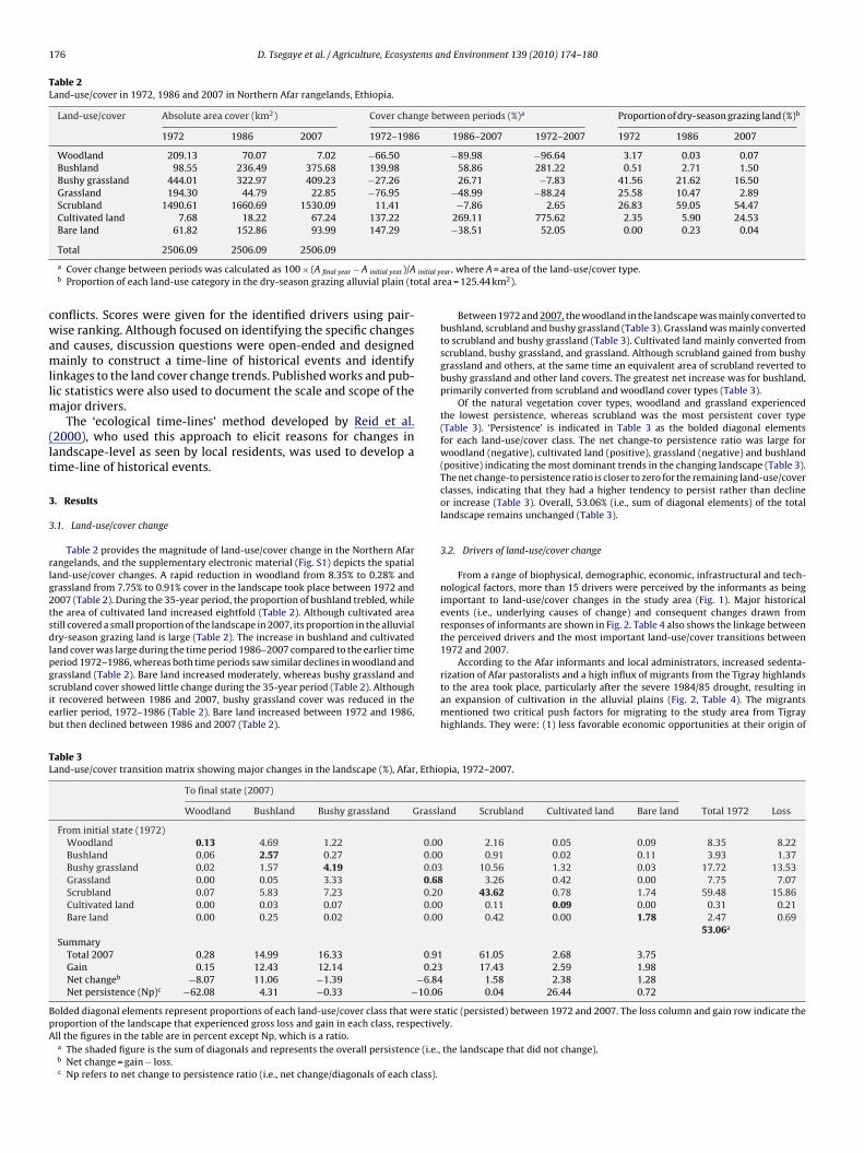
Table 2Land-use/cover in 1972, 1986 and 2007 in Northern Afar rangelands, Ethiopia.
Land-use/cover Absolute area cover (km2) Cover change between periods (%)a Proportion of dry-season grazing land (%)b
1972 1986 2007 1972–1986 1986–2007 1972–2007 1972 1986 2007
Woodland 209.13 70.07 7.02 −66.50 −89.98 −96.64 3.17 0.03 0.07Bushland 98.55 236.49 375.68 139.98 58.86 281.22 0.51 2.71 1.50Bushy grassland 444.01 322.97 409.23 −27.26 26.71 −7.83 41.56 21.62 16.50Grassland 194.30 44.79 22.85 −76.95 −48.99 −88.24 25.58 10.47 2.89Scrubland 1490.61 1660.69 1530.09 11.41 −7.86 2.65 26.83 59.05 54.47Cultivated land 7.68 18.22 67.24 137.22 269.11 775.62 2.35 5.90 24.53Bare land 61.82 152.86 93.99 147.29 −38.51 52.05 0.00 0.23 0.04
initial y
tal ar
cwamllm
(lt
3
3
rlg2tsdlpgsieb
TL
BpA
Total 2506.09 2506.09 2506.09
a Cover change between periods was calculated as 100 × (A final year − A initial year)/Ab Proportion of each land-use category in the dry-season grazing alluvial plain (to
onflicts. Scores were given for the identified drivers using pair-ise ranking. Although focused on identifying the specific changes
nd causes, discussion questions were open-ended and designedainly to construct a time-line of historical events and identify
inkages to the land cover change trends. Published works and pub-ic statistics were also used to document the scale and scope of the
ajor drivers.The ‘ecological time-lines’ method developed by Reid et al.
2000), who used this approach to elicit reasons for changes inandscape-level as seen by local residents, was used to develop aime-line of historical events.
. Results
.1. Land-use/cover change
Table 2 provides the magnitude of land-use/cover change in the Northern Afarangelands, and the supplementary electronic material (Fig. S1) depicts the spatialand-use/cover changes. A rapid reduction in woodland from 8.35% to 0.28% andrassland from 7.75% to 0.91% cover in the landscape took place between 1972 and007 (Table 2). During the 35-year period, the proportion of bushland trebled, whilehe area of cultivated land increased eightfold (Table 2). Although cultivated areatill covered a small proportion of the landscape in 2007, its proportion in the alluvialry-season grazing land is large (Table 2). The increase in bushland and cultivated
and cover was large during the time period 1986–2007 compared to the earlier time
eriod 1972–1986, whereas both time periods saw similar declines in woodland andrassland (Table 2). Bare land increased moderately, whereas bushy grassland andcrubland cover showed little change during the 35-year period (Table 2). Althought recovered between 1986 and 2007, bushy grassland cover was reduced in thearlier period, 1972–1986 (Table 2). Bare land increased between 1972 and 1986,ut then declined between 1986 and 2007 (Table 2).able 3and-use/cover transition matrix showing major changes in the landscape (%), Afar, Ethio
To final state (2007)
Woodland Bushland Bushy grassland Grassla
From initial state (1972)Woodland 0.13 4.69 1.22 0.00Bushland 0.06 2.57 0.27 0.00Bushy grassland 0.02 1.57 4.19 0.03Grassland 0.00 0.05 3.33 0.68Scrubland 0.07 5.83 7.23 0.20Cultivated land 0.00 0.03 0.07 0.00Bare land 0.00 0.25 0.02 0.00
SummaryTotal 2007 0.28 14.99 16.33 0.91Gain 0.15 12.43 12.14 0.23Net changeb −8.07 11.06 −1.39 −6.84Net persistence (Np)c −62.08 4.31 −0.33 −10.06
olded diagonal elements represent proportions of each land-use/cover class that were stroportion of the landscape that experienced gross loss and gain in each class, respectivell the figures in the table are in percent except Np, which is a ratio.a The shaded figure is the sum of diagonals and represents the overall persistence (i.e.,b Net change = gain − loss.c Np refers to net change to persistence ratio (i.e., net change/diagonals of each class).
ear , where A = area of the land-use/cover type.ea = 125.44 km2).
Between 1972 and 2007, the woodland in the landscape was mainly converted tobushland, scrubland and bushy grassland (Table 3). Grassland was mainly convertedto scrubland and bushy grassland (Table 3). Cultivated land mainly converted fromscrubland, bushy grassland, and grassland. Although scrubland gained from bushygrassland and others, at the same time an equivalent area of scrubland reverted tobushy grassland and other land covers. The greatest net increase was for bushland,primarily converted from scrubland and woodland cover types (Table 3).
Of the natural vegetation cover types, woodland and grassland experiencedthe lowest persistence, whereas scrubland was the most persistent cover type(Table 3). ‘Persistence’ is indicated in Table 3 as the bolded diagonal elementsfor each land-use/cover class. The net change-to persistence ratio was large forwoodland (negative), cultivated land (positive), grassland (negative) and bushland(positive) indicating the most dominant trends in the changing landscape (Table 3).The net change-to persistence ratio is closer to zero for the remaining land-use/coverclasses, indicating that they had a higher tendency to persist rather than declineor increase (Table 3). Overall, 53.06% (i.e., sum of diagonal elements) of the totallandscape remains unchanged (Table 3).
3.2. Drivers of land-use/cover change
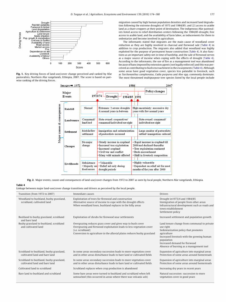
From a range of biophysical, demographic, economic, infrastructural and tech-nological factors, more than 15 drivers were perceived by the informants as beingimportant to land-use/cover changes in the study area (Fig. 1). Major historicalevents (i.e., underlying causes of change) and consequent changes drawn fromresponses of informants are shown in Fig. 2. Table 4 also shows the linkage betweenthe perceived drivers and the most important land-use/cover transitions between1972 and 2007.
According to the Afar informants and local administrators, increased sedenta-rization of Afar pastoralists and a high influx of migrants from the Tigray highlandsto the area took place, particularly after the severe 1984/85 drought, resulting inan expansion of cultivation in the alluvial plains (Fig. 2, Table 4). The migrantsmentioned two critical push factors for migrating to the study area from Tigrayhighlands. They were: (1) less favorable economic opportunities at their origin of
pia, 1972–2007.
nd Scrubland Cultivated land Bare land Total 1972 Loss
2.16 0.05 0.09 8.35 8.220.91 0.02 0.11 3.93 1.37
10.56 1.32 0.03 17.72 13.533.26 0.42 0.00 7.75 7.07
43.62 0.78 1.74 59.48 15.860.11 0.09 0.00 0.31 0.210.42 0.00 1.78 2.47 0.69
53.06a
61.05 2.68 3.7517.43 2.59 1.98
1.58 2.38 1.280.04 26.44 0.72
atic (persisted) between 1972 and 2007. The loss column and gain row indicate thely.
the landscape that did not change).
D. Tsegaye et al. / Agriculture, Ecosystems an
Fig. 1. Key driving forces of land-use/cover change perceived and ranked by Afarpastoralists, Northern Afar rangelands, Ethiopia, 2007. The score is based on pair-wise ranking of the driving forces.
Fig. 2. Major events, causes and consequences of land-use/cover changes from
Table 4Linkage between major land-use/cover change transitions and drivers as perceived by th
Transition (from 1972 to 2007) Immediate causes
Woodland to bushland, bushy grassland,scrubland, cultivated land
Exploitation of trees for firewood and coAlternative source of income to cope wiWhen woodland loses, bushland replac
Bushland to bushy grassland, scrublandand bare land
Exploitation of shrubs for firewood near
Bushy grassland to bushland, scrublandand cultivated land
Overgrazing reduces grass cover and givOvergrazing and firewood exploitation(i.e. scrubland)Conversion to agriculture in the alluvial
Scrubland to bushland, bushy grassland,cultivated land and bare land
In some areas secondary succession leaand in other areas disturbance leads to
Scrubland to bushland, bushy grassland,cultivated land and bare land
In some areas secondary succession leaand in other areas disturbance leads to
Cultivated land to scrubland Scrubland replaces when crop producti
Bare land to bushland and scrubland Some bare areas were turned to bushlanuntouched (this occurred in areas wher
d Environment 139 (2010) 174–180 177
migration caused by high human population densities and increased land degrada-tion following the extreme droughts of 1973 and 1984/85; and (2) access to arableland as a share croppers at their point of destination. The indigenous Afar pastoral-ists listed access to relief distribution centers following the 1984/85 drought, freeaccess to arable land, and the availability of farm labor, as inducements for them tosedentarize and become involved in agriculture.
The informants stated that migrants are the main cause of woodland coverreduction as they are highly involved in charcoal and firewood sale (Table 4) inaddition to crop production. The migrants also added that woodland was highlyexploited for the purpose of permanent house construction (Table 4). It also func-tions as an important safety net in time of hardship, and the sale of firewood servesas a major source of income when coping with the effects of drought (Table 4).According to the informants, the use of fire as a management tool was abandoned
because of bans imposed by extension agents (not legally enforced) and this was per-ceived as contributing to bush encroachment in the escarpments (Table 4). Althoughsome areas have good vegetation cover, species less palatable to livestock, suchas Tarchonanthus camphoratus, Cadia purpurea and Aloe spp. commonly dominate.The most threatened multipurpose tree species listed by the local people include1972 to 2007 as seen by local people, Northern Afar rangelands, Ethiopia.
e local people.
Drivers
nstructionth the drought effectses in the hilly areas
Drought in1973/4 and 1984/85Immigration of people from other areasInfrastructural development such as roads andtown establishmentSettlement policy
settlements Increased settlement and population growth
es way to bush coverleads to less vegetation cover
plains reduces bushy grassland
Land tenure change from communal to privateuse rightSedentarization policy that promotesagricultureIncreased livestock with the growing humanpopulationIncreased demand for firewoodAbsence of burning as a management tool
ds to more vegetation coverbare land or cultivated fields
Expansion of agriculture into marginal areasProtection of some areas around homesteads
ds to more vegetation coverbare land or cultivated fields
Expansion of agriculture into marginal areasProtection of some areas around homesteads
on is abandoned Increasing dry years in recent years
d and scrubland when lefte there was volcanic ash)
Natural succession: succession to morevegetation cover in good years
1 ems a
Dtle
tvhgcwt
fa
4
s3bepitpa
vaaw(sgoaid2fd
amltleTcdo
ete(a1tpiamt2
78 D. Tsegaye et al. / Agriculture, Ecosyst
obera glabra, Cordia gharaf and Olea europaea. The informants particularly statedhat recruitment failure of D. glabra, an important food plant for both humans andivestock in the wet-season grazing alluvial plains, could be an important indicator ofither grazing/browsing pressure or rainfall variability, or combinations of the two.
The pastoralists explained a shift in livestock species composition from domina-ion by camel-cattle to small stock-camel has occurred as a response to changes inegetation types in recent years. They also remember that many of the wild animalsave disappeared including cheetah (Acinonyx jubatus soemmerringii), oryx (Oryxazella beisa), eland (Taurotragus oryx) and others are threatened – ostrich (Struthioamelus) and soemmerring’s gazelle (Nanger soemmerringii) – in the study area. Thisas attributed mainly to the long civil war that took place in the study area and to
he loss of woodland (Fig. 2, Table 2).Overall, people stated that the changes in land-use/cover, mainly caused by
requent droughts and increasing numbers of dry years among other drivers, highlyffected their lifestyles and have made them more dependent on relief aid.
. Discussion
The arid and semi-arid rangelands in Northern Afar experiencedubstantial and increasing rates of land-use/cover changes during5 years from 1972 to 2007. There have been persistent changes,oth spatially and temporally, resulting in 47% of the total areaxperiencing transitional changes among the land cover types. Theoor vegetation cover observed in 1986 compared to 1972 and 2007
ndicates that most of the vegetation types suffered from short-erm direct and indirect drought effects. Bushland cover increase,articularly in the hills and escarpments, indicates partial recoveryfter the drought.
In the first period (1972–1986), the overall net transition to lessegetation (i.e., bare land, scrubland and cultivated land) coveredbout 272 km2, showing the direct and indirect impact of droughtnd related causes. During this period, a rapid loss of woodlandsas mainly caused by the severe droughts in 1973 and 1984/85
Meze-Hausken, 2004). There was also a change in the land tenureystem in 1975 encouraging subdivision of communal dry-seasonrazing areas for crop production on either an individual basisr through the establishment of farmers’ cooperatives (Omiti etl., 1999). These events were important underlying causes of thenflux of people into Northern Afar from the highly populated andegraded areas in the neighboring Tigray region (Meze-Hausken,004; Tsegaye et al., 1999). Campbell et al. (2005) note that thisorm of migration is an adaptation strategy of people affected byrought in arid and semi-arid areas.
As a result of continued migration of people from neighboringreas together with the increased sedentarization of pastoralists,ore alluvial dry-season grazing areas were converted to crop-
and in the second period (1986–2007). However, immigration tohe study area very much reduced after 1991 following the estab-ishment of ethnic-based administration and availability of labormployment opportunities in the rapidly growing urban areas inigray. In the second period, the net transition to more vegetationover was 143 km2, indicating some recovery after the 1984/85rought, the process perhaps being related to natural and sec-ndary re-growth.
As in other areas of East Africa (Reid et al., 2004), agriculturalxpansion related to shifts in government policy has been one ofhe key driving forces behind the land-use/cover changes in North-rn Afar. Cultivation is seen by some as a better livelihood strategye.g., Campbell et al., 2005) stemming from increasing populationnd changes in relative prices between input and output (Vedeld,995), while others (e.g., Little et al., 2008) view it as an unsus-ainable option that increases the risk to pastoralists. Althoughastoralists have persistently resisted sedentarization and farming
n the past (Chatty, 2007), we observed more voluntary farmingctivities and sedentarization in Afar in recent years. Such changesay be either intentionally driven by external factors or a spon-
aneous response to new opportunities or challenges (Reid et al.,004).
nd Environment 139 (2010) 174–180
Before the introduction of other land-uses such as agriculture,traditional institutions of the Afar communities were strongly orga-nized to serve the needs of the members living within specifiedphysical boundaries. Although land is legally owned by the state,grazing lands are communal properties accessible to all mem-bers of a clan or groups of clans within the boundary (Hundieand Padmanabhan, 2008). However, land under cultivation byagro-pastoral communities is considered to be private property.Although not fully implemented (Hundie and Padmanabhan, 2008),the 1994 constitution declares (in Article 40) “Ethiopian pastoralistshave a right to free land for grazing and cultivation as well as the rightnot to be displaced from their own lands”.
Although sedentarization of pastoralists is still continuing, moreinvolvement in agriculture may not continue in the study area dueto both increasing drought occurrence and a lack of technologi-cal progress in favor of the existing spate irrigation practice. It isobserved in the field that many cropping fields left uncultivatedgradually revert to bushy grasslands mainly dominated by annualforbs and Aloe spp. less palatable to livestock. Although there hasbeen a decline in agricultural activities due to reduced rainfall since2000, a tendency to shift to irrigated agriculture is linked to theincreased sedentarization of pastoralists. There is a strong demandfor the use of improved gabions and dikes that allow better use ofthe available floodwaters. Development actors (e.g., the Afar Inte-grated Pastoral Development Programme) operating in the areahave introduced such improved systems and assisted the agro-pastoralists in improving their flood diversion activities and havein fact contributed to halting the practice of shifting cultivation thatconverts more vegetated areas to cropping fields. While it is truethat such activities improve food security, it can also be argued thatmore people may be attracted to sedentarize and become involvedin agriculture in the long-run.
Many studies conducted in African drylands have documented adecline in woody vegetation cover (Lykke, 1998; Wezel and Haigis,2000). Woodland loss is usually attributed to land clearing forcrop production (e.g., Vedeld, 1995), while bush encroachment isattributed to overgrazing and absence of fire (e.g., Angassa and Oba,2008; Oba et al., 2000). This is not the case in the study area, asboth woodland and bushland covers dominate hillsides and escarp-ments unsuitable to either crop production or grazing. Rather,observations revealed modification of woodland cover caused byincreased tree exploitation (i.e., tree felling for firewood and con-struction).
The increased bushland cover at the expense of woodland alsoindicates the impact of altered disturbance regimes such as avoid-ing fire as a management tool besides continued wood harvesting(Wiegand and Jeltsch, 2000). Like many rangelands in Africa, theincrease in bushland cover in the study area was not unexpected,but the presence of more bushy cover mainly on the hilly areas andescarpments where there is little or no grazing is striking. Otherstudies have also noted the occurrence of bush encroachment inareas where there is shallow soil depth and grazing is infrequent(Brown and Archer, 1999).
The changes in land-use/cover in the study area thus indicateresource degradation and vulnerability of people. The drivers andrelated changes discussed above may therefore influence ecosys-tem functioning in the rangelands through their impact on thetraditional mobility pattern between the wet- and dry-season graz-ing areas. This may also lead to a decrease in the size of dry-seasongrazing areas, isolation of crucial habitats such as permanent watersources, particularly for large wild animals, indirectly resulting
in changing livestock species composition and directly disturb-ing some plant species that may be threatened with extinction.For instance, the failure of D. glabra recruitment in Northern Afarrangelands was mainly a contribution of intense livestock browsing(Tsegaye et al., 2009), indicating the severity of degradation. Most
ems an
ptfycudb
eceoscTacw2rgbri
gadupi
A
iSale
A
t
R
A
B
B
B
B
B
C
C
D. Tsegaye et al. / Agriculture, Ecosyst
astoralists no longer keep cattle and have shifted to small stockhat can utilize bush-encroached areas. The increasing demandor meat from the growing population in nearby towns in recentears is also an opportunity to increase the goat population thatan browse on the increasing bush cover. It should therefore benderscored that the shift from cattle-camel to small stock-camelominated livestock is not only a response to bush encroachmentut also a strategy to meet market demands.
The findings of this study support Illius and O’Connor’s (1999)xplanations regarding the rangeland management debate. Inonditions where key resource dry-season grazing areas arencroached by agriculture, grazing-induced degradation oftenccurs in other areas as they are heavily utilized during the dry-eason (Illius and O’Connor, 1999). In the study area, mobility isonstrained with a consequent overgrazing in the remaining areas.his is evident in Northern Afar where the dry-season grazing areasre encroached by other land-uses including agriculture. Such cir-umstances can occur in climatically highly variable environmentshere mobility of pastoralists has been severely restricted (Vetter,
005). The non-equilibrium approach, in which arid and semi-aridangelands conditions are seen as being driven by rainfall and not byrazing (Behnke and Scoones, 1993; Ellis and Swift, 1988) may note fully applicable in a situation where pastoral groups have beenemoved from part of their traditional grazing land, as witnessedn this study.
The general trend observed in the study area implies a loss ofrassland and woodland cover and an increase in cultivated areasnd bushland cover. The present tendency may lead to more landegradation if no assisted restoration is made. Continued land-se/cover change, coupled with a drier climate, greatly affectseople’s livelihoods and puts the pastoral production system under
ncreasing threat.
cknowledgments
We are grateful to the Development Fund of Norway for fund-ng the research. The first author is also grateful to the Norwegiantate Educational Loan Fund (Lånekassen) for providing financialssistance and Mekelle University in Ethiopia for granting a studyeave. We also wish to thank the two anonymous reviewers and theditor for their constructive and professional comments.
ppendix A. Supplementary data
Supplementary data associated with this article can be found, inhe online version, at doi:10.1016/j.agee.2010.07.017.
eferences
ngassa, A., Oba, G., 2008. Effects of management and time on mechanisms of bushencroachment in southern Ethiopia. Afr. J. Ecol. 46, 186–196.
ehnke, R.H., Scoones, I., 1993. Rethinking range ecology: implications for range-land management in Africa. In: Behnke, R.H., Scoones, I., Kerven, C. (Eds.), RangeEcology at Disequilibrium: New Models of Natural Variability and Pastoral Adap-tations in African Savannas. ODI (Overseas Development Institute), London, pp.1–30.
raimoh, A.K., 2006. Random and systematic land-cover transitions in northernGhana. Agr. Ecosyst. Environ. 113, 254–263.
riske, D.D., Fuhlendorf, S.D., Smeins, F.E., 2003. Vegetation dynamics on rangelands:a critique of the current paradigms. J. Appl. Ecol. 40, 601–614.
riske, D.D., Fuhlendorf, S.D., Smeins, F.E., 2005. State-and-transition models,thresholds, and rangeland health: a synthesis of ecological concepts and per-spectives. Rangeland Ecol. Manage. 58, 1–10.
rown, J.R., Archer, S., 1999. Shrub invasion of grassland: recruitment is continuous
and not regulated by herbaceous biomass or density. Ecology 80, 213–229.ampbell, D.J., Lusch, D.P., Smucker, T.A., Wangu, E.E., 2005. Multiple methods inthe study of driving forces of land use and land cover change: a case study of SEKajiado district Kenya. Hum. Ecol. 33, 763–794.
hatty, D., 2007. Mobile peoples: pastoralists and herders at the beginning of the21st century. Rev. Anthropol. 36, 5–26.
d Environment 139 (2010) 174–180 179
CSA (Central Statistical Authority), 2008. Report of the 2007 Population and HousingCensus. CSA, Addis Ababa, Ethiopia.
Ellis, J.E., Swift, D.M., 1988. Stability of African pastoral ecosystems: alternateparadigms and implications for development. J. Range Manage. 41, 450–459.
Garedew, E., Sandewall, M., Soderberg, U., Campbell, B.M., 2009. Land-use and land-cover dynamics in the Central Rift Valley of Ethiopia. Environ. Manage. 44,683–694.
Hardin, G., 1968. Tragedy of the commons. Science 162, 1243–1248.HTS (Hunting Technical Services), 1976. Tigrai Rural Development Study, Phase II
Main Report. HTS Ltd., London.Hundie, B., Padmanabhan, M., 2008. The Transformation of the Afar Commons in
Ethiopia: State Coercion, Diversification, and Poverty Rights Change AmongPastoralists. Collective Action and Property Rights (CAPRi) Working Paper No.87.
Illius, A.W., O’Connor, T.G., 1999. On the relevance of nonequilibrium concepts toarid and semiarid grazing systems. Ecol. Appl. 9, 798–813.
ITC (International Institute for Geo-Information Science Earth Observation), 2009.ILWIS Open version 3.7. Enschede, The Netherlands.
Kigomo, B.N., 2003. Forests and woodlands degradation in dryland Africa: a casefor urgent global attention. Paper presented at XII World Forest Congress,Quebec City. Available at www.fao.org/DOCREP/ARTICLE/WFC/XII/0169-B3.html.
Lambin, E.F., Geist, H.J., Lepers, E., 2003. Dynamics of land-use and land-cover changein tropical regions. Annu. Rev. Environ. Resour. 28, 205–241.
Lambin, E.F., Turner, B.L., Geist, H.J., Agbola, S.B., Angelsen, A., Bruce, J.W., Coomes,O.T., et al., 2001. The causes of land-use and land-cover change: moving beyondthe myths. Global Environ. Change 11, 261–269.
Lillesand, M.T., Kiefer, W.R., 2000. Remote Sensing and Image Analysis, 4th ed. JohnWiley & Sons Inc., New York.
Little, P.D., McPeak, J., Barrett, C.B., Kristjanson, P., 2008. Challenging orthodox-ies: understanding poverty in pastoral areas of East Africa. Dev. Change 39,587–611.
Lykke, A.M., 1998. Assessment of species composition change in savanna vegeta-tion by means of woody plants’ size class distributions and local information.Biodivers. Conserv. 7, 1261–1275.
Mayaux, P., Bartholome, E., Fritz, S., Belward, A., 2004. A new land-cover map ofAfrica for the year 2000. J. Biogeogr. 31, 861–877.
Meze-Hausken, E., 2004. Contrasting climate variability and methodological droughtwith perceived drought and climate change in northern Ethiopia. Clim. Res. 27,19–31.
Millennium Ecosystem Assessment, 2005. Ecosystem and Human Well-being: Syn-thesis. Island Press, Washington DC.
Mottet, A., Ladet, S., Coque, N., Gibon, A., 2006. Agricultural land-use change andits drivers in mountain landscapes: a case study in the Pyrenees. Agr. Ecosyst.Environ. 114, 296–310.
Oba, G., Stenseth, N.C., Lusigi, W.J., 2000. New perspectives on sustainablegrazing management in arid zones of sub-Saharan Africa. Bioscience 50,35–51.
Olson, J.M., Misana, S., Campbell, D.J., Mbonile, Mugisha, S., 2004. Land Use ChangeImpacts and Dynamics (LUCID) Project Working Paper 48. International Live-stock Research Institute, Nairobi, Kenya, p. 38.
Omiti, J.M., Parton, K.A., Sinden, J.A., Ehui, S.K., 1999. Monitoring changes in land-use practices following agrarian de-collectivization in Ethiopia. Agr. Ecosyst.Environ. 72, 111–118.
Pontius R.G.Jr., Shusas, E., McEachern, M., 2004. Detecting important categoricalland changes while accounting for persistence. Agr. Ecosyst. Environ. 101, 251–268.
Pratt, D.J., Gwynne, M.D., 1977. Rangeland Management and Ecology in East Africa.Hodder and Stoughton, London, UK.
Reid, R.S., Kruska, R.L., Muthui, N., Taye, A., Wotton, S., Wilson, C.J., Mulatu, W., 2000.Land-use and land-cover dynamics in response to change in climatic, biologicaland socio-political forces: the case of southwestern Ethiopia. Landscape Ecol.15, 339–355.
Reid, R.S., Thornton, P.K., Kruska, R.L., 2004. Loss and fragmentation of habitat forpastoral people and wildlife in East Africa: concepts and issues. Afr. J. Range For.Sci. 21, 171–184.
Sandford, S., 1983. Management of Pastoral Development in the Third World. ODI(Overseas Development Institute), London.
Serneels, S., Lambin, E.F., 2001. Proximate causes of land-use change in Narok districtKenya: a spatial statistical model. Agr. Ecosyst. Environ. 85, 65–81.
Serra, P., Pons, X., Sauri, D., 2003. Post-classification change detection with datafrom different sensors: some accuracy considerations. Int. J. Remote Sensing 24,3311–3340.
Serra, P., Pons, X., Sauri, D., 2008. Land-cover and land-use change in a Mediterraneanlandscape: a spatial analysis of driving forces integrating biophysical and humanfactors. Appl. Geogr. 28, 189–209.
Tsegaye, D, Farah, K.O, Mbuvi, D.M., 1999. Impact of Land-use on VegetationResources with Emphasis on Woody Vegetation in the Semi-arid Area of Aba’alaDistrict, North Afar, Ethiopia. M.Sc. thesis, Department of Range management,
University of Nairobi, Kenya.Tsegaye, D., Moe, S.R., Haile, M., 2009. Livestock browsing, not water limitations, con-tributes to recruitment failure of Dobera glabra in semiarid Ethiopia. RangelandEcol. Manage. 62, 540–549.
Vedeld, P.O., 1995. Land use and Deforestation in East Africa - Competing Uses UnderLabor and Market Constraints. Discussion Paper D-16/1995.

1 ems and Environment 139 (2010) 174–180
V
W
80 D. Tsegaye et al. / Agriculture, Ecosyst
etter, S., 2005. Rangelands at equilibrium and non-equilibrium: recent develop-ments in the debate. J. Arid Environ. 62, 321–341.
essels, K.J., Prince, S.D., Carroll, M., Malherbe, J., 2007. Relevance of rangelanddegradation in semiarid northeastern South Africa to the nonequilibrium theory.Ecol. Appl. 17, 815–827.
Wezel, A., Haigis, J., 2000. Farmers’ perception of vegetation changes in semi-aridNiger. Land Degrad. Dev. 11, 523–534.
Wiegand, T., Jeltsch, F., 2000. Long-term dynamics in arid and semiaridecosystems—synthesis of a workshop. Plant Ecol. 150, 3–6.
Copyright © 2022 FDOKUMEN