land use model of urban areas
27
K A R A C H I
Transcript of land use model of urban areas

K A R A C H I
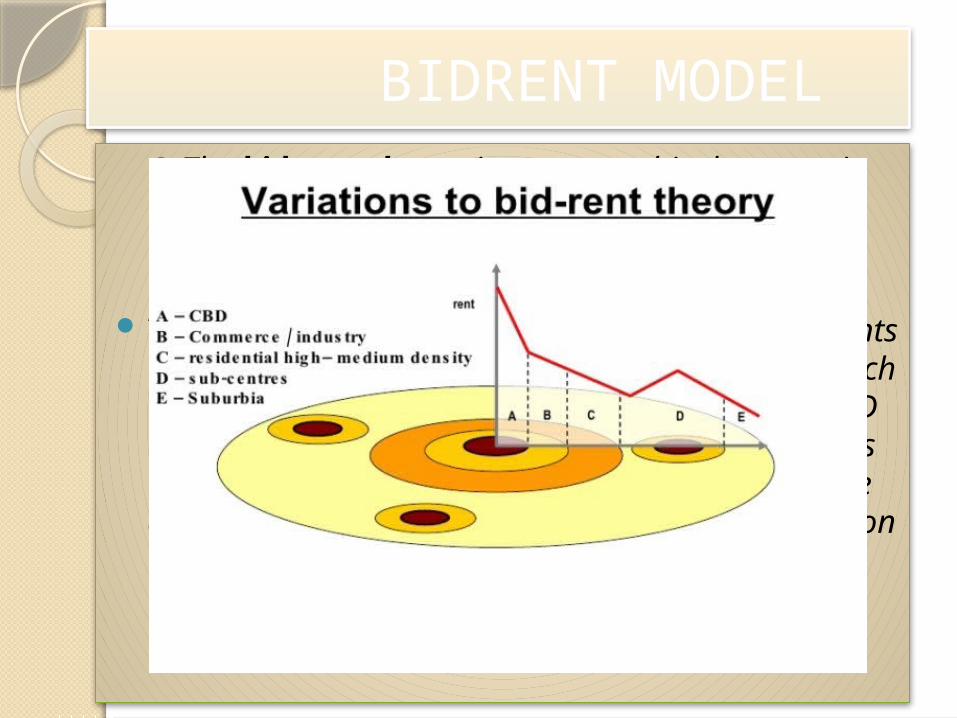
BIDRENT MODELThe bid rent theory is a geographical economic
theory that refers to how the price and demand for real estate change as the distance from the central business district (CBD) increases.
This is based upon the idea that retail establishments wish to maximize their profitability, so they are much
more willing to pay more for land close to the CBD and less for land further away from this area. This theory is based upon the reasoning that the more
accessible an area (i.e., the greater the concentration of customers), the more profitable.
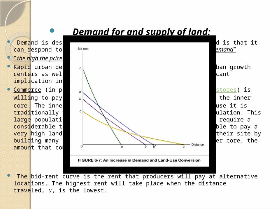
Demand for and supply of land: Demand is desire or need, the most important law of demand is that it can respond to changes in prices ‘’the low the price the high the demand’’
‘’ the high the price the low the demand’’. (William Alonso 1984) Rapid urban development have brought dynamic changes in urban growth centers as well as in land prices land values have significant implication in economic growth.
Commerce (in particular large department stores and chain stores) is willing to pay the greatest rent in order to be located in the inner core. The inner core is very valuable for these users because it is traditionally the most accessible location for a large population. This large population is essential for department stores, which require a considerable turnover. As a result, they are willing and able to pay a very high land rent value. They maximize the potential of their site by building many stories. As one travels farther from the inner core, the amount that commerce is willing to pay declines rapidly.
Bid rent curve:
The bid-rent curve is the rent that producers will pay at alternative locations. The highest rent will take place when the distance traveled, u, is the lowest.

The net profit to the firm is the same at each location because of competition; but in more distance locations, more of the cost is in the form of transport costs rather than rent. Also, at more distant locations capital will be used less intensively, since less capital will be substituted for land.
Shortest distance from C.B.DLongest distance from C.B.D
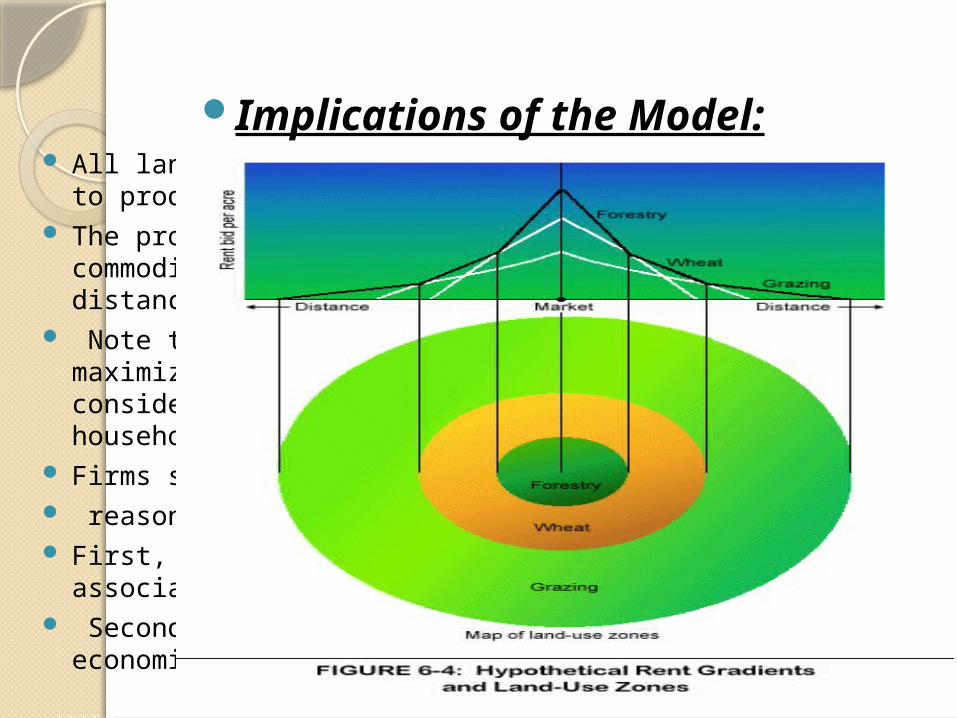
Implications of the Model: All land available within the urban area must be used to produce the commodity.
The production function indicates how much of the commodity is produced by land and capital at each distance, u.
Note that the model is only applicable for profit maximizes and is unrealistic because it does not consider the cost of labor or the location of households.
Firms seek access to the CBD for two reasons: First, they area able to lower transport cost associated with the CBD export facility.
Second, they are able to achieve agglomeration economies.
Spatial distribution of land use and land prices :
A number of land price studies have followed the simple, but fundamental, access-space trade-off idea, as developed by Alonso (1964), The essence of the trade-off relationship is that land prices are required to decline with distance as an individual moves away from the central business district (CBD).
But this was not possible now because it requires: A city is assumed to be monocentric, whereby an urban area is
characterized as a one dimensional, flat and featureless plain, and assumed to be congestion free. The location of workplaces
is given and is assumed to be in the CBD only. Secondly, transportation is assumed to be available in a uniform pattern;
that is, the CBD is accessible from all directions with a cost proportional to the distance and the number of travel trips.

According to Colin Clark (1951) regardless of time or place, city population declines exponentially away from the city center . At first most people live in central zone because of less developed transportation system but latter then people are start moving away from the city center , because of growth of SUBURBS. With increasing population density the city dwellers affords high commuting costs and live at low residential densities.
distance from
city...
0123456 time wise change
time wise change

Dowall found land values start flattening from city center especially in Bangkok from city center due to congestion in the city.
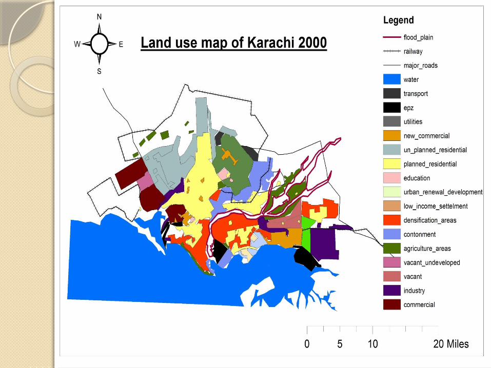
According to DOWALL(1981-1991), who studied the spatial pattern of land values in three ASIAN MEGA CITIES1. KARACHI.2. BANGKOK.3. JAKARTA.

Change in locational advantages as cities expand is one among many factors that determine levels of land prices (Dunkerley, 1983). Basically, locational advantages take place when the condition of an area is improved by means of transportation and quality of infrastructure.
We divide observations into three groups by distance from the CBD. They include the inner, the middle and the outer rings, which refer to land plots that are located within 10, between 11-20 and more than 20 kilometers from the CBD. We observe that values of gradients vary with distance, with steepest gradients in an innermost ring . This implies varying conditions of transport from sector to sector, with the most costly transport in the inner ring.
there is a consistent increase in the values of adjusted r-squared at outer rings in both periods of study. In detail, access and quality of infrastructure explain land prices in the inner ring by approximately 50-53%, while their explanatory power increased to 57-59% and 74-75% in middle and outer rings respectively. We can imply that accessibility as well as infrastructure has been perceived as more important at outer areas. On the contrary, lands at the inner area are well-equipped with a good quality of basic infrastructure and having easy access to the city center. Then levels of land prices are determined by some other important factors than purely access and public utilities.
Regarding this issue, we reveal that influence of infrastructure on land prices is not even in all concentric rings. It has no significant impact on prices of land in the inner ring . Greatest impact is on the middle ring. Here we may predict that over time quality of infrastructure would be more important in further outlying areas, especially when development spreads out. This indicates room for government in providing good condition of infrastructure, not only road access but also other necessary infrastructure, such as communication, as incentives to promote sub centers and decentralize growth. More importantly, not only is the sufficient amount, but consistent and continuous provision of infrastructure is also required for sustainable development

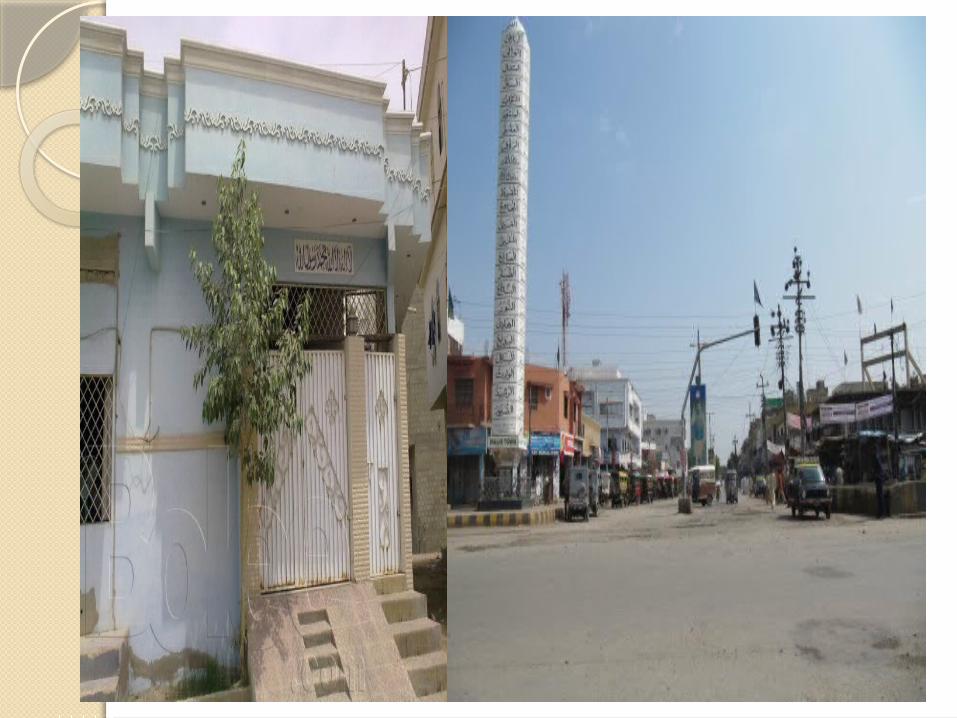
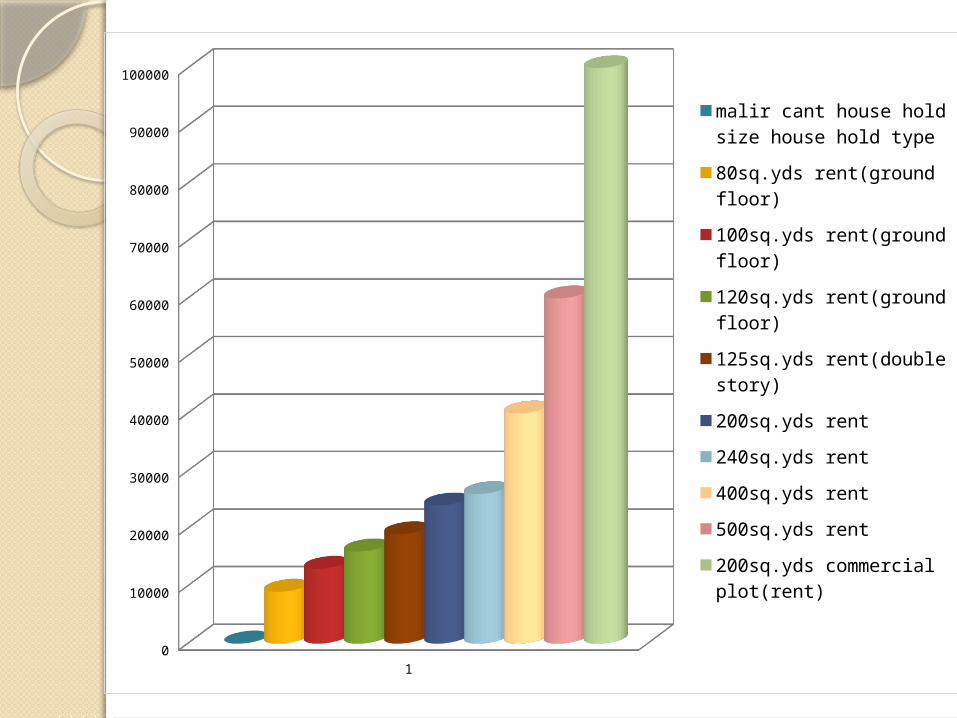
MALIR RENT
Single story 12,000
Double story 10,000
10
5000
10000
15000
MALIR AREA(80SQ.YDS)MALIRSINGLE STORYDOUBLE STORY
10
5000000
residential and commercial plot
MALIR SINGLE STORYDOUBLE STORY commercial
MALIR PRICE
SINGLE STORY
2000000
DOUBLE STORY
3000000
COMMERCIAL(120 SQ.YDS)
5000000
10
10000
20000
30000
40000
50000
60000
70000
80000
90000
100000
malir cant house hold size house hold type80sq.yds rent(ground floor)100sq.yds rent(ground floor)120sq.yds rent(ground floor)125sq.yds rent(double story)200sq.yds rent240sq.yds rent400sq.yds rent500sq.yds rent200sq.yds commercial plot(rent)


commercial(price) double story house
single story house
rent0
1,000,000
2,000,000
3,000,000
4,000,000
5,000,000
6,000,000
7,000,000
8,000,000
9,000,000
10,000,000
North Karachi
120sq.yds 240sq.yds 400sq.yds
2 room 3 room 4 room0
500000
1000000
1500000
2000000
2500000
3000000
3500000
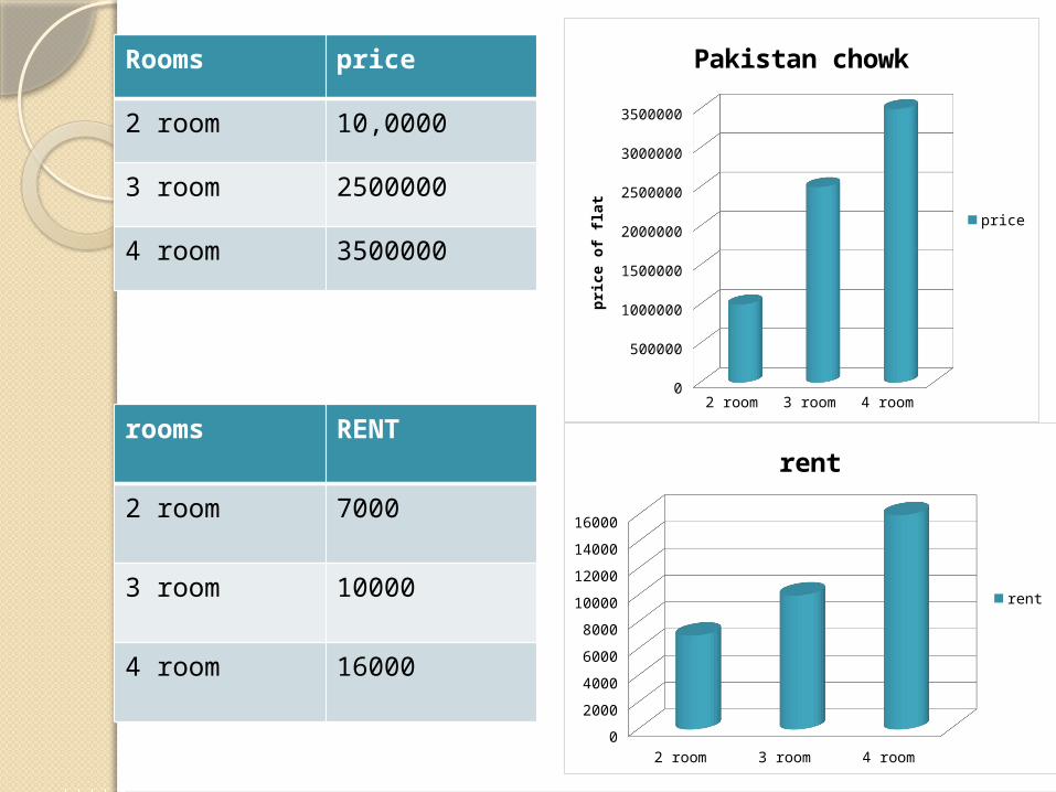
Pakistan chowk
price
price of
flat
Rooms price
2 room 10,0000
3 room 2500000
4 room 3500000
2 room 3 room 4 room0
200040006000800010000120001400016000
rent
rent
rooms RENT
2 room 7000
3 room 10000
4 room 16000
2 room
3 room
4 room
5 room
05000100001500020000
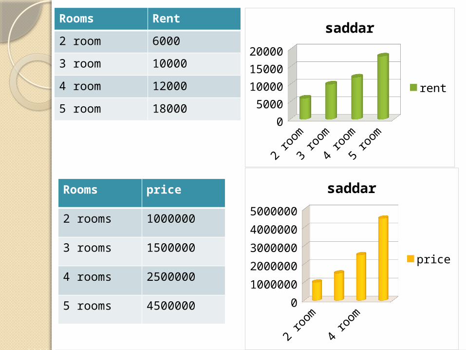
saddar
rent
Rooms Rent2 room 60003 room 100004 room 120005 room 18000
2 room
4 room
010000002000000300000040000005000000
saddar
price
Rooms price
2 rooms 1000000
3 rooms 1500000
4 rooms 2500000
5 rooms 4500000

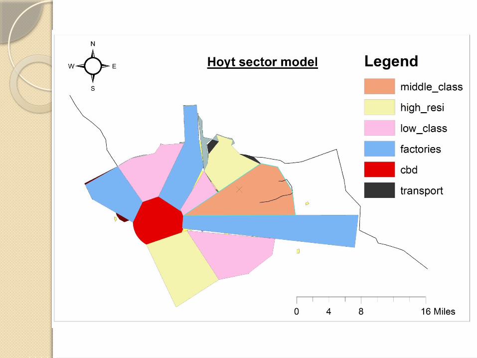
HOYT SECTOR MODEL The sector model, also known as the Hoyt model, is a model of
urban land use proposed in 1939 by economist Homer Hoyt. It is a modification of the concentric zone model of city
development. The benefits of the application of this model include the fact it allows for an outward progression of growth.
zones expand outward from the city center along railroads, highways, and other transportation arteries. Using Chicago as an example, an upper class residential sector evolved outward along the desirable Lake Michigan shoreline north of the central business district, while industry extended southward in sectors that followed railroad lines.
Hoyt observed that it was common for low-income households to be near railroad lines, and commercial establishments to be along business thoroughfares. Recognizing that the various transportation routes into an urban area, including railroads, sea ports, and tram lines, represented greater access, Hoyt theorized that cities tended to grow in wedge-shaped patterns -- or sectors -- emanating from the central business district and centered on major transportation routes.
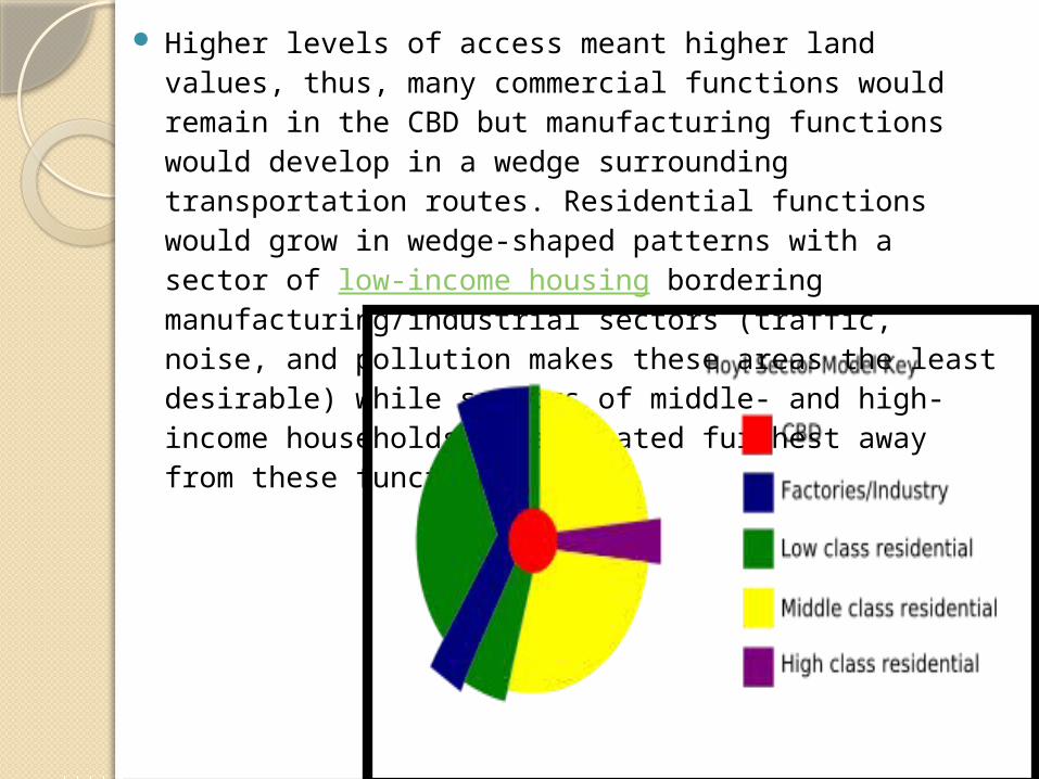
Higher levels of access meant higher land values, thus, many commercial functions would remain in the CBD but manufacturing functions would develop in a wedge surrounding transportation routes. Residential functions would grow in wedge-shaped patterns with a sector of low-income housing bordering manufacturing/industrial sectors (traffic, noise, and pollution makes these areas the least desirable) while sectors of middle- and high-income households were located furthest away from these functions.
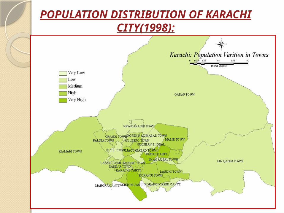
POPULATION DISTRIBUTION OF KARACHI CITY(1998):
RESULTS :An increase in population growth will
shift the rent gradient upward, reflecting higher transport costs at every location and greater benefits
from agglomeration in the CBD.Thus mainly the increase in land
values away from center majorly depend upon the infrastructure and the accessibility of transportation
system.As well as economic crisis or
stability also have a affect on land prcies.