Land use change and resource management in the Jnane Mas valley (Khenifra, Middle Atlas, Morocco
8
87 Land Use Change and Resource Management in the Jnane Mas Valley (Khenifra, Middle Atlas, Morocco) 1 Brahim Akdim a , Ramon Julia b and Mohamed Laaouane a a University Sidi Mohamed Ben Abdellah, FLS, LAGEA, BP. 59, Fez, Morocco b CSIC Jaume Almera, Barcelona, Spain e-mail: [email protected] Received December 21, 2009 Abstract—The purpose of this paper is to bring into light the landscape change and natural resources management in the Moroccan Middle Atlas across centuries. The pastoral way of life prevailed for many centuries. However, following the results of this research, evidence of important socioeconomic changes and resources use is found. Ancient agricultural activities, as well as the exploitation of the forest and even mineral resources have been growing activities over time. The survey shows that the agricultural activity has existed for several centuries as indicated by terraces and encrusted travertine channels used for irrigation. The landscapes and the ways of resources use are therefore in continuous change. The increasing needs in water and agriculture for demographic and climatic reasons (the dry periods in summer or periodic droughts) generated because of intensive over-exploitation of resources. The vegetation degraded facing human pressure (the pastoral activities, the coal of wood making, the lime manufacturing, etc.). Field observations show that irrigation has been used in this domain, for several centuries. Travertine channels, encrusted in the valleys of Jnane Mas and Arougou, illustrate these ancient uses of water resources for agriculture irrigation. DOI: 10.1134/S187537281101015X Keywords: Morocco, Middle Atlas, landscape, resources, change. INTRODUCTION The Moroccan Middle Atlas mountains are often presented in the literature as (i) a domain of transhumance [1], (ii) a globally wet area and commonly known as a water reservoir “Chateau d’eau du Maroc”, mainly in its north - western part [2], (iii) a stressed area, due to the over grazing and forest degradation [3, 4]. Taking these ideas, into consideration, a misleading assumption, weakening the place of agriculture, was formulated in most works. The major way of life evoked is the nomadic modes that were dominant several centuries ago. Recourse to agriculture and irrigation was overlooked in that context, except in summer. However, recent field work showed the limitations of such assumptions as it gives evidence of ancient irrigation systems in the area. The inherited cultural terraces that are still functional and ancient irrigation travertine channels observed in Arougou and Jnane Mas valleys in the Khenifra zone (Fig. 1), are indicators of these ancient systems. They show the spatial and economic adaptations to feed the growing population in the Middle Atlas through time. The developed irrigation systems give evidence of periodic rain deficit. They support the idea of a fluctuating climatic regime and a periodical water deficit in the Middle Atlas during the last ten centuries [5]. The article’s main objectives are to: - set up an inventory of the different operating modes of resources management at present and their past evolution; - analyze the ancient agricultural uses of water as they are revealed by the constructed travertine channels and agrarian terraces; - wedge in the time the different uses on the basis of the analysis of the natural and historic archives. The study of the development of channels, their age and context allowed carrying out research on ancient water supply for agriculture, hydraulic and drainage systems in the area. This paper deals with the technical aspect based on drainage and irrigation channel characteristics. Its main aim is to prove that, contrary to well-established presumptions, agriculture is ancient in the Middle Atlas and took place in a system of multi resources use. SETTING, GEOLOGY AND CLIMATE The studied area focuses on the valley of Jnane Mas, located at the administrative area of the rural Commune Aguelmam Azegza and the valley of Arougou in the commune of Moha Ou Hammou in the Province of Khenifra (Fig. 1). GEOGRAPHY ABROAD ISSN 1875-3728, Geography and Natural Resources, 2011, Vol. 32, No. 1, pp. 87-94. © Pleiades Publishing, Ltd., 2011. Published in Russian in Geography and Natural Resources, 2011, Vol. 32, No. 1, pp. 167-173 1 The text was submitted by the authors in English.
-
Upload
independent -
Category
Documents
-
view
1 -
download
0
Transcript of Land use change and resource management in the Jnane Mas valley (Khenifra, Middle Atlas, Morocco

87
Land Use Change and Resource Managementin the Jnane Mas Valley
(Khenifra, Middle Atlas, Morocco)1
Brahim Akdima, Ramon Juliab and Mohamed Laaouanea
a University Sidi Mohamed Ben Abdellah, FLS, LAGEA, BP. 59, Fez, Moroccob CSIC Jaume Almera, Barcelona, Spain
e-mail: [email protected] December 21, 2009
Abstract—The purpose of this paper is to bring into light the landscape change and natural resources management in the Moroccan Middle Atlas across centuries. The pastoral way of life prevailed for many centuries. However, following the results of this research, evidence of important socioeconomic changes and resources use is found. Ancient agricultural activities, as well as the exploitation of the forest and even mineral resources have been growing activities over time. The survey shows that the agricultural activity has existed for several centuries as indicated by terraces and encrusted travertine channels used for irrigation. The landscapes and the ways of resources use are therefore in continuous change. The increasing needs in water and agriculture for demographic and climatic reasons (the dry periods in summer or periodic droughts) generated because of intensive over-exploitation of resources. The vegetation degraded facing human pressure (the pastoral activities, the coal of wood making, the lime manufacturing, etc.). Field observations show that irrigation has been used in this domain, for several centuries. Travertine channels, encrusted in the valleys of Jnane Mas and Arougou, illustrate these ancient uses of water resources for agriculture irrigation.DOI: 10.1134/S187537281101015XKeywords: Morocco, Middle Atlas, landscape, resources, change.
INTRODUCTIONThe Moroccan Middle Atlas mountains are often
presented in the literature as (i) a domain of transhumance [1], (ii) a globally wet area and commonly known as a water reservoir “Chateau d’eau du Maroc”, mainly in its north - western part [2], (iii) a stressed area, due to the over grazing and forest degradation [3, 4]. Taking these ideas, into consideration, a misleading assumption, weakening the place of agriculture, was formulated in most works. The major way of life evoked is the nomadic modes that were dominant several centuries ago. Recourse to agriculture and irrigation was overlooked in that context, except in summer. However, recent field work showed the limitations of such assumptions as it gives evidence of ancient irrigation systems in the area. The inherited cultural terraces that are still functional and ancient irrigation travertine channels observed in Arougou and Jnane Mas valleys in the Khenifra zone (Fig. 1), are indicators of these ancient systems. They show the spatial and economic adaptations to feed the growing population in the Middle Atlas through time. The developed irrigation systems give evidence of periodic rain deficit. They support the idea of a fluctuating climatic regime and a periodical water deficit
in the Middle Atlas during the last ten centuries [5]. The article’s main objectives are to: - set up an inventory of the different operating
modes of resources management at present and their past evolution;
- analyze the ancient agricultural uses of water as they are revealed by the constructed travertine channels and agrarian terraces;
- wedge in the time the different uses on the basis of the analysis of the natural and historic archives.
The study of the development of channels, their age and context allowed carrying out research on ancient water supply for agriculture, hydraulic and drainage systems in the area. This paper deals with the technical aspect based on drainage and irrigation channel characteristics. Its main aim is to prove that, contrary to well-established presumptions, agriculture is ancient in the Middle Atlas and took place in a system of multi resources use.
SETTING, GEOLOGY AND CLIMATEThe studied area focuses on the valley of Jnane Mas,
located at the administrative area of the rural Commune Aguelmam Azegza and the valley of Arougou in the commune of Moha Ou Hammou in the Province of Khenifra (Fig. 1).
GEOGRAPHY ABROAD
ISSN 1875-3728, Geography and Natural Resources, 2011, Vol. 32, No. 1, pp. 87-94. © Pleiades Publishing, Ltd., 2011.Published in Russian in Geography and Natural Resources, 2011, Vol. 32, No. 1, pp. 167-173
1 The text was submitted by the authors in English.
GEOGRAPHY AND NATURAL RESOURCES Vol. 32 No. 1 2011
88 AKDIM et al.
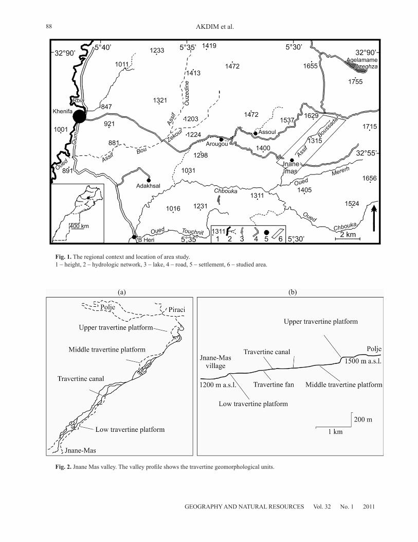
Fig. 1. The regional context and location of area study. 1 – height, 2 – hydrologic network, 3 – lake, 4 – road, 5 – settlement, 6 – studied area.
Fig. 2. Jnane Mas valley. The valley profile shows the travertine geomorphological units.

89
GEOGRAPHY AND NATURAL RESOURCES Vol. 32 No. 1 2011
LAND USE CHANGE AND RESOURCE MANAGEMENT IN THE JNANE MAS VALLEY
It is a part of the north western Middle Atlas, characterised by its folded geologic structures. Narrow structural deformation zones (anticlines and thrust faults) separated by faulted synclines and locally tabular limestone plateaux are dominant. The major substrates are formed of Mesozoic limestones that extend in the area. Uplift of the tertiary tectonic events occurred and exposed the carbonate relief platforms and structures to karst erosion. During periods of exposure, strongly developed karstic systems in the upper part of the valley appear. The poljés, valleys and related micro-forms are abundant at higher altitudes (Aguelman Azigza lake in the north is approximately at 1500 m). The summits of the surrounding Jbels (mountains) are between 1600 and 1700 m. The drainage networks are generally oriented by transverse faults; indicating repetitive structural control on hydrology. The Jnane Mas Valley is one of such developed fluvial systems in the area. Its profile shows a cascading topography influenced by travertine deposits at the valley bottom (Fig. 2).
It is a valley of about 10 kilometres in length and less than one kilometre large. The geomorphic framework is shaped under the dolomite and limestone dominance. The surface and underground karst landforms are abundant on the upper plateau and within the valley flanks. Water flowing from the three main springs in the upper part of the valley engenders travertine forming under different morphologies.
Tectonic aspects and karst phenomena are abundant and the bottom of the valley is filled with travertine of various ages. The valley bottom is filled by travertine deposits covered by soils that are intensively managed following a complementary agrarian system that optimised the use of landscape and water resources. Permanent small streams fed by springs irrigate the area. This zone corresponds to the Euro - Mediterranean climate, characterized by two major rainy periods (spring and late fall). The summer is dry and hot with maximum temperatures of about 40°C. Rainfall fluctuates between 700 and 800 mm a year (Fig. 3). It is therefore clear than even the global context in humid, dry seasons (summer) may accentuate need for irrigation in agriculture.
METHODOLOGY
The landscape and resources management are approached in geographic and evolutionary terms. Geo-environmental and socioeconomic investigation techniques are adopted. A basic preliminary work is done to locate resources, landscape forms and travertine, using aerial photographs analysis. Field work, laboratory analysis of sediments (travertine and terraces deposits), and water samples have prevailed in investigating the evidence of anthropogenic indicators and relationships that landscape components maintained through time. Dating travertine samples from the canal basis and from the upper travertine platform, serves to fit the episodes of its genesis in the general evolution of
the environment and landscape system deduced from previous works. The concept of ‘dynamic landscapes’ in its ‘complexity’ has been considered as the dynamics are herein influenced by the environmental context, the physical and anthropogenic factors linked to the socio-economic change.
PRESENT DAY ECOSYSTEMS AND LAND USEPopulation and Resources Management
The Zayane tribe, which constitutes the study area, is the major ethnic group in the Middle Atlas Mountain. At the end the 19th century, the French geographer Charles De Foucault, in his journey between Zemmour and Tadla crossed the west side of the Zayane territory. He reported that this tribe is essentially formed of nomads and composed of four major fractions (Bni Hsussene, Ait Harkat, Hebbaren and Aït Sidi Ali ou Brahim, Ait Boumezzough, Ait Lahcen ou Said, Ait Hammou ou Aissa). Their territory spreads between the Zemmour area in the west, the Bni Mguilds to the north - east, the westward Zaer and Ichkirn to the south, in Tadla plain direction.
The nomad way of life is acknowledged in Zayane since several centuries. However, agriculture has been progressively developed. In this study, we argue that agriculture is so ancient in the area as attested by ancient irrigation travertine channels in Jnane Mas and other resources that have been exploited as well (wood, plaster, etc.).
The social system of the Zayane tribe is complex as its ethnic groups change even within small areas. The
Fig. 3. The ombrothermic diagram representing data of Aïn Leuh meteorological station.
GEOGRAPHY AND NATURAL RESOURCES Vol. 32 No. 1 2011
90 AKDIM et al.
demographic evolution in this context is often slow, but some human concentrations tend to appear locally.
We note that the townships of this mountain evolve to the very slow rythm. In many cases they know a regressive evolution because life conditions don’t favour attractive employment, best incomes and collective facilities and the infrastructures are still not satisfying peoples needs.
The comparison of households between 1994 and 2004 shows a stagnant evolution in most communities. The most important commune in terms of population is Aguelmous but its human evolution is stagnant. The population of Aguelmam Azegza has regressed in this period.
Livestock Bearing and Its Mutations The nomad life style is still subsisting in the area.
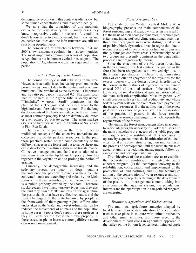
However, it actually faces increasing problems in the present – day context due to the spatial and economic mutations. The provincial ovine livestock is important and its ratio per capita is around 0.5. The main local race of the herd in the Zayane tribe is locally named “Timahdite” whereas “Sardi” dominates in the plain of Tadla. The goat and the sheep adapt to the highlander and forest dominating context. But the long displacements of the herds are reduced to the minimum as most common property land are definitely delimited or even owned by private actors. The main markets (souks) of livestock sale are in Khenifra or Souk Sebt in Fkih Ben Salah.
The practice of pasture in the forest refers to traditional concepts of the extensive nomadism and collective use of the pastoral resources. In the past, these practices rested on the complementarity of the different spaces in the forest and out to serve sheep and cattle development within a system of transhumance. Collective management and land use is adopted so that many areas in the Agdal are temporary closed to regenerate the vegetation and to prolong the period of grazing.
Currently, the demographic increasing and the sedentary process are factors of deep mutations that influence the pastoral resources in the area. The cultivated lands are extending and ruled by the Melk status while the rangelands are collective and the forest is a public property owned by the State. Therefore, stockbreeders have many territory types that they use: the land they own “ Melk” and exploit for agriculture, the pasturelands that have a collective status, and the forests belonging to the State but used by people in the framework of their grazing rights. Afforestation undertaken by the Water and Forest Administration has reduced the movements of animals and the population in some cases. People don’t support these projects as they still consider the forest their own property. In these cases, suspicion increases among different actors of resource management.
Forest Resources Use The study of the Western central Middle Atlas
biogeography presents the main components of the forest surroundings and meadow - forest in the area [6]. On the basis of their ecologic dynamics, morphological criteria and impacts of local climate and human activities, three main ecological areas were distinguished: areas of positive biotic dynamics, areas in regression due to recent pressure of either physical or human origins and finally damaged eco-forest areas. Unfortunately the last two groups are presently dominant as the degradation processes are progressively intense.
Since the enactment of the Moroccan forest law in the beginning of the last century, the pasture in the forest has been recognized as a devolved right use to the riparian populations. It obeys to administrative rules of exploitation (payment of the royalties for the excess livestock to the domestic herd, interdiction of the course in the districts of regeneration that cannot exceed 20% of the total surface of the park, etc.). However, the social realities of riparian pastors did not facilitate such rules application. Most are generally of small breeder with very limited productivity and whose fodder system rests on the exemption from payment of the pastoral resources. But the application of these new pastoral rules cannot be generalised. The organization of the practice of pasture in the forest remains confronted to serious challenges on which depends the regeneration of the forests.
Generally, the forest management takes in account, to various degrees, the necessity to involve the users. But the main obstacles to the success of the public programs are largely socio – institutional. It is necessary to operate by sequence since the identification of the socio – territorial units, their structuring, their implication on the process of development, until the ultimate phase of actual planning (scheduling, management, follow-up-assessment and development planning).
The objectives of these actions are to re-establish the ecosystem’s equilibrium, to integrate in a coherent program, (1) the techniques screwing to the rehabilitation, conservation, and improvement of the production of land pastures, and (2) the techniques aiming at the conservation of water resources and soil. More integrated projects pertaining to the development of the pasture in a more general context, taking into consideration the agrarian system, the populations’ interests and their participation in a negotiated program, are emerging.
Traditional Agriculture and Modernisation
The traditional agriculture strategies adapted by local farmers focus on diversification. Crop cultivation used to take place in mixture with animal husbandry and other small activities. But more recently, the development of cash crops in agriculture appeared in the valley on the bottom level terraces. Irrigated apple
91
GEOGRAPHY AND NATURAL RESOURCES Vol. 32 No. 1 2011
LAND USE CHANGE AND RESOURCE MANAGEMENT IN THE JNANE MAS VALLEY
trees are expanding and indicate a turn in the highlands agriculture economy which is progressively oriented to market needs and becomes less and less extensive. The introduction of apple trees in the area is a notable change in agricultural practices. It has considerable environmental impacts on water resources as they are under stress due to irrigation needs. Clearly, with less water available in summer and dry periods, such activity influences the downstream users.
CHANGE OF LAND USE AND RESOURCES MANAGEMENT: INDICATORS
OF ANCIENT PRACTICESPastoral Life as Indicated by the “Azibs”
and HerbagesThe status of the rangelands is collective. They are
distributed all along the mountains surrounding the
valley. The displacement of herd and people is done following a seasonal organised rhythm known to be “the transhumance between lowlands (Azaghar) and highlands (Almou). In summer encampments of herds, families and animals called Azib are built. Each one is established with stones and a hole is made to play the role of the door and the chimney. Herds gather in this room covered with straw and blackened by the smoke of the house. In general, two to three shepherds gather in one encampment, which enables one of them to go to the village to visit his family and bring food.
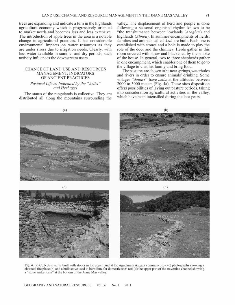
The pastures are chosen to be near springs, waterholes and rivers in order to ensure animals’ drinking. Some villages “douars” have azibs at the altitudes between 2000 to 3000 meters (Fig. 4a). These sites disposition offers possibilities of laying out pasture periods, taking into consideration agricultural activities in the valley, which have been intensified during the late years.
Fig. 4. (a) Collective azibs built with stones in the upper land at the Aguelmam Azegza commune; (b), (c) photographs showing a charcoal fire place (b) and a built stove used to burn lime for domestic uses (c); (d) the upper part of the travertine channel showing a “stone snake form” at the bottom of the Jnane Mas valley.
GEOGRAPHY AND NATURAL RESOURCES Vol. 32 No. 1 2011
92 AKDIM et al.
The pastoral systems of resource management have been influenced by the social evolution of local structures. As in the nearer areas, at the Aïn Leuh Plateau, where the use of ranges was ruled by a calendar respected by all fractions in the past, the Zayane territory is regulated by the common rule. The Jmaa was entrusted with the management of all the pasture lands. It attended to the identification of parcels to be used in the Agdals, to determining rest periods, to the organization of transhumance and to the settlement of intra and inter-tribal conflicts”. Such traditional organisation all over the Middle Atlas is affected by the deterioration of social structures in the region. The Jmaa as a social regulating institution has disappeared and has been reduced to a committee, which consists of the naïb-s of the tribe fractions. “Hence, the role of the naïb has been limited to prolonging state action. He does not intervene in conflict resolution but he is rather an informer of the Caid”. The important number of the “Azib” indicates the big pastoral activity in the area and reveals that livestock bearing is not a simply moving activity but a locally stay for many months. It is reinforced by other socioeconomic activities as indicated by wood coal traces, ovens of lime, artefact industries (water mill engines) and ancient agriculture traces such as terraces and irrigation channels.
Charcoal Fire Places and Lime StovesWood energy has been recently used and is still
important in rural areas. Intense activities were based on such energy in the past. Most recent terrace deposits shows charcoal debris attributed either to charcoal or forest burns. Charcoal fire places are abundant and occasional burn lime stoves are observed on the field (Fig. 4b,4c). More recently, and due mainly to the very low income of rural communities living in the vicinity of the forests, these people, to improve their household’s poor economic situation and meet some of their basic needs, commit illicit tree fallings, more particularly in cedar forests, in order to sell sawn wood and charcoal on the black market.
Ancient Irrigated Agriculture Indicated by Travertine Channels
In the valley Arougou (the rural commune of Moha Ou Hammou Zayani) and the valley of Jnane Mas, in the rural commune of Agulemane Azegza encrusted channels are built showing ancient progress in water management (Table 1) and its ancient uses.
On the main four travertine levels extending in the
Jnane Mas valley, agriculture has been a major activity and is still important at present. The travertine channel shows a “stone snake form” (Fig. 4d), and is about 500 meters in length and 60 cm in height as indicated in table 1. It is largest in the upper part and extended from a water distributing basin.
In both cases (Jnane Mas and Arougou), the channels are constructed to take advantage of the local water regime. Water flowing from Takhabit Nait Aissa spring had been managed on the upper and median travertine terraces for agriculture irrigation in Jnane Mas. In Arougou, the encrusted travertine channel serve irrigation and a water mill that was built in its lower part and which worked until the forties of the last century.
The terraces are located in clusters below, so that a gravity-flow sequence can irrigate the system as a whole through a common channel network. In these spring fed irrigation systems the water descends through channels over 600 meters to one kilometre to attain the farthest plots. Knowledge of the best location and size of both plots and channels is attained by experience.
DISCUSSIONThe human activities in the Moroccan mountain are
ancient as documented by history and studies based on rock engraving [7]. Following the preliminary results of an ongoing archaeological research project in The Middle Atlas, evidence of ancient human settlement is found in several sites between Azrou and Khenifra [8]. Hunter-gathering activities and livestock bearing have been dominant for centuries. Adapted seasonal transhumance regime have been developed to feed the sheep in the pastures of the highland summits “Almou” in summer and in the plains’ herbages “Azaghar” in winter. At the end of the 19th century, nomadic life was reported in the Zayane territory [9]. Most references emphasise the nomad way of life dominating in the area. However, data from the field work (irrigation channels, terraces, etc.) show evidence of a multi-activities socio-spatial system. A complementary resource management system has recently taken place. It has changed over time. The coexistence of different types of land uses in the area is confirmed by the still co-existing diverse types of resource management and human life styles. However, seemingly the land uses appeared in different periods following the global evolution of the mountain context in the Atlas (Table 2).
Most land use types appeared in the last century. The reports on ancient pastoral activities in the Middle Atlas are convergent [6, 10, 11]. It was progressively supported
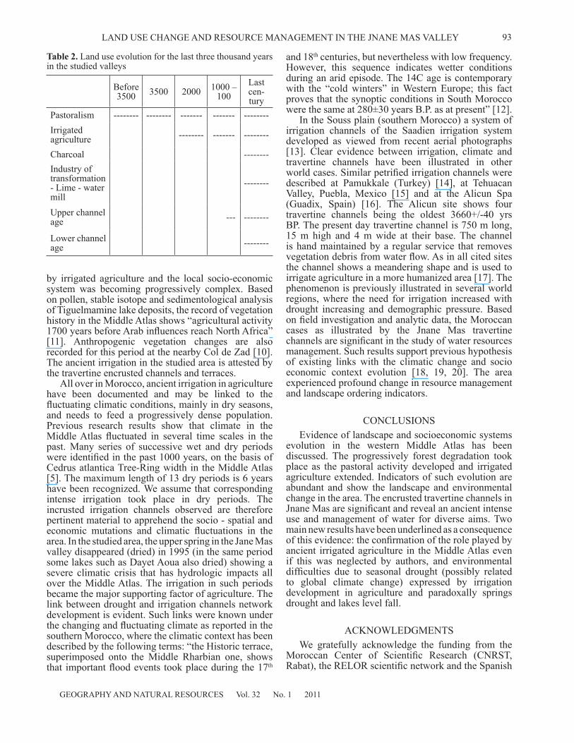
Table 1. General characteristics of the ancient irrigation travertine channels
Latitude Longitude Elevation Length Height Mean WidthChannel 1 Jnane Mas 32.56.14 N 5.28.06 W 1362 m 500 m 60 cm 60 cm to 120 cmChannel 2 Oued Arougou 32.55.28 N 5.32.56 W 1253 m 50 m 180 cm 120 cm
93
GEOGRAPHY AND NATURAL RESOURCES Vol. 32 No. 1 2011
LAND USE CHANGE AND RESOURCE MANAGEMENT IN THE JNANE MAS VALLEY
by irrigated agriculture and the local socio-economic system was becoming progressively complex. Based on pollen, stable isotope and sedimentological analysis of Tiguelmamine lake deposits, the record of vegetation history in the Middle Atlas shows “agricultural activity 1700 years before Arab influences reach North Africa” [11]. Anthropogenic vegetation changes are also recorded for this period at the nearby Col de Zad [10]. The ancient irrigation in the studied area is attested by the travertine encrusted channels and terraces.
All over in Morocco, ancient irrigation in agriculture have been documented and may be linked to the fluctuating climatic conditions, mainly in dry seasons, and needs to feed a progressively dense population. Previous research results show that climate in the Middle Atlas fluctuated in several time scales in the past. Many series of successive wet and dry periods were identified in the past 1000 years, on the basis of Cedrus atlantica Tree-Ring width in the Middle Atlas [5]. The maximum length of 13 dry periods is 6 years have been recognized. We assume that corresponding intense irrigation took place in dry periods. The incrusted irrigation channels observed are therefore pertinent material to apprehend the socio - spatial and economic mutations and climatic fluctuations in the area. In the studied area, the upper spring in the Jane Mas valley disappeared (dried) in 1995 (in the same period some lakes such as Dayet Aoua also dried) showing a severe climatic crisis that has hydrologic impacts all over the Middle Atlas. The irrigation in such periods became the major supporting factor of agriculture. The link between drought and irrigation channels network development is evident. Such links were known under the changing and fluctuating climate as reported in the southern Morocco, where the climatic context has been described by the following terms: “the Historic terrace, superimposed onto the Middle Rharbian one, shows that important flood events took place during the 17th
and 18th centuries, but nevertheless with low frequency. However, this sequence indicates wetter conditions during an arid episode. The 14C age is contemporary with the “cold winters” in Western Europe; this fact proves that the synoptic conditions in South Morocco were the same at 280±30 years B.P. as at present” [12].
In the Souss plain (southern Morocco) a system of irrigation channels of the Saadien irrigation system developed as viewed from recent aerial photographs [13]. Clear evidence between irrigation, climate and travertine channels have been illustrated in other world cases. Similar petrified irrigation channels were described at Pamukkale (Turkey) [14], at Tehuacan Valley, Puebla, Mexico [15] and at the Alicun Spa (Guadix, Spain) [16]. The Alicun site shows four travertine channels being the oldest 3660+/-40 yrs BP. The present day travertine channel is 750 m long, 15 m high and 4 m wide at their base. The channel is hand maintained by a regular service that removes vegetation debris from water flow. As in all cited sites the channel shows a meandering shape and is used to irrigate agriculture in a more humanized area [17]. The phenomenon is previously illustrated in several world regions, where the need for irrigation increased with drought increasing and demographic pressure. Based on field investigation and analytic data, the Moroccan cases as illustrated by the Jnane Mas travertine channels are significant in the study of water resources management. Such results support previous hypothesis of existing links with the climatic change and socio economic context evolution [18, 19, 20]. The area experienced profound change in resource management and landscape ordering indicators.
CONCLUSIONSEvidence of landscape and socioeconomic systems
evolution in the western Middle Atlas has been discussed. The progressively forest degradation took place as the pastoral activity developed and irrigated agriculture extended. Indicators of such evolution are abundant and show the landscape and environmental change in the area. The encrusted travertine channels in Jnane Mas are significant and reveal an ancient intense use and management of water for diverse aims. Two main new results have been underlined as a consequence of this evidence: the confirmation of the role played by ancient irrigated agriculture in the Middle Atlas even if this was neglected by authors, and environmental difficulties due to seasonal drought (possibly related to global climate change) expressed by irrigation development in agriculture and paradoxally springs drought and lakes level fall.
ACKNOWLEDGMENTSWe gratefully acknowledge the funding from the
Moroccan Center of Scientific Research (CNRST, Rabat), the RELOR scientific network and the Spanish
Table 2. Land use evolution for the last three thousand years in the studied valleys
Before 3500 3500 2000 1000 –
100Last cen-tury
Pastoralism -------- -------- ------- ------- --------Irrigated agriculture -------- ------- --------
Charcoal --------Industry of transformation - Lime - water mill
--------
Upper channel age --- --------
Lower channel age --------

GEOGRAPHY AND NATURAL RESOURCES Vol. 32 No. 1 2011
94 AKDIM et al.
Consejo Superior de Investigacion Scientifica (CSIC Barcelona). The University Sidi Mohamed Ben Abdellah (Fez) supported the research project.
We thank professor Abdelhamid Nfissi (English Department, FLS) and anonymous reviewers for carefully reading the manuscript and improving it through their suggestions.
REFERENCES1. Beaudet, G., Les Beni Mguild du Nord. Géographie de
l’Evolution Récente d’une Conféderation Semi Nomade, Rev. Géogr. Maroc., 1969, vol. 15, pp. 153–180.
2. Chilasse, L. and Dakki, M., Potentialités et Statuts de Conservation des Zones Humides du Moyen Atlas (Maroc), Avec Référence Aux Influences de la Sécheresse, Sécheresse, 2004, vol. 15, pp. 337–345.
3. Bencherifa, A., Land Use and Equilibrium of Mountain Ecosystems in the High Atlas of Western Morocco. Mount. Res. Develop., 1983, vol. 3, pp. 273–279.
4. Benabid, A., Forest Degradation in Morocco, In The North African Environment at Risk, Eds. W. D. Swearingen and A. Bencherifa, Boulder, Colorado, West view Press, Inc., 1996, pp. 175–190.
5. Till, C. and Guiot, J., Reconstruction of Precipitation in Morocco Since 1100 AD. Based on Cedrus Atlantica Tree-Ring Widths. Quat. Res., 1990, vol. 33, pp. 337–351.
6. Labhar, M., Les Milieux Forestiers et Pré-forestiers du Moyen-Atlas Central Nord Occidental: Approche Géographique, Phytoécologie et Dynamique: Thèse de Doctorat, Faculté des Sciences, Université Libre de Bruxelles, 1998, 404 p.
7. Ezziani, E.H., Contribution à une Nouvelle Chronologie des Figures Anthropomorphes des Gravures Rupestres du Haut-Atlas (Vallée de l’Ourika, Maroc), L’anthropologie, 2004, vol. 1008, pp.535–563.
8. Découverte d’un Campement Atérien Qui Date de Plus de 50 000 Ans Avant JC, In Terre Maroc, 2005, http://terremaroc.canalblog.com/archives/2005/10/12/888190.html.
9. Foucauld Viconte, Ch., Descovering Morocco (1883-1884). Challamel and Cie Editors, Paris, 1888, 256 p. [In Spanish].
10. Reille, M., Analyse Pollinique des Sediments
Postglaciares Dans le Moyen Atlas et le Haut Atlas Marocains: Premiers, Ecol. Mediterranea, 1976, n. 2, pp. 153–170.
11. Lamb, H.F., Eicher, U., and Switsur, V.R., An 18000 Year Record of Vegetation, Lake Level and Climatic Change From Tigalmamine, Middle Atlas, Morocco, J. Biogeo, 1989, vol. 16, pp. 65–74.
12. Mathieu, J., Weisrock, A., Wengler, L., Brochier J.-E., Even G., Fontugne M., Mercier N., Ouammou A., Senegas F., Valladas H., Vernet J.-L., and Wahl L., Les Dépôts Holocènes de la Basse Vallée de l’Oued Assaka, Sud-Maroc: Résultats Préliminaires, Quaternaire, 2002, vol. 13, pp. 207–218.
13. Ait Hsein, A. and Humbert, A., The Saadian Irrigation System as Viewed From Recent Aerial Photographs. Results of the Research Project Led in the Framework of the Moroccan-French Cooperation Program: Photographs edited in CD, 2001, University Nancy 2 and University Ibn Zohr Agadir.
14. Altunel, E. and Hancock, P.L., Morphology and Structural Setting of Quaternary Travertine of Pamukkale, Turkey, Geol. J., 1993, vol. 28, pp. 335–346.
15. Winsborough, B.M., Caran, S.Ch, Neely, J.A., Valastro, S.Jr., Calcified Microbial Mats Date Prehistoric Canals-Radiocarbon Assay of Organic Extracts from Travertine. Geoarchaeology, 1996, vol. 11, pp. 37–50.
16. Díaz-Hernández, J.L., Martín, M., Juliá, R., Carbonate Deposition Rates in Neolithic Channels Linked to Alicún Thermal Waters (Granada, Spain). In Karst and Environment, Eds. F. Carrasco, J.J. Durán, B. Andreo, 2002, pp. 477–483.
17. Bencherifa, A., Demography and Cultural Ecology of the Atlas Mountains of Morocco: Some New Hypotheses, Mount. Res.Dev., 1988, vol. 8, pp. 309–313.
18. Dougherty, W.W., Linkages Between Energy, Environment and Society in the High Atlas Mountains of Morocco, Mount. Res. Dev., 1994, vol. 14, pp. 119–135.
19. El Khalky, Y., Les Systèmes Hydrologiques Karstiques des Plateaux Sud-ouest du Moyen Atlas: études Hydrologiques et Hydrochimiques (Aïn Leuh, Ajdir El Hammam et Sources Oum Rbia), Thesis, FLSH, Bni Mellal, 2001, 218 p.
20. Flower, R. and Foster, I.D.L., Climatic implications of recent changes in lake level at Lac Azegza (Morocco), Bull. Soc. Géol. Fr., 1992, vol. 1, pp. 92–96.