Land Suitability Analysis for Mangrove Restoration in Muara ...
8
GSJ: Volume 8, Issue 8, August 2020, Online: ISSN 2320-9186 www.globalscientificjournal.com Land Suitability Analysis for Mangrove Restoration in Muara Gembong District, Bekasi Regency, West Java, Indonesia Asep Sahidin 1,2 , Zahidah 1 , Yayat Dhahiyat 1 , Perdana Putra Kelana 3 , M Fiqi F 4 1 Department of Fisheries, Fisheries and Marine Science Faculty, Padjadjaran University, Bandung, Indonesia. email: *[email protected] , [email protected] 2 Laboratory of Aquatic resources, Fisheries and Marine Science, Universitas Padjadjaran, Bandung, Indonesia. 3 Dumai Marine and Fisheries Polytechnic, Riau Indonesia. **[email protected] 4 Study program of Remote Sensing technology, Indonesian Defense University, Bogor ABSTRACT Muara Gembong Subdistrict is home for widely known destructed mangrove ecosystem with annual loss of 1000 ha. This Research aimed to analyzed suitability of mangrove rehabilitation in Muara Gembong, Bekasi Regency. The method used were GIS and survey for spatial analysis at two stations. The Parameters measured such as water temperature, salinity, Substrate, bathimetry or topography, and mangrove species. Four suitability criteria, very suitable, suitable, conditionally suitable and unsuitable were used to determine the suitability of mangrove rehabilitation. The results show both station area were very suitable for mangrove rehabilitation. Keywords: Mangrove, Muara Gembong, Suitablity, Rehabilitation INTRODUCTION Despite being degraded each year, the total amount of mangrove forest in coastal area of Indonesia is still regarded as the largest in the world. Approximately 23% of world’s mangrove ecosystem, inhabitat in Indonesia which equals to 3,79 millions hectare [1]. Majority of its degradation is attributed to massive land conversion to aquaculture, cities development including urban and tourism site as well as uncontrolled and unregulated wood logging [2,3]. Data recorded from 2000 to 2014 revealed that Indonesia is the largest GSJ: Volume 8, Issue 8, August 2020 ISSN 2320-9186 351 GSJ© 2020 www.globalscientificjournal.com
-
Upload
khangminh22 -
Category
Documents
-
view
0 -
download
0
Transcript of Land Suitability Analysis for Mangrove Restoration in Muara ...

GSJ: Volume 8, Issue 8, August 2020, Online: ISSN 2320-9186
www.globalscientificjournal.com
Land Suitability Analysis for Mangrove Restoration in Muara Gembong District, Bekasi Regency, West Java, Indonesia Asep Sahidin1,2, Zahidah1, Yayat Dhahiyat1, Perdana Putra Kelana3, M Fiqi F4
1Department of Fisheries, Fisheries and Marine Science Faculty, Padjadjaran University, Bandung, Indonesia. email: *[email protected], [email protected] 2Laboratory of Aquatic resources, Fisheries and Marine Science, Universitas Padjadjaran, Bandung, Indonesia. 3Dumai Marine and Fisheries Polytechnic, Riau Indonesia. **[email protected] 4Study program of Remote Sensing technology, Indonesian Defense University, Bogor
ABSTRACT Muara Gembong Subdistrict is home for widely known destructed mangrove ecosystem with annual loss of 1000 ha. This Research aimed to analyzed suitability of mangrove rehabilitation in Muara Gembong, Bekasi Regency. The method used were GIS and survey for spatial analysis at two stations. The Parameters measured such as water temperature, salinity, Substrate, bathimetry or topography, and mangrove species. Four suitability criteria, very suitable, suitable, conditionally suitable and unsuitable were used to determine the suitability of mangrove rehabilitation. The results show both station area were very suitable for mangrove rehabilitation. Keywords: Mangrove, Muara Gembong, Suitablity, Rehabilitation
INTRODUCTION
Despite being degraded each year, the total amount of mangrove forest in coastal area of Indonesia is still regarded as the largest in the world. Approximately 23% of world’s mangrove ecosystem, inhabitat in Indonesia which equals to 3,79 millions hectare [1]. Majority of its degradation is attributed to massive land conversion to aquaculture, cities development including urban and tourism site as well as uncontrolled and unregulated wood logging [2,3]. Data recorded from 2000 to 2014 revealed that Indonesia is the largest
GSJ: Volume 8, Issue 8, August 2020 ISSN 2320-9186 351
GSJ© 2020 www.globalscientificjournal.com
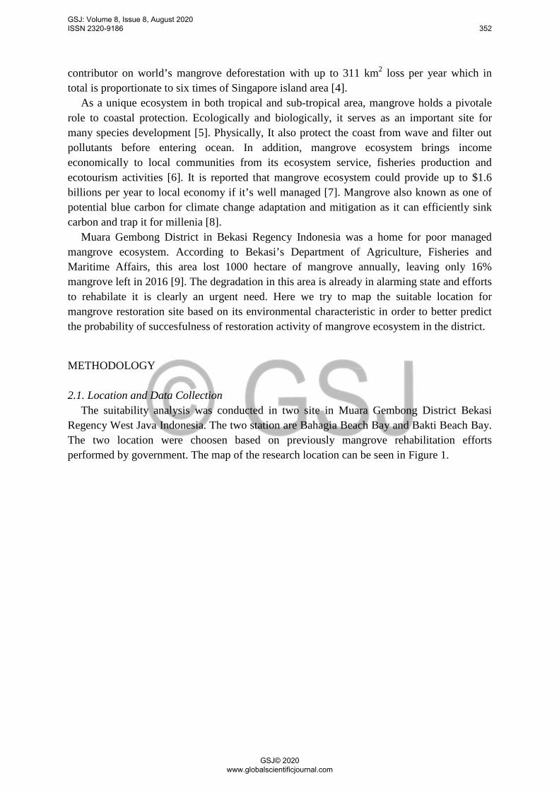
contributor on world’s mangrove deforestation with up to 311 km2 loss per year which in total is proportionate to six times of Singapore island area [4].
As a unique ecosystem in both tropical and sub-tropical area, mangrove holds a pivotale role to coastal protection. Ecologically and biologically, it serves as an important site for many species development [5]. Physically, It also protect the coast from wave and filter out pollutants before entering ocean. In addition, mangrove ecosystem brings income economically to local communities from its ecosystem service, fisheries production and ecotourism activities [6]. It is reported that mangrove ecosystem could provide up to $1.6 billions per year to local economy if it’s well managed [7]. Mangrove also known as one of potential blue carbon for climate change adaptation and mitigation as it can efficiently sink carbon and trap it for millenia [8].
Muara Gembong District in Bekasi Regency Indonesia was a home for poor managed mangrove ecosystem. According to Bekasi’s Department of Agriculture, Fisheries and Maritime Affairs, this area lost 1000 hectare of mangrove annually, leaving only 16% mangrove left in 2016 [9]. The degradation in this area is already in alarming state and efforts to rehabilate it is clearly an urgent need. Here we try to map the suitable location for mangrove restoration site based on its environmental characteristic in order to better predict the probability of succesfulness of restoration activity of mangrove ecosystem in the district.
METHODOLOGY 2.1. Location and Data Collection
The suitability analysis was conducted in two site in Muara Gembong District Bekasi Regency West Java Indonesia. The two station are Bahagia Beach Bay and Bakti Beach Bay. The two location were choosen based on previously mangrove rehabilitation efforts performed by government. The map of the research location can be seen in Figure 1.
GSJ: Volume 8, Issue 8, August 2020 ISSN 2320-9186 352
GSJ© 2020 www.globalscientificjournal.com

Figure 1. Research Station Location at Muara Gembong District
The research was performed in two different stages which include data collection on site and spatial data analysis for map generation. The primary data comprises with environmental parameter and water quality data that are significantly affecting mangrove. Secondary data obtained from misclenaous resources consisting land topographycall characteristic, land elevation and substrate type. Type and source of data used in this research can be seen in table 1.
Table 1. Type and Sources of Data
No Parameter Unit Tools Measurement Method
References
1 Land Elevation % GPS In Situ [10] 2 Number and
Mangrove Species
- - In Situ
3 Substrate Type Ekman Grab and Shovel Segitiga Tekstur [11]
4 Salinity Ppt Refractometer In Situ [12] 5 Temperature °c Thermometer In Situ
1.2. Land Suitability Analysis Land suitability analysis for mangrove restoration was based on environmental and water
quality data which meet the minimun requirement to support mangrove physiological development. The analysis consisted of four categorized, very suitable (S1), suitable (S2), conditionally suitable (S3) and unsuitable (N). Requirement for each criteria is based on Iman [13] and can be seen in table 2.
GSJ: Volume 8, Issue 8, August 2020 ISSN 2320-9186 353
GSJ© 2020 www.globalscientificjournal.com

Tabel 1. Mangrove Land Suitability Criteria No Parameter
Very Suitable
(S1)
Suitable (S2)
Conditionally Suitable (S3)
Unsuitable (N) Ref.
1 Land Elevation (m) 0-0,05 0,05-0,55 0,55-0,78 <0 [14]
2 Number and Mangrove Species >5 2-4 1 0 [15]
3 Substrate Silt-Clay Fine sand Medium sand - coarse sand Gravel [16] 4 Salinity(ppt) 20-30 10-20 30-37 <9 ; >38 [17] 5 Temperature (°c) 26-28 21-26 18-20 <18 ; >28
Parameters that can provide a stronger influence as a limiting factor for mangrove rehabilitation techniques are given higher weight. To get the weight value of each parameter used equation as shown below and the results of the weighting and score values can be seen in Table 3.
𝑊𝑊𝑊𝑊 = 𝑛𝑛 − 𝑟𝑟𝑊𝑊 + 1
∑(𝑛𝑛 − 𝑟𝑟𝑟𝑟 + 1)
With: Wj: Parameter Weight n : Number of Parameter rj : Rank rp : Parameter
Table 2. Mangrove Land Rehabilitation Suitability Matrix No Parameter Weight Category Criteria Scale Score
1 Land Elevation (m) 0,33
0-0,05 Very Suitable 4 1,32 0,05-0,55 Suitable 3 0,99 0,55-0,78 Conditionally Suitable 2 0,66 <0 ; >0,78 Unsuitable 1 0,33
2
Number and Mangrove Species 0,27
>5 Very Suitable 4 1,08 2-4 Suitable 3 0,81 1 Conditionally Suitable 2 0,54 0 Unsuitable 1 0,27
3 Substrate 0,2
Silt-Clay Very Suitable 4 0,8 Fine Sand Suitable 3 0,6 Medium-Coarse Conditionally Suitable 2 0,4 Gravel Unsuitable 1 0,2
4
Salinity (ppt) 0,13
20-30 Very Suitable 4 0,52 10-22 Suitable 3 0,39 30-37 Conditionally Suitable 2 0,26 <10 ; >38 Unsuitable 1 0,13
5 Temperature (°c) 0,07
26-28 Very Suitable 4 0,28 21-26 Suitable 3 0,21 18-20 Conditionally Suitable 2 0,14 <18 ; >28 Unsuitable 1 0,07
Assessment to determine the suitability of mangrove rehabilitation land based on the
score of each parameter is calculated using the following equation
𝐸𝐸𝐸𝐸𝐸𝐸𝐸𝐸𝐸𝐸𝐸𝐸𝐸𝐸𝐸𝐸𝐸𝐸𝑛𝑛 𝑆𝑆𝑆𝑆𝐸𝐸𝑟𝑟𝑆𝑆 𝑉𝑉𝐸𝐸𝐸𝐸𝐸𝐸𝑆𝑆 = 𝑇𝑇𝐸𝐸𝐸𝐸𝐸𝐸𝐸𝐸 𝑠𝑠𝑆𝑆𝐸𝐸𝑟𝑟𝑆𝑆 𝐸𝐸𝑛𝑛 𝐸𝐸𝐸𝐸𝑆𝑆𝐸𝐸𝐸𝐸𝐸𝐸𝐸𝐸𝑛𝑛
𝐻𝐻𝐸𝐸𝐻𝐻ℎ𝑆𝑆𝑠𝑠𝐸𝐸 𝑠𝑠𝑆𝑆𝐸𝐸𝑟𝑟𝑆𝑆× 100%
In accordance to that, the determination of categories can be decided based on the percentage of land suitability intervals as shown in Table 4.
GSJ: Volume 8, Issue 8, August 2020 ISSN 2320-9186 354
GSJ© 2020 www.globalscientificjournal.com
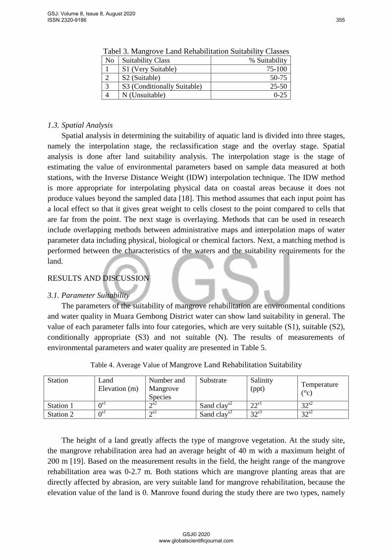
Tabel 3. Mangrove Land Rehabilitation Suitability Classes No Suitability Class % Suitability 1 S1 (Very Suitable) 75-100 2 S2 (Suitable) 50-75 3 S3 (Conditionally Suitable) 25-50 4 N (Unsuitable) 0-25
1.3. Spatial Analysis Spatial analysis in determining the suitability of aquatic land is divided into three stages,
namely the interpolation stage, the reclassification stage and the overlay stage. Spatial analysis is done after land suitability analysis. The interpolation stage is the stage of estimating the value of environmental parameters based on sample data measured at both stations, with the Inverse Distance Weight (IDW) interpolation technique. The IDW method is more appropriate for interpolating physical data on coastal areas because it does not produce values beyond the sampled data [18]. This method assumes that each input point has a local effect so that it gives great weight to cells closest to the point compared to cells that are far from the point. The next stage is overlaying. Methods that can be used in research include overlapping methods between administrative maps and interpolation maps of water parameter data including physical, biological or chemical factors. Next, a matching method is performed between the characteristics of the waters and the suitability requirements for the land.
RESULTS AND DISCUSSION
3.1. Parameter Suitability The parameters of the suitability of mangrove rehabilitation are environmental conditions
and water quality in Muara Gembong District water can show land suitability in general. The value of each parameter falls into four categories, which are very suitable (S1), suitable (S2), conditionally appropriate (S3) and not suitable (N). The results of measurements of environmental parameters and water quality are presented in Table 5.
Table 4. Average Value of Mangrove Land Rehabilitation Suitability
Station Land Elevation (m)
Number and Mangrove Species
Substrate Salinity (ppt) Temperature
(°c)
Station 1 0s1 2s2 Sand clays2 22s1 32s2 Station 2 0s1 2s2 Sand clays2 32s3 32s2
The height of a land greatly affects the type of mangrove vegetation. At the study site, the mangrove rehabilitation area had an average height of 40 m with a maximum height of 200 m [19]. Based on the measurement results in the field, the height range of the mangrove rehabilitation area was 0-2.7 m. Both stations which are mangrove planting areas that are directly affected by abrasion, are very suitable land for mangrove rehabilitation, because the elevation value of the land is 0. Manrove found during the study there are two types, namely
GSJ: Volume 8, Issue 8, August 2020 ISSN 2320-9186 355
GSJ© 2020 www.globalscientificjournal.com
Pidada (Sonneratia alba) and Rhizophora mucronata. According to Muharam [20] mangroves of the genus Rhizophora are the most widely planted mangroves during rehabilitation, because they are easy to breed and adapt well to the environment.
The type of substrate is one of the determining factors for the success of a mangrove rehabilitation effort. Most mangrove species grow well in muddy soils rather than sandy or rocky soils. At the study site, the substrate found was sandy loam and silt. Clay and silt are fine substrate fractions that can form mud. The types of mangroves used for planting activities in the Muara Gembong District area are Rhizophora mucronata. According to Kelana et al [21] species of Rhizophora mucronata often found in areas with muddy substrates and rich in nutrients. Based on the research results obtained, this parameter is included in the category of very appropriate and quite appropriate.
Salinity is one of the factors that determine the development of mangroves, therefore, the zonation of each mangrove habitat is always different according to local environmental conditions. Salinity at the study site ranged from 22 to 32 ppt. According to Jesus [22] Mangroves can survive in the range of 31-34 ppt if they are in a zone directly facing the sea. Prominent habitat characteristics in the area of mangrove ecosystems, forming mangrove zoning, mangroves can survive from the front zone near the sea to the zone far from the sea with a range of salinity in the water that wet the zone between 2-22 ppt. Based on this, the station in general research into the very appropriate category to conditionally suitable. While for temperature, ranges at each research station in Muara District is in accordance with the existing mangrove habitat conditions. The temperature range depends on the density and cover of the mangrove canopy at the observation station during the day, which is in the range of 32⁰C.
1.4. Mangrove Rehabilitation Land Suitablity
The value of each parameter is then assessed based on the land suitability matrix that has been made. The results of the assessment and percentage of suitability showed that the Muara Gembong sub-district was categorized as very suitable (S1) and quite appropriate (S2) for mangrove rehabilitation land. The suitability of mangrove rehabilitation land in detail can be seen in Table 6.
Table 6. Index values and suitability classes for mangrove rehabilitation Results Station Suitability Value (%) Suitability Class
1 83% Suitable (s2) 2 76,5% Suitable (s2)
1.5. Analysis of Spatial Mangrove Rehabilitation
Based on the suitability value of each of the above parameters and based on the results of the overlay that has been done, a water suitability map is obtained (Figure 2). Spatial analysis results show that in Muara Gembong Subdistrict, particulary in the two research location, is wholefully suitable for mangrove rehabilitation,. the quite appropriate category has a land area of 180,74 ha.
GSJ: Volume 8, Issue 8, August 2020 ISSN 2320-9186 356
GSJ© 2020 www.globalscientificjournal.com
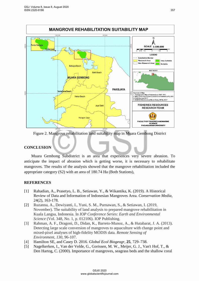
Figure 2. Mangrove rehabilitation land suitability map in Muara Gembong District
CONCLUSION
Muara Gembong Subdistrict is an area that experiences very severe abrasion. To anticipate the impact of abrasion which is getting worse, it is necessary to rehabilitate mangroves. The results of the analysis showed that the mangrove rehabilitation included the appropriate category (S2) with an area of 180.74 Ha (Both Stations),
REFERENCES
[1] Rahadian, A., Prasetyo, L. B., Setiawan, Y., & Wikantika, K. (2019). A Historical Review of Data and Information of Indonesian Mangroves Area. Conservation Media, 24(2), 163-178.
[2] Ruzanna, A., Dewiyanti, I., Yuni, S. M., Purnawan, S., & Setiawan, I. (2019, November). The suitability of land analysis to prepared mangrove rehabilitation in Kuala Langsa, Indonesia. In IOP Conference Series: Earth and Environmental Science (Vol. 348, No. 1, p. 012106). IOP Publishing.
[3] Rahman, A. F., Dragoni, D., Didan, K., Barreto-Munoz, A., & Hutabarat, J. A. (2013). Detecting large scale conversion of mangroves to aquaculture with change point and mixed-pixel analyses of high-fidelity MODIS data. Remote Sensing of Environment, 130, 96-107.
[4] Hamilton SE, and Casey D. 2016. Global Ecol Biogeogr, 25, 729–738. [5] Nagelkerken, I., Van der Velde, G., Gorissen, M. W., Meijer, G. J., Van't Hof, T., &
Den Hartog, C. (2000). Importance of mangroves, seagrass beds and the shallow coral
GSJ: Volume 8, Issue 8, August 2020 ISSN 2320-9186 357
GSJ© 2020 www.globalscientificjournal.com

reef as a nursery for important coral reef fishes, using a visual census technique. Estuarine, coastal and shelf science, 51(1), 31-44.
[6] Glaser, M. (2003). Interrelations between mangrove ecosystem, local economy and social sustainability in Caeté Estuary, North Brazil. Wetlands Ecology and Management, 11(4), 265-272.
[7] Duke, N. C., Meynecke, J. O., Dittmann, S., Ellison, A. M., Anger, K., Berger, U., ... & Koedam, N. (2007). A world without mangroves?. Science, 317(5834), 41-42.
[8] Taillardat, P., Friess, D. A., & Lupascu, M. (2018). Mangrove blue carbon strategies for climate change mitigation are most effective at the national scale. Biology letters, 14(10), 20180251.
[9] Pribadi R, Khakim A, and Nurdianto F. 2016. Structure and Composition of Mangrove Vegetation in Pantai Mekar Village and Harapan Jaya Village, Muara Gembong District, Bekasi Regency, West Java Province. Proceedings of the Application of Fisheries and Marine Sciences in the Management of Disaster Mitigation and Degradation of Coastal Areas and Small Islands. 4th Annual Seminar on Fisheries and Marine Research Results. ISSN: 2339-0883.
[10] Hadi, S., Syahrudin, S., & Kusumawardani, R. (2019, February). Metadata for Utilization of Geospatial Data and Information Certainty in the Arrangement of Spatial Planning. In National Seminar Geomatika (Vol. 3, pp. 725-734).
[11] Setiawan, A. (2007). Introduction to Oceanographycal Data. Indonesia Journal of Hydrosphere, 2(2).
[12] American Public Health Association. (2005). APHA (2005) Standard methods for the examination of water and wastewater. APHA Washington DC, USA.
[13] Iman, A. N., 2014. Land suitability for mangrove rehabilitation planning with elevation analysis approach in Kuri Caddi Maros Regency - Thesis. Makassar: Faculty of Marine and Fisheries Sciences, Hasanudin University.
[14] Brown, B. 2006. 5 Tahap Rehabilitasi Mangrove, Mangrove Action Project dan Indonesian Seaweed Root Foundation, Yogyakarta, Indonesia.
[15] Dahuri, R. (2003). Marine biodiversity: Indonesia's sustainable development assets. Gramedia Pustaka Utama.
[16] Barkey, R. 1990. Mangrove of South Sulawesi (Structure, Function and 13 Degradation Rates, Proceedings of the seminar on Integration Between Conservation and Wetlands Use in South Sulawesi. LIPI South Sulawesi Government.
[17] Kusmana, C. 1995. Plant Diversity Measurement Techniques. Training in Biodiversity Measurement and Monitoring Techniques in Indonesian Tropical Forests. Bogor: Department of Forest Resource Conservation. Faculty of Forestry. Bogor Agricultural Institute.
[18] Lu, G. Y., & Wong, D. W. (2008). An adaptive inverse-distance weighting spatial interpolation technique. Computers & geosciences, 34(9), 1044-1055.
[19] Zulfikar, A. et al., 2016. Assesment and suitability analysis of mangrove rehabilitation at Temburun Village. Kepulauan Riau: PPSPL Universitas Maritim Raja Ali Haji.
[20] Muharam, M. (2014). Mangrove Planting as One of The Land and Environmental Rehabilitation Efforts In The North Coast Area of Karawang District.
[21] Kelana, P. P., Setyobudiandi, I. & Krisanti, M., 2015. Conditions of hanitate and polymesoda erosa in the mangrove ecosystem area of the Sancang Forest Nature Reserve. Jurnal Akuatika, VI(2), pp. 107-117.
[21] Jesus, A. d., 2012. The condition of the mangrove ecosystem in the Liquisa sub-district of Timor-Leste. Depik, 1(3), pp. 136-143.
GSJ: Volume 8, Issue 8, August 2020 ISSN 2320-9186 358
GSJ© 2020 www.globalscientificjournal.com