land acquisition and the growth of informal settlements
315
LAND ACQUISITION AND THE GROWTH OF INFORMAL SETTLEMENTS IN SOUTH AFRICA: THE CASE OF INFORMAL SETTLEMENTS IN MAMELODI, CITY OF TSHWANE, 1994 – 2014 APHIWE MGUSHELO 2018
-
Upload
khangminh22 -
Category
Documents
-
view
3 -
download
0
Transcript of land acquisition and the growth of informal settlements

LAND ACQUISITION AND THE GROWTH OF INFORMAL SETTLEMENTS
IN SOUTH AFRICA: THE CASE OF INFORMAL SETTLEMENTS IN
MAMELODI, CITY OF TSHWANE, 1994 – 2014
APHIWE MGUSHELO
2018

LAND ACQUISITION AND THE GROWTH OF INFORMAL SETTLEMENTS
IN SOUTH AFRICA: THE CASE OF INFORMAL SETTLEMENTS IN
MAMELODI, CITY OF TSHWANE, 1994 – 2014
A dissertation
By
Aphiwe Mgushelo
Supervisor: Dr Daniel Darkey
In fulfilment of the requirements for the degree of
MASTER OF ARTS IN GEOGRAPHY
In the Faculty of Humanities, through the Department of Geography, Geoinformatics
and Meteorology
University of Pretoria Tshwane, South Africa
April 2018
i
DECLARATION OF ORIGINALITY
I, Aphiwe Mgushelo (student number: 16299061), hereby declare that this dissertation: Land acquisition and the growth of informal settlements in South Africa: the case of informal settlements in Mamelodi, City of Tshwane, 1994-2014, for the degree of Master of Arts in
Geography is my own work. This dissertation has not previously been submitted for
assessment or completion of any qualification anywhere. All the sources that I have used or
quoted have been indicated and acknowledged by means of complete reference.
19/01/2018
Signature Date

ii
DEDICATION AND ACKNOWLEDGEMENT
We dedicate this dissertation to God. To God be the Glory.
This dissertation would not have materialised without the help, encouragement, support and
contribution of a number of people and institutions:
• I would like to express my deepest gratitude towards my supervisor Dr Daniel (Dan)
Darkey. Thank you for your support and guidance, as a well as your patience throughout
the research period; for the General Studentship bursary which was very useful in the
completion of data collection. I have also not forgotten the 2016 SSAG conference funding
and more. Moreover, I am grateful for your prayers and supplications. Meda w’ase se.
• Thanks to Dr Nerhene Davis for helping us with the research proposal to an extent that it
was accepted. Thank you also, for referring me to your highly recommended student,
Holiday Kgati Modipi, who assisted me to complete the interviews.
• I am deeply indebted to you Holiday, thank you mfowethu. Thanks also to you Sybol
Mohaswa for voluntarily helping to us with pre-testing the interview survey.
• Thank you to the Mamelodi community of informal settlement dwellers for allowing us to
conduct interviews with them in their shacks. Thanks to Ms Metse Mabeba (City of
Tshwane (CoT): Director of Human Settlement Planning), and all the ward councillors and
community leaders for opening your doors and sharing your insights with us.
• I also particularly thank the following institutions: the Housing and Development Agency
(HDA, Gauteng), and CoT: Department of Human Settlements for land and human
settlement data; the South African Revenue Service, and particularly Charnel Charles, my
Line Manager, for her support; the University of Pretoria for awarding me the UP
Postgraduate Masters Research Bursary for the 2017 academic year.
• I would like to express my gratitude to: Thabitha Sebeyi from the HDA for the land audit
and use data; Mrs Ingrid Booysen for the maps and aerial photographs; Madodomzi
Mafanya and Katlego Kgabo for an introductory instruction in mapping and remote
sensing; and Bongiwe Tshabalala for assisting with Landsat imagery analysis.
• Thank you sis’ Lunga Ngcongo, ‘Chief Administrator’, for your support.
• Thanks to Mrs Jolene Schaefer and Simoné Ferreira for the edit (see Annexure 1).
• Thanks to all of my parents. I thank God for them; my biological father, MK Mgushelo and
mother, NV Mhlakaza, for giving birth to me and raising me. Uyimbokodo MaNkala. Dr
Lujabe “Makhulu” for an academic seed and inspiration. Mr and Mrs Ngalimani. Your
prayers have been steadfast and your support unwavering.
• To my brothers and sisters. You have encouraged and supported me. I am grateful.
iii
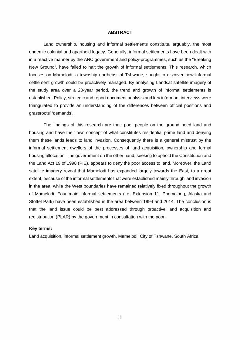
ABSTRACT
Land ownership, housing and informal settlements constitute, arguably, the most
endemic colonial and apartheid legacy. Generally, informal settlements have been dealt with
in a reactive manner by the ANC government and policy-programmes, such as the “Breaking
New Ground”, have failed to halt the growth of informal settlements. This research, which
focuses on Mamelodi, a township northeast of Tshwane, sought to discover how informal
settlement growth could be proactively managed. By analysing Landsat satellite imagery of
the study area over a 20-year period, the trend and growth of informal settlements is
established. Policy, strategic and report document analysis and key informant interviews were
triangulated to provide an understanding of the differences between official positions and
grassroots’ ‘demands’.
The findings of this research are that: poor people on the ground need land and
housing and have their own concept of what constitutes residential prime land and denying
them these lands leads to land invasion. Consequently there is a general mistrust by the
informal settlement dwellers of the processes of land acquisition, ownership and formal
housing allocation. The government on the other hand, seeking to uphold the Constitution and
the Land Act 19 of 1998 (PIE), appears to deny the poor access to land. Moreover, the Land
satellite imagery reveal that Mamelodi has expanded largely towards the East, to a great
extent, because of the informal settlements that were established mainly through land invasion
in the area, while the West boundaries have remained relatively fixed throughout the growth
of Mamelodi. Four main informal settlements (i.e. Extension 11, Phomolong, Alaska and
Stoffel Park) have been established in the area between 1994 and 2014. The conclusion is
that the land issue could be best addressed through proactive land acquisition and
redistribution (PLAR) by the government in consultation with the poor.
Key terms: Land acquisition, informal settlement growth, Mamelodi, City of Tshwane, South Africa

iv
TABLE OF CONTENTS
DECLARATION OF ORIGINALITY ........................................................................................ i
DEDICATION AND ACKNOWLEDGEMENT .........................................................................ii
ABSTRACT ........................................................................................................................... iii
LIST OF TABLES .................................................................................................................. vi
LIST OF FIGURES .............................................................................................................. vii
LIST OF FREQUENTLY USED ABBREVIATIONS ............................................................... xi
CHAPTER 1: INTRODUCTION ............................................................................................. 1
1.1. Introduction and background to the study ............................................................... 1
1.1.1. Definition of key terms ..................................................................................... 2
1.1.2. Conceptualising land management .................................................................. 6
1.2. Research context: background and problem statement ........................................ 12
1.2.1. Background to the problem statement............................................................ 12
1.2.2. Problem statement ......................................................................................... 16
1.3. Purpose of the research ........................................................................................ 21
1.3.1. Primary objective ........................................................................................... 21
1.3.2. Research question ......................................................................................... 21
1.3.3. Study area and scope of the study ................................................................. 22
1.3.4. Limitation of the study .................................................................................... 22
1.3.5. Significance of the study ................................................................................ 22
1.4. Dissertation outline ............................................................................................... 24
CHAPTER 2: LAND, HOUSING AND INFORMAL SETTLEMENTS .................................... 26
2.1. Introduction ........................................................................................................... 26
2.2. Global overview of informal settlements ................................................................ 27
2.3. Informal settlements in South Africa ...................................................................... 29
2.3.1. Emergence of informal settlements: a land dispossession narrative .............. 29
2.3.2. The state of housing and informal settlements in SA, 1994 – 2014 ................ 45
2.4. Land acquisition and the growth of informal settlements in South Africa: the ........... struggle for re-possession, 1994 – present ........................................................... 60
2.4.1. Land acquisition processes, failure and consequences .................................. 61
2.5. The need for proactive land acquisition and redistribution in South Africa ............. 94
2.6. Land re-possession lessons from other post-colonial societies: Zimbabwe and Namibia ................................................................................................................ 98

v
2.6.1. Introduction to land reform and rationale for taking lessons from Zimbabwe ..... and Namibia .................................................................................................. 98
2.6.2. Post-independence land reform experience in Zimbabwe ............................ 101
2.6.3. Post-independence land reform experience in Namibia ............................... 111
2.6.4. Final comments and observations on Zimbabwe and Namibia experiences . 118
2.7. Summary ............................................................................................................ 125
CHAPTER 3: RESEARCH METHODOLOGY ................................................................... 126
3.1. Introduction ......................................................................................................... 126
3.2. Research methodology ....................................................................................... 126
3.2.1. Research strategy ........................................................................................ 127
3.2.2. Research Paradigm ..................................................................................... 129
3.2.3. Data collection challenges and limitations of the study ................................. 142
3.2.4. Ethical considerations .................................................................................. 144
3.2.5. Data analysis ............................................................................................... 144
3.3. Summary ............................................................................................................ 145
CHAPTER 4: THE CASE OF INFORMAL SETTLEMENTS IN MAMELODI, 1994 – 2014 146
4.1. Introduction ......................................................................................................... 146
4.1.1. Mamelodi in context - history to present ....................................................... 146
4.2. Two decades of Informal settlement growth in Mamelodi in satellite imagery ...... 151
4.3. Presentation and discussion of data collected from key informant ...................... 158
4.4. Documentary data review and discussion of findings .......................................... 205
4.4.1. Mamelodi and informal settlement growth .................................................... 205
4.4.2. Prevalence of informal settlements in Mamelodi .......................................... 210
4.4.3. Land audit – who owns the land in Mamelodi? ............................................. 211
4.4.4. Land use ...................................................................................................... 214
4.4.5. City of Tshwane sustainable human settlement strategy ................................... (IDP housing chapter): of relevance and interest to the study ...................... 216
4.5. Summary ............................................................................................................ 236
CHAPTER 5: SUMMARY, CONCLUSION AND RECOMMENDATIONS .......................... 237
5.1. Introduction ......................................................................................................... 237
5.2. Summary and conclusion .................................................................................... 237
5.3. Recommendations .............................................................................................. 245
5.3.1. Recommendations for further/future research .............................................. 249
LIST OF REFERENCES ................................................................................................... 250

vi
LIST OF ANNEXURES ..................................................................................................... 288
Annexure 1: Letter for proof of dissertation edit ............................................................. 288
Annexure 2: Research ethics clearance ........................................................................ 289
Annexure 3: Permission to conduct research in the City of Tshwane ............................. 290
Annexure 4: Consent forms ........................................................................................... 291
Annexure 5: Interview survey ........................................................................................ 293
LIST OF TABLES
TABLE 1: Formal and informal land acquisition processes.………………………………..9
TABLE 2: Definitions of proactive……………………………………………………………11
TABLE 3: Housing backlog in selected major metropolitans/cities……………………….49
TABLE 4: Major inter-provincial migration in South Africa, 2001 - 2011………………...56
TABLE 5: Extent of state and private land in South Africa………………………………..64
TABLE 6: Key informants…………………………………………………………………… 133
TABLE 7: Pretoria’s housing and basic services situation by 1994……………………. 147
TABLE 8: Selected common views of respondents on Land Expropriation by government………………………………………………………………………. 199
TABLE 9: Distribution of population in the GPMA………………………………………...205
TABLE 10: Number of Informal Units per CoT Region, 2006, 2009, 2011 and 2013…. 217
TABLE 11: Region 6 – Study Site – historic growth of informal counts, 2006 – 2013….220
TABLE 12: Number of shacks and Informal settlements Growth…………………………221
TABLE 13: City of Tshwane housing demand……………………………………………... 223
TABLE 14: Land acquisition and selected informal settlements in Mamelodi………….. 243
vii
LIST OF FIGURES
FIGURE 1: Urban land acquisition, allocation and redistribution processes..……………...9
FIGURE 2: The former Homelands, and current provinces and major cities in South Africa ………………………………………………………………………………............39
FIGURE 3: The apartheid city spatial structure………………………………………………42
FIGURE 4: Re-blocked Lwandle informal settlement (left) and Alexandra Township sprawl (right) highlighted in yellow……………………………………………….44
FIGURE 5: Decline in national housing delivery output since BNG policy………………..50
FIGURE 6: Percentage distribution of informal dwelling households by province, 2011 ..56
FIGURE 7: State versus private land in South Africa………………………………………..64
FIGURE 8: South African land audit, 2017…………………………………………………...65
FIGURE 9: HDA land assembly status since establishment, as at October 18, 2016…...68
FIGURE 10: Provincial land per status ………………………………………………………68
FIGURE 11: National housing land backlog (in Ha)…………………………………………..69
FIGURE 12: Battle of Booysens – White residents of Booysens oppose relocation of residents from Jeffsville informal settlement in Atteridgeville after their shacks were damaged by a sinkhole..…………………………………………………….76
FIGURE 13: Aerial view of Imizamo Yethu nestled between the wealthy housing estates.85
FIGURE 14: Two Parcels of (216 ha) CTMM good vacant land (including 106 ha land bordered red and occupied by Plastic View dwellers) on the corner of Garsfontein Road and DeVillebois Mareuil Drive, which were set to be auctioned in March 2015…………………………………………………………..87
FIGURE 15: Plastic View informal settlement in a piece of state land within the affluent Woodlands Moreleta Park in Tshwane/Pretoria East, 2004 – 2014………….88
FIGURE 16: Abahlali baseMjondolo (shack-dwellers) refuse to vote under the banner 'No Land! No House! No Vote!..............................................................................90
FIGURE 17: ‘Zimbabwe-style land invasion in South Africa’…………………………………97
FIGURE 18: Study area and sites…………………………………………………………….. 128
FIGURE 19: Questionnaire-based descriptive survey study………………………………..130
FIGURE 20: Apartheid Pretoria city and surrounding dormitory settlements in the former Bophuthatswana homeland…………………………………………………….. 148
FIGURE 21: Profile of Region 6………………………………………………………………..150
viii
FIGURE 22: Informal settlement developments since 1994 – 2014 (Tasseled Cap Transformation for Mamelodi)…………………………………………………..152
FIGURE 23: Informal settlement developments since 1994 – 2014 (True colour composition for Mamelodi)………………………………………………………153
FIGURE 24: Extension 11 and surroundings, land use and structures before 1994 (Dairy farm) ……………………………………………………………………………… 154
FIGURE 25: Screen shot confirming informal settlements, 2004 (left) and 2014 (right)... 156
FIGURE 26: Redefining limits and boundaries – over the hill, other remaining vacant surrounding outskirts …………………………………………………………… 157
FIGURE 27: Respondents ethnicity…………………………………………………………... 158
FIGURE 28: Age of respondents……………………………………………………………… 159
FIGURE 29: Reasons for migration……………………………………………………………160
FIGURE 30: Level of education……………………………………………………………….. 161
FIGURE 31: Employment and Household income………………………………………….. 161
FIGURE 32: Year arrived in City of Tshwane………………………………………………...162
FIGURE 33: Year arrived in informal settlement…..…………………………………………163
FIGURE 34: Housing application status……………………………………………………… 163
FIGURE 35: Housing application year………………………………………………………...164
FIGURE 36: Housing and land occupation…………………………………………………...165
FIGURE 37: Eligibility for housing…………………………………………………………….. 166
FIGURE 38: Eviction……………………………………………………................................. 166
FIGURE 39: Shack red marked against eviction – Phomolong…………………………….167
FIGURE 40: Housing location preference…………………………………………………….168
FIGURE 41: Occupied land owner……………………………………………………………. 170
FIGURE 42: State of land upon occupation…………………………………………………..171
FIGURE 43: Consent to occupy land………………………………………………………….175
FIGURE 44: Status of the stand………………………………………………………………. 176
FIGURE 45: Relocation of shack dwellers in Phomolong to re-subdivided and formalised stands in Phomolong, 23 November 2017……………………………………. 177
FIGURE 46: Researchers interview with Sibusiso Mathelele, Phomolong SANCO branch Executive community leader (left)………………………………………………177

ix
FIGURE 47: Year informal settlement established…………………………………………..179
FIGURE 48: View of Alaska from Extension 11 through Lusaka………………………….. 180
FIGURE 49: Phomolong from where dwellers were relocated in 2009 after pipe burst… 182
FIGURE 50: Alaska informal settlement………………………………………………………183
FIGURE 51: Founder of Stoffel Park Stoffel Motloutsi with the land occupancy file……..184
FIGURE 52: Stoffel Park……………………………………………………………………….. 185
FIGURE 53: Bridge built by Stoffel Motloutsi crossing to Mahube mall on to Tsamaya Road………………………………………………………………………………. 187
FIGURE 54: Means to access land…………………………………………………………… 188
FIGURE 55: Advert of a stand for sale in Alaska posted in Maluti Tuckshop, Alaska .….189
FIGURE 56: Change of stand ownership after its sale, facilitated by Joe Kgopa (Chairperson of Alaska Residents Association)……………………………… 189
FIGURE 57: Community leadership office in Extension 11, Phomolong, Alaska and Stoffel Park (in order, from left to right)………………………………………………...190
FIGURE 58: Land access period……………………………………………………………… 191
FIGURE 59: Informal settlement size………………………………………………………… 193
FIGURE 60: Stands left vacant on the mountain and new shacks constructed on them in Stoffel Park……………………………………………………………………….. 195
FIGURE 61: Thriving shack structures making and selling business in Phomolong – over a year after…………………………………………………………………………..195
FIGURE 62: Emerging brick-making business in Stoffel Park and newly constructed houses on permanent stands…………………………………………………...196
FIGURE 63: Riverside informal settlement established in 2015 on a pocket of land…….196
FIGURE 64: Protection of existing property rights…………………………………………...197
FIGURE 65: Land expropriation without compensation……………………………………..197
FIGURE 66: Invade vacant land………………………………………………………………. 198
FIGURE 67: Foreign land ownership…………………………………………………………. 200
FIGURE 68: Sale of state property/land………………………………………………………201
FIGURE 69: Evict land invaders………………………………………………………………. 202
FIGURE 70: Concerned with waiting list……………………………………………………... 202
FIGURE 71: Housing allocation trustworthy…………………………………………………. 203

x
FIGURE 72: Architectural representation of the historical growth of Mamelodi Township, extending eastward (1947 - present day)……………………………………...208
FIGURE 73: Satellite view of present-day Mamalodi……………………………………….. 209
FIGURE 74: Distribution of Region 6 wards – Mamelodi……………………………………210
FIGURE 75: Geographic location of Tshwane and Mamelodi informal sector before 2011 municipal demarcation………………………………………………………….. 210
FIGURE 76: Extension 11 and Phumolong informal settlements – established before 1994 and after 2003, respectively……………………………………………………. 211
FIGURE 77: Spatial distribution of state and private land in South Africa ………………..212
FIGURE 78: State versus private land distribution, and informal settlements in Mamelodi…………………………………………………………………………. 213
FIGURE 79: Land-use in Mamelodi…………………………………………………………... 214
FIGURE 80: Aerial view of land-use in Mamelodi (informal settlements highlighted in aqua)……………………………………………………………………………… 215
FIGURE 81: City of Tshwane Informal setlement distribution………………………………217
FIGURE 82: Region 6 informal settlement distribution……………………………………... 218
FIGURE 83: Mamelodi East Informal settlements…………………………………………...219
FIGURE 84: Region 5 and other informal settlements in and around Mamelodi…………221
FIGURE 85a: Sustainable land suitable for development, 2007…………………………….224
FIGURE 85b: Land suitable for residential development, 2010…………………………….. 225
FIGURE 86: Council owned strategic land parcels…………………………………………. 226
FIGURE 87: Private vacant land……………………………………………………………….226
FIGURE 88: Strategically located vacant land supply for intervention programme……………………………………………………………………….. 227
FIGURE 89: Consolidation and intervention programme on land suitable for residential development……………………………………………………………………… 228
FIGURE 90: Mamelodi formalisation strategy……………………………………………….. 233
FIGURE 91: Mamelodi formalisation strategy (continues)…………………………………. 233

xi
LIST OF FREQUENTLY USED ABBREVIATIONS
ANC African National Congress
BLF Black First Land First
BNG Breaking New Ground
CDE Centre for Development and Enterprise
CoT/the City City of Tshwane
CTMM/the City City of Tshwane Metropolitan Municipality
DA Democratic Alliance DHS Department of Human Settlements
DLA Department of Land Affairs
DLGH Department of Local Government and Housing
DoH Department of Housing
DRDLR Department of Rural Development and Land Reform
EFF Economic Freedom Fighters
Ha Hectares
HDA Housing Development Agency
IDP Integrated Development Plan
KII Key Informant Interview
LaPsis Land and Property Spatial Information System
LEWC Land expropriation without compensation NaHSLI National Human Settlements Land Indices
NGI National Geo-spatial Information
NIMBY “Not-In-My-Back-Yard” (a term commonly used to characterise
opposition by wealthy homeowners to the development of low-income
housing in their area or to a proposal for a new project because it
is in close proximity to their community) (Department of Local
Government and Housing, 2005:17)
PAC Pan Africanist Congress of Azania
PIE Prevention of Illegal Eviction and Unlawful Occupation of Land Act
PLAR Proactive Land Acquisition and Redistribution
RDP Reconstruction and Development Programme
Red Ants Red Ant Security Services (Pty) Ltd
RSA Republic of South Africa
SACN South African Cities Network
SAHO South African History Online
SAHRC South African Human Rights Commission

xii
SAIRR South African Institute of Race Relations
SHSS Sustainable Human Settlement Strategy SoE State Owned Entities Stats SA Statistics South Africa
TBVC Transkei, Bophuthatswana, Venda, and Ciskei
UN United Nations
USGS United States Geological Survey USN & DW Urban Sector Network and Development Works
WBWS Willing Buyer, Willing Seller

1
CHAPTER 1: INTRODUCTION
1.1. Introduction and background to the study
Informal settlements are a significantly common feature across every South African
city and town. They provide a foothold and housing for a majority of the world’s urban
population – including in South Africa – particularly for the landless, the poor and the homeless
(Hurskainen, 2004; UN-Habitat, 2015). If it were not for the covetous European invasion and
the relentless forced removals and relocations, then the problem of land ownership, housing
and informal settlements would probably not have existed in South Africa, today (Afrovision,
2013). Thus, South Africa is presently experiencing the harvest of a colonial and apartheid
land dispossession and spatial planning system (Frescura, 2000; Department of Housing
(DoH), 2003; Afrovision, 2013; Bosman, 2014).
Informal settlements have persisted and continue to grow rapidly and uncontrollably in
South Africa. They are located mainly on vacant land within and adjacent to old and/or existing
townships (such as Mamelodi), informal settlements, and even on prime and affluent urban
residential areas. This occurs despite the 20 years of remarkable low-cost housing delivery of
about 3.7 million housing opportunities (Schensul, 2009; Stats SA, 2012; The Presidency,
2014; Chiweshe, 2014; Housing Development Agency (HDA), 2015). In 1994, when the ANC
government took (political) power, it inherited about 1.5 million households living in shacks
from the former government (DoH, 1994; Tissington, 2011; Chiweshe, 2014). Recent figures
reveal that the number of households living in informal settlements has increased (from 832
000) by 41.6% to 2 million between 1996 and 2013 (South African Institute of Race Relations
(SAIRR), 2015). Tomlinson (2015) further claims that the number of informal settlement
communities across the country has since increased by 650%. This is from 300 to 2 225 with
Gauteng and the Western Cape estimated to have the largest number of households who are
living in informal settlements in South Africa. These provinces are home to about 434 075 and
192 668 shacks respectively (Stats SA, 2012; HDA, 2013a; Tomlinson, 2015).
Notwithstanding this, according to the HDA (2012), the number or growth of informal
settlements may be more than that which was reported. This is because “shack counts are
generally an undercount due to the difficulty of determining boundaries of every structure
particularly when they are built right next to each other and are located under vegetation”
(HDA, 2012:13).
With the freedom of movement, enshrined in the constitution of 1996, people now
move between rural and urban areas unhindered. Thus, urbanisation has emerged as one of
the major causes of the continuous development and growth of informal settlements in the

2
post-apartheid South Africa. Now for the first time in the history of South Africa, in 2011 and
2014, over half (62% and 63% respectively) of the population lived in urban areas in
comparison to rural areas (The Presidency, 2014; Dyantyi, 2015). Notwithstanding the
urbanisation/migration to the urban areas, a lack of access to land and housing through formal
means, particularly through government channels, has left the many urban poor on their own
to fend for themselves. As a result, a mass of the urban population, particularly the urban poor,
are resorting to informal processes to address their land and housing needs on their own. This
has seen many poor people dwelling in informal settlements, erected mainly on illegally
occupied land (Godehart & Vaughan, 2008).
The purpose of this study is to gain insight into the role of land acquisition processes
in the growth of informal settlements in South Africa over a 20 year period since the dawn of
the democracy, 1994-2014. The study uses four informal settlements in Mamelodi, in the City
of Tshwane in the Gauteng province of South Africa, namely, Extension 11, Phomolong,
Alaska and Stoffel Park, as study area sites. Satellite imagery are analysed to establish the
trend and growth of informal settlements. Face-to-face key informant interviews were held with
67 respondents including the dwellers of the four informal settlements above, their community
leaders and ward councillors as well as with the City of Tshwane Metropolitan Director of
Human Settlement Planning, through the use of an interview survey. Altogether, the data that
was collected yielded 64 usable interviews which were subjected to thematic analyses and
they constitute the empirical data findings of the study. Moreover, a document analysis was
also conducted primarily for the purpose of data triangulation and validation.
In the next two sections, attention is given to the key terminologies relevant to the
study, which provide a context and improve understanding, among other terms, of what
constitutes urban poverty, informal settlements, (stale and private) land and land
management, amongst other terms.
1.1.1. Definition of key terms
For this dissertation, the following terms and the meaning attached to them apply:
Informal settlements: are described in various ways all over the world, depending on where
they are present (UN-Habit, 2015). Characteristically, informal settlements are identified and
described in accordance with the City of Tshwane Metropolitan Municipality’s working
definition. They are “one shack or more constructed on land, with or without consent of the
owner of the land or person in charge of the land”, where a shack is a self-built ‘temporary’
dwelling and comprises of corrugated iron, plastic, wood, cardboard or mud (HDA, 2013a:7).

3
These are not shacks in a backyard, but, for example, in a squatter/informal settlement or on
farmland as defined by Census 2011 (Stats SA, 2012). Critically, most applicable to this study
is the following definition, because it seems to capture the crux of the development and growth
of informal settlements, under South Africa’s democratic dispensation:
“Informal settlements are products of failed policies, ineffective governance,
corruption, inappropriate regulation, exclusionary urban economic development, poor
urban management strategies, dysfunctional inequitable land markets, discriminatory
financial systems and/or a profound democratic failure” (Department of Housing,
2004:1 - 2; Huchzermeyer & Karam, 2006: 43).
Urbanisation: is the process by which a large population of the country permanently move
from rural areas to relatively small urban areas and becomes densely populated, while
increasing the urban population and/or in most cases forming cities. Urbanisation will be used
interchangeable with rural-urban migration in this study. Rural-urban migration is a cause of
urbanisation and refers to the process by which a larger number of long-term rural dwellers
move, permanently or temporally from rural areas to urban areas (Long, 1998; Poston &
Bouvier, 2010; Tacoli, McGranahan & Satterthwaite 2014).
Urban poor: simply refers to poor people found or living in an urban area. The urban poor in
the context of South Africa are predominantly Africans, landless and/or homeless and are
frequently described in terms of economic indicators, such as income and consumption. Yet,
in practice, social indicators such as an access to housing, sanitation, food, water and
electricity often appear as indicators of poverty. In terms of access to land, particularly
housing, the National Department of Human Settlements refers to the poor as households and
individuals with incomes less than R 3500 per month, because they are unable to obtain home
loans and/or purchase land through the formal markets on their own. However, due to socio-
demographic factors that are ignored (such as difference in size of households and the burden
of responsibility that comes with it), an income-based definition cannot adequately describe
the poor. Furthermore, not all people with incomes more than R 3500 per month can manage
to secure home loans or are able to buy land as formal markets are characterised by high-
prices and work for the rich. Moreover, despite significant (negative) changes in the economy,
the R3500 monthly income threshold has remained the same since its setting in 1994 (Urban
Sector Network & Development Works (USN & DW), 2004; City of Tshwane (CoT), 2014b).
According to USN & DW (2004), if adjusted in line with the inflation, it should have been more
than R7000 per month in 2003. It is also argued that “set a poverty line low enough and no
one is poor” (Boonyabancha & Kerr, 2015:649), set it high enough and the rich become poor
(Levy, Marx & Satterthwaite, 2015:23).

4
The USN and DW (2004:25) also make a strong argument against the (narrow)
eligibility criteria of the Housing Subsidy Scheme (not paying directly/cash to any qualifying
beneficiaries, but instead paying directly to the housing unit seller or developer) and states
that it “exclude[s] many of the urban poor without secure tenure and adequate housing.
Beneficiaries must:
• Be a lawful resident of South Africa (citizen or permanent resident);
• Have a partner (either be married to someone or live together with someone) or be a
single person over 21 years of age with dependants;
• Have a monthly household income of less than R3500 per month (combined income
of head of household and spouse or partner); and
• Not have owned property or received any form of government housing subsidy before
(except for the consolidation subsidy and disabled people)”.
According USN and DW (2004), a majority of the urban poor residing in informal
settlements and shacks in backyard are not illegible for the Housing Subsidy Scheme in terms
of the above criteria. Immigrants without legal resident status, people with no Identity
Documents, those evicted from properties for failing to pay rates or services charges, people
below the age of 21 with dependants and single people are all excluded from such state-
provided housing.
Accordingly, for this dissertation the urban poor include even those households and/or
individuals that earn more than R3500 but are unable to secure mortgage from the
discriminatory financial systems and have no capacity to acquire land or housing on their own,
this is otherwise known as the ‘gap market’ (Wratten, 1995; USN & DW, 2004; Urban
LandMark, 2007). To this end, the formal property market in fact primarily serves only about
10% of all households in South Africa (Rust, 2006). Furthermore, it is critical to consider the
historical dispossession of Black people, because not owning land, on its own, constitutes
poverty. This is because land is not only a fundamental prerequisite for housing, but also a
fundamental source of livelihood (Guitierrez, Van Vliet, Arias & Pujol, 1995; Nemasetoni &
Royston, 2005).

5
Land: Land means different things to different people and in most instances it is defined
according to its geographic location, resources and use. USN & DW (2004), notes that, to the
poor, land is an important natural resource or asset that can provide a space for living,
socialising, working and access to other constitutional rights such as an access to basic
services, including but not limited to housing, food, sanitation, water and electricity. On the
other hand, it is notable that European powers (European colonists/imperialists/white settlers)
knew the power of land very well, that is, those who have territorial or land control, also have
control of its people and resources. Acquiring lands for colonising and building empires was
the source of riches, national pride for European colonists. It was about the subjugation and
assumption control of nations such as Africa and people such as Africans, as well as European
power (Rodney, 1973; Pakenham, 1991; Boddy-Evans, 2012; Meredith, 2015).
According to John Locke (a late prominent Western philosopher), land is primarily a
natural right or an inalienable right that is naturally independent of human laws or of
government (which is conventional and comes with conventional laws) and cannot be taken
without collective (majority) consent (Locke, 1689). It is therefore a God given right, one of
God’s first offers to men that He has created (King James Version, Psalm, 115:17 – 18;
Akanni, 2006:1). This makes any arbitrary taking of land (even by law) fundamentally
illegitimate. The third natural right (property) in particular, advanced by Locke, faced opposition
or a differing political philosophy as evidenced by (one known as America’s founding father)
Thomas Jefferson’s use in the Declaration of Independence of the expression "pursuit of
happiness" as a replacement for "property” (Harvey,1937). Yet notwithstanding this, in line
with Locke’s argument, to Africans land is primarily a birth right taken by an unjust and
discriminative government as written in the Freedom Charter (ANC, 1955):
“We, the People of South Africa, declare for all our country and the world to know: that
our people have been robbed of their birthright to land, liberty and peace by a form of
government founded on injustice and inequality”.
Additionally, Europeans (colonists) also understood that land include the land itself, its
inhabitants, resources on the surface and underneath, the seas and the airspace. Therefore,
considering the power, complexity and the diversity of land, it would be a considerable lack of
knowledge and/or mischievousness to reduce land to a housing or living space. Accordingly,
for this dissertation, it is adopted that land refers to a natural (God-created) asset, a natural
and constitutional right, a basis of freedom (justice and equality), a source of survival, wealth
and pride and a geographic space that can be (re)distributed (purchased, sold, donated and/or
bequeathed), controlled or owned for various uses, including but not limited to housing
(Wallace & Williamson, 2006).

6
Vacant land: The term vacant land comprises a variety of different unused and/or
underutilised land or property including, but not limited to open space, dilapidated land and/or
neglected buildings (Pagano & Bowman, 2000).
Private land: “all land which is owned, held or occupied under a freehold title, or a leasehold
title, or a certificate or claim, or which is registered as private land” (Silungwe, 2009:9) under
South Africa’s land registration system. State/public land on ther hand refers to land that is
owned by the government (national, provincial, local municipalities and parastatals)
(Department of Rural Development and Land Reform (DRDLR), 2013). That is “all land which
is occupied, used or acquired by the government and any other land not being customary or
private land” (Silungwe, 2009:9; Moyo, Silll & O’keefe, 2014:112).
1.1.2. Conceptualising land management
Land management: according to Planact and Cubes (2007) and USN & DW (2004), land
management involves various practices or processes that are concerned with land acquisition,
land ownership, land use (and/or zoning), land development and the sale and purchase of
land. It is also known as land use management (Mahlangeni, 2013), which is mainly concerned
with regulating the use of land as guided by the Land Use Management Bill (USN & DW,
2004). For this dissertation, the first description is most appropriate and useful.
Land can be managed (and/or acquired and redistributed) or used formal or informally
(Planact and Cubes, 2007). According to USN and DW (2004), Planact and Cubes (2007),
Brown-Luthango (2009) and Dyantyi (2015), formal processes are characterised by:
• Legality;
• Institutions established in terms of legislation and regulated by government;
• Bureaucracy and slow-paced processes (including high-costs, both in terms of money
and time, and policy limitations);
• Legislation and regulations in favour of land owners (i.e. reasonable compensation or
willing buyer willing seller land reform approach);
• Working for the rich, ‘pro-rich’;
• Low-cost housing; and
• Formal security of tenure or land rights.
While informal processes are typically characterised by (USN & DW, 2004; Western
Cape Provincial Housing Department/City of Cape Town (WCPHD/CCT), 2003):
• Illegality and lack of regulation;

7
• Fast and responsive means to failure of formal processes to provide the urban poor
access to land;
• Informal institutions, often organised by the people or community leader/s, where
vacant land is identified, ‘illegally occupied’, subdivided and plots are allocated to
households;
• Land invasion and occupation of pieces of vacant land, mainly, by poor people with
immediate need for land and/or housing;
• Do-it-yourself (DIY), self-help or makeshift housing (mainly shacks);
• Insecure or informal tenure – de facto security of tenure in terms of legislation such the
1996 Constitution, Prevention of Illegal Eviction From and Unlawful Occupation of
Land Act and the Extension of Security of Tenure Act;
• Individual land rights that are subject to higher overall community rights;
• Massive forced evictions;
• Often informally negotiated use of external space between neighbours (for “private”
space) and at a community level (for communal space);
• Newcomers requiring to be sponsored and undergo a period of probation before being
allocated land;
• Dwellers having to adhere accepted community standards of behaviour to belong; and
• Typical ways in which shacks or “sites” in informal settlements are exchanged are by
gaining the permission of the local civic association committee or community leader,
or by “purchasing” a shack from the previous owner.
It is important to note that the use of land, state-owned and private-owned, has long
been regulated by the government. To this effect, as a colonial continuity, Bollens (2005) and
Mahlangeni (2013) reports that the apartheid regime utilised land use management practices
to implement racist and segregationist land laws through urban spatial planning, for the
purpose of land dispossession and racial segregation. This, according to Bollens (2005),
Hoosen and Mafukidze (2007) and Mahlangeni (2013), led to:
• Forceful removals of non-White population, from prime and affluent land, to make way
for Europeans;
• Land acquisitions by the state without consent or compensation;
• Distribution and ownership of unjustly dispossessed land by European rule;
• Reserving property and/or land rights, and basic services for White minority;
• Separate racially established residential areas, including the establishment of African
townships as reservoirs of the insatiable demand cheap African labour;
• Separate and inequitable development;

8
• Controlled and restricted movement of Black people into/within the urban areas; and
• Political, social and economic exclusion - effectively de-humanising and
disempowering Africans.
Post-apartheid, USN and DW (2004), Bollens (2005) and Planact and Cubes (2007)
outlines the purpose of land management to include:
• Redressing racially segregated and bias apartheid spatial patterns;
• Ensuring all South Africans benefit from land use, more especially the historically
dispossessed, deprived/disempowered, marginalised and disadvantaged;
• Acquiring suitable and well-located land for low-income housing developments;
• Achieving land redistribution;
• Ensuring that new housing developments promote physical, social and economic
integration;
• Promoting delivery of basic services, more especially to previously ignored populations
and areas, including rural areas and townships; and
• Promoting sustainable livelihood strategies and poverty alleviation.
Towards the first and early post-1994 democratic election, a greater emphasises was
put on “the promise of land” restoration and security of land rights, by the African National
Congress (ANC) and its newly elected government, to the historically dispossessed Black
people (Charlton & Kihato, 2006; Hendricks, Ntsebeza & Helliker, 2013). Yet more than 20
years post-apartheid, land ownership and use is still white dominated. Colonialism and
apartheid left an almost indelible mark on South African land ownership and geographic
formation. This is further exacerbated by the presence and operation of the land and housing
(property) market, which further marginalises the poor from acquiring and owning land, while
widening the land ownership gap between White and Black people (USN & DW, 2004; Urban
LandMark, 2007; Lahiff, 2008).
Land acquisition: refers to the process of acquiring land for redistribution, transfer and
restoration (USN & DW, 2004).
Land acquisition processes: land can be acquired formally or informally as outlined by USN
and DW (2004). (See also Table 1)

9
TABLE 1: Formal and informal land acquisition processes
Formal land acquisition process Informal land acquisition process
Refers to land acquisition that takes place through
regulated formal land and housing market-driven
approach (which involves facilitating sale and
purchase of property, where property can either be
land or housing), expropriation and donations.
Involves reactive and often unregulated processes
established by individuals or a group of people to
meet their (or other peoples) immediate land and/or
housing needs, mainly due to the failure of formal
processes to provide access to land and/or housing.
Source: Author
Marx and Royston (2008) notes that, both processes for acquiring land are complex
and involve many steps as opposed to a single transaction (see Figure 1). Yet both processes
are demand-driven and have similar steps, but informal processes are, in strong terms,
irregular and illegal (WCPHD/CCT, 2003; USN & DW, 2004). For instance, in the case of a
somehow planned invasion of a vacant piece of land, the people would identify, select a
suitable site, occupy it, informally divide it and allocate site plots and public areas and
community leaders would then regulate de facto tenure arrangements (as well the use of land
and the trade of built structures such as shacks). Yet zoning does not seem to be done within
informal processes and can be explained by their very nature that they are generally illegal
and unauthorised. Informal settlements are often viewed by dwellers as a mixture of “rural or
customary and individualised processes”. Informal tenure is to some extent rural in nature, but
rules are adapted for urban conditions (WCPHD/CCT, 2003; USN & DW, 2004).
FIGURE 1: Urban land acquisition, allocation and redistribution processes
Source: Adapted from WCPHD/CCT, 2003; USN and DW, 2004
Physical planning(land identification, nature & direction of developement)
Land acquisition
Zoning/rezoning Subdivision
Tenure arrangement
Registration land transfer/ land use management
10
Land invasion: is a form of an informal process that involves a pre-planned occupation of
land by an individual or a group of people without the consent or permission of the rightful
owner of the land or person in charge of the land (HDA, 2013a). Land invasion is used
interchangeable with land grab, unlawful or illegal occupation of land. The process of land
invasion can also take place spontaneously and/or gradually (spontaneously, like the case of
Phomolong informal settlement in Mamelodi (SACN, 2014)). Yet it could be gradually, like in
Bredell in Ekurhuleni (Centre for Development and Enterprise (CDE), 2001; Huchzermeyer,
2003), and/or rapid like the colonisation of Africa (Pakenham, 1991; Nunn & Wantchekon,
2011).
This study focuses on land restitution and land redistribution as the main of the three
pillars of the “post-apartheid” South African government land reform process. It also focuses
on the meaningful transfer of land to Black people and the equitable redistribution in its
ownership and use (especially in urban areas). The third pillar, the land tenure reform, aims
at addressing the state of land administration and providing security of land tenure in
communal areas of the former homelands, African and Coloured reserves (including farms).
Thus it focuses much on formalising/legalising the land rights of those who have been
occupied the legally, but without secure or legally recognised land. Thus, its focus is to
“recognise and accommodate de facto vested rights which exist on the ground”, but does not
explicitly speak to the land from which Black people were forcibly removed (White Paper on
South African Land Policy/DLA, 1997; ANC, 2012:6; Zamponi, 2016:104-113).
Land restitution: refers to the process of settling land claims, including implementing
programmes, with the purpose of land restoration or financially compensating Black people
whose land was dispossessed under colonialism and apartheid, through colonial means and
land laws such as the 1913 Native Land Act and 1950 Group Areas Act (USN & DW, 2004;
Pepeteka, 2013).
Land redistribution: is the process of transferring from Whites to Black people. It is about
providing access to land to Black people to redress the legacy of white dominated land
ownership, through the acquisition of land for housing developments and livelihood
enhancement (Pepeteka, 2013).

11
Proactive land acquisition and redistribution (PLAR):
The key word here is ‘proactive’, the definition of which is found below in Table 2.
TABLE 2: Definitions of proactive
Source: Author
Being proactive can be easily defined by using its opposite – as not being reactive. Yet
considering the dictionary (formal/official) definitions tabled (in Table 2) above and even
though proactive has no universal definition, a summative/deductive definition can be adopted.
Being proactive is taking deliberate and planned (individual and policy) initiative or measures,
in advance, to achieve desired outcomes or to deal with an expected challenge. This is done
to avoid reacting or to prevent even the forced need to react to undesired consequential
events.
Proactive in the context of this study, therefore means to deliberately acquire and
redistribute land to the historically disposed in advance, especially urban land, for housing
purposes, through deliberate and legislative and other measures while realising and meeting
the current historical and current demand, anticipating future needs/demands. PLAR is about
dealing with and eradicating housing land backlog, housing backlog and the need to react to
undesired and yet expected consequential occurrences or events namely, land invasion and
informal settlements, related service delivery protests and the likes (after they had happened).
As a basic, PLAR requires the adoption of a proactive attitude and/or approach, by the State,
in dealing with informal settlements. This is a means of addressing, first and foremost, the
problem of land, which is the most fundamental prerequisite for housing.
Importantly, PLAR should not be confused with the existing Proactive Land Acquisition
Strategy (PLAS) which focuses on rural/communal land/areas and/or agricultural/agrarian
Source Description
Oxford Advanced Learner’s Dictionary of current
English (Hornby, 2005)
(Of a person or policy) controlling a situation by
making things happen rather than waiting for
things to happen and then reacting to them.
Random House Kernerman Webster's College
Dictionary
Serving to prepare for, intervene in, or control
an expected occurrence or situation.
Collins English Dictionary Tending to initiate change rather than reacting
to events.
American Heritage Dictionary of the English
Language
Acting in advance to deal with an expected
difficulty; anticipatory.

12
land reform (DLA, 2007a; Pepeteka, 2013). Although it presents itself as pro-poor, “PLAS was
adopted as official policy in 2006 following the National Land Summit in 2005. This was
convened as result of the slow paced land reform process, its dismal achievements and
critiques (Pepeteka, 2013, Zamponi, 2016:115-116), and saw the state becoming (an active)
‘willing buyer’ of land for redistribution, by actively [identifying and purchasing land] using
market opportunities where they arise”. The state began to take a supply-driven approach
instead of a demand or “application-driven approach”, wherein it identified and bought
available land on the market (Musakwa, Tshesane, Segooa, Makoni & Kangethe; 2015;
Zamponi, 2016:116). Using this approach, the government purchases land directly from
owners instead of issuing grants to applicants to purchase and this (now) state-owned land
can then be distributed on a leasehold basis for a period of three to five years, resulting in that
which the lessee may be given an option to buy (Lahiff, 2008:7-8). Moreover, in this way,
PLAS is a continuity of the market-driven land reform and leases land out according to the
established needs, against providing unconditional and full land transfer/security of tenure to
the historically land dispossessed and land needy Black people of South Africa (Zamponi,
2016:116).
In the next section attention is given to articulate the motivation for this study which
provides a context for- and leads to the problem statement, which is in general, the reactionary
approach to informal settlements and particularly the crisis of land acquisition as manifested
by the growth of informal settlements. This is, for many reasons the driver of change and it
warrants a research response.
1.2. Research context: background and problem statement
1.2.1. Background to the problem statement
More than 20 years “post-apartheid”, land ownership remains, arguably, the main
problem and resolving it will provide answers to a number of issues facing South Africa. This
includes eradicating housing backlogs and informal settlements as they are mainly land
issues. South Africa increasingly seems to be a neo-colonial or neo-apartheid state and this
is ensuing precisely from the enduring presence of systematic injustices of the past (colonial
and apartheid era). At the core of these injustices are land ownership and/or the lack of access
to land as manifested by the plight of landlessness such as the lack of housing and informal
settlements that exists prevalently and commonly in urban areas (Zikode, 2014; SACN, 2014).
To this end, it is important to recall that South Africa’s history is marked by over three and a
half centuries of relentless European/white settler land invasion and occupation.
13
Under colonialism and apartheid, “domination, hegemony, institutionalised racial
segregation and entrenched marginalisation of Blacks”, particularly Africans, were all intended
at securing their land and labour (Letseka & Maile, 2008:4). This was achieved as Black
people were eventually forcibly removed from their land and homes, and became the major
and reliable source of labour for the colonial economy (South African History Online (SAHO),
2011a; 2014). South Africa as a geographic location/space was not discovered by explorers
as explorers such as Portuguese explorer, Vasco da Gama, claim that it was discovered by
them. The land was already discovered, occupied and being used by the natives/indigenous
people (Ngalimani, 2017). According to SAHO (2011b), “the reason why groups often state
their arrival on some foreign land as a “discovery” is because, according to primitive ‘finders
keepers’ rule, this lends support to any claim they make to “owning” the land”. In the same
light, the use of the term’s post-apartheid and post-colonial(ism) imply or rather claim the end
of apartheid and colonialism. Yet the reality is that the legacies of colonialism and apartheid
did not disappear with the dawn of democracy in 1994. Hence, among other injustices, over
20 years into the constitutional democracy, the plight of landlessness remains a reality for the
masses of Black people (Zikode, 2014; SACN, 2015).
To prolong this reality, it is important to recall that White people continued to own
colonially and apartheid acquired land after 1994 despite the arrival of freedom and the dawn
of Constitutional democracy in the same year. The ownership is premised on the Constitutional
protection of the so called “existing property rights”. In addition, is the notion that the land
reform policy-programmes would transfer land from Whites to Blacks (Republic of South Africa
(RSA), 1996). With the fall of apartheid and the dawn of democracy this meant that the state
of land ownership in South Africa remained essentially the same, namely, White dominated.
The continued ownership and occupation of colonially and apartheid acquired land
also meant that the prospects of Black people to access land and reclaim land ownership rely
heavily on governments’ land reform programmes, mainly land restitution and land
redistribution. Hendricks and Ntsebeza (2000) were quick to criticise the stance of the 1996
Constitution on land reform. They argued that the Constitution, basically, legitimises the
injustice of colonial and apartheid land dispossession. Considering that White people own
majority of the land due to colonialism and apartheid, by entrenching the protection of existing
property rights, the Constitution essentially upholds the rights of Whites to land over the rights
of historically dispossessed Blacks, especially Africans who are the indigenous and rightful
land owners (Hall, 2009; Evans, 2013).

14
This has led to conflicting land rights over the past two decades, hence the current
land reform crisis (Hendricks & Ntsebeza, 2000; Hall, 2009; Evans (2013). The rights consist
of a White man’s protected land right on one hand and a Black man’s land right on the other,
which is neither protected nor guaranteed. South Africa’s Constitution and consequently the
land reform policy does not guarantee land redistribution because it seeks to negotiate a
balance between these two conflicting land rights and first with the whites, the former coloniser
and dispossessor. This neither strikes a balance nor leads to (significant or effective) land
redistribution. It is simply a Constitutional bias in favour of Whites who historically hold vast
amounts of the land in South Africa (RSA, 1996; Hendricks & Ntsebeza, 2000; Hall, 2009;
Evans, 2013). At worst, it leaves Black people at the mercy or willingness (or the lack of it
thereof) of White people as noted in the willing buyer - willing seller approach.
Accordingly, the current land woes are fundamentally enduring consequences of
unaddressed colonial and apartheid land dispossession (Hendricks et al., 2013). Hendricks et
al. (2013) further insist that the ongoing racialised land inequalities that was inherited from
colonial dispossession, work as a spatial barrier to constructing an equal nation in the present-
day South Africa. They make a dominant point “that the current land reform policies in the
country fail to take this colonial context of division and exclusion into account…and argues for
a fundamental change in approach to move beyond the impasse - (of what they refer to as)
an abiding crisis in land in South Africa”. It is particularly for this reason that history matters
(Oyeranmi, 2011; Nasson, 2016) and the colonial and apartheid legacy (historical facts) should
not be forgotten, ignored or exempted from the current land reality and discourse. The
opposite, arguably, leaves colonially and apartheid acquired white land privilege and injustice
to perpetuate unacknowledged and without remedy. In the end, forgetting or ignoring and/or
exempting history also allows for the dispossessor to continue to thrive out of colonially and
apartheid acquired land and the historically dispossessed to be cheated almost permanently
by the dispossessor (Pheko, 2015). Santayana (1905) also once said that “those who cannot
remember the past are condemned to repeat it”. Thus, there is a need to learn from history.
Houses (formal or informal) are built on nothing, but land. South Africa therefore
seriously needs to resolve its land issue as it hinders (other) governments’ (basic) service
delivery, particularly the delivery of housing. In fact, section 26 (1) (2) of the 1996 Constitution
of the Republic of South Africa (RSA, 1996) states that;
“everyone has the right to have access to adequate housing. The state must take
reasonable legislative and other measures, within its available resources, to achieve
the progressive realisation of this right”.
15
Land is a fundamental prerequisite and that core resource needs to be made available
to realise people’s housing rights. Regarding land, section 25 (5) of the Constitution (RSA,
1996) provides that;
“the state must take reasonable legislative and other measures, within its available
resources, to foster conditions which enable citizens to gain access to land on an
equitable basis”.
The governments’ housing developments, delivery and the state’s ability to redistribute
land (and/or deliver housing) is dependent on the availability and acquisition of land (Dyantyi,
2015; HDA, 2015). Notwithstanding other variables, such as issues related to governance,
politics and finance, this also suggests that informal settlements are mainly a land
problem/issue resulting from a failure to adequately provide housing and seemingly leading to
the erection of informal settlements as alternative housing. It is notable also, that the role of
liberation and former liberation movements turned government, like the ANC, is, arguably, not
first and foremost to give the historically dispossessed people houses, but actually the land to
which the houses are built or to be built and this is the bottom line of liberation. As Fanon
(1963: 44) puts it; “for a colonised people the most essential value, because the most concrete,
is first and foremost the land: the land which will bring them bread and, above all, dignity.”
The continued presence and growth of informal settlements is indicative that Black
people have not yet recovered from- and the government have not yet managed to undo
centuries of land dispossession (Hendricks et al., 2013). To this end, the problem of housing
backlogs and informal settlements epitomises the continuity of the Black people’s struggle for
land in South Africa, particularly in urban areas. Almost like Moses of the holy Bible, millions
of Black people have seen, but have not gotten, entered or accessed “the Promised Land”
(Charlton & KihaHallto, 2006; King James Version, Numbers, 27:12; Hendricks et al., 2013;
Mtwesi & Louw, 2013). Though taken out of captivity, like the Israelites brought out of
Pharaoh’s captivity, their struggle for the Promised Land (Canaan) continued for 40 years and
some died and did not enter or even see it.
It is true, perhaps, as Vavi (2004) notes that “democracy has by-passed the poor” or
exists only in name (as far as the poor, landless and homeless are concerned). Accordingly,
providing access to land and adequate housing are indeed still some of the greatest
challenges facing the historically dispossessed and urban poor, policy-makers and
government in the post-apartheid South Africa. The extent of these challenges originates from-
and is also compounded, largely, by the unresolved land issue, the enormous size of the

16
housing backlog and the desperation and impatience of the landless and homeless (Brown-
Luthango, 2009; Hendricks et al., 2013; Chiweshe, 2014).
Since 1994, various policies, strategies and programmes have been formulated by the
post-apartheid government to address these challenges which, according to Ali and Sulaiman
(2006), are a main breeding ground for informal settlements. Yet, the poor remain landless
and homeless, mainly, due to a lack of access to well-located land for housing (HDA, 2013b).
To this end, informal settlements in South Africa are not only still as large as 1994 (news24,
2013; The Presidency, 2014), but have also grown since 1994 with the urban population
growth.
Under 1.2.2, below, attention is drawn to the main problem warranting a research response.
1.2.2. Problem statement
Generally, informal settlements have been dealt with in a reactive manner by the ANC
government while a number of policy-programmes such as the “Breaking New Ground” aimed
at eradicating informal settlements by 2014 have failed to halt further development and growth
of informal settlements (DoH, 2004; Chiweshe, 2014; UN-Habitat, 2016). Eradicating informal
settlements thus remains one of the South Africa’s greatest challenges.
The 2009 National Housing Code, in accordance to the Housing act of 1997, sets the
fundamental or basic policy principles, guidelines and norms and standards which apply to
various government’s housing assistance programmes introduced since 1994. A decade after
the introduction of the national housing programme in 1994, a comprehensive review of
programme outcomes and changes in the socio-economic context in the country was carried
out. This also resulted in the Cabinet’s approval of the Comprehensive Plan for Sustainable
Human Settlement, commonly referred to as “Breaking New Ground” or “BNG”, in September
2004. The Comprehensive Plan shifted the focus to the integration of communities and
settlements to improve the quality of housing and housing environments. It also focuses on
the Upgrading of Informal Settlement to improve the lives of slum dwellers to meet the
Millennium Development Goals (MDG’s) of the United Nations (CoT, 2014a; 2014b). The
MDG’s span for 15 years (2000 to 2015) and were extended in 2016 to 2030 (as Sustainable
Development Goals).
Given that:
• Land reform in South Africa is overdue; and

17
• Land is a fundamental prerequisite- and that it is a core resource that needs to be
made available to realise people’s housing rights (RSA, 1994; 1996; South African
Human Rights Commission (SAHRC), 2003).
Effectively, this means the longer the South African government remains passive
(and/or slow) in resolving the land issue, the more the consequences of landlessness such as
the growth of informal settlements and land invasions will continue to spiral.
Abebe (2011) argues that any response to informal settlements after their development
or appearance may have social, economic and environmental costs implications, which has
been the case in South Africa. This, including perpetual land and housing, demand/backlogs,
as well as related service delivery protests, also calls for a deliberately proactive approach on
urban land. Additionally, urbanisation, which majorly leads to further proliferation of informal
settlements, is inevitable (Nwaka, 2005; Brown-Luthango, 2009; FIG, 2010).
Yet even though South Africa is rapidly urbanising, as well as experiencing other
challenges, to date, urban land has received relatively little attention compared to rural and
agricultural land, in research and practice (Kironde, 2006; DLA, 2007a, Mooya & Cloete 2007;
Lahiff, 2008; Brown-Luthango, 2009). According to Royston (2002:176), this poor attention
has resulted in “policy and implementation neglect” on urban land use management practices.
Some researchers, Fekade (2000) and Kironde (2006) in particular, advance the notion that
the failure of the post-apartheid government to acquire and redistribute land through formal
processes has led to the development of informal land acquisition and distribution (of vacant
land) processes as an alternative for the urban poor and desperate land seekers.
In the face of government failure, the poor have been increasingly taking the land on
their own (USN & DW; 2004; SACN, 2015), with seemingly and often nothing but themselves,
hammers and corrugated iron (makeshift material), to mention a few. Notwithstanding this,
recurring acts of land invasion and the erection of shacks (also known as imikhukhu in
isiXhosa), which takes place even beyond defined urban boundaries, are indicative of an
obvious, immediate and desperate demand for land and housing in South Africa. Recurring
land invasions also communicate and to an extent demonstrate that the poor on the ground
are running out of patience and can no longer wait on the government to address their land
and housing needs. It is also striking to note the level of determination of poor people in taking
the issue of an access to land upon them. The urban poor are resorting to live in informal
settlements despite limited-to-no access to basic services and the high risk of forced evictions.
This clearly shows that the poor have nothing to lose and are holding their ground to access
land and secure land tenure (Durand-Lasserve & Royston, 2002; Chetty, 2012).

18
A need exists therefore for a research response to this problem of growing informal
settlements. To this end, it is important to gain insight into the current urban land management
practices in South Africa, especially the current land acquisition processes and the role (if any)
they play in the growth of informal settlements.
1.2.2.1. The Constitution on rejecting the status quo
Section 25 of the Constitution deals with the question of land reform, and reads as
follows (RSA, 1996):
25. (1) No one may be deprived of property except in terms of law of general application, and
no law may permit arbitrary deprivation of property.
(2) Property may be expropriated only in terms of law of general application—
(a) for a public purpose or in the public interest; and
(b) subject to compensation, the amount of which and the time and manner of payment
of which have either been agreed to by those affected or decided or approved by a
court.
(3) The amount of the compensation and the time and manner of payment must be just
and equitable, reflecting an equitable balance between the public interest and the
interests of those affected, having regard to all relevant circumstances, including—
(a) the current use of the property;
(b) the history of the acquisition and use of the property;
(c) the market value of the property;
(d) the extent of direct state investment and subsidy in the acquisition and beneficial
capital improvement of the property; and
(e) the purpose of the expropriation.
(4) For the purposes of this section—
(a) the public interest includes the nation’s commitment to land reform, and to reforms
to bring about equitable access to all South Africa’s natural resources; and
(b) property is not limited to land.
(5) The state must take reasonable legislative and other measures, within its available
resources, to foster conditions which enable citizens to gain access to land on an
equitable basis.
(6) A person or community whose tenure of land is legally insecure as a result of past
racially discriminatory laws or practices is entitled, to the extent provided by an Act of
Parliament, either to tenure which is legally secure or to comparable redress.

19
(7) A person or community dispossessed of property after 19 June 1913 as a result of past
racially discriminatory laws or practices is entitled, to the extent provided by an Act of
Parliament, either to restitution of that property or to equitable redress.
(8) No provision of this section may impede the state from taking legislative and other
measures to achieve land, water and related reform, in order to redress the results of
past racial discrimination, provided that any departure from the provisions of this
section is in accordance with the provisions of section 36(1).
(9) Parliament must enact the legislation referred to in subsection (6).
Concerning the subject of land and housing rights in South Africa, the 1996
Constitution of the Republic of South Africa (RSA, 1996) claims to reject the status quo and
insists on transforming South Africa into a country that is equal (i.e. equitable land
redistribution for land equality). Yet the same Constitution protects existing property rights (i.e.
section 25 – the “property clause”), which basically is making the transformation of land
ownership almost impossible through the 1996 Constitution or lawful means and therfore it is
self-contradictory (Hall, 2009; Evans, 2013). In this regard, Moyo (2007:60) argues that, “the
legacy of racially unequal land control which confronted the former settler colonies was at
independence maintained through constitutions which guaranteed the protection of private
property and sanctified ‘willing buyer, willing seller’ [WBWS] approaches to the redistribution
of freehold land”, which is the case in South Africa.
To begin with, the white land owner must first of all be willing to sell the claimed land.
Assuming that the government is willing to buy land, what happens if there is no willing seller?
In addition, the 1996 Constitution also obligates the government to provide compensation for
colonial and apartheid acquired land, whether the land is being bought or expropriated (RSA,
1996). Considering the history of acquisition and the violent manner and unjust circumstances
under which the Black people lost their land, this is a mind-boggling compromise. Some
political parties, particularly PAC, have long opposed the ANC and disagreed with the 1996
Constitution in this regard. According to the Centre for Development Enterprise (CDE)
(2001:3), PAC’s Chief Whip in the Gauteng Legislature at the time (2001), Mosebjane Malatsi,
affirmed that “in terms of [the] PAC policy, South Africa’s land could not be bought or sold, as
the liberation struggle had been about the return of land removed from indigenous people”
and further said that, “there was no moral justification for paying compensation for land that is
simple being restored to its rightful owners”.
To make reform even more difficult, the 1996 Constitution is also found to favour white
land owners, by putting them in a stronger position when they contest determination of land
20
prices or expropriation (RSA, 1996; Ntsebeza, 2007). Recently, there has been consensus
(generally) across political, policymaking, government and social spectrum that the WBWS
premise to land acquisition has failed to redistribute and/or transfer land from Whites to Blacks
(Lahiff, 2008). This has seen the Gauteng Department of Human Settlements in particular,
placing its hopes for land acquisition and its land needs on the Expropriation Bill.
Dlamini (2007) argues that the WBWS premise to land redistribution has not only
derailed land reform but has failed dismally to transfer land occupation and to restore
ownership to Black people. Hendricks et al., (2013) insist that land reform in South Africa has
failed, precisely, because of the failure of the post-apartheid- government and 1996
Constitution to advance restorative justice from inception. Thus, suggesting that it was set up
and bound for failure. To this end, there is a reason to believe that for any Constitutional or
policy interventions to be effective, it should be primarily and deliberately pro-poor, pro-Black
and proactive and based on decolonisation, desegregation, redress and restoration and
should not hinder or frustrate land acquisition and redistribution.
Laws passed since 1994 gave the 1996 Constitution some meaning. The Prevention
of Illegal Eviction from and Unlawful Occupation of Land Act (19 of 1998) (PIE) is one of the
acts that stand out (Huchzermeyer, 2003). Somehow, the eviction of unlawful land
occupiers’/land invaders and relocation of informal settlement dwellers (in accordance to the
PIE Act) by the government appears to deny the poor access to (well-located) land. More
often, some of these informal settlements are better located than land and housing to which
the government seeks to relocate them. This also creates an impression that the poor are not
prioritised and that their presence is unwanted, particularly, in the prime and affluent
residential areas including suburbs and property estates, as highlighted also by the so called
“not-in-my-back-yard” (NIMBY) syndrome (CDE, 2001; DoH, 2004; Department of Local
Government and Housing, 2005:17).
Furthermore, whilst legislation and policing may prevent land invasion, they do not
necessarily resolve the land issue. The government, arguably, runs the risks of civil defiance
and socio-political upheaval. That is if the same or rather more zeal on evicting land invaders,
which has been demonstrated by urgent court orders and the tasking of the so called Red
Ants (a South African private security contracted enforce/act on municipal orders of demolition
and eviction), local government Ant-Land Invasion Units and the South African Police Service
(SAPS), is not afforded to resolving the land issue. The demand for land is burning and at this
stage, it appears that if the government fails to expeditiously resolve the land issue, the

21
peoples struggle for land could to turn into an anarchical and violent affair. Devenish, cited in
Hendricks et al. (2013:1), warns that, “as a nation, we neglect land reform at our peril”.
In the next section the purpose of the study, including the objective(s), research
question(s) and research methodology (how and where the study will be conducted) as well
as the significance of the study in detail, is provided.
1.3. Purpose of the research
1.3.1. Primary objective
Against this problem, the primary objective of this study is to gain insight into the
current urban land management practices in South Africa, with particular focus on the role of
land acquisition in the growth of informal settlements in Mamelodi.
1.3.1.1. Secondary objectives
The secondary objectives of the study are as follows:
• To analyse the development and growth of informal settlements in Mamelodi.
• To determine the role of the current land acquisition processes in the growth of informal
settlements.
• To briefly explore and propose strategies for proactive land acquisition and use.
1.3.2. Research question
How do the urban land management practices, particularly land acquisition processes,
impact the development and growth of informal settlements in South Africa?
1.3.2.1. Research sub-questions
• What are the trends that can be identified in terms of informal settlement patterns in
Mamelodi since 1994?
• What are the current processes of land acquisition?
• What role (if any) does the current processes of land acquisition play in the growth of
informal settlements?
• In what ways can land be proactively acquired and effectively used in order to promote
formal settlement growth?

22
1.3.3. Study area and scope of the study
The study mainly focuses on Mamelodi, situated north East of Tshwane in Gauteng
province of South Africa and particularly the growth of informal settlements in the Township,
over a 20-year period. The study area is discussed in detail in Chapter 3, section 3.2.1.1. and
extensively in Chapter 4.
Notably, little attention has been given to the acquisition of (more especially, urban)
land as a prerequisite for the development of housing (DLA, 2007b; Lahiff, 2008). Although
Hendricks et al. (2013:3) observed that land and agrarian issues are severally assumed to be
“synonymous”, they argue that “the land question in South Africa is as much an urban affair
as it is a rural issue”. It is worth noting, however, that this study is not an attempt to buttress
any racist “belief that Africans only aim to secure home consumption and residence, and they
do not require land for commercial uses” (Moyo, 2007:69). Yet owing to the broadness of the
land and housing subject, the study is narrowed down to focus on analysing the trends in
informal settlement patterns, determining the current land management practices in relation
to land acquisition and the growth of informal settlements as well as exploring different
strategies that can be employed to proactively provide access to land and promote formal
settlement growth. Essentially, this study is topic (land and informal settlements), geographical
(Mamelodi) and time bound (1994-2014).
1.3.4. Limitation of the study
Generalisation is often not possible for qualitative (interview) findings, due to their
nature of using small samples and purposive sampling techniques, rather than random
samples. Notwithstanding this, partial generalisations may still be possible to similar
populations and contexts (Mayer, 2000).
1.3.5. Significance of the study
Two top ranking government officials in the housing/human settlement sector have
acknowledged and confirmed the apparent growth of informal settlements in South Africa over
a period of nearly 20 years, from 1994 (Mashatile 2003 in Knight, 2004; City Press, 2013).
Informal settlements, therefore, should not be ignored or allowed to continue as usual. They
warrant a research (and) response.
First was Paul Mashatile (who was the Gauteng MEC for housing at the time and who
is currently the Gauteng MEC for Human Settlements and Co-operative Governance) who
asserted and made the following call:
23
“The informal settlement in South Africa is living testimony to apartheid created poverty
[….] it is important that we look at the historical perspective to the rapid increase in the
number of informal settlements in our province post 1994” (Mashatile, 2003:n.d).
A decade later, Tokyo Sexwale who was Minister of Human Settlements at the time,
made a similar, yet more concerning, statement. Tokyo was quoted by the City Press
(2013:n.d) speaking at the establishment of the Chair for education in Human Settlement
Development Management at the now Nelson Mandela University in Port Elizabeth saying:
“The number of informal settlements is growing uncontrollably. Likewise, the
populations inside these ghettos is increasing rapidly”.
According to the City Press (2013), Sexwale further said that the growth of informal
settlements made it more difficult for the government to meet the demand for housing. “This
imposes increased service delivery pressure upon resources like electricity, water, sanitation,
health services and housing, all of which were never budgeted for by the perceived affluent
municipalities”, said Tokyo. Although over a decade later, given that informal settlement have
continued to grow rapidly and uncontrollable so, a need, therefore, still exists to study this
issue. Thus heeding the long-overdue call, to (Mashatile, 2003): “look at the historical
perspective to the rapid increase in the number of informal settlements in our [Gauteng]
province post 1994”.
Most importantly, this study also moves from the premise that land is a fundamental
prerequisite for housing/sustainable human settlements. This, in turn, is basis that informal
settlements are first and foremost a land since settlements are developed or established on
land that are both formal and informal. The main significance of this study is, therefore, to
provide insight into the current urban land management practices in South Africa, with
particular focus on the role of land acquisition in the growth of informal settlements in
Mamelodi Township, North East of the City of Tshwane. Ultimately, the study seeks to discover
how informal settlement growth in South Africa could be proactively managed/ addressed. The
consequential contribution of this study may include:
• Providing the government (CTMM) with an in-depth understanding of why and how
informal settlements continue to grow, expand widely (sprawl) in South African urban
areas;
• Providing some policy proposals for effective land reform; especially proactive
acquisition and the redistribution of urban land;

24
• Encouraging the Department of Human Settlements to proactively acquire land to meet
urban land and sustainable human settlement demand;
• Ensuring, to a certain extent, that land is put to maximum productive use and used to
benefit the majority of the people of South Africa, more especially the poor;
• Promoting formal settlement growth; and
• Academically, this research will serve as a reference on land and informal settlements
in South Africa.
Furthermore, to avoid costly and reactive interventions, modelling informal settlement
growth patterns by coupling orthodox and commonly used qualitative research methods with
Landsat satellite image analysis techniques would reveal the major causes of informal
settlement growth, depict areas where there is potential for informal settlement development
and expansion and assist policy-makers and relevant government institutions and/or
authorities in comprehending the intrinsic nature of informal settlements as well as formulating
proactive land acquisition and redistribution strategies.
The study is organised into five chapters, including the introduction, literature review
summary, conclusion and recommendation, as outlined in the following section.
1.4. Dissertation outline
The study is organised into five chapters:
Chapter 1 presents the introduction and background of the study, which include the research
problem statement and the purpose of the research, including the main objectives, research
question(s) as well as the scope and significance of the study.
Chapter 2 presents a synthesis of the relevant literature that is consulted in this study.
Chapter 3 explains the research design and methodology, including all the processes that
was undertaken to collect the primary and secondary data, and generate and present study
findings.
Chapter 4 presents the analyses and discusses the findings of the study, especially from the
primary data. This includes data that was obtained from Landsat satellite images, document
analyses and key informant interviews.
Chapter 5 as a last chapter presents the summary, conclusion and recommendations of the
study.

25
In line with the dissertation outline, in the following and second chapter of the study, a
synthesis of the literature relevant to the study is provided, which is predominantly literature
on informal settlements globally and South Africa in particular and on land (dispossession and
re-possession).

26
CHAPTER 2: LAND, HOUSING AND INFORMAL SETTLEMENTS
2.1. Introduction
This chapter undertakes a literature review process on the research topic from
secondary sources such as previous research studies, journal articles, books, conference
papers, etc. Maritz (2003:22) provides that “information obtained from such sources can be
most valuable. It steers the research in the right direction; it serves as a reference base against
which certain findings can be tested”. Furthermore, it is necessary for the researcher to
supplement the data that has been reproduced from secondary sources by their “own
reasoning and discussions on each of the topics addressed to establish a relation in each
instance with the main problem in question”; this is primarily done “in order to make the
literature review more comprehensive and meaningful” (Maritz, 2003:22).
The problem of informal settlements in South Africa cannot be understood outside the
history of land dispossession and segregation in the country. This includes the manner in
which Europeans acquired land and laid the foundation for benefiting themselves by
dispossessing and depriving Africans. These processes themselves cannot be divorced from
the broader discourse of colonialism and apartheid. This chapter, therefore, seeks to articulate
a global view of informal settlements, because they are not unique to South Africa, and the
emergence and growth of informal settlements in South Africa. The chapter further seeks to
determine the role of the current land acquisition processes in the persistence/continued
presence and growth of informal settlements. The necessity for proactive land acquisition and
redistribution as a strategy to address informal settlement is briefly made. Finally, other post-
colonial approaches to land re-possession, for South Africa to consider, are discussed in
detail.
This chapter therefore contains five main sections:
Section 2.2: Global overview of informal settlements
Section 2.3. Informal settlements in South Africa
Section 2.4: Land acquisition and the growth of informal settlements in South Africa:
struggle for re-possession, 1994 – present
Section 2.5: The need for proactive land acquisition and redistribution in South Africa
Section 2.6. Land re-possession lessons from other post-colonial societies: Zimbabwe and
Namibia
A global overview of informal settlements is provided in the following section.

27
2.2. Global overview of informal settlements
Informal settlements are a significant common feature across every South African city
and town (urban area). According to the 2011 census, about 56.8% of South Africans live in
poverty on the streets and in areas including in informal settlements and low-income housing.
Yet the problem of informal settlements is not unique to South Africa (Stats SA, 2012). Informal
settlements are a global phenomenon, present almost in every urban area all over the world
(UN-Habitat, 2015; 2016). Europe, for example, has seen an increase in the number of urban
residents who cannot afford housing rentals along with rising housing costs, especially in the
wealthier big cities. This is more prevalent in the Southern and Eastern parts of Europe, while
Western European countries are reported to have more than 6% of their urban residents living
in very intolerable and hazardous environments (Economic Commission for Europe, 2008;
UN-Habitat, 2013; 2015).
UN-Habitat (2011) reports that over the past 10 years, the proportion of the
underdeveloped countries’ urban population residing in informal settlements has slightly
dropped from 39% (in 2000) to 32% (in 2010) (UN-Habitat, 2011; 2015). Yet, in spite of this
decline, approximately 25% of the global urban population still live in shacks. As of 1990, over
200 million informal settlement dwellers have been added to the world’s population. Over the
years private sector investment in housing has remained stable, but it has not made housing
affordable to the poor, with the affordable housing gap equal to $650 billion (about R8.7 trillion)
each year and is likely to increase (Mckinsey Global Institute, 2014; Friesecke, 2015). Thus,
Informal settlements fill the huge gaps left by the failures in the formal land and housing
markets. Essentially, informal settlements provide a foothold and housing for a majority of the
world’s urban population, who are landless, poor and homeless (UN-Habitat, 2015).
Whilst this urban phenomenon also exists in some parts of the developed world,
informal settlements are more prevalent in the urban areas of the underdeveloped world,
including countries such as Brazil, Kenya, Tanzania and South Africa (Hurskainen, 2004; Ali
& Sulaiman, 2006; Abebe, 2011; UN-Habitat, 2015). Asia is the capital of the world’s urban
population. Half (50%) of the world’s urban population live in Asia and 30% of the urban
population dwell in informal settlements (UN-Habitat, 2013; 2015). More than 90% of urban
growth takes place in underdeveloped countries and a projected 70 million new residents are
added to urban areas of those countries every year (UN-Habitat, 2015). Subsequently, the
urban population of the world’s two poorest regions, South Asia and Sub-Saharan Africa, is
expected to double over the next 20 years, suggesting that the total numbers of informal
settlement and shack dwellers in these regions will significantly grow (World Bank, 2008; UN-
Habitat, 2014; 2015). In the Latin America and Caribbean region, informal settlements have

28
historically provided housing solutions with no less than 24% of the urban dwellers still living
in informal settlements, despite a recent year’s decline of 9% (UN-Habitat, 2013; 2015).
According to UN-Habitat (2003), in 2001, amongst underdeveloped regions, sub-Saharan
Africa had the largest proportion of the urban population living in informal settlements (71.9
%) and Oceania had the lowest (24.1%). Sub-Saharan Africa has the second largest informal
settlement population (166 million out of a total urban population of 231 million) in the world
after South-central Asia (262 million), which is 58% of the total urban population, in that
region. This goes against the narrow narrative that Africa’s challenges are only rural.
According to UN-Habitat (2015), the majority (61.7%) of Africa’s urban population lives in
informal settlements and by 2050, it is expected that Africa’s urban population will have risen
from 400 million to 1.2 billion. Furthermore, globally, new informal settlement dwellers still
have limited capacity to vacate. About 66.67% (7 million) of the 10 million more people added
to the urban population of Sub-Saharan Africa each year dwell in informal settlements and
only 2 million are hopeful of moving out (UN-Habitat, 2011; UN-Habitat, 2015; Friesecke,
2015). Moreover, UN-Habitat (2015) had confirmed that there is a link between the growth of
informal settlement and the lack of access to land and housing.
Notwithstanding the fact that informal settlements are characterised by illegality,
informality, poverty, low-to-zero service delivery, marginalisation and vulnerability, in South
Africa, informal settlements also provide a foothold and housing for the urban poor, more
especially Africans (Olufemi, 1998; Mncwango, 2005; Chetty, 2012; UN-Habitat, 2015). In
spite of the poor living conditions in informal settlements, the urban poor are still determined
to live in shacks with generative opportunities for subsistence (Marx, 2003; Marx, Stoker &
Suri, 2013). Godobo (2008) notes that, for most poor people, informal settlements are not just
a place to live, but also a place to work, produce and play. Furthermore, whereas few people,
if any, would choose to live in informal settlements if they can afford or get formal housing,
poor people prefer to live close to places of employment. This is where there are various
economic opportunities to be exploited and viable livelihoods, like running a small business
(known as spaza shops) and street vending (Kapoor, Lall, Lundberg & Shalizi, 2004; Godobo,
2008).
According to Moser and Satterthwaite (2008), informal settlements are frequently
established in the outskirts of urban areas, where land is inexpensive, vacant, underutilised,
and/or neglected. The urban poor people live in degrading and hazardous environmental land
and informal settlement conditions, where they are exposed and often suffer from
communicable diseases (Hardoy & Satterthwaite, 1990; Cities Alliance, 2010; UN-Habitat,
2013; 2015). The World Bank (2008) and Mahanga (2002) further advances that the state of

29
service delivery such as formal housing, water, electricity, sanitation and access to urban
centres has always been dismal. Accordingly, the illegal occupation of vacant land, regardless
of ownership, informal settlements and urban poverty have become an urban reality (Godehart
& Vaughan, 2008; World Bank, 2008; Mitlin & Satterthwaite, 2013; HDA, 2015), while floods
and fires are a frequent occurrence in Informal settlements (Roberts & Kanaley, 2006; Hendler
& Wolfson, 2013).
The following section traces the origin/roots of informal settlements and discusses their
history in South Africa.
2.3. Informal settlements in South Africa
2.3.1. Emergence of informal settlements: a land dispossession narrative
The emergence of informal settlements in South Africa is deeply rooted in colonialism
and apartheid (Michalopolous & Papaioannou, 2011). They are an ongoing expression of
landlessness, resulting for the most part from colonial and apartheid land dispossessions.
Thus, this section seeks to contextualise and provide the background against which the
problem of land ownership, housing and informal settlements now exist in South Africa, to put
history into context.
2.3.1.1. Colonial and Apartheid legacy – ‘divide and rule’, 1652 – 1994
2.3.1.1.1. Colonialism, 1652 - 1948
Colonialism has had devastating, far-reaching and long-lasting effects for Africa
(Michalopolous & Papaioannou, 2011). The history of land dispossession in Africa is fairly
documented in various historical accounts, but well-articulated in what was called the
“Scramble for Africa” (Davidson, 1984:173; Pakenham, 1991). As if the slave trade (where
about 20 million Africans were captured, traded and exported like commodities) was not
enough, when it was just coming to an end, Europeans sought other means to further molest,
plunder, exploit and under-develop Africa. Land was a new prize (Rodney, 1970; 1973;
Pakenham, 1991; Meredith, 2015).
Europe has coveted Africa for its wealth since the times of the Pharaohs (Meredith,
2015). Rodney (1970) and Originalpeople.org (2012) describe the ‘scramble for Africa’ as the
process of European expansion through division, (armed and militant) invasion, occupation,
seizure, colonisation and rule of African continent/territory by European powers. In their review
of Pakenham’s ‘The Scramble for Africa’ book, Publishers Weekly described this process as
the “systematic rape [of Africa] by Europe” (Pakenham, 1991). The ruthless Scramble for

30
Africa reportedly took place between 1876 and 1913, which was an era of pre-planned and
rapid colonisation of the African continent by European powers (Pakenham, 1991; Back et al.,
2002; Nunn & Wantchekon, 2011). But, it was organised and formalised over a yearlong and
infamous Berlin Conference of 1884 – 1885. At the conference, fourteen European powers
negotiated and mapped their claims to African territory (Rodney, 1970; Back et al., 2002;
Gates & Appiah, 2010; Michalopolous & Papaioannou, 2011). In the end, seven major
European powers including Britain, France, Portugal, Belgium, Germany, Italy and Spain took
a piece of what King Leopold of Belgium called “this magnificent African cake” (Davidson,
1984:173; Meredith, 2015:384). They then proceeded to slice up and divide Africa amongst
themselves. This marked the beginning of the invasion and occupation of the African continent
by European settlers, colonists or imperialists without any consent of- and concern for the
African people, namely, the aboriginal/indigenous dwellers/inhabitants (Rodney, 1970;
Pakenham, 1991; Originalpeople.org, 2012).
Yet in South Africa, colonisation had begun since 1652 by the Dutch Settlers, who
were led by Jan van Riebeeck and called themselves ‘Afrikaner Boers’ or simply ‘Boers’ and
marked the beginning of the land question and the racial struggle for land in the country. Since
then, Dutch Settlers had launched raids into African lands and violently displaced Africans
through the barrel of a gun and cannons for over 150 years until they lost colonial control to
the British during the Napoleonic Wars of 1803 – 1815 (Originalpeople.org, 2012).
Furthermore, it is reported that late in 1880, only 10% of Africa was under European control.
By 1914, in just over 33 years, almost the rest of Africa had been colonised by European
powers, with the exception of only Ethiopia and Liberia remaining independent. Thus,
colonialism and its effects sets African countries such as the Democratic Republic of Congo,
Kenya, Sudan, Uganda, Tanzania, Namibia, Zimbabwe and South Africa apart from the rest
of the world in relation to the land and land issues (Rodney, 1970; Pakenham, 1991;
Originalpeople.org, 2012; Boddy-Evans, 2012).
After devoting some time to study the works and effects of the colonial rule and the
White minority rule in South Africa, it is interesting to note that apartheid was, in essence, itself
colonialism or its perpetuation thereof. Historians, political activists and scholars such as
Rodney (1973), Pakenham (1991) and Meredith (2015) provide comprehensive accounts of
how Europeans exploited African countries under colonialism and continued even after their
so called ‘independence’. Rodney’s (1973:38) ‘How Europe underdeveloped Africa’ details
how Europeans/Whites still had “actual ownership of the means of production” (e.g. land,
mines, factories, banks, insurance companies etc.) post-colonialism. Under colonial rule, this
foreign ownership was backed and sustained by military power and rule. Europeans only

31
removed their national flags as the faces/symbols of the countries, but not their hands from
their resources. Pakenham’s (1991) ‘Scramble for Africa’ also exposes how the former colonial
powers were actively dominating the economies of the African countries. Furthermore, in eras,
colonial and apartheid, Africans were deliberately treated cruelly, oppressed and forcibly
dispossessed of their land by whites without any compensation (Mahlangeni, 2013).
Colonialism indeed laid a foundation for apartheid since it gave it the ability to exist
and thrive. In addition to the earlier Dutch armed and militant invasions, in 1913 and 1936,
British colonial administrations and earlier illegitimate South African governments had
designated “native reserves” to resettle Africans that were removed from their land (Beinart &
Dubow, 1995). Furthermore, in order to understand South Africa’s present land woes, it is
imperative to revisit the Native Land Act of 1913. One can even go back as far as 1652. The
Native Land Act of 1913 is the cornerstone of all land laws and land dispossessions that
followed (Dyantyi, 2015). The 1913 Native Land Act was passed under Prime Minister Jan
Smuts. It exacerbated the situation of Africans as they were outlawed from owning, renting
and buying land, except small and largely unproductive/unfertile – especially – rural lands in
the native reserves (Msimang, 1966; Beinart & Dubow, 1995; Plaatje, 2007; Cairncross, 2011,
cited in Mathekga, 2013).
Yet three years before the 1913 Native Land Act, the Union of South Africa was formed
and Jan Smut’s South African Party came into power. The Union was formed to consolidate
and reinforce White supremacy and European rule in South Africa against the backdrop of the
Napoleonic Wars and the so called Anglo-Boer War (now renamed the South African War (for
African land), as Africans were also used (SAHO, 2011c)). The latter lasted for about three
years (1899 -1902) and both wars resulted in the Boers losing control over South Africa to the
British. The British and Boers united to form one government on the agreement that Africans
were to be totally disenfranchised from the Europeans only union. This resulted in exclusion
(socially, politically and economically) and harsher discrimination towards the Africans
(Pakenham, 1991; 1979; Afrovision, 2013). Far more-devastating, nonetheless, was still the
legalised robbery of vast lands from Africans, through the 1913 Native Land Act, by the
colonial government (Makhanye, 2013).
The mandate for the new South African Party government was to set a new trajectory
for land and labour in response to the European colonists' insatiable demand for land and
labour. This mandate was fulfilled through the 1913 Native Land Act and the 1936 Native Trust
and Land Act (1913 Native Land Act amendment). Through the promulgation of these Land
Acts (1913 & 1936), Africans would not only be discriminated upon, but were rapidly removed
from their lands and homes. They were then geographically marginalised and confined into

32
small fragmented areas (native reserves) in South Africa. Initially, only about 7% of South
Africa's land was set aside for this purpose (Cairncross, 2011, cited in Mathekga, 2013;
Makhanye, 2013). Essentially, this meant that the African majority could rent, buy or own from
only 7% of the land (Feinberg & Horn, 2009; Makhanye, 2013). As Plaatje (2007:21) puts it in
his book, ‘Native Life in South Africa’:
“Awaking on Friday morning, June 20, 1913, the South African native found himself,
not actually a slave, but a pariah in the land of his birth”.
The size of land in the native reserves was later increased by 6% to 13% through
the1936 Land Act (1913 Land Act amendment) (Mathieson & Atwell, 1998; Tagg, 2012;
Makhanye, 2013; Mahlangeni, 2013).
The predecessor of the 1913 Land Act was the 1894 Glen Grey Act, which was simply
introduced to get rid of the communal land rights of Africans (Innes, 1903; Beinart & Dubow,
1995). It led to seizures of their communal lands, mainly for agriculture and livestock grazing,
to the benefit of European commercial farmers and left African rural dwellers impoverished as
subsistence declined. They were forced to depend on colonial economy comprising farms,
mines and urban industries under white control (Beinart & Dubow, 1995). Subsistence
agriculture and hunting dominated the indigenous economy until the Europeans settled in the
Cape in 1652. Until the 1860s, the economy of South Africa was dominated by agriculture and
trade. The economy of South Africa became industrialised with the ‘discovery’ of diamonds in
Kimberly in 1867 and gold in Witwatersrand in 1886 (SAHO, 2014).
The shortage of labour supply has been a major feature of South Africa’s colonial
economy history particularly on white farms and plantations. With the discovery of diamonds
and gold, the demand for labour and labour supply shortage also grew. This is, to the extent
that White farmers complained to the colonial regime of the time regarding their struggle to
secure labour. Struggles broke out between the African peasants and government authorities
over the access to land because Africans were unwilling to enter the mines and white farms
effectively intensified the shortage of labour supply. The British imperial regime launched a
policy of expansion in southern Africa a few years after the ‘discovery’ of diamonds in the
1860s, which saw Cecil John Rhodes becoming the Prime Minister of the Cape Colony in
1890. Cecil John Rhodes effected legislations that were aimed at satisfying the need for
abundant, secure and steadfast cheap labour supply for white-owned farmers and mines
(SAHO, 2014).

33
In 1894, Cecil John Rhodes drafted and passed the Glen Grey Act to increase the
supply and control over African labour, particularly for white farms and the mining industry.
The 1984 Glen Grey Act provided that migrants from the reserves would supply labour
therefore laying the foundation for separate development and the apartheid laws aiming to
create an inexhaustible supply of cheap labour to the mines and White farms (SAHO, 2014).
Thus the 1984 Glen Grey Act set the foundation for the discriminatory and segregation
legislation for the years to come. The Act mainly required reforms in the system/institution of
land tenure, local district Councils in the African areas and a labour tax. In accordance to the
Glen Grey Act all African males were required to work outside their districts for a minimum of
three months in the year, failing this meant that a labour tax of 10 shillings (an equivalent of
about R1255 in today’s (2014) money) was imposed (SAHO, 2014).
In essence, the levying of tax was specifically aimed at forcing African peasant farmers
to leave their areas and to search for wage labour which would be the only way they would be
able to pay taxes. In addition to limiting the number of Africans who could own and live on
their own land, the 1984 Glen Grey Act also pressured/forced those who were regarded
ineligible to own land to leave the reserves in order to search for paid work. These processes
marked the beginning of the use of the migrant labour system to force African peasant farmers
to leave their families behind in the reserves to work in the mines. They did this under duress
(SAHO, 2014).
Contrary to the current South African land legislation, the 1996 Constitution and 1994
Restitution of Land Rights Act in particular, which puts the cut-off date for land (restitution)
claims on 19 June 1913, the Glen Grey Act is one of many colonial measures evidencing that
land dispossession of the indigenous people (Africans) started long before and predates 1913
(RSA, 1996; CDE, 2001; SAHO, 2014). Thus, the 1913 Native Land Act effectively expedited,
resolved and consolidated land ownership in South Africa in favour of Europeans. It enabled
the purposed European expansion to become a reality and consolidated European rule over
South Africa (Hall & Ntsebeza, 2007).
2.3.1.1.2. Apartheid, 1948 - 1994
Between 1948 and 1994, South African politics and government were based on an
extremely racial and criminal system designed to legitimise and bring colonisation to a logical
conclusion, to maintain and consolidate land ownership, White control and security. This
system that was created to institutionalise racial segregation and systematically marginalise
Black people is formally referred to as ‘Apartheid’, Afrikaans for aparthood or separateness (;
Reddy, 1985; Meredith, 1988; Beinart & Dubow, 1995, Mahlangeni 2013). Indeed, under

34
apartheid (regime) the process of South African land dispossession often concluded violently
and without compensation (Pepeteka, 2013; Department of Rural and Land Reform (DRLR),
2013).
Apartheid was essentially a Dutch/Boer takeover of control from the British and not the
end of colonialism. It is a result of the 1948 regime change campaign, whereby unity amongst
Boers became paramount to preserve the white minority rule over South Africa. Boer
nationalist’s factions, in particular, united under the banner of apartheid to preserve and
safeguard white supremacy. This era marks the next phase of colonialism in which Boer
nationalist’s and nationalism dominated South African politics. As a revolutionary and resistant
mood grew among the Africans living in urban areas during the 1940’s, White racial paranoia
seemingly intensified towards Black people, especially Africans. As Meredith (2015:580) puts
it, “the ‘black peril issue’ – swart gevaar” - dominated the political debates of whites and
particularly the Hereingde Nationale Party (Afrikaans for United Nationalist Party or Nationalist
Party) politics/ Boer separatist politics (Meredith, 1988; Beinart & Dubow, 1995; Hall &
Ntsebeza, 2007; Meredith, 2015:580). Moreover, according to the 1946 Census, the
population of whites was in decline. Since 1910, Whites had grown by just over a million to
2.4 million while Blacks had grown by almost 4.5 million to 9 million. Approximately 60% of
Africans at the time lived in White/European-designated areas whereas 40% were based in
the reserves. Thus, Blacks outnumbered Europeans (Meredith, 2015).
Wolpe (1972) also argued that the Boers only took off from where the British had left.
But, the apartheid ideology was unashamedly far more-racially discriminatory and
segregationist than the preceding ideologies. Separate development was employed as a
strategy to advance the cause of apartheid and South Africa became an even more
segregated and unequal country (Szeftel, 1971; Wolpe, 1972; Baldwin, 1975; Beinart &
Dubow, 1995). Apartheid laws reinforced the idea that the white people are superior to and
more civilised than other races and are by nature destined to rule over them, thus they are not
equals and should not live together. This appears to be the same narrative/belief that was held
and pronounced for decades by several prominent European/White figures such as Cecil John
Rhodes of Britain, who was a zealous and “an ardent advocate” of British expansion
(Confessions of Faith, 1877, cited in Flint, 1974; Meredith, 2015:374). One hundred and
eleven (111) years later, in 1998, Charles Swart the (first) Minister of Justice of the apartheid
government at the time (1948 – 1954) and first President of the Republic of South Africa (1961
– 1967), on defending the Group Areas Act of 1948, said:

35
“We will always find that reasonable amenities are provided for all classes according
to their aptitude, according to their standard of civilization and according to their need”
(Reader’s Digest, 1988; in SAHO, 2011d).
According to SAHO (2011d), this led to the establishment of several townships in
Pretoria such as Atteridgeville and Saulsville, Temba (Hammanskraal), Mabopane Laudium,
Eersterus and Mamelodi. Perhaps, the reasonable amenities also included government
support for informal settlement instead of formal housing as highlighted by de Beers (2001).
Notwithstanding this, leading up to the 1948 “national” government elections, in 1947, Malan
appointed the Sauer Commission to investigate the problems that were caused by the
presence and movement of Black people in South African cities and towns. This came about
as White businessmen and labourers were generally concerned about the threat of
competition and cheap labour provided by Africans posed to their businesses and jobs (Beinart
& Dubow, 1995; SAHO, 2011d). Therefore, white businessmen, in particular, sought means
to safeguard their businesses from competition. Together with several white interest groups
(including teachers, lawyers, academics, journalists and farmers) demanded a total separation
of the South African population according to race. It was the Sauer Commission which
endorsed and articulated Hendrik Verwoerd’s plan, and recommended that apartheid was the
only solution (Beinart & Dubow, 1995).
Consequently, homelands, mainly rural areas and townships located in the outskirts of
South Africa urban areas would be the ideal home and location of the Black people and
Africans in South Africa. Fourteen years later, in 1961, as Prime Minister during the formation
of South Africa a Republic, Hendrik Verwoerd maintained that the white (minority) rule over
South Africa could only be sustainable when people live separately according to their race
(Meredith, Beinart & Dubow, 1995; 1988; Irvin, 2016). Sauer’s recommended apartheid policy
became the Nationalist Party’s manifesto that won them the 1948 elections against Jan
Smuts’s United Party and put it in power for the next 46 years until 1994 (Beinart & Dubow,
1995; Tagg, 2012). Following the Nnationalist Party’s victory and arguably reminiscing the so-
called Anglo-Boer wars, 70-years old D. F Malan declared on forming South Africa’s first
exclusively Afrikaner government on 28 May 1948 (Goodman, 2002:146):
“Today South Africa belongs to us once more. For the first time since Union, South
Africa is ours. May God grant that it will always remain so”.
However, it is noteworthy that during this era about 75% of South Africa’s population (Africans)
was denied the right to vote (any political rights) (Malan & Hattingh 1975:17). Also established
in 1947, according to Beinart and Dubow (1995), the South African Bureau of Racial Affairs

36
(SABRA) conceived that apartheid alone would not be adequate as a means to preserve white
supremacy since half measures would not be sufficient and needed to extend to cover all
fronts (i.e. political, social, educational and cultural). Politically, Africans were denied the right
to vote. In this way, SABRA believed that white supremacy would thrive without whites losing
an inexhaustible supply of African labour. The SABRA understood that if Africans were to vote
in South Africa, the white-minority rule would come to an end (Beinart & Dubow, 1995).
Generally, history reveals that Europeans had always sought to dominate and dictate
all spheres of life of the people that they colonised, by stripping and depriving them of all their
citizen (social, economic and political) rights (Malan & Hattingh 1975:17; Reddy, 1985;
Originalpeople.org, 2012). Strictly speaking, colonialism and apartheid are both products of
Europeans (i.e. British and Dutch descendants) and their interests were the same, namely,
securing land, labour and white supremacy. Hence it is no coincidence that under both
colonialism and apartheid, Blacks were dispossessed of their land, provided cheap labour and
were denied the right to vote. This sustained the European power and rule over South Africa
up until 1994 (Beinart & Dubow, 1995).
Like colonial regimes, the apartheid government was not founded on the will of all the
people. The election process was extremely racial, exclusive and undemocratic. Only a
privileged few and primarily white electorate decided who would govern the country, its future
and that of its entire people (Beinart & Dubow, 1995; Reddy, 1995). In fact, the UN declared
that the racist apartheid regime was illegitimate and had no right to represent the people of
South Africa (Reddy, 1995). Nonetheless, the electorate majority gave the Nationalist Party
the power and mandate to implement its apartheid policy. In those days it was constituted
legal, particularly for the apartheid government, to racially segregate, forcefully expropriate
land and relocate Black people from their land and homes (de Beer, 2001). Racial segregation
and dispossession was the justice of the time. As in the words of the holy Bible, “corrupt judges
make injustice legal” (Good News Translation, Psalm 94:20). Empowered and mandated by
the voting majority, the Nationalist Party apartheid regime lacked no will and wasted no time
to implement its apartheid policy. The apartheid regime passed several laws to rigidly and
aggressively complete its apartheid project (Megan, 2011). They include, but are not limited
to:
• Population Registration Act 30 of 1950
• Group Areas Act 41 of 1950
• Prevention of Illegal Squatting Act 52 of 1951
• Bantu Authorities Act 68 of 1951

37
• Pass Laws Act of 1952
• Preservation of Separate Amenities Act 49 of 1953
• Bantu Education Act 47 of 1953
• Promotion of Bantu Self-Government Act 46 of 1959
• Black Homelands Citizenship Act 26 of 1970
Yet Mahlangeni (2013) notes that Black people had little or no input on any laws
governing- and decisions about them and their affairs. According to Mahlangeni (2013:4),
Blacks were marginalised and reduced to “passive spectators” and recipients of oppressive
laws. In the words of ANC leader Rev Selope Thema, as contained in an article published on
25 July (Zuma, 2012):
“In those days the black man was treated as a beast of burden. He was knocked and
kicked about with impunity. [….] Politically he had no voice in the making and
administration of the laws. Economically he was kept in a state of abject poverty”.
Basically, apartheid laws, such as the 1950 Group Areas Act (the heart of apartheid)
and the 1959 Promotion of Bantu Self-Government Act, were promulgated to preserve the
European rule and colonial gains. They further facilitated and perpetuated a programme of
forced removal and the relocation of Blacks (dispossession), particularly from white
designated areas (Beinart & Dubow, 1995). Even though the size of the land in the native
reserves was increased by 6% through the 1936 Land Act (1913 Land Act amendment), there
was still a chronic shortage of land to accommodate Africans, who made up about 75% of the
total population (of white South Africa and homelands population). Ultimately, despite
apartheid removals, it is reported that the land dispossession amounted to 87% of South
Africa’s land effectively falling under White minority control and ownership (Mathieson &
Atwell, 1998; Tagg, 2012; Makhanye, 2013; Mahlangeni, 2013). Apparently, according to
Beinart and Dubow (1995), taking vast amount of land from Blacks was also to ensure that
they (Blacks) would not jeopardise white economic prosperity or withhold their much
demanded labour power, upon which the white economy largely depended.
2.3.1.1.2.1. Apartheid spatial planning legacy: from native reserves to homelands,
townships and informal settlements
i) Apartheid geography: homelands
Under apartheid, “native reserves” were turned into Bantustans, black states, and later
rural homelands or simple homelands and they remained a major source of cheap African
labour. Altogether, ten homelands were established in South Africa and these were Transkei,

38
Bophuthatswana, Venda, and Ciskei (also known as TBVC), Gazankulu, KaNgwane,
KwaNdebele, KwaZulu, Lebowa, and QwaQwa (Beinart & Dubow, 1995; SAHO, 2011e;
Hendricks et al., 2013). Established on the territorial grounds imposed by the 1913 Native
Land Act (later amended in 1936), the homelands were home to about 75% of the South
Africa’s population (Africans) (Makhanye, 2013). Whilst the establishment of the homelands
is rooted in the land laws that were passed before apartheid, in 1951, the Nationalist Party
apartheid government built on this and introduced the 1951 Bantu Authorities Act and the 1959
Promotion of Bantu Self-Government Act (Beinart & Dubow, 1995; SAHO, 2011e).
The purpose of the homelands was to separate and get rid of African ethnic groups of
South Africa, as part of the apartheid policy to divide and rule (separate development)
(Coombes, 2003: 22). The true intention of the homelands that are now widely known as rural
areas or former homelands, as originally planned by or according to the Nationalist Party
Minister for Native Affairs at the time Hendrik Frensch Verwoed, also known as the chief
“architect of apartheid” (Cole, 2010:31), was to sell homelands as territorial and independent
self-governing states (Mathieson & Atwell, 1998). The aim, essentially, was to denationalise
Africans and relegate them as citizens of South Africa proper to the homelands. This was in
order to form a ‘white’ (only) South Africa, in which Europeans would be the demographic
majority. Homelands would also promote the apartheid intended separate development
(Coombes, 2003).
Accordingly, in the 1970s, 8 million Africans lost their South African citizenship with the
declaration of “independence” by the apartheid government. They were relegated to four
homelands namely, Transkei in 1976, Bophuthatswana in 1977, Venda in 1979 and Ciskei in
1981. While the other homelands continued to self-govern, they had no independent rights
(SAHO, 2011e). Yet the so-called independence or autonomy and international recognition of
homelands was denounced and rejected by the UN (Reddy, 1985; Beinart & Dubow, 1995;
Mathieson & Atwell, 1998; Stats SA, 2002; Tagg, 2012). Thus only South Africa and no other
country recognised the “independence” of homelands.
With the establishment of homelands, Africans and their land were further subjected
to a programme of vast land expropriation without compensation and forced relocations
(Msimang, 1966; Plaatje, 2007; Mahlangeni, 2013). The result was a reservation of vast
amounts of prime and affluent land for whites. Furthermore, like townships, homelands were
by far the poorest infertile and small portions of surplus/remaining land of South Africa.
Ultimately, with the establishment of homelands (as shown in Figure 2 – with the grey land
mass all claimed by Europeans), Africans who lived in the urban areas were regarded as

39
immigrants, with no permanent residential status (Mathieson & Atwell, 1998; Stats SA, 2002).
Africans were only recognised and treated as a migrant working population (Stats SA, 2002).
FIGURE 2: The former Homelands, current provinces and major cities in South Africa
Source: Compiled by Hamann (2015) using Statistics South Africa (2011) data
Apartheid was perpetuated colonialism and culminated the land agenda of colonialism.
At the very least, if not colonialism itself, apartheid should be viewed as colonial expansion or
a colonial policy or a form of colonialism (e.g. “neo-colonialism”). In fact, the aim of the
apartheid government was to completely remove Africans from the face of South Africa and
to make them foreigners, essentially, in their country of birth. Connie Mulder, the Minister of
Plural Relations and Development, made it clear to the House of Assembly on 7 February
1978:
“If our policy is taken to its logical conclusion as far as the black people are
concerned, there will be not one black man with South African citizenship [....] Every
black man in South Africa will eventually be accommodated in some independent
new state in this honourable way and there will no longer be an obligation on this
Parliament to accommodate these people politically” (House of Assembly, Debates,
col. 579: 7.2. 1978, cited in Talmon, 2006:177; SAHO, 2011e).

40
Even despite the promulgation of the 1970 Black Homelands Citizenship Act, this aim
was not realised. Approximately 55% of South Africa's population was accommodated in the
Homelands (Mathieson & Atwell, 1998; Tagg, 2012). The rest lived in South Africa, most in
townships and informal settlements on the outskirts of urban areas. Despite their living in
urban areas, Africans were recognised as immigrants and exclusively citizens of homelands,
even if they lived in the so called white South Africa. The 1970 Black Homelands Citizenship
Act was advocated by John Vorster, the successor of Hendrik Frensch Verwoerd as Prime
Minister and passed to complete Verwoerd’s plan. The Citizenship Act is the legislation that
led to the cancellation of citizenship, an arbitrary deprivation of nationality to all Africans.
Accordingly, Africans lost all their South African basic rights, including the right to land,
housing and even the ones they did not have anyway such as the right to vote. Thus, the
presence of Africans in urban areas was only for labour purposes. Figure 2 also seem to
explain the current and notably concentration of White people in the Cape former (now divided
into Western Cape, Northern Cape, North West and Eastern parts of Eastern Cape), Orange
Free State (now Free State) and Transvaal (now mostly Gauteng) as shown in Figure 2. It
also shows the concentration of informal settlements outside the former homelands wherein
Africans were not allowed to own land and had no land and housing rights (Beinart & Dubow,
1995; Mathieson & Atwell, 1998; Tagg, 2012). In 1986, those Africans who were not born in
the four independent homelands (TBVC) had their South African citizenship restored following
extensive opposition to limiting political rights of Africans to the homelands. It was in 1994,
with the fall of Apartheid, that that the homelands were reabsorbed into South Africa (SAHO,
2011e).
In order to generate the workforce required for the mining industry and other sectors
of the colonial and apartheid economy, poverty, diseases and neglect were deliberately
perpetuated. Thus, the native reserves or homelands became the face of this great
concentration (SAHO, 2014). Sadly, these circumstances continue years after the new
democratic government had replaced the colonial and apartheid governments. Thus,
suggesting that the creation of nine provinces from 1994 (as shown in Figure 2) has not
changed the socio-economic conditions of the former homeland area and its population
(Hendricks et al., 2013; Modise & Mtshiselwa, 2014).
Whilst the land restitution process to undo the impact of the 1913 Native Land Act is
ongoing, African’s home regions continue to be impoverished, unable to create enough of an
income from inside the region for the growing population. A visible link remains between the
former homelands regions and mines despite the dismantling of apartheid institutions and

41
laws. Several African men and woman still travel from the former homeland areas to find a job
in the mines (SAHO, 2014).
ii) Apartheid urban geography: the Apartheid City
The history of the spatial development of human settlements in South Africa can be
explained in terms of various phases including the Colonial City (-1910), the Segregation City
(1910-1950), the Apartheid City (1950-1995) and towards a Post-Apartheid City (since 1994)
(Krige, 1996). Colonial settlements in South Africa were developed by European colonists
from a European perspective of town planning. Europeans superimposed European urban
and economic patterns on colonial political areas and established human settlements for
themselves. Following the creation of these settlements, indigenous people were drawn as
labourers. The dominant-subordinate relationships led to whites living in the core and
indigenous groups on the outer periphery of these settlements thus embedding a stark
distinction between class and racial patterns. In addition to the class-racial segregation the
township system and the single-sex hostels for mine workers trace their roots in this phase.
These areas were the focus of influx control. The spatial development of the Colonial City can,
therefore, be said to be the roots of urban apartheid (Krige & Donaldson, 1999).
Informal settlements in South Africa have their origins in the colonial and apartheid
South Africa, resulting from large-scale land dispossession, slavery and migrant labour
system, racial segregation, establishment of townships and the lack of housing. According to
Huchzermeyer (2004, cited in Hendrick et al., 2013), the first shacks/informal settlement in
South Africa were erected/established in Cape Town, in 1834, as a response to lack of
adequate housing following slavery abolition (as in Rio). Moreover, early townships, for
example, in Johannesburg, include Alexandra (or simple Alex), proclaimed as a “Native
Townships” in 1912 and Soweto (short for South Western Townships), which was given birth
to Klipspruit which was established in 1905 and whose history goes back as far as the white
man’s first discovery of Gold in South Africa in 1886. These townships were prompted by
rapidly increasing urban growth as a result of land seizures in the rural areas, the gold rush
and the increasing problem of accommodation/proliferation of shanty towns, massive evictions
of Africans from the inner city of Johannesburg by British controlled city and government
authorities (Wilson, 2002; Mears, 2011:9; SAHO, 2011a; 2013a; Frescura, n.d).
Apartheid, true to its name and by design was a spatial planning apparatus and land
distribution strategy. Urban planners were instrumental in the formulation and implementation
of the 1950 Group Areas Act, resulting to apartheid urban spatial planning and the formation
of what has come to be known as the ‘Apartheid City’ (Frescura, 2000; Harrison, Todes &
Watson, 2007). The 1950 Group Areas Act was the heart of apartheid and is central to the

42
development of segregated townships and proliferation of informal settlement during the
apartheid era. It enabled the development and implementation of land use management
practices and relocation programmes that favoured the development needs of whites
(Mahlangeni, 2013). In accordance to the 1950 Group Areas Act and the 1950 Population
Registration Act, the Residential areas were demarcated according to race groups.
Colonial and apartheid spatial systems have not only resolved land ownership in South
Africa in favour of Whites but have also constructed the entire (rural and urban) geography of
South Africa (Christopher, 1987; Wills, 1991; Lemon, 1996; Tomlinson & Krige, 1997;
Schensul, 2009). Apartheid particularly created and entrenched racial, class and spatial
inequalities (as shown by Figure 4 below). The apartheid city is marked by buffer zones that
clearly separate the poor from the rich, suburbs from townships (and informal settlements)
and whites from Africans, Coloured’s and Indian from each other (as illustrated in Figure 3;
see also Figure 21 – Apartheid Pretoria city and surrounding dormitory settlements in the
former Bophuthatswana homeland – under section 4.1.1) (Davies, 1981; Schensul, 2009;
Seekings, 2010). Examples of the buffer zones that were used included, but were not limited
to, natural features, vacant (empty) land, long distance roads, Industrial and mining belts,
military bases, air-force bases and separate amenities (Wolpe, 1972; Robinson, 1997;
Frescura, 2000).
FIGURE 3: The apartheid city spatial structure
Source: Simon (1989)
43
From the 1950s, the next two decades witnessed the systematic destruction of Black
people’s houses by the apartheid government and houses were not constructed for them in
White urban areas. According to the Surplus People’s Project, by the late 1970s, more than 3
million Black people had been forcibly removed through apartheid instruments such as the
1950 Group Areas Act, the eviction of labour tenants from farms and the so called “black spot
removals”. Most of them were relocated to homelands (de Beer, 2001:2, CDE, 2001).
This resulted in the development of major affluent residential areas for whites with
exaggerated service delivery, whilst underdeveloped urban residential areas were reserved
for Blacks. This resulted in the mushrooming of informal settlements and shack-dwellers
without access to basic services such as sanitation and clean running water (Mahlangeni,
2013). In the process, Black people were forcibly removed from their land and homes and
confined into small Black townships. The eviction and relocation of Black people in Cape Town
from District 6 to the Cape Flats, amongst other, also broke many families apart (ANC, 1955;
Parnell, 1991; Mahlangeni, 2013). Yet notwithstanding this example, the magnitude of eviction
of Africans far transcends the consequences on other race groups (Mahlangeni, 2013). For
example, according to Frescura (2000) and Mahlangeni (2013), Africans living in the inner city
were removed along with their homes by local government authorities, which is a clear
connection to colonial segregation. Furthermore, even though the apartheid policymakers and
government denationalised Africans, they sitll wanted their labour in its cities and towns. This
need for African labour led to the reservation and demarcation of some parts of urban areas
such as African townships. This was inorder to locate and enable migrant labours to commute
to work, travelling long distances of about 180km, which were regarded as normal for Africans
to undertake (Mahlangeni, 2013).
Altogether, Africans could legally own and almost freely occupy only 13% of South
Africa’s land (in the homelands), while the rest (87%) was effectively owned by White minority
(Mathieson & Atwell, 1998; Tagg, 2012; Pepeteka, 2013; Makhanye, 2013). The fact that so
little land was available for the African occupation generally led to squatting and meant that
large informal settlements developed in and around towns and cities (as seen in Figure 3).
With its commitment to separate development, the apartheid government overlooked township
developments (Baldwin, 1975; Beinart & Dubow, 1995; Tagg, 2012). Furthermore, despite
legislation attempts to control the movement of Africans, the 1970s saw another historical
period of rural-to-urban migration. In 1980, poor support for low-income housing from the
apartheid government led to a shift toward self-help housing, site and service schemes and a
greater acceptance of informal settlement. The resulting informal settlement development took
place largely next to the townships (Parnell, 1991, CDE, 2001). In addition to the homelands,

44
townships and informal settlements thus served as urban resettlement camps for Black people
in the wake of forced removals from “white areas” (Malan & Hattingh 1975:23; SPP, 1983; de
Beer, 2001:2; Harrison et al., 2007; Tagg, 2012). To this end, townships and informal
settlements can be viewed as not only resettlement camps, but South Africa’s largest
concentration camps after the Boer concentration camps of the Anglo-Boer War, in which
Blacks are also reported to have suffered the most (van Heyningen, 2010).
iii) There is yet to be a Post-Apartheid City
Although a body of laws upon which the colonial and apartheid systems were built, has
been dismantled, particularly the 1913 Native Land Act and 1950 Group Areas Act, more than
20 years into democracy, the effects persist. Apartheid urban planning has left an almost
indelible mark in the urban geography, residential patterns and land ownership, with a majority
of land in the hands of the White minority and millions of Africans confined along industrial and
mining belts (Davies, 1981; Frescura, 2000). As a matter of fact, some of the former buffer
zones had become subjects of land grabs and informal settlement estates (Schensul, 2009).
To this effect, see Figure 4 below. Figure 4 shows the re-blocked Nomzamo/Lwandle informal
settlement in the former buffer land diagonally dividing former White-only designated Strand
(right) and an African area of Nomzamo Township (left), about 40 km east of Cape Town and
Casey Park (right), a relatively affluent residential suburb of Johannesburg, neighbouring the
sprawling poor Alexandra Township, with a laager-shaped informal settlement on the border
between the two.
FIGURE 4: Re-blocked Lwandle informal settlement (left) and Alexandra Township sprawl (right)
highlighted in yellow
Source: Photo courtesy of Jonny Miller, 2016
To date, there is yet to be a post-apartheid city where land is equitably distributed,
spatial patterns are desegregated and residential areas are not defined by the type of dwelling,
race or colour, language and class (Schensul, 2009; Seekings, 2010). Schensul (2009) argues
further that post-1994, state-led spatial transformation, particularly housing development
projects have failed to deconstruct the apartheid city but are remaking it and entrenching the

45
apartheid spatial legacy. In Durban, for an example, Schensul (2009) notes that the
government has constructed single group communities according to apartheid zoning (i.e.
1950 Group Areas Act) and occupied along racial lines, Africans and Indians. Where there is
integration or mixed communities, the majority are Whites, with few Africans and Indians. They
include some Black people who had resources but were restricted from living in the ‘Whites
only’ designated areas by apartheid laws and those who benefited earlier from the BEE of
1996, some because of political connection to the governing party, the ANC (Marais, 2000;
Schensul, 2009). To this extent, government housing developments, and therefore land reform
seem to have failed to significantly alter South Africa’s urban geography, the Apartheid city.
To this end, the resolution of land ownership in favour of Whites is central to the
construction of the present-day South Africa (Bosman, 2014). According to Ntsebeza
(2007:108), compared to other African countries, the extent of land theft/robbery in “South
Africa was extraordinary”. By the 20th century, 87% of the land was expropriated (Moyo in
Ntsebeza & Hall, 2007). To this end, unfortunately, despite the abolishment of apartheid in
1994 and more than 20 years into the democratic dispensation, the effects are enduring
(SACN, 2015; Zikode, 2014). It is against this context that informal settlements continue to
exist in South Africa, more than 20 years’ post-apartheid. de Beer (CEO of the National Urban
Reconstruction and Housing Agency at the time) argued at the CDE debate on ‘The Bredell
land invasion’, that “one should not think that the problems could be solved in the space of
five or 10 years” (de Beer, 2001; CDE, 2001)
The following sub-section provides a discussion report on the state of housing and
informal settlements in South Africa since-1994.
2.3.2. The state of housing and informal settlements in SA, 1994 – 2014
2.3.2.1. Grappling with the harvest of colonial-apartheid legacy and continuities of the past
Harvesting landlessness, homelessness and Informal settlements In South Africa and Africans, in particular, still find themselves, not ruled by a European
regime, but actually without land in their country of nativity, more than 20 years’ post-apartheid.
Despite the dawn of the Constitutional democracy which promised to heal and redress the
injustices of the past, millions of Black people are still landless and call informal settlements
home (Zikode, 2014; SACN, 2015). If it were not for the lustful and covetous European
invasion and relentless forced removals and relocations, resulting, largely, from the 1913
Native Land Act and 1950 Group Areas Act, the problem of land ownership, housing and
informal settlements in South Africa today, most probable would not have exist. Black people
had not been free to own land or live wherever they could and choose (DoH, 2003; Afrovision,

46
2013; Pepeteka, 2013; Bosman, 2014; Dyantyi, 2015). Thus, South Africa, today, is reaping
the harvest of colonial and apartheid acts of dispossession, racial discrimination, segregation
and deprivation, namely, land ownership, housing and informal settlements.
Accordingly, scholars such as Bozzoli have defined informal settlements in South
Africa as generally a product of “urban geography of privilege and empowerment” (Bozzoli,
1978; Bosman, 2014:4+20). Hall and Ntsebeza (2007) assert that they are symbolic of the
resistance of Africans to the yoke of colonialism.
Townships: dumping grounds and informal settlement magnets, and past continuities Generally, African townships had historically been peripheral, neglected and
underdeveloped “dumping grounds” attracting a large number of informal settlements (Parnell,
1991; de Beer, 2001:2; Vavi, 2004). A typical example of an apartheid dumping ground is
Dimbaza (with Xhosa origin for dumping place) initially called Mngqesha (Work), in King
Williams Town, resulting from a massive removal and resettlement of Africans from their land
and homes in non-African designated areas. The Surplus People Project survey reports that
the first residents of Dimbaza came in December 1967, loaded on trucks. After this, Dimbaza
saw another great and major influx of people between December 1968 and February 1969
from Middelburg (Cape), Burgersdorp and Cape Town, as reported. By May 1969, 2897 were
reportedly removed to Dimbaza and by 1978 the official population of Dimbaza was 14 562
(Desmond, 1971; Platzky & Walker, 1985; Victor, 2006; SAHO, 2013b). Thus, according to
the SAHO (2013b) Dimbaza symbolised the “surplus people” (including Africans forcibly
removed from White areas and people banished after realise from prison) discarded by the
apartheid system or policy of forced removal and resettlement. To date, the condition of some
townships is extremely appalling and distressing to the extent that some of their residents
believe that they are cursed areas. This is the case in Sada, a township established in the late
1960s, about 33 kilometres from Queenstown, as a dumping ground for forcibly removed farm
workers and some political activists who were banished after their release from prison
following the great repression post the Sharpeville massacre (Vavi, 2004).
Today, most South African towns and cities have a minimum of one township linked to
them (Mahlangeni, 2013; HDA, 2015). The cities, especially the major metropolitans and
mining towns are areas which mainly attract informal settlements. Informal settlement growth
areas include existing townships, economic and former buffer zones (e.g. proximate malls,
mining and industrial belts). Essentially though, pieces of vacant lands are prime areas of
informal settlement development (Mahlangeni, 2013; HDA, 2015). Typical examples of large
townships still present today and having a large number of informal settlements, include
Alexander in Johannesburg, Tembisa in Ekurhuleni, Katlehong in Germiston, Soshanguve and

47
Mamelodi in Tshwane, Mitchell’s Plain and Khayelitsha (Xhosa for New Home) in Cape Town,
Umlazi and Kwa-Mashu in Durban, Marikana in Rustenburg, Ibhayi in Port Elizabeth and
Mdantsane in East London (Western, 1981; Harrison et al., 2007; Stats SA, 2012; Mahlangeni
2013).
According to Hendrick et al. (2013), essentially every South African city has a rising
population of people dwelling in shacks and lately there has been a rise in urban land invasions
in the country. In the course of time the official response to the demands of the people for land
has shifted from the naked/uncovered/shameless repression of forced removals during
apartheid to different forms of supposedly “orderly urbanisation”, which is basically the eviction
of the homeless from shacks and other housing structures that they have erected (Hendrick
et al., 2013:5). In Cape Town, for example, the formation of the Anti-Land Invasion Unit, by
the Municipality, in 2008, with the main mission of preventing or removing unauthorised newly
constructed dwellings on city or provincial land, points to the problems resulting from a lack or
nonexistence of a sensible and articulate policy or plan for providing housing to the poor.
Whereas it is disputable whether the tasks of this unit could be compared to the brutality of
the apartheid influx control, by the looks of it, the recent evictions and removals have
resemblances (Hendricks et al., 2013).
Consequently, Hendrick et al. (2013) has used Cape Town as a variation on the
housing crisis theme and to represent land struggles in an urban environment. South African
cities, such as the City of Cape Town does not have a policy on dealing with land invasions.
To evict people or control illegal settlement on local government property, it depends on the
national legislation, particularly the Prevention of Illegal Eviction from and the Unlawful
Occupation of Land Act (Act No 19 of 1998), abbreviated as PIE. In several ways, the recent
forced removals show continuities with the apartheid past, instead of a brake in the democratic
dispensation. As pointed out earlier, the current policy implies an assumption that shacks will
ultimately bow out for formal housing, yet extremely few practical plans for achieving this have
been set up.
2.3.2.2. Housing backlog and informal settlement figures: empirical/statistical evidence
Over a period of 20 years (since 1994) in which it has delivered more than 3 million
housing opportunities, the South African government has spent R125 billion (on housing and
human settlement), in 2010 prices and yet have a larger housing backlog than 1994 (The
Presidency, 2014). This is not unique to South Africa. Absolute numbers continue to rise
globally despite the great progress recorded between 2000 and 2014 when 320 million people
were vacated from informal settlements conditions (UN-Habitat, 2016). This is consistent with

48
South Africa to the extent that the National Department of Human Settlements has described
the housing backlog as “a moving target” (Chiweshe, 2014:2). Between 1994 and 2014, there
has been an exponential growth in housing backlog from 1.5 million to about 2.4 million despite
the 20 years of remarkable low-cost housing delivery of about 3.7 million housing opportunities
since 1994. This has provided a home to approximately 12.7 million citizens (almost a quarter
of the South African population), mostly women-headed households (about 54%) and
benefited over 10 739 communities in 968 towns and cities countrywide (Chiweshe, 2014; The
Presidency, 2014).
A research report, ‘The Big Devil in the Jondolos: The Politics of Shack Fires’ released
by Abahlali baseMjondolo, confirmed what residents had long known by casting informal
settlements like Foreman Road in Durban as “poor people’s solution to a lack of affordable
housing, especially in cities.” For an example, in eThekwini municipality, a third of the
population, about 920 000 people, dwell in shacks and about one in six of all South African
households live in shacks, countrywide (Zikode, 2008; Birkinshaw 2008). According to
Hendricks et al. (2013), in Cape Town, given that the city’s database of all the informal
settlements was incomplete, it was not possible to plan in an effective manner.
Notwithstanding this, in 2005, a survey with all its shortcomings and challenges in an unstable
and changing environment, was undertaken and established that there are 223 informal
settlements. The survey found that there are approximately 450 000 people (approximately a
quarter of the population of Cape Town) dwelling in these shacks (Hayward, 2012).
Hendricks et al. (2013) notes that from an urban planning perspective the continuous
in-migration of people, almost always from the Eastern Cape, has resulted in an
unmanageable and unsustainable situation. With nearly half a million people presently
dwelling in shacks and more arriving daily and with approximately 400 000 people on the
several housing waiting lists, the situation is likely to explode and the city has no adequate
housing plans to deal with it. Notwithstanding this, as Hendricks et al. (2013:7) say, “Cape
Town is not unique in this respect as it is simply a microcosm of the large problem”. Put frankly,
the democratic government’s housing programme is extremely far from keeping up with the
pace of the ever-growing urban housing demand and greater work is required to stop the crisis
(Hendricks et al., 2013).
Furthermore, according to Huchzermeyer, Karam and Maina (2012), whilst evictions
and formal housing developments repeatedly displace informal settlements, they have a
tendency of re-emerging elsewhere. Given this, it should be much harder for the government
to keep up with the increasing demand for land and housing and consequently the growth of
informal settlements. In fact, over the years there have been some alarming and discouraging

49
reports regarding the timespan and financial requirements needed to eradicate South Africa’s
housing backlog, notable since 2007. At one instance, between 2007 and 2008, it was
reported that the City of Cape Town will never eradicate its housing backlog. During the same
period, the housing backlog was increasing by 2% yearly, which is equivalent to 7000 houses
yearly (see Table 3) (Dentlinger, 2007; Eglin, 2008). The following figures does not even
consider the levels of urbanisation and formation of new households. In 2001, South Africa
had an urbanisation level of 56.25%. Between 2001 and 2006, the country’s urban population
grew faster than the national population (Brown-Luthango, 2009).
TABLE 3: Housing backlog in selected major metropolitans/cities
Source: Information from page 4 of the Cape Argus article (Dentlinger, 2007) entitled “Housing backlog:
SA needs to pick up the pace”.
Revised later on, reports showed an increased housing backlog of 375 000 for the City
of Cape Town and that it would take the city 70 years to eradicate if the city continued to
deliver the current 6100 housing units a year based on its current resources at the time. Thus,
the City of Cape had to deliver five times more houses if it is to address its housing backlog
crisis at least by 2031 (Nicholson, 2014). Although it is believed that a delivery rate of 31 000
houses a year would eliminate the existing housing backlog in Cape Town by 2031, it does
not seem to be possible when considering the lack of resources including land, services and
funding. The City of Cape has also recognised that “the availability and readiness of
developable land underpin any successful housing programme…. without adequate and
suitable parcels of land, no new housing projects can come on stream” (City of Cape Town,
2014:32). This feeds into and advances the notion that land is a perquisite for housing, “land
first-and approach that can deliver” as Eglin (2008) phrases it. Hence the state seriously needs
to expedite the process of land acquisition and redistribution.
Furthermore, a recent report tabled by the Financial and Fiscal Commission (FFC)
(2013) titled ‘Exploring Alternative Finance and Policy Options for Effective and Sustainable
Delivery of Housing in South Africa’, claimed that South Africa required a minimum of R800
billion and a “miracle” (Ndenze, 2013) to actually eradicate its housing backlog of 2.1 million
houses at the time by 2020. This meant that the government had to allocate about 120 billion
City Housing backlog Delivery rate per year
Estimated time to remove backlog
Cape Town 350,000 5,000 Nevera
Johannesburg 250,000 5,000 50 years
eThekwini 250,000 13,000 19 years

50
a year of which at the time it was allocating 30 billion. Moreover, according to the FFC (2013),
challenges facing the housing sector include increasing housing backlogs and a decreasing
the number of low-income government housing.
In 2015, presenting its strategy to reduce the serious housing backlog to parliament in
the portfolio committee on human settlements, the national Department of Human Settlement
reported that the state needed nearly 10 000 hectares of land in order to meet the demands
of the national backlog of over 2.5 million homes. At the time, the state had bought
approximately 4200 hectares of land for low-cost/income housing (Felix, 2015). Yet according
to Felix (2015), the Members of Parliament argued that the state’s strategy was not enough to
reduce the high and increasing national housing backlog. Hendricks et al. (2013) also affirms
that, in Cape Town, above all the plans for addressing the housing issue are sadly not good
enough and it looks as if that the reality of shacks and informal settlements will be in South
Africa for several years to come. Meanwhile, Hendricks et al. (2013) further notes that the
response of the City of Cape Town Anti-Land Invasion Unit has been only to remove people
who are illegally constructing what they call their homes on municipal land.
Notwithstanding the increasing housing backlog, housing delivery decreased since the
adoption and implementation of the BNG policy-programme in 2004 (as shown in Figure 5)
(Chiweshe, 2014).
Figure 5: Decline in national housing delivery output since BNG policy
Source: Chiweshe, 2014

51
This decline in housing delivery also highlights the failure of the BNG policy-
programme to break new ground and expedite the delivery of housing and eliminate informal
settlements by 2014 as purposed. According the SACN (2014), the BNG policy planned to
support the eradication of informal settlements through in-situ upgrading in desired, safe and
certified locations. The households are removed and resettled only where development is
impossible or undesirable. It can be said that the BNG policy failed, arguably, because of the
undesirability of land for development and/or land ownership, among other things (SACN,
2014). On the other hand, there is also an increasing gap/affordable housing market. The
average price of houses in the market, including for the gap market, have grown fivefold over
the 20 years (The Presidency, 2014). The gap housing market constitutes households earning
between R3501 and R15000 a month, which is too much to qualify for subsidised housing and
yet too little to qualify for mortgage bonds. Accordingly, some of the reported 3 000 service
delivery protests in South Africa since 2009 were attributed to unfulfilled promises of RDP/low-
income houses (FFC, 2013; Tissington, Munshi, Mirugi-Mukundi & Durojay, 2013).
Informal settlements persist and continue to grow rapidly and uncontrollably in South
Africa despite 20 years of remarkable low-cost housing delivery of about 3.7 million housing
opportunities (Mashatile, 2003; City Press, 2013; Chiweshe, 2014; The Presidency, 2014). In
1994, when the ANC government took power, it inherited about 1.5 million households living
in shacks from the (White minority) apartheid government (DoH; 1994; Tissington; 2011;
Chiweshe, 2014). Recent Figures reveal that the number of households living in informal
settlements has increased (from 832 000) by 41.6% to 2 million between 1996 and 2013
(SAIRR, 2015). Tomlinson (2015) reports a similar figure and further claims that the number
of informal settlement communities across the country has increased by 650%, from 300 to
2 225. This may be an undercount as the Informal Settlement Atlas in HDA (2012:31) puts the
number at 2 754 settlements in 70 municipalities and 2628 in 45 municipalities. According to
the 2011 mid-year estimates, Gauteng and Western Cape had the largest number of
households living in informal settlements in South Africa and are home to about 434 075 and
192 668 shacks respectively (Stats SA, 2011; HDA, 2013a). This is perhaps due to the large
inflow of people from other provinces and neighbouring countries to Gauteng and Western
Cape (Stats SA, 2014). Thus, the number and growth of informal settlements differs from
province to province and region to region.
Yet it is worth noting that there is often a lack of reliable figures of informal settlements
in South Africa. At one instance, Stats SA (2007) reports that approximately 1.2 million people
live in informal settlements. At the other instance, Stats SA claims that the number of people
living in informal settlements dropped from 16.4% in 2001 to 14.4% in 2007. Meanwhile, Free

52
State, Gauteng and Limpopo are reported to have the highest number of people living in
informal settlements with 18.4%, 22.7% and 23.8% respectively (Stats SA, 2007). On the other
hand, Misselhorn (2008) provides a higher figure to that of Stats SA, of about 1.5 million people
living in informal settlements. According to Misselhorn (2008), this difference in the claimed
figures of informal settlements may be due to the fact that Stats SA does not consider the
number of sub-family members within these informal settlements. Misselhorn (2008) further
advances that Stats SA do not count the number of illegal immigration and newer immigrants
from neighbouring countries such as Lesotho, Zimbabwe and Mozambique in South African
informal settlements. Notwithstanding this, the HDA (2012) report on the status of Informal
Settlement in Western Cape Province also indicates that such “shack counts are generally an
undercount due to the difficulty of determining boundaries of every structure particularly when
they are built right next to each other and are located under vegetation”. Ultimately, this
suggests that the number/growth of informal settlements may be more than reported.
2.3.2.3. Major causes of informal settlements in South Africa
Urbanisation, rural-urban migration, population growth, lack of affordable housing and
the lack of access to land (particularly strategically/well-located), segregation, and
displacements are some of various interrelated factors that cause the development and growth
of informal settlements in most parts of the world. In addition to this is, inadequate governance,
especially in areas of policy, urban land management resulting in land speculation and
informality (UN-Habitat, 2009; 2011; 2013; 2015; 2016). Like in many other underdeveloped
countries, the lack of access to land and lack of adequate housing remains the main challenge
to eradicating informal settlements in South Africa and is further compounded by rapid
urbanisation (Magigi & Majani, 2006; UN-Habitat, 2015; SAIRR, 2015).
i) Migration, urbanisation and urban growth
Fundamentally, in South Africa, urbanisation is not necessarily a cause of informal
settlements, but itself a consequence of colonial and apartheid-induced land dispossessions,
racial segregation, deprivation and exploitation. This process left Africans confined and
overcrowded in homelands and segregated African townships, like Mamelodi, Khayelitsha,
kwaLanga, Dimbaza, and Ibhayi (Western 1981; Harrison et al., 2007; Bakker, Parsons &
Rauch; 2016; Even-Zahav, 2016). These outskirts are still home to many of Africans and
location to a majority of governments’ low-cost housing and informal settlements (Tshikotshi,
2010). Land dispossession in rural areas (including through land laws such as the 1894 Grey
Act and 1913 Native Land Act) is thus at the heart of urbanisation in South Africa and
overcrowding in its cities (Bosman, 2014).
53
With the introduction of racial and unjust land and segregation laws, Africans were
“robbed of their (inalienable) birth right to land by a form of governments founded on injustice
and inequality” and from once successful and independent farmers were forced to become
unprecedentedly dependent on their participation in colonial and white economy,
predominantly in urban areas (ANC, 1955; Turok, 2012; Hendricks et al., 2013). Apartheid and
segregation tried to find a curb/regulator between the processes of urbanisation and
proletarianisation by opposing the movement of Africans (to and in the urban areas) by means
of pass laws and influx control and at the same time detaching the mass of the people from
an independent source of livelihood or subsistence. From being one with the land, land
dispossession separated Africans from their natural-long relationship with the land and
created a dependency (Hendricks et al., 2013).
While Africans were driven out of the urban areas, young people predominantly males,
were forced to provide servant or cheap and intensive labour on farms, mines and urban
industries under European control. Cheap labour became a premium to the developing
colonial economy, more especially with the ‘discovery’ of what was documented as the world’s
largest gold in 1886 and diamond deposits in 1867 in Kimberly. In fact, colonial and apartheid
economies were dependant on large-scale labour which only Africans could provide. In spite
of the establishment of native reserves, it is reported that the number of Africans living in urban
areas increased since the introduction of apartheid in 1948, as a result of a huge economic
boom caused, primarily, by cheap African labour (Leys, 1974; Tagg, 2012; Turok, 2012;
Boddy-Evans, 2012; ZeroEightyFour, 2017). Yet the only space reserved for Africans in urban
areas were small and overcrowded African townships located in the outskirts of the urban
areas, established as reservoirs of African labour, known as migrant-labour (Pepeteka, 2013;
Dyantyi, 2015). Yet, when old or sick to work, they were sent back to the native reserves,
which were also known to be reservoirs of surplus-labour (Beinart & Dubow, 1995).
Accordingly, urbanisation has emerged as one of the major causes of the perpetual
development and growth of informal settlements in the post-apartheid South Africa. Africans
were not allowed to live permanently or own land in the urban areas, including cities like Cape
Town, Johannesburg and Pretoria (Turok, 2012; Pernegger & Godehart, 2007; Bakker et al.,
2016). The advent of democracy in 1994 and repeal of several colonial and apartheid laws,
like the pass laws (intended to force Africans off the land and to direct them to colonial labour
markets while controlling their movements into and around urban areas of South Africa, the
so called ‘influx control’ of Africans in cities in accordance to the Abolition of Influx Control Act
68 of 1986), led to freedom of movement and a new urbanisation outbreak (Beinart & Dubow,
1995; Setswe, 2010; Todes, Kok, Wentzel, Van Zyl & Cross, 2010; SAIRR, 2013). The Act

54
was also passed to limit access to the industrial areas and in order thereby reducing the risk
of forming massive informal settlement areas of unemployed people, thus suggesting that with
its abolition, vast informal settlement areas, more especially of the unemployed, were created
in the urban areas of South Africa. This, according to Mashatile (2003), compounded by the
fact that the apartheid regime had not built new houses since 1976, saw a mushrooming of
informal settlements like in any rapidly urbanising city. In Gauteng alone, this led to a housing
waiting list of 500 000 families (Knight, 2004).
In just 13 years (Between 1995 and 2008) the population in metropolitans grew by
almost 40%, while smaller cities grew by 24%. According to The Presidency (2014), in 1994,
rural areas were home to 64% of South Africa’s population. By 2012, about 38% of the South
Africa’s population lived in rural areas (SAIRR, 2013). Now for the first time in the history of
South Africa, clearly over half (62% (2011) and 63% (2014)) of the population live in urban
areas in comparison to rural areas (SAIRR, 2013; The Presidency, 2014; Dyantyi, 2015).
Statistics from the Stats SA 2011 Census showed the extent to which South Africa
persisted to be (re)formed by migration and how it “is a country still on the move” (Patel, 2012).
Stats SA provides information on inter-provincial migration information but does not do so on
inter-city migration. Based on the findings from the census 2011, the highest growth appears
to have taken place in Gauteng province. In the 1996 census, 7.6 million people were counted
in the province. By 2001 the number of people then increased to 9.2 million and to 12.3 million
in 2011 with a 33.7% increase from 1996 to 2011 (Meny-Gibert & Chiumia, 2016).
By 2014, South Africa had an estimated total population of 54 002 000 million (Stats
SA, 2014). According to the 2011 Census and the 2014 mid-year estimates, Gauteng (home
to the administrative capital City of Tshwane, City of Johannesburg and City of Ekurhuleni,
including West Rand and Sedibeng) had the smallest land area (1.4%), but is the most
populous (23.9%) province in South Africa, while Northern cape which had the largest land
area (30%) is the least populous (2.2%). People tend to move from other provinces and
outside South Africa into Gauteng when compared to other provinces. The 2011 census reveal
that only 56% of the people counted in Gauteng, is at their place of birth, while 94% of the
people counted in Eastern Cape were born there (Stats SA, 2012; 2014). Table 4 illustrates
major inter-provincial migration in South Africa in the decade from 2001 – 2011. Furthermore,
between 2011 and 2016, Limpopo and Eastern Cape had an estimated out-migration of about
303 101 and 241 758 respectively. During the same period, Gauteng and the Western Cape
experienced an estimated (highest) inflow of people of about 1 106 375 and 344 830
respectively (Stats SA, 2014). This, arguably, explains the large concentration (and highest
number) of informal settlements in these provinces respectively (Stats SA, 2012; HDA, 2013a).

55
Statistics from the 2011 Census indicated clearly that Gauteng province is the major
(41.68%) migration destination, with the highest proportion of migrants from Limpopo
(12.06%), Kwazulu Natal (8.27%) and Eastern Cape (6.04%) respectively (see Table 4 and
Figure 6). Meanwhile, most (86.6%) of the international migrants, streaming into South Africa
are from the SADC region (predominantly Black Africans (72%)) and an overwhelming majority
(52%) of them live in Gauteng followed by 12% in Western Cape (Stats SA, 2012; 2016).
According to the 2011 Census, the observed high percentage of international migration from
SADC is attributed to the history of labour migration, especially from Lesotho, Swaziland,
Mozambique, Malawi and Zimbabwe. Moreover, the political unrest and economic instability
in Zimbabwe during 2008 resulted in an influx of Zimbabweans into South Africa (Stats SA,
2012).
Regarding the type of dwelling/settlement, statistics from the 2011 Census also
showed that nationally, a higher (22%) proportion of migrant households (MH) live in informal
dwellings (shacks), in contrast to a lesser 12.9% of non-migrant households (NMH – these
are households of people born in the province of counting) (see Figure 6). A similar pattern is
observable in Western Cape, KwaZulu-Natal, North West, Gauteng, Mpumalanga and
Limpopo. The greatest variance between MH and NMH is in Western Cape, where there are
12.3% more MH residing in shacks than NMH. Meanwhile, Eastern Cape, Northern Cape and
Free State are the only provinces where there is a higher percentage of NMH living in shacks
than MH (Stats SA, 2012).
Notwithstanding the great migration and urbanisation, and although the urban
population and total population demography have (grown and) changed significantly since
1994, land ownership has remained relatively unchanged and white dominated (Mahlangeni,
2013). Between 1994 and 2014, the total population has grown by about 15.4 million people.
Africans still constitute the largest (80.2%) population group in South Africa, followed by
Coloureds (8.8%), Whites (8.4%) and then Indians/Asians (2.5%). During the same period,
the population percentage of Africans has increased and Coloureds and Indians/Asians have
remained steady, while Whites have decreased. Africans have increased by 4.2% and Whites
have declined by 2.86% (Stats SA, 2002; 2014).

56
TABLE 4: Major inter-provincial migration in South Africa, 2001 - 2011
Source: Findings from the full Census 2011 dataset for all ages
FGURE 6: Percentage distribution of informal dwelling households by province, 2011

57
Poverty, inadequate housing and the growth of informal settlements coexists and
exacerbates with urbanisation. South Africa is urbanising rapidly and the urban population is
growing at 58% yearly, faster than the employment rate (Godehart & Vaughan, 2008; Brown-
Luthango, 2009; SAIRR, 2013), of which more people are living in poverty, informal settlement
conditions, with no security of tenure and with constant risk of eviction (UN-Habitat, 2003;
2013; DoH, 2009). Berrisford (1998) contended that there is a high likelihood that the South
African urbanisation will get to approximately 75% by 2020; while the UN-Habitat (2015)
estimates that by 2030 the urban population will be 71.3%. Furthermore, the National
Development Plan (NDP) (NPC, 2012) has estimated that 7.8 million people will be added to
the urban population by 2030. This suggests that the absolute numbers of informal settlements
and shack dwellers in South Africa will dramatically grow (UN-Habitat, 2015).
While South Africa is experiencing fast urban population growth, it is evident that the
South African government in particular has somehow failed to anticipate and manage rural-
urban migration and immigration from other countries, more especially neighbouring countries
such as Zimbabwe, Lesotho and Mozambique (Misselhorn, 2008). It is therefore not surprising
that the South African government is failing to meet the growing demands of rapid urban
growth, particularly the grassroots demands of the poor for access to land and sustainable
human settlements.
ii) Lack of access to land and housing
a. Urbanisation and the struggle to access land and housing
Over and above urbanisation, providing access to land and housing to the urban poor
remains the main challenge facing the post-apartheid South African government (Magigi &
Manjani, 2006; Ziblim 2013). In addition to the housing and informal settlement problem that
already exist in South African urban areas (Tshikotshi, 2010; Chiweshe, 2014), a majority of
informal settlement dwellers often move from rural areas (or former homelands) to urban areas
fleeing poverty and hopeful of opportunities for employment and better quality of life (Kramer,
2006; Bakker et al., 2016). Unfortunately, the newer urban dwellers often lack the capacity to
succeed in the cities due to lack of skills, training, education, access to land and formal housing
(Yap, 1995). More often, they become unemployed (Stats SA, 2012; Chiweshe, 2014)
extremely poor, marginalised and a persistent burden to the government and policymakers
(Atuahene, 2004). According to Hendricks et al. (2013), the issues of land and housing in
Cape Town (for example) are particularly directly linked to the crisis of livelihoods in the former
reserves/homelands of the Eastern Cape, likewise as the overall connections between the
homelands and the towns mark a continuing tale of South Africa’s territorial segregation.
58
Atuahene (2004) further asserts that the reality is that newer dwellers frequently live in
urban communities called informal settlements that are economically, socially and politically
marginalised. According to Hendricks et al. (2013), these are they who, systematically and by
design, have no access to an independent source of livelihood or subsistence anymore but
are out of formal paid labour. Their struggle is over physical spaces and they live in informal
settlements. They further argue that the “discipline of urban labour” embodies their struggle,
while the reaction of the government to their presence has went from denial to open
aggression and suppression (Hendricks et al., 2013:4). The plight of this group of people is
genuine and it is evident that they belong to what Hendricks et al. (2013:4) call “a surplus
working population, or an industrial reserve army of labour”. Anyway, informal settlements are
not the exclusive dwelling of the unemployed or partly employed. They also provide
accommodation to workers who are active and who, for various reasons, do not have access
to state-provided housing (Hendricks et al., 2013). To this end, it is clear that the state has not
effectively met the land and housing needs and/or demands of this growing urban population.
Hendricks et al. (2013) notes that just as the generalised stalemate that exist for rural
land reform, the official response by current authorities to the demand for housing in the urban
area has been one of no action, disregard or intimidation. Informal settlements have
mushroomed all over the country because people have been left to provide for themselves
and a major problem facing local municipalities, is a question of how to address this
urbanisation which is unplanned. In the face of the irrefutable housing shortage that currently
exists, which may wrongfully suggest that the state has not built many houses all over the
country since 1994, it may be particularly problematic that the state has a tendency to assume
that informal settlements will someway disappear and make way for formal housing
development schemes (Hendrick et al., 2013).
b. Well-located land and housing: critical source of a sustainable livelihood
Meanwhile, access to urban land, seems to be either avoided or left to formal housing
developments as a means of redistributing land to the urban poor (Dyantyi, 2015). But,
people’s activities are attached to land and they need security of tenure (Guitierrez et al.,
1995). Land represents a fundamental factor of a sustainable livelihood strategy. Nemasetoni
and Royston (2005) notes that well-located land and sustainable human settlements enhance
the livelihoods of the poor (due to proximity advantage) by providing access to social and basic
infrastructure services, employment opportunities and urban economy. This significantly
improves the economic condition of the poor. Yet the UN-Habitat (2013; 2015), the lack of
access to well-located or prime land and adequate housing negatively affects the urban poor’s
ability to secure and sustain livelihoods.
59
Nemasetoni and Royston (2005) also highlights that land is not only a prerequisite for
housing, it is a critical source of livelihood and therefore it is not any land that would/should
do, but land that is suitable and well-located. This underscores a demand for well-located and
suitable land. A study conducted by Zack and Charlton (2003) provides typical examples of
the problems that are associated with residing in poor located land. According to the survey,
the poor cite distance to work and associated transport costs, shopping centres, hospitals,
amenities, recreational facilities and schools as a major financial burden (Parnell, 1991). It is
apparent therefore that the urban poor need a space and place to live and thrive.
c. Housing allocation, jumping the queue and land invasion
Generally, public perceptions over housing allocation are negative. Some people,
especially the ones who have been on the housing waiting list which is meant to work on ‘first
come first served’ process, believe that while they are waiting, others are “jumping the queue”.
Yet the Socio-Economic Rights Institute (SERI) and the Community Law Centre’s (CLC)
‘’Jumping the Queue’, Waiting Lists and other Myths: Perceptions and Practice around
Housing Demand and Allocation in South Africa research report’ has dismissed this as a myth
(Tissington et al., 2013:1).
Notwithstanding this, it seems that a mass of the urban population, particularly the
poor, are resorting to informal processes to address their land and housing needs on their
own. This has led to many Blacks dwelling in informal settlements (Schlyter, 1995; Yuen, 2007;
Godehart & Vaughan, 2008). The “Jumping the queue” term/concept is also used by municipal
Anti-Land Invasion Units to justify the eviction of people from buildings, houses and land that
they “illegally” occupy (Tissington et al., 2013:1). In 1995, Mosha (1995) argued that the reality
of the situation is that informal settlements are not going anywhere and instead they are
expanding beyond urban boundaries. With rapid urbanisation, increasing urban growth, a
demand for strategically/well-located land and the housing backlog, illegal land invasion and
informal settlements have become the contemporary and popular land and housing solution
for the urban poor (UN-Habitat, 2015).
The following section discusses how (measures and processes) South Africa and
South Africans have been attempting to redress the colonial and apartheid land dispossession
legacy. It provides an analysis of how land acquisition processes, both formal and informal,
have contributed to the persistence and growth of informal settlements in the country.

60
2.4. Land acquisition and the growth of informal settlements in South Africa: the struggle for re-possession, 1994 – present
Since 1994, the ANC-led government has embarked on legislative measures and
made progress to reverse the tide of landlessness, poverty and homelessness left by
colonialism and apartheid. This entails the development of the new (1996) Constitution of the
Republic of South Africa, which is underpinned by a plethora of land/housing laws, policies
and programmes (largely forming South Africa’s urban policy) namely, but not limited to:
• White Paper on Housing: A New Housing Policy and Strategy for South Africa (1994)
• 1994 Reconstruction and Development Programme (RDP)
• Restitution of land rights of 1994
• Land Redistribution Programme of 1994
• 1995 Development Facilitation Act (DFA)
• 1995 Urban Development Strategy (UDS)
• 1996 Growth, Employment and Redistribution (GEAR) policy
• 1997 Urban Development Framework (UDF)
• White Paper on South African Land Reform Policy of 1997
• Housing Act of 1997
• Extension of Security of Tenure Act of 1997
• Local Government: Municipal Systems Act of 1998
• Prevention of Illegal Evictions from and Unlawful Occupation of Land Act of 1998
(known as the PIE Act)
• Breaking New Ground: A Comprehensive Plan for the Development of Sustainable
Human Settlements (2004)
• Social Housing Policy for South Africa (2005)
• Social Housing Act of 2008
• National Housing Development Agency Act of 2008
• National Housing Code (2009)
• Upgrading of Informal Settlements Programme (UISP) Part 3; Volume 4 of the National
Housing Code (2009)
• Emergency Housing Programme (EHP) Part 3; Volume 4 of the National Housing Code
(2009)
• National Development Plan (NPC, 2012)
• Spatial Planning and Land Use Management Act (SPLUMA) 16 of 2013

61
Despite this plethora, many Black people are still struggling to find space, particularly
in the urban areas. To date, the lack of access to urban land, housing backlogs and informal
settlements still persist (Planact and Cubes, 2007; Brown-Luthango, 2009; Chetty, 2012; HDA,
2013a; 2014a).
2.4.1. Land acquisition processes, failure and consequences
Land can be acquired and/or redistributed through formal or informal processes
(Planact and Cubes, 2007). Formally, it can be acquired through purchase, transfer, donation,
or it can be expropriated (USN & DW, 2004; Wallace & Williamson, 2006; Planact and Cubes,
2007). Informal settlements are one of many problems in the country that can only, arguably,
be addressed through formal and effective land acquisition and redistribution (land reform).
Yet as Hendricks et al. (2013:39) argues “the history of land reform in South Africa is a history
of failure”. Investigating the causes, scholars tend to have different explanations for this failure.
Some attribute it to poor policy implementation, while others point to ongoing structural cause’s
traced in inherited inequalities in land. Yet, notwithstanding this, Hendricks et al. (2013) further
argues that there is no significant divide between these two accounts of causality and
insistently attributes land reform failure to its failure to embrace or choose restorative land
justice from the beginning.
Several reports with well-reviewed literature on the land policy-programme and an
empirical detail of figures reveal that land reform has indeed failed to redistribute land to the
poor and historically dispossessed Black people. Yet they tend to fail to pin down the basic
reason(s) and implications. A need remains to know, understand and to address them
(Wagerif, 2010; Hendricks et al., 2013).
2.4.1.1. Formal land acquisition and redistribution processes/channels
2.4.1.1.1. A history of failure: South Africa’s land reform status, 1994 – 2014
As a result of colonial and apartheid era vast land theft, when the ANC government
took (political) power in 1994, 87% of South Africa’s land was claimed by the former coloniser,
Europeans/Whites who constituted only about 11.2% of the total population at the time (Stats
SA, 2002; UN-Habitat, 2010; Mahlangeni, 2013). During the same period, about 86% of the
farmland was held by only 60 000 White farmers (Lahiff, 2009). The fact that Whites claimed
almost all the land in South Africa and the means of production, in essence, meant that they
are still the landlords and the Black peoples’ struggle for land continues as the tenants. Based
on the Market-driven land reform recommended by the World Bank, in 1994, the ANC
government adopted the willing buyer - willing seller approach aimed at transferring land from
Whites to Blacks (Lahiff, 2008; UN-Habitat, 2010).

62
Subsequently, the government introduced the Land Redistribution Programme to
enable individuals and groups to obtain a grant for the purchase of land from a willing seller,
to be used for both residential and farming purposes. In the same year, the Restitution of Land
Rights Act was also passed. Government purposed that land reform would be addressed
through land restitution (giving people back their land which they had been unjustly removed
from, or compensating them), and land redistribution (providing redress through providing
access to land to the people) and tenure reform (Pepeteka, 2013; The Presidency, 2014).
Yet Dlamini (2007) argued that the land reform was no longer slow-paced, but has
failed dismally to transfer land to the historically dispossessed Black people. This is proving to
be the case. Between 1994 and 2012, Mahlangeni (2013) confirms that the government (land
reform) had peacefully guided a transfer of 7.95 million hectares into Black ownership, which
is equivalent to 7.95% of formerly white-claimed land. Of the 86% (82 million hectares) of
farmland, by 2008, the government had transferred only about 4.2 million hectares to Black
farmers since 1994, through land restitution and redistribution (Lahiff, 2009), while the 1994
Reconstruction and Development Programme’s (RDP’s) target to redistribute about 30% (24.9
hectares) of the good land from white farmers to Black people by 2014 have been postponed
to 2025 (DLA, 2007b; Lahiff, 2008). This is, arguably, a great cause of land and racial
inequality, rural poverty and rapid urbanisation.
Whereas according to South African Human Rights Commission (2004) more
restitution work was focused on urban claims before 2003, recently, land redistribution has
become the most preferred land reform strategy to land restitution (Hendricks et al., 2013).
This is due to the fact that, quantitatively, land restitution has been a relatively minor delivery
programme as the majority of urban land claims regrettably resulted in financial compensation
rather than the transfer of the actual land, which has left many of the historically dispossessed
and poor still landless and the white dominated land ownership unchanged (USG, 2003;
Atuahene, 2011; Pepeteka, 2013; Zamponi, 2016:10).
According to Atuahene (2011:124), by 2008, 70% of claimants “had received no land
at all, only small, symbolic financial awards that bore no relation to the past or current market
value of their confiscated property”. This is not only an inequitable redress, but a recipe for
disaster (Atuahene, 2011) and it is arguably a drawback entrenching and maintaining the
status quo of land ownership. Hendricks et al. (2013) argue that South Africa faces a land
crisis and land restitution in particular needs to be rescued. There are still many outstanding
restitution claims dating back to 1996.

63
Regarding land restituion, while making opening remarks at the National Restitution
Consultative Conference, Minister of Land Reform and Rural Development, Nkwinti (2011) in
Hendricks et al., (2013:39) tendered the following apology:
“I acknowledge that we have not done well in managing the Restitution programme,
as government, causing strain, pain and frustration. It has been 10 to 16 years of
waiting. Some of the people who were expected to have benefited from the restitution
programme have passed on. On behalf of government, I apologise. Let us rise in their
honour.”
While an apology is appreciated, especially from a minister and disarms further
criticism, unfortunately it does not come with land (Hendricks et al., 2013). Minister Nkwinti
also admitted that the process of proving ownership is burdensome as the burden of proof
was enormous on the people who are lodging claims (Bendile, 2016). The minister further
attributed the slow-pace in land reform to the market value of land and the history of the land
acquisition (Modjadji, 2016).
A land audit report on land ownership in the Republic of South Africa, released by the
Chief Surveyor General in 2013, reveals that about 7% of the land is unaccounted for (state
land) and 14% of the land is state-owned (i.e. government departments, municipality or state-
owned entity), while 79% is privately owned (i.e. private individuals, companies or trusts). In
all of the provinces, except KwaZulu Natal, where the state also a greater extent of the land
than in all other provinces, the majority of the land is privately owned (see Table 5 and Figure
7) (DRDLR, 2013; Magubane, 2014).
Building on the 2013 land audit, the long-waited and much anticipated land audit that
was finally released in 2017, conclusively reveals that “at least 31% of South Africa’s land
surface is owned by natural persons who can be categorised by race” and it reveals that very
little land is in the hands of Black people. The rest of the 69% is held in or owned by Trusts
(24%), Companies including state-owned enterprises (19%), State-owned land including
Ingonyama Trust (16.6%), unregistered trust land in the Eastern Cape and Limpopo (6.3%),
Community-based organisations (2.9%) and mixed ownership (0.7%). This land audit also
distinguishes between the rural and urban land and also indicates the extent of the land.
Regarding urban land, at least 23% is owned by natural persons, of which 49% is owned by
white people. In Gauteng, the majority of the land, both rural land (farms) (65.3%) and urban
land (78.9%) is owned by legal entities. Mindful that the land audit does not categorise by race
the legal entities who hold 69% of the land in South Africa, the audit reveals that whites own
76%, Coloureds 15%, Indians 6% and Africans 3% (see Figure 8) (City Press, 2018).
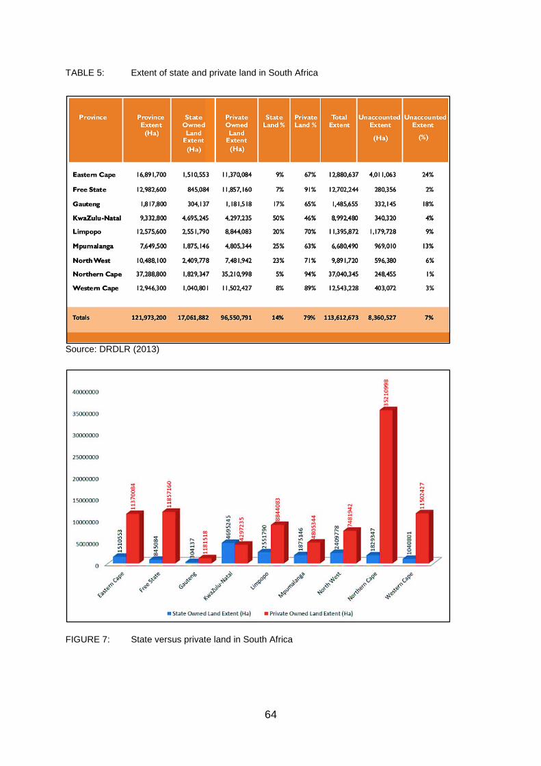
64
TABLE 5: Extent of state and private land in South Africa
Source: DRDLR (2013)
FIGURE 7: State versus private land in South Africa

65
FIGURE 8: South African land audit, 2017
Source: Department of Rural Development and Land Reform, and City Press calculators; Figure
produced by Cobus Prinsloo, Graphics24
Recent reports indicate that a lack of access to land and housing (and land) backlogs
persist because not much has been achieved by the government in acquiring and
redistributing land and more especially, private land (Brown-Luthango, 2009; Chetty, 2012;
HDA, 2013b; 2014a).
From the beginning of land reform, the Department of Land Affairs (now Department
of Rural development and Land Reform) (1997) and Guitierrez et al. (1995) had highlighted
that the majority of the land in South African urban areas is owned and controlled by the private
interest, which makes it less affordable and accessible to the poor. Ntsebeza (2000) and
Hendricks (2004) argue further, that the guarantee that land will be made available to Black
people is misleading simply because Whites privately own most of the land outside the former
homelands. To this end, Nkwinti (2012) stated that redressing racial imbalances in land
ownership remains land reform’s most urgent priority because Whites still own most of the
country’s land (Mahlangeni, 2013). In addition to this, some of the private land is owned by
foreign individuals and the law currently allows foreigners to buy land (Bendile, 2017). This is,
arguably, further complicating land reform in South Africa.

66
2.4.1.1.2. An analysis of formal processes
Major land management issues emerging out of the analysis of formal processes and
institutions include:
i) The role of the Housing Development Agency
It clearly appears that the development and delivery of housing has been used as a
means of redistributing land to the urban poor (Dyantyi, 2015). By 2014, the government had
significantly redistributed land through the delivery of approximately 3.7 million housing
opportunities (2.8 million completed houses and units, and just over 876 774 serviced sites)
since 1994, providing a home to approximately 12.7 million citizens (almost a quarter of the
South African population), to mostly women-headed households (about 54%) (USN & DW,
2004; Chiweshe, 2014; The Presidency, 2014). Despite this remarkable progress, the national
housing backlog of over 2 million housing units and growth of informal settlements suggest
that the scale of land acquisition made by the government over the past 20 years has not been
enough to meet these land needs/demands.
The HDA (2013b; 2014a) states that land acquisition area major barrier to the
development and delivery of housing. But, the Housing Development Agency (HDA) was
accordingly established in 2009 as an agency of the (National) Department of Human
Settlements (DHS) in terms of the Housing Development Agency Act 23 of 2008, for this
reason, to expedite the development and delivery of housing/sustainable human settlements
in South Africa (HDA, 2013a; 2013b; 2014b; 2015). This occurs by fast-tracking the acquisition
and release of state-, private-and communal owned land for human settlements
developments. Essentially, this entails the identification (state and private land), assembly,
acquisition (of state land), preparation and release of land for the purpose of human
settlements. In just four years after its establishment, the HDA admitted that this “has proved
to be complex, inefficient and debilitating for the intended social objectives” (HDA, 2013b:1).
According to the HDA (2013b), the problems presenting, currently, include the alignment
between the three spheres of government (national, provincial and local) regarding:
• Divergent legal frameworks;
• Different operational imperatives;
• Fragmentations in ownership and asset management; and
• Complex division of powers and functions.

67
These problems “result in the chronic failure to acquire well located or habitable state-
owned land to develop sustainable human settlements” (HDA, 2013b:1). To this end, a
renewed effort was required to ensure that the three spheres of government work together in
reforming the built environment to accelerate the development of housing/human settlements
(HDA, 2013b). In 2015, recognising the high and increasing national housing backlog, the
national DHS planned to fast-track land acquisition processes by working closer with
municipalities and provincial departments using the HDA to facilitate land acquisition,
especially at municipal level. Moreover, with the great focus now on transforming spatial
patterns and spatial governance, a renewed effort is required to make sure that all levels of
government (national, provincial and local) collaborate in reforming the built environment to
achieve a quicker, effective and equitable human settlements development (HDA, 2015).
According to the HDA’s National Human Settlements Land Indices (NaHSLI), state
land constitutes 12.9 % (15.7 million hectares) of South Africa’s land and water cover (121.9
million hectares), which is not far from the Chief Surveyor General land audit report (which
provides that the states owns 14% of the land in South Africa as shown in Table 5) (DRDLR,
2013; HDA, 2013b; Magubane, 2014). To date, according to the HDA (Agency) Land
Dashboard (“a web-based application that provides a summary of the properties that the HDA
owns and manages, as well as those that were identified, acquired and released for the
development of human settlements”), the Agency has identified more land than acquired (even
purchased privately owned land),
While the state land that has been donated, released more than privately owned land
countrywide (as shown in Figure 9). In 2015, the state reportedly needed nearly 10 000
hectares of land in order to meet the demands of the national backlog of over 2.5 million homes
(Felix, 2015). At the time, the state had bought approximately 4200 hectares of land for low-
cost housing (Felix, 2015). Figure 11 below shows a massive housing land backlog across
South Africa (particularly in the year 2014) and especially in Gauteng, Western Cape, KwaZulu
Natal, which are the provinces where informal settlements are most prevalent (Stats SA, 2012;
HDA, 2013a). This is somewhat also illustrated in Figure 9 and Figure 10 which shows the
current extent of provincial land (in Ha) assembled by the HDA for housing.

68
FIGURE 9: HDA land assembly status since establishment, as at October 18, 2016
Source: HDA (Land dashboard) (2016)
FIGURE 10: Provincial land per status
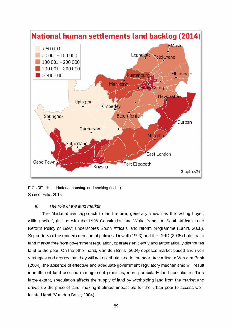
69
FIGURE 11: National housing land backlog (in Ha)
Source: Felix, 2015
ii) The role of the land market
The Market-driven approach to land reform, generally known as the ‘willing buyer,
willing seller’, (in line with the 1996 Constitution and White Paper on South African Land
Reform Policy of 1997) underscores South Africa’s land reform programme (Lahiff, 2008).
Supporters of the modern neo-liberal policies, Dowall (1993) and the DFID (2005) hold that a
land market free from government regulation, operates efficiently and automatically distributes
land to the poor. On the other hand, Van den Brink (2004) opposes market-based and riven
strategies and argues that they will not distribute land to the poor. According to Van den Brink
(2004), the absence of effective and adequate government regulatory mechanisms will result
in inefficient land use and management practices, more particularly land speculation. To a
large extent, speculation affects the supply of land by withholding land from the market and
drives up the price of land, making it almost impossible for the urban poor to access well-
located land (Van den Brink, 2004).
70
Brown-Luthango (2009) also identifies the existence and set up of the land market as
the main barrier preventing the urban poor, including newer urban dwellers, from accessing
affordable and well-located land. As far as Smolka and Furtado (2003) are concerned, the
operation of the land market is the main cause of the growing informal settlements. UN-Habitat
(2016) confirms that the continued existence of informal settlements is directly associated to
the persistence of inequality, poverty and distorted land markets. Dyantyi (2015) concludes
that if left to the markets, land reform will not serve the purpose of transferring land from Whites
to Blacks, particularly the poor and marginalised. To this end, although Lahiff (2008) believes
that the willing buyer - willing seller approach embraced the spirit of reconciliation, Lahiff
(2008:33) also notes that its bias is also excessively unwarranted:
“The ‘willing buyer, willing seller’ model, based on the World Bank’s recommendations
for a market-led reform, emphasised the voluntary nature of the process, payment of
full market-related prices, up-front and in cash, a reduced role for the state (relative to
previous ‘state-led’ reforms elsewhere in the world) and the removal of various
‘distortions’ within the land market. This approach fitted well with the general spirit of
reconciliation and compromise that characterized the negotiated transition to
democracy, although it can be seen as considerably more favourable to landowners
than strictly required by the 1996 Constitution”.
a. What about land expropriation?
Section 25 of the Constitution of the Republic of South Africa deals with the question
of expropriation and reads as follows (RSA, 1996):
25(2) Property may be expropriated only in terms of a law of general application-
(a) for a public purpose or in the public interest; and
(b) subject to compensation, the amount of which and the time and manner of payment
of which have either been agreed to by those affected or decided or approved by a
court.
25(3) The amount of the compensation and the time and manner of payment must be just and
equitable, reflecting an equitable balance between the public interest and the interests of those
affected, having regard to all relevant circumstances, including-
(a) the current use of the property;
(b) the history of the acquisition and use of the property;
(c) the market value of the property;

71
(d) the extent of direct state investment and subsidy in the acquisition and beneficial
capital improvement of the property; and
(e) the purpose of the expropriation.
Currently, the notion is that the market determines/sets the price of land, bought or
expropriated. Moreover, when it comes to acquiring land for redistribution, especially through
expropriation, the issue of compensation as obliged by the 1996 Constitution and the role of
the market, in particular, remains the main bone of contention in current and ongoing debates
on land reform in South Africa (Ntsebeza, 2005; Dlamini, 2007; Brown-Luthango, 2009;
Dyantyi, 2015). To this extent, Ntsebeza (2005) is among, if not the first scholars to call on the
property clause in the 1996 Constitution to be re-visited, particularly the protection of the
existing property rights section and the determination of land price by the market, to be
urgently challenged. Ntsebeza (2005) insisted that as long as the property clause is
entrenched in the 1996 Constitution, there will be no meaningful land reform programmes. It
is only recent in 2017 that the government is set to grant powers to the state’s Valuer-General
to determine the price of land in line with the entirety of the 1996 Constitution as opposed to
only the market value of the property, which is a submission or rather implies that the land is
highly priced as said by the Rural Development and Land Reform Minister Gugile Nkwinti
during the 2017 State of the Nation debate (Phakathi, 2017:3).
“….emphasised that the willing buyer, willing seller approach will no longer be used.
The government would instead purchase land at the value determined by the Valuer-
General. This, he said, would prevent the government from paying higher costs and
fast-track land reform.”
Significantly, this is set to end to the willing buyer, willing seller policy. Nkwinti stated
that the Valuer-General is already drafting standards for future land purchases (Phakathi,
2017). Yet based on this, it can be said that while the government is set to abandon the willing
buyer - willing seller approach, it has been reluctant to pursue the expropriation of land without
compensation.
To date (2014 from former EFF MP Andile Mngxitama, and 2017 from EFF
commander-in chief Julius Malema) the ANC has declined the EFF’s votes offer two times in
order to obtain a two-thirds majority that is required to amend the 1996 Constitution to allow
expropriation of land without compensation. In 2014, the Minister of Rural Development and
Land Reform, Gugile Nkwinti, on rejecting the EFF’s offer said, “this thing of being agitated
about expropriation without compensation does not speak to reality. The reality is that we are
a constitutional democracy.” The ruling party ANC instead proposed to codify the constitutional

72
requirement of just and equitable compensation (to be determined by Valuer-General) where
the state is acquiring land for land redistribution purposes as expressed in its 2017 policy
discussion documents (People’s Assembly, 2014; Phakathi, 2017; Dlodlo, 2017). The
parliament voted with a massive majority of 261 to 33 against the EFF’s motion for amending
the Constitution to allow expropriation of land without compensation (Herman, 2017).
Effectively, according to (Deputy Minister of Public Service and Administration) Dlodlo (2017),
the ANC voted against its 53rd national conference proposed resolution “to advance
expropriation without compensation on land acquired through unlawful means, or used for
illegal purposes, having due regard to section 25 of the Constitution”. It was not the first time
that the ANC has been offered the votes necessary to obtain the required parliamentary
majority by the opposition. In 2001, the PAC’s Chief Whip in the Gauteng Legislature at the
time, Mosebjane Malatsi, provided that the PAC and Azanian People’s Organisation (AZAPO)
would help the ANC in order to act on its appeal to amend the Constitution to bring about
proper redistribution/reallocation of the land (CDE, 2001).
According to the CDE (2001:3), Malatsi argued that “there was no moral justification
for paying compensation for land that was simply being restored to its rightful owners”. Yet
notwithstanding this, according to retired Chief Justice Judge of the Constitutional court,
Dikgang Moseneke, the 1996 Constitution does allow for expropriation of land [with
compensation] and there is to date no evidence that the Constitution is hindering land reform,
rather the Constitution is deliberately misinterpreted for two main political reasons: to deflect
the responsibility for the land reform failure away from the ruling party and to blame the
Constitution as a barrier to achieving meaningful land reform post-apartheid (HSRC Press,
2015).
Other factors contributing to (non-)acquisition and redistribution of land:
iii) City integration: desegregating apartheid spatial patterns and NIMBYism
a. Desegregating apartheid spatial patterns
During apartheid, spatial planning played a significant role- and was effective in urban
policy design and implementation, informing the country’s land use and spatial development.
Yet several critiques agree that, post-apartheid, spatial planning has made little impact on
restructuring urban land use management, spatial development and patterns (Watson, 2003;
Todes, 2006; Harrison, Todes & Watson, 2008). As Todes (2006) puts it, spatial planning was
marginalised as reflected by a lack of support (i.e. energy, time and financial resources) within
local authorities for the spatial frameworks conducted for the DLA in 2003 to be effective. By

73
the late 1990s, instead of realising ideals of urban integration, “apartheid divides”,
colonial/apartheid racially segregated spatial patterns “were being maintained” and post 1994
socio-spatial divides were transpiring, “often along class” (Todes, 2006:60).
Watson (2002) argues that the fundamentally managerialism approach of the
Integrated Development Plans (IDPs) and its focus on the budget as a means instead of
spatial plans, essentially marginalised spatial issues. Effectively, IDPs failed to realise urban
restructuring. The closing down of the RDP Office in 1996 further undermined the urban spatial
policy. Urban policy and responsibilities rested uneasily and without any strong holding centre
between the DLA and DoH (i.e. 1995 Urban Development Strategy was delegated) and what
later became the Department of Provincial and Local Government, thus effectively
marginalising urban policy and spatial issues (Pieterse, 2006). Urban spatial policy had
remained a low priority/focus in these departments.
Todes (2006) traces this decline of spatial urban policy to the introduction of GEAR
policy in 1996, a neoliberal free-market policy which also framed land reform among other
social and sectoral policies was “modelled on the International Monetary Fund (IMF) and
World Bank’s stabilisation and structural adjustment programmes, which have been applied
in many parts of Africa with disastrous effects” (Andrews in Ntsebeza & Hall, 2007:206), by
the South African government in place of a relatively aggressive 1994 RDP. This marked
marginalisation “radical” change ideas such as government building low-cost housing in
wealthy white areas, which were apparently not in order and to demonstrate of to the world
that it was stable and to “strengthen” or rather evade the necessary trouble of fixing its
fragmented and weak local government system to meet the presenting needs. In essence, it
was difficult to effect radical change, particulary within the existing bureaucracy at all levels
and some constrains on policy aimed towards effecting more radical changes (Pieterse, 2004;
Todes, 2006).
The idea of urban spatial restructuring, inclusivity and city integration has been an
important element of South Africa’s post-apartheid urban policy. It was born early on in policy
development, including the 1994 RDP and was central to the developmental/restructuring
principles of 1995 DFA and later entrenched in the 1997 UDF and a number of White Papers
and policy statements. Yet the later dumping of the RDP for the GEAR policy in 1996, which
was linked with a new focus on urban competitiveness at municipal level (Watson, 2003),
retrenched relatively free-market/non-interventionist policies regarding major makert-driven
urban developments (Todes, 2002; Bond, 2003). Being urban policy’s first major statement,
the 1995 Urban Development Strategy generally embraced the notion of urban integration but
74
effectively failed to address land markets or come up with policy proposals to acquire land to
realise urban/city integration (Bond, Bremner, Geldenhuys, Mayekiso, Miller & Swilling, 1996).
Ultimately, the remaining need to restructure apartheid spatial patters and to disown
apartheid geography has led to the development of the Spatial Planning and Land Use
Management Act (SPLUMA) in 2013 which was to give effect to the 1995 Development
facilitation Act development/restructuring principles and to link to land use management as
required of spatial frameworks by the White Paper on SPLUMA. The Municipal System Act
also effected similar provisions in its regulations thus stating the requirements for the spatial
framework component of the Integrated Development Plans (which received greater attention
with the 1998 Local Government White Paper (Todes, 2006). It is perhaps too early to judge
the SPLUMA. Yet notwithstanding this, according to Mahlangeni (2013), the mass of the
people of South Africa remain landless and development continues to be concentrated in
areas and communities which have always had proper infrastructure. Moreover, currently,
most of the land is acquired by the government through formal markets, involving huge
amounts of compensation. Dyantyi (2015) notes, that this further entrenches colonial and
apartheid injustice in terms of land ownership and, spatial and residential patterns.
As a remedial programme, the land restitution process has been important to partially
address the forced removal of Black people in urban areas through apartheid instruments such
as the 1950 Group Areas Act (Todes, Pillay & Krone, 2003). Quantitatively, land restitution
has been a relatively insignificant delivery programme as the majority of urban land claims
regrettably resulted in financial compensation rather than the transfer of the actual land. Yet
there have been some notable cases of urban land restitution involving well-located vacant
land, including West Bank and East Bank in East London, Cato Manor in Durban, Fairview
and South End in Port Elizabeth, Payneville on the East Rand, District Six, Ndabeni and
Tramway Road in Cape Town and Lady Selbourne in Pretoria (now Tshwane) (USG, 2003;
USN & DW, 2004). Among these, according to the National Department of Human
Settlements, are three particularly major monumental restitution projects of communities that
were forcibly removed from the inner city under apartheid that have been reintegrated with
new housing developments into the metropolitan/city centres and they include District Six,
Cato Manor and Lady Selbourne (The Presidency, 2014).
Yet, while it is faster than the rural land restitution process, the urban land restitution
process has been relatively slow-paced and created delays and uncertainties with low-income
housing projects on land claims affected sites. For example, in one case in Durban a low-
income housing project was put on hold for five years because of land claims (Todes et al.,
2003), while many of these projects have also been slow-paced in getting started, due to lack

75
of development support. Yet notwithstanding this, restitution projects can play an important
role in integrating the urban areas and desegregation of apartheid spatial patterns, as in the
notable case of Fairview noted above, wherein 1200 serviced sites were due to be delivered
in 2004 (USG, 2003; USN & DW, 2004).
In the 2013 State of the Nation Address (SONA), the former President (Jacob
Gedleyihlekisa Zuma) highlighted that municipalities have strived to address the issue of
access to land, especially in urban areas and could no longer be left alone to deal with it
(Zuma, 2013). Black and poor people are still struggling to find space in the urban areas, while
many cities and towns still resemble spatial patterns set up by colonial and apartheid regimes.
In substance, South Africa’s land reform has failed to alter colonial and apartheid urban spatial
patterns.
b. NIMBYism: opposition to low-income housing and city integration
Urban spaces are historically and continue to be contested spaces where socio-
economic conditions are defining features and are used to achieve and maintain race and
class segregation/exclusivity. Other factors that are contributing to the access to or lack of
access to land and the provision or non-provision of houses, originate mainly from the
apartheid legacy, where residential communities and housing was provided and used as an
apparatus of social separation. Making for great opposition to low-income housing projects by
wealthy homeowners of neighbouring communities, is the skewed wealth distribution along
with the class segregation which are both very visible in the Western Cape. The tendency of
new housing projects to turn into dysfunctional ghettos living up to the perceptions of
neighbouring communities make for an even greater resistance (Department of Local
Government and Housing, 2005). It is apparent that this legacy of the apartheid system cannot
be ended without political will and the resolve to tackle and put an end to the opposition to city
integration as it is visible in the “not-in-my-back-yard” (NIMBY) syndrome.
NIMBYism mainly expresses itself in the form opposition by wealthy homeowners to
the development of low-income housing in the vicinity of their often well-located and
affluent/higher income community (Department of Local Government and Housing, 2005).
This appears to explain the notable government housing projects and developments in the
peripheries of the city and existing black townships. Somehow, this also explains the prevalent
development of informal settlements resulting from the difficulty to acquire/secure well-located
land for housing. NIMBYism is a reality in South Africa and it is seriously problematic with
regards to providing access to land and housing (Department of Local Government and
Housing, 2005). It appears to seek to maintain and entrench colonial and apartheid segregated

76
spatial and residential arrangements and territorial boundaries. NIMBYism can lead to
racial/class clashes over residential land as in the recent case of the Booysen (in Tshwane)
which headlined and took the front page of Pretoria News (shown in Figure 12) (Tlhabye,
2017).
FIGURE 12: Battle of Booysens – White
residents of Booysens oppose relocation of
residents from Jeffsville informal settlement in
Atteridgeville after their shacks were damaged
by a sinkhole
Source: Pretoria News, 2017
According to a Pretoria News
article, the sentiments of the angry resident of Boysen were that; “they are coming in buses to
burn our houses down, to rape our women and children” (Tlhabye, 2017:1). On forcing them
out of the area, of the relocated shack-dwellers, one of the residents of Booysen was quoted
by Pretoria News saying, “my main concern stems from the increase in crime as a result of
the new shack dwellers”. Telling of horrible stories doing rounds in the community since the
commencement of the erection of the shacks, the resident further said: “I know that they are
just stories, but I think that is what caused people to go into a state of panic on their arrival”
(Tlhabye, 2017:1). Mindfully, the resettlement of the Jeffsville shack-dwellers in Booysens by
the City of Tswane was merely an urgent temporary relocation as repairs in their area were in
progress and not even a permanent development of low-income housing (Tlhabye, 2017).
Ultimately, despite maintaining the status quo, NIMBYism is subsequently a barrier to equal
land and housing opportunities (Hilber & Schöni, 2016).
2.4.1.2. Informal land acquisition and redistribution processes/channels
2.4.1.2.1. Consequence
Informality, as in informal land acquisition processes, is a consequence of the failure
of formal land acquisition processes to meet the peoples land (and/or housing needs) needs.
In the history of informal settlements, the failure of formal (processes) and authorised
institutions to provide access to land and formal housing to the (ever-growing) urban
population had been a breeding ground for the development and growth of informal
settlements (Ali & Sulaiman, 2006, Royston, 2006). The chronic housing backlog and growth
of informal settlements also suggest that the scale of land acquisition and housing delivery
output by the government over the past 20 years since 1994 has not been sufficient to meet

77
the demand. Accordingly, the Department of Housing (2004:1 – 2) and Huchzermeyer and
Karam (2006: 43) argued that:
“Informal settlements are products of failed policies, ineffective governance, corruption, inappropriate regulation, exclusionary urban economic development,
poor urban management strategies, dysfunctional and inequitable land markets,
discriminatory financial systems and/or a profound democratic failure”.
The failure of formal process has seemingly created a general perception among the
urban poor that the provision of land cannot be left to land and housing authorities.
Subsequently, an Informal land acquisition and distribution process is in effect, resulting in
more informal developments. Thus, the further development and growth of informal
settlements can be viewed as a response to and a consequence of the failure of formal
processes by filling of the land and housing gap (USN & DW, 2004; Ali & Sulaiman, 2006;
Pepeteka, 2013; UN-Habitat, 2015). To this effect, Keivani and Werna (2001) and Lemanski
(2009) makes a dominant argument that urban informal settlements are not an expression of
illegality but are one of alternative and various efforts within the holistic process of providing
housing. This alludes to the notion advanced by Fekade (2000) and Kironde (2006), that the
failure of the post-apartheid government to acquire and redistribute land through formal
processes including housing has led to the development of informal land acquisition and
distribution (of vacant land) processes as an alternative for the urban poor and desperate land
seekers.
i) Unlawful land occupation/land invasion: politicisation of land and ‘land grabs’
At the heart of colonialism and apartheid was the land dispossession of Africans and
it has since constructed the identity and political economy of South Africa. This includes the
prevailing culture of impunity resulting from violent struggles for liberation and the majority
rule. Yet the attainment of political freedom and transfer of political power from colonial and
apartheid administration to Black elites, African in particular, since the 1990s has not resulted
in significantly altering South Africa’s land legacy. Prevailing instead are colonial land laws,
policies, administrative procedures and infrastructures that are still being used and re-
entrenched (UN-Habitat, 2010).
According to UN-Habitat (2010), instead of being radical, political change and land
policies in South Africa have been adaptive and co-optive, only granting the new ruling Black
elites more power to secure access and control over local and national economies.
Consequently, with one of the ideals sustaining the liberation struggle of transforming land into
a resource to be released to the equitable benefit of all South Africans, remaining unfulfilled,

78
land continues to be a core bone of contention not only in politics, but also within the economy,
identity and culture of South Africa (UN-Habitat, 2010). Lodge (2002:845) argues that
“politically, land reform has been assigned a low-priority status by successive ANC
governments. ANC leaders suggest that this neglect accords with public perception; while ‘the
issue of land was important for local people’, the ‘central issue’ for most is job creation”.
Over the years, since 1994, South Africa, especially urban areas, have seen an
increasingly popular, common and widespread phenomenon of land invasion. Land invasions
have been taking place despite the governments’ delivery of over 3 million housing units (The
Presidency 2014). Yet it, interestingly, appears that land invasion is not new or original to the
post-apartheid South Africa. Land invasion predates this present dispensation. Considering
the manner of colonial and apartheid land acquisition, as described in terms of The Scramble
for Africa (Rodney, 1970; Pakenham, 1991; Originalpeople.org, 2012):
The process of European expansion through division, (armed and militant) invasion,
occupation, seizure, colonisation and rule of African continent by European powers.
[… which was an era of] pre-planned and rapid colonisation of the African continent by
European powers.… They sliced up and divided Africa amongst themselves and
invaded it without any consent of the African people.
Against this dissertation’s definition of land invasion (HDA, 2013a):
A form of an informal process that involves pre-planned occupation of land by an
individual or a group of people without the consent or permission of the rightful owner
of the land or person in charge of the land.
Notwithstanding contemporary rhetoric, it is apparent that land invasion has historically
been a manner and a process of the acquisition and distribution of land. Contrary to colonial
and apartheid, post-1994 land invasions are not sanctioned and/ or conducted by Europeans
or government.
Political stability and strong processes of democratic controls play a significant role
when it comes to land invasions. The opposite enables politicians to support, allow or even
facilitate land invasions. Political transitions including elections and election periods (local and
national), are most vulnerable to land invasion, even though such invasions can be short lived.
This was the case in Cator Manor, in Durban, where about 400 land invasions were recorded,
but were short lived as soon as the ANC came to power (Gigaba & Maharaj, 1996; Coccato,
1996; Crankshaw, 1996; De Souza, 1999). Yet at a local level in particular, where for instance
land invasion takes place or is concentrated in existing townships, the level of politics tends to

79
be harnessed for land invasion processes (Crankshaw, 1996:55). For fear of losing votes, the
incumbent government or ruling party might be unwilling to respond to or overlook land grabs,
while the other can instigate them for bolster their popularity with the electorate. The people
have become aware of such political power (voting) and take advantage of (or use) it as their
bargaining power, thus using their political power (‘no vote’) as a means to land and housing
(see Figure 16), but success can be short lived (Gigaba & Maharaj, 1996; Coccato, 1996;
Crankshaw, 1996; De Souza, 1999).
Most interestingly, this also seem to suggest that the prospects of the access to land
and housing for the poor are based on a balance of their (public opinion or electorate) needs
and political interest. Now if this holds, it is seriously alarming and may force a major
shift/change in land reform. Particularly because a most recent study that was conducted by
Gibson (2009) a political scientist, provides one of the most striking and compelling public
opinion survey ever conducted in the country of 3700 South Africans, and it is revealed that
there is a strongly shared land grievance among many Black people. As noted by Atuahene
(2011:122) the survey findings revealed that:
“85 percent of the Black informants believed that "most land in South Africa was taken
unfairly by white settlers, and they therefore have no right to the land today." Only eight
percent of white informants held the same view. Gibson's most alarming finding was
that two of every three of these blacks agreed that "land must be returned to blacks in
South Africa, no matter what the consequences are for the current owners and for
political stability in the country"; 91 percent of the whites surveyed disagreed.
According to Gibson's data, most blacks, whether they live in rural or urban areas, see
the land as stolen and want it back even if redistribution will provoke political unrest”.
According to Atuahene (2014), that means “land injustice has become a sea of oil
waiting for a match” and that match are the Economic Freedom Fighters (EFF). The EFF is
(now) a five-year-old South African political party led by Julius Malema, former ANC youth
league president. Regarding land, the party's founding cardinal pillar is ‘of South Africa's land
without compensation for equal redistribution in use’ (Atuahene, 2014; Economic Freedom
Fighters, 2013). Amongst other things, this survey revealed, arguably, that Blacks may have
forgiven their oppressors, the perpetrators of colonialism, but have not forgotten about their
oppressive deeds and hence their stolen land. Clearly, the peace, truth and reconciliation
project did not return land to Black people as it was never its concern in the first place (Megan,
2011) and Black people are increasingly realising that they are still landless. Accordingly, this
might as well be a justification or reason for the Black people to invade land.

80
Moreover, this is testament to the reality that the peace, truth and reconciliation project
has not resulted in the transfer of land to the indigenous and rightful owners (Megan, 2011;
Gibson, 2009). In fact, Megan (2011) notes that even though massive forced dispossessions,
removals and displacements were at the very core of the colonial and apartheid project, they
were never part of the Truth and Reconciliation Commission of (TRC) mandate or scope.
Gibson (2009) also argues that, in reality, Black and White people are not reconciled in South
Africa and instead, they are extremely and probably irrevocably divided on almost every issue
associated to land. To this end, this implies that peace and reconciliation will not be realized
until land is returned to the rightful owners. In the 2017 SONA, President Zuma spoke widely
about land reform, saying that “it will be difficult, if not impossible, to achieve true reconciliation
until the land question is resolved” (Dlodlo, 2017).
a. Informal settlements: a phenomenon of land invasion
The 2009 National Housing Code characterises Informal settlements as a
phenomenon of land invasion. According to the HDA (2015), due to the rising housing
backlogs and the challenge of evictions, informal settlements are the most accessible type of
housing for the poor and are seemingly their only accommodation solution due to lack of
affordable urban housing (USN & DW, 2004; Birkinshaw, 2008). The housing crisis, therefore,
leads to land invasion which is the main driver of the perpetual growth in numbers of informal
settlements across the country (Huchzermeyer, 2003; USN & DW, 2004; HDA, 2015).
Huchzermeyer (2003) also advances this narrative and asserts the need for lobbying
groups and activists to recognise that the housing crisis that leads to land invasion on the
urban outskirts, including rural district, is one of urban housing. Huchzermeyer (2003) further
insists that this crisis will not be addressed unless the land reform discourse confronts the
inequitable distribution of land in urban areas. Both privately-owned and state-owned land is
prone to land invasions, including (often well-located and) high-income and affluent areas
(HDA, 2015), resulting to infill informal settlements on vacant land between formally developed
areas (CSIR, 1999), which is becoming quite more common than the traditional invasion of
vacant within- and adjacent to existing townships, mostly on the urban periphery.
Furthermore, in turn, the Constitutionally enshrined right to adequate housing, which
is also enforced through the 1998 Prevention of Illegal Eviction and Unlawful Occupation of
Land Act (PIE Act), also places a huge burden on the land owners and municipalities in
particular, before requesting an eviction order from the court, to provide alternative
accommodation to evicted dwellers (HDA, 2015). Urgent court evictions can only be granted
on the basis of existing health hazard or risk (but the right to appeal is still applicable) to which
81
alternative housing must still be provided where land had also already been occupied for more
than 6 months and in both instances, the rights and needs of the elderly, children, handy
capped persons and women-headed households (special need persons) must be taken into
consideration (Huchzermeyer, 2003). This presents a huge challenge on municipalities in
addressing land invasions as evicting dwellers without alternative and adequate housing
results in a breach of the Constitution (HDA, 2015).
Legally, on one hand, the landless, homeless and informal settlement dwellers have
evoked such Constitutional provisions and thus winning court rulings to their favour. On the
other hand, municipalities have ensured that they are viewed as upholding/obeying the rule of
law in acting in accordance with these court rulings. Yet Huchzermeyer (2003:3) noted that
“the judiciary seemed reluctant to rule in favour of the poor, when the economy or investor
confidence is at stake” as it were in the Bredell case in 2001 (which occurred within the period
of Zimbabwe land invasion between 2000 and 2005), wherein the Pretoria High court gave
tough judgement (Huchzermeyer, 2003), granting an urgent eviction order for unlawful
occupants to be evicted, but without taking into consideration, the cold weather that evictees
were to suffer from. Furthermore, the court did not order the private landowners and
government to provide alternative housing (CDE, 2001; Huchzermeyer, 2003).
A look at select few cases of land invasion and informal settlements post-1994
Grootboom case (1998 – 2000) According to Huchzermeyer (2003), by 2003, no court ruling had been radical in
interpreting the right to housing to the extent that it resulted in the permanent right to occupy
land that was unlawfully occupied. Yet the period saw forced evictions and informal
settlements re-emerging elsewhere as in the Grootboom case (marked as a land mark ruling)
in 1998 - 2000 wherein about 900 dwellers of the overcrowded Wallacedene settlement in
Cape Town had illegally occupied vacant land that was set aside for low-income housing.
Upon eviction, the dwellers realised that they could not go back to their previous living space
in Wallacedene, as this had been occupied by others and consequently constructed shacks
on a sports ground in Wallacedene (Davis, 1999; CDE, 2001; Huchzermeyer, 2003). In this
(Grootboom) case, after the municipal and provincial government appealed (previous ruling
that on the basis of child’s right, the government must provide temporary shelter for the some
900 people including children) and argued that this would dilute the housing delivery
programme’s limited resources, the Constitutional court handed a “liberal judgement” and
ultimately ruled that “the government’s housing programme should not only provide for
medium to long term housing delivery, but also fulfilment of immediate needs, and the
management of crises”. Yet it was not ordered how and by when the government should
82
provide such provisions and only provided for temporary (land and housing) rights
(Huchzermeyer, 2003).
Bredell land invasion (2000) ‘The Bredell land invasion’ provides a typical invasion example/case and a consistent
message as received by de Beer, that “we can’t afford formal housing. Give us land and we
will build for ourselves (CDE, 2001).” This seemingly included building shacks. According to
the CDE (2001), 32 ha of vacant land, in Bredell near Kempton park in Ekurhuleni, owned by
the government (former Transvaal Provincial Administration), State-owned Entities (Eskom,
Transnet) and two farmers was invaded. There were several attempts in recent years before
to occupy land at Bredell. The Star (2001) broke the news (on 3 July 2001) and reported that
plots at Bredell were being sold for R25 by the PAC and that thousands of people, mostly from
Tembisa, queued to buy the land. By 4 July 2001, the police estimated that approximately
5000 people had settled, but various newspapers reported 10 000 (News24, 2001; CDE,
2001). By 5 July 2001, the PAC confirmed that R179 000 had been collected representing
7 160 plots at R25 each and the number of shacks was also put at R5 000 (ZA*Now, 2001,
Daily Mail and Guardian, 2001). The High Court also established that plots had been illegally
sold for R25 and that people had been illegally organised to occupy the land (CDE, 2001).
According to the CDE (2001), as told by Minister of Housing (at the time) Sankie
Mthembi-Mahanyele, the government established that the invaders included housing subsidy
applicants ‘jumping the queue’, people from neighbouring townships searching for rent-free
accommodation and entrepreneurs eyeing emerging business opportunities. Yet “there were
also political opportunists, crooks who wanted to make easy money, and foreigners”. Before,
there were many attempts to occupy land at Bredell but the invaders had been evicted by
farmers and the police. It has been claimed that the people turned to the PAC when they
began to see that informal settlements established by the PAC in Etwatwa and Daveyton
through land invasion were successful and this came after appealing unsuccessfully to the
ANC (CDE, 2001). Although the exact nature of PAC’s role in the Bredell invasion was under
dispute, it appeared that local PAC activists were deeply involved in orchestrating the Bredell
invasion, while the national PAC leaders certainly took their motives and articulated the
invaders’ needs in radical ways (The Star, 2001; CDE, 2001). PAC’s general secretary Thami
Ka Plaatjie, denied the reports that the PAC was collecting money, saying that it was the
people’s own decision to contribute towards the community fund (The Star, 2001; CDE, 2001),
meaning that they did not sell the land as “bogus owners” (Henddricks et al., 2013:7). General
Secretary Plaatjie further denied that the PAC had organised the invasion and said that the
PAC had been called to assist by the African Renaissance Civil Movement (who had begun

83
registering people with the intent of establishing an informal settlement (The Star, 2001; CDE,
2001).
There are lessons to be learned from ‘the Bredell land invasion’. People were
desperate and the poor people’s interests were being flooded in a political battle of political
parties. It was noted that the government’s land reform system was very bureaucratic and they
were taking too long to deliver on the need. It became clear “that a housing strategy, coupled
with rapid land release, is a critical priority [and most urgent task]” for South Africa’s cities and
this highlighted the need for the government to be wary of- and responsive to the happenings
in local communities and for the government to communicate more effectively with the ordinary
(poor) people (CDE, 2001). Even though the poor and desperate people were exploited and
“shamefully used for propaganda purposes”, as it was in the case of the 80-year old evicted
women, whom it was clear that she had been moved by others to Bredell and did not
personally build the shack as de Beer puts it, “the underlying message from Bredell was clear:
‘Give our people land’” (CDE, 2001:3). To de Beer, it was also reminiscent of the time that
Johannesburg Council officials were trying to discourage people from jumping the queue in
the early 1990s and they were trying to convince them that the government would deliver
houses, but the consistent message that was heard, was: “We can’t afford formal housing.
Give us land and we will build for ourselves” (CDE, 2001:3).
In the end, the Pretoria High court gave “tough judgement” (Huchzermeyer, 2003)
against the poor by granting an urgent eviction order for unlawful occupants to be evicted, but
without taking the cold weather that evictees were to suffer from, into consideration. In
addition, the court did not order the private landowners and government to provide alternative
housing (Huchzermeyer, 2003; CDE, 2001). According to Huchzemeyer (2003), in the case of
Bredell, the government’s hard stance on land invasions and its support for forceful evictions
were broadcasted through prime media coverage to every inadequately housed person and
the underlying message was: the road to adequate housing in South Africa is not through the
courts.
Imizamo Yethu (early 1990s - present) A notably informal settlement and land invasion success (from the landless, homeless
and poor perspective), so often on the news for various reasons, but mostly for shack fires, is
Imizamo Yethu (Xhosa for our efforts) (see Figure 13). Imizamo Yethu was established in the
early 1990s when 450 households who had been squatting in shacks abound Hout Bay were
resettled to this new site on the foot side of the Constantiaberg Mountain seaside and looking
over the harbour. Imizamo Yethu has since gradually grown to a fairly large township of
approximately 15000 people between 2005 and 2011, with mostly African and mainly isiXhosa

84
speaking people (about 90%) who originate from the former Transkei in the Eastern Cape and
came here in search for work (Stats SA, 2012; Monaco, 2008; Hout Bay Christian Community
Association, 2005). Many are reported to still have family members living there (Hout Bay
Christian Community Association, 2005). But, there are, allegedly, also a number of dwellers
from foreign African countries such as Angola and Zaire dwelling in the Imizamo Yethu buffer
zone. One theory advanced that these foreigners came into South Africa illegally by having
come ashore in Hout Bay in fishing trawlers (Silikamva High School, nd). According to the
Hout Bay Christian Community Association (2005), the influx of additional Xhosa’s, Angolan
and other foreigners have kept the employment and housing needs at a critical level. The
township started as an area where mainly Black people were allowed by the authorities to
build temporary shelters including shacks (Hout Bay Christian Community Association, 2005).
A majority of the Black people could not afford it and the law did not allow them to buy
land or homes in Hout Bay and so they alternatively looked for vacant land on which their
shacks were built. In many cases this was done without consent as this resulted in many
illegally occupied land while causing much agitation and unhappiness with their White fellow
residents. In 1988/89, Hout Bay saw the invasions of state and privately-owned land. A
collective effort by invaders to get legal property rights and the reaction from existing Hout Bay
property owners compelled the authorities to make formal property available for the invaders.
In 1990, 18 hectares of forestry land was made available by the former Western Cape
Regional Services Council on which Black people were allowed to build their temporary
shelters (shacks) while the authorities were planning the formal layout and named the place,
Imizamo Yethu Estate (Hout Bay Christian Community Association, 2005; Gawith & Sowman,
1992; Silikamva High School, n.d). According to Gawith and Sowman (1992), 429 sites were
occupied in between March and April in 1991.
The Imizamo Yethu living conditions were improved by the Niall Mellon Township Trust
with their People's Housing Process since 2003. This non-profit organisation based in Ireland
(by an Irish businessman), sent volunteers to South Africa and they have built over 300 new
basic, quality solid brick homes for individuals in Imizamo Yethu, therefore moving them out
of the dreaded shacks (Brand South Africa, 2006; Hout Bay Christian Community Association,
2005). Thus Imizamo Yethu is now constituted of both a designated formal housing area and
an informal settlement area. Yet newcomers continue to invade and illegally occupy the
remaining piece of vacant land as seen by the change over time in the land cover in Figure
13, arguably, banking to receive the same fate. Figure 13 (on the next page) also shows the
encroached land over the steep slopes of Constantiaberg Mountain behind Imizamo Yethu.
Imizamo Yethu has more than doubled since its establishment with a population of about 15
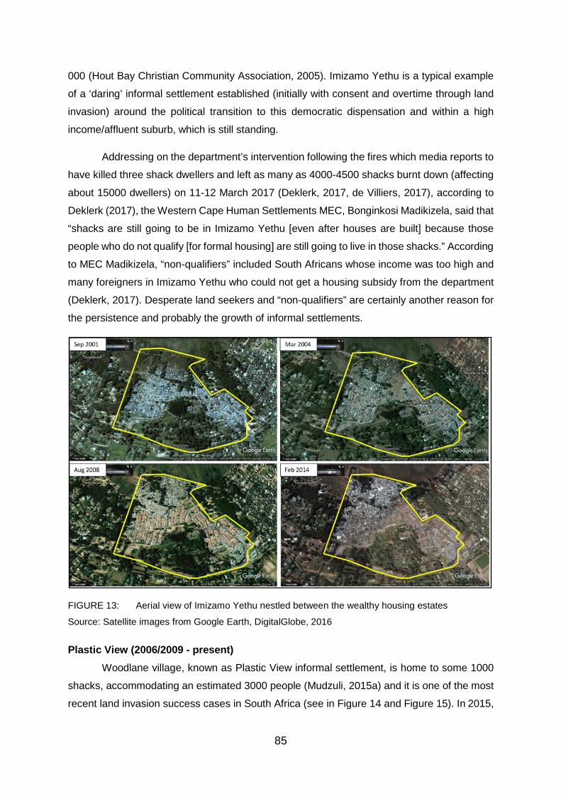
85
000 (Hout Bay Christian Community Association, 2005). Imizamo Yethu is a typical example
of a ‘daring’ informal settlement established (initially with consent and overtime through land
invasion) around the political transition to this democratic dispensation and within a high
income/affluent suburb, which is still standing.
Addressing on the department’s intervention following the fires which media reports to
have killed three shack dwellers and left as many as 4000-4500 shacks burnt down (affecting
about 15000 dwellers) on 11-12 March 2017 (Deklerk, 2017, de Villiers, 2017), according to
Deklerk (2017), the Western Cape Human Settlements MEC, Bonginkosi Madikizela, said that
“shacks are still going to be in Imizamo Yethu [even after houses are built] because those
people who do not qualify [for formal housing] are still going to live in those shacks.” According
to MEC Madikizela, “non-qualifiers” included South Africans whose income was too high and
many foreigners in Imizamo Yethu who could not get a housing subsidy from the department
(Deklerk, 2017). Desperate land seekers and “non-qualifiers” are certainly another reason for
the persistence and probably the growth of informal settlements.
FIGURE 13: Aerial view of Imizamo Yethu nestled between the wealthy housing estates
Source: Satellite images from Google Earth, DigitalGlobe, 2016
Plastic View (2006/2009 - present) Woodlane village, known as Plastic View informal settlement, is home to some 1000
shacks, accommodating an estimated 3000 people (Mudzuli, 2015a) and it is one of the most
recent land invasion success cases in South Africa (see in Figure 14 and Figure 15). In 2015,

86
Plastic View informal settlement dwellers won the right to stay on the land when the (North
Gauteng/Pretoria High) court ruled against the auction of the land (forming part of some 74
properties land release programme) by the City of Tshwane Metropolitan Municipality (CTMM)
as part of its abruptly announced land release programme, without consulting the occupants
(see Figure 14). The City of Tshwane was said to be selling the properties to raise funds (for
further economic development, regeneration, townships including infrastructure development
and other housing needs), ironically, in order to improve the lives of the poor in the metro
(Madzuli, 2015a). The dwellers, mostly foreign nationals, claimed that several large portions
of the properties, that were to be sold on auction, included land suitable for low-income
housing developments. They further feared that the sale of the land would permanently impair
the constitutional rights of those living in informal settlements and other homeless people in
Tshwane (Mudzuli, 2015b).
After being legally represented by Lawyers for Human Rights (LHR), Tswelopele Step
by Step (NGO) and the residents, after a series of orders in against home owners associations
from around the area, again successfully obtained an urgent North Gauteng High Court order
against the City of Tshwane wherein, according to Mudzuli (2015b) of Pretoria News, Judge
Legodi Phatudi agreed that “the sale of the property [upon which Plastic View is located] before
relocation would be an infringement on the rights of the occupants,” and would deal them
irremediable harm (because it would be almost impossible to settle relocation after the land
had been sold), thereby halting the sale of the land until all the legal proceedings were dealt
with (LHR, 2016). Despite experiencing shack fires, the most devastating and deadly by far
being the fire on 3 July 2016, which claimed as many as five lives and left more than 500
people homeless (Pretoria East Rekord, 2016; ENCA.COM, 2016), Plastic View dwellers keep
on rebuilding (Makhetha, 2016; ENCA.COM, 2016). According to Mudzuli (2015a), this auction
of municipal land was the first by the City of Tshwane Metropolitan Municipality.

87
FIGURE 14: Two Parcels of (216 ha) CTMM good vacant land (including 106 ha land bordered red
and occupied by Plastic View dwellers) on the corner of Garsfontein Road and DeVillebois Mareuil
Drive, which were set to be auctioned in March 2015
Source: Photo from Mudzuli (Pretoria News), (2015); supplied by CoT
This litigation over the land took about 10 years, dating back from 2006, when the
police burnt down Plastic View dwellers’ shacks (LHR, 2016). Since then and following a visit
to the devastated area, the government in the person of Gauteng MEC for Cooperative
Governance and Traditional Affairs and Human Settlements, Paul Mashatile, has promised to
formal development in the Plastic view area (Makhetha, 2016).
Yet, to date, Figure 15 shows that the informal settlement (Plastic View) is still
standing. A trilateral agreement by the MEC that was reached in principle (in April 2016) with
the City of Tshwane and the relevant Home Owners Associations to relocate the settlement
across Garsfontein Road and next to the Woodlands Boulevard mall wherein construction of
formal housing would also commence, are yet to be fulfilled as another group of Home Owners
Associations later objected to the relocation. Thus, the matter of the land to be developed is
yet to be finalised. Moreover, some of the shack dwellers are foreigners and may not qualify
for the governments’ social housing and because of this the dwellers are also wary of the
MEC’s promises (LHR, 2016; Makhetha, 2016). Meanwhile, another “Plastic View” developed
behind the woodlands Boulevard mall. It appears that informal settlements have developed
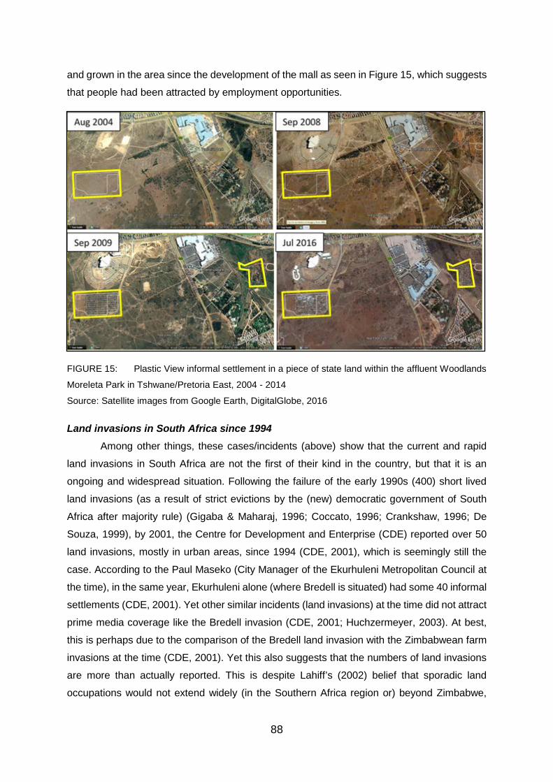
88
and grown in the area since the development of the mall as seen in Figure 15, which suggests
that people had been attracted by employment opportunities.
FIGURE 15: Plastic View informal settlement in a piece of state land within the affluent Woodlands
Moreleta Park in Tshwane/Pretoria East, 2004 - 2014
Source: Satellite images from Google Earth, DigitalGlobe, 2016
Land invasions in South Africa since 1994 Among other things, these cases/incidents (above) show that the current and rapid
land invasions in South Africa are not the first of their kind in the country, but that it is an
ongoing and widespread situation. Following the failure of the early 1990s (400) short lived
land invasions (as a result of strict evictions by the (new) democratic government of South
Africa after majority rule) (Gigaba & Maharaj, 1996; Coccato, 1996; Crankshaw, 1996; De
Souza, 1999), by 2001, the Centre for Development and Enterprise (CDE) reported over 50
land invasions, mostly in urban areas, since 1994 (CDE, 2001), which is seemingly still the
case. According to the Paul Maseko (City Manager of the Ekurhuleni Metropolitan Council at
the time), in the same year, Ekurhuleni alone (where Bredell is situated) had some 40 informal
settlements (CDE, 2001). Yet other similar incidents (land invasions) at the time did not attract
prime media coverage like the Bredell invasion (CDE, 2001; Huchzermeyer, 2003). At best,
this is perhaps due to the comparison of the Bredell land invasion with the Zimbabwean farm
invasions at the time (CDE, 2001). Yet this also suggests that the numbers of land invasions
are more than actually reported. This is despite Lahiff’s (2002) belief that sporadic land
occupations would not extend widely (in the Southern Africa region or) beyond Zimbabwe,

89
because the South African government, unlike Zimbabwe, committed itself to “pursuing
‘orderly land reform’” (Moyo, 2007:79).
Cousins (2000:1) projected that Zimbabwean-style land invasions will likely take place
in South Africa at some point in the future, in about a decade, despite the great differences
between the political economies of the two countries:
“And as in Zimbabwe, land invasions organized by populist politicians will call attention
to society’s failure to adequately address deepening rural poverty, and put a dramatic
spotlight on the emotive issue of our highly unequal and racially skewed land
distribution. This could result in land reform moving higher up the political agenda than
it is at present”.
According to Cousins (2000), even between the 1990 and 2000 land invasions, fuelled
by desperation, were a feature of urban areas in South Africa, but most were defused by the
government finding alternative land for the homeless. By 2000, prospects of land invasions
appeared very unlikely other than in isolated cases where communities and NGOs were trying
to put pressure on the government to speed up land reform. Moreover, Cousins anticipated
that land invasions were therefore likely to be met with a firm and unsympathetic response
from the government.
Indeed, years on, land invasion has been normalised and simply treated as a criminal
act by the government (HDA, 2015). Yet land invasions are evidently a manifestation of the
state and land market failure to fulfil “the promise of land” (Ali & Sulaiman, 2006; Royston,
2006; Charlton & Kihato, 2006; Hendricks, et al., 2013). Ultimately, land invasions have
successfully managed to keep land reform on the agenda (Moyo, 2001).
b. The rise of grassroots movements and new political formations
Post-1994, South Africa has seen the rise of grassroots movements, the dominant
driving factor being land and the relentless desire to gain or provide access to it, through
representation, lobbying and the exercise of political power. As noted by Pepeteka (2013),
during the 2000s irritations, impatience and pains arose regarding the slow land reform
process in the country and were clearly expressed by civil society movements. The
government, at the time, recognised the challenges, dismal achievements and critiques
regarding land reform and convened the National Land Summit in July 2005, which brought
together a variety of stakeholders. According to Jacobs (2012), the outcomes suggested the
rejection of sole-reliance on neoliberal policies such as the willing buyer willing seller. Indeed,
the persistence of landlessness and housing shortages/demand and the constant forced

90
evictions of the landless and poor (especially in the cities), has mainly led to the formation and
rise of grassroots movements (Zikode, 2008; Losier, 2009; Hendricks et al., 2013).
To mention the major ones, they include the Abahlali baseMjondolo (Zulu for shack-
dwellers) Movement (generally called ‘Abahlali’) formed in 2005, which is apparently the
largest shack-dwellers' movement in South Africa, now largely operating in Durban,
Pietermaritzburg, Pinetown (KwaZulu Natal) and Cape Town (Western Cape), (partly inspired
by Brazil’s Landless Workers Movement) the Landless People’s Movement (LPM) formed in
2001 (founded by the likes of Andile Mngxitama, also founder of the Black First Land First
(BLF) (Moyo, 2007:79)) and largely operating in Johannesburg (Gauteng) as well as the the
Anti-Eviction Campaign (AEC) that was formed before the LPM and largely operating in the
Western Cape. In September 2008, an alliance was established through the formation of the
Poor People’s Alliance by the Anti-Eviction Campaign in Western Cape, together with Abahlali
baseMjondolo, the Johannesburg branches of the Landless People's Movement and the
KwaZulu-Natal Rural Network (also known as ‘Abahlali basePlasini’) (Zikode, 2008; Losier,
2009; Hendricks et al., 2013: 3-8).
Since its formation, the Poor People's
Alliance refuses party politics and
boycott elections under the banner “No
Land! No House! No Vote!” (Zikode,
2008). (See Figure 16 below).
FIGURE 16: Abahlali baseMjondolo
(shack-dwellers) refuse to vote under the
banner 'No Land! No House! No Vote!
Source: Photo from Pithouse, 2010
With presence in the urban areas and farms, in the cities, these movements are mainly
formed by the landless, poor and homeless South Africans and are known for mobilising the
urban and rural poor for meaningful land reform, campaigning for public housing and against
evictions of the landless shack-dwellers by government and private landowners (Losier, 2009;
SACN, 2015). Their message is clear, they want land and formal (adequate) housing and they
are prepared to use their votes to get it (as shown in Figure 16). According to the UN-Habitat
(2010), South Africa has the most organised grassroots movements in the Southern African
region, including the abovementioned. Yet “ironically, government and landowners perceive
these social movements in criminal terms (or label them as a “Third Force” (Zikode 2006:185))
rather than as the voice of genuine citizen concerns” (Losier, 2009; UN-Habitat, 2010:1).

91
Furthermore, South Africa has seen the formation and rise of the disgruntled Economic
Freedom Fighters (EFF) from the ANC in 2013 and the Black First Land First (BLF) from the
EFF in 2015, both known for their radical stance on land reform and their founding
commitment: “expropriation of land without compensation” (Mngxitama, 2015; Economic
Freedom Fighters, 2013). Foundational and fundamental to their formation is the (strongly
Africanist ideological and) relatively radical (and provocative) land reform stance similar to that
of the old Pan Africanist Congress of Azania (PAC), who held, as the maxim goes, that “Africa
belongs to Africans” as opposed to “South Africa belongs to all who live in it” contained in the
Freedom Charter. Their argument is that those who colonised Africa had no rightful claim to
South African land (ANC, 1955; BLF, 2016). PAC was formed by disgruntled members of the
ANC, including Robert Sobukwe its founding President, in 1959 following the adoption of the
Freedom Charter in 1955, which they strongly opposed and totally rejected (SAHO, 2011f). In
terms of its policy, PAC believes that “South Africa’s land could not be bought or sold, as the
liberation struggle had been about the return of land removed from indigenous people” (CDE,
2001). In 1958, on the adoption of the Freedom Charter, speaking on behalf of the PAC,
Sobukwe said (SAHO, 2011f):
“According to us the freedom Charter is an irreconcilable conflict with the 1949
Programme seeing that it claims land no longer for African, but is auctioned for sale to
all who live in this country. We have come to the parting of ways and giving notice that
we are disassociating ourselves from the ANC as it is constituted at present in the
Transvaal”.
The rise of grassroots movements as well as the brake away and rise of these new
political formations, indicates, among other things, that the Black people’s grief over land
remains and the demand for land still burns. It also suggests that there is no consensus,
politically (and between the political and social), on how to address the land issue. Moreover,
the formation of these grassroots movements has led to the further politicisation of land and
intense interplay between oppositional campaigns of these social movements, government’s
policies and responses (Hendricks et al., 2013). To this end, grassroots and new political
formations have also ensured that the land issue and land issues are not ditched/neglected or
forgotten.
Established on the founding “cardinal pillar” of “expropriation of South Africa’s land
without compensation for equal redistribution in use” (Economic Freedom Fighters (EFF),
2013), EFF secured 6.3% of the votes in South Africa’s national elections in May 2014. This
was after only few months of campaigning, coming second to the Democratic Alliance (DA),
the main opposition party which won 22% of the vote. Despite the ANC securing a 62%

92
majority vote, the EFF achievement is arguable one of the consequences of ANC’s failed land
reform programme (Atuahene, 2014). Atuahene argues that, after all, Black people cannot be
expected to be more patient. If formal processes and legal channels to return stolen land are
failing, then Black people may resort to informal, illegal or extreme measures to reclaim the
land (Atuahene, 2014). To this end, grassroots movements have played an integral role in the
survival and thriving of many informal settlements in South Africa by stopping evictions and
providing opportunities for development. Such informal settlements include the Kennedy Road
informal settlement (established in 2005) in Durban, Plastic View in Tshwane (since about
2006) and Marikana informal settlement by Symphony way in Philippi East Cape Town which
started as early 2012 through land invasion (Zikode, 2008; Losier, 2009; Zikode, 2014;
Mudzuli, 2015b).
The use of the Freedom Charter as a land occupation/expropriation instrument Unlike the PAC and BLF who totally rejects it (SAHO, 2011f; BLF, 2015), the EFF, at
least according to its commander-in chief's words, seem to mainly subscribe to the Freedom
Charter and uses it to partially implement its land expropriation/appropriation policy and to
encourage and justify the occupation of vacant land by Black people by evoking its provisions.
Addressing EFF supporters and referring to the Freedom Charter on land at a local
government election rally in Newcastle, KwaZulu-Natal, in June 2015, EFF commander-in
chief Julius Malema criticised the ruling party for not implementing the Freedom Charter to
achieve land reform. Yet the EFF leader said the clause: “restrictions of land ownership on a
racial basis shall be ended‚ and all the land re-divided amongst those who work it” “was
problematic” and was further quoted saying that (Manyathela, 2016):
“If we say that South Africa belongs to whites too it means we are defeating what our
forefathers were fighting for[‚….] These whites found us here and not one of them came
with a piece of land in their pockets[….] So‚ if you see a piece of land and you like it‚
don’t apologise‚ go and occupy that land. That land belongs to us”.
Regarding the land and housing the Freedom Charter, in terms of its clauses,
promises/reads that (ANC, 1955):
“The Land Shall Be Shared Among Those Who Work It!; Restrictions of land ownership
on a racial basis shall be ended‚ and all the land redivided amongst those who work it,
to banish famine and land hunger; The state shall help the peasants with implements‚
seed‚ tractors and dams to save the soil and assist the tillers; Freedom of movement
shall be guaranteed to all who work on the land; People shall not be robbed of their
cattle‚ and forced labour and farm prisons shall be abolished; All shall have the right

93
to occupy land wherever they choose; All people shall have the right to live where
they choose, be decently housed, and to bring up their families in comfort and security;
Unused housing space to be made available to the people”.
The Freedom Charter appears to echo the sentiments of the EFF, but the rights to land
and housing as enshrined in the Freedom Charter are limited by/to section 25 and 26 of the
1996 Constitution and the provisions of the PIE Act which outlaw the unlawful occupation of
land (ANC, 1955; RSA, 1996, PIE, 1998). Nonetheless, the message of the EFF seem to
resonate with the poor, homeless and desperate land seekers as in the case of Matlala road
land invasion in Pietersburg (see Figure 17) (Erasmus, 2014). Yet, for this reason the National
Prosecuting Authority (NPA) has charged the EFF leader Julius Malema for contravening the
Riotous Assemblies Act through the calls for people to unlawfully occupy land in South Africa.
The two charges relate to land-grabs: the first is based on similar comments made by the EFF
leader in 2014, telling supporters that they should occupy lands in their respective branches
(Business Tech, 2016).

94
2.5. The need for proactive land acquisition and redistribution in South Africa
Proactivity is required to deal with the issue of land, housing and informal settlements.
Key to the survival of political democracy The Reconstruction and Development Programme (RDP) of 1994 was first of
comprehensive policies that was used to prioritise and set out plans to deliver housing and
transfer land to Black people (RSA, 1994). Yet the RDP had no target date to achieve land
reform. Notwithstanding this, land reform as a top priority of South Africa’s democratic
government is long-overdue. A mass of the people, Black in particular, remain without land,
thus it remains for the government to provide access to land in order to save South Africa’s
political democracy (Hendricks et al., 2013) as the RDP states (RSA, 1994):
“No political democracy can survive and flourish if the mass of our people remain in
poverty, without land, without tangible prospects for a better life. Attacking poverty and
deprivation must therefore be the first priority of a democratic government”.
Lodge (2002) argued that land reform has been assigned a low-priority status,
politically, by successive ANC governments. To date, the government has peacefully
transferred only about 8% of the land, acquired through colonialism and apartheid from White
to Black people (Mahlangeni, 2013) and there is a massive housing land backlog across South
Africa (Felix, 2015). Essentially, this means that Black people are yet to recover from centuries
of land dispossession. According to Huchzermeyer and Karam (2006:43), democracy itself
has already failed, because it has produced informal settlements:
“Informal settlements are products of failed policies, ineffective governance,
corruption, inappropriate regulation, exclusionary urban economic development, poor
urban management strategies, dysfunctional and inequitable land markets,
discriminatory financial systems and/or a profound democratic failure”.
Delivering the promise land: eradicating housing land backlog and housing Given that land is a fundamental prerequisite for housing makes the failure to provide
access to land for housing purposes in urban areas, the main challenge and stumbling block
to housing developments and delivery (CDE, 2001; SAHRC, 2003; Brown-Luthango, 2009;
HDA, 2013b; 2014a; Felix, 2015). Ultimately, eradicating the housing land backlogs may
enable the eradication of housing backlogs and informal settlements by making land available,
on an ‘as and when (required) basis’, for government housing projects and developments. Yet
without proactively addressing the issue of land, informal settlements will continue to grow
(Huchzermeyer, 2003; Ali & Sulaiman, 2006; Birkinshaw, 2008; HDA, 2015).
95
A matter of restorative justice: repossession
Land reform is a matter of restorative justice in South Africa that is yet to be served
(Gibson, 2009; Mtwesi & Louw, 2013; Hendricks et al., 2013) and a foundation for true
liberation and freedom (Fanon, 1963; Zikode, 2014). According to Dlamini (2007), the need
for post-apartheid land reform in South Africa is a matter of appropriate compensation of a
mandatory nature. Land like in all contemporary societies has been stated to be the main
source of inequality in South Africa. South Africa’s long history of social manipulation has
resulted in the distribution of land ownership and access to natural resources on the basis of
race against the advancement of public interest in a democratic and open society based on
freedom, equality and human dignity. In 1994, the democratically elected government of South
Africa inherited a highly unequal land ownership pattern, hence the need for the post-apartheid
land reform. To this end, it became necessary to adopt land policies for the purpose of
redressing inequalities, which are historical and racially-based (Dlamini, 2007).
Moreover, the United Nations (UN) denounced and documented the continued
invasion and occupation (colonisation) of African countries such as Namibia, Angola and
Lesotho by apartheid South Africa as acts of “aggression and terrorism”. The UN General
Assembly also reaffirmed and declared apartheid as a constant violation of international law
and the Charter of the United Nations (Article 1) and an international crime against humanity
(Reddy, 1985; Alden & Le Pere, 2003).
The struggle for liberation was for land (Atuahene, 2011) and land reform is suggested
as an appropriate means of compensating the Black people for the harm they suffered under
apartheid and increasing their political empowerment and economic self-sufficiency
(Robinson, 1997). For the reason that the dispossession of Black people was the source of
their oppression, it is argued that they should be compensated with land and the redistribution
of land is said to redress the historical inequalities caused by land dispossession (Dlamini,
2007). This is why this argument for the redistribution of land is premised on the idea that the
land return is a tangible expression of not only the government’s but also the willingness of
the society to address far reaching past abuse (Zirker, 2003). Yet Hendricks et al. (2013)
provides that overtime the struggle for liberation in South Africa tended to focus largely
exclusively on securing majority vote and neglected their dispossession.
Lessons from Zimbabwe – South Africa could be next According to Atuahene (2011), vast amounts of land were stolen from indigenous
people (Africans) in South Africa and Zimbabwe by the ruling white minority under colonialism
and apartheid. In both countries, taking back this land became a critical rallying cry for
liberation movements. Yet years following the end of white minority, it became very difficult for
96
the new democratic governments to fairly and efficiently redistribute the land (Atuahene,
2011). The issue of land in South Africa is like a time bomb. There is a need to provide more
housing whereby people can live in a dignified manner and prosper, as well as poverty that
arises in the present-day South Africa, hence the demand for land still burns and the
government has to resolve the land issue swiftly (Modjadji, 2016). Like in Zimbabwe, if left
unresolved for long, the land issue may lead to socio-political upheaval.
When Southern Rhodesia got its independence from Britain as Zimbabwe, in 1980
(SAHO, 2011g) the redistribution of land was at the core and fundamental freedoms were to
be returned to the Zimbabweans. Yet close to two decades on, the land question remained
unresolved leading to a social-political upheaval. The Zimbabweans radically and forcibly took
their land back, forcing the government to act almost arbitrary. Zimbabwe’s Fast Track Land
Reform Programme, which was implemented between 2000 and 2005, shook the land and
the agrarian reality of Southern Africa to its foundations. The Programme transferred close to
90% of agricultural land, previously claimed by Whites, to Africans, mainly from communal
areas of the country. It changed agrarian land relations in the former British colony within a
short period of time effectively deracialising the ownership of land and agricultural production
(Hendricks et al., 2013).
Unlike in Zimbabwe, Black people in South Africa are for the most part still seemingly
invading and occupying, primarily, pieces of vacant urban land in urban areas for housing
(CDE, 2001; HDA, 2013a; 2015), at least for now. To this end, an accelerated, peaceful and
lasting land reform solution is needed in South Africa. Failing which, South Africa could be
next and it could do what Zimbabwe did (Cousins, 2000; Devenish, cited in Hendricks et al.,
2013:1).
It is important to note that the former minister of housing, Sankie Mthembi-Mahanyele,
rejected the suggested comparison of Zimbabwe and South Africa in the Bredell land invasion
(CDE, 2001). Yet in terms of land reform and particularly land invasion, the two countries are
comparable. What is comparable is that in both incidents it became clear that people need
land and should be given land (CDE, 2001). The Bredell land invasion in 2001, which occurred
almost at the height of Zimbabwe’s (Fast Track Land Reform Programme) land invasions,
provided lessons for South Africa. The July 2001 incident, began gradually and was then
followed by a rapid increase of land invasion by up to 10 000 people (News24, 2001;
Huchzermeyer, 2003). It indicated that the “risk of Zimbabwe-style land invasions” is imminent
in South Africa due to the slow-pace of land reform, landlessness and homelessness (CDE,
2001:4).

97
The invasion of land by Matlala road (shown in Figure 17), on the outskirts of
‘Pietersburg city’, is one of first EFF’s instigated and organised land invasions. This land
invasion, according to Erasmus (2014) saw thousands of people occupying some 800ha of
land belonging to the municipality and private land owners. It took place shortly after the EFF’s
formation in 2013 and before its first national government elections (in May 2014). Yet to this
end, land invasion and informal settlement growth in South Africa between 1994 and (May)
2014 can be attributed to several factors, but not to the EFF.
FIGURE 17: ‘Zimbabwe-style land invasion in South Africa’
Source: Erasmus, 2014
Inefficient management of vacant land The current management of urban land, particularly the existence or retention of vacant
and underutilised land is inefficient, anti-poor, unproductive and unsustainable (Furtado &
Jorgensen, 2006). This is especially within the context of a massive demand for housing and
scarce public resources that can be exploited to address all the land needs (Brown–Luthango,
2009; Felix, 2015). To this end, vacant land presents itself as an immediate solution at the
disposal of government (Brown–Luthango, 2009), and it is easily one of the immediate targets
of PLAR.

98
Brown–Luthango (2009) considers vacant land tax as a measure to deal with vacant
land. Brown–Luthango (2009) notes with interest that various countries such as the United
States of America and Brazil have recognised the potential of vacant urban land and have
employed certain land use and management strategies to make sure that such land is put to
productive, efficient and sustainable use (Furtado & Jergensen, 2006; Fernandes, 2007).
Brazil for example uses progressive taxation on vacant land to discourage land retention and
land speculation, where vacant land is taxed at a progressively higher rate annually. One
major achievement of this policy is that if the land is not put to maximum and productive use
after five years, the government gets to expropriate the land without compensation (POLIS,
2002). Yet this is just one way of dealing with vacant and/or unused land. Moreover, there is
also land that was dispossessed from Black people that is currently utilised for various
purposes.
Brown-Luthango (2009) further advances that the presence of vacant land in urban
areas presents a critical area for urgent policy intervention. It is, therefore, also necessary for
the South African government to rethink the current land management practices, including
urban land as argued by Brown-Luthango (2009), particularly land acquisition.
Notwithstanding this, vacant land and its taxation is just one way of seeking to provide an
access to land. Other issues requiring emphasise include rescuing land restitution, addressing
the distorted land market and putting major focus on urban restructuring.
To this end, the literature review has mostly focused on the dispossession of land by
colonists from the indigenous people of South Africa which is one part of the discourse. It has
also looked at the progress of the democratic government of South Africa in dealing with the
legacy of dispossession, particularly the tide of landlessness and homelessness left by
colonialism and apartheid in the country. The next and last section of this chapter (2) looks at
how other post-colonial societies have dealt or continue to deal with the land issue.
2.6. Land re-possession lessons from other post-colonial societies: Zimbabwe and Namibia
2.6.1. Introduction to land reform and rationale for taking lessons from Zimbabwe and Namibia
Land reform programmes, worldwide, are nothing close to a modern-day invention. It
appears, instead, that historical and present circumstances continue recreating the causes or
requirements for land reform. Additionally, new obstacles to the execution of the land reform
programmes are being presented by the modern world. Post-colonial countries in the present

99
world system particularly come across not only political, but also economic challenges in
execution of the land reform programmes. The reason for this is simply that reforms inherently
require the redistribution or transfer of property or land from one segment of a population to
another and in the process, those whom land is taken from them through the programme tends
to oppose or reject the process. To this end, African countries continue to battle with the issue
(The Institute for Domestic and International Affairs (IDIA), 2007:1).
The IDIA identifies two main conditions or circumstances that give birth to land reforms.
The first is radical land redistribution to a population who previously had no land with the
purpose of advancing economic equality (Ghimire, 2001). The second is the need for returning
land to people from whom it was acquired or rather confiscated or expropriated under the rule
of and by oppressive regimes. It is particularly the second circumstance upon which Southern
Africa post-colonial nations, such a Zimbabwe, Namibia and South Africa, find themselves
battling with the matter of land reform. Overall, as virtually the only group of land owners, the
white minority inherently became the main and exclusive land reform ‘targets’ and tend to
oppose the process (IDIA, 2007). Thus, the land issue remains largely recialised and relatable
across Southern Africa (Moyo, 2007).
According to Moyo (2007), varied forms of settler colonisations in the Southern African
region define the main differences in faced land questions and the extent, magnitude of
amount of colonial land expropriation. For this reason, less tense or volatile land questions
are noted/observed in Botswana, Swaziland, Zambia and Malawi, where relatively less (or
mild) white settler occupation and land expropriation took place, although land concentration
amongst Africans has turned into a source of contention. South Africa, Zimbabwe, Namibia,
Angola and Mozambique contain “the most explosive land questions”, and it is where extreme
land expropriation by the settlers occurred (Moyo, 2007:62).
Moyo (2007:65) provides that the expropriation of land by white settlers varied in
Southern Africa. It occurred to a largest scale in South Africa, Zimbabwe and Namibia, while
it happened to a lesser scale in Mozambique, Swaziland, Botswana and Zambia. Yet the
researchers assert that it is in South Africa where white settler land expropriation occurred at
a largest scale. By the 20th century 87% of the land had been expropriated and alienated
(Moyo & Ntsebeza, 2007:65+108). Both under colonialism and apartheid, the ruling white
minority took huge or vast amounts tracks of land from Africans, not only in South Africa, but
also in Zimbabwe and Namibia. It became the struggle of respective liberation movements to
return or repossess this land (De Villiers, 2003; Dlamini, 2007; Atuahene, 2011). These
countries received their independence from centuries with a white minority rule around about
the same period (early 1990s; 1990 and 1994 respectively), except Zimbabwe, which get its
100
independence earlier (in 1980). Indeed, for many years post-independence land continued to
be a major bone of contention and source of tension in these countries, particularly between
Africans (the indigenous population) and Europeans (now simply referred to as whites due to
the pale pigment of their skin). This can be attributed to the manner in which land was acquired
and redistributed during the colonial and apartheid era and/or has had to be redistributed at
independence, under majority rule (Dlamini, 2007; Moyo, 2007).
The fact that Zimbabwe and Namibia (both in the same region as South Africa) have,
in addition, encountered similar land issues and have relied on the market-led economic
approach, characterised by the so called willing buyer-willing seller, “pushed by the world on
the basis that this is the only form of land reform that is compatible with its economic policies
and those of the International Monetary Fund” (Dlamini, 2007:6+27). The Market-led approach
has also been strengthened by proponents of neoliberal (free market) policies such as Borras
(2003; 2004).
Moreover, Dlamini (2007:6) argues that, because Namibia which at some time in its
history formed a part of South Africa is effecting or rather manoeuvring through issues related
to their land reform approach at the same time, while Zimbabwe began their land reform
process earlier, it gives the South African government a unique opportunity to take lessons
from the country’ experiences. Therefore, the following section examines the manner in which
Zimbabwe and Namibia have dealt and continue to be grapple with their land questions post-
independence and whether there is anything for South Africa to learn – mainly from the
academic work of De Villiers (2003), Dlamini (2007) and Chilunjika and Uwizeyimana (2015).
Unlike South Africa, both countries (Zimbabwe and Namibia) opted against a claims
based (i.e. land restitution) land reform approach but instead chose solely the market-based
approach, thereby “to acquire land as it becomes available on the market” (De Villiers,
2003:41). Therefore, this is also necessary to assess the appropriateness of the willing buyer
- willing seller policy (that emanates from the constitutional protection of existing property
rights post-colonialism/apartheid) as South Africa’s land redistribution strategy. As a preview,
Dlamini (2007:30) argues “that the fact both Zimbabwe and Namibia abandoned it for
expropriation strongly suggest that South Africa should do the same”. Yet the only issue is
that the trajectory of or shifts in land reform processes or discourses of these two countries,
like South Africa, tend to focus on rural and/or agrarian (land) reform, at the undermining or
neglecting of urban land for housing purposes, in particular – despite the fact that land also
remains fundamental and key to the development of housing (Moyo, 2007). To this end, Moyo
(2007:61) argues that “growing urban and peri-urban demand for land, required for housing
[among issues such as] petty commodity production, contingent upon growing semi-
101
proletarianisation and unemployment, has, however, also been neglected by South Africa’s
Market-based land reform and neo-liberal social security policies”.
The following sub-section captures and provides an overview of post-colonial trajectory
of the land reform in programme in Zimbabwe since its independence.
2.6.2. Post-independence land reform experience in Zimbabwe
After years of a protracted struggle for liberation, Southern Rhodesia (now Zimbabwe)
got its independence on 17 April 1980 from Britain while bringing to an end the conquest that
began as administration by the Cecil John Rhodes’ British South Africa Company in 1890 (De
Villiers, 2003; Chilunjika & Uwizeyimana, 2015). The land reform policy of Zimbabwe for the
first ten years after its independence, maintained a low profile and many viewed it as a model
of how land reform should be carried out (De Villiers, 2003:5). Yet from the mid-1990s, De
Villiers (2003:5) also notes that, “it became clear that the political currency of land, the
demands of landless, unlawful occupation of land and unfulfilled promises of land reform could
soon develop a momentum that would be difficult to control”. According to Dlamini (2007:32),
from the supposedly accessible domain of the ‘law’, the massive inequality in land ownership
between blacks and whites shoved property into the public domain or space of ‘politics’.
By the end of the (British) colonial rule, 42% of the country was in the hands of 6000
(white) commercial farmers and unequal land distribution was made worse by the bush or
liberation war (of 1960s and 1970s) during which African populations fled their homes,
abandoning and leaving their lands and country and peasants lived in protected villages, being
rounded up therein by the government (De Villiers, 2003). No later than 1977, the German
Development Institute had estimated that no less than 75% of land held by whites would be
needed to settle the surplus population living in (native/African) reserves and tribal areas.
There was recognition, therefore, that it would be impossible to sustain the inequalities of the
past (De Villiers, 2003).
Like South Africa, the Constitution of Zimbabwe and several other statutes define the
legal framework for land reform in the country. The attempts of Zimbabwe’s government over
the two decades to address the racially skewed and unequal land and wealth distribution
resulted in the entrenchment of Constitutional provisions relating to land reform. Yet
notwithstanding its democratic principles, the Constitution that guided Zimbabwe to
independence did not give any hope for undoing that (land) legacy immediately (United
Nations Development Programme (UNDP), 2002). The shifts in the Land Reform Programme
of Zimbabwe since 1980, reveal four distinct stages (with unique and distinct characteristics)

102
namely: the Lancaster House which is characterised by the willing buyer willing seller
model/approach (1980-1992), the compulsory acquisition with fair compensation (1992-1999),
the Fast Track Land Reform Programme (FTLRP) which is characterised by compulsory
acquisition with no compensation (2000-2002) and the partnerships and agricultural contracts
between white commercial farmers and indigenous black landholders (2014 to date) (De
Villiers, 2003; Dlamini, 2007; Chilunjika & Uwizeyimana, 2015).
Lancaster House Agreement phase (willing buyer, willing seller) – 1980 - 1992 Independence and the need for land reform (acquire land in white hands for
redistribution) culminated in the Lancaster House Conference (negotiations that went on for
three months in 1980) that culminate to the crafting of the independence Constitution with “a
carefully worded section on the land issue” (Nyawo, 2014:36; Chilunjika & Uwizeyimana,
2015:134). This marked the beginning of the reign of the willing buyer - willing seller principle
from 1980-1992 (Chilunjika & Uwizeyimana, 2015:134). Since land reform programme (land
acquisition) required financing (first and formost compensation), the Patriotic Front (ZANU-
PF) compromised and also accepted the British demands to protect white farmers, but only
after the British and United States governments promised money to pay for the land (All Party
Parliament Group Report, 2009:13). This was actually not the case in South Africa as the full
contribution is made by the South African government and/or Black elite/affording private
buyers. In a bid to end war, the other frontline state also put enormous pressure on the
Mugabe-led ZANU/ZAPU alliance to accept the outcomes of the Lancaster House
Conference, leading the alliance to succumb to the “lure for immediate political independence”
(De Villiers, 2003:7-8; Chilunjika & Uwizeyimana, 2015). De Villiers (2003) makes a point that
the government of Britain had a very strong influence in the Lancaster House negotiations.
Unfortunately, the Lancaster House Agreement prohibited the Zimbabweans’
Government for a period of ten years (of Constitutional protection of the rights of the white
minority – not indefinitely as in the case of South Africa) after independence from implementing
any land reform programme. It only allowed the government to purchase only unoccupied land
for the purpose of resettlement (De Villiers, 2003; Chilunjika & Uwizeyimana, 2015). As a result
of the Lancaster crafted a Constitution, the government was constrained to buy excess/left-
over/remaining land to redistribute to the landless (Chilunjika & Uwizeyimana, 2015:134).
Notwithstanding this, the “Declaration” of Rights”, in addition, set out on the agreed
draft Constitution, which comprised the “Freedom from Depreciation of Property” and it could
not be amended for a decade (Richardson, 2005:25). In this regard, Section 52(4) of the
Constitution stipulated that it could be amended or changed by a 100% majority (of members

103
of the Lower Chamber of the House of Assembly (Chilunjika & Uwizeyimana, 2015:134). Major
principles put forward at the Conference included (Stoneman & Cliffe, 1989:1):
• “Acquisition of land only on a willing buyer willing seller basis;
• [prompt] Compensation to be remittable in a foreign currency; and
• Under-utilised land could be acquired for public purposes but at the full market value”.
Although the British government undertook to finance the land reform programme, this
was provided that the Zimbabwean government would meet their contribution “pound for
pound” (De Villiers, 2003:7). The Lancaster agreement, unfortunately, did not guarantee or
enforce any foreign donors to honor their commitment to contribute to the financing of the land
reform programme (De Villiers, 2003). The willing buyer - willing seller approach set out that
land could not be bought compulsorily and that the government would rather only (voluntarily)
purchase land for resettlement purposes that was on a voluntary basis (De Villiers, 2003;
Chilunjika & Uwizeyimana, 2015). It was determined for all land to be offered to the
Government before any alternative buyer in accordance to the willing buyer - willing seller
principle and in the event that it turned down the offer, a certificate was issued to certify that
the government had “no present interest”, thereby permitting the sale of land to another willing
buyer (Chilunjika & Uwizeyimana, 2015:134).
Concerning the implementation of the willing buyer - willing seller, the new government
of Zimbabwe was from its inception, faced with striking the balance between the necessity for
instant and material land reform and retaining of skills and investment to promote economic
growth, which was seemingly next to impossible. Signals serving as a warning were observed
from the beginning (De Villiers, 2003:9). Riddell (1980:12) cautioned that:
“In short, it appears that the proposed Zimbabwe Constitution has been designed more
to maintain the present structure of commercial agriculture than to address
comprehensively the national problem of land”.
The Mozambique experience warned the Zimbabwe’s policy makers. Commercial
farmers fight following independence and this resulted in great unemployment and poverty in
the agricultural sector (De Villiers, 2003:8-9). Consequently, suddenly, white farmers who
once led the war against independence of Zimbabwe ironically turn into an “almost protected
species” (De Villiers, 2003:8-9). The willing buyer - willing seller approach, in addition, made
sure that only whites sold land that had been deserted as a result of the War of Liberation, or
was not of good quality, thereby setting the Black people up for failure in establishing a
successful economic sector (Thomas, 2003, in cited Dlamini, 2007:34-35). Failing to acquire
104
8.3 million hectares on which to resettle 162 000 households through the first period or phase
of its Land Reform and resettlement programme (Thomas, 2003, cited in Dlamini, 2007),
between 1980 and 1989 the new government of Zimbabwe acquired only 2.6 million hectares
of land and managed to resettle 52 000 families, 70 % of these late by 1983 (Dlamini, 2007).
The character of nonviolence and the orderliness of this phase, marked by the gradual
distribution of land, distinguished it from the later Fast Track Land Reform Programme. In all,
during this first decade, the resettlement of families displaced by the struggle for liberation had
largely been completed, but with rising stability, the availability of affordable land for additional
policy purposes was reduced and the government directly mounted down its commitments to
the redistribution of land (Dlamini, 2007). Over the period between 1980 and 1992, the market-
led land reform demonstrated its inability to deliver on the land question of Zimbabwe (Moyo
& Yoros, 2005). Apart from being slow and incremental, the process placed heavy financial
demands on the government of Zimbabwe which was already financially constrained. Thus,
from the mid-1980s onwards, this character of the land reform process led to diplomatic
conflict marked by bitterness between Zimbabwe’s and United Kingdom’s government (De
Villiers, 2003).
To end with, the willing buyer - willing seller clause made land reform slow and costly.
Essentially, though there was enough land for acquisition, the Government could not target
certain areas and as a result it had to depend on land offers and buying it at market-based
prices (De Villiers, 2003). Yet the Government did not have a sufficient amount of money at
its disposal to compensate the landholders (The Mike Campbell Foundation, 2008). Rather
than the farmers or communities, during the first phase, land redistribution and ownership
were onerously skewed to the people who had political connections with the Zimbabwe African
National Union-Patriotic Front (ZANU-PF) and this was another significant downside of the
land reform programme (De Villiers, 2003).
Phase of compulsory acquisition with fair compensation (1992-1999) On 18 April 1990, the Lancaster House Constitution (agreement) with its imposed
limitations expired (De Villiers, 2003; Chilunjika & Uwizeyimana, 2015). Effectively, the expiry
of the Lancaster House Constitution gave the new government of Zimbabwe the first
opportunity to address the issue of land, including other matters of the Constitution in its own
way (De Villiers, 2003). For much of the 1980s, it was found by some observers that the land
issue, which was high on the Lancaster House negotiations agenda, suffered a “curious
silence” and others saw the new far-reaching land reforms proposed by government as “a
precarious tight rope walk” (De Villiers, 2003:16). Leading to the expiry of the Lancaster House

105
Constitution and the upcoming elections, the issue of land turned out to be a point of rallying
change of the Constitution and Policy; as summarised by Mugabe (De Villiers, 2003:16):
“The biggest single problem yet to be resolved is that of land redistribution”.
Early in 1989, land reform began to surface as a political issue. The land became a
point of rallying support as political opposition led by Tekere, the leader of opposition party
and the need to regain political ground in rural areas, rose. Mugabe consequently joined the
bandwagon of land acquisition and once more promised a “revolutionary land reform program”
(De Villiers, 2003:16), which appears to be the situation in South Africa, presently, as land has
seemingly become a rallying point electoral politics and promise for support. Meanwhile, both
behind the scenes and publicly, the British government was interfering and trying to secure a
Constitution and model/system similar to the Lancaster House Constitution (De Villiers, 2003).
Since white commercial farmers were not willing to release the massive tracts of land
that they held and that the willing buyer - willing seller proves unsustainable and ineffective
since the government did not have sufficient money to pay off the white commercial
landholders, with Britain, the former colonial master was not living up to its promises of
assisting the Government of Zimbabwe to compensate the white landholders. There was a
gradual shift, therefore, from the willing buyer - willing seller premise (Chilunjika &
Uwizeyimana, 2015). Consequently, in the 1990s, land reform lost its momentum and the
decade has been described as a lost decade for Zimbabwe’s land programmes (ICG, n.d).
The slowdown in the 1990s was officially attributed to the land acquired through the willing
seller, willing buyer method which became more expensive for the government to buy (Moyo
& Yeros, 2005a).
Eventually, following the expiry of the Lancaster House Constitution, in two phases,
the government of Zimbabwe passed the introduction of its new land policy. It commenced by
amending the Constitution, the Constitution of Zimbabwe Amendment Act No. 30 of 1990 and
the Constitution of Zimbabwe Amendment Act No. 4 of 1993. According to the amended
Constitution, both commercial (contrary to only under-utilised land in terms of the Lancaster
Constitution) and under-utilised land, could be acquired for redistribution under the condition
that a “fair” compensation was to be payable in a “reasonable time” (as opposed to the
Lancaster provision requiring market value to be payable promptly). Phase two included the
introduction of a new legislation in terms of the Constitution and this includes the Land
Acquisition Act (LAA) 3 of 1992 which allowed for the compulsory acquisition of land by the
Government (De Villiers, 2003:16; Madhuku, 2004:133).

106
Empowering the president to acquire rural land compulsorily, the LAA 3 outlined the
procedure in that which the acquisition should occur: A written notice (with a one-year
duration) was delivered to the owner of the farm whose land fell within the category of land to
be compulsorily acquired, meaning they should no longer make any permanent improvements
on it or dispose it. Additionally, there was a move away from the market-value principle and
the period of compensation required by the Lancaster Constitution wherein section 19 of the
LAA 3 of 1992 empowered the parliament to stipulate, by means of legislation, certain
principles that would form basis for calculating compensation (De Villiers, 2003). In South
Africa’s case, this refers to the so called Gildenhuys formula (compensation = C – k0 ● (B -
A) - E1● K1 - E 2● K2 - E 3● K3…) that is used to deal with expropriation claims (Dlamini,
2007, which according to Ntsebeza (in Hall & Ntsebeza, 2007)) has also been argued that it
can also be used to guide land redistribution cases (i.e. to calculate compensation). Basically,
the formula determines compensation to be “the market value of the property minus the
present value of past subsidies” (Dlamini, 2007:63). To this effect, the a Compensation
Committee appointed to set a price tag for the land acquired as opposed to the landowners
who were empowered by the Lancaster constitution to put the price tag to the land (Chilunjika
& Uwizeyimana, 2015). Yet the implementation of the LAA 3 of 1992 encountered serious
challenges from the onset. Two major challenges stood out. On one hand, the prices set by
the land acquiring authority were challenged by the landowners. On the other hand, the LAA
3 of 1992 experienced a lack of support in terms of funding (Chilunjika & Uwizeyimana, 2015).
Citing DeVilliers (2003:79):
“The Lancaster House agreement did not contain a detailed and enforceable
commitment from any of the foreign donors to actually contribute to land reform. In
essence there were no guarantees of any kind, which in turn left the new government
exposed to take political responsibility for the programme without necessarily having
the means to abide by the constitutional guarantees.”
Chilunjika and Uwizeyimana (2015) argued that with the further absence of foreign
donors, this meant that the Government of Zimbabwe deviated or shifted away from the
Lancaster House Constitution. In fact, initially, according to De Villiers (2003:7) “the
Government of Britain promised £75 million and the US promised US$500 million, but there
were no written guarantees”. Unfortunately, De Villiers (2003:7) provides that, “by the year
2000 Zimbabwe had only received approximately £30 million, in contrast to Kenya where in
its restoration and resettlement process £500 million was provided”.

107
Meanwhile, the International Monetary Fund (IMF) and the World Bank (WB) stipulated
specific conditions that they wanted to be met by the Government to support the Land reform
programme scheme. These prospective donors, including the European Union (EU), declared
that they were only prepared to support the scheme only upon the production of a sound
resettlement methodology policy document (Massiwa, 2004). According to Massiwa
(2004:12), these institutions wanted the Government “to employ a market-oriented approach
which would involve taxation of under-utilised land that would induce subdivision of farms, as
such, this approach would in turn release more land to the market”, thereby demanding a
digression or shift away from a market-oriented approach or state-driven land reform.
A major lesson that could be learned from foreign donor promises, beside guarantees,
is that the funds (and the very guarantees) come with or demand serious compromises or
concession from the (prospective) beneficiary country as it was demanded of Zimbabwe. Yet,
demands which, according to Chilunjika and Uwizeyimana (2015) the Government of
Zimbabwe ignored (did not heed to) and went on to carry out the second phase of its land
reform scheme. This led to an increase in invasion and occupation of farms including violence
against white farmers (Chilunjika & Uwizeyimana, 2015), which is presently evidently
occurring in urban areas in South Africa with the exception of violence against white landlords.
According to Maposa (1995; cited in De Villiers, 2003:19-20), “the vacuum that
developed in the land policy field could have been prevented had the Government taken steps
in the following areas:
• Proper community-based land management, which should have included communities
in decision-making processes.
• Improved education programmes and channels of communication.
• Equality in access to resources such as land and credit facilities.
• Clear tenure rights, which had as their aim security of tenure.
• The need for strong institutional capacity and [an] equally strong policy of political and
economic empowerment to bring the population within the planning and decision-
making framework of the resettlement programme”.
Generally, the pace of the land reform programme remained slow-paced (Chilunjika &
Uwizeyimana, 2015). Below is the third phase of Zimbabwe’s land reform programme known
as the Fast Track Land Reform Programme (FTLRP) characterized by compulsory acquisition
without compensation is analysed.
108
The Fast Track Land Reform Programme (FTLRP) phase - compulsory acquisition without compensation (2000-2002)
The liberation war fighters (also known as the war veterans or war vets) were not
pleased with the pace with which the land reform programme was being implemented and
organised themselves and several other disgruntled Zimbabweans. On their own, they went
on to take violently grab the land and invade farms. This became a radical, revolutionary and
boisterous third phase of land reform. This sporadic and spontaneous policy paradigm shift,
as Chilunjika & Uwizeyimana (2005) describe it, marked the beginning of the so called the
Fast Track Land Reform Programme (FTLRP), characterised by compulsory land acquisition
without any compensation, which for a period of two years (2000-2002) saw vast tracts of land
being repossessed by Zimbabweans from whites. Yet the redistribution of farms and the
resettlement of the people on the land, carried on well beyond the spontaneous and sporadic
2000 to 2002 period (Chilunjika & Uwizeyimana, 2015).
It is worth noting that war veterans started occupying land on a small scale in 1999,
but this lessened after the government promised that redistribution/reallocation would be
accelerated (fast-tracked). Accordingly, in order to make the FTLRP (its process) legal and to
implement it, the Constitution and the laws that is governing land reform had to be amended
(Chilunjika & Uwizeyimana, 2015). According to the Human Rights Watch (HRW) (2000:3), a
draft Constitution including proposals of clauses to allowing compulsory acquisition of land for
redistribution without compensation (and make it easier) was written and in February 2000,
the Government organised a national referendum on the new Constitution. Yet this
Constitution suffered a blow as it was rejected, or rather it was defeated 55% to 45% in spite
of ZANU-PF having a large and sufficient majority in Parliament (Chilunjika & Uwizeyimana,
2015), in a national referendum and this is said to have further angered the war veterans. It
was this, combined with the fact that, between 1998 and 2000, only 90 000 hectares of land
(against the targeted 1 million hectares a year) were redistributed, that is said to have served
as the motivation for the massive land occupations that took place from 2000 (Dlamini, 2007).
In response, the Government went on to amend the Constitution, despite the rejection
of the draft Constitution. The new Constitution empowered the Government to acquire white
commercial farms without any obligation to compensate the landholders for the land marking
the beginning of the government’s FTLRP (Dlamini, 2007). Yet section (16A) (1) of the new
Constitution obligated the Government to pay only for the improvements that were made on
the farms, but because most farms acquired between 2000 and 2002 were virtually acquired
through a violent invasion of the land, but this did not occur (Chilunjika & Uwizeyimana, 2015).

109
Taking land from rich white commercial farmers and redistributing it to poor and middle-income
black Zimbabweans without land was stated to be the aim of the FTLRP (Dlamini, 2007).
According to Shumba (2002), the analysis of available literature suggests that it is not
actually its genuine willingness to speed up land reform that motivated the Government of
Zimbabwe, but rather the prevailing 2000-2002 political climate. Two elections (parliamentary
(2000) and presidential elections (2002)) took place at the time of increased political
competition that came with the rise of strong political opposition parties such as the Movement
for Democratic Change (MDC) (Shumba, 2002). De Villiers (2003) argues that it was an
accordingly heightened political competition that pushed the ZANU-PF-led government to
seriously consider reviving the programme of land resettlement which it believed that it had
slowed down during the years (De Villiers, 2003:20). In addition, during the time most
Zimbabweans and war veterans, in particular, had become impatient. Thus, according to De
Villiers (2003), it, therefore, came as no surprise that running up to the 2000 election, the land
issue was used as a tool to mobilise public opinion and to redirect the attention of the masses
from other major socio-economic issues confronting the country. De Villiers (2003:20),
observed that the ZANU-PF election campaign was based on ‘Land is the economy, economy
is land’ and took 63 of 120 parliamentary seats beating MDC which won 57 seats). Both the
2000 parliamentary and 2002 presidential elections were argued to be the “most violence-
ridden election in Zimbabwe’s history” (Shumba, 2002:327).
Yet Ntsebeza (2007:77) notes that while opposition parties in Zimbabwe, South Africa
and Namibia tried to depoliticise the issue of land and reduce it to an aspect of good
governance that is technical and managerial, President Mugabe’s ZANU-PF, Zimbabwe’s
ruling party, advanced a FTLRP that was politically mobilised and then accused the opposition
parties of being handled and seeking to reverse the momentum of land reform on behalf of
the former colonial masters and landlords, whom they believed they had funded political
opposition and civil society organisations. Zimbabwe’s government’s approach of state-led
mass land expropriations, incited by and together with war veterans-led land invasions,
mobilised a variety of social classes behind the distribution of land (Moyo 2001; Bernstein
2005) in a process that spanned for a period of five years beginning from 1997 (when 1471
farms were earmarked for expropriation (Moyo, forthcoming b)), which in just three years from
2000, the government declared complete.
After winning the 2000 parliamentary elections, and just two years to the 2002
presidential elections, once again the Government proceeded to amend the Constitution and
the LAA 3 of 1992 and the LAA 15 of 2000 (amendment of LAA 3 of 1992) was enacted with
the objective of fast-tracking of the acquisition of land (De Villiers, 2003). According to De
110
Villiers (2003), the issue of compensation was most controversial of the amendments, in that
it sought to allow the acquisition of land without paying compensation (Chilunjika &
Uwizeyimana, 2015). Since Britain could not support the implementation of the FTLRP from
its inception because it grossly contravened the Lancaster House principles and a few days
later, this according to Mitchell (2001:596) “angered and frustrated by the result of the
referendum” resulting into pro-Mugabe War Veterans Association organizing and mobilising
other war vets and villagers to run riot marching on farms owned by whites (Nyawo, 2014:36).
The commercial farmers are alleged to have run the campaign for the rejection of the draft
constitution through a no vote (Chilunjika & Uwizeyimana, 2015). The amendments (section
29) in the LAA 15 of 2000 stated that, “should Britain not establish a compensation fund,
compensation would only be payable for improvements to the land and not the value of the
land itself”, which was contrary to the LAA 3 of 1992 (De Villiers, 2003:21). Failing which, the
Government of Zimbabwean was cleared from any obligation to pay compensation (De Villiers,
2003).
The plot allocation processes to those who wanted land are said to have been often in
favor of those who were believed to support the ruling party of Zimbabwe, and it is argued that
those supervising the process in some have required applicants to show support for ZANU-
PF, the ruling party (Dlamini, 2007).
De Villiers (2003:64) argued that “these amendments were aimed at legalising the
ultra-vires expropriation of land without compensation in the hope that the land reform process
could be faster, cheaper, less complicated and less legalistic”. To this end, De Villiers
observed that after 30 years of independence, Zimbabwe had finally achieved radical land
redistribution at the cost of white settlers which was a goal that it envisaged during the
liberation struggle. What was yet to be established over the four years dating from 1999 to
2002 was the ultimate price which the country was set to pay for radicalising the land restitution
(De Villiers, 2003). Nonetheless, De Villiers (2013:22) provides that the process of
resettlement has been labelled as “chaotic” and to have paid little attention to implementation
or support services such as roads, schools and clinics.
Yet as cited in Chilunjika & Uwizeyimana (2015), the land occupations by which white
farm owners were forcibly removed from the land through violence and without any
compensation (Nyawo, 2014), marked the start of a complicated and huge crisis in Zimbabwe
(Masiiwa, 2004). De Villiers (2003:22) provided that this is to the extent that “the impact of the
process has reverberated across Southern Africa and international confidence in the ability
and willingness of young democracies to uphold liberal democratic values has received a
serious set-back”. For their actions, Zimbabwe was met with external financial isolation,

111
coupled with internal policy incoherence and continuing repression was indeed said to
continue to exacerbate the living and working conditions of the rural and urban working class
and semi-proletariat (Moyo & Yeros, 2005b). At the time, Ntsebeza (2007:79), also expected
“landlessness, unemployment, casual employment, poor working conditions and incomes, low
peasant farm incomes, and food shortages”, in the medium-term, to remain as critical issues
of the economy and politics.
Nonetheless, by 2003, almost 135 000 households had been allocated land and by
2010, the number rose up to almost 169 000 (Hanlon, Manjengwa & Smart, 2013). Eventually,
in September 2005, a constitutional amendment was passed by a ZANU-PF dominated
Parliament, nationlising farmland acquired through the process of fast-tracking land transfer
and denying the white owners recourse to challenge Government’s decisions, to expropriate
their land, in court (The Tobacco Institute of Southern Africa (TISA), 2011). Notwithstanding
this, since 2014, the Government took on an incremental approach, whereby is has been
encouraging partnerships between the black landowners and the white commercial who had
previously been evicted. Yet it has been a challenge to come up with policy outlines and
procedures of this current regime because a vigorous major legislative framework does not
exist (Chilunjika & Uwizeyimana, 2015).
The following sub-section captures and provides an overview of the post-colonial land
reform experience in Namibia since its independence.
2.6.3. Post-independence land reform experience in Namibia
Namibia (previously called South Western Africa) received its independence from
apartheid South Africa on 21 March 1990. But before this, the country was colonised by
Germany from 1883 to 1915 when it was conquered by South African troops and became a
South African protectorate (‘C’ Mandate) in 1919, under the League of Nations. Initially, South
Africans were received as ‘liberators’ and the expectations were that South Africa would return
some of the land that the Germans had seized. The German colonialists primarily wanted the
native tribes to give up their land on which they had previously grazed their stock so that as
they as white man might have the land to graze their stock (De Villiers, 2003:29). Yet soon
after, South Africa went on to implement a mandatory land policy along racial lines, similar to
its domestic law, which as early as in 1930 was concluded to be rather devoted to the interest
of the white man as opposed to that of the natives (De Villiers, 2003).
The fact that 90% of Namibians derive their livelihood from the land either as
subsistence or commercial farmers or as workers on commercial farms, easily demonstrated

112
the major role of land in the country. The racial distribution of land in Namibia predates South
Africa’s rule. With Germany invading as the first colonial power, the acquisition of vast tracks
of land for new settlers began (De Villiers, 2003). Citing Adams and Werner (1990), De Villiers
(2003) notes that, even before the German–Herero war of 1903, the German authority owned
more than 19 million ha, concession companies owned more than 29 million ha and the new
settlers 3.5 million ha, with the remaining 31 million ha in the hands of the indigenous people.
Namibia’s future policies were therefore tasked to deal with a ‘spatial legacy’ left by the
German land policy. The formation of reserves intensified the effectiveness of colonial control
and made it possible for the remainder of the Namibian peoples land to be availed to the new
(colonial) settlers. The land and labour policies of the Germans had a lot in common, which
meant that, similar to South Africa, the reserves became a key cheap labour recruitment base
and South Africa perpetuated this set up and built on it in later years. A grasping of the
country’s labour policy is, therefore, required to have a comprehensive understanding of the
land policy (De Villiers, 2003:31). The Germans proceeded to confiscate the remaining land
of the Herero and Nama people’s as a punishment for their revolt against the taking of their
land. With the sale of this land, the land holding of those white settlers increased to13 million
ha and by the time Namibia became a protectorate of South Africa, the ownership of land by
blacks had dropped from 31 million ha to 13 million ha.
With the entrance of South Africa in Namibia, it is said that “in the 1920s a ‘second
scramble’ for land occurred”. South Africa began to undertake a homeland and reserve system
based on race and by 1938, 25 million ha more had been reserved for settlers. Earlier on, by
1926, 880 new farms of 7.5 million ha had been distributed to white famers as a result of the
generous financial assistance that they received. Namibia was ‘fast running out’ of suitable
settlements of which an Administrator of Namibia admitted in 1937 (De Villiers, 2003:31). From
the Odendaal commission of the 1960s, in 1962, a policy of ethnic groups similar to that of
South Africa was recommended by the commission to be pursued in Namibia in which 10
homelands was established for all this respective groups, each with limited self-governing
power exercised by means of an elected assembly. The reserves covered about 33 million of
the country’s total land area of 82 million ha. The limited control of the homeland’s authorities
over the land was subject to their self-governance in which they were allowed to allocate land
to individuals or a group of people (i.e. on a communal basis) (De Villiers, 2003).
Essentially, Namibia was managed by the South African government as its de facto
fifth province with similar racial and other matters policies being followed, which like in
Zimbabwe and South Africa, consequently privileged and/or benefited the new white settlers
exclusively and in particular commercial farmers. Intensive support schemes for commercial

113
farmers were made available with financial and technical support, while communal areas were
almost neglected with few resources being directed towards them. Schemes in the form of soft
loans were also made available to white farmers, for an example, under the Agricultural Credit
Act 1966 that restricted support to white farmers (De Villiers, 2003).
Thus by the late 1960s, land redistribution had essentially been completed with the
white commercial farmers well established and the reserves/ homelands system in place.
Adams and Werner submit that white settlers controlled 50% of all agricultural land making
the “best pastures” of Namibia while black people were allocated a less quality “meagre 25%”
of the land. As a consequence, in 1962, white farmers held 75% of all the cattle herd, almost
all (96%) karakul sheep and 50% of the total goats (De Villiers, 2003:32).
Land reform: 1989–2002 Consequently, at independence in 1990, the new government of Namibia inherited a
system of racially skewed land distribution which had evolved for over a century with intensive
state intervention and support, financially and otherwise. Forty three per cent of all agricultural
land was held by only about 4,500 commercial farmers while as many as 15,000 black families
had access to 42% of the land. As such, after independence the new government of Namibia
was compelled to deal with the inequitable access and ownership of commercial land. It was
resolved that a national consultation on how to address the land issue going forward, was
necessary as the important role of land in the country’s development was realised (De Villiers,
2003).
A motion was filed to Hage Geingob, the Prime Minister, within the first month of the
National assembles’ first sitting calling for a national conference on the ‘land question’ which,
President Nujoma cited “one of the most burning issues facing our young nation” (De Villiers,
2003:33). This led to the 1991 National Conference on Land Reform and the Land Question
has been described as an important milestone towards land reform and it defined the way in
which the state would implement reform in both communal and commercial agricultural areas.
At the conference, a policy aimed at redressing the history of skewed land ownership in
Namibia was adopted through a national reconciliation process and in terms of Article 16
contained in the Namibian Constitution which required for just compensation to be provided
for acquisition of any private land (De Villiers, 2003). De Villiers (2003:39) describes the
conference as a “unique event” and provides that its contribution towards the relatively low
profile received by land reform in its first decade was great. Becoming conscious of the public
demand for the redistribution of land, the government of Namibia adopted the willing seller -
willing buyer approach as the main means to achieve land acquisition. The Namibian land
reform took the form of resettling small-scale farmers and the creation of a scheme for up-

114
and-coming black farmers to obtain large-scale farms. The conference in addition provided a
basis/foundation for the development of the programme, policies and legislation for land
reform (De Villiers, 2003). Thus, since gaining its sovereignty in 1990, Namibia has focused
on the disparities in land ownership among races. Under Sam Nujoma’s presidency, since the
independence, Namibia’s land reform policies mainly focused on acquiring land from (the so
called) ‘willing sellers’, which the government formally abandoned in 2004, blaming it for very
slow land reform progress (Melber, 2005; Ingle, 2011).
The land reform process of Namibia is based on two main legal positions/precepts,
namely the Agricultural (Commercial) Land Reform Act which endorses the willing buyer-
willing seller principle and the (Communal) Land Reform Act. Thus, the discussion focuses
only on land reform from the Agricultural (Commercial) Land Reform Act point of view,
particularly because it is the Act that endorses the willing buyer - willing seller principle (De
Villiers, 2003).
Overview of the Agricultural (Commercial) Land Reform Act 6 of 1995 The Agricultural (Commercial) Land Reform Act, which was only passed in 1995, was
Namibia’s first major piece of land reform legislation. Through the Act, a legal framework for
land acquisition by the state for redistribution purposes was established, after the willing buyer
- willing seller principle (De Villiers, 2003). In terms of this principle, willing commercial farmers
voluntarily offered to sell their ranches to the government. From then on, a Land Reform
Advisory Commission established in terms of the Act would pay an official visit to the farms
and advise the government whether or not to purchase them, based on or subject to the quality
and suitability of the land for the purpose of resettlement (Dlamini, 2007). Part of this official
commission’s task was to resolve disputes resulting from other parts of the Act. The Act
included provisions which entail a requirement that any commercial farmland that are offered
for sale, is offered first to the Government for resettlement purposes as in Zimbabwe, in order
to make sure that the market would works as expected. It also prohibits multiple land
landholdings/ownership by a one individual. The Act also ensures the availability of land for
redistribution by containing a provision of prohibiting ownership of commercial farmland by
foreigners (Dlamini, 2007).
The legislation effects Gradual and wary has been the pace of land reform in Namibia. An estimated 6600
households consisting of approximately 37000 people had been resettled in terms of the
willing buyer - willing seller policy by November 2003. Generally, it has been said that land
reform is set to continue in a slow pace (De Villiers, 2003). This is primarily because the
balance of forces politically is pushing against the landless and particularly the dispossessed.

115
It is only communities who practiced transhumance pastoralism that were really affected by
dispossession, while the ones in the north-central and north-eastern regions who practiced
mixed farming (cultivation and animal husbandry), never lost their land through dispossession
(Dlamini, 2007). Colonial policies have rather limited their mobility by establishing artificial
boundaries. It is for these reasons that redistributive land reform is suggested to have been
overshadowed by other issues, such as the provision of water that were more pressing. It has
been argued as a result that the land question in Namibia was not central in the liberation
struggle as politicians would want people to believe. Furthermore, the country’s dispossessed
make up a small minority of Namibians, while the north-central and north-eastern regions of
mixed farmers not only make up the large majority of the country’s population, but also
constitutes the main constituency of the governing party, SWAPO. It is said that the
dispossessed are also not well organised and therefore do not have any bargaining power
(De Villiers, 2003). SWAPO is thus under very little political pressure to speed up the land
redistribution process (Dlamini, 2007).
The president of the Namibia Agricultural Union gave assurance to the members that
a ‘Zimbabwe-style’ land invasion was not about to take place in Namibia as it had a good
relationship with the government. Yet some sceptics pointed out that as little as three years
before, similar assurances were given by the Commercial Farmers Union of Zimbabwe to its
members. Nujumo’s recent attacks at the time on Zimbabwe’s policy critics combined with the
refusal to condemn it, caused anxiety in that Namibia may be taking the same path. Yet there
are accusations that, as contest for the support of the electorate become strong and as socio-
economic issues are headlined, the ruling party is in need of “scapegoats to divert attention
from the real issues of poverty and unemployment….” (De Villiers, 2003:39). By 2003, it
appeared that there was no major support, in the National Assembly, for a paradigm shift away
from the willing buyer – willing seller approach. Yet this does not necessarily represent the
grassroots views where support for a ‘Zimbabwe-style’ land reform process is gaining
popularity (De Villiers, 2003:39).
De Villiers (2003) argues that although the route taken by Namibia (as in Zimbabwe)
to not restore ancestral land has made the process simply and less legalistic (unlike in South
Africa) and uncooperative, it also left those who lost their ancestral land without any
compensation, bitter and this will continue to be a festering sore. The farms could only be
purchased as they were offered through the market and this meant that the government had
little control over where to channel resources in accordance with a sub-regional land
development policy. Also, the government can acquire only land that is offered. Like in
Zimbabwe, the international community role in funding land reform is highlighted by the
116
experience of Namibia (De Villiers, 2003). De Villiers (2003) points out that given the scarcity
of resources combined with budgetary constraints, it was virtually impossible for the
government to compensate the farmers for the land they held while it could direct the funds
towards socio-economic objectives such as education and health, especially considering that
the removed communities were not compensated for their land which was taken from them.
The Namibian land reform process was, nevertheless, too slow to even proceed from
the start. According to De Villiers (2003), this was not entirely surprising as the dispossession
was relatively at a lesser-scale in comparison to Zimbabwe and South Africa. This is also
because the governing party’s (SWAPO’s) political stronghold, Ovambo land, did not
constitute some of the areas that were really affected by previous dispossessions where most
of the population had lost its land. Yet, as cited in De Villiers (2003), there were clear
indications of the land debate gaining momentum and political currency. At the time, the
Namibia Agricultural Union provided that, of the country’s 5273 commercial farms, white
farmers still held about 4456. While 30000 people had been resettled, it was estimated that a
minimum of 243000 landless were still awaiting their portion of land, which was the reason
behind the yearly increase in the budget for land acquisition from N$20 million to N$1000
million. With regards to land expropriation, the government decided to direct its focus towards
land held by foreigners which constituted a total of 192 farms (De Villiers, 2003). Although a
‘Zimbabwe-style land invasion’ was not yet on the table, De Villiers provides that it must be
recalled that Zimbabwe took on its radical land reform programme some twenty years after
independence. In Namibia, therefore, the grass was still green (in the early 2000s). According
to De Villiers (2003), the land reform’s success through market forces in the following few
years was to have a great impact on the direction that Namibia’s land reform was going to
take.
Since 2001, there have also been efforts to achieve land reform, by improving the
Namibian land redistribution policy and strategy (as in South Africa), but in both these
countries minimal attempts to use land expropriation legislation have had limited impact.
Namibia falteringly introduced a land tax in terms of the Agricultural (Commercial) Land
Reform Second Amendment Act 2 of 2001, which, combined with the threat of land
expropriation, was expected that it may redistribute more land. The Act required every
commercial agricultural land owner to pay a land tax based on the land value (known as the
Unimproved Site Value). This tax aims to penalise unproductive farmers in order to oblige
them to sell to the government and availing more land for the purpose of resettlement (De
Villiers, 2003). It is a progressive tax that discourages the retention of unused land and it
forces individuals to release some of their land units as they become unable to pay tax and it

117
also generates revenue for the state to purchase more commercial agricultural land for the
programme of resettlement. No tax has been collected so far, despite the fact that the
procedures necessary were put in place in April 2002 (De Villiers, 2003).
South Africa, on the other hand, was streamlining its bureaucratic land restitution
procedures, which apparently has since resulted in an increased speed of land transfers. The
scale of the entire effort far from the 30% target initially set for 1999, which was again set for
2015 (Moyo, 2007). Moyo further notes that both countries started to introduce legislation
which limit the land acquisition (i.e. purchase) by foreign nationals, in particular by absentee
landlords.
In July 2003, the Agricultural (Commercial) Land Reform Act was again amended.
Effectively, section 20 of the Act gave the government the power to expropriate land "in the
public interest", but with "the payment of just compensation" (Dlamini, 2007:42-43). The
government in 2004 announced that it was to implement the expropriation of agricultural land
so as to speed up the process of land reform. The government at the time blamed the willing
buyer - willing seller approach for inflating market related land prices, which consequently
resulted in the unaffordability of productive agricultural land, basically rendering it unavailable.
Thus, the (Commercial) Land Reform Amendment Bill marked the beginning of a new land
reform process era, abandoning the willing buyer-willing seller principle (Dlamini, 2007).
As was the case in Zimbabwe, the bureaucracy and financing of the land reform
programme, together with the “willing sellers” that are sparse in terms of number, have kept
land reform policies such as these from having significant impact. Factions such as the
Namibian Farm Workers Union became more militant and threatened to invade lands if
workers there are abused, intensifying the need for an economic structure based on the
principle of equality for all (LaFraniere, 2004). Later on in May 2006, the executive branch of
the government of Namibia approved a plan to speed up the availability of land plots, including
a recommendation for discussion of the feasibility of compulsory/forced expropriation, like in
Zimbabwe, as a means to achieve that end (Dettlinger, 2006).
Like in Zimbabwe, Namibia’s redistributive land reform was viewed as a prerequisite
for achieving effective rural development and ensuring economic stability. The willing buyer -
willing seller policy was initially favoured as the main approach to land redistribution, but, as
discussed in the section, the Namibian government later abandoned the policy for
expropriation notwithstanding the presence of adequate mechanisms set for its
implementation. The Namibian experience, as discussed, demonstrates that a lack of
prioritisation is one of the primary stumbling blocks towards the attainment of effective land
118
reform in Namibia. The little primary drive or momentum for land reform in the country was
provided by the dispossessed who, to their disadvantage, did not form the main political base
of the ruling party and constitute a small minority with little to no bargaining power at all
(Dlamini, 2007).
2.6.4. Final comments and observations on Zimbabwe and Namibia experiences
The general comments and observations below can be made on Zimbabwe’s and
Namibia’s experiences in addressing the land reform process (De Villiers, 2003). The section
discussed the land reform programmes undertaken by the post-colonial governments of
Zimbabwe and Namibia and established that while both governments had started with the
market-centered land reform policy, this was abandoned relatively early on in the process of
reform, for a more state-based expropriation policy (Dlamini, 2007).
According to De Villiers (2003), in both rural and urban areas, land reform is required,
but the access to land is required most urgently in rural areas where the levels of poverty are
highest. Yet both countries experience an outmigration of people from rural areas and
especially in Zimbabwe, Namibia and South Africa, the three countries, which is but, needless
to say, a cause for increased pressure on and need for urban resources such as land and
housing. Settling new farmers including some with relatively little farming experience is,
therefore, a difficult act as rural infrastructure is under severe pressure and in several places
in deterioration and might not be replaced (De Villiers, 2003). Furthermore, the large subsidies
in Africa that were in the past availed to support white farmers now have to be used for socio-
economic objectives such as health, education and housing that had previously been
neglected by past minority regimes. It would, therefore, be even more difficult to resettle and
retain rural populations on the required scale. Allocation and restoration of land have generally
privileged those who demonstrate the best chance of creating a success and thus ensuring a
good return on investment, however, to the disadvantage anddiempowerment of those most
in need, (De Villiers, 2003), which is cosmmon in dealing with cases of commercial land.
Though it appears that the primary focus of Zimbabwe’s and Namibia’s land reform
programmes has been the acquisition commercial farms, the same principles are applicable
to urban land for the purpose of human settlement, as in the case of utilised and unuterlised
farm land in Mamelodi. The case of Zimbabwe provides the possibility of organisation and
mobilisation of the landless massive and violent land occupations over a period of two decades
of slow-paced land reform, thus putting political pressure, even in South Africa, for the
introduction of radical land redistribution programme in order to accelerate the acquisition of
land. Generally, as observed by Dlamini (2007), this entire section has demonstrated that the

119
willing buyer - willing seller approach has failed as a means of attaining speedy provision for
distribution of land. It is said that a faster, more effective process is required to satisfy majority
needs and to show that past dispossession issues are being dealt with. Both Zimbabwe and
Namibia moved away from market-based redistribution programmes characterised by the
willing seller, willing buyer premise for state-led expropriation of land and this insinuated that
South Africa should be able to relate to their land reform experiences. Moreover, Zimbabwe
and Namibia arguably provide a strong case for the abandonment of the policy of willing buyer
- willing seller and towards the adoption of a more active constitutional-based expropriation
and state-led reform (Dlamini, 2007).
Willing buyer-willing seller as a hindrance to land redistribution in South Africa The principle of the willing buyer-willing seller as it is employed in the content of South
Africa entails that the whole concept is shifted from the government to the targeted
beneficiaries. Yet as observed above, the landless people’s mere ‘willingness’ is something
but not a guarantee that they will be able to acquire the land that they need. This is simply
because landless people are dependent on the state willingness to approve their land
applications and required funding as well as the cooperation of the landholders. Basically, the
state has been alleged to have become the centre of key decision making on land such as in
consultation with stakeholders or outsourcing of function to service providers, thus setting a
stage for a ‘state-centred’ land reform politics (Dlamini, 2007:52).
Lahiff (2008) indicated that the state had chosen not to enter the land market on the
beneficiaries’ behalf, despite (in theory) having the power and the resources to do so. Instead
it provided grants to targeted beneficiaries who, own their own, were expected to enter the
land market, find a ‘willing seller’ and consequently, a property that is on sale (Lahiff, 2008).
They were to, in addition, enter into negotiations with and secure a settlement wherefore the
owner is willing to sell at an agreed land price (De Villiers, 2003). Yet the problem with using
the principle of willing buyer-willing seller as an instrument for redistributive reform seems to
rest in the fact that the ‘willing seller’ and ‘willing buyer’, even as concepts, do not enjoy equal
consideration and protection. It is debated that if a ‘willing buyer’ is said to exist, it may not
represent the state (which neither buys land on its own behalf nor initiative) or the intended
land beneficiaries. Instead, it represents an abstract concept which is in essence a
combination of state and prospective/hopeful beneficiaries, supposedly working as a unit or in
agreement. The ‘willing seller’, precisely represents the lack of force on landholders, while the
‘willing buyer’, as noted before, does not provide any assurance to the landless that they will
certainly get any land at all, let alone the one they need (De Villiers, 2003). Although
proponents of marker-driven land reform describe the component of the willing seller which

120
represents the entire group of landowners as the most important aspect for any successful
implementation of land reform, (De Villiers, 2003) it has been argued that this in itself is a
cause of weakness of the policy (Dlamini, 2007).
Africa, like various parts of the world, such as Asia and Latin America, the World Bank
has advanced and rallied behind a market-led land reform model (Andrews, 2007). It has
based its support for such a model on the argument that the failure of past state-led land
reform programmes is due to its land acquisition methods that were largely expropriationary
and forceful and that this has led to serious tensions between the state and landholders and
has resulted in corruption and the undermining of the process of land reform (Borras 2004).
Negrao (2002) points out that the policy paradigm shift to neo-liberal land reform programmes
was guided in by the World Bank following Africa’s the poor economic performance at the end
of the Cold War, which led to the rise in foreign debt and consequently the dependency on
IMF and World Bank funding and the imposition economic structural adjustment (programs).
Borras (2004) did a comparison of the impact of market-driven agrarian reform
programmes in the Philippines, Brazil and South Africa and developed a model, based on the
pro-market to enable the review policy impact with regards to experiences in South Africa as
it tries to provide help and support to communities to access land and work within the
constraints of Land Redistribution for Agricultural Development. The model clearly
emphasises the arguments used by the proponents of market-driven land reform thus
insinuating that the market is more efficient and more effective than state-driven land reform
(Andrews, 2007:206-208). Yet Andrews in Ntsebeza and Hall (2007:208) note that South
Africa’s reality/experience disputes this positive characterisation of market-driven land reform.
Andrews makes a point by referencing the case of Muldersdrift, a rural community in Gauteng
and by evoking the words the leader of this landless community.
The Trust for Community Outreach and Education (TCOE) tribunal and the case
studies that were presented at the tribunal are useful in providing insights into the
misconceptions of the so-called efficiency of the market-driven land reform programme. The
case of Muldersdrift highlights the weaknesses of the market-driven model clearer than any
other case. Consistent with the doctrine of ‘willing buyer, willing seller’, the landless African
community of Muldersdrift organised themselves and formed an association that identified a
plot of land and started negotiating the price of the land with the white farmer. After reaching
an agreement on its price tag, it raised the money and began paying for the land in instalments.
Yet after over half of the money had been paid, the landowners in the area organised
themselves and intervened. They halted the land acquisition process by persuading the willing
seller not to sell to the African community, but rather to white landowners in the area. In a
121
desperate bid to maintain land ownership and control exclusively in White hands, the white
landowners went as far as buying out the Muldersdrift community. The Muldersdrift community
leader, Molefe Selibo, told the tribunal:
“To struggle for land is an uphill battle for the poor. Current government policies treat
all parties – the landowners and the landless – as equals but we are not equal. The
landowners have the resources to resist our land development initiative” (TCOE,
2003b:48).
Expropriation: from last resort to land reform driver? To this end, the begging question is whether expropriation is the way for South Africa
or not. Atuahene (2011:127) argues that “the ANC must realise that aggressive land reform
would be far less destabilising than violent revolt”. Yet it described this land reform policy as
one that relies on court-based land expropriation in line with section 25(3) of the constitution.
Atuahene (2011:129) further argues that:
“Whatever policies the ANC adopts, the bottom line is that land reform in South Africa
must move quicker and more efficiently. Thus far, South African citizens have waited
patiently for the ANC to transfer land from Whites to Blacks to remedy the massive
land theft that happened under colonialism and apartheid. But without significant
progress, there may be a point where these citizens will tire of waiting and take matters
into their own hands.”
Moyo (2007:65) also argued that the growing land acquisition radicalisation
approaches in Namibia and South Africa, and the increase of the tactic of land invasions in
SADC region from the 1990s, are signs of this shared grievance over land questions that have
not are yet been resolved, and the markets or landowners failure to redistribute land to a
broader constituency. Moyo (2001) noted that both formal and official studies have a tendency
of underestimating the demand for land, especially in South Africa, Zimbabwe and Namibia.
The latest experiences of rural land invasions in Zimbabwe and in peri-urban South Africa and
Namibia, serve as an indication of intense popular demand for the distribution of land amongst
“a diverse range of beneficiaries such as the rural landless, former refugees, war veterans,
former commercial farm workers, the rural poor, the urban poor and the African elite” (Moyo,
2007:74).
The national liberation process, in addition, has had different consequences/effects on
the way in which the land questions, democracy and the entirety of the national question (i.e.
racism, discrimination and other inequalities such as income, wealth etc.) have been dealt with
122
in Southern Africa. For instance, despite internal and armed conflicts over the national
question with external destabilisation fuelling them, in countries such as Mozambique and
Angola where liberation was decisively concluded (through revolution), it appears that the land
question have been resolved. Yet in Zimbabwe, Namibia and South Africa, the main settler
territories, wherein “liberation was relatively partially concluded”, compromises (negotiated
settlements) left the land question relatively unresolved. Yet liberal democratic constitutions
and market tenets, amongst other measures, protect these structures of wealth, income and
redistribution of land that are inequitable remain unaltered, in spite of them being the reason
the land question to be left unresolved. This constrains the reach and pace of land and
agrarian reform (Moyo, 2007:62).
Yet De Villiers (2003) on the other hand warned that the consideration should be given
that the market-led reform process may become very slow and rigid to the extent that a rational
land reform approach may be the first victim. This is as the winds of change that were started
by Mugabe were blowing across South Africa and Namibia, fueling the voices that call for
radical, non-market-led land reform processes (De Villiers, 2003:149). The below analysis of
land reform in various countries demonstrates the dilemma (regarding land reform that South
Africa is faced with) (De Villiers, 2003:149):
“Rarely has land reform occurred anywhere in the world without some form of force
used to compel land owners to sell land or discount the price of land compensation,
quite apart from outright expropriation … land reform using purely market processes
has rarely occurred as the criteria of the market and social justice do not always tie-
up.”
To this end, De Villiers (2003:3) argues that “a successful land reform model probably
requires a combination of market and non-market reform”. Yet Dlamini (2007:1+8-10) argues
that the willing buyer, willing seller, which characterises the market-led reform, act as a
hindrance to effective land redistribution and thus there is a “need for post-apartheid land
reform” and “taking land reform seriously”, which suggests a shift from the willing seller - willing
buyer approach to expropriation. Dlamini (2007:30) further argues “that the fact both
Zimbabwe and Namibia abandoned it for expropriation strongly suggest that South Africa
should do the same.” To this end, Dlamini (2007) further notes Zimbabwean risk associated
with the expropriation of land. In this regard, Dlamini (2007:65-67) points out that “South
Africa’s constitutional, legal and institutional mechanisms ensure that the probability of the
same occurring here is very low”. Upon examining the constitutional provisions with relevance
to expropriation and the meaning the courts has assigned to them by means of interpretation,
123
Dlamini (2007) also notes that the constitution endorses expropriation as a means of achieving
land redistribution.
Overall, Ntsebeza (2007) makes a point that compensation, which has been described
as critical elements of expropriation, is central to the analysis of expropriation. It has been
described as important because without compensation, the constitutional protected existing
property rights would be violated upon and this would amount to confiscation (Ntsebeza,
2007).
‘Expropriation and the Zimbabwean Risk’ In the past, the South African government has been criticised for its clear reluctance
to use its power to expropriate land for the purposes of land reform and for its apparent
unwillingness to accelerate land reform through land expropriation as opposed to
compensation at less than market price. While policy fundamentals are evidently in place and
derive their mandate from the constitution, most commentators argue that what is remaining
is the government’s commitment to ensure policy implementation. This allegation is often
placed in the context of the government’s lack of political will (Dlamini, 2007). Dlamini (2007)
also notes that expropriation is not new and that the South African government expropriates
many properties on regular basis, every year, for public purpose including roads and the
construction of dams. On this point, one other example is the expropriation of land along
Gautrain’s route, for public purposes and in the public interest, in urban Gauteng (Fin24,
2006). What is new is the expropriation of land from one private owner to another, for the
purposes of land reform. In all, at the heart of it, there remains the constitutional subjected
compensation, which is the main bone of contention (Dlamini, 2007).
The emergence of land invasions in Zimbabwe took place when it was becoming
increasingly clear that the land market did not possess the potential of providing a speedy
large scale land transfer to black farmers. Moreover, it was definitely not on the scale which
the government itself had promised (De Villiers, 2003). Meanwhile, due to South Africa’s three
key pillars of government land reform policy, the progress of land reform has been extremely
slow. Moreover, the Department of Land Affairs has on numerous occasions failed to spend
its budget allocated for land acquisition (De Villiers, 2003). Some critics were accusing the
resistance of white landholders or the protection of existing property rights. Yet a growing
consensus also placed the problem on poor programme design and a lack of capacity that
exist at all government levels (De Villiers, 2003). As argued above, this has resulted in calls
for government policy to be changed, particularly, towards an expropriation-based land reform.
The general view arguably suggests that South Africa has probably now reached that stage.
To this end, there were fears that South Africa will face the problems of farm invasion, similar

124
to what occurred in Zimbabwe. Beyond all the hype, it has been also argued that the incidents
in Zimbabwe do not seem to threaten South Africa and that the country’s poor and landless,
are yet to follow the example/model of the Zimbabwe’s war veterans (Dlamini, 2007).
Limited by RDP prescriptions friendly to the market, the South African government took
serious measures to ease the concerns of private landholders and foreign investors. As a
matter of fact, Dlamini (2007) notes that, to date, expropriation has only been taken up as a
means to deal with land restitution and not in the comprehensive land reform process, in
particular, land redistribution. Moreover, and contrary to Zimbabwe, South Africa possesses
legal and institutional mechanisms to provide supervision as the government intervenes on
behalf of Black and landless South Africans to settle historical land claims. Unlike Zimbabwe’s
forcible land expropriation model, which favours the rule of law in the resolving a problem of a
similar nature, South Africa has a commission responsible for land claims, and land claimants
and owners can resort to a land claims court specialising on such cases (Dlamini, 2007).
The situation in Zimbabwe brought the politics of land redistribution to the fore (Dlamini,
2007). Notwithstanding this, Dlamini (2007) argues the constitutional, legal and institutional
mechanisms of South Africa make sure that the likelihood of what happened in Zimbabwe
happening in the country is very low. Moreover, it is upon the South African government to
decide whether to continue using expropriation as the last resort or to graduate it to become
the first resort. Ultimately it is upon it to decide whether to amend the constitution to allow for
the expropriation of land without compensation in order to avoid a situation of confiscation
where existing property rights would be infringed, but the acquisition of land would be
compulsory and thereby effecting a state-led land reform (Dlamini, 2007). Alternatively it could
employ a “combination of market and non-market reform” as suggested by De Villiers (2003:3)
for a successful land reform model, but it would still have to deal with the big question of
compensation. There are no reports of war veterans who are displeased or angry over land
reform as in Zimbabwe. Yet in South Africa as in Zimbabwe, the influence of or rather pressure
from the grassroots land seekers combined with the need by political parties to (re)gain or
keep political ground/power in rendering/forcing a land reform policy shift, should not be
underestimated. In this regard, Hendricks et al. (2013:2) argues “that social movements have
a role critical role to play in charting a new course, both in respect of access to land and
influencing the broader policy options”. They believe that struggles from below are critical for
rethinking purely statist efforts at land reform (Hendricks et al., 2013).

125
2.7. Summary
Deeply rooted in colonisation and apartheid, informal settlements and the housing
backlog has increased in South Africa since 1994, notwithstanding the provision of over 3
million houses and housing opportunities by the government and the BNG set to eradicate
informal settlements by 2014. Vacant lands in existing/segregated townships continue to be
informal settlement magnets, while former buffer zones separating white and black people
have become informal settlement zones. Land can be acquired and redistributed formally
and/or informally. Land reform has been extremely slow to the extent that it is in crisis/has
failed to the extent that the pattern of land ownership and colonial and apartheid geography
remains barely altered.
The poor, even in urban areas in need of housing have been the most affected by this
continuing struggle for land. This is to the extent that South Africa has seen the rise of
grassroots movements and new political formations, which have kept the issue of land on the
national agenda. Ultimately, land invasion have become common even within affluent
residential areas such as Hout bay (in Cape Town) and Woodlands where ordinarily black
people would not dare to invade during the days of apartheid and colonisation.
There is a need for pro-poor proactive land acquisition in South Africa. Zimbabwe and
Namibia have suffered and endured similar land dispossession and land reform circumstances
as South Africa. The circumstance on the ground and lessons from the two countries, points
South Africa towards compulsory land expropriation as the approach to land dispossession.
In the next chapter (3), attention is given to a methodology appropriate to the study,
which provides a detailed and practical explanation of the research plan (of what is actually
intended and how it will be done).

126
CHAPTER 3: RESEARCH METHODOLOGY
3.1. Introduction
This chapter provides a detailed explanation and justification of how and why the study
has been conducted/approached and designed in the manner detailed herein below. This
includes the methodological approach, strategy and study methods (e.g. population, sampling
methods, and sample size, and recruitment activities; data collection methods tools - showing
how these will help to answer the research questions), describing how data will be analysed,
providing evidence of reliability and validity as well as briefly explaining how the
trustworthiness and rigour of the study will be enhanced.
This chapter contains two main sections:
Section 3.2: Research methodology
Section 3.3: Research strategy and design
In the following section attention is given to the research methodology.
3.2. Research methodology
A qualitative methodological approach was used. Qualitative research is an inductive
process of categorising data and observing relationships between categories (McMillan &
Schumacher, 1993). This implies that data and meaning transpires purely from the study
context and data requires further interpretation as a qualitative methodology that captures
underlying meanings, mainly narrative data, to inform the understanding of a phenomenon
(McMillan & Schumacher, 1993; Bamberger, 2000). This approach allows the informants to
give a contextual response to the research objective and problem being investigated (McMillan
& Schumacher, 1993; Krueger & Casey, 2009). In this study, the objective it is to gain insight
into the current land management practices of the City of Tshwane, particularly land
acquisition and informal settlement growth in Mamelodi.
The justification of adopting qualitative methodology further lies in its ability to allow for
flexible approach in the process of conducting the research. Notwithstanding this, researchers
research in context and do not impose their experiences, beliefs, limitations and research
strategies upon the emerging data. Therefore, this suggests that the researcher’s
responsibility is to document the data that is observed and collected from informants’ in their
context (Wiersma, 1995). This methodology allows informants to give a background,
experiences and perceptions of the research problem and objectives.
127
3.2.1. Research strategy
The study was conducted using a case study as a research strategy. Research within
the social sciences often poses ‘how or why‘ questions, where the researcher has little or no
control over events and has the desire to understand a contemporary or social phenomenon,
which is, in this case, the access to land and the growth of informal settlements in real-life
situations instead of general knowledge and a case study is the most preferred strategy for
this kind of a research (Yin, 2009). According to Merriam (1998), a case study is, “… an
intensive, holistic description and analysis of a bounded phenomenon” (Merriam, 1998:xiii).
The ability to provide a holistic description and analysis of the research focus or topic serves
as justification of a case study strategy being employed.
Moreover, a case study investigates a case or situation over time in depth, while
making use of multiple sources of data found in a setting or situation (McMillan & Schumacher,
2010). This is further advanced by Patton (1990) and Yin (2003), who argue that the use of
multiple data sources, a strategy which also enhances data credibility, is the hallmark of a
case study research. Baxter and Jack (2008) add that, possible data sources may include, but
are not limited to interviews, documentation, observations and physical artefacts. Yet for such
a narrative form of data to effectively respond to the research problem and objective(s), it
relies upon a flexible, well-organised and thoughtful data collection process.
3.2.1.1. Study area
A need remain to heed to such long overdue call such as this, to: “look at the historical
perspective to the rapid increase in the number of informal settlements in our [Gauteng]
province post 1994”, more than when it was initially raised by Mashatile (2003) (who was the
Gauteng MEC for housing at the time and currently the Gauteng MEC for Human Settlements
and Co-operative Governance). Yet this is not only important for Gauteng but also for the rest
of South Africa as informal settlements continue to exist and grow across the country. This is
evident when one bares in mind that just four years ago, Tokyo Sexwale, Minister of Human
Settlements at the time, was quoted by the City Press (2013) raising similar sentiment to that
of Mashatile and concerns about the informal settlements across South Africa, and saying;
“The number of informal settlements is growing uncontrollably. Likewise, the populations
inside these ghettos is increasing rapidly”.
Nonetheless, Gauteng presents itself as a good starting point and a good case study
due to the prevalence of informal settlements in the province (Stats SA, 2012; HDA, 2013a).
To this end, and because of having its roots in apartheid, the study area is Mamelodi Township
located in the City of Tshwane, North of Gauteng province of South Africa (as shown in Figure

128
18) and particularly the informal settlements located therein. Mamelodi as a study area was
particularly selected because it presents circumstances that are related to the problem
statement and the topic (i.e. the relationship between land and informal settlements) and it is
easily accessible, geographically, to the researcher. The Township and its informal
settlements are considered extensively in Chapter 4.
FIGURE 18: Study area and sites Source: Maps at the top created by Author Note: Hans Strydom road is now Solomon Mahlangu road
Moreover, these informal settlements were deliberately and particularly selected due
to the pre-study evidence indicating that they were established respectively just after 1994.
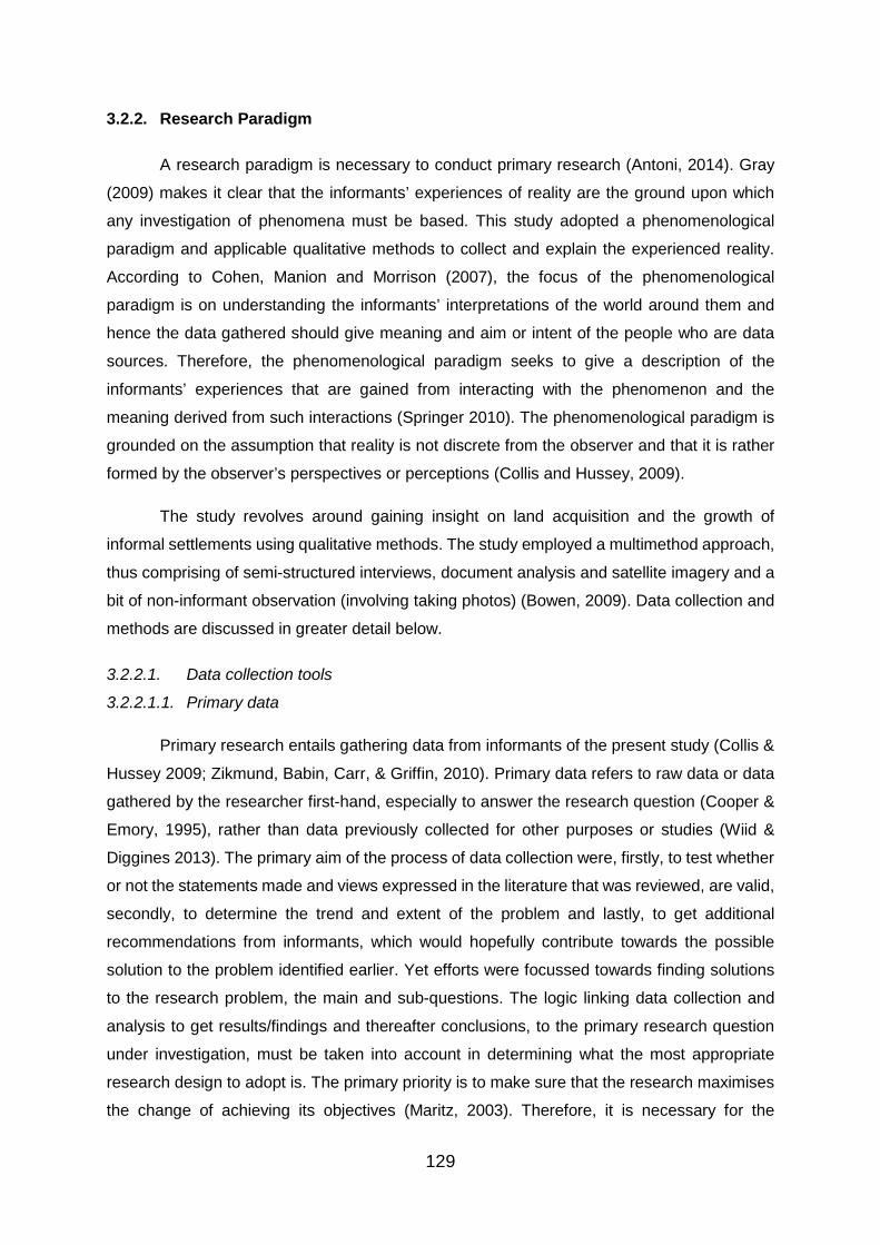
129
3.2.2. Research Paradigm
A research paradigm is necessary to conduct primary research (Antoni, 2014). Gray
(2009) makes it clear that the informants’ experiences of reality are the ground upon which
any investigation of phenomena must be based. This study adopted a phenomenological
paradigm and applicable qualitative methods to collect and explain the experienced reality.
According to Cohen, Manion and Morrison (2007), the focus of the phenomenological
paradigm is on understanding the informants’ interpretations of the world around them and
hence the data gathered should give meaning and aim or intent of the people who are data
sources. Therefore, the phenomenological paradigm seeks to give a description of the
informants’ experiences that are gained from interacting with the phenomenon and the
meaning derived from such interactions (Springer 2010). The phenomenological paradigm is
grounded on the assumption that reality is not discrete from the observer and that it is rather
formed by the observer’s perspectives or perceptions (Collis and Hussey, 2009).
The study revolves around gaining insight on land acquisition and the growth of
informal settlements using qualitative methods. The study employed a multimethod approach,
thus comprising of semi-structured interviews, document analysis and satellite imagery and a
bit of non-informant observation (involving taking photos) (Bowen, 2009). Data collection and
methods are discussed in greater detail below.
3.2.2.1. Data collection tools
3.2.2.1.1. Primary data
Primary research entails gathering data from informants of the present study (Collis &
Hussey 2009; Zikmund, Babin, Carr, & Griffin, 2010). Primary data refers to raw data or data
gathered by the researcher first-hand, especially to answer the research question (Cooper &
Emory, 1995), rather than data previously collected for other purposes or studies (Wiid &
Diggines 2013). The primary aim of the process of data collection were, firstly, to test whether
or not the statements made and views expressed in the literature that was reviewed, are valid,
secondly, to determine the trend and extent of the problem and lastly, to get additional
recommendations from informants, which would hopefully contribute towards the possible
solution to the problem identified earlier. Yet efforts were focussed towards finding solutions
to the research problem, the main and sub-questions. The logic linking data collection and
analysis to get results/findings and thereafter conclusions, to the primary research question
under investigation, must be taken into account in determining what the most appropriate
research design to adopt is. The primary priority is to make sure that the research maximises
the change of achieving its objectives (Maritz, 2003). Therefore, it is necessary for the
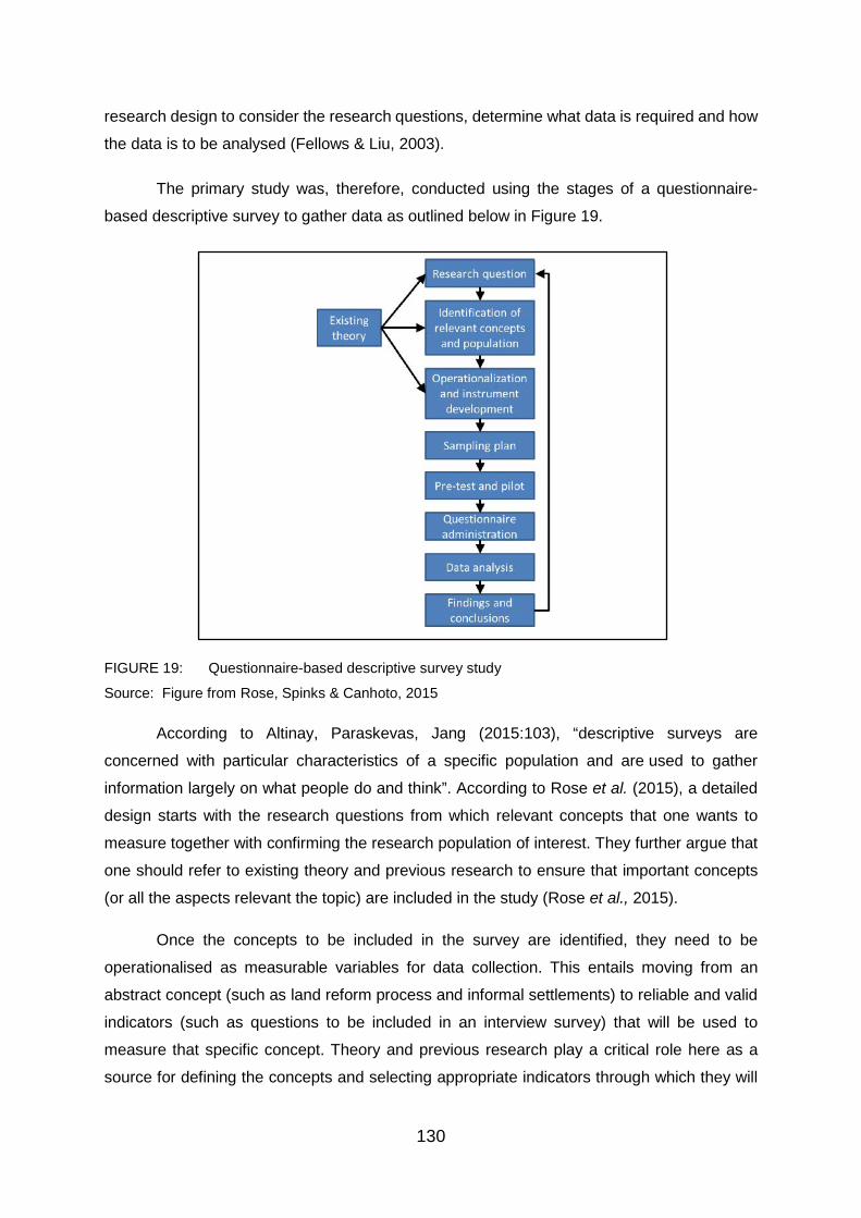
130
research design to consider the research questions, determine what data is required and how
the data is to be analysed (Fellows & Liu, 2003).
The primary study was, therefore, conducted using the stages of a questionnaire-
based descriptive survey to gather data as outlined below in Figure 19.
FIGURE 19: Questionnaire-based descriptive survey study
Source: Figure from Rose, Spinks & Canhoto, 2015
According to Altinay, Paraskevas, Jang (2015:103), “descriptive surveys are
concerned with particular characteristics of a specific population and are used to gather
information largely on what people do and think”. According to Rose et al. (2015), a detailed
design starts with the research questions from which relevant concepts that one wants to
measure together with confirming the research population of interest. They further argue that
one should refer to existing theory and previous research to ensure that important concepts
(or all the aspects relevant the topic) are included in the study (Rose et al., 2015).
Once the concepts to be included in the survey are identified, they need to be
operationalised as measurable variables for data collection. This entails moving from an
abstract concept (such as land reform process and informal settlements) to reliable and valid
indicators (such as questions to be included in an interview survey) that will be used to
measure that specific concept. Theory and previous research play a critical role here as a
source for defining the concepts and selecting appropriate indicators through which they will

131
be measured. The next step is the development of appropriate instruments for collecting data.
A schedule with interview questions was developed for collecting administrative data (Rose et
al., 2015).
It was also necessary to develop a sampling plan for the study. Like most survey
studies, this study collected data from only a sample of the population of interest and then
used qualitative deductions (thematic analysis), by identifying patterns that are indicated by
the data that was collected and making inferences to make generalisations about that overall
population based on the data from the study sample. Lastly, the interview questionnaire was
pre-tested and piloted, face-to-face, as a matter of high importance in order to reduce the risk
of problems later on (Rose et al., 2015). It is only after pre-testing and piloting the data
collection instrument (i.e. interview questions) that data collection began. There was a need
to use more than one administration method to reach the informants, such as time, availability
and English literacy of informants. (Rose et al., 2015).
According to Rose et al. (2015), these early stages are very important when conducting
a survey study since mistakes made at this point are difficult or impossible to correct later.
Thus, it was important to appreciate this and to not move on with enthusiasm to start data
collection using inadequately prepared and untested questions that produce poor data leading
to an inability to answer the original research question. They further argue that without pre-
testing and piloting, “it is a simple case of garbage out, garbage in: an inadequate data
collection instrument will generate inadequate data” (Rose et al., 2015:5).
Formal data analysis began only once all data had been collected. This involved
identifying patterns, making deductions and drawing inferences to draw conclusions about the
population from which study sample came. Once the analysis was completed, the findings and
conclusions were presented in a strategic format, so as to respond to each study objective
and question (see Chapter 4 and 5).
3.2.2.1.1.1. Interviews
According to Cooper and Emory (1995), data from primary sources can be collected
in two ways, observing people, conditions, etc, or by surveying or questioning people. This
research made use of a face-to-face interview to collect primary data by questioning the key
informants (Leedy, 1997).
Key Informant Interviews (KIIs)
Key informant interviews were conducted to collect primary data from the key
informants. Carter and Beaulieu (1992) describe KIIs as qualitative in-depth interviews with a
132
wide range of people who have first-hand information/views about a topic of interest and can
provide expert insight on what is going on in the community, the nature of problems and
possible solutions. Basically, the informants (key informants) were purposely selected due to
their knowledge of the study area and topic/subject being investigated investigation. Thus, key
informants included public officials, community leaders and shack dwellers. As an in-depth
interview, this involved conducting intensive face-to-face interviews with a small number of
informants to investigate their perceptions on a particular situation or idea towards realising
the study objective and solutions to the study questions, using standardised or a guide with
questions to be covered (Gall, Gall & Borg, 2003).
According to Boyce and Neale (2006), in-depth interviews are useful in obtaining
detailed and rich data in a relatively easy and inexpensive manner about a person’s practices,
perceptions and behaviours as well as to understand in detail the answers provided. Bryman
(2006) further advances that in-depth interviews gather background information, such as
expert knowledge, and are likely to gather facts as well as the descriptions of processes. Yet
it may be difficult to select the right key informants with diverse but relevant viewpoints and it
may even be challenging to get hold of busy informants and to secure appointments for
interviews (Carter & Beaulieu, 1992; Mountain States Group, Inc., 1999).
Sixty-seven key informants were interviewed, including 59 dwellers, five (5) community
leaders and three (3) government (City of Tshwane Municipality (CTMM)) officials, namely:
two (2) ward councillors and the Director of human Settlements Planning. However, altogether,
the collected data yielded 64 usable interviews which were subjected to thematic analyses.
Three interviews with the dwellers were not usable as they were extra and void of a lot of
critical information. Furthermore, as provided by Peek and Fothergill (2009), KIIs can also be
conducted where the potential informants may not be included or comfortable talking openly
in a group or to particularly to individualise (as opposed to group) their experiences,
perceptions and behaviours. Taking this into account, interviews were also conducted with 14
informal settlement dwellers from each of the four selected informal settlements, namely:
Phomolong, Extension 11, Alaska and Stoffel Park. Five community leaders, one (1) from
each of the aforementioned informal settlements, with the exception of Extension 11, were
also interviewed. Two (2) community leaders were interviewed in Extension 11 because of its
historical complexity and sub-division/composition.
Whereas Marshall, Cardon, Poddar and Fontenot (2013) provide that, ideally, one
case study should be about 15 to 30 interviews and it should be noted also that the general
rule on the sample size for interviews is that when the same narratives, themes, problems and
subjects are emerging from interviews, then a sufficient sample size has been achieved
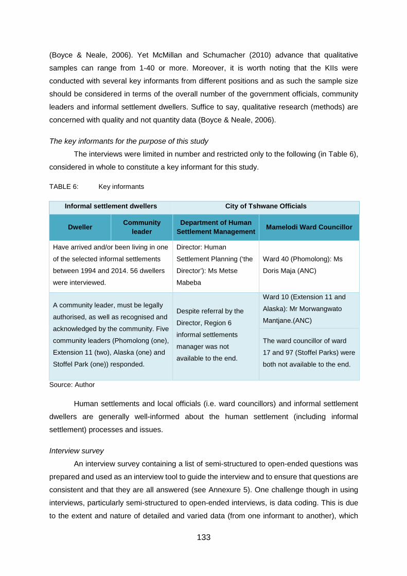
133
(Boyce & Neale, 2006). Yet McMillan and Schumacher (2010) advance that qualitative
samples can range from 1-40 or more. Moreover, it is worth noting that the KIIs were
conducted with several key informants from different positions and as such the sample size
should be considered in terms of the overall number of the government officials, community
leaders and informal settlement dwellers. Suffice to say, qualitative research (methods) are
concerned with quality and not quantity data (Boyce & Neale, 2006).
The key informants for the purpose of this study
The interviews were limited in number and restricted only to the following (in Table 6),
considered in whole to constitute a key informant for this study.
TABLE 6: Key informants
Informal settlement dwellers City of Tshwane Officials
Dweller Community leader
Department of Human Settlement Management Mamelodi Ward Councillor
Have arrived and/or been living in one
of the selected informal settlements
between 1994 and 2014. 56 dwellers
were interviewed.
Director: Human
Settlement Planning (‘the
Director’): Ms Metse
Mabeba
Ward 40 (Phomolong): Ms
Doris Maja (ANC)
A community leader, must be legally
authorised, as well as recognised and
acknowledged by the community. Five
community leaders (Phomolong (one),
Extension 11 (two), Alaska (one) and
Stoffel Park (one)) responded.
Despite referral by the
Director, Region 6
informal settlements
manager was not
available to the end.
Ward 10 (Extension 11 and
Alaska): Mr Morwangwato
Mantjane.(ANC)
The ward councillor of ward
17 and 97 (Stoffel Parks) were
both not available to the end.
Source: Author
Human settlements and local officials (i.e. ward councillors) and informal settlement
dwellers are generally well-informed about the human settlement (including informal
settlement) processes and issues.
Interview survey
An interview survey containing a list of semi-structured to open-ended questions was
prepared and used as an interview tool to guide the interview and to ensure that questions are
consistent and that they are all answered (see Annexure 5). One challenge though in using
interviews, particularly semi-structured to open-ended interviews, is data coding. This is due
to the extent and nature of detailed and varied data (from one informant to another), which

134
makes it difficult to identify and get themes (Creswell, 2007). Yet Gall et al. (2003) argues that
this provides rich data and reduces the researcher ability to impose personal biases within the
study. Although it is advisable to avoid yes and no questions as they tell very little, a space
was provided to expand on the answer.
Overall, the interviews were structured in such a manner that the specific objectives,
which are listed in 1.3.1, also taking in to account the issues/concepts, statements made and
views expressed in the literature reviewed, could be realised. The draft schedule was then
submitted to the Faculty of Humanities Research Ethics Committee (FHREC) of the University
of Pretoria for scrutiny of its ethical acceptance. No comments were raised on any aspects of
the questions and the technical structure of the draft. First, for consistency and clarity of the
draft schedule, a pre-test was conducted by a sample of two informants. Feedback received
from the comments and the pre-test were incorporated in the final version (Maritz, 2003).
While questions were asked in English, interviews were conducted in the local
language of the informants, especially where informants are illiterate and/or not fluent in
English. Stewart and Shamdasani (1992) argue that conducting a study in the language of the
informants increases the ability of the informants to articulate their views. Notes of the
interviews were taken. The interviews, where necessary, were, in addition, recorded and
transcribed in order to ensure that the views are captured (Krueger, 1994).
a. “Closed” type questions “Closed” type statements or questions were mainly used in the interview survey for the
following main advantages mentioned by Maritz (2003:19):
• They are relatively easy to respond to and attract a high rate of response.
• Terminologies used to describe the issues raised by different informants are limited,
which facilitates the processing of data.
• The objectives of the survey can conveniently be achieved.
“Closed” type statements are primarily used in the interview survey strictly on their own
in Part 1 of the survey to obtain the general demographic information of the informants.
Meanwhile, the informants, in Part 3 and Part 4 of the interview survey, were required to
indicate their agreement/disagreement on each question posed by answering, in the great
majority of cases, either “yes” or “no” respectively.
b. “Open-ended” comments The Division of Research Support of the Department of Information Technology at the
University of Pretoria describes the use of “open-ended” questions in its Guidelines for
135
creating Questionnaires in this way: “This type of questions are usually used when insufficient
knowledge regarding the particular subject exists and the researcher is uncertain whether
predefined categories [for possible answers] will cover all possibilities. Open questions are,
therefore, particularly useful for exploratory studies”. This extract was found to be particularly
relevant, as the main aim of the decision to conduct the interviews providing for “open-ended
comments.
Informants were, in addition, given the opportunity, in an “open-ended” format, to
express themselves in their own words on the subject in a space allocated after “closed”
statements or questions on each subject area. “Open-ended” questions were asked
particularly to acquire perfect understanding of informant experiences (Neuman, 2000;
McMillan & Schumacher, 2010). These comments were all taken into account when the results
of the interview survey were analysed.
c. Bias Maritz (2003:20) notes that “the possibility of bias in response to “closed” type
statements or questions is usually high due to the fact that there is no evidence that the
informants have thoroughly considered the statements or questions”. Yet this possibility was
mitigated as follows:
• Fieldwork assistant (a final-year Land Reform student) recommended by Dr Nerhene
Davis, a Land Reform lecture amongst other modules at the University of Pretoria, who
on request also agreed to facilitate the interviews with the informants. The student was
taken through or oriented on the study topic, interview survey and how to facilitate the
interviews (which includes asking and explaining the questions or statements) and was
deployed to assist with data collection, specifically from informal settlement dwellers in
the study area. This procedure was also followed in an effort to select the appropriate
key informants (i.e. informants) and in terms of the sampling technique explained in
3.2.2.3.2, and to secure their commitment to participate in the study through and in
terms of the informed consent form attached herein as Annexure 4 (see also the
interview survey attached as Annexure 5).
• The case study area was extensively covered by ensuring that the interviews are not
conducted with dwellers living in shacks next or close to each other. Interviews were
conducted with dwellers who met the key informant criteria for the purpose of this study
(i.e. who have lived in the informal settlements between 1994 and 2014). A space to
elaborate on the direct responses was provided on the survey.
“Closed” type statements such as “yes” and “no” are not necessarily quantitative but
followed with qualitative explanations. Discrete statements also often allow a neutral situation

136
where people are not sure. They were only used to obtain a direct response, which was
supplemented by an “open-ended” comment to particularly illicit meaning or to acquire a
perfect understanding of informant experiences as indicated above. Thus, the interview survey
is said to contain semi-structured to open-ended questions, rather than strictly “closed” and
“open” questions. Overall, in determining the preferred manner of data collection for this study,
being moderately easy to administer and analyse was taken into account in choosing semi-
structured questions (Neuman, 2000; McMillan & Schumacher, 2010).
3.2.2.1.2. Secondary data
Secondary data refers to information that has been gathered before the present or
current study (Collis & Hussey 2009; Zikmund et al., 2010). The necessary secondary data for
this study was collected from various secondary databases accessible in and from a variety
academic information centres including the University of Pretoria library. A variety of
secondary sources such as previous research studies, journal articles, books, conference
papers, web-based databases such as Google Earth and United States Geological Survey
(USGS) EarthExplorer interface (for Landsat–earth observation satellite images) etc. were
reviewed/utilised.
Firstly, secondary data sources enabled for a comprehensive synthesis of the relevant
literature on land acquisition and informal settlements to be conducted. Finally, while key
informant interviews provided insight through first-hand experiences and views on land
acquisition and the informal settlements, particularly in Mamelodi – documents (e.g. From
government) and Landsat satellite images were analysed to obtain some well documented
evidence to be tested against and complement the primary data. Secondary data sources are
discussed below.
3.2.2.1.2.1. Landsat satellite imagery
Landsat satellite imagery was used for the sole purpose of responding to the first
research objective and question – to analyse the development and growth of informal
settlements in Mamelodi. To establish the extent of the expansion of informal settlements. The
Landsat program is the first series and over four decades of space-based orbiting satellites
(sensors) co-managed by USGS and National Aeronautics and Space Administration (NASA)
that observe the earth/land masses (excluding Antarctica and Greenland), it offers the longest-
running enterprise for satellite imagery of the earth’s continental land cover/surface (including
coastal shallows and coral reefs), acquisition and record (University of Maryland, 2004; NASA,
2014; Nagaraj, 2015:8). Thus Landsat imagery are “collected from hundreds of remote
sensing satellite sensors [that] offer accurate, frequent and almost instantaneous data

137
covering the earth in a relatively short time” (Liu, 2014:iv). This program resulted in a long-
term record of changes induced by nature and humans on the global landscape (Miller,
Richardson, Koontz, John & Koontz, 2013). An additional seven satellites have been
successfully launched since the first, civilian observation (Byrnes, 2012), Landsat 1 satellite
image in 1972 (USGS. 2003; University of Maryland, 2004; Byrnes, 2012).
Having been imaging the planet for over four decades, Landsat helps make
comparisons by allowing people to see how the earth has changed. Landsat collects imagery
data at the scale of human relations with the land and the necessary frequency to monitor,
detect and have understanding of the changes in land cover and land use. This data has
benefits to society. For instance, a number of historical images of a single area can now be
obtained and analysed to detect to change (or for ‘Change detection’) over time. The user can
land-use or land-cover conditions across an entire site or region. Landsat was the first satellite
to keep an eye on or to monitor and help preserve the geoheritage of the lands throughout the
world (NASA, 2016). Pixel-by-pixel, Landsat images of the landscape are put together to
provide data at a scale required to effectively manage the lands, cities, and natural resources
over time (USGS, 2016).
Overall, because of its consistency, Landsat data obtained through the years allows
for the direct comparison of current specific area images acquired in earlier months, years, or
decades. This process of comparison can show changes in land-cover that take place
gradually and subtly, or rapidly and devastatingly. The archive’s richness, together with a
policy of no cost data, allows users to take advantage of time series of data over geographic
areas that is extensive to find long-term trends and to monitor the rates and characteristics of
the change on the surface of the land (Miller et al., 2013). Landsat satellites acquire imagery
in a regular, tiled style, after the World Reference System (WRS1 for MSS, WRS2 for TM and
ETM+). For example, Bands 1, 2 and 3 are combined and used to approximate the
appearance of the real world. Bands 4, 5 or 7 from ETM+ are used together with 1, 2 or 3 to
demonstrate the conditions of the vegetation Landsat imagery that is acquired in a manner
that is very precise, to better emphasize specific aspects of the land cover (University of
Maryland, 2004). Yet, Unsupervised Classification was not very useful (accurate) since the
resolution of acquired Landsat 5 imagery (in particular) was poor resulting to inaccurate
classification (such as categorisation of some built areas as bare/vacant land or confusion of
built areas to be bare land, vice versa). Thus, we alternatively opted for Tasseled Cap (TC)
transformation and True colour composition to demonstrate change in land cover/use as result
of informal settlement developments.

138
Landsat imagery can be selected, previewed and downloaded for free using the USGS
Earth Explorer application at http://earthexplorer.usgs.gov (USGS, 2008). The first step
following the download is therefore to ‘gunzip’ the file and this opens the Landsat image band
in a GeoTIFF file format which is its native. A GeoTIFF file can be utilised as a TIFF file in any
graphical software or using spatial software (such as the ENVI or ArcMap) and it produces or
present georeference data. In addition to this georeference data, a file of a Landsat image
from the USGS EarthExplorer will have been processed through a resampling technique.
“Finally, the Landsat image may have been orthorectified, especially if it is a Landsat
GeoCover image” (University of Maryland, 2004:2).
Software
ENVI was employed to process and analyse the downloaded Landsat satellite images
while ArcGIS-ArcMap (10.4.1) was used to create the maps. ENVI is a premier application or
software tool that is used for analysis and (pre)processing of geospatial (or satellite) imagery
in a quick and easy manner, which prepares the imagery for viewing or additional analysis
(Exelisvis, 2011). “It provides user friendly interface to process and analyse satellite imagery
that helps in effective decision making. ENVI can be used by GIS Professionals to image
analysts, image scientists without prior experience with imagery” (Abburu & Golla, 2015:134).
In this regard, classification is instrumental in “group(ing) satellite image pixels into meaningful
classes” (Abburu & Golla, 2015:131).
Change detection “assists to identify modification land cover within the same category.
This feature can be used in various applications such as disaster management, urban
monitoring and land cover change analysis etc” (Abburu & Golla, 2015:131). Composite
generation as it were proved fruitful in visual analysis. NASA (2014:14) provides that “for visual
analysis, colour composites make fullest of the capabilities of the human eye. Depending upon
the graphics system in use, composite generation ranges from simply selecting the bands to
use, to more involved procedures of band combination and associated contrast stretch”.
Change detection overtime was therefore possible through TC transformation (i.e. applying
surface Brightness Channel or brightness vector) and True colour composition (i.e. relying on
associated contrast stretch) of the acquired Landsat imagery (TM and ETM+ data) of the study
area for four dates (1993, 1994, 2004, and 2014) rather than selecting the bands to use or
more involved procedures of band combination. TC transformation makes bare land look dark
grey or dark and built areas (something that it is not water or vegetation) to look bright.

139
3.2.2.1.2.2. Document analysis
Document analysis was used as an additional secondary data to compliment primary
data and to enhance the rigour of the study by enabling data triangulation – to provide credible
facts to validate the raw data (Cacilley, 1983, Bowen, 2009; Matthews & Ross, 2010). Given
also their usefulness, lack of reactivity, efficiency and cost-effectiveness, documents present
major advantages that evidently offset its limitations such as high irretrievability, insufficiency
of detail (Bowen, 2009) and “biased selectivity” (Yin, 1994:80). Particularly, the analysis
includes the consultation of documents which contain information on land, housing and
informal settlements in Mamelodi in the CoT, Gauteng. Through documents analysis, data
from relevant documents was studied, assessed and interpreted with the aim of eliciting
meaning, gaining understanding and developing empirical knowledge (Corbin & Strauss,
2008; see also Rapley, 2007). Documents contain words and images whose recording is free
of the researcher’s involvement or interference (Bowen, 2009). The use of document analysis
is important as Atkinson and Coffey (1997:47) describe documents “as ‘social facts’, which
are produced, shared, and used in socially organised ways” and so are research findings.
Documents that were sampled and analysed mostly took the form of relevant
secondary data sources such reports in newspapers, academic papers and research
series/issues/articles on the study area and government publications from the DHS, CTMM,
HDA (including web-based applications) and Stats SA. Few documents were obtained from
the research area and they were treated as authentic since they were signed by the community
leader and/or the dwellers. This would include land audit data for the study area. This is in line
with Bowen (2009), who provides that documents that may be analysed or used as part of a
study, come in a variety of forms. Documents which can furnish documentary material for
research purposes take a variety of forms including advertisements, agendas, minutes of
meetings, attendace registers, letters and memoranda, newspapers, maps and charts;
organisational or institutional reports and various public records as well as scrap books and
photo albums (Bowen, 2009:27–28). Such documentary sources were also treated as sets of
field notes and analysis.
Several documents were methodologically searched over several months. The
Sustainable Human Settlement Plan Draft Report (CoT, 2014a:6), for example, contains:
• “a municipal housing needs assessment;
• the identification, surveying and prioritisation of informal settlements; and
• the identification of well-located land for housing”.

140
This was used to obtain the context and situational analysis of informal settlements
and housing supply and demand as well as challenges in Mamelodi. Data from documents
were analysed together with interview, satellite imagery data so that/and themes emerged
across the data sets. Moreover, observation of the community conditions allowed for the
development of a deeper understanding of how the informal settlement looked, was
demarcated, has developed and the developments that have taken or have been taking place
since its establishment. These field or study area observations in the form of pictures were
undertaken during the same period in which the interviews were conducted.
Documents were particularly useful pre- and post-interview situation. In this regard,
data collected from the documents was used to check data from interviews, satellite images
and vice versa. Therefore, despite their flaws (i.e. incompleteness and unevenness), the
documents reviewed, served another useful purpose as they augmented the satellite images,
interview and observational data. This is apart from the rich context and background
information that help with an understanding of the establishment of Mamelodi Township and
the development and expansion/growth provided as a result of a comprehensive, systematic
document review. Data from documents served to ground the research in the context of the
phenomena or topic being investigated (Bowen, 2009:37). Data from various documents is
analysed and discussed in Chapter 4 hereinafter.
3.2.2.2. Data validation
To enhance the data credibility, trustworthiness and validity of the study, the
researcher will use data triangulation where data obtained from documents, Landsat satellite
images and key informant interviews (KIIs) will be cross checked against each other. Data
source triangulation is essential in providing data validity and reliability as it considers more
than one source of data for the same data and enhances data validity and credibility (Patton,
1990; Yin, 2003; Runeson & Host, 2009). Therefore, to be sure, the diverse data source
sources provided a more complete picture of the trend of informal settlement expansion, land
acquisition sources and their role in the expansion/growth and strategies that could be
employed to proactively manage informal settlements, more especially in Mamelodi, that
would have been provided by a single data source. Effectively, triangulation of data sources
“countered the threats to trustworthiness, such as reactivity, research bias, and informant bias”
(Bowen, 2009:38).
All of the evidence from the Landsat satellite imagery, interviews and documents
created a consistent picture of- or insight into the land acquisition processes and their role in
the growth of informal settlements in Mamelodi and only then was the researcher satisfied that
141
the data collection processes and analysis were complete. The interviews did not unearth
some of the data set. The document analysis confirmed the authenticity of the data from
interviews and Landsat satellite imagery and vice versa.
3.2.2.3. Population of interest and sampling technique
3.2.2.3.1. Population and sample size
The survey (interview) population was restricted to Mamelodi informal settlement
dwellers and community leaders as well as government officials. Yet as stated by McMillan
and Schumacher (2010), qualitative samples can range from 1-40 or more. Thus, the total
sample size was 67 key informants including 59 informal settlement dwellers, five (5)
community leaders and three (3) government officials (including the City’s Director of Human
Settlement Planning and two (2) ward councillors who were also dwelling within the informal
settlements that they lead).
3.2.2.3.2. Sampling technique
The sampling technique to be used for this study was the purposive sampling
technique, where Mamelodi informal settlement dwellers and CTMM officials, particularly from
the Department of Human Settlements and ward councillors of the study’s settlements were
chosen for their knowledge concerning the study topic and their role in the area. Purposive
sampling is associated with small and in-depth studies, including case studies (Matthews &
Ross, 2010). As provided by Maxwell (1997) and Tongco (2007), purposive sampling allows
the researcher to selectively choose particular group of informants and areas to provide
significant/insightful/ expert information to feed into the study objectives and to address the
research question. Maxwell (1997) further defines purposive sampling as a method of
sampling in which, ‘‘particular settings, persons, or events are deliberately selected for the
important information they can provide that cannot be gotten from other choices’’ (Tashakkori
& Teddlie, 2003:87).
The hallmark and strength of purposive sampling essentially lies in its deliberate bias.
Notwithstanding its intentional bias, purposive sampling has the ability to provide dependable
and strong data (Bernard, 2002; Lewis & Sheppard, 2006; Tongco, 2007). Furthermore, a
random sampling is often neither feasible nor efficient (Alexiades, 1996). A high dispersal of
samples may bring about relatively higher costs for a researcher (Alexiades, 1996; Bernard,
2002). Hence a non-random sampling technique in purposive sampling will be used. Purposive
sampling proves efficient in that easily accessible informants are chosen, including those keen
to participate in the study (Teddlie & Yu, 2007). Tongco (2007:153) also provides that,

142
“Informants may be chosen out of convenience or from recommendations of knowledgeable
people”.
3.2.3. Data collection challenges and limitations of the study
The following challenges are expected for data collection tools to be used in the
research, yet, these limits will not compromise the research findings or results credited to data
triangulation. Other mitigations are discussed below:
• Unavailability of informants: rescheduling, excuses and non-responses to set
appointments and questions occurred. The regional manager responsible for the
management of informal settlements in Region 6 and two ward councillors (ward 17
and 97 where Stoffel Park is located) were perpetually unavailable.
• Language: interview questions (where necessary) were drafted in English and
interpretation in the local language of informants was required to provide an
understanding of the questions. The researcher dealt mostly with the Nguni
(IsiNdebele, IsiZulu, SiSwati and IsiXhosa) speaking informants, while the Field
assistant dealt mostly with the Sotho (Sepedi, Setswana and Sesotho) speaking
informants. This mitigated the possible selective bias of targeting only Nguni language
speaking informal settlement dwellers as a mainly Nguni language(s) speaker.
Fortunately, Tshivenda (or Luvenḓa) and Xitsonga speaking informants could
communicate at most in Sotho and least in Nguni (especially Vatsonga). Overall, the
informants spoke South African Bantu languages which are widely spoken and often
mixed in the country’s Townships, particularly within the Gauteng province.
• The use of a GPS to capture coordinates (i.e. building footprints) would (have been)
be a better option to show the area covered rather than stand or shack numbers which
have a potential of compromising the confidentiality and anonymity of the informants.
• Time and Budget: whereas the intention of the research was to interview a larger
number of informants, it was not possible due to time and budgetary constraints.
• The study is topic (land and informal settlement), geographical (Mamelodi) and time
bound (1994 – 2014).
In the research proposal the below possibility was raised:
• Aerial photographs of settlement patterns may not be available or exclusively for the
period under investigation, 1994 – 2014. Thus, only certain aerial photographs
available for the period will be used for analysis and/or interpretation.
143
This abovementioned challenge became a reality. As mentioned in the research
proposal, aerial photographs were to be obtained and interpreted/analysed to show trends
that can be identified in terms of informal settlement patterns in Mamelodi over a period of 20
years since 1994. Yet this was not the case for Mamelodi, for various reasons including that,
important images for certain years were either of too poor a quality in terms of resolution or
they were not available at all. Therefore, aerial photographs were abandoned for Landsat
satellite imagery which did not present the challenges presented by the aerial photos and
provided relatively far better quality results because:
o The United States Geological Survey (USGS) EarthExplorer has a bigger
quality archive of Landsat satellite images.
o Imagery is available for every year stretching from 1972 to the present,
specifically for the study period (1994-2014).
o The only limitation is basically clouds covering the land, which was mitigated
by downloading another aerial photograph for a different (or closer) date
o Images came with a coordinate system.
o All that was required was to, without any restriction, download them from the
USGS (EarthExplorer) Landsat archive and then to analyse them.
If used, the challenges relating to using the aerial photographs would have had
negatively affected (decreased) the quality of the results mainly because (of):
o Poor (i.e. early aerial photos) and varying photo resolutions thus required
resampling (which could be done in ENVI) which further reduced the quality
(resolution) of the photos, because when conducting change detection, ENVI
was somewhat guessing or did not know exactly what the land feature is. For
an example, whether it is a building or not. For this reason also, classification
was not accurate.
o They were not geo-rectified/orthorectified and had varying coordinate systems.
o Common ground control points also could not be consistently identified in all
aerial photographs. Firstly, because of the varied quality of the photographs
and secondly, changes on the surface or in land over time. Thus no landmarks
or points (such as a bridge, swimming pool etc.) were found that are common
in every photo; and
o It was not a norm for the government or air-survey companies to take aerial
photographs from 1994 to 2000 as suggested by the unavailability of the aerial
photos in their database, specifically for this period.

144
3.2.3.1. Generalisability
Furthermore, Stewart and Shamdasani (1992) claim that generalisation is often not
possible for qualitative (interview) findings due to their nature of using small samples and
purposive sampling technique, rather than random samples. Maree (2012) also asserts the
claim by stating that generalisation is not compatible for qualitative data. Polit and Hungler
(1991) define the term generalisability as the extent to which the research findings can be
generalised from the sample of the study to the entire population. Meyers (2000) argues that
while generalisability with qualitative data in the traditional meaning of the term is not possible,
partial generalisations may be possible to similar populations and/or contexts.
3.2.4. Ethical considerations
As the study involves people, it is essential to understand the ethical duties of
conducting research (McMillan & Schumacher, 2010).Accordingly, firstly, ethical clearance
was obtained from the University of Pretoria (see Annexure 2 attached). Secondly, before
conducting the study, permission to conduct research within the City of Tshwane Municipality
was granted by the City of Tshwane’s Group Head: City Strategy and Organisational
Performance and obtained through the City’s Knowledge Management Unit (Annexure 3
attached). Key informant consents were obtained from all informants by signing off the
provided consent forms. Prior to signing the consent forms (Annexure 4 and Annexure 5), all
consent forms, where required, were read to the informants in their respective or local
languages to ensure that they understood. Moreover, all informants were assured of
confidentiality and anonymity. Yet officials and community leaders consented to the use of
referenced quotes (to be identified as informants).
Finally, the informants were informed in detail about the purpose of the study, the
intended use of the information obtained from them and the findings of the study thereof. In
order to ensure voluntary participation and avoid information bias, no incentives were offered,
promised or provided. Consent forms clearly stated that the informants were free to withdraw
from research if they wished to do so at any stage without any disadvantages. Moreover,
permission was granted by the City’s Director of Human Settlement planning to take photos
in the study area.
3.2.5. Data analysis
The data collected through key informant interviews, document analysis and Landsat
imagery made up the study data and findings. A thematic analysis was used as the main
analysis technique in generating study findings. The analysis started with data coding
145
(Boyatzis, 1998; Creswell, 2003). According to Creswell (2003), this involves the
comprehensive process of grouping together evidence or collected data and labelling ideas
that are similar, so that they ultimately provide the researcher with wider perspectives.
Accordingly, after data collection, the interview survey transcripts and selected documents, in
particular, underwent a comprehensive process of data coding and identification of themes
(Rice & Ezzy, 1999), to enable an organised critical discussion of findings and presentation.
Downloaded Landsat imagery was processed and analysed using ENVI Classic 5.3 while
ArcGIS-ArcMap (10.4.1) was used to create the maps (i.e. for the study area and from the
Landsat imagery). Themes capture significant data in relation to the research objective and
question and provide patterned responses within the data (Braun & Clarke, 2006). In this
study, the research questions made up the main themes of the research data. These themes
were categorised and captured in the interview survey. The researcher then made a list of the
sub-themes by summarizing the respondent’s response to the interviews which relate to each
main theme (Cresswell, 2013). Once this was done, the researcher catalogued, categorised
and put together, all the data that fit under each sub-theme. Finally, all sub-themes were put
together to summarize the respondent’s comprehensive responses (Creswell, 2013).
Therefore, data analysis involved categorising and relinking aspects of data from the
key informants, selected documents and Landsat satellite imagery so that data can be
analysed, therefore finding underlying meaning and discussing the meaning of the data
(Matthews & Ross, 2010; Maree, 2012). Furthermore, the relationship between the categories
of the data, for example, land acquisition and the development of informal settlements, were
explored. Thus, similarities, differences and general patterns were identified (Bowen, 2009).
3.3. Summary
The study took a qualitative methodological approach and a case study strategy was used to
conduct the study where Mamelodi was a study area. Various primary and secondary data
sources, such as Satellite imagery key informant interviews and document analysis, were used
to collect the data. In terms of scope and limitations, the study is topic (land and informal
settlements), geographical (Mamelodi) and time bound (1994-2014). Following the thematic
analysis, the collected data was triangulated for completeness and validation purposes.
Permission and ethical clearance to conduct the study was obtained from the University of
Pretoria and the City of Tshwane Metropolitan Municipality. Moreover, the respondents
participated voluntarily and their identity was kept anonymous while their information was
treated confidentially.
In the next chapter (4), the collected data or study findings are presented and discussed.

146
CHAPTER 4: THE CASE OF INFORMAL SETTLEMENTS IN MAMELODI, 1994 – 2014
4.1. Introduction
This chapter presents and discusses the study findings relating to informal settlements
in Mamelodi Township, which is the case study area. This includes a presentation and analysis
of the development of Mamelodi and the growth of informal settlements in the township over
a period of 20 years (1994-2014). Focus was placed on four informal settlements, namely;
Extension 11, Phomolong, Alaska and Stoffel Park. The role of the current land acquisition
processes in their growth is also determined. Attention is given to the presentation and
discussion of data that was obtained from the Landsat imagery, key informant interviews and
from documents relevant to the study in an effort to achieve the study objectives listed in 1.3.1
and respond to the study questions listed in 1.3.2.
This chapter therefore contains three main sections:
Section 4.2: Two decades of informal settlement growth in Mamelodi in satellite imagery
Section 4.3: Presentation and discussion of data from key informants
Section 4.4: Documentary data review and discussion of findings
This is thus done purely to allow for the data to be disseminated or presented in order,
in a manner that allows the presentation and discussion of findings to flow. Yet it is important
to note that the sections are not presented in isolation to each other. Document data for
example is presented and discussed with hindsight of the data from interviews and Landsat
imagery.
4.1.1. Mamelodi in context - history to present
During the pre-apartheid years, the level of segregation was fairly high, but Blacks
often lived next to whites and also quite near to the city centre, in communities/areas such as
Marabastad and Bantule (Bernstein & McCarthy, 1998; see also Horn, 1994 – for depiction of
Segregation city of Pretoria – also cited in Bernstein & McCarthy, 1998). Shortly after the
beginning of apartheid in 1948, tens of thousands of black residents, Africans in particular,
were forcibly removed in the 1950s, in terms of the Illegal Squatting and Group Acts, to the
more peripheral Atterridgeville and Mamelodi townships serving as dormitory residential areas
(Bernstein & McCarthy, 1998).
By 1961, these two townships already experienced a shortage of many thousand
housing units. The Pretoria City Council made a case for the creation of the Ga-Rankuwa
township behind the so called ‘black reserve’ (later the Bophuthatswana homeland) boundary

147
about 30 km north-west of Pretoria in order to accommodate the growth. Settlements of Blacks
in the area rapidly expanded and extended into what became known as the Winterveld
complex (Bernstein & McCarthy, 1998) (see also Figure 20 on page 148). Table 7 shows a
more detailed breakdown of Pretoria’s housing and basic services situation by 1994.
TABLE 7: Pretoria’s housing and basic services situation by 1994
Source: ‘CDE Research: Policy in the making’ issue by Bernstein & McCarthy, 1998
Following the promulgation of- and in line with the Group Areas Act, in Pretoria (now
officially called Tshwane after Chief Tshwane of Chief Mushi), whites had their own
demarcated and segregated residential areas within the radius of the city centre (Pretoria).
Meanwhile, Coloureds, Indians and Africans were forcefully removed from those areas
designated as “Whites/Europeans Only”, namely, Lady Selbourne and Marabastad, to
townships located in outskirts of the city. These include Mamelodi, Hammanskraal,
Atteridgeville, Mabopane, Ga-Rankuwa, for Africans, and Eersterus (for Coloureds) and
Laudium (for Indians) (Harrison et al., 2007; SAHO, 2011d; CoT, 2013) – (refer to Figure 20).
Figure 20 also serves as a model of- or conform to the Apartheid city (spatial structure)
illustrated in Figure 3 on page 42, with Mamelodi as an African township with freestanding
informal settlements (Davies, 1981; Simon, 1989), located adjacent to an industrial sector and
thus making Pretoria “apartheid’s model city” as referred to by Bernstein and McCarthy
(1998:3).
Mamelodi (literally meaning and short for father of melodies) is one of the oldest
(traditionally African) townships in South Africa and it is named after Paul Kruger, a colonist
(a name known by to the Black population and for his ability to ‘imitate birds’) and was
established by the apartheid government in 1953 as a native location for black migrant
workers, African in particular, on the farm ‘Vlakfontein’ (as the township was also initially
known), near the train station at Eerste Fabrieken (Gottsmann, 2009; SAHO, 2011d).
According to SAWeb (n.d), this township was founded with just 16 houses built for Black
people, who were removed from other areas where they were unwanted in line with the Group
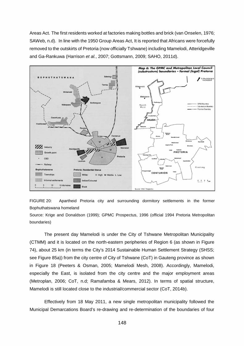
148
Areas Act. The first residents worked at factories making bottles and brick (van Onselen, 1976;
SAWeb, n.d). In line with the 1950 Group Areas Act, It is reported that Africans were forcefully
removed to the outskirts of Pretoria (now officially Tshwane) including Mamelodi, Atteridgeville
and Ga-Rankuwa (Harrison et al., 2007; Gottsmann, 2009; SAHO, 2011d).
FIGURE 20: Apartheid Pretoria city and surrounding dormitory settlements in the former
Bophuthatswana homeland
Source: Krige and Donaldson (1999); GPMC Prospectus, 1996 (official 1994 Pretoria Metropolitan
boundaries)
The present day Mamelodi is under the City of Tshwane Metropolitan Municipality
(CTMM) and it is located on the north-eastern peripheries of Region 6 (as shown in Figure
74), about 25 km (in terms the City’s 2014 Sustainable Human Settlement Strategy (SHSS;
see Figure 85a)) from the city centre of City of Tshwane (CoT) in Gauteng province as shown
in Figure 18 (Peeters & Osman, 2005; Mamelodi Mesh, 2008). Accordingly, Mamelodi,
especially the East, is isolated from the city centre and the major employment areas
(Metroplan, 2006; CoT, n.d; Ramafamba & Mears, 2012). In terms of spatial structure,
Mamelodi is still located close to the industrial/commercial sector (CoT, 2014b).
Effectively from 18 May 2011, a new single metropolitan municipality followed the
Municipal Demarcations Board’s re-drawing and re-determination of the boundaries of four
149
municipalities of Gauteng province namely, Metsweding District, Nokeng Tsa Taemane Local,
Kungwini Local and City of Tshwane Metropolitan Municipalities. The result was that the
reformed City of Tshwane Metropolitan Municipality covering about 35% of the Gauteng’s total
land area of 18 178 km², with seven Administrative Regions, 105 wards and 210 Councillors.
(See Figure 18 and Figure 75 to note the change of the municipal boundary and size). The
government’s continued commitment of improving service delivery and ensuring economic
growth to all its citizens, was given as an explanation for the re-determination of the City of
Tshwane municipal boundary that existed from 2001 to 2011 (CoT, 2013).
The amalgamation now means that the CoT has a total land area of 6298 km² making
it the world’s third largest metropolitan municipality in this regard after New York in USA and
Tokyo in Japan. Gauteng is the most densely populated province despite being the smallest
of South Africa’s provinces and is home to at least 24% of the country’s population which is
about 12.3 million people. Between 2001 and 2011, the population of the City of Tshwane
increased from 2.1 million people to 2.9 million (with a total of 911 536 households). As the
result of migration of people from surrounding provinces to Gauteng while searching for
economic opportunities notwithstanding at a slower rate, it is expected that overtime the City’s
population will continue to increase. In 2016, the Metropolitan’s population was growing at
2.6% per annum (Stats SA, 2016). Moreover, Metsweding region’s (and its local
municipalities) incorporation can partly explain the growth in the population of the City of
Tshwane (CoT, 2013).
Regional Context Region 6 is 885 km² (88524 ha) in extent with 24 wards accommodating a population
of 605 556 and about 22% (44377) of the regions dwelling units are informal. This includes
30373 shacks that make up the informal settlements. Ward 40 of Mamelodi with wards 85,
86, 91 and 101 are the most populated. These high population and density wards are located
in areas that had been previously disadvantaged and are in need of requiring service delivery
of a special kind and the establishment of sustainable human settlements (CoT, 2014a).
The City has identified land invasions as one of the main challenges facing Region 6.
The Municipal has determined to mitigate this by “fast-track[ing the] allocation of RDP houses
and formalisation of informal settlements”. Moreover, unemployment stands at 20.5 % which
is below the national average of 25%. Forty-five per cent of the population are low-income
earners (monthly household income of less than R 2000.00 per month), with also a
concentration of a no-income group. The north-eastern section of the Region, including
Mamelodi, accommodates mostly low-income communities and industrial land uses. (CoT,

150
2017). Figure 21 shows a more detailed breakdown of the profile (dwelling units) Region 6
(CoT, 2014a).
FIGURE 21: Profile of Region 6
Source: Stats SA, 2011 Census; (top right and bottom) CoT, 2013

151
4.2. Two decades of Informal settlement growth in Mamelodi in satellite imagery
This sub-section and the data contained herein relates to the following research
objective and the related question:
Objective 1: to analyse the development and growth of informal settlements in Mamelodi.
Question: what are the trends that can be identified in terms of informal settlement patterns in
Mamelodi since 1994?
Interpretation of historical and recent Landsat satellite imagery of Mamelodi Township Using the ENVI Classic 5.3 to process and analyse the Landsat satellite images (and
ArcMap to create the map), detected change in land cover and a use over time (1994-2014)
can be observed in Figure 22 and Figure 23. The year 1993 is used as a base-year showing
the use or state of the land cover before 1994, the dawn of democracy. Tasseled Cap (TC)
transformation and True colour composition was used to construct and contrast four pairs of
TC transformed and true colour composite images. Firstly, what appears from observing and
analysing the satellite images (in Figure 22 and Figure 23) over time, is that the municipality
has had so much time and opportunity to proactively secure, develop and release serviced
stands or the vacant land for the purpose of formal housing. In this way, it would have,
probably, avoided a number of informal settlements that have mushroomed on the land since
1994.
Consequently, left to fend for themselves, it appears that the land occupants did not
manage to resist the temptation and miss their chance to occupy and erect shacks on the
vacant land. Thus, it can be said that the municipality now is generally reacting to a crisis that
could have been prevented/avoided. The further problem is that new shacks and informal
settlements continue to be erected and develop while the municipality is in the protracted
process of replacing some shacks with formal housing. Since 1994, Informal settlements in
Mamelodi East have expanded, mushroomed and expanded primarily towards the South-East
as particularly indicated also by Gottsmann (2009) (see Figure 72).
Finally, the Landsat satellite images show that Stoffel Park Village is the last informal
settlement established within the traditional boundary or demarcated border of Mamelodi in
2014.

152
FIGURE 22: Informal settlement developments since 1994 – 2014 (Tasseled Cap Transformation for Mamelodi)
Source: Compiled by Bongiwe Tshabalala, student, University of Pretoria; imagery Courtesy of USGS EarthExplorer. 19/09/1993 (Landsat 5 (TM); 22/09/1994
(Landsat 5 (TM)); 31/07/2004 (Landsat 5 (TM)); 31/10/2014 (Landsat 8 (ETM+)).

153
FIGURE 23: Informal settlement developments since 1994 – 2014 (True colour composition for Mamelodi)
Note: (A), Extension 11 informal settlement; (B), Phomolong; (C), Alaska; (D), Stoffel Park.
(B) (A)
(D)
(C)
(A)
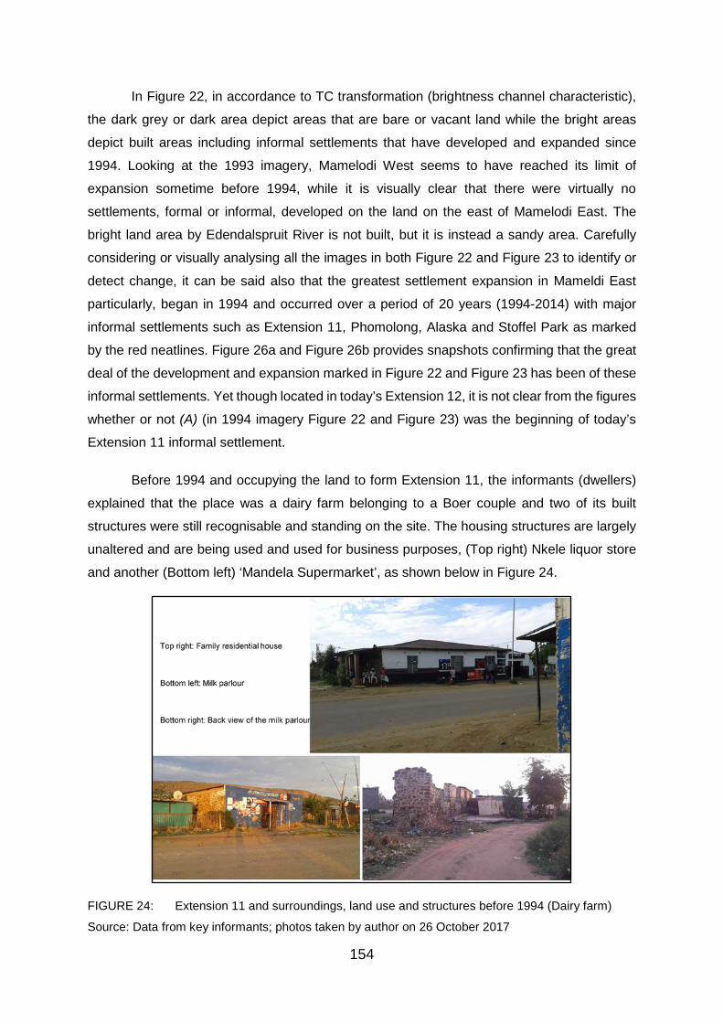
154
In Figure 22, in accordance to TC transformation (brightness channel characteristic),
the dark grey or dark area depict areas that are bare or vacant land while the bright areas
depict built areas including informal settlements that have developed and expanded since
1994. Looking at the 1993 imagery, Mamelodi West seems to have reached its limit of
expansion sometime before 1994, while it is visually clear that there were virtually no
settlements, formal or informal, developed on the land on the east of Mamelodi East. The
bright land area by Edendalspruit River is not built, but it is instead a sandy area. Carefully
considering or visually analysing all the images in both Figure 22 and Figure 23 to identify or
detect change, it can be said also that the greatest settlement expansion in Mameldi East
particularly, began in 1994 and occurred over a period of 20 years (1994-2014) with major
informal settlements such as Extension 11, Phomolong, Alaska and Stoffel Park as marked
by the red neatlines. Figure 26a and Figure 26b provides snapshots confirming that the great
deal of the development and expansion marked in Figure 22 and Figure 23 has been of these
informal settlements. Yet though located in today’s Extension 12, it is not clear from the figures
whether or not (A) (in 1994 imagery Figure 22 and Figure 23) was the beginning of today’s
Extension 11 informal settlement.
Before 1994 and occupying the land to form Extension 11, the informants (dwellers)
explained that the place was a dairy farm belonging to a Boer couple and two of its built
structures were still recognisable and standing on the site. The housing structures are largely
unaltered and are being used and used for business purposes, (Top right) Nkele liquor store
and another (Bottom left) ‘Mandela Supermarket’, as shown below in Figure 24.
FIGURE 24: Extension 11 and surroundings, land use and structures before 1994 (Dairy farm)
Source: Data from key informants; photos taken by author on 26 October 2017
155
The literature review provides the spatial organisation of informal settlement with
Gottsmann (2009) noting that “the finer grids networks typically represents the informal sector”
(see Figure 72). Noting therefore the spatial pattern, structure or organisation of the
settlements in Figure 25, it clear that informal settlements, especially the indicated four, are a
significant feature in and of Mamelodi East and their development has contributed massively
to the great occupation and expansion of Mamelodi (East).
Supplementary to Figure 22 and Figure 23, Figure 25 also validates the figures and
shows that of the four major informal settlements that have mushroomed in Mamelodi since
the dawn of South Africa’s democracy in 1994, two were established in the second decade of
the democratic South Africa between 2004 and 1994, namely, Alaska and Stoffel Park.
Needless to say, Extension 11 and Phomolong were established during the first decade,
between 1994 and 2004. It seems also that with patches of open area/land, that Phomolong
was not fully occupied by the year of 2004. Looking at the 2014 image in both, Figure 22 and
Figure 23, Mamelodi seems to have reached the limit of its greatest expanse. The informal
settlements, Alaska and Stoffel in particular, are encroaching upon Magalies Mountains, on
the East (as seen in Figure 26). If this informal settlement trend (of land demand and
occupation) and pattern continues, there is a reasonably high possibility that the shacks will
summit or extend over the mountains or to another nearby open land which has been the case
already since 2015 as the settlements reached virtually full capacity, especially, as newer
urban dwellers continue to define new boundaries.

156
FIGURE 25: Screen shot confirming informal settlements, 2004 (left) and 2014 (right)
Source: Google Earth (DigitalGlobe, 2004; 2014)

157
FIGURE 26: Redefining limits and boundaries – over the hill, other remaining vacant surrounding
outskirts
Source: Imagery by Author, 2017; (A), Alaska upon Magalies Mountain; (B), Stoffel Park on top of
Magalies Mountain; (C), Trail of removed Stoffel Park shack on top of Magalies Mountain; (D), new
informal settlement development (e.g. Silahliwe) in Pinaarspoort and Skierlik over the railway line and
Pienaarpoort station.
Data collected from key informants in the final analysis does not contradict the above data
from the satellite imagery. More details about the four informal settlements, which were
collected from key informants, are presented and discussed in the following section to achieve
the research objectives and to respond to the research questions. This includes how the land
was acquired and what has caused the informal settlements in Mamelodi to grow, something
which the Landsat satellite imagery does not indicate.

158
4.3. Presentation and discussion of data collected from key informant
Data collected through interviews with informal settlement dwellers, herein and after referred
to as respondents, is presented and discussed in this section. Therefore the data, including
the charts that are presented herein, relates to the shack-dwellers in Extension 11,
Phomolong, Alaska and Stoffel Park, with 56 respondents altogether (excluding the Director,
ward councillors and community leaders), unless stated or referenced otherwise.
Following a comprehensive analysis, the study findings are presented and discussed below
at once for all of the four informal settlements under common themes, in charts and written
format beginning with demographic information. Some of the answers that were obtained are
given verbatim and written in italics to give reference to the presentation and discussion of
data collected from the respondents as well as to explain or give an expression of their
positions in their own words.
GENERAL DEMOGRAPHIC INFORMATION
Gender, ethnicity and home language
70% of the respondents were females and were a majority in all the informal settlements (71%,
64%, 86% and 56% respectively in Phomolong, Extension 11, Alaska and Stoffel Park).
Furthermore, all the respondents in the study were Africans, mostly Pedi and Tsonga (as
shown in Figure 27) to an extent that the most spoken language were Sepedi (41%) and
Xitsonga (23%), while Selobedu (2%) was the least spoken language. Sepedi was the most
spoken language especially in Stoffel Park (57%), Alaska (50%) and Phomolong (43%), while
Xitsonga (43%) was spoken the most in Extension 11.
FIGURE 27: Respondents ethnicity
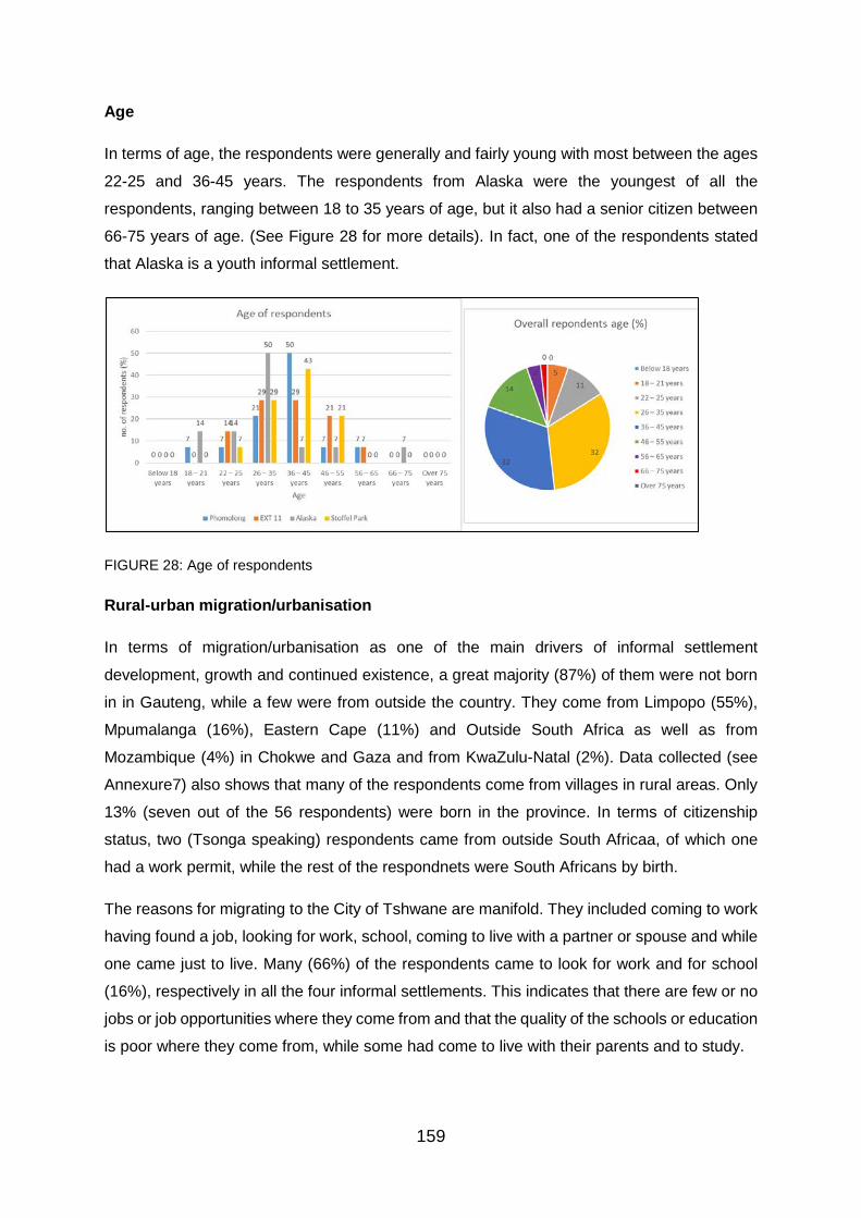
159
Age
In terms of age, the respondents were generally and fairly young with most between the ages
22-25 and 36-45 years. The respondents from Alaska were the youngest of all the
respondents, ranging between 18 to 35 years of age, but it also had a senior citizen between
66-75 years of age. (See Figure 28 for more details). In fact, one of the respondents stated
that Alaska is a youth informal settlement.
FIGURE 28: Age of respondents
Rural-urban migration/urbanisation
In terms of migration/urbanisation as one of the main drivers of informal settlement
development, growth and continued existence, a great majority (87%) of them were not born
in in Gauteng, while a few were from outside the country. They come from Limpopo (55%),
Mpumalanga (16%), Eastern Cape (11%) and Outside South Africa as well as from
Mozambique (4%) in Chokwe and Gaza and from KwaZulu-Natal (2%). Data collected (see
Annexure7) also shows that many of the respondents come from villages in rural areas. Only
13% (seven out of the 56 respondents) were born in the province. In terms of citizenship
status, two (Tsonga speaking) respondents came from outside South Africaa, of which one
had a work permit, while the rest of the respondnets were South Africans by birth.
The reasons for migrating to the City of Tshwane are manifold. They included coming to work
having found a job, looking for work, school, coming to live with a partner or spouse and while
one came just to live. Many (66%) of the respondents came to look for work and for school
(16%), respectively in all the four informal settlements. This indicates that there are few or no
jobs or job opportunities where they come from and that the quality of the schools or education
is poor where they come from, while some had come to live with their parents and to study.

160
It is also particularly interesting to note that none came to start a business (see Figure 29
below for more detail). Only five of the respondents were born in the City of Tshwane (four
from Mamelodi and one from Hammanskraal) making up 7% of all the respondents. They have
found a land and place to live in, in Mamelodi and in the informal settlements in particular.
FIGURE 29: Reasons for migration
Education, employment and income
Unemployment was a serious challenge facing the majority of the respondents from all four of
the informal settlements with as many as 66% unemployed and no more than 50% were
unemployed in all the settlements. Poor levels of education probably play a significant role in
this since as many as 48% of all the respondents did not complete any schooling, while 38%
had matric (Grade 12). (See Figure 30 and Figure 31). Some never even went to school.
Interestingly no more than 10% had a formal qualification other than matric. Consequently, a
great lack of skills and training is likely to be a major cause of unemployment and low-income
levels as shown also in Figure 31. Adding to this is that none of the respondents came from
to the City of Tshwane to start a business, but most to look for work.
Among the respondents, women had a higher rate of unemployment when compared to men,
with as many as 77% of the women unemployed, of which five per cent were female students.
This is perhaps why they are the dominant respondents.

161
FIGURE 30: Level of education
FIGURE 31: Employment and Household income
LAND ACQUISITION: LAND AND HOUSING
Arrival in the City of Tshwane and the informal settlement
Tshwane has been receiving a number of new residents, with a few respondents having been
born in the City, in Mamelodi and Hammanskraal. Some of the residents arrived in the City 30
years ago as indicated in Figure 32, in the early 1980s, with some arriving between 1989 and
1992 in Extension 11, but to date they live in an informal settlement and are yet to own a
house. There is a trend and order represented by the respondent’s year of arrival which
coincides with the years that they arrived in the informal settlement (shown in Figure 33) and
the years that the informal settlements are said to have been established (shown in Figure
47). A majority of the residents from Extension 11 arrived in the City between 1989 and 1992,
with others arriving later between 1995 and 1998, 2001 and 2004, as well as 2004 and 2007.
A large number of respondents from Phomolong arrived in the city between 2001 and 2004

162
as well as 2004 and 2007. Phomolong is followed by Alaska and Stoffel Park. A large number
of respondents from Alaska arrived between 2007 and 2010 as well as 2004 and 2007, while
respondents from Stoffel Park mostly arrived between 2001 and 2004, as well as 2004 and
2007. Overall the majority (41%) of the respondents arrived between 2001 and 2007, followed
by 2007 – 2010 with 13%.
None of the respondents was indicated to have arrived in the City or informal settlements
between 2013 and 2016, most probably because the study and the interviewed respondents
were also time limited between 1994 and 2014. This does not all indicate that the City has not
received new residents and/or that Mamelodi have not given birth to new shacks. As a matter
of fact, new shacks have been erected and new informal settlements have been developed.
FIGURE 32: Year arrived in City of Tshwane
Data graphically presented below in Figure 33 somewhat indicates that Extension 11 was
established before- and is therefore older than Phomolong, Alaska and Stoffel Park. Alaska
and Stoffel Park came after Extension 11 and Phomolong and are relatively new informal
settlements. Moreover the arrival of most of the respondents was also the establishment of
the respective informal settlements (consider Figure 33 together with section 4.2/satellite
imagery, Figure 32 above, Figure 76 and Table 11 under section 4.4/Documentary data).
Most of the respondents in Extention 11 arrived between 1995 and 1998; Phomolong, between
2001 and 2004; Stoffel Park and Alaska, between 2007 and 2010; and in Alaska, between
2010 and 2013. One of the respondents in Extension 11 was born in the informal settlement
now called RDP in the adjacent Extension 18 before being relocated to Sizanani in Extension
11 in 2005. According to the respondent born in 1992, now a father of one, the whole area
from the railway and before Lusaka, was Sizanani. This indicates that Extension 11 or
Sizanani to be precise by the account of the respondent was established at least 2 years
before 1994. Moreover, it appears that Extension 11 and Stoffel Park has continued to receive
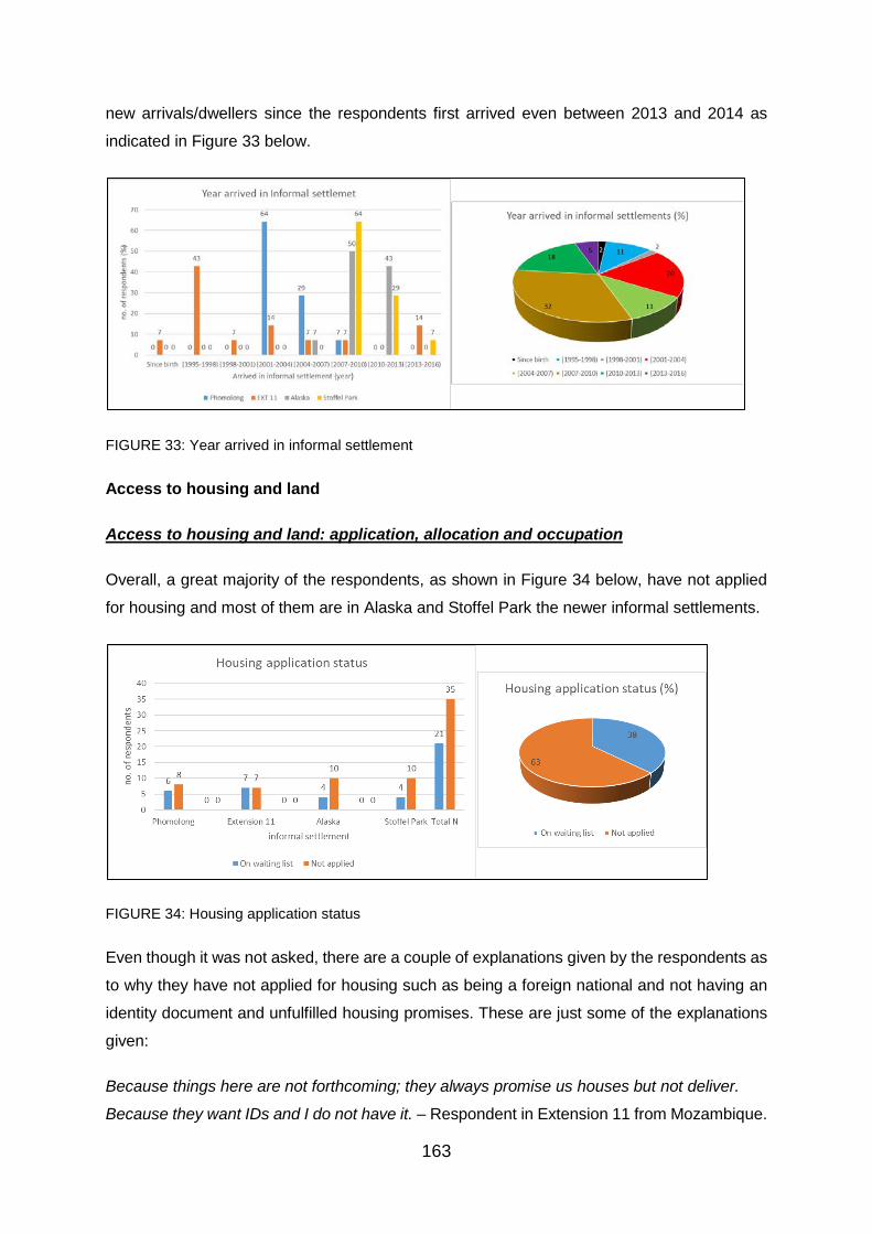
163
new arrivals/dwellers since the respondents first arrived even between 2013 and 2014 as
indicated in Figure 33 below.
FIGURE 33: Year arrived in informal settlement
Access to housing and land
Access to housing and land: application, allocation and occupation
Overall, a great majority of the respondents, as shown in Figure 34 below, have not applied
for housing and most of them are in Alaska and Stoffel Park the newer informal settlements.
FIGURE 34: Housing application status
Even though it was not asked, there are a couple of explanations given by the respondents as
to why they have not applied for housing such as being a foreign national and not having an
identity document and unfulfilled housing promises. These are just some of the explanations
given:
Because things here are not forthcoming; they always promise us houses but not deliver.
Because they want IDs and I do not have it. – Respondent in Extension 11 from Mozambique.

164
Of the 21% who have applied for government housing and on the waiting list, some have been
waiting for close to 20 years (since 1998 and 2001), but are yet to receive housing from the
government. Some of the respondents had applied even before arriving in their informal
settlements, especially in Stoffel Park, Phomolong and to a lesser extent in Alaska. Some
among those who had applied had lost hope in the housing system while some felt cheated.
One of the respondents in Phomolong, who applied in 2000, expressed that it is now the fourth
councillor, I have been applying every time right through. The other who applied again in 2008
said that I applied first in 2006, but the office burnt down with the records, we were told.
This indicates that they had a need for a place to live, while the government has not
demonstrated hastiness and is yet to respond adequately or to meet their need. It could also
be said therefore that some people, shacks and these informal settlements have persisted
due to lack of government housing delivery as many have remained without housing while
new dwellers with the common need, erect their own shacks and or apply for housing to join
them on the housing waiting list. Out of a declared need for a roof over their heads, some of
the respondents have gone to occupy land and erect shacks in these informal settlements.
That the other respondents applied for housing even before arriving in the informal settlements
as mentioned above, suggests that the government had not been proactive and active in
addressing/managing the respondents’ need for housing.
A majority of the respondents in Phomolong (33%) and Stoffel Park (50%) applied between
1998 and 2001 and recently between 2013 and 2016 in Alaska. While some of the
respondents in Extension 11 applied as early as between 1998 and 2001, the majority (57%)
of the respondents from the informal settlement did not indicate the year that they applied for
housing. (See Figure 35 below).
FIGURE 35: Housing application year

165
Overall, as many as about 49 out of 56 (87.5%, effectively 88%) respondent’s interviews
indicated that they occupied the land first before applying for housing (see Figure 36 below).
This includes both respondents who have applied and those who have not yet applied and are
not on the housing waiting list. This suggest that land was alternatively and relatively much
faster or easier to acquire than housing.
All of the respondents in Extension 11 occupied the land first before applying for housing.
FIGURE 36: Housing and land occupation
The City identifies, as stated in its strategic plan (Integrated Development Plan), presented
and discusses in hindsight in section 4.3 that every person has a democratic right to apply for
inclusion on the City of Tshwane Municipal Waiting List. Yet notwithstanding this, the
municipality belief that it would be an impossible task for it to provide housing to all the people
on the database, has determined that qualification is a requisite for a person to benefit from
the process of the Waiting List. A person has to meet the following criteria to qualify, which
largely corresponds to the National Department of Human Settlements eligibility criteria for the
Housing Subsidy Scheme:
• The total household income should not exceed R3500.
• Neither the applicant nor his/her spouse must have received a grant or subsidy of any
form from the Government.
• Neither the applicant nor the spouse should ever have owned a property before.
• The applicant must be a South African citizen or have permanent residence.
• Applicant must be married or single with dependants
Figure 37 reveals that of all the respondents, overall most (57%) of the respondents – including
across all the four informal settlements – d were eligible for (subsidy) housing from the
municipality, especially in Extension 11 and Phomolong. Household income and to a lesser
extent not having dependants stood as the main qualifying elements of whether or not they
were eligible for housing. As many as 7 (13% - two, one, three and one respectively from

166
Phomolong, Ext 11, Alaska and Stoffel Park) respondents were not eligible for housing simply
because they had no dependants.
FIGURE 37: Eligibility for housing
All of the respondents lived in a shack and none has or own any form of housing from the
government.
Evictions and housing location preference
The municipality have attempted to evict the dwellers from the informal settlements, but with
little success. Only 5% of the respondents from the four informal settlements indicated that
they have actually been (once) evicted by the municipality, but were still living in the same
informal settlements (one in Phomolong and two in Extension 11). With extremely few
successful eviction attempts as indicated in Figure 38 and without formal housing delivery or
relocations, the informal settlements have continued to stand since their establishment.
FIGURE 38: Eviction

167
One respondent (a mother of three) in Phomolong, who arrived in the informal settlement in
2003 when it was established, had to pay money to ultimately survive eviction, while the
respondents who had been living in (old) Extension 11 since 1995, indicated that they were
not spared but saved by the court. With their shacks demolished in August 2014, some of the
people, including the community leader, slept outside with their children for as long as three
months depending on when they afforded to raise their shack again. The Phomolong
respondent was actually saved by the costly red mark from the hands of the shack destroyers
(Red Ants), which was still visible on the shack shown in Figure 39 below. This is what these
respondents had to say regarding what happened:
Red Ants would come, even if you are at work to demolish the shacks. We paid money, R300,
to some self-appointed community leaders. They marked the shack red and when the Red
Ants came to demolish, they would see the mark pass. Because we gave them the money
they wanted, we remained. We were saved by the mark. – Phomolong respondent.
FIGURE 39: Shack red marked against eviction – Phomolong
They wanted us to move. They came and demolished badly. It was the first time. The came
with Metro police, Red Ants, all of them. It was bad. The people got sick and some died here.
We slept outside for 3 weeks. We cooked outside before dark. You waked up at 04:00 [am]
and wash and go to work, some to sell. Rain did not pour. God exist. Do not just hear people
telling you. This (old) Extension 11 respondent added that, they did not come back because
we bought a lawyer. We won in court. This place has a court order. Municipality demolished
our shacks without a court order. They used a Soshanguve court order to demolish with it
here. They had to provide us with shacks within 15 days but failed.
It depended on peoples affording to raise the shack; I stayed in [the] car for 3 months. Some
are still outside. – added Swapo, Extension 11 section committee leader.
One of the respondents also confirmed that, we stayed outside for 3 months. Rain did not
pour,
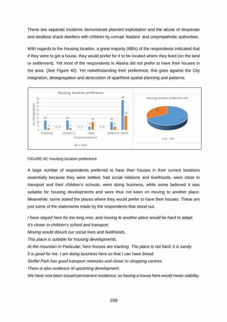
168
These two separate incidents demonstrate planned exploitation and the abuse of desperate
and landless shack dwellers with children by corrupt ‘leaders’ and unsympathetic authorities.
With regards to the housing location, a great majority (68%) of the respondents indicated that
if they were to get a house, they would prefer for it to be located where they lived (on the land
or settlement). Yet most of the respondents in Alaska did not prefer to have their houses in
the area. (See Figure 40). Yet notwithstanding their preference, this goes against the City
integration, desegregation and destruction of apartheid spatial planning and patterns.
FIGURE 40: Housing location preference
A large number of respondents preferred to have their houses in their current locations
essentially because they were settled, had social relations and livelihoods, were close to
transport and their children’s schools, were doing business, while some believed it was
suitable for housing developments and were thus not keen on moving to another place.
Meanwhile, some stated the places where they would prefer to have their houses. These are
just some of the statements made by the respondents that stood out.
I have stayed here for too long now, and moving to another place would be hard to adapt.
It’s closer to children’s school and transport.
Moving would disturb our social lives and livelihoods.
This place is suitable for housing developments.
At the mountain in Particular; here houses are tracking. The place is not hard; it is sandy.
It is good for me. I am doing business here so that I can have bread.
Stoffel Park has good transport networks and closer to shopping centres.
There is also evidence of upcoming development.
We have now been issued permanent residence, so having a house here would mean stability.

169
Moreover, one of the respondents who were a foreign national thought that they cannot get a
place to stay since they had no Identity document. Having housing in the informal settlements
because they were close to work was not among the main reasons provided by the
respondents, overall. This is understandable since the majority of the respondents were
unemployed.
Alternative areas stated by respondents include Nelmaphius, anywhere but Phomolong,
Mahube Mamelodi West and even Cullinan and Soshanguve, but Nelmaphius stood out. One
respondent stated: Anywhere in Mamelodi because it is close to factories, work, town, many
things. But specifically I would like it to be in Nelmaphius. The respondents in Stoffel Park who
preferred to have their houses elsewhere, also stated that the place was sandy.
The majority of the respondents in Alaska were opposed to having a house in Alaska mainly
because they said that the place was rocky and located dangerously on the mountain. Their
statements were such as: Alaska is on a mountain; anywhere flat would be an ideal
preference. The settlement is on the foot of the mountain making it dangerous to live here.
This place is too mountainous. Anywhere besides Alaska would be fine. These are just some
of the remarks made by some of the respondents that capture the overall impression.
On the other hand, this suggests that these respondents were not particularly opposed to
relocation, of which the CTMM strategic plan and the ward councillor revealed that the
municipality plans to relocate dwellers from Alaska because it was not suitable for human
settlement.
Land acquisition
People can acquire land as individuals or as a collective. This part of the report does not deal
with perceptions about or of the collective, but individual personal experiences and related
responses in relation to land acquisition.
Land ownership
A majority of the respondents, as shown in Figure 41, in all the informal settlements except in
Extension 11, indicated that the land was owned by the municipality. Some (29%), but a
majority in Extension 11 had no idea who was the land owner of the land they occupied. One
thing that is clear though is that none of the respondents owned the land, including those with
permanent stands. Moreover, there were also those who specified otherwise and indicated
that the land was owned by Metrorail/Prasa (Passenger Rail of South Africa) in Phomolong,
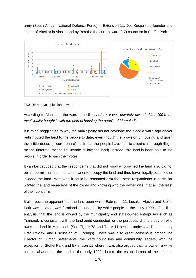
170
army (South African National Defence Force) in Extension 11, Joe Kgopa (the founder and
leader of Alaska) in Alaska and by Borotho the current ward (17) councillor in Stoffel Park.
FIGURE 41: Occupied land owner
According to Mautjane, the ward councillor, before, it was privately owned. After 1994, the
municipality bought it with the plan of housing the people of Mamelodi.
It is mind boggling as to why the municipality did not develope the place a while ago and/or
redistributed the land to the people to date, even though the provision of housing and given
them title deeds (secure tenure) such that the people have had to acquire it through illegal
means (informal means i.e. invade or buy the land). Instead, this land is been sold to the
people in order to gain their votes.
It can be deduced that the respondents that did not know who owned the land also did not
obtain permission from the land owner to occupy the land and thus have illegally occupied or
invaded the land. Moreover, it could be reasoned also that these respondents in particular
wanted the land regardless of the owner and knowing who the owner was, if at all, the least
of their concerns.
It also became apparent that the land upon which Extension 11, Lusaka, Alaska and Stoffel
Park was located, was farmland abandoned by white people in the early 1990s. The final
analysis, that the land is owned by the municipality and state-owned enterprises such as
Transnet, is consistent with the land audit conducted for the purposes of this study on who
owns the land in Mamelodi. (See Figure 78 and Table 11 section under 4.4. Documentary
Data Review and Discussion of Findings). There was also great consensus among the
Director of Human Settlements, the ward councillors and community leaders, with the
exception of Stoffel Park and Extension 11 where it was also argued that its owner, a white
couple, abandoned the land in the early 1990s before the establishment of the informal
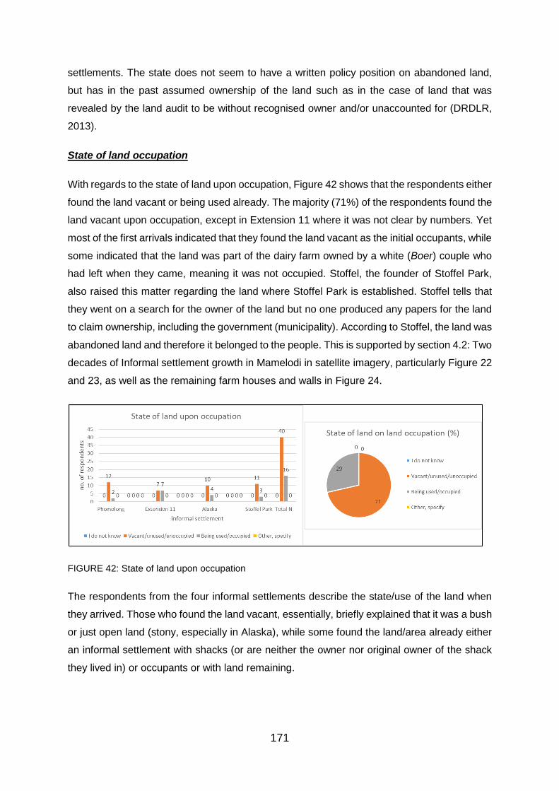
171
settlements. The state does not seem to have a written policy position on abandoned land,
but has in the past assumed ownership of the land such as in the case of land that was
revealed by the land audit to be without recognised owner and/or unaccounted for (DRDLR,
2013).
State of land occupation
With regards to the state of land upon occupation, Figure 42 shows that the respondents either
found the land vacant or being used already. The majority (71%) of the respondents found the
land vacant upon occupation, except in Extension 11 where it was not clear by numbers. Yet
most of the first arrivals indicated that they found the land vacant as the initial occupants, while
some indicated that the land was part of the dairy farm owned by a white (Boer) couple who
had left when they came, meaning it was not occupied. Stoffel, the founder of Stoffel Park,
also raised this matter regarding the land where Stoffel Park is established. Stoffel tells that
they went on a search for the owner of the land but no one produced any papers for the land
to claim ownership, including the government (municipality). According to Stoffel, the land was
abandoned land and therefore it belonged to the people. This is supported by section 4.2: Two
decades of Informal settlement growth in Mamelodi in satellite imagery, particularly Figure 22
and 23, as well as the remaining farm houses and walls in Figure 24.
FIGURE 42: State of land upon occupation
The respondents from the four informal settlements describe the state/use of the land when
they arrived. Those who found the land vacant, essentially, briefly explained that it was a bush
or just open land (stony, especially in Alaska), while some found the land/area already either
an informal settlement with shacks (or are neither the owner nor original owner of the shack
they lived in) or occupants or with land remaining.

172
Extension 11
The white people were gone then.
There were weeds and it was bushy when we arrived…I know the house in the corner was
here.
The land was not used. There were no occupants.
There was house belonging to a Boer couple, thus it was called Pienaarspoort before it was
sectionalised. – (Sizanani).
It was initially a forest. When I came here people were already staying.
There were occupants I bought the shack.
I am renting, so it was occupied. (Sizanani)
Phomolong
We bought a shack from previous owner.
We removed weeds and erected our shacks.
There was nothing, just land.
There were no houses.
We were the first occupants since we were evicted from Marabastad.
Having moved and settled people from Marabastad, there was still more land, so we occupied.
Alaska
Nothing, nothing, nothing. We struggled. We paid man to carry our shack building material.
There was nothing, it was just open.
It was open land and stoney.
There were already shacks.
There were occupants.
Stoffel Park
The place had bushes and when it started and people had to cut them down.
There were a lot of bushes and stones.
There was nothing and no people. We started the place.
Stoffel Park had begun when we came.
There were no occupants and the land was vacant.
Given that the majority of the respondents found the land vacant upon occupation, this
suggests the land has been vacant and was there for the municipality (as an indicated land
owner) to develop and distribute it. It also indicates that the people identified the land to meet
their land needs and were faster and more proactive than the municipality in acquiring and
using the land.

173
Manner of land occupation: process, permission to occupy
The respondents explained how they acquire the land in their respective informal settlements.
With the exception of initial Phomolong dwellers resettled there by the municipality, land
acquisitions (i.e. illegal land occupations) had been generally led either by a founder/leader of
the community, deliberately overlooked by government/politicians during elections, local/street
committee. Some of the respondents paid various amounts to get access to the land, whether
towards water services or fixing the gravel road or accessing the land/stand itself. It has been
common for dwellers to be informed by family or friends that there was land or stands being
allocated. Some saw people occupying the land an erecting shacks. Moreover the people
invaded or bought the land because it was vacant and they needed a place to live. There are
also few among the respondents who bought the stands from previous owners. According to
the Director of Human Settlements, the dwellers invaded the land because of unemployment
and they had no place to stay.
This how some of the respondents explained how they heard and got the land:
Extension 11
The land was vacant and we needed housing.
The plot was for sale and I needed land for housing.
I came home to study in this area. The stand was bought for R500 – R1500.
The place was already established when I came, I am renting.
We were removed from Shushumele, now Mahube) in 1998. I came from work with my shack
removed all of the shacks were piles in in place here in Extension 11; community leader of
Sizwe at the time allocated us the plots to erect shacks.
I came out of my parents place to look for a place. I had that the stands were available here
and allocated by initial occupants turned community leaders.
Phomolong
We went to the ANC committee office here and paid R10 and were given stand. They said it
was for the book/stamp. The office is still exist n Phomolong.
We saw people dividing and occupying the land, so we came and divided for our self and
erected a shack.
We bought the shack from the previous owner.
We were relocated from Marabastad.

174
Alaska
We invaded the land for job purposes, because it was unused.
My family member was relocating and I inherited the place.
We went to Joe, the owner and he showed us the place.
We went to the office, to Joe Kgopa. He gave us a stand for R1500.
I was renting in Lusaka, a street around the corner and saw that there was a place open here
and spoke to Joe noting that he was allocating stands. I paid him R1500.
Stoffel Park
I bought the stand for around R10000 from previous owner.
I was renting in Extension 6, Gardens; bought a stand without a shack for 25000 from previous
owner.
The plot was for sale so I bought the stand, together with the shack for R800.
The land was vacant and bought from municipality for R1500.
The land was vacant and we started invading because we need plots for housing.
It was bought by my boyfriend. At that time it was R500 from Stoffel.
I bought a place for R2500 at the office.
Councillor Borotho gave me the Place at the mountain. I also got the permanent stand from
him in September 2017 at no cost.
The land was vacant and bought from the municipality for R1500.
I had that stands were sold here and I came and bought a stand for R700 from Stoffel.
The matter here essentially is that the land was occupied because it was vacant, but a few
have bought shacks from previous owners, particularly in Stoffel Park. Most of the respondents
indicated that the land was vacant and they were coming from renting and wanted their own
place to live as some could not afford rental homes. Some add that the land was closer to job
opportunities. Notwithstanding this, people have paid to gain access to land in all the four
informal settlements, regardless it was for water services, stamp and waste removal as the
explained by the founders and community leaders. Moreover, that there are some respondents
who are renting, particularly in Extension 11, indicates that they were not the owners of the
shacks and the owners of some of the shacks do not live in them, but are renting them out for
income. This is why Extension 11 is viewed to have remained the same size over the years.
Figure 43 show that as many as 63% of the respondents indicated that they obtained
permission from the actual land owner. Yet the Director of Human Settlement Planning in the
municipality stated that the all of the informal settlements were initially established through
land invasion as also declared in the municipality’s strategic plan (Integrated Development

175
Plan). Notwithstanding the Directors statement, it is only initial dwellers in Phomolong who
were relocated from Marabastad in 2002 by the municipal who can say they occupied the land
with the voluntary consent of the land owner (i.e. municipality). The case of Stoffel Park is also
unique because it was initially established through land invasion as confirmed by Stoffel
Motloutsi, the founder and current community leader of the informal settlement, but were later
assisted by the Democratic Alliance to remain in the land and for the ANC-led municipality to
formally develop the informal settlement. One of the respondents who actually got permission
from Stoffel to occupy also highlighted that, Stoffel mentioned that we were under DA; we
were told that DA gave us the land to occupy.
FIGURE 43: Consent to occupy land
When probed further, it was found that a considerable number of those who indicated that
they obtained permission to occupy the land, did not obtain it from the actual land owner (but
from the founders in Joe Kgopa, Sizwe and Stoffel Motloutsi; community leaders, and
organised local offices/committees, some not even elected by the ordinary community
members): For example, a considerable number of respondents in Alaska indicated that they
were actually allocated stands by Joe Kgopa, whom some also believed was the owner of the
land.
Those (13%, found in Extension 11, Stoffel Park and Phomolong) who did not know that they
obtained permission to occupy the land and the one respondent from Extension 11 who did
not indicate at all are most likely to have actually not obtained the permission from the actual
land owners.
Moreover, all the informal settlements with the exception of Phomolong were initially
established through illegal land occupation that was organised and facilitated by their
founders.
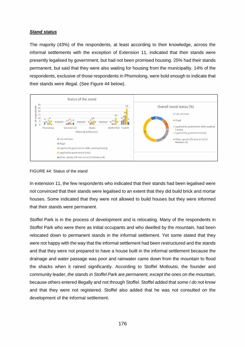
176
Stand status
The majority (43%) of the respondents, at least according to their knowledge, across the
informal settlements with the exception of Extension 11, indicated that their stands were
presently legalised by government, but had not been promised housing. 25% had their stands
permanent, but said that they were also waiting for housing from the municipality. 14% of the
respondents, exclusive of those respondents in Phomolong, were bold enough to indicate that
their stands were illegal. (See Figure 44 below).
FIGURE 44: Status of the stand
In extension 11, the few respondents who indicated that their stands had been legalised were
not convinced that their stands were legalised to an extent that they did build brick and mortar
houses. Some indicated that they were not allowed to build houses but they were informed
that their stands were permanent.
Stoffel Park is in the process of development and is relocating. Many of the respondents in
Stoffel Park who were there as initial occupants and who dwelled by the mountain, had been
relocated down to permanent stands in the informal settlement. Yet some stated that they
were not happy with the way that the informal settlement had been restructured and the stands
and that they were not prepared to have a house built in the informal settlement because the
drainage and water passage was poor and rainwater came down from the mountain to flood
the shacks when it rained significantly. According to Stoffel Motloutsi, the founder and
community leader, the stands in Stoffel Park are permanent, except the ones on the mountain,
because others entered illegally and not through Stoffel. Stoffel added that some I do not know
and that they were not registered. Stoffel also added that he was not consulted on the
development of the informal settlement.

177
Moreover, in Stoffel Park, though established in 2008, development only started in 2015 before
the other settlement such as Extension 11 and Phomolong which have been in existence over
20 and 10 years respectively before.
A minority (5%) indicated otherwise and respectively specified that they were to be relocated
to Extension 22 Marikana informal settlement (due to development) from Phomolong and
others explained that their stands were to be made permanent and packsed (meaning that
they were permanent but were not receiving basic services such as water and electricity) in
Extension 11. Sibusiso Mathelele (in Figure 46), Phomolong community from SANCO also
confirmed that, the rest of the rest of Phomolong is going to be permanent. It is already under-
development. It is being formalised. (See also Figure 45 below).
FIGURE 45: Relocation of shack dwellers in Phomolong to re-subdivided and formalised stands in
Phomolong, 23 November 2017
Source: Researcher on site
FIGURE 46: Researchers interview with Sibusiso Mathelele, Phomolong
SANCO branch Executive community leader (left)
Moreover, it is not likely that there were stands in Alaska that were
made permanent because the municipality was planning to relocate
the dwellers since the area was environmentally unsafe, hazardous
and costly for residential purposes as indicated by the municipality
in its strategic plan and the ward councillor. According to the ward
councillor, people [Alaska] invaded the land and live in hazardous
condition, especially when it rains and people are to be relocated
[from Alaska] because it is a flood area.

178
PERCEPTIONS REGARDING THE SETTLEMENT: ACCESS TO LAND, HOUSING POLITICS AND GROWTH
About the settlement (when, how and name)
Using the area, Figure 47 gives an indication of when each of the four informal settlements
was established according to the respondents that were interviewed in each settlement. In the
final analysis it appears that Extension 11 is the oldest informal settlement of the four as it was
established as early as 1991 extending the years of its formation to 1998. One of the
respondents, a mother of two who arrived in the City in 1981 from Mpumalanga to look for
work as a young girl (now between 46 – 55 years of age), indicated that she has been living
in Extension 11 for 26 years. Two respondents were definite that it started in 1994 and 1996
as they were among the initial or first occupants/dwellers to live in the informal settlement. The
Extension 11 informal settlement is divided into two main sections: (‘old’) Extension 11 which
began in as early as 1991 and received more arrivals between 1994 and 1998 with the
founding of Sizwe in 1996. Swapo, the section committee leader, indicated that the informal
settlement was established in 1994. Sizwe is known as Sizanani as indicated by some of the
respondents who were the initial dwellers in the informal settlement. Extension 11, as the main
area and broader section of the informal settlement, was already existing with dwellers by
when Sizanani was established. One of these two respondents of the dwellers, a mother of
two who arrived in Extension 11 in 1995, highlighted that this place is older than Sizanani,
Sizanani just came, is new, 1996. This place is old.
By the respondent’s accounts, Phomolong must have been stablished from 2002 and 2003 to
2004. Alaska was established in 2007 and it was immediately followed by the establishment
of Stoffel Park in 2008. This is also confirmed by the ward councillor and community leaders.
According to Stoffel, who still had the records, Stoffel Park was established exactly on 01 April
2008.
There are also a considerable number of respondents who did not know when the informal
settlement they lived in, was established, particularly in Extension 11, Alaska and Stoffel Park
respectively. They did not know simply because many stated that they came after their
informal settlements had already been established and this was especially the case with the
respondents in Sizanani, in Extension 11.

179
FIGURE 47: Year informal settlement established
Some of the respondents explained how their informal settlement was established. It is
apparent that Phomolong was founded by the municipality when they relocated people from
Marabastad there, while Extension 11, Alaska and Stoffel Park was founded by different
individuals from the masses of the landless and land seeking people who took it upon
themselves to divide and distribute the land they found vacant to the people given that they
needed a place to live.
Informal settlements are established by people or institutions formally and/or informally.
Moreover there is a meaning and/or story behind the establishment and naming of each of the
informal settlements. Considering both quantitative and qualitative data elements, the
following can be established about the four informal settlements in which the empirical study
was conducted. As many as four informal settlements have developed in Mamelodi East and
still exist since the early 1990s when South Africa was transitioning to a new era of
constitutional democracy. The four informal settlements basically came to being in two ways:
Either by government action, or by a led-collective/community.

180
Extension 11 informal settlement
While Morwangwato Mantjane, the ward councillor, states that Extension 11, shown briefly in
Figure 48, was established after 1994, some of the respondents indicated that they arrived in
the informal settlement before 1995. Yet it is difficult to reconcile this with the Satellite imagery
as it does clearly show housing structures in the area in 1994. Mamelodi is large and has been
divided into a number of sections called extensions. Thus extension 11 is one of the
extensions of Mamelodi (i.e. 11th extension). The informal settlement is also just called
Extension 11. Yet Sizanani, another section of Extension 11, was established in 1996.
Sizanani was founded by a man simply called Sizwe and then named after him. Sizanani is
an Nguni word meaning help each other.
FIGURE 48: View of Alaska from Extension 11 through Lusaka
Regarding the establishment of Extension 11, the following statements made by some of the
respondents give essence:
We did not buy the land. There was a man who issued the stands, but he said it is difficult for
him. – This is one of the first arrivals in Extension 11, who came before 1995.
People were looking for land places here; they said there is a place called Extension 11. They
were supposed to put people from Phase 3 [here in Mamelodi].

181
To this end, the section committee leader, Mr Swapo stated that, people came to live on the
land as a result of land grab back in 1994.
Extension 11, particularly the section were the first occupants dwell, has been a bone of
contention between the municipality and the dwellers. One of the respondents who arrived in
1995 and suffered the 2014 eviction by the municipality, had so much to say about the informal
settlement: You would write a novel about this place and it would sell This place is a problem.
Many people say, Jesus will come back, here (“la pha kuyobuy’uJesu)…. This place has
overcome four councillors…. It was destroyed long ago. It was destroyed by the first
councillors.
Regarding Sizanani, the respondents provided:
Sizanani/Sizwe; it’s the same thing. The person who was in charge (helping people to get the
land) of the place was called Sizwe, people loved him to the extent that they named the place
after him.
Sizwe is the one who started the place that is why it is called Sizanani. Sizwe said it is
Sizanani. He wanted to help people so that they could live well.
It started with people by Dumisa and then it got full. Sizwe saw that there was space where
white people farmed their stock; cows and donkeys lived here. I came here from Joburg and I
bought a shack…. I got it with already 25 people occupying the land…. I came back after 3
months; the pace was full and the whites were no longer there. – This respondent arrived in
Sizanani in September 1996.
Over the years the community leaders, both founders (except Sizwe) and community/local
committees have played a central role in the administration (i.e. providing access to land)
across the informal settlements as indicated also by the interviewed ward councillors and
community leaders. One of the community leaders, Regina Mapholisa of Extension 11
(Sizanani), indicated that people got a stand from an organised local committee/office and
added that there was no alternative beside committee; when it was starting people only paid
(R10.00) for water.
Phomolong
Phomolong (seen in Figure 49), meaning resting place in Sepedi, was established in 2002
when the government removed and brought people from Marabastad to Mamelodi and in 2003
when the people of Mamelodi protested and invaded the remaining land. As Ms Maja, the
ward councillor (who was part of the Mamelodi people), puts it, the City gave Marabastad
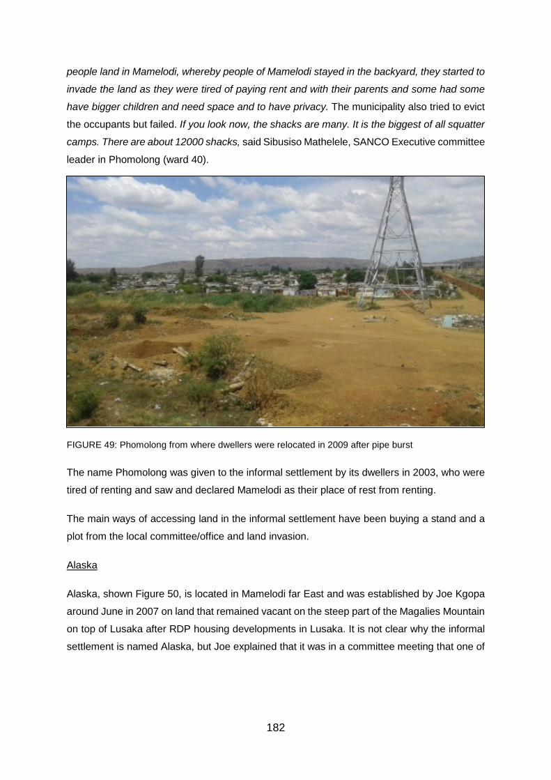
182
people land in Mamelodi, whereby people of Mamelodi stayed in the backyard, they started to
invade the land as they were tired of paying rent and with their parents and some had some
have bigger children and need space and to have privacy. The municipality also tried to evict
the occupants but failed. If you look now, the shacks are many. It is the biggest of all squatter
camps. There are about 12000 shacks, said Sibusiso Mathelele, SANCO Executive committee
leader in Phomolong (ward 40).
FIGURE 49: Phomolong from where dwellers were relocated in 2009 after pipe burst
The name Phomolong was given to the informal settlement by its dwellers in 2003, who were
tired of renting and saw and declared Mamelodi as their place of rest from renting.
The main ways of accessing land in the informal settlement have been buying a stand and a
plot from the local committee/office and land invasion.
Alaska
Alaska, shown Figure 50, is located in Mamelodi far East and was established by Joe Kgopa
around June in 2007 on land that remained vacant on the steep part of the Magalies Mountain
on top of Lusaka after RDP housing developments in Lusaka. It is not clear why the informal
settlement is named Alaska, but Joe explained that it was in a committee meeting that one of
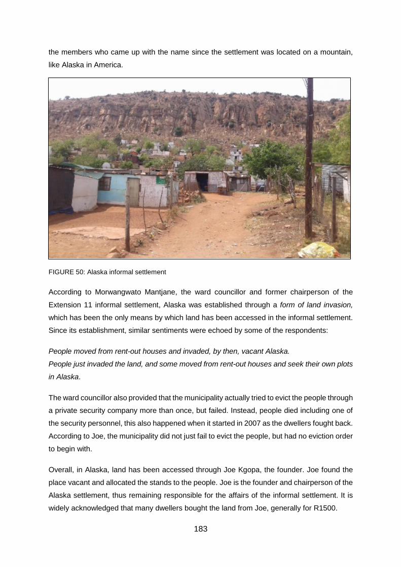
183
the members who came up with the name since the settlement was located on a mountain,
like Alaska in America.
FIGURE 50: Alaska informal settlement
According to Morwangwato Mantjane, the ward councillor and former chairperson of the
Extension 11 informal settlement, Alaska was established through a form of land invasion,
which has been the only means by which land has been accessed in the informal settlement.
Since its establishment, similar sentiments were echoed by some of the respondents:
People moved from rent-out houses and invaded, by then, vacant Alaska.
People just invaded the land, and some moved from rent-out houses and seek their own plots
in Alaska.
The ward councillor also provided that the municipality actually tried to evict the people through
a private security company more than once, but failed. Instead, people died including one of
the security personnel, this also happened when it started in 2007 as the dwellers fought back.
According to Joe, the municipality did not just fail to evict the people, but had no eviction order
to begin with.
Overall, in Alaska, land has been accessed through Joe Kgopa, the founder. Joe found the
place vacant and allocated the stands to the people. Joe is the founder and chairperson of the
Alaska settlement, thus remaining responsible for the affairs of the informal settlement. It is
widely acknowledged that many dwellers bought the land from Joe, generally for R1500.

184
It is widely acknowledged, even by Joe that the easiest way of accessing the land has been
through him (Joe) and the committee, while others sell stands on one hand and others steal
stands on the other. Moreover, though the informal settlement is located on a dangerous,
unsafe and hazardous area, people still dwell there which signals desperation for land.
Stoffel Park (Bamoshate wa Bhurundi)
In a naming meeting, Stoffel Park as widely known and called was named ‘Stoffel’ by the
dwellers of the informal Settlement, after and in honour of Stoffel Motloutsi (pictured in Figure
51), who founded the informal settlement. To make it suitable, Stoffel requested to add ‘Park’,
because there was also a Park then in the informal settlement, to make it Stoffel Park. Mindful
and remembering the history and the time when there was an ethnic/civil war in Burundi (and
they killed each other) between the 1960s and 1970s, Stoffel also requested the addition
‘Bamoshate wa Bhurundi’ Sepedi for capital city of Burundi. Some regard and refer to him as
the king of Stoffel Park because he founded the settlement. Officially referred to as Stoffel
Park Village (Bamoshate wa Bhurundi), Stoffel Park was established in 2007, adjacent to and
less than a year after Alaska when Stoffel led evicted and destitute landless people to dwell
on Magaliesburg (see Figure 52).
FIGURE 51: Founder of Stoffel Park Stoffel Motloutsi with the land occupancy file

185
FIGURE 52: Stoffel Park
The informal settlement was nearly born and raised in Mahube by the river, but the people
were evicted before they could even live in the shacks they had built. Thus in less than a year,
Magalies Mountain gave birth to another informal settlement, called Stoffel Park. This how
some of the respondent’s responded to how Stoffel Park was established:
We were with him in Mahube valley (before it was developed) police removed us before we
could even live in those shacks to live there by the mountain and we went. We came and
occupied the place. Stoffel would allocate people plots and say “you live here, you live there”.
Stoffel organised the community removed from the place now called Riverside informal
settlement to move to the mountain. Sizwe Mthethwa (the then Mayor of Pretoria) told us not
to stay any anywhere but to go to the mountain.
Without contradiction, Stoffel Motloutsi submitted that many people got the land/stands from
him and some through land invasion.
To get a stand, many dwellers have paid amounts ranging between R500 and R2500, which
Stoffel states was for water and waste removal, as well as constructing and maintaining the
road. Narrating the beginnings of the informal settlement, Stoffel provided that:
I am the founder just like a King. It started on 1 April 2008. Upon occupation it was open land
with nothing; nothing, nothing, nothing.
This land does not belong to the municipality. When I came here, I had done research and
found that it was a normal place; it does not belong to the municipality. The person it belonged

186
to had died and his child did not care about it. It is a Boer; so I was researching from the Boers
and found that it is a normal and it had no owner. I decided that I must start it. Municipality
said no person was allowed to live I fought and fought, getting arrested until I got out, today it
is developed. I have been arrested (more than fifteen times) for opening a squatter camp. I
am arrested because I am fighting for the people’s course.
The first dwellers of Stoffel Park came from Phase 3 in Mamelodi. There was no good service
there. We had lived there for 10 years; there was nothing happening. After trying, together
with the committees and the community leader (committee, section leader), to establish the
Informal Settlement since 2002, who eventually got tired, Stoffel pressed on: So I started this
place where there is Mahube Metro police came with owners of those houses and said they
were removing us there, but we were fighting and some saw that we are going to get arrested.
His comrades, others they were going with ran. Ultimately we came here. We were a
community. I stared to allocate stands and I have been allocating them since. People got the
land from the office, every day. [From] Monday, I opened from 08:30 until 16:30, and Sunday
08:30 to 12:00. The municipality responded with eviction court orders and seeing that the area
was governed by the ANC, they approached an opposition party, the DA for assistance.
They gave me court orders, saying that the place is not for us to live. So I said it is better I use
opposition party (DA). That time Sizwe Mthethwa (the Mayor at the time) was the enemy of
this place and called police.
The reason why it started on the mountain is that when they (the police) were giving us court
orders. I saw that it was better that we go up to the mountain until the DA told us to live here.
DA told us, “remain there”. They knew that the place did not belong to anyone; we were being
harassed. According to Stoffel, the DA supported them but did not want something in return.
We saw thought it is better that we vote for DA; we supported them.
As for the money that was paid by the dwellers, Stoffel explained: we talked and did a
collection for water, dustbin; it was controlled by me. I did the bridge by myself; with my hands.
Figure 53 is the bridge, built by the founder, Stoffel Motloutsi, crossing over Edendalspruit
River to Mahube mall, on to Tsamaya Road.

187
FIGURE 53: Bridge built by Stoffel Motloutsi crossing to Mahube mall on to Tsamaya Road
Given the above accounts, the initial occupants of Stoffel Park might have illegally invaded
the land in Mahube or Riverside and were thus evicted, but it is not reasonable to conclude
that the people illegally occupied the land now called Stoffel Park informal settlement. It had
been stated by the City’s Director of Human Settlement Planning and in its Strategic Plan, that
the informal settlements, including Stoffel Park, were established through land invasion. Yet
the dwellers of Stoffel Park were told by Sizwe Mthethwa (the Mayor of Pretoria at the time)
to rather go to the mountain.
Considering that a lot of land has been acquired through the government and especially during
elections, the issue of politics and political parties play a huge role in land acquisition and the
development and growth of informal settlements, particularly in Mamelodi. In fact, Stoffel also
provided that they were helped by the DA to obtain secure tenure in the land and for it to be
developed. In Phomolong, the ANC has played a huge role in granting people stands and they
had even done it via an office that has existed since the informal settlement’s establishment
to date.

188
Land acquisition and settlement expanse
Means of access to land
Access to land in the informal settlements have been obtained in various ways including
receiving a plot/stand from government, occupying/invading land illegally, buying land from
Politician or an organised committee/office, community founder and/or leader as shown in
Figure 54 below. Overall, the majority (30% and 29% respectively) of the respondents are of
the view that getting a stand from the government and invading the land illegally has been the
‘easiest’ way of getting the land in the informal settlements. Only 5% of the respondents
respectively either indicated that it was easier to obtain the access to land through housing
from government or buying a stand from a politician or buying an existing shack from its owner
(see also Figure 55 and Figure 56).
FIGURE 54: Means to access land
Figure 55 and 56 show and confirm that the sale of stands also occurs in Alaska where most
respondents do not prefer to have their houses built due to environmental and safety concerns.
The place is situated on a rock mountain and water sweep down through the shacks when it
rains. Some of the respondents in Alaska were worried that one day the rocks from the
mountain top will fall down on them.

189
FIGURE 55: Advert of a stand for sale in Alaska posted in Maluti Tuckshop, Alaska
FIGURE 56: Change of stand ownership after its sale, facilitated by Joe Kgopa (Chairperson of Alaska
Residents Association)
According to the City’s Director of Human Settlement Planning, Metse Mabeba, land in all of
the informal settlements have been mainly accessed through illegal land occupation, buying
an existing shack from its owner and to a lesser extent inheriting a shack from a family. Yet
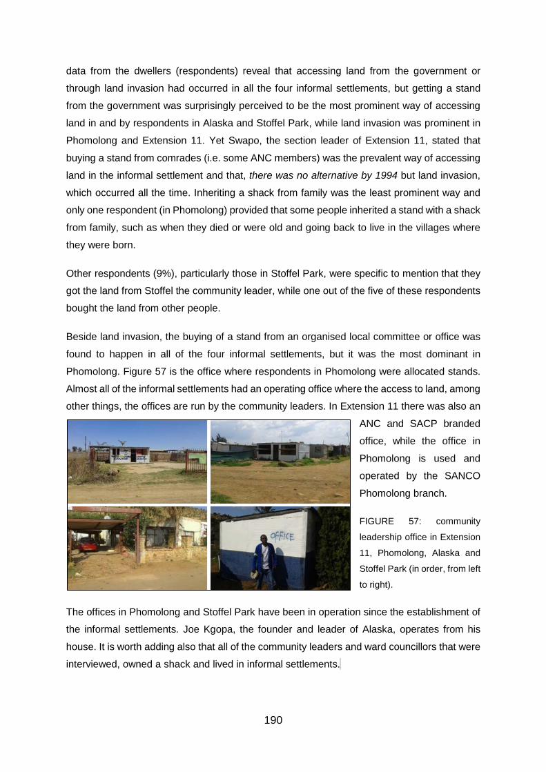
190
data from the dwellers (respondents) reveal that accessing land from the government or
through land invasion had occurred in all the four informal settlements, but getting a stand
from the government was surprisingly perceived to be the most prominent way of accessing
land in and by respondents in Alaska and Stoffel Park, while land invasion was prominent in
Phomolong and Extension 11. Yet Swapo, the section leader of Extension 11, stated that
buying a stand from comrades (i.e. some ANC members) was the prevalent way of accessing
land in the informal settlement and that, there was no alternative by 1994 but land invasion,
which occurred all the time. Inheriting a shack from family was the least prominent way and
only one respondent (in Phomolong) provided that some people inherited a stand with a shack
from family, such as when they died or were old and going back to live in the villages where
they were born.
Other respondents (9%), particularly those in Stoffel Park, were specific to mention that they
got the land from Stoffel the community leader, while one out of the five of these respondents
bought the land from other people.
Beside land invasion, the buying of a stand from an organised local committee or office was
found to happen in all of the four informal settlements, but it was the most dominant in
Phomolong. Figure 57 is the office where respondents in Phomolong were allocated stands.
Almost all of the informal settlements had an operating office where the access to land, among
other things, the offices are run by the community leaders. In Extension 11 there was also an
ANC and SACP branded
office, while the office in
Phomolong is used and
operated by the SANCO
Phomolong branch.
FIGURE 57: community
leadership office in Extension
11, Phomolong, Alaska and
Stoffel Park (in order, from left
to right).
The offices in Phomolong and Stoffel Park have been in operation since the establishment of
the informal settlements. Joe Kgopa, the founder and leader of Alaska, operates from his
house. It is worth adding also that all of the community leaders and ward councillors that were
interviewed, owned a shack and lived in informal settlements.F
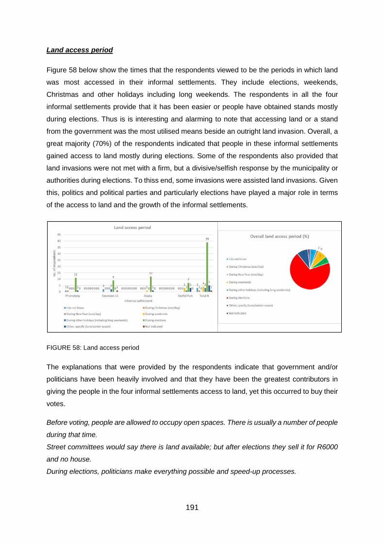
191
Land access period
Figure 58 below show the times that the respondents viewed to be the periods in which land
was most accessed in their informal settlements. They include elections, weekends,
Christmas and other holidays including long weekends. The respondents in all the four
informal settlements provide that it has been easier or people have obtained stands mostly
during elections. Thus is is interesting and alarming to note that accessing land or a stand
from the government was the most utilised means beside an outright land invasion. Overall, a
great majority (70%) of the respondents indicated that people in these informal settlements
gained access to land mostly during elections. Some of the respondents also provided that
land invasions were not met with a firm, but a divisive/selfish response by the municipality or
authorities during elections. To thiss end, some invasions were assisted land invasions. Given
this, politics and political parties and particularly elections have played a major role in terms
of the access to land and the growth of the informal settlements.
FIGURE 58: Land access period
The explanations that were provided by the respondents indicate that government and/or
politicians have been heavily involved and that they have been the greatest contributors in
giving the people in the four informal settlements access to land, yet this occurred to buy their
votes.
Before voting, people are allowed to occupy open spaces. There is usually a number of people
during that time.
Street committees would say there is land available; but after elections they sell it for R6000
and no house.
During elections, politicians make everything possible and speed-up processes.

192
They [politicians] promise people houses during elections; people get the land but there is no
delivery of houses after elections.
The politicians are not concerned with people voting for them. Land is a bribe to occupants.
They want us to vote for them. DA and ANC come and promise to build us roads, electricity,
RDP…
Meanwhile, some would be off-duty and some would get time during weekends. Moreover, on
a different and more detailed note, the City Director of Human Settlement Planning, Metse
Mabeba, provided that a number of people accessed the land during the night. This is because
monitoring it during the evening is difficult for the municipality. They also invade during
weekends aware that most of the City’s employees are not operating. Monitoring was also
reported to be poor during year-end, while there was also more time during holidays, including
long-weekends.
Notwithstanding this, the settlements, with the exception of Phomolong, were not (initially)
established by the municipality nor have they been under local government leadership and
control. Besides accessing land during elections and other means, some (9%) respondents,
except those in Extension 11, specified other means including June/winter in Phomolong,
every day in Alaska and anytime as well as towards year-end in Stoffel Park. With the
Exception of the ward councillor of Extension 6, in the case of Phomolong (who indicated it
was during Easter), all the community leaders and ward councillors pointed out that there was
no particular time where land was easier or mostly accessible or acquired, but that it was
accessible or acquired all the time or every day in their informal settlements until they were
full.
Informal settlement size
Overall, with the exception of Extension 11, according to respondents the the other informal
settlements have increased since their establishment. Seven out of fourteen of the
respondents that were interviewed in Extension 11, are of the view that the informal settlement
has remained the same, while four perceived that it has increased and only three noted that it
decreased as shown in Figure 59. Given this, it can be said, among other things, that none of
the informal settlements have decreased since their establishment and they have expanded
in terms of size and population.

193
FIGURE 59: Informal settlement size
The size of the informal settlements has increased, mainly, because people do not have a
place to live and they have continued to occupy the land:
Extension 11
It has remained the same because some people have been moved and many have been
relocated to Nelmaphius. They say there is a road to be built here from Mahube. They say we
are living on top of a mall and school. When you go to Mentoria to look for a map they say
there is no road; you are on a permanent [stand], but you do not have service delivery. They
know this place as having RDP (housing]… they do not know that we still have shacks.
Some people left, some moved into RDP houses, but decreased a bit since others among
those who go, especially not to an RDP house, live the shacks to rent them out.
Two respondent who indicated that Sizanani has increased explained that, it does not have
space to extend [and it has increased] because people do not have a place to live.
There are children who were born here who had now become man, now they wanted a place
to live here. Not long, there are others with children who will also want a place to live.
Phomolong
It is because people flock in and stay here. It was not full when we arrived [in 2003].
There were establishment of newer sub-sections and the number of occupants has increased.
People have no place to stay; also they come here because there is no rental.
Alaska
There are more occupants now.
194
There are many people staying here. They (Joe) have added people.
It is still increasing even now, even now you can see someone hammering a shack. People
even go to the mountain foot.
There are more occupants compared to 2012.
Because it has been here for a long time and there are many people.
Stoffel Park
It was even bigger. It is just that those who lived down by the river were moved to Skierlik and
they moved us down from the mountain. It will still grow again as others are occupying the
mountain again.
People are being moved to permanent stands.
According to one of the respondents who arrived in 2009, it is the way it has been, but there
are changes. At least people have changed, we stay in permanent [stands]. That is the only
difference now, but the size is the same.
Above are just some of the reasons that were provided by the respondents on the size of their
settlements. It appears that in the absence of formal development and overtime, the shacks
continue to absorb new dwellers; as long as there are still some pockets of land that remain
unoccupied or vacant.
According to Metse Mabeba, the Director of Human Settlement Planning, several shack
counts have already been conducted and all of them shows an increase in numbers since the
informal settlements were formed. Notwithstanding this, the City’s Strategic Plan’s (i.e.
Integrated Development Plan) consolidated shack count that was conducted between 2006
and 2013, reveal that the number of shacks have decreased in the older informal settlements,
(Extension 11 and Phomolong), whilst they have increased in the newer informal settlements
(Alaska and Stoffel Park).
Figure 60 show that as initial occupants are being relocated, in Stoffel Park, down from the
mountain to permanent stands in the restructure and re-divided lower area, new dwellers are
coming in to occupy and build on their stands. It was also indicated that some people had
been removed from Stoffel Park to form other informal settlements outside the presented
demarcated border of Mamelodi. Stoffel Park is the last informal settlement, now people are
developing informal settlements in places like Silahliwe [in Skierlik in Pienaarpoort] where
some people had been dumped from Stoffel Park. Silahliwe is an Nguni word meaning – ‘we
have been dumped’.

195
FIGURE 60: Stands left vacant on the mountain and new shacks constructed on them in Stoffel Park
Thriving informal economy - business of selling shack structures
Moreover, the informal economy of selling corrugated iron shack structures is thriving (as
shown in Figure 61 below) and exists in all of the four informal settlements except in Alaska,
but some shacks erected in Alaska resemble the same structures that are sold in the other
informal settlements. In Extension 11, alone, there is more than one shack structure selling
business. The structures vary in prices by settlement, the size and quality of the structure;
some are for one room, while some are for two and three room. In the final analysis, this
confirms and indicates that more shacks are being continually erected or new informal
settlements are developing in the area (such as Riverside informal settlement in Figure 63).
FIGURE 61: Thriving shack structures making and selling business in Phomolong – over a year after
The municipality requested the community leaders, particularly those of Alaksa and Stoffel
Park, to not allocate stands any further in 2015 to allow for promised developments to take
place. Thus, in 2015, development (i.e. re-subdivision and allocation of permanent stand, as
well as electrification) began in Stoffel Park. Since then, informal brick businesses have
opened in the informal settlement and some households have various types of built brick and
mortar houses, including rental flats (as shown in Figure 62). This indicates that the primary
thing that people needed was land and giving them permanent stands and tenure has the
potential to reduce the number of shacks and ultimately eradicate informal settlements.
Yet as dwellers are being relocated down from the mountain in Stoffel Park to the flat and re-
subdivided flat area, others are occupying the stands that are left vacant. Moreover, one new

196
informal settlement called Riverside (shown in Figure 63 below) was also established on a
pocket of sandy and flood prone land below Stoffel Park in 2015.
FIGURE 62: Emerging brick-making business in Stoffel Park and newly constructed houses on
permanent stands
FIGURE 63: Riverside informal settlement established in 2015 on a pocket of land
PERCEPTIONS REGARDING LAND/HOUSING OWNERSHIP: LAND REFORM
Protection of existing property rights
In all the four informal settlements, the respondents rejected the constitutional protection of
property rights of property that was acquired through colonialism and apartheid and indicated
that it was not right. Figure 64 shows that a majority (79%) of the respondents, disapproved
the protection of those existing property rights by the constitution of the Republic of South
Africa, overall indicating that whites should not continue to own it because it belonged to black
people and they took it forcefully.

197
FIGURE 64: Protection of existing property rights
Land expropriation without compensation
Data findings, as shown in Figure 65, on whether the respondents agreed or not that the
Constitution should be amended to allow the government to expropriate land without
compensation, reveal that there was no clear agreement for the constitution to be amended
to allow for land to be expropriated without compensation. Fifty percent of the respondents
agreed that the constitution should be amended to allow land expropriation without
compensation (LEWC), while 46% disagreed and the rest did not indicate their stand on the
matter. Thus on the basis of these findings, LEWC is not an obvious and may not be an easy
land reform approach to take because it has not received convincing support.
FIGURE 65: Land expropriation without compensation
Land expropriation without compensation received much support particularly in Alaska and
Phomolong, while it received less support in Extension 11 and Stoffel Park respectively. The
respondents provided a number of reasons for and against LEWC. Those who disagreed did
so mainly because they perceived that if LEWC were to be allowed then there could either be
tension and war, and/or that the landholders should be compensated for their investment. The
main theme from those who agreed to LEWC was “the land is ours”. The officials and

198
community leaders were for LEWC except for Joe Kgopa, the founder and chairperson of
Alaska, and Swapo, Extension 11 section committee leader. (See Table 8 for selected
common respondents’ responses)
Vacant land invasion
Concerning vacant land, 61% of the respondents agreed that vacant land should be invaded,
among other reasons, because people had no place to live and could not afford rent and some
have been waiting for a long time for housing. Those who disagreed to vacant land invasion,
in the main, stated that permission should first be obtained from the actual land owner
(government or person).
Here are some of the brief explanations provided by the respondents:
A lot of people do not have a place to stay and are tired of paying rent.
One might not know the nature of the place and might end up in dangerous places.
I no longer agree; like the place occupied in Riverside is dangerous; water flows down to that
place. It is a dangerous zone.
People need housing. You find that you apply for housing, but it never comes. It is theirs, yes
they should invade it so that government may open its eyes to see that there are people
without a place to stay.
Thus it also became apparent that long waits for housing provision have driven some of the
people to invade vacant land. Most of the respondents agree that vacant land should be
invaded because people need housing and have no place to live (see Figure 66).
FIGURE 66: Invade vacant land

199
TABLE 8: Selected common views of respondents on Land Expropriation by government

200
Foreign land ownership
The sale to and ownership of land in South Africa by foreign nationals was strongly
disapproved by 88% of the respondents (as shown in Figure 67). The common and dominant
reason provided by the respondents was that they owned land back in their countries of birth
and that they can rent as there was already huge and pressing demand for land from the
people of South Africa and foreign nationals already had land back home. The two foreign
nationals from Mozambique living in Extension 11 and Stoffel Park agreed that foreign
nationals (including companies) should be allowed to buy or own land in South Africa.
The land belongs only to South Africans.
Land is scarce and selling it to foreign nationals would leave South Africans homeless.
Already, they have land where they come from. What they can do is to rent.
We came here to work and send money home, so they must do the same national could own
land in South Africa. This is our children’s place, our forefathers, uncles; they are dead now
so we are fighting for them.
The Director of Human Settlement Planning in the City was not indifferent: There is still a high
demand in the country. More focus should be on that. Yet there were some among the
respondents who were South African nationals, who agreed to foreign land ownership,
because:
Government has no problem, it is the locals who have problems. We have no problem; we
work for ourselves, buying and selling. We are not troubling anyone.
They should be allowed to own land because their businesses create employment for South
African.
FIGURE 67: Foreign land ownership

201
Sale of state land
Figure 68 show that 86% of the respondents were opposed to the sale of state land by the
government under any circumstances, even to raise funds or revenue for service delivery. The
stated reasons, in essence, included:
Land is not sold. You do not sell land.
They should sell gold and silver.
Already, there is money from tax payers. It should find other means.
People would be homeless and would not be able to receive the very same services.
Housing is a basic human right. So it should be provided first before service delivery.
Housing is crucial and giving land to the people would stop the formation of informal
settlements.
Overall, land is imperative for housing and the indication is that people need housing and
understand that land is required for housing, thus they advise that the government should not
sell state land, but look to taxes and other forms of avenues to raise funds, including minerals.
FIGURE 68: Sale of state property/land
Eviction of illegal land occupants
As shown in Figure 69, an overwhelming 93% of the respondents generally understood that
people who occupied land unlawfully (i.e. without owner’s permission), by law, will most likely
be evicted. Yet notwithstanding this, 68% of the respondents disagreed that it is right for the
municipality to evict unlawful land occupants because they are landless and homeless. This
indicated that under certain conditions people may be prepared to invade the land even when
they know that they might be evicted from the land by the municipality. The trend was common
from the majority of the respondents in all the informal settlements. Some stated that people
needed a place to stay, while those who agreed qualified their disagreement by citing many

202
times that evictions were wanted in areas that were dangerous zones such as Phomolong
where a water pipe burst and caused destruction and killed children. Rather than evicting
them, the respondents argued that the government should access the area and develop it
(provide housing), should it be suitable for housing.
Metse Mabeba, the Director of Human Settlement Planning in the City, provided that there are
other options such as homeless shelter that can be utilised. Yet the respondents indicated
overall that people indeed need a place, but their own permanent place to stay. One of the
respondents who disagreed that it was right for the municipality to evict unlawful land
occupants reasoned: Unless government provides a permanent place for them to stay.
FIGURE 69: Evict land invaders
Housing allocation process: waiting list and trust
Figure 70 below show that a majority (48%) of the respondents are concerned with the housing
waiting list, while Figure 71 show a general mistrust in the manner in which houses are being
allocated by the municipality.
FIGURE 70: Concerned with waiting list

203
Some (14% and 13% of the respondents, respectively) were neither concerned or not
concerned about the housing waiting list and/or did not know about housing allocation,
particularly because they had not applied for housing and were not on the waiting list, or in
their settlement there was no housing being provided, but instead there were a
distribution/allocation of permanent stands or eminent relocation. The informal settlements
where respondents either did not now, or were neither concerned or not concerned are Stoffel
Park, Phomolong and Extension 11, while a greater majority of respondents were in Alaska.
(See Figure 70 and Figure 71 below). Among those who were concerned, the respondents
stated that:
The municipality does not follow the housing waiting list as houses are being sold to the
highest bidder.
We have applied for housing and we’ve received no feedback.
I had accompanied someone [and] I had that there are still millions who are on the waiting list;
they are too much.
In essence, the respondents wanted the government to provide feedback on the housing
waiting list and allocation and for it to eliminate corruption and deliver on its housing promises
faster, but in line with an incorruptible waiting list. Failing which, land invasion and shacks
would not end.
Figure 71 below show that the respondents in their overall majority (70%) believed that the
manner in which government houses were being allocated is gripped by corruption and is not
trustworthy. This was raised also by respondents who had not applied for housing and were
not on the municipal housing waiting list. A majority of the respondents held the same view in
all the four informal settlements.
FIGURE 71: Housing allocation trustworthy

204
The respondents who believed that there was corruption and mistrusted the housing allocation
process, more often, explained that they have seen and knew people who came in their
settlement (after them) receiving houses before them and those who applied a long while ago,
such as in 1998. They also believed and stated that it was those with money who received the
stands (in the main) and and that some people have lost their lands/stands to this corruption.
Statements such as, we have been squatting for 18 years, no house and there is corruption
and nepotism. Housing is allocated to people who afford bribes were common among the
respondents.

205
4.4. Documentary data review and discussion of findings
Documents provide the background, and detailed and relevant information concerning
the study area and sites. Documentary data herein is presented and discussed with hindsight
of the data from interviews and Landsat imagery.
4.4.1. Mamelodi and informal settlement growth
Along with the population growth of the CoT, the number of people in Mamelodi as in
other townships in the City has been rapidly increasing since 1993 and Mamelodi has
remained the second biggest and growing township in the Greater Pretoria Metropolitan Area
(GPMA) shown in Table 9.
TABLE 9: Distribution of population in the GPMA
Source: CDE Research: Policy in the making’ issued by Bernstein & McCarthy, 1998
Meanwhile, a comparative analysis of commuting patterns to and from Pretoria
metropolitan in 1987 and 1994 also show that the number of people commuting by bus from
Mamelodi was more than other townships (Atterridgeville, Ga-Rankuwa, kwaNdebele, as well
as Temba and Hammanskraal, and Winterveld, Mabopane and Soshanguve combined) and
increased during the period (from 13870 to 48600) thereby confirming the growth of the
townships population, which is most probably behind the intensified housing problems in the
area. Today, Mamelodi is not only one of the biggest townships in the City of Tshwane with
an almost 98% representation of black communities speaking Northern Sotho (Sepedi and
Setswana) as well as Ndebele, Zulu and Tsonga (Nkosi 2014:14). It is also one of the largest
and fastest growing townships in South Africa with a predominantly black population of about

206
1 million (rough and unofficial) (Mamelodi Mesh, 2008)) or 334, 577 people (over half of
Region 6 population (605556)) according to the 2011 census (Peeters & Osman, 2005; Stats
SA, 2012; Mamelodi Trust, n.d). Over time and since 1994, Mamelodi has absorbed an ever-
expanding informal settlement (Peeters & Osman, 2005). The township is divided into western
and eastern parts (Nkosi 2014) as illustrated in Figure 18 and Figure 72.
According to Peeters and Osman (2005) as well as Gottsmann and Osman (2010),
Mamelodi Township has a very large number of informal settlements (predominantly on the
East outskirts), with self-built shacks made from corrugated iron, cupboards and plastic
sheets. With inadequate housing, the rapid urbanisation of the rural poor, an influx of
immigrants from neighbouring countries in search of employment and opportunities for better
life, ineffective land use management practices, family growth and the likes, informal
settlements are growing even larger as the CoT struggles to meet the ever-growing need for
employment, land and formal housing amongst other needs from the list of demands.
According to CoT (2014b), by 2013 there were 32536 informal dwellings in Mamelodi
representing 24 informal settlements in Township which formed part of the 155 948 informal
dwellings and 178 informal settlements within the City of Tshwane. This is presented in greater
detail in section 4.4.5.
Informal dwellings in Mamelodi increased drastically between 1994 and 2011, from
3000 to 14 004 (see Table 7 and Figure 21). The Mamelodi informal sector has been identified
as one of the disadvantaged communities in the City (CoT, 2014b). Peeters and Osman (2005)
notes that informal settlements have given the poor and needy a foothold in the CoT. Many
people in Mamelodi live in shacks, either in areas/land occupied through illegal land invasions
and/or on legalised plots still waiting on the queue for government housing (Peeters and
Osman, 2005). To this effect, illustrating segregation and desegregation in the City of
Tshwane, Hamann (2015) visually represents Mamelodi as an area of continued racial
segregation.
A number of informal settlements and informal dwellers have been continuously
eradicated and moved into formal housing. Yet as this happens, new urban dwellers are
occupying the shifting erratic-outer edges of the township. Informal settlement patterns as
depicted by the historical expansion of the township layout, has been largely towards the East,
while in the West boundaries have remained relatively fixed throughout the growth of
Mamelodi. Even though Mamelodi looks like it has reached its limits of expanse, through
innovation the informal settlement dwellers, especially newer urban dwellers continue to
define new limits (as shown in Figure 72) (Peeters & Osman, 2005; Gottsmann & Osman,
2010) leading to urban sprawl. Figure 73 also, shows a basic aerial view map of the present

207
day Mamelodi, herein the informal settlements now are developed even beyond the
Edendalspruit River (wetland), under Extension 22 and Extension 15 (incorrectly labelled as
Ext 6 in Figure 73, Figure 78 and Figure 80).
The City acknowledges the threat of the unavailability of suitable land to accommodate
and put up with Mamelodi’s expansion and that this will require “re-development and urban
re-generation projects” (CoT, 2014a:17). Notwithstanding this, the City has identified the
Koedoespoort Transnet land as strategically located and with the potential to accommodate a
substantial number of housing units in an environment of mixed use (CoT, 2014a).

208
FIGURE 72: Architectural representation of the historical growth of Mamelodi Township, extending eastward (1947 - present day)
Source: Extracted from Gottsmann, 2009

209
FIGURE 73: Satellite view of present-day Mamalodi
Source: Compiled by Thabitha Sebeyi (GIS Technician at HDA) on 22 May 2017, data from HDA (NaHSLI) (2017)
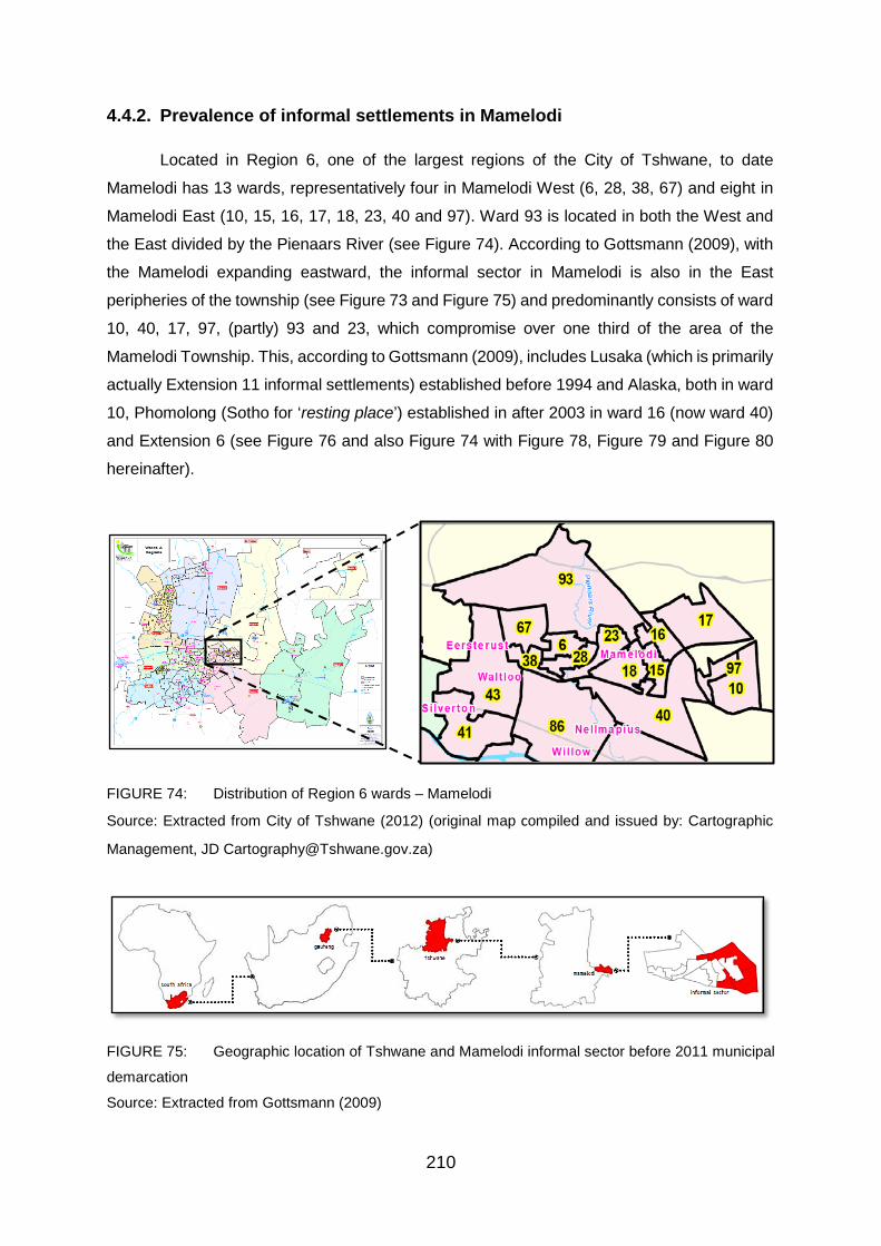
210
4.4.2. Prevalence of informal settlements in Mamelodi
Located in Region 6, one of the largest regions of the City of Tshwane, to date
Mamelodi has 13 wards, representatively four in Mamelodi West (6, 28, 38, 67) and eight in
Mamelodi East (10, 15, 16, 17, 18, 23, 40 and 97). Ward 93 is located in both the West and
the East divided by the Pienaars River (see Figure 74). According to Gottsmann (2009), with
the Mamelodi expanding eastward, the informal sector in Mamelodi is also in the East
peripheries of the township (see Figure 73 and Figure 75) and predominantly consists of ward
10, 40, 17, 97, (partly) 93 and 23, which compromise over one third of the area of the
Mamelodi Township. This, according to Gottsmann (2009), includes Lusaka (which is primarily
actually Extension 11 informal settlements) established before 1994 and Alaska, both in ward
10, Phomolong (Sotho for ‘resting place’) established in after 2003 in ward 16 (now ward 40)
and Extension 6 (see Figure 76 and also Figure 74 with Figure 78, Figure 79 and Figure 80
hereinafter).
FIGURE 74: Distribution of Region 6 wards – Mamelodi
Source: Extracted from City of Tshwane (2012) (original map compiled and issued by: Cartographic
Management, JD [email protected])
FIGURE 75: Geographic location of Tshwane and Mamelodi informal sector before 2011 municipal
demarcation
Source: Extracted from Gottsmann (2009)

211
FIGURE 76: Extension 11 and Phumolong informal settlements – established before 1994 and after
2003, respectively
Source: Extracted from Gottsmann (2009).
4.4.3. Land audit – who owns the land in Mamelodi?
Contrary to Table 5 and Figure 7, representing government’s land audit of South Africa,
which indicates that the state owns minority of the land in Gauteng and in comparison to all
other province(s), the HDA web-based data, as illustrated in Figure 77, provides that most of
the land in the City of Tshwane (North of Gauteng) is owned by the state (note: state land is
highlighted in red).

212
FIGURE 77: Spatial distribution of state and private land in South Africa
Source: Compiled by Thabitha Sebeyi (GIS Technician at HDA) on 22 May 2017, data from HDA
(NaHSLI) (2017)
The township’s land audit (illustrated in Figure 78; yellow=munipal, red=national,
purple=provincial, orange=SOE, sky blue=private) confirms further that most of the land within
the CoT is state owned as the greater part of the land in Mamelodi East is state owned. This
contradicts the historical account that most land is privately owned, by whites in particular and
begs a question or for an assessment of whether the state is taking land reform serious or
not. This can be seen or shown by its willingness and/or ability to first redistribute its own land
which it has control of. Figure 78 also shows that the informal settlements in the township,
including those in Extension 11 (in Ward 40), Phomolong (in Extension 6, ward 40), Alaska
(in Extension 22, ward 10) and Stoffel Park (in Extension 15, ward 17 and 97) are primarily
located on state land. Land use in Mamelodi is illustrated in greater detail under 4.4.4 on
pages 214-215.

213
FIGURE 78: State versus private land distribution, and informal settlements in Mamelodi

214
4.4.4. Land use
HDA (2017) repository (web-based applications – including NaHSLI, LaPSIS, HDA
Land Dashboard) based on 2011 Census, further affirm Gottsmann’s (2009) observation
(shown in Figure 75) and informal settlements in Mamelodi are predominantly located on the
Eastern and outer-peripheries of the township (as shown in Figure 78, Figure 79, and Figure
80). Figure 79 and Figure 80 illustrating land use in Mamelodi, also shows a broader and
clearer depiction of the informal settlements, informal (land) use, in Mamelodi. This includes
the four selected informal settlements (Extension 11, Phomolong, Alaska and Stoffel Park)
where the data was collected which indicates that the these informal settlements are the main
informal dwellings in Mamelodi, both West and East.
FIGURE 79: Land-use in Mamelodi Source: Compiled by Author, data from Stats SA, 2011 Census

215
FIGURE 80: Aerial view of land-use in Mamelodi (informal settlements highlighted in aqua)
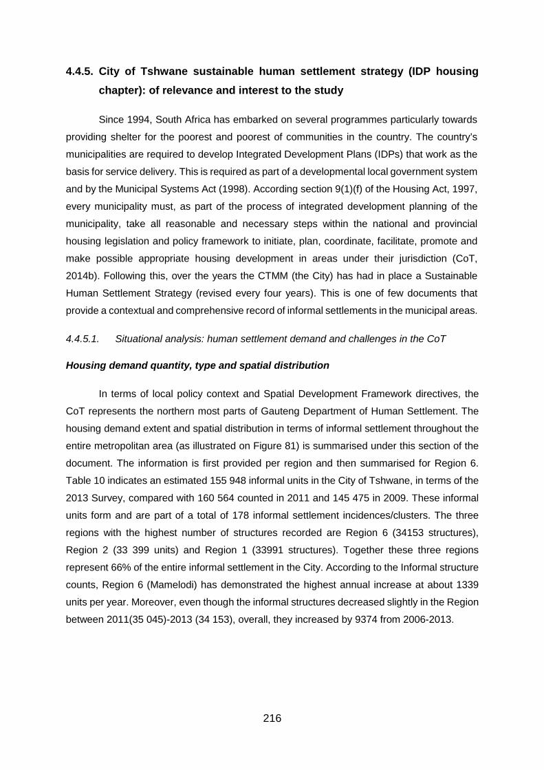
216
4.4.5. City of Tshwane sustainable human settlement strategy (IDP housing chapter): of relevance and interest to the study
Since 1994, South Africa has embarked on several programmes particularly towards
providing shelter for the poorest and poorest of communities in the country. The country’s
municipalities are required to develop Integrated Development Plans (IDPs) that work as the
basis for service delivery. This is required as part of a developmental local government system
and by the Municipal Systems Act (1998). According section 9(1)(f) of the Housing Act, 1997,
every municipality must, as part of the process of integrated development planning of the
municipality, take all reasonable and necessary steps within the national and provincial
housing legislation and policy framework to initiate, plan, coordinate, facilitate, promote and
make possible appropriate housing development in areas under their jurisdiction (CoT,
2014b). Following this, over the years the CTMM (the City) has had in place a Sustainable
Human Settlement Strategy (revised every four years). This is one of few documents that
provide a contextual and comprehensive record of informal settlements in the municipal areas.
4.4.5.1. Situational analysis: human settlement demand and challenges in the CoT
Housing demand quantity, type and spatial distribution
In terms of local policy context and Spatial Development Framework directives, the
CoT represents the northern most parts of Gauteng Department of Human Settlement. The
housing demand extent and spatial distribution in terms of informal settlement throughout the
entire metropolitan area (as illustrated on Figure 81) is summarised under this section of the
document. The information is first provided per region and then summarised for Region 6.
Table 10 indicates an estimated 155 948 informal units in the City of Tshwane, in terms of the
2013 Survey, compared with 160 564 counted in 2011 and 145 475 in 2009. These informal
units form and are part of a total of 178 informal settlement incidences/clusters. The three
regions with the highest number of structures recorded are Region 6 (34153 structures),
Region 2 (33 399 units) and Region 1 (33991 structures). Together these three regions
represent 66% of the entire informal settlement in the City. According to the Informal structure
counts, Region 6 (Mamelodi) has demonstrated the highest annual increase at about 1339
units per year. Moreover, even though the informal structures decreased slightly in the Region
between 2011(35 045)-2013 (34 153), overall, they increased by 9374 from 2006-2013.
217
FIGURE 81: City of Tshwane Informal setlement distribution
TABLE 10: Number of Informal Units per CoT Region, 2006, 2009, 2011 and 2013
Sources: GeoTerralmage Pty Ltd, Aerial Photos 2009, 2010; Plan Associates, Aerial Photos Counts
2009, 2011, 2013
Note: 178 Informal Settlements in total
4.4.5.1.1. Focus: Region 6, Mamelodi and informal settlements – location,
establishment, size and growth
According to the CoT (2014b), Region 6 contains the eastern areas of the urban
complex of the City of Tshwane around Mamelodi and the rural areas of Boschkop-Tiegerpoort
to the south-east thereof. The informal settlements in the region are largely concentrated in
Mamelodi (East). Meanwhile Mamelodi is located on the North-eastern peripheral extents of
the Region as depicted in Figure 82.

218
Table 11 shows that the Region recorded about 34 153 informal structures of which
the vast majority (± 32 000) are situated in and around Mamelodi (also refer to Figure 82 which
depicts the spatial distribution of informal settlements in the region and the clustering of
informal settlement at Mamelodi eastern end). This is the area in the City that represents the
highest people influx from other parts of Southern Africa. Figure 83 depicts the Mamelodi East
area in greater detail. Informal settlement in this precinct occurs in two linear/parallel strips
and a central core area.
FIGURE 82: Region 6 informal settlement distribution

219
FIGURE 83: Mamelodi East Informal settlements
Table 11 also contains a comprehensive record of informal settlements in Region 6
and Mamelodi in particular since 2006 (Region 6 – Study area sites (in yellow) – historic growth
of informal counts, 2006 – 2013) and also shows the areas that have been formalised since
then. Yet none of the case study sites had been formalised by 2013. Even by 2013 Mamelodi
had the most number of informal settlements (24) and shacks (32536) in the Region (refer to
Figure 83, Figure 84 and Table 11). Transnet, Transnet 1 and Erf 34041/Mamelodi X6
(Phomolong) – number 141, 142 and 143 form Phomolong informal settlement.

220
TABLE 11: Region 6 – Case Study Site – historic growth of informal counts, 2006 – 2013
Sources: GeoTerraImage Pty Ltd, Aerial Photos; Plan Associates, Aerial Photos Counts
Note: 1. Some of Mamelodi (East) informal settlements, such as area number 118 and 119 are located
in Region 5
2. Area number 118 combines with 140 to form Alaska; 119 combines with 139 to form Stoffel
Park; Extension 11 informal settlements are mainly represented by number 136.
3. The yellow highlights indicate Mamelodil informal settlements
Overall, the number of informal settlements and shacks in Mamelodi has increased
since the early 1990s as shown in Table 12. Table 12 shows the number of shacks in the four
informal settlements in 2006 and 2013 and indicates whether the informal settlement grew,
remained the same or decline over the period.

221
TABLE 12: Number of shacks and Informal settlements Growth
Informal settlement 2006 2013 Change
Increased, remained same,
decreased Extension 11 4212 4028 -184 decreased
Phomolong 12161 11094 -1067 decreased
Alaska 0 5940 5940 increased
Stoffel Park 0 3927 3927 increased
Overall 16373 25029 8616 *Increased Source: Derived from Table12, above *Overall growth attributed to Alaska and Stoffel which were not yet existing by 2006. In 2013, Phomolong remained the largest informal settlement in Mamelodi and Region 6 with 11 094 shacks followed by Alaska (5940), Extension 11 (3927) and Stoffel Park (3559). While there were some shacks moved in some informal settlements particularly in Phomolong and Extension 11 (between 2009 and 2013) there were also additional shacks with Stoffel Park and Alaska experiencing the major/greater expansion. (Refer also to Figure 83, 84 and Table 11).
According to the City, a total of 548 families were relocated from the main bulk water
pipe (Phomolong), following its burst in 2012 that led to the death of two children, to Hatherley
Portion 1, 331-JR and another 100 beneficiaries on the new site were allocated permanent
stands (CoT, 2017).
Further towards the east, the Leeuwfontein informal settlement form nearby to Mahube
Valley and represents the beginnings of the northward expansion Mamelodi pressure through
the Magaliesburg (Magalies Mountain). The Mamelodi East informal settlements and those
related to South (area number 118, 119, 121 and 122) are depicted in Figure 84 (30). Together
these represent approximately 3300 units.
FIGURE 84: Region 5 and other informal settlements in and around Mamelodi
The western strip which mainly consists of people who settled in route PWV15 road
reserve and the rail reserve as well as the large Transnet land portions, including Stand

222
33041/area number 143 (in Figure 83) to the south, was established in the early 2000’s. This
corresponds with many of the key informants’ narrative and particularly refers to Phomolong
(represented by number 141, 142 and 143) which, according to the Satellite imagery, was
established no later than 2004 and/or in 2002-2003 according to the data collected from key
informants (presented and discussed in 4.2). According to the news reports, Phomolong was
established in 2002 when the Municipality relocated some homeless families from
Marabastad, in Pretoria, against the resistance of about 150 people who protested against the
relocation (news24, 2002), because the area among other things had no portable water
(Moatshe, 2017). The residents were moved because the council planned to turn most of
Marabastad into a business district, with an area designated for residents (news24, 2002).
The eastern strip on the other hand represents Mamelodi’s eastern edge of bordering
or encroaching onto the Magalies Mountain. Invaded during the period 2008-2014, this is the
last strip of developable land to the east of Mamelodi. Approximately 8500 households
currently dwell in this area. (Refer to area number 139 and 140 in Figure 83). Correspondingly,
these (139 and 140 respectively) represent what is commonly known as Alaska and Stoffel
Park by key informants, official and on the ground. What is evident also from Table 11 is that
Alaska and Stoffel Park did not exist in 2006 (both with 0 informal structures), but emerged
later between 2007 and 2009 (and increased steadily from 4282 and 1099 to 5940 and 3927
informal structures respectively in 2013). This establishment and growth corresponds with
both the Landsat imagery data and key informant narrative on the establishment of the
informal settlements.
The central southern parts of Mamelodi (K54, Mamelodi X11 (i.e. Extension 11 informal
settlements) and Mamelodi X12 and X18 (i.e. also known as RDP) also consist of a large
informal settlement concentration estimated at about 5000 units (refer to Figure 83). Yet
informal structures in X18 decreased from 1003 in 2006 and only 938 existed by 2013. A
number of smaller isolated informal settlement incidences occur directly next to the south of
the railway line, bordering Mamelodi, around Hatherley and Nellmapius (see Figure 84 (33))
and in the rural areas to the south-east.
Figure 83 and 84 also show that a majority (22) of the informal settlements are located
in Mamelodi East, while only two are located on the West. Overall, records (Table 11) show
that the study sites (all in Mamelodi East) were the largest informal settlements in Mamelodi;
Extension, Phomolong, Alaska, and Stoffel Park. According to Table 11, in 2013, Phomolong
remained the largest informal settlement in Mamelodi and the Region with 11 094 shacks
followed by Alaska (5940), Extension 11 (3927) and Stoffel Park (3559). While there were
some shacks moved in some informal settlements particularly in Phomolong and Extension
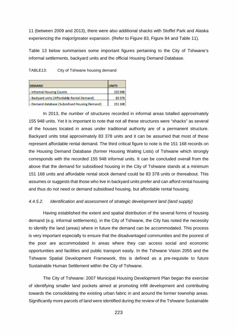
223
11 (between 2009 and 2013), there were also additional shacks with Stoffel Park and Alaska
experiencing the major/greater expansion. (Refer to Figure 83, Figure 84 and Table 11).
Table 13 below summarises some important figures pertaining to the City of Tshwane’s
informal settlements, backyard units and the official Housing Demand Database.
TABLE13: City of Tshwane housing demand
In 2013, the number of structures recorded in informal areas totalled approximately
155 948 units. Yet it is important to note that not all these structures were “shacks” as several
of the houses located in areas under traditional authority are of a permanent structure.
Backyard units total approximately 83 378 units and it can be assumed that most of these
represent affordable rental demand. The third critical figure to note is the 151 168 records on
the Housing Demand Database (former Housing Waiting Lists) of Tshwane which strongly
corresponds with the recorded 155 948 informal units. It can be concluded overall from the
above that the demand for subsidised housing in the City of Tshwane stands at a minimum
151 168 units and affordable rental stock demand could be 83 378 units or thereabout. This
assumes or suggests that those who live in backyard units prefer and can afford rental housing
and thus do not need or demand subsidised housing, but affordable rental housing.
4.4.5.2. Identification and assessment of strategic development land (land supply)
Having established the extent and spatial distribution of the several forms of housing
demand (e.g. informal settlements), in the City of Tshwane, the City has noted the necessity
to identify the land (areas) where in future the demand can be accommodated. This process
is very important especially to ensure that the disadvantaged communities and the poorest of
the poor are accommodated in areas where they can access social and economic
opportunities and facilities and public transport easily. In the Tshwane Vision 2055 and the
Tshwane Spatial Development Framework, this is defined as a pre-requisite to future
Sustainable Human Settlement within the City of Tshwane.
The City of Tshwane: 2007 Municipal Housing Development Plan began the exercise
of identifying smaller land pockets aimed at promoting infill development and contributing
towards the consolidating the existing urban fabric in and around the former township areas.
Significantly more parcels of land were identified during the review of the Tshwane Sustainable

224
Human Settlement Strategy in 2010 when the process was repeated. The 2007 and 2010
exercise results are depicted in Figures 85a and 85b respectively. The land parcels in red
depicted in Figure 85a were intended for the process of infill development and the
strengthening of the urban fabric of the former township areas. These areas (including those
in and around/adjacent Mamelodi) were mostly linked to the informal settlement (located on
and around them) insitu formalisation. Yet at the time (2007-2010), some of the land identified
particularly in Mamelodi was already either used by informal settlements such as Extension
11 and Phomolong, or later occupied to form informal settlement such as Stoffel Park from
2008.
FIGURE 85a: Sustainable land suitable for development, 2007

225
FIGURE 85b: Land suitable for residential development, 2010
4.4.5.2.1. City of Tshwane (council owned) strategic land parcels
A release of approximately 35 Council owned strategic land parcels located throughout
the City was approved by the City of Tshwane during 2009 with the aim that their development
should serve as a catalyst for local and metropolitan economic growth. Figure 86 (48a)
graphically illustrates a number of originally identified land parcels. They also included Plastic
View informal settlement land in Woodlands, Garsfontein, which was saved from the hammer
when the North Gauteng High Court ruled against its auction (See also area number 5 in
Figure 86 (48a) and Figure 14). According to Mudzuli (2015), Judge Legodi Phatudi agreed
that “the sale of the property [upon which Plastic View is located] before relocation would be
an infringement on the rights of the occupants,” and would deal them irremediable harm
(because it would be almost impossible to settle relocation after the land had been sold).
The City decided to release 12 priority parcels of land to the private sector as a first
phase in the process. The 12 sites representing about 1483 hectares of strategically located
vacant land nearby, or within existing or proposed future nodes of activity in the City’s
disadvantaged areas, are marked on Figure 86 (48a). Figure 86 (48b) illustrates the four sites
representing 300.2 hectares that were approved for development following the call for

226
proposals. The estimated residential yield of the four projects is about 11 002 residential units
(of which 606 are from 4.4 ha land in Denneboom, Mameldi Extension 13 which yet to be
awarded to a developer).
FIGURE 86: Council owned strategic land parcels
4.4.5.2.2. Vacant private land parcels adjacent to Mamelodi
The City of Tshwane identified two private sector driven project areas (bonded
housing) adjacent to Mamelodi and Olievenhoutbosch where it wishes to negotiate for some
subsidised housing to be included (Figure 87, number 1 is 226.7 ha and number 2 is 168.8
ha). While most of the land (including the strategically located) is owned by the Municipality
and already occupied, some the land parcels adjacent to Mamelodi such as in Figure 87 had
been vacant and privately owned.
FIGURE 87: Private vacant land
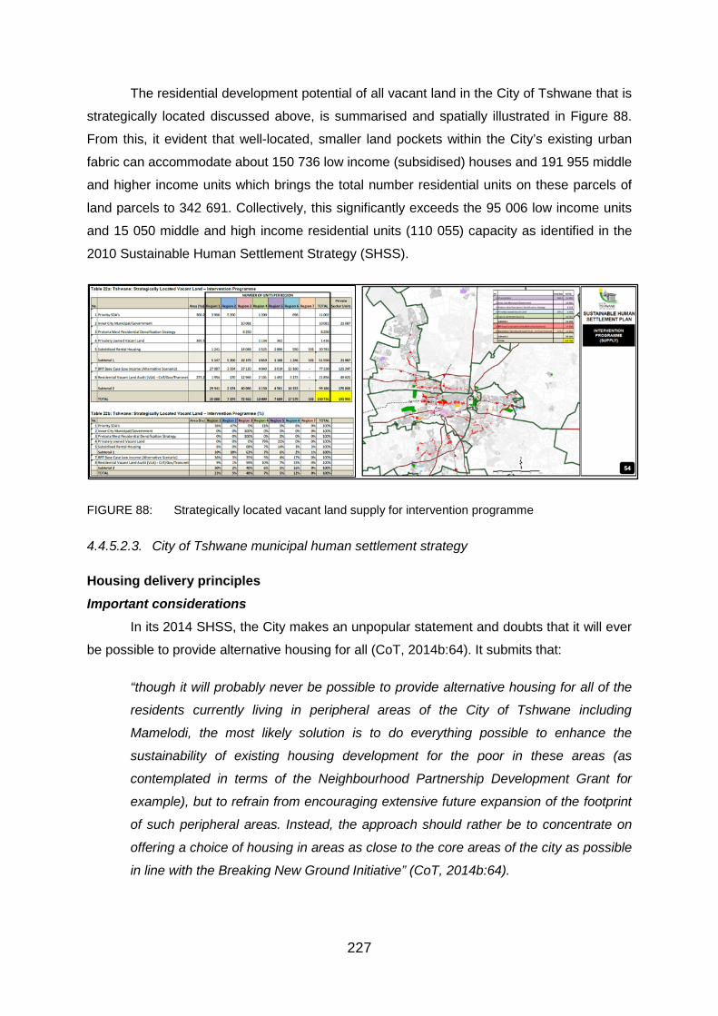
227
The residential development potential of all vacant land in the City of Tshwane that is
strategically located discussed above, is summarised and spatially illustrated in Figure 88.
From this, it evident that well-located, smaller land pockets within the City’s existing urban
fabric can accommodate about 150 736 low income (subsidised) houses and 191 955 middle
and higher income units which brings the total number residential units on these parcels of
land parcels to 342 691. Collectively, this significantly exceeds the 95 006 low income units
and 15 050 middle and high income residential units (110 055) capacity as identified in the
2010 Sustainable Human Settlement Strategy (SHSS).
FIGURE 88: Strategically located vacant land supply for intervention programme
4.4.5.2.3. City of Tshwane municipal human settlement strategy
Housing delivery principles Important considerations
In its 2014 SHSS, the City makes an unpopular statement and doubts that it will ever
be possible to provide alternative housing for all (CoT, 2014b:64). It submits that:
“though it will probably never be possible to provide alternative housing for all of the
residents currently living in peripheral areas of the City of Tshwane including
Mamelodi, the most likely solution is to do everything possible to enhance the
sustainability of existing housing development for the poor in these areas (as
contemplated in terms of the Neighbourhood Partnership Development Grant for
example), but to refrain from encouraging extensive future expansion of the footprint
of such peripheral areas. Instead, the approach should rather be to concentrate on
offering a choice of housing in areas as close to the core areas of the city as possible
in line with the Breaking New Ground Initiative” (CoT, 2014b:64).

228
The City discourages future expansion of peripherl areas. Yet field work and key
informant narrative indicates that new shacks and informal settlements have since been
erected in and mushroomed south of the railway line, adjacent to Mamelodi East, in areas
such as Pienaarspoort. This is despite and following the City lobbying the community leaders
against allocating new shack stands or admitting of incoming/new dwellers in the settlements,
by promising to develop them, particularly in Alaska and Stoffel Park in 2015.
In blue, the most prominent land pockets identified through this process and which as
part of the City’s Housing Intervention Programme could be regarded for typical mixed income,
multi-typology and multi tenure, is illustrated in Figure 89.
FIGURE 89: Consolidation and intervention programme on land suitable for residential development
Important to note also is that there is significant capacity (149 377 low income units)
which could contribute hugely towards enhancing the sustainability of the broader urban from
of the metropolitan even though this is not enough to address the entire housing backlog
existing in the City of Tshwane. In terms of the South African Cities Network (SACN, 2014 in
CoT, 2014b:65), BRT-based an urban integration investment that is based on a BRT may be
a good strategic option particularly for Tshwane and Ekurhuleni.

229
Yet it is further noted that the City will also not be able to realise the successful
eradication of housing backlogs where all efforts are focused exclusively on the new Breaking
New Ground model (i.e. higher density housing in more accessible locations). This is as a
result of the long lead-time from start to implementation of a project (± 2 years).
It is inevitable therefore if the City intends to significantly erode the current backlogs to
undertake in-situ upgradings of informal settlements in peripheral areas where backlogs
presently exist through a Housing Consolidation Programme to deal in the main with the
existing backlogs (completing and consolidating the existing housing programmes). The total
development potential of the identified land as part of the Intervention and Consolidation
Programmes is 341 923 low-income housing units.
The land parcels marked red (Consolidation Programme) in Figure 89 above have the
potential to accommodate the development of about 191 187 residential units while the land
parcels in blue (Intervention Programme) have the capacity to provide for low income units of
approximately 150 736 (of which. This excludes the capacity to provide for 57 357 (11 271 in
Region 6) middle income units and 63 890 (21 087 in Region 6) high income units calculated
for these areas. These lands also include private-owned land.
Acknowledging this inevitability, therefore, the City determined to follow a dual
approach towards housing delivery which consists of the following two programmes (CoT,
2014a:67):
1. Intervention Programme: which aims at promoting higher density, mixed income
(Inclusionary Housing) and mixed land, use developments around the Tshwane IRPTN
and nodal network.
The following three initiatives make up the Intervention Programme:
- Breaking New Ground/Inclusionary Housing.
- Social Housing and Community Residential Units focusing on affordable rental stock.
- Medium to higher density full ownership housing (i.e. RDP Walk-ups).
2. Consolidation Programme: which seeks to complete and consolidate existing housing
initiatives in all areas in the City of Tshwane with the aim towards improving and
supporting the sustainability and viability of these communities and addressing the
most urgent local needs and Upgrading of Informal Settlements (UIS) backlogs. It
broadly comprises all the red parcels of land as illustrated in Figure 89.

230
To this end, the City redefined well-located and thus:
“it will broadly mean continuing to provide land for new informal occupation on the
peripheries. Upgrading projects will then enable these areas to shift up to middle-class
status. As this process continues, space will need to be identified incrementally for
further informal shack-level occupation by the incoming migration stream, so that new
settlements can continue to be upgraded in an orderly, planned progression”. (SACN,
2014 in CoT, 2014b:67).
The Consolidation Programme mainly includes three initiatives:
- To upgrade informal settlements in peripheral locations where they are close to
existing mass public transport infrastructure and economic and social opportunities
and where the current layout makes sensible upgrading possible.
- Formalisation of well-located informal settlements (UIS Programme) which contribute
towards the consolidation of the existing urban fabric.
According to the City, the size and growth rate of the housing backlog and the great
pressure towards the upgrading of informal settlements, calls for intervention to be considered
in housing delivery in the City of Tshwane. Yet it is imperative for it to consider various related
matters including suitable land availability, the land price, the location of planned
developments, type of developments and funding availability in the main.
Following this, the City of Tshwane in Mamelodi has initiated a process of upgrading
some of the informal settlements, particularly since 2015.
In addition to these “hard issues” the City further noted that there are also “soft issues”
which need to be taken into account such as the family income, Structural investments made
by households, other influences, peripheral areas etc. These are issues which could impact
on the thinking and decisions taken by affected families and are reflected briefly below.
Family income effect
The City is of the view that a family which earns a constant monthly income of R2500
to R3500 could feasibly afford to consider options of tenure such as full tenure (because it
may qualify for a housing subsidy) or rental/institutional housing with at 25% of the monthly
income (R625 to R875 rental per month). A family on the other hand which earns an income
of R0 to R1500 per month or who is unemployed in a way which ensures a constant income
would be reluctant to take an option of rental housing, understandably so. The household
would face a constant risk of eviction due to the income limitation or the uncertainty of income

231
uncertainty. It is expected that such a household may prefer a “full-tenure” option. This income
category currently represents the largest portion of the housing backlog.
Yet the reality is that the narrative presented by several informal settlement dwellers
(who also fell within the low-income category – R0-3500 and were eligible for subsidy housing
known as RDP houses) interviewed in Mamelodi indicates that they came about to live in
shacks because they could no longer or not afford rent. The key informants (informal
settlement dwellers) provide a narrative that indicates clearly their disinterest and opposition
to renting and rather insist for land/housing ownership.
Structural investments made by households
Many households have over the years of dwelling in informal settlements invested in
permanent housing structures (brick and mortar). It is anticipated that such households would
choose to stay where they are and be granted “full-tenure” of a land portion on which they
have made the investment after the land has been developed by means of a process of in-situ
upgrading. This is because these are believed to be generally poor families.
Peripheral areas
In it 2014 SHSS, the City proposed that current development should be completed due
to the fact that a large number of families reside in these areas already and that a significant
number of development has already taken place.
Other influences
Some communities do not even want to consider alternatives because they have lived
in a particular area for so long while other families only dwell in an informal settlement because
they have no other alternatives.
Furthermore, the City could implement few such projects over the next decades
beginning in 2014. This is because of fiscal constraints. Yet it is very important that the land
on which such developments are to be executed is controlled by the City of Tshwane.
Consideration will therefore need to be given to development to be implemented on Council
owned land as a matter of priority and thereafter to expropriation and/or agreements of
availability of land regarding private owned land. It will also be necessary, when required, to
engage with other Government ties with respect to State and Parastatal/State Owned Entities’
(SoE) owned land. Even from the SHSS, it is not evident or clear that the City has in the past
engaged the SoE’s, particularly Transnet, to harvest and secure their land, before invasion as
in the case of Mamelodi, for human settlements development purposes.

232
Region 6: consolidation and formalisation programme in context Figures 90 and Figure 91 illustrate the formalisation strategy that was proposed for the
Mamelodi area and surrounds in the CoT Region 6. In total, the Region has 34 153 informal
settlement units which are approximately 2876 units more than the demand. The eleven
identified Strategic Development Areas and the in-situ formalisation process have a capacity
to accommodate about 37 913 units for Region 6. In-situ formalisation in areas like Mahube
Valley, Mamelodi X11, Transnet land and Phase 1/Mamelodi X10 to the north will
accommodate approximately 18 206 housing units. Major areas identified to accommodate
the Mamelodi surplus demand are Mahube Valley X15 (Stoffel Park), Nellmapius X24, The
Willows and Pienaarspoort in Region 5. Figure 90 graphically depicts the details of the strategy
for Region 6 and indicates that most of the surplus from Lusaka and route K54 reserve and
Mahube Valley will be moved or relocated to The Willows and Pienaarspoort next to, but
outside Mamelodi. Data collected from key informants indicate that this relocation has already
occurred and is still taking place. From the site visits during field work, it was evident that the
consolidation and formalisation programme is taking place in Mamelodi X11, Mahube Valley
X15 (Stoffel Park) and Transnet land with the formalisation of the informal settlements (i.e. re-
subdivision, allocation of permanent stands etc).
Nellmapius Ext 22, also outside Mamelodi, will be only utilised to accommodate part
of the demand database. In this regard, in preparation and as part of the programme, several
dwellers have been relocated in for example Transnet land/Phomolong to Nellmapius Ext 22
as indicated by the community leader, dwellers and ward councillor. Evident indeed, also in
Figure 90, is that the entire Alaska informal settlement is not set for formalisation, but only
relocation (see highlighted in pink) to The Willows and Pienaarspoort which suggests that
relocation was necessary because the land is either not suitable (e.g. geological risk area) for
human settlement development or the settlement needs a total overhaul.
The City points out that it is important to note that Nellmapius Ext 24, The Willows and
Mamelodi Ext 5 and Erf 2006 development capacity are all at average densities of about 80
units per hectare which is not single RDP housing. Further notes found that if the housing to
be developed is not 2 and 3-storey walk-ups, the surplus capacity of about 2876 units in
Mamelodi will not be attained. The implication of this essentially is that if the development of
all the informal settlements that exist in Mamelodi is at single RDP densities, then the identified
land as illustrated in Figures 90 and 91 will be used solely to accommodate existing housing
backlog in and around Mamelodi. It should be noted that the Council will then have to acquire
additional land to accommodate future demands.

233
FIGURE 90: Mamelodi formalisation strategy
FIGURE 91: Mamelodi formalisation strategy (continues)

234
Management of informal settlements The City has had no (at least adequate) formal or Standard Operation Procedure to
deal or manage informal settlements as suggested in its SHSS (CoT, 2014b). In its SHSS, as
a Strategic Intervention, the City determined that three key programmes to strategically deal
with issues related to land and building invasions and informal settlement management should
be implemented (CoT, 2014b:92):
Strategic programme 1: eradication of informal settlements This is aimed at, in essence, providing an estimated program for eradication of informal
settlements through formalization and/or relocation.
Strategic programme 2: informal settlement management policy The aim of this project is to provide an informal settlement management policy that
seeks to deal with the management of informal settlements which are lining up to be either
formalised and upgraded, or to be relocated and should deal with the following (CoT,
2014b:93):
• Illegal and unchecked growth of these settlements;
• The illegal selling of land and the registration of beneficiaries; and
• To ensure the provision of rudimentary services and facilities etc.
The necessity to strategise and address the above-listed challenges indicates that that
the City has been experiencing or facing them.
Strategic programme 3: a) The land and building invasion prevention and monitoring
This programme will entail the utilisation of security personnel to prevent, monitor and
get rid of unlawful land and building invasions within the City of Tshwane jurisdiction area.
Notwithstanding this, all informal structure/shack evictions and/or demolitions should follow
the applicable legislation. It is of critical importance to note that for this to take place a court
order to this effect must first be granted as required by legislation. Effectively, this means that
the City will further apply or use force to deal with land invasion.
Waiting lists The City proposed The Waiting List System to avoid queue jumping in terms of housing
allocation by the Department of Housing and to set municipal wide criteria for the allocation of
houses (which is in line with the National Housing Department). The Waiting List System will
in addition provide the Municipality with crucial statistics on the housing need and the related
data necessary to make decisions concerning future human settlement/housing development
235
planning. This clearly indicates that queue jumping in terms of housing allocation was indeed
a reality in the city and the current waiting list system was not able to avoid it. The City was
also, to an extent, probably not able to make decisions concerning future human settlement
development and planning.
Waiting list goals Moreover, the Waiting List has been set the following goals (CoT, 2014b:104):
• Facilitate the orderly, but effective allocation of housing within the municipal area.
• Ensure that the policy guidelines of the Waiting List are maintained.
• Ensure that a uniform approach to housing allocation is followed by the Municipality.
• Ensure the sustainability of the Waiting List through the empowerment of Municipal
Housing Officers, but at the same time co-ordinating criteria amongst different
communities.
• Integration of the Waiting List System into the global information technology system of
the Municipality.
• Persons on the Waiting List should receive priority treatment in the allocation of
subsidies (depending on their ranking on the list).
• The list should cater for community groupings.
The City has recognised that it is necessary that the information contained on the
Waiting List has to reflect the situation on the ground in order to achieve these goals. The
system, therefore, as matter of utmost importance has to be effectively maintained. Moreover,
the above beyond queue jumping in terms of housing allocation, indicates that the City’s
waiting list system has not been computerised, integrated or that it is somehow not effectively
managed. It has been vulnerable to human error and/or manipulation.
The significant difference between the CTMM housing subsidy eligibility criterion to
that of the National Department of Human Settlements is that it does not require a single
person with dependants to be over 21 years of age and does not consider whether the person
has received government housing subsidy except for the consolidation subsidy and disabled
people.
Finally, in 2010, it was realised that an agreement with national, provincial and
municipal as landowners to release land (6250ha) over the next four years (2010-2014) and
the use of densities of 60 units per ha can only be realised by means of appropriate planning
at a provincial and municipal level. This calls for a robust mechanism to be established to
harvest public land from all government spheres and to secure such land for the purpose of
human settlements development. Of note is that, as with the State Owned Entities, this

236
suggests that the City had no working agreement with the other two spheres of government
(national and provincial) on harvesting and securing land human settlements which is possibly
the main reason for the failure to secure such land. In its SHS Plan, the City has noted the
need to “develop and adopt criteria to inform identification of suitable land and its
development” (CoT, 2014b:17). It recognised that this can be achieved through “the Housing
Development Agency (HDA) [which] undertakes, in consultation with all spheres of
government, the identification of required land and produces a single periodic list of prioritised
publicly-owned land to be released for human settlements” (CoT, 2014b:18).
4.5. Summary
Analysing satellite imagery of the over a 20 year period (1994-2014), the trend and growth
pattern of the informal settlements in Mamalodi was established. Moreover, key informant
interviews and documents were further triangulated to provide an understanding of the
differences between official positions and the views, experiences and demands of the informal
settlement dwellers. These include the access to land and housing, as well as the
establishment and growth of the informal settlements and land reform questions. The
summary of the study findings, as well as the conclusion recommendations are presented in
the following chapter.

237
CHAPTER 5: SUMMARY, CONCLUSION AND RECOMMENDATIONS
5.1. Introduction
This final and summary chapter contains two main sections:
Section 5.2: Summary and conclusion
Section 5.3: Recommendations
The main finding of the study are summarised in the following section.
5.2. Summary and conclusion
Informal settlements in South Africa are deeply rooted in colonialism and apartheid.
Despite the delivery of over 3 million houses by the democratic government of South Africa
between 1994 and 2014, informal settlements’ numbers and shacks have grown rapidly and
uncontrollable in the country. Meanwhile, Whites still own majority (about 76%) of the land in
South Africa. To this end this study aimed to gain insight into the current urban land
management practices in South Africa, with particular focus on the role of land acquisition in
the growth of informal settlements in Mamelodi, as its primary objective. In the final analysis,
it can be established that: Failure by this democratic government to effectively manage and
address the demand for land and housing by proactively acquiring and redistributing land for
the purpose of housing the urban poor has led to this historically dispossessed, landless and
homeless group of people from their poor provinces of birth to resort to informal land
acquisition and (re)distribution processes, in the form of illegal land occupation and informal
settlement as an alternative solution.
The study findings are summarised methodologically and relevantly under the three
objectives of the study. The recommendations of the study are made under objective 3.
Objective 1:
To analyse the development and growth of informal settlements in Mamelodi.
Research Questions: What are the trends that can be identified in terms of informal settlement
patterns in Mamelodi since 1994?
Study findings reveal that Mamelodi has expanded largely towards the East, to a great
extent, because of the establishment and growth of informal settlements in the area, while the
West boundaries have remained relatively fixed throughout the growth of Mamelodi. Four main
informal settlements, namely Extension11, Phomolong, Alaska and Stoffel Park, have been
established in the area between 1994 and 2014.
238
The land in Mamelodi East was vacant and unused until the establishment of the four
informal settlements, with the exception of the land on which Extension 11 was establish
around 1994. The respondents provide that the land is an abandoned white-owned dairy farm.
Thus, it appears from observing and analysing the satellite images over time, that the local
municipality (now the City of Tshwane Metropolitan Municipality) has had so much time and
opportunity to proactively identify, secure, develop and release the vacant land for the purpose
of formal housing or serviced stands. In this way, it would have, probably, avoided a number
of informal settlement that have mushroomed on the land since 1994.
Consequently, left to fend for themselves, it appears that the land occupants did not
manage to resist the temptation and miss their chance to occupy and erect shacks on the
vacant land. There are four major informal settlements that have mushroomed in Mamelodi
since the dawn of South Africa’s democracy in 1994. Two were established in the second
decade of the democratic South Africa, between 2004 and 1994, namely, Alaska and Stoffel
Park respectively. Extension 11 and Phomolong were the first informal settlements and were
established during the first decade, between 1994 and 2004, respectively.
Landsat satellite imagery also show that Stoffel Park was the last informal settlement
that was established in Mamelodi by 2014. With Alaska and Stoffel Park, the last informal
settlements in Mamelodi East, established on the bordering Magalies Mountain, in 2014,
Mamelodi looked like it has reached its limits of expanse. Yet through innovation, newer urban
dwellers continue to define new limits. If this informal settlement trend continues, there is a
reasonably high possibility that the shacks will summit over the mountain or to another nearby
open land.
Data from the key informants, considered in the light of satellite imagery analysis and
various documents, provides insight on how the dwellers have acquired the land, as well as
the establishment and growth of the informal settlements as a result.
Objective 2:
To determine the role of the current land acquisition processes in the growth of informal
settlements.
Research Questions:
• What are the current processes of land acquisition?
• What role (if any) does the current processes of land acquisition play in the growth of
informal settlements?
239
Mamelodi came with apartheid in 1948 and was established for Africans, providing the
much needed migrant labour in the segregated white city of Pretoria. As indicated above, over
time and especially since 1994, Mamelodi has absorbed an ever-expanding informal
settlement. Many people in Mamelodi live in shacks, either in areas/land occupied through
illegal land invasions and/or on legalised plots still waiting on the queue for government
housing.
The informal settlement dwellers (respondents) are Africans and a great majority of
them come from outside the Gauteng province, mostly from Limpopo, to look for work of which
a majority of them remain unemployed, especially the women. This means that Mamelodi has
continued to be an African Township to the perpetuation of Apartheid design, as well as racial
and class segregation. Apart from employment, their immediate need in the City is housing of
which they do not find immediately, except rental housing mainly in the township. With
inadequate housing, rapid urbanisation of the rural poor and even some influx of immigrants
from neighbouring countries in search of employment and opportunities for better life, and
family growth, informal settlements have grown even larger.
None of the dwellers owned a house and they had no places of their own to live and
many came from renting and could no longer afford rental. The majority of the respondents
were eligible for subsidy housing, yet as many as 63% had not applied for housing. Some,
despite having applied, have been on the waiting for over 20 years, while some have not
applied because they were undocumented foreign nationals without Identity Documents
whose income was more than R3500 and/or had no dependants and some did not believe
that the government will ever give them housing. Moreover, a great majority (84%) occupied
the land first before applying for housing.
The initial dwellers found the land unoccupied and vacant. It was left vulnerable and
exposed for years to desperate urban land seekers. The dwellers came to occupy the land not
because it was close to work or facilities, but because they needed a place to live and the land
was vacant. To this end, it is established that the City of Tshwane Metropolitan Municipality
(CTMM) has consistently failed to proactively acquire and even attempt to develop and
redistribute the vacant lands, to the poor and have thus led the poor to resort to occupy these
lands mostly without the permission of the municipality to form the four informal settlements:
beginning with Extension 11 around 1994, followed by Phomolong, Alaska and Stoffel.
Phomolong is the only informal settlement that was initially established by the
government by relocating homeless people from Marabastad in 2002, but most of the land
remained unoccupied and was soon invaded in 2003. To this date, the settlement remains

240
informal with shacks because the municipality did not provide the dwellers with formal housing.
The municipality has attempted to respond to land invasions in the four informal settlements
with force in the form of eviction, many without a relevant court order and all without success.
Extension 11, Alaska and Stoffel Park were founded by individuals who took personal initiative
to divide and release the vacant to the land seekers.
Data from the Housing Development Agency reveals that most of the land within the
City of Tshwane is state owned, while a Mamelodi land audit shows and confirms that the
greater part of the land in Mamelodi East, including the one on which the four informal
settlements are located is owned by the state, including Transnet, which is a state-owned
entity. This contradicts the narrative that most land is privately owned, by whites in particular
and begs a question and concern: whether the government is serious about providing the poor
access to land reform has willingness and ability to redistribute its own land, which it has
control over. Land use in Mamelodi also shows that the Extension 11, Phomolong, Alaska and
Stoffel Park settlements are the main informal settlements in the entire Mamelodi.
Beyond establishment, the access to land in the informal settlements have been
obtained in various ways such as receiving a plot/stand from government, occupying/invading
land illegally, buying land from politician or an organised committee/office or community
founder and/or leader, as well as buying an existing shack from previous owner or inheriting
a stand with a shack from family. Overall, the majority of the respondents are of the view that
getting a stand from the government (but not through housing) and invading the land illegally
has been the ‘easiest’ way of getting the land in the informal settlements. Accessing land from
the government or through land invasion has occurred in all four of the informal settlements,
but getting a stand from the government was surprisingly perceived to be the most prominent
way of accessing land in and by respondents in Alaska and Stoffel Park, while land invasion
was prominent in Phomolong and Extension 11. With regards to Extension 11, it is provided
that there was no alternative in 1994 but land invasion, which occurred all the time. All of the
informal settlements had an operating office where access to the land among other things has
been facilitated in the community and run by the community leaders.
Land has been acquired in various specific periods, but ultimately all the time until the
informal settlements were seemingly full to capacity. The periods in which land was most
accessed in informal settlements include, during: elections, weekends, Christmas, other
holidays (including long weekends) and year-end. It was also reported that a number of people
accessed the land during the night, because monitoring it during the evening is difficult for the
municipality. People also invaded during weekends while being aware that most of the City’s
employees are not operating and/or simply because they were either off-duty or would get
241
time during weekends. Monitoring the situation was also reported to be poor during year-end,
while there was also more time during holidays including long-weekends. Meanwhile, some
occupied the land in June/winter because it was cold, to suggest that they were basically
homeless.
It appears to be not coincidental that accessing land/a stand from the government was
the most utilised means besides outright land invasion, given that respondents in all the four
informal settlements provide that it has been easier or people have obtained stands mostly
during elections. A great majority (70%) of the respondents indicated that people in these
informal settlements gained access to the land easier during elections. Some further provided
that land invasions during elections were not met with force or a firm response by the
municipality or authorities, but with divisiveness and selfish intentions, while some invasions
were assisted land invasions. Given this, politics and political parties and particularly elections
have played a major role in terms of access to land and the growth of the informal settlements.
The municipality and some politicians have been heavily involved and have given many people
in the four informal settlements access to land, yet it was to buy their votes.
Mamelodi East is the Capital of informal settlements in the City of Tshwane. In 2013,
Region 6, where in Mamelodi is located within the CTMM, it recorded about 34 153 informal
structures of which the vast majority (± 32 000) are situated in and around Mamelodi.
Furthermore, 22 out of 24 informal settlements in Mamelodi are located in Mamelodi East. The
case study sites, all located in Mamelodi East, were the largest informal settlements in the
Township. Phomolong remained the largest informal settlement in Mamelodi and the Region,
followed by Alaska, Extension 11 and Stoffel Park.
Given that all the four informal settlements were established between 1994 and 2014
and still stand as informal settlements to this date, Mamelodi has seen growth in the number
of informal settlements between the aforementioned years. This is despite the drop in the
number of shacks in some of the informal settlements between 2006 and 2013, particularly
Extension 11 and Phomolong, the older informal settlements, as the total number of shacks
(including informal structures) in the four informal settlements combined increased by 8616
from 16373 to 25029. There were some shacks moved from Phomolong and Extension 11
between 2009 and 2013, leading to a decrease in the number of shacks in the in these two
informal settlements, but there were also additional shacks with the establishment of Stoffel
Park and Alaska. Moreover, None of the four informal settlements, understudy, had been
formalised by 2013 and Mamelodi had 32536 informal structures of which many were in
Phomolong, Alaska, Extension 11 and Stoffel Park. Phomolong was the biggest of all the four
informal settlements with over 11000 shacks.

242
In the main, the number of informal settlements and their size have increased because
people do not have a place to live and have continued to illegally occupy the land.
Despite the landlessness and homeless that exist the municipality and Mamelodi, as
well as the shack-dwellers resistance towards evictions, land invasion has been normalised
and simply met with force and treated as a criminal act by the government. This is not only
being reactionary, but it also portrays the government as one that is out of touch with the poor
and unsympathetic towards their land needs. It portrays the government as not being seriously
committed to providing access to land and housing to the historically dispossessed and poor
and hence can be seen as anti-poor and against its very own people.
In fact, some of the respondents indicated that they would do even with permanent
stands and work to build their own brick and mortar houses. This was the case in the Bredell
land invasion in the early 2000s as reported by de Beer, the people said, “we can’t afford
formal housing, give us land and we will build for ourselves” (CDE, 2001:6). With the
formalisation, Stoffel Park has shown that this works for some small number of dwellers.
Stoffel Park, though established last among the four informal settlements, has been under-
development since 2015, and has been allocating permanent stands to the initial occupants
who dwelt on the mountain. This is notwithstanding that the informal settlement is still
predominantly made up of shacks, since obtaining permanent stands, some people have
started building permanent brick and mortar houses. Moreover, most of the dwellers across
the informal settlements, except in Alaska, would prefer to have their houses built on the land
they occupy presently, because they have become used to and have strong social relations
in the area and their children’s school and transport and the mall are close.
There is land suitable for housing developments in the City of Tshwane Metropolitan
Municipality, though not enough to meet the current housing demand, to accommodate over
341 low-income units through the municipality’s Intervention and Consolidation programme.
The failure to provide land and housing has been a breeding platform for the development and
growth of informal settlements in Mamelodi. Until an access to land and housing is provided
in the city, informal settlements will continue to grow. As a matter of fact, the stands on the
mountain left vacant by dwellers relocated to permanent stands in Stoffel Park were being
illegally re-occupied by new dwellers. In 2015, a new informal settlement, Riverside, was also
established on a pocket of sandy land below Stoffel Park.
The situational analysis, presented herein, of land acquisition and growth of the four
informal settlements understudy, is summarised in Table 14 on the next page.

243
TABLE 14: Land acquisition and selected informal settlements in Mamelodi
Extension 11 informal settlement
Phomolong Alaska Stoffel Park Village Lusaka
Extension 11 Sizanani (Formal settlement)
Land owner Abandoned land/ CTMM
Abandoned land/ CTMM Transnet and CTMM Abandoned land/
CTMM Abandoned land/ CTMM RDP housing
beneficiaries with title deeds
Ward 10 10 40 10 17 & 97 10 Extension 11 11 6 22 15 22
From - to ±1994 – 1996 – 2002 – 2007 –
2008 – (invasion of stands on the mountain
left vacant by relocation/resettlement
of initial and old occupants to permanent
stands)
2002 –
State/use of land upon occupation Vacant Vacant Vacant Vacant Vacant Vacant
Land acquisition (establishment) Land invasion Land invasion
Relocation from Marabastad by
municipality (2002) and land invasion
(2003-)
Land invasion Land invasion Land invasion (then lawful occupation
through RDP housing)
Number of shacks (2013) 4028 11092 5940 3967 _
Legal status of stands Not permanent Not permanent Not permanent Not permanent Partly permanent (under-going development) Permanent
Sources: HDA; Mamelodi Mappers, 2015; Gottsmann, 2009; Author; CoT (2014b) SHSS (from: GeoTerraImage Pty Ltd, Aerial Photos; Plan Associates, Aerial Photos Counts) Note: The state claims ownership of abandoned land, particularly where there is no documentation and it is unaccounted for (DRDLR, 2013).
244
Finally, there is a leaning away from the market-led (willing buyer – willing seller) land
reform approach to the state-led land reform approach in the form of land expropriation without
compensation, which began in Namibia and Zimbabwe and which is now in the political, social
and academic discourse in the South Africa. For a previously forcefully dispossessed people,
land expropriation without compensation (LEWC) (i.e. expropriation of land from one private
owner to another, for land reform purposes) is just, appropriate and logic. Compared to
Zimbabwe, in South Africa, the constitutional, legal and institutional mechanisms can make
sure that the Zimbabwean risk is avoided. Yet considering the study findings, though half of
the respondents agreed that the government should expropriate land without compensation,
on the other hand LEWC was short of support of almost a half (46%) of the respondents
because they either thought that it could lead to war or were of the view that the landholders
should be paid for their investment on the land. Four per cent did not indicate whether they
agreed to LEWC or not.
Notwithstanding this, providing access to land and reversing the patterns of land
ownership in South Africa’s is certainly long-overdue and Africans are by far the most landless
in the country. To this end, the survival of South Africa’s democracy rest on providing access
to the land to the historically dispossessed, homeless and poor. Despite the urgency to provide
access to land since 1994, it is evident throughout this research, particularly considering the
four informal settlements in Mamelodi East that the post-apartheid and democratic
government has, largely and consistently, failed to proactively acquire and to redistribute land
to the poor, therefore inadvertently promoting and encouraging land invasion, particularly of
vacant land. Moreover, the growth of informal settlements effectively suggests that the urban
poor on the ground are securing land on their own through informal processes much faster
than the government and its formal processes.
Beyond the issue of migration, unemployment and poverty, informal settlements are a
land issue. How the people and the government, especially the municipality, relate with each
other and the land to meet their needs and fulfil their promises is at the centre of the
establishment and persistence of informal settlements. The respondents’ accounts on how
they came to live in the land and views on the establishment and growth of the informal
settlements as well as the land question, prove that the people on the ground, the landless
and homeless land seekers are a key stakeholder and cannot be ignored, side-lined or
underestimated if the government is to address the land issue. The people need a place to
live, for which the land is needed. To this end, they will access the land even without the
permission of the actual owner’s (government or private person), to the extent that they will
fight with the armed securities to death, to remain in it.

245
The poor, such as the shack-dwellers of Mamelodi informal settlements, are the most
affected by the struggle for land. Ultimately, whatever actions and policies the government
takes and adopts the bottom line is that providing access to land in South Africa must move
quicker and more efficiently. Thus far, it is widely acknowledged that South African citizens
have waited patiently for the ANC-led government to transfer land from Whites to Blacks to
remedy the massive land dispossession that happened under colonialism and apartheid. At
least for now, people are still invading vacant and unused lands, for housing purposes. But
without significant progress, there may be a point where these citizens will tire of waiting and
take matters entirely into their own hands. Moreover, the poor are the most affected by the
continuing struggle for land. Thus, the land issues will be best resolved by government in
consultation with the poor on the ground as the intended beneficiaries and main stakeholders.
5.3. Recommendations
Objective 3:
To briefly explore and propose strategies for proactive land acquisition and use.
Research Questions: In what ways can land be proactively acquired and effectively used in
order to promote formal settlement growth?
(a) It is evident that what makes the informal settlement to grow is that many people come
from poor provinces such as Limpopo and Eastern Cape. If there were firms in their
provinces, they would most probably remain. Therefore, to begin with, the following is
recommended.
• Regional and Local economic development (RLED), entailing the creation of jobs and
enterprises should be prioritized in each province, particularly the impoverished and
underdeveloped provinces, to alleviate poverty and provide a better life for the people.
• Rural development and economies should be revitalized as most informal settlement
dwellers come from rural areas.
• The government and the private sector should also create jobs and employment
opportunities to reduce the dependency on government to provide housing.
• Youth and women empowerment and entrepreneurship/enterprise developments are
necessary because the informal settlement population is mostly young/youth, women
and unemployed.
This can also decrease the population to invade open space or vacant land in urban areas.
If the government can create jobs in small provinces, many people would not have to come to
Gauteng for employment and increase housing backlogs.

246
The study, mainly, proposes proactive land acquisition and redistribution (PLAR) as a
means to enable the eradication of housing (land) backlog and informal settlements by making
land available on an ‘as and when required basis’, for housing to manage urbanisation.
Considering the study findings and in order to proactively acquire and effectively use the land
to promote formal settlement growth, the following actionable commitments are further
recommended (for government attention):
(b) Stop sale of state land The state should not sell its property/land under any circumstances including raising funds for
service delivery. It should look for other means of raising revenue/funds and speedily develop
and redistribute the land to landless, poor and homeless people according to their needs.
(c) Expedite land acquisition, restitution and redistribution – accelerate the development and/or allocation of housing
Proactively and speedily, identify, acquire, develop and redistribute land to avoid its invasion.
More specifically the government should:
o Conduct a comprehensive land audit for the municipality in consultation with
the Housing Development Agency and spheres of government.
o Human settlement development should not take place on geological risk areas
such as Alaska, but only on suitable land.
o Prioritise the release of state-owned land.
o Have urgency and develop vacant land speedily by building houses on vacant
land before it could be invaded, because people come looking for work and
they erect shacks to stay.
o The government should expedite development and land redistribution to end
landlessness and homelessness.
o Develop the existing informal settlements and not wait for shacks to increase.
Where providing housing to all the people is not possible or may take long or there are
budgetary constraints:
o Allocate permanent and serviced stands.
o At least put bulk infrastructure: electricity and water and flushing toilets in for
each household, and also construct tarred roads.
o Give people bricks to build houses instead of shacks.
With land people are given a chance and possibility to build brick and mortar houses for
themselves and not wait for the government.

247
(d) Furthermore, to prevent the establishment and growth of informal settlements, the
municipality should:
• Accelerate housing allocation and/or land development to avoid land invasion.
• Dependants should not be required to qualify for subsidy housing (as the dwellers are
mostly youth and it could encourage the practice of having children for housing).
• Have more resources to curb the mushrooming and Monitor the vacant land 24/7.
• The town planning process is still long and by the time it is completed, the settlements
have increased ten (10) times or more. Shorten the town planning process.
(e) The Integrated Development Plan should not marginalise spatial Planning as it is critical
to altering apartheid spatial development and patterns.
(f) Deal with and put an end to corruption; particularly in land and housing allocation.
• Follow strict protocol concerning house provision and allocation.
• Approve, integrate and use an automated Municipal Housing Waiting List System.
• Provide constant feedback on the process and progress of housing waiting list and the
allocation for transparency and trust.
• Criminalise the sale of land by persons who do not own the land.
• People must have the relevant documentation required for housing allocation.
(g) Political parties and government, in particular, should fulfil promises made during
elections, particularly of providing access to land and housing. This is important to avoid
impatience, loss of trust, service deliver protests and anarchy.
(h) Performance monitoring and evaluation
Monitor and evaluate the performance of government officials including councillors in
terms of budget spending and service delivery. Remove poor performing officials in between
elections. Failing which, the people should also use their political power or votes, to remove
poor performing officials and to get service delivery.
(i) Policy intervention on vacant and abandoned lands Vacant and abandoned lands is an immediate solution at the disposal of government
and easily the immediate targets of PLAR. Thus, a government policy intervention is required
on vacant and abandoned lands. The government should:
• Develop a clear and coherent government policy on vacant and abandoned land.

248
• Consider immediate expropriation of land that has been vacant or unused for a
determined period of time.
• Consider the taxation of private-owned vacant land (not eligible for immediate
expropriation without compensation), where land is taxed at a progressively higher rate
annually. Progressive taxation on vacant land can discourage land retention and land
speculation. If it is not put to maximum and productive use, say after a period of a
determined time, government can expropriate the land without compensation.
Otherwise, the government can legalise the occupation of vacant land, including abandoned
land, wherein people would first obtain permit from municipality to the occupy land and monitor
land invasions. This will also require the Land Act 19 of 1998 (i.e. PIE Act) review.
(j) Land repossession approach
• Disallow financial compensation of land claimants. It does not directly translate or
guarantee equitable land redistribution/change of patterns of land ownership.
• Review the entrenchment existing property rights, of property/land acquired through
colonialism and apartheid, in the constitution.
• The acquisition and redistribution of vacant land, alone, will not be enough to achieve
fair and equitable distribution of land and the opportunities to use them. For this reason
alone, constitutional land expropriation without compensation (LEWC) for
comprehensive acquisition and redistribution of used land (expropriation of land from
one private owner to another, for land reform purposes) to some extent will be
necessary.
• Yet clarity and serious and decisive leadership on land expropriation without
compensation, as well as action to prevent war that might arise is required.
(k) Disallow foreign land ownership Moreover, the ownership of land by foreign nationals including companies should be prohibited
by law. Instead, foreign nationals can rent-out space. This is because:
o of the great landlessness and homelessness that exist in the country.
o it compromises the country’s land reform process and progress.

249
5.3.1. Recommendations for further/future research
The following needs further research:
• What will it take to build RDP houses in prime and affluent areas such as Woodlands
(in the City of Tshwane) in Gauteng, rather than primarily in the peripheries, as well as
in and adjacent to colonial and apartheid established townships such as Mamelodi?
• The capacity, willingness and progress of South African government in
redistributing/releasing its own land.
• The extent, suitability and potential use of abandoned land in South Africa.
• The implications or effects of taking cash for land in land claims or restitution cases.

250
LIST OF REFERENCES
Abburu, S. & Golla, S. 2015. Satellite image classification methods and techniques: A review.
International Journal of Computer Applications, 119(8):20-25. [Online]. Available:
https://research.ijcaonline.org/volume119/number8/pxc3903779.pdf [Acce ssed 09
November 2017].
Abebe, F. K. 2011. Modelling Informal settlement growth in Dar Es Salaam, Tanzania. Master
of Science in Geo-Information Science and Earth Observation ITC. University of
Twente, Enschede, The Netherlands. [Online]. Available: https://webapps.itc.utwente.
nl/librarywww/papers_2011/msc/upm/abebe.pdf [Accessed on 1 June 2016].
Africa All Party Parliament Group. 2009. Land in Zimbabwe: past mistakes, future prospects.
A report by the Africa All Parliament Group. December 2009. [Online]. Available:
http://www.royalafricansociety.org/sites/default/files/reports/aappg_report_land_in_Zi
mbabwe [Accessed 13 August 2017].
Afrovision. 2013. Afrovision – Govan Mbeki. [Online]. Available: https://www.youtube.com/
watch?v=W5sn3sWARvgA [Accessed on 31 July 2015].
Ajayi, J. R. 2012. Strategies for Sustainable Housing Co-Operatives in South Africa.
Philosophiae Doctor in Construction Management. Nelson Mandela Metropolitan
University, Port Elizabeth, South Africa. [Online]. Available: https://core.ac.uk/
download/pdf/145053440.pdf [Accessed on 1 April 2016].
Akanni; G. 2006. Understanding concepts and conditions for discipleship. Gboko: Peace
House.
Alden, C. & le Pere, G. 2003. South Africa's Post-Apartheid Foreign Policy: From
Reconciliation to Revival. Adelphi Paper 362. Oxford: Oxford University Press.
Alexiades, M. N. 1996. Collecting ethnobotanical data: introduction to basic concepts and
techniques. In Alexiades, M. N. (ed). Selected guidelines for ethnobotanical research:
a field manual. Bronx: The New York Botanical Garden.
Ali, M. H. & Sulaiman, M. S. 2006. The Causes and Consequences of the Informal Settlements
in Zanzibar. Proceedings of the XXIII FIG Congress, Munich, 8-13 October 2006, 1/17-
15/17.
American Heritage Dictionary of the English Language. 2016. 5th edition. Boston: Houghton
Mifflin. Online]. Available: https://www.thefreedictionary.com/proactive [Accessed on
31 July 2016].

251
ANC (African National Congress). 1955. The Freedom Charter. Adopted at the Congress of
the People at Kliptown, Johannesburg, on June 25 and 26, 1955. Issued by the
Congress of the People. Johannesburg: Historical Papers Research Archive. [Online]
Available: http://www.historicalpapers.wits.ac.za/inventories/inv_pdfo/AD1137/AD11
37-Ea6-1-001-jpeg.pdf [Accessed on 31 July 2016].
ANC. 2012. Land Reform Policy Discussion Document. [Online]. Available:
http://www.sahistory.org.za/archive/land-reformpolicy-discussion-document-june-
2012 [Accessed 31 July 2016].
Andrews, M. 2007. Struggling for a life in dignity. In Ntsebeza, L. and Hall, R (eds). The Land
Question in South Africa: The Challenges of Transformation and Redistribution. HSRC
Press
Antoni, X. L. 2014. Financial Literacy and Behaviour among the Black Community in Nelson
Mandela Bay. Master in Commerce. Nelson Mandela Metropolitan University, Port
Elizabeth, South Africa.
Atuahene, B. 2004. Legal Title to Land as an Intervention against Urban Poverty in Developing
Nations. The George Washington International Law Review, 36(5):1109-1179.
[Online]. Available: https://scholarship.kentlaw.iit.edu/fac_schol/30/ [Accessed on 3
August 2016].
Atuahene, B. 2011. South Africa's Land Reform Crisis: Eliminating the Legacy of Apartheid.
Essay, Published by Council of Foreign Affairs. Foreign Affairs, 90(4):121-129.
[Online]. Available: https://www.jstor.org/stable/pdf/23039612.pdf [Accessed 3 August
2016].
Atuahene, B. 2014. We Want What’s Ours. Oxford: Oxford University Press.
Bakker, J. D., Parsons, C. & Rauch, F. 2016. Urbanisation in Post-Apartheid South Africa.
Preliminary and incomplete. Global Research Program on Spatial Development of
Cities. [Online]. Available: https://urbanisation.econ.ox.ac.uk/materials/papers/52/
southafrica.pdf [Accessed on 20 August 2016].
Baldwin, A. 1975. Mass removals and separate development. Journal of Southern African
Studies, April volume:215-227.
Bamberger, M. 2000. Integrating Quantitative and Qualitative Research in Development
Projects. Washington DC: World Bank.

252
Baxter, P. & Jack, S. 2008. Qualitative Case Study Methodology: Study Design and
Implementation for Novice Researchers. The Qualitative Report, 13(4):544-559.
Beinart, W. & Dubow, S (eds). 1995. Segregation and Apartheid in Twentieth-Century South
Africa. New York: Routledge.
Bendile, D. 2016. Process of proving land ownership ‘burdensome’ for some. Eye Witness
News, 7 March. [Online]. Available: http://ewn.co.za/2016/03/08/Process-of-proving-
land-ownership-burdensome-for-some [Accessed on 3 February 2017].
Bendile, D. 2017. ANC hits warp speed on land: No longer Mr Nice Guy, the party also wants
to put a freeze on foreigners buying land. Mail & Guardian, 3 February. [Online].
Available: https://www.pressreader.com/south-africa/mail-gardian/20170203/2815050
45950279 [Accessed on 3 February 2017].
Bernard, H. R. 2002. Research Methods in Anthropology: Qualitative and quantitative
methods. 3rd edition. California: AltaMira Press.
Bernstein, A. & McCharthy, J. 1998. Pretoria – Africa’s rising star? The Citizen, 7 July 1998.
Bernstein, H. 2005. Rural land and conflicts in sub-Saharan Africa. In Moyo, S., & Yeros, P
(eds). Reclaiming the land: The resurgence of rural movements in Africa, Asia and
Latin America. London: Zed Publishers.
Berrisford, S. 1998. Law and Urban Change in South Africa. In Fernandes, E. and Varley, A
(eds). Illegal Cities: Law and Urban Change of Developing Countries. London: Zed
Books.
Birkinshaw, M. 2008. A Big Devil in the Jondolos: The Politics of Shack Fires. [Online].
Available: http://abahlali.org/files/Big_Devil_Politics_of_Shack_Fire.pdf [Accessed on
14 March 2016].]
BLF (Black First Land First Movement). 2016. Black Agenda: “Free the Mind – Take Back the
Land!” Founding Policy Document. Soweto 2016. Issued by the September National
Imbizo (SNI). [Online]. Available: https://blf.org.za/policy-documents/black-agenda/
[Accessed on 7 August 2018].
Boddy-Evans, A. 2012. "What Caused the Scramble for Africa?" African History. [Online].
Available: https://www.rtmsd.org/cms/lib/PA01000204/Centricity/Domain/217/What%
20Caused%20the%20Scramble%20for%20Africa.pdf [Accessed on 1 March 2016].
Bollens, S. A. 2005: Urban Planning and intergroup conflict: confronting a fractured public
interest. In Stiftel, B. & Watson, V (eds). Dialogues in Urban and Regional Planning,

253
Global Planning Educational Association Network, Routldege, London and New York,
209-246.
Bond, P. 2003. The degeneration of urban policy after apartheid. In Harrison, P.,
Huchzermeyer, M., & Mayekiso, M (eds). Confronting fragmentation: Housing and
urban development in a democratising society. Cape Town: UCT Press.
Bond, P., Bremner, I., Geldenhuys, O., Mayekiso, M., Miller, D. & Swilling, M. 1996. Response
to government’s draft Urban Strategy document II. Urban Forum, 7(1): 101-120.
Boonyabancha, S. & Kerr, T. 2015. How urban poor community leaders define and measure
poverty. International Institute for Environment and Development (IIED), 27(2): 637–
656.
Borras, S. M. 2003. Questioning market-led agrarian reform: Experiences from Brazil,
Colombia and Stu Africa. Journal of Agrarian Change, 3(1): 367-394.
Borras, S. M. 2004. Rethinking redistributive land reform. The Hague: Institute for Social
Studies.
Bosman, B. N. 2014. The Department of Human Settlement’s Policy on Eradicating Informal
Settlements in South Africa: A De- colonial Feasibility Analysis. Master of Arts in
Development studies. University of South Africa, South Africa [Online]. Available:
http://uir.unisa.ac.za/bitstream/handle/10500/18642/dissertation_bosman_bn.pdf?seq
uence=1&isAllowed=y [Accessed on 26 June 2016].
Bowen, G. A. 2009. Document analysis as a qualitative research method. Qualitative
Research Journal, 9(2):27–40. [Online]. Available: http://doi.org/d4ngt9 [Accessed on
13 August 2016].
Boyatzis, R. E. 1998. Transforming qualitative information: Thematic analysis and code
development. Thousand Oaks, London and New Delphi: Sage Publications.
Boyce, C. & Neale, P. 2006. A guide for designing and conducting in-depth interviews for
evaluation input. Pathfinder International, Tool series, monitoring and evaluation – 2.
[Online]. Available: http://www2.pathfinder.org/site/DocServer/m_e_tool_series_
indepth_interviews.pdf [Accessed on 01 May 2017].
Bozzoli, B. 1978. Capital and state in South Africa. Review of African political economy, 5
(11):40-50.

254
Brand South Africa. 2006. Ireland’s SA housing volunteers. Brand South Africa, 20 November
2006. [Online]. Available: https://www.brandsouthafrica.com/south-africa-fast-
facts/social-facts/niall-mellon [Accessed on 14 August 2018.].
Braun, V. & Clarke, V. 2006. Using thematic analysis in psychology. Qualitative Research in
Psychology, 3:77-106.
Brown-Luthango, M. 2009. Access to Land for the Urban Poor-Policy Proposals for South
African Cities. Urban Forum, 21(2):123-138.
Burgoyne, M. 2008. Factors affecting the housing delivery in South Africa: A case study of the
Fisanterkraal housing development project, Western Cape. Unpublished Masters
Dissertation. University of Stellenbosch, Stellenbosch, South Africa.
Business Tech. 2016. Malema to be charged for promoting land grabs in South Africa.
Business Tech, 13 October. [Online]. Available: https://businesstech.co.za/news/
government/139949/malema-to-be-charged-for-promoting-land-grabs-in-south-africa/
[Accessed on 13 October 2016].
Byrnes, R. A. 2012. Landsat—A Global Land Imaging Program: U.S. Geological Survey Fact
Sheet 2012–3057, 2 p.
Caincross in Mathekga, M. J. 2013. Land Defended the Land Reform Policy in South Africa.
SBF FrankTalk, 20 May. [Online]. Available: http://sbffranktalk.blogspot.com/
2013/05/land-defended-land-reform-policy-in.html [Accessed on 01 June 2016].
Cape Times. 2010. R80bn project to transform Cape Town by 2030. [Online]. Available:
http://www.makekadesigns.com/news/r80bn-project-transform-capetown-2030-0
[Accessed on 1 June 2016].
Carter, K. A. & Beaulieu, L. J. 1992. Conducting A Community Needs Assessment: Primary
Data Collection Techniques. Gainesville, FL: University of Florida—Institute of Food
and Agricultural Sciences. [Online]. Available: http://edis.ifas.ufl.edu/pdffiles/HE/
HE06000.pdf [Accessed on 29 February 2016].
CDE (Centre for Development and Enterprise). 1998. Pretoria: from apartheid’s model city to
a rising African star? Research no 8, July 1998: The Big Cities Series. Johannesburg:
CDE.
CDE. 2001. The Bredell land invasion: Why did this happen, and that can we learn from at?
CDE debates 15.
255
Cecilley, D. N. 1983. Document analysis in program evaluation. Evaluation and program
planning: An International journal, 6(1):19-29. [Online]. Available: https://www.fig.
net/resources/proceedings/2015/2015_11_nepal/T.S.6.7.pdf [Accessed on 22 August
2017].
Charlton, S. & Kihato, C. 2006. Reaching the poor? An analysis of the influences on the
evolution of South Africa’s housing programme. In PillayU., Tomlinson, R. & du Toit, J
(eds). Democracy and Delivery: Urban Policy in South Africa. Cape Town: HSRC
Press.
Charlton, S. 2012. The state of land use management in South Africa. Paper for Urban
Landmark. [Online]. Available: http://www.tips.org.za/files/u65/land_use_management
_ -_charlton.pdf [Accessed on 31 July 2015].
Chetty, L. 2012. Addressing the housing shortage in South Africa. Mail & Guardian, 1
December. [Online]. Available: http://thoughtleader.co.za/leeroychetty/2012/12/01/
addressing-the-housing-shortage-in-south-africa/. [Accessed on 25 September 2015].
Chilunjika, A. & Uwezeyimana, D. E. 2015. Shifts in the Zimbabwean Land Reform Discourse
from 1980 to the present. African Journal of Public Affairs, 8(3)3:130-144.
Chiweshe, Y. M. 2014. Eradicating informal settlements by 2014: A goal deferred. Public
Service Accounting Monitor. [Online]. Available: http://www.health-e.org.za/wp
content/uploads/2014/05/2014_MUKOROBINDO_HUMAN_SETTLEMENTS_POLIC
Y ANALYSIS_BRIEF-libre-2.pdf [Accessed on 31 July 2015].
Christopher, A. J. 1987, Race and residence in colonial Port Elizabeth. South African
Geographical Journal, 69(1):3-20.
Cities Alliance. 2010. Building Cities. Cities Alience.
City of Cape Town. 2014. Integrated Human Settlements five-year Strategic Plan, July 2012
– June 2017 2014/15 Review. Cape Town: The Human Settlements Directorate.
City Press. 2018. Who owns the land? City Press, 3 February. [Online]. Available: https://
twitter.com/City_Press/status/960027654618525696 [Accesssed on 3 February
2018].
City Press. 2013. Uncontrollable increase in informal settlements – Sexwale. City Press, 19
March. [Online]. Available: https://www.news24.com/Archives/City-Press/
Uncontrollable-increase-in-informal-settlements-Sexwale-20150429 [Accesssed on
13 August 2016].

256
Coccato, M. 1996. Alternatives to home ownership: Rental and shared sub-markets in informal
settlements. Master’s Thesis. McGill University, Montreal, Canada.
Cohen, L., Manion, L. & Morrison, K. 2007. Research methods in education. 6th edition. USA:
Routledge.
Cole, C. M. 2010. Performing South Africa's Truth Commission: Stages of Transition.
Bloomington, Indiana: Indiana University Press.
Collins English Dictionary – Complete and Unabridged. 2014. 12th edition. HarperCollins.
[Online]. Available: https://www.thefreedictionary.com/proactive [Accessed on 31 July
2016].
Collis, J. & Hussey, R. 2009. Business research: a practical guide for undergraduate &
postgraduate students. China: Palgrave MacMillan.
Confession of Faith in Flint, J. E. 1974. Boston: Little Brown.
Coombes, A. E. 2003. History after Apartheid: Visual Culture and Public Memory in a
Democratic South Africa. North Carolina: Duke University Press.
Cooper, D. R. & Emory, C. W. 1995. Business research methods. 5th edition. Richard D Irwin
Inc.
Corbin, J. & Strauss, A. 2008. Basics of qualitative research: Techniques and procedures for
developing grounded theory. 3rd edition. Thousand Oaks, CA: Sage.
CoT (City of Tshwane). 2013. Tshwane Vision 2055 – remaking South Africa’s Capital City.
Pretoria: City of Tshwane [Online]. Available: http://www.gis.tshwane.gov.za/
Documents/Online%20version-%20CoT%202055%20vision%5Bsmallpdf.com%5D.
pdf [Accessed on ].
CoT (n.d). Chapter 3: CoT Development Strategies. [Online]. Available: http://mfma.treasury.
gov.za/.../TSH%20Tshwane%20-%20IDP%20-%20Two%20 [Accessed on 19
November 2015].
CoT, 2014a. Region 6: Regional Integrated Development Plan 2014-15. Tshwane. City of
Tshwane. [Online]. Available: http://www.tshwane.gov.za/sites/Council/Ofiice-Of-The-
Executive-Mayor/ 201415%20REVIEWED%20IDP/Annexure%20G%20Region%206
%20RIDPv9_090514.pdf [Accessed on 01 August 2017].
CoT, 2014b. Sustainable Human Settlement Plan: Draft Report. December 2014. Tshwane.
City of Tshwane.

257
CoT. 2017. [Online]. Available: http://www.tshwane.gov.za/sites/regions/Pages/Region-6.
aspx. [Accessed on 1 August 2017].
Cousins, B. 2000. Why land invasions will happen here too ….. Programme for Land and
Agrarian Studies University of the Western Cape. April 2009. [Online]. Available:
https://www.plaas.org.za/sites/default/files/publications-pdf/why_land_invasions_will_
happen_here_too.pdf [Accessed on 13 August 2017].
Crankshaw, O. 1996. Social Differentiation, Conflict and Development in a South African
Township. Urban Forum, 7(1):53-67.
Creswell, J. W. 2003. Research design: Qualitative, quantitative, and mixed methods
approaches. Thousand Oaks, CA: Sage.
Creswell, J. W. 2007. Qualitative inquiry and research design: Choosing among five
approaches. 2nd edition. Thousand Oaks, CA: Sage.
Creswell, J. W. 2013. Qualitative Inquiry & Research Design: Choosing among Five
Approaches. 3rd edition. Thousand Oaks, CA: Sage.
CSIR (Council for Scientific and Industrial Research). 1999. State of human settlements
report: South Africa 1994-1998. Pretoria: Department of Housing.
Daily Mail and Guardian. 2001. 5 July.
Davidson, D. 1984. Inquiries into Truth and Interpretation. Oxford: Clarendon Press
Davies, R. J. 1981. The Spatial Formation of the South African City. GeoJournal
Supplementary Issue 2:59-72.
Davis, J. 1999. Judgement Delivered on 17 December 1999 in the High Court of South Africa
(Cape of Good Hope Provincial Division). Case No. 6826/99.
de Beer, C. 2001. The Bredell Land Invasion: Why did this Happen and what can we learn
from it? A Debate hosted by the Center for Development and Enterprise.
De Souza, F.A.M. 1999. Land Tenure Security and Housing Improvements in Recife, Brazil.
Habitat International, 23(1):19 – 33.
De Villiers, B. 2003. Land reform: Issues and Challenges: A comparative Overview of
Experiences in Zimbabwe, Namibia, South Africa and Australia, Johannesburg:
Konrad Adenauer Publications.
de Villiers, J. 2017. Imizamo Yethu fire one of Cape Town's worst – deputy mayor. News24,
13 March. [Online]. Available: https://www.news24.com/SouthAfrica/News/ imizamo-

258
yethu-fire-one-of-cape-towns-worst-deputy-mayor-20170313 [Accessed on 01 August
2017].
DeKlerk, A. 2017. Too many foreigners living in fire-ravaged shack settlement: Housing MEC.
Sowetan Live, 14 March. [Online]. Available: https://www.sowetanlive.co.za/news/
2017-03-14-too-many-foreigners-living-in-fire-ravaged-shack-settlement-housing-
mec/ [Accessed on 01 August 2017].
Dentlinger, L. 2007. Housing backlog: SA needs to pick up the pace. Cape Argus, 13 August.
Desmond, C. 1971. The Discarded People: An account of African Resettlement in South
Africa. Penguin African Library.
Dettlinger, L. 2006. Cabinet Approves New Land Reform Plan.” New Namibia, 17 May.
Devenish in Hendricks, F., Ntsebeza, L. & Helliker, K (eds). 2013. The Promise of Land:
Undoing a Century of Dispossession in South Africa. Johannesburg: Jacana.
DFID (Department for International Development). 2005. Making Market Systems Work Better
for the Poor – An Introduction to the Concept. Discussion Paper prepared for the ADB-
DFID learning event, February 2005, ADB Headquarters, Manilla.
DLA (Department of Land Affairs). 1997. White Paper on South African Land Policy. Pretoria:
DLA.
DLA. 2007a. Presentation to the Select Committee on Land and Environmental Affairs: Annual
Report 2005/06. Presented by Mr Glen S Thomas, Director-General to the National
Council of Provinces, 19 June.
DLA. 2007b. Annual report 2006/07. Pretoria: DLA.
Dlamini, S. R. A. 2007. Taking land reform seriously: From willing seller-willing buyer to
expropriation. [Online]. Available: https://www.plaas.org.za/sites/default/files/
publications-pdf/why_land_invasions_will_happen_here_too.pdf [Accessed on 13
August 2016].
DLGH (Department of Local Government and Housing.) 2005. Draft Discussion Paper to
inform the development and of a strategy and implementation plan in the Western
Cape for Breaking New Ground: A comprehensive plan for the development of
sustainable human settlements. DLGH.
Dlodlo, A. 2017. The day we failed our people. City Press, 05 March. [Online]. Available:
https://www.news24.com/Columnists/GuestColumn/the-day-we-failed-our-people-
20170305-3 [Accessed on 01 August 2017].

259
DoH (Department of Housing). 1994. White Paper on Housing. Pretoria: DoH.
DoH. 1997. National Housing Act of 1997. Pretoria: DoH.
DoH. 2003. The Sustainable Human Settlement Framework. Pretoria: DoH.
DoH. 2004. Breaking New Ground: A Comprehensive Plan for the Development of Sustainable
Human Settlements. Pretoria: DoH.
Dowall, D. E. 1993. The Role and Function of Urban Land Markets in Market Economies.
presented at "Workshop on Privatization of Land in Ukraine" sponsored by Ministry of
Construction and Architecture, State Committee on Land Resources, and United
States Agency for International Development, Kiev, Ukraine, May 12-14, 1993.
DRDLR (Department of Rural Development and Land Reform). 2013. Land Audit Report.
Presentation to the Portfolio Committee on Rural Development and Land Reform, 23
October 2013. DRDLR.
Durand-Lasserve, A. & Royston, L. 2002. International Trends and Country Contexts From
Tenure Regularisation to Tenure Security. In Durand-Lasserve, A & Royston, L (eds).
Holding their ground: secure land tenure for the urban poor in developing countries.
London: Earthscan.
Dyanti, M. 2015. Urban Land Ownership. Briefing Paper 397. Southern African Catholic
Bishop’s Conference. Parliamentary Liaison Office. November 2015.
Economic Commission for Europe (2008), Committee for Housing and Land Management - In
Search for Sustainable Solutions for Informal Settlements in the ECE Region.
EFF (Economic Freedom Fighters). 2013. Declaration. [Online]. Available:
https://www.effonline.org/declaration [Accessed on 01 August 2017].
Eglin, R. 2008. Land first: an innovative strategy to accelerate housing delivery. [Online].
Available: http://www.afesis.org.za/index.php/journal/503-land-firstan-innovative-
strategy-to-accelerate-housing-delivery.
ENCA.COM. 2016. Plastic View residents start picking up pieces after deadly fire. ENCA.Com,
4 July. [Online]. Available: https://www.enca.com/south-africa/plastic-view-residents-
start-picking-up-pieces-after-deadly-fire [Accessed on 01 August 2017].
Erasmus, N. 2014. EFF encourages people to claim land regardless of ownership. Review, 2
April. [Online]. Available: https://reviewonline.co.za/27300/eff-encourages-people-to-
claim-land-regardless-of-ownership/ [Accessed on 13 August 2016].
260
Evans, M. 2013. Land, socio-economic right and transformation justice. Land Divided
Conference. University of Cape Town.
Even-Zahav, E. 2016. Food security and the urban informal economy in South Africa: The
state of Knowledge and perspectives from street-food traders in Khayelitsha. Thesis
presented in partial fulfilment of the requirements for the degree of Master of
Philosophy in Sustainable Development. Stellenbosch University, Stellenbosch, South
Africa.
Exelisvis. 2011. ENVI: Imagery Becomes Knowledge. [Online]. Available: http://www.harris
geospatial.com/portals/0/pdfs/envi/Brochure_ENVI.pdf [Accessed on 13 August
2017].
Fanon, F. 1963. The Wretched of the Earth. New York: Grove Press.
Feinberg, H. & Horn, A. 2009. South African territorial segregation: New data on African farm
purchases, 1913-1936. Journal of African History: 41-60.
Fekade, W. 2000. Deficits of formal urban land management and informal responses under
rapid urban growth, an international perspective. Habitat International, 24(2):127-150.
Felix, J. 2015. State’s plan to reduce serious housing backlog is ‘not enough’, say MPs.
Media24 Parliamentary Bureau/City Press, 11 August. [Online]. Available:
https://www.news24.com/SouthAfrica/News/States-plan-to-reduce-serious-housing-
backlog-is-not-enough-say-MPs-20150811 [Accessed on 13 31 July 2016].
Fellows, R. & Liu, A. 2003. Research methods for construction. 2nd Edition. Oxford: Blackwell.
Fernandes, E. 2007. Implementing the Urban Reform Agenda in Brazil. Environment and
Urbanization, volume 19, 1.
FFC (Financial and Fiscal Commission). 2013. Exploring alternative finance and policy options
for effective and sustainable delivery of housing in South Africa. [Online]. Available:
http://www.ffc.co.za/images/Frontpagenewsitems/ExploringAlternativefinanceandPoli
cyOptionsforEffectiveandSustainableDeliverofhousing.pdf [Accessed on 01 July
2015].
FIG. 2010. Rapid Urbanization and Mega Cities: The Need for Spatial Information
Management. Research study by FIG Commission 3. FIG Publication, No 48.
Copenhagen, Denmark.

261
Fin24. 2006. Gautrain land clearing on track. Fin24 Archives, 12 May 2006. [Online]. Available:
https://www.fin24.com/Economy/Gautrain-land-clearing-on-track-20060512
[Accessed on 13 August 2016].
Frescura, F. 2000 Deconstructing the Apartheid City. Paper to the workshop on South African
Cities in Transition, HSRC, Pretoria, 26 January 2000. [Online]. Available:
http://francofrescura.co.za/urban-issuesapartheid -city.html. Accessed 05 December
2011 [Accessed on 31 July 2016].
Frescura, F. n.d. The spatial geography of urban apartheid - The Johannesburg Case Study.
[Online]. Available: http://www.sahistory.org.za/franco/urban-issues-spatial-
geography.html [Accessed on 31 July 2016].
Friesecke, F. 2015. Land Policy Models and Strategies to Make Housing More Affordable. FIG
Working Week 2015, Sofia, Bulgaria.
Furtado, F. & Jorgensen, P. 2006. Value Capture in Brazil: Issues and Opportunities, Project
– Land Markets in Brazil – Capturing Land Value to Finance Infrastructure
Improvements. Report prepared for the World Bank: Washington, DC.
Gall, M. D., Gall, J. P. & Borg, W. R. 2003. Educational research: An introduction. 7th edition.
Boston, MA: Allyn and Bacon.
Gates, H. L. & Appiah (eds). 2010. The Encyclopedia of Africa. Oxford: Oxford University
Press. DOI: 10.1093/acref/9780195337709.001.0001.
Gawith M. & Sowman, M. 1992. Informal settlements in Hout Bay: a brief history and review
of socio-demographic trends (1989–1991). EEU Report 10/92/92, Department of
Environmental and Geographical Science, University of Cape Town.
Ghimire, B (ed). 2001. Land reform and peasant livelihood. The Social dynamics of rural
poverty and agrarian reform in developing countries. London: ITDG Publishing.
Gibson, J. 2009. Overcoming Historical Injustices: Land Reconcilliation in South Africa.
Cambridge: Cambridge University Press.
Gigaba, M. & Maharaj, B. 1996. Land Invasions during political transition: The Wiggins saga
in Cato Manor. Development Southern Africa, 13(2):217-235.
Gobodo, N. 2008. The Need for Legislation on the Eradication of Informal Settlements: Policy
Options and the Way Forward. Presentation for Gauteng Province ‘Seminar on
Informal Settlements Upgrading/eradication’, 22 October 2008, Sunnyside Park Hotel,
Johannesburg.

262
Godehart, S. & Vaughan, A. 2008. Research Reviewing the BNG in Relation to Upgrading
Informal Settlements. Research Paper for Theme 1: Conceptual Framework. For the
National Department of Housing.
Godehart, S. 2006. The Transformation of Townships in South Africa. The Case of KwaMashu,
Durban. Spring Research Series 49. Dortmund: University of Dortmund.
Good News Translation. American Bible Society. [Online]. Available:
https://www.biblegateway.com/versions/ Good-News-Translation-GNT-Bible/#copy
[Accessed on 31 July 2016].
Goodman, D. 2002. Fault lines: Journeys into the new South Africa. 1st edition. Berkely and
Los Angeles: University of California Press.
Gottsmann, D. & Osman, A. 2010. Environments of change: a design solution for an informal
settlement in Mamelodi, South Africa, CIB W110 Informal Settlements and Affordable
Housing, CIB congress May, 2010, Salford Quays, Manchester, UK.
Gottsmann, D. 2009. Proposed new public servant catalyst for the informal settlement of
Phumolong, Mamelodi, Tshwane, South Africa. Unpublished Masters Dissertation.
University of Pretoria, Tshwane, South Africa.
GPMC (Greater Pretoria Metropolitan Council). 1996. Prospectus: greater Pretoria
metropolitan area, Pretoria: GPMC.
Gray, D. E. 2009. Doing research in the real world. 2nd edition. Los Angeles: Sage.
Guitierrez, J. A., Van Vliet, W., Arias, E. G. & Pujol, R. 1995. The Global Context of Housing
Poverty. In Aldrich, B.C. & Sandhu, R.S (eds). Housing the Urban Poor: Policy and
Practice in Developing Countries. London: Zed Books.
Hall, R. 2009. A Fresh Start for Rural Development and Agrarian Reform? PLAAS. Policy Brief
No. 29.
Hamann, C. 2015. Socio-spatial change in the post-apartheid City of Tshwane Metropolitan
Municipality, South Africa. Master of Science. University of South Africa, City of
Tshwane, South Africa.
Hanlon, J., Manjengwa, J. & Smart, T. Zimbabwe Takes Back its Land. Auckland Park:
Kumarian Press.
Hardoy, J. E. & Satterthwaite, D. 1990. The Future City. In Cairncross, S., Hardoy, J.E. &
Satterthwaite, D (eds). The Poor Die Young: Housing and Health in Third World Cities.
London: Earthscan Publications Ltd.
263
Harrison, P., Todes, A. & Watson, V. 2007. Planning and transformation: Learning from the
post-apartheid experience. London: Routledge.
Harrison, P., Todes, A. & Watson, V. 2008. Planning and transformation. Lessons from the
Post-Apartheid experience. London: Routledge.
Harvey, R. F. 1937. A Liberal Tradition in American Constitutionalism. North Carolina: The
University of North Carolina Press.
Hayward, S. 2012. Unpublished interview with Fred Hendricks at the Office of the Anti-Land
Invasion Unit, Cape Town, 18 July 2012.
HDA (Housing Development Agency). 2012. Implementation of emergency housing. Case
studies. Johannesburg: HDA.
HDA. 2013a. South Africa: Informal settlements status. Research report. Johannesburg: HDA.
HDA. 2013b. Accelerating the development of sustainable human settlements through land
assembly, building and property acquisitions, and project management and support
services. Johannesburg: HDA.
HDA. 2014a. Informal settlements: Rapid assessment and categorisation. Johannesburg:
HDA.
HDA. 2014b. Guidelines for the identification of well-located land for human settlements.
Johannesburg: HDA.
HDA. 2015. Request for Proposals: Managing and Curbing Land Invasions. Johannesburg:
HDA.
Hendler, P. & Wolfson, T. 2013. The planning and the “unplanning” of urban space 1913 to
2013: Privatised urban development and the role of municipal governments. Land
Divided: Land and South African Society in 2013, in comparative perspective.
University of Cape Town, 24-27 March. [Online]. Available:
http://www.landdivided2013.org.za/sites/default/files/Land%20divided%20conference
%20paper%2020130327%2001h%2050.pdf [Accessed on 13 August 2016].
Hendricks, F. & Ntsebeza, L. 2000. The Paradox of South Africa’s Land Reform Policy: Failed
Decolonisation? SARIPS Annual Colloquium. Harare; Zimbabwe.
Hendricks, F. 2004. Does the South African Constitution legitimise colonial land alienation?
Sociology seminar series. Rand Afrikaans University, 5 March.

264
Hendricks, F., Ntsebeza, L. & Helliker, K. (eds.), 2013. The Promise of Land: Undoing a
Century of Dispossession in South Africa. Johannesburg: Jacana.
Herman, P. 2017. If you see a beautiful piece of land, take it – Malema. News24, 28 February
2017. [Online]. Available: https://www.news24.com/SouthAfrica/News/if-you-see-a-
beautiful-piece-of-land-take-it-malema-20170228 [Accessed on 01 June 2017].
Hilber, C. & Schöni, O. 2016. The Housing Market Impacts of Constraining Second Home
Investments. Mimeo, London School of Economics.
Hoosen, F. & Mafukidze, J. 2007: Land Management and Democratic Governance Issues in
Diepkloof, Johannesburg, Commissioned by Planact and CUBES, Ford Foundation
Project.
Horn, A. 1994. Understanding Pretoria: the changing economic, political and spatial histories
of complex.
Hornby, A. S. 2005. Oxford Advanced Learner’s Dictionary of Current English. 7th Edition.
Oxford University Press, Cape Town.
House of Assembly, Debates, col. 579: 7.2. 1978 in SAHO. 2011e. The Homelands. Produced
for South African History Online on 17 April 2011. [Online]. Available:
https://www.sahistory.org.za/article/homelands [Accessed on 31 July 2016].
Hout Bay Christian Community Association. 2005. Imizamo Yethu. [Online]. Available:
http://www.hbcca.co.za/imizamo_yethu.htm [Accessed on 13 August 2016].
HSRC Press. 2015. Dikgang Moseneke on the Centrality of the Land Question to the Struggle
Against Apartheid. Sunday Times Books LIVE, 23 July 2015. [Online] Available:
http://hsrcpress.bookslive.co.za/blog/2015/07/23/dikgang-moseneke-on-the-centrality
-of-the-land-question-to-the-struggle-against-apartheid/ [Asccessed on 13 August
2016].
Huchzermeyer, M. 2003. Invasions, evictions and the law in South Africa. Research
Presentation at the National Housing Research Seminar, Pretoria, 23, 24 March 2004.
Huchzermeyer, M. & Karam, A. 2006. The continuing challenge of informal settlements: An
introduction. In Huchzermeyer, M. & Karam, A (eds.) Informal Settlements – A
Perpetual Challenge? Cape Town: Juta/UCT Press.
Huchzermeyer, M., Karam, A. & Maina, M. 2012. Informal settlements in Johannesburg: How
much do we know? The South African Informal City, 9 June 2012. [Online]. Available:
https://informalcity.co.za/sites/default/files/Informal%20settlements%20in%20Johann
https://www.news24.com/SouthAfrica/News/if-you-see-a-beautiful-piece-of-land-take-it-malema-20170228

265
esburg_%20How%20much%20do%20we%20know_.pdf [Accessed on 13 August
2016].
Hurskainen, P. The informal settlements of Voi. In: Pellikka, P., J. Ylhäisi & B. Clark (eds).
Taita Hills and Kenya, 2004 – seminar, reports and journal of a field excursion to
Kenya. Expedition reports of the Department of Geography, University of Helsinki 40,
64-78. Helsinki 2004.
ICG (International Crisis Group). n.d. Blood and Soil: Land, Politics and Conflict Prevention in
Zimbabwe and South Africa (2004) Brussels, Belgium: International Crisis Group
IDIA (Institution for Domestic & Institutional Affairs). 2007. Land Reform. United Nations
Development Programme.
Ingle, M. 2011. Taking stock of land reform in Namibia from 1990 to 2005 .New Contree, No.
62:55-70.
Innes, R. W. 1903. The Glen Grey Act and the Native Question. Lovedale Press.
International Organization for Migration. 2015. World Migration Report 2015. Migrants and
Cities: New Partnerships to Manage Mobility. Geneva. International Organization for
Migration.
Jacobs, A. H. M. 2012. A critical-hermeneutical inquiry of institutional culture in higher
education. Unpublished Doctor of Philosophy. University of Stellenbosch,
Stellenbosch, South Africa.
Kapoor, M., Lall, S. V., Lundberg, M. K. & Shalizi, Z. 2004. Location and Welfare in Cities:
Impacts of Policy Interventions on the Urban Poor. Development Research Group.
World Bank: Washington DC.
Keivani, R. & Werna, E. 2001. Refocusing the housing debate in developing countries from a
pluralist perspective. Habitat International, 25:191-208.
Khaki, I. 2009. Housing in South Africa: The Challenge to provide Sustainable, Integrated,
Affordable Housing. Masters Dissertation. University of Stellenbosch, Stellenbosch,
South Africa.
King James Version. 2012. Holy Bible. Vereeniging Christian Art Publishers.
Kironde, J. M. L. 2006. The Regulatory Framework, Unplanned Development and Urban
Poverty: Findings from Dar es Saalam, Tanzania. Land Use Policy, 23(4):460-472.

266
Knight, R. 2004. A Decade of Democracy: Housing, Services and Land in South Africa. South
Africa Delegation Briefing Paper, April 22 – May 2, 2004. Shared Interests [Online]
Available: http://richardknight.homestead.com/files/sihousing2004.htm [Accessed on
31 July 2016].
Kramer, M. 2006. Dispossessed: Life in Our World’s Urban Slums. New York: Orbis Books.
Krige, D. S. 1996. Botshabelo: Former fastest-growing urban area in South Africa:
Approaching population growth, Urban and Regional Occasional Paper, 20, University
of the State, Bloemfontein.
Krige, D. S. 1997, Post-apartheid development challenges in small towns of the Free
State. South African Geographical Journal, special issue November 1997, 175-178.
Krige, S. & Donaldson, R. 1999. Module 3. Dynamics and inertia of the post-apartheid city. In
Spatial transformation in the post-apartheid era South Africa: An international
educational project. Commissioned by the Ministry of the Flemish government
Department of Education. [Online]. Available: https://www.impulscentrum.be/south_
africa/Mod3_city/ onder.asp [Accessed on 31 July 2016].
Krueger, R. A. 1994. Focus groups: A practical guide for applied research. 2nd edition.
Thousand Oaks, CA: Sage.
Krueger, R. A. & Casey, M. A. 2009. Focus groups: A practical guide for applied research. 4th
edition. Thousand Oaks, CA: Sage.
LaFraniere, S. 2004. Tensions Simmer as Namibia Divides its Farmland. The New York
Times, 25 December.
Lahiff, E. 2002. The regional implications of the crisis in Zimbabwe – Rationale and principles
of regional support for land reform and economic spillover. Institute of Security Studies.
Zimbabwe conference. 27 November.
Lahiff, E. 2008. Land Reform in South Africa: A status Report 2008. PLAAS, University of the
Western Cape. (Research Report, 38).
Lahiff, E. 2009. Land redistribution in South Africa. In Binswanger-Mkhize, H.P., Bourguignon,
C., & van den Brink, R (eds). Agricultural land redistribution: Toward greater
consensus. Washington, DC: World Bank.
Leedy, P. D. 1997. Practical research, planning and design. 6th Edition. New York: Macmillan.
Lemanski, C. 2009. Augmented informality: South Africa’s backyard dwellings as a by-product
of formal housing policies. Habitat International, 33:472–484.

267
Lemon, A. 1996. The new political geography of the local state in South Africa. Malaysian
Journal of Tropical Geography, 27(2):35-45.
Letseka, M. & Maile, S. 2008. High university drop-out rates: A threat to South Africa’s future.
Pretoria: HSRC.
Levy, C., Marx, C. & Satterthwaite, D. 2015. Urbanisation and urban poverty reduction in low-
and middle-income countries. In Waage, J. & Yap, C (eds). Thinking Beyond Sectors
for Sustainable Development. London: Ubiquity Press.
Lewis, J. L. & Sheppard, S. R. J. 2006. Culture and communication: can landscape
visualization improve forest management consultation with indigenous communities?
Landscape and Urban Planning, volume 77:291–313.
Leys, C. 1977. Underdevelopment and dependency: Critical notes. Journal of Contemporary
Asia, 7(1): 92-107.
LHR (Lawyers for Human Rights). 2016. Right of reply: LHR gives its side of the Plastic View
case. The Citizen, 11 August. [Online]. Available: https://citizen.co.za/news/ south-
africa/1248606/right-of-reply-lhr-gives-its-side-of-the-plastic-view-case/ [Accessed on
13 August 2016].
Liu, S. 2014. Remote Sensing Satellite Image Acquisition Planning: Framework, Methods and
Application. [Online]. Available: https://scholarcommons.sc. edu/etd/2938 [Accessed
on 01 August 2017].
Locke, J. 1689. The Two Treatises of Civil Government.
Lodge, T. 2002. Politics in South Africa: From Mandela to Mbeki. Cape Town: David Philip.
Lodge, T. 2006. Mandela A Critical Life. New York: Oxford University Press.
Long, R. 1998. Urbanization Sociology. Encyclopaedia Britannica Article. [Online]. Available:
http://www.csbs.utsa.edu/users/rlong/intro/urb.htm [Accessed on 31 July 2015].
Losier, T. 2009. The Struggle for Land & Housing in Post-Apartheid South Africa. The San
Francisco Bay Area Independent Media Center, 12 January.
Madhuku, L. 2004. Law. Politics and Land Reform Process. In Massiyiwa, S. 2004. Post-
Independent Land Reform in Zimbabwe: Controveries and Impact on the Economy.
Harare: Friedrich Ebert Stiftung and Institute of Development Studies.

268
Magigi, W. & Majani, B. B. K. 2006. Housing Themselves in Informal Settlements: A Challenge
to Community Growth Processes, Land Vulnerability and Poverty Reduction in
Tanzania. 5th FIG Regional Conference, March 8-11. Accra: Ghana.
Magubane, K. 2014. Land ownership audit results finally released. Business day live, 1 April.
[Online]. Available: http://www.bdlive.co.za/business/agriculture/2014/04/01/land-
ownership-audit-results-finally-released. [Accessed on 06 March 2016).
Mahanga, M. M. 2002. Urban Housing and Poverty Alleviation in Tanzania. Uvumbuzi Road:
Dar Es Salaam University Press Limited.
Mahlangeni, B. M. 2013. Reflections on the impact of the Native Land Act, 1913 on local
government in South Africa. Research Unit, Parliament of the Republic of South Africa.
Makhanye, T. 2013. The impact of the Natives’ Land Act on spatial patterns and settlements
in South Africa. Research unit, Parliament of the Republic of South Africa.
Makhetha, T. 2016. Plastic View folk wary of Mashatile’s promises. Pretoria News, 7 July.
[Online]. Available: https://www.pressreader.com/south-africa/pretoria-
news/20160707/28157376 5020053 [Accessed on 01 August 2016].
Malan, T. & Hattingh, P. S. 1975. Swart tuislande in Suid-Afrika. Pretoria: Afrika-Instituut.
Mamelodi Mesh. 2008. Wireless Africa, wiki. [Online]. Available: http://wirelessafrica.
meraka.org.za/wiki/index.php/Mamelodi_Mesh [Accessed on 01 August 2016].
Mamelodi Trust. n.d. About Mamelodi. [Online]. Available: http://www.mameloditrust.
org.uk/about.htm [Accessed 31 July 2015].
Manyathela, C. 2016. Malema: don’t be apologetic about occupying land illegally. Eye Witness
News, 27 June. [Online]. Available: http://ewn.co.za/2016/06/27/Malema-urges-
people-to-be-nonapologetic-about-occupying-land. [Accessed on 11 August 2016].
Maposa in De Villiers, B. 2003. Land reform: Issues and Challenges: A comparative Overview
of Experiences in Zimbabwe, Namibia, South Africa and Australia, Johannesburg:
Konrad Adenauer Publications.
Marais, H. 2000. South Africa: Limits to Change: the Political Economy of Transition. Cape
Town: Zed Books.
Maree, J. G (ed). 2012. Complete your thesis or dissertation successfully: Practical guidelines.
Cape Town: Juta.

269
Maritz, M. J. 2003. Towards establishing national standards for the classification of
construction information in the republic of South Africa. Philosophiae Doctor (Quantity
Surveying). University of Pretoria, Tshwane, SouthAfrica.
Marshall, B., Cardon, P. W., Poddar, A. & Fontenot, R. 2013. Does sample size matter in
qualitative IS studies? Journal of Computer Information Systems, 54(1):11-22.
Marx, B., Stoker, T. & Suri, T. 2013. The Economics of Slums in the Developing World. Journal
of Economic Perspectives, 27(4): 187-210.
Marx, C. 2003. Supporting Informal Settlements. In Khan, F. & Thring, P (eds). Housing Policy
and Practice in Post-Apartheid South Africa. Sandown: Heinemann Publishers.
Marx, L. & Royston, L. 2008. How the poor access, hold and trade land in different types of
settlements in three metropolitan areas in South Africa: Cape Town, Ekurhuleni and
eThekwini. Centurion: Urban LandBank. PositionIT - Jan/Feb 2008. [Online]. Available:
http://www.ee.co.za/wp-content/uploads/legacy/SurvT%20-%20How%20the%20poor
%20access.pdf [Accessed on 31 July 2015].
Mashatile in Knight, R. 2004. A Decade of Democracy: Housing, Services and Land in South
Africa. South Africa Delegation Briefing Paper, April 22 – May 2, 2004. Shared
Interests [Online] Available: http://richardknight.homestead.com/files/sihousing2004.
htm [Accessed on 31 July 2016].
Masiiwa, M. 2004. Land Reform Programme in Zimbabwe. Disparity between Policy Design
and Implementation.
Mathieson, S. & Atwell, D. 1998. Between Ethnicity and Nationhood: Shaka Day and the
Struggle over Zuluness in post-Apartheid South Africa in Multicultural States:
Rethinking Difference and Identity edited by David Bennett. Routledge. UK.
Matthews, B. & Ross, L. 2010. Research Methods: A practical guide for the social sciences.
1st edition. Don Mills, Ontario: Pearson.
Maxwell, J. 1997. Designing a qualitative study. Thousand Oaks, CA: Sage.
McKinsey Global Institute. 2014. A blueprint for addressing the global affordable housing
challenge.
McMillan, J. & Schumacher, S. 1993. A conceptual introduction. 3rd edition. New York: Harper
College.
McMillan, J. & Schumacher, S. 2010. Research in education: evidence-based inquiry. 7th
edition. Boston, MA: Pearson Education.

270
Mears, R. 2011. Historical development of informal township settlements in Johannesburg
since 18861. Paper presented at the Economic History Society of Southern Africa,
Conference, 10-12 September 2007, Indaba Hotel, Fourways, Johannesburg and at
ERSA Research Workshop, 2 – 4 November 2011, Kopanong, Johannesburg.
[Online]. Available: https://econrsa.org/system/files/workshops/presentations/2011/
mears-paper-ersa-2011.pdf [Accessed on 31 July 2016].
Megan, B. 2011. Review Essays. The International Journal of Transitional Justice, 5:530–535.
Melber, H. 2005. Land & Politics in Namibia. Review of African Political Economy,
32(103):135-142.
Meny-Gibert, S. & Chiumia, S. 2016. Where do South Africa’s International Migrants Come
From? Factsheet. [Online]. Available: https://africacheck.org/factsheets/ geography-
migration/ [Accessed on 31 July 2016].
Meredith, M. 1988. In the Name of Apartheid: South Africa in the Post War Period. Harper &
Row.
Meredith, M. 2015. The Fortunes of Africa: A 5,000-Year History of Wealth, Greed and
Endeavour. London: Simon & Schuster.
Merriam, S. B. 1998. Qualitative research and case study applications in education. San
Francisco: Jossey-Bass.
Metroplan, 2006. Mamelodi top 20 priority township programme, third draft. Drafted for
Gauteng provincial government department of housing by Metroplan.
Meyers, M. 2000. Qualitative Research and the Generalizability Question: Standing Firm with
Proteus. The Qualitative Report, 4:3-4. [Online]. Available: http://www.
nova.edu/ssss/QR/QR4-3/myers.html [Accessed on 08 April 2016].
Michapoullos, S. & Papaioannou, L. 2011. The Long-Run Effects of the Scramble for Africa.
National Bureau of Economic Research, Working Paper No. 17620. Cambridge, MA
02138. [Online]. Available: http://www.nber.org/papers/w17620 [Accessed on 31 July
2016].
Miller, H. M., Richardson, L., Koontz, S. R., John, L. & Koontz, L. 2013. Users, uses, and value
of Landsat satellite imagery—Results from the 2012 survey of users: U.S. Geological
Survey Open-File Report 2013–1269. [Online]. Available: https://pubs.usgs.gov/of/
2013/1269/pdf/of2013-1269.pdf [Accessed on 11 August 2017].

271
Miller, J, M. 2016. Unequal Scenes. [Online]. Available: https://unequalscenes.com/.
[Accessed on 31 July 2016].
Misselhorn, M. 2008. Position paper on informal settlement upgrading. Part of a strategy for
the second economy. Office of the South African Presidency. Cape Town: Urban
LandMark.
Mitchel, T. W. 2001. The land crisis in Zimbabwe: getting beyond the myopic focus upon black
and white. Independent International and Computing Law Review, 11(3):587-601.
Mitlin, D. & Satterthwaite, D. 2007. Strategies for grassroots control of international aid.
Environment and Urbanization, 19 (2): 483–500.
Mncwango, S. T. 2005. The Need for Civil Society Participation in the Policy-Making Process
on Informal Settlements. University of the Witwatersarand, Johannesburg, South
Africa.
Mngxitama, A. 2015. Black First! – Land First! A revolutionary Call. News24, 13 August.
[Online]. Available: https://www.news24.com/SouthAfrica/News/Black-First-Land-
First-A-revolutionary-Call-20150813 [Accessed on 1 May 2017].
Moatshe, R. 2017. Gogo lauds move from wetland: Relocated by City after 13 years of
hardship. Pretoria News, 11 August. [Online]. Available: https://www.pressreader.
com/south-africa/pretoria-news/20170811/28157806076201 4 [Accessed on 1 August
2017].
Modise, L. & Mtshiselwa, N. 2014. The Natives Land Act of 1913 engineered the poverty of
Black South Africans: a historic-ecclesiastical perspective. Studia Historiae
Ecclesiasticae, 39(2).
Modjadji, N. 2016. Motlanthe warns of land hunger in SA. The Citizen, 8 March.
Monaco, S. 2008. Neighborhood politics in transition residents’ associations and local
government in post-apartheid Cape Town. Uppsala Universitet.
Mooya, M. M. & Cloete, C. E. 2007. Informal urban property markets and poverty alleviation:
A conceptual framework. Urban studies 44 (1):147-165.
Moroke, T. P. 2009. An Analysis of the Housing Need in South Africa with special reference
to the North West Province. Magister Artium et Scientiae (Planning). North-West
University, Potchefstroom, South Africa. [Online]. Available: http://dspace.nwu.ac.za/
bitstream/handle/10394/4911/moroke_tp.pdf;jsessionid=E8A087EE8C6162E00ED4D
92280771FED?sequence=1 [Accessed on 31 July 2016].

272
Moser, C. & Satterthwaite, D. 2008. Towards Pro-poor Adaptation to Climate Change in the
Urban Centres of Low-and Middle-income Countries. Human Settlements Discussion
Paper Series Climate Change and Cities 3: Global Urban Research Centre,
International Institute for Environment and Development.
Mosha, A. C. 1995. The Global Context of Housing Poverty. In Aldrich, B.C. & Sandhu, R.S
(eds). Housing the Urban Poor: Policy and Practice in Developing Countries. London:
Zed Books.
Mountain States Group, Inc. 1999. Community Engagement-Needs Assessment: Conducting
Key Informant and Focus Group Interviews. Boise, ID: Mountain States Group.
[Online]. Available: http://deltarhpi.ruralhealth.hrsa.gov/tools2. shtml [Accessed on 29
February 2016].
Moyo, S. (Forthcoming b). Fast track land and agrarian reform in Zimbabwe: Contradictions
of neo-liberalism.
Moyo, S. 2001. The land occupation movement and democratization in Zimbabwe:
Contradictions of neo-liberalism. Journal of International Studies, 30(2):311-330.
Moyo, S. 2007. The land question in Southern Africa: a comparative review. In Ntsebeza, L.
& Hall, R (eds). The Land Question in South Africa: The Challenges of Transformation
and Redistribution. Human Sciences Research Council Press. [Online]. Available:
http://www.hsrcpress.ac.za [Accessed on 11 August 2016].
Moyo, S. & Yeros, P. 2005a. The resurgence of rural movements under neo-liberalism. In
Moyo,s., & Yeros, P (eds). Reclaiming the land: The resurgence of rural movements
in Africa, Asia and Latin America. London: Zed Books.
Moyo, S. & Yeros, P. 2005b. Land occupations and land reform in Zimbabwe: Towards the
National Democratic Revolution. In Moyo,s. & Yeros, P (eds). Reclaiming the land: The
resurgence of rural movements in Africa, Asia and Latin America. London: Zed Books.
Moyo, S., O’Keefe, P. & Sill, M (eds). 2014. The Southern African Environment: Profiles of the
SADC Countries. Routledge.
Msimang, R. W. 1966. Natives Land Act 1913 specific cases of evictions and hardship. South
African Library.
Mtwesi, A. & Louw, W. 2013. Book reviews: The Promise of Land: Undoing a Century of
Dispossession in South Africa. Focus (The Journal of the Helen Suzman Foundation),
273
(70):66-67. [Online]. Available: https://hsf.org.za/publications/focus/focus-70-on-
focus/focus-70-oct-the-promise-of-land.pdf [Accessed on 1 August 2016].
Mudzuli, K. 2015a. Plastic view for sale: Controversial property first to be auctioned by City.
Pretoria News, 20 February. https://www.pressreader.com/south-africa/pretoria-
news/20150220/281479274857248 [Accessed on 13 August 2016].
Mudzuli, K. 2015b. Victory for Plastic View residents. Pretoria News, 24 March. https://www.
iol.co.za/news/victory-for-plastic-view-residents-1836159 [13 August 2016].
Musakwa, W., Tshesane, R. M., Segooa L, R., Makoni, E. N. & Kangethe, M. 2015. The
strategically located land index support system for human settlements land reform in
South Africa. CUPUM 2015: 183-Paper.
NASA. 2014. Learning and Teaching about Earth from Space with NASA/USGS Landsat
Satellites. A Trainer’s Toolbox. Produced by the NASA Landsat Education Team.
[Online]. Available: https://landsat.gsfc.nasa.gov/wp-content/uploads/2012/12/
Landsat_Tutorial_eBook. pdf [Accessed on 1 August 2017].
NASA. 2016. Observing Earth with Landsat Satellites. [Online]. Available: https://landsat.
gsfc.nasa.gov/wp-content/uploads/2012/12/ESW2016_poster_back. pdf [Accessed
on 1 August 2017].
Nasson, B. 2016. History Matters: Selected Writings, 1970-2016. Cape Town and
Johannesburg: Penguin Random House South Africa.
Ndenze, B. 2013. Housing backlog will cost R800bn. Politics, 22 October. [Online]. Available:
https://www.iol.co.za/news/politics/housing-backlog-will-cost-r800bn-1595609
[Accessed on 31 July 2016].
Negrao, J. 2002. Land in Africa – an indispensable element towards increasing the wealth of
the poor. Unpublished paper. Maputo: Edoardo Mondane University.
Nemasetoni, I. & Royston, L. 2005: Sustaining Livelihoods in Southern Africa, Theme: Shelter
and Sustainable Livelihoods, Issue 15, August 2005.
Neuman, L. W. 2000. Social research methods: Qualitative and Quantitative approaches. 4th
edition. London: Allyn & Bacon.
News24. 2001. 4 July.
News24. 2001. 5 July.

274
News24. 2002. Marabastad protests relocation. News24 (archives), 11 August. [Online].
Available: http://www.news24.com/xArchive/Archive/Marabastad-protests-relocation-
20020811 [Accessed on 1 August 2016].
News24. 2013. Informal settlements still as big as '94. News 24 (archives), 7 July. [Online].
Available: https://www.news24.com/SouthAfrica/Politics/Informal-settlem ents-still-as-
big-as-94-20130717 [Accessed on 13 August 2016].
Ngalimani, O. A. 2017. Macro-Political Conflict in South Africa: of the Conflicted, Compromised
and Captured. Essay for Theories and Approaches to Conflict. Masters of Philosophy
in Conflict Management. Nelson Mandela Metropolitan University, Port Elizabeth,
South Africa.
Ngaraj, A. 2015. The Private Impact of Public Maps— Landsat Satellite Imagery and Gold
Exploration. Job market paper, November 6, 2015. [Online]. Available:
http://web.mit.edu/nagaraj/ files/nagaraj_jmp_nov6.pdf [Accessed on 1 August 2017].
Nicholson, Z. 2014. 70 years to eradicate Cape Town housing backlog. Cape Times. 19
February 2014. [Online]. Available: http://www.iolproperty.co.za/roller/news/entry/
70_years_to_eradicate _cape [Accessed on 13 August 2016].
Nkosi, L. 2014. An evaluation of the municipal solid waste management system within city of
Tshwane Metropolitan Municipality in Mamelodi East Township, Gauteng province,
South Africa. Master of Public Health. University of Pretoria, Tshwane, South Africa.
Nkwinti in Hendricks, F., Ntsebeza, L. & Helliker, K (eds.). 2013. The Promise of Land:
Undoing a Century of Dispossession in South Africa. Johannesburg: Jacana
NPC (National Planning Commission). 2012. National Development Plan 2030: Our future -
Making it Work: Executive Summary. Pretoria: The Presidency.
Ntsebeza, L. 2005. Rural governance and citizenship in post-apartheid South Africa:
Democracy compromised? In Daniel, J., Southall, R., & Lutchman, J (eds). The state
of the nation: South Africa 2004-2005. Cape Town: HSRC Press and Michigan State
University Press.
Ntsebeza, L. 2007. Land redistribution in South Africa: the property clause revisited. In
Ntsebeza, L. & Hall, R (eds). The Land Question in South Africa: The Challenges of
Transformation and Redistribution. HSRC Press. [Online]. Available:
http://www.hsrcpress.ac.za [Accessed on 31 July 2015].

275
Nunn, N. & Wantchekon, L. 2011. The Slave Trade and the Origins of Mistrust in Africa.
American Review, 101(7): 3221-3252.
Nwaka, G. I. 2005. The urban informal sector in Nigeria: Towards economic development,
environmental health, and social harmony. Global Urban Development Magazine.
1(1):1-11.
Nyawo, V. Z. 2014. Zimbabwe post-Fast Track Land Reform Programme. The different
experiences coming through. International Journal of African Renaissance Studies –
Multi-, Inter- and Transdisciplinarity, 9(1):36-44.
Olufemi, O. 1998. Street Homelessness in Johannesburg Inner-City: Preliminary Survey.
Environment and Urbanisation, 10(2):223-234.
Originalpeople.org. 2012. Scramble for Africa: How the African continent became divided.
[Online]. Available: http://originalpeople.org/scramble-for-africa-par/ [Accessed on 14
August 2018].
Oyeranmi, O. S. 2011. The place of history in the 21st century African communities-the
Nigerian experience. Afro Asian Journal of social Sciences, 2(2.3), Quarter III:
Pagano, M. & Bowman, A. 2000. Vacant Land in Cities: An Urban Resource, Center on Urban
and Metropolitan Policy, The Brookings Institution and CEOs for Cities, Survey Series,
December 2000.
Pakenham, T. 1979. The Boer War. London: Weidenfeld and Nicolson.
Pakenham, T. 1991. The Scramble for Africa: White Man's Conquest of the Dark Continent
from 1876 to 1912. New York: Random House Inc.
Parnell, S. 1991. Sanitation, Segregation and the Natives (Urban Areas) Act: African Exclusion
from Johannesburg's Malay Location, 1897-1925. Journal of Historical Geography,
17(3).
Patel, K. 2012. On the move: South Africa and migration. Daily Maverick, 12 November.
[Online]. Available: https://www.dailymaverick.co.za/article/2012-11-07-on-the-move-
south-africa-and-migration/ [Accessed on 31 July 2015].
Patton, M. Q. 1990. Qualitative evaluation and research methods. 2nd edition. Newbury Park,
CA: Sage.
Peek, L. & Fothergill, A. 2009. Using focus groups: lessons from studying daycare centers,
9/11, and Hurricane Katrina. Qualitative Research, 9(1):31-59.

276
Peeters, N. & Osman, A. 2005. Generating an improved quality of informal housing in
Mamelodi, South Africa. XXXIII World Congress on Housing, 2005 Congress
Proceedings. IAHS & UP.
People’s Assembly. 2014. Land expropriation without compensation? No thanks, says
Minister. 3 July. [Online]. Available: https://www.pa.org.za/blog/land-expropriation-
without-compensation-no-thanks- [Accessed on 1 August 2017].
Pepeteka, T. 2013. Reversing the Legacy of the 1913 Natives Land Act: Progress of Land
Reform. Research Unit, Parliament of the Republic of South Africa.
Pernegger, L. & Godehart, S. 2007. Townships in the South African geographic landscape:
Physical and social legacies and challenges. Keynote address, Training for Township
Renewal Initiative, South African Treasury, Pretoria. [Online]. Available:
http://www.treasury.gov.za/divisions/bo/ndp/TTRI/TTRI%20Oct%202007/Day%201%
20-%2029%20Oct%202007/1a%20Keynote%20Address%20Li%20Pernegger%20Pa
per.pdf [Accessed on 25 March 2016].
Phakathi, B. 2017. Valuer-general to determine land prices, says Nkwinti. Business Day, 15
February.
Pheko, M. 2015. South Africa: 60 Years - How the "Freedom Charter" Betrayed Africans.
Pamazuka News, 22 July. [Online]. Available: https://www.pambazuka.org/
governance/60-years-how-freedom-charter-betrayed-africans [Accessed on 25 March
2016].
Pieterse, E. 2006. Building with ruins and dreams: exploratory thoughts on realising integrated
urban development through crises, Urban Studies 43(2): 285–304.
Pithouse, R. 2010. Abahlali baseMjondolo & the Popular Struggle for the Right to the City in
Durban, South Africa. [Online]. Available: http://base.d-p-h.info/en/fiches/dph/fiche-
dph-8418.html [Accessed on 13 August 2016].
Pithouse, R. 2015. The Transit Camp is a Form of Social Control. [Online]. Available:
http://abahlali.org/node/15115/ [Accessed on 1 June 2017].
Plaatje, S. T. 2007. Native Life in South Africa. Echo Library –Middlesex.
Planact and Cubes. 2007. Urban land: Space for the poor in the City of Johannesburg?
Summary of Findings of a 2007 joint Planact/ CUBES study on Land Management and
Democratic Governance in the City of Johannesburg. [Online]. Available:

277
http://www.planact.org.za/wp-content/uploads/2014/08/2.-Urban-land-Space-for-the-
Poor-Research-Summary.pdf [Accessed on 25 March 2016].
Platzky L. & Walker, C. 1985. The Surplus People: Forced Removals in South Africa.
Johannesburg: Ravan Press.
PÓLIS. 2002. The Statute of the City – New Tools for Assuring the Right to the City in Brasil.
INSTITUTO PÓLIS.
Polit, D. & Hungler, B. 1991. Nursing research: Principles and methods. New York: JB
Lippincott.
Poston, D. L. & Bouvier, L. F. 2010. Population and society: an introduction to demography.
New York: Cambridge University Press.
Pretoria East Rekord, 2016. Fiery horror for Plastic View. Pretoria East Rekord, 4 July.
[Online]. Available: https://rekordeast.co.za/99361/fiery-horror-for-plastic-view-2/
[Accessed on 11 August 2016].
Ramafamba. E. & Mears, R. 2012. The role of service delivery in local economic development:
A case study of Mamelodi Township. African Journal of Business Management,
6(4):1564-1572.
Random House Kernerman Webster's College Dictionary. 2010. B: Botanical. [Online].
Available: http://www.kdictionaries-online.com/DictionaryPage.aspx? [Accessed on 31
July 2016].
Rapley, T. 2007. Doing conversation, discourse and document analysis. London: Sage.
Reader’s Digest in SAHO. 2011d. Pretoria the Segregated city. [Online]. Available:
https://www.sahistory.org.za/article/pretoria-segregated-city [Accessed on 31 July
2016].
Reddy, E. S (ed). 1985. Apartheid, South Africa and International Law Selected Documents
and Papers. [Online]. Available: https://www.sahistory.org.za/sites/default/files/
Apartheid%2C%20South%20Africa%20and%20International%20Law.pdf [Accessed
on 25 March 2016].
Rhodes. C. 1877. Confession of Faith. [Online]. Available: https://mikemcclaughry.
wordpress.com/the-reading-library/the-basement-just-dox/just-dox-british-intelligenc
e/cecil-john-rhodes-confession-of-faith-1877/ [Accessed on 31 July 2016].
Rice, P. & Ezzy, D. 1999. Qualitative research methods: A health focus. Melbourne: Oxford
University Press.

278
Richardson, C. J. 2005. The Loss of Property Rights and the Collapse of Zimbabwe. Cato
Journal, 25(3):541-565.
Riddell, R. 1980. Zimbabwe: a New Nation with Old Problems. Institute of Development
Studies Bulletin, 11(4):59-64.
Roberts, B. & Kanaley, T. 2006. Urbanisation and sustainability in Asia: Good practice
approaches in urban region development. Asia Development Bank, Manila,
Philippines.
Robinson, L. 1997. Rationales for rural land redistribution in South Africa. Brooklyn J Int'l
L, 465-504.
Rodney, W. 1970. The Imperialist Partition of Africa. Monthly Review, 21(11):103-114.
Rodney, W. 1973. How Europe Underdeveloped Africa. Dar-Es-Salaam: Bogle-L'Ouverture
Publications, London and Tanzanian Publishing House, Dar-Es-Salaam.
Rose, S., Spinks, N. & Canhoto, A. I. 2015. Management Research Applying the Principles.
New York: Routledge, Taylor & Francis Group.
Royston, L. 2002. Security of urban tenure in South Africa: Overview of policy and practice.
In Durand-Lasserve, A. & Royston, L (eds). Holding their ground: Secure tenure for
the urban poor in developing countries. London: Earthscan.
Royston, L. 2006. Barking Dogs and Building Bridges: A contribution to making sense of
Hernando de Soto’s ideas in the South African Context. In Huchzermeyer, M & Karam,
A (eds). Informal settlements: A perpetual challenge? UCT Press, Cape Town.
RSA (Republic of South Africa). 1994. Reconstruction and Development Programme.
Pretoria: Government Printers.
RSA. 1996. The Constitution of the Republic of South Africa. Cape Town: Government
Printer.
RSA. 1998. The Prevention of Illegal Eviction from and Unlawful Occupation of Land (Act No.
19 of 1998).
Runeson, P. & Host, M. 2009. Guidelines for conducting and reporting case study research in
software engineering. Empirical Software Engineering, 14(2):196.
Rust, K. 2006. Analysis of South Africa’s housing sector performance. Paper for Finmark
Trust. [Online]. Available: http://www.finamark.org.za/documents/Hsector.perform
ance.pdf [Accessed on 25 March 2016].

279
SACN. 2014b. From housing to human settlements: Evolving Perspectives. Johannesburg:
SACN. [Online]. Available: http://www.thehda.co.za/uploads/files/SACN_From_
Housing_to_Human_Settlements_SouthAfricanCitiesNetwork.pdf [Accessed on 11
August 2016].
SACN. 2015. The urban land paper series, volume 1. Johannesburg: SACN. [Online].
Available: http://www.sacities.net/wp-content/uploads/2015/10/Urban-Land-Series-
Vol-1-SACN-2015.pdff [Accessed on 1 August 2016].
SAHO (South African History Online). 2011a. A history of Soweto. [Online]. Available:
http://www.sahistory.org.za/topic/ history-soweto [Accessed on 31 July 2016].
SAHO. 2011b. Vasco da Gama’s Voyage of ‘Discovery’ 1497. [Online]. Available:
https://www.sahistory.org.za/topic/vasco-da-gamas-voyage-discovery-1497
[Accessed on 25 March 2016].
SAHO. 2011c. Role of Black people in the South African War. [Online]. Available:
https://www.sahistory.org.za/article/role-black-people-south-african-war [Accessed on
1 July 2016].
SAHO. 2011d. Pretoria the Segregated city. [Online]. Available: https://www.sahistory.
org.za/article/pretoria-segregated-city [Accessed on 31 July 2016].
SAHO. 2011e. The Homelands. [Online]. Available: https://www.sahistory.org.za/article/
homelands [Accessed on 31 July 2016].
SAHO. 2011f. Robert Sobukwe. [Online]. Available: https://www.sahistory.org.za/people/
robert-mangaliso-sobukwe [Accessed on 31 July 2016].
SAHO. 2011g. Zimbabawean Independence Day. [Online]. Available: https://www. sahistory.
org.za/dated-event/zimbabawean-independence-day [Accessed on 1 August 2016].
SAHO. 2013a. Urban Removals - the Destruction of Sophiatown. [Online]. https://www.
sahistory.org.za/article/urban-removals-destruction-sophiatown [Accessed on 31 July
2016].
SAHO. 2013b. Dimbaza. [Online]. Available: http://www.sahistory.org.za/places/dimbaza
[Accessed on 31 July 2016].
SAHO. 2014. The Creation of Native Reserves and Migratory Labour System to South African
mines. [Online]. Available: https://www.sahistory.org.za/article/creation-native-reser
ves-and-migratory -labour-system-south-african-mines [Accessed on 31 July 2016].

280
SAHRC (South African Human Rights Commission). 2003. Fourth Report on Socio-Economic
Rights: 2000-2002. South African Human Rights Commission, Pretoria.
SAIRR (South African Institute of Race Relations). 2013. South Africa goes with the
urbanisation flow. Press release for immediate release, 22 January 2013. [Online].
Available: https://irr.org.za/media/media-releases/Urbanisation%20-%2022_Jan_20
13.pdf [Accessed on 25 March 2016].
Santayana, G. 1905. Reason in common sense. Volume 1 of the life of reason.
SAWeb, n.d. [Online]. Available: http://www.saweb.co.za/townships/township/tshwane/
mamelodi.html [Accessed on 14 August 2018].
Schensul, D., 2009: Remaking an apartheid city: State-led spatial transformation in post-
apartheid Durban, South Africa. Doctor of Philosophy. Brown University, Providence,
Rhode Island. [Online]. Available: http://www.s4.brown.edu/southafrica/Schensul%
20Dissertation.pdf [Accessed on 01 August 2016].
Schlyter, A. 1995. The Global Context of Housing Poverty. In Aldrich, B.C. & Sandhu, R.S
(eds). Housing the Urban Poor: Policy and Practice in Developing Countries. London:
Zed Books.
Seekings, J. 2010. Race, class and inequality in the South African City. Centre for Social
Science Research Social Surveys Unit. CSSR Working Paper No. 283.
Setswe, 2010. Township communities and urbanisation in South Africa. Discussion guide for
the 4th AMREP World Health Day workshop session on “Current Challenges in
Urbanisation & Health” Burnet Institute, Monash University and Compass 8 April
2010.Human Sciences Research Council.
Shumba, G. 2002. A critical reflection on the 2002 presidential election in Zimbabwe. African
Human Rights Law Journal, 2(2):327-346.
Silikamva High School, n.d. History of Imizamo Yethu Township. [Online]. Available:
http://silikamvaschool.co.za/?page_id=23 [Accessed on 01 July 2016].
Silungwe, C. M. 2009. The rhetoric and practice in land reform in Malawi: a contextualised
governmentality analysis. Malawi Law Journal, 3(1):26 – 54.
Simon, D. 1989. Crisis and change in South Africa: implications for the apartheid city.
Transactions of the Institute of British Geographers, 14(2):189-206.
Smolka, M. & Furtado, F. 2003. The Value Capture Debate in Latin America. Land Lines,
15(3).
281
Springer, K. 2010. Educational Research: Contextual approach. USA: Wiley.
Stats SA. 2002. South African Statistics 2002/ Statistics South Africa. Pretoria: Stats SA.
Stats SA. 2007. Community Survey, Basic Results: Municipalities. Statistical Release Basic
Results Municipalities/Statistics South Africa. Pretoria: Stats SA.
Stats SA. 2011: 2011 Census products, available [Online]. Available. http://beta2.statssa.
gov.za/?page_id=3955.
Stats SA. 2012. Census 2011 Statistical release – P0301.4 / Statistics South Africa. Pretoria:
Stats SA.
Stats SA. 2014. Statistical release P0302: Mid-year population estimates. Pretoria: Stats SA.
Stewart, D. W. & Shamdasani, P. N. 1992. Focus groups: theory and practice. London: Sage.
Stoneman, C. & Cliffe, L. 1989. Zimbabwe: Politics, Economics and Society. London: Printer
Publishers.
Surplus People Project (SPP). 1983. Forced Removals in South Africa. The SPP Reports,
volumes 1–5.
Szeftel, M. 1971. ‘The Transkei Conflict Externalization and Black Exclusivism’, unpublished
Seminar Paper. Institution of Commonwealth Studies. London.
Tacoli, C., McGranahan, G. & Satterthwaite, D. 2015. Urbanisation, rural–urban migration
and urban poverty. IIED Working Paper. IIED, London. [Online]. Available:
http://pubs.iied.org/10725IIED [Accessed on 01 July 2015].
Tagg, J. H. 2012. Providing adequate housing in South Africa in the twentieth and twenty first
century. BSc (Hons) Quantity Surveying. University of Pretoria, Tshwane, South
Africa. [Online]. Available: https://repository.up.ac.za/bitstream/handle/2263/40984/
Tagg_Providing%282012%29.pdf?sequence=1 [Accessed on 1 March 2016].
Tashakkori, A. & Teddlie, C. 2003. Handbook of Mixed Methods in Social & Behavioral
Research. Thousand Oaks: Sage.
TCOE (Trust for Community Outreach and Education). 2003. Annual Report. Cape Town:
TCOE.
Teddlie, C. & Yu, F. 2007. Mixed methods sampling: A typology with examples. Journal of
Mixed Methods Research, 1:77-100.
282
The Mike Campbell Foundation. 2008. Background to the Zimbabwean land crisis. [Online].
Available: http://www.mikecampbellfoundation.com/page/background-to-the-land-
crisis [Accessed on 13 August 2016].
The Presidency (of the Republic Of South Africa). 2014. Twenty Year Review, South Africa
1994 – 2014. [Online] Available: http://www.thepresidencydpme. gov.za/news/.../
20%20Year%20Review.pdf. [29 February 2016].
The Star. 2001. 3 July.
The Star. 2001. 6 July.
The Tobacco Institute of Southern Africa (TISA). 2011. Zimbabwe. [Online]. Available:
http://tobaccosa.co.za/browse.php?catid=105&sub=268 [Accessed on 13 August
2016].
Thomas in Dlamini, S. R. A. 2007. Taking land reform seriously: From willing seller-willing
buyer to expropriation. [Online]. Available: https://www.plaas.org.za/sites/default/files/
publications-pdf/why_land_invasions_will_happen_here_too.pdf [Accessed on 13
August 2016].
Tissington, K,. Munshi, N,. Mirugi-Mukundi, G. & Durojay, E. 2013. ‘Jumping the Queue’,
Waiting Lists and other Myths: Perceptions and Practice around Housing Demand
and Allocation in South Africa. Johannesburg: Community Law Centre (CLC) and
Cape Socio-Economic Rights Institute of South Africa (SERI).
https://www.fhr.org.za/files/2013/8564/7278/CLC_and_SERI_report_-28Jun12_
FINAL.pdf [Accessed on 27 March 2016].
Tissington, K. 2011. A Resource Guide to Housing in South Africa 1994-2010 Legislation,
Policy, Programmes and Practice. Socio-economic Rights Institute of South Africa
(SERI). [Online]. Available: http://www.urbanlandmark.org.za/downloads/SERI_
Housing_Resource_Guide_Feb11.pdf [Accessed on 27 March 2016].
Tlhabye, G. 2017. Battle of Booysens. Pretoria News, 31 January.
Todes, A. 2002. Spatial change and Durban's spatial framework. In: Bouillon, A., Freund, B.,
Hindson, D. & Lootvoet, B (eds). Governance, Urban Dynamics and Economic
Development: a comparative analysis of the metropolitan areas of Durban, Abidjan
and Marseilles, three cities project. Durban: Plumbline Publishing.
283
Todes, A. 2003. Housing, Integrated Urban Development and the Compact City. In: Harrison,
P., Huchzmeyer, M. & Mayekiso, M (eds). Confronting Fragmentation: Housing and
Urban Development In A Democratising Society. Cape Town: Juta.
Todes, A. 2006. Urban Spatial Policy. In: Pillay, U., Tomlinson, R. & du Toit, J (eds).
Democracy and Delivery. Urban Policy in South Africa. Cape Town: HSRC Press.
Todes, A., Kok, P., Wentzel, M., Van Zyl, J. & Cross, C. 2010. Contemporary South African
urbanization dynamics. Urban Forum, 21(3):331-348.
Todes, A., Pillay, C. & Krone, A. 2003. Urban restructuring and land availability. In Khan, F.
& Thring, P (eds). Housing policy and practice in South Africa. Cape Town: UCT
Press.
Todes, A. 2012. Urban growth and strategic spatial planning in Johannesburg, South Africa.
Cities, 29(3):158-165.
Tomlinson, M. R. 2015. Why can't we clear the housing backlog? – IRR. Politicsweb, 06
October. [Online]. Available: http://www.politicsweb.co.za/news-and-analysis/ why-
cant-we-clear-the-housing-backlog--irr [Accessed on 01 March 2016].
Tongco, D. 2007. Purposive Sampling as a Tool for Informant Selection. Ethnobotany
Research and Applications, 5:147-158. [Online]. Available: http://www.ethnobotany
journal.org/vol5/i1547-3465-05-147.pdf [Accessed on 13 August 2016].
Tshikotshi, V. 2009. The challenges of eradicating informal settlements in South Africa by
2014. The case of Seraleng sustainable human settlement, Rustenburg local
municipality, North West Province. Master of Science in Housing. University of the
Witwatersrand, Johannesburg, South Africa. [Online]. Available: http://wiredspace.
wits.ac.za/bitstream/handle/10539/8319/THe%20Challengers%20of%20Eradicating
%20Informal%20Settlements%20In%20SA%20by%202014.pdf [Accessed on 28
November 2015].
ULM (Urban LandMark). 2007. Urban land markets: review of data on how the poor access,
hold and trade land. Prepared by Stephen Berrisford. [Online]. Available: http://www.
urbanlandmark.org.za/research/x41.php [Accessed on 2 June 2016].
UN-Habitat. 2003. The Challenge of Slums: Global Report on Human Settlements. London:
Earthscan.
UN-Habitat. 2010. The State of African Cities, 2010. Governance, Inequality and Urban Land
Markets. Nairobi.

284
UN-Habitat . 2011. The State of The World’s Cities Report 2010/11. Bridging the urban divide.
[Online]. Available: http://www.unhabitat.org/documents/SOWC10/R1.pdf [Accessed
on 10 August 2016].
UN-Habitat. 2012. State of the world’s cities 2012/2013: Prosperity of Cities.
UN-Habitat . 2013. The State of the World Cities Report 2012/13.
UN-Habitat. 2015. Habitat III issue Papers: 22 - Informal Settlements. [Online]. Available:
http://unhabitat.org/wpcontent/uploads/2015/04/Habitat-III-Issue-Paper-22_Informal-
Settlements.pdf [Accessed on 9 August 2016].
UN-Habitat. 2016. HABITAT III Thematic Meeting on Informal Settlements. Pretoria, South
Africa 7th and 8th April 2016. [Online]. Available: http://www.worldurbancampaign.
org/sites/default/files/pretoria_declaration_for_habitat_iii_08_april_2016.pdf
[Accessed on 9 August 2016].
United Nations Development Programme (UNDP) (2002) Interim Mission Report on
Zimbabwe Land Reform and Resettlement: Assessment and suggested framework
for the future.
University of Maryland. 2004. Landsat Technical Guide. Global Land Cover Facility,
University of Maryland Institute for Advanced Computer Studies, University of
Maryland Department of Geography. [Online]. Available: http://glcf.umd.edu/
library/guide/techguide_landsat.pdf [Accessed on 10 July 2017].
USG (Urban Services Group). 2003. Land Restitution - A Development-Directed Solution:
The Port Elizabeth Land Restitution Initiative. Port Elizabeth: Urban Services Group.
USGS. 2003. Landsat: A Global Land-Observing Program: U.S. Geological Survey Fact
Sheet 023–03, 4 p. [Online]. Available: https://pubs.usgs.gov/fs/2003/0023/
[Accessed on 10 July 2017].
USGS. 2008. Imagery for Everyone… Timeline Set to Release Entire USGS Landsat Archive
at No Charge. Technical Announcement, Release, April 21, 2008. USGS. [Online].
Available: http:// landsat.usgs.gov/documents/USGS_Landsat_Imagery_Release.pdf
[Accessed on 10 July 2017].
USGS. 2016. Landsat—Earth Observation Satellites. U.S. Geological Survey Fact Sheet
2015–3081, ver. 1.1, August 2016. [Online]. Available: https://pubs.usgs.gov/fs/
2015/3081/ fs20153081.pdf [Accessed on 10 July 2017].

285
USN & DW (Urban Sector Network & Development Works). 2004. Scoping study: Urban land
issues. Final Report, 7 April 2004. Pretoria: DFID-South Africa.
Van den Brink. 2004. Land Redistribution Suggestions. Harold Wolpe Memorial Trust
Conference on “The Land Question in South Africa: The Challenge of Transformation
and Redistribution”. March 24–26, 2004. Cape Town.
Van Heyningen, E. 2010. A Tool for Modernisation? The Boer Concentration Camps of the
South African War, 1900-1902. South African Journal of Science, 6(106):1-10.
Van Onselen, C. 1976. Chibaro: African mine labour in Southern Rhodesia, 1900-1933.
London: Pluto Press.
Vavi, Z. 2004. Democracy has by-passed the poor. [Online]. Available:
https://www.marxists.org/subject/africa/vavi/poor-bypassed.htm [Accesses on 13
August 2016].
Victor, S. 2006. ‘Dimbaza: An Introductory History’, from the Amathole Museum’s newsletter,
Imvubu 18. [Online]. Available: http:// www.museum.za.net [Accessed on 13 August
2018].
Wallace, J. & Williamson, I. 2006. Building land markets. Land use policy, 23(2):123-135.
Watson, V. 2002. Change and Continuity in Spatial Planning. Metropolitan planning in Cape
Town under political transition. London: Routledge.
Watson, V. 2003. Planning for Integration: The Case of Metropolitan Cape Town. In Philip
Harrison, P., Huchzermeyer, Marie. & Mayikiso, M (eds). Confronting Fragmentation:
Housing and Urban Development in a Democratising Society. Cape Town: University
of Cape Town Press.
Western Cape Provincial Housing Department/ City of Cape Town. 2003. Informal Settlements
Handbook, Cape Town.
Western, J. 1981. Outcast Cape Town. Landon: George Allen and Unwin.
Wiersma, W. 1995. Research methods in education: An introduction. 6th edition. Boston: Allyn
and Bacon.
Wiid, J. & Diggines, C. 2013. Marketing research. 2nd edition. Cape Town: Juta.
Wills, T. M. 1991. Pietermaritzburg. In: Lemon, A (ed). Homes Apart: South Africa's
Segregated Cities. London: Paul Chapman and Cape Town: David Philip.

286
Wilson. Alexandra Township and the alexsan Kopano resource centre. Background report for
UNESCO developing open learning communities for gender equity with the support of
ICTS. [Online]. Available: https://www.wits.ac.za/media/migration/files/cs-38933-
fix/migrated-pdf/pdfs-5/unescoalexbkg.pdf [Accessed on 14 August 2018].
Wolpe, H. 1972. Capitalism and Cheap labour Power in South Africa: From Segregation to
Apartheid. Economy and Sociey. 1(4).
World Bank. 2008. Approaches to urban slums.
Wratten, E .1995. Conceptualizing urban poverty. Environment and Urbanization, 7:11–37.
Yap, K. S. 1995. The Global Context of Housing Poverty. In Aldrich, B.C. & Sandhu R.S (eds).
Housing the Urban Poor: Policy and Practice in Developing Countries. London: Zed
Books.
Yin, R. 2003. Case study research: Design and methods. 3rd edition. Thousand Oaks, CA:
Sage.
Yin, R. 2009. Case study research: Design and Methods. 4th edition. Thousand Oaks, CA:
Sage.
Yuen, B. 2007. Squatters No More: Singapore Social Housing. Global Urban Development
Magazine, 3(1).
ZA*Now. 2001. 5 July.
Zack, T. & Charlton, S. 2003. Better Off, But…: Beneficiaries’ Perceptions of the Government’s
Housing Subsidy Scheme. Occasional Paper No 12, Housing Finance Resource
Programme, Johannesburg.
Zamponi, M. 2016. The South African Land Reform since 1994: Policies, Debates,
Achievements. In Palloti, A. & Engel, U. South Africa after Apartheid: Policies and
Challenges of the Democratic Transition. Series: Africa-Europe Group for
Interdisciplinary Studies, 17:104-127.
ZeroEightyFour. 2017. South Africa - The White Laager (Suid-Afrika: Die Wit Laer). [Online].
Available: https://www.youtube.com/watch?v=HZhSXAVnNqY&t=24s [Accessed on
11 April 2017].
Ziblim, A. 2013. The Dynamics of Informal Settlements Upgrading in South Africa: Legislative
and Policy Context, Problems, Tensions, and Contradictions. Informal Settlements
Upgrading in South Africa: A Study. Habitat for Humanity International/ EMEA Office,
Bratislava, Slovakia. [Online]. Available: http://globalhousingindicators.org/sites/
287
globalhousingindicators.org/files/The%Dynamics%20of%20Informal%20Settlements
%20Upgrading%20in%20South%20Afri ca.pdf [Accessed on 13 August 2016].
Zikmund, G.W., Babin, B.J., Carr, J.C. & Griffin, M. 2010. Business research methods. 8th
edition. Canada: South-Western, Cengage Learning.
Zikode, S. 2006. The Third Force. Journal of Asian and African Studies, 41(1/2):185–189.
Zikode, S. 2008. Abahlali baseMjondolo (Shack Dwellers) Movement. Speech made to
Abahlali baseMjondolo Annual General Meeting, Blue Lagoon, Durban. December 14,
2008. [Online]. Available: http://www.indymedia.org.uk/en/2008/12/415682.html
[Accessed on 13 August 2016].
Zikode, S. 2014. No freedom without land. Speech to 10th biennial consultation on urban
ministry. [Online]. Available: http://www.thedailyvox.co.za/abahlali-basemjondolo-no-
freedom-without-land/ [Accessed on 13 August 2016].
Zirker, O. L. 2003. This Land is My Land: The evolution of property rights and land reform in
South Africa. Connecticut Journal of International Law, 18(2): 621-640.
Zuma, J. G. 2012. Address by his President Jacob Zuma, on the occasion of the naming of
the Presidential Guest House to Sefako Mapogo Makgatho Presidential Guest House,
Tshwane. ANC. [Online]. Available: http://www.anc.org.za/content/address-his-
president-jacob-zuma-occasion-naming-presidential-guest-house-sefako-mapogo
[Accessed on 13 August 2017].
Zuma, J. G. 2013. State of the Nation Address by His Excellency Jacob G Zuma, President of
the Republic of South Africa on the Joint Sitting of Parliament, 14 February 2013.
Conducted by the National Assembly. Cape Town: National Assembly, Parliament.

288
LIST OF ANNEXURES
Annexure 1: Letter for proof of dissertation edit

289
Annexure 2: Research ethics clearance

290
Annexure 3: Permission to conduct research in the City of Tshwane
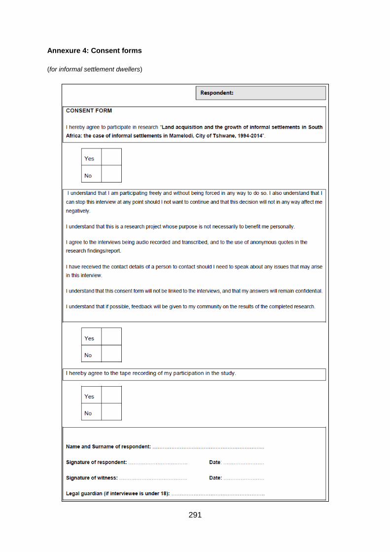
291
Annexure 4: Consent forms
(for informal settlement dwellers)

292
(for official & community leaders)
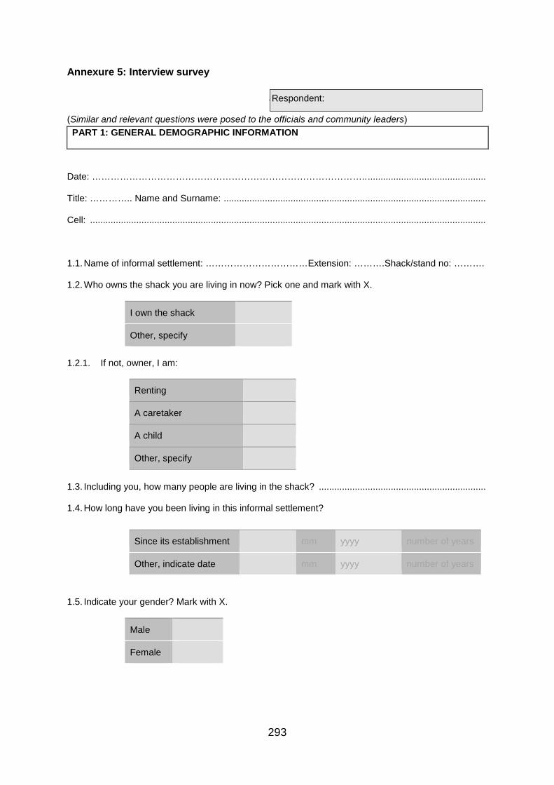
293
Annexure 5: Interview survey
Similar
(Similar and relevant questions were posed to the officials and community leaders) PART 1: GENERAL DEMOGRAPHIC INFORMATION
Date: …………………………………………………………………………….. ..............................................
Title: ………….. Name and Surname: ......................................................................................................
Cell: ..........................................................................................................................................................
1.1. Name of informal settlement: ……………………………Extension: ……….Shack/stand no: ……….
1.2. Who owns the shack you are living in now? Pick one and mark with X.
I own the shack
Other, specify
1.2.1. If not, owner, I am:
Renting
A caretaker
A child
Other, specify
1.3. Including you, how many people are living in the shack? .................................................................
1.4. How long have you been living in this informal settlement?
Since its establishment mm yyyy number of years
Other, indicate date mm yyyy number of years
1.5. Indicate your gender? Mark with X.
Male
Female
Respondent:
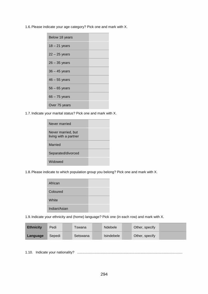
294
1.6. Please indicate your age category? Pick one and mark with X.
Below 18 years
18 – 21 years
22 – 25 years
26 – 35 years
36 – 45 years
46 – 55 years
56 – 65 years
66 – 75 years
Over 75 years
1.7. Indicate your marital status? Pick one and mark with X.
Never married
Never married, but living with a partner
Married
Separated/divorced
Widowed
1.8. Please indicate to which population group you belong? Pick one and mark with X.
African
Coloured
White
Indian/Asian
1.9. Indicate your ethnicity and (home) language? Pick one (in each row) and mark with X.
Ethnicity Pedi Tswana Ndebele Other, specify
Language Sepedi Setswana Isindebele Other, specify
1.10. Indicate your nationality? .............................................................................................................
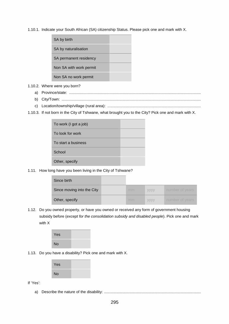
295
1.10.1. Indicate your South African (SA) citizenship Status. Please pick one and mark with X.
SA by birth
SA by naturalisation
SA permanent residency
Non SA with work permit
Non SA no work permit
1.10.2. Where were you born?
a) Province/state: ............................................................................................................................
b) City/Town: ...................................................................................................................................
c) Location/township/village (rural area): ........................................................................................
1.10.3. If not born in the City of Tshwane, what brought you to the City? Pick one and mark with X.
To work (I got a job)
To look for work
To start a business
School
Other, specify
1.11. How long have you been living in the City of Tshwane?
Since birth
Since moving into the City mm yyyy number of years
Other, specify mm yyyy number of years
1.12. Do you owned property, or have you owned or received any form of government housing
subsidy before (except for the consolidation subsidy and disabled people). Pick one and mark
with X
Yes
No
1.13. Do you have a disability? Pick one and mark with X.
Yes
No
If ‘Yes’:
a) Describe the nature of the disability: ...........................................................................................

296
b) Since when have been disabled?
mm yyyy number of years
1.14. Indicate the highest level of education you have completed? Pick one and mark with X.
Never went to school
No schooling completed
Matric (Grade 12)
Certificate
Diploma
Post-graduate diploma
Bachelor’s degree
Master’s degree
Doctorate degree
1.15. Are you currently employed? Pick one and mark with X.
Yes
No
1.15.1. If ‘Yes’:
a) Indicate your type of employment. Pick one and mark with X.
I am permanent
I am on a fixed-term contract
I am temporary
I am on a project contract
Other, specify
b) How long (years or months) have you been working at your current employ? ...........................
1.16. Please indicate your monthly combined household income? Pick one and mark with X.
R 0 – 3500
R 3501 – 15000
R 15001 – 25 000
More than 25 000

297
1.17. If any, how many children do you have? .......................................................................................
PART 2: LAND ACQUISITION
2.1. Who owns the land which you are occupying? Pick one and mark with X.
I do not know
Municipality
Family/friend
I own it
Other, specify
2.2. Please indicate with X and briefly explain the state of the land upon occupation. The land was:
I do not know
Vacant/unused
Being used/occupied
Other, specify
..................................................................................................................................................................
2.3. Explain briefly how you came to live on this land .............................................................................
..................................................................................................................................................................
2.3.1. Did you get permission/consent from the owner?
Yes
No
2.4. What is the present status of the plot/site? Pick one and mark with X. Explain briefly why.
I do not know
Illegal
Legalised by government while awaiting housing
Legalised by government (only)
Other, specify
..................................................................................................................................................................

298
PART 3: PERCEPTIONS REGARDING GOVERNMENT AND LAND/HOUSING OWNERSHIP
3.1. Explain briefly your knowledge of the history of land dispossession in South Africa.........................
..................................................................................................................................................................
3.2. Is it right for the Constitution to protect existing property rights including those of property/land
acquired through colonialism and apartheid? Pick one and mark with X. Please provide justification for
your response.
Yes
No
..................................................................................................................................................................
3.3. Should the Constitution be amended to allow expropriation of land without compensation? Pick one
and mark with X. Please provide reasons for your response.
Yes
No
..................................................................................................................................................................
3.4. Should vacant land be invaded? Pick one and mark with X. Please explain briefly why.
Yes
No
..................................................................................................................................................................
3.5. Should foreign nationals (including companies) be allowed to buy and/or own land in South
Africa. Pick one and mark with X. Please explain why.
Yes
No
..................................................................................................................................................................
3.6. Should, under certain circumstances (such as raising funds/revenue for service delivery), the
municipality sell its land/property? Pick one and mark with X. Please provide a reason(s).
Yes
No
..................................................................................................................................................................
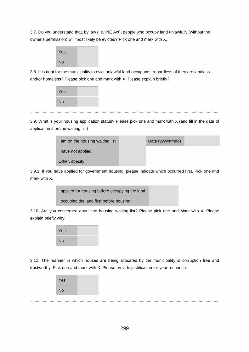
299
3.7. Do you understand that, by law (i.e. PIE Act), people who occupy land unlawfully (without the
owner’s permission) will most likely be evicted? Pick one and mark with X.
Yes
No
3.8. It is right for the municipality to evict unlawful land occupants, regardless of they are landless
and/or homeless? Please pick one and mark with X. Please explain briefly?
Yes
No
..................................................................................................................................................................
3.9. What is your housing application status? Please pick one and mark with X (and fill in the date of
application if on the waiting list)
I am on the housing waiting list Date (yyyymmdd)
I have not applied
Other, specify
3.9.1. If you have applied for government housing, please indicate which occurred first. Pick one and
mark with X.
I applied for housing before occupying the land
I occupied the land first before housing
3.10. Are you concerned about the housing waiting list? Please pick one and Mark with X. Please
explain briefly why.
Yes
No
..................................................................................................................................................................
3.11. The manner in which houses are being allocated by the municipality is corruption free and
trustworthy. Pick one and mark with X. Please provide justification for your response.
Yes
No
..................................................................................................................................................................

300
PART 4: PERCEPTIONS REGARDING THE INFORMAL SETTLEMENTS
4.1. Please explain briefly why the informal settlement is called (or provide meaning);
a) Lusaka: ......................................................................................................................................... .......
b) Phomolong: .................................................................................................................................. .......
c) Alaska: .......................................................................................................................................... .......
d) Stoffel Park: .................................................................................................................................. .......
4.2. If you know, indicate when and how the informal settlement started or was established.
mm yyyy
..................................................................................................................................................................
4.3. What has been the easiest way of accessing/occupying land here? Pick one applicable option.
Plot/stand from government
Through housing from government
Occupying/invading land (illegally)
Buying land (plot/stand) from a politician
Buying land (plot/stand) from an organised local committee/office
Buying an existing shack form its owner
Inherit shack from family
Other, specify
4.4. Generally, which period, time or event has land been easier accessible or acquired. Pick one and
mark with X. Please explain briefly what makes it easier to access land during this time/period (?).
I do not know
During Christmas (eve/day)
During New Year (eve/day)
During weekends
During other holidays (including long weekends)
During elections
Other, specify
..................................................................................................................................................................

301
4.5. Have you ever been evicted (from this land or settlement) before? Pick one and mark with X.
Yes
No
If ‘Yes’, please elaborate:
a) How many times? ........................................................................................................................
b) Please explain briefly what happened? ......................................................................................
c) Following eviction, where did you live/stay? ...............................................................................
d) Please explain briefly why you came back. ................................................................................
4.6. Indicate; by the look of things, since its establishment the informal settlement has: (Pick one and
mark with X. Please explain briefly why?)
Remained same
Increased
Decreased
Other, specify
..................................................................................................................................................................
4.7. What do you think the government (particularly the municipality), should have done to prevent the
establishment (and/or growth) of the informal settlement? ......................................................................
..................................................................................................................................................................
4.8. If you were to get housing, would you prefer/want to have it built on this land (or settlement)? Pick
one and mark with X. Briefly explain why?
Yes
No
(If ‘No’, also state where you would want your house built)
..................................................................................................................................................................
PART 5: CLOSING REMARKS
5.1. What will it take to address the land issue and informal settlements? ..............................................
..................................................................................................................................................................
5.2. Would you like to add anything more? ...............................................................................................
Thank you very much for your time, participation and contributions.