
KNOX CITY COUNCIL AGENDA
361
KNOX CITY COUNCIL AGENDA Ordinary Meeting of Council To be held at the Civic Centre 511 Burwood Highway Wantirna South On Monday, 26 June 2017
-
Upload
khangminh22 -
Category
Documents
-
view
0 -
download
0
Transcript of KNOX CITY COUNCIL AGENDA
KNOX CITY COUNCIL
AGENDA
Ordinary Meeting of Council
To be held at the Civic Centre
511 Burwood Highway Wantirna South
On
Monday, 26 June 2017
KNOX CITY COUNCIL
AGENDA FOR THE ORDINARY MEETING OF COUNCIL TO BE HELD AT THE
CIVIC CENTRE, 511 BURWOOD HIGHWAY, WANTIRNA SOUTH ON
MONDAY, 26 JUNE 2017 AT 7.00 P.M.
BUSINESS: Page Nos. 1. APOLOGIES AND REQUESTS FOR LEAVE OF ABSENCE 2. DECLARATIONS OF CONFLICT OF INTEREST 3. CONFIRMATION OF MINUTES
3.1
Confirmation of Minutes of Ordinary Meeting of Council held on Monday, 22 May 2017
3.2
Confirmation of Minutes of Strategic Planning Committee Meeting held on Tuesday, 13 June 2017
4. PETITIONS AND MEMORIALS 5. REPORTS BY COUNCILLORS
5.1 Committees & Delegates 1.
5.2 Ward Issues 1.
COUNCIL 26 June 2017 6. CONSIDERING AND ORDERING UPON OFFICERS’ REPORTS WITHIN THE
CITY DEVELOPMENT GROUP
6.1
All Wards Report Of Planning Applications Decided Under Delegation (160/1/06)
2.
6.2
Scott Ward Development Of An Eight Storey Apartment Building Containing 94 Apartments And Basement Carpark, Use For A Restaurant, Office, Gym And Dispensation Of Loading Bay At 500 Burwood Highway, Wantirna South (Application No. P2015/6731)
11.
6.3
Taylor Ward Application For The Development Of The Land For Four (4) Double Storey And Two (2) Single Storey Dwellings At 48 Murray Crescent, Rowville (P/2016/6839)
64.
6.4
Taylor Ward Application For The Development Of The Land For Four (4) Double Storey And Two (2) Single Storey Dwellings At 50 Murray Crescent, Rowville (P/2016/6744)
104.
6.5
Friberg Ward Application For The Change Of Use To Place Of Worship, Reduction In Car Parking And Alteration Of Access To A Road In A Category 1 Road Zone At 42/756 Burwood Highway, Ferntree Gully (Application No. P/2016/6905)
140.
6.6
Chandler Ward Proposed Rezoning Of 1221 Mountain Hwy, The Basin (The Basin Community House) And 1223 Mountain Hwy, The Basin
160.
6.7
Chandler, Dobson and Taylor Wards Response To Call-Up Item Requesting A Review Of Dandenong Foothills Planning Policy
174.
7. PUBLIC QUESTION TIME (Following the completion of business relating to Item 6, City Development, the business before the Council Meeting will be deferred to consider questions submitted by the public). 193.
COUNCIL 26 June 2017 8. CONSIDERING AND ORDERING UPON OFFICERS’ REPORTS WITHIN THE
ENGINEERING & INFRASTRUCTURE GROUP
8.1
All Wards Status Of The Construction Of Unsealed Roads And The Application Of Contributory Schemes - Special Rates And Charges
194.
8.2
All Wards Road Management Plan Review 2017
227.
9. CONSIDERING AND ORDERING UPON OFFICERS’ REPORTS WITHIN THE
COMMUNITY SERVICES GROUP
9.1
All Wards Community Development Fund Evaluation Panel Membership
257.
9.2
All Wards Community Access And Equity Implementation Plan 2017-22
264.
10. CONSIDERING AND ORDERING UPON OFFICERS’ REPORTS WITHIN THE
CORPORATE DEVELOPMENT GROUP
10.1
All Wards Draft Community & Council Plan 2017-2021
277.
10.2
All Wards Annual Budget 2017-18
284.
10.3
All Wards Instrument Of Delegation To The Chief Executive Officer
288.
10.4
Scott Ward Proposed Sale Of 2R Mowbray Drive, Wantirna South – Appointment Of Committee Of Council
297.
10.5
Collier Ward Proposed Sale Of Council Property – 62 Brentwood Drive, Wantirna (Melway Ref: 63 K8)
300.
10.6
Tirhatuan Ward Proposed Sale Of Council Property – Part Wellington Road Reserve And Part 889R Wellington Road, Rowville
308.
10.7
All Wards Incidental Community Grants Program Applications
320.
COUNCIL 26 June 2017 11. ITEMS FOR INFORMATION
11.1
All Wards Works Report (As of 26 May 2017)
325.
11.2
All Wards Assemblies of Councillors
344.
12. MOTIONS FOR WHICH NOTICE HAS PREVIOUSLY BEEN GIVEN 354. 13. SUPPLEMENTARY ITEMS 354. 13.1 Amendment C142 – Kingston Links Golf Course 354. 13.2 Review Of Mayoral And Councillors Allowance 354. 14. URGENT BUSINESS 354. 14.1 Urgent Business 354. 14.2 Call Up Items 354. 15. QUESTIONS WITHOUT NOTICE 354.
TONY DOYLE CHIEF EXECUTIVE OFFICER
1 COUNCIL 26 June 2017 5. REPORTS BY COUNCILLORS
5.1 Committees & Delegates
5.2 Ward Issues
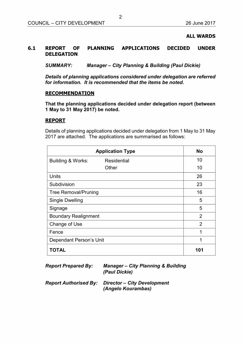
2 COUNCIL – CITY DEVELOPMENT 26 June 2017
ALL WARDS 6.1 REPORT OF PLANNING APPLICATIONS DECIDED UNDER
DELEGATION SUMMARY: Manager – City Planning & Building (Paul Dickie) Details of planning applications considered under delegation are referred for information. It is recommended that the items be noted.
RECOMMENDATION
That the planning applications decided under delegation report (between 1 May to 31 May 2017) be noted.
REPORT
Details of planning applications decided under delegation from 1 May to 31 May 2017 are attached. The applications are summarised as follows:
Application Type No
Building & Works: Residential Other
10 10
Units 26 Subdivision 23 Tree Removal/Pruning 16 Single Dwelling 5 Signage 5 Boundary Realignment 2 Change of Use 2 Fence 1 Dependant Person’s Unit 1
TOTAL 101
Report Prepared By: Manager – City Planning & Building (Paul Dickie)
Report Authorised By: Director – City Development (Angelo Kourambas)
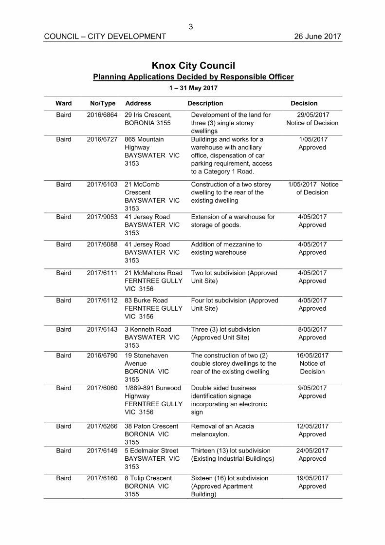
3 COUNCIL – CITY DEVELOPMENT 26 June 2017
Knox City Council Planning Applications Decided by Responsible Officer
1 – 31 May 2017
Ward No/Type Address Description Decision
Baird 2016/6864 29 Iris Crescent, BORONIA 3155
Development of the land for three (3) single storey dwellings
29/05/2017 Notice of Decision
Baird 2016/6727 865 Mountain Highway BAYSWATER VIC 3153
Buildings and works for a warehouse with ancillary office, dispensation of car parking requirement, access to a Category 1 Road.
1/05/2017 Approved
Baird 2017/6103 21 McComb Crescent BAYSWATER VIC 3153
Construction of a two storey dwelling to the rear of the existing dwelling
1/05/2017 Notice of Decision
Baird 2017/9053 41 Jersey Road BAYSWATER VIC 3153
Extension of a warehouse for storage of goods.
4/05/2017 Approved
Baird 2017/6088 41 Jersey Road BAYSWATER VIC 3153
Addition of mezzanine to existing warehouse
4/05/2017 Approved
Baird 2017/6111 21 McMahons Road FERNTREE GULLY VIC 3156
Two lot subdivision (Approved Unit Site)
4/05/2017 Approved
Baird 2017/6112 83 Burke Road FERNTREE GULLY VIC 3156
Four lot subdivision (Approved Unit Site)
4/05/2017 Approved
Baird 2017/6143 3 Kenneth Road BAYSWATER VIC 3153
Three (3) lot subdivision (Approved Unit Site)
8/05/2017 Approved
Baird 2016/6790 19 Stonehaven Avenue BORONIA VIC 3155
The construction of two (2) double storey dwellings to the rear of the existing dwelling
16/05/2017 Notice of Decision
Baird 2017/6060 1/889-891 Burwood Highway FERNTREE GULLY VIC 3156
Double sided business identification signage incorporating an electronic sign
9/05/2017 Approved
Baird 2017/6266 38 Paton Crescent BORONIA VIC 3155
Removal of an Acacia melanoxylon.
12/05/2017 Approved
Baird 2017/6149 5 Edelmaier Street BAYSWATER VIC 3153
Thirteen (13) lot subdivision (Existing Industrial Buildings)
24/05/2017 Approved
Baird 2017/6160 8 Tulip Crescent BORONIA VIC 3155
Sixteen (16) lot subdivision (Approved Apartment Building)
19/05/2017 Approved
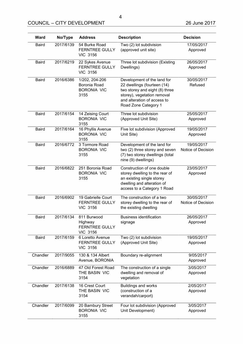
4 COUNCIL – CITY DEVELOPMENT 26 June 2017
Ward No/Type Address Description Decision
Baird 2017/6139 54 Burke Road FERNTREE GULLY VIC 3156
Two (2) lot subdivision (approved unit site)
17/05/2017 Approved
Baird 2017/6219 22 Sykes Avenue FERNTREE GULLY VIC 3156
Three lot subdivision (Existing Dwellings)
26/05/2017 Approved
Baird 2016/6386 1/202, 204-206 Boronia Road BORONIA VIC 3155
Development of the land for 22 dwellings (fourteen (14) two storey and eight (8) three storey), vegetation removal and alteration of access to Road Zone Category 1
30/05/2017 Refused
Baird 2017/6154 14 Zeising Court BORONIA VIC 3155
Three lot subdivision (Approved Unit Site)
25/05/2017 Approved
Baird 2017/6164 16 Phyllis Avenue BORONIA VIC 3155
Five lot subdivision (Approved Unit Site)
19/05/2017 Approved
Baird 2016/6772 3 Tormore Road BORONIA VIC 3155
Development of the land for two (2) three storey and seven (7) two storey dwellings (total nine (9) dwellings)
19/05/2017 Notice of Decision
Baird 2016/6822 251 Boronia Road BORONIA VIC 3155
Construction of one double storey dwelling to the rear of an existing single storey dwelling and alteration of access to a Category 1 Road
23/05/2017 Approved
Baird 2016/6902 19 Gabrielle Court FERNTREE GULLY VIC 3156
The construction of a two storey dwelling to the rear of the existing dwelling
30/05/2017 Notice of Decision
Baird 2017/6134 811 Burwood Highway FERNTREE GULLY VIC 3156
Business identification signage
26/05/2017 Approved
Baird 2017/6159 6 Loretto Avenue FERNTREE GULLY VIC 3156
Two (2) lot subdivision (Approved Unit Site)
19/05/2017 Approved
Chandler 2017/9055 130 & 134 Albert Avenue, BORONIA
Boundary re-alignment 9/05/2017 Approved
Chandler 2016/6889 47 Old Forest Road THE BASIN VIC 3154
The construction of a single dwelling and removal of vegetation
3/05/2017 Approved
Chandler 2017/6138 16 Crest Court THE BASIN VIC 3154
Buildings and works (construction of a verandah/carport)
2/05/2017 Approved
Chandler 2017/6099 20 Bambury Street BORONIA VIC 3155
Four lot subdivision (Approved Unit Development)
3/05/2017 Approved
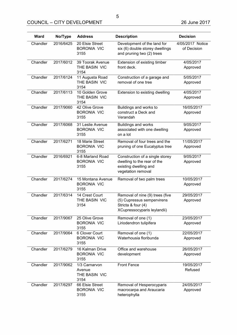
5 COUNCIL – CITY DEVELOPMENT 26 June 2017
Ward No/Type Address Description Decision
Chandler 2016/6425 20 Elsie Street BORONIA VIC 3155
Development of the land for six (6) double storey dwellings and pruning two (2) trees
4/05/2017 Notice of Decision
Chandler 2017/6012 39 Toorak Avenue THE BASIN VIC 3154
Extension of existing timber front deck.
4/05/2017 Approved
Chandler 2017/6124 11 Augusta Road THE BASIN VIC 3154
Construction of a garage and removal of one tree
5/05/2017 Approved
Chandler 2017/6113 10 Golden Grove THE BASIN VIC 3154
Extension to existing dwelling 4/05/2017 Approved
Chandler 2017/9060 42 Olive Grove BORONIA VIC 3155
Buildings and works to construct a Deck and Verandah
16/05/2017 Approved
Chandler 2017/6068 31 Leslie Avenue BORONIA VIC 3155
Buildings and works associated with one dwelling on a lot
9/05/2017 Approved
Chandler 2017/6271 18 Marie Street BORONIA VIC 3155
Removal of four trees and the pruning of one Eucalyptus tree
11/05/2017 Approved
Chandler 2016/6921 6-8 Marland Road BORONIA VIC 3155
Construction of a single storey dwelling to the rear of the existing dwelling and vegetation removal
9/05/2017 Approved
Chandler 2017/6274 15 Montana Avenue BORONIA VIC 3155
Removal of two palm trees 10/05/2017 Approved
Chandler 2017/6314 14 Crest Court THE BASIN VIC 3154
Removal of nine (9) trees (five (5) Cupressus sempervirens Stricta & four (4) XCupressocyparis leylandii)
29/05/2017 Approved
Chandler 2017/9067 25 Olive Grove BORONIA VIC 3155
Removal of one (1) Liriodendron tulipifera
23/05/2017 Approved
Chandler 2017/9064 6 Clover Court BORONIA VIC 3155
Removal of one (1) Waterhousia floribunda
22/05/2017 Approved
Chandler 2017/6279 16 Kalman Drive BORONIA VIC 3155
Office and warehouse development
26/05/2017 Approved
Chandler 2017/9062 1/3 Carnarvon Avenue THE BASIN VIC 3154
Front Fence 19/05/2017 Refused
Chandler 2017/6297 66 Elsie Street BORONIA VIC 3155
Removal of Hesperocyparis macrocarpa and Araucaria heterophylla
24/05/2017 Approved
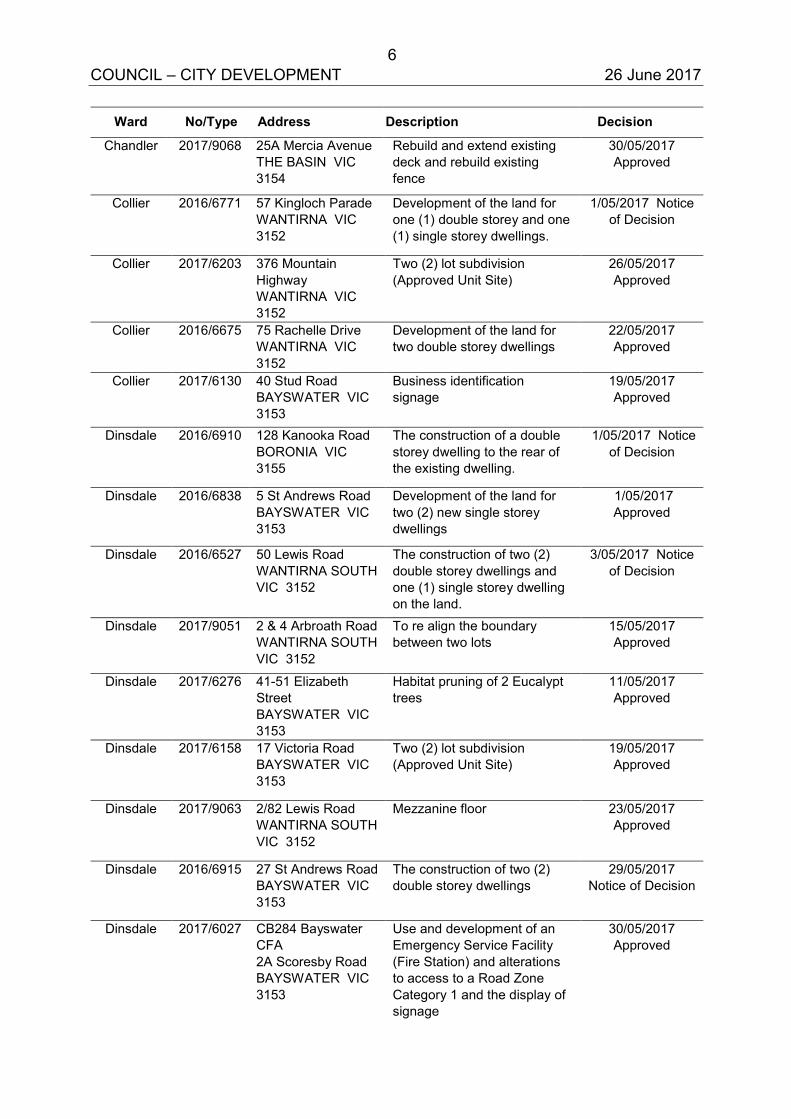
6 COUNCIL – CITY DEVELOPMENT 26 June 2017
Ward No/Type Address Description Decision
Chandler 2017/9068 25A Mercia Avenue THE BASIN VIC 3154
Rebuild and extend existing deck and rebuild existing fence
30/05/2017 Approved
Collier 2016/6771 57 Kingloch Parade WANTIRNA VIC 3152
Development of the land for one (1) double storey and one (1) single storey dwellings.
1/05/2017 Notice of Decision
Collier 2017/6203 376 Mountain Highway WANTIRNA VIC 3152
Two (2) lot subdivision (Approved Unit Site)
26/05/2017 Approved
Collier 2016/6675 75 Rachelle Drive WANTIRNA VIC 3152
Development of the land for two double storey dwellings
22/05/2017 Approved
Collier 2017/6130 40 Stud Road BAYSWATER VIC 3153
Business identification signage
19/05/2017 Approved
Dinsdale 2016/6910 128 Kanooka Road BORONIA VIC 3155
The construction of a double storey dwelling to the rear of the existing dwelling.
1/05/2017 Notice of Decision
Dinsdale 2016/6838 5 St Andrews Road BAYSWATER VIC 3153
Development of the land for two (2) new single storey dwellings
1/05/2017 Approved
Dinsdale 2016/6527 50 Lewis Road WANTIRNA SOUTH VIC 3152
The construction of two (2) double storey dwellings and one (1) single storey dwelling on the land.
3/05/2017 Notice of Decision
Dinsdale 2017/9051 2 & 4 Arbroath Road WANTIRNA SOUTH VIC 3152
To re align the boundary between two lots
15/05/2017 Approved
Dinsdale 2017/6276 41-51 Elizabeth Street BAYSWATER VIC 3153
Habitat pruning of 2 Eucalypt trees
11/05/2017 Approved
Dinsdale 2017/6158 17 Victoria Road BAYSWATER VIC 3153
Two (2) lot subdivision (Approved Unit Site)
19/05/2017 Approved
Dinsdale 2017/9063 2/82 Lewis Road WANTIRNA SOUTH VIC 3152
Mezzanine floor 23/05/2017 Approved
Dinsdale 2016/6915 27 St Andrews Road BAYSWATER VIC 3153
The construction of two (2) double storey dwellings
29/05/2017 Notice of Decision
Dinsdale 2017/6027 CB284 Bayswater CFA 2A Scoresby Road BAYSWATER VIC 3153
Use and development of an Emergency Service Facility (Fire Station) and alterations to access to a Road Zone Category 1 and the display of signage
30/05/2017 Approved
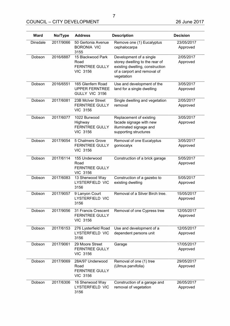
7 COUNCIL – CITY DEVELOPMENT 26 June 2017
Ward No/Type Address Description Decision
Dinsdale 2017/9066 50 Gertonia Avenue BORONIA VIC 3155
Remove one (1) Eucalyptus cephalocarpa
23/05/2017 Approved
Dobson 2016/6887 15 Blackwood Park Road FERNTREE GULLY VIC 3156
Development of a single storey dwelling to the rear of existing dwelling, construction of a carport and removal of vegetation
2/05/2017 Approved
Dobson 2016/6551 165 Glenfern Road UPPER FERNTREE GULLY VIC 3156
Use and development of the land for a single dwelling
3/05/2017 Approved
Dobson 2017/6081 23B McIver Street FERNTREE GULLY VIC 3156
Single dwelling and vegetation removal
2/05/2017 Approved
Dobson 2017/6077 1022 Burwood Highway FERNTREE GULLY VIC 3156
Replacement of existing facade signage with new illuminated signage and supporting structures
3/05/2017 Approved
Dobson 2017/9054 5 Chalmers Grove FERNTREE GULLY VIC 3156
Removal of one Eucalyptus goniocalyx
3/05/2017 Approved
Dobson 2017/6114 155 Underwood Road FERNTREE GULLY VIC 3156
Construction of a brick garage 5/05/2017 Approved
Dobson 2017/6083 13 Sherwood Way LYSTERFIELD VIC 3156
Construction of a gazebo to existing dwelling
5/05/2017 Approved
Dobson 2017/9057 9 Lanyon Court LYSTERFIELD VIC 3156
Removal of a Silver Birch tree. 15/05/2017 Approved
Dobson 2017/9056 31 Francis Crescent FERNTREE GULLY VIC 3156
Removal of one Cypress tree 12/05/2017 Approved
Dobson 2017/6153 276 Lysterfield Road LYSTERFIELD VIC 3156
Use and development of a dependent persons unit
12/05/2017 Approved
Dobson 2017/9061 29 Moore Street FERNTREE GULLY VIC 3156
Garage 17/05/2017 Approved
Dobson 2017/9069 28A/97 Underwood Road FERNTREE GULLY VIC 3156
Removal of one (1) tree (Ulmus parvifolia)
29/05/2017 Approved
Dobson 2017/6306 16 Sherwood Way LYSTERFIELD VIC 3156
Construction of a garage and removal of vegetation
26/05/2017 Approved
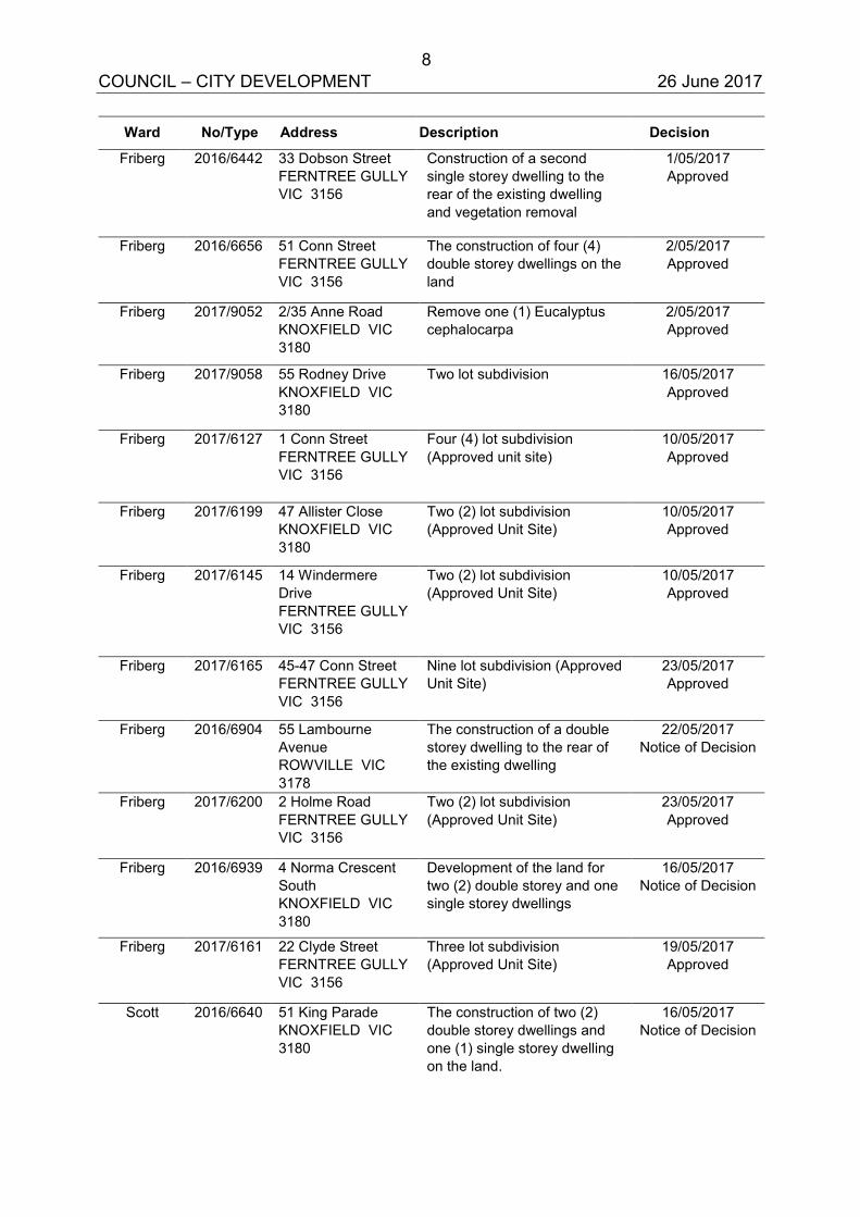
8 COUNCIL – CITY DEVELOPMENT 26 June 2017
Ward No/Type Address Description Decision
Friberg 2016/6442 33 Dobson Street FERNTREE GULLY VIC 3156
Construction of a second single storey dwelling to the rear of the existing dwelling and vegetation removal
1/05/2017 Approved
Friberg 2016/6656 51 Conn Street FERNTREE GULLY VIC 3156
The construction of four (4) double storey dwellings on the land
2/05/2017 Approved
Friberg 2017/9052 2/35 Anne Road KNOXFIELD VIC 3180
Remove one (1) Eucalyptus cephalocarpa
2/05/2017 Approved
Friberg 2017/9058 55 Rodney Drive KNOXFIELD VIC 3180
Two lot subdivision 16/05/2017 Approved
Friberg 2017/6127 1 Conn Street FERNTREE GULLY VIC 3156
Four (4) lot subdivision (Approved unit site)
10/05/2017 Approved
Friberg 2017/6199 47 Allister Close KNOXFIELD VIC 3180
Two (2) lot subdivision (Approved Unit Site)
10/05/2017 Approved
Friberg 2017/6145 14 Windermere Drive FERNTREE GULLY VIC 3156
Two (2) lot subdivision (Approved Unit Site)
10/05/2017 Approved
Friberg 2017/6165 45-47 Conn Street FERNTREE GULLY VIC 3156
Nine lot subdivision (Approved Unit Site)
23/05/2017 Approved
Friberg 2016/6904 55 Lambourne Avenue ROWVILLE VIC 3178
The construction of a double storey dwelling to the rear of the existing dwelling
22/05/2017 Notice of Decision
Friberg 2017/6200 2 Holme Road FERNTREE GULLY VIC 3156
Two (2) lot subdivision (Approved Unit Site)
23/05/2017 Approved
Friberg 2016/6939 4 Norma Crescent South KNOXFIELD VIC 3180
Development of the land for two (2) double storey and one single storey dwellings
16/05/2017 Notice of Decision
Friberg 2017/6161 22 Clyde Street FERNTREE GULLY VIC 3156
Three lot subdivision (Approved Unit Site)
19/05/2017 Approved
Scott 2016/6640 51 King Parade KNOXFIELD VIC 3180
The construction of two (2) double storey dwellings and one (1) single storey dwelling on the land.
16/05/2017 Notice of Decision
9 COUNCIL – CITY DEVELOPMENT 26 June 2017
Ward No/Type Address Description Decision
Scott 2017/6198 Community Centre 2 Old Stud Road WANTIRNA SOUTH VIC 3152
Construction of verandah to Community Centre
11/05/2017 Approved
Scott 2017/6175 1-11/62 Bunnett Road & 428 Scoresby Road, Ferntree Gully VIC 3156
2 Lot Subdivision 18/05/2017 Approved
Scott 2016/6649 87 Kathryn Road KNOXFIELD VIC 3180
Development of the land for five (5) double storey dwellings
29/05/2017 Notice of Decision
Scott 2016/6572 4 Nortons Lane WANTIRNA SOUTH VIC 3152
Use and development of a dwelling
24/05/2017 Notice of Decision
Scott 2017/6045 464 Scoresby Road FERNTREE GULLY VIC 3156
Construction of two (2) double storey dwellings and one (1) single storey dwelling (total of three (3) dwellings) and alteration of access to a Road Zone Category 1.
23/05/2017 Approved
Taylor 2016/6908 5 Le John Street ROWVILLE VIC 3178
The subdivision of the land into two (2) lots
18/05/2017 Approved
Taylor 2017/6214 Sh 16A/1100 Wellington Road ROWVILLE VIC 3178
Use of the land for the sale and consumption of liquor associated with a food and drink premises.
25/05/2017 Approved
Tirhatuan 2017/6169 115 Henderson Road, ROWVILLE
Building and Works (Two storey office and warehouse extension)
1/05/2017 Approved
Tirhatuan 2017/6055 970 Stud Road, ROWVILLE
The display of a major promotional V-board sign
1/05/2017 Approved
Tirhatuan 2016/6686 42 Avalon Road ROWVILLE VIC 3178
The construction of two (2) double storey dwellings on the land
1/05/2017 Approved
Tirhatuan 2017/6244 1500 Eastlink SCORESBY VIC 3179
Buildings and works associated with upgrade to drive-thru facility and electronic signage
9/05/2017 Approved
Tirhatuan 2015/6953 1102-1104 Stud Road ROWVILLE VIC 3178
The construction of 16 triple storey dwellings and 2 double storey dwellings (total of 18 dwellings) on the land and alteration of access to a road in a Road Zone Category 1
15/05/2017 Notice of Decision
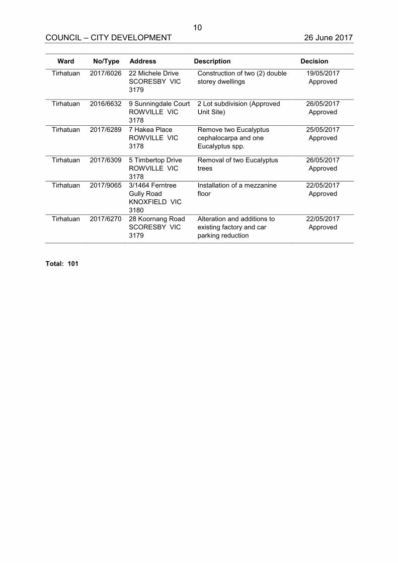
10 COUNCIL – CITY DEVELOPMENT 26 June 2017
Ward No/Type Address Description Decision
Tirhatuan 2017/6026 22 Michele Drive SCORESBY VIC 3179
Construction of two (2) double storey dwellings
19/05/2017 Approved
Tirhatuan 2016/6632 9 Sunningdale Court ROWVILLE VIC 3178
2 Lot subdivision (Approved Unit Site)
26/05/2017 Approved
Tirhatuan 2017/6289 7 Hakea Place ROWVILLE VIC 3178
Remove two Eucalyptus cephalocarpa and one Eucalyptus spp.
25/05/2017 Approved
Tirhatuan 2017/6309 5 Timbertop Drive ROWVILLE VIC 3178
Removal of two Eucalyptus trees
26/05/2017 Approved
Tirhatuan 2017/9065 3/1464 Ferntree Gully Road KNOXFIELD VIC 3180
Installation of a mezzanine floor
22/05/2017 Approved
Tirhatuan 2017/6270 28 Koornang Road SCORESBY VIC 3179
Alteration and additions to existing factory and car parking reduction
22/05/2017 Approved
Total: 101
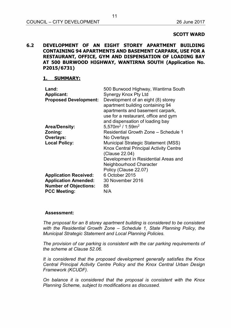
11 COUNCIL – CITY DEVELOPMENT 26 June 2017
SCOTT WARD 6.2 DEVELOPMENT OF AN EIGHT STOREY APARTMENT BUILDING
CONTAINING 94 APARTMENTS AND BASEMENT CARPARK, USE FOR A RESTAURANT, OFFICE, GYM AND DISPENSATION OF LOADING BAY AT 500 BURWOOD HIGHWAY, WANTIRNA SOUTH (Application No. P2015/6731)
1. SUMMARY:
Land: 500 Burwood Highway, Wantirna South Applicant: Synergy Knox Pty Ltd Proposed Development: Development of an eight (8) storey
apartment building containing 94 apartments and basement carpark, use for a restaurant, office and gym and dispensation of loading bay
Area/Density: 5,570m2 / 1:59m2 Zoning: Residential Growth Zone – Schedule 1 Overlays: No Overlays Local Policy: Municipal Strategic Statement (MSS)
Knox Central Principal Activity Centre (Clause 22.04) Development in Residential Areas and Neighbourhood Character Policy (Clause 22.07)
Application Received: 6 October 2015 Application Amended: 30 November 2016 Number of Objections: 88 PCC Meeting: N/A Assessment:
The proposal for an 8 storey apartment building is considered to be consistent with the Residential Growth Zone – Schedule 1, State Planning Policy, the Municipal Strategic Statement and Local Planning Policies.
The provision of car parking is consistent with the car parking requirements of the scheme at Clause 52.06.
It is considered that the proposed development generally satisfies the Knox Central Principal Activity Centre Policy and the Knox Central Urban Design Framework (KCUDF).
On balance it is considered that the proposal is consistent with the Knox Planning Scheme, subject to modifications as discussed.
12 COUNCIL – CITY DEVELOPMENT 26 June 2017 6.2 500 Burwood Highway, Wantirna South (cont’d)
It is recommended that a Notice of Decision to Grant a Planning Permit should issue, subject to conditions. 2. BACKGROUND
2.1 Call Up
The application is being reported to Council as it has been ‘called up’ by the Manager of City Planning and Building as the application proposes a building which exceeds the recommended height specified in the Knox Central Urban Design Framework.
2.2 Subject Site and Surrounds
The location of the subject site is shown in Appendix A.
The subject site is located on the southwest corner of Burwood Highway and Tyner Road. The site extends for approximately 175 metres along Tyner Road, and approximately 33 metres along Burwood Highway.
The boundary of the Knox Central Principal Activity Centre divides the site, approximately 53 metres from the Burwood Highway frontage.
The site is currently occupied by the Food Star Restaurant which occupies a small percentage of the front of the site, with a large car park located to the rear of the building occupying a majority of the site. A row of vegetation is located along the southern and western boundaries. Easements are located along the western and southern boundaries, as well as within the front setback, forward of the existing building.
To the immediate west of the site, south of Burwood Highway, is the Knox Village Retirement Village, residential and commercial properties. To the north of the site, across Burwood Highway, is the Knox City Shopping Centre including the bus interchange, and the Knox City Council offices. To the east of the site across Tyner Road, is St. Andrews College.
2.3 The Proposal
(Refer to attached plans at Appendix B)
The application seeks approval for the development of the land for an eight (8) storey apartment building containing 94 apartments (comprising 22 one-bedroom, 66 two-bedroom and 6 three-bedroom dwellings), basement carpark, restaurant, and gym.
13 COUNCIL – CITY DEVELOPMENT 26 June 2017 6.2 500 Burwood Highway, Wantirna South (cont’d)
The proposed design is contained within the front half of the site, a separate design and application for townhouses has been submitted on the rear half of the site. Details of this application are as follows:
The application proposes two basement levels containing 123 car parking spaces, storage, waste collection area, lifts, and bicycle parking. Access is via a double crossover on Tyner Road, at the southern end of the proposed development.
The ground floor contains a food and drink premise with a floor area of 150m2, office of 50m2, a gym for residents, and 16 dwellings. Dwellings are a mix of 1 and 2 bedrooms and all are provided with 1 car parking space. Private open space is provided via courtyards with access to living areas. The building is setback between 4 and 10 metres from Burwood Highway, and between 1 and 4 metres from Tyner Road.
The 1st floor contains 20 dwellings with a mix of 1 and 2 bedroom dwellings, each provided with 1 car parking space. Open space is provided via balconies, located off the living areas. The 1st floor is setback between 4.15 and 10 metres from Burwood Highway, and between 2.1 and 4.2 metres from Tyner Road.
The 2nd floor is the same as the 1st floor above.
The 3rd floor contains 17 dwellings with a mix of 1 and 2 bedroom dwellings each provided with 1 car parking space. Open space is provided via balconies, located off the living areas. The 3rd floor is setback a minimum 4.15 metres from Burwood Highway, and between 2.1 and 4.2 metres from Tyner Road.
The 4th floor contains 12 dwellings with a mix of 1 and 2 bedroom dwellings each provided with 1 car parking space. Open space is provided via balconies, located off living areas. The 4th floor is setback 4.15 metres from Burwood Highway, and between 2.3 and 6.1 metres from Tyner Road.
The 5th floor contains 6 dwellings each with 2 or 3 bedrooms and are provided with 1 or 2 parking spaces. Open space is provided via balconies, located off the living areas. The 5th floor is setback 6.8 metres from Burwood Highway, and 6 metres from Tyner Road.
The 6th and 7th floors contain the penthouses. Three 2 storey dwellings contain 3 bedrooms each and are provided with 2 parking spaces each. Open space is provided via balconies located off living areas. The 6th and 7th floors are setback a minimum 17 metres from Burwood Highway, and a 8 metres from Tyner Road.
14 COUNCIL – CITY DEVELOPMENT 26 June 2017 6.2 500 Burwood Highway, Wantirna South (cont’d)
The building has a maximum height of 24.4 metres and is finished in a variety of materials including glazing, concrete, zincalume, brick, and wood. All vegetation is proposed to be removed from the site.
The size of apartments ranges from 50m2 to 185m2.
The proposed building is located predominately within the boundaries of the Knox Central Principal Activity Centre and extends approximately 20 metres outside the Activity Centre to the south. The maximum height outside the boundaries of the Activity Centre is 15.7 metres.
3. CONSULTATION
3.1 Advertising
The application was advertised by way of signs on site and notices were sent to adjoining property owners and occupiers. Eighty eight (88) objections including a petition with 74 signatures have been received and are summarised below:
Lack of sunlight to solar panels (overshadowing)
The proposed building would overshadow some of the retirement village dwellings in the morning. However, as the building is located to the east of the retirement village, sunlight would not be impacted for the remainder of the day. The sunlight to the retirement village would comply with the ResCode standard.
Increased traffic and parking problems
Council has discussed the provided parking with the applicant and noted that Council would not be supportive of a reduction of car parking on the site. The applicant has agreed to minor changes that would ensure compliance with Clause 52.06 (Car parking) of the Knox Planning Scheme. The changes would be required as a condition of any permit issued.
Reduced privacy and overlooking
The plans provided do not show any screening of windows facing the retirement village. Conditions on any permit issued would ensure that there are no unreasonable views from the proposed building into the retirement village.
15 COUNCIL – CITY DEVELOPMENT 26 June 2017 6.2 500 Burwood Highway, Wantirna South (cont’d)
Too close to school and retirement village
The site is located within the Knox Principal Activity Centre and a mix of uses is expected under both State and Local planning policy. A higher density and mix of uses in Principal Activity Centres is an important element of sustainable design and land use planning.
Dust and noise from construction
A standard construction amenity condition would be included on any permit issued.
Reduced property values
This is not a relevant planning consideration.
Units not appropriate / Increased density
Increased density within an activity centre and the Residential Growth Zone – Schedule 1 is strongly encouraged under State and Local Planning Policy.
Building too high
Under the Knox Central Urban Design Framework, the site is recommended for a height of 5 storeys. It is noted however that for designs of architectural merit, the height of the building can be increased above the recommended height. The proposed design was assessed by Council’s urban design consultants who were satisfied that the design was of high architectural merit.
The building would be located on a prominent corner, has been designed with colours and details to increase visual interest, and is recessed at the upper floors, particularly the top 3 levels, so that they would not be visible from the street.
3.2 Referrals
The application has been referred to VicRoads and internal departments for comment. The following is a summary of relevant advice:
16 COUNCIL – CITY DEVELOPMENT 26 June 2017 6.2 500 Burwood Highway, Wantirna South (cont’d)
Urban Design
The application was referred to Council’s Urban Design consultant who provided advice on the proposed building. The advice was taken into consideration and the building redesigned to meet the comments provided. The building is considered to be of high architectural merit.
Traffic Engineer
The basement ramps should be 6.1 metres wide. Visitor parking must be accessible at all times and easily identifiable. A construction management plan should be provided. Standard conditions to be placed on any permit issued.
Drainage Engineer
Standard conditions to be included on any permit to issue. Arborist
The site has a number of mature native trees along the western boundary. The trees were planted and are therefore not protected by Clause 52.17 (Native Vegetation). The trees are in reasonable condition but retention would not allow for any substantial development of the site.
Assets
No objection to the proposal.
Sustainability Officer
The provided sustainable design statement is satisfactory.
Waste Officer
A waste management plan is required as a condition on any permit issued.
Landscape
The application was discussed with Council’s Landscape Officer who provided advice on tree planting and spacing within the front and side setbacks. Changes in the design were implemented early in the process to accommodate these setbacks.
17 COUNCIL – CITY DEVELOPMENT 26 June 2017 6.2 500 Burwood Highway, Wantirna South (cont’d)
Parks Services
No objection to the proposal. One small street tree is required to be removed at cost to the owner.
VicRoads
No objection to the proposal and no conditions required.
4. DISCUSSION
This section considers the proposed development in light of the provisions of the Knox Planning Scheme including State and Local Planning Policies, any other relevant policies and objectives.
4.1 Zoning and Overlays
4.1.1 Zone The subject site is located within the Residential Growth Zone – Schedule 1. A permit is required for the construction two or more dwellings on the land pursuant to Clause 32.07-4 of the Residential Growth Zone – Schedule 1. The maximum building height in the Residential Growth Zone – Schedule 1 should not exceed 13.5 metres unless permitted by the Responsible Authority.
The proposal is consistent with the purpose of the Residential Growth Zone - Schedule 1 by providing for increased densities and a diversity of housing types in locations offering good access to services.
The component of building located outside the Activity Centre boundary has a maximum height of 15.7 metres for a distance of 12 metres, which is considered to be a minor variation from the Residential Growth Zone – Schedule 1 height of 13.5 metres given the context of the site. The application was received before the implementation of the new height controls, and is considered to be a reasonable variation in height for urban design and architectural merit reasons as discussed in this report. The height of the building within the Activity Centre boundary is up to 24.5 metres. It is also noted that the proposed Knox Central Principal Activity Centre policy allows for variations of maximum height based on architectural merit as discussed throughout this report.
Given the application was lodged prior to 13 April 2017, the development has been assessed under the High Density
18 COUNCIL – CITY DEVELOPMENT 26 June 2017 6.2 500 Burwood Highway, Wantirna South (cont’d)
Residential Guidelines (2004), see below, and is not assessed against Clause 58. Under the Residential Growth Zone – Schedule 1, a planning permit is required to use the land for a gym, a food and drink premise or restaurant, and an office.
The proposed gym at 37m2 is considered too small to have any commercial potential and the applicant has agreed that it should be ancillary to the residential component of the proposal. Therefore it is considered that a permit is not required. A condition on any permit will require the gym be labelled accordingly.
The proposed restaurant has a floor area of 150m2 and it was discussed with the applicant that at this size it was unlikely that a restaurant would be capable of operating and that a café would be a more likely use. Therefore a condition on any permit issued will require the restaurant be relabelled as a food and drink premise more alike to a cafe. The site is located on the corner of a prominent intersection and in this location a café style building would not be detrimental the surrounding landowners or businesses. A food and drink premise would be a low scale use, and car and bicycle parking is provided to support the proposal.
The proposed office is small and is considered to be compatible with surrounding land uses and adjoining residential land. Car and bicycle parking is provided on site. The proposed non-residential uses are located on the corner of the proposed building where they will activate the frontage at pedestrian level.
4.1.2 Overlays
No overlays apply to the land.
4.2 Policy Consideration
4.2.1 State Planning Policy Framework (SPPF)
State policy requires Council to integrate the range of policies relevant to the issues to be determined, and balance conflicting objectives in favour of net community benefit and sustainable development.
19 COUNCIL – CITY DEVELOPMENT 26 June 2017 6.2 500 Burwood Highway, Wantirna South (cont’d)
Clause 11.01 Activity Centres – Encourage activity centres as a focus for high-quality development, activity and living for the whole community; encourage the concentration of major retail, residential, commercial, administrative, entertainment and cultural developments into activity centres which provide a variety of land uses and are highly accessible to the community.
The proposal is considered to be a high quality development that provides for additional density and activity on a previously underutilised site, within a principal activity centre.
Clause 15 Built Environment and Heritage – Encourages high quality architecture and urban design outcomes that reflect the particular characteristics, aspirations and cultural identity of the community; enhances liveability, diversity, amenity and safety of the public realm; and promotes attractiveness of towns and cities within broader strategic contexts.
Context – Development must take into account the natural, cultural and strategic context of its location.
The revised design process undertaken by the applicant has resulted in an evolved design that has considered the strategic context of its location. The site is located on a prominent corner where a building of high architectural merit will contribute to the strategic vision of the Knox Central Principal Activity Centre.
Safety – New development should create urban environments that enhance personal safety and property security and where people feel safe to live, work and move in at any time.
The design proposes pedestrian friendly facades that are either activated or visually interesting in place of a section of the existing car park. The increase in density and numerous balconies facing the street would also increase activity and passive surveillance to the area.
Landmarks, views and vistas – Landmarks, views and vistas should be protected and enhanced or, where appropriate, created by new additions to the built environment.
The proposed development will contribute positively to the built environment, creating an identifiable and distinctive element to a prominent corner site.
20 COUNCIL – CITY DEVELOPMENT 26 June 2017 6.2 500 Burwood Highway, Wantirna South (cont’d)
Consolidation of sites and empty sites – New development should contribute to the complexity and diversity of the built environment.
The proposed development will contribute to the complexity and diversity of the built environment and makes use of a site that is currently underutilised.
Energy and resource efficiency – All building, subdivision and engineering works should include efficient use of resources and energy efficiency.
The proposal increases density within a principal activity centre where there is access to public transport, entertainment and employment. This is an important component of sustainable land use planning, and in addition, the sustainable design concepts used in the building design itself have been noted as satisfactory by Council’s Sustainable Design Officer.
Architectural quality – New development should achieve high standards in architecture and urban design.
It is considered that the proposal has achieved high standards of architecture and urban design. The application was referred to Council’s urban design consultant who considered the design to be of high architectural merit. The building articulates away from the street, and at street level the upper three levels would not be visible. For this reason it was considered appropriate to allow for a building that exceeds the recommended height specified in the Knox Central Urban Design Framework. See Section 4.2.3 below for an assessment of this framework.
Landscape architecture – Recognition should be given to the setting in which buildings are designed and the integrating role of landscape architecture.
Changes were made to the design to accommodate the planting of canopy trees as per advice from Council’s landscape officers. The landscaping to Burwood Highway should wrap around to Tyner Road further and a condition on any permit issued would require the submission of a satisfactory landscape plan.
21 COUNCIL – CITY DEVELOPMENT 26 June 2017 6.2 500 Burwood Highway, Wantirna South (cont’d)
Clause 15.02 Sustainable Development – Ensure land use and development is consistent with the efficient use of energy and the minimisation of greenhouse gas emissions.
Energy efficient devices and practices have been applied through the application of a Sustainable Design Assessment. However, an updated report to reflect changes will be a condition on any permit issued.
Clause 17.01 Economic Development – Encourage development which meets the communities’ needs for retail, entertainment, office and other commercial services and provides net community benefit in relation to accessibility, efficient infrastructure use and the aggregation and sustainability of commercial facilities.
The proposal provides an increased density within walking distance of shops and services. In addition, the proposed food and drink premise is likely to provide employment opportunities.
Clause 18.01 Transport – Ensure that access is provided to all available modes of transport.
The subject site is located within walking distance of the Knox Bus Interchange, which is accessed by approximately 10 bus routes including a SmartBus, being on the Principal Public Transport Network. There is also the Airport Shuttle which operates via Knox Shopping Centre, taxi ranks and the Principal Bicycle Network along Blind Creek.
4.2.2 Local Planning Policy Framework (LPPF)
Municipal Strategic Statement (MSS) Clause 21.04 Urban Design Ensure all development responds positively to the existing pattern of urban forms and character, the landscape qualities, historic and cultural elements and social dimensions and aspirations of the Knox Community.
The proposed design has evolved to accommodate advice from Council in regard to urban design, bush boulevards, and landscape treatments. Council’s urban design consultants consider the design to be of high architectural merit. The upper three storeys are articulated away from the boundaries of the site and therefore would not be visible from the street.
22 COUNCIL – CITY DEVELOPMENT 26 June 2017 6.2 500 Burwood Highway, Wantirna South (cont’d)
For this reason and the architectural merit of a building located on a prominent corner, it is considered appropriate to exceed the recommended building height for this site.
Clause 21.06 Environment (Objective 10 Sustainability)
Knox aims to foster sustainable design and reduce energy usage in all developments, contribute to a reduction in greenhouse gas emissions, encourage reduced water usage and reduced usage of non-renewable natural resources in residential and non-residential development.
Energy efficient devices and practices have been applied through the application of a Sustainable Design Assessment. The proposal provides an increased density within walking distance of shops and services, entertainment, and transport.
Clause 21.07 Economic Development
The vision for the Knox Central Principal Activity Centre is to create a cohesive physically, economically, socially and culturally vibrant centre that will become the pre-eminent centre and focal point of regional activity in Knox. The Precinct will be a modern mixed-use activity centre, with a shift in its role and form brought about by focusing on the highest quality urban design (including Ecologically Sustainable Design principles) and the broadest possible range of activities in a physically, economically, socially and culturally cohesive vital and vibrant place.
The proposal provides an increased density within walking distance of shops and services. In addition, the proposed food and drink premise is likely to provide employment opportunities.
21.07-2 (Objective 9 – Non Residential Uses in Residential Areas)
To allow non-residential uses in residential areas which provide services to the community without significant detriment to residential amenity.
The site is located on a declared arterial road within a principal activity centre. The proposed non-residential uses are integrated into the proposed development and will provide an active frontage to the intersection.
23 COUNCIL – CITY DEVELOPMENT 26 June 2017 6.2 500 Burwood Highway, Wantirna South (cont’d)
Signage would be integrated into the building and the proposed uses are considered to be compatible with the surrounding residential area.
Clause 22.04 Knox Central Principal Activity Centre
The purpose of Clause 22.04 is to implement the land use and development vision for Knox Central based on the Knox Central Urban Design Framework (KCUDF), achieve a high intensity of activity through the area that creates the critical mass needed to support the widest possible range of higher order uses, achieve high standards is landscape architecture and urban design that contribute positively to the urban environment and improve access to an throughout the activity centre, and improve legibility for all forms of transport including pedestrians.
The importance of place has been expressed through high quality urban design, both in the built form and through the possibility of planting to contribute to the bush boulevard.
Encourage built form that is integrated with the surrounding environment, particularly Lewis Park, Blind Creek, and the bush boulevards.
The design was modified to allow for the planting of canopy trees within the front setback that would contribute to a bush boulevard along Burwood Highway.
Encourage built form that creates active pedestrian-friendly streets.
The proposal activates frontages that were previously used as car parking, with a proposed food and drink premise, dwellings, and numerous balconies that face Burwood Highway and Tyner Road creating passive surveillance opportunities and a safer environment. Although the building is above the recommended height of 5 stories, the upper floors are recessed and at a pedestrian level in front of the building, would not be visible.
Encourage built form that respects the character and amenity of existing residential areas where development occurs adjacent to residential areas.

24 COUNCIL – CITY DEVELOPMENT 26 June 2017 6.2 500 Burwood Highway, Wantirna South (cont’d)
The site is located in an area recommended for heights up to 5 stories. The framework allows for variations based on architectural merit and Council’s urban design consultant has had input into the design and was satisfied with the proposed outcome. The three upper floors of the proposed design are articulated away from the boundaries so that the building has a lesser impact on surrounding built form. The building contains a number of design elements and building materials to break up the built form and create the appearance of a number of smaller buildings in a row. The site is located within the Knox Central Principal Activity Centre where the character is proposed to change considerably as more activity is established. Several high apartment buildings have already been approved or are under construction along Burwood Highway.
Facilitate the replacement of areas of ground level car parking and open decked car parks, with activity generating uses such as residential or commercial, while accommodating car parking requirements with underground parking and deck parking concealed by an active front to the street.
As noted above the proposal replaces an existing car park with active frontages. All proposed car parking is to be located in the basement where it will not be visible from the street.
Draft Knox Central Structure Plan – Amendment C149
Amendment C149 proposes to implement the proposed Knox Central Structure Plan. Amendment C149 has been exhibited and a Panel Hearing has been convened although it does not form part of the Knox Planning Scheme. It is noted that the concept and built form is generally in accordance with the proposed structure plan.
The policy states that the southern side of Burwood Highway will provide a mixed-use environment providing high density residential development and commercial uses at ground floor. Commercial uses should be complimentary to uses within the commercial core and will activate street frontages. Development will contribute to and active, vibrant pedestrian environment.
The site is located in an area designated for “Mixed Use (predominately residential)”. The built form specifies building heights up to 18 metres.
25 COUNCIL – CITY DEVELOPMENT 26 June 2017 6.2 500 Burwood Highway, Wantirna South (cont’d)
The heights are not intended to be prescriptive or mandatory, rather they represent a starting point for discussion. Consideration can be given to architectural quality, sensitive interfaces and contribution to the public realm.
The proposed development is generally consistent with the proposed built form guidelines in terms of height and form. The site is located on an intersection and is considered to be a feature form building. The proposed height at 24 metres provides a five storey street wall before the upper floors recess away from the street.
The building is predominately residential but provides for mixed use opportunities that would be considered complimentary to the commercial core. The development activates frontages, provides surveillance to the street, and will help in creating a pedestrian friendly environment.
Clause 22.07 – Development in Residential Areas and Neighbourhood Character: Activity Area – Villa units, townhouses and apartments are encouraged.
The desired future character of this area is to:
See the most substantial change in housing styles than other areas in Knox.
Balance the retention of the green and leafy character when viewed from the street, whilst allowing more intensive residential development.
Provide new residential development that is well designed both architecturally and functionally.
The key (relevant) design objectives are:
Provide a landscaped front yard, including the planting of canopy trees in accordance with the requirements of the applicable zone schedule.
Landscaping can be accommodated within the front setback and within side and rear setbacks, in accordance with the schedule to the Residential Growth Zone and the bush boulevard policy along Burwood Highway. A condition would require further landscaping adjacent the proposed office/gym.
26 COUNCIL – CITY DEVELOPMENT 26 June 2017 6.2 500 Burwood Highway, Wantirna South (cont’d)
Retain existing canopy trees, wherever possible.
No existing vegetation is proposed to be retained. The vegetation is not considered to be in good condition and is not protected under the Clause 52.17.
Locate carports and garages behind the line of or underneath the dwelling or in the rear yard.
Car parking facilities are located in the basement and will not be visible from the street.
Significantly setback first and second floor levels from the ground floor level.
The upper floor levels of the development have been setback to reduce the impacts of the height of the building. The lower levels are broken up with a mix of materials, built form, and colour. The building has been assessed by Council’s urban design consultant and was considered to be of high architectural merit.
Provide wide, upper floor balconies fronting the street and any adjoining public open space to maximise passive surveillance.
The proposal activates frontages that were previously used as car parking, with a proposed food and drink premise, dwellings, and numerous balconies that face Burwood Highway and Tyner Road creating passive surveillance opportunities and a safer environment.
In developments of three or more dwellings, provide a mix of dwelling sizes (number of bedrooms). At least one dwelling should contain a bedroom, kitchen, bath or shower, and a toilet and wash basin at ground floor level.
The design proposes 3, 2, and 1 bedroom dwellings. Ground floor dwellings are considered to be accessible.
Applications must also consider:
Sustainable Design
A sustainable design assessment was provided and was considered to be satisfactory.
Architectural Design
The upper floor levels of the development have been setback to reduce the impacts of the height of the building.
27 COUNCIL – CITY DEVELOPMENT 26 June 2017 6.2 500 Burwood Highway, Wantirna South (cont’d)
The lower levels are broken up with a mix of materials, built form, and colour. The building has been assessed by Council’s urban design consultant and was considered to be of high architectural merit.
Housing for Aged Persons and Accessible Design
The proposed development considers the need of people with limited mobility as a clear and accessible path from the street to each front door has been provided at the ground floor. The ground floor dwellings are considered to be ‘accessible dwellings’ although the proposed lifts would ensure most dwellings are accessible to aged persons.
Guidelines for Higher Density Residential Development (2004)
The guidelines within this document promote well designed high density housing within Activity Centres when considering the context of the site and surrounds, building design and envelope, layout and design and open space and landscape design.
The guidelines are structured around six elements of design consideration, each of which contains design objectives and a corresponding set of design suggestions. An assessment has been made against each of the relevant elements.
Element 1 – Urban Context
Objectives:
To ensure buildings respond creatively to their existing context and to agreed aspirations for the future development of the area.
To provide a creative design response that is based on a clear understanding of the urban context and neighbourhood character.
The information submitted with the application includes a design response plan, context plan and written submission identifying the urban context and neighbourhood character of the area and clearly identifying the opportunities and constraints of the site to allow for a creative design response which addresses the planning controls and guidance of the Knox Urban Design Framework.
The site is located within the Knox Principal Activity Centre where significant change is expected and encouraged. Several high apartment style buildings have been approved or are under construction along Burwood Highway.
28 COUNCIL – CITY DEVELOPMENT 26 June 2017 6.2 500 Burwood Highway, Wantirna South (cont’d)
The three upper floors of the development have been articulated away from the site boundaries to reduce the impact of the building to immediately adjoining properties. The three upper floors would not be visible from the street at pedestrian level.
Advice regarding the planting of canopy trees within the front setback was provided from Council’s Landscape Department and the design was modified to accommodate the recommendations. It is therefore considered that the proposal would be able to contribute to the bush boulevard along Burwood Highway.
Element 2 – Building Envelope
Objectives:
To ensure that the height of new development responds to existing urban context and neighbourhood character objectives of the area.
To ensure new development is appropriate to the scale of nearby streets, other public spaces, and buildings.
To protect sunlight access to public spaces.
To ensure visual impacts to dwellings at the rear are appropriate to the context.
To ensure building separation supports private amenity and reinforces neighbourhood character.
To maximise informal or passive surveillance of streets and other public spaces.
To maximise residential amenity through the provision of views and protection of privacy within the subject site and on neighbouring properties.
To treat roof spaces and forms as a considered aspect of the overall building design.
The three upper floors of the proposed design are articulated away from the boundaries so that the building has a lesser impact on surrounding built form. However, it is also noted that the site is located within the Knox Central Principal Activity Centre where the character is proposed to change considerably as more activity is established. Several high apartment buildings have already been approved or are under construction along Burwood Highway.

29 COUNCIL – CITY DEVELOPMENT 26 June 2017 6.2 500 Burwood Highway, Wantirna South (cont’d)
The proposal activates frontages that were previously used as car parking, with a proposed food and drink premise, dwellings, and numerous balconies that face Burwood Highway and Tyner Road creating passive surveillance opportunities and a safer environment.
The proposal is not expected to overshadow public space.
The submitted plans do not clearly show the provision of screening to windows or balconies facing the retirement village. A condition on any permit issued would require that there are no unreasonable views into the retirement village.
Element 3 –Street Pattern and Streetscape Quality
Objectives:
To ensure car parking does not dominate the streetscape.
To create street entrances with a strong identity that provides transition from the street to residential interiors.
The development locates car parking within the basement area where it will not dominate views of the site.
The vehicular and pedestrian entrances to the site will be easily identifiable and will provide a good transition from the public realm to the proposed development. The design utilises a mix of colours and architectural form to identify the foyer/entrance at a pedestrian scale.
Element 4 – Circulation and Services
Objectives:
To provide adequate, safe and efficiently designed parking layouts.
Council’s Traffic Engineers identified minor issues with the design of the proposed car park which can be addressed through conditions on any permit issued.
Element 5 – Building Layout and Design
Objectives:
To provide a range of dwelling sizes and types in higher density residential developments.
30 COUNCIL – CITY DEVELOPMENT 26 June 2017 6.2 500 Burwood Highway, Wantirna South (cont’d)
To optimise the layout of buildings in response to occupants’ needs as well as, identified external influences and characteristics of the site.
To ensure that a good standard of natural lighting and ventilation is provided to internal building spaces.
To promote buildings of high architectural quality and visual interest.
The development provides a mix of 3 bedroom, 2 bedroom, and single bedroom studio apartments with balcony open space areas. There is a variety of dwelling types within the development as well as providing an optional form of living to Knox’s typical housing stock.
The built form and external materials provide a development of high architectural quality and visual interest.
The design guidelines suggest that to achieve a high quality of architectural design “materials should be considered as an integral part of the design response”. The application achieves a high quality of architectural design through articulation, use of texture and a variety of building materials and colours.
Living areas are provided with access to balconies and natural light. The apartments are not deep, and large windows to the balconies provide adequate light and ventilation. As the balconies would need to be screened, these windows/doors would not be require screening, allowing for better light or the ability to utilise screen doors etc.
Element 6 – Open Space and Landscape Design
Objectives:
To ensure access to open space for all residents.
To ensure common or shared spaces are functional and attractive for their intended users.
To allow solar access to the private and shared open spaces of new high density residential units.
To integrate the design of shared and private open space into the overall building design and façade composition.
To provide for greenery within open spaces.
31 COUNCIL – CITY DEVELOPMENT 26 June 2017 6.2 500 Burwood Highway, Wantirna South (cont’d)
Apartments within the building have access to a balcony integrated into the building design. Balconies are considered useable and are accessible from living areas. Where possible these areas have been located to the east, north, or west and will have solar access during the day. No units have been designed to be south facing only, and the few south facing balconies have solar access from the east and west also.
Opportunities for planting exist within the front setback of Burwood Highway, and a condition on any permit issued will required the retention of three larger existing trees.
4.3 Particular Provisions
Clause 52.06 Car Parking
The purpose of Clause 52.06 is to ensure the provision of an appropriate number of car parking spaces, to support sustainable transport alternatives to the motor car, consolidation of car parking, protect the amenity of the locality and ensure that the design and location of car parking is of a high standard, creates a safe environment and enables easy and efficient use.
With some minor changes, agreed to by the applicant the development can satisfy the car parking requirements of the planning scheme. The area shown as a restaurant with a useable floor area of 150m2 is unrealistic and it was agreed with the applicant that it be changed to be a food and drink premise, more alike to a small café. The proposed gym is considered ancillary to the apartment building and at 37m2 will not be a commercial gym. One unit has been shown with 3 bedrooms and 1 car parking space. It has been agreed that this be reduced to a 2 bedroom dwelling. Subject to these changes, to be included as conditions on any permit issued, the development would comply with the parking requirements.
Given compliance with the above, it is calculated that 123 car parking spaces are required and 123 have been provided within the basement carpark, including 18 visitor parking spaces.
Clause 52.06-8 details the design standards for car parking. The provision of car parking should meet the design requirements of this Clause. An assessment of the design standards, including any areas of non-compliance are considered below:
Design Standard 1: Accessways – Generally complies. Access to the subject site has been assessed by VicRoads and Council’s Traffic Engineers and will be subject to conditions regarding the ramp widths.
32 COUNCIL – CITY DEVELOPMENT 26 June 2017 6.2 500 Burwood Highway, Wantirna South (cont’d)
Design Standard 2: Car Parking Spaces – Complies.
Design Standard 3: Gradients – Complies.
Design Standard 4: Mechanical Parking – N/A
Design Standard 5: Urban Design – Complies.
Design Standard 6: Safety – Complies.
Design Standard 7: Landscaping – Complies, the basement carpark will not reduce landscaping potential on the site.
Clause 52.07 Unloading and Loading
The purpose of Clause 52.07 is to set aside land for loading and unloading commercial vehicles to prevent loss of amenity and adverse effect on traffic flow and road safety.
The size of the proposed food and drink premise is not expected to generate any significant commercial traffic or major deliveries. It is considered that a delivery van could temporarily pull over along Tyner Road without any detrimental impacts.
Clause 52.34 Bicycle Facilities
The purpose of Clause 52.34 is to encourage cycling as a mode of transport and to provide secure, accessible and convenient bicycle parking spaces and associated shower and change facilities.
Clause 52.34 specifies that a new use must not commence until the required bicycle facilities has been provided on the land.
For developments of 4 or more storeys, 1 resident bicycle parking space is required per 5 units, and 1 visitor bicycle parking space is required per 10 units.
This proposal generates a requirement for a total of 27 bicycle spaces. The applicant has indicated that the bicycle parking required will be provided in the basement, although the number of spaces has not been detailed. Sixteen bicycle parking spaces have been shown near the entry of the building that allows for visitors and customers to conveniently store bikes at the site.
Shower and changing facilities are to be provided at the following rates: 1 shower for the first 5 employee bicycle spaces, plus 1 to each 10 employee bicycle spaces thereafter; and 1 change room or direct access to a communal change room to each shower.
33 COUNCIL – CITY DEVELOPMENT 26 June 2017 6.2 500 Burwood Highway, Wantirna South (cont’d)
The details and location of the facilities will be required through a condition on any permit to issue.
4.4 General Decision Guidelines
Clause 65 of the Knox Planning Scheme and Section 60 of the Planning and Environment Act 1987 set out decision guidelines/matters which the responsible authority must consider when deciding any planning application.
The decision guidelines of Clause 65 of the Knox Planning Scheme and Section 60 of the Planning and Environment Act (1987) have been appropriately considered.
The development is not expected to have any significant social or economic effects.
5. CONCLUSION
Clause 10.04 of the Knox Planning Scheme requires Council to balance relative policy objectives when making decisions to ensure resulting development is sustainable and achieves a net community gain. In this context, the development is considered appropriate given the following:
The proposed development will create a sense of place and destination that will contribute to the economic, social and cultural aspirations of the Knox Central Principal Activity Centre, informed by Clause 21.07 (Economic Development) and Clause 22.04 (Knox Central Principal Activity Centre).
The proposal is consistent with Council’s Municipal Strategic Statement, State Planning Policy and Local Planning Policy, including Development in Residential Areas and Neighbourhood Character (Clause 22.07).
The proposal is consistent with the purpose of the General Residential Zone – Schedule 1 and the High Density Residential Guidelines.
The proposal can be consistent with particular provisions including Car Parking (52.06) and Bicycle Facilities (52.34).
6. CONFIDENTIALITY
There are no confidentiality issues associated with this report.
34 COUNCIL – CITY DEVELOPMENT 26 June 2017 6.2 500 Burwood Highway, Wantirna South (cont’d)
RECOMMENDATION
That Council issue a Notice of Decision to Grant a Planning Permit for the development of an eight (8) storey apartment building containing 94 apartments, basement carpark, use for a food and drink premise and office, and dispensation of loading bay at 500 Burwood Highway, Wantirna South subject to the following conditions:
Amended Plans
1. Prior to the commencement of any buildings or works, amended plans to the satisfaction of the Responsible Authority must be submitted to and approved by the Responsible Authority. When approved, the plans will be endorsed and will then form part of the permit. The plans must be drawn to scale with dimensions and three copies must be provided. The plans must be generally in accordance with the plans submitted with application but modified to show:
1.1 Dwelling 4.10 to have two bedrooms only
1.2 The restaurant area to be labelled as a food and drink premise.
1.3 The commercial gym to be labelled as a gym for use by residents only.
1.4 The landscaping area in the front setback to Burwood Highway to wrap around the Tyner Road frontage and break up the hard surface area forward of the building.
1.5 Letterboxes and all other structures (including meter boxes) shall be constructed to a maximum height of 900mm or relocated clear of a splayed area (2m x 2.5m) in accordance with AS2890.1, Clause 3.2.4 to ensure safe sight distances.
1.6 South facing habitable room windows and balconies within 9 metres of the property to the west shall be screened with obscure glass to a minimum height of 1.7 metres above finished floor levels.
1.7 Details of change rooms and showers, and location of at least 27 bicycle parking spaces.
35 COUNCIL – CITY DEVELOPMENT 26 June 2017 6.2 500 Burwood Highway, Wantirna South (cont’d)
Recommendation (cont’d)
1.8 West facing habitable room windows and balconies to be screened with obscure glass to a minimum height of 1.7 metres above finished floor levels.
1.9 Basement ramps to be 6.1 metres wide or otherwise to the satisfaction of the Responsible Authority.
1.10 The location of metre boxes and gas and water metres, or fire services to be shown on the plans. They must be appropriately located and screened if visible.
1.11 Drainage plans in accordance with Condition 2 of this Permit and any necessary modifications.
1.12 Landscape plans in accordance with Condition 4 of this Permit and any necessary modifications.
1.13 A Sustainable Design Assessment in accordance with Condition 12.
1.14 A Construction Management Plan in accordance with 21.
1.15 A Waste Management Plan in accordance with Condition 24.
To the satisfaction of the Responsible Authority.
Drainage
2. Prior to commencement of any buildings or works, three copies of drainage plans and computations must be submitted to and approved by the Responsible Authority. Construction of the drainage is to be in accordance with these plans. The plans must show the following:
2.1 All stormwater drainage discharge from the site connected to a legal point of discharge.
2.2 The internal drains of the dwellings to be independent of each other.
2.3 An on-site detention system designed by a suitably qualified Civil Engineering Consultant to ensure no net increase in stormwater discharge from the proposed development.
36 COUNCIL – CITY DEVELOPMENT 26 June 2017 6.2 500 Burwood Highway, Wantirna South (cont’d)
Recommendation (cont’d)
2.4 The on-site detention system to be installed in a suitable location for easy access and maintenance.
2.5 A suitable overland flow path for the entire site to the satisfaction of the Responsible Authority. Details of the overland flow path are to be included on the plans.
2.6 All levels to be to AHD (Australian Height Datum).
To the satisfaction of the Responsible Authority.
3. Stormwater runoff from all buildings and hardstand surfaces shall be properly collected and discharged in a complete and effective system of drains within the property and shall not cause or create a nuisance to abutting properties.
Landscaping
4. Prior to the commencement of any buildings or works, a landscape plan to the satisfaction of the responsible authority must be submitted to and approved by the responsible authority. When approved, the plan will be endorsed and will then form part of the permit. The plan must show:
4.1 A survey (including botanical names, height and width) of all existing vegetation to be retained and / or removed.
4.2 The identification and removal of all vegetation identified as an environmental weed in Knox (as outlined in Appendix 2 of Council’s Landscape Guidelines for Planning Permits).
4.3 Buildings and trees (including botanical names, height and width) on neighbouring properties within three metres of the boundary.
4.4 Details of the surface finishes of pathways and driveways.
4.5 Details and location of all existing and proposed services including above and below ground lines, cables and pipes.
37 COUNCIL – CITY DEVELOPMENT 26 June 2017 6.2 500 Burwood Highway, Wantirna South (cont’d)
Recommendation (cont’d)
4.6 A planting schedule of all proposed trees, shrubs and ground covers, including botanical names, common names, pot sizes, sizes at maturity, and quantities of each plant.
4.7 Landscaping and planting within all open areas of the site (including additional planting within open space areas of the existing dwelling/s).
4.8 All vegetation to be removed.
4.9 The planting of 7 large feature shrubs with a mature height of 4 to 5 metres within the front setbacks of dwellings and the office/gym facing Tyner Road.
4.10 Six large canopy tree forward of the waste storage area.
4.11 The planting of 10 small canopy trees in the rear yards along the western site boundary.
4.12 Nature strip canopy tree planting of a number and species determined by Council’s Park Department.
4.13 Trees and shrubs are to be chosen from Plant List 1 or 2 of Council’s Landscape Guidelines for Planning Permits. Canopy trees must be a minimum two metres tall when planted.
To the satisfaction of the Responsible Authority.
5. Before the occupation of the development, the landscaping works shown on the endorsed plans must be carried out and completed to the satisfaction of the responsible authority.
6. The landscaping shown on the endorsed plans must be maintained to the satisfaction of the responsible authority. Any dead, diseased or damaged plants are to be replaced.
General
7. All development must be in accordance with the endorsed plans.
38 COUNCIL – CITY DEVELOPMENT 26 June 2017 6.2 500 Burwood Highway, Wantirna South (cont’d)
Recommendation (cont’d)
8. The layout of buildings and works as shown on the endorsed plans, must not be altered without the prior written consent of the Responsible Authority. This does not apply to:
8.1 An open-sided pergola or verandah to a dwelling with a finished floor level not more than 800mm aboveground level and a maximum building height of three metres above ground level; or
8.2 A deck to a dwelling with a finished floor level not more than 800mm above ground level.
Where the total floor area of decks, pergolas and verandahs, for each dwelling does not exceed 16m2.
9. Once the development has started it must be continued and completed to the satisfaction of the Responsible Authority.
10. Prior to the occupation of the dwellings the development is to be completed in accordance with the endorsed plan/s to the satisfaction of the Responsible Authority.
11. All walls on the boundaries of adjoining properties must be cleaned and finished to the satisfaction of the Responsible Authority.
Sustainable Design Assessment
12. Prior to the commencement of any buildings or works, a Sustainable Design Assessment detailing Sustainable Design initiatives to be incorporated into the development must be submitted to and approved by the Responsible Authority. The Sustainable Design Assessment must outline the proposed sustainable design initiatives to be incorporated throughout the development such as (but not limited to) energy efficiency, water conservation, stormwater
quality, waste management and material selection, to the satisfaction of the Responsible Authority.
13. Prior to the occupation of the development, the development must be constructed in accordance with the Sustainable Design Assessment.
39 COUNCIL – CITY DEVELOPMENT 26 June 2017 6.2 500 Burwood Highway, Wantirna South (cont’d)
Recommendation (cont’d)
Car Parking & Accessways
14. Before the dwellings are occupied, driveways and car parking areas must be:
14.1 Fully constructed to the minimum standard of 100mm reinforced concrete and available for use in accordance with the plans submitted to and approved by the Responsible Authority; and
14.2 Formed to such levels and drained so that they can be used in accordance with the approved plan; and
14.3 Treated with an all-weather seal or some other durable surface; and
14.4 Line-marked or provided with some other adequate means of showing the car parking spaces.
To the satisfaction of the Responsible Authority.
15. Parking areas and driveways must be kept available and maintained for these purposes at all times to the satisfaction of the Responsible Authority.
16. Visitor spaces are to be accessible to visitors at all times and are to be line marked/paved and signed.
Fencing
17. All costs associated with the provision of the fencing are to be borne by the owner/developer under this permit.
18. Prior to the occupancy of the development all fencing shall be in a good condition to the satisfaction of the Responsible Authority.
Amenity During Construction
19. Upon commencement and until conclusion of the development, the developer shall ensure that the development does not adversely affect the amenity of the area in any way, including: 19.1 The appearance of building, works or materials on the land
40 COUNCIL – CITY DEVELOPMENT 26 June 2017 6.2 500 Burwood Highway, Wantirna South (cont’d)
Recommendation (cont’d)
19.2 Parking of motor vehicles
19.3 Transporting of materials or goods to or from the site
19.4 Hours of operation
19.5 Stockpiling of top soil or fill materials
19.6 Air borne dust emanating from the site
19.7 Noise
19.8 Rubbish and litter
19.9 Sediment runoff
19.10 Vibration
Should the development cause undue detriment to the amenity of the area then immediate remedial measures must be undertaken to address the issue as directed by, and to the satisfaction of, the Responsible Authority.
Stormwater
20. Stormwater runoff from all buildings and hard standing surfaces shall be properly collected and discharged in a complete and effective system of drains within the property and shall not cause or create a nuisance to abutting properties.
Construction Management Plan
21. Prior to the commencement of construction or any works on the site (including demolition and material removal) the applicant must submit for approval to the responsible authority a Construction Management Plan to the Responsible authority. The plan must be to the satisfaction of the responsible authority and must address, but not be limited to the following:
21.1 containment of dust, dirt and mud within the site and method and frequency of clean-up procedures in the event of build-up of matter outside of the site;
21.2 onsite facilities for washing construction vehicles;
21.3 parking arrangements for construction workers;
41 COUNCIL – CITY DEVELOPMENT 26 June 2017 6.2 500 Burwood Highway, Wantirna South (cont’d)
Recommendation (cont’d)
21.4 delivery and unloading points and expected frequency;
21.5 a liaison officer for contact by residents and the responsible authority in the event of relevant queries or problems experienced;
21.6 an outline of requests to occupy public footpaths or roads, or anticipated disruption to local services;
21.7 a plan outlining the stages the development will be constructed/completed with demonstration how the pedestrian access between Bunnett Roads will be available to the public during construction at all times.
To the satisfaction of the Responsible Authority.
22. Construction activity at the site is to accord with this approved Construction Management Plan.
Street Tree Removal
23. Prior to the commencement of any buildings and works approved under this permit, all costs associated with the removal of the street tree/s (amenity value, tree and stump removal and planting and maintaining a new tree) must be paid to Council by the owner/developer. The removal and replacement of the street tree/s must be undertaken by Council.
Waste Management Plan
24. Before the development commences, a waste collection and management plan must be submitted to and approved by the Responsible Authority, demonstrating how waste collection will be undertaken on site, including the operation of the garbage and recyclables storage area. Garbage and recyclables storage and collection must be undertaken in accordance with the approved plan/documentation, and must be undertaken by a private contractor, to the satisfaction of the Responsible Authority. Council will not collect waste from the proposed development.
42 COUNCIL – CITY DEVELOPMENT 26 June 2017 6.2 500 Burwood Highway, Wantirna South (cont’d)
Recommendation (cont’d)
Permit Expiry
25. This permit will expire if one of the following circumstances applies:
25.1 The development is not started within two years of the date of this permit.
25.2 The development is not completed within four years of the date of this permit.
Pursuant to Section 69 of the Planning & Environment Act 1987, the Responsible Authority may extend:
The commencement date referred to if a request is made in writing before the permit expires or within six (6) months afterwards.
The completion date referred to if a request is made in writing within 12 months after the permit expires and the development started lawfully before the permit expired.
NOTES Drainage Notes (to be read in conjunction with the above drainage conditions):
Applicant shall engage a certified Engineering Consultant to analyse the site’s existing drainage to determine type and size of the Onsite Detention (OSD) system. This shall be designed in accordance with the Knox City Council (Responsible Authority) Stormwater Drainage Guidelines, (copy available on request), and approved drainage design methods specified in the current edition of Australian Rainfall and Runoff. It should be located preferably in a common area to the dwellings, and be easily accessible for maintenance.
Applicant is to direct all stormwater discharge from property to a point nominated by VicRoads as this will represent the Legal Point of Discharge (LPD) for the property. Applicant is to verify this on site. Connect all stormwater discharge from the site to the LPD via an Onsite Detention (OSD) system. The internal drains for the dwellings are to be independent of each other.
43 COUNCIL – CITY DEVELOPMENT 26 June 2017 6.2 500 Burwood Highway, Wantirna South (cont’d)
Recommendation (cont’d)
The Applicant is required to use Australian Height Datum (AHD) to present levels in all future plans. Applicant must ensure that levels on the plan are accurate.
Drainage works in the Road reserve or in the Council easement will require a road opening permit.
Drainage system designed so as to avoid impact on any vegetation shown on the endorsed plans as being retained.
Water Sensitive Urban Design (WSUD) should be addressed as part of this development, e.g. water storage tanks, swale drains, etc.
Other Notes:
Road Opening Permit shall be required for any works within or affecting the road reserve.
Council encourages the consideration of water storage tanks for all existing and proposed residential developments.
A building permit must be obtained before development is commenced.
Buildings are not allowed to be built over Council easements. The dwelling/s must achieve a minimum 6-Star Energy Rating. In accordance with Council policy, an 8.5% public open space
contribution may apply in the event of the subdivision of the land. Dwelling numbers as shown on the endorsed plans do not
necessarily indicate any future street numbers. Property (street) numbering shall be in accordance with Council’s Property (Street) Numbering Policy. Information regarding this can be obtained from Council’s Property and Revenue Services Department on 9298 8215.
All letterboxes shall face towards the street frontage and if located adjacent to the driveway the letterboxes and any associated structures shall not be greater than 900mm in height.
44 COUNCIL – CITY DEVELOPMENT 26 June 2017 6.2 500 Burwood Highway, Wantirna South (cont’d)
Recommendation (cont’d)
Internal public lighting shall be provided to the satisfaction of the relevant authority and in accordance with AS1158. This would generally be low height or bollard type lighting to avoid spill-over into adjacent properties. It may be sensor activated, to avoid all night running costs.
Raised concrete slabs on the existing footpath fronting the site should be grounded.
All litter and rubbish associated with the construction must be contained on site at all times.
Report Prepared By: Principal Planner
(Cliff Bostock) Report Authorised By: Director – City Development
(Angelo Kourambas)

REPORT APPENDIX: A
Property - Address 500 Burwood
Highway, WANTIRNA SOUTH
Application
Number P/2015/6731
Description The construction of an eight (8) storey apartment building containing ninety four (94) apartments, basement, restaurant, office, and gym.
Wardname Scott
LEGEND:
Scale: 1:3000
DISCLAIMER: Roads and Title Boundaries - State of Victoria, Knox City Council Planning Scheme Information - DPCD, Knox City Council Aerial Photography - AAM (Flown January 2013 – unless otherwise stated) Melbourne Water Drainage Information - Melbourne Water
1. Whilst every endeavor has been made to ensure that the mapping information is current and accurate, no responsibility or liability is taken by Knox City Council or any of the above organizations in respect to inaccuracy, errors, omissions or for actions based on this information. 2. Planning information should be used only as a means of preliminary investigation. For accurate overlay information please obtain a Planning Certificate from the Department of Infrastructure.3. This print contains information from Vicmap Property (Copyright State of Victoria). The State of Victoria does not warrant the accuracy or completeness of information in this product. Any person using or relying on this information does so on the basis that the State of Victoria shall bear no responsibility or liability whatsoever for any errors, faults, defects or omissions in the information. 4. Drainage and flood extent information has been provided to Council on a yearly basis by Melbourne Water for indicative purposes only. Where the latest Melbourne Water drainage and flood extent mapping is critical, please contact Melbourne Water.
45
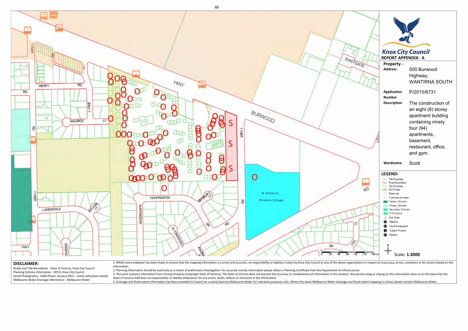
REPORT APPENDIX: A
Property - Address 500 Burwood
Highway, WANTIRNA SOUTH
Application
Number P/2015/6731
Description The construction of an eight (8) storey apartment building containing ninety four (94) apartments, basement, restaurant, office, and gym.
Wardname Scott
LEGEND:
Scale: 1:3000
DISCLAIMER: Roads and Title Boundaries - State of Victoria, Knox City Council Planning Scheme Information - DPCD, Knox City Council Aerial Photography - AAM (Flown January 2013 – unless otherwise stated) Melbourne Water Drainage Information - Melbourne Water
1. Whilst every endeavor has been made to ensure that the mapping information is current and accurate, no responsibility or liability is taken by Knox City Council or any of the above organizations in respect to inaccuracy, errors, omissions or for actions based on this information. 2. Planning information should be used only as a means of preliminary investigation. For accurate overlay information please obtain a Planning Certificate from the Department of Infrastructure.3. This print contains information from Vicmap Property (Copyright State of Victoria). The State of Victoria does not warrant the accuracy or completeness of information in this product. Any person using or relying on this information does so on the basis that the State of Victoria shall bear no responsibility or liability whatsoever for any errors, faults, defects or omissions in the information. 4. Drainage and flood extent information has been provided to Council on a yearly basis by Melbourne Water for indicative purposes only. Where the latest Melbourne Water drainage and flood extent mapping is critical, please contact Melbourne Water.
46
A 01
Pis DRAWING SCHEDULE PAO SITE PLAN AND AREA ANALYSIS 1400
P A 0 2 BASEMENT LEVEL B2 FLOOR PLAN 1200
Oi /
fPA03 BASEAAENT LEVEL BI FLOOR 1200 P L A N G R O U N D
FLOOR PLAN 1.200
TPA05 FIRST FLOOR PLAN 1200
7 4 0 6 SECOND FLOOR PLAN 1200
7 ~ 0 8 FOURTH FLOOR PLAN ARCARE
I _IA09 FIFTH FLOOR PLAN, PENTHOUSE LEVEL 1 1.200 A G E D C A R E RESIDENTIAL
DEVELOPMENT
TDAIO PENTHOUSE LEVEL 2 ROOF PLAN 1200
11,411 AREA ANALYSIS \ \ N S r
PC TD, 12
COLOURS MATERIALS A N D FINISHES SCHEDULE 1200
I ]EIGHBOURHOOD A N D SITE DESCRIPTION I "m
T--'15 DETAILED S H A D O W ANALYSIS - _F
STAGE 2 PROPOSED FUTURE MEDium DENSITY
DEVEL
TI) DETAILED SHADOW ANALYSIS
SUBJECT TO SEPARATE P A N N I N G A P L I C A T I O N I 1 1
O O A M 12 C O N SEPTEMBER 22
3P S E v jAi C I O I t R 1 I A * & t 1 I I I f l O 7 U 1 f l ! I I I _ , f l -
T Y N E R R O A D T Y N E R R O A D / / 0
X A L E 1:400
SUBJETITE / IV L 5 0 0 BURWOOD HIGHWAY
ST A N D R E W S STAGE MULTI LEVEL APAPTMEN/ / ; i C H R I S T I A N COLLIEDEVELOPMENT
P L N N I N G A P P L I C A T I O N F O R P R O P O S E D A P A R T M E N T DEVELOPMENT
IVANHOE LEVEH/173 UPPER HEIDELBERG ROAD A 5 0 0 B U R W 0 0 D H I G H W A Y , W A N I I R N A SOUTH 3079 DRAWING TITLE: SITE P L A N A N D A R E A A N A L Y S I S N PH 1031 9 4 9 9 8826 TEA 01 - 1 OF 17 DATE: 29TH NOVEMBER 2016 DRAWN B : R 1 A L L LEVELS ARE TO
C__
EMAIL off icepetridisarchitects.com,ou JOB NO. 15 - 101 SCALE: 1: 4 0 0 RESPONSE TO COUNCIL AUSTRALIAN HEIGHT DATUM
500
BU
RW
OO
D H
IGH
WA
Y W
AN
TIR
NA
SO
UTH
47
A P C A RE
A G E D C A R E RESIDENTIAL
DEVELOPMENT
SI-F 188.82nn (OVERALL) 3505820
I t ~ k E E n e r g y Apartments
SD SUAverage combined energy rating assessment to be
MMARY L 5 4 - t J 5
Hea Ing and cooling units in apartments to meet L L 2600 26k 1 2600 11 26o6 1 A U M L 2600 ~L M m L U w 2soo 11 moo L 2ft L ORML-ILL—moo A—Ada '21500 P 29M 2600 L ~51110
mini requirements of MEPS EER 3 33
n f the highest available energy rating such as xtro air ditioning, dishwashers and fridges part of building
mum Energy efficient electrical appliances to be within one
LP
poi
1 T
wo rks
Energy efficient water heaters to be used, g a s i n s t a n t a n e o u s , minimum 5 stam 0
0 5
• 56W solar panels to supply power for c m o n areas 0 C A R P A R K I N G
and car NO CARSPACES gicncLc 1r V
• Lighting per apartments not to exceed 5W/m2 7 N SICwACcS PARKIN sv /
• Energy efficient LED dowelights anator compact / AHO 1 NO
fluorescent lighting type. Moalighting prodacts or ,/ 0 N SASS ENCLOSURE approved equivalent
Carparto and circulations spaces _________ • Lighting and aircoodilioning to comply with BCA 4 9 M 6 4 0 0 4 9 0 0 \ 6400 4000
___________ 6400 0800
1r /
Section J energy efficiency minimum requirements I
• Lighting not to exceed 6W/m2 for carparh and 9W/m2 - _ _ _ _ _ _ _ _ _ _ _ _ _ _ _ _ _ _ 73
for circulation spaces. wsm
• Motion detectors to be used for common areas for )LLETIO
Material Fabric :
requirements: R2.0 for external 40lls. • R4 .O for ceilings exposed to direct sunlight - - -
— I - - - - RAW L etc
• Glazing will be generally shaded by balconies I
- p I no gum 't
671
Water : . Toilets tobe minimum 4 Star WELSruti • Basins taps tobe minimum 5 Star WELSrating
Shower flow not to exceed 6.0 I/min. R. in "ter tank, min 16,000 litres to be connected to INA
OLE toilets on ground and first floor. 5'20 vvashers part fthe building works to bewithin me
Transport
tar h m
the Highest rating is preferred. 0 ...........-
17 for occupants + 3 for visitors. inimum 20 secure bicyde storage spaces.
Waste Management Commitment to recycle at least 50% of construction waste --
Indoor Environment • Insulation between apartments wells to reduce noise T Y N ER ROAD Ouali
• infWrnOflCommitment
to use low VOC materials on paints and
//
• All kitchens to have a dedicated extractionfan to - extract fumes out of kitchen -- - 4 - - n - 1
>
-
Glazing to be laminated e l o s e i t : o
g l a z e d e x t 17
Corridor areas to be naturally ventilated. I
S T ANDREWS
C H R I S T I A N COLLEGE
Knox City Council / RECEIVED BASEMENT LEVEL B2 FLOOR PLAN 30 NOV 2016
SCALE 1 20
PLANNING DEPARTMENT
P L A N N I N G A P P L I C A T I O N F O R P R O P O S E D A P A R T M E N T DEVELOPMENT LEVEL 1 / 1 7 3 UPPER H E I D E L B E R G ROAD
IVANHOE 5 0 0 B U R W O O D H I G H W A Y , W A N T I R N A SOUTH PETRIDIS 3 0 7 9
D R A W I N G TITLE:
E M A I L . o f f i c e p e t r i d i s o r c k i t e c t s . c o m a u J O B N O . 15
- 101 S C A L E : 1: 2 0 0 R E S P O N S E T O C O U N C I L A U S T R A L I A N H E I G H T DATUM
BASEMENT LEVEL B2 FLOOR PLAN (N PH: 1Q31 9 499 8 8 2 6
T P A 0 2 - 2 0 F 17 D A T E : 2 9 T H N O V E M B E R 2 0 1 6 D R A W N BY: R I A L L LEVELS A R E TO
500
BU
RW
OO
D H
IGH
WA
Y W
AN
TIR
NA
SO
UTH
48
C A R P A R K BICYCLE
P A R K I N G DETAILS, SCALE 1 20
4 800 1 J VMION
WASTE
M A N A G E M E N T RAMP. 8 /
___ / 6400
64OUkyB-
-SIANAGE HIND USAGE LABELS FOR THE GARAGE AND RECYCLING INNS RLL BE
- _ _ _ _ _ _ _ _ _ _ _ _ _ _ _ _ _ _ _ _ _ _ _ _ _ _ _ _
/
A2 DED ByTHE AND VERMIN R U . 8 3 3 I ' / / 0
HE BIN STORE SMALL BE VENTILATED N ACCORDANCE NTH AUSTRALIAN S T A N D A R D A S 16682 VISITORS
________ ' VISITORS EEI] 1-" /
-RAE BIN *ASH AREA COMPROMISING OF A TAR AND FLOOR DRAIN VITA TRAP AND / SE RCORNECTION LL BE LREATED IN THE INN STORE FOR WASHING OF BINS,
AND COLLECTION AREAS CLEAN. 01
IIEEP INN LOS CEOSED AND WASA INNS REGULARLy. - TUE HORS CORPORATE RE THE PROROSED DEVELOPMENT SHALL SOURCE AND ENTER . INTO THE SERVICE AGREEMENTS FOR MVATE WASTE COLLECTION SERVICES THE BODY
AND COSTS ASSOCIATED THE WASTE COLLECTION SERVICE PROVIDED By PRIVATE COLLECTION CWRAC70RS
L T T H CONCRETE AERR -
]
-
/ I 131
3 2 O R P O R A T E WILL BE RESPONSIBLE FOR
oAcvM.ao (ROTh WT -I I w"MUM [MOUNT
mw
MAIN STAIR. LEADEN UP THROUGH BUILDING
TAR R I H T h RHE0 HR I 5 WIN SAT STEEL SECURITY MESH GRILLE
BARR TA E)U000S SOBTUI RH INAN CBFSTIT Will
I PEDESTRIAN ACCESS LEADING TO STREET LEVEL NOTE PROVIDE MECHANICAL E~TRACT VENTkATION TO CARPARK,
LET THROUGH )NTERIOR (THROUGH ALL FLOORS, OF BUILDING.
- - - - - - - - - - THROUGH ROCf,) TO BE DETAILED AT LATER DATE-BY SERVICES
kIjD
OVERHEAD OeSTRUrMONS (SUCH AS SERVICES) 70 BE 23DO'MIN
ETA IL PLAN_
K, LICH NO TO THE CAPPARY. AREA TO COMPLY WITH ST A N D R E W S I - " I CTION 4 7 AND BCA 2007 SECTION CHRISTIAN COLLEGE IN6'
SCALErnox
City Coun B A S E M E N T LEVEL B I FL A N S C A L E I 2M
LEVEL 1 / 1 P L A N N I N G A P P L I C A T I O N F O R P R O P O S E D A P A R T M E N T DEVELOPMENT 73 UPPER HEIDELBERG ROAD
IVANHOE 5 0 0 B U R W O O D H I G H W A Y , W A N T I R N A SOUTH 3079 DRAWING TITLE.
EMAIL offICepetrIdISarchIfecfS.com.ou JOB N O 15 - 101 SCALE; 1: 2 0 0 RESPONSE TO COUNCIL AUSTRALIAN HEIGHT DATUM
BASEMENT LEVEL B] FLOOR PLAN PH. 103) 9 499 8826 TPAO3 - 3OF 17 DATE. 29TH NOVEMBER 2016 DRAWN BY R.L ALL LEVELS ARE TO
500
BU
RW
OO
D H
IGH
WA
Y W
AN
TIR
NA
SO
UTH
49
ARCARE
uII AGEDDEVELOPMENT CARE RESIDENTIAL
'N
$ S I N
ESTORE,
/
—
/
/ /
GROUND9 SITE18882 (OVERALL)I L:5_.--------- -y' - N 35858'20 POPOSED N PtANTING(- / 0 /
Al
LANDSCAPING IN FIXED PLANTER Bogs 79 PROPOSED DENSE j4 I C O M i A U
: : / : 81
CLEARANCE L =L j NOTE 2300MM WIN STRUCTURE EXT I AND 820001 -
STA!\To
LIFI
AT tIFT GYM V
OFFICE 37.5M' 54.OM' H
:6'OYER
E KERB BASEkAERNT, s - - X , 1 I Q.
Knox City Council
i i
/jOH:D
TAGE) By 2500 MM AUDIO/ VIDEO NTE4CCM 'IV ACCESS (DEPTH 1110 THE Slit). CEDITOSE PANEL J EXIsu,c FOOTPATH- NOTE 001PATH 2 - -- 30 NOV 7016 1 Y N E R R O A D /1 /
SPEARS MUST NOT WADE - PROPOSED DENSE LOW LEVEL ADf STARS LEADING / THAN 1200 1111 IN PLANTiNG WI 100011 GE FENCE. IN OVERR4NI1R / UP FROM CARPARK WAY LEADING T O - F I X E D PLANTER BOXES - I-NAIEOA000 AREA / - BASEVEN ARK PLANNING DEPARTMENT
- ADA XA01ICL
____________________________ ' - - Q55Q SD [VEMDIJSXED - - AND CCL DI N STRIP C • / GLASS BALUSTRADE(LAMINATED SAFETY G L A S S ) - v-.. ST ANDREWS 0
I CHRISTIAN C O L L E G E S T E E L
FRAMING. V
I — 0 G R O U N D F L O O R P L A N P L A N T E R BOX SCAIC 1 2..
ISlVED CADV FL LEVEL. Ri
FIN CREA FALLS T DIRECTIONS, IN WO DISCHARGE TO DESIGNATED SADUWATEDIJILEI
P L A N T E R BOX
SCALE 1 20
DETAIL
- - P L A N N I N G A P P L I C A T I O N F O R P R O P O S E D A P A R T M E N T DEVELOPMENT IVANHOE [Eva 1/173 UPPER HEIDELBERG ROAD
5 0 0 B U R W 0 0 D H I G H W A Y , W A N I I R N A S 0 U T H P E T R I D I S 3079 DRAWING TITLE
PH. 1031 9 499 8826 G R O U N D F L O O R P L A N N TPA 04 - 4OF 17 DATE: 29TH NOVEMBER 2016 DRAWN BY R.L ALL LEVELS ARE TO EMAIL: off lce©petrldlsarchltecfs.c000au JOB NO. 15 -101 SCALE 1 1 200 RESPONSE TO COUNCIL AUSTRALIAN HEIGHT DATUM
500
BU
RW
OO
D H
IGH
WA
Y W
AN
TIR
NA
SO
UTH
50
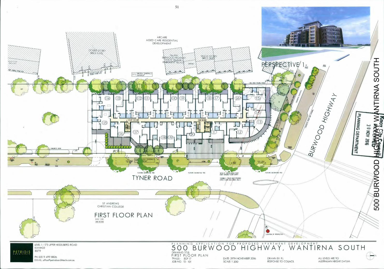
-
ARCARE AGED CARE IDENTIALDEVELOPMENT
- 7 /1 - STAIR / z
L1 U IFT
LIFT
-
fll 47D rn 0 /
- /
ELE
FOAl/iRE O E C ( 0 V E FiNS FEATURE OECORAI1VE FINS VIEW OF CR881/LEVERED ROOF 0(81000 D(CORAIJW FINS . - - ---.
OVER 00(8JND FLOOR (NUll
I Y N E R ROAD FLOOR L
ST ANDREWS 0 CHRISTIAN COLLEGE
FIRST FLOOR PLAN SCALE 200
AVID 85000
LOCATION OF PERSPECTIVE-1,-,-.,,'
P N N I N G A P P L I C A T I O N F O R P R O P O S E D A P A R T M E N T DEVELOPMENT
IVANHOE LEVEH/173 UPPER HEIDELBERG ROAD L A
5 0 0 B U R W 0 0 D H I G H W A Y , W A N T I R N A SOUTH PETRIDIS 3079
DRAWING TITLE. FIRST FLOOR PLAN PH: 03) 9 499 8826 TPA 0 5 - 50F 17 DATE: 29TH NOVEMBER 2016 DRAWN BY: R.L ALL LEVELS ARE TO
EMAIL: [email protected] JOB NO. 15 - 101 SCALE: 1: 2 0 0 RESPONSE TO COUNCIL AUSTRALIAN HEIGHT DATUM
500
BU
RW
OO
D H
IGH
WA
Y W
AN
TIR
NA
SO
UTH
51
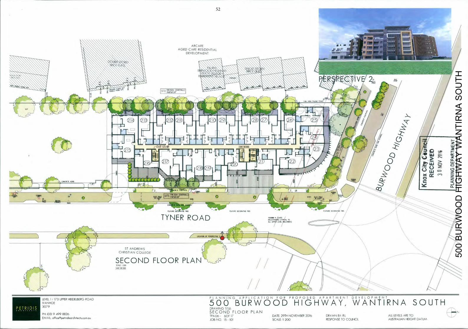
'
JJ7 E—
E 178-W20-
FEATURE
785820
IEATURF D € C I 1 M FINS FEATURE DECORATIVE FINS FEATURE DECORATfrSE FINS
TYNER R O A D 1 0 1 A15 U L(A(L kC(UIIES)
-------------------------------
I g / LOCATION OF
ST ANDREWS CHRISTIAN COLLEGE
SECOND FLOOR PLAN / SCALE 1 200
AHD 88 000
P L A N N I G A P P L I C A T I O N F O R P R O P O S E D A P A R T M E N T DEVELOPMENT
VANHOE LEVEH/173 UPPER HEIDELBERG ROAD N
5 0 0 B U R W 0 0 D H I G H W A Y , W A N T I R N A SOUTH •311DTL 3079 DRAWING TITLE S E C O N D FLOOR PLAN PH: 1031 9 499 8826 TPA O6- 60F 17 DATE: 29TH NOVEMBER 2016 DRAWN BY: R.L ALL LEVELS ARE TO
EMAIL: [email protected] JOB N O 15 - 101 SCALE: 1: 2 0 0 RESPONSE TO COUNCIL AUSTRALIAN HEIGHT DATUM
500
BU
RW
OO
D H
IGH
WA
Y W
AN
TIR
NA
SO
UTH
52
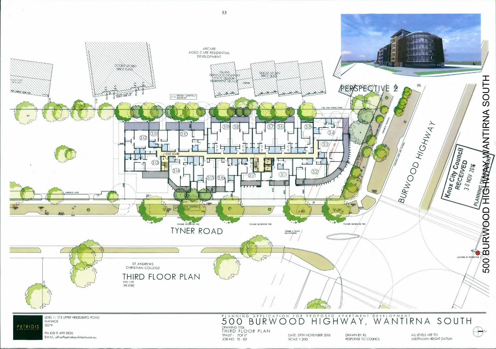
LEVEL 1/173UPPERHEIDELBERGROAD P L A N N I N G A P P L I C A T I O N F O P P R O P O S E D A P A R T M E N T DEVELOPMENT
IVANHOE 5 0 0 B U R W O O D H I G H W A Y , W A N T I R N A SOUTH 3079
EMAIL officepetridisorchitectscomou TPA 0 7 - 70F 17 DATE 29TH NOVEMBER 2016 DRAWN BY RI ALL LEVELS ARE TO
DRAWING TITLE
P H I 0 3 ) 9 4 9 9 8 8 2 6 THIRD FLOOR PLAN
JOB N O 15 - 101 SCALE 1: 2 0 0 RESPONSE TO COUNCIL AUSTPALIAN HEIGHT DATUM
500
BU
RW
OO
D H
IGH
WA
Y W
AN
TIR
NA
SO
UTH
53
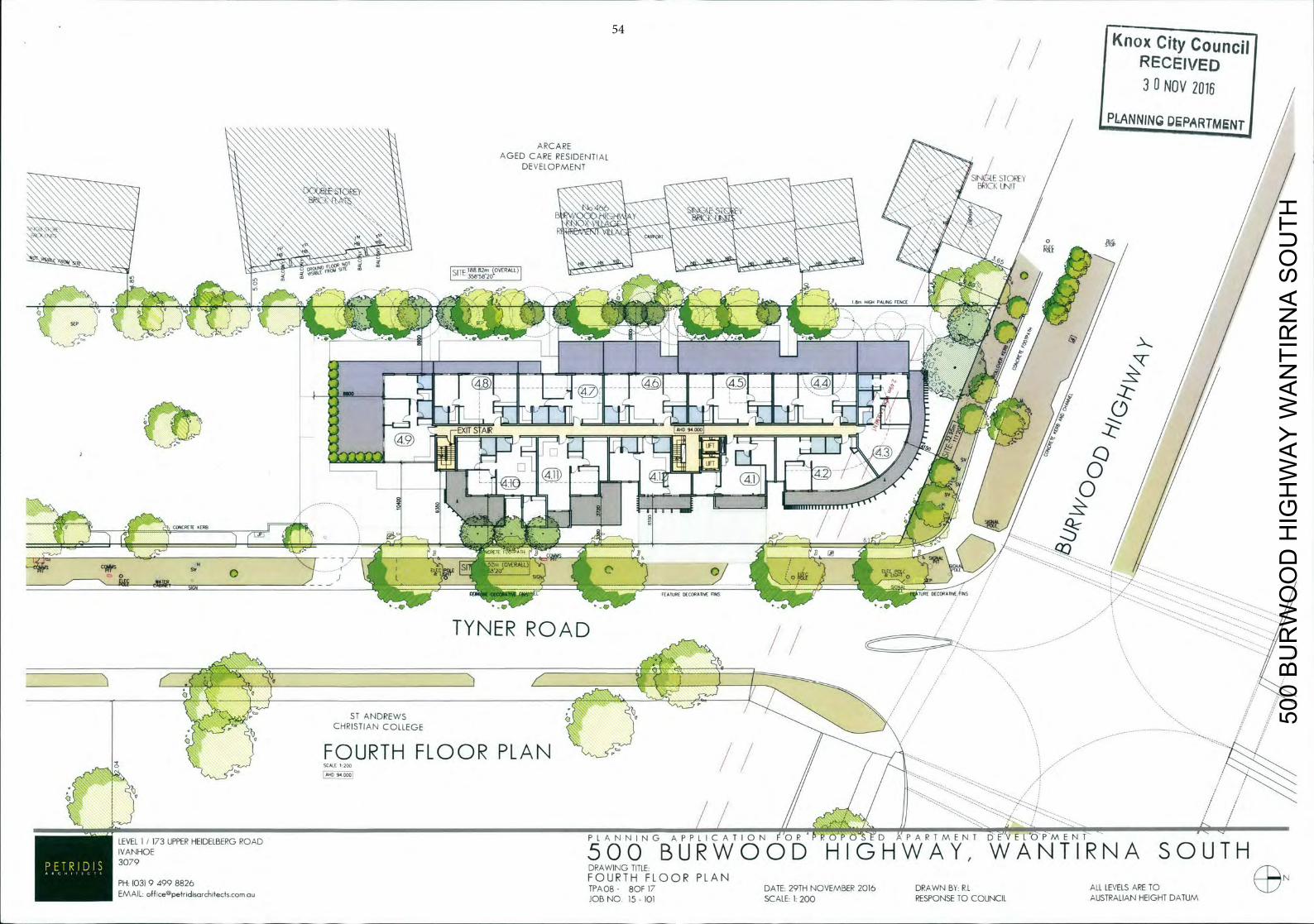
/ Knox City Councj RECEIVED 30 NOV 7016
/ / /
[PLANNING DEPRTMgN
SIGN
FEATURE DECORATIVE 1
- - - i - -
--
TYNER ROAD
----- L4
__
ST ANDREWS -- CHRISTIAN COLLEGE
-
------T-.
0 FOURTH F L O O R PLAN 7 SCALE -200
P L A N N I N G A P P L I C A T I O N O R R O P O D P A R T M E N T DEVELOPMENT
IVANHOE LEVEH/173 UPPER HEIDELBERG ROAD
5 0 0 B U R W 0 0 D H I G H W A Y , W A N T I R N A SOUTH • 3 J J I I ! U I 3079
DRAWING 11TL L 0 0 R P L A N N PH: 03) 9 4 9 9 8826
F O U R T H
TPA08 - 80F 17 DATE: 29TH NOVEMBER 2016 DRAWN BY: R . I . A L L LEVELS ARE TO
(T~
EMAIL: offcepetrdIsarchIfectscomau JOB NO. 15 - 101 SCALE: 1: 2 0 0 RESPONSE TO COUNCIL AUSTRALIAN HEIGHT DATUM
500
BU
RW
OO
D H
IGH
WA
Y W
AN
TIR
NA
SO
UTH
54
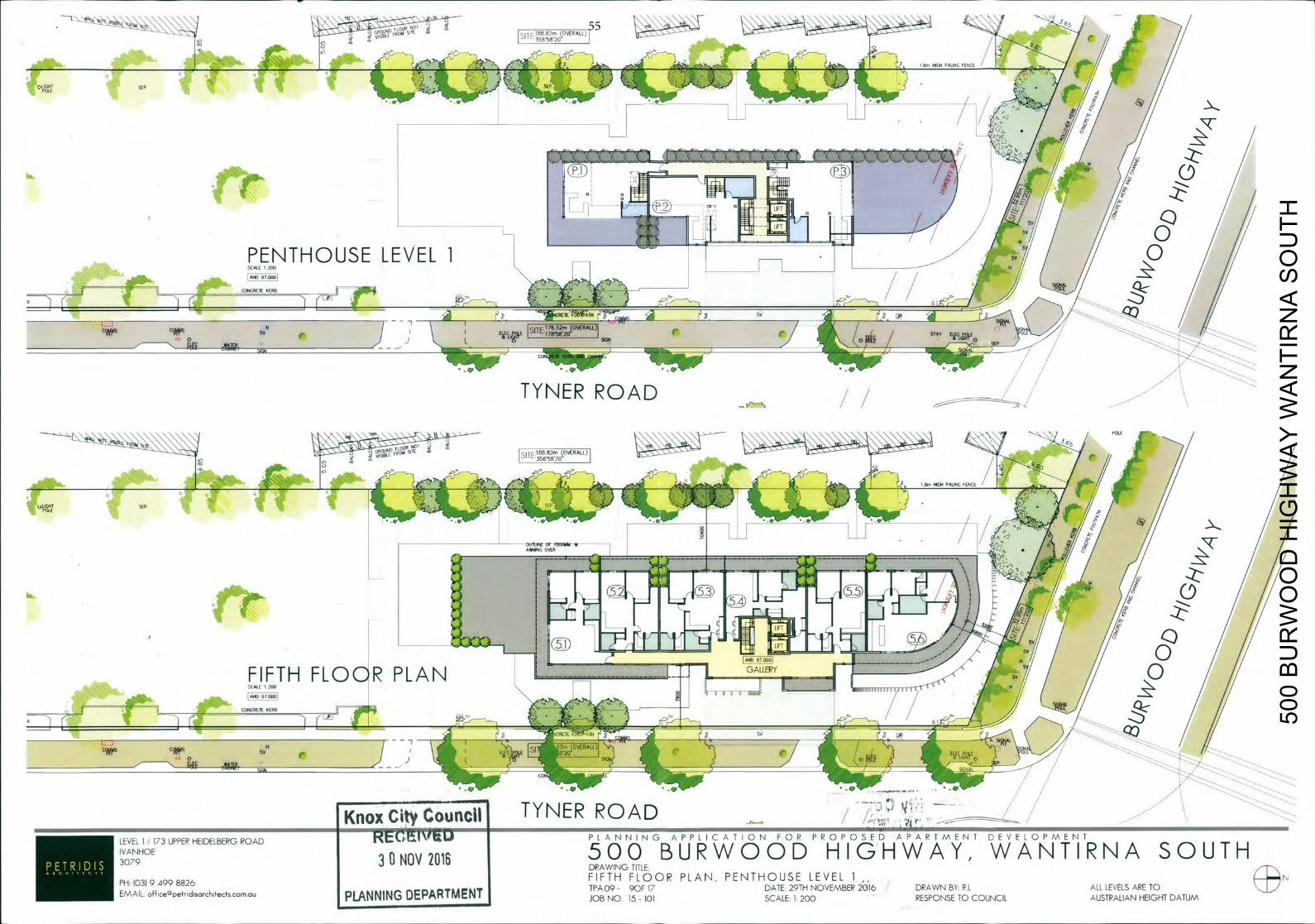
[SN 18882n (OVERALL) 96,
/ 1 8 PALM FENCI
og SLP 2 X c 2 * J ) )
Ai LE IS—
( n o t j
H / /
T) I
/ i s v (/
Q
P E N T H O U S E L E V E L 1 H
/
SCALE 1 200 A H O 97.000
CONCRETE KERB
SV ________________________________________ -
A ACAE[tPIHA7Y A _ _ _ _ _ _ _ _ _ _ _ _ _ _ _ _ _ Rol
0 J 7 SITE e /10 c / STAY 7 - - -
~IGN _ _ _ _ _
- - I - C _ —
TYNER ROAD
GH POLE k * 1 ' • J'r[/ ' j/
I AWING OVER
_ _ _ _ _ _ _ _ _ _ _ _ _ _ _ _ _ _ _ _ _ _ _ _ _ _ _ _ _ _ _ • 8
T-1 C5 4
ç Y
_ _ _ _
1 8 I
_________ [00097303
._- - H / /
FIFTH FLOOR PLAN L-Lla-1)
T GALLERY • 7 I T - S
4 / 0 SCALE 200 I IL H /1
080 97000 8 0 1
C00C80TE KE00
--
~vs SvH Cwps r / rIIN
/I3E
CON
Knox City Council TYNER ROAD 5 f l S S - s a r
. .
S
LEVEL] ]73 UPPER HEIDELBERGROAD K t U M V I S 1 0
P L A N N I N G A P P L I C A T I O N F O P P R O P O S E D A P A R T M E N T DEVELOPMENT
IVANHOE 'ONOV2O16 5 0 0 B U R W O O D H I G H W A Y , W A N T I R N A SOUTH 3079 DRAWING TITLE.
FIFTH F L O O R PLANS P E N T H O U S E LEVEL 1 N P H 103) 9 4 9 9 8 8 2 6 T P A 0 9 - 9OF 17 D A T E 2 9 T H N O V E M B E R 2 0 1 6 D R A W N B Y R1 ALL LEVELS A R E TO
EMAIL: o f f i c e p e t r i d i s a r c h i t e c t s . c o m o u PLANNING D E P A R T M E N T J O B NO. 15 - 101 SCALE 1 2 0 0 R E S P O N S E T O C O U N C I L A U S T R A L I A N H E I G H T DATUM
500
BU
RW
OO
D H
IGH
WA
Y W
AN
TIR
NA
SO
UTH
55
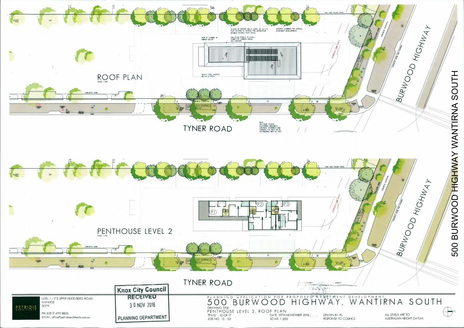
/ 9.5
0 OL
SEP
A PAL NC FENCE : o ' r 2 /
/
OUTLINE OF D I N G WALLS CARRY UP TO U/S ANTENNA (COMMON FOR OVERALL POOP DECKING TO ACHIEVE FIRE SEPARATION APARTMENT DEVELOPMENT) BETWEEN CEILING! ROOF SPACE
VIEW OF I500AA A 5 W SOLAR PANELS TO SUPPLI AWNING BELOW POWER COMMON
AND CARPARA AREAS
•--
SY P
- J I L m / I SEL
ROOF PLAN E C T E E L R I N C . j L
/
R/
SCALE I 200 Sv
/
N]
CONCRETE VERB
rJ:7
SIGN S;r 02
NOTE RAT ROOF ACCESS "
T 'i' t\J E R ROAD PLATFQlBUS. WULAWATS. GANTRIES. STAIRWAyS AND ADDERS, ETC MUST BE IN
ACCORDANCE WITH ASI657
l
000 ( i L L T <1c3o HIGH PALING FENCE
OLIGHT POLE
F f _ _
S B !
o /
PENTHOUSE LEVEL 2 A
/
SCALE 1200 SB 7 /
r------ CONCRETE VERB
A l z C Sv
SIGN
Ol/
CON
TYNER ROAD Knox City Council
LEVEL1/173 UPPER HEIDELBERGROAD R E C t I ' t U P L A N N I N G A P P L I C A T I O N F O R P R O P O S E D A I ' T I E N T DEVELOPMENT
iVANHOE 30N0V2016 5 0 0 B U R W O O D H I G H W A Y , W A N T I R N A SOUTH
DRAWING TITLE
PH- (03)94998826 PENTHOUSE LEVEL 2, ROOF PLAN (N
EMAIL offiCep&rIdisorchiecfscomciu I A M M I D E P A R T M E N T TPA 10 - 10 OF 17 DATE: 29TH NOVEMBER 2 0 1 6 ; -
DRAWN BY: R.L ALL LEVELS ARE TO JOB NO. 15 - 101 SCALE: 1. 2 0 0 RESPONSE TO COUNCIL AUSTRALIAN HEIGHT DATUM
500
BU
RW
OO
D H
IGH
WA
Y W
AN
TIR
NA
SO
UTH
56
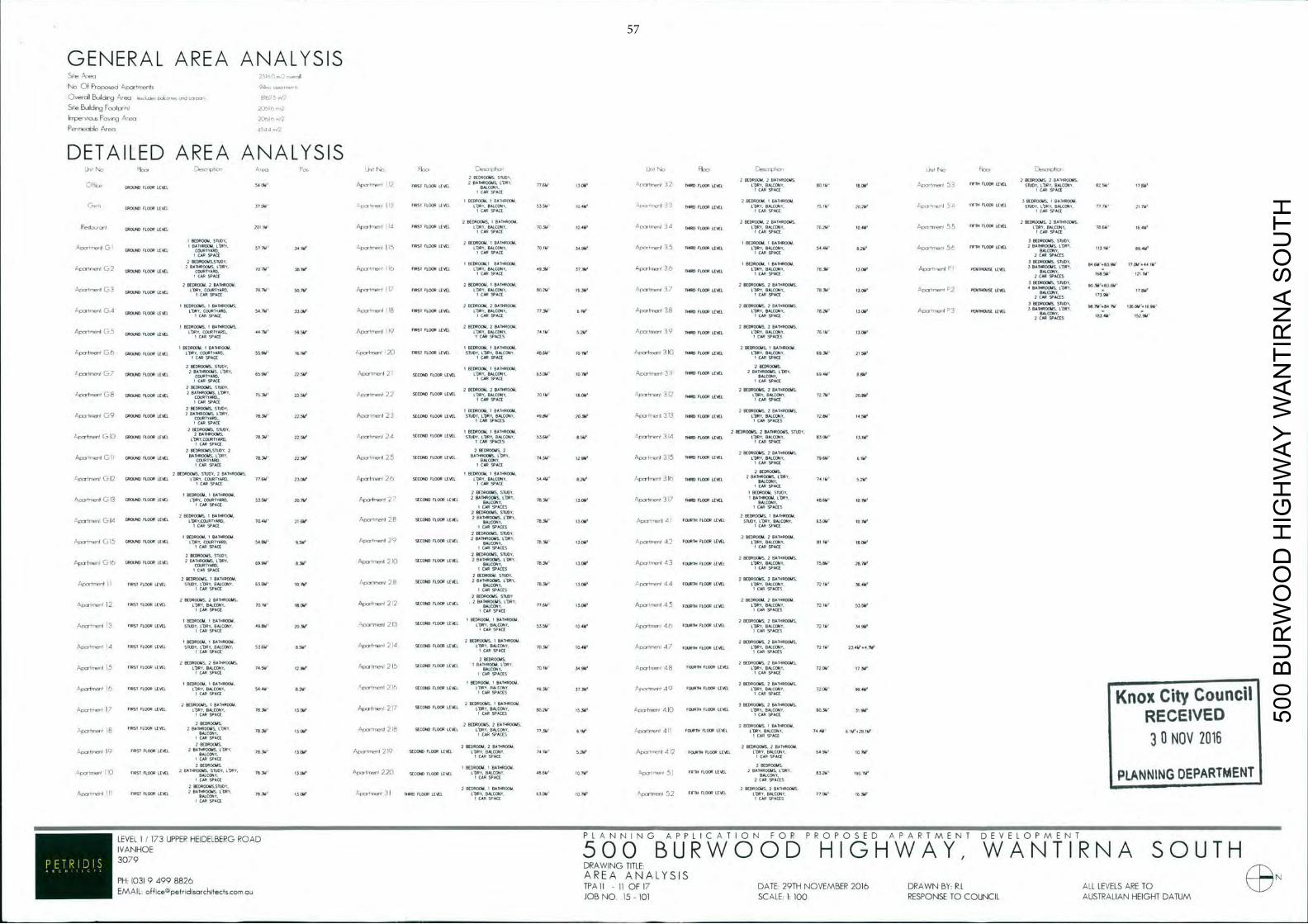
GENERAL AREA ANALYSIS N - Of Proposea A p a r t m e n t s 94,c opol,+se,
'veaII BCEIIdur-lg A r e a 611+3iel b+ko'+e1 r d +''+ 81625 +12 Si e, B i I d o g F o o t p n I 20615 r2
ICEpeeo.p Peaoa A'eo 20' Fen000le Area
DETAILED AREA ANALYSIS 2 8 ( 0 8 0 1 8 4 5 . 5 1 0 0 1 ,
2 3 8 0 8 0 ( 8 4 , 2 BAIO#OOI IS , 2 3 8 3 8 0 0 8 5 . 2 830#0013S, -
'
8 6 6 ( 8 4 0 1 2 0 ( 8 7 W A p - n ' 2 BATHROOMS. CORY.
77664 3 7 W 5 0 8 6 1 1 7 1 0 1 ' 1 0 0 8 0 r L 0 ) LEA CORY. BALCONY. 6 0 4 4 ' 8 1 6 1 ' 1eS1trr69'' 5/, VE6 1 1 0 0 8 LEVEl 5 8 1 0 9 . L ' D P 0 A L C 0 9 I . 8 2 5 9 ' 1789'
1 C AR SPACE I C A R SPACE AR SPACE
BEDROOM.1 E A T H R 0 ) . 2 8 ( 0 0 0 0 1 4 , I 8A1+00184 . 3 8 ( 6 8 0 ( 0 1 5 . I BAT ROOM.
I 37344 - , x p r r 0 ) + ' I S '3851 1 1 0 ( 8 1 ( 9 ( 1 L ' . B A L C O B L 9 . 5 3 5 6 3 ' + 0 4 9 ' - E l o l I r r 0 " t - ' ( + 4 8 0 1 1 ( 0 1 LEVEl COPY. BALCONY. 7 5 ( 9 2 0 2 W _(7'+3(8/I 5 / i SPIEl ( 1 0 0 8 LEVEL 581 1 8 6 1 ' BALCOEII 1 7 7 6 3 ' 2+7+4' G R O U N D I C A R SPACE I C A P SPACE AIR CE
2 8EORO06I$, I 0 + 1 0 8 0 0 8 , 2 8 ( 3 8 0 0 8 , 2 BATHROOMS. 2 3 8 3 8 0 ( 9 5 , 2 8*1080085.
G R O U N D E L 0 ) LEVEL 2 ( + 1 W A l I I / i r s i 1 6 0 ) LEVEL L DRY. B A L 0 ) 9 . 7 0 3 4 ' 107W 6 t ' / 4 1 8 6 9 . 6 C 0 9 1 , 76 2M 1 0 4 9 ' 5 5 FIFTH 1 1 0 ) LEVEL CORY. 8 A 1 C 0 9 1 , 7 8 W 16414' I C A R SPACE ICAP SPACE
8 ( 0 0 0 0 1 4 . 5 1 0 0 6 , 2 6 ( 0 8 0 ( 4 4 * 1 1 ( 8 0 0 9 8 ( 3 8 0 ) 4 I 8 A I V R 0 ) 3 0 ( 8 6 0 ) 9 . 5186+.
•'ocyfrr38nI C- I 8 ~ FLOOR LEVEL
8 6 1 " s ' / ' r y ' I r n e n t 115 06sf 1 1 , 0 ) LEVEL L ' D R I . P A L C O I O , 7 0 W ,si g e j ' A r I o e ' r t 3 5 16080 1 1 0 ) LEVEL 1 0 8 0 . BALCONY. $ 4 444' 8,214' l r m r t r r 8 6 n ' 5 +3818 1 1 0 0 8 2 B A T + a 0 ) 5 . 1+08 , .
113 l U 69414' O U R T Y A I
C M I C A P
SPACE SPACE
2 CAP SPACES
2 P E 0 0 0 0 9 S , S I U O 0 , 0 ( 0 1 4 0 ) , 6 6 1 + 0 0 ) , 0 ( 0 8 0 ) , 1090014, 3 8 ( 3 8 0 ) 3 5 , 5 1 0 0 1 .
6 4 6 4 1 + 8 3 9 1 4 ' 7 7 0 3 ' + 4 4 01' 0 - 2 ( 8 1 0 8 4 0 ( 2 0 C R LEVEL
0 * 1 9 0 15, LDPYI 7 0 7 W 38+14 ' 5+33 '11138+3 1 1 5 (3898 ( 2 0 ( 8 LEVEL L ' D P I , B A L C O N U R T Y A D. 1 C A R
Y, 4 9 , 3 8 ' 3 7 3 1 4 1' 6 1 6 ( 1 1 1 0 0 6 LEVEL
1 0 0 9 . BALC8+A1/ 1 ( 3 1 4 ' 3 7 W A p o n e o t 6 ( 6 1 0 ) 3 8 j s o 3 BATHROOMS. /08+1
I 168 W
121-W
C M SPACE SPACE
2 C446 SPA I C A N
BALCONY105
2 6 ( 0 6 0 0 9 1 2 B A T H R O O M . -
2 3 8 0 6 0 ) 1 . BATHROOM. - -
2 3 8 6 8 0 0 3 5 , 2 8 * 1 9 8 0 ( 9 5 , -
3 8 ( 3 8 0 0 8 9 . 51001.
11Crt11SPflI 3 3 0 9 0 , 8 0 5 0 ) LE A L
CORY. COURTYARD. 7 0 7 9 ' 3 8 7 3 4 ' Afotr86nt h i F P S I 1 6 0 ) LEVEL L '081 . BALCONY, 6 0 2 9 ' 1 5 3 1 4 ' -'p00(1718.1' / THIRD FLOOR LEVEL CORY. BALOONY. 7 8 3 4 ' I O W A ' C a t ' 1 6 9 + 3 2 sfxnon L E V E L 4 B A 1 B S L
I C M S P A C E 1 1 SPACE 2 CAN SPACES
I 8 ( 0 6 0 0 4 4 5 . I 8 * 1 0 0 0 ( 9 5 , 2 8 ( 0 8 0 ( 8 4 . 2 BATHROOM. 2 38DPO(8 IS , 2 BATHROOMS, 3 BEDROOMS 5 1 1 0 1 . 3 8 7 1 4 + 6 4 7 9 ' 13809+1638'
0001r138 ' -2 ( . 1 4 0 1 ( 9 ) 0 1 1 0 0 6 LEVEL
L ' Y A R D . 5 4 7 1 4 3 3 7 W A p o ' I r Y 3 6 r O 1 8 rss FLOOR LEVEL CORY, BALCONY. 7 7 3 4 ' 6 1 4 ' A p 0 0 t r e ' 3 8 s + o 1 1 0 0 8 o s t L 'OBI .BALCCBAY. 1 8 2 9 3 ( 6 4 ' A o o ' l 4 3 6 ( 9 8 8 0 8 6 LEVEL BALCONY 8 3 4 1 4 +52914'
I B E 3 8 0 0 U S , I BATHROOMS, 2 BtDPOCAI. 2 0 * 1 0 8 0 1 8 4 . 2 3 8 0 8 0 0 8 5 . 2 BATMROC14S.
1 - t - ) C .
G R O U N D F L _ _ L E A L ' 0 8 CO2 M O 713 5 4 1 W A p 8 6 f 6 9 e Y l 9 17165 0 ) EVE L; OP BALCONY. *4 5214 + - p o , l l P 1 ( 1 6 6 0 ) LEVE 1 6 8 8ALCON 6 4 3 (6i
I CAR SPACE C M SPACES I C M SPACES
I 8 ( 0 8 0 1 4 4 . I B A I A P 0 ) . I 8 ( 3 8 0 ) 3 . I BATHROOM. 2 BEDROOMS. BATHROOM,
- - p C r I r l Y 0 0 ( 3 9 8 6 ( 0 1 0 1 1 1 0 ) 1 ( 6 ( 1 + 5 8 + 0 . 0 0 1 8 1 1 4 8 0 . 5 5 9 9 ' 51133' ( '1086)10380+ .
2 0 FIRST (10 (8+ LEVEL S f 0 0 6 . L '389 . BALCONY, 4 8 , 0 9 ' 0 7 6 4 ' A p ' l 1 I Y 0 0 ' 3 ) 0 9 1 8 6 1 1 0 ) 6 ( 6 ( 1 l ' D B Y , B A L C O N Y , 6 9 3 4 2(544' I C M SPACE 1 C M SPACE I CAN SPACE
2 BCOP0OAIS. SI I IDYI I 8 ( 3 8 0 0 3 I 888+810181 2 9E080(MS,
L O 0 0 t , r l 1 C 7 GROUND 1 1 0 0 8 LEVEL 2 BATHROOMS. COPY.
6 5 9 9 ' 2 2 7 W A p L r I r r , e s $ C 1 1 0 ) 1 ( 6 ( 1 L 'D B I .BALC OAIV , 6 3 0 3 4 ' 1 0 7 8 ' ( 1 ( 1 1 1 0 ' 1 * 3 1 6 8 0 8 6 ( 1 0 1 ( 6 ( 1 2 B A I 8 B O O 4 I S , / 0 8 0 ,
6 9 4 9 ' 838'
I CAP SPACE I C M SPACE
2 6 ( 0 8 0 1 8 3 5 , 5 1 0 0 1 . 2 8 ( 0 8 0 0 8 . 2 8 * 1 + 8 0 1 4 4 . 2 V E 0 0 0 M I S . 2 BATHROOMS. / i ( y j ) , 0 ) ( C 8 ( 1 4 0 ) 0 1 1 0 0 1 LEVEL
2 BATHROOMS, L 0 8 0 , 22,564' ' - E + L r r r f l e n I 2 . 2 5 1 0 ( 1 0 FLOOR LEVEl, L O P E . BALCONy. 7 0 ( 4 4 ' 8 7 W S p r o l m a , ' 3 2 16080 ( 1 0 ( 8 LEVEL 1108+1. BALCONY. 1 2 2 9 ' 20913'
I C M SPACE I C A R SPACE C SPACE
2 3 8 0 6 0 0 9 5 , 5 8 0 0 + . I 6 ( 0 8 0 1 4 1 , I 8A1000083 , 2 0 8 0 0 0 ) 4 5 , 2 861+60085.
31 n ( 0 9 io 1 0 ) LEVEL 2 8 006(1 , L'OR 8344 2 2 5 4 3 A o , 1111e+1I 2 2 SECOND FLOOR LEVE 5 8 6 0 5 6 S A I D Y. 9664 2 0 3 4 - l p r o I r Y e 7 1 I 0 4 8 0 1 1 0 6 LIVE C O P Y . B A L C O N 72864 4543
I CAP SPACE I CAB SPACES + C M SPACES
2 8 ( 0 8 0 0 9 5 , 5 1 0 0 1 . I 8 ( 0 8 0 0 1 . I 8 * 1 6 9 0 ) 1 . 2 3 8 0 8 0 0 8 5 . 2 8*108+00435. STUDY. - - , , c p t r p 6 9 . 1 0 1 1 0 0 1 0 ) 0 (LOOP LEVEL
A b 0 8 0 0 8 9 . 7 8 3 4 2 2 . 7 W ' - 0 0 0 ( 0 8 0 1 2 4 SECEBO E L 0 ) LEVEL S 1 0 0 1 , L'OP+I BALCONY. 5 3 . 6 9 ' 8S44 ' 1 p 0 0 I 1 r e " + ' 3 .1 6 0 9 0 ( 1 0 ) LEVEL L ' D P I . BALCONY. 8 3 0 9 ' 13114'
I C M SPACE ' I C M SPACES I C M SPACE
2 8EO#0C94S,S1U00. 2 2 BEDROOMS. 2 2 8 ( 3 8 0 ( 9 5 2 BATHROOMS.
.1+0031118611 C ( 3 8 0 ) 0 1 L 0 ) L E V E L B A T H R O O M S
7 8 3 4 ' 2 2 7 W AIxrtnenI 25 S E C O N D FLOOR LEVEL B A I A * 6 O C M S . L 0 * 1 , C G U A R T Y A 2 9 1 4 ' A h c 1 . p o ' t n ' p r r ) 3 5 9 0 ) 1 1 0 ) LEVEL LORE. BALCC*40. 7 9 6 1 4 ' 064'
I RD'
C M SPACE I C M SPACE I CAP SPACE
2 1 ( 0 0 8 6 9 5 , 5 1 0 0 6 , 2 BATVROG4S. I 8 ( 0 8 0 0 4 . I BATHBOCII. 2 8E380164S,
- - c c r i o q I C 12 0 8 0 . 0 0 1 L 0 ) LEVEL LOST. ( 8 + 1 8 1 1 4 8 0 , 7 7 6 9 ' 2 3 1 1 3 ' S p o - t m e n ' 2 6 SECOND FLOOR LEVEL 1 ( 0 0 , BALCONY, 5 4 4 9 ' 0 7 3 4 ' Aper tne t 315 THIRD FLOOR LEVEL 2 0AI+P41C44 1 0 6 1 . 7 4 1 9 5.243'
I C M SPACE I C M SPACE CONY
I C M SPACE
I 3 8 0 6 0 ( 9 I 8 8 1 0 6 0 ( 9 2 3 8 8 6 0 0 9 5 . 5 1 0 0 0 , I 50)1
3 1 3 0916,610 1 1 0 0 LEVEL L'OBY. COURTYARD. 5 3 5 4 4 ' 2 0 701' A p O Y t ' I Y e Y ' 2 SECOND 1 1 0 0 9 LEVEL 2 8*1+1000445. 1 0 8 1 , 7 8 , 3 + 3 7 W 'L i 3 3 = 6 1 8 0 1 1 0 ) 1 ( 3 8 1 I B A I + 0 0 0 1 3 . 1 0 0 0 .
B c m 4 8 6 6 4 ' 6(163' I C M SPACE I
SAL ONY.
CAR SPACES I C M SPACES D R O O V S STUDY.
2 388601815 . I B A T H R O O M . 2
91 2 3 8 0 8 0 ) 5 . I 0*086000 r c r t r a , n t ( . 3 . 1 4 ( 3 8 0 ) 0 FLOOR LEVEL COPY.COJRIYAP0. 7 0 4 9 ' 2 1 7 W ' 9 . p C E ' - l e n I . 8 3 8 ( 8 + 4 0 1 1 0 8 6 LEVEL
BALCONY - 7 8 9 4 ' (37W A1x,or-e'st 4 FOURTH FLOOR LEVEL STUDY. L 0 1 1 , 8 4 C Y. 0 3 3 4 ' 10164' 1 CAP SPACE I C M SPA ES I C M SPACE
2 B E D R O O M S STUDY, I 8 ( 3 8 0 0 9 , I 8 * 1 0 9 0 0 0
- C O R Y . 2 BATHROOMS. 2 3 8 ( 8 0 0 9 . 2 86108008, 31+111108+11 C - i S (860.040 (LOOP LEVEL L'OBI, COEJPTIATD. 5 4 9 1 4 ' 9544+ A31,"lm,I C ) SECOND 1 1 0 ( 8 LEVEL
BALCONY. 7 6 3 1 4 ' 1 3 5 8 4 ' 9 . p I P I r l + 1 1 ( 4 2 1 0 ) T A 1 1 0 0 1 LEVEL L'D+fl, BALCONY. 8 1 1 W 18(83' I C M SPACE I CAP SPACES I C M SPACE
2 8 ( 0 8 0 ) 5 , 51UDY, 2 3 8 8 6 0 8 9 5 . 510101, 0(94
/ 11110)1+38111 3 1 5 090.6340 FLOOR LEVEL 2 BATHROOMS. 1 0 6 0 , 6 9 9 4 4 ' 8 3 4 4 ' A p o s l r r e o l 2 1 0 SECOND FLOOR LEVEL 2 8 + 0 3 8 0 0 9 4 5 . 1 0 8 1 , 18,3M 1 3 0 9 ' Ap+s'Irreol 2 3 1 1 ( 8 1 0 1 ( 0 ( 8 LEVEL L'DAlI. BALCONY. 1 5 3 8 ' 28.7W
I CAP SPACE I CAP SPACES I C M SPACE
2 A ( 0 8 0 0 U S . I 8A1YPO0I* . .
2 661L90041 ,S IL IE I . 2 B E DROOMS ,2 B A T H R O O M S , " , E I O I I I I P I l I
' M S T F L 0 ) LEVEL STUDY. 11081, BALCCPIV 0 3 0 4 ' 1 0 7 W - ' . r X 4 ' t e ' 8 0 1 I 2 1 1 SECOND 61.001 LEVEL ' BALCONY. 78,364' +3044 ' ( - p o s l r r e " + ' 4 4 1 0 4 8 1 8 ( 1 0 ) LEVEL L 'ERl . BALCONY. 7 2 ( 9 ' 36443' I C M SPACE I CAR SPACES I C M SPACES
2 BEDROOMS. STUDY 2 6 ( 0 8 0 ) 5 . 2 B A 8 A 9 0 0 4 S , 2
C O R Y . B A T H R O O M S . 2 8 ( 0 8 0 1 9 4 . 2 BA8ORO044. 1 0 1 1 r t m e - " 2 6 6 5 ! FLOOR LEVEL 1 ( 8 1 . 8 4 1 1 0 6 1 . l o l A ' 1 6 7 W
A p s r t n 3 8 n I 2 1 2 3 8 ( 0 8 0 ( 1 0 ) LEVEL ' BALCONY. 7 7 6 6 4 ' 1 5 7 W A p o ' I r o e n l 4 5 1 0 . 9 1 8 1 1 0 ) LEVEL L '081 . BALCONY. 7 2 1 9 ' 5 3 544'
I C M SPACE I CAP SPACE I C M SPACES
+ 3 8 0 8 0 0 9 . I B A T H R O O M . ' -
I 8 ( 0 0 0 0 4 4 . I BATHROOM. 2 BEDROOMS. 2 BA0IROORS, M S T FLOOR LEVEL STUDY. COPY,BALCONY. 4 9 8 4 4 ' 2 + 0 3 8 ' " o o s ( m a , l 2 1 3 SECOND 1 1 0 ( 8 LEVEL 1 8 6 1 , BALCONY. 5 3 5 4 3 ' i o i u ' A p o r l + n r ' 4 7 1 1048111 FLOORLEVEL L' I . BALCONY. 7 2 1 9 ' 34963'
I C M S P A C E I CAR SPACE I CAR SPACES
+ 8 ( 0 8 0 0 4 4 , I 0+1080044 . 2 BEDROOMS. I 6 * 1 1 0 + 0 0 9 , 2 08000184S, 2 8+69001845. A p o 1 0 r 3 8 r l i i l l F R S I FLOOR LEVEL STUDY, CRY O . $ 5 6 4 3 ' 8 S 4 3 ' ' 1 p 1 0 ' I 2 1 2 SECOND 1 1 0 0 1 LEVEL 1 0 0 0 . BALCONY, 7 0 3 8 ' 10414' L . p r o l p ' e r + ' 4 7 FOURTH 1 1 0 ) LEVEL L'OBV. BALCONY. 7 2 1 9 ' 234646+79'
I C M SPACE I CAP SPACE I C M SPACES
2 3 8 0 0 2 BEDROOMS,
0044S. 2 AATY38C(044S. , I P 1 1 0 0 0 0 9 L'DP+ 2 3 8 0 + 0 0 8 5 . 2 BATAROONS,
" . p < o r l r n e n t 5 M S T ( L 0 0 P LEVEL 1 0 8 7 . BALCONY. 7 4 5 3 4 ' 2 9 4 3 ' ' 1 0 9 t 1 I ' e A L 2 1 5 3 8 ( 0 6 0 1 1 0 ) LEVEL BALCONY. - 70163 3 4 9 4 4 ' S p c p l m e r t 4 8 1 8 0 0 1 8 FLOOR LEVEL CORY. BALCONY. 7 2 ( 9 4 ' 677W
I C M SPACE I CAP SPACES I C M SPACE
I 8 ( 0 6 0 0 9 . I BATOPOCU. I 3 8 0 0 0 0 8 , I 661080034 , 2 3 8 0 8 0 ( 4 4 0 , 2 8*11(80095, IS M S T 1 1 0 0 8 LEVEL 11081. BALCONY. 5 4 4 9 ' 6 7 4 '
6 . p + 3 - I n ' C Y I 2 1 6 38 (0840 1 1 0 0 6 LEVEL 1 1 * 1 4 1 6 4 ( 0 9 1 4 0 0 8 ' 3 7 3 3 ' L p o r t n 0 ) t 4 9 1 ( 8 8 1 + 1 0 0 ( 8 LEVEL L 'ORI . BALCONY. 7 2 0 3 ' 99463' I C M S P A C E I CAR SPADES 1 C M SPACE Knox City Counci
2 8 ( 0 + 0 ) 5 . B 0044. 2 BE000014S BA 0044 8 ( 3 8 0 ( 9 4 5 , 2 B 0095. ' I r I o l e Y t 7 0 0 S f 1 1 0 0 6 LEVEL / 0 1 1 / BALCONY, 1 8 , 3 8 ' +3044' A P O ' f r I I r I 2 1 SECOND FLOOR LEVEL L10RY/B*LCONY/ 6 0 2 ) 4 ' 1 5 3 9 ' 4 r p O r ) I P 0 + 1 ( 4 1 0 1 ( 8 1 6 1 + 1 1 ( 0 6 LEVEL C D Y. BALCONY. 9 0 9 1 ' 3 1 9 4 * ' I
C A R SPACE C A R SPACES I C A P SPACE RECEIVED 2 AEOBO0435, 2 6 ( 0 8 0 1 9 4 5 . 2 8 + 1 0 8 0 0 9 5 . 2 PEOROOAS, I BAI+YE08 - '
r a U r t l o e l t 8 491ST FLOOR LEVEL 2 PATYI000I4S. L E E ? . 7 0 , 3 4 ' 13 OM 5 p 1 o I I r r e I l ) 2 1 ( 850640 1 1 0 0 6 LEVEL / 0 0 1 / f A L C O N S 7 7 3 4 4 ' 6 ( 4 4 ' " p l 1 1 e o t 4 1 . 1 0 ) 1 0 1 1 0 0 8 LEVEL / 3 8 1 . BALCONY. 7 4 AM 6 ILA '+2D 163'
B A ' C O N C A P 3 8 C A R SPACES 1 CAR SPACE
0 0 0 0 6 9 . 3 0 NOV 2016 2 2 BEDROOM, 2 BATHROOM, 2 B E 0 0 0 0 U S . 2 BATHROOM.
' - o o s I m C A o t 1 9 1 1 8 5 8 1 5 0 0 1 LEVEL 2 BAIR6YOOAIS. / 0 8 1 , 1 8 3 4 ' 1 3 7 W A + 3 , r t r ' 3 8 I 0 1 2 1 9 SECOND SLOOP LEVEL L'EPY, BALCONY, 7 4 1 * ' 5 2 9 ' A p o r l o e r I 4 1 3 1 0 0 + 6 1 1 0 ) 1 ( 3 8 1 L '86Y. BALCONY. 6 4 9 4 4 ' 107)3'
I C M SPACE CAB SPACE I CAR SPACE
2 BEDROOMS.
' 1 3 + 1 1 1 1 0 ) 1 1 1 0 ( P S I FLOOR LEVEL 2 BAT++0018AS. STUEALCONYDY, / 0 0 1 ,
7 0 3 4 ' 13944' ' p r p I r I Y 1 t 2 , 2 0 SECOND FLOOR LEVEL
I C O P Y , BA,cON,Y. 48 61A' 0 7 4 4 ' A ç s e r t r r e o t S I l I l A 1 1 0 0 LEVEL 2 $ L 1 0 B Y . 8 3 2 9 ' 1 9 0 7 9 ' PLANNING DEPARTMENT
C A R SPACE I CAR SPACE
2
C`A~klo"AYCIES
2 BEDPOOIIS.SY.IDY, 2 BED00044, I 6 1 0 1 ( 0 0 9 , 2 8 ( 0 0 0 0 4 4 5 . 2 98198009$,
-
(1051 Y L 0 ) LEVEL 2 BATHROOMS, L DRY. 1 0 3 9 ' 1 3 3 8 ' 7 " . 11613
1 1 1+860 160+10 LEVEL L O P ? , BALCONY, 6 3 0 6 4 ' 0 7 4 ' r 3 + ' ' . ' 5 2 1 ( 1 0 1 1 0 0 LEVEL 1 I081 . BALCONY. 1 7 9 1 ' 1534*'
I CAL SPACE I CAP SPACE CAR SP6CCS
P L A N N I N G A P P L I C A T I O N F O R P R O P O S E D A P A R T M E N T DEVELOPMENT LEVEL I I 173 UPPER HEIDELBERG ROAD
IVANHOE 5 0 0 B U R W O O D H I G H W A Y , W A N T I R N A SOUTH 3079 DRAWING TITLE
PH A R E A A N A L Y S I S 1031 9 499 8826 TPA 11 - 11 OF 17 DATE: 29TH NOVEMBER 2016 DRAWN BY R.L ALL LEVELS ARE TO
(J~
EMAIL: offlce@pefrldlSarChlfecfs,com,au JOB NO, 15 - 101 SCALE- F 100 RESPONSE TO COUNCIL AUSTRALIAN HEIGHT DATUM
500
BU
RW
OO
D H
IGH
WA
Y W
AN
TIR
NA
SO
UTH
57
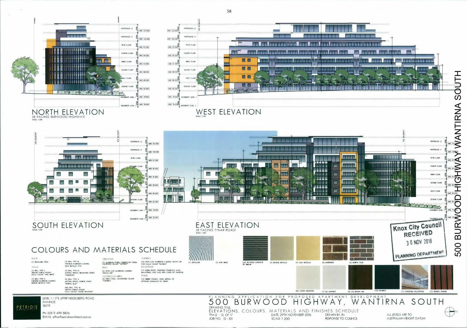
- I P E N T H O U S E ]
17 P E N 0 0 S D L2
ro 7777 11 1 r i T
P L 1 H 0 0 0 0 i PENTH0050 Li I I f l I ri -
MID 1000001
- V - nrm F L "
HO 9 000 F1000 m mnnmirinn n m p m r n r m r n m i r n i n i i i
F T H T H F L
V -- ---------rh
"nil OURTH FLOOR 777 rrM I LL 77 M7
::: A N T H I R D FLUOR
nnhJiI
AND f m ~ AMD FIN 000`1
VIRST FLOOR
- GR0UNDft00. ::::110111L: "I
tl BASEMENT LEVEL I ' I AND N ° I BASEMENT LEVEL I
BASEMENT LEVEL 2 AND 76 000 BASEMENT LEVEL 2
-
NORTH ELEVATION WEST ELEVATION lIE FACING BURWOOD HIGHWAY) SCALE 1 200
SCALE 1,200
-
PENTHOUSE L2
PENTHOUSE
1 _ 1 A N 9 3 r i i TJ11 r T T T 1 r ' r n ' r P E N T H O U S E L2 _ _ _ _ _ _ _ _ _ _ _ _ _
• V
± r V L ! PENTHOUSE L1
FF114 FLOOR
t T T V r T C . T T r
-77 FIFTH FLOOR
i7t FOURTH FLOOR ILI AND
THIRD FLOOR
11 AND a2 000 11
BASEMENT LEVEL I - : : : : : : : : : : : : : _::001_ = : : : : : : : : : : : - - - - - - - - - - - - - - - - - - - - - - - - V . V V _ V . V V I V - - - _ : _ : - - _ - -
RASEHENT LEVEL I AND 79 B06
- - - - - - - - - - - - - - - - - - - - - - - - - - - - - - - - - - - - - - - - - - - - - - - - - - - - - - - - - - - - - - - - - - - - - - - - - - - - - - - - - -V-VVVVV--
8 8 — 76000
BASEMENT LEVEL 2 [ M c 76 000 BASEME 2
______
City SOUTH ELEVATION EAST ELEVATION SCALE 200 lIE FACING TYNAR ROAD)
no SCALE 1200
REC%VE Dk
NOV COLOURS A N D MATERIALS SCHEDULE (1) ZINCALIJUE STEEL (4) WALL TYPE Ill. 7 ALUMINIUM FRANc POHOER OAT ERISH (10) ARCH CLAD ALUMINIUM CLADDING MUCHA 0411 ( I ) ZINCALUME (2) VIVID WHITE ZU TI '72V L C - I i (3) BRONZE METALLIC (4 GOLD METALLIC (5) HAWTHORN (6) BOVIIFAL BLUE
FAIRVIEW ALUMINIUM CLADDING. dLONBOND
COL OUR 00RcAIsr - ( b A ) DULUX COLOUR MAXIMUS OR SIMILAR V GOLD METALLIC 4100
FI - i ( hGLLIIPGDF
(2) WALL TYPE 1. (5) WALL TYPE IV~ (e) ARCH CLAD ALUMINUM CLADDING. (11) AXIOM GROUP. PANORAMA FRAMELESS SMOOTH CEMENT RENDER AUSTRAL 0010<5 MELBOURNE SERIES MUCHADMI
GLASS V VV V
DULUI COLOUR VIID M 4 T G ' H A W T H O R N - Cj T T - ) ( \ F f . 5 IET-X F .1
(3) HALL TIDE II. (6) WALL TYPE (9) SHEET STEEL. COECCJRBOAID COLOUR (12) TAMER PALINGS. 100TH, AERBAU 00 V _V_•i_____.__V___. V ' - - FAIRIAEA ALUMNIUM CLADDING AUSTRAL BRICKS. BUANAL RANGE SORrAIsr APPROVED EI)JIVALENT BY OWNER V V
.VV•_V -80WRAL BLUE' BRONZE METALLIC 9300
(6A) WALL TYPE VI SMOOTHLUXCOl.OIJRSDVIMOUNTAIN CEMEN~ RENDER
(BA) SNOWY MOUNTAIN (7) (9) SURFMIST )T) ( IT) MOCHA OAR (104) HABIMUS UNOYAMA BALUSTRADE
P L A N N I N G A P P L I C A T I O N F O R P R O P O S E D A P A R T M E N T DEVELOPMENT
IVANHOE 73UPPERHEIDELBERGROAD 5 0 0 B U R W O O D H I G H W A Y , W A N T I R N A SOUTH • • 3079 DRAWING TITLE
ELEVATIONS C O L O U R S MATERIALS A N D FINISHES SCHEDULE N PH 1031 9 499 8826 TPA 12 - 12 OF 17 DATE. 29TH NOVEMBER 2016 DRAWN BY R.L ALL LEVELS ARE TO EMAIL- o f f l c e © p e t r l d l s a r c k l t e c t s . c o m . O U
JOB N O 15 - 101 SCALE- 2 0 0 RESPONSE TO COUNCIL AUSTRALIAN HEIGHT DATUM
500
BU
RW
OO
D H
IGH
WA
Y W
AN
TIR
NA
SO
UTH
58
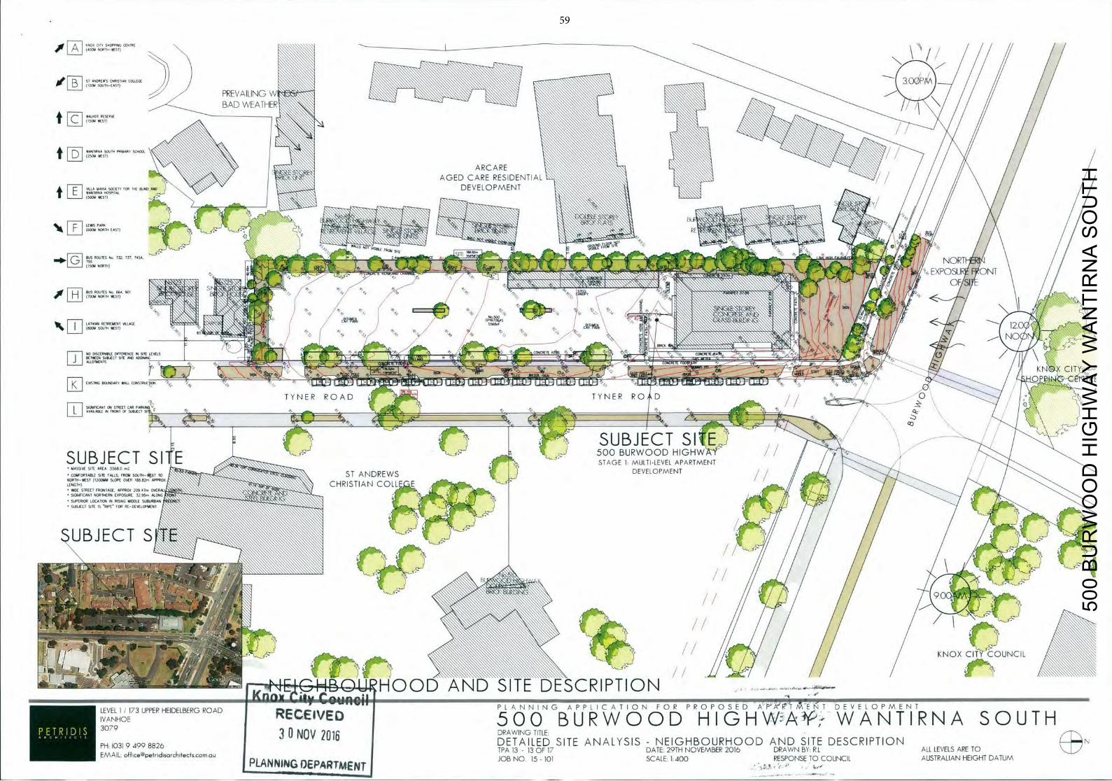
F KNOX CIIX SHOPPrNC CINIRE N S 'OUR N 1 X - S T ) N 5555\ S \
N / ) 3
PREVAILING W
: :
IIO AND
!\\;D/EATHE1I{t
AGED C I D E N T I A
/
" 5 5 5
S
US ROUTES
' : N>
732 737 745 '
- ' NORT
/
-
EXPOSU ONT
L A 8 REFIT WENT VILLAGE
/
/
N
(BOW SOUTH WEST) XLYM
Co I
0 / _ _ _ _ _
10 N I KALLOMINTS N X a f CIT
*320 C S 1 X C I C 4 - 0 PJ?L -rTRE
T YNER R O A D I Y N E R R 0 D / SIGNIFICANT ON
ROINT OF SUBJECT o941V FLI AVAILABLE IN F
STREET CAR PARX
SUBJECT SIE P755 5 0 0 BURWOOD HIGHW SUBJECT SITE M
• h X X _ STAGE 1: MULTI-LEVEL APARTMENT
MASSIVE 0418 AREA 55680 2
• CO4410RTABO 5411 1MCS5 1R061 S 3 2 J T N - 0 1 10 ST A N D R E W S 3 DEVELOPMENT L 12ODMM SLOPE OVER I M 82~APPROX
CHRISTIAN COLLE EWIDE/
• S OCANI N56100R* 132058*0 32 9 *C560 N
• SUPCR0R LOCATION IN RSXNG 4*0008 58*056454 SUBJECT 510 IS 881 132 RI DINOLC#14ENI
U B J E C T S \ \ K
elm
KNO
' - N C H B Q U - H O O D _ A N D SITE DESCRIPTION knnwE1j i y Coungli
:
LEVEL 1/173 UPPER HEIDELBERGROAD P L A N N I N G A P P L I C A T I O N F O R P R O P O S E D A P A ' T / E 1 DEVELOPMENT
IVANHOE R E C i I V E D 3 0 7 9
5 0 0 B U R W O O D H I G H W A W A N T I R N A SOUTH 30 NOV 2016 DRAWING TITLE,
PH 103194998826 DETAILED SITE ANALYSIS - NEIGHBOURHOOD A N D SITE DESCRIPTION N EMAIL off icepetrIdIsorch1tectscornau TPA 13 - 13 OF 17 DATE: 29TH NOVEMBER 2016 DRAWN BY: R.L ALL LEVELS ARE TO
LANNING QEPARIMENT JOB N O 15 - 101 SCALE: 1:400
-
-
RESPONSE TO COUNCIL AUSTRALIAN HEIGHT DATUM
500
BU
RW
OO
D H
IGH
WA
Y W
AN
TIR
NA
SO
UTH
59
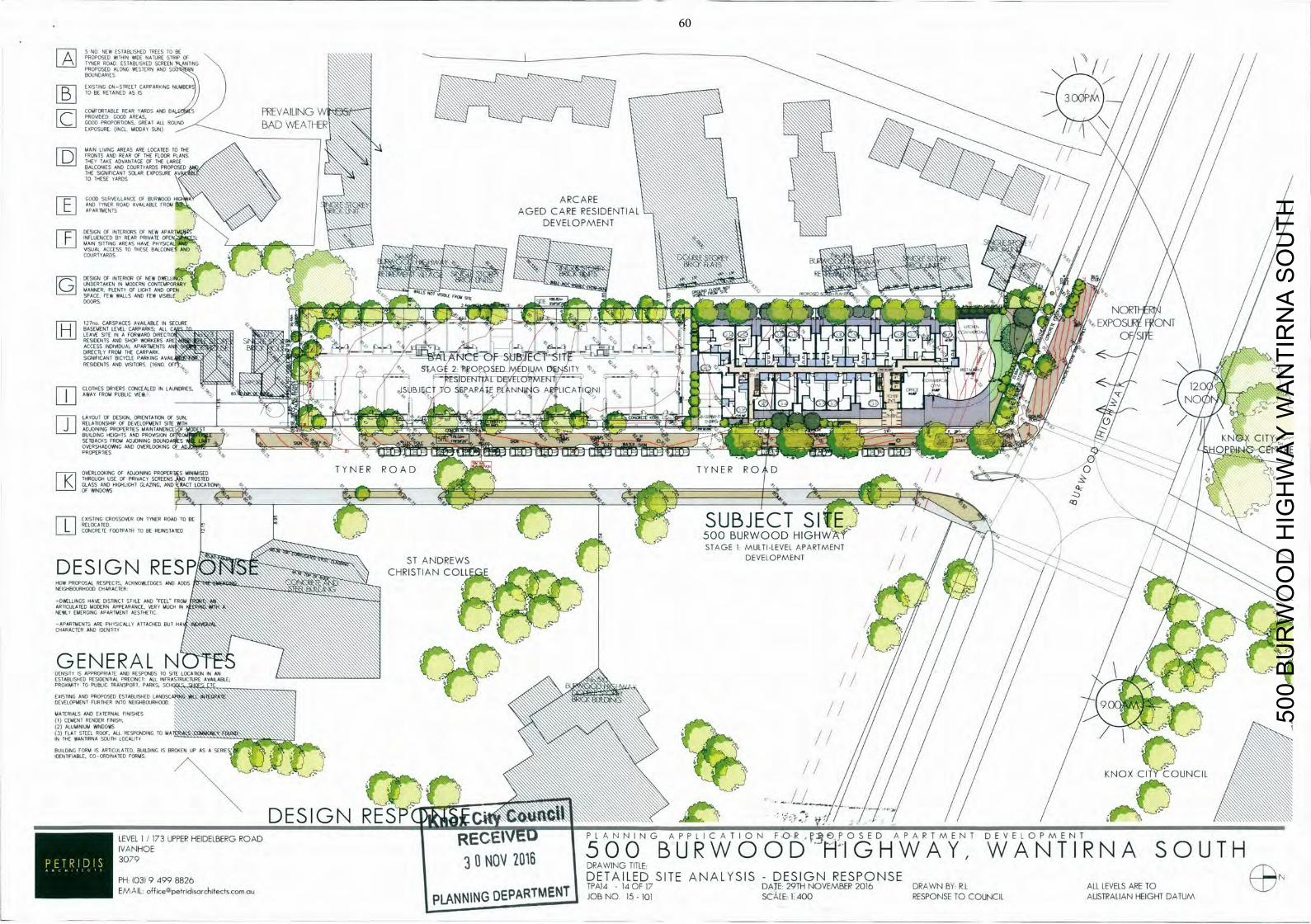
N O N E W 10 BE PROPOSED
ESTAAL SHED TREES STRIP * THIN WIDE NATURE OF
TYNER ROAD ESTABLISHED SCREEN ANTING FAI PROPOSED ALONG WESTERN AND N BOUNDARIES
EISTING N- TREETICARPARKIN G BERS
"WE
TO BE RETAIN
N)COMFORTABLE
REAR YARDS AND 8 S PRO E
BAD W E A T H E R F R O
TS AND REAR OF THE FLOOR PLANS T TAKE ADV NTAGE OF THE LARGE
MAIN LI NG AREAS ARE LOCATED TO THE
BALCONIES AND COURTYARDS PROPOSED \ \\\ \\ THE SIGNIFICANT SOLAR EXPOSURE V TO THESE YARDS
GOOD SURVEILLANCE OF 8URW000 H I D A N D TYNER ROAD
A ARCARE
APARTMENTS AVAILABLE FROM
AGED CARE RESIDENTIAL I DEVELOPMENT
DESIGN OF INTtRIORS OF NEW APARTUOG \ \\ INFLUENCED BY REAR PRIVATE OPENf. MAIN SITTING AREAS HAVE PHYSCAL VISUAL ACCESS TO THESE BALCONIES AND ' COURTYARDS ) / S J
I \
\ \ DESIGN OF INTERIOR Of NEW DWELL] IGS I I '
X
5' 5
UNDERTAKEN IN MODERN CONTEMPORARY
S S 55
MANNER. PLENTY OF L l O Y D A N D OPEN ' PACE, FEW WALLS AND FEW V S I B L E -
WAITS SITS ss
__________ S 5 P ,
-
' S 5' 0NORT
-
DOORS Al
127,o.,CARSPACES AVAILABLE IN
S E C U R E : i H
: EXPOS F ONT
LEAVE SITE IN A FORWARDS; REL 'TI';"
RESIDENTS AND SHOP WORKERS ARE " S I " sA <S [P55
ACCESS THE CARPARK
C PARKING AVAIL, 4 - A .
A N C ~ O f T-9 DIRECTLY FROM ~4
_1~
SIGNIFICANT BI
~SUBJ ifi 8 3 _____
LII mzb a X CITY BUILDING H 'D PROTS'ON DINING EIOLNDA
. / OVERSHA
OVERLOOKINAD
PROPERTIC
R g 2 1 % _ _ T YNER ROAD T Y N E R R O D —
-
O
OF WINDOWS GHT GLAZING. AND ACT LOCATION
CIO
I ISTING CROSSOVER ON TYNER ROAD TO
ONCRETE FOOTPATH TO BEREINSTAD
7 K
GLASS AND HIC41LI
BE J O R W O O D H I G H c
/
L STAGE 1 MULTI-LEVEL A P A R T M E N T S T ANDREWS
DESIGN R E S P A U ! C H R I S T L A N C O L L E E MSA
8
DEVELOPMENT
HOW PROPOSAL RESPECTS. ACKNOWLEDGES AND ADDS NEIGHBOURHOOD CHARACTER
-DWELLINGS HAVE DISTINCT STYLE AND F E E L A R T I C U L A T E D MODERN APPEARANCE. VERY MUCH IN
NEWLY EMERGING APARTMENT AESTHETIC
-APARTMENTS ARE PHYSICALLY ATTACHED BUT HA CHARACTER AND IDENTITY
GENERAL N DENSITY IS APPROPRIATE AND RESPONDS TO SITE LOCATION IN AN ESTABLISHED RESIDENTIAL PRECINCT: ALL INFRASTRUCTURE AVAILABLE. PRO lUlls TO PUBLIC TRANSPORT. PARKS. SCIFI TC I - K
EXISTING AND PROPOSED ESTABLISHED L A N D DEVELOPMENT FURTHER INTO NEIGHBOURHOOD
MATERIALS AND EXTERNAL FINISHES (1) CEMENT RENDER FINISH. (2) ALUMINIUM WINDOWS (3) FLAT STEEL ROOF. ALL RESPONDING TO MA IN THE WANTIRNA SOUTH LOCALITY 4 7 0
BUILDING FORM IS ARTICULATED. BUILDING IS BROKEN UP AS A S E R I E S I D E N T I F I A B L E . CO-ORDINATED F O R M S . 8 D E S I G N L n % w j r
KNOX UNCIL
:
LEVEL:001prs
1 I73IJPPERHEIDELBERGROAD R E C E I V E D P L A N N I N G A P P L I C A T I O N F O - R 5 O P O S E D A P A R T M E N T DEVELOPMENT
IVANHOE 5 0 0 B U R W O O D H I G H W A Y , W A N T I R N A SOUTH 3079 3 U NOV 206 DRAWING TITLE:
PH DETAILED SITE ANALYSIS - DESIGN RESPONSE N 1031 9 - 4 9 9 8 8 2 6
TPAI4 - 14 OF 17 DATE- 29TH NOVEMBER 2016 DRAWN BY R.L ALL LEVELS ARE TO EMAIL. o f f l c e © p e t r l d l s a r c h l t e c f s c o m . a u
PLANNING DEPARTMENT JOB N O 15 - 101 SCALE: 1:400 RESPONSE TO COUNCIL AUSTRALIAN HEIGHT DATUM
500
BU
RW
OO
D H
IGH
WA
Y W
AN
TIR
NA
SO
UTH
60
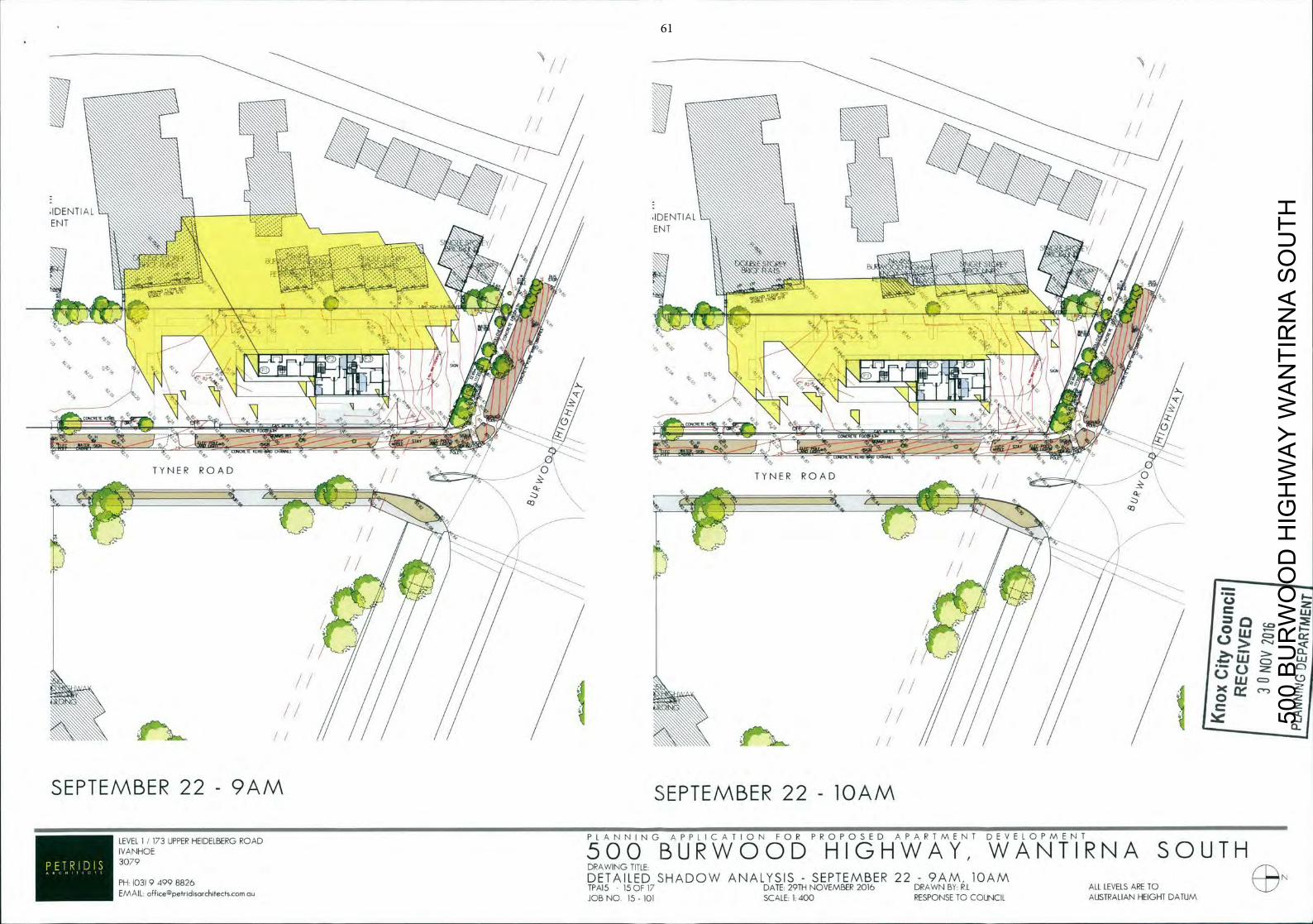
IDENTIAL ENT
lb
T Y N E R R O A D T Y N E R R O A D 0
::IrJ
Lu
Lu Clf
LIJ
UJ LLJ
SEPTEMBER 22 - 9 A M SEPTEMBER 22 - lOAM
-- - P L A N N I N G A P P L I C A T I O N F O R P R O P O S E D A P A R T M E N T DEVELOPMENT LEVEL 1 / 173 UPPER HEIDELBERG ROAD IVANHOE 5 0 0 B U R W O O D H I G H W A Y , W A N T I R N A SOUTH 3079 DRAWING TITLE
EMAIL off ice@petridisarchiectscomau JOB N O 15 - 101 SCALE: 1:400 RESPONSE TO COUNCIL AUSTRALIAN HEIGHT DATUM
DETAILED SHADOW ANALYSIS - SEPTEMBER 22 - 9 A M , lOAM PH: 103) 9 499 8826 TPA15 - 15 OF 17 DATE: 29TH NOVEMBER 2016 DRAWN BY: R.L ALL LEVELS ARE TO
500
BU
RW
OO
D H
IGH
WA
Y W
AN
TIR
NA
SO
UTH
61
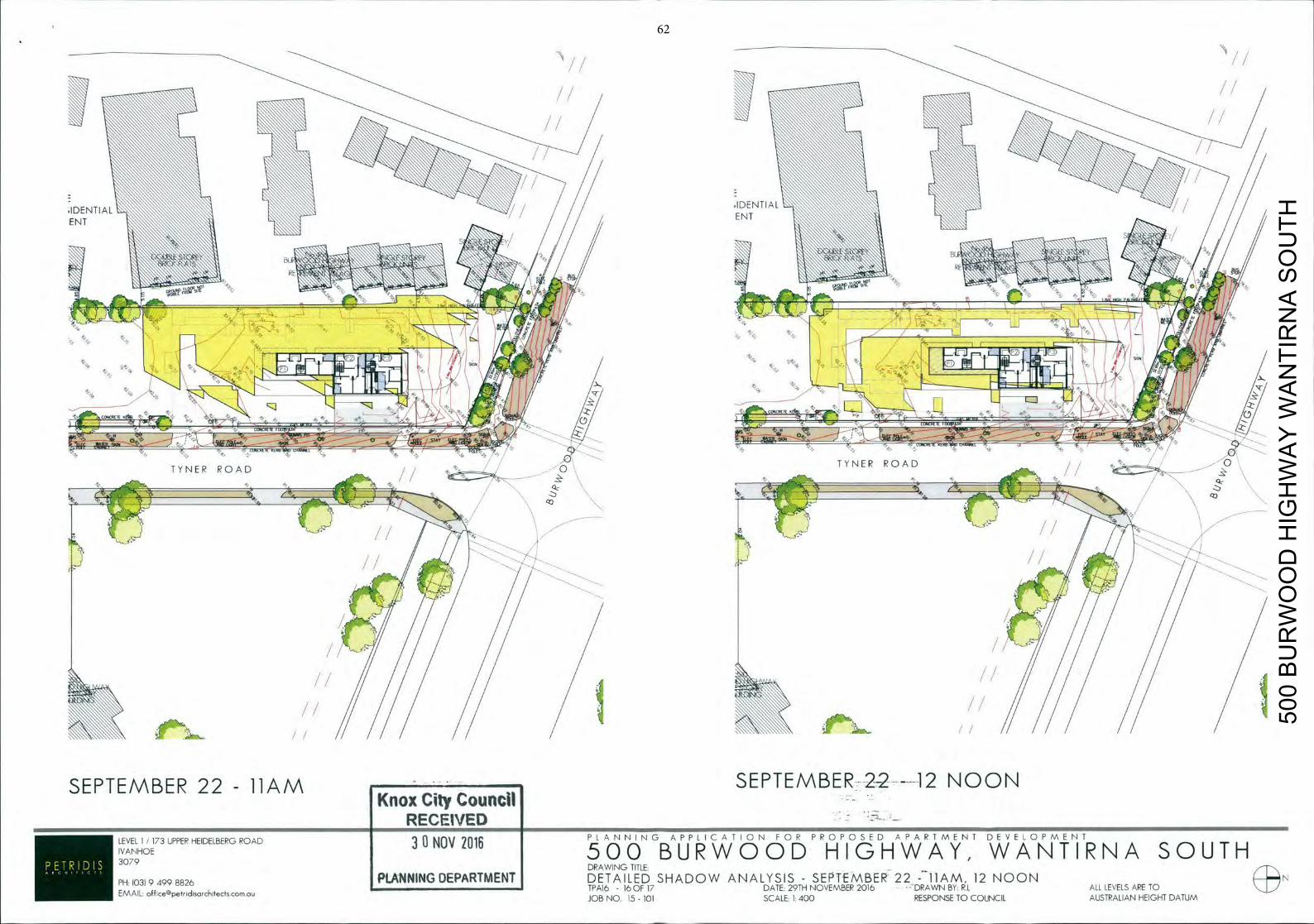
- •1 - / - IDE N TI AL IDE N i l AL
E ENT NT
Za
T Y N E R R O A D -
T Y N E R ROAD
CO CO
Age.,, /1 SEPTEMBER 22 - 11AM SEPTEMBER22----12 NOON
Knox City Council - RECEIVED LEVEL 1 / 7 3 UPPER HEIDELBERGROAD 33NOV 2016 P L A N N I N G A P P L I C A T I O N F O R P R O P O S E D A P A R T M E N T DEVELOPMENT
IVANHOE 5 0 0 B U R W O O D H I G H W A Y , W A N T I R N A SOUTH DRAWING TITLE:
PH 103194998826 PLANNING DEPARTMENT DETAILED SHADOW ANALYSIS - SEPTEMBER 22 - 11AM, 12 N O O N N EMAIL off icepetridisarchitectsconi au
TPA16 - 16 OF 17 DATE. 29TH NOVEMBER 2016 •DRAWN BY: R.L ALL LEVELS ARE TO JOB NO. 15 - 101 SCALE: 1:400 RESPONSE TO COUNCIL AUSTRALIAN HEIGHT DATUM
500
BU
RW
OO
D H
IGH
WA
Y W
AN
TIR
NA
SO
UTH
62
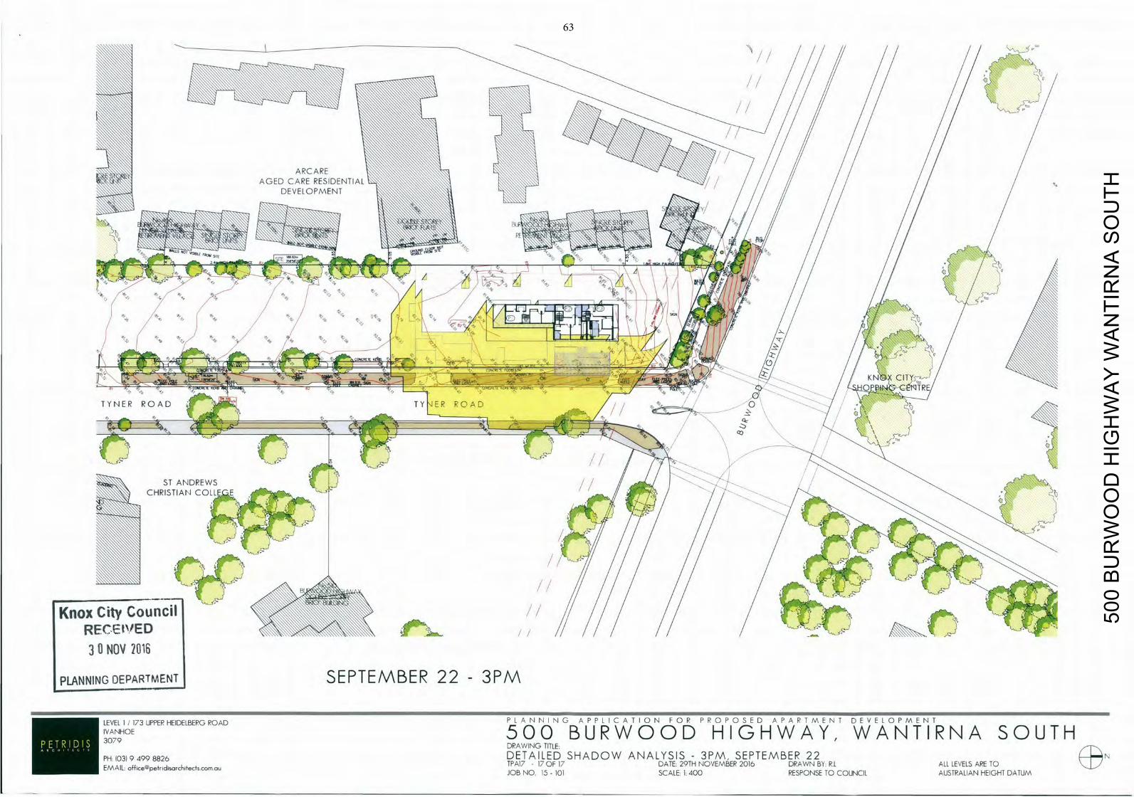
ARCARE AGED CARE RESIDENTIALDEVELOPMENT Y m I'll"Invo
I Y N E R R O A D I Y R ROAD 0
CO
ST ANDREWS CHRISTIAN COLL
SEPTEMBER 22 - 3PM
. E V E L 1 J 1 7 3 U P P E R H E I D E L B E R G R O A D P L A N N I N G A P P L I C A T I O N F O P P R O P O S E D A P A R T M E N T DEVELOPMENT
IVANHOE 5 0 0 B U R W O O D H I G H W A Y , W A N T I R N A SOUTH 3079 DRAWING TITLE:
P H : I 0 3 I 9 4 9 9 8 8 2 6 DETAILED SHADOW ANALYSIS - 3PM SEPTEMBER 22 EMAIL off ice@petridisarchitectscomau TPA17 - 17 OF 17 DATE: 29TH NOVEMBER 2016 DRAWN BY: R.L ALL LEVELS ARE TO
JOB NO. 15 - 101 SCALE: 1:400 RESPONSE TO COUNCIL AUSTRALIAN HEIGHT DATUM
500
BU
RW
OO
D H
IGH
WA
Y W
AN
TIR
NA
SO
UTH
63
64 COUNCIL – CITY DEVELOPMENT 26 June 2017
TAYLOR WARD
6.3 APPLICATION FOR THE DEVELOPMENT OF THE LAND FOR FOUR (4) DOUBLE STOREY AND TWO (2) SINGLE STOREY DWELLINGS AT 48 MURRAY CRESCENT, ROWVILLE (P/2016/6839)
1. SUMMARY:
Land: 48 Murray Crescent, Rowville Applicant: Tomic Prostor Building Design Consultancy Proposed Development: Development of the land for four (4) double
storey and two (2) single storey dwellings Existing Land Use: Single Dwelling Area/Density: 2000sqm/1:333sqm Zoning: General Residential Zone – Schedule 2 Overlays: Nil Local Policy: Municipal Strategic Statement (MSS)
Development in Residential Areas and Neighbourhood Character Policy
Application Received: 22 November 2016 Number of Objections: 35 PCC Meeting: 20 April 2017
Assessment:
It is considered that the proposal provides an appropriate balance between the need for additional housing within an established residential area and the amenity of occupants and adjoining residents.
The proposal generally complies with the Municipal Strategic Statement (MSS), the Development in Residential Areas and Neighbourhood Character Policy and ResCode.
The proposal complies with the General Residential Zone - Schedule 2. On balance it is considered that the proposal responds well to State and Local Planning Policies, subject to modifications. It is recommended that Council issue a Notice of Decision to Grant a Planning Permit, subject to conditions.
65 COUNCIL – CITY DEVELOPMENT 26 June 2017 6.3 48 Murray Crescent, Rowville (cont'd)
2. BACKGROUND
2.1 Subject Site and Surrounds
The location of the subject site is shown in Appendix A.
The subject site is located on the southern side of Murray Crescent, in Rowville.
The site is regular in shape with a street frontage of 29.76 metres.
The site currently contains a single storey brick dwelling with associated outbuildings.
Access to the site is via two single width crossovers, located along the eastern and western side of the site.
The site is vegetated along the side and rear boundaries with smaller trees and shrubs located within the front setback.
The land is surrounded by residential properties, developed generally with large dwellings on large lots.
2.2 The Proposal
(Refer to attached plans at Appendix B) It is proposed to construct six (6) dwellings on the land. Four (4) dwellings will be double storey, and two (2) dwellings will be single storey. Details on the proposal are as follows:
Dwellings 1 and 6 front Murray Crescent and will be setback a minimum 8.5 metres from the front boundary.
Dwellings 1, 2, 5 and 6 are to be double storey with a maximum height of 7.25 metres. Dwellings 3 and 4 (located to the rear) are to be single storey in height.
Dwelling 1 and Dwelling 6 contain four (4) bedrooms, while Dwellings 2, 3, 4 and 5 contain three (3) bedrooms.
A proposed 4 metre wide crossover, centrally located, provides shared access to Dwellings 1, 2, 3, 4 and 5 while a separate crossover along the eastern boundary provides access to Dwelling 6.
66 COUNCIL – CITY DEVELOPMENT 26 June 2017 6.3 48 Murray Crescent, Rowville (cont'd)
Dwellings 1, 2, 5 and 6 are provided with a double garage, while Dwellings 3 and 4 are provided with a single garage and a tandem car parking space. A visitor parking space is located to the west of the shared driveway between Dwellings 1 and 2.
Private open space has been provided at ground level for each dwelling, with a minimum area of 80 square metres.
The dwellings are to be constructed with face brickwork at ground level, rendered light weight cladding to first floors and pitched tiled roofs.
Existing boundary fencing is nominated to be retained.
All existing vegetation is shown to be removed.
3. CONSULTATION
3.1 Advertising
The application was advertised by way of a sign on the site and notices sent to adjoining property owners and occupiers. Thirty-five (35) objections to the application were received, and are summarised below:
Neighbourhood character
Council’s Development in Residential Areas and Neighbourhood Character Policy identifies the subject site within a Knox Neighbourhood Area, where areas will continue to be low-scale, characterised by detached houses, dual occupancies and some villa unit developments on lots greater than 1000sqm. These areas will also continue to retain their green and leafy identify through retention of front and back yards and the establishment of a garden setting, including canopy trees. The proposal would provide for a villa unit development on a block, with front, side and rear garden areas in the form of private open space, that can accommodate the planting of canopy trees to establish a garden setting. It is considered that the proposal is consistent with Council’s preferred future character for the Knox Neighbourhood area. An assessment against this Policy and the design guidelines is at Section 4.2.2 of this Report.
Integration with low density zone
Whilst it is acknowledged that the site boarders (to the rear) a low density zone. It is noted however that the development has been reduced to single storey at the rear to better integrate with surrounding development.
67 COUNCIL – CITY DEVELOPMENT 26 June 2017 6.3 48 Murray Crescent, Rowville (cont'd)
The proposal has been assessed against Clause 22.07, Neighbourhood Character. An assessment against this Policy is at Section 4.2.2 of this Report.
Development is inconsistent with the Housing Policy
The Local Housing Clause of the Municipal Strategic Statement (MSS, Clause 21.05) recognises that the population of Knox will grow by 12,000 persons and 15,000 households to 2030. The Housing Policy directs the provision of a diversity of housing types and forms; housing that meets the needs of all groups within the community; and accessible housing that is well designed and responsive to the local character and environment. An assessment against the MSS is at Section 4.2.2 of this Report
Relocation of crossover
The proposal has been refer to Councils Traffic and Assets departments for comment. No concerns have been raised in response to the proposed locations of the crossovers on the site. In addition, access objectives and standards required by ResCode Standard B14 have been achieved.
Bulk and massing of buildings
The first floors of the dwellings have been setback from ground floor areas, particularly adjacent to sensitive residential interfaces consistent with Council’s Development in Residential Areas and Neighbourhood Character Policy. In addition, setbacks to boundaries exceed the minimum required by ResCode Standard B17 and wall lengths are not excessive, adjacent to sensitive residential interfaces. As such, it is not considered that the proposal will result in adverse amenity impacts through visual bulk, to adjoining residential properties.
Loss of vegetation and trees and impact on fauna
The proposal seeks to remove all existing vegetation from the subject site. Council Arborist did not object to the proposed vegetation removal. It is noted that the site is not a designated area of biological significance.
A condition of any permit issued will require a landscape plan in accordance with Councils Landscape Guidelines for Planning Permits. This will ensure adequate planting occurs within the front, side and rear open space areas of the proposed development.
68 COUNCIL – CITY DEVELOPMENT 26 June 2017 6.3 48 Murray Crescent, Rowville (cont'd)
Overdevelopment
The proposed development achieves the requirements of the Knox Planning Scheme, including Council’s Development in Residential Areas and Neighbourhood Character Policy, ResCode, the Schedule to the General Residential 2 Zone and car parking. As such, it is not considered an overdevelopment of the land. Refer to Section 4 of this report.
Overlooking and reduction on privacy for adjoining neighbours
The proposal has generally been designed to avoid overlooking, however some overlooking may occur from the proposed development. A condition of any permit to issue will require full compliance with Standard B22. Refer to Section 4.4 of this report.
Overshadowing
ResCode Standard B21 requires an assessment of overshadowing to ensure any overshadowing does not result in adverse amenity impacts. This is determined on shadows between 9am and 3pm on the Equinox (22 September). The proposed overshadowing complies with ResCode Standard B21.
Increase in traffic/parking congestion and inadequate parking
Council’s Traffic Engineers have not raised any concerns with the capacity of the street or surrounding street network to absorb the additional traffic that would be generated by the proposed development.
Car parking is provided in accordance with the ratio required by Clause 52.06. Two (2) car parking spaces are provided for each proposed dwelling and one (1) visitor parking space has been provided.
Safety for pedestrians and traffic
Council’s Traffic Engineers have not raised any concerns in relation to pedestrian or traffic safety that would be generated by the proposed development.
Limited public transport
Although the site is not directly serviced by public transport, there are bus routes within reasonable proximity of the site. Refer to Section 4.2.1 of this report.
69 COUNCIL – CITY DEVELOPMENT 26 June 2017 6.3 48 Murray Crescent, Rowville (cont'd)
Precedent for more medium and high density development
An application must be considered on its own merits with consideration of the site context and requirements in the Planning Scheme at the time.
Previous VCAT decision in the area
An application is considered on its own merits and in accordance with the requirements in the Planning Scheme at the time.
Amenity impacts (including noise)/ Inconvenience of construction
The site is located within an established residential area where associated noise is a common feature of urban areas. The development will not result in an unreasonable increase in residential noise. Standard construction amenity conditions will be placed on any permit issued.
Increase in crime
There is no evidence that the proposal will lead to an increase in crime. The proposal will impact on the lifestyle of the area
The area will remain a residential area.
Impact on views
There is no right to a view in the Planning Scheme. This is not a valid planning consideration.
Impact/devaluation on property values
This is not a valid planning concern.
Waste management (including hard waste)
The application was referred to Council’s Waste Management Department who did not object to the proposed development. A condition of approval will require the submission of a Waste Management Plan to the satisfaction of the Responsible Authority.
Impact on infrastructure
No concerns have been raised with the capacity of the stormwater system by Council’s Drainage Engineers, provided a condition is included on any permit to issue that requires stormwater to be detained on site to peak pre-development flows.
70 COUNCIL – CITY DEVELOPMENT 26 June 2017 6.3 48 Murray Crescent, Rowville (cont'd)
Access for emergency services
The application has been referred to Council’s Traffic Department who have not raised any issues relating to access for emergency services.
3.2 Planning Consultative Committee Meeting
A Planning Consultative Committee (PCC) Meeting was held at the Civic Centre on 20 April 2017. Fifteen (15) people signed the attendance sheet at the meeting. Objectors expressed the following concerns with the proposal:
Traffic and safety.
Parking Congestion.
Insufficient infrastructure.
Neighbourhood character.
Impact to lifestyle.
There were no negotiated outcomes at the conclusion of the meeting.
3.3 Referrals
The application has been referred to internal departments for comment. The following is a summary of relevant advice:
Traffic Engineer
A 5m wide and 7m long passing area to be provided in the common driveway.
Standard conditions to be included on any permit issued.
Drainage Engineer
Standard conditions to be included on any permit to issue.
Assets
Crossovers to be reconstructed to Council standards and match width of proposed driveways.
71 COUNCIL – CITY DEVELOPMENT 26 June 2017 6.3 48 Murray Crescent, Rowville (cont'd)
Redundant crossing to be removed and kerb and naturestrip reinstated to Council Standards.
Landscape
The raingardens located in the private open space areas to be deleted.
Standard conditions to be included on any permit to issue.
Parks
Street tree 1 has a low retention value and can be removed at no cost to the applicant.
Street tree 2 will not be impacted the development, tree protection fencing to be installed around the tree.
Waste
Standard conditions to be included on any permit to issue.
Sustainability
Standard conditions to be included on any permit to issue.
Arborist
None of the trees proposed for removal require a planning permit.
The trees on site are mostly exotic species and are not significant.
4. DISCUSSION
This section considers the proposed development in light of the provisions of the Knox Planning Scheme including State and Local Planning Policies, any other relevant policies and objectives.
4.1 Zoning and Overlays
4.1.1 Zone
General Residential 2 Zone
The land is zoned General Residential Zone – Schedule 2. A permit is required for the construction two or more dwellings on the land pursuant to Clause 32.08-4 of the General Residential Zone – Schedule 2.
72 COUNCIL – CITY DEVELOPMENT 26 June 2017
6.3 48 Murray Crescent, Rowville (cont'd)
Schedule 2 to the General Residential Zone varies the ResCode requirements for Standard B13 (Landscaping) which requires a minimum of one canopy tree per 175 square metres of the site area including a minimum of one canopy tree within each area of secluded private open space and one canopy tree within the front setback per 5 metres of width of the site. Each tree should be required to be surrounded by 20 square metres of permeable surface with a minimum radius of 3 metres. Up to 50 per cent of the permeable surface may be shared with another tree.
It is considered that the proposed development can accommodate therequired canopy tree planting; subject to conditions on any permit toissue.
Schedule 2 to the General Residential Zone also varies the ResCode requirements for Standard B28 (Private Open Space) which requires the provision of private open space consisting of a minimum area of 80 square metres including one part of secluded private open space at the side or rear of the dwelling with a minimum area of 60 square metres with a minimum dimension of 5 metres with convenient access from a living room.
Complies. All Dwellings are provided with over 60 square metres ofsecluded private open space with a minimum dimension of 5 metresand exceed the 80 square metres requirement of private open space
Schedule 2 to the General Residential Zone also varies the ResCode requirements for Standard B32 (Front fence height) which requires a front fence height of 2m to a street in a Road Zone Category 1 and 1.2m to other streets.
Complies, the proposed front fence is to be 1.2m high.
Dwellings or residential buildings must not exceed a height of 9 metres (dependant on slope).
Complies. The maximum building height on site is to be 7.25 metres.
4.1.2 Overlays
No overlays apply to the land.
4.2 Policy Consideration
4.2.1 State Planning Policy Framework
73 COUNCIL – CITY DEVELOPMENT 26 June 2017 6.3 48 Murray Crescent, Rowville (cont'd)
State policy requires Council to integrate the range of policies relevant to the issues to be determined, and balance conflicting objectives in favour of net community benefit and sustainable development.
Key Policies:
Clause 15 Built Environment and Heritage – Encourages high quality architecture and urban design outcomes that reflect the particular characteristics, aspirations and cultural identity of the community; enhances liveability, diversity, amenity and safety of the public realm; and promotes attractiveness of towns and cities within broader strategic contexts.
The design of the development will make a positive contribution to the surrounding area, with built form considered to be appropriate in form and scale. The development incorporates important neighbourhood character features such as pitched roofs, brick finishes and car parking located behind or on the side of the proposed dwellings. Upper levels are reasonably articulated and are smaller than the ground level to reduce building bulk and mass.
Clause 15.02 Sustainable Development – Ensure land use and development is consistent with the efficient use of energy and the minimisation of greenhouse gas emissions.
The proposal contributes to the consolidation of urban development through the provision of increased density within an existing residential area.
Should a permit be issued, the development is required to be constructed in accordance with an approved Sustainable Design Assessment.
Clause 16 Housing – Encourage the development of well-designed medium-density housing that respects the neighbourhood character; improves housing choice; makes better use of existing infrastructure; and, improves energy efficiency of housing. Locate new housing in or close to activity centres and employment corridors and at other strategic development sites that offer good access to services and transport.
Neighbourhood character - This is discussed in a later section of the report (Section 4.2.2).
74 COUNCIL – CITY DEVELOPMENT 26 June 2017 6.3 48 Murray Crescent, Rowville (cont'd)
Housing choice – The development provides for dwellings with smaller open space areas than typical for the area.
Existing infrastructure – The site is located within a fully serviced and established area.
Energy efficiency – This has been discussed above under Clause 15.02.
Location – While the site is not located within an Activity Centre, it has access to a number of urban services within an established area. Subject to modifications, the subject site is capable of accommodating the proposed dwellings whilst making a positive contribution to the character of the area. Refer to the assessment against Council’s Neighbourhood Character Policy at Section 4.2.2 below.
Clause 18 Transport – Ensure that access is provided to all available modes of transport.
Bus route 691 is available along Eildon Parade to the north-east of the subject site.
The site is located within 330m of the following bus stop:
o The 691 bus route provides a service between Waverley Gardens and Boronia via Stud Park and Ferntree Gully. This service operates between 6:01am and 9:22pm Monday to Friday; between 7:30am and 6:59pm on Saturdays; and between 8:47am to 7:26pm Sundays, at various intervals.
4.2.2 Local Planning Policy Framework
Clause 21.01 Municipal Strategic Statement (MSS) – encourages planning and development occurring with the necessary consideration to such matters as managing population growth, encouraging sustainable development and influencing the urban form so that Knox itself becomes more sustainable.
All development therefore is encouraged to incorporate Ecologically Sustainable Design (ESD) and Water Sensitive Urban Design (WSUD) principles to ensure that a sustainable urban environment is ultimately achieved with a strong use of existing infrastructure and to reduce dependence on private vehicle travel.
75 COUNCIL – CITY DEVELOPMENT 26 June 2017 6.3 48 Murray Crescent, Rowville (cont'd)
The site is located in an established urban area reasonably close to urban services and open space areas, where existing infrastructure is readily available.
The development is designed to be respectful of the preferred neighbourhood character for the area, and provides sufficient setbacks. It responds appropriately to the constraints of the site and interfaces with the wider area. The proposal will also contribute to the landscape character of the area with new landscaping opportunities.
Living areas of the dwellings are open in nature and will receive adequate solar access, including the SPOS of the dwellings. The proposal will also not be detrimental to the energy efficiency of the adjoining sites.
Clause 21.04 Urban Design – Municipal Strategic Statement (MSS) To ensure that all development responds positivity to the existing patters of urban form and character, the landscape qualities, historic and cultural elements and social aspirations of the Knox community.
While the land is not in an Activity Centre, the proposal respects the preferred neighbourhood character and is consistent with the requirements of the MSS.
An assessment against Council’s Development in Residential Areas and Neighbourhood Character Policy (Clause 22.07) is below. The development complies with the open space requirements and provides opportunities for meaningful landscaping.
As highlighted above, the site is located in an established urban area reasonably close to urban services and open space areas.
Clause 21.05 – Housing This clause implements the Knox Housing Strategy 2015. In managing Knox’s current and future housing needs, Council supports a scaled approach to residential development. This scaled approach recognises that some parts of the City will need to accommodate change, due to population growth and the community’s changing household needs. Development in residential areas will need to respond positively to the desired future character of Knox. The strong landscape character is the unifying element of the neighbourhood character of Knox.
76 COUNCIL – CITY DEVELOPMENT 26 June 2017 6.3 48 Murray Crescent, Rowville (cont'd)
The subject site is located within a ‘Knox Neighbourhood’ area, which has a sense of spaciousness within the public and private realm. These areas will continue to be low-scale neighbourhoods, characterised by detached dwellings with large backyards which contribute to the area’s green and leafy character.
Objective 1 for Housing Objectives and Strategies is to support residential development in accordance with the Knox Housing Strategy 2013, which identifies a scale approach to residential development. The strategy is to direct housing growth toward Local Living and Activity Areas.
The site is not located in an Activity Centre. However, the site is sufficiently large to accommodate six (6) dwellings while achieving the open space and landscaping outcomes sought for the Knox Neighbourhood Character Area.
Objective 2 is to support a diversity of housing choice in appropriate locations. Strategies include encouraging a diversity of housing styles, types, forms and sizes to cater for the changing needs of the community.
The development would provide residents with alternative forms of housing styles and sizes.
Objective 3 is to ensure the quality of housing design in Knox is improved to better respond to neighbourhood identify and to create a stronger sense of place. Strategies include ensuring that residential development enhances the City’s “green and leafy” image, support development that makes a positive contribution to the preferred future character of the area and that is innovative, environmentally sustainable, accessible and site responsive.
Each dwelling is provided with areas of private open space, consistent with the Schedule to the General Residential 2 Zone, that will allow for canopy tree planting.
Objective 4 is to protect and enhance the landscape and environmental values of the nature areas of significance within the municipality.
The site is not located in an area of biological significance.
77 COUNCIL – CITY DEVELOPMENT 26 June 2017 6.3 48 Murray Crescent, Rowville (cont'd)
Objective 5 is to ensure that residential development better responds to the community’s current and future needs, and allows people to ‘age-in-place’ by supporting the provision of a diverse range of housing including smaller scale dwellings.
The development provides for dwellings with smaller private open space areas than typical for the surrounding area. Dwellings 1, 3, 4, 5 and 6 have services and a bedroom at ground level to improve accessibility for residents with reduced mobility.
Clause 22.07 – Development in Residential Areas and Neighbourhood Character: Knox Neighbourhood Area
The desired future character of this area is to:
Continue to be low-scale neighbourhoods, characterised by detached houses and dual occupancies; with some villa unit developments on larger blocks.
Retain their green and leafy identity and character through the retention of front and back yards, and the establishment of a garden setting that includes canopy trees.
The key design objectives are:
To retain and enhance the streetscape by the planting of appropriate trees on private land.
The setbacks and open space areas within the proposed design provide opportunities to plant new canopy trees. A landscape plan will be required as a condition on any permit to issue.
To avoid dominance of buildings from the street.
The development has proposed a setback varying between 8.5m to 9m along Murray Crescent. The setbacks allows for adequate canopy tree provisions to ensure buildings do not dominate the street frontage.
To avoid the loss of front and rear garden space.
The proposed dwellings are generally setback from the side and rear boundaries, which will ensure adequate areas for canopy tree planting within the front, side and rear of the development.
78 COUNCIL – CITY DEVELOPMENT 26 June 2017 6.3 48 Murray Crescent, Rowville (cont'd)
To avoid the dominance of car storage facilities from the street.
Car parking facilities are located to the side or rear of the dwellings and will not dominate the streetscape.
To retain large backyards for landscaping and open space.
The dwellings are provided with a minimum of 80sqm of open space, the setbacks and open space areas will accommodate new canopy tree planting.
To ensure buildings reflect the prevailing scale of buildings in the street.
Dwellings are not excessive in scale or bulk. Upper floor areas are recessed to better integrate with the surrounds.
4.3 Particular Provisions
Clause 52.06 – Car Parking
Prior to a new use commencing or a new building being occupied the car parking spaces required under Clause 52.06-5 must be provided on the land or as approved under Clause 52.06-3 to the satisfaction of the responsible authority.
Clause 52.06-5 outlines the requisite amount of parking to be provided as follows:
To each dwelling at a ratio of one car space to each one or two bedroom dwelling and two spaces for each dwelling with three or more bedrooms (with studies or studios that are separate rooms counted as bedrooms). One visitor space is required to be provided for every 5 dwellings.
Each dwelling has been provided with two car parking spaces. Dwellings 1, 2, 5 and 6 are provided with a double garage, while Dwellings 3 and 4 are provided with a single garage and a tandem car parking space.
One (1) visitor parking space is located to the west of the shared driveway between Dwellings 1 and 2.
Clause 52.06-8 details the design standards for car parking. The provision of car parking should meet the design requirements of this Clause. An assessment of the design standards, including any areas of non-compliance are considered below:
79 COUNCIL – CITY DEVELOPMENT 26 June 2017 6.3 48 Murray Crescent, Rowville (cont'd)
Design Standard 1: Access ways – Complies.
Design Standard 2: Car Parking Spaces – Complies.
Design Standard 3: Gradients – Complies.
Design Standard 4: Mechanical Parking – N/A.
Design Standard 5: Urban Design – Complies.
Design Standard 6: Safety – Complies.
Design Standard 7: Landscaping – Complies.
4.4 Clause 55 – Two or More Dwellings on a Lot and Residential Buildings (ResCode)
Neighbourhood Character and Infrastructure
Neighbourhood Character – Complies, refer to Section 4.2.2 above.
Residential Policy – Complies, refer to Section 4.2.2 above.
Infrastructure – Complies.
Site Layout and Building Massing
Street Setback – Complies with objective, variation to standard.
The bedroom one windows of Dwelling 1 and Dwelling 6 are setback 8.5m from the front boundary. The remainder of the development is setback 9m in accordance with the standard.
The minor encroachment of 0.5m will help articulate the built form of the development and will not be a dominant feature of the streetscape. The existing dwelling to the east of the site is setback 8.3m from Murray Crescent, which ensures the development respect the existing character of the area and is not out of proportion.
Building Height – Complies, maximum building height is 7.25 metres.
Site Cover/Permeability – Complies.
Energy Efficiency – Generally complies. A condition of approval will require the submission of a satisfactory Sustainable Design Assessment.
Open Space – Complies.
80 COUNCIL – CITY DEVELOPMENT 26 June 2017 6.3 48 Murray Crescent, Rowville (cont'd)
Safety – Complies. Entrances to the dwellings are not obscured or isolated from the internal access way.
Landscaping – Complies, a condition on any permit issued will require that appropriate landscape plans are submitted to the satisfaction of the Responsible Authority.
Access – Complies.
Parking Location – Generally complies. A condition of approval will require all habitable room windows located along the shared driveway to be double-glazed to protect future residents from potential vehicle noise.
Amenity Impacts
Side and rear setbacks – Complies.
Walls on boundaries – Complies. All walls on boundaries do not exceed the garage height or length specified in Standard B18.
Daylight to existing windows/north facing windows – Complies.
Overshadowing open space – Complies.
Overlooking – Can comply. There is opportunity for overlooking from Dwelling 2 and Dwelling 5 north facing upper floor foyer windows. A condition of any permit issued will require the windows to be screened.
Additionally a condition of any permit issued will require all windows shown to be screened to be screened with external louvers to be replaced with fixed obscured (non-openable) above finished floor levels. Film will not be accepted and the windows can be openable above 1.7 metres.
Internal views – Generally complies. A condition of approval will require that internal fencing to minimum height of 1.8m be provided to separate the private open space areas between Dwellings.
Noise Impacts – Complies.
On-Site Amenity and Facilities
Accessibility – Complies.
Daylight to new windows – Complies.
Private Open Space – Complies.
81 COUNCIL – CITY DEVELOPMENT 26 June 2017 6.3 48 Murray Crescent, Rowville (cont'd)
Solar access – Complies.
Storage – Complies.
Detailed Design
Design Detail – Complies.
Site Services – Complies.
Front fence – Complies.
4.5 General Decision Guidelines
Clause 65 of the Knox Planning Scheme and Section 60 of the Planning and Environment Act 1987 set out decision guidelines/matters which the responsible authority must consider when deciding any planning application.
The decision guidelines of Clause 65 of the Knox Planning Scheme and Section 60 of the Planning and Environment Act (1987) have been appropriately considered.
5. CONCLUSION
Clause 10.04 of the Knox Planning Scheme requires Council to balance relative policy objectives when making decisions to ensure resulting development is sustainable and achieves a net community gain. In this context, the development is appropriate given the following:
The development is consistent with the objectives and policies of the Knox Neighbourhood Area. The proposal can comply with the General Residential Zone - Schedule 2 and is generally compliant with ResCode subject to conditions on any permit to issue.
The proposed dwellings are generally consistent with Council’s Development in Residential Areas and Neighbourhood Character Policy (Clause 22.07 of the Knox Planning Scheme) in that the design has ensured the retention of front and rear yard open space, first floors are reasonably setback from ground floor areas and the dwellings incorporate materials consistent with the area. In addition to this, all dwellings are provided with usable areas of private open space and appropriate internal amenity.
The development is consistent with State and Local Planning Policy Framework (including the Municipal Strategic Statement).
82 COUNCIL – CITY DEVELOPMENT 26 June 2017 6.3 48 Murray Crescent, Rowville (cont'd)
The development is generally compliant with Clause 52.06 (Car Parking) and Clause 55 (ResCode) subject to changes that will be conditioned on any permit to issue.
6. CONFIDENTIALITY
There are no confidentiality issues associated with this report.
RECOMMENDATION
That Council issue a Notice of Decision to grant a Planning Permit for the development of the land for four (4) double storey and two (2) single storey dwellings at 48 Murray Crescent Rowville, subject to the following conditions:
Amended Plans
1. Prior to the commencement of any buildings or works, amended plans to the satisfaction of the Responsible Authority must be submitted to and approved by the Responsible Authority. When approved, the plans will be endorsed and will then form part of the permit. The plans must be drawn to scale with dimensions and three copies must be provided. The plans must be generally in accordance with the plans submitted with the application but modified to show:
1.1 A 5m wide and 7m long passing area to be provided along the shared driveway.
1.2 Crossovers to be reconstructed to Council standards and match width of proposed driveways.
1.3 Raingardens located in private open spaces areas of all Dwellings to be removed.
1.4 Visitor car parking space and the tandem car parking spaces for Dwelling 3 and Dwelling 4 to be clearly delineated.
1.5 All habitable room windows located along the shared driveway to be provided with double-glazed windows.
1.6 Dwelling 2 and Dwelling 5 north facing upper floor foyer windows to be screened with fixed obscured (non-openable) glazing or have window sill heights to at least 1.7 metres above finished floor levels. Adhesive film will not be accepted and the windows can be openable above 1.7 metres.
83 COUNCIL – CITY DEVELOPMENT 26 June 2017 6.3 48 Murray Crescent, Rowville (cont'd)
Recommendation (cont'd)
1.7 All windows shown to be screened to be screened with external louvers to be replaced with fixed obscured (non-openable) glazing to at least 1.7 metres above finished floor levels. Adhesive film will not be accepted and the windows can be openable above 1.7 metres.
1.8 Annotation stating that letterboxes and all other structures (including meter boxes) shall be constructed to a maximum height of 900mm or relocated clear of a splayed area (2m x 2.5m) in accordance with AS2890.1, Clause 3.2.4 to ensure safe sight distances. Letterboxes shall face towards the street frontage.
1.9 Internal fencing to be provided to separate private open space areas between Dwellings and have a minimum height of 1.8m.
1.10 Demonstration that the approved development will not act as an obstruction to overland flow during peak rainfall events as required by Condition 2.5 of this permit.
1.11 Drainage plans in accordance with Condition 2.
1.12 Landscape plans in accordance with Condition 3.
1.13 Sustainable Design Assessment in accordance with Condition 11.
1.14 Waste Management Plan in accordance with Condition 13.
1.15 Tree Protection fencing in accordance with Conditions 14-22.
To the satisfaction of the Responsible Authority.
Drainage
2. Prior to commencement of any buildings or works, three copies of drainage plans and computations must be submitted to and approved by the Responsible Authority. Construction of the drainage is to be in accordance with these plans. The plans must show the following:
2.1 All stormwater drainage discharge from the site connected to a legal point of discharge.
84 COUNCIL – CITY DEVELOPMENT 26 June 2017 6.3 48 Murray Crescent, Rowville (cont'd)
Recommendation (cont'd)
2.2 The internal drains of the dwellings to be independent of each other.
2.3 An on-site detention system designed by a suitably qualified Civil Engineering Consultant to ensure no net increase in stormwater discharge from the proposed development.
2.4 The on-site detention system to be installed in a suitable location for easy access and maintenance.
2.5 A suitable overland flow path for the entire site to the satisfaction of the Responsible Authority. Details of the overland flow path are to be included on the plans.
2.6 All levels to be to AHD (Australian Height Datum).
To the satisfaction of the Responsible Authority.
Landscaping
3. Prior to the commencement of any buildings or works, a landscape plan to the satisfaction of the responsible authority must be submitted to and approved by the responsible authority. When approved, the plan will be endorsed and will then form part of the permit. The plan must show:
3.1 A survey (including botanical names, height and width) of all existing vegetation to be retained and / or removed.
3.2 The identification and removal of all vegetation identified as an environmental weed in Knox (as outlined in Appendix 2 of Council’s Landscape Guidelines for Planning Permits).
3.3 Buildings and trees (including botanical names, height and width) on neighbouring properties within three metres of the boundary.
3.4 Details of the surface finishes of pathways and driveways.
3.5 Details and location of all existing and proposed services including above and below ground lines, cables and pipes.
85 COUNCIL – CITY DEVELOPMENT 26 June 2017 6.3 48 Murray Crescent, Rowville (cont'd)
Recommendation (cont'd)
3.6 A planting schedule of all proposed trees, shrubs and ground covers, including botanical names, common names, pot sizes, sizes at maturity, and quantities of each plant.
3.7 Landscaping and planting within all open areas of the site (including additional planting within open space areas of the existing dwelling/s).
3.8 The Landscape plans must show the provision of at least 13 additional indigenous or native canopy trees, 5 additional large feature shrubs with a mature height of 4-5 metres and at least 30 additional medium-large shrubs chosen from Appendix 4 or 5 of Council’s Landscape Guidelines for Planning Permits. These canopy trees must be a minimum 1.5metres tall when planted and are to be in the following areas:
3.8.1 1 large indigenous canopy tree and 1 medium canopy tree in the front setback of Unit 1
3.8.2 1 large indigenous canopy tree and 1 medium canopy tree in the front setback of Unit 6
3.8.3 1 medium canopy tree and 1 large feature shrub with a mature height of 4-5 metres in the P.O.S of Unit 1
3.8.4 1 medium canopy tree and 1 large feature shrub with a mature height of 4-5 metres in the P.O.S of Unit 2
3.8.5 1 medium canopy tree and 1 small canopy tree in the P.O.S of Unit 3
3.8.6 1 medium canopy tree and 1 small canopy tree in the P.O.S of Unit 4
3.8.7 1 medium canopy tree and 1 large feature shrub with a mature height of 4-5 metres in the P.O.S of Unit 5
3.8.8 1 medium canopy tree and 1 small canopy tree in the P.O.S of Unit 6
3.8.9 1 large feature shrub with a mature height of 4-5 metres located in the driveway landscaping adjacent to the Unit 6 kitchen
86 COUNCIL – CITY DEVELOPMENT 26 June 2017 6.3 48 Murray Crescent, Rowville (cont'd)
Recommendation (cont'd)
3.8.10 1 large feature shrub with a mature height of 4-5 metres located in the driveway landscaping adjacent to the Unit 2 living room
To the satisfaction of the Responsible Authority.
4. Before the occupation of the development, the landscaping works shown on the endorsed plans must be carried out and completed to the satisfaction of the responsible authority.
5. The landscaping shown on the endorsed plans must be maintained to the satisfaction of the responsible authority. Any dead, diseased or damaged plants are to be replaced.
General
6. All development must be in accordance with the endorsed plans.
7. The layout of buildings and works as shown on the endorsed plans must not be altered without the written consent of the Responsible Authority.
8. Once the development has started it must be continued and completed to the satisfaction of the Responsible Authority.
9. Prior to the occupation of the dwellings the development is to be completed in accordance with the endorsed plan/s to the satisfaction of the Responsible Authority.
10. All walls on the boundaries of adjoining properties must be cleaned and finished to the satisfaction of the Responsible Authority.
Sustainable Design Assessment
11. Prior to the commencement of any buildings or works, a Sustainable Design Assessment detailing Sustainable Design initiatives to be incorporated into the development must be submitted to and approved by the Responsible Authority. The Sustainable Design Assessment must outline
the proposed sustainable design initiatives to be incorporated throughout the development such as (but not limited to) energy efficiency, water conservation, stormwater quality, waste management and material selection, to the satisfaction of the Responsible Authority.
87 COUNCIL – CITY DEVELOPMENT 26 June 2017 6.3 48 Murray Crescent, Rowville (cont'd)
Recommendation (cont'd)
12. Prior to the occupation of the development, the development must be constructed in accordance with the Sustainable Design Assessment.
Waste Management Plan
13. Before the development commences, a waste collection and management plan must be submitted to and approved by the Responsible Authority, demonstrating how waste collection will be undertaken on site, including the operation of the garbage and recyclables storage area. Garbage and recyclables storage and collection must be undertaken in accordance with the approved plan/documentation, and must be undertaken to the satisfaction of the Responsible Authority.
Tree Protection
14. All works, including excavation, within the critical root zone areas of the street tree to be retained and other critical root zones on the land must be undertaken under the supervision of a qualified Arborist to ensure that there is no unreasonable damage to the root system of trees to be retained and/or protected, to the satisfaction of the Responsible Authority. Before the development starts, the owner must submit to the Responsible Authority details of the name of the Arborist who will supervise the works and the tasks to be undertaken by the Arborist, to the satisfaction of the Responsible Authority.
15. Prior to any works commencing on the site, the street tree to the east must be fenced off to create a protection zone. The protection zone must extend around the trees canopy drip-line unless an alternative tree protection zone has been approved by the responsible authority.
16. The fence is to be chain link or wire mesh, comprise either wooden or steel posts set into the ground or on concrete pads, and be a minimum height of 1.4 metres. Signage is to be affixed to the fence advising that the area is a tree protection zone and a no-go development area.
17. The fence and signage is to be maintained throughout the construction period and removed at the completion of all works.
18. No temporary removal of the fence, or encroachment into the protection zone is permitted without the written consent of the responsible authority.
88 COUNCIL – CITY DEVELOPMENT 26 June 2017 6.3 48 Murray Crescent, Rowville (cont'd)
Recommendation (cont'd)
19. Prior to erecting the fence around the tree protection zone, all unwanted vegetation and weed species must be removed from within the zone, and the ground within the protection zone must be covered with a layer of well composted organic mulch (maximum 100mm depth). The area is to be watered at least fortnightly throughout the construction period.
20. The following activities are prohibited from the tree protection area, without the written consent of the responsible authority.
20.1 Construction activities.
20.2 Dumping and/or storage of materials, goods and/or soil.
20.3 Trenching or excavation.
20.4 Lopping branches, nailing or affixing signs, service lines, lights etc to the trees.
21. Prior to any works commencing on site, the Responsible Authority must be contacted to inspect the Tree Protection fencing.
Car Parking & Accessways
22. Before the dwellings are occupied, driveways and car parking areas must be:
22.1 Fully constructed to the minimum standard of 100mm reinforced concrete and available for use in accordance with the plans submitted to and approved by the Responsible Authority; and
22.2 Formed to such levels and drained so that they can be used in accordance with the approved plan; and
22.3 Treated with an all-weather seal or some other durable surface; and
22.4 Line-marked or provided with some other adequate means of showing the car parking spaces.
To the satisfaction of the Responsible Authority.
23. Parking areas and driveways must be kept available and maintained for these purposes at all times to the satisfaction of the Responsible Authority.
89 COUNCIL – CITY DEVELOPMENT 26 June 2017 6.3 48 Murray Crescent, Rowville (cont'd)
Recommendation (cont'd)
Fencing
24. All costs associated with the provision of the fencing are to be borne by the owner/developer under this permit.
25. Prior to the occupancy of the development all fencing shall be in a good condition to the satisfaction of the Responsible Authority.
Amenity During Construction
26. Upon commencement and until conclusion of the development, the developer shall ensure that the development does not adversely affect the amenity of the area in any way, including:
26.1 the appearance of building, works or materials on the land
26.2 parking of motor vehicles
26.3 transporting of materials or goods to or from the site
26.4 hours of operation
26.5 stockpiling of top soil or fill materials
26.6 air borne dust emanating from the site
26.7 noise
26.8 rubbish and litter
26.9 sediment runoff
26.10 vibration
Should the development cause undue detriment to the amenity of the area then immediate remedial measures must be undertaken to address the issue as directed by, and to the satisfaction of, the Responsible Authority.
Stormwater
27. Stormwater runoff from all buildings and hardstanding surfaces shall be properly collected and discharged in a complete and effective system of drains within the property and shall not cause or create a nuisance to abutting properties.
Permit Expiry
28. This permit will expire if one of the following circumstances applies:
90 COUNCIL – CITY DEVELOPMENT 26 June 2017 6.3 48 Murray Crescent, Rowville (cont'd)
Recommendation (cont'd)
28.1 The development is not started within two years of the date of this permit.
28.2 The development is not completed within four years of the date of this permit.
Pursuant to Section 69 of the Planning & Environment Act 1987, the Responsible Authority may extend:
The commencement date referred to if a request is made in writing before the permit expires or within six (6) months afterwards.
The completion date referred to if a request is made in writing within 12 months after the permit expires and the development started lawfully before the permit expired.
NOTES
Drainage Notes (to be read in conjunction with the above drainage conditions):
Applicant shall engage a certified Engineering Consultant to analyse the site’s existing drainage to determine type and size of the Onsite Detention (OSD) system. This shall be designed in accordance with the Knox City Council (Responsible Authority) Stormwater Drainage Guidelines, (copy available on Council’s website), and approved drainage design methods specified in the current edition of Australian Rainfall and Runoff. It should be located preferably in a common area to the dwellings, and be easily accessible for maintenance.
The total Permissible Site Discharge for the property including all dwellings is 14.9L/s to the existing Council drainage system for a 5 year ARI event.
Applicant is to direct all stormwater to the north-west of the property as this represents the Legal Point of Discharge (LPD) for the property. Applicant is to verify this on site. Connect all stormwater discharge from the site to the LPD via an Onsite Detention (OSD) system. The internal drains for the dwellings are to be independent of each other.
The Applicant is required to use Australian Height Datum (AHD) to present levels in all future plans. Applicant must ensure that levels on the plan are accurate.
Drainage works in the Road reserve or in the Council easement will require a road opening permit.
91 COUNCIL – CITY DEVELOPMENT 26 June 2017 6.3 48 Murray Crescent, Rowville (cont'd)
Recommendation (cont'd)
Drainage system designed so as to avoid impact on any vegetation shown on the endorsed plans as being retained.
Water Sensitive Urban Design (WSUD) should be addressed as part of this development, e.g. water storage tanks, swale drains, etc.
Other Notes:
Council encourages the consideration of water storage tanks for all existing and proposed residential developments.
A building permit must be obtained before development is commenced.
Buildings are not allowed to be built over Council easements.
The dwelling/s must achieve a minimum 6-Star Energy Rating.
In accordance with Council policy, an 8.5% public open space contribution may apply in the event of the subdivision of the land.
To arrange an inspection of the Tree Protection fencing please contact Council Landscape Team on 9298 8125.
Indigenous plants can be purchased through approved indigenous nurseries, as listed in the Knox City Council 'Preferred Local Replacement Plants' Information Sheet.
A minimum of 80% of all new vegetation (both canopy trees and understorey) should be indigenous species.
The street tree to the west of the proposed crossover can be removed. For details regarding the cost and/or the timing of the removal and replacement of the street tree/s, please contact Council’s Active Open Space Team on (03) 9298 8425.
Dwelling numbers as shown on the endorsed plans do not necessarily indicate any future street numbers. Property (street) numbering shall be in accordance with Council’s Property (Street) Numbering Policy. Information regarding this can be obtained from Council’s Property and Revenue Services Department on 9298 8215.
92 COUNCIL – CITY DEVELOPMENT 26 June 2017
6.3 48 Murray Crescent, Rowville (cont'd)
Recommendation (cont'd)
Internal public lighting shall be provided to the satisfaction of therelevant authority and in accordance with AS1158. This wouldgenerally be low height or bollard type lighting to avoid spill-over intoadjacent properties. It may be sensor activated, to avoid all nightrunning costs.
Raised concrete slabs on the existing footpath fronting the site shouldbe grounded.
All litter and rubbish associated with the construction must becontained on site at all times.
Report Prepared By: Planner (Ollie Graovac)
Report Authorised By: Acting Director – City Development (Paul Dickie)
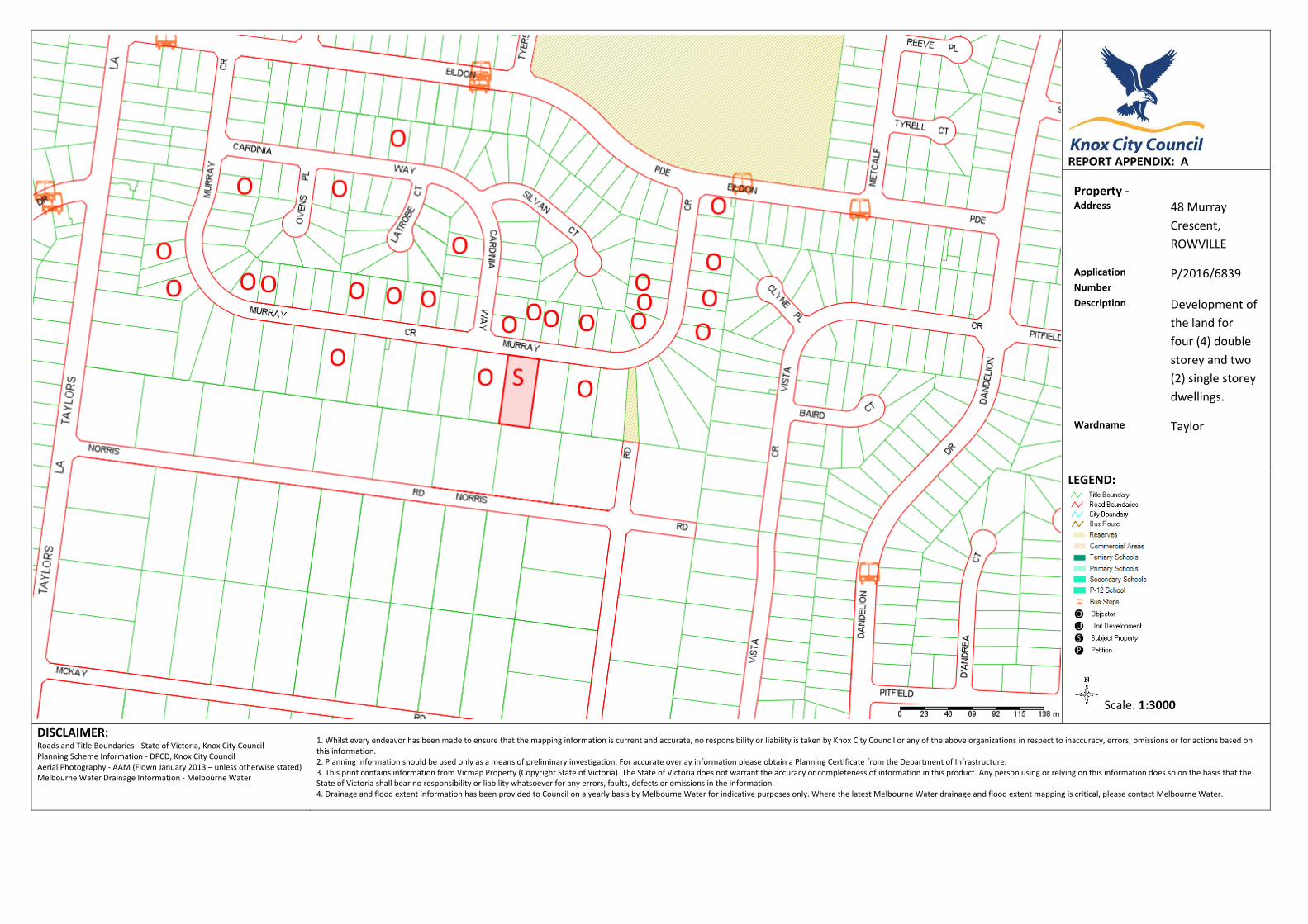
REPORT APPENDIX: A Property - Address 48 Murray
Crescent,
ROWVILLE
Application
Number P/2016/6839
Description Development of
the land for
four (4) double
storey and two
(2) single storey
dwellings.
Wardname Taylor
LEGEND:
Scale: 1:3000
DISCLAIMER: Roads and Title Boundaries - State of Victoria, Knox City Council Planning Scheme Information - DPCD, Knox City Council Aerial Photography - AAM (Flown January 2013 – unless otherwise stated) Melbourne Water Drainage Information - Melbourne Water
1. Whilst every endeavor has been made to ensure that the mapping information is current and accurate, no responsibility or liability is taken by Knox City Council or any of the above organizations in respect to inaccuracy, errors, omissions or for actions based on this information. 2. Planning information should be used only as a means of preliminary investigation. For accurate overlay information please obtain a Planning Certificate from the Department of Infrastructure. 3. This print contains information from Vicmap Property (Copyright State of Victoria). The State of Victoria does not warrant the accuracy or completeness of information in this product. Any person using or relying on this information does so on the basis that the State of Victoria shall bear no responsibility or liability whatsoever for any errors, faults, defects or omissions in the information. 4. Drainage and flood extent information has been provided to Council on a yearly basis by Melbourne Water for indicative purposes only. Where the latest Melbourne Water drainage and flood extent mapping is critical, please contact Melbourne Water.
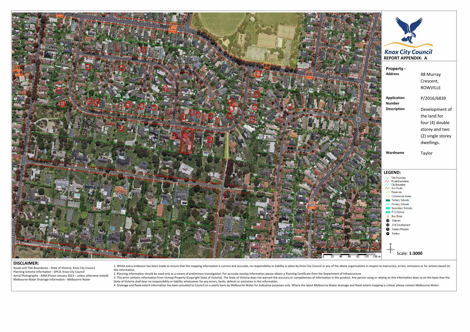
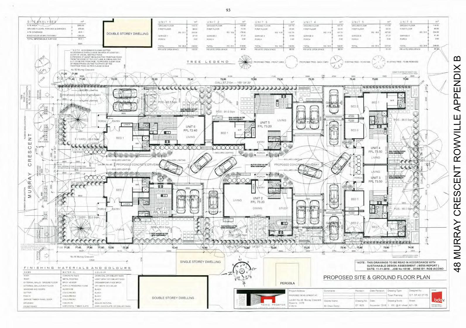
S I / N A L E llDc U N I T 1 m4 U N I T 2 m2 U N I T 3 rn U N I T 4 m U N I T 5 m4 U N I T 6 m4
S T E A R E A - . J L - > —
2 V T T
CIPOJND FLOOR t 1 6 7 0 GROUND FLOOR 10300 G R O U N D F L O O R 1 0 7 7 0 GROUND FLOOR 10770 G P O J N D FLOOR I I I 50 GROUND FLOOR 11400
G R O U N D FLOORS PORCHES & GARAGES 0 7 8 8 7 F RUT FLOOR 8 8 3 0 F ROT FLOOR 7 2 0 0 F PST F L O O R 0 0 0 0 F P S I FLOOR 0 0 0 0 F F I T F L O T H 5 6 0 0 F R S T FLOOR 9000
SITE COVERAGE —
G A DOUBLE STOREY DWELLING
SO 2 2 1 2 0 5 0 0 SO 188 7 5 0 0 SO 1 1 6 1 0 7 7 0 5 0 I I 6 1 0 7 7 0 SQ ISO 1 6 7 5 0 SO 2 2 0 20400
BUILDING D R A E W A F PATHWAy ' IDE, DO GARAGE I 3 7 0 0 GARAGE 3 7 2 0 GARAGE 3 2 4 5 0 GARAGE 4 2 4 5 0 G A R A G E S 3 7 2 0 GARAGE 6 4140
TOTAL IMPERMEABLE S U R A C E I 6 3 0 P O R C H 3 6 0 F O R C E 2 3 0 PORC- I 2 3 0 PORCH 2 3 0 PORCH 2 3 0 PORCH 360
0300 TOTAL SO 2 6 4 2 4 5 6 0 T O T A L 5 0 231 2 1 4 5 0 T O T A L SQ 1 4 9 1 3 4 5 0 TOTAL SQ 1 4 5 13450 TOTAL I Q 2 2 3 2 0 7 0 0 TOTAL S O 2 6 8 24900
I — N O T E A C C E S S W A Y S S - l O W S DOTTED P P VATS OPEN SPACE 1 0 0 0 0 P R VATE OPEN SPACE 8 3 5 0 P R O A T E OPEN SPACE 8 8 0 0 PR VOTE OPEN SPACE SBUS RI SO P P VATE OPEN SPACE 55
ACCESSWAYS SHOULD HAVE A N A R E A AT LEAST 50 CLEAR OF V ISUAL OBSTRUCTIONS X T E N D N G A T LEAST ' M A L O N G T H E IIRONTAGE ROAD
5 ' R O M
T H E E D G E O ~ EXIT LANE & 2 5 M A L O N G THE V T FROM THE FRONTAGE T O PROVIDE CLEAR V I E W T R E E L E G E N 0 PROPOSED T R E E F R O N T YARD PROPOSED T R E E B A C K Y A R D 9 EXISTING TREE T O RETAIN I ES ST ING TREE T O E S REMOVED
OF PEDESTRIANS ON T H E O O T P A T H OF T H E -' 0 THONTAGE ROAD AS P E R CLAUSE 5206-8
N V 5 0 M u r r a y Crescent-----------
x
-
-
IX 71 0 7160 - - - -
-
- S S
I I P1 I I I I I I F I I X Al
-
7 j l S
p220 7240 7260 72 1,00 i 7 V 5500 3700
73,00 73.20 7 3 . 4 0 7 3 6 0 VV
70 I O / L L 6 2107 149 04
100~ E D - 0 P E T E - % P H I V 5 t4
BED 1 qrn
71
R N N 45§u*
6000 75Q
PAIN GARDEN A8 PER 7 1 M _ _ 8 E & ! I A 8 8 E a
NEXT L I V I N G ' ( D B E p6s
_ _ _
_ _ _ _ _
J$
nimimr.
7240
A Z F / 'APE) BED 1 AITOHEN
LILIIING
UIIIG
00 E N T I
77
ILLI WIP ENS 6 5 T H
P 7 — I /1 I IV
UNIT4
W °i —BOLL APO L 0 8 7 1 1 FFL73 50
BEE$MSWr LIVING
BESS ABBESS.
2 SD 2500 U 101 N O
-I 'FOR O H UNIT 3 E L I /
METE
: °
In z
BED ENTRY
Fi 850 ' U 2
I
/ = I A 0 5 00 UNIT 2
I I BED 72
H F J /p IFFIL 73.20
TUDY
/ P 3 o I I I l l - -
T I T BEDS
7-7 fl 0 0 / I LIV4N
41
I
7 0 9
I / 1 0 0 7 t20 .40 iLtso i . 8 0 72o00 72 .0 72.40 0 / I L5 1 2 . 8 0 -
1 73.40 .
/7138Q 73.80 74.00 2500
OX N o 4 6 M A r r a y O r e S - s o l
5110 -
- 13000
0 5
-
4060 - -230
3 -
3 6 9 0
- -
0 1 5
I I I l l .1111711
12900
-r SINGLE STOREY DWELLING NOTE: THIS DRAWINGS TO BE READ IN ACCORDANCE WITH I
" \ SUSTAINABLE DESIGN ASSESSMENT ( B E S S REPORT) F I N I 5 H I N G M A T E R I A L 5 A N 0 C 0 L 0 U R 5 0 DATE: 11-11-2016 JOB No:16100 DONE BY: ROB IACONO N A M E M A 7 E P A L C O L O J P
/
7774
P 0 M E T A L R O O ° J N O L I G H T O P A E O R S M K A R F N I S H P R O P O S E D S I T E & G R O U N D F L O O R PLAN
T E P N A L WALLS G R O U N D FLOOR SPICE VENEER C R E A M / B R O W S FACE BRICk PERGOLA
EXTERNAL WALLS-F IRST FLOOR ACRYLIC RENDERED FOAM OFF WHITE OR S M LAR
WINDOWS A N D D O O R S ALUM1N UM BLACK I 5- ro le I A d d m O o n r m e i r t o R e o s o r r D a t e - R e v i s i o n D r a w i n g T y p o D e s i g n e d by
GUTTER COLOURBOND BLACK
F 0 5 0 A COLOURBOND B L A C K I P R O P O S E D DEVEL P M - S T V T _ _ _ _ _ _
T o w n P1311111116 C T DP AD 27178 GARAGE T IMBER PANEL D O O R C O L O J R B O N 2 BLACK -
DOUBLE STOREY DWELLING U I L o t 9 4 1 N o 4 MAr14y C r e s c e n t C l i e n t s N a m e D r a w m g N o D a l e D r a W r r g S c a l e Shept
DRIVEWAY CONCRETE SEALED NATURAL I P wn l I - ?178
N.
F R O N T FENCE HORIZONTAL I MBEP SLATS DOPE C H O C O L A T E OR SIMILAR Ill-/ID/s L T O V V c t o r a M r C h a t ) D e r r y l C T 1 6 2 5
1 NJSAembe 2 0 1 0 1 100 @A I s h e e t A o l 199
48 M
UR
RA
Y C
RE
SC
EN
T R
OW
VIL
LE A
PP
EN
DIX
B
93
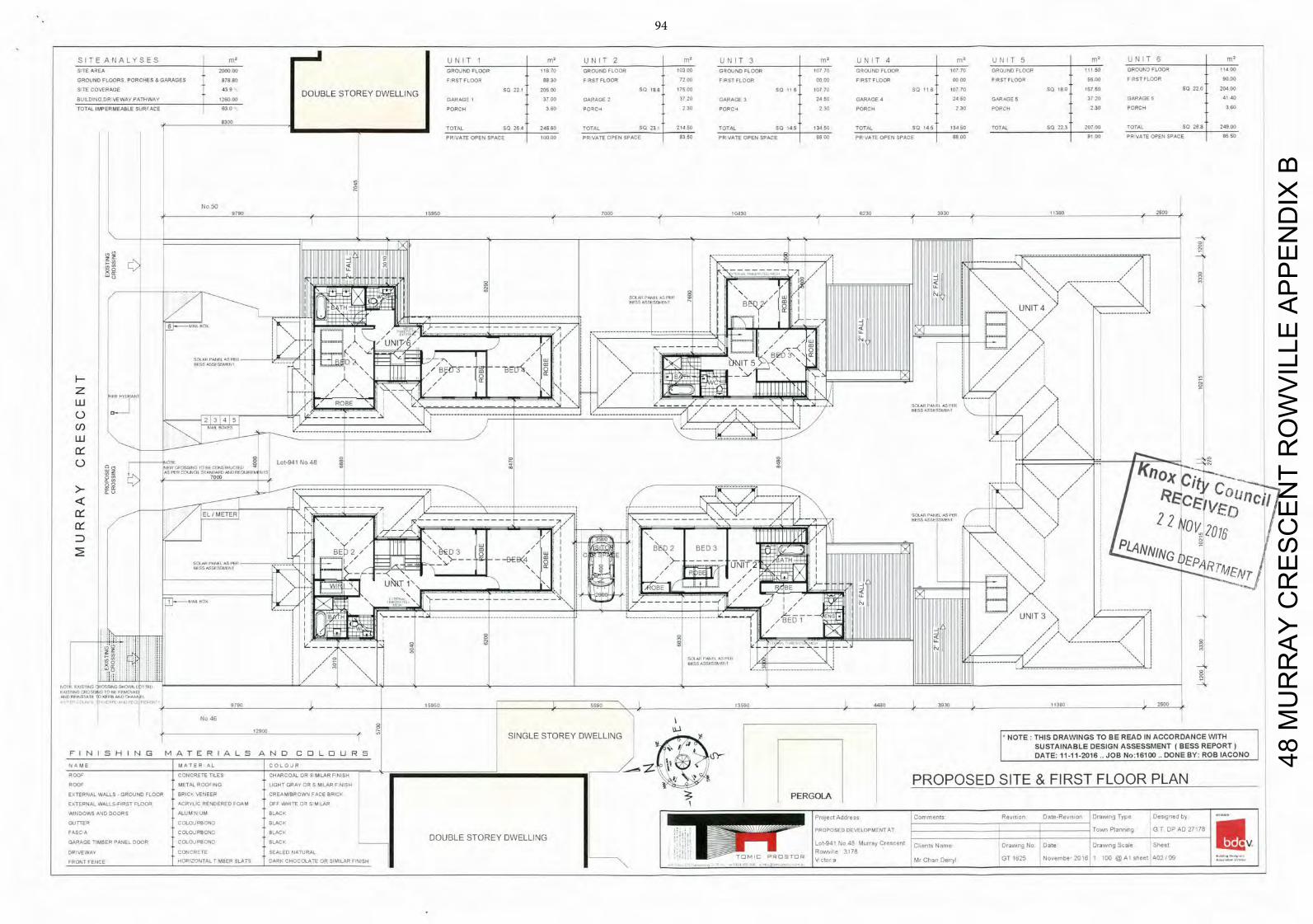
S I T E A N A L Y S E S rnR U N I T 1 m R U N I T 2 f l U U N I T 3 m ° U N I T 4 m ° U N I T 5 m R U N I T 6
S:TE A R E A 2 0 0 0 0 0 G P O J N D FLOOR 1 16 70 G R O U N D FLOOR 10300 G R O U N D F L O O R 1 0 7 7 0 GROUND FLOOR 1 0 7 7 0 G P O J N D FLOOR 111 50 GROUND FLOOR t 1400
G R O U N D FLOORS. P O R C H E S S GARAGES 8 7 8 8 0 7 P S T FLOOR 8 8 3 0 F R S T FLOOR 7 2 0 0 F P S I FLOOR 0 0 0 0 F ROT FLOOR 0 0 0 0 F ROT FLOOR 5 6 0 0 F R S T F L O O R 9000
S T E C O V E R A G E 4 0 9 DOUBLE STOREY DWELLING
SO 221 2 0 5 3 0 SQ 1 8 6 1 7 5 0 0 S Q 1 1 6 1 0 7 7 0 S Q 1 1 6 1 0 7 7 0 5 0 1 8 0 1 6 7 5 0 SQ 2 2 0 20400
BUILDING D R V E W A Y P A T H W A Y 2 6 0 0 0 GARAGE I 3 7 0 0 GARAGE 2 3 7 2 0 GARAGE 3 2 4 5 0 GARAGE 4 2 4 5 0 G A R A G E S 3 7 2 0 GARAGE 0 4140
TOTAL IMPERMEABLE S U R A C E 6 3 0 P O R C H 3 6 0 P O A C H 2 3 0 PORCH 2 3 0 PORCH 2 3 0 PORCH 2 3 0 PORCH 360
8300
1 OTAL SO 2 0 4 2 4 5 5 0 TOTAL S Q 231 2 1 4 5 0 TOTAL SO 145 1 3 4 5 0 TOTAL S Q 1 4 5 t
1 3 4 5 0 TOTAL SQ 2 2 3 2 0 7 0 0 TOTAL SO 2 6 0 24900
PR VATE OPEN SPACE I 1 0 0 0 0 PR VATE OPEN SPACE 8 3 0 0 P R VATE OPEN SPACE 1 8 8 0 0 PR VATE OPEN SPACE 1 8 8 0 0 1 9 1 0 0 PR NATE OPEN SPACE 8550
N o 50
9790 15950 7050 10430 6230 3930 11380 2500
H - - -
/ II
- -1
-oX
__777---
U N I T
UNIT/ V7
2 -
ui
_ U : - - i Z T h i T T h
H
0 0 0 NRA SI'OSSINS GEE CCNS1PECIEI L o t - 9 4 I N o 4 8
Z AS PER GISUNOT STANDARD ANT) VESLIA1YA NIS I ' 7 C . 7000
Cio Ity co E T E R i - - - - - -
_ _ i 4 1 \
SANAN PANEL AS
NOV 201' 22 A10
BE~ 2,11
Irl 11 P-11 AS 1111 UNIT
F
E
_ _ cro -
U B . T 1 " \ '7
.
; ; - 1 i l I / / / ' • E A L t j.7
SON
PASTING TJTG30S TO AN DEDENFIT
t A ' .
I "I I F 1, kA'E'I
. . . . . . . . . . . . .
~ y
jr
/E3 E UNIT 3
---------------
----------------------
Ic
AlIT) ITEASIAlE T IIEFIB AND 0EANlF! • I : L , I C ' E , - 9790 15960 5590 ' 0 3590 440E 3935
/ 11500 2500
N o 46
12900 5 SINGLE STOREY DWELLING THIS DRAWINGS TO BE READ IN ACCORDANCE WITH %R17"
; SUSTAINABLE DESIGN ASSESSMENT ( B E S S REPORT) F I N I S H I N G M A T E R I A L S A N D C 0 L 0 U R I DATE: 11-11-2016.. J O B No:16100 .. DONE BY: ROB IACONO N A M E M A T E R A L COLOJP
P 0 0 ' CONCRUTE TILES C H A R C O A L U P S MILAP F 51SF _ _ _ _ _ _ _ _ _ _ _ _ _ _ _ _ _ _ _ _ _ _ _ _ _ _ _ _ _ _ _ _ _ _ _ _ _ _ _ _ _ _ _ _ _ _ _ ' E ' \ P R O P O S E D S I T E & F I R S T F L O O R PLAN
P 0 0 ' METAL R O O ' I N O L IGHT O R A l O P S MILAP F 0)150
ENTERNAL WALLS - G R O U N D FLOOR SPICE VENEER C R E A M / B R O W S FACE BRICE PERGOLA
EATERNAL WALLS-F IRST FLOOR ACRYLIC RENDERED FOAM OFF W H I T E GA S LAP
WINDOWS AND D O O R S A L U M UM BLACK o 5 e 5 t A d J l . : ) T o o r n e e t s R e v i s i o n D a t e - R e - A I S l o o D I A A I r l g T y p e D e s g e e d by
GUTTER C O L O J R B G N D BLACK
FASC A COLOJPB014 BLACK PROPOSED OF EL P 1 _ _ _ _ _ _ _ _ _ _ _ _ _ _ _ _ _ _ _ _ _ _ _ _ _ _ _ _ _ _ _ _ _ _ _ _ _ _ _ _ _ _ _ _ _ _ _ _ _ _ _ _ _ TSWI RI G T D P A D 7178
GARAGE TIMBER PANEL DOOR COLOJRBOTIT SLACK DOUBLE STOREY DWELLING L o t - 9 4 ' O s 4 7 M s : 1 o 4 Y N o ' 1 t 2110105 N a m e OrRoAlIlfi N . D a t e D r a w i n g S s e l e S h e e t U S •V
DRIVEWAY CONCRATE SEALED NATURAL -
R o : w o e 7 ' 7 ) I I O U
0 0 G T I 6 ' 5 t J - - - '0I1I00'30AlhtAQGTEI F R O N T FENCE HORIZONTAL I HOER SLATS DARE C H O C O L A T E O R SIMILAR ElILOi-T V 0 II Mo C h a o 0011)1 5 0 . 0 - I
48 M
UR
RA
Y C
RE
SC
EN
T R
OW
VIL
LE A
PP
EN
DIX
B
94
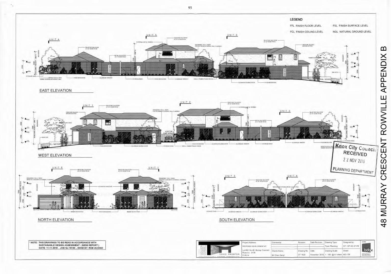
LEGEND F F L F I N I S H F L O O R L E V E L F S L F I N I S H S U R F A C E LEVEL
F C L F I N I S H C E I L I N G L E V E L N G L N A T U R A L G R O U N D LEVEL
U N I T 5 U N I T 6
U N I T 4
I r _ _ _ _ M d T M 0 m E M T
EXTETLEAL METAL S , ' 1 1 1 1 1 -
S P I E C I P O E I I A I.00E
EAST ELEVATION
U N I T 2 SRECTIEDlc&ROOF A T ' T R O C A PIlOT
U N I T 1 S P U - I N ) IILfrROOP A l . - P A T E N A U T A 1 ACE
TPI~ c c U N I T 3
jA\ AT 25 ROC*
PIT%
______________________________________________________________
AT, OF
________ II EL --MEIFP - P OX City C o b i l c
ii
WEST ELEVATION RECEIVED
2 NOV 2Ui U N I T 6 U N I T 1Al- PLANNING DEPARTMENT
U N I T 3 U N I T 4
C O A C A — I R N A L AE
o
I I
T OTP
_ _ _
•
_ _ _
_ _ _ _ _ ___
__ V
Big_
V - i
A md A— Oil
t; ALI" ,
NORTH ELEVATION SOUTH ELEVATION
T THIS DRAWINGS TO BE READ IN ACCORDANCE WITH SUSTAINABLE DESIGN ASSESSMENT (BESS REPORT) DATE: 11-11-2016 JOB No:16100 DONE BY: ROB IACONO
48 M
UR
RA
Y C
RE
SC
EN
T R
OW
VIL
LE A
PP
EN
DIX
B
95
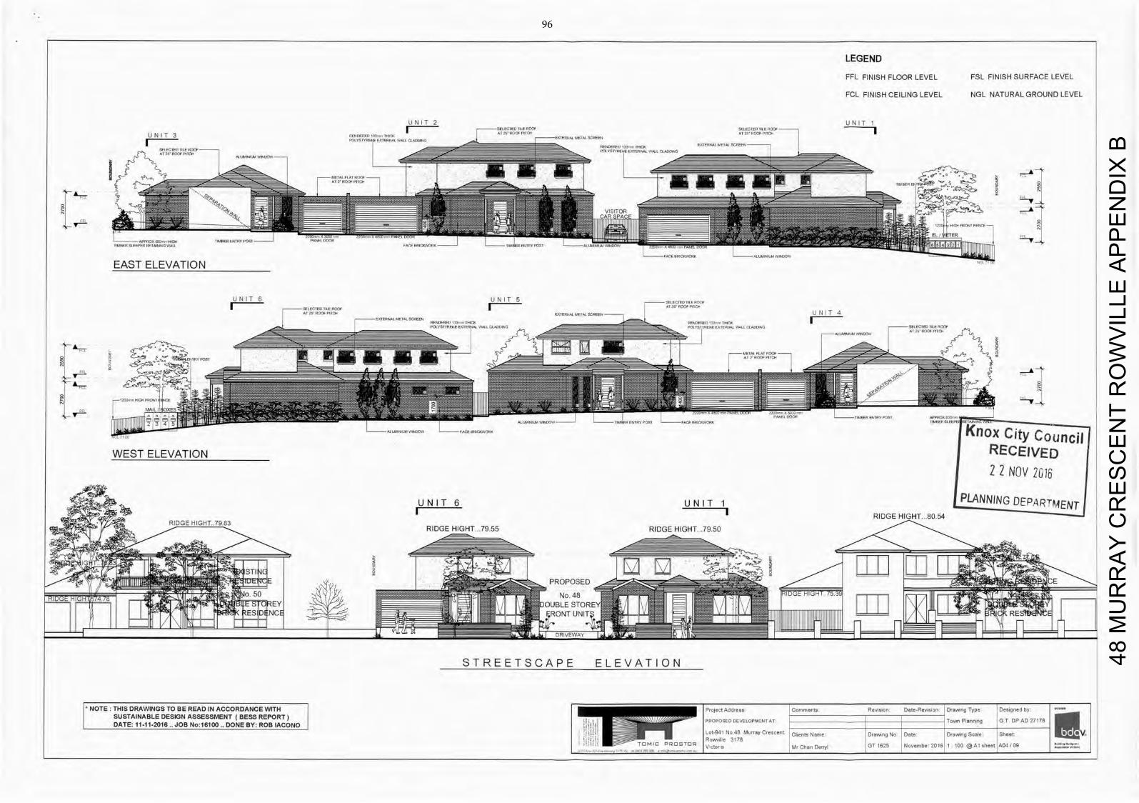
LEGEND
FFL FINISH FLOOR LEVEL FSL FINISH SURFACE LEVEL
FCL FINISH CEILING LEVEL NGL NATURAL GROUND LEVEL
U N I T 2 U N I T 1
U N I T 3 I C I) JF I
To H 6 177 372
EAST ELEVATION
UNIT 6 U N I I 5 I i f . I
I 2 1 Pilo,
C I 2S U U P I T A I X T E R U A I M E T A l & i 4 l f E t - U N I T 4
A
I T 111-
01
MA ILdBOXES- P A M I PCI 4
- i l l - U I I I ITT 1 1 A l II
2 1 - PlPlU =PLANNIN ii
WEST ELEVATION
U N I T 6 U N I T 1 I I RIDGE F-IIGHT.80.54
RIDGE HIGHT.7983 R I D G F H H T 7 f l R I D G E H I G H T 79.50
IGH STI 0o
1-IBLE STOREY -RONT LIN WEM y FL- DRIVEWAY
S T R E E T S C A P E ELEVATION
NOTE: THIS DRAWINGS TO BE READ IN ACCORDANCE WITH I Project Address Comments Revisiorl Date-Revision D r a n g Type Designed by SUSTAINABLE DESIGN ASSESSMENT ( B E S S REPORT) j PROPOSED DEVELOPMENTAl _ _ _ _ _ _ _ _ _ _ _ _ _ _ Town Planning G T OP AD 27178 DATE: 11-11-2016 JOB No:16100 DONE BY: ROB IACONO
I - - Lot-941 No 48 Murray Crescent Clients Name Drawmng No Date Drawmng Scale Sheet
L - Rowvi le 3178 I C P R O E T O R
V c tora Mr Chan Ce ryl 3 1 1625 N embe 0 16 1 100 @ A I sheet A04 /09
48 M
UR
RA
Y C
RE
SC
EN
T R
OW
VIL
LE A
PP
EN
DIX
B
96
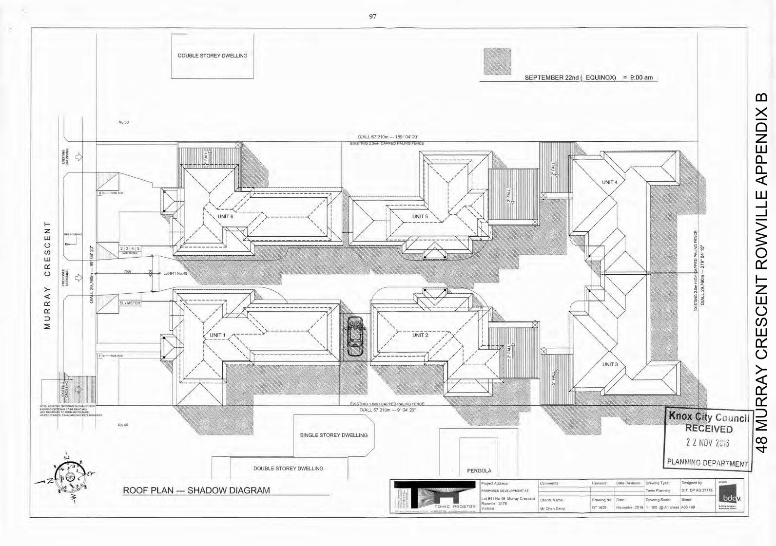
DOUBLE STOREY DWELLING
SEPTEMBER 22nd ( EQUINOX) = 9:00 am
48 M
UR
RA
Y C
RE
SC
EN
T R
OW
VIL
LE A
PP
EN
DIX
B
97
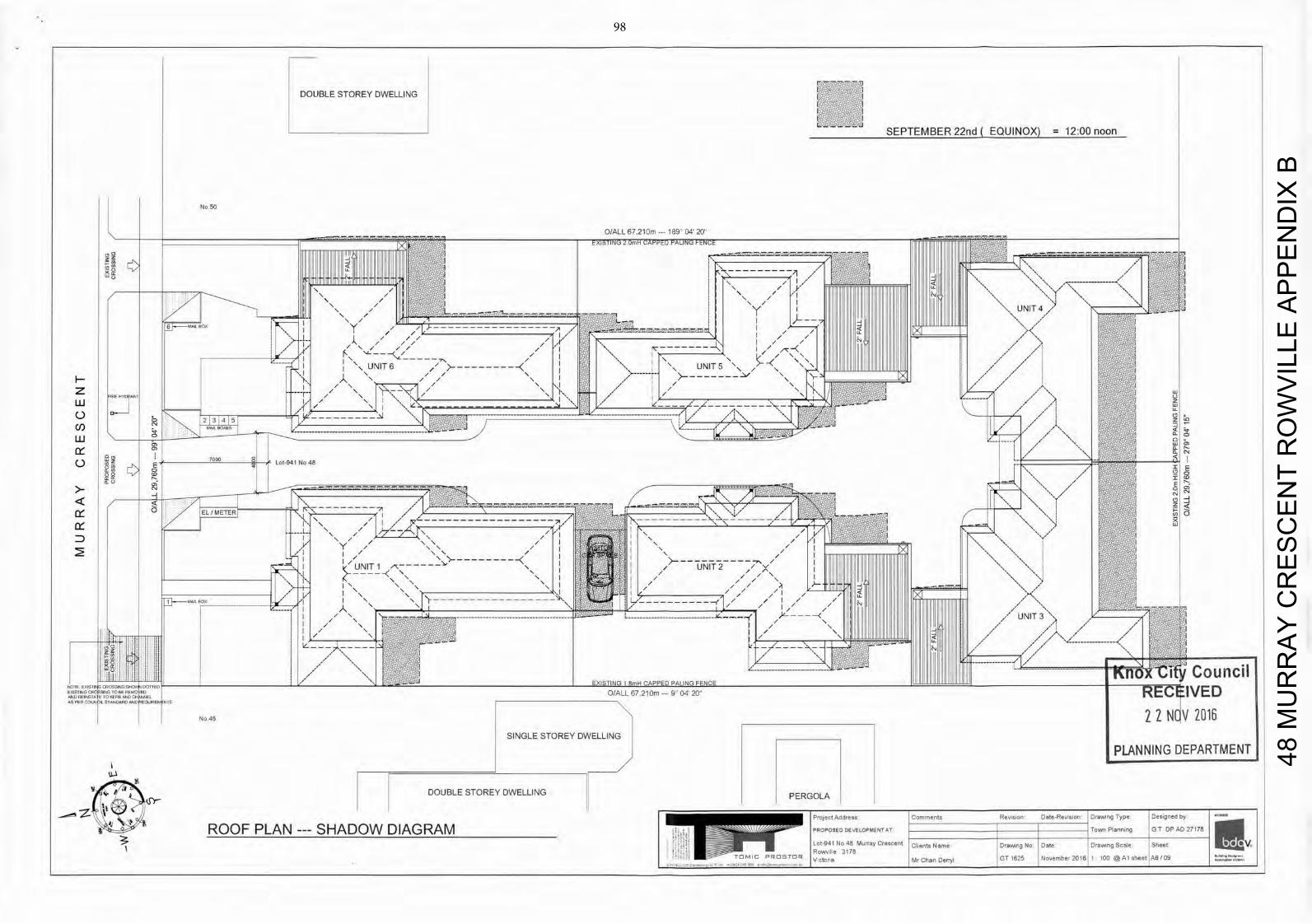
No 50
DOUBLE STOREY DWELLING
SEPTEMBER 22nd ( EQUINOX) = 12:00 noon
0/ALL 67,210m --- 189 04 20
// I I il1i I I DHII V I I I III 11111 IlIIIIIIIIIIIIIIIIIIIII I 11111 [IIIIIIIIIIIIIIIIMII U'JII I /
I ' \ 1 L TZLLI
r
/
LU uj
7000 I Lot-941 No 48
o o 5 ,/
/
° EL METE
--------------------
UNIT 1 I LI ,/--:xc I \ - - / 1HV• 1110111111 rIO lull L
71
- - Council 1, EXISTING 1 8mH CAPPED PALING FENCE
0 0/ALL6721Om 9 0420 REC IVED A S 1 - 0 C O L N 1 L 5 1 0 1 0 0 0 0 0 1 W
I F-1- N 11
No 46 2 2 NO V 2016 SINGLE STOREY DWELLING
PERGOLA
FPLANNING DEPARTMENT I
DOUBLE STOREY DWELLING
ROOF PLAN --- SHADOW DIAGRAM
48 M
UR
RA
Y C
RE
SC
EN
T R
OW
VIL
LE A
PP
EN
DIX
B
98
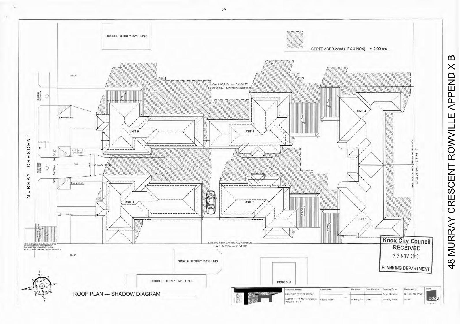
DOUBLE STOREY DWELLING PERGOLA
Project Address Comments Revision Dote-Revision Drawing Type Designed by
ROOF PLAN SHADOW DIAGRAM P R O P O S E D D E V E L O P M E N T A T i i i i i i i Town Planning C T DP AD 27178
Lot-941 No 48 Murray Crescent Clients Name Drawing No Date Drawing Scale Sheet e - I Powv, le 3178
48 M
UR
RA
Y C
RE
SC
EN
T R
OW
VIL
LE A
PP
EN
DIX
B
99
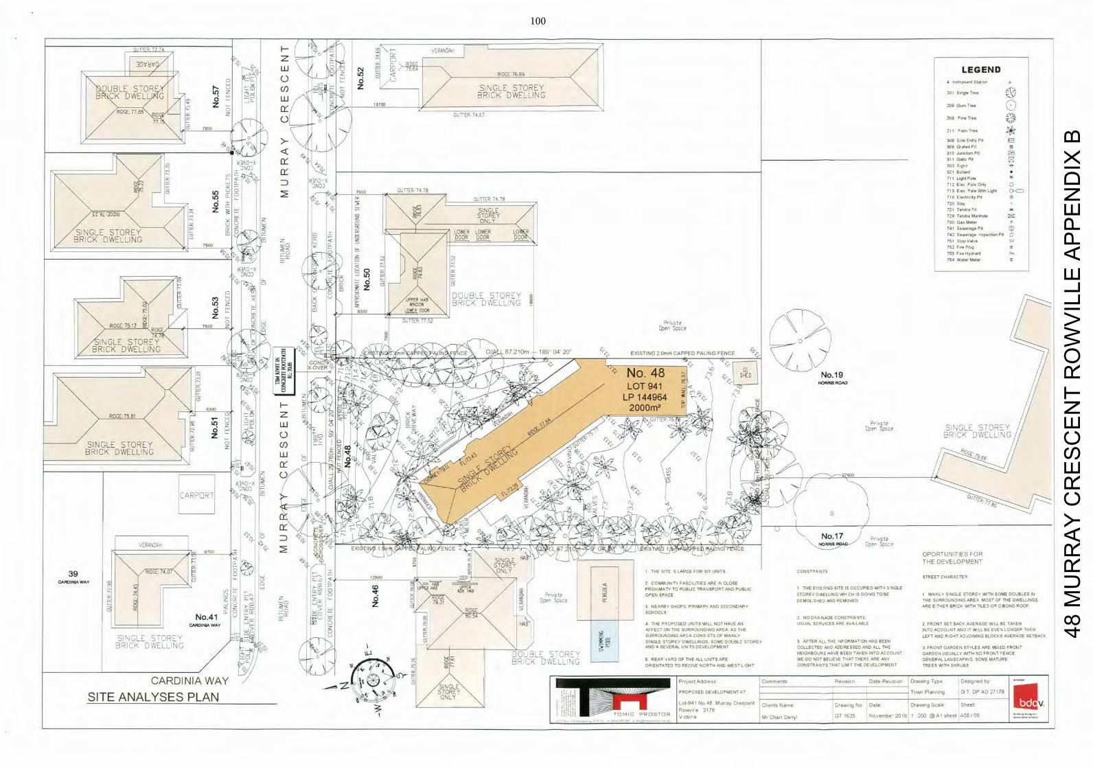
-
RI GE: LEGEND
OUBLE STOR — — Z SINGLE STOREY
1 12~ NORRIS ROAD
K DWEL E - BRICK DWELLING 201 Single Tree
Gum Tree
RIDGE: 7 7 8 I D G
z U w j 3
'ER 7 0 7 208 line Tree
o
77.1
I S e Entry PI
3 0 9 G r a t e d PI
310 J S Pit
Q - I 311 GhcPit
N 503 Sgrs
521 BoIIrd
— N 3 A O - X 711 U9EIPole
7N07 712 E l . , Polo Only 0 Quo
I.0 8 I 7 4 7 8 713 Elen ' S I C 15591 LIght
'N 0TTEO ' 4 7 ' 716 ElocIrIcIty Pd 51
00018 \ 1 / TeIU Manhole z O N L Y 730 G a Meter
741 Se.e,.ge Pit
SINGLE TOREY 00 L O W E R L O W E R L O
;41 S1111a,1 El
of DOOR DOOR DOO BRICK DWELLING 51 Stop VaN, sv 750 8
Pt
Go
754 W Meter z at
B I 1K 11 LI
Nl::<
3 0 0 —
N-H/. S
H /NG
A E R \ DOUBLE STOREY
/ BRICK DWELLING 0DOW Lf)
- 22 8300 LOSER DOOR
/ Z C U T O R 0 5 2 P Yvete RIDGE 75 1' RIDGE
7600 Z Dper SoAcy
INGLE STOREY ~O/ 0 B R I C K D W E L L I N G 6721Dm 189 2 0 " E I S T I N C O W H C A P P E D P A L I N G F E N C E NJ
LOT 941 NJ Dw
6300 2 z 3z
76.
0' Open space
0' BRICK DWELLING 0 M SINGLE STOREY
BRICK DWELLING E
I L I P 14496 0 0 O M 2 .2
CARPDRT
VERUN0A4 < S T T I A t ; K S ' 7 J . r 0 / Y i'soY 4 NORRILS -
Re— I 0 E X I 0 T / I PC P L I N Q J E N C E
— . ' Q L 7 a o - 4 - 0Lo I 50 6755
I L \ , / OPOPTUNITIES FOR S I N G L E T H E DEVELOPMENT STOREY
3 9 ' N /RIDCE: 74.07 P I T J . 7 / 1 , .
O N L Y I THE SITE S LARGE F O R Sl i t UNITS CONST°-A NITS
5 179170 -
DOOR I
- STREET CHARACTER
c , O I N I A W A Y = I 6 A 8 5 : . 2 C O M M U N TY FASCILITIES ARE N CLOSE
I L N UP HAD N E R ItAB PROXIMATY T O PUBLIC T R A S S P O R T A N D PUBLIC 1 THE EXISTiNG SITE IS OCCUPIED WiT - I S.NGLE
Pt' COP 0 EN SPACE STORES DWELLING WH CH IS GOING T O BE 1 M A N L Y SINGLE STORES WITH SOME DOUBLES IN
5 ' I 1 / D Z : _ 0 = 7931 I Oper SUCCE I D E M O L S - I E D AND REMOVED THE SURROUNDING A R E A M O S T OF THE DWELLINGS
I I -
Z . '—a I I 3 NEARBY SHOPS. PRIMARY A N D SECONDARY A R E E T H E R BRICK WITH TILED OR C/BOND ROOF
I
p a I RIDGE > I I SCHOOLS 8054 2 N O D R A N A G E CONSTRAINTS,
CARDINIA W A Y NAB 4 THE PROPOSED UNITS WILL N O T HAVE AN USUAL SERVICES ARE A V A LABLE 2 F R O N T SET BACK AVERAGE WILL BE TAKEN
LJ>I dw AFFECT ON THE S U R R O U N D NO A R E A AS T H E INTO A C C O J N T A N D IT 51 LL BE EVEN LONGER THEN El
SI NJ 0 1 F N T O N . — I ' SURROUNDING A R E A CONS STS OF MAINLY L E F T AND R 0 - I T ADJOINING BLOCKS AVERAGE SETBACK
P I 5 - i < - SINGLE STOREY DWELL INGS SOME DOUBLE STOREY 3 A F T E R ALL THE N P O R M A T O N HAS BEEN A N D A SEVERAL U N TS DEVELOPMENT COLLECTED HAD ADDRESSED AND A L L THE 3 F R O N T G A R D E N STyLES ARE MIXED FRONT
DCI N — NEIGHBOURS HAVE BEEN TAKEN INTO A C C O U N T G A R D E N USUALLY WITH NO F R O N T =1111E
/ — / i P E A ' - C HF T H E A L L UNITS ARE WE DO NOT BELIEVE T - I A T T H E R E ARE A S K GENERAL LAP/SCARING SOME MATURE V . . 1 -
F — ' - 7 - - 7 P E ' I V E N T H , - [ , W 1 E H J Q I / 5 0 0 0 1175 THAT LIM T THE D E V E L O P M E N T TREES WITH SHPIJBS li
C A R D I N I A W A Y ' N
I [ P o J e c t S i I i C o m m e o t s R e v i s i o n D a t e - R e S I S I S E D r a w i n g T y p e D e s , g i , e d by
/ SINGLE
SITE ANALYSES PLAN S T O Y
T P R O P O S E D JEL NT T S A R P150,1109 G T D P A D
— 178
ONLY
I L o t 9 4 1 11 0711 I C l In ICS N a o , o DIEXI,o --L 1j, _-'t ' 0155109 Scale S h e e t
I N
V
I PoARII - V C I M r C h a o De r r y l 0 7 l o -- ' . , o Y r y e 2 0 1 6 1 200 @ A l s h e e t A08/09
48 M
UR
RA
Y C
RE
SC
EN
T R
OW
VIL
LE A
PP
EN
DIX
B
100
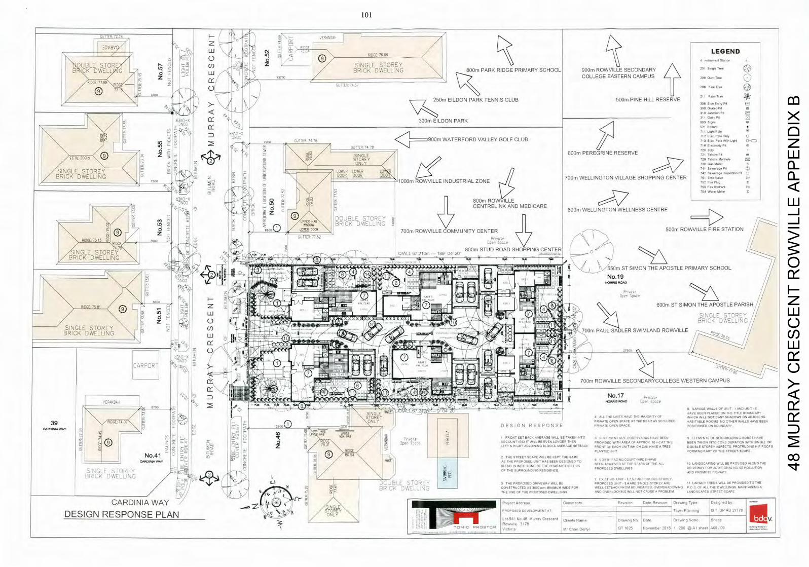
UJI RIDGE 76.69 LEGEND
OUBLE STOR T Ln Z SINGLE STOREY not :nt.b0n
NORRIS ROAD lie
RIDGE: 75.81 7 6 0 0 m S T S I M O N T H E A P O S T L E PARIS
B CK DWELL G L O BRICK DWELLING 800m PARK RIDGE PRIMARY SCHOOL 900m ROWVILLE SECONDARY 201 $ gI T
COLLEGE EASTERN CAMPUS GoTe RIDGE: 77,88
z z
IDG 208 line Tree
7.1 7800
250m EILDON PARK TENNIS CLUB 500m PINE HILL RESERVE 211 I m Tree
>- j 308 Side Entry Pit
< 3 0 1 9 0 Jum,h.n Pit
yw__ 3 Grated Pit
311 Gat, Pit z A O X -
300m EILDON PARK
N. — <
Botard
: - 0 O X
s . ) 711 LIght Pole
74 9OOm W A T E R F O R D V A L L E Y G O L F C L U B WthL9h
720 Stay
7900 Lf)Lq 74
0 716 El t 6y Pt
N. / / T h 4 ' 600m PEREGRINE RESERVE / 9 ]DGI8
SINGLE / - S T O R E Y 729 Telotro Manhole
N.. O N L Y 730 0 4 0 Meter 0
/ SINGLE STOREY -_ LOWER LOWER
< O R 4 2
S : w : r : e n n enbonPrt 0 BRICK DWELLING z < S
y
DOOR DOOR
1 0 0 0 r n R O W V I L L E I N D U S T R I A L Z O N E 7 0 0 r n W E L L I N G T O N V I L L A G E S H O P P I N G CENTER
800mRO
75d Wate r Meter 0 U D Q 0 753 F n e H y d r 4 n t Err
C E N T R E L I N K
c") "P HAB DOUBLE STOREY /
K DWELLING F
/
ER
1
:i~
< da~
V ==>
L 0 R DOOR 70Cm R O I L L M U N I T Y G E N T E R
AND MEDICARE 60Cm WELLINGTON WELLNESS CENTRE
R O F I R E STATION /
8 00 W V I L L E Q 7L
G T X R ' . 5 2 : -
V RIDGE 75 1
RDT 76 Z
INGLE STOREY - . . - - 8 0 0 m STUD ROAD SHOPPING CENTER
0
, 4 0
. . r r [ 21 r -- lrr O-o 20"0
BRICKDWELLING H
_
_
_ _
L T S I APOSTLE P SCHOOL
ONO,
SINGLE STOREY cf) 7 0 0 m P A U L S A D L E R SWIMILAND ROWVILLE LU
NOD
CARPORT
700m ROWVILLE SECONDARYCOLLEGE WESTERN CAMPUS
I VLRA\DAU
E • ,
NORRJIS D :pHe
/
B GARAGE WALLS OFUNIT-1 A N D UNT-6
s c,_: I - .0.
_ _ _ _ _ _ _ _ _ _ _ _ _ _ HAVE BEEN PLACED ON THE TITLE BOUNDARY , / _ C 5 S T Y _ _ _ _ _ _ _ _ _
4 ALL THE UNITS HAVE THE MAJORITY OF W H I C H W LL N O T CAST SHADOWS ON ADJOIN NG ORE
39 \ / R I D G E : 74.07 ., - i : i 1 O N L Y PRIVATE OPEN SPACE A T THE REAR AS SECLUDED HABITABLE ROOMS S O O T H E R WALLS HAVE BEEN
CA3INLeO W A Y ,
J
- 12950 0 E S I G N R E S P D N S E P R VATE OPEN SPACE POSITIONED ON BOUNDARY
Er - CD r- UP 698 UPPER -
'0 1 / = 0 - . - NON 669 A cr o c o p E B I F R O N T S E T BACK AVERAGE WILL BE T A K E N INTO S SUFFICIENT SIZE COURTYARDS HAVE BEEN 9 ELEMENTS OF NEIGHBOURING H O M E S HAVE
(9) Z 0 -o Z 0 N 7 p 7 7 S p o c e A C C O U N T A N D IT WILL BE EVEN LONGER T H E N P R O V I D E D WITH A R E A OF APPROS 10 rn2 A T THE BEEN TAKEN INTO CONS DERATION WITH SINGLE OR
5 2 . . I L E F T & R IGHT ADJOIN N O BLOCKS AVERAGE SETBACK F R O N T OF EACH S N I T WHICH CAN HAVE A TREE D O U B L E STOREY ASPECTS PROTRUDING HIP 90005
, . . , RIDGE > I PLANTED IN IT r O R M NO P A R T OF THE STREET-SCAPE
No.41 _ (9) 05 2 THE STREET SCAPE W I L L BE KEPT THE SAME
W A Y I-lAB AS T H E P R O P O S E D U t ! T HAS BEEN DES GNEO TO 6 NORTH FAC NG COURTYARDS HAVE
- Er c S 1W B L E N D I ' I WI SOME OF THE CHARACTERISTICS BEEN ACH EVED A T THE READS OF THE ALL IS LANDSCAPING W LL BE P S O V DIED A L O N G THE
SINGLE -
- -
12 = P R O P O S E D DWELLINGS DRIVEWAY F O R A D D T O N A L N O S E POLLUTION
B UK Er A - U / =
OF T H E SURROUNDING RESIDENCE A N D P R O M O T E PRIVACY
/ i _.J5 50rU- E r r 7 ES STING UNIT - I 2 NB ARE DOUBLE STORES
- C GD - 3 T H E P R O P O S E D DPISEWAY WILL S E PROPOSED J N I T - 3 4 A R E S NGLE S T O R E T A R E 11 LARGER TREES WILL BE PROVIDED TOTHE
C O I S T R U C T E J AS JOYS MIII MUM WIDE FOR WELL SETBACK FROM BOUNDARIES O V E R S H A D O W NO P O E OF ALL THE DWELLINGS MA STAIN NO A
I
4077 I t - Er THE USE OF THE PP.TPTYEL DWELLINGS 0110 0 0 0 L 0 E r I ING WILL N O T CAUSE A PROBLEM LANDSCAPED STREET UrrAPE
C,ARD I N I
-
-
SINGLE I ITSYJCC1 A d d r e s s Cor r r rne r r IS F e r r 81017 D a t e - R e v i s i o n D r a w i n g T y p o D e s i g n e d by
D E S I G N R E S P O N S E P L A N S T O R E Y F R O P O S E D D E V E L P M S T A f IT505I1PIOTISIVgGTDPAD2HONLY
I 1 . 0 7 - 9 4 7 N o 4 8 M s r r a y C r e s c e n t 01101515 N a n rr D r s n j N o C-ole I D raao rng S c a n S h e e t
N.
P w r l I e 3178 - O N O N T O Er V c t o r a M r C h — C - r r y I C T I H . . o t J - . . , . -mbe 2 0 1 5 1 2 0 C @ A l s h e e t A09109
48 M
UR
RA
Y C
RE
SC
EN
T R
OW
VIL
LE A
PP
EN
DIX
B
101
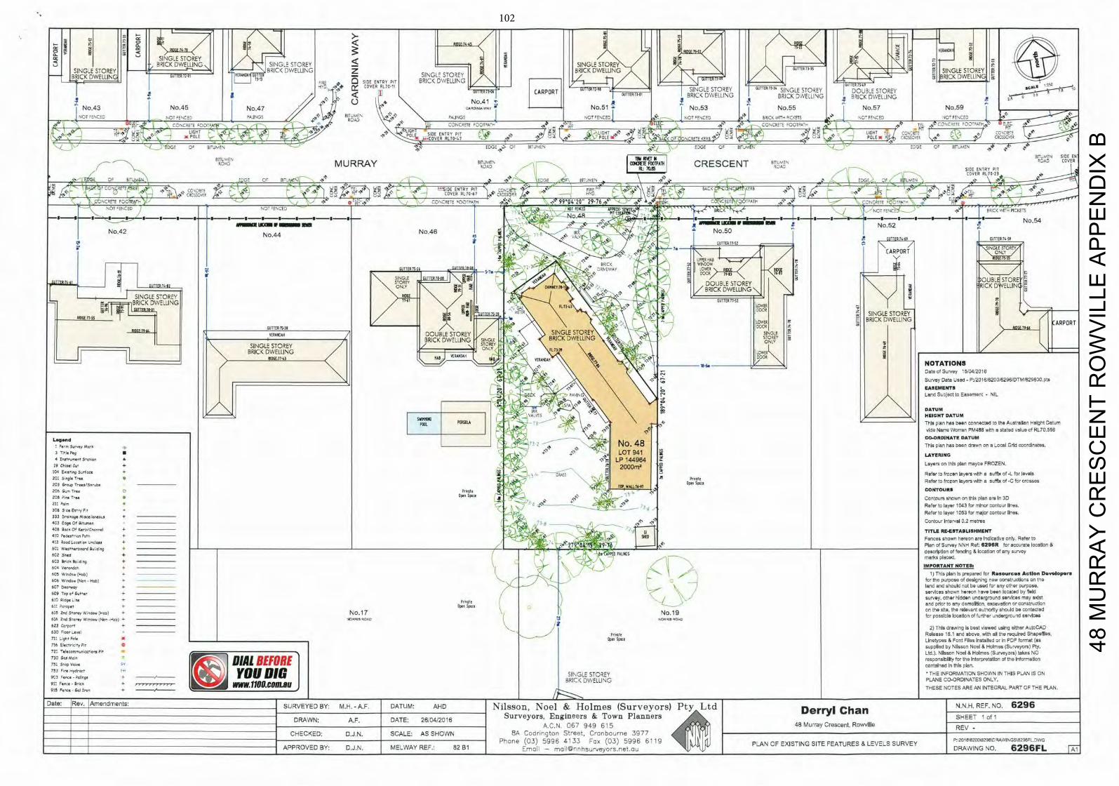
E5 4-7
SINGLE STOREY -ec BRICK-DWELLING SING-- STOREY
< T SINGLE STOREY GUTTER 73-35 0
B R I C K
L J
11TTER11 11
7VERANDA
Dft 73-13
SIDE ENTRY PIT GUTTER 75-49
D W E L L I N G , 9
J~TEIR
jL11
LE STOREY
0
$
-I COVER RLTDII DU11ERTJ6 CARPORT T T E R T 3 O I S I N I G L ~ STOREY
49 & J T T E R I E E N G S T O Y DOUBLE STOREY 71
BRICK DWELLING BRICK DWELLING No.41 4R
N o r 1 1 T GS ALINGS NCT
TEL 0ATb 1NCRaTE 10D PIT PIT
101 P 51 DE ENTRY PIT 3E CN=E
PIT- OLE
0 RI Jrv
SE < Br-MEN EDGE 3r_ EDG E
arrustv SIDE EN
/ BIROADTLvvN M U R R A Y EITJrv/\ -
f N T E 1 P A 1 H C R E S C E N T BElLMEN
SIDE ENTRY PIT
R A 0 COVER
I - COVER RL7023 01
1 E \ E ) ' TECAI
N O T :ENCE~ ERIC W~
° - "T i5k
I t ' — I — I - - S — S — I - - - I — - I - - S — I 1 - - ( — I — I — S S I I U No.54 LKAM 9No.52
No42 N 4 No46 IN N050 o . 4 .
. . I j TI_fiSt? GUTTEP-1S58 I
e l l *
GUTTER
CARP UPPER
BRICK WINDOW GUTTER 75-26 r~ LOWER
IT T
ES DOOR 79-1
STOREY 11 UBLE RE NNNNY
NGLESOR
ONLY CHIMNEY311-1 DOUBLE STOREY
_
_ _
J o
R0s;0I
f l .
BRICK DWELLING\
BRICKDWE.JNG I 'N.,/'e5! Z - & . \ OWER
OUIITRTh39 - 000?
SINGLE STOREY LOME
I GUTTER 5,38 INS
S I N G L S T O u Y / 1
V DOOR
SINGLE STOREY
BRICK :WELLING ARPOR1
ING BRICK DWELLING STOREY
BRICK DWELLING / I I 7 R.5 \FL7j8 \ f l R 7 OWE? -
T ' N
D' -
79 10
I I ROSE l I • 6 ) / I ie J VERANDAH IN? REaliSe NOTATIONS
Dale of Survey 5,04/2016
Survey Data Used - P02016/6250/6296/DTM'629600.prs
\ \ . EASEMENTS ' Land Subject to basement - NIL
S A DATUM IRR
v A r y ' HEIGHT DATUM This plan has been connected to the Australian Height Datum side Name Woman PM488 with a stated value of RL70.55E
CO-ORDINATE DATUM Lsflvd5vnrsy Met6 ,
.
N o . 4 8 This plan has been drawn on a Local Grid coordinates.
3 lisle Peg U - - LOT 941 LAYERING : El'.ti L I 144964 Layers on this plan may08 FROZEN.
tO' Eeeng Surfers 5 - oeot 0 Refer In frozen layers with e suffix of .L for levels S -
IN op. Sp.. Refer to frozen layers will' a suffix of -C for crosses
3C3 GrxpTreaa/5n'ubs sC,q'FV TOP1 WALL 6-97 CONTOURS 206 r - Tree 0 Prhat,
208 Fire I-se ON' Conrours shown on this plan are In 30 211 'are * T0(
- - .' Refer to layer 1043 for minor contour lines. 308 3 as E r r , Pr Refer Inlayer 1053 for major contour lines.
403 EarpQfRur,rsrr Contour interval 0.2 meires
413 ;Zocd Loceiah t - l - +
SHED Fences shown hereon are Indicative only. Refer to
+ Plan of survey N N H Ref: 6 2 9 6 R for accurate location
PA Not - descdpUxn of e x * & i c c 8 0 4 n o f any survey
T I T L E RE-ESTABLISHMENT
6CI W - 1 - - d ! SvNd~nq
A S
I
102 Seed 4' Ne fe maths placed.
603 85CC B u d s 9 + .
IMPORTANT NOTES. SC' Vs,'sxdah + NOT Whtd,v iHebi -
. - ' - '
i I " \
. z ' ' 1) This plan Is prepared for Resources Act ion Davelopern 606 Wind05 INes - H bI 4 for ISV purpose of designing new constructions on 115 607 One >l_
_ - - '
\ - . . . I ' land and should not be used to' any other surpose. meay ______________ / services shown hereon have been locared by laid 509 Isp e' Vsrnm +
survey. other hidden underground services may exist 6 0 ax9. re + " h a t e ) and prlcr in any dernoliitcri, excavedon or construolion 611 F s ' n e s + ope Sp-n 615 2nd Sterey w i n . - Onset + No.17 No.19 on the ste. the relevant eulnorfly should be contented
for possicie localion of further underground services 516 Rid Sterey W,ndoe iNst -i-vol + 4 0 - 1 5 noun 1 - 1 1 noun 623 + / 2> This drawing is best viewed using either AuIoCAD 630 EleorLensl Pnnele Release 15.1 and above, w i l l all the required Shepeflies, 711 L1a6 PsIn OP er Sp ece Linetyoes & Fcnl Files installed or in PDF format (as 716 E l . - , 59 P t supplied by Nilsson Noel & Holmes (Surveyors) Pty. 72: ' a se,nsr,x,50",o'rB Ltd.). Nilsson Noel & Holmes (Surveyors) takes NO 730 GneN 1 DIAL BEFORE 1 responsibility for the Interpretation of the Information
_ _ _ _ _ _ _ _ _ c o n t a l i e d In this plan.
k i J YOU DIG I S I N G L E S T O R E Y T H E I N F O R M A T I O N S H O W N IN
B R I w E i N G PLANE CO-ORDINATES THIS PLAN IS ON
911 Fence' Byns A 11OO.COflL9U J THESE NOTES ARE AN INTEGRAL PART OF THE PLAN. 915 Fs,rze .041 Ctes + — / . - - . - - - - -
Date: _Rev. _Amendments: SURVEYED BY: M.H.-A.F. DATUM: AHD N i l s s o n , N o e l & H o l m e s ( S u r v e y o r s ) P t y L t d Der '" I Chan N.N.H. REF. NO. 6296
DRAWN' A F DATE- 26/04/2016 S u r v e y o r s , E n g i n e e r s & T o w n P l a n n e r s SHEET 1 o f 1
A.C.N. 067 949 615 48 Murray Crescent, RowvIIIe REV - CHECKED D.J.N. SCALE: AS SHOWN 8A Codrin9torl Street, Cranbourne 3977 Phone (03) 5996 4133 Fax (03) 5996 611 PLAN OF EXISTING SITE FEATURES & LEVELS SURVEY 2015'6200\6296\DRAWIPsGSIR2SCFLJWG
APPROVED BY: D.J.N. MELWAY REF.: 82 81 E m a i l - moil©nnhsur'veyors.net.ou
4
DRAWING NO, 6 2 9 6 F L FAI
48 M
UR
RA
Y C
RE
SC
EN
T R
OW
VIL
LE A
PP
EN
DIX
B
102
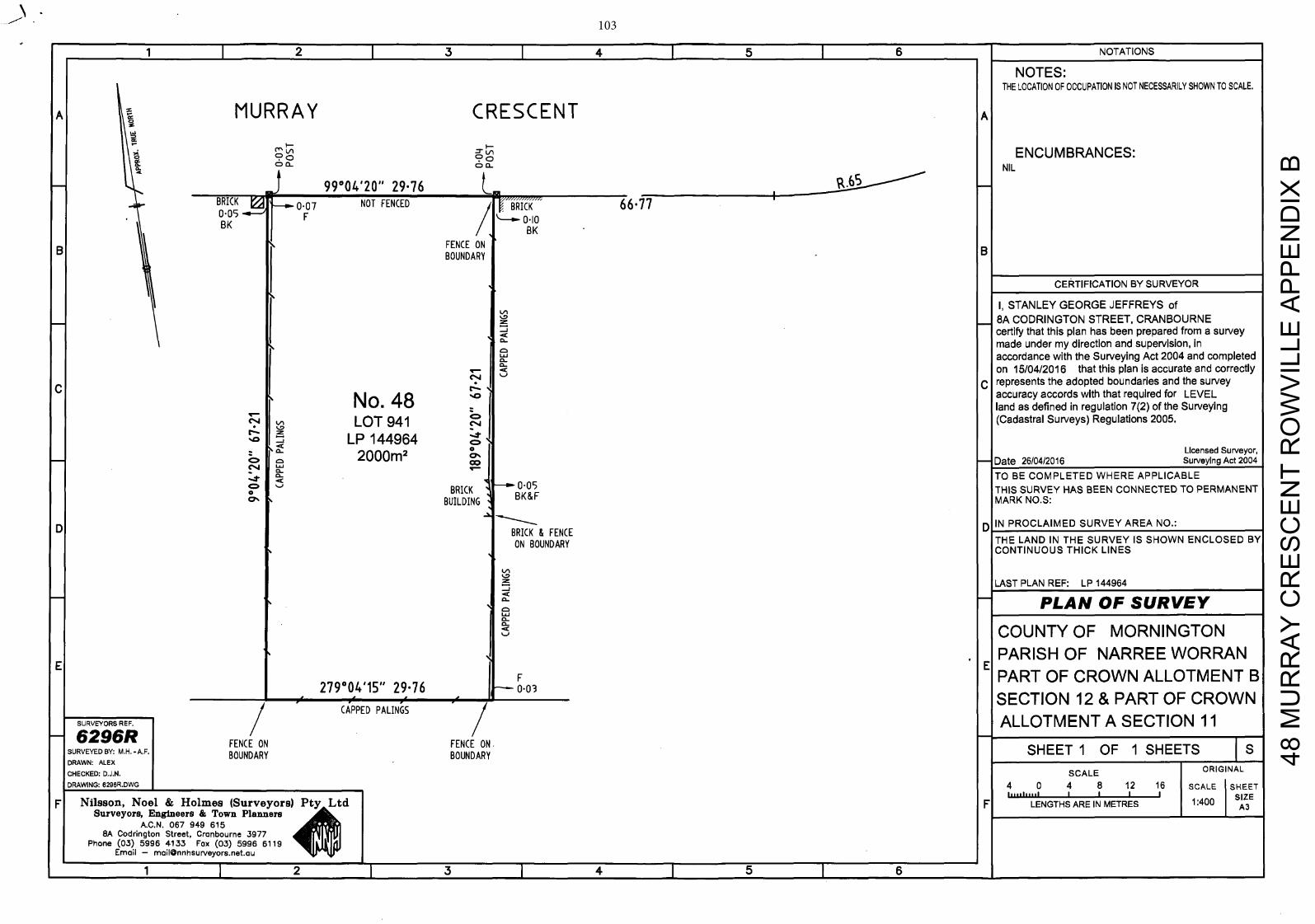
1 I 2 I 3 I 4 I 5 I 6 I NOTATIONS
NOTES: THE LOCATION OF OCCUPATION IS NOT NECESSARILY SHOWN TO SCALE.
MURRAY CRESCENT A A
9Ln ENCUMBRANCES: NIL
0
2 _
99°04'20" 29•76 BRICK T 0-07 NOT FENCED BRICK 667 0.05 F BK / BK
BI FENCE ON Ii' BOUNDARY 1 lB
CERTIFICATION BY SURVEYOR
I, STANLEY GEORGE JEFFREYS of
- 8A CODRINGTON STREET, CRANBOURNE certifythat this plan has been prepared from a survey - —J
made under my direction and supervision, in W accordance with the Surveying Act 2004 and completed 0
on 15/04/2016 that this plan is accurate and correctly Li
C represents the adopted boundaries and the survey
No. 48 ' ° accuracy accords with that required for LEVEL land as defined in regulation 7(2) of the Surveying
LOT 941 c.i (Cadastral Surveys) Regulations 2005. N O LP 144964
- C L 2 0 0 0 m 2 0 Licensed Surveyor,
- Date 26/04/2016 Surveying Act 2004 Cl-
TO BE COMPLETED WHERE APPLICABLE L i BRICK 005 THIS SURVEY HAS BEEN CONNECTED TO PERMANENT 0
BUILDINGtB
BK&F MARK NO.S:
DI RICK & FENCE D IN PROCLAIMED SURVEY AREA NO.:
ON BOUNDARY THE LAND IN THE SURVEY IS SHOWN ENCLOSED BY CONTINUOUS THICK LINES
LA
-
LAST PLAN REF: LP 144964 0 - PLAN OF SURVEY Uj 0
Li COUNTY OF MORN INGTON
E PARISH OF NARREE WORRAN
E F
279°04'15" 29•76 PART OF CROWN ALLOTMENT B
- 6 2 9 6 R
/ CAPPED PALINGS SURVEYORS REF.
/ SECTION 12 & PART OF CROWN ALLOTMENT A SECTION 11
FENCE ON FENCE ON. SURVEYED BY: M.H.-A.F. BOUNDARY BOUNDARY SHEET I OF I SHEETS I s DRAWN: ALEX
CHECKED: D.J.N. SCALE ORIGINAL DRAWING: 6296R.DWG
F Nilsson, Noel & Holmes (Surveyors) 4 0 4 8 12 16
I SCALE SHEET
I I I , , I l , , , I I I I I I I A3
S u r v e y o r s , E n g i n e e r s & T o w n Planners A.C.N. 067 949 615
L t d F LENGTHS ARE IN METRES 1:400 SIZE
8A Codrington Street, Cranbourne 3977 Phone (03) 5996 4133 Fox (03) 5996 6119
E m a i l - [email protected]
4
1 1 1 1 2 I 3 I 4 I 5 I 6
48 M
UR
RA
Y C
RE
SC
EN
T R
OW
VIL
LE A
PP
EN
DIX
B
103
104 COUNCIL – CITY DEVELOPMENT 26 June 2017
TAYLOR WARD 6.4 APPLICATION FOR THE DEVELOPMENT OF THE LAND FOR FOUR (4)
DOUBLE STOREY AND TWO (2) SINGLE STOREY DWELLINGS AT 50 MURRAY CRESCENT, ROWVILLE (P/2016/6744)
1. SUMMARY:
Land: 50 Murray Crescent, Rowville Applicant: ARG Planning Proposed Development: Development of the land for four (4)
double storey and two (2) single storey dwellings
Existing Land Use: Single Dwelling Area/Density: 1990sqm/1:332sqm Zoning: General Residential Zone – Schedule 2 Overlays: Nil Local Policy: Municipal Strategic Statement (MSS)
Development in Residential Areas and Neighbourhood Character Policy
Application Received: 12 October 2016 Number of Objections: 33 PCC Meeting: 20 April 2017 Assessment:
It is considered that the proposal provides an appropriate balance between the need for additional housing within an established residential area and the amenity of occupants and adjoining residents.
The proposal generally complies with the Municipal Strategic Statement (MSS), the Development in Residential Areas and Neighbourhood Character Policy and ResCode.
The proposal complies with the General Residential Zone - Schedule 2. On balance it is considered that the proposal responds well to State and Local Planning Policies, subject to modifications. It is recommended that Council issue a Notice of Decision to Grant a Planning Permit, subject to conditions.

105 COUNCIL – CITY DEVELOPMENT 26 June 2017 6.4 50 Murray Crescent, Rowville (cont'd)
2. BACKGROUND
2.1 Subject Site and Surrounds
The location of the subject site is shown in Appendix A.
The subject site is located on the southern side of Murray Crescent, in Rowville.
The site is regular in shape with a street frontage of 29.67 metres.
The site currently contains a single dwelling with associated outbuildings.
Access to the site is via a single crossover, located along the eastern side of the site.
The site is sparsely vegetated along the side and rear boundaries with smaller trees and shrubs located within the front setback.
The land is surrounded by residential properties, developed generally with large dwellings on large lots.
2.2 The Proposal
(Refer to attached plans at Appendix B) It is proposed to construct six (6) dwellings on the land. Four (4) dwellings will be double storey, and two (2) dwellings will be single storey. Details on the proposal are as follows:
Dwellings 1 and 6 front Murray Crescent and will be setback a minimum 9 metres from the front boundary.
Dwellings 1, 2, 5 and 6 are to be double storey with a maximum height of 7.8 metres. Dwellings 3 and 4 (located to the rear) are to be single storey in height.
Dwelling 1, 2, 4, 5, and Dwelling 6 contain four (4) bedrooms, while Dwelling 3 contains three (3) bedrooms.
A proposed driveway and crossover, centrally located, provides shared access to all Dwellings.
106 COUNCIL – CITY DEVELOPMENT 26 June 2017 6.4 50 Murray Crescent, Rowville (cont'd)
All dwellings are provided with a double garage. A visitor parking space is located to the west of the shared driveway between Dwellings 1 and 2.
Private open space has been provided at ground level for each dwelling, with a minimum area of 80 square metres.
The dwellings are to be constructed with face brickwork at ground level, rendered first floors and pitched tiled roofs.
Existing boundary fencing is nominated to be retained.
All existing vegetation is shown to be removed.
3. CONSULTATION
3.1 Advertising
The application was advertised by way of a sign on the site and notices sent to adjoining property owners and occupiers. Thirty-three (33) objections to the application were received, and are summarised below:
Neighbourhood character
Council’s Development in Residential Areas and Neighbourhood Character Policy identifies the subject site within a Knox Neighbourhood Area, where areas will continue to be low-scale, characterised by detached houses, dual occupancies and some villa unit developments on lots greater than 1000sqm. These areas will also continue to retain their green and leafy identify through retention of front and back yards and the establishment of a garden setting, including canopy trees. The proposal would provide for a villa unit development on a block, with front, side and rear garden areas in the form of private open space, that can accommodate the planting of canopy trees to establish a garden setting. It is considered that the proposal is consistent with Council’s preferred future character for the Knox Neighbourhood area. An assessment against this Policy and the design guidelines is at Section 4.2.2 of this Report.
Integration with low density zone
Whilst it is acknowledged that the site boarders (to the rear) a low density zone. It is noted however that the development has been reduced to single storey at the rear to better integrate with surrounding development The proposal has been assessed against Clause 22.07, Neighbourhood Character. An assessment against this Policy is at Section 4.2.2 of this Report.
107 COUNCIL – CITY DEVELOPMENT 26 June 2017 6.4 50 Murray Crescent, Rowville (cont'd)
Development is inconsistent with the Housing Policy
The Local Housing Clause of the Municipal Strategic Statement (Clause 21.05) recognises that the population of Knox will grow by 12,000 persons and 15,000 households to 2030. The Housing Policy directs the provision of a diversity of housing types and forms; housing that meets the needs of all groups within the community; and accessible housing that is well designed and responsive to the local character and environment. An assessment against the MSS is at Section 4.2.2 of this Report.
Relocation of crossover
The proposal has been referred to Councils Traffic and Assets departments for comment. No concerns have been raised in response to the proposed location of the crossover on the site. A condition on any permit issued would require the crossover the match the proposed driveway width.
Bulk and massing of buildings
The first floors of the dwellings have been setback from ground floor areas, particularly adjacent to sensitive residential interfaces consistent with Council’s Development in Residential Areas and Neighbourhood Character Policy. In addition, setbacks to boundaries exceed the minimum required by ResCode Standard B17 and there are no walls on boundaries. The units at the rear of the site a single storey to reduce the impact on the development on lower density surrounds. As such, it is not considered that the proposal will result in adverse amenity impacts through visual bulk, to adjoining residential properties.
Loss of vegetation and trees and impact on fauna
The proposal seeks to remove all existing vegetation from the subject site. Council’s Arborist did not object to the proposed vegetation removal. It is noted the site is not a designated area of biological significance. The vegetation on site was not considered to be significant.
A condition of any permit issued will require a landscape plan in accordance with Councils Landscape Guidelines for Planning Permits. This will ensure adequate planting occurs within the front, side and rear open space areas of the proposed development.
108 COUNCIL – CITY DEVELOPMENT 26 June 2017 6.4 50 Murray Crescent, Rowville (cont'd)
Overdevelopment
The proposed development achieves the requirements of the Knox Planning Scheme, including Council’s Development in Residential Areas and Neighbourhood Character Policy, ResCode, the Schedule to the General Residential 2 Zone and car parking. As such, it is not considered an overdevelopment of the land. Refer to Section 4 of this report.
Overlooking and reduction on privacy for adjoining neighbours
The proposal has generally been designed to avoid overlooking and complies with the overlooking requirements of Standard B22 of ResCode.
Overshadowing
ResCode Standard B21 requires an assessment of overshadowing to ensure any overshadowing does not result in adverse amenity impacts. This is determined on shadows between 9am and 3pm on the Equinox (22 September). The proposed overshadowing complies with ResCode Standard B21.
Increase in traffic/parking congestion and inadequate parking
Council’s Traffic Engineers have not raised any concerns with the capacity of the street or surrounding street network to absorb the additional traffic that would be generated by the proposed development.
Car parking is provided in accordance with the ratio required by Clause 52.06. Two (2) car parking spaces are provided for each proposed dwelling and one (1) visitor parking space has been provided.
Safety for pedestrians and traffic
Council’s Traffic Engineers have not raised any concerns in relation to pedestrian or traffic safety that would be generated by the proposed development.
Limited public transport
Although the site is not directly serviced by public transport, there are bus routes within reasonable proximity of the site. The design does not propose a significant increase in density and is still considered to be low scale.
109 COUNCIL – CITY DEVELOPMENT 26 June 2017 6.4 50 Murray Crescent, Rowville (cont'd)
Precedent for more medium and high density development
An application must be considered on its own merits with consideration of the site context and requirements in the Planning Scheme at the time.
Previous VCAT decision in the area
An application is considered on its own merits and in accordance with the requirements in the Planning Scheme at the time.
Amenity impacts (including noise)/ Inconvenience of construction
The site is located within an established residential area where associated noise is a common feature of urban areas. The development will not result in an unreasonable increase in residential noise. Standard construction amenity conditions ensure that unreasonable impacts can be addressed if necessary.
Increase in crime
There is no evidence that the proposal will lead to an increase in crime. The proposal will impact on the lifestyle of the area
The area will remain a residential area.
Impact on views
There is no right to a view in the Planning Scheme. This is not a valid planning consideration.
Impact/devaluation on property values
This is not a valid planning consideration.
Waste management (including hard waste)
The application was referred to Council’s Waste Management Department who did not object to the proposed development. A condition of approval will require the submission of a Waste Management Plan to the satisfaction of the Responsible Authority.
Impact on infrastructure
No concerns have been raised with the capacity of the stormwater system by Council’s Drainage Engineers, provided a condition is included on any permit to issue that requires stormwater to be detained on site to peak pre-development flows.
110 COUNCIL – CITY DEVELOPMENT 26 June 2017 6.4 50 Murray Crescent, Rowville (cont'd)
Access for emergency services
The application has been referred to Council’s Traffic Department who have not raised any issues relating to access for emergency services.
3.2 Planning Consultative Committee Meeting
A Planning Consultative Committee (PCC) Meeting was held at the Civic Centre on 20 April 2017. Ten (10) people signed the attendance sheet at the meeting. One resident spoke in support of the development. Objectors expressed the following concerns with the proposal:
Traffic and safety.
Parking Congestion.
Insufficient infrastructure.
Neighbourhood character.
Impact to lifestyle.
There were no negotiated outcomes at the conclusion of the meeting.
3.3 Referrals
The application has been referred to internal departments for comment. The following is a summary of relevant advice:
Traffic Engineer
Standard conditions to be included on any permit issued.
Drainage Engineer
Standard conditions to be included on any permit to issue.
Assets
Crossovers to be reconstructed to Council standards and match width of proposed driveways.
Redundant crossing to be removed and kerb and naturestrip reinstated to Council Standards.
111 COUNCIL – CITY DEVELOPMENT 26 June 2017 6.4 50 Murray Crescent, Rowville (cont'd)
Landscape
Standard conditions to be included on any permit to issue.
Parks
The street tree proposed to be removed can be removed at cost to the applicant.
Waste
Satisfied Council can service the site.
Sustainability
Standard conditions to be included on any permit to issue.
Arborist
None of the trees proposed for removal require a planning permit.
The trees on site are mostly exotic species and are no significant.
4. DISCUSSION
This section considers the proposed development in light of the provisions of the Knox Planning Scheme including State and Local Planning Policies, any other relevant policies and objectives.
4.1 Zoning and Overlays
4.1.1 Zone
General Residential 2 Zone
The land is zoned General Residential Zone – Schedule 2. A permit is required for the construction two or more dwellings on the land pursuant to Clause 32.08-4 of the General Residential Zone – Schedule 2.
Schedule 2 to the General Residential Zone varies the ResCode requirements for Standard B13 (Landscaping) which requires a minimum of one canopy tree per 175 square metres of the site area including a minimum of one canopy tree within each area of secluded private open space and one canopy tree within the front setback per 5 metres of width of the site. Each tree should be required to be surrounded by 20 square metres of permeable surface with a minimum radius of 3 metres. Up to 50 per cent of the permeable surface may be shared with another tree.
112 COUNCIL – CITY DEVELOPMENT 26 June 2017 6.4 50 Murray Crescent, Rowville (cont'd)
It is considered that the proposed development can accommodate the required canopy tree planting; subject to conditions on any permit to issue.
Schedule 2 to the General Residential Zone also varies the ResCode requirements for Standard B28 (Private Open Space) which requires the provision of private open space consisting of a minimum area of 80 square metres including one part of secluded private open space at the side or rear of the dwelling with a minimum area of 60 square metres with a minimum dimension of 5 metres with convenient access from a living room.
Complies. All Dwellings are provided with over 60 square metres of secluded private open space with a minimum dimension of 5 metres and exceed the 80 square metres requirement of private open space.
Schedule 2 to the General Residential Zone also varies the ResCode requirements for Standard B32 (Front fence height) which requires a front fence height of 2m to a street in a Road Zone Category 1 and 1.2m to other streets.
Complies, no front fence is proposed.
Dwellings or residential buildings must not exceed a height of 9 metres (dependant on slope).
Complies. The maximum building height on site is to be 7.8 metres.
4.1.2 Overlays
No overlays apply to the land.
4.2 Policy Consideration
4.2.1 State Planning Policy Framework
State policy requires Council to integrate the range of policies relevant to the issues to be determined, and balance conflicting objectives in favour of net community benefit and sustainable development.
Key Policies:
Clause 15 Built Environment and Heritage – Encourages high quality architecture and urban design outcomes that reflect the particular characteristics, aspirations and cultural identity of the community; enhances liveability, diversity, amenity and safety of the public realm; and promotes attractiveness of towns and cities within broader strategic contexts.
113 COUNCIL – CITY DEVELOPMENT 26 June 2017 6.4 50 Murray Crescent, Rowville (cont'd)
The design of the development will make a positive contribution to the surrounding area, with built form considered to be appropriate in form and scale. The development incorporates important neighbourhood character features such as pitched roofs, brick finishes and car parking located behind or on the side of the proposed dwellings. Upper levels are reasonably articulated and are smaller than the ground level to reduce building bulk and mass.
Clause 15.02 Sustainable Development – Ensure land use and development is consistent with the efficient use of energy and the minimisation of greenhouse gas emissions.
The proposal contributes to the consolidation of urban development through the provision of increased density within an existing residential area.
Should a permit be issued, the development is required to be constructed in accordance with the approved Sustainable Design Assessment.
Clause 16 Housing – Encourage the development of well-designed medium-density housing that respects the neighbourhood character; improves housing choice; makes better use of existing infrastructure; and, improves energy efficiency of housing. Locate new housing in or close to activity centres and employment corridors and at other strategic development sites that offer good access to services and transport.
Neighbourhood character - This is discussed in a later section of the report (Section 4.2.2).
Housing choice – The development provides for dwellings with smaller open space areas than typical for the area contributing to housing choice.
Existing infrastructure – The site is located within a fully serviced and established area.
Energy efficiency – This has been discussed above under Clause 15.02.
114 COUNCIL – CITY DEVELOPMENT 26 June 2017 6.4 50 Murray Crescent, Rowville (cont'd)
Location – While the site is not located within an Activity Centre, it has access to a number of urban services within an established area. Subject to modifications, the subject site is capable of accommodating the proposed dwellings whilst making a positive contribution to the character of the area. Refer to the assessment against Council’s Neighbourhood Character Policy at Section 4.2.2 below.
Clause 18 Transport – Ensure that access is provided to all available modes of transport.
Bus route 691 is available along Eildon Parade to the north-east of the subject site.
The site is located within 330m of the following bus stop:
o The 691 bus route provides a service between Waverley Gardens and Boronia via Stud Park and Ferntree Gully. This service operates between 6:01am and 9:22pm Monday to Friday; between 7:30am and 6:59pm on Saturdays; and between 8:47am to 7:26pm Sundays, at various intervals.
4.2.2 Local Planning Policy Framework
Clause 21.01 Municipal Strategic Statement (MSS) – encourages planning and development occurring with the necessary consideration to such matters as managing population growth, encouraging sustainable development and influencing the urban form so that Knox itself becomes more sustainable.
All development therefore is encouraged to incorporate Ecologically Sustainable Design (ESD) and Water Sensitive Urban Design (WSUD) principles to ensure that a sustainable urban environment is ultimately achieved with a strong use of existing infrastructure and to reduce dependence on private vehicle travel.
The site is located in an established urban area reasonably close to urban services and open space areas, where existing infrastructure is readily available.
The development is designed to be respectful of the preferred neighbourhood character for the area, and provides sufficient setbacks. It responds appropriately to the constraints of the site and interfaces with the wider area. The proposal will also contribute to the landscape character of the area with new landscaping opportunities.
115 COUNCIL – CITY DEVELOPMENT 26 June 2017 6.4 50 Murray Crescent, Rowville (cont'd)
Living areas of the dwellings are open in nature and will receive adequate solar access, including the SPOS of the dwellings. The proposal will also not be detrimental to the energy efficiency of the adjoining sites.
Clause 21.04 Urban Design – Municipal Strategic Statement (MSS) To ensure that all development responds positivity to the existing patters of urban form and character, the landscape qualities, historic and cultural elements and social aspirations of the Knox community.
While the land is not in an Activity Centre, the proposal respects the preferred neighbourhood character and is consistent with the requirements of the MSS.
An assessment against Council’s Development in Residential Areas and Neighbourhood Character Policy (Clause 22.07) is below. The development complies with the open space requirements and provides opportunities for meaningful landscaping.
As highlighted above, the site is located in an established urban area reasonably close to urban services and open space areas.
Clause 21.05 – Housing This clause implements the Knox Housing Strategy 2015. In managing Knox’s current and future housing needs, Council supports a scaled approach to residential development. This scaled approach recognises that some parts of the City will need to accommodate change, due to population growth and the community’s changing household needs. Development in residential areas will need to respond positively to the desired future character of Knox. The strong landscape character is the unifying element of the neighbourhood character of Knox.
The subject site is located within a ‘Knox Neighbourhood’ area, which has a sense of spaciousness within the public and private realm. These areas will continue to be low-scale neighbourhoods, characterised by detached dwellings with large backyards which contribute to the area’s green and leafy character.
Objective 1 for Housing Objectives and Strategies is to support residential development in accordance with the Knox Housing Strategy 2013, which identifies a scale approach to residential development. The strategy is to direct housing growth toward Local Living and Activity Areas.
116 COUNCIL – CITY DEVELOPMENT 26 June 2017 6.4 50 Murray Crescent, Rowville (cont'd)
The site is not located in an Activity Centre. However, the site is sufficiently large to accommodate six (6) dwellings while achieving the open space and landscaping outcomes sought for the Knox Neighbourhood Character Area.
Objective 2 is to support a diversity of housing choice in appropriate locations. Strategies include encouraging a diversity of housing styles, types, forms and sizes to cater for the changing needs of the community.
The development would provide residents with alternative forms of housing styles and sizes.
Objective 3 is to ensure the quality of housing design in Knox is improved to better respond to neighbourhood identify and to create a stronger sense of place. Strategies include ensuring that residential development enhances the City’s “green and leafy” image, support development that makes a positive contribution to the preferred future character of the area and that is innovative, environmentally sustainable, accessible and site responsive.
Each dwelling is provided with areas of private open space, consistent with the Schedule to the General Residential 2 Zone, that will allow for canopy tree planting.
Objective 4 is to protect and enhance the landscape and environmental values of the nature areas of significance within the municipality.
The site is not located in an area of biological significance.
Objective 5 is to ensure that residential development better responds to the community’s current and future needs, and allows people to ‘age-in-place’ by supporting the provision of a diverse range of housing including smaller scale dwellings.
The development provides for dwellings with smaller private open space areas than typical for the surrounding area. All dwellings have services and a bedroom at ground level to improve accessibility for residents with reduced mobility.
117 COUNCIL – CITY DEVELOPMENT 26 June 2017 6.4 50 Murray Crescent, Rowville (cont'd)
Clause 22.07 – Development in Residential Areas and Neighbourhood Character: Knox Neighbourhood Area
The desired future character of this area is to:
Continue to be low-scale neighbourhoods, characterised by detached houses and dual occupancies; with some villa unit developments on larger blocks.
Retain their green and leafy identity and character through the retention of front and back yards, and the establishment of a garden setting that includes canopy trees.
The key design objectives are:
To retain and enhance the streetscape by the planting of appropriate trees on private land.
The setbacks and open space areas within the proposed design provide opportunities to plant new canopy trees. A landscape plan will be required as a condition on any permit to issue.
To avoid dominance of buildings from the street.
The development has proposed a setback of 9m along Murray Crescent. The setback allows for adequate canopy tree provisions to ensure buildings do not dominate the street frontage.
To avoid the loss of front and rear garden space.
The proposed dwellings are generally setback from the side and rear boundaries, which will ensure adequate areas for canopy tree planting within the front, side and rear of the development.
To avoid the dominance of car storage facilities from the street.
Car parking facilities are located to the side or rear of the dwellings and will not dominate the streetscape.
To retain large backyards for landscaping and open space.
The dwellings are provided with a minimum of 80sqm of open space, the setbacks and open space areas will accommodate new canopy tree planting.
To ensure buildings reflect the prevailing scale of buildings in the street.
118 COUNCIL – CITY DEVELOPMENT 26 June 2017 6.4 50 Murray Crescent, Rowville (cont'd)
Dwellings are not excessive in scale or bulk. Upper floor areas are recessed to better integrate with the surrounds.
4.3 Particular Provisions
Clause 52.06 – Car Parking
Prior to a new use commencing or a new building being occupied the car parking spaces required under Clause 52.06-5 must be provided on the land or as approved under Clause 52.06-3 to the satisfaction of the responsible authority.
Clause 52.06-5 outlines the requisite amount of parking to be provided as follows:
To each dwelling at a ratio of one car space to each one or two bedroom dwelling and two spaces for each dwelling with three or more bedrooms (with studies or studios that are separate rooms counted as bedrooms). One visitor space should be provided per 5 dwellings.
Each dwelling has been provided with two car parking spaces in the form of a double garage.
One (1) visitor parking space is located between dwellings 2 and 3.
Clause 52.06-8 details the design standards for car parking. The provision of car parking should meet the design requirements of this Clause. An assessment of the design standards, including any areas of non-compliance are considered below:
Design Standard 1: Access ways – Generally complies. The crossover needs to match the proposed driveway width.
Design Standard 2: Car Parking Spaces – Complies.
Design Standard 3: Gradients – Complies.
Design Standard 4: Mechanical Parking – N/A.
Design Standard 5: Urban Design – Complies.
Design Standard 6: Safety – Complies.
Design Standard 7: Landscaping – Complies.
119 COUNCIL – CITY DEVELOPMENT 26 June 2017 6.4 50 Murray Crescent, Rowville (cont'd)
4.4 Clause 55 – Two or More Dwellings on a Lot and Residential Buildings (ResCode)
Neighbourhood Character and Infrastructure
Neighbourhood Character – Complies, refer to Section 4.2.2 above.
Residential Policy – Complies, refer to Section 4.2.2 above.
Infrastructure – Complies.
Site Layout and Building Massing
Street Setback – Complies.
Building Height – Complies, maximum building height is 7.8 metres.
Site Cover/Permeability – Complies.
Energy Efficiency – Generally complies. A condition of approval will require the submission of a satisfactory Sustainable Design Assessment.
Open Space – Complies.
Safety – Complies. Entrances to the dwellings are not obscured or isolated from the internal access way.
Landscaping – Complies, a condition on any permit issued will require that appropriate landscape plans are submitted to the satisfaction of the Responsible Authority.
Access – Complies.
Parking Location – Generally complies. A condition of approval will require all habitable room windows located along the shared driveway to be double-glazed to protect future residence from potential vehicle noise.
Amenity Impacts
Side and rear setbacks – Complies.
Walls on boundaries – Complies. All walls on boundaries do not exceed the garage height or length specified in Standard B18.
Daylight to existing windows/north facing windows – Complies.
Overshadowing open space – Complies.
120 COUNCIL – CITY DEVELOPMENT 26 June 2017 6.4 50 Murray Crescent, Rowville (cont'd)
Overlooking – Generally complies. A condition on any permit issued will require windows shown with external screens to be screened with fixed obscure glass to a minimum height of 1.7 metres.
Internal views – Generally Complies. Upper floor internal views have been screened. There is no overlooking between the living areas of dwellings on the ground floor.
Noise Impacts – Complies.
On-Site Amenity and Facilities
Accessibility – Complies.
Daylight to new windows – Complies.
Private Open Space – Complies.
Solar access – Complies.
Storage – Complies.
Detailed Design
Design Detail – Complies.
Site Services – Complies.
Front fence – Complies.
4.5 General Decision Guidelines
Clause 65 of the Knox Planning Scheme and Section 60 of the Planning and Environment Act 1987 set out decision guidelines/matters which the responsible authority must consider when deciding any planning application.
The decision guidelines of Clause 65 of the Knox Planning Scheme and Section 60 of the Planning and Environment Act (1987) have been appropriately considered.
5. CONCLUSION
Clause 10.04 of the Knox Planning Scheme requires Council to balance relative policy objectives when making decisions to ensure resulting development is sustainable and achieves a net community gain. In this context, the development is appropriate given the following:
121 COUNCIL – CITY DEVELOPMENT 26 June 2017 6.4 50 Murray Crescent, Rowville (cont'd)
The development is consistent with the objectives and policies of the Knox Neighbourhood Area. The proposal can comply with the General Residential Zone - Schedule 2 and is generally compliant with ResCode subject to conditions on any permit to issue.
The proposed dwellings are generally consistent with Council’s Development in Residential Areas and Neighbourhood Character Policy (Clause 22.07 of the Knox Planning Scheme) in that the design has ensured the retention of front and rear yard open space, first floors are reasonably setback from ground floor areas, and the dwellings incorporate materials consistent with the area. In addition to this, all dwellings are provided with usable areas of private open space and appropriate internal amenity.
The development is consistent with State and Local Planning Policy Framework (including the Municipal Strategic Statement).
The development is generally compliant with Clause 52.06 (Car Parking) and Clause 55 (ResCode) subject to changes that will be conditioned on any permit to issue.
6. CONFIDENTIALITY
There are no confidentiality issues associated with this report.
RECOMMENDATION
That Council issue a Notice of Decision to grant a Planning Permit for the development of the land for four (4) double storey and two (2) single storey dwellings at 50 Murray Crescent Rowville, subject to the following conditions:
Amended Plans
1. Prior to the commencement of any buildings or works, amended plans to the satisfaction of the Responsible Authority must be submitted to and approved by the Responsible Authority. When approved, the plans will be endorsed and will then form part of the permit. The plans must be drawn to scale with dimensions and three copies must be provided. The plans must be generally in accordance with the plans submitted with the application but modified to show:
1.1 The crossover to match the proposed driveway width.
122 COUNCIL – CITY DEVELOPMENT 26 June 2017 6.4 50 Murray Crescent, Rowville (cont'd)
Recommendation (cont'd)
1.2 The visitor car parking space to be clearly delineated.
1.3 All habitable room windows within 1 metre of the shared driveway to be provided with double-glazed windows.
1.4 All windows shown to be screened to be screened with external louvers to be replaced with fixed obscured (non-openable) glazing to at least 1.7 metres above finished floor levels. Film will not be accepted and the windows can be openable above 1.7 metres.
1.5 Annotation stating that letterboxes and all other structures (including meter boxes) shall be constructed to a maximum height of 900mm or relocated clear of a splayed area (2m x 2.5m) in accordance with AS2890.1, Clause 3.2.4 to ensure safe sight distances. Letterboxes shall face towards the street frontage.
1.6 Internal fencing to be provided to separate private open space areas between Dwellings and have a minimum height of 1.8m.
1.7 Drainage plans in accordance with Condition 2.
1.8 Landscape plans in accordance with Condition 3.
1.9 Sustainable Design Assessment in accordance with Condition 11.
To the satisfaction of the Responsible Authority.
Drainage
2. Prior to commencement of any buildings or works, three copies of drainage plans and computations must be submitted to and approved by the Responsible Authority. Construction of the drainage is to be in accordance with these plans. The plans must show the following:
2.1 All stormwater drainage discharge from the site connected to a legal point of discharge.
2.2 The internal drains of the dwellings to be independent of each other.
2.3 An on-site detention system designed by a suitably qualified Civil Engineering Consultant to ensure no
123 COUNCIL – CITY DEVELOPMENT 26 June 2017 6.4 50 Murray Crescent, Rowville (cont'd)
Recommendation (cont'd)
2.4 net increase in stormwater discharge from the proposed development.
2.5 The on-site detention system to be installed in a suitable location for easy access and maintenance.
2.6 A suitable overland flow path for the entire site to the satisfaction of the Responsible Authority. Details of the overland flow path are to be included on the plans.
2.7 All levels to be to AHD (Australian Height Datum).
To the satisfaction of the Responsible Authority.
Landscaping
3. Prior to the commencement of any buildings or works, a landscape plan to the satisfaction of the responsible authority must be submitted to and approved by the responsible authority. When approved, the plan will be endorsed and will then form part of the permit. The plan must show:
3.1 A survey (including botanical names, height and width) of all existing vegetation to be retained and / or removed.
3.2 The identification and removal of all vegetation identified as an environmental weed in Knox (as outlined in Appendix 2 of Council’s Landscape Guidelines for Planning Permits).
3.3 Buildings and trees (including botanical names, height and width) on neighbouring properties within three metres of the boundary.
3.4 Details of the surface finishes of pathways and driveways.
3.5 Details and location of all existing and proposed services including above and below ground lines, cables and pipes.
3.6 A planting schedule of all proposed trees, shrubs and ground covers, including botanical names, common names, pot sizes, sizes at maturity, and quantities of each plant.
124 COUNCIL – CITY DEVELOPMENT 26 June 2017 6.4 50 Murray Crescent, Rowville (cont'd)
Recommendation (cont'd)
3.7 Landscaping and planting within all open areas of the site (including additional planting within open space areas of the existing dwelling/s).
3.8 The Landscape plans must show the provision of at least 17 additional indigenous or native canopy trees, 5 additional large feature shrubs with a mature height of 4-5 metres and at least 25 additional medium-large shrubs chosen from Appendix 4 or 5 of Council’s Landscape Guidelines for Planning Permits. These canopy trees must be a minimum 1.5metres tall when planted.
To the satisfaction of the Responsible Authority.
4. Before the occupation of the development, the landscaping works shown on the endorsed plans must be carried out and completed to the satisfaction of the responsible authority.
5. The landscaping shown on the endorsed plans must be maintained to the satisfaction of the responsible authority. Any dead, diseased or damaged plants are to be replaced.
General
6. All development must be in accordance with the endorsed plans.
7. The layout of buildings and works as shown on the endorsed plans must not be altered without the written consent of the Responsible Authority.
8. Once the development has started it must be continued and completed to the satisfaction of the Responsible Authority.
9. Prior to the occupation of the dwellings the development is to be completed in accordance with the endorsed plan/s to the satisfaction of the Responsible Authority.
10. All walls on the boundaries of adjoining properties must be cleaned and finished to the satisfaction of the Responsible Authority.
Sustainable Design Assessment
Prior to the commencement of any buildings or works, a Sustainable Design Assessment detailing Sustainable Design initiatives to be incorporated into the development must be submitted to and approved by the Responsible Authority. The Sustainable Design Assessment must outline the proposed sustainable design initiatives to be incorporated throughout the development such as (but not limited to) energy efficiency, water conservation, stormwater quality, waste management and material selection, to the satisfaction of the Responsible Authority.
125 COUNCIL – CITY DEVELOPMENT 26 June 2017 6.4 50 Murray Crescent, Rowville (cont'd)
Recommendation (cont'd)
11. Prior to the occupation of the development, the development must be constructed in accordance with the Sustainable Design Assessment.
Waste Management Plan
12. Before the development commences, a waste collection and management plan must be submitted to and approved by the Responsible Authority, demonstrating how waste collection will be undertaken on site, including the operation of the garbage and recyclables storage area. Garbage and recyclables storage and collection must be undertaken in accordance with the approved plan/documentation, and must be undertaken to the satisfaction of the Responsible Authority.
Car Parking & Accessways
13. Before the dwellings are occupied, driveways and car parking areas must be:
13.1 Fully constructed to the minimum standard of 100mm reinforced concrete and available for use in accordance with the plans submitted to and approved by the Responsible Authority; and
13.2 Formed to such levels and drained so that they can be used in accordance with the approved plan; and
13.3 Treated with an all-weather seal or some other durable surface; and
13.4 Line-marked or provided with some other adequate means of showing the car parking spaces.
To the satisfaction of the Responsible Authority.
14. Parking areas and driveways must be kept available and maintained for these purposes at all times to the satisfaction of the Responsible Authority.
126 COUNCIL – CITY DEVELOPMENT 26 June 2017 6.4 50 Murray Crescent, Rowville (cont'd)
Recommendation (cont'd)
Fencing
15. All costs associated with the provision of the fencing are to be borne by the owner/developer under this permit.
16. Prior to the occupancy of the development all fencing shall be in a good condition to the satisfaction of the Responsible Authority.
Amenity During Construction
17. Upon commencement and until conclusion of the development, the developer shall ensure that the development does not adversely affect the amenity of the area in any way, including:
17.1 the appearance of building, works or materials on the land
17.2 parking of motor vehicles
17.3 transporting of materials or goods to or from the site
17.4 hours of operation
17.5 stockpiling of top soil or fill materials
17.6 air borne dust emanating from the site
17.7 noise
17.8 rubbish and litter
17.9 sediment runoff
17.10 vibration
Should the development cause undue detriment to the amenity of the area then immediate remedial measures must be undertaken to address the issue as directed by, and to the satisfaction of, the Responsible Authority.
Stormwater
18. Stormwater runoff from all buildings and hardstanding surfaces shall be properly collected and discharged in a complete and effective system of drains within the property and shall not cause or create a nuisance to abutting properties.
127 COUNCIL – CITY DEVELOPMENT 26 June 2017 6.4 50 Murray Crescent, Rowville (cont'd)
Recommendation (cont'd)
Permit Expiry
19. This permit will expire if one of the following circumstances applies:
19.1 The development is not started within two years of the date of this permit.
19.2 The development is not completed within four years of the date of this permit.
Pursuant to Section 69 of the Planning & Environment Act 1987, the Responsible Authority may extend:
The commencement date referred to if a request is made in writing before the permit expires or within six (6) months afterwards.
The completion date referred to if a request is made in writing within 12 months after the permit expires and the development started lawfully before the permit expired.
NOTES
Drainage Notes (to be read in conjunction with the above drainage conditions):
Applicant shall engage a certified Engineering Consultant to analyse the site’s existing drainage to determine type and size of the Onsite Detention (OSD) system. This shall be designed in accordance with the Knox City Council (Responsible Authority) Stormwater Drainage Guidelines, (copy available on Council’s website), and approved drainage design methods specified in the current edition of Australian Rainfall and Runoff. It should be located preferably in a common area to the dwellings, and be easily accessible for maintenance.
The total Permissible Site Discharge for the property including all dwellings is 13.9L/s to the existing Council drainage system for a 5 year ARI event.
Applicant is to direct all stormwater to the north-east of the property as this represents the Legal Point of Discharge (LPD) for the property. Applicant is to verify this on site. Connect all stormwater discharge from the site to the LPD via an Onsite Detention (OSD) system. The internal drains for the dwellings are to be independent of each other.
128 COUNCIL – CITY DEVELOPMENT 26 June 2017 6.4 50 Murray Crescent, Rowville (cont'd)
Recommendation (cont'd)
The Applicant is required to use Australian Height Datum (AHD) to present levels in all future plans. Applicant must ensure that levels on the plan are accurate.
Drainage works in the Road reserve or in the Council easement will require a road opening permit.
Drainage system designed so as to avoid impact on any vegetation shown on the endorsed plans as being retained.
Water Sensitive Urban Design (WSUD) should be addressed as part of this development, e.g. water storage tanks, swale drains, etc.
Other Notes:
Council encourages the consideration of water storage tanks for all existing and proposed residential developments.
A building permit must be obtained before development is commenced.
Buildings are not allowed to be built over Council easements.
The dwelling/s must achieve a minimum 6-Star Energy Rating.
In accordance with Council policy, an 8.5% public open space contribution may apply in the event of the subdivision of the land.
To arrange an inspection of the Tree Protection fencing please contact Council Landscape Team on 9298 8125.
Indigenous plants can be purchased through approved indigenous nurseries, as listed in the Knox City Council 'Preferred Local Replacement Plants' Information Sheet.
A minimum of 80% of all new vegetation (both canopy trees and understorey) should be indigenous species.
The street tree to the west of the proposed crossover can be removed. For details regarding the cost and/or the timing of the removal and replacement of the street tree/s, please contact Council’s Active Open Space Team on (03) 9298 8425.
129 COUNCIL – CITY DEVELOPMENT 26 June 2017
6.4 50 Murray Crescent, Rowville (cont'd)
Recommendation (cont'd)
Dwelling numbers as shown on the endorsed plans do notnecessarily indicate any future street numbers. Property (street)numbering shall be in accordance with Council’s Property (Street)Numbering Policy. Information regarding this can be obtained fromCouncil’s Property and Revenue Services Department on 9298 8215.
Internal public lighting shall be provided to the satisfaction of therelevant authority and in accordance with AS1158. This wouldgenerally be low height or bollard type lighting to avoid spill-overinto adjacent properties. It may be sensor activated, to avoid all nightrunning costs.
Raised concrete slabs on the existing footpath fronting the siteshould be grounded.
All litter and rubbish associated with the construction must becontained on site at all times.
Report Prepared By: Planner (Cliff Bostock)
Report Authorised By: Acting Director – City Development (Paul Dickie)
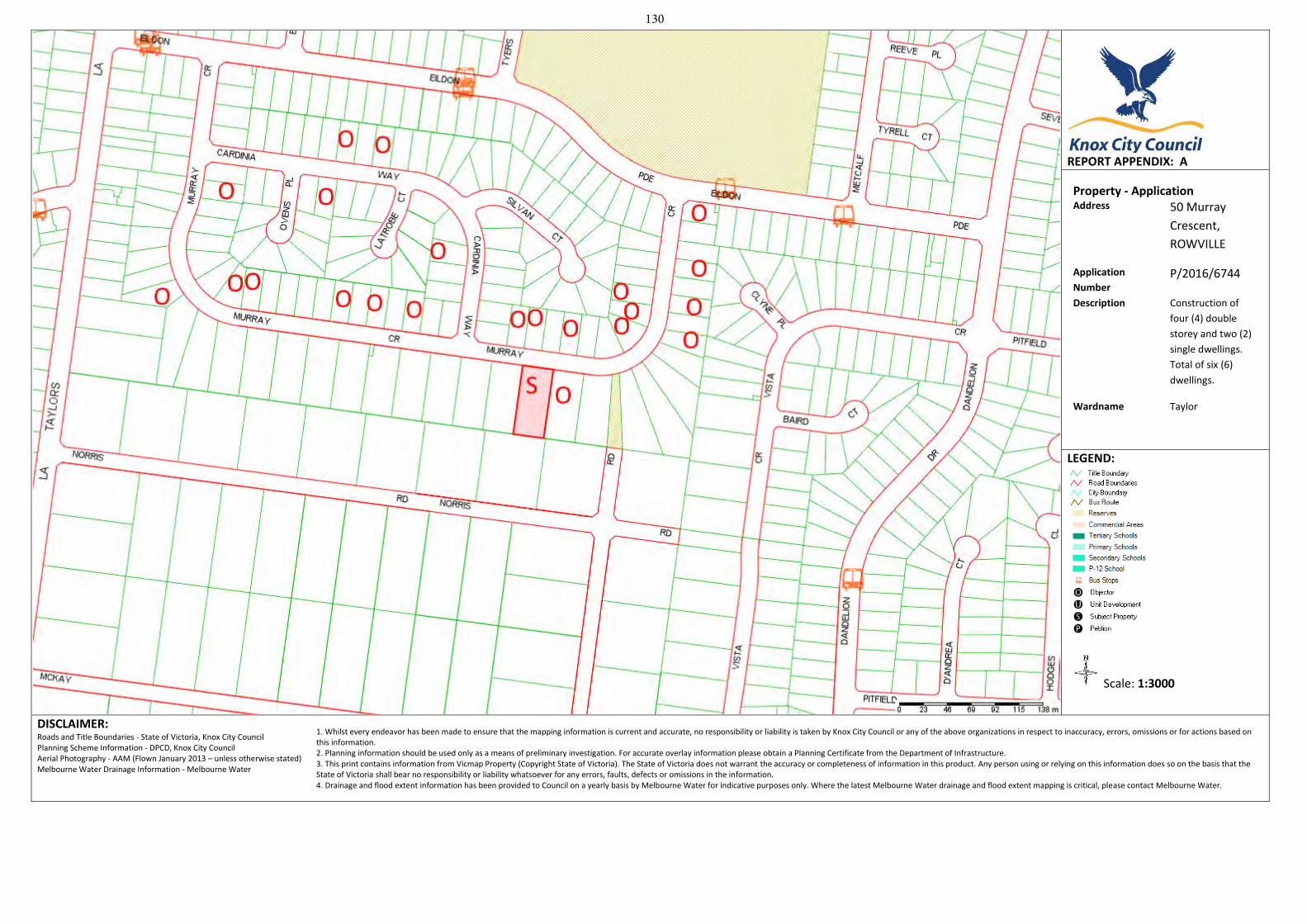
REPORT APPENDIX: A
Property - Application Address 50 Murray
Crescent,
ROWVILLE
Application
Number P/2016/6744
Description Construction of
four (4) double
storey and two (2)
single dwellings.
Total of six (6)
dwellings.
Wardname Taylor
LEGEND:
Scale: 1:3000
DISCLAIMER: Roads and Title Boundaries - State of Victoria, Knox City Council Planning Scheme Information - DPCD, Knox City Council Aerial Photography - AAM (Flown January 2013 – unless otherwise stated) Melbourne Water Drainage Information - Melbourne Water
1. Whilst every endeavor has been made to ensure that the mapping information is current and accurate, no responsibility or liability is taken by Knox City Council or any of the above organizations in respect to inaccuracy, errors, omissions or for actions based on this information. 2. Planning information should be used only as a means of preliminary investigation. For accurate overlay information please obtain a Planning Certificate from the Department of Infrastructure.3. This print contains information from Vicmap Property (Copyright State of Victoria). The State of Victoria does not warrant the accuracy or completeness of information in this product. Any person using or relying on this information does so on the basis that the State of Victoria shall bear no responsibility or liability whatsoever for any errors, faults, defects or omissions in the information. 4. Drainage and flood extent information has been provided to Council on a yearly basis by Melbourne Water for indicative purposes only. Where the latest Melbourne Water drainage and flood extent mapping is critical, please contact Melbourne Water.
130
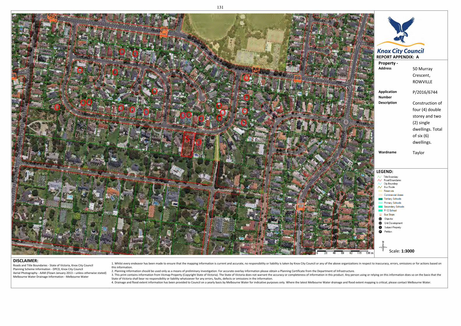
REPORT APPENDIX: A
Property - Address 50 Murray
Crescent,
ROWVILLE
Application
Number P/2016/6744
Description Construction of
four (4) double
storey and two
(2) single
dwellings. Total
of six (6)
dwellings.
Wardname Taylor
LEGEND:
Scale: 1:3000
DISCLAIMER: Roads and Title Boundaries - State of Victoria, Knox City Council Planning Scheme Information - DPCD, Knox City Council Aerial Photography - AAM (Flown January 2013 – unless otherwise stated) Melbourne Water Drainage Information - Melbourne Water
1. Whilst every endeavor has been made to ensure that the mapping information is current and accurate, no responsibility or liability is taken by Knox City Council or any of the above organizations in respect to inaccuracy, errors, omissions or for actions based on this information. 2. Planning information should be used only as a means of preliminary investigation. For accurate overlay information please obtain a Planning Certificate from the Department of Infrastructure.3. This print contains information from Vicmap Property (Copyright State of Victoria). The State of Victoria does not warrant the accuracy or completeness of information in this product. Any person using or relying on this information does so on the basis that the State of Victoria shall bear no responsibility or liability whatsoever for any errors, faults, defects or omissions in the information. 4. Drainage and flood extent information has been provided to Council on a yearly basis by Melbourne Water for indicative purposes only. Where the latest Melbourne Water drainage and flood extent mapping is critical, please contact Melbourne Water.
131
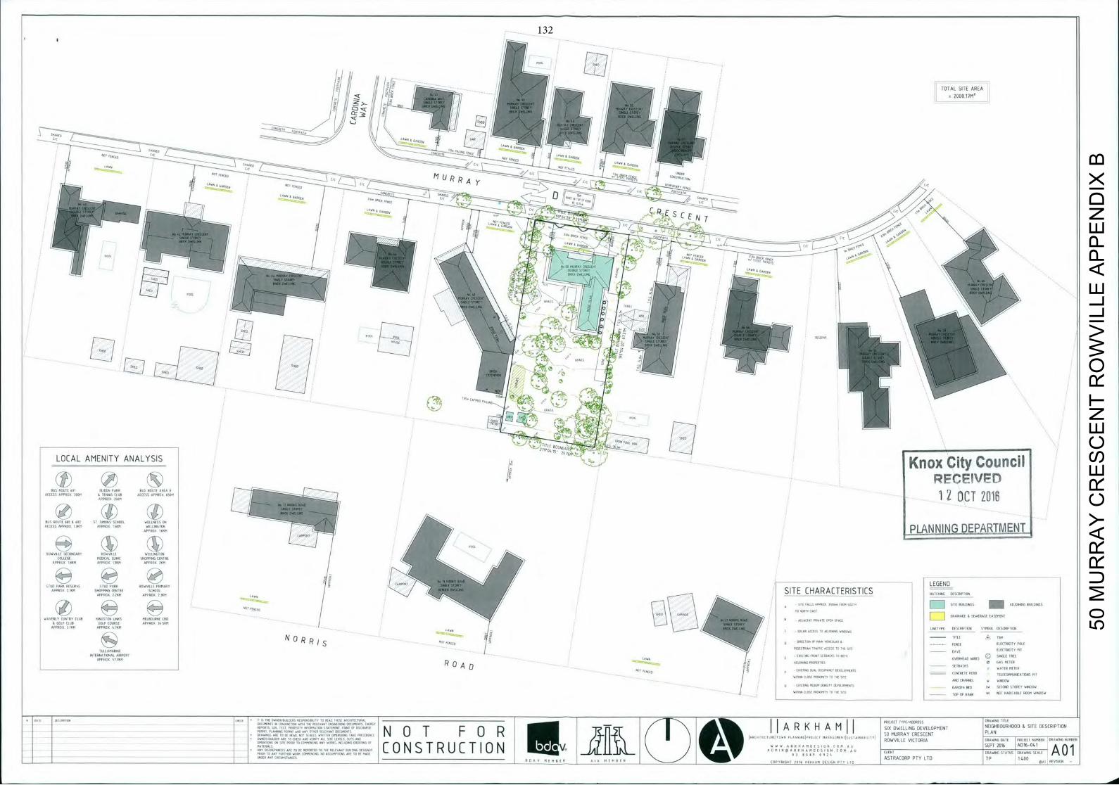
TOTAL SITE AREA
11-1 ED 7,
~ j CRESCENT CONCRETE
OUR
- HiiILI
LOCAL AMENITY ANALYSIS Knox City Council - -
RECEVFD BUS ROUTE I I I 1110094 PARK B u s ROUTE AREA 9 016
ACCESS APPROX 30011 & TENNIS CLUB ACCESS APPROX ROOM ------L 1 - O C T
2 APPROX 350M 4
BUS ACCESS APPROX
A REIGNS SC ELLIN SS ARC APPROX 15KM
-
/ PLANNINEEBIN1J1L APPROPE KM
PROC
ROWUI1000CCOR000R WELLINGTON
COLLEGE MEDICAL CLINIC SHOPPING CENTRE APPROX 1SKM APPROIC 19 BEEF
CARPORT O RISER SCOOP OW LOOP MAR
APPROX 2 2 K H APPROX 23NM
7 _
ND KOPECK 21KM SHOPPING T O A 0 SITE CHARACTERISTICS HATCHING
11 RIER. ROAD
0050APTO
SITE FALLS APPROI 1 1 - 1 FPO. ATT', IFID BUFLOJEHES ADJOINING 40 090005
TO ORTI EAST
CLUB S M E L B O U R N E E DRAINAGE I AR000SE:::
& GOLF
SYMBOL
CLUB L,
N 0R TITLE TBI
XR
,."DNA, I ONAL AIRPORT SON111 POPE O A R E D WIRES APPROX 5 0 1 1
- - - USOC 0 A o - 5f 11941010 OCCUPANCY CE
- SETBACKS WATER METER
-
- -
NET / 0 - 0
CONCRETE FEARS IEEE COMMUNICATIONS PIT - / CRC CHANNEL A 11 DOW
-
- / B C A S u A l MACrUM 0115111 DEVELOPMENTS UAROCN ECU CA 5 0 0 0 5 0 STOREY WINDOW
OITAN ClOUT 1 1 0 - 1 1 y TO CAT TIC - - - - - - - - TOPSY EAER A l ACT HABITABLE ROOM WINDOW
- PERMIT PLARRIC PERMIT A G AE' OTHER BCL"AB' Do TO . . . . 5 0 M U R R A Y CRESCENT N 0 1 F 0 R )-Tt
( T "
A R K H A M I
SE(DWELUNG DEVELOPMENT PLAN
DESCRIPTION
11 110EIR A " ' ALL SITE LEVEIS CUTS
-
-
C 0 N S T R U C I 10 N J _ _ v J4LllIrI_ _ _ _ _ _ _ _ _ _ _ _ _ _ _ _ _ _ _ _ _ _ _ _ _
A :
ASTRACORP PTY LTD OP
50 M
UR
RA
Y C
RE
SC
EN
T R
OW
VIL
LE A
PP
EN
DIX
B
132
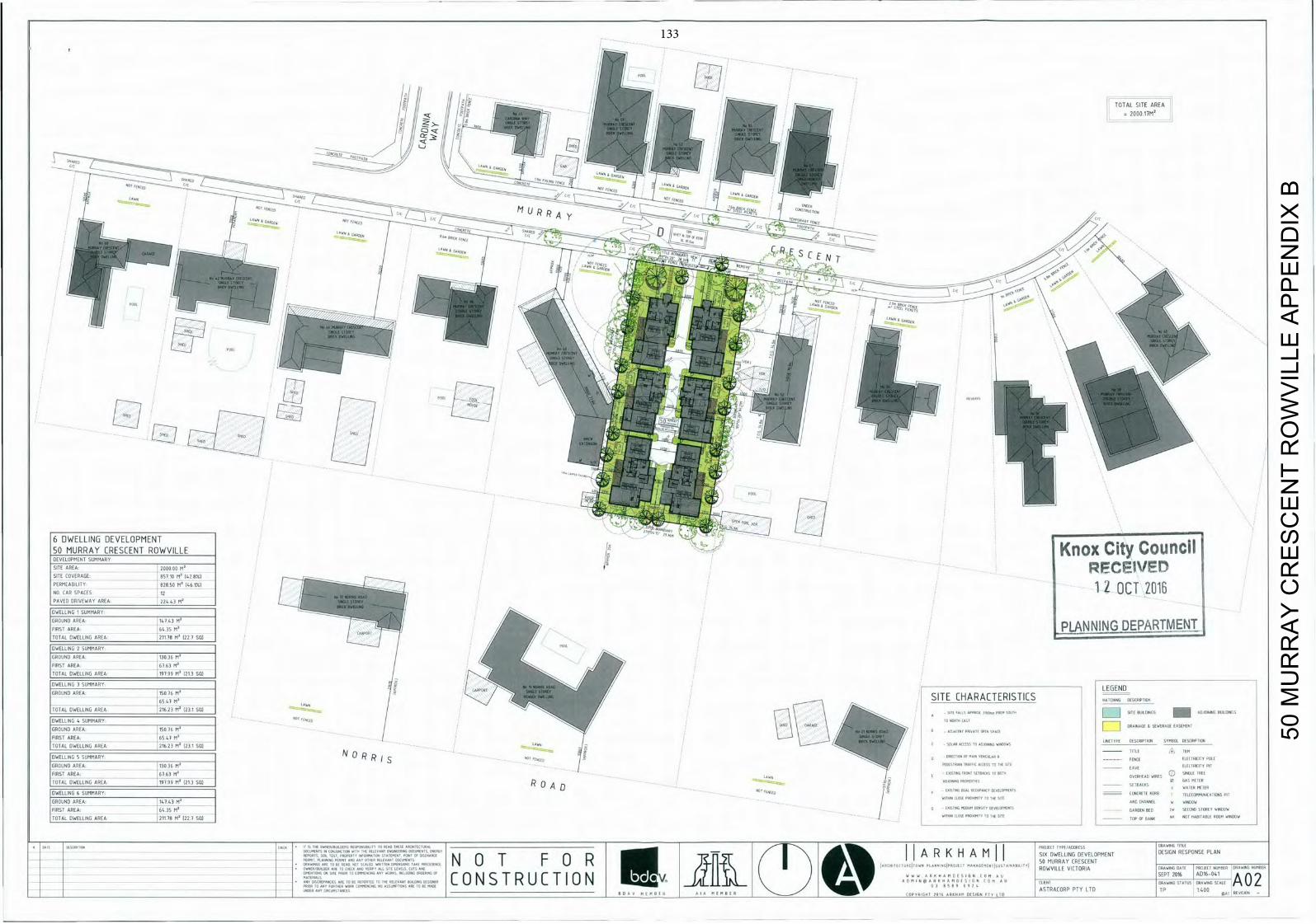
DWELLING 3 SUMMARY I I SWOAS O O W O S S / 4' - - - - - -
-
L E G E N D
-
GROUND AREA 15076M / A
o F I R E s SITE CHARACTERISTICS W T E A COS0RTION
TOTAL DWELLING AREA
DWELLING 4 SUMMARYGROUND
AREA
: 7 : ;
(231 / : : ° A I N A D E : : G B ONUS
TOTAL DWELLING AREA 21623 M (23 1 SO) - SOLAR ACCESS TO 0
GROUND AREA 13036 M
DWELLING 5 SUMMARY N 0 R R
DIESCRIPTEDhi SYMBOL DESCRIPTION
T I T L E P
OESTREAN TRAFFIC ACCESS TO THE SITE -
I A " A IIICI11.1":
FIRST AREA 6363 M 0 TRII 0 0 U OS
TOTAL DWELLING AREA 19399 R (213 sIl) R 0 A o WATER BOISE
DWELLING 6 SUMMAIS / CO C A 0 0 B ( 4 ( 6 0 C T O S PIT
~T,TAL',WELALING N A R E M ' W I I (LOST 0 1 0 ( 5 1 1 0 5010 CHANNEl w 1115005
A R E A 6 4 35 M1 -(AISOIIMEOIUM 000510 DEUEIOP0000IS L 0 6 0 0 0 0 6 0 ( 0 5 0 ( 0 0 0 5 1 0 5 0 1 11150011
AREA 211 TB M2 (22 9 SAl - I WITHIN (1050 P00010011 00 THE SITE
TOP OF RANK WH NOT I ISSI100LE 50000 WINDOW
PLAN
A 0 MURRAY CRESCENT
11=1,REPT, BE READ 101 SCALED WRITTEN I 'SION TAX[ PRICE EIIE N 0 T F 0 R - I I I O ' . l S ' - S I l (
X DWELLING VELOPMENT DESIGN RESPONSE
U ART 11 lHlIK AND 11HIll ALL SITE ~,ETS
CUTS ABU 041
-
- A N Y
DISCREPANCIES ARE TO BE REPORTED TO THE RELEVANT BUILDIND 0EID110 PF,O C 0 N S T R U C I 10 N U v ]_1..LifJI.ii.L / 1 M A T E R I A L S
M N S U ( 0 CLIENT DRAWING STATUS
UM TAN111 ASTRACORP PTY LTD 1H400 A02 I I ' ' I F F T l I l I E S F U P H R I A I I T ( B I N 0 0 0 1 1 A T I COSIGN P T ? I T O M O I R E 0111 -
50 M
UR
RA
Y C
RE
SC
EN
T R
OW
VIL
LE A
PP
EN
DIX
B
133
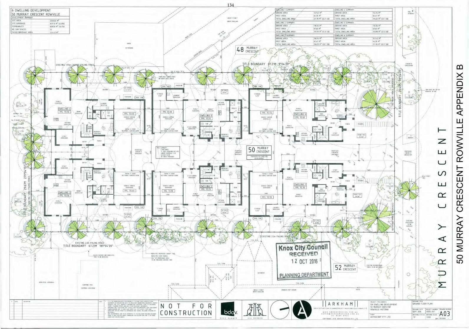
6 DWELLING DEVELOPMENT , - ' D5WAtIING
SUMMARY DWELLING I SUMMARY FIR
_O
G 14143 M 0 G R O U N D A R E A 1 5 0 76 D N 1 A R R O U N D AREA 0 S M U R R A Y CRESCENT RDBVIL E FIRST AREA A l 35 M' FIRST AREA 6541 M0 DEVELOPMENT SUMMARY SINGLE STOREY 9Ti U0 TOTAL DWELLING AREA 21178 M0 1221 SO) TOTAL DWELLING AREA 21623 N0 lUll SOl SITE AREA 200000 M0 - 881DB ORELII000 SITE COVERAGE ROT 10 N ' 142 8%) DWELLING 2 SUMMARY DWELLING S SUMMARY
PERMEABILITY 82850 M' 146 1%I ' GROUND AREA 13036 M' GROUND AREA 13036 M'
NO CUR SPACES - 12 _ 5 , U FIRST AREA 6363 R ' FIRST AREA 6163 F1'
PAVED DRIVEWAY AREA 22443 M' , _ " ,sA TOTAL DWELLING AREA 19199 M' 1213 SQl TOTAL DWELLING AREA 19399 M' 1213 SO) I
OWELLIN 0 SUMMARY DWELLING A SUMMARY SR
GROUND 'AREA 11116 M' GROUND AREA 14143 F1' 0
- - - FIRST AREA 6541 M' FIRST AREA 643S M' '
B R I C K - -
TOTAL DWELLING AREA 21623 V ' 123 GUI TOTAL DWELLING AREA 21118 R ' 221 SQl
EXTENSION
- / 8 MURRAY I _ S 5 _ NM r CRESCENT
EXISTING 195m L ALING FENC ITL BOUNDARY 21M 0 4 * 1 0 ' , 1H?oESM CROSSOVER
CONCRETE
10601 WAIT lOIN
l P 0 4 1 0
RI 08 LOIIEmR EERIE - /
S ,
IT ITT
o SIOS ILIRS
C
19
RALINE
1 1 1 1 1 1 1 K I N U DEl IRA [ ] 011 0 El U
BERE, RL 10 I'M J - 7
LAU000 SIU 0 L t P U R A O I N E
0 oo 01111 8000 1 0 1 0 0 0 0 0 0 1 0 L C ! i i G 7 E J ' E E OEM
11'I 0 5 0
— D W E L L I N G
41 5500 1200 5500 000111 MEALS I 1 .00
6000 0011110 , 0' 0 S BR a,,co
TIOX3100 01 FFL POP
E 110.11.
9 0 8 6
FFL 1376 1 A P X 3 5 . 1 2 0 0
50
OUBLE PARA I
I
I B I D GE I I
0 0 U 0 O U
00
DWELLING5
I '
FFL 1 2 k : IJWELLINSo6
j
IRTEXECLO 06 N.
ICILS
/
0
50 1
60 6 2200 RACE QQ
S E U T L I A N 20
- J I
I
_ , - 1 I
0000w / 0
LAO
OX30011 "'o STUDY REMOVE
PORCH
DATE I SUMEAR MURRAY
TO NCREAT, 11
TREESZA11-
I rPROPOSE CLAUSE
: : 0 / / I
5 O c T
(o
- IPROPOSED 1PRO OSEO
CONCRETE R0S
GATE 20 TR E
ENTRY 51 ILNIH
z PORCH
I
' T 1 0 9600
'BE L SECTIONAL GARAGE 0000 MEN00
5 SECTIONAL S 1 s
1
Q LING
-
[ I 5000 12200
1
1
I
TIC
L
2 0
h
I
00-00 11 CIEN DATE 6A r F
TWINY PORCH ATE Il
I E L J
I
0 0 0 0 5 0 0 : 0 1
I
0 0 8 PARAIT7310
I
IOWELLINLE2] I RIS1
DOUBLE S GE - DWELLINGT
001 ,
I NIS
F-11 1 6000 mili
i
I
ALREADY
F-11E 2 2
o
000 I FFL72 20 I
0 GO CEO
L
I
0 LINE 6 T N E
IDEA 0 11001
, S - A L F
to so
00 OL SIONIS,'
LUTE 000 6101111 ER SE 1 0 ,
- .
5 10161081
0000 lEG
D I C K - - ,
/ / 00001 AGE
00011*10 -
1000' OIl 0 / 8 00890 /
EXISTING CROSSOVER
1006
10
S S S 9 R EXISTING 2Gm PALING FE S4E 0 ' - I /
EXISTING 2 Urn PALING FENCE I I
I
TITLE BOUNDARY 67.21M 1890042055 1012, M / 5 5 K n o x U n
I I o A z , 4 _ 5 0 . A
/
S
I
EON ORSEEY 811 IIIOIE o N O R
ACES oM RAOl o o o 0 \ \ i RECEIVE / 7
RE UVE T R U E O R E - - - T O BE PROVIDED
A F R O U L L - - - - ! H I T a I 1 2 O C T 2 0 1 6
MURRAY ESH80AR 7
/
I - / 52 TREES TO BE RET VIED
I / CRESCENT VIRARI P L A N N I N G D E P A R T M E N T - a
OPEN POOL VERANDAH
I 6 U 0 I
TON EURO
0 0 IT L - - - - - - - J - - - - - - - - - - - - 1 0 5
7800
00605 OX I I SINGLE STORE? AI000AS NOT SHORN / I HOUSE T'
50 M
UR
RA
Y C
RE
SC
EN
T R
OW
VIL
LE A
PP
EN
DIX
B
134
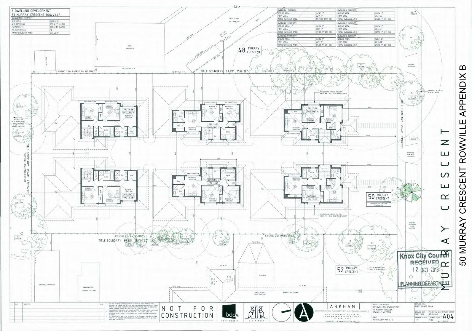
DWELLING DEVELOPMENT - ' 0SWAS3LLNG
1 S U M M A R Y D W E L L I N G S SUMMARY
0 MURRAY CRESCENT ROWVILLE GROUND AREA 14143 M4 GROUND AREA 15036 MR
R0Nr
VELOPB1UNT 'GUMMAAY
. 5 -
. - FIRST AREA 6435 MR FIRST AREA 6543 M
RE AREA 000000 M0 - - - SIN A - TOTAL DWELLING AREA 211 18 MR (02 9 SW TOTAL DWELLING AREA 01623 M4 231 SW I
- - - -
- BRIAN TARRING
RE COVERAGE -
8 5 1 1 0 MR 142 8%I - DWELLING 2 SUMMARY DWELLING 5 SUMMARY I
RMEARILITY 828 SO M (46 W I 5/5- GROUND AREA 13036 MR GROUND AREA 13036 MR I
I EAR SPACES- 12 - FIRST AREA 6363 M FIRST AREA - 6 3 6 3 MR I
WED DRIVEWAY AREA 2 24 43 MR . . _
TOTAL DWELLING AREA 9399 MR 1213 SQl TOTAL DWELLING AREA 19999 M 1213 SQl ,i I
3 ' VGSA DWELLING 9 SUMMARY DWELLING 6 SUMMARY I
GROUND AR A 150 36 MR GROUND AREA 14343 MR
- FIRST AREA 6541 MR
- FIRST AREA 6435 M
NOIRE - -
- - — TOTAL DWELLING AREA 21623 MR (23 1 GUI TOTAL DWELLING AREA 21178 MR (227 SQl
EVIERSION \ \ I MURRAY
- - CRESCENT I VIP
0 0 0 0 A 8 4 1 1 1 7 Tj?14,
- S
OljR
Tpz~l 21
EXISTING 1 9 5 n CAPPED P A L I N G FENC 0 4 4 0 0 4 0 4 . 0000 TITLE BOUNDARY 6.21M 9O42O Q 0 P -
-
41 I
5 S 1 d)
LOCATtON) 1311S
S11- S~OAfy
ROLE
/ I
HABOVE 1 A A S P R R 1 N 1 Y
T 6 R 4 E 0 IN 1 0 IF
\ , , / _ - _
, - ' - - - - S
-
- I
VPZ-O 0 3 o 0100 1000 _ _ _ _ _ _ _ _ _ _ _
5- 4410000 1 0 0 0 0 0 4 0 5-
- I
S I
1 . G 0 U I I 55 I FFL 75 75__I 100001000 0400 0000 I I
I FFL 15 6 0 I - - 0 0 0 I
/
I DWELLING I I I I = •
I / 1 GWELL1NG s i A
co
I I 1 0 9 3 0 I I S I _ - I
BEDROOM 4
M N O R Y S 0
320003000 3000 1 7 0
I V
B -
S
9393
/ OS _ _ _ _ _ _ _ _ _ _ _ / I FFL 7 6 2 5 I
7/
I 5 1 0 0 9 0 3 0 D W E L L I N G S , / 000 I I . I -
I
POND 3 S 3 B A
10000
!
C D P'~NIFICTG
IN i - - T T 1 1 1 1 , 1 3 " A NCRI
ON fl
ROLE
:IN Al~ - - - -
- - R I O
0 I 330
- I
DWELLING 2
XV R 0 0 0 0 0 88
I
-
I L_i....J U N I I 0 9 7 3 3 054
I I BEDROOM :
DWELLI I4533I H - I _ (
O X O
MURRAY
B I I
4001 G W E U i G 1 j I 50 CRESCENT I
.
I
- - L 111007151
/ 1
- _ _ _ r : H S Y
' - A / 4 5 0 4 8 001 - MAX 01% TRANSPARENCY /
L 1 1 1 1 7
/ S
- I
S
/
\ 5
EXISTING I -
CROSSOVER TO BE
0 6 8 3 0 3 0 0 >. EXISTING BOrn PAI1NG EXISTING 2 D m PALING ENCEA
C
/ A TITLE B O U N D A R Y t
\\\\\ \ S I E
L
ic ox ty Co I
RF vrry T O G
- 5 2 [RESCENT 1 CT 2016 0 2 ' 7
' r L A X A 0 4 0 0 0 -
Q 8 VERANDAH
IL
SWIMMING POOL
'I J
50 M
UR
RA
Y C
RE
SC
EN
T R
OW
VIL
LE A
PP
EN
DIX
B
135
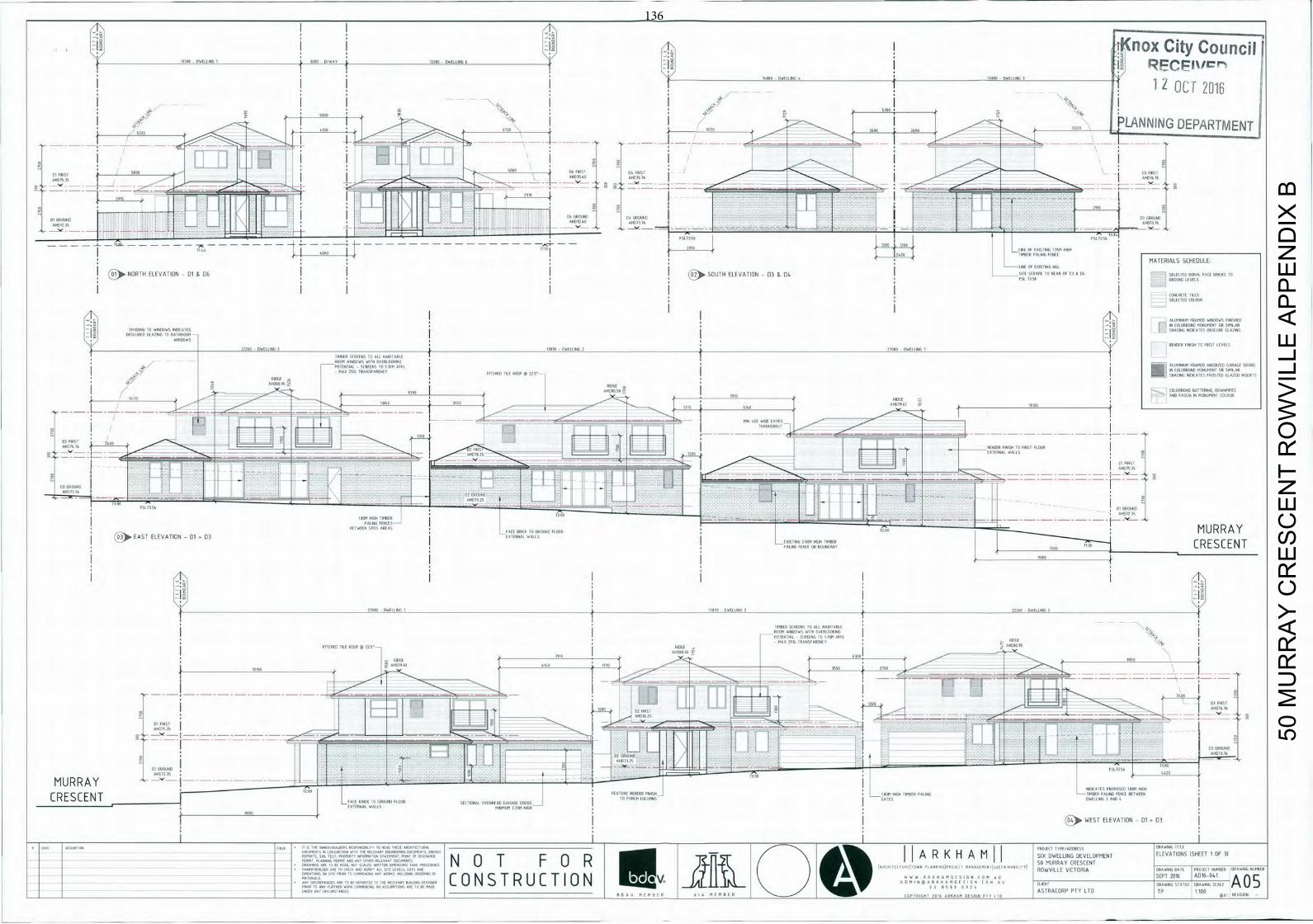
______________________Hj J(nox City Council Pi
OL 12016
41oo 5720 552o 2690 2690 552. LANNING DEPARTMENT
Do B16 76 AHRI
ON
t-2 9 S 2910
ON DID URCOND C' GROUND
A M E 1 1 1 1 I H i
3EEZ
- - - - - -
MATERIALS SCHEDULE:
- LINE OF EXISTING NFL
NORTH ELEVATION - 01 & 05 (O2 SOUTH ELEVATION - 03 & 00. L-- ,I', TO LIAR UT Cl ITO STIllING TOTAl lU l l ALlIES FSL 7356 GROUND LEVELS
CONCRETE TILLS SELECTEE COLOUR
ALUMINIUM FRAMER WINDOWS FINISHED IN OCLORBONO MONUMENT OR SIMILAR
LI sFArliNc 7,) S r STROING INDICATES
RENDER FINISH TO FIRST LEVELS 0010 0 1 t I E
L EE S
pFoMA N 'DAL SCREENS LCYTOIM XIII
Ol
LIIITIL :10 F — U 7 — I N COLORBGND MONUMENT OR SIMILAR -7
RIDGE AHIAI 95
11B 6140
RSI MA 1111IR 1114111 TO FIRST FLUOR EXTERNAL WALL$
AM, IS 11
PAT X S WfEN SIOS ANTIS
EFFN 1. 111-11 11— EAST ELEVATIONO1
l l L X T I F E K A L
TO CRESCENT
OlDER OW111110 I 11610 - DWELLING 0 1' bOLE DWELLING
TIMBER (FIFTHS TO ALI HABITABLE HOOM WINDOWS WITH OVERIOTION6
RBAG LITTER
P
OCT RULE V TO GlAEZ71 5 lo
H080 95
loso Ic D191BE 6110 IT'S
21.
IF ST 120 T
_ 2 1 O E M.16j
07 GROUND
51 NCUNIJ
AID 11
't MURRAY ,H1 L BOBI
INDICATES APOGEE 180M HIGH
M1, IT I A 11 ATE I I ND I CRESCENT o11 P1111 1 1 - 1 1
EDT I
MONT L U FENCE NT I
F WEST ELEVATION - 01 03
50 M
UR
RA
Y C
RE
SC
EN
T R
OW
VIL
LE A
PP
EN
DIX
B
136
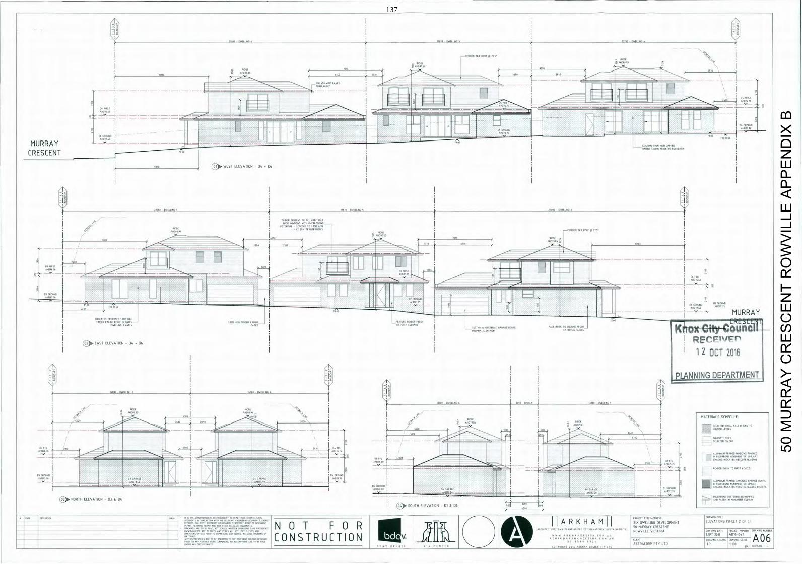
10080 0 4 1 0 0 0 1 , 6 1 '1000 - OWELLINS 5 22160 DWELLING 4
PITCHED OLD ROOF @
0005€ 4-
RIDGE ononoos
910 0 1 0 8 0 5 0 I - .
-
LIGG
10,00 C 9 0 0 0 0 0 6
0140 1,7C 5 0 4 0 2 4 0 0
A Oil IS
WIDE EAVES
06 FIRST A.011 Ell
f L H I
R11-
H 0 1 fH
HOT? TIT 16
CRESCENT (C)II.
W E S T ELEVATION D 4 06
. 2 l - 1 1 1 6 1 LLING 5 2 1000 7101151
PIER SCREENS 00 010 1100110000 C 0.000 WINDOWS 01111 09000000196
4 1 i '161100 SCREENS 1 0 1 1 D M ABEL' '5 40110 M A X 05% I006SPORRNCF I OHIO - I I 0111021'
9050
01109105
RIGHT
0 050 -
7001
1550 L -
-
1110
1010 0 1 4 0 A F D 7 1 85
I
IT 2400
T
"00 EE 1~12 FIRST 16 2S
i i
' 1 2
ENDING ED,, 11 11111NI
7Ar MURRAY 0 5 0 6 0 0 1 1050 I I 900 0CM C I I 1151 1
C_i
L I 5 I I I I o . 1 0 0 1 , 2 0 5
0110001 000111611 00400,0 0 0 0 0 0 1,110 0000 1
0 0 K ñ_Ox_City_00_U_fl_Oil RECF" (01)0.EAST ELEVATION 50. 06
0
I
iZ OCT zoiB
I PLANNING DEPARTMENT
1' 080 _00_____LI
1318D DWELLING
ODOR
5 01100091 0000005
?Flo 2"o 5s2o MID11,86
ROUND I-E-1
CO CRETE ;ILES
I
_ _ SELECTED (0101 P
000
L3 IF INDIA 04 FFIN,
AID
CHINI M INIMED WIDUDWS 1EN1111 L, LET I SHADING INDICATES OBS(URF :1 ','IN,
TTT
4 0 0 _ _ j
I
n r
0000600
DI, GAINAIL
- Y0052 NORTH ELEVATION 03 & 04
I oo)0 SOUTH ELEVATION 01 & VU
11 1S THE OWNERIBUIE. F1 111-11111L TI TO READ IFI11 —LITE11T.— T E S T -
, 7 \
A R K H A M SIX OWELLINU DEVELOPMENT ELEVATIONS (SHEET 2 OF 31
DINEPIBIRLDER IRE TO FM (I I'D 'ERE' ILL SITE ItIELS, (UTS ING Ell I L, I ROWVILLE VICTORIA DRAWING [ A i l C 0
STATE WENT 11
• " I LISCOUP WKS E TO BE REPORTED TO THE RE N-ER 011 TONS Of " OF c 0 N S I R U C I 10 N V -
I N M I Al
I 0 0 1 0 1
SEPT A D
A 06 0OFAIIIAS
ARE TO BE READ. NOT SCILED I R E - IA.E
INEIIC— 900100 P0099004 P86010 0 0 0 0 0 5 0199€ 91191001 009019015 I.J c '1 F U P ( . % , , , , , _ _ _ _ • , . . p , ) 50 MURRAY CRESCENT
POORR10fl9FF9HER WORK 00flfl911006 900009MPI10115 ARE 1 0 0 0 MAUI ASTRACORP PTY LTD VP 1100 901R Roll IIR101S1000IS
I o ' I l ' H o - 1 , 1 0 1 1 I 0 I I 0 1 0 I O H T 0 0 1 0 1 0 1 0 A M 0050696 P 0 1 410
50 M
UR
RA
Y C
RE
SC
EN
T R
OW
VIL
LE A
PP
EN
DIX
B
137
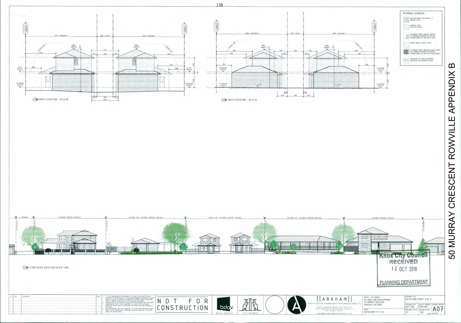
50 M
UR
RA
Y C
RE
SC
EN
T R
OW
VIL
LE A
PP
EN
DIX
B
138
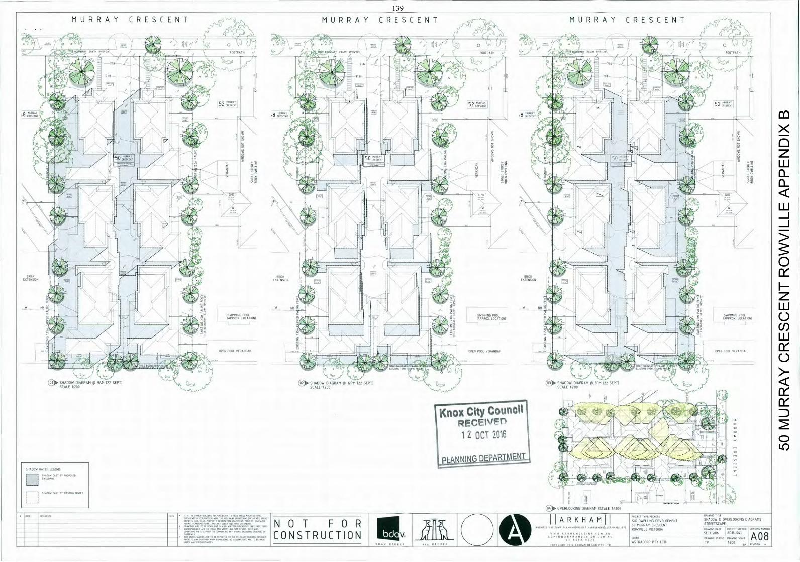
M U R R A Y C R E S C E N T M U R R A Y C R E S C E N T M U R R A Y CRESCENT
BABY 2 0 20 FOOTPATH
L
8 AR 2 9 0 9 9 0 20 L 1 0AU 9 9 0 2
2 o
711 716
71 B
C BAY
8 1 R E C 0 8
CRESTEN
8
d T
52FOOTPATH
CRESCENT MURRAY Tj
e1 2
j
Al
OF EZ
t E O 0 0 E L I J L ! _ _
_
G/B GIB
It BRICK - BRICK 2 - BRICK I EXTENSION ( S EXTENSION I EXTENSION I I
S W I M M I N G w NH
POOL I L I o N I APPRDX
SWIMMING LPOOL TIONI
' (APPROX LOCATION) SWIMMING POOL
OPEN POOL VERANDAH _ _ j '
OPEN POOL VERANDAH OPEN POOL VERANDAH
EI
lilt, 7 — rALINU F o
SHADOW DIAGRAM ~ 4 -GR @ 9AM 22 SEPT) @ SEPT) SHADOW DIAGRAM @ 3PM 22 SEPT)
SCALE 1,200 SCALE 1200
[knoxCityCoun1
RFCEIVFPOCT 12 OCT 2016 III I
I
L A N N 1 N Q D E I L F0II21bT
SHADOW HATCH LEGEND -
-
--
[ I POST
OVERLOOKING DIAGRAM SCALE 1 6001
REN SHADOW & OVERLOOKING DIAGRAMS 1EIC— SO11 'EST, PROPERTY INFORM-11 OTITF.EIT POINT OF DISEHARGE A R K H A M SIX DWELLING DEVELOPMENT
EIECEIU 50 MURRAY CRESCENT OWNER/NO DEE ARE TO (0000 EArl VANISH A / I SITE LEVELS
OIl UTS EAR RTWVILLE VICTORIA DRAWING TRIO TROTH I NUMBER USD015 5 MCIII
M A E R A I I C 0 N S T R U C T I 0 N V ) V WTE R T H O A A A
o
I F I T B 4A 08
( 0 0 0 9 ETCH IIRILMNEETE295 " . . / ' AS RACORP PTY LTD TP 1.200 U . M I T U A I R M E M B E R C O P Y R I G H T 2 0 1 6 W 6 0 0 2 M D E S I G N P E E CEO p H I REVISIONS
50 M
UR
RA
Y C
RE
SC
EN
T R
OW
VIL
LE A
PP
EN
DIX
B
139
140 COUNCIL – CITY DEVELOPMENT 26 June 2017
FRIBERG WARD
6.5 APPLICATION FOR THE CHANGE OF USE TO PLACE OF WORSHIP, REDUCTION IN CAR PARKING AND ALTERATION OF ACCESS TO A ROAD IN A CATEGORY 1 ROAD ZONE AT 42/756 BURWOOD HIGHWAY, FERNTREE GULLY (Application No. P/2016/6905)
1. SUMMARY:
Land: 42/756 Burwood Highway, Ferntree Gully Applicant: The Promise Church Proposed Development: Change of use to place of worship,
reduction in car parking and alteration of access to a road in a Category 1 Road Zone
Existing Land Use: Commercial Area: 532m2 Zoning: Commercial 2 Zone Overlays: Nil Local Policy: Municipal Strategic Statement (MSS) Application Received: Application Amended:
16 December 2016 7 April 2017
Number of Objections: 26 PCC Meeting: 21 March 2017
Assessment:
It is considered that the intensity of the proposal is inconsistent with the outcomes sought by the Knox Planning Scheme.
The proposal is inconsistent with the Municipal Strategic Statement (MSS). The proposal is also non-compliant with Car Parking requirements of the Knox Planning Scheme.
The proposal is broadly consistent with the purpose of the Commercial 2 Zone. On balance it is considered that the proposal does not respond well to State and Local Planning Policies. It is recommended that a Notice of Decision to Refuse to Grant a Planning Permit be issued.
141 COUNCIL – CITY DEVELOPMENT 26 June 2017 6.5 42/756 Burwood Highway, Ferntree Gully (cont'd)
2. BACKGROUND
2.1 Call up
This application is being reported to Council as it has been called up by Councillor Holland.
2.2 Subject Site and Surrounds
The location of the subject site is shown in Appendix A.
The subject site is located on the southern side of Burwood Highway and is an existing warehouse within an established commercial estate known as Twin Towers Estate.
The Estate comprise a total of 46 units and common property. Unit 42 is located along the western side of the development.
The subject site, has as an overall leasable area of approximately 532m2 compromising of an office, showroom, amenity and kitchen area, mezzanine and a warehouse.
The site is provided with a total of six car spaces.
Adjoining the Twin Towers Estate to the south and east is land used for commercial and industrial purposes. To the west and north across Burwood Highway is land used for residential purposes.
Mountain Gate Shopping Centre is located approximately 400m to the southeast of the site.
2.3 The Proposal
(Refer to attached details at Appendix B) The application proposes to change the use of the site to a place of worship as well as a reduction in the car parking requirements and alteration of access to a Category 1 Road. Specifically it proposes:
The place of worship is to operate on Sundays between 10:00am to 3:00pm.
The maximum number of attendees at any one time is proposed to be forty (40).
A church office will operate on site on weekdays.
A car parking reduction of six (6) car parking spaces is sought.
142 COUNCIL – CITY DEVELOPMENT 26 June 2017 6.5 42/756 Burwood Highway, Ferntree Gully (cont'd)
3. CONSULTATION
3.1 Advertising
The application was advertised by way of a sign on the site and notices sent to adjoining property owners and occupiers. Twenty-six (26) objections to the application were received, and are summarised below:
Inadequate/unrealistic car parking
The proposal to reduce the car parking requirement is considered to be inappropriate and would adversely impact the surrounding tenancies. Council’s Traffic Engineers have raised concerns with the capacity of the estate, service lane and on street parking to absorb the additional traffic that would be generated by the proposed use.
The withdrawal of written agreements via the advertising process has reduced potential car parking spaces within the estate and increased the rate of on-street parking on an unsealed service road without kerb and channel. An assessment against Clause 52.06 (Car Parking) is below at Section 4.3 of this Report.
Pedestrian safety
It has been acknowledged that no footpaths or pathways are present within the estate to allow pedestrians to safely access the site by foot. An assessment against 52.06 (Car Parking) is below at Section 4.3 of this Report.
Additional patrons accumulated over time
The proposal is for a maximum of 40 patrons at any one time. A condition of any permit issued would limit patron numbers.
Use operating outside specified timeframes
The proposed service is to operate on Sundays between 10:00am to 3:00pm. The church office will operate on site on weekdays. A condition of any permit issued would reinforce the operating hours of the Sunday service. Should the use operate outside specified times Council’s Planning Investigation Officers will deal with the matter.
143 COUNCIL – CITY DEVELOPMENT 26 June 2017 6.5 42/756 Burwood Highway, Ferntree Gully (cont'd)
Amenity impacts on existing weekend businesses The proposed use has potential to affect the existing tenancies that are open
and operate during the weekends. The proposal is assessed against its potential amenity impact on the surrounding community, estate and existing uses. Refer to Section 4.1.1 of this Report.
Inappropriate use in an industrial area
An application must be considered on its own merits with consideration of
the site context and requirements in the Planning Scheme at the time. Implications for the future lease/sale of adjoining properties
This is not a valid planning consideration.
Owners’ Corporation Public Liability Insurance/ Public Liability Insurance
This is not a valid planning consideration.
3.2 Planning Consultative Committee Meeting
A Planning Consultative Committee (PCC) Meeting was held at the Civic Centre on 21 March 2017. Fifteen (15) people signed the attendance sheet at the meeting. Objectors expressed the following main concerns with the proposal:
Traffic and safety.
Parking Congestion.
Impact on existing uses.
There were no negotiated outcomes at the conclusion of the meeting.
3.3 Referrals
The application has been referred to VicRoads and Council’s Traffic department for comment. The following is a summary of relevant advice:
144 COUNCIL – CITY DEVELOPMENT 26 June 2017 6.5 42/756 Burwood Highway, Ferntree Gully (cont'd)
Traffic Engineer
On street car parking is restricted as the on street parking is on an unsealed service road without a kerb and channel.
Due to the lack of onsite parking, the application for 40 patrons is not supported.
VicRoads
No objection
4. DISCUSSION
This section considers the proposed development in light of the provisions of the Knox Planning Scheme including State and Local Planning Policies, any other relevant policies and objectives.
4.1 Zoning and Overlays
4.1.1 Zone
Commercial 2 Zone
The land is zoned Commercial 2 Zone. The purpose of the Commercial 2 Zone is to encourage commercial areas for offices, appropriate manufacturing and industries, bulky goods retailing, other retail uses, and associated business and commercial services which does not affect the safety and amenity of local communities.
A permit is required for the use of the land for a place of worship pursuant to Clause 34.02-1 of the Commercial 2 Zone.
Pursuant to Clause 34.02-2 a use must not detrimentally affect the amenity of the neighbourhood, including through the transport of materials, goods or commodities to or from the land, appearance of any building, works or materials and the emission of noise, artificial light, vibration, smell, fumes, smoke, vapour, steam, soot, ash, dust, waste water, waste products, grit or oil.
Before deciding on an application, in addition to the decision guidelines in Clause 65, the responsible authority must consider, as appropriate:
- The effect that existing uses may have on the proposed use.
- The drainage of the land
- The availability of and connection to services.
145 COUNCIL – CITY DEVELOPMENT 26 June 2017 6.5 42/756 Burwood Highway, Ferntree Gully (cont'd)
- The effect of traffic to be generated on roads.
- The interim use of those parts of the land not required for the proposed use.
- If an industry or warehouse, the effect that the use may have on nearby existing or proposed residential areas or other uses which are sensitive to industrial off-site effects, having regard to any comments or directions of the referral authorities.
It is considered that the proposed Place of Worship would be broadly consistent with the intent of the Commercial 2 Zone.
However, the proposed intensity of the development would far exceed the capacity of the site and would unreasonably impact on the operation of the estate, the on-street car parking network and would affect the amenity of local communities and existing uses within the estate. Car parking within the estate is privately owned and only six car parking spaces are provided to the subject site. There are no visitor car parking spaces within the estate, which will direct all surplus car parking on to the service road and surrounding road network.
The demand for on-street car parking generated by the proposed use would detrimentally affect the businesses in the immediate estate. There are 46 units within the estate which need access to the site via the service road and their customers/visitors equally share and rely on the on-street car parking.
In addition, on-street car parking is further restricted as the on-street parking is on an unsealed service road without a kerb and channel. There are no footpaths along the service road or within the estate that will ensure safe pedestrian access to the site. Pedestrians are expected to walk a minimum 100 metres to access the site avoiding traffic and heavy vehicles that are generated within by estate. As such, the proposal is inconsistent with the Zone.
4.1.2 Overlays
No overlays apply to the land.
146 COUNCIL – CITY DEVELOPMENT 26 June 2017 6.5 42/756 Burwood Highway, Ferntree Gully (cont'd)
4.2 Policy Consideration
4.2.1 State Planning Policy Framework (SPPF)
State policy requires Council to integrate the range of policies relevant to the issues to be determined, and balance conflicting objectives in favour of net community benefit and sustainable development.
Key Policies:
Clause 15 Built Environment and Heritage – Encourages high quality architecture and urban design outcomes that reflect the particular characteristics, aspirations and cultural identity of the community; enhances liveability, diversity, amenity and safety of the public realm; and promotes attractiveness of towns and cities within broader strategic contexts.
No external changes are proposed to the building. Clause 17 – Economic Development – Provide for a strong innovative economy, where all sectors of the economy are critical to economic prosperity. Planning is to contribute to the economic wellbeing of communities and the State as a whole by supporting and fostering economic growth and development by providing land, facilitating decisions, and resolving land use conflicts.
Clause 17.01-1 Business - To encourage development which meet the communities’ needs for retail, entertainment, office and other commercial services and provides net community benefit in relation to accessibility, efficient infrastructure use and the aggregation and sustainability of commercial facilities.
Clause 17.02 Industry - Ensure availability of land for industry. Protect and carefully plan existing industrial areas to, where possible, facilitate further industrial development, encourage industrial uses that meet appropriate standards of safety and amenity, locate within activity centres and avoid approving non-industrial uses which will prejudice the availability of land for future industrial requirements in identified industrial areas.

147 COUNCIL – CITY DEVELOPMENT 26 June 2017 6.5 42/756 Burwood Highway, Ferntree Gully (cont'd)
The SPPF requires Council to integrate the range of policies relevant
to the issues to be determined and to balance conflicting objectives in favour of net community benefit and sustainable development. The proposed use of the site should provide for a complementary use that supports and activates the surrounding commercial and residential land uses.
However, the proposed intensity of the development would far exceed
the capacity of the site and would unreasonably impact on the operation of the service road, the on-street car parking network, would affect the amenity of local communities within the estate and limit future capacity for change. The demand for on-street car parking generated by the proposed use would detrimentally affect the businesses in the estate and create pedestrian safely issues. As such, the proposal is inconsistent with the SPPF.
Clause 18 Transport – Ensure that access is provided to all available modes of transport.
Bus route 732 is available along Burwood Highway. There is a bus stop located to the front of the subject site.
Bus route 732 has a direct service between Box Hill to Upper Ferntree Gully via Vermont South, Knox City and Mountain Gate. This service operates between 6:40am and 9:16pm Monday to Friday; between 8:01am and 9:48pm on Saturdays; and between 9:07am to 9:45pm Sundays, at various intervals.
4.2.2 Local Planning Policy Framework
Clause 21.07 – MSS - Economic Development – Within Knox, substantial tracts of business and industrial land are considered to be underutilised. Greenfield sites are limited so the focus of local policy is to better utilise the land located within existing established industrial areas. The support and retention of existing industrial uses and employment growth of these businesses is sought to be encouraged. This policy also includes a number of objectives in relation to development and use which are:
Maintain and enhance a high standard of visual amenity in industrial,
business and restricted retail sales areas.
148 COUNCIL – CITY DEVELOPMENT 26 June 2017 6.5 42/756 Burwood Highway, Ferntree Gully (cont'd)
Encourage industrial development that provides for perimeters along declared arterial road frontages defined by prestige facilities and well-planted setbacks.
To ensure a hierarchy of viable, accessible activity centres with a greater range of complementary activities for domestic, business, leisure and social life with improved public transport services.
1. The proposed place of worship of the site should provide for a complementary use that supports and activates the surrounding commercial and residential land uses.
However, the proposed intensity of the development would far exceed the capacity of the site and would unreasonably impact on the operation of the estate, the on-street car parking network would affect the amenity of local communities and existing uses within the estate. Car parking within the estate is privately owned and only six car parking spaces are provided to the subject site. There are no visitor car parking spaces within the estate, which will direct all surplus car parking on to the service road and surrounding road network.
The demand for on-street car parking generated by the proposed use would detrimentally affect the businesses in the immediate estate as on-street car parking is also relied on by the existing tenancies within the estate.
In addition, on-street car parking is further restricted as the on-street parking is on an unsealed service road without a kerb and channel. There are no footpaths along the service road or within the estate that will ensure safe pedestrian access to the site. Pedestrians are expected to walk a minimum 100 metres to access the site avoiding traffic and heavy vehicles that are generated by the estate. As such, the proposal is inconsistent with Council’s MSS.
4.3 Particular Provisions
Clause 52.06 – Car Parking
Prior to a new use commencing or a new building being occupied the car parking spaces required under Clause 52.06-5 must be provided on the land or as approved under Clause 52.06-3 to the satisfaction of the responsible authority.
149 COUNCIL – CITY DEVELOPMENT 26 June 2017 6.5 42/756 Burwood Highway, Ferntree Gully (cont'd)
Clause 52.06-5 outlines the requisite amount of parking to be provided. A place of Assembly has a ratio of 0.3 spaces to each patron permitted.
The proposal seeks approval for 40 patrons and pursuant to the table at Clause 52.06-5 twelve (12) car parking spaces are required for the proposed use.
Pursuant to Clause 52.06-3 a permit is required to reduce the number of car parking spaces. Clause 52.06-6 sets out the decision guidelines, including (as relevant):
- Any adverse economic impact a shortfall of parking may have on the economic viability of any nearby activity centre.
- The future growth and development of any nearby activity centre.
- Any car parking deficiency associated with the existing use of the land.
- Local traffic management in the locality of the land.
- The impact of fewer car parking spaces on local amenity, including pedestrian amenity and the amenity of nearby residential areas.
- The need to create safe, functional and attractive parking areas.
- Access to or provision of alternative transport modes to and from the land.
- The equity of reducing the car parking requirement having regard to any historic contributions by existing businesses.
- The character of the surrounding area and whether reducing the car parking provision would result in a quality/positive urban design outcome.
The proposal seeks a reduction of six (6) car parking spaces. The reduction for half of the required car parking scapes is considered inadequate.
It is considered that the intensity of the use and reduction of car parking sought would create a shortfall of parking in the immediate area that would adversely affect the economic viability of the immediately surrounding commercial area. Car parking within the estate is privately owned and only six car parking spaces are provided to the subject site. There are no visitor car parking spaces within the estate, which will direct all remaining car parking on to the service road and surrounding road network.
150 COUNCIL – CITY DEVELOPMENT 26 June 2017 6.5 42/756 Burwood Highway, Ferntree Gully (cont'd)
The demand for on-street car parking generated by the proposed use would detrimentally affect the businesses in the immediate estate. There are 46 units within the estate which need access to the site via the service road and their customers/visitors equally share and rely on availability of the on-street car parking.
Council’s Traffic Engineers have raised concerns in relation to pedestrian and vehicle safety associated within the on-street car parking. The on-street parking is on an unsealed service road without a kerb and channel. There are no footpaths along the service road or within the estate that will ensure safe pedestrian access to the site. Pedestrians are expected to walk a minimum 100 metres to access the site avoiding traffic and heavy vehicles that are generated by the existing uses in the estate. The car parking reduction and associated traffic generation would compromise the safe and convenient operation of the service road and existing estate.
Whilst it is acknowledged that the applicant has attempted to obtain car parking agreements with adjoining proprieties within the estate, the agreements were withdrawn during public notice. The applicant has not provided sufficient information to satisfy Council that the parking reduction sought and traffic generation would not compromise the safe and convenient operation of the existing tenancies within the estate and the surrounding service road and parking.
Clause 52.29 Land Adjacent to a Road Zone Category 1 - The purpose of Clause 52.29 is to ensure appropriate access to identified roads and requires that the responsible authority given consideration to; - State and Local Planning Policy Framework’s as relevant, - The views of the relevant road authority. - The effect of the proposal on the operation of the road and on public safety. - Any policy made by the relevant road authority pursuant to Schedule 2,
Clause 3 of the Road Management Act 2004 regarding access between a controlled access road and adjacent land.’
A permit is required to alter access to a road in a Road Zone, Category 1. The proposed use will alter the intensity on the site, generating additional vehicles. An application to alter a road in a Category 1 Road Zone must be referred to the Roads Corporation under Section 55 of the Act.
The application has been referred to VicRoads for comment under Section 55
of the Planning and Environment Act. VicRoads did not object to the proposal or provide any conditions to be placed on any permit issued.

151 COUNCIL – CITY DEVELOPMENT 26 June 2017
6.5 42/756 Burwood Highway, Ferntree Gully (cont'd)
4.4 General Decision Guidelines
Clause 65 of the Knox Planning Scheme and Section 60 of the Planning and Environment Act 1987 set out decision guidelines/matters which the responsible authority must consider when deciding any planning application.
The decision guidelines of Clause 65 of the Knox Planning Scheme andSection 60 of the Planning and Environment Act (1987) have beenappropriately considered.
5. CONCLUSION
Clause 10.04 of the Knox Planning Scheme requires Council to balance relative policy objectives when making decisions to ensure resulting development is sustainable and achieves a net community gain. In this context, the development is not appropriate given the following:
The proposal is inconsistent with the relevant policies contained in theState and Local Planning Policy Framework (including the MunicipalStrategic Statement) of the Knox Planning Scheme.
The proposal would cause unreasonable detriment to the surroundingarea and would significantly compromise the safe and convenientoperation of the surrounding uses.
The proposal to reduce the number of car parking spaces is inconsistentwith Clause 52.06 and the reduction will adversely affect the amenity ofthe locality. The proposal does not provide sufficient car parking on theland and does not comply with requirements of Clause 52.06 of the KnoxPlanning Scheme.
The intensity of the proposal and reduction in car parking wouldcompromise the future use of surrounding land for business and industrialpurposes.
6. CONFIDENTIALITY
There are no confidentiality issues associated with this report.

152 COUNCIL – CITY DEVELOPMENT 26 June 2017 6.5 42/756 Burwood Highway, Ferntree Gully (cont'd)
RECOMMENDATION
That Council issue a Notice to Refuse to grant a Planning Permit for the use of the land for a place of worship, reduction in car parking and alteration of access to a road in a category 1 road zone at 42/756 Burwood Highway, Ferntree Gully, subject to the following grounds of refusal:
1. The proposal is inconsistent with the relevant policies contained in the State and Local Planning Policy Framework (including the Municipal Strategic Statement) of the Knox Planning Scheme.
2. The proposal would cause unreasonable detriment to the surrounding area and would significantly compromise the safe and convenient operation of the existing uses.
3. The proposal to reduce the number of car parking spaces is inconsistent with Clause 52.06 and the reduction will adversely affect the amenity of the locality. The proposal does not provide sufficient car parking on the land and does not comply with requirements of Clause 52.06 of the Knox Planning Scheme.
4. The intensity of the proposal and reduction in car parking would compromise the future use of surrounding land for business and industrial purposes.
Report Prepared By: Planner (Ollie Graovac) Report Authorised By: Acting Director – City Development
(Paul Dickie)
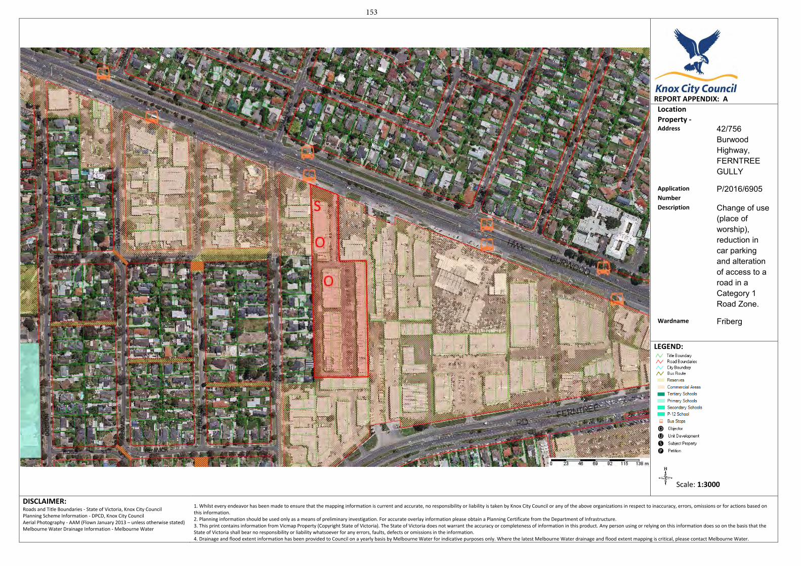
REPORT APPENDIX: A
Location
Property - Address 42/756
Burwood Highway, FERNTREE GULLY
Application
Number P/2016/6905
Description Change of use (place of worship), reduction in car parking and alteration of access to a road in a Category 1 Road Zone.
Wardname Friberg
LEGEND:
Scale: 1:3000
DISCLAIMER: Roads and Title Boundaries - State of Victoria, Knox City Council Planning Scheme Information - DPCD, Knox City Council Aerial Photography - AAM (Flown January 2013 – unless otherwise stated) Melbourne Water Drainage Information - Melbourne Water
1. Whilst every endeavor has been made to ensure that the mapping information is current and accurate, no responsibility or liability is taken by Knox City Council or any of the above organizations in respect to inaccuracy, errors, omissions or for actions based on this information. 2. Planning information should be used only as a means of preliminary investigation. For accurate overlay information please obtain a Planning Certificate from the Department of Infrastructure.3. This print contains information from Vicmap Property (Copyright State of Victoria). The State of Victoria does not warrant the accuracy or completeness of information in this product. Any person using or relying on this information does so on the basis that the State of Victoria shall bear no responsibility or liability whatsoever for any errors, faults, defects or omissions in the information. 4. Drainage and flood extent information has been provided to Council on a yearly basis by Melbourne Water for indicative purposes only. Where the latest Melbourne Water drainage and flood extent mapping is critical, please contact Melbourne Water.
153
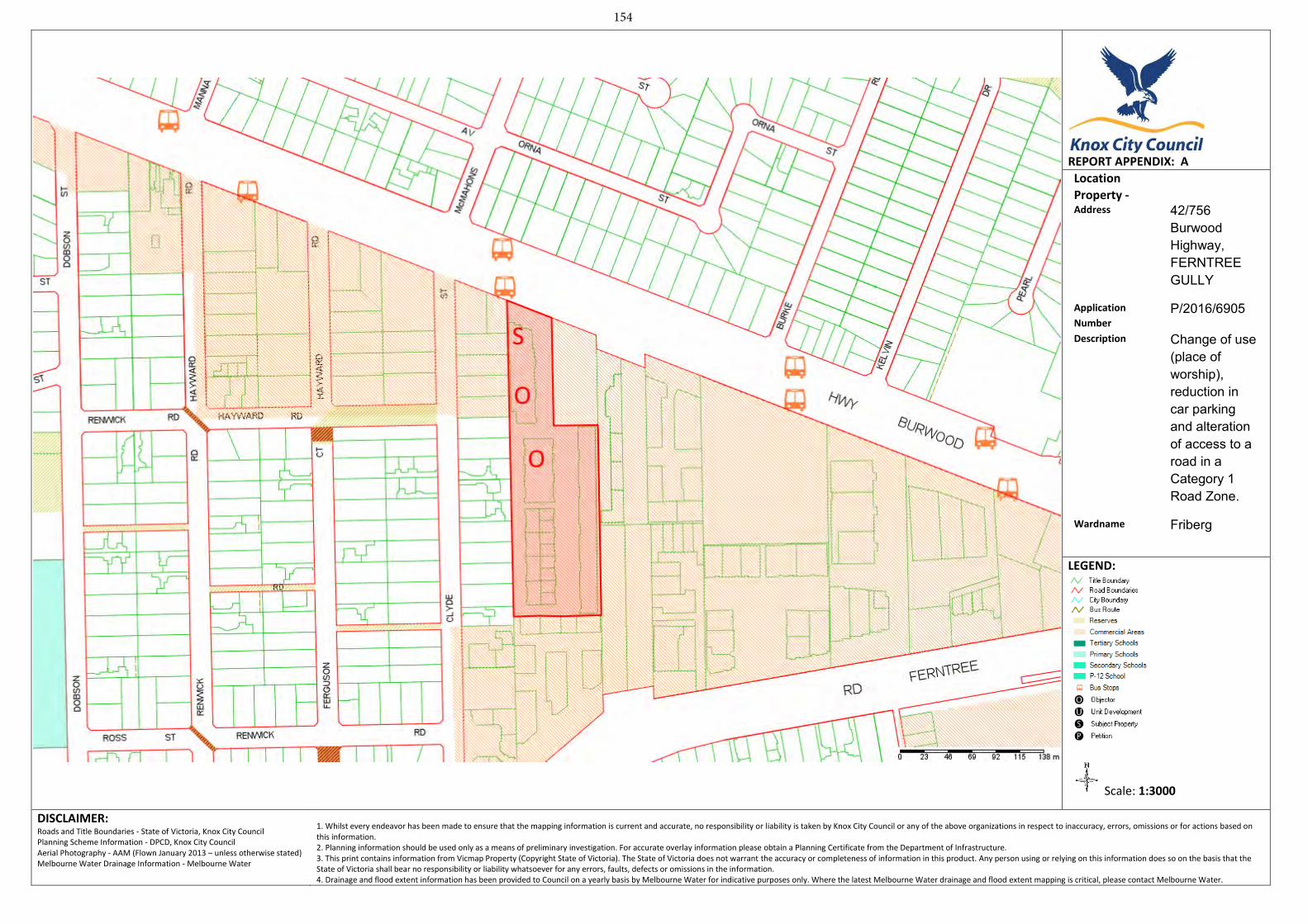
REPORT APPENDIX: A
Location
Property - Address 42/756
Burwood Highway, FERNTREE GULLY
Application
Number P/2016/6905
Description Change of use (place of worship), reduction in car parking and alteration of access to a road in a Category 1 Road Zone.
Wardname Friberg
LEGEND:
Scale: 1:3000
DISCLAIMER: Roads and Title Boundaries - State of Victoria, Knox City Council Planning Scheme Information - DPCD, Knox City Council Aerial Photography - AAM (Flown January 2013 – unless otherwise stated) Melbourne Water Drainage Information - Melbourne Water
1. Whilst every endeavor has been made to ensure that the mapping information is current and accurate, no responsibility or liability is taken by Knox City Council or any of the above organizations in respect to inaccuracy, errors, omissions or for actions based on this information. 2. Planning information should be used only as a means of preliminary investigation. For accurate overlay information please obtain a Planning Certificate from the Department of Infrastructure.3. This print contains information from Vicmap Property (Copyright State of Victoria). The State of Victoria does not warrant the accuracy or completeness of information in this product. Any person using or relying on this information does so on the basis that the State of Victoria shall bear no responsibility or liability whatsoever for any errors, faults, defects or omissions in the information. 4. Drainage and flood extent information has been provided to Council on a yearly basis by Melbourne Water for indicative purposes only. Where the latest Melbourne Water drainage and flood extent mapping is critical, please contact Melbourne Water.
154
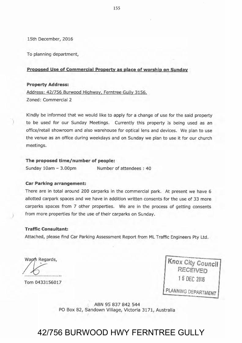
42/756 BURWOOD HWY FERNTREE GULLY
155
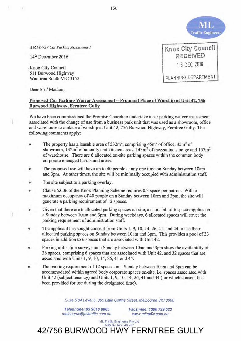
42/756 BURWOOD HWY FERNTREE GULLY
156
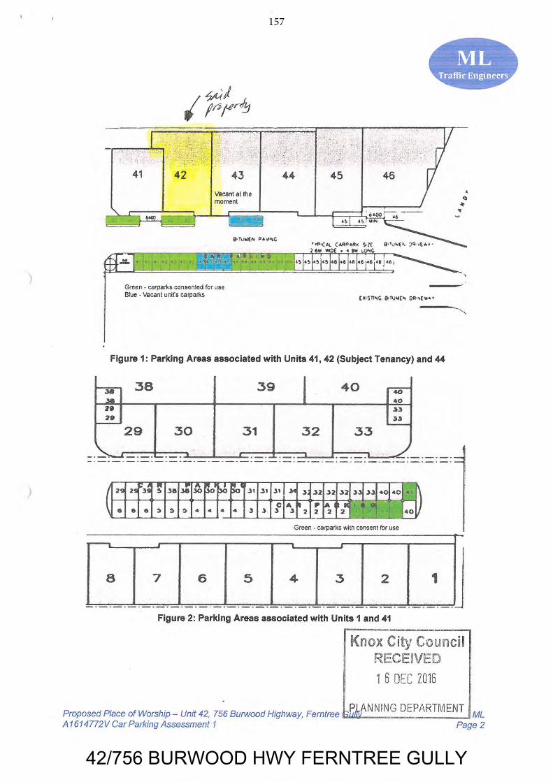
42/756 BURWOOD HWY FERNTREE GULLY
157
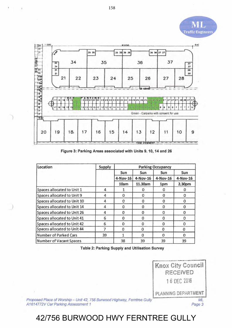
42/756 BURWOOD HWY FERNTREE GULLY
158
42/756 BURWOOD HWY FERNTREE GULLY
159
160 COUNCIL – CITY DEVELOPMENT 26 June 2017
CHANDLER WARD 6.6 PROPOSED REZONING OF 1221 MOUNTAIN HWY, THE BASIN (THE
BASIN COMMUNITY HOUSE) AND 1223 MOUNTAIN HWY, THE BASIN SUMMARY: Senior Strategic Planner (Jayna Liew) Coordinator - Property Management (Angela Mitchell) The purpose of this report is to seek Council approval to commence the rezoning of 1221 Mountain Hwy, The Basin to facilitate its disposal. It is proposed that the current tenant at this property, The Basin Community House, will be relocated within The Basin Primary School grounds. Council has identified the property at 1221 Mountain Hwy, The Basin as being surplus to Council’s requirements, in accordance with Council’s Sale of Land and Buildings Policy, and proposes the rezoning of the property from a Public Use Zone to a Neighbourhood Residential Zone (refer Appendix A). The sale process will commence once Ministerial approval for the rezoning is granted. This report also proposes the rezoning to Neighbourhood Residential Zone of the neighbouring property at 1223 Mountain Hwy, The Basin which is erroneously zoned for Public Use despite being used as residential land (refer Appendix A).
RECOMMENDATION
That Council:
1. Declares 1221 Mountain Highway, The Basin surplus to Council’s requirements.
2. Seeks authorisation from the Minister for Planning to prepare and exhibit Planning Scheme Amendment C161, as shown in Appendix B to this report.
3. Subject to receiving authorisation from the Minister for Planning, place Amendment C161 on public exhibition for a period of at least one month.
4. Adopts Amendment C161 (as shown in Appendix B) and submits the Amendment to the Minister for Planning for approval, should no submissions be received which cannot be resolved by officers.
5. Authorise the Director – City Development to make any minor changes to Amendment C161 provided these are consistent with the intent of the Amendment as shown in Appendix B.
161 COUNCIL – CITY DEVELOPMENT 26 June 2017 6.6 Proposed Rezoning of 1221 Mountain Hwy, The Basin (The Basin
Community House) and 1223 Mountain Hwy, The Basin (cont’d)
Recommendation (cont'd)
6. Receives a further report outlining the process for the sale of 1221 Mountain Highway, The Basin following Ministerial approval of Amendment C161.
1. INTRODUCTION
The property at 1221 Mountain Highway, The Basin is owned by Council and is currently zoned Public Use Zone 6 - Local Government (PUZ6). The property contains a single storey building occupied by The Basin Community House. The property is contained in Certificate of Title Volume 7733 Folio 098 part of Crown Allotment 72, Parish of Scoresby, County of Mornington.
The property at 1221 Mountain Highway, The Basin is considered surplus to Council’s requirements in accordance with Council’s Sale of Land and Buildings Policy and is proposed to be rezoned from Public Use Zone to Neighbourhood Residential Zone – Schedule 1 (NRZ1), consistent with the surrounding neighbourhood.
In addition, a zoning anomaly has been identified at the neighbouring property, 1223 Mountain Highway, The Basin (Lot 1 LP 74305). Despite being used as a residential dwelling, the property is located in a Public Use Zone. As this privately-owned property is inconsistent with intent of the Public Use Zone – Schedule 6 for Local Government Purposes, it is considered appropriate to rezone this land to NRZ1.
2. DISCUSSION
2.1 1221 Mountain Highway, The Basin
One of Council’s core responsibilities is to manage its assets in order to optimise their value to the community. Part of this responsibility involves evaluating any unused or redundant assets and releasing the funds tied up in these assets in order to acquire, develop or improve other assets.
The current tenant of 1221 Mountain Highway, The Basin, The Basin Community House, is intending to relocate to a new community facility at the adjacent site within The Basin Primary School, as part of the State Government plans to redevelop the school.
A review of Council’s land holdings identified 1221 Mountain Highway, The Basin as surplus, in accordance with Council’s Sale of Land and Buildings Policy (refer Appendix C).
162 COUNCIL – CITY DEVELOPMENT 26 June 2017
6.6 Proposed Rezoning of 1221 Mountain Hwy, The Basin (The Basin Community House) and 1223 Mountain Hwy, The Basin (cont’d)
Council’s Sale of Land and Buildings Policy outlines the process in considering any proposed sale of Council land. Specifically, prior to the sale of any property, it is to be appropriately zoned in order that the ultimate use of the land is determined by the zone and the highest possible sale price is achieved.
A report will be presented to Council following the rezoning process to progress the sale of this asset.
2.2 Rezoning of Public Use Zone land
To facilitate the future sale of the property, and to reflect that it is no longer intended for public use and Council ownership, it is recommended that 1221 Mountain Highway, The Basin be rezoned to NRZ1, consistent with the surrounding neighbourhood.
The neighbouring property at 1223 Mountain Highway, The Basin is similarly recommended for rezoning from a Public Use Zone to NRZ1 to be consistent with the zoning of properties to the immediate east and south of the property.
NRZ1 has been applied to areas identified as Bush Suburban in the Knox Housing Strategy 2015, with an eight metre maximum height limit and a purpose to “manage and ensure that development respects the identified neighbourhood character, heritage, environmental or landscape characteristic of limited and low scale residential development to protect the environmental and biological qualities that make these areas distinct.”
2.3 Application of Overlays
Both properties are currently affected by an Environmental Significance Overlay – Schedule 3 (ESO3), which is proposed to be retained.
Both properties are also affected by a Significant Landscape Overlay – Schedule 4 (SLO4) which relates to ‘The Basin Rural Landscape’, described in the SLO4 as a ‘pastoral landscape of rolling green hills’. It is considered that the landscape and development characteristics of both properties are more similar to the residential neighbourhood to the south and east instead of the open fields to the north. As such, it is proposed to apply the Design and Development Overlay - Schedule 2 (DDO2) and Significant Landscape Overlay - Schedule 3 (SLO3), which relate to the ‘Dandenong Foothills: Lower Slope and Valley Area’.
Notably, the DDO2 will apply a minimum subdivision area of 500m2. As 1221 Mountain Highway, The Basin has an area of 989m2, and 1223 Mountain Highway, The Basin has an area of 737m2, imposition of the DDO2 will effectively restrict future subdivision of both properties. The DDO2 is considered appropriate considering that planning controls on these properties will be consistent with the surrounding, similar residential neighbourhood.
163 COUNCIL – CITY DEVELOPMENT 26 June 2017 6.6 Proposed Rezoning of 1221 Mountain Hwy, The Basin (The Basin
Community House) and 1223 Mountain Hwy, The Basin (cont’d)
2.4 Consistency with State Planning Policy
The proposed amendment also supports the following policies of the State Planning Policy:
11.02 Urban growth by ensuring a supply of land is available for residential, commercial, retail, industrial, recreational, institutional and other community uses.
11.05-2 Distinctive areas of state significance by protecting and enhancing the valued attributes of the distinctive areas of the Yarra Valley and Dandenong Ranges.
11.06-2 Housing choice - providing housing choice close to jobs and services.
11.06-5 Neighbourhoods by assisting to create a city of inclusive, vibrant and healthy neighbourhoods that promote strong communities, healthy lifestyles and good access to local services and jobs.
12.01-1 Protection of biodiversity – the application of the ESO3 and SLO3 will assist the protection and conservation of Victoria’s biodiversity, including important habitat for Victoria’s flora and fauna and other strategically valuable biodiversity sites.
12.04-2 Landscapes by protecting landscapes and significant open spaces that contribute to character, identity and sustainable environment of the Dandenong Foothills.
16.01 Residential development by promoting a housing market that meets community needs and locating new housing in or close to activity centres and in urban renewal precincts and sites that offer good access to jobs, services and transport.
19.02-4 Distribution of social and cultural infrastructure by providing fairer distribution of and access to social and cultural infrastructure, in the form of a new The Basin Community House being provided within the grounds of The Basin Primary School.
The amendment is consistent with and supports the direction of Knox’s Local Planning Policy Framework, and specifically the following aspects of the Municipal Strategic Statement:
21.05 Housing by supporting a diversity of housing choice in appropriate locations. The rezoning of the subject land to the neighbourhood residential zone will protect the environmental and biological qualities that make this bush suburban area distinct.
164 COUNCIL – CITY DEVELOPMENT 26 June 2017 6.6 Proposed Rezoning of 1221 Mountain Hwy, The Basin (The Basin
Community House) and 1223 Mountain Hwy, The Basin (cont’d)
21.08 Infrastructure by ensuring that social infrastructure is accessible and meets the existing and future needs of the community. Sale of surplus facilities supports the financial viability of Council to continue delivering valuable infrastructure.
22.01 Dandenong Foothills by applying the DDO2 and SLO3 to more accurately reflect the development and landscape of the properties in question, and to support the protection of the Dandenong Foothills: Lower Slope and Valley landscape.
2.5 Proposed Sale of land
This report proposes that, following the rezoning of the land at 1221 Mountain Highway, The Basin, Council consider a future report outlining the proposed sale of 1221 Mountain Highway, The Basin consistent with the Sale of Land and Buildings Policy and statutory requirements.
3. CONSULTATION
Council will undertake public consultation on the Planning Scheme Amendment to fulfil its statutory obligations under the Planning & Environment Act 1987.
Key elements of the proposed exhibition process include amendment notices to be sent to adjoining owners and occupiers and specific State Government departments and authorities. Notices will also be published in the Government Gazette and Knox Leader.
Subsequent sale of land processes will include a further public consultation process as per Section 189 of the Local Government Act.
4. ENVIRONMENTAL/AMENITY ISSUES
Application of the SLO3 and DDO2 is a logical extension of the controls that apply to the adjoining established residential area, and will continue to protect the Dandenong Foothills landscape.
Amenity issues such as impacts on neighbouring properties and landscaping will be considered as part of any future planning permit applications.
5. FINANCIAL & ECONOMIC IMPLICATIONS
The proposed Planning Scheme Amendment can be managed within existing Council budget.
165 COUNCIL – CITY DEVELOPMENT 26 June 2017 6.6 Proposed Rezoning of 1221 Mountain Hwy, The Basin (The Basin
Community House) and 1223 Mountain Hwy, The Basin (cont’d)
The identification of 1221 Mountain Highway, The Basin as surplus to Council’s needs is in accordance with the Sale of Land and Buildings Policy. Rezoning and the proposed future sale of the property will support Council’s responsible financial management practice. A further report outlining the financial considerations of any future sale of this property will be prepared at the conclusion of the rezoning process.
The proposed changes to planning controls for 1223 Mountain Highway rectify anomalies and are not expected to have any financial implications for Council or the property owner. It is noted that any proposal to develop the property will be challenging if the existing PUZ6 is retained over the property.
6. SOCIAL IMPLICATIONS
The services provided at 1221 Mountain Highway by The Basin Community House will be relocated to the adjacent property.
Rezoning and future consideration of sale of 1221 Mountain Highway will support Council in its broader service delivery obligations. As assessed in Appendix C, the property is considered surplus to Council’s requirements, in particular due to its lack of parking facilities for alternative community uses.
The proposed changes to planning controls for 1223 Mountain Highway rectify anomalies and are not expected to have any social implications.
7. RELEVANCE TO CITY PLAN 2013-17 (INCORPORATING THE COUNCIL PLAN)
The proposed rezoning of this property is consistent with and will implement the following objectives and strategies of City Plan 2013-17, as outlined below:
Theme 2: Prosperous, Advancing Economy 2.2 Improve local opportunities for people to live, work, learn and play in
Knox.
2.2.5 Support opportunities, partnerships and collaborative efforts towards increasing ‘local living’ in Knox.
Theme 3: Vibrant and Sustainable Built and Natural Environments 3.1 The changing needs of a diverse community are supported through
planned growth and change in housing and infrastructure that respects both built form and natural systems, and resource availability.
3.1.1 A diversity of housing choice is provided in appropriate locations.
166 COUNCIL – CITY DEVELOPMENT 26 June 2017 6.6 Proposed Rezoning of 1221 Mountain Hwy, The Basin (The Basin
Community House) and 1223 Mountain Hwy, The Basin (cont’d)
Theme 5: Democratic and Engaged Communities 5.3 Ensure Council is well governed and demonstrates effective leadership.
5.3.1 Maintain accountable and transparent governance practices, and Council’s sound stewardship of the community’s finances and assets.
8. CONCLUSION
The rezoning and any future sale of 1221 Mountain Highway, The Basin presents an opportunity to convert an asset that will no longer be used to deliver community outcomes. The operations of The Basin Community House will be administered from the building to be constructed on the abutting school site.
Changes to planning controls for 1221 Mountain Highway are appropriate given that they are consistent with the surrounding residential neighbourhood.
Changes to planning controls for the adjacent property at 1223 Mountain Highway are appropriate to rectify zoning errors as the residential property should not be located within a Public Use zone.
It is recommended that Council determine 1221 Mountain Highway, The Basin as surplus. It is also recommended that Council seek authorisation from the Minister for Planning to prepare and exhibit Amendment C161 and, upon this being approved, a further report be presented to commence the sale of this property.
9. CONFIDENTIALITY
There are no confidentially issues associated with this report.
Report Prepared By: Senior Strategic Planner (Jayna Liew) Coordinator Property Management (Angela Mitchell) Report Authorised By: Acting Director – City Development (Paul Dickie) Acting Director – Corporate Development (Kim Rawlings)
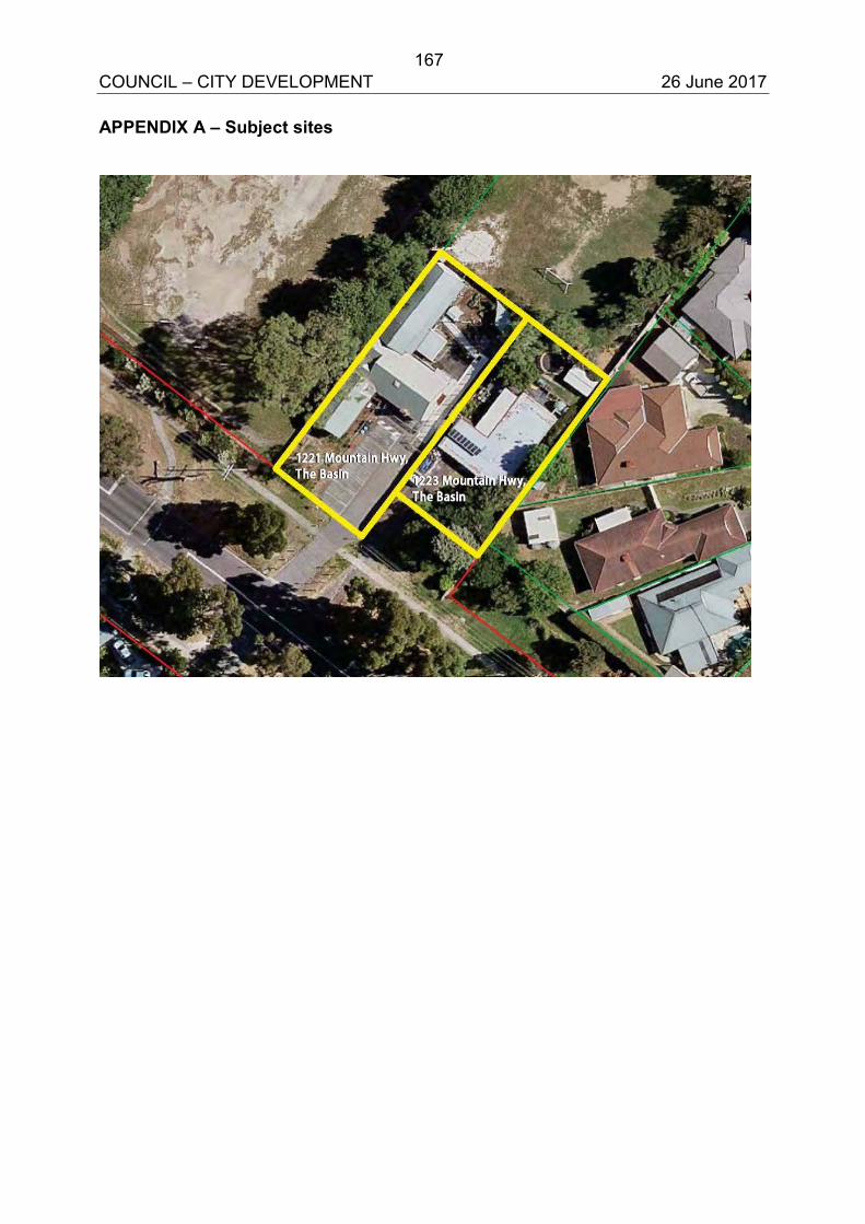
167 COUNCIL – CITY DEVELOPMENT 26 June 2017 APPENDIX A – Subject sites
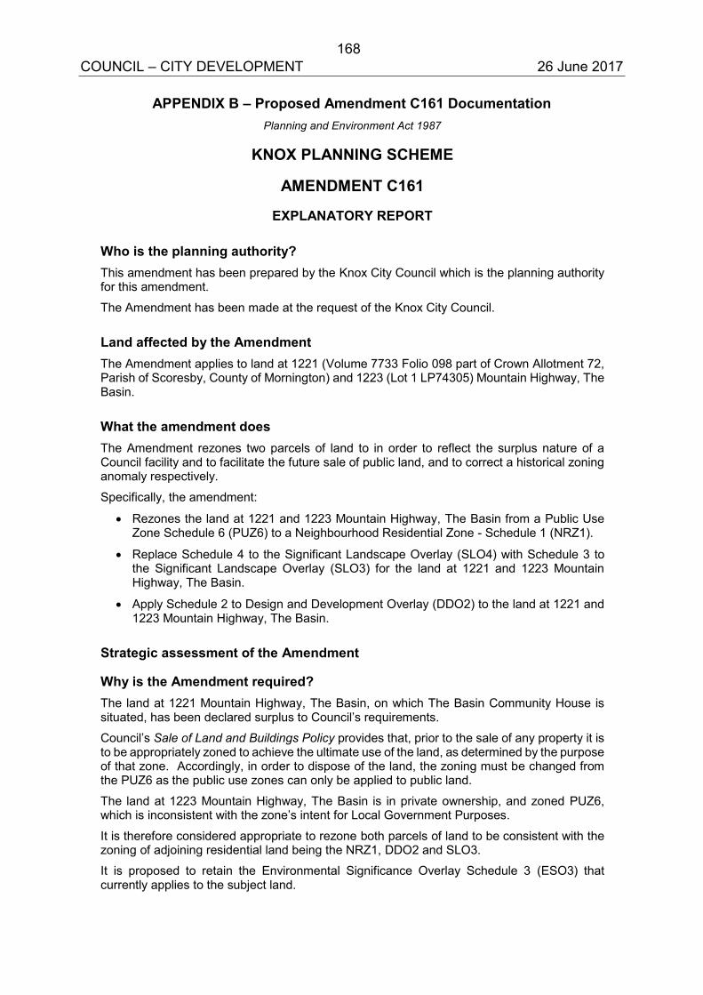
168 COUNCIL – CITY DEVELOPMENT 26 June 2017
APPENDIX B – Proposed Amendment C161 Documentation Planning and Environment Act 1987
KNOX PLANNING SCHEME
AMENDMENT C161
EXPLANATORY REPORT
Who is the planning authority? This amendment has been prepared by the Knox City Council which is the planning authority for this amendment.
The Amendment has been made at the request of the Knox City Council.
Land affected by the Amendment The Amendment applies to land at 1221 (Volume 7733 Folio 098 part of Crown Allotment 72, Parish of Scoresby, County of Mornington) and 1223 (Lot 1 LP74305) Mountain Highway, The Basin.
What the amendment does The Amendment rezones two parcels of land to in order to reflect the surplus nature of a Council facility and to facilitate the future sale of public land, and to correct a historical zoning anomaly respectively.
Specifically, the amendment:
Rezones the land at 1221 and 1223 Mountain Highway, The Basin from a Public UseZone Schedule 6 (PUZ6) to a Neighbourhood Residential Zone - Schedule 1 (NRZ1).
Replace Schedule 4 to the Significant Landscape Overlay (SLO4) with Schedule 3 tothe Significant Landscape Overlay (SLO3) for the land at 1221 and 1223 MountainHighway, The Basin.
Apply Schedule 2 to Design and Development Overlay (DDO2) to the land at 1221 and1223 Mountain Highway, The Basin.
Strategic assessment of the Amendment
Why is the Amendment required? The land at 1221 Mountain Highway, The Basin, on which The Basin Community House is situated, has been declared surplus to Council’s requirements.
Council’s Sale of Land and Buildings Policy provides that, prior to the sale of any property it is to be appropriately zoned to achieve the ultimate use of the land, as determined by the purpose of that zone. Accordingly, in order to dispose of the land, the zoning must be changed from the PUZ6 as the public use zones can only be applied to public land.
The land at 1223 Mountain Highway, The Basin is in private ownership, and zoned PUZ6, which is inconsistent with the zone’s intent for Local Government Purposes.
It is therefore considered appropriate to rezone both parcels of land to be consistent with the zoning of adjoining residential land being the NRZ1, DDO2 and SLO3.
It is proposed to retain the Environmental Significance Overlay Schedule 3 (ESO3) that currently applies to the subject land.
169 COUNCIL – CITY DEVELOPMENT 26 June 2017
How does the Amendment implement the objectives of planning in Victoria? The amendment implements the objectives of planning in Victoria by ensuring that the Knox Planning Scheme is able to facilitate appropriate development and use in accordance with Section 4(1) of the Planning and Environment Act 1987.
How does the Amendment address any environmental, social and economic effects? The reapplication of the SLO Schedules, from Schedule 4 - The Basin Rural Landscape to Schedule 3 - Dandenong Foothills: Lower Slope and Valley Area will better reflect and support the environmental and landscape objectives for this significant area. The application of the SLO3 is a logical extension of the controls that apply to the adjoining established residential area.
The proposed rezoning of 1223 Mountain Highway, The Basin to a residential zone is appropriate as it reflects the surplus nature of this Council land.
Does the Amendment address relevant bushfire risk? The subject land is not located in within the Bushfire Management Overlay (BMO). The application of the Neighbourhood Residential Zone is appropriate given the surrounding residential densities and bushfire requirements.
Does the Amendment comply with the requirements of any Minister’s Direction applicable to the amendment? The amendment complies with the Ministerial Direction on the Form and Content of Planning Scheme under section 7(5) of the Act.
The Amendment is consistent with Minister’s Direction No.9 – Metropolitan Strategy (as amended 30 May 2014) pursuant to Section 12 of the Planning and Environment Act 1987 – that requires planning authorities to have regard to the Metropolitan Planning Strategy (Plan Melbourne: Metropolitan Planning Strategy).
It is considered that the amendment is consistent with and support policies 2.3.4, 5.3.1 and 5.3.3 by providing for the rezoning and sale of Council owned land to facilitate delivery of other community initiatives.
How does the Amendment support or implement the State Planning Policy Framework and any adopted State policy? The State Planning Policy Framework (SPPF) seeks to ensure the objectives of planning in Victoria, as set out in the Planning and Environment Act 1987, are fostered through appropriate planning policies and practices that integrate relevant environmental, social and economic factors in the interest of net community benefit and sustainable development.
The amendment supports the following strategies by providing new residential zoned land and opportunities for new community infrastructure in the existing The Basin neighbourhood:
11.02 Urban growth- by ensuring a supply of land is available for residential, commercial, retail, industrial, recreational, institutional and other community uses.
11.05-2 Distinctive areas of state significance by protecting and enhancing the valued attributes of the distinctive areas of the Yarra Valley and Dandenong Ranges.
11.06-2 Housing choice by providing housing choice close to jobs and services.
11.06-5 Neighbourhoods by assisting to create a city of inclusive, vibrant and healthy neighbourhoods that promote strong communities, healthy lifestyles and good access to local services and jobs.
12.01-1 Protection of biodiversity – the application of the ESO3 and SLO3 will assist the protection and conservation of Victoria’s biodiversity, including important habitat for Victoria’s flora and fauna and other strategically valuable biodiversity sites.
170 COUNCIL – CITY DEVELOPMENT 26 June 2017
12.04-2 Landscapes by protecting landscapes and significant open spaces that contribute to character, identity and sustainable environment of the Dandenong Foothills.
16.01 Residential development by promoting a housing market that meets community needs and locating new housing in or close to activity centres and in urban renewal precincts and sites that offer good access to jobs, services and transport.
19.02-4 Distribution of social and cultural infrastructure by provide fairer distribution of and access to of social and cultural infrastructure, in the form of a new The Basin Community House.
How does the Amendment support or implement the Local Planning Policy Framework, and specifically the Municipal Strategic Statement? The amendment is consistent with and supports the direction of Knox’s Local Planning Policy Framework, and specifically the following aspects of the Municipal Strategic Statement.
21.05 Housing by supporting a diversity of housing choice in appropriate locations.
The rezoning of the subject land to the neighbourhood residential zone will protect the environmental and biological qualities that make this bush suburban area distinct.
21.08 Infrastructure by ensuring that social infrastructure is accessible and meets the existing and future needs of the community.
The sale of the rezoned land will facilitate a new community facility in the form of The Basin Community Hub.
22.01 Dandenong Foothills the application of the SLO3 will ensure that the landscape characteristics of the Foothills will be protected.
Does the Amendment make proper use of the Victoria Planning Provisions? The application of the NRZ1 is appropriate given that the land is proposed to be sold into new ownership and is consistent with the surrounding residential area, and as public use zones can only be applied to public land.
How does the Amendment address the views of any relevant agency? The views of the relevant agencies will be formally sought as part of the exhibition of the amendment.
Does the Amendment address relevant requirements of the Transport Integration Act 2010? The amendment will not have a significant impact on the transport system. The subject land is well located; adjacent to the Basin Primary School and on the PPTN.
Resource and administrative costs
What impact will the new planning provisions have on the resource and administrative costs of the responsible authority? The rezoning of the land will not have significant impact on the resources and administration cost of Knox Council.
Where you may inspect this Amendment The Amendment is available for public inspection, free of charge, during office hours at the following place:
Council’s Customer Service Building and Planning counter at the Knox Council Civic Centre, 511 Burwood Highway, Wantirna South, on weekdays (excluding Tuesdays) from 8:30am to 5:00pm and on Tuesdays from 8:30am to 8:00pm.
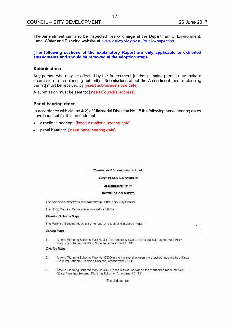
171 COUNCIL – CITY DEVELOPMENT 26 June 2017
The Amendment can also be inspected free of charge at the Department of Environment, Land, Water and Planning website at www.delwp.vic.gov.au/public-inspection.
[The following sections of the Explanatory Report are only applicable to exhibited amendments and should be removed at the adoption stage
Submissions Any person who may be affected by the Amendment [and/or planning permit] may make a submission to the planning authority. Submissions about the Amendment [and/or planning permit] must be received by [insert submissions due date].
A submission must be sent to: [insert Council’s address]
Panel hearing dates In accordance with clause 4(2) of Ministerial Direction No.15 the following panel hearing dates have been set for this amendment:
directions hearing: [insert directions hearing date]
panel hearing: [insert panel hearing date] ]
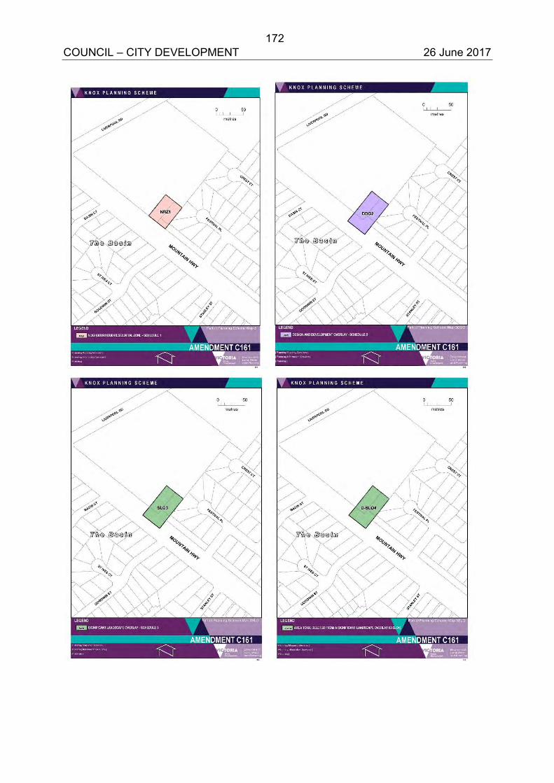
172 COUNCIL – CITY DEVELOPMENT 26 June 2017
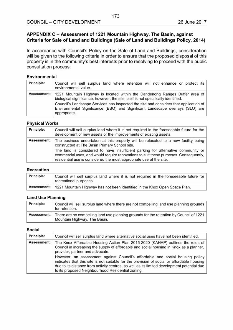
173 COUNCIL – CITY DEVELOPMENT 26 June 2017 APPENDIX C – Assessment of 1221 Mountain Highway, The Basin, against Criteria for Sale of Land and Buildings (Sale of Land and Buildings Policy, 2014)
In accordance with Council’s Policy on the Sale of Land and Buildings, consideration will be given to the following criteria in order to ensure that the proposed disposal of this property is in the community’s best interests prior to resolving to proceed with the public consultation process:
Environmental Principle: Council will sell surplus land where retention will not enhance or protect its
environmental value. Assessment: 1221 Mountain Highway is located within the Dandenong Ranges Buffer area of
biological significance, however, the site itself is not specifically identified. Council’s Landscape Services has inspected the site and considers that application of Environmental Significance (ESO) and Significant Landscape overlays (SLO) are appropriate.
Physical Works Principle: Council will sell surplus land where it is not required in the foreseeable future for the
development of new assets or the improvements of existing assets. Assessment: The business undertaken at this property will be relocated to a new facility being
constructed at The Basin Primary School site. The land is considered to have insufficient parking for alternative community or commercial uses, and would require renovations to suit these purposes. Consequently, residential use is considered the most appropriate use of the site.
Recreation Principle: Council will sell surplus land where it is not required in the foreseeable future for
recreational purposes. Assessment: 1221 Mountain Highway has not been identified in the Knox Open Space Plan.
Land Use Planning Principle: Council will sell surplus land where there are not compelling land use planning grounds
for retention. Assessment: There are no compelling land use planning grounds for the retention by Council of 1221
Mountain Highway, The Basin.
Social Principle: Council will sell surplus land where alternative social uses have not been identified. Assessment: The Knox Affordable Housing Action Plan 2015-2020 (KAHAP) outlines the roles of
Council in increasing the supply of affordable and social housing in Knox as a planner, provider, partner and advocate. However, an assessment against Council’s affordable and social housing policy indicates that this site is not suitable for the provision of social or affordable housing due to its distance from activity centres, as well as its limited development potential due to its proposed Neighbourhood Residential zoning.
174 COUNCIL – CITY DEVELOPMENT 26 June 2017
CHANDLER, DOBSON AND TAYLOR WARDS 6.7 RESPONSE TO CALL-UP ITEM REQUESTING A REVIEW OF
DANDENONG FOOTHILLS PLANNING POLICY SUMMARY: Senior Strategic Planner (Claire Anderson) This report responds to a call-up item from Council requesting a report outlining the process, timing and resources required to review current planning policy and the suite of planning controls that guide development in the Dandenong Foothills. It outlines three options: no review; a review of subdivision controls in targeted areas; or a wholesale review of the entire Foothills policy and all controls. The report recommends that Council does not review Dandenong Foothills policy and planning controls on the basis that: the current policies and controls are effectively protecting the landscape and environmental values (this has been acknowledged by the two previous independent reviews of the Knox Planning Scheme) and a review is not identified in the current City Plan 2013-2017 or the draft Community and Council Plan 2017-21.
RECOMMENDATION
That Council:
1. Note the three options for reviewing the current planning policy and suite of planning controls that guide development in the Dandenong Foothills as outlined in this report.
2. Endorse Option 1, which recommends not reviewing the Foothills policy and controls for the reasons outlined in this report.
1. INTRODUCTION
On 13 December 2016 Council resolved the following call-up item: “That a report be provided to the March 2017 Ordinary Meeting of Council outlining the process, timing and resources required to review the foothills policy.” A report was prepared for Council to consider at a confidential Issues Briefing on 20 March 2017.
This report outlines the process, timing and resources required for three broad options available to Council.
As a part of undertaking the work required for this Call Up Item, officers have had regard to Council’s Call Up Items at Council Meetings Policy, and in particular, Item 6.5 which states:
175 COUNCIL – CITY DEVELOPMENT 26 June 2017 6.7 Response to call-up item requesting a review of Dandenong Foothills
planning policy (cont’d)
‘Where preparing a report responding to a Call Up Item which will require more than 3 person days or $5,000 in costs, then the matter which is subject to the Call Up Item should be referred by Council to the next budget considerations with a supporting business case for consideration along with other competing priorities.’
2. DISCUSSION
2.1 Significance of the ‘Dandenong Foothills’
The ‘Dandenong Foothills’ (the Foothills) includes part or all of the suburbs of Boronia, The Basin, Ferntree Gully, Upper Ferntree Gully, Rowville, Lysterfield and Sassafras (Appendix A – Map of the Dandenong Foothills). Some of these areas are rural and located outside the Urban Growth Boundary. Other areas are mainly residential, interspersed with the “villages” (commercial and retail activity centres) of Alchester Village, The Basin, Ferntree Gully and Upper Ferntree Gully, and the mixed use strip along Burwood Highway between Glenfern Road and Upper Ferntree Gully Village.
The Foothills are highly valued by local residents and beyond. The Dandenong Ranges and its Foothills form a backdrop to views across the eastern suburbs of Melbourne, including long-range views from the Melbourne CBD and other high views across the metropolitan area. The important characteristics of the hills from these views are their heavily vegetated, apparently natural environment. The Lysterfield Valley is classified by the National Trust as an “attractive pastoral landscape”, forming a key gateway to the Dandenongs and provides an important buffer between urban and rural areas. The Foothills is also the most environmentally significant area of the City, with the majority of the area being a designated “Site of Biological Significance” of State and/or regional significance (Appendix B – Areas of Environmental and Landscape Significance in the City of Knox). The Foothills play an important role as an ecological buffer zone between the national parks to the east and south, and suburbia to the west. The Foothills also contain the highest value water catchments in the City. Some areas are susceptible to flooding.
Large areas of the Foothills are also highly susceptible to bushfires (Appendix C – Areas of Highest Bushfire Risk in the City of Knox).
While the area is broadly known as “the Foothills”, it includes five “key landscape areas”, each with their own special landscape values (Appendix D – Dandenong Foothills Key Landscape Areas). These range from the heavily vegetated hillsides of The Basin, Ferntree Gully and Upper Ferntree Gully, to the open pastoral landscape of Lysterfield’s rural areas.
176 COUNCIL – CITY DEVELOPMENT 26 June 2017 6.7 Response to call-up item requesting a review of Dandenong Foothills
planning policy (cont’d)
2.2 Current suite of planning policies and controls
The long-standing policy approach for the Dandenong Foothills recognises that its environmental and landscape significance outweighs the need for urban consolidation in these areas.
In the “scaled approach” to future residential development in Knox articulated in the Knox Housing Strategy 2015, all of the Foothills policy area (excluding Neighbourhood Activity Centres) is designated as “Bush Suburban,” the area earmarked for the least amount of change.
The package of controls that apply to the different areas within the Foothills are the most comprehensive and stringent in the City; designed to reflect the significance and sensitive nature of much of this area. They include a mix of mandatory and performance-based built form and vegetation protection controls. The requirements are embedded in:
Dandenong Foothills local planning policy: explains the significance of the Foothills in the local, regional and state context, and the objectives of policy to protect the Foothills, including by limiting further subdivision (Appendix E).
Bushfire Management Overlay (BMO): to identify areas where bushfire hazard presents a risk to human life and property.
Design and Development Overlays (DDOs): primarily to control built form; includes minimum subdivision sizes, maximum site coverage, permeability requirements, maximum building height.
Environmental Significance Overlays (ESOs): to protect and enhance vegetation and wildlife habits with biological significance.
Significant Landscape Overlays (SLOs): to protect and enhance vegetation for its landscape value.
Vegetation Protection Overlays (VPOs): primarily to protect individual trees.
2.3 Options for reviewing Dandenong Foothills policy and planning controls
The discussion below outlines the process, timing and resources required for three broad options available to Council. These were discussed with Councillors in some detail at a Confidential Issues Briefing.
177 COUNCIL – CITY DEVELOPMENT 26 June 2017 6.7 Response to call-up item requesting a review of Dandenong Foothills
planning policy (cont’d)
Option 1 – No review
This option is for the current Foothills policy and planning controls to remain on the basis that:
The Dandenong Foothills as a whole are a significant metropolitan and State asset as outlined in Section 2.1 above. The State Planning Policy Framework identifies the Dandenong Ranges as a “significant environment and landscape”, “environmentally sensitive area...with significant recreational value” that must be protected (Clause 12.04).
The long-standing suite of planning policies and controls have been
extremely effective in protecting the landscape and environmental values of the Foothills. Both the 2010 and 2014 Planning Scheme Reviews noted this success:
“Overall, the Knox Planning Scheme delivers the ‘leafy green’ image sought by Council’s corporate directions for land use and development. Its greatest successes are to protect the Dandenong Foothills…the controls fit the policy context like a glove fits a hand, providing certainty and stability in what had been [prior to 2006, when the majority of the current controls were introduced] a volatile area.”
A review would likely benefit few properties at a significant cost to Council (discussed in Options 2 and 3 below). There is no budget currently allocated for a review.
A review of Foothills policy is not identified in the current City Plan 2013-17 or the work currently being undertaken for the draft Community and Council Plan 2017-2021.
There is adequate future capacity of land in Knox to meet future demand for population and household growth. There is an estimated additional 36,362 dwelling capacity (theoretical ultimate capacity based on the Housing Strategy, Structure Plans and Strategic Sites), including the potential for an additional 1800 lots in the Foothills, to provide for an estimated demand of 12,625 new households for the whole municipality to 2036. Housing stock in Knox currently consists of mainly detached dwellings, which reflects the predominant household type of families with children. Retention of a large proportion of detached dwellings will continue to be important to meet the housing needs of this household type. This group will continue to be the predominant household type in Knox. There are many opportunities in other areas of the City for smaller housing types, including dual occupancies, villa units, townhouses and apartments, to be built close to services and infrastructure in “Local Living” and “Activity Areas” to meet the growing demand for couple-only and one-person households.
178 COUNCIL – CITY DEVELOPMENT 26 June 2017 6.7 Response to call-up item requesting a review of Dandenong Foothills
planning policy (cont’d)
Two submitters to Amendment C150 (implementation of the 2014 Knox Planning Scheme Review, including a new Municipal Strategic Statement) requested that greater subdivision potential be allowed in the Foothills. The Planning Panel that considered the Amendment concluded: “It is not appropriate or justified to reduce the minimum subdivision lot size in the Dandenong Foothills through the Amendment.”
In summary:
Process No further action required.
Timing N/A
Resources $0
This is the recommended option. Option 2 – Review subdivision controls in targeted areas only
Option 2 could involve a review of the current planning controls (particularly subdivision controls) to enable some additional development. For example, subdivision controls could be relaxed in targeted areas within an easy walking distance of Foothills activity centres (Alchester Village, The Basin, Ferntree Gully and Upper Ferntree Gully). This option would facilitate more housing choices in areas where most subdivision potential is limited.
This type of review assumes that the underlying policy for the Foothills is generally appropriate and effective, but that small changes to planning controls could provide different development outcomes in some areas.
Assuming that (for example) areas within approximately 400 metres easy walking distance of a commercial zone of the four centres are reviewed, early analysis has found that less than 200 properties could have additional development potential.
The estimated cost of this option is $430,000 over two years. This includes analysis and technical work (such as 3D terrain modelling and analysis of lot sizes), and the planning scheme amendment required to implement the changes to planning controls in the Knox Planning Scheme.
179 COUNCIL – CITY DEVELOPMENT 26 June 2017 6.7 Response to call-up item requesting a review of Dandenong Foothills
planning policy (cont’d)
In summary:
Process Medium complexity
Timing Approximately two years
Resources Approximately $430,000 ($240,000 for Project Manager over two years + $190,000 for technical work and planning scheme amendment)
This is not recommended.
Option 3 – Wholesale review of entire Foothills policy and all controls
Option 3 would involve re-examining the fundamental priorities in the underlying policy position on which the current suite of planning controls is based. It would review several technical studies (including the 2003 Knox Urban Design Framework and landscape assessment, spatial analysis with 3D terrain modelling and lot sizes, and update of parts of the Sites of Biological Significance Study). Assuming that the entire Foothills were reviewed under this option, early analysis has found that 11,800 properties could be affected. This option would raise significant levels of community concern about the potential for significant change to the character of Foothills areas.
The estimated cost of this option is $740,000 over three years. This includes significant analysis of impacts and reviews of technical work, requiring a substantial budget for expert consultants. It also includes resourcing a highly complex planning scheme amendment process that could introduce a completely new set of planning controls, and generate a large number of public submissions.
In summary:
Process Very high complexity
Timing Approximately three years
Resources Approximately $740,000 ($360,000 for Project Manager over three years +
$380,000 for technical work and planning scheme amendment)
This is not recommended.
180 COUNCIL – CITY DEVELOPMENT 26 June 2017 6.7 Response to call-up item requesting a review of Dandenong Foothills
planning policy (cont’d)
3. CONSULTATION
Community consultation is a legislative requirement of the planning scheme amendment process.
Any review of the Foothills proposing to facilitate more development in some areas is likely to generate significant community feedback given:
the importance of the Dandenong Foothills to landowners and the broader Foothills and Knox communities;
expectations of no or little change given Council’s long-standing policy approach;
direct impact on landowners, and the broader Foothills and Knox communities;
potential for significant change to the neighbourhood character of Foothills areas;
the risk of community/landowner angst given that some areas may be able to be further developed and not others.
Option 3 would generate the most community interest; while Option 2 would likely have less interest given that a targeted approach affects fewer properties directly.
Given the expected amount of community interest and impact, if Option 2 or 3 were pursued, a comprehensive community engagement program would be required.
4. ENVIRONMENTAL/AMENITY ISSUES
Allowing additional development in some or all areas of the Foothills would have significant impacts on its landscape and environmental values. The level of impact would be greatest for Option 3.
Similarly, there would be some local amenity impacts (such as an increase in traffic) on landowners and occupiers.
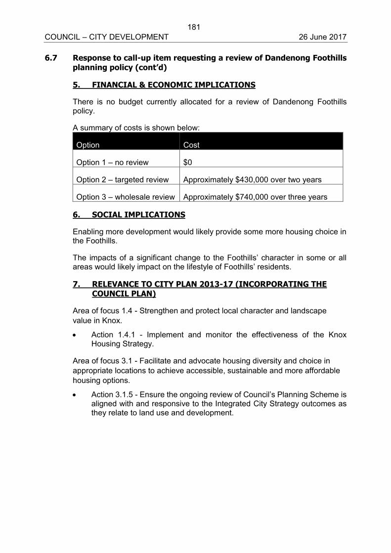
181 COUNCIL – CITY DEVELOPMENT 26 June 2017 6.7 Response to call-up item requesting a review of Dandenong Foothills
planning policy (cont’d)
5. FINANCIAL & ECONOMIC IMPLICATIONS
There is no budget currently allocated for a review of Dandenong Foothills policy.
A summary of costs is shown below:
Option Cost
Option 1 – no review $0
Option 2 – targeted review Approximately $430,000 over two years
Option 3 – wholesale review Approximately $740,000 over three years
6. SOCIAL IMPLICATIONS
Enabling more development would likely provide some more housing choice in the Foothills.
The impacts of a significant change to the Foothills’ character in some or all areas would likely impact on the lifestyle of Foothills’ residents.
7. RELEVANCE TO CITY PLAN 2013-17 (INCORPORATING THE COUNCIL PLAN)
Area of focus 1.4 - Strengthen and protect local character and landscape value in Knox.
Action 1.4.1 - Implement and monitor the effectiveness of the Knox Housing Strategy.
Area of focus 3.1 - Facilitate and advocate housing diversity and choice in appropriate locations to achieve accessible, sustainable and more affordable housing options.
Action 3.1.5 - Ensure the ongoing review of Council’s Planning Scheme is aligned with and responsive to the Integrated City Strategy outcomes as they relate to land use and development.
182 COUNCIL – CITY DEVELOPMENT 26 June 2017 6.7 Response to call-up item requesting a review of Dandenong Foothills
planning policy (cont’d)
Area of focus 3.4 - Ensure rural and urban areas are planned for, and their landscape character and amenity are protected, by understanding the value of agricultural land and providing policy guidance.
Action 3.4.1 - Complete a strategic review of rural and green wedge land to allow Council to better understand the productivity and economy of agricultural land, conservation and protection of landscape character and amenity, and provide strategic justification for any necessary changes to the Knox Planning Scheme.
8. CONCLUSION
This report responds to a call-up item from Council requesting a report outlining the process, timing and resources required to review current planning policy and the suite of planning controls that guide development in the Dandenong Foothills.
It provides three options including: no review; a review of subdivision controls in targeted areas only; or a wholesale review of the entire Foothills policy and all controls.
The report recommends that Council does not review Dandenong Foothills policy and planning controls on the basis that: the current policies and controls are effectively protecting the landscape and environmental values and a review is not identified in the current City Plan 2013-2017 or the draft Community and Council Plan currently underway.
9. CONFIDENTIALITY
There are no confidentiality issues associated with this report. Report Prepared By: Senior Strategic Planner (Claire Anderson) Report Authorised By: Acting Director – City Development (Paul Dickie)
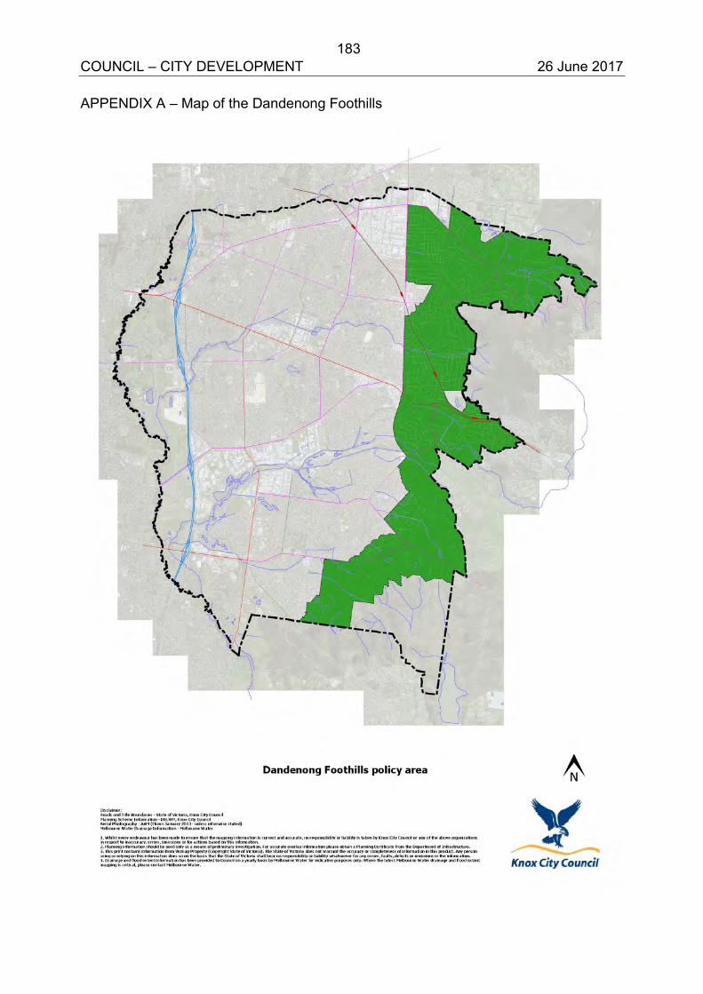
183 COUNCIL – CITY DEVELOPMENT 26 June 2017 APPENDIX A – Map of the Dandenong Foothills
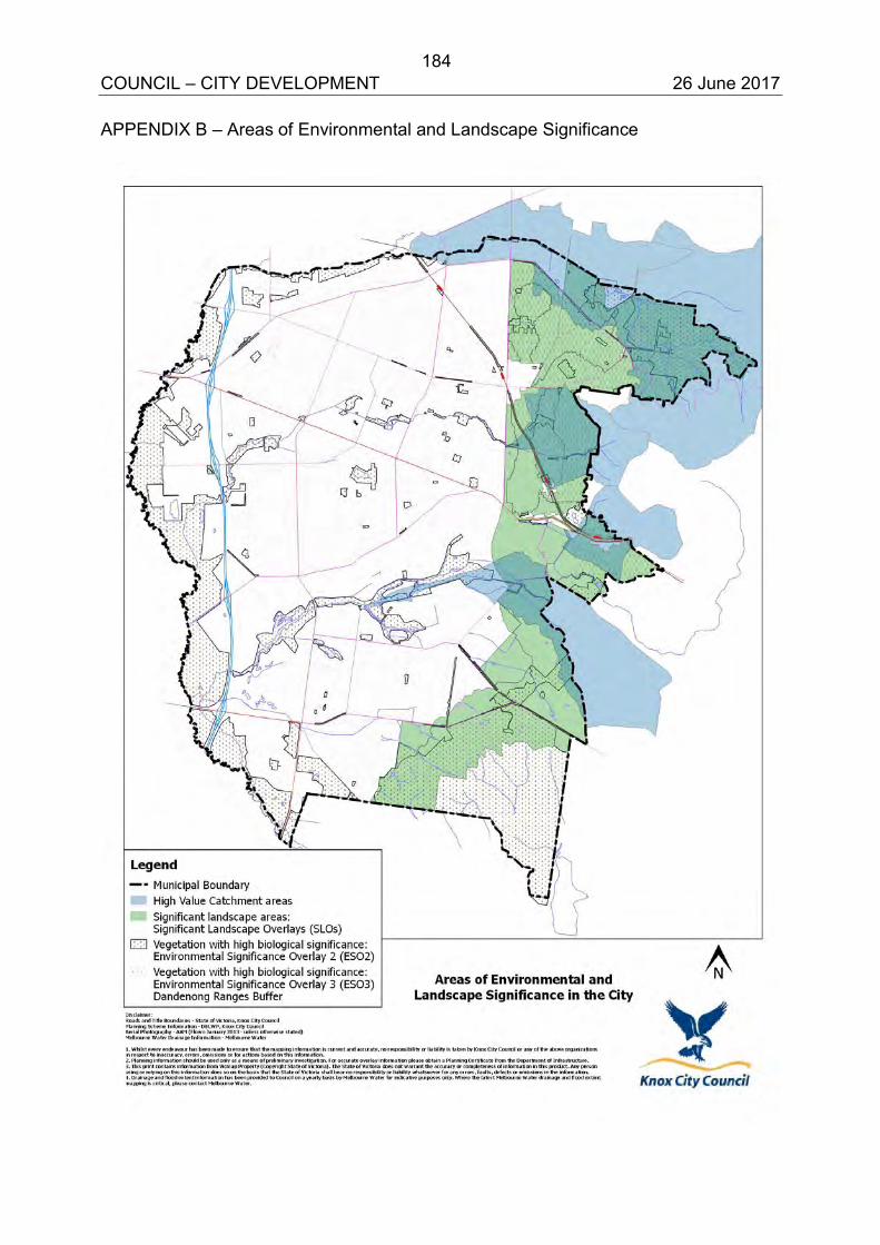
184 COUNCIL – CITY DEVELOPMENT 26 June 2017 APPENDIX B – Areas of Environmental and Landscape Significance
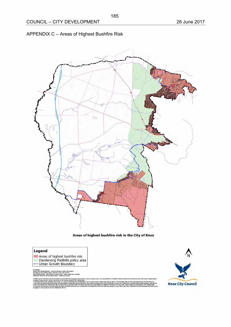
185 COUNCIL – CITY DEVELOPMENT 26 June 2017 APPENDIX C – Areas of Highest Bushfire Risk
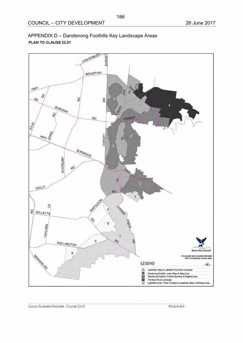
186 COUNCIL – CITY DEVELOPMENT 26 June 2017 APPENDIX D – Dandenong Foothills Key Landscape Areas
KNOX PLANNING SCHEME
LOCAL PLANNING POLICIES - CLAUSE 22.01 PAGE 1 OF 6
22.01 DANDENONG FOOTHILLS
This policy applies to the area shown on the plan forming part of this clause.
22.01-1 Policy basis
The Dandenong Foothills includes the treed slopes and rural areas of Lysterfield Valley,the rural landscapes of The Basin, and parts of the suburbs of Boronia, Sassafras, FerntreeGully (excluding the Ferntree Gully Village Neighbourhood Activity Centre), UpperFerntree Gully, Rowville and Lysterfield.
This policy:
Applies the Melbourne 2030 objectives of Policy 2.4 to local circumstances.
Applies the MSS objectives in Clauses 21.01 “Municipal Profile”, 21.03 “Vision andStrategic Land Use Framework”, 21.04 “Urban Design”, 21.05 “Housing”, 21.06“Environment” and 21.07 “Economic Development”.
Applies the findings of the Dandenong Foothills Urban and Landscape Review 2006,Knox Urban Design Framework 2020 (2003) and City of Knox NeighbourhoodCharacter Study 1999 to ensure that new buildings, works and landscaping protect andenhance the metropolitan landscape significance of the Dandenong Foothills andLysterfield Valley.
Provides design guidance to implement the Knox Urban Design Framework 2020(2003), Dandenong Foothills Urban and Landscape Review 2006 and City of KnoxNeighbourhood Character Study 1999.
Melbourne 2030 recognises the environmental and landscape qualities of land in thevicinity of the Dandenong Ranges as having high environmental and social values ofmetropolitan significance.
The Knox Urban Design Framework 2020 identified the Dandenong Ranges and itsfoothills as forming a backdrop to views across the eastern suburbs of Melbourne,including long range views from central city office buildings and other high pointsthroughout the metropolitan area such as Northcote Hill and the Calder Highway. Theimportant characteristics of the hills from these views are their heavily vegetated,apparently natural environment. These views are at risk from intensive residentialredevelopment, poorly sited, designed and finished buildings and works, and removal ofvegetation.
The interface between urban development and the Dandenong Ranges and national parks inLysterfield are particularly susceptible to bushfire events. Within these areas, protection ofhuman life and vegetation that has high significance to the landscape, may limitdevelopment potential.
Lysterfield Valley is classified by the National Trust as an “attractive pastoral landscape”and has been identified in Melbourne 2030 as forming part of the Southern Ranges greenwedge. Lysterfield Valley forms a key gateway to the Dandenongs and provides animportant buffer between urban and rural areas.
This policy addresses five key landscape areas that make up the Dandenong Foothills area.These are the:
Lysterfield Valley and Lysterfield Hills Rural Landscape
Dandenong Foothills: Lower Slope and Valley Area
Dandenong Foothills: Foothills Backdrop and Ridgeline Area
The Basin Rural Landscape
17/11/2016C137
13/11/2014C129
APPENDIX E187
KNOX PLANNING SCHEME
LOCAL PLANNING POLICIES - CLAUSE 22.01 PAGE 2 OF 6
Lysterfield Urban/Rural Transition and Lysterfield Valley Contributory Area
22.01-2 Objectives
The objectives of this policy are to:
Protect and enhance the metropolitan landscape significance of the DandenongFoothills and maintain uninterrupted view lines from within the municipality andvantage points in metropolitan Melbourne by ensuring that all buildings and works aresensitively designed and sited to sit below the dominant tree canopy height.
Promote the maintenance and improvement of the continuous closed tree canopy byallowing enough open space within new development for the retention of existingcanopy vegetation and growth of new canopy vegetation.
Maintain the low density residential character of the landscape areas by ensuring thatpreferred subdivision patterns and lot sizes are retained.
Protect the rural environments of The Basin and the Lysterfield Valley and LysterfieldHills.
Ensure that new buildings, works and landscaping in The Basin and the LysterfieldValley and Lysterfield Hills protect the physical and visual amenity of the open pastoralsetting.
Limit further subdivision and rezoning of land for urban purposes where there is a highrisk of bushfire.
22.01-3 Policy
It is policy that:
Site analysis and design response
Applications for buildings and works be accompanied by:
A site analysis.
A design response.
Site analysis
The site analysis may include a detailed site plan, photographs or other techniques andshould accurately describe, as appropriate:
The built form, scale, design and use of surrounding development.
Solar access to the site and surrounding properties.
Identified areas of environmental significance.
Open space.
Views to and from the site.
Location of significant trees and vegetation.
Drainage.
Street frontage features such as poles, street trees and kerb crossovers.
Any contaminated soils and filled areas, where known.
Any other notable features or characteristics of the site
28/03/2013C110
17/11/2016C137
188
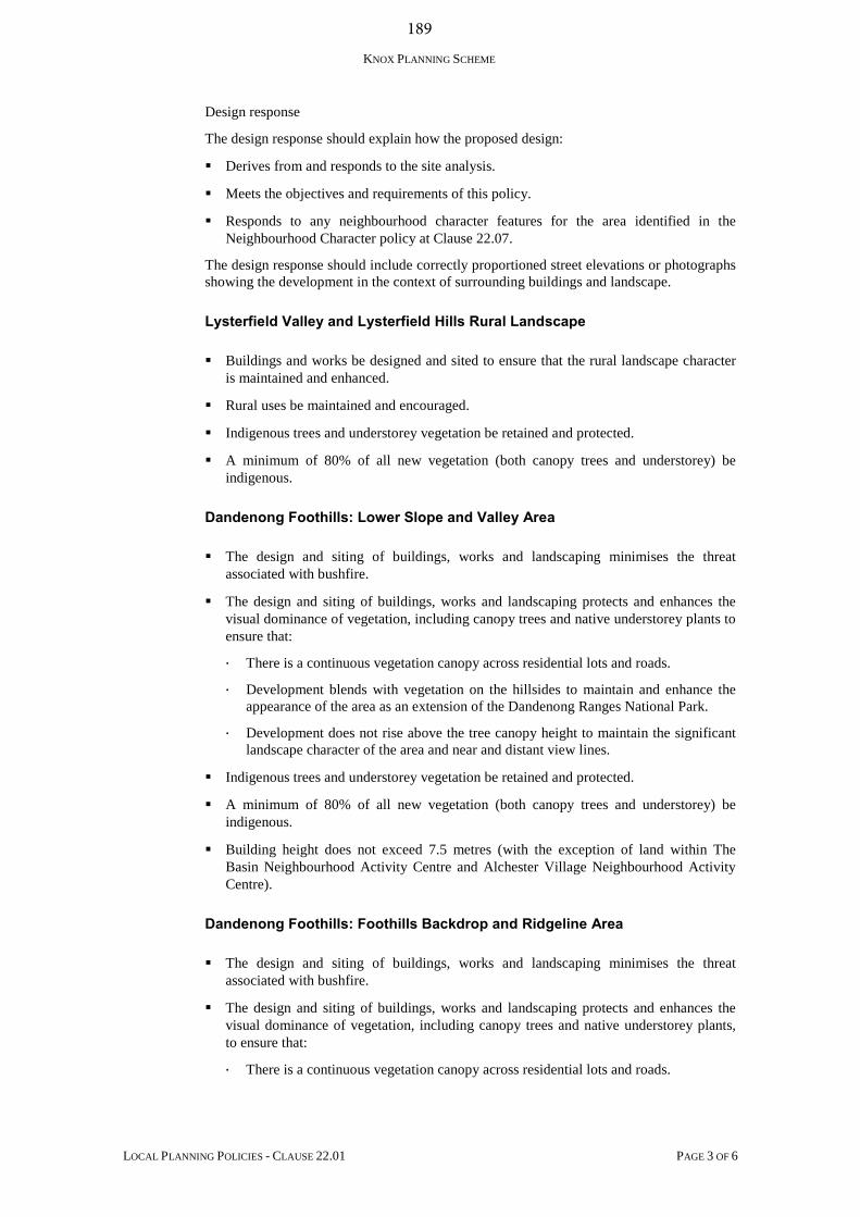
KNOX PLANNING SCHEME
LOCAL PLANNING POLICIES - CLAUSE 22.01 PAGE 3 OF 6
Design response
The design response should explain how the proposed design:
Derives from and responds to the site analysis.
Meets the objectives and requirements of this policy.
Responds to any neighbourhood character features for the area identified in theNeighbourhood Character policy at Clause 22.07.
The design response should include correctly proportioned street elevations or photographsshowing the development in the context of surrounding buildings and landscape.
Lysterfield Valley and Lysterfield Hills Rural Landscape
Buildings and works be designed and sited to ensure that the rural landscape characteris maintained and enhanced.
Rural uses be maintained and encouraged.
Indigenous trees and understorey vegetation be retained and protected.
A minimum of 80% of all new vegetation (both canopy trees and understorey) beindigenous.
Dandenong Foothills: Lower Slope and Valley Area
The design and siting of buildings, works and landscaping minimises the threatassociated with bushfire.
The design and siting of buildings, works and landscaping protects and enhances thevisual dominance of vegetation, including canopy trees and native understorey plants toensure that:
There is a continuous vegetation canopy across residential lots and roads.
Development blends with vegetation on the hillsides to maintain and enhance theappearance of the area as an extension of the Dandenong Ranges National Park.
Development does not rise above the tree canopy height to maintain the significantlandscape character of the area and near and distant view lines.
Indigenous trees and understorey vegetation be retained and protected.
A minimum of 80% of all new vegetation (both canopy trees and understorey) beindigenous.
Building height does not exceed 7.5 metres (with the exception of land within TheBasin Neighbourhood Activity Centre and Alchester Village Neighbourhood ActivityCentre).
Dandenong Foothills: Foothills Backdrop and Ridgeline Area
The design and siting of buildings, works and landscaping minimises the threatassociated with bushfire.
The design and siting of buildings, works and landscaping protects and enhances thevisual dominance of vegetation, including canopy trees and native understorey plants,to ensure that:
There is a continuous vegetation canopy across residential lots and roads.
189
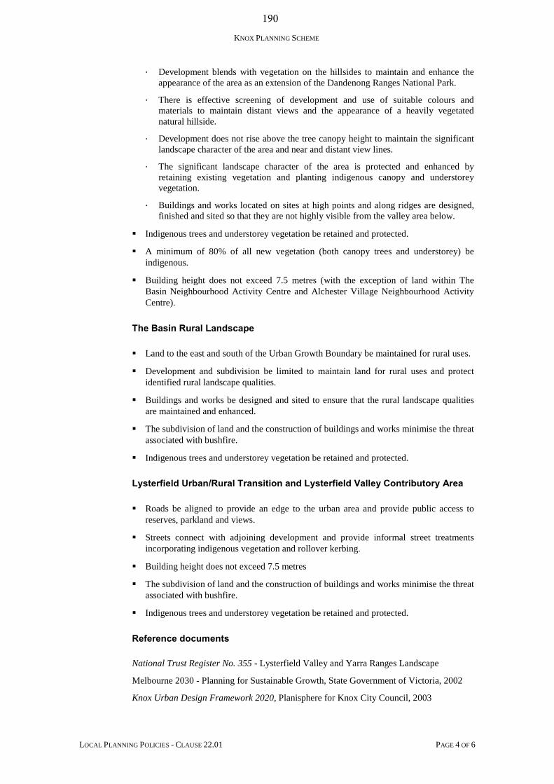
KNOX PLANNING SCHEME
LOCAL PLANNING POLICIES - CLAUSE 22.01 PAGE 4 OF 6
Development blends with vegetation on the hillsides to maintain and enhance theappearance of the area as an extension of the Dandenong Ranges National Park.
There is effective screening of development and use of suitable colours andmaterials to maintain distant views and the appearance of a heavily vegetatednatural hillside.
Development does not rise above the tree canopy height to maintain the significantlandscape character of the area and near and distant view lines.
The significant landscape character of the area is protected and enhanced byretaining existing vegetation and planting indigenous canopy and understoreyvegetation.
Buildings and works located on sites at high points and along ridges are designed,finished and sited so that they are not highly visible from the valley area below.
Indigenous trees and understorey vegetation be retained and protected.
A minimum of 80% of all new vegetation (both canopy trees and understorey) beindigenous.
Building height does not exceed 7.5 metres (with the exception of land within TheBasin Neighbourhood Activity Centre and Alchester Village Neighbourhood ActivityCentre).
The Basin Rural Landscape
Land to the east and south of the Urban Growth Boundary be maintained for rural uses.
Development and subdivision be limited to maintain land for rural uses and protectidentified rural landscape qualities.
Buildings and works be designed and sited to ensure that the rural landscape qualitiesare maintained and enhanced.
The subdivision of land and the construction of buildings and works minimise the threatassociated with bushfire.
Indigenous trees and understorey vegetation be retained and protected.
Lysterfield Urban/Rural Transition and Lysterfield Valley Contributory Area
Roads be aligned to provide an edge to the urban area and provide public access toreserves, parkland and views.
Streets connect with adjoining development and provide informal street treatmentsincorporating indigenous vegetation and rollover kerbing.
Building height does not exceed 7.5 metres
The subdivision of land and the construction of buildings and works minimise the threatassociated with bushfire.
Indigenous trees and understorey vegetation be retained and protected.
Reference documents
National Trust Register No. 355 - Lysterfield Valley and Yarra Ranges Landscape
Melbourne 2030 - Planning for Sustainable Growth, State Government of Victoria, 2002
Knox Urban Design Framework 2020, Planisphere for Knox City Council, 2003
190
KNOX PLANNING SCHEME
LOCAL PLANNING POLICIES - CLAUSE 22.01 PAGE 5 OF 6
Dandenong Foothills Urban and Landscape Review, Hansen Partnership Pty. Ltd. forKnox City Council, March 2006
City of Knox Neighbourhood Character Study, Mike Scott and Associates for Knox CityCouncil, 1999
191
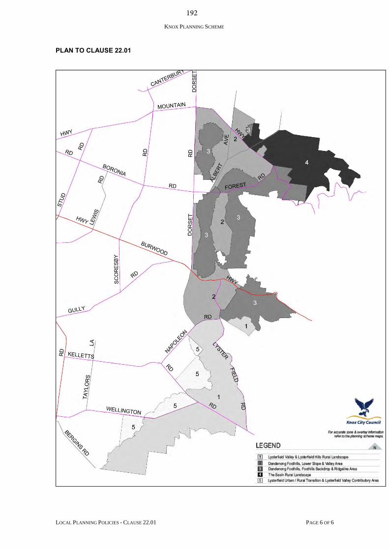
KNOX PLANNING SCHEME
LOCAL PLANNING POLICIES - CLAUSE 22.01 PAGE 6 OF 6
PLAN TO CLAUSE 22.01
192

193 COUNCIL 26 June 2017 7. PUBLIC QUESTION TIME Following the completion of business relating to Item 6, City Development, the business before the Council Meeting will now be deferred to consider questions submitted by the public.
194 COUNCIL – ENGINEERING & INFRASTRUCTURE 26 June 2017
ALL WARDS
8.1 STATUS OF THE CONSTRUCTION OF UNSEALED ROADS AND THE APPLICATION OF CONTRIBUTORY SCHEMES - SPECIAL RATES AND CHARGES SUMMARY: Coordinator – Project Delivery (Hans Pelgrim) Council, at its meeting 24 April 2017, called for a report to be prepared for the June 2017 Council meeting on Council’s approach to the construction of unsealed roads through the application of the Contributory Schemes - Special Rates and Charges Policy. This report is in response to the Call Up Item.
RECOMMENDATION
That Council:
1. receives and notes this Call Up report;
2. monitors the trial currently being initiated by Yarra Ranges; and
3. consider the initiation of a trial program as a part of the 2018/19 financial year.
1. INTRODUCTION
This report is presented following a Call Up item (Item 13.2) raised at the April 2017 Council meeting as follows:
“That a report is prepared for the June 2017 Council Meeting on Council’s approach to the construction of un-made roads through the application of the Contributory Schemes Special Rates and Charges Policy, considering:
the strategic benefits/intent of the Policy;
the current annual cost to Council associated with maintaining un-made roads;
the challenges and current estimated costs associated with the construction of un-made roads in Knox;
the previous position of affected residents and their support or otherwise for the construction of un-made roads; and
the approach followed by other Councils in the construction of un-made roads.”
This matter has been investigated which includes an overview of Council’s current position and an assessment of the approach by three other Councils.
195 COUNCIL – ENGINEERING & INFRASTRUCTURE 26 June 2017 8.1 Status of the Construction of Unsealed Roads and the Application of
Contributory Schemes - Special Rates and Charges (cont’d)
2. DISCUSSION
The Local Government Act gives Council the power to levy special rates and charges to cover the cost of infrastructure improvement works. Essentially, a potential scheme would be presented to Council where considerable landowner support can be demonstrated, before referring the project for consideration in Council’s Capital Works Program.
Section 163B of the Local Government Act requires that Council cannot proceed with a scheme where objections are received from owners representing a majority of rateable properties related to the scheme.
In September, 2008, the Contributory Schemes – Special Rates and Charges Policy (the Policy) was endorsed by Council, following the establishment of Ministerial Guidelines for the implementation of such schemes and amendments to the Local Government Act. Since that time, the Policy has had a number of reviews, which has considered minor drainage installations (endorsed by Council, September 2011) and footpaths identified in Council’s Five-Year Capital Works Program (endorsed by Council, July 2016) (See Appendix A – Current Policy).
Whilst Council receives a number of enquiries in relation to the construction of unmade roads, it is clear that whilst many may desire the road, very few are prepared to contribute to the cost. Further, whilst some residents may desire a fully constructed road, the feedback received from some residents is that they prefer the rural nature of these roads and the surrounding environment.
In a typical subdivision, the cost of the road-based infrastructure (kerb, channel, drainage, vehicle crossings and road surface) is incorporated in the purchase price of the block of land.
To this end, Council’s Policy position is that the residents on these un-made roads – as key beneficiaries – will need to contribute to this infrastructure.
2.1 Strategic Benefits/Intent of the Policy
The intent of the Policy is to provide a fair and equitable process that achieves Council’s direction and complies with the requirements of the Local Government Act/Ministerial Guidelines for the construction of infrastructure improvements such as unsealed roads.
The Policy provides a formal mechanism for apportionment and recovery of costs to benefitting property owners and encourages the take-up of schemes by offering a Council contribution of 10% (minimum) of costs as a financial incentive.

196 COUNCIL – ENGINEERING & INFRASTRUCTURE 26 June 2017 8.1 Status of the Construction of Unsealed Roads and the Application of
Contributory Schemes - Special Rates and Charges (cont’d)
Prior to this policy position there was no funding incentive provided to property owners and they were expected to pay for all scheme costs apportioned to benefitting properties.
Since the Policy was presented to Council in 2008, a number of residents have shown interest in the construction of Cornish Road, Lysterfield through a potential Special Rates and Charges Scheme.
However, subsequent resident surveys have not confirmed majority support (less than the required 60%, as per Policy) which resulted in the scheme not being pursued any further.
While there has been several enquiries for the sealing of various unsealed roads, there has not been sufficient commitment shown by property owners to pursue a potential scheme, once it has been explained how these roads are to be funded.
2.2 Current Annual Maintenance Cost to Council for Un-Made Roads
The annual maintenance costs expended on Council’s 19.9 kms of unsealed roads over the past five (5) years are summarised as follows:
2012-13 $230,000 2013-14 $247,000 2014-15 $251,000 2015-16 $269,000 2016-17 $276,000 (Budget Provided)
The maintenance budget includes the following activities - grading, supply of crushed rock, filling potholes, dust suppression and clearing table-drains.
2.3 Challenges and current costs associated with construction of unsealed roads
The main challenges associated with the construction of unsealed roads are:
(1) the cost to formally construct unsealed roads to current Council standards; (2) the reluctance of benefitting property owners to accept responsibility for
their apportionment of the construction costs; and (3) the potential that, abutting residents prefer the rural nature of an unsealed
road.
A relatively high cost of construction for the remaining unsealed roads within the Municipality exists, which is generally due to the effects of difficult and steep terrain associated with a number of unsealed roads, lack of formal drainage and the need to adopt current construction standards to enable Council to undertake ongoing maintenance responsibilities.
197 COUNCIL – ENGINEERING & INFRASTRUCTURE 26 June 2017 8.1 Status of the Construction of Unsealed Roads and the Application of
Contributory Schemes - Special Rates and Charges (cont’d)
Also, each unsealed road tends to have its own unique challenges that adds complexity to the site. Consequently, no scheme has been implemented under Council’s Contributory Schemes – Special Rates and Charges Policy for over 15 years.
2.4 Previous position of affected residents
There is a general reluctance from landowners, abutting the remaining unsealed roads, to contribute to the construction of unsealed roads.
Some are only in favour if Council fully funds the works while others prefer the rural nature of an unsealed road.
2.5 Current Knox City Council Approach
The current Policy provides a mechanism for the recovery of costs from benefitting persons when applied to infrastructure improvements of previously unconstructed, sub-standard or non-existent assets such as roads, footpaths, kerb and channel, drainage and/or off-street car parking.
Council’s current approach to upgrading assets under its Contributory Schemes – Special Rates and Charges Policy can best be summarised as follows:
A 60% minimum level of support is required from benefitting owners to the scheme proposal before the proposal is further investigated in detail.
The Policy excludes footpaths which are prioritised by virtue of Council strategic programs and which are subsequently presented for Council’s consideration in the Five Year CWP budget, and thus are fully funded by Council.
The Policy excludes minor drainage improvement projects for works which are under $50,000 and which are prioritised by virtue of Council strategic programs and which are subsequently presented for Council’s consideration in the Five Year CWP budget, and thus are fully funded by Council.
Council will contribute 10% of the total cost of the scheme, to provide a financial incentive for resident ‘take-up’ of the scheme.
Council will make allowance in accepting costs for a percentage of works which are regarded as Community Benefit and also accept costs, in accordance with the Policy, for non-rateable land.
The remaining costs of the scheme are distributed to benefitting property owners, in accordance with provisions of the Policy.
198 COUNCIL – ENGINEERING & INFRASTRUCTURE 26 June 2017 8.1 Status of the Construction of Unsealed Roads and the Application of
Contributory Schemes - Special Rates and Charges (cont’d)
2.6 Approach of Adjoining Councils
The approach of three (3) nearby Councils to upgrading assets under its Contributory Schemes – Special Rates and Charges Policy are summarised as follows:
2.6.1 Yarra Ranges
A significant majority, in the order of 70%, of benefitting property owners supporting the proposed scheme is required before a scheme can proceed.
Council will contribute a minimum 20% of the total cost of the scheme as a subsidy in order to provide an incentive for resident take-up of the scheme. This contribution may increase depending on the circumstances related to “Community Benefit”.
Consideration of a ceiling amount applied to apportioned costs for rural type roads where properties may be quite large and roads are quite long with the cost above the ceiling amount being contributed by Council as a further subsidy.
Currently, the Shire is trialling a sealing (short-term) treatment on a number of rural roads with a view to providing a sealed road, while maintaining a rural amenity at a reasonable cost.
2.6.2 City of Casey Support from a majority of contributing property owners is required
before the scheme can proceed. Council may however choose to proceed without majority support in recognition of the benefit to abutting properties and the broader community and Council is contributing two-thirds of the cost.
Council must abandon the Scheme if the majority of property owners object and if Council is raising over two-thirds of the costs of the works through the scheme.
Schemes for the construction of Local Residential Street Schemes are fully funded by property owners.
Roads with broader community benefit are co-funded by Council and property owners as follows: (1) Secondary Arterial Roads - 75% Council & 25% property
owners; and (2) Roads other than arterial roads – 50% Council & 50% property
owners.
Property owner’s contribution is capped at $11,016 (as at 1 July 2016) against each lot.
199 COUNCIL – ENGINEERING & INFRASTRUCTURE 26 June 2017 8.1 Status of the Construction of Unsealed Roads and the Application of
Contributory Schemes - Special Rates and Charges (cont’d)
2.6.3 Mornington Shire Council
A strong demonstration of support from a majority of contributing property owners is required before the scheme can proceed.
However, Council may choose to proceed without majority support in recognition of the benefit to abutting properties and the broader community for compelling reasons relating to issues of safety, health or amenity, and Council is contributing two-thirds of the cost.
Council may resolve to proceed with investigating a proposed special charge scheme if 60% of survey respondents are supportive.
Council may contribute to the project costs of schemes as categorized below, with all potential Council contribution being subject to funding being available through the Capital Works Program: o 100% - for infrastructure projects that provide the greatest
community benefit. o 50% Council contribution – for infrastructure that generally
provides equivalent benefits for both the broader community and local properties.
o 35% Council contribution – for infrastructure that has some broader community benefit but predominantly provides a benefit to properties within the scheme.
o 0% Council contribution - for infrastructure that has little or no broader community benefit. These projects will only proceed if there is overwhelming support, and may not proceed if objections are received in respect of a majority of rateable properties.
3. CONSULTATION
The original Policy was the subject of a consultation process and reflects the requirements of the Local Government Act.
It is recommended that no further consultation should occur at this time, unless substantial changes to the Policy are proposed.
4. ENVIRONMENTAL/AMENITY ISSUES
While there are minor environmental issues identified with this Policy (eg. dust reduction on unsealed roads, erosion, silt run-off to storm-water drainage), improved amenity is usually the main factor for undertaking asset improvements such as constructing previously unsealed roads.
200 COUNCIL – ENGINEERING & INFRASTRUCTURE 26 June 2017 8.1 Status of the Construction of Unsealed Roads and the Application of
Contributory Schemes - Special Rates and Charges (cont’d)
However, Council may wish to consider alternative construction standards for unsealed roads which are more mindful of the financial considerations and which may be more cognisant of existing physical and terrain restraints. This will still require some form of cost recovery from property owners but may provide an alternative to formal construction standards.
Council should be aware that, for any alternative construction proposals, it may be regarded as a temporary construction due to its reduced standard of construction and shorter life-expectancy.
Such a scheme, if implemented, could commit property owners to a further, future cost.
Temporary construction standards could be researched to consider what options are available; what impact these options may have; what costs would be to Council/benefitting owners; and, ongoing maintenance responsibilities.
5. FINANCIAL & ECONOMIC IMPLICATIONS
As part of undertaking the work required for this Call Up Item, officers have had regard to Council’s Call Up Items at Council Meeting Policy, and in particular, Item 6.5 which states:
“Where preparing a report responding to a Call Up Item which will require more than 3 person days or $5,000 in costs, then the matter which is subject to the Call Up Item should be referred by Council to the next budget considerations with a supporting business case for consideration along with competing priorities.”
Financial implications to Council are currently inconsequential as there has not been a Special Rates and Charges Scheme implemented for a number of years.
There has been no budget imposition on Council’s Capital Works Program (CWP) thus enabling Council to direct its CWP budget allocation elsewhere.
Should Council alter its approach to unsealed roads, requiring an amendment to its Contributory Schemes – Special Rates and Charges Policy or an amendment to its construction standards then, as a consequence, Council may experience an increase in property owner interest to the sealing of unsealed roads and potential requests for funding works.
It is noted that there are 54 local unmade roads identified in Knox – for an estimated total construction cost of $13.7m. These estimates were prepared several years ago and would have increased since that time.
201 COUNCIL – ENGINEERING & INFRASTRUCTURE 26 June 2017 8.1 Status of the Construction of Unsealed Roads and the Application of
Contributory Schemes - Special Rates and Charges (cont’d)
The estimate of cost for a Special Rates and Charges Scheme are based on the full construction of the roads to Council standards, including pavement, rollover kerb and channel and full drainage. Following construction of the road, full responsibility for road maintenance transfers to Council and diverts any further requests for resident contribution.
Council’s Long-Term Financial Forecast has projected approximately $5m for new and upgrade works per annum, for the next 2-3 years. There is no provision currently for the construction of un-made roads.
It is anticipated that Council would not be in a position financially to provide infrastructure on behalf of residents living on unsealed roads. Such a cost would be prohibitive and would create an inconsistency in terms of the funding of road-based infrastructure. In effect, the general ratepayers would be subsidising the residents who live on these unmade roads.
Spread across the expected life of the road, the annual lifecycle costs of a sealed road (maintenance, renewal, depreciation) would be comparable to the maintenance cost of an unsealed road. This is in the order of $14,000 - $15,000 per annum.
The key issue from an economic perspective however is the initial capital funding requirements given that the cost of road construction is currently in the order of $770,000 per kilometre. Further, Council needs to consider a range of competing priorities in regard to the allocation of its available capital funding.
6. SOCIAL IMPLICATIONS
The principle of benefitting landowners paying for improvements to infrastructure that were not fully developed or installed at the time of subdivision, is a key element of the current Policy.
The Policy provides a fair and equitable method of apportioning costs to the benefitting landowners, should they wish to upgrade their facilities.
7. RELEVANCE TO CITY PLAN 2013-17 (INCORPORATING THE COUNCIL PLAN)
This report is relevant to Council’s Strategic Objective of Dynamic Services & Facilities, directed towards continually reviewing and improving the quality and effectiveness of Council’s service provision.
202 COUNCIL – ENGINEERING & INFRASTRUCTURE 26 June 2017 8.1 Status of the Construction of Unsealed Roads and the Application of
Contributory Schemes - Special Rates and Charges (cont’d)
8. CONCLUSION
The implementation of Special Rates & Charges Schemes has been unsuccessful in recent years and only cursory interest has been shown for construction/sealing of the unsealed roads across the municipality.
It is suspected that this is due to the high cost of construction (and consequently relatively high cost apportioned to property owners) and for some residents who prefer to maintain the rural nature of their street.
As noted, the Shire of Yarra Ranges are currently trialling a short term sealing treatment with the objective of providing a sealed road at a lesser cost than full construction. Council will be monitoring the results of this trial program.
Based on the results of this trial, Council may wish to consider initiating its trial program for the implementation of temporary schemes as a means to encouraging the sealing of unsealed roads and maintaining the rural nature of these roads at a lesser cost. The results of any trial program may result in change in Council’s approach, with a subsequent Policy amendment.
9. CONFIDENTIALITY
There are no issues of Confidentiality associated with this report. Report Prepared By: Coordinator - Project Delivery (Hans Pelgrim) Report Authorised By: Director – Engineering & Infrastructure (Ian Bell)
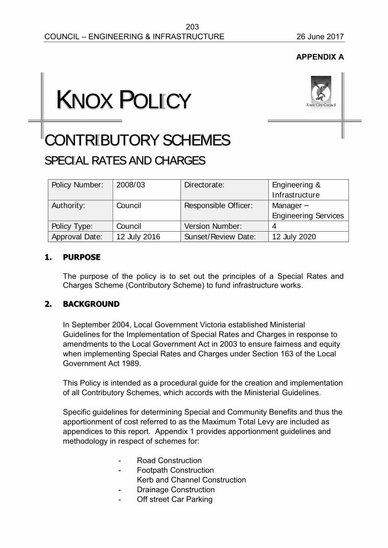
203 COUNCIL – ENGINEERING & INFRASTRUCTURE 26 June 2017
APPENDIX A
KNOX POLICY
CONTRIBUTORY SCHEMES
SPECIAL RATES AND CHARGES
Policy Number: 2008/03 Directorate: Engineering &
Infrastructure
Authority: Council Responsible Officer: Manager –
Engineering Services
Policy Type: Council Version Number: 4
Approval Date: 12 July 2016 Sunset/Review Date: 12 July 2020
1. PURPOSE
The purpose of the policy is to set out the principles of a Special Rates and Charges Scheme (Contributory Scheme) to fund infrastructure works.
2. BACKGROUND
In September 2004, Local Government Victoria established Ministerial
Guidelines for the Implementation of Special Rates and Charges in response to amendments to the Local Government Act in 2003 to ensure fairness and equity when implementing Special Rates and Charges under Section 163 of the Local Government Act 1989.
This Policy is intended as a procedural guide for the creation and implementation
of all Contributory Schemes, which accords with the Ministerial Guidelines. Specific guidelines for determining Special and Community Benefits and thus the
apportionment of cost referred to as the Maximum Total Levy are included as appendices to this report. Appendix 1 provides apportionment guidelines and methodology in respect of schemes for:
- Road Construction - Footpath Construction Kerb and Channel Construction - Drainage Construction - Off street Car Parking
204 COUNCIL – ENGINEERING & INFRASTRUCTURE 26 June 2017
Schemes can be used for any project or related project listed above. An operational guidelines and flowchart is shown in Appendix 2.
3. SCOPE
This policy will apply to the development of all Special Rates and Charges Schemes.
4. REFERENCES
Local Government Act 1989 and amendments Ministerial Guidelines 2004
5. DEFINITIONS
The terms used in this policy are defined in the Local Government Act 1989 and the Ministerial Guidelines.
6. COUNCIL POLICY
6.1 SCHEME INITIATION
The special rate or charge process may be initiated by Council, members of the public, residents within the area, Council Officers or as a result of requests` from officers of Statutory Authorities with services in the area or providing service to the area.
6.1.1 Preliminary Consultation and Report
Except for the case where the process has been initiated by a petition containing the signatures of a two thirds majority of potential contributors, the relevant Director shall circulate a questionnaire to identify the potential contributors and their level of support for a scheme.
Note: At the Council meeting held on 26 June 2007, Council resolved that a 60% minimum level of support from contributing properties be a base requirement for a road construction scheme to be prepared and before committing Council funds in the Capital Works Program.
Council may consider proceeding with a particular scheme based on compelling reasons relating to issues of safety, health or amenity.
Having allowed fourteen (14) days for reply, the Responsible Officer shall prepare a preliminary report to the subsequent Council Meeting which may include the following:
205 COUNCIL – ENGINEERING & INFRASTRUCTURE 26 June 2017
background information detailing the reason for canvassing potential
contributors;
a statistical analysis of results of responses and an assessment of their substance;
the circumstances which may exist whereby the considerations of safety or other matters override all other considerations;
the outcome of public consultation;
an expansion of the preliminary report taking into account the following matters where relevant:
the function of the infrastructure; safety and amenity; technical matters such as design speeds for local roads, impact on
drainage and road networks; environmental impact including removal or protection of native
vegetation; and cost to the community regarding options, including no action, i.e. cost
to maintain the existing facility.
Council contribution to the scheme;
recommendation of any committee which may have been formed to participate with development of the functional and conceptual issues;
recommendation to either abandon, amend or adopt the proposed scheme and/or proceed with detail design of the preferred option; and
recommendation that affected owners/occupiers and any party which has registered its interest in the scheme in writing with Council be advised of Council's decision.
6.1.2 Five Year Capital Works Program
Following a resolution by Council to proceed with the scheme, a preliminary estimate should be referred to the Five year Capital Works program. When funding becomes available for the project, the scheme may continue.
6.2 DETAILED SCHEME PREPARATION Following the Council resolution to proceed with the Scheme, the final design,
estimates and apportionments shall be prepared. The officer responsible for the detailed preparation of the Scheme shall maintain a high level of consultation with parties to be affected by the proposal.
206 COUNCIL – ENGINEERING & INFRASTRUCTURE 26 June 2017
6.3 STATUTORY REQUIREMENTS FOR SCHEME ADOPTION 6.3.1 Declaration of Special Rate or Charge
A proposed declaration must include a description of the works or services to be provided, the total cost of the works or services and the total amount of the special rates and charges to be levied. (This is in addition to information already required).
When Council gives public notice of a proposed special rate or charge it must, within three working days, send a copy of the public notice to each person who will be required to pay the rate or charge.
Before declaring a Scheme, Council must determine the “total amount” of the special rates and charges to be levied. The total amount may not exceed the maximum total amount calculated by the formula R X C = S; where R is the benefit ratio, C is the total cost of the works or service and S is the total maximum amount.
If Council proposes to levy a total amount that exceeds two thirds of the total cost, the affected ratepayers have a right to object and if the Council receives objections from a majority of those ratepayers within 28 days of the public notice it may not declare the scheme. (This is in addition to the existing Section 223 consultation process).
If Council proposes to alter a declared special rate or charge in a way that will require an additional person(s) to pay, or that will involve a material increase in the amount that a person has to pay, it must give public notice of the proposal. The Public Notice in Section 163 (1B) must: Outline the proposed declaration, show date on which it is proposed to make a declaration and allow inspection for at least 28 days after the notice and consider public submissions, in accordance with Section 223 of the Act.
Council’s responsible officer shall report to Council with the details of the scheme, including calculation of Maximum Total Levy and the maximum amount that Council will levy as outlined in the Ministerial Guidelines dated 23 September 2004 shown in Appendix 3.
Council or a committee of Council (established by Council) must consider any written submission made in respect of the scheme (S.223).
Also included in this report will be a Notice of Motion including: the period the Special Rate or Charge remains in force;
the purpose of the Special Rate or Charge;
a specification of the wards, groups, users or areas for which the Special Rate or Charge is declared;
207 COUNCIL – ENGINEERING & INFRASTRUCTURE 26 June 2017
a specification of the criteria which forms the basis of the Special Rate or Charge. For local street construction this will be the ownership of properties that abut or are adjacent to the project and/or derive benefit from improved access and amenity;
a specification of the manner in which the Special Rate or Charge will be assessed and levied. In general, apportionment should be carried out using the traditional methods well established through Administrative Appeals Tribunal precedent;
an estimate of owners’ liabilities. This estimate shall include ancillary costs such as survey, design, supervision and administration. Ancillary costs may be estimated using the Association of Consulting Engineers Australia (ACEA) Principle Consultant rates;
the impact of the Council’s liability to the contribution in the event of over expenditure;
period of maintenance required for the works (if works are relevant to the rate or charge);
incentives to be given to ratepayers as detailed in the policy;
planning policies and specific objectives (if any) as referred in Section 185 of the Local Government Act 1989;
the manner of payment of the Special Rate or Charge and the detail of the financing provisions to be accommodated by Council in regard to the scheme;
that a Public Notice will be given of the declaration;
that submissions made in accordance with Section 223 Local Government Act 1989 will be considered by Council; and
a requirement for Council to establish a committee to consider any written submission made and hear people, in respect of the scheme (S223).
The Responsible Officer for the scheme in his report to Council will have regard
to the Council policy which applies at the time in respect to the level of interest to be charged on the principal and any penalty interest which may apply to overdue repayment instalments.
6.3.2 Advice to Affected Persons Should Council resolve to declare a Special Rate or Charge, a letter advising of
this decision shall be sent to all persons required to pay and occupiers. This letter shall include the information to be contained in the Public Notice, including advice that submissions may be lodged by any interested party.
208 COUNCIL – ENGINEERING & INFRASTRUCTURE 26 June 2017
6.3.3 Public Notice Following the declaration of the Special Rate or Charge a notice shall be
published in a newspaper generally circulating in the area setting out the declaration and stating that submissions will be considered in accordance with Section 223 Local Government Act 1989.
The Responsible Officer shall ensure that copies of the advertisement are retained on file as confirmation that the notice was given.
6.3.4 Consideration of Submissions Written submissions received by Council within the time prescribed in the public
notice will be considered by a committee nominated by the Council. Personal appearances to support written submissions will be encouraged.
However, submitters must state their desire to appear before the Committee in their written submission. This committee will then make a recommendation to full Council for a final decision.
6.3.5 Council Resolution following Submissions Following consideration of the committee's recommendation Council may resolve
to:
abandon the scheme by not giving effect to the declaration to levy the Special Rate or Charge or;
prepare a new Special Rate or Charge Scheme due to the need to significantly modify the original scheme, therefore requiring the process to be recommenced or;
proceed with or without minor variation to the original declaration. NOTE: Any variation in the amount of the proposed rate or charge which
exceeds more than 10% of the amount specified in the original notice will require the scheme to be returned to Council for consideration of a new declaration.
All persons making submissions and all parties affected by the scheme shall be
advised of Council's resolution. In the circumstance that no submissions are lodged, Council may resolve to
confirm, modify or abandon its original scheme.
209 COUNCIL – ENGINEERING & INFRASTRUCTURE 26 June 2017
6.3.6 Levy of Special Rate or Charge Council levies the Special Rate or Charge by sending a notice to all those liable
to pay. This notice shall be in accordance with sub-sections 163(1A) and (1B) and (1C) of the Local Government Act 1989 and shall contain prescribed information detailed in Regulation 163(3).
6.3.7 Appeal Following the levying of the Special Rate or Charge aggrieved persons may
appeal to the Victorian Civil and Administrative Tribunal (VCAT) within one month after the date of issue of a notice to the person of the Special Rate or Special Charge or combination thereof. Section 185 of the Local Government Act sets down the criteria for an appeal and provides the following grounds:
i. the works and projects or the period of maintenance for the purposes of
which the Special Rate or Special Charge was imposed are not or will not provide a special benefit to that person; or
ii. the basis of distribution of the rate or charge amongst those persons who are liable to pay it is unreasonable; or
iii. if the planning scheme for the area contains any relevant policies or specific objectives, the works and projects proposed for the construction of a road or for the drainage of any land are inconsistent with those policies or objectives; or
iv. if the planning scheme for the area does not contain any relevant policies or specific objectives, the works and projects proposed for the construction of a road or for the drainage of the land are unnecessary, unreasonable, excessive, insufficient, unsuitable or costly, having regard to the locality or environment and to the probable use of the road or drainage of land.
Following notification from the VCAT of appeals lodged, contact may be made
with appellants in order to carry out negotiations prior to the hearing. Failing this the Responsible Officer will prepare Council's case for the VCAT hearing.
NOTE: An aggrieved person may in addition, or alternatively, appeal within 60
days to the County Court. Notice must be given to Council in the prescribed form for this to occur. (S. 184 L.G.A.). Grounds of appeal can be non-rateable land, assessment calculated incorrectly or the person considers that they are not liable to be rated.
210 COUNCIL – ENGINEERING & INFRASTRUCTURE 26 June 2017
6.3.8 Council Options Following VCAT Decision Where VCAT upholds the scheme entirely or varies it with respect to the
applicants, Council must proceed with the scheme as determined by VCAT. Council can then:
issue notices requiring payment within fourteen (14) days (S.167 (3)); or
resolve to declare a variation to the scheme with all liable owners to be notified of the variation advice (S.166 (1) (b) and (2)); or
Where VCAT quashes a scheme, Council could only proceed to declare a scheme for the same street if the new scheme differs significantly from the quashed one and in particular in no way is inconsistent with VCAT’s reasons for quashing the scheme as determined by VCAT. Council may then: resolve the discontinuance of the declaration and provide all liable owners
with discontinuance advice (S.164(2)); and significantly differ the scheme and proceed. NOTE: (i) The issue of notice requiring payment (S.167 (3)) would follow
Council's resolution to declare a variation and notification of variation.
(ii) Once a discontinuance notice has been sent out no further action
is required.
(iii) The person who is liable to pay the Special Rate or Charge may apply to Council for permission to pay by a lump sum as determined between that person and Council S167 (4).
6.4 SCHEME IMPLEMENTATION AND FINALISATION
6.4.1 Implementation Process The Responsible Officer shall ensure that the tasks necessary to implement the
scheme are carried out. Schemes which involve provision of services or Capital Works for the provision of infrastructure shall be competitively tendered in accordance with the procedure set down in the Council's Contract Administration Policy.
211 COUNCIL – ENGINEERING & INFRASTRUCTURE 26 June 2017
If the Tendered Price for the Contract works component of the Scheme exceeds the estimated cost by 10% or more, the proposal shall be referred to Council for reconsideration and a resolution sought to either abandon the scheme or accept the Tendered Price and proceed with the work. 6.4.1.1 Notice of Demand for Payment Following the decision of Council to proceed with the Scheme and its implementation through the Public Tender Process, a Notice of Demand for Payment will be served on all contributors indicating all the relevant scheme details and the charge or rate based on the accepted tender price. The notice shall clearly indicate that this demand for payment is based on the tendered price for the contract work forming part of the estimated scheme total cost and may be subject to variation of up to a maximum of 10% of the amount stated. Should demand for payment exceed the maximum variation of 10% of the amount stated, then the amount in excess shall be funded by Council.
6.4.2 Reconciliation and Report to Council
6.4.2.1 Special Charge Schemes
Schemes shall be finalised and reconciled within two months of finalisation of the works.
The responsible officer shall report to Council advising that the works are completed and costs finalised. The report will include final apportionment of costs and details where variations from original estimates affect final apportionments costs. NOTE: In any case where the Special Rate or Charge is varied by any amount,
notice is required to be given to all affected parties pursuant to Section 166(2) of the Local Government Act 1989.
7. RELATED DOCUMENTS
The policy document is related to the Local Government Act 1989.
212 COUNCIL – ENGINEERING & INFRASTRUCTURE 26 June 2017
APPENDICES
APPENDIX 1 Apportionment Principles APPENDIX 2 Summary of Procedure for Implementation of a Special Charge for Road Schemes Flowchart of Procedure APPENDIX 3 Special Rates and Charges Calculation of Maximum Levy – Ministerial Guidelines 2004
213 COUNCIL – ENGINEERING & INFRASTRUCTURE 26 June 2017
APPENDIX 1
SPECIAL RATES AND CHARGES POLICY APPORTIONMENT PRINCIPLES Officers responsible for the detailed development of cost apportionment for contributory schemes should have regard to this policy and the following principles: 1.0 BENEFIT RATIO The calculation of the maximum total levy for a scheme shall comply with the
Ministerial Guideline applying to Section 163(2C) of the Local Government Act 1989 as promulgated in the Victoria Government Gazette G39 23 September 2004. In most cases this will yield the limiting amount for levying by way of a special charge scheme. However to ensure consistency with past practice the following guidelines shall also be regarded in determining the Benefit Ratio.
2.0 METHOD OF APPORTIONMENT
The general method of apportionment in residential areas is based on 80% for access benefit and 20% amenity benefit using the effective frontage guidelines set out in City of Knox Plan 225-A1.
3.0 FOOTPATH AND BICYCLE PATH PROJECTS The construction of imperviously sealed paths, with the exception of those in
Council reserves and projects prioritised within the Capital Works Program, Program 4006 – New Footpath Construction Program, are to be undertaken by Special Charge Scheme with full cost of vehicle crossings and footpath thickenings chargeable to owners. The maintenance of the constructed asset will be Council responsibility.
Contributions by adjoining owners to be based on fairness, equity and in the
absence of special circumstance on the following guidelines:
3.1 Residential Area - Access Roads Subject to Council paying for non-rateable land proportion. Then:
Extent of scheme - abutting and opposite residences.
Owners pay costs as derived.
Individual charges based on Special Benefit derived from the calculation of maximum total levy and for through traffic that provides “Community Benefit”.
Allow one Benefit Unit per residential Unit as determined by the Planning
Scheme provision for the area (i.e. minimum Lot size for a residential unit).
214 COUNCIL – ENGINEERING & INFRASTRUCTURE 26 June 2017
Where a larger lot exists and more than one residential unit can be developed then an additional Benefit Unit should be charged for each additional potential development unit.
3.2 Residential Area - Residential Collector Road
Subject to Council paying for non-rateable land proportion. Then:
Residences included in scheme where path is proposed.
Owners charged 2/3 of scheme cost. (Subject to variation when using Maximum Levy calculation).
Council pays 1/3 of cost.
Benefit Unit based on residential unit and apportionment as above prescribed under Section 2.1.
3.3 Link Roads
Due to the need to ultimately have paths on both sides, then abutting
residents only will be included in the scheme. Owners charged on benefit unit basis of 1/3 scheme cost.
Due to function of path to serve broader needs of the community, Council to meet 2/3 of cost of construction i.e. owners liable for 1/3 cost of footpath.
3.4 Arterial Road
Due to function of path to serve broader needs of the community Council to
meet 100% of cost of construction. Owners charged nil cost.
3.5 Recreational Paths
3.5.1 Path located in Council Reserve.
Full cost to Council.
3.5.2 Shared Pedestrian/Cycle Paths
Owners of abutting and, where applicable, opposite residences are required to contribute to the normal 1.4 metre width path as prescribed for the various types of situations above. The extra width for cycle use, whether shared or segregated, being paid for by Council.
215 COUNCIL – ENGINEERING & INFRASTRUCTURE 26 June 2017
3.6 Paths in Commercial and Industrial Areas Where an existing or proposed development requires construction of a footpath, the Council contribution shall not exceed 50% of the cost of the works unless special circumstances exist.
4.0 DRAINAGE CONSTRUCTION SCHEMES
Council’s policy is aimed at making drainage schemes equitable and creating an incentive by offering the following: Council will contribute 10% of the total cost of works as a subsidy. For all property drainage schemes apportionment shall be undertaken on the following basis:
All properties which benefit from the construction of the drain by being able
to connect to the drain or receive protection by the drain shall be included in the scheme.
The determination of benefit to be derived from the construction of such
drains shall be at the discretion of Council with the liability being assessed on the general basis that properties contributing to the drain and being protected by it will be treated equally on an area basis.
Special Rates and Charges Schemes shall not be applied in the provision of public drains where the works:
are considered minor; can be delivered for an estimated cost of $50,000 or less; will improve amenity, safety and health; will mitigate local flooding; can be delivered with minimal consultation; are unencumbered by other infrastructure needs (ie. the scheme does not
require road construction, kerb and channel or other works); satisfies a missing link in the drainage network; and is uncomplicated to deliver.
5.0 ROAD CONSTRUCTION SCHEMES
5.1 Policy for Unsealed Roads Program Council’s policy is aimed at making road schemes equitable and creating an
incentive by offering the following:
i Council will make an allowance for through traffic and pay the percentage of works as a “Community Benefit”.
216 COUNCIL – ENGINEERING & INFRASTRUCTURE 26 June 2017
ii Council will also pay the proportional cost share of the non-rateable component.
iii Council will contribute 10% of the total cost of works as a subsidy.
Full cost of vehicle crossings and footpath thickenings to be met by owners. Council maintains constructed asset. 5.2 Access Roads
Cost to owners based on using guidelines in Appendix 3 part H and I for Benefit
Ratio and Calculation of Maximum Benefit and apportioned on the basis of Benefit Unit and/or Frontage. (Refer to Council Plan No. 225-A1 when frontage is to be considered). The actual cost to owners is based on a calculation of Maximum Levy which now exempts non-rateable property. An allowance for through traffic component with a community benefit is to be used as shown in Appendix 3. 5.3 Collector Roads
Cost to owners using through traffic volumes as community benefit and based
on the attached Benefit Ratio and Calculation of Maximum Levy and cost as for residential streets and exempting non-rateable land.
5.4 Arterial Roads
Full cost of Road Pavement to Road Authority (i.e. Council or VicRoads). Half cost of kerb and channel to owner; half cost to Road Authority. 6.0 OFF STREET CAR PARKING SCHEME (RATE OR CHARGE)
6.1 Retail The cost to be recovered shall be apportioned to those properties which will
derive a benefit. Have regard to existing and potential shop size, type, proximity and any provision or contribution towards spaces provided.
6.2 Commercial
Costs to be apportioned to beneficiaries on the basis of leasable floor space and
proximity and any previous contributions or provisions.
217 COUNCIL – ENGINEERING & INFRASTRUCTURE 26 June 2017
7.0 COUNCIL CONTRIBUTIONS General principles to follow: A Council contribution should occur where there is an identifiable benefit
received from a project to persons other than those landowners determined as being liable for the Special Rate or Charge (e.g. a street being constructed that is used as a through road to serve other streets). This is generally known as “Community Benefit” as defined and used in Appendix 3.
A Council contribution may occur on behalf of a non contributing Government
Authority which has a property within the boundary of a Scheme. (Section 221(3) states that Crown land cannot be included in a Special Rate or Charge). Council will pay the proportional costs of the non-rateable land.
A Council contribution will occur where there exists Council owned property
within the boundary of a Scheme. The extent of contribution should be based upon the existing or potential equivalent benefit received compared to other properties included in the Scheme.
A Council contribution should occur for replacement, modification or reinstatement of any existing infrastructure affected by a proposed project.
A Council contribution should occur for works included in a project that are for
the main benefit of the wider community or landowners outside the designated area of a proposed Special Charge Scheme.
An increased Council contribution may occur for locations:
where severe slope and terrain require more significant works than for general locations;
where user or community safety is of concern;
where significant risk management issues to Council exist;
where excessive maintenance costs of the existing conditions are being incurred by Council.
218 COUNCIL – ENGINEERING & INFRASTRUCTURE 26 June 2017
APPENDIX 2
SUMMARY OF PROCEDURE FOR IMPLEMENTATION OF A SPECIAL CHARGE SCHEME FOR ROAD CONSTRUCTION
1. A report is prepared and presented to Council requesting Council resolve to
approve the preparation of a Scheme as a result of a request and consultation with landowners.
2. Survey, design plans and scheme prepared in accordance with landowners. (This
step may take several months depending on the length of the street, the extent of drainage required, topography etc.)
3. A report is prepared and presented to Council to consider the Intended Scheme. Council may either:
- approve the intended scheme and agree to proceed and declare at a future
meeting; or
- decide not to proceed with the intended scheme. 4(a) If Council resolves to proceed, liable landowners shall be notified and a public
notice published. Submissions, both in favour and against the scheme, may be lodged with the Council within 14 days.
4(b) When Council gives public notice of a proposed special rate or charge it must,
within three working days, send a copy of the public notice to each person who will be required to pay the rate or charge.
5. A person who has made a submission may apply to Council to speak in support
of their submission before the Council. A committee of the Council must consider any written submission which is received by the Council within 14 days after the publication of the public notice.
6(a) A report is prepared and presented to Council, to declare and adopt the Special
Charge, with or without modification or may decide to abandon the scheme. 6(b) If the Council resolves to proceed, notice is served on landowners stating details
of scheme, charge liable and advising that persons aggrieved by Council’s decision may (within 30 days) apply to the Planning division of the Victorian Civil Administrative Tribunal for a review of the decision.
7. If no submissions are received by the Victorian Civil Administrative Tribunal,
Council proceeds to administer the scheme.
219 COUNCIL – ENGINEERING & INFRASTRUCTURE 26 June 2017
8. If Submissions are received by the Victorian Civil Administrative Tribunal, a date shall be set by the Tribunal to consider the submissions.
9. Tribunal conducts the hearing and advises those who made submissions and
Council of its decision. A time delay up to four months can be experienced while waiting for a hearing time to be set and a decision to be handed down.
10. A report is presented to Council to finalise the scheme details and determine the
scheme will proceed or otherwise. 11. All landowners liable are advised of whether the scheme has been approved or
abandoned. 12. If the scheme is approved, the works are tendered out to obtain the most
competitive price. 13. Council considers tenders received and resolves to award the contract for the
scheme. 14. Works commence. 15. Payment will generally be aligned with your payment of municipal rates, as
described in the notice sent to landowners and will be based on the estimated cost of works
16. Following completion of works, actual costs are calculated and become the final
amount payable by landowners. If the actual cost is less than the estimated cost, a refund is forwarded to those landowners whose payment has been received in full. If the actual cost is greater than the estimated cost, landowners are advised and become liable for the additional cost, (up to 10% above the estimated cost of works). Where instalments are being paid by a landowner, these are adjusted as appropriate.
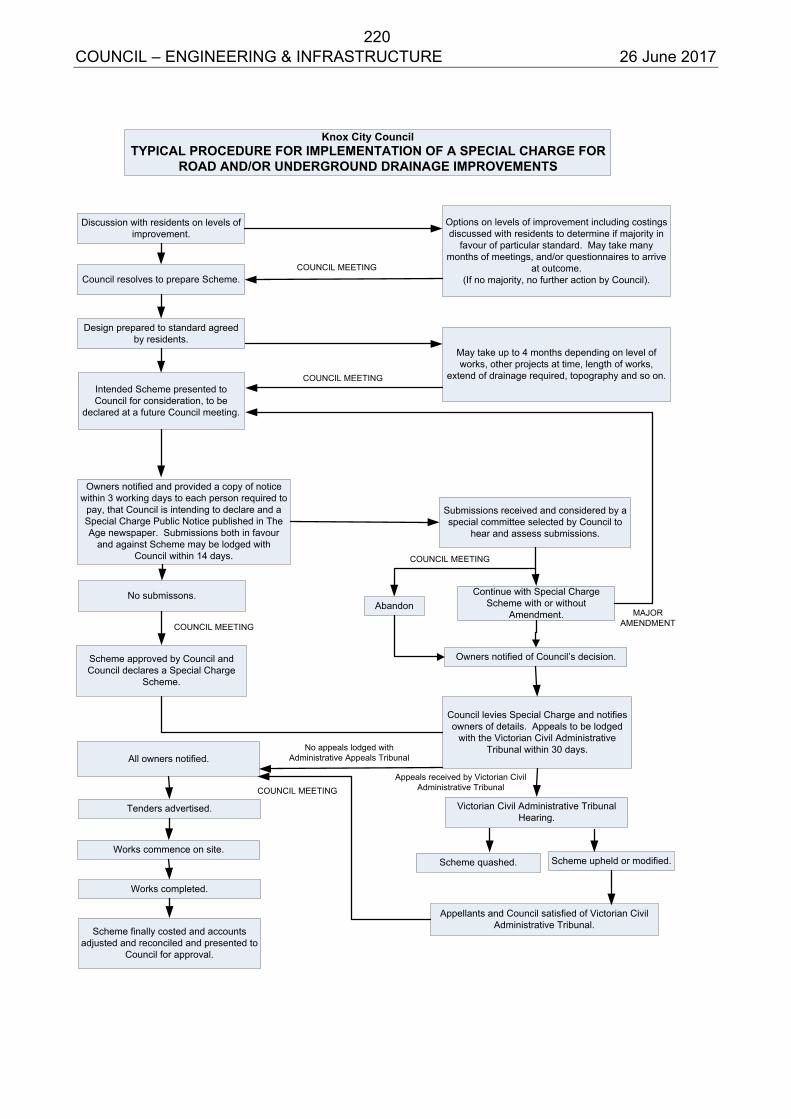
220 COUNCIL – ENGINEERING & INFRASTRUCTURE 26 June 2017
Knox City CouncilTYPICAL PROCEDURE FOR IMPLEMENTATION OF A SPECIAL CHARGE FOR
ROAD AND/OR UNDERGROUND DRAINAGE IMPROVEMENTS
Submissions received and considered by a special committee selected by Council to
hear and assess submissions.
May take up to 4 months depending on level of works, other projects at time, length of works,
extend of drainage required, topography and so on.Intended Scheme presented to Council for consideration, to be
declared at a future Council meeting.
Owners notified and provided a copy of notice within 3 working days to each person required to
pay, that Council is intending to declare and a Special Charge Public Notice published in The Age newspaper. Submissions both in favour
and against Scheme may be lodged with Council within 14 days.
Discussion with residents on levels of improvement.
Options on levels of improvement including costings discussed with residents to determine if majority in
favour of particular standard. May take many months of meetings, and/or questionnaires to arrive
at outcome. (If no majority, no further action by Council).Council resolves to prepare Scheme.
Design prepared to standard agreed by residents.
Continue with Special Charge Scheme with or without
Amendment.
No submissons.
Scheme approved by Council and Council declares a Special Charge
Scheme.
Abandon
Owners notified of Council’s decision.
Council levies Special Charge and notifies owners of details. Appeals to be lodged
with the Victorian Civil Administrative Tribunal within 30 days.
All owners notified.
Tenders advertised.
Works commence on site.
Works completed.
Scheme finally costed and accounts adjusted and reconciled and presented to
Council for approval.
Victorian Civil Administrative Tribunal Hearing.
Scheme quashed.
Appellants and Council satisfied of Victorian Civil Administrative Tribunal.
Scheme upheld or modified.
COUNCIL MEETING
COUNCIL MEETING
COUNCIL MEETING
COUNCIL MEETING
MAJORAMENDMENT
No appeals lodged with Administrative Appeals Tribunal
COUNCIL MEETINGAppeals received by Victorian Civil
Administrative Tribunal
221 COUNCIL – ENGINEERING & INFRASTRUCTURE 26 June 2017
APPENDIX 3 Local Government Act 1989 – Section 163(2C)
Special Rates and Special Charges: Calculating Maximum Total Levy
Ministerial Guideline
(Published in the Government Gazette on 23 September 2004)
INTRODUCTION 1. This Guideline is made under section 163(2C) of the Local Government Act 1989
(the Act). It relates to the application of sections 163(2), 163(2A) and 163(2B) of the Act. It specifically addresses the calculation of the maximum total amount that may be levied as a special rate or special charge (referred to as the “maximum total levy”).
2. Some terminology used in this Guideline should be noted:
a. “Scheme” refers to a special rate or special charge scheme. b. “Works or services” refers to the functions or powers being exercised by the
council for which it is proposed to levy a special rate or charge. c. “Property” refers to property in the form of land.
3. The calculation of the maximum total levy requires the following: a. Calculation of the “total cost” of the works or services, b. Calculation of the “benefit ratio”, which depends on reasonable estimates of:
“Total special benefits” to properties included in the scheme, “Total special benefits” to properties not included in the scheme (if any),
and “Total community benefits” (if any).
STEPS IN CALCULATION
4. The following steps apply to the calculation of the maximum total levy. A. DEFINE PURPOSE B. ENSURE COHERENCE. C. CALCULATE TOTAL COST D. IDENTIFY SPECIAL BENEFICIARIES E. DETERMINE PROPERTIES TO INCLUDE F. ESTIMATE TOTAL SPECIAL BENEFITS G. ESTIMATE COMMUNITY BENEFITS H. CALCULATE THE “BENEFIT RATIO” I. CALCULATE THE MAXIMUM TOTAL LEVY
222 COUNCIL – ENGINEERING & INFRASTRUCTURE 26 June 2017
A. Define Purpose 5. The purpose, or purposes, of the proposed works or services should be clearly
defined at the outset. The purpose should describe the reasons why the proposed works or services are proposed.
6. The description of the purpose would normally take account of the following:
a. Reasons why the works or services are considered necessary or appropriate, noting any relevant background information.
b. Who has proposed that the works or services be undertaken and including the following information;
If the works or services have been proposed by the council, the relevant council policy or resolution.
If the works or services were requested by a person or people other than the council, an indication of whether those people are proposed to be included in the scheme and what reasons they have given for requesting the works or services.
7. A scheme may serve multiple purposes and can be proposed by multiple
parties.
B. Ensure Coherence 8. For the purposes of calculating the maximum total levy, and therefore total cost
and benefit ratio, the works or services for which the special rate or charge is proposed should have a natural coherence.
9. Proposed works or services can be considered to have a natural coherence if:
a. They will be physically or logically connected, or b. They will provide special benefits, of a related nature, to a common, or
overlapping, group of properties. C. Calculate total cost 10. The “total cost” is the aggregate cost of defraying expenses related to providing
the works or services and establishing the scheme. 11. The following should apply to the calculation of the “total cost”:
a. Costs included in the total cost must be for purposes in section 163(1) of the Act.
b. Costs included in the total cost may only be for expenses listed in section 163(6) of the Act.
223 COUNCIL – ENGINEERING & INFRASTRUCTURE 26 June 2017
c. Costs included in the total cost should be based on actual expenses that have been incurred, or reasonable estimates of expenses expected to be incurred. (For example, any interest should be based on estimated actual interest costs rather than on prescribed penalty interest rates).
d. Costs included in the total cost may relate to known activities but not to
activities that are purely speculative or hypothetical in nature. (For example, provision for incidental costs related to the proposed works might be included but not costs related to possible legal proceedings that may or may not occur).
D. Identify special beneficiaries 12. The council should identify, as far as possible, which properties will receive a
special benefit from the proposed works or services. A “special benefit” is considered to be provided to a property if the proposed works or services will provide a benefit that is additional to or greater than the benefit to other properties.
13. It is important to note that, while special benefits are considered to accrue to
properties, the actual measurable benefits are provided to the owners and/or occupiers of the properties (see also paragraph 23.a).
14. Special benefits should be benefits that are either tangible benefits to the owners
or occupiers of the properties that are not remote, or they should be clear benefits to those owners or occupiers that were identified in the defined purpose of the works or services (paragraph 5). Types of benefits included as special benefits generally include services provided for the properties, identifiable improvements in physical or environmental amenity, improved access, improved safety or economic benefits.
15. A special benefit may be considered to exist if it would reasonably be expected to
benefit the owners or occupiers of the property. It is not necessary for the benefit to be actually used by the particular owners or occupiers of a specified property at a particular time in order for a special benefit to be attributed to the property.
E. Determine properties to include 16. Having identified which properties will receive special benefits, the council must
decide which properties to include in the scheme. The properties included in the scheme will be those that are required to pay the special rate or charge.
17. If a property will receive a special benefit but is not included in the scheme, the
calculation of the benefit ratio will result in the council paying the share of costs related to the special benefits for those properties.
224 COUNCIL – ENGINEERING & INFRASTRUCTURE 26 June 2017
18. The council is not required to levy a special rate or charge on any or every property that will receive a special benefit. A property with a special benefit may be excluded from the scheme for any of the following reasons:
a. the council is unable to levy a special rate or charge on the property, b. the owner of the property has already contributed to the costs of the works
through a development levy, c. the council considers that there are particular advantages for the municipality
in excluding the property from the scheme, d. the council considers that the special benefits for the property are marginal
and would not warrant including the property in the scheme, or e. any other reason that the council considers appropriate.
F. Estimate total special benefits 19. Total special benefits can be defined to include two parts, as follows:
TSB =TSB (in ) +TSB (out )
TSB is the estimated total special benefit for all properties that have been identified
to receive a special benefit.
TSB(in) is the estimated total special benefit for those properties that the council
proposes to include in the scheme.
TSB(out) is the estimated total special benefit for those properties with an identified
special benefit that the council does not propose to include in the scheme.
20. In estimating the total special benefits for properties that will be included in the scheme, particular attention should be paid to:
a. The identified purpose of the proposed works or services. b. Specific benefits relevant to the type of works or services proposed.
21. There is no single or prescribed method for estimating total special benefits.
However, whatever method is used, it is essential that the comparative weightings attributed to different types of benefits are reasonable and are applied consistently by a council. It is also essential that consistent weightings are used between those properties that are included in the scheme and those that are not included.
22. It is particularly important to note that, while it may sometimes be useful to estimate
special benefits on a property by property basis, this is not always necessary. The calculation of the benefit ratio only requires aggregate estimates of total special benefits for properties included in the scheme and for properties excluded from the scheme.
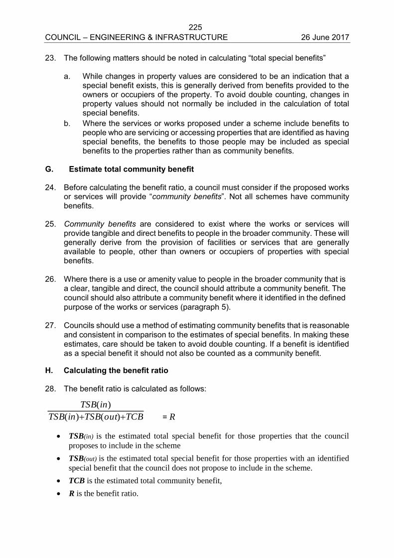
225 COUNCIL – ENGINEERING & INFRASTRUCTURE 26 June 2017
23. The following matters should be noted in calculating “total special benefits”
a. While changes in property values are considered to be an indication that a special benefit exists, this is generally derived from benefits provided to the owners or occupiers of the property. To avoid double counting, changes in property values should not normally be included in the calculation of total special benefits.
b. Where the services or works proposed under a scheme include benefits to people who are servicing or accessing properties that are identified as having special benefits, the benefits to those people may be included as special benefits to the properties rather than as community benefits.
G. Estimate total community benefit 24. Before calculating the benefit ratio, a council must consider if the proposed works
or services will provide “community benefits”. Not all schemes have community benefits.
25. Community benefits are considered to exist where the works or services will
provide tangible and direct benefits to people in the broader community. These will generally derive from the provision of facilities or services that are generally available to people, other than owners or occupiers of properties with special benefits.
26. Where there is a use or amenity value to people in the broader community that is
a clear, tangible and direct, the council should attribute a community benefit. The council should also attribute a community benefit where it identified in the defined purpose of the works or services (paragraph 5).
27. Councils should use a method of estimating community benefits that is reasonable
and consistent in comparison to the estimates of special benefits. In making these estimates, care should be taken to avoid double counting. If a benefit is identified as a special benefit it should not also be counted as a community benefit.
H. Calculating the benefit ratio 28. The benefit ratio is calculated as follows:
TCBoutTSBinTSB
inTSB
)()(
)(
= R
TSB(in) is the estimated total special benefit for those properties that the council
proposes to include in the scheme
TSB(out) is the estimated total special benefit for those properties with an identified
special benefit that the council does not propose to include in the scheme.
TCB is the estimated total community benefit,
R is the benefit ratio.
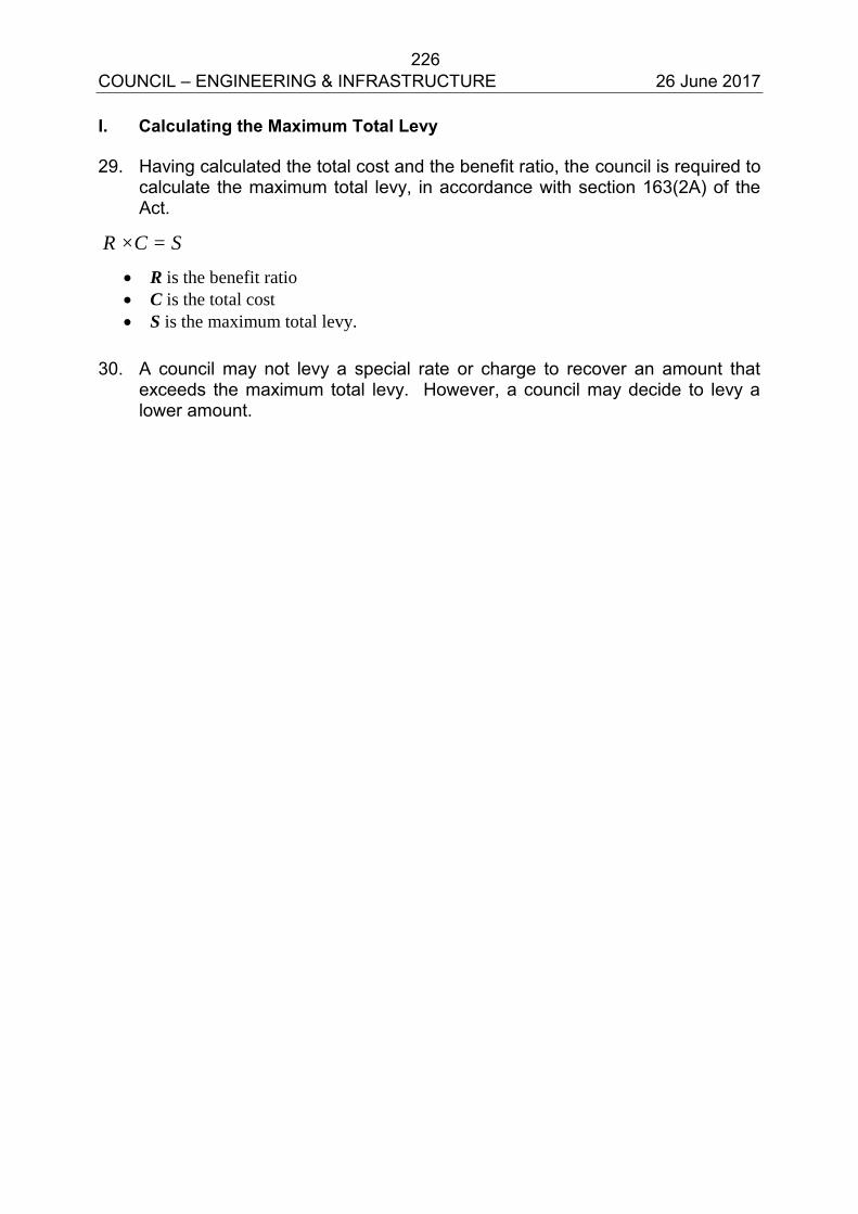
226 COUNCIL – ENGINEERING & INFRASTRUCTURE 26 June 2017
I. Calculating the Maximum Total Levy 29. Having calculated the total cost and the benefit ratio, the council is required to
calculate the maximum total levy, in accordance with section 163(2A) of the Act.
R ×C = S
R is the benefit ratio
C is the total cost
S is the maximum total levy. 30. A council may not levy a special rate or charge to recover an amount that
exceeds the maximum total levy. However, a council may decide to levy a lower amount.
227 COUNCIL – ENGINEERING & INFRASTRUCTURE 26 June 2017
ALL WARDS
8.2 ROAD MANAGEMENT PLAN REVIEW 2017 SUMMARY: Acting Coordinator – Asset Strategy (Robin Cassidy) The Road Management Act (the Act) was introduced in 2004 as a means to ensure Road Authorities manage their road networks in a more proactive and responsible manner. Road Management Plans provide Road Authorities with a policy defence for the management practices of inspection, maintenance and repair of their road networks. Following the recent Council elections, the current Road Management Plan is required to be formally reviewed in accordance with the Road Management (General) Regulations (2016).
RECOMMENDATION
That Council
1. endorse the Road Management Plan Review Report shown as Appendix A to this report;
2. in accordance with Regulation 302(5) of the Road Management (General) Regulations (2016), make the Report available to the community by providing a copy on Council’s website and at the Civic Centre; and
3. initiate the formal Road Management Plan Amendment process in accordance with the requirements of the Act during 2017/18.
1. INTRODUCTION
The Knox Road Management Plan (RMP) sets out Council’s approach to the inspection, maintenance and repair of its public roads and road related assets. If complied with, the RMP provides Council with a policy defence against civil liability claims associated with management of the road network.
Under Section 39(4) of the Road Management Act (2004):
“A road authority is to be taken to have made a policy or policy decision relating to a road management function if the road authority has made a road management plan that includes provisions relating to the performance of that road management function.” The Knox Road Management Plan was initially developed in accordance with the Road Management Act (2004), supporting Regulations and Codes of Practice. It was reviewed in 2006, 2009, and 2013. Amendments occurred in 2006, 2010 and 2015.
228 COUNCIL – ENGINEERING & INFRASTRUCTURE 26 June 2017
8.2 Road Management Plan Review (cont’d)
The RMP is now subject to formal review in accordance with the Road Management (General) Regulations (2016). These Regulations require that the review be completed by 30 June 2017.
This report introduces the Knox City Council Road Management Plan Review as presented in Appendix A. If endorsed by Council, the review must be made publicly available as specified in the Road Management (General) Regulations (2016) – Part 3 Division 1 – (9.2): –
“After a road authority has completed a review of its road management plan, it must –
(a) produce a written report summarising the findings and conclusions of the review;
and (b) make the report available for copying or inspection—
(i) at the place where the road management plan may be inspected or obtained in accordance with section 55(1)(b) of the Act; or
(ii) on an Internet site maintained by the road authority.
The amending of the Road Management Plan is a separate legislative process to the review, which is documented in the Road Management (General) Regulations (2016), and can occur at any time.
2. DISCUSSION
This review has aimed to assess the appropriateness, reasonableness and deliverability of Council’s current RMP through internal analysis and feedback.
The assessment of appropriateness and reasonableness was based on a review of:
Road Management Plans made by neighbouring municipalities; and
Customer satisfaction data.
The assessment of deliverability was based on:
Inspection, maintenance and repair performance recorded in Council’s Work Order System (Lifecycle);
Feedback from Council staff responsible for implementation of the Plan; and
Recent audit report recommendations as reported by: o Council’s Sustainable Infrastructure Department; o MAV Insurance (Council’s insurer); and o DFK Kidsons (Council’s auditor).
229 COUNCIL – ENGINEERING & INFRASTRUCTURE 26 June 2017
8.2 Road Management Plan Review (cont’d)
The Road Management Plan Review proposes a small number of amendment recommendations for consideration prior to any amendments to the plan itself. These areas of focus include:
That consideration be given to advice from external auditors when determining included service levels in future updates to the Road Management Plan, including; o Consideration of the hierarchy of a road when defining maintenance
service standards and response times; o Consideration for removing and relocating non-road related asset
inspections and maintenance activities from its RMP into other plans and strategies; and
o Ensuring that Council achieve its stated minimum score for all RMP inspection and repair response times prior to considering modifying its standards.
Amending the Road Management Plan is a separate regulatory process which is defined by regulations 303 and 304. Notification of agreed amendments must be in accordance with regulation 303 and include gazettal and a 28 day consultation period. The regulations do not specify the timing for implementation of amendments. It is recommended, however, that Council implement the proposed amendments during 2017/18. It is noted that the amendment process incorporates the opportunity for public submissions in accordance with the requirements of the Act.
Council’s current Road Management Plan will remain as Council’s reference document until such time as any amendments are formally endorsed by Council.
3. CONSULTATION
Internal consultation was also undertaken by means of an internal RMP Reference Group, which considered and provided feedback on a number of issues raised in this review. The report on the findings and conclusions of the review must be made publicly available as defined in the Road Management (General) Regulations (2016).
4. ENVIRONMENTAL/AMENITY ISSUES
There are no environmental or amenity issues associated with the Road Management Plan Review.
5. FINANCIAL & ECONOMIC IMPLICATIONS
Any work required to implement proposed amendments or any implications from potential amendments to maintenance service standards will be absorbed in existing operational budgets (Sustainable Infrastructure and Operations Departments).
230 COUNCIL – ENGINEERING & INFRASTRUCTURE 26 June 2017
8.2 Road Management Plan Review (cont’d)
A robust, reasonable and ultimately deliverable Road Management Plan provides Council with a policy defence against civil liability claims associated with the management of its road network. This has significant implications in reducing Council’s risk and financial exposure as well as building a strong case for reduced insurance premiums.
6. SOCIAL IMPLICATIONS
The road network has an impact on all community groups by providing connectivity across the municipality, as well as by providing economic benefits. The Road Management Plan documents how Council’s roads are managed and to what service standards – it is imperative it is reviewed, updated and amended regularly to reflect current community expectations and Council’s available resources. The legislated review recognises the importance of the community’s input by seeking to create an opportunity for residents to inform Council of their expectations.
7. RELEVANCE TO CITY PLAN 2013-17 (INCORPORATING THE COUNCIL PLAN)
The Road Management Plan Review has relevance to three themes of the Council Plan.
Dynamic Services & Facilities
“To continually improve the capacity of Council’s services and infrastructure to best meet the community’s needs.”
Accessible Transport Choices
“To provide real travel choice and reduce inequalities in access to transport opportunities in Knox by advocating for and facilitating improvements in transport infrastructure and services.
A Well Governed & Leading Organisation
“To ensure the highest standards and transparency of our governance practices and the capability of our organisation, and to improve the condition and suitability of the municipality’s assets.”
The undertaking of this review has demonstrated that Council has met its statutory obligations and has acted as a responsible steward of community assets. The review ensures that roads and related infrastructure continue to be managed in a manner that mitigates public safety risks in the most financially sustainable fashion. The public consultation process for this review has provided an opportunity for the community to determine the most appropriate way to manage the municipality’s road network.
231 COUNCIL – ENGINEERING & INFRASTRUCTURE 26 June 2017
8.2 Road Management Plan Review (cont’d)
8. CONCLUSION
The review of the Road Management Plan is designed to fulfil three principal objectives. The first is to ensure that Council (as a Road Authority) is constantly monitoring the appropriateness of its Road Management Plan. The second is to provide a forum for all new Councillors to become informed as to the importance of having a robust and relevant Road Management Plan. Finally, the review provides the community with an opportunity to comment on the reasonableness of the current Plan.
As noted previously, the review of the Road Management Plan was legislated to commence by 1 January and is to be completed no later than 30 June 2017. The purpose of the review is not to introduce amendments to the existing Plan but to examine the appropriateness of the current Plan in the way it manages risk prioritisation, inspection frequencies, intervention levels, response times and maintenance and repair standards of road based infrastructure.
The review has recommended that amendments to the current RMP occur as a separate process during 2017/18.
This Road Management Plan Review has enabled Council to meet its statutory requirements under the Road Management Act (2004) and ensure that Council has provided every opportunity for the community to have input into the way the Knox road network is managed.
9. CONFIDENTIALITY
There are no confidentiality issues associated with this report.
Report Prepared By: Acting Coordinator – Asset Strategy (Robin Cassidy)
Report Authorised By: Director – Engineering & Infrastructure
(Ian Bell)
232 COUNCIL – ENGINEERING & INFRASTRUCTURE 26 June 2017
KX: (D17-37047)
APPENDIX A
KNOX CITY COUNCIL
ROAD MANAGEMENT PLAN
REVIEW
2017
233 COUNCIL – ENGINEERING & INFRASTRUCTURE 26 June 2017
TABLE OF CONTENTS
1. Background ............................................................................................................... 235 1.1. Introduction ............................................................................................................ 235
1.2. Purpose of a Road Management Plan ................................................................... 235 2. Defining the Scope of this Review ............................................................................. 236 3. Assessment of Reasonableness and Deliverability ................................................... 237 3.1. Local Government Community Satisfaction Survey ............................................... 237 3.2. Local Government Performance Reporting Framework ......................................... 237
a. Measure 14 – Sealed local requests per 100km of sealed local roads...................... 237 b. Measure 15 – Sealed local roads maintained adequately ......................................... 238
3.3. Work Order System - Customer Requests. ............................................................ 239
3.4. Road Management Plans of neighbouring Councils .............................................. 240 3.5. Road and Path Hierarchies .................................................................................... 242 3.6. Recommendations from internal/external audits .................................................... 242 a. External Audits .......................................................................................................... 242 3.6.a.1. MAV – Liability Mutual Insurance – June 2015 ................................................ 242
3.6.a.2. DFK Kidsons – April 2015 ............................................................................... 243
b. Internal Audits ........................................................................................................... 244 3.7. Recommendations from strategies/plans ............................................................... 245 3.8. Instrument of Delegation ........................................................................................ 245
3.9. Demarcation responsibilities .................................................................................. 246 3.10. Performance Analysis ......................................................................................... 246
a. Routine Hazard Inspections ...................................................................................... 247 b. Reactive Maintenance – Initial Response ................................................................. 247
c. Reactive Maintenance – Temporary Works .............................................................. 248 d. Reactive Maintenance – Rectification Works ............................................................ 249
e. Routine Maintenance ................................................................................................ 250 f. Performance Summary ............................................................................................. 251 3.11. Feedback from staff responsible for RMP implementation ................................. 251
4. Summary of Recommendations ................................................................................ 252 5. Next Steps ................................................................................................................. 252
5.1. Finalisation of Review ............................................................................................ 252 5.2. Amendment of Road Management Plan ................................................................ 252
ATTACHMENT A – SUMMARY OF RECOMMENDATIONS ........................................... 255
234 COUNCIL – ENGINEERING & INFRASTRUCTURE 26 June 2017
List of Figures Figure 1 – Local Government Community Satisfaction Survey – local roads & footpaths 237 Figure 2 – LGPRF – Sealed local road requests per 100km of sealed road ........................ 7 Figure 3 – LGPRF – Sealed local roads maintained adequately ......................................... 7
List of Tables
Table 1 – Rectification Response Times .............................................................................. 9 Table 2 – Road and Path Hierarchies - changes……………………………………………. 10 Table 3 – Internal Audit – Annual scores………………………………………………………. 12 Table 4 - Recommendations from strategies and plans……………………………………... 12

235 Knox City Council – Road Management Plan – Review - 2017 26 June 2017
11.. BBAACCKKGGRROOUUNNDD
11..11.. IINNTTRROODDUUCCTTIIOONN
The Knox Road Management Plan (RMP) was developed to document Council’s approach to the management of public roads within the municipality. If complied with, the RMP provides Council with a policy defence against civil liability claims associated with management of the road network. The RMP was developed in accordance with the Road Management Act (2004), supporting regulations and codes of practice. The RMP is now subject to formal review in accordance with the Road Management (General) Regulations 2016. This latest review is the fourth with prior reviews being undertaken in 2006, 2009 and 2013. The RMP has been amended twice in 2010 and 2015. This report summarises the review process and findings. Although the review process has not identified specific and immediate changes to the standards and priorities for inspection and maintenance activities it does recommend that council initiate projects to inform the next cyclic amendment of its RMP in accordance with the process detailed in Section 5.2.
11..22.. PPUURRPPOOSSEE OOFF AA RROOAADD MMAANNAAGGEEMMEENNTT PPLLAANN
Section 50 of the Road Management Act (2004) states that the purposes of a Road Management Plan are:
a. to establish a management system for the road management functions of a road authority which is based on policy and operational objectives and available resources; and
b. to set the relevant standard in relation to the discharge of duties in the performance of those road management functions
General functions of a road authority are set out in section 34 of the Act and are reproduced below:
(1) A road authority has the following general functions — a. to provide and maintain, as part of a network of roads, roads for use by the
community served by the road authority; b. to manage the use of roads having regard to the principle that the primary
purpose of a road is to be used by members of the public and that other uses are to be managed in a manner which minimises any adverse effect on the safe and efficient operation of the road and on the environment;
c. to manage traffic on roads in a manner that enhances the safe and efficient operation of roads;
(ca) to design, construct, inspect, repair and maintain roads and road infrastructure; d. to coordinate the installation of infrastructure on roads and the conduct of other
works in such a way as to minimise, as far as is reasonably practicable, adverse impacts on the provision of utility or public transport services;
e. to undertake works and activities which promote the functions referred to in paragraphs (a), (b), (c) and (ca) and to undertake activities which promote the function in paragraph (d).
(2) The general functions conferred on a road authority under subsection (1) are not to be construed as limiting any other functions conferred on a road authority by or under this Act or any other Act. (3) In seeking to achieve its functions, a road authority should —
a. consult with the community and disseminate information in relation to the exercise of those functions;
b. take steps as are reasonably practicable to ensure the structural integrity and safety of public roads in accordance with this Act.
236 Knox City Council – Road Management Plan – Review - 2017 26 June 2017
In essence, a Road Management Plan provides a number of benefits to Council including, but not limited to:
Proactive management of road and road-related assets (asset management); Minimisation of public safety risk; Greater transparency in processes; Improved auditability of performance; Reduced insurance premiums; and A policy defence against civil liability claims.
22.. DDEEFFIINNIINNGG TTHHEE SSCCOOPPEE OOFF TTHHIISS RREEVVIIEEWW
Road Management (General) Regulations 2016, Part 3 Division 1(9) states that: In conducting a review of its road management plan, a road authority must ensure that the standards in relation to, and the priorities to be given to, the inspection, maintenance and repair of the roads and classes of roads to which the plan relates are appropriate.
Similar to the Review undertaken in 2013, this Review takes a fresh look at all aspects of the current RMP and assesses whether each aspect remains appropriate, deliverable and reasonable. Each Chapter and Attachment has been assessed. The assessment has considered changes to the Road Management Act and other relevant regulation and codes of practice enacted since the time of the last Review in 2013. Assessment of reasonableness was based on a review of:
Road Management Plans made by neighbouring municipalities Customer satisfaction data and feedback from the Knox community
Assessment of deliverability was based on: Inspection, maintenance and repair performance recorded in Council’s Work
Order System (Lifecycle) during the period January 2015 to December 2016 (extended to January 2013 to December 2016 for inspections only);
Feedback from Council staff responsible for implementation of the Plan; and Recent audit report recommendations as reported by:
o Council’s Sustainable Infrastructure Department o MAV Insurance (Council’s insurer) o DFK Kidsons (Council’s auditor)
Council’s Instrument of Delegation, road and path hierarchies, demarcation agreements and recommendations from relevant plans and strategies were also reviewed. In addition to meeting the legislated review requirements, the review process has been used to recommend work practice improvements to improve ongoing compliance with the RMP. Where evidence suggests aspects of the RMP are unrealistic or unachievable, changes to the RMP have been recommended. Care has been taken to ensure all proposed changes have a rational or plausible basis and are not unduly liberal so that the “policy defence” remains available.
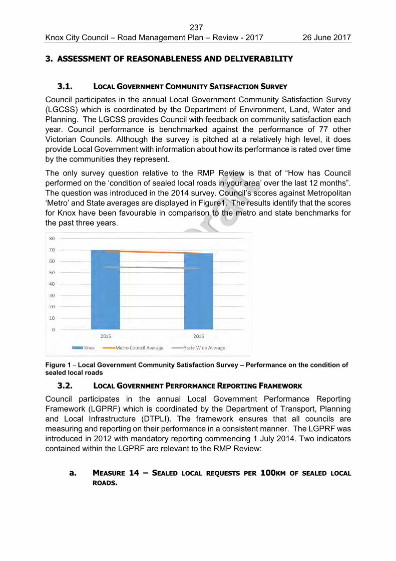
237 Knox City Council – Road Management Plan – Review - 2017 26 June 2017
33.. AASSSSEESSSSMMEENNTT OOFF RREEAASSOONNAABBLLEENNEESSSS AANNDD DDEELLIIVVEERRAABBIILLIITTYY
33..11.. LLOOCCAALL GGOOVVEERRNNMMEENNTT CCOOMMMMUUNNIITTYY SSAATTIISSFFAACCTTIIOONN SSUURRVVEEYY
Council participates in the annual Local Government Community Satisfaction Survey (LGCSS) which is coordinated by the Department of Environment, Land, Water and Planning. The LGCSS provides Council with feedback on community satisfaction each year. Council performance is benchmarked against the performance of 77 other Victorian Councils. Although the survey is pitched at a relatively high level, it does provide Local Government with information about how its performance is rated over time by the communities they represent.
The only survey question relative to the RMP Review is that of “How has Council performed on the ‘condition of sealed local roads in your area’ over the last 12 months”. The question was introduced in the 2014 survey. Council’s scores against Metropolitan ‘Metro’ and State averages are displayed in Figure1. The results identify that the scores for Knox have been favourable in comparison to the metro and state benchmarks for the past three years.
Figure 1 – Local Government Community Satisfaction Survey – Performance on the condition of sealed local roads
33..22.. LLOOCCAALL GGOOVVEERRNNMMEENNTT PPEERRFFOORRMMAANNCCEE RREEPPOORRTTIINNGG FFRRAAMMEEWWOORRKK
Council participates in the annual Local Government Performance Reporting Framework (LGPRF) which is coordinated by the Department of Transport, Planning and Local Infrastructure (DTPLI). The framework ensures that all councils are measuring and reporting on their performance in a consistent manner. The LGPRF was introduced in 2012 with mandatory reporting commencing 1 July 2014. Two indicators contained within the LGPRF are relevant to the RMP Review:
aa.. MMEEAASSUURREE 1144 –– SSEEAALLEEDD LLOOCCAALL RREEQQUUEESSTTSS PPEERR 110000KKMM OOFF SSEEAALLEEDD LLOOCCAALL
RROOAADDSS..
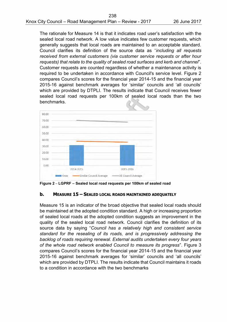
238 Knox City Council – Road Management Plan – Review - 2017 26 June 2017
The rationale for Measure 14 is that it indicates road user’s satisfaction with the sealed local road network. A low value indicates few customer requests, which generally suggests that local roads are maintained to an acceptable standard. Council clarifies its definition of the source data as “including all requests received from external customers (via customer service requests or after hour requests) that relate to the quality of sealed road surfaces and kerb and channel”. Customer requests are counted regardless of whether a maintenance activity is required to be undertaken in accordance with Council's service level. Figure 2 compares Council’s scores for the financial year 2014-15 and the financial year 2015-16 against benchmark averages for ‘similar’ councils and ‘all councils’ which are provided by DTPLI. The results indicate that Council receives fewer sealed local road requests per 100km of sealed local roads than the two benchmarks.
Figure 2 – LGPRF – Sealed local road requests per 100km of sealed road bb.. MMEEAASSUURREE 1155 –– SSEEAALLEEDD LLOOCCAALL RROOAADDSS MMAAIINNTTAAIINNEEDD AADDEEQQUUAATTEELLYY
Measure 15 is an indicator of the broad objective that sealed local roads should be maintained at the adopted condition standard. A high or increasing proportion of sealed local roads at the adopted condition suggests an improvement in the quality of the sealed local road network. Council clarifies the definition of its source data by saying “Council has a relatively high and consistent service standard for the resealing of its roads, and is progressively addressing the backlog of roads requiring renewal. External audits undertaken every four years of the whole road network enabled Council to measure its progress”. Figure 3 compares Council’s scores for the financial year 2014-15 and the financial year 2015-16 against benchmark averages for ‘similar’ councils and ‘all councils’ which are provided by DTPLI. The results indicate that Council maintains it roads to a condition in accordance with the two benchmarks
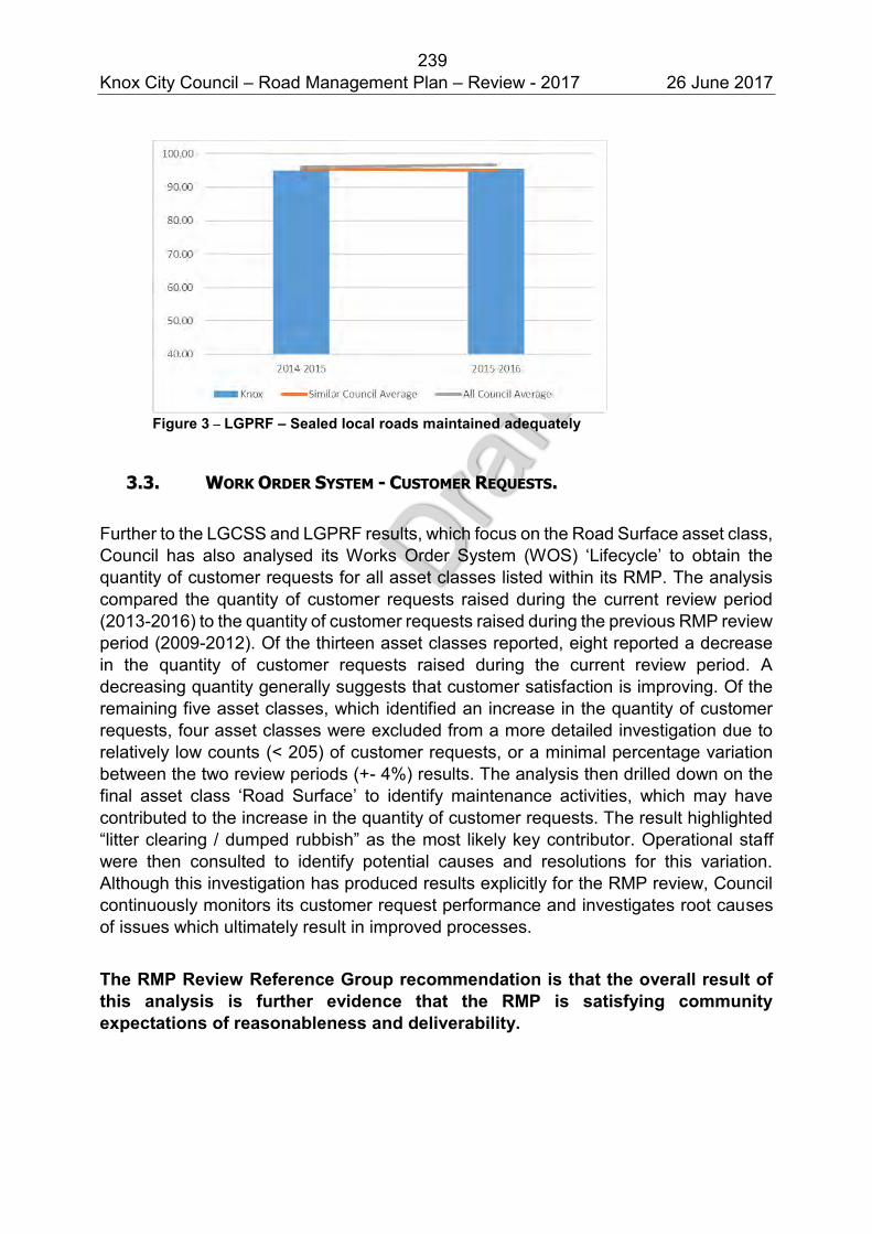
239 Knox City Council – Road Management Plan – Review - 2017 26 June 2017
Figure 3 – LGPRF – Sealed local roads maintained adequately
33..33.. WWOORRKK OORRDDEERR SSYYSSTTEEMM -- CCUUSSTTOOMMEERR RREEQQUUEESSTTSS..
Further to the LGCSS and LGPRF results, which focus on the Road Surface asset class, Council has also analysed its Works Order System (WOS) ‘Lifecycle’ to obtain the quantity of customer requests for all asset classes listed within its RMP. The analysis compared the quantity of customer requests raised during the current review period (2013-2016) to the quantity of customer requests raised during the previous RMP review period (2009-2012). Of the thirteen asset classes reported, eight reported a decrease in the quantity of customer requests raised during the current review period. A decreasing quantity generally suggests that customer satisfaction is improving. Of the remaining five asset classes, which identified an increase in the quantity of customer requests, four asset classes were excluded from a more detailed investigation due to relatively low counts (< 205) of customer requests, or a minimal percentage variation between the two review periods (+- 4%) results. The analysis then drilled down on the final asset class ‘Road Surface’ to identify maintenance activities, which may have contributed to the increase in the quantity of customer requests. The result highlighted “litter clearing / dumped rubbish” as the most likely key contributor. Operational staff were then consulted to identify potential causes and resolutions for this variation. Although this investigation has produced results explicitly for the RMP review, Council continuously monitors its customer request performance and investigates root causes of issues which ultimately result in improved processes.
The RMP Review Reference Group recommendation is that the overall result of this analysis is further evidence that the RMP is satisfying community expectations of reasonableness and deliverability.
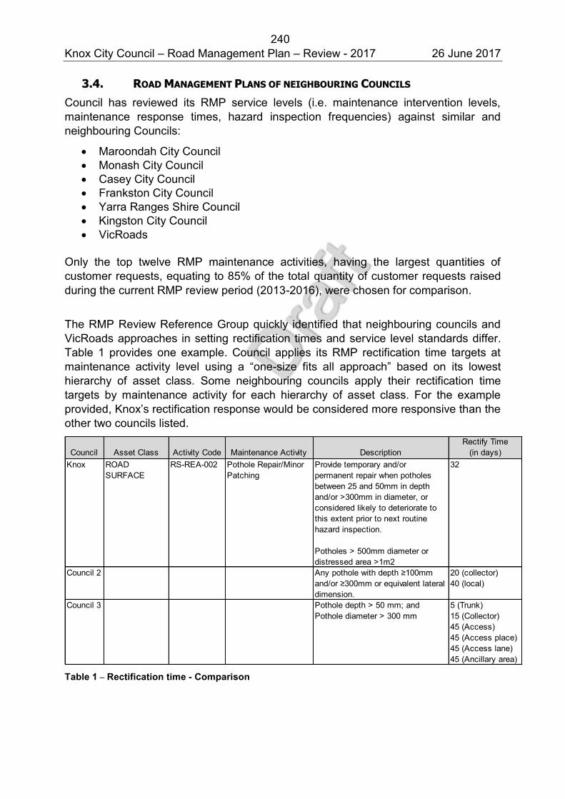
240 Knox City Council – Road Management Plan – Review - 2017 26 June 2017
33..44.. RROOAADD MMAANNAAGGEEMMEENNTT PPLLAANNSS OOFF NNEEIIGGHHBBOOUURRIINNGG CCOOUUNNCCIILLSS
Council has reviewed its RMP service levels (i.e. maintenance intervention levels, maintenance response times, hazard inspection frequencies) against similar and neighbouring Councils:
Maroondah City Council Monash City Council Casey City Council Frankston City Council Yarra Ranges Shire Council Kingston City Council VicRoads
Only the top twelve RMP maintenance activities, having the largest quantities of customer requests, equating to 85% of the total quantity of customer requests raised during the current RMP review period (2013-2016), were chosen for comparison.
The RMP Review Reference Group quickly identified that neighbouring councils and VicRoads approaches in setting rectification times and service level standards differ. Table 1 provides one example. Council applies its RMP rectification time targets at maintenance activity level using a “one-size fits all approach” based on its lowest hierarchy of asset class. Some neighbouring councils apply their rectification time targets by maintenance activity for each hierarchy of asset class. For the example provided, Knox’s rectification response would be considered more responsive than the other two councils listed.
Council Asset Class Activity Code Maintenance Activity DescriptionRectify Time
(in days)Knox ROAD
SURFACERS-REA-002 Pothole Repair/Minor
PatchingProvide temporary and/or permanent repair when potholes between 25 and 50mm in depth and/or >300mm in diameter, or considered likely to deteriorate to this extent prior to next routine hazard inspection.
Potholes > 500mm diameter or distressed area >1m2
32
Council 2 Any pothole with depth ≥100mm and/or ≥300mm or equivalent lateral dimension.
20 (collector)40 (local)
Council 3 Pothole depth > 50 mm; andPothole diameter > 300 mm
5 (Trunk)15 (Collector)45 (Access)45 (Access place)45 (Access lane)45 (Ancillary area)
Table 1 – Rectification time - Comparison
241 Knox City Council – Road Management Plan – Review - 2017 26 June 2017
As a result of neighbouring councils and VicRoads different approaches, the comparison of some maintenance activities became technically complex and in some instances unattainable. Council’s insurer during its Roads, Footpaths, Pathways and Trees Management Compliance Review completed in 2015 has recommended “that Council consider adopting a system that ensures defects identified on roads/footpaths/pathways that are of a higher category within the RMP hierarchy are required to be repaired quicker than those in a lower categories”. Council will consider this recommendation and investigate its scope in respect of determining which maintenance activities to target prior to the next amendment of its RMP.
Three of the twelve maintenance activities being compared were found to have no matching activity within neighbouring councils and VicRoads RMP’s. This difference is also the subject of a recommendation identified by Council’s insurer during its Roads, Footpaths, Pathways and Trees Management Compliance Review completed in 2015 which is detailed in section 3.6. Council’s insurer recommends the removal and relocation of non-road related asset maintenance activities and inspections from the RMP into other Council asset management plans and strategies to ensure service levels are maintained. The comparison exercise identified that this is the position taken by other road authorities. The review reference group identified:
1. That further discussions with Council’s insurer would need to be held to identify the scope of changes.
2. That any potential relocation of inspection and maintenance activity service levels into Asset Management Plan’s would occur as plans were reviewed.
3. That performance reporting of service levels for effected inspections and activities would need to continue.
Another factor considered by the review reference group is Council’s initial assessment process of customer requests which initiates and accelerates a temporary rectification when a risk to the public is identified as Extreme or High. Council’s processes ensure that temporary works occur promptly, within 1 or 5 days in the case of Extreme or High risks respectively. This practice offsets the potential risks associated with Council’s longer rectification timeframes.
The comparison exercise outcomes generally indicate that Council’s maintenance activity rectification times are reasonable compared to those of its neighbouring councils and VicRoads. In some instances, Knox documents a relatively high level of service (e.g. more responsive rectification times), but for the most part its rectification times sit around the average.
The RMP Review Reference Group recommendation is that based on the comparison of Council’s Road Management Plan with neighbouring councils and VicRoads, there is nothing to suggest Knox City Council, on the whole, needs to make changes to its inspection or maintenance service levels. However the comparison has highlighted that differences exist within road authorities RMP content and suggests that Council initiate a process to consider the recommendations of its external auditors prior to the next RMP amendment.
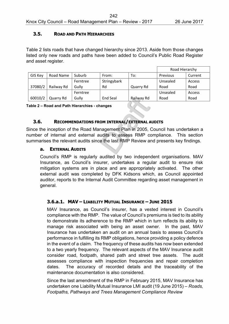
242 Knox City Council – Road Management Plan – Review - 2017 26 June 2017
33..55.. RROOAADD AANNDD PPAATTHH HHIIEERRAARRCCHHIIEESS
Table 2 lists roads that have changed hierarchy since 2013. Aside from those changes listed only new roads and paths have been added to Council’s Public Road Register and asset register.
Road Hierarchy
GIS Key Road Name Suburb From: To: Previous Current
37080/2 Railway Rd
Ferntree
Gully
Stringybark
Rd Quarry Rd
Unsealed
Road
Access
Road
60010/2 Quarry Rd
Ferntree
Gully End Seal Railway Rd
Unsealed
Road
Access
Road
Table 2 – Road and Path Hierarchies - changes
33..66.. RREECCOOMMMMEENNDDAATTIIOONNSS FFRROOMM IINNTTEERRNNAALL//EEXXTTEERRNNAALL AAUUDDIITTSS
Since the inception of the Road Management Plan in 2005, Council has undertaken a number of internal and external audits to assess RMP compliance. This section summarises the relevant audits since the last RMP Review and presents key findings.
aa.. EEXXTTEERRNNAALL AAUUDDIITTSS
Council’s RMP is regularly audited by two independent organisations. MAV Insurance, as Council’s insurer, undertakes a regular audit to ensure risk mitigation systems are in place and are appropriately activated. The other external audit was completed by DFK Kidsons which, as Council appointed auditor, reports to the Internal Audit Committee regarding asset management in general.
33..66..aa..11.. MMAAVV –– LLIIAABBIILLIITTYY MMUUTTUUAALL IINNSSUURRAANNCCEE –– JJUUNNEE 22001155
MAV Insurance, as Council’s insurer, has a vested interest in Council’s compliance with the RMP. The value of Council’s premiums is tied to its ability to demonstrate its adherence to the RMP which in turn reflects its ability to manage risk associated with being an asset owner. In the past, MAV Insurance has undertaken an audit on an annual basis to assess Council’s performance in fulfilling its RMP obligations, hence providing a policy defence in the event of a claim. The frequency of these audits has now been extended to a two yearly frequency. The relevant aspects of the MAV Insurance audit consider road, footpath, shared path and street tree assets. The audit assesses compliance with inspection frequencies and repair completion dates. The accuracy of recorded details and the traceability of the maintenance documentation is also considered.
Since the last amendment of the RMP in February 2015, MAV Insurance has undertaken one Liability Mutual Insurance LMI audit (19 June 2015) – Roads, Footpaths, Pathways and Trees Management Compliance Review
243 Knox City Council – Road Management Plan – Review - 2017 26 June 2017
The LMI review outcome conclude that Council achieves a high level of compliance with its RMP. A small number of improvement recommendations were identified. These included:
1. That Council consider the removal of the inspection frequencies and maintenance activities for non-road related assets from its RMP. Interestingly, this recommendation is supported by the findings of Council’s RMP comparison exercise with other councils, discussed in Section 3.4, which resulted in no matches being found for some of Council’s roadside vegetation activities.
2. That Council consider adopting a system that ensures defects identified on roads/footpaths/pathways that are of a higher category within the RMP hierarchy are required to be repaired quicker than those in lower categories. The review reference group considers this recommendation has merit in respect of reducing the risk to road users on more heavily trafficked roads and pathways for some RMP maintenance activities. However, the process and system changes to implement this recommendation will be need to be further investigated.
3. That Council replace the variety of measurement devices being used to measure defects with one standard tool. Council has addressed this recommendation and hazard inspectors now utilise a graduated measuring card.
The RMP Review Reference Group recommendation is that Council complete a project to consider the recommendations of its external auditors for inclusion in the next amendment to its RMP.
33..66..aa..22.. DDFFKK KKIIDDSSOONNSS –– AAPPRRIILL 22001155
In April 2015, Council’s external auditors DFK Kidsons completed a Review of Asset Management for Knox City Council. Unlike previous reviews, the 2015 review did not specifically audit Council’s compliance to its RMP however it did include an assessment of Work Order response times. The review concluded that “Results from the Works Order System can be used as a guide to assessing whether condition targets for infrastructure are being maintained. The Works Order System response times have improved since our previous audit in 2011. Knox is meeting or exceeding its internal benchmark of 90% across the three categories of: Initial response timeframes; temporary works timeframes; and rectification works for infrastructure assets”.
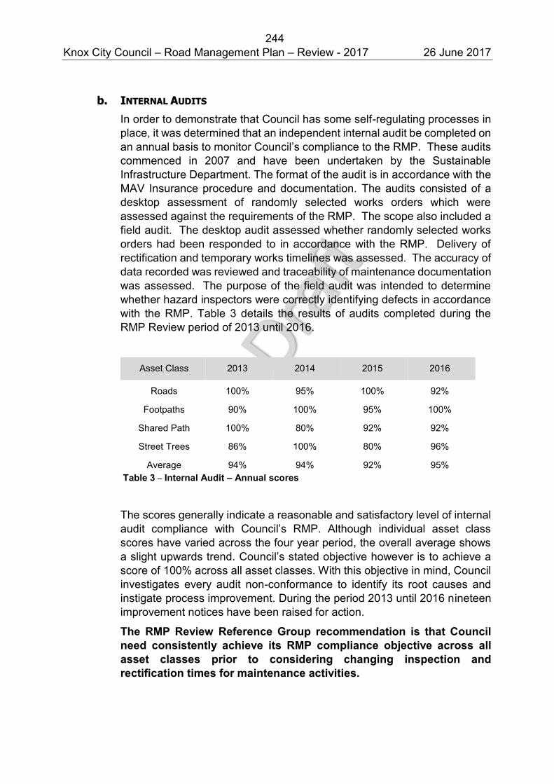
244 Knox City Council – Road Management Plan – Review - 2017 26 June 2017
bb.. IINNTTEERRNNAALL AAUUDDIITTSS
In order to demonstrate that Council has some self-regulating processes in place, it was determined that an independent internal audit be completed on an annual basis to monitor Council’s compliance to the RMP. These audits commenced in 2007 and have been undertaken by the Sustainable Infrastructure Department. The format of the audit is in accordance with the MAV Insurance procedure and documentation. The audits consisted of a desktop assessment of randomly selected works orders which were assessed against the requirements of the RMP. The scope also included a field audit. The desktop audit assessed whether randomly selected works orders had been responded to in accordance with the RMP. Delivery of rectification and temporary works timelines was assessed. The accuracy of data recorded was reviewed and traceability of maintenance documentation was assessed. The purpose of the field audit was intended to determine whether hazard inspectors were correctly identifying defects in accordance with the RMP. Table 3 details the results of audits completed during the RMP Review period of 2013 until 2016.
Asset Class 2013 2014 2015 2016
Roads 100% 95% 100% 92%
Footpaths 90% 100% 95% 100%
Shared Path 100% 80% 92% 92%
Street Trees 86% 100% 80% 96%
Average 94% 94% 92% 95% Table 3 – Internal Audit – Annual scores
The scores generally indicate a reasonable and satisfactory level of internal audit compliance with Council’s RMP. Although individual asset class scores have varied across the four year period, the overall average shows a slight upwards trend. Council’s stated objective however is to achieve a score of 100% across all asset classes. With this objective in mind, Council investigates every audit non-conformance to identify its root causes and instigate process improvement. During the period 2013 until 2016 nineteen improvement notices have been raised for action.
The RMP Review Reference Group recommendation is that Council need consistently achieve its RMP compliance objective across all asset classes prior to considering changing inspection and rectification times for maintenance activities.
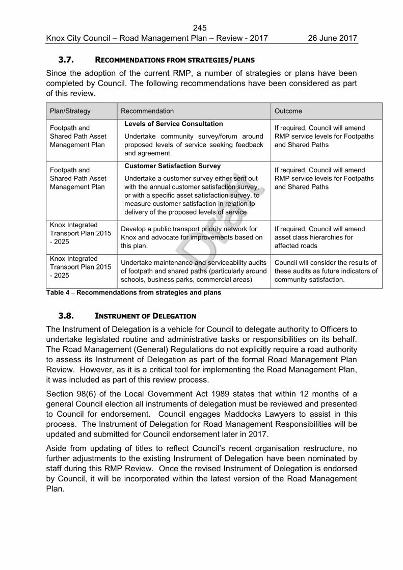
245 Knox City Council – Road Management Plan – Review - 2017 26 June 2017
33..77.. RREECCOOMMMMEENNDDAATTIIOONNSS FFRROOMM SSTTRRAATTEEGGIIEESS//PPLLAANNSS
Since the adoption of the current RMP, a number of strategies or plans have been completed by Council. The following recommendations have been considered as part of this review.
Plan/Strategy Recommendation Outcome
Footpath and Shared Path Asset Management Plan
Levels of Service Consultation Undertake community survey/forum around proposed levels of service seeking feedback and agreement.
If required, Council will amend RMP service levels for Footpaths and Shared Paths
Footpath and Shared Path Asset Management Plan
Customer Satisfaction Survey
Undertake a customer survey either sent out with the annual customer satisfaction survey, or with a specific asset satisfaction survey, to measure customer satisfaction in relation to delivery of the proposed levels of service
If required, Council will amend RMP service levels for Footpaths and Shared Paths
Knox Integrated Transport Plan 2015 - 2025
Develop a public transport priority network for Knox and advocate for improvements based on this plan.
If required, Council will amend asset class hierarchies for affected roads
Knox Integrated Transport Plan 2015 - 2025
Undertake maintenance and serviceability audits of footpath and shared paths (particularly around schools, business parks, commercial areas)
Council will consider the results of these audits as future indicators of community satisfaction.
Table 4 – Recommendations from strategies and plans
33..88.. IINNSSTTRRUUMMEENNTT OOFF DDEELLEEGGAATTIIOONN
The Instrument of Delegation is a vehicle for Council to delegate authority to Officers to undertake legislated routine and administrative tasks or responsibilities on its behalf. The Road Management (General) Regulations do not explicitly require a road authority to assess its Instrument of Delegation as part of the formal Road Management Plan Review. However, as it is a critical tool for implementing the Road Management Plan, it was included as part of this review process.
Section 98(6) of the Local Government Act 1989 states that within 12 months of a general Council election all instruments of delegation must be reviewed and presented to Council for endorsement. Council engages Maddocks Lawyers to assist in this process. The Instrument of Delegation for Road Management Responsibilities will be updated and submitted for Council endorsement later in 2017.
Aside from updating of titles to reflect Council’s recent organisation restructure, no further adjustments to the existing Instrument of Delegation have been nominated by staff during this RMP Review. Once the revised Instrument of Delegation is endorsed by Council, it will be incorporated within the latest version of the Road Management Plan.
246 Knox City Council – Road Management Plan – Review - 2017 26 June 2017
33..99.. DDEEMMAARRCCAATTIIOONN RREESSPPOONNSSIIBBIILLIITTIIEESS
During the review period only one neighbouring council has requested an update of its border demarcation agreement. The agreed revision has no direct impact in respect to Council’s RMP inspection and repair standards.
No other demarcation agreements have been identified as needing an update.
33..1100.. PPEERRFFOORRMMAANNCCEE AANNAALLYYSSIISS
Given Council’s duty to inspect, maintain and repair its public roads to the standards specified in its Road Management Plan, the Work Order System WOS (described in Attachment 9 of the RMP), was developed. This system was intended to assist service delivery whilst providing evidence of inspections, maintenance and repair required for Council to be able to easily demonstrate compliance with the RMP and an appropriate duty of care.
This section of the report summarises WOS performance data collected:
Inspection performance data includes all transactions within the period 1 January 2013 until 31 December 2016.
Rectification time performance data includes all transactions within the period 1 January 2015 until 31 December 2016.
These periods allow comparisons to be undertaken with results from the previous RMP Review completed in 2013.
In order for the RMP to provide a reliable policy defence, it is important that Council is able to demonstrate compliance with the policy defined in the RMP (it should be noted that Council introduced a 10% margin in the 2010 RMP update). Non-conformance may occur due to a number of factors including but not limited to:
Emergency situations (including storms, fires, floods) Resource and funding shortages Delays due to staffing issues (sick leave, ageing workforce, staff shortages,
secondments, higher duties) Supplier delays Inadequate training Incorrect recording/documentation or use of existing processes Inadequate performance monitoring Unexpected volume of defects Availability of plant or contractors
247 Knox City Council – Road Management Plan – Review - 2017 26 June 2017
aa.. RROOUUTTIINNEE HHAAZZAARRDD IINNSSPPEECCTTIIOONNSS
Routine hazard inspections have been recorded in Council’s Work Order System using PDAs and Ipads. The hazard inspection frequencies are outlined in Attachment 4 of the RMP. As documented in this same attachment, Council officers have developed a schedule of hazard inspections which groups inspection zones into two month blocks. For example, assets within inspection zone 13A will be inspected sometime within the period 1st May until 30th June. This effectively creates a two month grace period beyond the hazard inspection frequency defined in the RMP. If an asset is inspected on 1st May one year and 30th June the following year, it is deemed to have complied with the RMP. From an analysis perspective, this means adding two months buffer to the inspection dates to account for assets which may have been inspected early in the two month window in the first inspection, and late in the two month window in the second inspection.
The analysis of inspection data returned an average of 97% indicating that most inspections are completed in accordance with the RMP frequencies. This result is a 2% improvement over the 95% reported during the 2013 RMP review. Drilling down to individual groupings of asset class and hierarchy, the results identify that seven of the seventeen groupings achieved 100% compliance and that fifteen of the seventeen groupings scored equal to or above 90%. Comparing the results of this review to the previous review identified that seven groupings have improved by 2% or more.
The groupings with a lower than 90% performance (which ultimately negatively affect the average results) are identified below.
Roadside Vegetation (Collector roads) achieved a result of 87%.
Drainage (Link roads) achieved a result of 89%. The RMP review reference group was unable to identify any specific cause for these two irregularities and noted that these non-road related assets are included for consideration for removal from the RMP as discussed in section 3.2.
bb.. RREEAACCTTIIVVEE MMAAIINNTTEENNAANNCCEE –– IINNIITTIIAALL RREESSPPOONNSSEE
Initial response timeframes are only applicable when a request is received from a customer. It is the time available to assess the issue raised and to determine what, if any, work is required. The timeframes set out in the RMP range from 1 to 10 days (with most being 3 days) and were based on a desktop risk assessment of the public safety risk associated with not undertaking a specific maintenance task. The purpose of this initial response risk assessment is to enable supervisors to assess requests received and prioritise reactive works based on risk (or alternatively deem the issue not to meet intervention levels).
An analysis was undertaken of work orders requiring initial assessments completed during the period 1 January 2015 until 31 December 2016 (2 years) across sixty maintenance activities defined within Councils RMP. The two year period enables a comparison with the results of the analysis undertaken for the previous RMP review in 2013.
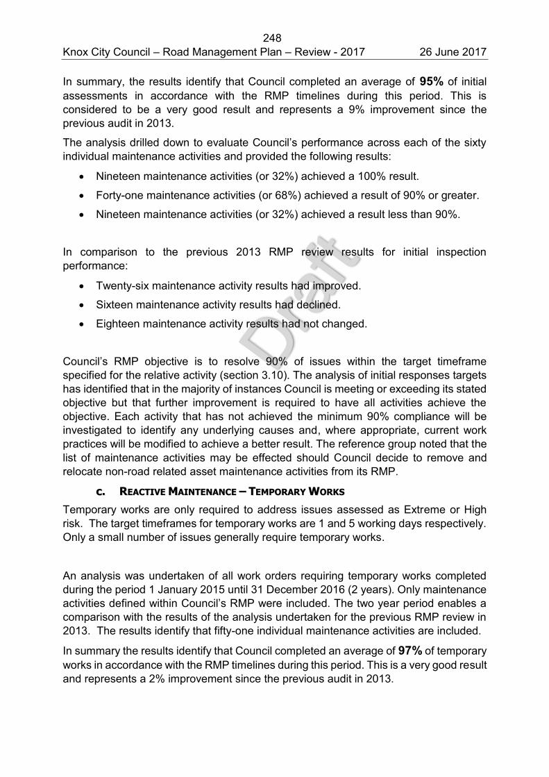
248 Knox City Council – Road Management Plan – Review - 2017 26 June 2017
In summary, the results identify that Council completed an average of 95% of initial assessments in accordance with the RMP timelines during this period. This is considered to be a very good result and represents a 9% improvement since the previous audit in 2013.
The analysis drilled down to evaluate Council’s performance across each of the sixty individual maintenance activities and provided the following results:
Nineteen maintenance activities (or 32%) achieved a 100% result.
Forty-one maintenance activities (or 68%) achieved a result of 90% or greater.
Nineteen maintenance activities (or 32%) achieved a result less than 90%.
In comparison to the previous 2013 RMP review results for initial inspection performance:
Twenty-six maintenance activity results had improved.
Sixteen maintenance activity results had declined.
Eighteen maintenance activity results had not changed.
Council’s RMP objective is to resolve 90% of issues within the target timeframe specified for the relative activity (section 3.10). The analysis of initial responses targets has identified that in the majority of instances Council is meeting or exceeding its stated objective but that further improvement is required to have all activities achieve the objective. Each activity that has not achieved the minimum 90% compliance will be investigated to identify any underlying causes and, where appropriate, current work practices will be modified to achieve a better result. The reference group noted that the list of maintenance activities may be effected should Council decide to remove and relocate non-road related asset maintenance activities from its RMP.
cc.. RREEAACCTTIIVVEE MMAAIINNTTEENNAANNCCEE –– TTEEMMPPOORRAARRYY WWOORRKKSS
Temporary works are only required to address issues assessed as Extreme or High risk. The target timeframes for temporary works are 1 and 5 working days respectively. Only a small number of issues generally require temporary works.
An analysis was undertaken of all work orders requiring temporary works completed during the period 1 January 2015 until 31 December 2016 (2 years). Only maintenance activities defined within Council’s RMP were included. The two year period enables a comparison with the results of the analysis undertaken for the previous RMP review in 2013. The results identify that fifty-one individual maintenance activities are included.
In summary the results identify that Council completed an average of 97% of temporary works in accordance with the RMP timelines during this period. This is a very good result and represents a 2% improvement since the previous audit in 2013.
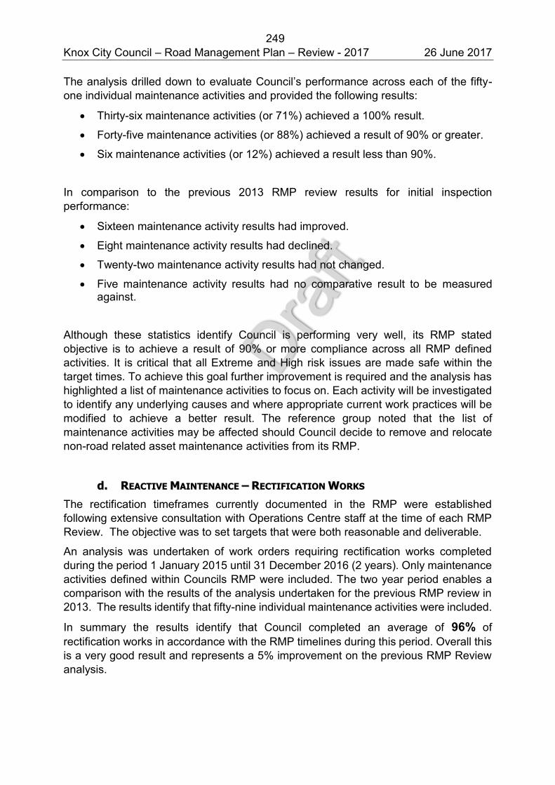
249 Knox City Council – Road Management Plan – Review - 2017 26 June 2017
The analysis drilled down to evaluate Council’s performance across each of the fifty-one individual maintenance activities and provided the following results:
Thirty-six maintenance activities (or 71%) achieved a 100% result.
Forty-five maintenance activities (or 88%) achieved a result of 90% or greater.
Six maintenance activities (or 12%) achieved a result less than 90%.
In comparison to the previous 2013 RMP review results for initial inspection performance:
Sixteen maintenance activity results had improved.
Eight maintenance activity results had declined.
Twenty-two maintenance activity results had not changed.
Five maintenance activity results had no comparative result to be measured against.
Although these statistics identify Council is performing very well, its RMP stated objective is to achieve a result of 90% or more compliance across all RMP defined activities. It is critical that all Extreme and High risk issues are made safe within the target times. To achieve this goal further improvement is required and the analysis has highlighted a list of maintenance activities to focus on. Each activity will be investigated to identify any underlying causes and where appropriate current work practices will be modified to achieve a better result. The reference group noted that the list of maintenance activities may be affected should Council decide to remove and relocate non-road related asset maintenance activities from its RMP.
dd.. RREEAACCTTIIVVEE MMAAIINNTTEENNAANNCCEE –– RREECCTTIIFFIICCAATTIIOONN WWOORRKKSS
The rectification timeframes currently documented in the RMP were established following extensive consultation with Operations Centre staff at the time of each RMP Review. The objective was to set targets that were both reasonable and deliverable.
An analysis was undertaken of work orders requiring rectification works completed during the period 1 January 2015 until 31 December 2016 (2 years). Only maintenance activities defined within Councils RMP were included. The two year period enables a comparison with the results of the analysis undertaken for the previous RMP review in 2013. The results identify that fifty-nine individual maintenance activities were included.
In summary the results identify that Council completed an average of 96% of rectification works in accordance with the RMP timelines during this period. Overall this is a very good result and represents a 5% improvement on the previous RMP Review analysis.
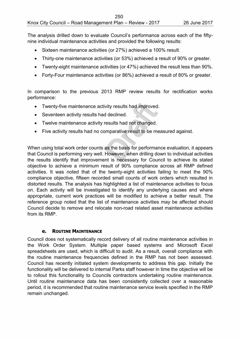
250 Knox City Council – Road Management Plan – Review - 2017 26 June 2017
The analysis drilled down to evaluate Council’s performance across each of the fifty-nine individual maintenance activities and provided the following results:
Sixteen maintenance activities (or 27%) achieved a 100% result.
Thirty-one maintenance activities (or 53%) achieved a result of 90% or greater.
Twenty-eight maintenance activities (or 47%) achieved the result less than 90%.
Forty-Four maintenance activities (or 86%) achieved a result of 80% or greater.
In comparison to the previous 2013 RMP review results for rectification works performance:
Twenty-five maintenance activity results had improved.
Seventeen activity results had declined.
Twelve maintenance activity results had not changed.
Five activity results had no comparative result to be measured against.
When using total work order counts as the basis for performance evaluation, it appears that Council is performing very well. However, when drilling down to individual activities the results identify that improvement is necessary for Council to achieve its stated objective to achieve a minimum result of 90% compliance across all RMP defined activities. It was noted that of the twenty-eight activities failing to meet the 90% compliance objective, fifteen recorded small counts of work orders which resulted in distorted results. The analysis has highlighted a list of maintenance activities to focus on. Each activity will be investigated to identify any underlying causes and where appropriate, current work practices will be modified to achieve a better result. The reference group noted that the list of maintenance activities may be affected should Council decide to remove and relocate non-road related asset maintenance activities from its RMP.
ee.. RROOUUTTIINNEE MMAAIINNTTEENNAANNCCEE
Council does not systematically record delivery of all routine maintenance activities in the Work Order System. Multiple paper based systems and Microsoft Excel spreadsheets are used, which is difficult to audit. As a result, overall compliance with the routine maintenance frequencies defined in the RMP has not been assessed. Council has recently initiated system developments to address this gap. Initially the functionality will be delivered to internal Parks staff however in time the objective will be to rollout this functionality to Councils contractors undertaking routine maintenance. Until routine maintenance data has been consistently collected over a reasonable period, it is recommended that routine maintenance service levels specified in the RMP remain unchanged.
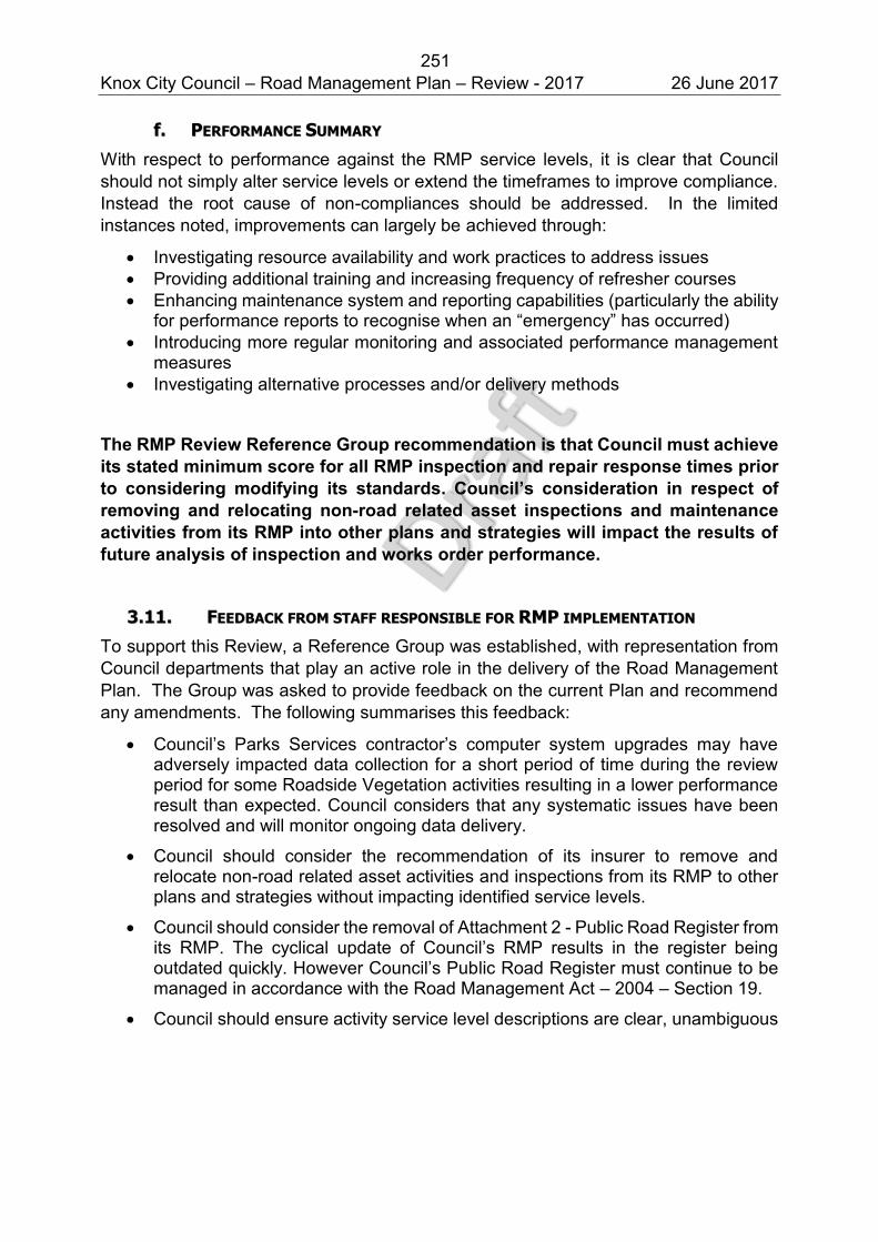
251 Knox City Council – Road Management Plan – Review - 2017 26 June 2017
ff.. PPEERRFFOORRMMAANNCCEE SSUUMMMMAARRYY
With respect to performance against the RMP service levels, it is clear that Council should not simply alter service levels or extend the timeframes to improve compliance. Instead the root cause of non-compliances should be addressed. In the limited instances noted, improvements can largely be achieved through:
Investigating resource availability and work practices to address issues Providing additional training and increasing frequency of refresher courses Enhancing maintenance system and reporting capabilities (particularly the ability
for performance reports to recognise when an “emergency” has occurred) Introducing more regular monitoring and associated performance management
measures Investigating alternative processes and/or delivery methods
The RMP Review Reference Group recommendation is that Council must achieve its stated minimum score for all RMP inspection and repair response times prior to considering modifying its standards. Council’s consideration in respect of removing and relocating non-road related asset inspections and maintenance activities from its RMP into other plans and strategies will impact the results of future analysis of inspection and works order performance.
33..1111.. FFEEEEDDBBAACCKK FFRROOMM SSTTAAFFFF RREESSPPOONNSSIIBBLLEE FFOORR RRMMPP IIMMPPLLEEMMEENNTTAATTIIOONN
To support this Review, a Reference Group was established, with representation from Council departments that play an active role in the delivery of the Road Management Plan. The Group was asked to provide feedback on the current Plan and recommend any amendments. The following summarises this feedback:
Council’s Parks Services contractor’s computer system upgrades may have adversely impacted data collection for a short period of time during the review period for some Roadside Vegetation activities resulting in a lower performance result than expected. Council considers that any systematic issues have been resolved and will monitor ongoing data delivery.
Council should consider the recommendation of its insurer to remove and relocate non-road related asset activities and inspections from its RMP to other plans and strategies without impacting identified service levels.
Council should consider the removal of Attachment 2 - Public Road Register from its RMP. The cyclical update of Council’s RMP results in the register being outdated quickly. However Council’s Public Road Register must continue to be managed in accordance with the Road Management Act – 2004 – Section 19.
Council should ensure activity service level descriptions are clear, unambiguous
252 Knox City Council – Road Management Plan – Review - 2017 26 June 2017
and accurate and resolve any inconsistencies.
44.. SSUUMMMMAARRYY OOFF RREECCOOMMMMEENNDDAATTIIOONNSS
All proposed RMP amendments described in the body of this report are collated and listed in Attachment A. Most amendments can begin to be implemented as soon as this Review has been endorsed by Council and made public.
Also listed in this Attachment are recommendations that do not directly relate to an amendment of the RMP, but will instead improve Council’s capacity to deliver on its RMP.
55.. NNEEXXTT SSTTEEPPSS
55..11.. FFIINNAALLIISSAATTIIOONN OOFF RREEVVIIEEWW
The Review process is defined in the Road Management Act (General) Regulations 2016. A report on the findings and conclusions of the Review must be made publicly available.
Regulation 302 (5)
After a road authority has completed a review of its road management plan, it must –
(a) produce a written report summarising the findings and conclusions of the review, and
(b) make the report available for copying or inspection at the place where the road management plan may be inspected or obtained in accordance with section 55(1)(b) of the Act.
It is the intention that this RMP Review will be reported to Council and made available on Council’s website.
55..22.. AAMMEENNDDMMEENNTT OOFF RROOAADD MMAANNAAGGEEMMEENNTT PPLLAANN
Amending the Road Management Plan is a separate regulatory process which is defined by regulations 303 and 304.
Regulation 303 (1)
Subject to regulation 304, if a road authority proposes to amend a road management plan, and the amendment relates to the determination of a standard of construction, inspection maintenance or repair under section 41 of the Act, the road authority must give notice-
Notification of these amendments must be in accordance with regulation 303 and include gazettal and a 28 day consultation period.
253 Knox City Council – Road Management Plan – Review - 2017 26 June 2017
However, Regulation 304 defines when notification of a proposed amendment is not required.
Regulation 304
A road authority is not required to give notice under regulation 303 if the Chief Executive Officer (however described) of the road authority certifies in writing that the proposed amendment to the road management plan results in the determination under section 41 of the Act of a standard and –
(a) that standard is higher than a relevant standard previously determined under section 41 of the Act, or
(b) the determination of that standard only deals with changes to administrative procedures within a road authority or between road authorities, or
(c) the determination of that standard only deals with changes of a machinery or declaratory nature, or
(d) the determination of that standard only deals with –
(i) a road for which the road authority has become the coordinating road authority
(ii) a road which has become a public road –
since the relevant road management plan was made or since that plan was last reviewed in accordance with section 54(5) of the Act and these Regulations
The RMP Review recommendations will be actioned prior to the next amendment of Councils RMP. Where no public notice is required in accordance with Regulation 304, certification will be sought from Council’s Chief Executive Officer. Any amendments will be documented in the revision schedule in Attachment 11 of the RMP
254 Knox City Council – Road Management Plan – Review - 2017 26 June 2017
ATTACHMENTS
255 Knox City Council – Road Management Plan – Review - 2017 26 June 2017
AATTTTAACCHHMMEENNTT AA –– SSUUMMMMAARRYY OOFF RREECCOOMMMMEENNDDAATTIIOONNSS
1. RECOMMENDED AMENDMENTS TO COUNCIL’S RMP
ID Recommended Amendment Nature of Amendment
1.1 Attachment 3
Remove
Administrative (no public notice required)
1.2 Attachment 3
Remove
Administrative (no public notice required)
1.4 Attachment 10
Insert new instrument of delegation once finalised.
(This can be done at the same time as any future RMP amendments, so as to limit additional Council reports.)
Administrative (no public notice required)
1.5 Section 1.1
Update Road Management Act (2004) to date 1 April 2017
Administrative (no public notice required)
1.6 Section 1.1
Append to reflect 2017 Review amendment in accordance with Road Management Act (General) Regulations - March 2016
Administrative (no public notice required)
1.7 Attachment 2
Public Road Register – Remove and cross reference to public website link to provide the public with an up to date register of roads
Administrative (no public notice required)
1.8 Section 1.5
Update key Council strategy documents and Vision themes
Administrative (no public notice required)
1.9 Attachment 4
Hazard Inspections
As recommended by Council’s insurer, remove and relocate to other strategies and plans non road related asset inspections.
Public Notice Required
1.10 Attachment 4
Maintenance Service Levels
As recommended by Council’s insurer, remove and relocate to other strategies and
Public Notice Required
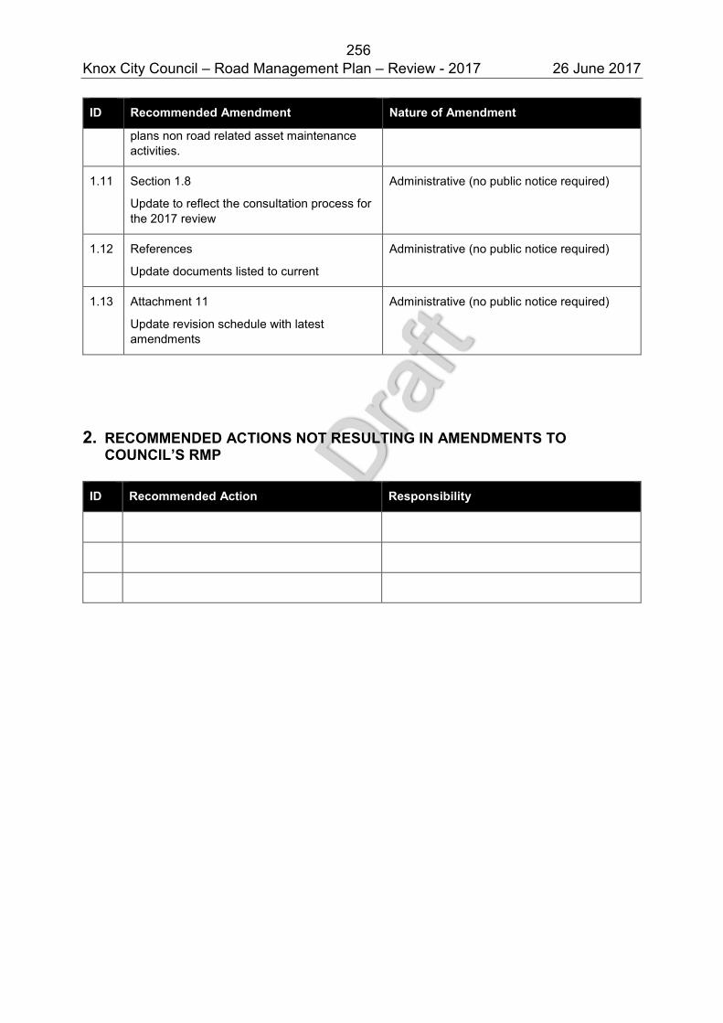
256 Knox City Council – Road Management Plan – Review - 2017 26 June 2017
ID Recommended Amendment Nature of Amendment
plans non road related asset maintenance activities.
1.11 Section 1.8
Update to reflect the consultation process for the 2017 review
Administrative (no public notice required)
1.12 References
Update documents listed to current
Administrative (no public notice required)
1.13 Attachment 11
Update revision schedule with latest amendments
Administrative (no public notice required)
2. RECOMMENDED ACTIONS NOT RESULTING IN AMENDMENTS TO
COUNCIL’S RMP
ID Recommended Action Responsibility
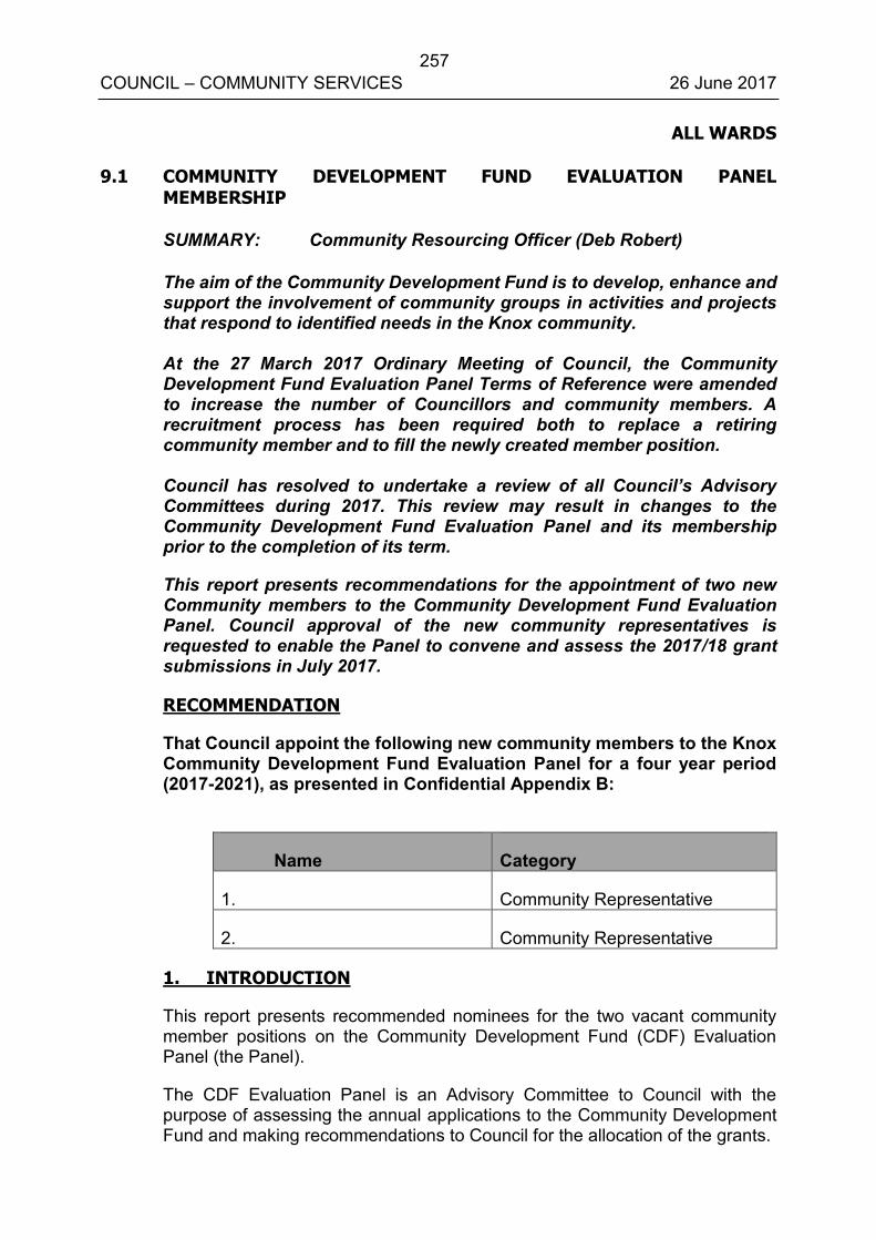
257 COUNCIL – COMMUNITY SERVICES 26 June 2017
ALL WARDS 9.1 COMMUNITY DEVELOPMENT FUND EVALUATION PANEL
MEMBERSHIP
SUMMARY: Community Resourcing Officer (Deb Robert)
The aim of the Community Development Fund is to develop, enhance and support the involvement of community groups in activities and projects that respond to identified needs in the Knox community. At the 27 March 2017 Ordinary Meeting of Council, the Community Development Fund Evaluation Panel Terms of Reference were amended to increase the number of Councillors and community members. A recruitment process has been required both to replace a retiring community member and to fill the newly created member position. Council has resolved to undertake a review of all Council’s Advisory Committees during 2017. This review may result in changes to the Community Development Fund Evaluation Panel and its membership prior to the completion of its term.
This report presents recommendations for the appointment of two new Community members to the Community Development Fund Evaluation Panel. Council approval of the new community representatives is requested to enable the Panel to convene and assess the 2017/18 grant submissions in July 2017.
RECOMMENDATION
That Council appoint the following new community members to the Knox Community Development Fund Evaluation Panel for a four year period (2017-2021), as presented in Confidential Appendix B:
Name Category
1. Community Representative
2. Community Representative
1. INTRODUCTION
This report presents recommended nominees for the two vacant community member positions on the Community Development Fund (CDF) Evaluation Panel (the Panel).
The CDF Evaluation Panel is an Advisory Committee to Council with the purpose of assessing the annual applications to the Community Development Fund and making recommendations to Council for the allocation of the grants.
258 COUNCIL – COMMUNITY SERVICES 26 June 2017
9.1 Community Development Fund Evaluation Panel Membership (cont’d)
The CDF Evaluation Panel comprises three Councillors, three Community representatives with voting rights, and Council Officers providing advice and support.
Two vacancies on the CDF Evaluation Panel occurred in late 2016 due to the conclusion of one community member’s four-year term and an increase in the number of community members, approved by Council at the 27 March 2017 meeting.
A recruitment process to fill both vacancies commenced in April 2017. Council approval of the community representatives is required to enable the CDF Evaluation Panel to convene and assess 2017-18 grant submissions in July 2017.
2. DISCUSSION
Knox Council’s Council Committees Policy requires the approval from Council for the appointment of community representatives recommended from a registration of interest and selection process.
Ms Amanda Steele has been a community evaluation panel member for the past six years, having completed an initial four year term and successfully reapplying for an additional two year term. Ms Steele’s tenure concluded with the completion of the 2016-17 Community Development Fund assessment and grants celebration event. She participated in the final meeting in November 2016 to reflect on the previous grant round and provide advice on process improvements for the future.
2.1 Selection Process
In April 2017, a broad reaching advertising campaign was undertaken to call for nominations to the CDF Evaluation Panel. Advertisements were placed in local papers, in e-bulletins to over 350 not for profit groups in Knox, through Council’s social media and on Knox library and Knox Civic Centre Customer Service screen promotions.
Nominations were received from eight Knox community members. All applications were deemed eligible and were of a high standard. This determined the need to interview all the nominees between 16 May and 24 May.
In accordance with the CDF Evaluation Panel Terms of Reference nominees were interviewed by Cr Jackson Taylor (Chair), and Deb Robert (Community Resourcing Officer) and Amanda Steele as a past representative, to bring her experience and perspective as a past community member.
259 COUNCIL – COMMUNITY SERVICES 26 June 2017
9.1 Community Development Fund Evaluation Panel Membership (cont’d)
The nominees were assessed on the following selection criteria ( Appendix A): Knox resident; Knowledge of local issues; Established networks and connections with diverse groups in Knox; Reasons for seeking Panel membership as an indication of commitment
to the wellbeing of Knox community; Potential skill/knowledge including committee experience; Awareness of grants processes and issues; Availability to attend the required meetings; and Computer knowledge and experience.
2.2 Recommendations
The interviewing panel were unanimous in their recommendation of the two community representatives for appointment to the CDF Evaluation Panel for the period 2017 to 2021 (see Confidential Appendix B & Appendix C for details of nominees and recommendations).
Both of the recommended applicants achieved the greatest score against selection key criteria and clearly demonstrated their capacity to contribute valuable skills and perspective to the CDF Evaluation Panel and the grants assessment process.
3. CONSULTATION
Notices calling for nominations to the Community Development Fund Evaluation Panel were:
Advertised in the local and community newspapers;
Displayed on Council’s website front page and the Community Development Fund webpage;
Presented on screens in Knox libraries and Council Customer Service; and
Emailed to over 350 not for profit community groups. The recruitment process was also promoted in community grants information sessions during April.
4. ENVIRONMENTAL/AMENITY ISSUES
There are no environmental/amenity issues associated with this report.
5. FINANCIAL & ECONOMIC IMPLICATIONS
The Community Development Fund is supported in Council’s annual budget with an allocation of $250,000. Any surplus carried forward from uncommitted Incidental Community Grants is added to this amount for distribution. The Community Development Fund is incorporated in the Long Term Financial Forecast.
260 COUNCIL – COMMUNITY SERVICES 26 June 2017
9.1 Community Development Fund Evaluation Panel Membership (cont’d)
6. SOCIAL IMPLICATIONS
The Community Development Fund grant program facilitates engagement between Council and a diverse range of community groups, strengthens existing relationships, supports new collaborations and broadens understanding of community need. It enables the delivery of projects relating to the draft Knox Community and Council Plan 2017-21
The participation of community members in the grant assessments is a valuable opportunity for civic participation and broadens the range of skills and perspectives brought to the process by all CDF Evaluation Panel members.
The opportunity also facilitates greater understanding of Council amongst community members, and increases their awareness of the range of activities supported by Council.
7. RELEVANCE TO CITY PLAN 2013-17 (INCORPORATING THE COUNCIL PLAN)
The Community Development Fund grants program contributes to the current City Plan 2013-17 themes of ‘Healthy, Connected Communities’, ‘Culturally Rich and Active Communities’, and ‘Democratic and Engaged Communities’ and to draft Community and Council Plan goals and strategies. It also contributes to the implementation of goals and strategies within the draft Knox Community and Council Plan 2017-21.
The funded projects assist Council and community to deliver objectives under a number of Council implementation plans.
8. CONCLUSION
Following a thorough recruitment process in April and May 2017, two nominees for the position of community representatives to the CDF Evaluation Panel are recommended to Council.
Approval by Council of the recommended community members is now sought to ensure the required representative composition on the CDF Evaluation Panel to enable the 2017-2018 grant assessment process to proceed in July.
The unsuccessful applicants will be contacted and discussions held to determine if applicants are interested in other opportunities to contribute their skills and commitment to the Knox community. Council officers will assist to provide referral and linkage to these opportunities.
261 COUNCIL – COMMUNITY SERVICES 26 June 2017
9.1 Community Development Fund Evaluation Panel Membership (cont’d)
9. CONFIDENTIALITY
In the interest of personal privacy, names and details of applicants in Appendix B and C are treated as confidential.
Report Prepared By: Community Resourcing Officer (Deb Robert)
Report Authorised By: Director – Community Services
(Kerry Stubbings)
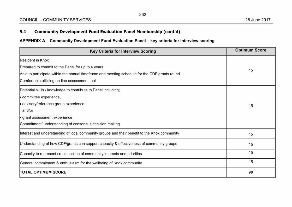
262 COUNCIL – COMMUNITY SERVICES 26 June 2017
9.1 Community Development Fund Evaluation Panel Membership (cont’d)
APPENDIX A – Community Development Fund Evaluation Panel – key criteria for interview scoring
Key Criteria for Interview Scoring Optimum Score
Resident in Knox
Prepared to commit to the Panel for up to 4 years
Able to participate within the annual timeframe and meeting schedule for the CDF grants round
Comfortable utilising on-line assessment tool
15
Potential skills / knowledge to contribute to Panel including;
committee experience,
advisory/reference group experience
and/or
grant assessment experience
Commitment/ understanding of consensus decision making
15
Interest and understanding of local community groups and their benefit to the Knox community 15
Understanding of how CDF/grants can support capacity & effectiveness of community groups 15
Capacity to represent cross-section of community interests and priorities 15
General commitment & enthusiasm for the wellbeing of Knox community 15
TOTAL OPTIMUM SCORE 90

263 COUNCIL – COMMUNITY SERVICES 26 June 2017
9.1 Community Development Fund Evaluation Panel Membership (cont’d)
Confidential Appendix B - Community Development Fund Evaluation Panel Community Representative Recommendations and Confidential Appendix C - Community Development Fund Evaluation Panel Community Representative applications are circulated under separate cover.
264 COUNCIL – COMMUNITY SERVICES 26 June 2017
ALL WARDS 9.2 COMMUNITY ACCESS AND EQUITY IMPLEMENTATION PLAN 2017-22
SUMMARY: Acting Coordinator Community Access and Equity – Amanda Wiggs
The Community Access and Equity Implementation Plan 2017-22 (The Plan) (Appendix A) will be the first for the City of Knox and will be an implementation plan of the Knox Community and Council Plan 2017-21. The development of a Community Access and Equity Implementation Plan was identified as an initiative within Council’s 2016/17 Annual Plan.
The Plan integrates Council’s previous Access and Inclusion Plan for People with Disabilities, Multicultural Strategic Plan and Preventing Violence Against Women Action Plan. It will enable a more integrated approach for Council to respond to other emerging access and equity issues affecting marginalised, vulnerable and disadvantaged population groups in Knox.
A preliminary Draft Action Plan is presented in Appendix B for consideration. Additional work will occur following finalisation and approval of the Knox Community and Council Plan 2017-21, to ensure the Community Access and Equity Implementation Plan 2017-22 aligns with the goals, strategies and initiatives of these plans. A finalised Action Plan will be presented to Council in September 2017 for approval, along with a summary of the Community Access and Equity Profile.
RECOMMENDATION
That Council:
1. Approve the Draft Community Access and Equity Implementation Plan 2017-22 and preliminary Draft Action Plan for further community and Council consultation and development; and
2. Receive the final Draft Community Access and Equity Implementation Plan 2017-22 for approval at its 25 September 2017 Ordinary meeting of Council.
265 COUNCIL – COMMUNITY SERVICES 26 June 2017
9.2 Community Access and Equity Implementation Plan 2017-22 (cont’d)
1. INTRODUCTION
The Community Access and Equity Service provides activities and programs that support and advocate for marginalised, vulnerable and disadvantaged populations groups to foster a diverse, accessible, inclusive and equitable Council and community.
Over a number of years, the Community Access and Equity Service has been responsible for three Council strategic action plans including the Knox Multicultural Strategic Plan 2012-17, Access and Inclusion Plan for People with Disabilities 2016 (a legislative requirement under the State Disability Act [2006]), and the Knox Preventing Violence Against Woman Action Plan.
Through consultation with the Knox Multicultural Advisory Committees, Knox Disability Advisory Committees, EMT and Council, it has been recommended that a new plan be developed, integrating these three plans as well as other access and equity issues affecting marginalised, vulnerable and disadvantaged population groups in Knox.
This Plan will provide a number of benefits by having one plan that outlines clear strategic direction regarding Council’s response to emerging access and equity issues in Knox and will enable a strengthened access and equity approach across the community and the organisation as well as providing clarity regarding future resource requirements.
The Plan both aligns with and responds to the emerging Knox Community and Council Plan 2017-21, which sets the direction for the Knox community through its goals, strategies, role and focus of Council. The Plan links directly with the goals of the Knox Community and Council Plan 2017-21 in achieving Council’s vision and demonstrates Council’s ongoing commitment to reducing barriers whilst enhancing access, participation and inclusive practice for all people in Knox.
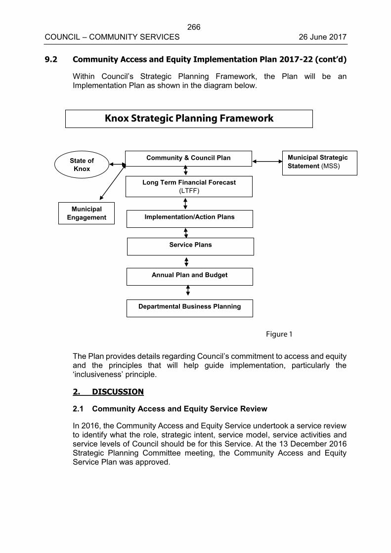
266 COUNCIL – COMMUNITY SERVICES 26 June 2017
9.2 Community Access and Equity Implementation Plan 2017-22 (cont’d)
Within Council’s Strategic Planning Framework, the Plan will be an Implementation Plan as shown in the diagram below.
The Plan provides details regarding Council’s commitment to access and equity and the principles that will help guide implementation, particularly the ‘inclusiveness’ principle.
2. DISCUSSION
2.1 Community Access and Equity Service Review
In 2016, the Community Access and Equity Service undertook a service review to identify what the role, strategic intent, service model, service activities and service levels of Council should be for this Service. At the 13 December 2016 Strategic Planning Committee meeting, the Community Access and Equity Service Plan was approved.
Knox Strategic Planning Framework
Municipal Strategic Statement (MSS)
Community & Council Plan State of Knox
Long Term Financial Forecast (LTFF)
Implementation/Action Plans Municipal
Engagement
Service Plans
Annual Plan and Budget
Departmental Business Planning
Figure 1
267 COUNCIL – COMMUNITY SERVICES 26 June 2017
9.2 Community Access and Equity Implementation Plan 2017-22 (cont’d)
Approved actions included consolidating three service activities (information, linkages and capacity building), and a modifying the existing service model to enable a more flexible and adaptive Service that is able to better deliver on its strategic intent. This would ensure that the Service has a broader and more integrated approach for Council to respond to other emerging access and equity issues affecting marginalised, vulnerable and disadvantaged population groups in Knox.
It was agreed that the research, engagement and development of the Community Access and Equity Implementation Plan would further inform the implementation of this Service Plan and the programs and activities for Council overall and for the Service over the next five years.
2.2 Community Access and Equity Implementation Plan 2017-2022
The development of a Community Access and Equity Implementation Plan aligns with Council’s responsibilities under Commonwealth, Victorian and Local Government legislation and outlines our focus and direction in meeting the needs of marginalised, disadvantaged and vulnerable population groups in Knox.
Knox City Council has an obligation and responsibility as a Local Government Authority to take into account the diverse needs of the local community; advocating for their interests to other communities, governments and fostering community cohesion and encouraging active participation in civic life and planning for and providing services and facilities for the local community.
Knox City Council has a strong history and active role in inclusive community planning through development of previous strategic plans, delivery of programs, projects and activities and the establishment of relevant advisory committees that advise and support Council to improve outcomes for marginalised, vulnerable and disadvantaged population groups.
Knox City Council recognises that it cannot address all social issues affecting the lives of marginalised, vulnerable and disadvantaged population groups alone and that it must consider ways it can work with community partners, business and all levels of government to address discrimination and disadvantage as well as promote diversity and inclusion.
268 COUNCIL – COMMUNITY SERVICES 26 June 2017
9.2 Community Access and Equity Implementation Plan 2017-22 (cont’d)
2.3 Community and Access Equity Issues
Knox is a diverse community, made up of people from many different cultures, beliefs, abilities and identities. Knox Council acknowledges that not all people start from the same position in life and therefore may have differences in their lived experience in the community. For some people this difference may mean that they experience discrimination, disadvantage and exclusion from community life.
The Plan provides a common framework to ensure that every member of our diverse community has the opportunity to participate, contribute and access Services and activities within Knox. The Plan will provide guidance to Council to undertake targeted projects in response to the needs of groups that are/or are at risk of being marginalised and disadvantaged from social, health, economic and political life.
2.4 Community Benefits
This Plan will provide a number of benefits to the community and the organisation by having one plan that clearly outlines clear strategic direction regarding Councils response to emerging and ongoing access and equity issues in Knox. This will provide clarity for community organisations to understand Council’s role and priority areas for focus as well as future resource requirements.
The Plan is an implementation plan of the emerging Knox Community and Council Plan 2017-21. This will enable a strengthened access and equity approach across the community and the organisation.
2.5 Guiding Principles
The Knox Community and Council Plan 2017-2021 outlines the following principles that underpins all future planning for the City of Knox:
Flexibility - Council is ready to adopt alternative strategies in response to changing circumstances, to enable community resilience.
Integration - Implementation should bring together a range of distinct systems and stakeholders, creating additional benefits where resources are shared and helping people to work together to achieve greater ends, giving consideration to a place-based approach to planning and delivery.
269 COUNCIL – COMMUNITY SERVICES 26 June 2017
9.2 Community Access and Equity Implementation Plan 2017-22 (cont’d)
Robustness - Strategies should be well conceived, evidence-based and able to take account of all life stages. Sustainability principles should be embedded to balance current needs with those of future generations, taking into account return on investment.
Inclusiveness - Council encourages broad engagement, shared contribution and collaboration in community decisions, incorporating an access and equity approach.
Resourcefulness - Council recognises alternative ways to use resources, including funding and delivery, adopting a prevention and early intervention approach.
Reflection – Council draws on experience to inform future decision-making and evaluation.
Foresight - Council works to identify future changes which will impact the community and use innovative and creative strategies and action to deal with change in the long term, exercising stewardship and leadership of change.
The Community Access & Equity Implementation Plan provides details regarding what an ‘access and equity/inclusiveness approach’ is. These principles will help guide implementation of The Plan:
Equity - a ‘fair go’ for all, where Council recognises that there is not a ‘one size fits all’ approach to the way we engage with, plan and deliver services to the Knox community.
Diversity – Celebrate and enhance our diverse community, which includes people born and raised in Australia, people from other countries and cultures, different religious and faith beliefs, ages, genders, identities and abilities.
Access – All community members have access to services, information and the opportunity to participate in community life free from discrimination.
Inclusion – All community members have the opportunity to fully participate in decisions that affect them and their community.
2.6 Focus Areas
The following five Focus Areas provide a focus for Council actions across Council’s 38 services to achieve outcomes for marginalised, vulnerable and disadvantaged population groups:
Focus Area 1: Equitable, Accessible and Inclusive Services Council will work to ensure all community members, no matter their ability, religion, race, gender or sexual identity, will have access to Council and community services that meet their needs.
270 COUNCIL – COMMUNITY SERVICES 26 June 2017
9.2 Community Access and Equity Implementation Plan 2017-22 (cont’d)
Focus Area 2: Leadership and Advocacy Council will lead by example and advocate to other levels of government, business, services, community organisations and the community to promote human rights and address issues of discrimination and exclusion.
Focus Area 3: Accessible and Safe Places and Spaces Council will work to ensure that all our buildings, public places and open spaces are accessible, universally designed and safe for everyone.
Focus Area 4: Empowerment and Participation Council will facilitate civic participation and inclusive engagement to ensure that people can exercise their rights and voices to help shape their own future.
Focus Area 5: Celebrating Diversity and Creating a Sense of Belonging Council will value and celebrate the diverse people and communities that make up Knox and the skills and abilities that they bring.
Council officers will work across all areas of Council, including building organisational capacity and competence, service provision and civic participation.
2.7 Action Plan
A preliminary Draft Action Plan is presented in Appendix B for consideration.
Additional work will occur following finalisation and approval of the Knox Community and Council Plan 2017-21, to ensure the Community Access and Equity Implementation Plan 2017-22 aligns with the goals, strategies and initiatives of the Community and Council Plan 2017-21. A finalised Action Plan will be presented to Council in September 2017 for approval.
2.8 Emerging Issues and key themes
The following emerging themes and issues have been identified as impacting Knox’s marginalised, vulnerable and disadvantaged population groups:
Lack of access or knowledge of appropriate services that meet the needs of our diverse population groups;
Discrimination and racism;
Violence - including family violence, violence towards women, elder abuse and perceptions of safety;
Lack of culturally appropriate services and limited knowledge and understanding of cultural expectations (CALD, Indigenous and LGBTI communities); and
Compounding disadvantage – impact areas include mental health, lack of appropriate housing, financial stress, gambling and isolation.
271 COUNCIL – COMMUNITY SERVICES 26 June 2017
9.2 Community Access and Equity Implementation Plan 2017-22 (cont’d)
2.9 Draft Action Plan
The Plan’s draft actions (Appendix B) provide an example of opportunities for Council led actions for the next five years that responds to access and equity issues in Knox. The Draft Action Plan identifies the actions, role of Council, the service that will lead and support the actions, if the action is existing or new, the community partners, if known and its alignment to the draft Community and Council Plan 2017-2021.
A full list of actions as well as resources required to deliver the Plan will be developed following the Knox Community and Council Plan 2017-21’s approval.
2.10 Monitoring and reporting
The Community Access and Equity Service will oversee monitoring and reporting of The Plan to Council. The Community Access and Equity Service will undertake consultation with key internal and external stakeholders including Council’s Advisory Committees (particularly its Disability, Multicultural, Early Years, Community Health & Wellbeing, Youth Issues, and Active Ageing Committees) on the implementation of The Plan and present an annual report to Council on progress.
Council is currently undertaking a review of Council’s Advisory Committees. This review will inform the future role of Advisory Committee’s in supporting the monitoring and implementation of The Plan.
2.11 Next Steps
The development of the Community Access and Equity Implementation Plan actions will also link to the work currently underway in the development of the Life Stages Implementation Plan.
Following Council’s consideration of the draft Community Access and Equity Plan at this Council Meeting, the final Plan will be presented to Council for approval in September 2017.
3. CONSULTATION
In developing The Plan, a number of consultative processes have been established and undertaken including:
272 COUNCIL – COMMUNITY SERVICES 26 June 2017
9.2 Community Access and Equity Implementation Plan 2017-22 (cont’d)
Development of a draft Community Access and Equity Profile – detailing demographic data on social, health and economic status, as well as emerging gaps, risks and protective factors of the identified population groups. One element of this profile – low socio economic population profile has presented to Council at its 22 May 2017 meeting in response to a call up item to provide an overview report that highlights population groups and suburbs where inequalities and disadvantage are represented (where available), the data sources informing this report; and an explanation of the SEIFA Indexes.
Internal Mapping of services currently delivered by Council that support marginalised, vulnerable and disadvantaged population groups.
Establishment of a Steering Committee, made up of key Council staff to provide guidance and expertise to the Project Manager and Project Officer on the development of The Plan. Six meetings were held in 2016.
Establishment of a Working Group, made up of key internal Council staff and community stakeholders, including Women’s Health East, EACH, Knox Infolink and the Department of Health and Human Services with expertise in working with marginalised and disadvantaged communities. Three half day workshops were held to: o Provide input and feedback on the findings of the Knox Community
Access and Equity Profile (data); o Identify additional issues, concerns and challenges for marginalised,
vulnerable and disadvantaged population groups in Knox; o Identify key community services and agencies working with identified
population groups; and o Development and review of emerging issues and themes, and areas
of action.
Ongoing engagement with Community and Council Plan working group regarding alignment opportunities.
Review of the Community Engagement findings from the emerging Knox Community and Council Plan 2017-2021. Community Access and Equity Implementation Plan 2017-22.
Consultation and feedback from the Knox Disability Advisory Committee, Knox Multicultural Advisory Committee, Knox Early Years Advisory Committee and Active Ageing Advisory Committee on identified community issues and areas for action.
Ongoing review, research and identification of the role of Council in addressing emerging community access and equity issues impacting on marginalised, vulnerable and disadvantaged populations groups in Knox.
Consultation and feedback from EMT on 5 May 2017 and Issues Briefing on 15 May 2017 on the draft Plan and preliminary action plan.
273 COUNCIL – COMMUNITY SERVICES 26 June 2017
9.2 Community Access and Equity Implementation Plan 2017-22 (cont’d)
Following Council’s consideration of the Draft Community Access and Equity Implementation Plan 2017-22, further community and Council engagement will occur. A finalised Community Access and Equity Plan 2017-22 will be presented to Council for consideration at its 25 September 2017 meeting.
4. ENVIRONMENTAL/AMENITY ISSUES
The draft Community Access and Equity Plan highlights a range of activities that will have environmental or amenity issues. This includes partnering with Outer Eastern Metropolitan Councils to research the need for an Integrated Aboriginal Health Facility for the Outer Eastern Aboriginal community.
It is expected ongoing costs associated with the Capital Works Retrofitting Program will be required. Council will also need to consider resources required for designing and building best practice, universally designed Council facilities that cater for Knox’s diverse community now and into the future.
5. FINANCIAL & ECONOMIC IMPLICATIONS
The Community Access and Equity Implementation Plan will outline resource requirements to support implementation of The Plan. Additional resource proposals would be sought through future council budget processes or external grant and community funding opportunities.
6. SOCIAL IMPLICATIONS
The Community Access and Equity Implementation Plan will guide activities and programs that support and advocate for marginalised, vulnerable and disadvantaged populations groups within Knox to foster a diverse, accessible, inclusive and equitable Council and community.
It is anticipated that implementation of the Community Access and Equity Implementation Plan will have specific benefits to the whole Knox community including individuals, community and business.
7. RELEVANCE TO CITY PLAN 2013-17 (INCORPORATING THE COUNCIL PLAN)
The Community Access and Equity Implementation Plan contributes to the implementation of goals, strategies and actions of the draft Knox Community and Council Plan 2017-21 all Themes of the current City Plan 2013-17 (incorporating the Council Plan) along with other relevant Council plans and strategies.
274 COUNCIL – COMMUNITY SERVICES 26 June 2017
9.2 Community Access and Equity Implementation Plan 2017-22 (cont’d)
City Plan 2013-17 Theme 1 - Healthy, Connected Communities; Theme 2 - Prosperous, Advancing Economy; Theme 3 - Vibrant and Sustainable Built; Theme 4 - Culturally Rich and Active Communities; and Theme 5 - Democratic and Engaged Communities.
Draft Community and Council Plan 2017-21
We value our natural and built environment; We have housing to meet our changing needs; We can move around easily; We are safe and secure; We have a strong regional economy, local employment and learning
opportunities; We are healthy, happy and well; We are inclusive, feel a sense of belonging and value; and We have confidence in decision-making.
8. CONCLUSION
This report outlines the draft Community Access and Equity Implementation Plan 2017-22, which is an implementation plan of the draft Knox Community and Council Plan 2017-21. The development of The Plan is identified as an initiative within Council’s 2016/17 Annual Plan and has been identified as part of the Community Access and Equity Service Plan.
The Plan integrates Council’s previous Access and Inclusion Plan for People with Disabilities, Multicultural Strategic Plan and Preventing Violence Against Women Action Plan. It will enable a more integrated approach for Council to respond to other emerging access and equity issues affecting marginalised, vulnerable and disadvantaged population groups in Knox.
The development of a Community Access and Equity Implementation Plan aligns with Council’s responsibilities under Commonwealth, Victorian and Local Government legislation and outlines our focus and direction in meeting the needs of marginalised, disadvantaged and vulnerable population groups in Knox
Knox City Council has a strong history and active role in inclusive community planning through development of previous strategic plans, delivery of programs, projects and activities and the establishment of relevant advisory committees that advise and support Council to improve outcomes for marginalised, vulnerable and disadvantaged population groups.
275 COUNCIL – COMMUNITY SERVICES 26 June 2017
9.2 Community Access and Equity Implementation Plan 2017-22 (cont’d)
The Plan will provide a number of benefits to the community and the organisation by having one plan that clearly outlines clear strategic direction regarding Councils response to emerging access and equity issues in Knox. This will provide clarity for community organisations to understand Councils role and priority areas for focus as well as future resource requirements.
The draft Community Access and Equity Plan is presented in Appendix A and a preliminary Draft Action Plan is presented in Appendix B for consideration. Additional work will occur following finalisation and approval of the Knox Community and Council Plan 2017-21, to ensure the Community Access and Equity Implementation Plan 2017-22 aligns with the goals, strategies and initiatives of this plan. A finalised Action Plan will be presented to Council in September 2017 for approval, along with a summary of the Community Access and Equity Profile.
9. CONFIDENTIALITY
There are no confidentiality issues associated with this report.
Report Prepared By: Acting Coordinator Community Access and Equity (Amanda Wiggs)
Report Authorised By: Director – Community Services
(Kerry Stubbings)

276 COUNCIL – COMMUNITY SERVICES 26 June 2017
9.2 Community Access and Equity Implementation Plan 2017-22 (cont’d)
APPENDIX A – Draft Knox Community Access and Equity Implementation Plan Framework 2017-22;
APPENDIX B – Draft Knox Community Access and Equity Implementation Plan 2017-22 – Preliminary Action Plan; and
APPENDIX C – Legislative Context and Definitions
are circulated under separate cover.
277 COUNCIL – CORPORATE DEVELOPMENT 26 June 2017
ALL WARDS 10.1 DRAFT COMMUNITY & COUNCIL PLAN 2017-2021
SUMMARY: Acting Manager – City Futures (Trish Winterling),
Manager – Governance & Innovation (Fleur Cousins), Manager – Community Wellbeing (Kathy Parton), Manager – City Planning & Building (Paul Dickie), Manager – Sustainable Infrastructure (Matthew Hanrahan), Acting Manager Communications & Customer Service (Jude Whelan).
This report presents to Council the revised draft Community and Council Plan 2017-21 for consideration and final adoption. The draft Community and Council Plan was made available with the proposed Budget 2017-18 for public comment for a period of 28 days in accordance with s223 of the Local Government Act 1989. A total of 62 submissions were received for both documents at the close of this period. This report recommends adoption of the revised draft Community and Council Plan 2017-21, which incorporates the amendments proposed in Appendix A.
RECOMMENDATION
That Council
1. Note the submissions received in response to the draft Community and Council Plan 2017-21, thank the submitters and provide a written response notifying submitters of the decision and the reason for the decision;
2. Endorse the Amendments to the Draft Community and Council Plan 2017-2021 as outlined in Appendix A;
3. Adopt the draft Community & Council Plan 2017-2021 provided in Appendix B of this report, that incorporates public health and wellbeing matters as per s27 of the Public Health and Wellbeing Act 2008, the draft Strategic Resource Plan as per s126 of the Local Government Act 1989, and the amendments referred to in Appendix A;
4. Forward a copy of the adopted Community and Council Plan 2017-21 to the Minister for Local Government by 30 June 2017 in accordance with legislative requirements of s125 of the Local Government Act 1989; and
5. Forward a copy of the adopted Community and Council Plan 2017-21 to the Secretary in accordance with legislative requirements of the s27(3) of the Public Health and Wellbeing Act 2008.
278 COUNCIL – CORPORATE DEVELOPMENT 26 June 2017
10.1 Draft Community & Council Plan 2017-2021 (cont’d)
1. INTRODUCTION
The current City Plan (incorporating Council Plan) will expire on 30 June 2017.
The development of the new draft Community & Council Plan 2017 – 2021 commenced in January 2016 and was informed by: evidence based research (2nd Edition State of Knox Report); community engagement, including the Municipal Survey, focus groups, Community Panel and an Agency Workshop; and internal engagement with Councillors and Council officers.
In accordance with s125 of the Local Government Act 1989, Council is required to prepare and approve a four year Council Plan by 30 June following Council general elections. The attached draft Community and Council Plan 2017-2021 satisfies this legislative requirement on behalf of Knox City Council. The draft Community and Council Plan clearly articulates the goals and strategies to achieve the Knox Vision, and the Council Plan component describes Council’s role and focus, and the initiatives to be undertaken over the next four years.
The draft Community and Council Plan 2017-2021 was made available with the Proposed Budget 2017-18 for community comment for a period of 28 days, using the public submission process provided in s223 of the Local Government Act 1989. This process is now complete, and a copy of the revised draft Community and Council Plan 2017-2021 is provided in Appendix B of this report.
The draft Community and Council Plan 2017-2021 satisfies s26 and s27 of the Public Health and Wellbeing Act 2008 to include public health and wellbeing matters in the Council Plan. It also incorporates the Strategic Resource Plan which outlines the resources required to achieve the goals of the draft Community and Council Plan over the next four years as per s126 of the Local Government Act 1989.
2. DISCUSSION
A key feature of Knox’s draft Community and Council Plan 2017-2021 is the strong community engagement and partnership approach taken to its development, building on the previous City Plan 2013-17 and the community-wide Knox@50 project. The strategy for the future Knox has been developed to inform the business priorities of Council and other stakeholders in Knox that will have a role in delivering the Plan. The draft Community and Council Plan 2017-2021 therefore supports a strong partnership approach to delivering on the aspirations of the Knox community.
279 COUNCIL – CORPORATE DEVELOPMENT 26 June 2017
10.1 Draft Community & Council Plan 2017-2021 (cont’d)
The draft Community & Council Plan 2017-21 articulates the following:
The Knox Vision 2035;
Shared goals and strategies to achieve the Vision;
Roles and focus for Council in achieving the Vision;
Council targets required to measure our progress to achieving the goals and strategies;
Council Plan initiatives for the next four years; and
Community targets required to measure our progress to achieving the goals and strategies.
The Council Plan component of the draft Community and Council Plan has been developed to be very specific about Council’s role in relation to the shared goals and strategies, and how the performance of Council’s role and focus will be measured. A number of initiatives will be undertaken by Council over the coming four years have also been identified under each of the strategies, which will directly contribute to the achievement of the goals, and ultimately the Knox Vision.
The Council Plan component also drives the allocation of Council’s resources through the Strategic Resource Plan and budget process to Council’s ongoing business and priority services and projects.
Knox City Council is committed to transparency and accountability, therefore the Community and Council Plan 2017-2021 will be monitored, with the Council Plan component being reported annually to the community in the Knox Annual Report (as required by s131 of the Local Government Act 1989) and a mid-term progress report being produced against the plan as a whole.
3. CONSULTATION
The draft Community and Council Plan 2017-2021 was developed using input from a wide range of key stakeholders, including community agencies, other tiers of government, businesses, community groups and clubs, and not-for-profit organisations, as well as community members. Councillor and internal engagement across the organisation with subject matter experts was also undertaken during the development of the Plan.
Another key element of the engagement was the formation of the Knox Community Panel. The Panel was a new approach for Knox and was regarded as a best practice approach for deliberative community engagement. It provided an opportunity to both share greater information with panel members on the challenges faced by Council and its operating environment as well as hear from panel members on the aspirations and priorities for the Knox municipality and the role Council should have in achieving these.
280 COUNCIL – CORPORATE DEVELOPMENT 26 June 2017
10.1 Draft Community & Council Plan 2017-2021 (cont’d)
The draft Community and Council Plan 2017-21 was also made available with the proposed Budget 2017-18 for community comment for a period of 28 days, in accordance with s223 of the Local Government Act 1989. During this time, a total of 62 submissions were received for both documents. Section 3.1 below provides an overview of the submissions.
3.1 Submissions Received
During the public comment period, submitters were asked to nominate if their submission was in relation to the draft Community and Council Plan, the proposed Budget or both. Of the 62 submissions received, the breakdown was as follows:
23 submissions indicated they were in relation to the draft Community and Council Plan;
29 were in relation to the Budget; and
10 indicated they were in relation to both.
The topics of the submissions included the following:
Housing affordability
Development/high density living
Rates
Hybrid/electric vehicles
Council listening to feedback/ accountability of Council
Garbage charge
Staff wages
Gender neutral public toilets
Gambling
Biodiversity
Parks, playgrounds & community spaces
Reconciliation Action Plan
Public transport
Ageing population
281 COUNCIL – CORPORATE DEVELOPMENT 26 June 2017
10.1 Draft Community & Council Plan 2017-2021 (cont’d)
Access and equity
Family violence/violence against women
3.2 Proposed Amendments to the draft Community and Council Plan 2017-2021
In response to public feedback, and due to further work completed by officers during the public submission period, minor amendments are proposed to the draft Community and Council Plan 2017-2021. All proposed amendments are provided in Appendix A of this report.
4. ENVIRONMENTAL/AMENITY ISSUES
The Community & Council Plan 2017-2021 enables Council’s planning and service provision to respond to the specific needs of the community and enhance the Knox environment.
5. FINANCIAL & ECONOMIC IMPLICATIONS
The development of the Community & Council Plan was funded within 2015-16 and 2016-17 operational budgets and will contribute to the achievement of Knox’s Vision. To deliver the Community and Council Plan 2017-2021, Council also prepared a draft Strategic Resource Plan that outlines the financial and non-financial resources needed for the life of the plan, and the proposed Budget that allocates the resources required for the first year of the plan.
6. SOCIAL IMPLICATIONS
The draft Community & Council Plan responds to the specific needs of the community identified in the 2nd edition State of Knox Report and through the community engagement undertaken during its development. It also identifies a number of goals and strategies based on available evidence for creating a local community in which people can achieve maximum health and wellbeing.
7. RELEVANCE TO CITY PLAN 2013-17 (INCORPORATING THE COUNCIL PLAN)
The draft Knox Community & Council Plan 2017 – 2021 replaces the current City Plan 2013 – 2017 and meets our legislative responsibilities under s125 of the Local Government Act 1989.
282 COUNCIL – CORPORATE DEVELOPMENT 26 June 2017
10.1 Draft Community & Council Plan 2017-2021 (cont’d)
8. CONCLUSION
The draft Community and Council Plan 2017-21 outlines the vision, goals, strategies and priorities for the whole community, including Council. The Plan reflects the fact that there are many organisations and agencies involved in managing the municipality and servicing the Knox community. The draft Community and Council Plan 2017-21 meets the legislative requirements to prepare a Council Plan, Strategic Resource Plan, and include public health and wellbeing matters in the Council Plan.
The Plan is presented for Council’s final consideration and adoption.
9. CONFIDENTIALITY
There are no confidentiality issues.
Report Prepared By: Acting Manager – City Futures (Trish Winterling) Manager – Governance & Innovation (Fleur Cousins) Manager – Community Wellbeing (Kathy Parton) Manager – City Planning & Building (Paul Dickie) Manager – Sustainable Infrastructure (Matthew Hanrahan) Acting Manager Communications & Customer
Service (Jude Whelan) Report Authorised By: Acting Director – City Development (Paul Dickie) Acting Director – Corporate Development (Kim Rawlings)

283 COUNCIL – CORPORATE DEVELOPMENT 26 June 2017
10.1 Draft Community & Council Plan 2017-2021 (cont’d)
APPENDIX A – Table of Proposed Amendments to the Draft Community and Council Plan 2017-21 and APPENDIX B – Community and Council Plan 2017-21 are circulated under separate cover
284 COUNCIL – CORPORATE DEVELOPMENT 26 June 2017
ALL WARDS 10.2 ANNUAL BUDGET 2017-18
SUMMARY: Manager Financial Services (Dale Monk)
In accordance with Sections 127 and 130 of the Local Government Act 1989 (the Act) and Sections 9 -11 of the Local Government (Planning and Reporting) Regulations 2014, Council is required to prepare and adopt an annual budget by 30 June each year and submit it to the Minister within 28 days after adoption. Key components of the Annual Budget 2017-18 include:
$81.990 million capital works program of which $28.098 million is allocated to maintaining and renewing community assets. $53.892 million is to be invested in new and upgraded community assets.
The Budget includes a 2.00% increase in rates (inclusive of the new Residential Garbage Charge) for 2017-18 in accordance with the rate cap requirements outlined in Sections 185A to 185G of the Act.
Continuation of the $100 rebate in relation to rates and charges for all eligible recipients.
RECOMMENDATION
That Council
1. Note the submissions received in response to the Proposed Annual Budget 2017-18, thank the submitters and provide a written response notifying submitters of the decision and the reason for the decision in accordance with Section 223(1)(d) of the Local Government Act 1989;
2. Adopts the Annual Budget 2017-18 provided in Appendix A;
3. Authorise the Chief Executive Officer to give public notice of this decision in accordance with Section 29 of the Local Government Act 1989;
4. Submit a copy of the Adopted Budget 2017-18 to the Minister for Local Government in accordance with Section 130(4) of the Local Government Act 1989;
5. Adopt the Rating Strategy 2017-18 provided in Appendix B;
285 COUNCIL – CORPORATE DEVELOPMENT 26 June 2017
10.2 Annual Budget 2017-18 (cont’d)
Recommendation (cont'd)
6. Declare the Rates, Levies and Annual Service Charges for the 2017-18 financial year provided in Appendix C;
7. Grant a rebate in relation to rates and charges to all Knox City Council residents eligible within the meaning of the State Concessions Act 1986. The maximum rebate is $100.00;
8. Declare and grant a rebate, to be known as the Cultural and Recreational Community Land Rebate (refer Appendix C - Schedule A), to each owner of rateable Recreation Land. The rebate in respect of each rateable land so owned is a maximum of 35% of the general rates payable; and
9. Declare and consider a rebate, to be known as the Community Benefit Land Rebate (refer Appendix C - Schedule A), to each owner of eligible Community Benefit Land. The rebate in respect of each rateable land so owned is a maximum of 75% of the general rates payable.
1. INTRODUCTION
At its Ordinary meeting of 24 April 2017, Council resolved to advertise its Proposed Annual Budget 2017-18, calling for submissions in accordance with Section 223 of the Local Government Act 1989 (the Act). The public submission period opened 25 April 2017 and closed 24 May 2017.
The Proposed Annual Budget 2017-18 was made available with the Draft Community and Council Plan 2017-21. Public comment was invited on both documents during the period of public consultation. In total, 62 submissions were received. The breakdown of submissions received were as follows:
23 submissions indicated they were in relation to the Draft Community and Council Plan;
29 were in relation to the Proposed Annual Budget 2017-18; and
10 indicated they were in relation to both documents.
At its meeting held on 30 May 2017, a Committee comprising all Councillors heard submissions on the Proposed Annual Budget 2017-18 and the Draft Community and Council Plan 2017-21. All submissions on both documents were tabled, with seven submitters speaking to their submission. The recommendations of the Committee, included in the Annual Budget 2017-18, are:
286 COUNCIL – CORPORATE DEVELOPMENT 26 June 2017
10.2 Annual Budget 2017-18 (cont’d)
$25,000 grant for the Alliance for Gambling Reform to continue to advocate for the prevention of gambling harm within the Knox community;
$20,000 for the relocation of the existing play facility at Knox Park to improve safety and amenity; and
$3,500 for the installation of a change table to The Basin Triangle Public Toilet.
2. DISCUSSION
The Annual Budget 2017-18 seeks to balance the competing demands for council services and infrastructure using prudential financial management principles to ensure long-term financial sustainability.
Significant investment in the capital works program of $81.990 million provides an increase ability to fund asset renewal requirements and new capital works to support the delivery of the Community and Council Plan. Significant capital projects for 2017-18 include:
The Knox Central Project ($8.085 million);
Stamford Park Redevelopment ($7.645 million);
Building Early Years Hubs at Bayswater and Wantirna South ($18.835 million);
Redevelopment of The Basin Neighbourhood House ($2.500 million);
Ongoing maintenance of community buildings ($5.100 million);
Construction of the Henderson Road Bridge ($0.500 million);
Continued investment in local road network ($8.000 million); and
Continued investment in community open space ($6.682 million).
The Annual Budget 2017-18 is premised on an increase in total general rates income (including the Residential Garbage Charge) of 2.00% for 2017-18 in accordance with the rate cap requirements of the State Government in as per Section 185A to 185G of the Act. Council has implemented user fees and charges increases that are both manageable and sustainable for its community.
The Annual Budget 2017-18 comprises the Budgeted Financial Statements and the Fees and Charges Schedule for the financial year ending 30 June 2018 (refer Appendix A).
287 COUNCIL – CORPORATE DEVELOPMENT 26 June 2017
10.2 Annual Budget 2017-18 (cont’d)
The Rating Strategy 2017-18 (refer Appendix B) documents Council’s objectives and approach to the raising of rate revenue in line with its goal of providing transparency and accountability in its decision-making. The Strategy is the method by which Council systematically considers factors of importance that informs its decisions about the rating system.
3. CONSULTATION
In accordance with Section 129 of the Act, Council publicly advertised the Proposed Annual Budget 2017-18 inviting the community to make submissions. A public notice was places in the Knox Leader newspaper.
4. ENVIRONMENTAL/AMENITY ISSUES
The Annual Budget 2017-18 recognises the leadership role Council has within the community to actively address the impacts of sustainability and to facilitate other levels of government and the community to act in a similar vein.
5. FINANCIAL & ECONOMIC IMPLICATIONS
The Annual Budget 2017-18 has been prepared in accordance with the Local Government Act 1989, the Local Government (Planning and Reporting) Regulations 2014 and relevant Australian Accounting Standards.
The Annual Budget 2017-18 accords with the financial frameworks established by Council in its Long Term Financial Forecast.
6. SOCIAL IMPLICATIONS
The Annual Budget 2017-18 contains resourcing for a wide range of program to deliver important community services to the Knox community.
7. RELEVANCE TO CITY PLAN 2013-17 (INCORPORATING THE COUNCIL PLAN)
The Annual Budget 2017-18 contains Council’s Annual Plan for the 2017-18 financial year and outlines the major activities and initiatives Council will undertake during the year to progress towards achievement of the Community and Council Plan 2017-21.
8. CONCLUSION
The Annual Budget 2017-18 forms an integral part of Council’s overall strategic planning framework and endeavours to resource the directions that have been established in the Community and Council Plan 2017-21.

288 COUNCIL – CORPORATE DEVELOPMENT 26 June 2017
10.2 Annual Budget 2017-18 (cont’d)
9. CONFIDENTIALITY
This report does not contain any confidential information.
Report Prepared By: Manager Financial Services (Dale Monk)
Report Authorised By: Acting Director Corporate Development (Kim Rawlings)

289 COUNCIL – CORPORATE DEVELOPMENT 26 June 2017
10.2 Annual Budget 2017-18 (cont’d)
APPENDIX A – Annual Budget 2017-18; APPENDIX B – Rating Strategy 2017-18; and
APPENDIX C – 2017-18 Declaration of Rates, Charges and Rebates are circulated under separate cover.
290 COUNCIL – CORPORATE DEVELOPMENT 26 June 2017
ALL WARDS 10.3 INSTRUMENT OF DELEGATION TO THE CHIEF EXECUTIVE OFFICER
SUMMARY: Governance Officer (Kirstin Ritchie)
This report presents a revised Instrument of Delegation to the Chief Executive Officer in accordance with section 98(6) of the Local Government Act 1989.
RECOMMENDATION
In the exercise of the powers conferred by section 98(1) of the Local Government Act 1989 (the Act) and the other legislation referred to in the attached instrument of delegation, Knox City Council (Council) resolves that -
1. There be delegated to the person holding the position, acting in or performing the duties of Chief Executive Officer the powers, duties and functions set out in the attached Instrument of Delegation to the Chief Executive Officer (Appendix A), subject to the conditions and limitations specified in that Instrument.
2. The instrument comes into force immediately the common seal of Council is affixed to the instrument.
3. On the coming into force of the instrument all previous delegations to the Chief Executive Officer are revoked.
4. The duties and functions set out in the instrument must be performed, and the powers set out in the instrument must be executed, in accordance with any guidelines or policies of Council that it may from time to time adopt.
5. It is noted that the instrument includes a power of delegation to members of Council staff, in accordance with section 98(3) of the Act.
6. That the instrument is signed and sealed in accordance with the provisions of the Meeting Procedure and Use of Common Seal Local Law 2008.
1. INTRODUCTION
Section 98 of the Local Government Act 1989 empowers Council to delegate any of its powers, duties or functions with some strategic exemptions such as setting rates, borrowing funds and adopting a budget. It is widely accepted that delegations are necessary to facilitate effective functioning of Councils as they enable day-to-day decisions to be made in relation to routine administrative and operational matters.
291 COUNCIL – CORPORATE DEVELOPMENT 26 June 2017
10.3 Instrument of Delegation to the Chief Executive Officer (cont’d)
Section 98(6) of the Local Government Act requires a Council to review within the period of 12 months after a general election, all delegations which are in force and have been made by the Council under Section 98(1).
It is considered appropriate to commence the review process by reviewing the delegation from Council to the Chief Executive Officer.
The existing Instrument of Delegation to the Chief Executive Officer has been in force since 28 May 2013.
2. DISCUSSION
The proposed Instrument of Delegation to the Chief Executive Officer, attached as Appendix A, is based on the template provided by local government solicitors, Maddocks Lawyers, as part of their Authorisation and Delegations service.
Maddocks Lawyers, promote the adoption of an instrument of delegation that is enabling rather than prescriptive in nature. The schedule to the attached instrument is consistent with this principle. The proposed instrument outlines the power of the Chief Executive Officer to determine any issue, take any action or do any act or thing arising out of or connected with any duty imposed, or function or power conferred on Council by or under any Act.
Further, the schedule restricts delegation where an issue, action, act or thing is:
Required by law to be done by Council resolution;
Designated by Council to be subject to the resolution of Council;
Inconsistent with a policy or strategy adopted by Council;
Not the subject of a lawful delegation; or
Already the subject of exclusive delegation to another member of Council staff.
In granting delegations, Council is not granting unfettered power to the Chief Executive Officer or relinquishing its own powers. A delegate must comply with the conditions of delegation as well as any policies of Council and any legislative framework. Further Council can still exercise any delegated power, duty or functions itself by resolution in the Chamber.
After consultation with senior management, two changes are proposed to the existing Instrument of Delegation to the Chief Executive Officer. The first relates to the awarding of multi-year contracts and places a limit of five consecutive years; previously no limit existed. The second is the deletion of section 5 from the existing instrument and, consequently, the addition of clause 4.17, 4.18 and 4.19.
292 COUNCIL – CORPORATE DEVELOPMENT 26 June 2017
10.3 Instrument of Delegation to the Chief Executive Officer (cont’d)
Clause 4.17 enables the Chief Executive Officer to waive debt up to the maximum amount of $10,000. Currently, this power is not delegated resulting in all requests for waivers having to be endorsed by Council. As the majority of debts are minor the cost of reporting and managing these debts, as well as the costs of printing, postage and staff time can exceed the amount of debt being waived. The $10,000 threshold is consistent with current practice in the sector and has considered Knox Council’s current debt profile.
Clause 4.18 enables the Chief Executive Officer to impose, reduce, alter or waive a fee or charge, including interest, which the Council may lawfully impose up to a maximum amount of $5,000. Currently, this power is not delegated resulting in all requests for waivers having to be endorsed by Council.
Clause 4.19 prevents the Chief Executive officer from determining an issue, take the action or do the act or thing relating to the disposal of any land for any unpaid rates or charges. As this power is not delegated, it must always be subject to a Council resolution.
Clause 7 of the instrument states that the Chief Executive Officer must not determine any issue, take an action or do the act or thing if it would or would likely involve a decision that is inconsistent with a policy or strategy adopted by Council. It is therefore considered that the proposed inclusions of clause 4.17, 4.18 and 4.19 along with clause 7 provides the ability to respond to changes in policy over time without specific imposed limitations on the Chief Executive Officer’s ability to determine any issue or take any action.
3. CONSULTATION
Council subscribes to the Maddocks Authorisations and Delegations Service, which provides advice regarding legislative amendments and template instruments, which are then tailored to organisational requirements. The proposed instrument has been prepared based on the advice provided by Maddocks Lawyers.
Consultation has occurred with relevant staff during the preparation of the revised Instrument of Delegation to the Chief Executive Officer, to ensure that they reflect current business processes.
Officers conducted benchmarking of the sector in relation to the financial limits contained in the Instrument of Delegation. The proposed instrument has also been the subject of discussion by Councillors at an Issues Briefing held on 8 March 2017. Feedback from this discussion has been incorporated into the revised Instrument of Delegation at Appendix A.
4. ENVIRONMENTAL/AMENITY ISSUES
There are no environmental or amenity issues associated with this report.
293 COUNCIL – CORPORATE DEVELOPMENT 26 June 2017
10.3 Instrument of Delegation to the Chief Executive Officer (cont’d)
5. FINANCIAL & ECONOMIC IMPLICATIONS
The costs to prepare and adopt the Instrument of Delegation to the Chief Executive Officer are minimal and will be met within the current department budget.
6. SOCIAL IMPLICATIONS
There are no social implications associated with this report.
7. RELEVANCE TO COUNCIL PLAN
By reviewing this this instrument, Council is meeting its statutory obligations and able to streamline routine administrative matters whilst ensuring the highest level of accountability in the process.
8. CONCLUSION
The form and content of the revised Instrument of Delegation to the Chief Executive Officer at Appendix A is consistent with the instruments adopted by most Councils throughout Victoria and facilitates the effective functioning of Knox City Council.
It is therefore recommended that Council sign and seal the revised Instrument of Delegation to the Chief Executive Officer as appended to this report.
9. CONFIDENTIALITY
There are no issues of confidentiality associated with this report.
Report Prepared By: Governance Officer (Kirstin Ritchie)
Report Authorised By: Acting Director – Corporate Development (Kim Rawlings)
294 COUNCIL – CORPORATE DEVELOPMENT 26 June 2017
Instrument of Delegation – Council to Chief Executive Officer 26 June 2017
APPENDIX A Instrument of Delegation to the Chief Executive Officer In exercise of the power conferred by section 98(1) of the Local Government Act 1989 (the Act) and all other powers enabling it, the Knox City Council (Council) delegates to the member of Council staff holding, acting in or performing the position of Chief Executive Officer, the powers, duties and functions set out in Schedule of this Instrument of Delegation. AND declares that
1. This Instrument of Delegation is authorised by a Resolution of Council passed on 26 June 2017.
2. The delegation
2.1 comes into force immediately the common seal of Council is affixed to the Instrument of Delegation;
2.2 is subject to any conditions and limitations set out in the schedule;
2.3 must be exercised in accordance with any guidelines or policies which Council from time to time adopts; and
2.4 remains in force until Council resolves to vary or revoke it.
3. The member of Council staff occupying the position or title of or acting in the
position of Chief Executive Officer may delegate to a member of Council staff any of the powers (other than the power of delegation conferred by section 98(3) of the Act or any other powers not capable of sub-delegation) which this Instrument of Delegation delegates to him or her.
THE COMMON SEAL of KNOX CITY COUNCIL
was affixed pursuant to an Order of the Council
made on the 26 June 2017 in the presence of
Mayor ..............................................................................
Chief Executive Officer ....................................................
Councillor ........................................................................
295 COUNCIL – CORPORATE DEVELOPMENT 26 June 2017
Instrument of Delegation – Council to Chief Executive Officer 26 June 2017
SCHEDULE
The power to 1. determine any issue; 2. take any action; or 3. do any act or thing arising out of or connected with any duty imposed, or function or power conferred on Council by or under any Act. Conditions and Limitations
The delegate must not determine the issue, take the action or do the act or thing
4. if the issue, action, act or thing is an issue, action, act or thing which involves
4.1. awarding a contract exceeding the value of:
4.1.1. $1,000,000 (including GST) for a single transaction; or
4.1.2. in the case of a multi-year contract, $500,000 (including GST) per annum
for each year of the contract, up to 5 consecutive years;
whichever is the greater;
4.2. the making, amendment or revocation of any Local Law under Part 5 of the Act;
4.3. approval of the Council Plan under s. 125 of the Act;
4.4. adoption of the Strategic Resource Plan under s 126 of the Act;
4.5. preparation or adoption of a Budget or a Revised Budget under Part 6 of the Act;
4.6. adoption of the Auditors report, Annual Financial Statements, Standard
Statements and Performance Statement under Part 6 of the Act;
4.7. determining pursuant to s 37 of the Act that an extraordinary vacancy on Council
not be filled;
4.8. exempting a member of a special committee who is not a Councillor, from
submitting a return under section 81 of the Act;
4.9. appointment of Councillor or community delegates or representatives to external
organisations;
4.10. the return of the general valuation and any supplementary valuations;
4.11. changes to the manner in which Council holds its elections;
4.12. the entering into of any contract for the sale, purchase or exchange of land with or
without consideration (but not one relating to the disposal of any land for unpaid
rates or charges);
296 COUNCIL – CORPORATE DEVELOPMENT 26 June 2017
Instrument of Delegation – Council to Chief Executive Officer 26 June 2017
4.13. the formation, operation or membership of or by the Council in any Corporation,
trust, partnership or any other body or business for an entrepreneurial purpose, or
the participation in any other entrepreneurial activity capable of being conducted
so as to directly or indirectly benefit the Council;
4.14. the establishment of any special committee or advisory committee of the Council;
4.15. the establishment of any regional corporation of which the Council is intending to
become a member;
4.16. noting declarations of impartiality by valuers pursuant to section 13DH(2) of the
Valuation of Land Act 1960;
4.17. the waiving of a single debt above the value of $10,000;
4.18. the imposition, reduction, alteration or waiver of any fee or charge, including
interest which the Council may lawfully impose, above the value of $5,000; or
4.19. the disposal of any land for any unpaid rates or charges.
5. If the issue, action, act or thing is an issue, action, act or thing which is required by law
to be done by Council resolution;
6. If any issue, action, act or thing is an issue, action, act or thing which Council has
previously designated as an issue, action, act or thing which must be subject to the
resolution of Council;
7. If the determining of the issue, the taking of the action, or doing of the act or thing,
would or would be likely to involve a decision which is inconsistent with a
7.1. policy; or
7.2. strategy
adopted by Council; or
8. If the determining of the issue, the taking of the action or doing of the act or thing
cannot be the subject of a lawful delegation, whether on account of s 98(1)(a)-(f)
(inclusive) of the Act or otherwise; or
9. The determining of the issue, the taking of the action or doing of the act or thing
already the subject of exclusive delegation to another member of Council staff.
297 COUNCIL – CORPORATE DEVELOPMENT 26 June 2017
SCOTT WARD 10.4 PROPOSED SALE OF 2R MOWBRAY DRIVE, WANTIRNA SOUTH –
APPOINTMENT OF COMMITTEE OF COUNCIL
SUMMARY: Coordinator Property Management (Angela Mitchell)
This report seeks to appoint two Councillors to the Committee of Council to hear submissions on Monday, 10 July 2017 relating to the proposed sale of 2R Mowbray Drive, Wantirna South.
RECOMMENDATION
That Council appoint Cr __________ and Cr __________ to consider submissions at 5.00pm on 10 July 2017 in relation to the proposed sale of 2R Mowbray Drive, Wantirna South.
1. INTRODUCTION
Council at its meeting on 22 May 2017 resolved to appoint Cr Seymour, Cr Cooper and Cr Gill to hear submissions for the proposed sale of 2R Mowbray Drive, Wantirna South. Cr Cooper and Cr Gill are not able to attend this meeting. This report seeks to appoint two Councillors to this Committee of Council.
2. DISCUSSION
Council, at its meeting on 22 May 2017, resolved:
“That Council, being of the opinion that the property known as 2R Mowbray Drive, Wantirna South and currently identified as Reserve 2 on Plan of Subdivision 120186 contained within Certificate of Title Volume 9316 Folio 649, as shown on attached plan as Appendix A (Subject Land), is surplus to Council’s requirements:
1. Proceed to remove the reserve status from the Subject Land pursuant to Section 24A of the Subdivision Act 1988.
2. Commence the statutory process, under Section 189 of the Local Government Act 1989, to sell the Subject Land to the owner of 1342-1344 High Street Road, Wantirna South by private treaty for no less than a value determined by an independent valuer appointed by Council plus GST (plus Council’s costs in relation to this sale).
3. Under Section 223 of the Local Government Act 1989, give public notice of the proposed sale of the Subject Land in the Knox Leader newspaper.
4. Hear submissions in accordance with Section 223(1)(b) of the Local Government Act 1989 and appoint the following Committee of Council comprising Cr Seymour, Cr Cooper and Cr Gill to consider submissions at 5.00pm on 10 July 2017.
5. That a further report be presented to Council following the conclusion of the statutory process.”
298 COUNCIL – CORPORATE DEVELOPMENT 26 June 2017
10.4 Proposed Sale of 2R Mowbray Drive, Wantirna South – Appointment of Committee of Council (cont’d)
The statutory notice advising the date, time and place for hearing of submissions was placed in the Leader on Tuesday, 30 May 2017.
As two Councillors are unable to attend the advertised submissions hearing date it is required that two further Councillor nominations be sought.
3. CONSULTATION
Consultation has been undertaken with Cr Gill and Cr Cooper.
4. ENVIRONMENTAL/AMENITY ISSUES
There are no environmental or amenity issues associated with this report.
5. FINANCIAL & ECONOMIC IMPLICATIONS
There are no financial and economic implications associated with this report.
6. SOCIAL IMPLICATIONS
There are no social implications associated with this report.
7. RELEVANCE TO CITY PLAN 2013-17 (INCORPORATING THE COUNCIL PLAN)
This report relates to:
Theme 5: Democratic and Engaged Communities 5.3 Ensure Council is well governed and demonstrates effective
leadership. 5.3.1 Maintain accountable and transparent governance practices, and
Council’s sound stewardship of the community’s finances and assets.
8. CONCLUSION
The statutory notice for the proposed sale of 2R Mowbray Drive, Wantirna South identified that submissions will be heard by a Committee of Council. As two of the three nominated Councillors are unable to attend, it is recommended that Council appoint two Councillors to attend the submissions hearing at 5.00pm on 10 July 2017.
299 COUNCIL – CORPORATE DEVELOPMENT 26 June 2017
10.4 Proposed Sale of 2R Mowbray Drive, Wantirna South – Appointment of Committee of Council (cont’d)
9. CONFIDENTIALITY
There are no confidential issues associated with this report. Report Prepared By: Coordinator – Property Management (Angela Mitchell)
Report Authorised By: Acting Director – Corporate Development (Kim Rawlings)
300 COUNCIL – CORPORATE DEVELOPMENT 26 June 2017
COLLIER WARD 10.5 PROPOSED SALE OF COUNCIL PROPERTY – 62 BRENTWOOD DRIVE,
WANTIRNA (MELWAY REF: 63 K8)
SUMMARY: Coordinator Property Management (Angela Mitchell)
The property at 62 Brentwood Drive, Wantirna (vacant land) has been assessed as surplus to Council’s requirements in accordance with Council’s Sale of Land and Buildings Policy. This report recommends that Council gives notice of its intention to commence the statutory process to sell this property by public auction.
RECOMMENDATION
That Council, being of the opinion that the property known as 62 Brentwood Drive, Wantirna and currently identified as Reserve 2 on LP 096422 and contained within Certificate of Title Volume 9031 Folio 834 as shown on the attached plan as Appendix A (subject land), is surplus to Council’s requirements:
1. Commence the statutory process, under Section 189 of the Local Government Act 1989, to sell the Subject Land by public auction and that under Section 223 of the Local Government Act 1989, give public notice of the proposed sale of the subject land in the Knox Leader.
2. Hears submissions in accordance with Section 223(1)(b) of the Local Government Act 1989 and appoint the following Committee of Council comprising Cr ________, Cr _______ and Cr ________ to consider submissions on Monday 21 August at 5.00pm.
3. Receives a further report at the conclusion of the statutory process.
1. INTRODUCTION
The land at 62 Brentwood Drive, Wantirna was created as Reserve 2 on LP 096422 for municipal purposes. The site is vacant and is surrounded by residential properties. The subject land currently identified as LP 096422 and contained within Certificate of Title Volume 9031 Folio 834 and known as 62 Brentwood Drive, Wantirna is rectangular in shape and has an overall area of 375m2.
This land was transferred to Council in 1973 in accordance with Section 569B(1) of the Local Government Act 1958.
Prior to the sale of any property, the Sale of Land and Buildings Policy requires that land with ‘a reservation on title’ will have this restriction removed through the issue of a planning permit and certified plan of subdivision pursuant to Section 24A of the Subdivision Act 1988. The removal of the reserve (for municipal purposes) on this site will create an unencumbered parcel of land. This process is currently underway.
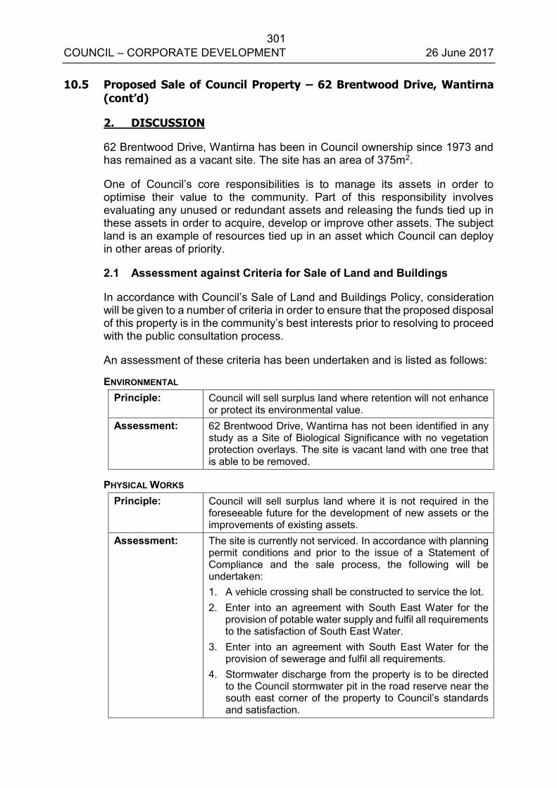
301 COUNCIL – CORPORATE DEVELOPMENT 26 June 2017
10.5 Proposed Sale of Council Property – 62 Brentwood Drive, Wantirna (cont’d)
2. DISCUSSION
62 Brentwood Drive, Wantirna has been in Council ownership since 1973 and has remained as a vacant site. The site has an area of 375m2.
One of Council’s core responsibilities is to manage its assets in order to optimise their value to the community. Part of this responsibility involves evaluating any unused or redundant assets and releasing the funds tied up in these assets in order to acquire, develop or improve other assets. The subject land is an example of resources tied up in an asset which Council can deploy in other areas of priority.
2.1 Assessment against Criteria for Sale of Land and Buildings
In accordance with Council’s Sale of Land and Buildings Policy, consideration will be given to a number of criteria in order to ensure that the proposed disposal of this property is in the community’s best interests prior to resolving to proceed with the public consultation process.
An assessment of these criteria has been undertaken and is listed as follows:
ENVIRONMENTAL Principle: Council will sell surplus land where retention will not enhance
or protect its environmental value. Assessment: 62 Brentwood Drive, Wantirna has not been identified in any
study as a Site of Biological Significance with no vegetation protection overlays. The site is vacant land with one tree that is able to be removed.
PHYSICAL WORKS Principle: Council will sell surplus land where it is not required in the
foreseeable future for the development of new assets or the improvements of existing assets.
Assessment: The site is currently not serviced. In accordance with planning permit conditions and prior to the issue of a Statement of Compliance and the sale process, the following will be undertaken: 1. A vehicle crossing shall be constructed to service the lot. 2. Enter into an agreement with South East Water for the
provision of potable water supply and fulfil all requirements to the satisfaction of South East Water.
3. Enter into an agreement with South East Water for the provision of sewerage and fulfil all requirements.
4. Stormwater discharge from the property is to be directed to the Council stormwater pit in the road reserve near the south east corner of the property to Council’s standards and satisfaction.
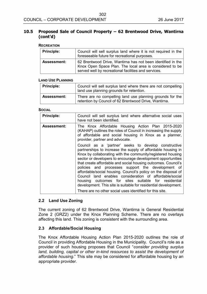
302 COUNCIL – CORPORATE DEVELOPMENT 26 June 2017
10.5 Proposed Sale of Council Property – 62 Brentwood Drive, Wantirna (cont’d)
RECREATION Principle: Council will sell surplus land where it is not required in the
foreseeable future for recreational purposes. Assessment: 62 Brentwood Drive, Wantirna has not been identified in the
Knox Open Space Plan. The local area is considered to be served well by recreational facilities and services.
LAND USE PLANNING Principle: Council will sell surplus land where there are not compelling
land use planning grounds for retention. Assessment: There are no compelling land use planning grounds for the
retention by Council of 62 Brentwood Drive, Wantirna.
SOCIAL Principle: Council will sell surplus land where alternative social uses
have not been identified. Assessment: The Knox Affordable Housing Action Plan 2015-2020
(KAHAP) outlines the roles of Council in increasing the supply of affordable and social housing in Knox as a planner, provider, partner and advocate. Council as a ‘partner’ seeks to develop constructive partnerships to increase the supply of affordable housing in Knox by collaborating with the community/registered housing sector or developers to encourage development opportunities that create affordable and social housing outcomes. Council’s policies and processes support the development of affordable/social housing. Council’s policy on the disposal of Council land enables consideration of affordable/social housing outcomes for sites suitable for residential development. This site is suitable for residential development. There are no other social uses identified for this site.
2.2 Land Use Zoning
The current zoning of 62 Brentwood Drive, Wantirna is General Residential Zone 2 (GRZ2) under the Knox Planning Scheme. There are no overlays affecting this land. This zoning is consistent with the surrounding area.
2.3 Affordable/Social Housing
The Knox Affordable Housing Action Plan 2015-2020 outlines the role of Council in providing Affordable Housing in the Municipality. Council’s role as a provider of such housing proposes that Council “consider providing surplus land, building, capital or other in-kind resources to assist the development of affordable housing.” This site may be considered for affordable housing by an appropriate provider.
303 COUNCIL – CORPORATE DEVELOPMENT 26 June 2017
10.5 Proposed Sale of Council Property – 62 Brentwood Drive, Wantirna (cont’d)
2.4 Method of Sale
Council's policy on the Sale of Land and Buildings provides that the sale will occur through a public process unless Council resolves that circumstances exist that justify an alternative method of sale.
The policy also provides that the public process be selected from the options of public auction, public tender or registration of expressions of interest and will be determined by the Chief Executive Officer on recommendation from the Director Corporate Development and be based on achieving the optimum economic return to Council.
In considering the method of sale, Council should consider that this property be sold by public auction. Given the location and size of this site, a public auction method of sale is likely to achieve an optimum economic return for Council. A public auction allows for a transparent and public process irrespective of who should purchase the land.
3. CONSULTATION
Council will undertake a public consultation program in order to fulfil both its statutory and community engagement obligations.
The consultative process covers the following measures:
Pursuant to section 189 of the Local Government Act 1989, Council will place a public notice in a newspaper which is generally circulating within the municipality.
The public notice will invite submissions on the proposal to sell the land.
Submissions will be considered by Council pursuant to section 223 of the Local Government Act 1989.
Submitters have the opportunity to be heard, in person, in support of any written submission they make should they desire to do so.
Following consideration of the Committee’s report, Council will then decide whether to proceed with its proposal to sell the land.
It is also proposed to send a copy of the public notice to residents immediately surrounding the property.
4. ENVIRONMENTAL/AMENITY ISSUES
The site contains no vegetation. Amenity issues such as impact on neighbouring properties and landscaping will be considered as part of any future planning permit process when the land is proposed to be developed.
304 COUNCIL – CORPORATE DEVELOPMENT 26 June 2017
10.5 Proposed Sale of Council Property – 62 Brentwood Drive, Wantirna (cont’d)
5. FINANCIAL & ECONOMIC IMPLICATIONS
The proposed disposal of 62 Brentwood Drive, Wantirna will meet Council’s financial objectives and provide significant proceeds from the proposed sale of this asset. Any costs associated with the proposed sale eg connection of services, agent’s fees etc will be deducted from the funds received from the proposed sale.
Whilst this land was acquired as a reserve for municipal purposes under the Local Government Act 1958, it is not considered that the land constitutes ‘public open space’ within the definition of Section 3 of the Subdivision Act 1988. Accordingly, there are no limitations on the distribution of the proceeds of the sale.
A confidential valuation dated 8 June 2017 is attached as Appendix B. A reserve price will be determined in accordance with Council’s policy prior to the sale process.
6. SOCIAL IMPLICATIONS
These are addressed in the assessment criteria set out earlier in this report.
7. RELEVANCE TO CITY PLAN 2013-17 (INCORPORATING THE COUNCIL PLAN)
This report relates to:
Theme 5: Democratic and Engaged Communities
5.3 Ensure Council is well governed and demonstrates effective leadership.
5.3.1 Maintain accountable and transparent governance practices, and Council’s sound stewardship of the community’s finances and assets.
8. CONCLUSION
As this property has been assessed as surplus to Council’s requirement, it is an opportunity to divest this property and convert the funds received to deliver community outcomes in another area of priority.
It is therefore recommended that Council commence the statutory process to sell 62 Brentwood Drive, Wantirna currently identified as Reserve 2 on LP 96422 and contained within Certificate of Title Volume 9031 Folio 834.
305 COUNCIL – CORPORATE DEVELOPMENT 26 June 2017
10.5 Proposed Sale of Council Property – 62 Brentwood Drive, Wantirna (cont’d)
9. CONFIDENTIALITY
A confidential valuation is attached to this report.
Report Prepared By: Coordinator Property Management (Angela Mitchell)
Report Authorised By: Acting Director – Corporate Development (Kim Rawlings)

306 COUNCIL – CORPORATE DEVELOPMENT 26 June 2017
10.5 Proposed Sale of Council Property – 62 Brentwood Drive, Wantirna (cont’d)
APPENDIX A – Proposed Sale of Council Property – 62 Brentwood Drive, Wantirna

307 COUNCIL – CORPORATE DEVELOPMENT 26 June 2017
10.5 Proposed Sale of Council Property – 62 Brentwood Drive, Wantirna
(cont’d)
Confidential Appendix B is circulated under separate cover.
308 COUNCIL – CORPORATE DEVELOPMENT 26 June 2017
TIRHATUAN WARD 10.6 PROPOSED SALE OF COUNCIL PROPERTY – PART WELLINGTON
ROAD RESERVE AND PART 889R WELLINGTON ROAD, ROWVILLE
SUMMARY: Coordinator Property Management (Angela Mitchell)
This report recommends that Council initiates the statutory process for the proposed sale of 2.311 hectares of Council owned land being part Wellington Road Reserve and part 889R Wellington Road, Rowville (Council Land) as shown in Appendix A. The Council Land proposed for sale has been assessed as surplus to Council’s requirements in accordance with Council’s Sale of Land and Buildings Policy. This report further recommends that Council gives notice of Council’s intention to sell the Council Land to the Pask Group (Pask) as developer of the adjoining Kingston Links golf course (Kingston Links) at 14 Corporate Drive, Rowville by private treaty.
RECOMMENDATIONS
That Council, having assessed that 2.311 hectares of Council land comprised in part Wellington Road Reserve and part 889R Wellington Road, Rowville is surplus to Council’s requirements, resolves to:
1. In accordance with Section 189 of the Local Government Act 1989, give public notice in the Knox Leader of its intention to sell an area of 2.311 hectares of Council land comprising part Wellington Road Reserve and part 889R Wellington Road, Rowville (contained in Certificate of Title Volume 10284 Folio 966 and Certificate of Title 9781 Folio 749) by private treaty to the Pask Group for a sale price of $7.6 million plus GST.
2. In accordance with Section 223 of the Local Government Act 1989, invite submissions from the public in respect of the intention to sell the Council Land.
3. Authorise the Coordinator Property Management to carry out the administrative procedures necessary to enable Council to perform its functions under Section 223 of the Local Government Act 1989.
4. Appoints Cr ________, Cr ________ and Cr ________ to hear submissions in accordance with Section 223 of the Local Government Act 1989 on Monday 28 August 2017 at 5.00pm and a further report presented to Council if submissions are received.
309 COUNCIL – CORPORATE DEVELOPMENT 26 June 2017
10.6 Proposed Sale of Council Property – Part Wellington Road Reserve and Part 889R Wellington Road, Rowville (cont’d)
5. Commence the sale process as listed below if no submissions are received:
a. The Council Land will be sold to Pask by private treaty for a sale price of $7.6 million plus GST, payable by 10% deposit and the balance due at settlement. Settlement is to occur on the later of 60 days after gazettal of planning scheme amendment C142, and creation of a separate title for the Council Land, provided that such settlement is no earlier than 31 January 2019.
b. The sale will be conditional upon the following:
Registration of a Section 24A plan under the Subdivision Act 1988 vesting part of the Council Land in Council and registration of a further such plan removing the reserve status from the Council Land and creating a separate title for such land.
The gazettal of planning scheme amendment C142 by no later than 30 June 2019.
c. Delegated authority is given to the Chief Executive Officer to negotiate and finalise the relevant terms and conditions of sale and all associated documentation and to execute the same.
1. INTRODUCTION
Pask as developer of Kingston Links has proposed a redevelopment for a mix of residential, small-scale commercial, and public uses.
Council officers have undertaken a collaborative approach to the review of the application for the proposed development of Kingston Links, which requires a proposed rezoning, combining input across Council and State Government agencies with extensive discussions with Pask. An important goal of this process has been to reach broad consensus between all parties on the outcomes for Kingston Links. The proposed rezoning is the subject of a separate report to Council entitled "Amendment C142 – Kingston Links Golf Course" to be considered at this Council meeting.
This has included an “in principle” agreement with Pask as to the terms of a proposed Development Contributions Agreement (DCA) to be in the form of a section 173 agreement to be recorded on the title to Kingston Links. The DCA will be binding on all future owners of Kingston Links if Pask sought to sell the whole or substantive parts of Kingston Links.
310 COUNCIL – CORPORATE DEVELOPMENT 26 June 2017
10.6 Proposed Sale of Council Property – Part Wellington Road Reserve and Part 889R Wellington Road, Rowville (cont’d)
The DCA proposes a package of community infrastructure contributions, which includes new sporting fields and associated pavilion, a contribution to support the delivery of new social housing in Rowville, contribution towards a new Men’s Shed and a new pedestrian crossing of the Corhanwarrabul Creek.
The proposed DCA also includes proposed terms for the sale of the Council Land to Pask by private treaty, subject to Council’s compliance with Sections 189 and 223 of the Local Government Act 1989 and resolving whether or not to sell the Council Land to Pask.
Kingston Links and the Council Land, are both currently zoned Special Use Zone (SUZ1) and are subject to Inundation Overlay (LSIO) as part of the floodplain for the Corhanwarrabul Creek and Rowville Main Drain catchments.
The planning report and associated Amendment C142 proposes to rezone all of Kingston Links and the Council Land for residential and public uses, remove the LSIO from areas that would be raised out of the floodplain, and apply a new Schedule 13 to the Development Plan Overlay. Should Council agree to sell the Council Land as proposed within this report, the sale would be conditional upon such a rezoning.
One of Council’s core responsibilities is to manage its assets in order to optimise their value to the community. Part of this responsibility involves evaluating any unused or redundant assets and releasing the funds tied up in these assets in order to acquire, develop or improve other assets. The Council Land is an example of resources tied up in an asset which Council can better deploy in other areas of priority for the reasons outlined in this report.
2. DISCUSSION
The Council Land is located near Linnel Court at the southeast corner of Kingston Links. It currently has no road access, but does have pedestrian access via the Council-owned lot at 12 Linnel Court. It is also part of the Rowville Main Drain floodplain. It floods periodically and is currently subject to the existing LSIO. There are a few isolated trees at the edge of the parcel, but it is mostly grassy vegetation that Council mows a few times each year. It is currently zoned SUZ1, the same as Kingston Links, and not currently used for public recreation.
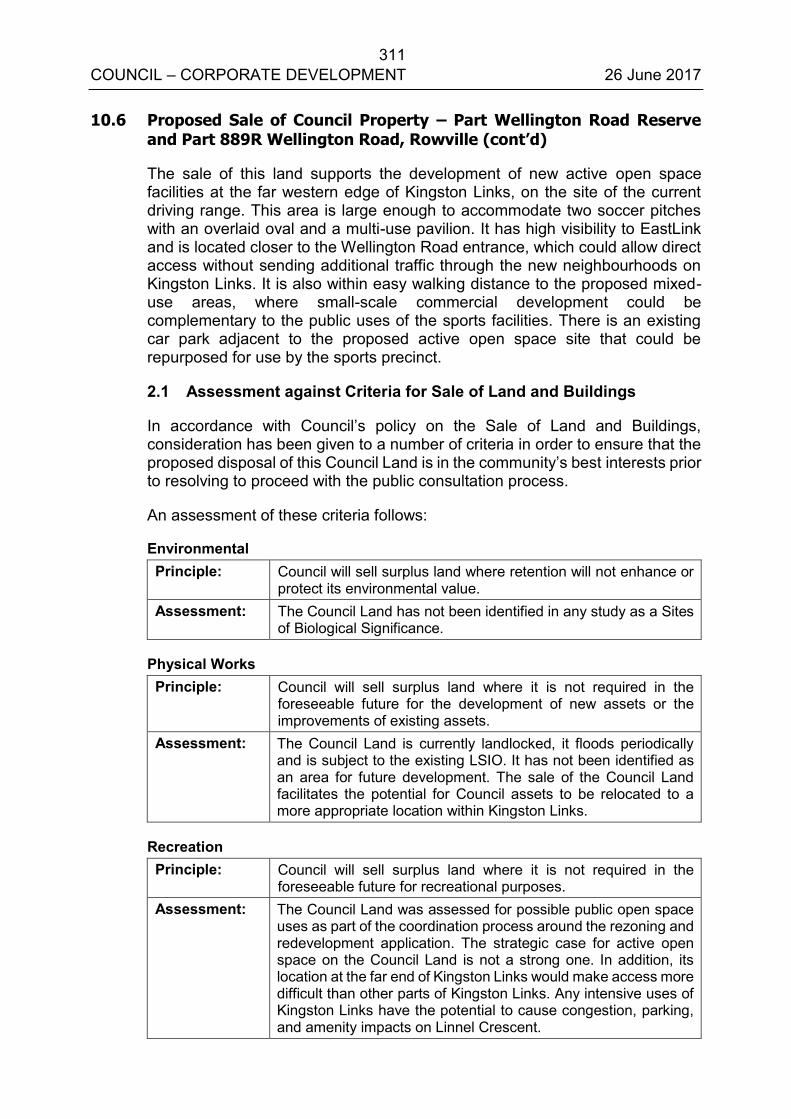
311 COUNCIL – CORPORATE DEVELOPMENT 26 June 2017
10.6 Proposed Sale of Council Property – Part Wellington Road Reserve and Part 889R Wellington Road, Rowville (cont’d)
The sale of this land supports the development of new active open space facilities at the far western edge of Kingston Links, on the site of the current driving range. This area is large enough to accommodate two soccer pitches with an overlaid oval and a multi-use pavilion. It has high visibility to EastLink and is located closer to the Wellington Road entrance, which could allow direct access without sending additional traffic through the new neighbourhoods on Kingston Links. It is also within easy walking distance to the proposed mixed-use areas, where small-scale commercial development could be complementary to the public uses of the sports facilities. There is an existing car park adjacent to the proposed active open space site that could be repurposed for use by the sports precinct.
2.1 Assessment against Criteria for Sale of Land and Buildings
In accordance with Council’s policy on the Sale of Land and Buildings, consideration has been given to a number of criteria in order to ensure that the proposed disposal of this Council Land is in the community’s best interests prior to resolving to proceed with the public consultation process.
An assessment of these criteria follows:
Environmental Principle: Council will sell surplus land where retention will not enhance or
protect its environmental value. Assessment: The Council Land has not been identified in any study as a Sites
of Biological Significance.
Physical Works Principle: Council will sell surplus land where it is not required in the
foreseeable future for the development of new assets or the improvements of existing assets.
Assessment: The Council Land is currently landlocked, it floods periodically and is subject to the existing LSIO. It has not been identified as an area for future development. The sale of the Council Land facilitates the potential for Council assets to be relocated to a more appropriate location within Kingston Links.
Recreation Principle: Council will sell surplus land where it is not required in the
foreseeable future for recreational purposes. Assessment: The Council Land was assessed for possible public open space
uses as part of the coordination process around the rezoning and redevelopment application. The strategic case for active open space on the Council Land is not a strong one. In addition, its location at the far end of Kingston Links would make access more difficult than other parts of Kingston Links. Any intensive uses of Kingston Links have the potential to cause congestion, parking, and amenity impacts on Linnel Crescent.
312 COUNCIL – CORPORATE DEVELOPMENT 26 June 2017
10.6 Proposed Sale of Council Property – Part Wellington Road Reserve and Part 889R Wellington Road, Rowville (cont’d)
Land Use Planning Principle: Council will sell surplus land where there are not compelling land
use planning grounds for retention. Assessment: There are no compelling land use planning grounds for the
retention by Council of the Council Land proposed for sale. Social Principle: Council will sell surplus land where alternative social uses have
not been identified. Assessment: The Knox Affordable Housing Action Plan 2015-2020 (KAHAP)
outlines the roles of Council in increasing the supply of affordable and social housing in Knox as a planner, provider, partner and advocate. Council as a ‘partner’ seeks to develop constructive partnerships to increase the supply of affordable housing in Knox by collaborating with the community/registered housing sector or developers to encourage development opportunities that create affordable and social housing outcomes. Council’s policies and processes support the development of affordable/social housing. Council’s policy on the disposal of Council land enable consideration of affordable/social housing outcomes for sites suitable for residential development. It is considered that on its own the Council land is not suitable for social housing however integrated with a broader development as proposed for Kingston Links social housing outcomes can and should be achieved. In accordance with Council’s Affordable Housing Action Plan and Planning Scheme, provision is to be made as part of the proposed DCA with Pask for affordable and social housing contributions.
2.2 Title Particulars
The subject land forms part of two existing titles:
Title 1 (Volume 10284 Folio 966)
A substantial area of the Council Land proposed for sale forms part of Certificate of Title Volume 10284 Folio 966. It is currently reserved for public recreation on title, zoned SUZ1 and includes land subject to an LSIO. In line with Council policy and best practice, the reserve status of this part of the Council Land needs to be removed and the land rezoned prior to the sale.
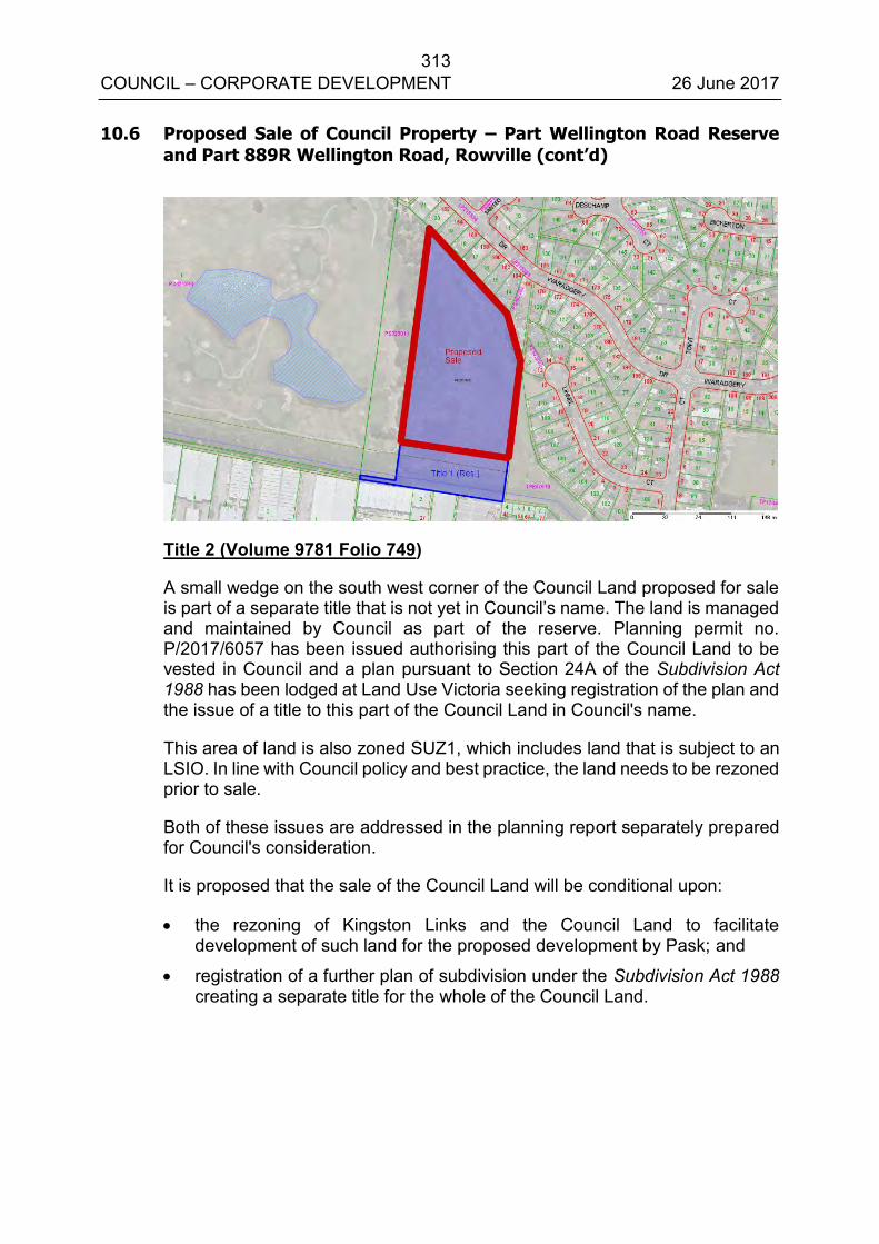
313 COUNCIL – CORPORATE DEVELOPMENT 26 June 2017
10.6 Proposed Sale of Council Property – Part Wellington Road Reserve and Part 889R Wellington Road, Rowville (cont’d)
Title 2 (Volume 9781 Folio 749)
A small wedge on the south west corner of the Council Land proposed for sale is part of a separate title that is not yet in Council’s name. The land is managed and maintained by Council as part of the reserve. Planning permit no. P/2017/6057 has been issued authorising this part of the Council Land to be vested in Council and a plan pursuant to Section 24A of the Subdivision Act 1988 has been lodged at Land Use Victoria seeking registration of the plan and the issue of a title to this part of the Council Land in Council's name.
This area of land is also zoned SUZ1, which includes land that is subject to an LSIO. In line with Council policy and best practice, the land needs to be rezoned prior to sale.
Both of these issues are addressed in the planning report separately prepared for Council's consideration.
It is proposed that the sale of the Council Land will be conditional upon:
the rezoning of Kingston Links and the Council Land to facilitate development of such land for the proposed development by Pask; and
registration of a further plan of subdivision under the Subdivision Act 1988 creating a separate title for the whole of the Council Land.
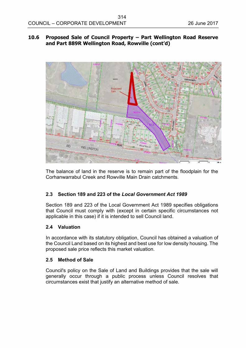
314 COUNCIL – CORPORATE DEVELOPMENT 26 June 2017
10.6 Proposed Sale of Council Property – Part Wellington Road Reserve and Part 889R Wellington Road, Rowville (cont’d)
The balance of land in the reserve is to remain part of the floodplain for the Corhanwarrabul Creek and Rowville Main Drain catchments.
2.3 Section 189 and 223 of the Local Government Act 1989
Section 189 and 223 of the Local Government Act 1989 specifies obligations that Council must comply with (except in certain specific circumstances not applicable in this case) if it is intended to sell Council land.
2.4 Valuation
In accordance with its statutory obligation, Council has obtained a valuation of the Council Land based on its highest and best use for low density housing. The proposed sale price reflects this market valuation.
2.5 Method of Sale
Council's policy on the Sale of Land and Buildings provides that the sale will generally occur through a public process unless Council resolves that circumstances exist that justify an alternative method of sale.
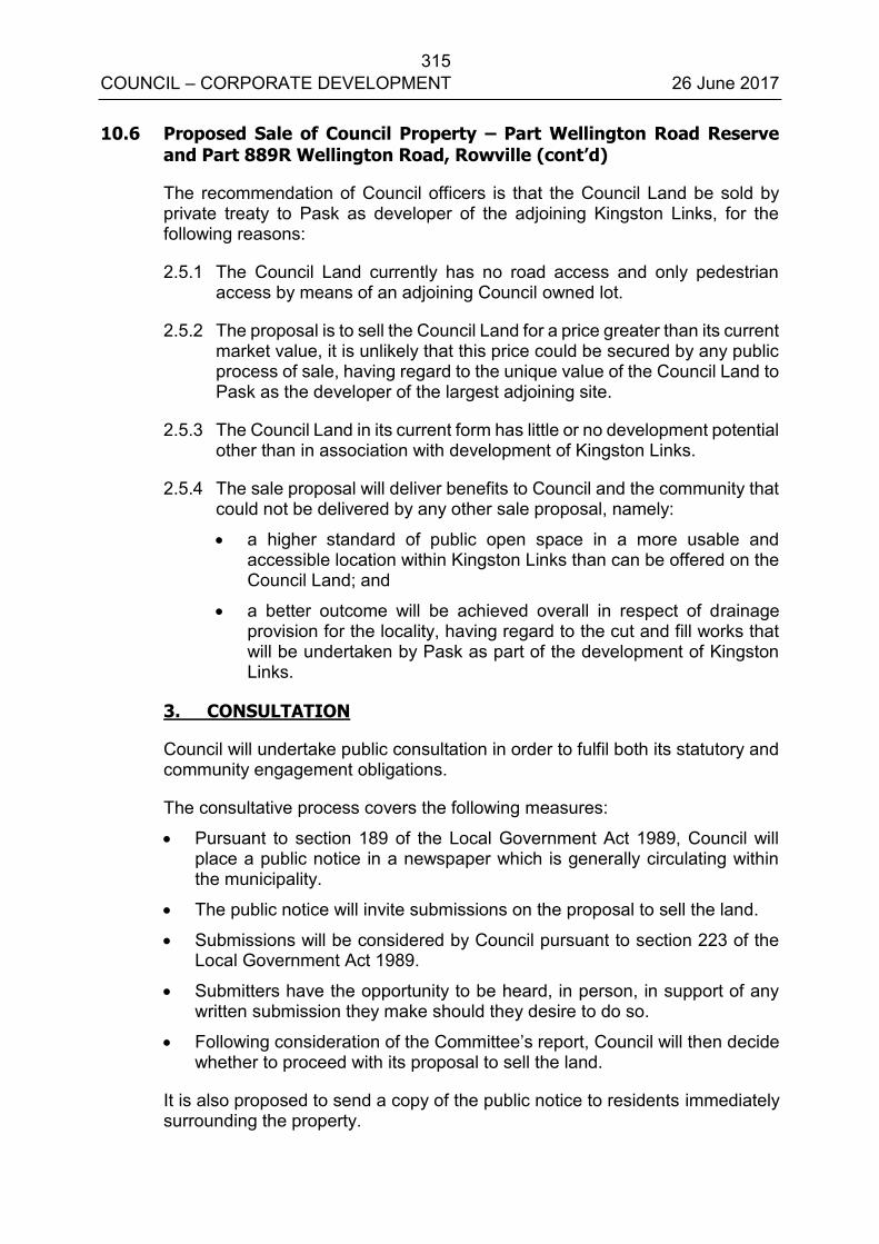
315 COUNCIL – CORPORATE DEVELOPMENT 26 June 2017
10.6 Proposed Sale of Council Property – Part Wellington Road Reserve and Part 889R Wellington Road, Rowville (cont’d)
The recommendation of Council officers is that the Council Land be sold by private treaty to Pask as developer of the adjoining Kingston Links, for the following reasons:
2.5.1 The Council Land currently has no road access and only pedestrian access by means of an adjoining Council owned lot.
2.5.2 The proposal is to sell the Council Land for a price greater than its current market value, it is unlikely that this price could be secured by any public process of sale, having regard to the unique value of the Council Land to Pask as the developer of the largest adjoining site.
2.5.3 The Council Land in its current form has little or no development potential other than in association with development of Kingston Links.
2.5.4 The sale proposal will deliver benefits to Council and the community that could not be delivered by any other sale proposal, namely:
a higher standard of public open space in a more usable and accessible location within Kingston Links than can be offered on the Council Land; and
a better outcome will be achieved overall in respect of drainage provision for the locality, having regard to the cut and fill works that will be undertaken by Pask as part of the development of Kingston Links.
3. CONSULTATION
Council will undertake public consultation in order to fulfil both its statutory and community engagement obligations.
The consultative process covers the following measures: Pursuant to section 189 of the Local Government Act 1989, Council will
place a public notice in a newspaper which is generally circulating within the municipality.
The public notice will invite submissions on the proposal to sell the land.
Submissions will be considered by Council pursuant to section 223 of the Local Government Act 1989.
Submitters have the opportunity to be heard, in person, in support of any written submission they make should they desire to do so.
Following consideration of the Committee’s report, Council will then decide whether to proceed with its proposal to sell the land.
It is also proposed to send a copy of the public notice to residents immediately surrounding the property.
316 COUNCIL – CORPORATE DEVELOPMENT 26 June 2017
10.6 Proposed Sale of Council Property – Part Wellington Road Reserve and Part 889R Wellington Road, Rowville (cont’d)
4. ENVIRONMENTAL/AMENITY ISSUES
There are a few isolated trees at the edge of the Council Land, but it is most grassy vegetation that Council mows a few times each year. It is currently zoned SUZ1, and is not currently used for public recreation. Amenity issues such as impact on neighbouring properties and landscaping will be considered as part of the planning permit process which is currently under consideration of Council.
5. FINANCIAL & ECONOMIC IMPLICATIONS
The proposed disposal of part of the Council Land will meet Council’s financial objectives and provide significant proceeds from the sale.
A valuation has been undertaken dated 16 June 2017 (refer confidential Appendix B). The proposed land sale price has been determined at its ‘highest and best use’ in accordance with Council’s policy.
6. SOCIAL IMPLICATIONS
These are addressed in the assessment criteria set out earlier in this report.
7. RELEVANCE TO CITY PLAN 2013-17 (INCORPORATING THECOUNCIL PLAN)
The future redevelopment of the Kingston Links and the associated proposed land sale addresses a number of objectives of the City Plan across all five themes of the Knox Vision:
Healthy, Connected Communities Prosperous, Advancing Economy Vibrant & Sustainable Built & Natural Environment Culturally Rich & Active Communities Democratic & Engaged Communities
8. CONCLUSION
The Kingston Links development has provided a unique opportunity to dispose of a portion of non-performing Council Land and achieve an outcome that delivers improved outcomes for the community. The Council Land has been assessed as surplus to Council’s requirement. This is an opportunity to divest this property and convert the funds received to deliver community outcomes in other areas of priority.
It is therefore recommended that Council initiates the statutory process to give notice of Council's intention to sell the Council Land to the Pask Group by private treaty in accordance with the recommendations contained in this report.
317 COUNCIL – CORPORATE DEVELOPMENT 26 June 2017
10.6 Proposed Sale of Council Property – Part Wellington Road Reserve and Part 889R Wellington Road, Rowville (cont’d)
9. CONFIDENTIALITY
A confidential valuation is attached to this report.
Report Prepared By: Coordinator Property Management (Angela Mitchell)
Report Authorised By: Acting Director – Corporate Development
(Kim Rawlings)
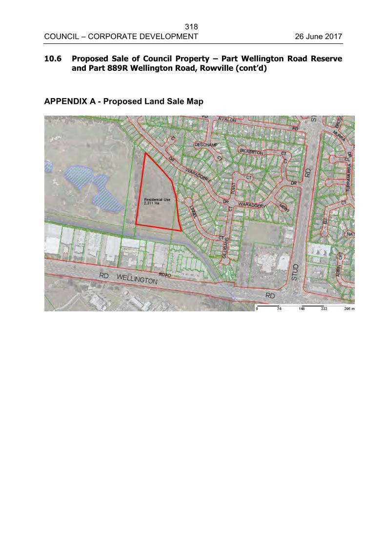
318 COUNCIL – CORPORATE DEVELOPMENT 26 June 2017
10.6 Proposed Sale of Council Property – Part Wellington Road Reserve and Part 889R Wellington Road, Rowville (cont’d)
APPENDIX A - Proposed Land Sale Map

319 COUNCIL – CORPORATE DEVELOPMENT 26 June 2017
10.6 Proposed Sale of Council Property – Part Wellington Road Reserve and Part 889R Wellington Road, Rowville (cont’d)
Confidential Appendix B is circulated under separate cover.
320 COUNCIL – CORPORATE DEVELOPMENT 26 June 2017
ALL WARDS 10.7 INCIDENTAL COMMUNITY GRANTS PROGRAM APPLICATIONS
SUMMARY: Governance Officer - (Kirstin Ritchie)
This report summarises the recommended grants from the Incidental Community Grants Program. All applications have been assessed against the criteria as set out in the Incidental Community Grant Program Policy.
RECOMMENDATION
That Council approve the five recommended Incidental Community Grant applications for a total value of $4,981, and note the one application approved under delegated authority for a total value of $500, as detailed in Appendix A.
1. INTRODUCTION
At the Ordinary Council meeting, held on 28 June 2016, Council resolved to endorse the Incidental Community Grants Program Policy (the Policy) to enable the continued provision of ad hoc one-off grants.
Under the endorsed policy the following criteria are used to determine the eligibility of applications for Incidental Community Grants:
All requests for funding must be in writing and on the relevant funding
application form; and
Applications must be from individuals who reside in Knox or community groups that provide services to the Knox community; and
All applications for funding must provide a demonstrated benefit to the Knox community and be in keeping with the objectives and directions of the City Plan; and
Applications for financial donations and general fundraising activities will not be supported through the Incidental Community Grants Program; and
The maximum grant limit is $1,000.
This report presents to Council recommended grant allocations in accordance with this policy.
321 COUNCIL – CORPORATE DEVELOPMENT 26 June 2017
10.7 Incidental Community Grants Program Applications (cont'd)
2. DISCUSSION
Council has established the Incidental Community Grants program to ensure that funding may be provided to individuals and community groups who request ad hoc, incidental, community based, one-off grants.
The Policy sets out an open and transparent grant program that meets the principles of good governance and is compliant with the requirements of the Local Government Act 1989.
In accordance with the Policy guidelines, applications for funding up to $500 are assessed and determined under delegation. Applications for funding between $501 and $1,000 have been assessed by the Chief Executive Officer, or delegate, for Council’s approval.
This report outlines the grant applications received since the 22 May 2017 Ordinary Council meeting, and recommends five grants for Council's approval.
It is noted that the value requested in one application exceed the maximum permitted in the Policy. Consequently, the Chief Executive Officer’s delegate has recommended that the maximum grant limit of $1,000 be paid.
A comprehensive review of this policy is currently underway, with a report to be presented to a future Strategic Planning Committee meeting. In addition, a broader review of Council’s grants programs is scheduled to be undertaken later this calendar year.
3. CONSULTATION
No consultation has been undertaken in relation to the grant applications detailed in this report as the policy specifies assessment can occur by the CEO, or delegate, for Council’s determination.
4. ENVIRONMENTAL/AMENITY ISSUES
There are no environmental or amenity issues associated with this report.
5. FINANCIAL & ECONOMIC IMPLICATIONS
The approval of incidental community grants is managed within Council’s adopted budget.
322 COUNCIL – CORPORATE DEVELOPMENT 26 June 2017
10.7 Incidental Community Grants Program Applications (cont'd)
6. SOCIAL IMPLICATIONS
The Incidental Community Grants program allows Council the flexibility to respond to requests from individual’s and/or community groups within Knox at a municipal level. These grants provide applicants the opportunity to participate and support a variety of community based programs.
7. RELEVANCE TO CITY PLAN 2013-17 (INCORPORATING THE COUNCIL PLAN)
Provision of the Incidental Community Grants program assists Council in meeting its general objectives under the Council Plan.
8. CONCLUSION
This report contains the recommendation for funding though the Incidental Community Grants program.
9. CONFIDENTIALITY
Confidential Appendix B contains each of the individual grant applications for Council's consideration.
Report Prepared By: Governance Officer – (Kirstin Ritchie)
Report Authorised By: Acting Director – Corporate Development
(Kim Rawlings)
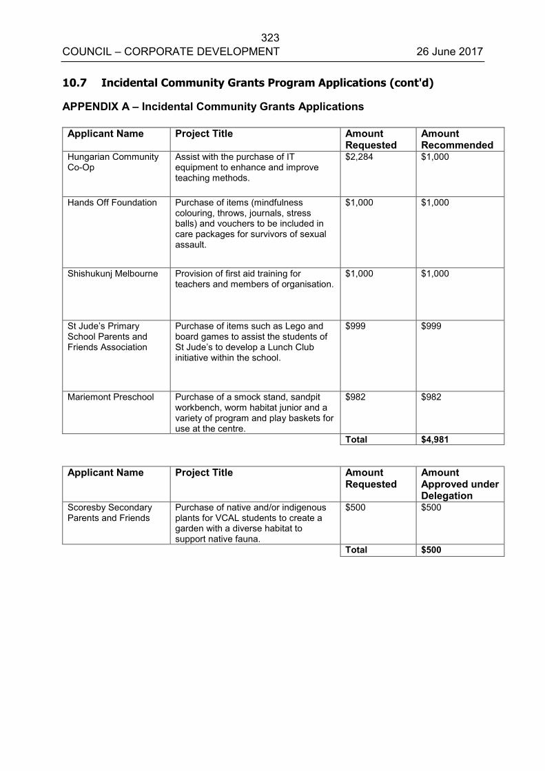
323 COUNCIL – CORPORATE DEVELOPMENT 26 June 2017
10.7 Incidental Community Grants Program Applications (cont'd)
APPENDIX A – Incidental Community Grants Applications Applicant Name Project Title Amount
Requested Amount Recommended
Hungarian Community Co-Op
Assist with the purchase of IT equipment to enhance and improve teaching methods.
$2,284 $1,000
Hands Off Foundation Purchase of items (mindfulness colouring, throws, journals, stress balls) and vouchers to be included in care packages for survivors of sexual assault.
$1,000 $1,000
Shishukunj Melbourne Provision of first aid training for teachers and members of organisation.
$1,000 $1,000
St Jude’s Primary School Parents and Friends Association
Purchase of items such as Lego and board games to assist the students of St Jude’s to develop a Lunch Club initiative within the school.
$999 $999
Mariemont Preschool Purchase of a smock stand, sandpit workbench, worm habitat junior and a variety of program and play baskets for use at the centre.
$982 $982
Total $4,981
Applicant Name Project Title Amount Requested
Amount Approved under Delegation
Scoresby Secondary Parents and Friends
Purchase of native and/or indigenous plants for VCAL students to create a garden with a diverse habitat to support native fauna.
$500 $500
Total $500

324 COUNCIL – CORPORATE DEVELOPMENT 26 June 2017
10.7 Incidental Community Grants Program Applications (cont'd)
Confidential Appendix B is circulated under separate cover.
325 COUNCIL – ITEMS FOR INFORMATION 26 June 2017
ALL WARDS 11.1 WORKS REPORT AS AT 26 MAY 2017
SUMMARY: Coordinator – Capital Works (Gene Chiron) The Works Report shows projects on Council’s Capital Works Program and indicates the status of each project as at 26 May 2017.
RECOMMENDATION
That the works report, as at 26 May 2017, be received and noted.
1. INTRODUCTION
This report summarises Council’s Capital Works Program for the 2016/2017 financial year. The aim of this report is to provide a regular and succinct status summary of each project over the last month. The Capital Works Report, as of 26 May 2017, is attached as Appendix A.
Report Prepared By: Coordinator – Capital Works (Gene Chiron)
Report Authorised By: Director – Engineering & Infrastructure (Ian Bell)
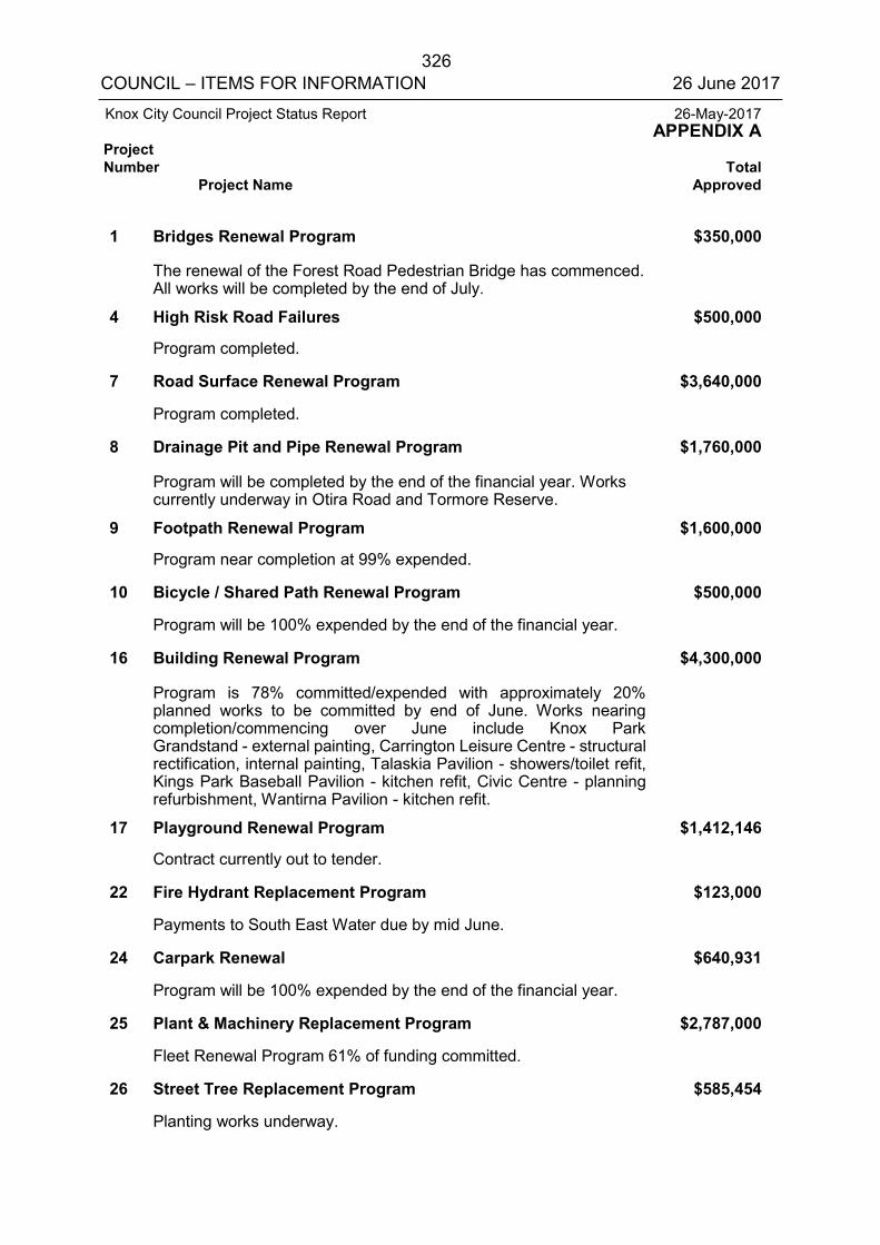
326 COUNCIL – ITEMS FOR INFORMATION 26 June 2017
Knox City Council Project Status Report 26-May-2017 APPENDIX A Project Number Total Project Name Approved
1 Bridges Renewal Program $350,000 The renewal of the Forest Road Pedestrian Bridge has commenced. All works will be completed by the end of July. 4 High Risk Road Failures $500,000 Program completed. 7 Road Surface Renewal Program $3,640,000 Program completed. 8 Drainage Pit and Pipe Renewal Program $1,760,000 Program will be completed by the end of the financial year. Works currently underway in Otira Road and Tormore Reserve. 9 Footpath Renewal Program $1,600,000 Program near completion at 99% expended. 10 Bicycle / Shared Path Renewal Program $500,000 Program will be 100% expended by the end of the financial year. 16 Building Renewal Program $4,300,000 Program is 78% committed/expended with approximately 20%
planned works to be committed by end of June. Works nearing completion/commencing over June include Knox Park Grandstand - external painting, Carrington Leisure Centre - structural rectification, internal painting, Talaskia Pavilion - showers/toilet refit, Kings Park Baseball Pavilion - kitchen refit, Civic Centre - planning refurbishment, Wantirna Pavilion - kitchen refit.
17 Playground Renewal Program $1,412,146 Contract currently out to tender. 22 Fire Hydrant Replacement Program $123,000 Payments to South East Water due by mid June. 24 Carpark Renewal $640,931 Program will be 100% expended by the end of the financial year. 25 Plant & Machinery Replacement Program $2,787,000 Fleet Renewal Program 61% of funding committed. 26 Street Tree Replacement Program $585,454 Planting works underway.
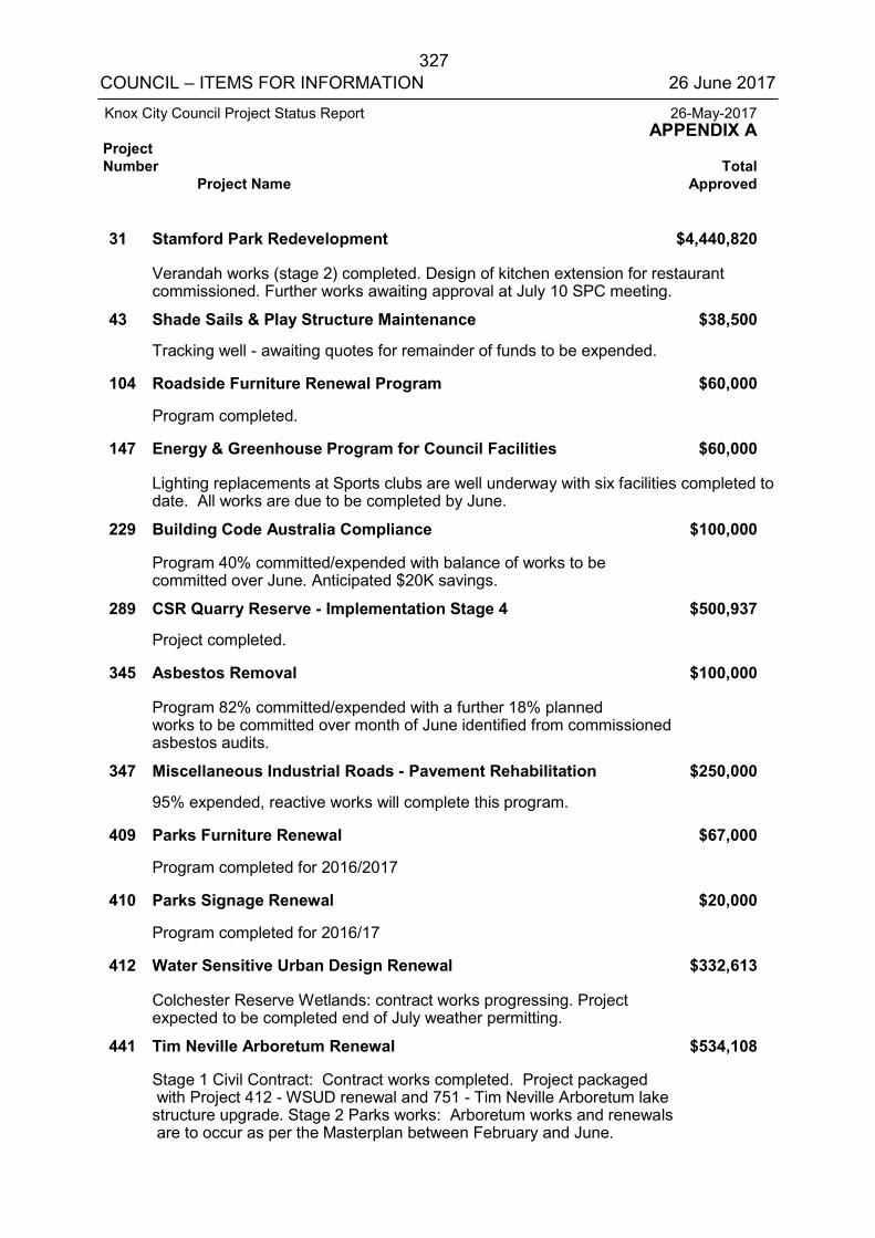
327 COUNCIL – ITEMS FOR INFORMATION 26 June 2017
Knox City Council Project Status Report 26-May-2017 APPENDIX A Project Number Total Project Name Approved
31 Stamford Park Redevelopment $4,440,820 Verandah works (stage 2) completed. Design of kitchen extension for restaurant
commissioned. Further works awaiting approval at July 10 SPC meeting. 43 Shade Sails & Play Structure Maintenance $38,500 Tracking well - awaiting quotes for remainder of funds to be expended. 104 Roadside Furniture Renewal Program $60,000 Program completed. 147 Energy & Greenhouse Program for Council Facilities $60,000 Lighting replacements at Sports clubs are well underway with six facilities completed to
date. All works are due to be completed by June. 229 Building Code Australia Compliance $100,000 Program 40% committed/expended with balance of works to be
committed over June. Anticipated $20K savings. 289 CSR Quarry Reserve - Implementation Stage 4 $500,937 Project completed. 345 Asbestos Removal $100,000 Program 82% committed/expended with a further 18% planned
works to be committed over month of June identified from commissioned asbestos audits.
347 Miscellaneous Industrial Roads - Pavement Rehabilitation $250,000 95% expended, reactive works will complete this program. 409 Parks Furniture Renewal $67,000 Program completed for 2016/2017 410 Parks Signage Renewal $20,000 Program completed for 2016/17 412 Water Sensitive Urban Design Renewal $332,613 Colchester Reserve Wetlands: contract works progressing. Project
expected to be completed end of July weather permitting. 441 Tim Neville Arboretum Renewal $534,108 Stage 1 Civil Contract: Contract works completed. Project packaged
with Project 412 - WSUD renewal and 751 - Tim Neville Arboretum lake structure upgrade. Stage 2 Parks works: Arboretum works and renewals are to occur as per the Masterplan between February and June.
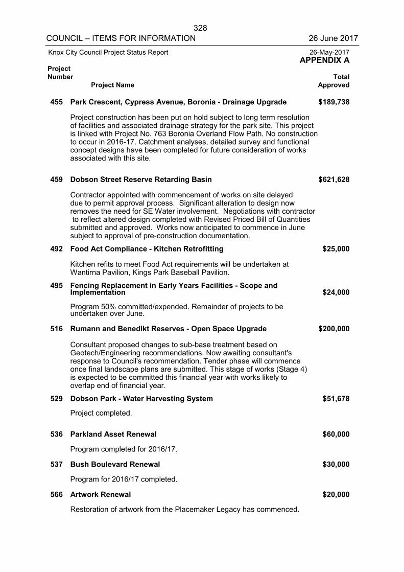
328 COUNCIL – ITEMS FOR INFORMATION 26 June 2017
Knox City Council Project Status Report 26-May-2017 APPENDIX A Project Number Total Project Name Approved
455 Park Crescent, Cypress Avenue, Boronia - Drainage Upgrade $189,738 Project construction has been put on hold subject to long term resolution
of facilities and associated drainage strategy for the park site. This project is linked with Project No. 763 Boronia Overland Flow Path. No construction to occur in 2016-17. Catchment analyses, detailed survey and functional concept designs have been completed for future consideration of works associated with this site.
459 Dobson Street Reserve Retarding Basin $621,628 Contractor appointed with commencement of works on site delayed
due to permit approval process. Significant alteration to design now removes the need for SE Water involvement. Negotiations with contractor to reflect altered design completed with Revised Priced Bill of Quantities submitted and approved. Works now anticipated to commence in June subject to approval of pre-construction documentation.
492 Food Act Compliance - Kitchen Retrofitting $25,000 Kitchen refits to meet Food Act requirements will be undertaken at
Wantirna Pavilion, Kings Park Baseball Pavilion. 495 Fencing Replacement in Early Years Facilities - Scope and
Implementation $24,000 Program 50% committed/expended. Remainder of projects to be
undertaken over June. 516 Rumann and Benedikt Reserves - Open Space Upgrade $200,000 Consultant proposed changes to sub-base treatment based on
Geotech/Engineering recommendations. Now awaiting consultant's response to Council's recommendation. Tender phase will commence once final landscape plans are submitted. This stage of works (Stage 4) is expected to be committed this financial year with works likely to overlap end of financial year.
529 Dobson Park - Water Harvesting System $51,678 Project completed. 536 Parkland Asset Renewal $60,000 Program completed for 2016/17. 537 Bush Boulevard Renewal $30,000 Program for 2016/17 completed. 566 Artwork Renewal $20,000 Restoration of artwork from the Placemaker Legacy has commenced.
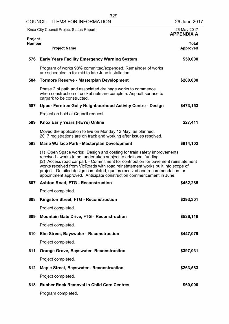
329 COUNCIL – ITEMS FOR INFORMATION 26 June 2017
Knox City Council Project Status Report 26-May-2017 APPENDIX A Project Number Total Project Name Approved
576 Early Years Facility Emergency Warning System $50,000 Program of works 98% committed/expended. Remainder of works
are scheduled in for mid to late June installation. 584 Tormore Reserve - Masterplan Development $200,000 Phase 2 of path and associated drainage works to commence
when construction of cricket nets are complete. Asphalt surface to carpark to be constructed.
587 Upper Ferntree Gully Neighbourhood Activity Centre - Design $473,153 Project on hold at Council request. 589 Knox Early Years (KEYs) Online $27,411 Moved the application to live on Monday 12 May, as planned.
2017 registrations are on track and working after issues resolved. 593 Marie Wallace Park - Masterplan Development $914,102
(1) Open Space works: Design and costing for train safety improvements received - works to be undertaken subject to additional funding. (2) Access road car park - Commitment for contribution for pavement reinstatement works received from VicRoads with road reinstatement works built into scope of project. Detailed design completed, quotes received and recommendation for appointment approved. Anticipate construction commencement in June.
607 Ashton Road, FTG - Reconstruction $452,285 Project completed. 608 Kingston Street, FTG - Reconstruction $393,301 Project completed. 609 Mountain Gate Drive, FTG - Reconstruction $526,116 Project completed. 610 Elm Street, Bayswater - Reconstruction $447,079 Project completed. 611 Orange Grove, Bayswater- Reconstruction $397,031 Project completed. 612 Maple Street, Bayswater - Reconstruction $263,583 Project completed. 618 Rubber Rock Removal in Child Care Centres $60,000 Program completed.
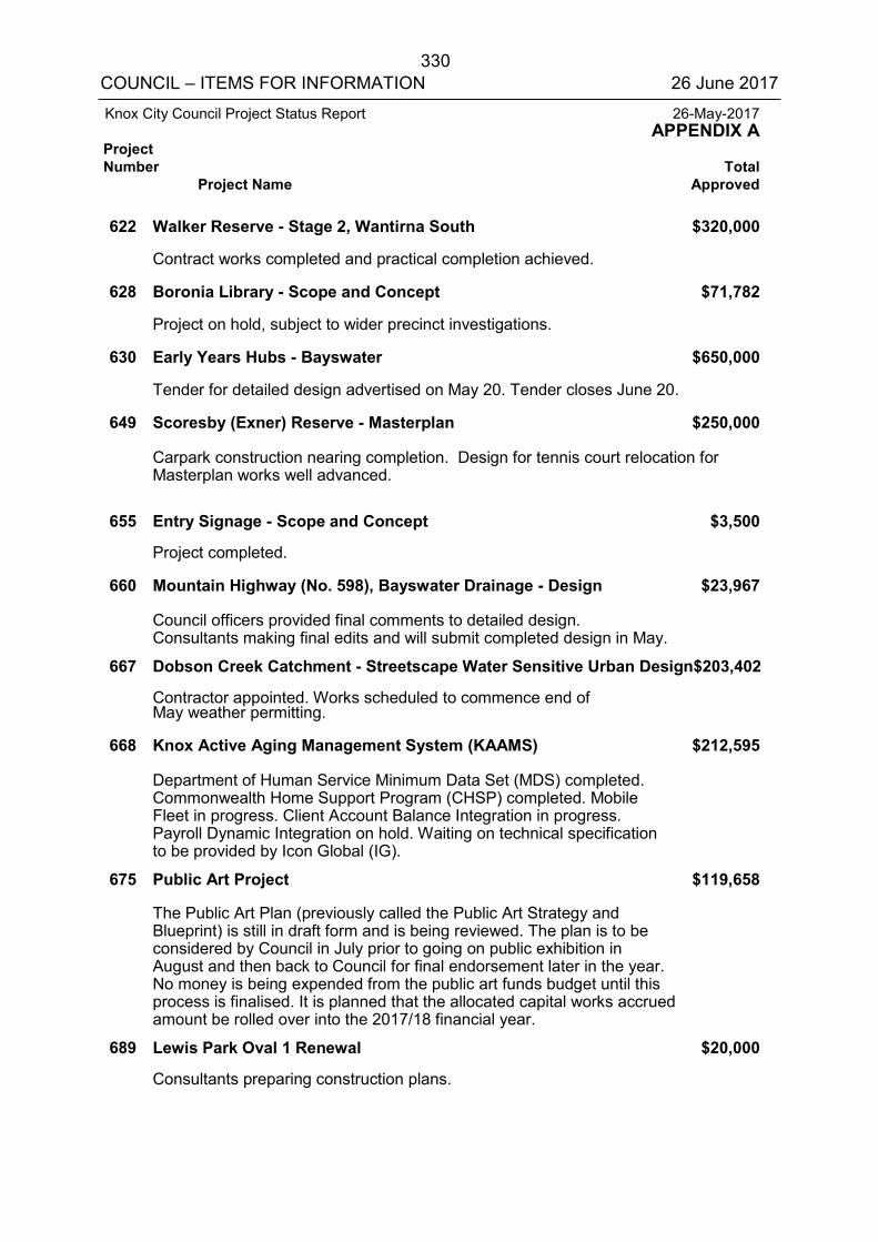
330 COUNCIL – ITEMS FOR INFORMATION 26 June 2017
Knox City Council Project Status Report 26-May-2017 APPENDIX A Project Number Total Project Name Approved
622 Walker Reserve - Stage 2, Wantirna South $320,000 Contract works completed and practical completion achieved. 628 Boronia Library - Scope and Concept $71,782 Project on hold, subject to wider precinct investigations. 630 Early Years Hubs - Bayswater $650,000 Tender for detailed design advertised on May 20. Tender closes June 20. 649 Scoresby (Exner) Reserve - Masterplan $250,000 Carpark construction nearing completion. Design for tennis court relocation for
Masterplan works well advanced. 655 Entry Signage - Scope and Concept $3,500 Project completed. 660 Mountain Highway (No. 598), Bayswater Drainage - Design $23,967 Council officers provided final comments to detailed design.
Consultants making final edits and will submit completed design in May. 667 Dobson Creek Catchment - Streetscape Water Sensitive Urban Design$203,402 Contractor appointed. Works scheduled to commence end of
May weather permitting. 668 Knox Active Aging Management System (KAAMS) $212,595 Department of Human Service Minimum Data Set (MDS) completed.
Commonwealth Home Support Program (CHSP) completed. Mobile Fleet in progress. Client Account Balance Integration in progress. Payroll Dynamic Integration on hold. Waiting on technical specification to be provided by Icon Global (IG).
675 Public Art Project $119,658 The Public Art Plan (previously called the Public Art Strategy and
Blueprint) is still in draft form and is being reviewed. The plan is to be considered by Council in July prior to going on public exhibition in August and then back to Council for final endorsement later in the year. No money is being expended from the public art funds budget until this process is finalised. It is planned that the allocated capital works accrued amount be rolled over into the 2017/18 financial year.
689 Lewis Park Oval 1 Renewal $20,000 Consultants preparing construction plans.
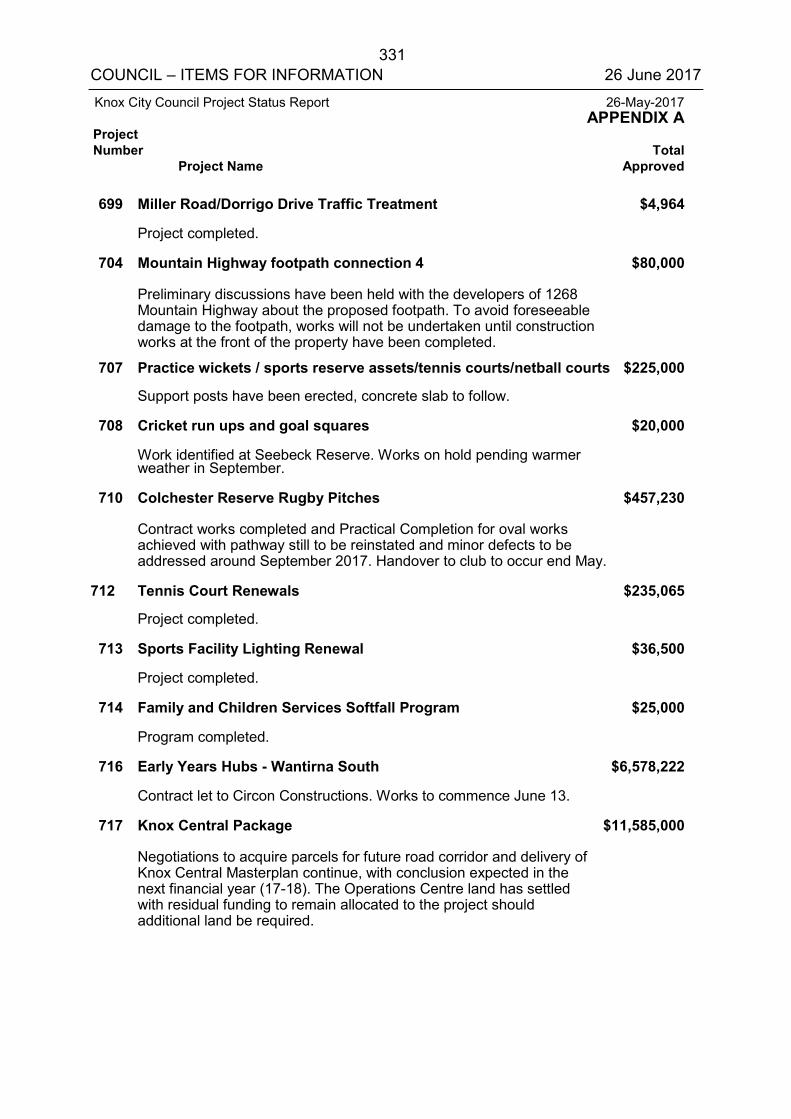
331 COUNCIL – ITEMS FOR INFORMATION 26 June 2017
Knox City Council Project Status Report 26-May-2017 APPENDIX A Project Number Total Project Name Approved
699 Miller Road/Dorrigo Drive Traffic Treatment $4,964 Project completed. 704 Mountain Highway footpath connection 4 $80,000 Preliminary discussions have been held with the developers of 1268
Mountain Highway about the proposed footpath. To avoid foreseeable damage to the footpath, works will not be undertaken until construction works at the front of the property have been completed.
707 Practice wickets / sports reserve assets/tennis courts/netball courts $225,000 Support posts have been erected, concrete slab to follow. 708 Cricket run ups and goal squares $20,000 Work identified at Seebeck Reserve. Works on hold pending warmer
weather in September. 710 Colchester Reserve Rugby Pitches $457,230 Contract works completed and Practical Completion for oval works
achieved with pathway still to be reinstated and minor defects to be addressed around September 2017. Handover to club to occur end May.
712 Tennis Court Renewals $235,065 Project completed. 713 Sports Facility Lighting Renewal $36,500 Project completed. 714 Family and Children Services Softfall Program $25,000 Program completed. 716 Early Years Hubs - Wantirna South $6,578,222 Contract let to Circon Constructions. Works to commence June 13. 717 Knox Central Package $11,585,000 Negotiations to acquire parcels for future road corridor and delivery of
Knox Central Masterplan continue, with conclusion expected in the next financial year (17-18). The Operations Centre land has settled with residual funding to remain allocated to the project should additional land be required.
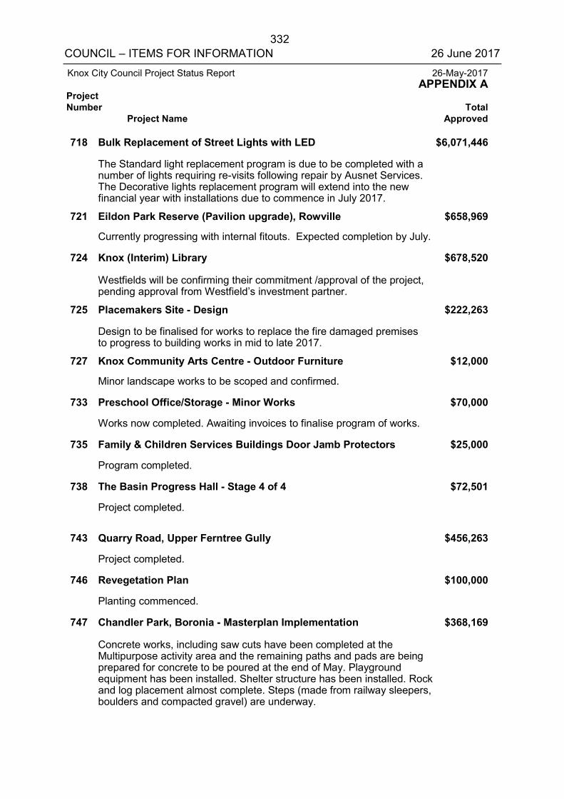
332 COUNCIL – ITEMS FOR INFORMATION 26 June 2017
Knox City Council Project Status Report 26-May-2017 APPENDIX A Project Number Total Project Name Approved
718 Bulk Replacement of Street Lights with LED $6,071,446 The Standard light replacement program is due to be completed with a
number of lights requiring re-visits following repair by Ausnet Services. The Decorative lights replacement program will extend into the new financial year with installations due to commence in July 2017.
721 Eildon Park Reserve (Pavilion upgrade), Rowville $658,969 Currently progressing with internal fitouts. Expected completion by July. 724 Knox (Interim) Library $678,520 Westfields will be confirming their commitment /approval of the project,
pending approval from Westfield’s investment partner. 725 Placemakers Site - Design $222,263 Design to be finalised for works to replace the fire damaged premises
to progress to building works in mid to late 2017. 727 Knox Community Arts Centre - Outdoor Furniture $12,000 Minor landscape works to be scoped and confirmed. 733 Preschool Office/Storage - Minor Works $70,000 Works now completed. Awaiting invoices to finalise program of works. 735 Family & Children Services Buildings Door Jamb Protectors $25,000 Program completed. 738 The Basin Progress Hall - Stage 4 of 4 $72,501 Project completed. 743 Quarry Road, Upper Ferntree Gully $456,263 Project completed. 746 Revegetation Plan $100,000 Planting commenced. 747 Chandler Park, Boronia - Masterplan Implementation $368,169 Concrete works, including saw cuts have been completed at the
Multipurpose activity area and the remaining paths and pads are being prepared for concrete to be poured at the end of May. Playground equipment has been installed. Shelter structure has been installed. Rock and log placement almost complete. Steps (made from railway sleepers, boulders and compacted gravel) are underway.
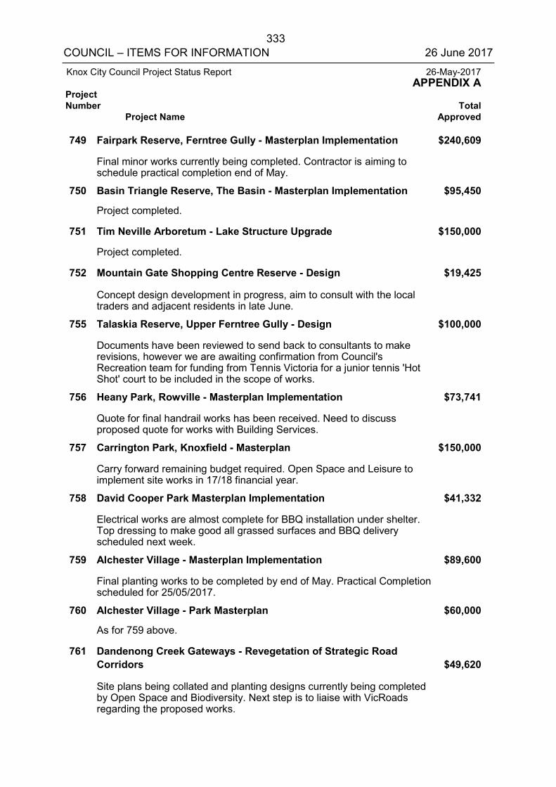
333 COUNCIL – ITEMS FOR INFORMATION 26 June 2017
Knox City Council Project Status Report 26-May-2017 APPENDIX A
Project Number Total
Project Name Approved
749 Fairpark Reserve, Ferntree Gully - Masterplan Implementation $240,609
Final minor works currently being completed. Contractor is aiming to schedule practical completion end of May.
750 Basin Triangle Reserve, The Basin - Masterplan Implementation $95,450
Project completed.
751 Tim Neville Arboretum - Lake Structure Upgrade $150,000
Project completed.
752 Mountain Gate Shopping Centre Reserve - Design $19,425
Concept design development in progress, aim to consult with the local traders and adjacent residents in late June.
755 Talaskia Reserve, Upper Ferntree Gully - Design $100,000
Documents have been reviewed to send back to consultants to make revisions, however we are awaiting confirmation from Council's Recreation team for funding from Tennis Victoria for a junior tennis 'Hot Shot' court to be included in the scope of works.
756 Heany Park, Rowville - Masterplan Implementation $73,741
Quote for final handrail works has been received. Need to discuss proposed quote for works with Building Services.
757 Carrington Park, Knoxfield - Masterplan $150,000
Carry forward remaining budget required. Open Space and Leisure to implement site works in 17/18 financial year.
758 David Cooper Park Masterplan Implementation $41,332
Electrical works are almost complete for BBQ installation under shelter. Top dressing to make good all grassed surfaces and BBQ delivery scheduled next week.
759 Alchester Village - Masterplan Implementation $89,600
Final planting works to be completed by end of May. Practical Completion scheduled for 25/05/2017.
760 Alchester Village - Park Masterplan $60,000
As for 759 above.
761 Dandenong Creek Gateways - Revegetation of Strategic Road Corridors $49,620
Site plans being collated and planting designs currently being completed by Open Space and Biodiversity. Next step is to liaise with VicRoads regarding the proposed works.
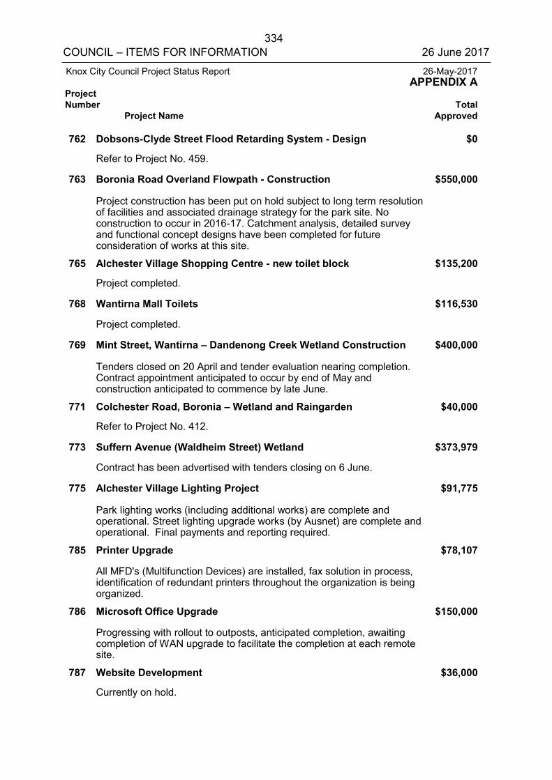
334 COUNCIL – ITEMS FOR INFORMATION 26 June 2017
Knox City Council Project Status Report 26-May-2017 APPENDIX A Project Number Total Project Name Approved
762 Dobsons-Clyde Street Flood Retarding System - Design $0 Refer to Project No. 459. 763 Boronia Road Overland Flowpath - Construction $550,000 Project construction has been put on hold subject to long term resolution
of facilities and associated drainage strategy for the park site. No construction to occur in 2016-17. Catchment analysis, detailed survey and functional concept designs have been completed for future consideration of works at this site.
765 Alchester Village Shopping Centre - new toilet block $135,200 Project completed. 768 Wantirna Mall Toilets $116,530 Project completed. 769 Mint Street, Wantirna – Dandenong Creek Wetland Construction $400,000 Tenders closed on 20 April and tender evaluation nearing completion.
Contract appointment anticipated to occur by end of May and construction anticipated to commence by late June.
771 Colchester Road, Boronia – Wetland and Raingarden $40,000 Refer to Project No. 412. 773 Suffern Avenue (Waldheim Street) Wetland $373,979 Contract has been advertised with tenders closing on 6 June. 775 Alchester Village Lighting Project $91,775 Park lighting works (including additional works) are complete and
operational. Street lighting upgrade works (by Ausnet) are complete and operational. Final payments and reporting required.
785 Printer Upgrade $78,107 All MFD's (Multifunction Devices) are installed, fax solution in process,
identification of redundant printers throughout the organization is being organized.
786 Microsoft Office Upgrade $150,000 Progressing with rollout to outposts, anticipated completion, awaiting
completion of WAN upgrade to facilitate the completion at each remote site.
787 Website Development $36,000 Currently on hold.
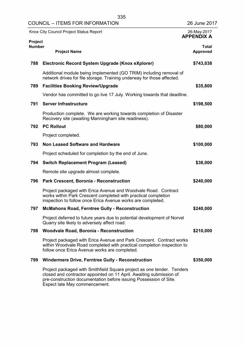
335 COUNCIL – ITEMS FOR INFORMATION 26 June 2017
Knox City Council Project Status Report 26-May-2017 APPENDIX A Project Number Total Project Name Approved
788 Electronic Record System Upgrade (Knox eXplorer) $743,038 Additional module being implemented (GO TRIM) including removal of
network drives for file storage. Training underway for those affected. 789 Facilities Booking Review/Upgrade $35,800 Vendor has committed to go live 17 July. Working towards that deadline. 791 Server Infrastructure $198,500 Production complete. We are working towards completion of Disaster
Recovery site (awaiting Manningham site readiness). 792 PC Rollout $80,000 Project completed. 793 Non Leased Software and Hardware $100,000 Project scheduled for completion by the end of June. 794 Switch Replacement Program (Leased) $38,000 Remote site upgrade almost complete. 796 Park Crescent, Boronia - Reconstruction $240,000 Project packaged with Erica Avenue and Woodvale Road. Contract
works within Park Crescent completed with practical completion inspection to follow once Erica Avenue works are completed.
797 McMahons Road, Ferntree Gully - Reconstruction $240,000 Project deferred to future years due to potential development of Norvel
Quarry site likely to adversely affect road. 798 Woodvale Road, Boronia - Reconstruction $210,000 Project packaged with Erica Avenue and Park Crescent. Contract works
within Woodvale Road completed with practical completion inspection to follow once Erica Avenue works are completed.
799 Windermere Drive, Ferntree Gully - Reconstruction $350,000 Project packaged with Smithfield Square project as one tender. Tenders
closed and contractor appointed on 11 April. Awaiting submission of pre-construction documentation before issuing Possession of Site. Expect late May commencement.
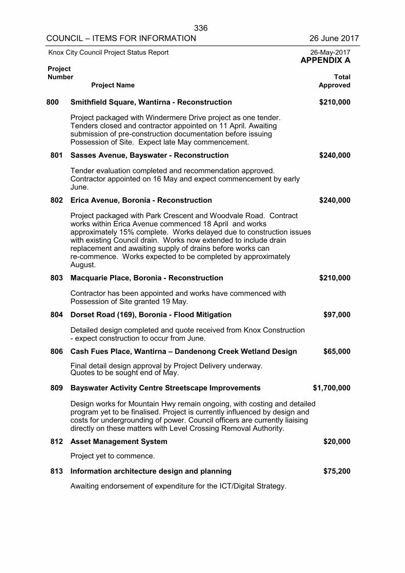
336 COUNCIL – ITEMS FOR INFORMATION 26 June 2017
Knox City Council Project Status Report 26-May-2017 APPENDIX A
Project Number Total
Project Name Approved
800 Smithfield Square, Wantirna - Reconstruction $210,000
Project packaged with Windermere Drive project as one tender. Tenders closed and contractor appointed on 11 April. Awaiting submission of pre-construction documentation before issuing Possession of Site. Expect late May commencement.
801 Sasses Avenue, Bayswater - Reconstruction $240,000
Tender evaluation completed and recommendation approved. Contractor appointed on 16 May and expect commencement by early June.
802 Erica Avenue, Boronia - Reconstruction $240,000
Project packaged with Park Crescent and Woodvale Road. Contract works within Erica Avenue commenced 18 April and works approximately 15% complete. Works delayed due to construction issues with existing Council drain. Works now extended to include drain replacement and awaiting supply of drains before works can re-commence. Works expected to be completed by approximately August.
803 Macquarie Place, Boronia - Reconstruction $210,000
Contractor has been appointed and works have commenced with Possession of Site granted 19 May.
804 Dorset Road (169), Boronia - Flood Mitigation $97,000
Detailed design completed and quote received from Knox Construction - expect construction to occur from June.
806 Cash Fues Place, Wantirna – Dandenong Creek Wetland Design $65,000
Final detail design approval by Project Delivery underway. Quotes to be sought end of May.
809 Bayswater Activity Centre Streetscape Improvements $1,700,000
Design works for Mountain Hwy remain ongoing, with costing and detailed program yet to be finalised. Project is currently influenced by design and costs for undergrounding of power. Council officers are currently liaising directly on these matters with Level Crossing Removal Authority.
812 Asset Management System $20,000
Project yet to commence.
813 Information architecture design and planning $75,200
Awaiting endorsement of expenditure for the ICT/Digital Strategy.
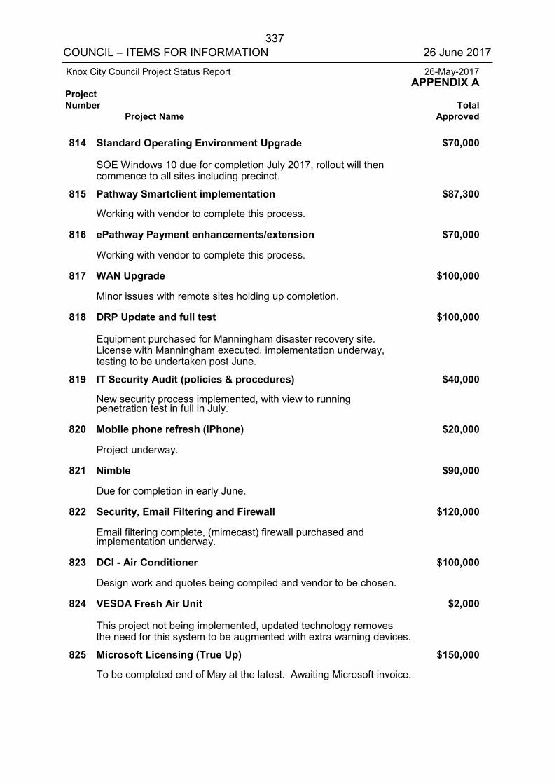
337 COUNCIL – ITEMS FOR INFORMATION 26 June 2017
Knox City Council Project Status Report 26-May-2017 APPENDIX A
Project Number Total
Project Name Approved
814 Standard Operating Environment Upgrade $70,000
SOE Windows 10 due for completion July 2017, rollout will then commence to all sites including precinct.
815 Pathway Smartclient implementation $87,300
Working with vendor to complete this process.
816 ePathway Payment enhancements/extension $70,000
Working with vendor to complete this process.
817 WAN Upgrade $100,000
Minor issues with remote sites holding up completion.
818 DRP Update and full test $100,000
Equipment purchased for Manningham disaster recovery site. License with Manningham executed, implementation underway, testing to be undertaken post June.
819 IT Security Audit (policies & procedures) $40,000
New security process implemented, with view to running penetration test in full in July.
820 Mobile phone refresh (iPhone) $20,000
Project underway.
821 Nimble $90,000
Due for completion in early June.
822 Security, Email Filtering and Firewall $120,000
Email filtering complete, (mimecast) firewall purchased and implementation underway.
823 DCI - Air Conditioner $100,000
Design work and quotes being compiled and vendor to be chosen.
824 VESDA Fresh Air Unit $2,000
This project not being implemented, updated technology removes the need for this system to be augmented with extra warning devices.
825 Microsoft Licensing (True Up) $150,000
To be completed end of May at the latest. Awaiting Microsoft invoice.
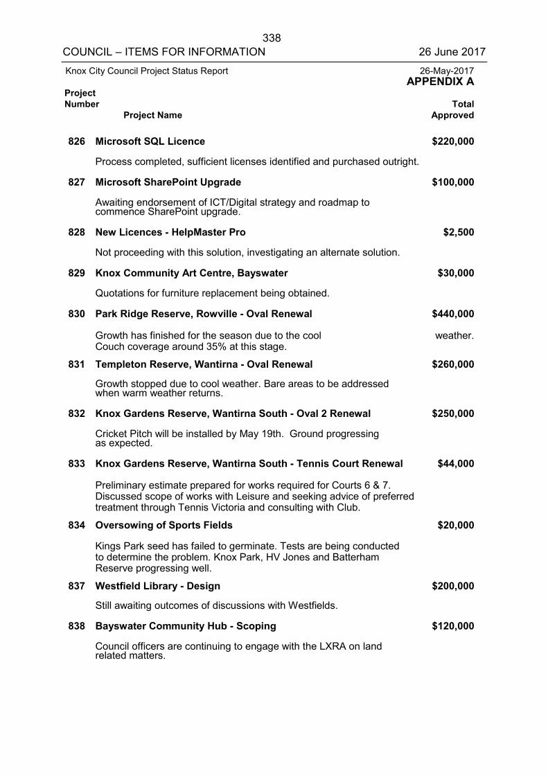
338 COUNCIL – ITEMS FOR INFORMATION 26 June 2017
Knox City Council Project Status Report 26-May-2017 APPENDIX A Project Number Total Project Name Approved
826 Microsoft SQL Licence $220,000 Process completed, sufficient licenses identified and purchased outright. 827 Microsoft SharePoint Upgrade $100,000 Awaiting endorsement of ICT/Digital strategy and roadmap to
commence SharePoint upgrade. 828 New Licences - HelpMaster Pro $2,500 Not proceeding with this solution, investigating an alternate solution. 829 Knox Community Art Centre, Bayswater $30,000 Quotations for furniture replacement being obtained. 830 Park Ridge Reserve, Rowville - Oval Renewal $440,000 Growth has finished for the season due to the cool weather.
Couch coverage around 35% at this stage. 831 Templeton Reserve, Wantirna - Oval Renewal $260,000 Growth stopped due to cool weather. Bare areas to be addressed
when warm weather returns. 832 Knox Gardens Reserve, Wantirna South - Oval 2 Renewal $250,000 Cricket Pitch will be installed by May 19th. Ground progressing
as expected. 833 Knox Gardens Reserve, Wantirna South - Tennis Court Renewal $44,000 Preliminary estimate prepared for works required for Courts 6 & 7.
Discussed scope of works with Leisure and seeking advice of preferred treatment through Tennis Victoria and consulting with Club.
834 Oversowing of Sports Fields $20,000 Kings Park seed has failed to germinate. Tests are being conducted
to determine the problem. Knox Park, HV Jones and Batterham Reserve progressing well.
837 Westfield Library - Design $200,000 Still awaiting outcomes of discussions with Westfields. 838 Bayswater Community Hub - Scoping $120,000 Council officers are continuing to engage with the LXRA on land
related matters.
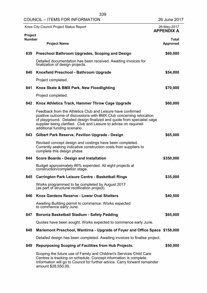
339 COUNCIL – ITEMS FOR INFORMATION 26 June 2017
Knox City Council Project Status Report 26-May-2017 APPENDIX A Project Number Total Project Name Approved
839 Preschool Bathroom Upgrades, Scoping and Design $60,000 Detailed documentation has been received. Awaiting invoices for
finalization of design projects. 840 Knoxfield Preschool - Bathroom Upgrade $54,000 Project completed. 841 Knox Skate & BMX Park, New Floodlighting $70,000 Project completed. 842 Knox Athletics Track, Hammer Throw Cage Upgrade $60,000 Feedback from the Athletics Club and Leisure have confirmed
positive outcome of discussions with BMX Club concerning relocation of playground. Detailed design finalized and quote from specialist cage supplier being clarified. Club and Leisure to advise on required additional funding scenario.
843 Gilbert Park Reserve, Pavilion Upgrade - Design $65,000 Revised concept design and costings have been completed.
Currently seeking indicative construction costs from suppliers to complete this design phase.
844 Score Boards - Design and Installation $350,000 Budget approximately 86% expended. All eight projects at
construction/completion stage. 845 Carrington Park Leisure Centre - Basketball Rings $35,000 Works programmed to be completed by August 2017
(as part of structural rectification project). 846 Knox Gardens Reserve - Lower Oval Shelters $40,500 Awaiting Building permit to commence. Works expected
to commence early June. 847 Boronia Basketball Stadium - Safety Padding $65,000 Quotes have been sought. Works expected to commence early June. 848 Mariemont Preschool, Wantirna - Upgrade of Foyer and Office Space $158,000 Detailed design has been completed. Awaiting invoices to finalise project. 849 Repurposing Scoping of Facilities from Hub Projects. $50,000 Scoping the future use of Family and Children's Services Child Care
Centres is tracking on schedule. Concept information is complete. Information will go to Council for further advice. Carry forward remainder amount $28,550.00.
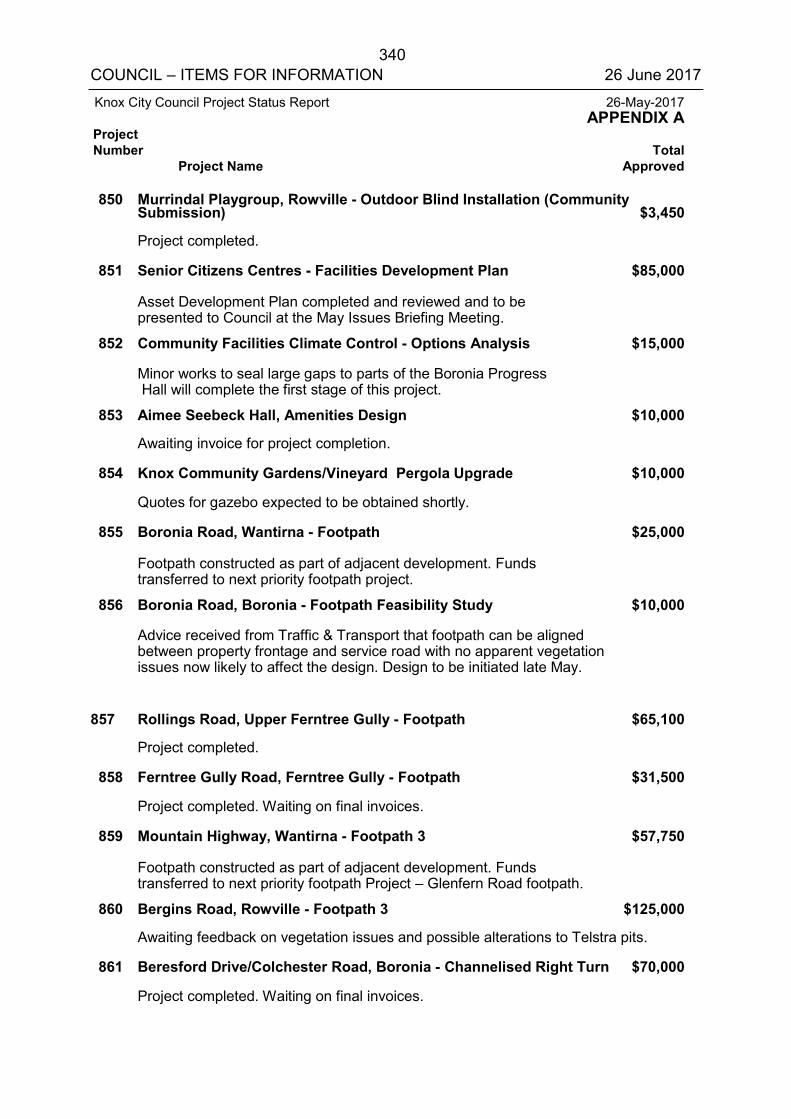
340 COUNCIL – ITEMS FOR INFORMATION 26 June 2017
Knox City Council Project Status Report 26-May-2017 APPENDIX A Project Number Total Project Name Approved
850 Murrindal Playgroup, Rowville - Outdoor Blind Installation (Community Submission) $3,450
Project completed. 851 Senior Citizens Centres - Facilities Development Plan $85,000 Asset Development Plan completed and reviewed and to be
presented to Council at the May Issues Briefing Meeting. 852 Community Facilities Climate Control - Options Analysis $15,000 Minor works to seal large gaps to parts of the Boronia Progress
Hall will complete the first stage of this project. 853 Aimee Seebeck Hall, Amenities Design $10,000 Awaiting invoice for project completion. 854 Knox Community Gardens/Vineyard Pergola Upgrade $10,000 Quotes for gazebo expected to be obtained shortly. 855 Boronia Road, Wantirna - Footpath $25,000 Footpath constructed as part of adjacent development. Funds
transferred to next priority footpath project. 856 Boronia Road, Boronia - Footpath Feasibility Study $10,000 Advice received from Traffic & Transport that footpath can be aligned
between property frontage and service road with no apparent vegetation issues now likely to affect the design. Design to be initiated late May.
857 Rollings Road, Upper Ferntree Gully - Footpath $65,100 Project completed. 858 Ferntree Gully Road, Ferntree Gully - Footpath $31,500 Project completed. Waiting on final invoices. 859 Mountain Highway, Wantirna - Footpath 3 $57,750 Footpath constructed as part of adjacent development. Funds
transferred to next priority footpath Project – Glenfern Road footpath. 860 Bergins Road, Rowville - Footpath 3 $125,000 Awaiting feedback on vegetation issues and possible alterations to Telstra pits. 861 Beresford Drive/Colchester Road, Boronia - Channelised Right Turn $70,000 Project completed. Waiting on final invoices.
341 COUNCIL – ITEMS FOR INFORMATION 26 June 2017
Knox City Council Project Status Report 26-May-2017 APPENDIX A Project Number Total Project Name Approved
862 Burwood Highway, Wantirna - Shared Path 2 - Design $10,000 Biodiversity consultant to be engaged to advise on vegetation and path alignment. 863 Fitzgerald Street, FTG - Streetlights $45,000 Light has now been installed. 864 Lakeside Boulevard, Rowville - Pedestrian Refuge $15,000 Project completed. Waiting on final invoices. 865 Mountain Highway, Boronia - Footpath Connection 2 $20,000 Project completed. 866 Ferntree Gully Village Square - Masterplan Implementation $100,000 Open Space is currently undertaking minor redesign of space, to restrict
proposed works to Council owned land. 867 Knox Regional Netball Centre, Ferntree Gully - Masterplan $55,000 Consultation to commence with stakeholders and local community in mid June. 868 H V Jones, Ferntree Gully Masterplan Implementation $45,000 Consultation to commence with stakeholders and local community in mid June. 869 Gilbert Park, Knoxfield - Masterplan Review $30,000 Feature survey completed mid-May. Amended Masterplan with
associated amended costing, is currently being prepared. 870 Ferntree Gully Stormwater Masterplan $20,000 Funds transferred to Dobsons-Clyde Street Flood Retarding System project. 871 Energy Performance Audit for Community Buildings $120,000 Contracts being finalised with the successful contractor.
Commencement has been delayed due to delays in sign-off timeframes in partner Councils. Project commencement has been delayed by 4 weeks.
874 Fulham Road, Rowville Reconstruction - Design $30,000 Geotech investigation and survey completed. Detailed design underway. 875 Parkhurst Drive, Knoxfield Reconstruction - Design $45,000 Geotech investigation and survey completed. Detailed design has commenced.
342 COUNCIL – ITEMS FOR INFORMATION 26 June 2017
Knox City Council Project Status Report 26-May-2017 APPENDIX A Project Number Total Project Name Approved
876 Eastgate Court, Wantirna South Reconstruction - Design $25,000 Design completed - questionnaire survey to assess business needs
underway with majority of survey responses returned. 877 Rosehill Street, Scoresby Reconstruction - Design $25,000 Geotech investigation and survey completed. Detailed design around
90% complete and now expected to be completed by early June. 878 Alma Avenue, Ferntree Gully Reconstruction - Design $25,000 Geotech investigation and survey completed with detailed design
underway and 50% complete. 879 Winwood Drive, Ferntree Gully Reconstruction - Design $25,000 Geotech investigation, survey and detailed design completed. Design review
completed and altering The Avenue intersection design following advice from Traffic & Transport.
880 Helene Court, Boronia Reconstruction - Design $25,000 Geotech investigation, survey and detailed design completed. Parks
agreed to remove significant eucalypt tree due to it causing damage to road infrastructure.
882 Knox Regional Football Centre Storage Shed $0 Project no longer proceeding as an alternative solution has been implemented. 883 Road Reconstruction Audit Works $1,160,000 Road reconstruction funding for audit priority works and to supplement
this year's Roads to Recovery funding shortfall. 884 Glenfern Road Ferntree Gully - Footpath $162,750 In progress. 885 Various Isolated Traffic Treatments $70,000 The ITT works are all complete. 886 Schultz Reserve - Internal Pavilion Upgrades (Female Friendly) $100,000 Council allocated funding to this project at its December, 2016 meeting
to match State Government Community Sports Infrastructure 2017/2018 funding.
887 Knox Regional Sports Park Signage - Design $13,500 Project completed.
343 COUNCIL – ITEMS FOR INFORMATION 26 June 2017
Knox City Council Project Status Report 26-May-2017 APPENDIX A Project Number Total Project Name Approved
888 Batterham Reserve Floodlighting Upgrade $200,000 Addition of new project as part of Community Development Grants
Programme following election commitments made prior to last year’s federal election. Works to be completed in the 2017/2018 Capital Works Program.
889 Wally Tew Reserve Floodlighting Upgrade $200,000 Addition of new project as part of Community Development Grants
Programme following election commitment made prior to last year's federal election. Works to be completed in the 2017/18 capital works program
891 Henderson Road Bridge - Preconstruction $75,000 Investigation works in progress on environmental studies and traffic study. 907 Construction of Council's section of JW Manson Reserve
WSUD system $255,500 Funding for resource, design and construction provided by Melbourne
Water. Design underway. Design scheduled to be completed by 30 June. Total: $74,490,636
344 COUNCIL – ITEMS FOR INFORMATION 26 June 2017
ALL WARDS
11.2 ASSEMBLIES OF COUNCILLORS
SUMMARY: Manager – Governance and Innovation (Fleur Cousins)
This report provides details of Assembly of Councillors established under section 80A of the Local Government Act as required under section 80A(2) of the Act.
RECOMMENDATION
That Council
1. Note the written record of Assemblies of Councillors as attached tothis report.
2. Incorporate the records of the Assemblies into the minutes of themeeting.
1. INTRODUCTION
Under section 80A(2) of the Local Government Act, the Chief Executive Officer must present a written record of an Assembly of Councillors to an ordinary meeting of Council as soon as practicable after an Assembly occurs. This written record is required to be incorporated into the minutes of the meeting.
Details of Assemblies of Councillors that have occurred between Monday 8 May 2017 and Sunday 11 June 2017 are attached to this report.
Report Prepared By: Manager – Governance and Innovation (Fleur Cousins)
Report Authorised By: Acting Director – Corporate Development (Kim Rawlings)
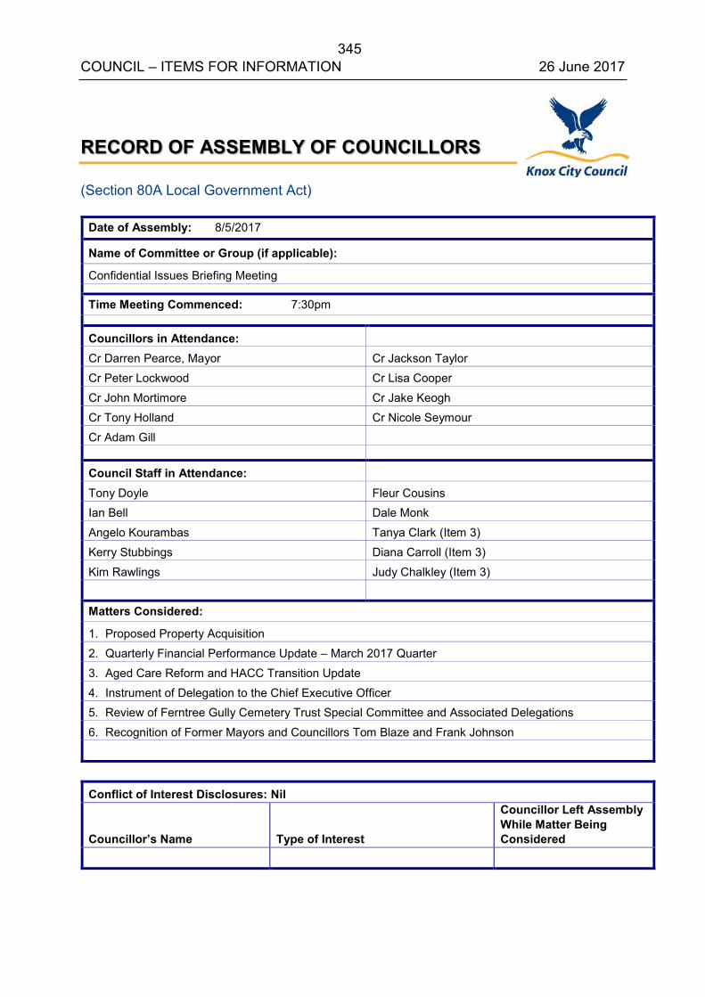
345 COUNCIL – ITEMS FOR INFORMATION 26 June 2017
RECORD OF ASSEMBLY OF COUNCILLORS
(Section 80A Local Government Act)
Date of Assembly: 8/5/2017
Name of Committee or Group (if applicable):
Confidential Issues Briefing Meeting
Time Meeting Commenced: 7:30pm
Councillors in Attendance: Cr Darren Pearce, Mayor Cr Jackson Taylor
Cr Peter Lockwood Cr Lisa Cooper
Cr John Mortimore Cr Jake Keogh
Cr Tony Holland Cr Nicole Seymour
Cr Adam Gill
Council Staff in Attendance: Tony Doyle Fleur Cousins Ian Bell Dale Monk
Angelo Kourambas Tanya Clark (Item 3)
Kerry Stubbings Diana Carroll (Item 3)
Kim Rawlings Judy Chalkley (Item 3)
Matters Considered:
1. Proposed Property Acquisition
2. Quarterly Financial Performance Update – March 2017 Quarter
3. Aged Care Reform and HACC Transition Update
4. Instrument of Delegation to the Chief Executive Officer5. Review of Ferntree Gully Cemetery Trust Special Committee and Associated Delegations
6. Recognition of Former Mayors and Councillors Tom Blaze and Frank Johnson
Conflict of Interest Disclosures: Nil
Councillor’s Name Type of Interest
Councillor Left Assembly While Matter Being Considered

346 COUNCIL – ITEMS FOR INFORMATION 26 June 2017
RECORD OF ASSEMBLY OF COUNCILLORS (Section 80A Local Government Act)
Date of Assembly: 9/5/2017
Name of Committee or Group (if applicable):
Knox Central Advisory Committee
Time Meeting Commenced: 1:30pm
Councillors in Attendance:
Cr Darren Pearce, Mayor Cr Jackson Taylor
Cr Peter Lockwood Cr Lisa Cooper
Cr Tony Holland Cr Jake Keogh
Council Staff in Attendance:
Angelo Kourambas
Samantha Mazer
Tony Doyle Nicole Vickridge
Matters Considered:
Status of Knox Central Project including the new Operation Centre and Knox Central Structure Plan and Amendment C149.
Conflict of Interest Disclosures: Nil Councillor’s Name
Type of Interest
Councillor Left Assembly While Matter Being Considered
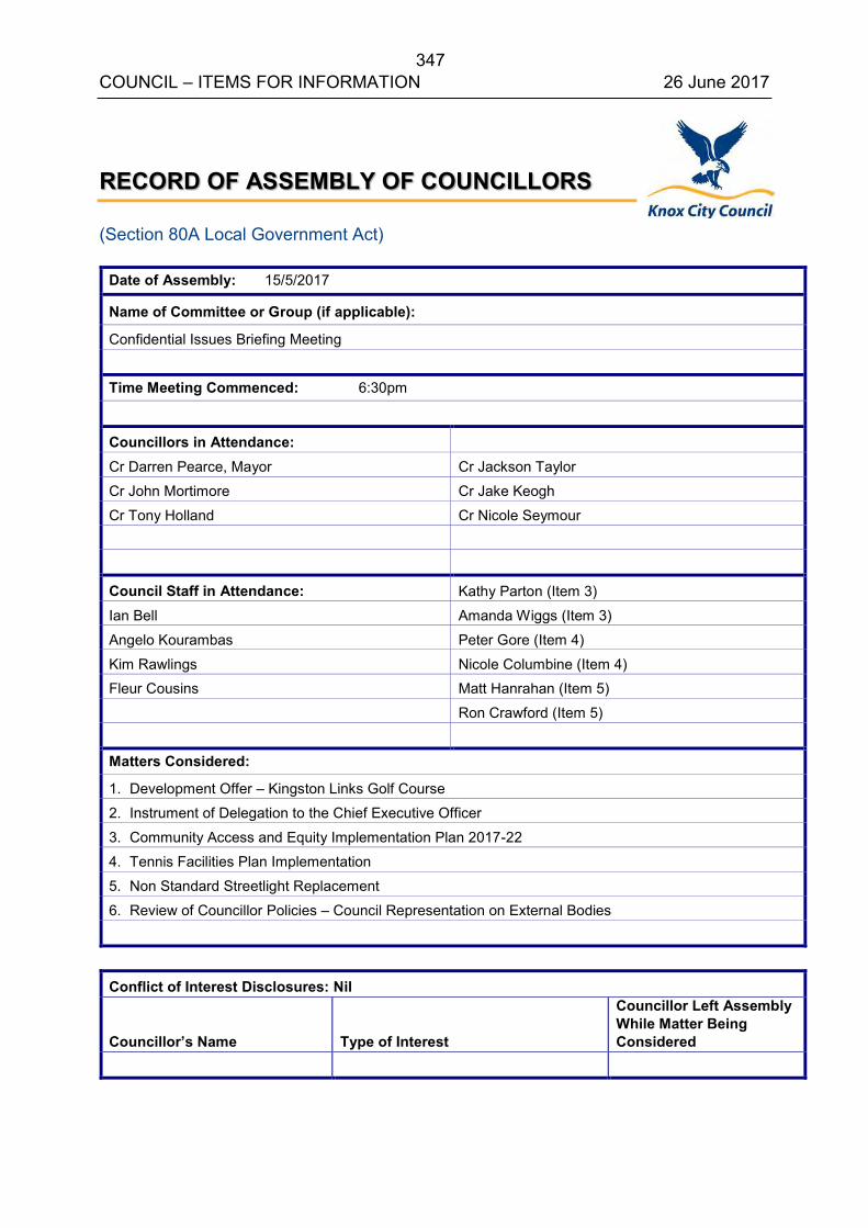
347 COUNCIL – ITEMS FOR INFORMATION 26 June 2017
RECORD OF ASSEMBLY OF COUNCILLORS (Section 80A Local Government Act)
Date of Assembly: 15/5/2017
Name of Committee or Group (if applicable):
Confidential Issues Briefing Meeting
Time Meeting Commenced: 6:30pm
Councillors in Attendance:
Cr Darren Pearce, Mayor Cr Jackson Taylor
Cr John Mortimore Cr Jake Keogh
Cr Tony Holland Cr Nicole Seymour
Council Staff in Attendance: Kathy Parton (Item 3)
Ian Bell Amanda Wiggs (Item 3)
Angelo Kourambas Peter Gore (Item 4)
Kim Rawlings Nicole Columbine (Item 4) Fleur Cousins Matt Hanrahan (Item 5)
Ron Crawford (Item 5)
Matters Considered:
1. Development Offer – Kingston Links Golf Course
2. Instrument of Delegation to the Chief Executive Officer
3. Community Access and Equity Implementation Plan 2017-22
4. Tennis Facilities Plan Implementation
5. Non Standard Streetlight Replacement
6. Review of Councillor Policies – Council Representation on External Bodies
Conflict of Interest Disclosures: Nil Councillor’s Name
Type of Interest
Councillor Left Assembly While Matter Being Considered
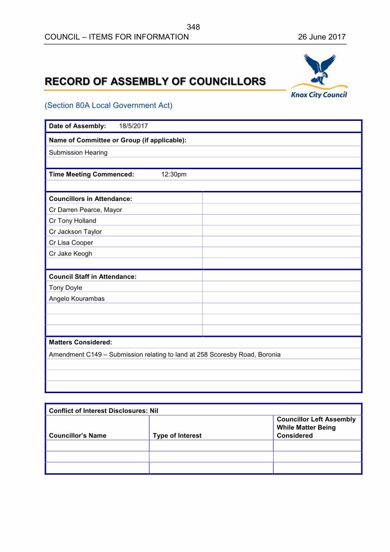
348 COUNCIL – ITEMS FOR INFORMATION 26 June 2017
RECORD OF ASSEMBLY OF COUNCILLORS (Section 80A Local Government Act)
Date of Assembly: 18/5/2017
Name of Committee or Group (if applicable):
Submission Hearing
Time Meeting Commenced: 12:30pm
Councillors in Attendance:
Cr Darren Pearce, Mayor
Cr Tony Holland
Cr Jackson Taylor
Cr Lisa Cooper
Cr Jake Keogh
Council Staff in Attendance:
Tony Doyle
Angelo Kourambas
Matters Considered:
Amendment C149 – Submission relating to land at 258 Scoresby Road, Boronia
Conflict of Interest Disclosures: Nil Councillor’s Name
Type of Interest
Councillor Left Assembly While Matter Being Considered
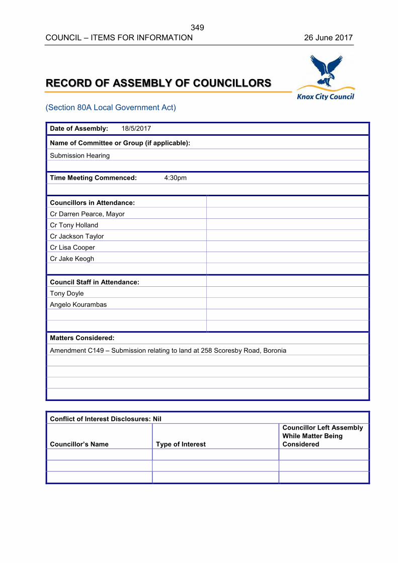
349 COUNCIL – ITEMS FOR INFORMATION 26 June 2017
RECORD OF ASSEMBLY OF COUNCILLORS (Section 80A Local Government Act)
Date of Assembly: 18/5/2017
Name of Committee or Group (if applicable):
Submission Hearing
Time Meeting Commenced: 4:30pm
Councillors in Attendance:
Cr Darren Pearce, Mayor
Cr Tony Holland
Cr Jackson Taylor
Cr Lisa Cooper
Cr Jake Keogh
Council Staff in Attendance:
Tony Doyle
Angelo Kourambas
Matters Considered:
Amendment C149 – Submission relating to land at 258 Scoresby Road, Boronia
Conflict of Interest Disclosures: Nil Councillor’s Name
Type of Interest
Councillor Left Assembly While Matter Being Considered

350 COUNCIL – ITEMS FOR INFORMATION 26 June 2017
RECORD OF ASSEMBLY OF COUNCILLORS
(Section 80A Local Government Act)
Date of Assembly: 22/5/2017
Name of Committee or Group (if applicable):
Knox Central Advisory Committee
Time Meeting Commenced: 1:30pm
Councillors in Attendance: Cr Darren Pearce, Mayor Cr Jackson Taylor
Cr Peter Lockwood Cr Lisa Cooper
Cr Tony Holland Cr Jake Keogh
Council Staff in Attendance: Angelo Kourambas
Samantha Mazer
Tony Doyle Nicole Vickridge
Matters Considered:
Status of Planning Scheme Amendment C149 and Panel Hearing.
Conflict of Interest Disclosures: Nil
Councillor’s Name Type of Interest
Councillor Left Assembly While Matter Being Considered
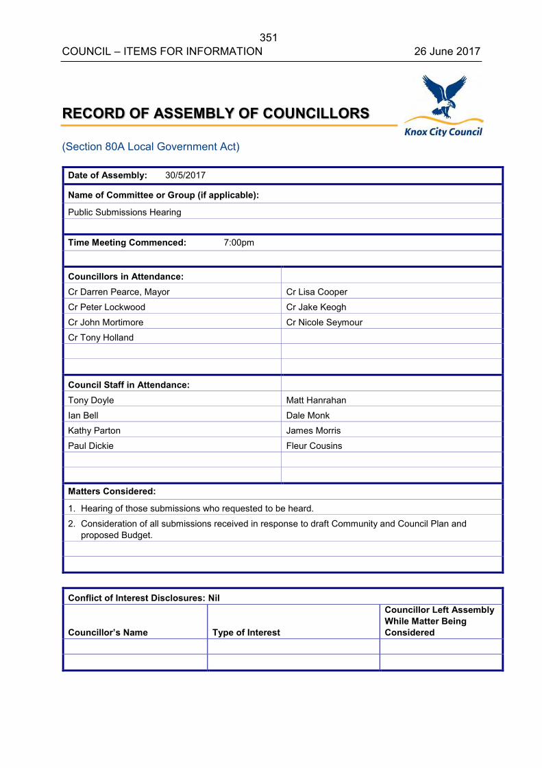
351 COUNCIL – ITEMS FOR INFORMATION 26 June 2017
RECORD OF ASSEMBLY OF COUNCILLORS (Section 80A Local Government Act)
Date of Assembly: 30/5/2017
Name of Committee or Group (if applicable):
Public Submissions Hearing
Time Meeting Commenced: 7:00pm
Councillors in Attendance:
Cr Darren Pearce, Mayor Cr Lisa Cooper
Cr Peter Lockwood Cr Jake Keogh
Cr John Mortimore Cr Nicole Seymour
Cr Tony Holland
Council Staff in Attendance:
Tony Doyle Matt Hanrahan
Ian Bell Dale Monk Kathy Parton James Morris
Paul Dickie Fleur Cousins
Matters Considered:
1. Hearing of those submissions who requested to be heard.
2. Consideration of all submissions received in response to draft Community and Council Plan and proposed Budget.
Conflict of Interest Disclosures: Nil Councillor’s Name
Type of Interest
Councillor Left Assembly While Matter Being Considered
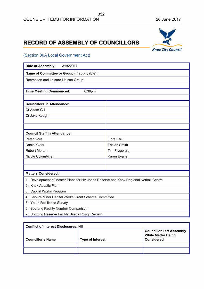
352 COUNCIL – ITEMS FOR INFORMATION 26 June 2017
RECORD OF ASSEMBLY OF COUNCILLORS (Section 80A Local Government Act)
Date of Assembly: 31/5/2017
Name of Committee or Group (if applicable):
Recreation and Leisure Liaison Group
Time Meeting Commenced: 6:30pm
Councillors in Attendance:
Cr Adam Gill
Cr Jake Keogh
Council Staff in Attendance:
Peter Gore Flora Lau
Daniel Clark Tristan Smith
Robert Morton Tim Fitzgerald
Nicole Columbine Karen Evans
Matters Considered:
1. Development of Master Plans for HV Jones Reserve and Knox Regional Netball Centre 2. Knox Aquatic Plan
3. Capital Works Program
4. Leisure Minor Capital Works Grant Scheme Committee
5. Youth Resilience Survey
6. Sporting Facility Number Comparison
7. Sporting Reserve Facility Usage Policy Review
Conflict of Interest Disclosures: Nil Councillor’s Name
Type of Interest
Councillor Left Assembly While Matter Being Considered
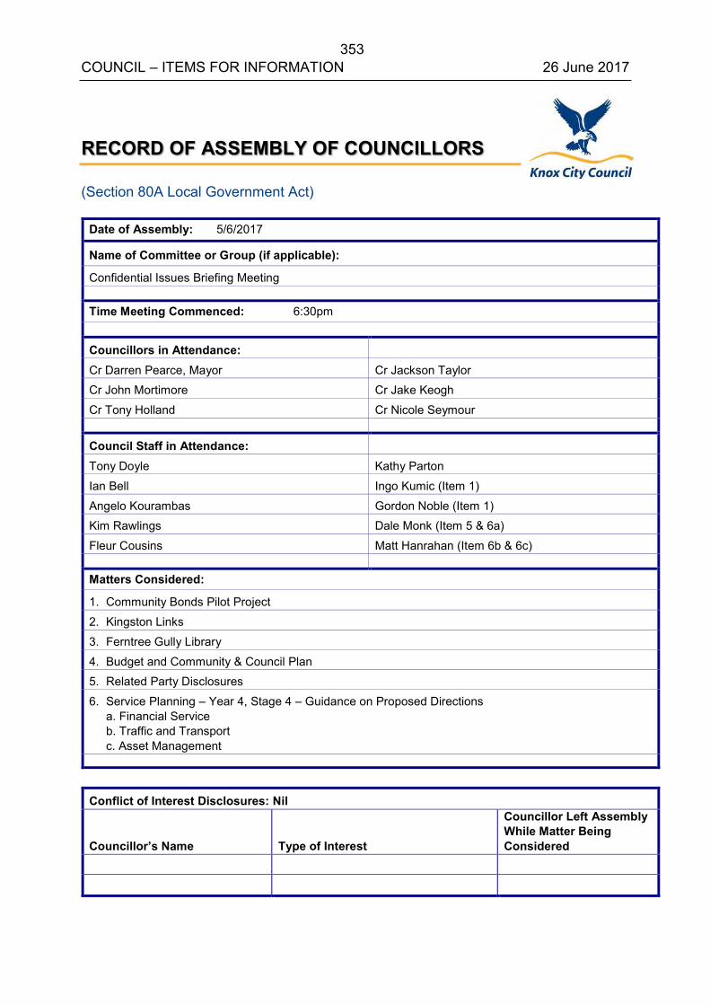
353 COUNCIL – ITEMS FOR INFORMATION 26 June 2017
RECORD OF ASSEMBLY OF COUNCILLORS (Section 80A Local Government Act)
Date of Assembly: 5/6/2017
Name of Committee or Group (if applicable):
Confidential Issues Briefing Meeting
Time Meeting Commenced: 6:30pm
Councillors in Attendance: Cr Darren Pearce, Mayor Cr Jackson Taylor Cr John Mortimore Cr Jake Keogh
Cr Tony Holland Cr Nicole Seymour
Council Staff in Attendance:
Tony Doyle Kathy Parton
Ian Bell Ingo Kumic (Item 1)
Angelo Kourambas Gordon Noble (Item 1) Kim Rawlings Dale Monk (Item 5 & 6a)
Fleur Cousins Matt Hanrahan (Item 6b & 6c)
Matters Considered:
1. Community Bonds Pilot Project
2. Kingston Links
3. Ferntree Gully Library
4. Budget and Community & Council Plan 5. Related Party Disclosures
6. Service Planning – Year 4, Stage 4 – Guidance on Proposed Directions a. Financial Service b. Traffic and Transport c. Asset Management
Conflict of Interest Disclosures: Nil Councillor’s Name
Type of Interest
Councillor Left Assembly While Matter Being Considered
354 COUNCIL 26 June 2017
12. MOTIONS FOR WHICH NOTICE HAS PREVIOUSLY BEEN GIVEN
13. SUPPLEMENTARY ITEMS
13.1 AMENDMENT C142 – KINGSTON LINKS GOLF COURSE
13.2 REVIEW OF MAYORAL AND COUNCILLORS ALLOWANCE
14. URGENT BUSINESS
14.1 URGENT BUSINESS
14.2 CALL UP ITEMS
15. QUESTIONS WITHOUT NOTICE