Reports for the Trust Board (Part 1) On 3 June 2015 Agenda ...
Upload
khangminh22Category
view
0download
0

FLINDERS REGIONAL DEVELOPMENT ASSESSMENT PANEL
AGENDA
Version Number Issued : Next Review GDS
1 24 Jun 2016 9.14.1 Page 2 of 6
AGENDA & REPORTS
FOR THE MEETING BEING HELD FRIDAY 24TH JUNE 2016 AT 9.30AM
1. PRESENT: 2. APOLOGIES: 3. DECLARATIONS OF INTEREST: 4. CONFIRMATION OF MINUTES: 4.1 ORDINARY MEETING - Held 11th April 2016 A copy of the Minutes from the Meeting (as previously circulated) are attached for the
reference of Panel Members. Recommendation: That the Minutes of the Ordinary Meeting of the Flinders Regional Development
Assessment Panel held on 11th April 2016 as circulated, be confirmed. 5. BUSINESS ARISING FROM MINUTES:

FLINDERS REGIONAL DEVELOPMENT ASSESSMENT PANEL
MINUTES
Version Number Issued : Next Review GDS
1 11 Apr 2016 9.14.1 Page 1 of 10
MINUTES
MEETING BEING HELD MONDAY 11TH APRIL 2016 AT 11.40AM IN THE MEETING ROOM, TOWN HALL,
108 MAIN STREET, PETERBOROUGH, SA 5422 1. PRESENT:
Members: Ms Shanti Ditter (Presiding Member);
Cr Garry Thompson; Cr Ralph Goehring;
Cr Frank Hardbottle & Cr Colin Nottle
In Attendance: Mr Peter McGuiness (Public Officer);
Mr David Hutchison (Planning Consultant, Access Planning); Mr Lawrence Heath (Dev & Reg Services Officer, DCP); Ms Sally Kent (Minute Secretary)
Members of the Public: Mr Graeme Woods (Applicant – G Woods) Mr Conor Evans (Applicant – C Evans)
2. APOLOGIES: NIL Presiding Member, Ms Ditter explained to the gallery that the Panel Members had undergone a site visit in respect of the Peterborough application prior to the meeting, and apologised for the late start of the meeting. 3. DECLARATIONS OF INTEREST: NIL 4. CONFIRMATION OF MINUTES: 4.1 ORDINARY MEETING - Held 23rd November 2015 Moved Cr G Thompson Seconded Cr F Hardbottle
That the Minutes of the Ordinary Meeting of the Flinders Regional Development Assessment Panel held on 23rd November 2015 as circulated, be confirmed.
CARRIED 5. BUSINESS ARISING FROM MINUTES: NIL

FLINDERS REGIONAL DEVELOPMENT ASSESSMENT PANEL
MINUTES
Version Number Issued : Next Review GDS
1 11 Apr 2016 9.14.1 Page 2 of 10
6. APPLICATIONS FOR CONSIDERATION:
6.1 THE DISTRICT COUNCIL OF MOUNT REMARKABLE
6.1.1 DA 830/106/15 – Conor Evans – Bicarbonate Sodium Blasting Details of the application for an industrial development (Bicarbonate Sodium blasting) at 555 (Lot 750) Forest Road, Wirrabara were included in the Agenda papers for the meeting. Ms Ditter asked the Planning Consultant, David Hutchison, if he would like to add anything further to the proposal. Mr Hutchison explained that the application was straight forward and everything had been dealt with in the report with nothing to add. Panel Members had no questions for the Planning Consultant or Applicant. Ms Ditter asked the Applicant if he was confident in meeting the conditions of the report, to which he replied he was and would be taking the suggestions on board. He has a good relationship with his neighbours and was not aware of any concerns or objections. The Applicant added that he is a qualified paint sprayer, but was not planning on offering any other services at present, only what the development application was relating to. Moved Cr F Hardbottle Seconded Cr C Nottle That Development Application 830/106/15 for an industrial development (Bicarbonate Sodium blasting) at 555 (Lot 750) Forest Road, Wirrabara is not seriously at variance with the District Council of Mount Remarkable’s Development Plan, Consolidated 5th September 2013. and That Council Grant Development Plan Consent to Development Application 830/106/15 for an industrial development (Bicarbonate Sodium blasting) at 555 (Lot 750) Forest Road, Wirrabara subject to the following conditions: 1. That except where minor amendments may be required by other relevant Acts, or by the
conditions imposed on this consent, the development shall proceed in accordance with the plans and details submitted with and forming part of Development Application No. 830/106/15.
2. A landscaping plan shall be submitted to Council which provides screening around the
building to the satisfaction of Council. 3. Amended plans shall be provided which indicate materials of the rear wall and doors of the
blasting booth and location of air/dust extraction unit. 4. The building, including shipping containers, shall be painted or otherwise finished in dull or
natural muted colour (such as pale green, brown or grey) to satisfaction of Council. 5. All construction work is to be carried out to the satisfaction of Council at all times.

FLINDERS REGIONAL DEVELOPMENT ASSESSMENT PANEL
MINUTES
Version Number Issued : Next Review GDS
1 11 Apr 2016 9.14.1 Page 3 of 10
EPA Directed Conditions 6. All abrasive blasting must be carried out within the confines of the abrasive blasting booth. 7. Spray painting must not occur onsite, any primer/base coat must be applied by brush or roller
prior to a fresh development application is submitted for a spray booth. 8. Lead based, mercurious or anti-fouling coatings must not be abrasive blasted on-site unless
appropriate test kits, hepafilter (and other specialised equipment) and a waste segregation system has been authorised by a future EPA licence.
9. Air extraction systems for the abrasive blasting booth must be capable of limiting particulate
emissions from the booth to less than 250mg/Nm3. 10. Exhaust air from the abrasive blasting booth extraction system must be directed to a flue
terminating not less than three metres above the highest structure within a 30-metre radius. 11. Discharge from the abrasive blasting booth must be vertical and unimpeded by any conical
type rain protector. Exhaust velocities must be greater than ten metres per second. The following notes provide important information for the benefit of the applicant and are requested to be included in the approval:
The applicant is reminded of its general environmental duty, as required by Section 25 of the Environment Protection Act, to take all reasonable and practicable measures to ensure that the activities on the whole site, including during construction, do not pollute the environment in a way which causes or may cause environmental harm.
An environmental authorisation in the form of a licence is required for the operation of this development. The applicant is required to contact the Environment Protection Authority before acting on this approval to ascertain licensing requirements.
A licence may be refused where the applicant has failed to comply with any conditions of development approval imposed at the direction of the Environment Protection Authority.
EPA information sheets, guidelines documents, codes of practice, technical bulletins etc can be accessed on the following web site: http://www.epa.sa.gov.au
CARRIED

FLINDERS REGIONAL DEVELOPMENT ASSESSMENT PANEL
MINUTES
Version Number Issued : Next Review GDS
1 11 Apr 2016 9.14.1 Page 4 of 10
6.1.2 DA 830/086/15 – Aurecon Australia Pty Ltd – NBN telecommunication facility Details of the application for a telecommunications facility comprising a 25 metre high monopole with a circular headframe, antennas and associated infrastructure and fencing at Lot 3 Government Road, Port Germein were included in the Agenda papers for the meeting. Ms Ditter asked the Planning Consultant, David Hutchison, if he would like to add anything further to the report. Mr Hutchison explained that the application was straight forward; the only area of concern during the submission was the soil at the site, and the longevity and strength of the concrete for the structure which had been addressed, so there was nothing to add. Panel Members had no questions for the Planning Consultant.
Moved Cr G Thompson Seconded Cr C Nottle That Development Application 830/086/15 for a telecommunications facility comprising a 25 metre high monopole with a circular headframe, antennas and associated infrastructure and fencing at Lot 3 Government Road, Port Germein SA 5495 is not seriously at variance with the provisions of the District Council of Mount Remarkable’s Development Plan, Consolidated 5th September 2013. That Council Grant Development Plan Consent to Development Application 830/086/15 for a telecommunications facility comprising a 25 metre high monopole with a circular headframe, antennas and associated infrastructure and fencing at Lot 3 Government Road, Port Germein SA 5495 subject to the following conditions: 1. Except where minor amendments may be required by other relevant Acts, or by conditions
imposed by this application, the development shall be established in strict accordance with the details and plans submitted with and forming part of Development Application No. 830/086/15.
2. The antennas affixed to the monopole shall be painted or otherwise finished in a dull, flat
grey colour such as cadet grey or similar. 3. All construction work is to be carried out to the satisfaction of Council at all times.
CARRIED

FLINDERS REGIONAL DEVELOPMENT ASSESSMENT PANEL
MINUTES
Version Number Issued : Next Review GDS
1 11 Apr 2016 9.14.1 Page 5 of 10
6.2 DISTRICT COUNCIL OF PETERBOROUGH 6.2.1 DA 504/015/15 – Graeme Woods – Horse Keeping Details of the application for the keeping of up to 9 horses on land comprising sections 392 and 395, number 113 Victoria Street, Peterborough were included in the Agenda papers for the meeting. An inspection of the area was undertaken by Panel Members prior to the meeting at 11.10am. Planning Consultant, David Hutchison of Access Planning was on-site to provide advice on the proposal to Members, along with Mr Graeme Woods the Applicant. Mr Woods explained the background to the purchase of the property by his wife in the 1990s and the operation they have been running as a Quarter Horse Stud between 113 Victoria Street, acreage out of town, and other properties in the area. He explained that the mares were brought to the site for foaling, and are then taken back out to their rural site after a couple of days once the foals have been monitored. They are then brought back at a later date when the foal needs to be weaned from its mother. They have between 2 and 3 stallions usually on site. The Applicant explained that they also run live stock, and heifers can be brought to the site if they need assistance with calving. Discussions were then had in relation to grass and pasture cover, along with vermin control and storage of feed. When asked about the number of horses on site, and whether the foals were included in the count, the Applicant was unsure of the ruling of this, and would like clarification. It was also added that the Applicant’s daughter is interested in the field of ‘breaking-in’ horses, and has her own ‘riding’ horses, which are kept on site or at their rural property. The Applicant was asked why they had applied to keep 9 horses on site, especially as they usually have and want more than that, and he explained that he was told this was the limit set in the 1990s when there had been issues with neighbours, but this was when there were other animals on the property including free-range chickens and sheep. He understood that this was the figure which needed to be worked with, but obviously would like more if possible. The site visit concluded at 11.30am and discussions resumed during the meeting. Ms Ditter explained to the Applicant that the Planning Consultant, David Hutchison, had prepared a report for the Members, and thanked him for showing the Panel around the property. Ms Ditter then asked the Members for their comments. Cr G Thompson mentioned that a lot of work needed to be done to meet the numerous conditions and asked if the Applicant had seen the list of conditions, which he had not, so was handed a copy at that point. Ms Ditter asked the District Council of Peterborough CEO how confident he was of policing and enforcing the conditions, due to the number of them, and mentioned that they are enforceable with penalties applicable if not complied with. Council replied they are capable of enforcing the conditions, and the Applicant added that they will endeavour to meet the conditions. Cr F Hardbottle asked whether having a cow on site was included in the conditions and whether it should be there.

FLINDERS REGIONAL DEVELOPMENT ASSESSMENT PANEL
MINUTES
Version Number Issued : Next Review GDS
1 11 Apr 2016 9.14.1 Page 6 of 10
Further discussions were also had in regard to adhering to the rules and regulations and keeping to the conditions, the number of horses kept on site including the foals, the management of the paddocks including coverage, and the proximity to neighbouring dwellings. Councillors G Thompson and C Nottle both acknowledged that Peterborough is a rural town, and the property is on the edge of town, and that it would be a shame to discourage horse keeping in such an area, especially as the horses seen today appeared to be well fed and cared for. However, they did have concern for the management of the paddocks with very little rainfall in Peterborough. The Planning Consultant, David Hutchison, then made a suggestion of giving consent for a period of 12 months to see if the conditions were manageable. The Applicant was then asked if he had had a chance to read the conditions of the report, which he replied only briefly, so the Presiding Member Ms Ditter suggested moving to the next item of the Agenda in order to give the Applicant 10 minutes to do so.

FLINDERS REGIONAL DEVELOPMENT ASSESSMENT PANEL
MINUTES
Version Number Issued : Next Review GDS
1 11 Apr 2016 9.14.1 Page 7 of 10
6.3 DISTRICT COUNCIL OF ORROROO CARRIETON
6.3.1 DA 502/019/15 – NBN Co Pty Ltd – NBN fixed wireless telecommunications facility
An inspection of the area at lot 4 FP160952 Orroroo – 24 Fourth Street was undertaken by Panel Members prior to the previous FRDAP meeting on 23rd November 2015, in addition to three different vantage points, where Planning Consultant, Mr David Hutchison of Access Planning was on-site to provide advice on the proposal to Members. The Planning Consultant’s report from the previous meeting for the application a fixed wireless telecommunications facility comprising a 40 metre high monopole, antennas and associated infrastructure at lot 4 FP160952 Orroroo – 24 Fourth Street were included in the Agenda papers for the meeting. A copy of the Applicant’s response to the deferred decision and Mr Hutchison’s subsequent report were also included in the Agenda papers for the meeting. Ms Ditter informed the Panel that the Applicant Adam Pfitzner was unfortunately able to attend due to late notice and prior-scheduled commitments. Planning Consultant David Hutchison informed the Panel that the Applicant had been in contact with the land owners at the Viterra site since the previous FRDAP meeting and they were in negotiations about a lease. Ms Ditter explained to the Panel that they had deferred their decision previously in order to await additional information on the impact of the Orroroo Airport on the siting of the tower, which had not been forthcoming, and that they need to advise Council if they are going to withdraw their current application and submit a new one for the Viterra site. Ms Ditter went on to clarify with the Panel that they could not review their previous decision, or indeed conduct a straw poll, as the Applicant had not supplied the information which was requested. Moved Cr F Hardbottle Seconded Cr G Thompson That the Panel send a letter to NBN Co explaining the Panel’s position on their current site application and advise that they have no particular preference for the type of structure necessary to support the NBN facility if one were to be erected on the Viterra land at Orroroo.
CARRIED

FLINDERS REGIONAL DEVELOPMENT ASSESSMENT PANEL
MINUTES
Version Number Issued : Next Review GDS
1 11 Apr 2016 9.14.1 Page 8 of 10
6.2.1 DA 504/015/15 – Graeme Woods – Horse Keeping Continued … The Presiding Member Ms Ditter asked the Applicant if he had had a chance to read the conditions and what his thoughts were regarding them. The Applicant said that he believed most of them were reasonably achievable except for points 3, 4 and 5, which were in relation to the pasture vegetation, and because the property is north of Goyder’s Line it would be very difficult and largely dependent on the seasons. Regarding points 17 and 18, he was not sure that a wash-down area was required, as it would be very rarely used. Ms Ditter asked the Applicant that if the Panel were to give consent for a period of 12 months, would he be willing to work towards this, to which the Applicant replied yes because it would give them the opportunity to work to these conditions. It was then explained to the Applicant that it would be his responsibility to seek consent for his application, at the end of the 12 months, but that this would need to be done at least one to two months prior to the finish date, to enable the Panel time to meet. Moved Cr G Thompson Seconded Cr R Goehring That Council Grant Development Planning Consent to Development Application 504/015/15 for the keeping of up to 9 horses on land comprising sections 392 and 395, number 113 Victoria Street, Peterborough, for a temporary period of 12 months from the date of the consent, subject to the following conditions:
1. Except as varied by these conditions, the development shall be undertaken in accord with the information contained in the application documents.
2. The subject land and all improvements and fixtures thereon shall be maintained in a good, orderly and serviceable condition at all times to the reasonable satisfaction of the Council.
3. Each year prior to winter the paddocks marked 1, 2, 3 and 5 on the approved plan shall be contour ploughed and, as required, be over sown with suitable winter grass to maintain pasture cover and minimise water runoff.
4. Pasture cover shall be maintained by resting paddocks, through weed control, the irrigation and fertilisation of pasture as required.
5. Paddocks shall be rested when the pasture gets down to 4cm in height, or when pasture cover is below 70%.
6. Horse shelters shall be provided to each paddock in accordance with the approved plans, such shelters to be constructed within 6 months of the date of the consent hereby granted.
7. Landscaping shall be established in accordance with the approved plans utilising Atriplex nummularia (Old Man Saltbush) as the principal species, but shall be interspersed with suitable native shade trees endemic to the locality at regular intervals.
8. Landscaping as required in condition 7 above and as depicted in the approved plans shall be fully established within 12 months of the consent being granted.
9. The landscaping referred to in condition 8 hereof shall be maintained in good heart and condition at all times, with dead, diseased or dying plants being replaced as necessary, to the reasonable satisfaction of Council.

FLINDERS REGIONAL DEVELOPMENT ASSESSMENT PANEL
MINUTES
Version Number Issued : Next Review GDS
1 11 Apr 2016 9.14.1 Page 9 of 10
10. The street boundary to yards 9 and 10 shall be fenced with appropriate solid sheet metal or timber fencing to a height of at least 1.5m, such work to be undertaken within 6 months of the date of this consent.
11. Stables and horse yards less than 100m2 in area shall have a base of 10cm of compacted rubble or dolomite topped with 15cm of sand, shell grit or sand woodchip mix.
12. Litter from the floor of stables and yards shall be collected regularly as required but will be undertaken at least weekly and the material disposed of along with manure.
13. All horse feed and/or fodder shall be stored in vermin proof containers.
14. Manure and soiled litter shall be collected daily and stored in sealed containers with a fly proof lid which shall be kept closed at all times except when manure is being deposited or removed from the manure bin, or for the purposes of cleaning the manure bin.
15. Manure and litter shall be removed from the land every 2 to 3 days or more regularly as required.
16. Manure bins shall be washed out once week.
17. The proposed wash-down area shall be established with 3 months of the date of this consent.
18. The wash-down area shall be drained to a soakage pit, which shall be cleaned from time to time as required to maintain appropriate soakage and to minimise fly and vermin breeding
19. No water from the stables, runs or paddocks shall be allowed to discharge to the street water table unless all litter material has been removed from that water by way of a suitable stormwater treatment such as a filtration trench which if required shall maintained to the reasonable satisfaction of the Council.
20. Driveways and vehicular trafficable areas shall be paved with quarry rubble or compacted crusher dust, such works to be completed prior to Council’s satisfaction prior to winter 2016.
Reason for conditions is ensure compliance with the relevant Development Plan provisions, to maintain the amenity of the locality and to ensure that the property is properly managed to avoid dust, vermin and odour impacts.
CARRIED

FLINDERS REGIONAL DEVELOPMENT ASSESSMENT PANEL
MINUTES
Version Number Issued : Next Review GDS
1 11 Apr 2016 9.14.1 Page 10 of 10
6.4 THE FLINDERS RANGES COUNCIL NIL 7. OTHER BUSINESS: 7.1 THE FLINDERS RANGES COUNCIL NIL 7.2 DISTRICT COUNCIL OF MOUNT REMARKABLE NIL 7.3 DISTRICT COUNCIL OF ORROROO CARRIETON NIL 7.4 DISTRICT COUNCIL OF PETERBOROUGH 8. NEXT MEETING: No date was set for the next meeting of the Panel. 9. CLOSURE: 12.45pm

FLINDERS REGIONAL DEVELOPMENT ASSESSMENT PANEL
AGENDA
Version Number Issued : Next Review GDS
1 24 Jun 2016 9.14.1 Page 3 of 6
6. APPLICATIONS FOR CONSIDERATION:
6.1 DISTRICT COUNCIL OF ORROROO CARRIETON
6.1.1 DA 502/019/15 – NBN Co Pty Ltd – NBN fixed wireless telecommunications facility
Action For DECISION
Proponent Council Officer
Officer DCOC CEO
Development Application 502/019/15
Associated Reports & Documents (1st Meeting – 23rd Nov 2015)
Development Application / Planning Report, inc preliminary drawing pack, EPBC Act Protected Matters Report and ARPANSA Environmental EME Report 1 x Representor Planning Consultant Report
Associated Reports & Documents (2nd Meeting – 11th Apr 2016)
Letter of Response from Aurecon, following FRDAP meeting 23rd November 2015 Planning Consultant Report
Letter to Aurecon, following FRDAP meeting 11th April 2016
Officer’s Recommendations: That Development Application 502/019/15 for a fixed wireless telecommunications facility comprising a 40 metre high monopole, antennas and associated infrastructure at lot 4 FP160952 Orroroo – 24 Fourth Street is not seriously at variance with the provisions of the District Council of Orroroo Carrieton’s Development Plan, Consolidated 22nd November 2012. That following consideration and having regard to all relevant matters that the Panel refuse Development Plan consent for a telecommunications facility at 24 Fourth Street, Orroroo, as the proposed development would be at odds with the following provisions of the Development Plan.
Residential zone Principle 4 Town Centre zone Objective 4 Principles 4 and 5 General Section Design and Appearance Objective 1 Principle 1 Infrastructure Objective 4 Principle 10

FLINDERS REGIONAL DEVELOPMENT ASSESSMENT PANEL
AGENDA
Version Number Issued : Next Review GDS
1 24 Jun 2016 9.14.1 Page 4 of 6
Orderly and Sustainable Development Objectives 1 and 6 Siting of Development Principles 1, 2 and 4 Telecommunications Facilities Objective 2 Principles 1, 3 and 3
Introduction: The Flinders Regional Development Assessment Panel is required to determine the application. Previous Panel Consideration: FRDAP meeting held 23rd November 2015. Moved Cr F Hardbottle, Seconded Cr C Nottle: That the proposal to construct a fixed wireless telecommunications facility comprising a 40 metre high monopole, antennas and associated infrastructure at lot 4 FP160952 Orroroo – 24 Fourth Street, be deferred to request the applicant to provide additional information on the impact of the Orroroo Airport on the siting of the tower. CARRIED FRDAP meeting held 11th April 2016. Moved Cr F Hardbottle Seconded Cr G Thompson: That the Panel send a letter to NBN Co explaining the Panel’s position on their current site application and advise that they have no particular preference for the type of structure necessary to support the NBN facility if one were to be erected on the Viterra land at Orroroo. CARRIED Officer’s Report: Refer to attached Reports by David Hutchison, Access Planning (dated 3rd November 2015 and dated 29th March 2016). Statutory Requirement: District Council of Orroroo Carrieton Development Plan – consolidated 22nd November 2012 Development Act 1993 Development Regulations 2008 Policy/Strategic Implications: District Council of Orroroo Carrieton Strategic Management Plan 2010-2014: Strategy Statement: To provide leadership through open communication to the community and ensuring our activities meet governance and legislation requirements. Strategy Objective: To provide good governance and comply with legislation Strategic Outcomes: Provide legislative requirements

FLINDERS REGIONAL DEVELOPMENT ASSESSMENT PANEL
AGENDA
Version Number Issued : Next Review GDS
1 24 Jun 2016 9.14.1 Page 5 of 6
Risk/Liability:
Likelihood Consequences
Insignificant 1
Minor 2
Moderate 3
Major 4
Catastrophic 5
A (almost certain) H H E E E B (likely) M H H E E C (moderate) L M H E E D (unlikely) L L M H E E (rare) L L M H H
Legend: E: Extreme risk; immediate action required H: High risk; senior management attention needed M: Moderate risk; management responsibility must be specified L: low risk; manage by routine procedures Voting Requirements: Absolute Majority

\
(
(
• Aurecon Australasia Pty Ltd ABN 54 005 139 873 55 Grenfell Street
T +61 8 8237 9777 F +61 8 8237 9778 E [email protected] w aurecongroup.com
aurecon Adelaide SA 5000 Australia
......... 10 August 2015
NBNCO Stephen Rufus Chief Executive Officer District Council of Orroroo Carrieton PO Box 3 ORROROO SA 5431
Dear Stephen
Development Application for a Proposed NBN Fixed Wireless (Telecommunications) Facility at 24 Fourth Street, Orroroo, SA 5431
NBN Co has engaged Ericsson as the equipment vendor and project manager to establish the infrastructure required to facilitate the fixed wireless component of the National Broadband Network (NBN). Ericsson has in turn engaged Aurecon to act on its behalf in relation to the establishment of the required fixed wireless network infrastructure.
The NBN is an upgrade to Australia's existing telecommunications network. It is designed to provide Australians with access to fast, affordable and reliable internet and landline phone services.
NBN Co plans to upgrade the existing telecommunications network in the most cost-efficient way using best-fit technology and taking into consideration existing infrastructure.
To enable the provision of these services to the local community, NBN Co has undertaken a thorough analysis of potential site alternatives and during this process has attempted to select the most appropriate site. Factors such as the ability to meet the required coverage and technical objectives, opportunities for co-location , the surrounding landscape and community needs have all been carefully considered as part of this selection process.
Based on this assessment, NBN Co determined that the above address would be the most appropriate location to establish a facility so as to provide high speed wireless broadband coverage to the Orroroo area. This would also serve as a key communications anchor point for other NBN Fixed Wireless facilities in the wider Mid-North region.
Prior to lodgement of this development application, NBN Co has undertaken consultation to gauge feedback from the Orroroo community. The consultation was undertaken in the form of a Community Information Session that was held on Wednesday 51h August 2015 at the Orroroo Memorial Hall from 3:00pm to 6:00pm. The session provided the community with an opportunity to consider the proposal and the broader benefits of the National Broadband Network. The session was attended by approximately 22 community members with predominately positive feedback being received.
Please find enclosed an application for Development Plan Consent and supporting information for a proposed telecommunications facility comprising a 40 metre high monopole along with ancillary components at the above address which will form part the NBN fixed wireless infrastructure.
The application is accompanied by:
• Completed Development Application form ;
• Completed Electricity Declaration form ;

\
(
(
• aurecon
• Planning Report detailing compliance with the Orroroo Carrieton Council Development Plan (Consolidated 22 November 2012);
• A recent copy of the Certificate of Title;
• Preliminary Drawing pack;
• EPBC Act Protected Matters Report; and
• ARPANSA Environmental EME Report.
We trust that you have all the necessary information to commence your assessment of this application. Should you require any additional information regarding this application, please do not hesitate to contact the undersigned on (08) 8237 9989 or by email at adam [email protected]
Yours faithfully
Adam Pfitzner Planner Aurecon Australasia Pty Ltd On behalf of NBN Co Limited

National Broadband Network
Planning Report Proposed Fixed Wireless Facility 24 Fourth Street Orroroo SA 5431
NBN Site Reference NBN-5PTZ-5PTG-51 01 - Orroroo The contents of this document reflect NBN Co's current position on the subject matter of this document. It is provided solely to explain information relevant to NBN Co's planning proposal. The contents of this document should not be relied upon as representing NBN Co's final position on the subject matter, except where stated
~~'(:;::/'"·Any data' pro,ldad a'a lndlcatt'a only, are subject to change and a,. dapandanl upon a nuNBNC • Prepared on behalf of NBN Co Limited
8. . b db d
19
By Aurecon Australasia Pty Ltd nngmg roa an ° 1 e
10 August 2015

Contents 1 INTRODUCTION .. ............. ............................................................................ ..... 5
2 BACKGROUND ............................................................................................ .... . 7
2.1 NBN Co and the National Broadband Network .. ..................... .. .......... .. .............. .... 7
2.2 What is Fixed Wireless and how is it different to Mobile Broadband? .................... 7
2.3 The Fixed Wireless Network- Interdependencies .............. ...... .............................. 7
3 SITE SELECTION ............................................................................................ 1 0
3.1 Identification of areas requiring a Fixed Wireless facility .............................. ........ 1 0
3.2 Site Selection Parameters .................................. .......................... .. ...... ................. 10
( 3.3 Co-Location Opportunities .............................................................. ....................... 10
3.4 Candidate Sites ..................................................................................................... 11
3.5 Preferred Site Selection ............................ ........ ...................... .................... .......... 13
4 SUBJECT LAND & SURROUNDS .. ................................................................ 14
5 PROPOSED DEVELOPMENT ......................................................................... 16
5.1 Facility and Equipment Details .......... ....... ...... ...................................... ................. 16
5.1.1 Equipment to be Installed ............ .. .......................................................... . 16
5.1 .2 Access and Parking Details ...... ........................................................... ..... 16
5.1 .3 Construction and Noise .......... .. .... .. .... .. ................................................ .... 17
6 CURRENT PLANNING CONTROLS .... .............. ................... ........... .. ............. 18
6.1 Commonwealth Legislation -The Telecommunications Act ................................ 18
6.2 State Policy and Legislation ........................................ ........ .... .............................. 18
6.3 The Telecommunications Code of Practice .......... ......... .. ........ ........ .. .. ..... ............ 18
( 7 DEVELOPMENT PLAN ASSESSMENT .......................................................... 19
7.1 Nature of Development ...................... ........... .................... .................................... 19
7.2 Public Notification ....... ...... ... ..... .... ... ......... ........ .... .. ...... ... ..... ... .... ............. .. ........ ... 19
7.3 Development Plan Provisions ............................ .. ...... .. .. ... .. ............................. ..... 19
7.4 Development Plan Assessment ............................................................................ 20
7.4.1 Building near Airfields .......... .................................... ............ ........ ............. 20
7.4.2 Design and Appearance ...... .. .... .. ............ .................... .. ........................... 21
7.4.3 Interface between land uses ...................... .. .... ... .. ........ .. ......... ..... ........... 22
7.4.4 Telecommunications Facilities and Infrastructure ....... ............... .. ............ 23
7.4.5 Transportation and Access .... .. ................................................................. 25
7.4.6 Residential Zone ..... .. ...... .... .. .......... .. .. ......................... .............. ...... .... .. .. 25
8 OTHER ENVIRONMENTAL CONSTRAINTS AND OPPORTUNITIES ............ 27
8.1 Heritage ..... .. .......... .... .................... .. .... ........................ ...... ........ ............................ 27
8.2 Electrical Interference and Grounding of the Facility .. ............. .......... .... ............... 27

8.3 Erosion, Sedimentation Control and Waste Management ...... ........................ ...... 27
8.4 Flora and Fauna and Endangered Species Study ..................................... .... ....... 27
8.5 Social and Economic Impacts ......... ...... ... ......... ......... ......... ............. ..................... 28
8.6 Public Safety .. ....................................................................................................... . 28
8.6.1 Radiofrequency Emissions .................................. ... ...... ............................ 28
8.6.2 Access .............................................. ... ...... ... .... ........................................ 29
8.7 The Public Interest and Benefits of Telecommunications ........ ............................. 29
9 CONCLUSION .... ............ .............. ......... .... ...... ..... .. ....................... .................. 30
10 APPENDIX ............... ............... ................................ .................................. ....... 31
1 0.1 Appendix A - Certificate of Title ...... ...... .... ..... ....................................................... 31
10.2 Appendix B- Proposed Plans .............................................. ................................. 32
( 10.3 Appendix C- EPBC Act Protected Matters Report .............................................. 33
10.4 Appendix D- ARPANSA Environmental EME Report .......................................... 34
(

(
(
Executive Summary
Proposal
Purposes
Property Details
Development Plan
Application
Applicant
NBN Co propose to install a new fixed wireless facility at 24 Fourth Street, Orroroo SA 5431 comprising of the following: • A new 40m high steel monopole; • Three (3) 1077mm long panel antennas at a centreline height
of40m; • Three (3) 500mm long remote radio units (RRUs), mounted
behind panel antennas; • One (1) 1800mm diameter parabolic antenna at a centreline
height of 37m; • One (1) GPS unit; • Two (2) outdoor equipment cabinets (each measuring
1464mm x 667mm x 944mm); and • 2.4m high security fencing and associated ancillary equipment.
The proposed facility will provide fixed wireless internet services to Orroroo.
Description of Land: Allotment 4 Filed Plan 160952, in the area named Orroroo, Hundred of Wal loway Street Address: 24 Fourth Street, Orroroo, SA 5431 Overall Site Area: approx. 1034m2
Property Owner: Trevor McKay
Council: District Council of Orroroo Carrieton Zone: Residential Zone Policy Area: N/A Maps: OrCar/3
Construction of a Fixed Wireless Telecommunications Facility comprising a steel monopole, antennas, fencing and associated ancillary equipment.
NBN Co limited (NBN Co) c/- Aurecon Australasia Pty Ltd Level10, 55 Grenfell Street Adelaide SA 5000 Contact: Adam Pfitzner (08) 8237 9989 [email protected]
4

(
(
1 INTRODUCTION NBN Co has engaged Ericsson as the equipment vendor and project manager to establish the infrastructure required to facilitate the fixed wireless component of the National Broadband Network (NBN). Ericsson has in turn engaged Aurecon to act on its behalf in relation to the establishment of the required fixed wireless network infrastructure.
The NBN is an upgrade to Australia's existing telecommunications network. It is designed to provide Australians with access to fast, affordable and reliable internet and landline phone services.
NBN Co plans to upgrade the existing telecommunications network in the most cost-efficient way using best-fit technology and taking into consideration existing infrastructure.
To support the Fixed Wireless component of this network, NBN Co requires a fixed wireless site to provide fixed wireless internet services and serve as a key communications anchor point for other NBN Fixed Wireless facilities in the wider region that surrounds the site.
An in-depth site selection process was undertaken in the area prior to confirming the site as the preferred location. This process matched potential candidates against four key factors, specifically:
11 Town planning considerations (such as zoning, surrounding land uses, environmental significance and visual impact);
• The ability of the site to provide connection to other sites within the region;
• Construction feasibility; and
• The ability for NBN Co to secure a lease agreement with the landowner.
This application seeks planning consent for:
• A new 40m high steel monopole;
• Three (3) 1077mm long panel antennas at a centreline height of 40m;
• Three (3) SOOmm long remote radio units (RRUs), mounted behind panel antennas;
• One (1) 1800mm diameter parabolic antenna at a centreline height of 37m;
• One (1) GPS unit;
• Two (2) outdoor equipment cabinets (each measuring 1464mm x 667mm x 944mm); and
• 2.4m high security fencing and associated ancillary equipment.
This submission will provide assessment in respect of the relevant planning guidelines, and demonstrates site selection on the basis of:
• The site is designed so as to be appropriately located & sited so as to minimise visual impact on the immediate & surrounding area;
• The proposal is designed to comply with the relevant Commonwealth, State and Local Legislation;
• The site is designed to achieve the required coverage objectives for the area;
• The proposal is designed to operate within the regulatory framework of Commonwealth, State and Local Government; and
5

(
(
• The facility is designed to operate within all current and relevant standards and is regulated by the Australian Communications and Media Authority (ACMA).
6

(
(
2 BACKGROUND
2.1 NBN Co and the National Broadband Network
NBN Co is the organisation responsible for overseeing the upgrade of Australia's existing telecommunications network and for providing wholesale services to retail service providers. The NBN is designed to provide Australians with access to fast, affordable and reliable internet and landline phone services.
NBN Co plans to upgrade the existing telecommunications network in the most cost-efficient way using best-fit technology and taking into consideration existing infrastructure.
The NBN's fixed wireless network will use cellular technology to transmit signals to and from a small antenna fixed on the outside of a home or business, which is pointed directly towards the fi xed wireless facility.
NBN Co's fixed wireless network is designed to offer service providers w ith wholesale access speeds of up to 25M bps for downloads and SMbps for uploads.1
2.2 What is Fixed Wireless and how is it different to Mobile Broadband?
The NBN's fixed wireless network, which uses advanced technology commonly referred to as LTE or 4G, is engineered to deliver services to a fixed number of premises within each coverage area.
This means that the bandwidth per household is designed to be more consistent than mobile wireless, even in peak times of use.
Unlike a mobile wireless service where speeds can be affected by the number of people moving into and out of the area, the speed available in a fixed wireless network is designed to remain relatively steady.
2.3 The Fixed Wireless Network- Interdependencies
Although fixed wireless facilities are submitted to Council as standalone developments from a planning perspective, they are highly interdependent from a technical perspective. Each f ixed w ireless facility is connected to another to form a chain of facilities that link back to the fibre network. This is called the 'transmission network'.
The transmission network requires line of sight from facility to facility until it reaches the fibre network. The fixed wireless network will remain unconnected without the transmission network and a break in this chain can have flow on effect s to multiple communities.
A typical fixed wireless facility will include three antennas mounted above the surrounding area. Each antenna is designed to cover a set area to maximise signal strength . These network
1 NBN Co Is designing the NBN to provide these speeds to our wholesale customers, telephone and internet service providers. End user experience including the speeds actually achieved over the NBN depends on some factors out side NBN Co's control like equipm ent quality, software, broadband plans and how the end user's service provider designs its network.
7

(
(
antennas communicate to a small antenna installed on the roof of each customer's home or business.
Each NBN Co Fixed Wireless facility has been designed to heights that allow the panel antennas to have a clear line of sight to the surrounding premises (radio coverage), and also ensure that the radio transmission dish has a clear line of sight to the adjoining network facility to link the sites back into the broader network.
8

(
(
The character of the Fixed Wireless network is visually demonstrated t hrough Figure 1 below.
Facility coverage area
FSAM (Fibre Service Area
Module)
1 FAN - Fibre Access
Node (tvpJcaltv • Telephone Exchange)
Physical connection to optical fibre- the fi bre spur
Fixed wireless facility- the Fibre Hub
Transmission signal connecting the facilities
Fixed wireless facility -wireless hub site
Fixed wireless facility -transmission end site
Fixed wireless facility -transmission end site
Facility coverage area
Figure 1: The fixed wireless network
9

(
(
3 SITE SELECTION Planning for a new fixed wireless broadband facility is a complex process. NBN Co conducts a rigorous multi-stage scoping process, as outlined below.
3.1 Identification of areas requiring a Fixed Wireless facility
NBN Co's Fixed Wireless locations are determined by a number of factors including the availability of both the NBN Co Fibre transit network and the availability of Point of Interconnect (POl) facilities to allow for the installation of NBN Co fibre equipment. NBN Co uses a number of methods to identify those parts of Australia that require Fixed Wireless coverage. When an area is identified as requiring Fixed Wireless coverage, investigations are undertaken to determine the measures required to provide this coverage.
NBN Co has identified a requirement to provide a Fixed Wireless facility in Orroroo to provide fixed wireless internet services to the community.
3.2 Site Selection Parameters
NBN Co generally identifies a 'search area' where a fixed wireless facility would work reliably and provide fixed wireless internet coverage to the community. A preliminary investigation of the area is then generally undertaken, in conjunction with planning and property consultants, radiofrequency engineers and designers in order to identify possible locations to establish a facility.
Generally speaking, new sites must be located within, or immediately adjacent to, the identified search area in order to be technically feasible. However, while the operational and geographical aspects of deploying new facilities are primary factors, there are also many other issues that influence network design, which have to be resolved in parallel.
Some of the issues that may be considered include visual amenity, potential co-location opportunities, the availability and suitability of land as well as a willing site provider, occupational health and safety, construction issues (including structural and loading feasibility and access for maintenance purposes), topographical constraints affecting network line of sight, legislative policy constraints, environmental impacts, and cost implications.
The number, type and height of facilities requ ired to complete the Fixed Wireless network are largely determined by the above operational, geographical and other factors discussed that influence final network design. These compounding factors often severely restrict the available search area within which a facility can be established to provide Fixed Wireless internet services to a local community.
3.3 Co-Location Opportunities
During the preliminary scoping visit, analysis of existing facilities was undertaken to determine if any co-location options were available in order to attach the NBN equipment to an existing tower. The following co-location opportunities were identified:
10

(
(
• A 30 metre high Telstra lattice tower at 1 Fifth Street, Orroroo, SA 5431- co-location
on this facility is not feasible due to the inadequate structural capacity of the existing
facility.
• A 55 metre high Optus lattice tower at Section 349 East Terrace, Orroroo, SA 5431-
co-location on this facility is not viable as the land is owned by the Crown which incurs
protracted lease negotiations.
In addition to the above, co-location on these facilities is also not technically feasible as the available height (taking into consideration elevations that have been 'reserved' for future Telstra and Optus equipment) for the installation of NBN equipment is too low. This is a particular issue for the parabolic antenna which must provide a line of sight connection to a proposed facility at Peterborough to allow connection to the wider NBN network. The undulating topography of the surrounding locality requires that the antennas be mounted high enough to clear any obstructions.
3.4 Candidate Sites
Following the identification of the search area, a number of candidate sites were examined. Each candidate was assessed based on the ability to meet the transmission objectives and site considerations detailed above. A total of three (3) candidates were selected for in-depth investigation, as per Figure 2 below. The most feasible site for the proposed development is Candidate C (refer to Figure 2).
NBN Co endeavours to avoid locating search areas in proximity to residential localities and potentially sensitive land uses, where practicable. The search area is predominately located centrally within the Orroroo Township and is generally characterised by a mixture of commercial, residential and recreational land uses.
Figure 2- NBN Co Candidate Sites (Image Source : Bing Maps)
11

(
(
A summary of the candidates that were proposed is set out in the table below, including a description of the opportunities and constraints resulting from detailed evaluation:
Candidate Address and Lot Number Facility Type Description
Section 349 Hundred of Co-location of This candidate is an existing 55 Walloway, East Terrace, NBN equipment metre high Optus lattice tower with Orroroo, SA 5431 on existing associated antennas. Whilst this
Optus facility. candidate offers an appropriate co-CR 6076/277 location opportunity, the subject
A land is owned by the Crown which incurs protracted tenure negotiations. In addition, current reservations restricts height availability on the existing facility which effects the viabi lity of NBN' s transmission link to Peterborough.
18 Fifth Street, Orroroo, SA New 40m This candidate is located on the 5431 monopole and Council Works Depot, situated
associated centrally the Orroroo township CT 5687/575 equipment. within the Residential Zone. Whilst
this candidate is located within a light industrial land use, it was not selected due to:
• The condition of the subject land highlights the potential for sit e contamination issues (being a
B works depot);
• Limited available space for the construction of the facility (required to relocate multiple items of equipment/machinery);
• Proximity to residential dwellings and road frontage (more prominent visual impact when compared to Candidate C);
• Potential protracted lease negotiations.
24 Fourth Street, Orroroo, SA New 40m This location was selected as the c 5431 monopole and
associated preferred candidate and is detailed
CT 5309/593 equipment.
in subsequent sections of this report.
12
(
(
3.5 Preferred Site Selection
The reasons for selecting this site are summarised as follows:
• The proposed site has been particularly targeted as it can provide optimal fixed wireless coverage to Orroroo and achieves line-of-sight at an appropriate height as required by NBN Co for connecting to a proposed facility at Peterborough w hich is crucial for the functioning of the network in the region;
• This site is within a property that is used for non-residential purposes, adjacent a Commercial Zone;
• The location takes advantage of partial screening provided by existing equipment and vegetation on the subject land.
The proposed development is sited in a location which has a minimal impact on the amenity of the locality whilst being able to provide fixed wireless services to the community in Orroroo and enabling crucial transmission links for other proposed NBN Fixed Wireless facilities in the region.
13
(
(
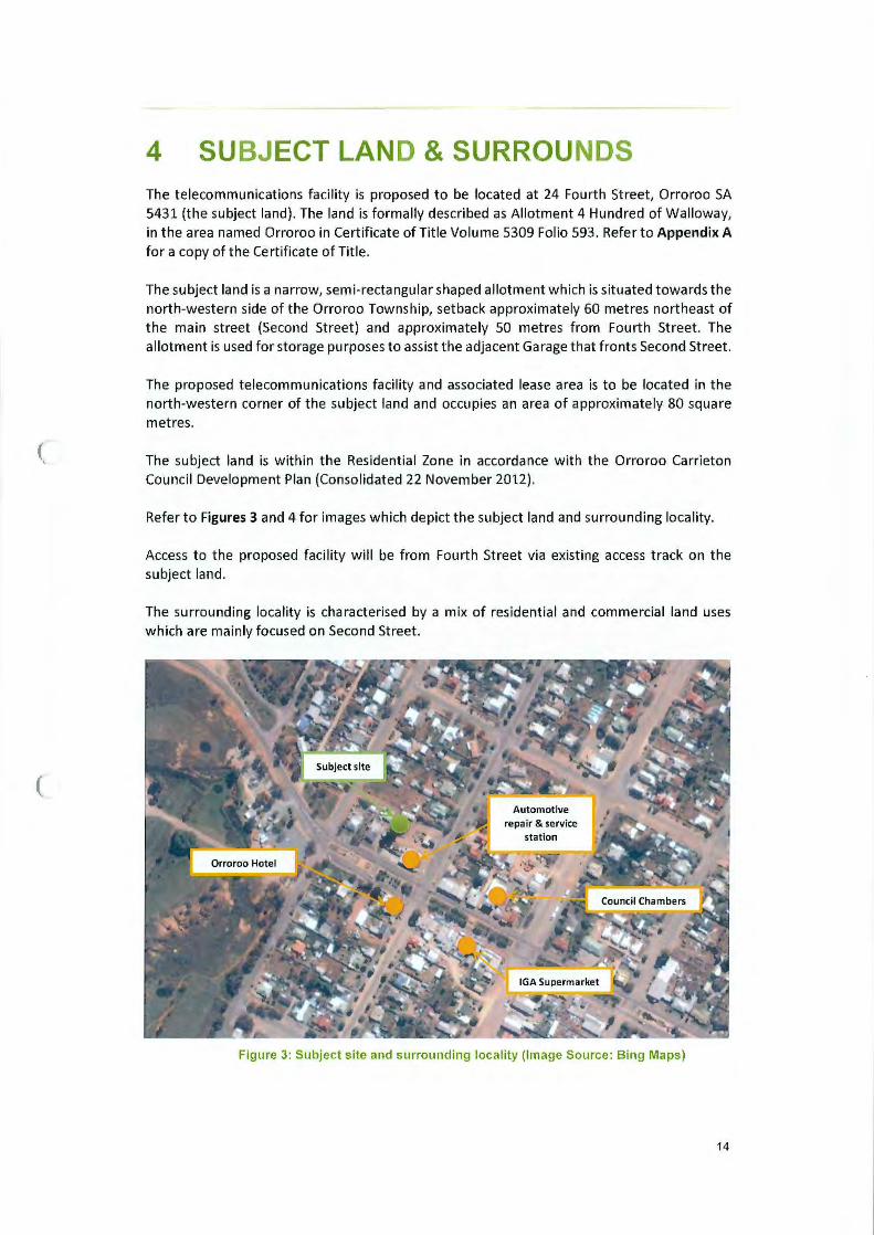
4 SUBJECT LAND & SURROUNDS The telecommunications facility is proposed to be located at 24 Fourth Street, Orroroo SA 5431 (the subject land). The land is formally described as Allotment 4 Hundred of Walloway, in the area named Orroroo in Certificate ofTitle Volume 5309 Fo lio 593 . Refer to Appendix A for a copy of the Certificate of Title.
The subject land is a narrow, semi-rectangular shaped allotment which is situated towards the north-western side of the Orroroo Township, setback approximately 60 metres northeast of the main street (Second Street) and approximately 50 metres from Fourth Street. The allotment is used for storage purposes to assist the adjacent Garage that fronts Second Street.
The proposed telecommunications facility and associated lease area is to be located in the north-western corner of the subject land and occupies an area of approximately 80 square metres.
The subject land is within the Residential Zone in accordance with the Orroroo Carrieton Council Development Plan (Consolidated 22 November 2012}.
Refer to Figures 3 and 4 for images which depict the subject land and surrounding locality.
Access to the proposed facility will be from Fourth Street via existing access track on the subject land.
The surrounding locality is characterised by a mix of residential and commercial land uses which are mainly focused on Second Street.
Figure 3: Subject site and surrounding locality (Image Source : Bing Maps)
14

(
l
Image 3: Looking north-northwest from the median strip on Second Street (near corner of Fourth St)
towards subject land (behind Hunts Fuel, adjacent tree)
Image 4: Looking southeast from ptoposed site towards Fourth Street.
Figure 4: Images of the subject land and surrounding locality
15

{
5 PROPOSED DEVELOPMENT
5.1 Facility and Equipment Details
5.1.1 Equipment to be Installed
Approval is sought for the development of a fixed wireless telecommunications facility, comprising the following equipment:
• A new 40m high steel monopole;
• Three (3) 1077mm long panel antennas at a centreline height of 40m;
• Three (3) SOOmm long remote radio units (RRUs), mounted behind panel antennas;
• One (1) 1800mm diameter parabolic antenna at a centreline height of 37m;
• One (1) GPS unit;
• Two (2) outdoor equipment cabinets (each measuring 1464mm x 667mm x 944mm); and
• 2.4m high security fencing and associated ancillary equipment.
The monopole will be constructed from galvanised steel which will fade to a light grey colour within approximately twelve (12) months from construction. The dull colour of the galvanised finish is considered to be the most appropriate finish to mitigate visual impact within the surrounding locality. Associated equipment and cabinets will be a pre-finished light grey colour to match the monopole structure and blend with the surrounding locality.
Please refer to Appendix 8- Proposed Plans for further details.
5.1.2 Access and Parking Details
The proposed NBN compound will be accessed via an existing access point from Fourth Street which is considered safe and convenient for the proposed development.
NBN Co considers the site access to be appropriate given the NBN Co facility will not be a significant generator of traffic. During the construction phase, it is planned that a truck will be used to deliver the equipment and a crane will be utilised to lift most of the equipment into place. Any traffic impacts associated with construction are expected to be of a short-term duration and are not anticipated to adversely impact on the surrounding road network.
A total construction period of approximately ten weeks (including civil works and network integration and equipment commissioning) is anticipated. Construction activities will Involve four basic stages:
• Stage 1 (Week 1) - Site preparation works, including field testing, excavation and construction of foundations;
• Stage 2 (Weeks 2, 3 and 4) - Construction of the mast;
• Stage 3 (Weeks 5 and 6)- Construct ion of the equipment shelter and fences;
• Stage 4 (Weeks 7 - 10) - Insta llation of antennas and radio equipment, as well as equipment testing.
16

(
(
Once operational, the facility is designed to function on a continuous, unstaffed basis and will typically only require maintenance works once a year, for approximately one day per year.
5.1.3 Construction and Noise
Noise and vibration emissions associated with the proposed facility are expected to be limited to the construction phase outlined above. Noise generated during the construction phase is anticipated to be of short duration and will be within the standards outlined in the relevant EPA guidelines. Construction works are planned only to occur between the hours of 7.00am and 6.00pm.
There is expected to be some low level noise from the ongoing operation of air conditioning equipment associated with the equipment cabinets, once installed. Noise emanating from the air conditioning equipment is expected to be at a comparable level to domestic air conditioning, and should be consistent with typical background noise levels prescribed by relevant guidelines.
17

(
(
6 CURRENT PLANNING CONTROLS
6.1 Commonwealth Legislation - The Telecommunications Act
The Commonwealth's Telecommunications Act 1997 (the Act) sets the statutory framework for telecommunications carriers to follow. The Commonwealth Department of Broadband, Communications and the Digital Economy are responsible for administering the provisions of the Act . The Act is supported by several other documents of statutory standing, in particular the Telecommunications (Low-Impact Facilities) Determination 1997 as well as the Telecommunications Code of Practice 1997.
When a proposed facility is compliant with the Telecommunications (Low-Impact Facilities) Determination 1997, the Act exempts carriers from State planning legislation. However when a facility is non-compliant with the Telecommunications (Low-Impact Facilities) Determination 1997, the relevant State and Territory planning legislation must be adhered to by the relevant carrier for a proposed facility.
6.2 State Policy and Legislation
Under the Telecommunications (Low-Impact Facilities) Determination 1997, the proposed facility is not defined as 'low-impact', due to the proposal involving the construction of a facility that exceeds the maximum requirements that are allowed under the provisions set out by the determination. Therefore the proposed facility is subject to the Development Act 1993 and the Development Regulations 2008.
6.3 The Telecommunications Code of Practice
Under Section 2.11 of the Telecommunications Code of Practice 1997, carriers are required to ensure that the design, planning and installation of their facilities are in accordance with what the industry considers to be 'best practice'.
Section 2.11.3 requires carriers to:
" ... minimise the potential degradation of the environment and the visual amenity associated with the facilities ."
In order to achieve 'Best Practice', carriers must comply with any relevant industry code or standard, which has been registered by the Australian Communications and Media Authority, under Part 6 of the Telecommunications Act 1997. The planning and siting of the cu rrent proposal has regard to Section 3 of the Australian Standard, Siting of Radio-Communications Facilities {AS:3516.2).
18

(
(
7 DEVELOPMENT PLAN ASSESSMENT
7.1 Nature of Development
The subject land is located within the Residential Zone in accordance with the provisions of the Orroroo Carrieton Council Development Plan (Consolidated 22 November 2012).
In accordance with the provisions of the Residential Zone we are of the opinion that the proposed development should be assessed on merit.
7.2 Public Notification
In accordance with Section 38 (2) (c) oft he Development Act 1993, we are of the opinion that the proposed te lecommunications facility shou ld be assigned Category 3 for Public Notification purposes.
7.3 Development Plan Provisions
The following Objectives and Principles of Development Control (PDC) of the Orroroo Carrieton Council Development Plan (Consolidated 22 November 2012) are considered to be relevant in the assessment of the proposed development.
Council Wide
Objectives 1 Building near Airfields
Principles of Development Control 1, 2, 3, 4
Objectives 1 Design and Appearance
Principles of Development Control 6, 16
Objectives 1, 2, 4, 5 Infrastructure
Principles of Development Control 10
Objectives 1, 2 Interface between land uses
Principles of Development Control 1, 2, 6, 7
Objectives 1 Siting and Visibility
Principles of Development Control 2, 5
Objectives 1, 2 Telecommunications Facilities
Principles of Development Control 1, 3
Object ives 2
Transportation and Access Principles of Development Control 8, 13, 21,
22
19

(
(
Zone Specific
Objectives 3 Residential Zone
Principles of Development Control 1, 2, 4, 8
7.4 Development Plan Assessment
7.4.1 Building near Airfields
The proposed location for the NBN Fixed Wireless facility is approximately 7.8 kilometres northwest of the Orroroo Airport runway. The proposed development, in this location, is not considered to affect the long-term operational, safety and commercial aviation requirements of the airfield. In addition to the significant separation distance from the runway, the proposal is located at a bearing of approximately 318.12 degrees from the end of the runway which is not considered to affect the approach/take-off of aircraft.
The development does not propose any lighting as part of this application and is not likely to increase the attraction of birds.
We are of the opinion that the proposed development is consistent with the following provisions:
Building near Airfields
OBJECTIVES
1 Development that ensures the long-term operational, safety and commercial aviation requirements of airfields (airports, airstrips and helicopter landing sites) continue to be met.
PRINCIPLES OF DEVELOPMENT CONTROL
1 The height and location of buildings and structures should not adversely affect the long-term operational, safety and commercial aviation requirements of airfields.
2 Development in the vicinity of airfields should not create a risk to public safety, in particular through any of the following:
(a) lighting glare
(b) smoke
(c) air turbulence
(d) storage of flammable liquids
(e) attraction of birds
(f) materials that affect aircraft navigational aids.
3 Lighting within six kilometres of an airport should be designed so that it does not pose a hazard to aircraft operations.
4 Development that is likely to increase the attraction of birds should not be located within three kilometres of an airport used by commercial aircraft. If located closer than three kilometres the facility should incorporate bird control measures to minimise the risk of bird strikes to aircraft.
20

(
(
7.4.2 Design and Appearance
The proposed NBN fixed wireless telecommunications facility has been designed and sited to provide optimal fixed wireless telecommunications coverage, achieve line-of-sight to other facilities in the region for connection to the wider NBN network and to minimise visual impact where possible.
The proposed location is on a parcel of land primarily used for storage and access for an associated automotive repair and service station on adjoining land within the centre of Orroroo.
The facility has been sited in a location in consultation with the land owner to ensure existing business operations are not affected by the operation of the facility. The location also takes advantage of existing trees adjacent the subject site to provide partial screening to the facility when viewed from the wider locality.
The monopole structure will be constructed of galvanised steel which will fade to a light grey colour within approximately twelve (12) months from the construction of the facility. This finish is considered to be more sympathetic to the surrounding loca lity in comparison to painted finishes. Associated equipment for the proposed facility is to be of a light grey colour to mitigate potential visual impact with the surrounding locality.
The height of the proposed facility strikes a balance between the need to minimise visual impact on the surrounding locality and technical constraints required for the function of the proposed antennas to provide internet services to Orroroo and connect to the wider NBN network.
We are of the opinion that the proposed development is consistent with the following provisions:
Design and Appearance
OBJECTIVES
1. Development of a high architectural standard that responds to and reinforces positive aspects of the local environment and built form.
PRINCIPLES OF DEVELOPMENT CONTROL
6. The external walls and roofs of buildings should not incorporate highly reflective materials which will result in glare.
16. The setback of buildings from public roads should:
(a) be similar to, or compatible with, setbacks of buildings on adjoining land and other buildings in the locality {b) contribute positively to the streetscape character of the locality
(c) not result in or contribute to a detrimental impact upon the function, appearance or character of the locality.
Siting and Visibility
OBJECTIVES
1. Protection of scenically attractive areas, particularly natural and rural landscapes.
PRINCIPLES OF DEVELOPMENT CONTROL
2. Buildings should be sited in unobtrusive locations and, in particular, should:
(a) be grouped together
21

(
{b) where possible be located in such a way as to be screened by existing vegetation when viewed from public roads.
5. The nature of external surface materials of buildings should not detract from the visual character and amenity of the landscape.
7.4.3 Interface between land uses
The proposed Fixed Wireless facility is located at the rear of the property, in the northwest corner, in order to maximise separation from residential dwellings as much as practicable whilst also minimising any potential interference with the existing land use on the subject land. The facility is located approximately 35 metres from the nearest dwelling, which is located northeast of the proposed site and has a frontage to Fourth Street. Established trees on the dwelling's property as well as existing sheds on the subject land assist in minimising potential visual impact from the nearest dwelling. An additional dwelling is located approximately 38 metres southwest of the proposed site and the existing Orroroo Senior Citizens Club Hall assists in screening the lower portion of the facility when viewed from properties that look directly towards the subject land on the opposite side of Fourth Street.
The proposed development is unlikely to cause adverse impacts to the existing land uses in the surrounding locality. The facility has been sited with an existing commercial use which minimises the visual impact of the proposed facility and provides better separation from residential land uses than other centrally located sites which meet coverage requirements.
This facility is to be operated in compliance with the mandatory standard for human exposure to EME- currently the Radio communications (Electromagnetic Radiation Human Exposure) Standard 2003. This standard is set by the Australian Communication and Media Authority (ACMA) and Australian Radiation Protection and Nuclear Safety Agency (ARPANSA).
During operation, the only noise emitted by this facility is the small cooling system located within the door of each outdoor equipment cabinet. This emits a noise level simi lar to that of a domestic air conditioner and is unlikely to be noticeable beyond the subject land.
The proposed development is considered to be consistent with the following provisions:
Interface between land uses
OBJECTIVES
l. Development located and designed to prevent adverse impact and conflict between land uses.
2. Protect community health and amenity and support the operation of all desired land uses.
PRINCIPLES OF DEVELOPMENT CONTROL
1. Development should not detrimentally affect the amenity of the locality or cause unreasonable interference through any of the following:
(a) the emission of effluent, odour, smoke, fumes, dust or other airborne pollutants (b) noise (c) vibration {d) electrical interference (e) light spill (f) glare (g) hours of operation (h) traffic impacts.
22
(
(
2. Development should be designed and sited to minimise negative impact on existing and potential future land uses considered appropriate in the locality.
6. Development should be designed, constructed and sited to minimise negative impacts of noise and to avoid unreasonable interference.
7. Development should be consistent with the relevant provisions each of the following documents:
(a) AS 2107 Acoustics- Recommended Design Sound Levels and Reverberation Times for Building Interiors
(b) AS 3671 Acoustics- Road Traffic Noise Intrusion, Building Siting and Construction
(c) the current Environment Protection (Noise) Policy
7.4.4 Telecommunications Faci lities and Infrastructure
The proposed facility w ill provide fast fixed wireless internet services to Orroroo and dwellings in the surrounding locality.
The NBN will enable high speed broadband to be delivered to all Australian households, businesses and enterprises through a combination of fixed line, f ixed wireless and satellite technology. The proposed telecommun ications facility is part of the National Broadband Network, and will provide fixed wireless se rvices to the community and will have significant benefits for the residents and businesses throughout the Mid North region.
Access t o the NBN will provide a wide range of se rvices to meet the need of the community and loca l businesses in Orroroo, such as:
• High Speed Internet Services
• Upgraded Telephone Services
• Teleworking Opportunities (working f rom home)
• Distance Education Services
• Online Health Services
• Online Business Services
During the preliminary scoping visit, analysis of existing facilities was undertaken to determine if any co-location options were available for NBN equipment. Two (2) existing telecommunications faci lities were identified (55m high Optus lattice tower and 30m high Telstra lattice tower). These facilities are not su itable for co-location of NBN equipment as the available height on the facilities are insufficient for NBN equipment to provide coverage to the town and connect to a proposed facility at Peterborough via line-of-sight. In addition, t he existing Optus facility is located on Crown land which can incur protracted tenure negotiations.
NBN Co. endeavours to utilise existing structures where possible, however; height requirements for the antennas and topographic constrains required a new 40m facility be located centrally within the town to provide high quality fixed wireless coverage to residents.
The proposed facility is appropriately sited and des igned to minimise the visual impact and amenity ofthe surrounding locality as much as practicable. The faci lity has been located with separation from sensitive land uses adj acent a commercial land use and takes advantage of partial screening provided by an established tree and existing buildings within and immediately adjacent the subject land.
23

(
(
The design of the proposed facility balances the need to provide an appropriate standard of fixed wi reless services and achieve line of sight to adjacent facilities in the network, whilst minimising visual impact on the surrounding locality as much as practicable. The 40 metre height of the monopole structure is the minimum acceptable height for the antennas to operate effectively.
The proposed development is therefore considered to be consistent w ith the following provisions:
Telecommunications Facilities
OBJECTIVES
1: Telecommunications facilities provided to meet the needs of the community.
2: Telecommunications facilities sited and designed to minimise visual impact on the amenity of the local environment.
PRINCIPLES OF DEVELOPMENT CONTROL
1: Telecommunications facilities should: (a) be located in a co-ordinated manner to deliver communication services efficiently (b) use materials and finishes that minimise visual impact (c) have antennae located as close as practical to the support structure (d) be located primarily in industrial, commercial, business, office, centre and rural zones (e) where technically feasible, be co-located with other telecommunications facilities (f) incorporate landscaping to screen the development, particularly equipment shelters and huts (g) be designed and sited to minimise the visual impact on the character and amenity of the local environment, in particular visually prominent areas, main focal points and significant vistas.
3. Telecommunications facilities should be located in residential zones only if sited and designed to minimise visual impact by:
(a) using existing buildings and vegetation for screening (b) where possible, incorporating the facility within an existing structure that may serve another purpose (c) taking into account the size, scale, context and characteristics of existing structures, landforms and vegetation so as to complement the local environment.
Infrastructure
OBJECTIVES
1. Infrastructure provided in an economical and environmentally sensitive manner. 2. Infrastructure, including social infrastructure, provided in advance of need. 4. The visual impact of infrastructure facilities minimised. 5. The efficient and cost-effective use of existing infrastructure.
PRINCIPLES OF DEVELOPMENT CONTROL
10. Utility buildings and structures should be grouped with non-residential development where possible.
24

(
(
7.4.5 Transportation and Access
The proposed development utilises an existing access point off of Fourth Street. Given the location of the proposed facility on the subject land, vehicles will be able to enter and exit the site in a forward direction as there is sufficient manoeuvring space. This access arrangement is considered safe and convenient for the proposed development and will not interfere with the free flow of traffic on Fourth Street.
Following construction, traffic generated by this facility will be minimal, with access typically being on a twelve (12) monthly basis for maintenance purposes.
The proposed development is therefore considered to be consistent with the following provisions:
7.4.6
Transportation and Access
OBJECTIVES
2. Development that: (a) provides safe and efficient movement for all motorised and non-motorised transport modes (b) ensures access for vehicles including emergency services, public infrastructure maintenance and commercial vehicles (c) provides off street parking
(d) is appropriately located so that it supports and makes best use of existing transport facilities and networks.
PRINCIPLES OF DEVELOPMENT CONTROL
B. Development should provide safe and convenient access for all anticipated modes of transport including cycling, walking, public and community transport, and motor vehicles.
13. Development should make sufficient provision on site for the loading, unloading and turning of all traffic likely to be generated.
21. Development should have direct access from an all weather public road.
22. Development should be provided with safe and convenient access which: (a) avoids unreasonable interference with the flow of traffic on adjoining roads (b) accommodates the type and volume of traffic likely to be generated by the development or land use and minimises induced traffic through over-provision (c) is sited and designed to minimise any adverse impacts on the occupants of and visitors to neighbouring properties.
Residential Zone
The Residential Zone encompasses a wide range of residential and small scale non-residential land uses as defined by Principle of Development Contrail.
Although the proposed development is not specifically an envisaged land use for the zone, the proposed facility is considered to provide an essential service for Orroroo and serve as a key part of the NBN network for the wider Mid-North region. The proposed facility is considered to be broadly consistent with key objectives and desired character of the Residential Zone as :
• The desired character statement identifies the importance of the provision of essential services for future development. The proposed development is providing a crucial broadband service that enables a wide range of capabilities for residents and business owners to support their needs.
2 5

(
(
• The subject site is located in an area se lected in consultation with the land owner to ensure the existing land uses are not adversely affected;
• The location on the subject land takes advantage of existing buildings and vegetation adjacent the site for screening purposes;
• The proposed development is located alongside a light industrial I commercial use to minimise its appearance;
• The location is set back from residential properties and other sensitive land uses as much as practical.
The proposed telecommunications facility is not considered to significantly impair the amenity of the locality, nor is it considered to be in conflict with adjoining land uses on the subject land or within the immediate locality. In summary we are of the opinion that the proposed development is considered to be consistent with the provisions as outlined below:
Residential Zone
OBJECTIVES
3. Development that contributes to the desired character of the zone.
PRINCIPLES OF DEVELOPMENT CONTROL
1. The following forms of development are envisaged in the zone:
• domestic outbuilding in association with a dwelling
· domestic structure
·dwelling
· dwelling addition
· small scale non-residential uses that serve the local community, for example:
- child care facilities
-health and welfare services
-open space
- primary and secondary schools
- recreation areas
- shops, offices or consulting rooms
·supported accommodation
2. Development listed as non-complying is generally inappropriate and not acceptable unless it can be demonstrated that it does not undermine the objectives and principles of the Development Plan.
4. Non-residential development such as shops, schools and consulting rooms should be of a nature and scale that:
(a) serves the needs of the local community
(b) is consistent with the character of the locality
(c) does not detrimentally impact on the amenity of nearby residents.
8. Development should not be undertaken unless it is consistent with the desired character for the zone.
26
(
(
8 OTHER ENVIRONMENTAL CONSTRAINTS AND OPPORTUNITIES
8.1 Heritage
In order to determine any possible natural or cultural values of state or national significance associated with the site, a search was conducted through the relevant Heritage Registers. There are no known items of cultural, historical or environmental heritage significance located in the direct vicinity of the proposal site.
There are no listed items Aboriginal heritage identified within the subject land; however, if any artefacts are found, the construction of this facility will be undertaken pursuant to Section 23 of the Aboriginal Heritage Act of 1998, in order to ensure that no damage is made to the historical artefacts.
8.2 Electrical Interference and Grounding of the Facility
The NBN fixed wireless network is licensed by the Australian Communications and Media Authority (ACMA) for the use of the LTE2300 frequency band. As NBN Co is a licensee of this sub-band, emissions from NBN Co equipment within the frequency band should not cause interference.
Filters will also help to ensure that each facility meets the ACMA specifications for emission of spurious signals outside the NBN Co frequency allocations. NBN Co intends to promptly investigate any interference issues that are reported.
The facility is also designed to be grounded (earthed) to the relevant Austra lian Standards.
8.3 Erosion, Sedimentation Control and Waste Management
All erosion and sediment control mitigation measures will be detailed in const ruction plans and will be designed to comply with the Building Code of Australia and local Council standards. In add ition, NBN Co contractors will be informed that they must comply with the 'NBN Construction Specification' that requires contractors to undertake the necessary erosion and sediment control measures in order to protect the su rrounding environment. On completion of the installation, NBN Co intends t o restore and reinstate the site to an appropriate standard. No waste which requires collection or disposal should be generated by the operation of the facility.
8.4 Flora and Fauna and Endangered Species Study
In order to determine any possible natura l Flora, Fauna and Endangered Species significance associated with the site, a search was conducted through the relevant environmental searches.
It was identified that there are six (6) 'Listed Threatened Species', one (1) 'Listed Ecological Community' and five (5) 'Listed Migratory Species' that may occur within a O.Skm radius of the site.
27

(
(
Given that the footprint of the site is relatively small (10m by 8m); the proposed installation is considered to be of low impact to flora and fauna. Precautions will be taken in order to minimise the removal or damage the any native species that may be present in the area of the proposed site. The siting of the facility ensures no vegetation will be removed or damaged2•
Please refer to the Protected Matters Search Report in Appendix C for further details.
8.5 Social and Economic Impacts
Access to fast internet is an essential service in contemporary society. Initially, small to medium business customers accounted for a significant part of the demand for broadband technology, but internet services have now been embraced by the general public. Usage of internet services continues to widen as new technologies become progressively more affordable and accessible for the wider community.
The proposed development will enable fast fixed wireless internet coverage to be provided in the District Council of Orroroo Carrieton region by enabling proposed NBN fixed wireless facilities to be connected to the wider NBN network.
The new NBN is designed to provide the community with access to fast and reliable internet services. A reliable internet service is important to help promote the economic growth of communities, and the facility is anticipated to have significant social and economic benefits for the local community.
8.6 Public Safety
8.6.1 Radiofrequency Emissions
In relation to public safety and specifically Electromagnetic Emissions (EME) and public health, NBN Cooperates within the operational standards set by the Australian Communication and Media Authority (ACMA) and Australian Radiation Protection and Nuclear Safety Agency (ARPANSA). ARPANSA is a Federal Government agency incorporated under the Health and Ageing portfolio and is charged with the responsibility for protecting the health and safety of both people and the environment from the harmful effects of radiation (ionising and nonionising) .
All NBN Co installations are designed and certified by qualified professionals in accordance with all relevant Australian Standards. This helps to ensure that the NBN Co facility does not result in any increase in the level of risk to the public.
This facility is to be operated in compliance with the mandatory standard for human exposure to EME- currently the Radio communications (Electromagnetic Radiation Human Exposure) Standard 2003. The EME Report associated with this site is attached in Appendix D. The report shows that the maximum predicted EME will equate to 0.11% of the maximum exposure limit. This is substantially less than 1% of the maximum allowable exposure limit.
2 Whilst all care is taken in the siting of the facility, some native vegetation may be required to be cleared as part of the construction process. If required, a separate application will be submitted to the Native Vegetation Council for the clearing of the native vegetation.
28

(
(
Moreover, all NBN Co equipment has the following features, all of which help to minimise the amounts of energy used and emitted:
• Dynamic/ Adaptive Power Control is a network feature that automatically adjusts the power and hence minimises EME from the facility.
• Varying the facility's transmit power to the minimal required level, minimising EME
from the network, and
• Discontinuous transmission, a feature that reduces EME emissions by automatically switching the transmitter off when no data is being sent.
8.6.2 Access
The proposed facility will have restrictions aimed at preventing public access, including a secured compound fence with a locked gate and warning signs placed around the facility.
8.7 The Public Interest and Benefits of Telecommunications
The proposed NBN Co facility is expected to have significant benefit for residents in the Orroroo area. NBN Co believes that the approval of the proposal will serve the public interest, given benefits for enhanced internet coverage in the area. The facility is expected to have benefits for local residents and businesses within the district.
There are numerous other benefits of telecommunications connectivity, as follows: 3
• There are many potential educational benefits justifying the implementation of the NBN. Curriculum and data sharing, increased availability and accessibility of research materials, and virtual classroom environments are good examples. Such elements are particularly beneficial within a tertiary education context.
• Businesses can, through internet usage, increase efficiency through time, resource and monetary savings. Improved internet services effectively remove physical distance and travel time as a barrier to business.
• Improvements to internet services may also be of benefit for local employees, by enabling telecommuting and home business. The telecommuting trend is heavily reliant on access to fast internet services, and is anticipated to continually increase in popularity.
The public benefits of access to fast internet services have been widely acknowledged for many years. Reliable internet access is now more than ever an integral component of daily life, so much so that its absence is considered a social disadvantage.
'End user experience including the speeds actually achieved over the NBN depends on some factors out side NBN Co's control like the end user's equipment quality, software, broadband plans and how the end user's service providers designs its network.
29

(
(
9 CONCLUSION NBN Co considers that the proposed facility, comprising of a 40 metre high monopole with attached antennas, outdoor cabinets and associated ancillary equipment has been situated in the most appropriate location whilst ensuring adequate coverage to Orroroo and surrounding areas is achieved.
The facility has been strategically sited and designed to mm1m1se visibility within the surrounding environment as much as practicable. In this regard NBN Co considers that the proposal satisfies the requirements of the Orroroo Carrieton Council Development Plan, whilst also addressing internet service deficiencies within the Orroroo area. The location of the facility provides an important ongoing benefit to the District Council of Orroroo Carrieton region.
NBN Co considers that the proposal is also consistent with the stated objectives and principles of development control within the Orroroo Carrieton Council Development Plan (Consolidated 22 November 2012) . The proposal also considers the Telecommunications Act 1997 and the Telecommunications Code of Practice 1997.
In this regard, the proposal satisfies the provisions of the Orroroo Carrieton Council Development Plan and we are of the opinion that the proposal has sufficient merit to warrant Development Plan Consent.
30

10 APPENDIX
10.1 Appendix A- Certificate of Title
(
(
31

Title Register Search LANDS TITLES OFFICE, ADELAIDE
For a Certificate of Title issued pursuant to the Real Property Act 1886
REGISTER SEARCH OF CERTIFICATE OF TITLE * VOLUME 5309 FOLIO 593 *
COST REGION
$26.50 (GST exempt EMAIL
AGENT PHPL BOX NO : 000 SEARCHED ON : 05/08/2014 AT : 13:34 : 20 CLIENT REF N-ORROROO
REGISTERED PROPRIETOR IN FEE SIMPLE
PARENT TITLE AUTHORITY DATE OF ISSUE EDITION
CT 2420/135 CONVERTED TITLE 23/11/1995 5
TREVOR THOMAS MCKAY OF 17 FOURTH STREET ORROROO SA 5431
DESCRIPTION OF LAND
ALLOTMENT 4 FILED PLAN 160952 IN THE AREA NAMED ORROROO
( HUNDRED OF WALLOWAY
EASEMENTS
SUBJECT TO A FREE AND UNRESTRICTED RIGHT OF WAY OVER THE LAND MARKED A
SCHEDULE OF ENDORSEMENTS
9763559 MORTGAGE TO WESTPAC BANKING CORPORATION
NOTATIONS
DOCUMENTS AFFECTING THIS TITLE
NIL
REGISTRAR- GENERAL'S NOTES
NIL (
END OF TEXT.
Page 1 of 2
The Registrar-General certifies that this Title Register Search displays the records maintained in the Register Book and other notations at the time of searching. Regislrar·General ® '

(
(
LANDS TITLES OFFICE ADELAIDE SOUTH AUSTRALIA
DIAGRAM FOR CERTIFICATE OF TITLE VOLUME 5309 FOLIO 593
SEARCH DATE: 05/08/2014 TIME: 13:34:20
This plan is scanned for Certificate of Title 2420/ 135 See title text for easement details.
TOWN OF ORROROO
tOO o taor= ......._---Jo.----'-'---...1'
DISTANCES ARE IN FEET AND INCHES FOR METRIC CONVERSION
1 FOOT 0·3048 metres 1 INCH = 0·0254 metres
Note : Subject to all lawfully existing plans of division
Page 2 of 2

10.2 Appendix B- Proposed Plans
(
(
32
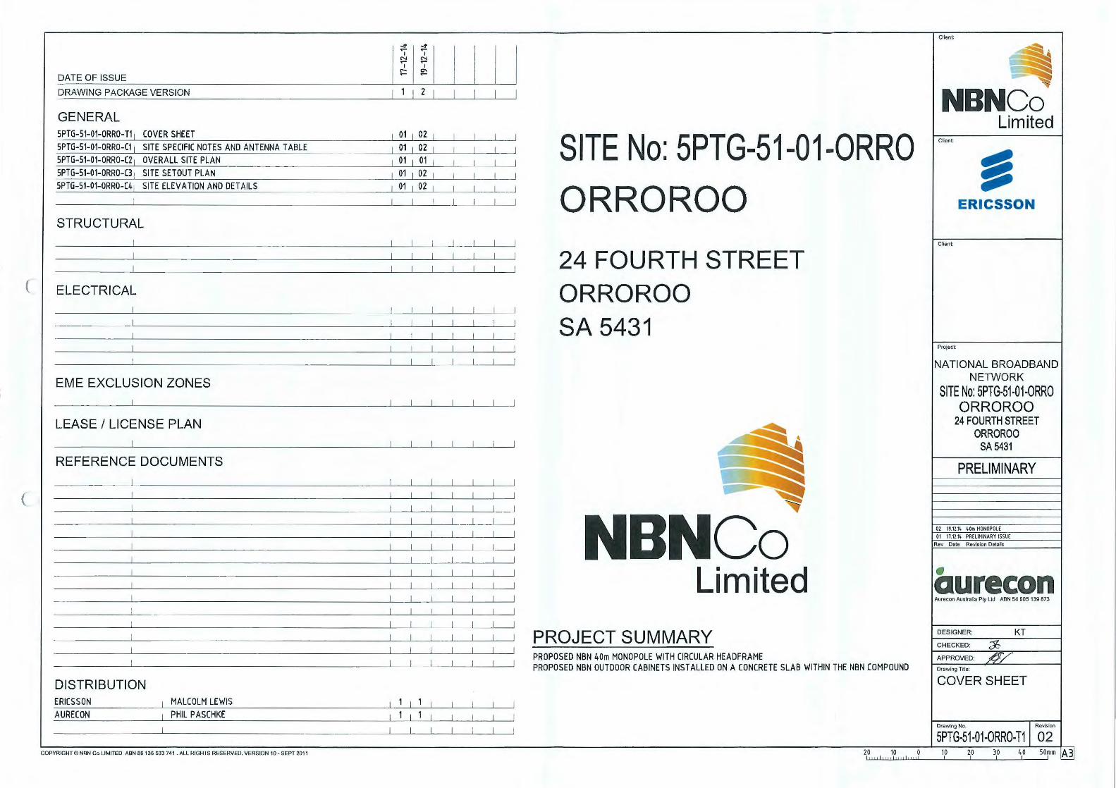
(
(
DATE OF ISSUE
DRAWING PACKAGE VERSION
GENERAL 5PTG-51-01-0RRO-T1 1 COVER SHEET 5PTG-51-01-0RRO-C1 1 SITE SPECIFIC NOTES AND ANTENNA TABLE 5PTG-51-01-0RRO-C21 OVERALL SITE PLAN 5PTG-51-01-0RRO-C3 1 SITE SETOUT PLAN 5PTG-51-01-0RRO-C41 SITE ELEVATION AND DETAILS
STRUCTURAL
ELECTRICAL
EME EXCLUSION ZONES
LEASE I LICENSE PLAN
REFERENCE DOCUMENTS
DISTRIBUTION ERICSSON AURECON
MALCOLM LEWIS PHIL PASCHKE
COPYRIGHH) NBN Co LIMITED ABN 86 136 533 741 . All RIGHTS RESERVED. VERSION 10 ·SEPT 2011
I ~ I ~ I I I I I 1 1 2
1 01 1 02 1 1 01 1 02 1 1 01 1 01 1 1 01 1 02 1
1 1 1 1 1 1
SITE No: SPTG-51-01 -0RRO
ORROROO
24 FOURTH STREET ORROROO SA 5431
NBNCo Limited
PROJECT SUMMARY PROPOSED NBN 40m MONOPOLE WITH CIRCULAR HEADFRAME PROPOSED NBN OUTDOOR CABINETS INSTALLED ON A CONCRETE SLAB WITHIN THE NBN COMPOUND
Client:
NBNCo Limited
Client:
:I! ;ill' ERICSSON
Client:
Project:
NATIONAL BROADBAND NETWORK
SITE No: 5PTG-51-01-0RRO ORROROO
24 FOURTH STREET ORROROO
SA5431
PRELIMINARY
02 19.12.14 40m MONOPOLE 01 11.12.14 PRELIMIIIARY ISSUE
Rev Dale Revision Details
• aurecon Aurecon Australia Ply ltd ABN 54 oos 139 873
DESIGNER: KT
CHECKED: 3:-APPROVED:
Drawing Tille:
COVER SHEET
Drawing No. Revision
5PTG-51·01-0RRO-T1 02 20 10 0 10 20 30 40 SOmm A3
! 1 tt t!l!!! l f!!!l tt• d I I I I I

Client:
NBN ANTENNA CONFIGURATION
ANTENNA DETAIL MAIN FEEDER DETAIL RRU DETAIL RF TAIL RET CABLE
SECTOR SYMBOL DIMENSION C/L AZIMUTH QUANTITY OVERALL CANISTER CANISTER TO
TYPE HxWxD HEIGHT (TN) E-TILT MECH TILT DESTINATION
RAU TYPE
LENGTH HEIGHT RRU LENGTH TYPE LOCATION TYPE LENGTH TYPE LENGTH NBNCo
G1 BEHIND 1/ TSR 484 1 ARGUS-LLPX310R- V1 1077x300x115 40.0m 40" 4" o· N/A N/A 2m RRUS61 ANTENNA 2m
21/2000 1.5m Limited
H&S HYBRID BEHIND H&S 1/2" BIRD 1/TSR 484 2 ~ ARGUS-LLPX310R-V1 1077x300x115 40.0m 100" 4" o· N/A N/ A 19.6mm 60m 39.0m 2m RRUS61 ANTENNA PROOFED 2m
21/ 2000 1.5m Client:
CABLE ADJACENT LISCA CABLE 1/TSR 484 :II 3 ~ ARGUS-LLPX310R- V1 1077x300x115 40.0m 180" 40 o• N/A N/A 2m RRUS61 MOUNT 5m 2112000 1.5m
4 ;ill' 5 ERICSSON
6
~ PETERBOROUGH LDF 1-50 Client:
A PARABOLIC ¢1800 37m 139" N/A N/A NORTH
1-0FF 50m - - - - - - - -CABLE
( B
c
D
GPS KRE 101282/1 ¢69x96 2.5m N/A N/A N/A N/A N/A LDF 1-50 10m - - - - - - - -CABLE Project:
NATIONAL BROADBAND
SITE INFORMATION: NETWORK
SITE No: SPTG-51-01-0RRO 1. SITE ADDRESS 8. EXISTING SITE HAZARDS
ORROROO 24 FOURTH STREET, ORROROO, SA 5431 - AREA SURROUNDING THE NBN SITE LOCATION IS CURRENTLY 24 FOURTH STREET
USED FOR STORAGE, BE AWARE OF POSSIBLE TRIP HAZARDS ORROROO 2. GENERAL - VEHICULAR MOVEMENTS ACROSS THE PROPERTY ASSOCIATED SA 5431 THE CONTRACTOR SHALL COMPLY WITH ALL RELEVANT NBN CONSTRUCTION STANDARDS, WITH THE LANDLORD'S BUSINESS
@ CURRENT AUSTRALIAN STANDARDS AND SPECIFICATIONS PRELIMINARY 9. ELECTRICAL SUPPLY
3. SITE ACCESS POWER EXISTS AT THE EXISTING BUSINESS ON THE PROPERTY. 1 ACCESS TO THE PROPOSED NBN SITE IS AVAILABLE FROM FOURTH STREET AND ACROSS THE THE FINAL SUPPLY POINT IS TO BE CONFIRMED WITH SA POWER I ( LANDLORD'S PROPERTY AS SHOWN ON DRAWING C2 NETWORKS
~
4. EQUIPMENT 10. TRANSMISSION LINK
~ 02 19.12.14 40m MONOPOLE 01 17.11.14 PRELIMINARY ISSUE
PROPOSED NBN OUTDOOR CABINETS ARE TO BE INSTALLED ON A CONCRETE SLAB WITHIN REFER TO TABLE ABOVE Rev Date Revision Details
THE NBN COMPOUND & LEASE AREA ~ ~~-~ :r~ L 11. SITE SPECIFIC NOTES • 5. STRUCTURE - FINAL LAYOUT OF NBN EQUIPMENT SUBJECT TO CONFIRMATION ~m~ NEW NBN 40m MONOPOLE WITH CIRCULAR HEADFRAME OF MONOPOLE FOOTING DIMENSIONS ~1r ~ 2 aurecon
- SECTOR 3 RRU TO BE INSTALL ED ON THE MOUNT POLE ~ .. Aurecon Australia Ply Ltd ABN 54 005 139 873
6. ANTENNA ACCESS ADJACENT THE ANTENNA TO AVOID INTERFERENCE WITH THE .... ANTENNA ACCESS WILL BE AVAILABLE TO QUALIFIED RIGGERS ONLY BY CLIMBING THE HEADFRAME ACCESS HATCH
A ACCESS LADDER INSTALLED ON THE MONOPOLE USING THE LAD-SAF SAFETY CLIMB SYSTEM, DESIGNER: KT OR VIA EWP 3 CHECKED: ~
7. EXISTING SERVICES APPROVED: # /
THE CONTRACTOR SHALL IDENTIFY AND CONFIRM THE LOCATION OF ALL RELEVANT EXISTING Drawing TiUe:
SERVICES AS REQUIRED PRIOR TO COMMENCEMENT OF WORKS SITE SPECIFIC NOTES
ANTENNA SETOUT PLAN AND ANTENNA TABLE
SCALE 1:100
SPTG:s1-01-0RRO-c11 Ro l2 n
COPYRIGHT © NBN Co LIMITED ABN 86 136 533 741 . ALL RIGHTS RESERVED. VERSION 10 · SEPT 2011 20 10 0 10 20 30 40 SOmm ~

(
SITE LOCATION
I
I
i I
I
I
,.
I ./
COPYRIGHT © OPENSTREETMAP CONTRIBUTORS, CC BY-SA hllp:/lwww.opanstteetmap.oru http:/lcrealivooonvnons.orgfliconcoslby·sa/2.0/ Use of this Imago is subJect to the tern\$ and conditions of tho Creative Commons Allribullon·ShareAI~e 2.0 llconco, the fun l icence of which can be accu sed at hllp:l/cJCtative oonvnons.otglllce nseslby·aa12.0flegalcode
SITE CO-ORDINATES MONOPOLE LOCATION
DATUM: MGA (GDA94) I ZONE: 54
LATITUDE -32.732735 LONGITUDE 138.611978
EASTING 276 224 NORTHING 6 375 819
LEGEND
PROPERTY BOUNDARY
- NUE - NUE - NBN UNDERGROUND ELECTRICAL LINE
- A E - A E - AERIAL EL ECTRICAL LINE
- I - I - EXISTING FENCE
COPYRIGHT <!:> NBN Co LIMITED ABN 86 136 533 741 . ALL RIGHTS RESERVED. VERSION 10 ·SEPT 2011
SCALE 1:2000
.tiQill:
1. THE NBN SUB-MAIN ROUTE SHOWN ON THE DRAWINGS IS INDICATIVE ONLY. ELECTRICAL CONTRACTOR TO DETERMINE AN EXACT ROUTE. ELECTRICAL CONTRACTOR TO LOCATE AND IDENTIFY EXISTING U/G SERVICES PRIOR TO COMMENCEMENT OF WORK.
Client
NBNCo Limited
Client:
:II! ;ill' ERICSSON
Client
Project:
NATIONAL BROADBAND NETWORK
SITE No: 5PTG-51·01-0RRO ORROROO
24 FOURTH STREET ORROROO
SA5431
PRELIMINARY
01 t1.12.11 PRELIMINARY ISSUE Rev Date Revision Details
• aurecon Aurecon Australia Ply Ltd ABN 54 005 139 873
DESIGNER:
CHECKED:
APPROVED:
Drawing Title:
OVERALL SITE PLAN
Drawing No.
5PTG-51-01-0RRO·C2 01 20 10 0 10 20 30 40
' ' ' ' "11 !! 111 1! 11!111 I I I I

(
(
PROPOSED NBN PANEL ANTENNA WITH-----------........._ NBN REMOTE RADIO UNITS FIXED BEHIND THE PANEL ANTENNA (TYP)
PROPOSED NBN 40m MONOPOLE WITH-------.. CIRCULAR HEADFRAME
PROPOSED NBN MONOPOLE FOUNDATION-+-------..... (INDICATIVELY SHOWN)
PROPOSED MONOPOLE ACCESS LADDER _ __,
PROPOSED NBN 2.4m HIGH CHAINWIRE-----~-r--_/
SECURITY FENCE WITH 3.0m WIDE ACCESS GATES
EXISTING FENCE ---_/c ..
PROPOSED NBN ~1800 PARABOLIC ANTENNA-____,.. (TO PETERBOROUGH NORTH)
<
EXISTING STORAGE AREA ----' AS SOCIA TED WI TH LANDLORDS BUSINESS
LEGEND
I
- -- - - -- PROPERTY BOUNDARY
~ x ··.·: .. ~
! <'·:· .. :.:: .. ·,.'•, ~. . . · .. ··
'
DETAIL SCALE 1:100
- NUE - NUE - NBN UNDERGROUND CONSUMER'S MAIN CABLE IN HDuPVC ELECTRICAL CONDUIT
- I -- I - NBN COMPOUND FENCE & LEASE AREA
- I - I - EXISTING FENCE
COPYRIGHT <~) NBN Co LIMITED ABN 86 136 533 741 . ALL RIGHTS RESERVED. VERSION 10 · SEPT 2011
,--~---EXISTING CAR BODIES & OTHER MACHINERY TO BE RELOCATED PRIOR TO COMMENCEMENT OF CONSTRUCTION (NOT SHOWN FOR CLARITY)
...---- ---PROPOSED NBN 300mm WIDE CABLE LADDER WITH 1-0FF CABLE LADDER SUPPORT POST AND PROPOSED NBN GPS UNIT (1-0FF)
->....------ PROPOSED NBN POWER DISTRIBUTION
§;~
~ 9..r:::5 ~~ & ~
BOARD/ METER PANEL ON H-FRAME
~
"" t_EXISTING PROPERTY BOUNOARY
(TYP)
~ L I-- ---PROPOSED NBN UNDERGROUND CONSUMER'S
MAIN IN HDuPVC ELECTRICAL CONDUIT (APPROX BSm)
"----~~~ PROPOSED NBN OUT DOOR CABINET SSC-02 ~ , INSTALLED ON A CONCRETE SLAB ~UI
'--~--=~:;;;:=.---..,If N B N 0 U TD 00 R CABINET S S C-0 2 !FUTURE LOCATION)
~:
1. THE ELECTRICAL ROUTE SHOWN ON THIS DRAWING IS INDICATIVE ONLY, FINAL ROUTE TO BE DETERMINED ON SITE PRIOR TO CONSTRUCTION
2. CONSTRUC TOR SHALL LOCATE AND IDENTIFY ANY EXISTING UNDERGROUND SERVICE S PRIOR TO THE COMMENCEMENT OF ANY WORK ON SITE
Clienl:
NBNCo Limited
Clienl:
:=;; ~
ERICSSON
Clienl:
Project
NATIONAL BROADBAND NETWORK
SITE No: SPTG-51-01-0RRO ORROROO
24 FOURTH STREET ORROROO
SA 5431
PRELIMINARY
02 19.11.14 40m MONOPOLE
01 11.12.14 PREliMINARY ISSUE Rev Dale Revision Oelai!s
• aurecon Aurecon Auslralla Pty Ltd ABN 54 005 13g 873
DESIGNER: KT
CHECKED:
APPROVED:
Drawing Tille:
SITE SETOUT PLAN
Drawing No.
5PTG-51-01-0RRO-C3 02 10 20 30 40

y EL 40.0m OVERALL HEIGHT
9 EL 37.0m C/L 1-0FF ~1800 PROPOSED PARABOLIC ANTENNA (TO PETERBOROUGH NORTH)
PROPOSED NBN GPS UNIT (1-0FF)------,
PROPOSED NBN 300mm WIDE CABLE LADDER WITH 1-0FF CABLE LADDER SUPPORT POST
PROPOSED NBN OUTDOOR CABINET SSC-02 INSTALLED ON A CONCRETE SLAB
PROPOSED NBN POWER DISTRIBUTION BOARD I METER PANEL ON H-FRAME
EXISTING VEHICLES&------... ASSOCIATED COMPONENTS TO BE RELOCATED ON SITE
EXISTING WORKSHOP (BEYOND)
9 EL 40.0m C/L 3-0FF 1077H PROPOSED NBN PANEL ANTENNAS 3-0FF SOOH REMOTE RADIO UNITS MOUNTED BEHIND ANTENNAS (1-0FF PER SECTOR)
EL 39.0m C/L 1-0FF PROPOSED NBN CANISTER
H----r--.--- NBN FIBRE AND DC CABLES TO BE INSTALLED VERTICALLY INSIDE
'1
11 MONOPOLE
I
. \ "i\ , I 1'1 ,v;
,~ ... ~ ,,, '\\ (~'
•I \ \\ II\{~ I :; ,, ,,\.''' '' •I
\ \ \ ''" \ \ \\ \\~·I
·'~ •\ ,,, '1 EXISTING TREE (BE YOND)
~\ ,, \ \ \ \ \ ,~, \ ·~·\
\ \ '''''.~\\~\' \:~ ,, '\~''''..~·~,''
APPROX 25m TALL
v-.--~-":--PROPOSED NBN 2.4m HIGH CHAINWIRE .. SECURITY FENCE WITH 3.0m WIDE ACCESS 1
GATES I,
r----EXISTING FENCE
EL O.Om GROUND LEVEL
L - - -~PROPOSED NBN MONOPOLE FOUNDATION (INDICATIVELY SHOWN)
WEST ELEVATION SCALE 1:200
COPYRIGHT llil NBN Co LIMITED ABN 86 136 533 741 , ALL RIGHTS RESERVED. VERSION 10- SEPT 2011 20 10
Client:
NBNCo Limited
Client:
:II ijill' ERICSSON
Client:
Project:
NATIONAL BROADBAND NETWORK
SITE No: 5PTG-51-01-0RRO ORROROO
24 FOURTH STREET ORROROO
SA 5431
PRELIMINARY
02 19.12.14 40m MONOPOlE 01 17.12.14 PRElii11NARY ISSUE
Rev Date Revision Details
• aurecon Aurecon Australia Ply ltd ABN 54 005 139 873
DESIGNER:
CHECKED:
APPROVED:
Drawing Title:
SITE ELEVATION AND DETAILS
Drawing No.
5PTG-51-01-0RRO-C4 02 10 20 30 40

10.3 Appendix C- EPBC Act Protected Matters Report
(
(
33

(
(
Australian Government
Department of the Environment
EPBC Act Protected Matters Report
This report provides general guidance on matters of national environmental significance and other matters protected by the EPBC Act in the area you have selected.
Information on the coverage of this report and qualifications on data supporting this report are contained in the caveat at the end of the report.
Information is available about Environment Assessments and the EPBC Act including significance guidelines, forms and application process details.
Report created: 29/07/15 17:46:20
Summary Details
Matters of NES Other Matters Protected by the EPBC Act Extra Information
Caveat Acknowledgements
0 0.95 Km•
This map may contain data which are ©Commonwealth of Australia (Geoscience Australia) , ©PSMA 2010
Coordinates Buffer: 0.5Km

(
(
Summary
Matters of National Environmental Significance
This part of the report summarises the matters of national environmental significance that may occur in , or may relate to, the area you nominated. Further information is available in the detail part of the report, which can be accessed by scrolling or following the links below. If you are proposing to undertake an activity that may have a significant impact on one or more matters of national environmental significance then you should consider the Administrative Guidelines on Significance.
World Heritage Properties: None
National Heritage Places: None
Wetlands of International Importance: None
Great Barrier Reef Marine Paris: None
Commonwealth Marine Area: None
Listed Threatened Ecological Communities:
Listed Threatened Species: 6
Listed Migratory Species: 5
Other Matters Protected by the EPBC Act
This part of the report summarises other matters protected under the Act that may relate to the area you nominated. Approval may be required for a proposed activity that significantly affects the environment on Commonwealth land, when the action is outside the Commonwealth land, or the environment anywhere when the action is taken on Commonwealth land. Approval may also be required for the Commonwealth or Commonwealth agencies proposing to take an action that is likely to have a significant impact on the environment anywhere.
The EPBC Act protects the environment on Commonwealth land, the environment from the actions taken on Commonwealth land, and the environment from actions taken by Commonwealth agencies. As heritage values of a place are part of the 'environment', these aspects of the EPBC Act protect the Commonwealth Heritage values of a Commonwealth Heritage place. Information on the new heritage laws can be found at http://www.environment.gov.au/heritage/index.html
A~ may be required for activities in or on a Commonwealth area that may affect a member of a listed threatened species or ecological community, a member of a listed migratory species, whales and other cetaceans, or a member of a listed marine species.
Commonwealth Land· None
Commonwealth Heritage Places: None
Listed Marine Species· 7
Whales and Other Cetaceans: None
Critical Habitats: None
Commonwealth Reserves Terrestrial : None
Commonwealth Reserves Marine: None
Extra Information
This part of the report provides information that may also be relevant to the area you have nominated.
State and Territory Reserves: None
Regional Forest Agreements: None
Invasive Species: 26
Nationally Important Wetlands: None
Key Ecological Features (Marine) None

(
(
Details
Matters of National Environmental Significance
Listed Threatened Ecological Communities [Resource Information 1 For threatened ecological communities where the distribution is well known, maps are derived from recovery plans, State vegetation maps, remote sensing imagery and other sources. Where threatened ecological community distributions are less well known, existing vegetation maps and point location data are used to produce indicative distribution maps.
Name Iron-grass Natural Temperate Grassland of South Australia
Listed Threatened Species Name Birds Pedionomus torquatus Plains-wanderer [906]
Rostratula australis Australian Painted Snipe [77037]
Plants Caladenja tensa
Status Critically Endangered
Status
Critically Endangered
Endangered
Greencomb Spider-orchid, Rigid Spider-orchid [24390) Endangered
Codonocarpus pyramidalis Slender Bell-fruit, Camel Poison [19507]
Reptiles Aprasia pseudopulchella Flinders Ranges Worm-lizard [1666]
Tiliqua adelajdensjs Pygmy Blue-tongue Lizard, Adelaide Blue-tongue Lizard [1270]
Listed Migratory Species
Vulnerable
Vulnerable
Endangered
Type of Presence Community likely to occur within area
[ Resource Information 1 Type of Presence
Species or species habitat may occur within area
Species or species habitat may occur within area
Species or species habitat likely to occur within area
Species or species habitat likely to occur within area
Species or species habitat likely to occur within area
Species or species habitat may occur within area
[Resource Information 1 * Species is listed under a different scientific name on the EPBC Act- Threatened Species list. Name Threatened Type of Presence Migratory Marine Birds Apus pacificus Fork-tailed Swift [678] Species or species habitat
likely to occur within area
Migratory Terrestrial Species Merops ornatus Rainbow Bee-eater [670]
Migratory Wetlands Species
Species or species habitat may occur within area

(
(
Name Ardea alba Great Egret, White Egret [59541 ]
Ardea ibis Cattle Egret (59542]
Gallinago hardwicki i Latham's Snipe, Japanese Snipe [863]
Other Matters Protected by the EPBC Act
Listed Marine Species
Threatened Type of Presence
Species or species habitat likely to occur within area
Species or species habitat may occur within area
Species or species habitat may occur within area
[Resource Information] * Species is listed under a different scientific name on the EPBC Act- Threatened Species list. Name Threatened Type of Presence Birds Apus pacificus Fork-tailed Swift [678]
Ardea alba Great Egret, White Egret (59541]
Ardea ibis Cattle Egret [59542]
Gallinago hardwjckii Latham's Snipe, Japanese Snipe [863]
Haliaeetus leucogaster White-bellied Sea-Eagle [943]
Merops ornatus Rainbow Bee-eater [670]
Rostratula benghalensis (sensu lato) Painted Snipe [889] Endangered*
Species or species habitat likely to occur within area
Species or species habitat likely to occur within area
Species or species habitat may occur within area
Species or species habitat may occur within area
Species or species habitat may occur within area
Species or species habitat may occur within area
Species or species habitat may occur within area

(
(
Extra Information
Invasive Species [Resource Information] Weeds reported here are the 20 species of national significance (WoNS), along with other introduced plants that are considered by the States and Territories to pose a particularly significant threat to biodiversity. The following feral animals are reported: Goat , Red Fox, Cat, Rabbit, Pig, Water Buffalo and Cane Toad. Maps from Landscape Health Project, National Land and Water Resouces Audit, 2001.
Name Birds Alauda arvensis Skylark [656]
Anas platyrhynchos Mallard [974]
Carduelis carduelis European Goldfinch [403]
Columba Iivia Rock Pigeon, Rock Dove, Domestic Pigeon [803)
Passer domesticus House Sparrow [405]
Streptopelia chinensis Spotted Turtle-Dove [780]
Sturnus vulgaris Common Starling [389]
Turdus merula Common Blackbird, Eurasian Blackbird [596]
Mammals Capra hircus Goat [2]
Felis catus Cat, House Cat, Domestic Cat [19]
Lepus capensis Brown Hare [1 27]
Mus musculus House Mouse [120]
Oryctolagus cuniculus Rabbit, European Rabbit [128]
Vulpes vulpes Red Fox, Fox [1 8]
Plants
Status Type of Presence
Species or species habitat likely to occur within area
Species or species habitat likely to occur within area
Species or species habitat likely to occur within area
Species or species habitat likely to occur within area
Species or species habitat likely to occur within area
Species or species habitat likely to occur within area
Species or species habitat likely to occur within area
Species or species habitat likely to occur within area
Species or species habitat likely to occur within area
Species or species habitat likely to occur within area
Species or species habitat likely to occur within area
Species or species habitat likely to occur within area
Species or species habitat likely to occur within area
Species or species habitat likely to occur within area

(
(
Name Asparagus asparagoides Bridal Creeper, Bridal Veil Creeper, Smilax, Florist's Smilax, Smilax Asparagus [22473]
Austrocylindropuntia spp. Prickly Pears [85132]
Carrichtera annua Ward's Weed [9511]
Cenchrus ciliaris Buffel-grass, Black Buffel-grass [20213]
Chrysanthemoides monilifera Bitou Bush, Boneseed [18983]
Chrysanthemoides monilifera subsp. monilifera Boneseed [16905]
Genista sp. X Genista monspessulana Broom [67538]
Lycium ferocissimum African Boxthorn, Boxthorn [1 9235]
Olea europaea Olive, Common Olive [9160]
Pinus radiata Radiata Pine Monterey Pine, lnsignis Pine, Wilding Pine [20780]
Rubus fruticosus aggregate Blackberry, European Blackberry [68406]
Ulex europaeus Gorse, Furze [7693]
Status Type of Presence
Species or species habitat likely to occur within area
Species or species habitat likely to occur within area
Species or species habitat likely to occur within area
Species or species habitat may occur within area
Species or species habitat may occur within area
Species or species habitat likely to occur within area
Species or species habitat likely to occur within area
Species or species habitat likely to occur within area
Species or species habitat likely to occur within area
Species or species habitat may occur within area
Species or species habitat likely to occur within area
Species or species habitat likely to occur within area

(
(
Caveat The information presented in this report has been provided by a range of data sources as acknowledged at the end of the report.
This report is designed to assist in identifying the locations of places which may be relevant in determining obligations under the Environment Protection and Biodiversity Conservation Act 1999. It holds mapped locations of World and National Heritage properties, Wetlands of International and National Importance, Commonwealth and State/Territory reserves, listed threatened, migratory and marine species and listed threatened ecological communities. Mapping of Commonwealth land is not complete at this stage. Maps have been collated from a range of sources at various resolutions.
Not all species listed under the EPBC Act have been mapped (see below) and therefore a report is a general guide only. Where available data supports mapping, the type of presence that can be determined from the data is indicated in general terms. People using this information in making a referral may need to consider the qualifications below and may need to seek and consider other information sources.
For threatened ecological communities where the distribution is well known, maps are derived from recovery plans, State vegetation maps, remote sensing imagery and other sources. Where threatened ecological community distributions are less well known, existing vegetation maps and point location data are used to produce indicative distribution maps.
For species where the distributions are well known, maps are digitised from sources such as recovery plans and detailed habitat studies. Where appropriate, core breeding, foraging and roosting areas are indicated under 'type o f presence'. For species whose distributions are less well known, point locations are collated from government wildlife authorities, museums, and non-government organisations; bioclimatic distribution models are generated and these validated by experts. In some cases, the distribution maps are based solely on expert knowledge.
Only selected species covered by the following provisions of the EPBC Act have been mapped:
· migratory and
·marine
The following species and ecological communities have not been mapped and do not appear in reports produced from this database:
• threatened species listed as extinct or considered as vagrants
• some species and ecological communities that have only recently been listed
· some terrestrial species that overfly the Commonwealth marine area
• migratory species that are very widespread, vagrant, or only occur In small numbers
The following groups have been mapped, but may not cover the complete distribution of the species:
- non-threatened seabirds which have only been mapped for recorded breeding sites
- seals which have only been mapped for breeding sites near the Australian continent
Such breeding sites may be important for the protection of the Commonwealth Marine environment.
Coordinates
-32.73274 138.61198
(
(
Acknowledgements This database has been compiled from a range of data sources. The department acknowledges the following custodians who have contributed valuable data and advice:
-Department of Environment. Climate Change and Water. New South Wales -Department of Sustainability and Environment. Victoria -Department of Primary Industries. Parks Water and Environment. Tasmania -Department of Environment and Natural Resources South Australia -Parks and Wildlife Service NT. NT Dept of Natural Resources. Environment and the Arts -Environmental and Resource Management. Queensland -Department of Environment and Conservation. Western Australia -Department of the Environment Climate Change. Energy and Water -Birds Australia -Australian Bird and Bat Banding Scheme -Australian National Wildlife Collection -Natural history museums of Australia -Museum Victoria -Australian Museum -SA Museum -Queensland Museum -Online Zoological Collections of Australian Museums -Queensland Herbarium -National Herbarium of NSW -Royal Botanic Gardens and National Herbarium of Victoria -Tasmanian Herbarium -State Herbarium of South Australia -Northern Territory Herbarium -Western Australian Herbarium -Australian National Herbarium. Atherton and Canberra -University of New England -Ocean Biogeographic Information System -Australian Government. Department of Oefence -State Forests of NSW -Geoscience Australia -CSIRO -Other groups and individuals
The Department is extremely grateful to the many organisations and individuals who provided expert advice and information on numerous draft distributions.
Please feel free to provide feedback via the Contact Us page.
C C ommonwealth of Aystralia
Department of the Enyjronment
GPO Box 787
Canberra ACT 2601 Ausllalia
+61 2 6274 1111

10.4 Appendix D- ARPANSA Environmental EME Report
(
(
34

Environmental EME Report Orroroo 24 Fourth Street, ORROROO SA 5431
This report provides a summary of Calculated RF EME Levels around the wireless base station
Date 11/8/2015
Introduction
RFNSA Site No. 5431007
The purpose of this report is to provide calculations of EME levels from the existing facilities at the site and any proposed additional facilities .
This report provides a summary of levels of radiofrequency (RF) electromagnetic energy (EME) around the wireless base station at Orroroo 24 Fourth Street ORROROO SA 5431 . These levels have been calculated by Ericsson using methodology developed by the Australian Radiation Protection and Nuclear Safety Agency (ARPANSA).
The maximum EME level calculated for the proposed systems at this site is 0.11% of the public exposure limit.
( The ARPANSA Standard
(
ARPANSA, an Australian Government agency in the Health and Ageing portfolio, has established a Radiation Protection Standard specifying limits for general public exposure to RF transmissions at frequencies used by wireless base stations. The Australian Communications and Media Authority (ACMA) mandates the exposure limits of the ARPANSA Standard.
How the EME is calculated in this report The procedure used for these calculations is documented in the ARPANSA Technical Report "Radio Frequency EME Exposure Levels- Prediction Methodologies" which is available at http://www.arpansa.gov.au.
RF EME values are calculated at 1.5m above ground at various distances from the base station, assuming level ground.
The estimate is based on worst-case scenario, including: • wireless base station transmitters for mobile and broadband data operating at maximum power • simultaneous telephone calls and data transmission • an unobstructed line of sight view to the antennas.
In practice, exposures are usually lower because: • the presence of buildings, trees and other features of the environment reduces signal strength • the base station automatically adjusts transmit power to the minimum required.
Maximum EME levels are estimated in 360° circular bands out to 500m from the base station.
These levels are cumulative and take into account emissions from all mobile phone antennas at this site. The EME levels are presented in three different units:
• volts per metre (V/m)- the electric field component of the RF wave
• milliwatts per square metre (mW/m2)- the power density (or rate of flow of RF energy per unit area)
• percentage (%)of the ARPANSA Standard public exposure limit (the public exposure limit= 1 00%).
Results The maximum EME level calculated for the proposed systems at this site is 2.076 V/m; equivalent to 11.43 mW/m2 or 0.11% of the public exposure limit.
Environmental EME report (v11.3, Feb 2014) Produced with RF-Map 2.0 (Build 1.18) NAD (v1.0.53334.25518)

(
Radio Systems at the Site There are currently no existing radio systems for this site.
It is proposed that this base station will have equipment for transmitting the following services:
Carrier Radio Systems
NBN Co L TE2300 (proposed)
Calculated EME Levels This table provides calculations of RF EME at different distances from the base station for emissions from existing equipment alone and for emissions from existing equipment and proposed equipment combined.
Maximum Cumulative EME Level- All carriers at this site Distance from the antennas Existing Equipment Proposed Equipment at Orroroo 24 Fourth Street
in 360° circular bands Electric Field Power Density %ARPANSA Electric Field Power Density %ARPANSA V/m mW/m2 exposure limits V/m mW/m2 exposure limits
Om to 50m 0.8 1.71 0.017% 50m to 100m 0.67 1.19 0.012% 100m to 200m 1.75 8.096 0.081% 200m to 300m 2.076 11.43 0.11% 300m to 400m 1.97 10.24 0.1% 400m to 500m 1.54 6.3 0.063%
2.076 11.43 0.11 Maximum EME level 247.9 m from the antennas at Orroroo 24
Fourth Street
Calculated EME levels at other areas of interest This table contains calculations of the maximum EME levels at selected areas of interest that have been identified through the consultation requirements of the Communications Alliance Ltd Deployment Code C564:2011 or via any other means. The calculations are performed over the indicated height range and include all existing and any proposed radio systems for this site.
Maximum Cumulative EME Level
Height I Scan All Carriers at this site Additional Locations relative to location Existing and Proposed Equipment
ground level Electric Field Power Density %of ARPANSA V/m mW/m2 exposure limits
Orroroo Area School on West Terrace Om to 3m 1.22 3.93 0.039%
Environmental EME report (v11.3, Feb 2014) Produced with RF-Map 2.0 (Build 1.18) NAO (v1.0.53334.25518)

(
RF EME Exposure Standard The calculated EME levels in this report have been expressed as percentages of the ARPANSA RF Standard and this table shows the actual RF EME limits used for the frequency bands available. At frequencies below 2000 MHz the limits vary across the band and the limit has been determined at the Assessment Frequency indicated. The four exposure limit figures quoted are equivalent values expressed in different units - volts per metre (V/m), watts per square metre (W/m2
), microwatts per square centimetre (J.JW/cm2
) and milliwatts per square metre (mW/m2) . Note: 1 W/m2 = 100 J,JW/cm2 = 1000 mW/m2
•
Radio Systems Frequency Band Assessment ARPANSA Exposure Limit (100% of Standard) Frequency
LTE 700 758-803 MHz 750 MHz 37.6 V/m = 3.75 Wtm• = 3751JW/cm• = 3750 mWtm•
WCDMA850 870-890 MHz 900 MHz 41 .1 V/m = 4.50 Wtm• = 450 !JW/cm• = 4500 mWtm•
GSM900, L TE900, WCDMA900 935-960 MHz 900 MHz 41.1 V/m = 4.50 Wtm• = 450 j.JW/cm• = 4500 mWtm•
GSM1800, LTE1800 1805- 1880 MHz 1800 MHz 58.1 V/m = 9.00 Wtm• = 900 !JW/cm• = 9000 mWtm•
LTE2100, WCDMA2100 2110- 2170 MHz 2100 MHz 61.4V/m = 10.00 Wtm• = 1000 !JW/cm• = 10000 mWtm•
LTE2300 2302 - 2400 MHz 2300 MHz 61.4 V/m = 10.00 Wtm• = 1000 !JW/cm• = 10000 mWtm•
LTE2600 2620 - 2690 MHz 2600 MHz 61.4 V/m = 10.00 Wtm• = 1000 !JW/cm• = 10000 mWtm•
LTE3500 3425 - 3575 MHz 3500 MHz 61.4 V/m = 10.00 W/m2 = 1000 IJW/cm• = 10000 mWtm•
Further Information The Australian Radiation Protection and Nuclear Safety Agency (ARPANSA) is a Federal Government agency incorporated under the Health and Ageing portfolio. ARPANSA is charged with responsibility for protecting the health and safety of people, and the environment, from the harmful effects of radiation (ionising and non-ionising).
Information about RF EME can be accessed at the ARPANSA website, http://www.arpansa.gov.au, including: • Further explanation of this report in the document "Understanding the ARPANSA Environmental EME Report" • The procedure used for the calculations in this report is documented in the ARPANSA Technical Report; "Radio Frequency EME
Exposure Levels - Prediction Methodologies" • the current RF EME exposure standard
Australian Radiation Protection and Nuclear Safety Agency (ARPANSA}, 2002, 'Radiation Protection Standard: Maximum Exposure Levels to Radiofrequency Fields-3kHz to 300 GHz', Radiation Protection Series Publication No.3, ARPANSA, Yallambie Australia. [Printed version: ISBN 0-642-79400-6 ISSN 1445-9760) (Web version: ISBN 0-642-79402-2 ISSN 1445-9760]
The Australian Communications and Media Authority (ACMA) is responsible for the regulation of broadcasting, radiocommunications, telecommunications and online content. Information on EME is available at http://emr.acma.gov.au
The Communications Alliance Ltd Industry Code C564:2011 'Mobile Phone Base Station Deployment' is available from the Communications Alliance Ltd website, http://commsalliance.com.au .
Contact details for the Carriers (mobile phone companies) present at this site and the most recent version of this document are available online at the Radio Frequency National Site Archive, http://www.rfnsa.com.au.
Environmental EME report (v11.3, Feb 2014) Produced with RF-Map 2.0 (Build 1.18) NAD (v1.0.53334.25518)

Aurecon Australasia Ply Ltd ABN 54 005 139 873 55 Grenfell Street Adelaide SA 5000 Australia
08 September 2015
David Hutchison Authorised Officer Orroroo Carrieton Council C/- Access Planning (SA) Pty Ltd 235 Henley Beach Road TORRENSVILLE SA 5031
Dear David
T +61 8 8237 9777 F +61 8 8237 9778 E [email protected] w aurecongroup.com
;JJ
aurecon
Response to Request for Further Information in regard to Proposed nbn™ Fixed Wireless Facility at 24 Fourth Street, Orroroo, SA 5431
We are writing in response to your email dated 25 August 2015 requesting further information in regard to the site selection process identified in the Planning Report submitted to Council.
To begin, it is important to clarify one aspect of the email that was received . The email suggested that we were having issues "negotiating with Crown Castle". It should be noted that the two existing facilities in Orroroo are owned/operated by Telstra and Optus. There is no Crown Castle facility within Orroroo. The issues identified as to why the Optus proposal was not pursued was due to the land being owned by The Crown (not Crown Castle).
Optus facility on Crown Land
nbn TM has had a lot of difficulty securing tenure on Crown owned land, nbn TM consider the limited tenure as a significant risk and do not wish to pursue as it will also significantly delay the rollout of the nbn™ network.
Viterra Silos
The silos were considered for the location of an nbn ™ facility but were not selected due to access and Occupational Health and Safety (OHS) issues.
nbn™ require access to the site 24/7 which cannot be guaranteed during harvest season. Fumigation and other Viterra site activities create a significant OHS risk and maintenance issues for nbn ™.
In addition, the proposed remote radio units are air cooled, and can become clogged with dust, affecting equipment performance, potentially creating a fire hazard and requiring excessive maintenance to prevent technical and safety issues.
Furthermore, the silos are old concrete structures and we are unable to guarantee the structural integrity which poses additional OHS risk.
We understand that mobile carriers (i.e. Telstra and Optus) have previously installed their equipment on silo structures using older technology, however, the potential risk is not considered reasonable for nbn™ .
Telstra Facility
Telstra's facility located at 1 Fifth Street was considered for the co-location of nbn™ equipment. The existing facility is a 30 metre high lattice tower. This facility was not selected as it is not technically
Project 224387 File Response to Council (Access Planning) (FINAL) - Orcoroo.docx 08 September 2015 Revision 1 Page 1

aurecon
feasible to locate nbn TM on the existing tower as it would not provide sufficient height and does not have sufficient structural capacity for additional equipment.
I trust the above provides clarification on the matters raised . Should you require additional information, please contact me on (08) 8237 9989 or [email protected].
Yours sincerely
Adam Pfitzner Planner Aurecon Australasia Pty Ltd (
(
Project 224387 File Response to Council (Access Planning) (FINAL) - Orroroo.docx 08 September 2015 Revision 1 Page 2

(
TO
DEVELOPMENT ACT 1993 DISTRICT COUNCIL OF ORROROO CARRIETON
STATEMENT OF REPRESENTATION Pursuant to Section 38 of the Development Act, 1993
Chief Executive Officer District Council of Orroroo Carrieton PO Box 3 ORROROO SA 5431
DEVELOPMENT No. 502/019/15
NAME OF PERSON(S) MAKING REPRESENTATION
ADDRESS
R.o(3 M c. CAg Tl-\ V
Po .rs.ax l 4-S
ORRot<oo 51-\ '5 4-3 I
DISTHJCi COUNQL Of ORROROO 1 CARRIETON
FILE. ...... ......... .. ...... " \"' \' \ \\ \ \\ ~ \ ~ \ ·.~
2 tl'.SEP 2015 A TIE NT ION""' ., .. .. . . MEETJNG;,,~~u~ .. : .. :.:.:.:.:.:.:.:.:.:.:.:.:.:.:.:.:.:::.:::: "'---.................... , ..... ,.,.,.,·,·········~ ·,,·,·,;;·,·,;·,iiiiiiii,l
NATURE OF INTEREST AFFECTED BY DEVELOPMENT
0\NNE.R OF LAND IN V IC INITY
(eg adjoining resident, owner
of land in vicinity, or on behalf
of an organisation or company)
REASONS FOR REPRESENTATION (please attach separate sheet if needed)
MY REPRESENTATION WOULD BE OVERCOME BY (state action sought)
Please indicate in the appropriate box below whether or not you wish to be heard by Council in respect to this submission: -
SIGNED
DATE
I do not wish to be heard I desire to be heard personally I will be represented by (P'f=Odfy)
/fl-
ZS /~/2015
lfl D D
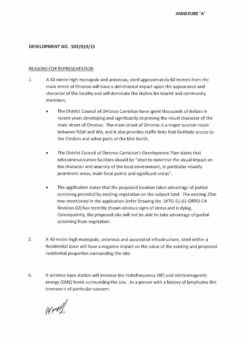
ANNEXURE 'A'
DEVELOPMENT NO. 502/019/15
REASONS FOR REPRESENTATION
1. A 40 metre high monopole and antennas, sited approximately 60 metres from the
main street of Orroroo will have a detrimental impact upon the appearance and
character of the locality and will dominate the skyline for tourist and community
members.
2.
• The District Council of Orroroo Carrieton have spent thousands of dollars in
recent years developing and significant ly improving the visual character of the
main street of Orroroo. The main street of Orroroo is a major tourism route
between NSW and WA, and it also provides traffic links that facilitate access to
the Flinders and other parts of the Mid North.
• The District Counci l of Orroroo Carrieton's Development Plan states that
telecommunication facilities should be "sited to minimise the visual impact on
the character and amenity of the loca l environment, in particular visually
prominent areas, main focal points and significant vistas".
• The application states that the proposed location takes advantage of partial
screening provided by existing vegetat ion on the subject land. The existing 25m
tree mentioned in the application (refer Drawing No. SPTG-51-01-0RRO-C4
Revision 02) has recently shown obvious signs of stress and is dying.
Consequently, the proposed site will not be able to take advantage of partial
screening from vegetation.
A 40 metre high monopole, antennas and associated infrastructure, sited within a
Residential Zone will have a negative impact on the value of the existing and proposed
residential properties surrounding the site.
3. A wireless base station will increase the radiofrequency (RF) and electromagnetic
energy (EME) levels surrounding the site. As a person with a history of lymphoma th is
increase is of particular concern.
(
(
• Aurecon Australasia Pty Ltd ABN 54 005 139 873 55 Grenfell Street
T +61 8 8237 9777 F +61 8 8237 9778 E [email protected] w aurecongroup.com
aurecon Adelaide SA 5000 Australia
DISTfliCT COUNCIL OF ORROROO I CARRIETON
FILE ...... .. ...... ...... .
16 October 2015 2 2 OCT Z015
~TI~~boN ......... ..... ..... .......... .. ... .... .. ....... ,.., ........ ,,,,, ,,
Ann Frick Development Officer
...... .... ....... .. .. . . . . . . . .. .. ..... ,. .,,, ~ ,,. , ,,
District Council of Orroroo Carrieton PO Box 3 ORROROO SA 5431
Dear Ann
DA: 502/019/15- Response to Representations Received during Category 3 Public Notification of Development Application for a proposed nbn rM Fixed Wireless Facility at 24 Fourth Street, Orroroo, SA 5431
We are writing in response to Council's letter dated 2 October 2015 in regard to the representations that were received in regard to the nbn ™ Fixed Wireless Facility (DA: 502/019/15) proposed at the above
address.
We thank Council for the opportunity to respond, on behalf of nbn, to the comments made during the public notification of the application. nbn appreciates feedback from residents and is committed to working openly and transparently with communities and key stakeholders in the deployment of nbn TM
infrastructure nationwide to achieve solutions which strike a balance between providing nbn ™ services and minimising impacts on communities and the local environment.
One ( 1) representation was received and we would like to take this opportunity to respond to the issues raised within the representation. The representor raises concerns that the proposed location will have a high visual impact on a major tourist route and likely to impact on property values and cause health implications.
As the representation has expressed a range of issues, we have categorised and addressed these under the headings below.
Site Selection Process
The location of an nbn TM Fixed Wireless telecommunications facility is determined by a number of key considerations. Unlike mobile technologies, the proposed nbn ™ Fixed Wireless Facility is required to be located as close to the centre of the coverage objective as practicable in order to be technically feasible.
Search areas are usually located in proximity to areas which require the service, to ensure balanced and effective coverage is provided to all residents and businesses.
In order to provide effective fixed wireless internet coverage to Orroroo, the facility needs to be located in a central location to ensure each antenna at the top of the facility services an even number of premises in the coverage footprint. In addition, the facility needs to be able to achieve line of sight connection to another nbn rM facility in Peterborough, which is crucial for the functioning of the facility. These technical constraints mean that the facility can only be located in certain central locations within Orroroo in order to function effectively.
For instance, the following are two (2) of the major constraints within Orroroo:
Page1

(
(
• aurecon
1. In certain locations within and around Orroroo, the transmission connection that would link the Orroroo and Peterborough facilities may be affected by aircraft using the Orroroo Airport. Whilst the frequency of flights is considered to be low, the impact of the aircraft blocking the transmission signal would affect every user on the nbn ™ network in Orroroo by way of losing their individual connections. Due to obligations on it, nbn does not consider this to be an acceptable risk when delivering a fast, reliable broadband internet service.
2. Crown owned land- majority of the land bordering Orroroo (on the outskirts/fringe of the town) is under the ownership of the Crown. Establishing a new telecommunications facility on this land poses a significant and unacceptable risk as, nbn cannot secure appropriate tenure. As a lease agreement cannot be resolved, nbn cannot construct on the land, and an alternative location must be pursued to avoid substantial delays to the rollout of the nbn™ network to Orroroo.
During earlier stages of planning for a facility in Orroroo, three (3) sites were selected for further investigation. A number of sites were ruled out due to the above transmission and Crown land issues, as well as the inability to provide adequate coverage to Orroroo, OH&S issues and site access issues (i.e. a location on Viterra land). Aside from the proposed location (which forms our Development Application) the following two (2) sites were also considered for the installation of the Fixed Wireless facility:
A. Optus Co-location -Recreation Oval, Section 349 North Terrace, Orroroo
In the first instance, nbn determined if any existing infrastructure can be used for the co-location of nbn™ equipment to avoid the construction of a new facility. This candidate is an existing 55 metre high Optus lattice tower with associated antennas. Whilst this candidate is well separated from residential land uses and negates the need for a new facility, the location also has a number of constraints which prevents the co-location of nbn ™ equipment, as follows:
• The existing facility is located on Crown owned land in which nbn cannot secure an appropriate lease. Whilst Optus has accepted this risk, nbn has advised that it is not in a position to do so. As mentioned above, if a lease cannot be secured, nbn cannot use the land; and
• The critical transmission link, requiring line of sight to Peterborough is affected by the aircraft utilising the Orroroo Airport, effectively "cutting" the connection if a plane traverses through the point-to-point radio signal between the towers.
Despite nbn's strong preference for co-location solutions, for the reasons outlined above, colocation on this facility was not considered to be a viable option. In addition to this candidate, the existing 30 metre high Telstra facility was also considered as a potential co-location opportunity, however, this facility is not considered to have adequate structural capacity to support additional nbn TM equipment.
B. Council Works Depot -18 Fifth Street, Orroroo
This candidate is located within a Residential Zone towards the centre of Orroroo. Whilst this site is similar to our proposed site, it was not selected due to:
• The condition of the subject land highlights potential for site contamination issues (being a works depot);
• The site is compact and does not offer an appropriate amount of space for the construction of the facility, and would have required the relocation of multiple items of equipment/machinery;
Page2

(
(
• aurecon
• The site is considered to be in closer proximity to residential land uses than the proposed site and is likely to have a greater visual impact as it was proposed to be located adjacent the Fifth Street frontage.
• The possibility of protracted lease negotiations, delaying the rollout of the nbn™ network to Orroroo.
In contrast to the above, we are of the opinion that the proposed location achieves an appropriate balance between the technical constraints for the provision of an effective wireless internet service to Orroroo and minimising impact on the locality and town as much as practicable. As identified in the representation, we acknowledge that the facility is in proximity to dwellings to the southwest and northeast of the subject land; however, the siting ensures that the base of the facility (compound area) is not within direct line of sight from the primary frontage of any dwellings.
Visual Impact
The representation has raised issue with the location of the facility being in proximity to residential dwellings and the main street (Second Street) as a major tourist route.
We acknowledge the character and amenity value that the refurbished main street brings to Orroroo. There is no doubt that the street offers an open, attractive and inviting atmosphere to both residents and visitors to the town.
We also acknowledge that the established trees planted within the median strip provide a dense 'screen' which restricts views to the northeast when travelling along Second Street from the southeast and is likely to conceal a significant portion of the facility from view by passing motorists.
On the opposite approach into town (from the northwest), the existing native trees and stobie poles provide a balance of vertical elements and whilst there are no existing structures that compare to a 40 metre high monopole, the proposed setback (from Second Street), as well being located behind the existing tree, minimises impact on the character of the main street. In addition, as the proposed site favours one side of the town (i.e. not directly in the centre of the town) once a motorist reaches the refurbished main street, they have already passed the site, which avoids the impact on the main street itself.
It should be noted that whilst the refurbished main street provides a pleasant aesthetic to Orroroo, the town does have precedence of two (2) other telecommunication facilities. Both existing facilities are of a lattice tower design, which is considered to have a greater visual impact when compared to the proposed facility. A lattice design creates a bulky, dominant appearance, whereas the proposed monopole structure is considered to be more sympathetic to the surrounding environment by being a slim and uniform design.
Furthermore, the existing Telstra facility, located at 1 Fifth Street, is considered to have comparable separation from residential dwellings and closer setback distances to road frontages.
Our proposal has set the facility as far back within the property as possible, offering approximately 55 metres from Second Street and approximately 65 metres from Fourth Street. The location utilises the existing "Hunts Fuel" and "Orroroo Senior Citizens Club Inc." buildings to provide reasonable screening to the base of the proposed facility when viewed from adjoining road networks.
In regard to the comment in the representation that the existing 25m high tree is 'dying', we cannot confirm this is the case. However, the application is proposing to retain the tree to provide partial screening of the facility and unfortunately it is beyond the control of this application as to how long that partial screening is available.
Page 3

(
(
• aurecon
Health & EME
The representation also raised the issues regarding the effect of Electromagnetic Energy (EME I EMR) that will be produced by the proposed facility, stating that "a wireless base station will increase the radiofrequency (RF) and electromagnetic energy (EME) levels surrounding the site ."
nbn acknowledges that some people are concerned about possible health effects from the EME generated by radio frequency technology and are committed to addressing these concerns responsibly.
We note that information about EME and safety was provided at our well-attended community information session held in Orroroo prior to lodging this application on 5th August 2015.
nbn relies on the expert advice of national and international health authorities such as the Australian Radiation Protection and Nuclear Safety Agency (ARPANSA) and the World Health Organization (WHO) for overall assessments of health and safety impacts.
Organisations such as the WHO routinely review the medical research and science relevant to the Electromagnetic Energy (EME) generated by radio communications services. The consensus is that there is no substantiated scientific evidence of adverse health effects from the EME generated by radio communications services that comply with national and international safety guidelines.
The report which accompanied the application to Council clearly demonstrates that the NBN Fixed Wireless proposal will operate well within the prescribed safety standards developed by ARPANSA, and a summary of the estimated RF EME levels around the proposed Orroroo facility is contained in the "EME Report", which was included with the application documentation.
We also note that research on possible biological and health effects of exposures to RF EME has been underway for more than 50 years. The WHO states that the research has found no adverse health effects from the low level RF signals emitted by base stations and wireless networks:
"considering the very low exposure levels and research results collected to date, there is no convincing scientific evidence that the weak RF signals from base stations and wireless networks cause adverse health effects"
It is nbn's responsibility to comply with the mandated standard for RF EME set by ARPANSA, which is the safety standard recommended by the WHO. The safety standard works by limiting the network signal to a level low enough to protect all people, in all environments, 24 hours a day. The safety limit itself has a significant safety margin built into it. For reference, please find attached EME Report (as sent to Council in a letter dated 24 August 2015) which shows the maximum predicted level of EME equates to 0.11% of the maximum allowable exposure limit (mandated standard) at a distance of 247.9 metres from the facility. This is substantially less than 1% of the maximum allowable exposure limit. In locations that are closer to the facility (0 -50 metres) the maximum levels much less- equating to 0.017% of the maximum allowable limit (or over 5800 times below that limit).
The proposal will operate at levels that are many orders of magnitude below the standard.
Property Values
Property values may be impacted for a variety of reasons. nbn is not aware of any credible evidence to suggest that the construction of a telecommunications facility would influence property value from a positive or negative perspective.
Page 4

(
(
• aurecon
We trust that the above response addresses the key issues raised within the representation received by Council.
We note that the proposed nbn TM facility will deliver substantial benefits to premises in Orroroo and the entire community has the potential to benefit from broadband that will be reliable and cost effective.
We confirm our intention to attend a Flinders Regional Development Assessment Panel meeting in support of our response should the opportunity be provided.
Should Council require any further information, please do not hesitate to contact the undersigned on (08) 8237 9989 or by email at [email protected]
Yours sincerely
Adam Pfitzner Planner
Enc: ARPANSA Environmental EME Report
Cc: David Hutchison Access Planning (SA) Pty Ltd 235 Henley Beach Road TORRENSVILLE SA 5031
Paga5

Environmental EME Report Orroroo 24 Fourth Street, ORROROO SA 5431
This report provides a summary of Calculated RF EME levels around the wireless base station
Date 11/8/2015
Introduction
RFNSA Site No. 5431007
The purpose of this report is to provide calculations of EME levels from the existing facilities at the site and any proposed additional facilities.
This report provides a summary of levels of radiofrequency (RF) electromagnetic energy (EME) around the wireless base station at Orroroo 24 Fourth Street ORROROO SA 5431 . These levels have been calculated by Ericsson using methodology developed by the Australian Radiation Protection and Nuclear Safety Agency (ARPANSA).
The maximum EME level calculated for the proposed systems at this site is 0.1 1% of the public exposure limit.
( The ARPANSA Standard
(
ARPANSA, an Australian Government agency in the Health and Ageing portfolio, has established a Radiation Protection Standard specifying limits for general public exposure to RF transmissions at frequencies used by wireless base stations. The Australian Communications and Media Authority (ACMA) mandates the exposure limits of the ARPANSA Standard.
How the EME is calculated in this report The procedure used for these calculations is documented in the ARPANSA Technical Report "Radio Frequency EME Exposure Levels- Prediction Methodologies" which is available at http://www.arpansa.gov.au.
RF EME values are calculated at 1 .5m above ground at various distances from the base station, assuming level ground.
The estimate is based on worst-case scenario, including: • wireless base station transmitters for mobile and broadband data operating at maximum power • simultaneous telephone calls and data transmission • an unobstructed line of sight view to the antennas.
In practice, exposures are usually lower because: • the presence of buildings, trees and other features of the environment reduces signal strength • the base station automatically adjusts transmit power to the minimum required.
Maximum EME levels are estimated in 360° circular bands out to 500m from the base station.
These levels are cumulative and take into account emissions from all mobile phone antennas at this site. The EME levels are presented in three different units:
• volts per metre (V/m) -the electric field component of the RF wave
• milliwatts per square metre (mW/m2) - the power density (or rate of flow of RF energy per unit area)
• percentage(%) of the ARPANSA Standard public exposure limit (the public exposure limit = 100%).
Results The maximum EME level calculated for the proposed systems at this site is 2.076 V/m; equivalent to 11 .43 mW/m2 or 0.11% of the public exposure limit.
Environmental EME report (v11.3, Feb 2014) Produced with RF-Map 2.0 (Build 1.18) NAD (v1 .0.53334.25518)

(
(
Radio Systems at the Site There are currently no existing radio systems for this site.
It is proposed that this base station will have equipment for transmitting the following services:
Carrier Radio Systems
NBN Co L TE2300 (proposed)
Calculated EME Levels This table provides calculations of RF EME at different distances from the base station for emissions from existing equipment alone and for emissions from existing equipment and proposed equipment combined.
Maximum Cumulative EME Level- All carriers at this site Distance from the antennas Existing Equipment Proposed Equipment at Orroroo 24 Fourth Street
in 360° circular bands Electric Field Power Density %ARPANSA Electric Field Power Density %ARPANSA V/m mWtm• exposure limits V/m mW/m2 exposure limits
Om to 50m 0.8 1.71 0.017% 50m to 100m 0.67 1.19 0.012% 100m to 200m 1.75 8.096 0.081% 200m to 300m 2.076 11.43 0.11% 300m to 400m 1.97 10.24 0.1% 400m to 500m 1.54 6.3 0.063%
2.076 11.43 0.11 Maximum EME level 247.9 m from the antennas at Orroroo 24
Fourth Street
Calculated EME levels at other areas of interest This table contains calculations of the maximum EME levels at selected areas of interest that have been identified through the consultation requirements of the Communications Alliance Ltd Deployment Code C564:2011 or via any other means. The calculations are performed over the indicated height range and include all existing and any proposed radio systems for this site.
Maximum Cumulative EME Level
Height I Scan All Carriers at this site Additional Locations relative to location Existing and Proposed Equipment
ground level Electric Field Power Density %of ARPANSA V/m mWtm• exposure limits
Orroroo Area School on West Terrace Om to 3m 1.22 3.93 0.039%
Environmental EME report (v11.3, Feb 2014) Produced with RF-Map 2.0 (Build 1.18) NAD (v1.0.53334.25518)
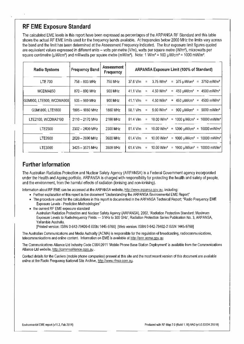
(
(
RF EME Exposure Standard The calculated EME levels in this report have been expressed as percentages of the ARPANSA RF Standard and this table shows the actual RF EME limits used for the frequency bands available. At frequencies below 2000 MHz the limits vary across the band and the limit has been determined at the Assessment Frequency indicated. The four exposure limit figures quoted are equivalent values expressed in different units- volts per metre (V/m), watts per square metre (W/m2
), microwatts per square centimetre (1-JW/cm2
) and milliwatts per square metre (mW/m2) . Note: 1 W/m2 = 100 1-JW/cm2 = 1000 mW/m2
.
Radio Systems Frequency Band Assessment ARPANSA Exposure Limit (100% of Standard) Frequency
LTE 700 758-803 MHz 750 MHz 37.6 V/m = 3.75 Wtm• = 375 ~W/cm• = 3750 mWtm•
WCDMA850 870-890 MHz 900 MHz 41.1 V/m = 4.50 Wtm• = 450 ~W/cm• = 4500 mWtm•
GSM900, LTE900, WCDMA900 935-960 MHz 900 MHz 41 .1 V/m = 4.50 Wtm• = 450 ~W/cm• = 4500 mWtm•
GSM1800, LTE1800 1805-1880 MHz 1800 MHz 58.1 V/m = 9.00 W/m2 = 900 ~W/cm• = 9000 mWJm•
LTE2100, WCDMA2100 2110-2170 MHz 2100 MHz 61.4 V/m = 10.00 WJm• = 1000 ~W/cm• = 10000 mWtm•
LTE2300 2302- 2400 MHz 2300 MHz 61.4 V/m = 10.00 W/m2 = 1000 ~W/cm• = 10000 mWtm•
LTE2600 2620- 2690 MHz 2600 MHz 61.4 V/m = 10.00 WJm• = 1000 ~W/cm• = 10000 mWJm•
LTE3500 3425- 3575 MHz 3500 MHz 61.4 V/m = 10.00 W/m2 = 1000 ~W/cm• = 10000 mWJm•
Further Information The Australian Radiation Protection and Nuclear Safety Agency (ARPANSA) is a Federal Government agency incorporated under the Health and Ageing portfolio. ARPANSA is charged with responsibility for protecting the health and safety of people, and the environment, from the harmful effects of radiation (ionising and non-ionising).
Information about RF EME can be accessed at the ARPANSA website, http://www.arpansa.gov.au, including: • Further explanation of this report in the document "Understanding the ARPANSA Environmental EME Report" • The procedure used for the calculations in this report is documented in the ARPANSA Technical Report; "Radio Frequency EME
Exposure Levels - Prediction Methodologies" • the current RF EME exposure standard
Australian Radiation Protection and Nuclear Safety Agency (ARPANSA), 2002, 'Radiation Protection Standard: Maximum Exposure Levels to Radiofrequency Fields-3kHz to 300 GHz', Radiation Protection Series Publication No.3, ARPANSA, Yallambie Australia. (Printed version: ISBN 0-642-79400-6 ISSN 1445-9760) [Web version: ISBN 0-642-79402-2 ISSN 1445-9760]
The Australian Communications and Media Authority (ACMA) is responsible for the regulation of broadcasting, radiocommunications, telecommunications and online content. Information on EME is available at http://emr.acma.gov.au
The Communications Alliance Ltd Industry Code C564:2011 'Mobile Phone Base Station Deployment' is available from the Communications Alliance Ltd website, http://commsalliance.com.au .
Contact details for the Carriers (mobile phone companies) present at this site and the most recent version of this document are available online at the Radio Frequency National Site Archive, http://www.rfnsa.com.au.
Environmental EME report (v11.3, Feb 2014) Produced with RF-Map 2.0 (Build 1.18) NAD (v1.0.53334.25518)

1
3rd November 2015 Ref: 6481rept The Chief Executive Officer District Council of Orroroo Carrieton PO Box 3 ORROROO SA 5431 ATTENTION: Ms. Ann Frick Dear Ann, RE: FIXED WIRELESS TELECOMMUNICATIONS FACILITY COMPRISING A 40 METRE
HIGH MONOPOLE, ANTENNAS AND ASSOCIATED INFRASTRUCTURE (DA: 502/019/15)
The following is a planning assessment of the above mentioned development application. In preparing this report I have reviewed the Council file and associated documents, inspected the subject land and locality and assessed the development against the relevant provisions of the Development Plan. 1.0 DEVELOPMENT DETAILS Development Application No: 502/019/2015 Applicant: NBN Co. C/- Aurecon Australasia Pty Ltd, 55 Grenfell Street, Adelaide, SA 5000 Owner: Mr. Trevor McKay 17 Fourth Street, Orroroo, SA 5431 Property Location: Lot 4 FP160952 Orroroo - 24 Fourth Street. Certificate of Title: Volume: 5309 Folio: 593 Existing Use: Vacant land used for parking and storage Proposed Development: Fixed Wireless Telecommunications Facility comprising
a 40 Metre High Monopole, Antennas and Associated Infrastructure
Zone: Residential Zone (Map OrCar/3) Public Notification: Category 3 - Merit Authorised Development Plan: Orroroo Carrieton Council, 22 November 2012

2
2.0 PROPOSED DEVELOPMENT The development proposes to the establishment of a wireless transmission facility for the provision of broadband internet and landline phone services. The development will include the following features: A new 40m high steel monopole; Three (3) 1077mm long panel antennas at a centre line height of 40m; Three (3) 500mm long remote radio units (RRUs), mounted behind panel antennas; One (1) 1800mm diameter parabolic antenna at a centerline height of 37m; One (1) GPS unit; Two (2) outdoor equipment cabinets (each measuring 1464mm x 667mm x 944mm); and 2.4m high security fencing and associated ancillary equipment. The proposed facility is to be located in the a secure compound located in the north west corner of the site, putting the facility some 60m from the alignment of Fourth Street and 50m from the alignment of Second Street. The tower has a base dimension of about 1.5m, is about 400mm wide at the top and supports a head frame supporting the antennas which is about 3m across; the antennas being about 3.4 in height. The NBN network has been described in the application documents thus; “Although fixed wireless facilities are submitted to Council as standalone developments from a planning perspective, they are highly interdependent from a technical perspective. Each fixed wireless facility is connected to another to form a chain of facilities that link back to the fibre network. This is called the ‘transmission network. The transmission network requires line of sight from facility to facility until it reaches the fibre network. The fixed wireless network will remain unconnected without the transmission network and a break in this chain can have flow on effects to multiple communities. A typical fixed wireless facility will include three antennas mounted above the surrounding area. Each antenna is designed to cover a set area to maximise signal strength. These network antennas communicate to a small antenna installed on the roof of each customer’s home or business. Each NBN Co Fixed Wireless facility has been designed to heights that allow the panel antennas to have a clear line of sight to the surrounding premises (radio coverage), and also ensure that the radio transmission dish has a clear line of sight to the adjoining network facility to link the sites back into the broader network.” The applicant advises that the site for the development has been selected by a range of parameters including; A need to be located within or immediate adjacent to the area to serviced; Visual amenity impacts; Potential co-location option; The availability and suitability of land as well as a willing site provider; Occupational health and safety and construction issues; Access for maintenance purposes; Topographical constraints affecting network line of sight; Legislative policy constraints; Environmental impact;, and

3
Cost implications. As part of the process of selecting a site, co-location options must be considered. Co-location involves locating the facility on an existing tower if one exists in the area under investigation. Two co-location options were investigated, The 30 metre high Telstra lattice tower at 1 Fifth Street, Orroroo – co-location on this facility
was not considered feasible due to the inadequate structural capacity of the existing facility. The 55 metre high Optus lattice tower at Section 349 East Terrace, Orroroo – co-location was
not considered feasible as the land is owned by the Crown which incurs protracted lease negotiations.
The applicant advises that neither site was considered appropriate because the height available to locate the facility was too low, especially for the parabolic antenna which needs ‘line of sight’ to the facility at Peterborough. Other sites considered included the Council works depot at 18 Fifth Street and the land now the subject of this application. Reasons for excluding the Council works depot include potential site contamination issues, limited space to locate the facility, the proximity of houses and subsequent visual impact issues, and the possibility of having to enter into protracted lease negotiations with the Council. The subject land was ultimately selected as it was in the search area and provided line of sight access to the NBN Co. facility at Peterborough, is a property used for non-residential purposes (despite being in the Residential zone) and can take advantage of the partial screening provided by existing development and landscaping on the land. 3.0 THE SUBJECT LAND AND LOCALITY The subject land is an irregular shaped allotment having a frontage of 15m to Fourth Street and a depth of some 60m. All up the land has an area of 1023m2. The land is more particularly described as being allotment 4 in Filed Plan 160592, Fourth Street Orroroo; Certificate of Title Volume 5309 Folio 593. The land forms part of a larger land holding that includes the garage located at the corner of Second and Fourth Streets and is used for access purposes to the garage and for outdoor storage purposes. The land is surfaced with a combination of crushed rubble and natural earth and a small stone building (which appears to have been a modest cottage occupies part of the north eastern boundary of the land. There is a large gum tree in the south western corner of the land. At the time of my inspection the gum tree appeared dead or very close to it, with only marginal leaf growth at the tips of the upper branches. Various views of the subject land are available in the application documents and in Appendix 1 of this report.

4
I note that the report accompanying the Development Application cites the gum tree on the subject land as having a height in the order of 25m. I estimate the height at something less than 20m. The gum tree provides a useful reference for the height of the 40m high tower.
Figure 1: The Subject Land For the purpose of defining the locality I have adopted the whole of the Town and its surrounds and in particular those areas adjacent to the town where the proposed tower will have a visual impact. To this end there is a primary locality, which is the built up area of the town in which the proposed development will have its most significant visual impact, with the secondary locality being the rural area surrounding the town and in particular the road entries to the Town.

5
The facility will be visible to varying degrees within both localities and will depend on the screening providing by roadside or plantation vegetation, the direction of the road from which the facility will be seen (focus of the view) and the elevation of the road relative to the subject land. Orroroo is located in a relatively flat environment and development within the town is low scale, primarily single storey building arranged along very wide road reserves. Unlike many country towns, private television antennas are rare and overhead infrastructure is low. The most visible features of the Town, particularly on the approaches to the Town from the north and west are the grain silos and the Telstra tower on the northern approach and the Optus tower, CFS tower and grain silos on the approach from the west. The degree of visibility of these features depends on the extent of screening from roadside vegetation as well as its location in relation to the focus of the view.
Figure 2: Entry to Orroroo from the north. The proposed tower sits just to the right of the road in the middle distance
In both cases the very low scale of development is obvious, with features such as the Telstra tower in the case of Figure 2 and the CFS tower in the case of figure 3 being in the drivers peripheral vision as opposed to the proposed tower which will sit almost directly in the line of vision. Landscaping, roadside vegetation and intervening buildings will hide the lower portion of the tower but the upper section, headframe and antennas will highly visible above the trees and buildings.
Figure 3: Entry to Orroroo from the west. The proposed tower sits just to the left of the road in the middle distance. In other circumstances on the entry to the town the Telstra and Optus Towers are visible clustered together with the silos, and for the most part are viewed in the peripheral vision of a person passing along the main entry routes into the town. As identified by Aurecon, much of the Town is surrounded by Crown land as indicated in Figure 4 below.
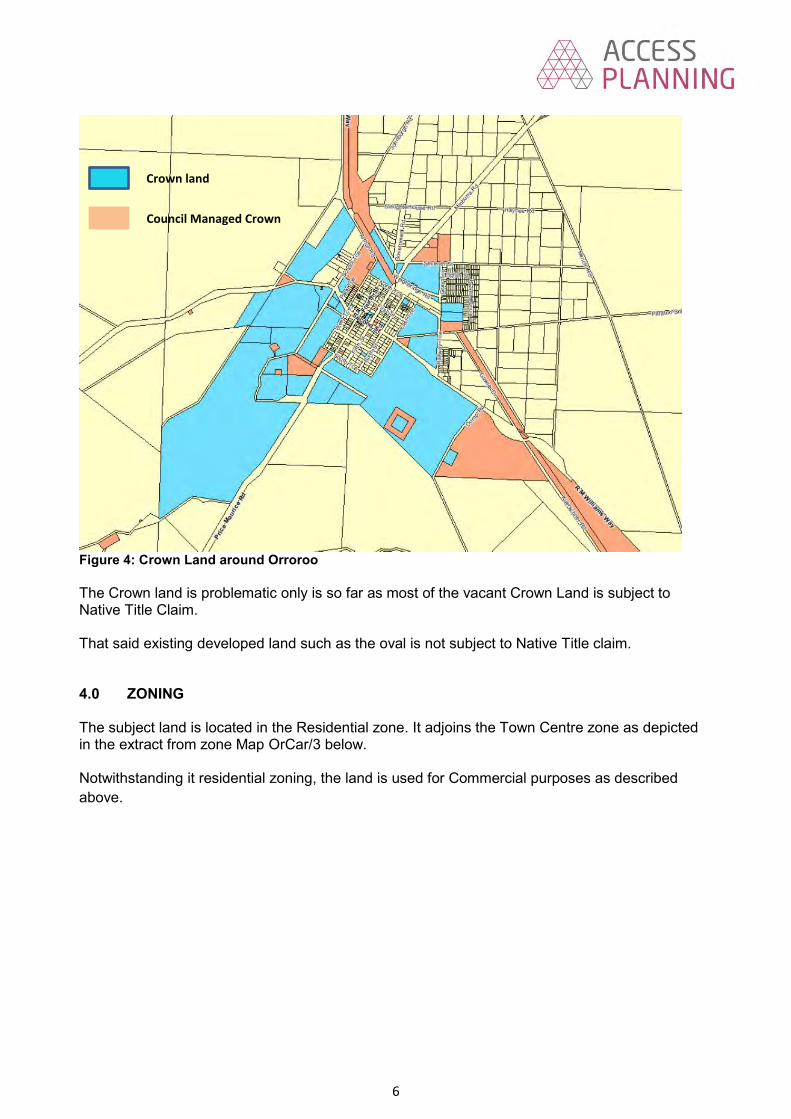
6
Figure 4: Crown Land around Orroroo The Crown land is problematic only is so far as most of the vacant Crown Land is subject to Native Title Claim. That said existing developed land such as the oval is not subject to Native Title claim. 4.0 ZONING The subject land is located in the Residential zone. It adjoins the Town Centre zone as depicted in the extract from zone Map OrCar/3 below. Notwithstanding it residential zoning, the land is used for Commercial purposes as described above.
Crown land
Council Managed Crown
Land
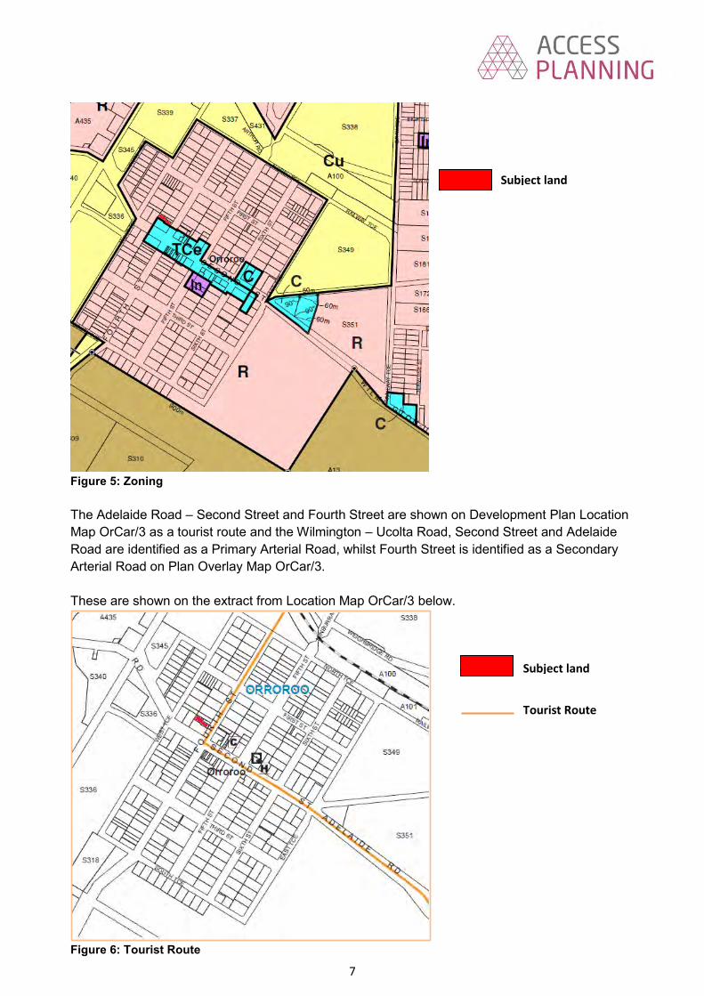
7
Figure 5: Zoning The Adelaide Road – Second Street and Fourth Street are shown on Development Plan Location Map OrCar/3 as a tourist route and the Wilmington – Ucolta Road, Second Street and Adelaide Road are identified as a Primary Arterial Road, whilst Fourth Street is identified as a Secondary Arterial Road on Plan Overlay Map OrCar/3. These are shown on the extract from Location Map OrCar/3 below.
Figure 6: Tourist Route
Subject land
Tourist Route
Subject land

8
5.0 PUBLIC CONSULTATION Pursuant to Schedule 9 of the Development Regulations 2008, the proposed development was classed as a Category 3 form of development for the purposes of Public Consultation, and as such underwent public notification. One response were received, a summary of which is provided below. A 40 metre high monopole and antennas, sited approximately 60 metres from the main street
of Orroroo will have a detrimental impact upon the appearance and character of the locality and will dominate the skyline for tourist and community members.
The District Council of Orroroo Carrieton have spent thousands of dollars in recent years
developing and significantly improving the visual character of the main street of Orroroo. The main street of Orroroo is a major tourism route between NSW and WA, and it also provides traffic links that facilitate access to the Flinders and other parts of the Mid North.
The District Council of Orroroo Carrieton’s Development Plan states that telecommunication
facilities should be “sited to minimise the visual impact on the character and amenity of the local environment, in particular visually prominent areas, main focal points and significant vistas”.
The application states that the proposed location takes advantage of partial screening
provided by existing vegetation on the subject land. The existing 25m tree mentioned in the application has recently shown obvious signs of stress and is dying. Consequently, the proposed site will not be able to take advantage of partial screening from vegetation.
A 40 metre high monopole, antennas and associated infrastructure, sited within a Residential
Zone will have a negative impact on the value of the existing and proposed residential properties surrounding the site.
A wireless base station will increase the radio frequency (RF) and electromagnetic energy
(EME) levels surrounding the site. As a person with a history of lymphoma this increase is of particular concern.
6.0 RESPONSE TO REPRESENTATIONS Siting of the facility The applicant has responded to the above by restating the reasons for siting the tower where they have (as set out in section 2 above), with the added advise that; Certain location in the Town are subject to interference from aircraft taking off from the airfield
which would break the link to Peterborough, and Much of the land around Orroroo is Crown land and there is some di8fficulty securing a lease
with the Crown. They maintain that the subject land achieves a balance between the technical issues around siting the facility and minimising the visual impact of the facility. Visual impact In response to issues raised about the visual impact they say that;
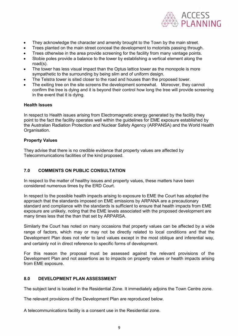
9
They acknowledge the character and amenity brought to the Town by the main street. Trees planted on the main street conceal the development to motorists passing through. Trees otherwise in the area provide screening for the facility from many vantage points. Stobie poles provide a balance to the tower by establishing a vertical element along the
road(s). The tower has less visual impact than the Optus lattice tower as the monopole is more
sympathetic to the surrounding by being slim and of uniform design. The Telstra tower is sited closer to the road and houses than the proposed tower. The exiting tree on the site screens the development somewhat. Moreover, they cannot
confirm the tree is dying and it is beyond their control how long the tree will provide screening in the event that it is dying.
Health Issues In respect to Health issues arising from Electromagnetic energy generated by the facility they point to the fact the facility operates well within the guidelines for EME exposure established by the Australian Radiation Protection and Nuclear Safety Agency (ARPANSA) and the World Health Organisation. Property Values They advise that there is no credible evidence that property values are affected by Telecommunications facilities of the kind proposed. 7.0 COMMENTS ON PUBLIC CONSULTATION In respect to the matter of healthy issues and property values, these matters have been considered numerous times by the ERD Court. In respect to the possible health impacts arising to exposure to EME the Court has adopted the approach that the standards imposed on EME emissions by ARPANA are a precautionary standard and compliance with the standards is sufficient to ensure that health impacts from EME exposure are unlikely, noting that the EME levels associated with the proposed development are many times less that the than that set by ARPARSA. Similarly the Court has noted on many occasions that property values can be affected by a wide range of factors, which may or may not be directly related to local conditions and that the Development Plan does not refer to land values except in the most oblique and inferential way, and certainly not in direct reference to specific forms of development.
For this reason the proposal must be assessed against the relevant provisions of the Development Plan and not assertions as to impacts on property values or health impacts arising from EME exposure. 8.0 DEVELOPMENT PLAN ASSESSMENT The subject land is located in the Residential Zone. It immediately adjoins the Town Centre zone. The relevant provisions of the Development Plan are reproduced below. A telecommunications facility is a consent use in the Residential zone.

10
Residential Zone Objectives 1 A residential zone comprising a range of dwelling types. 2 Increased dwelling densities in close proximity to centres, public transport routes and public
open spaces. 3 Development that contributes to the desired character of the zone. Desired Character The zone comprises a large proportion of Orroroo township and incorporates most of the residential and pockets of community-related development, including a home for the elderly. Orroroo has retained its low-density development pattern and an attractive character which provide a pleasant living environment for its residents. Although a variety of housing styles exist in the zone, dwellings in general have remained in good physical condition. It is important that future development is orderly and compact for the economic provision of essential services, and easy access to the town’s facilities. Principles 1 The following forms of development are envisaged in the zone:
▪ domestic outbuilding in association with a dwelling ▪ domestic structure ▪ dwelling ▪ dwelling addition ▪ small scale non-residential uses that serve the local community, for example:
- child care facilities - health and welfare services - open space - primary and secondary schools - recreation areas - shops, offices or consulting rooms
▪ supported accommodation 4 Non-residential development such as shops, schools and consulting rooms should be of a
nature and scale that: (a) serves the needs of the local community (b) is consistent with the character of the locality (c) does not detrimentally impact on the amenity of nearby residents. 8 Development should not be undertaken unless it is consistent with the desired character for
the zone. Town Centre zone Objectives 4 Development that contributes to the desired character of the zone. Desired Character The zone is located at the crossroads of the Adelaide Road and Morchard Road, in the western part of Orroroo. It incorporates a mixture of land uses, including business, commercial, hotel, tourist-related and some civic/community uses. The town centre evolved as the main service centre as it provides convenient access from other parts of the district, and has traffic links that facilitate access to other parts of the Mid North and to the Flinders. The appearance and historic style of the built environment should be retained, in particular the veranda facades which are seen as an important historic component of the overall style.

11
Preservation of the zone’s character and its built-form, where set-backs, materials, scales, roof pitch, gables, signs and colour schemes reinforce the existing streetscape, is an important element. The appearance of the zone should be further improved by extensive landscaping along the roadsides. New development should have regard to the scale, design and the unique quality of the built-form and be sympathetic to the individual and small-scale style of the existing buildings, and not overwhelm their historic and cultural significance and their setting. The overall special character of the town centre should be preserved and new development be encouraged to reflect values that reinforce the nature of the existing development. Principles 4 Development should not be undertaken unless it is consistent with the desired character for
the zone. 5 Buildings and structures should be designed and constructed in sympathy with adjoining
buildings so as to complement and enhance the existing character and appearance of the streetscape. Particular regard should be taken of the scale of buildings and roof heights, set-backs, façade treatment, profile, verandas, construction materials and colours.
6 Landscape and other features that contribute to the historic character of the streetscape
should not be modified unless the final effect will enhance its character. Design and Appearance Objective 1 Development of a high architectural standard that responds to and reinforces positive aspects
of the local environment and built form. Principle 1 The design of a building may be of a contemporary nature and exhibit an innovative style
provided the overall form is sympathetic to the scale of development in the locality and with the context of its setting with regard to shape, size, materials and colour.
Infrastructure Objectives 1 Infrastructure provided in an economical and environmentally sensitive manner. 2 Infrastructure, including social infrastructure, provided in advance of need. 3 Suitable land for infrastructure identified and set aside in advance of need. 4 The visual impact of infrastructure facilities minimised. 5 The efficient and cost-effective use of existing infrastructure. Principles 10 Utility buildings and structures should be grouped with non-residential development where
possible. Orderly and Sustainable Development Objectives 1 Orderly and economical development that creates a safe, convenient and pleasant environment
in which to live. 4 Development that does not prejudice the achievement of the provisions of the Development
Plan.

12
6 Urban development contained within existing townships and settlements and located only in zones designated for such development.
Principles 6 Development should be located and staged to achieve the economical provision of public
services and infrastructure, and to maximise the use of existing services and infrastructure. Siting and Visibility Objectives 1 Protection of scenically attractive areas, particularly natural and rural landscapes. Principles 1 Development should be sited and designed to minimise its visual impact on: (a) the natural, rural or heritage character of the area (b) areas of high visual or scenic value, particularly rural areas (c) views from public reserves, tourist routes and walking trails. 2 Buildings should be sited in unobtrusive locations and, in particular, should: (a) be grouped together (b) where possible be located in such a way as to be screened by existing vegetation when
viewed from public roads. 4 Buildings and structures should be designed to minimise their visual impact in the landscape,
in particular: (a) the profile of buildings should be low and the rooflines should complement the natural
form of the land (b) the mass of buildings should be minimised by variations in wall and roof lines and by
floor plans which complement the contours of the land (c) large eaves, verandas and pergolas should be incorporated into designs so as to create
shadowed areas that reduce the bulky appearance of buildings. Telecommunications Facilities Objectives 1 Telecommunications facilities provided to meet the needs of the community. 2 Telecommunications facilities sited and designed to minimise visual impact on the amenity of
the local environment. Principles 1 Telecommunications facilities should: (a) be located to meet the communication needs of the community (b) use materials and finishes that minimise visual impact (c) have antennae located as close as practical to the support structure (d) be located primarily in industrial, commercial, business, office, centre and rural zones (e) where technically feasible, be co-located with other telecommunications facilities (f) incorporate landscaping to screen the development, particularly equipment shelters and
huts (g) be designed and sited to minimise the visual impact on the character and amenity of the
local environment, in particular visually prominent areas, main focal points and significant vistas.
2 Telecommunications facilities in areas of high visitation and community use should use
innovative design techniques (eg sculpture and other artworks) where possible and where the resulting design would positively contribute to the character of the area.
3 Telecommunications facilities should be located in residential zones only if sited and designed
to minimise visual impact by: (a) using existing buildings and vegetation for screening (b) where possible, incorporating the facility within an existing structures that may serve
another purpose maintaining that structure’s character
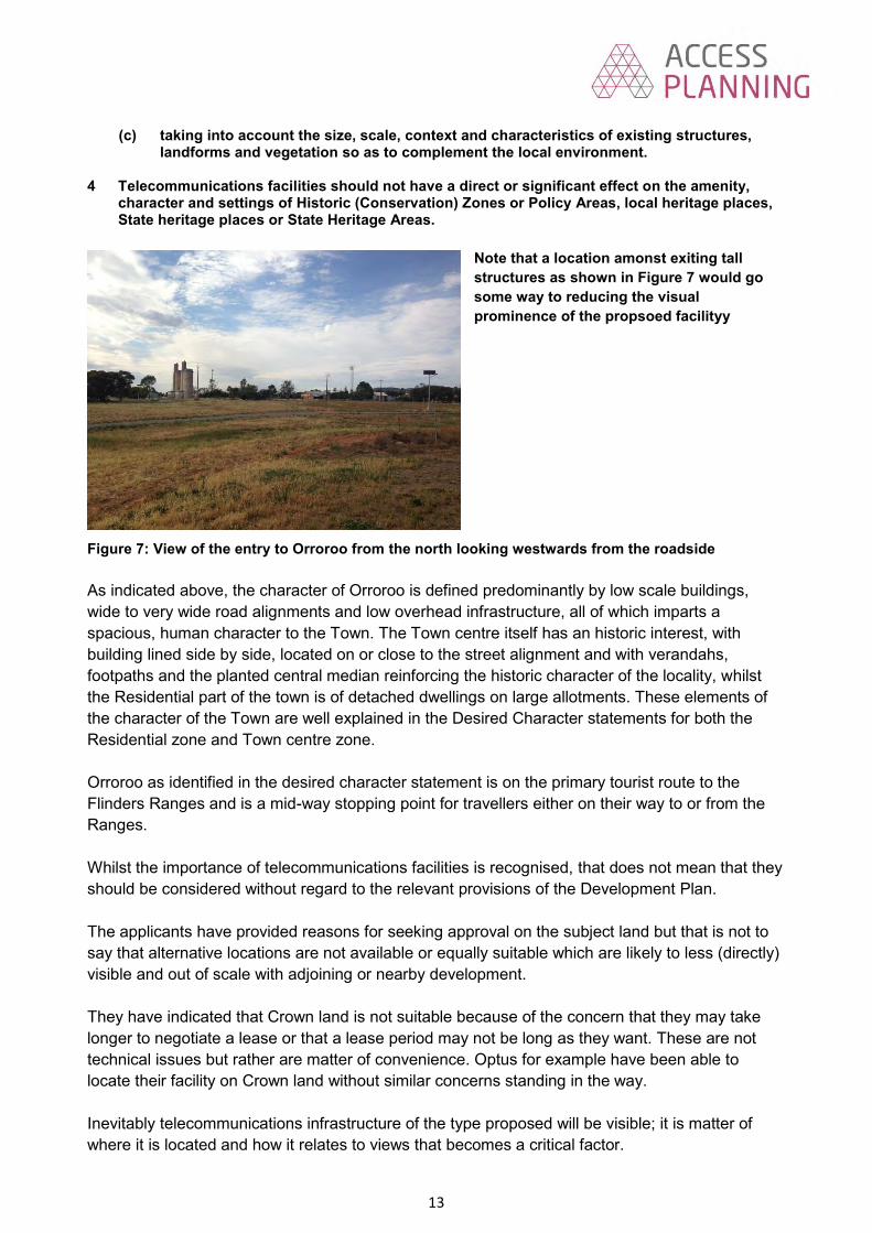
13
(c) taking into account the size, scale, context and characteristics of existing structures, landforms and vegetation so as to complement the local environment.
4 Telecommunications facilities should not have a direct or significant effect on the amenity,
character and settings of Historic (Conservation) Zones or Policy Areas, local heritage places, State heritage places or State Heritage Areas.
Note that a location amonst exiting tall structures as shown in Figure 7 would go some way to reducing the visual prominence of the propsoed facilityy
Figure 7: View of the entry to Orroroo from the north looking westwards from the roadside As indicated above, the character of Orroroo is defined predominantly by low scale buildings, wide to very wide road alignments and low overhead infrastructure, all of which imparts a spacious, human character to the Town. The Town centre itself has an historic interest, with building lined side by side, located on or close to the street alignment and with verandahs, footpaths and the planted central median reinforcing the historic character of the locality, whilst the Residential part of the town is of detached dwellings on large allotments. These elements of the character of the Town are well explained in the Desired Character statements for both the Residential zone and Town centre zone. Orroroo as identified in the desired character statement is on the primary tourist route to the Flinders Ranges and is a mid-way stopping point for travellers either on their way to or from the Ranges. Whilst the importance of telecommunications facilities is recognised, that does not mean that they should be considered without regard to the relevant provisions of the Development Plan. The applicants have provided reasons for seeking approval on the subject land but that is not to say that alternative locations are not available or equally suitable which are likely to less (directly) visible and out of scale with adjoining or nearby development. They have indicated that Crown land is not suitable because of the concern that they may take longer to negotiate a lease or that a lease period may not be long as they want. These are not technical issues but rather are matter of convenience. Optus for example have been able to locate their facility on Crown land without similar concerns standing in the way. Inevitably telecommunications infrastructure of the type proposed will be visible; it is matter of where it is located and how it relates to views that becomes a critical factor.

14
The proposed development is highly visible in view paths along both of the main entry roads to Orroroo and from the secondary entries via Orroroo Road the Wilmington Road where, in all cases it sits just off side of the main view paths along these roads. It is recognised that the views of the facility are screened from time to time by intervening trees and buildings, but the height of the facility is such that the upper portion of the tower at least will be highly visible from a wide area in and around the Town. Moreover, the tower will become a significant focal point at the intersection of Second and Fourth Street, which is the main tourist route through the Town. Aurecon argue that the existing tree will go some way to screening the tower from this vantage point. I am no expert but the tree looks to be well and truly dying. Its health will not be assisted by the digging of substantial footings for the tower in the critical root zone of the tree, which I suspect will be the final element that finish the tree off. There is limited opportunity on site to undertake site landscaping, which in any event is only going to be able to assist in screening the ground level infrastructure. The Development Plan seeks that telecommunications facilities in areas of high visitation, main focal points and significant vistas should minimise the visual impact of the facility. I see nothing in the application that seeks to achieve this goal. Further, the facility does not relate to scale size, context and characteristics of existing structures. Aurecon point to the stobie poles as elements within the locality that assist in offsetting the visual impact of the facility. Certainly the stobie poles are a minor feature of the streetscape. They are however generally low, well-spaced and separated (by the wide road reserves) such that they do not become a defining feature of the streetscape/landscape. At about 8m in height, they do not provide a comparable reference for a 40m high tower with a base of 1.5m and 3m wide headframe. By reference to views 1 and 2 in the appendix, the visual impact of the tower relative to the open streetscape of the intersection of Second and Fourth Street becomes obvious. Aurecon also suggest that the solid slim line tower is a better option than a lattice tower as it has less visual impact. This is at odds with most comparative assessments that find lattice towers less visible. A preferable alternative would be located the tower together with other tall structures on the north eastern side of town. A location along Railway Terrace should still meet the coverage requirements on NBN Co but would either move the location away from the main focal viewpoints and /or reduce its visual impact by locating it together with other tall structures such as the Telstra Tower, Optus Tower and silos, which will go some considerable way to reducing its visual prominence.

15
9.0 CONCLUSION I am of the opinion that the provisions of the Development Plan weigh against the siting of the development where it has been proposed. In particular the development is located in a residential zone and on a highly visible site. Little has been done to reduce its visual prominence either at ground level or for the upper sections of the tower. It is located in a relatively open and thus highly visible locality, and in an area that comprises very low level development in an open and spacious streetscape. The development does not have regard to the existing character of adjoining development and the one tree that might provide some relief for its visual prominence is clearly unhealthy and unlikely to survive the works that are proposed to be undertaken at its base. Whilst acknowledging the need for the facility, I not consider that there is a technical reason that the facility cannot be located in a better position where its visual prominence may be minimised. .

16
10.0 RECOMMENDATION Following consideration and having regard to all relevant issues that Panel resolve; 1 That development application number 502/019/2015 for a telecommunications facility at 24
Fourth Street, Orroroo is not seriously at variance with the provisions of the Development Plan. 2 That following consideration and having regard to all relevant matters that the Panel refuse
Development Plan consent for a telecommunications facility at 24 Fourth Street, Orroroo, as the proposed development would be at odds with the following provisions of the Development Plan.
Residential zone Principle 4 Town Centre zone Objective 4 Principles 4 and 5 General Section Design and Appearance Objective 1 Principle 1 Infrastructure Objective 4 Principle 10 Orderly and Sustainable Development Objectives 1 and 6 Siting of Development Principles 1, 2 and 4 Telecommunications Facilities Objective 2 Principles 1, 3 and 3 Please do not hesitate to contact me in the event that you have any questions.
David Hutchison BA MPIA CPP

17
Appendix 1 Views of the subject land
View 1: The subject land from Fourth Street. The proposed tower sits just to the right of the gum tree. I estimate the gum tree to be about 15m high
View 2: Wider view of the subject land from the intersection of Second and Fourth Streets
The subject land looking from the east on the Wilmington - Orroroo Road adjacent the caravan park. Note the gum tree on the subject land in left middle of the photograph.

18
Subject land from the north north west (rear). Note survey pegs adjacent to the blue vehicle which denote the north western boundary of secure compound in which the facility is to be located.

Aurecon Australasia Pty Ltd ABN 54 005 139 873 55 Grenfell Street Adelaide SA 5000 Australia
T F E W
+61 8 8237 9777 +61 8 8237 9778 [email protected] aurecongroup.com
Project 224387 - Orroroo 09 March 2016 Revision 1 Page 1
09 March 2016 David Hutchison Planning Consultant District Council of Orroroo Carrieton C/- Access Planning (SA) Pty Ltd 235 Henley Beach Road TORRENSVILLE SA 5031 Dear David DA 502/019/15 – Response following FRDAP meeting on 23 November 2015 We are writing in response to your email, dated 5 February 2016, seeking an update on the further investigations for the nbn Application at Orroroo. We are now in a position to provide the following update to Council and, in addition, nbn has asked that we seek some direction from the FRDAP regarding the status of the current Application (502/019/15).
At the meeting on the 23rd November 2015 the FRDAP clearly conveyed to us that it would be inclined to refuse Application 502/019/15, if we were to continue to pursue this.
Since the FRDAP meeting on the 23rd November, where the FRDAP’s consideration of this application was deferred, we have been actively pursuing transmission analysis, including liaison with relevant aircraft authorities and users within the area. This analysis is currently on-going in order to satisfy our client’s objectives. Unfortunately, with the limited amount of information available regarding flight paths and frequency of flights, nbn cannot confirm the exact impact that the transmission link will face until the facility is in service.
In parallel, and based upon feedback at, and immediately following the FRDAP meeting that we should be pursuing an alternative site preferably on Viterra land, we have commenced discussions with Viterra on the possibility of establishing the nbn facility on their land. We have only just been able to obtain an in-principle agreement from Viterra that they would consider a lease proposal. The likely protracted leasing negotiations with Viterra were foreshadowed in our original Application, and it is clear that the process will not be able to be expedited as was suggested by Council. Securing tenure will undoubtedly be protracted in this location. Whilst uncertainties about the outcome remain, we are willing to pursue an option on Viterra land, but this is subject to seeking clarity on the availability of land resulting from Council’s proposal to upgrade the road to create a heavy vehicle bypass. Based upon progress to-date (and past experience in negotiations with Viterra), it is anticipated that it will take approximately 12 months before a lease will be secured.
Of course, this delay in property negotiations, will impact the rollout of the nbn™ network and service delivery to the Orroroo community, and it is likely that residents and businesses in the area will have to wait at least approximately 18 months before an nbn facility is commissioned. We consider that it is the only responsible course to reiterate that a facility could be established very soon if the FRDAP was to approve our current Application. nbn has specifically asked us to advise the FRDAP and Council that last year, just prior to the FRDAP meeting, nbn forecast commissioning of the nbn™ fixed wireless facility in Orroroo for February 2016. We note that only one objection was received to the current Application. nbn places a high priority on delivering improved service to the many hundreds of

Project 224387 - Orroroo 09 March 2016 Revision 1 Page 2
premises in Orroroo and is perplexed that despite extensive pre-application consultation and one objection that Application (502/019/15) is unlikely to be supported by the FRDAP.
If the FRDAP and Council direct nbn to continue to proceed with securing tenure at the Viterra site and then we proceed to lodge an Application at this site, we would hope that minimal delays are experienced during the statutory planning process.
If nbn is to continue to pursue the establishment of a facility on the Viterra land, we also seek the FRDAP and/or Council’s early advice regarding its preference for the type of structure. This advice would be one factor amongst others (including engineering) that would contribute to a decision by nbn. The reason we raise this and seek this advice is because of conflicting commentary which appeared in the Council Planning Reports relating to both the proposed Wirrabarra nbn facility and the Orroroo nbn facility at the FRDAP meeting in November.
Specifically, when commenting on the proposed slim-line monopole, comprising the Orroroo nbn facility, the Council Planning Report advises (page 14) “this is at odds with most comparative assessments that find lattice towers less visible”. In contrast, in the Council report on the proposed nbn slim-line monopole at Wirrabara, this report praises the merits of monopoles: (page 6) “The design of the facility will also assist to minimise its visual impact, as the monopole is a relatively slender structure which carries little bulk, other than its vertical element”. Having regard to the conflicting advice, we seek the FRDAP and Council’s early advice on the preference for a facility type so that this may be factored in to a decision on the facility type at Viterra.
Please note that by pursing a site on Viterra land, nbn is accepting of the fact that the transmission link to Peterborough remains restricted to some extent.
Noting the facts that the nbn™ network will be delayed in Orroroo for a further 18 months and the minimal objection to the current application, we ask the FRDAP and Council to confirm its’ position that the current development application (502/019/15) should be withdrawn because there is no prospect of the FRDAP approving the Application. As soon as direction is received we will withdraw.
Yours sincerely Adam Pfitzner Planner

1
29 March 2016
Ref: 6481furtherrept
The Chief Executive Officer District Council of Orroroo Carrieton PO Box 3 ORROROO SA 5431
ATTENTION: Ms. Ann Frick
Dear Ann,
RE: FIXED WIRELESS TELECOMMUNICATIONS FACILITY COMPRISING A 40 METRE HIGH MONOPOLE, ANTENNAS AND ASSOCIATED INFRASTRUCTURE (DA: 502/019/15)
Panel members will recall that at its last meeting on the 23rd November 2015, the Panel deferred a decision in relation to the above development and requested the applicant to provide additional information on the impact of the Orroroo Airport on the siting of the tower.
Council has now received the attached response from Aurecon re the facility.
In effect they are saying that there is insufficient information available to determine the exact impact of airport activities on the transmission link.
They have also advised that they are pursuing an alternative location of the facility of the Viterra land which may lead to a delay in residents at Orroroo being able to access the NBN.
Aurecon for NBN advise that they now have in-principle approval from Viterra to locate the facility on the Viterra land which is the land around the silos to the west of Railway Terrace.
Viterra’s land holdings include the land in red on the following plan.

2
Apart from the delays they say they and the community will suffer, I consider the Viterra land to be a much better location for the facility than the site proposed (subject to knowing just where it will go). It is also zoned (Community Use) with some discussion, (not far advanced) about it being rezoned to Industry. This land has the benefit of the silos, two existing towers and is outside the primary viewshed of the tourist roads into and from Orroroo. It is thus a more supportable proposition. They have asked that the Panel to; 1 confirm whether it would prefer a lattice tower or a monopole; 2 confirm its’ position that the current development application (502/019/15) should be withdrawn
because there is no prospect of the FRDAP approving the Application; I am not sure that the Panel should be giving advice as to its preference of structure or confirming that there is no prospect of the application being approved as that is tantamount to refusing the application. In the circumstances I have no preference either way for the structure but think a monopole would be the preferred structure for minimising its visual impact. Secondly, I wonder if the Panel could not respond by taking a straw poll to find out the members views on the application. In this way we could respond by advising that a straw poll of members determined that the application was likely to be refused if it was to be pursued on the current site. That is a much more indirect response but gives them a pretty good idea of the likely outcome if the application were to be pursued on the current site. Recommendation 1 The Panel advise NBN Co that it has no particular preference for the type of structure
necessary to support the NBN facility if one were to be erected on the Viterra land at Orroroo. 2 The Panel carry out a straw poll to determine Panel members’ thoughts on the likelihood of
the application for the tower at the present site being approved, and the result of the straw poll be communicated to NBN Co.
Yours sincerely
David Hutchison BA PIA CPP Access Planning (SA)

12 April 2016 Ref: 6481Panelresponse Aurecon Australasia 55 Grenfell Street ADELAIDE SA 5000 ATTENTION: Mr. Adam Pfitzner Dear Adam, RE: NBN CO FACILITY, ORROROO (DA: 502/019/15) Further to your correspondence of 9th March 2016 I can advise that the Flinders Ranges Development Assessment Panel considered the matters set out in your letter and resolved that it was unable, in the circumstances, to provide you with any direction in respect to pursuing an alternative site, or the form in which that development might take (monopole or lattice tower). The Panel also resolved that it could not confirm one way or another as to its position on the current application without making a formal decision. The Panel resolved that the only way it could progress the matter would be for NBN Co to either withdraw the present application or to ask the Panel to formally consider it. It arrived at this decision on the basis that it has no information before it on the possible siting of an alternative facility, and did not want to preempt a formal decision of the Panel which may then exclude the Panel from determining an application when and if such an application is submitted. I think it is fair to say however that your interpretation of the Panel’s attitude to the development on the current site is already identified in your letter. Given the above, please advise the Council whether you wish the Panel to formally consider the present application or alternatively withdraw the application and pursue the alternative site. I would be happy to continue to provide assistance to you as you negotiate a site and alternative development proposal for the Viterra land. Please do not hesitate to contact me in the event I can be of any assistance. Yours sincerely
David Hutchison BA PIA CPP Access Planning (SA) Pty Ltd Authorised Officer DC Orroroo

FLINDERS REGIONAL DEVELOPMENT ASSESSMENT PANEL
AGENDA
Version Number Issued : Next Review GDS
1 24 Jun 2016 9.14.1 Page 6 of 6
6.2 THE FLINDERS RANGES COUNCIL NIL
No Applications for The Flinders Ranges Council require consideration at this Meeting. 6.3 THE DISTRICT COUNCIL OF MOUNT REMARKABLE NIL
No Applications for The District Council of Mount Remarkable require consideration at this Meeting.
6.4 THE DISTRICT COUNCIL OF PETERBOROUGH NIL
No Applications for The District Council of Peterborough require consideration at this Meeting. 7. OTHER BUSINESS: 7.1 DISTRICT COUNCIL OF ORROROO CARRIETON 7.2 THE FLINDERS RANGES COUNCIL 7.3 DISTRICT COUNCIL OF MOUNT REMARKABLE 7.4 DISTRICT COUNCIL OF PETERBOROUGH
8. NEXT MEETING: 9. CLOSURE:
Copyright © 2022 FDOKUMEN