
Albuquerque Morning Journal, 09-02-1908 - UNM Digital Repository
Upload
khangminh22Category
view
1download
0
If you require further information about this agenda please contact: Wendy Merry, Telephone 020 8583 2061, e-mail [email protected].
SUSTAINABLE DEVELOPMENT COMMITTEE – ADDITIONAL MEETING
An additional meeting of the Sustainable Development Committee will be held in the Committee Rooms 1 & 2, Civic Centre, Lampton Road, Hounslow on Thursday, 9 February 2012 at 7:30 pm
MEMBERSHIP
Mohinder Gill- Chair Mindu Bains, Felicity Barwood, Tom Bruce, Ruth Cadbury, Steve Curran, Samantha Davies, Gopal Dhillon, Bradley Fisher, Darshan Grewal, Elizabeth Hughes, Paul Jabbal, Sheila O'Reilly, Sohan Sangha and Allan Wilson.
AGENDA
1. Apologies for absence 2. Declarations of interest under the Town Planning Code of Practice or
any other communications from Members
Protocol for Speakers Members of the public or applicants should contact the Committee Administrator, Wendy Merry on 020 8583 2061 with details of the proposed submission no later than 5pm, on 2 February 2012. Notification will be given of the Chair’s decision with regard to the request to speak. For planning applications, the applicants will only be allowed to speak if there is an objector who wishes to address the Committee. In exceptional circumstances the Chair may agree that an applicant who would significantly add to the information already available will be allowed to speak at the Committee in the absence of an objector. Where both parties address the Committee, the order of speaking will be the applicant, followed by the objector. Each party will be given no more than 5 minutes to speak. Planning Applications for Decision
3. Addendum Report - published 10 February 2012 (Pages 1 - 36)
An Addendum report will be published shortly before the meeting with any additional information relating to agenda items not available at the time of publication of the main agenda.
4. Feltham Dene Care Home, Spring Road, Feltham (Pages 37 - 71) 5. Oaklands School, Woodlands Road, Isleworth (Pages 72 - 82) 6. John Collin House, 31 Sutton Lane, Hounslow (Pages 83 - 104)
7. Hanworth Library, Hampton Road West, Feltham (Pages 105 -
130) 8. Thames Water Land, Kew Bridge Road, Brentford (Pages 131 -
172) 9. 26a-34 & 44-52 High Street, Hounslow (Pages 173 -
213) Other Planning Matters
10. Guidance on national planning policies (Pages 214 -
216) The following note is intended to supplement individual committee reports and provides
guidance to Members on National Planning Policy for consideration in reaching decisions and/or providing comments on planning applications.
11. Any other business, which the Chair considers urgent. 12. The date of the next scheduled meeting is 23 February 2012 DECLARING INTERESTS
Committee members are reminded that if they have a personal interest in any matter being discussed at the meeting they must declare the interest and if the interest is also a prejudicial interest then they may not take part in any discussion or vote on the matter.
R A Gruet LLB - Assistant Director Corporate Governance London Borough of Hounslow, Civic Centre, Lampton Road, Hounslow TW3 4DN 1 February 2012
SUSTAINABLE DEVELOPMENT COMMITTEE
9th February 2011
ADDENDUM REPORT OF THE DIRECTOR OF ENVIRONMENT This report contains additional information relating to agenda items not available at the time of publication of the main agenda. AGENDA ITEM 4 Pages 1-35 Feltham Dene Care Home, Spring Road, Feltham 01049/B/S2 P/2011/3040 Amended Plans The following amended drawings have been received: 521321-A-012 Rev.10 Received 01/02/2012 521321-A-113 Rev.03, 521321-A-114 Rev.02, 521321-A-115 Rev.03, 521321-A-211 Rev.02, 521321-A-214 Rev.02, 521321-A-313 Rev.06, 521321-A-314 Rev.04, 521321-A-315 Rev.03, 521321-A-316 Rev.01, 521321-A-317 Rev.01 Received 06/02/2012 Consultations Since the last Sustainable Development Committee meeting held on the 19th January 2012 where this application was deferred, a further six objections have been received as well as a petition with 207 signatures. No new comments were raised that have not been included in the main committee report at paragraph 5.2. Planning Issues The following text should be included within the relevant paragraph number: 7.18 The key aims of the St Dunstan’s conservation area are to preserve
and enhance the setting of St Dunstan’s Church and other buildings clustered around St Dunstan’s Road, which still shows a coherent and idiosyncratic historic road layout and to ensure this enclave retains its historic charm and is not eroded by new development. Due to the position of the proposed development to the south of St Dunstan’s Church and St Dunstan’s Road, on the opposing side of Feltham High Street and over more modern additions (most notable four-storey blocks of flats) it is not considered the proposal would harm the character and appearance of this conservation area, and in particular the setting of St Dunstan’s Church and the enclave of historic buildings around St Dunstan’s Road.
Agenda Item 3
1
7.28 Based on the London Plan definition of habitable rooms, the proposed
development would have a density of 216hr/ha, which would be within the range indicated for this location within the London Plan. The density ranges contained within the London Plan for particular types of location are broad, enabling account to be taken of other factors relevant to optimising potential – local context, design and transport capacity are particularly important. Therefore, whilst it is noted that with the reduction in the number of units the density would remain above the upper range for this location, it is considered that the design of the proposal, which helps create a sense of space around the development, including front gardens and building lines set-back from the highway, as well as communal amenity space surrounding the block of flats, when taken in context with the local area whereby blocks of flats and more small-scale developments are found in close proximity to one another, this would optimise the potential for this site to deliver high quality housing that would be appropriate to the surrounding area.
7.48 It would be expected that a deferred contribution towards affordable
housing provision be made where the proposed development was not policy compliant in this respect. Such a contribution would be included within a Section 106 agreement where necessary.
Planning Obligations: The specific figures to be paid are:
i) Affordable Housing – 6 x 3-bedroom/5-person units and 8 x 2-bedroom/4-person.
ii) Education - £320,595 iii) Healthcare – a contribution based on the HUDU model would be
required iv) Transport Improvements - £58,200
The legal agreement will also secure a v) Travel Plan – the Council is minded to require a local level Travel
Plan as per Transport for London (TfL) guidance vi) The Considerate Contractor Scheme
Informatives: The following informative should be included: The following Section 106 contributions will be required to form part of
any subsequent legal agreement as based on the Council’s Supplementary Planning Document ‘Planning Obligations’: i) Affordable Housing – 6 x 3-bedroom/5-person units and 8 x 2-
2
bedroom/4-person. ii) Education - £320,595 iii) Healthcare – a contribution based on the HUDU model would be
required iv) Transport Improvements - £58,200
The legal agreement will also secure a v) Travel Plan – the Council is minded to require a local level Travel
Plan as per Transport for London (TfL) guidance vi) The Considerate Contractor Scheme
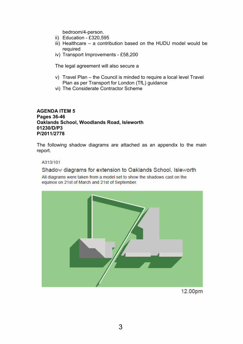
AGENDA ITEM 5 Pages 36-46 Oaklands School, Woodlands Road, Isleworth 01230/D/P3 P/2011/2778 The following shadow diagrams are attached as an appendix to the main report.
3

4
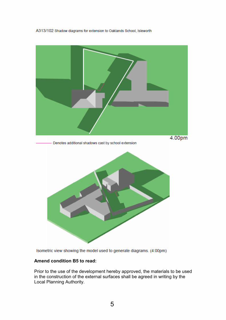
Amend condition B5 to read: Prior to the use of the development hereby approved, the materials to be used in the construction of the external surfaces shall be agreed in writing by the Local Planning Authority.
5
REASON: B3R In order to safeguard the visual amenity of the area and building in particular. AGENDA ITEM 6 Pages 47-68 John Collin House, 31 Sutton Lane, Hounslow 01095/31/S2 P/2011/3248 Conditions: To add the following;
Condition 16:
Prior to commencement of development and not withstanding the approved site plan (521323-A-012 Rev.08), full details of vehicular parking to provide two off street parking spaces to each property, with crossovers not exceeding 3.60 metres in width, shall be submitted to and approved in writing by the Local Planning Authority
Reason: G1R AGENDA ITEM 7 Pages 69-94 Hanworth Library, Hampton Road West, Feltham 00550/N/S2 P/2011/3245 Amended Plans The following amended drawings have been received: 521322-A-100 rev.03 Received 01/02/2012 521322-A-002 rev.01 Received 07/02/2012 Consultations Since the report was published, four further letters of objection have been received. The following comments were raised that have not been previously covered in paragraph 5.2 of the main committee report:
Comment Response
The nature of the commercial development
The proposed commercial units would be restricted to an A1/A2 use (condition 8) with restrictions
6
on the opening hours of these units (condition 18)
Loss of a community building The library has already re-located to Feltham Airparcs Leisure Centre which is a short distance from the application site. It is not considered the proposed development would result in the unacceptable loss of a valuable community facility within the surrounding area. See paragraph 7.7.
In addition to this, a response was received from Transport for London (TfL) raising no objections to the proposed development. Planning Obligations: The specific figures to be paid are:
i) Affordable Housing – 6 x 2-bedroom/4-person affordable rented; 2 x 1-bedroom/2-person, 1 x 2-bedroom/2-person and 1 x 2-bedroom/4-person intermediate.
ii) Education - £97,688.50 iii) Healthcare – a contribution based on the HUDU model would be
required iv) Transport Improvements - £47,325 The legal agreement will also secure a v) Travel Plan – the Council is minded to require a local level Travel
Plan as per Transport for London (TfL) guidance vi) The Considerate Contractor Scheme
Informatives: The following informative should be included: The following Section 106 contributions will be required to form part of
any subsequent legal agreement as based on the Council’s Supplementary Planning Document ‘Planning Obligations’: i) Affordable Housing – 6 x 2-bedroom/4-person affordable rented; 2 x
1-bedroom/2-person, 1 x 2-bedroom/2-person and 1 x 2-bedroom/4-person intermediate.
ii) Education - £97,688.50 iii) Healthcare – a contribution based on the HUDU model would be
required iv) Transport Improvements - £47,325
7
v) The legal agreement will also secure a vi) Travel Plan – the Council is minded to require a local level Travel
Plan as per Transport for London (TfL) guidance vii) The Considerate Contractor Scheme
AGENDA ITEM 8 Pages 95-136 Thames Water Land, Kew Bridge Road, Brentford 00657/B/P21 P/2011/2757 00657/B/L22 P/2011/3581 00657/B/CA1 P/2011/2866 Paras 4.14 and 7.119 should be amended to read 20% of the spaces rather than all of the spaces. Paras 7.119 and 7.141 should be amended to read two year’s free membership rather than one year’s free membership. Para 7.141 should continue to read: Affordable housing and a deferred payment mechanism to ensure that the Council benefit from any uplift in viability of the scheme. Para 5.1 should be updated to include a letter of support received from the Steam Museum. Appendix 2 – Drawing Numbers 00657/B/P21 and 657/B/CA1
Energy Statement Biodiversity Statement Cultural Strategy Code for Sustainable Homes Pre-Certification Framework Report Archaeological Desk Based Assessment to 183AD Air Quality Assessment Internal Daylight and Sunlight Study Statement of Community Involvement Noise Assessment Heritage Appraisal and PPS5 Statement Landscape Planning Report OXOX4748-001 P01 OXOX4748-002 P01 (Landscape Master plan) Desk Based Environmental Assessment Aboricultural Implications Assessment and Method Statement TPP1_KBR_P2 Planning Statement
8
Flood Risk Assessment Design and Access Statement Received 23/09/2011 1145 2, A2190 310 P2, A2190 311 P2, A2190 321 P13, A2190 322 P13, A2190 324 P4, A2190 325 P4, A2190 330 P3, A2190 331 P3, A2190 355 P3, A2190 356 P3, A2190 357 P5, A2190 358 P4, A2190 359 P3, A2190 380 P1, A2190 500 P4, A2190 501 P2, A2190 600 P8, A2190 606 P8, A2190 610 P1, A2190 611 P1, A2190 612 P1, A2190 613 P1, A2190 614 P1, A2190 615 P1, A2190 620 P2, A2190 621 P1 Received 27/09/2011 A2190 300 P14, A2190 301 P14, A2190 302 P14, A2190 303 P14, A2190 304 P14, A2190 305 P15, A2190 306 P15, A2190 307 P15, A2190 320 P21, A2190 323 P9, A2190 601 P10, A2190 602 P10, A2190 603 P11, A2190 604 P10, A2190 605 P9, A2190 624 P3, A2190 625 P3 Received 22/12/2011
00657/B/L22
A2190 502 P3 Received 14/12/2011 Addendum Design and Access Statement KM Heritage Letter Received 19/12/2011 1145, 3907, 3907 B, A2190 310 P2, A2190 311 P2, A2190 340 P3, A2190 341 P3, A2190 342 P1, A2190 343 P2, A2190 344 P3, A2190 345 P2, A2190 346 P1, A2190 347 P3, A2190 348 P4, A2190 349 P3, A2190 350 P4, A2190 351 P3, A2190 355 P3, A2190 356 P3, A2190 357 P5, A2190 358 P4, A2190 359 P3, A2190 360 P1, A2190 608 P1, A2190 609 P1, A2190 610 P1, A2190 611 P1, A2190 612 P1, A2190 613 P1, A2190 614 P1, A2190 615 P1, A2190 621 P1
Appendix 3 – Conditions and Informatives
00657/B/P21
1 A1A
The development hereby permitted shall be begun before the expiration of three years from the date of this permission.
Reason: To accord with the provisions of Section 91 (1) (a) of the Town and Country Planning Act 1990
9
2 B1 Detailed drawings of windows, external doors, balconies and privacy screens shall be submitted to and approved by the Local Planning Authority before development commences and the development shall not be carried out otherwise than in accordance with any such approval.
Reason: In order that the Council may be satisfied as to the details of the development.
3 B4 No development shall take place until samples of the materials to be used in the construction of the external surfaces of the hereby permitted development have been submitted to and approved in writing by the local planning authority. Development shall be carried out in accordance with the approved details
Reason: In order that the Council may be satisfied as to the details of the development in the interests of the visual amenity of the site and the area.
4 B5 The proposed development shall be carried out in all respects in accordance with the proposals contained in the application and the plans submitted: (Energy Statement Biodiversity Statement Cultural Strategy Code for Sustainable Homes Pre-Certification Framework Report Archaeological Desk Based Assessment to 183AD Air Quality Assessment Internal Daylight and Sunlight Study Statement of Community Involvement Noise Assessment Heritage Appraisal and PPS5 Statement Landscape Planning Report OXOX4748-001 P01 OXOX4748-002 P01 (Landscape Master plan) Desk Based Environmental Assessment Arboricultural Implications Assessment and Method Statement TPP1_KBR_P2 Planning Statement Flood Risk Assessment Design and Access Statement Received 23/09/2011 1145 2, A2190 310 P2, A2190 311 P2, A2190 321 P13, A2190 322 P13, A2190 324 P4, A2190 325 P4, A2190 330 P3, A2190 331 P3, A2190 355 P3, A2190 356 P3, A2190 357 P5, A2190 358 P4, A2190 359 P3, A2190 380 P1, A2190 500 P4, A2190
10
501 P2, A2190 600 P8, A2190 606 P8, A2190 610 P1, A2190 611 P1, A2190 612 P1, A2190 613 P1, A2190 614 P1, A2190 615 P1, A2190 620 P2, A2190 621 P1 Received 27/09/2011 A2190 300 P14, A2190 301 P14, A2190 302 P14, A2190 303 P14, A2190 304 P14, A2190 305 P15, A2190 306 P15, A2190 307 P15, A2190 320 P21, A2190 323 P9, A2190 601 P10, A2190 602 P10, A2190 603 P11, A2190 604 P10, A2190 605 P9, A2190 624 P3, A2190 625 P3 Received 22/12/2011 therewith and approved by the Local Planning Authority, or as shall have been otherwise agreed in writing by the Local Planning Authority before the building is used.
Reason: To ensure the development is carried out in accordance with the planning permission.
5 C23 Details of all fans, louvres, ducts or other external plant shall be submitted to and approved in writing by the Local Planning Authority prior to the commencement of development at the site.
Reason: To protect the visual amenities of the area and to ensure that the proposed development does not prejudice the amenities of the locality in accordance with policies ENV-B.1.1( New Development), ENV-P.1.5 (Noise Pollution) and ENV-P.1.6 (Air Pollution) of the adopted Unitary Development Plan.
6 C29 No demolition or construction work shall take place on the site except between the hours of 8:00am to 6:00pm Mondays to Fridays, 8:00am to 1:00pm on Saturdays, with no work to take place on Sundays and Bank Holidays without the prior agreement of the Local Planning Authority.
Reason: In order to safeguard the amenities of adjoining residential properties and to ensure that the proposed development does not prejudice the amenities of the locality in accordance with policies ENV-B.1.1 (New Development) and ENV-P.1.5 (Noise Pollution) of the adopted Unitary Development Plan.
7 C34 No development shall take place until a Construction Logistics Plan and a Construction Environmental Management Plan (CEMP) covering both the demolition and construction stages has been submitted to and approved in writing by the Local Planning Authority. The CEMP shall cover: (i) Any external
11
illumination of the site; (ii) Measures to ensure that all mud and other loose materials are not carried on the wheels and chassis of any vehicles leaving the site; (iii) Measures to minimise dust nuisance caused by the operations and to ensure that no dust or other debris is carried on to the adjoining properties; (iv) The routeing of vehicles to the site, access and egress arrangements and waiting areas; (v) Boundary treatment and measures to ensure they are maintained in a secure and tidy condition; and (vi) Considerate Contractor Scheme.
Reason: In order to safeguard the amenities of residential properties in the locality and in the interest of road safety in accordance with Hounslow Unitary Development Plan policies ENV-B.1.1 (New Development), ENV-P.1.5 (Noise Pollution), ENV-P.1.6 (Air Pollution), ENV-P.1.7 (Light Pollution), T.2.2 (Pedestrian Safety and Security) and T.4.4 (Road Safety) and London Plan policies 4A.20 (Reducing noise and enhancing soundscapes), 4A.3 (Sustainable design and construction).
8 D1 Details of measures to provide satisfactory privacy to all windows of dwellings at first floor level that face the roof of one of the two ‘link buildings’ hereby approved, shall be submitted to and approved in writing by the Local Planning Authority prior to the commencement of the development. The details as approved shall be implemented and maintained permanently thereafter prior to the occupation dwellings subject to the condition.
Reason: To prevent overlooking between dwellings and occupiers using the first floor amenity areas in accordance with policy ENV-B.1.1 (New Development) of the adopted Unitary Development Plan.
9 D4 The arrangements for storing waste and recycled materials shall not be carried out otherwise than in accordance with the approved plans, drawings and supporting information (A2090 300 P13, Planning Statement and Transport Assessment ) and shall be completed before any part of the relevant phase of accommodation hereby permitted is occupied.
Reason: To safeguard the amenities of the area and in accordance with policy ENV-B.1.1 (New development) and ENV-P.2.4 (Recycling Facilities in New Developments) of the adopted Unitary Development Plan.
10 D9 Before the development is occupied a scheme for protecting the proposed residential accommodation from excessive external noise shall be submitted to and approved by the Local Planning Authority and any works which form part of such a scheme shall be completed before any part of the
12
development is first occupied or used.
Reason: To ensure satisfactory environmental conditions for the occupiers of the proposed building in accordance with policy ENV-B.1.1 New development) and ENV-P.1.5 (Noise Pollution) of the adopted Unitary Development Plan.
11 E1 No development shall take place until full details of both hard and soft landscape works have been submitted to and approved in writing by the local planning authority and these works shall be carried out as approved. These details shall include (proposed finished levels or contours; means of enclosure; car parking layouts; other vehicle and pedestrian access and circulation areas; hard surfacing material; minor artefacts and structures (eg. furniture, play equipment, refuse or other storage units, signs, lighting etc); proposed and existing functional services above and below ground (eg drainage power, communications cables, pipelines etc. indicating lines, manholes, supports etc); retained historic landscape features and proposals for restoration, where relevant).
Soft landscape works shall include (planting plans; written specifications (including cultivation and other operations associated with plant and grass establishment); schedules of plants, noting species, plant sizes and proposed numbers/densities where appropriate; implementation programme).
These details shall be carried out in accordance with a scheme for phased implementation to be agreed prior to occupation of each residential block.
Notwithstanding the details of the scheme for phased implimentation, the linear park at the south of the site shall be completed in accordance with the approved details prior to occupation of 50% of the residential units at the site.
Reason: To ensure a satisfactory appearance of the site and improve the visual amenities of the locality in accordance with policy ENV-B.1.1 (New Development) of the adopted Unitary Development Plan.
12 E7 A Landscape Management Plan, including management responsibilities and maintenance schedules for all hard and soft landscaped areas on the site shall be submitted to and approved in writing prior to the occupation of the development. The Landscape Management Plan shall be carried out as approved. Reason: In the interests of visual amenity at the site.
13
13 No development shall take prior to the submission to, and
approval in writing by the Local Planning Authority of a Cultural Strategy Management Plan that explains how and when the cultural objectives for the site as set out in the approved Cultural Strategy will be implemented and maintained has been submitted to and approved in writing by the Local Planning Authority. The Cultural Strategy Management Plan shall be carried out as approved and shall address the following cultural objectives: Projects one and two: The Big table/Crafted Text Trail Project three: Heritage Trail Project four: Industrial Forms Project five: Performance in the Square Project six: Artisan Cafe Reason: To secure the site’s contribution to the establishment of a cultural precinct in the locality.
14 E6 In this condition "retained tree" means an existing tree which is to be retained in accordance with the approved plans and particulars; and paragraphs (a) and (b) below shall have effect until the expiration of (5 years¹) from (the date of the occupation of the building for its permitted use). (a) No retained tree shall be cut down, uprooted or destroyed, nor shall any retained tree be topped or lopped other than in accordance with the approved plans and particulars, without the written approval of the local planning authority. Any topping or lopping approved shall be carried out in accordance with British Standard [3998 (Tree Work)] or any other BS replacing. (b) If any retained tree is removed, uprooted or destroyed or dies, another tree shall be planted at the same place and that tree shall be of such size and species, and shall be planted at such time, as may be specified in writing by the local planning authority.
(c) The erection of fencing for the protection of any retained tree shall be undertaken in accordance with the approved plans and particulars before any equipment, machinery or materials are brought on to the site for the purposes of the development, and shall be maintained until all equipment, machinery and surplus materials have been removed from the site. Nothing shall be stored or placed in any area fenced in accordance with this condition and the ground levels within those areas shall not be altered, nor shall any excavation be made, without the written consent of the local planning
14
authority. Reason. To enable the Local Planning Authority to ensure the retention of the maximum number of trees on the site and their protection from damage, in the interests of visual amenity area and to accord with policy (ENV-B.1.1 (New Development) and policy ENV-N.2.8 (Tree Preservation Orders) of the adopted Unitary Development Plan.
15 F4 The development shall not be occupied until a means of vehicular access has been constructed in accordance with the approved plans.
Reason. In the interests of road safety and in accordance with policy ENV_B.1.1 (New Development), and policy T.4.4 (Road Safety) of the adopted Unitary Development Plan.
16 G7 The parking, loading and turning spaces shown on the approved plans (A2090 300 P13) shall be constructed and available for use before first occupation of Buildings A, B and C and the commercial units at the site and such spaces shall not be used for any other purposes.
Reason. In order to prevent obstruction and inconvenience to users of the adjacent highway and the premises, and in the interests of road safety in accordance with policy (ENV-B.1.1 New development) and policy T.1.4 (Car and Cycle Parking and Servicing Facilities for Developments) and T.4.4 (Road Safety) of the adopted Unitary Development Plan.
17 10% of the approved units shall be capable of adaption to wheelchair accessible standards in accordance with the approved drawings and ‘The Lifetime Homes Design Guide’ by Lifetime Homes.
Reason. To ensure that an appropriate level and mix will be provided to Wheelchair Housing Standards and that all of the residential accommodation will be built out to Lifetime Homes Standards in accordance Hounslow UDP Policies ENV-B.1.1 (New Development) and H.4.1 Housing Standards and Guidelines; London Plan Policies 3A.5 Housing Choice, 4B.1 Design Principles for a Compact City and 4B.5 Creating an Inclusive Environment; Accessible London: Achieving an Inclusive Environment (London Plan Supplementary Planning Guidance April 2004); and the Mayor's Best Practice Guidance 'Wheelchair accessible housing Designing homes that can be easily adapted for residents who are wheelchair users'.
18 The development shall comply in full with the contents of the submitted and approved Energy Statement unless otherwise agreed beforehand in writing by the Local Planning Authority.
15
Reason: To comply with the London Plan Policies 4A.1-4A.7 and to ensure the overall environmental sustainability of the development.
19 Prior to occupation of the each residential block, a Code for
Sustainable Homes Interim (Design Stage) Certificate, issued by the Building Research Establishment (BRE) or equivalent licensing organisation, shall be submitted for units within that block to the Local Planning Authority to show that a minimum Level 4 rating will be achieved.
Reason: To ensure the overall environmental sustainability of the development.
20 Prior to occupation of the each residential block a Code for
Sustainable Homes Final (Post-Construction) Certificate, issued by the BRE equivalent licensing organisation, shall be submitted for units within that block to the Local Planning Authority to demonstrate that Level 4 has been achieved. All the measures integrated shall be retained for as long as the development is in existence.
Reason: To ensure the overall environmental sustainability of the development.
21 No occupation shall take place until details of exterior lighting
of the building and its curtilage, and public areas, including measures to prevent light spill from the site to the adjacent neighbours, have been submitted to and approved in writing by the Local Planning Authority. The details shall be implemented as approved prior to the occupation of the residential units adjacent to relevant areas.
Reason. In order to minimise light pollution from the development in accordance with policies ENV-B.1.1 (New Development) and ENV-P.1.7 (Light Pollution) of the adopted Unitary Development Plan.
22 No occupation shall take place until a Delivery and Servicing
Plan has been submitted to the Local Planning Authority and approved in writing. Development shall be carried out in accordance with the approved details.
Reason. In order to safeguard the amenities of surrounding residential properties and ensure minimal disruption of traffic in the locality, in accordance with policies ENV-B.1.1 (New Development), ENV-P.1.5 (Noise Pollution) and T.4.4 (Road Safety) of the adopted Unitary Development Plan and Transport for London advice.
16
23 No unit shall be occupied until a Car Park Management Plan
has been submitted to and approved in writing by the Local Planning Authority. The car parking areas shall thereafter be managed in compliance with the approved Car Park Management Plan. Reason: In order that the Local Planning Authority may be satisfied as to the parking details of the development and in order to prevent obstruction and inconvenience to users of the adjacent highway and the site in the interests of road safety and to encourage use of more sustainable forms of transport and a reduction in car travel, in accordance with Policies ENV-B.1.1 (New Development), ENV-B.1.9 (Safety and Security), T.1.4 (Car and Cycle parking and Servicing Facilities for Developments), T.4.3 (The Traffic Implications of New Development), T.4.4 (Road Safety) and ENV-P.2.5 (Energy and Resource Efficiency) of the adopted Unitary Development Plan and Policies 3C.23 (Parking Strategy) and 3C.22 (Improving conditions for cycling) of the London Plan.)
24 Prior to the occupation of any residential blocks, the cycle parking spaces shown on the approved plans that are associated with that block shall be made available for use and thereafter retained.
Prior to the occupation of the last residential block to be built, a total of 84 cycle parking spaces shall be provided at the site.
Reason. To ensure that secure cycle spaces are provided and retained for the occupiers of the residential accommodation, in accordance with Hounslow Unitary Development Plan policies ENV-B.1.1 (New Development) and T.1.4 (Car and Cycle Parking and Servicing Facilities for Developments) and London Plan policies 3C.22 (Improving conditions for cycling) and 3C.23 (Parking strategy).
25 Development shall not commence until foul and surface water
drainage details incorporating the principles of sustainable urban drainage and including a timetable for implementation have been submitted to and approved in writing by the Local Planning Authority. Development shall be carried out in accordance with the approved details and retained thereafter.
Reason: To ensure that the surface and foul drainage systems have sufficient capacity to cope with the demand arising from the development so as to prevent increased risk of flooding and pollution of the water environment, in accordance with
17

Policies ENV-B.1.1 (New Development), ENV-P.1.2 (Water pollution and water Quality), ENV-P.1.3 (Surface water run off), ENV-P.1.4 (Waste water management) and ENV-W.2.4 (Floodwater) of the Hounslow Unitary Development Plan and Policies 4A.16 (Water supplies and resources), 4A.3 (Sustainable design and construction) and 4A.14 (Sustainable drainage) of the London Plan.
26 The commercial uses hereby approved shall not be open to customers outside the following times: 7:00am to 11:00pm Monday to Saturday, Sundays, Bank Holidays and Public Holidays.
(Reason. In order to safeguard the amenities of adjoining residential properties)
27 No amplified music or other music shall be played outside the
commercial premises hereby approved without the prior written consent of the Local Planning Authority.
Reason. To protect residential amenity in accordance with policies ENV-B.1.1 (New Development) and ENV-P.1.5 (Noise Pollution) of the adopted Unitary Development Plan.
28 Notwithstanding the provisions of the Town and Country Planning (Use Classes) Order 1987, as amended, or in any provision equivalent to that Class in any statutory instrument revoking and re-enacting that Order with or without modification; the commercial uses hereby approved shall not be changed to any other use without further approval in writing from the Local Planning Authority.
Reason: In order that the Council may be satisfied that the proposed development is consistent with the application submitted and assessed without diminishing the amenities of the local economy, residents and traders (including so as not to undermine the vitality and viability of the Brentford Town Centre) in accordance with Policies ENV-B.1.1 New Development, S.1.1 Main Shopping Areas, T.1.4 Car and Cycle Parking and Servicing Facilities for Developments of the Hounslow UDP and Spatial Policies E1 Maintaining Employment Capacity and E2 Locations for Employment of the Council’s Employment Development Plan Document and Policy BAAP5 (Regeneration) of the Brentford Area Action Plan.
29
Before the development hereby permitted commences:
a. A Phase 2 site investigation is required to be carried out and submitted to, and approved in writing by the
18
Local Planning Authority. The site shall be investigated by a competent person to identify the extent and nature of contamination. The report should include a tiered risk assessment of the contamination based on the proposed end use of the site. Additional investigation may be required where it is deemed necessary.
b. If required, a scheme for decontamination of the site shall be submitted to the Local Planning Authority, for written approval. The scheme shall account for any comments made by the Local Planning Authority before the development hereby permitted is first occupied.
During the course of the development:
c. The Local Planning Authority shall be notified immediately if additional contamination is discovered during the course of the development. A competent person shall assess the additional contamination, and shall submit appropriate amendments to the scheme for decontamination in writing to the Local Planning Authority for approval before any work on that aspect of development continues.
Before the development is first occupied:
d. The agreed scheme for decontamination referred to in clauses b) and c) above, including amendments, shall be fully implemented and a written validation (closure) report submitted to the Local Planning Authority for approval.
Reason: Contamination is known or suspected on the site due to a former land use. The LPA therefore wishes to ensure that the development can be implemented and occupied with adequate regard for public and environmental safety.
Supporting notes:
a. An initial phase 1 desk study has been submitted with the application for planning permission. The report should also make recommendations for the further gathering of information and or intrusive investigation. The full site investigation must include intrusive testing for soil and groundwater contamination, soil gasses, and leachate. The investigation shall be carried out at such points and at such depths as the LPA may stipulate. Risk assessments must adhere to current UK guidance and best practice.
b. The scheme for decontamination shall provide details of how each potential pollutant linkage, as identified in
19
the conceptual model, will be made safe.
c. In some instances the LPA may require work on site to be ceased whilst the nature of additional contamination is investigated fully.
d. The validation report shall revisit the site conceptual model, and provide evidence that each aspect of the decontamination scheme was carried out correctly and successfully. This report shall prove that the development is suitable for its new use.
e. We request that site investigation reports or site plans be sent electronically to [email protected] or by post on a cd or dvd wherever possible.
30 If, during development, contamination not previously identified
is found to be present at the site then no further development (unless otherwise agreed in writing with the Local Planning Authority) shall be carried out until the developer has submitted, and obtained written approval from the Local Planning Authority for, a remediation strategy detailing how this unsuspected contamination shall be dealt with. The remediation strategy shall be implemented as approved. Reason: To ensure protection of controlled waters.
31 C14 The non-residential units at the site shall not be used for a nursery, education establishment or a Place of Worship unless otherwise agreed beforehand by the Local Planning Authority. Reason: To prevent unacceptable demand on on-site and off-site parking.
32 EA1 Prior to the commencement of development (or such other stage in development as may be agreed in writing with the Local Planning Authority), the following components of a scheme to deal with the risks associated with contamination of the site shall each be submitted to and approved in writing by the Local Planning Authority:
1) A preliminary risk assessment which has identified: all previous uses; potential contaminants associated with those uses; a conceptual model of the site indicating sources, pathways and receptors; potentially unacceptable risks arising from contamination at the site.
2) A site investigation scheme, based on (1) to provide information for a detailed assessment of the risk to all receptors that may be affected, including those off site.
20

3) The results of the site investigation and detailed risk assessment referred to in (2) and, based on these, an options appraisal and remediation strategy giving full details of the remediation measures required and how they are to be undertaken. 4) A verification plan providing details of the data that will be collected in order to demonstrate that the works set out in the remediation strategy in (3) are complete and identifying any requirements for longer-term monitoring of pollutant linkages, maintenance and arrangements for contingency action.
Any changes to these components require the express consent of the Local Planning Authority. The scheme shall be implemented as approved.
Reason: To protect the quality of the water environment, as there is a potential risk of pollution of controlled waters due to historical uses of the site.
33 EA2 Prior to first occupation of any part of the development (or such other stage in development as may be agreed in writing with the Local Planning Authority), a verification report demonstrating completion of the works set out in the approved remediation strategy required under Condition EA1(3), and the effectiveness of the remediation shall be submitted to and approved in writing by the Local Planning Authority. The report shall include results of sampling and monitoring carried out in accordance with the approved verification plan required under Condition EA1(4) to demonstrate that the site remediation criteria have been met. It shall also include any plan (a "long-term monitoring and maintenance plan") for longer-term monitoring of pollutant linkages, maintenance and arrangements for contingency action, if identified in the verification plan, and for the reporting of this to the Local Planning Authority. The long-term monitoring and maintenance plan shall be implemented as approved. Reason: To ensure any further measures that need to be taken to eliminate or reduce the risk of pollution to controlled waters are understood and carried out.
34 EA3 Reports on monitoring, maintenance and any contingency action carried out in accordance with a long-term monitoring and maintenance plan shall be submitted to the local planning authority as set out in that plan. On completion of the monitoring programme a final report demonstrating that all long- term site remediation criteria have been met and documenting the decision to cease monitoring shall be submitted to and approved in writing by the local planning authority.
21
Reason: Monitoring will help to determine if the polluting substances have been adequately contained or remediated.
35 EA4 If, during development, contamination not previously identified is found to be present at the site then no further development (unless otherwise agreed in writing with the Local Planning Authority) shall be carried out until the developer has submitted, and obtained written approval from the Local Planning Authority for, a remediation strategy detailing how this unsuspected contamination shall be dealt with. The remediation strategy shall be implemented as approved. Reason: To ensure there is no unwanted negative impact to controlled waters by ensuring any unsuspected contamination is properly addressed.
36 EA5 No infiltration of surface water drainage into the ground is permitted other than with the express written consent of the Local Planning Authority, which may be given for those parts of the site where it has been demonstrated that there is no resultant unacceptable risk to controlled waters. The development shall be carried out in accordance with the approved details. Reason: To protect the quality of the water environment and ensure that no polluting substances find their way into controlled waters.
37 EA6 Piling or any other foundation designs using penetrative methods shall not be permitted other than with the express written consent of the Local Planning Authority, which may be given for those parts of the site where it has been demonstrated that there is no resultant unacceptable risk to groundwater. The development shall be carried out in accordance with the approved details. Reason: To ensure that piling and other intrusive works do not introduce pollutants or create new pathways that could put controlled waters at risk of being polluted.
00657/B/L22
1. H1A The works to which this consent relates, must be begun not later than the expiration of three years beginning with the date of this consent. Reason: To accord with the provisions of Section 18(1) of the Planning (Listed Buildings and Conservation Areas) Act 1990.
22
2. No development shall take place until further details including sectional drawings at a scale of no more than 1:20 of the any approved works to the listed boundary wall and filter bed have been submitted to and approved in writing by the Local Planning Authority. The details shall be carried out as approved unless otherwise agreed beforehand by the Local Planning Authority. Reason: To safeguard the special historic character and appearance of the site.
00657/B/CA1 1 The works to which this consent relates, must be begun not
later than the expiration of three years beginning with the date of this consent. Reason: To accord with the provisions of Section 18(1) of the Planning (Listed Buildings and Conservation Areas) Act 1990.
Informatives: Noise The building contractors should take note of, and act upon advice given in the BS5228 Code of Practice "Control of Noise on Construction Sites". Before commencement of the works the building contractors should, giving as much notice as possible, notify the occupants of properties surrounding the site of the nature and duration of works and the permitted hours of work. The building contractors should also provide such occupants with the name and telephone number of a responsible person who can be contacted for advice or in the event of a need to complain. Dust The building contractors should take note of, and act upon advice given in the in the GLA and London Councils - Best Practice Guidance: "The Control of Dust and Emissions from Construction and Demolition. Environment Agency In order to manage the environmental risks associated with the redevelopment of contaminated sites, we recommend that developers should:
− Follow the risk management framework provided in CLR11, Model Procedures for the Management of Land Contamination, when dealing with land affected by contamination.
− Refer to the Environment Agency Guiding Principles for Land Contamination for the type of information required in order to assess risks to controlled waters from the site. The Local Authority can advise on risk to other receptors, e.g. human health.
23

− Refer to our website at www.environment-agency.gov.uk for more information.
The CL:AIRE Definition of Waste: Development Industry Code of Practice1 (version 2) provides operators with a framework for determining whether or not excavated material arising from site during remediation and/or land development works are waste or have ceased to be waste. Developers should refer to our position statement on the Code of Practice, along with the additional guidance on our website2. Under the Code of Practice:
− excavated materials that are recovered via a treatment operation can be re-used on-site providing they are treated to a standard such that they are fit for purpose and unlikely to cause pollution
− 1 http://www.claire.co.uk/index.php?option=com_phocadownload&view=file&id=212:initiatives&Itemid=82
− 2 http://www.environment-agency.gov.uk/business/sectors/32731.aspx
− treated materials can be transferred between sites as part of a hub and cluster project
− some naturally occurring clean material can be transferred directly between sites.
Developers should ensure that all contaminated materials are adequately characterised both chemically and physically in line with British Standards BS EN 14899:2005 'Characterisation of Waste - Sampling of Waste Materials - Framework for the Preparation and Application of a Sampling Plan' and that the permitting status of any proposed on or off site treatment or disposal activity is clear. If in doubt, we should be contacted for advice at an early stage to avoid any delays. Contaminated soil that is, or must be disposed of, is waste. Therefore, its handling, transport, treatment and disposal is subject to waste management legislation, which includes:
− Duty of Care Regulations 1991
− Hazardous Waste (England and Wales) Regulations 2005
− Environmental Permitting (England and Wales) Regulations 2010
− The Waste (England and Wales) Regulations 2011 If the total quantity of hazardous waste material to be produced at or taken off site is 500kg or greater in any 12 month period, the site operator will need to register with us as a hazardous waste producer. Please refer to our website for more information. The type and nature of contamination on this site is such that it will require extensive remediation and monitoring. We advise early engagement between the developer, Local Planning Authority and ourselves to discuss the opportunities available through the planning obligation (Section 106) route.
24
AGENDA ITEM 9 Pages 137-177 26a-34 & 44-52 High Street, Hounslow 00610/BB/P1 P/2011/2887 Conditions
38 A1A
Time limit for development
The development hereby permitted shall be begun before the expiration of three years from the date of this permission.
(Reason. To accord with the provisions of Section 91 (1) (a) of the Town and Country Planning Act 1990)
39 B1 Details – windows, balconies, privacy screens
Detailed drawings of windows, balconies and privacy screens shall be submitted to and approved by the Local Planning Authority before development commences and the development shall not be carried out otherwise than in accordance with any such approval.
(Reason. In order that the Council may be satisfied as to the details of the development and to satisfy the requirements of policies ENV B1.1 New Development)
40 B4 Materials – Samples
No development shall take place until samples of the materials to be used in the construction of the external surfaces of the hereby permitted have been submitted to and approved in writing by the local planning authority. Development shall be carried out in accordance with the approved details
(Reason. In order that the Council may be satisfied as to the details of the development in the interests of the visual amenity of the area and to satisfy the requirements of policies ENV B1.1 New Development)
41 B5 Details - plans
The proposed development shall be carried out in all respects in accordance with the proposals contained in the application and the plans submitted (numbered above) therewith and approved by the Local Planning Authority, or as shall have been otherwise agreed in writing by the Local Planning Authority before the building is used.
(Reason. To ensure the development is carried out in accordance with the planning permission)
25
5 C23 External plant
No fans, louvres, ducts or other external plant shall be installed without the prior approval of the Local Planning Authority.
(Reason. To protect the visual amenities of the area and to ensure that the proposed development does not prejudice the amenities of the locality in accordance with policies ENV.B.1.1 New development, ENV.P.1.5 Noise pollution and ENV.P.1.6 Air pollution)
6 C29 Hours of Construction No demolition or construction work shall take place on the site except between the hours of 8:00am to 6:00pm Mondays to Fridays, 8:00am to 1:00pm on Saturdays, with no work to take place on Sundays and Bank Holidays without the prior agreement of the Local Planning Authority Reason: C29R
7 C34 Construction Environmental Management Plan
No development shall take place until a Construction Environmental Management Plan (CEMP) covering the construction stages has been submitted to and approved in writing by the Local Planning Authority. The CEMP shall cover: (i) Any external illumination of the site; (ii) Measures to ensure that all mud and other loose materials are not carried on the wheels and chassis of any vehicles leaving the site; (iii) Measures to minimise dust nuisance caused by the operations and to ensure that no dust or other debris is carried on to the adjoining properties; (iv) The routeing of vehicles to the site, access and egress arrangements and waiting areas; and (v) Boundary treatment and measures to ensure they are maintained in a secure and tidy condition.
(Reason. In order to safeguard the amenities of residential properties in the locality and in the interest of road safety in accordance with Hounslow Unitary Development Plan policies ENV-B.1.1 (New development), ENV-P.1.5 (Noise pollution), ENV-P.1.6 (Air pollution), ENV-P.1.7 (Light pollution), T.2.2 (Pedestrian safety and security) and T.4.4 (Road safety)
8 C14 Restriction on Use The ground floor premises shall be used for retail purposes only and for no other purpose (including any other purpose in Class A1 of the Schedule to the Town and Country Planning (Use Classes)
26
Order 1987, or in any provision equivalent to that Class in any statutory instrument revoking and re-enacting that Order with or without modification). REASON C14R.
9 D4 Waste & Recycled Storage (Details to be submitted)
Reason D4R
10 D9 Soundproofing – External Noise
Before the development is commenced a scheme for protecting the proposed residential accommodation from external noise, taking into consideration the External Building Fabric Report (17568/EBF1 Revision A) dated 19th December 2011 and including sound insulation test reports, shall be submitted to and approved by the Local Planning Authority and any works that form part of such a scheme shall be completed before any part of the development is first occupied.
Reason D9R
12 E1 Landscape design proposals Hard & soft landscaping works, including boundary treatments, external lighting, play strategy, planting plans and maintenance/implementation programme. REASON: E1R
13 E15 Provision for Tree Planting If within a period of two years from the date of the planting of any tree, that tree, or any tree planted in replacement for it, is removed, uprooted or destroyed or dies, another tree of the same species and size as that originally planted shall be planted at the same place, unless the local planning authority gives its written consent to any variation. REASON: E15R
14 E16 Existing trees to be retained REASON: E16R
27
15 F4 Completion- Access The buildings hereby approved shall not be occupied until a means of access for vehicles and pedestrians has been constructed in accordance with the approved plans. REASON F4R
16 F10 Visibility splays
A splay of 2.4m x 2.4m shall be provided on each side of the vehicular access points, the depth measured from the back of the footway and the widths outwards from the edges of the access, and no fence, wall or other obstruction to visibility exceeding 0.6m in height above the surface of the adjoining highway shall be erected within the areas of such splays.
(Reason. In the interests of road safety in accordance with policy ENV.B.1.1 New development, policy T.4.4 Road Safety.)
17 G7 Parking
The parking, loading and turning spaces shown on drawing nos. AL(00)10 Rev.A and AL(00)12 Rev.A shall be constructed and available for use before first occupation of the relevant part of the development that use those facilities and such spaces shall not be used for any other purposes.
(Reason. In order to prevent obstruction and inconvenience to users of the adjacent highway and the premises, and in the interests of road safety in accordance with policy ENV.B.1.1 New development and policy T1.4 Car and Cycle Parking and servicing facilities for developments and T4.4 Road Safety.)
18 Cycle storage - details Prior to the commencement of development, details of the proposed cycle storage to accommodate a minimum of 113 cycles across the site, shall be submitted to and approved by the Local Planning Authority, with the approved details being completed prior to occupation of any part of the development. (Reason. To ensure that secure cycle spaces are provided and retained for the occupiers of the residential accommodation, in accordance with Hounslow Unitary Development Plan policies ENV-B.1.1 (New development), T.1.4 (Car and cycle parking and servicing facilities for developments) and T.4.2 (Oppose overall increase in highway capacity for private vehicles and seek
28
reduction in traffic levels) and London Plan policy 6.9.
19 J2 Lifetime Homes
The development hereby permitted shall designed in accordance with the Lifetime Home standards as set out in the London Plan Accessible London Supplementary Guidance Accessible London
Reason: J2R
20 Details of wheelchair units Before the development is commenced, details of the wheelchair accommodation (minimum 10 units), including location and internal layouts, shall be submitted to and approved by the Local Planning Authority. Any works that form part of such a scheme shall be completed before any part of the development is first occupied.
Reason: J2R
21 Car Park Management Plan No unit shall be occupied until a Car Park Management Plan, including details of delivery and servicing for the commercial units, has been submitted to and approved in writing by the Local Planning Authority. The car parking areas shall thereafter be managed in compliance with the approved Car Park Management Plan.
(Reason. In order to safeguard the amenities of surrounding residential properties and ensure minimal disruption of traffic in the locality, in accordance with policies ENV-B.1.1 (New Development), ENV-P.1.5 (Noise Pollution) and T.4.4 (Road Safety) of the adopted Unitary Development Plan 2003 and the London Plan 2011.)
22 Operating hours
The non-residential floor space of the building hereby permitted shall not be open to customers outside the hours of 08:00 to 23:00 Monday to Saturday and 09:00 to 22:00 on Sundays and Public Holidays. In order to safeguard the amenities of residential properties in the locality, in particular the upper levels of this development, in
29
accordance with Hounslow Unitary Development Plan policies ENV-B.1.1 (New Development), ENV-P.1.5 (Noise pollution), and S.3.1 (New retail development).
23 Shop Front Details
Full details of the design of the shop fronts to non-residential ground floor units shall be submitted to and approved in writing by the Local Planning Authority prior to the fit out of each commercial unit hereby approved. The details shall be carried out as approved prior to first occupation of the unit to which the details relate.
(Reason. To ensure the appearance of the shopfronts is satisfactory and to confirm details of the development, in accordance with policy ENV-B.1.1 (New Development) of the adopted Unitary Development Plan.
24 Amplified music
No amplified music or other music shall be played outside the commercial premises hereby approved without the prior written consent of the Local Planning Authority.
(Reason. To protect residential amenity in accordance with policies ENV-B.1.1 (New Development) and ENV-P.1.5 (Noise Pollution) of the adopted Unitary Development Plan.
25 Sustainable Drainage
No development shall take place until details of a Sustainable Urban Drainage Scheme, including measures for (i) the harvesting of rainwater, (ii) the minimisation of water run-off from the site, aiming for greenfield levels, and (iii) the conservation and reuse as appropriate of other water supplies in the buildings have been submitted to and approved by the Local Planning Authority. The building shall not be occupied until evidence (e.g. photographs and copies of installation contracts) has been submitted to the Local Planning Authority to demonstrate that the development has been carried out in accordance with the approved details. (Reason. In the interests of sustainability and to ensure the satisfactory management of surface water run-off from the development hereby permitted, including by preventing increased risk of flooding and pollution of the water environment, and in accordance with Hounslow Unitary Development Plan Policies
30

ENV-B.1.1 (New development), ENV-P.1.2 (Water pollution and water quality), ENV-P.1.3 (Surface water run off) and London Plan Policies 5.10 (Urban Greening), 5.13 (Sustainable drainage) and 5.15 (Water use and supplies).
26 Sustainable Construction No development shall take place until a statement on the sourcing of materials to be used in the building, involving reuse, recycling and other sustainable sourcing of materials to be used in the construction of extensions and fitting out of the building wherever possible, has been submitted to and approved in writing by the Local Planning Authority. The building shall not be occupied until evidence (e.g. photographs and copies of installation contracts) have been submitted to the Local Planning Authority to demonstrate that the development has been carried out in accordance with the approved details (Reason. To ensure the development can be implemented with adequate regard to the environment in the interests of sustainability in accordance with Hounslow Unitary Development Plan Policies ENV-B.1.1 (New development), London Plan Policy 5.3 (Sustainable design and construction); and Sustainable Design and Construction (London Plan Supplementary Planning Guidance May 2006.)
27 Conservation of Energy No development shall take place until an energy assessment has been submitted to the Local Planning Authority which demonstrates how the hierarchy of energy efficiency, efficiency supply of energy and renewable energy generation has been observed. The assessment should show that a reduction in CO2 emissions of at least 25% will be achieved, taken from a CO2 emissions baseline calculated using the mandatory minimums outlined in the Part L Building Regulations. CO2 emissions figures should be calculated using SAP (Standard Assessment Procedure)/ SBEM (Simplified Building Energy Model) and the associated worksheets should be submitted as part of the application, alongside full details, and, where appropriate, plans and technical schematics of the proposed energy efficiency measures and renewable energy technology(ies). The building shall not be occupied until evidence (e.g. photographs and copies of installation contracts) has been submitted to the Local Planning Authority to demonstrate that the development has been carried out in accordance with the approved details
31

(Reason: To comply with the London Plan Policies 5.1-5.7 and to ensure the overall environmental sustainability of the development.)
28 Code for Sustainable Homes – Design Stage Within 3 months of work starting on site, a Code for Sustainable Homes Interim (Design Stage) Certificate, issued by the Building Research Establishment (BRE) or equivalent licensing organisation, must be submitted for each dwelling to the Local Planning Authority to show that a minimum Level 3 rating will be achieved.
(Reason: To ensure the overall environmental sustainability of the development.)
29 Code for Sustainable Homes – Post-Construction
No occupation shall take place until a Code for Sustainable Homes Final (Post-Construction) Certificate, issued by the BRE equivalent licensing organisation, must be submitted for each dwelling to the Local Planning Authority to demonstrate that Level 3 has been achieved. All the measures integrated shall be retained for as long as the development is in existence.
(Reason: To ensure the overall environmental sustainability of the development.)
30 Archaeological desk-study
No development shall commence on site until a desk-top archaeological investigation has been submitted to and approved by the Local Planning Authority. The investigation shall be in accordance with English Heritage guidelines. The recommendations of the investigation shall be undertaken prior to commencement on any part of the site. (Reason: The site lies in an area where archaeological remains can be anticipated and the Local Planning Authority wishes to protect any archaeological remains on the site from being impacted upon by the construction of the development in accordance with Hounslow Unitary Development Plan policy ENV-B.3.2 (Sites of archaeological importance) and London Plan policy 7.8.
31 Ecology
32
The development shall not be occupied until evidence (e.g. photographs and copies of installation contracts) has been submitted to the Local Planning Authority to demonstrate that the recommendations of the Ecological Assessment dated September 2011 (ref ECO2715.EcoAss.vf) have been implemented. Such measures shall thereafter be retained on site. (Reason: To ensure ecological enhancements to the site in accordance with Unitary Development Plan policy ENV-N.2.5 and London Plan policy 7.19)
32 J12 Land Quality Condition Reason: J12R
33 Condition EA1: Prior to the commencement of development (or such other stage in development as may be agreed in writing with the Local Planning Authority), the following components of a scheme to deal with the risks associated with contamination of the site shall each be submitted to and approved in writing by the Local Planning Authority:
1) A preliminary risk assessment which has identified: all previous uses; potential contaminants associated with those uses; a conceptual model of the site indicating sources, pathways and receptors; potentially unacceptable risks arising from contamination at the site.
2) A site investigation scheme, based on (1) to provide information for a detailed assessment of the risk to all receptors that may be affected, including those off site.
3) The results of the site investigation and detailed risk assessment referred to in (2) and, based on these, an options appraisal and remediation strategy giving full details of the remediation measures required and how they are to be undertaken. 4) A verification plan providing details of the data that will be collected in order to demonstrate that the works set out in the remediation strategy in (3) are complete and identifying any requirements for longer-term monitoring of pollutant linkages, maintenance and arrangements for contingency action. Any changes to these components require the express consent of the Local Planning Authority. The scheme shall be implemented as approved. (Reason: To protect the quality of the water environment, because
33
the site lies directly on a Principal Aquifer, in which groundwater is likely to be shallow. This groundwater body must be protected from pollution.)
34 Condition EA2: Prior to commencement of development, a verification report demonstrating completion of the works set out in the approved remediation strategy required under Condition EA1(3), and the effectiveness of the remediation shall be submitted to and approved in writing by the Local Planning Authority. The report shall include results of sampling and monitoring carried out in accordance with the approved verification plan required under Condition EA1(4) to demonstrate that the site remediation criteria have been met. It shall also include any plan (a "long-term monitoring and maintenance plan") for longer-term monitoring of pollutant linkages, maintenance and arrangements for contingency action, as identified in the verification plan, and for the reporting of this to the Local Planning Authority. The long-term monitoring and maintenance plan shall be implemented as approved. (Reason: To ensure that any remedial works required by Condition EA1 are undertaken and demonstrated successful.)
35 Condition EA3: If, during development, contamination not previously identified is found to be present at the site then no further development (unless otherwise agreed in writing with the Local Planning Authority) shall be carried out until the developer has submitted, and obtained written approval from the Local Planning Authority for, a remediation strategy detailing how this unsuspected contamination shall be dealt with. The remediation strategy shall be implemented as approved. (Reason: To ensure that any unsuspected contamination is properly addressed by following Environment Agency guidance and industry best practice.)
36 Condition EA4: No infiltration of surface water drainage into the ground is permitted other than with the express written consent of the Local Planning Authority, which may be given for those parts of the site where it has been demonstrated that there is no resultant unacceptable risk to controlled waters. The development shall be carried out in accordance with the approved details. (Reason: To ensure that surface water runoff does not result in
34

polluting substances finding their way into controlled waters.)
37 Condition EA5: Piling, deep drilling for ground source heat pumps, or any other foundation designs using penetrative methods shall not be permitted other than with the express written consent of the Local Planning Authority, which may be given for those parts of the site where it has been demonstrated that there is no resultant unacceptable risk to groundwater. The development shall be carried out in accordance with the approved details. (Reason: To ensure that intrusive works do not introduce pollutants or create new pathways that could pollute controlled waters.)
Informatives:
1 The building contractors should take note of, and act upon advice given in the in the GLA and London Councils - Best Practice Guidance: "The Control of Dust and Emissions from Construction and Demolition
2 If site staff are instructed by a Council Officer to stop vehicle movements to and from the site if any incidents occur, they must comply with the instructions. For any further advice, contact the Council’s Community Environment Team on 020 8583 5070.
3 The building contractors should take note of, and act upon advice given in the BS5228 Code of Practice "Control of Noise on Construction Sites". Before commencement of the works the building contractors should, giving as much notice as possible, notify the occupants of properties surrounding the site of the nature and duration of works and the permitted hours of work. The building contractors should also provide such occupants with the name and telephone number of a responsible person who can be contacted for advice or in the event of a need to complain.
4 Condition EA1: The application does not include a preliminary risk assessment but the submitted documents indicate that the site has been shops or similar since 1950s and that no contamination is suspected. However, the site lies directly on a Principal Aquifer, in which groundwater is likely to be shallow. This groundwater body must be protected from pollution. Other sites nearby where contamination was not suspected have uncovered hydrocarbon contamination in the soils and groundwater and, in one case, an Underground Fuel Storage Tank. Although we are satisfied that there are generic remedial options available to deal with the risks to controlled waters posed by any contamination at this site, further details will be required prior to development commencing.
35
5 Condition EA4:
The application form indicates that surface water drainage will be discharging to main sewer. This poses a low risk to groundwater and so we have no concerns with this aspect of the proposal as submitted in relation to controlled waters. However, should the surface water drainage scheme change this may no longer be the case. Please reconsult us if there are any changes to the scheme. Although not directly related to this condition, we note that the foul water drainage is marked on the application form as "unknown". As a foul sewer is present in the area, we would object to discharging foul water to ground in this area. This is in line with our guidance document ‘Groundwater protection: Policy and practice (GP3) Part 4 - Legislation and Policies’ (2008).
6 Condition EA5: Our records indicate that the London Clay is approximately 80 metres thick in this area. It is not clear if deep drilling is proposed or if piling depths will punch through the London Clay. This layer of clay lies beneath the shallow Principal Aquifer and naturally protects the deeper underlying Principal Aquifer from which drinking water is abstracted. The applicant should follow the risk management framework provided in our guidance for ‘Piling into Contaminated Sites’ and also refer to the document: ‘Pilling and Penetrative Ground Improvement Methods on Land Affected by Contamination: Guidance on Pollution Prevention’.
7 In order to manage the environmental risks associated with the redevelopment of contaminated sites, we recommend that developers should:
− Follow the risk management framework provided in CLR11, Model Procedures for the Management of Land Contamination, when dealing with land affected by contamination.
− Refer to the Environment Agency Guiding Principles for Land Contamination for the type of information required in order to assess risks to controlled waters from the site. The Local Authority can advise on risk to other receptors, e.g. human health.
− Refer to our website at www.environment-agency.gov.uk for more information.
36
SUSTAINABLE DEVELOPMENT COMMITTEE 9th February 2012
Stephen Hissett e-mail: [email protected]
References: P/2011/3040 01049/B/S2
Address: Feltham Dene Care Home, Spring Road, Feltham TW13 7JB
Ward: Hanworth Park
Proposal: Redevelopment of the site comprising the erection of 11 two-storey houses with accommodation in the roof space and the erection of a four- and five-storey building consisting of 26 flats including a total of 14 affordable units (comprising 6 x three-bedroom houses and 8 x two-bedroom flats)
Drawing numbers: 521321-A-001, -002, -003, -010, -011, -012, -020, -021, -022, -023, -102, -110, -111, -112, -113, -114, -115, -116, -211, -212, -213, -214, -300, -311, -312, -313, -314, -315, -316, -317, -513, -514, -515, Design & Access Statement Received 24/10/2011 Amended drawing numbers to follow
Application received:
24/10/2011
1.0 SUMMARY
1.1 Planning permission is sought to erect eleven x two storey-houses comprising five x 4-bedroom and six x 3-bedroom houses and 26 flats within a four- and five-storey building, providing 16 x 2-bedroom and 10 x 1-bedroom units. The application also includes provision of car parking and landscaping across the site.
1.2 The application is recommended for approval. It is considered that the amended development would be appropriate in its size and scale to both the site and surrounding area generally and would not harm neighbouring resident’s living conditions. Furthermore, the proposed development would provide sufficient off-street car parking to ensure there would be no prejudicial impacts on the local road network.
2.0 SITE DESCRIPTION
2.1 The site is situated on Spring Road, within an existing residential area, a short distance from Feltham High Street town centre, which is to the north-east of the site.
2.2 The site is currently occupied by a two-storey, 1960’s, purpose-built care
home facility that has been closed since October 2009. The building has been vacant since this time. The site is irregular in shape, 92m long on the
Agenda Item 4
37
east-west axis and 43m-86m on the north-south axis. 2.3 The existing site is located within an established area, predominantly
consisting of two-storey, semi-detached or detached houses built from around 1930 with more recent extensions and no specific character on Spring Road. To the north and west of the site there are several four-storey 1960’s blocks of flats. The buildings surrounding the site are typically of brickwork appearance with concrete or clay pitched roofs.
2.4 There are two existing vehicular access points to the site, one situated to
the north-east of the site and the other to the south-west, both from Spring Road.
2.5 The site is generally flat with grass covering part of the area. Hardstanding
covers approximately 50% of the existing site. The existing boundary along Spring Road consists of 0.3m high brickwork and a 0.9m metal railing fences.
2.6 The site is not located in a Flood Risk Area and is not designated within the
adopted Unitary Development Plan (UDP). The site has a Public Transport Accessibility Level (PTAL) of 1b, which is described as ‘Very Poor’.
3.0 HISTORY
3.1 Until recently the site was used as a care home, which is now surplus to requirements and the Council are now looking to dispose of the site, with the intention of selling the site at auction.
4.0 DETAILS
4.1 The proposed development would comprise of eleven new houses fronting Spring Road, consisting of two-storey and loft accommodation, and a block of 26 flats within a four- and five-storey building towards the centre/rear of the site.
4.2 The proposed mix of housing would be as follows:
Accommodation type Quantum
4-bedroom/6-person 5 (houses)
3-bedroom/5-person 6 (houses)
2-bedroom/4-person 16 (flats)
1-bedroom/2-person 10 (flats)
Total 37 units
4.3 The proposed accommodation would be of the following sizes:
38
Accommodation type Internal Gross Area (m2)
4-bedroom/6-person 115.6
3-bedroom/5-person 102
2-bedroom/4-person 71.3 & 74
1-bedroom/2-person 52
4.4 Affordable housing provision would be made at a level of 38% (14 of the 37 units) of the development as a whole, with the following breakdown proposed:
Accommodation type Affordable accommodation
4-bedroom/6-person 0
3-bedroom/5-person 6 (42%)
2-bedroom/4-person 8 (58%)
1-bedroom/2-person 0
Units 1-5 – all private sale units
4.5 These would consist of two-storey houses (4-bedroom/6-person) with loft accommodation that would be located towards the north-east corner of the site. They would face east onto Spring Road, with off-street car parking provision for two cars to the front of the dwellings and private rear amenity spaces. Each unit would have a front canopy over the main entrance and front roof dormer, with PV panels located on the rear roof face. They would be of a typical domestic design and scale to replicate the existing residential properties on Spring Road. All of these units have been designed for wheelchair accessibility. Units 1 and 2 would follow the building line of the adjoining properties to the north of the site, principally nos. 6 and 8 Spring Road. Units 3-5 would be set at an angle to take account of the curve of Spring Road at this point.
4.6 Units 1-2 would be 7.53m wide x 14.39m x 9.1m high to the ridge. Units 3-5 would be 7.53m wide x 21.43m x 9.1m high to the ridge.
Units 6-11 – all affordable accommodation
4.7 These would consist of two-storey houses (3-bedroom/5-person) with loft accommodation and would be located towards the southern end of the site facing south-east onto Spring Road. They would form a terrace of six units positioned parallel to Spring Road at this point. They would be separated from Units 1-5 by an area of private car parking for the residents of Units 6-
39

11. This area would provide six car parking spaces and two disabled spaces, and be accessed from Spring Road, with new landscaping on the street frontage. In addition to this parking provision, each unit would benefit from one off-street parking space to the front of the dwelling, with private rear amenity space and a similar appearance to Units 1-5.
4.8 Units 6-11 would be 8.2m wide x 32.66m x 9.5m high to the ridge.
4.9 All housing would be finished with facing red stock brickwork and matching brick pointing. Windows and doors would be constructed of timber double-glazed units, with feature brick solider lintels. Roofs and dormers will be covered with plain red clay tiles.
Flats – 8 affordable/18 private sale units
4.10 As amended the flats would be provided within a four- and five-storey building that would be positioned towards the centre of the site and orientated in an east-west direction so that the front elevation would be facing south towards Spring Road. This block would now provide 26 flats at a mix described previously at paragraph 4.2. There would be three communal cores, with the two four-storey elements providing 8 units and the six-storey element providing 10 units.
4.11 The block would have a maximum height of 14.85 (5-storeys) with a flat green roof, with the lower elements being 11.45 high. The block would be laid out such that the taller element would be towards the centre, with two lower ‘wings’ either side and enclosing amenity space to the front of the block.
4.12 An area of communal and private amenity spaces would be provided immediately to the front of the flats, including provision of play space for residents. There would also be additional private garden space immediately to the rear of the building, with further communal garden/play space located to the north-east of the block (adjacent to the northern boundary and rear gardens of Units 1-2). Screening will be provided for ground floor flats to ensure privacy of amenity space is retained.
4.13 Car parking for the flats would be provided adjacent to the western and northern boundary of the site and would total 29 spaces, including three visitor spaces and two disabled spaces. Secure cycle storage (no. 26 cycles) would be provided within the rear car parking area. Communal refuse and recycling storage would be located in the south-west corner of the site, adjacent to the access to the site from Spring Road. The visitor spaces shown previously on Spring Road have been removed from the plans.
4.14 The flats will have a modern appearance, with a combination of materials to be used in the external surfaces. These would include; grey engineering brickwork to the ground floor with a coloured render/cladding or similar at the upper floors. The windows would be powered coated aluminium double-glazed units and balconies would have a gray galvanised steel frame with safety glass parapet.
40
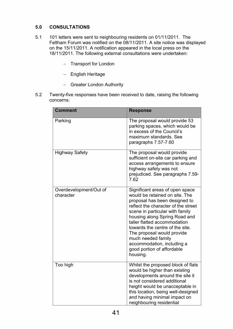
5.0 CONSULTATIONS
5.1 101 letters were sent to neighbouring residents on 01/11/2011. The Feltham Forum was notified on the 08/11/2011. A site notice was displayed on the 15/11/2011. A notification appeared in the local press on the 18/11/2011. The following external consultations were undertaken:
− Transport for London
− English Heritage
− Greater London Authority
5.2 Twenty-five responses have been received to date, raising the following concerns:
Comment Response
Parking The proposal would provide 53 parking spaces, which would be in excess of the Council’s maximum standards. See paragraphs 7.57-7.60
Highway Safety The proposal would provide sufficient on-site car parking and access arrangements to ensure highway safety was not prejudiced. See paragraphs 7.59-7.62
Overdevelopment/Out of character
Significant areas of open space would be retained on site. The proposal has been designed to reflect the character of the street scene in particular with family housing along Spring Road and taller flatted accommodation towards the centre of the site. The proposal would provide much needed family accommodation, including a good portion of affordable housing.
Too high Whilst the proposed block of flats would be higher than existing developments around the site it is not considered additional height would be unacceptable in this location, being well-designed and having minimal impact on neighbouring residential
41
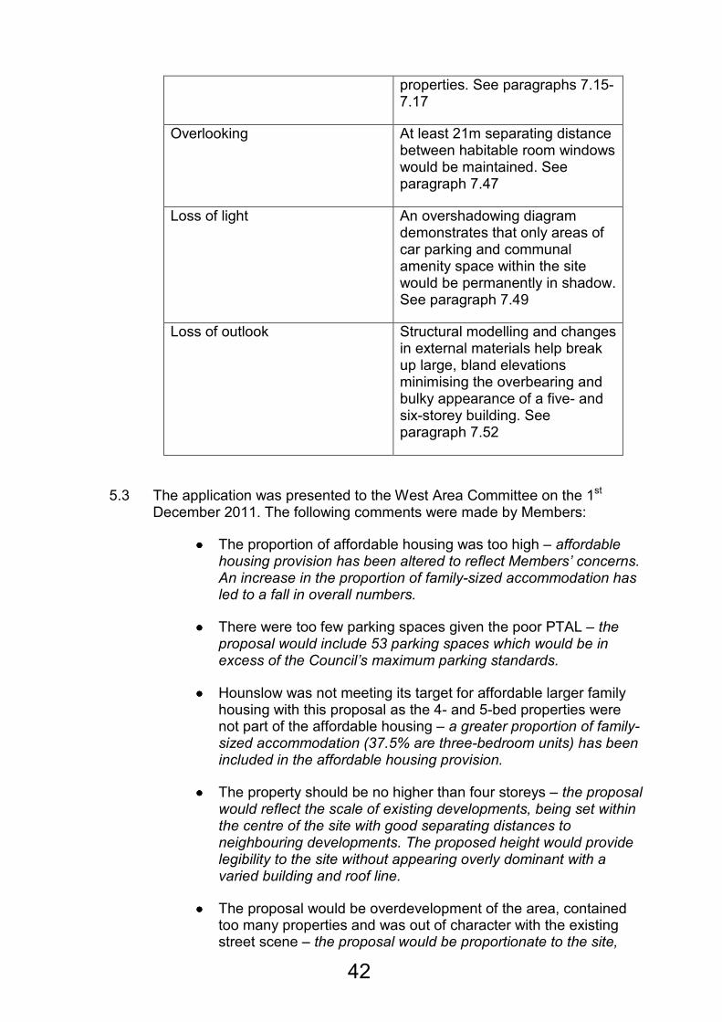
properties. See paragraphs 7.15-7.17
Overlooking At least 21m separating distance between habitable room windows would be maintained. See paragraph 7.47
Loss of light An overshadowing diagram demonstrates that only areas of car parking and communal amenity space within the site would be permanently in shadow. See paragraph 7.49
Loss of outlook Structural modelling and changes in external materials help break up large, bland elevations minimising the overbearing and bulky appearance of a five- and six-storey building. See paragraph 7.52
5.3 The application was presented to the West Area Committee on the 1st December 2011. The following comments were made by Members:
•••• The proportion of affordable housing was too high – affordable housing provision has been altered to reflect Members’ concerns. An increase in the proportion of family-sized accommodation has led to a fall in overall numbers.
•••• There were too few parking spaces given the poor PTAL – the proposal would include 53 parking spaces which would be in excess of the Council’s maximum parking standards.
•••• Hounslow was not meeting its target for affordable larger family housing with this proposal as the 4- and 5-bed properties were not part of the affordable housing – a greater proportion of family-sized accommodation (37.5% are three-bedroom units) has been included in the affordable housing provision.
•••• The property should be no higher than four storeys – the proposal would reflect the scale of existing developments, being set within the centre of the site with good separating distances to neighbouring developments. The proposed height would provide legibility to the site without appearing overly dominant with a varied building and roof line.
•••• The proposal would be overdevelopment of the area, contained too many properties and was out of character with the existing street scene – the proposal would be proportionate to the site,
42

providing a good mix of housing type and affordable housing provision on site. It would be designed to complement the existing street scene with family housing along Spring Road and the new flats positioned towards the centre of the site.
•••• There should be some facility available for the community included in the proposal – the submitted application must be assessed on its own merits. The principle of a 100% residential scheme would not be unacceptable given the exclusively residential nature of the surrounding area and its proximity to Feltham Town Centre.
•••• The area did not have the infrastructure to support more housing, for example schools were oversubscribed – there is a shortage in housing provision within the Borough and a financial contribution in the form of a Section 106 legal agreement will be required to mitigate the impact on local infrastructure.
5.4 The application was presented to the Sustainable Development Committee on the 26th January 2012. Members voted to defer the application to allow amendments to be made to the scheme. The following comments were made by Members:
• The development was too high and failed to respect surrounding developments, in particular its relationship with the neighbouring conservation area and St Dunstan’s Church.
• The proposal would be too dense for this site and this part of Feltham.
• Concerns were raised with regards to the existing problem of flooding along Spring Road and the junction with Feltham High Street
• Issues regarding traffic and parking were raised, in particular the narrowness of Spring Road and the junction with the High Street.
Amendments
5.5 As a result of consultation feedback the following amendments have been made to the proposed development:
• The height of the proposed development has been reduced from five- and six-storeys to four- and five-storeys.
• The number of flats on site has been reduced from 32 to 26.
• The number of parking spaces required for the block of flats has been reduced from 30 to 25.
• The density of the site has been reduced to 285 habitable rooms/hectare (hr/ha), a reduction of 22 habitable rooms.
43
• The affordable housing mix has been changed to 6 x three-bedroom houses and 8 x two-bedroom flats
• The cycle store has been relocated to make it more accessible and usable for residents
• Parking layout and crossover widths have been reduced to minimise impact on pedestrian safety
• Bland elevations have been given more detail in the form of changes in materiality
• Rear amenity space for the 6 x three-bedroom houses has been increased
• A shadowing diagram has been provided indicating the proposal would not overshadow adjoining areas of amenity space
6.0 POLICY
Determining applications for full or outline planning permission
6.1 When determining applications for planning permission, the authority is required to have regard to the development plan, so far as is material, and to any other material considerations. In addition, the determination must be made in accordance with the development plan unless material considerations indicate otherwise. The Development Plan
6.2 The Development Plan for the Borough comprises the Council's Unitary Development Plan (UDP), Employment Development Plan Document, Brentford Area Action Plan and the London Plan. The emerging Core Strategy
6.3 On 12 July 2011, the Council's Cabinet approved that the Core Strategy "Preferred Strategy" should go out to consultation. As emerging policy, the Local Planning Authority (LPA) considers that the emerging Core Strategy is capable of being a material consideration. Given that the emerging Core Strategy is still in the consultation stages, the LPA considers that very limited weight can be given to it at this stage. The draft National Planning Policy Framework
6.4 The draft National Planning Policy Framework (NPPF) was published for consultation on 25 July 2011. The NPPF is a consultation document and, therefore, potentially subject to amendment. Nonetheless, as emerging policy, the Local Planning Authority (LPA) considers that the NPPF is capable of being a material consideration. As the Planning Policy Statements, Guidance notes and Circulars remain in place until cancelled and given that the NPPF is still in the consultation stages, the LPA considers that very limited weight can be given to the NPPF at this stage.
44

6.5 A full list of the national, regional and local policies relevant for this proposal can be found at appendix 1.
7.0 PLANNING ISSUES
7.1 The main planning issues to consider are:
1. Principle of a residential development;
2. Design and appearance;
3. Housing Standards
4. The proposal’s impact on neighbouring land uses;
5. Environmental Considerations;
6. Transport and Access;
7. Whether sustainable building principles are applied; and
8. The potential of the proposed development to secure planning obligations
Issue 1: The principle of the proposed residential development
7.2 Government Policy and Guidance in the form of PPS1 (Sustainable Development) and PPS3 (Housing) encourage a systematic sustainable approach to the selection of land for development, with preference given, among others, to previously developed land.
7.3 In line with the amendments to PPS 3, paragraph 2.6 of the Interim Housing Design SPG states that the wider objectives of the London Plan are to ‘provide safe, secure and sustainable environments’, create ‘green corridors, protect trees and create ‘breathing spaces’ will normally outweigh the small increment to overall housing provision which usually results from garden development. This guidance sets out eight specific criteria designed to take full account of the contribution that the garden makes in each case compared to the limited contribution that the development might make to the housing stock. These include:
• Local context and character including the historic and built environment;
• Safe, secure and sustainable environments;
• Bio diversity;
• Trees;
• Green corridors and networks;
• Flood risk;
• Climate change including the heat island effect, and
• Enhancing the distinct character of suburban London
7.4 London Plan Policy 3.3 (Increasing London’s Housing Supply) recognises the need for more homes in London in order to promote opportunity and provide a real choice for all Londoners in ways that meet their needs at a
45
price they can afford. Policy 3.4 (Optimising Housing Potential) states that taking into account local context and character, the design principles outlined in Chapter 7 of the Plan, and public transport capacity, development should optimise housing output for different types of location.
7.5 London Plan policy 7.2 (All inclusive design) states that The Mayor will require all new development in London to achieve the highest standards of accessible and inclusive design. Policy 7.4 (Local Character) states that development should have regard to the form, function and structure of an area, place or street and the scale, mass and orientation of surrounding buildings. All development should improve an area’s visual or physical connection with natural futures.
7.6 On the local scale, Unitary Development Plan policy ENV-B.1.1 (New Development) requires all development to relate to the scale, nature and character of the surrounding area.
7.7 UDP housing policy H.4.1 and the 1997 SPG outline a range of housing standards that should be met in order to achieve adequate quality of living for future occupants. In addition the Mayors Housing strategy also outlines key size guidance of units and rooms that should also be considered.
7.8 With regards to the loss of the current nursing home, adopted UDP policy H.7.1 states that the Council will, where appropriate seek to facilitate and increase the provision of a variety of supported accommodation for people with special needs, from residential care homes to small scale ‘ordinary living’ housing. The Council’s Adult Services Team has advised that a residential home or nursing home is not required on this site, with a preference towards the provision of general residential housing with support and facilities to enable the (very) vulnerable to live in the local area. With regards to Policy C.3.3, the existing facilities have been deemed surplus to requirements and given the location of the site in an exclusively residential area, it is considered the proposal for 100% residential on this site would be in accordance with this policy.
7.9 In September 2010, the Executive gave permission to consult on the closures of John Collin House and Feltham Dene. The homes were proposed for closure in 2013, however this was brought forward due to decline in both sites leading the homes to be deemed unfit for purpose. As part of the “Development of Resource Centres for Older People”, the Council is re-providing Residential Care Facilities such as Greenrod Place in Brentford and the Clifton Gardens Resource Centre in Chiswick. Further development is being undertaken on the Sandbanks site in Bedfont.
7.10 It is therefore considered that the residential scheme would utilise an existing brownfield site that is no longer required for supported accommodation and would help meet housing needs identified within the Borough. The scheme would be appropriate to the surrounding area being 100% residential in nature and consequently it is considered the proposed development would be acceptable in principle notwithstanding the other planning issues that will be discussed in turn.
Issue 2: Design and Appearance
46
7.11 PPS 1 emphasises that design which fails to maximise opportunities available for improving the character and quality of an area or that is inappropriate in its context should not be accepted. Policy ENV-B.1.1 of the UDP promotes high quality design that enhances the overall environmental quality and townscape. Section 1.0 of the UDP Supplementary Planning Guidance (SPG) states that the design and layout of proposed developments must enable them to be compatible with, and make a positive contribution to, the character of the locality. New buildings must relate satisfactorily to adjoining and neighbouring buildings and spaces. The scale, massing, siting, size and height of these buildings should be respected by new development, although this need not exclude original, innovative design.
7.12 All policies in the London Plan promote sustainable development. Policy 7.1 sets out a series of criteria that should be considered by boroughs when assessing planning applications. In particular it states that Development should be designed so that the layout, tenure and mix of uses interface with surrounding land community infrastructure, the Blue Ribbon Network, local shops, employment opportunities, commercial services and public transport. Policy 7.4 builds on this and outlines criteria by which buildings, streets and open spaces should provide high quality design.
7.2 By Design, prepared by the Commission for Architecture and the Built Environment, sets out seven key objectives of urban design that development proposals (in terms of their layout, landscape, density and mix, height, massing and detailed appearance) should aspire to reinforce:
• Character – a place with its own identity;
• Continuity and enclosure – a place where public and private spaces are clearly distinguishable;
• Quality of the public realm – a place with attractive and successful outdoor areas;
• Ease of movement – a place that is easy to get to and move through;
• Legibility – a place that has a clear image and is easy to understand;
• Adaptability – a place that can change easily;
• Diversity – a place with variety and choice.
Height, Mass, Scale and Position
7.13 The proposed development is located within an existing residential area, which has a mix of housing types (terrace, semi-detached and flats) with none higher than four stories. The majority of buildings are brick built with tiled, pitched roofs.
7.14 The houses proposed would be two-storey with loft accommodation and no higher than the existing semi-detached and terrace properties along Spring Road. However, the proposed buildings are larger in mass than standard houses on Spring Road, and sit in considerably larger plot sizes. This is a result of the requirement to provide larger houses, and current internal and external accommodation size requirements, which have increased since the
47
surrounding development was built. It is not considered this relationship would be unacceptable and the proposed massing of the new housing would ensure it would not appear over bearing and reflected the general scale of development in the surrounding area.
7.15 The creation of a ‘street frontage’ along Spring Road is welcomed, with the larger family accommodation positioned to reflect that on the opposing side of Spring Road. These properties would be positioned to respect both the existing building line along Spring Road and the curved nature of this part of Spring Road, with breaks between to ensure there would not be an overbearing effect within the street scene.
7.16 The proposed flat building has been altered in that one floor has been removed from the scheme in line with Member comments at the previous SDC. The building would now be a four and five storey block positioned towards the centre of the site. The properties immediately to the north of the site are four-storey in height with a pitched roof. Whilst the new flats would be of substantial mass the amendments received have resulted in a scheme comparable with the adjacent flat buildings, the block is also positioned towards the centre of the site with considerable spacing to adjoining developments to help reduce the overall massing and scale. The angled position of this block, with the central element one storey higher than the ‘wings’ would further help to minimise the overall massing and height of this building. Adequate separation distances, as contained within Appendix 1 of the adopted UDP and SPG, have been provided to further ensure the massing and scale of the development is appropriate to the site and would minimise impact on adjoining properties. This building has been positioned to minimise its impact on the proposed amenity space, as well as adjoining residential properties, in particular with regards to overshadowing, which will be discussed in more detail below.
7.17 The height would be located towards the centre of the development and isolated to a small section of the proposed block of flats, being a maximum five-storey in height. The variation in roof levels helps break up the mass of this building, whilst also ensuring the proportions of the building are retained. The position of the height, and variation at roof level, helps provide legibility, with the central element of the building being clearly visible from the surrounding area. Whilst this would be higher than other existing developments in the area, it is not considered this would harm the appearance or character of the surrounding area as the scale and massing of the proposal would ensure it complemented existing tall elements within the local landscape character, most notably St Dunstan’s church (approximately 95m to the north) and did not represent a significant visual step up in height from the existing four-storey (plus pitched roof) residential blocks that surround the site to the north and west.
7.18 Whilst it is noted that the proposal would be visible from the conservation area, it is not considered it would have a detrimental impact on the character and appearance of this due to the separation distance of the proposed development and the size and scale of adjoining properties, most notably the four-storey (plus pitched roof) flats to the north and west of the site. Furthermore, the position of the flats (highest element of the proposal) towards the centre of the site would further minimise its impact on the
48
conservation area. Whilst the proposal would have a more modern appearance, especially when viewed from the conservation area in the context of other surrounding developments, it is not considered this would harm the general appearance of the conservation area or have an unacceptable impact on the existing buildings and setting of this conservation area.
7.19 Whilst it is noted that the proposed development would result in a significant increase in residential population in the area, the site is of a considerable size and it is not considered the proposal as a whole would be disproportionate to the size of the site. This would be reflected not only in the large areas of amenity space associated with the private dwellings, but also the communal spaces provided in conjunction with the flatted development.
Design
7.20 The scheme has attempted to assimilate into the general appearance of the surrounding area, but includes elements required in new housing developments that may not be presently found at existing properties.
7.21 There is no doubt that the proposed buildings would be modern additions to the area – markedly different from those buildings that surround it. However, the houses would have clean lines, have a brickwork finish, and provide residential scale front canopies and dormers and a fenestration pattern that closely reflects the residential nature of the surrounding area. It is considered the design of the proposed houses reflects the setting of the site and would not be out of keeping with the surrounding area.
7.22 With regards to the proposed block of flats towards the rear of the site, these would be of a far more contemporary design, with more modern external appearances, having an external cladding system. Such a design, whilst notably different from the surrounding area, would provide interest to otherwise dominating elevations and help to break up the appearance of this block to ensure it did not appear overly dominating, which is also helped by the reduction in height.
Street Scene
7.23 As highlighted above, the predominant built-form of the surrounding area is brick-built properties of a residential scale, no higher than four-storeys, with areas of open space surrounding existing developments.
7.24 The proposed houses would help contribute to the street scene along Spring Road and, as described above, would reflect the residential nature of properties on the eastern side of Spring Road. The proposed building lines and scale of these properties would further emphasise the creation of new street pattern in this location, helping to enclose Spring Road and bring about a sense of place that is currently lacking due to the openness of the site as existing. Much of the design cues for the finished appearance of these properties have been taken from the surrounding residential properties and it is considered this would ensure the proposal would complement the street scene and contribute to the appearance of the
49

surrounding area in general.
7.25 With regards to the proposed block of flats, due to their height, these would be visible both directly from Spring Road to the south, but also from the surrounding area. It is considered the variation in roof height helps provide interest, whilst the general massing and finished appearance will create dynamism in the street scene as receptors move around the site. The provision of communal amenity/play space to the front of this block immediately adjacent to Spring Road would ensure the development would not appear overly domineering when viewed from the street and ensure the residential-scale at street frontage was maintained. Added interest to the flank elevations in terms of variations in materials helps to break up what could otherwise be bland, overbearing elevations. It is considered these variations in materials proposed for the external finish of the proposed block of flats help add interest and offer a development that is different, but also complementary to the existing street scene. It is also considered the massing of this block, coupled with the provision of projecting balconies and other projecting elements, help create an important modelling aspect that further helps to break up the overall massing of these flats and adds a greater level of interest, in particular in the form of shadowing, than may otherwise have been achieved.
7.26 In light of the above it is considered the proposal would be acceptable in design terms, with the scale, height and massing of the development being appropriate to the site and surrounding context and the finished appearance and general modelling ensuring the development complemented the existing street scene and responded to the general character of the surrounding area.
Issue 3: Housing Standards
7.27 PPS3 sets out the national planning policy framework for delivering the Government’s housing objectives. The Government’s key housing policy goal is to ensure that everyone has the opportunity of living in a decent home, which they can afford, in a community where they want to live (Paragraph 9).
Density
7.19 Residential density is a tool against which an initial appraisal is made. It is a useful guide to the nature of the development and can be used to ensure that new development reflects the character of an area, but is not a determinant in its own right. Policy 3.4 of the London Plan states that development should optimise housing output for different types of location within the relevant density range shown in Table 3.2 of the London Plan. Table 3.2 illustrates appropriate densities to be achieved in relation to housing. The site has a PTAL of 1b, which is defined as “Very Poor” and can be described as being in an “Urban” location. Table 3.2 sets the relevant density range for a development in this location as 150-250hr/ha. Based on the accommodation proposed, with 154 habitable rooms1 (where
1 Based on the London Housing Design Guide Interim Edition (August 2010) definition of habitable rooms:
“Habitable rooms provide the living accommodation of the dwelling. They include living room, dining room,
50
a larger room can be suitably divided into two this is counted as two habitable rooms, i.e. living/dining rooms) and a site area of 0.54ha, the development would have a density of 285hr/ha.
7.28 As a result of the reduction in the flat block the overall density has reduced. Whilst the proposed density is remains outside the range established by the London Plan, the merits of the scheme and the quality of the accommodation provided need first to be taken into consideration. These issues are assessed in the following paragraphs.
Residential mix and size
7.29 PPS 3 and the London Plan encourage new residential developments to provide a choice of housing with a mix of family and non-family housing being needed to meet different community requirements. In addition to this need for housing mix, developments over 10 dwellings should include a proportion of affordable homes as established by Policy 3.13 of the London Plan.
7.30 The proposed mix of units has been described previously at paragraph 4.2.
7.31 London Plan Table 3.3 sets out minimum space standards for dwellings of different sizes. This is based on the minimum gross internal floor area (GIA) required for new homes relative to the number of occupants whilst also taking account of commonly required furniture and the spaces needed for different activities and moving around, in line with the ‘Lifetime Home’ standards. All units proposed have been designed to exceed the minimum space standards listed in Table 3.3.
7.32 Given the scheme would comply with the requirements of the London Plan
in terms of individual unit sizes it is considered the proposal would be acceptable in terms of the accommodation provided. Furthermore, there would be an appropriate mix of housing on site, with a significant proportion (27 out of 37) of these units being of a family-size (i.e. 2+ bedrooms) as defined in the Council’s SPG.
Accessibility
7.33 The London Plan strongly supports the principles of Lifetime Homes and
views them as fundamental to the delivery of the Government’s objectives of social inclusion, sustainability, equality and valuing diversity and identifies that the increased independent living they can bring will reduce pressure on hospital beds and residential care homes. Policy 3.8 of the London Plan further specifies that all units within the scheme be based on the ‘Lifetime Homes’ standards and that 10% of all units be wheelchair accessible or easily adaptable for residents who are wheelchair users. All units would be based on the ‘Lifetime Homes’ standards. Details of this would be secured by a relevant planning condition, with the Housing Development and Partnerships team working closely with the developer to ensure that these
study, home office, conservatory, bedroom etc. They exclude the bathroom, WC, utility room, store room and
circulation space. A kitchen is not a habitable room unless is provides space for dining.”
51
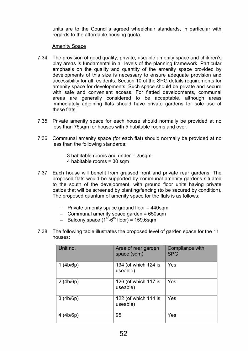
units are to the Council’s agreed wheelchair standards, in particular with regards to the affordable housing quota.
Amenity Space
7.34 The provision of good quality, private, useable amenity space and children’s
play areas is fundamental in all levels of the planning framework. Particular emphasis on the quality and quantity of the amenity space provided by developments of this size is necessary to ensure adequate provision and accessibility for all residents. Section 10 of the SPG details requirements for amenity space for developments. Such space should be private and secure with safe and convenient access. For flatted developments, communal areas are generally considered to be acceptable, although areas immediately adjoining flats should have private gardens for sole use of these flats.
7.35 Private amenity space for each house should normally be provided at no
less than 75sqm for houses with 5 habitable rooms and over. 7.36 Communal amenity space (for each flat) should normally be provided at no
less than the following standards: 3 habitable rooms and under = 25sqm 4 habitable rooms = 30 sqm
7.37 Each house will benefit from grassed front and private rear gardens. The
proposed flats would be supported by communal amenity gardens situated to the south of the development, with ground floor units having private patios that will be screened by planting/fencing (to be secured by condition). The proposed quantum of amenity space for the flats is as follows:
− Private amenity space ground floor = 440sqm
− Communal amenity space garden = 650sqm
− Balcony space (1st-6th floor) = 159.6sqm
7.38 The following table illustrates the proposed level of garden space for the 11 houses:
Unit no. Area of rear garden space (sqm)
Compliance with SPG
1 (4b/6p) 134 (of which 124 is useable)
Yes
2 (4b/6p) 126 (of which 117 is useable)
Yes
3 (4b/6p) 122 (of which 114 is useable)
Yes
4 (4b/6p) 95 Yes
52
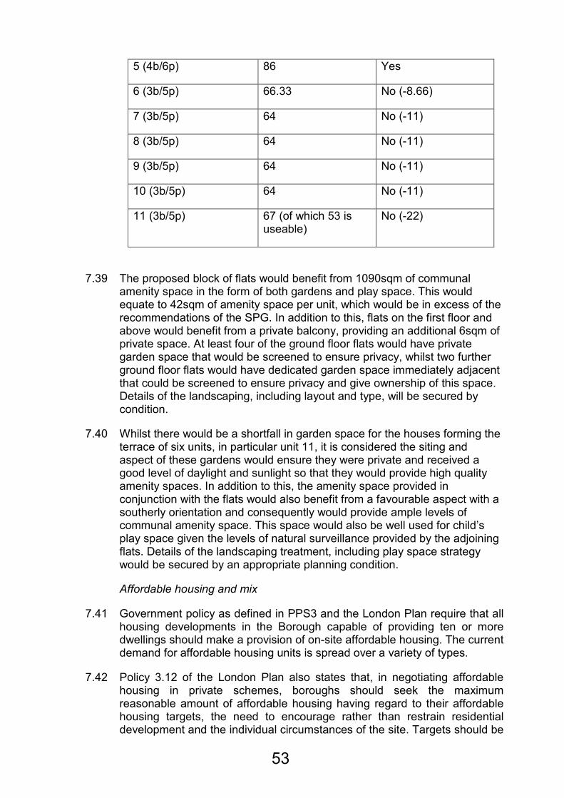
5 (4b/6p) 86 Yes
6 (3b/5p) 66.33 No (-8.66)
7 (3b/5p) 64 No (-11)
8 (3b/5p) 64 No (-11)
9 (3b/5p) 64 No (-11)
10 (3b/5p) 64 No (-11)
11 (3b/5p) 67 (of which 53 is useable)
No (-22)
7.39 The proposed block of flats would benefit from 1090sqm of communal amenity space in the form of both gardens and play space. This would equate to 42sqm of amenity space per unit, which would be in excess of the recommendations of the SPG. In addition to this, flats on the first floor and above would benefit from a private balcony, providing an additional 6sqm of private space. At least four of the ground floor flats would have private garden space that would be screened to ensure privacy, whilst two further ground floor flats would have dedicated garden space immediately adjacent that could be screened to ensure privacy and give ownership of this space. Details of the landscaping, including layout and type, will be secured by condition.
7.40 Whilst there would be a shortfall in garden space for the houses forming the terrace of six units, in particular unit 11, it is considered the siting and aspect of these gardens would ensure they were private and received a good level of daylight and sunlight so that they would provide high quality amenity spaces. In addition to this, the amenity space provided in conjunction with the flats would also benefit from a favourable aspect with a southerly orientation and consequently would provide ample levels of communal amenity space. This space would also be well used for child’s play space given the levels of natural surveillance provided by the adjoining flats. Details of the landscaping treatment, including play space strategy would be secured by an appropriate planning condition.
Affordable housing and mix
7.41 Government policy as defined in PPS3 and the London Plan require that all housing developments in the Borough capable of providing ten or more dwellings should make a provision of on-site affordable housing. The current demand for affordable housing units is spread over a variety of types.
7.42 Policy 3.12 of the London Plan also states that, in negotiating affordable housing in private schemes, boroughs should seek the maximum reasonable amount of affordable housing having regard to their affordable housing targets, the need to encourage rather than restrain residential development and the individual circumstances of the site. Targets should be
53
applied flexibly, taking account of individual site costs, the availability of public subsidy, the implications of phased development including provision for re-appraisal and other scheme requirements. London Plan policy 3.11 requires 60% of the affordable housing provision to be social rent and 40% for intermediate rent or sale.
7.43 In respect of viability, Circular 05/05 makes clear that site viability must be considered, such that affordable housing provision is negotiated in a way that ensures a “level of contribution that can be demonstrated as reasonable to be made whilst allowing development to take place” (paragraph B10). Further to this PPS3 states that councils should consider the “economic viability of land for housing…drawing on informed assessments of the likely levels of finance available for affordable housing, including public subsidy and the level of developer contribution that can reasonably be secured.”
7.44 The Hounslow Plan sets out the Council’s 5 key pledges to residents, which include the delivery of 2500 new affordable homes to rent and buy. Larger family housing is a particular priority for Hounslow, and this is supported by the London Plan target of 42% of new affordable homes to rent to have 3 bedrooms or more. The provision of large affordable homes is also supported by the Homes & Communities Agency, the West London Investment Guide, the London SPG and the London Plan.
7.45 The London Borough of Hounslow is satisfied that the affordable housing proposal of 38% on-site provision is acceptable with regards to the London Plan Policies 3.11 and 3.12 and the adopted UDP.
7.46 The good property mix of the affordable housing element is important, as the Council’s housing need is for a range of housing types both for affordable rent and affordable intermediate tenures. The London Plan policy 3.8 states the need to provide a range of housing choices taking into account the housing requirements of different groups. This scheme would provide 14 units that would be considered family accommodation, i.e. 2+ bedrooms in accordance with the definition of family housing contained within the adopted SPG. Therefore the development proposal in terms of unit mix and size meets the Council’s requirements as it provides a good mix of units and delivers 100% of 2+bedroom affordable family units and 37.5% of three-bedroom units.
7.47 Changes to the affordable housing provision have been made to reflect comments made by Members at the West Area Committee, with a greater proportion of family-sized accommodation being provided. Whilst this has resulted in a drop in overall numbers, this reflects the fact that a higher portion of the affordable accommodation would be larger, family-sized houses.
7.48 A tenure mix for the proposed affordable accommodation has not been made at this stage. It is considered the development would be required to comply with London Plan policy 3.11 and provide 60% social rent and 40% intermediate rent/sale. Such rent models would be expected to be included in any S106 agreement and would be dependent upon a detailed financial viability assessment being undertaken, which would be scrutinised by the Council’s external valuer to ensure the maximum level of affordable housing
54
and tenure type is achieved on site. Given the shortfall in on-site affordable housing provision, it would be expected the developer would agree to a mechanism of deferred payment which would be set out in a S106 agreement to bring the affordable housing provision on site to the 41% target whilst also providing the required family housing.
Issue 4: Impact on neighbouring land uses
Overlooking
7.49 Appendix 1 of the UDP states that a distance of at least 21m is recommended between the windows of habitable rooms which directly face those of another habitable room to avoid overlooking. The proposal has been designed to ensure this standard has been met and that no habitable room windows would be within 21m of habitable rooms of neighbouring properties. Whilst there may be a perception of overlooking created by the development, in particular with regards to the five- and six-storey block of flats, it is not considered this would be unacceptable in this instance and the privacy of neighbouring residential properties would be maintained.
Daylight, Sunlight & Overshadowing
7.50 An overshadowing assessment of the proposed development has been submitted in conjunction with the application.
7.51 In assessing this information it is not considered that the proposal would result in an unacceptable level of overshadowing to neighbouring residential properties. The main impact in terms of overshadowing would be to the communal amenity space and car parking immediately to the rear of the block of flats and contained within the site. Given the provision of communal amenity space to the front of the site that would not be overshadowed and benefit from a southerly aspect, it is not considered the overshadowing of the amenity space at the rear would be unacceptable. This would be primarily due to the position and orientation of the proposed accommodation and the separating distances to adjoining residential properties, in particular with regards to the position of the four- and five-storey block of flats (approximately 25 and 36m to the north). The proposed housing would not impact upon neighbouring residents in terms of daylight, sunlight or overshadowing.
Outlook
7.52 The detailed design of the proposal has previously been discussed within paragraphs 7.10-7.24.
7.53 It is considered that the amended scheme would reflect the scale of surrounding development, being similar in size, scale and appearance and consequently would not have a detrimental impact on the outlook from neighbouring properties. Coupled with this, areas of open space would be retained around properties, including areas of soft landscaping and the retention of existing trees. This would further mitigate the addition of new development on the site and ensure there would not be an unacceptable impact on the outlook from neighbouring properties.
55
7.54 The previously taller flat building has been reduced and this bulkier section of the scheme is positioned a significant distance from neighbouring properties and would have elevational treatment and modelling that would ensure interest and dynamism, albeit more contemporary in appearance than existing developments.
7.55 Given the reduction in height It is not considered that the appearance of the development would have an unacceptable impact on the outlook of neighbouring residents. Where large, bland elevations have been proposed, these have been broken up with variations in material or structural modelling in order to minimise the potential overbearing and dominating appearance of such a building. Some of these amendments have been made following the consultation period, including comments made by Members at the West Area Committee and the Sustainable Development Committee that the proposal was too high and out of keeping with the character of the existing street scene.
Issue 5: Environmental Considerations
Air
7.56 The whole Borough was declared an Air Quality Management Area (AQMA) in March 2006. However, whilst the designation of the AQMA is indicative of a certain level of air quality, this in itself does not prevent development.
7.57 It is not considered that the proposed development would significantly exacerbate existing conditions with regards to air quality and that the location of the site would not be inappropriate for residential development due to existing air quality issues. It is not considered this matter would require further mitigation or would represent a reason for refusing this application. A condition will also be applied regarding construction works, in particular regarding the spread of dust and other airborne contaminates during construction work.
Noise
7.58 It is considered that appropriate planning conditions regarding sound insulation to comply with Building Regulations would be sufficient in this instance to ensure resident’s living conditions were satisfactory and prevent external noise attenuation. A condition will also be applied regarding construction works, in particular regarding hours of operation.
Water/Flooding
7.59 The site is not within a flood zone. It is therefore not necessary to carry out a flood risk assessment for this proposal. Whilst it is noted that concerns have been raised with regards to the liability of Spring Road and Feltham High Street to flooding, it is not considered this is an inevitability of the development of this site given that it is located outside a flood risk area. It is considered appropriate conditions (nos. 17 and 19) to ensure surface water runoff is minimised to ‘greenfield’ levels would be appropriate for this development given that it is not located within a flood risk area and therefore a full Flood Risk Assessment (FRA) would not be necessary.
56
Issue 6: Transport and Access
7.60 The Council’s parking standards are considered to be the maximum desirable provision, with UDP policies seeking to reduce reliance on the private car and promote use of sustainable modes. Parking standards are contained within Appendix 3 of the UDP. There are no minimum standards except in relation to disabled parking.
7.61 The site has a PTAL described as ‘Very Poor’ and consequently it would be expected that the proposal would provide close to the maximum standards contained within the UDP.
7.62 The proposal would include the provision of two parking spaces for each of the eleven houses, with an additional two spaces for disabled parking and three visitor spaces. There would be a further twenty-four spaces for the flats with an additional two disabled spaces and three visitor spaces located towards the rear of the site. The site as a whole would therefore provide 53 spaces.
7.63 The proposal would therefore exceed the Council’s maximum car parking standards for a development of this size by 1 space. Given the site’s location, with a Public Transport Accessibility Level (PTAL) rating of 1b, which is described as ‘Very Poor’, and therefore the need for on-site car parking, it is not considered this over provision would be unacceptable in this instance. It should also be noted that the Council’s standards are maxima and as such the Council should be promoting use of transport modes other than by private car. Consequently it is considered that a residential Green Travel Plan be included in any S106 agreement.
7.64 The proposal would also provide secure cycle storage for 26 cycles. This positioned to the rear of the block of flats, adjacent to the car parking. Each house would have its own rear garden with sufficient space for cycle storage. It is therefore considered that the proposed cycle storage arrangements would be satisfactory subject to an appropriate planning condition regarding detailed design of the cycle stores.
7.65 Access to the rear car parking for the flats would utilise the existing vehicle crossover in this location and consequently would be considered acceptable. Houses 1-5 would have their own driveway with space for two vehicles to the front of the property, utilising a 3.6m vehicle crossover. Units 6-11 would have one space provided to the front of the property ( with individual crossovers) with a new parking area provided between units 5 and 6 providing a second space for each of these units. This space would be finished with ‘grasscrete’ and screened to ensure resident’s amenity space was protected. Details of this will be required as part of the landscaping condition.
7.66 Refuse and recycling storage for the block of flats would be close to the point of collection and therefore would be satisfactory. Each house would utilise kerbside collection of refuse and recycling in accordance with current Council practices.
7.67 In light of the above it is considered that the proposal would ensure
57
satisfactory parking would be provided on site for residents and visitors and the proposed layout and servicing arrangements would not have a prejudicial impact on the free-flow of traffic on the local road network or highway safety in general.
Issue 7: Sustainability
7.68 Sustainability underpins many policies of the UDP and the London Plan. These require developments to be sustainable in transport terms, to minimise waste, include energy efficiency measures and promote the use of renewable energy, and not significantly increase the requirement for water supply or surface water drainage.
7.69 The new London Plan policy 5.2 requires development proposals to make the fullest practicable contribution to minimising carbon dioxide emissions in accordance with the following energy hierarchy:
• Be Lean: use less energy
• Be Clean: supply energy efficiently
• Be Green: use renewable energy
7.70 The Mayor aims to ensure that major developments reduce carbon dioxide emissions from buildings, by reaching higher then the Target Emission Rate (TER) outlined in the national Buildings Regulations, leading to zero carbon residential buildings from 2016. The mayor has stipulated that between 2010 and 2013 residential buildings should provide a 25% improvement on 2010 Building Regulations’ which rise to 40% by 2013-2016.
7.71 The applicants have submitted a Renewable Energy Strategy that states that a number of energy efficient measures have been included in the design to reduce the production of CO2. It is proposed that total site CO2 emissions can be reduced by 20% through the use of solar PV panels across the site.
7.72 In addition , the applicants have indicated that the proposed development would meet Code for Sustainable Homes (CSH) Level 4 which outlines the environmental rating and performance of new homes, based on the following criteria:
• Energy
• Water
• Materials
• Surface water
• Pollution
• Health and Wellbeing
• Management
• Ecology
58
7.73 Points are award on each of these categories which equates to a ‘Code Level’ (from 1-6). The higher the code level, the more sustainable the home is. Once the development has been built and occupied, the levels gained will be confirmed and a CSH certificate will be issued.
7.74 The re-development of the site is consistent with these aims, as the site has been previously developed and is 100% brownfield land. The submitted energy statement demonstrates that the proposal would result in a reduction in 20% of CO2 from a baseline including regulated and unregulated emissions, which would satisfactorily achieve the 25% reduction in regulated CO2 emissions required by the London Plan. This statement goes on further to suggest the development would achieve CSH ‘Level 4’.
7.75 It is considered an appropriate planning condition requiring a detailed CSH Pre-Assessment confirming how the applicant intends to achieve Code ‘Level 4’ and details of the photovoltaics proposed be included in any planning consent.
7.76 No details as to how the proposal would incorporate Sustainable Urban Drainage Systems (SUDS) into the design of the development have been provided or how water use would be minimised and surface water runoff reduced towards ‘greenfield’ levels. Whilst it is noted that large areas of the site would remain as soft landscaping and therefore help to minimise surface water runoff, it is considered this detail can be secured by an appropriate planning condition to ensure compliance with the London Plan.
Issue 8: Planning Obligations
7.77 UDP policy IMP6.1 states that the Council will seek to ensure that a developer enters into a planning obligation to secure planning benefits related to the proposed development. A payment or other benefit offered pursuant to a section 106 agreement is not material to a decision to grant planning permission and cannot be required unless it complies with the provisions of the Community Infrastructure Levy Regulations 2010 (regulation 122), which provide that the planning obligation must be:
(a) necessary to make the development acceptable in planning terms; (b) directly related to the development; and (c) fairly and reasonably related in scale and kind to the development.
7.78 Government Circular 05/2005 provides guidance on the use of planning
obligations, which may impose a restriction or requirement, or provide for payment of money from the developer to make acceptable development proposals that might otherwise be unacceptable in planning terms. The Council’s Supplementary Planning Document on Planning Obligations (which was adopted in March 2008) contains guidance on the imposition of planning obligations in compliance with Circular 05/2005. These obligations may offset shortfalls in the scheme or mitigate the impacts of the development.
7.79 Accordingly, it is mandatory that each criterion be satisfactorily addressed
prior to granting planning permission subject to a section 106 agreement. However in this instance as there is no developer at this stage and with the
59
Council being landowner and Local Planning Authority, the Council is not able to enter into a legal agreement with itself. Therefore the completion of a S106 agreement will need to be secured by planning condition.
7.80 The following planning obligations have been directly calculated from the
Council’s Planning Obligations SPD where relevant. It would be expected that any legal agreement would include these contributions and where this is deemed unviable a detailed financial assessment will be scrutinised by the Council’s external valuer.
I. Affordable Housing II. Construction Training III. Education IV. Health V. Highway Improvements VI. Travel Plan VII. Considerate Contractors Scheme
8.0 EQUAL DUTIES IMPLICATIONS
8.1 The Council has had due regard to its Equalities Duties and in particular with respect to its duties arising pursuant to the Equality Act 2010, section 149. Following a relevance test, this is available at:
http://www.hounslow.gov.uk/index/council_and_democracy/equality/eias/environment_eias.htm
8.2 It is considered that there will be no specific implications with regard to the Council’s duty in respect of its equalities duties and that if approving or refusing this proposal the Council will be acting in compliance with its duties.
Relevant Section of Relevance Test
Major development
9.0 RECOMMENDATION
GRANT
The proposed redevelopment of the Feltham Dene site to provide 11 x two-bedroom houses and 32 x one- and two-bedroom flats would result in the development of this brownfield site to provide an appropriate mix and size of housing accommodation that would be in keeping with the residential character of the area. The scheme as amended presents a development of high design quality that would provide a good standard of living accommodation and amenity benefits without having an unduly detrimental impact on neighbouring and nearby resident’s living conditions. Furthermore, the proposal would not have a prejudicial impact on the free-flow of traffic on the local road network or highway safety in general. On balance the development is in accordance with the relevant policies of the adopted Unitary Development Plan, Supplementary Planning Guidance and the London Plan, including policies IMP.3.1, ENV-N.2.6, ENV-B.1.1, ENV-B.1.5, ENV-B.1.9, ENV-P.1.3-7, ENV-P.2.1, ENV-P.2.4, H.4.1, H.4.4-5
60

H.6.2, H.7.1, C.3.3, T.1.4, T.2.1, T.2.2 and T.4.3-5, T.5.2.
61
Conditions: 1 The development hereby permitted shall not be commenced
until a written planning obligation under Section 106 Town and Country Planning Act 1990 in the same terms or substantially in the same terms as the planning obligation annexed hereto has been entered into by all relevant parties in relation to that relevant part of the application site and until the obligation has been completed and submitted to the local planning authority.
REASON: to ensure that the impacts of the proposed development are appropriately mitigated.
2 A1a Time Limit
The development hereby permitted shall be begun before the expiration of three years from the date of this permission. REASON: A1R
3 B4 Materials to match/samples No development shall take place until samples of the materials to be used in the construction of the external surfaces of the hereby permitted buildings have been submitted to and approved in writing by the Local Planning Authority. Development shall be carried out in accordance with the approved details. REASON: B4R
4 B5 Detailed Applications The proposed development shall be carried out in all respects in accordance with the proposals contained in the application and the plans submitted numbered as per drawing numbers therewith and approved by the Local Planning Authority, or as shall have been otherwise agreed in writing by the Local Planning Authority before the building is used. REASON: B5R
5 C5 Restriction of Permitted Development Rights (No enlargement) REASON: C5R
6 C7 Restriction of Permitted Development Rights (No fences etc.) REASON: C7R
62
7 C29 Hours of Construction No demolition or construction work shall take place on the site except between the hours of 8.00am to 18.00pm on Mondays to Friday and 9.00am to 13.00pm on Saturdays and none shall take place on Sundays and Public Holidays without the prior agreement of the Local Planning Authority. REASON: C29R
8 D4 Waste & Recycled Storage (Details to be submitted) REASON: D5R
9 E1 Landscape design proposals Hard & soft landscaping works, including boundary treatments, play strategy, refuse & cycle store and planting plans and maintenance/implementation programme. REASON: E1R
10 E15 Provision for Tree Planting If within a period of two years from the date of the planting of any tree, that tree, or any tree planted in replacement for it, is removed, uprooted or destroyed or dies, another tree of the same species and size as that originally planted shall be planted at the same place, unless the local planning authority gives its written consent to any variation. REASON: E15R
11 E16 Existing trees to be retained REASON: E16R
12 F4 Completion- Access The buildings hereby approved shall not be occupied until a means of access for vehicles and pedestrians has been constructed in accordance with the approved plans. REASON F4R
13 G2 Parking The parking layout shown on drawing 521321-A-012 Rev 06 shall be provided before the dwellings to which it relates is occupied and thereafter it shall not be used for any purpose other than the parking of vehicles.
63
REASON: G1R
14 N/S The development hereby permitted shall be designed in accordance with the Lifetime Home standards as set out in the London Plan Accessible London Supplementary Guidance Accessible London REASON: J2R
15 J12 Phased Contamination Condition
Before the development hereby permitted commences:
a. The site shall be investigated by a competent person to identify the extent and nature of contamination. A detailed site investigation report shall be prepared and submitted to the LPA. The report should include a tiered risk assessment of the contamination based on the proposed end use of the site. Additional investigation may be required where it is deemed necessary.
b. If required, a scheme for decontamination of the site shall be submitted to the LPA, for written approval. The scheme must account for any comments made by the LPA
Before the development hereby permitted is first occupied:
c. The LPA shall be notified immediately if additional contamination is discovered during the course of the development. A competent person shall assess the additional contamination, and shall submit appropriate amendments to the scheme for decontamination in writing to the LPA for approval.
d. The agreed scheme for decontamination, including amendments, must be fully implemented and a written validation (closure) report submitted to the LPA for approval.
REASON: Contamination is known or suspected on the site due to a former land use. The LPA therefore wishes to ensure that the development can be implemented and occupied with adequate regard for public and environmental safety. Supporting notes:
a. An initial desk study must be submitted with the original application. The full site investigation must include intrusive testing for soil and groundwater contamination, soil gasses, and leachate. The investigation shall be carried out at such points and at such depths as the LPA may stipulate. The tiered risk assessment shall include a site conceptual model, which identifies all potential pollutant linkages on the site. Risk assessments must adhere to current UK guidance and
64
best practice.
b. The scheme for decontamination shall provide details of how each potential pollutant linkage, as identified in the conceptual model, will be made safe.
c. In some instances the LPA may require work on site to be ceased whilst the nature of additional contamination is investigated fully.
d. The validation report shall revisit the site conceptual model, and provide evidence that each aspect of the decontamination scheme was carried out correctly and successfully. This report shall prove that the development is suitable for its new use.
16 Conservation of Energy The building shall not be occupied until evidence (e.g. photographs and copies of installation contracts) has been submitted to the Local Planning Authority to demonstrate that the development has been carried out in accordance with the details approved in the Design & Access Statement dated October 2011. (Reason: To comply with the London Plan Policies 5.1-5.7 and to ensure the overall environmental sustainability of the development.)
17 Sustainable Drainage No development shall take place until details of a Sustainable Urban Drainage Scheme, including measures for (i) the harvesting of rainwater, (ii) the minimisation of water run-off from the site, aiming for greenfield levels, and (iii) the conservation and reuse as appropriate of other water supplies in the buildings have been submitted to and approved by the Local Planning Authority. The building shall not be occupied until evidence (e.g. photographs and copies of installation contracts) has been submitted to the Local Planning Authority to demonstrate that the development has been carried out in accordance with the approved details. (Reason. In the interests of sustainability and to ensure the satisfactory management of surface water run-off from the development hereby permitted, including by preventing increased risk of flooding and pollution of the water environment, and in accordance with Hounslow Unitary Development Plan Policies ENV-B.1.1 (New development), ENV-P.1.2 (Water pollution and water quality), ENV-P.1.3 (Surface water run off) and London Plan Policies 5.10 (Urban Greening), 5.13 (Sustainable drainage) and 5.15 (Water use
65
and supplies).
18 Sustainable Construction No development shall take place until a statement on the sourcing of materials to be used in the building, involving reuse, recycling and other sustainable sourcing of materials to be used in the construction of extensions and fitting out of the building wherever possible, has been submitted to and approved in writing by the Local Planning Authority. The building shall not be occupied until evidence (e.g. photographs and copies of installation contracts) have been submitted to the Local Planning Authority to demonstrate that the development has been carried out in accordance with the approved details (Reason. To ensure the development can be implemented with adequate regard to the environment in the interests of sustainability in accordance with Hounslow Unitary Development Plan Policies ENV-B.1.1 (New development), London Plan Policy 5.3 (Sustainable design and construction); and Sustainable Design and Construction (London Plan Supplementary Planning Guidance May 2006.)
19 Surface Water Drainage With regard to surface water drainage it is the responsibility of a developer to make proper provision for drainage to ground, water courses or a suitable sewer. In respect of surface water it is recommended that the applicant should ensure that storm flows are attenuated or regulated into the receiving public network through on or off site storage. When it is proposed to connect to a combined public sewer, the site drainage should be separate and combined at the final manhole nearest the boundary. Connections are not permitted for the removal of Ground Water. Where the developer proposes to discharge to a public sewer, prior approval from Thames Water Developer Services will be required. They can be contacted on 0845 850 2777. Reason - to ensure that the surface water discharge from the site shall not be detrimental to the existing sewerage system
Informatives:
1 The building contractors should take note of, and act upon advice given in the in the GLA and London Councils - Best Practice Guidance: "The Control of Dust and Emissions from Construction and Demolition
66
2 If site staff are instructed by a Council Officer to stop vehicle movements to and from the site if any incidents occur, they must comply with the instructions. For any further advice, contact the Council’s Community Environment Team on 020 8583 5070.
3 The building contractors should take note of, and act upon advice given in the BS5228 Code of Practice "Control of Noise on Construction Sites". Before commencement of the works the building contractors should, giving as much notice as possible, notify the occupants of properties surrounding the site of the nature and duration of works and the permitted hours of work. The building contractors should also provide such occupants with the name and telephone number of a responsible person who can be contacted for advice or in the event of a need to complain.
4 With regard to water supply, this comes within the area covered by the Veolia Water Company. For your information the address to write to is - Veolia Water Company The Hub, Tamblin Way, Hatfield, Herts, AL10 9EZ - Tel - 0845 782 3333.
Background papers
The contents of planning file ref. 01049/B/S2 save for exempt or confidential information as defined in the Local Government Act 1972, Sch. 12A Parts 1 and 2.
67
Appendix 1
The relevant national planning policies are:
• PPS1: Delivering Sustainable Development
• PPS3: Housing
• PPG13: Transport
The Circulars of relevance to this planning application are:
• 11/95: Use of Planning Conditions in Planning Permission
• 05/05: Planning Obligations
London Plan (2011) The following London Plan policies are of relevance to the applications: 3.3 Increasing housing supply 3.4 Optimising Housing Potential 3.5 Quality and Design of Housing Developments 3.8 Housing Choice 3.9 Mixed and Balanced Communities 3.10 Definition of Affordable Housing 3.11 Affordable Housing Targets 3.12 Negotiating affordable housing on Individual Private Residential
and Mixed use schemes. 3.13 Affordable Housing Thresholds. 5.3 Sustainable Design and Construction 5.7 Renewable Energy 5.11 Green Roof and Development Site Environments 5.13 Sustainable Drainage 6.9 Cycling 6.10 Walking 6.13 Parking 7.1 Building London’s Neighbourhoods and Communities 7.2 All Inclusive Environments 7.3 Designing out Crime 7.4 Local Character 7.6 Architecture
Unitary Development Plan (2003)
IMP.6.1 Planning Obligations ENV-N.2.6 Landscape features ENV-B.1.1 New development ENV-B.1.5 Environmental improvements ENV-B.1.9 Safety and security ENV-P.1.3 Surface water run off ENV-P.1.4 Waste water management ENV-P.1.5 Noise pollution ENV-P.1.6 Air pollution
68
ENV-P.1.7 Light pollution ENV-P.2.1 Waste management ENV-P.2.4 Recycling facilities in new developments H.4.1 Housing standards and guidelines H.4.4 Provision for children’s play in housing developments H.4.5 Associated facilities for residential developments H.6.2 Environmental improvements in residential areas H.7.1 Supported housing C.3.3 Changes of use of health facilities T.1.4 Car and cycle parking and servicing facilities for developments T.2.1 Pedestrian access T.2.2 Pedestrian safety and security T.4.3 Traffic implications of new development T.4.4 Road safety T.4.5 On-street parking T.5.2 Reducing traffic nuisance in residential areas
Supplementary Planning Guidance
The Mayors Interim Housing Design Guide (August 2011)
London Borough of Hounslow Unitary Development Plan Supplementary Planning Guidance (February 1997) (UDP SPG (February 1997))
General standards and controls:
Section 1 Design and layout Section 3 Safety and security guidelines Section 4 Daylight and sunlight Residential standards and controls:
Section 9 Form and design Section 10 Private amenity space Section 11 Roads, footpaths, parking and servicing Section 12 Internal space provision Section 13 Housing for people with disabilities
69
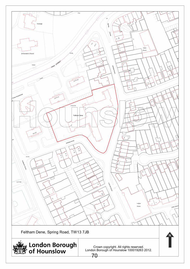
Crown copyright. All rights reserved.London Borough of Hounslow 100019263 2012.
2
7
41
2
5
Church
Oasis
1The Hermitage
Post
10
PO
6
4
113 1 to 6
LB
Sprin
gC
orn
er
5
15
13
2
3
4
St Dunstan's Church
11
HIGH
Shelter
Vicarage
STREET
14.3m
SP
RIN
G R
OA
D
21
8
6
27
67
38
32
79
52
33
37
22
31
45
61
57
201 to 215
217 to 231
CR
Shelter
(PH)The Three Horseshoes
Feltham Dene
El Sub Sta
66 to 80
SPRING ROAD
77
7379
75
69
6571
67
73
GP
61
LU
DLO
W R
OA
D
59a
57
59
13
SU
NB
UR
Y R
OA
D
13.7m
3
Lych Gate
2
HAM CROFT CLOSEHouse
Ludlow 1
39
37
1 to 8
21 4
5 47
Feltham Dene, Spring Road, TW13 7JB
70
SUSTAINABLE DEVELOPMENT COMMITTEE REPORT 9th February 2012
e-mail: [email protected]
References: P/2011/2778 01230/D/P3
Address: Oaklands School, Woodlands Road, Isleworth
Ward: Hounslow South
Proposal: Erection of a single storey extension to the north wing of the main school building.
Drawing numbers: Site Plan, A313 01, 01A, 02A, 10, 11A and 12A received 27.09.11; and A313/101 received 12.01.12.
Application received: 27/09/2011
1.0 SUMMARY
1.1 The proposal would provide an extension to the northeast corner of the main school building. It would provide a larger toilet block, a new utility room and office and would extend the existing physiotherapy and medical room.
1.2 The design includes a flat roof with a vertical ‘fin’ on the northern elevation. The design is considered to contribute positively to overall environmental quality and would respect the appearance of the existing building.
1.3 One objection has been received and relates to overshadowing of a neighbouring rear garden. Information has been provided by the applicant to demonstrate that although some overshadowing would occur, this would be limited in its extent and would avoid harm to neighbours’ living conditions.
1.4 Approval is recommended.
2.0 SITE DESCRIPTION
2.1 The site contains a single-storey school building. Bridge Road is to the west and Woodlands Road is to the north. To the south are residential properties on Gibson Close and to the east are No.142 Woodlands Road and Nos 1 – 15 Sussex Avenue. The School teaches children with special needs.
2.2 The site currently contains some minor landscaping in the form of a grass strip and shrubs as well as a paved parking area, which was used by a mini-bus at the time of the site visit. Bins are currently located in a fenced enclosure at the eastern side of the building.
Agenda Item 5
71
3.0 HISTORY
3.1 00154/N/S1 Erection of extension to form new classroom, existing hall to classroom, erection of building for use as hall with 2 stores.
Approved 18/04/1995
3.2 00154/N/S2 Erection of single storey extension to provide shower/changing facility and extra classroom space, and installation of mobile storage unit.
Approved 10/12/1996
3.3 00154/N/S3 Erection of single storey rear extension to existing school.
Approved 14/05/2001
3.4 00154/D/P1 Erection of a single storey detached classroom building to school
Approved 05/02/2002
3.5 00154/N/S4 Installation of a new 16x 14m artificial play surface and erection of 3.6m high weld mesh fencing to enclose play area
Approved 04/07/2003.
3.6 00154/D/S1 Demolition of existing bin area and store and erection of single storey extension to North Eastern end of site.
Approved 10/09/2003.
3.7 00154/D/P2 Removal of existing chain link fence and concrete posts and erection of a 2.4m high black metal fencing and two x 2.2m high access gates to roadside frontage of site.
Approved 14/01/2009.
4.0 DETAILS
4.1 The proposed extension would create a toilet block, utility room, office, physiotherapy room and medical room.
4.2 The extension would be to the northeast end of the main school. It would be set off the boundary of No.142 by at least of 1.4m and would measure:
• Between 1.5m and 8m deep.
• 3.5m high with a flat roof and 5.5m high at the front ‘fin’ elevation.
• 29m long.
72
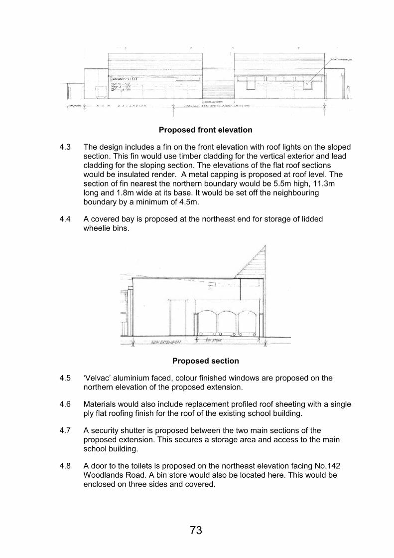
Proposed front elevation
4.3 The design includes a fin on the front elevation with roof lights on the sloped section. This fin would use timber cladding for the vertical exterior and lead cladding for the sloping section. The elevations of the flat roof sections would be insulated render. A metal capping is proposed at roof level. The section of fin nearest the northern boundary would be 5.5m high, 11.3m long and 1.8m wide at its base. It would be set off the neighbouring boundary by a minimum of 4.5m.
4.4 A covered bay is proposed at the northeast end for storage of lidded wheelie bins.
Proposed section
4.5 ‘Velvac’ aluminium faced, colour finished windows are proposed on the northern elevation of the proposed extension.
4.6 Materials would also include replacement profiled roof sheeting with a single ply flat roofing finish for the roof of the existing school building.
4.7 A security shutter is proposed between the two main sections of the proposed extension. This secures a storage area and access to the main school building.
4.8 A door to the toilets is proposed on the northeast elevation facing No.142 Woodlands Road. A bin store would also be located here. This would be enclosed on three sides and covered.
73
5.0 CONSULTATIONS
5.1 One neighbouring property was notified on 24.10.11. A site notice was also posted. One reply was received, commenting as follows.
Comment Response
On the whole we don't object to the single storey extension, although don't relish the idea of the school’s bin storage area being just over the fence to our patio.
Bins are currently located at this side of the school building. A condition has been included to require further details of the bin enclosure to limit harm from noise and odours.
Our main objection is to the proposed rather high frontage roof. This roof will impact on our patio area and will restrict daylight to our garden and we're sure will cast a shadow.
Shadow diagrams have been provided, which indicate that good levels of sunlight and daylight would reach the rear garden of No.142 due to its southern aspect
Whilst a 2.8% increase in overshadowing would occur during the equinox, this increase is not considered to be sufficient to merit a recommendation for refusal.
6.0 POLICY
Determining applications for full or outline planning permission
6.1 When determining applications for planning permission, the authority is required to have regard to the development plan, so far as is material, and to any other material considerations. In addition, the determination must be made in accordance with the development plan unless material considerations indicate otherwise.
The Development Plan
6.2 The Development Plan for the Borough comprises the Council's Unitary Development Plan (UDP), Employment Development Plan Document, Brentford Area Action Plan and the London Plan.
The Emerging Core Strategy
6.3 On 12 July 2011, the Council's Cabinet approved that the Core Strategy "Preferred Strategy" should go out to consultation. As emerging policy, the Local Planning Authority (LPA) considers that the emerging Core Strategy is
74
capable of being a material consideration. Given that the emerging Core Strategy is still in the consultation stages, the LPA considers that in general limited weight can be given to it at this stage and that where a specific core strategy policy is engaged by an application greater weight may be attached.
The Draft National Planning Policy Framework
6.4 The consultation on the draft National Planning Policy Framework (NPPF) closed on 17 October 2011. The NPPF is not yet in force and may be subject to amendment. Nonetheless, as emerging policy, the Local Planning Authority (LPA) considers that the NPPF is capable of being a material consideration. As the Planning Policy Statements, Guidance notes and Circulars remain in place until cancelled and given that the NPPF may be subject to amendment, the LPA considers that very limited weight can be given to the NPPF at this stage.
6.5 Unitary Development Plan
ENV-B.1.1 New development
C.2.1 Educational facilities
T.4.3 Traffic implications of new development.
7.0 PLANNING ISSUES
The acceptability in principle
7.1 Policy ENV-B.1.1 seeks to ensure that development relates well to the surrounding area, respects the predominant character and density and does not damage the amenities of adjacent properties.
7.2 Policy C.2.1 relates to educational facilities and states that when considering new facilities or extensions to existing facilities, the Council will normally grant planning permission provided the scale and design of any resulting building does not harm the character and appearance of the area. It should not result in significant disturbance in terms of traffic, car parking and noise and should be accessible by a choice of modes of travel. There should be no loss of existing playing fields.
7.3 The proposed facilities are needed in order to provide a larger toilet block and changing area, a new utility room and office and an extension to the existing physiotherapy and medical room. The current provision is regarded as unsatisfactory according to the submitted design and access statement.
The main planning issues are therefore:
• The impact on the character and appearance of the site and area.
• The impact on neighbours’ living conditions.
• Parking
75
Appearance
7.4 Under Policy ENV B.1.1.all development should ensure that proposals contribute positively to overall environmental quality. In particular development should relate well to its site and the scale, nature, height, massing, character and use of the adjacent townscape.
7.5 The Design and Access Statement confirms that the intention is to create a strong presence close to the main entrance, as the Governors are concerned at the lack of distinctiveness at the school entrance.
7.6 The Design and Access Statement clarifies that the new extension would be specifically designed to cater for the needs of disabled children, incorporating wide access doorways, a large lobby for parking walking frames and wheelchairs and electric ceiling hoists.
7.7 The proposal is single-storey, like the existing school although the proposed fin would be higher than the existing shallow sloped roof by 2m. It would be set back from Woodlands Road by approximately 12m and be subordinate to the neighbouring two-storey houses. The proposed materials are considered to relate well to the existing school building and would present a clean and modern appearance. Due to its size and design, the complementary nature of the materials and the 12m set back from the street, the proposed extension is considered to remain subordinate to the scale of the main school building and would protect the character of the local area. It would contribute positively to overall environmental quality.
Neighbours
Overlooking
7.8 The neighbouring house at No.142 Woodlands Road has no flank windows and no flank windows are proposed for the extension to the school. Although a door is proposed on the flank of the extension, the boundary fence restricts views to the neighbouring house. Overlooking is therefore avoided.
Sunlight/Daylight
7.9 As a ‘rule of thumb’, BRE recommend that no more than 40% of any private garden (which excludes small front gardens) should be prevented from receiving any sun at all when the sun at its equinox (i.e. on 21 March).
7.10 The submitted shadow diagrams (for the March and September equinox) show that in the worse case scenario the existing environment currently overshadows 42.2% of the rear garden of No.142. The proposed development would result in an increase of 2.8%, a total of 45% of shadow on the rear garden.
7.11 The neighbouring house will receive good levels of sunlight and daylight from the south and east for the majority of the year due to its southern aspect. The shadow scenario demonstrated would be a marginal increase in
76
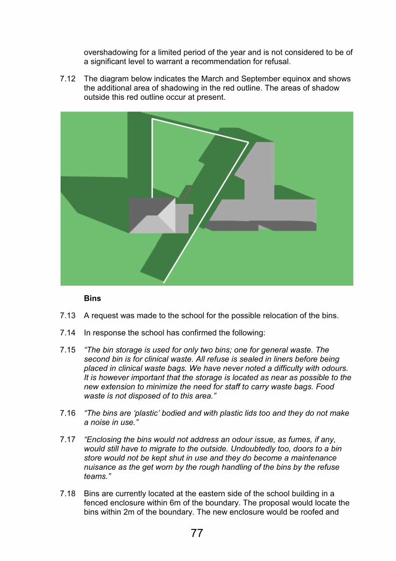
overshadowing for a limited period of the year and is not considered to be of a significant level to warrant a recommendation for refusal.
7.12 The diagram below indicates the March and September equinox and shows the additional area of shadowing in the red outline. The areas of shadow outside this red outline occur at present.
Bins
7.13 A request was made to the school for the possible relocation of the bins.
7.14 In response the school has confirmed the following:
7.15 “The bin storage is used for only two bins; one for general waste. The second bin is for clinical waste. All refuse is sealed in liners before being placed in clinical waste bags. We have never noted a difficulty with odours. It is however important that the storage is located as near as possible to the new extension to minimize the need for staff to carry waste bags. Food waste is not disposed of to this area.”
7.16 “The bins are ‘plastic’ bodied and with plastic lids too and they do not make a noise in use.”
7.17 “Enclosing the bins would not address an odour issue, as fumes, if any, would still have to migrate to the outside. Undoubtedly too, doors to a bin store would not be kept shut in use and they do become a maintenance nuisance as the get worn by the rough handling of the bins by the refuse teams.”
7.18 Bins are currently located at the eastern side of the school building in a fenced enclosure within 6m of the boundary. The proposal would locate the bins within 2m of the boundary. The new enclosure would be roofed and
77

would be enclosed on two sides. It would be open to the east. A condition could be included on any decision for approval to require further details of the bin enclosure to limit noise and odours.
Parking
7.19 Policy T.4.3 states that development will not be permitted if the traffic movement directly associated with it would increase danger, cause unacceptable noise, congestion or environmental intrusion.
7.20 The proposal would result in the loss of three parking spaces. Currently school mini-buses park here. The supporting planning statement states that further school improvements are being considered and parking would be reviewed then. It also states that only one mini-bus is parked on the premises outside of school hours.
7.21 The width of the access road would allow for parking within the site, opposite the proposed extension. Woodlands Road itself is not heavily parked and on-street parking would also be possible here without causing danger to pedestrians, causing unacceptable noise, congestion or environmental intrusion.
8.0 EQUALITIES DUTIES IMPLICATIONS.
8.1 The Council has to give due regard to its Equalities Duties and in particular with respect to its duties arising pursuant to the Equality Act 2010, section 149. Following a relevance test, which is available at: http://www.hounslow.gov.uk/index/council_and_democracy/equality/eias/environment_eias.htm it is considered that there will be no specific implications with regard to the council’s duty in respect of equalities duties and that if approving or refusing this proposal the Council will be acting in compliance with its duties.
Relevant Section of Relevance Test All other minor development
9.0 CONCLUSION
9.1 The design and appearance of the proposed extension would be in keeping with the main building, which is already distinct from the surrounding housing by its nature. Materials could be controlled by condition. Information has been submitted to demonstrate that some overshadowing would occur to the neighbouring house at No.142 Woodlands Road but that this would be limited in its extent. This neighbouring rear garden has a southern aspect and the house has no flank windows. As a result harm would be avoided to the living conditions of neighbouring residents.
10.0 RECOMMENDATION: GRANT
Reasons
With appropriate safeguarding conditions it is considered that the proposed erection of a single storey extension to the north wing of the main school
78
building because of its position, design and appearance, would be acceptable and complementary to the appearance of the locality, and would not harm neighbours’ living conditions. The development is in accordance with adopted Unitary Development Plan policies ENV-B.1.1 (New development) and C.2.1 (Educational facilities).
Conditions:
1 A1A The development hereby permitted shall be begun before the expiration of three years from the date of this permission.
REASON: A1R. To accord with the provisions of Section 92(1) of the Town and Country Planning Act 1990.
2 B3 The materials to be used in the construction of the external surfaces of the extension hereby permitted shall include timber cladding, lead roof cladding, insulated render, metal capping and aluminium faced, colour finished windows.
REASON: B3R In order to safeguard the visual amenity of the area and building in particular.
3 B5 The proposed development shall be carried out in all respects in accordance with the proposals contained in the application and the plans submitted therewith (Site Plan, A313 01, 01A, 02A, 10, 11A and 12A received 27.09.11. A313/101 received 12.01.12.) and approved by the Local Planning Authority, or as shall have been otherwise agreed in writing by the Local Planning Authority before the building is used.
REASON: B5R. To ensure the development is carried out in accordance with the planning permission.
4 D2 No additional windows or other glazed openings shall be formed in the flank walls of the extension hereby approved and no additional doors inserted in the building without the prior written consent of the Local Planning Authority.
REASON: To protect neighbours' living conditions in accordance with adopted Unitary Development Plan Policy ENV-B.1.1
79
5 NSTD Prior to the use of the extension hereby approved, details of the bin enclosure shall be submitted to and approved in writing by the Local Planning Authority. Reason: To protect the living conditions of neighbouring residents in terms of noise and odour, to accord with policy ENV-B.1.1.
Background Papers:
The contents of planning file ref 01230/D/P3 save for exempt or confidential information as defined in the Local Government Act 1972, Sch. 12A Parts 1 and 2.
This report is relevant to the following wards/areas: Hounslow South.
80
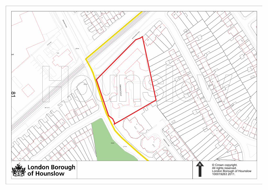
© Crown copyright.All rights reserved. London Borough of Hounslow 100019263 2011.
Depot
26
Ward
Bdy
46
SUSSEX AVENUE
5
11
24
34
93
Oakla
nds S
chool
17
16
23
35
1 to
24
GIB
SO
N C
LOSE
47
8
Shelter
1 to
24
9
19
16
250
91
134
CR 132
WO
OD
LAN
DS
RO
AD
136
142
2
240
12
1
103
1
2
20.4m
Tank
14
13
20.4m
BR
IDG
E R
OA
D
El Sub S
ta
MP 12.75
17.1m
38
81
References: P/2011/3248 01095/31/S2
Address: John Collin House, 31 Sutton Lane, Hounslow
Ward: Heston Central
Proposal: Demolition of the existing building and the erection of nine household Units comprising of eight semi detached houses and one detached house
Plan Nos: 521323-A-001, 521323-A-002, 521323-A-010, 521323-A-011, 521323-A-020, 521323-A-021, 521323-A-022, 521323-A-023, 521323-A-110 rev.03, 521323-A-111 rev.01, 521323-A-112, 521323-A-200 rev.01, 521323-A-210, 521323-A-211, 521323-A-212, 521323-A-300 rev.01, 521323-A-301, 521323-A-310 rev.03, 521323-A-311 rev.03, 521323-A-315, 521323-A-514, 521323-A-515
Received 15th November 2011
521323-A-012 Rev. 08
Received 21st December 2011
Date received: 24th October 2011
1.0 SITE DESCRIPTION
1.1 The application site is located on a corner plot, at the junction of Sutton Lane and Dene Avenue. The site measures 0.12 hectares in area and is located in a predominantly residential area.
1.2 The site is occupied by a two storey 1960’s building, which was previously in use as a purpose built Care Home. It is known as John Collin House. The building is constructed of red brick with uPVC windows and doors.
1.3 The site contains a number of large trees and shrubs of varying sizes and quality. Of particular note, are two large trees (Lime and Horse Chestnut) of approximately 20 metres in height, which have recently been protected by a Tree Preservation Order.
1.4 The adjoining streets have unrestricted on street parking. The Public Transport Accessibility Level (PTAL) for the site is rated as 3, which is considered moderate.
SUSTAINABLE DEVELOPMENT COMMITTEE
19th January 2012
Sam Collins
E-mail: [email protected]
Agenda Item 6
82
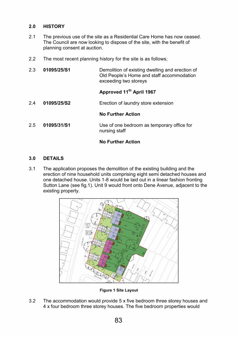
2.0 HISTORY
2.1 The previous use of the site as a Residential Care Home has now ceased. The Council are now looking to dispose of the site, with the benefit of planning consent at auction.
2.2 The most recent planning history for the site is as follows; 2.3 01095/25/S1 Demolition of existing dwelling and erection of
Old People’s Home and staff accommodation exceeding two storeys Approved 11th April 1967
2.4 01095/25/S2 Erection of laundry store extension No Further Action
2.5 01095/31/S1 Use of one bedroom as temporary office for nursing staff No Further Action
3.0 DETAILS
3.1 The application proposes the demolition of the existing building and the erection of nine household units comprising eight semi detached houses and one detached house. Units 1-8 would be laid out in a linear fashion fronting Sutton Lane (see fig.1). Unit 9 would front onto Dene Avenue, adjacent to the existing property.
Figure 1 Site Layout
3.2 The accommodation would provide 5 x five bedroom three storey houses and 4 x four bedroom three storey houses. The five bedroom properties would
83

consist of a living room, kitchen, dining area and WC to the ground floor, three bedrooms and a bathroom to the first floor and two bedrooms and a further bathroom at roof level. The four bedroom properties would consist of a living room, kitchen, dining area and WC to the ground floor, two bedrooms and a bathroom at first floor and a further two bedrooms at roof level. The total floor area for the properties would be 138.6m2 for the five bedroom houses and 115.6m2 for the four bedroom houses.
3.3 The buildings would be of traditional design, with gable end roofs and two storey projecting bays to the front elevation (see fig.2). A small porch would be provided to the front of each property, above the front door. They would be constructed in red brickwork and white stone mortar. The proposed roofs would be finished in plain red clay tiles with solar panels to the rear roof slopes.
3.4 The five bedroom properties fronting Sutton Lane would contain two roof lights to the front and rear roof slopes with solar panels to the rear roof slope. The four bedroom properties would have one small gabled dormer and one roof light to the front roof slopes, with a further roof light and solar panels to the rear. Unit 9 would have a hipped roof containing one roof light to the front roof slope and two roof lights to the rear. The property would have solar panels located to the front roof slope, facing due south.
Figure 2 Computer Generated Image
3.5 The proposed Solar Photovotaic panels would provide renewable energy to the properties. The applicant has confirmed that the proposals would meet Level 4 of the Code for Sustainable Homes.
3.6 Each property would be provided with two off street parking spaces located to the front of the properties. Each property would also benefit from a private rear garden, the smallest of which would measure in excess of 100m2.
3.7 Following amendments to the scheme, the proposal would retain a large amount of the existing vegetation upon the site. In particular, the two trees (Lime and Horse Chestnut) which are protected by the Tree Preservation Order, would be retained.
84
4.0 CONSULTATIONS
4.1 Eighty (80) nearby and adjoining properties were notified of the application by letter on 15th November 2011. One comment has been received regarding the proposed parking provision. No objections to the proposal have been received.
5.0 POLICY
Determining applications for full or outline planning permission 5.1 When determining applications for planning permission, the authority is
required to have regard to the development plan, so far as is material, and to any other material considerations. In addition, the determination must be made in accordance with the development plan unless material considerations indicate otherwise.
The Development Plan 5.2 The Development Plan for the Borough comprises the Council's Unitary
Development Plan (UDP), Employment Development Plan Document, Brentford Area Action Plan and the London Plan.
The emerging Core Strategy 5.3 On 12 July 2011, the Council's Cabinet approved that the Core Strategy
"Preferred Strategy" should go out to consultation. As emerging policy, the Local Planning Authority (LPA) considers that the emerging Core Strategy is capable of being a material consideration. Given that the emerging Core Strategy is still in the consultation stages, the LPA considers that in general limited weight can be given to it at this stage and that where a specific core strategy policy is engaged by an application greater weight may be attached.
The draft National Planning Policy Framework 5.4 The consultation on the draft National Planning Policy Framework (NPPF)
closed on 17 October 2011. The NPPF is not yet in force and may be subject to amendment. Nonetheless, as emerging policy, the Local Planning Authority (LPA) considers that the NPPF is capable of being a material consideration. As the Planning Policy Statements, Guidance notes and Circulars remain in place until cancelled and given that the NPPF may be subject to amendment, the LPA considers that very limited weight can be given to the NPPF at this stage.
5.5 In addition to the draft NPPF Central Government Guidance to be applied is
mainly set out in Planning Policy Guidance Notes, Planning Policy Statements and Government Circulars, with particular emphasis for this application on:
PPS 1 Delivering Sustainable Development PPS 3 Housing
85
PPS 5 Planning for the Historic Environment PPS 13 Transport PPS 22 Renewable Energy PPS 25 Development and Flood Risk Supplementary Planning Guidance 1997
5.6 The guidance contained within the Supplementary Guidance was subject to
formal public consultation and unlike normal SPG were subject to an inquiry process and consideration by a government inspector. The Inspectors report recommended the appendices be removed from the plan, as they added to its bulk, cost and complexity and may well have consumed further resources at the first review of the UDP. He also considered that they could stand alone away from the main plan as SPG. This was the course of action to be taken by the Council. During the consultation process, objections were received from individual house builders and the HBF. The guidance was amended as part of the process. The Council did not therefore consider it necessary to reconsult on this proposed guidance, but simply to use the guidance in light of the suggested amendments and the Inspector’s comments.
Section 10 Private Amenity Space Section 12 Internal Space Provision 6.0 PLANNING ISSUES
6.1 The main planning issues to consider are:
I. The principle of the development
II. The scale, bulk and design of the development
III. The effects on adjacent buildings and impact on neighbouring occupiers
IV. The quality and nature of the proposed accommodation
V. Access and parking provision
VI. Environmental Considerations
VII. Sustainability and Energy
VIII. Potential to secure planning obligations
I. The principle of the development
Loss of the existing Residential Care Home
6.2 In September 2010, the Executive gave permission to consult on the closures of John Collin House and Feltham Dene. The homes were proposed for closure in 2013, however this was brought forward due to decline in both sites leading the homes to be deemed unfit for purpose. As part of the “Development of Resource Centres for Older People”, the Council is re-
86
providing Residential Care Facilities such as Greenrod Place in Brentford and the Clifton Gardens Resource Centre in Chiswick. Further development is being undertaken on the Sandbanks site in Bedfont.
6.3 In general terms, the Council would resist the loss of a community facility for which there is a demonstrable need and where no alternative provision is made. The facility is now closed and the Council’s Adult Services Team have advised that they do not require a residential home or nursing homes to replace the existing buildings and as such, the loss of the existing use upon the site may be considered acceptable.
Proposed Housing
6.4 Planning Policy Statement 3 (PPS 3), the new London Plan and the Unitary Development Plan 2003 (UDP) seek to maximise housing on previously developed sites. Policy 3.4 of the new London Plan seeks to optimise housing potential provided it is compatible with local context, and encourages well designed buildings with good access to local shops, services, employment and public transport. Therefore, when considering new housing proposals, the Council will seek to promote sustainable patterns of development and allow for new housing provided it is consistent with all other policies in UDP, and can be achieved within a high quality environment for new and existing residents.
6.5 Government policy in PPS 3 (Housing) encourages a systematic sustainable approach to selection of land for residential development, with preference given, among others, to brownfield sites with good public transport access.
Housing & Density
6.6 Government Policy and Guidance in the form of PPS 1 (Delivering Sustainable Development), and PPS 3 (Housing) encourage a systematic, sustainable approach to the selection of land for residential development, with preference given, among others, to brownfield land, also known as previously-developed land. This approach is also laid out UDP Policies IMP.1.2 (The Re-use and Recycling of Urban Land).
6.7 Planning Policy Statement 3 (Housing) and the London Plan both encourage more efficient use of land in order to provide sustainable communities and to meet housing needs in the local area and within the broader London context.
6.8 The site is located within an existing residential area. In principle, redevelopment of this site for housing increases housing stock in a suitable location with potentially appropriate access to existing infrastructure and town centre facilities. The proposed development generates a density of 141 hr/ha based on a net site area of 0.12ha. The London Plan density range for this site is 150-250 hr/ha, although this is slightly lower, it is considered acceptable in this case as the proposal would meet a recognised need within the borough for houses of 3 bedrooms or more..
II. Scale, Bulk and Design
87
6.9 PPS 1 emphasises that design which fails to maximise opportunities available for improving the character and quality of an area or that is inappropriate in its context should not be accepted. Policy ENV-B.1.1 of the UDP promotes high quality design that enhances the overall environmental quality and townscape. Section 1.0 of the UDP Supplementary Planning Guidance (SPG) states that the design and layout of proposed developments must enable them to be compatible with, and make a positive contribution to, the character of the locality. New buildings must relate satisfactorily to adjoining and neighbouring buildings and spaces. The scale, massing, siting, size and height of these buildings should be respected by new development, although this need not exclude original, innovative design.
6.10 PPS 3 states that good design is fundamental to the development of high quality new housing, which contributes to the creation of sustainable, mixed communities. Following this, and reflecting policy in PPS 1, Paragraph 13 of PPS 3 states that design which is inappropriate in its context, or which fails to take the opportunities available for improving the character and quality of an area and the way it functions, should not be accepted.
6.11 All policies in the London Plan promote sustainable development. Policy 3.5 requires that new developments respect their local context and communities, in terms of social, physical, cultural, historical, environmental and economic characteristics.
6.12 By Design, prepared by the Commission for Architecture and the Built Environment, sets out seven key objectives of urban design that development proposals (in terms of their layout, landscape, density and mix, height, massing and detailed appearance) should aspire to reinforce:
• Character – a place with its own identity;
• Continuity and enclosure – a place where public and private spaces are clearly distinguishable;
• Quality of the public realm – a place with attractive and successful outdoor areas;
• Ease of movement – a place that is easy to get to and move through;
• Legibility – a place that has a clear image and is easy to understand;
• Adaptability – a place that can change easily;
• Diversity – a place with variety and choice.
6.13 Policy ENV-B.1.1 states that the Council will consider all development proposals with regard to ensuring that proposals make a positive contribution to overall environmental quality. In particular development should relate well to its site and the scale, nature, height, massing, character and use of the adjacent townscape.
6.14 The proposal includes the development of 5 x five bedroom houses and 4 x
four bedroom houses of three storeys in height (two plus roof level). This would replace the existing two storey, 1960’s Residential Care Home, known as John Collin House.
88
6.15 The proposed layout would respond to the existing street pattern, fronting predominantly onto Sutton Lane, with Unit 9 fronting Dene Avenue. The houses would present a largely uniform building frontage which would generally follow the existing building line on Sutton Lane to the north and south. The overall scale of the buildings would sit well within the existing residential area, which is characterised by large semi detached properties.
6.16 The properties would be of a traditional appearance, with strong gable roofs and two storey projecting bays. The external finish of the properties would comprise exposed red brickwork, with white stone mortar and red clay tiles to the roofs.
6.17 In line with new London Plan policy the scheme seeks to provide on site renewable energy through the use of Solar Photovoltaic panels, located to the roofs of the properties. The prominent solar Photovoltaic Panels would be located to the rear of Units 1-8, although on Unit 9 they would be located to the front elevation, facing due south. The use of renewable technologies such as solar panels is a requirement of new housing and their presence within the street scene is becoming increasingly common. In this case for units 1-8 the solar panels would be located to the rear roof slopes and therefore would not be visible from the public realm. For unit 9 the proposal solar panels would be located to the front roof slope facing south, and would cover a significant proportion of the roof slope. They would therefore be a highly visible element, however they are not considered to have an unacceptable visual impact upon the design of the house and given the importance of sustainability the overall appearance is acceptable.
Landscaping
6.18 Policy ENV-N.2.7 states that the Council will aim to protect all trees in the Borough which contribute to the value of the environment. The Council wants to promote the aesthetic value of trees as part of the landscape and for their value as screening. When considering development proposals the Council will normally require all existing trees of amenity and landscape value to be retained. If a tree is considered worthy of retention then its location and protection will be a constraint to the development. The Council will seek to achieve replacement of new tree planting in connection with development proposals where appropriate.
6.19 The application site contains a number of trees of varying size and quality. Nine poor quality trees are proposed to be removed due to their condition, the majority of which are dead. One further tree (Acer) is proposed to be removed to accommodate the proposal, however it is of poor quality and of limited size.
6.20 The 23 remaining trees, including the two large trees (Lime and Horse Chestnut) which are subject to a Tree Preservation Order would be retained. As the majority of trees upon the site are to be retained, including those more important trees, It is considered that the development would preserve the amenity of the site when viewed internally and also from neighbouring properties.
III. Effects on neighbours
89
Privacy and Overlooking
6.21 To the north the site adjoins the rear of properties on Bulstrode Avenue, which comprises large semi detached properties, with good size rear gardens. The proposed properties would be west facing, compared to 158-164 Bulstrode Avenue which face north and 166 Bulstrode Avenue and 35 Sutton Lane, which face north west. Unit 1, the northernmost property would therefore adjoin 35 Sutton Lane at a 45 degree angle. Unit 1 would be located 9.0 metres away from 35 Sutton Lane at the closest point.
6.22 The northern (side) elevation of Unit 1 would contain no windows or openings, and given the orientation of the property, no views would be afforded towards the rear of 35 Sutton Lane, from the front or rear elevations. As such, it is not considered that Unit 1 would result in any undue overlooking or loss of privacy to either 35 Sutton Lane or 166 Bulstrode Avenue. Furthermore, the existing tree and vegetation to the rear of 35 Sutton Lane (upon the application site) would be retained, and would provide screening to the rear of the property.
6.23 Unit 9 would front onto Dene Avenue and be positioned in line with the adjoining house (Loxwood), on Dene Avenue. Unit 9 would contain no windows or openings to the eastern elevation of the building and the proposed building line of Unit 9 would not extend beyond Loxwood to either the front or rear. As such there would be no additional overlooking opportunities presented, other than to the rear garden area, which is considered an acceptable and common residential arrangement.
Daylight, Sunlight and Outlook
6.24 The proposed properties would be of typical residential scale with Units 1-4 and 9 measuring 9.60 metres in height at the roof ridge and Units 5-8 measuring 9.10 metres in height at the roof ridge.
6.25 Unit 1 would be located 9.0 metres away from 35 Sutton Lane at its closest point, therefore it is not considered given the scale of the proposed properties, that there would be any loss of light to the rear facing windows at ground or first floor. In terms of outlook, the rear of 35 Sutton Lane presently looks onto the side of John Collin House, which is a two storey property. Unit 1 would be located no closer to 35 Sutton Lane and would also be of two storeys (with roof level accommodation). On balance therefore it is not considered that there would be any additional loss of outlook to the rear facing windows of 35 Sutton Lane. Furthermore, the existing tree and vegetation to the rear of 35 Sutton Lane (upon the application site) would be retained, and would provide screening to the rear of the property.
6.26 Loxwood, on Dene Avenue, would be located to the east of Unit 9 and contains a single window to the western elevation at first floor which provides light to the stairwell. The side elevation of Unit 9 would be 4.30 metres from the western elevation of Loxwood, but as the window is not a primary light source to a habitable room, there would be no unacceptable impact upon the neighbour’s living conditions.
90
6.27 Overall, it is considered that due regard has been given to preserving the living conditions of neighbouring properties. Due to the scale of the properties and their separation from neighbouring properties it has been sufficiently demonstrated by the applicant that there would not be any undue impact upon neighbouring properties in terms of loss of outlook, sunlight, daylight or privacy.
IV. Quality of accommodation
Unit Sizes
6.28 UDP Supplementary Planning Guidance (February 1997) sets out the minimum floor areas for new development that the Council is seeking to secure. More recent guidance that has more stringent requirements is set out in the London Housing Design Guide (interim edition) August 2010.
6.29 Policy 3.5 of the London Plan sets out the minimum space standards for new development which are as follows;
6.30 All properties would comply with these minimum standards, with the proposed 4 bedroom properties at 115.6m2 and the proposed 5 bedroom properties at 138.6m2. All properties would be dual aspect with units 1-8 fronting west and unit 9 fronting south. Unit 9 has a north facing garden, however given the length of the garden, it is considered that sufficient sunlight would be enjoyed by occupants. The ground floor reception room at no.9 would also enjoy the benefit of a south facing window to the front of the property and therefore would enjoy a sufficient level of natural light.
6.31 Due to the orientation and general layout of the proposed houses it is considered that there would be an acceptable level of privacy and outlook afforded. Unit 9 would be set side on to the rear of units 7 and 8, however given that the side elevation of the property contains only one window which would provide natural light to the stairwell, there would be no undue overlooking opportunities created.
Amenity space
6.32 The provision of good quality, private, useable, amenity space and children’s play areas is key in all levels of the planning framework. All properties would be provided with large rear gardens, the majority facing east and the smallest measuring in excess of 100m2. The Council’s Supplementary Planning Guidance states that for a property of five habitable rooms or more, at least
Dwelling Type Gross Internal Area (sqm)
Three Storey House – 4 bedroom, 6 person
113
N.B. There is no specific requirement relating to properties with more than 4 bedrooms.
91
75m2 should be provided. The proposed properties would therefore comfortably comply with this guidance.
Lifetime homes and accessibility
6.33 The London Plan strongly supports the principle of Lifetime Homes and views them as fundamental to the delivery of the Government’s objectives of social inclusion, sustainability, equality and valuing diversity and identifies that the increased independent living they can bring will reduce pressure on hospital beds and residential care homes. Policy 3.8 proposes that all new dwellings should be built to Lifetime Home standards and that 10% of new housing is “designed to be wheelchair accessible or easily adaptable for residents who are wheelchair users”.
6.34 All residential Units will meet the Lifetime Homes criteria and will be suitable for disabled use. In addition the properties have been designed to meet the requirements of the draft London Housing Design Guide and will achieve Code for Sustainable Homes Level 4.
6.35 Given that the proposed Units would meet the London Plan internal space standards and would provide a sufficient amount of quality and useable amenity space, the overall standard of accommodation is considered acceptable.
V. Access and parking provision
6.36 PPG 13 (Transport) sets out to integrate planning and transport at the national, regional, strategic and local level to promote more sustainable transport choices for moving people, promote accessibility to jobs, shopping, leisure facilities and services by public transport and reduce the need to travel, especially by car. PPG13 stresses the importance of “accessibility” by non-car modes i.e. public transport, walking and cycling. It also stresses the importance of promoting more sustainable transport choices for people and reducing the need to travel, especially by car.
6.37 London Plan Policy 6.1 seeks to ensure that on-site car parking at new developments is the minimum necessary and that there is no over-provision that could undermine the use of more sustainable non-car modes. Parking standards for the borough are set out at Appendix 3 of the UDP with the maximum standard for properties of three or more bedrooms at 2 spaces per Unit.
6.38 All developments must provide parking and servicing facilities in accordance with the Council’s standards under UDP Policy T.1.4 and Appendix 3 (Parking standards). The standards are considered to be the maximum desirable provision, with UDP policies seeking to reduce the need to travel, reduce reliance on the private car and promote the use of sustainable modes. There are no minimum standards except in relation to disabled parking.
6.39 The site is located within an area which is rated as having only moderate access to Public Transport, therefore the Council would require the maximum parking requirement for these properties (2 per Unit). Concerns have been expressed regarding the potential impact of the development upon the local
92
parking provision however the proposal includes the two parking spaces to the front of each property and therefore would meet the UDP requirement. At present no cycle storage is proposed, however with side access and large rear gardens to the properties, cycle storage could easily be provided.
6.40 The application proposes one shared crossover per pair of semi detached houses. The proposed crossovers would measure no more than 4.0 metres in width, which LB Highways have confirmed is acceptable provided that no fences are erected between the parking spaces. This has been controlled by way of condition (condition 6).
6.41 The overall parking provision would meet the Council’s maximum parking standard and would provide sufficient parking for the residents given the location of the site.
VI. Environmental Considerations
Air
6.43 The whole Borough was declared an Air Quality Management Area (AQMA) in March 2006. However, whilst the designation of the AQMA is indicative of a certain level of air quality, this in itself does not prevent development.
6.44 It is not considered that the proposed development would significantly exacerbate existing conditions with regards to air quality and that the location of the site would not be inappropriate for residential development due to existing air quality issues. It is not considered this matter would require further mitigation or would represent a reason for refusing this application. A condition will also be applied regarding construction works, in particular regarding the spread of dust and other airborne contaminates during construction work.
Noise
6.45 It is not considered that planning conditions would be required specifically relating to insulation. Building Regulations would be sufficient in this instance to ensure resident’s living conditions were satisfactory and prevent external noise attenuation. A condition will also be applied regarding construction works, in particular regarding hours of operation.
Water/Flooding
6.46 The site is not within a flood zone. It is therefore not necessary to carry out a flood risk assessment for this proposal.
Waste/Recycling
6.42 The LBH Waste and Recycling Team have confirmed that the proposed properties would benefit from the existing kerbside waste and recycling collection arrangements.
VII. Sustainability and Energy
93
6.43 At the national level, PPS 1 sets out the Government’s key objectives for delivering sustainable development. It sets out that planning should promote sustainable and inclusive patterns of development by:
• Making suitable land available for development in line with economic, social and environmental objectives to improve people’s quality of life;
• Contributing to sustainable economic development;
• Ensuring that development contributes towards the creation of safe, sustainable, liveable and mixed community with good access to jobs and key services for all members of the community.
6.44 The UDP and London Plan encourage sustainable development through many policies including promoting the use of energy efficient building design and materials, re-use of previously developed land and existing buildings, and location of development in or close to town centres and areas with good public transport. These also require developments to be sustainable in transport terms, to minimise waste, include energy efficiency measures and promote the use of renewable energy, and not significantly increase the requirement for water supply or surface water drainage. Policy 5.2 of the London Plan sets out an energy efficiency hierarchy for developments to follow: use less energy -“ be lean”, supply energy efficiently - “be clean” and use renewable energy - “be green”.
6.45 The applicant has submitted an Energy Statement which proposes the inclusion of Solar Photovoltaic Panels to the roofs of the properties. For units 1-8 these would be to the rear roof slopes, whereas the panels to unit 9 would be to the front of the property. Overall these should lead to a 20.99% reduction in carbon emissions to the site, which would meet the requirements of the Mayor’s London Plan.
6.46 The applicant has confirmed that the development would achieve a Code for Sustainable Homes level 4 rating.
VIII. Planning Obligations
6.47 UDP policy IMP6.1 states that the Council will seek to ensure that a developer enters into a planning obligation to secure planning benefits related to the proposed development. A payment or other benefit offered pursuant to a section 106 agreement is not material to a decision to grant planning permission and cannot be required unless it complies with the provisions of the Community Infrastructure Levy Regulations 2010 (regulation 122), which provide that the planning obligation must be:
(a) necessary to make the development acceptable in planning terms; (b) directly related to the development; and (c) fairly and reasonably related in scale and kind to the development.
6.48 Accordingly, it is mandatory that each criterion be satisfactorily addressed prior to granting planning permission subject to a section 106 agreement.
94
6.49 Government Circular 05/2005 provides guidance on the use of planning obligations, which may impose a restriction or requirement, or provide for payment of money from the developer to make acceptable development proposals that might otherwise be unacceptable in planning terms. The Council’s Supplementary Planning Document on Planning Obligations (which was adopted in March 2008) contains guidance on the imposition of planning obligations in compliance with Circular 05/2005. These obligations may offset shortfalls in the scheme or mitigate the impacts of the development.
6.50 Given the quantum of development at only 9 Units of residential accommodation there would be no requirement for affordable housing to be provided. Furthermore, given that the proposal would meet the Council’s requirements in terms of internal space standards, amenity space and maximum parking standards it is considered that there would be no undue impacts upon the local area, for which a financial contribution may be sought.
6.51 The development would require the relocation of the existing bus stop to Sutton Lane, for which the developer would have to bear the cost. It is not considered however that this should be sought through a s106 legal agreement, and will be dealt with by way of planning condition (condition 13).
7.0 EQUALITIES DUTIES IMPLICATIONS
7.1 The Council has to give due regard to its Equalities Duties and in particular with respect to its duties arising pursuant to the Equality Act 2010, section Following a relevance test, which is available at: http://www.hounslow.gov.uk/index/council_and_democracy/equality/eias/environment_eias.htm it is considered that there will be no specific implications with regard to the council’s duty in respect of equalities duties and that if approving or refusing this proposal the Council will be acting in compliance with its duties.
Relevant Section of Relevance Test
Minor Development – 1-9 dwellings
8.0 RECOMMENDATION
Approval
REASONS
Subject to appropriate safeguarding conditions, it is considered that the proposed development owing to its scale and design would not adversely impact on the existing street scene, or result in unreasonable harm to neighbours’ living conditions, the appearance or local traffic and parking conditions. In addition, the proposal would provide a satisfactory level of accommodation, with acceptable levels of internal space, amenity space and parking provision. Therefore it is considered to be in accordance with the objectives of the relevant policies of the London Plan and London Borough of Hounslow Unitary Development Plan, in particular UDP policies ENV-N.2.7 (Trees and Community Woodlands), ENV-B.1.1 (New Development), ENV-B.1.9 (Safety and Security), H.4.1 (Housing Standards and Guidelines), T.1.4
95
(Car and Cycle Parking and Servicing for Developments), T.2.2 (Pedestrian safety and security), T.4.3 (Traffic implications of new development).
CONDITIONS
1. A1A - The development hereby permitted shall be begun before the expiration of three years from the date of this permission. (Reason. To accord with the provisions of Section 91 (1) (a) of the Town and Country Planning Act 1990)
2. B4 - No development shall take place until samples of the materials to be
used in the construction of the external surfaces, including windows of the hereby permitted have been submitted to and approved in writing by the local planning authority. Development shall be carried out in accordance with the approved details
(Reason. In order that the Council may be satisfied as to the details of the development in the interests of the visual amenity of the area and to satisfy the requirements of policies ENV B1.1New Development) 3. B5 - The proposed development shall be carried out in all respects in accordance with the proposals contained in the application and the plans submitted (numbered above) therewith and approved by the Local Planning Authority, or as shall have been otherwise agreed in writing by the Local Planning Authority before the building is used. (Reason. To ensure the development is carried out in accordance with the planning permission) 4. C29 - No demolition or construction work shall take place on the site except between the hours of 8:00am to 6:00pm Mondays to Fridays, 8:00am to 1:00pm on Saturdays, with no work to take place on Sundays and Bank Holidays without the prior agreement of the Local Planning Authority. (Reason. In order to safeguard the amenities of adjoining residential properties and to ensure that the proposed development does not prejudice the amenities of the locality in accordance with policies ENV.B.1.1 New development and ENV.P.1.5 Noise pollution) 5. No development shall take place until a Construction Environmental Management Plan (CEMP) covering both the demolition and construction stages has been submitted to and approved in writing by the Local Planning Authority. The CEMP shall cover: (i) Any external illumination of the site;
(ii) Measures to ensure that all mud and other loose materials are not carried on the wheels and chassis of any vehicles leaving the site;
(iii) Measures to minimise dust nuisance caused by the operations and to ensure that no dust or other debris is carried on to the adjoining properties;
96
(iv) The routeing of vehicles to the site, access and egress arrangements and waiting areas;
(v) Boundary treatment and measures to ensure they are maintained in a secure and tidy condition; and
(vi) Considerate Contractor Scheme. The development shall be implemented in accordance with the approved details. Reason: In order to safeguard the amenities of residential properties in the locality and in the interest of road safety in accordance with Hounslow Unitary Development Plan policies ENV-B.1.1 (New 6. No development above ground shall take place until full details of hard and soft landscape works have been submitted to and approved in writing by the Local Planning Authority.
Hard landscaping details shall include hard surfacing materials, proposed finished levels or contours, means of enclosure and boundary treatments, vehicle and pedestrian access and circulation areas, minor artefacts and structures (e.g. benches, lighting, CCTV, works of art etc.), walls, gates and fences. The details should include no fences or boundary treatments between the proposed parking spaces to ensure that visibility is maintained for the use of the crossover.
Soft landscaping details shall include proposed finished levels or contours, planting plans, written specifications (including cultivation and other operations associated with plant and grass establishment), plant schedules (noting species, plant sizes and proposed numbers/densities) and tree pits and species proposed to be planted therein and measures to ensure protection from services routes. All landscape work shall be completed prior to occupation of the development and retained and maintained thereafter. If within a period of five years from the date of planting any tree or specimen shrub that tree or specimen shrub or any tree or specimen shrub planted in replacement for it is removed, uprooted or destroyed or dies (or becomes, in the opinion of the Local Planning Authority, seriously damaged or defective), another tree or specimen shrub of the same species and size as that originally planted shall be planted at the same place, unless the Local Planning Authority gives its written approval to any variation. Reason: In order that the Local Planning Authority may be satisfied as to the hard and soft landscape works are carried out and to ensure that the development will be accessible to all in accordance with Hounslow Unitary Development Plan policies ENV-B.1.1 (New Development), ENV-P.1.3 (Surface water run off), T.2.1 (Pedestrian access) and T.2.2 (Pedestrian safety and security) and London Plan policies 4B.1 (Design principles for a compact city), 4B.3 (Enhancing the quality of the public realm), 4B.5 (Creating an inclusive environment) and 4A.3 (Sustainable design and construction).
97
7. E6 - In this condition "retained tree" means an existing tree which is to be retained in accordance with the approved plans and particulars; and paragraphs (a) and (b) below shall have effect until the expiration of (5 years¹) from (the date of the occupation of the building for its permitted use). (a) No retained tree shall be cut down, uprooted or destroyed, nor shall any retained tree be topped or lopped other than in accordance with the approved plans and particulars, without the written approval of the local planning authority. Any topping or lopping approved shall be carried out in accordance with British Standard [3998 (Tree Work)] or any other BS replacing. (b) If any retained tree is removed, uprooted or destroyed or dies, another tree shall be planted at the same place and that tree shall be of such size and species, and shall be planted at such time, as may be specified in writing by the local planning authority. (c) The erection of fencing for the protection of any retained tree shall be undertaken in accordance with the approved plans and particulars before any equipment, machinery or materials are brought on to the site for the purposes of the development, and shall be maintained until all equipment, machinery and surplus materials have been removed from the site. Nothing shall be stored or placed in any area fenced in accordance with this condition and the ground levels within those areas shall not be altered, nor shall any excavation be made, without the written consent of the local planning authority. (Reason. To enable the Local Planning Authority to ensure the retention of the maximum number of trees on the site and their protection from damage, in the interests of visual amenity area and to accord with policy ENV.B.1.1 New development,[and policy ENV-N.2.8 Tree Preservation Orders) 8. No development shall take place until a detailed scheme of on-site sustainability covering: (a) measures for the harvesting of rainwater and the minimisation of water run-off aiming for greenfield levels; (b) grey water reuse as appropriate; (c) the sourcing of materials to be used in the construction and fitting out (involving reuse, recycling and other sustainable sourcing); (d) the use of passive ventilation; The scheme as approved shall be implemented prior to occupation of the buildings, unless otherwise approved in writing by the Local Planning Authority, and retained thereafter.
(Reason. To ensure that the development can be implemented with adequate regard to the environment by incorporating energy efficiency measures and by the on-site generation of renewable energy in accordance with Policies ENV-B.1.1 (New development), ENV-P.2.5 (Energy and resource efficiency) and ENV-P.2.6 (Renewable energy) of the Hounslow Unitary Development Plan, Policies 4A.3 (Sustainable Design and Construction),4A.7 (Renewable energy), 4A.14 (Sustainable drainage) of the London Plan and Sustainable Design and Construction (May 2006) (London Plan Supplementary Planning Guidance).
98
10. Within 3 months of work starting on site, a Code for Sustainable Homes Interim (Design Stage) Certificate, issued by the Building Research Establishment (BRE) or equivalent licensing organisation, must be submitted for each dwelling to the Local Planning Authority to show that a minimum Level 3 or above rating will be achieved. (Reason: To ensure the overall environmental sustainability of the development.) 11. No occupation shall take place until a Code for Sustainable Homes Final (Post-Construction) Certificate, issued by the BRE equivalent licensing organisation, must be submitted for each dwelling to the Local Planning Authority to demonstrate that Level 3 or above has been achieved. All the measures integrated shall be retained for as long as the development is in existence. (Reason: To ensure the overall environmental sustainability of the development.) 12. J12 - "Before the development hereby permitted commences: a. A contaminated land Phase 1 desk study report shall be submitted to, and approved in writing by the Local Planning Authority. Should the Phase 1 report recommend that a Phase 2 site investigation is required, then this shall be carried out and submitted to, and approved in writing by the Local Planning Authority. The site shall be investigated by a competent person to identify the extent and nature of contamination. The report should include a tiered risk assessment of the contamination based on the proposed end use of the site. Additional investigation may be required where it is deemed necessary. b. If required, a scheme for decontamination of the site shall be submitted to the Local Planning Authority, for written approval. The scheme shall account for any comments made by the Local Planning Authority before the development hereby permitted is first occupied. During the course of the development: c. The Local Planning Authority shall be notified immediately if additional contamination is discovered during the course of the development. A competent person shall assess the additional contamination, and shall submit appropriate amendments to the scheme for decontamination in writing to the Local Planning Authority for approval before any work on that aspect of development continues. Before the development is first brought into use: d. The agreed scheme for decontamination referred to in clauses b) and c) above, including amendments, shall be fully implemented and a written validation (closure) report submitted to the Local Planning Authority for approval. Reason: Contamination is known or suspected on the site due to a former land use. The LPA therefore wishes to ensure that the development can be implemented and occupied with adequate regard for public and environmental safety.
99
13. No development shall take place until acceptable arrangements are made with the relevant Council department for the relocation of the existing Bus Stop on Sutton Lane, as shown on the approved plans. The costs of the works should be met in full by the developer. Reason. To ensure the development is carried out in accordance with the planning permission) 14. C5 - Restriction of Permitted Development Rights (No enlargement) Reason: C5R 15 C7 - Restriction of Permitted Development Rights (No fences etc.) Reason: C7R INFORMATIVES Noise
The building contractors should take note of, and act upon advice given in the BS5228 Code of Practice "Control of Noise on Construction Sites". Before commencement of the works the building contractors should, giving as much notice as possible, notify the occupants of properties surrounding the site of the nature and duration of works and the permitted hours of work. The building contractors should also provide such occupants with the name and telephone number of a responsible person who can be contacted for advice or in the event of a need to complain. Dust The building contractors should take note of, and act upon advice given in the in the GLA and London Councils - Best Practice Guidance: "The Control of Dust and Emissions from Construction and Demolition. Waste Surface Water Drainage - With regard to surface water drainage it is the
responsibility of a developer to make proper provision for drainage to ground, water courses or a suitable sewer. In respect of surface water it is recommended that the applicant should ensure that storm flows are attenuated or regulated into the receiving public network through on or off site storage. When it is proposed to connect to a combined public sewer, the site drainage should be separate and combined at the final manhole nearest the boundary. Connections are not permitted for the removal of Ground Water. Where the developer proposes to discharge to a public sewer, prior approval from Thames Water Developer Services will be required. They can be contacted on 0845 850 2777. Reason - to ensure that the surface water discharge from the site shall not be detrimental to the existing sewerage system.
100
Thames Water would advise that with regard to sewerage infrastructure we would not have any objection to the above planning application.
Where a developer proposes to discharge groundwater into a public sewer, a
groundwater discharge permit will be required. Groundwater discharges typically result from construction site dewatering, deep excavations, basement infiltration, borehole installation, testing and site remediation. Groundwater permit enquiries should be directed to Thames Water’s Risk Management Team by telephoning 020 8507 4890 or by emailing [email protected]. Application forms should be completed on line via www.thameswater.co.uk/wastewaterquality. Any discharge made without a permit is deemed illegal and may result in prosecution under the provisions of the Water Industry Act 1991.
Water With regard to water supply, this comes within the area covered by the Veolia
Water Company. For your information the address to write to is - Veolia Water Company The Hub, Tamblin Way, Hatfield, Herts, AL10 9EZ - Tel - 0845 782 3333.
Cranes Given the nature of the proposed development, it is possible that a crane may
be required during its construction. We would therefore, draw the applicant’s attention to the requirement within the British Standard Code of Practice for the safe use of Cranes, for crane operators to consult the aerodrome before erecting a crane is close proximity to an aerodrome. This is explained further in Advice Note 4, ‘Cranes and Other Construction Issues’ (available at www.aoa.org.uk/publications/safeguarding.asp)
Background papers
The contents of planning file ref. 01095/31/S2 save for exempt or confidential information as defined in the Local Government Act 1972, Sch. 12A Parts 1 and 2.
101
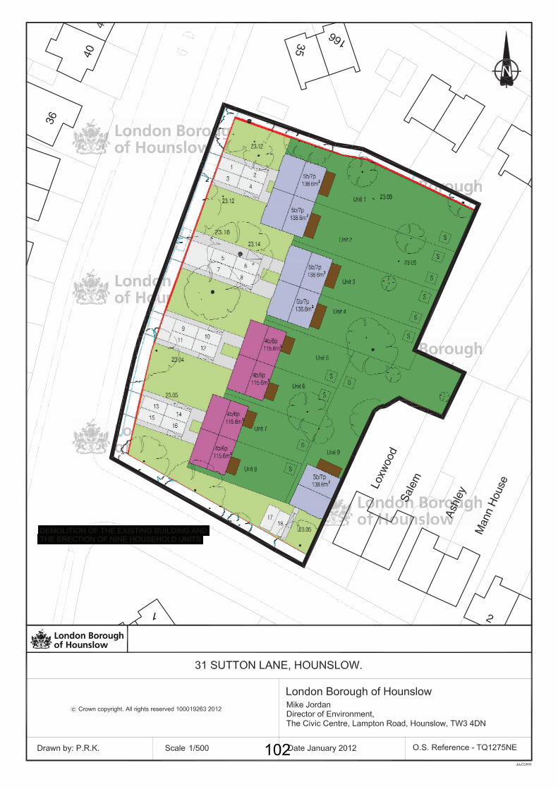
102
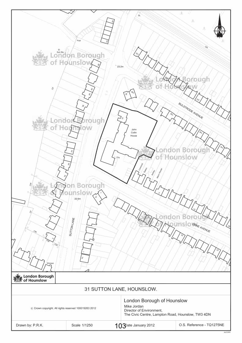
103
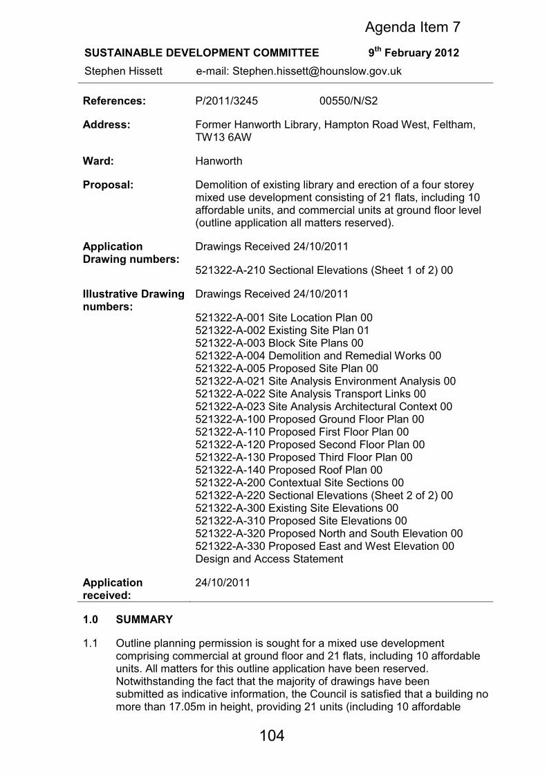
References: P/2011/3245 00550/N/S2
Address: Former Hanworth Library, Hampton Road West, Feltham, TW13 6AW
Ward: Hanworth
Proposal: Demolition of existing library and erection of a four storey mixed use development consisting of 21 flats, including 10 affordable units, and commercial units at ground floor level (outline application all matters reserved).
Application Drawing numbers:
Drawings Received 24/10/2011
521322-A-210 Sectional Elevations (Sheet 1 of 2) 00
Illustrative Drawing numbers:
Drawings Received 24/10/2011
521322-A-001 Site Location Plan 00 521322-A-002 Existing Site Plan 01 521322-A-003 Block Site Plans 00 521322-A-004 Demolition and Remedial Works 00 521322-A-005 Proposed Site Plan 00 521322-A-021 Site Analysis Environment Analysis 00 521322-A-022 Site Analysis Transport Links 00 521322-A-023 Site Analysis Architectural Context 00 521322-A-100 Proposed Ground Floor Plan 00 521322-A-110 Proposed First Floor Plan 00 521322-A-120 Proposed Second Floor Plan 00 521322-A-130 Proposed Third Floor Plan 00 521322-A-140 Proposed Roof Plan 00 521322-A-200 Contextual Site Sections 00 521322-A-220 Sectional Elevations (Sheet 2 of 2) 00 521322-A-300 Existing Site Elevations 00 521322-A-310 Proposed Site Elevations 00 521322-A-320 Proposed North and South Elevation 00 521322-A-330 Proposed East and West Elevation 00 Design and Access Statement
Application received:
24/10/2011
1.0 SUMMARY
1.1 Outline planning permission is sought for a mixed use development comprising commercial at ground floor and 21 flats, including 10 affordable units. All matters for this outline application have been reserved. Notwithstanding the fact that the majority of drawings have been submitted as indicative information, the Council is satisfied that a building no more than 17.05m in height, providing 21 units (including 10 affordable
SUSTAINABLE DEVELOPMENT COMMITTEE 9th February 2012
Stephen Hissett e-mail: [email protected]
Agenda Item 7
104
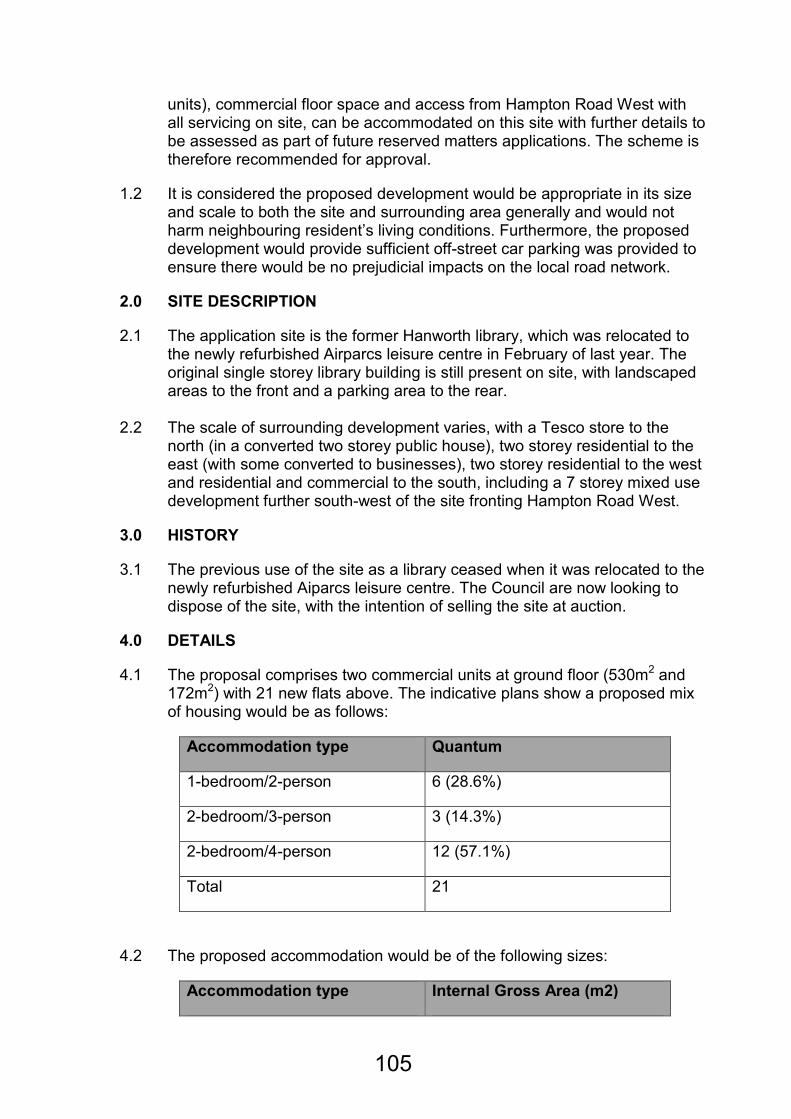
units), commercial floor space and access from Hampton Road West with all servicing on site, can be accommodated on this site with further details to be assessed as part of future reserved matters applications. The scheme is therefore recommended for approval.
1.2 It is considered the proposed development would be appropriate in its size and scale to both the site and surrounding area generally and would not harm neighbouring resident’s living conditions. Furthermore, the proposed development would provide sufficient off-street car parking was provided to ensure there would be no prejudicial impacts on the local road network.
2.0 SITE DESCRIPTION
2.1 The application site is the former Hanworth library, which was relocated to the newly refurbished Airparcs leisure centre in February of last year. The original single storey library building is still present on site, with landscaped areas to the front and a parking area to the rear.
2.2 The scale of surrounding development varies, with a Tesco store to the
north (in a converted two storey public house), two storey residential to the east (with some converted to businesses), two storey residential to the west and residential and commercial to the south, including a 7 storey mixed use development further south-west of the site fronting Hampton Road West.
3.0 HISTORY
3.1 The previous use of the site as a library ceased when it was relocated to the newly refurbished Aiparcs leisure centre. The Council are now looking to dispose of the site, with the intention of selling the site at auction.
4.0 DETAILS
4.1 The proposal comprises two commercial units at ground floor (530m2 and 172m2) with 21 new flats above. The indicative plans show a proposed mix of housing would be as follows:
Accommodation type Quantum
1-bedroom/2-person 6 (28.6%)
2-bedroom/3-person 3 (14.3%)
2-bedroom/4-person 12 (57.1%)
Total 21
4.2 The proposed accommodation would be of the following sizes:
Accommodation type Internal Gross Area (m2)
105

1-bedroom/2-person 52.3
2-bedroom/3-person 74
2-bedroom/4-person 74.4, 76.5 & 84.4
4.3 From the indicative plans it can be shown that an affordable housing provision can be achieved at a level of 48% of the development as a whole, with the following indicative breakdown shown:
Accommodation type
Intermediate Affordable accommodation
Affordable Rented accommodation
1-bedroom/2-person 2 (20%) 0
2-bedroom/3-person 1 (10%) 0
2-bedroom/4-person 1 (10%) 6 (60%)
Total 4 (40%) 6 (60%)
4.4 The indicative plans show that the proposed development would comprise of a three- and four-storey block wrapping around the corner of Hounslow Road and Hampton Road West. The four-storey element would be positioned along Hampton Road West and would include an undercroft access for parking to the rear of the site at the southern boundary. The three-storey element extends along the Hounslow Road frontage where the site adjoins with two-storey residential buildings.
4.5 The indicative plans show that a potential design solution would include blue-grey engineering brickwork to the ground floor plinth and buff brickwork to the upper floors. Vertical timber cladding would be used in recessed elements. The windows would be grey powder coated aluminum double glazed units. The balconies would be constructed out of safety glass with a grey galvanized steel frame and handrail with timber privacy screens.
4.6 Parking spaces would be located along the southern and western boundaries of the site and would be used for both the commercial and residential units. Secure cycle storage for could also be accommodated to the rear of the site.
4.7 The indicative plans show that each of the units can be designed with a dual aspect and balcony. In addition a first floor amenity deck is shown to the rear of the building.
5.0 CONSULTATIONS
5.1 96 letters were sent to neighbouring residents on 15/11/2011. Site
106
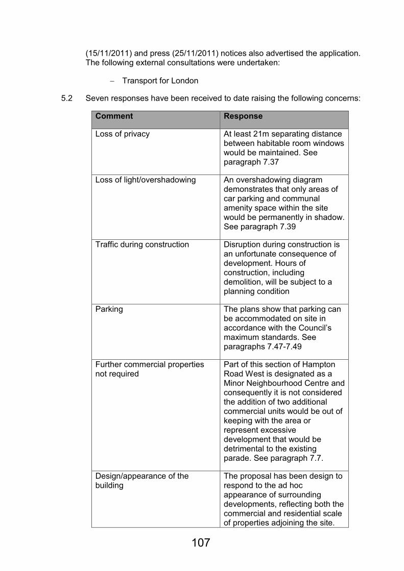
(15/11/2011) and press (25/11/2011) notices also advertised the application. The following external consultations were undertaken:
− Transport for London
5.2 Seven responses have been received to date raising the following concerns:
Comment Response
Loss of privacy At least 21m separating distance between habitable room windows would be maintained. See paragraph 7.37
Loss of light/overshadowing An overshadowing diagram demonstrates that only areas of car parking and communal amenity space within the site would be permanently in shadow. See paragraph 7.39
Traffic during construction Disruption during construction is an unfortunate consequence of development. Hours of construction, including demolition, will be subject to a planning condition
Parking The plans show that parking can be accommodated on site in accordance with the Council’s maximum standards. See paragraphs 7.47-7.49
Further commercial properties not required
Part of this section of Hampton Road West is designated as a Minor Neighbourhood Centre and consequently it is not considered the addition of two additional commercial units would be out of keeping with the area or represent excessive development that would be detrimental to the existing parade. See paragraph 7.7.
Design/appearance of the building
The proposal has been design to respond to the ad hoc appearance of surrounding developments, reflecting both the commercial and residential scale of properties adjoining the site.
107
The varied building line and roof heights help break up the mass of the development as a whole. See paragraphs 7.12-7.17.
Outlook from gardens of adjoining properties
The proposal largely reflects the scale of existing developments on this side of Hampton Road West and due to its orientation and separation from adjoining residential properties would not appear overly bulky or overbearing. See paragraph 7.41.
Too many flats in Feltham already
The proposal would provide much needed family accommodation, including a good portion of affordable housing.
5.3 The application was presented to the West Area Committee on the 1st December 2011. The following comments were made by Members:
−−−− Concerned about the impact on neighbouring properties in terms of privacy, loss of light and overshadowing
−−−− The site access was by a busy junction and entering and leaving would be dangerous
−−−− Insufficient car parking spaces
−−−− Already sufficient commercial uses in the local area
−−−− Need for 1-2 bedroom flats in this area
−−−− The proposal was an overdevelopment of the site and surrounding infrastructure would not support it
Amendments
5.4 As a result of consultation feedback the following amendments have been made to the proposed development:
• The affordable housing mix has been changed to include 7 x 2-bedroom/4-person units, including 6 x 2-bedroom/4-bedroom units affordable rent units.
• Servicing has been provided on site, so that all service vehicles enter and exit the site in forward gear, with sufficient turning-space provided to the rear of the site.
108
• Designation of residential and commercial car parking has been indicated. This would be secured in a Car Park Management Plan by condition.
• A shadowing diagram has been provided indicating the proposal would not overshadow neighbouring residential properties.
6.0 POLICY
Determining applications for full or outline planning permission
6.1 When determining applications for planning permission, the authority is required to have regard to the development plan, so far as is material, and to any other material considerations. In addition, the determination must be made in accordance with the development plan unless material considerations indicate otherwise. The Development Plan
6.2 The Development Plan for the Borough comprises the Council's Unitary Development Plan (UDP), Employment Development Plan Document, Brentford Area Action Plan and the London Plan. The emerging Core Strategy
6.3 On 12 July 2011, the Council's Cabinet approved that the Core Strategy "Preferred Strategy" should go out to consultation. As emerging policy, the Local Planning Authority (LPA) considers that the emerging Core Strategy is capable of being a material consideration. Given that the emerging Core Strategy is still in the consultation stages, the LPA considers that in general limited weight can be given to it at this stage and that where a specific core strategy policy is engaged by an application greater weight may be attached. The draft National Planning Policy Framework
6.4 The consultation on the draft National Planning Policy Framework (NPPF) closed on 17 October 2011. The NPPF is not yet in force and may be subject to amendment. Nonetheless, as emerging policy, the Local Planning Authority (LPA) considers that the NPPF is capable of being a material consideration. As the Planning Policy Statements, Guidance notes and Circulars remain in place until cancelled and given that the NPPF may be subject to amendment, the LPA considers that very limited weight can be given to the NPPF at this stage.
6.5 A full list of the national, regional and local policies relevant for this proposal can be found at appendix 1.
7.0 PLANNING ISSUES
7.1 The main planning issues to consider are:
109
1. Principle of a mixed commercial/residential development;
2. Design and appearance;
3. Housing Standards
4. The proposal’s impact on neighbouring land uses;
5. Environmental Considerations;
6. Transport and Access;
7. Whether sustainable building principles are applied; and
8. The potential of the proposed development to secure planning obligations
Issue 1: The principle of the proposed residential development
7.2 Government Policy and Guidance in the form of PPS1 (Sustainable Development) and PPS3 (Housing) encourage a systematic sustainable approach to the selection of land for development, with preference given, among others, to previously developed land.
7.3 London Plan Policy 3.3 (Increasing London’s Housing Supply) recognises the need for more homes in London in order to promote opportunity and provide a real choice for all Londoners in ways that meet their needs at a price they can afford. Policy 3.4 (Optimising Housing Potential) states that taking into account local context and character, the design principles outlined in Chapter 7 of the plan, and public transport capacity, development should optimise housing output for different types of location.
7.4 London Plan policy 7.2 (All inclusive design) states that The Mayor will require all new development in London to achieve the highest standards of accessible and inclusive design. Policy 7.4 (Local Character) states that development should have regard to the form, function and structure of an area, place or street and the scale, mass and orientation of surrounding buildings. All development should improve an area’s visual or physical connection with natural futures.
7.5 On the local scale, Unitary Development Plan policy ENV-B.1.1 (New Development) requires all development to relate to the scale, nature and character of the surrounding area.
7.6 UDP housing policy H.4.1 and the 1997 SPG outline a range of housing standards that should be met in order to achieve adequate quality of accommodation for future occupants. In addition the Mayors Housing strategy also outlines key size guidance of units and rooms that should also be considered.
7.7 The use of the site as a public library has already ceased, with the library relocated to the Feltham Airparcs leisure centre a short distance away. Consequently the loss of a community use from this site would not be a
110
factor in determining the acceptability of the principle of a mixed-use scheme on this site. The proposal would provide a mix of units with 48% of the total units provided as affordable accommodation. Additionally, this section of Hampton Road West, in particular 1-5 Rex House, 1-19 Market Parade and 14-36 Hampton Road West together form a Minor Neighbourhood Centre as identified within the adopted UDP. Given the presence of a significant level of commercial activity in close proximity to the site it is not considered the addition of two small retail units would have a detrimental impact on the character of the area or the role and function of this Minor Neighbourhood Centre.
7.8 It is therefore considered that the mixed-use scheme would utilise an existing brownfield site that is no longer required for a public library and would help meet housing needs identified within the Borough. The scheme would be appropriate to the surrounding area which is characterised by a mixture of residential and commercial uses and consequently it is considered the proposed development would be acceptable in principle notwithstanding the other planning issues that will be discussed in turn.
Issue 2: Design and Appearance
7.9 PPS 1 emphasises that design which fails to maximise opportunities available for improving the character and quality of an area or that is inappropriate in its context should not be accepted. Policy ENV-B.1.1 of the UDP promotes high quality design that enhances the overall environmental quality and townscape. Section 1.0 of the UDP Supplementary Planning Guidance (SPG) states that the design and layout of proposed developments must enable them to be compatible with, and make a positive contribution to, the character of the locality. New buildings must relate satisfactorily to adjoining and neighbouring buildings and spaces. The scale, massing, siting, size and height of these buildings should be respected by new development, although this need not exclude original, innovative design.
7.10 All policies in the London Plan promote sustainable development. Policy 7.1 sets out a series of criteria that should be considered by boroughs when assessing planning applications. In particular it states that Development should be designed so that the layout, tenure and mix of uses interface with surrounding land community infrastructure, the Blue Ribbon Network, local shops, employment opportunities, commercial services and public transport. Policy 7.4 builds on this and outlines criteria by which buildings, streets and open spaces should provide high quality design.
7.11 By Design, prepared by the Commission for Architecture and the Built Environment, sets out seven key objectives of urban design that development proposals (in terms of their layout, landscape, density and mix, height, massing and detailed appearance) should aspire to reinforce:
•••• Character – a place with its own identity;
•••• Continuity and enclosure – a place where public and private spaces are clearly distinguishable;
111
•••• Quality of the public realm – a place with attractive and successful outdoor areas;
•••• Ease of movement – a place that is easy to get to and move through;
•••• Legibility – a place that has a clear image and is easy to understand;
•••• Adaptability – a place that can change easily;
•••• Diversity – a place with variety and choice.
Height, Mass, Scale and Position 7.12 The proposed building would be four-storeys (approximately 17m) at its
highest and would wrap around the corner of the site so that along the Hounslow Road frontage it would be three-storeys in height, with four-storeys fronting Hampton Road West. It is considered this positioning and massing is appropriate for the site, paying close consideration to the existing developments further along Hampton Road West and Hounslow Road and also developments on opposing corners of this intersection. Hampton Road West is predominantly commercial in nature at this section, with Rex House, a seven-storey mixed-use building, a short distance to the south-west of the site. Hounslow Road, on the other hand, is almost exclusively residential in nature with two-storey semi-detached properties to the south-east of the site. It is therefore considered the stepped nature of the design proposal, with the higher element fronting Hampton Road West responds to the changes in street scene between Hampton Road West and Hounslow Road.
7.13 The position of the proposed development responds closely to the nature of this corner site, helping to create a sense of enclosure along Hampton Road West that is lacking at present, but without becoming overly dominant along Hounslow Road. This again is reflected in the variation in height. The proposed layout also has the benefit of removing the potential impact of car parking on the street scene, taking this aspect of the proposed development towards to the rear of the site, and helping create an open separation to the adjoining residential properties to the south, with mitigation in the form new landscaping along the southern boundary, ensuring there would be no harm to resident’s living conditions with the provision of parking to the rear.
7.14 The building line of the new development would follow those of adjoining properties, ensuring these would not be lost in terms of the street scene and would ensure adequate separation distances between the proposal and the public highway. The position of the building would also help minimise overshadowing of neighbouring properties, in particular residential properties to the south-west of the site with the tallest elements of the development positioned along the northern boundary of the site.
7.15 Whilst it is noted that the proposed development would have a greater depth with respect to the existing properties fronting Hounslow Road, it is considered the positioning away from the boundary and the orientation of the site would ensure these properties were not enclosed to the detriment of resident’s living conditions. There would also be a staggered height
112
between the Hounslow Road frontage towards the centre of the site, which would further mitigate the impact of the greater depth of this part of the development when seen against the scale of the adjoining residential properties.
7.16 In addition to this, the proposal has been positioned such that adequate separation distances would be maintained to adjoining residential properties, with a minimum 21m provided between the site boundary and indicative windows/balconies, ensuring privacy for neighbouring residents was retained (this issue will be discussed in more detail at Section 4).
7.17 The general massing of the site has been positioned towards the northern boundary of the site, i.e. the Hampton Road West frontage, with the greatest towards the junction of this road with Hounslow Road. It is considered this would help provide a focal point for the junction, without appearing overly dominant and retaining much of the character of the area, with a scale that responds to the existing developments surrounding the site. This massing would further help enclose the junction, helping create a sense of place and responding to the openness currently found at opposing corners of this junction. This would help add much needed interest to what is otherwise an uninteresting and open corner site.
7.18 Notwithstanding the detailed design of the proposal, it is therefore considered that the height, massing and positioning of the proposed development would be acceptable and appropriate for this corner site, paying close consideration to the adjoining properties, their scale and character and ensuring the proposal would not have a detrimental impact on the character and appearance of the street scene in general.
Issue 3: Housing Standards
7.19 PPS3 sets out the national planning policy framework for delivering the Government’s housing objectives. The Government’s key housing policy goal is to ensure that everyone has the opportunity of living in a decent home, which they can afford, in a community where they want to live (Paragraph 9).
Density
7.20 Residential density is a tool against which an initial appraisal is made. It is a useful guide to the nature of the development and can be used to ensure that new development reflects the character of an area, but is not a determinant in its own right. Policy 3.4 of the London Plan states that development should optimise housing output for different types of location within the relevant density range shown in Table 3.2 of the London Plan. Table 3.2 illustrates appropriate densities to be achieved in relation to housing. The site has a Public Transport Accessibility Level (PTAL) of 1b, which is defined as “Very Poor” and can be described as being in an “Urban” location. Table 3.2 sets the relevant density range for a development in this location as 150-250 habitable rooms/hectare (hr/ha). Based on the indicative drawings, the Council is satisfied that the site would be able to support the level of accommodation proposed, with 78 habitable
113

rooms and a site area of 0.246ha, the development would have a density of 317hr/ha.
7.21 Whilst the proposed density is outside the range established by the London Plan, the merits of the scheme and the quality of the accommodation provided need first to be taken into consideration. These issues are assessed in the following paragraphs.
Residential mix and size
7.22 PPS 3 and the London Plan encourage new residential developments to provide a choice of housing with a mix of family and non-family housing being needed to meet different community requirements. In addition to this need for housing mix, developments over 10 dwellings should include a proportion of affordable homes as established by Policy 3.13 of the London Plan.
7.23 The indicative mix of units has been described previously at paragraph 4.1.
7.24 London Plan Table 3.3 sets out minimum space standards for dwellings of different sizes. This is based on the minimum gross internal floor area (GIA) required for new homes relative to the number of occupants whilst also taking account of commonly required furniture and the spaces needed for different activities and moving around, in line with the ‘Lifetime Home’ standards. The indicative drawings illustrate that all units proposed would be designed to exceed the minimum space standards listed in Table 3.3.
7.25 The Council would be satisfied that a scheme of this layout would be able to
provide appropriate accommodation that would comply with the requirements of the London Plan in terms of individual unit sizes and it is therefore considered the proposal would be acceptable in terms of the accommodation provided, notwithstanding the detailed design which would be accessed as part of a future reserved matters application. In addition to this, the site could support an appropriate mix of housing, with a significant proportion (15/21) of these units being of a family-size (i.e. 2+ bedrooms) as defined in the Council’s SPG.
Accessibility
7.26 The London Plan strongly supports the principles of Lifetime Homes and
views them as fundamental to the delivery of the Government’s objectives of social inclusion, sustainability, equality and valuing diversity and identifies that the increased independent living they can bring will reduce pressure on hospital beds and residential care homes. Policy 3.8 of the London Plan further specifies that all units within the scheme be based on the ‘Lifetime Homes’ standards and that 10% of all units be wheelchair accessible or easily adaptable for residents who are wheelchair users. All units would be based on the ‘Lifetime Homes’ standards and would be readily adaptable for residents who are wheelchair users. Details of this detailed design stage would be assessed as part of a reserved matters application, although the Council would be satisfied that the proposed layout would be able to meet
114
the London Plan and ‘Lifetime Homes’ standards for accessible accommodation.
Amenity Space
7.27 The provision of good quality, private, useable amenity space and children’s
play areas is fundamental in all levels of the planning framework. Particular emphasis on the quality and quantity of the amenity space provided by developments of this size is necessary to ensure adequate provision and accessibility for all residents. Section 10 of the SPG details requirements for amenity space for developments. Such space should be private and secure with safe and convenient access. For flatted developments, communal areas are generally considered to be acceptable, although areas immediately adjoining flats should have private gardens for sole use of these flats.
7.28 Communal amenity space (for each flat) should normally be provided at no
less than the following standards:
3 habitable rooms and under = 25sqm 4 habitable rooms = 30 sqm 5 habitable rooms and more = 40 sqm
7.29 The proposed flats as indicated on the illustrative plans would be supported by a communal amenity garden situated to the rear of the three-storey block fronting Hounslow Road, with all units benefiting from private balconies. The proposed quantum of amenity space for the flats is as follows:
−−−− Communal amenity garden space = 195sqm
−−−− Balcony space (1st-4th floor) = 249.4sqm
7.30 The indicative accommodation would benefit from 195sqm of communal amenity space. It should also be noted that on average every flat would have access to approximately 12sqm of private balcony space, with an additional 9sqm of communal amenity space for the 21 units. Such spaces would be screened to ensure privacy and usability, whilst the communal garden space would benefit from natural surveillance from the adjoining flats. The Council would be satisfied that the proposed amenity space, whilst representing a shortfall (approximately 275sqm) in on-site amenity space provision from the Council’s SPG, due to the site’s proximity to Hanworth Park and Feltham Airparcs leisure centre (both approximately 5 minutes walk from the site), this would not be unacceptable, with the detailed design of this space to be assessed as part of any reserved matters application.
Affordable housing and mix
7.31 Government policy as defined in PPS3 and the London Plan require that all housing developments in the Borough capable of providing ten or more dwellings should make a provision of on-site affordable housing. The current demand for affordable housing units is spread over a variety of types.
115
7.32 Policy 3.12 of the London Plan also states that, in negotiating affordable housing in private schemes, boroughs should seek the maximum reasonable amount of affordable housing having regard to their affordable housing targets, the need to encourage rather than restrain residential development and the individual circumstances of the site. Targets should be applied flexibly, taking account of individual site costs, the availability of public subsidy, the implications of phased development including provision for re-appraisal and other scheme requirements. London Plan policy 3.11 requires 60% of the affordable housing provision to be social rent and 40% for intermediate rent or sale.
7.33 In respect of viability, Circular 05/05 makes clear that site viability must be considered, such that affordable housing provision is negotiated in a way that ensures a “level of contribution that can be demonstrated as reasonable to be made whilst allowing development to take place” (paragraph B10). Further to this PPS3 states that councils should consider the “economic viability of land for housing…drawing on informed assessments of the likely levels of finance available for affordable housing, including public subsidy and the level of developer contribution that can reasonably be secured.”
7.34 The Hounslow Plan sets out the Council’s 5 key pledges to residents, which include the delivery of 2500 new affordable homes to rent and buy. Larger family housing is a particular priority for Hounslow, and this is supported by the London Plan target of 42% of new affordable homes to rent to have 3 bedrooms or more. The provision of large affordable homes is also supported by the Homes & Communities Agency, the West London Investment Guide, the London SPG and the London Plan.
7.35 The London Borough of Hounslow is satisfied the affordable housing proposal of 48% on-site provision is in accordance with the London Plan Policies 3.11 and 3.12 and the adopted UDP.
7.36 The good property mix of the affordable housing element is important, as the Council’s housing need is for a range of housing types both for affordable rent and affordable intermediate tenures. The London Plan policy 3.8 states the need to provide a range of housing choices taking into account the housing requirements of different groups. The indicative plans show that the scheme can accommodate 8 units that would be considered family accommodation, i.e. 2+ bedrooms in accordance with the definition of family housing contained within the adopted SPG. Therefore the development proposal in terms of unit mix and size meets the Council’s requirements as it provides a good mix of units and delivers 38% of 2+bedroom affordable family units.
7.37 A tenure mix for the proposed affordable accommodation would broadly comply with London Plan policy 3.11 and provide 60% affordable rent accommodation and 40% intermediate rent/sale. Such rent models would be expected to be included in any S106 agreement and would be dependent upon a detailed financial viability assessment being undertaken, which would be scrutinised by the Council’s external valuer to ensure the maximum level of affordable housing and tenure type is achieved on site, however the Council are satisfied that the illustrative proposal would be able
116
to achieve this level of affordable housing subject to a detailed assessment of the reserved matters at a future date.
Issue 4: Impact on residents
Overlooking
7.38 Appendix 1 of the UDP states that a distance of at least 21m is recommended between the windows of habitable rooms which directly face those of another habitable room to avoid overlooking. The illustrative scheme has been designed to ensure this standard has been met and that no habitable room windows would be within 21m of habitable rooms of neighbouring properties. Whilst there may be a perception of overlooking created by the development, in particular with regards to the four-storey block fronting Hampton Road West and the rear gardens of existing properties fronting Hounslow Road, it is not considered this would be unacceptable in this instance, taking into consideration the separating distances to neighbouring properties and the position of the balconies, the Council would be satisfied that the position of the proposed development in respect of adjoining residential properties would not result in an unacceptable loss of privacy for neighbouring residential properties, notwithstanding the detailed assessment of the reserved matters to follow.
Daylight, Sunlight & Overshadowing
7.39 An overshadowing assessment of the proposed development has been submitted in conjunction with the application.
7.40 In assessing this information it is not considered the proposal would result in an unacceptable level of overshadowing to neighbouring residential properties. The main impact in terms of overshadowing would be to the front of the site and the public highway adjacent to Hampton Road West. The Council would therefore be satisfied that the proposed position and height of the development would be acceptable in terms of overshadowing, notwithstanding the detailed design that would be assessed as part of a reserved matters application. This would be primarily due to the position and orientation of the proposed accommodation and the separating distances to adjoining residential properties, in particular with regards to the position of the four-storey block fronting Hampton Road West.
Outlook
7.41 The detailed design of the proposal has previously been discussed within paragraphs 7.9-7.17.
7.42 The proposed development would largely reflect the scale of other developments along this side of Hampton Road West, and due to the orientation of this development in relation to the nearest residential properties (located to the south fronting Hounslow Road) it is not considered the proposal would have an unacceptable impact on the outlook from these residential properties. The Council would therefore be satisfied that the position and height of the proposal would be acceptable in terms of its impact on the outlook from neighbouring residential properties with the
117
detailed design of the proposal to be assessed as part of a reserved matters application.
Issue 5: Environmental Considerations
Air
7.43 The whole Borough was declared an Air Quality Management Area (AQMA) in March 2006. However, whilst the designation of the AQMA is indicative of a certain level of air quality, this in itself does not prevent development.
7.44 It is not considered the proposed development would significant exacerbate existing conditions with regards to air quality and that the location of the site would not be in appropriate for residential development due to existing air quality issues. It is not considered this matter would require further mitigation or would represent a reason for refusing this application. A condition will also be applied regarding construction works, in particular regarding the spread of dust and other airborne contaminates during construction work.
Noise
7.45 It is considered appropriate planning conditions regarding sound insulation would be sufficient in this instance to ensure resident’s living conditions were satisfactory and prevent external noise attenuation. A condition will also be applied regarding construction works, in particular regarding hours of operation.
Water
7.46 The site is not within a flood zone. It is therefore not necessary to carry out a flood risk assessment for this proposal.
Issue 6: Transport and Access
7.47 The Council’s parking standards are considered to be the maximum desirable provision, with UDP policies seeking to reduce reliance on the private car and promote use of sustainable modes. Parking standards are contained within Appendix 3 of the UDP. There are no minimum standards except in relation to disabled parking.
7.48 The site has a Public Transport Accessibility Level (PTAL) described as ‘Very Poor’ and consequently it would be expected the proposal would provide close to the maximum standards contained within the UDP.
7.49 The proposal would utilise and existing vehicle crossover to gain access to the rear of the site with all servicing being undertaken to the rear of the site, with a designated loading/unloading bay close to the rear access points for the commercial units. Vehicle tracking diagrams have been submitted indicating that the largest service vehicle can enter and exit the site in forward gear, thereby minimising the impact on the flow of traffic along Hampton Road West. Refuse and recycling storage for the block of flats would be close to the point of collection and therefore would be satisfactory.
118
7.50 The indicative plans show that the site can accommodate approximately 18 parking spaces to the rear of the site, including wider spaces for the disabled, it would not be expected that a significant proportion of car parking would be needed for the commercial units and as such the majority of spaces could be allocated to the residential. It should also be noted that the Council’s standards are maxima and as such the Council should be promoting use of transport modes other than by private car. Consequently it is considered that a residential Green Travel Plan be included in any S106 agreement. The parking layout is satisfactory in terms of manoeuvring into and out of the spaces.
7.51 The proposal would also accommodate cycle storage for at least cycles. This storage area would be close to the main entrances for the residential units. It is therefore considered that the proposed cycle storage arrangements would be satisfactory subject to an appropriate planning condition regarding detailed design of the cycle stores.
7.52 In light of the above the Council would be satisfied that the proposed position and access arrangements for the development would be acceptable, with satisfactory provision for on-site car parking for residents and visitors and servicing arrangements that would not have a prejudicial impact on the free-flow of traffic on the local road network or highway safety in general.
Issue 7 Sustainability
7.53 Sustainability underpins many policies of the UDP and the London Plan. These require developments to be sustainable in transport terms, to minimise waste, include energy efficiency measures and promote the use of renewable energy, and not significantly increase the requirement for water supply or surface water drainage.
7.54 The new London Plan policy 5.2 requires development proposals to make the fullest practicable contribution to minimising carbon dioxide emissions in accordance with the following energy hierarchy:
• Be Lean: use less energy
• Be Clean: supply energy efficiently
• Be Green: use renewable energy
7.55 The Mayor aims to ensure that major developments reduce carbon dioxide emissions from buildings, by reaching higher then the Target Emission Rate (TER) outlined in the national Buildings Regulations, leading to zero carbon residential buildings from 2016. The mayor has stipulated that between 2010 and 2013 residential buildings should provide a 25% improvement on 2010 Building Regulations’ which rise to 40% by 2013-2016.
7.56 Given that the application is for outline consent only details of the measures to reduce CO2 emissions have not been provided in detail. However, it has been indicated that such reductions may be achieved through either ground source heat pumps (hot water provision) or photovoltaics (electricity
119

generation).
7.57 Similarly, details as to how the proposal would achieve a Level 3-4 Code for Sustainable Homes have not been provided and consequently this would need to be secured by an appropriate planning condition.
7.58 No details as to how the proposal would incorporate Sustainable Urban Drainage Systems (SUDS) into the design of the development have been provided or how water use would be minimised and surface water runoff reduced towards ‘greenfield’ levels
7.59 The re-development of this brownfield site would be in accordance with the broad principles of sustainability. Given the outline nature of this application detailed information has not be supplied as to how the proposed development would meet the CO2 emission targets within the London Plan or how SUDS can be incorporated into the proposal. However, the Council would be satisfied that the proposal position and height of the development could facilitate such measures, which would be assessed as part of a detailed reserved matters application to follow.
Issue 8: Planning Obligations
7.60 UDP policy IMP6.1 states that the Council will seek to ensure that a developer enters into a planning obligation to secure planning benefits related to the proposed development. A payment or other benefit offered pursuant to a section 106 agreement is not material to a decision to grant planning permission and cannot be required unless it complies with the provisions of the Community Infrastructure Levy Regulations 2010 (regulation 122), which provide that the planning obligation must be:
(a) necessary to make the development acceptable in planning terms; (b) directly related to the development; and (c) fairly and reasonably related in scale and kind to the development.
7.61 Accordingly, it is mandatory that each criterion be satisfactorily addressed
prior to granting planning permission subject to a section 106 agreement. 7.62 Government Circular 05/2005 provides guidance on the use of planning
obligations, which may impose a restriction or requirement, or provide for payment of money from the developer to make acceptable development proposals that might otherwise be unacceptable in planning terms. The Council’s Supplementary Planning Document on Planning Obligations (which was adopted in March 2008) contains guidance on the imposition of planning obligations in compliance with Circular 05/2005. These obligations may offset shortfalls in the scheme or mitigate the impacts of the development.
7.63 The following planning obligations have been directly calculated from the
Council’s Planning Obligations SPD where relevant. It would be expected that any legal agreement would include these contributions and where this is deemed unviable a detailed financial assessment will be scrutinised by the Council’s external valuer.
120
I. Construction Training - this would be based on the Council’s SPD
calculation of £2500 per £1million construction costs. At present since there is no developer the construction costs are unknown.
II. Education – a contribution would be based upon the Council’s SPD requirements.
III. Health– a contribution based on the HUDU model would be required.
IV. Transport Improvements - a contribution would be based upon the Council’s SPD requirements.
V. Travel Plan – the Council is minded to require a local level Travel Plan as per Transport for London (TfL) guidance
VI. Considerate Contractors Scheme 8.0 EQUAL DUTIES IMPLICATIONS
8.1 The Council has to give due regard to its Equalities Duties and in particular with respect to its duties arising pursuant to the Equality Act 2010, section 149. Following a relevance test, which is available at:
http://www.hounslow.gov.uk/index/council_and_democracy/equality/eias/environment_eias.htm
8.2 It is considered that there will be no specific implications with regard to the council’s duty in respect of equalities duties and that if approving or refusing this proposal the Council will be acting in compliance with its duties.
Relevant Section of Relevance Test
Major development
9.0 RECOMMENDATION
GRANT
The proposed redevelopment of the former Hanworth Library site to provide 21 x one- and two-bedroom flats and retail space at ground floor would result in the development of this brownfield site to provide an appropriate mixed-use scheme that would be in keeping with the surrounding area and provide an acceptable mix and size of housing accommodation. The scheme as amended presents a development of high design quality that would provide a good standard of living accommodation and amenity benefits without having an unduly detrimental impact on neighbouring and nearby resident’s living conditions. Furthermore, the proposal would not have a prejudicial impact on the free-flow of traffic on the local road network or highway safety in general. On balance the development is in accordance with the relevant policies of the adopted Unitary Development Plan, Supplementary Planning Guidance and the London Plan, including policies IMP.3.1, ENV-N.2.6, ENV-B.1.1, ENV-B.1.5, ENV-B.1.9, ENV-P.1.3-7, ENV-P.2.1, ENV-P.2.4, H.4.1, H.4.4-5 H.6.2, H.7.1, C.3.3, T.1.4, T.2.1, T.2.2 and
121
T.4.3-5, T.5.2.
Conditions 1 The development hereby permitted shall not be commenced
until a written planning obligation under Section 106 Town and Country Planning Act 1990 in the same terms or substantially in the same terms as the planning obligation annexed hereto has been entered into by all relevant parties in relation to that relevant part of the application site and until the obligation has been completed and submitted to the local planning authority.
REASON: to ensure that the impacts of the proposed development are appropriately mitigated.
2 A2 Outline Permissions
Approval of the details of the siting, design and external appearance of the building(s), the means of access thereto and the landscaping of the site (herein called “the reserved matters”) shall be obtained from the local planning authority in writing before any development is commenced and shall be carried out as approved REASON: to accord with the provisions of Section 92(1) of the Town and Country Planning Act 1990.
3 A5 Outline Permissions The development hereby permitted shall be begun either before the expiration of five years from the date of this permission, or before the expiration of two years from the date of approval of the last of the reserved matters to be approved, whichever is the later REASON: to accord with the provisions of Section 92(1) of the Town and Country Planning Act 1990.
4 Building height and external plant The building hereby approved shall not exceed the maximum heights specified in the building height schedule shown on drawing number 521322-A-210 received 24/10/2011, and no louvres, ducts or other external plant equipment shall be installed on any building without the prior written approval of the Local Planning Authority. REASON: In order that the Local Planning Authority may be satisfied as to the details of the development relating to height: (a) in the interests of the visual amenity of the area in
122
accordance with Hounslow Unitary Development Plan (UDP) policies ENV-B.1.1 (New development), ENV-B.1.2 (High buildings or structures affecting sensitive areas), ENV-B.1.3 (High buildings or structures in areas other than those listed in ENV-B.1.2), and H.4.1 (Housing standards and guidelines); the London Plan (2011); and UDP Supplementary Planning Guidance (February 1997); and (b) to safeguard the amenities of (to prevent noise and disturbance to) residential properties in the locality by controlling noise levels in accordance with UDP policies ENV-B.1.1 and ENV-P.1.5 (Noise pollution) and the London Plan (2011).
5 B3 Materials to match samples Reason: B3R
6 C29 Hours of Construction No demolition or construction work shall take place on the site except between the hours of 8:00am to 6:00pm Mondays to Fridays, 8:00am to 1:00pm on Saturdays, with no work to take place on Sundays and Bank Holidays without the prior agreement of the Local Planning Authority Reason: C29R
7 C34 Construction Environmental Management Plan
No development shall take place until a Construction Environmental Management Plan (CEMP) covering the construction stages has been submitted to and approved in writing by the Local Planning Authority. The CEMP shall cover: (i) Any external illumination of the site; (ii) Measures to ensure that all mud and other loose materials are not carried on the wheels and chassis of any vehicles leaving the site; (iii) Measures to minimise dust nuisance caused by the operations and to ensure that no dust or other debris is carried on to the adjoining properties; (iv) The routeing of vehicles to the site, access and egress arrangements and waiting areas; and (v) Boundary treatment and measures to ensure they are maintained in a secure and tidy condition.
(Reason. In order to safeguard the amenities of residential properties in the locality and in the interest of road safety in accordance with Hounslow Unitary Development Plan policies ENV-B.1.1 (New development), ENV-P.1.5 (Noise pollution), ENV-P.1.6 (Air pollution), ENV-P.1.7 (Light pollution), T.2.2 (Pedestrian safety and security) and T.4.4 (Road safety)
123
8 C14 Restriction on Use
The ground floor premises shall be used for retail purposes only and for no other purpose (including any other purpose in Class A1 of the Schedule to the Town and Country Planning (Use Classes) Order 1987, or in any provision equivalent to that Class in any statutory instrument revoking and re-enacting that Order with or without modification). REASON C14R.
9 D4 Waste & Recycled Storage (Details to be submitted) Reason D4R
10 D9 Soundproofing – External Noise Before the development is commenced a scheme for protecting the proposed residential accommodation from external noise, shall be submitted to and approved by the Local Planning Authority and any works that form part of such a scheme shall be completed before any part of the development is first occupied or used. Reason D9R
11 E1 Landscape design proposals Hard & soft landscaping works, including boundary treatments, play strategy, planting plans and maintenance/implementation programme. REASON: E1R
12 E15 Provision for Tree Planting If within a period of two years from the date of the planting of any tree, that tree, or any tree planted in replacement for it, is removed, uprooted or destroyed or dies, another tree of the same species and size as that originally planted shall be planted at the same place, unless the local planning authority gives its written consent to any variation. REASON: E15R
13 E16 Existing trees to be retained REASON: E16R
14 F4 Completion- Access
124

The buildings hereby approved shall not be occupied until a means of access for vehicles and pedestrians has been constructed in accordance with the approved plans. REASON F4R
15 G2 Parking (Outline) Before the development commences details of parking (including spaces for people with disabilities) shall be submitted to and approved by the Local Planning Authority and the spaces shown on the approved drawing shall be available for use before first occupation of any part of the development Reason: G2R
16 J2 The development hereby permitted shall designed in accordance with the Lifetime Home standards as set out in the London Plan Accessible London Supplementary Guidance Accessible London Reason: J2R
17 Car Park Management Plan No unit shall be occupied until a Car Park Management Plan, including details of delivery and servicing for the commercial units, has been submitted to and approved in writing by the Local Planning Authority. The car parking areas shall thereafter be managed in compliance with the approved Car Park Management Plan. (Reason. In order to safeguard the amenities of surrounding residential properties and ensure minimal disruption of traffic in the locality, in accordance with policies ENV-B.1.1 (New Development), ENV-P.1.5 (Noise Pollution) and T.4.4 (Road Safety) of the adopted Unitary Development Plan 2003 and the London Plan 2011.)
18 The non-residential floor space of the building hereby permitted shall not be open to customers outside the hours of 08:00 to 23:00 Monday to Saturday and 09:00 to 22:00 on Sundays and Public Holidays. In order to safeguard the amenities of residential properties in the locality, in particular the upper levels of this development, in accordance with Hounslow Unitary Development Plan policies ENV-B.1.1 (New Development), ENV-P.1.5 (Noise pollution), and S.3.1 (New retail development).
125
19 Shop Front Details Full details of the design of the shop fronts to non-residential ground floor units shall be submitted to and approved in writing by the Local Planning Authority prior to the fit out of each commercial unit hereby approved. The details shall be carried out as approved.
(Reason. To ensure the appearance of the shopfronts is satisfactory and to confirm details of the development, in accordance with policy ENV-B.1.1 (New Development) of the adopted Unitary Development Plan.
20 Sustainable Drainage No development shall take place until details of a Sustainable Urban Drainage Scheme, including measures for (i) the harvesting of rainwater, (ii) the minimisation of water run-off from the site, aiming for greenfield levels, and (iii) the conservation and reuse as appropriate of other water supplies in the buildings have been submitted to and approved by the Local Planning Authority. The building shall not be occupied until evidence (e.g. photographs and copies of installation contracts) has been submitted to the Local Planning Authority to demonstrate that the development has been carried out in accordance with the approved details. (Reason. In the interests of sustainability and to ensure the satisfactory management of surface water run-off from the development hereby permitted, including by preventing increased risk of flooding and pollution of the water environment, and in accordance with Hounslow Unitary Development Plan Policies ENV-B.1.1 (New development), ENV-P.1.2 (Water pollution and water quality), ENV-P.1.3 (Surface water run off) and London Plan Policies 5.10 (Urban Greening), 5.13 (Sustainable drainage) and 5.15 (Water use and supplies).
21 Sustainable Construction No development shall take place until a statement on the sourcing of materials to be used in the building, involving reuse, recycling and other sustainable sourcing of materials to be used in the construction of extensions and fitting out of the building wherever possible, has been submitted to and approved in writing by the Local Planning Authority. The building shall not be occupied until evidence (e.g. photographs and copies of installation contracts) have been
126
submitted to the Local Planning Authority to demonstrate that the development has been carried out in accordance with the approved details (Reason. To ensure the development can be implemented with adequate regard to the environment in the interests of sustainability in accordance with Hounslow Unitary Development Plan Policies ENV-B.1.1 (New development), London Plan Policy 5.3 (Sustainable design and construction); and Sustainable Design and Construction (London Plan Supplementary Planning Guidance May 2006.)
22 Conservation of Energy No development shall take place until an energy assessment has been submitted to the Local Planning Authority which demonstrates how the hierarchy of energy efficiency, efficiency supply of energy and renewable energy generation has been observed. The assessment should show that a reduction in CO2 emissions of at least 25% will be achieved, taken from a CO2 emissions baseline. CO2 emissions figures should be calculated using SAP (Standard Assessment Procedure)/ SBEM (Simplified Building Energy Model) and the associated worksheets should be submitted as part of the application, alongside full details of the proposed energy efficiency measures and renewable energy technology(ies). The building shall not be occupied until evidence (e.g. photographs and copies of installation contracts) has been submitted to the Local Planning Authority to demonstrate that the development has been carried out in accordance with the approved details (Reason: To comply with the London Plan Policies 5.1-5.7 and to ensure the overall environmental sustainability of the development.)
23 J12 Land Quality Condition Reason: J12R
24 Surface Water Drainage With regard to surface water drainage it is the responsibility of a developer to make proper provision for drainage to ground, water courses or a suitable sewer. In respect of surface water it is recommended that the applicant should ensure that storm flows are attenuated or regulated into the receiving public network through on or off site storage. When it is proposed to connect to a combined public sewer, the site drainage should be separate and combined at the final manhole nearest the
127
boundary. Connections are not permitted for the removal of Ground Water. Where the developer proposes to discharge to a public sewer, prior approval from Thames Water Developer Services will be required. They can be contacted on 0845 850 2777. Reason: To ensure that the surface water discharge from the site shall not be detrimental to the existing sewerage system.
Informatives:
1 The building contractors should take note of, and act upon advice given in the in the GLA and London Councils - Best Practice Guidance: "The Control of Dust and Emissions from Construction and Demolition
2 If site staff are instructed by a Council Officer to stop vehicle movements to and from the site if any incidents occur, they must comply with the instructions. For any further advice, contact the Council’s Community Environment Team on 020 8583 5070.
3 The building contractors should take note of, and act upon advice given in the BS5228 Code of Practice "Control of Noise on Construction Sites". Before commencement of the works the building contractors should, giving as much notice as possible, notify the occupants of properties surrounding the site of the nature and duration of works and the permitted hours of work. The building contractors should also provide such occupants with the name and telephone number of a responsible person who can be contacted for advice or in the event of a need to complain.
128
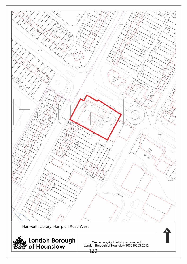
Crown copyright. All rights reserved.London Borough of Hounslow 100019263 2012.
1
2
13
7
BankMarket Parade
1
PO
216
TCB
LB
(PH)
192
Groom
Horse and
245
Shelter
204
257
CR
8
209
20.4m
176
Car P
ark
14
16
Library
18
20
24
12a to 27
1 to 12
203
19.8m
166
193
156
1
158
183
Willow Cottages
6
14
El S
ub S
ta
El Sub Sta
1
Rex House
144
MOUNT ROAD
13
136
142a
Und
233
FF
FFSta
FW Sub
El
2
235
227
20.4m
12
1
7
221
FF
FF
22
13
28
Hanworth Library, Hampton Road West
129
Sustainable Development Committee
09th February 2012
e-mail: [email protected]
References: P/2011/2757
P/2011/3581
P/2011/2866
00657/B/P21
00657/B/L22
00657/B/CA1
Address: Thames Water Land, Kew Bridge Road, Brentford
Ward: Brentford
Proposal: 00647/B/P21: The demolition of all unlisted buildings and structures, removal of some of the trees, restoration and alteration of the filter bed tanks and the construction of 3 buildings (A,B and C) to provide 76 residential units (including affordable housing) and a total of 526 square metres (GIA) of commercial floorspace distributed on the ground floor of buildings B & C [use classes B1(a)/B1(b)/D1/D2 only]; in a purpose-built single storey commercial building for use classes B1(a)/B1(b)/B1(c) only and the refurbishment of the existing listed Gatehouse for use classes A1/A3/B1(a)/B1(b) only, together with associated private and communal amenity space, car, motorcycle and cycle parking, refuse/recycling storage and means of access and servicing and the provision of a linear park and soft and hard landscaping works including the alteration and restoration of the existing filter bed banks and alterations to the existing southern listed boundary wall to create pedestrian connections. 00657/B/L22: Alterations relating to the refurbishment of the existing Gate House and southern boundary wall and removal of part of the southern filter bed bank, construction of the "Mews" building and associated facilities and landscaping works 00647/B/CA1: Demolition of unlisted buildings and structures at the site.
Drawing numbers: See Appendix 2
Agenda Item 8
130
Applications received: 27/09/2011 (00657/B/CA1) 14/12/2011 (00657/B/L22) 16/12/2011 (00567/B/P21)
1.0 SUMMARY
1.1 These applications propose the redevelopment of the former Thames Water land adjacent to Kew Bridge Road and the Kew Steam Museum, with a mixed use scheme.
1.2 Planning Permission is sought for the erection of three blocks (of between 5 and 7 storeys in height) containing a total of 76 flats (including 15 affordable units) and commercial floorspace, the erection of a separate building providing commercial floorspace, the change of use of the existing Grade II Listed Gatehouse to provide commercial floorspace with associated car parking, servicing and landscaping and the restoration of parts of the existing filter bed. Conservation Area Consent is sought for the demolition of all unlisted buildings at the site.
1.3 Listed Building Consent is sought for works to the southern boundary wall, the listed filter wall and the refurbishment of the Gatehouse.
1.4 Additionally, the proposal includes changes to the approved public open space that must be provided as part of the original housing development scheme for the adjoining Thames Water reservoir site (approved in 2001 but not yet completed).
1.5 Approval of the three applications is recommended, subject to conditions and a legal agreement.
2.0 SITE DESCRIPTION
2.1 The site has an area of 0.95ha and is currently occupied by three buildings (two office buildings and a pump house) used by Thames Water. The existing total floorspace at the site is 1,515m2. The site largely comprises the original (1845) filter bed and so the ground level at the centre of the site is lower than that on the periphery. It also includes a strip of higher land excavated to create the southern bund, which is in turn supported by the listed southern boundary wall to Kew Bridge Road.
2.2 It is contained to the north by a concrete boundary and metal mesh fence at the top of the surrounding bund wall, to the west, in part by a tall metal fence protecting the remaining water operations, to the south by a Grade II Listed wall that stands between the site and Kew Bridge Road and to the east by metal railings that stand on top of that part of the filter bed and demark the boundary of the site with the Steam
131
Museum to the east. At the eastern end of this wall is a vacant gatehouse at the entrance to the site that is Grade II listed.
2.3 Beyond the site, to the north is the Brentford Towers Estate that comprises six residential towers that are 23 storeys in height and that are accessed from Green Dragon Lane. These were sited carefully in relation to the later reservoirs and have in part used the bund walls for soft landscape surrounds.
2.4 To the east of the site is the Kew Bridge Steam Museum that includes a number of Listed Buildings including the Great Engine House, the Steam Museum Building and Standpipe Tower, all of which are Grade I Listed. The filter bed and the filter bed wall that contains much of the application site was integral to the water supply process and so is historically linked to this cluster of listed buildings.
2.5 The applicant owns the site, the former reservoir site to the west and the Steam Museum complex.
2.6 To the South is Kew Bridge Road and on the other side of that road are buildings of varying uses and heights and beyond that is the River Thames. To the east lies Strand on the Green and to the west Brentford town centre.
2.7 To the south west, between the edge of the site and Kew Bridge Road are a series of buildings that include the recently constructed Musical Museum, offices, a takeaway, a petrol filling station and a pair of semi-detached houses.
2.8 Planning permission has been granted for a mixed use scheme including 308 residential units on land south of Kew Bridge Road between Regatta Point and Kew Bridge (the St George Kew Bridge site) and this development has been implemented.
2.9 To the west of the site is a compound used by Thames Water, containing water supply infrastructure that would be retained in operation and secured by fencing from the surrounding land.
2.10 Further to the west is an area of former covered reservoirs that falls within the ownership of the applicant. It is also still being used by Thames Water and is currently being decommissioned. Outline permission has been granted for residential development at the site and reserved matters have been approved for 353 units within nine buildings of between six and 16 storeys in height. That permission has been implemented and construction of buildings is expected to start soon.
2.11 The site is presently accessed from Kew Bridge Road and an internal road links the site access (marked by the gatehouse) to the existing Thames Water compound. An area of green space between the entrance and the southern filter bed bank links the site to that further to
132
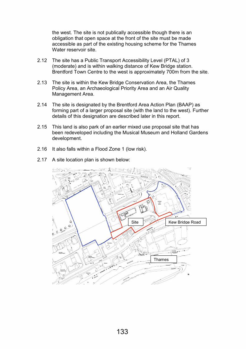
the west. The site is not publically accessible though there is an obligation that open space at the front of the site must be made accessible as part of the existing housing scheme for the Thames Water reservoir site.
2.12 The site has a Public Transport Accessibility Level (PTAL) of 3 (moderate) and is within walking distance of Kew Bridge station. Brentford Town Centre to the west is approximately 700m from the site.
2.13 The site is within the Kew Bridge Conservation Area, the Thames Policy Area, an Archaeological Priority Area and an Air Quality Management Area.
2.14 The site is designated by the Brentford Area Action Plan (BAAP) as forming part of a larger proposal site (with the land to the west). Further details of this designation are described later in this report.
2.15 This land is also park of an earlier mixed use proposal site that has been redeveloped including the Musical Museum and Holland Gardens development.
2.16 It also falls within a Flood Zone 1 (low risk).
2.17 A site location plan is shown below:
Thames
Kew Bridge Road Site
133

3.0 HISTORY
3.1 This site is part of Thames Water land that has been sold for redevelopment. The land to the west and part of this application site that fronts Kew Bridge Road have planning permission for residential development (granted in 2001). The s.106 legal agreement (that was varied in 2006 and 2011) includes obligations relevant to this application, as they involve work on part of the application site, providing:
• 1.67 hectares of publicly accessible open space, with half of that to be provided in a linear park at the front of this application site (adjoining Kew Bridge Road);
• A combined pedestrian and cycle route from east to west across the front part of this application site;
• The completion of a B1 office development within the filter bed (this application site); and
• The refurbishment of the gatehouse at the east side of the southern boundary wall.
3.2 If approved, the variation of that legal agreement would be necessary to permit this development, to make reference to the details of any new permission granted, and to remove the obligation to provide an office development.
3.3 Other planning history principally relates to this existing use at the site and is not relevant to this application.
4.0 DETAILS
4.1 These applications seeks permission for the redevelopment of the site for a mixed-use development including 76 flats, 525.7m2 of commercial floorspace with associated parking and landscaping, works to listed buildings at the site, the enhancement of the open space in front of the site and a public open space. The three applications seek permission for the following:
00657/B/P21 (Application for Planning Permission)
4.2 Three buildings would be erected within the bunded space of the former filter bed (buildings, A to the west, B in the centre, and C to the east and nearest to the Steam Museum).
4.3 Building A would be seven storeys in height. The ground floor would be used for plant and storage. The upper floors would be used as 42 units (24 x 1 beds and 18 x 2-beds) 15 of those units would be shared ownership affordable homes (10 x 1-beds and 5 x 2-beds).
134
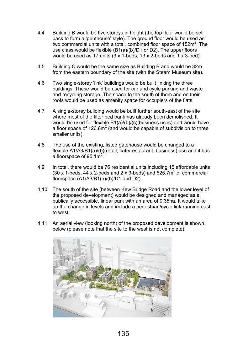
4.4 Building B would be five storeys in height (the top floor would be set back to form a ‘penthouse’ style). The ground floor would be used as two commercial units with a total, combined floor space of 152m2. The use class would be flexible (B1(a)/(b)/D1 or D2). The upper floors would be used as 17 units (3 x 1-beds, 13 x 2-beds and 1 x 3-bed).
4.5 Building C would be the same size as Building B and would be 32m from the eastern boundary of the site (with the Steam Museum site).
4.6 Two single-storey ‘link’ buildings would be built linking the three buildings. These would be used for car and cycle parking and waste and recycling storage. The space to the south of them and on their roofs would be used as amenity space for occupiers of the flats.
4.7 A single-storey building would be built further south-east of the site where most of the filter bed bank has already been demolished. It would be used for flexible B1(a)/(b)/(c)(business uses) and would have a floor space of 126.6m2 (and would be capable of subdivision to three smaller units).
4.8 The use of the existing, listed gatehouse would be changed to a flexible A1/A3/B1(a)/(b)(retail, café/restaurant, business) use and it has a floorspace of 95.1m2.
4.9 In total, there would be 76 residential units including 15 affordable units (30 x 1-beds, 44 x 2-beds and 2 x 3-beds) and 525.7m2 of commercial floorspace (A1/A3/B1(a)/(b)/D1 and D2).
4.10 The south of the site (between Kew Bridge Road and the lower level of the proposed development) would be designed and managed as a publically accessible, linear park with an area of 0.35ha. It would take up the change in levels and include a pedestrian/cycle link running east to west.
4.11 An aerial view (looking north) of the proposed development is shown below (please note that the site to the west is not complete):
135
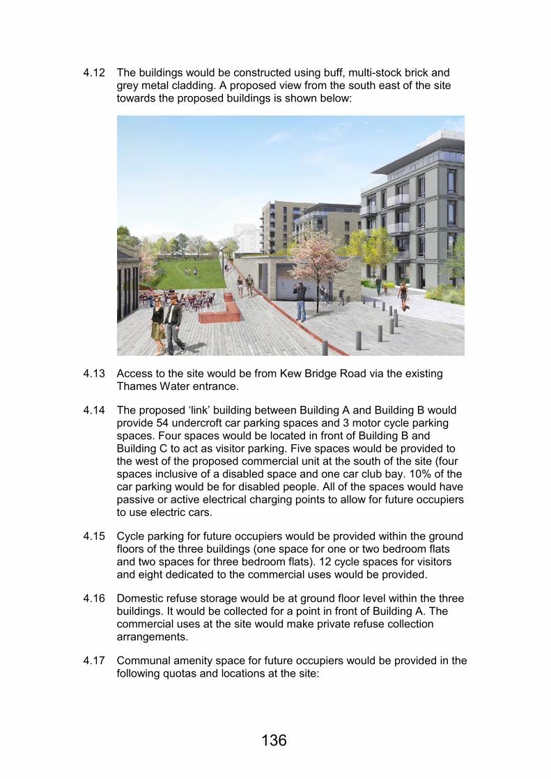
4.12 The buildings would be constructed using buff, multi-stock brick and grey metal cladding. A proposed view from the south east of the site towards the proposed buildings is shown below:
4.13 Access to the site would be from Kew Bridge Road via the existing Thames Water entrance.
4.14 The proposed ‘link’ building between Building A and Building B would provide 54 undercroft car parking spaces and 3 motor cycle parking spaces. Four spaces would be located in front of Building B and Building C to act as visitor parking. Five spaces would be provided to the west of the proposed commercial unit at the south of the site (four spaces inclusive of a disabled space and one car club bay. 10% of the car parking would be for disabled people. All of the spaces would have passive or active electrical charging points to allow for future occupiers to use electric cars.
4.15 Cycle parking for future occupiers would be provided within the ground floors of the three buildings (one space for one or two bedroom flats and two spaces for three bedroom flats). 12 cycle spaces for visitors and eight dedicated to the commercial uses would be provided.
4.16 Domestic refuse storage would be at ground floor level within the three buildings. It would be collected for a point in front of Building A. The commercial uses at the site would make private refuse collection arrangements.
4.17 Communal amenity space for future occupiers would be provided in the following quotas and locations at the site:
136
• A courtyard between Building A and Building B and an area to the south of Building B (262m2).
• A courtyard between Building B and Building C and an area to the south of Building C (332m2).
• An area between Building C and the eastern boundary of the site and an elevated area in the northeast of the site (492m2).
• An area on the roof of the link building between Building A and Building B (345m2).
• An area on the roof of the link building between Building B and Building C (342m2).
4.18 The total communal amenity space at the site would be 1,771m2. The publically accessible linear park would also be available for use by residents.
4.19 Each flat would also have access either to a private balcony or a private roof terrace. The total private amenity space provision at the site would be approximately 500m2.
4.20 1-bedroom flats (for two people) would have an internal floorspace of between 50 and 56m2. 2-bedroom flats (for up to four people) would have an internal floorspace of between 76 and 89m2. 3-bedroom flats (for between five and six occupiers) would have internal floorspaces of between 86 and 111m2.
4.21 The flats would be designed to achieve Code for Sustainable Homes Level 4 and the development overall would represent an improvement of 28.2% above the Building Regulations (2010). It would do this through the of sustainable construction methods and through installing 288 solar panels to the roofs of the three main buildings.
4.22 The applicant has submitted the following Heads of Terms to mitigate the impacts from the development on local infrastructure and the environment:
• Education
• Health
• Transport/Highways
• Considerate Contractor’s Scheme
• Steam Museum Improvements
• Sustainable Transport/Highways
137
• Travel Plan
• Provision of linear park
• Affordable housing (together with a deferred contribution mechanism that would allow the Council to benefit from any uplift of the viability of the scheme over time).
4.23 Officers also consider that construction training should be provided.
00657/B/CA1 (Application for Conservation Area Consent)
4.24 The existing, unlisted buildings at the site associated with the use of the site by Thames Water would be demolished.
4.25 The existing boundary treatments (other than the listed wall on the southern boundary of the site) would be removed/demolished.
00657/B/L21 (Application for Listed Building Consent)
4.26 The development would include the restoration and repair of much of the remaining existing filter bed including installing a steel ring around the lip of the bank. A section of the wall would also be removed (in the southeast corner of the site).
4.27 The following works would be carried out to the listed gatehouse:
• A pairs of doors would be installed within the northern elevation of the building.
• Internal walls would be removed.
• The ceiling would be removed.
• The roof space would be insulated.
• Roof lights would be installed in to the northern pitch of the roof.
4.28 A 3m section of the southern listed wall would be removed to the west of the gatehouse and 2.4m section further west would also be removed.
4.29 The applicant would carry out recladding work to the Diesel House at the Steam Museum. These works would not form part of these applications and would need to be secured through an agreement under s.106.
4.30 The applicant owns the Steam Museum but these works would not constitute essential maintenance work that might normally be expected of an owner of the site. Whilst the works are not essential, they are very desirable to the Steam Museum and would improve the appearance of that site. Further, it would release the Steam Museum
138
from a significant financial burden so that their funds could be redirected towards other improvements at the site.
5.0 CONSULTATIONS
5.1 Neighbouring residents on Green Dragon Lane, Kew Bridge Road, Brentford High Street and Holland Gardens were notified together with the Brentford Community Council. A site notice and a press notice were also posted. The same neighbours were reconsulted when the proposed number of units at the site increased from 70 to 76 and when the application for Listed Building Consent increased its scope to include work to the listed filter bed walls. One response was received, that commented as follows:
Comment Response
The scale and massing of the development seems satisfactory.
Agreed.
It is a pity that the previously proposed design has been amended.
The revised design related more accurately to historical legibility of the site overall.
The quality of the materials will need to be high.
Agreed. A condition would ensure that this would be the case.
The new public linear park will improve the area.
Agreed.
The use of hard landscaping and lighting will need to be controlled.
Agreed. A condition would ensure that this would be the case.
5.2 The application was presented to Members at the November meeting of the Isleworth and Brentford Area committee. Members made the following comments:
Comment Response
More car club spaces should be provided.
The overall parking provision at the site has been increased.
Affordable housing must be provided at the site.
15 affordable housing units would now be provided and further provision could be secured subject to future viability.
139
The listed protected views and setting of the Steam Museum should not be compromised.
Officers are of the view that the design and scale of the buildings would cause no harm to the character and views of the Steam Museum complex.
A financial contribution towards the Steam Museum would be supported.
Agreed and this would be secured through a legal agreement and planning contribution.
5.3 The Environment agency requested that a number of conditions be attached to any planning permission and these are included as part of the recommendation.
5.4 English Heritage advised that the LPA should determine the application inline with national, regional and local policy.
6.0 POLICY
Determining applications for full or outline planning permission
6.1 When determining applications for planning permission, the authority is required to have regard to the development plan, so far as is material, and to any other material considerations. In addition, the determination must be made in accordance with the development plan unless material considerations indicate otherwise.
The Development Plan
6.2 The Development Plan for the Borough comprises the Council's Unitary Development Plan (UDP), Employment Development Plan Document, Brentford Area Action Plan and the London Plan. The Unitary Development Plan was adopted in December 2003 and was amended and saved as of 28th September 2007 by Direction from the Secretary of State. The Brentford Area Action Plan (BAAP) and the Employment Development Plan Document (EDPD) were adopted in November 2008. The London Plan was adopted on 22 July 2011.
The emerging Core Strategy
6.3 On 12 July 2011, the Council's Cabinet approved that the Core Strategy "Preferred Strategy" should go out to consultation. As emerging policy, the Local Planning Authority (LPA) considers that the emerging Core Strategy is capable of being a material consideration. Given that the emerging Core Strategy is still in the consultation stages, the LPA considers that very limited weight can be given to it at this stage.
The draft National Planning Policy Framework
6.4 The draft National Planning Policy Framework (NPPF) was published for consultation on 25 July 2011. The NPPF is a consultation
140
document and, therefore, potentially subject to amendment. Nonetheless, as emerging policy, the Local Planning Authority (LPA) considers that the NPPF is capable of being a material consideration. As the Planning Policy Statements, Guidance notes and Circulars remain in place until cancelled and given that the NPPF is still in the consultation stages, the LPA considers that very limited weight can be given to the NPPF at this stage.
Determining applications for Conservation Area consent
6.5 In considering whether to grant planning permission with respect to any buildings or other land in a conservation area, special attention shall be paid to the desirability of preserving or enhancing the character or appearance of the conservation area.
Determining applications in respect of Listed Buildings
6.6 In considering whether to grant planning permission for development which affects a listed building or its setting, the authority shall have special regard to the desirability of preserving the building or its setting or any features of special architectural or historic interest which it possesses.
Supplementary Planning Guidance
• Unitary Development Plan Supplementary Planning Guidance (1997)
• Draft Conservation Area Appraisals
• Planning Obligations Supplementary Planning Guidance (2008)
• Air Quality Supplementary Planning Guidance (2008)
1997 Supplementary Planning Guidance
6.7 The guidance contained within the Supplementary Guidance was subject to formal public consultation and unlike normal SPG were subject to an inquiry process and consideration by a government inspector. The Inspector’s report recommended the appendices be removed from the plan, as they added to its bulk, cost and complexity and may well have consumed further resources at the first review of the UDP. He also considered that they could stand alone away from the main plan as SPG. This was the course of action to be taken by the Council. During the consultation process, objections were received from individual house builders and the HBF. The guidance was amended as part of the process. The Council did not therefore consider it necessary to re-consult on this proposed guidance, but simply to use the guidance in light of the suggested amendments and the Inspector’s comments.
6.8 The relevant national, regional and local policies and guidelines are
shown in Appendix 1 to this report.
141
7.0 PLANNING ISSUES
7.1 The main planning issues to consider in respect of these applications are:
• The principle of the development
• Housing density and mix
• The appearance of the development
• Heritage implications
• Landscaping, biodiversity and open space
• Standards of accommodation
• Neighbouring living conditions
• Car and cycle parking
• Sustainability
• Flood risk
• Land and air quality
• Affordable housing and other planning obligations
The principle of the development
The redevelopment of the site for a mixed use in general
7.2 PPS1 (Delivering Sustainable Development) supports the appropriate, efficient redevelopment of previously developed land.
7.3 The site (forming part of a larger site that also includes the former Thames Reservoir site) is designated by the Brentford Area Action Plan (BAAP) for:
• Mixed-use development which maintains open space on site as well as the buildings of historic interest providing for a range of residential and business accommodation. Pedestrian access through the site from Green Dragon Lane to Waterman’s Part and the River Thames should form an integral part of the development. No business accommodation has been provided elsewhere on site.
7.4 It is noted that historically this site and adjoining land was included in a larger proposal site in the Unitary Development Plan, which sought a mix of uses. This larger site encompassed both Thames Water land,
142
including the Kew Bridge Steam Museum and the application site, and the adjoining the British Gas site. The latter has been redeveloped with housing, a hotel and the Musical Museum, with the application site forming the last plot within the original wider proposal site to be redeveloped.
7.5 Policy BAAP1 (Sustainable Development) encourages the best use of previously developed land with an appropriate mix of uses.
7.6 UDP Policy IMP1.2 (The Re-Use and Recycling of Urban Land and Buildings) states that the Borough will encourage the re-use of existing buildings when looking to make the best use of previously developed land.
7.7 UDP Policy ENV-W.1.2 (Mixed Uses in the Thames Policy Area) encourages mixed uses in these locations.
7.8 Policy supports a mix of uses at sites like this and this is reinforced at this site in particular by the BAAP designation of this site for a mixed-use development. On that basis, a mix of uses would be acceptable in principle here.
Loss of existing employment uses at the site
7.9 EDPD Policy EP4 (Changes of Use From Offices Outside of Town Centres and Key Existing Office Locations) states that a change of use like this can be acceptable if:
• The existing office use is detrimental to the amenity of the surrounding area; or
• Evidence is provided of the active marketing of the site for offices for a period of at least one year; and
• The proposed use is compatible with the surrounding area
7.10 In addition, the development would require a variation to the existing s.106 legal agreement for the adjacent site, which requires an office development, be provided on the application site before any new housing is occupied.
7.11 The proposal would also result in the loss of the existing office and industrial/storage buildings at the site, which are currently used by Thames Water but are in the process of being decommissioned.
7.12 In its place, the development would provide 525m2 of employment uses at the site (the uses would be flexible and so would not necessarily be B1 office uses but would be employment generators). This would represent a reduction in the amount of employment floorspace at the site of 895m2.
143
7.13 No evidence has been submitted to demonstrate that the existing buildings at the site have been unsuccessfully marketed for at least one year (the applicant would not be required to demonstrate this is if it was felt that the amenity of the area was harmed by the existing use). Given the bespoke nature of the existing office and industrial buildings at the site which were occupied by a water supply company, it is less likely that they would be attractive for different occupiers although they could be rebuilt in a complementary and less intensive way.
7.14 Although of an overall lesser floorspace than those at the site currently, the proposed commercial units would be flexible in terms of their arrangement and use and their modern construction would make them much more likely to be used and so to create local employment.
7.15 Notwithstanding that, no sufficiently strong case for compliance with EDPD Policy EP4 on the basis of an inability to market the existing units has been made and so the value of the existing and proposed uses to amenity must be considered.
7.16 The site is currently in a poor state of repair and that, together with the way that the site is being used has resulted in an unattractive overall appearance that conflicts with the general character of the Conservation Area. This is problematic because of the close proximity and historic association of this site to the historic and locally significant Steam Museum.
7.17 This historic value of the site (particularly the filter bed and the filter bed walls) have not been properly preserved over time and the harm being caused to the site, the setting of the Steam Museum and the wider Conservation Area are harmful to the general amenity of the wider area.
7.18 Less intrusive residential development with some commercial floor space would, because of its careful design and respect for the historic setting including enhancement of existing listed buildings and the public realm, be compatible with the surrounding area.
7.19 On that basis it is considered that the overall loss of the employment uses at the site would be acceptable in the context of the EPDP.
7.20 Further, the BAAP designation of the site for mixed uses would not be undermined. The new commercial floor space would be modern and flexible and much more likely to be occupied than the current buildings.
7.21 Further, any assessment of the scheme overall should consider the amount of housing (particularly affordable housing) that would be provided at the site and this aspect of the proposal is discussed later in this report.
144
Residential development at the site
7.22 PPS3 (Housing) encourages the efficient use of previously developed land for housing where that housing would be appropriate and of a high quality. This site is Brownfield land, having been previously developed, and it is identified within the BAAP as a proposal site, where a mix of uses including residential is anticipated. Nevertheless, the principle of new residential development would need to be considered with regard to implications for existing infrastructure, particularly local education and health facilities. If approved, adequate contributions, in accordance with the Planning Obligations SPD would be required for school places and health facilities.
7.23 London Plan Policy 3.3 (Increasing Housing Supply) underlines the need to build new houses in London generally and it sets targets on a Borough basis.
7.24 National, regional and local policy all support the redevelopment of sites for housing, in general. This is particularly true on previously developed land, like this site.
7.25 On that basis, residential use at this site would be acceptable in principle.
Office and retail uses at the site
7.26 PPS4 (Planning for Sustainable Economic Growth) directs new office and retail development towards town centres. Where these uses are proposed outside of a town centre, sequential and impact assessments should be submitted to demonstrate that the uses in these locations would not have a detrimental impact on the vitality and viability of surrounding centres and that the proposals could not be provided in a town centre or on the edge of one.
7.27 Policy EP1 (Location of New Office-Based Employment) states that proposals for new office floorspace will be directed to the Borough’s four town centres unless the proposed floor space is limited in scale (less than 200m2).
7.28 Overall, there would be a net loss of office floorspace at the site and so the principle of this type of use is acceptable in principle, notwithstanding there is an obligation for an office development at the site (noting there is no minimum floor area specified in the obligation).
7.29 No sequential assessment has been submitted to demonstrate the acceptability of a retail use at the site but the designation of the site within the BAAP is for a mix of uses. The retail element would be limited to the existing listed gatehouse (which has a floorspace of 95m2) and so it would be modest in scale. The objective of PPS4 in this regard is to protect town centres and it is likely this A1 use would be mostly used by occupiers of the proposed development and it is
145
unlikely that it would draw shoppers out of nearby town centres because of its size and type.
7.30 On that basis, the mix of uses proposed at the site would be acceptable in principle
Housing density and mix
7.31 London Plan Policy 3.4 (Optimising Housing Potential) states that development should optimise housing output, subject to local context and character, design and public transport links. A density matrix is provided for guidance.
7.32 London Plan Policy 3.8 (Housing Choice) states that developments should provide a housing choice, including the provision of affordable housing. All new houses should be built to ‘Lifetime Homes’ standards and 10% should be wheelchair accessible or adaptable.
7.33 The proposal would result in a more dense development at the site than is currently the case and it would maximise the potential of the site to a greater degree.
7.34 The density would be within the appropriate range as outlined by the London Plan density matrix and a range of one, two and three bed flats would be provided (10% of which would be wheelchair accessible or convertible).
7.35 The London Plan states that in an urban location like this and where the PTAL is 3, for the size of the units proposed, density should be in the range of 55-145 units per hectare. In this case there would be 80 u/ha.
7.36 There would be a mix of units sizes including two and three bedroom flats that could be used by families.
7.37 The density of the site and the mix of proposed housing would be acceptable.
The appearance of the development
7.38 UDP Policy ENV-B.1.1 (New Development) states that amongst other criteria, development proposal will be considered having regards to their relationship with the surrounding area, good urban design, the use of high quality materials and landscape design.
7.39 Policy BAAP2 (Urban Design) states that development proposals must demonstrate how developments would complement existing areas of high quality.
7.40 The BAAP specifies that any development will be assessed against the impact on views to and from the site. The scale and massing of
146
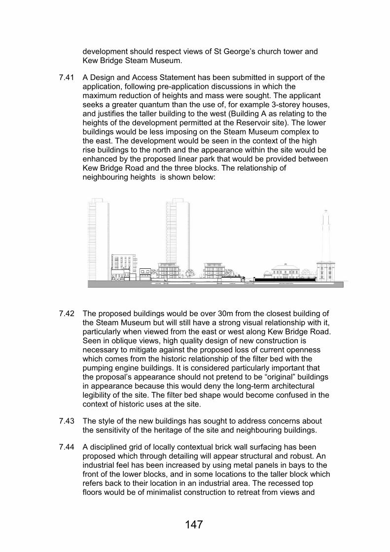
development should respect views of St George’s church tower and Kew Bridge Steam Museum.
7.41 A Design and Access Statement has been submitted in support of the application, following pre-application discussions in which the maximum reduction of heights and mass were sought. The applicant seeks a greater quantum than the use of, for example 3-storey houses, and justifies the taller building to the west (Building A as relating to the heights of the development permitted at the Reservoir site). The lower buildings would be less imposing on the Steam Museum complex to the east. The development would be seen in the context of the high rise buildings to the north and the appearance within the site would be enhanced by the proposed linear park that would be provided between Kew Bridge Road and the three blocks. The relationship of neighbouring heights is shown below:
7.42 The proposed buildings would be over 30m from the closest building of the Steam Museum but will still have a strong visual relationship with it, particularly when viewed from the east or west along Kew Bridge Road. Seen in oblique views, high quality design of new construction is necessary to mitigate against the proposed loss of current openness which comes from the historic relationship of the filter bed with the pumping engine buildings. It is considered particularly important that the proposal’s appearance should not pretend to be “original” buildings in appearance because this would deny the long-term architectural legibility of the site. The filter bed shape would become confused in the context of historic uses at the site.
7.43 The style of the new buildings has sought to address concerns about the sensitivity of the heritage of the site and neighbouring buildings.
7.44 A disciplined grid of locally contextual brick wall surfacing has been proposed which through detailing will appear structural and robust. An industrial feel has been increased by using metal panels in bays to the front of the lower blocks, and in some locations to the taller block which refers back to their location in an industrial area. The recessed top floors would be of minimalist construction to retreat from views and
147

mass. The actual materials and relationships in construction terms will be designed in more detail through condition.
7.45 Further attempts are proposed to reduce the overtly “residential” nature of the site, such as the detailed treatment of balconies. An interesting design feature would be introduced by the stack of corner balconies to the taller building, which will also add to interest for passers-by. The mass would be reduced by having only single storey link blocks between the flats. The hard and soft landscape within the filter bed would be designed in a high quality urban way, reserving grass and general greenery for the park between the filter bed and the street-side listed boundary wall. A green roof is proposed to the mews building and courtyard for disguise and interest that would have ecological attributes too.
7.46 The higher-level path through the linear park and its viewing points of the listed engine houses and steam tower are considered to be very important when approaching from the western residential areas, and the proposals have included this as a design parameter. As much enclosure as possible of the filter bed will be encouraged where this is not eliminated by the access for vehicles and pedestrians into the residential and remaining water authority areas. As a result of both these aspects and notwithstanding the application drawings, the relative levels, amount and openness of the ramped path and area north of the gatehouse be reserved by condition.
7.47 The filter bed bund structure and banks although currently in a relatively poor state of repair, partly due to works by the statutory body, and self-seeded trees, constitutes a heritage asset at the site. The brick facing would be restored and subject to detail and further consideration of the current brick perimeter wall, a steel ring would be installed around its perimeter so as to demonstrate its significance within the site and to the area.
7.48 The listed wall would be repaired and the amount of retaining soil-burden reduced although the land in this area will higher so that outward street-views remain. Two small sections of the listed southern wall would be removed to improve access in to and around the proposed linear park. This will require making good the cut ends and terminating them appropriately.
7.49 The gatehouse would be restored and altered, bringing the disused building back to use, with the interior structural rationale retained, and the roof lights and bays held for condition.
7.50 In conclusion, and subject to details of materials, finishing and landscaping being agreed, the proposal for residential-led mixed-use has been designed appropriately for a development which has to provide this amount of accommodation, and will reinstate the form and
148

enjoyable accessibility of this historic site. The design of the buildings would be acceptable and the appearance of the site and the wider Conservation Area would be enhanced.
Heritage implications
7.51 PPS5 (Planning for the Historic Environment) seeks to reconcile the need for development with the need to protect the historic environment. UDP Policy ENV-B.1.2 (High Buildings or Structures Affecting Sensitive Areas) states that planning permission will normally be refused for buildings where they would result in significant harm to sensitive areas or where they would be significantly taller than their surroundings. London Plan Policy 7.8 (Heritage Assets and Archaeology) states that development should identify, value, conserve, restore, re-use and incorporate heritage assets.
7.52 London Plan Policy 7.9 (Heritage Led Regeneration) seeks to ensure that wherever possible, heritage assets are restored and put back to use.
7.53 UDP Policy ENV-B.2.2 (Conservation Areas) states that development should preserve or enhance the character and appearance of the Conservation Area.
7.54 UDP Policy ENV-B.2.3 (Re-Use of Redundant Historic Buildings) will promote the retention of existing uses but will consider alternative uses subject to certain criteria that include the existing use not being viable.
7.55 UDP Policy ENV-B.2.7 (Alterations to Listed Buildings) states that development should preserve their special architectural and historic character, should be of a high quality and should be fully justified.
7.56 UDP Policy ENV-B.3.2 (Sites of Archaeological Importance) states that where a site is designated as an Archaeological Priority Area, a written assessment of the likely archaeological impact of the development should be submitted to demonstrate that applicants have properly assessed and planned for archaeological implications.
7.57 UDP Policy ENV-B.2.8 (Views and Landmarks) states that the Council will seek to protect local views and landmarks. Kew Bridge Pumping Station (the Campanile Tower) is identified as a local landmark.
7.58 UDP Policy ENV-W.1.1 (Design in the Thames Policy Area) states that design in this area should be of a high quality and should respect the character and surroundings in terms of scale and massing and the relationship with heritage assets.
7.59 UDP Policy ENV-W.1.3 (Important Views and Structures in the Thames Policy Area) states that development should protect important structures such as the former Metropolitan Water Board Pump House Tower (part of the Steam Museum site).
149
7.60 The development takes up the remaining adjoining space relating to the cluster of buildings now known as the Kew Bridge Steam Museum, in which the steam engines were a function of supplying water. Although L B Hounslow has a rich heritage of water related buildings and engines, a quotation from DCMS in 1999 describes the site: Built in the 19th century to supply London with water, the museum is recognised as the most important historic site of the water supply industry in Britain.
7.61 Since the 1950s three-quarters of the filter bed site has been occupied by one and two storey office buildings and an industrial shed type enclosure, related to the management of the current water business. The existing offices and the pump-house are not thought to make a positive contribution towards the appearance of the site or to the character and appearance of the Kew Bridge Conservation Area and so their removal is not considered problematic. In any event these are barely seen behind secured gates and within the bunded area. There is a wide area of sky to be seen in the same view from Kew Bridge Road as that of the historic main entrance to the first engine house.
7.62 Other approaching views from the west are influenced by trees growing on the bund wall; however it is recommended that tree planting should be restricted to places which do not reduce the heritage significance, so that the banks are clearly seen to have had a purpose.
7.63 The aspiration of the overall plan as endorsed by the BAAP etc was that a pedestrian route would be available through the current site and help to link up the musical museum and the steam museum an enjoyable landscaped route, provide recreational space and help the understanding of the place overall. The proposed landscape and treatment of the route assists this and is an improvement over the approved scheme, subject to the detail of levels and built form at the eastern end.
7.64 The historic steam museum buildings and their townscape importance are well set out and explained in the applicant’s outline history and statement of heritage significance. Most of the site is in the designated Kew Bridge Conservation Area because as a former space it used for containing and filtering water, a necessary ingredient of the success and continuation of the water business (and buildings) until the mid 20th century. The general openness is therefore a major feature of its historic character.
7.65 Nearly a quarter of the former filter bed at the western end including the western bund will continue to be fenced off for use by Thames Water. Because of its small amount of built form, this space will contribute an area of openness, however the works undertaken by the statutory authority are crude, detrimental to the historic interest and unattractive, although the continuous bund shape is still recognisable.
150

7.66 The proposed buildings would be over 30m from the Steam Museum but will still have a visual relationship with it, particularly when viewed from the east or west along Kew Bridge Road.
7.67 The filter bed bund and brick facing would be restored and a steel ring would be installed around its perimeter so as to demonstrate its significance within the site and to the area.
7.68 The gatehouse would be restored and altered, to bring the disused building back to use, though details of the implications on the building’s special architectural and historic character are to be assessed. Levels around the gatehouse would be amended and the entrance area made into a mixed use surface. The proposed north elevation of the gatehouse is shown below:
7.69 Two small sections of the listed southern wall would be removed to improve access in to and around the proposed linear park.
7.70 The applicant would carry out works to the listed Diesel House at the Steam Museum as part of any s.106 agreement. Such a proposal would require a separate listed building consent but if approved, would significantly improve facilities at that site and would acknowledge the close relationship between this site and the Steam Museum.
7.71 Views of the Steam Museum from key locations, including the Thames would not be harmed because of the height of the proposed buildings and the distance between the two sites.
Landscaping, biodiversity and open space
7.72 PPS9 (Biodiversity and Geological Conservation) seeks to ensure that biological and geological diversity is conserved.
151
7.73 PPS17 (Planning for Open Space, Sport and Recreation) encourages the retention and provision of additional open space in sustainable locations.
7.74 The proposed linear park at the south of the site would provide publically accessible open space that was required as part of the overall scheme for the wider site. A naturally landscaped area protected by way of change of level would be of benefit to Kew Bridge Road, and allow views out. The following features of that space have been proposed and could be secured by condition:
• A heritage trail;
• A sculpture trail incorporating industrial features from the Steam Museum;
• A performance square
7.75 A well designed and functional public open space in the area of the gatehouse would make a notable contribution to the appearance and functionality of the surrounding area.
7.76 A significant benefit of this development would be that it would create a publically accessible and attractive linear park at the front of the site, adjacent to Kew Bridge Road. Whilst a park would need to be created in any event (as a result of the obligations relating to the site to the west), that which is now proposed is considered to represent a significant improvement on that design.
7.77 A detailed landscaping plan has been submitted and the proper management of landscaping at the site would be secured by condition.
Standard of accommodation
7.78 PPS10 (Planning for Sustainable Waste Management) states that new developments should provide facilities that enable communities to manage their waste sustainably.
7.79 PPG24 (Planning and Noise) seeks to minimise adverse impacts caused by noise.
7.80 London Plan Policy 3.5 (Quality and Design of Housing Developments) sets out minimum size standards for new housing.
7.81 London Plan Policy 3.6 (Children and Young People’s Play and Informal Recreation Facilities) states that housing development should make provision for play and recreation space and states that the Mayor’s Supplementary Planning Guidance (Providing for Children and Young People’s Play and Informal Recreation Space) should be referred to.
152
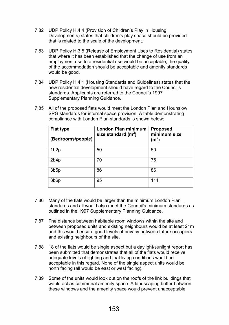
7.82 UDP Policy H.4.4 (Provision of Children’s Play in Housing Developments) states that children’s play space should be provided that is related to the scale of the development.
7.83 UDP Policy H.3.5 (Release of Employment Uses to Residential) states that where it has been established that the change of use from an employment use to a residential use would be acceptable, the quality of the accommodation should be acceptable and amenity standards would be good.
7.84 UDP Policy H.4.1 (Housing Standards and Guidelines) states that the new residential development should have regard to the Council’s standards. Applicants are referred to the Council’s 1997 Supplementary Planning Guidance.
7.85 All of the proposed flats would meet the London Plan and Hounslow SPG standards for internal space provision. A table demonstrating compliance with London Plan standards is shown below:
Flat type
(Bedrooms/people)
London Plan minimum size standard (m2)
Proposed minimum size (m2)
1b2p 50 50
2b4p 70 76
3b5p 86 86
3b6p 95 111
7.86 Many of the flats would be larger than the minimum London Plan standards and all would also meet the Council’s minimum standards as outlined in the 1997 Supplementary Planning Guidance.
7.87 The distance between habitable room windows within the site and between proposed units and existing neighbours would be at least 21m and this would ensure good levels of privacy between future occupiers and existing neighbours of the site.
7.88 18 of the flats would be single aspect but a daylight/sunlight report has been submitted that demonstrates that all of the flats would receive adequate levels of lighting and that living conditions would be acceptable in this regard. None of the single aspect units would be north facing (all would be east or west facing).
7.89 Some of the units would look out on the roofs of the link buildings that would act as communal amenity space. A landscaping buffer between these windows and the amenity space would prevent unacceptable
153
overlooking and a condition would require that these arrangements were permanently retained so as to ensure privacy.
7.90 Overall, the flats would provide a good standard of living accommodation with good outlook, sunlight and daylight. Conditions would control opening hours of the residential units so as not to create unacceptable noise and disturbance.
7.91 The total communal amenity space requirement at the site would be 1,910m2. A total of 1,771m2 would be provided and so there would be a shortfall of 139m2. However, each flat would additionally have either a private balcony or a terrace and all occupiers would have access to the public linear park (3,542m2) at the south of the site.
7.92 Children’s play space would be provided within the linear park.
7.93 Refuse and recycling would be stored internally at ground floor level and would be collected from designated collection points at the front of the buildings. These arrangements would ensure that waste and recycling was properly stored and collected in line with policy objectives.
7.94 Planning conditions would control the hours of operation of the commercial uses at the site to ensure that no harm would be caused to living conditions through noise and disturbance.
7.95 The applicant has submitted a Cultural Strategy for the site that makes a number of proposals for the site. These include public art, sculpture and a heritage trail. These would improve the relationship of the site with the Steam Museum with whitch it is historically linked and improve the enjoyment of the site as a space to live for future occupiers. A condition would ensure that the measures proposed in the Cultural Strategy were provided and retained.
7.96 The development would provide a good standard of accommodation for future occupiers.
Affordable housing and other planning obligations
7.97 London Plan Policy 3.8 (Housing Choice) states that developments should provide affordable housing.
7.98 London Plan Policy 3.11 (Affordable Housing Targets) seeks to ensure that delivery of the maximum amount of affordable housing and states that provision should be made on-site except in exceptional circumstances to help ensure mixed communities. 60% of provision should be social rented and 40% should be intermediate housing.
7.99 London Plan Policy 3.12 (Negotiating Affordable Housing on Individual Private Residential and Mixed-Use Schemes) and London Plan Policy 3.13 (Affordable Housing Thresholds) state that where sites have the
154
capacity to provide 10 or more units, the maximum, reasonable amount of affordable housing should be sought.
7.100 UDP Policy H.3.5 (Release of Employment Uses to Residential) states that where it has been established that the change of use from an employment use to a residential use would be acceptable, the maximum reasonable amount of affordable housing is provided.
7.101 The Planning Obligations Supplementary Planning Document (SPD) provides formulae to assess the potential impact of a development and obligations that can be sought to mitigate any impact.
7.102 15 units of affordable housing would be provided within Block A (two 1-bed units and one 2-bed each on three floors) and they would be within a separate core. They would all be shared ownership.
7.103 Normally, a single tenure would not be acceptable because policy objectives are to provide mixed communities. In this case, however, the relatively small scale of the development would make it much more difficult to successfully provide additional tenure types (a separate core would be required for each tenure type). A greater tenure mix would likely render the scheme less viable and reduce the amount of affordable housing provided at the site.
7.104 Whilst this provision (15 units or 20%) would be less than would normally be considered acceptable, the applicant has satisfactorily demonstrated that to provide additional affordable housing would, at this time, be financially unviable. However there would be a mechanism to secure additional contributions in the form of either additional units on site or a payment for off-site provision should the scheme become more viable in the future.
7.105 In this case, the costs associated with the sensitive nature of the site in heritage terms (the filter bed wall, the gatehouse etc) and the high specification of the proposed buildings that would be required because of the visual relationship with the Steam Museum (resulting in higher build costs) have meant that it has not been possible to meet normal affordable housing targets. The deferred payment mechanism, would though, offer security that if the scheme is more viable than currently thought in the future, the Council will benefit appropriately from this upturn in conditions.
7.106 The Council’s Housing Team are satisfied that in the context of the schemes viability and the nature of the site, this level and mix of affordable housing would be acceptable in this case, subject to the deferred payment mechanism described above.
155
Neighbouring living conditions
7.107 UDP Policy ENV-B.1.1 (New Development) states that new development should not cause unacceptable harm to the amenity of surrounding neighbours.
7.108 The location of the site, away from neighbouring houses and flats means that the development would not cause harm to living conditions elsewhere. A distance in excess of 21m would be maintained between proposed habitable room windows and those that exist to the north in the tall flat buildings.
7.109 A planning condition would control hours of construction to ensure that no unacceptable noise or disturbance would occur.
7.110 No harm would be caused by the development to living conditions at neighbouring properties.
Traffic and Parking
7.111 PPG13 (Transport) promotes sustainable forms of development and seeks to reduce reliance on private car travel, where possible.
7.112 UDP Policy H.3.5 (Release of Employment Uses to Residential) states that where it has been established that the change of use from an employment use to a residential use would be acceptable, the site should be well served by local services and transport.
7.113 UDP Policy T.1.4 (Car and Cycle Parking and Servicing Facilities in New Developments) states that parking should be provided in line with the Council’s maximum parking standards.
7.114 UDP Policy T.4.3 (Traffic Implications for New Developments) states that proposal will be assessed in terms of road safety implications and their contribution towards traffic congestion.
7.115 Policy BAAP7 (Delivering Sustainable Access) states that major developments should promote sustainable movements.
7.116 The maximum parking standard for the residential element of the proposal would be 72 spaces (including visitor spaces). 58 (including visitor spaces) would be provided (0.76 parking spaces would be provided per unit). A Transport Assessment has been submitted to justify this shortfall against the maximum standards and it is considered that it does so successfully.
7.117 In this area, the likelihood of occupiers parking off-site is slim. Public transport in the area is reasonable with links in to London and opportunities for parking off-site are very limited. Practical parking is not possible on Kew Bridge Road and parking on Green Dragon Lane is restricted. Occupiers wanting to park off-site would need to do so some distance from the site and that is not likely to be appealing.
156
7.118 Further, a Travel Plan would be submitted and secured as part of a s.106 agreement so as to reduce reliance on private cars and residents would be restricted from applying for local parking permits.
7.119 There would be a car club space and occupiers would be given 1 year’s free membership and this would be secured through a legal agreement. All of the car parking spaces would be pre-installed with electric charging points.
7.120 84 secure cycle spaces would be provided at ground floor level for the residential use and 12 for the commercial use.
7.121 Four car spaces would be provided for use by the commercial uses at the site and this would exceed the maximum standard for office uses (although the standards do note that smaller units might need to exceed the standards to meet operational need). Notwithstanding that, the inability to park in connection with the commercial elements at the site is more likely to result in potential customers leaving to travel somewhere else rather than parking inappropriately nearby.
7.122 A condition prohibiting certain uses within the use classes proposed (like day nurseries and places of worship) is recommended to ensure uses that may generate unsatisfactory levels of demand for parking are prevented.
7.123 The parking provision, when taken together with the Travel Plan, car club space and membership and cycle parking provision and the public transport links are considered to be acceptable here and would not result in unacceptable or dangerous on-street parking.
7.124 Whilst there would be no formal servicing arrangements (although the visitor car parking spaces could be utilised if not in use), the open/shared space at the south of the site could easily be used for collection and deliveries. A swept path diagram has been submitted that shows that large vehicles (like waste collection vehicles) could enter, turn and leave the site safely. These arrangements would be acceptable. The Council’s Waste and Recycling team are also satisfied with the proposed arrangements.
7.125 The traffic statement submitted with the application demonstrates that the total number of trips generated by the site would be 44 in the morning peak and 42 in the evening peak. This volume can be accommodated on the local road network.
7.126 The existing access to the site would be retained for vehicular access and additional pedestrian access would be provided through the linear park at the front of the site.
157
Sustainability
7.127 The supplement to PPS1 (Planning and Climate Change) promotes the delivery of sustainable development through, for example, the provision of decentralised and renewable low-carbon energy sources and achieving Code for Sustainable Homes.
7.128 PPS22 (Renewable Energy) seeks to ensure that reliance on fossil fuels is reduced.
7.129 London Plan Policy 5.2 (Minimising Carbon Dioxide Emissions) states that new development like that proposed should demonstrate a 25% improvement against the Building Regulations (2010).
7.130 BAAP Policy BAAP1 (Sustainable Development) sets out the sustainability objectives for new development in Brentford.
7.131 The applicant has demonstrated that the development would achieve an improvement of 28% above the Building Regulations (2010) through sustainable construction methods and photovoltaic panels and a planning condition would ensure that these measures were implemented and permanently maintained.
7.132 All of the units would achieve Code for Sustainable Homes Level 4 through a range of energy efficiency, carbon reduction and other measures.
7.133 It is considered that the development would meet the Mayor’s sustainability objectives and those of the BAAP.
Flood risk
7.134 PPS25 (Development and Flood Risk) seeks to ensure that flood risk is taken into account at all stages of the planning process.
7.135 A Flood Risk Assessment has been submitted and the Environment Agency are satisfied that the development would not result in an unacceptable flood risk subject to compliance with conditions, that are recommended.
Land and air quality
7.136 The Air Quality Supplementary Planning Document (2008) outlines when it might be necessary to provide an Air Quality Assessment as part of a planning application.
7.137 An Air Quality Assessment and a Land Contamination Desk Based Assessment have been submitted. It is considered that no harm would be caused to local air quality as a result of the development because of the limited additional occupiers that would be brought to the area and the limited number of cars associated with the use. A condition
158
requiring compliance with the recommendations made in the submitted Land Contamination Desk Based Assessment is recommended.
7.138 Subject to these conditions, no harm would be caused to air or land quality by the development.
Planning Obligations
7.139 UDP policy IMP6.1 states that the Council will seek to ensure that a developer enters into a planning obligation to secure planning benefits related to the proposed development. A payment or other benefit offered pursuant to a section 106 agreement is not material to a decision to grant planning permission and cannot be required unless it complies with the provisions of the Community Infrastructure Levy Regulations 2010 (regulation 122), which provide that the planning obligation must be:
• (a) necessary to make the development acceptable in planning terms;
• (b) directly related to the development; and
• (c) fairly and reasonably related in scale and kind to the development.
Accordingly, it is mandatory that each criterion be satisfactorily addressed prior to granting planning permission subject to a section 106 agreement.
7.140 Government Circular 05/2005 provides guidance on the use of planning obligations, which may impose a restriction or requirement, or provide for payment of money from the developer to make acceptable development proposals that might otherwise be unacceptable in planning terms. The Council’s Supplementary Planning Document on Planning Obligations (which was adopted in March 2008) contains guidance on the imposition of planning obligations in compliance with Circular 05/2005. These obligations may offset shortfalls in the scheme or mitigate the impacts of the development.
7.141 The applicant has submitted the following draft Heads of Terms which would provide the following:
• A sum of £134,036 towards education provision in the Borough.
• A sum of £76,319 towards health provision in the Borough.
• A sum of £25,000 towards transport and highways works within the Borough.
• The submission of and compliance with a Travel Plan.
159
• Electric car charging points.
• Public Art within the site.
• The provision of a car club space and 1 year’s free membership for the first occupier of each unit.
• The provision and upkeep of a publically accessible linear park at the south of the site.
• Obtaining Listed Building Consent for and carrying out the re-cladding of the Diesel House at the Steam Museum.
• Construction Training
7.142 The contributions towards health and education would adequately meet the sums set out in the Council’s Planning Obligations SPD so as to mitigate the impacts of the development on local infrastructure. The other obligations appropriately mitigated other impacts of the scheme.
The Steam Museum
7.143 The applicant, in conjunction with the operators of the Steam Museum have identified that re-cladding work to the Diesel House is the main priority for the operators of the Steam Museum. The works would represent a significant financial commitment for the Steam Museum.
7.144 As part of a legal agreement, the applicant would carry out this work. Whilst not essential maintenance work, the cladding would improve the appearance of the site and would allow for the Steam Museum to direct its resources in to other areas.
7.145 In carrying out this work, the applicant would be recognising the close historic and visual relationship between the application site and the Steam Museum. The works would help to establish the long term sustainability of the Steam Museum by freeing up resources that would have been spent on the recladding work.
7.146 The legal agreement associated with application reference 00657/B/P15 (dated 31/08/2001 and varied in 2006 and 2011) and any associated grants of reserved matters or details pursuant to conditions would need to be varied to remove the obligations that would prevent compatibility with elements of these proposals.
8.0 EQUALITIES DUTIES IMPLICATIONS
8.1 The Council has had due regard to its Equalities Duties and in particular with respect to its duties arising pursuant to the Disability Discrimination Act 1995, s.49A, the Race Relations Act 1976, s.71 and the Sex Discrimination Act 1975, s.76A. Following a relevance test, which is available
160
at:http://www.hounslow.gov.uk/index/council_and_democracy/equality/eias/environment_eias.htm it is considered that there will be no specific implications with regard to the council’s duty in respect of equalities duties and that if approving or refusing this proposal the Council will be acting in compliance with its duties.
Relevant Section of Relevance Test
Major development
9.0 RECOMMENDATION A
9.1 (00657/B/P21): That planning permission be granted for the demolition of all unlisted buildings and structures, removal of some of the trees, restoration and alteration of the filter bed tanks and the construction of 3 buildings (A,B and C) to provide 76 residential units (including affordable housing) and a total of 526 square metres (GIA) of commercial floorspace distributed on the ground floor of buildings B & C [use classes B1(a)/B1(b)/D1/D2 only]; in a purpose-built single storey commercial building for use classes B1(a)/B1(b)/B1(c) only and the refurbishment of the existing listed Gatehouse for use classes A1/A3/B1(a)/B1(b) only, together with associated private and communal amenity space, car, motorcycle and cycle parking, refuse/recycling storage and means of access and servicing and the provision of a linear park and soft and hard landscaping works including the alteration and restoration of the existing filter bed banks and alterations to the existing southern listed boundary wall to create pedestrian connections subject to the following conditions and securing the above mentioned planning obligations and any necessary variation of existing oblifgations by the prior completion of a satisfactory legal agreement or unilateral undertaking made under Section 106 of the Town and Country Planning Act 1990 and or other appropriate legislation, the exact terms of which shall be negotiated by appropriate officers within the Department of Environment on the advice of the Borough Solicitor.
9.2 The satisfactory legal agreement or unilateral undertaking outlined above shall be completed and planning permission issued by 09/05/2012 or such extended period as may be agreed in writing by appropriate officers with the Department of Environment or Borough Solicitor’s Officer.
9.3 If the legal agreement is not completed by the date specified above (or any agreed extended period), then the Director of Environment or Divisional Head of Regulatory & Development Services be authorised to refuse planning permission for the reason that the proposal should include planning obligations required to make the development acceptable in planning terms in accordance with Circular 05/05, relevant policies in the development plan and the Planning Obligations SPD, as described in this report.
161
9.4 If planning permission is refused (for the reasons set out above), the Director of Environment or Divisional Head of Regulatory & Development Services (in consultation with the Chair of the Sustainable Development Committee) is hereby authorised to approve any further application for planning permission validated within 12 months of the date of refusal of planning permission, provided that it (a) duplicates the planning application, and (b) that there has not been any material change in circumstances the relevant planning considerations, and (c) that a satisfactory legal agreement or unilateral undertaking securing the obligations set out in the report is completed within any specified period of time.
Reason:
Subject to conditions and a legal agreement, the development would cause no harm to the appearance of the site, would preserve the character and appearance of the Conservation Area, would cause no harm to the setting of listed buildings or cause harm to listed buildings at the site, would cause no harm to living conditions at neighbouring properties, would not result in an unacceptable loss of employment floor space, would represent appropriate mixed use development at the site, would not undermine the retail function of Brentford Town Centre, would not result in unacceptable levels of off-site parking, would not harm the safe and free flow of pedestrian and vehicular traffic, would provide an acceptable mix and standard of housing including affordable housing, would meet the Mayor’s sustainability objectives, would cause no harm to air or land quality or increase the risk of flooding and would not place unmitigated pressure on local infrastructure. The development would be in accordance with national planning policy, London Plan policies 3.1 Ensuring equal life changes for all, 3.2 Improving health and addressing health inequalities, 3.3 Increasing housing supply, 3.4 Optimising housing potential, 3.5 Quality and design of housing developments, 3.6 Children and young people’s play , 3.8 Housing Choice, 3.10 Definition of affordable housing, 3.11 Affordable housing targets, 3.12 Negotiating affordable housing, 3.13 Affordable housing thresholds, 4.1 Developing London’s economy , 4.2 Offices, 4.3 Mixed use development and offices, 4.4 Managing industrial land and premises, 4.6 Arts, culture, sport and entertainment, 4.7 Retail and town centre development, 4.8 Supporting a diverse retail sector, 4.9 Small shops, 4.12 Improving opportunities for all, 5.1 Climate change mitigation, 5.2 Minimising carbon dioxide emissions, 5.3 Sustainable design and construction, 5.6 Decentralised energy in development proposals, 5.7 Renewable energy , 5.8 Innovative energy technologies , 5.9 Overheating and cooling , 5.10 Urban Greening, 5.11 Green roofs and development site environs, 5.12 Flood risk management, 5.13 Sustainable drainage, 5.15 Water use and supplies, 5.21 Contaminated land, 6.1 Strategic approach, 6.3
162
Assessing effects of development on transport capacity, 6.9 Cycling, 6.10 Walking, 6.13 Parking, 7.1 Building London’s neighbourhoods and communities, 7.2 An inclusive environment, 7.3 Designing out crime, 7.4 Local character, 7.5 Public realm, 7.6 Architecture, 7.8 Heritage assets and archaeology, 7.9 Heritage led regeneration , 7.13 Safety, security and resilience to emergency, 7.14 Improving air quality, 7.15 Reducing noise and enhancing soundscapes, 8.1 Implementation and 8.2 Planning obligations and the Mayors Supplementary Planning Guidance Providing for Children and Young People’s Play and Informal Recreation Supplementary Planning Guidance (2008), Mayor’s Housing Supplementary Planning Guidance (2008) and Mayor’s Draft Revised Interim Housing Supplementary Planning Guidance (2009), Unitary Development Plan Policies IMP1.1 Integrating patterns of land use and the provision of transport, IMP1.2 The re-use and recycling of urban land and buildings, IMP6.1 Planning obligations, ENV-B.1.1 New development, ENV-B.1.2 High buildings or structures affecting sensitive areas, ENV-B.1.9 Safety and Security, ENV-B.2.2 Conservation Areas, ENV-B.2.3 Reuse of redundant historic buildings, ENV-B.2.7 Alterations to listed buildings , ENV-B.2.8 Views and landmarks, ENV-B.3.2 Sites of archaeological importance, ENV-P.1.1 Environmental sustainability, ENV-P.1.2 Water pollution and water quality, ENV-P.1.3 Surface water runoff , ENVP.1.4 Waste water management, ENV-P.1.5 Noise pollution, ENV-P.1.6 Air pollution, ENV-P.1.7 Light pollution, ENV-P.2.1 Waste management, ENV-P.2.4 Recycling facilities in new development, H.3.5 Release of employment uses to residential, H.4.1 Housing standards and guidelines, H.4.4 Provision of children’s play, H.4.5 Associated facilities for residential developments, ENV- N.1.10 Provision of new local open space, T.1.2 The movement implications of development, T.1.4 Car and cycle parking and servicing facilities, T.2.1 Pedestrian access, T.2.2 Pedestrian safety and security, T.2.4 Public transport infrastructure, T.4.3 Traffic implications of new development, T.4.4 Road safety, T.4.5 On-street parking, T.5.2 Reducing traffic nuisance , T.5.3 Vehicle crossovers and hardstandings , ENV-W.1.1 Design in the Thames Policy Area, ENV-W.1.2 Mixed uses in the Thames Policy Area, ENV-W.1.3 Important views and structures in the Thames Policy Area, Employment Development Plan Document Policies EP1 Location of new office based employment, EP4 Change of use from offices (outside Town Centres) , EP9 Small and medium sized enterprises, Brentford Area Action Plan Policies BAAP1 Sustainable Development, BAAP2 Urban Design, BAAP6 Large scale art, cultural, entertainment and leisure and BAAP7 Delivering sustainable access and the Council’s 1997 Supplementary Planning Guidance.
Conditions and informatives are as Appendix 3.
163
9.5 RECOMMENDATION B
9.6 (00657/B/CA1): That Conservation Area Consent for the demolition of all unlisted buildings at the site be granted following reason:
Reason:
Subject to safeguarding conditions, the demolition of all unlisted buildings at the site would cause preserve the character and appearance of the Conservation Area and there is a scheme in place for the redevelopment of the site after the demolition. The development would be in accordance with Unitary Development Plan Policies ENV-B.1.1 New Development and ENV-B.2.2 Conservation Areas.
Conditions and informatives are as Appendix 3.
9.7 RECOMMENDATION C
9.8 (00657/B/L22): That Listed Building Consent for alterations relating to the refurbishment of the existing Gate House and southern boundary wall and removal of part of the southern filter bed bank, construction of the "Mews" building and associated facilities and landscaping works be granted for the following reason:
Reason:
Subject to appropriate safeguarding conditions and The Alterations relating to the refurbishment of the existing Gate House and southern boundary wall and removal of part of the southern filter bed bank, construction of the "Mews" building and associated facilities and landscaping works would cause no harm to listed buildings at the site and would cause no harm to the setting of nearby listed building. The development would be in accordance with London Plan Policies 7.8 Heritage assets and archaeology and , 7.9 Heritage led regeneration and Unitary Development Plan Policies ENV-B.2.3 Reuse of redundant historic buildings and ENV-B.2.7 Alterations to listed buildings.
Conditions and informatives are as Appendix 3.
Background Papers:
The contents of files referenced on the front page of this report and 00657/B/P15, save for exempt or confidential information as defined in the Local Government Act 1972, Sch. 12A Parts 1 and 2
164
Appendix 1 – Policy 9.9 National Policy
PPS1 Delivering Sustainable Development
Planning and Climate Chance (supplement to PPS1)
PPS3 Housing
PPS4 Planning for Sustainable Economic Growth
PPS5
PPS9
Planning for the Historic Environment
Biodiversity and Geological Conservation
PPG13
PPG17
PPS22
PPS23
PPG24
PPS25
Transport
Planning for Open Space, Sport and Recreation
Renewable Energy
Planning and Pollution Control
Planning and Noise
Flooding
9.10 The London Plan
Chapter 3: London’s People
3.1 Ensuring equal life changes for all
3.2 Improving health and addressing health inequalities
3.3 Increasing housing supply
3.4 Optimising housing potential
3.5
3.6
3.8
3.10
3.11
3.12
Quality and design of housing developments
Children and young people’s play
Housing Choice
Definition of affordable housing
Affordable housing targets
Negotiating affordable housing
165
3.13 Affordable housing thresholds
Chapter 4: London’s Economy
4.1 Developing London’s economy
4.2 Offices
4.3 Mixed use development and offices
4.4 Managing industrial land and premises
4.6
4.7
4.8
4.9
4.12
Arts, culture, sport and entertainment
Retail and town centre development
Supporting a diverse retail sector
Small shops
Improving opportunities for all
Chapter 5: London’s Response to Climate Change
5.1 Climate change mitigation
5.2 Minimising carbon dioxide emissions
5.3 Sustainable design and construction
5.6 Decentralised energy in development proposals
5.7
5.8
5.9
5.10
5.11
5.12
5.13
5.15
5.21
Renewable energy
Innovative energy technologies
Overheating and cooling
Urban Greening
Green roofs and development site environs
Flood risk management
Sustainable drainage
Water use and supplies
Contaminated land
Chapter 6: London’s Transport
6.1 Strategic approach
166
6.3 Assessing effects of development on transport capacity
6.9 Cycling
6.10
6.13
Walking
Parking
Chapter 7: London’s Living Places and Spaces
7.1 Building London’s neighbourhoods and communities
7.2 An inclusive environment
7.3 Designing out crime
7.4
7.5
7.6
7.8
7.9
7.13
7.14
7.15
Local character
Public realm
Architecture
Heritage assets and archaeology
Heritage led regeneration
Safety, security and resilience to emergency
Improving air quality
Reducing noise and enhancing soundscapes
Chapter 8: Implementation, Monitoring and Review
8.1 Implementation
8.2 Planning obligations
London Plan Supplementary Planning Guidance
• Providing for Children and Young People’s Play and Informal Recreation Supplementary Planning Guidance (2008)
• Mayor’s Housing Supplementary Planning Guidance (2008)
• Mayor’s Draft Revised Interim Housing Supplementary Planning Guidance (2009)
9.11 Unitary Development Plan
Implementation
167

IMP1.1 Integrating patterns of land use and the provision of transport
IMP1.2
IMP6.1
The re-use and recycling of urban land and buildings
Planning obligations
Built Environment
ENV-B.1.1
ENV-B.1.2
New development
High buildings or structures affecting sensitive areas
ENV-B.1.9
ENV-B.2.2
ENV-B.2.3
ENV-B.2.7
ENV-B.2.8
ENV-B.3.2
Safety and Security
Conservation Areas
Reuse of redundant historic buildings
Alterations to listed buildings
Views and landmarks
Sites of archaeological importance
Environmental Protection
ENV-P.1.1 Environmental sustainability
ENV-P.1.2
ENV-P.1.3
ENVP.1.4
ENV-P.1.5
ENV-P.1.6
ENV-P.1.7
ENV-P.2.1
ENV-P.2.4
Water pollution and water quality
Surface water runoff
Waste water management
Noise pollution
Air pollution
Light pollution
Waste management
Recycling facilities in new development
Housing
H.3.5 Release of employment uses to residential
H.4.1
H.4.4
Housing standards and guidelines
Provision of children’s play
168
H.4.5 Associated facilities for residential developments
Natural Environment
ENV- N.1.10 Provision of new local open space
Transport
T.1.2 The movement implications of development
T.1.4
T.2.1
T.2.2
T.2.4
T.4.3
T.4.4
T.4.5
T.5.2
T.5.3
Car and cycle parking and servicing facilities
Pedestrian access
Pedestrian safety and security
Public transport infrastructure
Traffic implications of new development
Road safety
On-street parking
Reducing traffic nuisance
Vehicle crossovers and hardstandings
Waterways
ENV-W.1.1
ENV-W.1.2
ENV-W.1.3
Design in the Thames Policy Area
Mixed uses in the Thames Policy Area
Important views and structures in the Thames Policy Area
Other Local Policies and Guidelines
9.12 Employment Development Plan Document (EDPD)
EP1
EP4
EP9
Location of new office based employment
Change of use from offices (outside Town Centres)
Small and medium sized enterprises
9.13 Brentford Area Action Plan (BAAP)
BAAP1 Sustainable Development
169

BAAP2
BAAP6
BAAP7
Urban Design
Large scale art, cultural, entertainment and leisure
Delivering sustainable access
9.14 Unitary Development Plan Supplementary Planning Guidance (1997)
Section 9
Section 10
Section 12
Form and Design
Private Amenity Space
Internal Space Provision
170
1 to
3
El Sub Sta4 to 11
Playground
38
49
31
PE
GA
SU
S C
OU
RT
441
House
46
43
6
9
30
TIT
AN
CO
UR
T
Fraser
GREEN DRAGON LANE
41
1 to 88
10
1
Boro Const & LB Bdy
Def
Steps
Victoria
HIGH STREET
Playground
Mooring Posts
Mud and Shingle
Mean High Water
Posts
1
10.4m
9.8m
88
Sub Sta
Pumping
Tanks
Wicksteed House
Sloping masonry
TkKew Bridge
to
Steam
7.6
m
SM
El
Museum
Station
LB
4 to 6
The Hollows
1
Gas Valve
15 to 20
Regatta Point
410
8.5m
406
57
8.2m
41
411
3 to 5
PH
42
3.7m
58
Works
1 to 15
Compound
38
408
3
1 to 35
6
2
SM
43
to8
Mooring Posts
7.0m
37 to 58
Shaft
KEW BRIDGE ROAD
MH & MLW
Mean High Water
THAMES WATER LAND AT KEW BRIDGE ROAD, BRENTFORD.
c Crown copyright. All rights reserved 100019263 2011
Drawn by: S.C. Scale Date 04 - 11 - 2011 O.S. Reference - TQ1878SE1/1250
Director of Environment,The Civic Centre, Lampton Road, Hounslow, TW3 4DN
London Borough of HounslowMike Jordan
171

Sustainable Development Committee
9th February 2012
Stephen Hissett e-mail: [email protected]
Agenda Item 9
172

References: P/2011/2887 00610/BB/P1
Address: 26a-34 and 44-52 High Street, Hounslow
Ward: Hounslow Central
Proposal: Redevelopment of 44-52 High Street comprising construction of a nine-storey building with retail at ground floor and 61 flats above; and development 26a-34 High Street to provide 40 residential units by conversion of the public house use at ground level and the offices and ancillary residential accommodation on the first and second floors and construction of two additional floors; together with the provision of rear servicing to both sites from Cecil Road.
Drawing numbers: AL (00) 01, AL (00) 02, AL (00) 03, AL (00) 04, AL (00) 05, AL (00) 06, AL (00) 09, AL (00) 10, AL (00) 11, AL (00) 12, AL (00) 13, AL (00) 14, AL (00) 15, AL (00) 16, AL (00) 17, AL (00) 18, AL (00) 19, AL (00) 20, AL (00) 21, AL (00) 30, AL (00) 31, AL (00) 32, AL (00) 33, AL (00) 34, AL (00) 35, AL (00) 36, AL (00) 37, AL (00) 40, AL (00) 41, AL (00) 42 AL (01) 01, AL (01) 02, AL (01) 04, AL (01) 06, AL (01) 08, AL (01) 10 AL (02) 01, AL (02) 02 Internal Daylight & Sunlight Report (October 03, 2011), Ecological Assessment (September 2011), Air Quality Assessment (28th September 2011), Sustainability Statement and Energy Strategy Report (Issue 3 – 03.10.11), Transport Statement (September 2011), Statement of Travel Plan Initiatives (September 2011), Design & Access Statement (September 2011), Planning Statement (October 2011), Hounslow: Retail Capacity Study (September 2011), Environmental Noise Survey and PPG24 Assessment (2 September 2011), Daylight, Sunlight and Overshadowing (3rd October 2011), Arboricultural Impact Assessment (October 2011) Received 30/09/2011
Application received: 30/09/2011
1.0 SUMMARY
1.1 The proposal comprises the re-development of two sites at the eastern end of Hounslow High Street to provide a combined 101 residential units at first floor and above and 1318m2 of retail floor space at ground floor level. Of the
173
101 residential units, 52 (51%) would be 1-bedroom, 39 (39%) 2-bedroom and 10 (10%) 3-bedroom. The scheme proposes 69% affordable housing (58% social rent and 42% shared ownership), will significantly improve the design quality of Hounslow High Street and includes a package of s106 obligations. Associated amenity/play space would be provided around an open courtyard positioned at first floor level. Access and servicing for the sites would be from the rear via Cecil Road.
1.2 It is considered that on balance the proposal would be in accordance with the adopted Unitary Development Plan (UDP) policies and Supplementary Planning Guidance and the London Plan. The development would be located within the Hounslow town centre boundary and would be an appropriate development in this location taking into consideration the existing site characteristics and the surrounding area in general and the aspirations for Hounslow Town Centre. The proposed quantum and mix of housing would be appropriate for the site and its location and the level of affordable housing provision would be acceptable. The design, height and massing of the development would reflect the town centre location of the site and provide a high-quality, well-designed development on the high street. Parking provision would be in accordance with the Development Plan policies and pay close regard to the high accessibility level of this site within the town centre. In light of the above the application is recommended for approval.
2.0 SITE DESCRIPTION 2.1 The application site consists of two sites towards the eastern end of
Hounslow High Street; 44-52 (Site 1, the westernmost) and 26a-34 (Site 2, the easternmost). The two sites are separated by four properties; 36-42. Both sites are located on the northern side of the High Street and are flat parcels of land.
2.2 The sites are within the area designated as Hounslow Town Centre in the
Unitary Development Plan (UDP) and are located within the secondary shopping frontage of the town centre boundary. The sites have a Public Transport Accessibility Level (PTAL) of 6b, which is described as ‘Excellent’ and are located approximately 50-100m to the west of Hounslow Bus Garage and some 300-350m from Hounslow East Underground station.
2.3 The existing buildings on Site 1 consist of a row of derelict, former early
twentieth century but modified terraced properties, and associated outbuildings/yards, with a large undeveloped area behind. The buildings are currently vacant and have been for some time; one has been demolished. The “garden” has a number of self-sown trees. Part of the site is allocated within the Hounslow Council’s Proposals Map as an area suitable for mixed use development. The rear of the site is half bounded by a private car-park and half-bounded by a Council owned car park, accessed off Prince Regent/Cecil Roads. The western side of the site is bounded by a large four-storey building (Europa House) consisting of retail at ground floor with offices on the upper floors; this building is now the end of the block. A narrower, tall-single-storey projection extends along the site boundary and nearly to Prince Regent Road at the rear.
174
2.4 Between sites 1 and 2 the four properties comprise small buildings each side of a central pair of larger but still domestic-sized buildings which were jointly re-fronted in the 1920s. The westernmost number 42 is in a state of disrepair. The central pair are of retail units with residential/offices above. The eastern unit is the smallest, occupied by an estate agent’s office with solicitor’s office above. All have long gardens which include trees.
2.5 Site 2 presently consists of a later 20th Century building that was purpose-
designed and has been occupied by a mix of retail uses and a public house at ground floor level and offices at first and second floor that are currently vacant. The remainder of the site is occupied by an open car park to the rear and is bounded at the north of this car park by properties that front Cecil Road. The eastern boundary of the site is bounded by gardens of the properties fronting Kingsley Road; these consist of a mixture of commercial uses at ground floor with predominantly residential above.
2.6 On the opposing (south) side of the High Street is a large, converted office
building, known as Madison Heights, which now provides residential accommodation over eight floors over a longer, two storey podium comprising retail at ground floor and ancillary offices/storage above. The surrounding area is dominated by retail/commercial uses at ground floor, with a mixture of uses at first floor, but predominantly consisting of residential and office uses. There is a varied building style and building heights along this length of the High Street, with no uniform design or appearance and numerous in-fill developments. The impacts of the design on existing and proposed townscape are considered later.
3.0 HISTORY
Site 1 3.1 44 High Street
Installation of new shop front
Approved 05/02/1958
Use of premises as employment office
Refused 14/12/1976
Installation of new shop front and use of part ground retail as employment agency office and enclosure of part rear yard
Approved 27/07/1982
3.2 44-52 High Street Demolition of existing buildings, erection of four-storey building comprising ground floor shop with offices over and construction of car park at rear Refused 25/08/1982
175
Demolition of existing buildings, erection of four-storey building comprising ground floor shop with offices over and construction of car park at rear Approved 18/11/1983
3.3 44-48 High Street Demolition of existing building and erection of three-storey building comprising retail and ancillary accommodation Refused 22/09/1986
3.4 46 High Street Demolition of existing retail unit Approved 02/11/2000
3.5 46-48 High Street Change of use from retail shop to restaurant Refused 01/05/2001
3.6 47 High Street Installation of illuminated fascia sign, illuminated projecting sign and traditional pawnbroker’s balls sign Advert Approved 12/11/2010
3.7 47 High Street Installation of a replacement shop front and security roller shutter Approved 16/11/2010
Site 2
3.8 29 High Street Change of use of the premises from A1 use (shop) to A3 use (café) including installation of a kitchen extract duct on the rear elevation Approved 20/05/2011
4.0 DETAILS
4.1 The proposal comprises the re-development of two sites at the eastern end of Hounslow High Street to provide a combined 101 residential units at first
176

floor and above and 1318m2 of retail floor space at ground floor level. The proposed uses can be broken down in the following table:
Use Existing Proposed
Retail 757.98m2 1318m2
Pub 308.08m2 0
Office 1440.7 0
Residential 0 101 units
4.2 The following residential breakdown is to be provided:
Tenure 1 bed 2 bed 3 bed Total
Social Rented
10 21 9 40 (40%)
Intermediate affordable
23 5 1 29 (29%)
Private 19 13 0 32 (32%)
Totals 52 (52%) 39 (39%) 10 (10%) 101
4.3 Site 2 (eastern site)
4.4 The structure of the existing three-storey building will be retained, refurbished and extended for residential use. The existing retail provision at ground floor will be maintained. The existing public house will be converted into retail space as permitted development under the Use Classes Order 2005 and there will be no external alterations to the premises at ground floor level. Any new signage will be applied for separately to this application.
4.5 Additional accommodation will be created at third and fourth floor levels, following similar building lines to the existing building, but with a set-back at fourth floor level (fifth storey). A rearward projection would be added to the existing building, extending northwards (approximately 26.5m) from the rear elevation with a width of 16.6m. The rear elevation would be some 10m from the rear boundary of the properties fronting Cecil Road (approximately 27.5m from the rear elevations of these properties). The flank elevation of this new addition would be some 14m from the rear boundary of the properties fronting Kingsley Road. The addition would also be five-storeys in height and have similar design principles to that used on the frontage.
4.6 Amenity space is to be provided in the form of a communal roof garden and flats will be provided with private balconies.
177
4.7 The residential units would be accessed via a staircase and lift from dedicated secure entrances off the High Street and from the rear of the building. All residential units and roof garden would be capable of being used by disabled persons and have been designed to meet ‘Lifetime Homes’ standards.
4.8 The site would be serviced from the rear via an access from Cecil Road as existing. Refuse storage would be contained to the rear of the building, being accessed by residents via the rear entrance. Secure cycle storage would be within the buildings and accessed via the cores which immediately access the High Street frontage or those at the rear. A secure access way would be provided from the High Street to the disabled-user car park at the rear of this site.
4.9 Site 1 (western site)
4.10 The proposed new building would replace the existing, derelict buildings on site. It would consist of a nine-storey building fronting the High Street, with retail uses at ground floor and eight floors of residential above. A seven-storey building is proposed to the rear, being six storeys of residential over the retail space. This would be separated from the larger building at the front by an amenity/play space located on a deck over the ground floor retail uses. Further communal amenity space is to be provided at roof level on the rear building, with all flats benefitting from private zones or balconies where this can be achieved without undue detriment to daylight.
4.11 The building would be constructed in a varied palette of materials, comprising predominantly brick to the exterior facing elevations, with different texture and colours to add interest to the High Street frontage. A combination of lighter masonry and timber cladding is to be used at the upper levels and interior facing elevations to give a more lightweight appearance in particular to the top of the building seen from the High Street.
4.12 The materials used for the redevelopment of Sites 1 and 2 will be similar. The design of the front elevations is intended to present a varied but coherent frontage to the High Street, using a strong bay-rhythm through projecting elements and changes in materials to integrate the varying buildings and heights to the appearance of this part of the High Street. The design ethos was to design the two buildings separately, but with aspects that link the two, i.e. materials, massing treatment and details. Projecting bays emphasise the retail ground floor level beneath, and provide more amenity and privacy to the lower residential units than would open balconies. Higher up the in-set balconies and recessed frontage echo the overall stepped form of buildings along this part of the High Street and reduce the impact on the street scene. It is intended that gable ends would be in brick, with colour and texture relief.
4.13 Refuse storage is again provided at ground floor level to the rear of the new retail space and will be accessed by residents via an external pathway along the western boundary of the site. Servicing will again take place to the rear of the site via a shared access route with Site 2.
4.14 The proposal would provide a total of 10 parking bays for disabled users related to the development. These would be located to the rear of Site 2. The
178
existing Council owned 30-space car park to the rear of Site 1 would be retained although altered and reduced in area to provide a pedestrian route to the rear of Site 1 from Cecil Road, rear servicing of Site 1 and tree planting. After modifications to the layout this area would provide 18 public car parking spaces. The Council have negotiated an agreement with the developer for the loss of these parking spaces, with the intention of granting a permanent, non-exclusive right of access over this new access way to the developer and their successors in title for the passage of pedestrians and service vehicles.
5.0 CONSULTATION 5.1 A site notice was displayed on the 26/10/2011. A press notice appeared in
the local paper on the 28th October 2011. 5.2 273 neighbouring residents/businesses were notified of the application on the
19/10/2011. The following external consultations were also undertaken:
− Transport for London
− English Heritage
− Primary Care Trust
− Metropolitan Police
− Environment Agency 5.3 Three objections have been received. These are detailed as follows:
Comments Response
Overlooking – majority or new units will directly overlook rear gardens and windows of neighbouring properties. Roof gardens a particular concern
All habitable room windows have been positioned a minimum 21m from directly opposite habitable room windows. Separation distances between the proposed buildings and neighbouring properties (min. 26m to properties to the north and approx. 23-29m to properties to the east) would be sufficient to minimise any potential overlooking.
Traffic – level of additional traffic along Cecil Road and accessing the site from the rear is concerning. Additional traffic will increase danger to pedestrians, increase pollution and increase volume of noise
It is not anticipated the proposal would significantly increase vehicle movements to the site than would be expected if the site was used to its full potential at present as only ten car parking spaces for disabled users are provided on site and delivery and service vehicles would be restricted as part of a delivery and service plan by condition.
179
Parking – insufficient levels of parking for the proposed development coupled with a reduction in spaces of the public car park and the existing parking pressures in the area
The proposal would provide ten parking spaces for disabled-users. The site is located within the Town Centre with excellent public transport links and a Controlled Parking Zone. Residents would be prevented from obtaining parking permits by a legal agreement so would not be able to park on surrounding roads.
Loss of light – possibility the size/height of the development will result in a loss of light to neighbouring residential properties
A full daylight, sunlight and overshadowing report has been submitted and indicates the proposed development would not unacceptably overshadow neighbouring residential properties.
Access to the rear of existing properties – loss of a right of way to the rear gardens of properties fronting Cecil Road unacceptable
This would not be a planning consideration. The proposed development would be undertaken within the boundaries of the developer’s ownership and the Council’s car park as agreed.
Visual appearance – the greater height and closer proximity of the development to neighbouring properties is a concern and would not overcome an attractive design
The proposed height and position of the development is appropriate to the site’s location in the town centre. The separating distances, changes in height and elevational treatment would ensure the proposal would not appear overbearing for residents.
Construction logistics – during the construction of the development there will be increased noise, traffic and pollution that will be an unacceptable disruption to resident’s day to day lives
Construction work is a necessary consequence of development. Conditions will be imposed to restrict the hours of demolition and construction and minimise the impact on neighbouring residents.
Volume of social rent housing – high volume proposed would unreasonably affect the demographics of the surrounding areas and would result in a fall in property values and an increase in the risk of unlawful behaviour
Changes in property value are not a planning consideration. There is a high demand for affordable housing within Hounslow and the proposed development would go someway to meeting this demand.
Extension to site 1 – the extension would bring the proximity of the
The proposed height and position of the development is appropriate
180

new buildings much closer to existing residential properties and would be unacceptable
to the site’s location in the town centre. The separating distances, changes in height and elevational treatment would ensure the proposal would not appear overbearing for residents.
Impact on ICT infrastructure – the height of the development will impact upon television reception and mobile phone signal
This would not be a planning consideration.
Previous redevelopments have harmed the character of Cecil Road and its residential nature and this new development will only make the situation worse
Whilst it is noted the proposed development would be greater in height and mass than existing buildings around the site it is considered it would be appropriate given the site’s location within the town centre and would pay close regard to the scale and position of neighbouring developments.
5.4 The proposal was presented to the Central Area Committee on the 17th
November 2011. Members made the following comments:
− Concerned that the low-rise buildings in the middle of the development, outside the developer’s ownership, would be dominated by the higher buildings around it - the proposal must be assessed on its own merits and the properties between the two proposal sites are outside the developer’s ownership. The proposal has been designed so as not to prejudice future development on this site. It has been demonstrated within the application that detailed plans for a policy compliant scheme for the ‘Gap’ site with the planning application. It is anticipated that the proposal would help kick-start wider regeneration in the area including the development of these buildings.
− Concerns about the car park to the rear and its future use. The loss of 6 spaces was noted - the car park would remain in the Council’s ownership and would provide 18 spaces. It should also be noted that the application site has a Public Transport Accessibility Level (PTAL) described as ‘Excellent’ and that the proposal incorporates 10 parking spaces for disabled users.
− The proposed nine-storey building was too tall, would be out of character with its surroundings and would ruin the street scene – by incorporating the greatest height on Site 1 this aims to emphasise direction, but would also respond to the height of Madison Heights on the opposing side of the High Street. In addition to Madison Heights, there are a number of other tall buildings in proximity to the site, including the 9-storey residential development at Matisse Road/Prince Regent Road. Unlike Madison House and many other tall buildings in
181
the local area, the scale, height and massing of the proposed development benefits from elevations being broken up and articulated through incorporation of projecting bays, projecting balconies and utilisation of a varied pallet of external materials The height of the buildings reflect the predominantly commercial use of the High Street and give importance to this part of the High Street. Please see paragraphs 7.14-7.43 for a full commentary and justification of the proposed height of the building.
− There were too many one-bedroom flats being proposed – the mix of housing is considered appropriate to the site’s location in the town centre, which it is not considered would be an appropriate location for larger family-sized accommodation, although it should be noted that the proposal will provide 49% two-bedroom+ units.
− The amount of amenity space proposed was below requirements and it was not acceptable for children to be taken across the busy road to be able to use Inwood Park – the proposal would provide on-site play areas for younger children on the ‘deck’ level, with roof terraces providing further amenity space. The proposed private balconies would comply with the London Housing Design Guide amenity space standards and would therefore provide useable amenity space for residents. Section 106 monies may be used to improve accessibility to local parks and general highway/junction improvements around the site. It should also be noted that the site is not situated within an Area of Open Space Deficiency as shown on Map ENV-N.1 of the adopted Unitary Development Plan.
− A nine-storey building was not necessary as a focal point or sign post to the High Street – presently the High Street lacks legibility, in particular from the north and as such it is considered the relationship between the two blocks on Site 1 will help provide legibility from the north, both to the site access and to the town centre.
− Members would prefer to see a piecemeal development with the middle area developed as well - the proposal must be assessed on its own merits. The whole site is outside of the developer’s ownership and it has been impossible to bring forward the site as a whole with a development reflective of a single ownership. The proposal has been designed so as not to prejudice future development on the intervening site and it is anticipated that the proposal would help kick-start wider regeneration in the area. This has been demonstrated within the application with detailed plans indicating a scheme for the ‘Gap’ site included in the application. Detailed consideration to the development of the ‘Gap’ site has therefore been given consideration throughout the application process.
− A car free development was unrealistic and there were concerns over families having to give up their cars to be able to move into an affordable home. There were also concerns about cars from car free developments parking on the surrounding roads because there is no parking on site – the site is located in the town centre and has excellent
182
public transport connections. Ten disabled-user spaces would be provided on site and consequently it would not ideally be car-free. Resident’s would be prevented from obtaining a parking permit for the local area ensuring they would not be able to park on the surrounding roads. This would be the most sustainable location within the Borough for a development of this nature.
− Flats would overlook Hounslow Manor School – the proposed development would be a minimum of 40m from Hounslow Manor School, and therefore considerably further than the recommended separation distances contained within the adopted UDP (these being 21m). Members should note that overlooking of a school is not a planning consideration.
− The proposals were too bulky and an overdevelopment of the site – the scale and massing of the development would be proportionate to the site and its location within the town centre. Please see paragraphs 7.14-7.43 for a full commentary and justification of the proposed height of the building.
− There were not enough facilities or services within the infrastructure to support the development and any S106 funding would not be enough to provide the amount required – the proposal would make a financial contribution towards services and infrastructure in the area. It is considered this would be sufficient to mitigate the potential affects of the development.
6.0 POLICY
Determining applications for full or outline planning permission
6.1 When determining applications for planning permission, the authority is required to have regard to the development plan, so far as is material, and to any other material considerations. In addition, the determination must be made in accordance with the development plan unless material considerations indicate otherwise. The Development Plan
6.2 The Development Plan for the Borough comprises the Council's Unitary Development Plan (UDP), Employment Development Plan Document, Brentford Area Action Plan and the London Plan. The emerging Core Strategy
6.3 On 12 July 2011, the Council's Cabinet approved that the Core Strategy "Preferred Strategy" should go out to consultation. As emerging policy, the Local Planning Authority (LPA) considers that the emerging Core Strategy is capable of being a material consideration. Given that the emerging Core Strategy is still in the consultation stages, the LPA considers that in general limited weight can be given to it at this stage and that where a specific core strategy policy is engaged by an application greater weight may be attached.
183

The draft National Planning Policy Framework
6.4 The consultation on the draft National Planning Policy Framework (NPPF) closed on 17 October 2011. The NPPF is not yet in force and may be subject to amendment. Nonetheless, as emerging policy, the Local Planning Authority (LPA) considers that the NPPF is capable of being a material consideration. As the Planning Policy Statements, Guidance notes and Circulars remain in place until cancelled and given that the NPPF may be subject to amendment, the LPA considers that very limited weight can be given to the NPPF at this stage.
6.5 A full list of the national, regional and local policies relevant for this proposal can be found at appendix 1.
7.0 ISSUES 7.1 The main planning issues to consider are:
1. The principle of the development
2. The scale, bulk and design of the proposed development
3. The quality and nature of the residential accommodation
4. Proportion, mix and tenure of the affordable housing provision
5. The effect on neighbouring residents/businesses
6. The implications for traffic and parking in the locality
7. Sustainability issues
8. Archaeological and Environmental Impacts
I. The principle of the development
7.2 Planning Policy Statement 1 (PPS1) Delivering Sustainable Development
highlights the importance of promoting the more efficient use of land through higher density, mixed use development and the use of suitably located, vacant and under-used previously developed land, although gardens are not included in this description. Planning Policy Statement 3 (PPS 3), the London Plan and the UDP seek to maximise housing on previously developed sites. Policy 3.3 and 3.4 of the London Plan seek to ensure that development proposals achieve the highest possible intensity of housing compatible with local context, and encourages well designed buildings with good access to local shops, services, employment and public transport. Therefore, when considering new housing proposals, the Council will seek to promote sustainable patterns of development and allow for new housing provided conditions are suitable, it is consistent with all other policies in UDP, and can be achieved within a high quality environment for new and existing residents. As a result housing on the site is considered acceptable on upper floors in town centres, in accordance with relevant UDP policies, so long as appropriate design and layout are achievable and the other policy criteria set out in this report are met.
184

7.3 Government policy in PPS 3 (Housing) encourages a systematic sustainable approach to selection of land for residential development, with preference given, among others, to brownfield sites with good public transport access. The site is located within the Hounslow Town Centre boundary and has very good public transport links to bus routes and underground railway services. In principle, redevelopment of this site for housing increases housing stock in a suitable location with potentially appropriate access to existing infrastructure and town centre facilities.
7.4 In addition, the retention of commercial retail use at ground floor level is
encouraged in this town centre location. The proposal is on Hounslow High Street where commercial retail uses are appropriate and the site would provide continued retail business and employment opportunities that would benefit the local economy.
7.5 The provision of residential accommodation on the site would be acceptable
in principle; UDP policies encourage development within town centre locations and include the provision of residential accommodation above ground floor commercial uses. The need for housing is further supported in both regional and national planning policy, with the London Plan stipulating that Hounslow is required to deliver 470 units per annum or 4,750 units over the 10 year plan period (2011-2021).
7.6 Both sites are located within the secondary shopping frontage of Hounslow
town centre and consequently the provision of new retail units in this location would be acceptable. The level of retail floor space provided by the development (1318sqm) is in keeping with national guidance and the Council’s objectives to improve the vitality and viability of town centres. A Retail Impact Assessment submitted with the application states that the development will result in an uplift of 14.3% of Hounslow’s shopper expenditure and that as a result of the development, Hounslow’s market share will remain constant at 7.4%. The report concludes that the development could be sustained by the underlying consumer base without diluting the overall productivity of the retail provision in Hounslow. Consequently it is considered the proposed level of retail floorspace would be appropriate for this site and would help the vitality and viability of Hounslow town centre as an important shopping destination within the Borough and as one of the key Metropolitan Centres as identified in the London Plan.
7.7 The proposal would result in the loss of existing office floorspace. This space
has been vacant since at least March 2002 and marketed by Lambert Smith and Hampton from this date until October 2005. Policy EP2 of the EDPD seeks to prevent the loss of office space in town centres and that the change of use from office will only be acceptable where evidence is provided of active marketing of the site for offices for a period of at least two years. It is considered that given the level of marketing undertaken for the office space over a period of several years and the lack of interest in this space, the loss of the office accommodation would not be unacceptable in this instance and that subject to environmental considerations the re-use of this brownfield site for residential accommodation would be an efficient use given the sustainable location of the town centre location.
185
The comprehensive re-development of the site 7.8 The scheme would result in the redevelopment of nos. 44-52 High Street,
with the Council identifying nos. 36-50 High Street as a mixed development site within the adopted Unitary Development Plan (Site M22 – mixed use with retail on ground floor with either residential, community or office uses above). As outlined above, permission has previously been refused at nos. 46-48 High Street because (amongst other reasons) the application would have resulted in piecemeal development of the identified site.
7.9 Whilst it may be preferential for Site M22 to be delivered as a whole, nos. 36-
42 remain outside of the ownership of the applicant. As part of the submitted scheme, it has been shown indicatively through detailed drawings and a viability appraisal that the ‘gap site’ which forms nos. 36-42 High Street, could be delivered and that the proposal now submitted would not prejudice this ‘gap site’ coming forward in the future. The applicant has submitted information addressing the financial viability of developing the ‘gap site’ and design issues, including the separation distances and position of windows, the landscape design and quantum of amenity space, as well as ensuring a design and massing that would complement the wider streetscape. In addition to this, presently the ‘gap site’ represents a land-locked site that does not benefit from rear servicing from Cecil Road. However, the proposal (and indicative scheme) would allow for the provision of rear servicing of this site, thereby providing far greater opportunity for its redevelopment in the future. Consequently, it has been demonstrated that the ‘gap site’ could be delivered independently of this application, which in turn would not prejudice the development of this site.
7.10 It is therefore considered the proposal would be acceptable in principles,
notwithstanding the other planning issues, which will be discussed below:
II. The scale, bulk and design of the proposed development
Generic policies
7.11 PPS 1 emphasises that design which fails to maximise opportunities available for improving the character and quality of an area or that is inappropriate in its context should not be accepted. Policy ENV-B.1.1 of the UDP promotes high quality design that enhances the overall environmental quality and townscape. Section 1.0 of the UDP Supplementary Planning Guidance (SPG) states that the design and layout of proposed developments must enable them to be compatible with, and make a positive contribution to, the character of the locality. New buildings must relate satisfactorily to adjoining and neighbouring buildings and spaces. The scale, massing, siting, size and height of these buildings should be respected by new development, although this need not exclude original, innovative design.
7.12 PPS 3 states that good design is fundamental to the development of high quality new housing, which contributes to the creation of sustainable, mixed communities. Following this, and reflecting policy in PPS 1, Paragraph 13 of PPS 3 states that design which is inappropriate in its context, or which fails to take the opportunities available for improving the character and quality of an area and the way it functions, should not be accepted.
186
7.13 All policies in the London Plan promote sustainable development. Policy 7.1 sets out a series of criteria that should be considered by boroughs when assessing planning applications. In particular it states that Development should be designed so that the layout, tenure and mix of uses interface with surrounding land community infrastructure, the Blue Ribbon Network, local shops, employment opportunities, commercial services and public transport. Policy 7.4 builds on this and outlines criteria by which buildings, streets and open spaces should provide high quality design and assist in enhancing the area’s character. Policy 7.6 requires architecture to be of the highest architectural quality, contribute to a coherent public realm, streetscape and wider cityscape, meet the principles of inclusive design and optimise the potential of sites.
7.14 By Design, prepared by the Commission for Architecture and the Built Environment’s guidance of 2000 and endorsed by PPS 1, sets out seven key objectives of urban design that development proposals (in terms of their layout, landscape, density and mix, height, massing and detailed appearance) should aspire to reinforce:
• Character – a place with its own identity. based on responding to and reinforcing locally distinctive patterns of development, landscape and culture;
• Continuity and enclosure – a place where public and private spaces are clearly distinguishable;
• Quality of the public realm – a place with attractive and successful outdoor areas;
• Ease of movement – a place that is easy to get to and move through;
• Legibility – a place that has a clear image and is easy to understand;
• Adaptability – a place that can change easily;
• Diversity – a place with variety and choice. 7.15 Policy ENV-B.1.1 of the UDP promotes high quality design that enhances the
overall environmental quality and townscape. Section 1.0 of the UDP Supplementary Planning Guidance (SPG) states that the design and layout of proposed developments must enable them to be compatible with, and make a positive contribution to, the character of the locality. New buildings must relate satisfactorily to adjoining and neighbouring buildings and spaces. The scale, massing, siting, size and height of these buildings should be respected by new development, although this need not exclude original, innovative design. UDP Policy S.4.1 also seeks the improvement of the environment of shopping centres by way of good design in new developments, refurbishments and conversions, i.e. the buildings, and also the public realm around them. Regeneration of this part of the High Street is an established aspiration although specific guidance is still in consultation.
Specific site assessment and proposed design of scale (height) and bulk (mass) in the townscape
7.16 This is a highly visible site at the eastern end – or beginning - of the High Street. The scale and bulk of the proposed development is substantial. The
187
current developments would represent a major visual feature and significant presence in this location particularly given the tiny size of the few relics showing the scale of buildings which formerly lined the London/Roman Road in this section. However it is also the case that the length of High Street now bracketed between Kingsley Road and School Road is a mixture of the developed, re-developed (sometimes more than once) and demolished awaiting redevelopment, and with some areas to the rear which have been never developed.
7.17 In respect of design and quality, any new development must create a positive
image for the area in terms of visual design, use, scale, format and site layout, providing a distinctive development that offers legible buildings and a pleasant environment for people within and outside the site, including its setting.
7.18 As a result, and to accord with the Council’s aspirations, the design has
evolved throughout pre-application discussions to refer to the broader site as a potentially comprehensive re-development and identify how adjoining sites may be treated if brought forward in the future. This has mostly influenced the development to the rear, but there is an effect on the relative heights and mass of the frontage buildings.
7.19 This length of the High Street is not the primary shopping frontage, and
although there is one tall building at Madison Heights, of 1960’s vintage, this is not of itself a reason to replicate its height. It is considered that the townscape of this block would not suffer if heights all along the north side increased, however this need not be continuous or step consistently. Building heights along this length logically could step up to rise towards the primary shopping area in the west; however it is considered that they ought not become excessive in height in this block because this would affect the legibility and reduce the importance of the core area.
7.20 The design proposes a massing of a wider and lower building (albeit two
storeys higher than existing) at Site 2 i.e. of horizontal proportion; and a narrower, taller building at Site 1 to the west, at one floor/3m less than Madison Heights.
7.21 The townscape theory for Europa House (currently occupied by Harvey’s),
the western neighbour of Site 1, is that it may well be re-developed; it may then become for example five- or six-storeys tall, although as it is only 30 years old the building might be refurbished, perhaps with an additional planted storey. At present, although the lead cladding is getting tired, it provides a disciplined and near-traditional bay rhythm to the street. Brick piers to shop windows and bay windows in a receding upper storey read as subdivisions, reducing length and providing interest particularly to passers-by. There is however development potential (and townscape need) to create an active frontage to Lawrence Road, to turn the corners in a way which assists legibility, and to create an attractive public realm. An indication of how
188
such a massing could be achieved alongside the proposals is shown on the application drawings1.
7.22 The designers have also indicated how an intermediate building height could
be arranged in the “gap site” between Sites 1 and 2; and have stepped in the massing of Site 1 to allow a better relationship. This narrowing also assists the relative proportions of height to width in Site 1, and the interest of the elevation proposed currently. The submitted drawings demonstrate that the “gap site” could be developed without any adverse effects upon the properties adjacent to it. In addition the proposed development would not have any adverse impact on the existing properties on the “gap site” should these stay in their current form. The applicants have assessed the viability of the “gap site” in some detail and have demonstrated that it could be delivered as per the indicative drawings.
7.23 The proposals therefore have suggested how other redevelopments could
take place, which have in turn influenced the proposals. However being in other ownership this would be subject to much more detailed design development and is not part of this application. It is also still the case that by developing blocks to the rear of the sites there will be some limiting of neighbouring development potential.
7.24 The proposed buildings, even in isolation, have a role in the wider townscape. The existing appearance and definition of the High Street along this length is very fragmented because the scales and styles vary so considerably. There is an advantage to creating taller buildings here (if needed for capacity and regeneration of the town centre) rather than in the western and more cohesive parts of the High Street: because of its separateness, the greater amount of traffic along it, and current extremes of character.
7.25 Travellers approaching from the north and east will see the buildings in the distance, west of the former commercial building, re-clad to form Madison Heights, which now comprises a discrete block of eight storeys of residential. This sits on top of a two storey podium of shops and office above, and at 32m (approximately) tall overall the slab block is sited to terminate the view down Kingsley Road. It identifies the alignment of the High Street, but doesn’t signal the High Street’s direction east-west, which is confused by the existing 7 storey office block to the east, Hounslow House (Tesco site).
7.26 The proposed buildings of Site 1 will help to indicate the direction of the town centre. Pedestrians leaving Hounslow East station will see these blocks in a kinetic (apparently moving) relationship. The eastern end of Site 2 will rise higher above the group of older buildings which turn the Kingsley Road comer to butt up against it. The current relationship is at least as stark but lower, so the change in character will be much more noticeable from the east.
1 Note that the design would be subject to use, viability and usefulness of the suggested permeability. Massing too could vary: whilst there is a townscape tradition of marking corners with the tallest element, there is also benefit from a lower and more human scale building, with way-marking achieved by modelling and detail: from the west this could continue to read as a front layer to the proposed Site 1.
189

7.27 The ground floor frontage will continue to be set back as at present so that the public realm will make sense of this relationship, being book-ended by numbers 26 and 36.
7.28 The materials and detailed treatment of the party wall gables will be conditioned to ensure that this appears as an interesting bracket to the change of scale rather than appear blank or overwhelming. The overhanging bays of both proposal sites will start from first floor rather than second, which will make siting the proposed street trees more constrained; however both bays and trees will be important for outlook and quality.
7.29 Excessive variety is a current characteristic of the north side; the relic buildings although charming in scale are in poor condition, and lack of viability in such a valuable commercial position makes their beneficial retention most unlikely. They are now in the company of much larger buildings, and seen from the High Street the contrast of the current relationship does little of benefit for either scale. As such, the sites have to be considered in the context of seeking beneficial re-development rather than preservation. The lively proposed elevational treatment will provide a pattern which will help further re-development to fit in.
7.30 The Hanworth Road divide is a historic junction off the Roman Road/High Street and will provide direct three-quarter views, particularly of Site 1. The first building in this view of the block, since the development of Lawrence Road, is Europa House. Site 1 will be clearly much taller than its neighbour, at double the current height of Europa House. The contrast will be abrupt seen from Hanworth Road. This taller building will also be visible as an upper layer seen from further east and west in Hounslow High Street.
7.31 The upper storeys of Site 1’s front and east sides recede to make a visual termination of the building from those views. The west side does not recede physically because this is the optimum location for the stair/lift core. This elevation and top feature has been carefully designed in order to produce good proportions, not look like a party wall waiting for a similar height neighbour to arrive, and fulfil the building’s potential as a landmark in the heart of the block. It is therefore important that the modelling makes the buildings coherent, well-proportioned and attractive, seen in all - including the important oblique - views. Quality of construction and materials must be high; the numbers and variety of materials will be conditioned to be designed in more detail.
7.32 Parallel with the frontage, the near views along the High Street will be even more oblique, and interest and rhythm would have to be provided by projections and detailed modelling. The public realm is increased by setting back the building at ground floor by up to 1m. The bays and projections of Europa House have been reflected in the proposed enclosed balcony or “winter garden” approach, a practical response to putting residential use on the High Street which helps deal with solar gain, poor air quality and noise levels, and need for privacy. These have the further benefit of creating visual rhythm and interest, and a better separation from the public realm underneath.
190
7.33 The development helps achieve a more positive perimeter and enclosure to this High Street block. The proposed buildings are sited opposite the very long two storey podium building of Madison Heights, and in some long views from the south would be seen above it. The podium visually encompasses Nando’s (the replacement building of the former chapel which still marks the eastern end of Hounslow High Street) and stretches all the way west to School Road. Apart from the abruptly tall block of Madison Heights the existing podium is of a monotonous scale, especially in contrast with the inter-war parade of shops east of Nando’s. The development will help provide interest in counterpoint to the severe geometry of the south side of the High Street. It will be on the sunny side of the street, seen from under the perma-shade of the podium’s canopy, but not affecting it adversely.
7.34 The proposals’ bay rhythm and overhangs would provide a traditional visual interest through modelling and relief, whilst the recessions and materials would lighten the upper parts of the structure.
7.35 A secure pedestrian route at the eastern end of Site 2 has been provided to allow residents of the rear block access either into the car park for disabled users, or the High Street. Similarly residents of Site 1 will be able to access the building from both front and rear.
7.36 The rear of the site along Cecil/Prince Regent Roads is very much in need of natural surveillance and enhanced townscape, with the proposed development helping to increase natural surveillance of these roads. Once west of the Cecil Road enclave’s frontages, the road is currently given over to access, traffic and car-parking, rather than a pedestrian-friendly street; although there are street trees and currently the canopy of trees in relic garden space.
7.37 The extension of Site 2, both at upper level with two additional floors and to the rear, would add significant bulk to the existing building when viewed from the rear, although from public places less so than at Site 1 (the impact on existing properties is described elsewhere in this report). The rear buildings will be set back from a street frontage, and have a family resemblance in style including the lively projections and recession; but the proposed building rear of Site 1 in particular will appear tall and very visible from Prince Regent Road. This will clearly harness the access court and car parks as a visual foreground space, where new tree planting will be important.
7.38 Indicative sketches have shown it is possible to create a low and shallow fronted perimeter block instead of the car park; this is likely to be of overall visual benefit, but does not form part of this application. However should that happen it will be necessary to ensure that the currently proposed building and its access remain clearly legible and that tree provision does not disappear.
7.39 The elevational interest is not limited to the publicly visible faces. Privacy of windows and the provision of private space and balconies are influencing features of the elevational treatment. Whilst these have been fine-tuned in balance with the need for natural light to flats, they help also create detailed interest within the quite enclosed private spaces.
191
7.40 It was also considered that there is the potential to increase the height of the replacement and existing buildings on site, helping to act as a legibility way-finder for the High Street, in particular from locations such as the bus station and Hounslow East underground station. However, to counter this, the proposed development was to be limited in overall height in response to the scale and character of the residential area to the north, and the distance from the primary shopping centre to the west. Notwithstanding the existence of Madison Heights, this is a tall building in its context and has been assessed in that light.
7.41 The nature of the two sites has made it possible to place the greatest height (9 storeys) on the High Street to the western end (Site 1) so as to emphasise direction. Rather than a single, yet taller block, the depth of Site 1 has made it possible in terms of privacy distances, amenity and daylight to insert a second residential block with a communal deck-garden between them. This seven-storey element, and the projecting wing of Site 2, has been sited so as to not prejudice the amenity of existing neighbours nor future additional development. Furthermore, the deck garden would be sheltered from the noise of the High Street and used for private amenity and semi-private access, and available for play and outdoor use.
7.42 The relationship of the two blocks on Site 1 will help provide legibility from the north, both to the site access and to the town centre, whilst also adding interest and dynamism from different view points around the site. Height and outlook in this location should ensure liveliness and good natural surveillance to the currently bleak length of Prince Regent/Cecil Road outside.
7.43 Balancing the vertical element of Site 1, the re-modelling of Site 2 further east would make it taller than before but still a more horizontal massing which retains the generous ground floor set-back for the benefit of the public realm.
7.44 To conclude, the design has evolved throughout the pre-application
discussions that have taken place, with reference made in particular to other nearby buildings, the relationship to and effect on the townscape, and whilst within the town centre boundary, the development sites’ part in the town centre as a whole. Layout design had to ensure that deliverability of adjoining sites were not prejudiced, whilst also providing liveable, attractive and well-designed development that would enhance the town centre and promote it as a destination within the Borough.
7.45 It is considered that the proposed development would be appropriate to the site’s position within the town centre and the prominent High Street location. The design reflects the character of the area, and whilst it would result in a development of considerable bulk and massing, the architectural detailing and lively elevational modelling will help ensure the development adds interest without appearing overbearing.
III. The quality and nature of the residential accommodation
7.46 PPS3 sets out the national planning policy framework for delivering the Government’s housing objectives. The Government’s key housing policy goal
192
is to ensure that everyone has the opportunity of living in a decent home, which they can afford, in a community where they want to live (Paragraph 9).
Density
7.47 Residential density is a tool against which an initial appraisal is made. It is a useful guide to the nature of the development and can be used to ensure that new development reflects the character of an area, but is not a determinant in its own right. Policy 3.4 of the London Plan states that development should optimise housing output for different types of location within the relevant density range shown in Table 3.2 of the London Plan. Table 3.2 illustrates appropriate densities to be achieved in relation to housing. The site has a Public Transport Accessibility Level (PTAL) of 6b, which is defined as “Excellent” and can be described as being in a “Central” location. Table 3.2 sets the relevant density range for a development in this location as 650-1100 habitable rooms/hectare (hr/ha). The proposal involves the creation of 101 dwellings comprising a total of 362 habitable rooms on a gross site area of 0.46 hectares. This equates to a density of 787 habitable rooms per hectare with an average 3.58 habitable rooms per unit.
7.48 Whilst the proposed density is within the range established by the London
Plan, the merits of the scheme and the quality of the accommodation provided need first to be taken into consideration. These issues are assessed in the following paragraphs.
Residential mix and size
7.49 PPS 3 and the London Plan encourage new residential developments to provide a choice of housing with a mix of family and non-family housing being needed to meet different community requirements. In addition to this need for housing mix, developments over 10 dwellings should include a proportion of affordable homes as established by Policy 3.13 of the London Plan.
7.50 London Play policy 3.8 states that new development should offer a range of
housing choices in terms of the mix of housing sizes and types, taking account of the housing requirements of different groups and the changing roles of different sectors, including the private rented sector, in meeting these needs.
7.51 The proposed mix of units is set out in the table below:
Studio 1 bedroom
2 bedroom
3 bedroom
Total
0 52 (51%) 39 (39%) 10 (10%) 101
7.52 It is considered the proposed housing mix is appropriate for this town centre
location and provides a good mix of accommodation including a significant proportion of family-sized accommodation (49% would have two+ bedspaces). This housing mix would be in accordance with the London Plan and UDP policies and help achieve a balanced development that would provide for local needs and changing demographics.
193

7.53 London Plan Table 3.3 sets out minimum space standards for dwellings of
different sizes. This is based on the minimum gross internal floor area (GIA) required for new homes relative to the number of occupants whilst also taking account of commonly required furniture and the spaces needed for different activities and moving around, in line with the ‘Lifetime Home’ standards. The applicant’s have indicated that all proposed units have been designed to exceed the minimum space standards listed in Table 3.3. Furthermore, in accordance with London Plan policy 3.8, all units within the scheme are based on the ‘Lifetime Homes’ standard and 10% of the units will be wheelchair accessible or easily adaptable for residents who are wheelchair users.
7.54 There would be no single-aspect, north-facing units within the development,
which would help to ensure the proposed accommodation would achieve satisfactory levels of daylight and sunlight and ensure the accommodation would be of a high quality for future residents. Where single-aspect units are proposed, these would either be south-facing or orientated north-west.
Amenity Space
7.55 The provision of good quality, private, useable amenity space and children’s
play areas is key in all levels of the planning framework. Particular emphasis on the quality and quantity of the amenity space provided by developments of this size is necessary to ensure adequate provision and accessibility for all residents. Section 10 of the SPG details requirements for amenity space for developments. Such space should be private and secure with safe and convenient access. For flatted developments, communal areas are generally considered to be acceptable, although areas immediately adjoining flats should have private gardens for sole use of these flats. Communal amenity space (for each flat) should normally be provided at no less than the following standards:
3 habitable rooms and under = 25sqm 4 habitable rooms = 30 sqm 5 habitable rooms and over = 40sqm
7.56 The proposed development would therefore require 2870sqm of amenity space in accordance with the above criteria. The applicant’s have indicated that the proposed development would provide the following amenity space:
• First floor (‘deck’) landscaped amenity space = 645.8sqm
• Roof amenity space = 896.8sqm
• Total balcony amenity space = 850sqm 7.57 The amenity space per flat has thus been calculated at an average of 24sqm,
taking into consideration the communal areas and private balconies. This would therefore result in a shortfall of some 1-4sqm per unit of meeting the Council’s amenity space standards. All but two flats would benefit from private balconies/’winter gardens’, with these balconies being excluded due to the impact their provision would have on the daylight and sunlight received by these flats (this will be discussed in greater detail in Section 5). Given the
194
position of these two flats on the second and third floor, close to the service core, it is not considered this would be unacceptable given the accessibility of the communal amenity spaces from these flats. It is considered that given the site constraints and its town centre location and nature of the development, the expected shortfall in amenity space would not be unacceptable in this instance. The position, layout and aspect of the proposed communal amenity space, in particular the roof terraces, would ensure these spaces would be of a high quality and provide a useable space for residents. In addition to this, the proposed balconies comply with the London Housing Design Guidance’s minimum standards.
7.58 It should also be noted that the site is not in an area of Open Space
Deficiency as indicated by UDP Map ENV-N1 and is within 5 minutes walking distance (approximately 400m) of Inwood Park and Kingsley Wood Park. A contribution for enhancement/provision of open space nearby, in accordance with the Planning Obligations SPD, is recommended for the minor shortfall in on-site provision of amenity space.
7.59 London Plan policy 3.6 requires residential development proposals to make
provision for play and informal recreation, based on the expected child population generated by the scheme and an assessment of future needs. It has been indicated that the proposal is to include some form of child’s play space within the first floor (‘decked’) landscaped amenity space. Details of this are to be secured through an appropriate landscaping condition.
Outlook, design & layout
7.60 UDP Policy H.4.1 requires proposals to, amongst other things, have regard to
standards and guidelines for privacy and spacing between buildings. These are set out at Appendix 1 of the UDP, which states that a distance of 21m is recommended between the windows of habitable rooms, which directly face those of another habitable room. There are no windows directly facing each other at less than 21m within the scheme layout. Privacy screens are proposed in order to minimise overlooking between balconies.
7.61 The development across both sites have been designed to comply with the
BRE Report; Site layout planning for daylight and sunlight – A good practice guide (1991) in accordance with the Council’s SPG (1997).
7.62 The applicant has submitted an Internal Daylight and Sunlight Report, which
analyses the daylight and sunlight receipt for each individual room. There are advisory standards for daylight or sunlight within new buildings2. In terms of sunlight, the BRE Report 209 advises that sunlight is less important in bedrooms and kitchens, where people prefer it in the mornings rather than the afternoon. The submitted daylight and sunlight report concludes that there would be “very good” levels of daylight and sunlight within the proposed development. It is further noted that whilst slightly lower levels of both can be seen directly behind or below balconies, this is to be expected with the provision of private amenity space within a dense urban environment.
2 BS8206-2: 2008, ‘Lighting for buildings – Part 2: Code of practice for daylighting’ (2008) and BRE Report 209, ‘Site layout planning for daylight and sunlight – A guide to good practice’ (1991)
195
7.63 In reviewing the report, it is demonstrated that of the 263 rooms assessed for
Average Daylight Factor (ADF)3, 253 (96%) meet or exceed the recommended minimum levels for kitchens, bedrooms and living room areas as agreed with Council officers and based on BRE guidelines4. There lower levels are experienced (only 10 rooms), these are due to a combination of the increased obstruction at lower levels and the provision of private amenity space in the form of balconies. There are no flats where the daylighting level is poor for the whole unit in order to minimise the impact of inadequate daylighting on any individual unit.
7.64 The report goes on to state that all south-facing facades perform “very well”
in terms of Annual Probably Sunlight Hours (APSH)5. In a few areas behind balconies, a portion of the summer sun transfers from the room to the balcony, but this is an expected consequence of the provision of private amenity space.
7.65 It is therefore considered that given the urban environment within which the
development is located and the multi-orientation nature of its design, it would not be unreasonable to expect that there would be some rooms that would not meet the targets in the BRE Report 209 and since there are no minimum standards for daylight/sunlight within the planning framework this would not be considered unacceptable.
Noise & Air Quality
7.66 Noise Assessment and Air Quality Assessment have been submitted in
conjunction with the planning application. 7.67 PPG 24 states that Planning Authority’s should have regard to the advice in
the appropriate Noise Exposure Category (NEC), as given below:
• NEC A – Noise need not be considered as a determining factor in granting planning permission, although the noise level at the high end of the category should not be regarded as a desirable level
• NEC B – Noise should be taken into account when determining planning application and, where appropriate, conditions imposed to ensure an adequate level of protection against noise
• NEC C – Planning permission should not normally be granted. Where it is considered that permission should be given, for example because there are no alternative quieter sites available,
3 Average Daylight Factor (ADF): this method of assessment takes into account the total glazed area to the room, the transmittance quality of the glazing proposed, the total area of the room surfaces including ceilings and floors, and the internal average reflectance for the room being assessed. The method also takes into account the Vertical Sky Component and the quantum of reflected light off external surfaces. 4 Building Research Establishment (BRE) Report “Site Layout Planning for Daylight and Sunlight – A Guide to Good Practice (1991). 5 The BRE test is of Annual Probable Sunlight Hours (APSH) and "Probable Sunlight Hours" means the total amount of hours in the year that the sun is expected to shine on unobstructed ground, allowing for average levels of cloudiness for the location in question.
196
conditions should be imposed to ensure a commensurate level of protection against noise
• NEC D – Planning permission should normally be refused
7.68 The submitted Noise Assessment predicts that the facades of the development will fall within NEC B and C. furthermore, with regards to internal noise within the proposed residential units, recommendations for ‘reasonable’ internal noise levels be adopted as minimum design targets in the worst affected dwellings. It goes on to conclude that if planning permission were granted, planning conditions should be imposed to ensure an adequate level of protection against external noise, and the specified ‘reasonable’ internal noise levels would provide a basis for this condition.
7.69 After consultation with the Council’s Environmental Strategy officer, it has
been sufficiently demonstrated by the applicant that the external building fabric would be of sufficient specification to reach the required internal noise levels and therefore to minimise excessive noise to residential accommodation. It is considered that safeguarding conditions requiring the details of sound insulation treatments to be submitted prior to development commencing are appropriate in this instance to ensure the proposed accommodation would not be unduly affected by excessive noise.
7.70 Hounslow was declared an Air Quality Management Area (AQMA) in 2005
due to high levels of Nitrogen Dioxide. The objective of UDP policy ENV-P.1 is to protect residents and works in the Borough from further detrimental effects due to poor air quality. The submitted Air Quality Assessment indicates that the creation of 101 residential units in an area with well developed public transport links and no facilities for private vehicle parking is in full support of the Hounslow Air Quality Action Plan and helps to reduce overall nitrogen dioxide levels. The applicant has agreed to submit an Air Quality Management Agreement which will be secured by condition.
IV. Proportion, mix and tenure of the affordable housing provision
7.71 Government policy as defined in PPS3 and the London Plan require that all housing developments in the Borough capable of providing ten or more dwellings should make a provision of on-site affordable housing. The current demand for affordable housing units is spread over a variety of types.
7.72 Policy 3.12 of the London Plan also states that, in negotiating affordable
housing in private schemes, boroughs should seek the maximum reasonable amount of affordable housing having regard to their affordable housing targets, the need to encourage rather than restrain residential development and the individual circumstances of the site. Targets should be applied flexibly, taking account of individual site costs, the availability of public subsidy, the implications of phased development including provision for re-appraisal and other scheme requirements. London Plan policy 3.11 requires 60% of the affordable housing provision to be social rent and 40% for intermediate rent or sale.
7.73 In respect of viability, Circular 05/05 makes clear that site viability must be
considered, such that affordable housing provision is negotiated in a way that
197

ensures a “level of contribution that can be demonstrated as reasonable to be made whilst allowing development to take place” (paragraph B10). Further to this PPS3 states that councils should consider the “economic viability of land for housing…drawing on informed assessments of the likely levels of finance available for affordable housing, including public subsidy and the level of developer contribution that can reasonably be secured.”
7.74 Further to this PPS3 states that councils should consider the “economic
viability of land for housing…drawing on informed assessments of the likely levels of finance available for affordable housing, including public subsidy and the level of developer contribution that can reasonably be secured.”
7.75 The Council has undertaken robust financial viability and tenure assessments
on this scheme and therefore is in support of the developer’s offer of 69% on site affordable housing provision, of which 40 units are social rented units and 29 as affordable intermediate units. This proposal would exceed the London Plan policy requirements and would make a much valued contribution towards meeting an identified affordable housing need by significantly contributing towards meeting the Council’s affordable housing delivery target of 2,500 new affordable homes by 2014 (as stated in the 2010/11 Annual Monitoring Report).
7.76 A good property mix of the affordable housing element is important, as the
Council’s housing need is for a range of housing types both for affordable rent and affordable intermediate tenures. The London Plan Policy 3.8 states the need to provide a range of housing choices taking into account the housing requirements of different groups. By proposing 58% social and 42% intermediate, the proposal complies with London Plan tenure split requirements and will provide a socially balanced mix of units on site.
7.77 This scheme provides 9 units of social rented housing and 1 unit of
affordable intermediate housing that are three-bedroom units. Therefore, the development proposal in terms of unit mix and size meets the Council’s requirements as it provides a good mix of units for all tenures and delivers 23% of 3 bedroom accommodation in social rented and 3% of 3-bedroom accommodation in intermediate affordable family units. It should also be noted that in accordance with the Council’s definition of family sized units within the adopted SPG, the number of affordable family-sized units (2-bedroom+) would be 36.
Social Rented Intermediate
1 bedroom 10 23
2 bedroom 21 5
3 bedroom 9 1
Total 40 29
198
7.78 The development proposal needs to satisfy the Council’s minimum requirement to provide 10% of all units to wheelchair standards stipulated in Policy 3.8 of the London Plan. This will be set out as a planning condition and the Council will be looking to see that the units will be in compliance with agreed standards and associated parking. The Housing Development and Partnerships team will be working with the developer to ensure that these units are to the Council’s agreed wheelchair standards.
7.79 The Council would also expect units to be built to Lifetime homes standard
(in accordance with Policy 3.8 of the London Plan). In addition, all affordable housing units must meet the Homes and Communities Agency’s Design & Quality standards, Build for Life Standards, Code for Sustainable Homes Level 3/4 and for all units to exceed the minimum Housing Quality Indicator (HQI) standards, in line with section 2.8 of the Borough’s SPD.
7.80 It is therefore considered the proposal affordable housing, in terms of
quantum, size and tenure would be acceptable taking into consideration the site’s location and the viability of the scheme as submitted.
V. The effect on neighbouring residents/businesses
Daylight, sunlight & overshadowing 7.81 There are residential properties to the north and east of the site that could be
significantly impacted by the proposed development in terms of daylight/sunlight, overlooking and outlook, whilst there are also residential and commercial uses to the south on the opposing side of the High Street that would be affected in terms of outlook.
7.82 The applicant has submitted a Daylight, Sunlight and Overshadowing report
that analyses the sunlight impact of the proposed development. The report tests the proposed development against neighbouring properties, in particular those to the north and east of the application site, in respect of the Vertical Sky Component6, the No Sky Line (NSL)7 and the Average Daylight Factor (ADF)8.
7.83 The Building Research Establishment’s guideline: ‘Site layout planning for
daylight and sunlight – A guide to good practice’ states that with regards to gardens and open spaces that no more than two fifths, and preferably no more than a quarter of gardens, children’s playgrounds and sitting out areas should be prevented by buildings from receiving any sunlight at all on 21st March. The applicant has submitted a Sunlight and Daylight plan, which demonstrates that the proposal would not have an unacceptable impact upon the level of sunlight or daylight received at adjoining properties.
6 The Vertical Sky Component is a measure of the amount of skylight incident on a vertical plane (it is the Sky Factor on a Vertical Plane). It is most commonly applied to the light incident at the centre of a window and in this sense is a measure of the potential for good daylighting. 7 The No Sky Line assess the change in position of the No Sky Line between the existing and proposed situations. It takes into account the number and size of windows to a room, but does not give any qualitative or quantitative assessment of the light in the room, only where sky can or cannot be seen. 8 The Average Daylight Factor considered the amount of sky visibility on the vertical face of the window, as well as the window size, room size and room use.
199

7.84 The submitted report concludes that in daylight terms the vast majority of the
windows in the surrounding residential properties meet the BRE Guidelines recommendations in respect of the VSC analysis and that in sunlight terms the majority of windows that are relevant for analysis again meet the BRE Guidelines recommendations. Where assessed rooms fall short in terms of the recommendations for sunlight and daylight, it would appear from site investigations that these are likely to be to kitchens or toilets/bathrooms and not living accommodation or are already affected by the existing buildings on site (two windows at no. 19 Cecil Road would fail the VSC test but appear to be ground floor kitchen and/or bathroom windows; nos. 2-24 (evens) Kingsley Road experience small losses in winter sunlight, but living rooms are positioned to the front of these properties and would be unaffected; rear windows at 22 High Street would fail VSC test, but would not be significantly beyond the recommended 20% and is already obstructed by the massing of 24 and 26 High Street, which protrudes in front of the affected windows).
7.85 It is considered that the daylight, sunlight and overshadowing report has
satisfactorily demonstrated that the proposed development would not result in an unacceptable loss of daylight and sunlight to neighbouring residential properties, and that the level of overshadowing of the proposed development would not be unacceptable and would ensure the amenity space would be usable and of a high quality.
Privacy
7.86 Appendix 1 of the Council’s UDP states that a distance of at least 21m is
recommended between the windows of habitable rooms which directly face those of another habitable room, or windows of any other premises where these give light and outlook to rooms normally occupied during the day. The proposal has been design such that habitable room windows would not be located within 21m of habitable room windows of adjoining residential properties.
7.87 It is considered that the proposed layout of the development would ensure
neighbouring resident’s privacy would be maintained. Potential overlooking may result due to use of the roof terraces, but it is considered that since this would be at a high level, with screening and a set-back, it would not result in an unacceptable loss of privacy for residents and consequently would be considered acceptable in this instance.
Noise and disturbance/other impacts
7.88 UDP Policy ENV-P.1.5 states that the Council will not allow any development that could result in unacceptable noise nuisance to present or future nearby occupiers. Given the location of this site within the town centre boundary and consequently and area of high activity, it is not considered the proposal would give rise to an unacceptable impact in terms of noise and general disturbance, in particular given the greater level of acoustic insulation provided within modern buildings when compared with the existing and surrounding land uses.
200
VI. The implications for traffic and parking in the locality
7.89 Policy T.1.2 of the UDP requires proposals for new development to be readily accessible by sustainable modes. All proposals should ensure that the development promotes access by walking, cycling and public transport with the aim of maximising the proportion of trips to developments by these modes.
7.90 Policy T.1.4 (Car and Cycle Parking and Servicing Facilities for
Developments) of the UDP states that all developments must provide parking and servicing facilities in accordance with the Council’s standards as found in Appendix 3. These standards include provision which must be made for people with disabilities and operational parking. Section 9 of the UDP SPG states that servicing arrangements should enable vehicles to enter and leave housing development sites in forward gear.
7.91 This site is at the eastern edge of the town centre and is close to Hounslow
East underground station and Hounslow Bus Garage with Hounslow High Street having numerous bus services. It has a PTAL of 6b, which is described as “Excellent”, demonstrating the site is highly accessible by public transport. Therefore minimal on-site parking is preferable in order to encourage use of sustainable modes of transport and minimise traffic and parking congestion in the town centre.
7.92 However PPG 13, policy 6.13 of the London Plan and the parking standards
of the UDP recognise that developments should always include provision for car parking/car based access for disabled people as not all people can make use of public transport to all destinations. Suitable designated car parking and drop-offs for disabled residents are therefore required. The London Plan says a flexible approach should be applied but developments should make arrangements for parking for disabled people even in car free developments. The appropriate number of bays will depend on the size, location and nature of the development, the existing supply of and demand for on and off street car parking and the accessibility of the local area.
7.93 Policy 6.9 of the London Plan states that development should provide secure,
integrated and accessible cycle parking facilities in accordance with the standards set out in Table 6.3 (extract below):
Use Class 1 space per sqm of gross floorspace
A1 – Non Food In Centre 1/125
C3 (Dwellings) 1 per 1 or 2 bed unit
2 per 3 or more bed unit
7.94 Ten parking spaces are proposed to the rear of Site 1, which would be for
disabled-users. In addition to this, 113 cycle parking spaces in total are to be provided on site. As part of the proposal there would be a reduction in the
201

number of spaces available within the Council’s public car park to the rear to 18.
7.95 It is considered that given the highly sustainable location of the proposed
development and taking into consideration the level of surrounding supporting infrastructure, most notably the access to bus and underground train services, it is considered the level of parking provision on site is appropriate to the site and wider locality and would not be contrary to adopted policies. To safeguard the provision of on-street parking in the surrounding area it is considered that as part of any Section 106 agreement residents of the proposed development would not be able to apply for parking permits.
7.96 The developer has reached an agreement with the Council for the loss of the
12 car parking spaces in order to provide new access way servicing the rear of the proposed. After consultation with the Council’s Traffic & Road Safety and Parking Services teams, it is not considered the loss of these car parking spaces within the town centre would be unacceptable in this instance, in particular given the existing provision of car parking within the town centre and on-street parking within close proximity to the site.
7.97 A full Transport Assessment was submitted with the application. This served
to demonstrate that the proposed development could be adequately accommodated by the existing public transport services and highway infrastructure.
7.98 The proposed access and egress arrangement are considered to be
satisfactory and will not adversely affect the operation of Cecil Road and the local road network in general.
7.99 Deliveries to and from properties on this section of the High Street are
allowed to take place from the roadside subject to restrictions. The proposal would include the rationalisation of this with servicing being directed to the rear of the site via Cecil Road. It is expected that the proposed development would attract fewer traffic trips during weekday morning and evening peak hour periods. It is considered a delivery and servicing plan be secured to ensure conflict of use of the rear service yard would be minimised and consequently the potential impact on Cecil Road and surrounding roads would be mitigated.
7.100 A Travel Plan has been submitted outlining initiatives that will be undertaken
to promote and improve the use of public transport, cycling and walking by residents. The Council’s Transport Policy team have considered the scope of these initiatives and have found them to be acceptable given the sites location and the availability of car parking proposed on the site.
7.101 Any S106 agreement would include contributions to improve accessibility
around the site, including contributions towards improvements to pedestrian use of the High Street. To secure the traffic and parking arrangements into the future, the s106 should incorporate a Delivery and Servicing Plan (DSP) to effectively manage servicing across the site and minimise conflict with other uses on site, a Travel Plan promoting non-private car modes of travel,
202
and a restriction on residents and businesses obtaining resident parking permits for any CPZ in the locality.
VII. Sustainability Issues
7.102 The broad aim of sustainable development is to ensure that the quality of
social, economic and ecological environments are improved and maintained for future generations. The UDP and London Plan encourage sustainable development through many policies including promoting the use of energy efficient building design and materials, re-use of previously developed land and existing buildings, and location of development in or close to town centres and areas with good public transport.
7.103 Sustainability underpins many of the UDP policies and the London Plan.
These require developments not only to be sustainable in transport terms; but also to include appropriate recycling facilities and to minimise waste; to include energy efficiency measures and promote the use of renewable energy; and not to significantly increase the requirement for water supply or surface water drainage.
7.104 Policies ENV-B.1.1, ENV-P.1.3, ENV-P.2.1, ENV-P.2.4 and ENV-P.2.5
require that all developments should include recycling facilities and minimise waste, include energy efficiency measures, be sustainable in transport terms, promote the use of renewable energy and not significantly increase the requirement for water supply or surface water drainage.
7.105 The partial re-use and re-development of the site is consistent with these
aims, as the frontage and car park site has been previously developed and is predominantly brownfield land. The applicant has submitted a detailed Energy Statement, which demonstrates that the development would progress to meet Code for Sustainable Homes Level 3. The London Plan at policy 5.2 requires the development to implement renewable energy in order to achieve the full 25% Dwelling Emissions Rate improvement over 2010 Part L Building Regulation standards (Code for Sustainable Homes level 4).
7.106 The Energy Statement submitted details that the most appropriate renewable
technology for the site is photovoltaic (PV) panels, which would be distributed across the roof of the proposed buildings. A Combined Heat and Power (CHP) unit is also proposed for the site.
7.107 After consultation with the Council’s Sustainability consultant, whilst it has not
been possible for the applicant to demonstrate that it would be possible to reduce overall CO2 emissions of the entire building by 25% below the Target Emissions Rate (TER), the applicant has clearly defined the contribution of the residential portions of the development to the overall CO2 reduction, indicating that these areas will meet the 25% reduction required by the London Plan (2011). It is considered that an appropriate condition securing the implementation of the submitted Energy Statement, including a greater provision of PV panels across the site would be acceptable in this instance.
7.108 With regards to Sustainable Urban Drainage Systems (SUDS), the applicant
has submitted indicative SUDS methods which demonstrate that such
203
methodologies can be employed, but would require further detailed investigation. It is considered an appropriate condition to secure the provision of SUDS on the site be included in any consent.
VIII. Archaeological and Environmental Impacts
Archaeological Issues
7.109 The objective of UDP policy ENV-B.3 is to conserve, protect and enhance the archaeological heritage. The site is located in an area of generally low archaeological potential, but is close to a major Roman Road and a roadside village from the Saxon Period. Much of the site has been developed since the 19th century, which may mean any archaeological deposits, if present, have already been damaged or destroyed in those areas. However, there are certain portions of adjoining sites that have remained undeveloped for a significant period of time and therefore it may be considered an appropriate condition requiring a detailed investigation by undertaken prior to commencement of development.
Contaminated Land
7.110 Owing to the history of uses on the site there is potential for some contamination of the land. PPS 23 advises that for instances where there is suspicion that the site might be contaminated, or where evidence suggests that there may be some contamination, planning permission may be granted subject to conditions that development will not be permitted to start until a site investigation and assessment have been carried out and that the development itself will incorporate any remedial measures shown to be necessary. Since detailed information to this effect has not been submitted it is considered an appropriate planning condition would allow for detailed investigation to be undertaken prior to commencement.
Flood Risk and Water Quality
7.111 The site is identified as being within an area with little or no risk of flooding, and therefore falls within the Flood Zone 1 designation of the Environmental Agency (EA). A detailed response is still outstanding from the EA.
8.0 PLANNING OBLIGATIONS 8.1 UDP policy IMP6.1 states that the Council will seek to ensure that a
developer enters into a planning obligation to secure planning benefits related to the proposed development. A payment or other benefit offered pursuant to a section 106 agreement is not material to a decision to grant planning permission and cannot be required unless it complies with the provisions of the Community Infrastructure Levy Regulations 2010 (regulation 122), which provide that the planning obligation must be:
(a) necessary to make the development acceptable in planning terms; (b) directly related to the development; and (c) fairly and reasonably related in scale and kind to the development.
204
8.2 Accordingly, it is mandatory that each criterion be satisfactorily addressed prior to granting planning permission subject to a section 106 agreement.
8.3 Government Circular 05/2005 provides guidance on the use of planning
obligations, which may impose a restriction or requirement, or provide for payment of money from the developer to make acceptable development proposals that might otherwise be unacceptable in planning terms. The Council’s Supplementary Planning Document on Planning Obligations (which was adopted in March 2008) contains guidance on the imposition of planning obligations in compliance with Circular 05/2005. These obligations may offset shortfalls in the scheme or mitigate the impacts of the development.
8.4 It has been agreed with the developer that the following Heads of Terms
would be included in any Section 106 agreement:
i. Travel Plan/Car Club ii. Considerate Contractors Scheme iii. Restriction on Parking Permits
8.5 It would be expected that the following contributions would be made within a
legal agreement for a development of this nature:
i. Affordable Housing ii. Employment & Training iii. Education iv. Health v. Highway Improvements vi. Open Space & Play Area vii. Public Realm
8.6 However, the Council’s external valuer has undertaken a robust evaluation of
the viability appraisal undertaken by the applicant which demonstrates that the proposal would be able to make a contribution of £200,000 towards Section 106 contributions. The provision of 69% on-site affordable housing provision is significantly in excess of other developments in the area and in this instance would act to counter-balance the Section 106 contributions available. Internal discussions with the relevant Council departments will follow to ensure the Section 106 monies are appropriately allocated. In any event, the developer has agreed to an overage provision whereby in the event that the development generates a profit in excess of the figures included within the viability appraisal would result in additional monies being paid to the Council.
9.0 EQUAL OPPORTUNITIES IMPLICATIONS 9.1 The Council has had due regard to its Equalities Duties and in particular with
respect to its duties arising pursuant to the Disability Discrimination Act 1995, s.49A, the Race Relations Act 1976, s.71 and the Sex Discrimination Act 1975, s.76A. A relevance test has been carried out and is available at:
http://www.hounslow.gov.uk/index/council_and_democracy/equality/eias/envi
ronment_eias.htm
205
9.2 It is considered that there will be no adverse impacts in respect of protected characteristics. As such, the Council considers that there is no need for an Equalities Impact Assessment to be carried out and that in approving or refusing this proposal the Council will be acting in compliance with its duties.
Relevant Section of Relevance Test
Dwellings (small scale Major)
10.0 RECOMMENDATION
1. That planning permission be granted subject to the following conditions and securing the abovementioned planning obligations by the prior completion of a satisfactory legal agreement or unilateral undertaking made under Section 106 of the Town and Country Planning Act 1990 and or other appropriate legislation, the exact terms of which shall be negotiated by appropriate officers within the Department of Environment on the advice of the Borough Solicitor.
2. The satisfactory legal agreement or unilateral undertaking outlined above
shall be completed and planning permission issued by 31st March 2011 or such extended period as may be agreed in writing by appropriate officers within the Department of Environment or Borough Solicitor’s Office.
3. If the legal agreement or unilateral undertaking is not completed by the date
specified above (or any agreed extended period), then the Director of Environment or Assistant Director - Environment Department (Regulatory & Development Services) or Development Control Support Manager is hereby authorised to refuse planning permission for the reason that the proposal should include planning obligations required to make the development acceptable in planning terms in accordance with Regulation 122 of the Community Infrastructure Levy Regulations 2010, development plan policies and the Planning Obligations SPD, as described in Section 7.0 of this Report.
4. Following the grant of planning permission, where (a) requested to enter into
a deed of variation or legal agreement in connection with the planning permission hereby approved and by the person(s) bound by the legal agreement authorised in paragraph 1 above, and (b) where the planning obligations are not materially affected, and (c) there is no monetary cost to the Council, the Director of Environment or Assistant Director - Environment Department (Regulatory & Development Services) or Development Control Support Manager is hereby authorised (in consultation with the Chair of SDC and upon the advice of the Borough Solicitor) to enter into a legal agreement(s) (deed of variation) made under Sections 106 and/or 106A of the Town and Country Planning Act 1990 and or other appropriate legislation.
5. If planning permission is refused (for the reasons set out above), the Director
of Environment or Assistant Director - Environment Department (Regulatory & Development Services) or Development Control Support Manager (in consultation with the Chair of the Sustainable Development Committee) is hereby authorised to approve any further application for planning permission
206
validated within 12 months of the date of refusal of planning permission, provided that it (a) duplicates the planning application, and (b) that there has not been any material change in circumstances in the relevant planning considerations, and (c) that a satisfactory legal agreement or unilateral undertaking securing the obligations set out in the Report is completed within any specified period of time.
GRANT The proposed redevelopment of 26a-34 and 44-52 High Street to provide retail units at ground floor and 101 residential units above, including 69 affordable units, together with the provision of rear servicing of both sites from Cecil Road, landscaping and car parking provision on site presents a sustainable balance of land uses and proposes a positive regeneration for a key site within the Borough. The scheme as amended presents a development of high design quality that would provide a good standard of living accommodation and amenity benefits without having an unduly detrimental impact on neighbouring and nearby resident’s living conditions. Furthermore, the proposal would not have a prejudicial impact on the free-flow of traffic on the local road network or highway safety in general. On balance the development is in accordance with the relevant policies of the adopted Unitary Development Plan, Supplementary Planning Guidance and the London Plan, including policies IMP.1.2, IMP.2.1A, IMP.2.2, IMP.6.1, ENV-N.2.6, ENV-B.1.1, ENV-B.1.2, ENV-B.1.3 ENV-B.1.5, ENV-B.1.9, ENV-P.1.3-7, ENV-P.2.1, ENV-P.2.4, H.4.1, H.4.4-5, C.1.3, S.1.1, S.3.1, S.4.1, S.4.4, S.4.5, T.1.4, T.2.1, T.2.2 and T.4.3-5.
Conditions To Follow
Background papers
The contents of planning file ref. 00610/BB/P1 save for exempt or confidential information as defined in the Local Government Act 1972, Sch. 12A Parts 1 and 2.
207
Appendix 1
1.1 National Guidance
PPS 1 Delivering Sustainable Development
PPS 3 Housing
PPS 4 Planning for Sustainable Economic Growth
PPS 6 Planning for Town Centres
PPG 13 Transport
PPS 22 Renewable Energy
PPG 24 Planning and Noise
1.2 London Plan
1.3 The London Plan was adopted on the 21st July 2011
Chapter 2: London’s Places Policy 2.15 Town Centres Chapter 3: London’s People Policy 3.1 Ensuring equal life changes for all Policy 3.2 Improving health and addressing health inequalities Policy 3.3 Increasing housing supply Policy 3.4 Optimising housing potential Policy 3.5 Quality and design of housing developments Policy 3.6 Children and young people’s play and informal recreation facilities Policy 3.8 Housing choice Policy 3.10 Definition of affordable housing Policy 3.11 Affordable housing targets Policy 3.12 Negotiating affordable housing Policy 3.13 Affordable housing thresholds Chapter 4: London’s Economy Policy 4.1 Developing London’s economy Policy 4.5 London’s Visitor Infrastructure Policy 4.7 Retail and town centre development Policy 4.8 Supporting a successful and diverse retail sector Policy 4.12 Improving Opportunities for all
Chapter 5: London’s Response to Climate Change
Policy 5.1 Climate change mitigation Policy 5.2 Minimising carbon dioxide emissions Policy 5.3 Sustainable design and construction Policy 5.6 Decentralised energy in development proposals Policy 5.7 Renewable energy Policy 5.8 Innovative energy technologies Policy 5.9 Overheating and cooling Policy 5.10 Urban Greening Policy 5.11 Green roofs and development site environs
208
Policy 5.12 Flood risk management Policy 5.13 Sustainable drainage Policy 5.15 Water use and supplies Policy 5.21 Contaminated land
Chapter 6: London’s Transport
Policy 6.1 Strategic approach Policy 6.2 Assessing effects of development on transport capacity Policy 6.9 Cycling Policy 6.10 Walking Policy 6.13 Parking
Chapter 7: London’s Living Places and Spaces
Policy 7.1 Building London’s neighbourhoods and communities Policy 7.2 An inclusive environment Policy 7.3 Designing out crime Policy 7.4 Local character Policy 7.5 Public realm Policy 7.6 Architecture Policy 7.8 Heritage assets and archaeology Policy 7.13 Safety, security and resilience to emergency Policy 7.14 Improving air quality Policy 7.15 Reducing noise and enhancing soundscapes Chapter 8:Implementation, Monitoring and Review Policy 8.1 Implementation
Policy 8.2 Planning obligations
1.3 London Plan Supplementary Planning Guidance (SPG) London Plan SPG: Accessible London – April 2004
London Plan SPG: Housing – November 2005
London Plan SPG: Sustainable Design and Construction 2006
1.4 Unitary Development Plan 1.5 Adopted in December 2003 and amended and saved as of 28th September
2007 by Direction from the Secretary of State. The relevant UDP policies are considered to be:
IMP.1. 2 The Reuse and Recycling of Urban Land and Buildings
IMP.2.1A Regeneration and Enhancement of Town Centres
IMP.2.2 Regeneration of Hounslow Town Centre
IMP 6.1 Planning Obligations ENV-B.1.1 New Development
209
ENV-B.1.2 High Buildings and Structures
ENV-B.1.3 High Buildings and Structures in Areas Other Than Those Listed in ENV-B.1.2
ENV-B.1.9 Safety and Security
ENV-P.1.3 Surface Water Run Off
ENV-P.1.4 Waste water management
ENV-P.1.5 Noise Pollution
ENV-P.1.6 Air Pollution
ENV-P.1.7 Light pollution
ENV-P.2.1 Waste management
ENV-P.2.4 Recycling Facilities in New Developments
H.4.1 Housing Standards and Guidelines
H.4.4 Provision for children’s play in housing developments
H.4.5 Associated facilities for residential developments
C.1.3 Existing Social and Community Facilities
S.1.1 Main Shopping Areas
S.3.1 New Retail Development
S.4.1 Environmental Improvements to Shopping Areas
S.4.4 Access to Shopping Facilities
S.4.5 Servicing Arrangements
T.1.2 The Movement Implications of Development
T.1.4 Car & Cycle Parking & Servicing Facilities for Developments
T.2.1 Pedestrian Access
T.2.2 Pedestrian Safety and Security
T.4.3 Traffic Implications of New Development
T.4.4 Road Safety
T.4.5 On-Street Parking
Appendix 1: Privacy and Spacing between Buildings
Appendix 2: Waste Management and Collection in Residential Developments
Appendix 3: Parking Standards
Appendix 5: Supplementary Planning Guidance
1.6 UDP Supplementary Planning Guidance (1997)
1.0 Design & Layout
3.0 Safety & Security Guidelines
4.0 Daylight & Sunlight
9.0 Form & Design
10.0 Private Amenity Space
210

12.0 Internal Space Provision
211
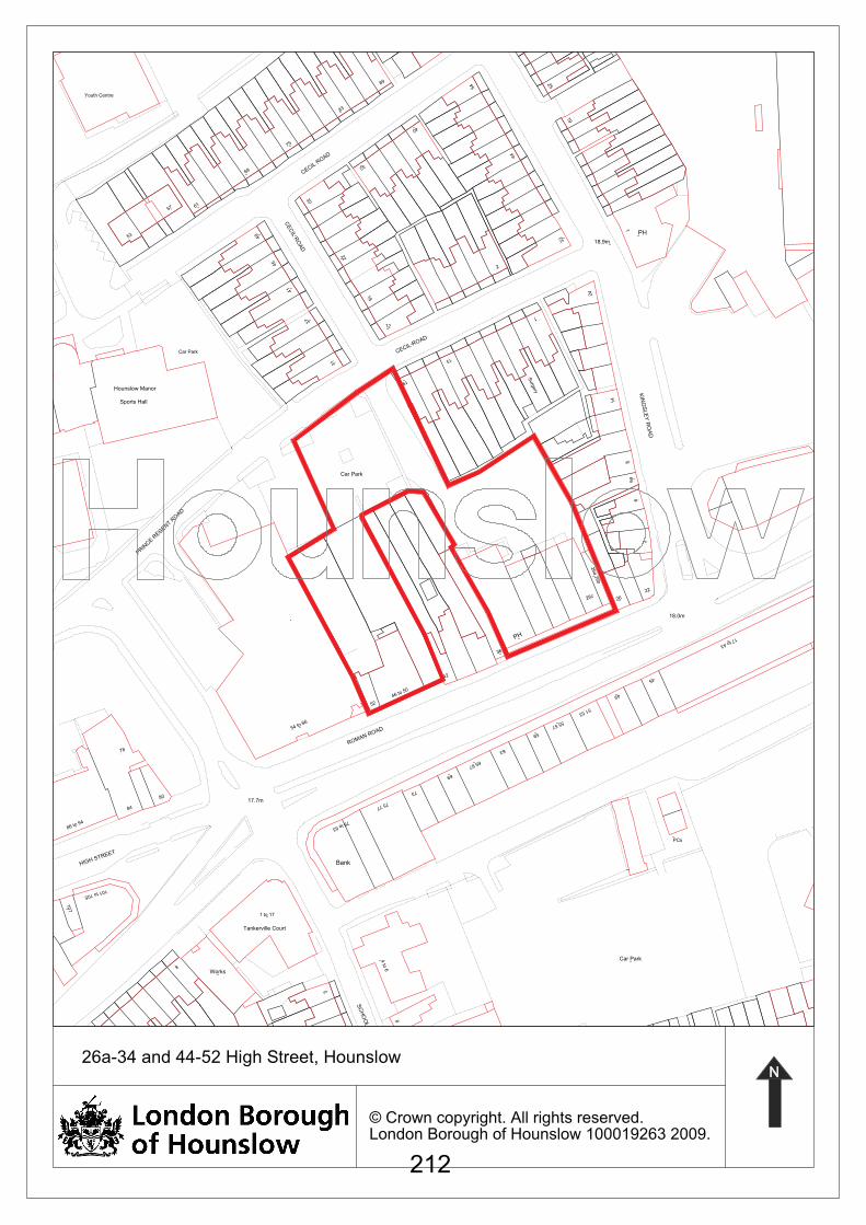
1
32
44
2
40
54
12
16
CECIL R
OAD
32
22
83
89
41
37
CE
CIL
RO
AD
49
30
69
75
45
57 61
53
Youth Centre
1PH
24
18.9m
19
25
15
6
14
KIN
GS
LE
Y R
OA
D
45
17 to 43
18.0m
2626c22
26a 2
6b
2
86a
Car Park
Surg
ery
PCs
13
31
19
CECIL ROAD
Bank
79 to 83
49
5
69
65 67
63
59
55 57
42
36
PH
51 53
17.7m
54 to 66
ROMAN ROAD
75 77
73
52
46 to 50
Car Park
PRIN
CE R
EGEN
T RO
AD
Hounslow Manor
Sports Hall
Car Park
101 to 105
84
1 to 17
78
80
20
107
86 to 94
HIGH STREET
4 to
6
SC
HO
OL R
OA
D
8
8
Works
Tankerville Court
© Crown copyright. All rights reserved.London Borough of Hounslow 100019263 2009.
26a-34 and 44-52 High Street, Hounslow
212
Guidance to the Sustainable Development Committee on National Planning Policy The following note is intended to supplement individual committee reports and provides guidance to Members on National Planning Policy for consideration in reaching decisions and/or providing comments on planning applications.
Planning Policy Guidance Notes (PPGs), and Planning Policy Statements (PPSs), which are replacing PPGs, set out the Government’s national policies on different aspects of land use planning in England. The following provides an overview of each PPG and PPS. It does not seek to address all issues specific to a proposal, as these are outlined in each individual committee report.
Planning Policy Statement 1: Delivering Sustainable Development (January 2005) sets sustainable development as the core principle underpinning planning and lists the Government’s four aims for achieving sustainable development:
• social progress which recognises the needs of everyone;
• effective protection of the environment;
• the prudent use of natural resources; and,
• the maintenance of high and stable levels of economic growth and employment.
Paragraph 13 lists key principles that should be applied to ensure that decisions taken on planning applications contribute to the delivery of sustainable development, including high quality inclusive design. Planning Policy Statement: Planning and Climate Change – Supplement to Planning Policy Statement 1 (December 2007) sets out how planning should contribute to reducing emissions and stabilising climate change and take into account the unavoidable consequences. Applicants for planning permissions should consider how well their proposal for development contribute to the Government’s ambition of a low-carbon economy and how well adapted they are for the expected effects of climate change. Planning Policy Guidance 2: Green belts (January 1995, amended March 2001) sets out objectives for the green belt including retaining openness through controls on development. New development is only acceptable if it is for specific purposes, identified in para. 3.4, and PPG2 emphasises that it is for the applicant to show why permission should be granted for inappropriate development. Planning Policy Statement 3: Housing (June 2010) The overall aim of this statement is to ensure that everyone has the opportunity of living in a decent affordable home in a community where they want to live. It supports the delivery of decent homes through the efficient use of land, good design, and a mix of sizes and tenures. Housing should be in suitable locations with a good range of community facilities and with good access to jobs, key services and infrastructure. Planning Policy Statement 4: Planning for Sustainable Economic Growth (December 2009) sets out planning policies for economic development including retail, leisure and entertainment, offices, factories, warehouses and other B Use Classes, arts, culture and tourism development. The policies in this statement also apply to other development, excluding housing, which provide employment opportunities, generate wealth or produce or generate economic output or product.
Agenda Item 10
213
Planning Policy Statement 5: Planning for the Historic Environment (March 2010) sets out planning policies on the conservation of the historic environment. Planning has a central role to play in conserving our heritage assets and utilising the historic environment in creating sustainable places.
Planning Policy Statement 7: Sustainable Development in Rural Areas (August 2004) Not applicable
Planning Policy Guidance 8: Telecommunications (August 2001) sets out the Government’s planning guidance on the siting and design of telecommunication systems and installations. PPG 8 offers guidance on environmental and health issues and consultation procedures. Planning Policy Statement 9: Biodiversity and Geological Conservation (August 2005) sets out planning policies on the protection of biodiversity and geological conservation interests. Planning Policy Statement 10: Planning for Sustainable Waste Management (July 2005) sets out the approach of sustainable management using the 'waste hierarchy' of reduction, reuse, recycle and compost, using waste as a source of energy and disposing of waste only as a last resort. In determining planning applications, locational needs together with wider environmental and economic benefits of sustainable waste management are material considerations. The design and layout of new development should also support sustainable waste management. Planning Policy Statement 12: Local Spatial Planning (June 2008) explains what local spatial planning is, and how it benefits communities. In additions it sets out the Government's policy on local spatial planning, which plays a central role in the overall task of place shaping and in the delivery of land uses and associated activities. The statement should be taken into account by the local planning authority in preparing development plan documents and other local development documents which will eventually replace the Unitary Development Plan. Planning Policy Guidance 13: Transport (January 2011) sets out objectives of PPG13 (as set out at Paragraph 4) are to integrate planning and transport at the national, regional, strategic and local level to:
1. promote more sustainable transport choices for both people and for moving freight;
2. promote accessibility to jobs, shopping, leisure facilities and services by public transport, walking and cycling, and
3. reduce the need to travel, especially by car. Planning Policy Guidance 14: Development on Unstable Land (1990) explains the effects of unstable land on development. Consideration is given to the responsibilities of the different parties and the need for instability to be taken into account in the planning process is emphasised. Planning Policy Guidance 17: Planning for Open Space, Sport and Recreation (July 2002) For all open spaces of public value local authorities should:
• avoid any erosion of recreational function and maintain or enhance the character of open spaces;
• ensure that open spaces do not suffer from increased overlooking, traffic flows or other encroachment;
214

• protect and enhance those parts of the rights of way network that might benefit open space; and
• consider the impact of any development on biodiversity and nature conservation.
Planning Policy Guidance 18: Enforcing planning control (December 1991) outlines the general approach to enforcement, including the primary responsibility of local planning authorities in breaches of planning control that would unacceptably affect public amenity or the existing use of land and buildings meriting protection in the public interest. Planning Policy Guidance 19: Outdoor Advertisement Control (March 1992) sets out guidance on the display of outdoor advertising, for which control can be justified on the grounds of amenity and public safety. Planning Policy Guidance 20: Coastal Planning (October 1992) Not applicable. Planning Policy Statement 22: Renewable energy (August 2004) sets out policies for renewable energy and the vital role the development of renewable energy can play in facilitating the government’s objectives for sustainable development and climate change. The statement also identifies key principles that local planning authorities should adhere to in their approach to planning for renewable energy include promoting and encouraging a full range of renewable energy sources, and considering the wider environmental and economic benefits of all renewable energy proposals. Planning Policy Statement 23: Planning and Pollution Control (November 2004) advises that any consideration of the quality of land, air or water and potential impacts arising from development, leading to impacts on health, is capable of being a material planning consideration, in so far as it arises or may arise from or may affect any land use. Planning Policy Guidance 24: Planning and Noise (September 1994) outlines the considerations to be taken into account in determining planning applications both for noise sensitive developments and for those activities which will generate noise; introduces the concept of noise exposure categories for residential development, encourages their use and recommends appropriate levels for exposure to different sources of noise. Also advises on the use of conditions to minimise the impact of noise. Planning Policy Statement 25: Development and Flood Risk (Revised March 2010) aims to ensure that flood risk is taken into account at all stages in the planning process to avoid inappropriate development in areas at risk of flooding, and to direct development away from areas of highest flood risk. Where new development is exceptionally necessary in areas of flood risk, the guidance seeks to prevent an increase in flood risk elsewhere, and where possible, reducing flood risk overall.
215
Copyright © 2022 FDOKUMEN