Knowledge base Output O.T1.2
107
Project co-funded by the European Union (ERDF, IPA) Knowledge base Output O.T1.2 Version 03 – 2018-02-15
-
Upload
khangminh22 -
Category
Documents
-
view
1 -
download
0
Transcript of Knowledge base Output O.T1.2
Project co-funded by the European Union
(ERDF, IPA)
Knowledge base
Output O.T1.2
Version 03 – 2018-02-15

Project co-funded by European Union funds (ERDF, IPA) 2
Table of contents
1 INTRODUCTION ......................................................................................................................... 8
1.1 CAMARO-D project ............................................................................................................................................... 8
1.2 Description of Danube catchment and its specifics .............................................................................. 10
1.3 Project partners ................................................................................................................................................. 12
2 KEY ENVIRONMENTAL PROBLEMS .................................................................................. 15
2.1 Key problems by review ................................................................................................................................. 15
2.1.1 Water Management .......................................................................................................................................................... 17
2.1.2 Spatial planning ................................................................................................................................................................. 21
2.1.3 Forestry ................................................................................................................................................................................. 23
2.1.4 Agriculture ........................................................................................................................................................................... 26
2.1.5 Tourism ................................................................................................................................................................................. 27
2.2 Key problems by targets ................................................................................................................................. 28
2.2.1 Water quality ...................................................................................................................................................................... 31
2.2.2 Flood risk .............................................................................................................................................................................. 32
2.2.3 Soil functioning and landscape retention............................................................................................................... 34
2.2.4 Discussion ............................................................................................................................................................................ 36
2.3 Frequency of individual negative practices ............................................................................................. 36
2.3.1 General overview of frequency of use of risky practices ................................................................................ 37
2.3.2 Frequencies of use of practices in land management segments .................................................................. 38
2.3.3 Most frequently implemented practices ................................................................................................................. 40
2.3.4 Most frequently implemented practices in land management segments ................................................ 41
2.4 Frequency of negative practices for land management segments .................................................. 44
2.5 Summary of problems and negative practices ....................................................................................... 44
3 CURRENT LEGISLATION AND POLICY FRAMEWORK ................................................. 48
3.1 Common EU legislation and strategies ...................................................................................................... 48
3.1.1 Cross Compliance principles (GAEC – Good Agricultural and Environmental Conditions) ............ 49
3.1.2 EU Water Framework Directive ................................................................................................................................. 49
3.1.3 EU Soil Framework Strategy /Directive (actually repealed) ......................................................................... 50
3.1.4 EU Floods Directive .......................................................................................................................................................... 50
3.1.5 EU Drinking Water Directive ....................................................................................................................................... 50

Project co-funded by European Union funds (ERDF, IPA) 3
3.1.6 EU Groundwater Directive ............................................................................................................................................ 50
3.1.7 Environment Action Programme to 2020.............................................................................................................. 51
3.1.8 Natura 2000 and Ramsar convention ...................................................................................................................... 51
3.1.9 Forest Europe (ex MCPFE) and EU Forest Strategy .......................................................................................... 51
3.1.10 Nitrate Directive ................................................................................................................................................................ 52
3.2 Nation specific legislation and policy ........................................................................................................ 52
3.2.1 Basic governance of landscape and water resources ....................................................................................... 52
3.2.2 National specific legislation.......................................................................................................................................... 53
3.2.3 Restrictive tools ................................................................................................................................................................. 53
3.2.4 Motivating strategies ....................................................................................................................................................... 54
3.3 Stakeholders view ............................................................................................................................................. 55
3.3.1 Key problems identified by stakeholders .............................................................................................................. 56
3.3.2 Positive prospects as viewed by stakeholders..................................................................................................... 57
4 TYPICAL BMP (BEST MANAGEMENT PRACTICES) AND CONTROL MEASURES . 58
4.1 Arable Agriculture ............................................................................................................................................ 61
4.1.1 Conservation tillage ......................................................................................................................................................... 62
4.1.2 Strip tillage ........................................................................................................................................................................... 62
4.1.3 No tillage ............................................................................................................................................................................... 63
4.1.4 Grass buffer strips along water courses ................................................................................................................. 63
4.1.5 Mulching................................................................................................................................................................................ 64
4.1.6 Fertilization with manure and compost ................................................................................................................. 64
4.1.7 Conservation crop rotation .......................................................................................................................................... 65
4.1.8 Precision agriculture ....................................................................................................................................................... 65
4.1.9 Control of Nutrients application ................................................................................................................................ 66
4.1.10 Control of pesticides application ............................................................................................................................... 66
4.1.11 Retention ditches .............................................................................................................................................................. 67
4.1.12 Grassed waterways .......................................................................................................................................................... 67
4.1.13 Sediment traps ................................................................................................................................................................... 68
4.1.14 Hedges.................................................................................................................................................................................... 68
4.1.15 Infiltrating pools ................................................................................................................................................................ 69
4.1.16 Stabilized dung pits with retention tank ................................................................................................................ 69
4.2 Grassland management .................................................................................................................................. 70
4.2.1 Appropriate cattle load at pastures .......................................................................................................................... 70
4.2.2 Manual mowing in vulnerable areas ........................................................................................................................ 71

Project co-funded by European Union funds (ERDF, IPA) 4
4.2.3 Appropriate distribution of pastures versus meadows ................................................................................... 71
4.2.4 Extensive meadows/pastures within vulnerable areas .................................................................................. 72
4.2.5 Permanent grassing of infiltration areas ................................................................................................................ 72
4.2.6 Proper pastures (grazing) management (feeding lots, drinking lots, weed control) ......................... 73
4.3 Forestry ................................................................................................................................................................. 73
4.3.1 Establishment of stable, site-adapted forest ecosystems ............................................................................... 74
4.3.2 Avoiding areas without canopy cover ..................................................................................................................... 75
4.3.3 Improving structural diversity and stability parameters of forest ecosystems ................................... 75
4.3.4 Small-scale silvicultural regeneration techniques ............................................................................................. 76
4.3.5 Adequate timber harvesting techniques ................................................................................................................ 76
4.3.6 Identification and protection of virgin forests ..................................................................................................... 77
4.3.7 Manage forest-ecologically sustainable wild ungulate stocks ...................................................................... 77
4.3.8 Soil conservation liming................................................................................................................................................. 78
4.3.9 Prohibition of chemical fertilizers and pesticides within DWPZ ................................................................. 78
4.3.10 Forest fire prevention ..................................................................................................................................................... 79
4.3.11 Limitation of forest roads .............................................................................................................................................. 79
4.3.12 Forest roads with proper drainage ........................................................................................................................... 80
4.3.13 Construction of retention pools.................................................................................................................................. 80
4.3.14 Wetlands restoration, deconstruction of drainages .......................................................................................... 81
4.3.15 Buffer strips along streams, dolines or sinkholes .............................................................................................. 81
4.3.16 Establishing of field shrubs .......................................................................................................................................... 82
4.4 Spatial planning ................................................................................................................................................. 82
4.4.1 Protection of (water-related) open spaces in regional and local land use planning .......................... 84
4.4.2 Integration of flood hazard information into regional and local land use planning ........................... 84
4.4.3 Implementation of retention pits and local rainwater harvest facilities in local land use plans .. 85
4.4.4 Coordination of flood risk management at catchment scale ......................................................................... 85
4.4.5 Implementation of land-saving development measures ................................................................................. 86
4.4.6 Awareness raising for land-saving development and flood adaptation by participatory local land
use planning processes .................................................................................................................................................................... 86
4.4.7 Land management for river restoration and flood protection ..................................................................... 87
4.4.8 Implementation of nature conservation and water management projects in land consolidation
schemes .................................................................................................................................................................................................. 87
5 CONCLUSIONS .......................................................................................................................... 88
5.1 Outputs of WP T1 ............................................................................................................................................... 88

Project co-funded by European Union funds (ERDF, IPA) 5
5.2 Summary ............................................................................................................................................................... 89
6 REFERENCES ............................................................................................................................ 91
7 ANNEXES ................................................................................................................................... 93
7.1 Annex 1 - Agriculture – arable land ............................................................................................................ 93
7.2 Annex 2 - Agriculture - grassland ................................................................................................................ 95
7.3 Annex 3 - Forestry ............................................................................................................................................. 97
7.4 Annex 4 - Water management ....................................................................................................................100
7.5 Annex 5 - Spatial planning ...........................................................................................................................104
7.6 Annex 6 - Tourism ...........................................................................................................................................106

Project co-funded by European Union funds (ERDF, IPA) 6
Glossary
ASP - Associated Partner of the project
BMP – Best Management Practice
BOD – Biological Oxygen Demand
CCF – Continuous Cover Forests
DBA – Danube Basin Analysis 2004
DRB - Danube River Basin
DWPZ – Drinking Water Protection Zones
DZES – Good Agricultural and Environmental Situation (of agricultural land – Czechia)
DRBMP – Danube River Basin Management Plan
EC – European Commission
EEC – European Economic Community
ERDF – European Regional Development Fund
ES – European Standard
EU - European Union
EVL – (European Important Locality – in Czech)
ICPDR - International Commission for the Protection of the Danube River
IPA – Instruments for Pre-Accession Assistance (EU funds)
GAEC - Good Agricultural and Environmental Conditions (of agricultural land)
LUDP - Land Use Development Plan
MCPFE – Ministerial Conference on the Protection of Forests in Europe
NGO - Non-Governmental Organization
OPUL – Agricultural-Environmental Program (Austria)
PE – Population equivalent

Project co-funded by European Union funds (ERDF, IPA) 7
PP – Project Partner
rkm – river kilometers
SWOT - Strengths, Weaknesses, Opportunities, and Threats analysis
WFD - Water Framework Directive
WP – Work package
WPT – Work Package Task
Countries:
AT - Austria
BG - Bulgaria
CZ – Czech Republic
DE - Germany
HR – Croatia
HU – Hungary
RO - Romania
RS - Serbia
SI – Slovenia
SK - Slovakia
Project co-funded by European Union funds (ERDF, IPA) 8
1 Introduction
Knowledge base is the final output of the first thematic work package (WP T1 – Investigative
Danube) of CAMARO-D project. Knowledge base concludes results and outcomes, collected
within WP T1, into complex material. It first brings brief overview of major current
environmental problems of Danube catchment, focusing on three targets of CAMARO-D project
(water quality, flood risk, and soil/landscape functioning). All challenges and negative practices
are evaluated by CAMARO-D expert teams separately in five land management segments: water
management; spatial planning; forestry; agriculture; tourism.
Knowledge base then summarizes legislation conditions within individual Danube countries,
related to expert fields of agriculture, forestry and spatial planning. The reviews were mainly
focused on recent situation in national and EU legislation and policy within each CAMARO-D
country, in order to improve catchment management situation, to provide better water quality
and runoff-retention conditions.
Finally, knowledge base gives brief overview of selected Best management practices (BMP) in
four land management segments: arable agriculture, grassland management, forestry and spatial
planning. The list is based on the transnational gap-analysis, BMP-analysis and SWOT-analysis
about current land use practices and their impacts on water management and it encompasses
stakeholder needs and requirements concerning legislation, funding systems, financial
instruments, the role of decision makers and knowledge transfer.
Knowledge base (Output 3.2) is a structured summary. It is complex output material of WP T1
(WP 3). For detailed information on individual segments of expertise and materials worked out
within WP T1 readers are asked to address individual specific documents available at
http://www.interreg-danube.eu/approved-projects/camaro-d
1.1 CAMARO-D project
The project CAMARO-D (Cooperating towards Advanced Management routines for land use
impacts on the water regime in the Danube river basin) started in January 2017 and is
financially supported by European Union funds (ERDF, IPA) within the Danube Transnational
Programme 2014-2020. During the two and a half years of project implementation the project

Project co-funded by European Union funds (ERDF, IPA) 9
will develop comprehensive recommendations towards a strategic policy for the
implementation of an innovative transnational catchment-based “Land Use Development
Plan” for the Danube River Basin.
Intensive land use practices often cause severe negative impacts on groundwater resources as
well as on torrents and rivers due to increased erosion processes, floods, soil compactions,
surface runoff, invasive plant species and water pollutions. By means of a new transnational
guidance with a tailored, application-oriented tool-kit for relevant stakeholders and
decision-makers a sustainable protection of water resources and improved flood risk
prevention shall be provided. This will foster the trans-sector and transnational cooperation in
the field of water management, forestry, agriculture, spatial planning and nature conservation.
Newly developed best practices in function-oriented sustainable land use management –
considering also climate change issues – will be tested and documented within various Pilot
Actions. Supported by intensive stakeholder workshops and trainings, the initiation of the
practical tool-kit implementation will be conducted within selected pilot areas.
To guarantee a broad basis of different geographic, scientific and decision-making fields the
partnership consists of 14 project partners and 9 associated partners representing
governmental bodies, water suppliers, research and education institutions, agro-meteorological
institutions, environmental agencies and spatial planning institutes acting on local, regional and
national levels and originating from nearly all Danube basin states (Austria, Slovenia, Bulgaria,
Croatia, Czech Republic, Germany, Hungary, Romania and Serbia). The Forest Department of the
Austrian Federal Ministry of Sustainability and Tourism (former: Agriculture, Forestry,
Environment and Water Management) assumes the Lead partnership of this project.
CAMARO-D outcomes will provide important inputs for the further development of EUSDR
(EU Strategy for the Danube Region) and other relevant EU-policies like Water Framework
Directive and Flood Directive as well as for the Danube river basin Management Plans. To
underline the importance of the implementation of this transnational catchment-based “Land
Use Development Plan” a Memorandum of Understanding will be signed by notable
representatives of each partner country during the Final Conference in Vienna in June 2019.

Project co-funded by European Union funds (ERDF, IPA) 10
1.2 Description of Danube catchment and its specifics
The Danube is the most international river basin in the world. The basin drains water from
19 countries. From the point of view of Water framework directive it is one of the most complex
basins in which EU directives have to be implemented. In 1994 the Danube River Protection
Convention was initiated which established the International Commission for the Protection of
the Danube River (ICPDR). Today, the convention was signed by 14 countries within the basin.
The ICPDR generally provides the organizational structure that is a pre-requisite to resolving the
conflicting pressures of protecting the water environment whilst enabling continued and
sustainable water use within the basin.
The Danube River Basin extends over 807,827 km2 in Central and South-Eastern Europe. The
Danube is 2857 km long and flows in an easterly direction from the Black Forest Mountains to
the Black Sea where its mean annual discharge is 6486 m3/s (Sommerwerk et al. 2009).
Table 1: Basic characteristics of the Danube River Basin District (ICPDR 2015)

Project co-funded by European Union funds (ERDF, IPA) 11
As such, the river is the 21st largest river globally, and the second largest river in Europe (ICPDR
2015). The ‘natural’ regime of the river varies seasonally and through the basin, reflecting the
distribution of precipitation which varies from > 3000 mm annually in the West to < 500 mm in
the center and east of the basin. The basin is spatially heterogeneous: one third of the basin is
mountainous and the mean altitude of the basin is ~ 450 m asl, extending from Piz Bernina
(4052 m a.s.l.) in the West, and Peak Krivan (2496 m a.s.l.) in the North to the Black Sea. Along
its course, the Danube flows through a series of alternating basins and gorges: below the
confluence of the Danube and the Morava, the river enters the Devin Gate, below which the
Danube forms an internal delta as it starts to traverse the Pannonian Plain. Here the flow of the
‘Middle’ Danube is augmented by the Drava, the Tisza, and the Sava rivers: tributaries that rise in
the Southern Alps, the Western Carpathians, and the Julian Alps respectively, highlighting the
degree to which the Danube is dependent upon flow generated in alpine areas. Downstream the
Danube flows through the 117 km long Iron Gate located in the Southern Carpathians. Below the
Iron Gate, the ‘Lower’ Danube crosses the Romanian and Bulgarian lowlands before the river
bifurcates into three channels as it flows through the Danube Delta and ultimately discharges
into the Black Sea (Habersack et al. 2016).

Project co-funded by European Union funds (ERDF, IPA) 12
Figure 1: The Danube River Basin identifying four river sections: the Upper, Middle, and Lower Danube and
the Danube Delta (base map: ICPDR) (Sommerwerk et al. 2009).
1.3 Project partners
CAMARO-D team pursues a broad participation of different partners, not only in geographic
scope but also referring to diverse scientific and governmental fields of responsibility. Most
important of the Danube basin states are involved (according to area of catchment – see Table
1): Austria, Slovenia, Bulgaria, Croatia, Czech Republic, Germany, Hungary, Romania and Serbia.
Countries involved within the project represent ca 650.000 km2 of total area of catchment (ca
800.000 km2), what means to cover more than 80% of total catchment area.
The partnership consists of representatives of governmental bodies, water suppliers, research
and education institutions, agro-meteorological institutions, environmental agencies and spatial
planning institutes acting on local, regional and national level. Their main fields of expertise are
environmental status assessment, elaboration of adequate target-oriented sustainable land use
guiding principles, enhanced flood forecasting, policy and strategy preparation in their

Project co-funded by European Union funds (ERDF, IPA) 13
respective thematic fields, spatial planning and water supply issues, rural development
(guidelines and adapted subsidies), regulation and impact assessment considering the current
knowledge about climate change influences, approval and control of the implementation of
forest- and river-related management plans and national / regional strategies respectively
legislation.
Associated project partners partly represent target groups of CAMARO-D, their needs and
interests served as a basis for the project-idea and –development and are met by the project
content and related outcomes. The selection of ASPs supports the broad operational
implementation of the developed catchment-based “Land Use Development Plan” in the
respective participating countries.
While research institutions cover scientific part of the project – the analysis of problems and
design of best practices, ASPs role is mainly in dissemination of results into practice, decision
making and landscape management. They participate at workshops, communicate with
stakeholders and assess designed measures and practices from point of view of their practical
applicability.
Overview of individual project partners and associated partners provides Table 2.
Table 2: List of project partners
Role Official Name in English Acronym Country
LP Austrian Federal Ministry of Sustainability and Tourism (former: Austrian Federal Ministry of Agriculture, Forestry, Environment and Water Management)
BMNT AUSTRIA
ERDF PP1
Agricultural Research and Education Center Raumberg-Gumpenstein
AREC AUSTRIA
ERDF PP2
Municipality of the City of Vienna Department 31 – Vienna Water
MA31 AUSTRIA
ERDF PP3
University of Ljubljana UL SLOVENIA
ERDF PP4
Public Water Utility JP VODOVOD- KANALIZACIJA Ljubljana
JP VO_KA SLOVENIA
ERDF PP5
Herman Otto Institute HOI HUNGARY
ERDF National Forest Administration ROMSILVA ROMANIA

Project co-funded by European Union funds (ERDF, IPA) 14
PP6
ERDF PP7
National Meteorological Administration of Romania
NMA_RO ROMANIA
ERDF PP8
Environmental Protection Agency Covasna EPAC ROMANIA
ERDF PP9
Executive Forest Agency EFA BULGARIA
ERDF PP10
Croatian Geological Survey HGI_CGS CROATIA
ERDF PP11
Czech Technical University in Prague CTU CZECH REPUBLIC
ERDF PP12
Forest Research Institute Baden-Württemberg, Dept. Soils and Environment
FVA_BW GERMANY
IPA PP1
The Jaroslav Černi Institute for the Development of Water Resources
JCI SERBIA
ASP1 Office of the Upper Austrian Federal State Government, Forest Service
UA_FS AUSTRIA
ASP2 Office of the Styrian Federal State Government; Dep. 14 - Water management, resources and sustainability
S_FS AUSTRIA
ASP3 Morava River Basin, state owned enterprise PMO CZECH REPUBLIC
ASP4 The University of Agricultural Sciences and Veterinary Medicine of Bucharest - Faculty of Land Reclamation and Environmental Engineering
USAMV_FIFIM ROMANIA
ASP5 Styrian League for Nature Protection NATURSCHUTZBUND Stmk
AUSTRIA
ASP6 Water Management System Covasna SGAC ROMANIA
ASP7 Croatian Waters CW CROATIA
ASP8 Republic of Serbia Ministry of Agriculture and Environmental protection, Water Directorate
RDV SERBIA
ASP9 Bavarian State Institute of Forestry LWF GERMANY

Project co-funded by European Union funds (ERDF, IPA) 15
2 Key environmental problems
The chapter presents a summary and categorization of key environmental problems – mainly
those, which CAMARO-D project deals with. It is based on expertise of individual project
partners (PPs) and information gathered by gap-analysis, workshops with stakeholders and
SWOT analysis. It is not a complex statistics but sum of information which can be gathered from
available materials and cooperation with PPs.
2.1 Key problems by review
(modified from ICPDR, 2015)
Pollution by organic substances
Households and sewer connected industry produce a waste water load of 88 million population
equivalent (PE) in the Danube basin (ICPDR, 2015). A majority of this impressive load (ca 72 %)
is now conveyed to urban wastewater treatment plants or treated individually.
Wastewater collection and treatment infrastructure has been improved at almost 900
agglomerations by 2015. Since the reference year (2005/2006) of the 1st DRBM Plan the BOD
emissions via waste water have been reduced by almost 50 % thanks to the substantial
development of the wastewater infrastructure in the last decade.
Pollution by nutrients
Nutrient pollution is caused by releases of nitrogen (N) and phosphorus (P) into the aquatic
environment. Nutrient emissions can originate from both point and diffuse sources. Point
sources of nutrient pollution are similar to those of the organic pollution. Diffuse pathways such
as overland flow, urban runoff, soil erosion, tile drainage flow and groundwater flow can
remarkably contribute to the emissions into surface waters transporting nutrients from
agriculture, urban areas, atmosphere and even from naturally covered areas.
The recent basin-wide nutrient emissions entering the surface water bodies are 605,000 tons
per year total N and 38,500 tons per year total P. Diffuse pathways clearly dominate the total
emissions by 84 % (N) and 67 % (P). For N, groundwater (base flow and interflow) is the most
important diffuse pathway with a proportion of 54%. In case of P, soil erosion (32 %) and urban
runoff (18 %) generate the highest emissions. Regarding the sources, agriculture (N: 42 %, P: 28

Project co-funded by European Union funds (ERDF, IPA) 16
%) and urban water management (N: 25%, P: 51%) are responsible for the majority of the
nutrient emissions. Long-term average nutrient river loads transported to the Black Sea are
lower compared to the emissions due to in-stream retention and amount to about 500,000 tons
per year (N) and 25,000 tons per year (P) (ICPDR 2015).
Figure 2: Ecological status and ecological potential for rivers (ICPDR, 2015)
Figure 3: Chemical status for Danube rivers (ICPDR, 2015)

Project co-funded by European Union funds (ERDF, IPA) 17
Ecological and Chemical Status
Out of a 28,836 rkm network in the DRBD, good ecological status or ecological potential is
achieved for 7,107 rkm (25%) and good chemical status for 20,380 rkm (70.7 %). It shall be
noted that this information on chemical status is based on the analysis of priority substances in
water and does not include (with the exception of Czech Republic) data on mercury in biota. The
data on contamination of biota by mercury are available only from DE, AT, CZ, SK and SI and are
shown separately. It is apparent from the third Figure below that the analysis of mercury in
biota is a decisive element for the assessment of the chemical status because in all surface water
bodies, in which this quality element was analyzed, it exceeded its Environmental Quality
Standard (EQS) and caused bad chemical status.
2.1.1 Water Management
Water quality in the Danube River Basin is largely influenced by the inputs of pollutants -
particularly excessive nutrients, organic material, and hazardous substances. According to the
ICPDR’s Emission Inventory 2002, which considers point and diffuse sources of pollution in the
whole Danube River Basin, municipalities and industry released fewer pollutants than in
previous years.
Major problems affecting aquatic ecosystems in the Danube River Basin:
Excessive nutrient loads (particularly nitrogen and phosphorous)
Phosphorus is one of the key nutrients affecting the ecosystems of the Danube River Basin and
the Black Sea, by exacerbating eutrophication. The total phosphorus load in the Danube River is
around 48,900 tons per annum (1992-1996). This phosphorus mainly originates from sources
such as wastewater discharges and erosion of fertilized farmland.
The total nitrogen load upstream of the Danube Delta transported by the Danube River is
estimated to be between 537,000 and 551,000 tons per annum. This data covers the period
1992-1996, and should only be taken as a rough indicator of the current size of the nitrogen
load. Most Danube countries are working to reduce emissions of nitrogen and other nutrients
from municipal wastewater treatment plants.

Project co-funded by European Union funds (ERDF, IPA) 18
High amounts of organic substances originating from untreated or poorly treated
wastewater
Organic pollution has been increasing in parts of the Danube Basin up till the end of the last
century, as industrial production and household consumption have resulted in increasing loads
of wastewater rich in organic matter. Other organic matter of natural origin includes natural soil
erosion with a high organic content and the decomposition of dead plants and animals. In terms
of organic pollution, water quality in the Danube ranges between Class II (moderate pollution)
and Class II-III (moderate to critical pollution) of the interim ICPDR classification. The most
serious organic pollution problems occur in tributaries that regularly receive untreated or
inadequately treated wastewater from industrial plants and municipalities
Contamination with hazardous substances (including heavy metals, oil, and
microbiological toxins)
Hazardous substances are substances that are toxic, persistent and liable to bioaccumulate, or
otherwise give reason for concern - by influencing the hormone or immune systems of animals,
for example. The list of priority substances comprises heavy metals and organic substances.
Accidental pollution incidents in the Danube River Basin can cause widespread damage to the
environment and endanger the health of local people and the state of local economies
downstream. The ICPDR is working to prevent accidental pollution and to improve response
capability by listing all relevant "Accident Risk Spots" in inventories, and by providing two tools
to lessen the related risks:
1. Recommendations on guidelines for the Danube states to improve the standard of
safety measures at risk sites
2. Checklists to help controlling technical safety levels at Accident Risk Spots.
Degradation and loss of wetlands
The floodplains and wetlands of the Danube basin are uniquely valuable ecosystems in
European and even global terms, although few areas are still in their natural or even near-
natural state. According to a study conducted in the framework of the Danube Pollution
Reduction Programme, over the last two centuries in particular, most of the larger floodplain
areas have disappeared – including up to 80 % of the total wetland area along the Danube and
its larger tributaries, the Pruth, Tisza, Sava, Drava, and Morava.

Project co-funded by European Union funds (ERDF, IPA) 19
Wetlands are highly productive ecosystems and provide habitats for many species, including
endangered ones. They are, however, sensitive ecosystems that can easily suffer from degrading
riverbed erosion, pollution, intensive forestry, hunting and intensive recreational use, as well as
measures for flood protection, agriculture and navigation.
Besides their ecological value, floodplains can have a considerable positive effect on water
quality and nutrient levels. Wetlands also serve as retention areas and help to even out flood
peaks and reduce flood damage by storing surplus water.
The "taming" of wild rivers to improve flood prevention, navigation, agricultural production, and
energy production, has shortened the length of the Bavarian Danube by 21 % and the length of
the River Tisza in Hungary by 31 %. Drainage ditches and dykes were built on about 3.7 million
hectares of permanently or seasonally inundated land in Hungary during the 19th and 20th
century. Some 80 % of Romania’s floodplains were likewise drained under agricultural
intensification schemes during the 1960s and 1970s.
Changes in river flow patterns (hydromorphological alterations) and its effect on
sediment transportation
Since the 16th century, people have been changing the natural course of the rivers in the Danube
River Basin, mainly for hydropower generation, flood control and navigation. All these changes
affect the ecological quality (technically also known as 'status') of the rivers.
Hydromorphological alterations such as river and habitat interruptions, the disconnection of
wetlands/floodplains and hydrological alterations (i.e. water abstraction) can provoke changes
in the natural structure of rivers. This may include the alteration of river depth and width, river
type specific flow regimes, interruption of natural sediment transportation as well as the
interruption of natural fish migration routes.
Large dams and weirs, for instance, might not only interrupt the river and habitat continuity, but
have an important effect on the natural sediment transportation, resulting in
1. The retention of sediment upstream of dams. The accumulated sediment has to be
extracted to maintain the river's depth for hydropower generation and navigation. The
siltation process can also entail problems with the drinking water supply.
2. The loss of sediment downstream of dams, meaning that material must be artificially
imported to stabilize the river bed and prevent incision.

Project co-funded by European Union funds (ERDF, IPA) 20
Stakeholders, who were interviewed within workshops and questionnaires campaigns in frame
of the project (see chapter 3.3) about their impression of the state of the environmental
management, have mentioned the following problems: (i) Surface waters pollution – The key
environmental problem is surface water quality. Many reservoirs have serious problems with
nutrients cycle, the waters are eutrophic with high algae concentration. Main source of
phosphorous are wastewaters, even though majority of the municipalities have functional
wastewater treatment plants. In some countries (Bulgaria, Romania, Serbia) the industrial
pollution was called out as the most harmful human induced activity. (ii) Drought – Half of the
respondents the same as overall water managers in all participating countries consider droughts
as the key thread, especially due to the expected consequences of climate change.
Stakeholders have mentioned also positive achievements towards better state of the
environment, which was reached in the last decade. Most often stated recent improvements are
the modernization of water supply systems, better management of biodiversity conservation
and improvement of soil organic matter content on the arable fields.
Groundwater pollution
Groundwater constitutes the largest reservoir of freshwater in the world, accounting for over 97
% of all freshwaters available on earth (excluding glaciers and ice caps). The remaining 3 % is
composed mainly of surface water (lakes, rivers, wetlands) and soil moisture. By incorporation
into the Water Framework Directive (WFD), groundwater became part of an integrated water
management system.
According to the DBA the main reasons for the pollution of groundwater were identified as:
Insufficient wastewater collection and treatment on the municipal level;
Insufficient wastewater treatment at industrial premises;
Water pollution caused by intensive agriculture and livestock breeding;
Inappropriate waste disposal sites.
To avoid the presence of hazardous substances in groundwater aquifers, additional measures
need to be taken as required under the following Directives:
Drinking Water Directive (80/778/EEC) as amended by Directive (98/83/EC);
Plant Protection Products Directive (91/414/EEC);
Habitats Directive (92/43/EEC);

Project co-funded by European Union funds (ERDF, IPA) 21
Integrated Pollution Prevention Control Directive (96/61/EC).
Introduced organisms – beaver reintroduction
Getting closer to all topics of all four segments of CAMARO-D projects (Water management,
Spatial planning, Agriculture and Forestry, the specific species problem are mainly beavers,
which become an issue within all CAMARO-D countries. This mammal has been drastically
reduced or extinct in most parts of Danube catchment during 18th to 19th century. During
second half of 20th and recently, beaver is coming back to its original biotopes. Therefore, it
hardly can be called invasive or introduced species. In fact, it is reintroduced original species,
which however was extinct within very different stages of landscape development and land-use
and which is returning back into. Beaver belongs to the most problematic (some authors
mention it as the most one) species, related to problems of human-animal coexistence within
one area.
Beaver is very effective in managing water level manipulation, what affects mainly flood risk and
also water quality, can cause serious damages at any structures, linked or built close to water
bodies, and can endanger dams of small water reservoirs or levees along rivers. During their
search for food, they are also very effective in cutting down trees, what can cause secondary
harmful effects on private or state property or security problems.
Beaver population is rapidly rising within the Czech Republic, Hungary, Slovakia, Austria,
Bulgaria, Romania and other Danube countries.
2.1.2 Spatial planning
Municipalities
Municipalities generate around 60 % of the wastewater discharged in the Danube River Basin,
and much of this wastewater is released into rivers not sufficiently treated.
Inadequate management and treatment of municipal wastewater has been identified as one of
the core problems in the Danube River Basin.
Among other measures, the ICPDR encourages that more nutrients must be removed in
wastewater treatment plants and water pollution from landfills must be prevented.
Recommended measures:
Project co-funded by European Union funds (ERDF, IPA) 22
New sewer systems and wastewater treatment plants must be constructed, with
existing facilities restored and upgraded.
The operation of sewer systems and wastewater treatment plants must be improved.
More nutrients must be removed in wastewater treatment plants.
The treatment of sewage sludge must be improved.
Water pollution from landfills must be prevented.
Industry
The chemical, food, and pulp and paper industries are amongst the main industrial polluters in
the Danube River Basin. Discharges from such plants significantly raise the levels of heavy
metals and organic micropollutants in the river network. The degree of industrial development
and pollution caused by the industrial sector varies among the countries.
The immediate environmental impacts of the inadequate treatment and storage of
industrial and mining waste include water pollution, groundwater and soil
contamination, and the reduced availability of clean water.
Other longer-term impacts can include the depletion of natural resources, landscape
degradation, reductions in biodiversity, and health risks.
The problems associated by industrial activities and mining are caused by:
The use of outdated technologies and harmful substances that could be substituted
Discharges of wastewater into the sewerage systems without pre-treatment
Inadequate treatment facilities
Protected areas
Protected areas are often directly linked with surface and/or groundwater bodies and their
status is therefore also depending on the management practices and status of such water bodies,
and vice versa. Such areas shelter valuable habitats for flora and fauna, and can provide
numerous ecosystem services.
The protected areas to be considered are listed in WFD Annex IV. Furthermore, the WFD
requires to establish a “register or registers of all areas lying within each river basin district
which have been designated as requiring special protection under specific Community

Project co-funded by European Union funds (ERDF, IPA) 23
legislation for the protection of their surface water and groundwater or for the conservation of
habitats and species directly depending on water” (WFD Article 6).
Types of protected area are:
Areas designated for the abstraction of water intended for human consumption
Areas designated for the protection of economically significant aquatic species
Bodies of water designated as recreational waters, including areas designated
as bathing waters
Nitrates vulnerable zones
Nutrient sensitive areas
Areas designated for the protection of habitats or species where the maintenance or
improvement of the status of water is an important factor in their protection
Other protected areas in non-EU Member States (e.g. Nature and Biosphere Reserves)
2.1.3 Forestry
Forests play an important role in environmental protection. There is a long history of protection
of forests in mountain areas, where they help to prevent soil erosion, landslides and avalanches,
and where they are important in maintaining the water quality of rivers draining forested
catchments. Special silvicultural methods are required to ensure that these forests are
maintained indefinitely. Forests also respond to environmental protection. A major issue is air
pollution, which is known to have had significant impacts on some forests. Air pollutants of
concern include sulphur dioxide, hydrogen fluoride, heavy metals, and ozone. Control of these
pollutants ultimately benefits forests. Forests have a major role to play in the protection of the
global carbon cycle. They represent an important sink for atmospheric carbon dioxide, and
conversion of forests to other land uses is one of the causes of the increase in atmospheric
carbon dioxide concentrations. Reforestation and afforestation could contribute to reducing
atmospheric carbon dioxide concentrations, and the use of biofuels could help to reduce demand
for fossil fuels.
Main detected problems and their consequences:
Monoculture forests, missing tree species diversity
o Planted forest monocultures are high consumers of water.
o Planted forest monocultures increase soil and water acidification.

Project co-funded by European Union funds (ERDF, IPA) 24
o Planted forest monocultures sustain a low diversity of wildlife.
Not stabilized forest roads, forest roads without proper drainage
o Intensive soil erosion within forest road
o Intensive surface runoff during intensive rainfall-runoff events
o Higher risk of flash floods
o Intensive sediment transport from forest
o Higher risk of forest damage
Inadequate timber harvest techniques
o Impacts on soil
More intensive wind erosion
Soil compaction
Rutting (creation of depressions by forest equipment)
Puddling (physical change in soil properties due to shearing forces that alter soil
structure and porosity)
o Impact on watershed
Runoff and gully erosion
o Impact on streams
Tree roots help stabilize stream banks, and tree shade helps reduce algae growth
in streams in some cases. Streamside vegetation also traps sediments before they
reach the stream and absorbs nitrates from groundwater. Clearing trees removes
these benefits.
o Impact on water tables
Waterlogged soils that are difficult to reforest or crop.
Reduced soil moisture and drying of existing wetlands.
Fluctuating water tables causing increased soil salinity or changes in soil pH.
Problems with water quantity or quality in existing dugouts, springs or wells.
o Impact on wildlife
Avoiding logging in the riparian/wetland zone. Riparian and wetland areas
provide important habitat for many species of fish and wildlife and help to
protect water quality.

Project co-funded by European Union funds (ERDF, IPA) 25
Leaving snag trees (dead standing trees). Snag trees are important for supplying
food, roosting and nesting for many bird species such as woodpeckers, some
songbirds and bats.
Leaving fallen trees and woody debris on forest floor. Woody debris is important
for many small and medium sized fur bearing animals.
Invasive species - Invasive species negatively impact the forest sector in economic,
ecological, environmental, social and health terms.
o Impact on genes.
If introduced or spread into habitats with closely related species, alien species could interbreed
with native species resulting in changes to the genetic makeup of either species which could
result in a reduction in the survival of either species, creation of a more successful invader, or
the creation of hybrids that could be more susceptible to certain pests and pathogens. Of recent
concern to the forest sector is the impact of possible introduction of new tree genotypes (non-
local provenances or genetically improved planting stock) resulting in the creation of hybrids
and the resulting loss of gene pools that may have acquired specific characteristics through local
adaptation.
o Impact on species.
Invasive species can influence species diversity, richness, composition and abundance. At the
species level, direct effects of invasive species occur through processes such as the predation of,
competition with, and pathogen and parasite transmission to individual organisms, eventually
leading to population declines and species extinctions.
o Impact on habitats.
Through their impacts on species and ecosystem processes, invasive species can result in the
fragmentation, destruction, alteration or complete replacement of habitats which in turn, has
cascading effects on even more species and ecosystem processes.
o Impact on Ecosystems.
The impacts of invasive species at the ecosystem-level include changes to trophic structures,
changes in the availability of resources such as water and nutrients, and changes in the
disturbance regime of an ecosystem.

Project co-funded by European Union funds (ERDF, IPA) 26
2.1.4 Agriculture
Agriculture has long been a major source of income for many people living in the Danube River
Basin. But today agriculture is also a major source of pollutants including fertilizers and
pesticides, as well as effluent from huge pig farms and agro-industrial units. Animal breeding
and manure disposal are important agricultural point sources of agriculture pollution.
Inappropriate agricultural practices in some areas led to polluted rivers and groundwater as
well as soil erosion. Many wetlands have been converted into farmland, drained, contaminated
or otherwise degraded. Fertile topsoil has also been eroded in many agricultural regions. These
changes have affected the structure and biodiversity of ecosystems. Unsustainable agricultural
practices also reduce the standard of living for farmers and rural communities in the long term.
The modernization and intensification of agriculture in the new EU countries is expected to
bring about an increase in the loads of agricultural pollutants affecting the Danube and the Black
Sea.
ICPDR recommendations on best agro-industrial techniques address the following issues:
Development and implementation of good agricultural practice
Adequate use of pesticides and fertilizers
Proper storage and handling of manure
Proper treatment of wastewater discharges from farms
Reductions in run-off and erosion
Promotion of organic farming
Proper operation of irrigation and drainage systems
Suitable restoration, management and conservation of wetlands
Unsustainable intensive agriculture has been recognized by most of the stakeholders of various
backgrounds. In the surveys, across all the participating countries, they mentioned concrete
environmental impacts such as excessive soil erosion, soil degradation, soil compaction,
incoming nutrients from arable fields into the watercourses, problems with excessive use of
pesticides and herbicides.

Project co-funded by European Union funds (ERDF, IPA) 27
2.1.5 Tourism
The Danube is the second longest river in Europe in size, with a total length of 2880 km. This
extremely important stream has its source in Germany and passes through Austria, Slovakia,
Hungary, Croatia, Serbia, Romania and Moldova, that eventually flows into the Black Sea to
Ukraine reaching the Danube Delta. Thus, many European countries share the Danube and its
economic potential, natural and tourist River creating a link between countries, cultures, people
and ideologies of Eastern and Western Europe, on both sides of the former Iron Curtain.
Hiking helps direct tourists to know different countries and cultures; therefore, the development
of cross-border runs along the Danube should serve not only to improving tourism
infrastructure, but also to strengthen the ties among all its neighbouring countries. In addition,
visitors have the opportunity to broaden their horizons and live the unique experience of hiking
that will carry through a variety of landscapes and regions.
In June 2011 the European Council endorsed the EU Strategy for the Danube Region to launch
the second macro-regional strategies.
Countries and regions concerned macro strategy is not only countries along the Danube, but all
the countries in the Danube basin Germany (Länder Baden-Wurttemberg and Bavaria), Austria,
Slovakia, Czech Republic, Hungary, Slovenia, Croatia, Serbia, Bosnia and Herzegovina,
Montenegro, Romania, Bulgaria, Moldova and Ukraine (Odessa, Lvov, Chernivtsi oblasts and
Transcarpathia). The four pillars of the strategy Commission established four pillars and eleven
priority areas that form the core of its strategy for the Danube:
connecting the Danube region: mobility, sustainable energy, culture, tourism and so on;
protecting the environment in the Danube region: water quality, risk prevention,
biodiversity and landscapes etc.;
increasing prosperity in the Danube region: knowledge, education, investment in people
and skills, and so on;
strengthening the Danube region: institutional capacity and cooperation, security and
safety. PAC Steering Group 3 (priority area "Tourism and Culture") has defined seven main
targets, one of which refers to "the development of new tourism products organic." Thus,
it can be considered a trekking tourism project directly contributes to the implementation
of the EU Strategy for the Danube Regions

Project co-funded by European Union funds (ERDF, IPA) 28
Negative impacts from tourism occur when the level of visitor use is greater than the
environment's ability to cope with this use within the acceptable limits of change. Uncontrolled
conventional tourism poses potential threats to many natural areas around the world. It can put
enormous pressure on an area and lead to impacts such as soil erosion, increased pollution,
discharges into the sea, natural habitat loss, increased pressure on endangered species and
heightened vulnerability to forest fires. It often puts a strain on water resources, and it can force
local populations to compete for the use of critical resources.
Three main impact areas
Depletion of natural resources
o Water resources
o Local resources
o Land degradation
Pollution
o Air pollution and noise
o Solid waste and littering
o Sewage
o Aesthetic Pollution
Physical impacts
o Physical impacts of tourism development
Construction activities and infrastructure development
Deforestation and intensified or unsustainable use of land
Marina development
o Physical impacts from tourist activities
Trampling
Anchoring and other marine activities
Alteration of ecosystems by tourist activities
2.2 Key problems by targets
GAP analysis of key environmental problems, related to water and landscape management
within major land management segments (water management in the meaning of water quality
and flood control, agriculture, spatial planning, forestry and tourism), related to water and

Project co-funded by European Union funds (ERDF, IPA) 29
landscape conservation: Individual tasks were provided by all project partners and all
participating countries, based on simple check list, where negative practices were listed and
assessed from point of view of their importance and frequency within individual countries.
These check lists for individual segments (water management separated to water quality and
flood control, agricultural land separated to arable and grassed, forestry, spatial planning and
tourism) were assessed at first by expert institutions (project partners and related associated
partners) and at second by stakeholders in form of stakeholder´s workshops, organized within
each CAMARO-D country and by a wide public by filling internet forms. Results of stakeholders’
survey has been evaluated as SWOT analyses, to help to determine main gaps and key
environmental problems in each country and each segment.
Firstly, the risk land management practices were generalized and assessed those, having
potential negative impacts on:
Water management
Flood prevention
Soil functioning - landscape retention capacity
In total, 148 practices were identified as potentially harmful – in five segments of land
management activities:
For agriculture 40 practices were identified in total.
o 20 in cropping systems
o 20 in permanent systems (mainly on grasslands).
For forestry altogether 36 practices were identified.
For water management activities 42 practices were identified.
For spatial planning 17 practices were found.
Concerning tourism 13 main practices were found.
Identified practices could be categorised into very general ones and specific for individual
countries.
The majority of 148 practices were identified as harmful not only to one, but to several of the
above-mentioned vulnerability areas. Water quality could be endangered by 74 % of identified
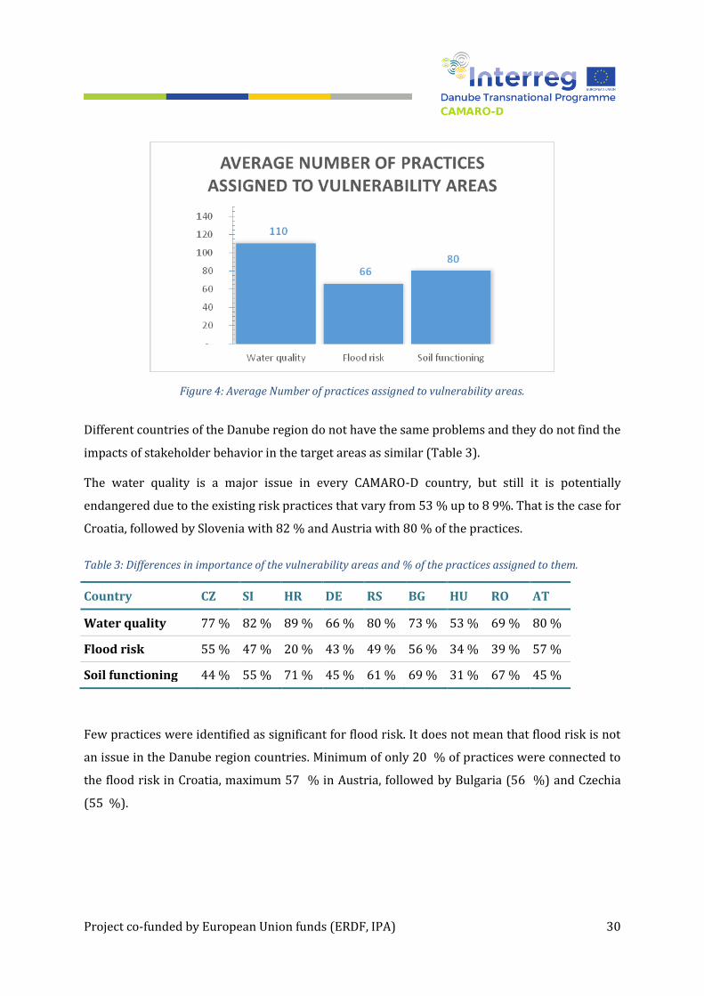
practices, flood risk is linked to 44 % and soil functioning to 54 % of the practices (Figure 4).
Project co-funded by European Union funds (ERDF, IPA) 30
Figure 4: Average Number of practices assigned to vulnerability areas.
Different countries of the Danube region do not have the same problems and they do not find the
impacts of stakeholder behavior in the target areas as similar (Table 3).
The water quality is a major issue in every CAMARO-D country, but still it is potentially
endangered due to the existing risk practices that vary from 53 % up to 8 9%. That is the case for
Croatia, followed by Slovenia with 82 % and Austria with 80 % of the practices.
Table 3: Differences in importance of the vulnerability areas and % of the practices assigned to them.
Country CZ SI HR DE RS BG HU RO AT
Water quality 77 % 82 % 89 % 66 % 80 % 73 % 53 % 69 % 80 %
Flood risk 55 % 47 % 20 % 43 % 49 % 56 % 34 % 39 % 57 %
Soil functioning 44 % 55 % 71 % 45 % 61 % 69 % 31 % 67 % 45 %
Few practices were identified as significant for flood risk. It does not mean that flood risk is not
an issue in the Danube region countries. Minimum of only 20 % of practices were connected to
the flood risk in Croatia, maximum 57 % in Austria, followed by Bulgaria (56 %) and Czechia
(55 %).

Project co-funded by European Union funds (ERDF, IPA) 31
By GAP analysis provided by individual project partners and consulted within each participating
CAMARO-D country, there were following main problems identified and emphasized within
Danube catchment.
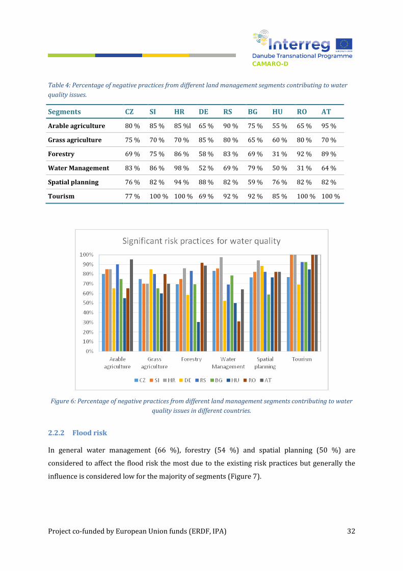
2.2.1 Water quality
In general, tourism (91 %) and spatial planning (80 %) are considered to affect the water quality
the most due to numerous risk practices in these segments, followed by arable agriculture with
77 % (Figure 5). The percentage presents an average sum of practices assigned to each segment
compared to the total sum of practices in the segment.
Figure 5: Overview of contributing % of practices from selected segments to water quality.
In detailed view, it can be seen that individual countries have different segments contributing to
the water quality issues and these discrepancies are influenced by local conditions. Generally,
the water management segment is not considered as too risky in several countries as it is the
case in tourism. The variabilities among countries are high and the averages (Figure 5) are often
not showing a proper picture. For example, arable agriculture in Austria, Serbia, Croatia and
Slovenia is affecting the water quality by 85 % – 95 % practices, while for Hungary, Romania and
Germany it is only 55 % – 65 % of practices (Table 4).
Project co-funded by European Union funds (ERDF, IPA) 32
Table 4: Percentage of negative practices from different land management segments contributing to water
quality issues.
Segments CZ SI HR DE RS BG HU RO AT
Arable agriculture 80 % 85 % 85 %l 65 % 90 % 75 % 55 % 65 % 95 %
Grass agriculture 75 % 70 % 70 % 85 % 80 % 65 % 60 % 80 % 70 %
Forestry 69 % 75 % 86 % 58 % 83 % 69 % 31 % 92 % 89 %
Water Management 83 % 86 % 98 % 52 % 69 % 79 % 50 % 31 % 64 %
Spatial planning 76 % 82 % 94 % 88 % 82 % 59 % 76 % 82 % 82 %
Tourism 77 % 100 % 100 % 69 % 92 % 92 % 85 % 100 % 100 %
Figure 6: Percentage of negative practices from different land management segments contributing to water
quality issues in different countries.
2.2.2 Flood risk
In general water management (66 %), forestry (54 %) and spatial planning (50 %) are
considered to affect the flood risk the most due to the existing risk practices but generally the
influence is considered low for the majority of segments (Figure 7).

Project co-funded by European Union funds (ERDF, IPA) 33
Figure 7: Overview of contributing % of practices from selected segments to flood risk.
Table 5: Percentage of negative practices from different land management segments contributing to flood
risk.
Segments CZ SI HR DE RS BG HU RO AT
Arable agriculture 40 % 5 % 5 % 30 % 5 % 10 % 10 % 5 % 10 %
Grass agriculture 40 % 5 % 0 % 15 % 0 % 10 % 5 % 15 % 35 %
Forestry 58 % 50 % 11 % 67 % 78 % 75 % 25 % 36 % 89 %
Water Management 74 % 88 % 48 % 48 % 71 % 74 % 71 % 55 % 69 %
Spatial planning 65 % 59 % 24 % 41 % 41 % 71 % 47 % 47 % 59 %
Tourism 23 % 23 % 8 % 23 % 46 % 69 % 8 % 69 % 31 %

Project co-funded by European Union funds (ERDF, IPA) 34
Figure 8: Percentage of negative practices from different land management segments contributing to flood
risk in different countries.
The countries’ variability in flood risk recognition as being affected in variable segments is
extreme, and much higher than for water quality and soil functioning (Figure 8). Especially in
agriculture, forestry and tourism, the differences among regions reach 80 %. It is mostly given
by differences in local conditions (morphology, climate, …). But also concerning of economic
situation and development level.
2.2.3 Soil functioning and landscape retention
In general grass agriculture (71 %), forestry (70 %) and arable agriculture (69 %) are
considered to affect the landscape retention and soil functioning the most due to numerous risk
practices (Figure 9). They are directly managing landscape and soil.
Predominantly, the soil functioning is considered as relatively endangered and the variability
between different segments and countries is lower – the opinion is more consistent. This is
especially the case for the majority of the contributing areas – forestry and agriculture. The most
variable sector here is the tourism that according to Austrian and Hungarian feedback is
negatively affecting the soil functioning by only 31 % (AU), resp. 23 % (HU), while in Slovenia,
Croatia and Bulgaria it is above 85 %.

Project co-funded by European Union funds (ERDF, IPA) 35
Figure 9: Overview of contributing % of practices from selected segments to soil functioning.
Figure 10: Percentage of negative practices from different land management segments contributing to soil
functioning in different countries.

Project co-funded by European Union funds (ERDF, IPA) 36
Table 6: Percentage of negative practices from different land management segments contributing to soil
functioning.
Segments CZ SI HR DE RS BG HU RO AT
Arable agriculture 55 % 40 % 85 % 60 % 100 % 80 % 60 % 90 % 55 %
Grass agriculture 60 % 65 % 85 % 70 % 85 % 80 % 40 % 90 % 65 %
Forestry 64 % 78 % 86 % 47 % 69 % 86 % 36 % 83 % 83 %
Water Management 12 % 36 % 43 % 31 % 29 % 48 % 17 % 36 % 10 %
Spatial planning 41 % 35 % 65 % 29 % 47 % 47 % 18 % 59 % 24 %
Tourism 54 % 92 % 85 % 46 % 62 % 85 % 23 % 62 % 31 %
2.2.4 Discussion
The above presented numbers and graphs are only indicative, as both of general and country-
specific practices were included. Therefore, proportional expression of importance of individual
measures and practices does not always be absolutely reliable.
Concluded from the above it is proposed to see the presented figures and numbers as
“potentials”. This way it can be simulated how the situation would look like if all of the risk
practices were identified by project members frequently used in all CAMARO-D countries and
have equal impact in various regions.
The example of potential misinterpretation can be seen on Figure 7. A wrong interpretation
would lead to the conclusion that the grasslands and arable lands are less contributing to the
flood risk and flood runoff than forest land. It is evident that often this is opposite. Correct
interpretation of Figure 7 is that in forestry higher number of identified practices contribute to
increased flood risk. But there is no information on frequency of these practices and on their
actual impact.
2.3 Frequency of individual negative practices
The numbers presented in the previous chapter were based on the significance added to the 148
practices, but to see the relevance of the land management issues, we have to look how often the

Project co-funded by European Union funds (ERDF, IPA) 37
practices are occurring in different Danube regions, and which ones are most affecting the
vulnerability areas.
For that reason, each of the 148 identified harmful practices was classified for every country by
its occurrence as follows:
L (Low) – rare frequency of use
N (Normal) – occasional use, under suitable conditions
H (High) – frequent use, typical management strategy
2.3.1 General overview of frequency of use of risky practices
By occurrence the practices were then sorted – again in total but also in every land management
segment of activities. In the following text, the mostly occurring practices will be emphasized (as
having the highest impact on land management under current conditions). But all the other
issues should not be omitted or considered as irrelevant. They can still occur and cause
environmental problems under specific conditions or in particular regions.
Figure 11: Average proportion of frequencies of use of practices in Danube region.
From the total number of 148 identified practices in Danube region, on average 24 practices (16
%) occur frequently, 59 practices (40 %) occur normally and 65 practices (44 %) rarely (Figure
11).

Project co-funded by European Union funds (ERDF, IPA) 38
In different countries, the frequencies of use are variable due to national, economical, legislative
and environmental specifics (Figure 12).
Figure 12: Average frequencies of practices (%) in CAMARO-D countries
The countries with many problematic practices frequently implemented are Croatia, Bulgaria,
Czechia and Serbia. The countries with low frequency of risky practices are Germany, Austria,
Slovenia and Bulgaria (Table 7).
Table 7: Average frequencies of practices (%) in CAMARO-D countries.
Country CZ SI HR DE RS BG HU RO AT
High frequency 20,3 % 12,2 % 31,8 % 5,4 % 19,6 % 21,6 % 4,7 % 14,9 % 15,5 %
Normal frequency 50,7 % 36,5 % 52,0 % 28,4 % 40,5 % 28,4 % 55,4 % 45,3 % 24,3 %
Low frequency 29,1 % 51,4 % 16,2 % 66,2 % 39,9 % 50,0 % 39,9 % 39,9 % 60,1 %
2.3.2 Frequencies of use of practices in land management segments
In more detail it is visible that individual countries have different segments with different
frequencies of use. These will be only listed in graph (Figure 13) and table (Table 8) without
further comments and we will focus on selecting particular most frequently implemented
practices in the next chapter.

Project co-funded by European Union funds (ERDF, IPA) 39
Table 8: Percent of practice frequencies in different segments for CAMARO-D countries.
Country CZ SI HR DE RS BG HU RO AT
Arable agriculture
H 20 % 25 % 30 % 10 % 25 % 25 % 15 % 10 % 10 %
N 55 % 35 % 65 % 40 % 45 % 30 % 45 % 40 % 35 %
L 25 % 40 % 5 % 50 % 30 % 55 % 40 % 50 % 60 %
Grass agriculture
H 0 % 10 % 15 % 0 % 20 % 10 % 0 % 0 % 20 %
N 75 % 30 % 35 % 10 % 25 % 30 % 30 % 45 % 30 %
L 25 % 60 % 50 % 90 % 55 % 60 % 70 % 55 % 60 %
Forestry
H 36 % 11 % 11 % 6 % 17 % 19 % 3 % 8 % 42 %
N 36 % 17 % 72 % 42 % 39 % 28 % 50 % 47 % 11 %
L 28 % 72 % 17 % 53 % 44 % 50 % 47 % 44 % 44 %
Water Management
H 24 % 10 % 45 % 7 % 17 % 29 % 7 % 21 % 0 %
N 57 % 48 % 52 % 21 % 45 % 29 % 76 % 38 % 33 %
L 19 % 43 % 2 % 71 % 38 % 40 % 17 % 40 % 64 %
Spatial planning
H 18 % 18 % 71 % 6 % 29 % 29 % 0 % 29 % 6 %
N 47 % 71 % 29 % 24 % 59 % 29 % 76 % 53 % 24 %
L 35 % 12 % 0 % 71 % 12 % 41 % 24 % 18 % 65 %
Tourism
H 0 % 0 % 23 % 0 % 15 % 8 % 0 % 23 % 8 %
N 31 % 23 % 31 % 31 % 23 % 23 % 31 % 62 % 8 %
L 69 % 77 % 46 % 69 % 62 % 69 % 69 % 15 % 85 %

Project co-funded by European Union funds (ERDF, IPA) 40
Figure 13: Average number of practices with different frequencies in land management segments.
2.3.3 Most frequently implemented practices
To identify most frequently implemented practices an index of frequency of use was proposed.
A summary of the frequency of use for every CAMARO-D country separately in the categories N
and H is presented. Category “L” (rare use) was omitted in searching for frequently implemented
practices. The frequency index for each practice is then computed as:
IF = (100 × H + 20 × N) / 9
IF index of frequency
H sum of occurrences in high frequency category for 9 CAMARO-D countries
N sum of occurrences in normal frequency category for 9 CAMARO-D countries
The index of frequency amounts to the sum of 100 % application of high frequently
implemented practices (as typical practice for the region and land management category) and
20 % potential application of normally implemented practices (defined as implemented only
under suitable conditions). Division by 9 is normalization of the index for nine CAMARO-D
participant countries.
Project co-funded by European Union funds (ERDF, IPA) 41
The index of frequency can reach maximum of 100 if every country would mark the identified
practice as highly frequent. For every country marking the practice as “rare” the index would
reach zero (0).
Index of frequency is presented for every practice in the full list of the practices shown from the
most frequent to the least frequent in the Danube countries.
Eight practices are implemented with high frequency in 5 or 4 Danube countries having the
index of frequency above 50. Four of them are connected to the forest management. These
mostly implemented practices have impact on all three vulnerability areas, mostly on water
quality and soil functioning. These frequently implemented practices are:
Practice of keeping cattle indoors in longer period and decreased number of grazing
animals in total;
Direct urban drainage into water courses;
No sewage systems due dispersed settlements;
Monoculture forests, no natural regeneration;
Not stabilized forest roads;
Forest roads without proper drainage;
Inadequate timber harvest techniques;
Incomplete wastewater treatment plants.
Twenty practices are implemented with high frequency in three countries – these cover all five
land management segments. The details on frequency of use for each of the 148 practices in
every CAMARO-D country are listed from the most implemented ones.
2.3.4 Most frequently implemented practices in land management segments
To identify most frequently applied practices an index of frequency of use was utilized. The
practices were then listed from the most to less often used not only as a whole list but also for
the five land management segments separately. The results for all risk practices in every
segment listed from most frequent in CAMARO-D region are presented in chapter 2.4.
From the tables in the chapter 2.4 it can be identified which are the most frequently used and
therefore most significant negative practices over the whole Danube region in each individual
segment (Table 9).

Project co-funded by European Union funds (ERDF, IPA) 42

Project co-funded by European Union funds (ERDF, IPA) 43
Table 9: Most frequent risk practices in land management segments in Danube countries
Segment No. Description Frequently used
Arable
agriculture
3 Intensive plant production, regardless of soil and water
conservation
SI HR HU
4 Heavy machinery intensive use (soil compaction) CZ DE AT
18 Lack of inspection and control of
manure/fertilizer/pesticide application
SI RS BG
Grass
agriculture
22 Practice of keeping cattle indoors in longer period and
decreased number of grazing animals in total
SI HR RS BG AT
23 Drainage of water contaminated from inadequate storage
or application of manure on arable land
HR AT
28 Management of protected areas; subjects of protection RS BG
Forestry
74 Monoculture forests, no natural regeneration CZ DE HU AT
53 Not stabilized forest roads CZ SI RS RO
69 Forest roads without proper drainage CZ RS BG RO
Water
management
96 Incomplete wastewater treatment plants SI HR RS BG
94 Intensive agricultural use of floodplains CZ SI HR
98 Rain water is centrally drained – common rain and
sewerage drainage
CZ BG RO
Spatial
planning
121 Direct urban drainage into water courses CZ SI HR RS BG
131 No sewage systems due dispersed settlements SI HR RS BG RO
120 Development of areas with a high share of sealed
(impermeable) surfaces (e.g. commercial areas with
large parking lots)
CZ HR RO
Tourism
142 Intensive mountain tourism and related infrastructure HR AT
143 Intensive lowland tourism and related infrastructure HR
140 Huts without sewage systems BG RO

Project co-funded by European Union funds (ERDF, IPA) 44
2.4 Frequency of negative practices for land management segments
Every practice is listed in the tables - from the most frequent to the least frequent in Danube
countries – separated for each land management segment. Individual tables can be seen in the
Annex 1 to Annex 6.
2.5 Summary of problems and negative practices
Chapter 2 tried to identify most negative practices, used within entire Danube catchment. Two
directions were used:
Review of available official materials, identifying key environmental problems of target
area
Specific check-list, where GAP analysis has been performed and negative practices were
listed by national experts from CAMARO-D countries, assessed by frequency and
importance of their use.
Performed analysis helped to define real gaps in landscape management. Additional efforts must
be done to optimize it and reach significant improvement in water quality, retention capacity
and soil functioning. These results built the basis for formulation of BMP catalogue for four main
segments:
Agriculture – arable land
Agriculture – grassland
Forestry
Spatial planning
Generally, it can be said, that problems with landscape functioning and water quantity and
quality issues are visible throughout Danube region in all available documents and related
analyses. In recent 2 decades the situation got much better in many regions, but other issues
remain unsolved.
Built-up areas and residential areas are getting better with water management even though
wastewaters not treated enough, and rain waters are not retained and purposely infiltrated.
Important remains the agriculture land as a huge area with potentially retention capacity for
rainwater on the other hand with many degraded functions. It affects many processes connected

Project co-funded by European Union funds (ERDF, IPA) 45
to water cycle and finally the Danube itself. Non-point sources of pollution are more and more
dominating as industrial and municipality sources are being solved. For nitrates the drainage
systems and used fertilizers form a big source of risk. For total phosphorus transports and
related eutrophication erosion and sediment transports are main sources in total amounts. Also
transported sediment is not directly taken into account in WFD water status criteria that means
the problem is underestimated in implementation of River basin management plans.
Area of forests is high in Danube region and from spatial point of view it is more or less
stabilized. Neither significant deforestation nor afforestation can be expected. But the forests
quality is driven by economic utilization while other functions were underestimated for many
decades. Enhancing diversity of tree species, forest structure, complete forest environments (e.g.
forest roads associated risks) are again main challenges for future of Danube basin region. The
differences between countries are high in these segments, since there are both alpine and low
land regions presented. Also, countries with longer history of environmental forest management
have different approaches.
Spatial planning and planning in urbanized regions is very important for quality of life in every
CAMARO-D country. It affects the surface water quality. However, concerning rainfall runoff
relations, risks associated with drought and floods, and availability of water in small streams,
here the majority of tools have to be implemented in degraded agricultural landscapes.
Managing the landscape properly we will enhance the soil functioning and get closer to good
status of water bodies and Danube. Nevertheless, we have to respect national specifics and
differences that showed-up also in all analyses (GAP, BMP, SWOT) performed within WP T1 of
CAMARO-D.
Concerning negative practices with impact on water quality, rainfall-runoff relations affecting
flood risk and soil functioning, following conclusions can be formulated:
In arable agriculture the most frequent negative practices are:
Intensive plant production, regardless of soil and water conservation and regardless of
suitability of the regions for the type of production.

Project co-funded by European Union funds (ERDF, IPA) 46
Heavy machinery intensive use (soil compaction) – the effect could be reduced by
precision agriculture implementation with proper designs of land management and use of
no-till and reduced tillage techniques.
Lack of inspection and control of manure/fertilizer/pesticide application and therefore
massive application of pesticides
Subsidy driven production – technical crops (including erosion accelerating crops such as
maize).
On grasslands the most frequent negative practices are:
Practice of keeping cattle indoors in longer period and decreased number of grazing
animals in total
Lack of inspection and control of manure/fertilizer application and bad status of storage
facilities for livestock manure, therefore drainage of contaminated water.
Management of protected areas; selection of subjects of protection and connected issues
Burning of stubble after harvesting, especially in southern countries of Danube region.
In forestry the most frequent negative practices are:
Monoculture forests, allowing no natural regeneration and generally areas missing tree
species diversity
Not stabilized forest roads and forest roads without proper drainage
Timber harvest techniques generally, especially inadequate techniques, like tractor-
skidding
In water management the most frequent negative practices are:
Incomplete and missing wastewater treatment plants. WFD helped the situation here a lot
but still many municipalities are not connected to treatment plants, and if so, the 3rd
treatment (for phosphorus) is often not implemented in current systems.
Intensive agricultural use of floodplains, and intensive building and infrastructural land
use in floodplains (urbanization).
Uncleaning of river sections and gullies from vegetation and waste (agricultural residues,
dead trees, branches,)
Direct diverting of rain-water into streams and rivers
In spatial planning the most frequent negative practices are:

Project co-funded by European Union funds (ERDF, IPA) 47
Direct urban drainage into water courses and no sewage systems due dispersed
settlements – these are overlapping the most mentioned problems within water
management
Development of areas with a high share of sealed (impermeable) surfaces (e.g. commercial
areas with large parking lots) and also satellite settlements, and connected inflow of
rainwater from sealed areas and roofs to sewage systems
Creation of waste-depots out of regulations.
Finally, negative practices in tourism are not as frequent as in other segments – since there is
high variability of touristic spots in CAMARO-D countries. In some these are alpine regions in
others these are low-lands, lakes, etc. The problems are:
Intensive mountain tourism and related infrastructure (e.g. huts without sewage systems;
camp sites located near protected areas or areas with valuable nature resources are often
without proper sewage and drainage system)
Intensive lowland tourism and related infrastructure
Traffic infrastructure (roads, parking lots etc.) especially those located in protected areas
which are under great visitor’s pressure are often without adequate drainage and
treatment system.

Project co-funded by European Union funds (ERDF, IPA) 48
3 Current legislation and policy framework
Legislation basically provides frame for all activities within the landscape, catchments and
communities. It is very important from point of view of understanding of occurrence of negative
practices applied within individual countries, behavior of stakeholders and applicability of any
proposed control and compensation measures.
Therefore, relatively extensive survey was provided within CAMARO-D countries through
project partners, to review their national and international legislation frame. To work out
applicable, uniform standardized material, common structure has been proposed for all
CAMARO-D countries, to compare their legislation framework and requirements and EU
standards and regulations implementation.
Following two chapters 3.1 and chapter 3.2 summarizes information gathered for all CAMARO-D
countries, while chapter 3.3 concludes opinions of individual stakeholders, collected during
stakeholder´s workshops and using online questionnaires. The questions were focused on
opinion of individual stakeholders from various segments on gaps in national and EU
regulations, requirements in the field of water management, landscape management, soil
conservation, agriculture, forestry and spatial planning, linked to topics of CAMARO-D project.
Detailed description of legislation and policy conditions in individual countries can be found in
separate material D.T 1.1.4 – transnational synthesis status quo report on Danube basin level,
worked in September 2017 by CAMARO-D team.
3.1 Common EU legislation and strategies
There are high number of EU common strategies linked to environment, water management,
landscape, spatial planning, forestry and soil conservation. The most important directives and
regulations were selected to demonstrate how those documents and requirements are fulfilled
and used in practical landscape management within Danube countries:
Further directives were selected:
1. Cross Compliance principles (GAEC)
2. EU Water Framework Directive
3. EU Soil Framework Strategy /Directive (repealed)
4. EU Floods Directive
Project co-funded by European Union funds (ERDF, IPA) 49
5. EU Drinking Water Directive
6. EU Groundwater Directive
7. Environment Action programme to 2020
8. Natura 2000 and Ramsar convention
9. Forest Europe (ex MCPFE) and EU Forest Strategy
10. Nitrates Directive
The only CAMARO-D country, which is not EU member yet is Serbia. However, Serbia directs to
full harmonization of its national legislation with EU requirements. Therefore, several EU
strategies have already been implemented and all rest of listed tools/strategies has been
planned to be implemented until end of 2018.
Generally, it becomes clear, that EU based directives, policies and standards cannot respect
national specifics, therefore they only can set general rules and requirements. They are either
too soft (GAEC) to resolve the problem on general level, or too ambitious (WFD) to be
realistically fulfilled by all member countries.
3.1.1 Cross Compliance principles (GAEC – Good Agricultural and Environmental
Conditions)
The system of basic requirements to the farmers, to apply on their agricultural land to keep it in
good conditions. It is applied in a number of ways by different countries, but it is always linked
with conditioning of state subsidy system at agricultural land, defining several categories and
activities, which has to be fulfilled by land-users. Individual states develop their own standards
(Austria – OPUL; Czechia – DZES, ….). Serbia did not join yet this requirement, but it is intended
to introduce it in later stage.
3.1.2 EU Water Framework Directive
WFD (2000/60/ES) - probably the most important widely implemented environmental EU
standard related to water and landscape management. The WFD has been implemented within
all CAMARO-D countries – as required by its status. All the countries produced their “National
Water Management Plans” and all the countries follow requirements in reaching good status of
water courses. However many parameters have still to be reached and in some instances it is not
realistic to achieve the desired state. Parameters of water quality are easier to be reached due to

Project co-funded by European Union funds (ERDF, IPA) 50
requirement to wastewater treatment plant construction. Also monitoring significantly
increased during last decade and corresponds to WFD requirements. However especially
requirement to improve hydro-morphological conditions are difficult to introduce into practice.
3.1.3 EU Soil Framework Strategy /Directive (actually repealed)
Rather general Directive (2004/35/ES) sets up basic requirements for soil features
conservation. As the implementation within individual EU member states was not really
harmonized, individual states interpret its general statements into national legislations their
individual way.
3.1.4 EU Floods Directive
EU Flood directive (2007/60/ES) is closely linked to WFD. Basic requirements of the EU Floods
directive were reached within CAMARO-D countries by “Plans for Flood Management”, which
were worked out for main basins. Most of the measures, focused on landscape retention,
floodplain management, retention areas preservation were coordinated with WFD requirements
and plans. In most of the countries great effort is now focused on development of conception of
systems “Nature-close Flood Control measures”, which accent water retention within the
catchments and flood wave transformation within floodplains and polders.
3.1.5 EU Drinking Water Directive
EU Drinking Water Directive (98/83/ES) focuses on drinking water quality and availability
within each country. It is again rather general directive, which sets up basic requirements on
drinking water availability and quality. Most of the countries (except of Serbia which only
reaches 50 % of drinking water with required quality) fulfill defined standards of water quality
in chemical and biological parameters.
3.1.6 EU Groundwater Directive
EU Groundwater directive (2006/118/ES) deals with ground water conservation and it is
closely linked to WFD. There are also defined Water Bodies (Ground Water Bodies), which are
basic elements of conservation and where good status shall be reached. It is in many countries
also closely linked with Nitrate directive (91/676/EEC). The Groundwater directive is rather
general and most of CAMARO-D countries fulfill its requirements.

Project co-funded by European Union funds (ERDF, IPA) 51
3.1.7 Environment Action Programme to 2020
7th Environmental Action Programme of EU is aiming stop the decrease of biodiversity. The
action program is a general document, focused on overall development of EU society
harmonized with environment and coexistence with nature and natural resources.
This document shall be projected into a wide number of individual specific regulations and
strategies more or less in all fields of human being.
3.1.8 Natura 2000 and Ramsar convention
Natura 2000 is a system of protected areas, declared over whole EU to conserve special habitats,
based on uniform coordinated Landscape Mapping. Within Czechia there are so called SPA
(Special Protection Area = Birds Area = Area with special interest in protection of birds) and SCI
(Site of Community Importance = EVL – European Important Locality).
Ramsar convention on Wetlands (signed 2.2.1971) deals with sustainable and effective
exploitation of wetlands. The basis of the convention is list of internationally significant
wetlands.
All CAMARO-D countries respect requirements of Natura 2000 and Ramsar convention and
protect part of their landscape.
3.1.9 Forest Europe (ex MCPFE) and EU Forest Strategy
Forest Europe (formerly: Ministerial Conference on the Protection of Forests in Europe, MCPFE)
is a pan-European forest policy process at ministerial level (of 47 Member States), conducted
every 3 to 5 years (since 1990), to develop guidelines, criteria and indicators for the protection
and sustainable management of forests. 2007 the topic “Forests and Water” was discussed in
Warsaw and a resolution was passed. It represents one of the most effective forest policy
mechanisms at international level.
The EU Forest Strategy shall supplement national forest policies of the individual member states
to increase forests ´mitigation potential and adaptive capacity to climate change. In addition the
forest cover should be protected to ensure soil protection, water quality and quantity regulation
by integrating sustainable forestry practices in the programme of measures of River Basin
Management Plans and in the Rural Development Programmes.

Project co-funded by European Union funds (ERDF, IPA) 52
Both documents are rather general, but all CAMARO countries join these actions and implement
their national action plans.
3.1.10 Nitrate Directive
One of basic and most often implemented general standards to protect mainly groundwater
quality in agricultural landscape. The Nitrate Directive´s (91/676/EEC) goal is to identify
important and vulnerable areas of ground water recharge and to limit application of agricultural
fertilizers on agricultural land, to control water quality.
There are specific implementation plans at national levels (link to Cross compliance, to WFD
requirements, ….) at individual CAMARO-D countries.
Nevertheless there is some level of implementation performed at all CAMARO countries.
3.2 Nation specific legislation and policy
3.2.1 Basic governance of landscape and water resources
3.2.1.1 Water management
Water management is driven within all Danube countries by ministries of various specifications.
In most of the countries there is Ministry of Water Management, often connected to some or
several of segments of Environment, Agriculture and Forestry. The exception is Hungary, where
water management is driven by Ministry of National Development.
3.2.1.2 Spatial planning
Spatial planning is relatively specific field of expertise. In some countries (Austria, Hungary) this
segment is not driven on ministry level and is split into levels of state and municipalities, or is
driven directly by government. In other countries it is managed by resorts of Ministries of Local
or Regional Development (Czechia, Bulgaria, Romania,…), Ministry of Constructions (Croatia,
Serbia), Ministry of Transport and Digital Infrastructure (Germany), Ministry of Environment
and Spatial Planning(Slovenia)
3.2.1.3 Soil conservation
Soil conservation is provided by Ministries of Agriculture within most of CAMARO-D countries.
In some cases, this care is shared with Ministry of Environment (Czechia, Croatia)

Project co-funded by European Union funds (ERDF, IPA) 53
3.2.1.4 Forestry
Forestry is driven in all CAMARO-D countries by Ministries of Agriculture, Environment and
Forestry.
3.2.2 National specific legislation
Each of CAMARO-D countries has a number of nation specific programs focused on specific
target areas of expertise. Generally, nation specific programs
either emphasize selected segments of national policy and underline country specific
priorities, which cannot be covered by general EU policies and directives
or more in details specify requirements of EU policies and directives, define more strict
conditions, or bring general statement of EU directives into practical implementation.
Typical example can be for instance
Agro-ecological subsidy programs, or implementation of land consolidation plans into
landscape management (Czechia)
Regional programs of Federal states in water management in Austria
Strategic plans of development of forest sector in Bulgaria
Program of Sustainable agriculture in Germany
National Afforestation program in Hungary
National Environmental Protection Program in Serbia
All listed programs (and many more – see full document Status Quo WP T1.1.4) and documents
focus on selected segment, usually link to certain EU document and specify certain requirements
in given field.
3.2.3 Restrictive tools
Restrictive tools are used on national levels, to force land-users (stakeholders) to fulfill state
requirements by restrictions. Stakeholders are (usually economically) controlled in case of
infraction of given standards, requirements or regulations. Restrictions can be either on EU level
or on national level. EU restrictions usually are applied against state itself, as there usually is not
direct link between EU and individual stakeholder. Therefore, punishment comes to individual
stakeholder mostly from state.

Project co-funded by European Union funds (ERDF, IPA) 54
The principle of restrictive policy is setting certain limits (in application of fertilizers, in
wastewater treatment, in methods of timber harvesting, keeping of minimum discharges, ….).
Condition of punishment is then activated by excess of given limits.
Typical example is Nitrate Action Program, controlling nitrates application in agriculture in
Austria, Water Resources Conservation Program in Croatia, which defines acceptable land use
practices within water resources conservation zones. For detailed description, see full document
Status Quo WP T1.1.4.
3.2.4 Motivating strategies
Motivating strategies work the opposite way than restrictive ones. By positive (usually financial)
motivation of stakeholders, state (or EU) drives behavior of entities the way, which is desired
from point of view of fulfilling of state (EU) requirements. This method is more democratic
(subjects are not strictly limited in their activities), but on the other hand there is no guarantee
that all subjects will follow the proper way. Therefore, positive motivation is not (and shall not
be) used for fulfilling some fixed limits, but better for improvement of situation.
For implementation of positive motivation, proposed system shall be contemplated carefully and
well managed (unfortunately in practice this is the biggest weakness), to avoid negative
synergies or opposite effects of motivation.
A typical example for such positive motivation can be agro-environmental programs in Czechia,
which motivates farmers to run their farms more ecologically (limited fertilization and
implementation of chemicals, limited and proper density of grazing, good practices of soil
management to increase organic carbon content). However inconsistencies exist since similar
positive motivation support is offered farmers to produce energy crops (in Czechia supplied by
Ministries of Industry and Regional Development). Result is enormous increase of maize
production at arable land (even in unsuitable conditions), which has very negative effects on soil
and water conservation.
Detailed information about specific motivating strategies within individual CAMARO-D countries
can be reviewed in detail in the Status Quo document WP T1.1.4.

Project co-funded by European Union funds (ERDF, IPA) 55
3.3 Stakeholders view
Extensive qualitative and quantitative surveys were carried out in nine countries that
participate in the CAMARO-D project. The selected countries cover over 82 % of the Danube
River Basin area, therefore representing an overall conditions of the Basin. (See more detailed in
Output T1.1, which is related to stakeholder’s workshops)
The results are based on interviews, workshops paper and online questionnaires which were
distributed among the selected stakeholders. Interactive discussion during the workshops that
was aimed at defining the major challenges and creating new management goals supplemented
this survey. A wide spectrum of respondents with various professions, interests, motivations
and nationalities was addressed. Thematically, highest number of the responses comes from the
surface water quality sector (58 %). Out of all the replies, 46 % come from the state agencies
(typically administration, municipalities, state water management companies, forestry and
environmental protection agencies, ministries), 40 % from private companies and NGOs
engaged with water management (planning, water treatment, etc.) and agriculture (farmers), 14
% from research institutes and universities. The responding stakeholders are evenly distributed
in terms of their spatial extend: 35 % are active on international and national level; 37 % on
regional level; 28 % on local level. The respondents of the survey cover all of the environmental
topics that we investigate within the CAMARO-D project. Most of the stakeholders work with
water quality and quantity related issues (26 % surface water management, 16 % groundwater
management), 20 % are active in agriculture, 19 % in forestry, 9 % in the landscape spatial
planning, 6 % with soil conservation and 4 % with other environmental problems.

Project co-funded by European Union funds (ERDF, IPA) 56
Figure 14: Characterization of the respondents. (a) type of enterprise, (b) spatial extent, (c) main area of
interest, (d) company size
3.3.1 Key problems identified by stakeholders
The following overall conclusions on the problems and weaknesses in current environmental
management in the Danube basin can be drawn:
Stakeholders are aware of the insufficient monitoring and data to quantify the
environmental impacts of their activities.
Qualified human resources are limited. In most cases the current employees are fully
occupied with their daily obligations.

Project co-funded by European Union funds (ERDF, IPA) 57
Companies are financially secured but cannot afford to invest more resources than they
invest at the moment.
Many respondents feel that they need to improve the dissemination of their positive
environmental actions among the general public. Most of the positive actions are not
properly communicated. Most of the stakeholders miss public relation know-how.
Several countries of middle and lower Danube mention lack of involvement in EU and
transboundary environmental projects.
The most important barrier of the organization development towards better
environmental conservation is increased administration.
3.3.2 Positive prospects as viewed by stakeholders
Private companies, public sector and research institutes in all countries have qualified,
competent and well-informed employees. Stakeholders operate with up to date
comprehensive knowledge on the general environmental issues, they have good
information about the current state of the environment in the region (especially
governmental agencies, research institutes and universities). The employees have good
education and experience and are further confronted with new information and data
about the state of the environment.
Most private and state organizations have adequate technical equipment. Companies
already utilize modern technology and equipment to minimize the negative environmental
impact of their activities
Stakeholders feel motivated to adjust or modify their current activities to mitigate
negative environmental impacts.
In all countries the respondents would welcome clear standards, guidelines, plans or
policy providing comprehensible rules for everybody. Policies from local scale to regional,
national up to European Union scales are mentioned.
Companies consider that EU projects, funds or subsidies would help them to increase their
environmental contribution. Stakeholders in the Upper Danube countries prefer local or
regional support projects.
Respondents are willing to closely cooperate with the stakeholders from the neighboring
countries and whole Danube catchment. This opportunity is not fully utilized yet and can
be quite easily initiated.

Project co-funded by European Union funds (ERDF, IPA) 58
4 Typical BMP (Best Management Practices) and control
measures
One of the first important activities of CAMARO-D project was to identify Best Management
Practices (BMPs) already applied, or suitable for application in Danube River Basin. Initially all
project partners participated in identification of existing BMP and their frequency of use. The
information was collected at national level, concerning BMPs for drinking water protection and
flood prevention, to control water pollution (and generally water regime of the landscape) from
non-point pollution sources from agriculture, forestry and grassland management and the
corresponding spatial planning measures in CAMARO-D countries.
Twelve areas of BMP implementation were mapped (Table 16). Altogether 202 Best
Management Practices were identified within 12 segments of land management. The numbers
within the segments (Table 16) and relative share of total 202 BMPs are presented in Figure 15.
Table 16: Numbers of identified BMPs in activity segments.
BMP activity segments Number of BMPs within segment
A - Arable Agriculture (cropping systems) 36
B - Grass Agriculture (all permanent cultures) 20
C – Forestry 43
D - Water Management 24
E - Spatial Planning 8
F – Technical Measures (TM) in Agriculture 12
G - Technical Measures (TM) in Forestry 5
H - Technical Measures (TM) in Water Management 10
I - Technical Measures (TM) in Spatial Planning 18
J - Land Consolidation Projects (strategies) 7
K – Surface Water (SW) Protection Zones 10
L – Ground Water (GW) Protection Zones 9

Project co-funded by European Union funds (ERDF, IPA) 59
Figure 15: Number of BMPs identified within land management segments.
Each of the 202 identified Best Management Practices was classified by each of the participating
countries based on occurrence as follows::
L (Low) – rare frequency of use
N (Normal) – occasional use, under suitable conditions
H (High) – frequent use, typical management strategy or measure
From the total number of 202 identified BMPs in Danube region, on average 45 practices (23 %)
occur frequently. 87 practices (42 %) on average occur normally and 66 practices (34 %) occur
rarely. In different countries, the frequencies of use are variable due to national, economical,
legislative, and environmental specifics (Figure 16).

Project co-funded by European Union funds (ERDF, IPA) 60
Figure 16: Average frequencies of practices (%) in CAMARO-D countries
Of course, many BMP were identified as not relevant in various Danube regions. Many of them
were excluded as not effective, in other cases their implementation was considered as too
complicated.
As proposed by CAMARO-D work plan, for four segments of land management expert teams
were nominated by CAMARO-D Steering Committee. These expert groups selected the most
relevant BMPs for each land management. Altogether 46 practices were defined and described
in 4 BMPs catalogues for Danube region (ranging from 6 to 16 of BMP per segment). These BMPs
were selected not as the most used current practices, but as favourable BMPs for wider use and
for potential implementation within an innovative transnational catchment-based “Land Use
Development Plan” for the Danube River Basin.
In the final list of practices wide variety of approaches are combined: From single technical
measures (ditch) up to the general management plan (coordination of flood risk management at
catchment scale). Therefore, the implementation of the listed BMP can vary in complexity.
Current use, policy support, and frequency of application of these BMPs are approximated for
every CAMARO-D country.
The list will never be complete, but the list tries to collect the most effective and most often
implemented practices to share knowledge and experiences within Danube countries. Hopefully
our target group consists of decision makers, land managers, stakeholders, and local authorities
interested in Danube region landscape improvement.

Project co-funded by European Union funds (ERDF, IPA) 61
4.1 Arable Agriculture
The list of most relevant BMP identified in arable agriculture:
4.1.1 Conservation tillage
4.1.2 Strip tillage
4.1.3 No tillage
4.1.4 Grass buffer strips along water courses
4.1.5 Mulching
4.1.6 Fertilization with manure and compost
4.1.7 Conservation crop rotation
4.1.8 Precision agriculture
4.1.9 Control of Nutrients application
4.1.10 Control of pesticides application
4.1.11 Retention ditches
4.1.12 Grassed waterways
4.1.13 Sediment traps
4.1.14 Hedges
4.1.15 Infiltrating pools
4.1.16 Stabilized dung pits with retention tank
Table 17: Support of BMP by national policies and their application in every country.
AT BG HR CZ D HU RO RS SLO AT BG HR CZ D HU RO RS SLO
4.1.01 x x x x x x x x xx xx x xxx xx xx xx x x
4.1.02 x x x x x x x x xx x x x x x x x
4.1.03 x x x x x x x xx x x x x x xx x x
4.1.04 x x x x x x x x x xxx xx xx xx xx xxx xx xxx
4.1.05 x x x x x x x x xx xx xx xxx x xx xx xx xxx
4.1.06 x x x x x x x xxx xx xx xx xxx x x xx xxx
4.1.07 x x x x x x x x xx xxx xx x xx x x xx xxx
4.1.08 x x x x x x x x x x x xx x x x x
4.1.09 x x x x x x x xx xx xx xx x xxx x x xx
4.1.10 x x x x x x x xx xx xx x xx xxx xx x x
4.1.11 x x x x x x x x xx x xxx x xx x x x x
4.1.12 x x x x x x x x x x xx xx
4.1.13 x x x x xx
4.1.14 x x x x x x x xx xx xx xx xx xx xx x x
4.1.15 x x x x x xx x x x x
4.1.16 x x x x x xx xxx x x x
BMPRequired or supported by country specific policy Application frequency (low - x, normal - xx, high - xxx)
Project co-funded by European Union funds (ERDF, IPA) 62
4.1.1 Conservation tillage
Conservation tillage is an agricultural practice applied on arable land. Basic principle consists in
replacement of conventional tillage based on regular plough (turning of top soil layer of ca 15 –
30 cm) by soil surface loosening by cultivator. Top soil layer of ca 5 - 10 cm is loosened by
various technologies but is not turned upside down.
Positive effects include mainly following: soil is only disturbed by cultivator, but not turned by
plough. It allows to soil organisms continuous activity, not interrupted by ploughing and
following period. Soil structure is not that much affected by mechanical processing of soil. This
technology allows to leave mulch (crop residues) within topsoil, what provides good protection
against soil erosion. Finally yet importantly – the operation is less energy and time demanding
than conventional tillage, based on ploughing.
The movement of machinery is easier (less energy needed) and faster than conventional
ploughing. The measure (technology) enhances soil properties – mainly soil structure, organic
carbon content, hydraulic conductivity and provides good soil protection.
4.1.2 Strip tillage
Strip-tillage is defined as less than full-width tillage of varying intensity that is conducted
parallel to the row direction. Generally, no more than one-fourth of the plow layer is disturbed
by this practice. The goal of strip-tillage is to create a seedbed condition in the row that is similar
to that achieved by moldboard plowing, while leaving a relatively high amount of crop residue
on the inter-row soil surface to reduce erosion.
The main advantages include soil processing by deep loosening in a strip up to the depth of 35
cm with the option to apply fertilizer into the root zone. Plant residues are placed in the inter-
row which not only eliminates erosion processes, but also unproductive evaporating.
Strip-tillage, which creates a soil environment that enhances seed germination, is an alternative
to no-till in areas where poorly drained soils are dominant. Where soil moisture conditions are
suitable, strip-tillage — traditionally in the fall — creates narrow-width tilled strips to increase
early spring soil evaporation and soil temperature in the top 5 cm.

Project co-funded by European Union funds (ERDF, IPA) 63
4.1.3 No tillage
In agricultural crop production one term – no-till – is leading to increased polemic and
polarization of the parties. No-till or no-tillage describes a form of cropping which does not use
any mechanical tillage of the soil for crop establishment. The aim is to move as little soil as
possible in order not to bring weed seeds to the surface and not stimulating them to germinate.
No other soil tillage operation is done. The residues from the previous crops will remain largely
undisturbed at the soil surface as mulch.
In no till farming, the soil is more resistant to erosion caused by wind and water. Ground that is
not tilled is less compacted than soil that is tilled. Tillage busts up the natural soil structure. Loss
of structure makes the soil less able to support heavy loads, such as the wheel traffic from tillage
operations. Fewer passes across the field in no till farming will dramatically reduce fuel costs. No
till seeding leaves plant residues on the ground, which can help keep the soil moist and protect
against evaporation caused by sun and wind. The measure is suitable for any types of field, soil
and crop, when respecting specific conditions of complex agricultural approach.
4.1.4 Grass buffer strips along water courses
Buffers and filter strips are areas of permanent vegetation located within and between
agricultural fields and the water courses to which they drain to interrupt sediment fluxes and
allow infiltration and sedimentation of eroded material. The strips must be designed with
proper dimensions (width) according the field topography and have to be maintained (mowed).
Simpler variant is formed by strips of protective crops on arable land (supported by Cross
Compliance in several countries), but this variant is much less effective than permanent filter
strips.
If properly designed the strips reduce the surface runoff and sediment connectivity to desired
level. Additional benefit is reduction of nutrient fluxes caused by both surface and hypodermic
flows. They can provide soil surface protection for steeper slopes, help to stabilize river and
stream banks. They can help to provide necessary landscape fragmentation in areas with
improper field sizes. They allow easier stream accessibility for machinery used for stream
maintenance.

Project co-funded by European Union funds (ERDF, IPA) 64
4.1.5 Mulching
Mulching is the process of covering the topsoil with plant material such as leaves, grass, twigs,
crop residues, straw etc. Mulching plays a crucial role in preventing soil erosion.
A mulch cover enhances the activity of soil organisms such as earthworms. They help to create a
soil structure with plenty of smaller and larger pores through which rainwater can easily
infiltrate into the soil, thus reducing surface runoff. As the mulch material decomposes, it
increases the content of organic matter in the soil. Soil organic matter helps to create a good soil
with stable crumb structure.
Mulching is one way to improve the water use. Research has shown that a 5 cm layer of wheat
straw mulch decreased water evaporation by 40 % compared to bare ground control test plots.
Doubling the depth of mulch increased the efficiency by another 10 %. In addition to improving
water use efficiency, mulching reduces soil temperature. This is especially important when the
hot summer temperatures can quickly exceed a plants upper critical temperature. By keeping
the soil and plant roots cooler, it can continue to maintain its vigor and growth.
4.1.6 Fertilization with manure and compost
Compost and manure are excellent fertilizers containing nitrogen, phosphorus, potassium and
other nutrients. It also adds organic matter to the soil which may improve soil structure,
aeration, soil moisture-holding capacity, and water infiltration. Applying compost and manure
requires proper period, volumes, and a mixture of the fertilizers to be applied.
The effectiveness of the composting process is dependent upon the environmental conditions
present within the composting system i.e. oxygen, temperature, moisture, material disturbance,
organic matter and the size and activity of microbial populations. Composting is not a
mysterious or complicated process. Natural recycling (composting) occurs on a continuous basis
in the natural environment. Organic matter is metabolized by microorganisms and consumed by
invertebrates. The resulting nutrients are returned to the soil to support plant growth.
Nitrogen content in manure varies with the type of animal and feed ration, amount of litter,
bedding or soil included, and amount of urine concentrated with the manure. To determine how
much manure is needed for a specific application, the nutrient content and the rate nitrogen
becomes available for plant uptake needs to be estimated.
Project co-funded by European Union funds (ERDF, IPA) 65
4.1.7 Conservation crop rotation
Crop rotation is an integral part of a sound soil conservation and crop management program. It
involves growing different crops in sequence or at different times in a field. Through the
selection of the proper sequence of crops in the rotation program, different goals can be
achieved such as: increase soil organic, matter, improve soil structure, increase or decrease the
content of some soil nutrients, and break disease and other pest cycles. Crops grown in the
rotation system are chosen based on a number of factors such as: main commodity(ies)
produced on the farm, location and climatic conditions, land base and soil type, cost of
establishing the rotation crop and its potential return, production practices, and goals to be
achieved.
Soil organic matter and clay particles hold large stores of plant nutrients. These reservoirs,
however, are not all available to the crop. In an organic crop rotation, the grower manages soil
organic matter and nutrient availability by incorporating different crop residues, cycling among
crops with different nutrient needs, using cover crops, and adding organic soil amendments.
4.1.8 Precision agriculture
Precision Agriculture (PA) or Site-Specific Crop Management (SSCM) is a farming management
concept based on observing, measuring and responding to inter and intra-field variability in
crops. The goal of precision agriculture research is to define a Decision Support System (DSS) for
whole farm management with the goal of optimizing returns on inputs while preserving
resources. Precision Agriculture (PA) is a whole-farm management approach using information
technology, satellite positioning (GNSS) data, remote sensing and proximal data gathering. These
technologies have the goal of optimizing returns on inputs whilst potentially reducing
environmental impacts.
Agricultural control centers integrate sensor data and imaging input with other data, providing
farmers with the ability to identify fields that require treatment and determine the optimum
amount of water, fertilizers and pesticides to apply. This helps the farmer avoid wasting
resources and prevent run-off, ensuring that the soil has just the right amount of additives for
optimum health, while also reducing costs and controlling the farm's environmental impact.
The risk is, that farmers need to be well-educated, or depend on an extensive network of third
party providers.

Project co-funded by European Union funds (ERDF, IPA) 66
4.1.9 Control of Nutrients application
In modern agriculture, use of essential plant nutrients in adequate amounts and proper balance
is one of the key components in increasing crop yields. Further, in developing crop production
technologies, research work under field and controlled conditions is necessary to generate basic
and applied information. In addition, research is very dynamic and complex due to variation in
climatic, soil, and plant factors and their interactions.
Generally, nutrients are essential part of soil fertility and their management is a key to the
success of agricultural production of arable lands. Nevertheless, control over nutrient
application is very complex task, depending on crop rotation, soil properties, type of fertilizers
used (natural versus synthetic), machinery, and technology level of the farm. Control over
nutrient application should reduce the nutrient use and their fluxes to the environment, mainly
to water sources to prevent excessive eutrophication.
4.1.10 Control of pesticides application
The term pesticide can refer to insecticides, herbicides, fungicides, rodenticides, and various
other substances used to control pests. Pesticides are used in agriculture to control weeds, insect
infestation and diseases. A pesticide is any substance or mixture of substances used to: prevent;
destroy; repel; reduce pests and the damage caused by pests.
When pests must be controlled over large areas of land, pesticides prove to be very cost
effective, including when less human labor is needed to maintain the pesticide process. The
general effectiveness of the program and its economic benefits are increased greatly still when
pesticides are used in a way that reduces the likelihood of the pests becoming resistant to the
chemicals used to fight them. If all the correct precautions are used, including using no more
than the recommended level, then chemical control of pests can be used effectively.
Control over pesticide application should reduce the pesticide use and their fluxes to the
environment, mainly to water sources.
Farmers maintain unnecessarily high levels of pesticide use because pesticides are weakly
regulated, because farmers pay none of the costs to remedy the pollution caused by pesticides,
and because pesticides account for a relatively small percentage of overall production costs and
per-acre crop value.
Project co-funded by European Union funds (ERDF, IPA) 67
4.1.11 Retention ditches
Retention ditches are usually connected to a system of other retention features, including, where
appropriate, hedges, ponds, ditches trees in line, and others. Opposite to typical ditch, to achieve
retention capacity, they have to be contour oriented, usually constructed as a grassed, shallow
profiles accessible with conventional agricultural machinery.
The design of a retention ditches needs to be well fitted to its surroundings. When choosing a
suitable site, the main factors to consider are the cost effectiveness of the area as well as its
ability to support the retention ditch environment.
The retention ditches should be constructed on mild slopes (up to 6°) and on permeable soils to
infiltrate fast enough prior another rainstorm episode. They have to be designed to hold the total
flow volume (not only peak discharge) of the design flood. Otherwise, being overflooded, they
lose their anti-erosion and flood protection function.
4.1.12 Grassed waterways
Grassed waterways are broad, shallow and typically saucer-shaped channels designed to move
surface water across farmland without causing soil erosion. The vegetative cover in the
waterway slows the water flow and protects the channel surface from the eroding forces of
runoff water. Left alone, runoff and snowmelt water will drain toward a field's natural draws or
drainage ways. It is in these areas that grassed waterways are often established.
If properly sized and constructed, grassed waterways safely transport water down natural
draws through fields. Waterways also provide outlet channels for constructed terrace systems,
contour cropping layouts and diversion channels. Grassed waterways are a good solution to the
erosion caused by concentrated water flows when the watershed area generating the runoff
water is relatively large.
Outlets must be adequate enough to allow water to drain without ponding or flooding the area
being protected, while also preventing erosion of the water into the outlet which can be
accomplished through the use of riprap.
A limitation is during large runoff events, when soil is saturated, grassed waterways will have a
very concentrated flow of water making them not as effective during high rainfalls.

Project co-funded by European Union funds (ERDF, IPA) 68
4.1.13 Sediment traps
A sediment trap is generally a constructed ‘basin’ or depression or a dam at the field outlet,
where sediment settles out and accumulates, allowing for its removal. Regular maintenance of
sediment traps (removal of accumulated sediment) is a necessity to ensure their proper
function. Sediment traps can be designed as dry ponds at the field or small watershed outlets
prior the sediment entrance to ditches or permanent streams. The other variant is digging small
sinks with overflow for smaller contributing areas. Finally, impervious, but recyclable dams are
being tested worldwide, built from straw piles, bushes or wooden residues.
Sediment traps and bunds can reduce pollution risk by intercepting run-off and allowing the soil
carried in the run-off to fall out. They can also be useful in emergency situations to intercept and
capture any small slurry or chemical spills on the steading.
They are most appropriate where run-off polluted with sediment is the main concern and are
not appropriate for accepting more polluted types of run-off such as slurry. Having a sediment
trap upstream of a pond or wetland will help provide the opportunity for heavier particles
within the run-off such as soil and sediment to settle out.
4.1.14 Hedges
A hedge is a permanent cover stripe together with a row of bushes or small trees separating two
parcels, often accompanied by a path, small road, or a ditch. Hedging agricultural crops can be a
very useful risk management tool if used correctly, promoting also other ecosystem functions.
Besides the basic erosion function (permanent obstacle to the surface runoff), there are of great
importance in terms of landscape aesthetics and nesting and migration zones for small game,
insects, plants and all living organisms, while increasing the permeability of the landscape for
living (because of disproportionately large field units created earlier, the agricultural landscape
became a human being impenetrable). It can function in the landscape as an indispensable part
of local bio-corridors.
Well designed and maintained hedge can be an important tool for maintaining soil quality and
productivity, but also rises the overall quality of the landscape.

Project co-funded by European Union funds (ERDF, IPA) 69
4.1.15 Infiltrating pools
Infiltration basins are vegetated depressions designed to hold runoff from impervious surfaces,
allow the settling of sediments and associated pollutants, and allow water to infiltrate into
underlying soils and groundwater. Infiltration basins are dry except in periods of heavy rainfall,
and may serve other functions (e.g. recreation). They provide runoff storage and flow control.
Storage is provided through landscaped areas that allow temporary ponding on the land surface,
with the stored water allowed to infiltrate into the soil. The measure enhances the natural ability
of the soil to drain water by providing a large surface area in contact with the surrounding soil,
through which water can pass.
Infiltration basins may also act as “bioretention areas” of shallow landscaped depressions,
typically under-drained and relying on engineered soils, vegetation and filtration to reduce
runoff and remove pollution. They provide water quality benefits through physical filtration to
remove solids/trap sediment, adsorption to the surrounding soil or biochemical degradation of
pollutants.
4.1.16 Stabilized dung pits with retention tank
The construction of a manure storage facility involves some risks with regards to the negative
effects on the environment. Therefore, it is impetuous to establish rules and conditions for
setting up and organizing livestock manure storage structures that have a negative impact on
the environment.
The farmer must be trained and aware of all considerations regarding the geological, technical
and most important aspects of soil, water, and atmosphere protection. In most cases, however,
farm advisory services are virtually non-existent, storage facilities for unsuitable livestock are
arranged, which are inconsistent with the soil's capacity to take over the loads from the
accumulation of enormous quantities of residual organic materials, which, as is known, contain
besides the nutrients necessary for the development of crop plants and organic elements and
components with potentially toxic effects on the main environmental resources such as soil,
water, atmosphere. This is a general framework for the conditions to be met when a manure
storage facility is planned for large-scale agro-zootechnical farms with high yields of animal
waste and low-capacity farms, the so-called households. Also, the conditions that need to be met
when designing a communal manure storage platform are presented.

Project co-funded by European Union funds (ERDF, IPA) 70
4.2 Grassland management
The list of most relevant BMP identified in grassland management:
4.2.1 Appropriate cattle load at pastures
4.2.2 Manual mowing in vulnerable areas
4.2.3 Appropriate distribution of pastures versus meadows
4.2.4 Extensive meadows/pastures within vulnerable areas
4.2.5 Permanent grassing of infiltration areas
4.2.6 Proper pastures (grazing) management (feeding lots, drinking lots, weed control)
Table 18: Support of BMP by national policies and their application in every country.
4.2.1 Appropriate cattle load at pastures
Grasslands are being replaced by urbanization and more profitable agricultural activities around
the world. Producers may be faced with land constraints and need to consider intensification of
the remaining grasslands as a means of maintaining overall production on a decreasing land
resource. However, intensification of the grazing system is usually associated with greater
nutrient inputs, including those from commercial fertilizers and supplement fed to animals.
Excessive loading of nutrients in intensive grazing systems via fertilizer and animal wastes can
cause nutrient build-up in the soil and subsequent water quality problems.
Management strategies to reduce soil and water contamination include refining the balance of
nutrient inputs from feeds and fertilizers as well as accounting for the nutrients recycled
through the decomposition of plant litter and animal wastes. The best management practices
will supply reliable information for future environmental policies that may be adopted by
governmental agencies.
AT BG HR CZ D HU RO RS SLO AT BG HR CZ D HU RO RS SLO
4.2.01 x x x x x x x xxx xx x xxx x xxx xx xx xx
4.2.02 x x x x x x xx xx xx x x x xxx xx
4.2.03 x x x x x xx x xx x xx xx xxx xx x
4.2.04 x x x x x x x xx xx x xx xx x xx x x
4.2.05 x x x x x x x x xx x x xx x x
4.2.06 x x x x x x x xxx xxx x xx xx xx xx xx x
BMPRequired or supported by country specific policy Application frequency (low - x, normal - xx, high - xxx)

Project co-funded by European Union funds (ERDF, IPA) 71
4.2.2 Manual mowing in vulnerable areas
Autumn works applied on pastures are particularly important for preserving and/or improving
the productive potential of grassland systems. These works are limited to mowing vegetal
remains and spreading animal manure. Extensive meadows with high biodiversity require
regular harvesting of biomass (during vegetation season). Manual mowing can be only way of
their preserving.
Manual mowing is based on mowing (harvesting) of biomass by manual power or small
machinery in conditions of difficult morphological or economic conditions. Manual mowing also
means removal of rest of ungrazed biomass from pasture.
Use by mowing requires the knowledge of simpler conditions to be observed, such as: stage of
plant development, cutting height and cutting, harvest removal, hay preparation, silage and
more. Instead, grazing is much more complicated, as the animal factor by trampling, grass
breakage, solid and liquid manure, etc., influences the productivity and floristic composition of
the grassy rug of a meadow. Therefore, as much methods of use as the methods of improving the
production of a meadow should be given to obtain the expected results.
4.2.3 Appropriate distribution of pastures versus meadows
Management by mowing or grazing is essential to the maintenance of structure, balance and
diversity in grassland. Without management grassland becomes coarse and rank, loses both
diversity and interest, and will eventually turn into scrub or woodland.
Parcels, accessible for machinery, with fertile soils are more effective to use as meadows, while
less fertile land, steep, broken topography or for any other reason not effective for
mechanization shall be used as pastures. Intensity of grazing shall correspond to soil and
vegetation type – to keep turf in good shape. Meadows can be located at places, dedicated for
flood wave spilling, while pastures are not suitable – due to both of risk for animals and
potential flood water pollution by feces.
The goal is to provide optimum harvest of biomass/production of meat or milk on one hand and
to provide as high soil conservation, water retention and water quality conservation as possible.
Project co-funded by European Union funds (ERDF, IPA) 72
4.2.4 Extensive meadows/pastures within vulnerable areas
A classically managed meadow grassland is one that is shut up for hay (grazing stock excluded)
during the spring/early summer. In July the stock are returned to ‘aftermath’ graze, then light
grazing continues until the end of the season – about November time. The best haymaking
grasslands are normally found on neutral soils, as grass growth on thinner limestone and acidic
soils is poorer, with finer swards better suited to pasturing. Particularly in dairy systems, many
traditional meadows have been improved by addition of fertilizers to produce rapid grass
growth for multiple-cropping and silaging.
A pasture grassland is one that is normally grazed year-round, spring included, and not hay-
cropped. The pasture may be ‘rested’ in winter to allow sward recovery and while stock is
housed. Confusion often arises when pastures are referred to colloquially as ‘meadows’ because
they may have been managed as such in the recent or historic past. The goal is to set up only
such management, which will lead to sustainable exploitation without damages on turf and soil,
changes of vegetation species and risk for water quality. This is especially necessary in locations
with high slope, shallow soils, low fertile soils, high ground water level or any other “extreme”
conditions.
4.2.5 Permanent grassing of infiltration areas
The goal is to cover important infiltration areas with permanent vegetation cover, providing
filtration and retention effect for surface water to transform it into subsurface one. Permanent,
well maintained extensive grass (preferably meadow) provides much better qualitative control
for infiltrating water than arable land, due to limited, or generally neglected amount of fertilizers
and pesticides.
Principle consists in permanent grassing (preferably meadow) of the area, which has been
identified as infiltration one. Ideally, grassed area is managed as extensive one. Such
management/measure will lead to decreasing of surface runoff and positive effect on infiltrating
water quality. Permanent grasslands and farming systems linked to them have a great diversity
in Europe and can differ between the main agro-climatic zones. Therefore, the practices to
improve efficiency and productivity and/or their influence on biodiversity conservation or
carbon footprint may vary according to that diversity.

Project co-funded by European Union funds (ERDF, IPA) 73
4.2.6 Proper pastures (grazing) management (feeding lots, drinking lots, weed control)
Pasture management should be thought of as grass farming: “Think of the grasses as your crop,
while you use animals to harvest that crop.” If pastures show characteristics representative of
poor pasture management, there are five steps to improve and better manage pastures:
conducting an inventory, creating a sacrifice area, implementing rotational grazing, mowing and
harrowing, and proper fertilizing. Important part of the practice is appropriate load of animals at
the parcel.
Good pasture management are represented by following:
Sacrifice area set up for animals during rainy season
Several smaller, lush pastures and few, if any, weeds
Animals fenced away from streams, ditches or other water bodies
Few, if any, areas of bare soil exposed
Therefore, the goal of this practice is to manage the grazing process the way to avoid intensive
contact of animals with water bodies, serious damages of turf, long term (permanent)
concentration of feces at one place and massive damages at trees and bushes caused by animals.
Expected effect is water quality conservation, soil protection and prevention of accelerated
surface runoff of rainwater. Side effect is also nature and landscape preservation and
biodiversity control.
4.3 Forestry
The list of most relevant BMP identified in forest management:
4.3.1 Establishment of stable, site-adapted forest ecosystems
4.3.2 Avoiding areas without canopy cover
4.3.3 Improving structural diversity and stability parameters of forest ecosystems
4.3.4 Small-scale silvicultural regeneration techniques
4.3.5 Adequate timber harvesting techniques
4.3.6 Identification and protection of virgin forests
4.3.7 Manage forest-ecologically sustainable wild ungulate stocks
4.3.8 Soil conservation liming
4.3.9 Prohibition of chemical fertilizers and pesticides within DWPZ

Project co-funded by European Union funds (ERDF, IPA) 74
4.3.10 Forest fire prevention
4.3.11 Limitation of forest roads
4.3.12 Forest roads with proper drainage
4.3.13 Construction of retention pools
4.3.14 Wetlands restoration, deconstruction of drainages
4.3.15 Buffer strips along streams, dolines or sinkholes
4.3.16 Establishing of field shrubs
Table 19: Support of BMP by national policies and their application in every country.
4.3.1 Establishment of stable, site-adapted forest ecosystems
Stable forest ecosystems with different layers minimize large-scale risks such as insect
calamities and storm damages, and are more robust against climate change. The practice
includes the establishment of mixed forests according to the natural forest community (site-
adapted) and of high structural diversity which entails permanent ground cover and therefore
minimizes runoff. The tree species diversity and mixture has to be adapted to the natural forest
community in order to guarantee the highest degree of stability and resilience. On soils with
lower permeability, deep rooting species and layered younger stands should be used to increase
transpiration and interception.
A forest ecosystem’s stability and resilience are crucial for drinking water protection and flood
mitigation/prevention. Therefore, a site-adapted tree species mixture in forest stands becomes a
central focus of silviculture.
AT BG HR CZ D HU RO RS SLO AT BG HR CZ D HU RO RS SLO
4.3.01 x x x x x x x x x x x x x xx xx x x xxx
4.3.02 x x x x x x x x x xx xxx x xxx xx x x xxx x
4.3.03 x x x x x x x x x x x xx xx x xx xx xx xxx
4.3.04 x x x x x x x x x xxx xx xx x xx xx xx xxx
4.3.05 x x x x x x x x x x xx x x x xx
4.3.06 x x x x x x x x x x x x xx xx x xxx
4.3.07 x x x x x x x x x x x x x
4.3.08 x x x x x x x xx x x x
4.3.09 x x x x x x x xx xxx xx x xxx x xx xxx
4.3.10 x x x x x x x x x x xxx xxx xx xx xx xx x xx
4.3.11 x x x x x x xx x x x x x
4.3.12 x x x x x x x x x xx xx x x x
4.3.13 x x x x x xx xx x x x x
4.3.14 x x x x x x x x x x xx x x xx x xx
4.3.15 x x x x x xx x x xx x xx xxx
4.3.16 x x x x x x x x xxx xx x x x x x
BMPRequired or supported by country specific policy Application frequency (low - x, normal - xx, high - xxx)

Project co-funded by European Union funds (ERDF, IPA) 75
During the process of forest reconstruction, when monotonous forests are changed to become
mixed forests, a continuous vegetation cover should be guaranteed. Small scale structures can be
created by prearranging the regeneration of shade-tolerant tree species, by initializing natural
site-adapted regeneration, and by selective structural thinning.
4.3.2 Avoiding areas without canopy cover
Avoiding areas without canopy cover by avoiding clear-cuts and large-scale forest die-back (e.g.
due to wind-throw, bark beetle or forest fires) is the most important facet of this measure. The
application of the clear-cut technique may endanger the quality of the water and also creates
erosive dynamics. All these effects are contradictory to integral drinking source water
protection. The avoidance of clear-cuts prevents the above mentioned negative effects. Huge
clear-cuts have to be avoided, as alternative small-scale gap-cuts, single-tree-felling or the group
selection system can be applied. In addition the regular shelter wood cut system should be
avoided, as it would involve a clear cut phase as a result of its final cut. Without applying the
clear-cut technique the continuous cover forest management system can be established.
This practice is characterized by the application of a bundle of individual measures which ensure
together the provision of forest canopy cover over space and time.
4.3.3 Improving structural diversity and stability parameters of forest ecosystems
Only stable forest ecosystems can provide the ecosystem services water provision (drinking
water protection) and water regulation (flood prevention). Hence it becomes mandatory for
forest-spatial-planning as part of general spatial planning concepts to improve the stability and
resilience of forest ecosystems, especially within the context of drinking water protection and
flood prevention. To achieve this purpose all possibilities to improve forest ecosystem stability
and resilience have to be taken into account.
The measure is an integrative application of silvicultural operations and general management
approaches which promote stability and resilience of forest ecosystems. It encompasses both
silvicultural techniques and conservation strategies for reaching the intended purpose.
The establishment of Continuous Cover Forests (CCF) requires structured forest stands, where
the structural diversity is created by tree species diversity, uneven-aged trees and multi-layered
stands. This leads to the intended structural diversity. One possibility to achieve this target is the
application of structural thinning operations.

Project co-funded by European Union funds (ERDF, IPA) 76
4.3.4 Small-scale silvicultural regeneration techniques
Also the application of small-scale regeneration methods (gap-cuts or group selection cuts)
supports the creation of structured forest stands. The applied silvicultural regeneration
techniques have to be carried out on small-scale areas. This is an essential contrast to the clear-
cut technique and supports forest stand stability during the mostly natural regeneration phase.
The adequate techniques are e.g. group selection cuts, single tree cuts or small-scale gap cuts.
There has to be given the balance between light-provision for the regeneration of the forest
trees and the stability of the remaining forest stand.
All three regeneration techniques (the group selection system, the single-tree selection system
or the small-gap cut system) follow the principle of natural regeneration of all tree species. This
system requires the presence of all necessary tree species within the mature forest stands,
where regeneration dynamics have to be induced. If some tree species are missing, afforestation
measures have to be included. For an overall success the wild ungulate stocks have to be
maintained on a forest ecologically sustainable level.
4.3.5 Adequate timber harvesting techniques
It is impossible to completely avoid soil damage while logging. To minimize erosion and surface
runoff, only clearly defined roads and skid trails should be used on forest soils. Soil-conserving
techniques should be preferred, such as skyline cranes, manual wood processing, horses, and
others. To limit runoff to short stretches, cross drainages should be installed on the skid trails
and roads.
In general the timber should be prepared with chainsaws and transported by skyline cranes, and
only if necessary, timber should be harvested with tractor-skidders. However, as this is
unrealistic, alternatives must be found. One alternative is using defined skid trails and roads that
are used over and over again during harvesting periods. That way, the impact is limited to those
trails and roads. Harvesting should be carried out extensively with unused stretches in between.
The skyline-crane method should be state of the art in DWPZs (Drinking Water Protection
Zones).
Runoff is much higher in wheel tracks than on normal forest soil because of soil compaction.
Over longer distances, the runoff accumulates and increases the erosion potential. Compaction

Project co-funded by European Union funds (ERDF, IPA) 77
also leads to a lower rooting density and higher water saturation in the soil which result in
reduced infiltration. Therefore, applying soil-conserving harvesting techniques, especially the
application of skyline cranes and horses, is very effective regarding flood prevention and
drinking water protection.
4.3.6 Identification and protection of virgin forests
Mostly virgin forest ecosystems already fulfil all criteria of an adequate drinking water
protection forest. Tree species diversity and distribution, uneven-aged and multi-layered
structure of the forests are given and stability, vitality and resilience have to be given on an
optimal level. Wild ungulate densities have to be forest-ecologically balanced. If those criteria
are fulfilled, the self-regulating force of such forest ecosystems is given on a high level. Hence
forest management measures within those virgin forest ecosystems can be suspended and
natural succession can take place, until an urgent need for management measures
implementation should arise again (e.g. in case of large-scale bark beetle infestations, wind-
throw or forest fires). Therefore the protection of virgin forest ecosystems secures a low
disturbance regime, which supports important ecosystem services such as water provision
(drinking water protection) and water regulation (flood prevention).
4.3.7 Manage forest-ecologically sustainable wild ungulate stocks
Regeneration dynamics are of crucial importance for forest succession. If the stocks of the wild
ungulate game species are too high, forest regeneration is seriously hampered or even stopped.
Reasons for this dangerous situation for forest ecosystems are the browsing, fraying and bark-
stripping damages caused by wild ungulates. In order to guarantee stable forest stands, the wild
ungulate stocks have to be kept on a level, which allows vital regeneration dynamics of all
necessary tree species, i.e. of all tree species of a natural forest community (forest hydrotope
type).
In some European regions especially the regeneration dynamics of Silver fir (Abies alba) and oak
species (Quercus sp.) have to be facilitated by the creation of forest-ecologically balanced wild
ungulate stocks. The regeneration process of all broadleaved tree species, fir, larch and in some
cases spruce can be improved by this measure. The only chance to reach forest-ecologically
balanced wild ungulate stocks is the implementation of appropriate hunting activities and by the
creation of close to nature forest stands. The focus of the hunting activities has to be on red dear

Project co-funded by European Union funds (ERDF, IPA) 78
(Cervus elaphus), roe dear (Capreolus capreolus), chamois (Rupicapra rupicapra) and ibex (e.g.
Capra ibex). The activities of the hunters can be supported essentially by the presence of wild
predators like e.g. wolf (Canis lupus) or lynx (Lynx lynx).
4.3.8 Soil conservation liming
In forest areas with acidified soils (especially on siliceous bedrocks) it may be necessary to carry
out liming in order to counteract soil acidification caused by a high input of air contaminants.
Acidification of forest soils is still a big problem in some areas despite the fact that depositions
(acid rain) have decreased to very low levels since the 1990s in most parts of Europe. Liming
regenerates the soil from the effects of air pollution on acidified sites. It prevents nutrients and
pollutants such as heavy metals from leaching into the groundwater. It helps the conservation
and rebuilding of soil structure and therefore increases infiltration and water retention.
The process of liming starts after a phase of planning and approval. Generally, 2.5 – 4.5 t/ha
dolomite is applied every 10 years. This is being done by helicopter or on the ground using a
blowing machine. The measures must be documented to register ecological and economic
impacts. By random samples of the used material on site, both nutrient compositions and
whether or not the measure complies with fertilizer regulations are monitored.
4.3.9 Prohibition of chemical fertilizers and pesticides within DWPZ
The use of chemicals like fertilizers, pesticides or herbicides in forestry practices should be
generally avoided (forbidden in DWPZs), as these substances form a threat to water quality.
Forestry is not dependent on the use of these substances. It has to be highlighted that forestry in
general does not apply chemicals in an extended way, but in some cases of course they are
applied. Examples are pesticides used against insect infestations, chemicals against browsing
damages, herbicides against broadleaved tree species during the establishing of conifer
plantations, or fertilizers in special plantations. The potential danger of these chemicals entering
the source water resources for drinking water supply is a strong argument for the prohibition of
their use within DWPZ.
The absence of the application of the mentioned chemicals is a crucial advantage of forested
watersheds in contrast to agriculturally used ones.

Project co-funded by European Union funds (ERDF, IPA) 79
4.3.10 Forest fire prevention
Forest fire prevention is of vital interest for the integrity of forest ecosystems, especially if they
are providing a continuous protection of drinking water supply and are functional for flood
prevention or mitigation. Climate change and other challenges threaten forests and their
protection and production functionality. According to climate change simulations forest fires
could increase in future. For this reason it is necessary that forest management practices
address principles that ensure fire prevention. Fire prevention measures require attention from
all authorities, especially from those responsible for forest management. Forest fire prevention
does not only protect life, environment and natural heritage, but in most cases is the most
effective strategy to reduce infrastructural damages. This best management practice is highly
relevant both within the context of flood prevention and drinking water protection.
Forest fire prevention measures take into account the probability of fire and include several
organizational concepts and measures:
Educational actions: planning, organizing, implementing and performing control patrol
actions.
Permanent monitoring and early detection measures to end the fire before it grows.
Measures specific for silvicultural forestry activities in order to reduce the risk of fire.
Rules and measures for firefighting.
4.3.11 Limitation of forest roads
The overall goal is to have good infiltration in forests which means a large percentage of
unsealed surfaces. A network of forest roads is necessary for harvesting. The more efficient it is
designed, the fewer roads are needed. The goal is to have as few forest roads as possible to
minimize erosion and runoff. Especially in DWPZ, forest roads should be as scarce as possible,
and the construction of new ones should be avoided.
Extremely runoff intensive roads should be removed if possible. These are all roads with a slope
of >10 % (>3 % for clayey or silty substrates) that do not have cross drainages. Deeply cut in
roads should be filled, rarely used ones greened. Steep embankments should be flattened to
reduce erosion. Concrete roads should be replaced by more permeable roads in some cases, and
unnecessary roads should be removed. Unsealed surfaces and the disruption of linear structures
improve infiltration and decrease height and speed of runoff peaks. A decrease in road surface

Project co-funded by European Union funds (ERDF, IPA) 80
area by 50 % may reduce the part of the rain that ends up as surface runoff by 40-50 %. This
reduction is lower in case of heavy rain, especially for less permeable soils where this reduction
is 10 % at the most.
4.3.12 Forest roads with proper drainage
The goal is to decrease flood risk and erosion by letting road runoff flow off the road in regular
intervals. This leads to the water infiltrating locally and increases the time the runoff needs to
flow to the receiving water, thereby reducing flow peaks.
Water from runoff-intensive roads should be diverted into the forest stand at as short as
possible intervals along the road. Runoff-intensive roads in lowland with cross slopes to both
sides, and runoff intensive roads in mountainous regions with cross slopes towards the valley
(up to 5 %) should be treated. On roads with steep longitudinal slopes, a cross drainage should
be installed at least every 50 m. Road-accompanying ditches should be avoided. In case this is
not possible, the ditches should be greened to decrease water velocity. To return the ditch water
to the forest stand, infiltration ditches should be installed.
When the water accumulating on roads flows into the forest stand at regular intervals and
infiltrates into the soil there, the runoff from forests can be prevented almost completely. The
flow distance to a stream increases, flood peaks are buffered and delayed. Normal rainfall can
infiltrate almost completely, but the effect is limited for heavy rain events on waterlogged soils.
4.3.13 Construction of retention pools
Naturally occurring and artificial surface depressions can be used as temporary water retention
basins that are filled with water during heavy rain events and fall dry during drought periods.
Water is held back during heavy precipitation events, buffering floods. This is a small-scale
measure and has no connection to constructing large objects such as water reservoirs.
Natural depressions, abandoned fish ponds or the depressions next to roads acting as dams
should be used as retention pools, and constructing new ones should only be done when there is
no other option. The retention pools should be connected to existing, non-regulated drainage
trenches or cross drainages on roads.
The desired size of a retention pool is not large and ranges between a few cubic meters to
several thousand cubic meters. Surface water originating from rainfall is caught in retention

Project co-funded by European Union funds (ERDF, IPA) 81
pools which act as buffer storages to delay runoff. Also, some of the water in retention pools may
evaporate or infiltrate.
4.3.14 Wetlands restoration, deconstruction of drainages
Reactivating former wetlands can increase water retention long-term and dampen flood events.
The deconstruction of ditches and drainage systems directly affects flood events by increasing
the retention capacity of the land and reducing flood travel time to streams.
Wetlands retain water which increases flood travel time to the receiving water, thereby reducing
flood peaks. They are also good sediment and contaminant filters, and therefore have positive
effects on water quality.
Before applying this measure, some planning should be done. The area has to be mapped, and
the impact of a restoration must be assessed. The actual implementation starts with removing
or closing off drainage systems, thereby slowing runoff. Constructing linear structures (roads
and paths) should be avoided in these areas. The accumulation of linear runoff should be
stopped and can, for example, be disrupted by reducing the width of linear flow channels
(ditches) using wooden poles. This causes temporary water retention and slows flood waves.
Closing drainages leads to a significant decrease in flow speeds. Intact wetlands decrease flood
formation, especially because of an increased evaporation through peat mosses as compared to
forest soils.
4.3.15 Buffer strips along streams, dolines or sinkholes
Buffer strips along streams, dolines and sinkholes limit erosion processes and are a very
effective way to prevent the entrance of various substances into the water body. Forested buffer
strips along streams and lakes have to be established in order to protect the open water bodies
from direct infiltration of nutrients or sediments, which can be caused by strong precipitation
events, erosion processes or logging activities. Streams are sensitive sectors, also in many
DWPZ’s, and hence have to be protected with highest priority. Buffer strips with dense and vital
forest cover can protect the streams from direct infiltration of sediments or nutrient loads and
are protective against lateral erosion processes. Forest vegetation has to be stable in buffer
strips and management operations have to be carried out extremely cautious. Dolines and
sinkholes are karstic features and deserve the same attention like streams, buffer strips are also
an adequate solution there.

Project co-funded by European Union funds (ERDF, IPA) 82
The intended purpose of the measure is the stabilization of riparian areas in order to mitigate or
avoid lateral erosion processes which could mobilize huge amounts of soil- and bedrock
substances in case of flood events. This practice also exerts positive impacts on drinking source
water protection. The second essential purpose is the protection of the streams from direct
input of sediments or nutrient loads, which affects drinking water protection and fishery
activities.
4.3.16 Establishing of field shrubs
Field shrubs may act as the transition zone from forest to un-forested land. Shrubs (especially
root-intensive trees such as alder) planted parallel to the slope of runoff-intensive areas can
slow runoff and increase water retention.
The goals are to decrease surface runoff and soil erosion, and to increase water retention in the
transition zone between forests and agricultural land.
Preferable areas are fallow sites parallel to the slope in the transition zone between agriculture
and forestry. Hotspots with particularly high runoff should be identified beforehand, where
afforestation with field shrubs has the highest mitigation effect on flood formation. The plant
choices should be in favor of site-adapted tree species and ecologically stable, root-intensive
plants. Tested options are rows of alder with parts of lime, ash or maple as well as rows of
lime/hornbeam with parts of oak. Alder should not be used within DWPZ due to its nitrogen-
fixation.
4.4 Spatial planning
The list of most relevant BMP identified in spatial planning:
4.4.1 Protection of (water-related) open spaces in regional and local land use planning
4.4.2 Integration of flood hazard information into regional and local land use planning
4.4.3 Implementation of retention pits and local rainwater harvest facilities in local land
use plans
4.4.4 Coordination of flood risk management at catchment scale
4.4.5 Implementation of land-saving development measures
4.4.6 Awareness raising for land-saving development and flood adaptation by
participatory local land use planning processes

Project co-funded by European Union funds (ERDF, IPA) 83
4.4.7 Land management for river restoration and flood protection
4.4.8 Implementation of nature conservation and water management projects in land
consolidation schemes
Table 20: Support of BMP by national policies and their application in every country.
AT BG HR CZ D HU RO RS SLO AT BG HR CZ D HU RO RS SLO
4.4.01 x x x x x x x x x x x xx xx x xx x x xxx
4.4.02 x x x x x x x x x xxx xxx xx xxx xxx xxx xx x xx
4.4.03 x x x x x x x x x xx x xx xxx
4.4.04 x x x x x x x x x xx xx xxx xxx xx xx xx xx
4.4.05 x x x x x x x x x xx xx xxx x xx x xxx
4.4.06 x x x x xx x x x x x x xxx
4.4.07 x x x x x x x x x x x x xx xx xx x xx xx
4.4.08 x x x x x x x xxx x xx xxx xx xx xx
BMPRequired or supported by country specific policy Application frequency (low - x, normal - xx, high - xxx)

Project co-funded by European Union funds (ERDF, IPA) 84
4.4.1 Protection of (water-related) open spaces in regional and local land use planning
The protection of open spaces (in the sense of undeveloped land) is a planning measure, usually
applied in regional or local land use plans. The basic principle of this measure is to define high
value open space land uses, such as nature conservation, recreation, flood protection, water
quality conservation or agriculture, and assign them priority in the land use planning process
(e.g. agricultural priority zones). These areas not eligible for zoning building land or other land
uses that could harm the purpose of their designation (e.g. infrastructure development, gravel
mining). Related to water management flood hazard areas, flood plains with retentive functions
or reserve areas for structural flood protection or groundwater protection could be given this
kind of priority.
The goal of this measure is to provide the spatial preconditions for flood runoff (“room for the
river”) and water quality conservation. Furthermore, this management practice contributes to
the protection of anthropogenic land uses against the impacts of flooding and to soil
conservation in general.
4.4.2 Integration of flood hazard information into regional and local land use planning
Flood hazard information (e.g. flood hazard maps or calculated inundation areas) is displayed in
local and regional land use plans. The information should be available for everyone (e.g. in web-
based land information systems).
The goal of this measure is to make hazard information available for planning stakeholders so it
can be considered in planning processes at local and regional level. Integrating flood hazard
information into local and regional land use planning is important both for the local planning
authority as a basis for land use planning and for the citizens in general (and land owners in
particular) in order to be informed about the spatial extension of potential flood events.
This measure is very effective if planning stakeholders can use the information and implement it
in land use plans and development concepts. This implementation should result in a lower
degree of land use conflicts between flood risk management and development and thus avoid
potential flood damage. Making flood hazard information available to the public also supports
awareness for those hazards. If hazard information is integrated and no building land is zoned it
also contributes to soil conservation (i.e. to avoid soil sealing).

Project co-funded by European Union funds (ERDF, IPA) 85
4.4.3 Implementation of retention pits and local rainwater harvest facilities in local land
use plans
Implementation of “green infrastructure” like retention pits and local rainwater harvest facilities
in local land use plans is a measure applied by planners and local planning authorities. The
measure is aimed at exploiting the potential of local land use planning in designing measures to
avoid the adverse consequences of flash floods and river floods.
Local retention of rain water plays an important role in mitigating the negative impacts of flash
floods and river floods. The goal of this measure is not to drain the water into the next river and
thereby speed up and increase the flood wave but to keep it on site as far as possible so it can
percolate or evaporate. Percolation of water is beneficial for the ground water level. Evaporation
has a cooling effect which can be used to buffer heat islands in cities and heat phases in general.
Local land use planning offers the possibility to preventively integrate retention pits and local
rainwater harvest facilities into new housing areas and to raise awareness for small scaled local
retention measures.
4.4.4 Coordination of flood risk management at catchment scale
Coordination of flood risk management at catchment scale is a measure applicable at regional,
national or international level. Best management practices in this field usually relate to the
regional level, mainly realized by a (voluntary) cooperation of municipalities sharing a river
catchment or certain river stretches. The basic principle is to coordinate measures of flood risk
management (e.g. structural flood protection, flood retention, spatial planning, flood warning) at
catchment level and not to divide the catchment into different management areas. This measure
is required both by the EU Water Framework Directive and the EU Flood Directive.
The goal of this measure is to increase effectivity in flood risk management in general and flood-
related planning in particular. Cooperation of municipalities is able to overcome the so-called
“problem of fit” (i.e. administrative areas do not match the biophysical areas relevant for flood
risk management) and avoid negative downstream effects caused by upstream municipalities
(e.g. flood protection by dikes in the upstream part of the catchment increase flood hazards in
the downstream part). The measure is suitable for any kind of river catchments but it is most
likely to realize it at regional level.

Project co-funded by European Union funds (ERDF, IPA) 86
4.4.5 Implementation of land-saving development measures
Implementation of land-saving development measures is a planning tool applied at local and
regional level. The basic principle consists in zoning building land, commercial areas and
infrastructure as land saving as possible. Upon building, soil sealing should be reduced as much
as possible. Land that is already sealed and/or built upon and not used anymore should be
reused or unsealed.
The intended goal of this measure is to reduce land take and to preserve unsealed land. Land is a
limited resource and cannot be increased, therefore it is necessary to treat it carefully. Soil
sealing also increases the rate and the velocity of surface water runoff. If soil retains its capacity
to soak up water at large scale it has a considerable effect on preventing floods.
The measure is very effective on soil conservation. It is THE measure for soil conservation since
its goal is to preserve unsealed land. There are also positive effects on flood control. Positive
effects are also expected on water quality conservation since the water gets filtered by the soil
which leads to better groundwater quality.
4.4.6 Awareness raising for land-saving development and flood adaptation by
participatory local land use planning processes
Awareness raising for land-saving development and flood adaption by participatory local land
use planning processes is a planning measure applied at the local level. Participatory planning
processes are learning processes for the stakeholders involved. The basic principle of this
measure consists in giving people state of the art information and in explaining why it is
necessary to implement land-saving development or flood adaptation by participation in the
planning process.
The intention of this measure is to raise awareness by involving people into local land use
planning processes that deal with land-saving building types (e.g. high density low-rise
buildings) or flood adapted building types. The overarching goal is to change peoples’ behavior
concerning land consumption and risk awareness.
The measure is suitable for participatory settings in local development planning processes.

Project co-funded by European Union funds (ERDF, IPA) 87
4.4.7 Land management for river restoration and flood protection
Whether it comes to structural flood protection, to flood retention or to river restoration, the
decisive question is about the availability of land. The implementation of those measures on
mainly private land is a challenging issue because of the related impacts on property rights and
property values as well as the influences on existing land use patterns. Land management
according to this best management practice comprises land acquisition (property) by public
purchase, land acquisition supported by land consolidation, acquisition of land use rights by
easements and acquisition of land use rights by contracts with land owners or by funding
schemes.
The goal of this measure is to make land available for the public purposes of river restoration
and flood protection without using the instrument of expropriation which if legally possible at
all is very conflicting in implementation. Depending on the measure water management
authorities would strive for public ownership on land (e.g. for retention basins or river
restoration) or they would rather acquire land use rights by easements or compensate land
owners by funding (agri-environmental programs) or contractual agreements (e.g. for land uses
in flood plains).
4.4.8 Implementation of nature conservation and water management projects in land
consolidation schemes
Land consolidation is a tool to adjust the structure of farmed holdings in order to optimize
conditions for agricultural production. In land consolidation schemes landowners allow their
holdings to be restructured into larger and more convenient land parcels that are equivalent to
the value and size of their original holdings. Land consolidation may also be used for adjusting
the structure of land plots to implement non-agricultural projects, such as nature conservation
and water management projects. The land required for those projects is either acquired by the
authorities in charge (in that case nature conservation or water management authorities) or the
farmers involved in the land consolidation scheme have to provide a certain share of their land
for those measures (this possibility however is limited). Within the land consolidation
procedure the land is allocated to the places where it is actually required for nature
conservation and water management purposes. The main goal is to support land acquisition for
measures of nature conservation and water management.

Project co-funded by European Union funds (ERDF, IPA) 88
5 Conclusions
5.1 Outputs of WP T1
As a first step the investigation of current status in involved countries within Danube catchment
was done. Evaluation and summarization of GAP analyses and Policy reviews on Danube level
has been summarized within DT114 (“Transnational synthesis status quo report on Danube
basin level”). Each of the transboundary outputs is based on the country level investigation
prepared by the project partners in separate national GAP analyses (DT112). The national Policy
reviews are available as DT113. Main outputs focus on the environmental protection and
management measures, which are summarized in four best management practices catalogues
(BPC), delivered separately for Agricultural, Forestry, Grassland and Spatial planning as DT123.
Based on the stakeholders’ workshops (for detailed information look at Output 1.1 Stakeholder
Workshops) and questionnaire surveys, SWOT analysis was done in all participating countries.
The transboundary SWOT analysis is presented as DT133. In the process of stakeholder
involvement and investigation, nine Stakeholders’ workshops in nine countries were held.
All the WPT1 (Investigative Danube) key outputs, which will serve as a basis for the following
project activities are:
DT111 Standardized joint check-list as a basis for the gap-analysis
DT112 Nine GAP-analyses reports about current land use practices and their impacts on
water management
DT113 Nine analyses report of existing policy instruments/strategies resp. governance
and cross compliance synergies on national/regional levels and their current practical
implementation
DT114 Transnational synthesis status quo report on Danube basin level
DT115 List of stakeholders in involved countries for questionnaires and further
involvement
DT121 Nine national review reports of existing best management practices (BMP)
DT122 Transnational review report of existing best management practices (BMP)
DT123 Four transnational best management practice catalogues (Agricultural, Forestry,
Grassland and Spatial planning)

Project co-funded by European Union funds (ERDF, IPA) 89
DT131 – Questionnaire for Stakeholder investigation with methodology of SWOT
evaluation of results
DT132 Nine SWOT analyses based on the outcomes of the questionnaires and the
stakeholder workshops
DT133 Evaluation and transnational conclusions of SWOT analyses
5.2 Summary
The presented knowledge base is formulated based on surveys and reviews performed on
several scales by stakeholders of various backgrounds and interests. The analysis of the actual
environmental problems and environmental management challenges in the Danube basin
reflects the general perspectives of the managers, experts, researches, as well as stakeholders
who work and live in the landscape (e.g. farmers, industry, local administration, etc.). One of the
main merits of the report is the comparison of the views on the environmental state of the
Danube basin as perceived by different groups of stakeholders.
Section 2 presents the key environmental problems and the most negative management
practices as evaluated by the experts with the relevant background. The impacts resulting from
improper water management, spatial planning, forestry management, agriculture activities and
tourism are evaluated. Chapter 2.1 reviews information from the previous studies done in the
Danube basin. Following GAP analysis (Section 2.2) is based on the feedbacks of the experts
from all the participating countries. The GAP presents a list of the concrete problematic practices
that are relevant for different sections of the Danube basin. The most frequent and negative ones
are listed in summary of section 2.
The view of the stakeholders is presented in Section 3.3. The most important identified
environmental threats and natural disasters, which need to be considered by the stakeholders
during their daily activities, are surface water pollution, floods, droughts, and invasive plant
species. Unsustainable intensive agriculture was recognized as the most severe factor
contributing to the environmental degradation. The agriculture is sensed as the driver of the
degradation processes such as water and wind erosion, soil degradation and soil compaction.
The policy review on the national and European scales (Section3) shows the importance of the
local policy guidelines and the national legislation. The general European policy framework
harmonizes the national legislations and supports solving of the potential transboundary

Project co-funded by European Union funds (ERDF, IPA) 90
conflicts. Nevertheless, only the local policy reflects the regional social, economic, ecological,
climatic and topographical specifics. On the other hand, pure implementation of general EU
requirements, standards, policies and directives cannot solve local problems in target segments.
The practical outcome of the Investigative Danube package is the list of the Best Management
Practices for various activity segments.
According to section 2 of the Knowledge base, related to previous CAMARO-D analyses and
literature review, as most important for water quality, flood control due to water retention in
the landscape and generally, landscape management has been identified agricultural
management of arable land. As this is the most frequent category of land cover, it represents the
biggest degraded retention potential within Danube catchment and is responsible for the crucial
part of non-point pollution of water. However, this for sure does not mean, that other segments
shall be neglected. Forest and permanent cultures (mainly grasslands) suffer also from many
negative practices. Implementing proper management strategies here would also have a great
impact on the Danube region landscape and its functioning.
Generally, Knowledge base concluding and summarizing results of one year of work of 22 expert
teams from 9 CAMARO-D countries can give information support and directions of further effort
in CAMARO-D project by defining most effective routing to achieve improvements in target
areas.

Project co-funded by European Union funds (ERDF, IPA) 91
6 References
Habersack, H. et al., 2016. Challenges of river basin management: Current status of, and
prospects for, the River Danube from a river engineering perspective. Science of The Total
Environment, 543, s.828–845. Available at:
https://www.sciencedirect.com/science/article/pii/S0048969715309402 [visited on
February 8, 2018].
ICPDR, 2015. The Danube River Basin District Management Plan — Update 2015, International
Commission for the Protection of the Danube River. Available at:
https://www.icpdr.org/main/sites/default/files/nodes/documents/drbmp-
update2015.pdf [visited on February 23, 2018].
Sommerwerk et al., 2009. The Danube River Basin. In Rivers of Europe. Academic Press, s. 728.
Available at:
https://books.google.cz/books?hl=cs&lr=&id=GDmX5XKkQCcC&oi=fnd&pg=PT75&dq=So
mmerwerk+N,+SchneiderJajoby+M,+Baumgartner+C,+Ostojic+M,+Paunovic+M,+Bloesch+J
,+Siber+R,+Tockner+K.+The+Danube+River+Basin.+In:+Tockner+K,+Robinson+C.T,+Uehli
nger+U.+(eds.),+Rive [visited on February 23, 2018].
Mihalcea, L.U., Tourism along the Danube river,
Innes, J.L., Forests in Environmental Protection. Forests and Forst Plants , 1.
Cannell, M.G.R., 1999. Environmental impacts of forest monocultures: water use, acidification,
wildlife conservation, and carbon storage. New Forests, 17(1), pp.239–262. Available
at: http://dx.doi.org/10.1023/A:1006551018221. [visited on February 23, 2018].
Felton, A. et al., 2016. Replacing monocultures with mixed-species stands: Ecosystem service
implications of two production forest alternatives in Sweden. Ambio, 45, pp.124–139.
[visited on February 23, 2018].
FAO, 2009. Negative impacts of invasive species on forests and forestry. Available at:
http://www.fao.org/forestry/aliens/52522/en/ [visited on February 23, 2018].
Alberta, 2002. Impact of Forest Harvest. Available at:
https://www1.agric.gov.ab.ca/$department/deptdocs.nsf/all/apa3317 [visited on
February 23, 2018].
FAO, 2005. Environmental impacts of forest utilization and mitigation practices. Available at:
http://www.fao.org/forestry/environment/11787/en/ [visited on February 23, 2018].
CAMARO-D 2018. Cooperating towards Advanced MAnagement ROutines for land use impacts
on the water regime in the Danube river basin. Available at:
http://www.interreg-danube.eu/approved-projects/camaro-d [visited on February 23,
2018].

Project co-funded by European Union funds (ERDF, IPA) 92
DT114 Transnational synthesis status quo report on Danube basin level
DT122 Transnational review report of existing best management practices (BMP)
DT123 Four transnational best management practice catalogues (Agricultural, Forestry,
Grassland and Spatial planning)
DT133 Evaluation and transnational conclusions of SWOT analyses

Project co-funded by European Union funds (ERDF, IPA) 93
7 Annexes
7.1 Annex 1 - Agriculture – arable land
Table 10: Arable agriculture practices listed from the most frequent to the least frequent in Danube
countries.
No. Index of frequency
H country N country description
3 47 3 SI HR HU 6 CZ DE RS BG RO AT
Intensive plant production, regardless of soil and water conservation
4 42 3 CZ DE AT 4 SI HR RS RO
Heavy machinery intensive use (soil compaction)
18 40 3 SI RS BG 3 HR DE HU Lack of inspection and control of manure/fertilizer/pesticide application
8 38 3 CZ BG HU 2 DE BG Subsidy driven production – technical crops
9 38 3 HR RS BG 2 CZ HU Massive application of pesticides
13 38 2 HR AT 7 CZ SI DE RS HU RO AT
Inappropriate manure management
10 36 3 RS BG RO 1 HR Burning of stubble after harvesting
1 33 2 HR DE 5 CZ SI RS HU RO
Cultivation of arable land with no buffer zones along water courses
2 33 2 CZ HU 5 HR DE RS BG
Monoculture production of plants with low soil conservation effect
6 33 2 RS BG 5 CZ SI HR HU RO
Fertilization with mineral fertilizers mainly (no manure or other organic fertilization)
5 29 2 CZ RO 3 HR BG HU Low landscape fragmentation (mean single parcel size (ha))
20 29 2 SI RS 3 HR BG HU No pesticide control
11 24 1 HR 6 CZ SI DE Improperly used fertilizers

Project co-funded by European Union funds (ERDF, IPA) 94
BG RO cause diffuse water pollution
No. Index of frequency
H country N country description
7 22 1 HR 5 CZ SI DE RS HU
Over-fertilization
14 20 1 SI 4 CZ HR HU Production of crop breeds with high requirements on water supply in inadequate conditions
17 13 1 SI 1 HR Manure application in DWPZ
19 13 0 6 CZ SI HR RS RO
Storage facilities for livestock manure
15 9 0 4 CZ HR RS Wetland drainage due to intensive and spreading agricultural production
12 7 0 3 CZ HR RS Production of new potentially invasive species (for example Paulownia tomentosa)
16 7 0 3 HR DE RO Inadequate irrigation

Project co-funded by European Union funds (ERDF, IPA) 95
7.2 Annex 2 - Agriculture - grassland
Table 11: Grass agriculture practices listed from the most frequent to the least frequent in Danube countries.
No. Index of frequency
H country N country description
22 60 5 SI HR RS BG AT
2 CZ HU Practice of keeping cattle indoors in longer period and decreased number of grazing animals in total
23 36 2 HR AT 6 CZ SI RS BG RO AT
Drainage of water contaminated from inadequate storage or application of manure on arable land
28 27 2 RS BG 2 HR RO Management of protected areas; subjects of protection
32 27 1 HR 7 CZ SI RS BG HU RO
Low livestock pressure
36 27 2 SI RS 2 HR BG Lack of inspection and control of manure/fertilizer application
37 24 1 AT 6 CZ SI HR RS HU RO
Storage facilities for livestock manure
33 18 1 RS 3 HR BG Burning of stubble after harvesting
38 18 1 AT 3 CZ DE RS Intensive wine production with no soil conservation practices
21 11 0 5 CZ SI DE HU RO
Livestock overload
26 11 0 5 CZ SI HU RO
Grassland management (retention puffer zones to water bodies)
25 7 0 3 CZ RO Degraded pastures
29 7 0 3 CZ BG RO Pasture feeding after grassland management (autumn and winter)
31 7 0 3 CZ HR Conversion of grassland near rivers and brooks (approved/not approved)
39 7 0 3 CZ RS BG Intensive orchards with no soil conservation practices

Project co-funded by European Union funds (ERDF, IPA) 96
No. Index of frequency
H country N country description
24 4 0 2 CZ RO Streams detachment by livestock
35 4 0 2 SI HR Manure application in DWPZ
40 4 0 2 CZ HU Hop yards at prone parcels
27 2 0 1 CZ Inappropriate drainage systems for grassland management
30 2 0 1 CZ Unfavorable greening of ski slopes and eroded areas (no site-specific, intensification of grassland management)
34 2 0 1 HR Uncontrolled fertilization of grasslands

Project co-funded by European Union funds (ERDF, IPA) 97
7.3 Annex 3 - Forestry
Table 12: Forestry practices listed from the most frequent to the least frequent in Danube countries.
No. Index of frequency
H country N country description
74 53 4 CZ DE HU AT 4 HR RS BG RO Monoculture forests, no natural regeneration
53 51 4 CZ SI RS RO 3 HR BG HU Not stabilized forest roads
69 51 4 CZ RS BG RO 3 SI HR DE Forest roads without proper drainage
72 51 4 CZ RS BG AT 3 HR DE RO Timber harvest techniques
50 47 3 CZ SI AT 6 HR DE RS BG HU RO
Inadequate timber yield techniques, like tractor-skidding
44 36 2 CZ AT 6 HR DE RS BG HU RO
Missing tree species diversity
45 36 2 CZ AT 6 HR DE RS BG HU RO
Homogeneous forest plantations
49 33 2 CZ AT 5 HR DE RS BG HU
Age-class-based forest areas
68 33 2 CZ HR 5 SI DE RS BG HU
Open spaces
46 29 2 CZ AT 3 DE RS HU Hindrances for the natural regeneration process of forest ecosystems
60 29 2 RS BG 3 CZ HR RO Use of not specialized technique
65 29 2 SI AT 3 CZ HR RO Forests with special protection functions (water, soil, and climatic factors against industrial pollution)
42 27 2 CZ AT 2 HR HU Clear-Cut Application
56 27 2 HR BG 2 CZ SI Forest fires caused by carelessness
59 27 2 RS BG 2 HR RO Not coordinated policy and legislation framework

Project co-funded by European Union funds (ERDF, IPA) 98
No. Index of frequency
H country N country description
62 27 2 RS BG 2 HU RO Inappropriately low forest roads density
41 24 2 HR AT 1 RS Missing information about forest sites within water protection zones
47 24 2 CZ AT 1 HU Missing autochthonous tree species
48 22 1 AT 5 CZ HR DE RS BG
Consequent Extraction of huge old and stable tree individuals
55 22 2 RO AT 0 Lateral erosion potential through cutting of forested buffer-strips
58 22 1 BG 5 CZ HR RS RO Transportation techniques effect on small streams
63 22 1 AT 5 CZ HR DE HU RO
Inappropriately high forest roads density
57 20 1 CZ 4 SI HR HU Invasive plant species within the herb layer
54 18 1 SI 3 DE RO Driftwood potential
76 18 1 DE 3 CZ SI HR Not adequate handling of dead wood
52 16 1 AT 2 CZ HR Excessive forest road construction
66 16 1 HR 2 HU RO Forests of poplar and willow in inner river meadows (affected by drying) and in the Danube
70 13 0 6 CZ SI HR DE RS HU
Amount of forest roads
43 11 0 5 CZ HR RS BG Timber yield with forest-stand destabilization
67 11 0 5 HR RS BG HU RO
Deciduous forests (especially oaks) affected by climate change (drought) in the steppe and forest steppe zone

Project co-funded by European Union funds (ERDF, IPA) 99
No. Index of frequency
H country N country description
73 11 0 5 CZ HR DE RS RO
Unprotected (open land) runoff-intensive areas with steep slopes
71 9 0 4 HR DE HU RO Destruction of forest wetlands
75 9 0 4 CZ HR DE HU Forest drainage
51 4 0 2 CZ HR Application of chemicals in forested areas
61 4 0 2 HR HU Cultivation of new potentially invasive species (for example Paulownia tomentosa)
64 2 0 1 RO Low or no special care for protected afforested areas (national parks and natural
Project co-funded by European Union funds (ERDF, IPA) 100
7.4 Annex 4 - Water management
Table 13: Water management practices listed from the most frequent to the least frequent in Danube
countries.
No. Index of frequency
H country N country description
96 51 4 SI HR RS BG
3 CZ HU RO Incomplete wastewater treatment plants
94 44 3 CZ SI HR 5 DE RS HU RO AT
Intensive agricultural use of floodplains
98 44 3 CZ BG RO 5 SI HR RS HU AT
Rain water is centrally drained – common rain and sewerage drainage
105 44 3 HR RS BG 5 CZ SI HU RO AT
Uncleaning of river sections and gullies from vegetation and waste
78 42 3 CZ RS HU 4 SI HR DE AT
Direct diverting of rain-water into streams and rivers
95 42 3 HR RS BG 4 CZ SI HU RO
Missing water treatment plants
101 42 3 SI HR RO 4 CZ RS BG HU
Unmaintained river banks with agricultural residues, dead trees, branches, …. (jam within river channels)
93 40 3 CZ SI HR 3 DE RS AT Intensive building and infrastructural land use in floodplains (urbanization)
109 40 3 HR RS BG 3 CZ SI HU Uneconomical and irrational water losses in water supply infrastructure – lack of maintenance of drinking and irrigation water supply structures
77 36 2 HR DE 6 CZ SI RS HU RO
Rivers and streams canalization
89 36 2 CZ BG 6 SI HR RS HU RO
High percentage of arable land of total (specify for your country and specific areas)

Project co-funded by European Union funds (ERDF, IPA) 101
No. Index of frequency
H country N country description
106 33 2 BG RO 5 CZ SI HR RS HU
Bad condition and lack of maintenance of drainage systems
107 33 2 BG RO 5 CZ SI HR RS HU
Lack of engineering works and their maintenance (effluent canals, benching of slopes, etc.)
79 31 2 HR DE 4 CZ BG HU RO
High capacity (higher than Q10) river channels
87 31 2 HR RO 4 DE RS BG Overlapping of the trained minor basins of rivers and streams with the protected areas limits
90 31 2 HR RO 4 CZ SI BG HU
The hydraulic works are not developed because of property issues.
97 31 2 CZ BG 4 SI HR HU RO
Rain water is centrally drained – separated rain drainage
115 31 2 HR HU 4 CZ SI RS RO
Uncontrolled deposition of floating debris in river basin
91 29 1 CZ 8 SI HR DE RS BG HU RO
Streams channels training (regulation) and shortening (by straightening)
81 27 2 CZ HR 2 HU Intensive drainage of arable land
82 27 2 CZ DE 2 HU RO Drainage systems in grassland areas (former wetland areas)
92 27 2 CZ HR 2 SI HU Cross section of the trained (regulated) channels narrow and deep
100 27 2 HR BG 2 CZ RS Deposition, waste disposal (garden waste, neophyte,...) in rivers and brooks channels
114 27 2 HR RO 2 CZ SI Inadequate rehabilitation of erosion sites in the headwaters
116 24 1 BG 6 CZ SI HR RS HU
Neglecting maintenance works in river courses (flow capacity)

Project co-funded by European Union funds (ERDF, IPA) 102
No. Index of frequency
H country N country description
85 22 1 RO 5 CZ HR DE HU
Uncontrolled development of protected species which damage the river banks and causes serious problems and obstacles at river channels
99 22 1 RO 5 CZ HR DE RS HU
Seepage water from agricultural farms into the receiving water
111 22 1 RS 5 CZ SI HR BG HU
Wrong construction and maintenance of water structures
80 20 1 HR 4 CZ RS HU Hard stabilization of river/stream banks and bottom
108 20 1 BG 4 HR RS HU RO
Inappropriate use of combined and separate sewage systems
86 18 1 HU 3 HR BG RO Massive, legal or illegal deforestation in the upper catchment basin
102 18 1 HR 3 HU RO Problematic cleaning of debris-barriers and landfill regulation
83 13 1 HR 1 HU Diversion channels as receiving water (wastewater from agricultural farms in greenfield sites)
84 13 1 RS 1 HR Afforested areas, proportionally too low compared to the areas of crops land
118 13 0 6 CZ SI HR DE BG HU
Construction of flood-control reservoirs and other technical flood control measures
103 11 0 5 CZ HR DE RS HU
Missing of riparian vegetation / invasive aggressive species of plants
104 11 0 5 CZ HR RS BG HU
Mining of construction materials (sand and gravel) from rivers and torrents

Project co-funded by European Union funds (ERDF, IPA) 103
No. Index of frequency
H country N country description
No. Index of frequency
H country N country description
117 11 0 5 CZ SI HR BG HU
Inadequate control and maintenance of existing flood regime
110 9 0 4 HR RS BG HU
Wrong operation (management and coordination) of reservoir gates (river run-off HPP)
112 9 0 4 CZ HR HU RO
Weak, wrong or no planning and control of change of land use in the riparian area
113 9 0 4 CZ SI HR BG
Inadequate maintenance and cleaning of dams (water reservoirs) in the headwaters
88 4 0 2 HR RO Destroying of trained river banks and other protective hydraulic works because of the livestock grazing

Project co-funded by European Union funds (ERDF, IPA) 104
7.5 Annex 5 - Spatial planning
Table 14: Spatial planning practices listed from the most frequent to the least frequent in Danube countries.
No. Index of frequency
H country N country description
121 58 5 CZ SI HR RS BG
1 HU Direct urban drainage into water courses
131 58 5 SI HR RS BG RO
1 HU No sewage systems due dispersed settlements
120 44 3 CZ HR RO 5 SI DE RS HU AT
Development of areas with a high share of sealed (impermeable) surfaces (e.g. commercial areas with large parking lots)
134 44 3 HR RS BG 5 CZ SI HU RO AT
Inflow of rainwater from sealed areas and roofs to sewage systems
119 40 3 CZ HR RO 3 SI RS HU Satellite settlements
123 40 3 HR RS BG 3 SI HU RO Creation of waste-depots out of regulations
135 38 3 SI HR AT 2 HU RO Use of pesticides on railways
122 36 2 HR RO 6 CZ SI DE RS BG HU
Settlement and infrastructure development in flood hazard areas
129 33 2 HR DE 5 CZ SI RS BG
Abandoned contaminated sites
130 33 2 HR RO 5 SI DE RS BG
Missing storm water systems on roads
133 33 2 RS BG 5 CZ SI HR HU RO
Improper design of separated rain sewer systems in settlements
127 24 1 HR 6 CZ SI RS BG HU RO
Low or no coordination of various activities within spatial planning
125 18 1 HR 3 DE RS RO Areas of great nature value not protected by measures of spatial plans

Project co-funded by European Union funds (ERDF, IPA) 105
No. Index of frequency
H country N country description
124 13 0 6 CZ SI HR RS HU RO
Inappropriate land use near water sources
128 13 0 6 CZ HR RS BG HU RO
Wastewater from industry not treated properly
132 11 0 5 CZ SI HR HU RO
Improper design of mixed (common) sewer systems in settlements
126 7 0 3 SI HR RS Management of flood risk areas by flood risk assessment

Project co-funded by European Union funds (ERDF, IPA) 106
7.6 Annex 6 - Tourism
Table 15: Tourism practices listed from the most frequent to the least frequent in Danube countries.
No. Index of frequency
H country N country description
142 29 2 HR AT 3 CZ BG RO Intensive mountain tourism and related infrastructure
143 29 1 HR 8 CZ SI DE RS BG HU RO
Intensive lowland tourism and related infrastructure
140 27 2 BG RO 2 SI RS Huts without sewage systems
145 27 2 HR RS 2 CZ RO Traffic infrastructure (roads, parking lots etc.) especially those located in protected areas which are under great visitor’s pressure are often without adequate drainage and treatment system.
144 18 1 RS 3 HR DE RO Improper wetland and other riverine habitats management and restoration
147 18 1 RO 3 HR RS HU Camp sites located near protected areas or areas with valuable nature resources are often without proper sewage and drainage system
137 13 1 RO 1 DE Grazing of ski slopes or site adapted management of alpine pastures
148 13 0 6 CZ SI HR DE HU RO
River/water tourism
136 7 0 3 BG HU RO Skiing slopes
138 2 0 1 RO Artificial snow making with additives
141 2 0 1 RO Snow groomers with oil leakages
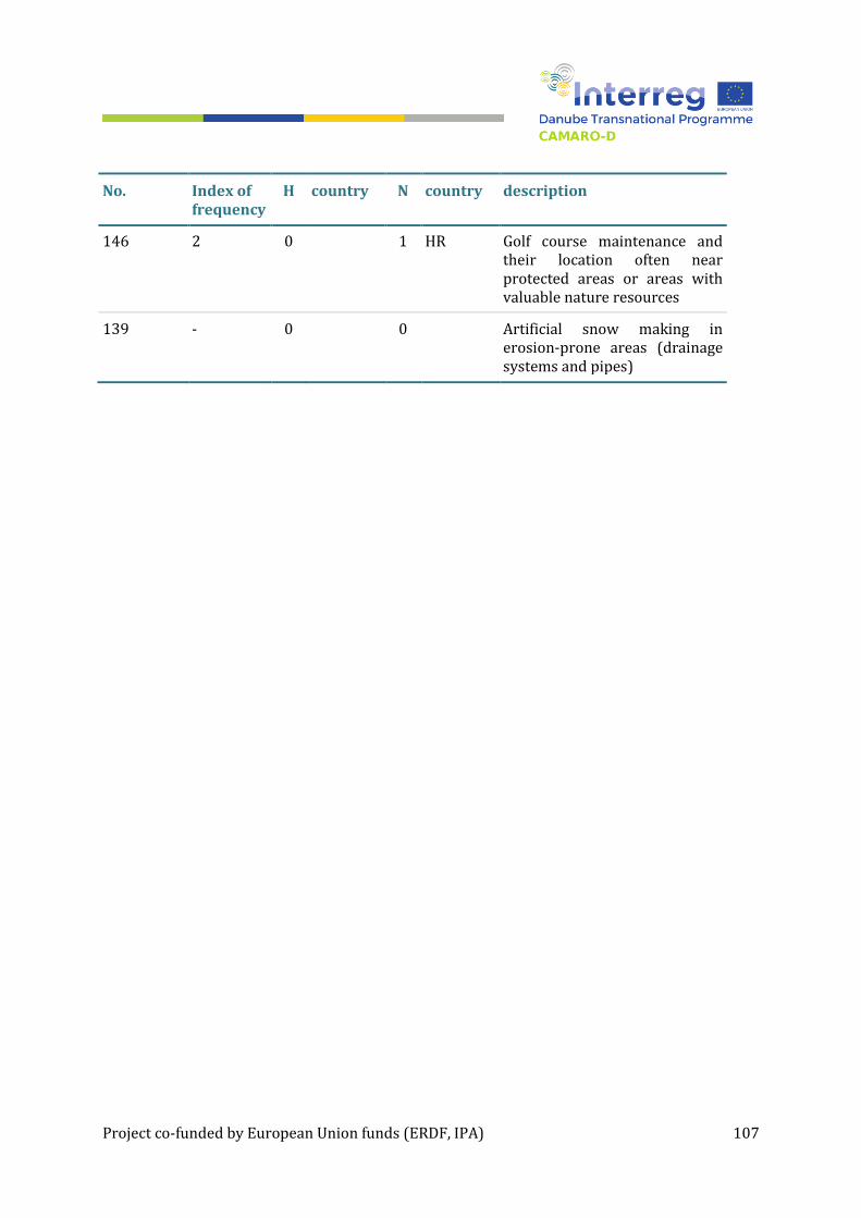
Project co-funded by European Union funds (ERDF, IPA) 107
No. Index of frequency
H country N country description
146 2 0 1 HR Golf course maintenance and their location often near protected areas or areas with valuable nature resources
139 - 0 0 Artificial snow making in erosion-prone areas (drainage systems and pipes)