June 2017 - Broxbourne Council
678
0 Strategic Land Availability Assessment Covering Report including Housing Implementation Strategy www.broxbourne.gov.uk/slaa June 2017
-
Upload
khangminh22 -
Category
Documents
-
view
1 -
download
0
Transcript of June 2017 - Broxbourne Council
0
Strategic Land Availability Assessment
Covering Report including Housing Implementation Strategy
www.broxbourne.gov.uk/slaa
June 2017

1
Disclaimer
a. The SLAA does not allocate sites to be developed. The Council will decide the
allocation of sites for future housing and economic development through the Local
Plan. The SLAA informs, but does not determine, the Local Plan Site Allocations.
b. The identification of potential housing and commercial sites within the SLAA does not
imply that the Council would necessarily grant planning permission for such
development. All planning will continue to be considered against the appropriate
policies in the development plan and having regards to any other material
considerations.
c. The inclusion of potential housing and commercial sites within the study does not
preclude them from being considered for other purposes.
d. The boundaries of the sites are based on information available at the time. The SLAA
does not limit an extension or contraction of these boundaries for the purposes of a
planning application.
e. The exclusion of sites from the study i.e. because they were not identified or
promoted, does not preclude the possibility of planning permission for residential
development being granted on them. It is acknowledged that sites will continue to
come forward that may be suitable for residential and/or commercial development
that has not been identified in the SLAA.
f. Where it is set out, an estimation of when development may come forward is based
on an assessment at the time of the study. Circumstances or assumptions may
change which may mean that sites could come forward sooner or later than originally
envisaged.
g. The information that accompanies the SLAA is based on information that was
available at the time of the study. Users of the study’s findings will need to appreciate
that there may be additional constraints on some sites that were not identified at the
time of the survey and that planning applications will continue to be treated on their
merits at the time of the planning application rather than on the information contained
within the assessment. Likewise, some of the identified constraints may have been
removed since the information for this SLAA update was compiled. Applicants are
therefore advised to carry out their own analysis of sites to identify any constraints or
other information for the purpose of submitting planning applications and not rely on
the findings of the SLAA.

2
Strategic Land Availability Assessment (SLAA) Executive Summary
This document supersedes the outline Broxbourne Strategic Land Availability Assessment
(SLAA) published in 2016. The purpose of this update is to identify a future supply of land
which is suitable, available and achievable for housing and economic development uses
over the plan period.
The update has been prepared in accordance with the methodology contained in the
National Planning Practice Guidance. The NPPG states that an assessment should:
• Identify sites and broad locations with potential for development;
• Assess their development potential; and
• Assess their suitability for development and the likelihood of development coming
forward (the available and achievability)
It is considered that this approach will ensure that all land is assessed together as part of
plan preparation to identify which sites or broad locations are the most suitable and
deliverable for a particular use. However, it should be noted that although this update will be
an important evidence source to inform plan making it does not in itself determine whether a
site should be allocated for development.
207 sites have been considered as part of this update. This includes 195 existing SLAA
sites, and 12 new sites promoted to the Council during a call for sites exercise undertaken in
July-September 2016. A list of all sites can be found on page and the assessments of the
sites are contained within Appendix 3 of the update.
This SLAA update also includes an updated windfall assessment. The National Planning
Policy Framework (NPPF) that local planning authorities may make an allowance for windfall
sites in their five-year if a local planning authority has compelling evidence that such sites
have consistently become available in the local area and will continue to provide a reliable
source of supply. Historic windfall delivery rates and expected future trends were analysed,
and it was concluded that an allowance of 37 dwellings per annum could be justified.
The Regulation 18 draft Local Plan identified a need for 7,123 new homes, an average of
419 per annum and that the borough should plan for in excess of 7,500 new jobs, 40,000
square metres of new retail space and 10,000 square metres of new leisure space. A
subsequent update of the Council’s OAN has indicated a slight increase in the amount of
dwellings required over the plan period. These figures have been used to underpin this
SLAA update.
The SLAA demonstrates that 57 sites are considered to be suitable, available and
achievable for development. These sites have the potential to accommodate up to 5,641
dwellings against the objectively assessed need and 266,344sqm of commercial land.
The following table summarises the updates conclusion regarding potential housing capacity
within the borough over a fifteen year period. To comply with the NPPF, a supply of specific
developable sites have been separated into five year periods; 1-5, 6-10 and 11-15.

3
Estimated Dwelling Capacity of SLAA Sites
Years 1-5 Years 6-10 Years 11-15 Total
HOD Urban 90 200 0 290 Green Belt 0 9 0 9
BWT Urban 0 0 36 36 Green Belt 125 715 660 1,500
CG Urban 424 1005 487 1,916 Green Belt 847 681 0 1,528
WX Urban 40 0 322 362 Green Belt 0 0 0 0 Total 1,526 2,610 1,505 5,641
An indicative trajectory illustrating the amount of housing that can be expected to be
provided and at what point in the future is contained in Appendix 5 of this update.
The Council’s urban capacity figure is contained in Appendix 6 of this update.
The estimated commercial capacity of SLAA sites is 204,346 sqm. An indicative trajectory
illustrating the amount of commercial land that can be expected to be provided and at what
point in the future is contained in Appendix 7 of this update.
4
Index of Sites
To help manage future amendments and changes each SLAA site has its own
unique reference number. The first two or three letters indicate the settlement, the
middle letter/s signify the category of land and the final two or three numbers indicate
the specific reference for the site. The table below clarifies the acronym and its
reference. Maps of all the sites contained within this SLAA update can be found at
Appendix 4 of this report.
Acronym Reference HOD Hoddesdon BWT Broxbourne, Wormley, Turnford
CG Cheshunt and Goffs Oak WX Waltham Cross U Urban land that falls within an urban area
that is being considered for residential development
UC Urban land that falls within an urban area that is being considered for commercial use
GB Green Belt land promoted to the Council during the “call for sites” or identified by the Council through a desk-top study
Urban Sites
Page No. Site Reference Site Location/Name 70 HOD-U-12 Former Turnford Surfacing Site 73 HOD-U-17 Salisbury Road Industrial Premises 76 HOD-U-23 19 Amwell Street and Scania House 79 HOD-U-25 Garages off Burnside
82 HOD-U-27 Land to the south of Brewery Road 85 HOD-U-28 Crown Buildings and Squash Club 88 HOD-U-31(a) Rawmec Business Park 90 HOD-U-31(b) Lea Road Industrial Works 92 HOD-U-32 25,25a and 25b High Street 95 HOD-U-36 Lampit Mansard Roofs 98 HOD-U-39 Westfield Primary School
101 HOD-U-41 Former Hoddesdon Police Station 143 BWT-U-15 Gas Distribution Station 176 CG-U-15 Fourfields Elderly Persons Home 179 CG-U-29 Land south of Hammondstreet 182 CG-U-33 Tanglewood and Windrush 184 CG-U-37 Whitefields Estate Regeneration Plan
187 CG-U-40 Wolsey Hall

5
Page No. Site Reference Site Location/Name 190 CG-U-41 Gospel Hall 193 CG-U-42 Fieldings Road Industrial Sites
195 CG-U-44 Land rear of Halsey Masonic Hall 198 CG-U-45 Office Building, 191-195 Windmill Lane 201 CG-U-47 Whit Hern 204 CG-U-50 Old Tesco House 207 CG-U-52 Land rear to Goffs Oak House 209 CG-U-54 Borough Council Offices
212 CG-U-55 Gaveds Ltd Land 215 CG-U-56 Cheshunt Lakeside 218 CG-U-57 The Whitehouse 221 CG-U-58 Rear of Flamstead End Shops 585 WX-U-01 Conservative Club 588 WX-U-11 232-285 High Street
591 WX-U-13 Land off Sturlas Way
594 WX-U-14 Medlock Electrical, 107-115 Eleanor Cross Road
and the Friary
597 WX-U-18 Land between Eleanor Cross Road and Monarchs
Way 600 WX-U-19 Royal Mail Sorting Office 603 WX-U-22 Waltham Cross Trade Centre 606 WX-U-23 Industrial Premises off Byranstone Road 609 WX-U-24 PR Pallets
611 WX-U-25 Theobalds Grove Station Car Park 614 WX-U-27 Station Approach Industrial Units 617 WX-U-28 Gala Bingo Site
Green Belt Sites
Page No. Site Reference Site Location/Name
105 HOD-GB-01 303 Ware Road 108 HOD-GB-03 Cutthroat Lane Field, Hertford Road 111 HOD-GB-05 Spring Field, Springle Lane 113 HOD-GB-06 Piggery Site, Rye Road 116 HOD-GB-07 Sheredes Tennis Courts 119 HOD-GB-08 Roselands House Field 121 HOD-GB-09 Admirals Walk Field
123 HOD-GB-10 Woodside, Woollensbrook 125 HOD-GB-11 Hertford Road Gypsy and Traveller Site 128 HOD-GB-12 Nursery Grove, Cock Lane 131 HOD-GB-13 Land west of Admirals Walk Lake 134 HOD-GB-14 305 Ware Road 137 HOD-GB-15 Rosehill Bowls Club
140 HOD-GB-17 Land to the west of the A10 at Hoddesdon 147 BWT-GB-01 Disused quarry site at Church Lane 150 BWT-GB-02 Derwent Turnford 153 BWT-GB-03 Brookfield Riverside
6
Page No. Site Reference Site Location/Name 156 BWT-GB-05 Brookfield Garden Village 160 BWT-GB-06 Wormleybury Field
163 BWT-GB-07 Holy Cross Hill 165 BWT-GB-08 Land at Wharf Road 168 BWT-GB-09 Turnford Secondary School 171 BWT-GB-10 Land next to New Barn Farm 173 BWT-GB-11 Land at Holy Cross Hill 225 CG-GB-02 Land between 90a and 102 Cuffley Hill
228 CG-GB-03 Travelling Showpersons site, Goffs Lane 231 CG-GB-04 Half Moat Manor House Site 234 CG-GB-05 Theobalds Brook Field 237 CG-GB-07 Albury Farm 240 CG-GB-08(a) Albury Walk Field East 243 CG-GB-08(b) Albury Walk Field West
245 CG-GB-09 M. O’Connor Land, Goffs Lane 248 CG-GB-10 Theobalds Park Estate Grassland 251 CG-GB-11(a) Small Acre, Oakview, Rushdown and Lindrick
Nurseries 254 CG-GB-11(b) Small Acre and Oak View Nursery 257 CG-GB-12 Green Acre Nursery 259 CG-GB-14(a) White House Farm 262 CG-GB-14(b) White House Farm Field
265 CG-GB-15 Pendine, St James Road 268 CG-GB-16 Tina (Tawe Cheyne) Nursery 271 CG-GB-17 Former Nockhold/FJD Nursery 274 CG-GB-18(a) Longmead and Pylon Farm 277 CG-GB-18(b) Longmead Nursery 280 CG-GB-19 Twelve Acre Farm
283 CG-GB-21 Garryross Farm 286 CG-GB-22 Land south of Peakes Way 289 CG-GB-23 Granby Park Road 292 CG-GB-25 Claremont 294 CG-GB-26 Tudor Nursery 297 CG-GB-27 Elmhurst Ponds, Appleby Street 299 CG-GB-28 Hammondstreet View
301 CG-GB-29 Hazel Grove 303 CG-GB-30 Calves Croft Farm 305 CG-GB-31 Oak House Farm 308 CG-GB-32(a) Bonneygrove Wood Field 311 CG-GB-32(b) Bonneygrove Wood Field and V&E Club 314 CG-GB-34 Mannings Ground
317 CG-GB-35 Triangle Nursery 320 CG-GB-36 Maxwells Farm 323 CG-GB-37 Ashfield Nursery 326 CG-GB-38 Land at Park House, Appleby Street 328 CG-GB-39 Rowlands Nurseries 331 CG-GB-40 Hillside Nursery

7
Page No. Site Reference Site Location/Name 334 CG-GB-41(a) Ballymour and surrounding Land 337 CG-GB-41(b) South of Andrews lane
340 CG-GB-41(c ) Ballymour and Langdons 343 CG-GB-41(d) Lea Mount 346 CG-GB-42 Laurel Park 348 CG-GB-43 South Lodge Pastures 351 CG-GB-44 Rags Brook Valley Site 355 CG-GB-45 Rush Meadow Junction
358 CG-GB-46 White Bungalow 360 CG-GB-47 Churchview Nursery 362 CG-GB-48 104 Cuffley Hill (CG Edward) 365 CG-GB-49 Doverfield 368 CG-GB-50 Meadow Farm 370 CG-GB-51 Chase Field
373 CG-GB-52(a) Westgate Nurseries and nurseries east of Crouch Lane
375 CG-GB-52(b) Springfield and Westgate 377 CG-GB-53 Brookwall Nursery, St James Road 379 CG-GB-54 Hazelwood 382 CG-GB-55 Cheshunt Pavilion 385 CG-GB-56 Brackendale 387 CG-GB-58 Cuffley Brook Site, Jones Road
390 CG-GB-59(a) Four Wind and Forest View 393 CG-GB-59(b) Four Winds, Forest View and Tetherdown 396 CG-GB-60 Rosedale Meadow 399 CG-GB-61(a) Limes Nursery 402 CG-GB-61(b) Limes Nursery and Rosary Nursery 405 CG-GB-62 Cuffley Hill Comprehensive
408 CG-GB-63 Goffs Lane Comprehensive 411 CG-GB-64 Thorn Nursery 413 CG-GB-65 Fairmead Nursery 416 CG-GB-66 Burleigh Field 418 CG-GB-67 Cross Nursery 421 CG-GB-68 Park Lane Meadow 423 CG-GB-69 Lucas House Farm
426 CG-GB-70 Land at White Bungalow 429 CG-GB-71(a) In-Ex Nursery 432 CG-GB-71(b) In-Ex Nursery 435 CG-GB-72 Derry’s Wood Field 438 CG-GB-73(a) Darnicle Hill Nursery 441 CG-GB-73(b) Darnicle Hill Nursery
444 CG-GB-74 Hammondstreet Reservoir and Cedarwood Bungalow
446 CG-GB-75 Tetherdown 449 CG-GB-76 Warden Nursery 452 CG-GB-77 Windyridge Nursery 454 CG-GB-78(a) Theobalds Nursery
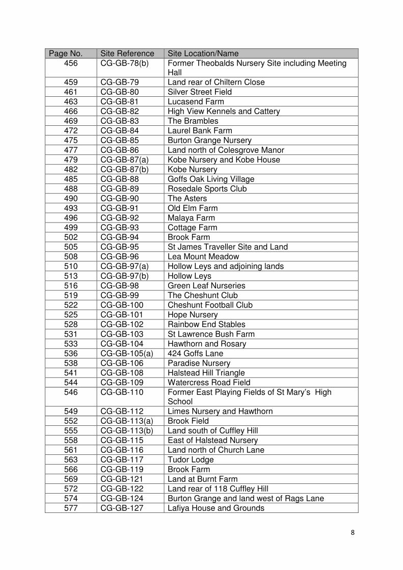
8
Page No. Site Reference Site Location/Name 456 CG-GB-78(b) Former Theobalds Nursery Site including Meeting
Hall 459 CG-GB-79 Land rear of Chiltern Close
461 CG-GB-80 Silver Street Field 463 CG-GB-81 Lucasend Farm 466 CG-GB-82 High View Kennels and Cattery 469 CG-GB-83 The Brambles 472 CG-GB-84 Laurel Bank Farm 475 CG-GB-85 Burton Grange Nursery
477 CG-GB-86 Land north of Colesgrove Manor 479 CG-GB-87(a) Kobe Nursery and Kobe House 482 CG-GB-87(b) Kobe Nursery 485 CG-GB-88 Goffs Oak Living Village 488 CG-GB-89 Rosedale Sports Club 490 CG-GB-90 The Asters
493 CG-GB-91 Old Elm Farm 496 CG-GB-92 Malaya Farm 499 CG-GB-93 Cottage Farm 502 CG-GB-94 Brook Farm 505 CG-GB-95 St James Traveller Site and Land 508 CG-GB-96 Lea Mount Meadow 510 CG-GB-97(a) Hollow Leys and adjoining lands
513 CG-GB-97(b) Hollow Leys 516 CG-GB-98 Green Leaf Nurseries 519 CG-GB-99 The Cheshunt Club 522 CG-GB-100 Cheshunt Football Club 525 CG-GB-101 Hope Nursery 528 CG-GB-102 Rainbow End Stables
531 CG-GB-103 St Lawrence Bush Farm 533 CG-GB-104 Hawthorn and Rosary 536 CG-GB-105(a) 424 Goffs Lane 538 CG-GB-106 Paradise Nursery 541 CG-GB-108 Halstead Hill Triangle 544 CG-GB-109 Watercress Road Field 546 CG-GB-110 Former East Playing Fields of St Mary’s High
School
549 CG-GB-112 Limes Nursery and Hawthorn 552 CG-GB-113(a) Brook Field 555 CG-GB-113(b) Land south of Cuffley Hill 558 CG-GB-115 East of Halstead Nursery 561 CG-GB-116 Land north of Church Lane 563 CG-GB-117 Tudor Lodge
566 CG-GB-119 Brook Farm 569 CG-GB-121 Land at Burnt Farm 572 CG-GB-122 Land rear of 118 Cuffley Hill 574 CG-GB-124 Burton Grange and land west of Rags Lane 577 CG-GB-127 Lafiya House and Grounds

9
Page No. Site Reference Site Location/Name 579 CG-GB-129 Rushdown Nursery 582 CG-GB-131 Land rear of 122-126 Cuffley Hill
621 WX-GB-02 Theobalds Park Farm 625 WX-GB-03 Theobalds Sport Ground
Commercial Sites
Page No. Site Reference Site Location/Name 629 HOD-UC-01 Plots F and L, RD Park, Essex Road
632 HOD-UC-02 South side of Essex Road and Railway, Plots H1 and H2
635 HOD-UC-03 Hoddesdon Fire Station 638 HOD-UC-08 Land east of Dinant Link Road 641 HOD-UC-09 Ryelands Primary School 644 WX-UC-03 Magnum 25 647 WX-UC-05 Plot D
650 WX-UC-06 Park Plaza North

10
Introduction
National Planning Policy requires local planning authorities to prepare a strategic
land availability assessment to establish realistic assumptions about the availability,
suitability and the likely economic viability of land to meet the identified housing and
economic development need over the Plan period.
The Broxbourne Strategic Land Availability Assessment (SLAA) 2017 forms a key
component of the emerging Local Plan database. The SLAA also provides data to
inform the calculation of the Council’s Five-Year Housing Land Supply position,
which is set out annually in the Authority Monitoring Report (AMR).
However, it should be noted that the SLAA does not determine whether a site should
be allocated for development. As identified in National Planning Practice Guidance
“It is the role of the assessment to provide information on the range of sites which
are available to meet need, but it is for the development plan itself to determine
which of those sites are the most suitable to meet those needs”.
Background
National Planning Policy Framework and Planning Practice Guidance
The National Planning Policy Framework (NPPF) (paragraph 159) places a
requirement on local planning authorities to “prepare a Strategic Housing Land
Availability Assessment to establish realistic assumptions about the availability,
suitability and the likely economic viability of land to meet the identified need for
housing over the Plan period”.
Paragraph 161 of the NPPF requires local planning authorities to use of their
evidence base to assess “the existing and future supply of land available for
economic development and its sufficiency and suitability to meet the identified
needs. Reviews of land available for economic development should be undertaken at
the same time as, or combined with, Strategic Housing Land Availability
Assessments and should include a reappraisal of the suitability of previously
allocated land”.
The National Planning Practice Guidance (NPPG) states that the “assessment of
land availability is an important step in the preparation of Local Plans” and that it
“forms a key component of the evidence base to underpin policies in development
plans for housing and economic development”. The NPPG states that the SLAA
should:
• Identify sites and broad locations with potential for development;
• Assess their development potential;
• Assess their suitability for development and the likelihood of development
coming forward (the availability and achievability)
11
The NPPG provides guidance on what inputs and processes should be undertaken
to ensure a robust assessment of land availability. These processes and inputs are
discussed in the ‘Methodology section’ of this report.
The emerging Broxbourne Local Plan
The emerging Local Plan will detail the borough’s development strategy for the next
15 years for homes, jobs, shops, leisure, transport and infrastructure all set along the
long term protection and improvement of a redefined Green Belt, parks and open
spaces.
The draft Local Plan (Regulation 18) identified that there is a need for 7,123 new
homes, an average of 419 dwellings per annum, and that the Council should plan for
in excess of 7,500 new jobs, around 40,000 sqm of new retail space and 10,000 sqm
of new leisure space.
The draft Local Plan (Regulation 18) also stated (paragraph 3.5) that “urban and
brownfield sites cannot meet all of the development and infrastructure needs and
provide sufficient opportunities for the future development of the Borough”. A
number of alternative options were considered (i.e. intensification of existing
residential areas, development in town centre locations), and it was concluded that
some carefully selected Green Belt sites should be released for development “to
help create a more balanced, sustainable, desirable and prosperous community for
all”.
The Council consulted on its Regulation 18 draft Local Plan during June 2016 to
September 2016. Representations that suggested additional sites to be assessed, or
included updated information on current SLAA sites, were incorporated into this
document.
12
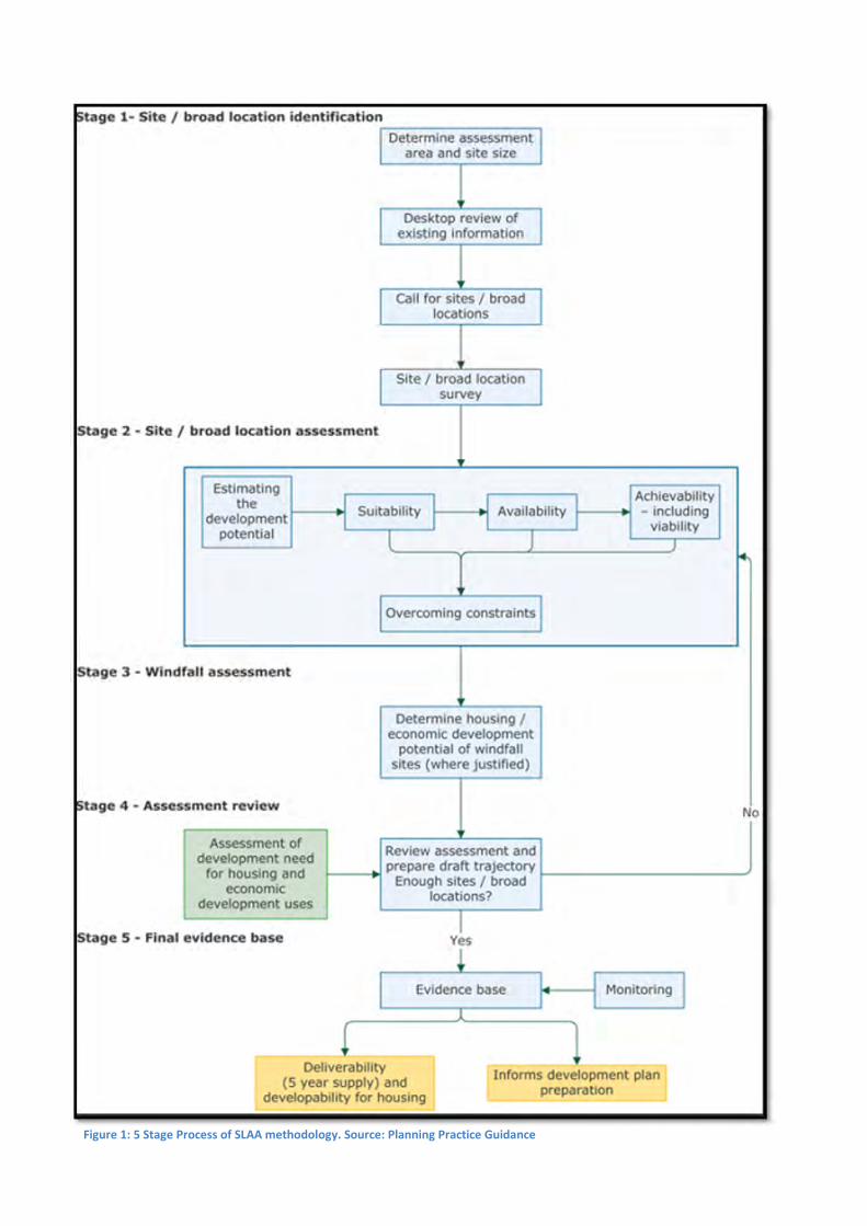
Methodology
National Planning Practice Guidance states that the following standard outputs
should be produced from the assessment to ensure consistency, accessibility and
transparency:
• A list of all sites or broad locations considered, cross-referenced to their
locations on maps;
• An assessment of each site or broad location, in terms of its suitability for
development, availability and achievability to determine whether a site is
realistically expected to be development and when;
• Contains more detail for those sites which are considered to be realistic
candidates for development, where others have been discounted for clearly
evidenced and justified reasons;
• The potential type and quantity of development that could be delivered on
each site/broad location, including a reasonable estimate of build out rates,
setting out how any barriers to delivery could be overcome and when;
• An indicative trajectory of anticipated development and consideration of
associated risks.
To achieve the above outputs, the Practice Guidance sets out what inputs and
processes should be undertaken to ensure a robust assessment of land availability.
The flow chart (Figure1) outlines the 5 stage process.
13
Figure 1: 5 Stage Process of SLAA methodology. Source: Planning Practice Guidance
14
Stage 1 – Identification of sites and broad areas
The assessment has been undertaken solely within Broxbourne Borough Council’s
administrative boundary. A Strategic Housing Market Area (SHMA) has been
prepared for the same area. The Council’s SHMA and its updates can be viewed by
using the following link: www.broxbourne.gov.uk/evidencestudies.
To ensure consistency with previous SLAAs and the NPPG, only sites and broad
locations that are large enough to accommodate 5 dwellings or more (net) or
capable of delivering 0.25ha or 500 sqm of commercial floorspace have been
included within the SLAA update. Where smaller sites have been identified, a
justification has been provided as to why. It should be noted that when a number
was not provided for the amount of dwellings a site could provide, the housing
densities included within Policy H11 of the Council’s Local Plan Second Review
2001-2011 was used to provide an indicative development capacity for the site.
To inform this update, the Council carried out a fresh Call for Sites between July
2016 - September 2016. The Call for Sites was publicised on the Council’s website
and in the Local Plan newsletter. An updated Call for Sites form was used for this
Call for Sites. A copy of this form can be found in Appendix 1. During the Call for
Sites period, 34 sites were promoted to the Council for development. A Call for Sites
summary report can be found in Appendix 2 of this update.
In addition to the Call for Sites, the Council has used a range of data sources to
identify sites. Many of the sites included within the outline 2016 SLAA have been
reassessed. Other data sources include:
• Planning application records
• Development Briefs
• Pre-application Discussions
• Public Sector Land Registers and Empty Property Registers
Stage 2 - Site/broad location assessment
Assessment of Suitability, Availability and Achievability
Paragraph 47 (bullet point 3) states that local planning authorities should identify and
update annually a supply of specific deliverable sites sufficient to provide five years’
worth of housing against their housing requirements and identify a supply of specific,
developable sites or broad locations for growth, for years 6-10 and, where possible,
years 11-15.
For a site to be considered deliverable it should be available now, offer a suitable
location for development now, and be achievable with a realistic prospect that
housing will be delivered on the site within five years and in particular that site is
viable. The NPPF states that sites with planning permission should be considered

15
deliverable until permission expires, unless there is clear evidence that schemes will
not be implemented within five years.
For a site to be considered developable it must be in a suitable location for housing
development and there should be a reasonable prospect that the site is available
and could be viably developed at the point envisaged.
In accordance with the NPPG, all sites included within this update have had their
suitability, availability and achievability assessed. An overview of how these
assessments were carried out is provided below.
Suitability
The following constraints were considered when determining whether a site was
suitable for housing or economic development:
• Proximity to noisy uses
• Flood Risk
• Current and Previous Land Use
• Protected Trees
• Landscape and topography
• Conservation Areas, Listed
Buildings, Heritage Assets
• Current land designation (see
below section of Previously
Developed Land)
• Biodiversity (Local Wildlife
Sites, SSSIs, ancient
woodlands)
• Proximity to sustainable modes
of transport
• Location within the borough
• Public Right of Ways Air Quality
Management Areas (AQMAs)
• Conservation Areas, Listed
Buildings, Heritage Assets
• Proximity to Local Services (with reference to Barton et al (2010) sustainable
distances)1
Previously Developed Land in the Green Belt
The NPPF (paragraph 89) states local planning authorities should consider the
construction of new dwellings within the Green Belt as inappropriate subject to
certain exceptions. One exception is the “limited infilling or the partial or complete
redevelopment of previously developed sites (brownfield land), whether redundant or
in continuing use (excluding temporary buildings), which would not have a greater
impact on the openness of the Green Belt and the purpose of including land within it
than the existing development”.
The Council acknowledges that there are some Green Belt sites contained within this
update that have areas of previously developed land. As defined in the NPPF,
previously developed land is “land which is or was occupied by a permanent
1 Barton et al (2010) Shaping Neighbourhoods for Local Health and Global Sustainability. 2
nd Edition.
For the sustainable distances used within this assessment, please refer to Table 2.5 in the Council’s
Sustainability Appraisal of the Broxbourne Emerging Local Plan (www.broxbourne.gov.uk/SA)
16
structure, including the curtilage of the developed land (although it should not be
assumed that the whole of the curtilage should be developed) and any associated
fixed surface infrastructure. This excludes: land that is or has been occupied by
agricultural or forestry buildings; land that has been developed for minerals
extraction or waste disposal by landfill purposes where provision for restoration has
been made through development control procedures; land in built-up areas such as
private residential gardens, parks, recreation grounds and allotments; and land that
was previously-developed but where the remains of the permanent structure or fixed
surface structure have blended into the landscape in the process of time.”
It is considered that the opportunities for developing these sites will be better
explored through the production of the Council’s Brownfield Land Register, which, as
prescribed in ‘The Town and Country Planning (Brownfield Land Register)
Regulations 2017’ must be published by 31st December 2017. The appraisal form will
clearly indicate whether there is an opportunity to explore the development of this
site through the Brownfield Land Register.
Availability
The following was taken into account when assessing the sites availability for
development:
• Current Land Use
• Planning Status
• Development time frame
• Ownership of land
• Intention for the site to be built
out
• Legal Constraints (i.e. ransom
strips)
A site is considered to be available if it has been promoted to the Council for
development by the landowners, or has been promoted to the Council by another
person/company but the principle of developing the site is supported by all
landowners.
Achievability
The following has been taken into account when assessing the sites for
development:
• Economic viability
• Highway issues
• Current accessibility to the site
• Land preparation costs
• Developer interest in the site
• Third party land acquisition
The site assessments for this update can be found in Appendix 3.

17
Removed Sites
The following sites have been removed from this SLAA update. The reasons for their
removal are included in Table 1.
Site Reference Number
Site Name Reason for Removal
HOD-GB-04 Lord Street Bowling Green Field
Outline planning permission has been granted for 14 dwellings (07/14/1133/O)
HOD-GB-16 Volker Fitzpatrick Planning permission has been granted for 21 dwellings and a two storey (plus basement) extension to the Head Office (07/16/1222/F).
BWT-GB-04 Broxbourne School
Planning permission has been granted for the redevelopment of the existing school to provide 8 Form Entry Secondary School on land to the south of the existing school buildings, new indoor/outdoor sports facilities , car parking with student drop off/pick up, landscaping, remodelling of existing access at High Road and Bell Lane, and residential development comprising up to 153 dwellings maximum (07/16/0512/F)
CG-GB-20 Grangebrook Planning permission has been granted for 14 dwellings (07/15/0856/F). Work on this site has begun.
CG-GB-105(a) Land to the west of 424 Goffs Lane
Below the site size threshold for its inclusion within the SLAA (5 dwellings)
CG-GB-107 Cheshunt Park Farm
Planning permission has been granted for 12 dwellings (07/15/0715/F)
CG-GB-111 Goffs School Planning permission has been granted for the redevelopment of a new secondary school site (07/14/0477/F). Work on this site has begun.
CG-GB-114 Tanfield Farm Planning permission has been granted for 11 dwellings (07/16/0644/F)
CG-GB-117 Tudor Lodge Below the site size threshold for its inclusion within the SLAA (5 dwellings)
CG-GB-118 Land south of Andrews Lane
This SLAA site reference number has been changed to CG-GB-41(b)
WX-U-26 Shopping Centre, High Street Waltham Cross
Planning permission has been granted for 44 dwellings (07/16/0090/PNRES). Work on this site has begun.
Table 1: Sites removed from the Strategic Land Availability Assessment (SLAA) update
18
Stage 3 – Windfall Assessment
The NPPF (Paragraph 48) states that “Local Planning Authorities may make an
allowance for windfall sites in the five-years supply if they have compelling evidence
that such sites have consistently become available in the local area and will continue
to provide a reliable source of supply”.
Windfall sites are defined in the glossary of the framework as “sites which have not
been specifically identified as sites in the Local Plan process. They normally
comprise previously developed sites that have unexpectedly become available”.
For the purposes of this sites which have been “identified as sites in the Local Plan
process” will be sites which have been identified within this SLAA update. These
sites are considered to have been identified as part of the process in formulating the
Local Plan and therefore cannot be counted as windfall sites.
Methodology for Windfall Assessment
The NPPF provides the following guidance in establishing a realistic windfall
allowance:
• The Local Planning Authority must have compelling evidence that sites have
become consistently available;
• The allowance should be realistic, having regard to the Strategic Housing
Land Availability Assessment, historic windfall delivery rates and expected
future trends; and
• Windfall allowance calculations should not include residential gardens.
The Council has used cdpSmart (Hertfordshire) and Building Control records to
obtain historical data regarding housing completions within a ten year period (1 April
2007-31 March 2017) throughout the borough and on sites classed as windfall. A
ten-year period has been chosen as it covers a wide range of different market
conditions; a booming economy (pre-2008), a recession (1008-2013) and the post-
recession recovery.
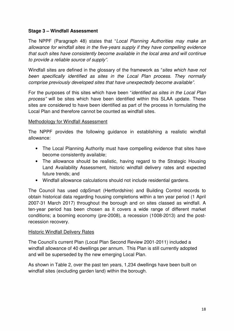
Historic Windfall Delivery Rates
The Council’s current Plan (Local Plan Second Review 2001-2011) included a
windfall allowance of 40 dwellings per annum. This Plan is still currently adopted
and will be superseded by the new emerging Local Plan.
As shown in Table 2, over the past ten years, 1,234 dwellings have been built on
windfall sites (excluding garden land) within the borough.

19
Year No. of dwellings permitted on windfall sites (gross) (excluding garden land)
No. of dwellings built on windfall sites (gross) (excluding garden land)
2006/07 231 137
2007/08 244 115
2008/09 95 63
2009/10 249 265
2010/11 155 118
2011/12 130 52
2012/13 53 77
2013/14 228 48
2014/15 263 79
2015/16 568 61
2016/17 146 219
Total 2362 1234
Annual Average 215 112 Table 2: Historic Windfall Commitments and Completions
Table 2 also shows that since 2006/07 the number of dwellings permitted and built
on windfall sites can vary considerably from year to year. The high number of
dwellings being granted permission in the latter five years can be associated with the
lack of an up-to-date local Plan.
The unusually high completions in 2009/10 reflects a large number of dwellings
being completed on major windfall sites – 32 dwellings at Turnford triangle, 30
dwellings at Grove House, 70 dwellings at Hertford Regional College and 37
dwellings at 9-11 High Street, Waltham Cross.
It should be noted that the Council’s current adopted Plan finished in 2011. The
allocations included within this Plan, as detailed in Policy H4 and H5, had been built
out prior to or just after 2011. Therefore, as a result a number of dwellings that have
come forward since 2011 have been windfall in nature.
Major and Minor Windfall Sites
Table 3 shows that since 2006/07 935 dwellings have been built on major windfall
sites, equating to an average of 85 dwellings per annum. In the same time period,
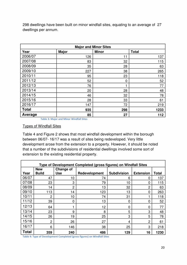
20
298 dwellings have been built on minor windfall sites, equating to an average of 27
dwellings per annum.
Major and Minor Sites
Year Major Minor Total
2006/07 126 11 137
2007/08 83 32 115
2008/09 35 28 63
2009/10 227 38 265
2010/11 95 23 118
2011/12 52 0 52
2012/13 76 1 77
2013/14 20 28 48
2014/15 46 32 78
2015/16 28 33 61
2016/17 147 72 219
Total 935 298 1233
Average 85 27 112 Table 3: Major and Minor Windfall Sites
Types of Windfall Sites
Table 4 and Figure 2 shows that most windfall development within the borough
between 06/07- 16/17 was a result of sites being redeveloped. Very little
development arose from the extension to a property. However, it should be noted
that a number of the subdivisions of residential dwellings involved some sort of
extension to the existing residential property.
Type of Development Completed (gross figures) on Windfall Sites
Year New Build
Change of Use Redevelopment Subdivision Extension Total
06/07 47 10 74 6 0 137
07/08 23 3 79 10 0 115
08/09 14 2 13 32 2 63
09/10 113 14 123 13 0 263
10/11 2 10 74 31 1 118
11/12 39 0 13 0 0 52
12/13 64 1 12 0 0 77
13/14 23 9 8 5 3 48
14/15 26 19 25 3 5 78
15/16 2 26 27 4 2 61
16/17 6 146 38 25 3 218
Total 359 240 486 129 16 1230 Table 4: Type of Development Completed (gross figures) on Windfall Sites
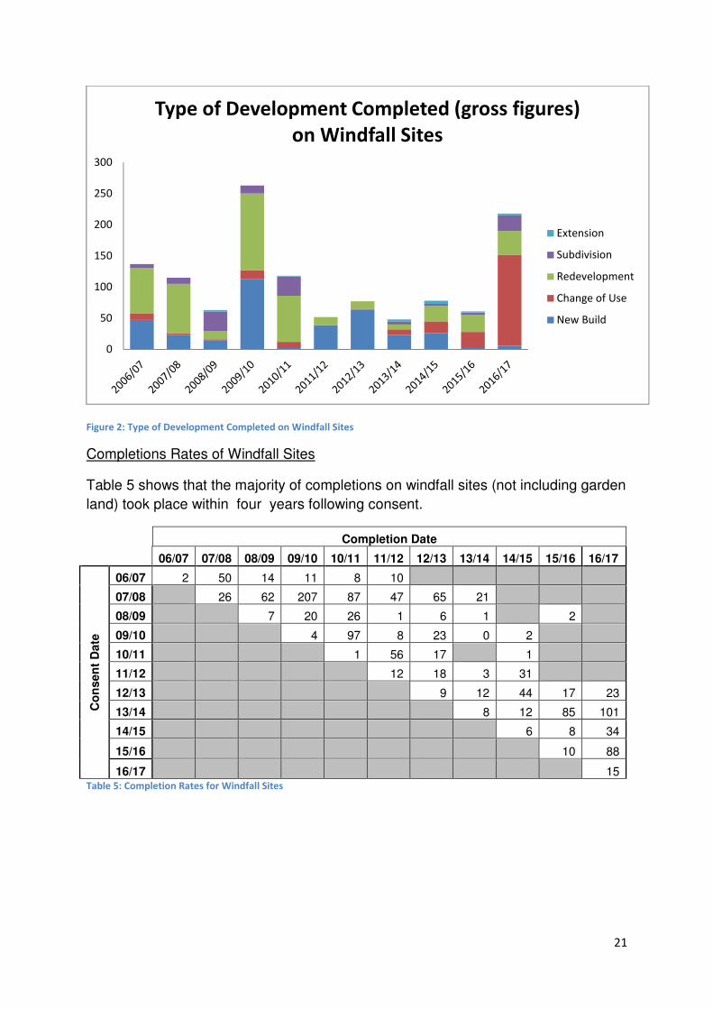
21
Figure 2: Type of Development Completed on Windfall Sites
Completions Rates of Windfall Sites
Table 5 shows that the majority of completions on windfall sites (not including garden
land) took place within four years following consent.
Completion Date
06/07 07/08 08/09 09/10 10/11 11/12 12/13 13/14 14/15 15/16 16/17
Co
nsen
t D
ate
06/07 2 50 14 11 8 10
07/08 26 62 207 87 47 65 21
08/09 7 20 26 1 6 1 2
09/10 4 97 8 23 0 2
10/11 1 56 17 1
11/12 12 18 3 31
12/13 9 12 44 17 23
13/14 8 12 85 101
14/15 6 8 34
15/16 10 88
16/17 15 Table 5: Completion Rates for Windfall Sites
0
50
100
150
200
250
300
Type of Development Completed (gross figures)
on Windfall Sites
Extension
Subdivision
Redevelopment
Change of Use
New Build
22
Completion Rates of non-windfall Small Sites
The Council’s Local Plan (Regulation 18) trajectory and 5 year land supply identifies
current commitments, SLAA Sites (which can accommodate at least 5 dwellings
(net)) and Local Plan allocations. It is anticipated that dwellings that are to come
forward on small sites (4 dwellings or less) can be covered by a windfall allowance.
As shown in Table 6, since 2006/07 there have been 522 completions (gross) on
small sites within the borough. This equates to an average of 47 dwellings per
annum. The table also shows that small sites have provided a consistent supply of
housing within the borough over the 11 year period.
Table 6: Small Site Completions (gross)
National and Local Policy Context
The National Government has introduced permitted development rights which enable
the conversion of office accommodation to residential without planning permission
being obtained from the local planning authority. Developers are required to give
‘prior approval’ notification.
The Council has an Article 4 (dated 3rd October 2013) direction which prevents
offices located within the area listed below, being converted in residential without
planning permission being obtained from the local planning authority. The area’s in
which the Council’s Article 4 direction covers is as follows:
• Volker Fitzpatrick site, Hertford Road, Hoddesdon
• Merck Sharp and Dohme site, Hertford Road, Hoddesdon
• Hoddesdon Business Park, Essex Road, Hoddesdon
• Turnford Place, Great Cambridge Road, Turnford
Year Small site completions (gross)
2016/17 86
2015/16 43
2014/15 43
2013/14 33
2012/13 32
2011/12 46
2010/11 41
2009/10 46
2008/09 62
2007/08 64
2006/07 26
Total 522
Average 47
23
• Cheshunt Business Park, Delamare Road and Fieldings Road, Cheshunt
• News International Printworks site, Waltham Cross
• Park Plaza North, Waltham Cross
• Albany House, High Street, Waltham Cross
• Waltham Cross Business Park
Emerging Policy ED2: Loss of Employment uses – Rest of the Borough, resists the
loss of office, industrial and warehouse units outside of the borough’s employment
areas, and includes a number of criteria which proposals have to meet prior to the
granting of planning permission for development that would cause the loss of an
existing employment use.
However, there are some office buildings located outside of the areas identified
above. These office buildings could be viable to convert to residential, and would
therefore contribute to the Council’s windfall supply.
The Council’s emerging Plan contains policies which encourage windfall
development within the Borough. Subject to meeting certain criteria:
• Policy H2: Conversion of non-residential buildings to residential use allows
for the change of use of non-residential buildings to residential;
• Policy ED2: Loss of Employment Uses – Rest of the Borough allows for the
redevelopment of employment sites outside of designated employment areas
where a) the retention of the site for employment use has been fully explored
without success, and that there is no reasonable prospect of the site/premises
being suitable and viable for any alternative employment use, b) continued
use of the site for employment generating process is incompatible with
surrounding land uses, and c) the proposal does not prejudice the continued
viability of existing Strategic Employment Areas and neighbouring uses.
Conclusions
Historical evidence shows that windfall sites have made a significant contribution to
the number of annual completions within the Borough. To avoid duplication with
SLAA sites it is considered that any windfall allowance should be based on historic
delivery rates of small sites only. As shown in Table 3 and 6, small sites have been a
constant source of supply within the Borough over the 11 year period.
With an average gross completion rate of 27 dwellings on small windfall sites and 47
dwellings on small site, it is considered that a conservative but realistic windfall
allowance can be derived from taking the average of these two figures. A windfall
allowance of 37 dwellings will be included within this SLAA update.
It is considered appropriate that the windfall allowance should be applied from Year
3 of the SLAA period and the 5 year land supply. This is due to the assumption that
the majority of windfall development that is to come forward in the years 2017/18,
24
2018/19 and 2019/20 would already have been granted planning permission, and
therefore would be identified as a ‘Commitment’. As shown above, most windfall
development is built out within 3 years from being granted consent, with the majority
coming forward in the third year.
The windfall allowance will continue to be reviewed as part of the Council’s AMR.
Stage 4 – Assessment Review
Once all sites were assessed, the development potential of all sites considered to be
suitable, available and achievable was collated to produce an indicative trajectory.
The indicative trajectory sets out how much housing and commercial land could be
provided within the borough, where and at what point in the future.
Housing
Table 7 summarises the overall estimated housing potential for the period 2017-
2032. A full trajectory can be found in Appendix 5. The Council has an urban
capacity figure of 2,564. A list of sites which form this figure is contained in Appendix
6.
Source of Housing Potential
Explanation Number of Dwellings
0-5 years 6-10
years 11-15 years
Total
Commitments
On the 31/03/2017 the Council had 1,513 (net) commitments. A list of commitments on major sites (10 dwellings (net) or more) is included in Table 8. Of these 21 major sites, 9 have started construction
1,224 441 0 1,665
Windfall Sites
As set out in Stage 3, It is considered appropriate that a windfall allowance of 37 dwellings per annum is included within the 5 year land supply.
74 185 185 444
SLAA Sites This SLAA update identified a number of sites considered to be suitable, available and achievable for residential/mixed-use development. A table of these sites is contained with the ‘Stage 5 – Final Evidence Base’ section of this document.
1,526 2,610 1,505 5,641
Self-build Sites
The Self-Build and Custom Housebuilding Act 2015 places a requirement on local planning authorities in England to keep a register of people who are interested in self-build or custom housebuilding projects in their local area. Section 10 of the Housing and Planning Act (2016) places a duty on local planning authorities to “give suitable development permission in respect of enough serviced plots of land to meet the demand for self-build and custom housebuilding in the authority’s area arising in each base period”. As at 01/06/2017, there were 104 people on the Council’s self-build and custom-build register. This indicates that there is a demand for self-build and custom housebuilding within the Borough. Furthermore, contained within the emerging Local Plan is the Council’s proposed policy (GB2) which seeks to address dereliction on glasshouse sites through permitting self-build housing at low densities
20 25 25 70
Total 2,844 3,261 1,715 7,820 Table 7: Overview of Housing Supply

25
Planning Reference Number
SLAA Reference Number (if applicable)
Site Name Settlement Area
Development Capacity (net)
Current Status
07/14/0813/PNRES
BWT-U-13 Bridge House, 55-59 High Road
Broxbourne 33 Started
07/14/0904/F CG-U-53 New River Arms, High Road
Turnford 43 Granted
07/14/0076/F CG-GB-01 Former St Mary’s High School
Cheshunt 70 Started
07/14/0629/F CG-U-49 79 Crossbrook Street Cheshunt 10 Granted
07/14/0385/0 CG-U-51 Land rear of 1-7 Albury Ride
Cheshunt 12 Granted
07/15/0595/RM CG-U-16 Cheshunt School Site Cheshunt 88 Started
07/160512/F) BWT-GB-04 Broxbourne School Broxbourne 153
07/14/0026/f HOD-U-13 Oaklands Yard, Essex Road
Hoddesdon 71 Granted
07/15/0249/F HOD-U-15 Land rear of 76 High Street
Hoddesdon 40 Granted
07/14/0843/F HOD-U-19 Speakerbus Ltd Hoddesdon 60 Started
07/14/1133/O HOD-GB-04 Land adjacent to 54,56 and 58 Kennedy Avenue
Hoddesdon 14 Granted
07/16/0089/RM HOD-U-26 Land at former Old Highway Tavern
Hoddesdon 10 Started
07/16/0125/F The Old Maltings, Brewery Road
Hoddesdon 13 Started
07/15/0828/PNRES
Wellington House, Trust Road
Waltham Cross
12 Granted
07/15/0970/F Rear of 40 Park Lane Waltham Cross
11 Granted
07/16/0090/PNRES
WX-U-26 Bartholomew Court, High Street
Waltham Cross
44 Started
07/16/0001/F WX-U-15 Hazlemere Marina Waltham Cross
117 Started
07/13/0899/O HOD-GB-02 High Leigh Garden Village
Hoddesdon 523 Granted
07/13/0158/O WX-GB-01 Britannia Nurseries Waltham Cross
90 Granted
07/15/0715/F CG-GB-107 Cheshunt Park Farm Cheshunt 14 Granted
07/15/0856/F CG-GB-20 Grangebrook Goffs Oak 14 Started
Total 1,442
Table 8: Commitments on Major Sites

26
The draft Local Plan (Regulation 18) stated that the borough had an objectively
assessed need for 419 dwellings per annum for the period 2014-2031. This
amounted to 7,123 dwellings over the 17 year period.
A subsequent update of the Council’s OAN (‘Borough of Broxbourne Council- Partial
Review of Objectively Assessed Housing Need, 2017’) was carried out to inform the
next iteration (Regulation 19) of the emerging Local Plan. The update took into
account the latest household projections (2014) published by the Department for
Communities and Local Government, which the National Planning Policy Guidance
(NPPG) states should be the starting point to estimate the overall housing need.
The update showed that the borough has a demographic housing need of 7,021
dwellings over the period 2016-2033. This equates to 413 dwellings per annum. To
take into account market signals, a 10% uplift (which was also used in the 2016 OAN
Review) has been applied to this figure. This equates to an additional 702 dwellings
over the period 2016-2033. Therefore, the dwelling requirement per annum is 454. It
is this dwelling requirement that has been applied to this SLAA update.
Conclusion – Housing
The total supply of housing included within this SLAA (as detailed in Appendix 5)
shows that the borough is able to meet its objectively assessed housing need in full.
Employment
The Council’s ‘Broxbourne Borough Local Plan Employment Land Study’ provided a
forecast for the demand for offices, manufacturing, and warehousing space to 2031.
The demand forecasted for each type of employment land is identified within Table
9.
Type of Employment Land Demand forecasted (m²) to 2031 Local Office Floorspace 17,500 Manufacturing 41,500 Warehousing 160,700
Total 219,700 Table 9: Forecasted Demand by Type of Employment Land
Table 10 summaries the overall estimated commercial land potential for the period
2017-2032.
Source of Employment
Land Explanation
Number of Dwellings
0-5 years
6-10 years
11-15 years
Total
Commitments On the 31/03/2017 the Council has a commitment of 23,685 sqm of commercial floorspace. This figure can be broken down into the following use classes: A1:4451 sqm, A2: 237 sqm, A3: 1612 sqm, A4: 162 sqm, A5:204 sqm, B1:251 sqm,
13,223 10,462 0 23,685

27
B1a: 3,005 sqm, B2:885 sqm, B8:2,101 sqm , SG: 8,551 sqm, D1 (excluding educational buildings) :494 sqm , D2:1,632 sqm. Of these commitments, work has started on 27 sites, which have the capacity to deliver 25,591 sqm of floorspace.
Strategic Land Availability Assessment (SLAA) sites
The SLAA update identified a number of sites considered to be suitable, available and achievable for commercial development
70,002 100,844 33,500 204,346
Total 83,225 111,306 33,500 228,031 Table 10: Overview of Employment Land Potential
Conclusion – Employment
The total supply of employment land included within this SLAA update (as detailed in
Appendix 7) shows that the Borough has enough land to meet its objectively
assessed need for employment land in full.
28
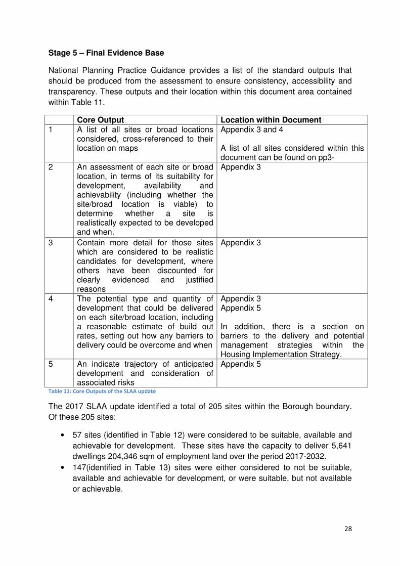
Stage 5 – Final Evidence Base
National Planning Practice Guidance provides a list of the standard outputs that
should be produced from the assessment to ensure consistency, accessibility and
transparency. These outputs and their location within this document area contained
within Table 11.
Core Output Location within Document 1 A list of all sites or broad locations
considered, cross-referenced to their location on maps
Appendix 3 and 4 A list of all sites considered within this document can be found on pp3-
2 An assessment of each site or broad location, in terms of its suitability for development, availability and achievability (including whether the site/broad location is viable) to determine whether a site is realistically expected to be developed and when.
Appendix 3
3 Contain more detail for those sites which are considered to be realistic candidates for development, where others have been discounted for clearly evidenced and justified reasons
Appendix 3
4 The potential type and quantity of development that could be delivered on each site/broad location, including a reasonable estimate of build out rates, setting out how any barriers to delivery could be overcome and when
Appendix 3 Appendix 5 In addition, there is a section on barriers to the delivery and potential management strategies within the Housing Implementation Strategy.
5 An indicate trajectory of anticipated development and consideration of associated risks
Appendix 5
Table 11: Core Outputs of the SLAA update
The 2017 SLAA update identified a total of 205 sites within the Borough boundary.
Of these 205 sites:
• 57 sites (identified in Table 12) were considered to be suitable, available and
achievable for development. These sites have the capacity to deliver 5,641
dwellings 204,346 sqm of employment land over the period 2017-2032.
• 147(identified in Table 13) sites were either considered to not be suitable,
available and achievable for development, or were suitable, but not available
or achievable.

29
Table 12: Sites considered to be suitable, available and achievable
Site Reference Number Site Name Settlement Type of Site
BWT-GB-02 Derwent Turnford Great Cambridge Road
Turnford Green Belt
BWT-GB-03 Brookfield Riverside Turnford Green Belt
BWT-GB-05 Brookfield Garden Village Turnford Green Belt
BWT-GB-06 Wormleybury Field Broxbourne Green Belt
BWT-GB-08 Land at Wharf Road Wormley Green Belt
BWT-GB-10 Land next to New Barn Farm Turnford Green Belt
BWT-GB-11 Land at Holy Cross Hill Turnford Green Belt
BWT-U-15 Gas Holder site Broxbourne Urban
CG-GB-02 Land between 90a and 102 Cuffley Hill Goffs Oak Green Belt
CG-GB-03 Travelling Showperson site Goff's Lane Goffs Oak Green Belt
CG-GB-04 Half Moat Manor House Site Cheshunt Urban
CG-GB-05 Bury Green Cheshunt Green Belt
CG-GB-08(a) Albury Walk Field East Cheshunt Green Belt
CG-GB-100 Cheshunt Football Club Theobalds Lane
Cheshunt Green Belt
CG-GB-110 Former East Playing Fields of St Mary's High School
Cheshunt Green Belt
CG-GB-118 Land south of Andrews Lane Cheshunt Green Belt
CG-GB-124 Burton Grange and land adjoining to the west
Cheshunt Green Belt
CG-GB-16, CG-GB-71 and CG-GB-98
Tina, In-Ex Nurseries and Green Leaf Goffs Oak Urban
CG-GB-26 Tudor Nursery Burton Lane Cheshunt Green Belt
CG-GB-32(b) Bonneygrove Wood Field & V&E Club Cheshunt Green Belt
CG-GB-36 Maxwells Farm land West of the A10 Cheshunt Green Belt
CG-GB-44 Rags Brook Valley Site Cheshunt Green Belt
CG-GB-45 Rush Meadow junction of Lieutenant Ellis Way and the A10
Cheshunt Green Belt
CG-GB-48 CG Edwards Site Goffs Oak Green Belt
CG-GB-55 Cheshunt Pavilion Albury Walk Cheshunt Green Belt
CG-GB-60 Rosedale Meadow Faints Close Goffs Oak Green Belt
CG-GB-62 Cuffley Hill Comprehensive Goffs Oak Green Belt
CG-GB-63 Goffs Lane Comprehensive Goffs Oak Green Belt
CG-GB-65 Fairmead Nursery Goffs Oak Green Belt
CG-GB-99 Cheshunt Sports Club Albury Ride Cheshunt Green Belt
CG-U-15 Fourfields Elderly Persons Home Cheshunt Urban
CG-U-40 Wolsey Hall Windmill Lane Cheshunt Urban
CG-U-41 Gospel Hall Cheshunt Urban
CG-U-47 Whit Hern Cheshunt Urban
CG-U-54 Borough Offices & car park Cheshunt Urban
CG-U-56 Cheshunt Lakeside Cheshunt Urban
CG-U-59 Land to rear of Flamstead End Shops Cheshunt Urban
HOD-GB-01 303 Ware Road Hoddesdon Green Belt

30
Site Reference Number Site Name Settlement Type of Site
HOD-GB-11 Hertford Road Gypsy and Traveller Site Hoddesdon Green Belt
HOD-GB-14 305 Ware Road Hoddesdon Green Belt
HOD-GB-15 Rosehill Bowls Club Lord Street Hoddesdon Green Belt
HOD-U-12 Turnford Surfacing Site Hoddesdon Urban
HOD-U-23 19 Amwell Street & Scania House Hoddesdon Urban
HOD-U-36 Lampits Mansard Roofs Hoddesdon Urban
HOD-U-27 Land to the south of Brewery Road Hoddesdon Urban
HOD-U-39 Westfield Primary School Hoddesdon Urban
HOD-U-41 Former Hoddesdon Police Station Hoddesdon Urban
HOD-UC-03 Fire Station Burford Street Hoddesdon Urban Commercial
HOD-UC-08 East of Dinant Link Road Hoddesdon Urban Commercial
WX-GB-02 Theobalds Park Farm Great Cambridge Road
Waltham Cross
Green Belt
WX-U-13 Land off Sturlas Way Waltham Cross
Urban
WX-U-22 Waltham Cross Trade Centre Waltham Cross
Urban
WX-U-25 Theobalds Station car park Waltham Cross
Urban
WX-U-28 Gala Bingo Site Waltham Cross
Urban
WX-UC-05 Park Plaza South Waltham Cross
Urban Commercial
WX-UC-06 Park Plaza North Waltham Cross
Urban Commercial
31
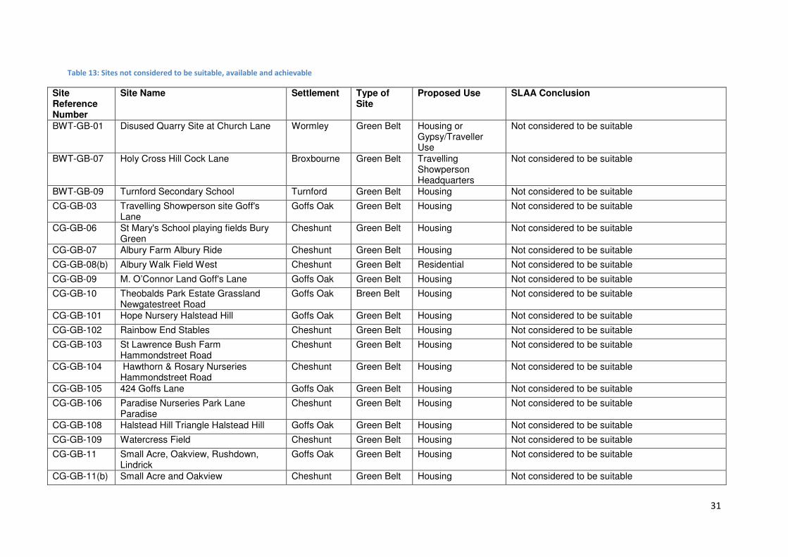
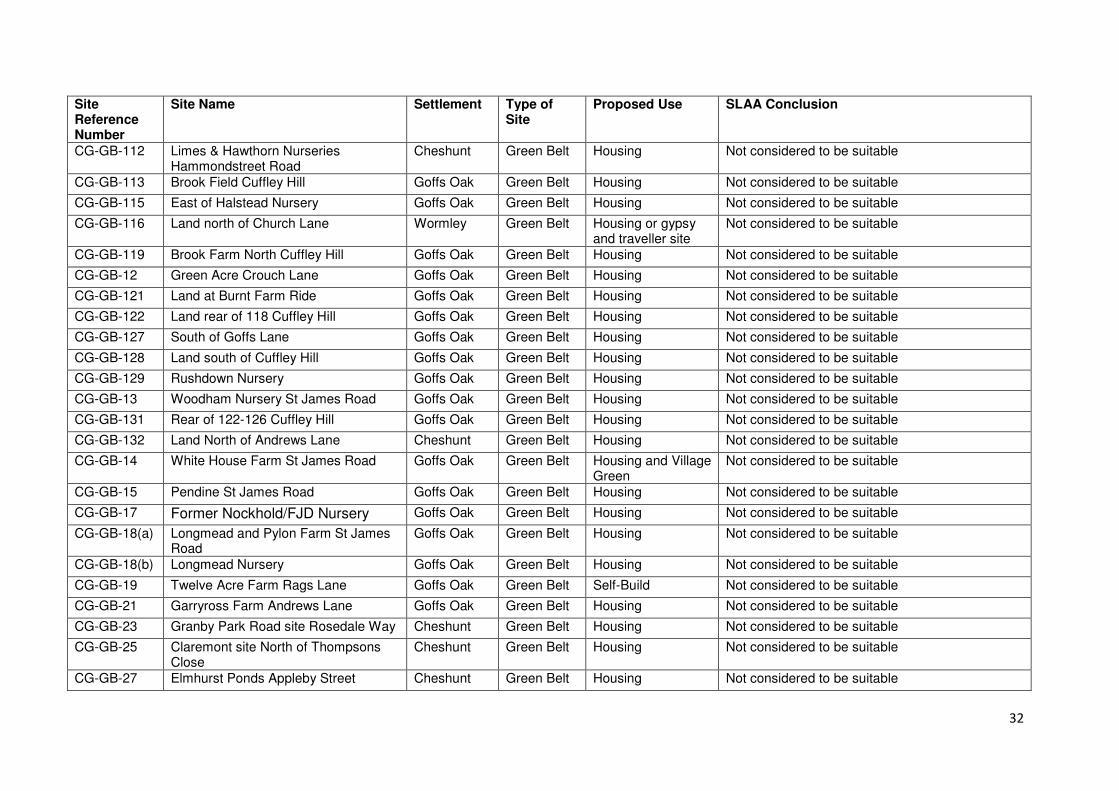
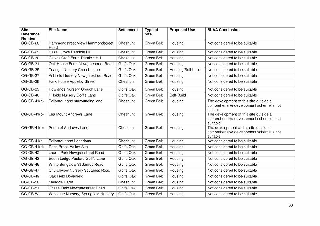
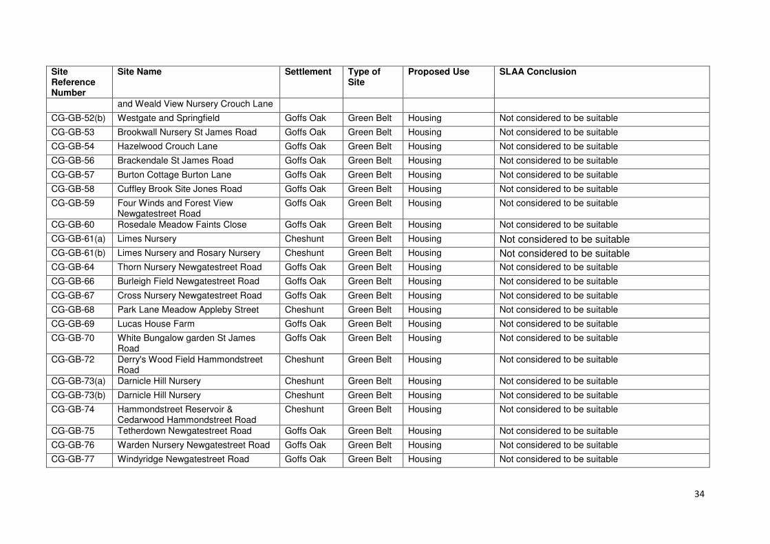
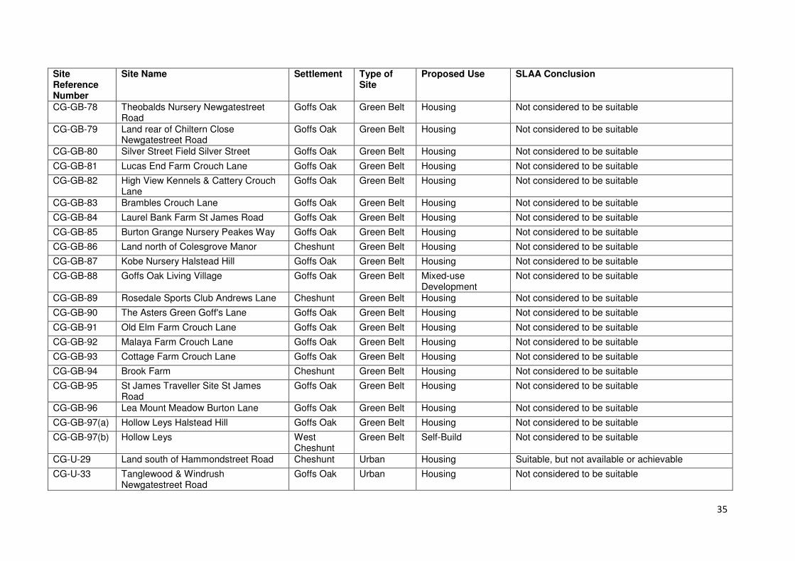
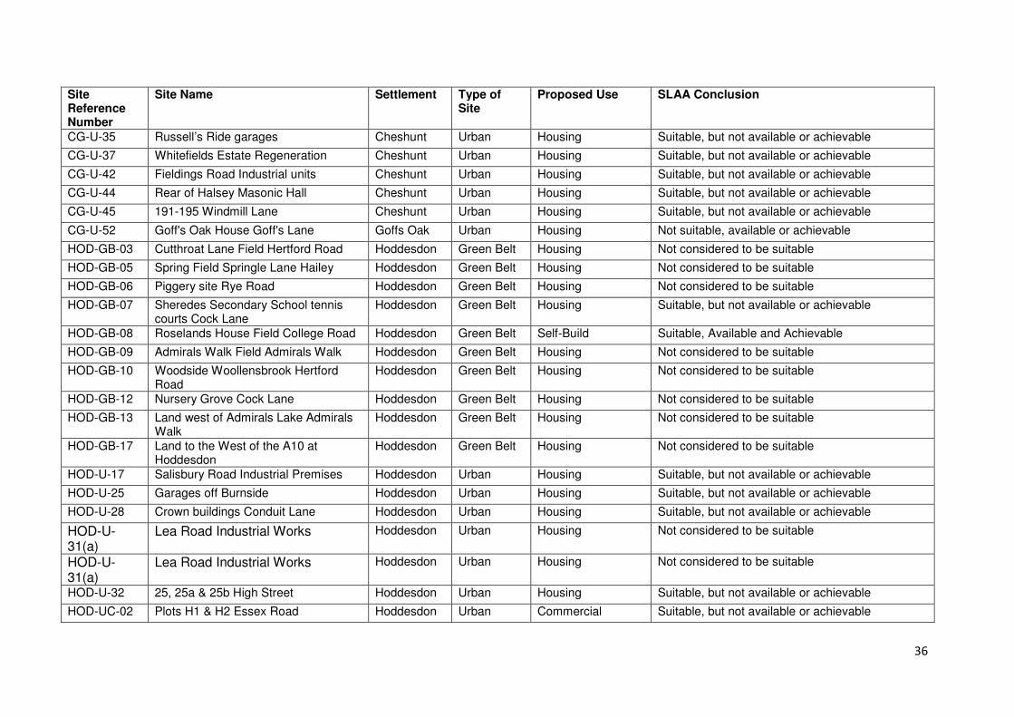
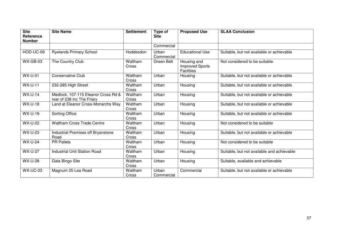
Table 13: Sites not considered to be suitable, available and achievable
Site Reference Number
Site Name Settlement Type of Site
Proposed Use SLAA Conclusion
BWT-GB-01 Disused Quarry Site at Church Lane Wormley Green Belt Housing or Gypsy/Traveller Use
Not considered to be suitable
BWT-GB-07 Holy Cross Hill Cock Lane Broxbourne Green Belt Travelling Showperson Headquarters
Not considered to be suitable
BWT-GB-09 Turnford Secondary School Turnford Green Belt Housing Not considered to be suitable
CG-GB-03 Travelling Showperson site Goff's Lane
Goffs Oak Green Belt Housing Not considered to be suitable
CG-GB-06 St Mary's School playing fields Bury Green
Cheshunt Green Belt Housing Not considered to be suitable
CG-GB-07 Albury Farm Albury Ride Cheshunt Green Belt Housing Not considered to be suitable
CG-GB-08(b) Albury Walk Field West Cheshunt Green Belt Residential Not considered to be suitable
CG-GB-09 M. O’Connor Land Goff's Lane Goffs Oak Green Belt Housing Not considered to be suitable
CG-GB-10 Theobalds Park Estate Grassland Newgatestreet Road
Goffs Oak Breen Belt Housing Not considered to be suitable
CG-GB-101 Hope Nursery Halstead Hill Goffs Oak Green Belt Housing Not considered to be suitable
CG-GB-102 Rainbow End Stables Cheshunt Green Belt Housing Not considered to be suitable
CG-GB-103 St Lawrence Bush Farm Hammondstreet Road
Cheshunt Green Belt Housing Not considered to be suitable
CG-GB-104 Hawthorn & Rosary Nurseries Hammondstreet Road
Cheshunt Green Belt Housing Not considered to be suitable
CG-GB-105 424 Goffs Lane Goffs Oak Green Belt Housing Not considered to be suitable
CG-GB-106 Paradise Nurseries Park Lane Paradise
Cheshunt Green Belt Housing Not considered to be suitable
CG-GB-108 Halstead Hill Triangle Halstead Hill Goffs Oak Green Belt Housing Not considered to be suitable
CG-GB-109 Watercress Field Cheshunt Green Belt Housing Not considered to be suitable
CG-GB-11 Small Acre, Oakview, Rushdown, Lindrick
Goffs Oak Green Belt Housing Not considered to be suitable
CG-GB-11(b) Small Acre and Oakview Cheshunt Green Belt Housing Not considered to be suitable
32
Site Reference Number
Site Name Settlement Type of Site
Proposed Use SLAA Conclusion
CG-GB-112 Limes & Hawthorn Nurseries Hammondstreet Road
Cheshunt Green Belt Housing Not considered to be suitable
CG-GB-113 Brook Field Cuffley Hill Goffs Oak Green Belt Housing Not considered to be suitable
CG-GB-115 East of Halstead Nursery Goffs Oak Green Belt Housing Not considered to be suitable
CG-GB-116 Land north of Church Lane Wormley Green Belt Housing or gypsy and traveller site
Not considered to be suitable
CG-GB-119 Brook Farm North Cuffley Hill Goffs Oak Green Belt Housing Not considered to be suitable
CG-GB-12 Green Acre Crouch Lane Goffs Oak Green Belt Housing Not considered to be suitable
CG-GB-121 Land at Burnt Farm Ride Goffs Oak Green Belt Housing Not considered to be suitable
CG-GB-122 Land rear of 118 Cuffley Hill Goffs Oak Green Belt Housing Not considered to be suitable
CG-GB-127 South of Goffs Lane Goffs Oak Green Belt Housing Not considered to be suitable
CG-GB-128 Land south of Cuffley Hill Goffs Oak Green Belt Housing Not considered to be suitable
CG-GB-129 Rushdown Nursery Goffs Oak Green Belt Housing Not considered to be suitable
CG-GB-13 Woodham Nursery St James Road Goffs Oak Green Belt Housing Not considered to be suitable
CG-GB-131 Rear of 122-126 Cuffley Hill Goffs Oak Green Belt Housing Not considered to be suitable
CG-GB-132 Land North of Andrews Lane Cheshunt Green Belt Housing Not considered to be suitable
CG-GB-14 White House Farm St James Road Goffs Oak Green Belt Housing and Village Green
Not considered to be suitable
CG-GB-15 Pendine St James Road Goffs Oak Green Belt Housing Not considered to be suitable
CG-GB-17 Former Nockhold/FJD Nursery Goffs Oak Green Belt Housing Not considered to be suitable
CG-GB-18(a) Longmead and Pylon Farm St James Road
Goffs Oak Green Belt Housing Not considered to be suitable
CG-GB-18(b) Longmead Nursery Goffs Oak Green Belt Housing Not considered to be suitable
CG-GB-19 Twelve Acre Farm Rags Lane Goffs Oak Green Belt Self-Build Not considered to be suitable
CG-GB-21 Garryross Farm Andrews Lane Goffs Oak Green Belt Housing Not considered to be suitable
CG-GB-23 Granby Park Road site Rosedale Way Cheshunt Green Belt Housing Not considered to be suitable
CG-GB-25 Claremont site North of Thompsons Close
Cheshunt Green Belt Housing Not considered to be suitable
CG-GB-27 Elmhurst Ponds Appleby Street Cheshunt Green Belt Housing Not considered to be suitable
33
Site Reference Number
Site Name Settlement Type of Site
Proposed Use SLAA Conclusion
CG-GB-28 Hammondstreet View Hammondstreet Road
Cheshunt Green Belt Housing Not considered to be suitable
CG-GB-29 Hazel Grove Darnicle Hill Cheshunt Green Belt Housing Not considered to be suitable
CG-GB-30 Calves Croft Farm Darnicle Hill Cheshunt Green Belt Housing Not considered to be suitable
CG-GB-31 Oak House Farm Newgatestreet Road Goffs Oak Green Belt Housing Not considered to be suitable
CG-GB-35 Triangle Nursery Crouch Lane Goffs Oak Green Belt Housing/Self-build Not considered to be suitable
CG-GB-37 Ashfield Nursery Newgatestreet Road Goffs Oak Green Belt Housing Not considered to be suitable
CG-GB-38 Park House Appleby Street Cheshunt Green Belt Housing Not considered to be suitable
CG-GB-39 Rowlands Nursery Crouch Lane Goffs Oak Green Belt Housing Not considered to be suitable
CG-GB-40 Hillside Nursery Goff's Lane Goffs Oak Green Belt Self-Build Not considered to be suitable
CG-GB-41(a) Ballymour and surrounding land Cheshunt Green Belt Housing The development of this site outside a comprehensive development scheme is not suitable
CG-GB-41(b) Lea Mount Andrews Lane Cheshunt Green Belt Housing The development of this site outside a comprehensive development scheme is not suitable
CG-GB-41(b) South of Andrews Lane Cheshunt Green Belt Housing The development of this site outside a comprehensive development scheme is not suitable
CG-GB-41(c) Ballymour and Langdons Cheshunt Green Belt Housing Not considered to be suitable
CG-GB-41(d) Rags Brook Valley Site Goffs Oak Green Belt Housing Not considered to be suitable
CG-GB-42 Laurel Park Newgatestreet Road Goffs Oak Green Belt Housing Not considered to be suitable
CG-GB-43 South Lodge Pasture Goff's Lane Goffs Oak Green Belt Housing Not considered to be suitable
CG-GB-46 White Bungalow St James Road Goffs Oak Green Belt Housing Not considered to be suitable
CG-GB-47 Churchview Nursery St James Road Goffs Oak Green Belt Housing Not considered to be suitable
CG-GB-49 Oak Field Doverfield Goffs Oak Green Belt Housing Not considered to be suitable
CG-GB-50 Meadow Farm Cheshunt Green Belt Housing Not considered to be suitable
CG-GB-51 Chase Field Newgatestreet Road Goffs Oak Green Belt Housing Not considered to be suitable
CG-GB-52 Westgate Nursery, Springfield Nursery Goffs Oak Green Belt Housing Not considered to be suitable
34
Site Reference Number
Site Name Settlement Type of Site
Proposed Use SLAA Conclusion
and Weald View Nursery Crouch Lane
CG-GB-52(b) Westgate and Springfield Goffs Oak Green Belt Housing Not considered to be suitable
CG-GB-53 Brookwall Nursery St James Road Goffs Oak Green Belt Housing Not considered to be suitable
CG-GB-54 Hazelwood Crouch Lane Goffs Oak Green Belt Housing Not considered to be suitable
CG-GB-56 Brackendale St James Road Goffs Oak Green Belt Housing Not considered to be suitable
CG-GB-57 Burton Cottage Burton Lane Goffs Oak Green Belt Housing Not considered to be suitable
CG-GB-58 Cuffley Brook Site Jones Road Goffs Oak Green Belt Housing Not considered to be suitable
CG-GB-59 Four Winds and Forest View Newgatestreet Road
Goffs Oak Green Belt Housing Not considered to be suitable
CG-GB-60 Rosedale Meadow Faints Close Goffs Oak Green Belt Housing Not considered to be suitable
CG-GB-61(a) Limes Nursery Cheshunt Green Belt Housing Not considered to be suitable
CG-GB-61(b) Limes Nursery and Rosary Nursery Cheshunt Green Belt Housing Not considered to be suitable
CG-GB-64 Thorn Nursery Newgatestreet Road Goffs Oak Green Belt Housing Not considered to be suitable
CG-GB-66 Burleigh Field Newgatestreet Road Goffs Oak Green Belt Housing Not considered to be suitable
CG-GB-67 Cross Nursery Newgatestreet Road Goffs Oak Green Belt Housing Not considered to be suitable
CG-GB-68 Park Lane Meadow Appleby Street Cheshunt Green Belt Housing Not considered to be suitable
CG-GB-69 Lucas House Farm Goffs Oak Green Belt Housing Not considered to be suitable
CG-GB-70 White Bungalow garden St James Road
Goffs Oak Green Belt Housing Not considered to be suitable
CG-GB-72 Derry's Wood Field Hammondstreet Road
Cheshunt Green Belt Housing Not considered to be suitable
CG-GB-73(a) Darnicle Hill Nursery Cheshunt Green Belt Housing Not considered to be suitable
CG-GB-73(b) Darnicle Hill Nursery Cheshunt Green Belt Housing Not considered to be suitable
CG-GB-74 Hammondstreet Reservoir & Cedarwood Hammondstreet Road
Cheshunt Green Belt Housing Not considered to be suitable
CG-GB-75 Tetherdown Newgatestreet Road Goffs Oak Green Belt Housing Not considered to be suitable
CG-GB-76 Warden Nursery Newgatestreet Road Goffs Oak Green Belt Housing Not considered to be suitable
CG-GB-77 Windyridge Newgatestreet Road Goffs Oak Green Belt Housing Not considered to be suitable
35
Site Reference Number
Site Name Settlement Type of Site
Proposed Use SLAA Conclusion
CG-GB-78 Theobalds Nursery Newgatestreet Road
Goffs Oak Green Belt Housing Not considered to be suitable
CG-GB-79 Land rear of Chiltern Close Newgatestreet Road
Goffs Oak Green Belt Housing Not considered to be suitable
CG-GB-80 Silver Street Field Silver Street Goffs Oak Green Belt Housing Not considered to be suitable
CG-GB-81 Lucas End Farm Crouch Lane Goffs Oak Green Belt Housing Not considered to be suitable
CG-GB-82 High View Kennels & Cattery Crouch Lane
Goffs Oak Green Belt Housing Not considered to be suitable
CG-GB-83 Brambles Crouch Lane Goffs Oak Green Belt Housing Not considered to be suitable
CG-GB-84 Laurel Bank Farm St James Road Goffs Oak Green Belt Housing Not considered to be suitable
CG-GB-85 Burton Grange Nursery Peakes Way Goffs Oak Green Belt Housing Not considered to be suitable
CG-GB-86 Land north of Colesgrove Manor Cheshunt Green Belt Housing Not considered to be suitable
CG-GB-87 Kobe Nursery Halstead Hill Goffs Oak Green Belt Housing Not considered to be suitable
CG-GB-88 Goffs Oak Living Village Goffs Oak Green Belt Mixed-use Development
Not considered to be suitable
CG-GB-89 Rosedale Sports Club Andrews Lane Cheshunt Green Belt Housing Not considered to be suitable
CG-GB-90 The Asters Green Goff's Lane Goffs Oak Green Belt Housing Not considered to be suitable
CG-GB-91 Old Elm Farm Crouch Lane Goffs Oak Green Belt Housing Not considered to be suitable
CG-GB-92 Malaya Farm Crouch Lane Goffs Oak Green Belt Housing Not considered to be suitable
CG-GB-93 Cottage Farm Crouch Lane Goffs Oak Green Belt Housing Not considered to be suitable
CG-GB-94 Brook Farm Cheshunt Green Belt Housing Not considered to be suitable
CG-GB-95 St James Traveller Site St James Road
Goffs Oak Green Belt Housing Not considered to be suitable
CG-GB-96 Lea Mount Meadow Burton Lane Goffs Oak Green Belt Housing Not considered to be suitable
CG-GB-97(a) Hollow Leys Halstead Hill Goffs Oak Green Belt Housing Not considered to be suitable
CG-GB-97(b) Hollow Leys West Cheshunt
Green Belt Self-Build Not considered to be suitable
CG-U-29 Land south of Hammondstreet Road Cheshunt Urban Housing Suitable, but not available or achievable
CG-U-33 Tanglewood & Windrush Newgatestreet Road
Goffs Oak Urban Housing Not considered to be suitable
36
Site Reference Number
Site Name Settlement Type of Site
Proposed Use SLAA Conclusion
CG-U-35 Russell’s Ride garages Cheshunt Urban Housing Suitable, but not available or achievable
CG-U-37 Whitefields Estate Regeneration Cheshunt Urban Housing Suitable, but not available or achievable
CG-U-42 Fieldings Road Industrial units Cheshunt Urban Housing Suitable, but not available or achievable
CG-U-44 Rear of Halsey Masonic Hall Cheshunt Urban Housing Suitable, but not available or achievable
CG-U-45 191-195 Windmill Lane Cheshunt Urban Housing Suitable, but not available or achievable
CG-U-52 Goff's Oak House Goff's Lane Goffs Oak Urban Housing Not suitable, available or achievable
HOD-GB-03 Cutthroat Lane Field Hertford Road Hoddesdon Green Belt Housing Not considered to be suitable
HOD-GB-05 Spring Field Springle Lane Hailey Hoddesdon Green Belt Housing Not considered to be suitable
HOD-GB-06 Piggery site Rye Road Hoddesdon Green Belt Housing Not considered to be suitable
HOD-GB-07 Sheredes Secondary School tennis courts Cock Lane
Hoddesdon Green Belt Housing Suitable, but not available or achievable
HOD-GB-08 Roselands House Field College Road Hoddesdon Green Belt Self-Build Suitable, Available and Achievable
HOD-GB-09 Admirals Walk Field Admirals Walk Hoddesdon Green Belt Housing Not considered to be suitable
HOD-GB-10 Woodside Woollensbrook Hertford Road
Hoddesdon Green Belt Housing Not considered to be suitable
HOD-GB-12 Nursery Grove Cock Lane Hoddesdon Green Belt Housing Not considered to be suitable
HOD-GB-13 Land west of Admirals Lake Admirals Walk
Hoddesdon Green Belt Housing Not considered to be suitable
HOD-GB-17 Land to the West of the A10 at Hoddesdon
Hoddesdon Green Belt Housing Not considered to be suitable
HOD-U-17 Salisbury Road Industrial Premises Hoddesdon Urban Housing Suitable, but not available or achievable
HOD-U-25 Garages off Burnside Hoddesdon Urban Housing Suitable, but not available or achievable
HOD-U-28 Crown buildings Conduit Lane Hoddesdon Urban Housing Suitable, but not available or achievable
HOD-U-31(a)
Lea Road Industrial Works Hoddesdon Urban Housing Not considered to be suitable
HOD-U-31(a)
Lea Road Industrial Works Hoddesdon Urban Housing Not considered to be suitable
HOD-U-32 25, 25a & 25b High Street Hoddesdon Urban Housing Suitable, but not available or achievable
HOD-UC-02 Plots H1 & H2 Essex Road Hoddesdon Urban Commercial Suitable, but not available or achievable
37
Site Reference Number
Site Name Settlement Type of Site
Proposed Use SLAA Conclusion
Commercial
HOD-UC-09 Ryelands Primary School Hoddesdon Urban Commercial
Educational Use Suitable, but not available or achievable
WX-GB-03 The Country Club Waltham Cross
Green Belt Housing and Improved Sports Facilities
Not considered to be suitable
WX-U-01 Conservative Club Waltham Cross
Urban Housing Suitable, but not available or achievable
WX-U-11 232-285 High Street Waltham Cross
Urban Housing Suitable, but not available or achievable
WX-U-14 Medlock, 107-115 Eleanor Cross Rd & rear of 238 inc The Friary
Waltham Cross
Urban Housing Suitable, but not available or achievable
WX-U-18 Land at Eleanor Cross-Monarchs Way Waltham Cross
Urban Housing Suitable, but not available or achievable
WX-U-19 Sorting Office Waltham Cross
Urban Housing Suitable, but not available or achievable
WX-U-22 Waltham Cross Trade Centre Waltham Cross
Urban Housing Not considered to be suitable
WX-U-23 Industrial Premises off Bryanstone Road
Waltham Cross
Urban Housing Suitable, but not available or achievable
WX-U-24 PR Pallets Waltham Cross
Urban Housing Not considered to be suitable
WX-U-27 Industrial Unit Station Road Waltham Cross
Urban Housing Suitable, but not available and achievable
WX-U-28 Gala Bingo Site Waltham Cross
Urban Housing Suitable, available and achievable
WX-UC-03 Magnum 25 Lea Road Waltham Cross
Urban Commercial
Commercial Suitable, but not available or achievable
38
Housing Implementation Strategy
39
Introduction
This Housing Implementation Strategy (HIS) for the Borough of Broxbourne sets out
the Council’s approach to managing the delivery of new housing within the Borough
to 2033. The HIS has been produced to support the emerging Local Plan, which
identifies the growth locations and level of development that will be provided within
the Borough to meet its development needs without compromising sustainable
development objectives.
The Borough’s HIS will identify:
• The sources of housing supply that will contribute to the Borough meeting its
objectively assessed housing need which is set out in the Plan;
• The potential timescales for the phasing and delivery of the Borough’s Local
Plan sites;
• The potential risks to housing delivery;
• The Council’s proposed approach to monitoring and managing housing
delivery
Policy Background
The National Planning Policy Framework (NPPF) (paragraph 47) states that local
planning authorities should
• use their evidence base to ensure that their Local Plan meets the full,
objectively assessed needs for market and affordable housing in the housing
market area, as far as is consistent with the policies set out in this Framework,
including identifying key sites which are critical to the delivery of the housing
strategy over the plan period;
• identify and update annually a supply of specific deliverable sites sufficient to
provide five years worth of housing against their housing requirements with an
additional buffer of 5% (moved forward from later in the plan period) to
ensure choice and competition in the market of land. Where there has been a
record of persistent under delivery of housing, local planning authorities
should increase the buffer to 20% (moved forward from later in the plan
period) to provide a realistic prospect of achieving the planned supply and to
ensure choice and competition in the market for land;
• identify a supply of specific, developable sites or broad locations for growth,
for years 6-10, where possible, for years 11-15
To assist in the above, the NPPF (paragraph 47) requires local planning authorities,
for market and affordable housing to “illustrate the expected rate of housing
trajectory for the plan period and set out a housing implementation strategy for the
full range of housing describing how they will maintain delivery of a five-year supply
of housing land to meet their target”.

40
Current Housing Position
As shown in Table 14, there has been variation in the delivery of housing within the
Borough over a ten year period. During this period, the Borough has on average
delivered 211 (net) dwellings per annum. This relatively low rate of delivery,
particularly in the years 2013-2016, partly reflects the lack of an up-to-date
development plan – the Council’s current adopted Local Plan covers the period
2001-2011, with the housing allocations (Policy H3 and H4) included within this Plan
being built out.
06
/07
07
/08
08
/09
09
/10
10
/11
11
/12
12
/13
13
/14
14
/15
15
/16
To
tal
Av
era
ge
Housing Requirement 270 270 270 240 252 252 262 262 419 419 291
6 292
Gross Completions 287 298 202 333 278 175 190 118 184 183 224
8 225
Net Completions 260 281 179 316 271 168 183 97 179 177 211
1 211
Over/Under Delivery -10 11 -91 76 19 -84 -79 -
165 -
240 -
242 -
805
Table 14: Housing Completions between 06/07-15/16
The most recent 5 year land supply has been set out in the Council’s 2015/16
Authority Monitoring Report (AMR), published in February 2017. This shows that the
Borough has a supply of 2.4 years; however, when Local Plan allocations are taken
into account, the five year housing land supply increases to 5.02 years.
Broxbourne’s Housing Requirement in the emerging Local Plan
In July 2016, the Council published its Regulation 18 draft Local Plan. The draft
Local Plan set out how Broxbourne will grow and develop to become a more
desirable place to live, work, and visit for inward investment. The Plan also sets out
the development strategy for the next 15 years for homes, jobs, shops, leisure,
transport and infrastructure all set alongside the long term protection and
improvement of a redefined Green Belt, parks and open spaces.
The level of housing need for the Borough has been determined by evidence
gathered to inform the Strategic Housing Market Assessment and its subsequent
updates. As identified in ‘Borough of Broxbourne Council – Review of Objectively
Assessed Housing Need’ (Justin Gardner, 2016), “it is considered that the Borough
is not a self-contained housing market area but that housing market geographies
make it difficult for the Borough to meaningfully work with the locations with which
the strongest links are identified. It is therefore recommended that the Council can
progress its own evidence base and that duty to cooperate concentrates on
discussions with Enfield and East Hertfordshire”. This review concluded that 419
41
homes per annum would be a ‘reasonable objective’ assessment of need (about
7,130 over the 2014-2031 period).
An overview of the Borough’s housing supply was included within Appendix A of the
Council draft Local Plan (Regulation 18). The housing trajectory will be updated in
the next iteration of the draft Plan (Regulation 19) and in future AMRs.
Broxbourne’s Housing Requirement – Partial Review of the OAN (July 2017)
A subsequent update to the OAN (Borough of Broxbourne Council – Partial Review
of Objectively Assessed Housing Need, 2017) was carried out to inform the Council’s
Regulation 19 draft Local Plan. This update takes into account the latest household
projections (2014) published by the Department for Communities and Local
Government, which the National Planning Policy Guidance (NPPG) states should be
the starting point to estimate the overall housing need.
The Review showed that the borough has a demographic housing need of 7021
dwellings over the plan period (2016-2033). This equates to 413 dwellings per
annum. The NPPF states that “Plans should take account of market signals, such as
land princes and housing affordability”. When 10% market signal uplift2 is applied to
this figure, an additional 702 dwellings are needed over the period 2016-2033. This
equates to an additional 41 dwellings per annum, therefore, the dwelling per annum
requirement is increased to 454.
Housing Supply Components
The sources of the housing supply for the Council’s Housing Trajectory are identified
in the below table.
Source Explanation Completions Since the base date of the Plan period (2016) monitoring indicates
that there has been 253 (net) dwellings completed. Commitments These are site which benefit from having outlined or full planning
permission. This category includes sites where planning permission has not yet been implemented and those which are under construction.
Small Sites Windfall Allowance
Paragraph 48 of the NPPF states that “Local Planning Authorities may make an allowance for windfall sites in the five-year supply if they have compelling evidence that such sites have consistently become available in the local area and will continue to provide a reliable source of supply. Any allowance should be realistic having regard to the Strategic [Housing] Land Availability Assessment, historic windfall delivery rates and expected future trends, and should not include residential gardens”. The Council has recently completed its 2017 Strategic Land Availability Assessment (2017), which
2 Paragraph 17 of the NPPF states that “Plans should take account of market signals, such as land prices and
housing affordability, and set out a clear strategy for allocating sufficient land which is suitable for
development in their area, taking account of the needs for residential and business communities”.
42
provided an updated analysis on past windfall trends and recommended that an allowance of 37 dwellings per annum is included with the Council’s five year land supply. Windfall development within the Borough will continue to be monitored through the AMR.
Strategic Land Availability Sites (SLAA)
This SLAA provides an evaluation in terms of suitability, availability and achievability, for a number of sites in accordance with the methodology set out in the National Planning Practice Guidance (NPPG). 57 sites have been identified as being suitable, available and achievable for development.
Proposed Local Plan Site Allocations
In July 2016, the Council published its Regulation 18 draft Local Plan. The draft Local Plan identified a number of strategic locations that would contribute significantly to the Borough’s housing supply over the Plan period. These strategic locations are: Cheshunt Lakeside, Waltham Cross Northern High Street, Brookfield and Rosedale Park. A number of smaller sites in Goffs Oak, Cheshunt and Broxbourne are also proposed in order that the Council can feet its full housing needs.
Table 15: Housing Supply Components
Housing Delivery and Development Phasing
The phasing of housing delivery is important to ensure that the Council maintains a
five year land supply throughout the Plan period.
All assumptions on the phasing of development should be realistic, based on robust
local evidence. Appendix A presents the Borough’s build out rates over a 15 year
period.
Appendix A shows that from consent date, nearly all commitments (which do not
lapse) are built out within 6-7 years, with a significant proportion coming forward
within 3 years (with the exception of 2014/15). There are a few commitments that
take longer than 6-7 years to be completed; however, the sites only yield a small
amount (1-2 dwellings)
A significant amount of permissions for the years 2014/15 (303 – 85%) and 2015/16
(1078 -91%) have yet to be built. It is considered that the percentage of permissions
not built out for the financial year 2015/16 will remain high until High Leigh Garden
Village (which makes up 48% of permissions not implemented) begins to deliver
housing. As indicated in Appendix 1 of this report, there has been a delay in the
delivery of this housing scheme.
Between 2007/08 and 2012/13, there was an increase in the number of lapsed
permissions. This increase can be associated with the impacts that the recession
had on the housing market.
Table 16 contains a sample of build out rates for major development (the delivery of
10 dwellings (net) or more) sites for the Borough over between the period 2005/06-
2016/17 has enabled the following average build out or “delivery rates” for a range of
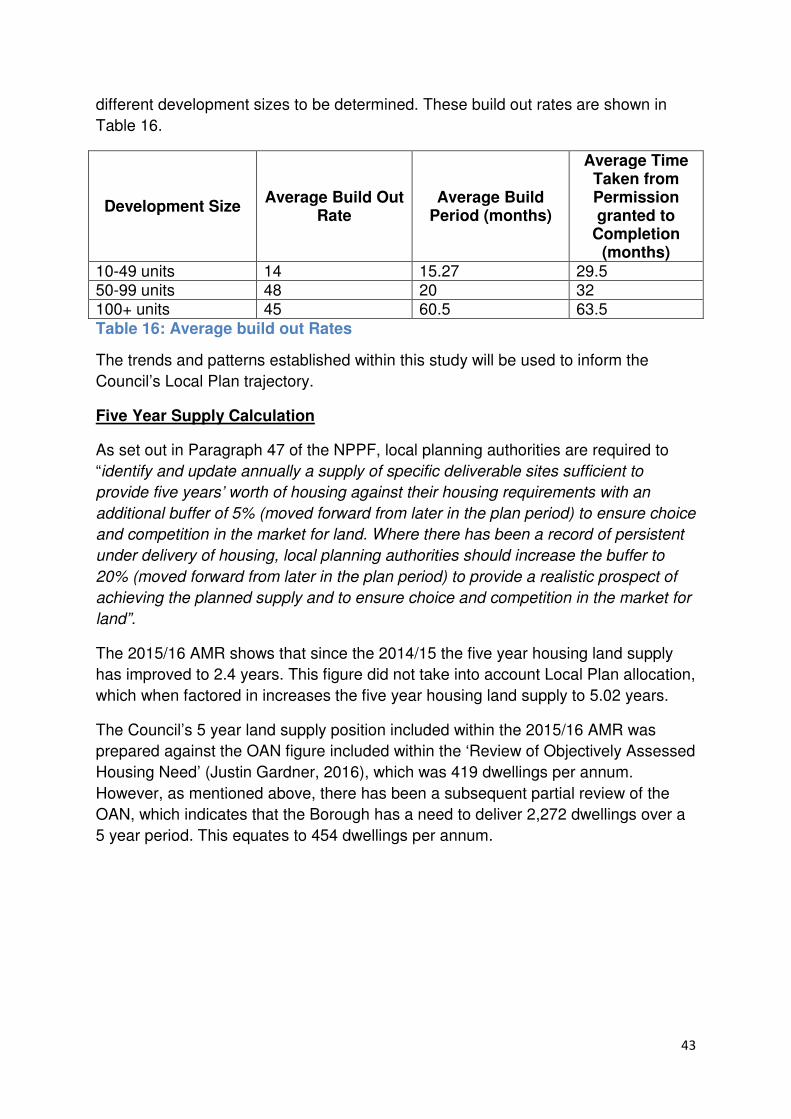
43
different development sizes to be determined. These build out rates are shown in
Table 16.
Development Size Average Build Out
Rate Average Build
Period (months)
Average Time Taken from Permission granted to
Completion (months)
10-49 units 14 15.27 29.5 50-99 units 48 20 32 100+ units 45 60.5 63.5
Table 16: Average build out Rates
The trends and patterns established within this study will be used to inform the
Council’s Local Plan trajectory.
Five Year Supply Calculation
As set out in Paragraph 47 of the NPPF, local planning authorities are required to
“identify and update annually a supply of specific deliverable sites sufficient to
provide five years’ worth of housing against their housing requirements with an
additional buffer of 5% (moved forward from later in the plan period) to ensure choice
and competition in the market for land. Where there has been a record of persistent
under delivery of housing, local planning authorities should increase the buffer to
20% (moved forward from later in the plan period) to provide a realistic prospect of
achieving the planned supply and to ensure choice and competition in the market for
land”.
The 2015/16 AMR shows that since the 2014/15 the five year housing land supply
has improved to 2.4 years. This figure did not take into account Local Plan allocation,
which when factored in increases the five year housing land supply to 5.02 years.
The Council’s 5 year land supply position included within the 2015/16 AMR was
prepared against the OAN figure included within the ‘Review of Objectively Assessed
Housing Need’ (Justin Gardner, 2016), which was 419 dwellings per annum.
However, as mentioned above, there has been a subsequent partial review of the
OAN, which indicates that the Borough has a need to deliver 2,272 dwellings over a
5 year period. This equates to 454 dwellings per annum.
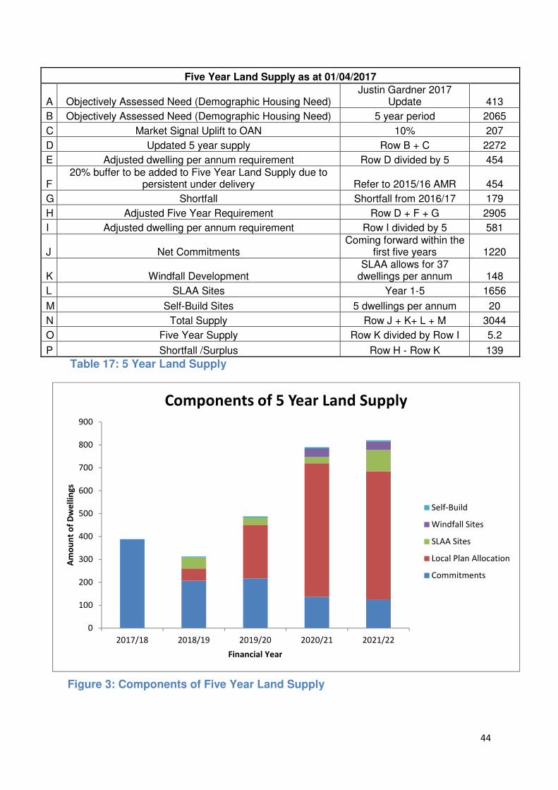
44
0
100
200
300
400
500
600
700
800
900
2017/18 2018/19 2019/20 2020/21 2021/22
Am
ou
nt
of
Dw
ell
ing
s
Financial Year
Components of 5 Year Land Supply
Self-Build
Windfall Sites
SLAA Sites
Local Plan Allocation
Commitments
Five Year Land Supply as at 01/04/2017
A Objectively Assessed Need (Demographic Housing Need) Justin Gardner 2017
Update 413
B Objectively Assessed Need (Demographic Housing Need) 5 year period 2065
C Market Signal Uplift to OAN 10% 207
D Updated 5 year supply Row B + C 2272
E Adjusted dwelling per annum requirement Row D divided by 5 454
F 20% buffer to be added to Five Year Land Supply due to
persistent under delivery Refer to 2015/16 AMR 454
G Shortfall Shortfall from 2016/17 179
H Adjusted Five Year Requirement Row D + F + G 2905
I Adjusted dwelling per annum requirement Row I divided by 5 581
J Net Commitments Coming forward within the
first five years 1220
K Windfall Development SLAA allows for 37
dwellings per annum 148
L SLAA Sites Year 1-5 1656
M Self-Build Sites 5 dwellings per annum 20
N Total Supply Row J + K+ L + M 3044
O Five Year Supply Row K divided by Row I 5.2
P Shortfall /Surplus Row H - Row K 139
Table 17: 5 Year Land Supply
Figure 3: Components of Five Year Land Supply

45
As shown in the above table and graph, the Council’s proposed Local Plan
allocations form a significant proportion of the 5 year land supply. Therefore, it is
important that the current status of the proposed allocations within the planning
process is carefully monitored. Commentary on the progress of these sites will be
contained within the AMR.
The Council will continue to review its 5 year land supply position through the AMR.
Risks to Housing Delivery and Contingencies
Table 5 provides an overview of the potential risks to the delivery of new housing
within the Borough and details actions that the Council could implement to mitigate
against these risks.
Potential Risk to the Delivery of Housing Explanation
Potential Mitigatory Measures
Economic Climate – The housing market is a key component of the UK’s economy. Due to this, it is particularly sensitive to the local and national economic climate, particularly the ability for developers to access finance, and, the availability of mortgages and the affordability of houses for house purchasers. The impact that the economic climate can have on the housing market has been evident since recession (2008-2013) – during this period there was a serious downturn in the housing market (mortgage lending contracted, house prices fell, build out rates stalled, housing sites stalled). There are signs that the economy and the housing market is recovering from this recession, however, the impact that Brexit will have on the housing market is unknown. If Brexit results in a downturn in the housing market, it is likely that this will have a detrimental impact on the Borough’s build out rates. The Council will have little control over this scenario, therefore, there is a risk that the OAN set out in the emerging Local Plan will not be delivered.
• The Council will consider whether the viability of sites can be reassessed to factor in any economic changes. This is in line with Paragraph 205 of the NPPF which states that “Where obligations are being sought or revised, local planning authorities should take account of changes in market conditions over time, and where appropriate, be sufficiently flexible to prevent planned development being stalled”.
• The Council will ensure that there is a wide range of sites, which have a diversity in the types of dwelling being provided, and are being delivered by a range of housebuilders (both large and small).
Status in the Planning System – There is a greater level of risk associated with sites that do not benefit from planning permission or are allocated within an Local Plan that has not been adopted. A number of the sites that the SLAA update concluded to be suitable, available and achievable are currently designated as Green Belt. The National Planning Policy Framework (NPPF) (paragraph 83) states that “Once established, Green Belt boundaries should only be altered in
• It is perceived that a site’s identification within this SLAA update as being suitable, available and achievable provides developers with a greater level of certainty that the sites are achievable in planning terms.
• The Council will ensure that SLAA sites contained within the emerging Local Plan have sufficient evidence to support their allocation. This evidence will include a Green Belt Topic Paper that

46
Potential Risk to the Delivery of Housing Explanation
Potential Mitigatory Measures
exceptional circumstances, through the preparation or review of the Local Plan”.
will assess a number of sites against the draft criteria set out in the Council’s ‘Green Belt Exceptional Circumstances’ (2016).
• Developers will be encouraged to enter into pre-application discussions with the Council in regards to bringing a planning application forward for proposed allocations.
Supply of deliverable housing land - The NPPF has placed a requirement on local planning authorities to maintain a 5 year land supply. The borough as a number of constraints (i.e. green belt, Lee Valley Regional Park, lack of brownfield land) which restricts its supply of deliverable sites.
• The Council will continue to monitor its 5 year land supply positions through its AMR.
• Within the emerging Local Plan (Regulation 18), the Council has identified Maxwell Farm and Rush Meadow as safeguarded land for future development. If required, this land could be released early to ensure that a supply of deliverable housing land is maintained.
Large amount of unimplemented permissions – A letter to the Housing Minister in January 2017, on behalf of the South East England Councils states that “Evidence from multiple sources shows there have been significant increases in the number of unused planning permissions for homes in recent years”. An increase in the number of unimplemented planning permissions not being taken forward by the construction industry could result in local growth plans not being fulfilled.
• The Council will engage in discussions with landowners to establish the reason(s) for the lack of implementation. Where appropriate, the Council will help the landowner in addressing any issues that have arisen.
• The Council will consider the wider housing market to assess whether the lack of implementation is a result of
• The Housing White Paper (February 2017) indicates that the Government will introduce “a new housing delivery test to ensure that local authorities and wider interests are held accountable for their role in ensuring new homes are delivered in their area”.
Delay in the installation of infrastructure – A delay in the provision of infrastructure, particularly utilities connections and road connectivity, can result in housebuilding slowing or stopping on a site altogether. A common cause for the lag in the provision on infrastructure is the lack of funding.
• To support the emerging Local Plan, the Council has prepared an Infrastructure Delivery Plan (IDP). The IDP will detail what infrastructure is required, when it is needed, who is responsible for providing the infrastructure and how it will be funded. The IDP will be updated on a regular basis.
• Where appropriate, the Council will work with statutory service providers and the County Council to ensure that the

47
Potential Risk to the Delivery of Housing Explanation
Potential Mitigatory Measures
infrastructure is provided in a timely manner to support the development.
• If required, and government funding is available, the Council will aid the developers in applying for government supported funding.
Public Opposition – Developments, both large and small, can create public opposition. It is possible that this public opposition could result in costly delays or prevent the development from coming forward at all.
• A number of SLAA sites concluded to be suitable, available and achievable are also proposed allocations within the emerging Local Plan. In line with ‘The Town and Country Planning (Local Plan) (England) Regulations 2012’, the Council has consulted on its Regulation 18 draft Local Plan. The comments made during this consultation period will inform the next iteration of the Local Plan.
• The Council will encourage the developers to engage, at the earliest possible stage, with statutory bodies, community groups and local residents, regarding proposals for development on
Planning Application Process – The Government has set targets for Local Planning Authorities to deal with major applications in 13 weeks and minor in 8 weeks. Delays within this planning application process can be caused for a number of reasons:
• Submission of incomplete forms and/or provision of poor quality maps and drawings which can prevent the Council from validating the application.
• The Council may wish to consult a number of organisation/departments on any planning application. Any issues raised as part of this consultation may result in a delay in the issuing of a decision as more information may be required and/or submitted proposals will need to be amended.
• A planning application may need to go through the Planning and Regulatory Committee, which could further delay the issuing of a Council’s decision.
• Broxbourne Borough Council encourages developers of major schemes to enter into Planning Performance Agreements (PPA). The NPPG states that a PPA is a “project management tool which the local planning authorities and applicants can use to agree timescales, actions and resources for handling particular applications”. PPAs can be useful in setting out an efficient and transparent process for determining large and/or complex applications.
• It is encouraged that applications are entered into pre-application discussions with the Council. Pre-application engagement can offer significant potential to improve both the efficiency and effectiveness of the planning application system and the improve the quality of planning applications and their likelihood success. The NPPG states that this can be achieved by:

48
Potential Risk to the Delivery of Housing Explanation
Potential Mitigatory Measures
Ownership of Land – It is possible for a site to have a number of owners. A sites fragmented ownership may result in it becoming difficult to deliver a comprehensive masterplan i.e. Rosedale Park/Cheshunt Lakeside that adheres to the sustainable development principles that the Council is promoting within the emerging Local Plan.
• The Council will liaise with landowners and site promoters to encourage a comprehensive approach to developing a particular site.
• If necessary, the Council will pursue compulsory purchase to enable a sites delivery. The emerging Local Plan includes references to the use of compulsory purchase in some emerging policies.
Table 18: Risk to Housing Delivery and Contingencies
Management
In the event that the Council’s housing delivery objectives are not being met then
management actions will need to be considered. Many of the actions that the Council
could take have been identified in Table 18.
In addition to these actions, the Council could consider the following actions:
• Review the Development Strategy to ensure that it is still appropriate
• If appropriate, undertake a partial review of the Local Plan to address the
change in circumstances or introduce new mechanisms to better address
• The Council may hold a further ‘call for sites’ and re-visit SLAA sites that were
previously considered to be unsuitable.
• The Council may consider bringing forward safeguarded land or the Area
Action Plan for Waltham Cross.
Monitoring Housing Delivery
The Council will monitor the progress in delivery of housing within the borough
through the Authority Monitoring Report (AMR). The AMR is produced on an annual
basis, and can be viewed on the Council’s website by using the following link:
www.broxbourne.gov.uk/amr. The AMR provides information on completions and
commitments completed/granted during a financial year, as well as updating the
Council’s housing trajectory and five year land supply position.
In addition, there will be regular updates to the Strategic Land Availability
Assessment (SLAA). These updates will take into account any progress on SLAA
sites and incorporate any updated information on a sites availability, suitability and
achievability.
Furthermore, the recently published Housing White Paper (February 2017) is
proposing to introduce a ‘Housing Delivery Test’. The Paper states that the housing

49
delivery test will “highlight whether the numbers of homes being built is below target,
provide a mechanism for establishing the reasons why, and where necessary trigger
policy responses that will ensure that further land comes forward”.
50
Strategic Land Availability Assessment
Appendices
51
Appendix 1
Updated Call for Sites Form

52
Please read the accompanying guidance notes before completing this form. When
completed it should be submitted to the Council by 5pm on Friday 16th September 2016
together with a map identifying the boundaries of the site an suitable scale (e.g. 1:1250),
showing the boundary of the site accurately.
Should you have any queries with regards to the form then please contact the Planning
Policy Team on [email protected]
Please return your completed form and site location plan to the Broxbourne Borough
Council Planning Policy team by:
E-mail: [email protected]
Post: Broxbourne Borough Council Planning Policy Team Bishops College Churchgate Cheshunt Hertfordshire EN8 9XB
Contact Details Agent’s contact details (if applicable)
Title Title
First Name First Name
Last Name Last Name
Job title (where relevant)
Job title (where relevant)
Organisation (where relevant)
Organisation (where relevant)
Address Address
Telephone Number
Telephone Number
Broxbourne Borough Council
Strategic Land Availability Assessment
Site Submission and Update Form
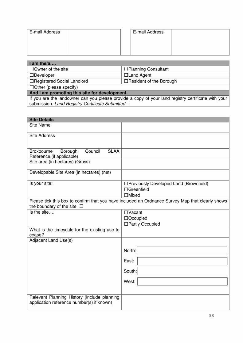
53
E-mail Address E-mail Address
I am the/a…. ☐Owner of the site ☐Planning Consultant ☐Developer ☐Land Agent ☐Registered Social Landlord ☐Resident of the Borough ☐Other (please specify)
And I am promoting this site for development.
If you are the landowner can you please provide a copy of your land registry certificate with your
submission. Land Registry Certificate Submitted ☐
Site Details Site Name
Site Address
Broxbourne Borough Council SLAA Reference (if applicable)
Site area (in hectares) (Gross)
Developable Site Area (in hectares) (net)
Is your site: ☐Previously Developed Land (Brownfield) ☐Greenfield ☐Mixed
Please tick this box to confirm that you have included an Ordnance Survey Map that clearly shows
the boundary of the site ☐
Is the site…. ☐Vacant ☐Occupied ☐Partly Occupied What is the timescale for the existing use to cease?
Adjacent Land Use(s) North: East: South: West:
Relevant Planning History (include planning application reference number(s) if known)
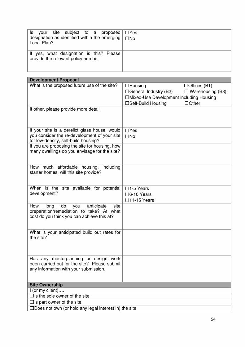
54
Is your site subject to a proposed designation as identified within the emerging Local Plan?
☐Yes ☐No
If yes, what designation is this? Please provide the relevant policy number
Development Proposal
What is the proposed future use of the site? ☐Housing ☐Offices (B1) ☐General Industry (B2) ☐ Warehousing (B8) ☐Mixed-Use Development including Housing ☐Self-Build Housing ☐Other
If other, please provide more detail.
If your site is a derelict glass house, would you consider the re-development of your site for low-density, self-build housing?
☐Yes ☐No
If you are proposing the site for housing, how many dwellings do you envisage for the site?
How much affordable housing, including starter homes, will this site provide?
When is the site available for potential development?
☐1-5 Years ☐6-10 Years ☐11-15 Years
How long do you anticipate site preparation/remediation to take? At what cost do you think you can achieve this at?
What is your anticipated build out rates for the site?
Has any masterplanning or design work been carried out for the site? Please submit any information with your submission.
Site Ownership I (or my client)…. ☐Is the sole owner of the site ☐Is part owner of the site ☐Does not own (or hold any legal interest in) the site

55
IF you are not the owner, or own part of the site do you know who owns the remainder (please provide details) Are the owner (or other owners) supportive of your proposal for the site in question?
☐Yes ☐No
Market Interest Please select the statement that is the most appropriate to indicate what level of market interest there is/has been recently for your site. Yes Comments The site is owned by a developer ☐
The site is under option to a developer ☐
Enquires have been received about the site from developers
☐
The site is being marketed ☐
None ☐
Not Known ☐
Possible Constraints to Development
Please consider whether the site identified has any constraints that may prevent or restrict development on the site Access Arrangements
• Is there an existing safe access point to the site?
• Are there opportunities for alternative access points to the site?
Water Courses/Flood Risk
• Does the site contains or is near to a watercourse, drain or other water feature?
• What flood zone does your site lie within? When was the last time the site flooded?
Topography
• Does the site slope?
• What is the vegetation cover of the site?
• Does the site have varying site levels?
Contamination
• Does the site contain contaminated land?
• Were there any previous hazardous land uses at the site?

56
Legal/Ownership Issues
• Is the site subject to any ransom strips or covenants?
• Are there any unresolved multiple ownership?
• Is the site subjected to any tenancies/lease? If yes what are the terms for terminating these?
Site Designations
• Does the site contains or adjoin any of the following: green belt, areas of archaeological interest, Lee Valley Park, Listed Building, TPO trees, Ancient Monument, Community Open Space, Cheshunt Common, Conservation Area, SSSI
Other Considerations
• Does the site contain a Public Right of Way?
• Are there any existing structures on the site? Do they require to be relocated? Or demolished?
Can these constraints be overcome? Has any studies or assessments been carried out to determine whether the constraints can be overcome and at what cost?
Utilities Does the site have access to…. Yes Details
Mains Water Supply ☐
Mains Sewerage ☐
Electrical Supply ☐
Gas Supply ☐
Landline telephone/Broadband ☐
Site Visits
A site visit may need to be carried out as part of the assessment. Are you happy to permit an officer entry to your site?
☐Yes ☐No
Any requirements for the site visit. i.e. Officer to make contact prior to visiting the site, the site visit would need to be escorted etc.
57
Declarations ☐☐☐☐I confirm that I am aware that I may be requested to provide further information to
support the information that I have provided on this form to aid in the Council
assessing the sites suitability. ☐☐☐☐I accept that the information I provide with this submission at a later date (if
required), with the exception of my contact details, may be made publicly available in
the SLAA update report and supporting documents ☐☐☐☐I confirm that the information provided within this submission is true and accurate to
the best of my knowledge.
Signed:___________________________________________ Date: ________________

58
Appendix 2
Call for Sites Submission Report

59
2016 Call for Sites Submissions Report
Site
Reference
Site Name Site
Location
Proposed
Future Use
Proposed
Capacity
Previously
Promoted?
Location Map
CG-GB-11 Rushdown
Nursery
Goffs Oak Housing 15 Yes
CG-GB-
18(b)
Longmead
Nursery
Goffs Oak Housing 45 No
WX-U-22 Eleanor
Trade
Centre
Waltham
Cross
Housing 60 Yes
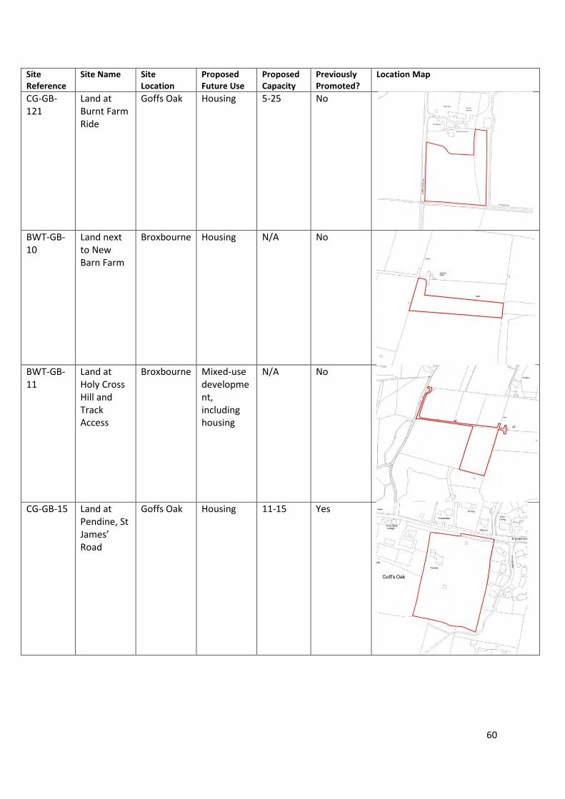
60
Site
Reference
Site Name Site
Location
Proposed
Future Use
Proposed
Capacity
Previously
Promoted?
Location Map
CG-GB-
121
Land at
Burnt Farm
Ride
Goffs Oak Housing 5-25 No
BWT-GB-
10
Land next
to New
Barn Farm
Broxbourne Housing N/A No
BWT-GB-
11
Land at
Holy Cross
Hill and
Track
Access
Broxbourne Mixed-use
developme
nt,
including
housing
N/A No
CG-GB-15 Land at
Pendine, St
James’
Road
Goffs Oak Housing 11-15 Yes
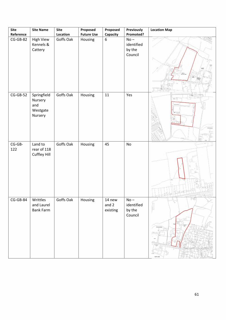
61
Site
Reference
Site Name Site
Location
Proposed
Future Use
Proposed
Capacity
Previously
Promoted?
Location Map
CG-GB-82 High View
Kennels &
Cattery
Goffs Oak Housing 6 No –
identified
by the
Council
CG-GB-52 Springfield
Nursery
and
Westgate
Nursery
Goffs Oak Housing 11 Yes
CG-GB-
122
Land to
rear of 118
Cuffley Hill
Goffs Oak Housing 45 No
CG-GB-84 Writtles
and Laurel
Bank Farm
Goffs Oak Housing 14 new
and 2
existing
No –
identified
by the
Council
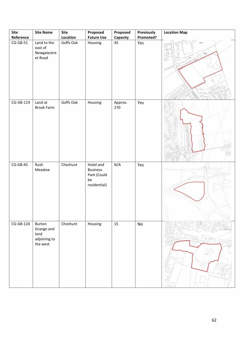
62
Site
Reference
Site Name Site
Location
Proposed
Future Use
Proposed
Capacity
Previously
Promoted?
Location Map
CG-GB-51 Land to the
east of
Newgatestre
et Road
Goffs Oak Housing 45 Yes
CG-GB-119 Land at
Brook Farm
Goffs Oak Housing Approx.
270
Yes
CG-GB-45 Rush
Meadow
Cheshunt Hotel and
Business
Park (Could
be
residential)
N/A Yes
CG-GB-124 Burton
Grange and
land
adjoining to
the west
Cheshunt Housing 15 No
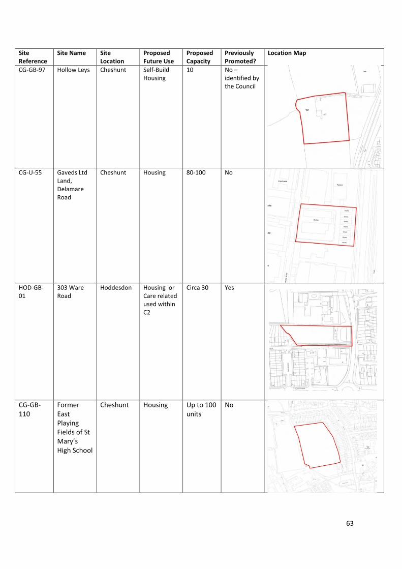
63
Site
Reference
Site Name Site
Location
Proposed
Future Use
Proposed
Capacity
Previously
Promoted?
Location Map
CG-GB-97 Hollow Leys Cheshunt Self-Build
Housing
10 No –
identified by
the Council
CG-U-55 Gaveds Ltd
Land,
Delamare
Road
Cheshunt Housing 80-100 No
HOD-GB-
01
303 Ware
Road
Hoddesdon Housing or
Care related
used within
C2
Circa 30 Yes
CG-GB-
110
Former
East
Playing
Fields of St
Mary’s
High School
Cheshunt Housing Up to 100
units
No
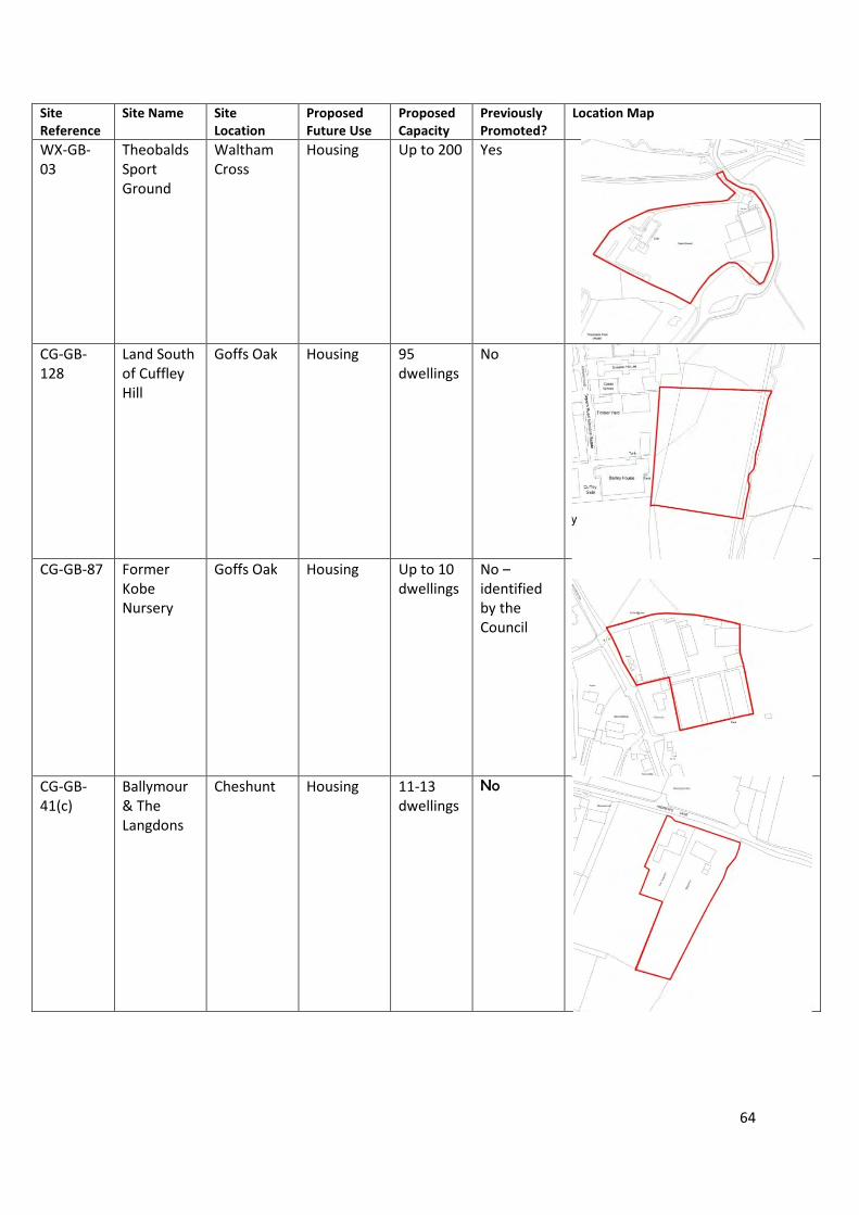
64
Site
Reference
Site Name Site
Location
Proposed
Future Use
Proposed
Capacity
Previously
Promoted?
Location Map
WX-GB-
03
Theobalds
Sport
Ground
Waltham
Cross
Housing Up to 200 Yes
CG-GB-
128
Land South
of Cuffley
Hill
Goffs Oak Housing 95
dwellings
No
CG-GB-87 Former
Kobe
Nursery
Goffs Oak Housing Up to 10
dwellings
No –
identified
by the
Council
CG-GB-
41(c)
Ballymour
& The
Langdons
Cheshunt Housing 11-13
dwellings
No

65
Site
Reference
Site Name Site
Location
Proposed
Future Use
Proposed
Capacity
Previously
Promoted?
Location Map
CG-GB-
41(a)
Ballymour
and
surroundin
g lands
Cheshunt Housing,
Self-Build
Housing
162-195
dwellings
No
CG-GB-19 12 Acre
Farm and
Ash
Cottage
Goffs Oak Housing 45 Yes
HOD-GB-
08
Roselands
House Field
Hoddesdon Self-Build
Housing
8 Yes
CG-GB-
128
South of
Goffs Lane
Goffs Oak Housing N/A No –
identified
by the
Council

66
Site
Reference
Site Name Site
Location
Proposed
Future Use
Proposed
Capacity
Previously
Promoted?
Location Map
WX-U-25 Theobalds
Grove
Station Car
Park
Waltham
Cross
Housing 50 Yes
CG-U-41 Gospel
Hall,
Halfhide
Lane
Cheshunt Housing 50-80 No –
identified
by the
Council
CG-GB-78 Former
Theobalds
Nursery
Site
Goffs Oak Housing 25-30 No-
identified
by the
Council
CG-GB-
61(b)
Limes and
Rosary
Nursery
Cheshunt Housing 109
dwellings
Yes

67
Site
Reference
Site Name Site
Location
Proposed
Future Use
Proposed
Capacity
Previously
Promoted?
Location Map
Land to
rear of 124-
122 Cuffley
Hill
Goffs Oak Housing 45 No

68
Appendix 3
SLAA Site Forms
69
Hoddesdon
Urban Sites
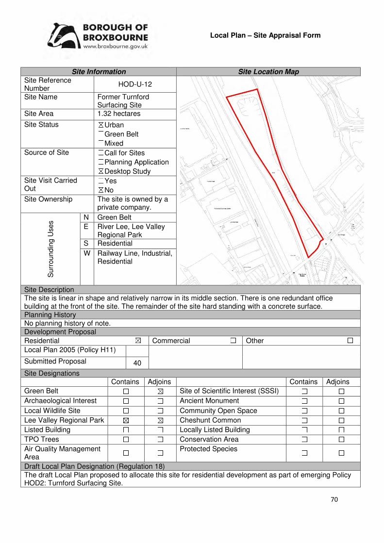
70
Local Plan – Site Appraisal Form
Site Information Site Location Map Site Reference Number
HOD-U-12
Site Name Former Turnford Surfacing Site
Site Area 1.32 hectares
Site Status ☒Urban ☐Green Belt ☐Mixed
Source of Site ☐Call for Sites ☐Planning Application ☒Desktop Study
Site Visit Carried Out
☐Yes ☒No
Site Ownership The site is owned by a private company.
Surr
oundin
g U
ses N Green Belt
E River Lee, Lee Valley Regional Park
S Residential
W Railway Line, Industrial, Residential
Site Description The site is linear in shape and relatively narrow in its middle section. There is one redundant office building at the front of the site. The remainder of the site hard standing with a concrete surface. Planning History No planning history of note. Development Proposal
Residential ☒ Commercial ☐ Other ☐
Local Plan 2005 (Policy H11)
Submitted Proposal 40
Site Designations Contains Adjoins Contains Adjoins
Green Belt ☐ ☒ Site of Scientific Interest (SSSI) ☐ ☐
Archaeological Interest ☐ ☐ Ancient Monument ☐ ☐
Local Wildlife Site ☐ ☐ Community Open Space ☐ ☐
Lee Valley Regional Park ☒ ☒ Cheshunt Common ☐ ☐
Listed Building ☐ ☐ Locally Listed Building ☐ ☐
TPO Trees ☐ ☐ Conservation Area ☐ ☐
Air Quality Management Area
☐ ☐ Protected Species ☐ ☐
Draft Local Plan Designation (Regulation 18) The draft Local Plan proposed to allocate this site for residential development as part of emerging Policy HOD2: Turnford Surfacing Site.
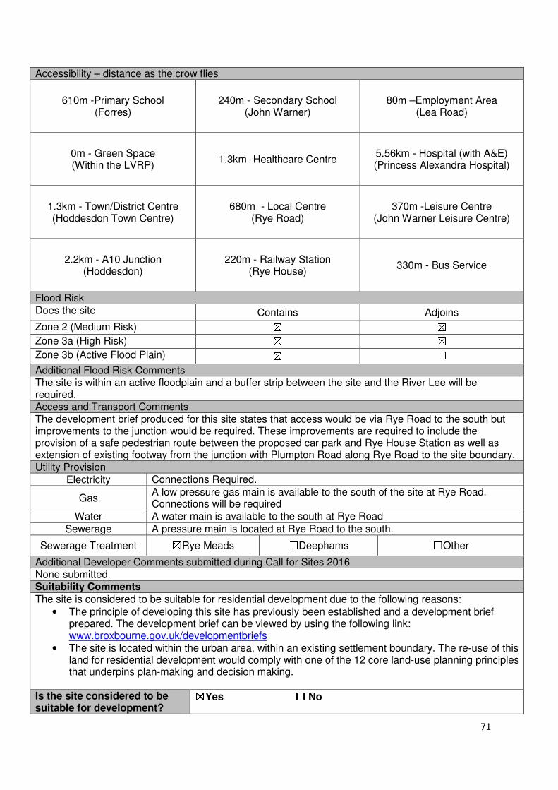
71
Accessibility – distance as the crow flies
610m -Primary School (Forres)
240m - Secondary School (John Warner)
80m –Employment Area (Lea Road)
0m - Green Space (Within the LVRP)
1.3km -Healthcare Centre 5.56km - Hospital (with A&E) (Princess Alexandra Hospital)
1.3km - Town/District Centre (Hoddesdon Town Centre)
680m - Local Centre (Rye Road)
370m -Leisure Centre (John Warner Leisure Centre)
2.2km - A10 Junction (Hoddesdon)
220m - Railway Station (Rye House)
330m - Bus Service
Flood Risk Does the site Contains Adjoins
Zone 2 (Medium Risk) ☒ ☒
Zone 3a (High Risk) ☒ ☒
Zone 3b (Active Flood Plain) ☒ ☐
Additional Flood Risk Comments The site is within an active floodplain and a buffer strip between the site and the River Lee will be required. Access and Transport Comments The development brief produced for this site states that access would be via Rye Road to the south but improvements to the junction would be required. These improvements are required to include the provision of a safe pedestrian route between the proposed car park and Rye House Station as well as extension of existing footway from the junction with Plumpton Road along Rye Road to the site boundary. Utility Provision
Electricity Connections Required.
Gas A low pressure gas main is available to the south of the site at Rye Road. Connections will be required
Water A water main is available to the south at Rye Road
Sewerage A pressure main is located at Rye Road to the south.
Sewerage Treatment ☒Rye Meads ☐Deephams ☐Other
Additional Developer Comments submitted during Call for Sites 2016 None submitted. Suitability Comments The site is considered to be suitable for residential development due to the following reasons:
• The principle of developing this site has previously been established and a development brief prepared. The development brief can be viewed by using the following link: www.broxbourne.gov.uk/developmentbriefs
• The site is located within the urban area, within an existing settlement boundary. The re-use of this land for residential development would comply with one of the 12 core land-use planning principles that underpins plan-making and decision making.
Is the site considered to be suitable for development?
☒☒☒☒Yes ☐☐☐☐ No

72
Availability Comments The site is within single ownership. The site owner is currently working on a scheme to bring this site forward.
Is the site considered to be available for development?
☒☒☒☒Yes ☐☐☐☐ No
Achievability Comments The site is considered to be achievable for development. As identified in the development brief for this site, a number of mitigation measures will need to be put in place to for development to come forward in this site. As identified in the development brief for this site, the Council will seek contributions.
Is the site considered to be achievable?
☒☒☒☒Yes ☐☐☐☐ No
Delivery Period 1-10 years
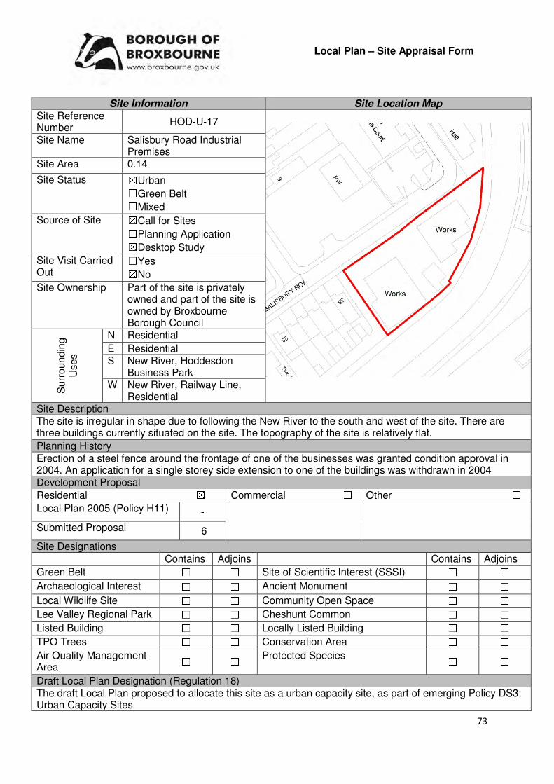
73
Local Plan – Site Appraisal Form
Site Information Site Location Map Site Reference Number
HOD-U-17
Site Name Salisbury Road Industrial Premises
Site Area 0.14
Site Status ☒Urban ☐Green Belt ☐Mixed
Source of Site ☒Call for Sites ☐Planning Application ☒Desktop Study
Site Visit Carried Out
☐Yes ☒No
Site Ownership Part of the site is privately owned and part of the site is owned by Broxbourne Borough Council
Surr
oundin
g
Uses
N Residential
E Residential S New River, Hoddesdon
Business Park W New River, Railway Line,
Residential Site Description The site is irregular in shape due to following the New River to the south and west of the site. There are three buildings currently situated on the site. The topography of the site is relatively flat.
Planning History Erection of a steel fence around the frontage of one of the businesses was granted condition approval in 2004. An application for a single storey side extension to one of the buildings was withdrawn in 2004 Development Proposal
Residential ☒ Commercial ☐ Other ☐
Local Plan 2005 (Policy H11) -
Submitted Proposal 6
Site Designations Contains Adjoins Contains Adjoins
Green Belt ☐ ☐ Site of Scientific Interest (SSSI) ☐ ☐
Archaeological Interest ☐ ☐ Ancient Monument ☐ ☐
Local Wildlife Site ☐ ☐ Community Open Space ☐ ☐
Lee Valley Regional Park ☐ ☐ Cheshunt Common ☐ ☐
Listed Building ☐ ☐ Locally Listed Building ☐ ☐
TPO Trees ☐ ☐ Conservation Area ☐ ☐
Air Quality Management Area
☐ ☐ Protected Species ☐ ☐
Draft Local Plan Designation (Regulation 18) The draft Local Plan proposed to allocate this site as a urban capacity site, as part of emerging Policy DS3: Urban Capacity Sites
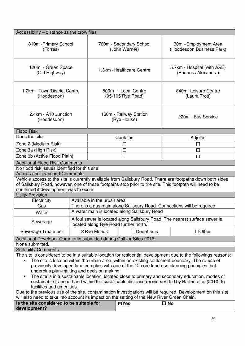
74
Accessibility – distance as the crow flies
810m -Primary School (Forres)
760m - Secondary School (John Warner)
30m –Employment Area (Hoddesdon Business Park)
120m - Green Space (Old Highway)
1.3km -Healthcare Centre 5.7km - Hospital (with A&E)
(Princess Alexandra)
1.2km - Town/District Centre (Hoddesdon)
500m - Local Centre (95-105 Rye Road)
840m -Leisure Centre (Laura Trott)
2.4km - A10 Junction (Hoddesdon)
160m - Railway Station (Rye House)
220m - Bus Service
Flood Risk Does the site Contains Adjoins
Zone 2 (Medium Risk) ☐ ☐
Zone 3a (High Risk) ☐ ☐
Zone 3b (Active Flood Plain) ☐ ☐
Additional Flood Risk Comments No flood risk issues identified for this site Access and Transport Comments Vehicle access to the site is currently available from Salisbury Road. There are footpaths down both sides of Salisbury Road, however, one of these footpaths stop prior to the site. This footpath will need to be continued if development was to occur. Utility Provision
Electricity Available in the urban area
Gas There is a gas main along Salisbury Road. Connections will be required
Water A water main is located along Salisbury Road
Sewerage A foul sewer is located along Salisbury Road. The nearest surface sewer is located along Rye Road further north.
Sewerage Treatment ☒Rye Meads ☐Deephams ☐Other
Additional Developer Comments submitted during Call for Sites 2016 None submitted. Suitability Comments The site is considered to be in a suitable location for residential development due to the followings reasons:
• The site is located within the urban area, within an existing settlement boundary. The re-use of previously developed land complies with one of the 12 core land-use planning principles that underpins plan-making and decision making.
• The site is in a sustainable location, located close to primary and secondary education, modes of sustainable transport and within the sustainable distance recommended by Barton et al (2010) to facilities and amenities.
Due to the previous use of the site, contamination investigations will be required. Development on this site will also need to take into account its impact on the setting of the New River Green Chain.
Is the site considered to be suitable for development?
☒☒☒☒Yes ☐☐☐☐ No

75
Availability Comments
The site has been identified by the Council during a desktop study. The Council has not received any promotion for the development of this site through the Call for Sites 2016 or the Local Plan (Regulation 18) consultation. No requests pre-application discussion or planning applications have been submitted for this site.
Is the site considered to be available for development?
☒☒☒☒Yes ☐☐☐☐ No
Achievability Comments The site is not available, therefore is not considered to be achievable.
Is the site considered to be achievable? ☒☒☒☒Yes ☐☐☐☐ No
Delivery Period -
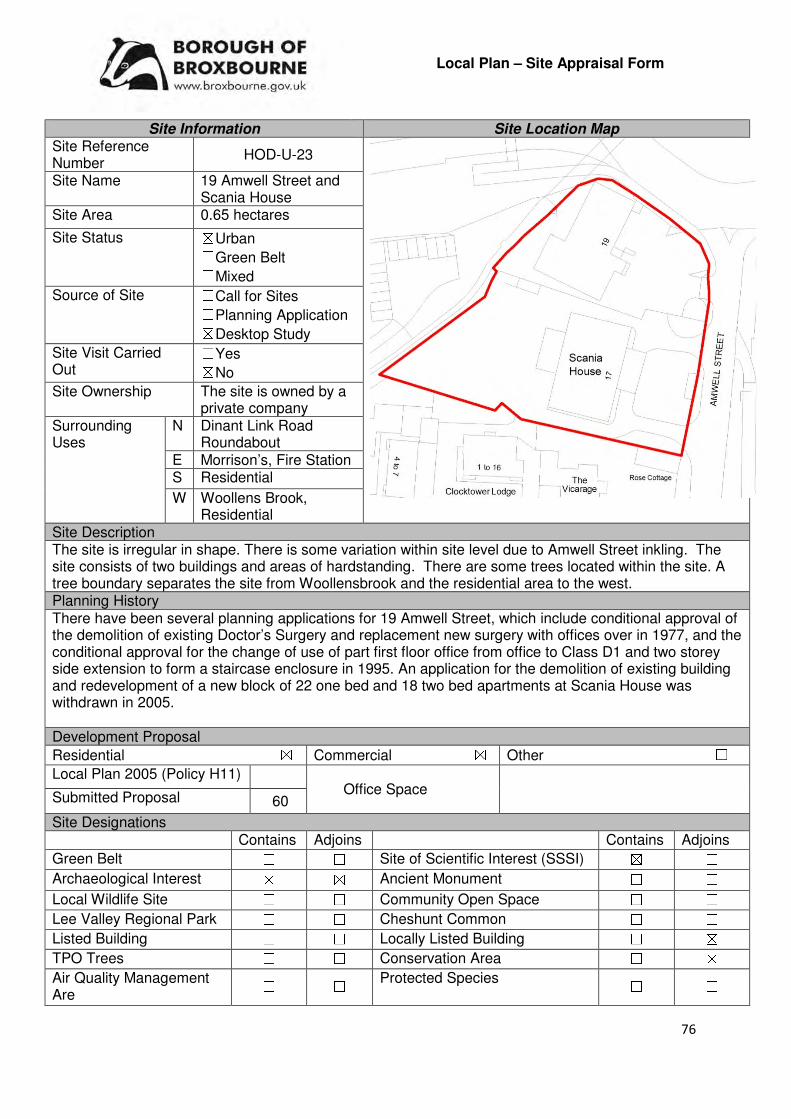
76
Local Plan – Site Appraisal Form
Site Information Site Location Map Site Reference Number
HOD-U-23
Site Name 19 Amwell Street and Scania House
Site Area 0.65 hectares
Site Status ☒Urban ☐Green Belt ☐Mixed
Source of Site ☐Call for Sites ☐Planning Application ☒Desktop Study
Site Visit Carried Out
☐Yes ☒No
Site Ownership The site is owned by a private company
Surrounding Uses
N Dinant Link Road Roundabout
E Morrison’s, Fire Station S Residential
W Woollens Brook, Residential
Site Description The site is irregular in shape. There is some variation within site level due to Amwell Street inkling. The site consists of two buildings and areas of hardstanding. There are some trees located within the site. A tree boundary separates the site from Woollensbrook and the residential area to the west. Planning History There have been several planning applications for 19 Amwell Street, which include conditional approval of the demolition of existing Doctor’s Surgery and replacement new surgery with offices over in 1977, and the conditional approval for the change of use of part first floor office from office to Class D1 and two storey side extension to form a staircase enclosure in 1995. An application for the demolition of existing building and redevelopment of a new block of 22 one bed and 18 two bed apartments at Scania House was withdrawn in 2005. Development Proposal
Residential ☒ Commercial ☒ Other ☐
Local Plan 2005 (Policy H11)
Submitted Proposal 60
Site Designations Contains Adjoins Contains Adjoins
Green Belt ☐ ☐ Site of Scientific Interest (SSSI) ☒ ☐
Archaeological Interest ☒ ☒ Ancient Monument ☐ ☐
Local Wildlife Site ☐ ☐ Community Open Space ☐ ☐
Lee Valley Regional Park ☐ ☐ Cheshunt Common ☐ ☐
Listed Building ☐ ☐ Locally Listed Building ☐ ☒
TPO Trees ☐ ☐ Conservation Area ☐ ☒
Air Quality Management Are
☐ ☐ Protected Species ☐ ☐
Office Space

77
Draft Local Plan Designation (Regulation 18) The draft Local Plan proposed to allocate this site as a urban capacity site, as part of emerging Policy DS3: Urban Capacity Sites Accessibility – distance as the crow flies
160m -Primary School (St Catherine’s)
1km - Secondary School (Sheredes)
510m –Employment Area (Merck Sharpe and Dohme)
340m - Green Space (Pound Close)
417m -Healthcare Centre (Fawkon Walk)
6.9km - Hospital (with A&E) (Princess Alexandra)
0m- Town/District Centre (Hoddesdon Town Centre)
370m - Local Centre (38-54 Ware Road)
1.46km -Leisure Centre (John Warner)
1.2km - A10 Junction (Hoddesdon)
1.4km - Railway Station (Rye House)
200m - Bus Service
Flood Risk Does the site Contains Adjoins
Zone 2 (Medium Risk) ☐ ☐
Zone 3a (High Risk) ☐ ☒
Zone 3b (Active Flood Plain) ☐ ☐
Additional Flood Risk Comments The site proximity to Woollens Brook, which is located to the west of the site, may require further investigation. Access and Transport Comments The site benefits from vehicular access from Amwell Street. Pedestrian access to the site also exists. Utility Provision
Electricity Connections already available
Gas A low pressure gas main is located to the east at Amwell Street
Water Water mains available along Amwell Street
Sewerage A foul sewer is located along Amwell Street
Sewerage Treatment ☒Rye Meads ☐Deephams ☐Other
Additional Developer Comments submitted during Call for Sites 2016 None submitted. Suitability Comments
The site is considered to be in a suitable location for residential development due to the following reasons:
• The site is previously developed land, located within an existing settlement boundary. The re-use of previously developed land is one of the 12 core land-use planning principles that underpins plan-making and decision-making.
• The site is within Hoddesdon Town Centre. The NPPF (Paragraph 23) states that Local Planning Authorities should “recognise that residential development can play an important role in ensuring vitality of centres and set out policies to encourage residential development on appropriate sites”.
• The site is in a sustainable location; it is in proximity to primary and secondary education, local facilities and modes of sustainable transport. It is also within the sustainable distance recommended by Barton et al (2010) for a doctor’s surgery, hospital, leisure centre and local park/green space.

78
The following planning constraints will need to be taken into consideration/further investigations undertaken, if development on this site was to occur: the sites proximity to Hoddesdon Conservation area which adjoins the site to the east and south, the impact the development will have on the Old Vicarage, a locally listed building; and, the sites location within an area of archaeological interest (Hoddesdon, Historic Core). It is considered that these constraints would not prevent the development of the site; however mitigatory measures may need to be implemented. Is the site considered to be suitable for development?
☒☒☒☒Yes ☐☐☐☐ No
Availability Comments
The site is owned by an independent social housing provider. The Council has been in discussions with the site owner regarding the development of this site. Pre application discussions are being undertaken.
Is the site considered to be available for development?
☒☒☒☒Yes ☐☐☐☐ No
Achievability Comments
The site is considered to be achievable. Due to the developed nature of the site and its location within the urban area of Hoddesdon it will be able to benefit from existing infrastructure. The demolition of the existing buildings may be required; however, this is depending on the scheme that is brought forward. Demolition works may affect the viability of the scheme. It is considered that there are no policy constraints that would prevent this site from coming forward.
Is the site considered to be achievable?
☒☒☒☒Yes ☐☐☐☐ No
Delivery Period 6-10 years
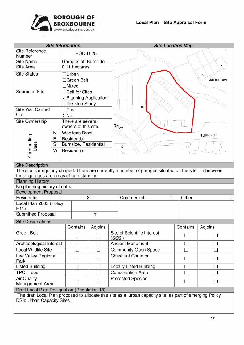
79
Local Plan – Site Appraisal Form
Site Information Site Location Map Site Reference Number
HOD-U-25
Site Name Garages off Burnside Site Area 0.11 hectares
Site Status ☐Urban ☐Green Belt ☐Mixed
Source of Site ☐Call for Sites ☒Planning Application ☐Desktop Study
Site Visit Carried Out
☐Yes ☒No
Site Ownership There are several owners of this site.
Surr
oundin
g
Uses
N Woollens Brook
E Residential S Burnside, Residential
W Residential
Site Description The site is irregularly shaped. There are currently a number of garages situated on the site. In between these garages are areas of hardstanding. Planning History No planning history of note. Development Proposal
Residential ☒ Commercial ☐ Other ☐
Local Plan 2005 (Policy H11)
Submitted Proposal 7
Site Designations Contains Adjoins Contains Adjoins
Green Belt ☐ ☐ Site of Scientific Interest (SSSI)
☐ ☐
Archaeological Interest ☐ ☐ Ancient Monument ☐ ☐
Local Wildlife Site ☐ ☐ Community Open Space ☐ ☐
Lee Valley Regional Park
☐ ☐ Cheshunt Common ☐ ☐
Listed Building ☐ ☐ Locally Listed Building ☐ ☐
TPO Trees ☐ ☐ Conservation Area ☐ ☐
Air Quality Management Area
☐ ☐ Protected Species ☐ ☐
Draft Local Plan Designation (Regulation 18) The draft Local Plan proposed to allocate this site as a urban capacity site, as part of emerging Policy DS3: Urban Capacity Sites
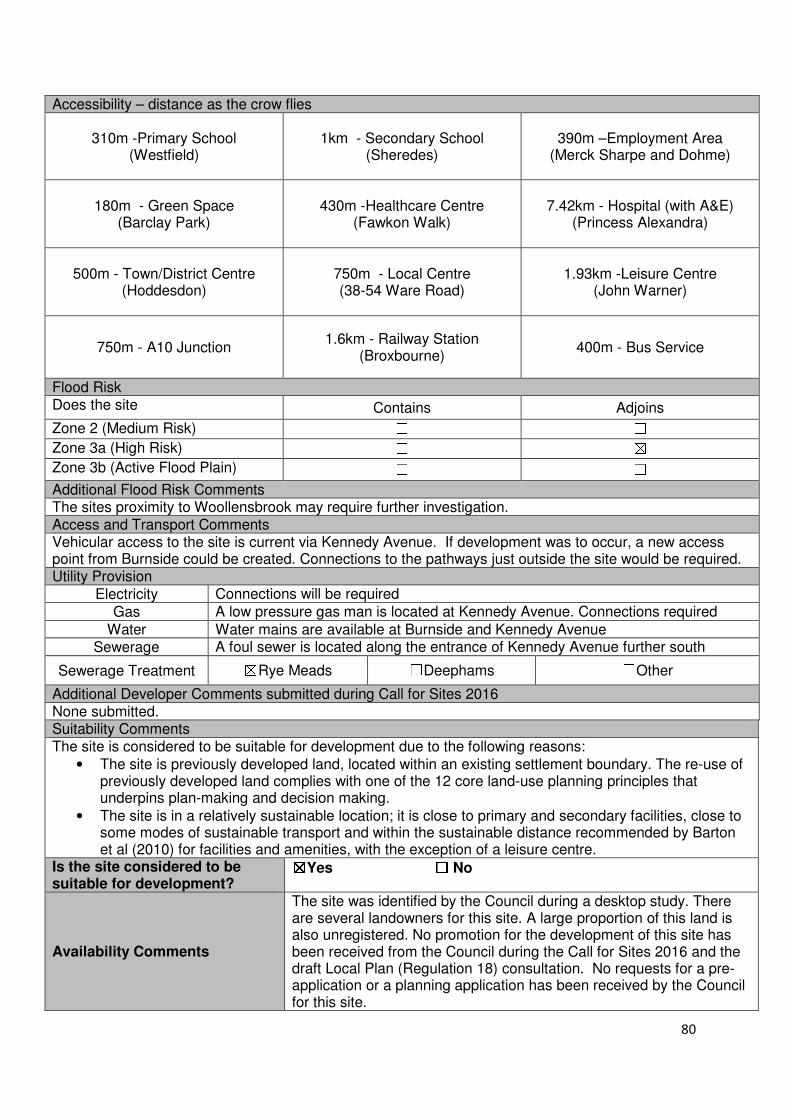
80
Accessibility – distance as the crow flies
310m -Primary School (Westfield)
1km - Secondary School (Sheredes)
390m –Employment Area (Merck Sharpe and Dohme)
180m - Green Space (Barclay Park)
430m -Healthcare Centre
(Fawkon Walk)
7.42km - Hospital (with A&E) (Princess Alexandra)
500m - Town/District Centre (Hoddesdon)
750m - Local Centre (38-54 Ware Road)
1.93km -Leisure Centre (John Warner)
750m - A10 Junction 1.6km - Railway Station
(Broxbourne) 400m - Bus Service
Flood Risk Does the site Contains Adjoins
Zone 2 (Medium Risk) ☐ ☐
Zone 3a (High Risk) ☐ ☒
Zone 3b (Active Flood Plain) ☐ ☐
Additional Flood Risk Comments The sites proximity to Woollensbrook may require further investigation. Access and Transport Comments Vehicular access to the site is current via Kennedy Avenue. If development was to occur, a new access point from Burnside could be created. Connections to the pathways just outside the site would be required. Utility Provision
Electricity Connections will be required
Gas A low pressure gas man is located at Kennedy Avenue. Connections required
Water Water mains are available at Burnside and Kennedy Avenue Sewerage A foul sewer is located along the entrance of Kennedy Avenue further south
Sewerage Treatment ☒Rye Meads ☐Deephams ☐Other
Additional Developer Comments submitted during Call for Sites 2016 None submitted. Suitability Comments The site is considered to be suitable for development due to the following reasons:
• The site is previously developed land, located within an existing settlement boundary. The re-use of previously developed land complies with one of the 12 core land-use planning principles that underpins plan-making and decision making.
• The site is in a relatively sustainable location; it is close to primary and secondary facilities, close to some modes of sustainable transport and within the sustainable distance recommended by Barton et al (2010) for facilities and amenities, with the exception of a leisure centre.
Is the site considered to be suitable for development?
☒☒☒☒Yes ☐☐☐☐ No
Availability Comments
The site was identified by the Council during a desktop study. There are several landowners for this site. A large proportion of this land is also unregistered. No promotion for the development of this site has been received from the Council during the Call for Sites 2016 and the draft Local Plan (Regulation 18) consultation. No requests for a pre-application or a planning application has been received by the Council for this site.
81
Is the site considered to be available for development?
☐☐☐☐Yes ☒☒☒☒ No
Achievability Comments The site is not considered to be available therefore is not achievable. Is the site considered to be achievable?
☐☐☐☐Yes ☒☒☒☒ No
Delivery Period -
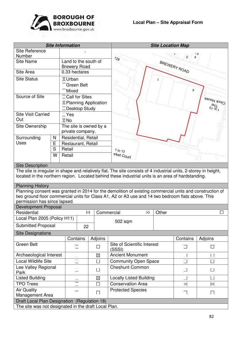
82
Local Plan – Site Appraisal Form
Site Information Site Location Map Site Reference Number
`
Site Name Land to the south of Brewery Road
Site Area 0.33 hectares
Site Status ☒Urban ☐Green Belt ☐Mixed
Source of Site ☐Call for Sites ☒Planning Application ☐Desktop Study
Site Visit Carried Out
☐Yes ☒No
Site Ownership The site is owned by a private company.
Surrounding Uses
N Residential, Retail
E Restaurant, Retail S Retail
W Retail
Site Description The site is irregular in shape and relatively flat. The site consists of 4 industrial units, 2-storey in height, located in the northern region. Located behind these industrial units is an area of hardstanding.
Planning History Planning consent was granted in 2014 for the demolition of existing commercial units and construction of two ground floor commercial units for Class A1, A2 or A3 use and 14 two bedroom flats above. This permission has since lapsed. Development Proposal
Residential ☒ Commercial ☒ Other ☐
Local Plan 2005 (Policy H11)
Submitted Proposal 22
Site Designations Contains Adjoins Contains Adjoins
Green Belt ☐ ☐ Site of Scientific Interest (SSSI)
☐ ☐
Archaeological Interest ☐ ☒ Ancient Monument ☐ ☐
Local Wildlife Site ☐ ☐ Community Open Space ☐ ☐
Lee Valley Regional Park
☐ ☐ Cheshunt Common ☐ ☐
Listed Building ☐ ☒ Locally Listed Building ☐ ☐
TPO Trees ☐ ☐ Conservation Area ☒ ☒
Air Quality Management Area
☐ ☐ Protected Species ☐ ☐
Draft Local Plan Designation (Regulation 18) The site was not designated in the draft Local Plan.
502 sqm
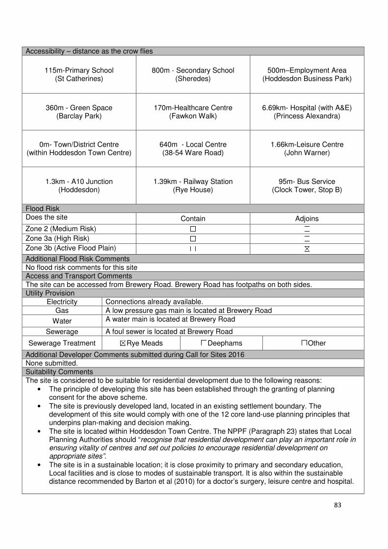
83
Accessibility – distance as the crow flies
115m-Primary School (St Catherines)
800m - Secondary School (Sheredes)
500m–Employment Area
(Hoddesdon Business Park)
360m - Green Space (Barclay Park)
170m-Healthcare Centre (Fawkon Walk)
6.69km- Hospital (with A&E)
(Princess Alexandra)
0m- Town/District Centre (within Hoddesdon Town Centre)
640m - Local Centre (38-54 Ware Road)
1.66km-Leisure Centre
(John Warner)
1.3km - A10 Junction (Hoddesdon)
1.39km - Railway Station
(Rye House)
95m- Bus Service (Clock Tower, Stop B)
Flood Risk Does the site Contain Adjoins
Zone 2 (Medium Risk) ☐ ☐
Zone 3a (High Risk) ☐ ☐
Zone 3b (Active Flood Plain) ☐ ☒
Additional Flood Risk Comments No flood risk comments for this site Access and Transport Comments The site can be accessed from Brewery Road. Brewery Road has footpaths on both sides. Utility Provision
Electricity Connections already available.
Gas A low pressure gas main is located at Brewery Road
Water A water main is located at Brewery Road
Sewerage A foul sewer is located at Brewery Road
Sewerage Treatment ☒Rye Meads ☐Deephams ☐Other
Additional Developer Comments submitted during Call for Sites 2016 None submitted. Suitability Comments The site is considered to be suitable for residential development due to the following reasons:
• The principle of developing this site has been established through the granting of planning consent for the above scheme.
• The site is previously developed land, located in an existing settlement boundary. The development of this site would comply with one of the 12 core land-use planning principles that underpins plan-making and decision making.
• The site is located within Hoddesdon Town Centre. The NPPF (Paragraph 23) states that Local Planning Authorities should “recognise that residential development can play an important role in ensuring vitality of centres and set out policies to encourage residential development on appropriate sites”.
• The site is in a sustainable location; it is close proximity to primary and secondary education, Local facilities and is close to modes of sustainable transport. It is also within the sustainable distance recommended by Barton et al (2010) for a doctor’s surgery, leisure centre and hospital.

84
Is this site considered to be suitable for development?
☒Yes ☐ No
Availability Comments The site is considered to be available. Pre-application discussions between the landowner and the Council have been held.
Is the site considered to be available for development
☐Yes ☒ No
Achievability Comments The site is considered to be achievable. Planning consent for a residential scheme on this site has previously been granted which indicates that there are no planning constraints that would prevent the development of this site. Due to the sites location within the urban area it will be able to benefit from existing infrastructure.
Is the site considered to be achievable? ☒Yes ☒ No
Delivery Period 1-5 years

85
Local Plan – Site Appraisal Form
Site Information Site Location Map Site Reference Number
HOD-U-28
Site Name Crown Buildings and Squash Club
Site Area 0.26
Site Status ☒Urban ☐Green Belt ☐Mixed
Source of Site ☐Call for Sites ☐Planning Application ☒Desktop Study
Site Visit Carried Out
☐Yes ☒No
Site Ownership There are three landowners for this site
Surr
oundin
g
Uses
N Conduit Lane, Multi Storey Car Park
E Conduit Lane, Lampits S Charlton Way, Residential
W Residential
Site Description The site is square in shape and relatively flat. The site is occupied by a number of buildings
Planning History There have been various planning applications for the squash club building, the most recent of which include the refusal for the redevelopment of the Former Squash Club into a 4 storey block with 5 retail floor units and 15 one bedroom flats (2005), the refusal for the redevelopment of the Former Squash Club into a 3 storey block with 5 retail floor units and 14 two bed flats (2005), and a refusal for the change of use to a new tyre and exhaust centre (2011). In 1995, planning was refused for the change of use Class to A1 and A2 at Crown House, Crown Buildings. Development Proposal
Residential ☒ Commercial ☐ Other ☐
Local Plan 2005 (Policy H11)
Submitted Proposal 10
Site Designations Contains Adjoins Contains Adjoins
Green Belt ☐ ☐ Site of Scientific Interest (SSSI) ☐ ☐
Archaeological Interest ☐ ☐ Ancient Monument ☐ ☐
Local Wildlife Site ☐ ☐ Community Open Space ☐ ☐
Lee Valley Regional Park
☐ ☐ Cheshunt Common ☐ ☐
Listed Building ☐ ☒ Locally Listed Building ☐ ☐
TPO Trees ☐ ☐ Conservation Area ☐ ☒
Air Quality Management Area
☐ ☐ Protected Species ☐ ☐

86
Draft Local Plan Designation (Regulation 18) The draft Local Plan proposed to allocate this site as an Urban Capacity Site, as part of emerging Policy DS3: Urban Capacity Sites Accessibility – distance as the crow flies
93m -Primary School (St Augustines)
690m - Secondary School (Sheredes)
360m –Employment Area
(Hoddesdon Business Park)
400m - Green Space (Barclay Park)
200m -Healthcare Centre
(Fawkon Walk)
6.8km - Hospital (with A&E) (Princess Alexandra)
0m - Town/District Centre (Hoddesdon Town Centre)
800m - Local Centre (38-54 Ware Road)
1.8km-Leisure Centre
(John Warner)
1.4km - A10 Junction (Hoddesdon)
1.1km - Railway Station
(Broxbourne)
170m - Bus Service
Flood Risk Does the site Contains Adjoins
Zone 2 (Medium Risk) ☐ ☐
Zone 3a (High Risk) ☐ ☐
Zone 3b (Active Flood Plain) ☐ ☐
Additional Flood Risk Comments No flood risk issues identified for this site Access and Transport Comments The site benefits from vehicular access from Conduit Lane. Utility Provision
Electricity Located along Conduit Lane
Gas Gas mains are available along Conduit Lane
Water Water main available along Conduit Lane
Sewerage A foul sewer is located further east
Sewerage Treatment ☒Rye Meads ☐Deephams ☐Other
Additional Developer Comments submitted during Call for Sites 2016 None submitted. Suitability Comments The site is considered to be in a suitable location for residential development due to the following:
• The site is previously developed land, located in an existing settlement boundary. The development of this site would comply with one of the 12 core land-use planning principles that underpins plan-making and decision making.
• The site is located within Hoddesdon Town Centre. The NPPF (Paragraph 23) states that Local Planning Authorities should “recognise that residential development can play an important role in ensuring vitality of centres and set out policies to encourage residential development on appropriate sites”.
• The site is in a sustainable location; it is in close proximity to primary and secondary education, local facilities and close to modes of sustainable transport. It is also within the sustainable distance recommended by Barton et al (2010) for local park/green space, doctor’s surgery, leisure centre and hospital.
Is the site considered to be suitable for development?
☒☒☒☒Yes ☐☐☐☐ No

87
Availability Comments
There are three landowners for this site. The site has not been promoted to the Council for development and was identified through a desktop study. The Council has not received any promotion for the development of this site during the2016 Call for Sites and the Local Plan (Regulation 18) consultation. In addition, no requests for pre-application or a planning application has been received for this site.
Is the site considered to be available for development?
☐☐☐☐Yes ☒☒☒☒ No
Achievability Comments The land is not considered to be available therefore development on this site is not achievable.
Is the site considered to be achievable?
☐☐☐☐Yes ☒☒☒☒ No
Delivery Period -

88
Local Plan – Site Appraisal Form
Site Information Site Location Map Site Reference Number
HOD-U-31(a)
Site Name Lea Road Industrial Works – Rawmec Business Park
Site Area 1.36 hectares
Site Status ☒Urban ☐Green Belt ☐Mixed
Source of Site ☐Call for Sites ☐Planning Application ☒Desktop Study
Site Visit Carried Out
☐Yes ☒No
Site Ownership The site is owned by a private company.
Surr
oundin
g
Uses
N Castle Road Open Space
E New River, Railway Line S Industrial area
W Residential
Site Description The site is relatively rectangular in shape and has no topographical issues. The site is currently contains a number of structures, including one large industrial works, and hardstanding. The site is separated from the remainder of the industrial estate by a metal gate. Planning History No planning history of note. Development Proposal
Residential ☒ Commercial ☐ Other ☐
Local Plan 2005 (Policy H11) -
Submitted Proposal 60 Site Designations Contains Adjoins Contains Adjoins
Green Belt ☐ ☐ Site of Scientific Interest (SSSI) ☐ ☐
Archaeological Interest ☐ ☐ Ancient Monument ☐ ☐
Local Wildlife Site ☐ ☐ Community Open Space ☐ ☒
Lee Valley Regional Park ☐ ☐ Cheshunt Common ☐ ☐
Listed Building ☐ ☐ Locally Listed Building ☐ ☐
TPO Trees ☐ ☐ Conservation Area ☐ ☐
Air Quality Management Area
☐ ☐ Protected Species ☐ ☐
Draft Local Plan Designation (Regulation 18) The draft Local Plan proposed to allocate this site for mixed used development, under emerging Policy HOD3: Rye Park. The draft policy states that “The opportunity to redevelop industrial premises within Plumpton Road for housing will be pursued”.
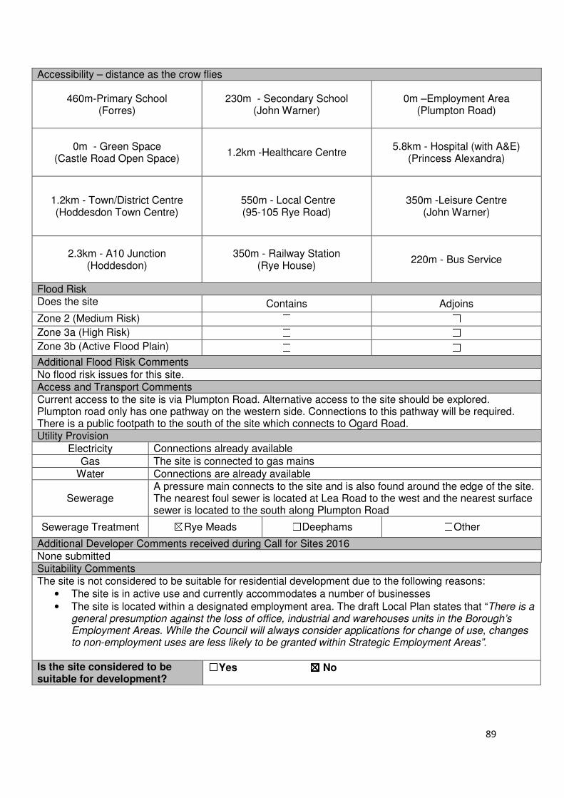
89
Accessibility – distance as the crow flies
460m-Primary School (Forres)
230m - Secondary School (John Warner)
0m –Employment Area (Plumpton Road)
0m - Green Space (Castle Road Open Space)
1.2km -Healthcare Centre 5.8km - Hospital (with A&E)
(Princess Alexandra)
1.2km - Town/District Centre (Hoddesdon Town Centre)
550m - Local Centre (95-105 Rye Road)
350m -Leisure Centre (John Warner)
2.3km - A10 Junction (Hoddesdon)
350m - Railway Station (Rye House)
220m - Bus Service
Flood Risk Does the site Contains Adjoins
Zone 2 (Medium Risk) ☐ ☐
Zone 3a (High Risk) ☐ ☐
Zone 3b (Active Flood Plain) ☐ ☐
Additional Flood Risk Comments No flood risk issues for this site. Access and Transport Comments Current access to the site is via Plumpton Road. Alternative access to the site should be explored. Plumpton road only has one pathway on the western side. Connections to this pathway will be required. There is a public footpath to the south of the site which connects to Ogard Road. Utility Provision
Electricity Connections already available
Gas The site is connected to gas mains
Water Connections are already available
Sewerage A pressure main connects to the site and is also found around the edge of the site. The nearest foul sewer is located at Lea Road to the west and the nearest surface sewer is located to the south along Plumpton Road
Sewerage Treatment ☒Rye Meads ☐Deephams ☐Other
Additional Developer Comments received during Call for Sites 2016 None submitted Suitability Comments The site is not considered to be suitable for residential development due to the following reasons:
• The site is in active use and currently accommodates a number of businesses
• The site is located within a designated employment area. The draft Local Plan states that “There is a general presumption against the loss of office, industrial and warehouses units in the Borough’s Employment Areas. While the Council will always consider applications for change of use, changes to non-employment uses are less likely to be granted within Strategic Employment Areas”.
Is the site considered to be suitable for development?
☐☐☐☐Yes ☒☒☒☒ No
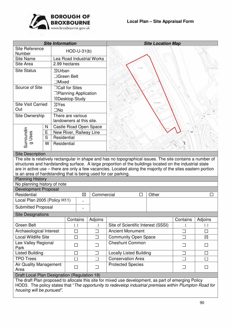
90
Local Plan – Site Appraisal Form
Site Information Site Location Map Site Reference Number
HOD-U-31(b)
Site Name Lea Road Industrial Works Site Area 2.99 hectares
Site Status ☒Urban ☐Green Belt ☐Mixed
Source of Site ☐Call for Sites ☐Planning Application ☒Desktop Study
Site Visit Carried Out
☒Yes ☐No
Site Ownership There are various landowners at this site.
Surr
oundin
g U
ses
N Castle Road Open Space
E New River, Railway Line S Residential
W Residential
Site Description The site is relatively rectangular in shape and has no topographical issues. The site contains a number of structures and hardstanding surface. A large proportion of the buildings located on the industrial state are in active use – there are only a few vacancies. Located along the majority of the sites eastern portion is an area of hardstanding that is being used for car parking. Planning History No planning history of note Development Proposal
Residential ☒ Commercial ☐ Other ☐
Local Plan 2005 (Policy H11) -
Submitted Proposal -
Site Designations Contains Adjoins Contains Adjoins
Green Belt ☐ ☐ Site of Scientific Interest (SSSI) ☐ ☐
Archaeological Interest ☐ ☐ Ancient Monument ☐ ☐
Local Wildlife Site ☐ ☐ Community Open Space ☐ ☒
Lee Valley Regional Park
☐ ☐ Cheshunt Common ☐ ☐
Listed Building ☐ ☐ Locally Listed Building ☐ ☐
TPO Trees ☐ ☐ Conservation Area ☐ ☐
Air Quality Management Area
☐ ☐ Protected Species ☐ ☐
Draft Local Plan Designation (Regulation 18) The draft Plan proposed to allocate this site for mixed use development, as part of emerging Policy HOD3. The policy states that “The opportunity to redevelop industrial premises within Plumpton Road for housing will be pursued”.
91
Accessibility – distance as the crow flies
460m-Primary School (Forres)
230m - Secondary School (John Warner)
0m –Employment Area (Contained within boundary)
0m - Green Space (Castle Road Open Space)
1.2km -Healthcare Centre
5.8km - Hospital (with A&E)
(Princess Alexandra)
1.13km- Town/District Centre
(Hoddesdon Town Centre)
510m - Local Centre (95-105 Rye Road)
350m -Leisure Centre (John Warner)
2.3km - A10 Junction (Hoddesdon)
50m- Railway Station (Rye House Station)
220m - Bus Service
Flood Risk Does the site Contains Adjoins
Zone 2 (Medium Risk) ☐ ☐
Zone 3a (High Risk) ☐ ☐
Zone 3b (Active Flood Plain) ☐ ☐
Additional Flood Risk Comments No flood risk issues have been identified for this site. Access and Transport Comments Current access to the site is via Plumpton Road. . Plumpton road only has one pathway on the western side. Connections to this pathway will be required. Within the northern region of the site is a pathway which connects the industrial area to the residential units at Ogard Road. Utility Provision
Electricity Connections already available
Gas The site is connected to gas mains
Water Connections are already available.
Sewerage A foul sewer is located along Plumpton Road. This runs parallel to a pressure main.
Sewerage Treatment ☒Rye Meads ☐Deephams ☐Other
Additional Developer Comments received during Call for Sites 2016 None submitted. Suitability Comments The site is not considered to be suitable for residential development due to the following reasons:
• The site is in active use and currently accommodates a number of businesses
• The site is located within a designated employment area. The draft Local Plan states that “There is a general presumption against the loss of office, industrial and warehouses units in the Borough’s Employment Areas. While the Council will always consider applications for change of use, changes to non-employment uses are less likely to be granted within Strategic Employment Areas”.
Is this site considered to be suitable for development?
☒Yes ☐ No
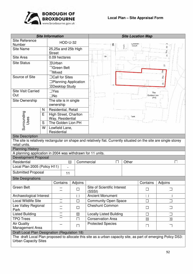
92
Local Plan – Site Appraisal Form
Site Information Site Location Map Site Reference Number
HOD-U-32
Site Name 25,25a and 25b High Street
Site Area 0.09 hectares
Site Status ☒Urban ☐Green Belt ☐Mixed
Source of Site ☐Call for Sites ☐Planning Application ☒Desktop Study
Site Visit Carried Out
☐Yes ☐No
Site Ownership The site is in single ownership
Surr
oundin
g
Uses
N Residential, Retail
E High Street, Charlton Way, Residential
S The Golden Lion PH
W Lowfield Lane, Residential
Site Description The site is relatively rectangular on shape and relatively flat. Currently situated on the site are single storey retail units. Planning History A planning application in 2004 was withdrawn for 11 units. Development Proposal
Residential ☒ Commercial ☐ Other ☐
Local Plan 2005 (Policy H11) -
Submitted Proposal 11
Site Designations Contains Adjoins Contains Adjoins
Green Belt ☐ ☐ Site of Scientific Interest (SSSI)
☐ ☐
Archaeological Interest ☐ ☐ Ancient Monument ☐ ☐
Local Wildlife Site ☐ ☐ Community Open Space ☐ ☐
Lee Valley Regional Park
☐ ☐ Cheshunt Common ☐ ☐
Listed Building ☐ ☒ Locally Listed Building ☐ ☐
TPO Trees ☐ ☐ Conservation Area ☒ ☒
Air Quality Management Area
☐ ☐ Protected Species ☐ ☐
Draft Local Plan Designation (Regulation 18) The draft Local Plan proposed to allocate this site as a urban capacity site, as part of emerging Policy DS3: Urban Capacity Sites
93
Accessibility – distance as the crow flies
220m -Primary School (St Augustines)
470m - Secondary School (Sheredes)
580m –Employment Area (Hoddesdon Business Park)
175m - Green Space (Barclay Park)
150m -Healthcare Centre 6.9km - Hospital (with A&E)
(Princess Alexandra)
0m - Town/District Centre (Hoddesdon Town Centre)
940m - Local Centre (38-54 Ware Road)
2km -Leisure Centre (John Warner)
1.3km - A10 Junction (Hoddesdon)
1.1km - Railway Station (Broxbourne)
55m - Bus Service
Flood Risk Does the site Contains Adjoins
Zone 2 (Medium Risk) ☐ ☐
Zone 3a (High Risk) ☐ ☐
Zone 3b (Active Flood Plain) ☐ ☐
Additional Flood Risk Comments No flood risk comments for this site. Access and Transport Comments The site can be accessed from Lowfield Lane. A one way road (High Street) is located to the east of the site. There is pedestrian access to the site from the High Street. Utility Provision
Electricity Connections already available
Gas Gas mains are available from the High Street
Water Available along Lowfield Lane or along the High Street
Sewerage A foul sewer is located to the east along the High Street
Sewerage Treatment ☒Rye Meads ☐Deephams ☐Other
Additional Developer Comments submitted during Call for Sites 2016 None submitted. Suitability Comments The site is considered to be in a suitable location for residential development due to the following reasons:
• The site is previously developed land within an established settlement boundary. The re-use of land that has been previously developed is one of the 12 core land-use planning principles that underpin plan-making and decision making.
• The site is within Hoddesdon Town Centre. The NPPF (Paragraph 23) states that Local Planning Authorities should “recognise that residential development can play an important role in ensuring vitality of centres and set out policies to encourage residential development on appropriate sites”.
• The site is considered to be in a sustainable location; it is in close proximity to primary and secondary education, modes of sustainable transport and within the sustainable distance recommended by Barton et al (2010) to a doctor’s surgery, green space/local park, hospital and leisure centre.
Is the site considered to be suitable for development?
☒☒☒☒Yes ☐☐☐☐ No

94
Availability Comments
The site is not considered to be available for development. There has been no promotion for the development of this site during the 2016 Call for Sites and the Local Plan (Regulation 18) consultation. No request for pre-application advice or a planning application has been submitted for this site.
Is the site considered to be available for development?
☐☐☐☐Yes ☒☒☒☒ No
Achievability Comments Due to the site being unavailable for development, it is not considered to be achievable.
Is the site considered to be achievable?
☐☐☐☐Yes ☒☒☒☒ No
Delivery Period -
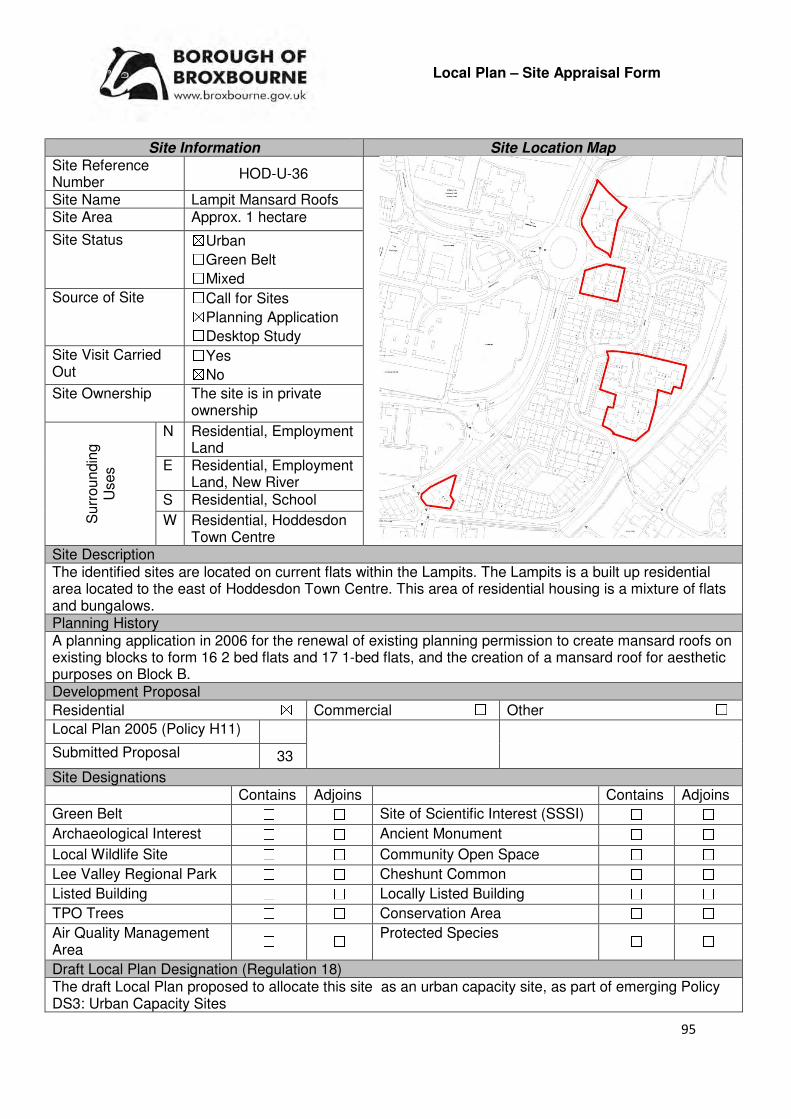
95
Local Plan – Site Appraisal Form
Site Information Site Location Map Site Reference Number
HOD-U-36
Site Name Lampit Mansard Roofs Site Area Approx. 1 hectare
Site Status ☒Urban ☐Green Belt ☐Mixed
Source of Site ☐Call for Sites ☒Planning Application ☐Desktop Study
Site Visit Carried Out
☐Yes ☒No
Site Ownership The site is in private ownership
Surr
oundin
g
Uses
N Residential, Employment Land
E Residential, Employment Land, New River
S Residential, School
W Residential, Hoddesdon Town Centre
Site Description The identified sites are located on current flats within the Lampits. The Lampits is a built up residential area located to the east of Hoddesdon Town Centre. This area of residential housing is a mixture of flats and bungalows. Planning History A planning application in 2006 for the renewal of existing planning permission to create mansard roofs on existing blocks to form 16 2 bed flats and 17 1-bed flats, and the creation of a mansard roof for aesthetic purposes on Block B. Development Proposal
Residential ☒ Commercial ☐ Other ☐
Local Plan 2005 (Policy H11)
Submitted Proposal 33
Site Designations Contains Adjoins Contains Adjoins
Green Belt ☐ ☐ Site of Scientific Interest (SSSI) ☐ ☐
Archaeological Interest ☐ ☐ Ancient Monument ☐ ☐
Local Wildlife Site ☐ ☐ Community Open Space ☐ ☐
Lee Valley Regional Park ☐ ☐ Cheshunt Common ☐ ☐
Listed Building ☐ ☐ Locally Listed Building ☐ ☐
TPO Trees ☐ ☐ Conservation Area ☐ ☐
Air Quality Management Area
☐ ☐ Protected Species ☐ ☐
Draft Local Plan Designation (Regulation 18) The draft Local Plan proposed to allocate this site as an urban capacity site, as part of emerging Policy DS3: Urban Capacity Sites
96
Accessibility – distance as the crow flies
28-334m -Primary School (St Catherine’s Primary School or
St Augustines Primary School)
700m- 1km - Secondary School (Sheredes)
167-372m –Employment Area (Hoddesdon Business Park)
458-687m - Green Space (Barclay Park)
290m-480m -Healthcare Centre
(Fawkon Walk)
6.37-6.61km-- Hospital (with A&E)
(Princess Alexandra)
60m - Town/District Centre (Hoddesdon Town Centre)
840m-920m - Local Centre (107-117 Rye Road)
1.46-1.84km -Leisure Centre
(John Warner)
1.55-1.64km - A10 Junction (Hoddesdon)
1.23-1.55km - Railway Station
(Rye House)
155m-236m - Bus Service
Flood Risk Does the site Contains Adjoins
Zone 2 (Medium Risk) ☐ ☐
Zone 3a (High Risk) ☐ ☐
Zone 3b (Active Flood Plain) ☐ ☐
Additional Flood Risk Comments No flood risk issues have been identified for this site. Access and Transport Comments The sites can be accessed from Lampits. There are footpaths on both sides of Lampits. Utility Provision
Electricity Electricity connections are available in the area.
Gas Low pressure gas mains are available in the area.
Water Water mains are located in the area.
Sewerage Foul sewers and surface sewers are located in the area.
Sewerage Treatment ☒Rye Meads ☐Deephams ☐Other
Additional Developer Comments during Call for Sites 2016 None submitted. Suitability Comments The site is considered to be suitable for residential development for the following reasons:
• The site is previously developed land, located within an existing settlement boundary. The re-use of previously developed land is one of the 12 core land-use planning principles that underpins plan-making and decision-making.
• The site is considered to be in sustainable location, close educational facilities, modes of sustainable transport and within the sustainable distance recommended by Barton et al (2010) for facilities and amenities
• The infrastructure (utilities, road, educational facilities) are in place to support the development of the site.
• The principle of developing this site has been previously been established through the planning application process. Permission for the creation of 33 dwellings at this site was renewed in 2006, however has subsequently lapsed.
Is this site considered to be suitable for development?
☒Yes ☐ No
97
Availability Comments The site has been identified by the Council for appraisal. There was previously a planning application for this site, however this has now lapsed. There has been no recent promotion from the landowners of this site
Is the site considered to be available for development
☒Yes ☐ No Achievability Comments The site is considered to be achievable. A developer has indicated their
interests in bringing the remainder of this site forward. It is considered that there are no policy constraints that will prevent this site from coming forward.
Is the site considered to be achievable?
☒Yes ☐ No Delivery Period 1-5 years

98
Local Plan – Site Appraisal Form
Site Information Site Location Map Site Reference Number
HOD-U-39
Site Name Westfield Primary School Site Area 1.27 hectare
Site Status ☒Urban ☐Green Belt ☐Mixed
Source of Site ☐Call for Sites ☐Planning Application ☒Desktop Study
Site Visit Carried Out
☐Yes ☒No
Site Ownership The site is in public ownership.
Surr
oundin
g
Uses
N Merck Sharpe and Dohme
E Residential S Residential
W Residential
Site Description The site is square in shape and flat. Currently situated on the site are structures, playing field and some hardstanding surface. Trees are located along the boundaries of the site.
Planning History A planning application for a single storey extension to the front elevation of the school was granted conditional approval in 2012. Development Proposal
Residential ☒ Commercial ☐ Other ☐
Local Plan 2005 (Policy H11) -
Submitted Proposal 40
Site Designations Contains Adjoins Contains Adjoins
Green Belt ☐ ☐ Site of Scientific Interest (SSSI)
☐ ☐
Archaeological Interest ☐ ☐ Ancient Monument ☐ ☐
Local Wildlife Site ☐ ☐ Community Open Space ☐ ☐
Lee Valley Regional Park
☐ ☐ Cheshunt Common ☐ ☐
Listed Building ☐ ☐ Locally Listed Building ☐ ☐
TPO Trees ☐ ☐ Conservation Area ☐ ☐
Air Quality Management Area
☐ ☐ Protected Species ☐ ☐
Draft Local Plan Designation (Regulation 18) The draft Local Plan proposed to allocate this site as an urban capacity site, as part of emerging Policy DS3: Urban Capacity Sites.

99
Accessibility – distance as the crow flies
676m -Primary School (St Catherines)
1.1km - Secondary School (Sheredes)
100m –Employment Area
(Merck Sharpe and Dohme)
452m - Green Space (Barclay Park)
540m -Healthcare Centre
7.22km - Hospital (with A&E)
(Princess Alexandra)
462m - Town/District Centre (Hoddesdon Town Centre)
488m - Local Centre (38-54 Ware Road)
1.59km -Leisure Centre (John Warner)
650m - A10 Junction (Hoddesdon)
1.8km - Railway Station
(Rye House)
220m - Bus Service
Flood Risk Does the site Contains Adjoins
Zone 2 (Medium Risk) ☐ ☐
Zone 3a (High Risk) ☐ ☐
Zone 3b (Active Flood Plain) ☐ ☐
Additional Flood Risk Comments No flood risk comments have been identified for this site. Access and Transport Comments The site can be accessed via Westfield Road. There is only one pathway along Westfield Road Utility Provision
Electricity Connections already available
Gas Available within the school
Water Water mains located along Westfield Road
Sewerage Foul sewer located to the east and south west of the site.
Sewerage Treatment ☒Rye Meads ☐Deephams ☐Other
Additional Developer Comments submitted as part of Call for Sites 2016 None submitted. Suitability Comments The site has been identified for relocation into the High Leigh development. Subject to this relocation, the site is considered to be suitable for development due to the following reasons:
• The site is previous developed land in an existing settlement boundary. The re-use of previously developed land is one of the 12 core land-use planning principles that underpins plan-making and decision-making.
• The site is considered to be in a sustainable location; it is close to primary and secondary education, close to local facilities and is close to some modes of sustainable transport. It is also within the sustainable distance recommended by Barton et al (2010) for a doctor’s surgery, leisure centre, hospital and green space/local park.
Is this site considered to be suitable for development?
☒Yes ☐ No
Availability Comments The site is considered to be available for development. The school will be relocated to the new High Leigh Garden Village development. As a result of this re-location, the site will become vacant and available for development.
100
Is the site considered to be available for development
☒Yes ☐ No Achievability Comments The site is considered to be achievable. Clearance of existing
structures will need to take place, however the site benefits from connections and proximity to existing infrastructure.
Is the site considered to be achievable?
☒Yes ☐ No Delivery Period 6-10 years
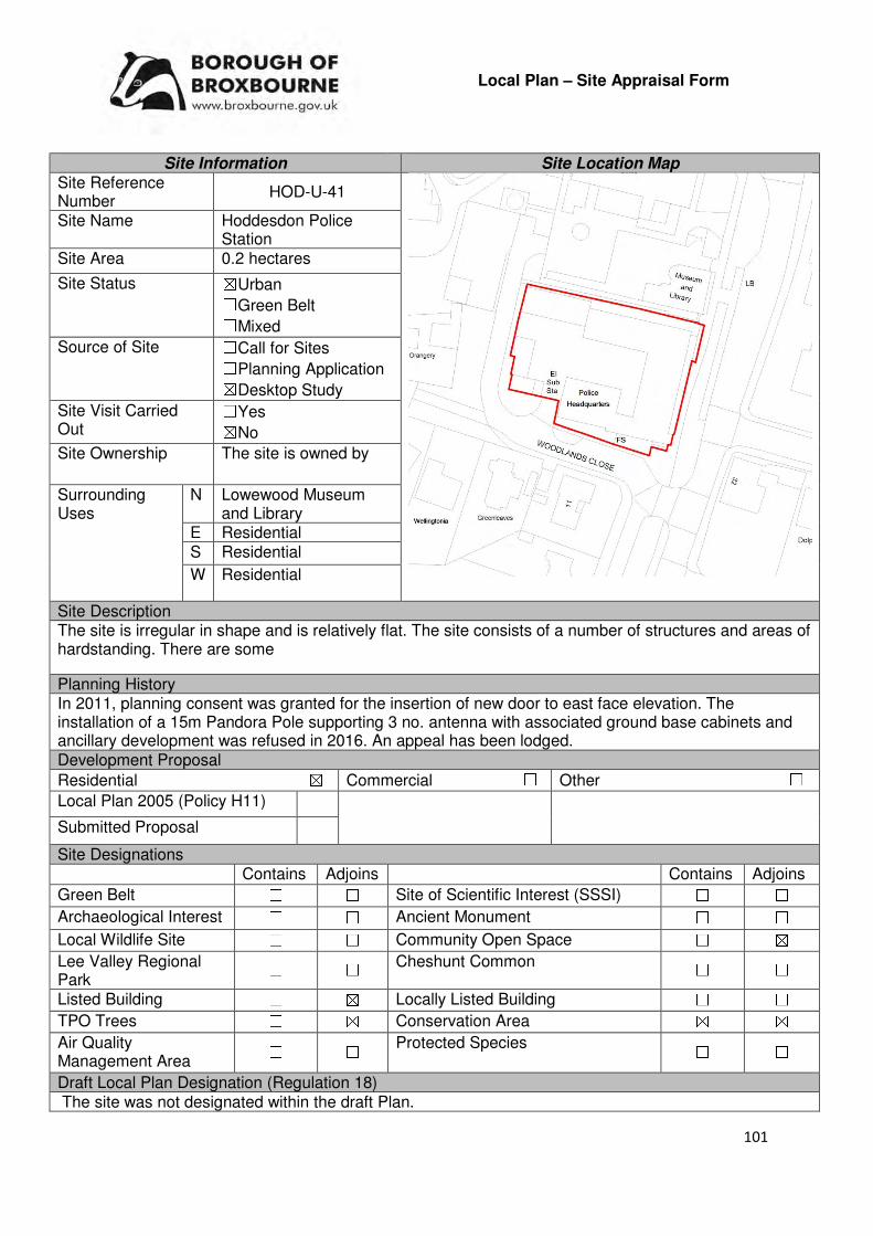
101
Local Plan – Site Appraisal Form
Site Information Site Location Map Site Reference Number
HOD-U-41
Site Name Hoddesdon Police Station
Site Area 0.2 hectares
Site Status ☒Urban ☐Green Belt ☐Mixed
Source of Site ☐Call for Sites ☐Planning Application ☒Desktop Study
Site Visit Carried Out
☐Yes ☒No
Site Ownership The site is owned by
Surrounding Uses
N Lowewood Museum and Library
E Residential S Residential
W Residential
Site Description The site is irregular in shape and is relatively flat. The site consists of a number of structures and areas of hardstanding. There are some
Planning History In 2011, planning consent was granted for the insertion of new door to east face elevation. The installation of a 15m Pandora Pole supporting 3 no. antenna with associated ground base cabinets and ancillary development was refused in 2016. An appeal has been lodged. Development Proposal
Residential ☒ Commercial ☐ Other ☐
Local Plan 2005 (Policy H11)
Submitted Proposal
Site Designations Contains Adjoins Contains Adjoins
Green Belt ☐ ☐ Site of Scientific Interest (SSSI) ☐ ☐
Archaeological Interest ☐ ☐ Ancient Monument ☐ ☐
Local Wildlife Site ☐ ☐ Community Open Space ☐ ☒
Lee Valley Regional Park
☐ ☐ Cheshunt Common ☐ ☐
Listed Building ☐ ☒ Locally Listed Building ☐ ☐
TPO Trees ☐ ☒ Conservation Area ☒ ☒
Air Quality Management Area
☐ ☐ Protected Species ☐ ☐
Draft Local Plan Designation (Regulation 18) The site was not designated within the draft Plan.
102
Accessibility – distance as the crow flies
152m -Primary School (St Cross)
183m - Secondary School (Sheredes)
800m–Employment Area
(Hoddesdon Business Park)
50m - Green Space (Open Air Pool)
580m-Healthcare Centre
(Fawkon Walk)
7.04km - Hospital (with A&E) (Princess Alexandra)
280m- Town/District Centre (Hoddesdon Town Centre)
700m - Local Centre (25-53 High Street)
2.42 km -Leisure Centre
(John Warner)
1.45km - A10 Junction (Hoddesdon)
920m- Railway Station
(Broxbourne)
10m - Bus Service (Broxbourne Civic Hall)
Flood Risk Does the site Contain Adjoins
Zone 2 (Medium Risk) ☐ ☐
Zone 3a (High Risk) ☐ ☐
Zone 3b (Active Flood Plain) ☐ ☐
Additional Flood Risk Comments No flood risk comments for this site. Access and Transport Comments The site can be accessed from Woodlands Close. Utility Provision
Electricity Connections already available
Gas A low pressure gas main is located along Woodlands Close and High Street
Water A water main is located along Woodlands Close and High Street. A trunk main is also located along High Street
Sewerage A foul sewer is located along High Street. A surface sewer is located at the Yewlands, near Mayfield
Sewerage Treatment ☒Rye Meads ☐Deephams ☐Other
Additional Developer Comments submitted during Call for Sites 2016 None submitted. Suitability Comments The site is considered to be suitable for residential development due to the following reasons:
• The site is previously developed land within an established settlement boundary. The re-use of land that has been previously developed is one of the 12 core land-use planning principles that underpin plan-making and decision making.
• The site is considered to be in a sustainable location for development; it is in close proximity to primary and secondary education, modes of sustainable transport and within the sustainable distance recommended by Barton et al (2010) for a doctor’s surgery, green space/local park and hospital.
The following planning constraints will need to be taken into consideration if development was to occur on this site: the site’s location within Hoddesdon Conservation area (high standards of design and detailing will be required); the impact that the development would have on Lowewood, a Grade II listed building located to the north of the site; the sites location within the a conservation area means that the trees located on site are protected. It is considered that these constraints would not prevent development from coming forward.

103
Is this site considered to be suitable for development?
☒Yes ☐ No
Availability Comments The site is considered to be available. In recent correspondence with the landowner of the site, it was confirmed that this site was vacant and opportunities for its development were being explored.
Is the site considered to be available for development
☒Yes ☐ No Achievability Comments The site is considered to be achievable.
Although there are some planning constraints that will need to be considered as part of any planning application, it is considered that these will not prevent the development of this site. Due to the sites urban location, it will be able to benefit from existing infrastructure.
Is the site considered to be achievable? ☒Yes ☐ No Delivery Period 6-10 years

104
Hoddesdon
Green Belt Sites

105
Local Plan – Site Appraisal Form
Site Information Site Location Map Site Reference Number
HOD-GB-01
Site Name 303 Ware Road Site Area 0.4 hectares
Site Status ☐Urban ☒Green Belt ☐Mixed
Source of Site ☒Call for Sites ☐Planning Application ☐Desktop Study
Site Visit Carried Out
☒Yes ☐No
Site Ownership There is more than one landowner for this site
Surr
oundin
g
Uses
N Vacant Buildings, Green Belt
E Residential S Residential
W Residential
Site Description The site is linear in shape and relatively small in size. Located in the eastern region of the site is a detached house and yard. The dwelling is set back from and well screened by trees from Ware Road. The garden area forms a significant proportion of this site. There are numerous trees located along all boundaries; however there are some gaps in tree coverage along the northern and eastern boundaries. Located in the centre of the site is an area of insignificant shrubbery. The site is located at a higher ground level than the surrounding development. There are very few variations in ground level on the site. Planning History In 1982 permission was refused for four dwellings and in 1986 24 dwellings was refused on site. Subsequent to this an application was refused and dismissed at appeal for 32 dwellings in 2006 and again in 2008 an application was refused and later dismissed at appeal for 27 dwellings. Development Proposal
Residential ☒ Commercial ☐ Other ☐
Local Plan 2005 (Policy H11)
Submitted Proposal 27 Site Designations Contains Adjoins Contains Adjoins
Green Belt ☒ ☒ Site of Scientific Interest (SSSI) ☐ ☐
Archaeological Interest ☐ ☐ Ancient Monument ☐ ☐
Local Wildlife Site ☐ ☐ Community Open Space ☐ ☐
Lee Valley Regional Park
☐ ☐ Cheshunt Common ☐ ☐
Listed Building ☐ ☐ Locally Listed Building ☐ ☐
TPO Trees ☐ ☐ Conservation Area ☐ ☐
Air Quality Management Area
☐ ☐ Protected Species ☐ ☐
106
Draft Local Plan Designation (Regulation 18) The draft Local Plan proposes to keep this site within the Green Belt. Accessibility – distance as the crow flies
350m -Primary School (Roselands)
990m - Secondary School
(John Warner)
2.1 km -Employment Area
(Hoddesdon Business Park)
350m - Green Space (Informal Bridle Way)
20m -Healthcare Centre
(Chaucer Way)
6.85km - Hospital (with A&E) (Princess Alexandra Hospital)
1.79km - Town/District Centre (Hoddesdon Town Centre)
430m - Local Centre
(Chaucer Way)
940m -Leisure Centre
(John Warner)
1km - A10 Junction
(A414 Junction)
1.5km - Railway Station
(Rye House Train Station)
500m Bus Service
Flood Risk Does the site Contains Adjoins
Zone 2 (Medium Risk) ☐ ☐
Zone 3a (High Risk) ☐ ☐
Zone 3b (Active Flood Plain) ☐ ☐
Additional Flood Risk Comments There is no flood risk at the site Access and Transport Comments The site benefits from existing vehicular and pedestrian access from Ware Road. It is possible to close off the existing vehicular access at 303 Ware Road and use the access points at the MAFF Site (Christian Close specifically) which are already in place and in compliance with highway standards. A bus stop is located in the close vicinity of the site. This is also the case for pedestrian and cycle provision. It is considered that the site would have little additional impact on the wider strategic network due to the number of units being proposed on the site and its location. There is a public footpath that runs along the northern and western boundary which would need to be retained. Utility Provision
Electricity Electricity is already provided to the existing house and neighbouring units
Gas A low pressure gas pipe is situated at the eastern edge of the site
Water A water main exists to the east and to the south which can be connected to.
Sewerage There is a separate surface sewer and foul sewer to the east and south of the site which can be connected to.
Sewerage Treatment ☒Rye Meads ☐Deephams ☐Other
Additional Developer Comments submitted during Call for Sites 2016 The promoter of the site states that adding land at 303 Ware Road referred to in paragraph 3.8 of the Plan will require minor realignment of the Green Belt boundary and that an extremely good case for “exceptional circumstances” guided by the principles of creating sustainable patterns of development can be made for the addition of this site to the proposed Green Belt releases. The promoter refers to the Prospect Planning report, stating that the Report proposed no changes to the inner boundary of the Green Belt other than at two location, one of which being 303 Ware Road. The rationale provided for the proposed amendments is that the parcels of land is not considered to fulfil a strategic Green Belt function, they do not display strong countryside characteristics and do not contribute to the character or appearance of a Conservation Area.
107
Suitability Comments
The site is not considered to be suitable for residential development due to the following reasons:
• The site is included in area A4 identified in the Council’s Green Belt Review (Scott Wilson, 2008). The Review states that area A4 “Performs a strong role under Green Belt Purposes 1 and thus merits retention. Also performs strongly against Green Belt purposes 2 in providing a barrier between the large urban area of Broxbourne and Hertford Heath, although it should be noted that the motorway provides a permanent barrier between these settlements. Performs poorly against Green Belt purpose 3” and proposed no change to the boundary in this location.
• It is considered that there are no strong defensible Green Belt boundaries that would prevent further encroachment.
However, it should be noted that the Councils’ Green Belt Topic Paper (2017) stated that: “303/305 Ware Road, Hoddesdon, are empty buildings where regeneration and alternative uses could promote the amenity of local residents through improved vitality and street scene. However, these aspirations are somewhat hampered by their designation as Green Belt. The 2005 Local Plan Inspector drew attention to the possibility of providing a small amount of housing on these sites, which are effectively part of the urban area of Hoddesdon, and suggested that the sites could be looked at through a Green Belt Review. However, the 2008 Green Belt Review by Scott Wilson suggested that both sites performed well against Green Belt Purpose 1 (checking the unrestricted sprawl of built-up areas and thus merits retention. As noted in paragraph 1.27 above, since the Local Plan Inspector’s report, there is now a broader emphasis in national policy than housing needs in meeting ‘exceptional circumstances’ and therefore redevelopment should be pursued as permissible development in the Green Belt rather than through the Local Plan”.
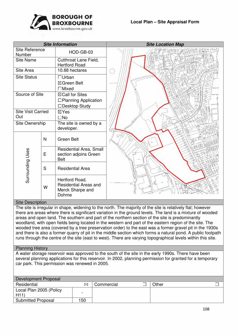
108
Local Plan – Site Appraisal Form
Site Information Site Location Map Site Reference Number
HOD-GB-03
Site Name Cutthroat Lane Field, Hertford Road
Site Area 10.88 hectares
Site Status ☐Urban ☒Green Belt ☐Mixed
Source of Site ☒Call for Sites ☐Planning Application ☐Desktop Study
Site Visit Carried Out
☒Yes ☐No
Site Ownership The site is owned by a developer.
Surr
oundin
g U
ses
N Green Belt
E Residential Area, Small section adjoins Green Belt
S Residential Area
W
Hertford Road, Residential Areas and Merck Sharpe and Dohme
Site Description The site is irregular in shape, widening to the north. The majority of the site is relatively flat; however there are areas where there is significant variation in the ground levels. The land is a mixture of wooded areas and open land. The southern and part of the northern section of the site is predominantly woodland, with open fields being located in the western and part of the eastern region of the site. The wooded tree area (covered by a tree preservation order) to the east was a former gravel pit in the 1930s and there is also a former quarry of pit in the middle section which forms a natural pond. A public footpath runs through the centre of the site (east to west). There are varying topographical levels within this site. Planning History A water storage reservoir was approved to the south of the site in the early 1990s. There have been several planning applications for this reservoir. In 2002, planning permission for granted for a temporary car park. This permission was renewed in 2005. Development Proposal
Residential ☒ Commercial ☐ Other ☐
Local Plan 2005 (Policy H11)
-
Submitted Proposal 150

109
Site Designations Contains Adjoins Contains Adjoins
Green Belt ☒ ☒ Site of Scientific Interest (SSSI) ☐ ☐
Archaeological Interest ☐ ☐ Ancient Monument ☐ ☐
Local Wildlife Site ☐ ☐ Community Open Space ☐ ☐
Lee Valley Regional Park
☐ ☐ Cheshunt Common ☐ ☐
Listed Building ☐ ☐ Locally Listed Building ☐ ☐
TPO Trees ☒ ☒ Conservation Area ☐ ☐
Air Quality Management Area
☐ ☐ Protected Species ☐ ☐
Draft Local Plan Designation (Regulation 18) The draft Local Plan proposed to keep this site within the Green Belt Accessibility – distance as the crow flies
440m -Primary School (Roselands)
1.3km - Secondary School (John Warner Secondary School)
0m -Employment Area (adjoins Merck Sharpe and
Dohme)
200m - Green Space (Roselands)
20m -Healthcare Centre (Christian Close Doctors)
7.28km-Hospital (with A&E) (Princess Alexandra Hospital)
1km - Town/District Centre (Hoddesdon)
750m - Local Centre (38-54 Ware Road)
1.3km -Leisure Centre (John Warner)
790m - A10 Junction (Hoddesdon)
1.87km - Railway Station (Rye House Train Station)
200m - Bus Service
Flood Risk Does the site Contains Adjoins
Zone 2 (Medium Risk) ☐ ☐
Zone 3a (High Risk) ☒ ☐
Zone 3b (Active Flood Plain) ☒ ☐
Additional Flood Risk Comments No flood risk comments for this site. Access and Transport Comments The site can be accessed from Hertford Road. A potential new access arrangement from Westhill Road is prevented by the existing wooded area in this location. Infrastructure will be required in order for pedestrians and cyclists to access the site safely and conveniently. The public footpath that runs through the centre of the site will need to be maintained and enhanced if development occurred. The impact that the potential development will have on the local and strategic network will need to be assessed. Utility Provision
Electricity Located within the urban area to the North
Gas Low pressure gas pipes exist at Hertford Road, Westhill Road and College Road. There is also a medium pressure main at Hertford Road.
Water There are several water mains along Hertford Road and within the initial entrance point into the site. There are also water mains available at College Road to the north and West Hill Road to the east.
Sewerage There are foul sewers available at Westhill Road and Briscoe Road. There are no services along Hertford Road or within the site itself.
Sewerage Treatment ☒Rye Meads ☐Deephams ☐Other

110
Additional Developer Comments submitted during Call for Sites 2016 None submitted. During the Local Plan (Regulation 18) consultation the promoter stated that the 10.7 hectares site does not fall within any landscape designations, contains any local wildlife or scheduled monuments or does not lie within or is located adjacent to a conservation area or contains any listed buildings. This contains a number of existing trees which could form a suitable and mature landscape setting for a new residential development. The promoter continues by stating that the site lies within an area of enclosed Green Belt which has existing weak boundaries afforded by residential to the north which comes closer to the existing settlements to the north and west. Previous Local Plan Inspectors have recognised the potential at this location to remove land from the Green Belt and allocate land for development. The promoter states that the site can be accessed from Hertford Road and is in single landownership. The site does not have any overriding constraints to development and the land can be brought forward immediately for development. The land is recognised to be in a sustainable location and is located immediately adjacent to an identified site in the emerging Local Plan at High Leigh. The promoter states that the site can be delivered early in the Plan period to provide a mix of homes, including affordable housing, community facilities and local highway improvements, whilst making an important contribution towards Broxbourne’s development needs. Suitability Comments
The site is not considered to be suitable for residential development due to the following reasons:
• There are no clear Green Belt boundaries to the north of the site. The development of this site could lead to encroachment within East Herts Green Belt.
• The Council’s Green Belt Topic Paper (2017) states that “At first glance the A10 appears to offer an alternative Green Bely boundary, but the northern side of the sit, where it adjoins East Hertfordshire, has no clear physical demarcation line along which the Green Belt can be redrawn. The area is characterised by woodland with small pockets of open land, and removal of this land from the Green Belt would be likely to result in the removal of a large number of trees which form an important part of the character of the wider area, defining the edge of the countryside. It would be very difficult to integrate the site into the existing built-up to provide additional services and facilities. In transport terms it is relatively inaccessible”.
• The development of this site will result in the loss of TPO trees and would potentially threaten the longer term protection of remaining protected trees due to their close proximity with proposed dwellings.
• As mentioned above, the only possible access route to this site will be from the B1197/Hertford Road. It is considered that to create safe access for both pedestrians along this road will be difficult/dangerous.
Is the site considered to be suitable for development?
☐☐☐☐Yes ☒☒☒☒ No
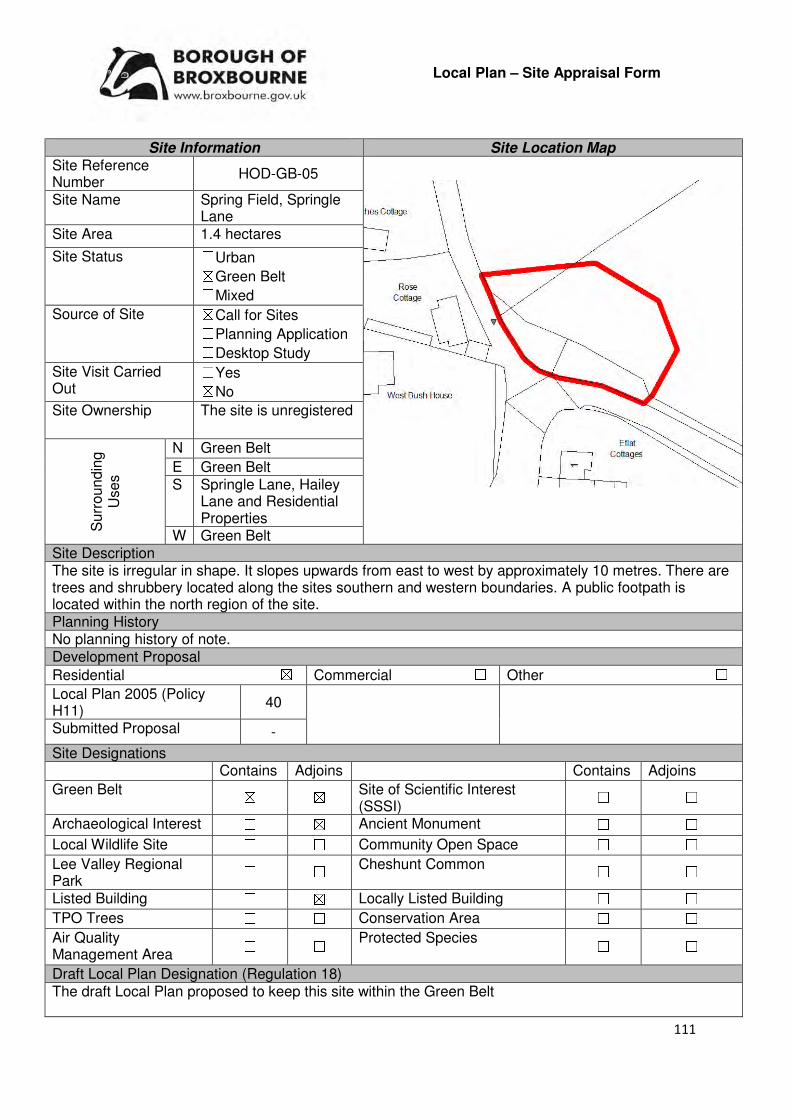
111
Local Plan – Site Appraisal Form
Site Information Site Location Map Site Reference Number
HOD-GB-05
Site Name Spring Field, Springle Lane
Site Area 1.4 hectares
Site Status ☐Urban ☒Green Belt ☐Mixed
Source of Site ☒Call for Sites ☐Planning Application ☐Desktop Study
Site Visit Carried Out
☐Yes ☒No
Site Ownership The site is unregistered
Surr
oundin
g
Uses
N Green Belt
E Green Belt S Springle Lane, Hailey
Lane and Residential Properties
W Green Belt Site Description The site is irregular in shape. It slopes upwards from east to west by approximately 10 metres. There are trees and shrubbery located along the sites southern and western boundaries. A public footpath is located within the north region of the site. Planning History No planning history of note. Development Proposal
Residential ☒ Commercial ☐ Other ☐
Local Plan 2005 (Policy H11)
40
Submitted Proposal -
Site Designations Contains Adjoins Contains Adjoins
Green Belt ☒ ☒ Site of Scientific Interest (SSSI)
☐ ☐
Archaeological Interest ☐ ☒ Ancient Monument ☐ ☐
Local Wildlife Site ☐ ☐ Community Open Space ☐ ☐
Lee Valley Regional Park
☐ ☐ Cheshunt Common ☐ ☐
Listed Building ☐ ☒ Locally Listed Building ☐ ☐
TPO Trees ☐ ☐ Conservation Area ☐ ☐
Air Quality Management Area
☐ ☐ Protected Species ☐ ☐
Draft Local Plan Designation (Regulation 18) The draft Local Plan proposed to keep this site within the Green Belt
112
Accessibility – distance as the crow flies
570m -Primary School (Roselands)
1.1km - Secondary School (John Warner)
1.3km -Employment Area (Merck Sharpe and Dohme)
580m - Green Space (Rear of Roselands)
440m -Healthcare Centre (Hailey View Surgery)
7km - Hospital (with A&E) (Princess Alexandra Hospital)
.9km - Town/District Centre (Hoddesdon Town Centre)
710m - Local Centre (Chaucer Way)
1.19km -Leisure Centre (John Warner)
520m - A10 Junction (A414 Junction)
1.9km - Railway Station (Rye House)
180m Bus Service
Flood Risk Does the site Contains Adjoins
Zone 2 (Medium Risk) ☐ ☐
Zone 3a (High Risk) ☐ ☐
Zone 3b (Active Flood Plain) ☐ ☐
Additional Flood Risk Comments The site is not within a flood zone or an area susceptible to surface water flooding. However it may suffer from ground water flooding and it is within a source protection zone. Access and Transport Comments The site would ideally be accessed from either Springle Lane to the south-west of Hailey Lane to the south-east although both of these roads are semi-rural in nature. Cycle and pedestrian access is poor on these roads and they would therefore need major improvement/enhancement. A public right of way to the north of the site would need to be maintained. Utility Provision
Electricity Available at Hailey lane.
Gas Available at Hailey Lane
Water Available at Hailey Lane
Sewerage Available at Hailey Lane
Sewerage Treatment ☒Rye Meads ☐Deephams ☐Other
Additional Developer Comments submitted during Call for Sites 2016 None submitted. Suitability Comments The site is not considered to be in a suitable location for residential development for the following reasons:
• The site is included in area A1 identified in the Council’s Green Belt Review. The Review states that area A1 performs strongly against Purposes 1 of the Green Belt and thus merits retention. This area performs relatively poorly against Green Belt Purposes 2 and 3. The Review states that the area “may be of greater importance than that attributed in the measurements in relation to the separation of the large urban area of Broxbourne and Hertford Heath”. No changes proposed to boundary in this location.
• There are no clear Green Belt boundaries at this site that would prevent further encroachment into the Green Belt.
• The site is too small to facilitate sustainable place-shaping; therefore its development will result in the creation of a small-scale, isolated development.
Is the site considered to be suitable for development?
☐☐☐☐Yes ☒☒☒☒ No
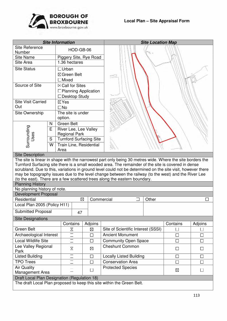
113
Local Plan – Site Appraisal Form
Site Information Site Location Map Site Reference Number
HOD-GB-06
Site Name Piggery Site, Rye Road Site Area 1.36 hectares
Site Status ☐Urban ☒Green Belt ☐Mixed
Source of Site ☒Call for Sites ☐Planning Application ☐Desktop Study
Site Visit Carried Out
☒Yes ☐No
Site Ownership The site is under option.
Surr
oundin
g
Uses
N Green Belt
E River Lee, Lee Valley Regional Park
S Turnford Surfacing Site
W Train Line, Residential Area
Site Description The site is linear in shape with the narrowest part only being 30 metres wide. Where the site borders the Turnford Surfacing site there is a small wooded area. The remainder of the site is covered in dense scrubland. Due to this, variations in ground level could not be determined on the site visit, however there may be topography issues due to the level change between the railway (to the west) and the River Lee (to the east). There are a few scattered trees along the eastern boundary. Planning History No planning history of note. Development Proposal
Residential ☒ Commercial ☐ Other ☐
Local Plan 2005 (Policy H11)
Submitted Proposal 47
Site Designations Contains Adjoins Contains Adjoins
Green Belt ☒ ☒ Site of Scientific Interest (SSSI) ☐ ☐
Archaeological Interest ☐ ☐ Ancient Monument ☐ ☐
Local Wildlife Site ☐ ☐ Community Open Space ☐ ☐
Lee Valley Regional Park
☒ ☒ Cheshunt Common ☐ ☐
Listed Building ☐ ☐ Locally Listed Building ☐ ☐
TPO Trees ☐ ☐ Conservation Area ☐ ☐
Air Quality Management Area
☐ ☐ Protected Species ☒ ☐
Draft Local Plan Designation (Regulation 18) The draft Local Plan proposed to keep this site within the Green Belt.
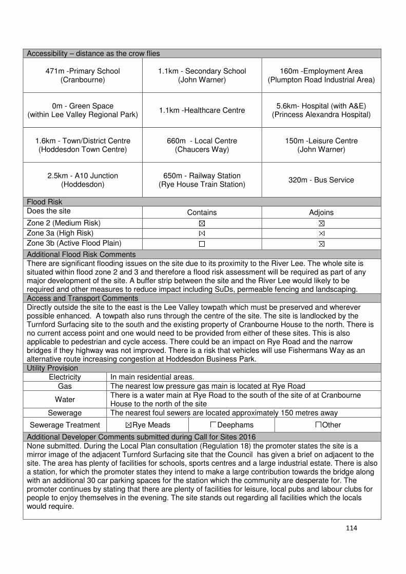
114
Accessibility – distance as the crow flies
471m -Primary School (Cranbourne)
1.1km - Secondary School (John Warner)
160m -Employment Area (Plumpton Road Industrial Area)
0m - Green Space (within Lee Valley Regional Park)
1.1km -Healthcare Centre
5.6km- Hospital (with A&E)
(Princess Alexandra Hospital)
1.6km - Town/District Centre (Hoddesdon Town Centre)
660m - Local Centre
(Chaucers Way)
150m -Leisure Centre
(John Warner)
2.5km - A10 Junction
(Hoddesdon)
650m - Railway Station
(Rye House Train Station)
320m - Bus Service
Flood Risk Does the site Contains Adjoins
Zone 2 (Medium Risk) ☒ ☒
Zone 3a (High Risk) ☒ ☒
Zone 3b (Active Flood Plain) ☐ ☒
Additional Flood Risk Comments There are significant flooding issues on the site due to its proximity to the River Lee. The whole site is situated within flood zone 2 and 3 and therefore a flood risk assessment will be required as part of any major development of the site. A buffer strip between the site and the River Lee would likely to be required and other measures to reduce impact including SuDs, permeable fencing and landscaping. Access and Transport Comments Directly outside the site to the east is the Lee Valley towpath which must be preserved and wherever possible enhanced. A towpath also runs through the centre of the site. The site is landlocked by the Turnford Surfacing site to the south and the existing property of Cranbourne House to the north. There is no current access point and one would need to be provided from either of these sites. This is also applicable to pedestrian and cycle access. There could be an impact on Rye Road and the narrow bridges if they highway was not improved. There is a risk that vehicles will use Fishermans Way as an alternative route increasing congestion at Hoddesdon Business Park. Utility Provision
Electricity In main residential areas.
Gas The nearest low pressure gas main is located at Rye Road
Water There is a water main at Rye Road to the south of the site of at Cranbourne House to the north of the site
Sewerage The nearest foul sewers are located approximately 150 metres away
Sewerage Treatment ☒Rye Meads ☐Deephams ☐Other
Additional Developer Comments submitted during Call for Sites 2016 None submitted. During the Local Plan consultation (Regulation 18) the promoter states the site is a mirror image of the adjacent Turnford Surfacing site that the Council has given a brief on adjacent to the site. The area has plenty of facilities for schools, sports centres and a large industrial estate. There is also a station, for which the promoter states they intend to make a large contribution towards the bridge along with an additional 30 car parking spaces for the station which the community are desperate for. The promoter continues by stating that there are plenty of facilities for leisure, local pubs and labour clubs for people to enjoy themselves in the evening. The site stands out regarding all facilities which the locals would require.

115
Suitability Comments
The site is not considered to be suitable for residential development due to the following reasons;
• The site is located within Flood Zone 2 and Flood Zone 3a and the Green Belt .The site was included within area E1 identified in the Council’s Green Belt Review (Scott Wilson, 2008). The Review states that area E8 performs strongly against Green Belt Purposes 1 and 2, and plays a poor role against Purpose 3. No change to the boundary in this location was proposed. The combinations of these factors mean that the site is not suitable for development at this time.
• Accessibility to the site is problematic – the site does not have any vehicle access and is currently landlocked between two different sites. No evidence has been provided as to how this issue will be resolved.
Is the site considered to be suitable for development?
☐☐☐☐Yes ☒☒☒☒ No
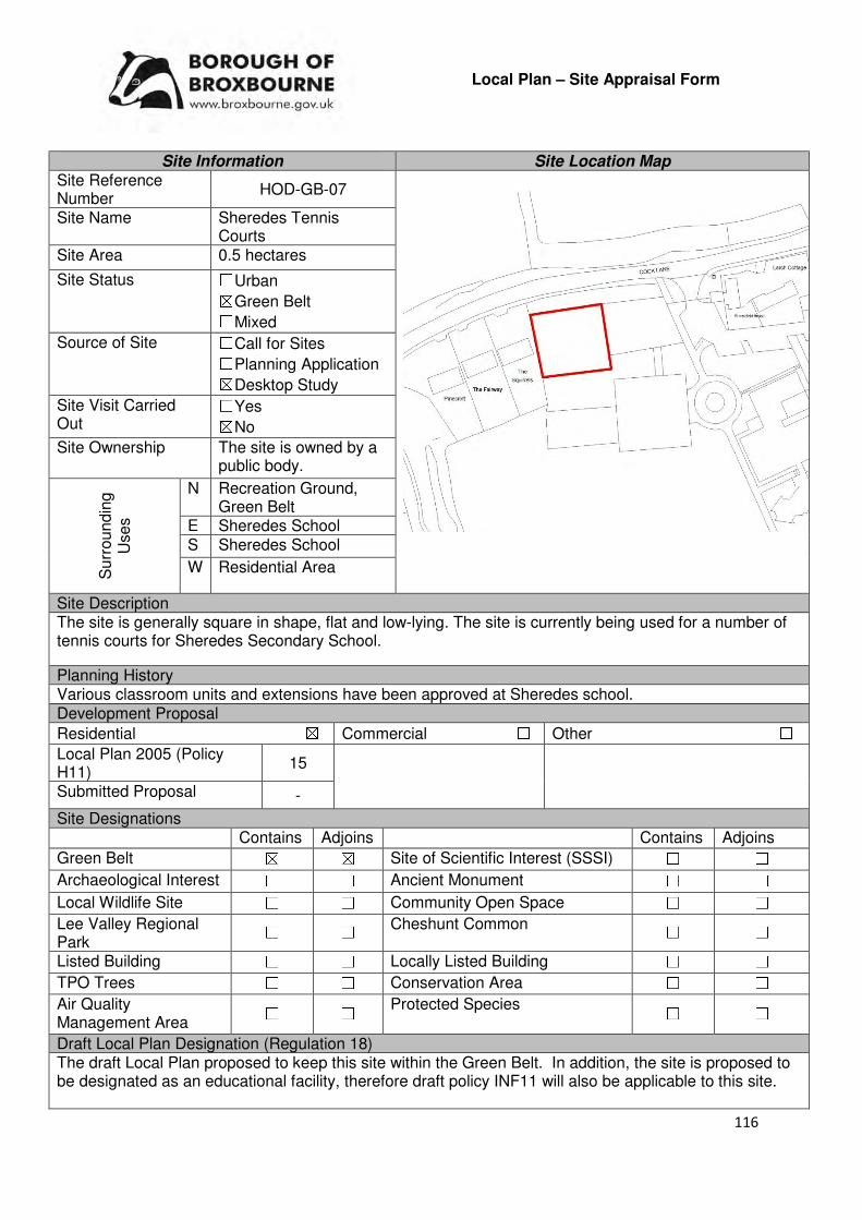
116
Local Plan – Site Appraisal Form
Site Information Site Location Map Site Reference Number
HOD-GB-07
Site Name Sheredes Tennis Courts
Site Area 0.5 hectares
Site Status ☐Urban ☒Green Belt ☐Mixed
Source of Site ☐Call for Sites ☐Planning Application ☒Desktop Study
Site Visit Carried Out
☐Yes ☒No
Site Ownership The site is owned by a public body.
Surr
oundin
g
Uses
N Recreation Ground, Green Belt
E Sheredes School S Sheredes School
W Residential Area
Site Description The site is generally square in shape, flat and low-lying. The site is currently being used for a number of tennis courts for Sheredes Secondary School.
Planning History Various classroom units and extensions have been approved at Sheredes school. Development Proposal
Residential ☒ Commercial ☐ Other ☐
Local Plan 2005 (Policy H11)
15
Submitted Proposal -
Site Designations Contains Adjoins Contains Adjoins
Green Belt ☒ ☒ Site of Scientific Interest (SSSI) ☐ ☐
Archaeological Interest ☐ ☐ Ancient Monument ☐ ☐
Local Wildlife Site ☐ ☐ Community Open Space ☐ ☐
Lee Valley Regional Park
☐ ☐ Cheshunt Common ☐ ☐
Listed Building ☐ ☐ Locally Listed Building ☐ ☐
TPO Trees ☐ ☐ Conservation Area ☐ ☐
Air Quality Management Area
☐ ☐ Protected Species ☐ ☐
Draft Local Plan Designation (Regulation 18) The draft Local Plan proposed to keep this site within the Green Belt. In addition, the site is proposed to be designated as an educational facility, therefore draft policy INF11 will also be applicable to this site.
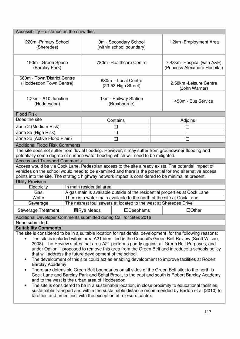
117
Accessibility – distance as the crow flies
220m -Primary School (Sheredes)
0m - Secondary School (within school boundary)
1.2km -Employment Area
190m - Green Space (Barclay Park)
780m -Healthcare Centre
7.48km- Hospital (with A&E)
(Princess Alexandra Hospital)
680m - Town/District Centre (Hoddesdon Town Centre)
630m - Local Centre (23-53 High Street)
2.58km -Leisure Centre
(John Warner)
1.2km - A10 Junction (Hoddesdon)
1km - Railway Station
(Broxbourne)
450m - Bus Service
Flood Risk Does the site Contains Adjoins
Zone 2 (Medium Risk) ☐ ☐
Zone 3a (High Risk) ☐ ☐
Zone 3b (Active Flood Plain) ☐ ☐
Additional Flood Risk Comments The site does not suffer from fluvial flooding. However, it may suffer from groundwater flooding and potentially some degree of surface water flooding which will need to be mitigated. Access and Transport Comments Access would be via Cock Lane. Pedestrian access to the site already exists. The potential impact of vehicles on the school would need to be examined and there is the potential for two alternative access points into the site. The strategic highway network impact is considered to be minimal at present. Utility Provision
Electricity In main residential area
Gas A gas main is available outside of the residential properties at Cock Lane
Water There is a water main available to the north of the site at Cock Lane
Sewerage The nearest foul sewers at located to the west at Sheredes Drive
Sewerage Treatment ☒Rye Meads ☐Deephams ☐Other
Additional Developer Comments submitted during Call for Sites 2016 None submitted. Suitability Comments The site is considered to be in a suitable location for residential development for the following reasons:
• The site is included within area A21 identified in the Council’s Green Belt Review (Scott Wilson, 2008). The Review states that area A21 performs poorly against all Green Belt Purposes, and under Option 1 proposed to remove this area from the Green Belt and introduce a schools policy that will address the future development of the school.
• The development of this site could act as enabling development to improve facilities at Robert Barclay Academy
• There are defensible Green Belt boundaries on all sides of the Green Belt site; to the north is Cock Lane and Barclay Park and Spital Brook, to the east and south is Robert Barclay Academy and to the west is the urban area of Hoddesdon.
• The site is considered to be in a sustainable location, in close proximity to educational facilities, sustainable transport and within the sustainable distance recommended by Barton et al (2010) to facilities and amenities, with the exception of a leisure centre.

118
Is the site considered to be suitable for development?
☒☒☒☒Yes ☐☐☐☐ No
Availability Comments
The site has been identified by the Council for assessment. No promotion has been received by the landowner during the Local Plan Consultation (Regulation 18) or the 2016 Call for Sites. No request for pre-application advice or a planning application has been submitted for this site.
Is the site considered to be available for development?
☐☐☐☐Yes ☒☒☒☒ No
Achievability Comments The site is not considered to be available, therefore it is not achievable. Is the site considered to be achievable?
☐☐☐☐Yes ☒☒☒☒ No
Delivery Period -

119
Local Plan – Site Appraisal Form
Site Information Site Location Map Site Reference Number
HOD-GB-08
Site Name Roselands House Field, College Road
Site Area 0.8 hectares
Site Status ☐Urban ☒Green Belt ☐Mixed
Source of Site ☒Call for Sites ☐Planning Application ☐Desktop Study
Site Visit Carried Out
☒Yes ☐No
Site Ownership The site is privately owned by three people.
Surr
oundin
g
Uses
N Green Belt
E Residential S Residential
W Green Belt
Site Description The site is irregular in shape and quite angular. It is relatively flat; however there are very small changes in the ground level in isolated area. There are trees along all boundaries of the site which shields it from the surrounding development. Within the eastern portion of the site is a group of approximately 8-10 mature trees. This area of the site is currently being used as a horse paddock. There is an area of scrub located in the middle of the site. Just to the north east of this scrub are remnants of a water pumping station. The road leading up to the site is a narrow dirt track. Planning History In 1981 approval was granted for a five bedroom property to the south of Roselands House which is now 52 College Road.
Development Proposal
Residential ☒ Commercial ☐ Other ☐
Local Plan 2005 (Policy H11)
Submitted Proposal 8 self-build plots
Site Designations Contains Adjoins Contains Adjoins
Green Belt ☒ ☒ Site of Scientific Interest (SSSI) ☐ ☐
Archaeological Interest ☐ ☐ Ancient Monument ☐ ☐
Local Wildlife Site ☐ ☐ Community Open Space ☐ ☐
Lee Valley Regional Park ☐ ☐ Cheshunt Common ☐ ☐
Listed Building ☐ ☐ Locally Listed Building ☐ ☐
TPO Trees ☒ ☒ Conservation Area ☐ ☐
Air Quality Management Area
☐ ☐ Protected Species ☐ ☐
Draft Local Plan Designation (Regulation 18) The draft Local Plan proposed to keep this site within the Green Belt

120
Accessibility – distance as the crow flies
420m -Primary School (Roselands)
1.3km - Secondary School (John Warner)
220m -Employment Area (Merck Sharpe and Dohme)
400m - Green Space (Roselands)
530m -Healthcare Centre 7.2km - Hospital (with A&E)
(Princess Alexandra Hospital)
680m - Town/District Centre (Hoddesdon Town Centre)
580m - Local Centre 1.3km -Leisure Centre
(John Warner Leisure Centre)
910m - A10 Junction (Hoddesdon)
1.8km - Railway Station (Broxbourne)
220m- Bus Service
Flood Risk Does the site Contains Adjoins
Zone 2 (Medium Risk) ☐ ☐
Zone 3a (High Risk) ☐ ☐
Zone 3b (Active Flood Plain) ☐ ☐
Additional Flood Risk Comments There are no fluvial or existing surfacing water flooding issues. However, there could be some ground water flooding issues. Access and Transport Comments The site can currently be accessed from College Road, however, this is a private road and the dirt track leading up to the site would require widening if development was to occur. Roselands Avenue can also be used to access the site. The proposed density of dwellings could have an impact on College Road due to the nature of the road. There is a public right of way to the east and north of the site which runs through to land east of Hertford Road. There may be an impact upon the local road network in the area and on College Road. Utility Provision
Electricity In main residential area
Gas A gas main is available at College Road to the south
Water A water main is located to the south at College Road but does not extend to the site
Sewerage A foul sewer is situated to the south at Briscoe Road
Sewerage Treatment ☒Rye Meads ☐Deephams ☐Other
Additional Developer Comments submitted during Call for Sites 2016 The promoter stated that the site is ready for development, and anticipates it coming forward within the first 5 years of the plan period. The promoter considers the site to have no constraints which would prevent its development. The eastern region of the site where the paddock is located has not being included within the promoted development area. Suitability Comments
The site is not considered to be suitable for development due to the following reasons:
• The site is located within the Green Belt and is open in nature. It is considered that the development of this site would have a detrimental impact on the sites openness and would be contrary to the purposes of the Green Belt set out in the NPPF (paragraph 80)
Is the site considered to be suitable for development?
☐☐☐☐Yes ☒☒☒☒ No

121
Local Plan – Site Appraisal Form
Site Information Site Location Map Site Reference Number
HOD-GB-09
Site Name Admirals Walk Field Site Area 0.5 hectares
Site Status ☐Urban ☒Green Belt ☐Mixed
Source of Site ☒Call for Sites ☐Planning Application ☐Desktop Study
Site Visit Carried Out
☐Yes ☒No
Site Ownership There are various landowners for this site
Surr
oundin
g
Uses
N Green Belt
E Admirals Walk Lake, Green Belt, Residential
S Residential
W New River, Residential
Site Description The site is rectangular in shape. It is relatively flat but low-lying site with a very gentle decline from west to east by 2 metres. There are several trees located within the sites borders, with the Horse Chestnuts and Oaks located along the eastern boundary are covered by a TPO. There are some areas of clear land. Planning History In 1980 permission was refused for residential development (Outline application for six dwellings) on this land and on land further northwards. Permission was refused for the development of a single detached house in 1978. Development Proposal
Residential ☒ Commercial ☐ Other ☐
Local Plan 2005 (Policy H11)
-
Submitted Proposal 2-3 sustainable homes
Site Designations Contains Adjoins Contains Adjoins
Green Belt ☒ ☒ Site of Scientific Interest (SSSI) ☐ ☐
Archaeological Interest ☐ ☐ Ancient Monument ☐ ☐
Local Wildlife Site ☐ ☒ Community Open Space ☐ ☐
Lee Valley Regional Park ☐ ☒ Cheshunt Common ☐ ☐
Listed Building ☐ ☐ Locally Listed Building ☐ ☒
TPO Trees ☒ ☐ Conservation Area ☐ ☒
Air Quality Management Area
☐ ☐ Protected Species ☐ ☐
Draft Local Plan Designation (Regulation 18) The draft Local Plan proposed to keep this site within the Green Belt
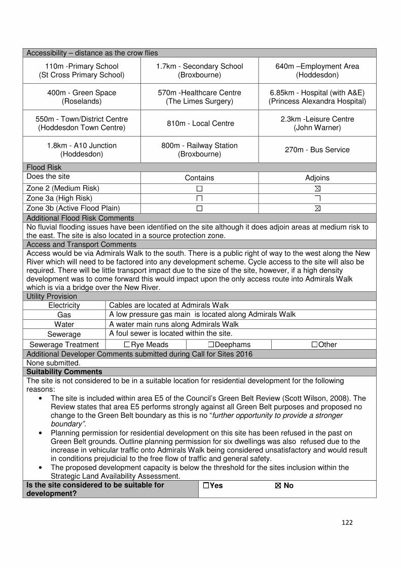
122
Accessibility – distance as the crow flies
110m -Primary School (St Cross Primary School)
1.7km - Secondary School (Broxbourne)
640m –Employment Area (Hoddesdon)
400m - Green Space (Roselands)
570m -Healthcare Centre (The Limes Surgery)
6.85km - Hospital (with A&E) (Princess Alexandra Hospital)
550m - Town/District Centre (Hoddesdon Town Centre)
810m - Local Centre 2.3km -Leisure Centre
(John Warner)
1.8km - A10 Junction (Hoddesdon)
800m - Railway Station (Broxbourne)
270m - Bus Service
Flood Risk Does the site Contains Adjoins
Zone 2 (Medium Risk) ☐ ☒
Zone 3a (High Risk) ☐ ☐
Zone 3b (Active Flood Plain) ☐ ☒
Additional Flood Risk Comments No fluvial flooding issues have been identified on the site although it does adjoin areas at medium risk to the east. The site is also located in a source protection zone. Access and Transport Comments Access would be via Admirals Walk to the south. There is a public right of way to the west along the New River which will need to be factored into any development scheme. Cycle access to the site will also be required. There will be little transport impact due to the size of the site, however, if a high density development was to come forward this would impact upon the only access route into Admirals Walk which is via a bridge over the New River. Utility Provision
Electricity Cables are located at Admirals Walk
Gas A low pressure gas main is located along Admirals Walk
Water A water main runs along Admirals Walk
Sewerage A foul sewer is located within the site.
Sewerage Treatment ☐Rye Meads ☐Deephams ☐Other
Additional Developer Comments submitted during Call for Sites 2016 None submitted. Suitability Comments
The site is not considered to be in a suitable location for residential development for the following reasons:
• The site is included within area E5 of the Council’s Green Belt Review (Scott Wilson, 2008). The Review states that area E5 performs strongly against all Green Belt purposes and proposed no change to the Green Belt boundary as this is no “further opportunity to provide a stronger boundary”.
• Planning permission for residential development on this site has been refused in the past on Green Belt grounds. Outline planning permission for six dwellings was also refused due to the increase in vehicular traffic onto Admirals Walk being considered unsatisfactory and would result in conditions prejudicial to the free flow of traffic and general safety.
• The proposed development capacity is below the threshold for the sites inclusion within the Strategic Land Availability Assessment.
Is the site considered to be suitable for development?
☐☐☐☐Yes ☒☒☒☒ No
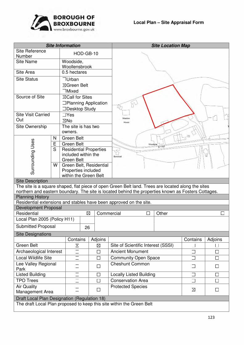
123
Local Plan – Site Appraisal Form
Site Information Site Location Map Site Reference Number
HOD-GB-10
Site Name Woodside, Woollensbrook
Site Area 0.5 hectares
Site Status ☐Urban ☒Green Belt ☐Mixed
Source of Site ☒Call for Sites ☐Planning Application ☐Desktop Study
Site Visit Carried Out
☐Yes ☒No
Site Ownership The site is has two owners.
Surr
oundin
g U
ses N Green Belt
E Green Belt S Residential Properties
included within the Green Belt
W Green Belt, Residential Properties included within the Green Belt
Site Description The site is a square shaped, flat piece of open Green Belt land. Trees are located along the sites northern and eastern boundary. The site is located behind the properties known as Fosters Cottages. Planning History Residential extensions and stables have been approved on the site. Development Proposal
Residential ☒ Commercial ☐ Other ☐
Local Plan 2005 (Policy H11)
Submitted Proposal 26
Site Designations Contains Adjoins Contains Adjoins
Green Belt ☒ ☒ Site of Scientific Interest (SSSI) ☐ ☐
Archaeological Interest ☐ ☐ Ancient Monument ☐ ☐
Local Wildlife Site ☐ ☐ Community Open Space ☐ ☐
Lee Valley Regional Park
☐ ☐ Cheshunt Common ☐ ☐
Listed Building ☐ ☐ Locally Listed Building ☐ ☐
TPO Trees ☐ ☐ Conservation Area ☐ ☐
Air Quality Management Area ☐ ☐
Protected Species ☒ ☐
Draft Local Plan Designation (Regulation 18) The draft Local Plan proposed to keep this site within the Green Belt
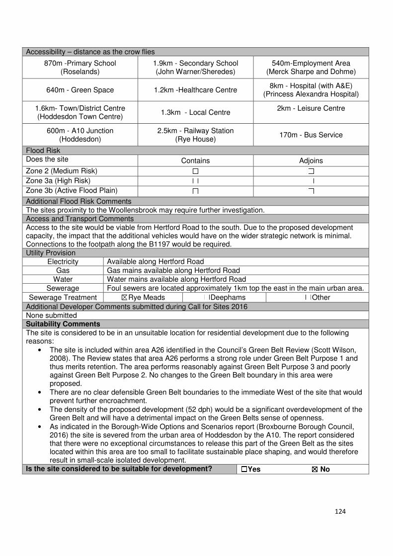
124
Accessibility – distance as the crow flies
870m -Primary School (Roselands)
1.9km - Secondary School (John Warner/Sheredes)
540m-Employment Area (Merck Sharpe and Dohme)
640m - Green Space 1.2km -Healthcare Centre 8km - Hospital (with A&E)
(Princess Alexandra Hospital)
1.6km- Town/District Centre (Hoddesdon Town Centre)
1.3km - Local Centre 2km - Leisure Centre
600m - A10 Junction (Hoddesdon)
2.5km - Railway Station (Rye House)
170m - Bus Service
Flood Risk Does the site Contains Adjoins
Zone 2 (Medium Risk) ☐ ☐
Zone 3a (High Risk) ☐ ☐
Zone 3b (Active Flood Plain) ☐ ☐
Additional Flood Risk Comments The sites proximity to the Woollensbrook may require further investigation. Access and Transport Comments Access to the site would be viable from Hertford Road to the south. Due to the proposed development capacity, the impact that the additional vehicles would have on the wider strategic network is minimal. Connections to the footpath along the B1197 would be required. Utility Provision
Electricity Available along Hertford Road
Gas Gas mains available along Hertford Road
Water Water mains available along Hertford Road
Sewerage Foul sewers are located approximately 1km top the east in the main urban area.
Sewerage Treatment ☒Rye Meads ☐Deephams ☐Other
Additional Developer Comments submitted during Call for Sites 2016 None submitted Suitability Comments
The site is considered to be in an unsuitable location for residential development due to the following reasons:
• The site is included within area A26 identified in the Council’s Green Belt Review (Scott Wilson, 2008). The Review states that area A26 performs a strong role under Green Belt Purpose 1 and thus merits retention. The area performs reasonably against Green Belt Purpose 3 and poorly against Green Belt Purpose 2. No changes to the Green Belt boundary in this area were proposed.
• There are no clear defensible Green Belt boundaries to the immediate West of the site that would prevent further encroachment.
• The density of the proposed development (52 dph) would be a significant overdevelopment of the Green Belt and will have a detrimental impact on the Green Belts sense of openness.
• As indicated in the Borough-Wide Options and Scenarios report (Broxbourne Borough Council, 2016) the site is severed from the urban area of Hoddesdon by the A10. The report considered that there were no exceptional circumstances to release this part of the Green Belt as the sites located within this area are too small to facilitate sustainable place shaping, and would therefore result in small-scale isolated development.
Is the site considered to be suitable for development? ☐☐☐☐Yes ☒☒☒☒ No
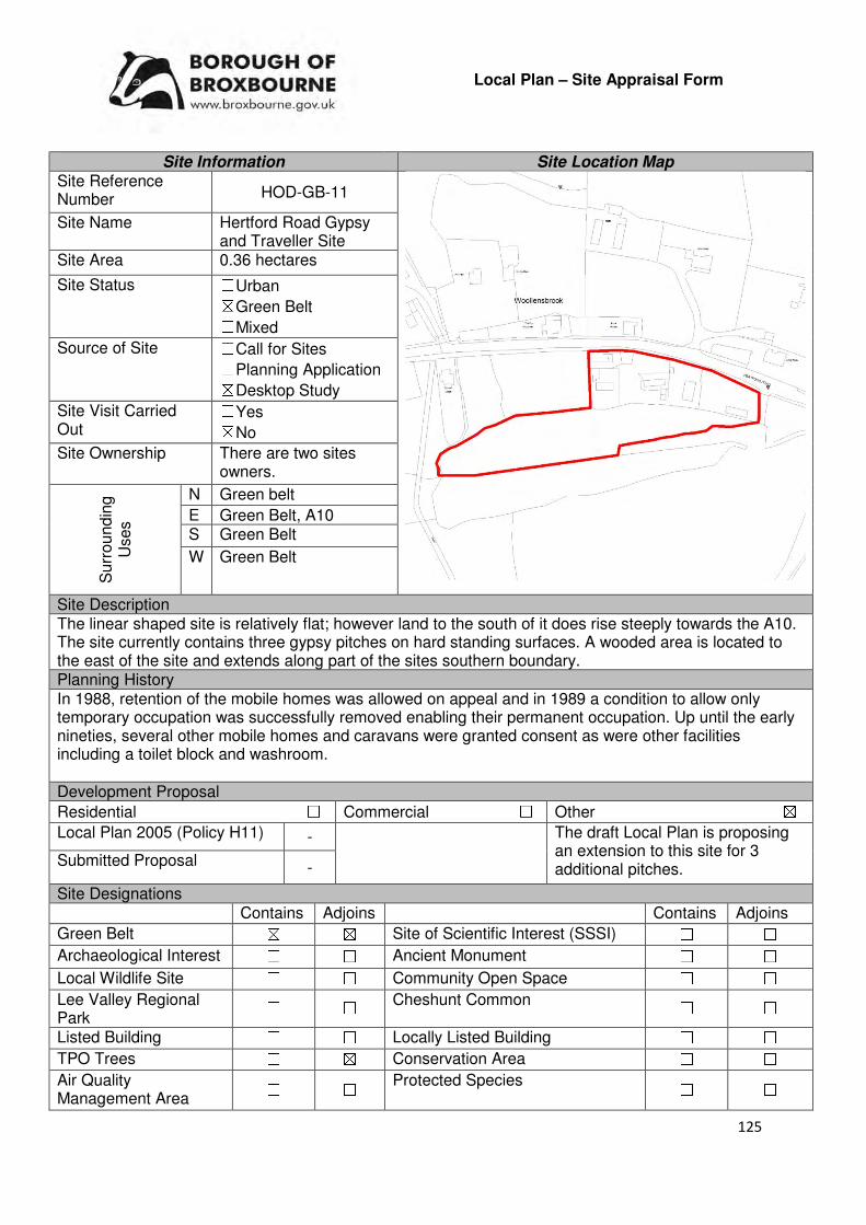
125
Local Plan – Site Appraisal Form
Site Information Site Location Map Site Reference Number HOD-GB-11
Site Name Hertford Road Gypsy and Traveller Site
Site Area 0.36 hectares
Site Status ☐Urban ☒Green Belt ☐Mixed
Source of Site ☐Call for Sites ☐Planning Application ☒Desktop Study
Site Visit Carried Out
☐Yes ☒No
Site Ownership There are two sites owners.
Surr
oundin
g
Uses
N Green belt
E Green Belt, A10 S Green Belt
W Green Belt
Site Description The linear shaped site is relatively flat; however land to the south of it does rise steeply towards the A10. The site currently contains three gypsy pitches on hard standing surfaces. A wooded area is located to the east of the site and extends along part of the sites southern boundary. Planning History In 1988, retention of the mobile homes was allowed on appeal and in 1989 a condition to allow only temporary occupation was successfully removed enabling their permanent occupation. Up until the early nineties, several other mobile homes and caravans were granted consent as were other facilities including a toilet block and washroom. Development Proposal
Residential ☐ Commercial ☐ Other ☒
Local Plan 2005 (Policy H11) - The draft Local Plan is proposing an extension to this site for 3 additional pitches.
Submitted Proposal -
Site Designations Contains Adjoins Contains Adjoins
Green Belt ☒ ☒ Site of Scientific Interest (SSSI) ☐ ☐
Archaeological Interest ☐ ☐ Ancient Monument ☐ ☐
Local Wildlife Site ☐ ☐ Community Open Space ☐ ☐
Lee Valley Regional Park
☐ ☐ Cheshunt Common ☐ ☐
Listed Building ☐ ☐ Locally Listed Building ☐ ☐
TPO Trees ☐ ☒ Conservation Area ☐ ☐
Air Quality Management Area
☐ ☐ Protected Species ☐ ☐
126
Draft Local Plan Designation (Regulation 18) The draft Local Plan proposed to keep this site within the Green Belt. The site has also been identified for limited expansion to meet the needs of that community on land to the immediate south which is in the ownership of the Council, as part of emerging Policy GT1: Gypsy and Traveller sites. Accessibility – distance as the crow flies
700m -Primary School (Westfield)
1.8km - Secondary School (John Warner or Sheredes)
380m –Employment Area (Merck Sharpe and Dohme)
630m - Green Space 960m -Healthcare Centre 7.67km - Hospital (with A&E) (Princess Alexandra Hospital)
1.3km - Town/District Centre (Hoddesdon Town Centre)
1km - Local Centre 1.8km -Leisure Centre
(John Warner)
550m - A10 Junction (Hoddesdon)
2.3km - Railway Station (Rye House)
114m - Bus Service
Flood Risk Does the site Contains Adjoins
Zone 2 (Medium Risk) ☒ ☒
Zone 3a (High Risk) ☐ ☒
Zone 3b (Active Flood Plain) ☐ ☐
Additional Flood Risk Comments The south eastern corner of the site just slights abuts in Zone 2 (Medium Risk). In addition, Woollensbrook, which is located to the south of the site, is located within Flood Zone 2 and Flood Zone 3. Access and Transport Comments The site benefits from existing vehicular access from Hertford Road to the north. There is also a pathway for pedestrians. Utility Provision
Electricity Connections are already available
Gas Low and medium pressure gas mains are located along Hertford Road
Water The site has access to water
Sewerage A foul sewer is located further east at Westfield Road
Sewerage Treatment ☒Rye Meads ☐Deephams ☐Other
Additional Developer Comments submitted during Call for Sites 2016 None submitted. Suitability Comments The site is not considered to be suitable for residential development due to the following reasons:
• The site is currently in active use as an authorised gypsy and traveller site.
• The site is included within area A8 identified in the Council’s Green Belt Review (Scott Wilson, 2008). The Review states that area A8 performs a strong role against Green Belt Purposes 1 and 2, and reasonably against Green Belt Purpose 3. The Review proposed no changes to the boundary in this location.
• As indicated in the Council’s Borough-wide Options and Scenario report, the site is severed from the urban area of the A10 and is therefore not considered to be in a sustainable location for residential development

127
As part of the site is already in use as a gypsy and traveller site, it is considered to be suitable to expand this site to enable the Council to accommodate for the needs of community currently occupying the site. National Policy requires local planning authorities to “set pitch targets for gypsies and travellers…and plot targets for travelling showpeople…which address the likely permanent and transit accommodation needs of travellers in their area”. Is the site considered to be suitable for development?
☒☒☒☒Yes ☐☐☐☐ No
Availability Comments
The site is considered to be available. The proposed use for the site within the draft Local Plan is already established. The expansion of this site to create 3 additional plots will be on Council owned land.
Is the site considered to be available for development?
☒☒☒☒Yes ☐☐☐☐ No
Achievability Comments Preparatory works required to bring this site forward are not considered to be significant to prevent development. It is considered that there are no policy constraints that would prevent this site from coming forward.
Is the site considered to be achievable? ☒☒☒☒Yes ☐☐☐☐ No
Delivery Period 6-10 years
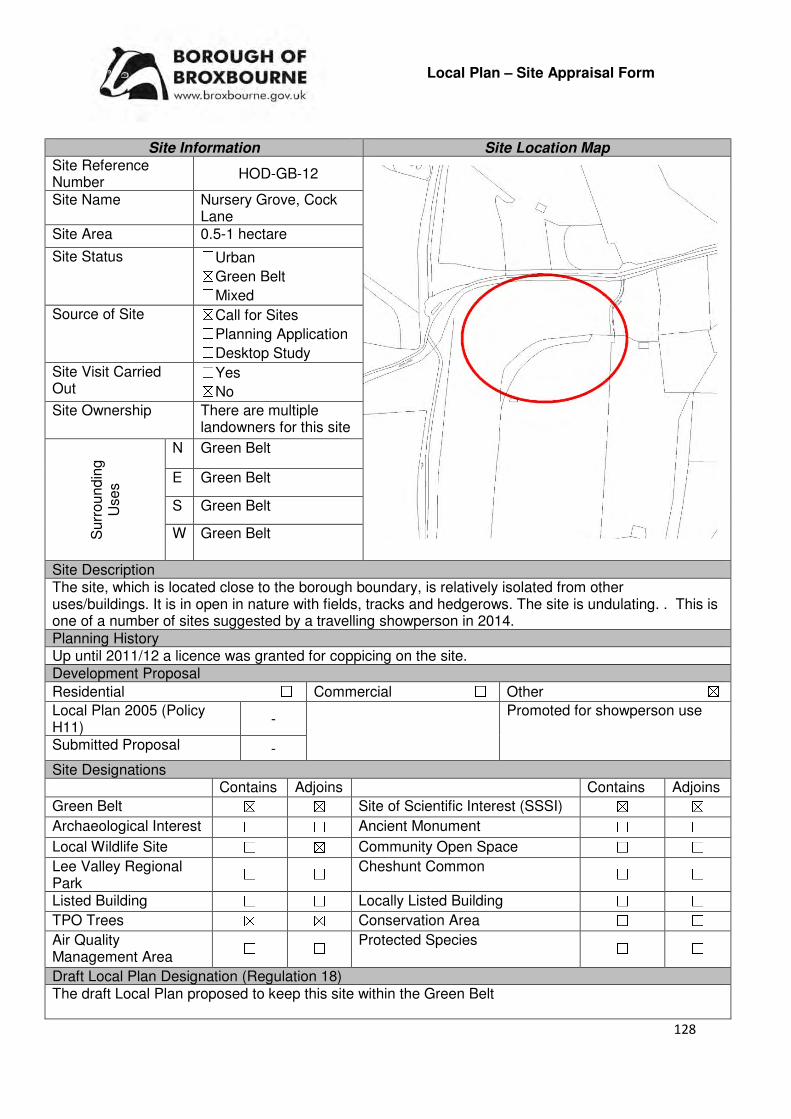
128
Local Plan – Site Appraisal Form
Site Information Site Location Map Site Reference Number
HOD-GB-12
Site Name Nursery Grove, Cock Lane
Site Area 0.5-1 hectare
Site Status ☐Urban ☒Green Belt ☐Mixed
Source of Site ☒Call for Sites ☐Planning Application ☐Desktop Study
Site Visit Carried Out
☐Yes ☒No
Site Ownership There are multiple landowners for this site
Surr
oundin
g
Uses
N Green Belt
E Green Belt
S Green Belt
W Green Belt
Site Description The site, which is located close to the borough boundary, is relatively isolated from other uses/buildings. It is in open in nature with fields, tracks and hedgerows. The site is undulating. . This is one of a number of sites suggested by a travelling showperson in 2014. Planning History Up until 2011/12 a licence was granted for coppicing on the site. Development Proposal
Residential ☐ Commercial ☐ Other ☒
Local Plan 2005 (Policy H11)
- Promoted for showperson use
Submitted Proposal -
Site Designations Contains Adjoins Contains Adjoins
Green Belt ☒ ☒ Site of Scientific Interest (SSSI) ☒ ☒
Archaeological Interest ☐ ☐ Ancient Monument ☐ ☐
Local Wildlife Site ☐ ☒ Community Open Space ☐ ☐
Lee Valley Regional Park
☐ ☐ Cheshunt Common ☐ ☐
Listed Building ☐ ☐ Locally Listed Building ☐ ☐
TPO Trees ☒ ☒ Conservation Area ☐ ☐
Air Quality Management Area
☐ ☐ Protected Species ☐ ☐
Draft Local Plan Designation (Regulation 18) The draft Local Plan proposed to keep this site within the Green Belt
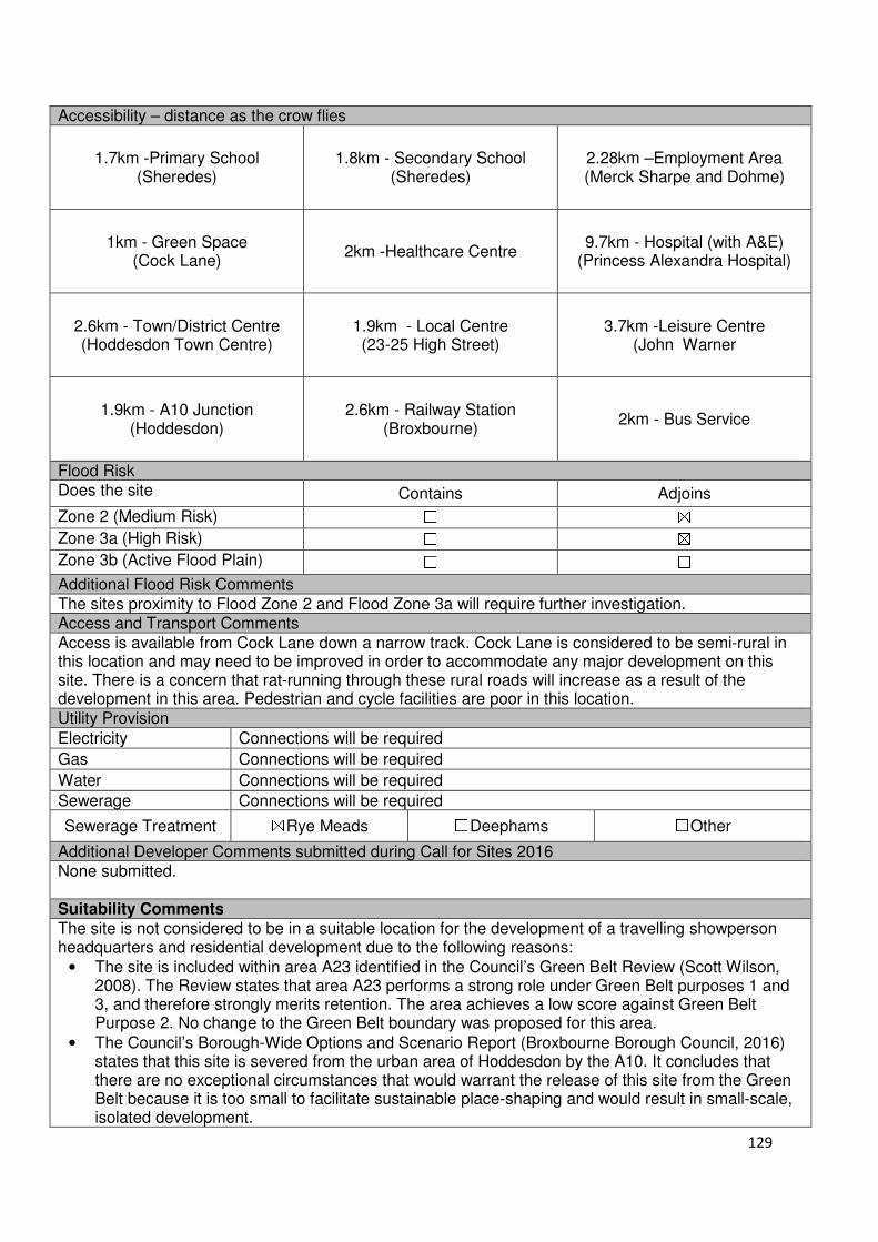
129
Accessibility – distance as the crow flies
1.7km -Primary School (Sheredes)
1.8km - Secondary School (Sheredes)
2.28km –Employment Area (Merck Sharpe and Dohme)
1km - Green Space (Cock Lane)
2km -Healthcare Centre 9.7km - Hospital (with A&E)
(Princess Alexandra Hospital)
2.6km - Town/District Centre (Hoddesdon Town Centre)
1.9km - Local Centre (23-25 High Street)
3.7km -Leisure Centre (John Warner
1.9km - A10 Junction (Hoddesdon)
2.6km - Railway Station (Broxbourne)
2km - Bus Service
Flood Risk Does the site Contains Adjoins
Zone 2 (Medium Risk) ☐ ☒
Zone 3a (High Risk) ☐ ☒
Zone 3b (Active Flood Plain) ☐ ☐
Additional Flood Risk Comments The sites proximity to Flood Zone 2 and Flood Zone 3a will require further investigation. Access and Transport Comments Access is available from Cock Lane down a narrow track. Cock Lane is considered to be semi-rural in this location and may need to be improved in order to accommodate any major development on this site. There is a concern that rat-running through these rural roads will increase as a result of the development in this area. Pedestrian and cycle facilities are poor in this location. Utility Provision
Electricity Connections will be required
Gas Connections will be required
Water Connections will be required
Sewerage Connections will be required
Sewerage Treatment ☒Rye Meads ☐Deephams ☐Other
Additional Developer Comments submitted during Call for Sites 2016 None submitted. Suitability Comments The site is not considered to be in a suitable location for the development of a travelling showperson headquarters and residential development due to the following reasons:
• The site is included within area A23 identified in the Council’s Green Belt Review (Scott Wilson, 2008). The Review states that area A23 performs a strong role under Green Belt purposes 1 and 3, and therefore strongly merits retention. The area achieves a low score against Green Belt Purpose 2. No change to the Green Belt boundary was proposed for this area.
• The Council’s Borough-Wide Options and Scenario Report (Broxbourne Borough Council, 2016) states that this site is severed from the urban area of Hoddesdon by the A10. It concludes that there are no exceptional circumstances that would warrant the release of this site from the Green Belt because it is too small to facilitate sustainable place-shaping and would result in small-scale, isolated development.
130
• Within the sites boundaries is part of Wormley-Hoddesdon Park Wood North, a Site of Special Scientific Interest (SSSI). The NPPF advises against development that would have on impact on the sites notified special interest features.
• The site is not considered to be in a sustainable location for development; it is not close to educational facilities or modes of sustainable transport. It is above the sustainable distance recommended by Barton et al (2010) to a doctor’s surgery and leisure centre.
Is the site considered to be suitable for development? ☐☐☐☐Yes ☒☒☒☒ No

131
Local Plan – Site Appraisal Form
Site Information Site Location Map Site Reference Number
HOD-GB-13
Site Name Land west of Admirals Walk Lake
Site Area 3.39 hectares
Site Status ☐Urban ☒Green Belt ☐Mixed
Source of Site ☒Call for Sites ☐Planning Application ☐Desktop Study
Site Visit Carried Out
☒Yes ☐No
Site Ownership The site is in single ownership
Surr
oundin
g U
ses N Residential
E Admirals Walk Lake, Lee Valley Regional Park
S Admirals Walk Lake, Green Belt
W New River, Residential
Site Description The site is a relatively square shaped piece of land and is relatively flat. The New River, which is to the West of the Site, is at higher ground level. Within the south western region of the site is a wooded area. Partially along both the eastern and western boundary is scrub. There are bushes scattered across the site. Planning History In 2009 permission was refused for the creation of football pitches. Development Proposal
Residential ☒ Commercial ☐ Other ☐
Local Plan 2005 (Policy H11)
-
Submitted Proposal 42
Site Designations Contains Adjoins Contains Adjoins
Green Belt ☒ ☒ Site of Scientific Interest (SSSI) ☐ ☐
Archaeological Interest ☐ ☐ Ancient Monument ☐ ☐
Local Wildlife Site ☐ ☒ Community Open Space ☐ ☐
Lee Valley Regional Park
☐ ☒ Cheshunt Common ☐ ☐
Listed Building ☐ ☐ Locally Listed Building ☐ ☐
TPO Trees ☐ ☐ Conservation Area ☐ ☐
Air Quality Management Area
☐ ☐ Protected Species ☐ ☐
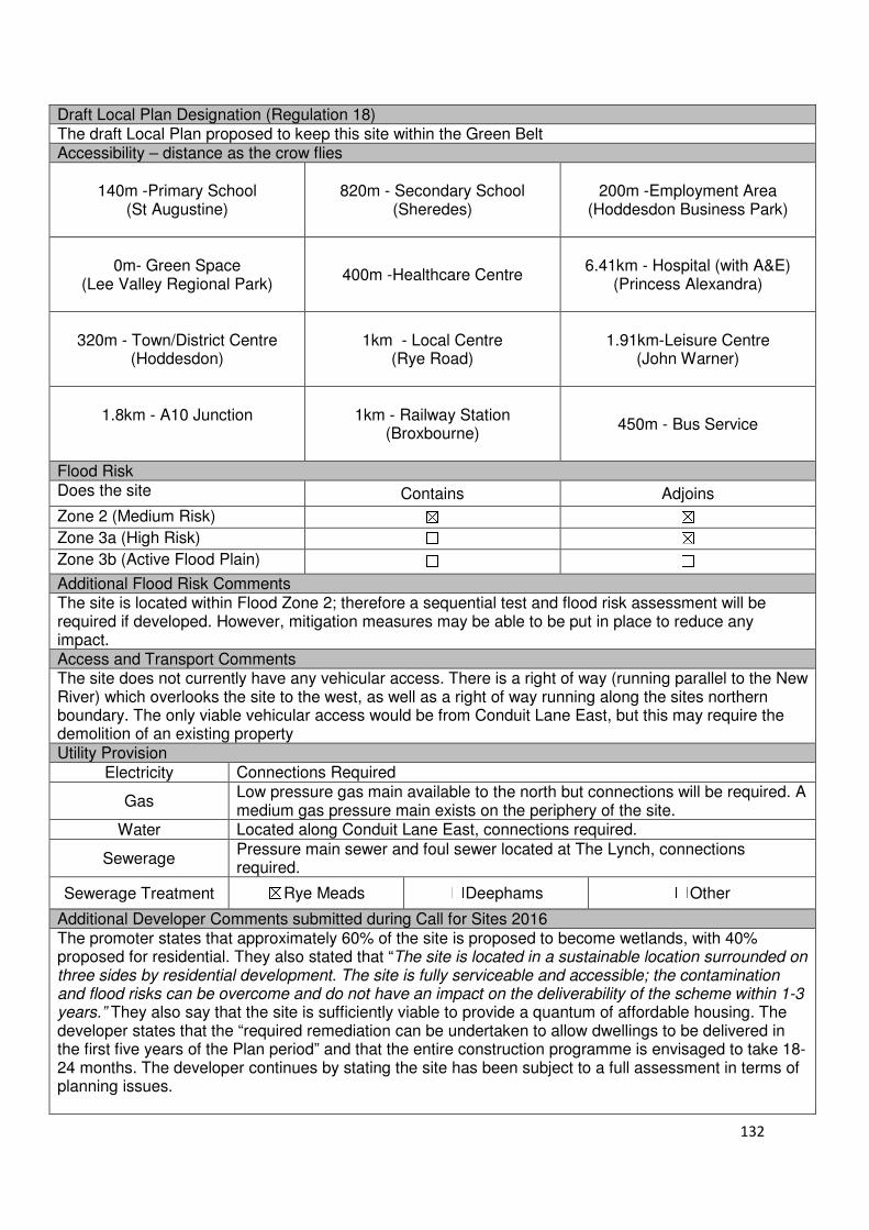
132
Draft Local Plan Designation (Regulation 18) The draft Local Plan proposed to keep this site within the Green Belt Accessibility – distance as the crow flies
140m -Primary School
(St Augustine)
820m - Secondary School
(Sheredes)
200m -Employment Area
(Hoddesdon Business Park)
0m- Green Space (Lee Valley Regional Park)
400m -Healthcare Centre
6.41km - Hospital (with A&E)
(Princess Alexandra)
320m - Town/District Centre
(Hoddesdon)
1km - Local Centre
(Rye Road)
1.91km-Leisure Centre (John Warner)
1.8km - A10 Junction
1km - Railway Station
(Broxbourne)
450m - Bus Service
Flood Risk Does the site Contains Adjoins
Zone 2 (Medium Risk) ☒ ☒
Zone 3a (High Risk) ☐ ☒
Zone 3b (Active Flood Plain) ☐ ☐
Additional Flood Risk Comments The site is located within Flood Zone 2; therefore a sequential test and flood risk assessment will be required if developed. However, mitigation measures may be able to be put in place to reduce any impact. Access and Transport Comments The site does not currently have any vehicular access. There is a right of way (running parallel to the New River) which overlooks the site to the west, as well as a right of way running along the sites northern boundary. The only viable vehicular access would be from Conduit Lane East, but this may require the demolition of an existing property Utility Provision
Electricity Connections Required
Gas Low pressure gas main available to the north but connections will be required. A medium gas pressure main exists on the periphery of the site.
Water Located along Conduit Lane East, connections required.
Sewerage Pressure main sewer and foul sewer located at The Lynch, connections required.
Sewerage Treatment ☒Rye Meads ☐Deephams ☐Other
Additional Developer Comments submitted during Call for Sites 2016 The promoter states that approximately 60% of the site is proposed to become wetlands, with 40% proposed for residential. They also stated that “The site is located in a sustainable location surrounded on three sides by residential development. The site is fully serviceable and accessible; the contamination and flood risks can be overcome and do not have an impact on the deliverability of the scheme within 1-3 years.” They also say that the site is sufficiently viable to provide a quantum of affordable housing. The developer states that the “required remediation can be undertaken to allow dwellings to be delivered in the first five years of the Plan period” and that the entire construction programme is envisaged to take 18-24 months. The developer continues by stating the site has been subject to a full assessment in terms of planning issues.

133
Suitability Comments
The site is not considered to be in a suitable location for development due to the following reasons:
• The site is included within area E5 identified in the Council’s Green Belt Review (Scott Wilson, 2008). The Review states that area E5 performs strongly against all purposes of the Green Belt and proposed no changes to the boundary as there is no opportunity to provide a stronger boundary.
• The Inspector from the 2005 Local Plan Inquiry stated that “”Any residential development [on this site would breach the primary Green Belt policy objective of retaining openness”.
• A planning application for the development of 42 dwellings on this site was refused for the following reasons: “The proposal constitutes inappropriate development in the Green Belt for which very special circumstances have not been demonstrated. A such the proposal is contrary to Policy GBC2 of the Borough of Broxbourne Local Plan Second Review 2001-2011, emerging Policy GBC1 of the Broxbourne Local Plan 2016-2031 and the provisions of section 9 of the NPPF “Protecting Green Belt Land”, and “The scheme, by reason of its scale and bulk, would have an unacceptable impact on the openness of this Green Belt site contrary to Policy GBC2 of the Borough of Broxbourne Local Plan Second Review 2001-2011, emerging Policy GBC1 of the Broxbourne Local Plan 2016-2031 and the provisions of section 9 of the NPPF “Protecting Green Belt Land”.
• The development of this site will have a detrimental impact on the landscape of this area, particularly the long views into the Lee Valley Regional Park from the New River.
Is the site considered to be suitable for development? ☐☐☐☐Yes ☒☒☒☒ No

134
Local Plan – Site Appraisal Form
Site Information Site Location Map Site Reference Number
HOD-GB-14
Site Name 305 Ware Road Site Area 0.5 hectares
Site Status ☐Urban ☐Green Belt ☒Mixed
Source of Site ☐Call for Sites ☐Planning Application ☒Desktop Study
Site Visit Carried Out
☐Yes ☐No
Site Ownership The site is owned by a public body
Surr
oundin
g
Uses
N Green Belt, Quantum Care Home
E Ware Road, Residential S Green Belt
W Green Belt, Playing Fields of Hailey Hall School
Site Description The site is currently occupied by a number of vacant buildings which were previously a community support unit owned by the NHS. The site is square and relatively flat. There are trees located along the sites northern, southern and western boundary. The site is set back from Ware Road by a wide grass verge. Planning History A planning application for two 5 bed care homes was withdrawn in the early 2000s. Development Proposal
Residential ☒ Commercial ☐ Other ☐
Local Plan 2005 (Policy H11)
15
Submitted Proposal
Site Designations Contains Adjoins Contains Adjoins
Green Belt ☒ ☒ Site of Scientific Interest (SSSI)
☐ ☐
Archaeological Interest ☐ ☒ Ancient Monument ☐ ☐
Local Wildlife Site ☐ ☐ Community Open Space ☐ ☐
Lee Valley Regional Park
☐ ☐ Cheshunt Common ☐ ☐
Listed Building ☐ ☐ Locally Listed Building ☐ ☐
TPO Trees ☐ ☐ Conservation Area ☐ ☐
Air Quality Management Area
☐ ☐ Protected Species ☐ ☐
Draft Local Plan Designation (Regulation 18) The draft Local Plan proposed to keep this site within the Green Belt
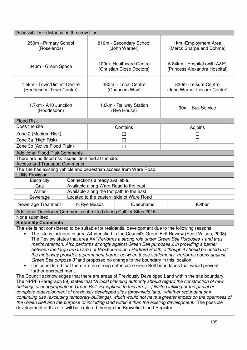
135
Accessibility – distance as the crow flies
250m - Primary School (Roselands)
810m - Secondary School (John Warner)
1km -Employment Area (Merck Sharpe and Dohme)
340m - Green Space 100m -Healthcare Centre (Christian Close Doctors)
6.84km - Hospital (with A&E) (Princess Alexandra Hospital)
1.5km - Town/District Centre (Hoddesdon Town Centre)
380m - Local Centre (Chaucers Way)
830m -Leisure Centre (John Warner Leisure Centre)
1.7km - A10 Junction (Hoddesdon)
1.6km - Railway Station (Rye House)
90m - Bus Service
Flood Risk Does the site Contains Adjoins
Zone 2 (Medium Risk) ☐ ☐
Zone 3a (High Risk) ☐ ☐
Zone 3b (Active Flood Plain) ☐ ☐
Additional Flood Risk Comments There are no flood risk issues identified at the site. Access and Transport Comments The site has existing vehicle and pedestrian access from Ware Road. Utility Provision
Electricity Connections already available.
Gas Available along Ware Road to the east
Water Available along the footpath to the east
Sewerage Located to the eastern side of Ware Road
Sewerage Treatment ☒Rye Meads ☐Deephams ☐Other
Additional Developer Comments submitted during Call for Sites 2016 None submitted. Suitability Comments The site is not considered to be suitable for residential development due to the following reasons:
• The site is included in area A4 identified in the Council’s Green Belt Review (Scott Wilson, 2008). The Review states that area A4 “Performs a strong role under Green Belt Purposes 1 and thus merits retention. Also performs strongly against Green Belt purposes 2 in providing a barrier between the large urban area of Broxbourne and Hertford Heath, although it should be noted that the motorway provides a permanent barrier between these settlements. Performs poorly against Green Belt purpose 3” and proposed no change to the boundary in this location.
• It is considered that there are no strong defensible Green Belt boundaries that would prevent further encroachment.
The Council acknowledges that there are areas of Previously Developed Land within the site boundary. The NPPF (Paragraph 89) states that “A local planning authority should regard the construction of new buildings as inappropriate in Green Belt. Exceptions to this are: […] limited infilling or the partial or complete redevelopment of previously developed sites (brownfield land), whether redundant or in continuing use (excluding temporary buildings), which would not have a greater impact on the openness of the Green Belt and the purpose of including land within it than the existing development.” The possible development of this site will be explored through the Brownfield land Register.

136
Furthermore, it should be noted that the Councils’ Green Belt Topic Paper (2017) stated that: “303/305 Ware Road, Hoddesdon, are empty buildings where regeneration and alternative uses could promote the amenity of local residents through improved vitality and street scene. However, these aspirations are somewhat hampered by their designation as Green Belt. The 2005 Local Plan Inspector drew attention to the possibility of providing a small amount of housing on these sites, which are effectively part of the urban area of Hoddesdon, and suggested that the sites could be looked at through a Green Belt Review. However, the 2008 Green Belt Review by Scott Wilson suggested that both sites performed well against Green Belt Purpose 1 (checking the unrestricted sprawl of built-up areas and thus merits retention. As noted in paragraph 1.27 above, since the Local Plan Inspector’s report, there is now a broader emphasis in national policy than housing needs in meeting ‘exceptional circumstances’ and therefore redevelopment should be pursued as permissible development in the Green Belt rather than through the Local Plan”.
Is the site considered to be suitable for development? ☐☐☐☐Yes ☒☒☒☒ No

137
Local Plan – Site Appraisal Form
Site Information Site Location Map Site Reference Number
HOD-GB-15
Site Name Rosehill Bowls Club Site Area 0.3 hectares
Site Status ☐Urban ☒Green Belt ☐Mixed
Source of Site ☐Call for Sites ☐Planning Application ☒Desktop Study
Site Visit Carried Out
☐Yes ☒No
Site Ownership The site is owned by a developer.
Surr
oundin
g
Uses
N Green Belt
E Residential S Residential
W Green Belt
Site Description The site, which is relatively squared shaped and relatively flat. The site is used as a bowls club. The western portion of the site consists of a bowling green. The eastern portion contains there structures and hardstanding surface which is used as a car park. It is shielded from Lord Street by trees. Planning History An application in 1992 for a storage building and the re-siting of an existing shed was granted approval. In 1994, a single storey side extension to the Club House was granted approval and in 1996, a new pavilion to replace the existing clubhouse was granted approval. Development Proposal
Residential ☒ Commercial ☐ Other ☐
Local Plan 2005 (Policy H11)
9
Submitted Proposal
Site Designations Contains Adjoins Contains Adjoins
Green Belt ☒ ☒ Site of Scientific Interest (SSSI) ☐ ☐
Archaeological Interest ☐ ☐ Ancient Monument ☐ ☐
Local Wildlife Site ☐ ☐ Community Open Space ☐ ☐
Lee Valley Regional Park
☐ ☐ Cheshunt Common ☐ ☐
Listed Building ☐ ☐ Locally Listed Building ☐ ☐
TPO Trees ☒ ☒ Conservation Area ☐ ☐
Air Quality Management Area
☐ ☐ Protected Species ☐ ☐
Draft Local Plan Designation (Regulation 18) The site was designated Open Space, Leisure, Sport and Recreation in the draft Local Plan
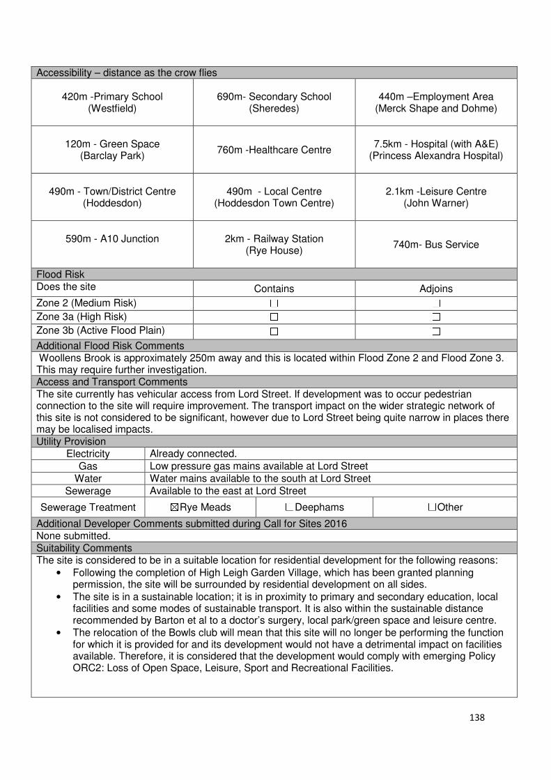
138
Accessibility – distance as the crow flies
420m -Primary School (Westfield)
690m- Secondary School (Sheredes)
440m –Employment Area
(Merck Shape and Dohme)
120m - Green Space (Barclay Park)
760m -Healthcare Centre
7.5km - Hospital (with A&E)
(Princess Alexandra Hospital)
490m - Town/District Centre
(Hoddesdon)
490m - Local Centre
(Hoddesdon Town Centre)
2.1km -Leisure Centre
(John Warner)
590m - A10 Junction
2km - Railway Station
(Rye House)
740m- Bus Service
Flood Risk Does the site Contains Adjoins
Zone 2 (Medium Risk) ☐ ☐
Zone 3a (High Risk) ☐ ☐
Zone 3b (Active Flood Plain) ☐ ☐
Additional Flood Risk Comments Woollens Brook is approximately 250m away and this is located within Flood Zone 2 and Flood Zone 3. This may require further investigation. Access and Transport Comments The site currently has vehicular access from Lord Street. If development was to occur pedestrian connection to the site will require improvement. The transport impact on the wider strategic network of this site is not considered to be significant, however due to Lord Street being quite narrow in places there may be localised impacts. Utility Provision
Electricity Already connected.
Gas Low pressure gas mains available at Lord Street
Water Water mains available to the south at Lord Street
Sewerage Available to the east at Lord Street
Sewerage Treatment ☒Rye Meads ☐Deephams ☐Other
Additional Developer Comments submitted during Call for Sites 2016 None submitted. Suitability Comments The site is considered to be in a suitable location for residential development for the following reasons:
• Following the completion of High Leigh Garden Village, which has been granted planning permission, the site will be surrounded by residential development on all sides.
• The site is in a sustainable location; it is in proximity to primary and secondary education, local facilities and some modes of sustainable transport. It is also within the sustainable distance recommended by Barton et al to a doctor’s surgery, local park/green space and leisure centre.
• The relocation of the Bowls club will mean that this site will no longer be performing the function for which it is provided for and its development would not have a detrimental impact on facilities available. Therefore, it is considered that the development would comply with emerging Policy ORC2: Loss of Open Space, Leisure, Sport and Recreational Facilities.
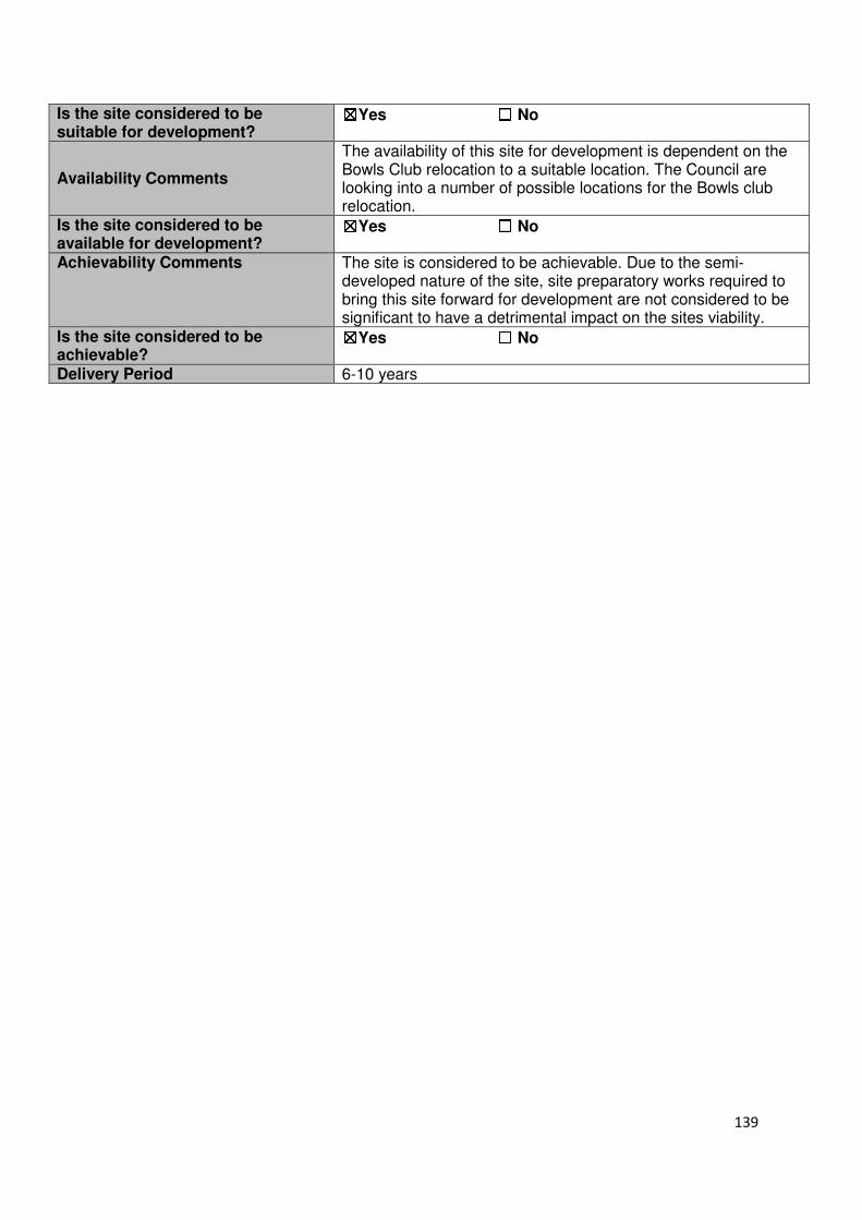
139
Is the site considered to be suitable for development?
☒☒☒☒Yes ☐☐☐☐ No
Availability Comments
The availability of this site for development is dependent on the Bowls Club relocation to a suitable location. The Council are looking into a number of possible locations for the Bowls club relocation.
Is the site considered to be available for development?
☒☒☒☒Yes ☐☐☐☐ No
Achievability Comments The site is considered to be achievable. Due to the semi-developed nature of the site, site preparatory works required to bring this site forward for development are not considered to be significant to have a detrimental impact on the sites viability.
Is the site considered to be achievable?
☒☒☒☒Yes ☐☐☐☐ No
Delivery Period 6-10 years

140
Local Plan – Site Appraisal Form
Site Information Site Location Map Site Reference Number
HOD-GB-17
Site Name Land to the west of the A10 at Hoddesdon
Site Area 38.7 hectares
Site Status ☐Urban ☒Green Belt ☐Mixed
Source of Site ☒Call for Sites ☐Planning Application ☐Desktop Study
Site Visit Carried Out
☐Yes ☒No
Site Ownership The site is in single ownership
Surr
oundin
g
Uses
N Hertford Road, Green Belt
E A10 S Green Belt, Spital
Brook W Box Wood Hoddesdon,
Green Belt Site Description The site is irregular in shape. The site consists of open fields that have trees/hedges around the boundaries and high density woodland. The woodland area within the red line has varying topographical levels. However, in general there is a gentle slope in a south easterly direction towards the A10. Planning History No planning history of note. Development Proposal
Residential ☐ Commercial ☐ Other ☐
Local Plan 2005 (Policy H11)
-
Submitted Proposal -
Site Designations Contains Adjoins Contains Adjoins
Green Belt ☒ ☒ Site of Scientific Interest (SSSI) ☐ ☒
Archaeological Interest ☐ ☐ Ancient Monument ☐ ☐
Local Wildlife Site ☒ ☒ Community Open Space ☐ ☐
Lee Valley Regional Park
☐ ☐ Cheshunt Common ☐ ☐
Listed Building ☐ ☐ Locally Listed Building ☐ ☐
TPO Trees ☒ ☒ Conservation Area ☐ ☐
Air Quality Management Area
☐ ☐ Protected Species ☐ ☐
Draft Local Plan Designation (Regulation 18) The draft Local Plan proposed to keep this site within the Green Belt.
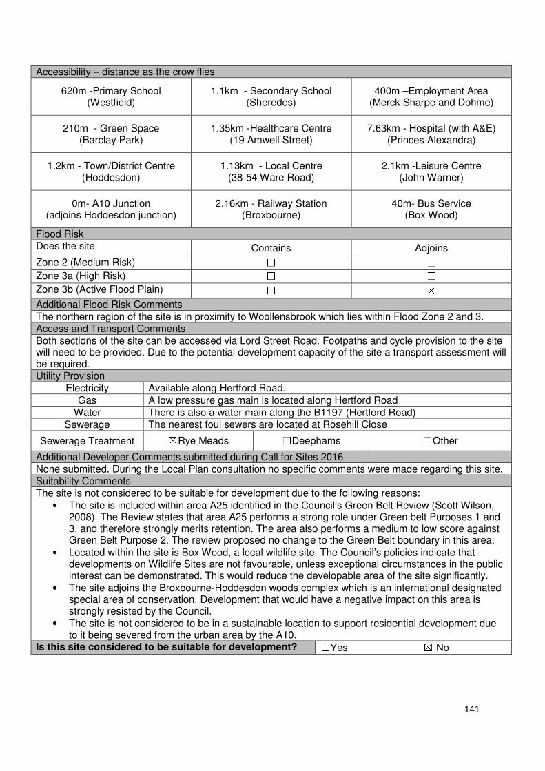
141
Accessibility – distance as the crow flies
620m -Primary School (Westfield)
1.1km - Secondary School (Sheredes)
400m –Employment Area (Merck Sharpe and Dohme)
210m - Green Space (Barclay Park)
1.35km -Healthcare Centre (19 Amwell Street)
7.63km - Hospital (with A&E) (Princes Alexandra)
1.2km - Town/District Centre (Hoddesdon)
1.13km - Local Centre (38-54 Ware Road)
2.1km -Leisure Centre (John Warner)
0m- A10 Junction (adjoins Hoddesdon junction)
2.16km - Railway Station (Broxbourne)
40m- Bus Service (Box Wood)
Flood Risk Does the site Contains Adjoins
Zone 2 (Medium Risk) ☐ ☐
Zone 3a (High Risk) ☐ ☐
Zone 3b (Active Flood Plain) ☐ ☒
Additional Flood Risk Comments The northern region of the site is in proximity to Woollensbrook which lies within Flood Zone 2 and 3. Access and Transport Comments Both sections of the site can be accessed via Lord Street Road. Footpaths and cycle provision to the site will need to be provided. Due to the potential development capacity of the site a transport assessment will be required. Utility Provision
Electricity Available along Hertford Road.
Gas A low pressure gas main is located along Hertford Road
Water There is also a water main along the B1197 (Hertford Road) Sewerage The nearest foul sewers are located at Rosehill Close
Sewerage Treatment ☒Rye Meads ☐Deephams ☐Other
Additional Developer Comments submitted during Call for Sites 2016 None submitted. During the Local Plan consultation no specific comments were made regarding this site. Suitability Comments The site is not considered to be suitable for development due to the following reasons:
• The site is included within area A25 identified in the Council’s Green Belt Review (Scott Wilson, 2008). The Review states that area A25 performs a strong role under Green belt Purposes 1 and 3, and therefore strongly merits retention. The area also performs a medium to low score against Green Belt Purpose 2. The review proposed no change to the Green Belt boundary in this area.
• Located within the site is Box Wood, a local wildlife site. The Council’s policies indicate that developments on Wildlife Sites are not favourable, unless exceptional circumstances in the public interest can be demonstrated. This would reduce the developable area of the site significantly.
• The site adjoins the Broxbourne-Hoddesdon woods complex which is an international designated special area of conservation. Development that would have a negative impact on this area is strongly resisted by the Council.
• The site is not considered to be in a sustainable location to support residential development due to it being severed from the urban area by the A10.
Is this site considered to be suitable for development? ☐Yes ☒ No
142
Broxbourne, Wormley and Turnford
Urban Sites
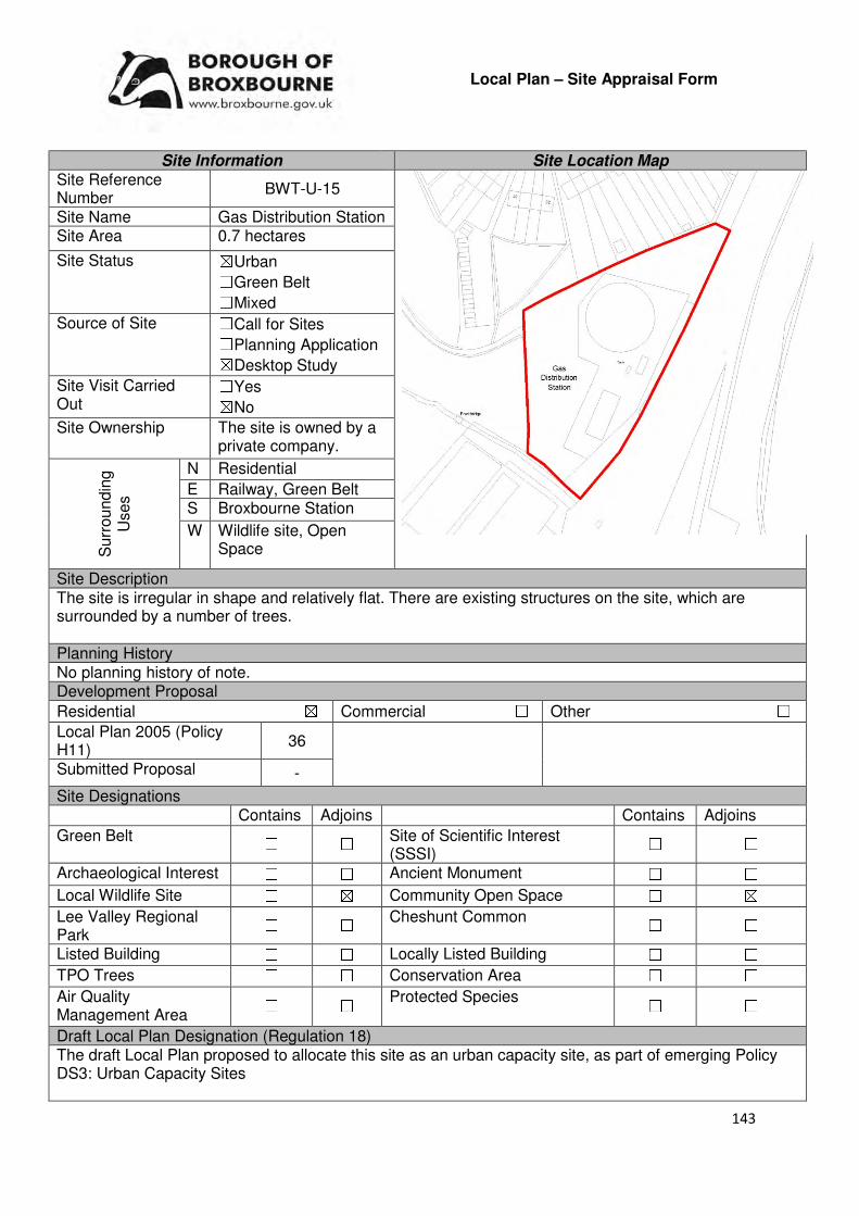
143
Local Plan – Site Appraisal Form
Site Information Site Location Map Site Reference Number
BWT-U-15
Site Name Gas Distribution Station Site Area 0.7 hectares
Site Status ☒Urban ☐Green Belt ☐Mixed
Source of Site ☐Call for Sites ☐Planning Application ☒Desktop Study
Site Visit Carried Out
☐Yes ☒No
Site Ownership The site is owned by a private company.
Surr
oundin
g
Uses
N Residential
E Railway, Green Belt S Broxbourne Station
W Wildlife site, Open Space
Site Description The site is irregular in shape and relatively flat. There are existing structures on the site, which are surrounded by a number of trees. Planning History No planning history of note. Development Proposal
Residential ☒ Commercial ☐ Other ☐
Local Plan 2005 (Policy H11)
36
Submitted Proposal -
Site Designations Contains Adjoins Contains Adjoins
Green Belt ☐ ☐ Site of Scientific Interest (SSSI)
☐ ☐
Archaeological Interest ☐ ☐ Ancient Monument ☐ ☐
Local Wildlife Site ☐ ☒ Community Open Space ☐ ☒
Lee Valley Regional Park
☐ ☐ Cheshunt Common ☐ ☐
Listed Building ☐ ☐ Locally Listed Building ☐ ☐
TPO Trees ☐ ☐ Conservation Area ☐ ☐
Air Quality Management Area
☐ ☐ Protected Species ☐ ☐
Draft Local Plan Designation (Regulation 18) The draft Local Plan proposed to allocate this site as an urban capacity site, as part of emerging Policy DS3: Urban Capacity Sites

144
Accessibility – distance as the crow flies
290m -Primary School (St Cross)
650m - Secondary School (Sheredes)
860m –Employment Area (Hoddesdon Business Park)
0m - Green Space (Adjoins the Meadway)
900m -Healthcare Centre
6.81km - Hospital (with A&E)
(Princess Alexandra)
860m- Town/District Centre (Hoddesdon Town Centre)
600m - Local Centre (23-25 High Road)
2.78km -Leisure Centre
(John Warner)
2.1km - A10 Junction (Hoddesdon)
300m- Railway Station (Broxbourne Station)
400m - Bus Service (Broxbourne Station)
Flood Risk Does the site Contains Adjoins
Zone 2 (Medium Risk) ☒ ☒
Zone 3a (High Risk) ☒ ☒
Zone 3b (Active Flood Plain) ☐ ☐
Additional Flood Risk Comments Due to Spital Brook running within close proximity to the sites southern border, it is located partially within Flood Zone 2 and 3a. A flood risk assessment should accompany any application for the development of this site and appropriate flood mitigation measures implemented. Access and Transport Comments The site can be accessed from a track located at Admirals Walk. This access will require improving if development comes forward on the site. There is no pedestrian access to the site. There are footpaths on both sides of Admirals Walk. Connections to these footpaths will be required. Utility Provision
Electricity Connections will be required
Gas A low pressure gas main and main pressure gas main is located within the site boundaries.
Water A water mains is located at Mead Way, to the north of the site
Sewerage A foul sewer and surface sewer are located at Mead Way, to the north of the site
Sewerage Treatment ☐Rye Meads ☒Deephams ☐Other
Additional Developer Comments submitted as part of Call for Sites 2016 None submitted. Suitability Comments The site is considered to be suitable for development due to the following reasons:
• The site is previously developed land located within an existing settlement boundary. The use of previously developed land is one of the twelve core land-use planning principles that under plan-making and decision making.
• The site adjoins a built up residential area, therefore its development for this use would be in keeping with the context.
• The site is considered to be in a sustainable location; it is close to primary and secondary education, local facilities and modes of sustainable transport. It is also within the sustainable distance recommended by Barton et al (2010) to a doctor’s surgery, leisure centre and local park/green space.
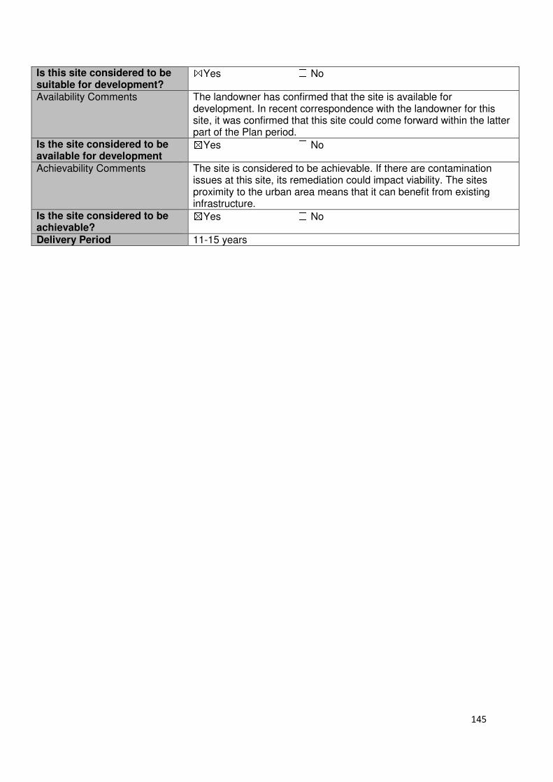
145
Is this site considered to be suitable for development?
☒Yes ☐ No
Availability Comments The landowner has confirmed that the site is available for development. In recent correspondence with the landowner for this site, it was confirmed that this site could come forward within the latter part of the Plan period.
Is the site considered to be available for development
☒Yes ☐ No Achievability Comments The site is considered to be achievable. If there are contamination
issues at this site, its remediation could impact viability. The sites proximity to the urban area means that it can benefit from existing infrastructure.
Is the site considered to be achievable?
☒Yes ☐ No Delivery Period 11-15 years
146
Broxbourne, Wormley and Turnford
Green Belt Sites

147
Local Plan – Site Appraisal Form
Site Information Site Location Map Site Reference Number
BWT-GB-01
Site Name Disused quarry site at Church Lane
Site Area 4.56 hectares
Site Status ☐Urban ☒Green Belt ☐Mixed
Source of Site ☒Call for Sites ☐Planning Application ☐Desktop Study
Site Visit Carried Out
☐Yes ☒No
Site Ownership The land is in single ownership
Surr
oundin
g
Uses
N Green Belt
E Green Belt, Wormleybury Historic Park and Garden
S Green Belt , Wormleybury Historic Park and Garden
W Green Belt, Residential dwellings
Site Description The site is not particular flat or regular in shape. The site is greenfield in nature. A number of trees and scrub can be found throughout the site. A single structure is located in the south western corner of the site, just to the east of a cluster of trees. There are trees located along the sites borders
Planning History In 1971 permission was refused for a garden centre and caretaker’s bungalow. In 1986 the restoration of the gravel pit with the construction of an earth embankment and use of soil for manufacture and processing was refused.
Development Proposal
Residential ☒ Commercial ☐ Other ☒
Local Plan 2005 (Policy H11)
-
Submitted Proposal
120 (however, second promotion suggested larger detached dwellings)
Site Designations Contains Adjoins Contains Adjoins
Green Belt ☒ ☒ Site of Scientific Interest (SSSI) ☐ ☐
Archaeological Interest ☐ ☒ Ancient Monument ☐ ☐
Local Wildlife Site ☐ ☐ Community Open Space ☐ ☐
Lee Valley Regional Park
☐ ☐ Cheshunt Common ☐ ☐
Listed Building ☐ ☐ Locally Listed Building ☐ ☐
TPO Trees ☐ ☐ Conservation Area ☐ ☐
Air Quality Management Area
☐ ☐ Protected Species ☐ ☐
Gypsy/Travellers
use
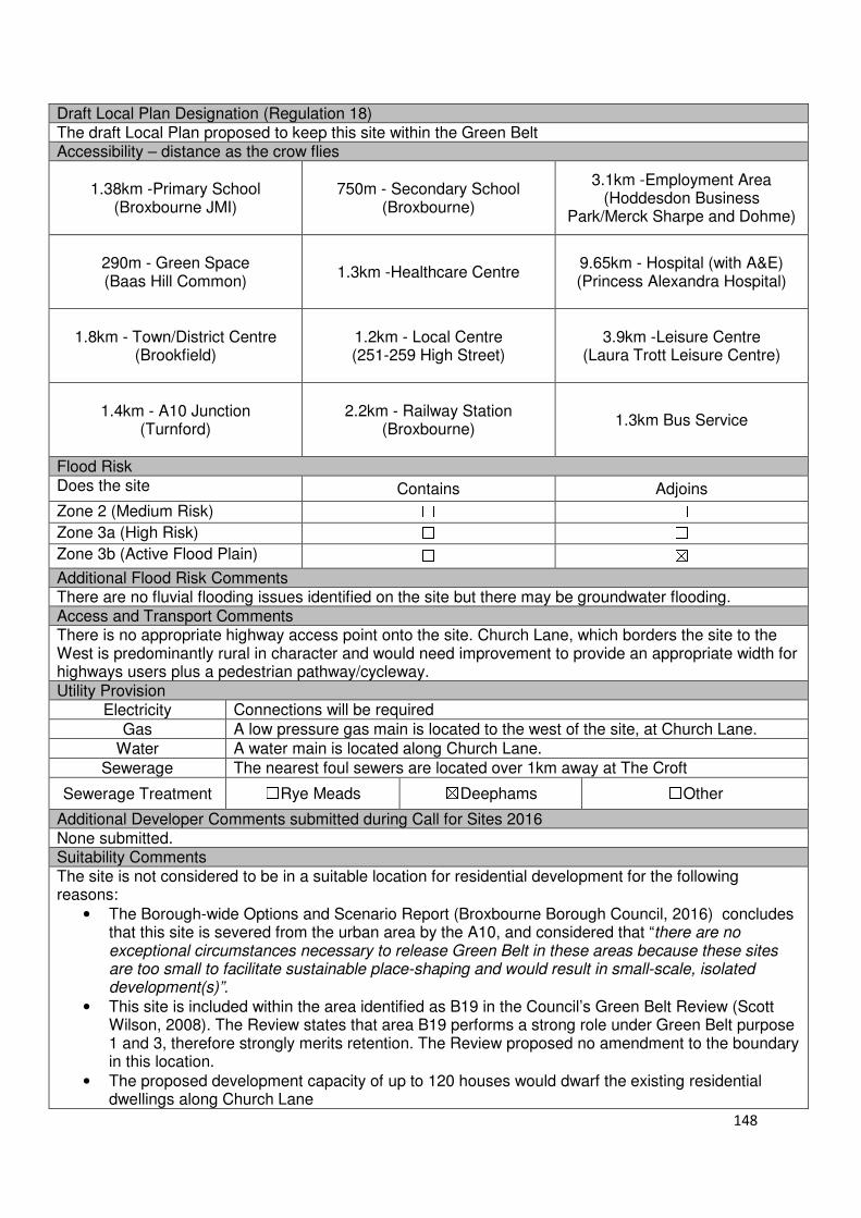
148
Draft Local Plan Designation (Regulation 18) The draft Local Plan proposed to keep this site within the Green Belt Accessibility – distance as the crow flies
1.38km -Primary School
(Broxbourne JMI)
750m - Secondary School (Broxbourne)
3.1km -Employment Area (Hoddesdon Business
Park/Merck Sharpe and Dohme)
290m - Green Space (Baas Hill Common)
1.3km -Healthcare Centre
9.65km - Hospital (with A&E) (Princess Alexandra Hospital)
1.8km - Town/District Centre (Brookfield)
1.2km - Local Centre (251-259 High Street)
3.9km -Leisure Centre (Laura Trott Leisure Centre)
1.4km - A10 Junction
(Turnford)
2.2km - Railway Station
(Broxbourne)
1.3km Bus Service
Flood Risk Does the site Contains Adjoins
Zone 2 (Medium Risk) ☐ ☐
Zone 3a (High Risk) ☐ ☐
Zone 3b (Active Flood Plain) ☐ ☒
Additional Flood Risk Comments There are no fluvial flooding issues identified on the site but there may be groundwater flooding. Access and Transport Comments There is no appropriate highway access point onto the site. Church Lane, which borders the site to the West is predominantly rural in character and would need improvement to provide an appropriate width for highways users plus a pedestrian pathway/cycleway. Utility Provision
Electricity Connections will be required
Gas A low pressure gas main is located to the west of the site, at Church Lane.
Water A water main is located along Church Lane.
Sewerage The nearest foul sewers are located over 1km away at The Croft
Sewerage Treatment ☐Rye Meads ☒Deephams ☐Other
Additional Developer Comments submitted during Call for Sites 2016 None submitted. Suitability Comments The site is not considered to be in a suitable location for residential development for the following reasons:
• The Borough-wide Options and Scenario Report (Broxbourne Borough Council, 2016) concludes that this site is severed from the urban area by the A10, and considered that “there are no exceptional circumstances necessary to release Green Belt in these areas because these sites are too small to facilitate sustainable place-shaping and would result in small-scale, isolated development(s)”.
• This site is included within the area identified as B19 in the Council’s Green Belt Review (Scott Wilson, 2008). The Review states that area B19 performs a strong role under Green Belt purpose 1 and 3, therefore strongly merits retention. The Review proposed no amendment to the boundary in this location.
• The proposed development capacity of up to 120 houses would dwarf the existing residential dwellings along Church Lane

149
• The sites rural location and severance from the urban area means that it is not in close proximity to modes of sustainable transport, Therefore development at this site would be car dependent. Church Lane would be significantly impacted by a high volume of cars.
• The site is located next to Wormleybury Registered Historic Park. It is considered that the development of this site would have a detrimental impact on the Parks character and historical significance.
• The site is not considered to be in a suitable and sustainable location for residential development – its rural location means that it is not close to local facilities. It is also not within the sustainable distance recommended by Barton et al (2010) for a leisure centre, doctor’s surgery and hospital.
As stated in ‘Planning Policy for Traveller Sites’ (DCLG, 2015) “Local planning authorities should ensure that traveller sites are sustainable economically, socially and environmentally”. Due to this sites isolated location within the borough, it is considered that it will not be sustainable economically, socially or environmentally for gypsy and traveller use. Is the site considered to be suitable? ☐Yes ☒No

150
Local Plan – Site Appraisal Form
Site Information Site Location Map Site Reference Number
BWT-GB-02
Site Name Derwent Turnford Site Area 5.06 hectares
Site Status ☐Urban ☒Green Belt ☐Mixed
Source of Site ☒Call for Sites ☐Planning Application ☐Desktop Study
Site Visit Carried Out
☒Yes ☐No
Site Ownership The site is owned by a private company.
Surr
oundin
g
Uses
N Green Belt, Local Wildlife Site
E New River, Urban Area S Turnford Link Road
W A10
Site Description The teardrop shaped site, is relatively flat, however there are small variations in ground level. Along the southern, western and northern boundary of the site are trees; however there is a gap along the western boundary which provides a view to the A10. South eastern corner is lower than the New River to the east of the site; however appears to level off by the north eastern corner. Within the south western portion of the site is a cluster of trees Planning History No planning history of note. Development Proposal
Residential ☒ Commercial ☐ Other ☒
Local Plan 2005 (Policy H11) - Playing Fields/Access Road
Submitted Proposal 300
Site Designations Contains Adjoins Contains Adjoins
Green Belt ☒ ☒ Site of Scientific Interest (SSSI) ☐ ☐
Archaeological Interest ☐ ☐ Ancient Monument ☐ ☐
Local Wildlife Site ☐ ☒ Community Open Space ☐ ☐
Lee Valley Regional Park
☐ ☐ Cheshunt Common ☐ ☐
Listed Building ☐ ☐ Locally Listed Building ☐ ☐
TPO Trees ☐ ☒ Conservation Area ☐ ☐
Air Quality Management Area ☐ ☐
Protected Species ☐ ☐
Draft Local Plan Designation (Regulation 18) The draft Local Plan proposed to keep this site within the Green Belt.
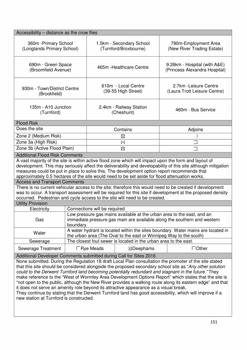
151
Accessibility – distance as the crow flies
360m -Primary School (Longlands Primary School)
1.5km - Secondary School
(Turnford/Broxbourne)
790m-Employment Area
(New River Trading Estate)
690m - Green Space (Broomfield Avenue)
465m -Healthcare Centre
9.26km - Hospital (with A&E) (Princess Alexandra Hospital)
930m - Town/District Centre
(Brookfield)
610m - Local Centre (39-55 High Street)
2.7km -Leisure Centre
(Laura Trott Leisure Centre)
135m - A10 Junction
(Turnford)
2.4km - Railway Station
(Cheshunt)
460m - Bus Service
Flood Risk Does the site Contains Adjoins
Zone 2 (Medium Risk) ☒ ☐
Zone 3a (High Risk) ☒ ☐
Zone 3b (Active Flood Plain) ☒ ☐
Additional Flood Risk Comments A vast majority of the site is within active flood zone which will impact upon the form and layout of development. This may seriously affect the deliverability and developability of this site although mitigation measures could be put in place to solve this. The development option report recommends that approximately 0.5 hectares of the site would need to be set aside for flood attenuation works. Access and Transport Comments There is no current vehicular access to the site; therefore this would need to be created if development was to occur. A transport assessment will be required for this site if development at the proposed density occurred. Pedestrian and cycle access to the site will need to be created. Utility Provision
Electricity Connections will be required
Gas Low pressure gas mains available at the urban area to the east, and an immediate pressure gas main are available along the southern and western boundary.
Water A water hydrant is located within the sites boundary. Water mains are located in the urban area (The Oval to the east or Winnipeg Way to the south)
Sewerage The closest foul sewer is located in the urban area to the east.
Sewerage Treatment ☐Rye Meads ☒Deephams ☐Other
Additional Developer Comments submitted during Call for Sites 2016 None submitted. During the Regulation 18 draft Local Plan consultation the promoter of the site stated that this site should be considered alongside the proposed secondary school site as “Any other solution could to the Derwent Turnford land becoming potentially redundant and stagnant in the future.” They make reference to the “West of Wormley Area Development Options Report” which states that the site is “not open to the public, although the New River provides a walking route along its eastern edge” and that it does not serve an amenity role beyond its attractive appearance as a visual break. They continue by stating that the Derwent Turnford land has good accessibility, which will improve if a new station at Turnford is constructed.

152
Suitability Comments The site is not considered to be suitable for residential development due to the following reasons:
• The Council’s Green Belt Review (Scott Wilson, 2008) states that this area (B8) performs a strong role under Green Belt purposes 1 and 3, therefore merits retention. No change to the Green Belt boundary in this area was proposed.
• The Metropolitan Green Belt Review (Prospect Planning, 2008) states that “Land located between the edge of existing built up area and the A10 on the western edge of Broxbourne and Wormley, between Baas Lane/Bell Lane to the north and the A10 slip road to the south, is predominantly open and rural in character. Hence it fulfils and important Green Belt function of checking the unrestricted sprawl of Broxbourne and Wormley, which is already part of a long urban corridor which runs through the length of the Borough, as well as assisting in safeguarding the countryside from encroachment”.
• The Council’s ‘West of Wormley Area Development Options Report’ concluded that the option which would have the least impact on the existing landscape is the ‘Secondary School Option’. This site was not included within this option.
• The proposal to develop 300 dwellings would be a significant overdevelopment of this site. This would have a detrimental impact on the sense of openness within this part of the Green Belt.
• A significant proportion of the site lies within Flood Zone 3. The ‘Flood Risk Exception Test Report (April 2017) states that for this site “The Council does not consider that there are wider sustainability benefits to the community that outweigh the flood hazard at this site for residential use. The site is small and the flood zones cover approximately two-thirds of the site. No safe access to the site can be identified. There are number of other sites more suitable for residential development from a flood hazard perspective”.
Hertfordshire County Council’s highway consultants have undertaken high-level work which indicates that a southern access to the proposed reserve secondary school site to the north at Church Lane, Wormley (ref BWT-GB-06) is technically feasible from the A10 spur to the south, and could supplement the northern access to the site from Church Lane. This access would require bridging of the floodplain and usage of third part land (i.e. the Derwent Land). The landowners have indicated their desire to work with the Council to enable the delivery of the school. As mentioned above, a significant proportion of the site lies within flood zone 3. However, the Council’s ‘Flood Risk Exception Test Report’ (April 2017) states that there “are wider sustainability benefits to the community for using this site as access to the school site that outweigh flood hazard. An elevated structure such as bridge is likely to be required in order to be able to access the school site, and the Council is confident that the site can be developed for use in a safe manner. It is possible that the school may require an alternative access in a flood situation.” As set out in the Green Belt topic paper, it is considered that provision of the school, including the necessary access arrangements, could constitute the very special circumstances necessary for the construction of the southern access road in the Green Belt. Is the site considered to be suitable for development?
☒☒☒☒Yes ☐☐☐☐ No
Availability Comments As stated above, the landowners have indicated their desire to work with the Council to enable the delivery of the school.
Is the site considered to be available for development
☒Yes ☐ No Achievability Comments As stated above, technical studies show that the creation of
a southern access to the proposed reserve secondary school on this site is technically feasible.
Is the site considered to be achievable?
☒Yes ☐ No Delivery Period 11-15 years

153
Local Plan – Site Appraisal Form
Site Information Site Location Map Site Reference Number
BWT-GB-03
Site Name Brookfield Riverside Site Area 20 hectares
Site Status ☐Urban ☐Green Belt ☒Mixed
Source of Site ☐Call for Sites ☐Planning Application ☒Desktop Study
Site Visit Carried Out
☒Yes ☐No
Site Ownership There are various landowners for this site.
Surr
oun
din
g
Uses
N Green Belt
E A10, Residential S Brookfield Retail Park
W Green Belt
Site Description The site is irregular in shape with no major topographical issues. Contained within the southern region of the site is the New River Trading Estate, allotments and a traveller site. Halfhide Lane separates the New River Trading Estate from the allotments and the traveller site. The traveller and the allotment site are separated by a line of trees. The remainder of the site is greenfield in nature, of which the majority is open field. This area of the site is separated from the built up area by a tree boundary. Located within the north-eastern region of the site is a significant cluster of trees. Along a significant part of the sites boundaries are a number of trees. Planning History The site was promoted and identified as a strategic site for retail, leisure and residential uses in the Council’s submission Core Strategy. This was not supported by the Planning Inspectorate and subsequently the Core Strategy was not found sound without its removal from the document. This application was the renewal of a previous application that was granted planning permission in 2011. In 2013, outline permission was granted for the construction of a link road from Halfhide Lane to the A10 Interchange.
Development Proposal
Residential ☒ Commercial ☒ Other ☒
Local Plan 2005 (Policy H11)
10,00 sqm of leisure floorspace and a civic centre
Submitted Proposal 250
Site Designations Contains Adjoins Contains Adjoins
Green Belt ☒ ☒ Site of Scientific Interest (SSSI) ☐ ☐
Archaeological Interest ☐ ☒ Ancient Monument ☐ ☒
Local Wildlife Site ☒ ☒ Community Open Space ☐ ☒
Lee Valley Regional Park ☐ ☐ Cheshunt Common ☐ ☐
Listed Building ☐ ☐ Locally Listed Building ☐ ☐
TPO Trees ☐ ☒ Conservation Area ☐ ☐
Air Quality Management Area
☐ ☐ Protected Species ☐ ☐
3,500 sqm of retail convenience,
30,000 sqm net retail comparison,
part of a c. 50,000 sqm business
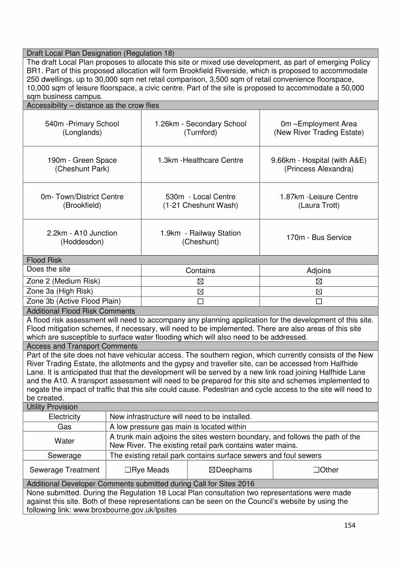
154
Draft Local Plan Designation (Regulation 18) The draft Local Plan proposes to allocate this site or mixed use development, as part of emerging Policy BR1. Part of this proposed allocation will form Brookfield Riverside, which is proposed to accommodate 250 dwellings, up to 30,000 sqm net retail comparison, 3,500 sqm of retail convenience floorspace, 10,000 sqm of leisure floorspace, a civic centre. Part of the site is proposed to accommodate a 50,000 sqm business campus. Accessibility – distance as the crow flies
540m -Primary School
(Longlands)
1.26km - Secondary School (Turnford)
0m –Employment Area (New River Trading Estate)
190m - Green Space (Cheshunt Park)
1.3km -Healthcare Centre
9.66km - Hospital (with A&E)
(Princess Alexandra)
0m- Town/District Centre
(Brookfield)
530m - Local Centre (1-21 Cheshunt Wash)
1.87km -Leisure Centre (Laura Trott)
2.2km - A10 Junction
(Hoddesdon)
1.9km - Railway Station (Cheshunt)
170m - Bus Service
Flood Risk Does the site Contains Adjoins
Zone 2 (Medium Risk) ☒ ☒
Zone 3a (High Risk) ☒ ☒
Zone 3b (Active Flood Plain) ☐ ☐
Additional Flood Risk Comments A flood risk assessment will need to accompany any planning application for the development of this site. Flood mitigation schemes, if necessary, will need to be implemented. There are also areas of this site which are susceptible to surface water flooding which will also need to be addressed. Access and Transport Comments Part of the site does not have vehicular access. The southern region, which currently consists of the New River Trading Estate, the allotments and the gypsy and traveller site, can be accessed from Halfhide Lane. It is anticipated that that the development will be served by a new link road joining Halfhide Lane and the A10. A transport assessment will need to be prepared for this site and schemes implemented to negate the impact of traffic that this site could cause. Pedestrian and cycle access to the site will need to be created. Utility Provision
Electricity New infrastructure will need to be installed.
Gas A low pressure gas main is located within
Water A trunk main adjoins the sites western boundary, and follows the path of the New River. The existing retail park contains water mains.
Sewerage The existing retail park contains surface sewers and foul sewers
Sewerage Treatment ☐Rye Meads ☒Deephams ☐Other
Additional Developer Comments submitted during Call for Sites 2016 None submitted. During the Regulation 18 Local Plan consultation two representations were made against this site. Both of these representations can be seen on the Council’s website by using the following link: www.broxbourne.gov.uk/lpsites
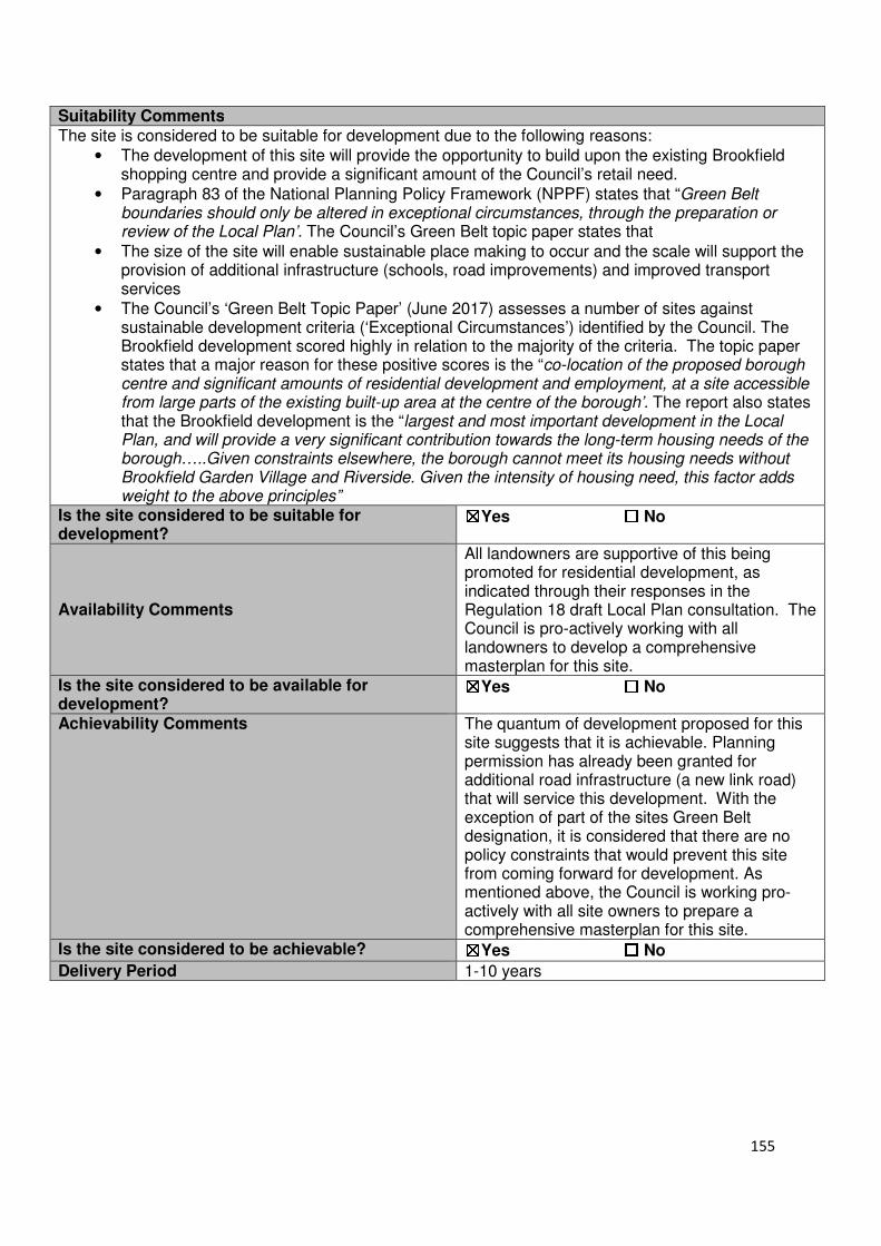
155
Suitability Comments
The site is considered to be suitable for development due to the following reasons:
• The development of this site will provide the opportunity to build upon the existing Brookfield shopping centre and provide a significant amount of the Council’s retail need.
• Paragraph 83 of the National Planning Policy Framework (NPPF) states that “Green Belt boundaries should only be altered in exceptional circumstances, through the preparation or review of the Local Plan’. The Council’s Green Belt topic paper states that
• The size of the site will enable sustainable place making to occur and the scale will support the provision of additional infrastructure (schools, road improvements) and improved transport services
• The Council’s ‘Green Belt Topic Paper’ (June 2017) assesses a number of sites against sustainable development criteria (‘Exceptional Circumstances’) identified by the Council. The Brookfield development scored highly in relation to the majority of the criteria. The topic paper states that a major reason for these positive scores is the “co-location of the proposed borough centre and significant amounts of residential development and employment, at a site accessible from large parts of the existing built-up area at the centre of the borough’. The report also states that the Brookfield development is the “largest and most important development in the Local Plan, and will provide a very significant contribution towards the long-term housing needs of the borough…..Given constraints elsewhere, the borough cannot meet its housing needs without Brookfield Garden Village and Riverside. Given the intensity of housing need, this factor adds weight to the above principles”
Is the site considered to be suitable for development?
☒☒☒☒Yes ☐☐☐☐ No
Availability Comments
All landowners are supportive of this being promoted for residential development, as indicated through their responses in the Regulation 18 draft Local Plan consultation. The Council is pro-actively working with all landowners to develop a comprehensive masterplan for this site.
Is the site considered to be available for development?
☒☒☒☒Yes ☐☐☐☐ No
Achievability Comments The quantum of development proposed for this site suggests that it is achievable. Planning permission has already been granted for additional road infrastructure (a new link road) that will service this development. With the exception of part of the sites Green Belt designation, it is considered that there are no policy constraints that would prevent this site from coming forward for development. As mentioned above, the Council is working pro-actively with all site owners to prepare a comprehensive masterplan for this site.
Is the site considered to be achievable? ☒☒☒☒Yes ☐☐☐☐ No
Delivery Period 1-10 years
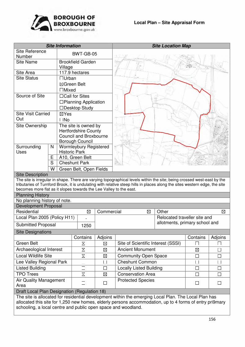
156
Local Plan – Site Appraisal Form
Site Information Site Location Map Site Reference Number
BWT-GB-05
Site Name Brookfield Garden Village
Site Area 117.9 hectares Site Status ☐Urban ☒Green Belt ☐Mixed
Source of Site ☐Call for Sites ☐Planning Application ☐Desktop Study
Site Visit Carried Out
☒Yes ☐No
Site Ownership The site is owned by Hertfordshire County Council and Broxbourne Borough Council
Surrounding Uses
N Wormleybury Registered Historic Park
E A10, Green Belt S Cheshunt Park
W Green Belt, Open Fields Site Description The site is irregular in shape. There are varying topographical levels within the site; being crossed west-east by the tributaries of Turnford Brook, it is undulating with relative steep hills in places along the sites western edge, the site becomes more flat as it slopes towards the Lee Valley to the east.
Planning History No planning history of note. Development Proposal
Residential ☒ Commercial ☒ Other ☒
Local Plan 2005 (Policy H11) - Relocated traveller site and allotments, primary school and Submitted Proposal 1250
Site Designations Contains Adjoins Contains Adjoins
Green Belt ☒ ☒ Site of Scientific Interest (SSSI) ☐ ☐
Archaeological Interest ☒ ☒ Ancient Monument ☒ ☐
Local Wildlife Site ☒ ☒ Community Open Space ☐ ☐
Lee Valley Regional Park ☐ ☐ Cheshunt Common ☐ ☐
Listed Building ☐ ☐ Locally Listed Building ☐ ☐
TPO Trees ☒ ☒ Conservation Area ☐ ☐
Air Quality Management Area
☐ ☐ Protected Species ☐ ☐
Draft Local Plan Designation (Regulation 18) The site is allocated for residential development within the emerging Local Plan. The Local Plan has allocated this site for 1,250 new homes, elderly persons accommodation, up to 4 forms of entry pri9mary schooling, a local centre and public open space and woodland.
157
Accessibility – distance as the crow flies
770m-Primary School (Longlands)
1.3km - Secondary School (Turnford)
1.54km –Employment Area
(Fieldings Road)
0m - Green Space
(adjoins Cheshunt Park)
1km -Healthcare Centre
9.5km - Hospital (with A&E)
(Princess Alexandra)
Brookfield - Town/District Centre
(0m – adjoins)
920m - Local Centre (1-21 Cheshunt Wash)
2.2km -Leisure Centre (Laura Trott)
200m- A10 Junction
(Turnford)
2.26km - Railway Station (Cheshunt)
220m - Bus Service (Brookfield Centre)
Flood Risk Does the site Contains Adjoins
Zone 2 (Medium Risk) ☒ ☒
Zone 3a (High Risk) ☒ ☒
Zone 3b (Active Flood Plain) ☒ ☐
Additional Flood Risk Comments The two tributaries of Turnford Brook and their associated Zone 2 and Zone 3a flood risk areas run east-west through the centre and adjacent to the north of the site, which would necessitate some flood protection measures. There is also a small area of Zone 3B floodplain within the centre of the site and a substantial area of Zone 3B immediately adjacent to the north east of the site as the Turnford Brook approaches and passes underneath the A10. Both of these would need major mitigation work if any development came forward. Access and Transport Comments The most appropriate entrance to the site would be from the A10 junction at Turnford via a new link road. This new link road has been granted planning permission. From this link to a circulatory road would be required to provide access to the proposed residential development. Footpath and cycling infrastructure would be required. As indicated in the previous SLAA, due to the sites proximity to the A10 it is assumed that most vehicles would use this already heavily congested road as a means of access. The impact that the development would have on the wider strategic road network will require further investigation. Due to the scale of development, public transport options will need to be implemented. Utility Provision
Electricity Electricity cables will need to be provided
Gas New gas mains will be required for this site.
Water A trunk main is located behind Brookfield Retail Park and follows the path of the New River
Sewerage Infrastructure will need to be installed.
Sewerage Treatment ☐Rye Meads ☒Deephams ☐Other
Additional Developer Comments submitted during Call for Sites 2016 WYG has prepared a document titled ‘A Vision for Brookfield’, for Broxbourne Borough Council. This
document can be viewed on the following webpage:www.broxbourne.gov.uk/lpsites. The document
outlines initial high level thoughts on the site and begin ton layout what the new Brookfield will look like. This document looks at both Brookfield Riverside and Brookfield Garden Village Suitability Comments The site is considered to be suitable for development due to the following reasons:
• The development of this site will provide the opportunity to build upon the proximity of the existing Brookfield shopping centre
158
• As identified in the Council’s ‘Brookfield Development Options Report’, there are opportunities for create new Green Belt boundaries. To the north of the site is Wormleybury Brook, to the south is the existing edge of Cheshunt Park, to the east is Brookfield Retail Park and A10, and to the west is Park Lane Paradise, however the report state that is “may be possible to create a new structural landscape boundary on the slopes of Doggett Hill”.
• The development of this site will help to support the borough’s housing need over the Local Plan period, and would put less pressure on the release of other Green Belt sites in less sustainable and appropriate location
• The size of the site will enable sustainable place making to occur and the scale will support the provision of additional infrastructure (schools, road improvements) and improved transport services. Paragraph 83 of the NPPF states that “Green Belt boundaries should only be altered in exceptional circumstances, through the preparation or review of the Local Plan”. The Council’s Green Belt topic paper concludes that
• The opportunity to plan a mixed use urban edge development, which builds upon the existing retail centre, would make a significant contribution to place shaping in the borough
• The site is considered to be in a relatively sustainable location; it is in close proximity to educational facilities, some modes of sustainable transport and within the sustainable distance recommended by Barton et al (2010) for facilities and amenities, with the exception of a leisure centre.
• The Council’s ‘Green Belt Topic Paper’ (June 2017) assesses a number of sites against sustainable development criteria (‘Exceptional Circumstances’) identified by the Council. The Brookfield development scored highly in relation to the majority of the criteria. The topic paper states that a major reason for these positive scores is the “co-location of the proposed borough centre and significant amounts of residential development and employment, at a site accessible from large parts of the existing built-up area at the centre of the borough’. The report also states that the Brookfield development is the “largest and most important development in the Local Plan, and will provide a very significant contribution towards the long-term housing needs of the borough…..Given constraints elsewhere, the borough cannot meet its housing needs without Brookfield Garden Village and Riverside. Given the intensity of housing need, this factor adds weight to the above principles”
Is this site considered to be suitable for development?
☒Yes ☐ No
Availability Comments All landowners are supportive of this being promoted for residential development, as indicated through their responses in the Regulation 18 draft Local Plan consultation. The Council is working proactively with all the landowners of this site in regards to bringing it forward for development. Due to the scale of the site, and the need to ensure that s comprehensive masterplan has been devised that is agreed by all landowners, and the need to bring necessary infrastructure to require residential development to bring, it is considered that this site will not come forward until the middle of the Plan period.
Is the site considered to be available for development
☒Yes ☐ No Achievability Comments The quantum of residential development will support the
development of infrastructure required to support the development. The location of a high pressure through the centre of the site will need to be considered. There is developer interest in this site. With the exception of the sites Green Belt designation, it is considered that there are no policy constraints that would prevent this site from coming forward for development.
159
Is the site considered to be achievable?
☒Yes ☐ No Delivery Period 1-15 years
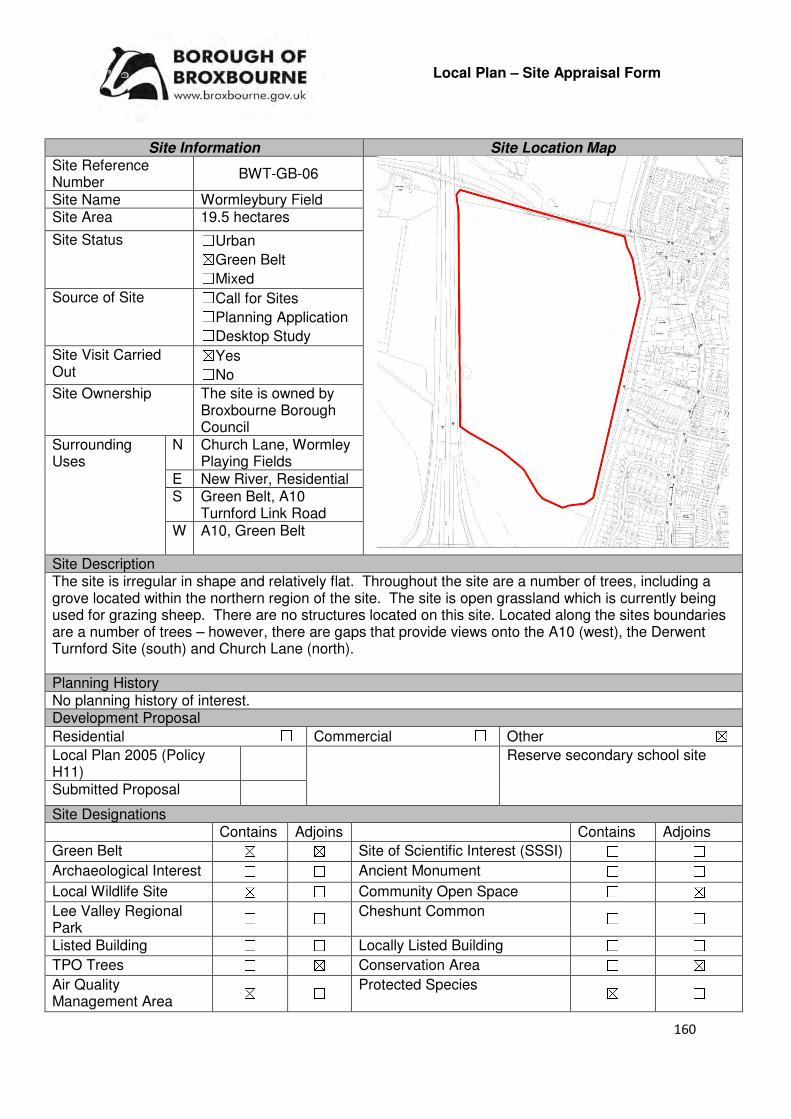
160
Local Plan – Site Appraisal Form
Site Information Site Location Map Site Reference Number
BWT-GB-06
Site Name Wormleybury Field Site Area 19.5 hectares
Site Status ☐Urban ☒Green Belt ☐Mixed
Source of Site ☐Call for Sites ☐Planning Application ☐Desktop Study
Site Visit Carried Out
☒Yes ☐No
Site Ownership The site is owned by Broxbourne Borough Council
Surrounding Uses
N Church Lane, Wormley Playing Fields
E New River, Residential S Green Belt, A10
Turnford Link Road W A10, Green Belt
Site Description The site is irregular in shape and relatively flat. Throughout the site are a number of trees, including a grove located within the northern region of the site. The site is open grassland which is currently being used for grazing sheep. There are no structures located on this site. Located along the sites boundaries are a number of trees – however, there are gaps that provide views onto the A10 (west), the Derwent Turnford Site (south) and Church Lane (north). Planning History No planning history of interest. Development Proposal
Residential ☐ Commercial ☐ Other ☒
Local Plan 2005 (Policy H11)
Reserve secondary school site
Submitted Proposal
Site Designations Contains Adjoins Contains Adjoins
Green Belt ☒ ☒ Site of Scientific Interest (SSSI) ☐ ☐
Archaeological Interest ☐ ☐ Ancient Monument ☐ ☐
Local Wildlife Site ☒ ☐ Community Open Space ☐ ☒
Lee Valley Regional Park
☐ ☐ Cheshunt Common ☐ ☐
Listed Building ☐ ☐ Locally Listed Building ☐ ☐
TPO Trees ☐ ☒ Conservation Area ☐ ☒
Air Quality Management Area
☒ ☐ Protected Species ☒ ☐
161
Draft Local Plan Designation (Regulation 18) The draft Local Plan proposed to allocate this site for a Reserve Secondary School, as part of emerging Policy INF9: Reserve Secondary School Site Accessibility – distance as the crow flies
450m-Primary School (Longlands)
470m - Secondary School (Broxbourne)
1.03km–Employment Area (New River Trading Estate)
0m - Green Space (Wormley Playing Fields)
530m -Healthcare Centre
8.8km - Hospital (with A&E)
(Princess Alexandra)
700m- Town/District Centre (Brookfield)
230m - Local Centre (53-59 High Road)
2.9km-Leisure Centre (Laura Trott)
210m - A10 Junction (Turnford Junction)
2km - Railway Station (Broxbourne)
160m - Bus Service
Flood Risk Does the site Contains Adjoins
Zone 2 (Medium Risk) ☐ ☐
Zone 3a (High Risk) ☐ ☒
Zone 3b (Active Flood Plain) ☐ ☒
Additional Flood Risk Comments The site is not located within a flood risk area, however adjoins one to the south. The site is within a source protection zone. Access and Transport Comments The site benefits from vehicular access from Church Lane, however this would require improvements if development was to occur. Church Lane is a rural road, which is not considered to be appropriate to accommodate the level of traffic associated with a secondary school. There is limited scope to upgrade this road due to its proximity to listed buildings and the impact it could have on the conservation area. An alternative access point could be created from the A10 Link located to the south of the site; however this would require access across privately owned land. Utility Provision
Electricity Located in the main urban area.
Gas There is a low pressure gas main to the north of the site. Along the western perimeter is an intermediate pressure main.
Water A water main is located at Church Lane. A trunk main runs parallel to the eastern boundary of the site.
Sewerage Foul sewers are located within the urban area to the east of the site, the closest starting just outside 24-18 Church Lane
Sewerage Treatment ☐Rye Meads ☒Deephams ☐Other
Additional Developer Comments submitted during Call for Sites 2016 None submitted. Suitability Comments This site is not considered to be suitable for residential development due to the following reasons:
• The Council’s Green Belt Review (Scott Wilson, 2008) stated that this area (B8) performs a strong against Green Belt Purposes 1 and 3, and therefor strongly merits retention. No changes to the boundary in this location were proposed.

162
• The Metropolitan Green Belt Review (Prospect Planning, 2008) states that this area is predominantly open and rural in nature, therefore “fulfils an important Green Belt function of checking the unrestricted outward sprawl of Broxbourne and Wormley” as well as assisting in safeguarding the countryside from encroachment. It recommended that the Green Belt status be confirmed from this site.
• The site is a Local Wildlife Site, referred to as ‘Wormley Parkland East of the A10’. Emerging Policy NEB1: Wildlife, Wildlife Sites and Biodiversity states that “Development on, or which negatively affects, a Local Wildlife Site or Local nature Reserve, as shown on the Policies Map, will not be permitted unless: (a) the local development needs significantly outweigh the nature conservation value of the site; and, (b) the development provides appropriate avoidance/mitigation/compensation measures to offset any detriment to the nature conservation interest on the site.’ It is considered that the development of this site for residential does not fulfil criteria a) and the mitigatory levels required if this site was brought forward are considered to be unachievable in the short term.
Hertfordshire County Council and Broxbourne Borough Council have examined a number of potential secondary school sites. The outcome of this work suggests that taking account of constraints and opportunities, the Church Lane, Wormley site remains the preferred option and other options are less suitable, or are otherwise not deliverable. Hertfordshire County Council commissioned a baseline ecological survey of the Church Lane, Wormley site during 2016. Further to this, working with Herts and Middlesex Wildlife Trust, Broxbourne Borough Council has undertaken further assessment to understand how any ecological impacts could be mitigated by suitable layout and design of the site as well as future management measures. Final conclusions as to the suitability of the site will depend on the outcomes of this work. Is this site considered to be suitable for development?
☒Yes ☐ No
Availability Comments The landowner of the site is supportive of the site coming forward for development as a secondary school site. Within the supporting text of Policy INF11, it is stated that the site is likely to be required in middle of the Plan period.
Is the site considered to be available for development
☒Yes ☐ No Achievability Comments The site is considered to be achievable. Mitigatory measures
to compensate for their detrimental impact on nature conservation interest of the site may affect the sites viability.
Is the site considered to be achievable?
☒Yes ☐ No Delivery Period 11-15 years

163
Local Plan – Site Appraisal Form
Site Information Site Location Map Site Reference Number
BWT-GB-07
Site Name Holy Cross Hill Site Area 2-3 hectares
Site Status ☐Urban ☒Green Belt ☐Mixed
Source of Site ☒Call for Sites ☐Planning Application ☐Desktop Study
Site Visit Carried Out
☐Yes ☒No
Site Ownership There are various landowners for this site.
Surrounding Uses
N Green Belt
E Green Belt S Green Belt
W Green Belt, Holy Cross Hill
Site Description The site contains, and is surrounded by open fields. Contained within the boundary of the site is Hill Cross Farm and an access track. Lines of hedge can be found throughout the site as the run along the boundaries of the different landowners within this area. The site is not particularly flat, as it drops to the north. This is one of a number of sites suggested by a travelling showperson in 2014. Planning History The construction of an agricultural access was granted consent in 2001. Development Proposal
Residential ☐ Commercial ☐ Other ☒
Local Plan 2005 (Policy H11)
Travelling Showpersons Use
Submitted Proposal
Site Designations Contains Adjoins Contains Adjoins
Green Belt ☐ ☐ Site of Scientific Interest (SSSI)
☐ ☐
Archaeological Interest ☐ ☐ Ancient Monument ☐ ☐
Local Wildlife Site ☐ ☐ Community Open Space ☐ ☐
Lee Valley Regional Park
☐ ☐ Cheshunt Common ☐ ☐
Listed Building ☐ ☐ Locally Listed Building ☐ ☐
TPO Trees ☐ ☐ Conservation Area ☐ ☐
Air Quality Management Area
☐ ☐ Protected Species ☐ ☐
Draft Local Plan Designation (Regulation 18) The draft Local Plan proposed to keep this site within the Green Belt.

164
Accessibility – distance as the crow flies
1.73km -Primary School (Flamstead End)
1.8km - Secondary School (Broxbourne School)
3.2km –Employment Area (Fieldings Road)
970m - Green Space (Cheshunt Park)
1.8km -Healthcare Centre (Maples Healthcare Centre)
10.4km- Hospital (with A&E) (Princess Alexandra)
1.5km - Town/District Centre (Brookfield)
1.9km - Local Centre 3.68km -Leisure Centre
(Laura Trott)
1.5km - A10 Junction (Turnford)
3.3km - Railway Station (Broxbourne)
2km - Bus Service
Flood Risk Does the site Contains Adjoins
Zone 2 (Medium Risk) ☐ ☐
Zone 3a (High Risk) ☐ ☐
Zone 3b (Active Flood Plain) ☐ ☒
Additional Flood Risk Comments No flood risk issues have been identified for this site. Access and Transport Comments There is currently an access track from Holy Cross that runs to Holly Cross Hill. This track and its access point from Holy Cross Hill would require improvement if development was to occur. Holy Cross Hill is a semi-rural road that has no footpaths. As a result of this, it is assumed that there will be car reliance to access services and facilities. There are no footpaths or cycle paths at this site. Utility Provision
Electricity New infrastructure will need to be installed
Gas New infrastructure will need to be installed
Water New infrastructure will need to be installed
Sewerage New infrastructure will need to be installed
Sewerage Treatment ☐Rye Meads ☒Deephams ☐Other
Additional Developer Comments from 2016 Call for Sites None submitted. Suitability Comments The site is not considered to be suitable for residential development due to the following reasons:
• The Council’s Green Belt Review (Scott Wilson, 2008) states that this area (B9) performs a strong role under Green Belt Purpose 1 and 3, therefore strongly merits retention. The area achieves a low score against Green Belt Purpose 2. It was not proposed to change to Green Belt boundary in this area.
• The Borough Wide Options and Scenarios Report states that this site is severed from the urban area by the A10 and it is considered that there are no exceptional circumstances that warrant the release of this area from the Green Belt. The report also states that the site is too small to facilitate sustainable place shaping and would result in a small-scale, isolated development.
• The site is not in a sustainable location; its rural location means that it is not in proximity to local or education facilities, modes of sustainable transport and is above the sustainable distance recommended by Barton et al (2010) for a hospital, doctor’s surgery and a leisure centre.
Is this site considered to be suitable for development? ☐Yes ☒ No
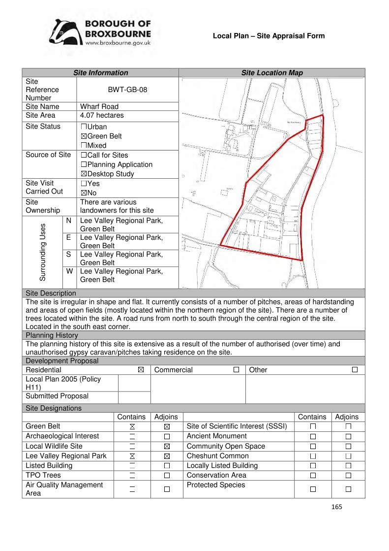
165
Local Plan – Site Appraisal Form
Site Information Site Location Map Site Reference Number
BWT-GB-08
Site Name Wharf Road Site Area 4.07 hectares
Site Status ☐Urban ☒Green Belt ☐Mixed
Source of Site ☐Call for Sites ☐Planning Application ☒Desktop Study
Site Visit Carried Out
☐Yes ☒No
Site Ownership
There are various landowners for this site
Surr
oundin
g U
ses N Lee Valley Regional Park,
Green Belt E Lee Valley Regional Park,
Green Belt S Lee Valley Regional Park,
Green Belt W Lee Valley Regional Park,
Green Belt
Site Description The site is irregular in shape and flat. It currently consists of a number of pitches, areas of hardstanding and areas of open fields (mostly located within the northern region of the site). There are a number of trees located within the site. A road runs from north to south through the central region of the site. Located in the south east corner. Planning History The planning history of this site is extensive as a result of the number of authorised (over time) and unauthorised gypsy caravan/pitches taking residence on the site. Development Proposal
Residential ☒ Commercial ☐ Other ☐
Local Plan 2005 (Policy H11)
Submitted Proposal
Site Designations Contains Adjoins Contains Adjoins
Green Belt ☒ ☒ Site of Scientific Interest (SSSI) ☐ ☐
Archaeological Interest ☐ ☐ Ancient Monument ☐ ☐
Local Wildlife Site ☐ ☒ Community Open Space ☐ ☐
Lee Valley Regional Park ☒ ☒ Cheshunt Common ☐ ☐
Listed Building ☐ ☐ Locally Listed Building ☐ ☐
TPO Trees ☐ ☐ Conservation Area ☐ ☐
Air Quality Management Area
☐ ☐ Protected Species ☐ ☐
166
Draft Local Plan Designation (Regulation 18) The site was proposed to be allocated as a gypsy and traveller site, as part of emerging Policy GT1. Accessibility – distance as the crow flies
390m -Primary School (Wormley)
930m - Secondary School (Broxbourne)
1.6km –Employment Area (New River Trading Estate)
0m - Green Space (within LVRP)
545m -Healthcare Centre (Wormley)
7.96km - Hospital (with A&E) (Princess Alexandra)
1.53km - Town/District Centre (Brookfield)
480m - Local Centre (39-55 High Road)
3.48km -Leisure Centre (Laura Trott)
1.15km - A10 Junction (Turnford)
1.46km - Railway Station (Broxbourne)
555m - Bus Service (Old Star PH)
Flood Risk Does the site Contain Adjoins
Zone 2 (Medium Risk) ☒ ☒
Zone 3a (High Risk) ☒ ☒
Zone 3b (Active Flood Plain) ☐ ☒
Additional Flood Risk Comments Due to the sites location within Flood Zone 2 and Flood Zone 3 a flood risk assessment will need to accompany any application for the development of this site. Flood mitigation measures will need to be implemented. Access and Transport Comments The site benefits from access off of Wharf Road, via a level crossing. As stated in promotional material for Crossrail 2, it will be “impractical” to retain the existing level crossings on the Broxbourne branch as a result of the increased frequency, therefore, it is being sought to remove these crossings to “increase safety, reduce risks to both users and rail passengers and help improve local road connectivity”. Utility Provision
Electricity Located in the main urban area to the west of the site.
Gas The closest low pressure gas main is located to the west of the site, in the main residential area.
Water A water main is located in the main residential area to the west of the site, along Wharf Road.
Sewerage A pressure main is located within the south region of the site. The closest foul sewer and surface sewer are located in the main residential area to the west of the site.
Sewerage Treatment ☐Rye Meads ☒Deephams ☐Other
Additional Developer Comments promoted during the Call for Sites 2016 None submitted. Suitability Comments The site is not considered to be suitable for residential development due to the following reasons:
• As highlighted above, the closure of the Wharf Road crossing would making accessing this impractical for residential development.
167
• The site is included within area E19 or E21 identified in the Council’s Green Belt Review (Scott Wilson, 2008). The Review states that area E19 performs strongly against the Green Belt purposes and that area E21 performs strongly against Green Belt purposes 1 and 2, and plays an average role against purpose 3. The Review proposed no amendment to the boundary in this location.
• The development of this site for residential will create an isolated pocket of development within the Green Belt.
• The site is located within the Lee Valley Regional Park. It is considered that residential development is inconsistent with the Lee Valley Park Objectives included within the Park Development Framework.
However, the site is considered to be suitable for a gypsy site. The draft Local Plan states that “The accommodation needs of the more long standing Wharf Road travelling community are recognised by the Council. However, the situation at Wharf Road has become very complex with substantial sub-letting of caravans to individuals with no long term connection to the borough. The Council is therefore seeking to work with the established community and the Lee Valley Regional Park Authority to create an authorised site at Wharf Road for that community”. The creation of an authorised gypsy and traveller site at Wharf Road is detailed in emerging Policy GT1: Gypsy and Traveller sites. During the Regulation 18 consultation, the Lee Valley Regional Park Authority (LVRPA) formally responded seeking the removal of the prospective Wharf Road gypsy and traveller site allocation. In their response, the LVRPA noted that the allocation would require relocation of plots onto Lee Valley Park land in order to create the proposed integrated serviced site. The LVRPA is opposed to this strategy and consequently considers that the Local Plan proposal is not a viable solution and therefore suggests that it would be “unsound”. A report presented to Cabinet on the 4th April 2017 detailed the current situation at Wharf Road and identified that the Council could pursue four strategic options. These options were: 1) Retain the Current Allocation, 2) Pursue an Alternative Site, 3) The “Status Quo” and 4) Mix and Match. The report concluded that “Notwithstanding the current opposition of the LVRPA, it is conclude that the current Local Plan proposal for Wharf Road is the best and most cost effective solution to creating an authorised site for the Wharf Road travellers. It is still considered that the LVRPA may reach a similar conclusion and the Head of Planning and Development is therefore writing to the Authority explaining the realities of the situation”. It is considered that the creation of an authorised gypsy and traveller site at this location is the most pragmatic and possible the only way in which the longstanding issues relating to the future of Wharf Road will be resolved. Is this site considered to be suitable for development?
☒Yes ☐ No
Availability Comments The Council and the Lee Valley Regional Park Authority are in discussions regarding the creation of
Is the site considered to be available for development?
☒Yes ☐ No
Achievability Comments Is the site considered to be achievable for development?
☒Yes ☐ No Delivery Period 1-15 years
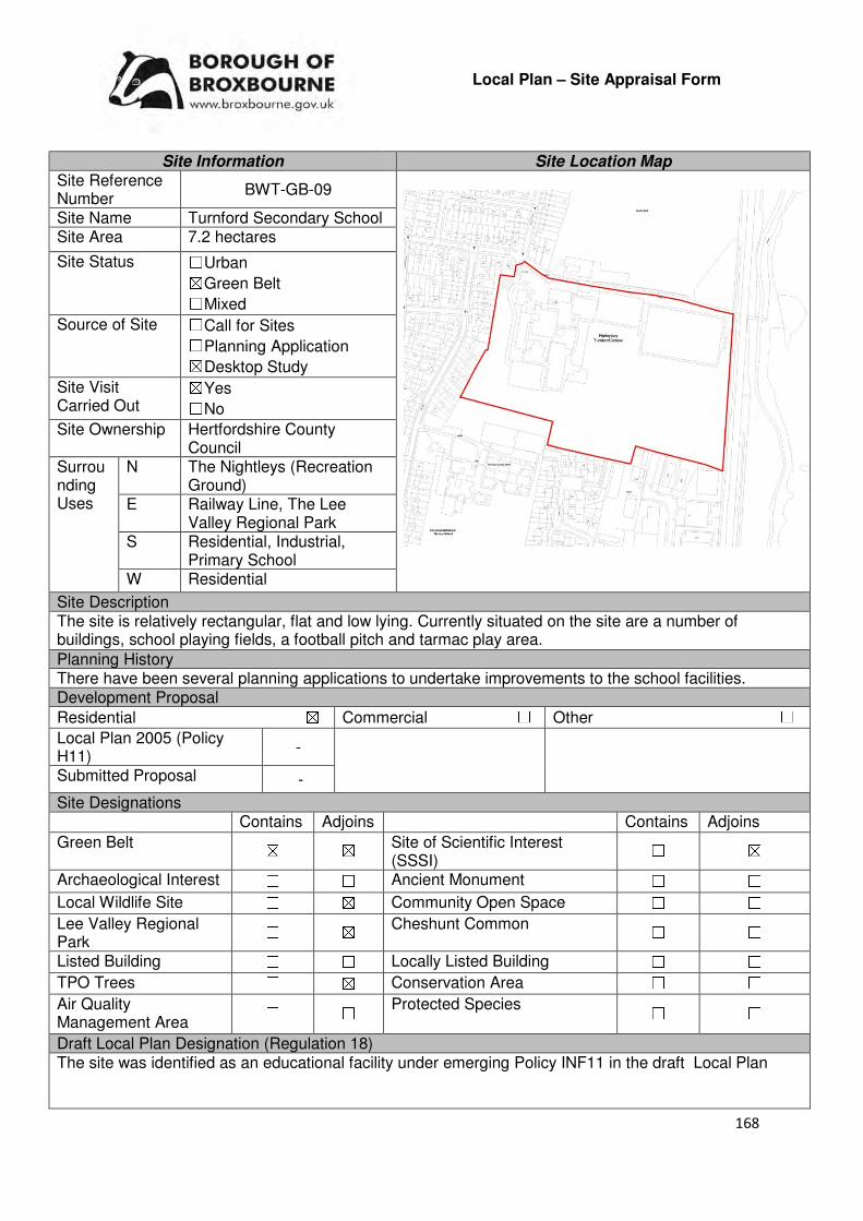
168
Local Plan – Site Appraisal Form
Site Information Site Location Map Site Reference Number
BWT-GB-09
Site Name Turnford Secondary School Site Area 7.2 hectares
Site Status ☐Urban ☒Green Belt ☐Mixed
Source of Site ☐Call for Sites ☐Planning Application ☒Desktop Study
Site Visit Carried Out
☒Yes ☐No
Site Ownership Hertfordshire County Council
Surrounding Uses
N The Nightleys (Recreation Ground)
E Railway Line, The Lee Valley Regional Park
S Residential, Industrial, Primary School
W Residential
Site Description The site is relatively rectangular, flat and low lying. Currently situated on the site are a number of buildings, school playing fields, a football pitch and tarmac play area.
Planning History There have been several planning applications to undertake improvements to the school facilities. Development Proposal
Residential ☒ Commercial ☐ Other ☐
Local Plan 2005 (Policy H11)
-
Submitted Proposal -
Site Designations Contains Adjoins Contains Adjoins
Green Belt ☒ ☒ Site of Scientific Interest (SSSI)
☐ ☒
Archaeological Interest ☐ ☐ Ancient Monument ☐ ☐
Local Wildlife Site ☐ ☒ Community Open Space ☐ ☐
Lee Valley Regional Park
☐ ☒ Cheshunt Common ☐ ☐
Listed Building ☐ ☐ Locally Listed Building ☐ ☐
TPO Trees ☐ ☒ Conservation Area ☐ ☐
Air Quality Management Area
☐ ☐ Protected Species ☐ ☐
Draft Local Plan Designation (Regulation 18) The site was identified as an educational facility under emerging Policy INF11 in the draft Local Plan
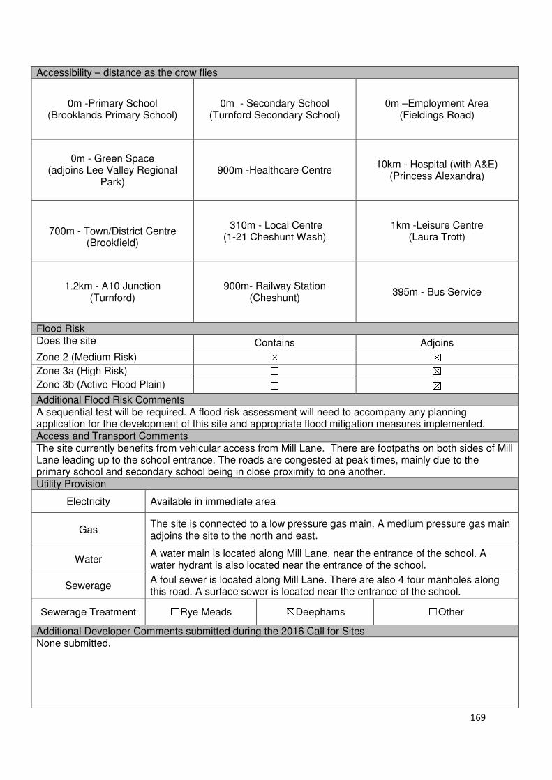
169
Accessibility – distance as the crow flies
0m -Primary School (Brooklands Primary School)
0m - Secondary School (Turnford Secondary School)
0m –Employment Area
(Fieldings Road)
0m - Green Space (adjoins Lee Valley Regional
Park)
900m -Healthcare Centre
10km - Hospital (with A&E)
(Princess Alexandra)
700m - Town/District Centre
(Brookfield)
310m - Local Centre
(1-21 Cheshunt Wash)
1km -Leisure Centre
(Laura Trott)
1.2km - A10 Junction (Turnford)
900m- Railway Station
(Cheshunt)
395m - Bus Service
Flood Risk Does the site Contains Adjoins
Zone 2 (Medium Risk) ☒ ☒
Zone 3a (High Risk) ☐ ☒
Zone 3b (Active Flood Plain) ☐ ☒
Additional Flood Risk Comments A sequential test will be required. A flood risk assessment will need to accompany any planning application for the development of this site and appropriate flood mitigation measures implemented. Access and Transport Comments The site currently benefits from vehicular access from Mill Lane. There are footpaths on both sides of Mill Lane leading up to the school entrance. The roads are congested at peak times, mainly due to the primary school and secondary school being in close proximity to one another. Utility Provision
Electricity Available in immediate area
Gas The site is connected to a low pressure gas main. A medium pressure gas main adjoins the site to the north and east.
Water A water main is located along Mill Lane, near the entrance of the school. A water hydrant is also located near the entrance of the school.
Sewerage A foul sewer is located along Mill Lane. There are also 4 four manholes along this road. A surface sewer is located near the entrance of the school.
Sewerage Treatment ☐Rye Meads ☒Deephams ☐Other
Additional Developer Comments submitted during the 2016 Call for Sites None submitted.
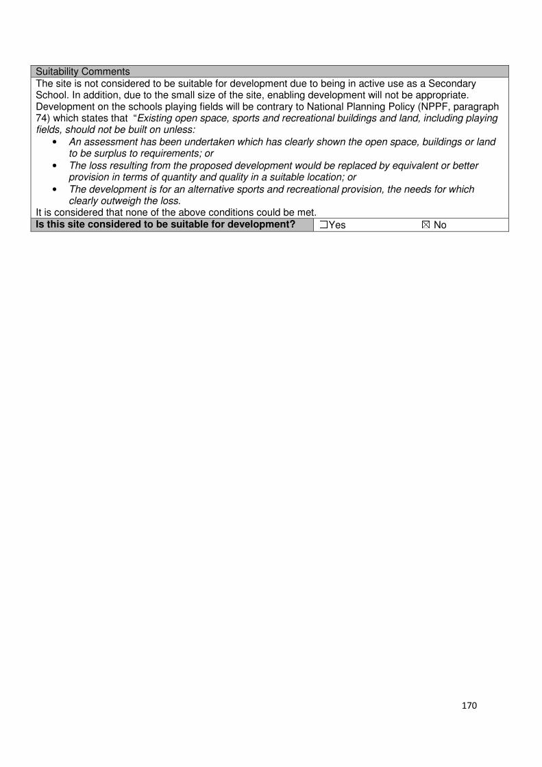
170
Suitability Comments The site is not considered to be suitable for development due to being in active use as a Secondary School. In addition, due to the small size of the site, enabling development will not be appropriate. Development on the schools playing fields will be contrary to National Planning Policy (NPPF, paragraph 74) which states that “Existing open space, sports and recreational buildings and land, including playing fields, should not be built on unless:
• An assessment has been undertaken which has clearly shown the open space, buildings or land to be surplus to requirements; or
• The loss resulting from the proposed development would be replaced by equivalent or better provision in terms of quantity and quality in a suitable location; or
• The development is for an alternative sports and recreational provision, the needs for which clearly outweigh the loss.
It is considered that none of the above conditions could be met. Is this site considered to be suitable for development? ☐Yes ☒ No

171
Local Plan – Site Appraisal Form
Site Information Site Location Map Site Reference Number
BWT-GB-10
Site Name Land next to New Barn Farm
Site Area 1.1 hectares
Site Status ☐Urban ☒Green Belt ☐Mixed
Source of Site ☒Call for Sites ☐Planning Application ☐Desktop Study
Site Visit Carried Out
☐Yes ☒No
Site Ownership The site is in single ownership
Surrounding Uses
N Green Belt, Open Field
E Green Belt, Wooded area S Green Belt , Open Field
W Green Belt , Open Field
Site Description The site is irregular in shape and slopes gradually from west to east. The site is greenfield in nature; it is open fields. A line of hedgerow is located along the sites western boundary. The northern boundary of the site is lined with trees and hedges, while the eastern boundary has a number of trees located Planning History No planning history of note. Development Proposal
Residential ☒ Commercial ☐ Other ☒
Local Plan 2005 (Policy H11)
33 Community Woodland
Submitted Proposal -
Site Designations Contains Adjoins Contains Adjoins
Green Belt ☐ ☐ Site of Scientific Interest (SSSI)
☐ ☐
Archaeological Interest ☐ ☐ Ancient Monument ☐ ☐
Local Wildlife Site ☐ ☐ Community Open Space ☐ ☐
Lee Valley Regional Park
☐ ☐ Cheshunt Common ☐ ☐
Listed Building ☐ ☐ Locally Listed Building ☐ ☐
TPO Trees ☐ ☐ Conservation Area ☐ ☐
Air Quality Management Area
☐ ☐ Protected Species ☐ ☐
Draft Local Plan Designation (Regulation 18) The site has been identified as Community Woodland that will be included within the proposed Brookfield Development. The Brookfield development is identified in emerging policy BR1.
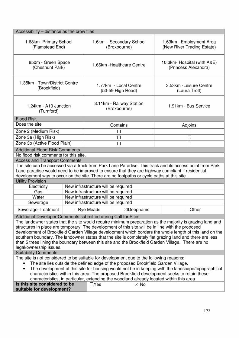
172
Accessibility – distance as the crow flies
1.68km -Primary School (Flamstead End)
1.6km - Secondary School (Broxbourne)
1.63km –Employment Area (New River Trading Estate)
850m - Green Space (Cheshunt Park)
1.66km -Healthcare Centre
10.3km- Hospital (with A&E)
(Princess Alexandra)
1.35km - Town/District Centre
(Brookfield)
1.77km - Local Centre
(53-59 High Road)
3.53km -Leisure Centre
(Laura Trott)
1.24km - A10 Junction
(Turnford)
3.11km - Railway Station
(Broxbourne)
1.91km - Bus Service
Flood Risk Does the site Contains Adjoins
Zone 2 (Medium Risk) ☐ ☐
Zone 3a (High Risk) ☐ ☐
Zone 3b (Active Flood Plain) ☐ ☐
Additional Flood Risk Comments No flood risk comments for this site. Access and Transport Comments The site can be accessed via a track from Park Lane Paradise. This track and its access point from Park Lane paradise would need to be improved to ensure that they are highway compliant if residential development was to occur on the site. There are no footpaths or cycle paths at this site. Utility Provision
Electricity New infrastructure will be required
Gas New infrastructure will be required
Water New infrastructure will be required
Sewerage New infrastructure will be required
Sewerage Treatment ☐Rye Meads ☒Deephams ☐Other
Additional Developer Comments submitted during Call for Sites The landowner states that the site would require minimum preparation as the majority is grazing land and structures in place are temporary. The development of this site will be in line with the proposed development of Brookfield Garden Village development which borders the whole length of this land on the southern boundary. The landowner states that the site is completely flat grazing land and there are less than 5 trees lining the boundary between this site and the Brookfield Garden Village. There are no legal/ownership issues. Suitability Comments The site is not considered to be suitable for development due to the following reasons:
• The site lies outside the defined edge of the proposed Brookfield Garden Village.
• The development of this site for housing would not be in keeping with the landscape/topographical characteristics within this area. The proposed Brookfield development seeks to retain these characteristics, in particular, extending the woodland already located within this area.
Is this site considered to be suitable for development?
☐Yes ☒ No

173
Local Plan – Site Appraisal Form
Site Information Site Location Map Site Reference Number
BWT-GB-11
Site Name Land at Holy Cross Hill Site Area 2.38 hectare
Site Status ☐Urban ☒Green Belt ☐Mixed
Source of Site ☒Call for Sites ☐Planning Application ☐Desktop Study
Site Visit Carried Out
☐Yes ☒No
Site Ownership There are two landowners for the site
Surrounding Uses
N Green Belt (Open Fields)
E Green Belt (Open Fields), Hill Cross Farm
S Green Belt (Open Fields)
W Green Belt (Open Fields)
Site Description The majority of the site is rectangular in shape, with a small slither of land (which follows the path of the track that connects the site to Park Lane Paradise) breaching out from the south western corner. The site slopes gradually from south west corner to the north eastern corner. The site is open field in nature, with hedges around the northern and eastern boundary. Located in the north eastern region of the site is a small concentration of hedges/scrub. Planning History No planning history of note. Development Proposal
Residential ☒ Commercial ☐ Other ☒
Local Plan 2005 (Policy H11) 71 Community woodland.
Submitted Proposal
Site Designations Contains Adjoins Contains Adjoins
Green Belt ☒ ☒ Site of Scientific Interest (SSSI) ☐ ☐
Archaeological Interest ☒ ☒ Ancient Monument ☐ ☐
Local Wildlife Site ☐ ☐ Community Open Space ☐ ☐
Lee Valley Regional Park
☐ ☐ Cheshunt Common ☐ ☐
Listed Building ☐ ☐ Locally Listed Building ☐ ☐
TPO Trees ☐ ☐ Conservation Area ☐ ☐
Air Quality Management Area
☐ ☐ Protected Species ☐ ☐
Draft Local Plan Designation (Regulation 18) The draft Local Plan proposed to keep this site within the Green Belt.

174
Accessibility – distance as the crow flies
1.58km -Primary School (Flamstead End)
1.76km - Secondary School (Broxbourne Secondary School)
1.72km –Employment Area (New River Trading Estate)
910m - Green Space (Cheshunt Park)
1.85km -Healthcare Centre (The Maples Health Centre)
10.43km - Hospital (with A&E)
(Princess Alexandra)
1.5km - Town/District Centre
(Brookfield)
1.9km - Local Centre (53-59 High Road)
3.57km -Leisure Centre
(Laura Trott)
1.46km - A10 Junction (Turnford)
3.25km- Railway Station
(Broxbourne)
1.9km - Bus Service
Flood Risk Does the site Contains Adjoins
Zone 2 (Medium Risk) ☐ ☐
Zone 3a (High Risk) ☐ ☐
Zone 3b (Active Flood Plain) ☐ ☒
Additional Flood Risk Comments No flood risk issues have been identified for this site. Access and Transport Comments The site can be accessed via a track from Park Lane Paradise. Utility Provision
Electricity New infrastructure will be required
Gas New infrastructure will be required
Water New infrastructure will be required
Sewerage New infrastructure will be required
Sewerage Treatment ☐Rye Meads ☒Deephams ☐Other
Additional Developer Comments submitted during Call for Sites 2016 The landowner states that the site is available now. It has an existing access point; there are no contamination issues, or legal/ownership issues. Suitability Comments The site is not considered to be suitable for development due to the following reasons:
• The site lies outside the defined edge of the proposed Brookfield Garden Village.
• The development of this site for housing would not be in keeping with the landscape/topographical characteristics within this area. The proposed Brookfield development seeks to retain this characteristics, in particular, extending the woodland already located within this area
Is this site considered to be suitable for development?
☒Yes ☐ No
175
Cheshunt and Goffs Oak
Urban Sites
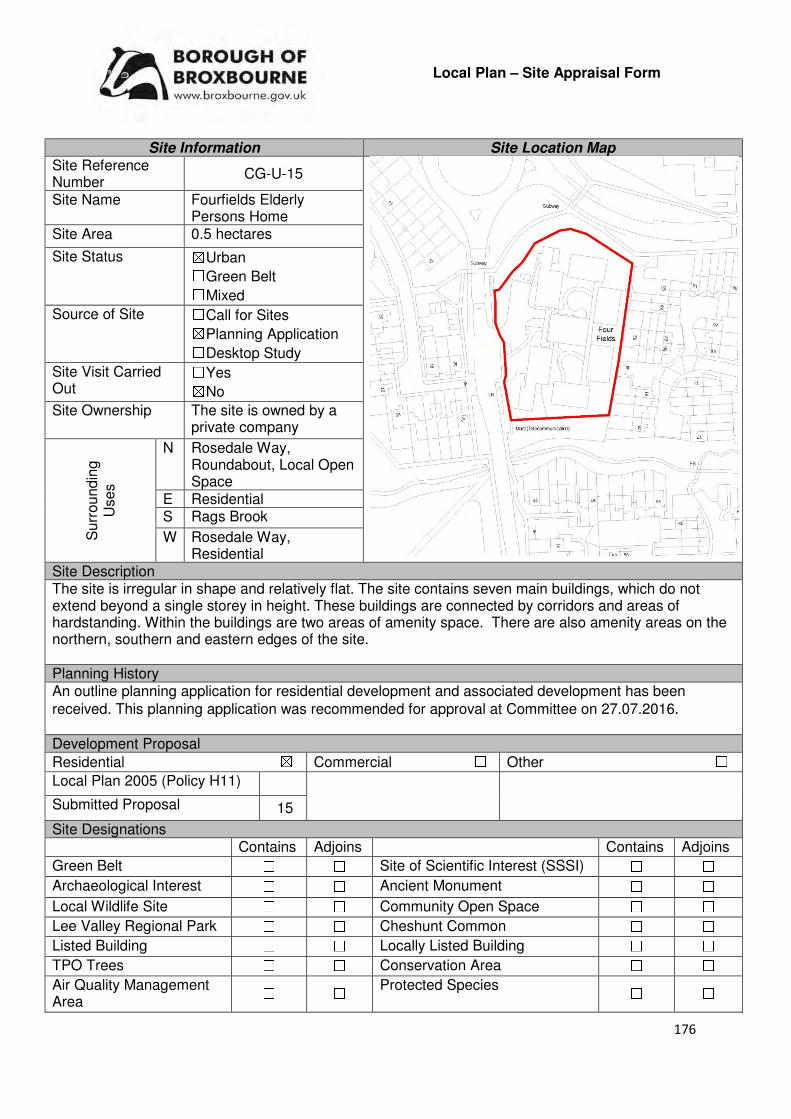
176
Local Plan – Site Appraisal Form
Site Information Site Location Map Site Reference Number
CG-U-15
Site Name Fourfields Elderly Persons Home
Site Area 0.5 hectares
Site Status ☒Urban ☐Green Belt ☐Mixed
Source of Site ☐Call for Sites ☒Planning Application ☐Desktop Study
Site Visit Carried Out
☐Yes ☒No
Site Ownership The site is owned by a private company
Surr
oundin
g
Uses
N Rosedale Way, Roundabout, Local Open Space
E Residential S Rags Brook
W Rosedale Way, Residential
Site Description The site is irregular in shape and relatively flat. The site contains seven main buildings, which do not extend beyond a single storey in height. These buildings are connected by corridors and areas of hardstanding. Within the buildings are two areas of amenity space. There are also amenity areas on the northern, southern and eastern edges of the site. Planning History An outline planning application for residential development and associated development has been
received. This planning application was recommended for approval at Committee on 27.07.2016. Development Proposal
Residential ☒ Commercial ☐ Other ☐
Local Plan 2005 (Policy H11)
Submitted Proposal 15
Site Designations Contains Adjoins Contains Adjoins
Green Belt ☐ ☐ Site of Scientific Interest (SSSI) ☐ ☐
Archaeological Interest ☐ ☐ Ancient Monument ☐ ☐
Local Wildlife Site ☐ ☐ Community Open Space ☐ ☐
Lee Valley Regional Park ☐ ☐ Cheshunt Common ☐ ☐
Listed Building ☐ ☐ Locally Listed Building ☐ ☐
TPO Trees ☐ ☐ Conservation Area ☐ ☐
Air Quality Management Area
☐ ☐ Protected Species ☐ ☐

177
Draft Local Plan Designation (Regulation 18) The draft Local Plan proposed to allocate this site as an urban capacity site, as part of emerging Policy DS3: Urban Capacity Sites Accessibility – distance as the crow flies
32m -Primary School (Fairfields)
730m - Secondary School (Goffs)
1.7km –Employment Area (New River Trading Estate)
30m - Green Space (Rosedale)
297m -Healthcare Centre (Stockwell Lodge)
11.82km- Hospital (with A&E) (Princess Alexandra)
1.4km - Town/District Centre (Brookfield)
230m - Local Centre 2.25km -Leisure Centre
(Laura Trott)
1.37km - A10 Junction (Church Lane)
3.42km - Railway Station (Cuffley)
5m - Bus Service (Fourfields Care Home)
Flood Risk Does the site Contains Adjoins
Zone 2 (Medium Risk) ☐ ☐
Zone 3a (High Risk) ☐ ☐
Zone 3b (Active Flood Plain) ☐ ☒
Additional Flood Risk Comments The sites close proximity to Rags Brook may require further investigation. Access and Transport Comments The site can be accessed via Rosedale Way. Utility Provision
Electricity Connections available
Gas A low pressure gas main is located at Rosedale Way
Water A trunk main is located along Rosedale Way. A water main is located at Jacksons Drive. A water hydrant is located to the east of the site.
Sewerage A foul sewer and surface sewer is located along Rosedale Way
Sewerage Treatment ☐Rye Meads ☒Deephams ☐Other
Additional Developer Comments submitted during Call for Sites 2016 None submitted. Suitability Comments The site is considered to be suitable for residential development due to the following reasons:
• It was recommended at Committee in June 2016 that this site was granted conditional planning permission. The case officer report concluded that the proposed development would replace a care home which has reached the end of its economic life (alternative provision is being proposed off-site) with residential development, supporting the Council’s five year supply of housing land. The proposed development would also comply with the Interim Policy for Residential Car Parking Standards, and is not considered to present an unacceptable impact to the public highway or in terms of residential amenity.
• The site is considered to be in a sustainable location for residential development – it is close to local facilities, education facilities and some modes of sustainable transport. It is also within the sustainable distance recommended by Barton et al (2010) for a doctor’s surgery and local park/green space.
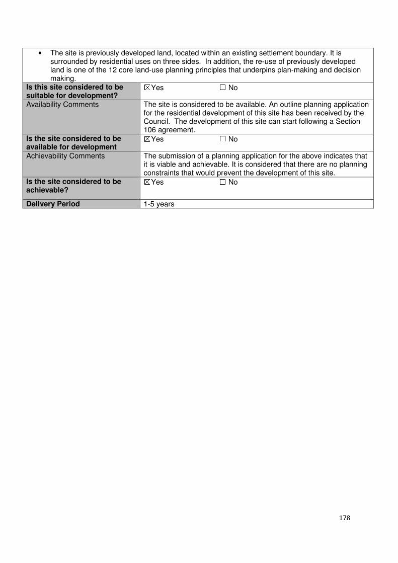
178
• The site is previously developed land, located within an existing settlement boundary. It is surrounded by residential uses on three sides. In addition, the re-use of previously developed land is one of the 12 core land-use planning principles that underpins plan-making and decision making.
Is this site considered to be suitable for development?
☒Yes ☐ No
Availability Comments The site is considered to be available. An outline planning application for the residential development of this site has been received by the Council. The development of this site can start following a Section 106 agreement.
Is the site considered to be available for development
☒Yes ☐ No
Achievability Comments The submission of a planning application for the above indicates that it is viable and achievable. It is considered that there are no planning constraints that would prevent the development of this site.
Is the site considered to be achievable?
☒Yes ☐ No
Delivery Period 1-5 years

179
Local Plan – Site Appraisal Form
Site Information Site Location Map Site Reference Number
CG-U-29
Site Name Land south of Hammondstreet
Site Area 3 hectares
Site Status ☒Urban ☐Green Belt ☐Mixed
Source of Site ☐Call for Sites ☐Planning Application ☒Desktop Study
Site Visit Carried Out
☒Yes ☐No
Site Ownership There are two landowners for this site.
Surr
oundin
g
Uses
N Hammondstreet Road, Residential
E Residential S Crouch Lane, Green Belt
W Residential
Site Description The site is broadly rectangular in shape and slopes from north to south. The site is predominantly greenfield in nature, with scrub and trees found throughout the site. There are trees/scrubs located on all of the sites boundaries, however, there is a particularly strong concentration along the sites eastern and western boundaries. Within the central region of the site of green open space. Planning History Outline planning permission for residential development at land south of Hammondstreet Road, which includes this site, was granted in 1994. This site was identified for open space and residential development. Various reserved matters application was received for this scheme. Development Proposal
Residential ☒ Commercial ☐ Other ☐
Local Plan 2005 (Policy H11)
Submitted Proposal 44
Site Designations Contains Adjoins Contains Adjoins
Green Belt ☐ ☒ Site of Scientific Interest (SSSI) ☐ ☐
Archaeological Interest ☐ ☐ Ancient Monument ☐ ☐
Local Wildlife Site ☐ ☐ Community Open Space ☐ ☐
Lee Valley Regional Park
☐ ☐ Cheshunt Common ☐ ☐
Listed Building ☐ ☐ Locally Listed Building ☐ ☐
TPO Trees ☐ ☐ Conservation Area ☐ ☐
Air Quality Management Area
☐ ☐ Protected Species ☐ ☐

180
Draft Local Plan Designation (Regulation 18) The draft Local Plan proposed to allocate this site for residential development, as part of emerging Policy CH9: South of Hammondstreet Road. The site was identified as having the capacity to deliver 44 dwellings. Accessibility – distance as the crow flies
1.03km -Primary School (Fairfields)
1.55km - Secondary School (Goffs)
2.48km –Employment Area (New River Trading Estate)
83m - Green Space (Argent Way)
1.01km -Healthcare Centre (Valley View)
12.15km- Hospital (with A&E) (Barnet)
2.32km - Town/District Centre (Brookfield)
22m - Local Centre (Hammondstreet)
3.32km -Leisure Centre (Laura Trott)
2.5km - A10 Junction (Church Lane)
2.51km - Railway Station (Cuffley)
20m- Bus Service (Oaklands Road)
Flood Risk Does the site Contains Adjoins
Zone 2 (Medium Risk) ☐ ☐
Zone 3a (High Risk) ☐ ☐
Zone 3b (Active Flood Plain) ☐ ☒
Additional Flood Risk Comments No flood risk comments for this site. There are footpaths on both sides of the road along most of Rosedale Way. Connections to these footpaths will be required. Access and Transport Comments There is no current vehicular access to this site. However, there are a number of potential access points to this site from Hammondstreet Road, Crouch Lane and the residential areas bordering the site to the east and west. A transport assessment may be required for this site to assessed the impact that it development would have on the local road network. Connections to the existing footpath infrastructure surrounding the site will be required. A public right of way runs parallel to the sites western border. Utility Provision
Electricity Cables located in the residential areas surrounding the site
Gas A low pressure gas main is located along Hammondstreet Road
Water A water main is located along Crouch Lane to the south of the site, at Lucern Close, Little Grove Avenue and Cony Close to the east and Biggs Grove Road to the west. A trunk main is located along Hammondstreet Road
Sewerage A foul sewer and surface sewer is located at Crouch Lane to the south, Hammondstreet Road to the north, Lucern Close, Little Grove Avenue and Cony Close to the east and Biggs Grove Road to the west.
Sewerage Treatment ☐Rye Meads ☒Deephams ☐Other
Additional Developer Comments submitted during Call for Sites 2016 None submitted. Suitability Comments The site is considered to be suitable for residential development due to the following reasons:
• The site is considered to be in a sustainable location for residential development – it is close to most local facilities, primary education and modes of sustainable transport.
• The principle of developing this site for residential development has already been established outline planning application that was granted planning permission in 1994.
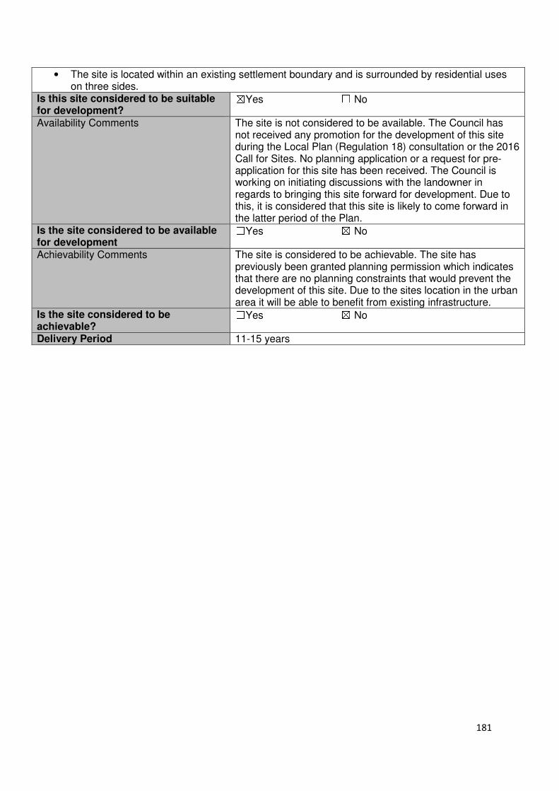
181
• The site is located within an existing settlement boundary and is surrounded by residential uses on three sides.
Is this site considered to be suitable for development?
☒Yes ☐ No
Availability Comments The site is not considered to be available. The Council has not received any promotion for the development of this site during the Local Plan (Regulation 18) consultation or the 2016 Call for Sites. No planning application or a request for pre-application for this site has been received. The Council is working on initiating discussions with the landowner in regards to bringing this site forward for development. Due to this, it is considered that this site is likely to come forward in the latter period of the Plan.
Is the site considered to be available for development
☐Yes ☒ No
Achievability Comments The site is considered to be achievable. The site has previously been granted planning permission which indicates that there are no planning constraints that would prevent the development of this site. Due to the sites location in the urban area it will be able to benefit from existing infrastructure.
Is the site considered to be achievable?
☐Yes ☒ No
Delivery Period 11-15 years
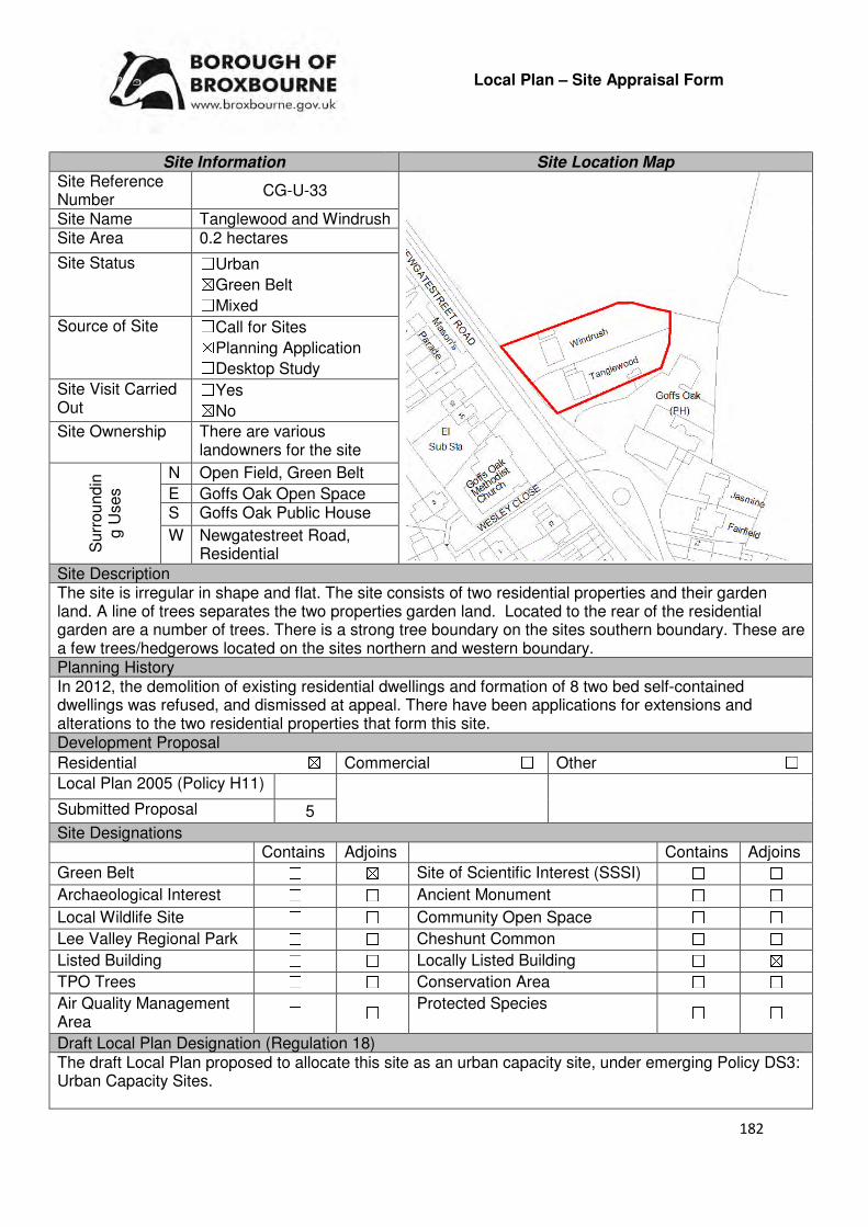
182
Local Plan – Site Appraisal Form
Site Information Site Location Map Site Reference Number
CG-U-33
Site Name Tanglewood and Windrush Site Area 0.2 hectares
Site Status ☐Urban ☒Green Belt ☐Mixed
Source of Site ☐Call for Sites ☒Planning Application ☐Desktop Study
Site Visit Carried Out
☐Yes ☒No
Site Ownership There are various landowners for the site
Surr
oundin
g U
ses
N Open Field, Green Belt
E Goffs Oak Open Space S Goffs Oak Public House
W Newgatestreet Road, Residential
Site Description The site is irregular in shape and flat. The site consists of two residential properties and their garden land. A line of trees separates the two properties garden land. Located to the rear of the residential garden are a number of trees. There is a strong tree boundary on the sites southern boundary. These are a few trees/hedgerows located on the sites northern and western boundary. Planning History In 2012, the demolition of existing residential dwellings and formation of 8 two bed self-contained dwellings was refused, and dismissed at appeal. There have been applications for extensions and alterations to the two residential properties that form this site. Development Proposal
Residential ☒ Commercial ☐ Other ☐
Local Plan 2005 (Policy H11)
Submitted Proposal 5
Site Designations Contains Adjoins Contains Adjoins
Green Belt ☐ ☒ Site of Scientific Interest (SSSI) ☐ ☐
Archaeological Interest ☐ ☐ Ancient Monument ☐ ☐
Local Wildlife Site ☐ ☐ Community Open Space ☐ ☐
Lee Valley Regional Park ☐ ☐ Cheshunt Common ☐ ☐
Listed Building ☐ ☐ Locally Listed Building ☐ ☒
TPO Trees ☐ ☐ Conservation Area ☐ ☐
Air Quality Management Area
☐ ☐ Protected Species ☐ ☐
Draft Local Plan Designation (Regulation 18) The draft Local Plan proposed to allocate this site as an urban capacity site, under emerging Policy DS3: Urban Capacity Sites.
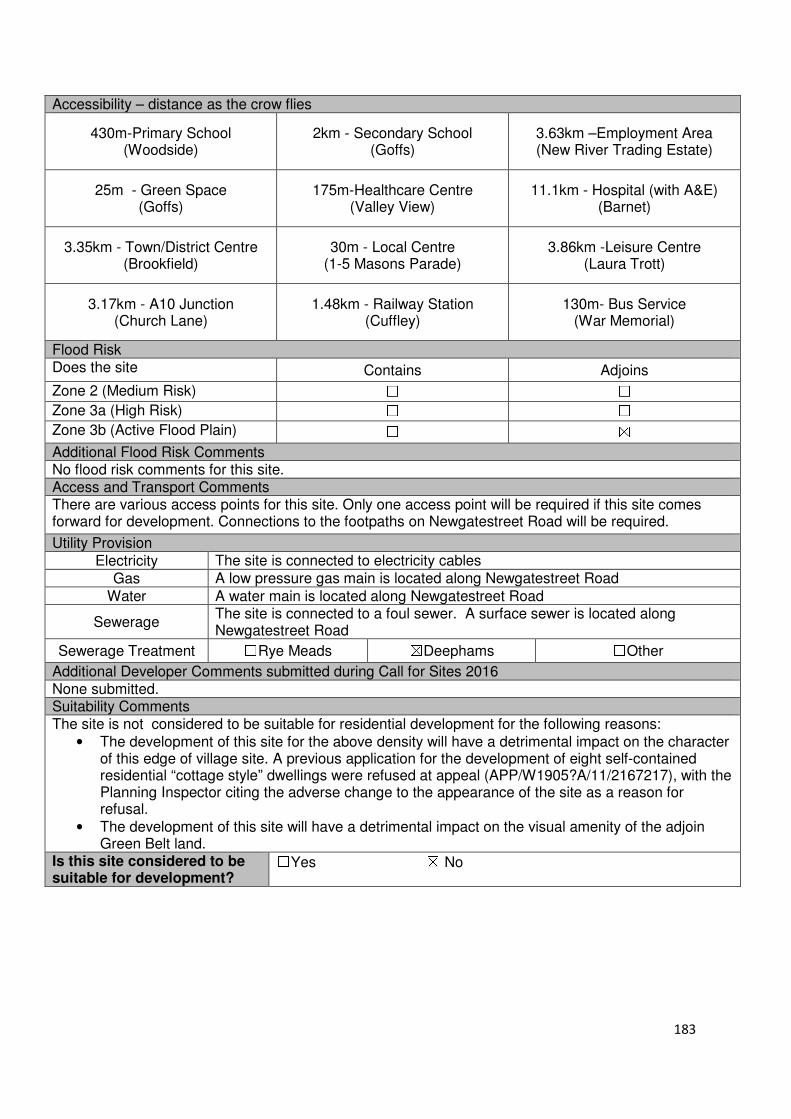
183
Accessibility – distance as the crow flies
430m-Primary School (Woodside)
2km - Secondary School (Goffs)
3.63km –Employment Area (New River Trading Estate)
25m - Green Space (Goffs)
175m-Healthcare Centre (Valley View)
11.1km - Hospital (with A&E) (Barnet)
3.35km - Town/District Centre (Brookfield)
30m - Local Centre (1-5 Masons Parade)
3.86km -Leisure Centre (Laura Trott)
3.17km - A10 Junction (Church Lane)
1.48km - Railway Station (Cuffley)
130m- Bus Service (War Memorial)
Flood Risk Does the site Contains Adjoins
Zone 2 (Medium Risk) ☐ ☐
Zone 3a (High Risk) ☐ ☐
Zone 3b (Active Flood Plain) ☐ ☒
Additional Flood Risk Comments No flood risk comments for this site. Access and Transport Comments There are various access points for this site. Only one access point will be required if this site comes forward for development. Connections to the footpaths on Newgatestreet Road will be required.
Utility Provision
Electricity The site is connected to electricity cables
Gas A low pressure gas main is located along Newgatestreet Road
Water A water main is located along Newgatestreet Road
Sewerage The site is connected to a foul sewer. A surface sewer is located along Newgatestreet Road
Sewerage Treatment ☐Rye Meads ☒Deephams ☐Other
Additional Developer Comments submitted during Call for Sites 2016 None submitted. Suitability Comments The site is not considered to be suitable for residential development for the following reasons:
• The development of this site for the above density will have a detrimental impact on the character of this edge of village site. A previous application for the development of eight self-contained residential “cottage style” dwellings were refused at appeal (APP/W1905?A/11/2167217), with the Planning Inspector citing the adverse change to the appearance of the site as a reason for refusal.
• The development of this site will have a detrimental impact on the visual amenity of the adjoin Green Belt land.
Is this site considered to be suitable for development?
☐Yes ☒ No
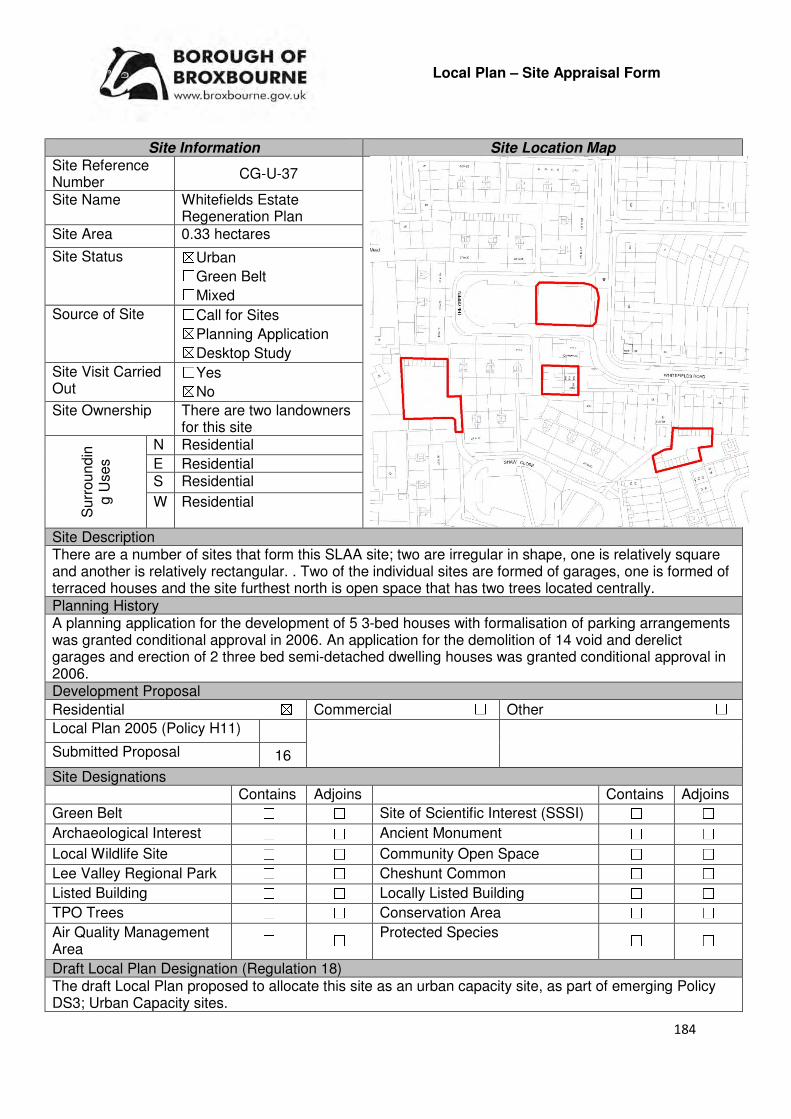
184
Local Plan – Site Appraisal Form
Site Information Site Location Map Site Reference Number
CG-U-37
Site Name Whitefields Estate Regeneration Plan
Site Area 0.33 hectares
Site Status ☒Urban ☐Green Belt ☐Mixed
Source of Site ☐Call for Sites ☒Planning Application ☒Desktop Study
Site Visit Carried Out
☐Yes ☒No
Site Ownership There are two landowners for this site
Surr
oundin
g U
ses
N Residential
E Residential S Residential
W Residential
Site Description There are a number of sites that form this SLAA site; two are irregular in shape, one is relatively square and another is relatively rectangular. . Two of the individual sites are formed of garages, one is formed of terraced houses and the site furthest north is open space that has two trees located centrally. Planning History A planning application for the development of 5 3-bed houses with formalisation of parking arrangements was granted conditional approval in 2006. An application for the demolition of 14 void and derelict garages and erection of 2 three bed semi-detached dwelling houses was granted conditional approval in 2006. Development Proposal
Residential ☒ Commercial ☐ Other ☐
Local Plan 2005 (Policy H11)
Submitted Proposal 16
Site Designations Contains Adjoins Contains Adjoins
Green Belt ☐ ☐ Site of Scientific Interest (SSSI) ☐ ☐
Archaeological Interest ☐ ☐ Ancient Monument ☐ ☐
Local Wildlife Site ☐ ☐ Community Open Space ☐ ☐
Lee Valley Regional Park ☐ ☐ Cheshunt Common ☐ ☐
Listed Building ☐ ☐ Locally Listed Building ☐ ☐
TPO Trees ☐ ☐ Conservation Area ☐ ☐
Air Quality Management Area
☐ ☐ Protected Species ☐ ☐
Draft Local Plan Designation (Regulation 18) The draft Local Plan proposed to allocate this site as an urban capacity site, as part of emerging Policy DS3; Urban Capacity sites.
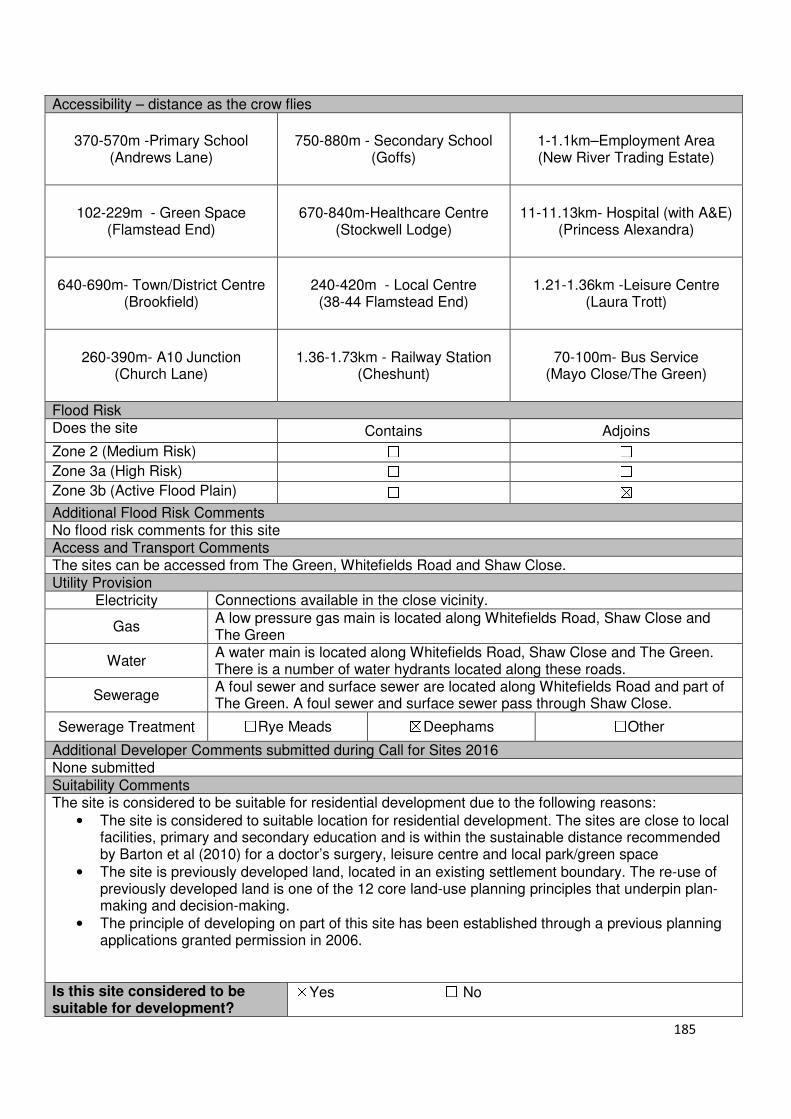
185
Accessibility – distance as the crow flies
370-570m -Primary School (Andrews Lane)
750-880m - Secondary School (Goffs)
1-1.1km–Employment Area (New River Trading Estate)
102-229m - Green Space (Flamstead End)
670-840m-Healthcare Centre
(Stockwell Lodge)
11-11.13km- Hospital (with A&E)
(Princess Alexandra)
640-690m- Town/District Centre (Brookfield)
240-420m - Local Centre (38-44 Flamstead End)
1.21-1.36km -Leisure Centre
(Laura Trott)
260-390m- A10 Junction (Church Lane)
1.36-1.73km - Railway Station
(Cheshunt)
70-100m- Bus Service (Mayo Close/The Green)
Flood Risk Does the site Contains Adjoins
Zone 2 (Medium Risk) ☐ ☐
Zone 3a (High Risk) ☐ ☐
Zone 3b (Active Flood Plain) ☐ ☒
Additional Flood Risk Comments No flood risk comments for this site Access and Transport Comments The sites can be accessed from The Green, Whitefields Road and Shaw Close. Utility Provision
Electricity Connections available in the close vicinity.
Gas A low pressure gas main is located along Whitefields Road, Shaw Close and The Green
Water A water main is located along Whitefields Road, Shaw Close and The Green. There is a number of water hydrants located along these roads.
Sewerage A foul sewer and surface sewer are located along Whitefields Road and part of The Green. A foul sewer and surface sewer pass through Shaw Close.
Sewerage Treatment ☐Rye Meads ☒Deephams ☐Other
Additional Developer Comments submitted during Call for Sites 2016 None submitted Suitability Comments The site is considered to be suitable for residential development due to the following reasons:
• The site is considered to suitable location for residential development. The sites are close to local facilities, primary and secondary education and is within the sustainable distance recommended by Barton et al (2010) for a doctor’s surgery, leisure centre and local park/green space
• The site is previously developed land, located in an existing settlement boundary. The re-use of previously developed land is one of the 12 core land-use planning principles that underpin plan-making and decision-making.
• The principle of developing on part of this site has been established through a previous planning applications granted permission in 2006.
Is this site considered to be suitable for development?
☒Yes ☐ No

186
Availability Comments The site is not considered to be available. Since Pre-application advice undertaken on this site there has been no planning application submitted. It Is understood that part of this site may have sold off. There has been no promotion of this site during the 2016 Call for Sites or the Local Plan consultation.
Is the site considered to be available for development
☐Yes ☒ No
Achievability Comments The site is not available and is therefore not considered to be achievable.
Is the site considered to be achievable?
☐Yes ☒ No
Delivery Period -
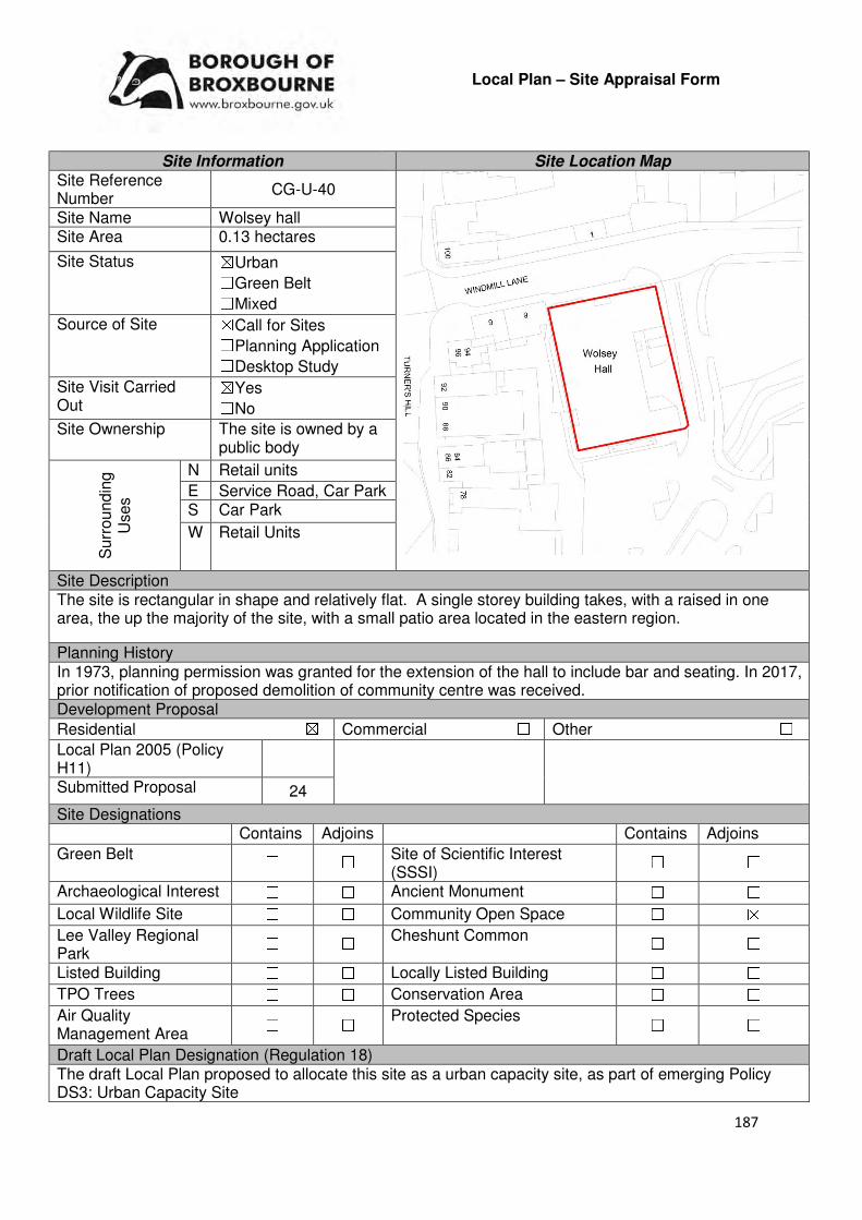
187
Local Plan – Site Appraisal Form
Site Information Site Location Map Site Reference Number
CG-U-40
Site Name Wolsey hall Site Area 0.13 hectares
Site Status ☒Urban ☐Green Belt ☐Mixed
Source of Site ☒Call for Sites ☐Planning Application ☐Desktop Study
Site Visit Carried Out
☒Yes ☐No
Site Ownership The site is owned by a public body
Surr
oundin
g
Uses
N Retail units
E Service Road, Car Park S Car Park
W Retail Units
Site Description The site is rectangular in shape and relatively flat. A single storey building takes, with a raised in one area, the up the majority of the site, with a small patio area located in the eastern region.
Planning History In 1973, planning permission was granted for the extension of the hall to include bar and seating. In 2017, prior notification of proposed demolition of community centre was received. Development Proposal
Residential ☒ Commercial ☐ Other ☐
Local Plan 2005 (Policy H11)
Submitted Proposal 24
Site Designations Contains Adjoins Contains Adjoins
Green Belt ☐ ☐ Site of Scientific Interest (SSSI)
☐ ☐
Archaeological Interest ☐ ☐ Ancient Monument ☐ ☐
Local Wildlife Site ☐ ☐ Community Open Space ☐ ☒
Lee Valley Regional Park
☐ ☐ Cheshunt Common ☐ ☐
Listed Building ☐ ☐ Locally Listed Building ☐ ☐
TPO Trees ☐ ☐ Conservation Area ☐ ☐
Air Quality Management Area
☐ ☐ Protected Species ☐ ☐
Draft Local Plan Designation (Regulation 18) The draft Local Plan proposed to allocate this site as a urban capacity site, as part of emerging Policy DS3: Urban Capacity Site
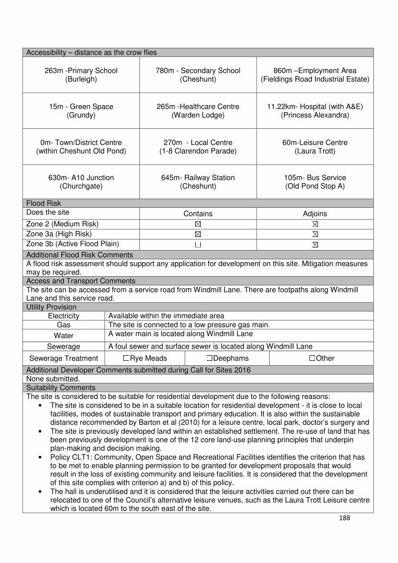
188
Accessibility – distance as the crow flies
263m -Primary School (Burleigh)
780m - Secondary School (Cheshunt)
860m –Employment Area
(Fieldings Road Industrial Estate)
15m - Green Space (Grundy)
265m -Healthcare Centre
(Warden Lodge)
11.22km- Hospital (with A&E) (Princess Alexandra)
0m- Town/District Centre
(within Cheshunt Old Pond)
270m - Local Centre (1-8 Clarendon Parade)
60m-Leisure Centre (Laura Trott)
630m- A10 Junction (Churchgate)
645m- Railway Station
(Cheshunt)
105m- Bus Service (Old Pond Stop A)
Flood Risk Does the site Contains Adjoins
Zone 2 (Medium Risk) ☒ ☒
Zone 3a (High Risk) ☒ ☒
Zone 3b (Active Flood Plain) ☐ ☒
Additional Flood Risk Comments A flood risk assessment should support any application for development on this site. Mitigation measures may be required. Access and Transport Comments The site can be accessed from a service road from Windmill Lane. There are footpaths along Windmill Lane and this service road. Utility Provision
Electricity Available within the immediate area
Gas The site is connected to a low pressure gas main.
Water A water main is located along Windmill Lane
Sewerage A foul sewer and surface sewer is located along Windmill Lane
Sewerage Treatment ☐Rye Meads ☐Deephams ☐Other
Additional Developer Comments submitted during Call for Sites 2016 None submitted. Suitability Comments The site is considered to be suitable for residential development due to the following reasons:
• The site is considered to be in a suitable location for residential development - it is close to local facilities, modes of sustainable transport and primary education. It is also within the sustainable distance recommended by Barton et al (2010) for a leisure centre, local park, doctor’s surgery and
• The site is previously developed land within an established settlement. The re-use of land that has been previously development is one of the 12 core land-use planning principles that underpin plan-making and decision making.
• Policy CLT1: Community, Open Space and Recreational Facilities identifies the criterion that has to be met to enable planning permission to be granted for development proposals that would result in the loss of existing community and leisure facilities. It is considered that the development of this site complies with criterion a) and b) of this policy.
• The hall is underutilised and it is considered that the leisure activities carried out there can be relocated to one of the Council’s alternative leisure venues, such as the Laura Trott Leisure centre which is located 60m to the south east of the site.

189
• As indicated in the National Planning Policy Framework (NPPF), residential development can play an important role in ensuring the vitality of retail centres. The NPPF (paragraph 23) states that local planning authorities should encourage residential development on appropriate sites. It is considered that this site is appropriate
Is this site considered to be suitable for development?
☒Yes ☐ No
Availability Comments The site is owned by the Council. The Council has begun to work on a scheme to bring this site forward for development.
Is the site considered to be available for development
☒Yes ☐ No
Achievability Comments The site is considered to be achievable. Due to the sites urban location, it can benefit from existing infrastructure (i.e. highway compliant roads, utilities etc.).
Is the site considered to be achievable?
☒Yes ☐ No
Delivery Period 1-5 years
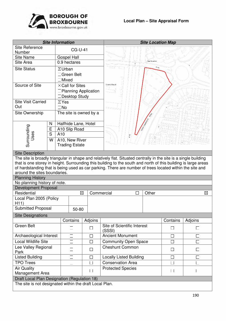
190
Local Plan – Site Appraisal Form
Site Information Site Location Map Site Reference Number
CG-U-41
Site Name Gospel Hall Site Area 0.9 hectares
Site Status ☒Urban ☐Green Belt ☐Mixed
Source of Site ☒Call for Sites ☐Planning Application ☐Desktop Study
Site Visit Carried Out
☒Yes ☐No
Site Ownership The site is owned by a
Surr
oundin
g
Uses
N Halfhide Lane, Hotel
E A10 Slip Road S A10
W A10, New River Trading Estate
Site Description The site is broadly triangular in shape and relatively flat. Situated centrally in the site is a single building that is one storey in height. Surrounding this building to the south and north of this building is large areas of hardstanding that is being used as car parking. There are number of trees located within the site and around the sites boundaries. Planning History No planning history of note. Development Proposal
Residential ☒ Commercial ☐ Other ☒
Local Plan 2005 (Policy H11)
Submitted Proposal 50-80
Site Designations Contains Adjoins Contains Adjoins
Green Belt ☐ ☐ Site of Scientific Interest (SSSI)
☐ ☐
Archaeological Interest ☐ ☐ Ancient Monument ☐ ☐
Local Wildlife Site ☐ ☐ Community Open Space ☐ ☐
Lee Valley Regional Park
☐ ☐ Cheshunt Common ☐ ☐
Listed Building ☐ ☐ Locally Listed Building ☐ ☐
TPO Trees ☐ ☐ Conservation Area ☐ ☐
Air Quality Management Area
☐ ☐ Protected Species ☐ ☐
Draft Local Plan Designation (Regulation 18) The site is not designated within the draft Local Plan.
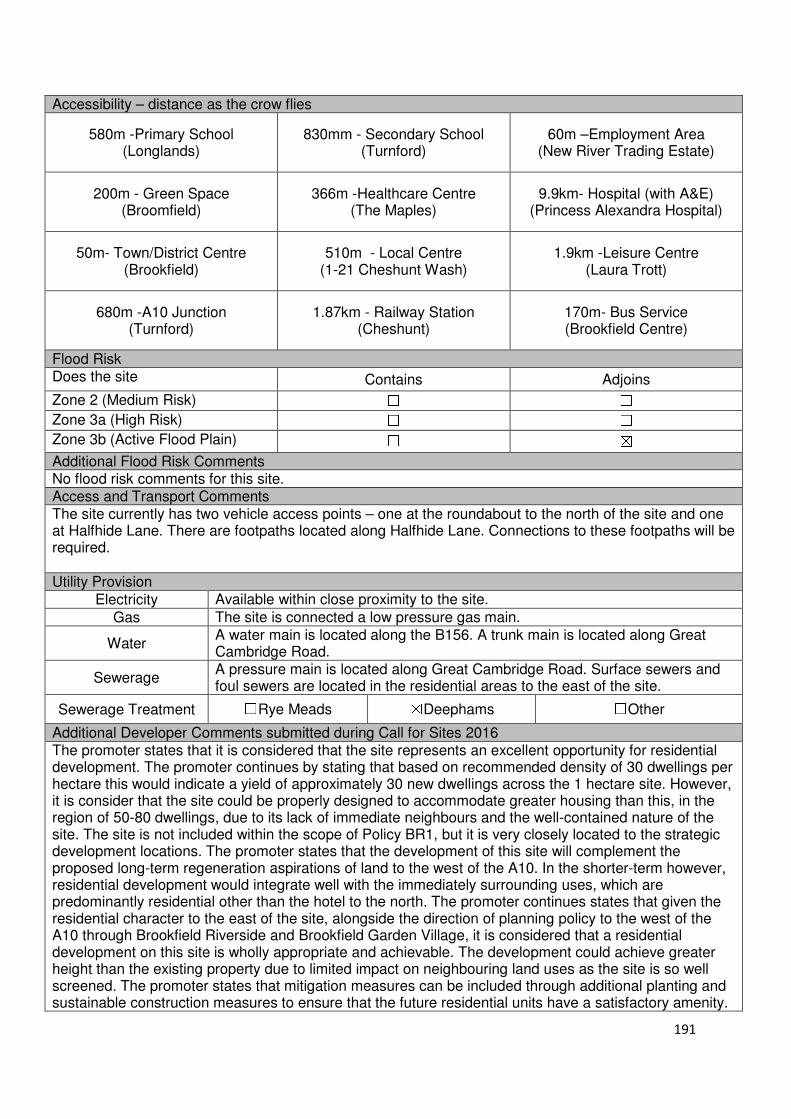
191
Accessibility – distance as the crow flies
580m -Primary School (Longlands)
830mm - Secondary School (Turnford)
60m –Employment Area (New River Trading Estate)
200m - Green Space (Broomfield)
366m -Healthcare Centre (The Maples)
9.9km- Hospital (with A&E) (Princess Alexandra Hospital)
50m- Town/District Centre (Brookfield)
510m - Local Centre (1-21 Cheshunt Wash)
1.9km -Leisure Centre (Laura Trott)
680m -A10 Junction (Turnford)
1.87km - Railway Station (Cheshunt)
170m- Bus Service (Brookfield Centre)
Flood Risk Does the site Contains Adjoins
Zone 2 (Medium Risk) ☐ ☐
Zone 3a (High Risk) ☐ ☐
Zone 3b (Active Flood Plain) ☐ ☒
Additional Flood Risk Comments No flood risk comments for this site. Access and Transport Comments The site currently has two vehicle access points – one at the roundabout to the north of the site and one at Halfhide Lane. There are footpaths located along Halfhide Lane. Connections to these footpaths will be required. Utility Provision
Electricity Available within close proximity to the site.
Gas The site is connected a low pressure gas main.
Water A water main is located along the B156. A trunk main is located along Great Cambridge Road.
Sewerage A pressure main is located along Great Cambridge Road. Surface sewers and foul sewers are located in the residential areas to the east of the site.
Sewerage Treatment ☐Rye Meads ☒Deephams ☐Other
Additional Developer Comments submitted during Call for Sites 2016 The promoter states that it is considered that the site represents an excellent opportunity for residential development. The promoter continues by stating that based on recommended density of 30 dwellings per hectare this would indicate a yield of approximately 30 new dwellings across the 1 hectare site. However, it is consider that the site could be properly designed to accommodate greater housing than this, in the region of 50-80 dwellings, due to its lack of immediate neighbours and the well-contained nature of the site. The site is not included within the scope of Policy BR1, but it is very closely located to the strategic development locations. The promoter states that the development of this site will complement the proposed long-term regeneration aspirations of land to the west of the A10. In the shorter-term however, residential development would integrate well with the immediately surrounding uses, which are predominantly residential other than the hotel to the north. The promoter continues states that given the residential character to the east of the site, alongside the direction of planning policy to the west of the A10 through Brookfield Riverside and Brookfield Garden Village, it is considered that a residential development on this site is wholly appropriate and achievable. The development could achieve greater height than the existing property due to limited impact on neighbouring land uses as the site is so well screened. The promoter states that mitigation measures can be included through additional planting and sustainable construction measures to ensure that the future residential units have a satisfactory amenity.

192
The site is not constrained by any statutory or local designations and the need for the Meeting Hall is no longer required due to consolidation on other sites in the area. There are significant constraints elsewhere in the borough, particularly through the vast coverage of Green Belt, meaning that the redevelopment of brownfield, urban sites needs to be prioritised and maximised to meet the needs of the borough. The promoter concludes that the site offers a truly sustainable opportunity for residential development, which would ease the pressure on sites earmarked for Green Belt release. The site is deliverable within the first five years of the Plan period and therefore should be included within Appendix 2 relating to Policy DS3 as an urban capacity site. Suitability Comments The site is considered to be suitable to accommodate facilities such as a household waste centre, fire station, sorting office, due to the following reasons:
• Employment uses will be able to benefit from the sites close proximity to the A10.
• Employment uses will be in keeping with the proposals for Brookfield Riverside, which seeks to establish commercial/retail uses to the west of this site.
The site is considered to be less suitable for residential development due to it being severed from the existing residential area by the A10 slip road and the A10. Furthermore, residential development will not be in keeping with the current commercial land uses established (and to be established) within this area. However, if this site is not considered to be necessary for economic development uses it could come forward for residential development. This position will be reviewed in further SLAA updates. Is the site considered to be suitable for development?
☒☒☒☒Yes ☐☐☐☐ No
Availability Comments
The site is currently in use by the Gospel Hall Trust. It is understood that the site owner have fond an alternative site. The site would become available as part of this relocation plan. The site has been promoted to the Council for residential development. It was stated that the site could come forward within the first five years of the Plan period. There have been no discussions with the landowner of this site in regards to bringing it forward for commercial use.
Is the site considered to be available for development?
☒☒☒☒Yes ☐☐☐☐ No
Achievability Comments The site is considered to be achievable for mixed use development. There are no policy constraints that would prevent this site from coming forward for development. It is considered that the site preparatory works will not have a significant impact on the economic viability of the development of this site. The site is located within the urban area of Broxbourne – this means that it will be able to benefit from existing infrastructure.
Is the site considered to be achievable?
☒☒☒☒Yes ☐☐☐☐ No
Delivery Period 1-5 years
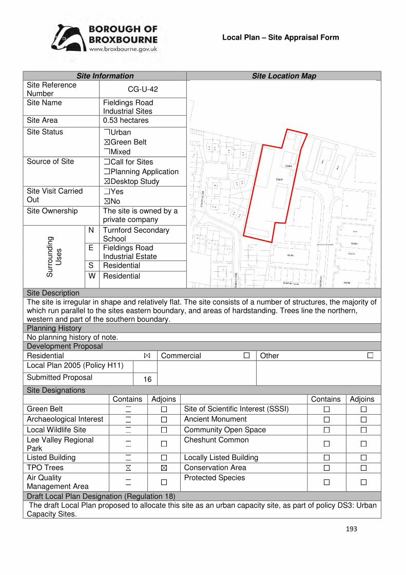
193
Local Plan – Site Appraisal Form
Site Information Site Location Map Site Reference Number
CG-U-42
Site Name Fieldings Road Industrial Sites
Site Area 0.53 hectares
Site Status ☐Urban ☒Green Belt ☐Mixed
Source of Site ☐Call for Sites ☐Planning Application ☒Desktop Study
Site Visit Carried Out
☐Yes ☒No
Site Ownership The site is owned by a private company
Surr
oundin
g
Uses
N Turnford Secondary School
E Fieldings Road Industrial Estate
S Residential
W Residential
Site Description The site is irregular in shape and relatively flat. The site consists of a number of structures, the majority of which run parallel to the sites eastern boundary, and areas of hardstanding. Trees line the northern, western and part of the southern boundary. Planning History No planning history of note. Development Proposal
Residential ☒ Commercial ☐ Other ☐
Local Plan 2005 (Policy H11)
Submitted Proposal 16
Site Designations Contains Adjoins Contains Adjoins
Green Belt ☐ ☐ Site of Scientific Interest (SSSI) ☐ ☐
Archaeological Interest ☐ ☐ Ancient Monument ☐ ☐
Local Wildlife Site ☐ ☐ Community Open Space ☐ ☐
Lee Valley Regional Park
☐ ☐ Cheshunt Common ☐ ☐
Listed Building ☐ ☐ Locally Listed Building ☐ ☐
TPO Trees ☒ ☒ Conservation Area ☐ ☐
Air Quality Management Area
☐ ☐ Protected Species ☐ ☐
Draft Local Plan Designation (Regulation 18) The draft Local Plan proposed to allocate this site as an urban capacity site, as part of policy DS3: Urban Capacity Sites.

194
Accessibility – distance as the crow flies
95m-Primary School (Brookland)
0m - Secondary School (Turnford Secondary School)
0m–Employment Area (adjoins Fieldings Road Industrial
Estate)
60m - Green Space (Cadmore Lane)
1.17km -Healthcare Centre (Warden Lodge)
10.16km- Hospital (with A&E) (Princess Alexandra)
790m - Town/District Centre (Cheshunt Old Pond)
400m - Local Centre (83-89 Roundmoor Drive)
970m -Leisure Centre (Laura Trott)
1.1km - A10 Junction (Church Lane)
700m- Railway Station (Cheshunt)
646m- Bus Service (Cheshunt Station)
Flood Risk Does the site Contains Adjoins
Zone 2 (Medium Risk) ☒ ☒
Zone 3a (High Risk) ☐ ☐
Zone 3b (Active Flood Plain) ☐ ☒
Additional Flood Risk Comments A flood risk assessment should support and proposals for development at this site. Flood mitigation measures may be required. Access and Transport Comments The site can be accessed via Fieldings Road (through the industrial estate). However, a more appropriate access would be via the garage area to the south of the site, but this would adjoin Utility Provision
Electricity Connections already available.
Gas A low pressure gas main is located along Fieldings Road
Water A water main is located along Fieldings Road
Sewerage A surface sewer runs through the southern region of the site (east to west). A foul sewer is located along Fieldings Road
Sewerage Treatment ☐Rye Meads ☒Deephams ☐Other
Additional Developer Comments submitted during Call for Sites None submitted. Suitability Comments The site is not considered to be suitable for residential development due to the following reasons:
• To the south of the site is proposed Cheshunt Lakeside development. The Council acknowledges that the proposed Cheshunt Lakeside development will result in a loss of employment land within this area. Therefore, it is considered that this site should retain its employment function to aid in negating some of the impacts of this proposed development and ensure employment opportunities within this area is retained.
• The site is still in employment use. The Council will resist the change of use of employment land to residential in areas
• The residents will have to access the site through an industrial estate. It is considered that this is not suitable access for residential development.
Due to the current established use of the site, it is considered that this site is suitable to form an extension to the adjoining Employment Area (Fieldings Road). Is this site considered to be suitable for development? ☐Yes ☒ No
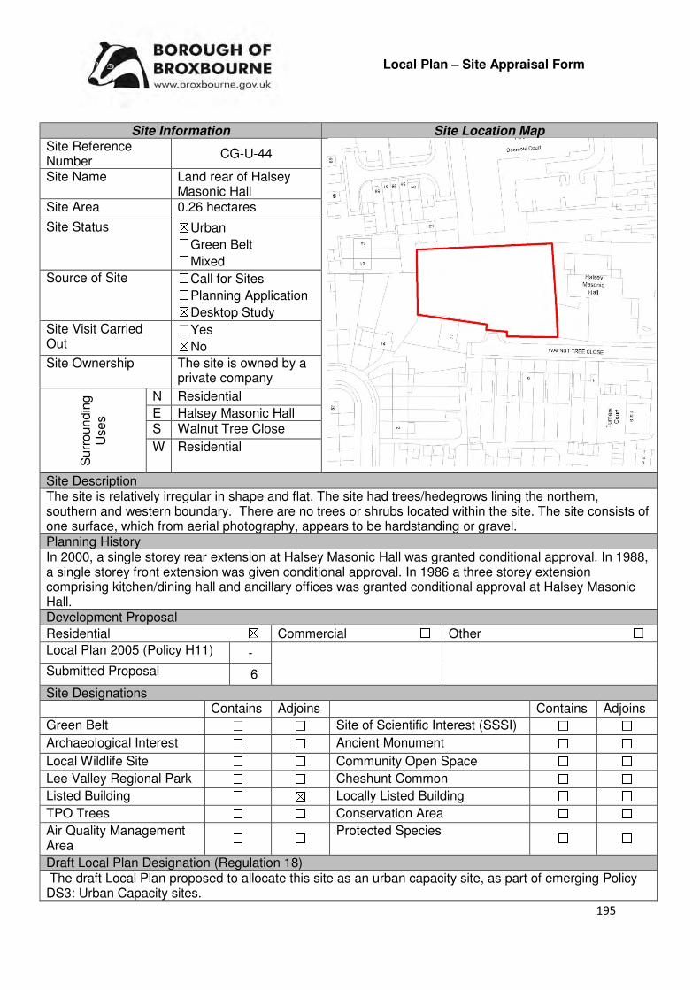
195
Local Plan – Site Appraisal Form
Site Information Site Location Map Site Reference Number
CG-U-44
Site Name Land rear of Halsey Masonic Hall
Site Area 0.26 hectares
Site Status ☒Urban ☐Green Belt ☐Mixed
Source of Site ☐Call for Sites ☐Planning Application ☒Desktop Study
Site Visit Carried Out
☐Yes ☒No
Site Ownership The site is owned by a private company
Surr
oundin
g
Uses
N Residential
E Halsey Masonic Hall S Walnut Tree Close
W Residential
Site Description The site is relatively irregular in shape and flat. The site had trees/hedegrows lining the northern, southern and western boundary. There are no trees or shrubs located within the site. The site consists of one surface, which from aerial photography, appears to be hardstanding or gravel. Planning History In 2000, a single storey rear extension at Halsey Masonic Hall was granted conditional approval. In 1988, a single storey front extension was given conditional approval. In 1986 a three storey extension comprising kitchen/dining hall and ancillary offices was granted conditional approval at Halsey Masonic Hall. Development Proposal
Residential ☒ Commercial ☐ Other ☐
Local Plan 2005 (Policy H11) -
Submitted Proposal 6
Site Designations Contains Adjoins Contains Adjoins
Green Belt ☐ ☐ Site of Scientific Interest (SSSI) ☐ ☐
Archaeological Interest ☐ ☐ Ancient Monument ☐ ☐
Local Wildlife Site ☐ ☐ Community Open Space ☐ ☐
Lee Valley Regional Park ☐ ☐ Cheshunt Common ☐ ☐
Listed Building ☐ ☒ Locally Listed Building ☐ ☐
TPO Trees ☐ ☐ Conservation Area ☐ ☐
Air Quality Management Area
☐ ☐ Protected Species ☐ ☐
Draft Local Plan Designation (Regulation 18) The draft Local Plan proposed to allocate this site as an urban capacity site, as part of emerging Policy DS3: Urban Capacity sites.

196
Accessibility – distance as the crow flies
360m -Primary School (Downfield)
540m - Secondary School (Cheshunt)
1.2km –Employment Area (Fieldings Road Industrial Estate)
90m - Green Space (Grundy Park)
72m -Healthcare Centre (Warden Lodge)
11.5km - Hospital (with A&E) (Princess Alexandra)
93m- Town/District Centre (Cheshunt Old Pond)
260m - Local Centre (127-137 Cromwell Avenue)
180m-Leisure Centre (Laura Trott)
570m- A10 Junction (Churchgate)
810m- Railway Station (Theobalds Grove)
80m- Bus Service (King Arthur Court)
Flood Risk Does the site Contains Adjoins
Zone 2 (Medium Risk) ☐ ☐
Zone 3a (High Risk) ☐ ☐
Zone 3b (Active Flood Plain) ☐ ☐
Additional Flood Risk Comments No flood risk comments for this site. Access and Transport Comments The site can be accessed via Turners Hill or from Walnut Tree Close. It is considered that Walnut Tree Close would be the more appropriate access point for this site. There are footpaths on the southern side of Walnut Tree Close, which leads to Turners Hill. Connections to these will be required. Utility Provision
Electricity Electricity connections available in the surrounding residential areas.
Gas Halsey Masonic Hall is connected to a low pressure gas main. A low pressure gas main is also located along Walnut Tree Close.
Water A water main is located along Walnut Tree Close and Turners Hill
Sewerage A surface sewer is located along Turners Hill. The closest foul sewer is located to the south east of the site.
Sewerage Treatment ☐Rye Meads ☒Deephams ☐Other
Additional Developer Comments submitted during Call for Sites 2016 None submitted. Suitability Comments The site is considered to be suitable for residential dwellings due to the following reasons:
• The site is previously developed land located with an existing settlement boundary. It is surrounded by residential units on three sides. In addition, the re-use of previously developed land is one of the 12 core land-use planning principles that underpins plan-making and decision making.
• The site is considered to be in a sustainable location for residential development – it is close to local facilities, education facilities and modes of sustainable transport. It is also within the sustainable distance recommended by Barton et al (2010) for a doctor’s surgery and local park/green space.
However, any scheme that comes forward on this site will need to take into account the setting of Halsey Masonic Hall, a Grade II listed building. Development proposals that will have a detrimental impact on this will not be permitted. The loss of car parking and the privacy of surrounding residential dwellings will also need to be considered.

197
Is this site considered to be suitable for development?
☒Yes ☐ No
Availability Comments The site is not available. The site is in active use as a car park for the Halsey Masonic Club. No promotion for the development of this site has been received by the landowner during the Call for Sites 2016 or the Local Plan (Regulation 18) Consultation
Is the site considered to be available for development
☐Yes ☒ No
Achievability Comments The site is not considered to be available, and therefore is not achievable.
Is the site considered to be achievable? ☐Yes ☒ No
Delivery Period -
198
Local Plan – Site Appraisal Form
Site Information Site Location Map Site Reference Number
CG-U-45
In 1976, Site Name Office building, 191-195 Windmill Lane
Site Area 0.13 hectares
Site Status ☒Urban ☐Green Belt ☐Mixed
Source of Site ☐Call for Sites ☐Planning Application ☒Desktop Study
Site Visit Carried Out
☐Yes ☒No
Site Ownership The site is owned by a two private companies.
Surr
oundin
g
Uses
N Car Park
E Residential properties S Windmill Lane
W Residential properties
Site Description The site is broadly rectangular in shape and relatively flat. Fronting onto windmill land is a three-storey building, with some parking facilities out the front. To the north of this building is a car park. Located in the north-eastern corner are two structures. Planning History In 1976, a three storey office block and twenty car parking spaces was approved. Development Proposal
Residential ☒ Commercial ☐ Other ☐
Local Plan 2005 (Policy H11)
Submitted Proposal 11
Site Designations Contains Adjoins Contains Adjoins
Green Belt ☐ ☐ Site of Scientific Interest (SSSI) ☐ ☐
Archaeological Interest ☐ ☐ Ancient Monument ☐ ☐
Local Wildlife Site ☐ ☐ Community Open Space ☐ ☒
Lee Valley Regional Park
☐ ☐ Cheshunt Common ☐ ☐
Listed Building ☐ ☐ Locally Listed Building ☐ ☐
TPO Trees ☐ ☐ Conservation Area ☒ ☒
Air Quality Management Area
☐ ☐ Protected Species ☐ ☐
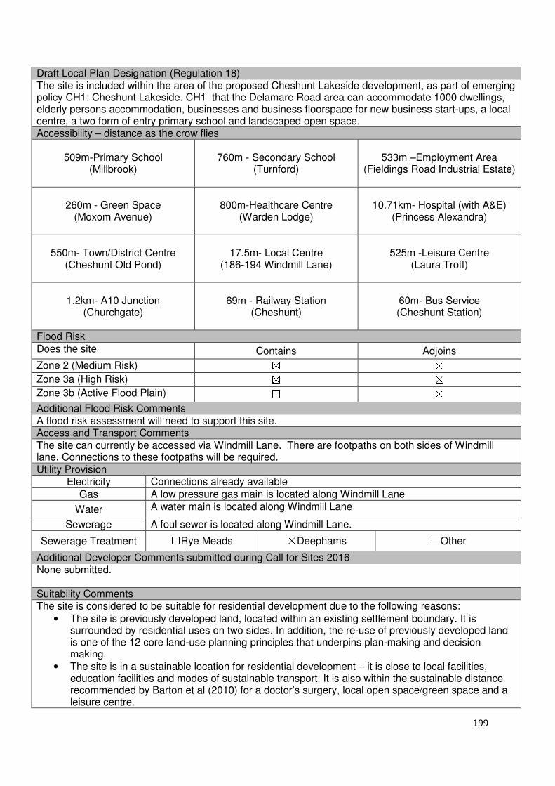
199
Draft Local Plan Designation (Regulation 18) The site is included within the area of the proposed Cheshunt Lakeside development, as part of emerging policy CH1: Cheshunt Lakeside. CH1 that the Delamare Road area can accommodate 1000 dwellings, elderly persons accommodation, businesses and business floorspace for new business start-ups, a local centre, a two form of entry primary school and landscaped open space. Accessibility – distance as the crow flies
509m-Primary School (Millbrook)
760m - Secondary School (Turnford)
533m –Employment Area (Fieldings Road Industrial Estate)
260m - Green Space (Moxom Avenue)
800m-Healthcare Centre
(Warden Lodge)
10.71km- Hospital (with A&E) (Princess Alexandra)
550m- Town/District Centre (Cheshunt Old Pond)
17.5m- Local Centre
(186-194 Windmill Lane)
525m -Leisure Centre (Laura Trott)
1.2km- A10 Junction
(Churchgate)
69m - Railway Station (Cheshunt)
60m- Bus Service (Cheshunt Station)
Flood Risk Does the site Contains Adjoins
Zone 2 (Medium Risk) ☒ ☒
Zone 3a (High Risk) ☒ ☒
Zone 3b (Active Flood Plain) ☐ ☒
Additional Flood Risk Comments A flood risk assessment will need to support this site. Access and Transport Comments The site can currently be accessed via Windmill Lane. There are footpaths on both sides of Windmill lane. Connections to these footpaths will be required. Utility Provision
Electricity Connections already available
Gas A low pressure gas main is located along Windmill Lane
Water A water main is located along Windmill Lane
Sewerage A foul sewer is located along Windmill Lane.
Sewerage Treatment ☐Rye Meads ☒Deephams ☐Other
Additional Developer Comments submitted during Call for Sites 2016 None submitted. Suitability Comments The site is considered to be suitable for residential development due to the following reasons:
• The site is previously developed land, located within an existing settlement boundary. It is surrounded by residential uses on two sides. In addition, the re-use of previously developed land is one of the 12 core land-use planning principles that underpins plan-making and decision making.
• The site is in a sustainable location for residential development – it is close to local facilities, education facilities and modes of sustainable transport. It is also within the sustainable distance recommended by Barton et al (2010) for a doctor’s surgery, local open space/green space and a leisure centre.
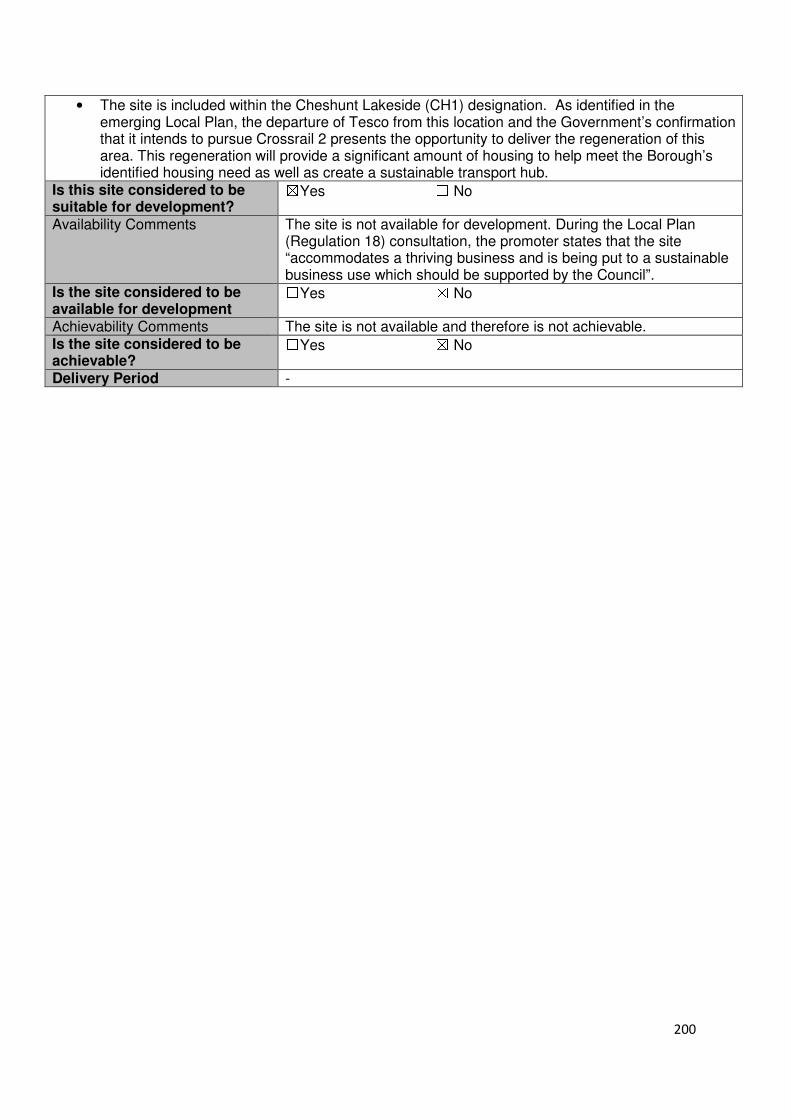
200
• The site is included within the Cheshunt Lakeside (CH1) designation. As identified in the emerging Local Plan, the departure of Tesco from this location and the Government’s confirmation that it intends to pursue Crossrail 2 presents the opportunity to deliver the regeneration of this area. This regeneration will provide a significant amount of housing to help meet the Borough’s identified housing need as well as create a sustainable transport hub.
Is this site considered to be suitable for development?
☒Yes ☐ No
Availability Comments The site is not available for development. During the Local Plan (Regulation 18) consultation, the promoter states that the site “accommodates a thriving business and is being put to a sustainable business use which should be supported by the Council”.
Is the site considered to be available for development
☐Yes ☒ No
Achievability Comments The site is not available and therefore is not achievable. Is the site considered to be achievable?
☐Yes ☒ No
Delivery Period -
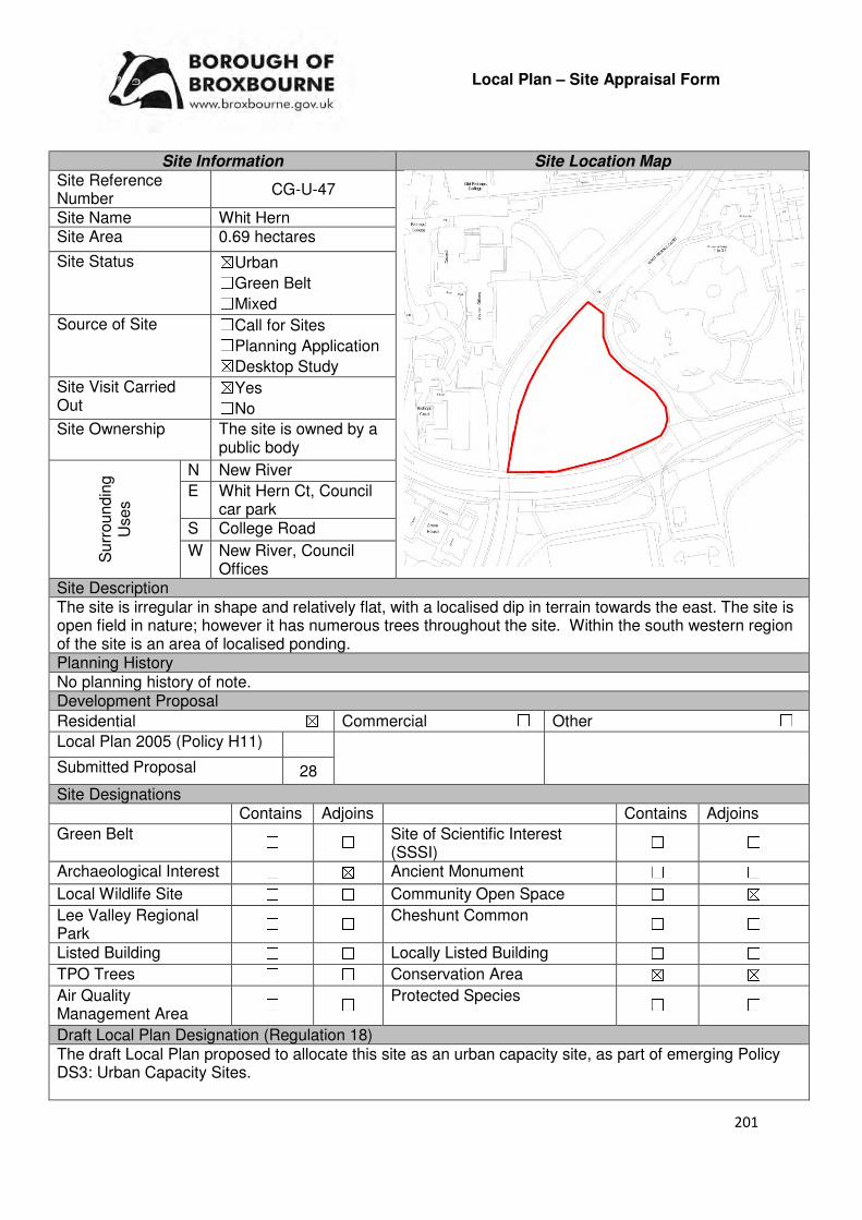
201
Local Plan – Site Appraisal Form
Site Information Site Location Map Site Reference Number
CG-U-47
Site Name Whit Hern Site Area 0.69 hectares
Site Status ☒Urban ☐Green Belt ☐Mixed
Source of Site ☐Call for Sites ☐Planning Application ☒Desktop Study
Site Visit Carried Out
☒Yes ☐No
Site Ownership The site is owned by a public body
Surr
oundin
g
Uses
N New River
E Whit Hern Ct, Council car park
S College Road
W New River, Council Offices
Site Description The site is irregular in shape and relatively flat, with a localised dip in terrain towards the east. The site is open field in nature; however it has numerous trees throughout the site. Within the south western region of the site is an area of localised ponding. Planning History No planning history of note. Development Proposal
Residential ☒ Commercial ☐ Other ☐
Local Plan 2005 (Policy H11)
Submitted Proposal 28
Site Designations Contains Adjoins Contains Adjoins
Green Belt ☐ ☐ Site of Scientific Interest (SSSI)
☐ ☐
Archaeological Interest ☐ ☒ Ancient Monument ☐ ☐
Local Wildlife Site ☐ ☐ Community Open Space ☐ ☒
Lee Valley Regional Park
☐ ☐ Cheshunt Common ☐ ☐
Listed Building ☐ ☐ Locally Listed Building ☐ ☐
TPO Trees ☐ ☐ Conservation Area ☒ ☒
Air Quality Management Area
☐ ☐ Protected Species ☐ ☐
Draft Local Plan Designation (Regulation 18) The draft Local Plan proposed to allocate this site as an urban capacity site, as part of emerging Policy DS3: Urban Capacity Sites.
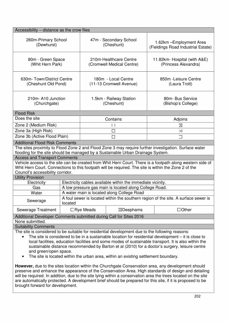
202
Accessibility – distance as the crow flies
260m-Primary School (Dewhurst)
47m - Secondary School (Cheshunt)
1.62km –Employment Area
(Fieldings Road Industrial Estate)
80m - Green Space (Whit Hern Park)
210m-Healthcare Centre
(Cromwell Medical Centre)
11.82km- Hospital (with A&E) (Princess Alexandra)
630m- Town/District Centre (Cheshunt Old Pond)
180m - Local Centre
(11-13 Cromwell Avenue)
850m -Leisure Centre (Laura Trott)
210m- A10 Junction
(Churchgate)
1.5km - Railway Station (Cheshunt)
80m- Bus Service (Bishop’s College)
Flood Risk Does the site Contains Adjoins
Zone 2 (Medium Risk) ☐ ☒
Zone 3a (High Risk) ☐ ☒
Zone 3b (Active Flood Plain) ☐ ☐
Additional Flood Risk Comments The sites proximity to Flood Zone 2 and Flood Zone 3 may require further investigation. Surface water flooding for the site should be managed by a Sustainable Urban Drainage System. Access and Transport Comments Vehicle access to the site can be created from Whit Hern Court. There is a footpath along western side of Whit Hern Court. Connections to this footpath will be required. The site is within the Zone 2 of the Council’s accessibility corridor. Utility Provision
Electricity Electricity cables available within the immediate vicinity.
Gas A low pressure gas main is located along College Road.
Water A water main is located along College Road
Sewerage A foul sewer is located within the southern region of the site. A surface sewer is located
Sewerage Treatment ☐Rye Meads ☒Deephams ☐Other
Additional Developer Comments submitted during Call for Sites 2016 None submitted. Suitability Comments The site is considered to be suitable for residential development due to the following reasons:
• The site is considered to be in a sustainable location for residential development – it is close to local facilities, education facilities and some modes of sustainable transport. It is also within the sustainable distance recommended by Barton et al (2010) for a doctor’s surgery, leisure centre and green/open space.
• The site is located within the urban area, within an existing settlement boundary. However, due to the sites location within the Churchgate Conservation area, any development should preserve and enhance the appearance of the Conservation Area. High standards of design and detailing will be required. In addition, due to the site lying within a conservation area the trees located on the site are automatically protected. A development brief should be prepared for this site, if it is proposed to be brought forward for development.

203
Is this site considered to be suitable for development?
☒Yes ☐ No
Availability Comments The site is owned by the Council. As encouraged in the Housing White Paper (2017), the Council has reviewed its landholdings to identify potential sites for development. This site was identified as having potential to come forward for development within the first part of the Plan period.
Is the site considered to be available for development
☒Yes ☐ No
Achievability Comments The site is considered to be achievable. There are no policy constraints that would prevent this site from coming forward. There are no legal/ownership issues that would prevent this site from being developed. It is considered that the preparatory works required to bring this site forward for development will not have a detrimental impact on the sites viability.
Is the site considered to be achievable?
☒Yes ☐ No
Delivery Period 1-5 years
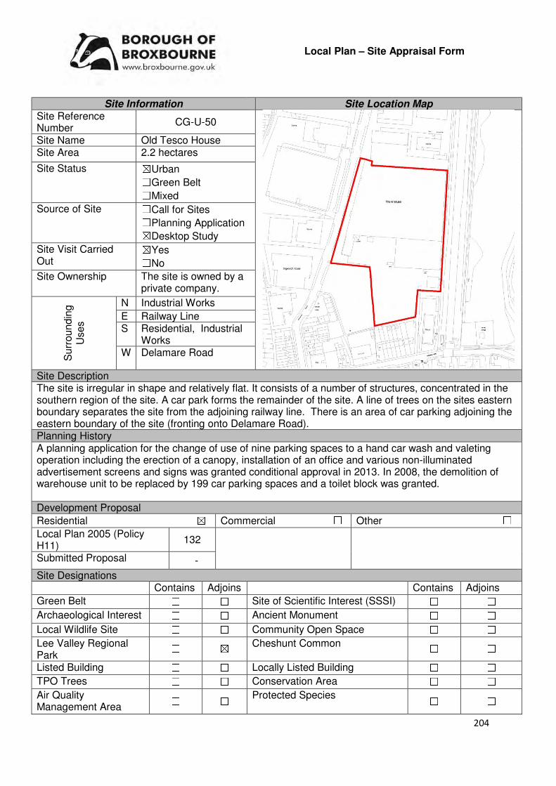
204
Local Plan – Site Appraisal Form
Site Information Site Location Map Site Reference Number
CG-U-50
Site Name Old Tesco House Site Area 2.2 hectares
Site Status ☒Urban ☐Green Belt ☐Mixed
Source of Site ☐Call for Sites ☐Planning Application ☒Desktop Study
Site Visit Carried Out
☒Yes ☐No
Site Ownership The site is owned by a private company.
Surr
oundin
g
Uses
N Industrial Works
E Railway Line S Residential, Industrial
Works W Delamare Road
Site Description The site is irregular in shape and relatively flat. It consists of a number of structures, concentrated in the southern region of the site. A car park forms the remainder of the site. A line of trees on the sites eastern boundary separates the site from the adjoining railway line. There is an area of car parking adjoining the eastern boundary of the site (fronting onto Delamare Road). Planning History A planning application for the change of use of nine parking spaces to a hand car wash and valeting operation including the erection of a canopy, installation of an office and various non-illuminated advertisement screens and signs was granted conditional approval in 2013. In 2008, the demolition of warehouse unit to be replaced by 199 car parking spaces and a toilet block was granted. Development Proposal
Residential ☒ Commercial ☐ Other ☐
Local Plan 2005 (Policy H11)
132
Submitted Proposal -
Site Designations Contains Adjoins Contains Adjoins
Green Belt ☐ ☐ Site of Scientific Interest (SSSI) ☐ ☐
Archaeological Interest ☐ ☐ Ancient Monument ☐ ☐
Local Wildlife Site ☐ ☐ Community Open Space ☐ ☐
Lee Valley Regional Park
☐ ☒ Cheshunt Common ☐ ☐
Listed Building ☐ ☐ Locally Listed Building ☐ ☐
TPO Trees ☐ ☐ Conservation Area ☐ ☐
Air Quality Management Area
☐ ☐ Protected Species ☐ ☐
205
Draft Local Plan Designation (Regulation 18) The site is included within the proposed Cheshunt Lakeside (CH1) allocation. The emerging policy identifies that the Cheshunt Lakeside site can accommodate 1000 dwellings, elderly persons accommodation, businesses and business floorspace for new business start-ups, a local centre, a two form of entry primary school and landscaped open space. Accessibility – distance as the crow flies
390m-Primary School (Brooklands)
530m - Secondary School (Turnford)
320m–Employment Area (Fieldings Road Industrial Estate)
80m - Green Space (Lee Valley Regional Park)
840m -Healthcare Centre
(Warden Lodge)
10.46km- Hospital (with A&E) (Princess Alexandra)
520m- Town/District Centre (Cheshunt Old Pond)
80m - Local Centre
(186-194 Windmill Lane)
570m-Leisure Centre (Laura Trott)
1.23km - A10 Junction (Churchgate)
90m- Railway Station
(Cheshunt)
125m- Bus Service (Cheshunt)
Flood Risk Does the site Contains Adjoins
Zone 2 (Medium Risk) ☒ ☒
Zone 3a (High Risk) ☒ ☒
Zone 3b (Active Flood Plain) ☐ ☐
Additional Flood Risk Comments A flood risk assessment will need to accompany any planning application for this site and appropriate mitigation schemes implemented. A sequential test will need to be undertaken. Access and Transport Comments The site can be accessed via Delamare Road. Due to the amount of development this site would require a transport assessment. There are footpaths on both sides of Delamare Road. Connections to these footpaths will be required. Cycle access to the site will need to be provided. Utility Provision
Electricity Available at the site.
Gas A low pressure gas main is located along Delamare Road
Water A water main is located along Delamare Road
Sewerage A surface sewer and foul sewer is located along Delamare Road
Sewerage Treatment ☐Rye Meads ☒Deephams ☐Other
Additional Developer Comments submitted during Call for Sites 2016 None submitted. Comments have been submitted during the Local Plan (Regulation 18) consultation in relation to the Cheshunt Lakeside site. These comments can be found on the Council’s website, by using the following link: www.broxbourne.gov.uk/lpsites Suitability Comments The site is considered to be suitable for residential development due to the following reasons:
• The site is previously developed land, located within an existing settlement boundary. It is surrounded by residential uses on two sides. In addition, the re-use of previously developed land is one of the 12 core land-use planning principles that underpins plan-making and decision making.
206
• The site is in a sustainable location for residential development – it is close to local facilities, education facilities and modes of sustainable transport. It is also within the sustainable distance recommended by Barton et al (2010) for a doctor’s surgery, local open space/green space and a leisure centre.
• The site is included within the Cheshunt Lakeside (CH1) designation. As identified in the emerging Local Plan, the departure of Tesco from this location and the Government’s confirmation that it intends to pursue Crossrail 2 presents the opportunity to deliver the regeneration of this area. This regeneration will provide a significant amount of housing to help meet the borough’s identified housing need.
Is this site considered to be suitable for development?
☒Yes ☐ No
Availability Comments The site has been promoted to the Council for development. The availability of this land for development has been confirmed to the Council by the landowner. Although the site is in single ownership and vacant, therefore in principle could come forward relatively quickly, the Council anticipates that this site will come forward as part of a comprehensive scheme which will be developed in accordance with a comprehensive master plan. As identified in emerging Policy CH1, incremental development of this area will be resisted.
Is the site considered to be available for development
☒Yes ☐ No
Achievability Comments The site is considered to be achievable. The proposed density for the site will be able to deliver the infrastructure and mitigatory schemes required to bring this site forward for development. The Council has carried out an exception test which indicates that the sites flood risk is a constraint, but the site can be effectively managed. As a result of this, it is considered that there are no policy constraints that would prevent this site from coming forward.
Is the site considered to be achievable?
☒Yes ☐ No
Delivery Period 1-15 years

207
Local Plan – Site Appraisal Form
Site Information Site Location Map Site Reference Number
CG-U-52
Site Name Land to rear of Goffs Oak House
Site Area 0.42 hectares
Site Status ☒Urban ☐Green Belt ☐Mixed
Source of Site ☐Call for Sites ☒Planning Application ☒Desktop Study
Site Visit Carried Out
☐Yes ☒No
Site Ownership The site is owned by a private company
Surr
oundin
g
Uses
N Goffs Oak House
E Residential dwellings S Local Wildlife Site,
Green Belt W Doverfield, Residential
Dwellings
Site Description The site is broadly rectangular in shape and is relatively flat. There are number of trees located on the site, of which a number are mature. There is an area of hardstanding/gravel that adjoins and stretches the length of the western boundary of the site. Planning History Residential development of 16 detached dwellings and associated work at land at the rear of Goffs Oak House was refused in 1988. Development Proposal
Residential ☒ Commercial ☐ Other ☐
Local Plan 2005 (Policy H11) -
Submitted Proposal 8
Site Designations Contains Adjoins Contains Adjoins
Green Belt ☐ ☒ Site of Scientific Interest (SSSI) ☐ ☐
Archaeological Interest ☐ ☐ Ancient Monument ☐ ☐
Local Wildlife Site ☐ ☒ Community Open Space ☐ ☐
Lee Valley Regional Park
☐ ☐ Cheshunt Common ☐ ☐
Listed Building ☐ ☒ Locally Listed Building ☐ ☐
TPO Trees ☒ ☒ Conservation Area ☐ ☐
Air Quality Management Area
☐ ☐ Protected Species ☐ ☐
Draft Local Plan Designation (Regulation 18) The draft Local Plan proposed to allocate this site as an urban capacity site, as part of emerging Policy DS3: Urban Capacity Sites.
208
Accessibility – distance as the crow flies
310m -Primary School (Woodside)
1.75km - Secondary School (Goffs)
3.51km –Employment Area (New River Trading Estate)
150m - Green Space (Goffs Informal)
110m -Healthcare Centre
(Valley View)
11km- Hospital (with A&E) (Barnet)
3.2km - Town/District Centre
(Brookfield)
110m - Local Centre (684-696 Goffs Lane)
3.6km -Leisure Centre
(Laura Trott)
2.95km - A10 Junction (Churchgate)
1.67km - Railway Station
(Cuffley)
77m- Bus Service (War Memorial)
Flood Risk Does the site Contains Adjoins
Zone 2 (Medium Risk) ☐ ☐
Zone 3a (High Risk) ☐ ☐
Zone 3b (Active Flood Plain) ☐ ☒
Additional Flood Risk Comments No flood risk issues identified for this site. Access and Transport Comments The site can be accessed from Doverfield. The footpath on the eastern side of Doverfield stops at the current vehicle entrance to the site and begins again at the sites south western corner. The footpath on the western side of Doverfield runs the length of Doverfield. Connections to these footpaths will be required. Utility Provision
Electricity Electricity cables available at the existing problems
Gas A low pressure gas main is located to the north at Goffs Oak House or to the west at Doverfield
Water A water main is located along Goffs Lane, Doverfield and at Myles Court. A water hydrant adjoins the site to the east.
Sewerage A foul sewer and surface sewer are located along Goffs Lane. A pressure main is located along Doverfield
Sewerage Treatment ☐Rye Meads ☐Deephams ☐Other
Additional Developer Comments submitted during Call for Sites 2016 None submitted. Suitability Comments The site is not considered to be suitable for residential development due to the following reasons:
• The development of this site would adversely affect the setting and character of Goffs Oak House, a Grade II Listed Building.
Is this site considered to be suitable for development? ☐Yes ☒ No

209
Local Plan – Site Appraisal Form
Site Information Site Location Map Site Reference Number
CG-U-54
Site Name Borough Council Offices Site Area 1.69 hectares
Site Status ☒Urban ☐Green Belt ☐Mixed
Source of Site ☐Call for Sites ☐Planning Application ☒Desktop Study
Site Visit Carried Out
☒Yes ☐No
Site Ownership The site is owned by a public body.
Surr
oundin
g
Uses
N Whit Hern Park, Listed Building, Public House
E New River, Emanuel Lodge S Residential
W Churchgate, Residential
Site Description The site is irregular in shape and relatively flat. The part of the site to the west of the New River consists of a number of buildings, the largest of which being three storeys. There is an area of car parking fronting on to Churchgate. To the east of the main building is an area of green space. A footbridge links the western region of the site with the eastern region. The eastern region of the site is a car park which has trees/hedges located within the car park and on its boundaries. A brick wall separates part the eastern edge of the car park from the adjoining Emanuel Lodge. Planning History In 1984, planning permission was granted for the construction of a new two/three storey civic office building and first floor link to existing building and the formation of a new car park and access to College Road. Since then, there have been various planning applications to improve and alter the numerous facilities located within this site. Development Proposal
Residential ☒ Commercial ☐ Other ☐
Local Plan 2005 (Policy H11)
Submitted Proposal 50
Site Designations Contains Adjoins Contains Adjoins
Green Belt ☐ ☐ Site of Scientific Interest (SSSI) ☐ ☐
Archaeological Interest ☒ ☒ Ancient Monument ☐ ☐
Local Wildlife Site ☐ ☐ Community Open Space ☒ ☒
Lee Valley Regional Park ☐ ☐ Cheshunt Common ☐ ☐
Listed Building ☒ ☒ Locally Listed Building ☐ ☐
TPO Trees ☐ ☐ Conservation Area ☒ ☒
Air Quality Management Area
☐ ☐ Protected Species ☐ ☐

210
Draft Local Plan Designation (Regulation 18) The draft Local Plan proposed to allocate this site as an urban capacity site, as part of emerging Policy DS3: Urban Capacity Sites Accessibility – distance as the crow flies
172m-Primary School (Dewhurst)
70m - Secondary School (Cheshunt)
1.54km –Employment Area (Fieldings Road Industrial Estate)
0m - Green Space (adjoins Whit Hern Park)
200m-Healthcare Centre (Cromwell Avenue)
11.85km- Hospital (with A&E) (Princess Alexandra)
575m- Town/District Centre (Cheshunt Old Pond)
147 - Local Centre (16 Cromwell Avenue)
820m -Leisure Centre (Laura Trott)
220m- A10 Junction (Churchgate)
1.45km - Railway Station (Cheshunt)
30m- Bus Service (Bishops’ College)
Flood Risk Does the site Contains Adjoins
Zone 2 (Medium Risk) ☐ ☐
Zone 3a (High Risk) ☐ ☐
Zone 3b (Active Flood Plain) ☐ ☐
Additional Flood Risk Comments A SuDs system may be required as the site could impact upon drainage. Access and Transport Comments The site benefits from existing vehicle access from College Road (Whit Hern Ct) and Churchgate. There are footpaths on both sides of College Road and Churchgate. A transport assessment may be required to support any planning application for this site. The site is located within the accessibility corridor. Connections to these will be required. Connections to the footpath on the western side of Whit Hern Ct will also be required. Utility Provision
Electricity Connections already available.
Gas A low pressure gas main is located along Churchgate
Water A water main is located along Churchgate
Sewerage A foul sewer and surface sewer is located along Churchgate
Sewerage Treatment ☐Rye Meads ☒Deephams ☐Other
Additional Developer Comments submitted during Call for Sites 2016 None submitted. Suitability Comments The site is considered to be suitable for residential development due to the following reasons:
• The site is considered to be in a sustainable location for residential development – it is close to local facilities, education facilities and some modes of sustainable transport. It is also within the sustainable distance recommended by Barton et al (2010) for a doctor’s surgery, leisure centre and green/open space.
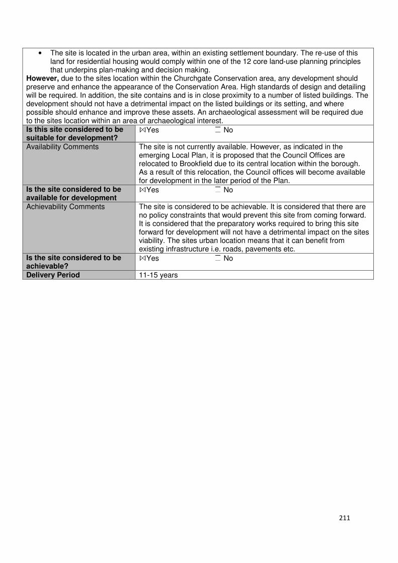
211
• The site is located in the urban area, within an existing settlement boundary. The re-use of this land for residential housing would comply within one of the 12 core land-use planning principles that underpins plan-making and decision making.
However, due to the sites location within the Churchgate Conservation area, any development should preserve and enhance the appearance of the Conservation Area. High standards of design and detailing will be required. In addition, the site contains and is in close proximity to a number of listed buildings. The development should not have a detrimental impact on the listed buildings or its setting, and where possible should enhance and improve these assets. An archaeological assessment will be required due to the sites location within an area of archaeological interest. Is this site considered to be suitable for development?
☒Yes ☐ No
Availability Comments The site is not currently available. However, as indicated in the emerging Local Plan, it is proposed that the Council Offices are relocated to Brookfield due to its central location within the borough. As a result of this relocation, the Council offices will become available for development in the later period of the Plan.
Is the site considered to be available for development
☒Yes ☐ No
Achievability Comments The site is considered to be achievable. It is considered that there are no policy constraints that would prevent this site from coming forward. It is considered that the preparatory works required to bring this site forward for development will not have a detrimental impact on the sites viability. The sites urban location means that it can benefit from existing infrastructure i.e. roads, pavements etc.
Is the site considered to be achievable?
☒Yes ☐ No
Delivery Period 11-15 years
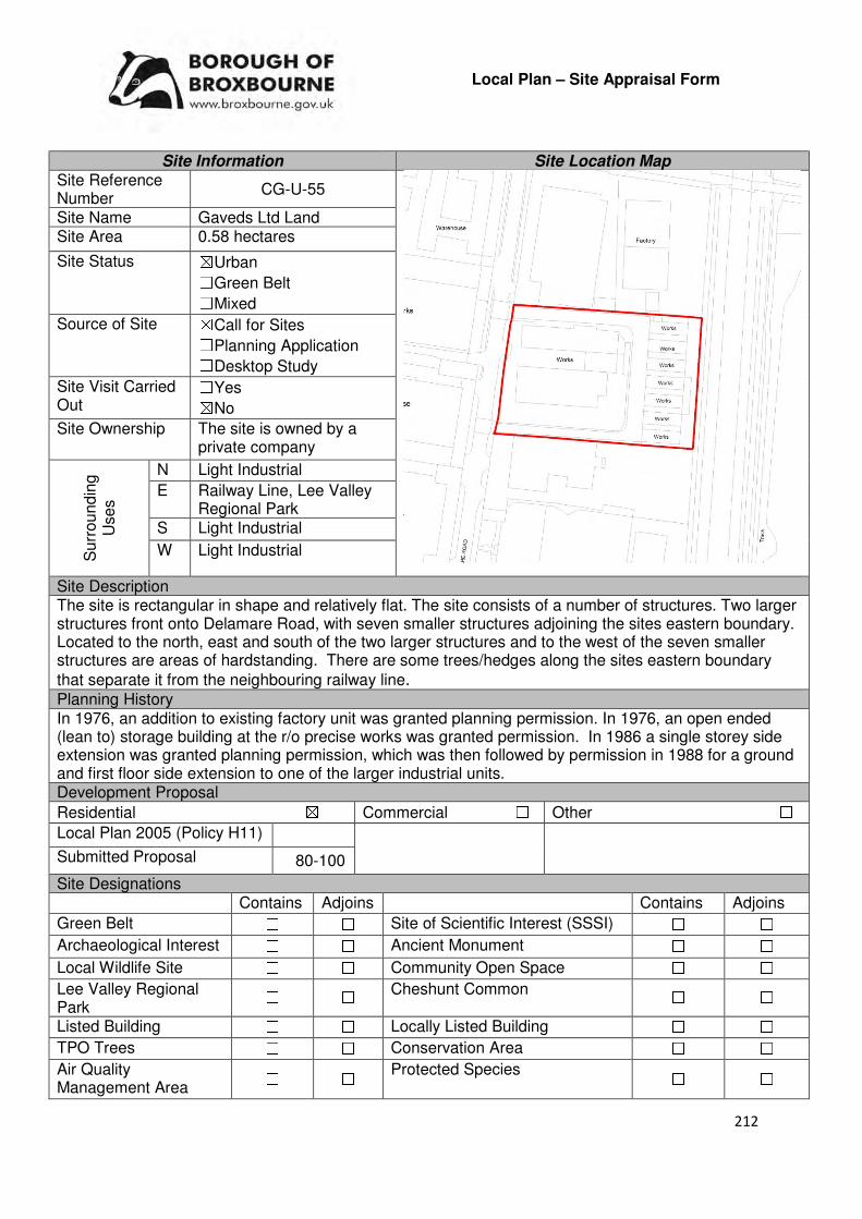
212
Local Plan – Site Appraisal Form
Site Information Site Location Map Site Reference Number
CG-U-55
Site Name Gaveds Ltd Land Site Area 0.58 hectares
Site Status ☒Urban ☐Green Belt ☐Mixed
Source of Site ☒Call for Sites ☐Planning Application ☐Desktop Study
Site Visit Carried Out
☐Yes ☒No
Site Ownership The site is owned by a private company
Surr
oundin
g
Uses
N Light Industrial
E Railway Line, Lee Valley Regional Park
S Light Industrial
W Light Industrial
Site Description The site is rectangular in shape and relatively flat. The site consists of a number of structures. Two larger structures front onto Delamare Road, with seven smaller structures adjoining the sites eastern boundary. Located to the north, east and south of the two larger structures and to the west of the seven smaller structures are areas of hardstanding. There are some trees/hedges along the sites eastern boundary
that separate it from the neighbouring railway line. Planning History In 1976, an addition to existing factory unit was granted planning permission. In 1976, an open ended (lean to) storage building at the r/o precise works was granted permission. In 1986 a single storey side extension was granted planning permission, which was then followed by permission in 1988 for a ground and first floor side extension to one of the larger industrial units. Development Proposal
Residential ☒ Commercial ☐ Other ☐
Local Plan 2005 (Policy H11)
Submitted Proposal 80-100
Site Designations Contains Adjoins Contains Adjoins
Green Belt ☐ ☐ Site of Scientific Interest (SSSI) ☐ ☐
Archaeological Interest ☐ ☐ Ancient Monument ☐ ☐
Local Wildlife Site ☐ ☐ Community Open Space ☐ ☐
Lee Valley Regional Park
☐ ☐ Cheshunt Common ☐ ☐
Listed Building ☐ ☐ Locally Listed Building ☐ ☐
TPO Trees ☐ ☐ Conservation Area ☐ ☐
Air Quality Management Area
☐ ☐ Protected Species ☐ ☐

213
Draft Local Plan Designation (Regulation 18) The site is included within the site area for the proposed Cheshunt Lakeside (CH1) allocation. The emerging policy identifies that the Cheshunt Lakeside site can accommodate 1000 dwellings, elderly persons accommodation, businesses and business floorspace for new business start-ups, a local centre, a two form of entry primary school and landscape open space. Accessibility – distance as the crow flies
230m-Primary School (Brooklands Primary School)
320m - Secondary School (Turnford)
80m –Employment Area
(Fieldings Road Industrial Estate)
140m - Green Space (Cadmore Lane)
1.09km -Healthcare Centre
(Warden Lodge)
10.29km- Hospital (with A&E) (Princess Alexandra)
670m- Town/District Centre
(Cheshunt Old Pond)
340m - Local Centre
(83-89 Roundmoor Drive)
810m-Leisure Centre
(Laura Trott)
1.16km- A10 Junction (Church Lane)
450m- Railway Station
(Cuffley)
430m- Bus Service (Cheshunt Railway Station (Stop
D))
Flood Risk Does the site Contains Adjoins
Zone 2 (Medium Risk) ☒ ☒
Zone 3a (High Risk) ☐ ☐
Zone 3b (Active Flood Plain) ☐ ☒
Additional Flood Risk Comments A flood risk assessment will need to accompany any planning application for this site an appropriate mitigation schemes implement. Access and Transport Comments The site can be accessed via Delamare Road. Due to the amount of development this site could accommodate a transport assessment will be required. There are footpaths on both sites of Delamare Road. Connections to these footpaths will be required. Cycle access to the site will need to be provided. Utility Provision
Electricity Electricity connections available
Gas The site is connected to a low pressure gas main.
Water A water main is located along Delamare Road
Sewerage A foul sewer is located on part of the sites western boundary. A surface sewer is located along Delamare Road.
Sewerage Treatment ☐Rye Meads ☒Deephams ☐Other
Additional Developer Comments submitted during Call for Sites 2016 The promoter stated that there are no material constraints that would prevent the site from being developed for housing from around Q4 of 2020. The promoter stated that the site has an existing safe access point at Delamare Road, has not history of flooding. No survey has been conducted to determine which the site contains contaminated land – the promoter states that the site has been used for light industrial activities since 1960 and was previously allotments and that there are no known hazardous uses on the site. The existing structures are nine factory units predominantly built in the 1960s with some later additions to the larger units. All these units are planned for demolition in Q3/Q4 of 2020.
214
Suitability Comments The site is considered to be suitable for residential development due to the following reasons:
• The site is previously developed land, located within an existing settlement boundary. The re-use of previously developed land is one of the 12 core land-use planning principles that underpins plan-making and decision making.
• The site is in a sustainable location for residential development – it is close to local facilities, education facilities and modes of sustainable transport. It is also within the sustainable distance recommended by Barton et al (2010) for a doctor’s surgery, local open space/green space and a leisure centre.
• The site is included within the Cheshunt Lakeside (CH1) designation. As identified in the emerging Local Plan, the departure of Tesco from this location and the Government’s confirmation that it intends to pursue Crossrail 2 presents the opportunity to deliver the regeneration of this area. This regeneration will provide a significant amount of housing to help meet the borough’s identified housing need as well as create a sustainable transport hub.
Is this site considered to be suitable for development?
☒Yes ☐ No
Availability Comments The site has been promoted to the Council during the Call for Sites 2016. As part of this promotion, the promoter states that the site would be able to come forward for development after 2020. The Council anticipates that this site will come forward as part of a comprehensive scheme that will be developed in accordance with a master plan. As indicated in emerging Policy CH1 incremental development of this area will be resisted.
Is the site considered to be available for development
☒Yes ☐ No
Achievability Comments The site is considered to be achievable. The proposed density of the site will be able to deliver the infrastructure and mitigatory schemes required to bring this site forward for development. The Council has carried out an Exception Test which indicates that the flood risk in this area is a constraint, but the site can be effectively managed and considers the site to be suitable for development due to its other sustainability factors. As a result of this, it is considered that there are no policy constraints that would prevent this site from coming forward.
Is the site considered to be achievable?
☒Yes ☐ No
Delivery Period 1-15 years

215
Local Plan – Site Appraisal Form
Site Information Site Location Map Site Reference Number
CG-U-56
Site Name Cheshunt Lakeside Site Area 12.37 hectares
Site Status ☒Urban ☐Green Belt ☐Mixed
Source of Site ☐Call for Sites ☐Planning Application ☒Desktop Study
Site Visit Carried Out
☒Yes ☐No
Site Ownership There are various landowners for this site
Surr
oundin
g U
ses N Cadmore Lane, Fieldings
Road Industrial Estate E Railway Line, Lee Valley
Regional Park S Cheshunt Station,
Residential W Residential, Allotments
Site Description The site is broadly rectangular in shape and relatively flat. The site is separated into two different regions (east and west) by a road that runs from north to south. Located in the two regions are a number of structures, of varying size, and areas of hardstanding. There are some trees scattered along the sites eastern boundary, with a stronger tree lines along the western boundary where the site is adjoined by residential gardens.
Planning History There have been various planning applications for a number of buildings located within this site. These applications included the extension and alteration to buildings and change of use. Development Proposal
Residential ☒ Commercial ☒ Other ☐
Local Plan 2005 (Policy H11)
Submitted Proposal 1990
Site Designations Contains Adjoins Contains Adjoins
Green Belt ☐ ☒ Site of Scientific Interest (SSSI) ☐ ☐
Archaeological Interest ☐ ☐ Ancient Monument ☐ ☐
Local Wildlife Site ☐ ☐ Community Open Space ☐ ☒
Lee Valley Regional Park
☐ ☒ Cheshunt Common ☐ ☐
Listed Building ☐ ☐ Locally Listed Building ☐ ☐
TPO Trees ☐ ☐ Conservation Area ☐ ☐
Air Quality Management Area
☐ ☐ Protected Species ☐ ☐

216
Draft Local Plan Designation (Regulation 18) The draft Local Plan proposed to allocate this site for mixed-use development, as part of emerging Policy CH1: Cheshunt Lakeside. The states that the site can accommodate 1000 dwellings, elderly persons accommodation, businesses and business floorspace for new business start-ups, a local centre, a two form of entry primary school and landscaped open space. Accessibility – distance as the crow flies
140m -Primary School (Brooklands)
250m - Secondary School (Turnford)
20m –Employment Area
(Fieldings Road Industrial Estate)
0m - Green Space (adjoins Clifton Close and 25m
away from Cadmore Lane)
730m -Healthcare Centre (Warden Lodge)
10.23km- Hospital (with A&E) (Princess Alexandra)
490m- Town/District Centre (Cheshunt Old Pond)
15m - Local Centre (186-194 Windmill Lane)
450m-Leisure Centre (Laura Trott)
1.02km- A10 Junction (Church Lane)
30m- Railway Station
(Cheshunt)
30m- Bus Service (Cheshunt Railway Station)
Flood Risk Does the site Contains Adjoins
Zone 2 (Medium Risk) ☒ ☒
Zone 3a (High Risk) ☒ ☒
Zone 3b (Active Flood Plain) ☐ ☒
Additional Flood Risk Comments Any planning application for this site should be accompanied by a flood risk assessment and appropriate mitigation schemes implemented. A sequential test will be required. Access and Transport Comments Running through the centre of the site is Delamare Road, which connects to Windmill Lane to the south and Cadmore Lane to the north. Due to the amount of development this site could accommodate a transport assessment will be required, and schemes that will mitigate against the impact of the proposed development implemented. Pedestrian access to the site is available from Cadmore Lane, Windmill Lane and Delamare Road, which all have footpaths on both sides. Pedestrian accessibility to the site should be retained, and improved. Cycle access to the site will need to be provided. Utility Provision
Electricity Electricity connections available.
Gas A number of the buildings/structures located within the site are connected to a low pressure gas main. A low pressure gas main is located along Delamare Road.
Water A number of buildings/structures are connected to the water main that runs the length of Delamare Road. There are number of water hydrants located along Delamare Road.
Sewerage
Some buildings/structures are connected to a foul sewer. A foul sewer is also located within the western region of the site, running parallel to the adjoining residential properties before entering the allotments. A surface sewer is located along Delamare Road
Sewerage Treatment ☐Rye Meads ☒Deephams ☐Other
Additional Developer Comments submitted during Call for Sites 2016 None submitted. During the Local Plan (Regulation 18) consultation, representations were made for this site. These representations can be found on the Council’s website, by using the following link: www.broxbourne.gov.uk/lpsites
217
Suitability Comments The site is considered to be suitable for mixed-use development due to the following reasons:
• The site is considered to be in a sustainable location for development – it is close to education facilities, local facilities and modes of sustainable transport. It is also within the sustainable distance recommended by Barton et al (2010) for a doctor’s surgery, leisure centre and local open/green space.
• The site is previously developed land, located within an existing settlement boundary. The re-use of previously developed land is one of the 12 core land-use planning principles that underpins plan-making and decision making.
• The development of this site will make a significant contribution to meetings the borough’s objectively assessed need and minimise the pressure to release further, inappropriate Green Belt sites.
• The departure of Tesco from this location and the Government’s confirmation that it intends to pursue Crossrail 2 presents the opportunity to deliver the regeneration of this area. Not only will this regeneration provide housing, but also create a sustainable transport hub and new business premises.
It should be noted that due to the sites proximity to the Lee Valley Spa, a habitats regulation assessment (HRA) will need to be carried out. This is a legal requirement under Regulation 61 of the Conservation of Habitats and Species Regulation 2010 (as amended). The assessment should help to determine the “likely significant effect and (where appropriate) assess adverse impacts on the integrity of a European Site, examines alternative solutions and provide justifications for imperative reasons of over-riding public interest (IROPI). The developer submitted a development capacity figure of 1,990 dwellings for this site. The Council will undertake work to determine an appropriate development capacity for this site. Is this site considered to be suitable for development?
☒Yes ☐ No
Availability Comments The site is considered to be available for development. There are two developers seeking to promote a master plan for the site. One developer controls a significant proportion of the site while another developer is seeking further acquisitions to assume a strategic interest in the area. However, there are also a number of land parcels that are not in the ownership of either of these developers. This will impact the timescale in which the development can come forward. As indicated in Policy CH1, if necessary, the Council will pursue compulsory purchase in order to bring forward this scheme.
Is the site considered to be available for development
☒Yes ☐ No
Achievability Comments The site is considered to be achievable. The amount of dwellings that is to be provided on this site will support the provision of necessary infrastructure. The Council has carried out a sequential test which indicates that while the sites location within Flood Zone 2, and parts in Flood Zone 3a, can be a constraint to development, the site can be managed to enable development to occur. The preparatory works required to bring this site forward for development is not considered to have a significant detrimental impact on the economic viability of the site. The results of the Habitats Regulation Assessment (HRA) could have an impact on the sites achievability.
Is the site considered to be achievable?
☒Yes ☐ No
Delivery Period 1-15 years

218
Local Plan – Site Appraisal Form
Site Information Site Location Map Site Reference Number
CG-U-57
Site Name The Whitehouse Site Area 0.36 hectares
Site Status ☒Urban ☐Green Belt ☐Mixed
Source of Site ☒Call for Sites ☐Planning Application ☐Desktop Study
Site Visit Carried Out
☐Yes ☒No
Site Ownership The site is owned by a private company.
Surrounding Uses
N Residential
E Residential S Residential
W Residential
Site Description The site is irregular in shape. It consists of a number of two buildings that are 5-storey in height, area of hardstanding. There are some trees located on the grass verge that the sets the buildings back from the high street. There are also some trees located along the sites southern boundary. Planning History A planning application for the demolition of two existing White House buildings (front and rear) totalling 46 units, to be replaced with three purpose built residential buildings providing a mix of one and two bed homes (61 units) with semi-basement parking, cycle and bin provision as well as private and communal amenity space has been registered. Development Proposal
Residential ☒ Commercial ☐ Other ☐
Local Plan 2005 (Policy H11)
Submitted Proposal 61 (net of 15)
Site Designations Contains Adjoins Contains Adjoins
Green Belt ☐ ☐ Site of Scientific Interest (SSSI) ☐ ☐
Archaeological Interest ☐ ☐ Ancient Monument ☐ ☐
Local Wildlife Site ☐ ☐ Community Open Space ☐ ☐
Lee Valley Regional Park
☐ ☐ Cheshunt Common ☐ ☐
Listed Building ☐ ☐ Locally Listed Building ☐ ☐
TPO Trees ☐ ☐ Conservation Area ☐ ☐
Air Quality Management Area
☐ ☐ Protected Species ☐ ☐
Draft Local Plan Designation (Regulation 18) The site is not designated within the draft Local Plan

219
Accessibility – distance as the crow flies
362m -Primary School (Brooklands Primary School)
395m - Secondary School (Turnford Secondary School)
680m–Employment Area
(Fieldings Road Industrial)
340m - Green Space (Penton Drive)
515m -Healthcare Centre (High Street Surgery)
10.45km- Hospital (with A&E)
(Princess Alexandra)
340m- Town/District Centre (Brookfield)
180m - Local Centre
(1-21 Cheshunt Wash)
1.19km -Leisure Centre (Laura Trott)
690m - A10 Junction (Church Lane)
1.24km - Railway Station
(Cheshunt)
0m - Bus Service (Mill Lane)
Flood Risk Does the site Contains Adjoins
Zone 2 (Medium Risk) ☒ ☐
Zone 3a (High Risk) ☐ ☐
Zone 3b (Active Flood Plain) ☐ ☐
Additional Flood Risk Comments Only a small area of the site is located within Flood Zone 2. Access and Transport Comments The site can currently be accessed from Brookfield Lane East. There are footpaths located along High Street and Brookfield Lane East. Utility Provision
Electricity Already available
Gas A low pressure gas main is located along Brookfield Lane East and High Street
Water The site is already connected
Sewerage A foul sewer and surface sewer are located along Brookfield Lane East and High Street
Sewerage Treatment ☐Rye Meads ☒Deephams ☐Other
Additional Developer Comments submitted during Call for Sites 2016 The promoter states public consultation events regarding the development proposal for this site has taken place. There are no access arrangement, water course/flood risk, topographical, contamination, legal/ownership issues, site designations constraints that would prevent the development of this site. The promoter states that the existing properties (46 units) will be demolished as part of the redevelopment. The site is anticipated to come forward within the first five years. Suitability Comments
The site is considered to be suitable for residential development due to the following reasons:
• The site is in a sustainable location for residential development – it is close to educational facilities, local facilities and some modes of sustainable transport. It is also within the sustainable distance recommended by Barton et al (2010) for a doctor’s surgery, green space/local park and leisure centre.
• The site is previously developed land, located within an existing settlement boundary. The re-use of previously developed land is one of the 12 core land-use planning principles that underpins plan-making and decision making.
Is the site considered to be suitable for development?
☒☒☒☒Yes ☐☐☐☐ No

220
Availability Comments
The site was promoted to the Council by the landowner through the 2016 Call for Sites. The landowner for the site has submitted a planning application, which has yet to be determined, for the development of this site.
Is the site considered to be available for development?
☒☒☒☒Yes ☐☐☐☐ No
Achievability Comments The site is considered to be achievable. There are no policy constraints that would prevent this site from coming forward for development. It is considered that the preparatory works required to bring this site forward for development will not have a detrimental impact on the sites viability. The sites urban location means that it can benefit from existing infrastructure.
Is the site considered to be achievable?
☒☒☒☒Yes ☐☐☐☐ No
Delivery Period 1-5 years
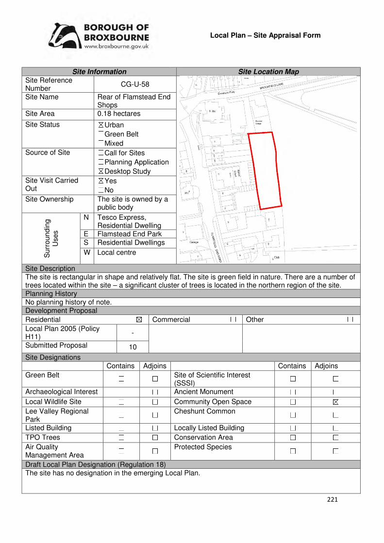
221
Local Plan – Site Appraisal Form
Site Information Site Location Map Site Reference Number
CG-U-58
Site Name Rear of Flamstead End Shops
Site Area 0.18 hectares
Site Status ☒Urban ☐Green Belt ☐Mixed
Source of Site ☐Call for Sites ☐Planning Application ☒Desktop Study
Site Visit Carried Out
☒Yes ☐No
Site Ownership The site is owned by a public body
Surr
oundin
g
Uses
N Tesco Express, Residential Dwelling
E Flamstead End Park S Residential Dwellings
W Local centre
Site Description The site is rectangular in shape and relatively flat. The site is green field in nature. There are a number of trees located within the site – a significant cluster of trees is located in the northern region of the site. Planning History No planning history of note. Development Proposal
Residential ☒ Commercial ☐ Other ☐
Local Plan 2005 (Policy H11)
-
Submitted Proposal 10
Site Designations Contains Adjoins Contains Adjoins
Green Belt ☐ ☐ Site of Scientific Interest (SSSI)
☐ ☐
Archaeological Interest ☐ ☐ Ancient Monument ☐ ☐
Local Wildlife Site ☐ ☐ Community Open Space ☐ ☒
Lee Valley Regional Park
☐ ☐ Cheshunt Common ☐ ☐
Listed Building ☐ ☐ Locally Listed Building ☐ ☐
TPO Trees ☐ ☐ Conservation Area ☐ ☐
Air Quality Management Area
☐ ☐ Protected Species ☐ ☐
Draft Local Plan Designation (Regulation 18) The site has no designation in the emerging Local Plan.

222
Accessibility – distance as the crow flies
205m -Primary School (Andrews Lane)
1.45km - Secondary School (Turnford)
1.07km –Employment Area (New River Trading Estate)
0m - Green Space (Flamstead End Park)
340m -Healthcare Centre (Stockwell Lodge)
11.43km - Hospital (with A&E) (Princess Alexandra )
800m - Town/District Centre (Brookfield)
0m - Local Centre (adjoins)
1.59km -Leisure Centre (Laura Trott)
660m - A10 Junction (Church Lane)
2.02km - Railway Station (Cheshunt)
60m - Bus Service (Brookfield lane)
Flood Risk Does the site Contains Adjoins
Zone 2 (Medium Risk) ☐ ☐
Zone 3a (High Risk) ☐ ☐
Zone 3b (Active Flood Plain) ☐ ☒
Additional Flood Risk Comments No flood risk issues for this site Access and Transport Comments There is no current vehicle access to the site. It is possible that vehicle access to the site can be created from Brookfield Lane; however this will require a reconfiguration of the existing footpath that runs through Flamstead End Park. There are footpaths on both sides of Brookfield Lane and Flamstead End. Connections to these footpaths will be required. Utility Provision
Electricity Electricity connections available in the close vicinity of the site
Gas A low pressure gas main is located along Brookfield Lane
Water A water main is located along Brookfield lane West and Flamstead End Road
Sewerage A foul sewer and surface sewer is located along Brookfield Lane West
Sewerage Treatment ☒Rye Meads ☒Deephams ☐Other
Additional Developer Comments submitted during Call for Sites 2016 None submitted. Suitability Comments
The site is considered to be suitable for residential development due to the following reasons:
• The site is located within the urban area, within an existing settlement boundary. The re-use of this land for residential development would comply with one of the 12 core land-use planning principles that underpins plan-making and decision making.
• The site is considered to be in a sustainable location for residential development – it is close to local facilities, primary education and some modes of sustainable transport. It is also within the sustainable distance recommended by Barton et al (2010) for green space/local park, leisure centre and doctors surgery.
Is the site considered to be suitable for development?
☒☒☒☒Yes ☐☐☐☐ No
Availability Comments The site is considered to be available. The site is in public ownership. The landowner for this site is a developing a residential scheme for this site.
Is the site considered to be available for development?
☒☒☒☒Yes ☐☐☐☐ No

223
Achievability Comments The site is considered to be achievable. It is considered that there are no policy constraints that would prevent this site from coming forward for development. Due to the sites location within the existing urban area it will be able to benefit from existing infrastructure. It is considered that the site preparatory works required to bring this site forward will not have a detrimental impact on viability.
Is the site considered to be achievable?
☒☒☒☒Yes ☐☐☐☐ No
Delivery Period 1-5 years
224
Cheshunt and Goffs Oak
Green Belt Sites

225
Local Plan – Site Appraisal Form
Site Information Site Location Map Site Reference Number
CG-GB-02
Site Name Land between 90a and 102 Cuffley Hill
Site Area 2.3 hectares
Site Status ☐Urban ☒Green Belt ☐Mixed
Source of Site ☒Call for Sites ☐Planning Application ☐Desktop Study
Site Visit Carried Out
☒Yes ☐No
Site Ownership There are various site owners
Surr
oundin
g
Uses
N Green Belt
E Green Belt, Fairmead Nursery
S Residential
W Green Belt, Residential Dwellings
Site Description The site, which is rectangular in shape, has several variations in the sites topography. The most significant variation in ground levels is located in the north western corner. There are several mature trees scattered throughout the site, however there is a higher concentration within the northern region of the site. Planning History No planning history of note. Development Proposal
Residential ☒ Commercial ☐ Other ☐
Local Plan 2005 (Policy H11)
-
Submitted Proposal
65 dwellings (when combined with CG-GB-65)
Site Designations Contains Adjoins Contains Adjoins
Green Belt ☒ ☒ Site of Scientific Interest (SSSI)
☐ ☐
Archaeological Interest ☐ ☐ Ancient Monument ☐ ☐
Local Wildlife Site ☐ ☐ Community Open Space ☐ ☐
Lee Valley Regional Park
☐ ☐ Cheshunt Common ☐ ☐
Listed Building ☐ ☐ Locally Listed Building ☐ ☐
TPO Trees ☒ ☒ Conservation Area ☐ ☐
Air Quality Management Area
☐ ☐ Protected Species ☐ ☐

226
Draft Local Plan Designation (Regulation 18) The draft Local Plan allocated this site for residential development, as part of emerging Policy GO5. The emerging Policy identifies that this site (Rosemead Nursery) having the capacity to accommodate 14 dwellings. Accessibility – distance as the crow flies
200m -Primary School (Goffs Oak Primary School)
2.5km - Secondary School (Goffs Secondary School)
3.94km -Employment Area (New Rive Trading Estate)
500m - Green Space (Village Green)
600m -Healthcare Centre (Valley View)
10.6km - Hospital (with A&E) (Barnet Hospital)
4.3km - Town/District Centre (Cheshunt Old Pond)
460m - Local Centre (1-3 Newgatestreet Road)
4.32km -Leisure Centre (Laura Trott)
3.6km- A10 Junction (Church Lane)
1.2km - Railway Station (Cuffley)
65m – Bus Service (Robinsons Avenue)
Flood Risk Does the site Contains Adjoins
Zone 2 (Medium Risk) ☐ ☐
Zone 3a (High Risk) ☐ ☐
Zone 3b (Active Flood Plain) ☐ ☒
Additional Flood Risk Comments There may be some ground or surface water flooding issues. Access and Transport Comments Access for all modes is currently unavailable. The most viable and suitable access to the site would be via the gap between 92 and 94 Cuffley Hill. Due to the amount of development being proposed, a transport assessment will be required. Connections to the existing footpaths along Cuffley Hill will be required. Cycle access to the site will need to be provided. Utility Provision
Electricity Connections available in the existing residential area to the south or east
Gas A low pressure gas main is located along Cuffley Hill
Water A water main is located along Cuffley Hill. A water hydrant is located in proximity to the entrance of the site.
Sewerage A foul sewer is located at the residential properties (102-100) to the south of the site. A surface sewer is located along Cuffley Hill.
Sewerage Treatment ☐Rye Meads ☒Deephams ☐Other
Additional Developer Comments submitted during Call for Sites 2016 None submitted. During the Local Plan consultation (Regulation 18) the promoter states that the site provides an excellent opportunity to help realise Broxbourne Council’s aspirations for the area and that the site has the capacity to accommodate development. They continue by stating that there are no impediments constraining the development of this site and that the site performs poorly against Green Belt objectives and offers limited contribution to the role and function of the Green Belt. Therefore, the promoter considers that the site should be used efficiently and therefore the overall number of dwellings to be provided increased, which can be done without jeopardising the character of the area. A number of technical documents were submitted to support the Local Plan representations. These included a Landscape and Ecology Strategy, Transport Appraisal and a Landscape and Green Belt Assessment. These can be viewed on the Council’s website by using the following link: www.broxbourne.gov.uk/lpsites
227
Suitability Comments The site is considered to be in a suitable location for residential development due to the following reasons:
• The Inspector from the Inquiry of the 2005 Local Plan Review stated that this site “lies within a sustainable location for new housing, being within walking distance of schools, shops and other services”. The site is also within the sustainable distance recommended by Barton et al (2010) for some facilities and amenities, with the exception of a leisure centre and hospital.
• The Council’s Green Belt Review (Scott Wilson, 2008) identifies this site as part of area C34. It states that C34 performs strongly against Green Belt purposes 1 and 2, and poorly against purpose 3. Under approach 2, the review proposed to remove part of C31, C33 and C34 (which included this site) from the Green Belt and move the boundary to the northern edge of the woodland and field boundary and re-designate with appropriate environmental policies. However, the report also states that “lack of constraints and good accessibility means that this site [C34] would be worth allocating”.
• The development of this site will enable a more robust and defensible Green Belt boundary to be created. It is considered that this new boundary will be robust and last beyond the Plan period.
• The site was considered as part of Development Approach 2: Goffs Oak Village Expansion, in the Goffs Oak Development Options report. The benefits of adopting this development approach included the creation of a more logical and defensible Green Belt boundary and providing an appropriate level of housing through relatively minor Green Belt boundary revision which is considered to not have a significant impact on the village as a whole.
There are a number of TPO trees on the site that will need to be retained and incorporated into any development that is to occur on this site. This planning constraint is not considered to be significant to prevent the development of this site. Is the site considered to be suitable?
☒Yes ☐No
Availability Comments The site has been actively promoted to the Council for development. During the Local Plan Regulation 18 consultation, the promoter confirmed that the site is available for development.
Is the site considered to be available for development?
☒☒☒☒Yes ☐☐☐☐ No
Achievability Comments A developer has an option over this site, which suggests that it is achievable. Installation of road infrastructure due to the gap between existing houses should not be a significant problem to the sites deliverability. The site can benefit from existing infrastructure due to its close proximity to the urban area of Goffs Oak. With the exception of the sites Green Belt designation, it is considered that there are no policy constraints that would prevent this site from coming forward for development.
Is the site considered to be achievable?
☒☒☒☒Yes ☐☐☐☐ No
Delivery Period 1-5 years

228
Local Plan – Site Appraisal Form
Site Information Site Location Map Site Reference Number
CG-GB-03
Site Name Travelling show persons site, Goffs Lane
Site Area 2.6 hectares
Site Status ☐Urban ☒Green Belt ☐Mixed
Source of Site ☒Call for Sites ☐Planning Application ☐Desktop Study
Site Visit Carried Out
☐Yes ☒No
Site Ownership There are various site owners for the site.
Surr
oundin
g
Uses
N Goffs Lane, Residential
E B198, Green Belt S B198, Green Belt
W Residential Properties located within the Green Belt
Site Description The site is irregular in shape due to it following the curve of Goffs Lane. It slightly narrows towards the southern end of the site. The site is mostly flat. The site is not visible from the surrounding roads due to a tree/hedge boundary. The south/south western region of the site is developed. Planning History A three bedroom bungalow was refused on the site in 1990 but later in 1992 a residential unit was approved. A storage/workshop building was approved in 1999 to house fairground equipment and two mobile homes were approved in the same year. Development Proposal
Residential ☐ Commercial ☐ Other ☒
Local Plan 2005 (Policy H11) - Continued use as a travelling showperson site Submitted Proposal 75
Site Designations Contains Adjoins Contains Adjoins
Green Belt ☒ ☒ Site of Scientific Interest (SSSI) ☐ ☐
Archaeological Interest ☐ ☐ Ancient Monument ☐ ☐
Local Wildlife Site ☐ ☐ Community Open Space ☐ ☐
Lee Valley Regional Park ☐ ☐ Cheshunt Common ☐ ☐
Listed Building ☐ ☐ Locally Listed Building ☐ ☐
TPO Trees ☒ ☐ Conservation Area ☐ ☐
Air Quality Management Area
☐ ☐ Protected Species ☐ ☐
Draft Local Plan Designation (Regulation 18) The draft Local Plan designated the site as a travelling showperson site as part of emerging Policy GT2: Extended Travelling Showpeople Site
229
Accessibility – distance as the crow flies
500m -Primary School (Bonneygrove)
200m - Secondary School (Goffs)
2.25km -Employment Area (News International)
150m - Green Space 900m -Healthcare Centre
(Cromwell) 12km - Hospital (with A&E)
(Barnet)
2km - Town/District Centre (Cheshunt Old Pond)
1.5km - Local Centre 2km -Leisure Centre
(Laura Trott)
1.4km - A10 Junction (College Road)
2.5km - Railway Station (Theobalds Grove)
10m - Bus Service (Goffs Lane)
Flood Risk Does the site Contains Adjoins
Zone 2 (Medium Risk) ☐ ☐
Zone 3a (High Risk) ☐ ☐
Zone 3b (Active Flood Plain) ☐ ☒
Additional Flood Risk Comments There may be some ground/surface water flooding issues. Access and Transport Comments The site can be accessed from Goffs Lane. This would require improvement to ensure it is compliant with highway regulations if development was to occur. The pedestrian and cycle links located just outside the site would need to be connected to if development was to occur. Due to the proximity of the site to a roundabout, the impact that development would have on this would need to be investigated. The site adjoins Lieutenant Ellis Way, which provides an immediate access to the southern corridor of the A10.
Utility Provision
Electricity Site may already be connected. Electricity connections available in close vicinity to the site
Gas There is a low pressure and medium pressure gas main to the south along Goffs Lane
Water A water main is located along Goffs Lane
Sewerage A foul sewer and surface sewer are located along Goffs Lane
Sewerage Treatment ☐Rye Meads ☒Deephams ☐Other
Additional Developer Comments submitted during Call for Sites 2016
None submitted. Suitability Comments The site is not considered to be in a suitable location for residential development for the following reasons:
• The Council’s Green Belt Review (Scott Wilson, 2008) states that this area (D4) performs strongly against all Green Belt purposes therefore should be trained.
• The Bury Green Options Report states that “Housing development on the existing travelling showperson site would not be supported as this would be in an area of the Green Belt outside the Bury Green area and is not considered to be appropriate for housing as it makes an important contribution to the maintenance of the borough’s Green Belt”.

230
• The site is currently in active use as a travelling showperson site. It is considered that this site is suitable for continued use as a travelling showperson site.
Is the site considered to be suitable for development?
☒☒☒☒Yes ☐☐☐☐ No
Availability Comments Contained within the landowners submission on the Regulation 18 draft Local Plan was the following statement: “RPS notes that the Council recognises the existence of our client’s travelling showpeople’s site on land south of Goffs Lane, and has allocated the land as such in the accompanying Proposals Map.” This statement appears to indicate that the landowner is happy with this site to remain within its current use as a travelling showperson site for the Plan period.
Is the site considered to be available for development
☒☒☒☒Yes ☐☐☐☐ No
Achievability Comments The site is considered to be achievable. The site is already being used as a travelling showpeople’s site.
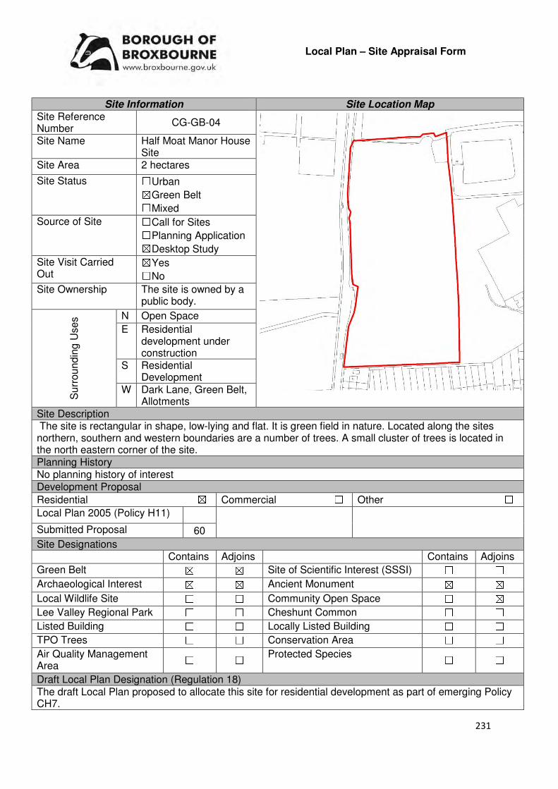
231
Local Plan – Site Appraisal Form
Site Information Site Location Map Site Reference Number
CG-GB-04
Site Name Half Moat Manor House Site
Site Area 2 hectares
Site Status ☐Urban ☒Green Belt ☐Mixed
Source of Site ☐Call for Sites ☐Planning Application ☒Desktop Study
Site Visit Carried Out
☒Yes ☐No
Site Ownership The site is owned by a public body.
Surr
oundin
g U
ses N Open Space
E Residential development under construction
S Residential Development
W Dark Lane, Green Belt, Allotments
Site Description The site is rectangular in shape, low-lying and flat. It is green field in nature. Located along the sites northern, southern and western boundaries are a number of trees. A small cluster of trees is located in the north eastern corner of the site. Planning History No planning history of interest Development Proposal
Residential ☒ Commercial ☐ Other ☐
Local Plan 2005 (Policy H11)
Submitted Proposal 60
Site Designations Contains Adjoins Contains Adjoins
Green Belt ☒ ☒ Site of Scientific Interest (SSSI) ☐ ☐
Archaeological Interest ☒ ☒ Ancient Monument ☒ ☒
Local Wildlife Site ☐ ☐ Community Open Space ☐ ☒
Lee Valley Regional Park ☐ ☐ Cheshunt Common ☐ ☐
Listed Building ☐ ☐ Locally Listed Building ☐ ☐
TPO Trees ☐ ☐ Conservation Area ☐ ☐
Air Quality Management Area
☐ ☐ Protected Species ☐ ☐
Draft Local Plan Designation (Regulation 18) The draft Local Plan proposed to allocate this site for residential development as part of emerging Policy CH7.
232
Accessibility – distance as the crow flies
200m -Primary School
100m- Secondary School
(Goffs School)
1.9km –Employment Area
(Delamare Road)
0m - Green Space (Adjoins Goffs Lane Local Park/Recreation Ground)
300m -Healthcare Centre
(Cromwell)
12km - Hospital (with A&E)
(Princess Alexandra)
1.4km - Town/District Centre (Cheshunt Old Pond)
300m - Local Centre
(Cromwell)
1.4km -Leisure Centre
(Laura Trott)
840m - A10 Junction
(College Road)
1.9km - Railway Station
(Theobalds Grove)
400m - Bus Service
Flood Risk Does the site Contains Adjoins
Zone 2 (Medium Risk) ☐ ☐
Zone 3a (High Risk) ☐ ☐
Zone 3b (Active Flood Plain) ☐ ☒
Additional Flood Risk Comments The site is within close proximity to an area of Flood Zone 2. Measures will be required to ensure that there is no risk of future flooding on the site or surrounding sites, particularly to the east. Access and Transport Comments Access to the site does not currently exist. The most appropriate access point for the site would be via Dark Lane. The impact that the transport will have on the local network, particularly Dark Lane, will be required. Pedestrian and cycle access to the site will need to be created. Utility Provision
Electricity Can connect to the provision to the south.
Gas There is a gas main to the south at Franklin Avenue and to the north at Goffs Lane
Water A water main exists along Franklin Avenue but additional infrastructure will be required for the site to be connected to this.
Sewerage A surface sewer exists to the rear of properties at Franklin Avenue. New infrastructure for the site itself would be required.
Sewerage Treatment ☐Rye Meads ☒Deephams ☐Other
Additional Developer Comments submitted during Call for sites 2016 None submitted. During the Local Plan (Regulation 18) consultation the promoter stated that they are supportive of the site being allocated for housing, and that the site coming forward early within the Plan period for development is welcomed and can be delivered within that timeframe. Suitability Comments
The site is considered to be in a suitable location for residential development due to the following reasons:
• The Council’s Green Belt Review (Scott Wilson, 2008) identifies this site as part of area D8. The Review states that this area performs poorly against the Green Belt purposes, its location meaning that is does little in terms of preventing sprawl. The Review continues by stating that the area does little to separate existing settlements and therefore could score lower than attributed.
233
• The Metropolitan Green Belt Review (Prospect Planning, 2008) states that the Council land fronting Dark Lane, to the west of the existing built footprint of St Mary’s School should “either be released from the Green Belt and allocated for housing development in the short term or designated as Reserve Housing Land with an indication of when it will be required to come forward”
• The site is considered to be in a sustainable location; it is in close proximity to primary and secondary education, close to some modes of sustainable transport and within the sustainable distance recommended by Barton et al (2010) for facilities and amenities, with the exception of a hospital
The following planning constraints will need to be considered if development comes forward on this site; the sites proximity to Half Moat Manor House and Associated Leat (a Scheduled Monument); and, the sites location within the area of archaeological interest. The development of this site should maintain the access to the moat for anglers. Is the site considered to be suitable for development?
☒☒☒☒Yes ☐☐☐☐ No
Availability Comments
The site has been actively promoted to the Council for development. Recent representations for the landowner indicate that the site could come forward within the next 5 years.
Is the site considered to be available for development?
☒☒☒☒Yes ☐☐☐☐ No
Achievability Comments
The site is considered to be achievable. The sites location close to the urban area of Bury Green means that development can benefit from existing infrastructure i.e. road, utilities, footpaths etc. With the exception of the Green Belt designation, it is considered that there are no policy constraints that would prevent the development of this site.
Is the site considered to be achievable?
☒☒☒☒Yes ☐☐☐☐ No
Delivery Period 1-5 years
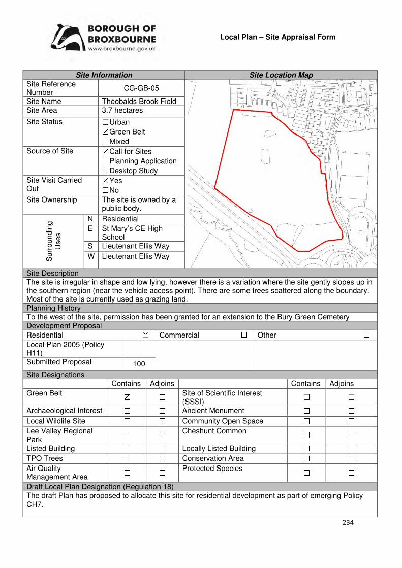
234
Local Plan – Site Appraisal Form
Site Information Site Location Map Site Reference Number
CG-GB-05
Site Name Theobalds Brook Field Site Area 3.7 hectares
Site Status ☐Urban ☒Green Belt ☐Mixed
Source of Site ☒Call for Sites ☐Planning Application ☐Desktop Study
Site Visit Carried Out
☒Yes ☐No
Site Ownership The site is owned by a public body.
Surr
oundin
g
Uses
N Residential
E St Mary’s CE High School
S Lieutenant Ellis Way
W Lieutenant Ellis Way
Site Description The site is irregular in shape and low lying, however there is a variation where the site gently slopes up in the southern region (near the vehicle access point). There are some trees scattered along the boundary. Most of the site is currently used as grazing land. Planning History To the west of the site, permission has been granted for an extension to the Bury Green Cemetery Development Proposal
Residential ☒ Commercial ☐ Other ☐
Local Plan 2005 (Policy H11)
Submitted Proposal 100
Site Designations Contains Adjoins Contains Adjoins
Green Belt ☒ ☒ Site of Scientific Interest (SSSI)
☐ ☐
Archaeological Interest ☐ ☐ Ancient Monument ☐ ☐
Local Wildlife Site ☐ ☐ Community Open Space ☐ ☐
Lee Valley Regional Park
☐ ☐ Cheshunt Common ☐ ☐
Listed Building ☐ ☐ Locally Listed Building ☐ ☐
TPO Trees ☐ ☐ Conservation Area ☐ ☐
Air Quality Management Area
☐ ☐ Protected Species ☐ ☐
Draft Local Plan Designation (Regulation 18) The draft Plan has proposed to allocate this site for residential development as part of emerging Policy CH7.
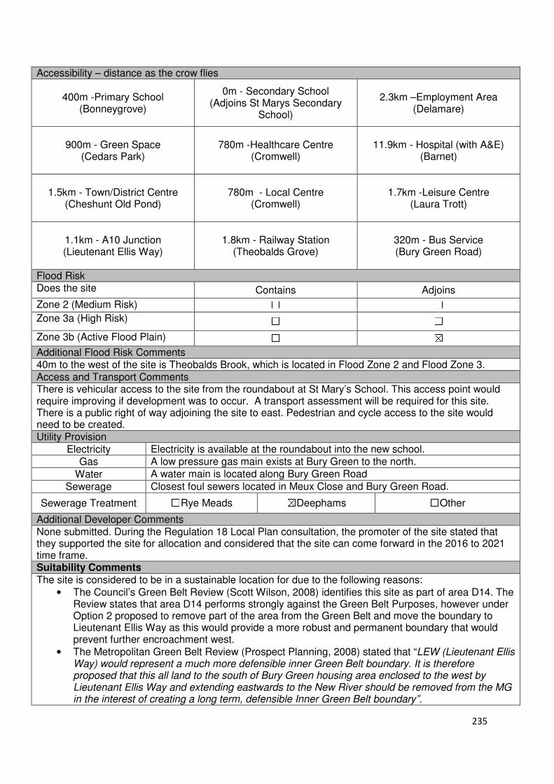
235
Accessibility – distance as the crow flies
400m -Primary School (Bonneygrove)
0m - Secondary School (Adjoins St Marys Secondary
School)
2.3km –Employment Area
(Delamare)
900m - Green Space (Cedars Park)
780m -Healthcare Centre
(Cromwell)
11.9km - Hospital (with A&E)
(Barnet)
1.5km - Town/District Centre
(Cheshunt Old Pond)
780m - Local Centre
(Cromwell)
1.7km -Leisure Centre
(Laura Trott)
1.1km - A10 Junction (Lieutenant Ellis Way)
1.8km - Railway Station (Theobalds Grove)
320m - Bus Service (Bury Green Road)
Flood Risk Does the site Contains Adjoins
Zone 2 (Medium Risk) ☐ ☐
Zone 3a (High Risk) ☐ ☐
Zone 3b (Active Flood Plain) ☐ ☒
Additional Flood Risk Comments 40m to the west of the site is Theobalds Brook, which is located in Flood Zone 2 and Flood Zone 3. Access and Transport Comments There is vehicular access to the site from the roundabout at St Mary’s School. This access point would require improving if development was to occur. A transport assessment will be required for this site. There is a public right of way adjoining the site to east. Pedestrian and cycle access to the site would need to be created. Utility Provision
Electricity Electricity is available at the roundabout into the new school.
Gas A low pressure gas main exists at Bury Green to the north.
Water A water main is located along Bury Green Road
Sewerage Closest foul sewers located in Meux Close and Bury Green Road.
Sewerage Treatment ☐Rye Meads ☒Deephams ☐Other
Additional Developer Comments None submitted. During the Regulation 18 Local Plan consultation, the promoter of the site stated that they supported the site for allocation and considered that the site can come forward in the 2016 to 2021 time frame. Suitability Comments
The site is considered to be in a sustainable location for due to the following reasons:
• The Council’s Green Belt Review (Scott Wilson, 2008) identifies this site as part of area D14. The Review states that area D14 performs strongly against the Green Belt Purposes, however under Option 2 proposed to remove part of the area from the Green Belt and move the boundary to Lieutenant Ellis Way as this would provide a more robust and permanent boundary that would prevent further encroachment west.
• The Metropolitan Green Belt Review (Prospect Planning, 2008) stated that “LEW (Lieutenant Ellis Way) would represent a much more defensible inner Green Belt boundary. It is therefore proposed that this all land to the south of Bury Green housing area enclosed to the west by Lieutenant Ellis Way and extending eastwards to the New River should be removed from the MG in the interest of creating a long term, defensible Inner Green Belt boundary”.
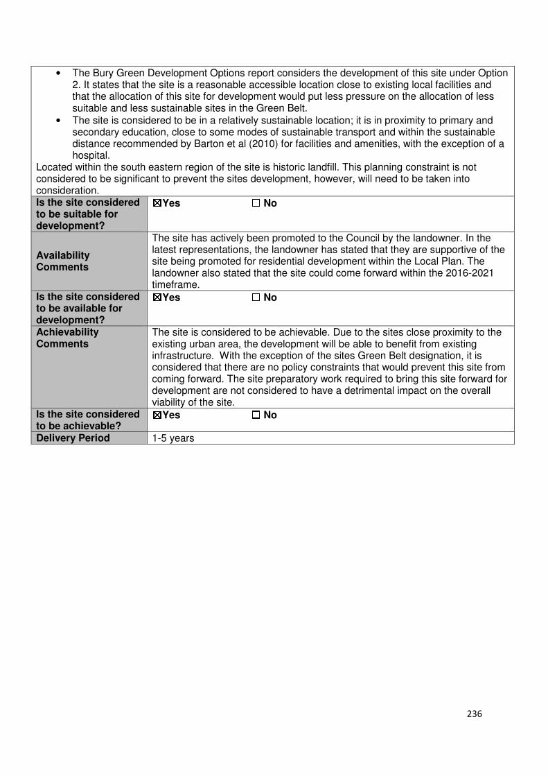
236
• The Bury Green Development Options report considers the development of this site under Option 2. It states that the site is a reasonable accessible location close to existing local facilities and that the allocation of this site for development would put less pressure on the allocation of less suitable and less sustainable sites in the Green Belt.
• The site is considered to be in a relatively sustainable location; it is in proximity to primary and secondary education, close to some modes of sustainable transport and within the sustainable distance recommended by Barton et al (2010) for facilities and amenities, with the exception of a hospital.
Located within the south eastern region of the site is historic landfill. This planning constraint is not considered to be significant to prevent the sites development, however, will need to be taken into consideration. Is the site considered to be suitable for development?
☒☒☒☒Yes ☐☐☐☐ No
Availability Comments
The site has actively been promoted to the Council by the landowner. In the latest representations, the landowner has stated that they are supportive of the site being promoted for residential development within the Local Plan. The landowner also stated that the site could come forward within the 2016-2021 timeframe.
Is the site considered to be available for development?
☒☒☒☒Yes ☐☐☐☐ No
Achievability Comments
The site is considered to be achievable. Due to the sites close proximity to the existing urban area, the development will be able to benefit from existing infrastructure. With the exception of the sites Green Belt designation, it is considered that there are no policy constraints that would prevent this site from coming forward. The site preparatory work required to bring this site forward for development are not considered to have a detrimental impact on the overall viability of the site.
Is the site considered to be achievable?
☒☒☒☒Yes ☐☐☐☐ No
Delivery Period 1-5 years
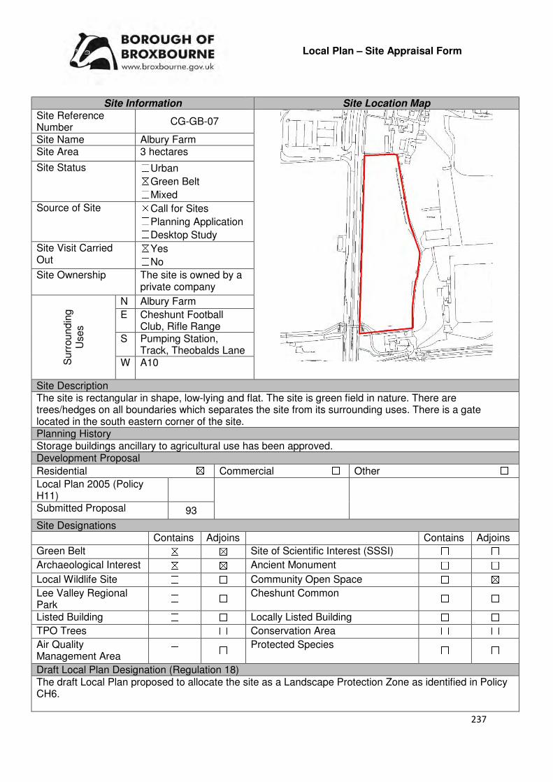
237
Local Plan – Site Appraisal Form
Site Information Site Location Map Site Reference Number
CG-GB-07
Site Name Albury Farm Site Area 3 hectares
Site Status ☐Urban ☒Green Belt ☐Mixed
Source of Site ☒Call for Sites ☐Planning Application ☐Desktop Study
Site Visit Carried Out
☒Yes ☐No
Site Ownership The site is owned by a private company
Surr
oundin
g
Uses
N Albury Farm
E Cheshunt Football Club, Rifle Range
S Pumping Station, Track, Theobalds Lane
W A10
Site Description The site is rectangular in shape, low-lying and flat. The site is green field in nature. There are trees/hedges on all boundaries which separates the site from its surrounding uses. There is a gate located in the south eastern corner of the site. Planning History Storage buildings ancillary to agricultural use has been approved. Development Proposal
Residential ☒ Commercial ☐ Other ☐
Local Plan 2005 (Policy H11)
Submitted Proposal 93
Site Designations Contains Adjoins Contains Adjoins
Green Belt ☒ ☒ Site of Scientific Interest (SSSI) ☐ ☐
Archaeological Interest ☒ ☒ Ancient Monument ☐ ☐
Local Wildlife Site ☐ ☐ Community Open Space ☐ ☒
Lee Valley Regional Park
☐ ☐ Cheshunt Common ☐ ☐
Listed Building ☐ ☐ Locally Listed Building ☐ ☐
TPO Trees ☐ ☐ Conservation Area ☐ ☐
Air Quality Management Area
☐ ☐ Protected Species ☐ ☐
Draft Local Plan Designation (Regulation 18) The draft Local Plan proposed to allocate the site as a Landscape Protection Zone as identified in Policy CH6.

238
Accessibility – distance as the crow flies
310m -Primary School
(Longmeads)
200m - Secondary School (Cheshunt)
1.5km –Employment Area
(Delamare)
210m - Green Space
667m -Healthcare Centre (Warden Lodge Medical Practice)
12.2km - Hospital (with A&E)
(Princess Alexandra)
730m - Town/District Centre
(Cheshunt Old Pond)
590m - Local Centre (99-109 Crossbrook Street)
850m -Leisure Centre
(Laura Trott)
400m - A10 Junction
(Lieutenant Ellis Way)
600m - Railway Station
(Theobalds Grove)
610m - Bus Service (Theobalds Grove Railway
Station (Stop B))
Flood Risk Does the site Contains Adjoins
Zone 2 (Medium Risk) ☐ ☒
Zone 3a (High Risk) ☐ ☒
Zone 3b (Active Flood Plain) ☐ ☒
Additional Flood Risk Comments Any redevelopment on this site will need to take into consideration Theobalds Brook, which is located approximately 58m to the south. Theobalds Brook is within Flood Zone 2 and Flood Zone 3a. Access and Transport Comments The site can be accessed from a small track from Albury Ride (via Albury Farm) or from Theobalds Lane. To The access to this site will require improvement if development was to come forward. Due to the amount of housing this site could accommodate, a transport assessment may be required. There is a public right of way at Albury Walk. Pedestrian and cycle access to the site will need to be created. Utility Provision
Electricity Electricity cables available in the area but connection required.
Gas The site has the opportunity to connect to the low pressure gas main that runs along the eastern edge of the A10
Water There is a water main on the southern perimeter of the site
Sewerage A foul sewer exists for the residential properties to the north of the site.
Sewerage Treatment ☐Rye Meads ☒Deephams ☐Other
Additional Developer Comments submitted during Call for Sites 2016 None submitted. During the Local Plan Regulation 18 consultation, the promoter of the site states that the policy wording (CH6) does not make reference to this land being removed from the Green Belt and considers this to be an omission. The promoter continues by stating that the site would not fulfil any of the purposes of the Green Belt being surrounded by proposed development on all sides. Suitability Comments This site is proposed for removal from the Green Belt as part of the release from the Green Belt from the Park Plaza area, with the new Green Belt boundary to be redrawn along the New River and Lieutenant Ellis Way. The site is not considered to be suitable for development due to the following two reasons:
• The capacity of Theobalds Lane, including the access point onto the A10 to the west, is considered to have been reached once the proposals for the development at Cheshunt Football Club have been implemented.

239
• The emerging Local Plan indicates that a landscape buffer (‘landscape protection zone’) should continue to be retained along the A10 in order to retain openness along the A10 approach into Cheshunt. This field is considered to form an important function in terms of the long-term character of the borough in this area and the transition from London to Hertfordshire.
Is the site considered to be suitable for development?
☐☐☐☐Yes ☒☒☒☒ No
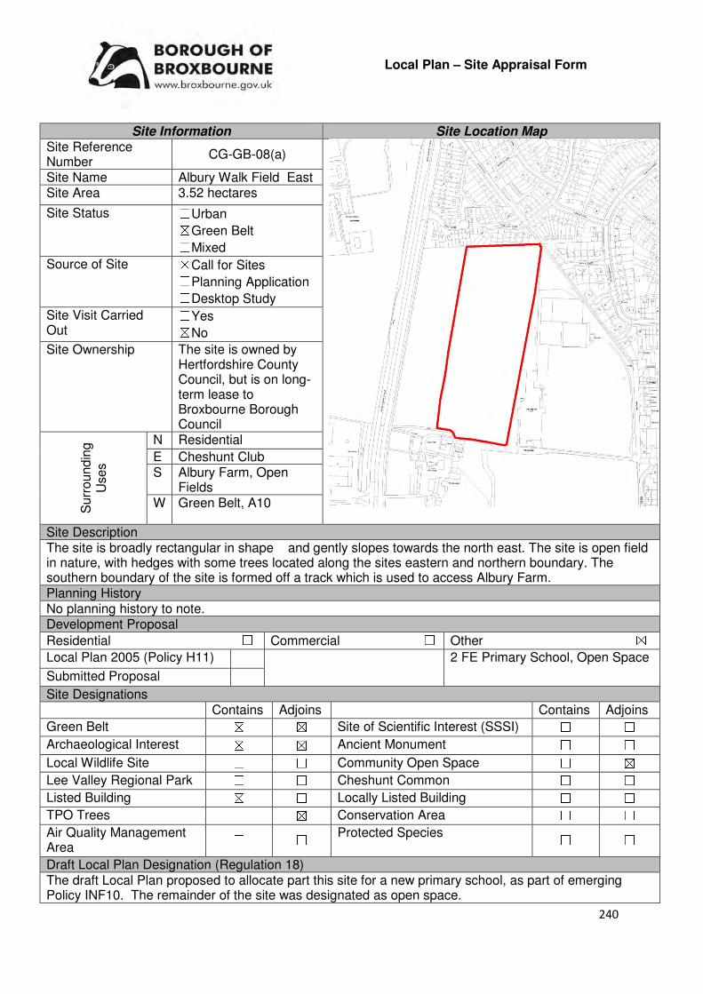
240
Local Plan – Site Appraisal Form
Site Information Site Location Map Site Reference Number
CG-GB-08(a)
Site Name Albury Walk Field East Site Area 3.52 hectares
Site Status ☐Urban ☒Green Belt ☐Mixed
Source of Site ☒Call for Sites ☐Planning Application ☐Desktop Study
Site Visit Carried Out
☐Yes ☒No
Site Ownership The site is owned by Hertfordshire County Council, but is on long-term lease to Broxbourne Borough Council
Surr
oundin
g
Uses
N Residential
E Cheshunt Club S Albury Farm, Open
Fields W Green Belt, A10
Site Description The site is broadly rectangular in shape and gently slopes towards the north east. The site is open field in nature, with hedges with some trees located along the sites eastern and northern boundary. The southern boundary of the site is formed off a track which is used to access Albury Farm. Planning History No planning history to note. Development Proposal
Residential ☐ Commercial ☐ Other ☒
Local Plan 2005 (Policy H11) 2 FE Primary School, Open Space
Submitted Proposal
Site Designations Contains Adjoins Contains Adjoins
Green Belt ☒ ☒ Site of Scientific Interest (SSSI) ☐ ☐
Archaeological Interest ☒ ☒ Ancient Monument ☐ ☐
Local Wildlife Site ☐ ☐ Community Open Space ☐ ☒
Lee Valley Regional Park ☐ ☐ Cheshunt Common ☐ ☐
Listed Building ☒ ☐ Locally Listed Building ☐ ☐
TPO Trees ☐ ☒ Conservation Area ☐ ☐
Air Quality Management Area
☐ ☐ Protected Species ☐ ☐
Draft Local Plan Designation (Regulation 18) The draft Local Plan proposed to allocate part this site for a new primary school, as part of emerging Policy INF10. The remainder of the site was designated as open space.

241
Accessibility – distance as the crow flies
315m -Primary School (Longlands)
100m - Secondary School (Cheshunt)
990m –Employment Area (News International)
480m - Green Space (Cedars Park)
540m -Healthcare Centre (Crossbrook Street)
11.73km- Hospital (with A&E) (Princess Alexandra)
360m - Town/District Centre (Cheshunt Old Pond)
230m - Local Centre (College Road)
510m -Leisure Centre (Laura Trott)
240m - A10 Junction (College Road)
780m - Railway Station (Theobalds Grove Station)
261m - Bus Service (Elgin Road)
Flood Risk Does the site Contains Adjoins
Zone 2 (Medium Risk) ☐ ☐
Zone 3a (High Risk) ☐ ☐
Zone 3b (Active Flood Plain) ☐ ☒
Additional Flood Risk Comments There may be groundwater or surface water flooding on the site. Access and Transport Comments The site is currently accessible via a narrow track which connects Albury Ride and the urban area. There are a number of alternative access points available for the site; however these would either negotiation with third party landowners. A transport assessment should accompany any application for the development of this site. Connections to the footpaths within the residential areas to the north and east will be required. Utility Provision
Electricity Located within the main urban area to the north
Gas Gas main available west at the A10 and south at Albury Ride entrance
Water The nearest water main is either located at Albury Ride to the south east or to the north at the urban area
Sewerage A foul sewer is located to the north of the site.
Sewerage Treatment ☐Rye Meads ☒Deephams ☐Other
Additional Developer Comments submitted during Call for Sites 2016 None submitted.
Suitability Comments
This area of land is currently formed of pitches associated with the Cheshunt Club, and is on long-term lease to Broxbourne Borough Council from Hertfordshire County Council. The County Council is working with the Club in order to prepare a masterplan for the area to allow improvements to the Clubs’ facilities whilst also providing a primary school site near Albury Ride. A modest amount of residential development may be considered acceptable as part of this proposal, as part of a comprehensive and carefully planned approach (including sites CG-GB-08a, CG-GB-55, and CG-GB-99). The quantum and location of housing will depend on a satisfactory masterplan agreed with the Borough Council, taking account of the capacity of Albury Ride (including the junction with Crossbrook Street) and any impacts on existing residential properties.
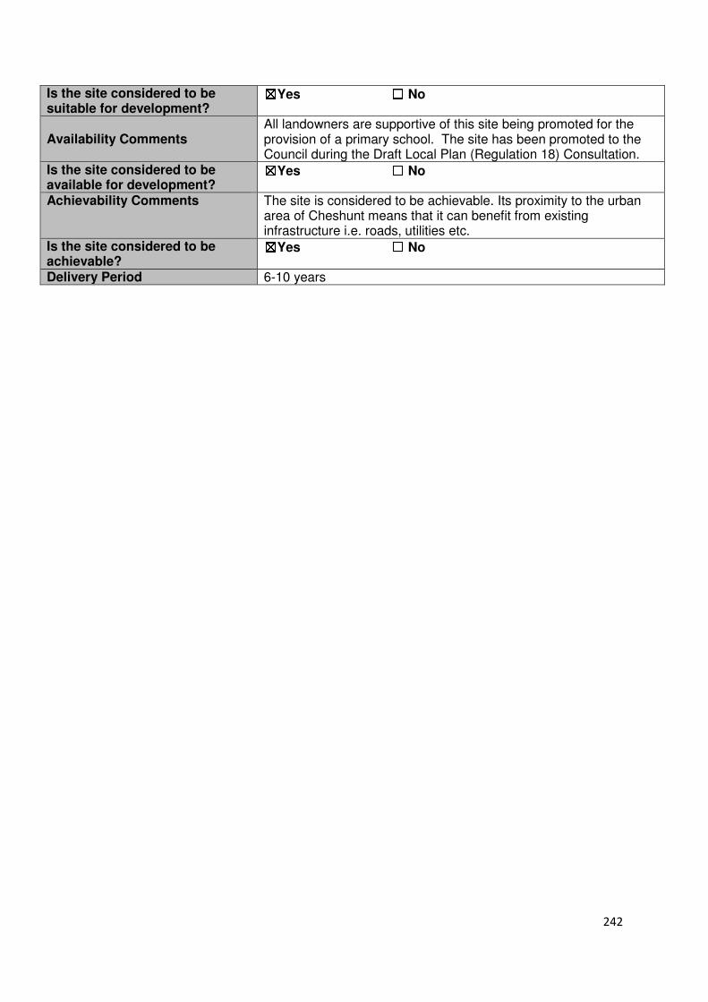
242
Is the site considered to be suitable for development?
☒☒☒☒Yes ☐☐☐☐ No
Availability Comments All landowners are supportive of this site being promoted for the provision of a primary school. The site has been promoted to the Council during the Draft Local Plan (Regulation 18) Consultation.
Is the site considered to be available for development?
☒☒☒☒Yes ☐☐☐☐ No
Achievability Comments The site is considered to be achievable. Its proximity to the urban area of Cheshunt means that it can benefit from existing infrastructure i.e. roads, utilities etc.
Is the site considered to be achievable?
☒☒☒☒Yes ☐☐☐☐ No
Delivery Period 6-10 years
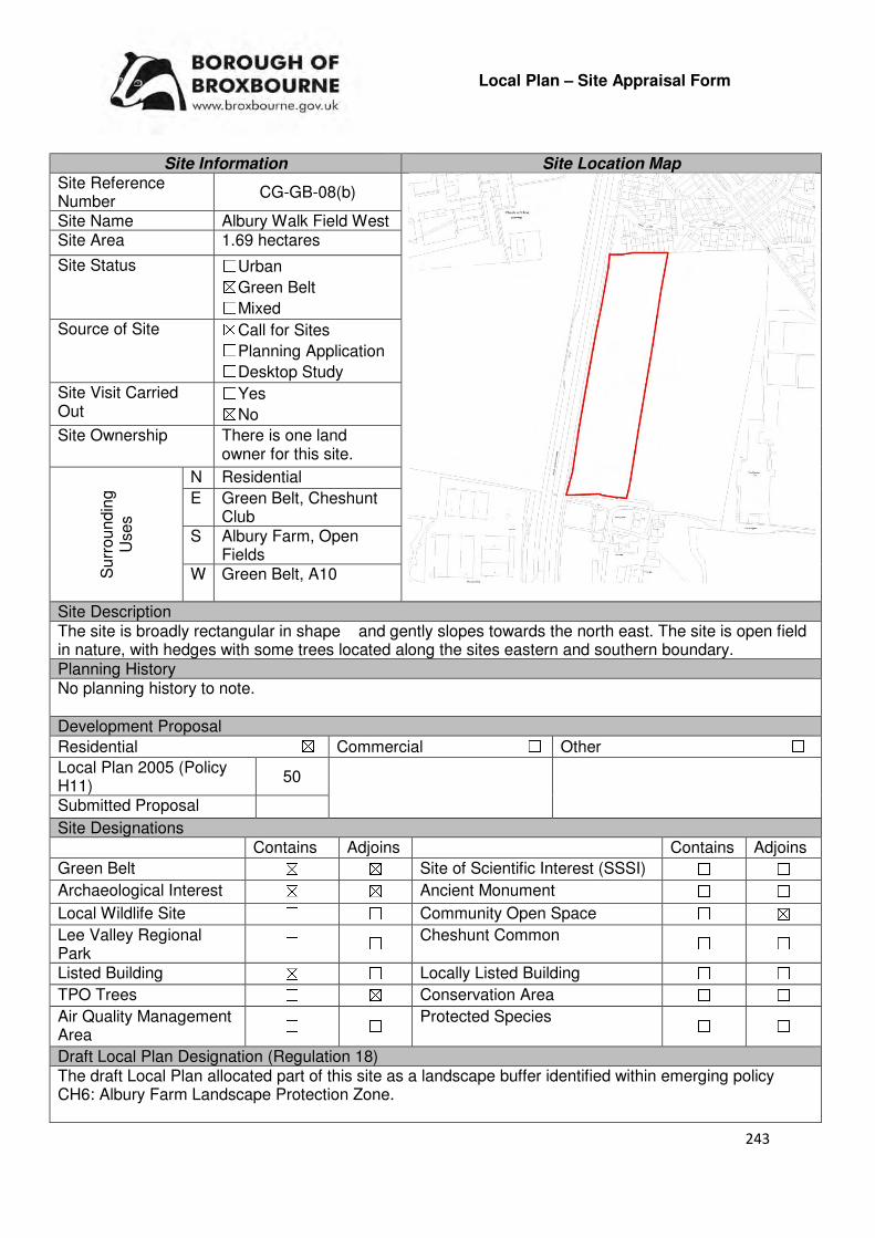
243
Local Plan – Site Appraisal Form
Site Information Site Location Map Site Reference Number
CG-GB-08(b)
Site Name Albury Walk Field West Site Area 1.69 hectares
Site Status ☐Urban ☒Green Belt ☐Mixed
Source of Site ☒Call for Sites ☐Planning Application ☐Desktop Study
Site Visit Carried Out
☐Yes ☒No
Site Ownership There is one land owner for this site.
Surr
oundin
g
Uses
N Residential
E Green Belt, Cheshunt Club
S Albury Farm, Open Fields
W Green Belt, A10
Site Description The site is broadly rectangular in shape and gently slopes towards the north east. The site is open field in nature, with hedges with some trees located along the sites eastern and southern boundary. Planning History No planning history to note. Development Proposal
Residential ☒ Commercial ☐ Other ☐
Local Plan 2005 (Policy H11)
50
Submitted Proposal
Site Designations Contains Adjoins Contains Adjoins
Green Belt ☒ ☒ Site of Scientific Interest (SSSI) ☐ ☐
Archaeological Interest ☒ ☒ Ancient Monument ☐ ☐
Local Wildlife Site ☐ ☐ Community Open Space ☐ ☒
Lee Valley Regional Park
☐ ☐ Cheshunt Common ☐ ☐
Listed Building ☒ ☐ Locally Listed Building ☐ ☐
TPO Trees ☐ ☒ Conservation Area ☐ ☐
Air Quality Management Area
☐ ☐ Protected Species ☐ ☐
Draft Local Plan Designation (Regulation 18) The draft Local Plan allocated part of this site as a landscape buffer identified within emerging policy CH6: Albury Farm Landscape Protection Zone.
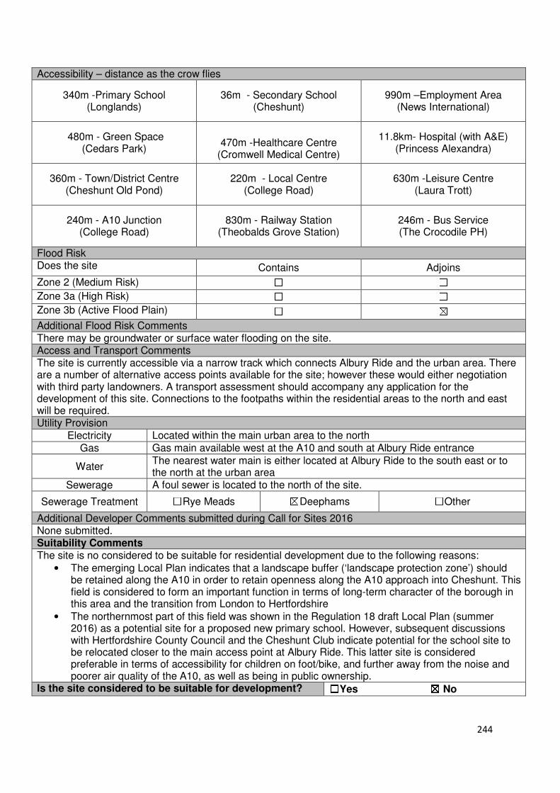
244
Accessibility – distance as the crow flies
340m -Primary School (Longlands)
36m - Secondary School (Cheshunt)
990m –Employment Area (News International)
480m - Green Space (Cedars Park)
470m -Healthcare Centre
(Cromwell Medical Centre)
11.8km- Hospital (with A&E) (Princess Alexandra)
360m - Town/District Centre (Cheshunt Old Pond)
220m - Local Centre (College Road)
630m -Leisure Centre (Laura Trott)
240m - A10 Junction (College Road)
830m - Railway Station (Theobalds Grove Station)
246m - Bus Service (The Crocodile PH)
Flood Risk Does the site Contains Adjoins
Zone 2 (Medium Risk) ☐ ☐
Zone 3a (High Risk) ☐ ☐
Zone 3b (Active Flood Plain) ☐ ☒
Additional Flood Risk Comments There may be groundwater or surface water flooding on the site. Access and Transport Comments The site is currently accessible via a narrow track which connects Albury Ride and the urban area. There are a number of alternative access points available for the site; however these would either negotiation with third party landowners. A transport assessment should accompany any application for the development of this site. Connections to the footpaths within the residential areas to the north and east will be required. Utility Provision
Electricity Located within the main urban area to the north
Gas Gas main available west at the A10 and south at Albury Ride entrance
Water The nearest water main is either located at Albury Ride to the south east or to the north at the urban area
Sewerage A foul sewer is located to the north of the site.
Sewerage Treatment ☐Rye Meads ☒Deephams ☐Other
Additional Developer Comments submitted during Call for Sites 2016 None submitted. Suitability Comments The site is no considered to be suitable for residential development due to the following reasons:
• The emerging Local Plan indicates that a landscape buffer (‘landscape protection zone’) should be retained along the A10 in order to retain openness along the A10 approach into Cheshunt. This field is considered to form an important function in terms of long-term character of the borough in this area and the transition from London to Hertfordshire
• The northernmost part of this field was shown in the Regulation 18 draft Local Plan (summer 2016) as a potential site for a proposed new primary school. However, subsequent discussions with Hertfordshire County Council and the Cheshunt Club indicate potential for the school site to be relocated closer to the main access point at Albury Ride. This latter site is considered preferable in terms of accessibility for children on foot/bike, and further away from the noise and poorer air quality of the A10, as well as being in public ownership.
Is the site considered to be suitable for development? ☐☐☐☐Yes ☒☒☒☒ No
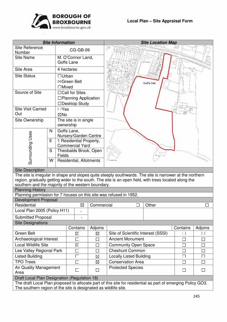
245
Local Plan – Site Appraisal Form
Site Information Site Location Map Site Reference Number
CG-GB-09
Site Name M. O’Connor Land, Goffs Lane
Site Area 4 hectares
Site Status ☐Urban ☒Green Belt ☐Mixed
Source of Site ☐Call for Sites ☐Planning Application ☐Desktop Study
Site Visit Carried Out
☐Yes ☒No
Site Ownership The site is in single ownership
Surr
oundin
g U
ses N Goffs Lane,
Nursery/Garden Centre E 1 Residential Property,
Commercial Yard S Theobalds Brook, Open
Fields W Residential, Allotments
Site Description The site is irregular in shape and slopes quite steeply southwards. The site is narrower at the northern region, gradually getting wider to the south. The site is an open field, with trees located along the southern and the majority of the western boundary. Planning History Planning permission for 7 houses on this site was refused in 1952. Development Proposal
Residential ☒ Commercial ☐ Other ☐
Local Plan 2005 (Policy H11) -
Submitted Proposal -
Site Designations Contains Adjoins Contains Adjoins
Green Belt ☒ ☒ Site of Scientific Interest (SSSI) ☐ ☐
Archaeological Interest ☐ ☐ Ancient Monument ☐ ☐
Local Wildlife Site ☒ ☐ Community Open Space ☐ ☐
Lee Valley Regional Park ☐ ☐ Cheshunt Common ☐ ☐
Listed Building ☐ ☒ Locally Listed Building ☐ ☐
TPO Trees ☐ ☒ Conservation Area ☐ ☐
Air Quality Management Area
☐ ☐ Protected Species ☐ ☐
Draft Local Plan Designation (Regulation 18) The draft Local Plan proposed to allocate part of this site for residential as part of emerging Policy GO3. The southern region of the site is designated as wildlife site.
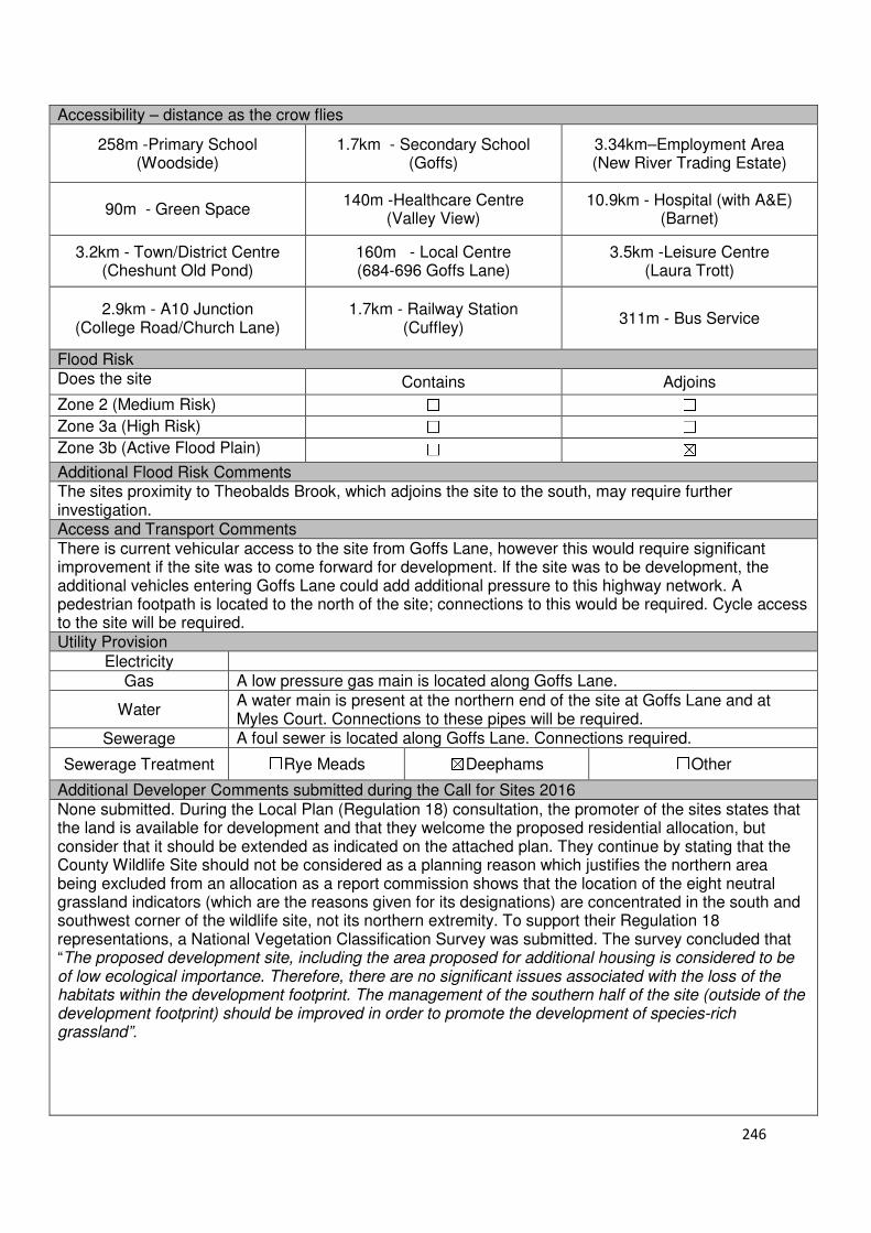
246
Accessibility – distance as the crow flies
258m -Primary School (Woodside)
1.7km - Secondary School (Goffs)
3.34km–Employment Area (New River Trading Estate)
90m - Green Space 140m -Healthcare Centre
(Valley View) 10.9km - Hospital (with A&E)
(Barnet)
3.2km - Town/District Centre (Cheshunt Old Pond)
160m - Local Centre (684-696 Goffs Lane)
3.5km -Leisure Centre (Laura Trott)
2.9km - A10 Junction (College Road/Church Lane)
1.7km - Railway Station (Cuffley)
311m - Bus Service
Flood Risk Does the site Contains Adjoins
Zone 2 (Medium Risk) ☐ ☐
Zone 3a (High Risk) ☐ ☐
Zone 3b (Active Flood Plain) ☐ ☒
Additional Flood Risk Comments The sites proximity to Theobalds Brook, which adjoins the site to the south, may require further investigation. Access and Transport Comments There is current vehicular access to the site from Goffs Lane, however this would require significant improvement if the site was to come forward for development. If the site was to be development, the additional vehicles entering Goffs Lane could add additional pressure to this highway network. A pedestrian footpath is located to the north of the site; connections to this would be required. Cycle access to the site will be required. Utility Provision
Electricity
Gas A low pressure gas main is located along Goffs Lane.
Water A water main is present at the northern end of the site at Goffs Lane and at Myles Court. Connections to these pipes will be required.
Sewerage A foul sewer is located along Goffs Lane. Connections required.
Sewerage Treatment ☐Rye Meads ☒Deephams ☐Other
Additional Developer Comments submitted during the Call for Sites 2016 None submitted. During the Local Plan (Regulation 18) consultation, the promoter of the sites states that the land is available for development and that they welcome the proposed residential allocation, but consider that it should be extended as indicated on the attached plan. They continue by stating that the County Wildlife Site should not be considered as a planning reason which justifies the northern area being excluded from an allocation as a report commission shows that the location of the eight neutral grassland indicators (which are the reasons given for its designations) are concentrated in the south and southwest corner of the wildlife site, not its northern extremity. To support their Regulation 18 representations, a National Vegetation Classification Survey was submitted. The survey concluded that “The proposed development site, including the area proposed for additional housing is considered to be of low ecological importance. Therefore, there are no significant issues associated with the loss of the habitats within the development footprint. The management of the southern half of the site (outside of the development footprint) should be improved in order to promote the development of species-rich grassland”.
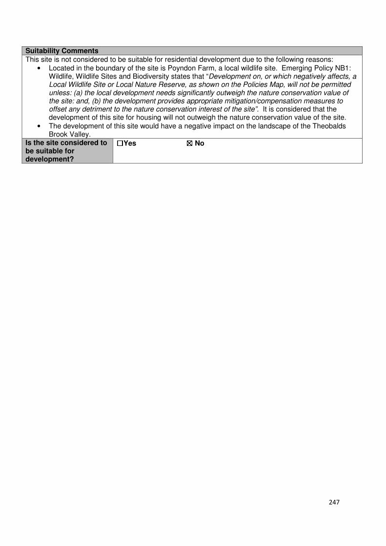
247
Suitability Comments
This site is not considered to be suitable for residential development due to the following reasons:
• Located in the boundary of the site is Poyndon Farm, a local wildlife site. Emerging Policy NB1: Wildlife, Wildlife Sites and Biodiversity states that “Development on, or which negatively affects, a Local Wildlife Site or Local Nature Reserve, as shown on the Policies Map, will not be permitted unless: (a) the local development needs significantly outweigh the nature conservation value of the site: and, (b) the development provides appropriate mitigation/compensation measures to offset any detriment to the nature conservation interest of the site”. It is considered that the development of this site for housing will not outweigh the nature conservation value of the site.
• The development of this site would have a negative impact on the landscape of the Theobalds Brook Valley.
Is the site considered to be suitable for development?
☐☐☐☐Yes ☒☒☒☒ No
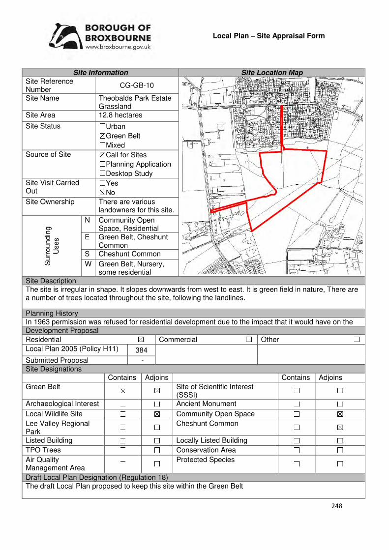
248
Local Plan – Site Appraisal Form
Site Information Site Location Map Site Reference Number
CG-GB-10
Site Name Theobalds Park Estate Grassland
Site Area 12.8 hectares
Site Status ☐Urban ☒Green Belt ☐Mixed
Source of Site ☒Call for Sites ☐Planning Application ☐Desktop Study
Site Visit Carried Out
☐Yes ☒No
Site Ownership There are various landowners for this site.
Surr
oundin
g
Uses
N Community Open Space, Residential
E Green Belt, Cheshunt Common
S Cheshunt Common
W Green Belt, Nursery, some residential
Site Description The site is irregular in shape. It slopes downwards from west to east. It is green field in nature, There are a number of trees located throughout the site, following the landlines.
Planning History In 1963 permission was refused for residential development due to the impact that it would have on the Development Proposal
Residential ☒ Commercial ☐ Other ☐
Local Plan 2005 (Policy H11) 384
Submitted Proposal - Site Designations Contains Adjoins Contains Adjoins
Green Belt ☒ ☒ Site of Scientific Interest (SSSI)
☐ ☐
Archaeological Interest ☐ ☐ Ancient Monument ☐ ☐
Local Wildlife Site ☐ ☒ Community Open Space ☐ ☒
Lee Valley Regional Park
☐ ☐ Cheshunt Common ☐ ☒
Listed Building ☐ ☐ Locally Listed Building ☐ ☐
TPO Trees ☐ ☐ Conservation Area ☐ ☐
Air Quality Management Area
☐ ☐ Protected Species ☐ ☐
Draft Local Plan Designation (Regulation 18) The draft Local Plan proposed to keep this site within the Green Belt
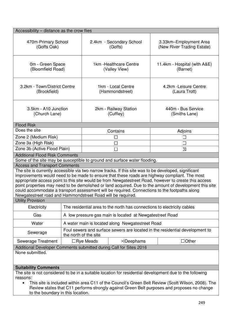
249
Accessibility – distance as the crow flies
470m-Primary School (Goffs Oak)
2.4km - Secondary School (Goffs)
3.33km–Employment Area (New River Trading Estate)
0m - Green Space (Bloomfield Road)
1km -Healthcare Centre (Valley View)
11.4km - Hospital (with A&E) (Barnet)
3.2km - Town/District Centre (Brookfield)
1km - Local Centre (Hammondstreet)
4.2km -Leisure Centre (Laura Trott)
3.5km - A10 Junction (Church Lane)
2km - Railway Station (Cuffley)
440m - Bus Service (Smiths Lane)
Flood Risk Does the site Contains Adjoins
Zone 2 (Medium Risk) ☐ ☐
Zone 3a (High Risk) ☐ ☐
Zone 3b (Active Flood Plain) ☐ ☒
Additional Flood Risk Comments Some of the site may be susceptible to ground and surface water flooding. Access and Transport Comments The site is currently accessible via two narrow tracks. If this site was to be developed, significant improvements would need to be made to ensure that these roads are highway compliant. The most appropriate access point to this site would be from Newgatestreet Road, however to create this access point properties may need to be demolished or land acquired. Due to the amount of development this site could accommodate a transport assessment will be required. Connections to the footpaths along Newgatestreet road and Hammondstreet Road will be required. Utility Provision
Electricity The residential area to the north has connections to electricity cables
Gas A low pressure gas main is located at Newgatestreet Road
Water A water main is located along Newgatestreet Road
Sewerage Foul sewers and surface sewers are located in the residential development to the north of the site
Sewerage Treatment ☐Rye Meads ☒Deephams ☐Other
Additional Developer Comments submitted during Call for Sites 2016 None submitted. Suitability Comments
The site is not considered to be in a suitable location for residential development due to the following reasons:
• This site is included within area C11 of the Council’s Green Belt Review (Scott Wilson, 2008). The Review states that C11 performs strongly against Green Belt purposes and proposes no change to the boundary in this location.
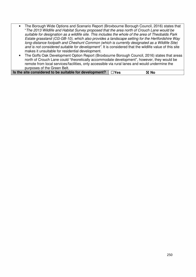
250
• The Borough Wide Options and Scenario Report (Broxbourne Borough Council, 2016) states that “The 2013 Wildlife and Habitat Survey proposed that the area north of Crouch Lane would be suitable for designation as a wildlife site. This includes the whole of the area of Theobalds Park Estate grassland (CG-GB-10), which also provides a landscape setting for the Hertfordshire Way long-distance footpath and Cheshunt Common (which is currently designated as a Wildlife Site) and is not considered suitable for development”. It is considered that the wildlife value of this site makes it unsuitable for residential development.
• The Goffs Oak Development Option Report (Broxbourne Borough Council, 2016) states that areas north of Crouch Lane could “theoretically accommodate development”, however, they would be remote from local services/facilities, only accessible via rural lanes and would undermine the purposes of the Green Belt.
Is the site considered to be suitable for development? ☐☐☐☐Yes ☒☒☒☒ No
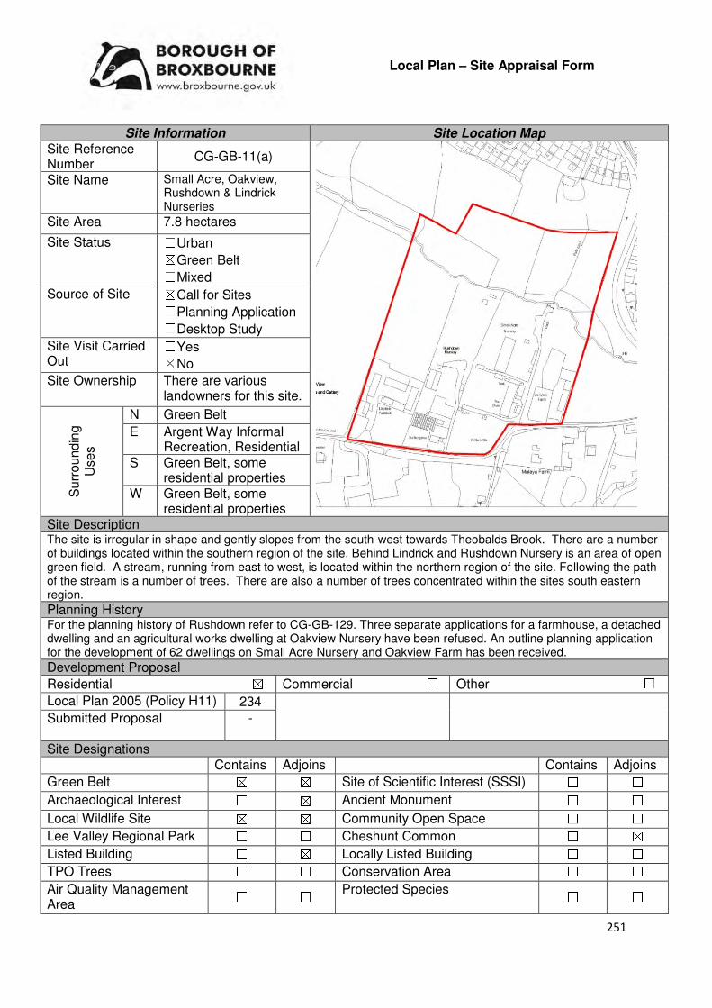
251
Local Plan – Site Appraisal Form
Site Information Site Location Map Site Reference Number
CG-GB-11(a)
Site Name Small Acre, Oakview, Rushdown & Lindrick Nurseries
Site Area 7.8 hectares
Site Status ☐Urban ☒Green Belt ☐Mixed
Source of Site ☒Call for Sites ☐Planning Application ☐Desktop Study
Site Visit Carried Out
☐Yes ☒No
Site Ownership There are various landowners for this site.
Surr
oundin
g
Uses
N Green Belt
E Argent Way Informal Recreation, Residential
S Green Belt, some residential properties
W Green Belt, some residential properties
Site Description The site is irregular in shape and gently slopes from the south-west towards Theobalds Brook. There are a number of buildings located within the southern region of the site. Behind Lindrick and Rushdown Nursery is an area of open green field. A stream, running from east to west, is located within the northern region of the site. Following the path of the stream is a number of trees. There are also a number of trees concentrated within the sites south eastern region. Planning History For the planning history of Rushdown refer to CG-GB-129. Three separate applications for a farmhouse, a detached dwelling and an agricultural works dwelling at Oakview Nursery have been refused. An outline planning application for the development of 62 dwellings on Small Acre Nursery and Oakview Farm has been received.
Development Proposal
Residential ☒ Commercial ☐ Other ☐
Local Plan 2005 (Policy H11) 234
Submitted Proposal -
Site Designations Contains Adjoins Contains Adjoins
Green Belt ☒ ☒ Site of Scientific Interest (SSSI) ☐ ☐
Archaeological Interest ☐ ☒ Ancient Monument ☐ ☐
Local Wildlife Site ☒ ☒ Community Open Space ☐ ☐
Lee Valley Regional Park ☐ ☐ Cheshunt Common ☐ ☒
Listed Building ☐ ☒ Locally Listed Building ☐ ☐
TPO Trees ☐ ☐ Conservation Area ☐ ☐
Air Quality Management Area
☐ ☐ Protected Species ☐ ☐
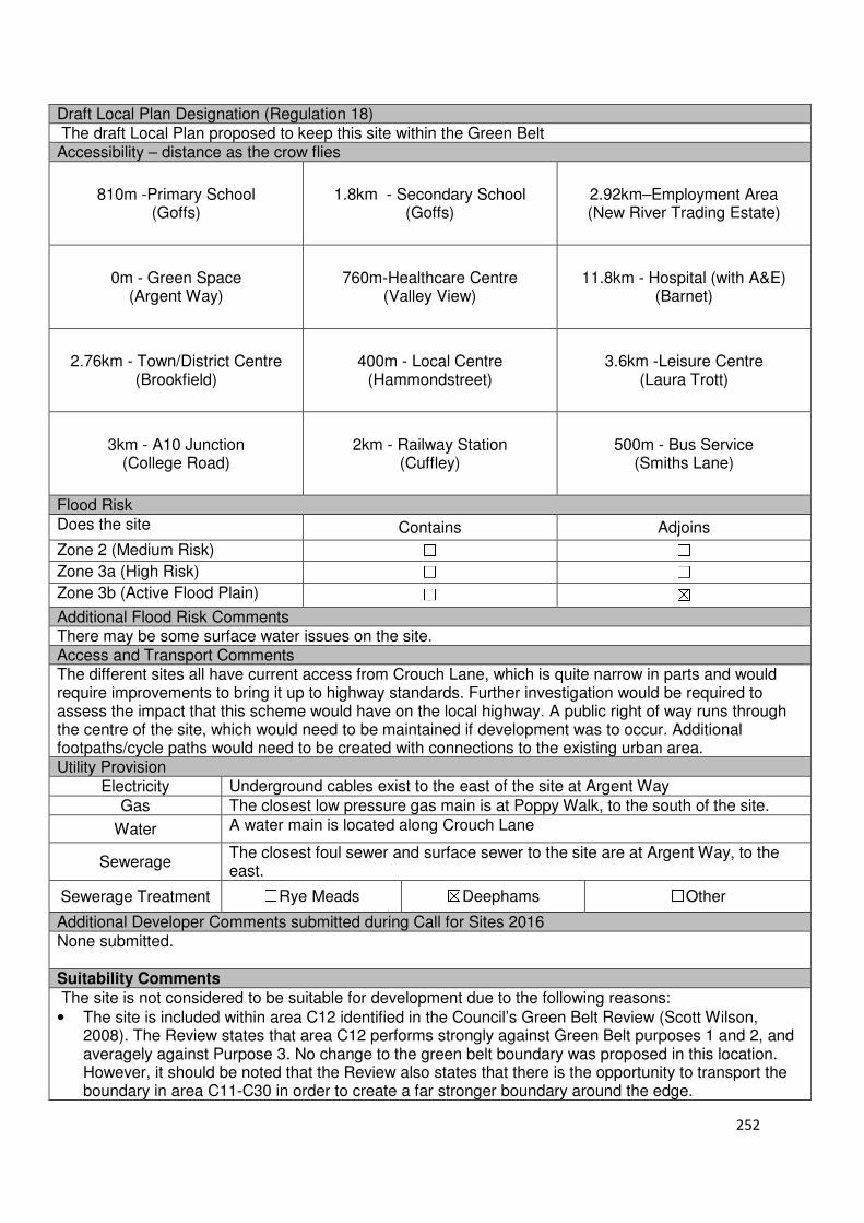
252
Draft Local Plan Designation (Regulation 18) The draft Local Plan proposed to keep this site within the Green Belt Accessibility – distance as the crow flies
810m -Primary School (Goffs)
1.8km - Secondary School (Goffs)
2.92km–Employment Area (New River Trading Estate)
0m - Green Space (Argent Way)
760m-Healthcare Centre (Valley View)
11.8km - Hospital (with A&E) (Barnet)
2.76km - Town/District Centre (Brookfield)
400m - Local Centre (Hammondstreet)
3.6km -Leisure Centre (Laura Trott)
3km - A10 Junction (College Road)
2km - Railway Station (Cuffley)
500m - Bus Service (Smiths Lane)
Flood Risk Does the site Contains Adjoins
Zone 2 (Medium Risk) ☐ ☐
Zone 3a (High Risk) ☐ ☐
Zone 3b (Active Flood Plain) ☐ ☒
Additional Flood Risk Comments There may be some surface water issues on the site. Access and Transport Comments The different sites all have current access from Crouch Lane, which is quite narrow in parts and would require improvements to bring it up to highway standards. Further investigation would be required to assess the impact that this scheme would have on the local highway. A public right of way runs through the centre of the site, which would need to be maintained if development was to occur. Additional footpaths/cycle paths would need to be created with connections to the existing urban area. Utility Provision
Electricity Underground cables exist to the east of the site at Argent Way
Gas The closest low pressure gas main is at Poppy Walk, to the south of the site.
Water A water main is located along Crouch Lane
Sewerage The closest foul sewer and surface sewer to the site are at Argent Way, to the east.
Sewerage Treatment ☐Rye Meads ☒Deephams ☐Other
Additional Developer Comments submitted during Call for Sites 2016 None submitted. Suitability Comments
The site is not considered to be suitable for development due to the following reasons:
• The site is included within area C12 identified in the Council’s Green Belt Review (Scott Wilson, 2008). The Review states that area C12 performs strongly against Green Belt purposes 1 and 2, and averagely against Purpose 3. No change to the green belt boundary was proposed in this location. However, it should be noted that the Review also states that there is the opportunity to transport the boundary in area C11-C30 in order to create a far stronger boundary around the edge.

253
• The Goffs Oak Development Options Report (Broxbourne Borough Council, 2016) identifies two categories of Green Belt sites that are not favoured for this development. This site can be placed into second category, which comprises Green Belt sites that do not adjoin or marginally adjoin urban development. The Report states that the development of these sites would create unconnected pockets of housing that are totally unrelated to one another or the existing urban area, and in the case of many sites would only be accessible via narrow rural lanes. The Report also states that these sites would exacerbate the area’s already haphazard development patterns.
• The Council’s Green Belt Review (Scott Wilson, 2008) identifies a number of strong and weak Green Belt boundaries. It is considered that this site does not have a strong Green Belt boundary to the west that would prevent further encroachment.
Is the site considered to be suitable for development?
☐☐☐☐Yes ☒☒☒☒ No
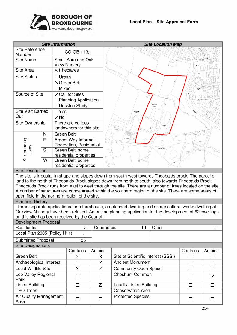
254
Local Plan – Site Appraisal Form
Site Information Site Location Map Site Reference Number
CG-GB-11(b)
Site Name Small Acre and Oak View Nursery
Site Area 4.1 hectares
Site Status ☐Urban ☒Green Belt ☐Mixed
Source of Site ☒Call for Sites ☐Planning Application ☐Desktop Study
Site Visit Carried Out
☐Yes ☒No
Site Ownership There are various landowners for this site.
Surr
oundin
g
Uses
N Green Belt
E Argent Way Informal Recreation, Residential
S Green Belt, some residential properties
W Green Belt, some residential properties
Site Description The site is irregular in shape and slopes down from south west towards Theobalds brook. The parcel of land to the north of Theobalds Brook slopes down from north to south, also towards Theobalds Brook. Theobalds Brook runs from east to west through the site. There are a number of trees located on the site. A number of structures are concentrated within the southern region of the site. There are some areas of open field in the northern region of the site.
Planning History Three separate applications for a farmhouse, a detached dwelling and an agricultural works dwelling at Oakview Nursery have been refused. An outline planning application for the development of 62 dwellings on this site has been received by the Council. Development Proposal
Residential ☒ Commercial ☐ Other ☐
Local Plan 2005 (Policy H11) -
Submitted Proposal 56 Site Designations Contains Adjoins Contains Adjoins
Green Belt ☒ ☒ Site of Scientific Interest (SSSI) ☐ ☐
Archaeological Interest ☐ ☒ Ancient Monument ☐ ☐
Local Wildlife Site ☒ ☒ Community Open Space ☐ ☐
Lee Valley Regional Park
☐ ☐ Cheshunt Common ☐ ☒
Listed Building ☐ ☒ Locally Listed Building ☐ ☐
TPO Trees ☐ ☐ Conservation Area ☐ ☐
Air Quality Management Area
☐ ☐ Protected Species ☐ ☐

255
Draft Local Plan Designation (Regulation 18) The draft Local Plan proposed to keep this site within the Green Belt Accessibility – distance as the crow flies
950m -Primary School (Goffs)
1.8km - Secondary School (Goffs)
2.92km–Employment Area (New River Trading Estate)
0m - Green Space (Argent Way)
760m-Healthcare Centre (Valley View)
11.8km - Hospital (with A&E) (Barnet)
2.76km - Town/District Centre (Brookfield)
400m - Local Centre (Hammondstreet)
3.6km -Leisure Centre (Laura Trott)
3km - A10 Junction (College Road)
2.14km - Railway Station (Cuffley)
500m - Bus Service
Flood Risk Does the site Contains Adjoins
Zone 2 (Medium Risk) ☐ ☐
Zone 3a (High Risk) ☐ ☐
Zone 3b (Active Flood Plain) ☐ ☒
Additional Flood Risk Comments There may be some surface water issues on the site. Access and Transport Comments The different sites all have current access from Crouch Lane, which is quite narrow in parts and would require improvements to bring it up to highway standards. Further investigation would be required to assess the impact that this scheme would have on the local highway. A public right of way runs through the centre of the site, which would need to be maintained if development was to occur. Additional footpaths/cycle paths would need to be created with connections to the existing urban area. Utility Provision
Electricity Underground cables exist to the east of the site at Argent Way
Gas The closest low pressure gas main is at Poppy Walk, to the south of the site. Water A water main is located along Crouch Lane
Sewerage The closest foul sewer and surface sewer to the site are at Argent Way, to the east.
Sewerage Treatment ☐Rye Meads ☒Deephams ☐Other
Additional Developer Comments submitted during Call for Sites 2016 None submitted. A promotional document for the development of this site has been produced by a developer. In this document it states that the site will deliver new access off Argent Way, a mix of 2, 3 and 4 bed homes including affordable housing, formal and informal play space for local resident, new access and extension to Cheshunt Common, sustainable drainage systems and new utilities infrastructure to prevent stress of local networks. The promotion material continues by stating that the redevelopment of this site will secure a dangerous site, provide new access and extension to Cheshunt Common, protect and enhance local biodiversity and provide new housing to meet local need. The promotional material states that Oak View Farm and Small Acre Nursery are accessible to the public which could be unsafe and secure. The two sites have a number of hazards, including derelict buildings, overgrown plants and broken glass. In additional, there are contaminants on site from previous horticultural activity, as well as commercial buildings on site. All of this is currently openly accessible to the public via an unsecured footpath which runs through the middle of the former nursery. Regenerating the site will enable the opportunity to make the site safe and secure for local residents.
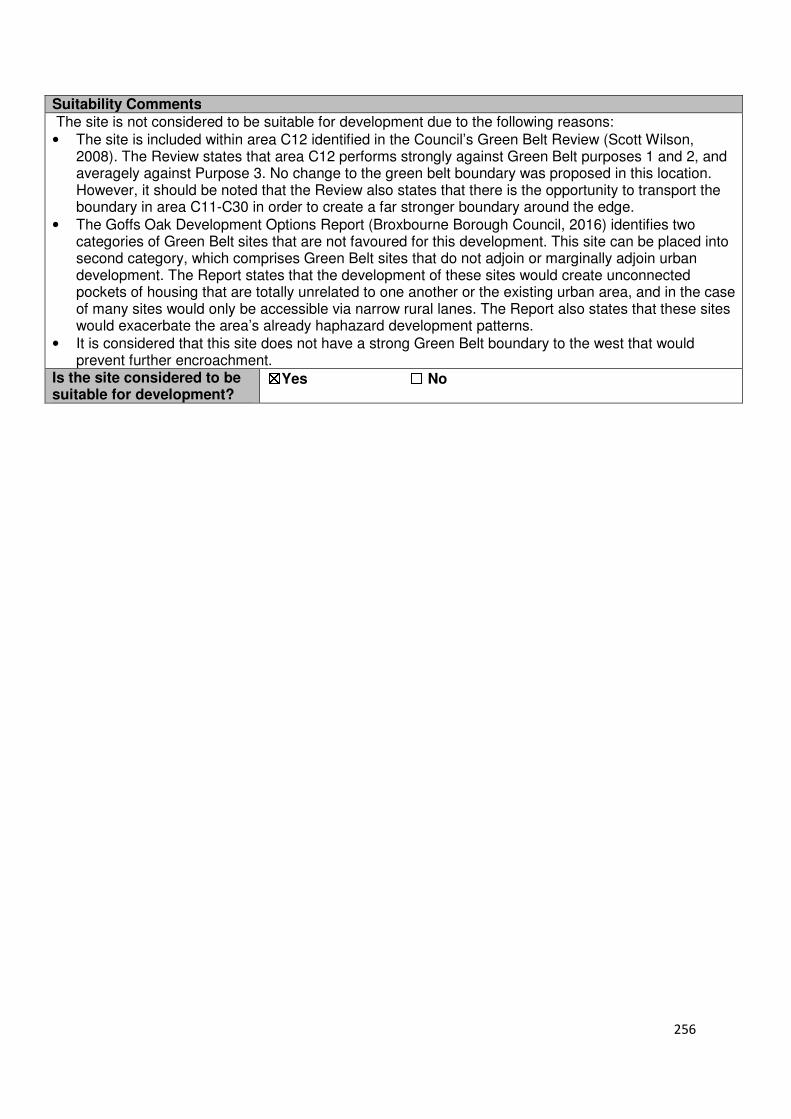
256
Suitability Comments
The site is not considered to be suitable for development due to the following reasons:
• The site is included within area C12 identified in the Council’s Green Belt Review (Scott Wilson, 2008). The Review states that area C12 performs strongly against Green Belt purposes 1 and 2, and averagely against Purpose 3. No change to the green belt boundary was proposed in this location. However, it should be noted that the Review also states that there is the opportunity to transport the boundary in area C11-C30 in order to create a far stronger boundary around the edge.
• The Goffs Oak Development Options Report (Broxbourne Borough Council, 2016) identifies two categories of Green Belt sites that are not favoured for this development. This site can be placed into second category, which comprises Green Belt sites that do not adjoin or marginally adjoin urban development. The Report states that the development of these sites would create unconnected pockets of housing that are totally unrelated to one another or the existing urban area, and in the case of many sites would only be accessible via narrow rural lanes. The Report also states that these sites would exacerbate the area’s already haphazard development patterns.
• It is considered that this site does not have a strong Green Belt boundary to the west that would prevent further encroachment.
Is the site considered to be suitable for development?
☒☒☒☒Yes ☐☐☐☐ No
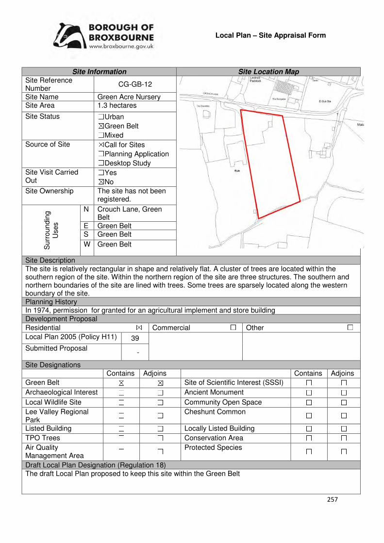
257
Local Plan – Site Appraisal Form
Site Information Site Location Map Site Reference Number
CG-GB-12
Site Name Green Acre Nursery Site Area 1.3 hectares
Site Status ☐Urban ☒Green Belt ☐Mixed
Source of Site ☒Call for Sites ☐Planning Application ☐Desktop Study
Site Visit Carried Out
☐Yes ☒No
Site Ownership The site has not been registered.
Surr
oundin
g
Uses
N Crouch Lane, Green Belt
E Green Belt S Green Belt
W Green Belt
Site Description The site is relatively rectangular in shape and relatively flat. A cluster of trees are located within the southern region of the site. Within the northern region of the site are three structures. The southern and northern boundaries of the site are lined with trees. Some trees are sparsely located along the western boundary of the site. Planning History In 1974, permission for granted for an agricultural implement and store building Development Proposal
Residential ☒ Commercial ☐ Other ☐
Local Plan 2005 (Policy H11) 39
Submitted Proposal
-
Site Designations Contains Adjoins Contains Adjoins
Green Belt ☒ ☒ Site of Scientific Interest (SSSI) ☐ ☐
Archaeological Interest ☐ ☐ Ancient Monument ☐ ☐
Local Wildlife Site ☐ ☐ Community Open Space ☐ ☐
Lee Valley Regional Park
☐ ☐ Cheshunt Common ☐ ☐
Listed Building ☐ ☐ Locally Listed Building ☐ ☐
TPO Trees ☐ ☐ Conservation Area ☐ ☐
Air Quality Management Area
☐ ☐ Protected Species ☐ ☐
Draft Local Plan Designation (Regulation 18) The draft Local Plan proposed to keep this site within the Green Belt
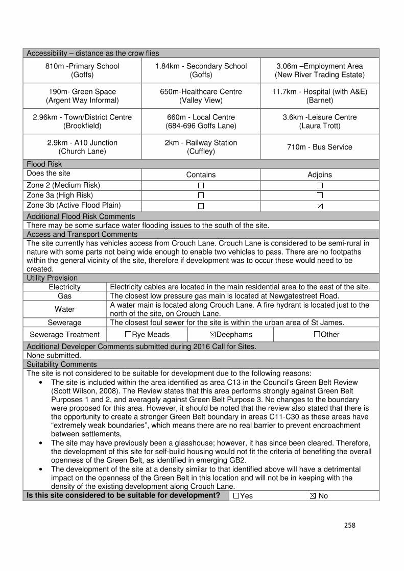
258
Accessibility – distance as the crow flies
810m -Primary School (Goffs)
1.84km - Secondary School (Goffs)
3.06m –Employment Area (New River Trading Estate)
190m- Green Space (Argent Way Informal)
650m-Healthcare Centre (Valley View)
11.7km - Hospital (with A&E) (Barnet)
2.96km - Town/District Centre (Brookfield)
660m - Local Centre (684-696 Goffs Lane)
3.6km -Leisure Centre (Laura Trott)
2.9km - A10 Junction (Church Lane)
2km - Railway Station (Cuffley)
710m - Bus Service
Flood Risk Does the site Contains Adjoins
Zone 2 (Medium Risk) ☐ ☐
Zone 3a (High Risk) ☐ ☐
Zone 3b (Active Flood Plain) ☐ ☒
Additional Flood Risk Comments There may be some surface water flooding issues to the south of the site. Access and Transport Comments The site currently has vehicles access from Crouch Lane. Crouch Lane is considered to be semi-rural in nature with some parts not being wide enough to enable two vehicles to pass. There are no footpaths within the general vicinity of the site, therefore if development was to occur these would need to be created. Utility Provision
Electricity Electricity cables are located in the main residential area to the east of the site.
Gas The closest low pressure gas main is located at Newgatestreet Road.
Water A water main is located along Crouch Lane. A fire hydrant is located just to the north of the site, on Crouch Lane.
Sewerage The closest foul sewer for the site is within the urban area of St James.
Sewerage Treatment ☐Rye Meads ☒Deephams ☐Other
Additional Developer Comments submitted during 2016 Call for Sites. None submitted. Suitability Comments The site is not considered to be suitable for development due to the following reasons:
• The site is included within the area identified as area C13 in the Council’s Green Belt Review (Scott Wilson, 2008). The Review states that this area performs strongly against Green Belt Purposes 1 and 2, and averagely against Green Belt Purpose 3. No changes to the boundary were proposed for this area. However, it should be noted that the review also stated that there is the opportunity to create a stronger Green Belt boundary in areas C11-C30 as these areas have “extremely weak boundaries”, which means there are no real barrier to prevent encroachment between settlements,
• The site may have previously been a glasshouse; however, it has since been cleared. Therefore, the development of this site for self-build housing would not fit the criteria of benefiting the overall openness of the Green Belt, as identified in emerging GB2.
• The development of the site at a density similar to that identified above will have a detrimental impact on the openness of the Green Belt in this location and will not be in keeping with the density of the existing development along Crouch Lane.
Is this site considered to be suitable for development? ☐Yes ☒ No
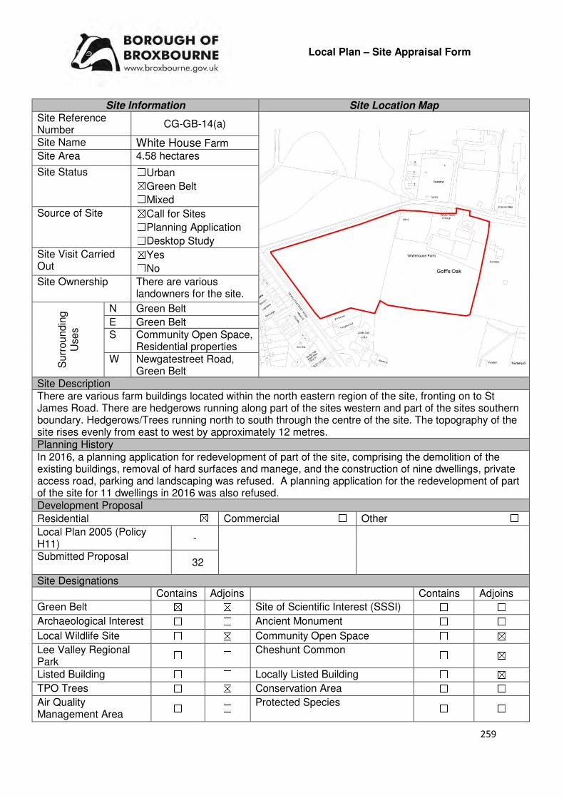
259
Local Plan – Site Appraisal Form
Site Information Site Location Map Site Reference Number
CG-GB-14(a)
Site Name White House Farm
Site Area 4.58 hectares
Site Status ☐Urban ☒Green Belt ☐Mixed
Source of Site ☒Call for Sites ☐Planning Application ☐Desktop Study
Site Visit Carried Out
☒Yes ☐No
Site Ownership There are various landowners for the site.
Surr
oundin
g
Uses
N Green Belt
E Green Belt S Community Open Space,
Residential properties W Newgatestreet Road,
Green Belt Site Description There are various farm buildings located within the north eastern region of the site, fronting on to St James Road. There are hedgerows running along part of the sites western and part of the sites southern boundary. Hedgerows/Trees running north to south through the centre of the site. The topography of the site rises evenly from east to west by approximately 12 metres. Planning History In 2016, a planning application for redevelopment of part of the site, comprising the demolition of the existing buildings, removal of hard surfaces and manege, and the construction of nine dwellings, private access road, parking and landscaping was refused. A planning application for the redevelopment of part of the site for 11 dwellings in 2016 was also refused. Development Proposal
Residential ☒ Commercial ☐ Other ☐
Local Plan 2005 (Policy H11)
-
Submitted Proposal
32
Site Designations Contains Adjoins Contains Adjoins
Green Belt ☒ ☒ Site of Scientific Interest (SSSI) ☐ ☐
Archaeological Interest ☐ ☐ Ancient Monument ☐ ☐
Local Wildlife Site ☐ ☒ Community Open Space ☐ ☒
Lee Valley Regional Park
☐ ☐ Cheshunt Common ☐ ☒
Listed Building ☐ ☐ Locally Listed Building ☐ ☒
TPO Trees ☐ ☒ Conservation Area ☐ ☐
Air Quality Management Area
☐ ☐ Protected Species ☐ ☐
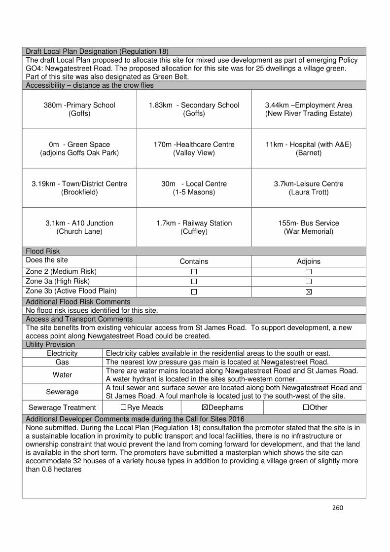
260
Draft Local Plan Designation (Regulation 18) The draft Local Plan proposed to allocate this site for mixed use development as part of emerging Policy GO4: Newgatestreet Road. The proposed allocation for this site was for 25 dwellings a village green. Part of this site was also designated as Green Belt. Accessibility – distance as the crow flies
380m -Primary School (Goffs)
1.83km - Secondary School (Goffs)
3.44km –Employment Area (New River Trading Estate)
0m - Green Space (adjoins Goffs Oak Park)
170m -Healthcare Centre
(Valley View)
11km - Hospital (with A&E)
(Barnet)
3.19km - Town/District Centre
(Brookfield)
30m - Local Centre (1-5 Masons)
3.7km-Leisure Centre
(Laura Trott)
3.1km - A10 Junction
(Church Lane)
1.7km - Railway Station
(Cuffley)
155m- Bus Service (War Memorial)
Flood Risk Does the site Contains Adjoins
Zone 2 (Medium Risk) ☐ ☐
Zone 3a (High Risk) ☐ ☐
Zone 3b (Active Flood Plain) ☐ ☒
Additional Flood Risk Comments No flood risk issues identified for this site. Access and Transport Comments The site benefits from existing vehicular access from St James Road. To support development, a new access point along Newgatestreet Road could be created. Utility Provision
Electricity Electricity cables available in the residential areas to the south or east.
Gas The nearest low pressure gas main is located at Newgatestreet Road.
Water There are water mains located along Newgatestreet Road and St James Road. A water hydrant is located in the sites south-western corner.
Sewerage A foul sewer and surface sewer are located along both Newgatestreet Road and St James Road. A foul manhole is located just to the south-west of the site.
Sewerage Treatment ☐Rye Meads ☒Deephams ☐Other
Additional Developer Comments made during the Call for Sites 2016 None submitted. During the Local Plan (Regulation 18) consultation the promoter stated that the site is in a sustainable location in proximity to public transport and local facilities, there is no infrastructure or ownership constraint that would prevent the land from coming forward for development, and that the land is available in the short term. The promoters have submitted a masterplan which shows the site can accommodate 32 houses of a variety house types in addition to providing a village green of slightly more than 0.8 hectares
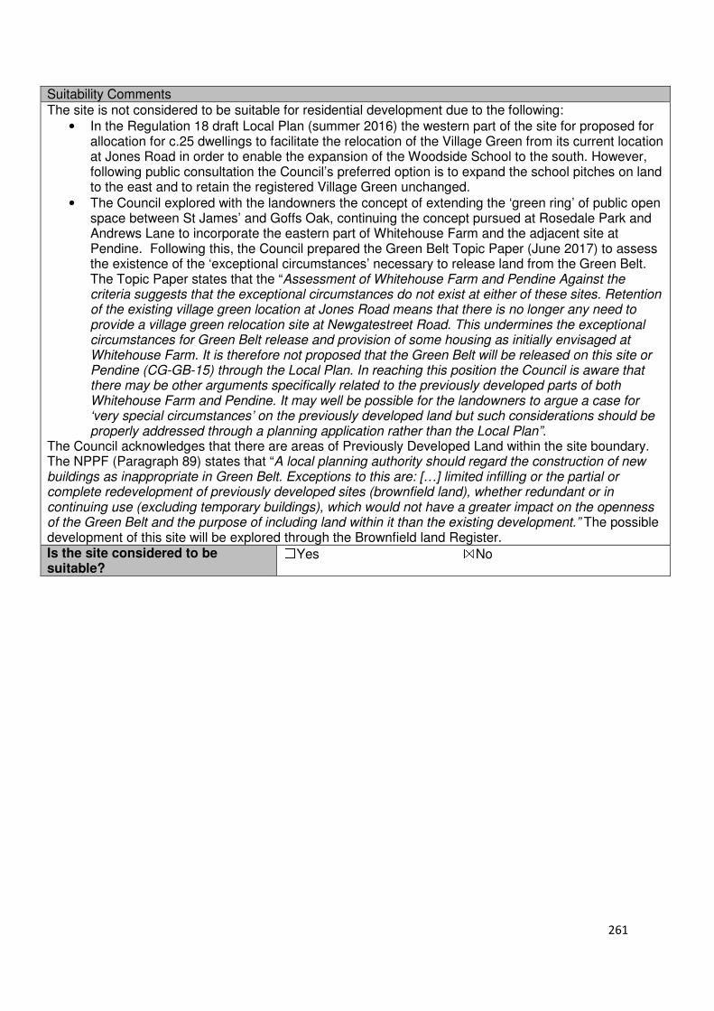
261
Suitability Comments The site is not considered to be suitable for residential development due to the following:
• In the Regulation 18 draft Local Plan (summer 2016) the western part of the site for proposed for allocation for c.25 dwellings to facilitate the relocation of the Village Green from its current location at Jones Road in order to enable the expansion of the Woodside School to the south. However, following public consultation the Council’s preferred option is to expand the school pitches on land to the east and to retain the registered Village Green unchanged.
• The Council explored with the landowners the concept of extending the ‘green ring’ of public open space between St James’ and Goffs Oak, continuing the concept pursued at Rosedale Park and Andrews Lane to incorporate the eastern part of Whitehouse Farm and the adjacent site at Pendine. Following this, the Council prepared the Green Belt Topic Paper (June 2017) to assess the existence of the ‘exceptional circumstances’ necessary to release land from the Green Belt. The Topic Paper states that the “Assessment of Whitehouse Farm and Pendine Against the criteria suggests that the exceptional circumstances do not exist at either of these sites. Retention of the existing village green location at Jones Road means that there is no longer any need to provide a village green relocation site at Newgatestreet Road. This undermines the exceptional circumstances for Green Belt release and provision of some housing as initially envisaged at Whitehouse Farm. It is therefore not proposed that the Green Belt will be released on this site or Pendine (CG-GB-15) through the Local Plan. In reaching this position the Council is aware that there may be other arguments specifically related to the previously developed parts of both Whitehouse Farm and Pendine. It may well be possible for the landowners to argue a case for ‘very special circumstances’ on the previously developed land but such considerations should be properly addressed through a planning application rather than the Local Plan”.
The Council acknowledges that there are areas of Previously Developed Land within the site boundary. The NPPF (Paragraph 89) states that “A local planning authority should regard the construction of new buildings as inappropriate in Green Belt. Exceptions to this are: […] limited infilling or the partial or complete redevelopment of previously developed sites (brownfield land), whether redundant or in continuing use (excluding temporary buildings), which would not have a greater impact on the openness of the Green Belt and the purpose of including land within it than the existing development.” The possible development of this site will be explored through the Brownfield land Register. Is the site considered to be suitable?
☐Yes ☒No
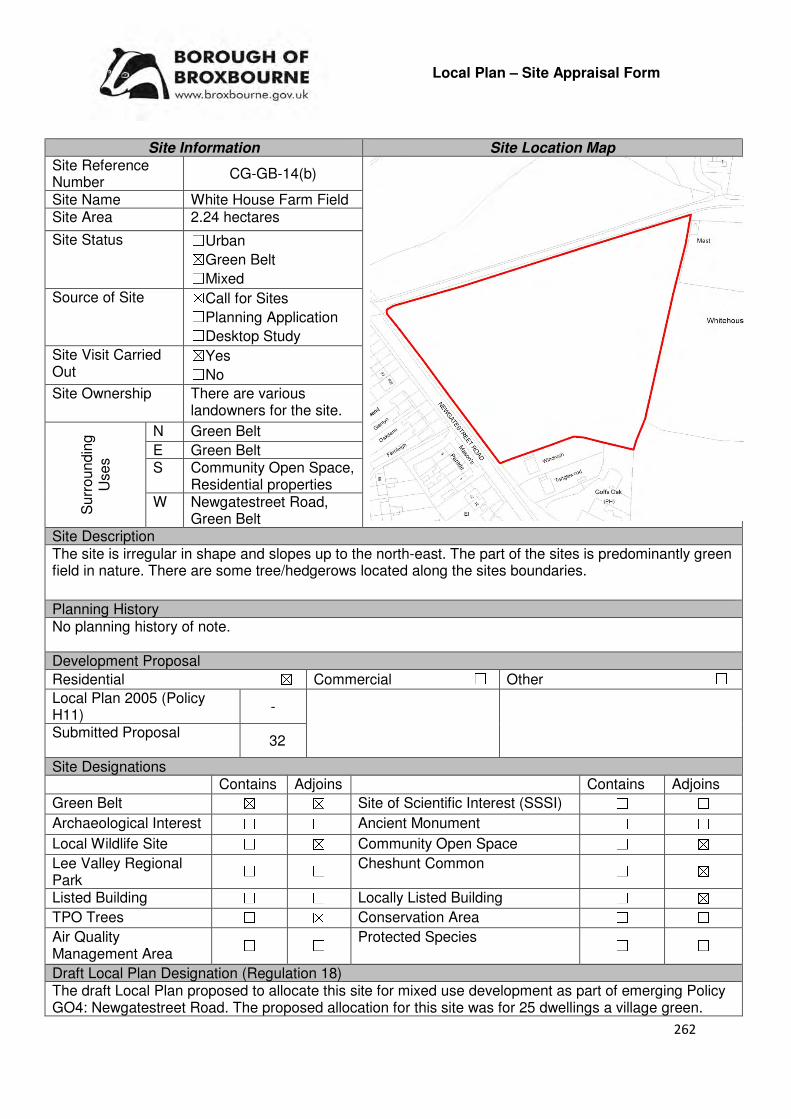
262
Local Plan – Site Appraisal Form
Site Information Site Location Map Site Reference Number
CG-GB-14(b)
Site Name White House Farm Field Site Area 2.24 hectares
Site Status ☐Urban ☒Green Belt ☐Mixed
Source of Site ☒Call for Sites ☐Planning Application ☐Desktop Study
Site Visit Carried Out
☒Yes ☐No
Site Ownership There are various landowners for the site.
Surr
oundin
g
Uses
N Green Belt
E Green Belt S Community Open Space,
Residential properties W Newgatestreet Road,
Green Belt Site Description The site is irregular in shape and slopes up to the north-east. The part of the sites is predominantly green field in nature. There are some tree/hedgerows located along the sites boundaries.
Planning History No planning history of note. Development Proposal
Residential ☒ Commercial ☐ Other ☐
Local Plan 2005 (Policy H11)
-
Submitted Proposal
32
Site Designations Contains Adjoins Contains Adjoins
Green Belt ☒ ☒ Site of Scientific Interest (SSSI) ☐ ☐
Archaeological Interest ☐ ☐ Ancient Monument ☐ ☐
Local Wildlife Site ☐ ☒ Community Open Space ☐ ☒
Lee Valley Regional Park
☐ ☐ Cheshunt Common ☐ ☒
Listed Building ☐ ☐ Locally Listed Building ☐ ☒
TPO Trees ☐ ☒ Conservation Area ☐ ☐
Air Quality Management Area
☐ ☐ Protected Species ☐ ☐
Draft Local Plan Designation (Regulation 18) The draft Local Plan proposed to allocate this site for mixed use development as part of emerging Policy GO4: Newgatestreet Road. The proposed allocation for this site was for 25 dwellings a village green.
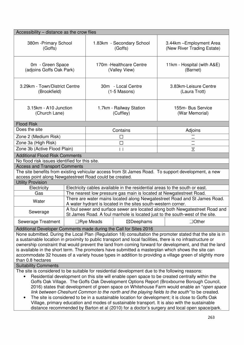
263
Accessibility – distance as the crow flies
380m -Primary School
(Goffs)
1.83km - Secondary School (Goffs)
3.44km –Employment Area (New River Trading Estate)
0m - Green Space (adjoins Goffs Oak Park)
170m -Healthcare Centre
(Valley View)
11km - Hospital (with A&E)
(Barnet)
3.29km - Town/District Centre
(Brookfield)
30m - Local Centre (1-5 Masons)
3.83km-Leisure Centre
(Laura Trott)
3.15km - A10 Junction
(Church Lane)
1.7km - Railway Station
(Cuffley)
155m- Bus Service (War Memorial)
Flood Risk Does the site Contains Adjoins
Zone 2 (Medium Risk) ☐ ☐
Zone 3a (High Risk) ☐ ☐
Zone 3b (Active Flood Plain) ☐ ☒
Additional Flood Risk Comments No flood risk issues identified for this site. Access and Transport Comments The site benefits from existing vehicular access from St James Road. To support development, a new access point along Newgatestreet Road could be created. Utility Provision
Electricity Electricity cables available in the residential areas to the south or east.
Gas The nearest low pressure gas main is located at Newgatestreet Road.
Water There are water mains located along Newgatestreet Road and St James Road. A water hydrant is located in the sites south-western corner.
Sewerage A foul sewer and surface sewer are located along both Newgatestreet Road and St James Road. A foul manhole is located just to the south-west of the site.
Sewerage Treatment ☐Rye Meads ☒Deephams ☐Other
Additional Developer Comments made during the Call for Sites 2016 None submitted. During the Local Plan (Regulation 18) consultation the promoter stated that the site is in a sustainable location in proximity to public transport and local facilities, there is no infrastructure or ownership constraint that would prevent the land from coming forward for development, and that the land is available in the short term. The promoters have submitted a masterplan which shows the site can accommodate 32 houses of a variety house types in addition to providing a village green of slightly more than 0.8 hectares Suitability Comments The site is considered to be suitable for residential development due to the following reasons:
• Residential development on this site will enable open space to be created centrally within the Goffs Oak Village. The Goffs Oak Development Options Report (Broxbourne Borough Council, 2016) states that development of green space on Whitehouse Farm would enable an “open space link between Cheshunt Common to the north and the playing fields to the south” to be created.
• The site is considered to be in a sustainable location for development; it is close to Goffs Oak Village, primary education and modes of sustainable transport. It is also with the sustainable distance recommended by Barton et al (2010) for a doctor’s surgery and local open space/park.

264
• The Council’s Green Belt Topic Paper (2017) states that “White House Farm and Pendine are both former small agricultural holdings comprising a mix of agricultural buildings and open land. The western part of White House Farm featured in draft policy as a relocation site for the village green (facilitated by a removal from the Green Belt and provision of c.25 homes) to enable the expansion of the Woodside School to the south. An alternative school expansion site to the east has been identified, avoiding the need for the relocation of the existing village green at Hones Road. However, the creation of an additional public open space on the corner of Newgatestreet Road and St James’ Road would provide a new amenity space accessible from the north of the village, from where it is currently a lengthy walk to the existing playing fields to the rear of the village centre. The new open space would be closely connected with the shops and facilities of the village centre and would be expected to provide a focal point and strengthened identity for the village. These benefits would be facilitated by the provision of c. 25 dwellings”.
Is the site considered to be suitable for development?
☒Yes ☐No
Availability Comments The site is considered to be available. During the Regulation 18 consultation on the draft Local Plan the landowners confirmed that the site is available and deliverable for development. The landowners also stated that “should the allocation of a village green not be accompanied by a residential development allocation they would not be amenable to the allocation”.
Is the site considered to be available for development?
☒Yes ☐No
Achievability Comments The site is considered to be achievable. With the exception of its current Green Belt designation, it is considered that there are no policy constraints that would prevent this site from coming forward for development. It is considered that the site preparatory work will not have a significant impact on the economic viability of the development of this site. The site is located in close proximity to the urban area of Goffs Oak Village – this means that it will be able to benefit from existing infrastructure.
Is the site considered to be achievable for development?
☒Yes ☐No
Delivery Period 1-5 years
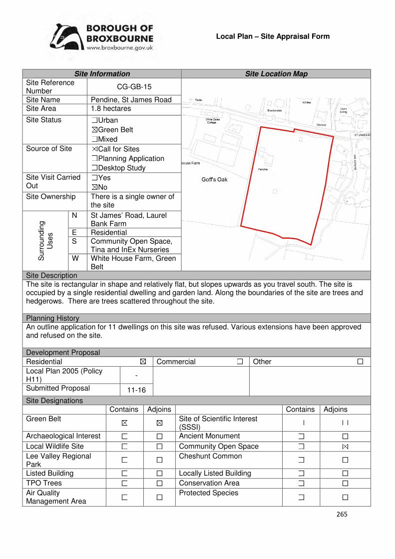
265
Local Plan – Site Appraisal Form
Site Information Site Location Map Site Reference Number
CG-GB-15
Site Name Pendine, St James Road Site Area 1.8 hectares
Site Status ☐Urban ☒Green Belt ☐Mixed
Source of Site ☒Call for Sites ☐Planning Application ☐Desktop Study
Site Visit Carried Out
☐Yes ☒No
Site Ownership There is a single owner of the site
Surr
oundin
g
Uses
N St James’ Road, Laurel Bank Farm
E Residential S Community Open Space,
Tina and InEx Nurseries W White House Farm, Green
Belt Site Description The site is rectangular in shape and relatively flat, but slopes upwards as you travel south. The site is occupied by a single residential dwelling and garden land. Along the boundaries of the site are trees and hedgerows. There are trees scattered throughout the site. Planning History An outline application for 11 dwellings on this site was refused. Various extensions have been approved and refused on the site. Development Proposal
Residential ☒ Commercial ☐ Other ☐
Local Plan 2005 (Policy H11)
-
Submitted Proposal 11-16
Site Designations Contains Adjoins Contains Adjoins
Green Belt ☒ ☒ Site of Scientific Interest (SSSI)
☐ ☐
Archaeological Interest ☐ ☐ Ancient Monument ☐ ☐
Local Wildlife Site ☐ ☐ Community Open Space ☐ ☒
Lee Valley Regional Park
☐ ☐ Cheshunt Common ☐ ☐
Listed Building ☐ ☐ Locally Listed Building ☐ ☐
TPO Trees ☐ ☐ Conservation Area ☐ ☐
Air Quality Management Area
☐ ☐ Protected Species ☐ ☐
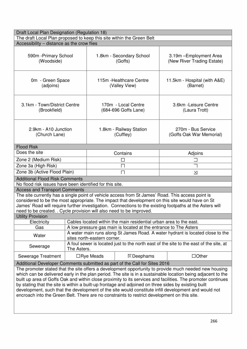
266
Draft Local Plan Designation (Regulation 18) The draft Local Plan proposed to keep this site within the Green Belt Accessibility – distance as the crow flies
590m -Primary School (Woodside)
1.8km - Secondary School (Goffs)
3.19m –Employment Area (New River Trading Estate)
0m - Green Space (adjoins)
115m -Healthcare Centre (Valley View)
11.5km - Hospital (with A&E) (Barnet)
3.1km - Town/District Centre (Brookfield)
170m - Local Centre (684-696 Goffs Lane)
3.6km -Leisure Centre (Laura Trott)
2.9km - A10 Junction (Church Lane)
1.8km - Railway Station (Cuffley)
270m - Bus Service (Goffs Oak War Memorial)
Flood Risk Does the site Contains Adjoins
Zone 2 (Medium Risk) ☐ ☐
Zone 3a (High Risk) ☐ ☐
Zone 3b (Active Flood Plain) ☐ ☒
Additional Flood Risk Comments No flood risk issues have been identified for this site. Access and Transport Comments The site currently has a single point of vehicle access from St James’ Road. This access point is considered to be the most appropriate. The impact that development on this site would have on St James’ Road will require further investigation. Connections to the existing footpaths at the Asters will need to be created. . Cycle provision will also need to be improved. Utility Provision
Electricity Cables located within the main residential urban area to the east.
Gas A low pressure gas main is located at the entrance to The Asters
Water A water main runs along St James Road. A water hydrant is located close to the sites north-eastern corner.
Sewerage A foul sewer is located just to the north east of the site to the east of the site, at The Asters.
Sewerage Treatment ☐Rye Meads ☒Deephams ☐Other
Additional Developer Comments submitted as part of the Call for Sites 2016 The promoter stated that the site offers a development opportunity to provide much needed new housing which can be delivered early in the plan period. The site is in a sustainable location being adjacent to the built up area of Goffs Oak and within close proximity to its services and facilities. The promoter continues by stating that the site is within a built-up frontage and adjoined on three sides by existing built development, such that the development of the site would constitute infill development and would not encroach into the Green Belt. There are no constraints to restrict development on this site.
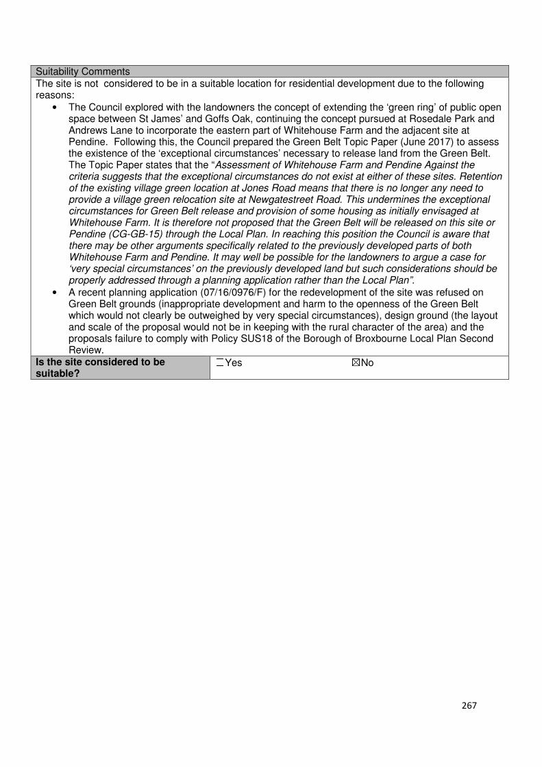
267
Suitability Comments The site is not considered to be in a suitable location for residential development due to the following reasons:
• The Council explored with the landowners the concept of extending the ‘green ring’ of public open space between St James’ and Goffs Oak, continuing the concept pursued at Rosedale Park and Andrews Lane to incorporate the eastern part of Whitehouse Farm and the adjacent site at Pendine. Following this, the Council prepared the Green Belt Topic Paper (June 2017) to assess the existence of the ‘exceptional circumstances’ necessary to release land from the Green Belt. The Topic Paper states that the “Assessment of Whitehouse Farm and Pendine Against the criteria suggests that the exceptional circumstances do not exist at either of these sites. Retention of the existing village green location at Jones Road means that there is no longer any need to provide a village green relocation site at Newgatestreet Road. This undermines the exceptional circumstances for Green Belt release and provision of some housing as initially envisaged at Whitehouse Farm. It is therefore not proposed that the Green Belt will be released on this site or Pendine (CG-GB-15) through the Local Plan. In reaching this position the Council is aware that there may be other arguments specifically related to the previously developed parts of both Whitehouse Farm and Pendine. It may well be possible for the landowners to argue a case for ‘very special circumstances’ on the previously developed land but such considerations should be properly addressed through a planning application rather than the Local Plan”.
• A recent planning application (07/16/0976/F) for the redevelopment of the site was refused on Green Belt grounds (inappropriate development and harm to the openness of the Green Belt which would not clearly be outweighed by very special circumstances), design ground (the layout and scale of the proposal would not be in keeping with the rural character of the area) and the proposals failure to comply with Policy SUS18 of the Borough of Broxbourne Local Plan Second Review.
Is the site considered to be suitable?
☐Yes ☒No
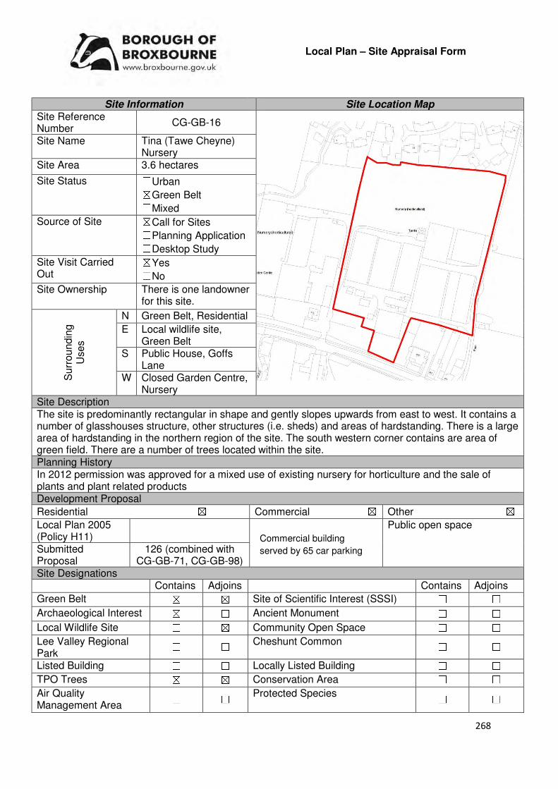
268
Local Plan – Site Appraisal Form
Site Information Site Location Map Site Reference Number
CG-GB-16
Site Name Tina (Tawe Cheyne) Nursery
Site Area 3.6 hectares
Site Status ☐Urban ☒Green Belt ☐Mixed
Source of Site ☒Call for Sites ☐Planning Application ☐Desktop Study
Site Visit Carried Out
☒Yes ☐No
Site Ownership There is one landowner for this site.
Surr
oundin
g
Uses
N Green Belt, Residential
E Local wildlife site, Green Belt
S Public House, Goffs Lane
W Closed Garden Centre, Nursery
Site Description The site is predominantly rectangular in shape and gently slopes upwards from east to west. It contains a number of glasshouses structure, other structures (i.e. sheds) and areas of hardstanding. There is a large area of hardstanding in the northern region of the site. The south western corner contains are area of green field. There are a number of trees located within the site. Planning History In 2012 permission was approved for a mixed use of existing nursery for horticulture and the sale of plants and plant related products Development Proposal
Residential ☒ Commercial ☒ Other ☒
Local Plan 2005 (Policy H11)
Public open space
Submitted Proposal
126 (combined with CG-GB-71, CG-GB-98)
Site Designations Contains Adjoins Contains Adjoins
Green Belt ☒ ☒ Site of Scientific Interest (SSSI) ☐ ☐
Archaeological Interest ☒ ☐ Ancient Monument ☐ ☐
Local Wildlife Site ☐ ☒ Community Open Space ☐ ☐
Lee Valley Regional Park
☐ ☐ Cheshunt Common ☐ ☐
Listed Building ☐ ☐ Locally Listed Building ☐ ☐
TPO Trees ☒ ☒ Conservation Area ☐ ☐
Air Quality Management Area
☐ ☐ Protected Species ☐ ☐
Commercial building
served by 65 car parking
spaces.
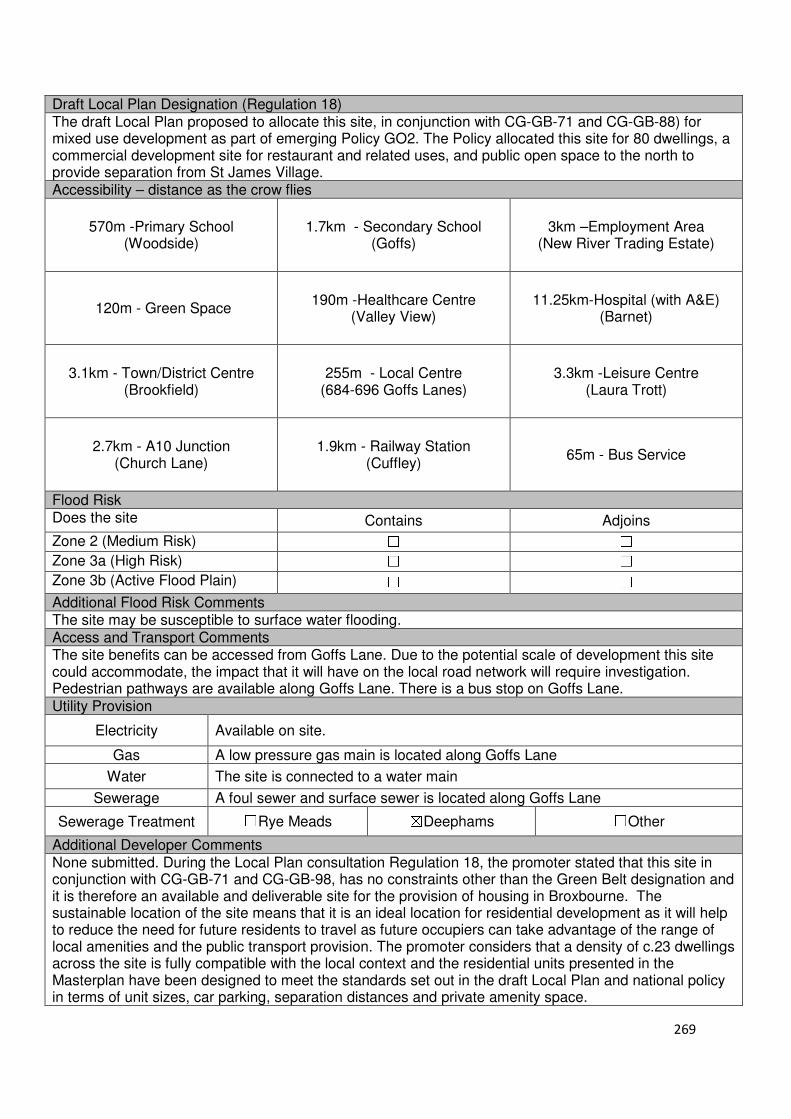
269
Draft Local Plan Designation (Regulation 18) The draft Local Plan proposed to allocate this site, in conjunction with CG-GB-71 and CG-GB-88) for mixed use development as part of emerging Policy GO2. The Policy allocated this site for 80 dwellings, a commercial development site for restaurant and related uses, and public open space to the north to provide separation from St James Village. Accessibility – distance as the crow flies
570m -Primary School (Woodside)
1.7km - Secondary School (Goffs)
3km –Employment Area (New River Trading Estate)
120m - Green Space
190m -Healthcare Centre (Valley View)
11.25km-Hospital (with A&E) (Barnet)
3.1km - Town/District Centre (Brookfield)
255m - Local Centre (684-696 Goffs Lanes)
3.3km -Leisure Centre (Laura Trott)
2.7km - A10 Junction (Church Lane)
1.9km - Railway Station (Cuffley)
65m - Bus Service
Flood Risk Does the site Contains Adjoins
Zone 2 (Medium Risk) ☐ ☐
Zone 3a (High Risk) ☐ ☐
Zone 3b (Active Flood Plain) ☐ ☐
Additional Flood Risk Comments The site may be susceptible to surface water flooding. Access and Transport Comments The site benefits can be accessed from Goffs Lane. Due to the potential scale of development this site could accommodate, the impact that it will have on the local road network will require investigation. Pedestrian pathways are available along Goffs Lane. There is a bus stop on Goffs Lane. Utility Provision
Electricity Available on site.
Gas A low pressure gas main is located along Goffs Lane
Water The site is connected to a water main
Sewerage A foul sewer and surface sewer is located along Goffs Lane
Sewerage Treatment ☐Rye Meads ☒Deephams ☐Other
Additional Developer Comments None submitted. During the Local Plan consultation Regulation 18, the promoter stated that this site in conjunction with CG-GB-71 and CG-GB-98, has no constraints other than the Green Belt designation and it is therefore an available and deliverable site for the provision of housing in Broxbourne. The sustainable location of the site means that it is an ideal location for residential development as it will help to reduce the need for future residents to travel as future occupiers can take advantage of the range of local amenities and the public transport provision. The promoter considers that a density of c.23 dwellings across the site is fully compatible with the local context and the residential units presented in the Masterplan have been designed to meet the standards set out in the draft Local Plan and national policy in terms of unit sizes, car parking, separation distances and private amenity space.
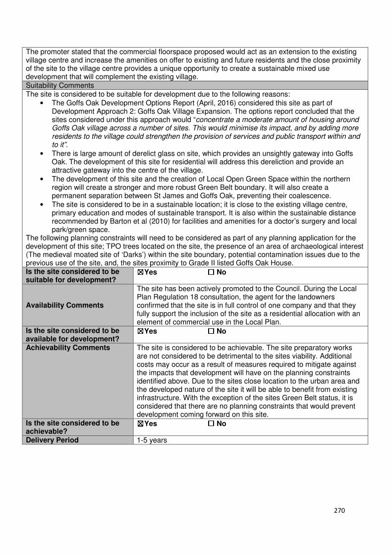
270
The promoter stated that the commercial floorspace proposed would act as an extension to the existing village centre and increase the amenities on offer to existing and future residents and the close proximity of the site to the village centre provides a unique opportunity to create a sustainable mixed use development that will complement the existing village. Suitability Comments The site is considered to be suitable for development due to the following reasons:
• The Goffs Oak Development Options Report (April, 2016) considered this site as part of Development Approach 2: Goffs Oak Village Expansion. The options report concluded that the sites considered under this approach would “concentrate a moderate amount of housing around Goffs Oak village across a number of sites. This would minimise its impact, and by adding more residents to the village could strengthen the provision of services and public transport within and to it”.
• There is large amount of derelict glass on site, which provides an unsightly gateway into Goffs Oak. The development of this site for residential will address this dereliction and provide an attractive gateway into the centre of the village.
• The development of this site and the creation of Local Open Green Space within the northern region will create a stronger and more robust Green Belt boundary. It will also create a permanent separation between St James and Goffs Oak, preventing their coalescence.
• The site is considered to be in a sustainable location; it is close to the existing village centre, primary education and modes of sustainable transport. It is also within the sustainable distance recommended by Barton et al (2010) for facilities and amenities for a doctor’s surgery and local park/green space.
The following planning constraints will need to be considered as part of any planning application for the development of this site; TPO trees located on the site, the presence of an area of archaeological interest (The medieval moated site of ‘Darks’) within the site boundary, potential contamination issues due to the previous use of the site, and, the sites proximity to Grade II listed Goffs Oak House. Is the site considered to be suitable for development?
☒☒☒☒Yes ☐☐☐☐ No
Availability Comments
The site has been actively promoted to the Council. During the Local Plan Regulation 18 consultation, the agent for the landowners confirmed that the site is in full control of one company and that they fully support the inclusion of the site as a residential allocation with an element of commercial use in the Local Plan.
Is the site considered to be available for development?
☒☒☒☒Yes ☐☐☐☐ No
Achievability Comments The site is considered to be achievable. The site preparatory works are not considered to be detrimental to the sites viability. Additional costs may occur as a result of measures required to mitigate against the impacts that development will have on the planning constraints identified above. Due to the sites close location to the urban area and the developed nature of the site it will be able to benefit from existing infrastructure. With the exception of the sites Green Belt status, it is considered that there are no planning constraints that would prevent development coming forward on this site.
Is the site considered to be achievable?
☒☒☒☒Yes ☐☐☐☐ No
Delivery Period 1-5 years

271
Local Plan – Site Appraisal Form
Site Information Site Location Map Site Reference Number
CG-GB-17
Site Name Former Nockhold/FJD Nursery
Site Area 8 hectares
Site Status ☐Urban ☒Green Belt ☐Mixed
Source of Site ☒Call for Sites ☐Planning Application ☐Desktop Study
Site Visit Carried Out
☐Yes ☒No
Site Ownership The site is in private ownership
Surr
oundin
g
Uses
N Residential
E Residential, Tudor Nursery
S Residential, Goffs Lane
W Nurseries
Site Description The site is irregular in shape due to following the boundaries of existing properties. The site slopes downwards from Goffs Lane to St James, however this is relatively gentle. The middle section of the site was refused permission for residential development in the 1970s. The site is separated into three different segments by tree boundaries. The northern region of the site has some hard standing surface. A large cluster of trees are located in the south eastern corner, behind the existing properties. Trees are located on the sites southern, northern and western borders.
Planning History A football pitch was previously approved for the northern part of the site. This northern end was also granted consent for stables and horse related activities. Development Proposal
Residential ☒ Commercial ☐ Other ☐
Local Plan 2005 (Policy H11)
Submitted Proposal
Site Designations Contains Adjoins Contains Adjoins
Green Belt ☒ ☒ Site of Scientific Interest (SSSI) ☐ ☐
Archaeological Interest ☐ ☒ Ancient Monument ☐ ☐
Local Wildlife Site ☒ ☐ Community Open Space ☐ ☐
Lee Valley Regional Park
☐ ☐ Cheshunt Common ☐ ☐
Listed Building ☐ ☒ Locally Listed Building ☐ ☐
TPO Trees ☐ ☒ Conservation Area ☐ ☐
Air Quality Management Area
☐ ☐ Protected Species ☐ ☐
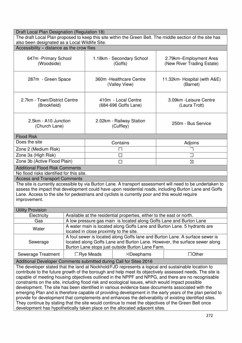
272
Draft Local Plan Designation (Regulation 18) The draft Local Plan proposed to keep this site within the Green Belt. The middle section of the site has also been designated as a Local Wildlife Site. Accessibility – distance as the crow flies
647m -Primary School (Woodside)
1.18km - Secondary School (Goffs)
2.79km–Employment Area (New River Trading Estate)
287m - Green Space
360m -Healthcare Centre
(Valley View)
11.32km- Hospital (with A&E)
(Barnet)
2.7km - Town/District Centre
(Brookfield)
410m - Local Centre (684-696 Goffs Lane)
3.09km -Leisure Centre (Laura Trott)
2.5km - A10 Junction (Church Lane)
2.02km - Railway Station
(Cuffley)
250m - Bus Service
Flood Risk Does the site Contains Adjoins
Zone 2 (Medium Risk) ☐ ☐
Zone 3a (High Risk) ☐ ☐
Zone 3b (Active Flood Plain) ☐ ☒
Additional Flood Risk Comments No flood risks identified for this site. Access and Transport Comments The site is currently accessible by via Burton Lane. A transport assessment will need to be undertaken to assess the impact that development could have upon residential roads, including Burton Lane and Goffs Lane. Access to the site for pedestrians and cyclists is currently poor and this would require improvement. Utility Provision
Electricity Available at the residential properties, either to the east or north.
Gas A low pressure gas main is located along Goffs Lane and Burton Lane
Water A water main is located along Goffs Lane and Burton Lane. 5 hydrants are located in close proximity to the site.
Sewerage A foul sewer is located along Goffs lane and Burton Lane. A surface sewer is located along Goffs Lane and Burton Lane. However, the surface sewer along Burton Lane stops just outside Burton Lane Farm.
Sewerage Treatment ☐Rye Meads ☒Deephams ☐Other
Additional Developer Comments submitted during Call for Sites 2016 The developer stated that the land at Nockhold/FJD represents a logical and sustainable location to contribute to the future growth of the borough and help meet its objectively assessed needs. The site is capable of meeting housing objectives outlined in the NPPF and NPPG, and there are no recognisable constraints on the site, including flood risk and ecological issues, which would impact possible development. The site has been identified in various evidence base documents associated with the emerging Plan and is therefore capable of providing development in the early years of the plan period to provide for development that complements and enhances the deliverability of existing identified sites. They continue by stating that the site would continue to meet the objectives of the Green Belt once development has hypothetically taken place on the allocated adjacent sites.
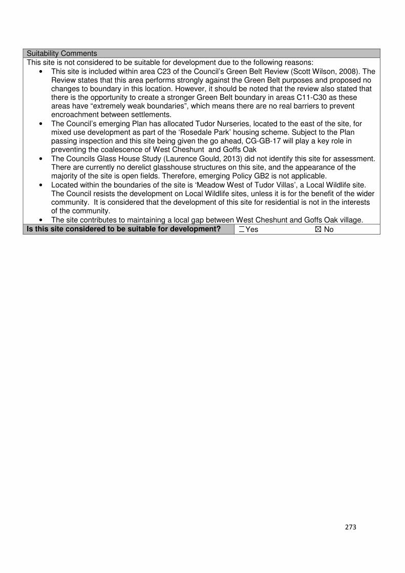
273
Suitability Comments This site is not considered to be suitable for development due to the following reasons:
• This site is included within area C23 of the Council’s Green Belt Review (Scott Wilson, 2008). The Review states that this area performs strongly against the Green Belt purposes and proposed no changes to boundary in this location. However, it should be noted that the review also stated that there is the opportunity to create a stronger Green Belt boundary in areas C11-C30 as these areas have “extremely weak boundaries”, which means there are no real barriers to prevent encroachment between settlements.
• The Council’s emerging Plan has allocated Tudor Nurseries, located to the east of the site, for mixed use development as part of the ‘Rosedale Park’ housing scheme. Subject to the Plan passing inspection and this site being given the go ahead, CG-GB-17 will play a key role in preventing the coalescence of West Cheshunt and Goffs Oak
• The Councils Glass House Study (Laurence Gould, 2013) did not identify this site for assessment. There are currently no derelict glasshouse structures on this site, and the appearance of the majority of the site is open fields. Therefore, emerging Policy GB2 is not applicable.
• Located within the boundaries of the site is ‘Meadow West of Tudor Villas’, a Local Wildlife site. The Council resists the development on Local Wildlife sites, unless it is for the benefit of the wider community. It is considered that the development of this site for residential is not in the interests of the community.
• The site contributes to maintaining a local gap between West Cheshunt and Goffs Oak village. Is this site considered to be suitable for development? ☐Yes ☒ No

274
Local Plan – Site Appraisal Form
Site Information Site Location Map Site Reference Number
CG-GB-18(a)
Site Name Longmead and Pylon Farm
Site Area 3 hectares
Site Status ☐Urban ☒Green Belt ☐Mixed
Source of Site ☒Call for Sites ☐Planning Application ☐Desktop Study
Site Visit Carried Out
☐Yes ☒No
Site Ownership There are several landowners for this site.
Surr
oundin
g
Uses
N Green Belt
E Green Belt S Residential
W Laurel Bank Farm, Green Belt
Site Description The site is formed of two staggered, rectangular shapes of land, which gradually slope northwards. Trees are located along the two rectangular shapes boundary, with there also trees in the western rectangular shape following what appears to be a previous site boundary. There is one residential building on the site located in the south eastern region of the site. These two separate sites were promoted together to the Council in a previous call for sites. Planning History In 2007 permission was refused for 24 dwellings on Longmead and Pylon Farm. Development Proposal
Residential ☒ Commercial ☐ Other ☐
Local Plan 2005 (Policy H11)
-
Submitted Proposal
30 (In conjunction with
CG-GB-47) Site Designations Contains Adjoins Contains Adjoins
Green Belt ☒ ☒ Site of Scientific Interest (SSSI) ☐ ☐
Archaeological Interest ☐ ☐ Ancient Monument ☐ ☐
Local Wildlife Site ☐ ☐ Community Open Space ☐ ☐
Lee Valley Regional Park
☐ ☐ Cheshunt Common ☐ ☐
Listed Building ☐ ☐ Locally Listed Building ☐ ☐
TPO Trees ☐ ☒ Conservation Area ☐ ☐
Air Quality Management Area
☐ ☐ Protected Species ☐ ☐
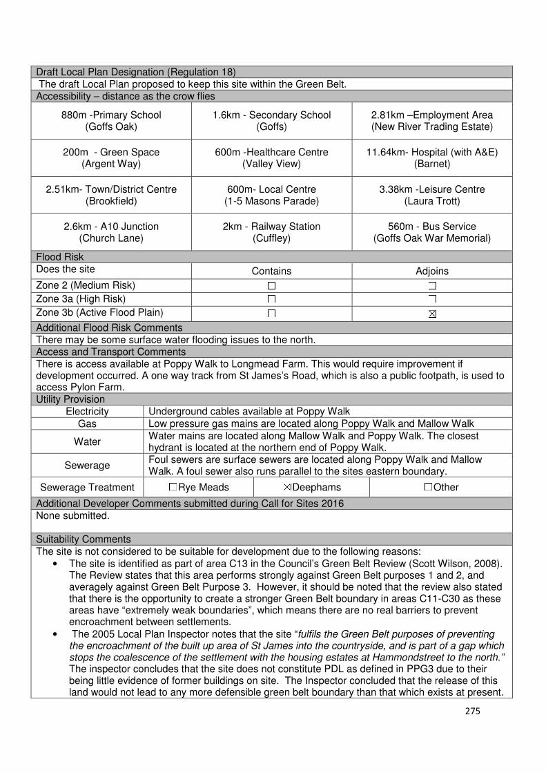
275
Draft Local Plan Designation (Regulation 18) The draft Local Plan proposed to keep this site within the Green Belt. Accessibility – distance as the crow flies
880m -Primary School (Goffs Oak)
1.6km - Secondary School (Goffs)
2.81km –Employment Area (New River Trading Estate)
200m - Green Space (Argent Way)
600m -Healthcare Centre (Valley View)
11.64km- Hospital (with A&E) (Barnet)
2.51km- Town/District Centre (Brookfield)
600m- Local Centre (1-5 Masons Parade)
3.38km -Leisure Centre (Laura Trott)
2.6km - A10 Junction (Church Lane)
2km - Railway Station (Cuffley)
560m - Bus Service (Goffs Oak War Memorial)
Flood Risk Does the site Contains Adjoins
Zone 2 (Medium Risk) ☐ ☐
Zone 3a (High Risk) ☐ ☐
Zone 3b (Active Flood Plain) ☐ ☒
Additional Flood Risk Comments There may be some surface water flooding issues to the north. Access and Transport Comments There is access available at Poppy Walk to Longmead Farm. This would require improvement if development occurred. A one way track from St James’s Road, which is also a public footpath, is used to access Pylon Farm. Utility Provision
Electricity Underground cables available at Poppy Walk
Gas Low pressure gas mains are located along Poppy Walk and Mallow Walk
Water Water mains are located along Mallow Walk and Poppy Walk. The closest hydrant is located at the northern end of Poppy Walk.
Sewerage Foul sewers are surface sewers are located along Poppy Walk and Mallow Walk. A foul sewer also runs parallel to the sites eastern boundary.
Sewerage Treatment ☐Rye Meads ☒Deephams ☐Other
Additional Developer Comments submitted during Call for Sites 2016 None submitted. Suitability Comments The site is not considered to be suitable for development due to the following reasons:
• The site is identified as part of area C13 in the Council’s Green Belt Review (Scott Wilson, 2008). The Review states that this area performs strongly against Green Belt purposes 1 and 2, and averagely against Green Belt Purpose 3. However, it should be noted that the review also stated that there is the opportunity to create a stronger Green Belt boundary in areas C11-C30 as these areas have “extremely weak boundaries”, which means there are no real barriers to prevent encroachment between settlements.
• The 2005 Local Plan Inspector notes that the site “fulfils the Green Belt purposes of preventing the encroachment of the built up area of St James into the countryside, and is part of a gap which stops the coalescence of the settlement with the housing estates at Hammondstreet to the north.” The inspector concludes that the site does not constitute PDL as defined in PPG3 due to their being little evidence of former buildings on site. The Inspector concluded that the release of this land would not lead to any more defensible green belt boundary than that which exists at present.

276
• Part of the site was included within ‘Development Approach 4: Infill around the Green Ring’ in the Goffs Oak Development Options Report (Broxbourne Borough Council, 2016). Although this would provide a moderate amount of housing, the report concluded that this approach would break the key visual links between those roads and the green ring, and that the large number of sites included within this option could be a barrier to delivery, particularly of the infrastructure required to support the site. The report also noted that negative public reaction to this approach could be expected.
• A planning application for the development of 24 dwellings at this site was refused. Some of the reasons provided for the applications refusal include; the materially detrimental impact the development would have on the character and visual amenity of the site and its setting and be contrary to Policy GBC16, and, the site has no realistic means of vehicular access other than via an existing highway (Poppy Walk) and that the greater use of this would be detrimental to pedestrian and vehicular highway safety and create a level of congestion along the length of Poppy Walk that would be materially detrimental to residential amenity.
Is this site considered to be suitable for development? ☐Yes ☒ No
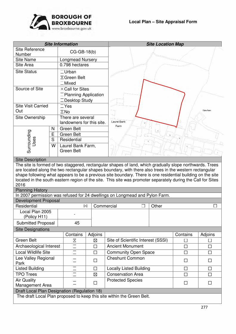
277
Local Plan – Site Appraisal Form
Site Information Site Location Map Site Reference Number
CG-GB-18(b)
Site Name Longmead Nursery Site Area 0.798 hectares
Site Status ☐Urban ☒Green Belt ☐Mixed
Source of Site ☒Call for Sites ☐Planning Application ☐Desktop Study
Site Visit Carried Out
☐Yes ☒No
Site Ownership There are several landowners for this site.
Surr
oundin
g
Uses
N Green Belt
E Green Belt S Residential
W Laurel Bank Farm, Green Belt
Site Description The site is formed of two staggered, rectangular shapes of land, which gradually slope northwards. Trees are located along the two rectangular shapes boundary, with there also trees in the western rectangular shape following what appears to be a previous site boundary. There is one residential building on the site located in the south eastern region of the site. This site was promoter separately during the Call for Sites 2016 Planning History In 2007 permission was refused for 24 dwellings on Longmead and Pylon Farm. Development Proposal
Residential ☒ Commercial ☐ Other ☐
Local Plan 2005 (Policy H11)
-
Submitted Proposal 45
Site Designations Contains Adjoins Contains Adjoins
Green Belt ☒ ☒ Site of Scientific Interest (SSSI) ☐ ☐
Archaeological Interest ☐ ☐ Ancient Monument ☐ ☐
Local Wildlife Site ☐ ☐ Community Open Space ☐ ☐
Lee Valley Regional Park
☐ ☐ Cheshunt Common ☐ ☐
Listed Building ☐ ☐ Locally Listed Building ☐ ☐
TPO Trees ☐ ☒ Conservation Area ☐ ☐
Air Quality Management Area
☐ ☐ Protected Species ☐ ☐
Draft Local Plan Designation (Regulation 18) The draft Local Plan proposed to keep this site within the Green Belt.

278
Accessibility – distance as the crow flies
880m -Primary School (Goffs Oak)
1.67km - Secondary School (Goffs)
2.94km –Employment Area (New River Trading Estate)
200m - Green Space (Argent Way)
600m -Healthcare Centre (Valley View)
11.64km- Hospital (with A&E) (Barnet)
2.84km- Town/District Centre (Brookfield)
600m- Local Centre (1-5 Masons Parade)
3.5km -Leisure Centre (Laura Trott)
2.73km - A10 Junction (Church Lane)
2km - Railway Station (Cuffley)
560m - Bus Service (Goffs Oak War Memorial)
Flood Risk Does the site Contains Adjoins
Zone 2 (Medium Risk) ☐ ☐
Zone 3a (High Risk) ☐ ☐
Zone 3b (Active Flood Plain) ☐ ☒
Additional Flood Risk Comments There may be some surface water flooding issues to the north. Access and Transport Comments There is access available at Poppy Walk to Longmead Farm. This would require improvement if development occurred. A one way track from St James’s Road, which is also a public footpath, is used to access Pylon Farm. Utility Provision
Electricity Underground cables available at Poppy Walk
Gas Low pressure gas mains are located along Poppy Walk and Mallow Walk
Water Water mains are located along Mallow Walk and Poppy Walk. The closest hydrant is located at the northern end of Poppy Walk.
Sewerage Foul sewers are surface sewers are located along Poppy Walk and Mallow Walk. A foul sewer also runs parallel to the sites eastern boundary.
Sewerage Treatment ☐Rye Meads ☒Deephams ☐Other
Additional Developer Comments submitted during Call for Sites 2016 The promoter states that the site is “ready to go” and that it is located next to an existing developed area where the infrastructure is already in place. The promoter continues by stating that the owners of the site are willing to work with the Council in bringing forward the site for housing. It is considered the same character and style of housing at Poppy Walk can be extended to the site and provide much need housing at a very short notice. Site preparation would be minimal. Suitability Comments The site is not considered to be suitable for development due to the following reasons:
• The site was included within area C13 of the Council’s Green Belt Review (Scott Wilson, 2008). The Review states that are C13performs strongly against Green Belt purposes 1 and 2, and averagely against Green Belt Purpose 3. However, it should be noted that the review also stated that there is the opportunity to create a stronger Green Belt boundary in areas C11-C30 as these areas have “extremely weak boundaries”, which means there are no real barriers to prevent encroachment between settlements.
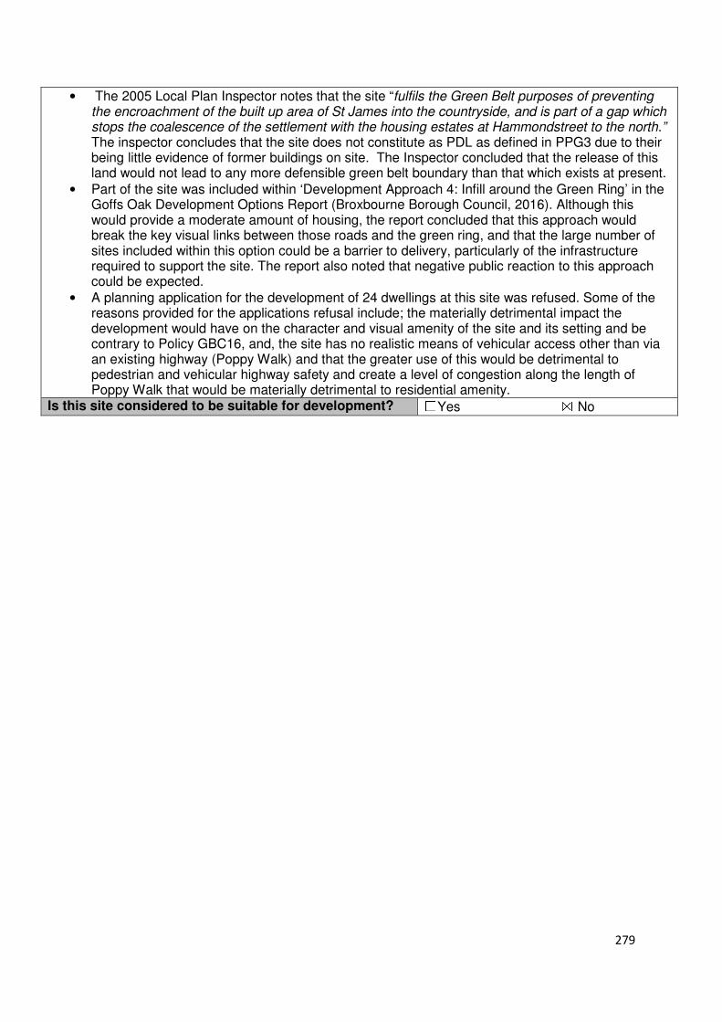
279
• The 2005 Local Plan Inspector notes that the site “fulfils the Green Belt purposes of preventing the encroachment of the built up area of St James into the countryside, and is part of a gap which stops the coalescence of the settlement with the housing estates at Hammondstreet to the north.” The inspector concludes that the site does not constitute as PDL as defined in PPG3 due to their being little evidence of former buildings on site. The Inspector concluded that the release of this land would not lead to any more defensible green belt boundary than that which exists at present.
• Part of the site was included within ‘Development Approach 4: Infill around the Green Ring’ in the Goffs Oak Development Options Report (Broxbourne Borough Council, 2016). Although this would provide a moderate amount of housing, the report concluded that this approach would break the key visual links between those roads and the green ring, and that the large number of sites included within this option could be a barrier to delivery, particularly of the infrastructure required to support the site. The report also noted that negative public reaction to this approach could be expected.
• A planning application for the development of 24 dwellings at this site was refused. Some of the reasons provided for the applications refusal include; the materially detrimental impact the development would have on the character and visual amenity of the site and its setting and be contrary to Policy GBC16, and, the site has no realistic means of vehicular access other than via an existing highway (Poppy Walk) and that the greater use of this would be detrimental to pedestrian and vehicular highway safety and create a level of congestion along the length of Poppy Walk that would be materially detrimental to residential amenity.
Is this site considered to be suitable for development? ☐Yes ☒ No
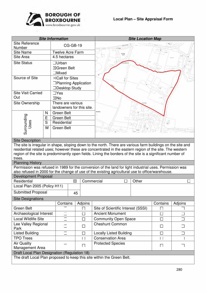
280
Local Plan – Site Appraisal Form
Site Information Site Location Map Site Reference Number
CG-GB-19
Site Name Twelve Acre Farm Site Area 4.5 hectares
Site Status ☐Urban ☒Green Belt ☐Mixed
Source of Site ☒Call for Sites ☐Planning Application ☐Desktop Study
Site Visit Carried Out
☐Yes ☒No
Site Ownership There are various landowners for this site.
Surr
oundin
g
Uses
N Green Belt
E Green Belt S Residential
W Green Belt
Site Description The site is irregular in shape, sloping down to the north. There are various farm buildings on the site and residential related uses; however these are concentrated in the eastern region of the site. The western region of the site is predominantly open fields. Lining the borders of the site is a significant number of trees. Planning History Permission was refused in 1989 for the conversion of the land for light industrial uses. Permission was also refused in 2000 for the change of use of the existing agricultural use to office/warehouse. Development Proposal
Residential ☒ Commercial ☐ Other ☐
Local Plan 2005 (Policy H11)
Submitted Proposal 45
Site Designations Contains Adjoins Contains Adjoins
Green Belt ☐ ☐ Site of Scientific Interest (SSSI) ☐ ☐
Archaeological Interest ☐ ☐ Ancient Monument ☐ ☐
Local Wildlife Site ☐ ☐ Community Open Space ☐ ☐
Lee Valley Regional Park
☐ ☐ Cheshunt Common ☐ ☐
Listed Building ☐ ☐ Locally Listed Building ☐ ☐
TPO Trees ☐ ☐ Conservation Area ☐ ☐
Air Quality Management Area
☐ ☐ Protected Species ☐ ☐
Draft Local Plan Designation (Regulation 18) The draft Local Plan proposed to keep this site within the Green Belt.

281
Accessibility – distance as the crow flies
960m -Primary School (Fairfields)
1.34km - Secondary School (Goffs)
2.5km–Employment Area
(New River Trading Estate)
80m - Green Space (Argent Way)
760m -Healthcare Centre
(Valley View)
12km - Hospital (with A&E) (Barnet)
2.35km - Town/District Centre (Brookfield)
430m - Local Centre
(Hammondstreet)
3.2km -Leisure Centre
(Laura Trott)
2.5km - A10 Junction (Church Lane)
2.26km - Railway Station
(Cuffley)
455m - Bus Service (Oaklands Road)
Flood Risk Does the site Contains Adjoins
Zone 2 (Medium Risk) ☐ ☐
Zone 3a (High Risk) ☐ ☐
Zone 3b (Active Flood Plain) ☐ ☒
Additional Flood Risk Comments There may be some surface water flooding issues. Access and Transport Comments The site is currently accessible via Rags Lane. However, there is a ditch or drainage channel in front of the existing properties and therefore access from Rags Lane would require a vehicular bridge or culverting of the ditch. There are currently no pathways along Rags Lane Utility Provision
Electricity Underground electricity cables are available to the south of the site at the main urban area
Gas Low pressure gas mains are located in the residential area to the south (Poets Gate and the end of Rags Lane)
Water A water mains runs along Burton Lane
Sewerage A foul sewer runs directly through the site
Sewerage Treatment ☐Rye Meads ☒Deephams ☐Other
Additional Developer Comments submitted as part of Call for Sites 2016 The promoter stated that the land is now redundant for agricultural use as well as the fact that if pig production was to resume the site would become a bad neighbour to the new residential areas that surround the site. The footpath that cuts across the middle of the site has seen an increase in foot traffic which has led to more trespassing of the site, litter, vandalism and roaming dogs. The promoter continues by stating the street lighting at Rags Lane remains an issue, however if the site was to be developed then provision could be made for widening of the lane and the provision of pavements and street lighting. The site benefits from an existing tree line and hedges which means that the development of this site will be enclosed, thus maintaining the semi-rural feel. The promoter noted that the landowners are willing to donate up to two acres for landscaping along the northern boundary, which would allow the Council’s concept of Rags brook Valley to continue and maintain attractiveness. Finally, the promoter stated that the site is now redundant for agricultural use and contains derelict buildings; therefore the site should qualify for self-build.
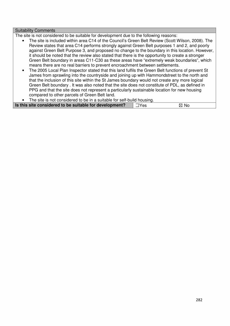
282
Suitability Comments The site is not considered to be suitable for development due to the following reasons:
• The site is included within area C14 of the Council’s Green Belt Review (Scott Wilson, 2008). The Review states that area C14 performs strongly against Green Belt purposes 1 and 2, and poorly against Green Belt Purpose 3, and proposed no change to the boundary in this location. However, it should be noted that the review also stated that there is the opportunity to create a stronger Green Belt boundary in areas C11-C30 as these areas have “extremely weak boundaries”, which means there are no real barriers to prevent encroachment between settlements.
• The 2005 Local Plan Inspector stated that this land fulfils the Green Belt functions of prevent St James from sprawling into the countryside and joining up with Hammondstreet to the north and that the inclusion of this site within the St James boundary would not create any more logical Green Belt boundary . It was also noted that the site does not constitute of PDL, as defined in PPG and that the site does not represent a particularly sustainable location for new housing compared to other parcels of Green Belt land.
• The site is not considered to be in a suitable for self-build housing. Is this site considered to be suitable for development? ☐Yes ☒ No
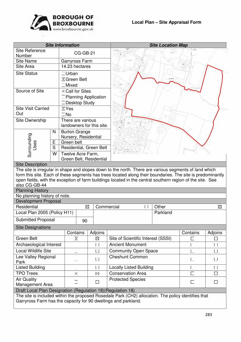
283
Local Plan – Site Appraisal Form
Site Information Site Location Map Site Reference Number
CG-GB-21
Site Name Garryross Farm Site Area 14.23 hectares
Site Status ☐Urban ☒Green Belt ☐Mixed
Source of Site ☒Call for Sites ☐Planning Application ☐Desktop Study
Site Visit Carried Out
☒Yes ☐No
Site Ownership There are various landowners for this site.
Surr
oundin
g
Uses
N Burton Grange Nursery, Residential
E Green belt S Residential, Green Belt
W Twelve Acre Farm, Green Belt, Residential
Site Description The site is irregular in shape and slopes down to the north. There are various segments of land which form this site. Each of these segments has trees located along their boundaries. The site is predominantly open fields, with the exception of farm buildings located in the central southern region of the site. See also CG-GB-44 Planning History No planning history of note. Development Proposal
Residential ☒ Commercial ☐ Other ☒
Local Plan 2005 (Policy H11) Parkland
Submitted Proposal 90
Site Designations Contains Adjoins Contains Adjoins
Green Belt ☒ ☒ Site of Scientific Interest (SSSI) ☐ ☐
Archaeological Interest ☐ ☐ Ancient Monument ☐ ☐
Local Wildlife Site ☐ ☐ Community Open Space ☐ ☐
Lee Valley Regional Park
☐ ☐ Cheshunt Common ☐ ☐
Listed Building ☐ ☐ Locally Listed Building ☐ ☐
TPO Trees ☒ ☒ Conservation Area ☐ ☐
Air Quality Management Area
☐ ☐ Protected Species ☐ ☐
Draft Local Plan Designation (Regulation 18)(Regulation 18) The site is included within the proposed Rosedale Park (CH2) allocation. The policy identifies that Garryross Farm has the capacity for 90 dwellings and parkland.

284
Accessibility – distance as the crow flies
450m -Primary School (Fairfields)
840m - Secondary School (Goffs)
2km –Employment Area (New River Trading Estate)
170m - Green Space (Dig Dag)
770m-Healthcare Centre (Stockwell Lodge)
12km- Hospital (with A&E) (Barnet)
1.87km- Town/District Centre (Brookfield)
420m - Local Centre (Hammondstreet)
2.66km -Leisure Centre (Laura Trott)
1.8km - A10 Junction (Church Lane)
2.47km - Railway Station (Cuffley)
335m - Bus Service (Peakes Lane)
Flood Risk Does the site Contains Adjoins
Zone 2 (Medium Risk) ☐ ☐
Zone 3a (High Risk) ☐ ☐
Zone 3b (Active Flood Plain) ☐ ☒
Additional Flood Risk Comments The site is not located within a flood zone. However, Rags Brook runs through the site and this should be taken into consideration. The site may suffer from surface water flooding. Access and Transport Comments The site can be currently accessed via Andrews Lane. Andrews Lane is quiet narrow in places, and footpaths along the majority of the road. Rags Lane, which borders the site to the west, is also rural in nature and narrow in some places. This road does not have footpaths. Utility Provision
Electricity The nearest electricity connections are located to the south west of Andrews Lane
Gas A low pressure gas main is available at Garryross Farm.
Water A water mains and hydrants and located along Andrews Lane. A water main also runs along Rags Lane.
Sewerage A foul sewer and abandoned sewer run through the centre of the site.
Sewerage Treatment ☐Rye Meads ☒Deephams ☐Other
Additional Developer Comments submitted during 2016 Call for Sites None submitted. However, during the Local Plan consultations comments were made by the promoter of ‘Rosedale Park’. The promoter stated that the site fully accords with the National Planning Policy Framework and place making principles and will provide new homes in a location well related to existing social infrastructure and transport links. The promoters continues by stating the site will also provide new and enhanced social infrastructure as well as a new public park along the Rags Brook valley enabling the local community to access and enjoy this area for the first time. This promotion and other documents submitted during the Local Plan consultation can be found on the Council’s website, using the following
link: www.broxbourne.gov.uk/lpsites.
Suitability Comments This site is only considered to be suitable for development if it comes forward as part of the Rosedale Park strategic development. The suitability, availability and achievability of the Rosedale Park development can be found below. This site is not considered to be suitable to come forward for development in isolation as it will not be able to demonstrate exceptional circumstances – the site will be an extension to an existing settlement which does not provide/improve the infrastructure within the vicinity, enable strategic place-making or open up Rags Brook Valley to the public.
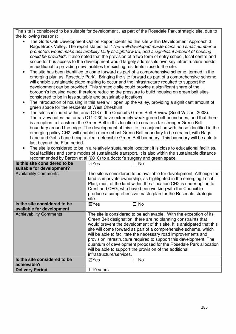
285
The site is considered to be suitable for development , as part of the Rosedale Park strategic site, due to the following reasons:
• The Goffs Oak Development Option Report identified this site within Development Approach 3: Rags Brook Valley. The report states that “The well-developed masterplans and small number of promoters would make deliverability fairly straightforward, and a significant amount of housing could be provided”. It also noted that the provision of a two form of entry school, local centre and scope for bus access to the development would largely address its own key infrastructure needs, in additional to providing new facilities for existing residents close to the site.
• The site has been identified to come forward as part of a comprehensive scheme, termed in the emerging plan as ‘Rosedale Park’. Bringing the site forward as part of a comprehensive scheme will enable sustainable place-making to occur and the infrastructure required to support the development can be provided. This strategic site could provide a significant share of the borough’s housing need, therefore reducing the pressure to build housing on green belt sites considered to be in less suitable and sustainable locations.
• The introduction of housing in this area will open up the valley, providing a significant amount of green space for the residents of West Cheshunt.
• The site is included within area C18 of the Council’s Green Belt Review (Scott Wilson, 2008). The review notes that areas C11-C30 have extremely weak green belt boundaries, and that there is an option to transform the Green Belt in this location to create a far stronger Green Belt boundary around the edge. The development of this site, in conjunction with those identified in the emerging policy CH2, will enable a more robust Green Belt boundary to be created, with Rags Lane and Goffs Lane being a clear defensible Green Belt boundary. This boundary will be able to last beyond the Plan period.
• The site is considered to be in a relatively sustainable location; it is close to educational facilities, local facilities and some modes of sustainable transport. It is also within the sustainable distance recommended by Barton et al (2010) to a doctor’s surgery and green space.
Is this site considered to be suitable for development?
☒Yes ☐ No
Availability Comments The site is considered to be available for development. Although the land is in private ownership, as highlighted in the emerging Local Plan, most of the land within the allocation CH2 is under option to Crest and CEG, who have been working with the Council to produce a comprehensive masterplan for the Rosedale strategic site.
Is the site considered to be available for development
☒Yes ☐ No
Achievability Comments The site is considered to be achievable. With the exception of its Green Belt designation, there are no planning constraints that would prevent the development of this site. It is anticipated that this site will come forward as part of a comprehensive scheme, which will be able to facilitate the necessary road improvements and provision infrastructure required to support this development. The quantum of development proposed for the Rosedale Park allocation will be able to support the provision of the additional infrastructure/services.
Is the site considered to be achievable?
☒Yes ☐ No
Delivery Period 1-10 years
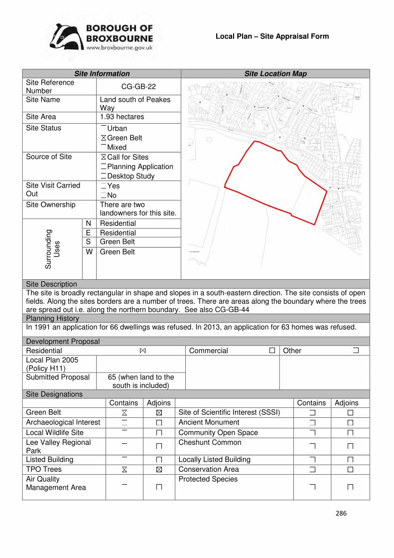
286
Local Plan – Site Appraisal Form
Site Information Site Location Map Site Reference Number
CG-GB-22
Site Name Land south of Peakes Way
Site Area 1.93 hectares
Site Status ☐Urban ☒Green Belt ☐Mixed
Source of Site ☒Call for Sites ☐Planning Application ☐Desktop Study
Site Visit Carried Out
☐Yes ☐No
Site Ownership There are two landowners for this site.
Surr
oundin
g
Uses
N Residential
E Residential S Green Belt
W Green Belt
Site Description The site is broadly rectangular in shape and slopes in a south-eastern direction. The site consists of open fields. Along the sites borders are a number of trees. There are areas along the boundary where the trees are spread out i.e. along the northern boundary. See also CG-GB-44 Planning History In 1991 an application for 66 dwellings was refused. In 2013, an application for 63 homes was refused.
Development Proposal
Residential ☒ Commercial ☐ Other ☐
Local Plan 2005 (Policy H11)
Submitted Proposal 65 (when land to the south is included)
Site Designations Contains Adjoins Contains Adjoins
Green Belt ☒ ☒ Site of Scientific Interest (SSSI) ☐ ☐
Archaeological Interest ☐ ☐ Ancient Monument ☐ ☐
Local Wildlife Site ☐ ☐ Community Open Space ☐ ☐
Lee Valley Regional Park
☐ ☐ Cheshunt Common ☐ ☐
Listed Building ☐ ☐ Locally Listed Building ☐ ☐
TPO Trees ☒ ☒ Conservation Area ☐ ☐
Air Quality Management Area
☐ ☐ Protected Species ☐ ☐

287
Draft Local Plan Designation (Regulation 18) The draft Local Plan included this site within the proposed Rosedale Park allocation (CH2). The policy identifies that this site (Lea Road and land to the south) could accommodate 65 dwellings. Accessibility – distance as the crow flies
330m -Primary School (Fairfields)
1.05km - Secondary School (Goffs)
1.87km–Employment Area (New River Trading Estate)
64m - Green Space (Dig Dag)
660m -Healthcare Centre (Stockwell Lodge)
12km - Hospital (with A&E) (Princess Alexandra)
1.73km - Town/District Centre (Brookfield)
450m - Local Centre (Hammondstreet)
2.65km -Leisure Centre (Laura Trott)
1.9km - A10 Junction (Church Lane)
2.99km - Railway Station (Cuffley)
312m - Bus Service
Flood Risk Does the site Contains Adjoins
Zone 2 (Medium Risk) ☐ ☐
Zone 3a (High Risk) ☐ ☐
Zone 3b (Active Flood Plain) ☐ ☒
Additional Flood Risk Comments No flood risk issues identified for this site. Access and Transport Comments The site can be accessed from Peakes Way. However, the access point will need significant improvement if development was to occur. Another option is to create an additional arm off Peakes Way roundabout. The impact that the site would have on traffic would need to be assessed. There is a footpath on one side of the road at Peakes Way. Cycle access to the site would require improvement. Utility Provision
Electricity Electricity cables located to the urban area in the north and east
Gas A low pressure gas main is located along Rags Lane and in Byron Close
Water A water main is located along Rags Lane. A trunk mains is located along Peakes Way
Sewerage A surface sewer is located along Peakes Way. A foul sewer is located along Rags Lane and within the urban area to the north of the site.
Sewerage Treatment ☐Rye Meads ☒Deephams ☐Other
Additional Developer Comments submitted during 2016 Call for Sites. None submitted. However, during the Local Plan consultation comments were made by the promoter of ‘Rosedale Park’. The promoter stated that the site fully accords with the National Planning Policy Framework and place making principles and will provide new homes in a location well related to existing social infrastructure and transport links. The promoters continues by stating that the strategic site will also provide new and enhanced social infrastructure as well as a new public park along the Rags Brook valley enabling the local community to access and enjoy this area for the first time. This promotion and other documents submitted during the Local Plan consultation can be found on the Council’s website, using the following link: www.broxbourne.gov.uk/lpsites

288
Suitability Comments This site is only considered to be suitable for development if it comes forward as part of the Rosedale Park strategic development. The suitability, availability and achievability of the Rosedale Park development can be found below. This site is not considered to be suitable to come forward for development in isolation as it will not be able to demonstrate exceptional circumstances – the site will be an extension to an existing settlement which does not provide/improve the infrastructure within the vicinity, enable strategic place-making or open up Rags Brook Valley to the public. The site is considered to be suitable for development due to the following reasons:
• The Goffs Oak Development Options Report identified this site within Development Approach 3: Rags Brook Valley. The report states that “The well-developed masterplans and small number of promoters would make deliverability fairly straightforward and a significant amount of housing could be provided”. It also noted that the provision of a two form of entry school, local centre and scope for bus access to the development would largely address its own key infrastructure needs, in addition to providing new facilities for existing residents close to the site. The site was also identified in Development Approach 4: Infill around the green ring, which stated that this site and CG-GB-85, would “continue the existing building line south of Peakes Way and Rags Lane, and occupy meadow land north of the more unspoilt countryside in the Rags Brook Valley”.
• The site coming forward as part of a comprehensive development scheme will enable sustainable place-making to occur and the infrastructure required to support the development can be provided. In addition, this comprehensive development will create robust Green Belt boundaries (Rags Lane and Goffs Lane), that will last beyond the Plan period.
• The site is considered to be in a relatively sustainable location; it is close to educational facilities, local facilities and some modes of sustainable development. This site is also within the sustainable distance recommended by Barton et al (2010) for a doctor’s surgery and green space.
Is this site considered to be suitable for development?
☒Yes ☐ No
Availability Comments The site is considered to be available for development. Although the land is in private ownership, as highlighted in the emerging Local Plan, most of the land within the allocation CH2 is under option to Crest and CEG, who have been working with the Council to produce a comprehensive masterplan for the Rosedale strategic site.
Is the site considered to be available for development
☒Yes ☐ No Achievability Comments The site is considered to be achievable. With the exception of its
Green Belt designation, it is considered that there are no planning constraints that would prevent the development of this site. It is anticipated that this site will come forward as part of a comprehensive scheme, which will be able to facilitate the necessary road improvements and provide the necessary infrastructure for this development. The quantum of development proposed for the Rosedale Park allocation will be able to support the provision of the additional infrastructure/services. The preparatory works required to bring this site forward for development are not considered
Is the site considered to be achievable?
☒Yes ☐ No Delivery Period 1-10 years

289
Local Plan – Site Appraisal Form
Site Information Site Location Map Site Reference Number
CG-GB-23
Site Name Granby Park Road Site Area 1.47 hectares
Site Status ☐Urban ☒Green Belt ☐Mixed
Source of Site ☒Call for Sites ☐Planning Application ☐Desktop Study
Site Visit Carried Out
☒Yes ☐No
Site Ownership There are two landowners for the site.
Surr
oundin
g
Uses
N Green Belt
E Residential S Residential, Rosedale
Sports Club W Green Belt
Site Description The site is rectangular in shape and gently slopes downwards from east to west. The site consists of an open field, and has trees located along its boundaries. See also CG-GB-44 Planning History No planning history of interest. Development Proposal
Residential ☒ Commercial ☐ Other ☐
Local Plan 2005 (Policy H11)
Submitted Proposal
115 dwellings (when combined with
field to the north) Site Designations Contains Adjoins Contains Adjoins
Green Belt ☒ ☒ Site of Scientific Interest (SSSI) ☐ ☐
Archaeological Interest ☐ ☐ Ancient Monument ☐ ☐
Local Wildlife Site ☐ ☐ Community Open Space ☐ ☐
Lee Valley Regional Park ☐ ☐ Cheshunt Common ☐ ☐
Listed Building ☐ ☐ Locally Listed Building ☐ ☐
TPO Trees ☒ ☒ Conservation Area ☐ ☐
Air Quality Management Area
☐ ☐ Protected Species ☐ ☐
Draft Local Plan Designation (Regulation 18) The draft Local Plan included this site within the proposed Rosedale Park (CH2) allocation. The draft Plan identifies that this site (Granby Park Road) could provide 115 dwellings in conjunction with the field to the north.

290
Accessibility – distance as the crow flies
410m -Primary School (Fairfields)
530m - Secondary School (Goffs)
1.96km –Employment Area (New River Trading Estate)
160m - Green Space (Claremont)
600m -Healthcare Centre (Stockwell)
12.2km- Hospital (with A&E) (Princess Alexandra)
1.74km - Town/District Centre (Brookfield)
560m - Local Centre
2.33km -Leisure Centre
(Laura Trott)
1.6km - A10 Junction (Church Lane)
3km - Railway Station (Cuffley)
160m - Bus Service (Granby Park Road)
Flood Risk Does the site Contains Adjoins
Zone 2 (Medium Risk) ☐ ☐
Zone 3a (High Risk) ☐ ☐
Zone 3b (Active Flood Plain) ☐ ☒
Additional Flood Risk Comments There may be some ground water flooding. Access and Transport Comments The site can be accessed from Andrews Lane. However, this access point will require improvement if development occurred. There is a pathway along one side of the road at Andrews Lane, which then changes to the other side when it reaches the current vehicular entrance of the site. Utility Provision
Electricity Electricity cables are located to the east of the site.
Gas A low pressure gas main is located at Granby Park Road.
Water A water main is located along Andrews Lane and at Granby Park Road. A hydrant is also located at Granby Park Road.
Sewerage A foul sewer runs through the site, just to the west of the houses at Granby Park Road. A foul sewer is also located at Andrews Lane.
Sewerage Treatment ☐Rye Meads ☒Deephams ☐Other
Additional Developer Comments submitted as part of the 2016 Call for Sites None submitted. However, during the Local Plan consultation comments were made by the promoter of ‘Rosedale Park’. The promoter stated that the site fully accords with the National Planning Policy Framework and place making principles and will provide new homes in a location well related to existing social infrastructure and transport links. The promoter continues by stating that the strategic site will also provide new and enhanced social infrastructure as well as a new public park along the Rags Brook Valley enabling the local community to access and enjoy this area for the first time. This promotion and other documents submitted during the Local Plan consultation can be found on the Council’s website, using the following link: www.broxbourne.gov.uk/lpsites Suitability Comments This site is only considered to be suitable for development if it comes forward as part of the Rosedale Park strategic development. The suitability, availability and achievability of the Rosedale Park development can be found below. This site is not considered to be suitable to come forward for development in isolation as it will not be able to demonstrate exceptional circumstances – the site will be an extension to an existing settlement which does not provide/improve the infrastructure within the vicinity, enable strategic place-making or open up Rags Brook Valley to the public. The site is considered to be suitable for development due to the following reasons:

291
• The Goffs Oak Development Options Report (Broxbourne Borough Council, 2016) identified this site with Development Approach 3: Rags Brook Valley. The report states that “The well-developed masterplans and small number of promoters would make deliverability fairly straightforward, and a significant amount of housing could be provided”. It also noted that the provision of a two form of entry school, a local centre and scope for bus access to the development would largely address its own key infrastructure needs, in addition to providing new facilities for existing residents close to the site.
• The site has been identified to come forward as part of a comprehensive scheme. This will enable sustainable place-making to occur and the infrastructure required to support the development can be provided. This will also enable a more robust Green Belt boundary to be created within this area, with Rags Lane and Goffs Lane acting as new defensible Green Belt boundaries.
• The site is considered to be in a sustainable location; it is close to education facilities, local shops and within the sustainable distance recommended by Barton et al (2010) for a doctor’s surgery and open space. There are a number of bus stops within close proximity to the site.
Is this site considered to be suitable for development?
☒Yes ☐ No
Availability Comments The site is considered to be available for development. Although the land is in private ownership, as highlighted in the emerging Local Plan, most of the land within the allocation CH2 is under option to Crest and CEG, who have been working with the Council to produce a comprehensive masterplan for the Rosedale strategic site.
Is the site considered to be available for development
☒Yes ☐ No
Achievability Comments The site is considered to be achievable. With the exception of its Green Belt designation, there are no planning constraints that would prevent the development of this site. It is anticipated that this site will come forward as part of a comprehensive scheme, which will be able to facilitate the necessary road improvements and provide the infrastructure required to support this development. The quantum of development proposed for the Rosedale Park allocation will be able to support the provision of the additional infrastructure/services. The preparatory works required to bring this site forward for development are not considered
Is the site considered to be achievable?
☒Yes ☐ No
Delivery Period 1-10 years

292
Local Plan – Site Appraisal Form
Site Information Site Location Map Site Reference Number
CG-GB-25
Site Name Claremont Site Area 3.46 hectares
Site Status ☐Urban ☒Green Belt ☐Mixed
Source of Site ☒Call for Sites ☐Planning Application ☐Desktop Study
Site Visit Carried Out
☒Yes ☐No
Site Ownership The site is owned by a private company.
Surr
oundin
g
Uses
N Rosedale Sports Club
E Residential S Residential, Open Field
W Green Belt
Site Description The site is broadly rectangular in shape and gradually slopes to the east. The site is greenfield in nature. There are trees located along the boundaries of the site and a few trees within the central region of the site. Planning History In 1996 consent was granted to use the field for a mixture of pasture and sport facilities. A condition exists that they should only be used as alternative pitches not as an additional to the pitches already in existence at Rosedale Sports Club. This permission was renewed in 2001. Development Proposal
Residential ☐ Commercial ☐ Other ☒
Local Plan 2005 (Policy H11)
Extension to Sport Pitches
Submitted Proposal
Site Designations Contains Adjoins Contains Adjoins
Green Belt ☒ ☒ Site of Scientific Interest (SSSI)
☐ ☐
Archaeological Interest ☐ ☐ Ancient Monument ☐ ☐
Local Wildlife Site ☒ ☐ Community Open Space ☐ ☒
Lee Valley Regional Park
☐ ☐ Cheshunt Common ☐ ☐
Listed Building ☐ ☐ Locally Listed Building ☐ ☐
TPO Trees ☐ ☒ Conservation Area ☐ ☐
Air Quality Management Area
☐ ☐ Protected Species ☐ ☐
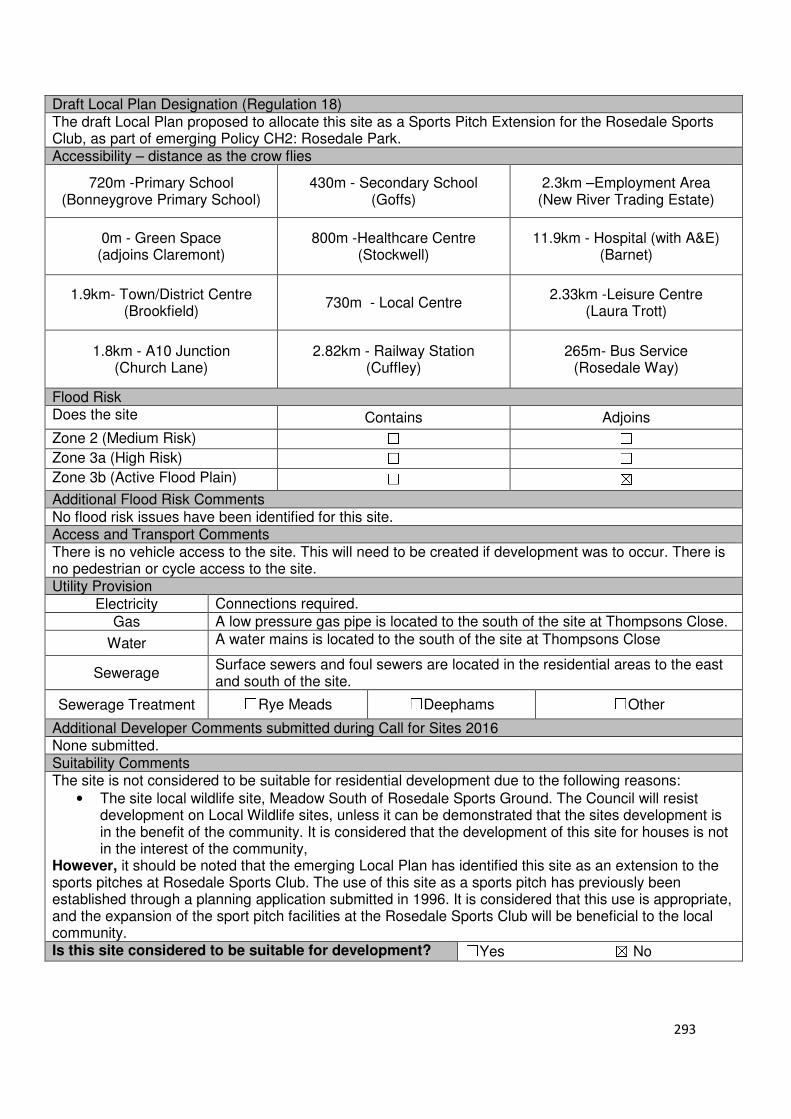
293
Draft Local Plan Designation (Regulation 18) The draft Local Plan proposed to allocate this site as a Sports Pitch Extension for the Rosedale Sports Club, as part of emerging Policy CH2: Rosedale Park. Accessibility – distance as the crow flies
720m -Primary School (Bonneygrove Primary School)
430m - Secondary School (Goffs)
2.3km –Employment Area (New River Trading Estate)
0m - Green Space (adjoins Claremont)
800m -Healthcare Centre (Stockwell)
11.9km - Hospital (with A&E) (Barnet)
1.9km- Town/District Centre (Brookfield)
730m - Local Centre 2.33km -Leisure Centre
(Laura Trott)
1.8km - A10 Junction (Church Lane)
2.82km - Railway Station (Cuffley)
265m- Bus Service (Rosedale Way)
Flood Risk Does the site Contains Adjoins
Zone 2 (Medium Risk) ☐ ☐
Zone 3a (High Risk) ☐ ☐
Zone 3b (Active Flood Plain) ☐ ☒
Additional Flood Risk Comments No flood risk issues have been identified for this site. Access and Transport Comments There is no vehicle access to the site. This will need to be created if development was to occur. There is no pedestrian or cycle access to the site. Utility Provision
Electricity Connections required.
Gas A low pressure gas pipe is located to the south of the site at Thompsons Close.
Water A water mains is located to the south of the site at Thompsons Close
Sewerage Surface sewers and foul sewers are located in the residential areas to the east and south of the site.
Sewerage Treatment ☐Rye Meads ☐Deephams ☐Other
Additional Developer Comments submitted during Call for Sites 2016 None submitted. Suitability Comments The site is not considered to be suitable for residential development due to the following reasons:
• The site local wildlife site, Meadow South of Rosedale Sports Ground. The Council will resist development on Local Wildlife sites, unless it can be demonstrated that the sites development is in the benefit of the community. It is considered that the development of this site for houses is not in the interest of the community,
However, it should be noted that the emerging Local Plan has identified this site as an extension to the sports pitches at Rosedale Sports Club. The use of this site as a sports pitch has previously been established through a planning application submitted in 1996. It is considered that this use is appropriate, and the expansion of the sport pitch facilities at the Rosedale Sports Club will be beneficial to the local community. Is this site considered to be suitable for development? ☐Yes ☒ No

294
Local Plan – Site Appraisal Form
Site Information Site Location Map Site Reference Number
CG-GB-26
Site Name Tudor Nursery Site Area 15.7 hectares
Site Status ☐Urban ☒Green Belt ☐Mixed
Source of Site ☒Call for Sites ☐Planning Application ☐Desktop Study
Site Visit Carried Out
☐Yes ☐No
Site Ownership There are two owners for the site
Surr
oundin
g
Uses
N Green Belt
E Local Wildlife Site, Residential
S Residential dwellings , Goffs Lane
W Green Belt Site Description The site is irregular in shape and slopes down eastwards. Currently situated on the site are a number of derelict glasshouses, which are concentrated in the sites western and central region. The eastern region is open fields, with a number of trees scattered throughout. There are also trees scattered in the sites north-western and south-western corners. Located around the sites boundaries are trees, which currently separate the site from the adjoining residential development. Planning History Various applications have been granted and refused on the site. These were mainly relate to the horticultural trade/use e.g. glasshouses, portacabins and caravans. Development Proposal
Residential ☒ Commercial ☐ Other ☒
Local Plan 2005 (Policy H11) Park, Open Space Submitted Proposal 340
Site Designations Contains Adjoins Contains Adjoins
Green Belt ☒ ☒ Site of Scientific Interest (SSSI) ☐ ☐
Archaeological Interest ☐ ☒ Ancient Monument ☐ ☐
Local Wildlife Site ☐ ☒ Community Open Space ☐ ☐
Lee Valley Regional Park ☐ ☐ Cheshunt Common ☐ ☐
Listed Building ☐ ☒ Locally Listed Building ☐ ☐
TPO Trees ☐ ☒ Conservation Area ☐ ☐
Air Quality Management Area
☐ ☐ Protected Species ☐ ☐
Draft Local Plan Designation (Regulation 18) The draft Local Plan proposed to allocate this site for mixed use development as part of emerging Policy CH2. The emerging policy allocates this site for 340 dwellings, a retirement village, low density parkland and a local shop.
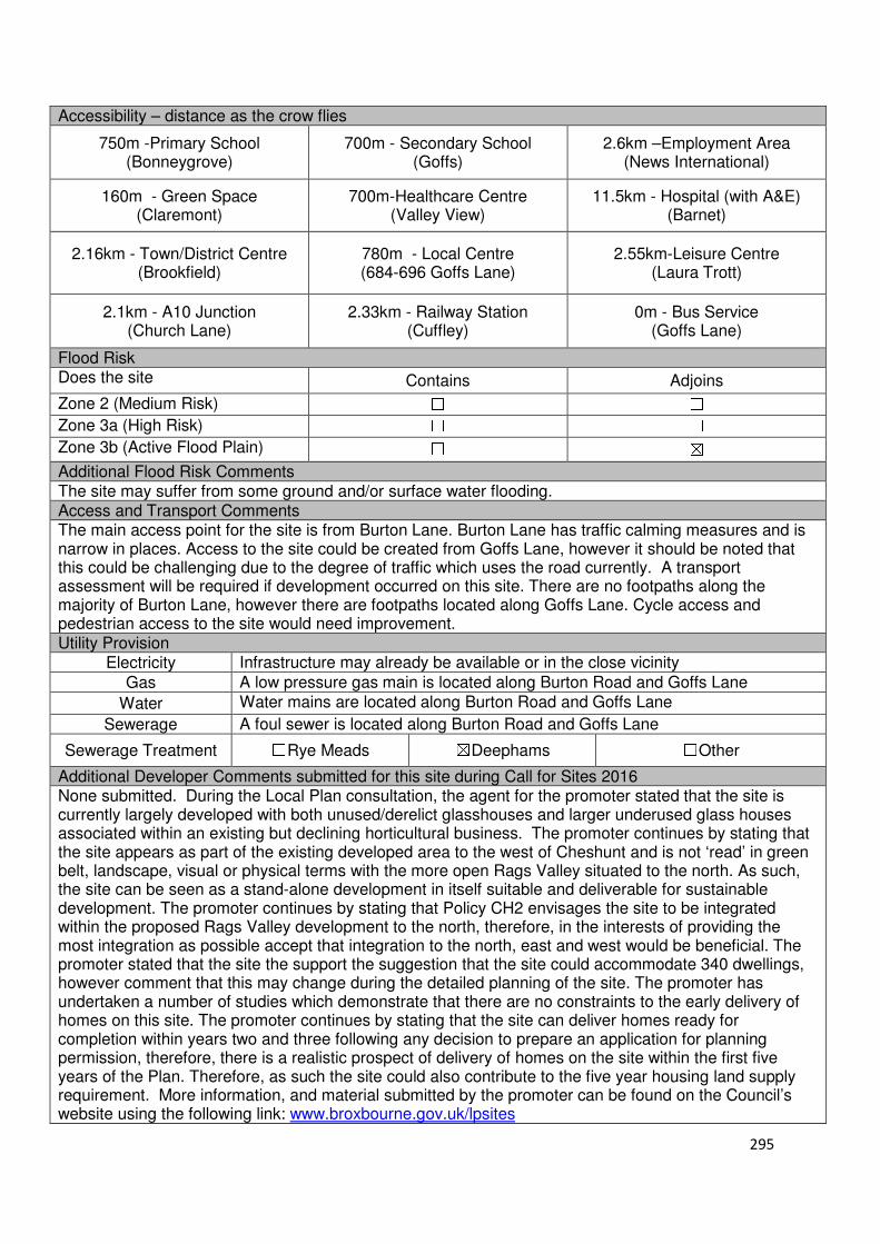
295
Accessibility – distance as the crow flies
750m -Primary School (Bonneygrove)
700m - Secondary School (Goffs)
2.6km –Employment Area (News International)
160m - Green Space (Claremont)
700m-Healthcare Centre (Valley View)
11.5km - Hospital (with A&E) (Barnet)
2.16km - Town/District Centre (Brookfield)
780m - Local Centre (684-696 Goffs Lane)
2.55km-Leisure Centre (Laura Trott)
2.1km - A10 Junction (Church Lane)
2.33km - Railway Station (Cuffley)
0m - Bus Service (Goffs Lane)
Flood Risk Does the site Contains Adjoins
Zone 2 (Medium Risk) ☐ ☐
Zone 3a (High Risk) ☐ ☐
Zone 3b (Active Flood Plain) ☐ ☒
Additional Flood Risk Comments The site may suffer from some ground and/or surface water flooding. Access and Transport Comments The main access point for the site is from Burton Lane. Burton Lane has traffic calming measures and is narrow in places. Access to the site could be created from Goffs Lane, however it should be noted that this could be challenging due to the degree of traffic which uses the road currently. A transport assessment will be required if development occurred on this site. There are no footpaths along the majority of Burton Lane, however there are footpaths located along Goffs Lane. Cycle access and pedestrian access to the site would need improvement. Utility Provision
Electricity Infrastructure may already be available or in the close vicinity
Gas A low pressure gas main is located along Burton Road and Goffs Lane
Water Water mains are located along Burton Road and Goffs Lane
Sewerage A foul sewer is located along Burton Road and Goffs Lane
Sewerage Treatment ☐Rye Meads ☒Deephams ☐Other
Additional Developer Comments submitted for this site during Call for Sites 2016 None submitted. During the Local Plan consultation, the agent for the promoter stated that the site is currently largely developed with both unused/derelict glasshouses and larger underused glass houses associated within an existing but declining horticultural business. The promoter continues by stating that the site appears as part of the existing developed area to the west of Cheshunt and is not ‘read’ in green belt, landscape, visual or physical terms with the more open Rags Valley situated to the north. As such, the site can be seen as a stand-alone development in itself suitable and deliverable for sustainable development. The promoter continues by stating that Policy CH2 envisages the site to be integrated within the proposed Rags Valley development to the north, therefore, in the interests of providing the most integration as possible accept that integration to the north, east and west would be beneficial. The promoter stated that the site the support the suggestion that the site could accommodate 340 dwellings, however comment that this may change during the detailed planning of the site. The promoter has undertaken a number of studies which demonstrate that there are no constraints to the early delivery of homes on this site. The promoter continues by stating that the site can deliver homes ready for completion within years two and three following any decision to prepare an application for planning permission, therefore, there is a realistic prospect of delivery of homes on the site within the first five years of the Plan. Therefore, as such the site could also contribute to the five year housing land supply requirement. More information, and material submitted by the promoter can be found on the Council’s website using the following link: www.broxbourne.gov.uk/lpsites

296
Suitability Comments The site is considered to be suitable for residential development due to the following reasons:
• There are currently a number of derelict glasshouses on this site. The development of this site addresses this area of dereliction, which could worsen if investment into new facilities was not undertaken, and creates a pleasant settlement with better outlooks and links to the open spaces.
• The Goffs Oak Development Options Report identified this site as part of Development Approach 3a: Rags Brook Park plus Tudor Nursery. It concluded that this approach “would concentrate development along the Rags Brook Valley”, however, the “well developed masterplans and small number of promoters would make deliverability fairly straightforward, and a significant amount of housing could be provided”.
• The site has been identified to come forward as part of a comprehensive scheme, termed in the emerging plan as ‘Rosedale Park’. Bringing the site forward as part of a comprehensive scheme will enable sustainable place-making to occur and the infrastructure required to support the development can be provided. This strategic site could provide a significant share of the borough’s housing need, therefore reducing the pressure to build housing on green belt sites considered to be in less suitable and sustainable locations.
• The site has been included within area C21 of the Council’s Green Belt Review (Scott Wilson, 2008). The review states that areas C11-C30 have extremely weak Green Belt boundaries, and there is an option to transform the Green Belt in this location to create a far stronger Green Belt boundary around the edge. The development of this site, in conjunction with those identified in emerging policy CH2, will enable a more robust Green Belt boundary to be created, with Rags Lane and Goffs Lane being a clear defensible Green Belt boundary. This boundary will be able to last beyond the Plan period.
• The site is considered to be in a sustainable location; it is close to educational facilities, and local facilities, some modes of sustainable transport. It is also within the sustainable distance recommended by Barton et al (2010) for Green Space and Healthcare Centre.
Is this site considered to be suitable for development?
☒Yes ☐ No
Availability Comments The site is considered to be available for development. Although the land is in private ownership, as highlighted in the emerging Local Plan, most of the land within the allocation CH2 is under option to Crest and CEG, who have been working with the Council to produce a comprehensive masterplan for the Rosedale strategic site. During the Local Plan Regulation 18 consultation, the promoter states that site could come forward within 2-3 years of planning permission being granted.
Is the site considered to be available for development
☒Yes ☐ No
Achievability Comments The site is considered to be achievable. With the exception of its Green Belt designation, there are no planning constraints that would prevent the development of this site. It is anticipated that this site will come forward as part of a comprehensive scheme, which will be able to facilitate the necessary road improvements and the provision infrastructure required to support this development. The quantum of development proposed for the Rosedale Park allocation will be able to support the provision of the additional infrastructure/services.
Is the site considered to be achievable?
☒Yes ☐ No
Delivery Period 1-10 years
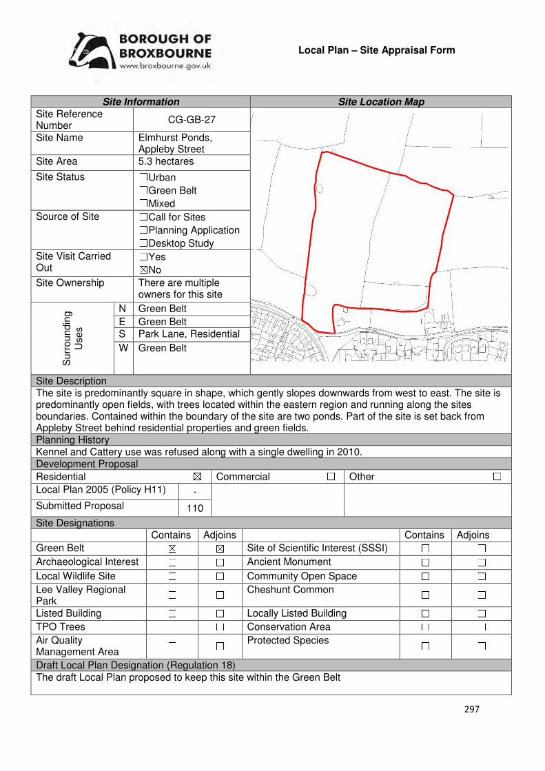
297
Local Plan – Site Appraisal Form
Site Information Site Location Map Site Reference Number
CG-GB-27
Site Name Elmhurst Ponds, Appleby Street
Site Area 5.3 hectares
Site Status ☐Urban ☐Green Belt ☐Mixed
Source of Site ☐Call for Sites ☐Planning Application ☐Desktop Study
Site Visit Carried Out
☐Yes ☒No
Site Ownership There are multiple owners for this site
Surr
oundin
g
Uses
N Green Belt
E Green Belt S Park Lane, Residential
W Green Belt
Site Description The site is predominantly square in shape, which gently slopes downwards from west to east. The site is predominantly open fields, with trees located within the eastern region and running along the sites boundaries. Contained within the boundary of the site are two ponds. Part of the site is set back from Appleby Street behind residential properties and green fields. Planning History Kennel and Cattery use was refused along with a single dwelling in 2010. Development Proposal
Residential ☒ Commercial ☐ Other ☐
Local Plan 2005 (Policy H11) -
Submitted Proposal 110
Site Designations Contains Adjoins Contains Adjoins
Green Belt ☒ ☒ Site of Scientific Interest (SSSI) ☐ ☐
Archaeological Interest ☐ ☐ Ancient Monument ☐ ☐
Local Wildlife Site ☐ ☐ Community Open Space ☐ ☐
Lee Valley Regional Park
☐ ☐ Cheshunt Common ☐ ☐
Listed Building ☐ ☐ Locally Listed Building ☐ ☐
TPO Trees ☐ ☐ Conservation Area ☐ ☐
Air Quality Management Area
☐ ☐ Protected Species ☐ ☐
Draft Local Plan Designation (Regulation 18) The draft Local Plan proposed to keep this site within the Green Belt
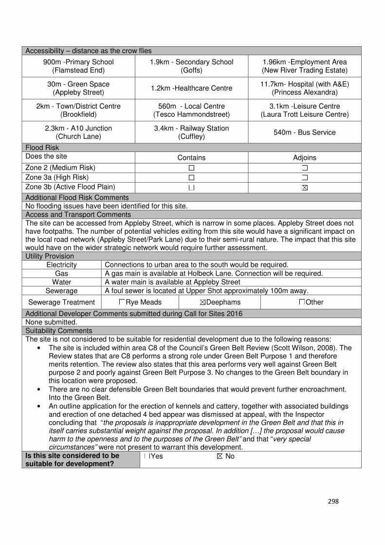
298
Accessibility – distance as the crow flies
900m -Primary School (Flamstead End)
1.9km - Secondary School (Goffs)
1.96km -Employment Area (New River Trading Estate)
30m - Green Space (Appleby Street)
1.2km -Healthcare Centre 11.7km- Hospital (with A&E)
(Princess Alexandra)
2km - Town/District Centre (Brookfield)
560m - Local Centre (Tesco Hammondstreet)
3.1km -Leisure Centre (Laura Trott Leisure Centre)
2.3km - A10 Junction (Church Lane)
3.4km - Railway Station (Cuffley)
540m - Bus Service
Flood Risk Does the site Contains Adjoins
Zone 2 (Medium Risk) ☐ ☐
Zone 3a (High Risk) ☐ ☐
Zone 3b (Active Flood Plain) ☐ ☒
Additional Flood Risk Comments No flooding issues have been identified for this site. Access and Transport Comments The site can be accessed from Appleby Street, which is narrow in some places. Appleby Street does not have footpaths. The number of potential vehicles exiting from this site would have a significant impact on the local road network (Appleby Street/Park Lane) due to their semi-rural nature. The impact that this site would have on the wider strategic network would require further assessment. Utility Provision
Electricity Connections to urban area to the south would be required.
Gas A gas main is available at Holbeck Lane. Connection will be required.
Water A water main is available at Appleby Street
Sewerage A foul sewer is located at Upper Shot approximately 100m away.
Sewerage Treatment ☐Rye Meads ☒Deephams ☐Other
Additional Developer Comments submitted during Call for Sites 2016 None submitted. Suitability Comments The site is not considered to be suitable for residential development due to the following reasons:
• The site is included within area C8 of the Council’s Green Belt Review (Scott Wilson, 2008). The Review states that are C8 performs a strong role under Green Belt Purpose 1 and therefore merits retention. The review also states that this area performs very well against Green Belt purpose 2 and poorly against Green Belt Purpose 3. No changes to the Green Belt boundary in this location were proposed.
• There are no clear defensible Green Belt boundaries that would prevent further encroachment. Into the Green Belt.
• An outline application for the erection of kennels and cattery, together with associated buildings and erection of one detached 4 bed appear was dismissed at appeal, with the Inspector concluding that “the proposals is inappropriate development in the Green Belt and that this in itself carries substantial weight against the proposal. In addition […] the proposal would cause harm to the openness and to the purposes of the Green Belt” and that “very special circumstances” were not present to warrant this development.
Is this site considered to be suitable for development?
☐Yes ☒ No
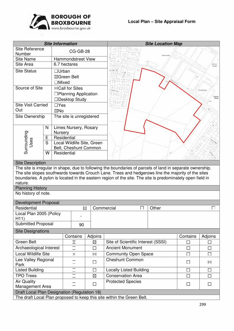
299
Local Plan – Site Appraisal Form
Site Information Site Location Map Site Reference Number
CG-GB-28
Site Name Hammondstreet View Site Area 6.7 hectares
Site Status ☐Urban ☒Green Belt ☐Mixed
Source of Site ☒Call for Sites ☐Planning Application ☐Desktop Study
Site Visit Carried Out
☐Yes ☒No
Site Ownership The site is unregistered
Surr
oundin
g
Uses
N Limes Nursery, Rosary Nursery
E Residential S Local Wildlife Site, Green
Belt, Cheshunt Common W Residential
Site Description The site is irregular in shape, due to following the boundaries of parcels of land in separate ownership. The site slopes southwards towards Crouch Lane. Trees and hedgerows line the majority of the sites boundaries. A pylon is located in the eastern region of the site. The site is predominately open field in nature. Planning History No history of note.
Development Proposal
Residential ☒ Commercial ☐ Other ☐
Local Plan 2005 (Policy H11)
-
Submitted Proposal 90
Site Designations Contains Adjoins Contains Adjoins
Green Belt ☒ ☒ Site of Scientific Interest (SSSI) ☐ ☐
Archaeological Interest ☐ ☐ Ancient Monument ☐ ☐
Local Wildlife Site ☒ ☒ Community Open Space ☐ ☐
Lee Valley Regional Park
☐ ☐ Cheshunt Common ☐ ☒
Listed Building ☐ ☐ Locally Listed Building ☐ ☐
TPO Trees ☐ ☒ Conservation Area ☐ ☐
Air Quality Management Area
☐ ☐ Protected Species ☐ ☐
Draft Local Plan Designation (Regulation 18) The draft Local Plan proposed to keep this site within the Green Belt.
300
Accessibility – distance as the crow flies
1.07km -Primary School (Goffs Oak)
2.24km - Secondary School (Goffs)
3.1km –Employment Area (New River Trading Estate)
0m - Green Space (adjoins Bloomfield)
1.24km -Healthcare Centre (Valley View)
12km - Hospital (with A&E) (Barnet)
2.87km - Town/District Centre (Brookfield)
640m - Local Centre (Hammondstreet)
4.08km -Leisure Centre (Laura Trott)
3.32km - A10 Junction (Church Lane)
2.2km - Railway Station (Cuffley)
81m- Bus Service (Smiths Lane)
Flood Risk Does the site Contains Adjoins
Zone 2 (Medium Risk) ☐ ☐
Zone 3a (High Risk) ☐ ☐
Zone 3b (Active Flood Plain) ☐ ☐
Additional Flood Risk Comments There may be some surface water flooding on the site. Access and Transport Comments Current vehicular access to the site exists from Hammondstreet Road. Hammondstreet Road only one footpath on the northern side of the road. Cycle ways to the site would need to be provided. The impact that residential development would have on the local highway would need to be assessed. Utility Provision
Electricity Underground cables are available to the north at Hammondstreet.
Gas A low pressure gas mains is located along Hammondstreet Road.
Water A trunk main and water main is located along Hammondstreet Road.
Sewerage A foul sewer runs through the middle of the site
Sewerage Treatment ☐Rye Meads ☒Deephams ☐Other
Additional Developer Comments submitted during Call for Sites 2016 None submitted. Suitability Comments This site is not considered to be suitable for development due to the following reasons:
• The site is included within area C11 of the Council’s Green Belt Review (Scott Wilson, 2008). The Review states that area C11 performs strongly against Green Belt purposes and proposed no change to the boundary in this location. However, it should be noted that the review stated that areas C11-C30 have weak Green Belt boundaries, and there is an option to transform the Green Belt boundary in this location to create a far stronger Green Belt in this location to create a far stronger boundary.
• It is considered that the site does not have clear and defensible Green Belt boundaries to the south that would last beyond the Plan period and prevent further encroachment into the countryside,
• The development of this site will have a detrimental impact on the view corridor to London. Is this site considered to be suitable for development? ☐Yes ☒ No

301
Local Plan – Site Appraisal Form
Site Information Site Location Map Site Reference Number
CG-GB-29
Site Name Hazel Grove Site Area 2.9 hectares
Site Status ☐Urban ☒Green Belt ☐Mixed
Source of Site ☒Call for Sites ☐Planning Application ☐Desktop Study
Site Visit Carried Out
☐Yes ☒No
Site Ownership There are two landowners for the site.
Surr
oundin
g U
ses N Wormley-Hoddesdon
Park Wood South (SSSI & SAC)
E Green Belt S Green Belt,
Hammondstreet Road W Green Belt, Calves Croft
Farm Site Description The linear, rectangular shaped site is predominantly flat. The site is predominantly open fields, with trees located along the sites boundaries. Planning History No history of note. Development Proposal
Residential ☒ Commercial ☐ Other ☒
Local Plan 2005 (Policy H11)
Gypsy and Traveller site.
Submitted Proposal 100
Site Designations Contains Adjoins Contains Adjoins
Green Belt ☒ ☒ Site of Scientific Interest (SSSI)
☐ ☒
Archaeological Interest ☐ ☐ Ancient Monument ☐ ☐
Local Wildlife Site ☒ ☒ Community Open Space ☐ ☐
Lee Valley Regional Park
☐ ☐ Cheshunt Common ☐ ☐
Listed Building ☐ ☐ Locally Listed Building ☐ ☐
TPO Trees ☐ ☐ Conservation Area ☐ ☐
Air Quality Management Area
☐ ☐ Protected Species ☐ ☐
Draft Local Plan Designation (Regulation 18) The draft Local Plan proposed to keep this site within the Green Belt

302
Accessibility – distance as the crow flies
1.24km -Primary School (Goffs)
3.29km - Secondary School (Goffs)
3.95km –Employment Area (New River Trading Estate)
170m - Green Space (Richardson Crescent)
1.84km -Healthcare Centre (Valley View)
11.6km - Hospital (with A&E) (Barnet)
3.91km - Town/District Centre (Brookfield)
1.68km - Local Centre (1-5 Masons Parade)
5.03km -Leisure Centre (Laura Trott)
4.2km - A10 Junction (Church Lane)
2.1km- Railway Station (Cuffley)
1.08km - Bus Service (Smiths Lane)
Flood Risk Does the site Contains Adjoins
Zone 2 (Medium Risk) ☐ ☐
Zone 3a (High Risk) ☐ ☐
Zone 3b (Active Flood Plain) ☐ ☐
Additional Flood Risk Comments There may be some ground water flooding on the site. Access and Transport Comments There is current vehicular access to the site via Hammondstreet Road. However, this is a single track and land acquisition may be required in order to facilitate an improved access point. An assessment on the impact development would have on the local roads will need to be carried out prior to any development. The pathways along Hammondstreet Road stop in front of the vehicle entrance to the site. Pedestrian access to the site will need to be created. Cycle access to the site will also need to be created. Utility Provision
Electricity Overhead electricity pylon crosses the northern part of the site.
Gas A low pressure gas mains is located along Hammondstreet Road
Water Water mains are located at the entrance of the site.
Sewerage The closest surface sewer and foul sewer are located in Brace Close, to the east of the site.
Sewerage Treatment ☐Rye Meads ☐Deephams ☐Other
Additional Developer Comments submitted during 2016 Call for Sites None submitted. Suitability Comments The site is not considered to be suitable for development due to the following reasons:
• The site is included within area C1 of the Council’s Green Belt Review (Scott Wilson, 2008). The review states that area C1 performs strongly against the Green Belt purposes and therefore should be retained. Apart from the small part of land that lies between Nightingale Close and Dalia Close, no amendments to the boundary were proposed for this area.
• Within the boundaries of the site is Derry’s Wood Field, a local wildlife site. The Council resists development on local wildlife sites unless it can be demonstrated that the development is in the public interest. The building of residential dwellings on this site is not considered to be in the public interest.
• The proximity of the site to Wormley-Hoddesdon Park Wood South, a Special Area of Conservation and an SSSI, will be a constraining factor on any development.
• The site is not considered to be in a sustainable location for residential development due to not lying close to a wide range of local facilities, education facilities. It is also not within the sustainable distance recommended by Barton et al (2010) for a doctor’s surgery, leisure centre and hospital.
Is this site considered to be suitable for development? ☐Yes ☒ No

303
Local Plan – Site Appraisal Form
Site Information Site Location Map Site Reference Number
CG-GB-30
Site Name Calves Croft Farm Site Area 9.4 hectares
Site Status ☐Urban ☒Green Belt ☐Mixed
Source of Site
☒Call for Sites ☐Planning Application ☐Desktop Study
Site Visit Carried Out
☐Yes ☒No
Site Ownership
There are two landowners for this site.
Surr
oundin
g
Uses
N Wormley-Hoddesdon Park Wood South (SSSI and SAC)
E Green Belt, Local wildlife site S Green Belt
W Local Wildlife Site, Wormley-Hoddesdon Park Wood South
Site Description The site is irregular in shape and slopes abruptly to the west towards the border of the Borough of Welwyn and Hatfield. Currently situated on the site are a number of outbuildings and one residential dwelling. Planning History Various agricultural and horticultural related facilities have been granted permission and also refused over the years. A granny annexe and conversion of existing barn/s into residential dwelling/s have been refused on the site. Development Proposal
Residential ☒ Commercial ☐ Other ☐
Local Plan 2005 (Policy H11) 282
Submitted Proposal
Site Designations Contains Adjoins Contains Adjoins
Green Belt ☐ ☐ Site of Scientific Interest (SSSI) ☐ ☐
Archaeological Interest ☐ ☐ Ancient Monument ☐ ☐
Local Wildlife Site ☐ ☐ Community Open Space ☐ ☐
Lee Valley Regional Park
☐ ☐ Cheshunt Common ☐ ☐
Listed Building ☐ ☐ Locally Listed Building ☐ ☐
TPO Trees ☐ ☐ Conservation Area ☐ ☐
Air Quality Management Area
☐ ☐ Protected Species ☐ ☐
Draft Local Plan Designation (Regulation 18) The draft Local Plan proposed to keep this site within the Green Belt
304
Accessibility – distance as the crow flies
1.38km -Primary School (Goffs Oak)
3.43km - Secondary School (Goffs)
4.11km –Employment Area (New River Trading Estate)
420m - Green Space Richardson Crescent
2.02km -Healthcare Centre (Valley View)
11.8km - Hospital (with A&E) (Barnet)
4.03km - Town/District Centre (Brookfield)
1.83km - Local Centre (Hammondstreet)
5.17km -Leisure Centre (Laura Trott)
4.5km - A10 Junction (College Road)
2km - Railway Station (Cuffley)
1.28km - Bus Service (Smiths Lane)
Flood Risk Does the site Contains Adjoins
Zone 2 (Medium Risk) ☐ ☐
Zone 3a (High Risk) ☐ ☐
Zone 3b (Active Flood Plain) ☐ ☐
Additional Flood Risk Comments The site may be susceptible to ground and surface water flooding. Access and Transport Comments The site can be accessed from a track at Hammondstreet Road, adjacent to Newgatestreet Road. This would require significant improvement if development was to occur. This improvement may require additional land to be acquired in order to facilitate an improved entrance point from Hammondstreet Road. The footpaths along Hammondstreet Road stop just prior to the track which the site can be accessed from. Pedestrian and cycle access would require improvement if development was to occur. Utility Provision
Electricity
Gas Gas mains are located along Hammondstreet Road
Water Water mains are located at Hammondstreet Road.
Sewerage The closest foul sewers and surface sewers are located at Brace Close
Sewerage Treatment ☐Rye Meads ☐Deephams ☐Other
Additional Developer Comments submitted during 2016 Call for Sites None submitted. Suitability Comments The site is not considered to be in a suitable for development due to the following reasons:
• The site is included within area C1 of the Council’s Green Belt Review (Scott Wilson, 2008). The Review states that area C1strongly against the Green Belt purposes and therefore should be retained. Apart from the small part of land that lies between Nightingale Close and Dalia Close, no amendments to the boundary were proposed for this area.
• Within the boundaries of the sites is St Lawrence Farm Field, a local wildlife site. The Council resits development on local wildlife sites unless it can demonstrated that the development
• The site is not considered to be in a sustainable location for residential development due to not lying close to a wide range of local facilities
• The proximity of the site to Wormley-Hoddesdonpark Wood South, a Special Area of Conservation (SAC) and Site of Special Scientific Interest (SSSI), will be a constraining factor on any development.
Is this site considered to be suitable for development? ☐Yes ☒ No

305
Local Plan – Site Appraisal Form
Site Information Site Location Map Site Reference Number
CG-GB-31
Site Name Oak House Farm Site Area 1 hectare
Site Status ☐Urban ☒Green Belt ☐Mixed
Source of Site ☒Call for Sites ☐Planning Application ☐Desktop Study
Site Visit Carried Out
☐Yes ☒No
Site Ownership There are two landowners for the site.
Surr
oundin
g
Uses
N Windyridge, Residential
E Residential, Nurseries, Green Belt
S Track, Green Belt
W Green Belt
Site Description The linear shaped site gradually slopes to the west and is predominantly open fields. Trees and hedgerows line the sites boundaries. Two trees are located in the eastern region of the site, one being close to the gate which provides vehicular entrance. A cluster of trees is also located in the western region. There are no structures on the site. Planning History In 2016, a planning application for a two story infill extension linking the house to the double garage to provide annexe accommodation was refused. In 2016, a planning application for the retention of garage conversion into a habitable room and timber frame link extension to the main house was also refused. Development Proposal
Residential ☒ Commercial ☐ Other ☐
Local Plan 2005 (Policy H11)
Submitted Proposal 20-30
Site Designations Contains Adjoins Contains Adjoins
Green Belt ☒ ☒ Site of Scientific Interest (SSSI) ☐ ☐
Archaeological Interest ☐ ☐ Ancient Monument ☐ ☐
Local Wildlife Site ☐ ☐ Community Open Space ☐ ☐
Lee Valley Regional Park ☐ ☐ Cheshunt Common ☐ ☐
Listed Building ☐ ☐ Locally Listed Building ☐ ☐
TPO Trees ☐ ☐ Conservation Area ☐ ☐
Air Quality Management Area
☐ ☐ Protected Species ☐ ☐
Draft Local Plan Designation (Regulation 18) The draft Local Plan proposed to keep this site within the Green Belt
306
Accessibility – distance as the crow flies
320m -Primary School (Goffs Oak)
2.75km - Secondary School (Goffs)
4km–Employment Area (New River Trading Estate)
490m - Green Space (Richardson Crescent)
1.1km -Healthcare Centre (Valley View)
11km- Hospital (with A&E) (Barnet)
3.89km - Town/District Centre (Brookfield)
820m - Local Centre (1-5 Masons Parade)
4.63km -Leisure Centre (Laura Trott)
1.3km - A10 Junction (Church Lane)
1.18km - Railway Station (Cuffley)
1km - Bus Service (War Memorial)
Flood Risk Does the site Contains Adjoins
Zone 2 (Medium Risk) ☐ ☐
Zone 3a (High Risk) ☐ ☐
Zone 3b (Active Flood Plain) ☐ ☐
Additional Flood Risk Comments Some ground water flooding may be evident. Access and Transport Comments The site can be accessed from Newgatestreet Road. Access point would require improvement if development was to occur. Along the western side of Newgatestreet Road is a footpath, with the footpath on the eastern side stopping prior to the entrance of the site. Road, paths and cycle path infrastructure will be required for the site itself. Utility Provision
Electricity Underground cables available along Newgatestreet Road
Gas A low pressure gas main is located along Newgatestreet Road
Water A water mains runs along the sites eastern boundary. A water hydrant is also located on the sites eastern boundary.
Sewerage The closest foul sewer is located outside 147-149 Newgatestreet Road
Sewerage Treatment ☐Rye Meads ☒Deephams ☐Other
Additional Developer Comments made during 2016 Call for Sites None submitted. However, in the Local Plan (Regulation 18) consultation the promoter stated that the site has the capacity of delivering 20-30 dwellings and that the only constraint listed in the 2016 SLAA is Green Belt. They continue by stating that it would appear to be a favourable location for residential development and that Newgatestreet Road is a wide and straight thoroughfare has the capacity to absorb additional traffic. The promoter states that an additional policy should be added to the local plan, which proposes the preparation of a strategy for the area West of Cheshunt. The policy would set out proposals for housing along Newgatestreet Road. The promoter notes that there are a number of sites that have been examined in the SLAA on both sides of Newgatestreet Road, and that should this site not be deemed suitable for residential development it could be offered for public recreational purposes in associated with the overall strategy for the area.
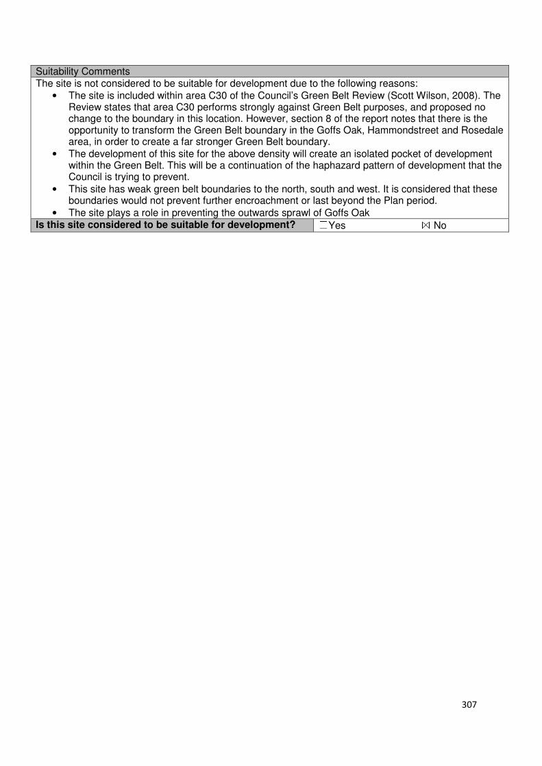
307
Suitability Comments The site is not considered to be suitable for development due to the following reasons:
• The site is included within area C30 of the Council’s Green Belt Review (Scott Wilson, 2008). The Review states that area C30 performs strongly against Green Belt purposes, and proposed no change to the boundary in this location. However, section 8 of the report notes that there is the opportunity to transform the Green Belt boundary in the Goffs Oak, Hammondstreet and Rosedale area, in order to create a far stronger Green Belt boundary.
• The development of this site for the above density will create an isolated pocket of development within the Green Belt. This will be a continuation of the haphazard pattern of development that the Council is trying to prevent.
• This site has weak green belt boundaries to the north, south and west. It is considered that these boundaries would not prevent further encroachment or last beyond the Plan period.
• The site plays a role in preventing the outwards sprawl of Goffs Oak Is this site considered to be suitable for development? ☐Yes ☒ No
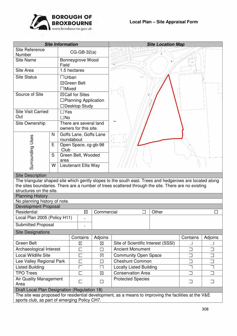
308
Local Plan – Site Appraisal Form
Site Information Site Location Map Site Reference Number
CG-GB-32(a)
Site Name Bonneygrove Wood Field
Site Area 1.5 hectares
Site Status ☐Urban ☒Green Belt ☐Mixed
Source of Site ☒Call for Sites ☐Planning Application ☐Desktop Study
Site Visit Carried Out
☐Yes ☐No
Site Ownership There are several land owners for this site.
Surr
oundin
g U
ses N Goffs Lane, Goffs Lane
roundabout E Open Space, cg-gb-98
Club S Green Belt, Wooded
area W Lieutenant Ellis Way
Site Description The triangular shaped site which gently slopes to the south east. Trees and hedgerows are located along the sites boundaries. There are a number of trees scattered through the site. There are no existing structures on the site. Planning History No planning history of note. Development Proposal
Residential ☒ Commercial ☐ Other ☐
Local Plan 2005 (Policy H11) -
Submitted Proposal -
Site Designations Contains Adjoins Contains Adjoins
Green Belt ☒ ☒ Site of Scientific Interest (SSSI) ☐ ☐
Archaeological Interest ☐ ☐ Ancient Monument ☐ ☐
Local Wildlife Site ☐ ☒ Community Open Space ☐ ☐
Lee Valley Regional Park ☐ ☐ Cheshunt Common ☐ ☐
Listed Building ☐ ☐ Locally Listed Building ☐ ☐
TPO Trees ☐ ☒ Conservation Area ☐ ☐
Air Quality Management Area
☐ ☐ Protected Species ☐ ☐
Draft Local Plan Designation (Regulation 18) The site was proposed for residential development, as a means to improving the facilities at the V&E sports club, as part of emerging Policy CH7.
309
Accessibility – distance as the crow flies
146m -Primary School (Bonneygrove)
99m - Secondary School (Goffs Oak)
2.52km –Employment Area
(Fieldings Road)
310m - Green Space (Claremont)
760m -Healthcare Centre
(Cromwell Medical Centre)
12.3km - Hospital (with A&E) (Barnet)
1.64km- Town/District Centre (Cheshunt Old Pond)
600m - Local Centre
1.88km -Leisure Centre
(Laura Trott)
1.3km - A10 Junction (Church Lane)
2.5km - Railway Station
(Cheshunt)
172m - Bus Service (Claremont)
Flood Risk Does the site Contains Adjoins
Zone 2 (Medium Risk) ☐ ☐
Zone 3a (High Risk) ☐ ☐
Zone 3b (Active Flood Plain) ☐ ☐
Additional Flood Risk Comments The site may suffer from ground water flooding. Lieutenant Ellis Way, located to the west of the site, suffers from surface water flooding. Access and Transport Comments There is no current vehicular access to the site – there is a dropped kerb that suggests this site previously had access, however its location on the current road infrastructure would not be appropriate due to being close to a roundabout exit. Land outside the current site ownership and boundary may be required to provide appropriate access. Goffs Lane has footpaths and cycle paths. Connections to this infrastructure from the site will be required. Utility Provision
Electricity Available in the main urban area
Gas A low pressure gas main is located along Goffs Lane, with the V&E club located to the east of the site being connected to this.
Water A water mains is located to the north of the site along Goffs Lane
Sewerage The V&E club to the east of the site is connected to a foul sewer. A surface sewer is located to the north of the site along Goffs Lane
Sewerage Treatment ☐Rye Meads ☒Deephams ☐Other
Additional Developer Comments submitted during Call for sites 2016 None submitted. However, during the Local Plan consultation (Regulation 18) the promoter of the site stated that development of this site would entail joint working between the three landowners, and at the present time there is no objection to the proposal. The promoter continues by stating that there are a number of constraints that would need to be addressed prior to its redevelopment for a residential led-scheme, including land ownership, access, and the mix of dwellings and sport pitches, and that there may be viability constraints as well. The promoter noted that the resolution of these constraints may not be achieved during the life of the plan. Suitability Comments The site is considered to be suitable for development due to the following reasons:
• The development of this site for residential will enable facilities at the V&E club to be improved.
310
• The site is included within area D6 of the Council’s Green Belt Review (Scott Wilson, 2008). The Review concluded that area D6 “Performs poorly against the Green Belt purposes, its location meaning that it does little in terms of preventing sprawl. In reality, also does little to separate existing settlements” and the possible release of this area from the Green Belt should be considered.
• The Review of the Inner Green Belt Boundary (Prospect Planning, 2008) states that this area appears to have development potential and recommended that “detailed consideration be given to the use of this land by the V&E Club with a view to establishing whether it might be relocated and the land designated for housing development, either as a short term Housing allocation or as Reserve Housing Land.”
• The site is considered to be in a sustainable location for residential development; it is close to educational facilities, local facilities, and some modes of sustainable transport. It is also within the sustainable distance recommended by Barton et al (2010) to a doctor’s surgery, green space and leisure centre.
Is this site considered to be suitable for development?
☒Yes ☐ No
Availability Comments The site is considered to be available for development. During the Local Plan (Regulation 18) consultation no objection to the sites allocation was made from its landowner
Is the site considered to be available for development
☒Yes ☐ No
Achievability Comments The site is considered to be achievable. However, there are a number of constraints, such as vehicle access to the site, which will need to be carefully planned. The site coming forward as part of a wider scheme to improve the facilities at the V&E club could make access issues easier to address. Some flood mitigation measures may be required for the issues identified above, which could impact on the sites viability. With the exception of its Green Belt designation, it is considered that there are no policy constraints that will prevent this site from coming forward for development.
Is the site considered to be achievable?
☒Yes ☐ No Delivery Period 6-10 years
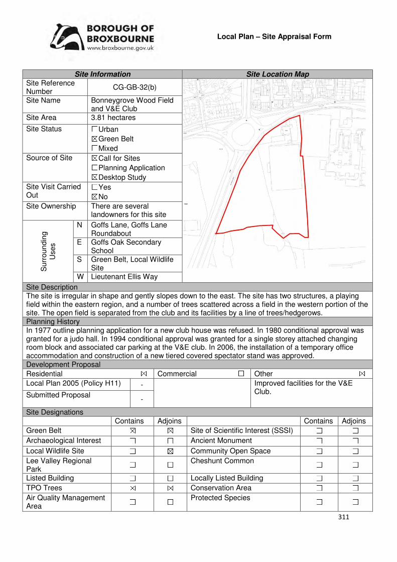
311
Local Plan – Site Appraisal Form
Site Information Site Location Map Site Reference Number
CG-GB-32(b)
Site Name Bonneygrove Wood Field and V&E Club
Site Area 3.81 hectares
Site Status ☐Urban ☒Green Belt ☐Mixed
Source of Site ☒Call for Sites ☐Planning Application ☒Desktop Study
Site Visit Carried Out
☐Yes ☒No
Site Ownership There are several landowners for this site
Surr
oundin
g
Uses
N Goffs Lane, Goffs Lane Roundabout
E Goffs Oak Secondary School
S Green Belt, Local Wildlife Site
W Lieutenant Ellis Way
Site Description The site is irregular in shape and gently slopes down to the east. The site has two structures, a playing field within the eastern region, and a number of trees scattered across a field in the western portion of the site. The open field is separated from the club and its facilities by a line of trees/hedgerows. Planning History In 1977 outline planning application for a new club house was refused. In 1980 conditional approval was granted for a judo hall. In 1994 conditional approval was granted for a single storey attached changing room block and associated car parking at the V&E club. In 2006, the installation of a temporary office accommodation and construction of a new tiered covered spectator stand was approved. Development Proposal
Residential ☒ Commercial ☐ Other ☒
Local Plan 2005 (Policy H11) - Improved facilities for the V&E Club. Submitted Proposal
-
Site Designations Contains Adjoins Contains Adjoins
Green Belt ☒ ☒ Site of Scientific Interest (SSSI) ☐ ☐
Archaeological Interest ☐ ☐ Ancient Monument ☐ ☐
Local Wildlife Site ☐ ☒ Community Open Space ☐ ☐
Lee Valley Regional Park
☐ ☐ Cheshunt Common ☐ ☐
Listed Building ☐ ☐ Locally Listed Building ☐ ☐
TPO Trees ☒ ☒ Conservation Area ☐ ☐
Air Quality Management Area
☐ ☐ Protected Species ☐ ☐
312
Draft Local Plan Designation (Regulation 18) (Regulation 18 Consultation) The site has been allocated for housing and improved facilities at the V&E club under emerging Policy CH7 Accessibility – distance as the crow flies
90m -Primary School (Bonneygrove)
0m - Secondary School (adjoins Goffs Oak)
2.37km –Employment Area (Fieldings)
310m - Green Space (Claremont)
680m -Healthcare Centre
(Cromwell)
12.3km - Hospital (with A&E)
(Barnet)
1.55km - Town/District Centre
(Cheshunt Old Pond)
470m - Local Centre
1.81km -Leisure Centre
(Laura Trott)
1.14km - A10 Junction (Church Lane)
2.45km - Railway Station
(Cheshunt)
172m - Bus Service (Claremont)
Flood Risk Does the site Contains Adjoins
Zone 2 (Medium Risk) ☐ ☐
Zone 3a (High Risk) ☐ ☐
Zone 3b (Active Flood Plain) ☐ ☒
Additional Flood Risk Comments The site may suffer from ground water flooding. Lieutenant Ellis Way, located to the west of the site, suffers from surface water flooding. Access and Transport Comments The V&E club can be accessed via Goffs Lane. Improvements to this access point will be required if development was to occur. Goffs Lane has footpaths and cycle paths. Connections to the infrastructure from the site will be required. A transport assessment will be required. Utility Provision
Electricity Available in the main urban area
Gas The V&E Club already has connections
Water A water mains is located to the north of the site along Goffs Lane
Sewerage The V&E Club already has connections.
Sewerage Treatment ☐Rye Meads ☒Deephams ☐Other
Additional Developer Comments submitted during Call for Sites 2016 None submitted. However, during the Local Plan consultation (Regulation 18) representations for the part of the site (the field located to the west of the V&E club) were made. These comments can be found on the Site Form for CG-GB-32(a). Suitability Comments The site is considered to be suitable for development due to the following reasons:
• The development of this site for residential will enable facilities at the V&E club to be improved.
• The site is included within area D6 of the Council’s Green Belt Review (Scott Wilson, 2008). The Review concluded that area D6 “Performs poorly against the Green Belt purposes, its location meaning that it does little in terms of preventing sprawl. In reality, also does little to separate existing settlements” and the possible release of this area from the Green Belt should be considered.
313
• The Review of the Inner Green Belt Boundary (Prospect Planning, 2008) states that this area appears to have development potential and recommended that “detailed consideration be given to the use of this land by the V&E Club with a view to establishing whether it might be relocated and the land designated for housing development, either as a short term Housing allocation or as Reserve Housing Land.”
• The site is considered to be in a sustainable location for residential development; it is close to educational facilities, local facilities, and some modes of sustainable transport. It is also within the sustainable distance recommended by Barton et al (2010) to a doctor’s surgery, green space and leisure centre.
Is this site considered to be suitable for development?
☒Yes ☐ No
Availability Comments The site is considered to be available. The Council is working with the V&E club to find an alternative site for their improved facilities. Their relocation will mean that the entirety of the site can come forward for residential development. Part of the site has been confirmed as available during the Local Plan (Regulation 18) consultation.
Is the site considered to be available for development
☒Yes ☐ No
Achievability Comments The site is considered to be achievable. However, there are a number of constraints, such as vehicle access to the site, which will need to be carefully planned. The site coming forward as part of a wider scheme to improve the facilities at the V&E club could make access issues easier to address. Some flood mitigation measures may be required for the issues identified above, which could impact on the sites viability. Improved V&E facilities will need to be provided as part of this scheme. With the exception of its Green Belt designation, it is considered that there are no policy constraints that will prevent this site from coming forward for development.
Is the site considered to be achievable?
☒Yes ☐ No
Delivery Period 6-10 years

314
Local Plan – Site Appraisal Form
Site Information Site Location Map Site Reference Number
CG-GB-34
Site Name Manning Ground, Goffs Lane
Site Area 0.5 hectares
Site Status ☐Urban ☒Green Belt ☐Mixed
Source of Site ☒Call for Sites ☐Planning Application ☐Desktop Study
Site Visit Carried Out
☐Yes ☒No
Site Ownership There are various landowners for this site.
Surrounding Uses
N Goffs Lane, In-Ex
E Green Belt, Residential S Construction Storage,
Open fields W Green Belt, Residential
Site Description The site is rectangular in shape and relatively flat. There are a number of existing structures on the site, and hard standing surfaces. Around the sites boundaries are hedges and trees. Planning History A one bedroom flat over a garage was refused in 2003. Approval was granted for its existing use as open storage and car parking. Development Proposal
Residential ☒ Commercial ☐ Other ☐
Local Plan 2005 (Policy H11)
Submitted Proposal
45 (as part of land allocated in GO2)
Site Designations Contains Adjoins Contains Adjoins
Green Belt ☒ ☒ Site of Scientific Interest (SSSI) ☐ ☐
Archaeological Interest ☐ ☐ Ancient Monument ☐ ☐
Local Wildlife Site ☐ ☐ Community Open Space ☐ ☐
Lee Valley Regional Park ☐ ☐ Cheshunt Common ☐ ☐
Listed Building ☐ ☐ Locally Listed Building ☐ ☐
TPO Trees ☐ ☒ Conservation Area ☐ ☐
Air Quality Management Area
☐ ☐ Protected Species ☐ ☐
Draft Local Plan Designation The draft Local Plan included this site within the proposed residential development at Goffs Lane, as part of emerging Policy GO2.
315
Accessibility – distance as the crow flies
430m -Primary School (Woodside)
1.64km - Secondary School (Goffs Oak)
3.32km –Employment Area (New River Trading Estate)
100m - Green Space (Goffs Oak Park)
164m -Healthcare Centre
(Valley View)
11.2- Hospital (with A&E)
(Barnet)
3.09km - Town/District Centre
(Brookfield)
210m - Local Centre (684-696 Goffs Lane)
3.5km -Leisure Centre
(Laura Trott)
2.3km - A10 Junction (College Road)
1.8km - Railway Station
(Cuffley)
183m - Bus Service (War Memorial)
Flood Risk Does the site Contain Adjoins
Zone 2 (Medium Risk) ☐ ☐
Zone 3a (High Risk) ☐ ☐
Zone 3b (Active Flood Plain) ☐ ☒
Additional Flood Risk Comments There may be some ground and surface water flooding problems. Access and Transport Comments The site can be currently accessed via Goffs Lane. This access point, particularly its visibility, will require improving if development was to come forward. Goffs Lane has footpaths along both sides of the road. Connections to these will be required. Cycle access to the site should be created. Utility Provision
Electricity Cables available.
Gas A low pressure gas mains is located along Goffs Lane
Water A water mains is located along Goffs Lane
Sewerage A foul sewer and surface sewer is located along Goffs Lane
Sewerage Treatment ☐Rye Meads ☒Deephams ☐Other
Additional Developer Comments submitted during Call for Sites 2016. None submitted. During the Local Plan (Regulation 18) consultation the landowner made the following comments “RPS notes that the Council recognises the existence of our client’s travelling showpeople’ s site on land south of Goffs Lane, and has allocated the land as such in the accompanying Proposals Map”. Suitability Comments The site is considered to be suitable for residential development due to the following reasons:
• The Council’s Green Belt Review (Scott Wilson, 2008) states that this area (C24) performs strongly against Green Belt purposes, however, due to the extremely weak boundaries within sub areas C11-C30 there are no real barriers to prevent encroachment between settlements due to the incremental development that has occurred over the years. The review considered allocating area C24 and provided the following analysis: “Archaeology is the only site constraint against a number of opportunities including reasonable accessibility and proximity to services, high level of derelict/vacant brownfield land and regeneration potential. On this basis the site maybe suitable for built development”.
316
• The site has been assessed as part of Development Approach 2 in the ‘Goffs Oak Development Options Report’. The report notes that the development of this site would enable protection and remediation of the various storage and industrial uses on site, and that the site could be used to create a ‘gateway’ to Goffs Oak Village. The overall benefits identified for Development Approach 2 included; the provision of an appropriate level of housing through relatively minor Green Belt boundary revisions, in part the Green Belt boundary around Goffs Oak village could be more logical and hence defensible in the future, fairly unattractive sites would be removed from the Green Belt and could potentially create more attractive gateways into the village and residents of the new development would have good access to services, facilities and transport.
• The site is considered to be in a sustainable location for residential development; it is close to primary education facilities, local facilities and some modes of sustainable transport. It is also within the sustainable distance recommended by Barton et al (2010) to a doctor’s surgery and local green space.
Is this site considered to be suitable for development?
☒Yes ☐ No
Availability Comments The site is considered to be available for development. The landowners of the site made reference to its allocation within its Local Plan representation.
Is the site considered to be available for development
☒Yes ☐ No
Achievability Comments The site is considered to be achievable. Although there are policy constraints on this site, it is considered that they will not be able to prevent its development. The sites proximity to the built up area of Goffs Oak will enable it to benefit from existing infrastructure. The costs of building on this site are not considered to be significant to have a detrimental impact on the sites overall viability.
Is the site considered to be achievable?
☒Yes ☐ No
Delivery Period 1-5 years

317
Local Plan – Site Appraisal Form
Site Information Site Location Map Site Reference Number
CG-GB-35
Site Name Triangle Nursery Site Area 1 hectare
Site Status ☐Urban ☒Green Belt ☐Mixed
Source of Site ☒Call for Sites ☐Planning Application ☐Desktop Study
Site Visit Carried Out
☐Yes ☐No
Site Ownership There are various landowners for this site.
Surr
oundin
g
Uses
N Nurseries, Green Belt
E Malaya Farm, Green Belt
S Green Belt
W Green Belt
Site Description The site is relatively triangular in shape and gently slopes to the south east. There are some structures scattered across the site. The southern region of the site is predominantly open field in nature. There is a significant cluster of trees located with the north eastern region of the site.
Planning History A planning application for the demolition of existing dilapidated structures and buildings and construction of a new five bedroom dwelling was refused in 2014. Development Proposal
Residential ☒ Commercial ☐ Other ☐
Local Plan 2005 (Policy H11)
30
Submitted Proposal -
Site Designations Contains Adjoins Contains Adjoins
Green Belt ☒ ☒ Site of Scientific Interest (SSSI)
☐ ☐
Archaeological Interest ☐ ☐ Ancient Monument ☐ ☐
Local Wildlife Site ☐ ☒ Community Open Space ☐ ☐
Lee Valley Regional Park
☐ ☐ Cheshunt Common ☐ ☐
Listed Building ☐ ☐ Locally Listed Building ☐ ☐
TPO Trees ☐ ☐ Conservation Area ☐ ☐
Air Quality Management Area ☐ ☐
Protected Species ☐ ☐

318
Draft Local Plan Designation (Regulation 18) The draft Local Plan proposed to keep this site within the Green Belt Accessibility – distance as the crow flies
890m -Primary School (Goffs Oak)
1.77km - Secondary School (Goffs Oak)
3km–Employment Area (New River Trading Estate)
100m - Green Space (Argent Way)
600m -Healthcare Centre (Valley View)
11.7km - Hospital (with A&E) (Barnet)
2.83km - Town/District Centre (Brookfield)
670m - Local Centre (1-5 Masons Parade)
3.62km -Leisure Centre (Laura Trott)
2.8km - A10 Junction (Church Lane)
2.06km - Railway Station (Cuffley )
560m - Bus Service (Macintosh Close)
Flood Risk Does the site Contains Adjoins
Zone 2 (Medium Risk) ☐ ☐
Zone 3a (High Risk) ☐ ☐
Zone 3b (Active Flood Plain) ☐ ☐
Additional Flood Risk Comments There may be surface water problems to the south. Access and Transport Comments The site can be accessed from Crouch Lane. Crouch Lane is narrow places and semi-rural in nature. Third party land would be required to widen the road to support residential development. There are no footpaths along Crouch Lane. A public right of way is located just outside the site to the north east, which connects to Rags Lane. Cycle access to the site would need to be created. Utility Provision
Electricity Available in main urban area either to the south or east
Gas The nearest low pressure gas mains is located along Crouch Lane, approximately 600m away.
Water A water mains is located along Crouch Lane
Sewerage Foul sewers and surface sewers are located to the east of the site
Sewerage Treatment ☐Rye Meads ☒Deephams ☐Other
Additional Developer Comments submitted during Call for Sites 2016. None submitted. The landowners of the site have been in contact with the Council, through the pre-application process, in regards to developing this site for self-build housing. Suitability Comments The site is not considered to be suitable for residential development due to the following:
• The Council’s Green Belt Review (Scott Wilson, 2008) stated that this area (C13) performs strongly against Green Belt purposes 1 and 2, and averagely against Purpose 3. No change to the Green Belt boundary was proposed. However, it should be noted that the review also stated that there is the opportunity to create a stronger Green Belt boundary in areas C11-C30 as these areas have “extremely weak boundaries”, which means there are no real barrier to prevent encroachment between settlements.
• Previous planning applications for residential development on this site have been refused. The most recent application, when went to appeal in 2014, was dismissed. Reasons cited for its refusal include: inappropriate development in the Green Belt, harmful to the Green Belt, the proposed development would reduce the openness of the Green Belt in comparison to the existing buildings on site and the development would be contrary to one of the purposes of the Green Belt which is to assist in safeguarding the countryside from encroachment.
319
• The residential development along Crouch Lane is spaced out, therefore the development of this site for residential, at the indicative density identified above would not be in keeping with the surrounding area.
• As identified in APP/W1905/A/14/2219300 there is “little remains of the large former greenhouses other than the base walls”. From this, and aerial photography it can be concluded that this site has been returned to an open site. It is considered that the development of this site, even for self-build housing, will result in the loss of openness, which the NPPF makes clear is an essential characteristic of Green Belts. Therefore, the development of self-build housing on this site would not comply with the criteria set out in emerging Policy GB2.
• There are no clear defensible Green Belt boundaries to the east, south and west of the site that would prevent further sprawl and last beyond the Plan period
Is this site considered to be suitable for development? ☐Yes ☒ No
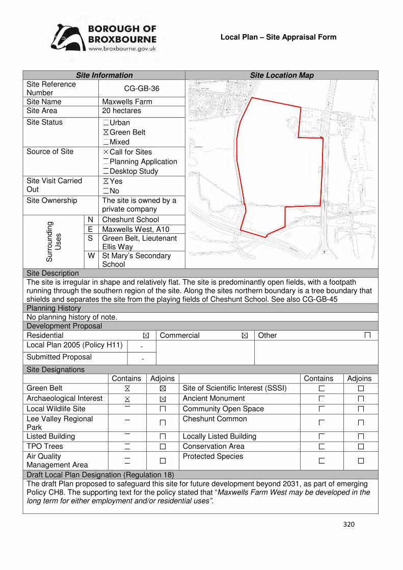
320
Local Plan – Site Appraisal Form
Site Information Site Location Map Site Reference Number
CG-GB-36
Site Name Maxwells Farm Site Area 20 hectares
Site Status ☐Urban ☒Green Belt ☐Mixed
Source of Site ☒Call for Sites ☐Planning Application ☐Desktop Study
Site Visit Carried Out
☒Yes ☐No
Site Ownership The site is owned by a private company
Surr
oundin
g
Uses
N Cheshunt School
E Maxwells West, A10 S Green Belt, Lieutenant
Ellis Way W St Mary’s Secondary
School Site Description The site is irregular in shape and relatively flat. The site is predominantly open fields, with a footpath running through the southern region of the site. Along the sites northern boundary is a tree boundary that shields and separates the site from the playing fields of Cheshunt School. See also CG-GB-45 Planning History No planning history of note. Development Proposal
Residential ☒ Commercial ☒ Other ☐
Local Plan 2005 (Policy H11) -
Submitted Proposal -
Site Designations Contains Adjoins Contains Adjoins
Green Belt ☒ ☒ Site of Scientific Interest (SSSI) ☐ ☐
Archaeological Interest ☒ ☒ Ancient Monument ☐ ☐
Local Wildlife Site ☐ ☐ Community Open Space ☐ ☐
Lee Valley Regional Park
☐ ☐ Cheshunt Common ☐ ☐
Listed Building ☐ ☐ Locally Listed Building ☐ ☐
TPO Trees ☐ ☐ Conservation Area ☐ ☐
Air Quality Management Area
☐ ☐ Protected Species ☐ ☐
Draft Local Plan Designation (Regulation 18) The draft Plan proposed to safeguard this site for future development beyond 2031, as part of emerging Policy CH8. The supporting text for the policy stated that “Maxwells Farm West may be developed in the long term for either employment and/or residential uses”.
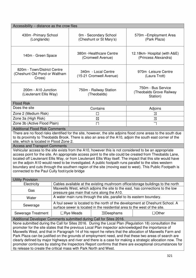
321
Accessibility – distance as the crow flies
430m -Primary School (Longlands)
0m - Secondary School (Cheshunt or St Mary’s)
570m –Employment Area (Park Plaza)
140m - Green Space 380m -Healthcare Centre
(Cromwell Avenue) 12.18km- Hospital (with A&E)
(Princess Alexandra)
820m - Town/District Centre (Cheshunt Old Pond or Waltham
Cross)
340m - Local Centre (15-21 Cromwell Avenue)
970m -Leisure Centre (Laura Trott)
200m - A10 Junction (Lieutenant Ellis Way)
750m - Railway Station (Theobalds)
750m - Bus Service (Theobalds Grove Railway
Station)
Flood Risk Does the site Contains Adjoins
Zone 2 (Medium Risk) ☐ ☒
Zone 3a (High Risk) ☒ ☒
Zone 3b (Active Flood Plain) ☐ ☐
Additional Flood Risk Comments There are no flood risks identified for the site, however, the site adjoins flood zone areas to the south due to its proximity to Theobalds Brook. There is also an area of the A10, adjoin the south east corner of the site, which is located in Flood Zone 2. Access and Transport Comments Vehicular access to the site exists from the A10, however this is not considered to be an appropriate access point for the site. An appropriate access point to the site could be created from Theobalds Lane, located off Lieutenant Ellis Way, or from Lieutenant Ellis Way itself. The impact that this site would have on the adjoin A10 would need to be investigated. A public footpath runs parallel to the sites western boundary and cuts through the southern region of the site (moving east to west). This Public Footpath is connected to the Paul Cully foot/cycle bridge Utility Provision
Electricity Cables available at the existing mushroom office/storage buildings to the north
Gas Maxwells West, which adjoins the site to the east, has connections to the low pressure gas main that runs along the A10.
Water A water main runs through the site, parallel to its eastern boundary.
Sewerage A foul sewer is located to the north of the development at Cheshunt School. A surface sewer is located in the residential area to the west of the site.
Sewerage Treatment ☐Rye Meads ☒Deephams ☐Other
Additional Developer Comments submitted during Call for Sites 2016. None submitted during the Call for Sites 2016. During the Local Plan (Regulation 18) consultation the promoter for the site states that the previous Local Plan inspector acknowledged the importance of Maxwells West, and that in Paragraph 14 of his report he refers that the allocation of Maxwells Farm and Park Plaza can be justified on the grounds of employment need, and that these two areas of search are clearly defined by major highways and river and there is a case for making a strategic allocation now. The promoter continues by stating the Inspectors Report confirms that there are exceptional circumstances for its release to create the critical mass with Park North and West.

322
The Inspector was prepared to find the Plan “sound”, subject to a number of amendments, therefore had the Council accepted the Inspector’s recommendations and moved forward with the Plan, Maxwells Farm West would now be excluded from the Green Belt and available for development. They continue by stating that Maxwells Farm West has been acknowledged by both the Council and the Inspector as a site which should be released from the Green Belt to meet future development needs, and that the site is suitable for both housing and employment. The promoter recommended changing the policy wording so that development is not restricted to post the Plan period as this would restrict the availability of the land to meet a development need during the Plan period. Suitability Comments The site is considered to be in a sustainable place for development due to the following reasons:
• The site is considered to be in a sustainable location to support residential development; it is close to sustainable modes of transport, local facilities and educational facilities. It is also within the sustainable distance recommended by Barton et al (2010) for a doctor’s surgery, open space and a leisure centre.
• The identified period for the site to come forward will enable the development to be tailored to meet the needs of the borough.
• The Inspectors Report for the Core Strategy stated the allocation of this site can be “justified on grounds of employment needs”; however “considerable uncertainties about the scope and deliverability (including viability) of the sites remain, particularly concerning potential highway improvements.” Therefore, it was concluded that “the approach to identify AoS, rather strategic sites, is sound in the circumstances”. The site coming forward beyond the Plan period will enable these uncertainties to be investigated and appropriate mitigation schemes to be devised.
• The development of this site will create clear and defensible Green Belt boundaries, as stated in the Inspectors Report for the Core Strategy, a defensible Green Belt boundary would be formed by the river to the west.
Is this site considered to be suitable for development?
☒Yes ☐ No
Availability Comments The site is considered to be available, however due to the Council meeting its Objectively Assessed Need on alternative sites; the site will not be required within this Plan period. However, it is considered appropriate to safeguard this site for future development (post plan-period). During the Local Plan Consultation (Regulation 18) the site was confirmed to be available for development.
Is the site considered to be available for development
☒Yes ☐ No
Achievability Comments The site is considered to be achievable in the long term. This will enable necessary highway works to be completed that will make the site accessible. As identified in the Core Strategy Inspectors report, there are a number of issues that will need to be addressed prior to the delivery of any development. With the exception of its Green Belt designation, there are no policy constraints that would prevent its development.
Is the site considered to be achievable?
☒Yes ☐ No
Delivery Period 16-20 years

323
Local Plan – Site Appraisal Form
Site Information Site Location Map Site Reference Number
CG-GB-37
Site Name Ashfield Nursery Site Area 1.2 hectares
Site Status ☐Urban ☒Green Belt ☐Mixed
Source of Site ☒Call for Sites ☐Planning Application ☐Desktop Study
Site Visit Carried Out
☐Yes ☒No
Site Ownership There is one landowner for this site
Surr
oundin
g
Uses
N Tetherdown, Green Belt
E Green Belt S Pembrey, Green Belt
W Newgatestreet Road, Open Fields, Green Belt
Site Description The site is rectangular in shape and gently slopes to the east. The site is developed in nature, with a number of glasshouse structures taking up the majority of the site area. To the south of the glasshouse structure is hardstanding surface. Located in the north western region of the site is one residential property. Planning History In 1984, an outline application for a detached dwelling on the site was refused. In 1987, permission for a detached dwelling house and garage with vehicular access was granted approval. Permission for replacement glasshouses was approved in 1979 was an extension to the nursery packing being granted permission in 1998. Development Proposal
Residential ☒ Commercial ☐ Other ☐
Local Plan 2005 (Policy H11) 36
Submitted Proposal
Site Designations Contains Adjoins Contains Adjoins
Green Belt ☒ ☒ Site of Scientific Interest (SSSI) ☐ ☐
Archaeological Interest ☐ ☐ Ancient Monument ☐ ☐
Local Wildlife Site ☐ ☐ Community Open Space ☐ ☐
Lee Valley Regional Park ☐ ☐ Cheshunt Common ☐ ☐
Listed Building ☐ ☐ Locally Listed Building ☐ ☐
TPO Trees ☐ ☐ Conservation Area ☐ ☐
Air Quality Management Area
☐ ☐ Protected Species ☐ ☐
Draft Local Plan Designation (Regulation 18)
The draft Local Plan proposed to keep this site within the Green Belt

324
Accessibility – distance as the crow flies
590m -Primary School (Goffs)
2.71km - Secondary School (Goffs)
3.84km –Employment Area (New River Trading Estate)
290m - Green Space (Richardson Crescent)
1.18km -Healthcare Centre (Valley View)
11.3km - Hospital (with A&E) (Barnet)
3.66km - Town/District Centre (Brookfield)
990m - Local Centre (1-5 Masons Parade)
4.57km -Leisure Centre (Laura Trott)
3.9km - A10 Junction (Church Lane)
1.54km - Railway Station (Cuffley)
940m - Bus Service (Smiths Lane)
Flood Risk Does the site Contains Adjoins
Zone 2 (Medium Risk) ☐ ☐
Zone 3a (High Risk) ☐ ☐
Zone 3b (Active Flood Plain) ☐ ☐
Additional Flood Risk Comments There may be some ground water flooding on the site.
Access and Transport Comments The site can be accessed from Newgatestreet Road. There is a footpath on the western side of Newgatestreet Road. There is no footpath on the eastern side of Newgatestreet Road, therefore this will need to be provided or connections required to the existing footpath on the western edge if development was to come forward. Utility Provision
Electricity Cables available along Newgatestreet Road
Gas The site is connected to the low pressure gas main that runs along Newgatestreet Road
Water A water mains is located along Newgatestreet Road
Sewerage A foul sewer is located to the south of the site, within the main housing area of Newgatestreet Road.
Sewerage Treatment ☐Rye Meads ☒Deephams ☐Other
Additional Developer Comments promoted during the Call for Sites 2016 None submitted. Suitability Comments This site is not considered to be suitable for development due to the following reasons:
• At the time of writing, Ashfield Nursery appears to be in production as a Fruit and Vegetables wholesaler. Emerging Policy GB2 states that “Operating glass house sites will be safeguarded for horticultural production”.
• The site is included within area C30 of the Council’s Green Belt Review (Scott Wilson, 2008). The Review states that are C30 performs strongly against Green Belt Purposes and proposed no change to the Green Belt boundary in this location. However, it should be noted that the review also stated that there is the opportunity to create a stronger Green Belt boundary in areas C11-C30 as these areas have “extremely weak boundaries”, which means there are no real barriers to prevent encroachment between settlements.
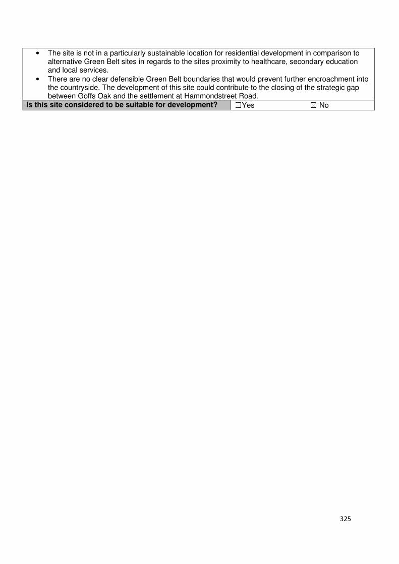
325
• The site is not in a particularly sustainable location for residential development in comparison to alternative Green Belt sites in regards to the sites proximity to healthcare, secondary education and local services.
• There are no clear defensible Green Belt boundaries that would prevent further encroachment into the countryside. The development of this site could contribute to the closing of the strategic gap between Goffs Oak and the settlement at Hammondstreet Road.
Is this site considered to be suitable for development? ☐Yes ☒ No

326
Local Plan – Site Appraisal Form
Site Information Site Location Map Site Reference Number
CG-GB-38
Site Name Land at Park House, Appleby Street
Site Area 0.5 hectare
Site Status ☐Urban ☒Green Belt ☐Mixed
Source of Site
☒Call for Sites ☐Planning Application ☐Desktop Study
Site Visit Carried Out
☐Yes ☒No
Site Ownership
The site is in multiple ownership
Surr
oundin
g
Uses
N Open Fields, Green Belt
E Open Fields, Green Belt S Appleby Street, Residential
W Informal Open Space, Green Belt
Site Description The site is broadly rectangular in shape and relatively flat. The site is currently occupied by a number of buildings, garden land and hardstanding surfaces. Trees are located along the sites northern and western boundary. Planning History In 1986, conversion of coach house to ‘granny flat’ was refused. In 1997, a two storey rear extension, conversion of existing outbuilding to residential use, demolition of barns and erection of detached garage was granted conditional approval. In 2002, a first floor rear extension and relocation of existing conservatory was granted conditional approval. Development Proposal
Residential ☒ Commercial ☐ Other ☐
Local Plan 2005 (Policy H11) 15
Submitted Proposal - Site Designations Contains Adjoins Contains Adjoins
Green Belt ☒ ☒ Site of Scientific Interest (SSSI) ☐ ☐
Archaeological Interest ☐ ☐ Ancient Monument ☐ ☐
Local Wildlife Site ☐ ☒ Community Open Space ☐ ☐
Lee Valley Regional Park ☐ ☐ Cheshunt Common ☐ ☐
Listed Building ☐ ☐ Locally Listed Building ☐ ☐
TPO Trees ☐ ☐ Conservation Area ☐ ☐
Air Quality Management Area
☐ ☐ Protected Species ☐ ☐
Draft Local Plan Designation (Regulation 18) The draft Local Plan proposed to keep this site within the Green Belt
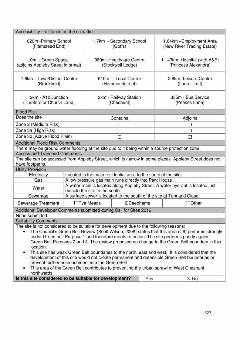
327
Accessibility – distance as the crow flies
620m -Primary School (Flamstead End)
1.7km - Secondary School (Goffs)
1.64km –Employment Area (New River Trading Estate)
0m - Green Space (adjoins Appleby Street informal)
980m -Healthcare Centre (Stockwell Lodge)
11.43km Hospital (with A&E) (Princess Alexandra)
1.6km - Town/District Centre (Brookfield)
610m - Local Centre (Hammondstreet)
2.9km -Leisure Centre (Laura Trott)
2km - A10 Junction (Turnford or Church Lane)
3km - Railway Station (Cheshunt)
355m - Bus Service (Peakes Lane)
Flood Risk Does the site Contains Adjoins
Zone 2 (Medium Risk) ☐ ☐
Zone 3a (High Risk) ☐ ☐
Zone 3b (Active Flood Plain) ☐ ☐
Additional Flood Risk Comments There may be ground water flooding at the site due to it being within a source protection zone. Access and Transport Comments The site can be accessed from Appleby Street, which is narrow in some places. Appleby Street does not have footpaths. Utility Provision
Electricity Located in the main residential area to the south of the site
Gas A low pressure gas main runs directly into Park House
Water A water main is located along Appleby Street. A water hydrant is located just outside the site to the south.
Sewerage A surface sewer is located to the south of the site at Tennand Close
Sewerage Treatment ☐Rye Meads ☒Deephams ☐Other
Additional Developer Comments submitted during Call for Sites 2016 None submitted. Suitability Comments The site is not considered to be suitable for development due to the following reasons:
• The Council’s Green Belt Review (Scott Wilson, 2008) states that this area (C6) performs strongly under Green belt Purpose 1 and therefore merits retention. The site performs poorly against Green Belt Purposes 2 and 3. The review proposed no change to the Green Belt boundary in this location.
• This site has weak Green Belt boundaries to the north, east and west. It is considered that the development of this site would not create permanent and defensible Green Belt boundaries or prevent further encroachment into the Green Belt
• This area of the Green Belt contributes to preventing the urban sprawl of West Cheshunt northwards.
Is this site considered to be suitable for development? ☐Yes ☒ No
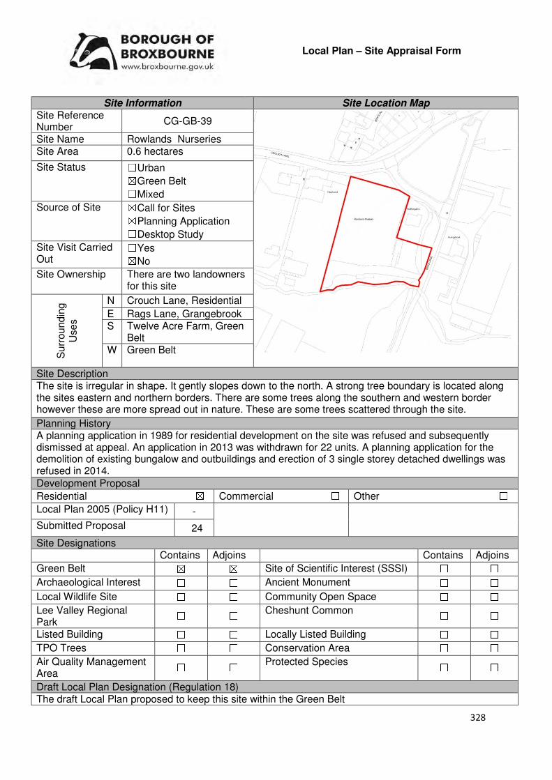
328
Local Plan – Site Appraisal Form
Site Information Site Location Map Site Reference Number
CG-GB-39
Site Name Rowlands Nurseries Site Area 0.6 hectares
Site Status ☐Urban ☒Green Belt ☐Mixed
Source of Site ☒Call for Sites ☒Planning Application ☐Desktop Study
Site Visit Carried Out
☐Yes ☒No
Site Ownership There are two landowners for this site
Surr
oundin
g
Uses
N Crouch Lane, Residential
E Rags Lane, Grangebrook S Twelve Acre Farm, Green
Belt W Green Belt
Site Description The site is irregular in shape. It gently slopes down to the north. A strong tree boundary is located along the sites eastern and northern borders. There are some trees along the southern and western border however these are more spread out in nature. These are some trees scattered through the site.
Planning History A planning application in 1989 for residential development on the site was refused and subsequently dismissed at appeal. An application in 2013 was withdrawn for 22 units. A planning application for the demolition of existing bungalow and outbuildings and erection of 3 single storey detached dwellings was refused in 2014.
Development Proposal
Residential ☒ Commercial ☐ Other ☐
Local Plan 2005 (Policy H11) -
Submitted Proposal 24
Site Designations Contains Adjoins Contains Adjoins
Green Belt ☒ ☒ Site of Scientific Interest (SSSI) ☐ ☐
Archaeological Interest ☐ ☐ Ancient Monument ☐ ☐
Local Wildlife Site ☐ ☐ Community Open Space ☐ ☐
Lee Valley Regional Park
☐ ☐ Cheshunt Common ☐ ☐
Listed Building ☐ ☐ Locally Listed Building ☐ ☐
TPO Trees ☐ ☐ Conservation Area ☐ ☐
Air Quality Management Area
☐ ☐ Protected Species ☐ ☐
Draft Local Plan Designation (Regulation 18) The draft Local Plan proposed to keep this site within the Green Belt
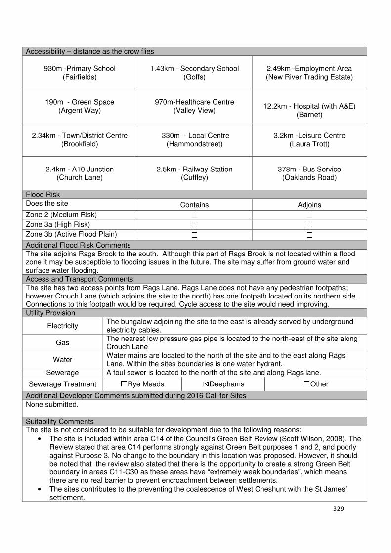
329
Accessibility – distance as the crow flies
930m -Primary School (Fairfields)
1.43km - Secondary School (Goffs)
2.49km–Employment Area (New River Trading Estate)
190m - Green Space (Argent Way)
970m-Healthcare Centre
(Valley View)
12.2km - Hospital (with A&E)
(Barnet)
2.34km - Town/District Centre (Brookfield)
330m - Local Centre
(Hammondstreet)
3.2km -Leisure Centre (Laura Trott)
2.4km - A10 Junction (Church Lane)
2.5km - Railway Station
(Cuffley)
378m - Bus Service (Oaklands Road)
Flood Risk Does the site Contains Adjoins
Zone 2 (Medium Risk) ☐ ☐
Zone 3a (High Risk) ☐ ☐
Zone 3b (Active Flood Plain) ☐ ☐
Additional Flood Risk Comments The site adjoins Rags Brook to the south. Although this part of Rags Brook is not located within a flood zone it may be susceptible to flooding issues in the future. The site may suffer from ground water and surface water flooding. Access and Transport Comments The site has two access points from Rags Lane. Rags Lane does not have any pedestrian footpaths; however Crouch Lane (which adjoins the site to the north) has one footpath located on its northern side. Connections to this footpath would be required. Cycle access to the site would need improving. Utility Provision
Electricity The bungalow adjoining the site to the east is already served by underground electricity cables.
Gas The nearest low pressure gas pipe is located to the north-east of the site along Crouch Lane
Water Water mains are located to the north of the site and to the east along Rags Lane. Within the sites boundaries is one water hydrant.
Sewerage A foul sewer is located to the north of the site and along Rags lane.
Sewerage Treatment ☐Rye Meads ☒Deephams ☐Other
Additional Developer Comments submitted during 2016 Call for Sites None submitted. Suitability Comments The site is not considered to be suitable for development due to the following reasons:
• The site is included within area C14 of the Council’s Green Belt Review (Scott Wilson, 2008). The Review stated that area C14 performs strongly against Green Belt purposes 1 and 2, and poorly against Purpose 3. No change to the boundary in this location was proposed. However, it should be noted that the review also stated that there is the opportunity to create a strong Green Belt boundary in areas C11-C30 as these areas have “extremely weak boundaries”, which means there are no real barrier to prevent encroachment between settlements.
• The sites contributes to the preventing the coalescence of West Cheshunt with the St James’ settlement.
330
• A planning inspector stated in a recent appeal (APP/W1905/A/14/2217163) that the former nursery building that previously occupied part of the site “ha[s] been removed and although the site is overgrown, any remains of the former buildings have blended into the landscape”. The site has been returned to the Green Belt. It is considered that the development of this site, even for self-build housing, will result in a loss of openness, which the NPPF makes clear is an essential characteristic of Green Belts. Therefore, the development of self-build housing on this site would not comply with the criteria set out in emerging Policy GB2
• A recent application for 3 single storey detached dwellings was refused at appeal. States that the site is open to views from the northern boundary and
• The most recent planning application for residential development on this site was refused due to the following reasons: the proposal would inappropriate development in the Green Belt and would not fall within any of the exceptions to this as set out in paragraph 89 of the Framework; the development would extend the urban area of Hammondstreet into the open rural area which would conflict with two of the purposes of the Green Belt which are to check the unrestricted sprawl of large built up areas and to assist in safeguarding the countryside from encroachment; the development would cause unacceptable harm to the open rural character of the site and area.
Is this site considered to be suitable for development? ☐Yes ☒ No
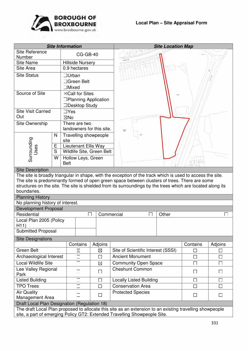
331
Local Plan – Site Appraisal Form
Site Information Site Location Map Site Reference Number
CG-GB-40
Site Name Hillside Nursery Site Area 0.9 hectares
Site Status ☐Urban ☐Green Belt ☐Mixed
Source of Site ☒Call for Sites ☐Planning Application ☐Desktop Study
Site Visit Carried Out
☐Yes ☒No
Site Ownership There are two landowners for this site.
Surr
oundin
g
Uses
N Travelling showpeople site
E Lieutenant Ellis Way S Wildlife Site, Green Belt
W Hollow Leys, Green Belt
Site Description The site is broadly triangular in shape, with the exception of the track which is used to access the site. The site is predominantly formed of open green space between clusters of trees. There are some structures on the site. The site is shielded from its surroundings by the trees which are located along its boundaries.
Planning History No planning history of interest.
Development Proposal
Residential ☐ Commercial ☐ Other ☐
Local Plan 2005 (Policy H11)
Submitted Proposal
Site Designations Contains Adjoins Contains Adjoins
Green Belt ☒ ☒ Site of Scientific Interest (SSSI) ☐ ☐
Archaeological Interest ☐ ☐ Ancient Monument ☐ ☐
Local Wildlife Site ☐ ☒ Community Open Space ☐ ☐
Lee Valley Regional Park
☐ ☐ Cheshunt Common ☐ ☐
Listed Building ☐ ☐ Locally Listed Building ☐ ☐
TPO Trees ☐ ☐ Conservation Area ☐ ☐
Air Quality Management Area
☐ ☐ Protected Species ☐ ☐
Draft Local Plan Designation (Regulation 18) The draft Local Plan proposed to allocate this site as an extension to an existing travelling showpeople site, a part of emerging Policy GT2: Extended Travelling Showpeople Site.

332
Accessibility – distance as the crow flies
250m -Primary School (Bonneygrove)
245m - Secondary School (Goffs)
2.66km –Employment Area (Fieldings Road)
170m - Green Space (Claremont)
920m -Healthcare Centre (Cromwell Avenue)
11.94km- Hospital (with A&E)
(Barnet)
1.8km - Town/District Centre (Cheshunt Old Pond)
770m - Local Centre
2km -Leisure Centre (Laura Trott)
1.4km - A10 Junction (College Road)
2.68km - Railway Station (Cheshunt)
30m - Bus Service (Claremont)
Flood Risk Does the site Contains Adjoins
Zone 2 (Medium Risk) ☐ ☐
Zone 3a (High Risk) ☐ ☐
Zone 3b (Active Flood Plain) ☐ ☐
Additional Flood Risk Comments There may be some surface water flooding on the site.
Access and Transport Comments The site can be accessed from Goffs Lane. This access point is not wide enough to accommodate two vehicles and pedestrian footpaths and would require widening if development was to occur. There are pedestrian footpaths along Goffs Lane. Utility Provision
Electricity Located at Goffs Lane
Gas A low pressure gas main is located to north of the site along Goffs Lane or to the east at Grovedale Close
Water A water mains is located to north of the site along Goffs Lane or to the east at Grovedale Close
Sewerage Foul sewers and surface sewers are located to the north of the site along Goffs Lane and to the east at Grovedale Close
Sewerage Treatment ☐Rye Meads ☒Deephams ☐Other
Additional Developer Comments submitted during Call for Sites 2016 None submitted. During the Regulation 18 Local Plan Consultation the land promoter confirmed that the site is not available for the extension of the travelling showpeople site. Suitability Comments The site is not considered to be suitable for development due to the following reasons:
• The Council’s Green Belt Review (Scott Wilson, 2008) stated that this area (D4) performs strongly against the Green Belt purposes and therefore should be retained. The review proposed no changes to the Green Belt boundary in this location, with the exception of a discreet release of land that separates two parts of the existing urban area.
333
• With the exception of a packing shed, there are no “existing buildings”, such as a glasshouse, on this site. A site with similar characteristics to CG-GB-40 (CG-GB-115 – a previous glasshouse site that is now “devoid of development other than for a small brick building and some very low remnant walls”) had an outline application for 14 self-build plots refused at appeal (APP/W1905/W/16/3164574). In the decision notice, the Inspector stated that “openness in a Green Belt context can be taken to mean absence of development”, therefore, building self-build plots on a site which is devoid of development would have a detrimental impact on the openness of the Green Belt. It is considered that the development of self-build plots on CG-GB-40 will have the same outcome, therefore, it would fail to comply with both the NPPF, which makes clear in Paragraph 79 that openness is an essential characteristic of Green Belts, and emerging Policy GB2: Residential Development on Derelict Glasshouse Sites (IIii).
Is this site considered to be suitable for development? ☐Yes ☒ No

334
Local Plan – Site Appraisal Form
Site Information Site Location Map Site Reference Number
CG-GB-41(a)
Site Name Ballymour and surrounding land
Site Area 7.25 hectares
Site Status ☐Urban ☒Green Belt ☐Mixed
Source of Site ☒Call for Sites ☐Planning Application ☐Desktop Study
Site Visit Carried Out
☒Yes ☐No
Site Ownership There are various landowners to this site
Surr
oundin
g
Uses
N Open Fields, Green Belt
E Green Belt, Cheshunt Sports Club
S Tudor Nursery
W Residential
Site Description The site is irregular in shape and slopes down towards Andrews Lane. The site is predominantly open fields with trees separating the land parcels that are in different ownerships. Two residential properties are located in north-western region of the site. See also CG-GB-44.
Planning History There has been a number of planning applications for improvements and extensions to the two residential properties located on this site. A planning application for 6 bungalows was submitted in 1982, however this was later withdrawn.
Development Proposal
Residential ☒ Commercial ☐ Other ☐
Local Plan 2005 (Policy H11)
-
Submitted Proposal 162-195
Site Designations Contains Adjoins Contains Adjoins
Green Belt ☒ ☒ Site of Scientific Interest (SSSI) ☐ ☐
Archaeological Interest ☐ ☐ Ancient Monument ☐ ☐
Local Wildlife Site ☐ ☐ Community Open Space ☐ ☐
Lee Valley Regional Park ☐ ☐ Cheshunt Common ☐ ☐
Listed Building ☐ ☐ Locally Listed Building ☐ ☐
TPO Trees ☒ ☒ Conservation Area ☐ ☐
Air Quality Management Area
☐ ☐ Protected Species ☐ ☐
Draft Local Plan Designation (Regulation 18) The site was included within the ‘Rosedale Park’ allocation (CH2). The Plan identified that this site could accommodate 95 dwellings and an area of open space (Figure 7 Rosedale Park)

335
Accessibility – distance as the crow flies
660m -Primary School (Fairfields)
860m - Secondary School (Goffs)
2.31km –Employment Area (New River Trading Estate)
470m - Green Space (Rosedale)
680m -Healthcare Centre (Valley View)
11.8km - Hospital (with A&E) (Barnet)
2.08km- Town/District Centre (Brookfield)
720m - Local Centre (684-696 Goffs Lane)
2.7km-Leisure Centre (Laura Trott)
2.1km - A10 Junction (Church Lane)
2.34km - Railway Station (Cuffley)
388m - Bus Service (Burton Lane)
Flood Risk Does the site Contains Adjoins
Zone 2 (Medium Risk) ☐ ☐
Zone 3a (High Risk) ☐ ☐
Zone 3b (Active Flood Plain) ☐ ☐
Additional Flood Risk Comments No flooding issues identified for this site. Access and Transport Comments The site can be accessed via Andrews Lane. Andrews Lane is quite narrow in places therefore widening and improvement works to this road may be required if development was to occur. A transport assessment will be required to assess the impact the development of the identified capacity would have on the local and strategic road network. Andrews Lane does not have footpaths along the majority of the road. Pedestrian and cycle infrastructure would need to be installed. Utility Provision
Electricity Located at Goffs Lane
Gas A low pressure gas main is located along Andrews Lane
Water A water main is located along Andrews lane
Sewerage Surface sewers and foul sewers are located in the residential area to the west of the site.
Sewerage Treatment ☐Rye Meads ☒Deephams ☐Other
Additional Developer Comments submitted during Call for Sites 2016 The promoter stated that the site is outside of the flood risk areas shown on Broxbourne Council’s website and other than being in the Green and adjacent to a sports field, the site has no other site designations or encumbrances such as TPO’s and SSSI’s, Listed Buildings etc., that would negatively impact the development coming forward. The promoter continues by stating that the proposal offers a very logical rounding off of the housing constructed approximately 20 years ago to the east of the site, which will allow the new development to seamlessly blend and with the inclusion of significant landscaping enhance the visual appearance of the existing street scene and views from the Green Belt and countryside. The site will represent a relatively small loss of Green belt Land and that the sports ground to the east of the site would check any further sprawl whilst ensuring there is ample separation between settlement areas to the east whilst providing a clear delineation required to stop the wider expanse or urban areas from appearing to merge into one another. The promoter stated that the areas of Green Belt to the north of Andrews Lane and south of the proposed site provide ample land to provide severance between existing urban areas.
336
The promoter acknowledged that land to the north of Andrews Lane has been subject to a much larger proposal to release Green Belt, however the promoter stated that this would be far more harmful to the five purposes of the Green Belt of land and ultimately result development sprawl, urban spaces merging into one another and loss of special character of the area. The site promoted would be a much smaller loss of Green Belt that is not strategically important in terms of curbing urban sprawl and merging towns and villages. The density for the indicative scheme has been based on the Crest Nicholson site at the former Everest Sports Ground. The promoter concluded that the area of land serves little of the five purposes of Green Belt and in developing this area would provide much needed private and affordable housing whilst providing a greater protection to the wider more appropriate areas of Green Belt. Suitability Comments This site is not considered to be suitable for residential development due to the following reasons:
• The site does not have any clear and defensible Green Belt boundaries to the west. As a result, it is possible that over time that this will result in the merging of West Cheshunt with St James.
• It is considered that no exceptional circumstances have been demonstrated to warrant the release of this site, outside of the proposed Rosedale Park allocation, from the Green Belt.
• The site contributes to preventing the outward sprawl of St James and preventing the coalescence of this settlement with West Cheshunt.
However, it should be noted that the Council’s Green Belt Topic Paper (2017) makes the following statement: “Located within the area of the Rosedale Park proposals are a number of small sites (Ballymour and the Langdons, South of Andrew’s Lane and Lea Mount Meadow) which will be released from the Green Belt as part of the redrawing of the Green Belt to Rags Lane/Burton Lane in order to facilitate the Rosedale Park proposal. The Council considers the extension of the place-shaping principles behind Rosedale Park as critical to the grant of planning permission at these small sites. These principles should include securing a comprehensive masterplan for Rosedale Park, including continuous rights of way through a Green Infrastructure network which will help to structure future options for built development and avoid a continuous sprawl. The Council will prepare a masterplan for these sites to illustrate how place-making objectives should be secured in the event of planning applications coming forward at these sites. It is proposed that new Local Green Space will be designated as part of these proposals”. Is this site considered to be suitable for development?
☐Yes ☒ No
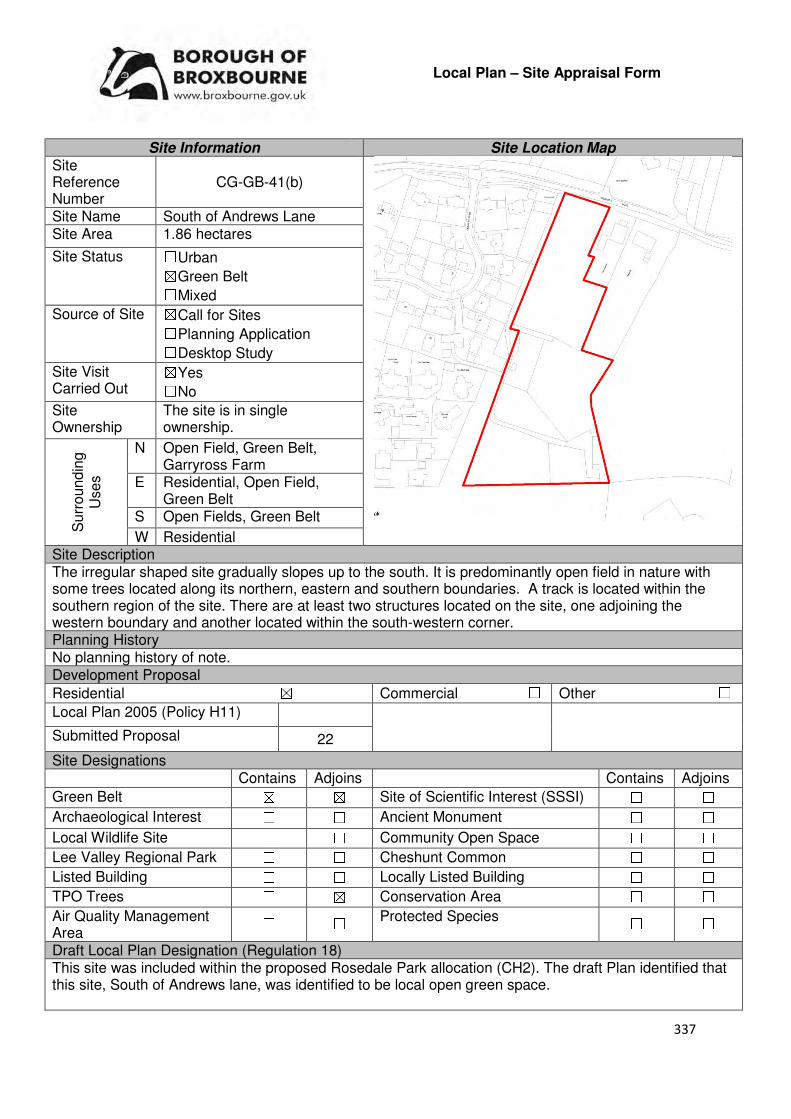
337
Local Plan – Site Appraisal Form
Site Information Site Location Map Site Reference Number
CG-GB-41(b)
Site Name South of Andrews Lane Site Area 1.86 hectares
Site Status ☐Urban ☒Green Belt ☐Mixed
Source of Site ☒Call for Sites ☐Planning Application ☐Desktop Study
Site Visit Carried Out
☒Yes ☐No
Site Ownership
The site is in single ownership.
Surr
oundin
g
Uses
N Open Field, Green Belt, Garryross Farm
E Residential, Open Field, Green Belt
S Open Fields, Green Belt
W Residential Site Description The irregular shaped site gradually slopes up to the south. It is predominantly open field in nature with some trees located along its northern, eastern and southern boundaries. A track is located within the southern region of the site. There are at least two structures located on the site, one adjoining the western boundary and another located within the south-western corner. Planning History No planning history of note. Development Proposal
Residential ☒ Commercial ☐ Other ☐
Local Plan 2005 (Policy H11)
Submitted Proposal 22
Site Designations Contains Adjoins Contains Adjoins
Green Belt ☒ ☒ Site of Scientific Interest (SSSI) ☐ ☐
Archaeological Interest ☐ ☐ Ancient Monument ☐ ☐
Local Wildlife Site ☐ ☐ Community Open Space ☐ ☐
Lee Valley Regional Park ☐ ☐ Cheshunt Common ☐ ☐
Listed Building ☐ ☐ Locally Listed Building ☐ ☐
TPO Trees ☐ ☒ Conservation Area ☐ ☐
Air Quality Management Area
☐ ☐ Protected Species ☐ ☐
Draft Local Plan Designation (Regulation 18) This site was included within the proposed Rosedale Park allocation (CH2). The draft Plan identified that this site, South of Andrews lane, was identified to be local open green space.

338
Accessibility – distance as the crow flies
820m -Primary School (Fairfields)
980m - Secondary School (Goffs)
3.23km –Employment Area (Fieldings Road)
530m - Green Space (Argent Way)
800m -Healthcare Centre (Valley View)
11.86km- Hospital (with A&E) (Barnet)
2.25km - Town/District Centre (Brookfield)
860m - Local Centre (684-696 Goffs Lane)
2.88km -Leisure Centre (Laura Trott)
2.1km - A10 Junction (College Road)
2.47km - Railway Station (Cuffley)
470m - Bus Service (Burton Lane)
Flood Risk Does the site Contains Adjoins
Zone 2 (Medium Risk) ☐ ☐
Zone 3a (High Risk) ☐ ☐
Zone 3b (Active Flood Plain) ☐ ☐
Additional Flood Risk Comments No flood risk issues identified for this site. Access and Transport Comments The site can be accessed via Andrews Lane. Andrews Lane is quite narrow in places, and has no footpaths along the majority of the road. Pedestrian and cycle access to the site will be required if it came forward for development. Utility Provision
Electricity Located at Goffs Lane
Gas A low pressure gas main is located along Andrews Lane
Water A water main is located along Andrews Lane
Sewerage Surface sewers and foul sewers are located in the residential area to the west of the site.
Sewerage Treatment ☐Rye Meads ☒Deephams ☐Other
Additional Developer Comments submitted during Call for Sites 2016 None submitted. Suitability Comments This site is not considered to be suitable for residential development due to the following reasons:
• The Council’s Green Belt Review (Scott Wilson, 2008) states that this area (C18) performs strongly against Green Belt Purposes 1 and 2, and averagely against Green belt Purpose 3. The review proposed no change to the boundary in this location. However, it should be noted that the review also stated that there is the opportunity to create a stronger Green Belt boundary in areas C11-C30 as these areas have “extremely weak boundaries”, which means there are no real barriers to prevent encroachment between settlements.
• Subject to the adoption of the emerging Local Plan and the Rosedale Park development being approved, the site will play a local role in preventing the coalescence of West Cheshunt and the St James settlement.
• The site does not have any clear and defensible Green Belt boundaries to the south and west, which would prevent further encroachment into the countryside. As a result, it is possible over time that West Cheshunt and the St James settlement will merge together.
• The site plays a current role in preventing the outward sprawl of St James.

339
However, it should be noted that the Council’s Green Belt Topic Paper (2017) makes the following statement: “Located within the area of the Rosedale Park proposals are a number of small sites (Ballymour and the Langdons, South of Andrew’s Lane and Lea Mount Meadow) which will be released from the Green Belt as part of the redrawing of the Green Belt to Rags Lane/Burton Lane in order to facilitate the Rosedale Park proposal. The Council considers the extension of the place-shaping principles behind Rosedale Park as critical to the grant of planning permission at these small sites. These principles should include securing a comprehensive masterplan for Rosedale Park, including continuous rights of way through a Green Infrastructure network which will help to structure future options for built development and avoid a continuous sprawl. The Council will prepare a masterplan for these sites to illustrate how place-making objectives should be secured in the event of planning applications coming forward at these sites. It is proposed that new Local Green Space will be designated as part of these proposals”. Is this site considered to be suitable for development? ☐Yes ☒ No

340
Local Plan – Site Appraisal Form
Site Information Site Location Map Site Reference Number
CG-GB-41(c)
Site Name Ballymour and Langdons Site Area 0.52 hectares
Site Status ☐Urban ☒Green Belt ☐Mixed
Source of Site ☒Call for Sites ☐Planning Application ☐Desktop Study
Site Visit Carried Out
☐Yes ☒No
Site Ownership There are multiple landowners for this site.
Surr
oundin
g
Uses
N Garryross Farm, Green Belt
E Open Field, Green Belt S Open Field, Green Belt
W Open Field, Green Belt, Residential
Site Description The irregular shaped site consists of two residential dwellings and their gardens. There are a number trees located with the northern region of each of the gardens. Trees are located along the sites eastern and northern boundary. Planning History There have been several planning applications for improvements and extensions to the two residential properties that form this site. Development Proposal
Residential ☒ Commercial ☐ Other ☐
Local Plan 2005 (Policy H11) -
Submitted Proposal 11-13
Site Designations Contains Adjoins Contains Adjoins
Green Belt ☐ ☐ Site of Scientific Interest (SSSI) ☐ ☐
Archaeological Interest ☐ ☐ Ancient Monument ☐ ☐
Local Wildlife Site ☐ ☐ Community Open Space ☐ ☐
Lee Valley Regional Park
☐ ☐ Cheshunt Common ☐ ☐
Listed Building ☐ ☐ Locally Listed Building ☐ ☐
TPO Trees ☐ ☐ Conservation Area ☐ ☐
Air Quality Management Area
☐ ☐ Protected Species ☐ ☐
Draft Local Plan Designation (Regulation 18) The draft Plan included this site within the Rosedale Park (CH2) allocation. The Plan identified this site, Ballymour and Langdons, as local open green space.
341
Accessibility – distance as the crow flies
770m -Primary School (Fairfields)
1km - Secondary School (Goffs)
2.4km –Employment Area (New River Trading Estate)
550m - Green Space (Claremont)
940m -Healthcare Centre (Valley View)
12km - Hospital (with A&E) (Barnet)
2.21km - Town/District Centre (Brookfield)
990m - Local Centre (684-696 Goffs Lane)
2.88km -Leisure Centre (Laura Trott)
2.23km - A10 Junction (College Road)
2.6km - Railway Station (Cuffley)
618m - Bus Service (Burton Lane)
Flood Risk Does the site Contains Adjoins
Zone 2 (Medium Risk) ☐ ☐
Zone 3a (High Risk) ☐ ☐
Zone 3b (Active Flood Plain) ☐ ☐
Additional Flood Risk Comments No flooding issues identified for this site. Access and Transport Comments The site can be accessed via Andrews Lane. Andrews Lane is quite narrow in places and semi-rural in nature. Andrews Lane does not have footpaths along the majority of the road. Pedestrian and cycle infrastructure would need to be installed. Utility Provision
Electricity Located at Goffs Lane
Gas A low pressure gas main is located along Andrews Lane
Water A water main is located along Andrews Lane
Sewerage Surface sewers and foul sewers are located in the residential area to the west of the site
Sewerage Treatment ☐Rye Meads ☒Deephams ☐Other
Additional Developer Comments submitted during Call for Sites 2016 The promoter of the site stated that it lies outside of the flood risk areas shown on Broxbourne Councils website and other than being Green belt and adjacent to a sports field the site has no other designations or encumbrances such as TPO’s, SSSI’s, Listed Buildings etc., that would negatively impact the development coming forward. The promoter continues by stating that the proposal offers a very logical rounding off of the housing constructed approximately 20 years ago to the east of the site, which will allow the new development to seamlessly blend and with the inclusion of significant landscaping enhance the visual appearance of the existing street scene and the views from the Green Belt and countryside. The site will represent a relatively small loss of Green Belt land and that the sports ground to the east of the site would check any further sprawl whilst ensuring there is ample separation between settlement areas to the east whilst providing a clear delineation required to stop the wider expanse of urban areas from appearing to merge into one another. The promoter stated that the areas of Green Belt to the north of Andrews Lane and south of the proposed site provide ample land to provide severance between existing urban areas.

342
The promoter acknowledged that land to the north of Andrews Lane has been subject to a much larger proposal to release Green belt, however the promoter states that this would be far more harmful to the five purposes of the Green Belt of land and ultimately result in development sprawl, urban spaces merging into one another and loss of special character of the area. The site promoted would be a much smaller loss of Green Belt that is not strategically important in terms of curbing urban sprawl and merging towns and villages. The density for the indicative scheme has been based on the Crest Nicholson site at the former Everest Sports Ground. The promoter concluded that the area of land serves little of the five purposes of Green belt and in developing this area would provide much needed private and affordable housing whilst provided a greater protection to the wider more appropriate areas of Green Belt, and that there are no wildlife, trees of flooding issues known at the time to hinder development. The landowners are keen to work together to release the potential of their land within the first five years of the plan period. The size of the site is such that affordable housing can be provided in full and in line with current policy. An investigation into self-build on this site has not been carried out but it appears that there is sufficient space to provide an element of self-build properties within the development. Suitability Comments This site is not considered to be suitable for residential development due to the following reasons:
• Subject to the adoption of the emerging Local Plan and the Rosedale Park development being approved, the site will play a strategic role in preventing the coalescence of West Cheshunt and Rosedale.
• The site plays a current role in preventing the outward sprawl of St James and preventing the coalescence of this settlement with West Cheshunt.
• The site does not have any clear and defensible Green Belt boundaries to the south and west, which would prevent further encroachment into the countryside. As a result, it is possible over time that West Cheshunt and the St James settlement will merge together.
However, it should be noted that the Council’s Green Belt Topic Paper (2017) makes the following statement: “Located within the area of the Rosedale Park proposals are a number of small sites (Ballymour and the Langdons, South of Andrew’s Lane and Lea Mount Meadow) which will be released from the Green Belt as part of the redrawing of the Green Belt to Rags Lane/Burton Lane in order to facilitate the Rosedale Park proposal. The Council considers the extension of the place-shaping principles behind Rosedale Park as critical to the grant of planning permission at these small sites. These principles should include securing a comprehensive masterplan for Rosedale Park, including continuous rights of way through a Green Infrastructure network which will help to structure future options for built development and avoid a continuous sprawl. The Council will prepare a masterplan for these sites to illustrate how place-making objectives should be secured in the event of planning applications coming forward at these sites. It is proposed that new Local Green Space will be designated as part of these proposals”. Is this site considered to be suitable for development? ☐Yes ☒ No

343
Local Plan – Site Appraisal Form
Site Information Site Location Map Site Reference Number
CG-GB-41(d)
Site Name Lea Mount Site Area 2.98 hectares
Site Status ☐Urban ☒Green Belt ☐Mixed
Source of Site ☒Call for Sites ☐Planning Application ☐Desktop Study
Site Visit Carried Out
☒Yes ☐No
Site Ownership There are various landowners for this site.
Surr
oundin
g
Uses
N Open Fields, Green Belt
E Cheshunt Sports Club, Green Belt
S Residential, Tudor Nursery
W 2 residential properties, Open Fields, Green Belt
Site Description The irregular shaped site is predominantly open field in nature. The site slopes towards Andrews Lane. There are trees located along the sites boundaries which shield it from surrounding sites. There are some trees/shrubs scattered through the site.
Planning History An application for 6 bungalows was submitted in 1982, however this was later withdrawn.
Development Proposal
Residential ☒ Commercial ☐ Other ☐
Local Plan 2005 (Policy H11) -
Submitted Proposal 95
Site Designations Contains Adjoins Contains Adjoins
Green Belt ☒ ☒ Site of Scientific Interest (SSSI) ☐ ☐
Archaeological Interest ☐ ☐ Ancient Monument ☐ ☐
Local Wildlife Site ☐ ☐ Community Open Space ☐ ☐
Lee Valley Regional Park
☐ ☐ Cheshunt Common ☐ ☐
Listed Building ☐ ☐ Locally Listed Building ☐ ☐
TPO Trees ☒ ☒ Conservation Area ☐ ☐
Air Quality Management Area ☐ ☐
Protected Species ☐ ☐
Draft Local Plan Designation (Regulation 18) The draft Local Plan included this site within the Rosedale Park (CH2) allocation. This site, Lea Mount was identified for residential development, with Figure 7-Rosedale Park indicating that this site can accommodate approximately 95 dwellings.
344
Accessibility – distance as the crow flies
650m -Primary School (Fairfields)
860m - Secondary School (Goffs)
2.37km –Employment Area (New River Trading Estate)
470m - Green Space (Rosedale)
930m -Healthcare Centre
(Stockwell)
11.9km - Hospital (with A&E) (Barnet)
2.08km - Town/District Centre
(Brookfield)
880m - Local Centre
2.7km -Leisure Centre
(Laura Trott)
2.1km - A10 Junction
(Church Lane)
2.6km - Railway Station (Cuffley)
510m - Bus Service (Granby Park Road)
Flood Risk Does the site Contains Adjoins
Zone 2 (Medium Risk) ☐ ☐
Zone 3a (High Risk) ☐ ☐
Zone 3b (Active Flood Plain) ☐ ☐
Additional Flood Risk Comments No flood risk issues identified for this site. Access and Transport Comments There is no vehicle access for this site. Andrews Lane is located to the north of the site and would be the most appropriate vehicle access point. It should be noted that Andrews Lane is quite narrow in places and semi-rural in nature. Andrews Lane does not have footpaths along the majority of the road. Pedestrian and cycle infrastructure would need to be installed. An assessment on the impact that this site would have on the local and wider road network will be required. Utility Provision
Electricity Located at Goffs Lane
Gas A low pressure gas main is located along Andrews Lane
Water A water main is located along Andrews Lane
Sewerage Surface sewers and foul sewers are located in the residential area to the west
Sewerage Treatment ☐Rye Meads ☒Deephams ☐Other
Additional Developer Comments submitted during Call for Sites 2016 None submitted. This site has been included in the promotion CG-GB-41(a). Suitability Comments This site is not considered to be suitable for residential development in isolation due to the following reasons:
• The site does not have clear and defensible Green Belt boundaries to the east and south that will last beyond the Plan period or prevent further encroachment into the Green Belt. It is considered that over time this could lead to the coalescence of the St James settlement and West Cheshunt.
• The development of this site will result in an isolated pocket of development within the Green Belt that is not related to any existing settlement.
345
This site is considered to be suitable for residential development if it comes forward as part of the Rosedale Park strategic site due to the following reasons:
• The Goffs Oak Development Options Report identified this site within Development Approach 3: Rags Brook Valley. The report states that “The well-developed masterplans and small number of promoters would make deliverability fairly straightforward, and a significant amount of housing could be provided”. It is also noted that the provision of a two form of entry school, local centre and scope for bus access to the development would largely address its own key infrastructure needs, in addition to providing new facilities for existing residents close to the site.
• The site has been identified to come forward as part of a comprehensive scheme termed ‘Rosedale Park’. This will enable sustainable place-making to occur and the infrastructure required to support the development can be provided.
Is this site considered to be suitable for development?
☒Yes ☐ No
Availability Comments The site is considered to be available for development. The site was included within a Call for Sites 2016 submission, which stated that the landowners are keen to work together to release the potential of their land within the first few years of the Plan period. The Local Plan (Regulation 18) highlights that most of the land within the allocation CH2 is under option to Crest and CEG, who have been working with the Council to produce a comprehensive masterplan.
Is the site considered to be available for development
☒Yes ☐ No Achievability Comments The site is considered to be achievable, with the exception of the
sites Green Belt designation, there are no planning constraints that would prevent development on this site. Some TPO trees may need to be removed in order for vehicle access to the site to be gained. It is anticipated that this site will come forward as part of a comprehensive scheme, which will be able to facilitate the necessary road improvements and provide infrastructure required for this development.
Is the site considered to be achievable?
☒Yes ☐ No Delivery Period 1-10 years

346
Local Plan – Site Appraisal Form
Site Information Site Location Map Site Reference Number
CG-GB-42
Site Name Laurel Park Site Area 5 hectares
Site Status ☐Urban ☒Green Belt ☐Mixed
Source of Site ☒Call for Sites ☐Planning Application ☐Desktop Study
Site Visit Carried Out
☐Yes ☒No
Site Ownership
The land is not registered.
Surr
oundin
g
Uses
N Residential dwelling, Green belt
E Residential S Residential, Green Belt
W Newgatestreet Road, Linden Cottage, Green Belt
Site Description The site is relatively rectangular in shape. There are a number of structures on the site; the structure which adjoins Newgatestreet is a residential dwelling. With the exception of these structures, the site is predominantly open field in nature, with some tree clusters located near the structures. Trees are located along the sites boundary. Planning History Agricultural workers dwelling approved in the late 70s. A further two bedroom bungalow for agricultural worked refused in 1980. Development Proposal
Residential ☒ Commercial ☐ Other ☐
Local Plan 2005 (Policy H11) 150
Submitted Proposal -
Site Designations Contains Adjoins Contains Adjoins
Green Belt ☒ ☒ Site of Scientific Interest (SSSI) ☐ ☐
Archaeological Interest ☐ ☐ Ancient Monument ☐ ☐
Local Wildlife Site ☐ ☐ Community Open Space ☐ ☒
Lee Valley Regional Park
☐ ☐ Cheshunt Common ☐ ☐
Listed Building ☐ ☐ Locally Listed Building ☐ ☐
TPO Trees ☐ ☐ Conservation Area ☐ ☐
Air Quality Management Area
☐ ☐ Protected Species ☐ ☐
Draft Local Plan Designation (Regulation 18) The draft Local Plan proposed to keep this site within the Green Belt

347
Accessibility – distance as the crow flies
850m -Primary School (Goffs Oak)
2.9km - Secondary School (Goffs)
3.75km –Employment Area (New Rivers Trading Estate)
0m - Green Space (adjoins Richardson Crescent)
1.4km -Healthcare Centre (Valley View)
11.5km - Hospital (with A&E) (Barnet)
3.83km - Town/District Centre (Brookfield)
1.23km - Local Centre (1-5 Masons Parade)
4.73km -Leisure Centre (Laura Trott)
3.89km - A10 Junction (Church Lane)
1.74km - Railway Station (Cuffley)
1km - Bus Service (Smiths Lane)
Flood Risk Does the site Contains Adjoins
Zone 2 (Medium Risk) ☐ ☐
Zone 3a (High Risk) ☐ ☐
Zone 3b (Active Flood Plain) ☐ ☐
Additional Flood Risk Comments There may be some ground water flooding. Access and Transport Comments There are two vehicle access points to the site from Newgatestreet Road. These access points would require improvement if development was to occur. There is a footpath along the western site of Newgatestreet Road which leads to Goffs Oak Village. Connections to this path would be required if development came forward. Utility Provision
Electricity Available along Newgatestreet Road
Gas A low pressure gas main is located along Newgatestreet Road
Water A water main is located along Newgatestreet Road and Hammondstreet Road
Sewerage The closest foul and surface sewer is located in the residential area to the east
Sewerage Treatment ☐Rye Meads ☒Deephams ☐Other
Additional Developer Comments submitted during Call for Sites 2016 None submitted. Suitability Comments The site is not considered to be suitable for development due to the following reasons:
• The site is included within area C30 of the Council’s Green Belt Review (Scott Wilson, 2008). The Review states that area C30 performs strongly against Green Belt purposes and proposed no change to the Green Belt boundary in this location. However, it should be noted that the review also stated that there is the opportunity to create a stronger Green Belt boundary in C11-C30 as these areas have “extremely weak boundaries”, which means that there are no real barriers to prevent encroachment between settlements.
• The site contributes to preventing the outward sprawl of the development at Hammondstreet Road. It also contributes to maintaining the strategic local gap between Goffs Oak Village and the Hammondstreet settlement.
• The Local Plan Second Review 2001-2011 Inspectors report concluded that there was no strong reasons to alter the Green Belt boundary on grounds of physical features in the landscape, and that the site does not lie close to a wide range of facilities. It was deemed in the Inspectors view to not be in a particularly sustainable position for development.
Is this site considered to be suitable for development? ☐Yes ☒ No

348
Local Plan – Site Appraisal Form
Site Information Site Location Map Site Reference Number
CG-GB-43
Site Name South Lodge Pastures Site Area 9.4 hectares
Site Status ☐Urban ☒Green Belt ☐Mixed
Source of Site ☒Call for Sites ☐Planning Application ☐Desktop Study
Site Visit Carried Out
☒Yes ☐No
Site Ownership The site is owned by a trust.
Surr
oundin
g
Uses
N Residential, Goffs Lane
E Travelling Show peoples site, Lieutenant Ellis Way
S Open Fields, Nursery, Green Belt
W Residential Properties, Green Belt, Halstead Hill
Site Description The site is irregular in shape and predominately open field in nature. Scattered across the site are a number of trees. A line of trees runs north to south, starting behind the gardens of 289 Goffs Lane to Hollow Leys nursery. Planning History Application for residential use was refused in the late 1950s. Development Proposal
Residential ☒ Commercial ☐ Other ☐
Local Plan 2005 (Policy H11) -
Submitted Proposal 34
Site Designations Contains Adjoins Contains Adjoins
Green Belt ☒ ☒ Site of Scientific Interest (SSSI) ☐ ☐
Archaeological Interest ☐ ☐ Ancient Monument ☐ ☐
Local Wildlife Site ☒ ☐ Community Open Space ☐ ☐
Lee Valley Regional Park
☐ ☐ Cheshunt Common ☐ ☐
Listed Building ☐ ☒ Locally Listed Building ☐ ☐
TPO Trees ☒ ☒ Conservation Area ☐ ☐
Air Quality Management Area
☐ ☐ Protected Species ☐ ☐
Draft Local Plan Designation (Regulation 18) The draft Local Plan proposed to keep this site within the Green Belt. The western region of the site has also been identified as a local wildlife site.
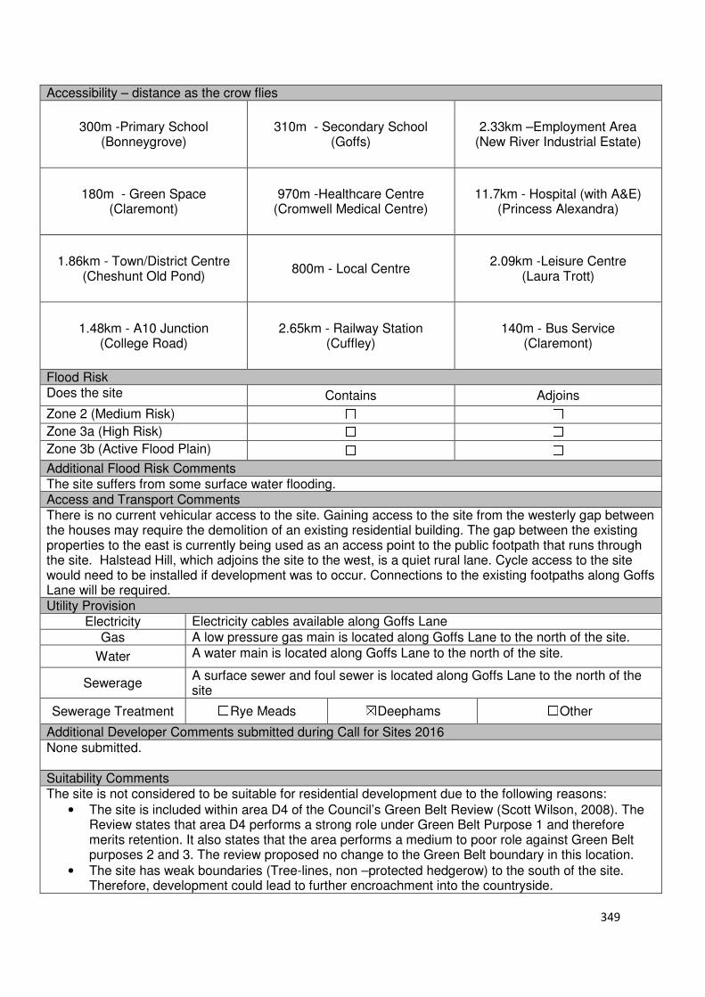
349
Accessibility – distance as the crow flies
300m -Primary School (Bonneygrove)
310m - Secondary School (Goffs)
2.33km –Employment Area (New River Industrial Estate)
180m - Green Space (Claremont)
970m -Healthcare Centre (Cromwell Medical Centre)
11.7km - Hospital (with A&E)
(Princess Alexandra)
1.86km - Town/District Centre (Cheshunt Old Pond)
800m - Local Centre
2.09km -Leisure Centre (Laura Trott)
1.48km - A10 Junction (College Road)
2.65km - Railway Station (Cuffley)
140m - Bus Service (Claremont)
Flood Risk Does the site Contains Adjoins
Zone 2 (Medium Risk) ☐ ☐
Zone 3a (High Risk) ☐ ☐
Zone 3b (Active Flood Plain) ☐ ☐
Additional Flood Risk Comments The site suffers from some surface water flooding. Access and Transport Comments There is no current vehicular access to the site. Gaining access to the site from the westerly gap between the houses may require the demolition of an existing residential building. The gap between the existing properties to the east is currently being used as an access point to the public footpath that runs through the site. Halstead Hill, which adjoins the site to the west, is a quiet rural lane. Cycle access to the site would need to be installed if development was to occur. Connections to the existing footpaths along Goffs Lane will be required. Utility Provision
Electricity Electricity cables available along Goffs Lane
Gas A low pressure gas main is located along Goffs Lane to the north of the site.
Water A water main is located along Goffs Lane to the north of the site.
Sewerage A surface sewer and foul sewer is located along Goffs Lane to the north of the site
Sewerage Treatment ☐Rye Meads ☒Deephams ☐Other
Additional Developer Comments submitted during Call for Sites 2016 None submitted. Suitability Comments The site is not considered to be suitable for residential development due to the following reasons:
• The site is included within area D4 of the Council’s Green Belt Review (Scott Wilson, 2008). The Review states that area D4 performs a strong role under Green Belt Purpose 1 and therefore merits retention. It also states that the area performs a medium to poor role against Green Belt purposes 2 and 3. The review proposed no change to the Green Belt boundary in this location.
• The site has weak boundaries (Tree-lines, non –protected hedgerow) to the south of the site. Therefore, development could lead to further encroachment into the countryside.

350
• Within the sites boundaries is South Lodge Pasture, a local wildlife site. The Council strongly resists development on local wildlife sites unless it can be shown that it is of high community benefit. It is considered that the development of this site for housing would not be in the benefit of the community.
• The development of this site for the above density will not be in keeping with the prevailing pattern of shallow, loose knit ribbon development found along Halstead Hill.
• Accessing the site may be problematic as there is no ideal location for a vehicle access point. Halstead Hill is not considered to be suitable. The development of this site as such a density will require improvements to Halstead Hill (i.e. cutting back trees/hedges, installing footpaths and widening the road) that will have a detrimental impact on the distinctive green character and appearance of the lane.
Is this site considered to be suitable for development? ☐Yes ☒ No

351
Local Plan – Site Appraisal Form
Site Information Site Location Map Site Reference Number
CG-GB-44
Site Name Rags Brook Valley Site Site Area 44 hectares
Site Status ☐Urban ☒Green Belt ☐Mixed
Source of Site ☐Call for Sites ☐Planning Application ☐Desktop Study
Site Visit Carried Out
☒Yes ☐No
Site Ownership There are various landowners for this site.
Surr
oundin
g U
ses N Residential, Green Belt
E Residential
S Tudor Nursery, Residential
W
Green Belt , St James’
Site Description The irregular shaped site has an undulating topography. There are a various land uses on this site, however they are predominantly agricultural and sport related in nature. The majority of the site is open field in nature, with trees separating the parcels of land in different ownership. There are some structures located on some land parcels that form this site. Planning History See planning history from the following site appraisals: CG-GB-21, CG-GB-22, CG-GB-24, CG-GB-25, CG-GB-41(a, b, c, and d) and CG-GB-89. A planning application for the demolition of existing buildings at Garryross Farm and development of a mixed use scheme to include a new linear park and comprising up to 380 dwellings, 64 bed care home, local centre comprising up to 604 sqm (GIA) of A1, A2, A3, A4,A5 and D1/D2 uses and associated ancillary facilities, a primary school, improved recreational, leisure and sporting facilities and association open space, landscaping and car parking for Land North and South of Andrew’s Lane and South of Peakes Way has been submitted. Development Proposal
Residential ☒ Commercial ☐ Other ☒
Local Plan 2005 (Policy H11)
Two form of entry school
Rags Brook Park
Submitted Proposal 380

352
Site Designations Contains Adjoins Contains Adjoins
Green Belt ☒ ☒ Site of Scientific Interest (SSSI) ☐ ☐
Archaeological Interest ☐ ☐ Ancient Monument ☐ ☐
Local Wildlife Site ☒ ☒ Community Open Space ☐ ☒
Lee Valley Regional Park
☐ ☐ Cheshunt Common ☐ ☐
Listed Building ☐ ☐ Locally Listed Building ☐ ☐
TPO Trees ☒ ☒ Conservation Area ☐ ☐
Air Quality Management Area
☐ ☐ Protected Species ☐ ☐
Draft Local Plan Designation (Regulation 18) The site is included within the ‘Rosedale Park’ development, allocated under emerging Policy CH2. This site has been identified to deliver 375 dwellings, two form of entry primary school and a fully accessible public park between Rosedale Way and Burton lane Accessibility – distance as the crow flies
210m -Primary School (Fairfields)
420m - Secondary School (Goffs)
1.83km –Employment Area
(New River Industrial Estate)
0m - Green Space (adjoins Rosedale and
Claremont)
450m -Healthcare Centre
(Stockwell)
12km - Hospital (with A&E) (Princess Alexandra or Barnet)
1.67km- Town/District Centre
(Brookfield)
400m - Local Centre
2.33km -Leisure Centre
(Laura Trott)
1.8km - A10 Junction (Church Lane)
2.6km - Railway Station
(Cuffley)
163m - Bus Service (Granby Park Road)
Flood Risk Does the site
Contains Adjoins
Zone 2 (Medium Risk) ☒ ☐
Zone 3a (High Risk) ☒ ☐
Zone 3b (Active Flood Plain) ☐ ☐
Additional Flood Risk Comments Due to Rags Brook running through the site, mitigation measures will be required if development was to occur in close proximity. There may be some ground and surface water flooding. Access and Transport Comments The site is separated into two segments by Andrews Lane. Andrews Lane is quite narrow in places and semi-rural in nature. Adjoining the site to the west is Rags Lane. Rags Lane is also quite narrow in places and semi-rural in nature. Andrews Lane and Rags Lane do not have footpaths along the majority of the road. Access to the northern region of the site could also be achieved from Peakes Way. An investigation into the impact that this site would have on the local and strategic road network will be required. Pedestrian and cycle access to the site will need to be improved.
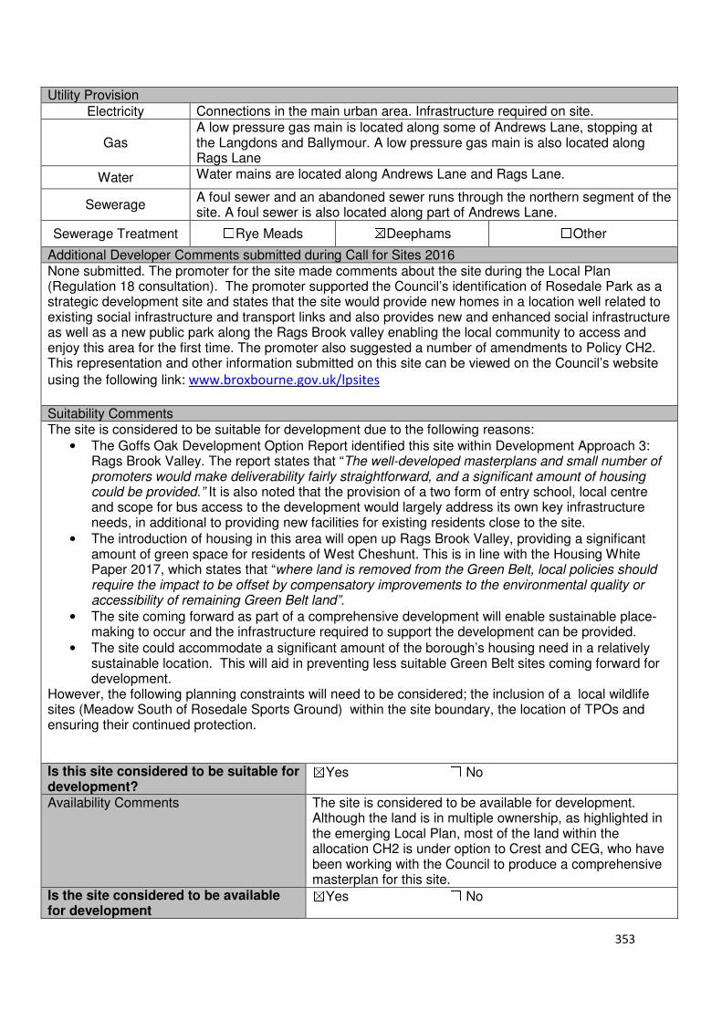
353
Utility Provision
Electricity Connections in the main urban area. Infrastructure required on site.
Gas A low pressure gas main is located along some of Andrews Lane, stopping at the Langdons and Ballymour. A low pressure gas main is also located along Rags Lane
Water Water mains are located along Andrews Lane and Rags Lane.
Sewerage A foul sewer and an abandoned sewer runs through the northern segment of the site. A foul sewer is also located along part of Andrews Lane.
Sewerage Treatment ☐Rye Meads ☒Deephams ☐Other
Additional Developer Comments submitted during Call for Sites 2016 None submitted. The promoter for the site made comments about the site during the Local Plan (Regulation 18 consultation). The promoter supported the Council’s identification of Rosedale Park as a strategic development site and states that the site would provide new homes in a location well related to existing social infrastructure and transport links and also provides new and enhanced social infrastructure as well as a new public park along the Rags Brook valley enabling the local community to access and enjoy this area for the first time. The promoter also suggested a number of amendments to Policy CH2. This representation and other information submitted on this site can be viewed on the Council’s website
using the following link: www.broxbourne.gov.uk/lpsites
Suitability Comments The site is considered to be suitable for development due to the following reasons:
• The Goffs Oak Development Option Report identified this site within Development Approach 3: Rags Brook Valley. The report states that “The well-developed masterplans and small number of promoters would make deliverability fairly straightforward, and a significant amount of housing could be provided.” It is also noted that the provision of a two form of entry school, local centre and scope for bus access to the development would largely address its own key infrastructure needs, in additional to providing new facilities for existing residents close to the site.
• The introduction of housing in this area will open up Rags Brook Valley, providing a significant amount of green space for residents of West Cheshunt. This is in line with the Housing White Paper 2017, which states that “where land is removed from the Green Belt, local policies should require the impact to be offset by compensatory improvements to the environmental quality or accessibility of remaining Green Belt land”.
• The site coming forward as part of a comprehensive development will enable sustainable place-making to occur and the infrastructure required to support the development can be provided.
• The site could accommodate a significant amount of the borough’s housing need in a relatively sustainable location. This will aid in preventing less suitable Green Belt sites coming forward for development.
However, the following planning constraints will need to be considered; the inclusion of a local wildlife sites (Meadow South of Rosedale Sports Ground) within the site boundary, the location of TPOs and ensuring their continued protection. Is this site considered to be suitable for development?
☒Yes ☐ No
Availability Comments The site is considered to be available for development. Although the land is in multiple ownership, as highlighted in the emerging Local Plan, most of the land within the allocation CH2 is under option to Crest and CEG, who have been working with the Council to produce a comprehensive masterplan for this site.
Is the site considered to be available for development
☒Yes ☐ No

354
Achievability Comments The site is considered to be achievable. These are some policy constraints within the site which would require mitigation measures i.e. loss of TPO trees, reduction in land area available for housing due to not building on wildlife sites, however these would not prevent development on the site. The site coming forward as a comprehensive scheme will enable the necessary road, utilities and social infrastructure to be provided. A planning application for the development of this site has been submitted by a large housebuilder. This suggests that the site is viable.
Is the site considered to be achievable?
☒Yes ☐ No Delivery Period 1-10 years

355
Local Plan – Site Appraisal Form
Site Information Site Location Map Site Reference Number
CG-GB-45
Site Name Rush Meadow Junction Site Area 2.15 hectares
Site Status ☐Urban ☒Green Belt ☐Mixed
Source of Site ☒Call for Sites ☐Planning Application ☐Desktop Study
Site Visit Carried Out
☐Yes ☒No
Site Ownership The site is owned by a private company
Surr
oundin
g
Uses
N Residential, Green Belt, Open Fields,
E A10, Lieutenant Ellis Way Roundabout
S Lieutenant Ellis Way
W Green Belt, St Mary’s Secondary School
Site Description The loosely tear dropped shaped site is relatively flat. The site is predominantly open field in nature, with one structure located in the south western region of the site. There are trees located along the sites boundaries which help to shield the site from its surrounding uses. The tree boundary is stronger on some boundaries more than others. See also Maxwells Farm West CG-GB-36 Planning History In 2002, permission was refused for the change of use of land to recreational grey hound gallop with pavilion. In 2013, permission was refused for change of use of part of barn to greyhound kennels including installation of door. An application for a sports/social club was withdrawn. Development Proposal
Residential ☐ Commercial ☒ Other ☐
Local Plan 2005 (Policy H11)
Submitted Proposal
Site Designations Contains Adjoins Contains Adjoins
Green Belt ☒ ☒ Site of Scientific Interest (SSSI) ☐ ☐
Archaeological Interest ☐ ☐ Ancient Monument ☐ ☐
Local Wildlife Site ☐ ☐ Community Open Space ☐ ☐
Lee Valley Regional Park
☐ ☐ Cheshunt Common ☐ ☐
Listed Building ☐ ☐ Locally Listed Building ☐ ☐
TPO Trees ☐ ☐ Conservation Area ☐ ☐
Air Quality Management Area
☐ ☐ Protected Species ☐ ☐
Hotel and Business Park
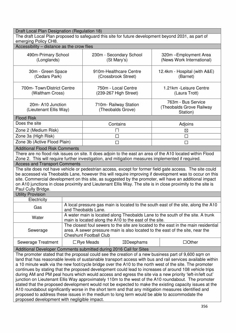
356
Draft Local Plan Designation (Regulation 18) The draft Local Plan proposed to safeguard this site for future development beyond 2031, as part of emerging Policy CH8. Accessibility – distance as the crow flies
490m-Primary School (Longlands)
230m - Secondary School (St Mary’s)
320m –Employment Area (News Work International)
30m - Green Space (Cedars Park)
910m-Healthcare Centre (Crossbrook Street)
12.4km - Hospital (with A&E) (Barnet)
700m- Town/District Centre (Waltham Cross)
750m - Local Centre (239-267 High Street)
1.21km -Leisure Centre (Laura Trott)
20m- A10 Junction (Lieutenant Ellis Way)
710m- Railway Station (Theobalds Grove)
763m - Bus Service (Theobalds Grove Railway
Station)
Flood Risk Does the site Contains Adjoins
Zone 2 (Medium Risk) ☐ ☒
Zone 3a (High Risk) ☐ ☐
Zone 3b (Active Flood Plain) ☐ ☐
Additional Flood Risk Comments There are no flood risk issues on site. It does adjoin to the east an area of the A10 located within Flood Zone 2. This will require further investigation, and mitigation measures implemented if required. Access and Transport Comments The site does not have vehicle or pedestrian access, except for former field gate access. The site could be accessed via Theobalds Lane, however this will require improving if development was to occur on this site. Commercial development on this site, as suggested by the promoter, will have an additional impact on A10 junctions in close proximity and Lieutenant Ellis Way. The site is in close proximity to the site is Paul Cully Bridge. Utility Provision
Electricity
Gas A local pressure gas main is located to the south east of the site, along the A10 and Theobalds Lane.
Water A water main is located along Theobalds Lane to the south of the site. A trunk main is located along the A10 to the east of the site.
Sewerage The closest foul sewers to the site are located to the east in the main residential area. A sewer pressure main is also located to the east of the site, near the Cheshunt Football Club
Sewerage Treatment ☐Rye Meads ☒Deephams ☐Other
Additional Developer Comments submitted during 2016 Call for Sites The promoter stated that the proposal could see the creation of a new business part of 9,600 sqm on land that has reasonable levels of sustainable transport access with bus and rail services available within a 10 minute walk via the new foot/cycle bridge over the A10 to the north west of the site. The promoter continues by stating that the proposed development could lead to increases of around 108 vehicle trips during AM and PM peal hours which would access and egress the site via a new priority ‘left-in/left out’ junction on Lieutenant Ellis Way approximately 110m to the west of the A10 roundabout. The promoter stated that the proposed development would not be expected to make the existing capacity issues at the A10 roundabout significantly worse in the short term and that any mitigation measures identified and proposed to address these issues in the medium to long term would be able to accommodate the proposed development with negligible impact.

357
Suitability Comments The site is considered to be suitable for development, in the long term, due to the following reasons:
• The site coming forward for commercial development would complement the proposed development at Park Plaza North and Park Plaza West.
• The development of this site, in conjunction with Maxwells Farm (CG-GB-36) will create a strong and defensible Green Belt boundary. This boundary will be formed by the New River, located to the west of the site.
• The site is close to modes of sustainable transport, within the sustainable distance recommended by Barton et al (2010) for a leisure centre, doctor’s surgery and open space, and close to local and educational facilities.
• The site is strategically located for a business park – it adjoins the A10, close to the M25 and is close to Theobalds Grove Station.
• The site coming forward after the Plan period will enable issues identified above (particularly that of vehicle access) to be investigated and appropriate mitigation schemes devised.
Is this site considered to be suitable for development?
☒Yes ☐ No
Availability Comments The site is considered to be available, however due to the Council meetings its need for employment on alternative sites, the site is not considered to be needed for development until beyond the Plan period. During the Call for Sites 2016, the promoter stated that this site can come forward within the first five years.
Is the site considered to be available for development
☒Yes ☐ No
Achievability Comments The achievability of this site could be impacted by the necessary highway improvements required to bring the site forward for development. With the exception of its Green Belt designation, there are no policy constraints that would prevent the development of this site.
Is the site considered to be achievable?
☒Yes ☐ No
Delivery Period 16-20 years
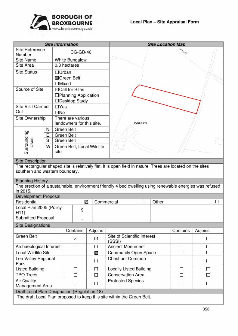
358
Local Plan – Site Appraisal Form
Site Information Site Location Map Site Reference Number
CG-GB-46
Site Name White Bungalow Site Area 0.3 hectares
Site Status ☐Urban ☒Green Belt ☐Mixed
Source of Site ☒Call for Sites ☐Planning Application ☐Desktop Study
Site Visit Carried Out
☐Yes ☒No
Site Ownership There are various landowners for this site.
Surr
oundin
g
Uses
N Green Belt
E Green Belt S Green Belt
W Green Belt, Local Wildlife site
Site Description The rectangular shaped site is relatively flat. It is open field in nature. Trees are located on the sites southern and western boundary.
Planning History The erection of a sustainable, environment friendly 4 bed dwelling using renewable energies was refused in 2015. Development Proposal
Residential ☒ Commercial ☐ Other ☐
Local Plan 2005 (Policy H11)
9
Submitted Proposal -
Site Designations Contains Adjoins Contains Adjoins
Green Belt ☒ ☒ Site of Scientific Interest (SSSI)
☐ ☐
Archaeological Interest ☐ ☐ Ancient Monument ☐ ☐
Local Wildlife Site ☐ ☒ Community Open Space ☐ ☐
Lee Valley Regional Park
☐ ☐ Cheshunt Common ☐ ☐
Listed Building ☐ ☐ Locally Listed Building ☐ ☐
TPO Trees ☐ ☐ Conservation Area ☐ ☐
Air Quality Management Area
☐ ☐ Protected Species ☐ ☐
Draft Local Plan Designation (Regulation 18) The draft Local Plan proposed to keep this site within the Green Belt.
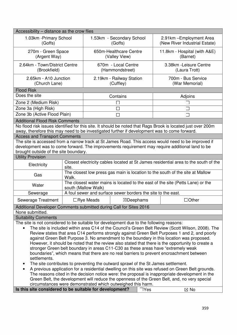
359
Accessibility – distance as the crow flies
1.03km -Primary School (Goffs)
1.53km - Secondary School (Goffs)
2.91km –Employment Area (New River Industrial Estate)
270m - Green Space (Argent Way)
650m-Healthcare Centre (Valley View)
11.8km - Hospital (with A&E) (Barnet)
2.64km - Town/District Centre (Brookfield)
670m - Local Centre (Hammondstreet)
3.38km -Leisure Centre (Laura Trott)
2.65km - A10 Junction (Church Lane)
2.19km - Railway Station (Cuffley)
700m - Bus Service (War Memorial)
Flood Risk Does the site Contains Adjoins
Zone 2 (Medium Risk) ☐ ☐
Zone 3a (High Risk) ☐ ☐
Zone 3b (Active Flood Plain) ☐ ☐
Additional Flood Risk Comments No flood risk issues identified for this site. It should be noted that Rags Brook is located just over 200m away, therefore this may need to be investigated further if development was to come forward. Access and Transport Comments The site is accessed from a narrow track at St James Road. This access would need to be improved if development was to come forward. The improvements requirement may require additional land to be brought outside of the site boundary. Utility Provision
Electricity Closest electricity cables located at St James residential area to the south of the site.
Gas The closest low press gas main is location to the south of the site at Mallow Walk.
Water The closest water mains is located to the east of the site (Petts Lane) or the south (Mallow Walk)
Sewerage A foul sewer and surface sewer borders the site to the east.
Sewerage Treatment ☐Rye Meads ☒Deephams ☐Other
Additional Developer Comments submitted during Call for Sites 2016 None submitted. Suitability Comments The site is not considered to be suitable for development due to the following reasons:
• The site is included within area C14 of the Council’s Green Belt Review (Scott Wilson, 2008). The Review states that area C14 performs strongly against Green Belt Purposes 1 and 2, and poorly against Green Belt Purpose 3. No amendment to the boundary in this location was proposed. However, it should be noted that the review also stated that there is the opportunity to create a stronger Green belt boundary in areas C11-C30 as these areas have “extremely weak boundaries”, which means that there are no real barriers to prevent encroachment between settlements.
• The site contributes to preventing the outward sprawl of the St James settlement.
• A previous application for a residential dwelling on this site was refused on Green Belt grounds. The reasons cited in the decision notice were: the proposal is inappropriate development in the Green Belt, the development will reduce the openness of the Green Belt, and, no very special circumstances were demonstrated which outweighed this harm.
Is this site considered to be suitable for development? ☐Yes ☒ No

360
Local Plan – Site Appraisal Form
Site Information Site Location Map Site Reference Number
CG-GB-47
Site Name Churchview Nursery Site Area 0.8 hectares
Site Status ☐Urban ☒Green Belt ☐Mixed
Source of Site ☒Call for Sites ☐Planning Application ☐Desktop Study
Site Visit Carried Out
☐Yes ☒No
Site Ownership There are two landowners for this site
Surr
oundin
g
Uses
N Green Belt
E Residential S Residential
W Green Belt
Site Description The site is irregular in shape, and gently slopes down to the north. Trees are located along the sites north, eastern and western boundaries. The site is predominantly hard standing surface with the exception of a mound, back gardens and a structure within the southern regions. Planning History Churchview Nursery was partly redeveloped for housing in the late nineties (now Nursery Gardens). There is no other history of note. Development Proposal
Residential ☒ Commercial ☐ Other ☐
Local Plan 2005 (Policy H11)
24
Submitted Proposal -
Site Designations Contains Adjoins Contains Adjoins
Green Belt ☒ ☒ Site of Scientific Interest (SSSI)
☐ ☐
Archaeological Interest ☐ ☐ Ancient Monument ☐ ☐
Local Wildlife Site ☐ ☐ Community Open Space ☐ ☐
Lee Valley Regional Park
☐ ☐ Cheshunt Common ☐ ☐
Listed Building ☐ ☐ Locally Listed Building ☐ ☐
TPO Trees ☐ ☐ Conservation Area ☐ ☐
Air Quality Management Area
☐ ☐ Protected Species ☐ ☐
Draft Local Plan Designation (Regulation 18) The draft Local Plan proposed to keep this site within the Green Belt
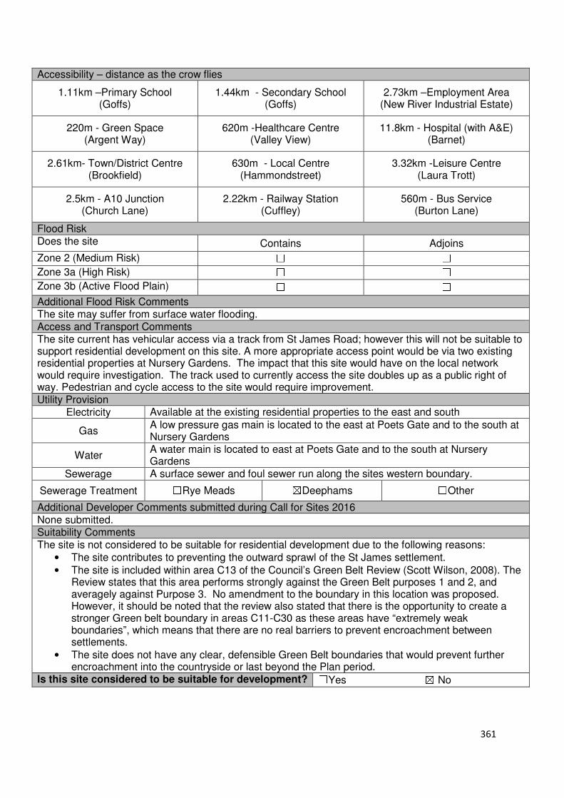
361
Accessibility – distance as the crow flies
1.11km –Primary School (Goffs)
1.44km - Secondary School (Goffs)
2.73km –Employment Area (New River Industrial Estate)
220m - Green Space (Argent Way)
620m -Healthcare Centre (Valley View)
11.8km - Hospital (with A&E) (Barnet)
2.61km- Town/District Centre (Brookfield)
630m - Local Centre (Hammondstreet)
3.32km -Leisure Centre (Laura Trott)
2.5km - A10 Junction (Church Lane)
2.22km - Railway Station (Cuffley)
560m - Bus Service (Burton Lane)
Flood Risk Does the site Contains Adjoins
Zone 2 (Medium Risk) ☐ ☐
Zone 3a (High Risk) ☐ ☐
Zone 3b (Active Flood Plain) ☐ ☐
Additional Flood Risk Comments The site may suffer from surface water flooding. Access and Transport Comments The site current has vehicular access via a track from St James Road; however this will not be suitable to support residential development on this site. A more appropriate access point would be via two existing residential properties at Nursery Gardens. The impact that this site would have on the local network would require investigation. The track used to currently access the site doubles up as a public right of way. Pedestrian and cycle access to the site would require improvement. Utility Provision
Electricity Available at the existing residential properties to the east and south
Gas A low pressure gas main is located to the east at Poets Gate and to the south at Nursery Gardens
Water A water main is located to east at Poets Gate and to the south at Nursery Gardens
Sewerage A surface sewer and foul sewer run along the sites western boundary.
Sewerage Treatment ☐Rye Meads ☒Deephams ☐Other
Additional Developer Comments submitted during Call for Sites 2016 None submitted. Suitability Comments The site is not considered to be suitable for residential development due to the following reasons:
• The site contributes to preventing the outward sprawl of the St James settlement.
• The site is included within area C13 of the Council’s Green Belt Review (Scott Wilson, 2008). The Review states that this area performs strongly against the Green Belt purposes 1 and 2, and averagely against Purpose 3. No amendment to the boundary in this location was proposed. However, it should be noted that the review also stated that there is the opportunity to create a stronger Green belt boundary in areas C11-C30 as these areas have “extremely weak boundaries”, which means that there are no real barriers to prevent encroachment between settlements.
• The site does not have any clear, defensible Green Belt boundaries that would prevent further encroachment into the countryside or last beyond the Plan period.
Is this site considered to be suitable for development? ☐Yes ☒ No

362
Local Plan – Site Appraisal Form
Site Information Site Location Map Site Reference Number
CG-GB-48
Site Name 104 Cuffley Hill (CG Edward)
Site Area 1 hectare
Site Status ☐Urban ☒Green Belt ☐Mixed
Source of Site ☒Call for Sites ☐Planning Application ☐Desktop Study
Site Visit Carried Out
☐Yes ☐No
Site Ownership The site is owned by a private company.
Surr
oundin
g
Uses
N Green Belt, Open Fields
E Green Belt S Residential, Goffs Lane
W Wooded area, Green Belt
Site Description The site is relatively rectangular in shape and has several variations in its topography. It is predominantly hard standing surface with a number of structures. Along the southern boundary of the site is a wooded region. Trees are also located on the sites southern, western and eastern boundary. Planning History In 2012 a certificate of lawfulness for the existing use of the site as a retail centre for garden landscape and building materials to trade to the public was approved.
Development Proposal
Residential ☒ Commercial ☐ Other ☐
Local Plan 2005 (Policy H11)
Submitted Proposal 20
Site Designations Contains Adjoins Contains Adjoins
Green Belt ☒ ☒ Site of Scientific Interest (SSSI) ☐ ☐
Archaeological Interest ☐ ☐ Ancient Monument ☐ ☐
Local Wildlife Site ☐ ☐ Community Open Space ☐ ☐
Lee Valley Regional Park ☐ ☐ Cheshunt Common ☐ ☐
Listed Building ☐ ☐ Locally Listed Building ☐ ☐
TPO Trees ☐ ☒ Conservation Area ☐ ☐
Air Quality Management Area ☐ ☐
Protected Species ☐ ☐
Draft Local Plan Designation (Regulation 18) The draft Local Plan proposed to allocate this site for residential development, as part of emerging Policy GO5. The CG Edward site was identified as having the capacity to accommodate 20 dwellings.

363
Accessibility – distance as the crow flies
190m-Primary School (Goffs)
2.53km - Secondary School (Goffs)
4.14m –Employment Area (New River Industrial Estate)
490m - Green Space (Jones Road)
710m -Healthcare Centre (Valley View)
10.56km- Hospital (with A&E) (Barnet)
3.96km - Town/District Centre (Brookfield)
460m - Local Centre (1-5 Masons Parade)
4.4km -Leisure Centre (Laura Trott)
3.8km - A10 Junction (Church Lane)
910m- Railway Station (Cuffley)
135m - Bus Service (Robinson Avenue)
Flood Risk Does the site Contains Adjoins
Zone 2 (Medium Risk) ☐ ☐
Zone 3a (High Risk) ☐ ☐
Zone 3b (Active Flood Plain) ☐ ☐
Additional Flood Risk Comments The site may be susceptible to ground water flooding and some surface water flooding in the northern end. Access and Transport Comments The site benefits from vehicular access from Cuffley Hill. This access also serves three additional properties (106, 106a, 106b). Vehicle access to this site would require improvement if development was to occur. There are no footpaths into the site; however Cuffley Hill does have footpaths on both sides. Pedestrian and cycle infrastructure would require improvements if development was to occur. Utility Provision
Electricity Connections available in the existing residential area to the south or east
Gas A low pressure gas main is located along Cuffley Hill
Water A water main is located along Cuffley Hill.
Sewerage A foul sewer is located to the residential properties to the south of the site (106b). A surface sewer is located along Cuffley Hill
Sewerage Treatment ☐Rye Meads ☒Deephams ☐Other
Additional Developer Comments submitted during Call for Sites 2016. None submitted. During the Regulation 18 consultation, the promoter for this site stated that the allocation of residential development on this site is fully supported by the client and that site fully accords with the requirements of the National Planning Policy Framework in respect of being deliverable, available and achievable. The promoter continues by stating that the capacity proposed is fully supported and that bringing forward the site for development is wholly consistent with national and the emerging local planning policy given it is one of the very few undeveloped brownfield sites in Goffs Oak. The site is capable of being brought forward for development quickly, thereby allowing for delivery of much needed housing. The promoter stated that due to the site comprising of brownfield land, it is capable of being brought forward in advance of the plan, and that the site provides the opportunity to meet the needs of the local community, deliver significant benefits to the local community and maximise the efficient of investment in existing infrastructure. The promoter continued by stating that the redevelopment of this site is likely to have a beneficial impact on the Green Belt and the character of the area as it will provide defensible boundaries for the settlement which will protect the Green Belt functions of the wider lands and that its development will have a positive impact on the local economy.
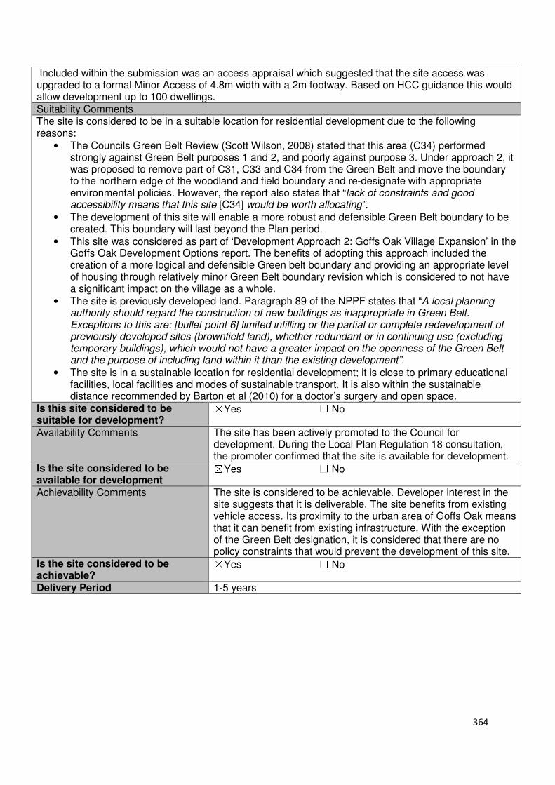
364
Included within the submission was an access appraisal which suggested that the site access was upgraded to a formal Minor Access of 4.8m width with a 2m footway. Based on HCC guidance this would allow development up to 100 dwellings. Suitability Comments The site is considered to be in a suitable location for residential development due to the following reasons:
• The Councils Green Belt Review (Scott Wilson, 2008) stated that this area (C34) performed strongly against Green Belt purposes 1 and 2, and poorly against purpose 3. Under approach 2, it was proposed to remove part of C31, C33 and C34 from the Green Belt and move the boundary to the northern edge of the woodland and field boundary and re-designate with appropriate environmental policies. However, the report also states that “lack of constraints and good accessibility means that this site [C34] would be worth allocating”.
• The development of this site will enable a more robust and defensible Green Belt boundary to be created. This boundary will last beyond the Plan period.
• This site was considered as part of ‘Development Approach 2: Goffs Oak Village Expansion’ in the Goffs Oak Development Options report. The benefits of adopting this approach included the creation of a more logical and defensible Green belt boundary and providing an appropriate level of housing through relatively minor Green Belt boundary revision which is considered to not have a significant impact on the village as a whole.
• The site is previously developed land. Paragraph 89 of the NPPF states that “A local planning authority should regard the construction of new buildings as inappropriate in Green Belt. Exceptions to this are: [bullet point 6] limited infilling or the partial or complete redevelopment of previously developed sites (brownfield land), whether redundant or in continuing use (excluding temporary buildings), which would not have a greater impact on the openness of the Green Belt and the purpose of including land within it than the existing development”.
• The site is in a sustainable location for residential development; it is close to primary educational facilities, local facilities and modes of sustainable transport. It is also within the sustainable distance recommended by Barton et al (2010) for a doctor’s surgery and open space.
Is this site considered to be suitable for development?
☒Yes ☐ No
Availability Comments The site has been actively promoted to the Council for development. During the Local Plan Regulation 18 consultation, the promoter confirmed that the site is available for development.
Is the site considered to be available for development
☒Yes ☐ No
Achievability Comments The site is considered to be achievable. Developer interest in the site suggests that it is deliverable. The site benefits from existing vehicle access. Its proximity to the urban area of Goffs Oak means that it can benefit from existing infrastructure. With the exception of the Green Belt designation, it is considered that there are no policy constraints that would prevent the development of this site.
Is the site considered to be achievable?
☒Yes ☐ No
Delivery Period 1-5 years
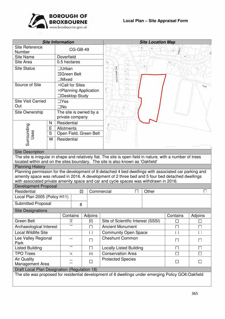
365
Local Plan – Site Appraisal Form
Site Information Site Location Map Site Reference Number
CG-GB-49
Site Name Doverfield Site Area 0.5 hectares
Site Status ☐Urban ☒Green Belt ☐Mixed
Source of Site ☒Call for Sites ☒Planning Application ☐Desktop Study
Site Visit Carried Out
☐Yes ☐No
Site Ownership The site is owned by a private company
Surr
oundin
g
Uses
N Residential
E Allotments S Open Field, Green Belt
W Residential
Site Description The site is irregular in shape and relatively flat. The site is open field in nature, with a number of trees located within and on the sites boundary. The site is also known as ‘Oakfield’ Planning History Planning permission for the development of 8 detached 4 bed dwellings with associated car parking and amenity space was refused in 2016. A development of 2 three bed and 5 four bed detached dwellings with associated private amenity space and car and cycle spaces was withdrawn in 2016. Development Proposal
Residential ☒ Commercial ☐ Other ☐
Local Plan 2005 (Policy H11)
Submitted Proposal 8
Site Designations Contains Adjoins Contains Adjoins
Green Belt ☒ ☒ Site of Scientific Interest (SSSI) ☐ ☐
Archaeological Interest ☐ ☐ Ancient Monument ☐ ☐
Local Wildlife Site ☐ ☐ Community Open Space ☐ ☐
Lee Valley Regional Park
☐ ☐ Cheshunt Common ☐ ☐
Listed Building ☐ ☐ Locally Listed Building ☐ ☐
TPO Trees ☒ ☒ Conservation Area ☐ ☐
Air Quality Management Area
☐ ☐ Protected Species ☐ ☐
Draft Local Plan Designation (Regulation 18) The site was proposed for residential development of 8 dwellings under emerging Policy GO6:Oakfield

366
Accessibility – distance as the crow flies
80m -Primary School (Woodside)
1.97km - Secondary School (Goffs)
3.64km –Employment Area (New River Industrial Estate)
220m - Green Space (Jones Road)
290m -Healthcare Centre (Valley View)
10.8km - Hospital (with A&E) (Barnet)
3.45km - Town/District Centre (Brookfield)
230m - Local Centre (684-696 Goffs Lane)
3.76km -Leisure Centre (Laura Trott)
3.13km - A10 Junction (College Road)
1.46km - Railway Station (Cuffley)
225m - Bus Service (War Memorial)
Flood Risk Does the site Contains Adjoins
Zone 2 (Medium Risk) ☐ ☐
Zone 3a (High Risk) ☐ ☐
Zone 3b (Active Flood Plain) ☐ ☐
Additional Flood Risk Comments The site may suffer from ground water. Access and Transport Comments The site does not currently benefit from vehicular access; however the area to the north of the site has consent for four units with an access point available. The site adjoins a public right of way. Pedestrian access to the site can be provided through the development of four units to the north. Utility Provision
Electricity Electricity cables are located to the north at Doverfield.
Gas A low pressure gas main is located at Doverfield, to the north of the site.
Water A water mains is located at Doverfield to the north of the site and Pollards Close to the west
Sewerage A foul sewer is located to the north of the site at Doverfield
Sewerage Treatment ☐Rye Meads ☒Deephams ☐Other
Additional Developer Comments submitted during Call for Sites 2016 None submitted. Suitability Comments This site is not considered to be suitable for development due to the following reasons:
• The site is included within area D2 identified in the Council’s Green Belt Review (Scott Wilson, 2008). The Review states that area D2 ) performs strongly against Green Belt purposes and proposed no change to the Green Belt boundary in this location as there is no further opportunity to provide a stronger boundary.
367
• A planning application for the 8 dwellings on this site was refused in 2016 for the following reasons; the proposed development constitutes as inappropriate development in the green belt and reduces the openness of the green belt without very special circumstances which clearly outweigh this harm, it fails to provide for delivery of affordable housing, it would result in the loss of TPO trees and would potentially threaten the longer term protection of remaining protected trees due to their close proximity with proposed dwellings, the size, scale, bulk and overall appearance of the proposed dwellings would not reflect, or relate to the characteristics and context of the surrounding area, the proposed layout and design of the dwellings would result in overlooking and loss of privacy to occupiers of existing and future occupiers of proposed neighbouring dwellings and insufficient information has been provided with respect to vehicle and pedestrian access arrangements onto Doverfield.
• The Council’s Green Belt Topic paper (June 2017) states that the proposed link to Woodside Primary School, which formed part of the case for ‘very special circumstances’, is “unviable due to intervening landownerships”. The paper continues by stating that “Although located near the village centre, the site meets few of the sustainable development criteria set out in Table 1. It is therefore considered that Oak Field does not present the exceptional circumstances necessary for release of Green Belt”.
Is this site considered to be suitable for development? ☐Yes ☒ No
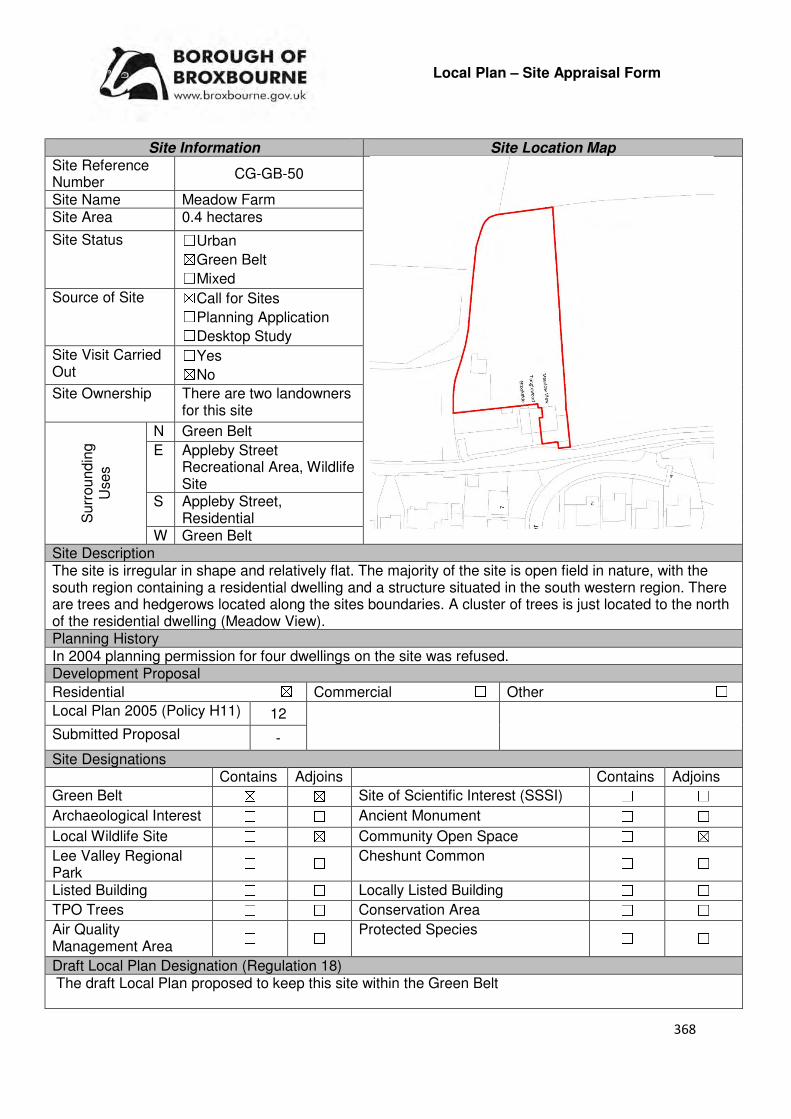
368
Local Plan – Site Appraisal Form
Site Information Site Location Map Site Reference Number
CG-GB-50
Site Name Meadow Farm Site Area 0.4 hectares
Site Status ☐Urban ☒Green Belt ☐Mixed
Source of Site ☒Call for Sites ☐Planning Application ☐Desktop Study
Site Visit Carried Out
☐Yes ☒No
Site Ownership There are two landowners for this site
Surr
oundin
g
Uses
N Green Belt
E Appleby Street Recreational Area, Wildlife Site
S Appleby Street, Residential
W Green Belt Site Description The site is irregular in shape and relatively flat. The majority of the site is open field in nature, with the south region containing a residential dwelling and a structure situated in the south western region. There are trees and hedgerows located along the sites boundaries. A cluster of trees is just located to the north of the residential dwelling (Meadow View). Planning History In 2004 planning permission for four dwellings on the site was refused. Development Proposal
Residential ☒ Commercial ☐ Other ☐
Local Plan 2005 (Policy H11) 12
Submitted Proposal -
Site Designations Contains Adjoins Contains Adjoins
Green Belt ☒ ☒ Site of Scientific Interest (SSSI) ☐ ☐
Archaeological Interest ☐ ☐ Ancient Monument ☐ ☐
Local Wildlife Site ☐ ☒ Community Open Space ☐ ☒
Lee Valley Regional Park
☐ ☐ Cheshunt Common ☐ ☐
Listed Building ☐ ☐ Locally Listed Building ☐ ☐
TPO Trees ☐ ☐ Conservation Area ☐ ☐
Air Quality Management Area
☐ ☐ Protected Species ☐ ☐
Draft Local Plan Designation (Regulation 18) The draft Local Plan proposed to keep this site within the Green Belt
369
Accessibility – distance as the crow flies
690m-Primary School (Flamstead End)
1.66km - Secondary School (Goffs)
1.88km–Employment Area
(New River Industrial Estate)
0m - Green Space (Appleby Street)
1km -Healthcare Centre
(Stockwell)
11.5km - Hospital (with A&E) (Princess Alexandra)
1.73km - Town/District Centre (Brookfield)
590m - Local Centre
(Hammondstreet)
3.05km -Leisure Centre (Laura Trott)
2.13km - A10 Junction
(Church Lane)
3.41km - Railway Station
(Cuffley)
370m - Bus Service (Peakes Way)
Flood Risk Does the site Contains Adjoins
Zone 2 (Medium Risk) ☐ ☐
Zone 3a (High Risk) ☐ ☐
Zone 3b (Active Flood Plain) ☐ ☐
Additional Flood Risk Comments The site may suffer from ground water flooding. Access and Transport Comments The site can be accessed from Appleby Street. Appleby Street does not have footpaths. Utility Provision
Electricity Cables available to the south, closer to the residential area
Gas A gas main is located along Appleby Street
Water A water main is located along Appleby Street
Sewerage A foul sewer is located to the south at the site at Appleby Street
Sewerage Treatment ☐Rye Meads ☒Deephams ☐Other
Additional Developer Comments submitted during Call for Sites 2016 None submitted. Suitability Comments The site is not considered to be suitable for residential development due to the following reasons:
• The site is included within area C7 of the Council’s Green Belt Review (Scott Wilson, 2008). The Review states that area C7 performs a strong role under Green Belt purpose 1 and thus merits retention. It performs poorly against Green Belt purposes 2 and 3. No changes to the Green Belt boundary in this location were proposed.
• This site has weak Green Belt boundaries to the north, east and west. It is considered that these boundaries would not last beyond the Plan period or prevents further encroachment into the countryside.
• The area contributes to the preventing the outward urban sprawl of West Cheshunt. Is this site considered to be suitable for development? ☐Yes ☒ No
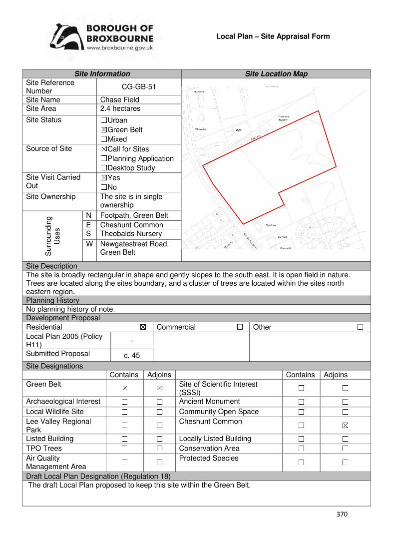
370
Local Plan – Site Appraisal Form
Site Information Site Location Map Site Reference Number
CG-GB-51
Site Name Chase Field Site Area 2.4 hectares
Site Status ☐Urban ☒Green Belt ☐Mixed
Source of Site ☒Call for Sites ☐Planning Application ☐Desktop Study
Site Visit Carried Out
☒Yes ☐No
Site Ownership The site is in single ownership
Surr
oundin
g
Uses
N Footpath, Green Belt
E Cheshunt Common S Theobalds Nursery
W Newgatestreet Road, Green Belt
Site Description The site is broadly rectangular in shape and gently slopes to the south east. It is open field in nature. Trees are located along the sites boundary, and a cluster of trees are located within the sites north eastern region. Planning History No planning history of note. Development Proposal
Residential ☒ Commercial ☐ Other ☐
Local Plan 2005 (Policy H11)
-
Submitted Proposal c. 45
Site Designations Contains Adjoins Contains Adjoins
Green Belt ☒ ☒ Site of Scientific Interest (SSSI)
☐ ☐
Archaeological Interest ☐ ☐ Ancient Monument ☐ ☐
Local Wildlife Site ☐ ☐ Community Open Space ☐ ☐
Lee Valley Regional Park
☐ ☐ Cheshunt Common ☐ ☒
Listed Building ☐ ☐ Locally Listed Building ☐ ☐
TPO Trees ☐ ☐ Conservation Area ☐ ☐
Air Quality Management Area
☐ ☐ Protected Species ☐ ☐
Draft Local Plan Designation (Regulation 18) The draft Local Plan proposed to keep this site within the Green Belt.

371
Accessibility – distance as the crow flies
230m-Primary School (Goffs)
2.54km - Secondary School (Goffs)
4.03km –Employment Area (New River Industrial Estate)
450m - Green Space (Richardson Crescent)
890m -Healthcare Centre (Valley View)
11km - Hospital (with A&E) (Barnet)
3.63km - Town/District Centre (Brookfield)
660m - Local Centre (1-5 Masons Parade)
4.44km -Leisure Centre (Laura Trott)
3.6km - A10 Junction (Church Lane)
1.36km - Railway Station (Cuffley)
20m - Bus Service (Newgatestreet Road)
Flood Risk Does the site Contains Adjoins
Zone 2 (Medium Risk) ☐ ☐
Zone 3a (High Risk) ☐ ☐
Zone 3b (Active Flood Plain) ☐ ☐
Additional Flood Risk Comments The site may suffer from ground water flooding. Access and Transport Comments There is currently gate access to the site via Newgatestreet Road. This access would require improvement if development was to occur. The impact that this site would have on the local network would require further investigation. This section of Newgatestreet Road has footpaths on both sides. A public footpath runs parallel to the sites northern boundary. Utility Provision
Electricity Electricity cables available along Newgatestreet Road
Gas A low pressure gas main is located along Newgatestreet Road
Water A water main is located along Newgatestreet Road
Sewerage A foul sewer and surface sewer is located to the south of the site, along Newgatestreet Road (near 147-149)
Sewerage Treatment ☐Rye Meads ☒Deephams ☐Other
Additional Developer Comments submitted during Call for Sites 2016 The promoter states that there is no ownership or functional relationship between land to the west and east of Newgatestreet Road as suggested in the ‘Goffs Oak Area Development Options’ Broxbourne Borough Council, 2016. The promoter notes that the Options report indicates that this site and CG-GB-79 (land to the west of Newgatestreet Road) should be considered together, however states that the sites have different characteristics with land to the west of Newgatestreet Road, which has significantly open character with wide ranging views across Cuffley as the land dramatically falls away to the west. In contrast land to the east of Newgatestreet Road displays a much greater level of physical and visual self-containment with no medium or long range views across the site. The display of different characters for each sites means that there is no justification for them being considered simultaneously for development. The promoter states the site is deliverable, available now and offers a suitable location for development being located immediately adjacent to the existing northern settlement boundary of Goffs Oak, and that the site is achievable as it is being promoted for development by a company who have an established-track record of delivering new housing in the borough. The site is located in Flood Zone 1 and does not include any ecological, landscape, heritage or archaeological destinations.
372
The land has been used for agriculture and grazing, with no evidence of past contaminative uses present. The promoter confirms that the site is in single ownership with no legal impediments. To support the site submission, a Green Belt and Landscape assessment was submitted. The assessment concluded that the proposed development of land off Newgatestreet Road would only create modest harm to Green Belt purposes, and specifically has a low effect on the purposes of preventing towns from merging. It also concluded that the scheme would have a number of tangible benefits including: delivering housing in a sustainable location, within a very short walk of the existing Primary School, have minimal visibility in the wider landscape, form a logical change to the overall settlement pattern, without distorting or coalescence, provide a comprehensive design solution, resulting in an enhanced entrance to Goffs Oak when entering from the north , and, retain and enhance existing public footpath route, which is enclosed by vegetation. Suitability Comments The site is not considered to be suitable for development due to the following reasons:
• The site is included within area C30 identified in the Council’s Green Belt Review (Scott Wilson, 2008) The Review states that this area strongly against Green Belt purposes and proposed no change to the boundary in this location. However, it should be noted that the review also stated that there is the opportunity to create a stronger Green Belt boundary in C11-C30 as these areas have “extremely weak boundaries”, which means that there are no real barriers to prevent encroachment between settlements.
• This site has weak green belt boundaries to the north. It is considered that this boundary will not prevent further encroachment into the countryside or last beyond the Plan Period. It is possible that the development of this site could lead to the coalescence of Goffs Oak and the Hammondstreet development
• The site prevents the further outward sprawl of Goffs Oak.
• In comparison to alternative sites around Goffs Oak, the distance of this site from the services and facilities of Goffs Oak is greater.
Is this site considered to be suitable for development? ☐Yes ☒ No
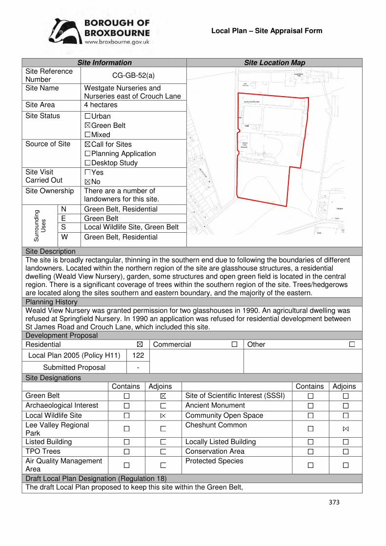
373
Local Plan – Site Appraisal Form
Site Information Site Location Map Site Reference Number
CG-GB-52(a)
Site Name Westgate Nurseries and Nurseries east of Crouch Lane
Site Area 4 hectares
Site Status ☐Urban ☒Green Belt ☐Mixed
Source of Site ☒Call for Sites ☐Planning Application ☐Desktop Study
Site Visit Carried Out
☐Yes ☒No
Site Ownership There are a number of landowners for this site.
Su
rro
un
din
g
Use
s
N Green Belt, Residential
E Green Belt S Local Wildlife Site, Green Belt
W Green Belt, Residential
Site Description The site is broadly rectangular, thinning in the southern end due to following the boundaries of different landowners. Located within the northern region of the site are glasshouse structures, a residential dwelling (Weald View Nursery), garden, some structures and open green field is located in the central region. There is a significant coverage of trees within the southern region of the site. Trees/hedgerows are located along the sites southern and eastern boundary, and the majority of the eastern.
Planning History Weald View Nursery was granted permission for two glasshouses in 1990. An agricultural dwelling was refused at Springfield Nursery. In 1990 an application was refused for residential development between St James Road and Crouch Lane, which included this site. Development Proposal
Residential ☒ Commercial ☐ Other ☐
Local Plan 2005 (Policy H11) 122
Submitted Proposal -
Site Designations Contains Adjoins Contains Adjoins
Green Belt ☐ ☒ Site of Scientific Interest (SSSI) ☐ ☐
Archaeological Interest ☐ ☐ Ancient Monument ☐ ☐
Local Wildlife Site ☐ ☒ Community Open Space ☐ ☐
Lee Valley Regional Park
☐ ☐ Cheshunt Common ☐ ☒
Listed Building ☐ ☐ Locally Listed Building ☐ ☐
TPO Trees ☐ ☐ Conservation Area ☐ ☐
Air Quality Management Area
☐ ☐ Protected Species ☐ ☐
Draft Local Plan Designation (Regulation 18) The draft Local Plan proposed to keep this site within the Green Belt,
374
Accessibility – distance as the crow flies
360m -Primary School (Goffs)
2.08km - Secondary School (Goffs)
3.52km–Employment Area (New River Industrial Estate)
200m - Green Space (Goffs)
370m -Healthcare Centre (Valley View)
11.2km- Hospital (with A&E) (Barnet)
3.28km- Town/District Centre (Brookfield)
237m - Local Centre (1-5 Masons Parade)
3.94km -Leisure Centre (Laura Trott)
3.2km - A10 Junction (Church Lane)
1.48km - Railway Station (Cuffley)
400m - Bus Service (War Memorial)
Flood Risk Does the site Contains Adjoins
Zone 2 (Medium Risk) ☐ ☐
Zone 3a (High Risk) ☐ ☐
Zone 3b (Active Flood Plain) ☐ ☐
Additional Flood Risk Comments There may be surface water flood issues on the site. Access and Transport Comments The site can be accessed from Crouch Lane. Crouch Lane is narrow in places and semi-rural in nature. There are no footpaths along Crouch Lane. There is no cycle access to the site. Utility Provision
Electricity
Gas The closest low pressure gas main is located in the residential area to the west of the site.
Water A water mains runs along Crouch Lane Sewerage The closest foul sewer is located just outside Weald View Nursery
Sewerage Treatment ☐Rye Meads ☒Deephams ☐Other
Additional Developer Comments submitted during 2016 Call for Sites None submitted. Suitability Comments This site is not considered to be suitable for development due to the following reasons:
• The site is included within area C28 identified in the Council’s Green Belt Review (Scott Wilson, 2008). The Review states that area C28 performs strongly against Green Belt purposes 1 and 2, and plays an average role against Purpose 3. However, it should be noted that review also stated that there is the opportunity to create a strong Green Belt boundary in C11-C30 as these areas have “extremely weak boundaries”, which means that there are no real barriers to prevent encroachment between settlements.
• The site plays a key local role in preventing the coalescence of Goffs Oak and St James’.
• This site has weak boundaries to the east and south. This means that the development of this site would not assist in safeguarding the countryside from encroachment or check unrestricted sprawl.
However, emerging Policy GB2 may be applicable to part of this site. This policy enables derelict greenhouse site to be developed into self-build housing, subject to a number of conditions being met. Is this site considered to be suitable for development? ☐Yes ☒ No

375
Local Plan – Site Appraisal Form
Site Information Site Location Map Site Reference Number
CG-GB-52(b)
Site Name Springfield and Westgate
Site Area 2.46 hectares
Site Status ☐Urban ☒Green Belt ☐Mixed
Source of Site ☒Call for Sites ☐Planning Application ☐Desktop Study
Site Visit Carried Out
☐Yes ☒No
Site Ownership There are various landowners for this site.
Surr
oundin
g
Uses
N Green Belt, Residential
E Green Belt S Local Wildlife Site,
Green Belt W Green Belt, Weal View
Nursery, Crouch Lane
Site Description The site is irregular in shape due to following the boundaries of different landowners. The northern region of the site has a number of glasshouse structures, with the southern region having a significant number of trees, with some small areas of open field. There are some trees located on the sites boundaries. Planning History An agricultural dwelling was refused at Springfield Nursery. In 1990 an application was refused for residential development between St James Road and Crouch Lane, which included this site. Development Proposal
Residential ☒ Commercial ☐ Other ☐
Local Plan 2005 (Policy H11)
Submitted Proposal 11
Site Designations Contains Adjoins Contains Adjoins
Green Belt ☒ ☒ Site of Scientific Interest (SSSI) ☐ ☐
Archaeological Interest ☐ ☐ Ancient Monument ☐ ☐
Local Wildlife Site ☐ ☐ Community Open Space ☐ ☐
Lee Valley Regional Park
☐ ☐ Cheshunt Common ☐ ☒
Listed Building ☐ ☐ Locally Listed Building ☐ ☐
TPO Trees ☐ ☐ Conservation Area ☐ ☐
Air Quality Management Area
☐ ☐ Protected Species ☐ ☐
Draft Local Plan Designation (Regulation 18) The draft Local Plan proposed to keep this site within the Green Belt

376
Accessibility – distance as the crow flies
360m -Primary School (Goffs)
2km - Secondary School (Goffs)
3.4km –Employment Area (New River Industrial Estate)
300m - Green Space (Goffs)
450m -Healthcare Centre (Valley View)
11.3km- Hospital (with A&E) (Barnet)
3.3km - Town/District Centre (Brookfield)
330m - Local Centre (1-5 Masons Parade)
3.96km -Leisure Centre (Laura Trott)
3.2km - A10 Junction (Church Lane)
1.53km - Railway Station (Cuffley)
507m - Bus Service (War Memorial)
Flood Risk Does the site Contains Adjoins
Zone 2 (Medium Risk) ☐ ☐
Zone 3a (High Risk) ☐ ☐
Zone 3b (Active Flood Plain) ☐ ☐
Additional Flood Risk Comments There may be surface water flood issues on the site. Access and Transport Comments The site can be accessed from Crouch Lane. Crouch Lane is narrow in places and semi-rural in nature. There are no footpaths along Crouch Lane. There is no cycle access to the site. Utility Provision
Electricity Connections may exist at Crouch Lane to the west
Gas The closest low pressure gas main is located in the residential area to the west of the site.
Water A water main runs along Crouch Lane Sewerage The closest foul sewer is located just outside Weald View Nursery
Sewerage Treatment ☐Rye Meads ☒Deephams ☐Other
Additional Developer Comments submitted during Call for Sites 2016 The promoter stated that the site could come forward within 5 years and that the density (4.4 mph) is low enough for the site to remain in the Green Belt and secure long term benefits for the openness and attractiveness of the Green Belt. The promoter states that the site is not within or adjacent to a flood zone and there are no fluvial flooding issues, and that there are few constraints that would need to be overcome. No detailed studies or assessments have net been undertaken. Suitability Comments The site is not considered to be suitable for development due to the following reasons:
• The site is included within area C28 identified in the Council’s Green Belt Review (Scott Wilson, 2008). The Review states that area C28 performs strongly against Green Belt purposes 1 and 2, and plays an average role against Purpose 3. However, it should be noted that review also stated that there is the opportunity to create a strong Green Belt boundary in C11-C30 as these areas have “extremely weak boundaries”, which means that there are no real barriers to prevent encroachment between settlements.
• The site plays a key local role in preventing the coalescence of Goffs Oak and St James’.
• This site has weak boundaries to the east and south. This means that the development of this site would not assist in safeguarding the countryside from encroachment or check unrestricted sprawl.
However, subject to the sites compliance with emerging Policy GB2: Residential Development on Derelict Glass House Sites, the site could be subdivided into self-build housing plots. Is this site considered to be suitable for development? ☐Yes ☒ No
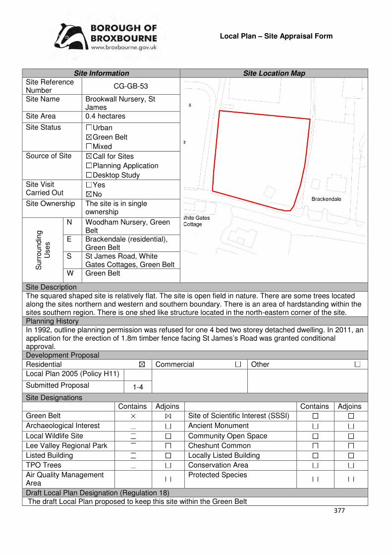
377
Local Plan – Site Appraisal Form
Site Information Site Location Map Site Reference Number
CG-GB-53
Site Name Brookwall Nursery, St James
Site Area 0.4 hectares
Site Status ☐Urban ☒Green Belt ☐Mixed
Source of Site ☒Call for Sites ☐Planning Application ☐Desktop Study
Site Visit Carried Out
☐Yes ☒No
Site Ownership The site is in single ownership
Surr
oundin
g
Uses
N Woodham Nursery, Green Belt
E Brackendale (residential), Green Belt
S St James Road, White Gates Cottages, Green Belt
W Green Belt
Site Description The squared shaped site is relatively flat. The site is open field in nature. There are some trees located along the sites northern and western and southern boundary. There is an area of hardstanding within the sites southern region. There is one shed like structure located in the north-eastern corner of the site. Planning History In 1992, outline planning permission was refused for one 4 bed two storey detached dwelling. In 2011, an application for the erection of 1.8m timber fence facing St James’s Road was granted conditional approval. Development Proposal
Residential ☒ Commercial ☐ Other ☐
Local Plan 2005 (Policy H11)
Submitted Proposal 1-4
Site Designations Contains Adjoins Contains Adjoins
Green Belt ☒ ☒ Site of Scientific Interest (SSSI) ☐ ☐
Archaeological Interest ☐ ☐ Ancient Monument ☐ ☐
Local Wildlife Site ☐ ☐ Community Open Space ☐ ☐
Lee Valley Regional Park ☐ ☐ Cheshunt Common ☐ ☐
Listed Building ☐ ☐ Locally Listed Building ☐ ☐
TPO Trees ☐ ☐ Conservation Area ☐ ☐
Air Quality Management Area
☐ ☐ Protected Species ☐ ☐
Draft Local Plan Designation (Regulation 18) The draft Local Plan proposed to keep this site within the Green Belt
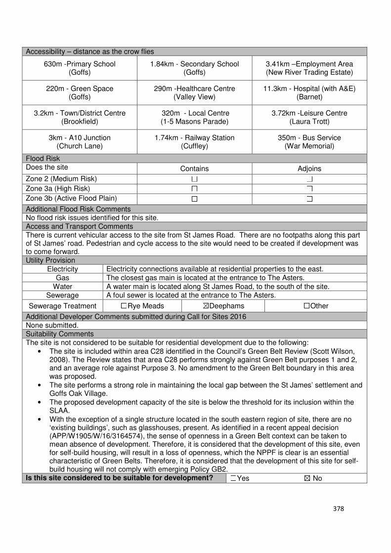
378
Accessibility – distance as the crow flies
630m -Primary School (Goffs)
1.84km - Secondary School (Goffs)
3.41km –Employment Area (New River Trading Estate)
220m - Green Space (Goffs)
290m -Healthcare Centre (Valley View)
11.3km - Hospital (with A&E) (Barnet)
3.2km - Town/District Centre (Brookfield)
320m - Local Centre (1-5 Masons Parade)
3.72km -Leisure Centre (Laura Trott)
3km - A10 Junction (Church Lane)
1.74km - Railway Station (Cuffley)
350m - Bus Service (War Memorial)
Flood Risk Does the site Contains Adjoins
Zone 2 (Medium Risk) ☐ ☐
Zone 3a (High Risk) ☐ ☐
Zone 3b (Active Flood Plain) ☐ ☐
Additional Flood Risk Comments No flood risk issues identified for this site. Access and Transport Comments There is current vehicular access to the site from St James Road. There are no footpaths along this part of St James’ road. Pedestrian and cycle access to the site would need to be created if development was to come forward. Utility Provision
Electricity Electricity connections available at residential properties to the east.
Gas The closest gas main is located at the entrance to The Asters.
Water A water main is located along St James Road, to the south of the site. Sewerage A foul sewer is located at the entrance to The Asters.
Sewerage Treatment ☐Rye Meads ☒Deephams ☐Other
Additional Developer Comments submitted during Call for Sites 2016 None submitted. Suitability Comments The site is not considered to be suitable for residential development due to the following:
• The site is included within area C28 identified in the Council’s Green Belt Review (Scott Wilson, 2008). The Review states that area C28 performs strongly against Green Belt purposes 1 and 2, and an average role against Purpose 3. No amendment to the Green Belt boundary in this area was proposed.
• The site performs a strong role in maintaining the local gap between the St James’ settlement and Goffs Oak Village.
• The proposed development capacity of the site is below the threshold for its inclusion within the SLAA.
• With the exception of a single structure located in the south eastern region of site, there are no ‘existing buildings’, such as glasshouses, present. As identified in a recent appeal decision (APP/W1905/W/16/3164574), the sense of openness in a Green Belt context can be taken to mean absence of development. Therefore, it is considered that the development of this site, even for self-build housing, will result in a loss of openness, which the NPPF is clear is an essential characteristic of Green Belts. Therefore, it is considered that the development of this site for self-build housing will not comply with emerging Policy GB2.
Is this site considered to be suitable for development? ☐Yes ☒ No
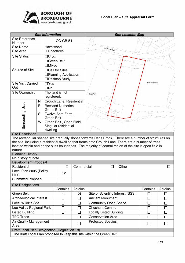
379
Local Plan – Site Appraisal Form
Site Information Site Location Map Site Reference Number
CG-GB-54
Site Name Hazelwood Site Area 0.4 hectares
Site Status ☐Urban ☒Green Belt ☐Mixed
Source of Site ☒Call for Sites ☐Planning Application ☐Desktop Study
Site Visit Carried Out
☐Yes ☒No
Site Ownership The land is not registered.
Surr
oundin
g U
ses N Crouch Lane, Residential
E Rowland Nurseries, Green Belt
S Twelve Acre Farm, Green Belt
W Green Belt , Open Field, Singular residential dwelling
Site Description The rectangular shaped site gradually slopes towards Rags Brook. There are a number of structures on the site, including a residential dwelling that fronts onto Crouch Lane. There are a number of trees located within and on the sites boundaries. The majority of central region of the site is open field in nature. Planning History No history of note. Development Proposal
Residential ☒ Commercial ☐ Other ☐
Local Plan 2005 (Policy H11)
12
Submitted Proposal -
Site Designations Contains Adjoins Contains Adjoins
Green Belt ☒ ☒ Site of Scientific Interest (SSSI) ☐ ☐
Archaeological Interest ☐ ☐ Ancient Monument ☐ ☐
Local Wildlife Site ☐ ☐ Community Open Space ☐ ☐
Lee Valley Regional Park ☐ ☐ Cheshunt Common ☐ ☐
Listed Building ☐ ☐ Locally Listed Building ☐ ☐
TPO Trees ☐ ☐ Conservation Area ☐ ☐
Air Quality Management Area
☐ ☐ Protected Species ☐ ☐
Draft Local Plan Designation (Regulation 18) The draft Local Plan proposed to keep this site within the Green Belt

380
Accessibility – distance as the crow flies
1.03km -Primary School (Fairfields)
1.46km - Secondary School (Goffs)
2.63km–Employment Area (New River Industrial Estate)
140m - Green Space (Argent Way)
940m -Healthcare Centre (Valley View)
12km - Hospital (with A&E) (Barnet)
2.4km - Town/District Centre (Brookfield)
333m - Local Centre (Hammondstreet)
3.27km -Leisure Centre (Laura Trott)
2.45km - A10 Junction (Church Lane)
2.49km - Railway Station (Cuffley)
386m- Bus Service (Oaklands)
Flood Risk Does the site Contains Adjoins
Zone 2 (Medium Risk) ☐ ☐
Zone 3a (High Risk) ☐ ☐
Zone 3b (Active Flood Plain) ☐ ☐
Additional Flood Risk Comments Rags Brook adjoins the site to the south. This may need some consideration if development was to come forward. Access and Transport Comments The site can be accessed from Crouch Lane. Crouch Lane is narrow in places and semi-rural in nature. There are no footpaths along Crouch Lane. Utility Provision
Electricity Electricity cables are located at the site.
Gas A gas main is located 153m to the north east of the site, along Rags Lane
Water A water main is located along Crouch Lane, to the north of the site.
Sewerage A foul sewer and surface sewer are located at Crouch Lane, to the north of the site.
Sewerage Treatment ☐Rye Meads ☒Deephams ☐Other
Additional Developer Comments submitted during Call for Sites 2016 None submitted. Suitability Comments This site is not considered to be suitable for residential development due to the following reasons:
• The site is included within the area identified as C14 in the Council’s Green Belt Review (Scott Wilson, 2008). The Review states that area C14 performs strongly against Green Belt purposes 1 and 2, and poorly against Purpose 3. No change to the boundary was proposed in this area. However, it should be noted that the review also stated that there is the opportunity to create a strong Green Belt boundary in C11-C30 as these areas have “extremely weak boundaries”, which means that there are no real barriers to prevent encroachment between settlements.
• The site plays a local role in preventing the outward sprawl of St James. The site also contributes to preventing the coalescence of the St James settlement and West Cheshunt
• This site does not have strong, defensible Green Belt boundaries on the east and west that would prevent further encroachment into the Green Belt or last beyond the Plan period.

381
• The Goffs Oak Development Options Report (Broxbourne Borough Council, 2016) identifies two categories of Green Belt sites which are not favoured. It is possible to include this site within the second category, which comprises of Green Belt sites that do not adjoin or only marginally adjoin urban development. The Report states that the “development of these sites would create unconnected pockets of housing that are totally unrelated to one another or to existing urban areas, and in any case of many sites would only be accessible via narrow rural lanes”. The Report also states that the development of these sites would exacerbate the areas haphazard development pattern and could over time, lead to the merging of urban areas which would erode the character of Goffs Oak.
Is this site considered to be suitable for development? ☐Yes ☒ No
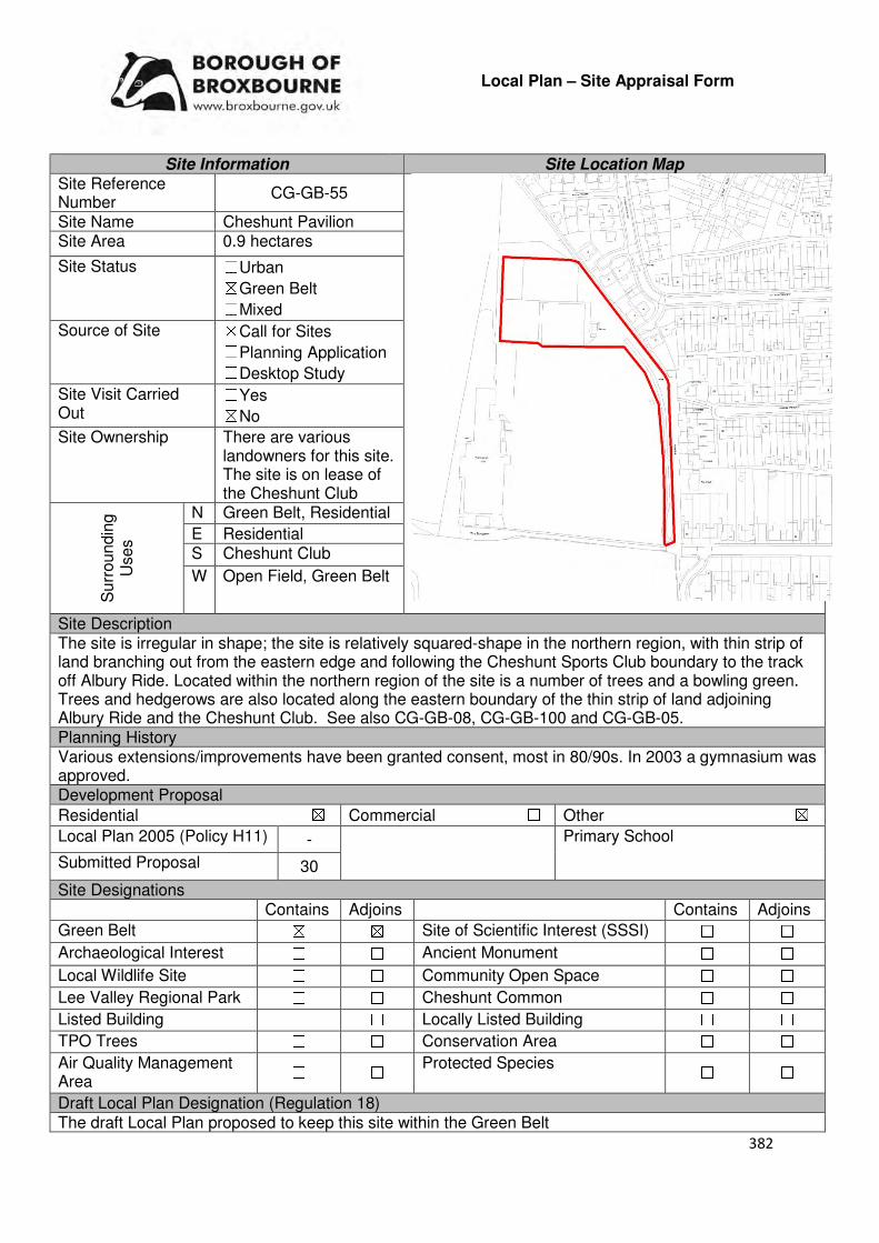
382
Local Plan – Site Appraisal Form
Site Information Site Location Map Site Reference Number
CG-GB-55
Site Name Cheshunt Pavilion Site Area 0.9 hectares
Site Status ☐Urban ☒Green Belt ☐Mixed
Source of Site ☒Call for Sites ☐Planning Application ☐Desktop Study
Site Visit Carried Out
☐Yes ☒No
Site Ownership There are various landowners for this site. The site is on lease of the Cheshunt Club
Surr
oundin
g
Uses
N Green Belt, Residential
E Residential S Cheshunt Club
W Open Field, Green Belt
Site Description The site is irregular in shape; the site is relatively squared-shape in the northern region, with thin strip of land branching out from the eastern edge and following the Cheshunt Sports Club boundary to the track off Albury Ride. Located within the northern region of the site is a number of trees and a bowling green. Trees and hedgerows are also located along the eastern boundary of the thin strip of land adjoining Albury Ride and the Cheshunt Club. See also CG-GB-08, CG-GB-100 and CG-GB-05. Planning History Various extensions/improvements have been granted consent, most in 80/90s. In 2003 a gymnasium was approved. Development Proposal
Residential ☒ Commercial ☐ Other ☒
Local Plan 2005 (Policy H11) - Primary School
Submitted Proposal 30
Site Designations Contains Adjoins Contains Adjoins
Green Belt ☒ ☒ Site of Scientific Interest (SSSI) ☐ ☐
Archaeological Interest ☐ ☐ Ancient Monument ☐ ☐
Local Wildlife Site ☐ ☐ Community Open Space ☐ ☐
Lee Valley Regional Park ☐ ☐ Cheshunt Common ☐ ☐
Listed Building ☐ ☐ Locally Listed Building ☐ ☐
TPO Trees ☐ ☐ Conservation Area ☐ ☐
Air Quality Management Area
☐ ☐ Protected Species ☐ ☐
Draft Local Plan Designation (Regulation 18) The draft Local Plan proposed to keep this site within the Green Belt

383
Accessibility – distance as the crow flies
220m -Primary School (Longlands)
226m - Secondary School (Cheshunt)
850m –Employment Area
(Park Plaza North)
0m - Green Space (adjoins)
350m -Healthcare Centre
(Crossbrook Street)
11.7km- Hospital (with A&E)
(Princess Alexandra(
360m- Town/District Centre
(Cheshunt Old Pond)
290m - Local Centre (127-137 Crossbrook Street)
470m -Leisure Centre
(Laura Trott)
370m- A10 Junction (College Road)
650m - Railway Station
(Theobalds Grove)
295m - Bus Service (The Roman Urn PH)
Flood Risk Does the site Contains Adjoins
Zone 2 (Medium Risk) ☐ ☐
Zone 3a (High Risk) ☐ ☐
Zone 3b (Active Flood Plain) ☐ ☐
Additional Flood Risk Comments There may be some surface water flooding on the site. Access and Transport Comments The site can be accessed by using the track from Albury Ride that leads to the Cheshunt Club. This is considered to be the most appropriate access point; therefore, its continued use would require negotiations with the landowner of the site. Due to the sites close proximity to the A10, a transport assessment would need to be undertaken. There is no pedestrian or cycle access to this site. Albury Walk, a public right of way adjoins the site to the east. Utility Provision
Electricity Located in the urban area to the east of the site
Gas A low pressure gas main is located to the east of the site, at Rushleigh Avenue
Water A water mains is located to the east of the site, at Brinley Close and Rushleigh Avenue
Sewerage A foul sewer is located within the site. A surface sewer is located along Albury Walk.
Sewerage Treatment ☐Rye Meads ☒Deephams ☐Other
Additional Developer Comments submitted during Call for Sites 2016 None submitted. During the Local Plan consultation (Regulation 18) the landowner indicated that they would like to discuss the option of a land swap between the proposed primary school at Albury Ride and the Cheshunt Club

384
Suitability Comments This area of land is a former pavilion associated with the Cheshunt Club, which is now privately owned. The County Council is working with the Club in order to prepare a masterplan for the area to allow improvements to the clubs’ facilities whilst also providing a primary school site near Albury Ride. A small amount of residential development may be considered acceptable as part of this proposal, as part of a comprehensive and carefully planned approach (including sites CG-GB-08(a), CG-GB-55 and CG-GB-99). The quantum and location of any residential development will depend on a satisfactory masterplan agreed with the Borough Council, taking account of the capacity of Albury Ride (including the junction with Crossbrook Street) and any impacts on existing residential properties. Is this site considered to be suitable for development?
☒Yes ☐ No
Availability Comments The site is considered to be available. The landowners and Hertfordshire County Council are working together on creating a masterplan for this area.
Is the site considered to be available for development
☒Yes ☐ No
Achievability Comments The site is considered to be achievable. In the draft Local Plan, it is proposed to remove this site from the Green Belt. With the removal of this site from the Green Belt, it is considered that there are no policy constraints that would prevent the development of the site. The capacity constraints at Albury Ride may place some restrictions on development.
Is the site considered to be achievable? ☒Yes ☐ No
Delivery Period 6-10
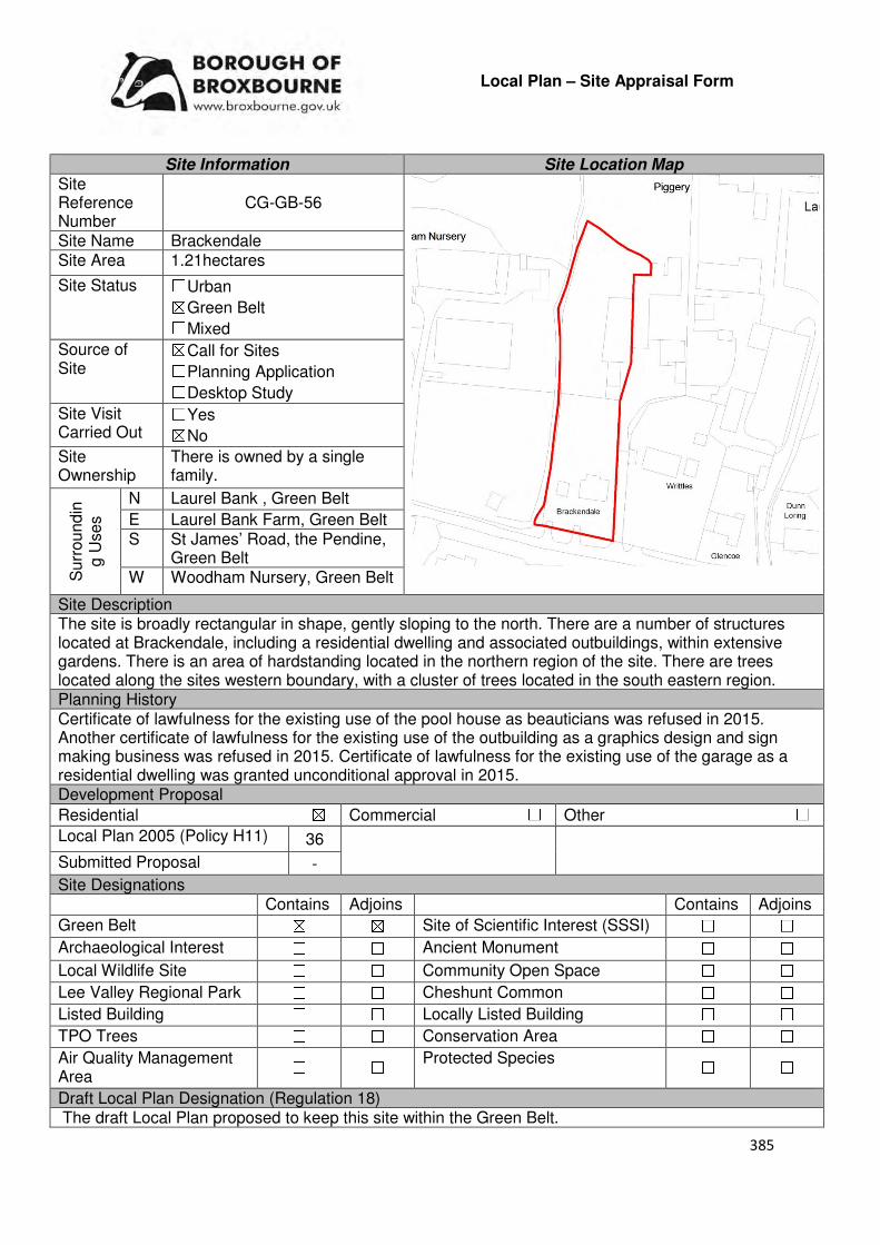
385
Local Plan – Site Appraisal Form
Site Information Site Location Map Site Reference Number
CG-GB-56
Site Name Brackendale Site Area 1.21hectares
Site Status ☐Urban ☒Green Belt ☐Mixed
Source of Site
☒Call for Sites ☐Planning Application ☐Desktop Study
Site Visit Carried Out
☐Yes ☒No
Site Ownership
There is owned by a single family.
Surr
oundin
g U
ses
N Laurel Bank , Green Belt
E Laurel Bank Farm, Green Belt S St James’ Road, the Pendine,
Green Belt W Woodham Nursery, Green Belt
Site Description The site is broadly rectangular in shape, gently sloping to the north. There are a number of structures located at Brackendale, including a residential dwelling and associated outbuildings, within extensive gardens. There is an area of hardstanding located in the northern region of the site. There are trees located along the sites western boundary, with a cluster of trees located in the south eastern region. Planning History Certificate of lawfulness for the existing use of the pool house as beauticians was refused in 2015. Another certificate of lawfulness for the existing use of the outbuilding as a graphics design and sign making business was refused in 2015. Certificate of lawfulness for the existing use of the garage as a residential dwelling was granted unconditional approval in 2015. Development Proposal
Residential ☒ Commercial ☐ Other ☐
Local Plan 2005 (Policy H11) 36
Submitted Proposal -
Site Designations Contains Adjoins Contains Adjoins
Green Belt ☒ ☒ Site of Scientific Interest (SSSI) ☐ ☐
Archaeological Interest ☐ ☐ Ancient Monument ☐ ☐
Local Wildlife Site ☐ ☐ Community Open Space ☐ ☐
Lee Valley Regional Park ☐ ☐ Cheshunt Common ☐ ☐
Listed Building ☐ ☐ Locally Listed Building ☐ ☐
TPO Trees ☐ ☐ Conservation Area ☐ ☐
Air Quality Management Area
☐ ☐ Protected Species ☐ ☐
Draft Local Plan Designation (Regulation 18) The draft Local Plan proposed to keep this site within the Green Belt.
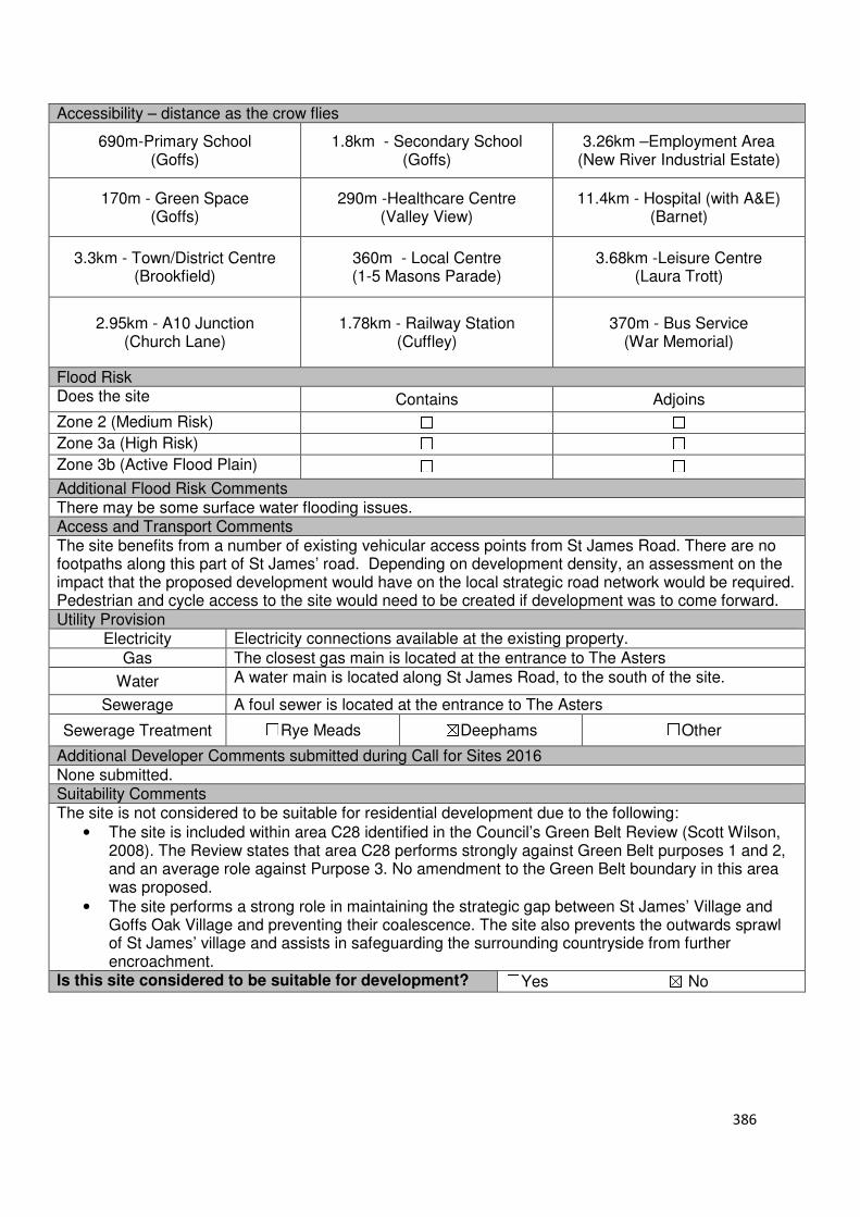
386
Accessibility – distance as the crow flies
690m-Primary School (Goffs)
1.8km - Secondary School (Goffs)
3.26km –Employment Area (New River Industrial Estate)
170m - Green Space (Goffs)
290m -Healthcare Centre (Valley View)
11.4km - Hospital (with A&E) (Barnet)
3.3km - Town/District Centre (Brookfield)
360m - Local Centre (1-5 Masons Parade)
3.68km -Leisure Centre (Laura Trott)
2.95km - A10 Junction (Church Lane)
1.78km - Railway Station (Cuffley)
370m - Bus Service (War Memorial)
Flood Risk Does the site Contains Adjoins
Zone 2 (Medium Risk) ☐ ☐
Zone 3a (High Risk) ☐ ☐
Zone 3b (Active Flood Plain) ☐ ☐
Additional Flood Risk Comments There may be some surface water flooding issues. Access and Transport Comments The site benefits from a number of existing vehicular access points from St James Road. There are no footpaths along this part of St James’ road. Depending on development density, an assessment on the impact that the proposed development would have on the local strategic road network would be required. Pedestrian and cycle access to the site would need to be created if development was to come forward. Utility Provision
Electricity Electricity connections available at the existing property.
Gas The closest gas main is located at the entrance to The Asters
Water A water main is located along St James Road, to the south of the site.
Sewerage A foul sewer is located at the entrance to The Asters
Sewerage Treatment ☐Rye Meads ☒Deephams ☐Other
Additional Developer Comments submitted during Call for Sites 2016 None submitted. Suitability Comments The site is not considered to be suitable for residential development due to the following:
• The site is included within area C28 identified in the Council’s Green Belt Review (Scott Wilson, 2008). The Review states that area C28 performs strongly against Green Belt purposes 1 and 2, and an average role against Purpose 3. No amendment to the Green Belt boundary in this area was proposed.
• The site performs a strong role in maintaining the strategic gap between St James’ Village and Goffs Oak Village and preventing their coalescence. The site also prevents the outwards sprawl of St James’ village and assists in safeguarding the surrounding countryside from further encroachment.
Is this site considered to be suitable for development? ☐Yes ☒ No
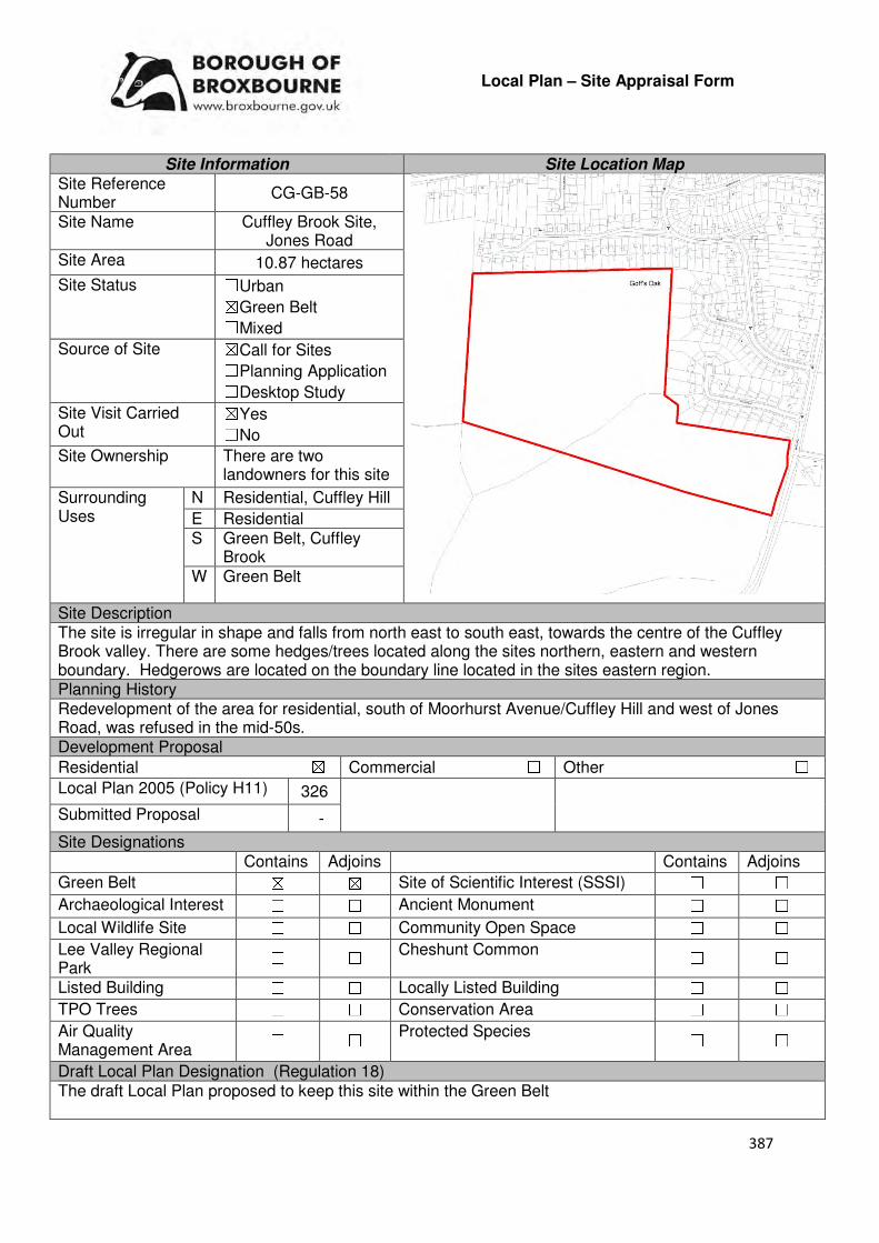
387
Local Plan – Site Appraisal Form
Site Information Site Location Map Site Reference Number
CG-GB-58
Site Name Cuffley Brook Site, Jones Road
Site Area 10.87 hectares
Site Status ☐Urban ☒Green Belt ☐Mixed
Source of Site ☒Call for Sites ☐Planning Application ☐Desktop Study
Site Visit Carried Out
☒Yes ☐No
Site Ownership There are two landowners for this site
Surrounding Uses
N Residential, Cuffley Hill
E Residential S Green Belt, Cuffley
Brook W Green Belt
Site Description The site is irregular in shape and falls from north east to south east, towards the centre of the Cuffley Brook valley. There are some hedges/trees located along the sites northern, eastern and western boundary. Hedgerows are located on the boundary line located in the sites eastern region. Planning History Redevelopment of the area for residential, south of Moorhurst Avenue/Cuffley Hill and west of Jones Road, was refused in the mid-50s. Development Proposal
Residential ☒ Commercial ☐ Other ☐
Local Plan 2005 (Policy H11) 326
Submitted Proposal -
Site Designations Contains Adjoins Contains Adjoins
Green Belt ☒ ☒ Site of Scientific Interest (SSSI) ☐ ☐
Archaeological Interest ☐ ☐ Ancient Monument ☐ ☐
Local Wildlife Site ☐ ☐ Community Open Space ☐ ☐
Lee Valley Regional Park
☐ ☐ Cheshunt Common ☐ ☐
Listed Building ☐ ☐ Locally Listed Building ☐ ☐
TPO Trees ☐ ☐ Conservation Area ☐ ☐
Air Quality Management Area
☐ ☐ Protected Species ☐ ☐
Draft Local Plan Designation (Regulation 18) The draft Local Plan proposed to keep this site within the Green Belt

388
Accessibility – distance as the crow flies
115m -Primary School (Woodside)
2.33km - Secondary School (Goffs)
3.76km –Employment Area (News International)
20m - Green Space (Jones Road)
760m -Healthcare Centre (Valley View)
10km- Hospital (with A&E) (Barnet)
3.95km - Town/District Centre (Brookfield)
608m- Local Centre (1-5 Newgatestreet Road)
4.11km -Leisure Centre (Laura Trott)
3.71km - A10 Junction (Church Lane)
690m- Railway Station (Cuffley)
245m- Bus Service (Cuffley Hill)
Flood Risk Does the site Contain Adjoins
Zone 2 (Medium Risk) ☐ ☐
Zone 3a (High Risk) ☐ ☐
Zone 3b (Active Flood Plain) ☐ ☐
Additional Flood Risk Comments There may be some ground and surface water flooding on the site. Access and Transport Comments The site can be accessed from Jones Road; however part of this section of the road is private access only. Due to the amount of dwellings this site could accommodate a transport assessment will be required. There are footpaths located at the entrance to Broadfields. Connections to these footpaths will be required. Utility Provision
Electricity Connections available at the residential properties to the north and east.
Gas A low pressure gas main is located at Jones Road, Broadfields, Moorhurst Avenue and Cuffley Hill
Water Water mains are located at Greenways, Broadfields, Jones Road, Moorhurst Avenue and Cuffley Hill.
Sewerage A foul sewer crosses the site. Surface sewers are located along Cuffley Hill and at the Greenways, Moorhurst Avenue, Broadfields and Jones Road.
Sewerage Treatment ☐Rye Meads ☒Deephams ☐Other
Additional Developer Comments submitted during Call for Sites 2016 None submitted. Suitability Comments The site is not considered to be suitable for residential development due to the following reasons:
• The site is included within area D27 identified in the Council’s Green Belt Review (Scott Wilson, 2008). The Review states that area D27 performs strongly against Green Belt purposes and proposed no change to the Green Belt boundary as there “is no further opportunity to provide a stronger boundary”.
• The development of this site will have a detrimental impact on the landscape character of this area of the Green Belt.
• Development on this site will erode the Green Belt gap between Goffs Oak and Cuffley, in

389
additional to having a detrimental impact on this area of the
• The Borough Wide Options and Scenarios (Broxbourne Borough Council, 2016) states that this site “forms part of a high quality valley landscape which maintains separation between Cuffley and Goffs Oak. In addition, the only direct access which leaves the majority of the site essentially unattached to the village. It is not considered to be a suitable site for development”.
Is this site considered to be suitable for development? ☐Yes ☒ No

390
Local Plan – Site Appraisal Form
Site Information Site Location Map Site Reference Number
CG-GB-59(a)
Site Name Four Winds and Forest View
Site Area 2.1 hectares
Site Status ☐Urban ☒Green Belt ☐Mixed
Source of Site ☒Call for Sites ☐Planning Application ☐Desktop Study
Site Visit Carried Out
☐Yes ☒No
Site Ownership There are several landowners for this site.
Surr
oundin
g
Uses
N Green Belt, Laurel Park
E Green Belt, Wooded Area, Open Field
S Green Belt, Tetherdown
W Newgatestreet Road, Open Field, Green Belt
Site Description The site is relatively rectangular in shape. Two residential dwellings front on to Newgatestreet Road, with another structure located in the north easterly region of the site. The remainder of the site is predominantly open field in nature, with a wooded area located in the central region of the site, extending to the eastern boundary. A number of trees line the sites boundary.
Planning History In 2014, the demolition of some existing out-buildings and replacement with new out-buildings to use as tack room, garage and storage was granted permission at Four Winds. In 1973 a two storey side extension was approved a Forest View. A change of use to mixed residential/business (parking for five limousines) was refused at Forest View in 1996.
Development Proposal
Residential ☒ Commercial ☐ Other ☐
Local Plan 2005 (Policy H11) 63
Submitted Proposal -
Site Designations Contains Adjoins Contains Adjoins
Green Belt ☒ ☒ Site of Scientific Interest (SSSI) ☐ ☐
Archaeological Interest ☐ ☐ Ancient Monument ☐ ☐
Local Wildlife Site ☒ ☐ Community Open Space ☐ ☒
Lee Valley Regional Park ☐ ☐ Cheshunt Common ☐ ☐
Listed Building ☐ ☐ Locally Listed Building ☐ ☐
TPO Trees ☐ ☐ Conservation Area ☐ ☐
Air Quality Management Area
☐ ☐ Protected Species ☐ ☐
Draft Local Plan Designation (Regulation 18) The draft Local Plan proposed to keep this site within the Green Belt
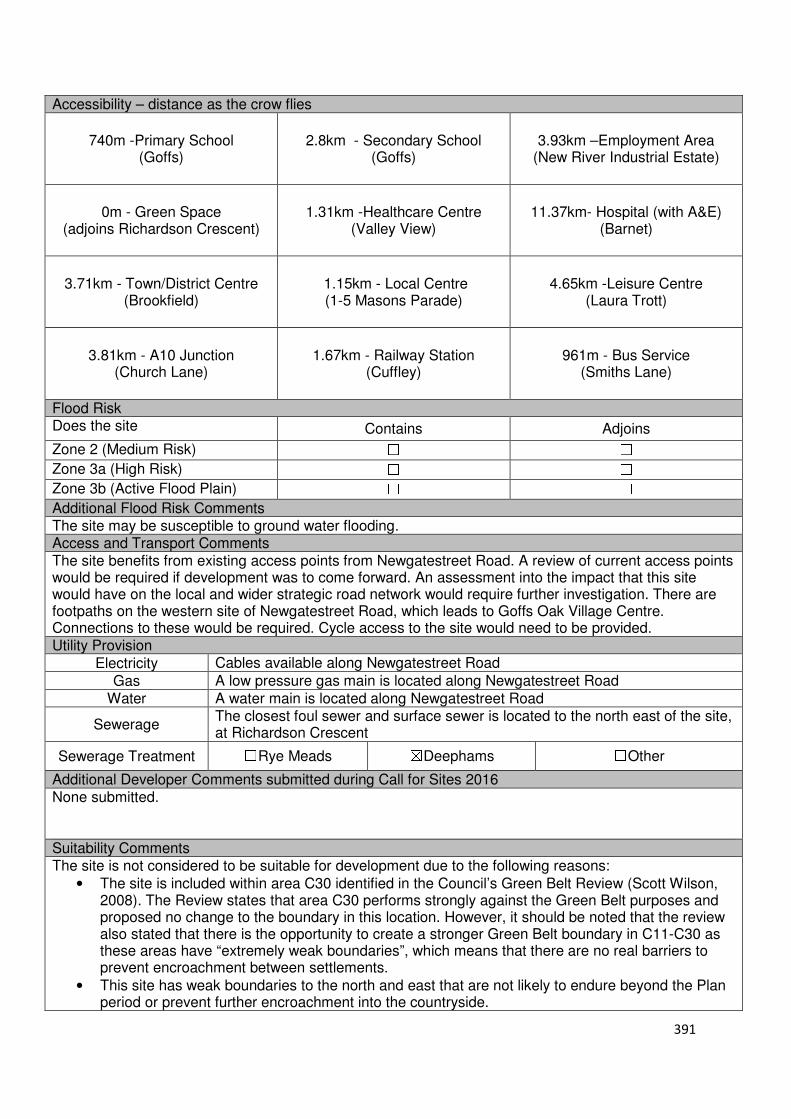
391
Accessibility – distance as the crow flies
740m -Primary School (Goffs)
2.8km - Secondary School (Goffs)
3.93km –Employment Area (New River Industrial Estate)
0m - Green Space (adjoins Richardson Crescent)
1.31km -Healthcare Centre (Valley View)
11.37km- Hospital (with A&E) (Barnet)
3.71km - Town/District Centre (Brookfield)
1.15km - Local Centre (1-5 Masons Parade)
4.65km -Leisure Centre (Laura Trott)
3.81km - A10 Junction (Church Lane)
1.67km - Railway Station (Cuffley)
961m - Bus Service (Smiths Lane)
Flood Risk Does the site Contains Adjoins
Zone 2 (Medium Risk) ☐ ☐
Zone 3a (High Risk) ☐ ☐
Zone 3b (Active Flood Plain) ☐ ☐
Additional Flood Risk Comments The site may be susceptible to ground water flooding. Access and Transport Comments The site benefits from existing access points from Newgatestreet Road. A review of current access points would be required if development was to come forward. An assessment into the impact that this site would have on the local and wider strategic road network would require further investigation. There are footpaths on the western site of Newgatestreet Road, which leads to Goffs Oak Village Centre. Connections to these would be required. Cycle access to the site would need to be provided. Utility Provision
Electricity Cables available along Newgatestreet Road
Gas A low pressure gas main is located along Newgatestreet Road
Water A water main is located along Newgatestreet Road
Sewerage The closest foul sewer and surface sewer is located to the north east of the site, at Richardson Crescent
Sewerage Treatment ☐Rye Meads ☒Deephams ☐Other
Additional Developer Comments submitted during Call for Sites 2016 None submitted. Suitability Comments The site is not considered to be suitable for development due to the following reasons:
• The site is included within area C30 identified in the Council’s Green Belt Review (Scott Wilson, 2008). The Review states that area C30 performs strongly against the Green Belt purposes and proposed no change to the boundary in this location. However, it should be noted that the review also stated that there is the opportunity to create a stronger Green Belt boundary in C11-C30 as these areas have “extremely weak boundaries”, which means that there are no real barriers to prevent encroachment between settlements.
• This site has weak boundaries to the north and east that are not likely to endure beyond the Plan period or prevent further encroachment into the countryside.
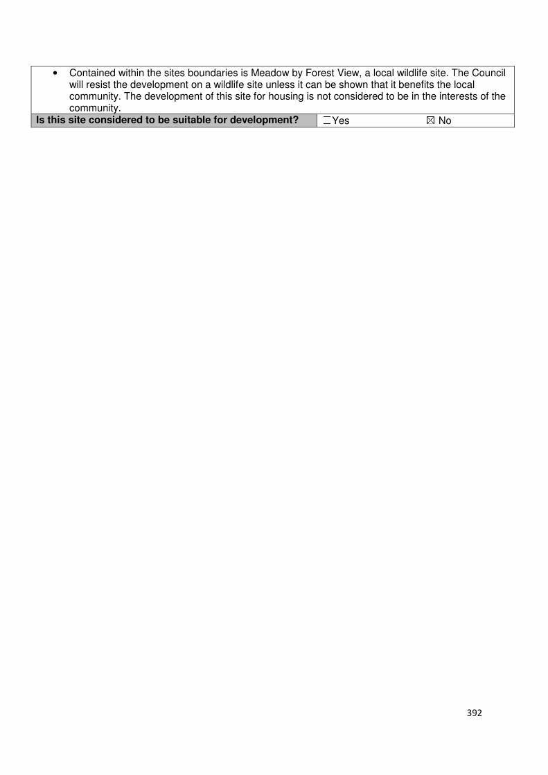
392
• Contained within the sites boundaries is Meadow by Forest View, a local wildlife site. The Council will resist the development on a wildlife site unless it can be shown that it benefits the local community. The development of this site for housing is not considered to be in the interests of the community.
Is this site considered to be suitable for development? ☐Yes ☒ No
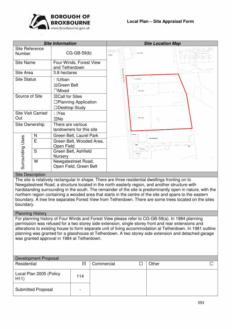
393
Local Plan – Site Appraisal Form
Site Information Site Location Map Site Reference Number CG-GB-59(b)
Site Name Four Winds, Forest View and Tetherdown
Site Area 3.8 hectares
Site Status ☐Urban ☒Green Belt ☐Mixed
Source of Site ☒Call for Sites ☐Planning Application ☐Desktop Study
Site Visit Carried Out
☐Yes ☒No
Site Ownership There are various landowners for this site
Surr
oundin
g U
ses N Green Belt, Laurel Park
E Green Belt, Wooded Area, Open Field
S Green Belt, Ashfield Nursery
W Newgatestreet Road, Open Field, Green Belt
Site Description The site is relatively rectangular in shape. There are three residential dwellings fronting on to Newgatestreet Road, a structure located in the north easterly region, and another structure with hardstanding surrounding in the south. The remainder of the site is predominantly open in nature, with the northern region containing a wooded area that starts in the centre of the site and spans to the eastern boundary. A tree line separates Forest View from Tetherdown. There are some trees located on the sites boundary.
Planning History For planning history of Four Winds and Forest View please refer to CG-GB-59(a). In 1984 planning permission was refused for a two storey side extension, single storey front and rear extensions and alterations to existing house to form separate unit of living accommodation at Tetherdown. In 1981 outline planning was granted for a glasshouse at Tetherdown. A two storey side extension and detached garage was granted approval in 1984 at Tetherdown. Development Proposal
Residential ☒ Commercial ☐ Other ☐
Local Plan 2005 (Policy H11)
114
Submitted Proposal -
394
Site Designations Contains Adjoins Contains Adjoins
Green Belt ☒ ☒ Site of Scientific Interest (SSSI) ☐ ☐
Archaeological Interest ☐ ☐ Ancient Monument ☐ ☐
Local Wildlife Site ☒ ☐ Community Open Space ☐ ☒
Lee Valley Regional Park
☐ ☐ Cheshunt Common ☐ ☐
Listed Building ☐ ☐ Locally Listed Building ☐ ☐
TPO Trees ☐ ☐ Conservation Area ☐ ☐
Air Quality Management Area
☐ ☐ Protected Species ☐ ☐
Draft Local Plan Designation (Regulation 18) The draft Local Plan proposed to keep this site within the Green Belt. Accessibility – distance as the crow flies
670m -Primary School (Goffs)
2.74km - Secondary School (Goffs)
3.93km–Employment Area (New River Industrial Estate)
0m - Green Space (adjoins Richardson Crescent)
1.23km -Healthcare Centre (Valley View)
11.3km - Hospital (with A&E) (Barnet)
3.71km - Town/District Centre (Brookfield)
1km - Local Centre (1-5 Masons Parade)
4.6km -Leisure Centre (Laura Trott)
3.8km - A10 Junction (Church Lane)
1.6km - Railway Station (Cuffley)
961mm - Bus Service (Smiths Close)
Flood Risk Does the site Contains Adjoins
Zone 2 (Medium Risk) ☐ ☐
Zone 3a (High Risk) ☐ ☐
Zone 3b (Active Flood Plain) ☐ ☐
Additional Flood Risk Comments The site may be susceptible to ground water flooding. Access and Transport Comments The site benefits from a number of access points from Newgatestreet Road. It is considered that should development come forward, some of these access points would require closing. An assessment into the impact that this site could have on the local and wider strategic road network would require further investigation. There are footpaths on the western side of Newgatestreet Road, which lead to Goffs Oak Village Centre. Connections to these would be required. Cycle access to the site would need to be provided. Utility Provision
Electricity Cables available along Newgatestreet Road
Gas A low pressure gas main is located along Newgatestreet Road
Water A water main is located along Newgatestreet Road
Sewerage The closest foul sewer and surface sewer is located to the north east of the site, at Richardson Crescent.
Sewerage Treatment ☐Rye Meads ☒Deephams ☐Other
Additional Developer Comments submitted during Call for Sites 2016 None submitted.

395
Suitability Comments
• The site is included within area C30 identified in the Council’s Green Belt Review (Scott Wilson, 2008). The Review states that area C30 performs strongly against the Green Belt purposes and proposed no change to the boundary in this location. However, it should be noted that the review also stated that there is the opportunity to create a stronger Green Belt boundary in C11-C30 as these areas have “extremely weak boundaries”, which means that there are no real barriers to prevent encroachment between settlements.
• This site has weak boundaries to the north and east that are not likely to endure beyond the Plan period or prevent further encroachment into the Green Belt.
• Contained within the sites boundaries is Meadow by Forest View, a local wildlife site. The Council will resist the development on a wildlife site unless it can be shown that it benefits the local community. The local wildlife designation does not cover the entirety of the site, but a significant proportion, which will reduce the sites developable area
Is this site considered to be suitable for development? ☐Yes ☒ No

396
Local Plan – Site Appraisal Form
Site Information Site Location Map Site Reference Number
CG-GB-60
Site Name Rosedale Meadow Site Area 0.36 hectares
Site Status ☐Urban ☒Green Belt ☐Mixed
Source of Site ☒Call for Sites ☐Planning Application ☐Desktop Study
Site Visit Carried Out
☐Yes ☒No
Site Ownership The site is owned by two private companies.
Surr
oundin
g
Uses
N Local Wildlife Site, Green Belt
E Residential S Residential, Green Belt
W Green Belt
Site Description The site is broadly rectangular in shape and relatively flat. It is predominantly open field in nature, with a number of trees scattered throughout.
Planning History A planning application for the erection of 1five bed and 4 four bed dwellings with access road, associated landscaping, car and cycle parking was refused in 2013. Development Proposal
Residential ☒ Commercial ☐ Other ☐
Local Plan 2005 (Policy H11)
Submitted Proposal 5
Site Designations Contains Adjoins Contains Adjoins
Green Belt ☒ ☒ Site of Scientific Interest (SSSI)
☐ ☐
Archaeological Interest ☐ ☐ Ancient Monument ☐ ☐
Local Wildlife Site ☒ ☒ Community Open Space ☐ ☐
Lee Valley Regional Park
☐ ☐ Cheshunt Common ☐ ☐
Listed Building ☐ ☐ Locally Listed Building ☐ ☐
TPO Trees ☒ ☒ Conservation Area ☐ ☐
Air Quality Management Area
☐ ☐ Protected Species ☐ ☐
Draft Local Plan Designation (Regulation 18) The site was proposed to be designated as a local wildlife site in the emerging Local Plan.

397
Accessibility – distance as the crow flies
790m-Primary School
(Bonneygrove)
630m - Secondary School (Goffs)
2.5km –Employment Area (New River Industrial Estate)
110m - Green Space (Claremont)
1km -Healthcare Centre (Stockwell Lodge)
12km - Hospital (with A&E)
(Barnet)
2.17km - Town/District Centre
(Brookfield)
960m - Local Centre
2.51km -Leisure Centre (Laura Trott)
1.86km- A10 Junction
(Church Lane)
2.75km - Railway Station
(Cuffley)
171m - Bus Service (Colesgrove Farm)
Flood Risk Does the site Contains Adjoins
Zone 2 (Medium Risk) ☐ ☐
Zone 3a (High Risk) ☐ ☐
Zone 3b (Active Flood Plain) ☐ ☒
Additional Flood Risk Comments There may be some surface water flooding. Access and Transport Comments There is no current vehicular access to the site. There is a set of gates at Faints Close which can be used to access the site. Faints Close is considered to be the only feasible access point to the site. There are no footpaths through Faints Close. Footpaths begin when Faints Close and Caldecote Avenue meet. Utility Provision
Electricity Connections available at the existing properties to the east and south.
Gas A low pressure gas main is located to the south at Faints Close.
Water A water main is located to the south at Faints Close
Sewerage A foul sewer and surface sewer is located to the south at Faints Close
Sewerage Treatment ☐Rye Meads ☒Deephams ☐Other
Additional Developer Comments submitted during Call for Sites 2016 None submitted. However, the promoter stated during the Local Plan (Regulation 18) consultation that this site is adjacent to the proposed Rosedale Park development and could be developed as part of the series of integrated communities. They continue by stating that the development on the Faints Close site is also important being able to provide important pedestrian connections as required in relation to both Rosedale Park North and Rosedale Park South. The site can be delivered at an early stage to provide much needed family dwellings – the site could provide 5 dwellings by 2018. The promoter states that access to the site already exists and all the utilities are available. The promoter submitted a map which shows that the site is no longer designated as a wildlife site. Suitability Comments The site is not considered to be suitable for development due to the following reasons:
• The site is still designated as a local wildlife site, Meadow South of Rosedale Sports Ground, as shown by Council records. The Council will resist development on local wildlife sites unless it can be shown that its development benefits the wider community. The Council will be checking the exact boundaries through the Local Plan process.

398
• A scheme ( 07/13/0954/F) similar to the proposal submitted by the promoter during the Local Plan consultation was refused, not only due to its being inappropriate form of development within the Metropolitan Green Belt and resulting in built form on land which is currently designated as a local wildlife site, but the development would fail in meeting Privacy Guidelines laid out in the Borough Wide Supplementary Guidance (Adopted August 2004 – updated 2013) which means that the proposal would create a material loss of privacy at the rear of the properties in Thompson Close The scheme was also refused due to an unacceptable impact on the TPO trees within the site.
Is this site considered to be suitable for development? ☐Yes ☒ No
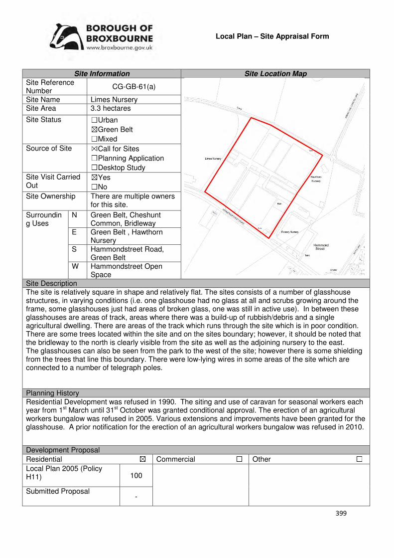
399
Local Plan – Site Appraisal Form
Site Information Site Location Map Site Reference Number
CG-GB-61(a)
Site Name Limes Nursery Site Area 3.3 hectares
Site Status ☐Urban ☒Green Belt ☐Mixed
Source of Site ☒Call for Sites ☐Planning Application ☐Desktop Study
Site Visit Carried Out
☒Yes ☐No
Site Ownership There are multiple owners for this site.
Surrounding Uses
N Green Belt, Cheshunt Common, Bridleway
E Green Belt , Hawthorn Nursery
S Hammondstreet Road, Green Belt
W Hammondstreet Open Space
Site Description The site is relatively square in shape and relatively flat. The sites consists of a number of glasshouse structures, in varying conditions (i.e. one glasshouse had no glass at all and scrubs growing around the frame, some glasshouses just had areas of broken glass, one was still in active use). In between these glasshouses are areas of track, areas where there was a build-up of rubbish/debris and a single agricultural dwelling. There are areas of the track which runs through the site which is in poor condition. There are some trees located within the site and on the sites boundary; however, it should be noted that the bridleway to the north is clearly visible from the site as well as the adjoining nursery to the east. The glasshouses can also be seen from the park to the west of the site; however there is some shielding from the trees that line this boundary. There were low-lying wires in some areas of the site which are connected to a number of telegraph poles. Planning History Residential Development was refused in 1990. The siting and use of caravan for seasonal workers each year from 1st March until 31st October was granted conditional approval. The erection of an agricultural workers bungalow was refused in 2005. Various extensions and improvements have been granted for the glasshouse. A prior notification for the erection of an agricultural workers bungalow was refused in 2010.
Development Proposal
Residential ☒ Commercial ☐ Other ☐
Local Plan 2005 (Policy H11) 100
Submitted Proposal -

400
Site Designations Contains Adjoins Contains Adjoins
Green Belt ☒ ☒ Site of Scientific Interest (SSSI) ☐ ☐
Archaeological Interest ☐ ☐ Ancient Monument ☐ ☐
Local Wildlife Site ☐ ☐ Community Open Space ☐ ☒
Lee Valley Regional Park
☐ ☐ Cheshunt Common ☒ ☒
Listed Building ☐ ☐ Locally Listed Building ☐ ☐
TPO Trees ☐ ☐ Conservation Area ☐ ☐
Air Quality Management Area
☐ ☐ Protected Species ☐ ☐
Draft Local Plan Designation (Regulation 18) The draft Local Plan proposed to keep this site within the Green Belt Accessibility – distance as the crow flies
1.4km -Primary School (Goffs Oak)
2.5km- Secondary School (Goffs)
3km -Employment Area (New River Industrial Trading
Estate)
0m - Green Space (Hammondstreet)
1.5km -Healthcare Centre (Valley View)
12.25km- Hospital (with A&E) (Barnet)
2.95km - Town/District Centre (Brookfield)
700m - Local Centre (Hammondstreet)
4km -Leisure Centre
(Laura Trott)
3.2km - A10 Junction (Church Lane)
2.52km- Railway Station (Cuffley)
138m - Bus Service (Smiths)
Flood Risk Does the site Contains Adjoins
Zone 2 (Medium Risk) ☐ ☐
Zone 3a (High Risk) ☐ ☐
Zone 3b (Active Flood Plain) ☐ ☐
Additional Flood Risk Comments There are no flooding issues identified for this site. Access and Transport Comments The site can be currently accessed from Hammondstreet Road. There are footpaths along the northern side of Hammondstreet Road. The current vehicular access point will require improvement if development was to occur. Depending upon the density of the site a transport assessment may be required. There is a public right of way to the rear of the site. Utility Provision
Electricity Available at Bread and Cheese Lane or to the south at Hammondstreet Road
Gas A low pressure gas main is located along Hammondstreet Road
Water A water main and trunk main is located along Hammondstreet Road
Sewerage A foul sewer is located to the south of the site, near 431 and 433 Hammondstreet Road
Sewerage Treatment ☐Rye Meads ☒Deephams ☐Other

401
Additional Developer Comments submitted during Call for Sites 2016 The promoter of the site stated that is unviable to continue the existing use of the site and that any attempt to revive any such use would not be possible. Without there being significant incentive to redevelop the site, it will fall into disrepair, with the cost of repair and upgrading the premises being unjustifiable. The promoter stated that the site represents a significant opportunity of turning a derelict brownfield site into a high quality housing development, providing much needed housing and helping to meet the Council’s need for housing as part of its 5-year supply. The site is effectively constraint free in respect of the principle of redevelopment for convention residential use, rather than solely for self-build which is unlikely to be viable in isolation. A feasibility scheme was carried out which identified that there is scope for around 109 dwellings, subject to factors such as mix of units and density, which could be amended. The promoter stated that the site is deliverable and that the Council’s own Green Belt Review identified the site as “relatively unconstrained and a derelict brownfield site [which] means this should be considered as a possibility for development”. Suitability Comments The site is not considered to be suitable for high density residential development due to the following reasons:
• The site is included within area C10 identified in the Council’s Green Belt Review (Scott Wilson, 2008). The review states that area C10 performs strongly against Green Belt purposes and no change to the boundary in this location were proposed.
• The 2005 Local Plan Inspectors Report states that Limes Nursery performs the green belt functions of separating the built up area of Cheshunt and Hammondstreet, and although partly developed with glasshouses and some small outbuildings, prevent these settlements from encroaching into the countryside.
• The ‘Goffs Oak Development Options Report’ notes that development to address dereliction on sites such as Limes would result in the creation of ‘villages’ of development isolated from services and transport. It continues by stating that the adoption of this approach would result in unsustainable urban sprawl, the likely merging of settlements and the steady erosion of the character of Goffs Oak.
However, subject to the sites compliance with emerging Policy GB2: Residential Development on Derelict Glass House Sites, the site could be subdivided into self-build housing plots. Is this site considered to be suitable for development?
☐Yes ☒ No
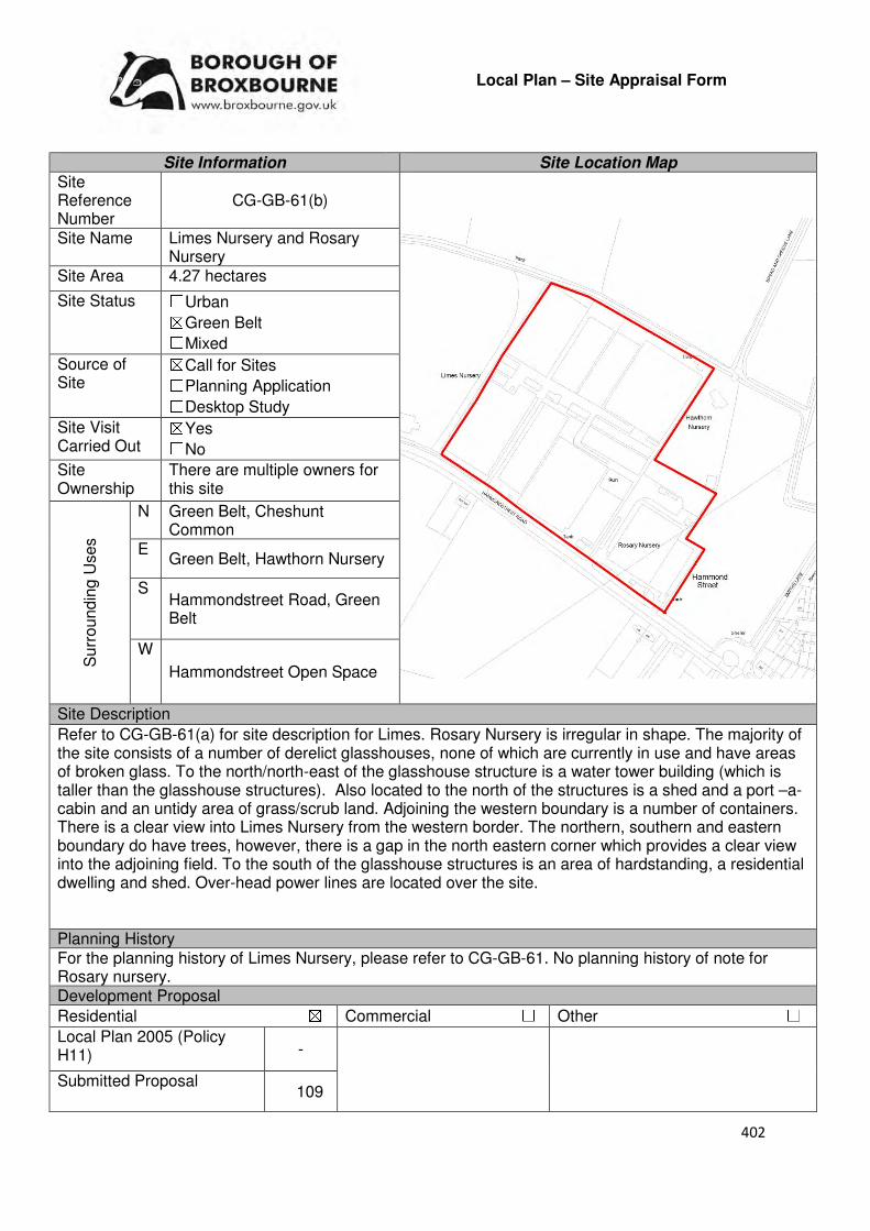
402
Local Plan – Site Appraisal Form
Site Information Site Location Map Site Reference Number
CG-GB-61(b)
Site Name Limes Nursery and Rosary Nursery
Site Area 4.27 hectares
Site Status ☐Urban ☒Green Belt ☐Mixed
Source of Site
☒Call for Sites ☐Planning Application ☐Desktop Study
Site Visit Carried Out
☒Yes ☐No
Site Ownership
There are multiple owners for this site
Surr
oundin
g U
ses
N Green Belt, Cheshunt Common
E Green Belt, Hawthorn Nursery
S Hammondstreet Road, Green Belt
W
Hammondstreet Open Space
Site Description
Refer to CG-GB-61(a) for site description for Limes. Rosary Nursery is irregular in shape. The majority of the site consists of a number of derelict glasshouses, none of which are currently in use and have areas of broken glass. To the north/north-east of the glasshouse structure is a water tower building (which is taller than the glasshouse structures). Also located to the north of the structures is a shed and a port –a-cabin and an untidy area of grass/scrub land. Adjoining the western boundary is a number of containers. There is a clear view into Limes Nursery from the western border. The northern, southern and eastern boundary do have trees, however, there is a gap in the north eastern corner which provides a clear view into the adjoining field. To the south of the glasshouse structures is an area of hardstanding, a residential dwelling and shed. Over-head power lines are located over the site. Planning History For the planning history of Limes Nursery, please refer to CG-GB-61. No planning history of note for Rosary nursery. Development Proposal
Residential ☒ Commercial ☐ Other ☐
Local Plan 2005 (Policy H11) -
Submitted Proposal 109
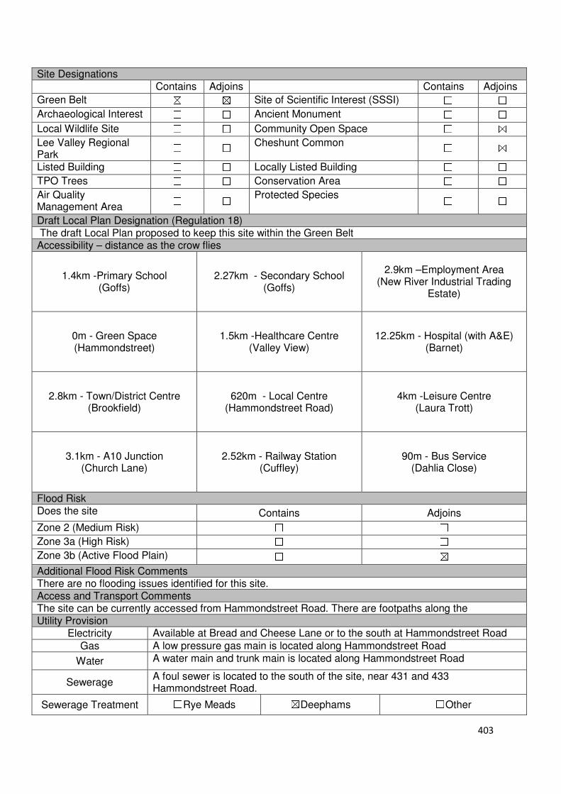
403
Site Designations Contains Adjoins Contains Adjoins
Green Belt ☒ ☒ Site of Scientific Interest (SSSI) ☐ ☐
Archaeological Interest ☐ ☐ Ancient Monument ☐ ☐
Local Wildlife Site ☐ ☐ Community Open Space ☐ ☒
Lee Valley Regional Park
☐ ☐ Cheshunt Common ☐ ☒
Listed Building ☐ ☐ Locally Listed Building ☐ ☐
TPO Trees ☐ ☐ Conservation Area ☐ ☐
Air Quality Management Area
☐ ☐ Protected Species ☐ ☐
Draft Local Plan Designation (Regulation 18) The draft Local Plan proposed to keep this site within the Green Belt Accessibility – distance as the crow flies
1.4km -Primary School (Goffs)
2.27km - Secondary School (Goffs)
2.9km –Employment Area
(New River Industrial Trading Estate)
0m - Green Space (Hammondstreet)
1.5km -Healthcare Centre
(Valley View)
12.25km - Hospital (with A&E)
(Barnet)
2.8km - Town/District Centre (Brookfield)
620m - Local Centre
(Hammondstreet Road)
4km -Leisure Centre (Laura Trott)
3.1km - A10 Junction (Church Lane)
2.52km - Railway Station
(Cuffley)
90m - Bus Service (Dahlia Close)
Flood Risk Does the site Contains Adjoins
Zone 2 (Medium Risk) ☐ ☐
Zone 3a (High Risk) ☐ ☐
Zone 3b (Active Flood Plain) ☐ ☒
Additional Flood Risk Comments There are no flooding issues identified for this site. Access and Transport Comments The site can be currently accessed from Hammondstreet Road. There are footpaths along the Utility Provision
Electricity Available at Bread and Cheese Lane or to the south at Hammondstreet Road
Gas A low pressure gas main is located along Hammondstreet Road
Water A water main and trunk main is located along Hammondstreet Road
Sewerage A foul sewer is located to the south of the site, near 431 and 433 Hammondstreet Road.
Sewerage Treatment ☐Rye Meads ☒Deephams ☐Other
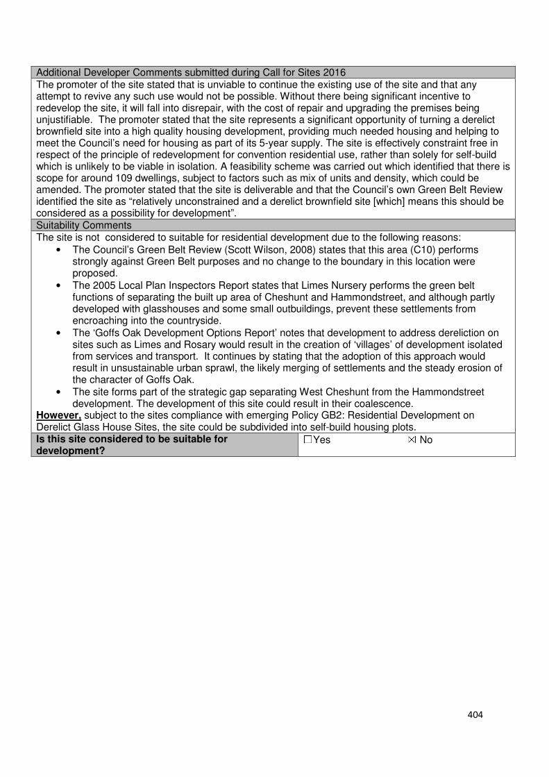
404
Additional Developer Comments submitted during Call for Sites 2016 The promoter of the site stated that is unviable to continue the existing use of the site and that any attempt to revive any such use would not be possible. Without there being significant incentive to redevelop the site, it will fall into disrepair, with the cost of repair and upgrading the premises being unjustifiable. The promoter stated that the site represents a significant opportunity of turning a derelict brownfield site into a high quality housing development, providing much needed housing and helping to meet the Council’s need for housing as part of its 5-year supply. The site is effectively constraint free in respect of the principle of redevelopment for convention residential use, rather than solely for self-build which is unlikely to be viable in isolation. A feasibility scheme was carried out which identified that there is scope for around 109 dwellings, subject to factors such as mix of units and density, which could be amended. The promoter stated that the site is deliverable and that the Council’s own Green Belt Review identified the site as “relatively unconstrained and a derelict brownfield site [which] means this should be considered as a possibility for development”. Suitability Comments The site is not considered to suitable for residential development due to the following reasons:
• The Council’s Green Belt Review (Scott Wilson, 2008) states that this area (C10) performs strongly against Green Belt purposes and no change to the boundary in this location were proposed.
• The 2005 Local Plan Inspectors Report states that Limes Nursery performs the green belt functions of separating the built up area of Cheshunt and Hammondstreet, and although partly developed with glasshouses and some small outbuildings, prevent these settlements from encroaching into the countryside.
• The ‘Goffs Oak Development Options Report’ notes that development to address dereliction on sites such as Limes and Rosary would result in the creation of ‘villages’ of development isolated from services and transport. It continues by stating that the adoption of this approach would result in unsustainable urban sprawl, the likely merging of settlements and the steady erosion of the character of Goffs Oak.
• The site forms part of the strategic gap separating West Cheshunt from the Hammondstreet development. The development of this site could result in their coalescence.
However, subject to the sites compliance with emerging Policy GB2: Residential Development on Derelict Glass House Sites, the site could be subdivided into self-build housing plots. Is this site considered to be suitable for development?
☐Yes ☒ No

405
Local Plan – Site Appraisal Form
Site Information Site Location Map Site Reference Number
CG-GB-62
Site Name Cuffley Hill Comprehensive
Site Area 4.3 hectares
Site Status ☐Urban ☒Green Belt ☐Mixed
Source of Site ☒Call for Sites ☐Planning Application ☐Desktop Study
Site Visit Carried Out
☒Yes ☐No
Site Ownership There are various landowners for this site.
Surr
oun
din
g
Uses
N Green Belt, Residential
E Residential S Cuffley Hill, Residential
W Wooded Area, Green Belt
Site Description This site is formed of three different sites: CG-GB-02, CG-GB-48 and CG-GB-65. Please refer to these forms for site descriptions. Planning History Please refer to CG-GB-02, CG-GB-48 and CG-GB-65 for the sites planning history. Development Proposal
Residential ☒ Commercial ☐ Other ☐
Local Plan 2005 (Policy H11)
Submitted Proposal
46 (Local Plan Proposal)
Site Designations Contains Adjoins Contains Adjoins
Green Belt ☒ ☒ Site of Scientific Interest (SSSI) ☐ ☐
Archaeological Interest ☐ ☐ Ancient Monument ☐ ☐
Local Wildlife Site ☐ ☐ Community Open Space ☐ ☐
Lee Valley Regional Park
☐ ☐ Cheshunt Common ☐ ☐
Listed Building ☐ ☐ Locally Listed Building ☐ ☐
TPO Trees ☒ ☒ Conservation Area ☐ ☐
Air Quality Management Area
☐ ☐ Protected Species ☐ ☐
Draft Local Plan Designation (Regulation 18) The draft Local Plan proposed to allocate this site for residential development in emerging Policy GO5: North of Cuffley Hill. The draft Plan identified that this site has the ability to provide 46 dwellings and public open space.
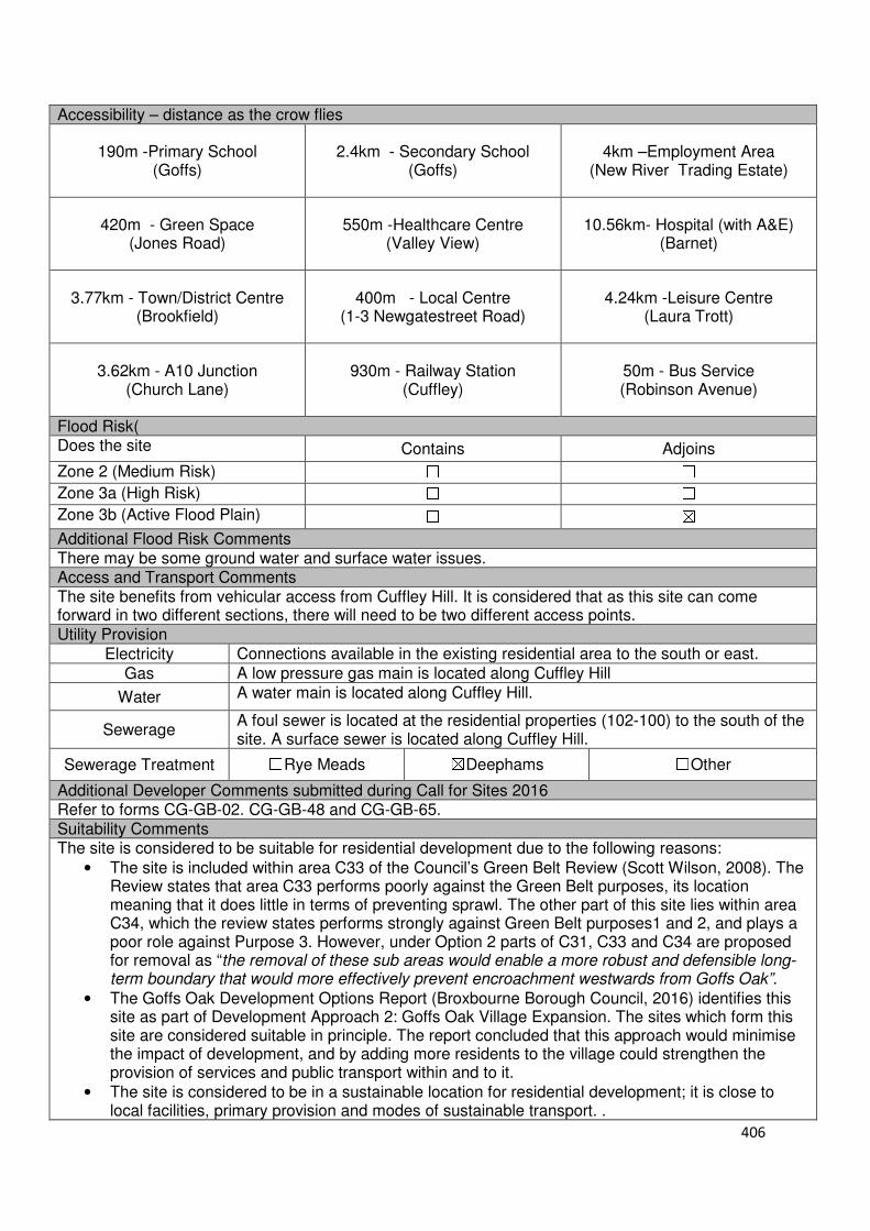
406
Accessibility – distance as the crow flies
190m -Primary School (Goffs)
2.4km - Secondary School (Goffs)
4km –Employment Area (New River Trading Estate)
420m - Green Space (Jones Road)
550m -Healthcare Centre (Valley View)
10.56km- Hospital (with A&E) (Barnet)
3.77km - Town/District Centre (Brookfield)
400m - Local Centre (1-3 Newgatestreet Road)
4.24km -Leisure Centre (Laura Trott)
3.62km - A10 Junction (Church Lane)
930m - Railway Station (Cuffley)
50m - Bus Service (Robinson Avenue)
Flood Risk( Does the site Contains Adjoins
Zone 2 (Medium Risk) ☐ ☐
Zone 3a (High Risk) ☐ ☐
Zone 3b (Active Flood Plain) ☐ ☒
Additional Flood Risk Comments There may be some ground water and surface water issues. Access and Transport Comments The site benefits from vehicular access from Cuffley Hill. It is considered that as this site can come forward in two different sections, there will need to be two different access points. Utility Provision
Electricity Connections available in the existing residential area to the south or east.
Gas A low pressure gas main is located along Cuffley Hill
Water A water main is located along Cuffley Hill.
Sewerage A foul sewer is located at the residential properties (102-100) to the south of the site. A surface sewer is located along Cuffley Hill.
Sewerage Treatment ☐Rye Meads ☒Deephams ☐Other
Additional Developer Comments submitted during Call for Sites 2016 Refer to forms CG-GB-02. CG-GB-48 and CG-GB-65. Suitability Comments The site is considered to be suitable for residential development due to the following reasons:
• The site is included within area C33 of the Council’s Green Belt Review (Scott Wilson, 2008). The Review states that area C33 performs poorly against the Green Belt purposes, its location meaning that it does little in terms of preventing sprawl. The other part of this site lies within area C34, which the review states performs strongly against Green Belt purposes1 and 2, and plays a poor role against Purpose 3. However, under Option 2 parts of C31, C33 and C34 are proposed for removal as “the removal of these sub areas would enable a more robust and defensible long-term boundary that would more effectively prevent encroachment westwards from Goffs Oak”.
• The Goffs Oak Development Options Report (Broxbourne Borough Council, 2016) identifies this site as part of Development Approach 2: Goffs Oak Village Expansion. The sites which form this site are considered suitable in principle. The report concluded that this approach would minimise the impact of development, and by adding more residents to the village could strengthen the provision of services and public transport within and to it.
• The site is considered to be in a sustainable location for residential development; it is close to local facilities, primary provision and modes of sustainable transport. .

407
However, it should be noted that there are a number of protected trees on this site. Due to this it is considered that the density outlined in the Local Plan is appropriate for this site and would be able to provide a number of dwellings within a spacious woodland setting. Is this site considered to be suitable for development?
☒Yes ☐ No
Availability Comments The representations received during the Local Plan (Regulation 18) Consultation indicate that this site is available for development, with two developers having options over this site. It is considered that there are no legal/ownerships constraints that would prevent this site from coming forward.
Is the site considered to be available for development
☒Yes ☐ No
Achievability Comments There are two developers associated with this site. Their interest in the site indicates that it is viable. With the exception of its currently Green Belt designation, it is considered that there are no planning constraints that would prevent the site coming forward for development. It is considered that road works necessary to gain vehicle access to this site will not have a significant impact on the sites viability. The proximity of the site to the urban area means that it will be able to benefit from existing infrastructure (i.e. road network, utilities).
Is the site considered to be achievable? ☒Yes ☐ No
Delivery Period 1-5 years

408
Local Plan – Site Appraisal Form
Site Information Site Location Map Site Reference Number
CG-GB-63
Site Name Goffs Lane Comprehensive Site Area 2.55 hectares
Site Status ☐Urban ☒Green Belt ☐Mixed
Source of Site ☒Call for Sites ☐Planning Application ☐Desktop Study
Site Visit Carried Out
☒Yes ☐No
Site Ownership There are multiple owner for this site
Surr
oundin
g
Uses
N Goffs Lane, InEx nurseries
E Green Belt S Green Belt , Theobalds
Brook W Green Belt, Myles Court,
Goffs Oak House Site Description Refer to CG-GB-09, CG-GB-34 and CG-GB-121 for site description.
Planning History Refer to CG-GB-09, CG-GB-34 and CG-GB-121 for the planning history. Development Proposal
Residential ☒ Commercial ☐ Other ☐
Local Plan 2005 (Policy H11)
Submitted Proposal 45 (Local Plan allocation)
Site Designations Contains Adjoins Contains Adjoins
Green Belt ☒ ☒ Site of Scientific Interest (SSSI)
☐ ☐
Archaeological Interest ☐ ☒ Ancient Monument ☐ ☐
Local Wildlife Site ☐ ☒ Community Open Space ☐ ☐
Lee Valley Regional Park
☐ ☐ Cheshunt Common ☐ ☐
Listed Building ☐ ☐ Locally Listed Building ☐ ☐
TPO Trees ☒ ☒ Conservation Area ☐ ☐
Air Quality Management Area
☐ ☐ Protected Species ☐ ☐
Draft Local Plan Designation (Regulation 18) The draft Local Plan proposed to allocate this site for 45 dwellings in emerging Policy GO3: South of Goffs Lane.

409
Accessibility – distance as the crow flies
360m -Primary School (Woodside)
1.56km - Secondary School (Goffs)
3.3km –Employment Area (News International)
80m - Green Space (Goffs)
140m-Healthcare Centre (Valley View)
11km - Hospital (with A&E) (Barnet)
3km - Town/District Centre (Brookfield)
170m - Local Centre (684-696 Goffs Lane)
3.4km -Leisure Centre (Laura Trott)
2.75m - A10 Junction (Churchgate)
1.75km - Railway Station (Cuffley)
300m - Bus Service (War Memorial)
Flood Risk Does the site Contains Adjoins
Zone 2 (Medium Risk) ☐ ☐
Zone 3a (High Risk) ☐ ☐
Zone 3b (Active Flood Plain) ☐ ☐
Additional Flood Risk Comments There may be some ground and surface water flooding problems. Access and Transport Comments There are various access points to the site from Goffs Lane. If this site came forward, it is considered that only one vehicular access points will be required. The most appropriate access point, and the impact that this site would have on the local strategic road network, should be investigated. Goffs Lane has footpaths along both sides of the road. Connections to these will be required. Cycle access to the site should be created. Utility Provision
Electricity Cables available along Goffs Lane
Gas A low pressure gas main is located along Goffs Lane
Water A water mains is located along Goffs Lane Sewerage A foul sewer and surface sewer is located along Goffs Lane
Sewerage Treatment ☐Rye Meads ☒Deephams ☐Other
Additional Developer Comments submitted during Call for Sites 2016 Refer to CG-GB-09, CG-GB-34 and CG-GB-121 Suitability Comments This site is considered to be suitable for residential development due to the following reasons:
• The site is included within area C24 identified in the Council’s Green belt Review (Scott Wilson, 2008). The review states that area C24 performs strongly against Green Belt purposes, however, due to the extremely weak boundaries within sub areas C11-C30 there are no real barriers to prevent encroachment between settlements due to the incremental development that has occurred over the years. Therefore, there is the opportunity to transform the Green Belt boundary in this location in order to create a far stronger boundary around the edge. The review considered allocating area C24 and provided the following analysis: “Archaeology is the only site constraint against a number of opportunities including reasonable accessibility and proximity to services, high level of derelict/vacant brownfield land and regeneration potential. On this basis the site maybe suitable for built development”.
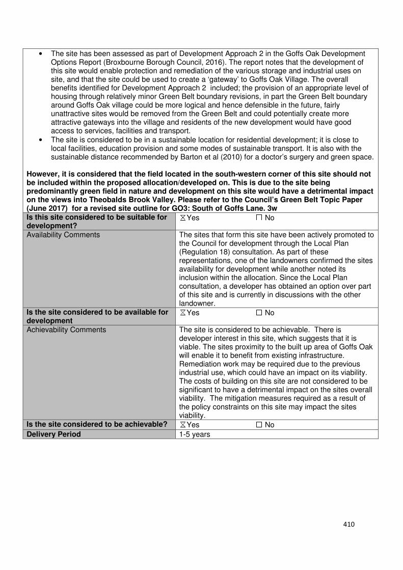
410
• The site has been assessed as part of Development Approach 2 in the Goffs Oak Development Options Report (Broxbourne Borough Council, 2016). The report notes that the development of this site would enable protection and remediation of the various storage and industrial uses on site, and that the site could be used to create a ‘gateway’ to Goffs Oak Village. The overall benefits identified for Development Approach 2 included; the provision of an appropriate level of housing through relatively minor Green Belt boundary revisions, in part the Green Belt boundary around Goffs Oak village could be more logical and hence defensible in the future, fairly unattractive sites would be removed from the Green Belt and could potentially create more attractive gateways into the village and residents of the new development would have good access to services, facilities and transport.
• The site is considered to be in a sustainable location for residential development; it is close to local facilities, education provision and some modes of sustainable transport. It is also with the sustainable distance recommended by Barton et al (2010) for a doctor’s surgery and green space.
However, it is considered that the field located in the south-western corner of this site should not be included within the proposed allocation/developed on. This is due to the site being predominantly green field in nature and development on this site would have a detrimental impact on the views into Theobalds Brook Valley. Please refer to the Council’s Green Belt Topic Paper (June 2017) for a revised site outline for GO3: South of Goffs Lane. 3w Is this site considered to be suitable for development?
☒Yes ☐ No
Availability Comments The sites that form this site have been actively promoted to the Council for development through the Local Plan (Regulation 18) consultation. As part of these representations, one of the landowners confirmed the sites availability for development while another noted its inclusion within the allocation. Since the Local Plan consultation, a developer has obtained an option over part of this site and is currently in discussions with the other landowner.
Is the site considered to be available for development
☒Yes ☐ No
Achievability Comments The site is considered to be achievable. There is developer interest in this site, which suggests that it is viable. The sites proximity to the built up area of Goffs Oak will enable it to benefit from existing infrastructure. Remediation work may be required due to the previous industrial use, which could have an impact on its viability. The costs of building on this site are not considered to be significant to have a detrimental impact on the sites overall viability. The mitigation measures required as a result of the policy constraints on this site may impact the sites viability.
Is the site considered to be achievable? ☒Yes ☐ No
Delivery Period 1-5 years
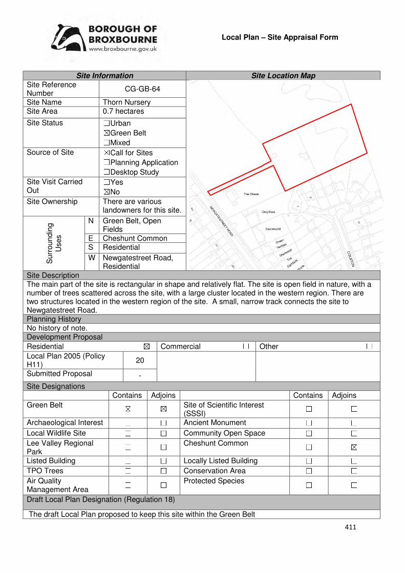
411
Local Plan – Site Appraisal Form
Site Information Site Location Map Site Reference Number
CG-GB-64
Site Name Thorn Nursery Site Area 0.7 hectares
Site Status ☐Urban ☒Green Belt ☐Mixed
Source of Site ☒Call for Sites ☐Planning Application ☐Desktop Study
Site Visit Carried Out
☐Yes ☒No
Site Ownership There are various landowners for this site.
Surr
oundin
g
Uses
N Green Belt, Open Fields
E Cheshunt Common S Residential
W Newgatestreet Road, Residential
Site Description The main part of the site is rectangular in shape and relatively flat. The site is open field in nature, with a number of trees scattered across the site, with a large cluster located in the western region. There are two structures located in the western region of the site. A small, narrow track connects the site to Newgatestreet Road. Planning History No history of note. Development Proposal
Residential ☒ Commercial ☐ Other ☐
Local Plan 2005 (Policy H11)
20
Submitted Proposal -
Site Designations Contains Adjoins Contains Adjoins
Green Belt ☒ ☒ Site of Scientific Interest (SSSI)
☐ ☐
Archaeological Interest ☐ ☐ Ancient Monument ☐ ☐
Local Wildlife Site ☐ ☐ Community Open Space ☐ ☐
Lee Valley Regional Park
☐ ☐ Cheshunt Common ☐ ☒
Listed Building ☐ ☐ Locally Listed Building ☐ ☐
TPO Trees ☐ ☐ Conservation Area ☐ ☐
Air Quality Management Area
☐ ☐ Protected Species ☐ ☐
Draft Local Plan Designation (Regulation 18)
The draft Local Plan proposed to keep this site within the Green Belt
412
Accessibility – distance as the crow flies
230m -Primary School (Goffs)
2.5km - Secondary School (Goffs)
3.83km –Employment Area (New River Trading Estate)
550m - Green Space (Richardson Crescent)
830m -Healthcare Centre (Valley View)
11.1km- Hospital (with A&E) (Barnet)
3.61km - Town/District Centre (Brookfield)
620m - Local Centre (1-5 Masons Parade)
4.35km -Leisure Centre (Laura Trott)
3.55km - A10 Junction (Church Lane)
1.36km - Railway Station (Cuffley)
831m - Bus Service (Goffs Oak War Memorial)
Flood Risk Does the site Contains Adjoins
Zone 2 (Medium Risk) ☐ ☐
Zone 3a (High Risk) ☐ ☐
Zone 3b (Active Flood Plain) ☐ ☐
Additional Flood Risk Comments The site may suffer from ground water flooding. Access and Transport Comments The site can be accessed from Newgatestreet Road; however this is via a gate and track. This track is narrow and would require widening if development was to come forward. The visibility of the entrance would also require improving. There are footpaths along both sides of Newgatestreet Road which lead to Goffs Oak Village Centre. Connections to these would be required. Cycle access to the site would need to be installed. Utility Provision
Electricity Cables available at Newgatestreet Road
Gas A low pressure gas main is located along Newgatestreet Road
Water A water main is located along Newgatestreet Road
Sewerage A foul sewer and surface is located along Newgatestreet Road.
Sewerage Treatment ☐Rye Meads ☒Deephams ☐Other
Additional Developer Comments submitted during Call for Sites 2016 None submitted. Suitability Comments This site is not considered to be suitable for development due to the following reasons:
• The site is included in area C30 identified in the Council’s Green Belt Review (Scott Wilson, 2008). The Review states that area C30 area performs strongly against the Green Belt boundary and proposed no change to the boundary in this location. However, it should be noted that the review also stated that there is the opportunity to create stronger Green Belt boundary in C11-C30 as these areas have “extremely weak boundaries” which means that there are no real barriers to prevent encroachment between settlements.
• This site has weak Green Belt boundaries to the south. These weak boundaries are not likely to ensure beyond the Plan period or prevent further encroachment into the countryside.
• This site contributes to preventing the outward sprawl of Goffs Oak and plays a role in maintaining the strategic gap between Goffs Oak Village and the Hammondstreet settlement.
Is this site considered to be suitable for development? ☐Yes ☒ No
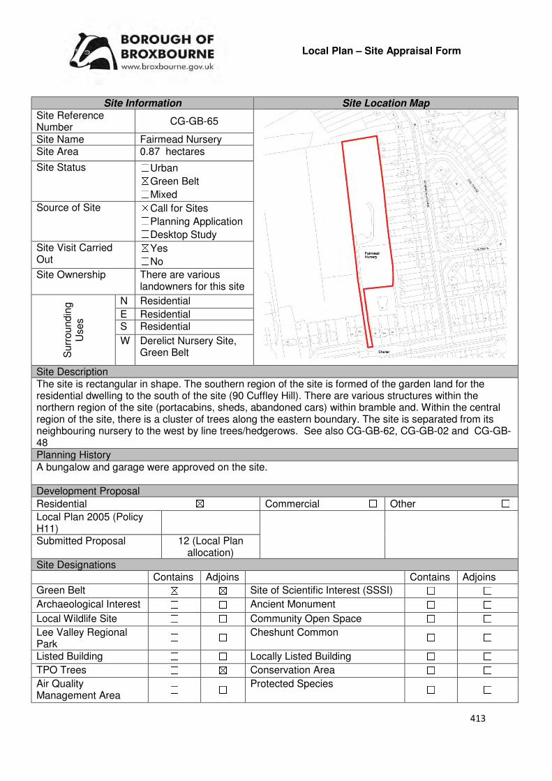
413
Local Plan – Site Appraisal Form
Site Information Site Location Map Site Reference Number
CG-GB-65
Site Name Fairmead Nursery Site Area 0.87 hectares
Site Status ☐Urban ☒Green Belt ☐Mixed
Source of Site ☒Call for Sites ☐Planning Application ☐Desktop Study
Site Visit Carried Out
☒Yes ☐No
Site Ownership There are various landowners for this site
Surr
oundin
g
Uses
N Residential
E Residential S Residential
W Derelict Nursery Site, Green Belt
Site Description The site is rectangular in shape. The southern region of the site is formed of the garden land for the residential dwelling to the south of the site (90 Cuffley Hill). There are various structures within the northern region of the site (portacabins, sheds, abandoned cars) within bramble and. Within the central region of the site, there is a cluster of trees along the eastern boundary. The site is separated from its neighbouring nursery to the west by line trees/hedgerows. See also CG-GB-62, CG-GB-02 and CG-GB-48 Planning History A bungalow and garage were approved on the site. Development Proposal
Residential ☒ Commercial ☐ Other ☐
Local Plan 2005 (Policy H11)
Submitted Proposal 12 (Local Plan allocation)
Site Designations Contains Adjoins Contains Adjoins
Green Belt ☒ ☒ Site of Scientific Interest (SSSI) ☐ ☐
Archaeological Interest ☐ ☐ Ancient Monument ☐ ☐
Local Wildlife Site ☐ ☐ Community Open Space ☐ ☐
Lee Valley Regional Park
☐ ☐ Cheshunt Common ☐ ☐
Listed Building ☐ ☐ Locally Listed Building ☐ ☐
TPO Trees ☐ ☒ Conservation Area ☐ ☐
Air Quality Management Area
☐ ☐ Protected Species ☐ ☐

414
Draft Local Plan Designation (Regulation 18) The draft Local Plan proposed to allocate this site for residential development, as part of emerging Policy GO5. The Plan identifies that this site, Fairmead Nursery, has the capacity to deliver 12 dwellings. Accessibility – distance as the crow flies
203m -Primary School (Goffs)
2.5km - Secondary School (Goffs)
4km –Employment Area
(New River Trading Estate)
410m - Green Space (Jones Road)
560m -Healthcare Centre
(Valley View)
10.6km - Hospital (with A&E) (Barnet)
3.8km - Town/District Centre (Brookfield)
310m - Local Centre (1-5 Masons Parade)
4.35km -Leisure Centre
(Laura Trott)
3.6km - A10 Junction (Church Lane)
1.08km - Railway Station
(Cuffley)
25m- Bus Service (Robinson Avenue)
Flood Risk Does the site Contains Adjoins
Zone 2 (Medium Risk) ☐ ☐
Zone 3a (High Risk) ☐ ☐
Zone 3b (Active Flood Plain) ☐ ☐
Additional Flood Risk Comments There may be some ground water and surface water issues. Access and Transport Comments There is no vehicular access to this site. The residential property to the south of the site (90 Cuffley Hill) does have vehicular access, which could be extended to this site. Connections to the footpaths along Cuffley Hill will need to be created. Cycle access to the site will also need to be created. Utility Provision
Electricity Connections available in the existing residential area to the south or east
Gas A low pressure gas main is located along Cuffley Hill
Water A water main is located along Cuffley Hill.
Sewerage A foul sewer is located at the residential properties (102-100) to the south of the site and to the east at Robinson avenue. A surface sewer is located along Cuffley Hill
Sewerage Treatment ☐Rye Meads ☒Deephams ☐Other
Additional Developer Comments submitted during Call for Sites 2016 The promoter stated that this site, in conjunction with CG-GB-02, is in a highly sustainable location on the western edge of Goffs Oak, within a short distance of the local amenities and services. The promoter stated that the site has the capacity to accommodate development, whilst maintaining the overall purpose of the borough’s Green Belt. There are no impediments constraining the development of this site. A number of technical documents were submitted to support the sites promotion; this included a tree assessment, landscape and Green Belt appraisal, Initial Development Design Framework and a Transport Appraisal. These documents, and the representations made for this site and CG-GB-02 can be
found on the Council’s website by using the following link: www.broxbourne.gov.uk/lpsites
415
Suitability Comments This site is considered to be suitable for residential development due to the following reasons:
• The site is included within area C33 identified in the Council’s Green Belt Review (Scott Wilson, 2008). The Review states that area C33 “Performs poorly against Green Belt purposes, its location meaning that it does little in terms of preventing sprawl. In reality, also does little to separate existing settlements and thus, if anything, could score lower than attributed here” and proposed its removal (in full and in part) as part of Option 1 and 2.
• The Council’s ‘Review of the Inner Boundary of the Metropolitan Green Belt within the Borough of Broxbourne” concluded that it is not necessary to “retain an area of physically enclosed land” and that the land has potential for residential development and should be allocated as either a short term Housing site or as Reserve Housing Land.
• The site was considered as part of Development Approach 2: Goffs Oak Village Expansion (Broxbourne Borough Council, 2016), in the Goffs Oak Development Options report. The report states that this site, in conjunction with CG-GB-02 and CG-GB-48, is suitable in principle, but notes that there are a number of protected trees within the site which should be retained if development came forward.
• The site is considered to be in a sustainable location for development; it is close to local facilities, primary education and modes of sustainable transport. This point is reiterated in the 2005 Local Plan Inspector’s Report.
Is this site considered to be suitable for development?
☒Yes ☐ No
Availability Comments The site has actively been promoted to the Council through the Local Plan consultation (Regulation 18). During this consultation, the promoter of the site stated that it was available for development in the short-term.
Is the site considered to be available for development
☒Yes ☐ No
Achievability Comments The site is considered to be achievable. With the exception of the sites Green Belt designation, it is considered that there are no policy constraints that would prevent the development of this site. Due to the sites proximity to the urban area of Goffs Oak means that it can benefit from existing infrastructure i.e. roads, utilities.
Is the site considered to be achievable? ☒Yes ☐ No
Delivery Period 1-5 years

416
Local Plan – Site Appraisal Form
Site Information Site Location Map Site Reference Number
CG-GB-66
Site Name Burleigh Field Site Area 3.7 hectares
Site Status ☐Urban ☒Green Belt ☐Mixed
Source of Site ☐Call for Sites ☒Planning Application ☐Desktop Study
Site Visit Carried Out
☐Yes ☒No
Site Ownership There are two landowners for this site
Surr
oundin
g
Uses
N Open Field, Green Belt
E Newgatestreet Road, Residential
S Green Belt, Residential
W Open field, Green Belt
Site Description The square-shaped site and slopes down to the west. It is open field in nature, with a number of bushes/shrubs scattered through the site. There is a high concentration of bushes/shrubs within the south western central region of the site. A number of trees are located on the sites northern, eastern and western boundaries. There are some trees on the southern boundary however these are spaced out. Planning History Residential development west of Newgatestreet Road was refused in the late 50s. Development Proposal
Residential ☒ Commercial ☐ Other ☐
Local Plan 2005 (Policy H11)
111
Submitted Proposal -
Site Designations Contains Adjoins Contains Adjoins
Green Belt ☒ ☒ Site of Scientific Interest (SSSI)
☐ ☐
Archaeological Interest ☐ ☐ Ancient Monument ☐ ☐
Local Wildlife Site ☐ ☐ Community Open Space ☐ ☐
Lee Valley Regional Park
☐ ☐ Cheshunt Common ☐ ☐
Listed Building ☐ ☐ Locally Listed Building ☐ ☐
TPO Trees ☐ ☐ Conservation Area ☐ ☐
Air Quality Management Area
☐ ☐ Protected Species ☐ ☐
Draft Local Plan Designation (Regulation 18) The draft Local Plan proposed to keep this site within the Green Belt

417
Accessibility – distance as the crow flies
460m -Primary School (Goffs)
2.82km - Secondary School (Goffs)
4.1km –Employment Area (New River Trading Estate)
520m - Green Space (Richardson Crescent)
1.17m -Healthcare Centre (Valley View)
11.2km - Hospital (with A&E) (Barnet)
3.86km - Town/District Centre (Brookfield)
930m - Local Centre (1-5 Masons Parade)
4.71km -Leisure Centre (Laura Trott)
3.9km - A10 Junction (Church Lane)
1.31km - Railway Station (Cuffley)
1.1km -Bus Service (Goffs Oak Memorial)
Flood Risk Does the site Contains Adjoins
Zone 2 (Medium Risk) ☐ ☐
Zone 3a (High Risk) ☐ ☐
Zone 3b (Active Flood Plain) ☐ ☒
Additional Flood Risk Comments The site may suffer from ground water flooding and surface water flooding. Access and Transport Comments Current access to the site is via a gate from Newgatestreet Road. This access point and its visibility will need to be improved if development came forward. Due to the amount of development that this site could accommodate, a transport assessment will be required. There are footpaths on the western side of Newgatestreet Road. Connections to this footpath will be required. Cycle access to the site will be required. Utility Provision
Electricity Electricity cables available at Newgatestreet Road
Gas A low pressure gas main is located along Newgatestreet Road
Water A water main is located along Newgatestreet Road
Sewerage The closest foul sewer and surface sewer are located to the south of the site, by the entrance to Chiltern Close.
Sewerage Treatment ☐Rye Meads ☒Deephams ☐Other
Additional Developer Comments submitted during Call for Sites 2016 None submitted. Suitability Comments This site is not considered to be suitable for development due to the following reasons:
• The site is included within area C30 identified in the Council’s Green Belt Review. The Review states that area C30 performs strongly against the Green Belt purposes and proposed no change to the boundary in this location. However, it should be noted that the review also stated that there is the opportunity to create stronger Green Belt boundaries in C11-C30 as these areas have “extremely weak boundaries” which means that there are no real barriers to prevent encroachment between settlements.
• This site has weak Green Belt boundaries to the north, south and west. These weak boundaries are not likely to endure beyond the Plan period or prevent further encroachment into the countryside.
• The site plays a role in maintaining the strategic gap between the Hammondstreet settlement and Goffs Oak Village.
Is this site considered to be suitable for development? ☐Yes ☒ No
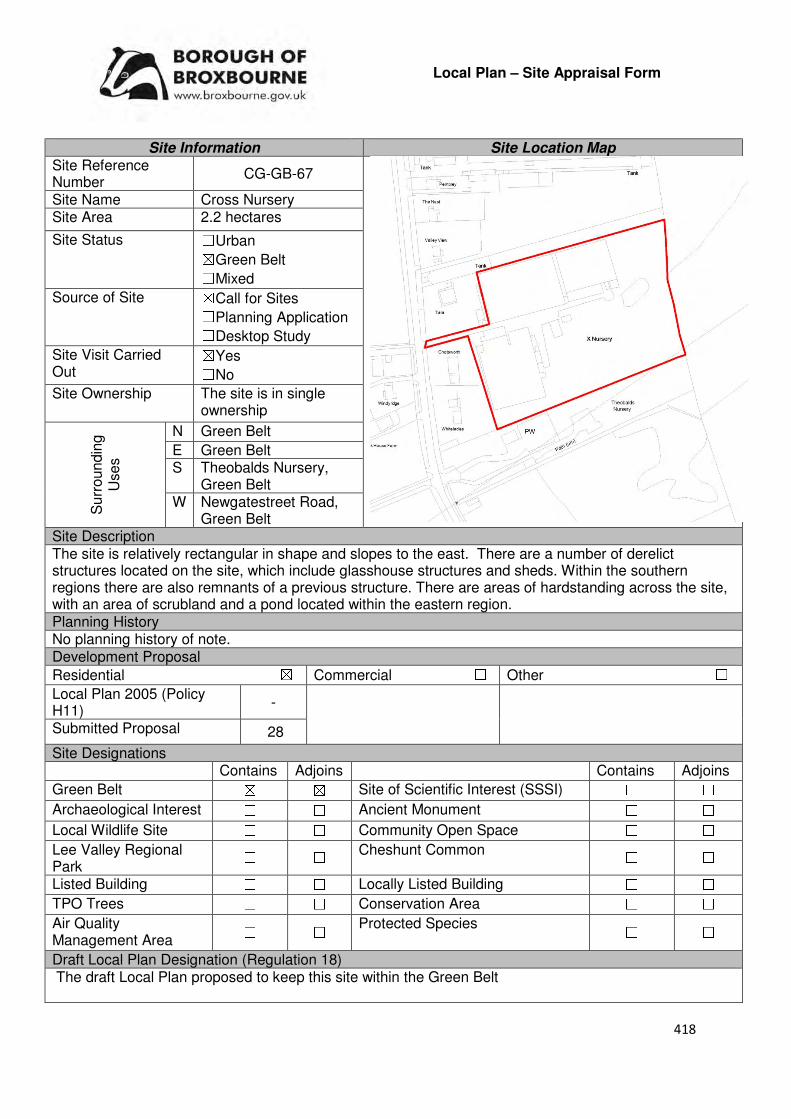
418
Local Plan – Site Appraisal Form
Site Information Site Location Map Site Reference Number
CG-GB-67
Site Name Cross Nursery Site Area 2.2 hectares
Site Status ☐Urban ☒Green Belt ☐Mixed
Source of Site ☒Call for Sites ☐Planning Application ☐Desktop Study
Site Visit Carried Out
☒Yes ☐No
Site Ownership The site is in single ownership
Surr
oundin
g
Uses
N Green Belt
E Green Belt S Theobalds Nursery,
Green Belt W Newgatestreet Road,
Green Belt Site Description The site is relatively rectangular in shape and slopes to the east. There are a number of derelict structures located on the site, which include glasshouse structures and sheds. Within the southern regions there are also remnants of a previous structure. There are areas of hardstanding across the site, with an area of scrubland and a pond located within the eastern region. Planning History No planning history of note. Development Proposal
Residential ☒ Commercial ☐ Other ☐
Local Plan 2005 (Policy H11)
-
Submitted Proposal 28
Site Designations Contains Adjoins Contains Adjoins
Green Belt ☒ ☒ Site of Scientific Interest (SSSI) ☐ ☐
Archaeological Interest ☐ ☐ Ancient Monument ☐ ☐
Local Wildlife Site ☐ ☐ Community Open Space ☐ ☐
Lee Valley Regional Park
☐ ☐ Cheshunt Common ☐ ☐
Listed Building ☐ ☐ Locally Listed Building ☐ ☐
TPO Trees ☐ ☐ Conservation Area ☐ ☐
Air Quality Management Area
☐ ☐ Protected Species ☐ ☐
Draft Local Plan Designation (Regulation 18) The draft Local Plan proposed to keep this site within the Green Belt

419
Accessibility – distance as the crow flies
460m -Primary School (Goffs)
2.61km - Secondary School (Goffs)
3.84km –Employment Area (New River Trading Estate)
300m - Green Space (Richardson Crescent)
1.02km -Healthcare Centre (Valley View)
11.2km - Hospital (with A&E) (Barnet)
3.67km - Town/District Centre (Brookfield)
820m - Local Centre (1-5 Masons Parade)
4.47km -Leisure Centre (Laura Trott)
3.68km - A10 Junction (Church Lane)
1.44km- Railway Station (Cuffley)
1.01km- Bus Service (War Memorial)
Flood Risk Does the site Contains Adjoins
Zone 2 (Medium Risk) ☐ ☐
Zone 3a (High Risk) ☐ ☐
Zone 3b (Active Flood Plain) ☐ ☐
Additional Flood Risk Comments There may be ground water and surface water flooding. Access and Transport Comments The site can be accessed via a narrow track from Newgatestreet Road. This track would require widening if development was to occur. The visibility of the access point would also require improving. This area of Newgatestreet Road has a footpath on its western side. Connections to this footpath will be required. Utility Provision
Electricity Located at Newgatestreet Road.
Gas A low pressure gas main is located along Newgatestreet Road.
Water A water main is located along Newgatestreet Road
Sewerage A foul sewer and surface sewer is located to the south of the site, along Newgatestreet Road (near 147-149)
Sewerage Treatment ☐Rye Meads ☒Deephams ☐Other
Additional Developer Comments submitted during Call for Sites 2016 None submitted. Suitability Comments This site is not considered to be suitable for residential development (market) due to the following reasons:
• The site is included within area C30 identified in the Council’s Green Belt Review (Scott Wilson, 2008). The Review states that area C30 performs strongly against the Green Belt purposes and proposed no change to the Green Belt boundary in this location. However, it should be that the review also stated that there is the opportunity to create a stronger Green Belt boundary in C11-C30 as these areas have “extremely weak boundaries”, which means that there are no real barriers to prevent encroachment between settlements.
• This site has weak green belt boundaries to the north, east and south. There are no permanent and defensible Green Belt boundaries for this site which will remain over a long period of time and prevent further encroachment into the countryside.
420
• The site plays a role in maintaining the strategic gap between Goffs Oak and the Hammondstreet settlement.
• The development of this site will result in a small-scale isolated development. The site is too small to facilitate sustainable place-making.
• The Inspector for the Borough of Broxbourne Local Plan Second Review 2001-2011 made the following conclusions for this site: “A substantial part of the objection site is covered with vacant glasshouses in various states of dereliction, and some other outbuildings. Although some of the buildings and storage areas do not contribute much to the openness of the green belt, the site and its surroundings remain essentially rural in character. It fulfils the Green Belt functions of preventing Cheshunt from sprawling into the countryside, and maintaining the gap between Goffs Oak and Hammondstreet. The site does not constitute PDL as defined in PPG3 and at present it does not represent a particularly sustainable location for new housing compared to other parcels of Green Belt land.”
However, the Council’s emerging policy GB2 permits self-build development at low densities on derelict glasshouse sites. This is subject to the site meeting a number of conditions i.e. being erected prior to 20th October 2015; evidence that the site has been marketed for a period of a least one year at a realistic value for use as a horticultural business, and/or evidence is provided that the site is incapable of accommodating a viable horticultural business. Following a site visit, it is considered that part of this site (western region where derelict glasshouse sites are situated) would meet criteria II ii) of emerging Policy GB2. Is this site considered to be suitable for development?
☐Yes ☒ No

421
Local Plan – Site Appraisal Form
Site Information Site Location Map Site Reference Number
CG-GB-68
Site Name Park Lane Meadow Site Area 6 hectares
Site Status ☐Urban ☒Green Belt ☐Mixed
Source of Site ☒Call for Sites ☐Planning Application ☐Desktop Study
Site Visit Carried Out
☐Yes ☒No
Site Ownership There are three landowners for this site.
Surr
oundin
g U
ses N Green Belt, Paradise
House, Open Field E Park Lane Paradise,
Green Belt S Appleby Street,
Appleby Street Open Space
W Green Belt, Open Field
Site Description The irregular shaped site gradually slopes to the north. It is predominantly open field in nature, with trees and hedgerows located along the sites boundary, with the exception of the boundary which adjoins Park House to the west. There is one structure located on the site, located roughly centrally along the sites northern boundary. From this structure a line of trees runs southwards, stopping within the middle of the upper segment of the site. Planning History No planning history of note Development Proposal
Residential ☒ Commercial ☐ Other ☐
Local Plan 2005 (Policy H11) -
Submitted Proposal 120
Site Designations Contains Adjoins Contains Adjoins
Green Belt ☒ ☒ Site of Scientific Interest (SSSI) ☐ ☐
Archaeological Interest ☐ ☐ Ancient Monument ☐ ☐
Local Wildlife Site ☐ ☒ Community Open Space ☐ ☒
Lee Valley Regional Park ☐ ☐ Cheshunt Common ☐ ☐
Listed Building ☐ ☐ Locally Listed Building ☐ ☐
TPO Trees ☐ ☐ Conservation Area ☐ ☐
Air Quality Management Area
☐ ☐ Protected Species ☐ ☐
Draft Local Plan Designation (Regulation 18) The draft Local Plan proposed to keep this site within the Green Belt
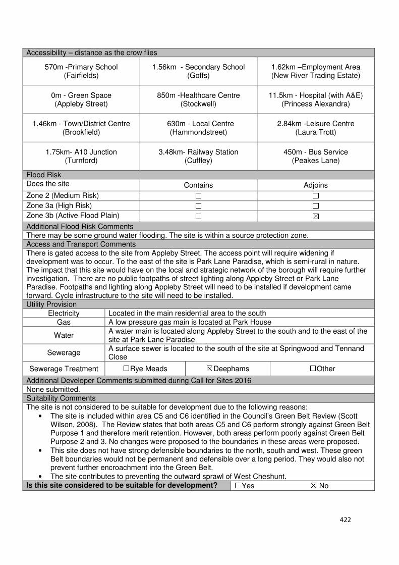
422
Accessibility – distance as the crow flies
570m -Primary School (Fairfields)
1.56km - Secondary School (Goffs)
1.62km –Employment Area (New River Trading Estate)
0m - Green Space (Appleby Street)
850m -Healthcare Centre (Stockwell)
11.5km - Hospital (with A&E) (Princess Alexandra)
1.46km - Town/District Centre (Brookfield)
630m - Local Centre (Hammondstreet)
2.84km -Leisure Centre (Laura Trott)
1.75km- A10 Junction (Turnford)
3.48km- Railway Station (Cuffley)
450m - Bus Service (Peakes Lane)
Flood Risk Does the site Contains Adjoins
Zone 2 (Medium Risk) ☐ ☐
Zone 3a (High Risk) ☐ ☐
Zone 3b (Active Flood Plain) ☐ ☒
Additional Flood Risk Comments There may be some ground water flooding. The site is within a source protection zone. Access and Transport Comments There is gated access to the site from Appleby Street. The access point will require widening if development was to occur. To the east of the site is Park Lane Paradise, which is semi-rural in nature. The impact that this site would have on the local and strategic network of the borough will require further investigation. There are no public footpaths of street lighting along Appleby Street or Park Lane Paradise. Footpaths and lighting along Appleby Street will need to be installed if development came forward. Cycle infrastructure to the site will need to be installed. Utility Provision
Electricity Located in the main residential area to the south
Gas A low pressure gas main is located at Park House
Water A water main is located along Appleby Street to the south and to the east of the site at Park Lane Paradise
Sewerage A surface sewer is located to the south of the site at Springwood and Tennand Close
Sewerage Treatment ☐Rye Meads ☒Deephams ☐Other
Additional Developer Comments submitted during Call for Sites 2016 None submitted. Suitability Comments The site is not considered to be suitable for development due to the following reasons:
• The site is included within area C5 and C6 identified in the Council’s Green Belt Review (Scott Wilson, 2008). The Review states that both areas C5 and C6 perform strongly against Green Belt Purpose 1 and therefore merit retention. However, both areas perform poorly against Green Belt Purpose 2 and 3. No changes were proposed to the boundaries in these areas were proposed.
• This site does not have strong defensible boundaries to the north, south and west. These green Belt boundaries would not be permanent and defensible over a long period. They would also not prevent further encroachment into the Green Belt.
• The site contributes to preventing the outward sprawl of West Cheshunt. Is this site considered to be suitable for development? ☐Yes ☒ No

423
Local Plan – Site Appraisal Form
Site Information Site Location Map Site Reference Number
CG-GB-69
Site Name Lucas House Farm Site Area 6.9 hectares
Site Status ☐Urban ☒Green Belt ☐Mixed
Source of Site ☒Call for Sites ☐Planning Application ☐Desktop Study
Site Visit Carried Out
☐Yes ☒No
Site Ownership
The site is in single ownership. There is also a caution over part of this site.
Surr
oundin
g U
ses N Crouch Lane, Open Field,
Green Belt E Open Field, Woodham
Nursery, Green Belt S Woodham Nursery, Local
Wildlife Site, Green Belt W Nurseries, Green Belt,
Crouch Lane Site Description The irregular shaped site slopes to the east. The site is predominantly open field in nature, with the exception of a small segment located within the northern region of the site which contains hardstanding a number of structures. Located in the southern region of the large cluster of trees. Additional clusters and lone trees are located throughout the site. A number of trees are located along the sites boundaries. Planning History No history of note. Development Proposal
Residential ☒ Commercial ☐ Other ☐
Local Plan 2005 (Policy H11) 207
Submitted Proposal -
Site Designations Contains Adjoins Contains Adjoins
Green Belt ☒ ☒ Site of Scientific Interest (SSSI) ☐ ☐
Archaeological Interest ☐ ☐ Ancient Monument ☐ ☐
Local Wildlife Site ☐ ☒ Community Open Space ☐ ☐
Lee Valley Regional Park ☐ ☐ Cheshunt Common ☐ ☒
Listed Building ☐ ☒ Locally Listed Building ☐ ☐
TPO Trees ☐ ☐ Conservation Area ☐ ☐
Air Quality Management Area
☐ ☐ Protected Species ☐ ☐
424
Draft Local Plan Designation (Regulation 18) The draft Local Plan proposed to keep this site within the Green Belt Accessibility – distance as the crow flies
430m-Primary School (Goffs)
2km - Secondary School (Goffs)
3.34km –Employment Area (New River Industrial Estate)
Goffs - Green Space (170m)
310m -Healthcare Centre (Valley View)
11.3km - Hospital (with A&E) (Barnet)
3km - Town/District Centre (Brookfield)
260m - Local Centre (1-5 Masons Parade)
3.78km -Leisure Centre (Laura Trott)
2.98km - A10 Junction (Church Lane)
1.6km - Railway Station (Cuffley)
3712 - Bus Service (War Memorial)
Flood Risk Does the site Contains Adjoins
Zone 2 (Medium Risk) ☐ ☐
Zone 3a (High Risk) ☐ ☐
Zone 3b (Active Flood Plain) ☐ ☒
Additional Flood Risk Comments No flooding issues identified. Access and Transport Comments The site can be accessed from Crouch Lane. Crouch Lane is narrow in places and semi-rural in nature. There is also a dropped kerb and gated entrance to this site from St James Road. Crouch Lane access point is considered to be the most suitable, if development was to come forward/ This access point will need to be improved to ensure that it is highway compliant. Due to the development capacity this site can deliver, an assessment into the impact that this would have on the local and wider strategic network will be required. There are no footpaths or street lighting along Crouch Lane. These will need to be installed if development was to come forward. Cycle access to the site would need to be provided. Utility Provision
Electricity Located in the main residential areas to the east and west
Gas The closest low pressure gas main is located to the east of the site (Poppy Walk, Bartrop Close) or to the west (Colston Crescent, Melvyn Close)
Water A water main is located along Crouch Lane
Sewerage Surface sewer and foul sewers are located to the west of the site at Poppy Close
Sewerage Treatment ☐Rye Meads ☒Deephams ☐Other
Additional Developer Comments submitted during Call for Sites 2016 None submitted.
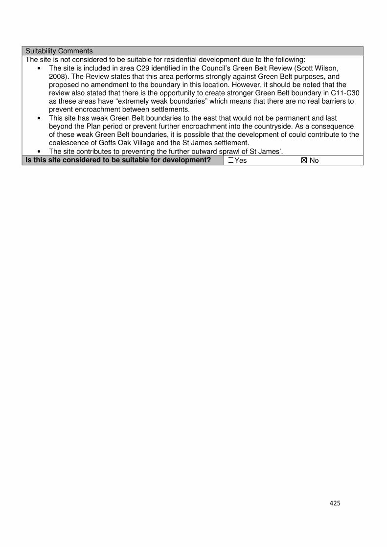
425
Suitability Comments The site is not considered to be suitable for residential development due to the following:
• The site is included in area C29 identified in the Council’s Green Belt Review (Scott Wilson, 2008). The Review states that this area performs strongly against Green Belt purposes, and proposed no amendment to the boundary in this location. However, it should be noted that the review also stated that there is the opportunity to create stronger Green Belt boundary in C11-C30 as these areas have “extremely weak boundaries” which means that there are no real barriers to prevent encroachment between settlements.
• This site has weak Green Belt boundaries to the east that would not be permanent and last beyond the Plan period or prevent further encroachment into the countryside. As a consequence of these weak Green Belt boundaries, it is possible that the development of could contribute to the coalescence of Goffs Oak Village and the St James settlement.
• The site contributes to preventing the further outward sprawl of St James’. Is this site considered to be suitable for development? ☐Yes ☒ No
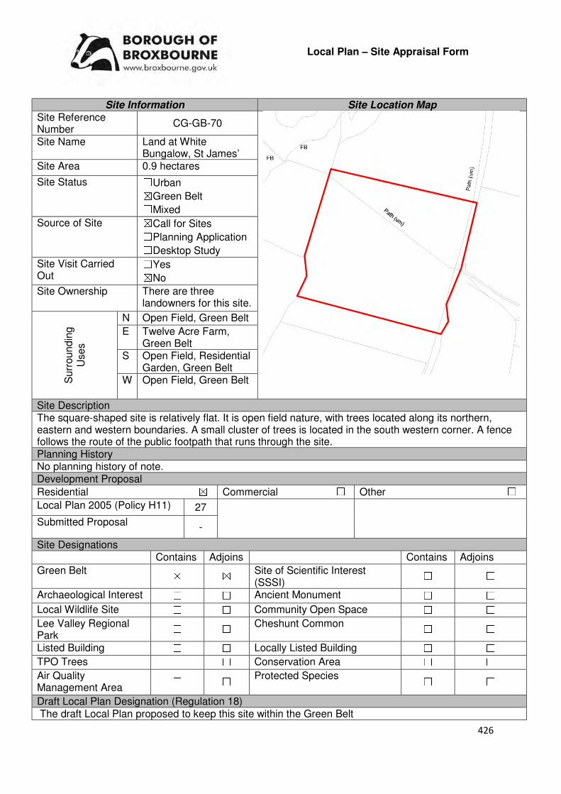
426
Local Plan – Site Appraisal Form
Site Information Site Location Map Site Reference Number
CG-GB-70
Site Name Land at White Bungalow, St James’
Site Area 0.9 hectares
Site Status ☐Urban ☒Green Belt ☐Mixed
Source of Site ☒Call for Sites ☐Planning Application ☐Desktop Study
Site Visit Carried Out
☐Yes ☒No
Site Ownership There are three landowners for this site.
Surr
oundin
g
Uses
N Open Field, Green Belt
E Twelve Acre Farm, Green Belt
S Open Field, Residential Garden, Green Belt
W Open Field, Green Belt
Site Description The square-shaped site is relatively flat. It is open field nature, with trees located along its northern, eastern and western boundaries. A small cluster of trees is located in the south western corner. A fence follows the route of the public footpath that runs through the site. Planning History No planning history of note. Development Proposal
Residential ☒ Commercial ☐ Other ☐
Local Plan 2005 (Policy H11) 27
Submitted Proposal -
Site Designations Contains Adjoins Contains Adjoins
Green Belt ☒ ☒ Site of Scientific Interest (SSSI)
☐ ☐
Archaeological Interest ☐ ☐ Ancient Monument ☐ ☐
Local Wildlife Site ☐ ☐ Community Open Space ☐ ☐
Lee Valley Regional Park
☐ ☐ Cheshunt Common ☐ ☐
Listed Building ☐ ☐ Locally Listed Building ☐ ☐
TPO Trees ☐ ☐ Conservation Area ☐ ☐
Air Quality Management Area
☐ ☐ Protected Species ☐ ☐
Draft Local Plan Designation (Regulation 18) The draft Local Plan proposed to keep this site within the Green Belt

427
Accessibility – distance as the crow flies
1.05km -Primary School (Goffs)
1.52km - Secondary School (Goffs)
2.87km –Employment Area (New River Trading Estate)
180m - Green Space (Argent Way)
670m -Healthcare Centre (Valley View)
11.9km - Hospital (with A&E) (Barnet)
2.61km - Town/District Centre (Brookfield)
570m - Local Centre (Hammondstreet)
3.4km -Leisure Centre (Laura Trott)
2.6km - A10 Junction (Church Lane)
2.2km - Railway Station (Cuffley)
608m - Bus Service (Macintosh Close)
Flood Risk Does the site Contains Adjoins
Zone 2 (Medium Risk) ☐ ☐
Zone 3a (High Risk) ☐ ☐
Zone 3b (Active Flood Plain) ☐ ☐
Additional Flood Risk Comments Consideration should be given to the impact that Rags Brook, located 100m to the north, could have on the site. There may be surface water flooding on the site Access and Transport Comments The site can be accessed via a track from St James Road. This access will require widening if development was to come forward. These improvements may require land to be brought outside of the site’s boundaries. The track access doubles up as a public footpath. This footpath will need to be retained. A public footpath also runs through the site. Pedestrian and cycle access to the site will need to be created. Utility Provision
Electricity Electricity cables available to the south east of the site at Poets Gate
Gas A low pressure gas main is located to the south east of the site at Poets Gate
Water The closest water mains is located to the south east of the site at Poets Gate
Sewerage A foul sewer and surface sewer adjoin the site to the east.
Sewerage Treatment ☐Rye Meads ☒Deephams ☐Other
Additional Developer Comments submitted during Call for Sites 2016 None submitted. Suitability Comments The site is not considered to be suitable for residential development due to the following reasons:
• The site is included in area C14 identified in the Council’s Green Belt (Scott Wilson, 2008). The review states that this area C14 performs strongly against Green Belt Purposes 1 and 2, and poorly against Purpose 3. However, it should be noted that that the review also stated that there is the opportunity to create stronger Green Belt boundaries in C11-C30 as these areas have “extremely weak boundaries” which means that there are no real barriers to prevent encroachment between settlements.
• The sites boundaries are weak on all sides and would not be permanent and defensible over a long period of time. They would also not prevent further encroachment into the countryside.
• The development of this site will result in a small area of isolated development that is not close to
428
local facilities and amenities. The site is also not large enough to facilitate sustainable place-making.
• The site plays a role in maintaining the local gap between West Cheshunt and St James’ village. Is this site considered to be suitable for development? ☐Yes ☒ No
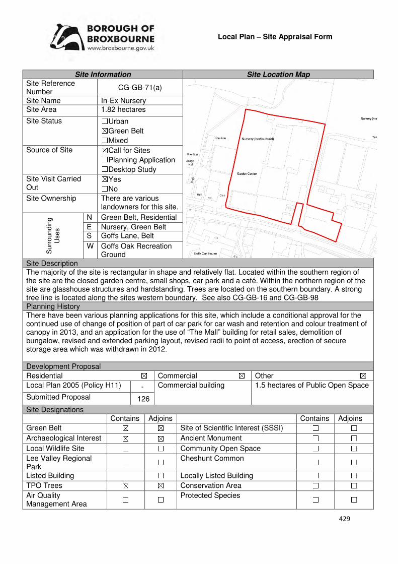
429
Local Plan – Site Appraisal Form
Site Information Site Location Map Site Reference Number
CG-GB-71(a)
Site Name In-Ex Nursery Site Area 1.82 hectares
Site Status ☐Urban ☒Green Belt ☐Mixed
Source of Site ☒Call for Sites ☐Planning Application ☐Desktop Study
Site Visit Carried Out
☒Yes ☐No
Site Ownership There are various landowners for this site.
Surr
oun
din
g
Uses
N Green Belt, Residential
E Nursery, Green Belt S Goffs Lane, Belt
W Goffs Oak Recreation Ground
Site Description The majority of the site is rectangular in shape and relatively flat. Located within the southern region of the site are the closed garden centre, small shops, car park and a café. Within the northern region of the site are glasshouse structures and hardstanding. Trees are located on the southern boundary. A strong tree line is located along the sites western boundary. See also CG-GB-16 and CG-GB-98 Planning History There have been various planning applications for this site, which include a conditional approval for the continued use of change of position of part of car park for car wash and retention and colour treatment of canopy in 2013, and an application for the use of “The Mall” building for retail sales, demolition of bungalow, revised and extended parking layout, revised radii to point of access, erection of secure storage area which was withdrawn in 2012. Development Proposal
Residential ☒ Commercial ☒ Other ☒
Local Plan 2005 (Policy H11) - Commercial building 1.5 hectares of Public Open Space
Submitted Proposal 126
Site Designations Contains Adjoins Contains Adjoins
Green Belt ☒ ☒ Site of Scientific Interest (SSSI) ☐ ☐
Archaeological Interest ☒ ☒ Ancient Monument ☐ ☐
Local Wildlife Site ☐ ☐ Community Open Space ☐ ☐
Lee Valley Regional Park
☐ ☐ Cheshunt Common ☐ ☐
Listed Building ☐ ☐ Locally Listed Building ☐ ☐
TPO Trees ☒ ☒ Conservation Area ☐ ☐
Air Quality Management Area
☐ ☐ Protected Species ☐ ☐

430
Draft Local Plan Designation (Regulation 18) The sire was proposed for mixed use development under emerging Policy GO2: North of Goffs Lane. The policy identifies the site as having the capacity to deliver 80 homes, a commercial development site for restaurant and related uses and public open space to the north to provide separation from St James Village. Accessibility – distance as the crow flies
490m -Primary School (Woodside)
1.58km - Secondary School (Goffs)
3.25km –Employment Area (News International)
0m - Green Space (adjoins Goffs)
90m-Healthcare Centre (Valley View)
11.2km - Hospital (with A&E) (Barnet)
3km - Town/District Centre (Brookfield)
120m - Local Centre (684-696 Goffs Lane)
3.44km -Leisure Centre (Laura Trott)
2.78km - A10 Junction (Churchgate)
1.74km - Railway Station (Cuffley)
85m - Bus Service (Goffs Oak War Memorial)
Flood Risk Does the site Contains Adjoins
Zone 2 (Medium Risk) ☐ ☐
Zone 3a (High Risk) ☐ ☐
Zone 3b (Active Flood Plain) ☐ ☒
Additional Flood Risk Comments There may be surface water flooding. Access and Transport Comments The site benefits from vehicular access of Goffs Lane. This current access point will require improvements if development was to come forward on this site. A transport assessment will be required which demonstrates the likely impact of a development proposal on movement patters and flows in an area, and identifies measures to deal with this. Goffs Lane has pedestrian footpaths on both sites of the road. The site will need to provide connections to these. Cycle access to the site will need to be created. Utility Provision
Electricity Electricity available
Gas A low pressure gas main is located along Goffs Lane
Water A water main is located along Goffs Lane Sewerage A foul sewer and surface sewer is located along Goffs Lane
Sewerage Treatment ☐Rye Meads ☒Deephams ☐Other
Additional Developer Comments submitted during Call for Sites 2016 None submitted. During the Local Plan (Regulation 18) consultation, the promoter of the site states that they are fully support the inclusion of the site within the draft Local Plan. They state that the development is wholly sustainable in the context of the NPPF and will deliver substantial benefits for the area – in addition to providing much needed housing the proposals has the potential to enhance the commercial facilities in the village. The proposal submitted provides a balanced scheme which has been designed to ensure that the scheme does not harm the character of the area. The promoters prepared an indicative masterplan for this site which suggests indicates provision for 126 dwellings comprising primarily 2,3 and4 dwellings with a small number of apartments, commercial buildings to accommodate the cafe and compatible commercial uses in the southwest corner and public open space with an area of 1.5 hectares. The promoters state that providing an increase in the number of homes would make more efficient use of the released Green Belt land and would be far more beneficial for both the Council and for the case of sustainable development.
431
The promoter continues by stating that the sustainable location of the site means that it is an ideal location for residential development as it will help to reduce the need for future residents to travel as future occupiers can avail of the range of local amenities and the public transport provision. The 1.5 hectares of publically accessible open space will provide a buffer between the proposed development and St James Village. The promoter states that this space will act as a high quality open space for future residents and as a buffer to ensure separation of Goffs Oak and St James Village is preserved. They also state that the redevelopment of the site and the delivery of the publically open space will create new linkages to connect in with the existing rights of way in the area, which will provide new walking routes for the local community. Suitability Comments The site is considered to be suitable for residential development due to the following reasons:
• The development of this site will address an area of dereliction within Goffs Oak and provide the opportunity to provide an attractive gateway into the Village Centre.
• The site is considered to be in a sustainable location for residential development; it is close to local facilities and primary education, close to modes of sustainable transport and within the sustainable distance recommended by Barton et al (2010) to a doctor’s surgery and green space.
• The site is included within area C24 identified in the Council’s Green Belt Review (Scott Wilson, 2008). Appendix 5 of the Review states that the only constraint to this area if archaeology and there is a number of opportunities including reasonable accessibility and proximity to services, high level of derelict/vacant brownfield land and regeneration potential. The Review concludes that on this basis the site may be suitable for built development. The suggested policy approach for this area was ‘Consider Allocating Site’. .
Is this site considered to be suitable for development?
☒Yes ☐ No
Availability Comments The site is considered to be available. During the Local Plan Consultation (Regulation 18) the landowners of the site stated that they are supportive of the inclusion of the site as a residential allocation with an element of commercial use within the emerging Local Plan.
Is the site considered to be available for development
☒Yes ☐ No Achievability Comments Developer interest in the land suggests that it is achievable. It is
considered that, with the exception of its Green Belt designation, there are no policy constraints that would prevent the development of this site. Due to previous use, contamination investigations may be required. Subject to the result of this investigation, if remediation work is required financial viability of the site could be impacted... Due to the sites location closer to the urban area of Goffs Oak, and previously developed nature it will be able to benefit from existing infrastructure i.e. local roads, utilities etc.
Is the site considered to be achievable?
☒Yes ☐ No Delivery Period 1-5 Years
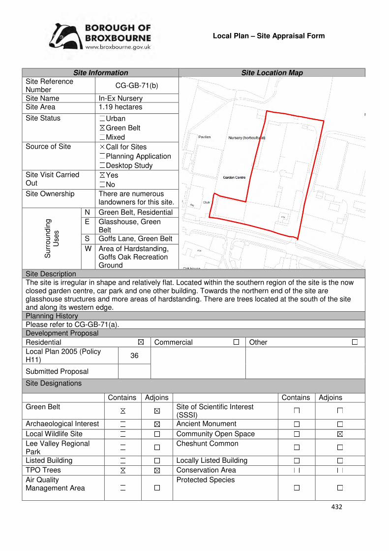
432
Local Plan – Site Appraisal Form
Site Information Site Location Map Site Reference Number
CG-GB-71(b)
Site Name In-Ex Nursery Site Area 1.19 hectares
Site Status ☐Urban ☒Green Belt ☐Mixed
Source of Site ☒Call for Sites ☐Planning Application ☐Desktop Study
Site Visit Carried Out
☒Yes ☐No
Site Ownership There are numerous landowners for this site.
Surr
oundin
g
Uses
N Green Belt, Residential
E Glasshouse, Green Belt
S Goffs Lane, Green Belt
W Area of Hardstanding, Goffs Oak Recreation Ground
Site Description The site is irregular in shape and relatively flat. Located within the southern region of the site is the now closed garden centre, car park and one other building. Towards the northern end of the site are glasshouse structures and more areas of hardstanding. There are trees located at the south of the site and along its western edge. Planning History Please refer to CG-GB-71(a). Development Proposal
Residential ☒ Commercial ☐ Other ☐
Local Plan 2005 (Policy H11)
36
Submitted Proposal
Site Designations
Contains Adjoins Contains Adjoins
Green Belt ☒ ☒ Site of Scientific Interest (SSSI)
☐ ☐
Archaeological Interest ☐ ☒ Ancient Monument ☐ ☐
Local Wildlife Site ☐ ☐ Community Open Space ☐ ☒
Lee Valley Regional Park
☐ ☐ Cheshunt Common ☐ ☐
Listed Building ☐ ☐ Locally Listed Building ☐ ☐
TPO Trees ☒ ☒ Conservation Area ☐ ☐
Air Quality Management Area
☐ ☐ Protected Species ☐ ☐
433
Draft Local Plan Designation (Regulation 18) This site forms part of the mixed use allocation identified in emerging Policy GO2. The policy states that the area identified in GO2 can accommodate 80 homes, a commercial development site for restaurant and related uses and public open space to the north to provide separation from St James Village. Accessibility – distance as the crow flies
490m-Primary School (Woodside)
1.63km - Secondary School (Goffs)
3.25km –Employment Area
(New International)
0m - Green Space (adjoins Goffs)
88m -Healthcare Centre
(Valley View)
11.2km - Hospital (with A&E)
(Barnet)
3km - Town/District Centre (Brookfield)
120m - Local Centre (684-696 Goffs Lane)
3.5km -Leisure Centre
(Laura Trott)
2.84km - A10 Junction (Church Lane/Church Gate)
1.74km - Railway Station
(Cuffley)
85m - Bus Service
Flood Risk Does the site Contains Adjoins
Zone 2 (Medium Risk) ☐ ☐
Zone 3a (High Risk) ☐ ☐
Zone 3b (Active Flood Plain) ☐ ☒
Additional Flood Risk Comments There may be surface water flooding. Access and Transport Comments The site benefits from vehicular access from Goffs Lane. This current access point will require improvements if development was to come forward on this site. A transport assessment will be required which demonstrates the likely impact of a development proposal on movement patterns and flows in an area, and identifies measures to deal with this. Goffs Lane has pedestrian footpaths on both sites of the road. The site will need to provide connection to these. Cycle access to the site will need to be created. Utility Provision
Electricity Electricity available
Gas A low pressure gas main is located along Goffs Lane
Water A water main is located along Goffs Lane
Sewerage A foul sewer is located along Goffs Lane
Sewerage Treatment ☐Rye Meads ☒Deephams ☐Other
Additional Developer Comments submitted during Call for Sites 2016 Please refer to CG-GB-71(b) for promoter comments submitted during the Local Plan (Regulation 18) consultation. Suitability Comments The site is considered to be suitable for residential development due to the following reasons:
• The development of this site will address an area of dereliction within Goffs Oak and provide the opportunity to provide an attractive gateway into the Village Centre.
• The site is considered to be in a sustainable location for residential development; it is close to local facilities and primary educational facilities, close to modes of sustainable transport and within the sustainable distance recommended by Barton et al (2010) to a doctor’s surgery and green space.
434
• Appendix 5 of the Council’s Green Belt Review (Scott Wilson, 2008) identified that area C24 only constraint is archaeology and that there are a number of opportunities including reasonable accessibility and proximity to services, high level of derelict/vacant brownfield land and regeneration potential and concluded on this basis that the site may be suitable for built development. The suggested policy approach for this area was ‘Consider Allocating Site’
Is this site considered to be suitable for development?
☒Yes ☐ No
Availability Comments The site is considered to be available. During the Local Plan Consultation (Regulation 18) the landowners of the site stated that they are supportive of the sites allocation.
Is the site considered to be available for development
☒Yes ☐ No
Achievability Comments Developer interest in the site suggests that it is achievable. With the exception of the sites Green Belt designation, it is considered that there are no constraints that would prevent the development of this site. Due to previous use, contamination investigations may be required. Subject to the result of this investigation, if remediation work is required financial viability of the site could be impacted.
Is the site considered to be achievable?
☒Yes ☐ No
Delivery Period 1-6 years

435
Local Plan – Site Appraisal Form
Site Information Site Location Map Site Reference Number
CG-GB-72
Site Name Derry’s Wood Field Site Area 9.43 hectares
Site Status ☐Urban ☒Green Belt ☐Mixed
Source of Site ☒Call for Sites ☐Planning Application ☐Desktop Study
Site Visit Carried Out
☐Yes ☒No
Site Ownership The site is in multiple ownership
Surr
oundin
g
Uses
N Green Belt
E Green Belt S Residential, Green Belt
W Green Belt
Site Description The site is irregular in shape and sloping down to the east. The site is predominantly open field in nature. There are a number of trees scattered throughout the site, however there is a higher concentration within the northern region of the site. Trees/hedges are located along the majority of the sites boundaries. Planning History In the mid-60s permission was refused for residential development on the site. A decade later permission was also refused for a golf driving range. In 1996 the County Council approved landfill remediation and landscaping on the land. Development Proposal
Residential ☒ Commercial ☐ Other ☐
Local Plan 2005 (Policy H11) -
Submitted Proposal 562 individual plots
Site Designations Contains Adjoins Contains Adjoins
Green Belt ☒ ☒ Site of Scientific Interest (SSSI) ☐ ☒
Archaeological Interest ☐ ☐ Ancient Monument ☐ ☐
Local Wildlife Site ☒ ☒ Community Open Space ☐ ☐
Lee Valley Regional Park
☐ ☐ Cheshunt Common ☐ ☒
Listed Building ☐ ☐ Locally Listed Building ☐ ☐
TPO Trees ☐ ☐ Conservation Area ☐ ☐
Air Quality Management Area
☐ ☐ Protected Species ☐ ☐
Draft Local Plan Designation (Regulation 18) The draft Local Plan proposed to keep this site within the Green Belt

436
Accessibility – distance as the crow flies
1.24km -Primary School (Goffs)
3.03km - Secondary School (Goffs)
3.78km –Employment Area (New River Trading Estate)
440m - Green Space (Hammondstreet)
1.82km -Healthcare Centre (Valley View)
11.72km- Hospital (with A&E) (Barnet)
3.57km - Town/District Centre (Brookfield)
1.44km - Local Centre (Hammondstreet)
4.81km -Leisure Centre (Laura Trott)
3.85km - A10 Junction (Turnford)
2.09km - Railway Station (Cuffley)
921m - Bus Service (Smiths Lane)
Flood Risk Does the site Contains Adjoins
Zone 2 (Medium Risk) ☐ ☐
Zone 3a (High Risk) ☐ ☐
Zone 3b (Active Flood Plain) ☐ ☐
Additional Flood Risk Comments The site is susceptible to ground water flooding. A strip of land half way through the site is susceptible to surface water flooding and will therefore need consideration. Access and Transport Comments The site can be accessed from Walters Close or by using the country track from Newgatestreet Road which serves Calves Croft Farm. Due to the potential development capacity of the site a transport assessment will be required. Walters Close has footpaths on both sides. Connections to these will be required if development on this site came forward. Cycle access to the site will need to be created. Utility Provision
Electricity Available at Brace Close to the south.
Gas A low pressure gas mains is located along Hammondstreet Road
Water Water mains are located to the south of the site at Brace Close and Walters Close. A water hydrant is located on the southern boundary of the site, near Walters Close.
Sewerage A foul sewer and surface sewer is located at Walters Close and Brace Close, to the south of the site
Sewerage Treatment ☐Rye Meads ☒Deephams ☐Other
Additional Developer Comments submitted during Call for Sites 2016 None submitted. Suitability Comments The site is not considered to be suitable for residential development due to the following reasons:
• The site is included within area C1 identified in the Council’s Green Belt Review (Scott Wilson, 2008). The Review states that area C1 performs strongly against Green Belt purposes and therefore should be retained. The only amendments to this area of the Green Belt were the removal of a thin strip between Nightingale Road and Dalia Close.
• The site contributes to preventing the further the outward sprawl of the Hammondstreet settlement.
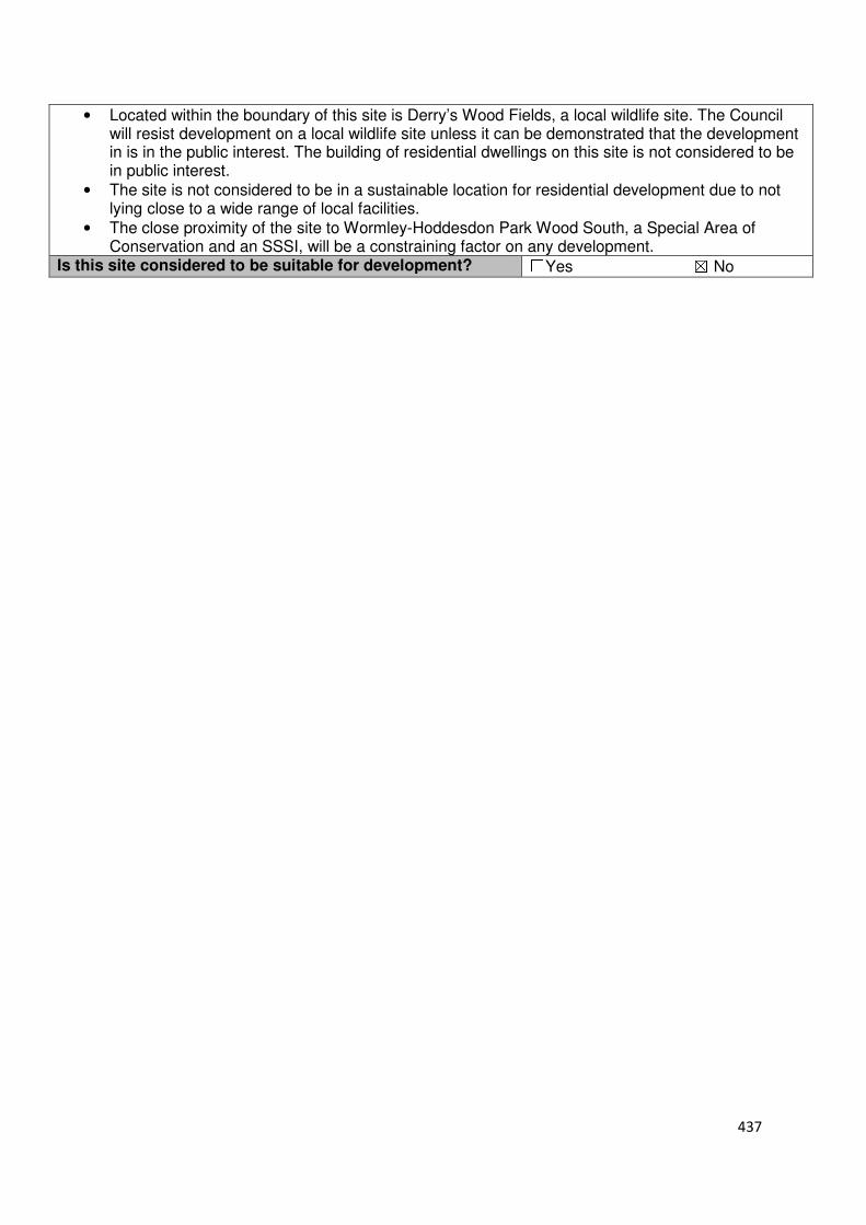
437
• Located within the boundary of this site is Derry’s Wood Fields, a local wildlife site. The Council will resist development on a local wildlife site unless it can be demonstrated that the development in is in the public interest. The building of residential dwellings on this site is not considered to be in public interest.
• The site is not considered to be in a sustainable location for residential development due to not lying close to a wide range of local facilities.
• The close proximity of the site to Wormley-Hoddesdon Park Wood South, a Special Area of Conservation and an SSSI, will be a constraining factor on any development.
Is this site considered to be suitable for development? ☐Yes ☒ No
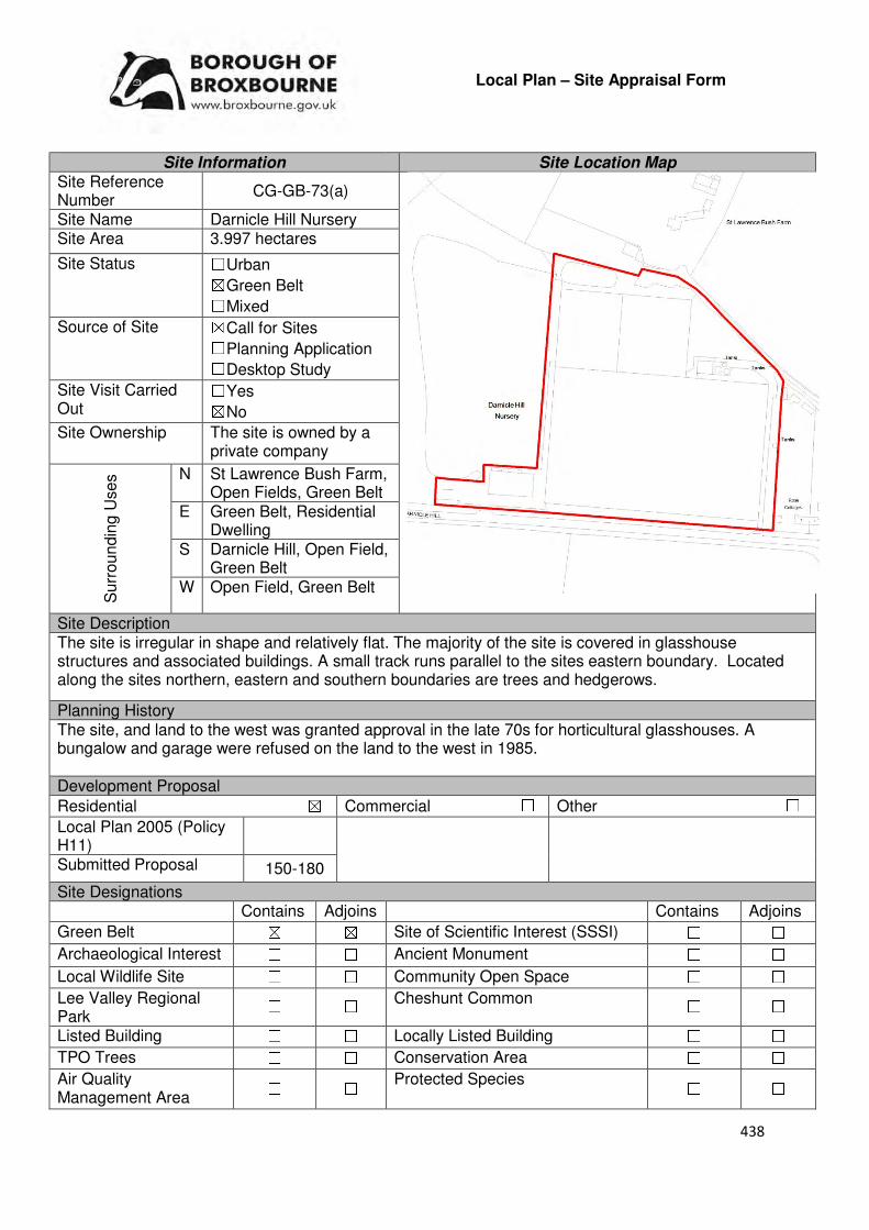
438
Local Plan – Site Appraisal Form
Site Information Site Location Map Site Reference Number
CG-GB-73(a)
Site Name Darnicle Hill Nursery Site Area 3.997 hectares
Site Status ☐Urban ☒Green Belt ☐Mixed
Source of Site ☒Call for Sites ☐Planning Application ☐Desktop Study
Site Visit Carried Out
☐Yes ☒No
Site Ownership The site is owned by a private company
Surr
oundin
g U
ses N St Lawrence Bush Farm,
Open Fields, Green Belt E Green Belt, Residential
Dwelling S Darnicle Hill, Open Field,
Green Belt W Open Field, Green Belt
Site Description The site is irregular in shape and relatively flat. The majority of the site is covered in glasshouse structures and associated buildings. A small track runs parallel to the sites eastern boundary. Located along the sites northern, eastern and southern boundaries are trees and hedgerows.
Planning History The site, and land to the west was granted approval in the late 70s for horticultural glasshouses. A bungalow and garage were refused on the land to the west in 1985. Development Proposal
Residential ☒ Commercial ☐ Other ☐
Local Plan 2005 (Policy H11)
Submitted Proposal 150-180
Site Designations Contains Adjoins Contains Adjoins
Green Belt ☒ ☒ Site of Scientific Interest (SSSI) ☐ ☐
Archaeological Interest ☐ ☐ Ancient Monument ☐ ☐
Local Wildlife Site ☐ ☐ Community Open Space ☐ ☐
Lee Valley Regional Park
☐ ☐ Cheshunt Common ☐ ☐
Listed Building ☐ ☐ Locally Listed Building ☐ ☐
TPO Trees ☐ ☐ Conservation Area ☐ ☐
Air Quality Management Area
☐ ☐ Protected Species ☐ ☐
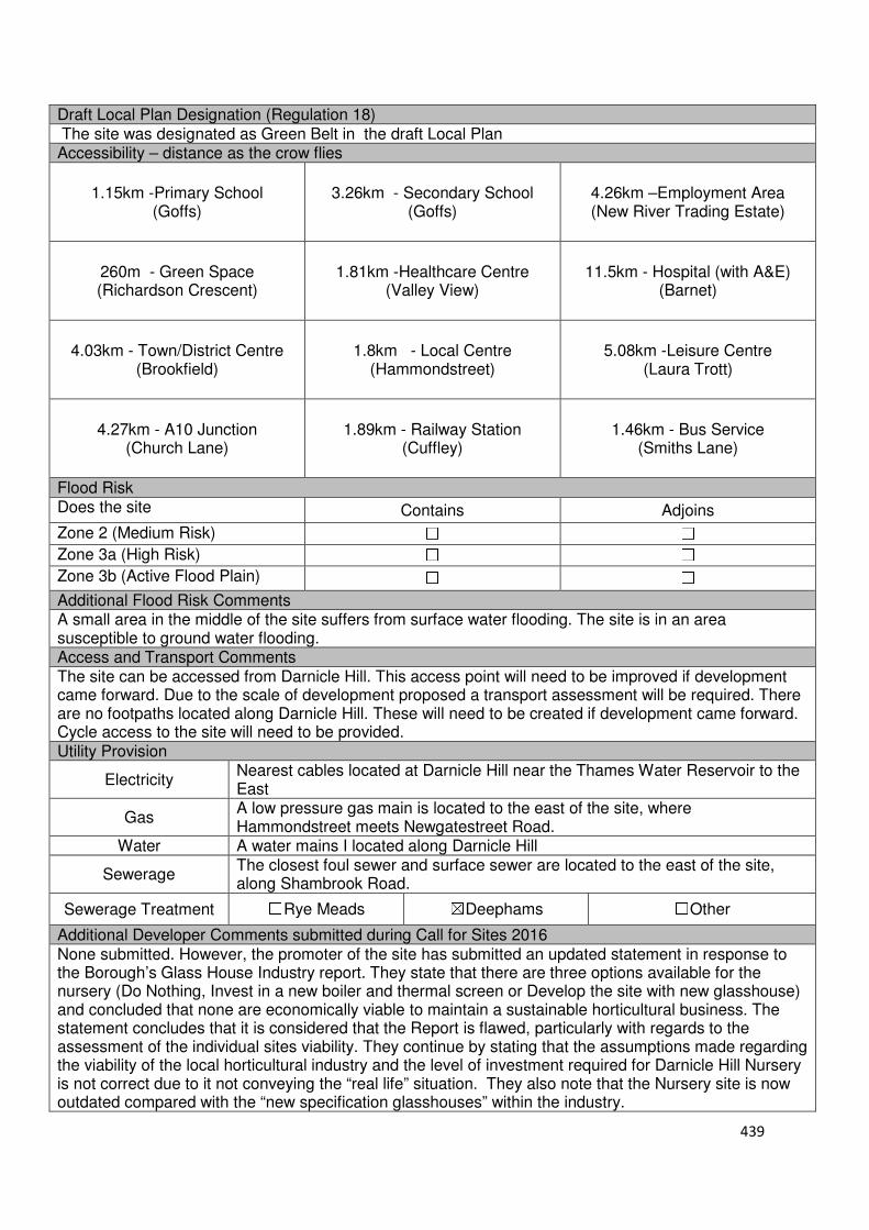
439
Draft Local Plan Designation (Regulation 18) The site was designated as Green Belt in the draft Local Plan Accessibility – distance as the crow flies
1.15km -Primary School (Goffs)
3.26km - Secondary School (Goffs)
4.26km –Employment Area (New River Trading Estate)
260m - Green Space (Richardson Crescent)
1.81km -Healthcare Centre (Valley View)
11.5km - Hospital (with A&E) (Barnet)
4.03km - Town/District Centre (Brookfield)
1.8km - Local Centre (Hammondstreet)
5.08km -Leisure Centre (Laura Trott)
4.27km - A10 Junction (Church Lane)
1.89km - Railway Station (Cuffley)
1.46km - Bus Service (Smiths Lane)
Flood Risk Does the site Contains Adjoins
Zone 2 (Medium Risk) ☐ ☐
Zone 3a (High Risk) ☐ ☐
Zone 3b (Active Flood Plain) ☐ ☐
Additional Flood Risk Comments A small area in the middle of the site suffers from surface water flooding. The site is in an area susceptible to ground water flooding. Access and Transport Comments The site can be accessed from Darnicle Hill. This access point will need to be improved if development came forward. Due to the scale of development proposed a transport assessment will be required. There are no footpaths located along Darnicle Hill. These will need to be created if development came forward. Cycle access to the site will need to be provided. Utility Provision
Electricity Nearest cables located at Darnicle Hill near the Thames Water Reservoir to the East
Gas A low pressure gas main is located to the east of the site, where Hammondstreet meets Newgatestreet Road.
Water A water mains I located along Darnicle Hill
Sewerage The closest foul sewer and surface sewer are located to the east of the site, along Shambrook Road.
Sewerage Treatment ☐Rye Meads ☒Deephams ☐Other
Additional Developer Comments submitted during Call for Sites 2016 None submitted. However, the promoter of the site has submitted an updated statement in response to the Borough’s Glass House Industry report. They state that there are three options available for the nursery (Do Nothing, Invest in a new boiler and thermal screen or Develop the site with new glasshouse) and concluded that none are economically viable to maintain a sustainable horticultural business. The statement concludes that it is considered that the Report is flawed, particularly with regards to the assessment of the individual sites viability. They continue by stating that the assumptions made regarding the viability of the local horticultural industry and the level of investment required for Darnicle Hill Nursery is not correct due to it not conveying the “real life” situation. They also note that the Nursery site is now outdated compared with the “new specification glasshouses” within the industry.
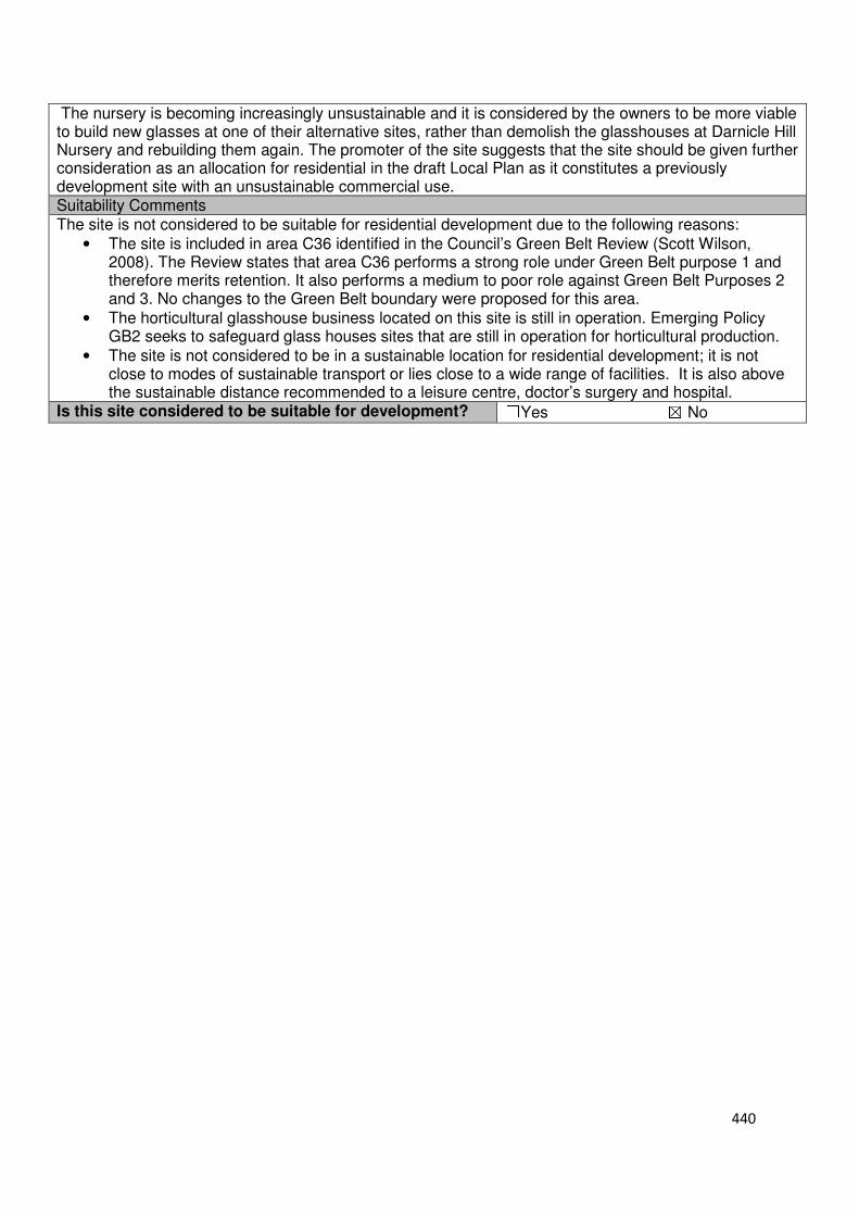
440
The nursery is becoming increasingly unsustainable and it is considered by the owners to be more viable to build new glasses at one of their alternative sites, rather than demolish the glasshouses at Darnicle Hill Nursery and rebuilding them again. The promoter of the site suggests that the site should be given further consideration as an allocation for residential in the draft Local Plan as it constitutes a previously development site with an unsustainable commercial use. Suitability Comments The site is not considered to be suitable for residential development due to the following reasons:
• The site is included in area C36 identified in the Council’s Green Belt Review (Scott Wilson, 2008). The Review states that area C36 performs a strong role under Green Belt purpose 1 and therefore merits retention. It also performs a medium to poor role against Green Belt Purposes 2 and 3. No changes to the Green Belt boundary were proposed for this area.
• The horticultural glasshouse business located on this site is still in operation. Emerging Policy GB2 seeks to safeguard glass houses sites that are still in operation for horticultural production.
• The site is not considered to be in a sustainable location for residential development; it is not close to modes of sustainable transport or lies close to a wide range of facilities. It is also above the sustainable distance recommended to a leisure centre, doctor’s surgery and hospital.
Is this site considered to be suitable for development? ☐Yes ☒ No

441
Local Plan – Site Appraisal Form
Site Information Site Location Map Site Reference Number
CG-GB-73(b)
Site Name Darnicle Hill Nursery Site Area 5.75 hectares
Site Status ☐Urban ☒Green Belt ☐Mixed
Source of Site ☒Call for Sites ☐Planning Application ☐Desktop Study
Site Visit Carried Out
☐Yes ☒No
Site Ownership The site is owned by a private company
Surr
oundin
g U
ses N St Lawrence Bush
Farm, Open Fields, Green Belt
E Green Belt, Residential Dwelling
S Darnicle Hill, Open Field, Green Belt
W Open Field, Green Belt
Site Description The site is irregular in shape and relatively flat. The majority of the site is covered in glasshouse structure and associated buildings. A small track runs parallel to the sites eastern boundary. An area of open field is located within the western region of the site. Located along the sites northern, eastern and southern boundaries are trees and hedgerows. Planning History Please refer to CG-GB-73(a) Development Proposal
Residential ☒ Commercial ☐ Other ☐
Local Plan 2005 (Policy H11)
Submitted Proposal 150-180
Site Designations Contains Adjoins Contains Adjoins
Green Belt ☒ ☒ Site of Scientific Interest (SSSI) ☐ ☐
Archaeological Interest ☐ ☐ Ancient Monument ☐ ☐
Local Wildlife Site ☐ ☐ Community Open Space ☐ ☐
Lee Valley Regional Park
☐ ☐ Cheshunt Common ☐ ☐
Listed Building ☐ ☐ Locally Listed Building ☐ ☐
TPO Trees ☐ ☐ Conservation Area ☐ ☐
Air Quality Management Area
☐ ☐ Protected Species ☐ ☐
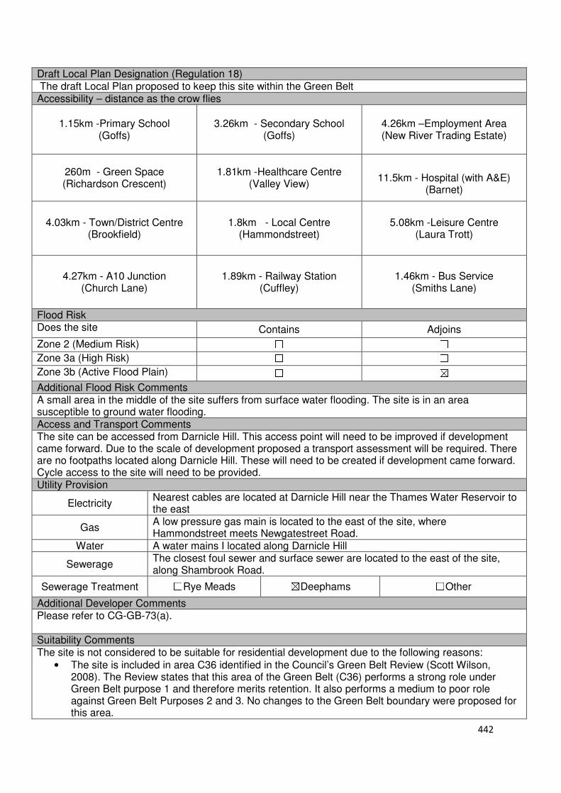
442
Draft Local Plan Designation (Regulation 18) The draft Local Plan proposed to keep this site within the Green Belt Accessibility – distance as the crow flies
1.15km -Primary School (Goffs)
3.26km - Secondary School (Goffs)
4.26km –Employment Area (New River Trading Estate)
260m - Green Space (Richardson Crescent)
1.81km -Healthcare Centre (Valley View)
11.5km - Hospital (with A&E)
(Barnet)
4.03km - Town/District Centre (Brookfield)
1.8km - Local Centre (Hammondstreet)
5.08km -Leisure Centre (Laura Trott)
4.27km - A10 Junction (Church Lane)
1.89km - Railway Station (Cuffley)
1.46km - Bus Service (Smiths Lane)
Flood Risk Does the site Contains Adjoins
Zone 2 (Medium Risk) ☐ ☐
Zone 3a (High Risk) ☐ ☐
Zone 3b (Active Flood Plain) ☐ ☒
Additional Flood Risk Comments A small area in the middle of the site suffers from surface water flooding. The site is in an area susceptible to ground water flooding. Access and Transport Comments The site can be accessed from Darnicle Hill. This access point will need to be improved if development came forward. Due to the scale of development proposed a transport assessment will be required. There are no footpaths located along Darnicle Hill. These will need to be created if development came forward. Cycle access to the site will need to be provided. Utility Provision
Electricity Nearest cables are located at Darnicle Hill near the Thames Water Reservoir to the east
Gas A low pressure gas main is located to the east of the site, where Hammondstreet meets Newgatestreet Road.
Water A water mains I located along Darnicle Hill
Sewerage The closest foul sewer and surface sewer are located to the east of the site, along Shambrook Road.
Sewerage Treatment ☐Rye Meads ☒Deephams ☐Other
Additional Developer Comments Please refer to CG-GB-73(a). Suitability Comments The site is not considered to be suitable for residential development due to the following reasons:
• The site is included in area C36 identified in the Council’s Green Belt Review (Scott Wilson, 2008). The Review states that this area of the Green Belt (C36) performs a strong role under Green Belt purpose 1 and therefore merits retention. It also performs a medium to poor role against Green Belt Purposes 2 and 3. No changes to the Green Belt boundary were proposed for this area.

443
• The horticultural glasshouse business located on this site is still in operation. Emerging Policy GB2 seeks to safeguard glass houses sites that are still in operation for horticultural production.
• The site is not considered to be in a sustainable location for residential development; it is not close to modes of sustainable transport or lies close to a wide range of facilities. It is also above the sustainable distance recommended by Barton et al (2010) for a leisure centre, doctor’s surgery and hospital.
Is this site considered to be suitable for development? ☐Yes ☒ No

444
Local Plan – Site Appraisal Form
Site Information Site Location Map Site Reference Number
CG-GB-74
Site Name Hammondstreet Reservoir and Cedarwood Bungalow
Site Area 2 hectares
Site Status ☐Urban ☒Green Belt ☐Mixed
Source of Site ☒Call for Sites ☐Planning Application ☐Desktop Study
Site Visit Carried Out
☐Yes ☒No
Site Ownership Part of the site is owned by a private company and part is unregistered
Surr
oundin
g
Uses
N Open Field, Green Belt
E Green Belt, Residential S Hammondstreet Road,
Laurel Park, Green Belt W Track, Green Belt, Darnicle
Hill Nursery Site Description The broadly rectangular site is relatively flat. There are two small areas in the site where ground level drops by 2m. The majority of the site is open field in nature. Cedarwood Bungalow and its garden land are located in the eastern region of the site. Located in the north-western and south-eastern corner of the site are cluster of trees. Two structures are located in the central region of the site, near the southern boundary. Trees are located along the sites boundaries. Planning History No planning history of note. Development Proposal
Residential ☒ Commercial ☐ Other ☐
Local Plan 2005 (Policy H11) 60
Submitted Proposal -
Site Designations Contains Adjoins Contains Adjoins
Green Belt ☒ ☒ Site of Scientific Interest (SSSI) ☐ ☐
Archaeological Interest ☐ ☐ Ancient Monument ☐ ☐
Local Wildlife Site ☐ ☐ Community Open Space ☐ ☐
Lee Valley Regional Park ☐ ☐ Cheshunt Common ☐ ☐
Listed Building ☐ ☐ Locally Listed Building ☐ ☐
TPO Trees ☐ ☐ Conservation Area ☐ ☐
Air Quality Management Area
☐ ☐ Protected Species ☐ ☐
Draft Local Plan Designation (Regulation 18) The draft Local Plan proposed to keep this site within the Green Belt.

445
Accessibility – distance as the crow flies
1.14km -Primary School (Goffs)
3.09km - Secondary School (Goffs)
3.98km –Employment Area (New River Trading Estate)
30m - Green Space (Richardson Crescent)
1.7km -Healthcare Centre (Valley View)
11.6km- Hospital (with A&E) (Barnet)
3.77km - Town/District Centre (Brookfield)
1.53km - Local Centre (Hammondstreet)
4.89km -Leisure Centre (Laura Trott)
4km - A10 Junction (Church Lane)
2.02km - Railway Station (Cuffley)
1.02km - Bus Service (Smiths Lane)
Flood Risk Does the site Contains Adjoins
Zone 2 (Medium Risk) ☐ ☐
Zone 3a (High Risk) ☐ ☐
Zone 3b (Active Flood Plain) ☐ ☒
Additional Flood Risk Comments The site may be susceptible to ground water flooding. Access and Transport Comments There are two access points to the site from Hammondstreet Road. Due to the potential development capacity of this site, a transport assessment will be required. The assessment will need to take into consideration the sites proximity to Newgatestreet/Hammondstreet junction. There are footpaths along Hammondstreet Road. Connections to these will be required. Cycle access to the site will need to be created. Utility Provision
Electricity Nearest cables are located at Darnicle Hill near the Thames Water Reservoir to the east
Gas A low pressure gas main is located along Hammondstreet Road.
Water A water main and trunk main is located along Hammondstreet Road Sewerage A foul sewer and surface sewer is located along Shambrook Road
Sewerage Treatment ☐Rye Meads ☐Deephams ☐Other
Additional Developer Comments submitted during Call for Sites 2016 None submitted. Suitability Comments This site is not considered to be suitable for residential development due to the following reasons:
• The site is included in area C1 identified in the Council’s Green Belt Review (Scott Wilson, 2008). The Review states that area C1 performs strongly against the Green Belt purposes and therefore should be retained. The only proposed amendments to this area of the Green Belt were the removal of a thin strip between Nightingale Road and Dalia Close.
• The site is not considered to be in a sustainable location for residential development. It does not lie close to a wide range of facilities. It is not within the sustainable distance recommended by Barton et al (2010) for a hospital, leisure centre or doctors surgery.
• The site prevents the outward urban sprawl of the Hammondstreet settlement.
• The site has weak Green Belt boundaries to the north and east. These Green Belt boundaries are not considered to be robust and defensible, and will not prevent further encroachment into the countryside.
Is this site considered to be suitable for development? ☐Yes ☒ No

446
Local Plan – Site Appraisal Form
Site Information Site Location Map Site Reference Number
CG-GB-75
Site Name Tetherdown Site Area 1.7 hectares
Site Status ☐Urban ☒Green Belt ☐Mixed
Source of Site ☒Call for Sites ☐Planning Application ☐Desktop Study
Site Visit Carried Out
☒Yes ☐No
Site Ownership The site is owned by two landowners
Surr
oundin
g
Uses
N Local Wildlife Site, Green Belt
E Green Belt, Open Fields S Ashfield Nursery, Green Belt
W Newgatestreet Road, Open Field, Green Belt
Site Description The rectangular shaped site slopes to the east. It is predominantly open field in nature. Located within the western region of the site is a residential dwelling and associated garden lands. In the north eastern region of the site is a cluster of trees. Trees are located along most of the sites boundary. Planning History In 1984 planning permission was refused for a two storey side extension, single storey front and rear extensions and alterations to the existing house to form a separate unit of living accommodation. In 1981 outline planning was granted for a glasshouse. A two storey side extension and detached garage was granted approval in 1984, Development Proposal
Residential ☒ Commercial ☐ Other ☐
Local Plan 2005 (Policy H11) 51
Submitted Proposal -
Site Designations Contains Adjoins Contains Adjoins
Green Belt ☒ ☒ Site of Scientific Interest (SSSI) ☐ ☐
Archaeological Interest ☐ ☐ Ancient Monument ☐ ☐
Local Wildlife Site ☐ ☒ Community Open Space ☐ ☐
Lee Valley Regional Park ☐ ☐ Cheshunt Common ☐ ☐
Listed Building ☐ ☐ Locally Listed Building ☐ ☐
TPO Trees ☐ ☐ Conservation Area ☐ ☐
Air Quality Management Area
☐ ☐ Protected Species ☐ ☐
Draft Local Plan Designation (Regulation 18) The draft Local Plan proposed to keep this site within the Green Belt

447
Accessibility – distance as the crow flies
670m -Primary School (Goffs)
2.74km - Secondary School (Goffs)
3.87km –Employment Area (New River Trading Estate)
110m - Green Space (Richardson Crescent)
1.23km -Healthcare Centre (Valley View)
11.3km - Hospital (with A&E) (Barnet)
3.71km - Town/District Centre (Brookfield)
1km - Local Centre (1-5 Masons Parade)
4.6km-Leisure Centre (Laura Trott)
3.78km - A10 Junction (Church Lane)
1.6km - Railway Station (Cuffley)
945m - Bus Service (Smiths Lane)
Flood Risk Does the site Contains Adjoins
Zone 2 (Medium Risk) ☐ ☐
Zone 3a (High Risk) ☐ ☐
Zone 3b (Active Flood Plain) ☐ ☐
Additional Flood Risk Comments The site may be susceptible to ground water flooding Access and Transport Comments The site can be accessed from Newgatestreet Road. An impact into the impact that this site could have on the local and strategic road network will require further investigation. There are footpaths on the western side of Newgatestreet Road, which lead to Goffs Oak Village Centre. Connections to these would be required. Cycle access to the site would need to be created. Utility Provision
Electricity Available at Newgatestreet Road
Gas A low pressure gas main is located along Newgatestreet Road
Water A water main is located along Newgatestreet Road
Sewerage The closest foul sewer and surface sewer is located to the north east of the site at Richardson Crescent
Sewerage Treatment ☐Rye Meads ☒Deephams ☐Other
Additional Developer Comments submitted during Call for Sites 2016 None submitted. Suitability Comments The site is not considered to be suitable for development due to the following reasons:
• The site is included in area C30 identified in the Council’s Green Belt Review (Scott Wilson, 2008). The Review states that area C30 performs strongly against the Green Belt purposes and proposed no change to the boundary in this location. However, it should be noted that the review also stated that there is the opportunity to create a stronger Green Belt boundary in C11-C30 as these areas have “extremely weak boundaries” which means that there are no real barriers to prevent encroachment between settlements.
• The site contributes to preventing the outward sprawl of Goffs Oak. The site also contributes to maintaining the local gap between the Hammondstreet settlement and Goffs Oak.
• This site has weak Green Belt boundaries to the north and east that are not likely to endure beyond the Plan period or prevent further encroachment into the countryside.

448
• The site is not within the sustainable distance recommended by Barton et al (2010) for the following facilities and amenities: hospital, leisure centre and doctors surgery. The site does not also lie close to modes of sustainable transport.
Is this site considered to be suitable for development? ☐Yes ☒ No

449
Local Plan – Site Appraisal Form
Site Information Site Location Map Site Reference Number
CG-GB-76
Site Name Warden Nursery Site Area 1.21 hectares
Site Status ☐Urban ☒Green Belt ☐Mixed
Source of Site ☐Call for Sites ☐Planning Application ☒Desktop Study
Site Visit Carried Out
☐Yes ☒No
Site Ownership There are multiple owners for this site.
Surr
oundin
g
Uses
N Ashfield Nursery, Green Belt
E Open Field, Green Belt S Glasshouse, Residential
Dwelling, Green Belt W Newgatestreet Road,
Open Field, Green Belt Site Description The site is broadly triangular in shape and slopes down to the east. Located within the western region of the site is three residential dwellings and their associated garden land. A small strip of hardstanding extends beyond the residential property referred to as Pembrey. Within the south-western region of the site is a cluster of trees. Trees are located along the sites southern and eastern boundary.
Planning History In 1980 planning permission was granted for a single storey extension at Pembrey. In 1978 planning permission was granted for the erection of stables, tack room, store and toilet at Pembrey. In 2013, a two storey side and single storey rear extension was granted conditional approval at The Nest. Development Proposal
Residential ☒ Commercial ☐ Other ☐
Local Plan 2005 (Policy H11) 36
Submitted Proposal -
Site Designations Contains Adjoins Contains Adjoins
Green Belt ☒ ☒ Site of Scientific Interest (SSSI) ☐ ☐
Archaeological Interest ☐ ☐ Ancient Monument ☐ ☐
Local Wildlife Site ☐ ☐ Community Open Space ☐ ☐
Lee Valley Regional Park ☐ ☐ Cheshunt Common ☐ ☐
Listed Building ☐ ☐ Locally Listed Building ☐ ☐
TPO Trees ☐ ☐ Conservation Area ☐ ☐
Air Quality Management Area
☐ ☐ Protected Species ☐ ☐
Draft Local Plan Designation (Regulation 18) The draft Local Plan proposed to keep this site within the Green Belt
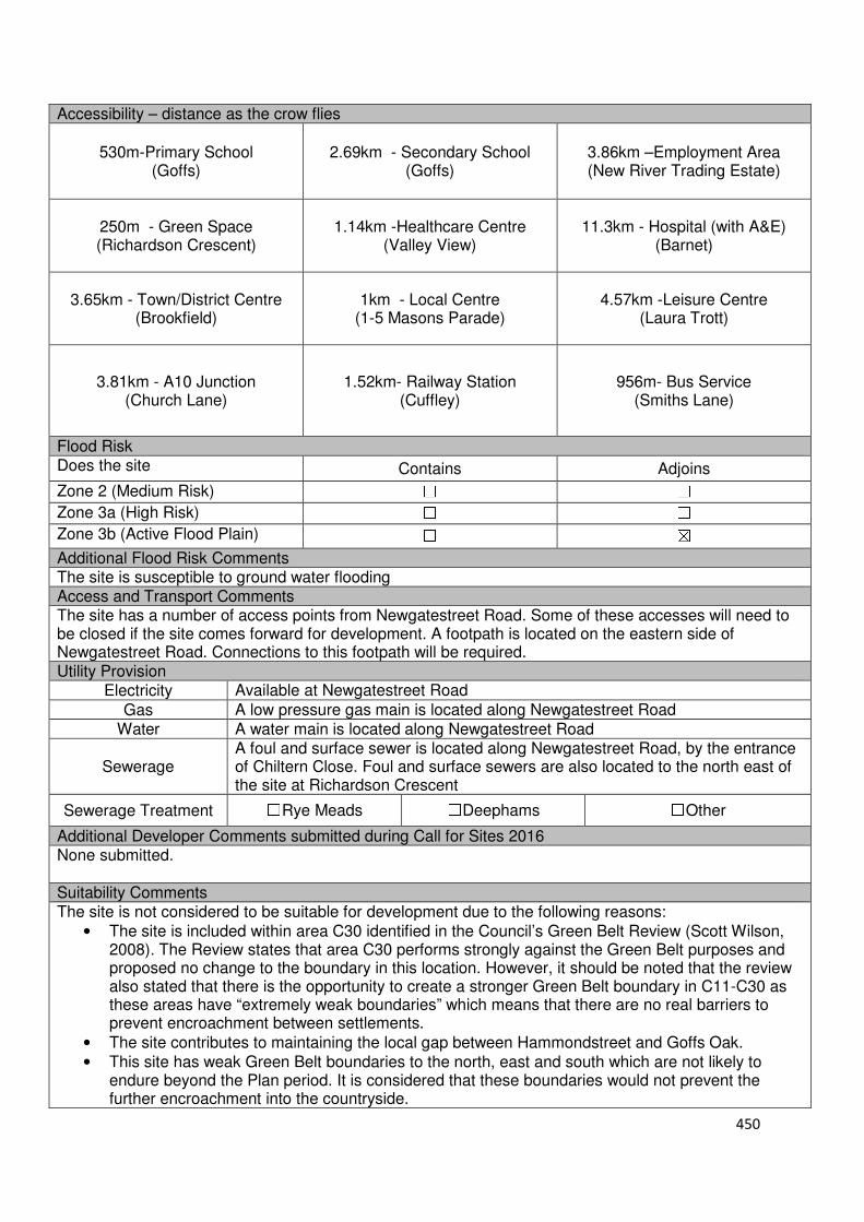
450
Accessibility – distance as the crow flies
530m-Primary School (Goffs)
2.69km - Secondary School (Goffs)
3.86km –Employment Area (New River Trading Estate)
250m - Green Space (Richardson Crescent)
1.14km -Healthcare Centre (Valley View)
11.3km - Hospital (with A&E) (Barnet)
3.65km - Town/District Centre (Brookfield)
1km - Local Centre (1-5 Masons Parade)
4.57km -Leisure Centre (Laura Trott)
3.81km - A10 Junction (Church Lane)
1.52km- Railway Station (Cuffley)
956m- Bus Service (Smiths Lane)
Flood Risk Does the site Contains Adjoins
Zone 2 (Medium Risk) ☐ ☐
Zone 3a (High Risk) ☐ ☐
Zone 3b (Active Flood Plain) ☐ ☒
Additional Flood Risk Comments The site is susceptible to ground water flooding Access and Transport Comments The site has a number of access points from Newgatestreet Road. Some of these accesses will need to be closed if the site comes forward for development. A footpath is located on the eastern side of Newgatestreet Road. Connections to this footpath will be required. Utility Provision
Electricity Available at Newgatestreet Road
Gas A low pressure gas main is located along Newgatestreet Road
Water A water main is located along Newgatestreet Road
Sewerage A foul and surface sewer is located along Newgatestreet Road, by the entrance of Chiltern Close. Foul and surface sewers are also located to the north east of the site at Richardson Crescent
Sewerage Treatment ☐Rye Meads ☐Deephams ☐Other
Additional Developer Comments submitted during Call for Sites 2016 None submitted. Suitability Comments The site is not considered to be suitable for development due to the following reasons:
• The site is included within area C30 identified in the Council’s Green Belt Review (Scott Wilson, 2008). The Review states that area C30 performs strongly against the Green Belt purposes and proposed no change to the boundary in this location. However, it should be noted that the review also stated that there is the opportunity to create a stronger Green Belt boundary in C11-C30 as these areas have “extremely weak boundaries” which means that there are no real barriers to prevent encroachment between settlements.
• The site contributes to maintaining the local gap between Hammondstreet and Goffs Oak.
• This site has weak Green Belt boundaries to the north, east and south which are not likely to endure beyond the Plan period. It is considered that these boundaries would not prevent the further encroachment into the countryside.
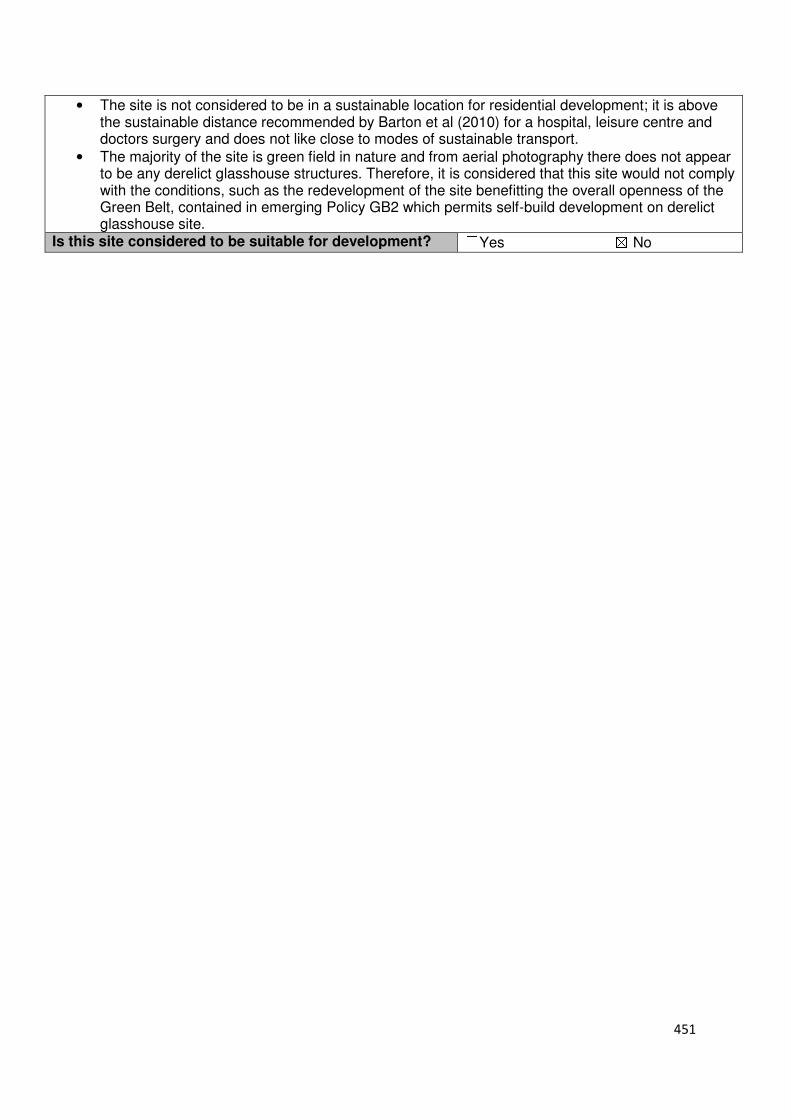
451
• The site is not considered to be in a sustainable location for residential development; it is above the sustainable distance recommended by Barton et al (2010) for a hospital, leisure centre and doctors surgery and does not like close to modes of sustainable transport.
• The majority of the site is green field in nature and from aerial photography there does not appear to be any derelict glasshouse structures. Therefore, it is considered that this site would not comply with the conditions, such as the redevelopment of the site benefitting the overall openness of the Green Belt, contained in emerging Policy GB2 which permits self-build development on derelict glasshouse site.
Is this site considered to be suitable for development? ☐Yes ☒ No
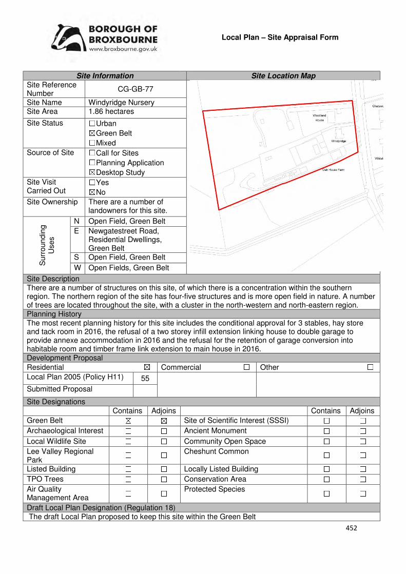
452
Local Plan – Site Appraisal Form
Site Information Site Location Map Site Reference Number
CG-GB-77
Site Name Windyridge Nursery Site Area 1.86 hectares
Site Status ☐Urban ☒Green Belt ☐Mixed
Source of Site ☐Call for Sites ☐Planning Application ☒Desktop Study
Site Visit Carried Out
☐Yes ☒No
Site Ownership There are a number of landowners for this site.
Surr
oundin
g
Uses
N Open Field, Green Belt
E Newgatestreet Road, Residential Dwellings, Green Belt
S Open Field, Green Belt
W Open Fields, Green Belt
Site Description There are a number of structures on this site, of which there is a concentration within the southern region. The northern region of the site has four-five structures and is more open field in nature. A number of trees are located throughout the site, with a cluster in the north-western and north-eastern region. Planning History The most recent planning history for this site includes the conditional approval for 3 stables, hay store and tack room in 2016, the refusal of a two storey infill extension linking house to double garage to provide annexe accommodation in 2016 and the refusal for the retention of garage conversion into habitable room and timber frame link extension to main house in 2016. Development Proposal
Residential ☒ Commercial ☐ Other ☐
Local Plan 2005 (Policy H11) 55
Submitted Proposal
Site Designations Contains Adjoins Contains Adjoins
Green Belt ☒ ☒ Site of Scientific Interest (SSSI) ☐ ☐
Archaeological Interest ☐ ☐ Ancient Monument ☐ ☐
Local Wildlife Site ☐ ☐ Community Open Space ☐ ☐
Lee Valley Regional Park
☐ ☐ Cheshunt Common ☐ ☐
Listed Building ☐ ☐ Locally Listed Building ☐ ☐
TPO Trees ☐ ☐ Conservation Area ☐ ☐
Air Quality Management Area
☐ ☐ Protected Species ☐ ☐
Draft Local Plan Designation (Regulation 18) The draft Local Plan proposed to keep this site within the Green Belt
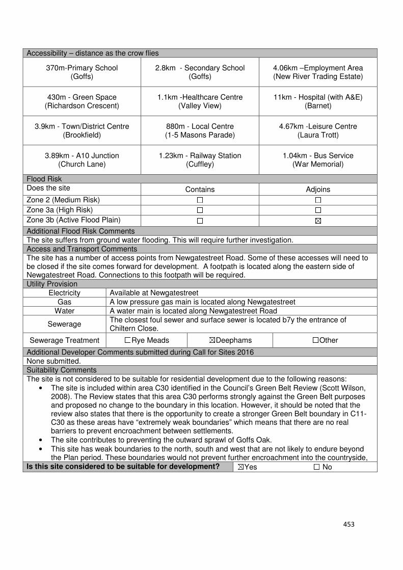
453
Accessibility – distance as the crow flies
370m-Primary School (Goffs)
2.8km - Secondary School (Goffs)
4.06km –Employment Area (New River Trading Estate)
430m - Green Space (Richardson Crescent)
1.1km -Healthcare Centre (Valley View)
11km - Hospital (with A&E) (Barnet)
3.9km - Town/District Centre (Brookfield)
880m - Local Centre (1-5 Masons Parade)
4.67km -Leisure Centre (Laura Trott)
3.89km - A10 Junction (Church Lane)
1.23km - Railway Station (Cuffley)
1.04km - Bus Service (War Memorial)
Flood Risk Does the site Contains Adjoins
Zone 2 (Medium Risk) ☐ ☐
Zone 3a (High Risk) ☐ ☐
Zone 3b (Active Flood Plain) ☐ ☒
Additional Flood Risk Comments The site suffers from ground water flooding. This will require further investigation. Access and Transport Comments The site has a number of access points from Newgatestreet Road. Some of these accesses will need to be closed if the site comes forward for development. A footpath is located along the eastern side of Newgatestreet Road. Connections to this footpath will be required. Utility Provision
Electricity Available at Newgatestreet
Gas A low pressure gas main is located along Newgatestreet
Water A water main is located along Newgatestreet Road
Sewerage The closest foul sewer and surface sewer is located b7y the entrance of Chiltern Close.
Sewerage Treatment ☐Rye Meads ☒Deephams ☐Other
Additional Developer Comments submitted during Call for Sites 2016 None submitted. Suitability Comments The site is not considered to be suitable for residential development due to the following reasons:
• The site is included within area C30 identified in the Council’s Green Belt Review (Scott Wilson, 2008). The Review states that this area C30 performs strongly against the Green Belt purposes and proposed no change to the boundary in this location. However, it should be noted that the review also states that there is the opportunity to create a stronger Green Belt boundary in C11-C30 as these areas have “extremely weak boundaries” which means that there are no real barriers to prevent encroachment between settlements.
• The site contributes to preventing the outward sprawl of Goffs Oak.
• This site has weak boundaries to the north, south and west that are not likely to endure beyond the Plan period. These boundaries would not prevent further encroachment into the countryside,
Is this site considered to be suitable for development? ☒Yes ☐ No

454
Local Plan – Site Appraisal Form
Site Information Site Location Map Site Reference Number
CG-GB-78(a)
Site Name Theobalds Nursery Site Area 1.3 hectares
Site Status ☐Urban ☒Green Belt ☐Mixed
Source of Site ☐Call for Sites ☐Planning Application ☒Desktop Study
Site Visit Carried Out
☐Yes ☒No
Site Ownership There are several owners for this site.
Surr
oundin
g U
ses
N Cross Nursery, Green Belt
E Open Field, Green Belt S Open Field, Green Belt
W Newgatestreet Road, Green Belt
Site Description The site is irregular in shape. Fronting onto the Newgatestreet Road, and forming the majority of the sites western region is two residential properties and their associated garden land, and a Place of Worship. The eastern region of the site is open field in nature, and contains an electricity pylon. Planning History In 1990, a single storey religious meeting room with associated car parking facilities was granted conditional approval. A single storey building to house Christian Meeting Room and associated works was withdrawn in 1988. In 2000, the construction of a temporary wooden building for associated religious activities and associated car parking was refused. Various extensions have been approved and refused for the two residential properties. Development Proposal
Residential ☒ Commercial ☐ Other ☐
Local Plan 2005 (Policy H11) 39
Submitted Proposal -
Site Designations Contains Adjoins Contains Adjoins
Green Belt ☒ ☒ Site of Scientific Interest (SSSI) ☐ ☐
Archaeological Interest ☐ ☐ Ancient Monument ☐ ☐
Local Wildlife Site ☐ ☐ Community Open Space ☐ ☐
Lee Valley Regional Park
☐ ☐ Cheshunt Common ☐ ☐
Listed Building ☐ ☐ Locally Listed Building ☐ ☐
TPO Trees ☐ ☐ Conservation Area ☐ ☐
Air Quality Management Area
☐ ☐ Protected Species ☐ ☐
Draft Local Plan Designation (Regulation 18) The draft Local Plan proposed to keep this site within the Green Belt.
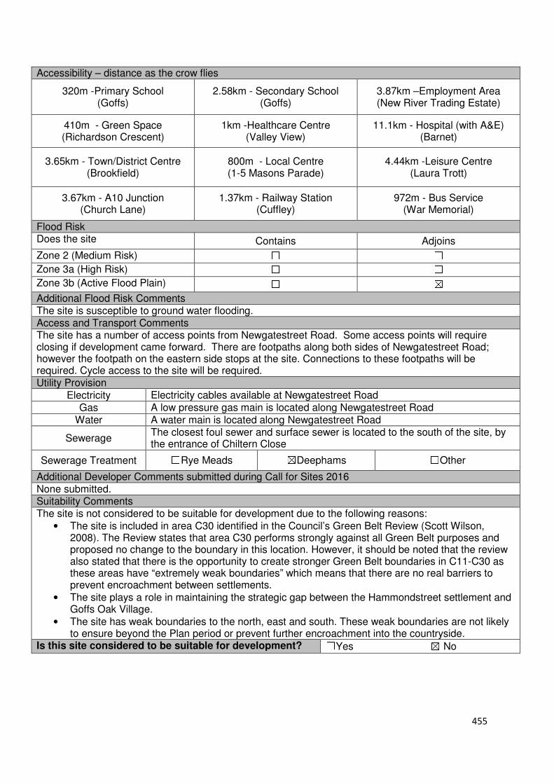
455
Accessibility – distance as the crow flies
320m -Primary School (Goffs)
2.58km - Secondary School (Goffs)
3.87km –Employment Area (New River Trading Estate)
410m - Green Space (Richardson Crescent)
1km -Healthcare Centre (Valley View)
11.1km - Hospital (with A&E) (Barnet)
3.65km - Town/District Centre (Brookfield)
800m - Local Centre (1-5 Masons Parade)
4.44km -Leisure Centre (Laura Trott)
3.67km - A10 Junction (Church Lane)
1.37km - Railway Station (Cuffley)
972m - Bus Service (War Memorial)
Flood Risk Does the site Contains Adjoins
Zone 2 (Medium Risk) ☐ ☐
Zone 3a (High Risk) ☐ ☐
Zone 3b (Active Flood Plain) ☐ ☒
Additional Flood Risk Comments The site is susceptible to ground water flooding. Access and Transport Comments The site has a number of access points from Newgatestreet Road. Some access points will require closing if development came forward. There are footpaths along both sides of Newgatestreet Road; however the footpath on the eastern side stops at the site. Connections to these footpaths will be required. Cycle access to the site will be required. Utility Provision
Electricity Electricity cables available at Newgatestreet Road
Gas A low pressure gas main is located along Newgatestreet Road
Water A water main is located along Newgatestreet Road
Sewerage The closest foul sewer and surface sewer is located to the south of the site, by the entrance of Chiltern Close
Sewerage Treatment ☐Rye Meads ☒Deephams ☐Other
Additional Developer Comments submitted during Call for Sites 2016 None submitted. Suitability Comments The site is not considered to be suitable for development due to the following reasons:
• The site is included in area C30 identified in the Council’s Green Belt Review (Scott Wilson, 2008). The Review states that area C30 performs strongly against all Green Belt purposes and proposed no change to the boundary in this location. However, it should be noted that the review also stated that there is the opportunity to create stronger Green Belt boundaries in C11-C30 as these areas have “extremely weak boundaries” which means that there are no real barriers to prevent encroachment between settlements.
• The site plays a role in maintaining the strategic gap between the Hammondstreet settlement and Goffs Oak Village.
• The site has weak boundaries to the north, east and south. These weak boundaries are not likely to ensure beyond the Plan period or prevent further encroachment into the countryside.
Is this site considered to be suitable for development? ☐Yes ☒ No

456
Local Plan – Site Appraisal Form
Site Information Site Location Map Site Reference Number CG-GB-78(b)
Site Name Former Theobald’s Nursery Site including Meeting Hall
Site Area 0.9 hectares
Site Status ☐Urban ☒Green Belt ☐Mixed
Source of Site ☒Call for Sites ☐Planning Application ☐Desktop Study
Site Visit Carried Out
☐Yes ☒No
Site Ownership There are three landowners for this site.
Surr
oundin
g
Uses
N Cross Nursery, Residential dwellings, Green Belt
E Open Field, Green Belt S Open Field, Green Belt
W Newgatestreet Road, Green Belt
Site Description The site is broadly rectangular in shape and gradually slopes down to the north. There are trees and shrubs located along the sites northern, eastern and southern boundary. An electricity pylon is located centrally within the site. Located in the western region of the site is a single structure, while the eastern region of the site is open field in nature. Planning History Please refer to CG-GB-78(a) Development Proposal
Residential ☒ Commercial ☐ Other ☐
Local Plan 2005 (Policy H11)
Submitted Proposal 25-30
Site Designations Contains Adjoins Contains Adjoins
Green Belt ☒ ☒ Site of Scientific Interest (SSSI) ☐ ☐
Archaeological Interest ☐ ☐ Ancient Monument ☐ ☐
Local Wildlife Site ☐ ☐ Community Open Space ☐ ☐
Lee Valley Regional Park
☐ ☐ Cheshunt Common ☐ ☐
Listed Building ☐ ☐ Locally Listed Building ☐ ☐
TPO Trees ☐ ☐ Conservation Area ☐ ☐
Air Quality Management Area
☐ ☐ Protected Species ☐ ☐
Draft Local Plan Designation (Regulation 18) The draft Local Plan proposed to keep this site within the Green Belt

457
Accessibility – distance as the crow flies
320m -Primary School (Goffs)
2.58km - Secondary School (Goffs)
3.87km –Employment Area (New River Trading Estate)
420m - Green Space (Richardson Crescent)
1km -Healthcare Centre (Valley View)
11.1km - Hospital (with A&E) (Barnet)
3.65km - Town/District Centre (Brookfield)
800m - Local Centre (1-5 Masons Parade)
4.44km -Leisure Centre (Laura Trott)
3.67km - A10 Junction (Church Lane)
1.37km - Railway Station (Cuffley)
972m - Bus Service (War Memorial)
Flood Risk Does the site Contains Adjoins
Zone 2 (Medium Risk) ☐ ☐
Zone 3a (High Risk) ☐ ☐
Zone 3b (Active Flood Plain) ☐ ☒
Additional Flood Risk Comments The site is susceptible to ground water flooding. Access and Transport Comments The site has a number of access points from Newgatestreet Road. Some access points will require closing if development came forward. There are footpaths along both sides of Newgatestreet Road; however the footpath on the eastern side stops at the site. Connections to these footpaths will be required. Utility Provision
Electricity Electricity cables available at Newgatestreet Road
Gas A low pressure gas main is located along Newgatestreet Road
Water A water main is located along Newgatestreet Road
Sewerage The closest foul sewer and surface sewer is located to the south of the site, by the entrance of Chiltern Close
Sewerage Treatment ☐Rye Meads ☒Deephams ☐Other
Additional Developer Comments submitted during Call for Sites 2016 The promoter stated that the site can be delivered within 5 years. The site is no longer in use and vacation of the entire site could be arranged quickly. The Trust would have to be relocated so there is no loss of service provision. The promoter continues by stating that there is an existing electricity pylon on the site, however there is an opportunity to develop around this. Suitability Comments The site is not considered to be suitable for development due to the following reasons:
• The site is included in area C30 identified in the Council’s Green Belt Review (Scott Wilson, 2008). The Review states that area C30 performs strongly against all Green Belt purposes and proposed no change to the boundary in this location. However, it should be noted that the review also stated that there is the opportunity to create stronger Green Belt boundaries in C11-C30 as these areas have “extremely weak boundaries” which means that there are no real barriers to prevent encroachment between settlements.
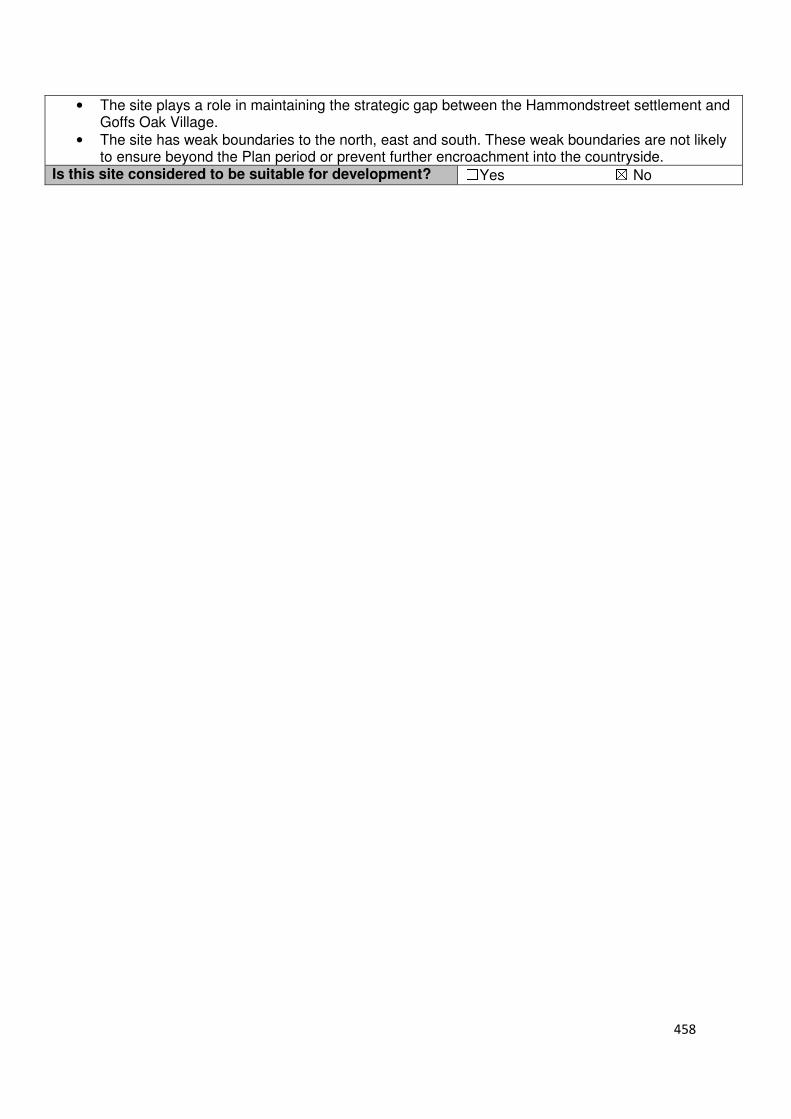
458
• The site plays a role in maintaining the strategic gap between the Hammondstreet settlement and Goffs Oak Village.
• The site has weak boundaries to the north, east and south. These weak boundaries are not likely to ensure beyond the Plan period or prevent further encroachment into the countryside.
Is this site considered to be suitable for development? ☐Yes ☒ No
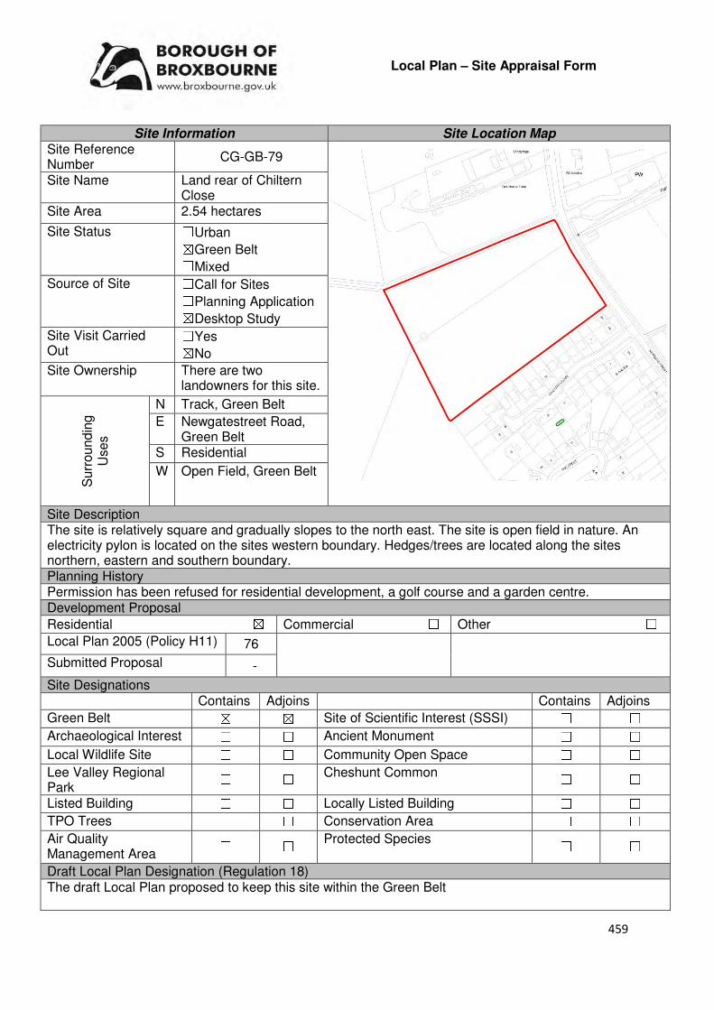
459
Local Plan – Site Appraisal Form
Site Information Site Location Map Site Reference Number
CG-GB-79
Site Name Land rear of Chiltern Close
Site Area 2.54 hectares
Site Status ☐Urban ☒Green Belt ☐Mixed
Source of Site ☐Call for Sites ☐Planning Application ☒Desktop Study
Site Visit Carried Out
☐Yes ☒No
Site Ownership There are two landowners for this site.
Surr
oundin
g
Uses
N Track, Green Belt
E Newgatestreet Road, Green Belt
S Residential
W Open Field, Green Belt
Site Description The site is relatively square and gradually slopes to the north east. The site is open field in nature. An electricity pylon is located on the sites western boundary. Hedges/trees are located along the sites northern, eastern and southern boundary. Planning History Permission has been refused for residential development, a golf course and a garden centre. Development Proposal
Residential ☒ Commercial ☐ Other ☐
Local Plan 2005 (Policy H11) 76
Submitted Proposal -
Site Designations Contains Adjoins Contains Adjoins
Green Belt ☒ ☒ Site of Scientific Interest (SSSI) ☐ ☐
Archaeological Interest ☐ ☐ Ancient Monument ☐ ☐
Local Wildlife Site ☐ ☐ Community Open Space ☐ ☐
Lee Valley Regional Park
☐ ☐ Cheshunt Common ☐ ☐
Listed Building ☐ ☐ Locally Listed Building ☐ ☐
TPO Trees ☐ ☐ Conservation Area ☐ ☐
Air Quality Management Area
☐ ☐ Protected Species ☐ ☐
Draft Local Plan Designation (Regulation 18) The draft Local Plan proposed to keep this site within the Green Belt
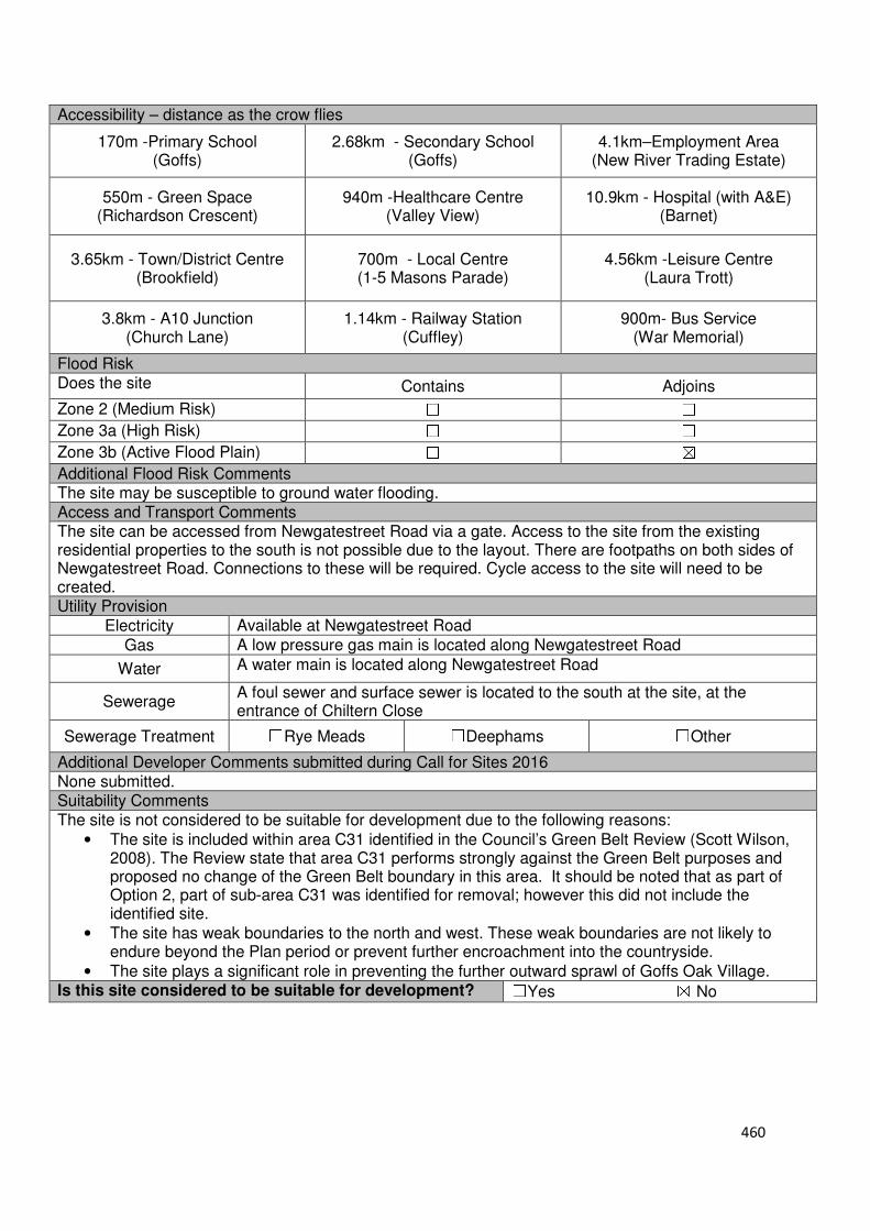
460
Accessibility – distance as the crow flies
170m -Primary School (Goffs)
2.68km - Secondary School (Goffs)
4.1km–Employment Area (New River Trading Estate)
550m - Green Space (Richardson Crescent)
940m -Healthcare Centre (Valley View)
10.9km - Hospital (with A&E) (Barnet)
3.65km - Town/District Centre (Brookfield)
700m - Local Centre (1-5 Masons Parade)
4.56km -Leisure Centre (Laura Trott)
3.8km - A10 Junction (Church Lane)
1.14km - Railway Station (Cuffley)
900m- Bus Service (War Memorial)
Flood Risk Does the site Contains Adjoins
Zone 2 (Medium Risk) ☐ ☐
Zone 3a (High Risk) ☐ ☐
Zone 3b (Active Flood Plain) ☐ ☒
Additional Flood Risk Comments The site may be susceptible to ground water flooding. Access and Transport Comments The site can be accessed from Newgatestreet Road via a gate. Access to the site from the existing residential properties to the south is not possible due to the layout. There are footpaths on both sides of Newgatestreet Road. Connections to these will be required. Cycle access to the site will need to be created. Utility Provision
Electricity Available at Newgatestreet Road
Gas A low pressure gas main is located along Newgatestreet Road
Water A water main is located along Newgatestreet Road
Sewerage A foul sewer and surface sewer is located to the south at the site, at the entrance of Chiltern Close
Sewerage Treatment ☐Rye Meads ☐Deephams ☐Other
Additional Developer Comments submitted during Call for Sites 2016 None submitted. Suitability Comments The site is not considered to be suitable for development due to the following reasons:
• The site is included within area C31 identified in the Council’s Green Belt Review (Scott Wilson, 2008). The Review state that area C31 performs strongly against the Green Belt purposes and proposed no change of the Green Belt boundary in this area. It should be noted that as part of Option 2, part of sub-area C31 was identified for removal; however this did not include the identified site.
• The site has weak boundaries to the north and west. These weak boundaries are not likely to endure beyond the Plan period or prevent further encroachment into the countryside.
• The site plays a significant role in preventing the further outward sprawl of Goffs Oak Village. Is this site considered to be suitable for development? ☐Yes ☒ No
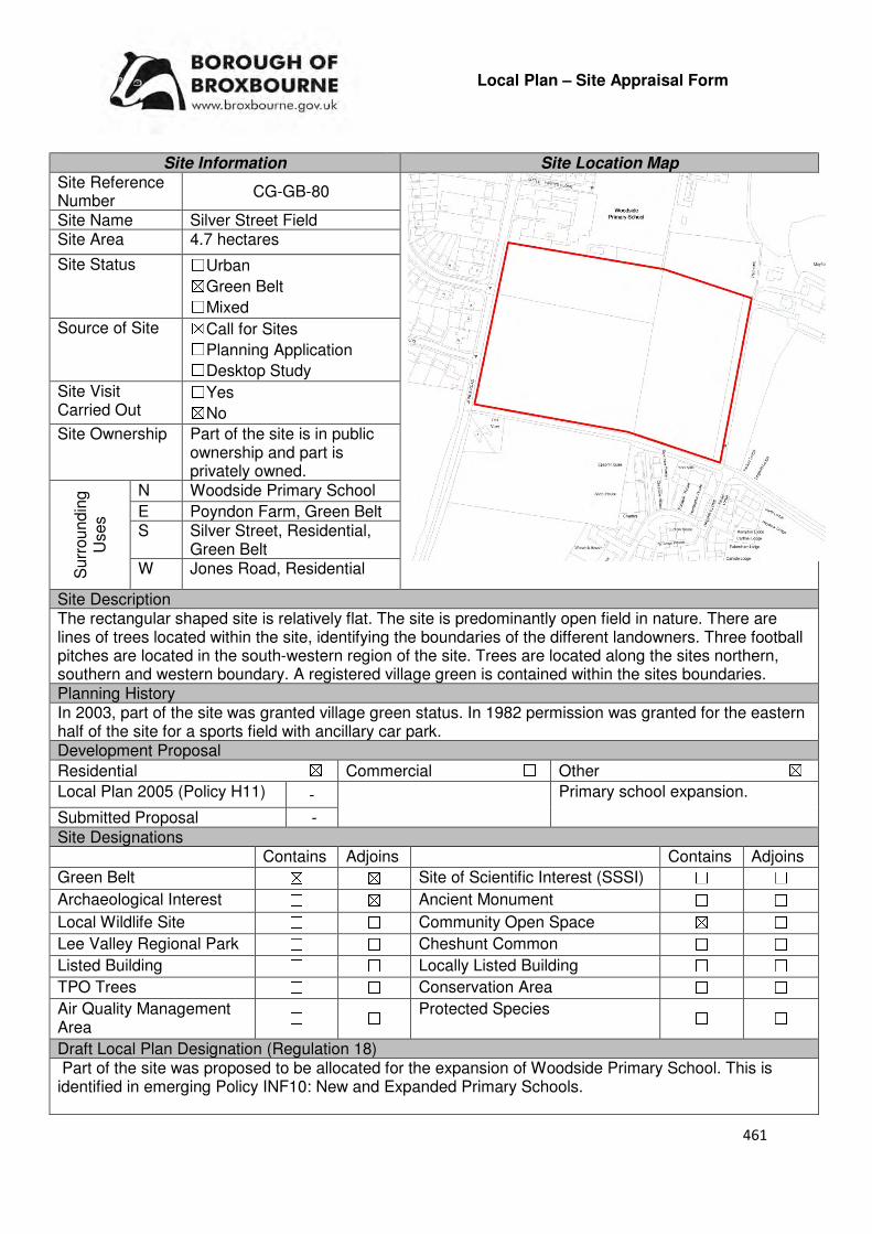
461
Local Plan – Site Appraisal Form
Site Information Site Location Map Site Reference Number
CG-GB-80
Site Name Silver Street Field Site Area 4.7 hectares
Site Status ☐Urban ☒Green Belt ☐Mixed
Source of Site ☒Call for Sites ☐Planning Application ☐Desktop Study
Site Visit Carried Out
☐Yes ☒No
Site Ownership Part of the site is in public ownership and part is privately owned.
Surr
oundin
g
Uses
N Woodside Primary School
E Poyndon Farm, Green Belt S Silver Street, Residential,
Green Belt W Jones Road, Residential
Site Description The rectangular shaped site is relatively flat. The site is predominantly open field in nature. There are lines of trees located within the site, identifying the boundaries of the different landowners. Three football pitches are located in the south-western region of the site. Trees are located along the sites northern, southern and western boundary. A registered village green is contained within the sites boundaries. Planning History In 2003, part of the site was granted village green status. In 1982 permission was granted for the eastern half of the site for a sports field with ancillary car park. Development Proposal
Residential ☒ Commercial ☐ Other ☒
Local Plan 2005 (Policy H11) - Primary school expansion.
Submitted Proposal -
Site Designations Contains Adjoins Contains Adjoins
Green Belt ☒ ☒ Site of Scientific Interest (SSSI) ☐ ☐
Archaeological Interest ☐ ☒ Ancient Monument ☐ ☐
Local Wildlife Site ☐ ☐ Community Open Space ☒ ☐
Lee Valley Regional Park ☐ ☐ Cheshunt Common ☐ ☐
Listed Building ☐ ☐ Locally Listed Building ☐ ☐
TPO Trees ☐ ☐ Conservation Area ☐ ☐
Air Quality Management Area
☐ ☐ Protected Species ☐ ☐
Draft Local Plan Designation (Regulation 18) Part of the site was proposed to be allocated for the expansion of Woodside Primary School. This is identified in emerging Policy INF10: New and Expanded Primary Schools.
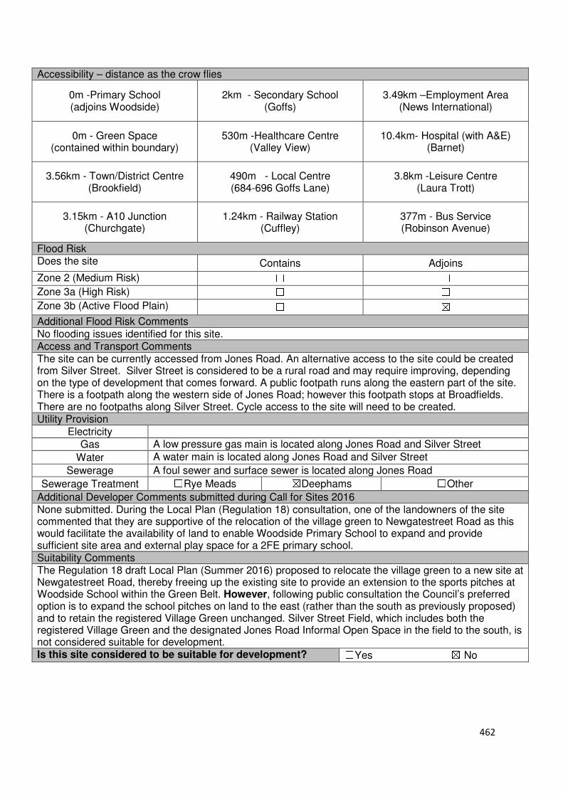
462
Accessibility – distance as the crow flies
0m -Primary School (adjoins Woodside)
2km - Secondary School (Goffs)
3.49km –Employment Area (News International)
0m - Green Space (contained within boundary)
530m -Healthcare Centre (Valley View)
10.4km- Hospital (with A&E) (Barnet)
3.56km - Town/District Centre (Brookfield)
490m - Local Centre (684-696 Goffs Lane)
3.8km -Leisure Centre (Laura Trott)
3.15km - A10 Junction (Churchgate)
1.24km - Railway Station (Cuffley)
377m - Bus Service (Robinson Avenue)
Flood Risk Does the site Contains Adjoins
Zone 2 (Medium Risk) ☐ ☐
Zone 3a (High Risk) ☐ ☐
Zone 3b (Active Flood Plain) ☐ ☒
Additional Flood Risk Comments No flooding issues identified for this site. Access and Transport Comments The site can be currently accessed from Jones Road. An alternative access to the site could be created from Silver Street. Silver Street is considered to be a rural road and may require improving, depending on the type of development that comes forward. A public footpath runs along the eastern part of the site. There is a footpath along the western side of Jones Road; however this footpath stops at Broadfields. There are no footpaths along Silver Street. Cycle access to the site will need to be created. Utility Provision
Electricity
Gas A low pressure gas main is located along Jones Road and Silver Street
Water A water main is located along Jones Road and Silver Street
Sewerage A foul sewer and surface sewer is located along Jones Road
Sewerage Treatment ☐Rye Meads ☒Deephams ☐Other
Additional Developer Comments submitted during Call for Sites 2016 None submitted. During the Local Plan (Regulation 18) consultation, one of the landowners of the site commented that they are supportive of the relocation of the village green to Newgatestreet Road as this would facilitate the availability of land to enable Woodside Primary School to expand and provide sufficient site area and external play space for a 2FE primary school. Suitability Comments The Regulation 18 draft Local Plan (Summer 2016) proposed to relocate the village green to a new site at Newgatestreet Road, thereby freeing up the existing site to provide an extension to the sports pitches at Woodside School within the Green Belt. However, following public consultation the Council’s preferred option is to expand the school pitches on land to the east (rather than the south as previously proposed) and to retain the registered Village Green unchanged. Silver Street Field, which includes both the registered Village Green and the designated Jones Road Informal Open Space in the field to the south, is not considered suitable for development. Is this site considered to be suitable for development? ☐Yes ☒ No

463
Local Plan – Site Appraisal Form
Site Information Site Location Map Site Reference Number
CG-GB-81
Site Name Lucasend Farm Site Area 3.1 hectares
Site Status ☐Urban ☒Green Belt ☐Mixed
Source of Site ☐Call for Sites ☐Planning Application ☒Desktop Study
Site Visit Carried Out
☐Yes ☒No
Site Ownership There are two landowners for this site.
Surr
oundin
g
Uses
N Cheshunt Common, Local Wildlife Site, Green Belt
E Open Field S Crouch Lane, Green Belt
W Open Fields, Green Belt
Site Description The site is irregular in shape and slopes down to the north east. A number of structures are contained within the site; however, these are concentrated in the southern region. The northern region is predominantly open field in nature. There are a number of trees scattered throughout the site. Trees are located along the sites northern, western, southern and part of the eastern boundary. Planning History Various minor household extensions have been approved on the residential property at Lucas End Farm. Development Proposal
Residential ☒ Commercial ☐ Other ☐
Local Plan 2005 (Policy H11)
96
Submitted Proposal -
Site Designations Contains Adjoins Contains Adjoins
Green Belt ☒ ☒ Site of Scientific Interest (SSSI)
☐ ☐
Archaeological Interest ☐ ☒ Ancient Monument ☐ ☐
Local Wildlife Site ☒ ☒ Community Open Space ☐ ☐
Lee Valley Regional Park
☐ ☐ Cheshunt Common ☐ ☒
Listed Building ☐ ☐ Locally Listed Building ☐ ☐
TPO Trees ☐ ☐ Conservation Area ☐ ☐
Air Quality Management Area
☐ ☐ Protected Species ☐ ☐
Draft Local Plan Designation (Regulation 18) The site was designated as Green Belt in the emerging Local Plan.

464
Accessibility – distance as the crow flies
650m-Primary School (Goffs)
2.13km - Secondary School (Goffs)
3.23km –Employment Area (New River Trading Estate)
360m - Green Space (Argent Way)
730m -Healthcare Centre (Valley View)
11.5km- Hospital (with A&E) (Barnet)
3km - Town/District Centre (Brookfield)
650m - Local Centre (1-5 Masons Parade)
4km -Leisure Centre (Laura Trott)
3.69km - A10 Junction (Church Lane)
1.83km - Railway Station (Cuffley)
580m- Bus Service (Smiths Lane)
Flood Risk Does the site Contains Adjoins
Zone 2 (Medium Risk) ☐ ☐
Zone 3a (High Risk) ☐ ☐
Zone 3b (Active Flood Plain) ☐ ☒
Additional Flood Risk Comments The northern tip of the site is susceptible to surface water flooding. Access and Transport Comments The site can be currently accessed via Crouch Lane. Crouch Lane is narrow in places and semi-rural in nature. Due to the scale of development that could come forward on this site, Crouch Lane may require improving. In addition, due to the potential development capacity of this site, a transport assessment will be required. There are no footpaths along Crouch Lane. This will need to be created if development came forward. Cycle access to the site will also need to be created. Utility Provision
Electricity Connections available.
Gas The closest low pressure gas main is located to the west of the site at Colston Crescent.
Water A water mains is located along Crouch Lane
Sewerage The closest surface sewer and foul sewer are located to the west of the site at Colston Crescent.
Sewerage Treatment ☐Rye Meads ☒Deephams ☐Other
Additional Developer Comments submitted during Call for Sites 2016 None submitted. Suitability Comments The site is not considered to be suitable for residential development due to the following reasons:
• The site is included in area C11 identified in the Council’s Green Belt Review (Scott Wilson, 2008). The Review concludes that area C11 performs strongly against Green Belt purposes and no change to the boundary. However, it should be noted that the review also stated that there is the opportunity to create stronger Green belt boundaries in C11-C30 as these area have “extremely weak boundaries” which means that there are no real barriers to prevent encroachment between settlements.

465
• Located within the boundary of the site is Lucas End Meadows, a local wildlife site. The Council will resist development on a local wildlife site unless it can be demonstrated that the development is in the public interest. The building of residential dwellings on this site is not considered to be in the public interest.
• The Goffs Oak Development Options Report (Broxbourne Borough Council, 2016) states that the area north of Crouch Lane is “judged to be an area that forms part of a local gap between urban areas and performs an important role in preventing the merging of those urban areas”.
Is this site considered to be suitable for development? ☐Yes ☒ No
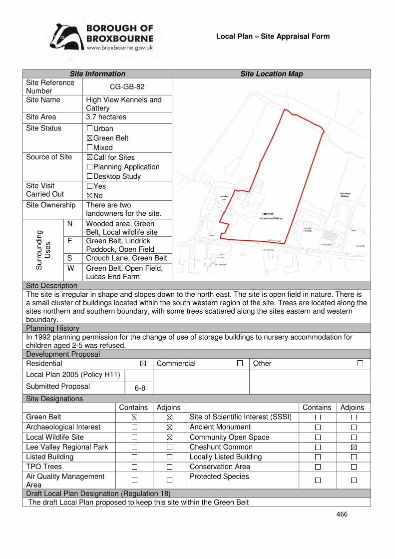
466
Local Plan – Site Appraisal Form
Site Information Site Location Map Site Reference Number
CG-GB-82
Site Name High View Kennels and Cattery
Site Area 3.7 hectares
Site Status ☐Urban ☒Green Belt ☐Mixed
Source of Site ☒Call for Sites ☐Planning Application ☐Desktop Study
Site Visit Carried Out
☐Yes ☒No
Site Ownership There are two landowners for the site.
Surr
oundin
g
Uses
N Wooded area, Green Belt, Local wildlife site
E Green Belt, Lindrick Paddock, Open Field
S Crouch Lane, Green Belt
W Green Belt, Open Field, Lucas End Farm
Site Description The site is irregular in shape and slopes down to the north east. The site is open field in nature. There is a small cluster of buildings located within the south western region of the site. Trees are located along the sites northern and southern boundary, with some trees scattered along the sites eastern and western boundary. Planning History In 1992 planning permission for the change of use of storage buildings to nursery accommodation for children aged 2-5 was refused. Development Proposal
Residential ☒ Commercial ☐ Other ☐
Local Plan 2005 (Policy H11)
Submitted Proposal 6-8
Site Designations Contains Adjoins Contains Adjoins
Green Belt ☒ ☒ Site of Scientific Interest (SSSI) ☐ ☐
Archaeological Interest ☐ ☒ Ancient Monument ☐ ☐
Local Wildlife Site ☐ ☒ Community Open Space ☐ ☐
Lee Valley Regional Park ☐ ☐ Cheshunt Common ☐ ☒
Listed Building ☐ ☐ Locally Listed Building ☐ ☐
TPO Trees ☐ ☐ Conservation Area ☐ ☐
Air Quality Management Area
☐ ☐ Protected Species ☐ ☐
Draft Local Plan Designation (Regulation 18) The draft Local Plan proposed to keep this site within the Green Belt
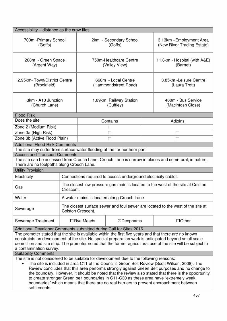
467
Accessibility – distance as the crow flies
700m -Primary School (Goffs)
2km - Secondary School (Goffs)
3.13km –Employment Area (New River Trading Estate)
268m - Green Space (Argent Way)
750m-Healthcare Centre (Valley View)
11.6km - Hospital (with A&E) (Barnet)
2.95km- Town/District Centre (Brookfield)
660m - Local Centre (Hammondstreet Road)
3.85km -Leisure Centre (Laura Trott)
3km - A10 Junction (Church Lane)
1.89km Railway Station (Cuffley)
460m - Bus Service (Macintosh Close)
Flood Risk Does the site Contains Adjoins
Zone 2 (Medium Risk) ☐ ☐
Zone 3a (High Risk) ☐ ☐
Zone 3b (Active Flood Plain) ☐ ☐
Additional Flood Risk Comments The site may suffer from surface water flooding at the far northern part. Access and Transport Comments The site can be accessed from Crouch Lane. Crouch Lane is narrow in places and semi-rural; in nature. There are no footpaths along Crouch Lane.
Utility Provision
Electricity Connections required to access underground electricity cables
Gas The closest low pressure gas main is located to the west of the site at Colston Crescent.
Water A water mains is located along Crouch Lane
Sewerage The closest surface sewer and foul sewer are located to the west of the site at Colston Crescent.
Sewerage Treatment ☐Rye Meads ☒Deephams ☐Other
Additional Developer Comments submitted during Call for Sites 2016 The promoter stated that the site is available within the first five years and that there are no known constraints on development of the site. No special preparation work is anticipated beyond small scale demolition and site strip. The promoter noted that the former agricultural use of the site will be subject to a contamination survey. Suitability Comments The site is not considered to be suitable for development due to the following reasons:
• The site is included in area C11 of the Council’s Green Belt Review (Scott Wilson, 2008). The Review concludes that this area performs strongly against Green Belt purposes and no change to the boundary. However, it should be noted that the review also stated that there is the opportunity to create stronger Green belt boundaries in C11-C30 as these area have “extremely weak boundaries” which means that there are no real barriers to prevent encroachment between settlements.

468
• The Goffs Oak Development Options Report ( Broxbourne Borough Council, 2016) states that the area north of Crouch Lane is “judged to be an area that forms part of a local gap between urban areas and performs an important role in preventing the merging of those urban areas”.
Is this site considered to be suitable for development? ☐Yes ☒ No
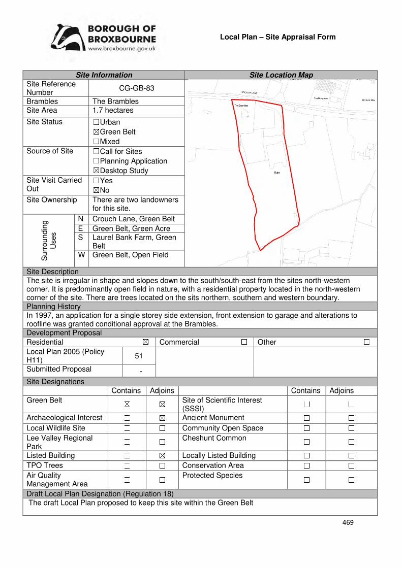
469
Local Plan – Site Appraisal Form
Site Information Site Location Map Site Reference Number
CG-GB-83
Brambles The Brambles Site Area 1.7 hectares
Site Status ☐Urban ☒Green Belt ☐Mixed
Source of Site ☐Call for Sites ☐Planning Application ☒Desktop Study
Site Visit Carried Out
☐Yes ☒No
Site Ownership There are two landowners for this site.
Surr
oundin
g
Uses
N Crouch Lane, Green Belt
E Green Belt, Green Acre S Laurel Bank Farm, Green
Belt W Green Belt, Open Field
Site Description The site is irregular in shape and slopes down to the south/south-east from the sites north-western corner. It is predominantly open field in nature, with a residential property located in the north-western corner of the site. There are trees located on the sits northern, southern and western boundary. Planning History In 1997, an application for a single storey side extension, front extension to garage and alterations to roofline was granted conditional approval at the Brambles. Development Proposal
Residential ☒ Commercial ☐ Other ☐
Local Plan 2005 (Policy H11)
51
Submitted Proposal -
Site Designations Contains Adjoins Contains Adjoins
Green Belt ☒ ☒ Site of Scientific Interest (SSSI)
☐ ☐
Archaeological Interest ☐ ☒ Ancient Monument ☐ ☐
Local Wildlife Site ☐ ☐ Community Open Space ☐ ☐
Lee Valley Regional Park
☐ ☐ Cheshunt Common ☐ ☐
Listed Building ☐ ☒ Locally Listed Building ☐ ☐
TPO Trees ☐ ☐ Conservation Area ☐ ☐
Air Quality Management Area
☐ ☐ Protected Species ☐ ☐
Draft Local Plan Designation (Regulation 18) The draft Local Plan proposed to keep this site within the Green Belt

470
Accessibility – distance as the crow flies
740m -Primary School (Goffs)
1.86km - Secondary School (Goffs)
3.27km –Employment Area (New River Trading Estate)
250m - Green Space (Argent Way)
500m-Healthcare Centre
(Valley View)
11.5km - Hospital (with A&E)
(Barnet)
3km- Town/District Centre
(Brookfield)
510m - Local Centre (1-5 Masons Parade)
3.7km -Leisure Centre (Laura Trott)
2.96km - A10 Junction (Church Lane)
1.9km - Railway Station
(Cuffley)
553m - Bus Service (War Memorial)
Flood Risk Does the site Contains Adjoins
Zone 2 (Medium Risk) ☐ ☐
Zone 3a (High Risk) ☐ ☐
Zone 3b (Active Flood Plain) ☐ ☐
Additional Flood Risk Comments The site may be susceptible to water flooding on the southern boundary. Access and Transport Comments The site can be accessed from Crouch Lane. Crouch Lane is narrow in places and semi-rural in nature. There are no footpaths along Crouch Lane. A transport assessment or statement may be required if development was to come forward. These will need to be created if development came forward. Cycle access to the site will also need to be created. Utility Provision
Electricity Connections will be required.
Gas The closest low pressure gas main is located to the west of the site at Colston Crescent.
Water A water mains is located along Crouch Lane
Sewerage The closest surface sewer and foul sewer are located to the west of the site at Colston Crescent.
Sewerage Treatment ☐Rye Meads ☐Deephams ☐Other
Additional Developer Comments submitted during Call for Sites 2016 None submitted. Suitability Comments The site is not considered to be suitable for residential development due to the following reasons:
• The site is included in area C13 identified in the Council’s Green Belt Review (Scott Wilson. 2008). The Review states that are C13 performs strongly against Green Belt purposes 1 and 2, and averagely against Purpose 3. No change to the Green Belt boundary in this location was proposed. However, it should be noted that the review also stated that there is the opportunity to create a stronger Green belt boundaries in C11-C30 as these areas have “extremely weak boundaries” which means that there are no real barriers to prevent encroachment between settlements.

471
• Although not referenced within the Goffs Oak Development Option Report (Broxbourne Borough Council, 2016), this site can be included within the second category of ‘Green Belt sites which are not favoured’, which comprises of Green Belt sites that do not adjoin or only marginally adjoin urban development. The report states that the development of these sites would create “unconnected pockets of housing that are totally unrelated to one another or to existing urban areas, and in the case of many sites would only be accessible via narrow rural lanes.” The report continues by stating that it is likely that the development of such sites would exacerbate the area’s haphazard development pattern, and over time lead to the merging of urban areas. This would erode the character of Goffs Oak.
Is this site considered to be suitable for development? ☐Yes ☒ No

472
Local Plan – Site Appraisal Form
Site Information Site Location Map Site Reference Number
CG-GB-84
Site Name Laurel Bank Farm Site Area 2.5 hectares
Site Status ☐Urban ☐Green Belt ☒Mixed
Source of Site ☒Call for Sites ☐Planning Application ☐Desktop Study
Site Visit Carried Out
☒Yes ☐No
Site Ownership There are various landowners for the site.
Surr
oundin
g U
ses
N Green Belt
E Residential S St James Road, Pendine,
Green Belt W Brackendale, Green Belt
Site Description The site is irregular in shape and slopes down to the north. There are a number of structures, which include residential dwellings, workshops and agricultural buildings on the site, which take up the majority of the sites area. There is only a small area within the northern region of the site that is open field in nature. There are some trees located on all of the sites boundaries.
Planning History In 2017, a certificate of lawfulness for the existing use the site for a mixture of uses within use classes B1, B2 and B8 – not yet been determined. In 2013 Certificate of Lawfulness for the existing use of a barn for maintenance and repair of motor vehicles was granted unconditional approval. A prior notification to erect an agricultural storage building was granted approval in 2008. Various farm buildings and storage units have been approved on the farm. Various extensions have also been granted consent for the residential properties on the site. In 1979 the development of 4 blocks of greenhouses was granted consent at the Writtles. Development Proposal
Residential ☒ Commercial ☐ Other ☐
Local Plan 2005 (Policy H11)
Submitted Proposal 16
Site Designations Contains Adjoins Contains Adjoins
Green Belt ☒ ☒ Site of Scientific Interest (SSSI) ☐ ☐
Archaeological Interest ☐ ☐ Ancient Monument ☐ ☐
Local Wildlife Site ☐ ☐ Community Open Space ☐ ☐
Lee Valley Regional Park
☐ ☐ Cheshunt Common ☐ ☐
Listed Building ☐ ☐ Locally Listed Building ☐ ☐
TPO Trees ☐ ☐ Conservation Area ☐ ☐
Air Quality Management Area
☐ ☐ Protected Species ☐ ☐
473
Draft Local Plan Designation (Regulation 18) The draft Local Plan proposed to keep this site within the Green Belt Accessibility – distance as the crow flies
760m-Primary School (Goffs)
1.74km - Secondary School (Goffs)
3.1km –Employment Area (New River Trading Estate)
200m - Green Space (Goffs)
290m-Healthcare Centre (Valley View)
11.4km - Hospital (with A&E) (Barnet)
2.9km - Town/District Centre (Brookfield)
330m - Local Centre (684-696 Goffs Lane)
3.62km -Leisure Centre (Laura Trott)
2.84km - A10 Junction (Church Lane)
1.86km - Railway Station (Cuffley)
350m- Bus Service (War Memorial)
Flood Risk Does the site Contains Adjoins
Zone 2 (Medium Risk) ☐ ☐
Zone 3a (High Risk) ☐ ☐
Zone 3b (Active Flood Plain) ☐ ☒
Additional Flood Risk Comments The northern tip of the site may be susceptible to some surface water flooding Access and Transport Comments The site is currently accessed via a track from St James’ Road. From the masterplan submitted by the promoters, this track would not be used to enter the development, but a new access point will be created. Existing footpaths along St James Road end at the current vehicle access point to the site. Connections to these footpaths will be required if development came forward. Cycle access to the site will need to be improved. Utility Provision
Electricity Located to the west in the main residential area
Gas A low pressure gas main is located at the entrance of The Asters.
Water A water main is located along St James Road.
Sewerage A foul sewer and surface sewer is located at the entrance of The Asters
Sewerage Treatment ☐Rye Meads ☒Deephams ☐Other
Additional Developer Comments submitted during Call for Sites 2016. The promoter of the site states that the site is a commercial brownfield site within the Green Belt that is well located with regards to the existing built up area, lies in a sustainable location and has been identified by the Council as a site worth of consideration as a housing allocation. The promoter notes that the site was at one point to be included as part of the St James development boundaries. It was assessed in 2008 as part of the Green Belt Assessment which found that the site Suitability Comments The site is not considered to be suitable for residential development due to the following reasons:
• The site is included within area C27 identified in the Council’s Green Belt Review (Scott Wilson, 2008). The Review states that area C27performs strongly against green Belt Purposes 1 and 2, and plays an average role against Purpose 3. No amendment to the boundary in this location was proposed. However, it should be noted that the review also states that there is the opportunity to transform the Green Belt boundaries in areas C11-C30 as these areas have “extremely weak boundaries”
474
• This site is considered to have weak Green Belt boundaries to the north, part of the east and west. These weak boundaries are no likely to endure beyond the Plan period or prevent further encroachment into the countryside.
• In the 2005 Local Plan Inspectors Report it was stated that Laurel Bank Farm “would not lead to any more defensible green belt boundary than exists at present; it would merely add to the encroachment of built form into the countryside. [I] consider inclusion of the site within St James would not create any more logical green boundary than that shown on the Plan.”
The Council acknowledges that there are areas of Previously Developed Land within the site boundary. The NPPF (Paragraph 89) states that “A local planning authority should regard the construction of new buildings as inappropriate in Green Belt. Exceptions to this are: […] limited infilling or the partial or complete redevelopment of previously developed sites (brownfield land), whether redundant or in continuing use (excluding temporary buildings), which would not have a greater impact on the openness of the Green Belt and the purpose of including land within it than the existing development. “The Council will explore the potential for developing this area of the site through the Brownfield Register. Is this site considered to be suitable for development? ☐Yes ☒ No

475
Local Plan – Site Appraisal Form
Site Information Site Location Map Site Reference Number
CG-GB-85
Site Name Burton Grange Nursery Site Area 4.2 hectares
Site Status ☐Urban ☒Green Belt ☐Mixed
Source of Site ☐Call for Sites ☐Planning Application ☒Desktop Study
Site Visit Carried Out
☐Yes ☒No
Site Ownership The site is owned by a private company and two landowners.
Surr
oundin
g U
ses
N Rags Lane
E Open Field, Green Belt S Rags Brook, Green Belt
W Rosemary Cottage, Green Belt
Site Description The irregular shaped site slopes towards Rags Brook. The majority of the site is occupied by glass house structures. Located within the north-western corner of the site is a residential dwelling and its garden land. The northern region of the site is green in nature, with a number of trees scattered throughout. A number of trees are located on the sites northern, eastern, southern and part of the western boundary. Planning History In 2005 the erection of a glasshouse (including removal of existing derelict glasshouse) was approved. In 2005 the construction of a holding reservoir to retain storm water falling on greenhouse was approved. In 1976, an agricultural workers dwelling was refused, however in 1987 a detached two bedroom bungalow for agricultural worker was granted permission. The erection of glasshouses was granted approval in 1996. Development Proposal
Residential ☒ Commercial ☐ Other ☐
Local Plan 2005 (Policy H11) 126
Submitted Proposal
Site Designations Contains Adjoins Contains Adjoins
Green Belt ☒ ☒ Site of Scientific Interest (SSSI) ☐ ☐
Archaeological Interest ☐ ☐ Ancient Monument ☐ ☐
Local Wildlife Site ☐ ☐ Community Open Space ☐ ☐
Lee Valley Regional Park
☐ ☐ Cheshunt Common ☐ ☐
Listed Building ☐ ☐ Locally Listed Building ☐ ☒
TPO Trees ☐ ☐ Conservation Area ☐ ☐
Air Quality Management Area
☐ ☐ Protected Species ☐ ☐
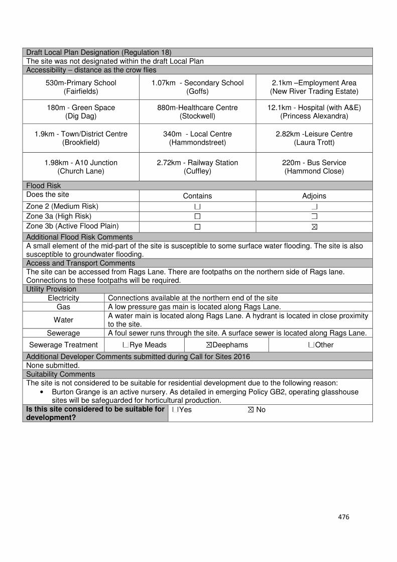
476
Draft Local Plan Designation (Regulation 18) The site was not designated within the draft Local Plan Accessibility – distance as the crow flies
530m-Primary School (Fairfields)
1.07km - Secondary School (Goffs)
2.1km –Employment Area (New River Trading Estate)
180m - Green Space (Dig Dag)
880m-Healthcare Centre (Stockwell)
12.1km - Hospital (with A&E) (Princess Alexandra)
1.9km - Town/District Centre (Brookfield)
340m - Local Centre (Hammondstreet)
2.82km -Leisure Centre (Laura Trott)
1.98km - A10 Junction (Church Lane)
2.72km - Railway Station (Cuffley)
220m - Bus Service (Hammond Close)
Flood Risk Does the site Contains Adjoins
Zone 2 (Medium Risk) ☐ ☐
Zone 3a (High Risk) ☐ ☐
Zone 3b (Active Flood Plain) ☐ ☒
Additional Flood Risk Comments A small element of the mid-part of the site is susceptible to some surface water flooding. The site is also susceptible to groundwater flooding. Access and Transport Comments The site can be accessed from Rags Lane. There are footpaths on the northern side of Rags lane. Connections to these footpaths will be required. Utility Provision
Electricity Connections available at the northern end of the site
Gas A low pressure gas main is located along Rags Lane.
Water A water main is located along Rags Lane. A hydrant is located in close proximity to the site.
Sewerage A foul sewer runs through the site. A surface sewer is located along Rags Lane.
Sewerage Treatment ☐Rye Meads ☒Deephams ☐Other
Additional Developer Comments submitted during Call for Sites 2016 None submitted. Suitability Comments The site is not considered to be suitable for residential development due to the following reason:
• Burton Grange is an active nursery. As detailed in emerging Policy GB2, operating glasshouse sites will be safeguarded for horticultural production.
Is this site considered to be suitable for development?
☐Yes ☒ No

477
Local Plan – Site Appraisal Form
Site Information Site Location Map Site Reference Number
CG-GB-86
Site Name Land north of Colesgrove Manor
Site Area 1.1 hectares
Site Status ☐Urban ☒Green Belt ☐Mixed
Source of Site ☐Call for Sites ☐Planning Application ☒Desktop Study
Site Visit Carried Out
☐Yes ☒No
Site Ownership There are various landowners for this site.
Surr
oundin
g
Uses
N Goffs Lane, residential properties, Green Belt
E Residential properties, Green Belt
S Colesgrove Manor, Green Belt
W Halstead Hill, Green Belt
Site Description The irregular shaped site and gently slopes to the south east. Shrub is scattered throughout the site. A cluster of trees is located in the north-western corner. Trees and/or hedges line the sites eastern, southern and western boundary. There are some trees spread out on the sites northern boundary. Planning History In 1973 permission was refused for the erection of 4 detached houses with detached garages and 6 linked houses with detached garages and communal open space. Development Proposal
Residential ☒ Commercial ☐ Other ☐
Local Plan 2005 (Policy H11)
Submitted Proposal
Site Designations Contains Adjoins Contains Adjoins
Green Belt ☒ ☒ Site of Scientific Interest (SSSI) ☐ ☐
Archaeological Interest ☐ ☒ Ancient Monument ☐ ☐
Local Wildlife Site ☐ ☐ Community Open Space ☐ ☐
Lee Valley Regional Park ☐ ☐ Cheshunt Common ☐ ☐
Listed Building ☐ ☒ Locally Listed Building ☐ ☐
TPO Trees ☒ ☒ Conservation Area ☐ ☐
Air Quality Management Area
☐ ☐ Protected Species ☐ ☐
Draft Local Plan Designation (Regulation 18) The draft Local Plan proposed to keep this site within the Green Belt

478
Accessibility – distance as the crow flies
1.06km -Primary School (Woodside)
860m - Secondary School (Goffs)
2.62km–Employment Area
(News International)
360m - Green Space (Claremont)
900m-Healthcare Centre (Valley View)
11.6km - Hospital (with A&E) (Barnet)
2.41km - Town/District Centre (Cheshunt Old Pond)
930m - Local Centre (684-696 Goffs Lane)
2.65km -Leisure Centre (Laura Trott)
1.99km - A10 Junction (Churchgate)
2.47km - Railway Station (Cuffley)
25m- Bus Service (Colesgrove Farm)
Flood Risk Does the site Contains Adjoins
Zone 2 (Medium Risk) ☐ ☐
Zone 3a (High Risk) ☐ ☐
Zone 3b (Active Flood Plain) ☐ ☒
Additional Flood Risk Comments No flooding issues identified for this site. Access and Transport Comments There is no current vehicular access to the site. The site could be accessed via Goffs Lane or Halstead Hill. It should be noted that Halstead Hill is semi-rural in nature. There are no footpaths along Halstead Hill; however there are footpaths on both sides of Goffs Lane. Connections to the footpaths at Goffs Lane will be required if development came forward. Cycle access to the site will be required. Utility Provision
Electricity Connections located at existing residential properties at Goffs Lane.
Gas A low pressure gas main is located Goffs Lane and Halstead Hill
Water A water main is located along Goffs Lane.
Sewerage A surface sewer and foul sewer are located along Goffs Lane.
Sewerage Treatment ☐Rye Meads ☒Deephams ☐Other
Additional Developer Comments submitted during Call for Sites 2016 None submitted. Suitability Comments The site is not considered to be suitable for residential development due to the following reasons:
• The site is included in area D5 identified in the Council’s Green Belt Review (Scott Wilson, 2008). The Review states that area D5 performs strongly against the Green Belt purposes, and therefore in theory should be retained. The review noted that a strip of houses within the Green Belt is odd, but there are no further opportunities to provide a stronger boundary and therefore proposed no change. The site contributes to maintaining separation between the Cheshunt and Goffs Oak settlements.
• The site does not have clear defensible Green Belt boundaries to the south, east and west that would last beyond the Plan period or prevent further encroachment into the countryside.
Is this site considered to be suitable for development? ☐Yes ☒ No

479
Local Plan – Site Appraisal Form
Site Information Site Location Map Site Reference Number
CG-GB-87(a)
Site Name Kobe Nursery and Kobe House
Site Area 1.2 hectares
Site Status ☐Urban ☒Green Belt ☐Mixed
Source of Site ☐Call for Sites ☐Planning Application ☒Desktop Study
Site Visit Carried Out
☐Yes ☒No
Site Ownership There are two landowners for this site.
Surr
oundin
g
Uses
N Open Field, Green Belt, Local Wildlife Site
E Scrubland, Green Belt S Green Belt, Halstead Hill
Site (14 dwellings) W Halstead Hill, Residential
Dwellings, Green Belt Site Description The site is broadly squared-shape and relatively flat. A residential dwelling and its associated garden land is located in the sites south western corner. The remainder of the site predominantly consists of glasshouse structures, with some shed structures located in the eastern corner. Trees/hedgerows are located on the sites northern and western boundaries. There is a small area of scrubland in the eastern region of the site. Planning History In 2014 temporary consent for 24 months was granted for the use of Unit 1 and Unit 2 for B2/B8 uses (Bespoke Cabinet Makers/Storage). This permission was renewed for a further 24 months in 2016. In 2012 the change of use of unit 2 from agricultural use to commercial storage (sui generis) was granted conditional approval. The development of a 5 bed detached dwelling (including the demolition of the existing dwelling) was granted approval in 2003. A current planning application is register for the site which seeks the demolition of the derelict glasshouses and erection of 9 residential dwellings.
Development Proposal
Residential ☒ Commercial ☐ Other ☐
Local Plan 2005 (Policy H11) 36
Submitted Proposal - Site Designations Contains Adjoins Contains Adjoins
Green Belt ☒ ☐ Site of Scientific Interest (SSSI) ☐ ☐
Archaeological Interest ☐ ☐ Ancient Monument ☐ ☐
Local Wildlife Site ☐ ☒ Community Open Space ☐ ☐
Lee Valley Regional Park
☐ ☐ Cheshunt Common ☐ ☐
Listed Building ☐ ☐ Locally Listed Building ☐ ☐
TPO Trees ☐ ☐ Conservation Area ☐ ☐
Air Quality Management Area
☐ ☐ Protected Species ☐ ☐

480
Draft Local Plan Designation (Regulation 18) The draft Local Plan proposed to keep this site within the Green Belt Accessibility – distance as the crow flies
590m-Primary School (Bonneygrove)
640m - Secondary School (Goffs)
2.26km –Employment Area (News International)
450m - Green Space (Claremont)
1.26km -Healthcare Centre (Cromwell)
11.6km - Hospital (with A&E) (Barnet)
2.19km - Town/District Centre (Cheshunt Old Pond)
1.21km - Local Centre 2.39km -Leisure Centre
(Laura Trott)
1.74km - A10 Junction (Churchgate)
2.76km - Railway Station (Cuffley)
300m- Bus Service (Colesgrove Farm)
Flood Risk Does the site Contains Adjoins
Zone 2 (Medium Risk) ☐ ☐
Zone 3a (High Risk) ☐ ☐
Zone 3b (Active Flood Plain) ☐ ☒
Additional Flood Risk Comments No flood risk issues identified for this site. Access and Transport Comments The site can be accessed from Halstead Hill. Halstead Hill is semi-rural in nature. There are no footpaths along Halstead Hill and this part of the highway is unlit. The closest public footpaths to this site are those located on Goffs Lane to the north and the footpath along Barrow Lane to the south east. Concern for pedestrian safety will need to be addressed if development came forward. A public right of way is located to the north of the site. Cycle access to the site will need to be created if development came forward. Utility Provision
Electricity Connections available at Halstead Hill
Gas A low pressure gas main is located along Halstead Hill.
Water A water main is located along Halstead Hill
Sewerage The closest foul sewer and surface sewer are located along Goffs Lane to the north of the site.
Sewerage Treatment ☐Rye Meads ☒Deephams ☐Other
Additional Developer Comments submitted during Call for Sites 2016 None submitted. Suitability Comments The site is not considered to be suitable for residential development due to the following reasons:
• The site is included in area D9 identified in the Council’s Green Belt Review (Scott Wilson, 2008). The Review concludes that area D9 performs strongly against Green Belt Purposes 1 and 2, and plays an average role against Purpose 3. The review proposed no change to the Green Belt in this area.

481
• This area of the Green Belt contributes to preventing the further outward sprawl of West Cheshunt
• In 2017, planning permission for the development of 9 dwellings. Reasons cited in the decision noticed included: inappropriate development within the Green Belt and would result in harm to the openness of the Green Belt, which would not be clearly outweighed by very special circumstances; the location of the proposed residential development, due to the distance from services and facilities, the proposed dwellings are not considered to be situated within a sustainable location; due to the size and prominence of the proposed garages within the layout, the garages would be detrimental to the character and design of the surrounding area; and, the proposed development would not provide a safe and convenient environment for pedestrians to connect to the existing public highway footway network without harm to the Green Belt and rural character of the area
• The site does not have any clear and defensible Green Belt boundaries to the north, east, south and west that would prevent further encroachment into the countryside
However, subject to the sites compliance with emerging Policy GB2: Residential Development on Derelict Glass House Sites, the site could be subdivided into self-build housing plots. Is this site considered to be suitable for development? ☐Yes ☒ No
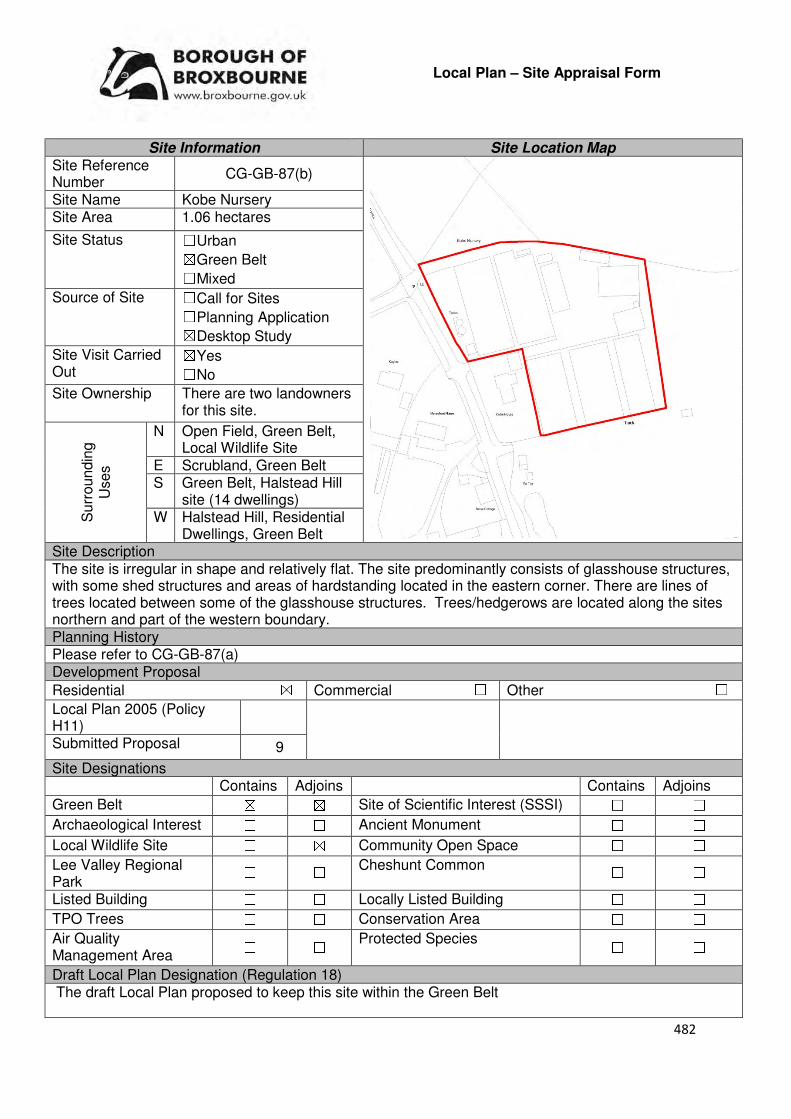
482
Local Plan – Site Appraisal Form
Site Information Site Location Map Site Reference Number
CG-GB-87(b)
Site Name Kobe Nursery Site Area 1.06 hectares
Site Status ☐Urban ☒Green Belt ☐Mixed
Source of Site ☐Call for Sites ☐Planning Application ☒Desktop Study
Site Visit Carried Out
☒Yes ☐No
Site Ownership There are two landowners for this site.
Surr
oundin
g
Uses
N Open Field, Green Belt, Local Wildlife Site
E Scrubland, Green Belt S Green Belt, Halstead Hill
site (14 dwellings) W Halstead Hill, Residential
Dwellings, Green Belt Site Description The site is irregular in shape and relatively flat. The site predominantly consists of glasshouse structures, with some shed structures and areas of hardstanding located in the eastern corner. There are lines of trees located between some of the glasshouse structures. Trees/hedgerows are located along the sites northern and part of the western boundary. Planning History Please refer to CG-GB-87(a) Development Proposal
Residential ☒ Commercial ☐ Other ☐
Local Plan 2005 (Policy H11)
Submitted Proposal 9
Site Designations Contains Adjoins Contains Adjoins
Green Belt ☒ ☒ Site of Scientific Interest (SSSI) ☐ ☐
Archaeological Interest ☐ ☐ Ancient Monument ☐ ☐
Local Wildlife Site ☐ ☒ Community Open Space ☐ ☐
Lee Valley Regional Park
☐ ☐ Cheshunt Common ☐ ☐
Listed Building ☐ ☐ Locally Listed Building ☐ ☐
TPO Trees ☐ ☐ Conservation Area ☐ ☐
Air Quality Management Area
☐ ☐ Protected Species ☐ ☐
Draft Local Plan Designation (Regulation 18) The draft Local Plan proposed to keep this site within the Green Belt
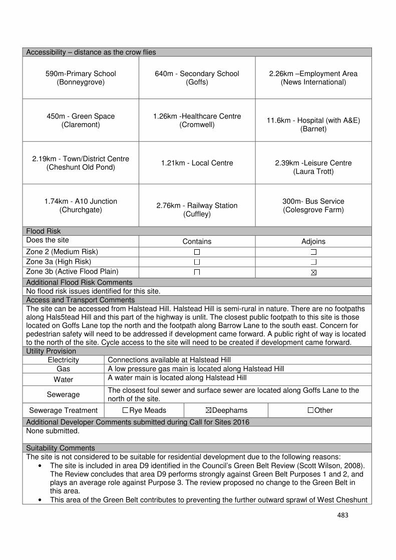
483
Accessibility – distance as the crow flies
590m-Primary School (Bonneygrove)
640m - Secondary School (Goffs)
2.26km –Employment Area
(News International)
450m - Green Space (Claremont)
1.26km -Healthcare Centre
(Cromwell)
11.6km - Hospital (with A&E)
(Barnet)
2.19km - Town/District Centre
(Cheshunt Old Pond)
1.21km - Local Centre
2.39km -Leisure Centre
(Laura Trott)
1.74km - A10 Junction
(Churchgate)
2.76km - Railway Station
(Cuffley)
300m- Bus Service (Colesgrove Farm)
Flood Risk Does the site Contains Adjoins
Zone 2 (Medium Risk) ☐ ☐
Zone 3a (High Risk) ☐ ☐
Zone 3b (Active Flood Plain) ☐ ☒
Additional Flood Risk Comments No flood risk issues identified for this site. Access and Transport Comments The site can be accessed from Halstead Hill. Halstead Hill is semi-rural in nature. There are no footpaths along Hals5tead Hill and this part of the highway is unlit. The closest public footpath to this site is those located on Goffs Lane top the north and the footpath along Barrow Lane to the south east. Concern for pedestrian safety will need to be addressed if development came forward. A public right of way is located to the north of the site. Cycle access to the site will need to be created if development came forward. Utility Provision
Electricity Connections available at Halstead Hill
Gas A low pressure gas main is located along Halstead Hill
Water A water main is located along Halstead Hill
Sewerage The closest foul sewer and surface sewer are located along Goffs Lane to the north of the site.
Sewerage Treatment ☐Rye Meads ☒Deephams ☐Other
Additional Developer Comments submitted during Call for Sites 2016 None submitted. Suitability Comments The site is not considered to be suitable for residential development due to the following reasons:
• The site is included in area D9 identified in the Council’s Green Belt Review (Scott Wilson, 2008). The Review concludes that area D9 performs strongly against Green Belt Purposes 1 and 2, and plays an average role against Purpose 3. The review proposed no change to the Green Belt in this area.
• This area of the Green Belt contributes to preventing the further outward sprawl of West Cheshunt

484
• In 2017, planning permission for the development of 9 dwellings. Reasons cited in the decision noticed included: inappropriate development within the Green Belt and would result in harm to the openness of the Green Belt, which would not be clearly outweighed by very special circumstances; the location of the proposed residential development, due to the distance from services and facilities, the proposed dwellings are not considered to be situated within a sustainable location; due to the size and prominence of the proposed garages within the layout, the garages would be detrimental to the character and design of the surrounding area; and, the proposed development would not provide a safe and convenient environment for pedestrians to connect to the existing public highway footway network without harm to the Green Belt and rural character of the area
• The site does not have any clear and defensible Green Belt boundaries to the north, east, south and west that would prevent further encroachment into the countryside
However, subject to the sites compliance with emerging Policy GB2: Residential Development on Derelict Glass House Sites, the site could be subdivided into self-build housing plots. Is this site considered to be suitable for development? ☐Yes ☒ No
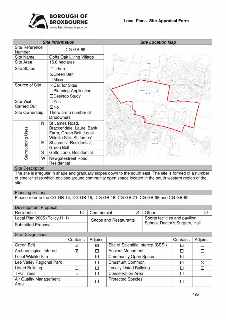
485
Local Plan – Site Appraisal Form
Site Information Site Location Map Site Reference Number
CG-GB-88
Site Name Goffs Oak Living Village Site Area 15.6 hectares
Site Status ☐Urban ☒Green Belt ☐Mixed
Source of Site ☒Call for Sites ☐Planning Application ☐Desktop Study
Site Visit Carried Out
☐Yes ☒No
Site Ownership There are a number of landowners
Surr
oundin
g U
ses N St James Road,
Brackendale, Laurel Bank Farm, Green Belt, Local Wildlife Site, St James’
E St James’, Residential, Green Belt
S Goffs Lane, Residential
W Newgatestreet Road, Residential
Site Description The site is irregular in shape and gradually slopes down to the south east. The site is formed of a number of smaller sites which enclose around community open space located in the south-western region of the site. Planning History Please refer to the CG-GB-14, CG-GB-15, CG-GB-16, CG-GB-71, CG-GB-98 and CG-GB-90 Development Proposal
Residential ☒ Commercial ☒ Other ☒
Local Plan 2005 (Policy H11) Sports facilities and pavilion, School, Doctor’s Surgery, Hall Submitted Proposal
Site Designations Contains Adjoins Contains Adjoins
Green Belt ☒ ☒ Site of Scientific Interest (SSSI) ☐ ☐
Archaeological Interest ☒ ☐ Ancient Monument ☐ ☐
Local Wildlife Site ☐ ☒ Community Open Space ☒ ☐
Lee Valley Regional Park ☐ ☐ Cheshunt Common ☒ ☒
Listed Building ☐ ☐ Locally Listed Building ☐ ☒
TPO Trees ☒ ☐ Conservation Area ☐ ☐
Air Quality Management Area
☐ ☐ Protected Species ☐ ☐
Shops and Restaurants
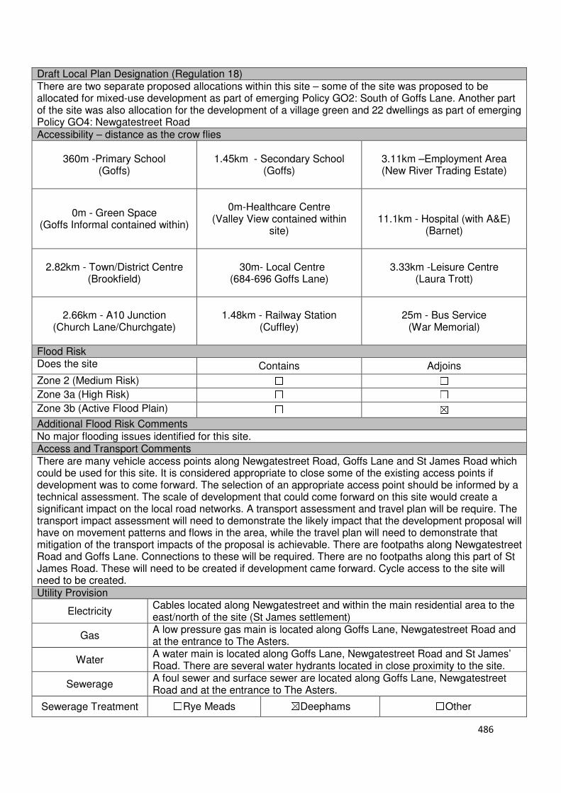
486
Draft Local Plan Designation (Regulation 18) There are two separate proposed allocations within this site – some of the site was proposed to be allocated for mixed-use development as part of emerging Policy GO2: South of Goffs Lane. Another part of the site was also allocation for the development of a village green and 22 dwellings as part of emerging Policy GO4: Newgatestreet Road Accessibility – distance as the crow flies
360m -Primary School (Goffs)
1.45km - Secondary School (Goffs)
3.11km –Employment Area (New River Trading Estate)
0m - Green Space (Goffs Informal contained within)
0m-Healthcare Centre
(Valley View contained within site)
11.1km - Hospital (with A&E)
(Barnet)
2.82km - Town/District Centre
(Brookfield)
30m- Local Centre
(684-696 Goffs Lane)
3.33km -Leisure Centre (Laura Trott)
2.66km - A10 Junction (Church Lane/Churchgate)
1.48km - Railway Station
(Cuffley)
25m - Bus Service (War Memorial)
Flood Risk Does the site Contains Adjoins
Zone 2 (Medium Risk) ☐ ☐
Zone 3a (High Risk) ☐ ☐
Zone 3b (Active Flood Plain) ☐ ☒
Additional Flood Risk Comments No major flooding issues identified for this site. Access and Transport Comments There are many vehicle access points along Newgatestreet Road, Goffs Lane and St James Road which could be used for this site. It is considered appropriate to close some of the existing access points if development was to come forward. The selection of an appropriate access point should be informed by a technical assessment. The scale of development that could come forward on this site would create a significant impact on the local road networks. A transport assessment and travel plan will be require. The transport impact assessment will need to demonstrate the likely impact that the development proposal will have on movement patterns and flows in the area, while the travel plan will need to demonstrate that mitigation of the transport impacts of the proposal is achievable. There are footpaths along Newgatestreet Road and Goffs Lane. Connections to these will be required. There are no footpaths along this part of St James Road. These will need to be created if development came forward. Cycle access to the site will need to be created. Utility Provision
Electricity Cables located along Newgatestreet and within the main residential area to the east/north of the site (St James settlement)
Gas A low pressure gas main is located along Goffs Lane, Newgatestreet Road and at the entrance to The Asters.
Water A water main is located along Goffs Lane, Newgatestreet Road and St James’ Road. There are several water hydrants located in close proximity to the site.
Sewerage A foul sewer and surface sewer are located along Goffs Lane, Newgatestreet Road and at the entrance to The Asters.
Sewerage Treatment ☐Rye Meads ☒Deephams ☐Other
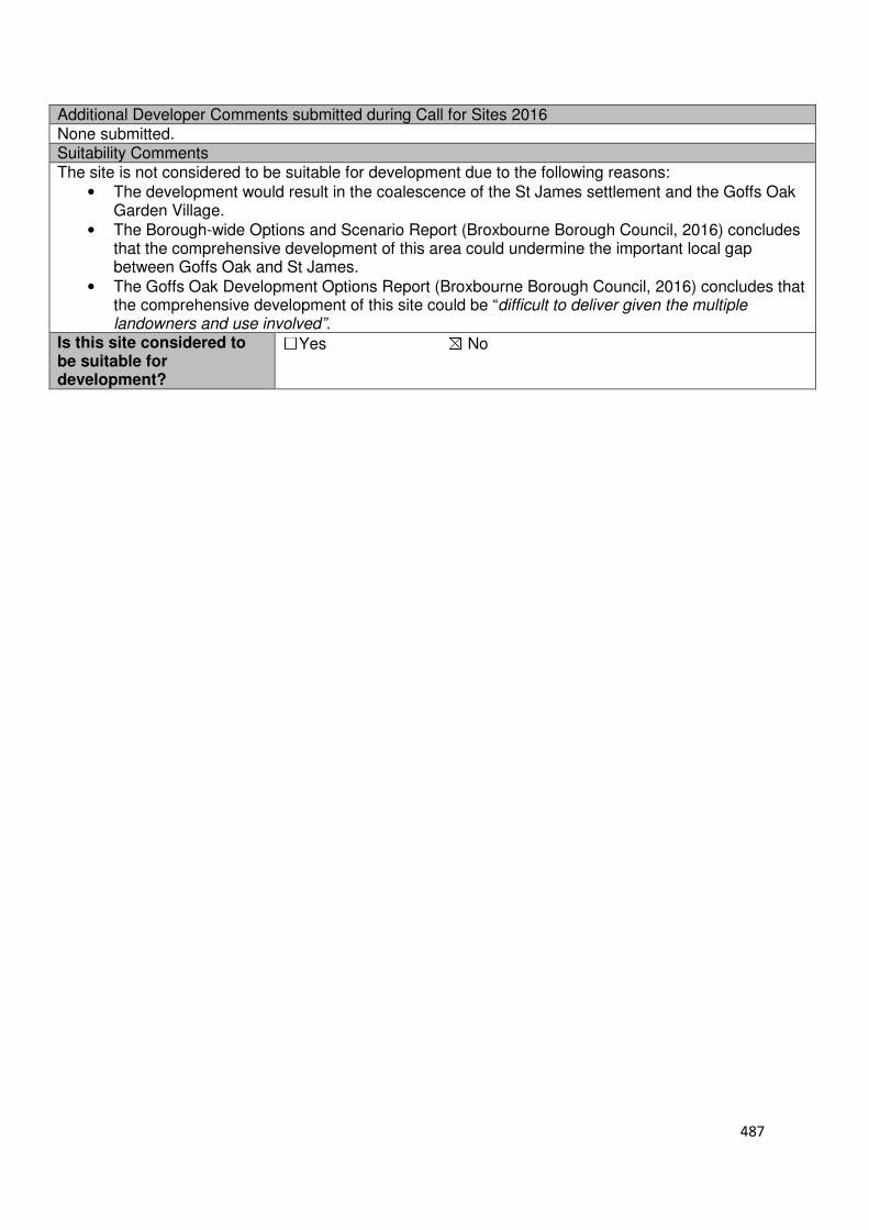
487
Additional Developer Comments submitted during Call for Sites 2016 None submitted. Suitability Comments The site is not considered to be suitable for development due to the following reasons:
• The development would result in the coalescence of the St James settlement and the Goffs Oak Garden Village.
• The Borough-wide Options and Scenario Report (Broxbourne Borough Council, 2016) concludes that the comprehensive development of this area could undermine the important local gap between Goffs Oak and St James.
• The Goffs Oak Development Options Report (Broxbourne Borough Council, 2016) concludes that the comprehensive development of this site could be “difficult to deliver given the multiple landowners and use involved”.
Is this site considered to be suitable for development?
☐Yes ☒ No
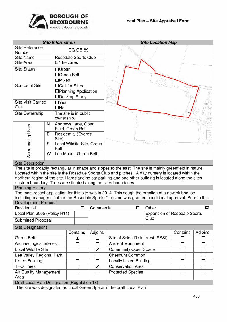
488
Local Plan – Site Appraisal Form
Site Information Site Location Map Site Reference Number
CG-GB-89
Site Name Rosedale Sports Club Site Area 6.4 hectares
Site Status ☐Urban ☒Green Belt ☐Mixed
Source of Site ☐Call for Sites ☐Planning Application ☒Desktop Study
Site Visit Carried Out
☐Yes ☒No
Site Ownership The site is in public ownership.
Surr
oundin
g U
ses N Andrews Lane, Open
Field, Green Belt E Residential (Everest
Site) S Local Wildlife Site, Green
Belt W Lea Mount, Green Belt
Site Description The site is broadly rectangular in shape and slopes to the east. The site is mainly greenfield in nature. Located within the site is the Rosedale Sports Club and pitches. A day nursery is located within the northern region of the site. Hardstanding car parking and one other building is located along the sites eastern boundary. Trees are situated along the sites boundaries. Planning History The most recent application for this site was in 2014. This sough the erection of a new clubhouse including manager’s flat for the Rosedale Sports Club and was granted conditional approval. Prior to this Development Proposal
Residential ☐ Commercial ☐ Other ☒
Local Plan 2005 (Policy H11) Expansion of Rosedale Sports Club Submitted Proposal
Site Designations Contains Adjoins Contains Adjoins
Green Belt ☒ ☒ Site of Scientific Interest (SSSI) ☐ ☐
Archaeological Interest ☐ ☐ Ancient Monument ☐ ☐
Local Wildlife Site ☐ ☒ Community Open Space ☐ ☐
Lee Valley Regional Park ☐ ☐ Cheshunt Common ☐ ☐
Listed Building ☐ ☐ Locally Listed Building ☐ ☐
TPO Trees ☐ ☒ Conservation Area ☐ ☐
Air Quality Management Area
☐ ☐ Protected Species ☐ ☐
Draft Local Plan Designation (Regulation 18) The site was designated as Local Green Space in the draft Local Plan
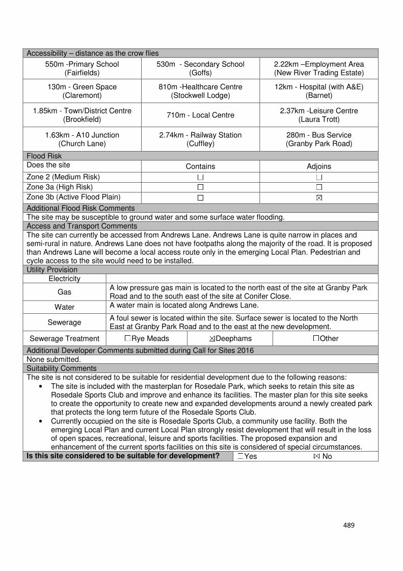
489
Accessibility – distance as the crow flies
550m -Primary School (Fairfields)
530m - Secondary School (Goffs)
2.22km –Employment Area (New River Trading Estate)
130m - Green Space (Claremont)
810m -Healthcare Centre (Stockwell Lodge)
12km - Hospital (with A&E) (Barnet)
1.85km - Town/District Centre (Brookfield)
710m - Local Centre 2.37km -Leisure Centre
(Laura Trott)
1.63km - A10 Junction (Church Lane)
2.74km - Railway Station (Cuffley)
280m - Bus Service (Granby Park Road)
Flood Risk Does the site Contains Adjoins
Zone 2 (Medium Risk) ☐ ☐
Zone 3a (High Risk) ☐ ☐
Zone 3b (Active Flood Plain) ☐ ☒
Additional Flood Risk Comments The site may be susceptible to ground water and some surface water flooding. Access and Transport Comments The site can currently be accessed from Andrews Lane. Andrews Lane is quite narrow in places and semi-rural in nature. Andrews Lane does not have footpaths along the majority of the road. It is proposed than Andrews Lane will become a local access route only in the emerging Local Plan. Pedestrian and cycle access to the site would need to be installed. Utility Provision
Electricity
Gas A low pressure gas main is located to the north east of the site at Granby Park Road and to the south east of the site at Conifer Close.
Water A water main is located along Andrews Lane.
Sewerage A foul sewer is located within the site. Surface sewer is located to the North East at Granby Park Road and to the east at the new development.
Sewerage Treatment ☐Rye Meads ☒Deephams ☐Other
Additional Developer Comments submitted during Call for Sites 2016 None submitted. Suitability Comments The site is not considered to be suitable for residential development due to the following reasons:
• The site is included with the masterplan for Rosedale Park, which seeks to retain this site as Rosedale Sports Club and improve and enhance its facilities. The master plan for this site seeks to create the opportunity to create new and expanded developments around a newly created park that protects the long term future of the Rosedale Sports Club.
• Currently occupied on the site is Rosedale Sports Club, a community use facility. Both the emerging Local Plan and current Local Plan strongly resist development that will result in the loss of open spaces, recreational, leisure and sports facilities. The proposed expansion and enhancement of the current sports facilities on this site is considered of special circumstances.
Is this site considered to be suitable for development? ☐Yes ☒ No

490
Local Plan – Site Appraisal Form
Site Information Site Location Map Site Reference Number
CG-GB-90
Site Name The Asters Site Area 0.5 hectares
Site Status ☐Urban ☒Green Belt ☐Mixed
Source of Site ☒Call for Sites ☐Planning Application ☐Desktop Study
Site Visit Carried Out
☐Yes ☒No
Site Ownership There are three landowners for this site.
Surr
oundin
g
Uses
N Residential
E Nurseries, Green Belt S Nurseries, Garden
Centre, Green Belt W Community Open
Space, Green Belt
Site Description The site is irregular in shape and relatively flat. The site is green field in nature. A number of trees are located within the site. A footpath from the north to the south west corner runs through the site.
Planning History In 2005 permission for refused for a residential care home. In 1999 permission was refused for seven detached dwellings. In 1996 a footpath was approved on the site linking the Asters to Goffs Oak facilities. Development Proposal
Residential ☒ Commercial ☐ Other ☐
Local Plan 2005 (Policy H11)
-
Submitted Proposal 6
Site Designations Contains Adjoins Contains Adjoins
Green Belt ☒ ☒ Site of Scientific Interest (SSSI) ☐ ☐
Archaeological Interest ☐ ☐ Ancient Monument ☐ ☐
Local Wildlife Site ☐ ☐ Community Open Space ☐ ☒
Lee Valley Regional Park
☐ ☐ Cheshunt Common ☐ ☐
Listed Building ☐ ☐ Locally Listed Building ☐ ☐
TPO Trees ☐ ☐ Conservation Area ☐ ☐
Air Quality Management Area
☐ ☐ Protected Species ☐ ☐
Draft Local Plan Designation (Regulation 18) The draft Local Plan proposed to keep this site within the Green Belt.
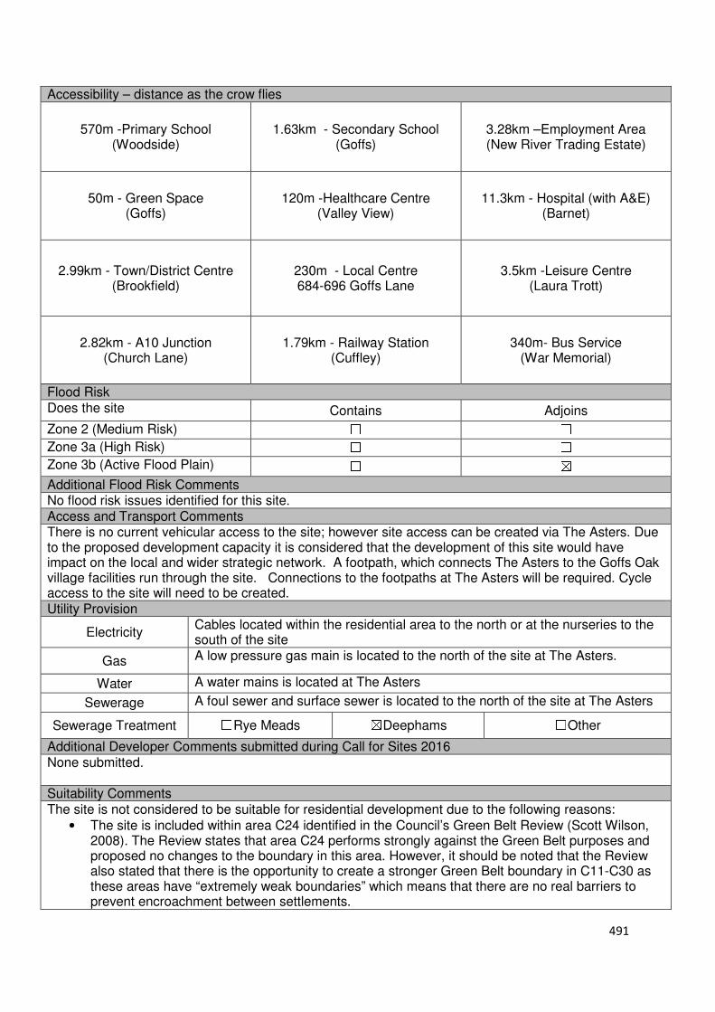
491
Accessibility – distance as the crow flies
570m -Primary School (Woodside)
1.63km - Secondary School (Goffs)
3.28km –Employment Area (New River Trading Estate)
50m - Green Space (Goffs)
120m -Healthcare Centre (Valley View)
11.3km - Hospital (with A&E) (Barnet)
2.99km - Town/District Centre (Brookfield)
230m - Local Centre 684-696 Goffs Lane
3.5km -Leisure Centre (Laura Trott)
2.82km - A10 Junction (Church Lane)
1.79km - Railway Station (Cuffley)
340m- Bus Service (War Memorial)
Flood Risk Does the site Contains Adjoins
Zone 2 (Medium Risk) ☐ ☐
Zone 3a (High Risk) ☐ ☐
Zone 3b (Active Flood Plain) ☐ ☒
Additional Flood Risk Comments No flood risk issues identified for this site. Access and Transport Comments There is no current vehicular access to the site; however site access can be created via The Asters. Due to the proposed development capacity it is considered that the development of this site would have impact on the local and wider strategic network. A footpath, which connects The Asters to the Goffs Oak village facilities run through the site. Connections to the footpaths at The Asters will be required. Cycle access to the site will need to be created. Utility Provision
Electricity Cables located within the residential area to the north or at the nurseries to the south of the site
Gas A low pressure gas main is located to the north of the site at The Asters.
Water A water mains is located at The Asters
Sewerage A foul sewer and surface sewer is located to the north of the site at The Asters
Sewerage Treatment ☐Rye Meads ☒Deephams ☐Other
Additional Developer Comments submitted during Call for Sites 2016 None submitted. Suitability Comments The site is not considered to be suitable for residential development due to the following reasons:
• The site is included within area C24 identified in the Council’s Green Belt Review (Scott Wilson, 2008). The Review states that area C24 performs strongly against the Green Belt purposes and proposed no changes to the boundary in this area. However, it should be noted that the Review also stated that there is the opportunity to create a stronger Green Belt boundary in C11-C30 as these areas have “extremely weak boundaries” which means that there are no real barriers to prevent encroachment between settlements.

492
• As shown in the emerging Local Plan allocation GO2, the Council has allocated land at the nurseries to the south of the site for mixed-use development. Subject to this allocation being approved, this site will play a strong role in preventing the coalescence of St James and Goffs Oak.
• Previous applications for development on this site have been refused. The outline application for the construction a residential care home in 2005 was refused due to not being able to justify very special circumstances and the provision of insufficient detail to assess the highway and access implications of the proposal.
Is this site considered to be suitable for development? ☐Yes ☒ No
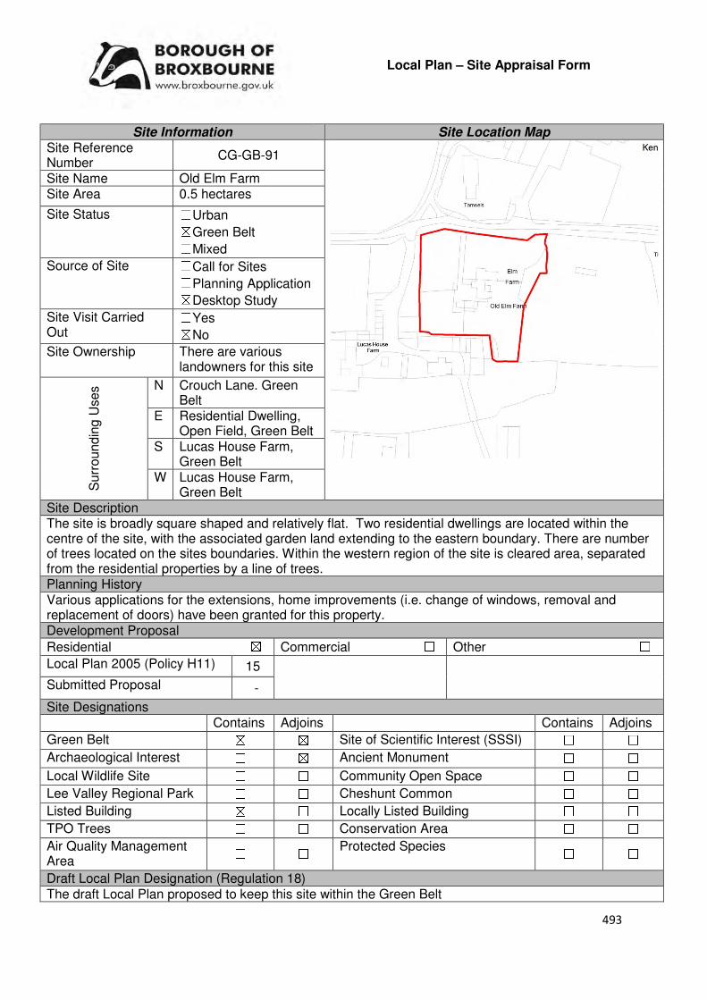
493
Local Plan – Site Appraisal Form
Site Information Site Location Map Site Reference Number
CG-GB-91
Site Name Old Elm Farm Site Area 0.5 hectares
Site Status ☐Urban ☒Green Belt ☐Mixed
Source of Site ☐Call for Sites ☐Planning Application ☒Desktop Study
Site Visit Carried Out
☐Yes ☒No
Site Ownership There are various landowners for this site
Surr
oundin
g U
ses N Crouch Lane. Green
Belt E Residential Dwelling,
Open Field, Green Belt S Lucas House Farm,
Green Belt W Lucas House Farm,
Green Belt Site Description The site is broadly square shaped and relatively flat. Two residential dwellings are located within the centre of the site, with the associated garden land extending to the eastern boundary. There are number of trees located on the sites boundaries. Within the western region of the site is cleared area, separated from the residential properties by a line of trees. Planning History Various applications for the extensions, home improvements (i.e. change of windows, removal and replacement of doors) have been granted for this property. Development Proposal
Residential ☒ Commercial ☐ Other ☐
Local Plan 2005 (Policy H11) 15
Submitted Proposal -
Site Designations Contains Adjoins Contains Adjoins
Green Belt ☒ ☒ Site of Scientific Interest (SSSI) ☐ ☐
Archaeological Interest ☐ ☒ Ancient Monument ☐ ☐
Local Wildlife Site ☐ ☐ Community Open Space ☐ ☐
Lee Valley Regional Park ☐ ☐ Cheshunt Common ☐ ☐
Listed Building ☒ ☐ Locally Listed Building ☐ ☐
TPO Trees ☐ ☐ Conservation Area ☐ ☐
Air Quality Management Area
☐ ☐ Protected Species ☐ ☐
Draft Local Plan Designation (Regulation 18) The draft Local Plan proposed to keep this site within the Green Belt
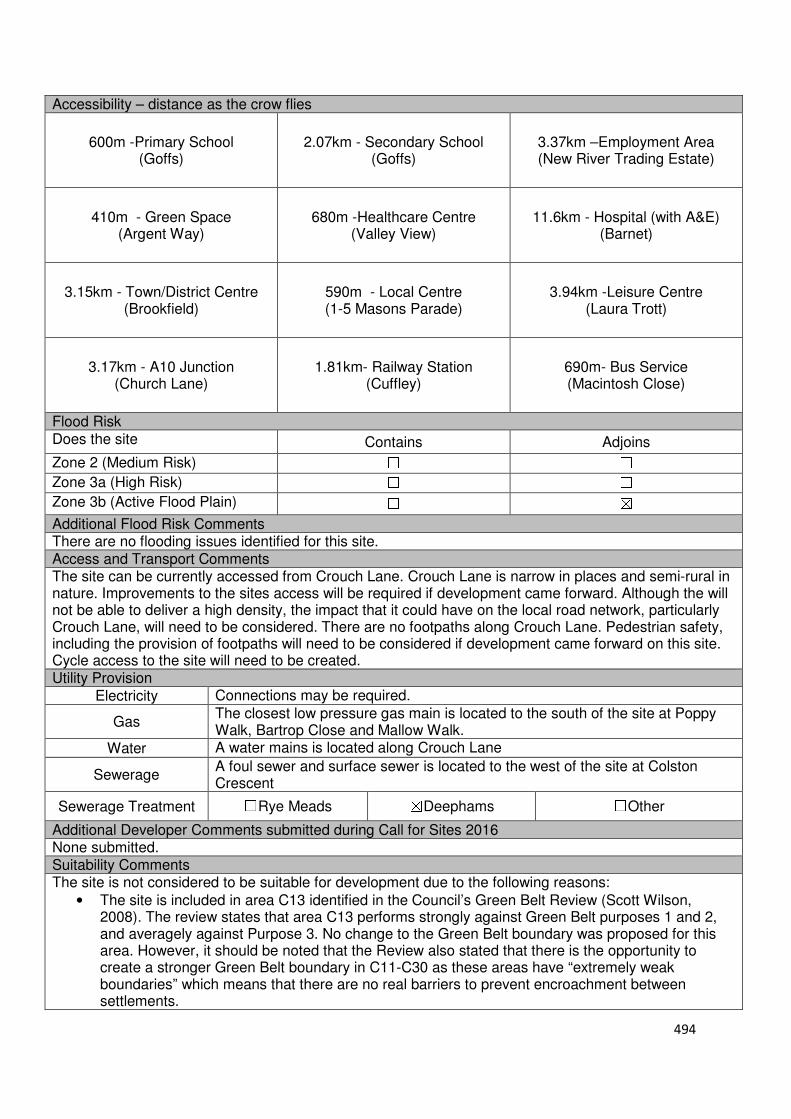
494
Accessibility – distance as the crow flies
600m -Primary School (Goffs)
2.07km - Secondary School (Goffs)
3.37km –Employment Area (New River Trading Estate)
410m - Green Space (Argent Way)
680m -Healthcare Centre (Valley View)
11.6km - Hospital (with A&E) (Barnet)
3.15km - Town/District Centre (Brookfield)
590m - Local Centre (1-5 Masons Parade)
3.94km -Leisure Centre (Laura Trott)
3.17km - A10 Junction
(Church Lane)
1.81km- Railway Station
(Cuffley)
690m- Bus Service (Macintosh Close)
Flood Risk Does the site Contains Adjoins
Zone 2 (Medium Risk) ☐ ☐
Zone 3a (High Risk) ☐ ☐
Zone 3b (Active Flood Plain) ☐ ☒
Additional Flood Risk Comments There are no flooding issues identified for this site. Access and Transport Comments The site can be currently accessed from Crouch Lane. Crouch Lane is narrow in places and semi-rural in nature. Improvements to the sites access will be required if development came forward. Although the will not be able to deliver a high density, the impact that it could have on the local road network, particularly Crouch Lane, will need to be considered. There are no footpaths along Crouch Lane. Pedestrian safety, including the provision of footpaths will need to be considered if development came forward on this site. Cycle access to the site will need to be created. Utility Provision
Electricity Connections may be required.
Gas The closest low pressure gas main is located to the south of the site at Poppy Walk, Bartrop Close and Mallow Walk.
Water A water mains is located along Crouch Lane
Sewerage A foul sewer and surface sewer is located to the west of the site at Colston Crescent
Sewerage Treatment ☐Rye Meads ☒Deephams ☐Other
Additional Developer Comments submitted during Call for Sites 2016 None submitted. Suitability Comments The site is not considered to be suitable for development due to the following reasons:
• The site is included in area C13 identified in the Council’s Green Belt Review (Scott Wilson, 2008). The review states that area C13 performs strongly against Green Belt purposes 1 and 2, and averagely against Purpose 3. No change to the Green Belt boundary was proposed for this area. However, it should be noted that the Review also stated that there is the opportunity to create a stronger Green Belt boundary in C11-C30 as these areas have “extremely weak boundaries” which means that there are no real barriers to prevent encroachment between settlements.

495
• This site has weak boundaries to the east, south and west. These boundaries would not last beyond the Plan period or prevent further encroachment into the countryside.
• The Goffs Oak Development Options Report (Broxbourne Borough Council, 2016) identifies two categories of Green belt sites which are not favoured. This site can fall into the second category which states that this site would “create unconnected pockets of housing that are totally unrelated to one another or to existing urban areas, and in the case of many sites would only be accessible via narrow rural lanes. An option that favoured such sites would need to provide new services/facilities such as primary schools in an appropriate location(s), collectively and proportionately funded by each scheme”. The Report continues that the development of such sites would exacerbate the area’s already haphazard development pattern, and over time lead to the merging of urban areas. This would erode the character of Goffs Oak.
Is this site considered to be suitable for development? ☐Yes ☒ No

496
Local Plan – Site Appraisal Form
Site Information Site Location Map Site Reference Number
CG-GB-92
Site Name Malaya Farm Site Area 2.42 hectares
Site Status ☐Urban ☒Green Belt ☐Mixed
Source of Site ☐Call for Sites ☐Planning Application ☒Desktop Study
Site Visit Carried Out
☐Yes ☒No
Site Ownership There are two landowners for this site.
Surr
oundin
g
Uses
N Crouch Lane, Green belt
E Cottage Farm, Green Belt S Open Field, Green Belt
W Triangle Nursery, Green Belt
Site Description The site is broadly rectangular in shape and slopes from the south west to the north east. Located within the north region of the site are various structures, which include holiday homes and agricultural sheds. The remainder of the site is Green Field in nature. A number of trees line the sites boundaries. There are also trees scattered throughout the site. Hedgerows separate the structures garden lands in the northern region of the site from the open field in the south. Planning History Permission was granted for the conversion of existing outbuildings to form 6 bed and breakfast units. The change of use from horticultural maintenance and storage buildings to D1 (day nursery/pre-school children’s unit) went to appeal in 2003, where it was dismissed. Development Proposal
Residential ☒ Commercial ☐ Other ☐
Local Plan 2005 (Policy H11) 72
Submitted Proposal -
Site Designations Contains Adjoins Contains Adjoins
Green Belt ☒ ☒ Site of Scientific Interest (SSSI) ☐ ☐
Archaeological Interest ☐ ☐ Ancient Monument ☐ ☐
Local Wildlife Site ☐ ☒ Community Open Space ☐ ☒
Lee Valley Regional Park
☐ ☐ Cheshunt Common ☐ ☐
Listed Building ☐ ☐ Locally Listed Building ☐ ☐
TPO Trees ☐ ☐ Conservation Area ☐ ☐
Air Quality Management Area
☐ ☐ Protected Species ☐ ☐
497
Draft Local Plan Designation (Regulation 18) The draft Local Plan proposed to keep this site within the Green Belt Accessibility – distance as the crow flies
940m-Primary School (Goffs)
1.65km - Secondary School (Goffs)
2.89km –Employment Area (New River Trading Estate)
10m - Green Space (Argent Way)
640m -Healthcare Centre
(Valley View)
11.7km - Hospital (with A&E)
(Barnet)
2.68km - Town/District Centre (Brookfield)
490m - Local Centre (Hammondstreet)
3.5km -Leisure Centre (Laura Trott)
2.71km - A10 Junction (Church Lane)
2.11km - Railway Station
(Cuffley)
485m - Bus Service (Macintosh Close)
Flood Risk Does the site Contains Adjoins
Zone 2 (Medium Risk) ☐ ☐
Zone 3a (High Risk) ☐ ☐
Zone 3b (Active Flood Plain) ☐ ☐
Additional Flood Risk Comments There may be some surface water flooding on the site. Access and Transport Comments The site can be currently accessed from Crouch Lane. Crouch Lane is a narrow, winding road that is semirural in nature. It has a ditch running alongside much of its length. Due to the amount of dwellings that the site could deliver, a transport assessment will be required. There are no footpaths along Crouch Lane. Pedestrian safety, including the provision of footpaths will need to be considered if development came forward on this site. Cycle access to the site will need to be created. Utility Provision
Electricity Available at Crouch Lane
Gas The closest low pressure gas main is located to the north east of the site at Rags Lane
Water A water main is located along Crouch Lane
Sewerage A foul sewer and surface sewer are located at the junction of Argent Way and Crouch Lane.
Sewerage Treatment ☐Rye Meads ☒Deephams ☐Other
Additional Developer Comments submitted during Call for Sites 2016 None submitted. Suitability Comments This site is not considered to be suitable for development due to the following reasons:
• The site is included in area C13 identified in the Council’s Green Belt Review (Scott Wilson, 2008). The Review states that area C13 performs strongly against Green Belt purposes 1 and 2, and averagely against Purpose 3. No change to the Green Belt boundary was proposed for this area. However, it should be noted that the Review also stated that there is the opportunity to create a stronger Green Belt boundary in C11-C30 as these areas have “extremely weak boundaries” which means that there are no real barriers to prevent encroachment between settlements.

498
• This site has weak Green Belt boundaries to the east, south and west. These boundaries would not last beyond the Plan period or prevent further encroachment into the countryside.
• The Goffs Oak Development Options Report (Broxbourne Borough Council, 2016) identifies two categories of Green Belt sites which are not favoured. This site can fall into the second category which states that this site would “create unconnected pockets of housing that are totally unrelated to one another or to the existing urban areas, and in the case of many sites would only be accessible via narrow rural lanes. An option that favoured such sites would need to provide new services/facilities such as primary schools in an appropriate location(s), collectively and proportionately funded by each scheme.” The Report continues by stating that the development of such sites would exacerbate the area’s already haphazard development pattern, and over time lead to the merging of urban areas. This would erode the character of Goffs Oak. .
Is this site considered to be suitable for development? ☐Yes ☒ No
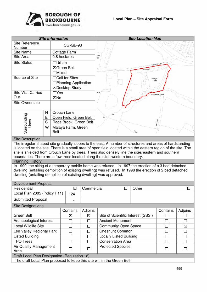
499
Local Plan – Site Appraisal Form
Site Information Site Location Map Site Reference Number
CG-GB-93
Site Name Cottage Farm Site Area 0.8 hectares
Site Status ☐Urban ☒Green Belt ☐Mixed
Source of Site ☐Call for Sites ☐Planning Application ☒Desktop Study
Site Visit Carried Out
☐Yes ☒No
Site Ownership
Surr
oundin
g
Uses
N Crouch Lane
E Open Field, Green Belt S Rags Brook, Green Belt
W Malaya Farm, Green Belt
Site Description The irregular shaped site gradually slopes to the east. A number of structures and areas of hardstanding is located on the site. There is a small area of open field located within the eastern region of the site. The site is shielded from Crouch Lane by trees. Trees also densely line the sites eastern and southern boundaries. There are a few trees located along the sites western boundary. Planning History In 1999, the siting of a temporary mobile home was refused. In 1997 the erection of a 3 bed detached dwelling (entailing demolition of existing dwelling) was refused. In 1998 the erection of 2 bed detached dwelling (entailing demolition of existing dwelling) was approved. Development Proposal
Residential ☒ Commercial ☐ Other ☐
Local Plan 2005 (Policy H11) 24
Submitted Proposal -
Site Designations Contains Adjoins Contains Adjoins
Green Belt ☒ ☒ Site of Scientific Interest (SSSI) ☐ ☐
Archaeological Interest ☐ ☐ Ancient Monument ☐ ☐
Local Wildlife Site ☐ ☐ Community Open Space ☐ ☒
Lee Valley Regional Park ☐ ☐ Cheshunt Common ☐ ☐
Listed Building ☐ ☐ Locally Listed Building ☐ ☐
TPO Trees ☐ ☐ Conservation Area ☐ ☐
Air Quality Management Area
☐ ☐ Protected Species ☐ ☐
Draft Local Plan Designation (Regulation 18) The draft Local Plan proposed to keep this site within the Green Belt

500
Accessibility – distance as the crow flies
1.1km -Primary School (Goffs)
1.63km - Secondary School (Goffs)
2.8km –Employment Area (New River Trading Estate)
10m - Green Space (Argent Way)
790m-Healthcare Centre (Valley View)
12km - Hospital (with A&E) (Barnet)
2.61km - Town/District Centre
(Brookfield)
417m - Local Centre
(Hammondstreet)
3.45km -Leisure Centre (Laura Trott)
2.63km - A10 Junction (Church Lane)
2.28km - Railway Station (Cuffley)
460m- Bus Service (Oaklands Road)
Flood Risk Does the site Contains Adjoins
Zone 2 (Medium Risk) ☐ ☐
Zone 3a (High Risk) ☐ ☐
Zone 3b (Active Flood Plain) ☐ ☒
Additional Flood Risk Comments There is some evidence of surface water flooding on the site. Access and Transport Comments The site can be accessed via Crouch Lane. Crouch Lane is a narrow, winding road that is semi-rural in nature. It has a ditch running alongside much of its length. The impact that the development of this site would have on the roads within the local area, particularly Crouch lane, will need to be investigated. There are no footpaths along Crouch Lane. Pedestrian safety, including the provision of footpaths, will need to be considered if development came forward on this site. There is a public right of way to the east of the site which will need to be retained. Cycle access to the site will need to be created. Utility Provision
Electricity Available at Crouch Lane to the north east
Gas The closest low pressure gas main is located to the north east of the site at Rags Lane.
Water A water main is located along Crouch Lane.
Sewerage A foul sewer and surface sewer is located at the junction of Argent Way and Crouch Lane
Sewerage Treatment ☐Rye Meads ☒Deephams ☐Other
Additional Developer Comments submitted during Call for Sites 2016 None submitted. Suitability Comments The site is not considered to be suitable for residential development due to the following reasons:
• The site is included in area C13 identified in the Council’s Green Belt Review (Scott Wilson, 2008). The Review states that area C13 performs strongly against Green Belt purposes 1 and 2, and averagely against Purpose 3. No change to the Green Belt boundary was proposed for this area. However, it should be noted that the Review also stated that there is the opportunity to create stronger Green Belt boundary in C11-C30 as these areas have “extremely weak boundaries” which means that there are no real barriers to prevent encroachment between settlements.
• This site has weak green Belt boundaries to the east, south and west. These boundaries would not last beyond the Plan period or prevent further encroachment into the countryside.
• The Goffs Oak Development Options Report (Broxbourne Borough Council, 2016) identifies two
501
categories of Green Belt sites which are not favoured. This site can fall into the second category which states that sites such as this would “create unconnected pockets of housing that are totally unrelated to one another or to the existing urban areas, an in the case of many sites would only be accessible via narrow rural lanes. An option that favoured such sites would need to provide new services/facilities such as primary schools in an appropriate location(s), collectively and proportionately funded by each scheme”. This Report continues by stating that the development of such sites would exacerbate the area’s already haphazard development pattern, and over time lead to the merging or urban areas. This would erode the character of Goffs Oak.
Is this site considered to be suitable for development? ☐Yes ☒ No

502
Local Plan – Site Appraisal Form
Site Information Site Location Map Site Reference Number CG-GB-94
Site Name Brook Farm Site Area 1.285 hectares
Site Status ☐Urban ☒Green Belt ☐Mixed
Source of Site ☐Call for Sites ☐Planning Application ☒Desktop Study
Site Visit Carried Out
☐Yes ☒No
Site Ownership There are four landowners for this site
Surr
oundin
g
Uses
N Crouch Lane, Residential
E Dwelling, Green Belt S Rags Brook, Twelve Acre
Farm, Green Belt W Brookside Farm, Cottage
Farm, Green Belt Site Description The site is broadly rectangular in shape and slopes down towards Rags Brook. Within the eastern region of the site is a residential dwelling and associated garden land, and a shed like structure. There are a few trees scattered throughout the eastern region of the site. A cluster of trees is located in the western region of the site. The central region of the site is open field in nature. There are a number of trees located on the sites northern, southern and western boundaries. Planning History
In 2016, conditional approval was granted for the removal of condition 1 of planning permission E/626-50 “That the bungalow shall be occupied by persons employed in agriculture as defined by section 119(1 of the Town and Country Planning Act 1947, or in an industry mainly dependent upon agriculture, this includes, also the dependants of such persons as aforesaid”. Development Proposal
Residential ☒ Commercial ☐ Other ☐
Local Plan 2005 (Policy H11) 38
Submitted Proposal -
Site Designations Contains Adjoins Contains Adjoins
Green Belt ☒ ☒ Site of Scientific Interest (SSSI) ☐ ☐
Archaeological Interest ☐ ☐ Ancient Monument ☐ ☐
Local Wildlife Site ☐ ☐ Community Open Space ☐ ☐
Lee Valley Regional Park ☐ ☐ Cheshunt Common ☐ ☐
Listed Building ☐ ☐ Locally Listed Building ☐ ☐
TPO Trees ☐ ☐ Conservation Area ☐ ☐
Air Quality Management Area
☐ ☐ Protected Species ☐ ☐
503
Draft Local Plan Designation (Regulation 18) The draft Local Plan proposed to keep this site within the Green Belt Accessibility – distance as the crow flies
1km -Primary School (Fairfield)
1.5km - Secondary School (Goffs)
2.67km –Employment Area (New River Trading Estate)
7m - Green Space (Argent Way)
890m-Healthcare Centre
(Valley View)
12km - Hospital (with A&E)
(Barnet)
2.47km- Town/District Centre
(Brookfield)
340m - Local Centre
(Hammondstreet)
3.3km -Leisure Centre
(Laura Trott)
2.51km - A10 Junction (Church Lane)
2.4km - Railway Station
(Cuffley)
370m- Bus Service (Oaklands Road)
Flood Risk Does the site Contains Adjoins
Zone 2 (Medium Risk) ☐ ☐
Zone 3a (High Risk) ☐ ☐
Zone 3b (Active Flood Plain) ☐ ☒
Additional Flood Risk Comments The site is susceptible to surface water flooding and over 50% of the site is susceptible to ground water flooding. Access and Transport Comments The site can be accessed via Crouch Lane. Crouch Lane is a narrow, winding road that is semi-rural; in nature. It has a ditch running alongside much of its length. The impact that the development of this would have on the roads within the local area, particularly Crouch Lane, will need to be investigated. There are no footpaths along Crouch Lane. Pedestrian safety, including the provision of footpaths, will need to be considered if development came forward on this site. Cycle access to the site will need to be created. Utility Provision
Electricity Available to the north at Crouch Lane
Gas The closest low pressure gas main is located to the north east of the site at Rags Lane.
Water A water main is located along Crouch Lane.
Sewerage A foul sewer and surface sewer is located at the junction of Argent Way and Crouch Lane
Sewerage Treatment ☐Rye Meads ☒Deephams ☐Other
Additional Developer Comments submitted during Call for Sites 2016 None submitted. Suitability Comments This site is not considered to be suitable for development due to the following reasons:
• The site is included in area C14 identified in the Council’s Green Belt Review (Scott Wilson, 2008). The Review states that area C14 performs strongly against Green Belt Purposes 1 and 2, and poorly against Purpose 3. No changes to the boundary were proposed. However, it should be noted that the Review also stated that there is the opportunity to create stronger Green Belt boundary in C11-C30 as these areas have “extremely weak boundaries” which means that there are no real barriers to prevent encroachment between settlements.
504
• This site has weak Green Belt boundaries to the east, south and west. These boundaries would not last beyond the Plan period or prevent further encroachment into the countryside.
• The Goffs Oak Development Options Report (Broxbourne Borough Council, 2016) identifies two categories of Green Belt sites which are not favoured. This site can fall into the second category which states that sites such as this would “create unconnected pockets of housing that are totally unrelated to one another or to the existing urban areas, an in the case of many sites would only be accessible via narrow rural lanes. An option that favoured such sites would need to provide new services/facilities such as primary schools in an appropriate location(s), collectively and proportionately funded by each scheme”. This Report continues by stating that the development of such sites would exacerbate the area’s already haphazard development pattern, and over time lead to the merging or urban areas. This would erode the character of Goffs Oak.
Is this site considered to be suitable for development? ☐Yes ☒ No

505
Local Plan – Site Appraisal Form
Site Information Site Location Map Site Reference Number
CG-GB-95
Site Name St James Traveller Site and Land (Oakdene)
Site Area 0.6 hectares
Site Status ☐Urban ☒Green Belt ☐Mixed
Source of Site ☐Call for Sites ☐Planning Application ☒Desktop Study
Site Visit Carried Out
☐Yes ☒No
Site Ownership There are three landowners for this site.
Surr
oundin
g
Uses
N Nursery, Green Belt
E Open Field, Green Belt S St James Road, Pendine,
Green Belt W Open Field, Green Belt,
Wildlife Sites
Site Description The site is square in shape and slopes down to the north. There are a number of structures on the site and areas of hardstanding. The majority of these structures are located in the sites western region. A number of trees are located on the site and on its northern and southern boundaries. A track follows the sites eastern and part of the northern boundary. This site is also known as Oakdene. Planning History Planning permission for residential caravan site for four Gypsy Families was refused in 1985. In 1995, planning permission was granted for a residential caravan site for 3 caravans for one gypsy family (renewal on permanent basis of previous temporary permission). Development Proposal
Residential ☒ Commercial ☐ Other ☐
Local Plan 2005 (Policy H11) 18
Submitted Proposal
Site Designations Contains Adjoins Contains Adjoins
Green Belt ☒ ☒ Site of Scientific Interest (SSSI) ☐ ☐
Archaeological Interest ☐ ☐ Ancient Monument ☐ ☐
Local Wildlife Site ☐ ☐ Community Open Space ☐ ☐
Lee Valley Regional Park
☐ ☐ Cheshunt Common ☐ ☐
Listed Building ☐ ☐ Locally Listed Building ☐ ☐
TPO Trees ☐ ☐ Conservation Area ☐ ☐
Air Quality Management Area
☐ ☐ Protected Species ☐ ☐
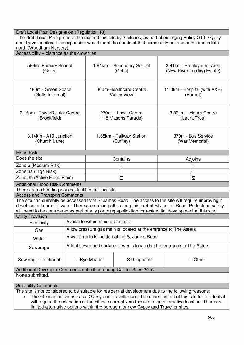
506
Draft Local Plan Designation (Regulation 18) The draft Local Plan proposed to expand this site by 3 pitches, as part of emerging Policy GT1: Gypsy and Traveller sites. This expansion would meet the needs of that community on land to the immediate north (Woodham Nursery). Accessibility – distance as the crow flies
556m -Primary School (Goffs)
1.91km - Secondary School (Goffs)
3.41km –Employment Area (New River Trading Estate)
180m - Green Space (Goffs Informal)
300m-Healthcare Centre (Valley View)
11.3km - Hospital (with A&E) (Barnet)
3.16km - Town/District Centre (Brookfield)
270m - Local Centre (1-5 Masons Parade)
3.86km -Leisure Centre (Laura Trott)
3.14km - A10 Junction (Church Lane)
1.68km - Railway Station (Cuffley)
370m - Bus Service (War Memorial)
Flood Risk Does the site Contains Adjoins
Zone 2 (Medium Risk) ☐ ☐
Zone 3a (High Risk) ☐ ☒
Zone 3b (Active Flood Plain) ☐ ☒
Additional Flood Risk Comments There are no flooding issues identified for this site. Access and Transport Comments The site can currently be accessed from St James Road. The access to the site will require improving if development came forward. There are no footpaths along this part of St James’ Road. Pedestrian safety will need to be considered as part of any planning application for residential development at this site. Utility Provision
Electricity Available within main urban area
Gas A low pressure gas main is located at the entrance to The Asters
Water A water main is located along St James Road
Sewerage A foul sewer and surface sewer is located at the entrance to The Asters
Sewerage Treatment ☐Rye Meads ☒Deephams ☐Other
Additional Developer Comments submitted during Call for Sites 2016 None submitted. Suitability Comments The site is not considered to be suitable for residential development due to the following reasons:
• The site is in active use as a Gypsy and Traveller site. The development of this site for residential will require the relocation of the pitches currently on this site to an alternative location. There are limited alternative options within the borough for new Gypsy and Traveller sites.

507
• The site is included in area C26 identified in the Council’s Green Belt Review (Scott Wilson, 2008). The Review states that area C26 performs strongly against Green Belt purposes 1 and 2, and plays an average role against Purpose 3. No changes to the boundary for this area were proposed. However, it should be noted that the Review states that there is the opportunity to create a stronger Green Belt boundary within areas C11-C30 as these areas have “extremely weak boundaries” which means that there are no real barriers to prevent encroachment between settlements.
• The site is in active use as a Gypsy and Traveller site.
• The site contributes to preventing the outward sprawl of St James Village and maintaining the local gap between St James Village and Goffs Oak Village
The site is considered to be suitable to retain its use as a Gypsy and Traveller site. Planning permission for the use of this site for a gypsy and traveller site, on a permanent basis, was granted in 1995. The Case Officer Report from 1995 states that “This is a well-established site with the use having been in existence for nearly 10 years. This site contributes towards gypsy site provision within the Borough and satisfies a need for a family who had long-established links with the area. In visual terms it is unobtrusive and there are no records of the use having given rise to any loss of amenity or complaints”. It is considered that the points raised in this report are still relevant today. It should be noted that while this site was granted permanent permission, there is a condition that it will benefit the applicant and their immediate family. Is this site considered to be suitable for development?
☒Yes ☐ No
Availability Comments The site is considered to be available to continue its use as a gypsy and traveller site for one family. A planning application has been made by the family to retain additional residential caravans and grant temporary planning permission for the stationing of 3 caravans.
Is the site considered to be available for development?
☒Yes ☐ No
Achievability Comments The use of this site as a gypsy and traveller site has already been established. A current planning application is being determined to assess whether the site could accommodate more pitches.
Is this site considered to be achievable? ☒Yes ☐ No
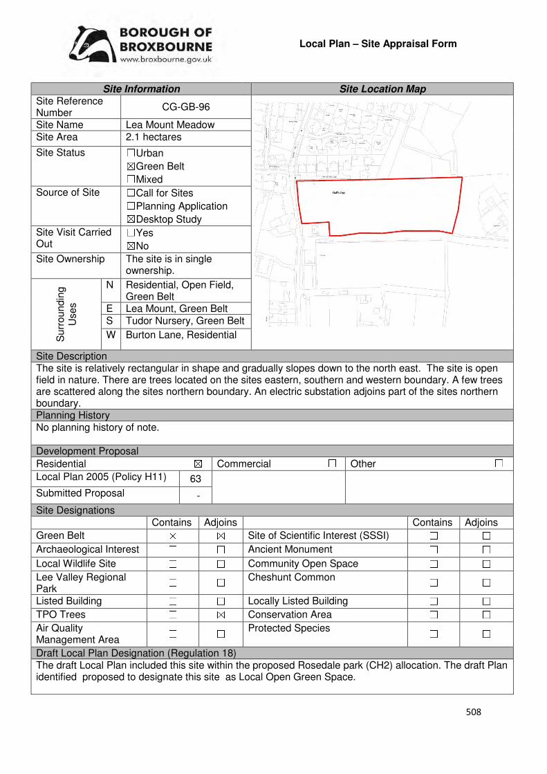
508
Local Plan – Site Appraisal Form
Site Information Site Location Map Site Reference Number
CG-GB-96
Site Name Lea Mount Meadow Site Area 2.1 hectares
Site Status ☐Urban ☒Green Belt ☐Mixed
Source of Site ☐Call for Sites ☐Planning Application ☒Desktop Study
Site Visit Carried Out
☐Yes ☒No
Site Ownership The site is in single ownership.
Surr
oundin
g
Uses
N Residential, Open Field, Green Belt
E Lea Mount, Green Belt S Tudor Nursery, Green Belt
W Burton Lane, Residential
Site Description The site is relatively rectangular in shape and gradually slopes down to the north east. The site is open field in nature. There are trees located on the sites eastern, southern and western boundary. A few trees are scattered along the sites northern boundary. An electric substation adjoins part of the sites northern boundary. Planning History No planning history of note. Development Proposal
Residential ☒ Commercial ☐ Other ☐
Local Plan 2005 (Policy H11) 63
Submitted Proposal -
Site Designations Contains Adjoins Contains Adjoins
Green Belt ☒ ☒ Site of Scientific Interest (SSSI) ☐ ☐
Archaeological Interest ☐ ☐ Ancient Monument ☐ ☐
Local Wildlife Site ☐ ☐ Community Open Space ☐ ☐
Lee Valley Regional Park
☐ ☐ Cheshunt Common ☐ ☐
Listed Building ☐ ☐ Locally Listed Building ☐ ☐
TPO Trees ☐ ☒ Conservation Area ☐ ☐
Air Quality Management Area
☐ ☐ Protected Species ☐ ☐
Draft Local Plan Designation (Regulation 18) The draft Local Plan included this site within the proposed Rosedale park (CH2) allocation. The draft Plan identified proposed to designate this site as Local Open Green Space.
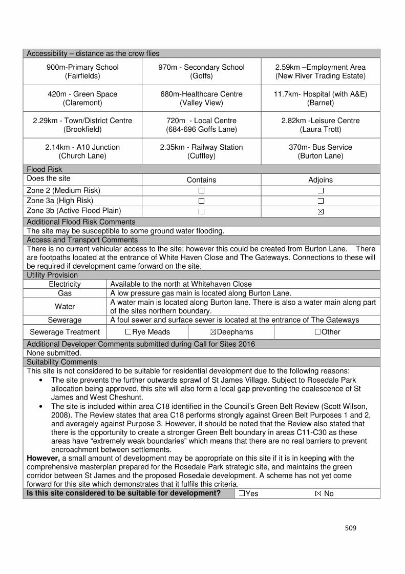
509
Accessibility – distance as the crow flies
900m-Primary School (Fairfields)
970m - Secondary School (Goffs)
2.59km –Employment Area (New River Trading Estate)
420m - Green Space (Claremont)
680m-Healthcare Centre (Valley View)
11.7km- Hospital (with A&E) (Barnet)
2.29km - Town/District Centre (Brookfield)
720m - Local Centre (684-696 Goffs Lane)
2.82km -Leisure Centre (Laura Trott)
2.14km - A10 Junction (Church Lane)
2.35km - Railway Station (Cuffley)
370m- Bus Service (Burton Lane)
Flood Risk Does the site Contains Adjoins
Zone 2 (Medium Risk) ☐ ☐
Zone 3a (High Risk) ☐ ☐
Zone 3b (Active Flood Plain) ☐ ☒
Additional Flood Risk Comments The site may be susceptible to some ground water flooding. Access and Transport Comments There is no current vehicular access to the site; however this could be created from Burton Lane. There are footpaths located at the entrance of White Haven Close and The Gateways. Connections to these will be required if development came forward on the site. Utility Provision
Electricity Available to the north at Whitehaven Close
Gas A low pressure gas main is located along Burton Lane.
Water A water main is located along Burton lane. There is also a water main along part of the sites northern boundary.
Sewerage A foul sewer and surface sewer is located at the entrance of The Gateways
Sewerage Treatment ☐Rye Meads ☒Deephams ☐Other
Additional Developer Comments submitted during Call for Sites 2016 None submitted. Suitability Comments This site is not considered to be suitable for residential development due to the following reasons:
• The site prevents the further outwards sprawl of St James Village. Subject to Rosedale Park allocation being approved, this site will also form a local gap preventing the coalescence of St James and West Cheshunt.
• The site is included within area C18 identified in the Council’s Green Belt Review (Scott Wilson, 2008). The Review states that area C18 performs strongly against Green Belt Purposes 1 and 2, and averagely against Purpose 3. However, it should be noted that the Review also stated that there is the opportunity to create a stronger Green Belt boundary in areas C11-C30 as these areas have “extremely weak boundaries” which means that there are no real barriers to prevent encroachment between settlements.
However, a small amount of development may be appropriate on this site if it is in keeping with the comprehensive masterplan prepared for the Rosedale Park strategic site, and maintains the green corridor between St James and the proposed Rosedale development. A scheme has not yet come forward for this site which demonstrates that it fulfils this criteria. Is this site considered to be suitable for development? ☐Yes ☒ No
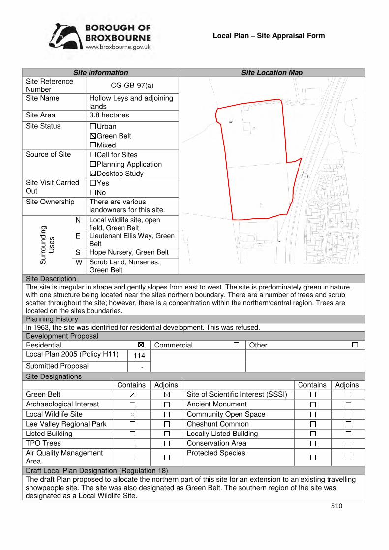
510
Local Plan – Site Appraisal Form
Site Information Site Location Map Site Reference Number
CG-GB-97(a)
Site Name Hollow Leys and adjoining lands
Site Area 3.8 hectares
Site Status ☐Urban ☒Green Belt ☐Mixed
Source of Site ☐Call for Sites ☐Planning Application ☒Desktop Study
Site Visit Carried Out
☐Yes ☒No
Site Ownership There are various landowners for this site.
Surr
oundin
g
Uses
N Local wildlife site, open field, Green Belt
E Lieutenant Ellis Way, Green Belt
S Hope Nursery, Green Belt
W Scrub Land, Nurseries, Green Belt
Site Description The site is irregular in shape and gently slopes from east to west. The site is predominately green in nature, with one structure being located near the sites northern boundary. There are a number of trees and scrub scatter throughout the site; however, there is a concentration within the northern/central region. Trees are located on the sites boundaries.
Planning History In 1963, the site was identified for residential development. This was refused.
Development Proposal
Residential ☒ Commercial ☐ Other ☐
Local Plan 2005 (Policy H11) 114
Submitted Proposal -
Site Designations Contains Adjoins Contains Adjoins
Green Belt ☒ ☒ Site of Scientific Interest (SSSI) ☐ ☐
Archaeological Interest ☐ ☐ Ancient Monument ☐ ☐
Local Wildlife Site ☒ ☒ Community Open Space ☐ ☐
Lee Valley Regional Park ☐ ☐ Cheshunt Common ☐ ☐
Listed Building ☐ ☐ Locally Listed Building ☐ ☐
TPO Trees ☐ ☐ Conservation Area ☐ ☐
Air Quality Management Area
☐ ☐ Protected Species ☐ ☐
Draft Local Plan Designation (Regulation 18) The draft Plan proposed to allocate the northern part of this site for an extension to an existing travelling showpeople site. The site was also designated as Green Belt. The southern region of the site was designated as a Local Wildlife Site.
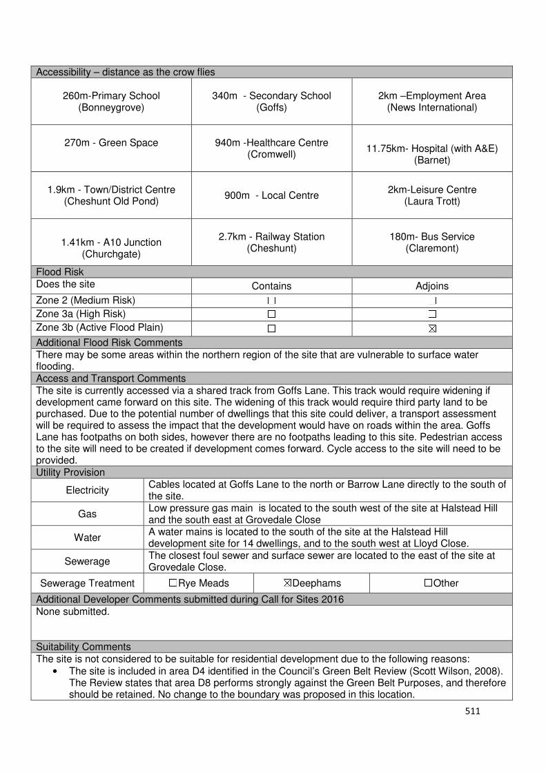
511
Accessibility – distance as the crow flies
260m-Primary School (Bonneygrove)
340m - Secondary School (Goffs)
2km –Employment Area
(News International)
270m - Green Space
940m -Healthcare Centre
(Cromwell)
11.75km- Hospital (with A&E)
(Barnet)
1.9km - Town/District Centre
(Cheshunt Old Pond)
900m - Local Centre
2km-Leisure Centre (Laura Trott)
1.41km - A10 Junction
(Churchgate)
2.7km - Railway Station
(Cheshunt)
180m- Bus Service (Claremont)
Flood Risk Does the site Contains Adjoins
Zone 2 (Medium Risk) ☐ ☐
Zone 3a (High Risk) ☐ ☐
Zone 3b (Active Flood Plain) ☐ ☒
Additional Flood Risk Comments There may be some areas within the northern region of the site that are vulnerable to surface water flooding. Access and Transport Comments The site is currently accessed via a shared track from Goffs Lane. This track would require widening if development came forward on this site. The widening of this track would require third party land to be purchased. Due to the potential number of dwellings that this site could deliver, a transport assessment will be required to assess the impact that the development would have on roads within the area. Goffs Lane has footpaths on both sides, however there are no footpaths leading to this site. Pedestrian access to the site will need to be created if development comes forward. Cycle access to the site will need to be provided. Utility Provision
Electricity Cables located at Goffs Lane to the north or Barrow Lane directly to the south of the site.
Gas Low pressure gas main is located to the south west of the site at Halstead Hill and the south east at Grovedale Close
Water A water mains is located to the south of the site at the Halstead Hill development site for 14 dwellings, and to the south west at Lloyd Close.
Sewerage The closest foul sewer and surface sewer are located to the east of the site at Grovedale Close.
Sewerage Treatment ☐Rye Meads ☒Deephams ☐Other
Additional Developer Comments submitted during Call for Sites 2016 None submitted. Suitability Comments The site is not considered to be suitable for residential development due to the following reasons:
• The site is included in area D4 identified in the Council’s Green Belt Review (Scott Wilson, 2008). The Review states that area D8 performs strongly against the Green Belt Purposes, and therefore should be retained. No change to the boundary was proposed in this location.

512
• The Goffs Oak Development Options Report (Broxbourne Borough Council, 2016) identifies two categories of sites which are not favoured. This site would fall into the second category (Green Belt sites that do not adjoin or marginally adjoin urban development). The Report states that the development of these sites would “create unconnected pockets of housing that are totally unrelated to one another or to the existing urban areas, and in the case of many sites would only be accessible via narrow rural lanes.” The Report also noted that the development of such sites would exacerbate the area’s already haphazard development pattern, and over time lead to the merging of urban areas.
• Contained within the sites boundaries is ‘Meadow North of Barrow Lane’, a local wildlife site. The Council will resist development on local wildlife sites unless it can be demonstrated that it is in the interest of the community. The development of this site for residential is not considered to be in the interest of the community.
• With the exception of 1-2 structures, there are no “existing buildings”, such as a glasshouse, on this site. A site with similar characteristics to CG-GB-97(a) (CG-GB-115 – a previous glasshouse site that is now “devoid of development other than for a small brick building and some very low remnant walls”) had an outline application for 14 self-build plots refused at appeal (APP/W1905/W/16/3164574). In the decision notice, the Inspector stated that “openness in a Green Belt context can be taken to mean absence of development”, therefore, building self-build plots on a site which is devoid of development would have a detrimental impact on the openness of the Green Belt. It is considered that the development of self-build plots on CG-GB-79(a) will have the same outcome, therefore, it would fail to comply with both the NPPF, which makes clear in Paragraph 79 that openness is an essential characteristic of Green Belts, and emerging Policy GB2: Residential Development on Derelict Glasshouse Sites (IIii).
Is this site considered to be suitable for development? ☐Yes ☒ No

513
Local Plan – Site Appraisal Form
Site Information Site Location Map Site Reference Number
CG-GB-97(b)
Site Name Hollow Leys Site Area 2 hectares
Site Status ☐Urban ☒Green Belt ☐Mixed
Source of Site ☒Call for Sites ☐Planning Application ☐Desktop Study
Site Visit Carried Out
☐Yes ☒No
Site Ownership There are two landowners for this site.
Surr
oundin
g
Uses
N Local Wildlife Site, Green Belt, Open Field
E Green Belt, S Open Field, Local
Wildlife Site, Green Belt W Local Wildlife Site,
Green Belt, Scrubland Site Description The site is broadly square in shape and gradually slopes down to the north east. The majority of the site is green in nature, with one structure located near the northern boundary. The other structures identified by the promoter in the Call for Sites form are no visible from the aerial photography. There are a number of trees and shrubs located on the site; with there being is a high concentration within the southern and eastern region. Planning History In 1963, residential development on the site was refused. Development Proposal
Residential ☒ Commercial ☐ Other ☐
Local Plan 2005 (Policy H11) -
Submitted Proposal 10
Site Designations Contains Adjoins Contains Adjoins
Green Belt ☒ ☒ Site of Scientific Interest (SSSI) ☐ ☐
Archaeological Interest ☐ ☐ Ancient Monument ☐ ☐
Local Wildlife Site ☐ ☒ Community Open Space ☐ ☐
Lee Valley Regional Park ☐ ☐ Cheshunt Common ☐ ☐
Listed Building ☐ ☐ Locally Listed Building ☐ ☐
TPO Trees ☐ ☐ Conservation Area ☐ ☐
Air Quality Management Area
☐ ☐ Protected Species ☐ ☐
Draft Local Plan Designation (Regulation 18) The site was proposed to be allocated as an extension to an existing Gypsy and Traveller site under emerging Policy GT1.

514
Accessibility – distance as the crow flies
300m -Primary School (Bonneygrove Primary School)
340m - Secondary School (Goffs)
2km –Employment Area
(News International)
270m - Green Space
990m -Healthcare Centre
(Cromwell)
11.8km- Hospital (with A&E)
(Barnet)
1.89km - Town/District Centre
(Cheshunt Old Pond)
900m - Local Centre
2.12km -Leisure Centre
(Laura Trott)
1.44km - A10 Junction (Churchgate)
2.76km - Railway Station
(Cheshunt)
180m - Bus Service (Claremont)
Flood Risk Does the site Contains Adjoins
Zone 2 (Medium Risk) ☐ ☐
Zone 3a (High Risk) ☐ ☐
Zone 3b (Active Flood Plain) ☐ ☒
Additional Flood Risk Comments There may be some areas within the northern region of the site that are vulnerable to surface water flooding. Access and Transport Comments The site is currently accessed via a shared track from Goffs Lane. This track would require widening if development came forward on this site. The widening of this track may require third party land from adjoining sites. Goffs Lane has footpaths on both sides, however there is no footpath leading to this site. Pedestrian access to the site will need to be created if development comes forward. Cycle access to the site will need to be provided. Utility Provision
Electricity Cables located at Goffs Lane to the north or Barrow Lane directly to the south of the site.
Gas Low pressure gas main is located to the south west of the site at Halstead Hill and the south east at Grovedale Close
Water A water mains is located to the south of the site at the Halstead Hill development site for 14 dwellings, and to the south west at Lloyd Close.
Sewerage The closest foul sewer and surface sewer are located to the east of the site at Grovedale Close.
Sewerage Treatment ☐Rye Meads ☒Deephams ☐Other
Additional Developer Comments submitted during Call for Sites 2016 The promoter of the site stated that it would take 12 months for the current use of the site to cease and that they anticipate that the site preparation and remediation works would approximately take 12 months. The promoter states that there are no legal/landownership issues and that there are 4 existing structures on the site, one of which is still in use. There may be some contaminated land present from previous use however this is not apparent without soil investigation. Suitability Comments The site is not considered to be suitable for residential development due to the following reasons:
• The site is included in area D4 identified in the Council’s Green Belt Review (Scott Wilson, 2008). The Review states that area D4 performs strongly against the Green Belt Purposes, and therefore should be retained. No change to the boundary in this location was proposed.

515
• The Goffs Oak Development Options Report (Broxbourne Borough Council, 2016) identifies two categories of Green Belt sites which are not favoured. This site would fall into the second category (green belt sites that do not adjoin or only marginally adjoin urban development). The Report states that the development of these sites would “create unconnected pockets of housing that are totally unrelated to one another or to the existing urban areas, and in the case of many sites would only be accessible via narrow rural lanes.” The Report also noted that the development of such sites would exacerbate the area’s already haphazard development pattern, and over time lead to the merging of urban areas.
• With the exception of 1-2 structures, there are no “existing buildings”, such as a glasshouse, on this site. A site with similar characteristics to CG-GB-97(b) (CG-GB-115 – a previous glasshouse site that is now “devoid of development other than for a small brick building and some very low remnant walls”) had an outline application for 14 self-build plots refused at appeal (APP/W1905/W/16/3164574). In the decision notice, the Inspector stated that “openness in a Green Belt context can be taken to mean absence of development”, therefore, building self-build plots on a site which is devoid of development would have a detrimental impact on the openness of the Green Belt. It is considered that the development of self-build plots on CG-GB-97(b) will have the same outcome, therefore, it would fail to comply with both the NPPF, which makes clear in Paragraph 79 that openness is an essential characteristic of Green Belts, and emerging Policy GB2: Residential Development on Derelict Glasshouse Sites (IIii).
Is this site considered to be suitable for development? ☐Yes ☒ No

516
Local Plan – Site Appraisal Form
Site Information Site Location Map Site Reference Number
CG-GB-98
Site Name Green Leaf Nurseries Site Area 0.5 hectares
Site Status ☐Urban ☒Green Belt ☐Mixed
Source of Site ☒Call for Sites ☐Planning Application ☐Desktop Study
Site Visit Carried Out
☒Yes ☐No
Site Ownership There are two landowners for the site.
Surr
oundin
g
Uses
N Green Belt
E InEx Nursery, Green Belt
S Goffs Lane, Residential
W Pavilion, Goffs Oak Recreation Ground
Site Description The site is broadly rectangular and relatively flat. There are a number of structures located within the site northern region. Trees are located along the sites western borders and part of the northern boundary. A hedgerow in close proximity to southern boundary separates this site from an adjoining building. See also CG-GB-71 and CG-GB-16 Planning History In 1993, planning permission was granted for the development of a storage building. Development Proposal
Residential ☒ Commercial ☐ Other ☐
Local Plan 2005 (Policy H11) 15
Submitted Proposal -
Site Designations Contains Adjoins Contains Adjoins
Green Belt ☒ ☒ Site of Scientific Interest (SSSI) ☐ ☐
Archaeological Interest ☐ ☐ Ancient Monument ☐ ☐
Local Wildlife Site ☐ ☐ Community Open Space ☐ ☒
Lee Valley Regional Park
☐ ☐ Cheshunt Common ☐ ☐
Listed Building ☐ ☐ Locally Listed Building ☐ ☐
TPO Trees ☐ ☒ Conservation Area ☐ ☐
Air Quality Management Area
☐ ☐ Protected Species ☐ ☐
Draft Local Plan Designation (Regulation 18) The site forms part of GO2: North of Goffs Lane, which was proposed to be allocated for 80 homes, a commercial development site for restaurant and related uses and public open space.

517
Accessibility – distance as the crow flies
470m-Primary School (Woodside)
1.72km - Secondary School (Goffs)
3.35km –Employment Area
(News International)
0m - Green Space (adjoins Goffs Informal)
85m -Healthcare Centre
(Valley View)
11.2km - Hospital (with A&E)
(Barnet)
3km - Town/District Centre (Brookfield)
120m - Local Centre (684-696 Goffs Lane)
3.57km -Leisure Centre
(Laura Trott)
2.9km - A10 Junction (Church Lane/Churchgate)
1.76km - Railway Station
(Cuffley)
90m - Bus Service (War Memorial)
Flood Risk Does the site Contains Adjoins
Zone 2 (Medium Risk) ☐ ☐
Zone 3a (High Risk) ☐ ☐
Zone 3b (Active Flood Plain) ☐ ☒
Additional Flood Risk Comments No flooding issues have been identified. Access and Transport Comments The site can be accessed from Goffs Lane, via InEx. Goffs Lane has pedestrian footpaths on both sides of the road. The site will need to provide connections to these. Cycle access to the site will need to be created. Utility Provision
Electricity Electricity available
Gas A low pressure gas main is located along Goffs Lane
Water A water main is located along Goffs Lane
Sewerage A foul sewer and surface sewer is located along Goffs Lane
Sewerage Treatment ☐Rye Meads ☒Deephams ☐Other
Additional Developer Comments submitted during Call for Sites 2016. None submitted. Please refer to CG-GB-71(a) for promoter comments on draft Local Plan allocation GO2: South of Goffs Lane. Suitability Comments The site is considered to be suitable for residential development due to the following reasons:
• The site is considered to be in a sustainable location for residential development; it is close to local facilities and primary education, close to modes of sustainable transport and within the sustainable distance recommended by Barton et al (2010) to a doctor’s surgery and green space.
• The site is included in area C24 identified in the Council’s Green Belt Review (Scott Wilson, 2008). Appendix 5 of the Review states that the only constraint for area C24 is archaeology and there are a number of opportunities including reasonable accessibility and proximity to services, high level of derelict/vacant brownfield land and regeneration potential. The Review concludes that on this basis the site may be suitable for built development. The suggested policy approach for this area was ‘Consider Allocating Site’.
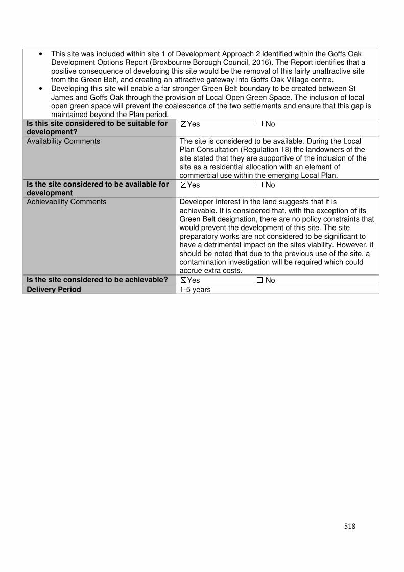
518
• This site was included within site 1 of Development Approach 2 identified within the Goffs Oak Development Options Report (Broxbourne Borough Council, 2016). The Report identifies that a positive consequence of developing this site would be the removal of this fairly unattractive site from the Green Belt, and creating an attractive gateway into Goffs Oak Village centre.
• Developing this site will enable a far stronger Green Belt boundary to be created between St James and Goffs Oak through the provision of Local Open Green Space. The inclusion of local open green space will prevent the coalescence of the two settlements and ensure that this gap is maintained beyond the Plan period.
Is this site considered to be suitable for development?
☒Yes ☐ No
Availability Comments The site is considered to be available. During the Local Plan Consultation (Regulation 18) the landowners of the site stated that they are supportive of the inclusion of the site as a residential allocation with an element of commercial use within the emerging Local Plan.
Is the site considered to be available for development
☒Yes ☐ No
Achievability Comments Developer interest in the land suggests that it is achievable. It is considered that, with the exception of its Green Belt designation, there are no policy constraints that would prevent the development of this site. The site preparatory works are not considered to be significant to have a detrimental impact on the sites viability. However, it should be noted that due to the previous use of the site, a contamination investigation will be required which could accrue extra costs.
Is the site considered to be achievable? ☒Yes ☐ No
Delivery Period 1-5 years
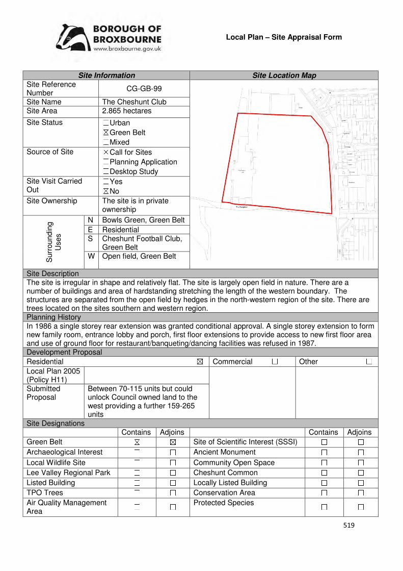
519
Local Plan – Site Appraisal Form
Site Information Site Location Map Site Reference Number
CG-GB-99
Site Name The Cheshunt Club Site Area 2.865 hectares
Site Status ☐Urban ☒Green Belt ☐Mixed
Source of Site ☒Call for Sites ☐Planning Application ☐Desktop Study
Site Visit Carried Out
☐Yes ☒No
Site Ownership The site is in private ownership
Surr
oundin
g
Uses
N Bowls Green, Green Belt
E Residential S Cheshunt Football Club,
Green Belt W Open field, Green Belt
Site Description The site is irregular in shape and relatively flat. The site is largely open field in nature. There are a number of buildings and area of hardstanding stretching the length of the western boundary. The structures are separated from the open field by hedges in the north-western region of the site. There are trees located on the sites southern and western region. Planning History In 1986 a single storey rear extension was granted conditional approval. A single storey extension to form new family room, entrance lobby and porch, first floor extensions to provide access to new first floor area and use of ground floor for restaurant/banqueting/dancing facilities was refused in 1987. Development Proposal
Residential ☒ Commercial ☐ Other ☐
Local Plan 2005 (Policy H11)
Submitted Proposal
Between 70-115 units but could unlock Council owned land to the west providing a further 159-265 units
Site Designations Contains Adjoins Contains Adjoins
Green Belt ☒ ☒ Site of Scientific Interest (SSSI) ☐ ☐
Archaeological Interest ☐ ☐ Ancient Monument ☐ ☐
Local Wildlife Site ☐ ☐ Community Open Space ☐ ☐
Lee Valley Regional Park ☐ ☐ Cheshunt Common ☐ ☐
Listed Building ☐ ☐ Locally Listed Building ☐ ☐
TPO Trees ☐ ☐ Conservation Area ☐ ☐
Air Quality Management Area
☐ ☐ Protected Species ☐ ☐
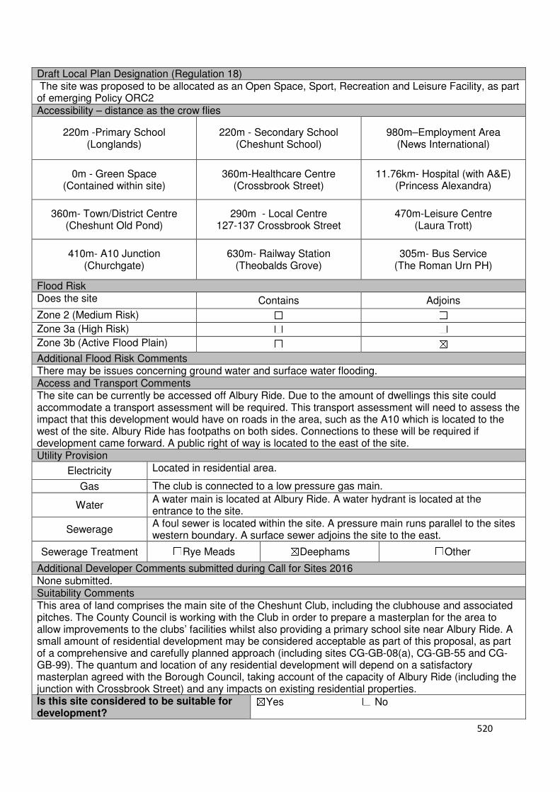
520
Draft Local Plan Designation (Regulation 18) The site was proposed to be allocated as an Open Space, Sport, Recreation and Leisure Facility, as part of emerging Policy ORC2 Accessibility – distance as the crow flies
220m -Primary School (Longlands)
220m - Secondary School (Cheshunt School)
980m–Employment Area (News International)
0m - Green Space (Contained within site)
360m-Healthcare Centre (Crossbrook Street)
11.76km- Hospital (with A&E) (Princess Alexandra)
360m- Town/District Centre (Cheshunt Old Pond)
290m - Local Centre 127-137 Crossbrook Street
470m-Leisure Centre (Laura Trott)
410m- A10 Junction (Churchgate)
630m- Railway Station (Theobalds Grove)
305m- Bus Service (The Roman Urn PH)
Flood Risk Does the site Contains Adjoins
Zone 2 (Medium Risk) ☐ ☐
Zone 3a (High Risk) ☐ ☐
Zone 3b (Active Flood Plain) ☐ ☒
Additional Flood Risk Comments There may be issues concerning ground water and surface water flooding. Access and Transport Comments The site can be currently be accessed off Albury Ride. Due to the amount of dwellings this site could accommodate a transport assessment will be required. This transport assessment will need to assess the impact that this development would have on roads in the area, such as the A10 which is located to the west of the site. Albury Ride has footpaths on both sides. Connections to these will be required if development came forward. A public right of way is located to the east of the site. Utility Provision
Electricity Located in residential area.
Gas The club is connected to a low pressure gas main.
Water A water main is located at Albury Ride. A water hydrant is located at the entrance to the site.
Sewerage A foul sewer is located within the site. A pressure main runs parallel to the sites western boundary. A surface sewer adjoins the site to the east.
Sewerage Treatment ☐Rye Meads ☒Deephams ☐Other
Additional Developer Comments submitted during Call for Sites 2016 None submitted. Suitability Comments This area of land comprises the main site of the Cheshunt Club, including the clubhouse and associated pitches. The County Council is working with the Club in order to prepare a masterplan for the area to allow improvements to the clubs’ facilities whilst also providing a primary school site near Albury Ride. A small amount of residential development may be considered acceptable as part of this proposal, as part of a comprehensive and carefully planned approach (including sites CG-GB-08(a), CG-GB-55 and CG-GB-99). The quantum and location of any residential development will depend on a satisfactory masterplan agreed with the Borough Council, taking account of the capacity of Albury Ride (including the junction with Crossbrook Street) and any impacts on existing residential properties. Is this site considered to be suitable for development?
☒Yes ☐ No
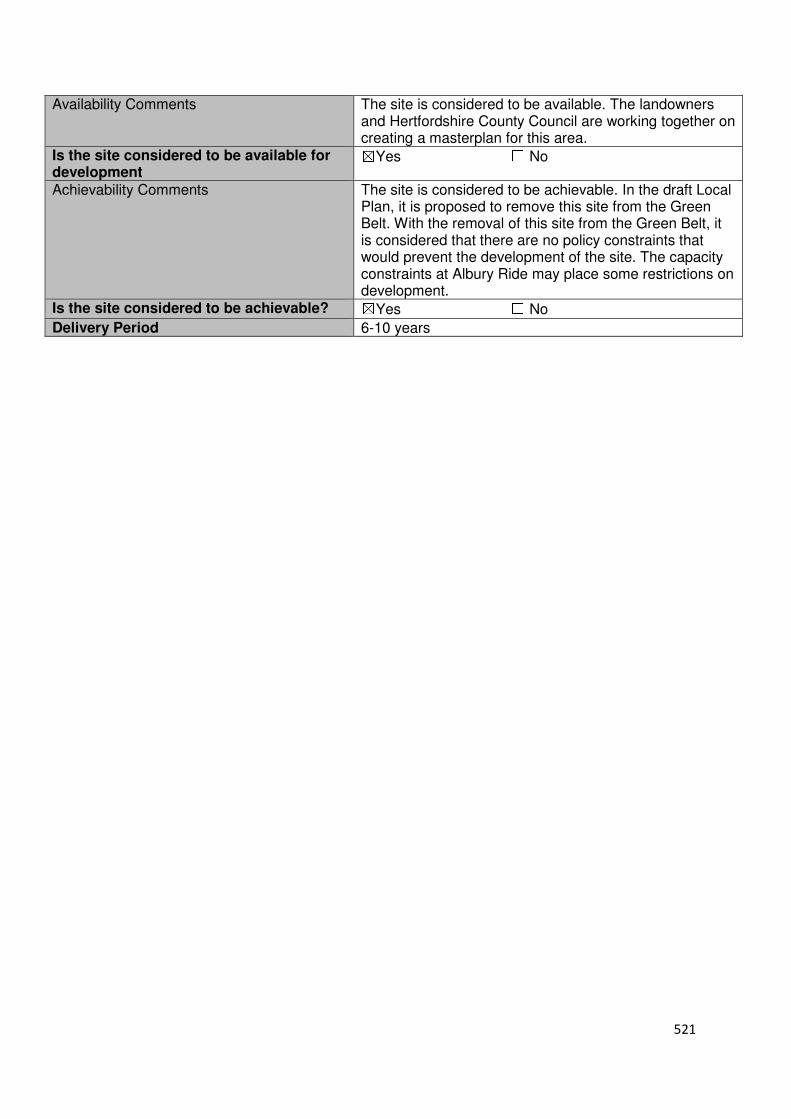
521
Availability Comments The site is considered to be available. The landowners and Hertfordshire County Council are working together on creating a masterplan for this area.
Is the site considered to be available for development
☒Yes ☐ No
Achievability Comments The site is considered to be achievable. In the draft Local Plan, it is proposed to remove this site from the Green Belt. With the removal of this site from the Green Belt, it is considered that there are no policy constraints that would prevent the development of the site. The capacity constraints at Albury Ride may place some restrictions on development.
Is the site considered to be achievable? ☒Yes ☐ No
Delivery Period 6-10 years
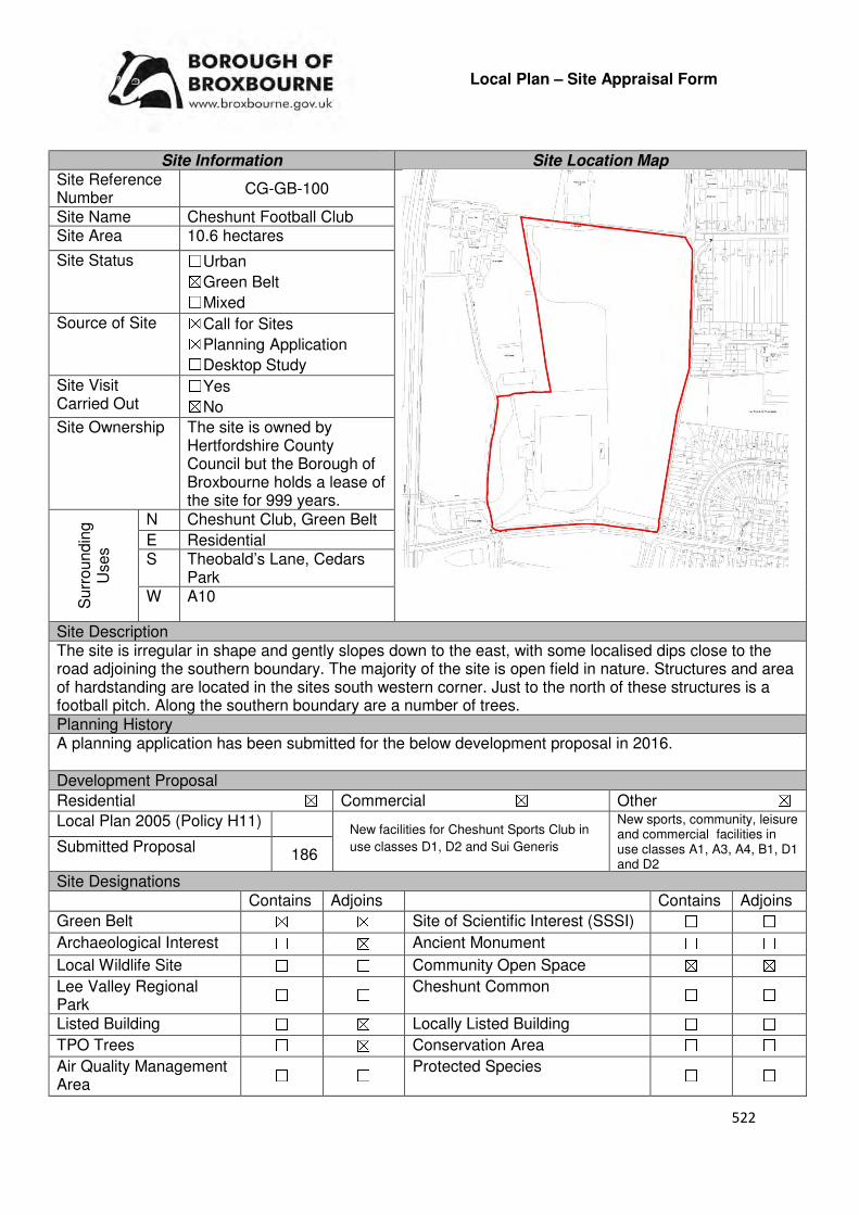
522
Local Plan – Site Appraisal Form
Site Information Site Location Map Site Reference Number
CG-GB-100
Site Name Cheshunt Football Club Site Area 10.6 hectares
Site Status ☐Urban ☒Green Belt ☐Mixed
Source of Site ☒Call for Sites ☒Planning Application ☐Desktop Study
Site Visit Carried Out
☐Yes ☒No
Site Ownership The site is owned by Hertfordshire County Council but the Borough of Broxbourne holds a lease of the site for 999 years.
Surr
oundin
g
Uses
N Cheshunt Club, Green Belt
E Residential S Theobald’s Lane, Cedars
Park W A10
Site Description The site is irregular in shape and gently slopes down to the east, with some localised dips close to the road adjoining the southern boundary. The majority of the site is open field in nature. Structures and area of hardstanding are located in the sites south western corner. Just to the north of these structures is a football pitch. Along the southern boundary are a number of trees. Planning History A planning application has been submitted for the below development proposal in 2016. Development Proposal
Residential ☒ Commercial ☒ Other ☒
Local Plan 2005 (Policy H11)
New sports, community, leisure and commercial facilities in use classes A1, A3, A4, B1, D1 and D2
Submitted Proposal 186
Site Designations Contains Adjoins Contains Adjoins
Green Belt ☒ ☒ Site of Scientific Interest (SSSI) ☐ ☐
Archaeological Interest ☐ ☒ Ancient Monument ☐ ☐
Local Wildlife Site ☐ ☐ Community Open Space ☒ ☒
Lee Valley Regional Park
☐ ☐ Cheshunt Common ☐ ☐
Listed Building ☐ ☒ Locally Listed Building ☐ ☐
TPO Trees ☐ ☒ Conservation Area ☐ ☐
Air Quality Management Area
☐ ☐ Protected Species ☐ ☐
New facilities for Cheshunt Sports Club in
use classes D1, D2 and Sui Generis

523
Draft Local Plan Designation (Regulation 18) The draft Local Plan proposed to allocate the southern region of this site for the development of 120 dwellings, community and commercial facility which would enable the development of the Cheshunt FC stadium. The remained of the site was designated as Open Space, Sport, Recreation and Leisure Facility Accessibility – distance as the crow flies
0m -Primary School (adjoins Longlands)
160m - Secondary School (Cheshunt School)
520m –Employment Area
(News International)
0m - Green Space (adjoins Cedars Park)
340m-Healthcare Centre
(Crossbrook Street)
11.84km Hospital (with A&E) (Princess Alexandra)
470m- Town/District Centre (Cheshunt Old Pond)
240m - Local Centre
(113-125 Crossbrook Street)
560m-Leisure Centre (Laura Trott)
210- A10 Junction (Lieutenant Ellis Way)
370m - Railway Station
(Theobalds Grove)
380m- Bus Service (Theobalds Grove Railway
Station)
Flood Risk Does the site Contains Adjoins
Zone 2 (Medium Risk) ☐ ☒
Zone 3a (High Risk) ☒ ☒
Zone 3b (Active Flood Plain) ☐ ☒
Additional Flood Risk Comments Only the southern region of the site is located within Flood Zone 3a due to Theobalds Brook running the length of the southern boundary. The site may also suffer from some ground water flooding and some small areas of surface water flooding. Access and Transport Comments The site is currently accessed via Theobald’s Lane. To the west of the current site entrance, Theobald’s Lane is narrow in places, allowing only one vehicle to pass. Due to the amount of development that could come forward on the site, a transport assessment will be required. As Theobald’s Lane leads out onto the A10, this assessment will need to look at the impact that this site will have on this road. There are footpaths on the southern side of Theobald’s Lane. Connections to these will be required if development comes forward on this site. Utility Provision
Electricity Electricity connections located in the residential area to the east of the site
Gas A low pressure gas main is located along Great Cambridge Road and Theobald’s Lane.
Water A water main is located to the south of the site at Theobald’s Lane. A trunk main is located in the southern region of the site.
Sewerage A high pressure main adjoins part of the site to the west. A foul sewer and surface sewer is located to the east of the site at Theobald’s Lane, Montayne Road
Sewerage Treatment ☐Rye Meads ☒Deephams ☐Other
Additional Developer Comments submitted during Call for Sites 2016 None submitted.
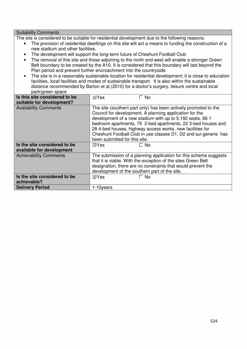
524
Suitability Comments The site is considered to be suitable for residential development due to the following reasons:
• The provision of residential dwellings on this site will act a means to funding the construction of a new stadium and other facilities.
• The development will support the long-term future of Cheshunt Football Club
• The removal of this site and those adjoining to the north and west will enable a stronger Green Belt boundary to be created by the A10. It is considered that this boundary will last beyond the Plan period and prevent further encroachment into the countryside.
• The site is in a reasonably sustainable location for residential development; it is close to education facilities, local facilities and modes of sustainable transport. It is also within the sustainable distance recommended by Barton et al (2010) for a doctor’s surgery, leisure centre and local park/green space
Is this site considered to be suitable for development?
☒Yes ☐ No
Availability Comments The site (southern part only) has been actively promoted to the Council for development. A planning application for the development of a new stadium with up to 5,192 seats, 66 1 bedroom apartments, 70 2-bed apartments, 22 3-bed houses and 28 4-bed houses, highway access works, new facilities for Cheshunt Football Club in use classes D1, D2 and sui generis has been submitted for this site.
Is the site considered to be available for development
☒Yes ☐ No
Achievability Comments The submission of a planning application for this scheme suggests that it is viable. With the exception of the sites Green Belt designation, there are no constraints that would prevent the development of the southern part of the site.
Is the site considered to be achievable?
☒Yes ☐ No
Delivery Period 1-10years

525
Local Plan – Site Appraisal Form
Site Information Site Location Map Site Reference Number
CG-GB-101
Site Name Hope Nursery Site Area 1.2 hectares
Site Status ☐Urban ☒Green Belt ☐Mixed
Source of Site ☒Call for Sites ☐Planning Application ☐Desktop Study
Site Visit Carried Out
☐Yes ☒No
Site Ownership The site is owned by a private company.
Surr
oundin
g
Uses
N Local Wildlife Site, Green Belt
E Lieutenant Ellis Way S Barrow Lane, Green Belt
W Halstead Hill Residential Development Site (14 dwellings)
Site Description The broadly rectangular shape is relatively low-lying with some fluctuating ground levels. The majority of the site is covered by glasshouse structures, and an area of hardstanding in the central region of the site. Lining the site boundaries to the north and east are trees. Hedgerows are located on the southern boundary. Planning History In 1991, development comprising the extension to greenhouse, raising the boiler chimney and the erection of a water tank was approved. In 1995, a single storey extension to toilet block, mess room and storage shed was approved. There have been various approvals for the renewal of a residential caravan. Development Proposal
Residential ☒ Commercial ☐ Other ☐
Local Plan 2005 (Policy H11) -
Submitted Proposal 6
Site Designations Contains Adjoins Contains Adjoins
Green Belt ☒ ☒ Site of Scientific Interest (SSSI) ☐ ☐
Archaeological Interest ☐ ☐ Ancient Monument ☐ ☐
Local Wildlife Site ☐ ☒ Community Open Space ☐ ☐
Lee Valley Regional Park ☐ ☐ Cheshunt Common ☐ ☐
Listed Building ☐ ☐ Locally Listed Building ☐ ☐
TPO Trees ☐ ☒ Conservation Area ☐ ☐
Air Quality Management Area
☐ ☐ Protected Species ☐ ☐
Draft Local Plan Designation (Regulation 18) The draft Local Plan proposed to keep this site within the Green Belt
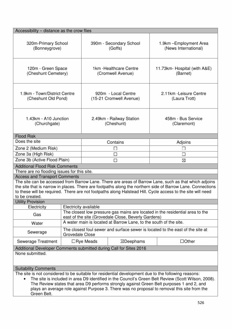
526
Accessibility – distance as the crow flies
320m-Primary School (Bonneygrove)
390m - Secondary School (Goffs)
1.9km –Employment Area
(News International)
120m - Green Space (Cheshunt Cemetery)
1km -Healthcare Centre
(Cromwell Avenue)
11.73km- Hospital (with A&E) (Barnet)
1.9km - Town/District Centre
(Cheshunt Old Pond)
920m - Local Centre (15-21 Cromwell Avenue)
2.11km -Leisure Centre (Laura Trott)
1.43km - A10 Junction
(Churchgate)
2.49km - Railway Station (Cheshunt)
458m - Bus Service (Claremont)
Flood Risk Does the site Contains Adjoins
Zone 2 (Medium Risk) ☐ ☐
Zone 3a (High Risk) ☐ ☐
Zone 3b (Active Flood Plain) ☐ ☒
Additional Flood Risk Comments There are no flooding issues for this site. Access and Transport Comments The site can be accessed from Barrow Lane. There are areas of Barrow Lane, such as that which adjoins the site that is narrow in places. There are footpaths along the northern side of Barrow Lane. Connections to these will be required. There are not footpaths along Halstead Hill. Cycle access to the site will need to be created. Utility Provision
Electricity Electricity available
Gas The closest low pressure gas mains are located in the residential area to the east of the site (Grovedale Close, Beverly Gardens)
Water A water main is located at Barrow Lane, to the south of the site.
Sewerage The closest foul sewer and surface sewer is located to the east of the site at Grovedale Close
Sewerage Treatment ☐Rye Meads ☒Deephams ☐Other
Additional Developer Comments submitted during Call for Sites 2016 None submitted. Suitability Comments The site is not considered to be suitable for residential development due to the following reasons:
• The site is included in area D9 identified in the Council’s Green Belt Review (Scott Wilson, 2008). The Review states that area D9 performs strongly against Green Belt purposes 1 and 2, and plays an average role against Purpose 3. There was no proposal to removal this site from the Green Belt.
527
• The Goffs Oak Development Options Report (Broxbourne Borough Council, 2016) identifies two categories of Green Belt sites that are not favoured. It is possible to include this site within the secondary category which comprises of Green Belt sites that do not adjoin or only marginally adjoin urban development. The report states that the “development of these sites would create unconnected pockets of housing that are totally unrelated to one another or to existing urban areas, and in the case of many sites would only be accessible via narrow rural lanes”. An option that favours this this site would need to provide new services/facilities, collectively and proportionately funded by each scheme. The report continues by stating that this would be a significant challenge to address and likely to exacerbate the area’s already haphazard development pattern, and over time lead to merging of urban areas.
However, subject to the sites compliance with emerging Policy GB2: Residential Development on Derelict Glass House Sites, the site could be subdivided into self-build housing plots. Is this site considered to be suitable for development?
☐Yes ☒ No
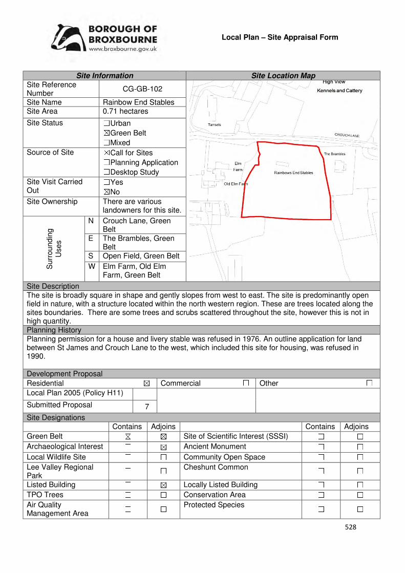
528
Local Plan – Site Appraisal Form
Site Information Site Location Map Site Reference Number
CG-GB-102
Site Name Rainbow End Stables Site Area 0.71 hectares
Site Status ☐Urban ☒Green Belt ☐Mixed
Source of Site ☒Call for Sites ☐Planning Application ☐Desktop Study
Site Visit Carried Out
☐Yes ☒No
Site Ownership There are various landowners for this site.
Surr
oundin
g
Uses
N Crouch Lane, Green Belt
E The Brambles, Green Belt
S Open Field, Green Belt
W Elm Farm, Old Elm Farm, Green Belt
Site Description The site is broadly square in shape and gently slopes from west to east. The site is predominantly open field in nature, with a structure located within the north western region. These are trees located along the sites boundaries. There are some trees and scrubs scattered throughout the site, however this is not in high quantity. Planning History Planning permission for a house and livery stable was refused in 1976. An outline application for land between St James and Crouch Lane to the west, which included this site for housing, was refused in 1990. Development Proposal
Residential ☒ Commercial ☐ Other ☐
Local Plan 2005 (Policy H11)
Submitted Proposal 7
Site Designations Contains Adjoins Contains Adjoins
Green Belt ☒ ☒ Site of Scientific Interest (SSSI) ☐ ☐
Archaeological Interest ☐ ☒ Ancient Monument ☐ ☐
Local Wildlife Site ☐ ☐ Community Open Space ☐ ☐
Lee Valley Regional Park
☐ ☐ Cheshunt Common ☐ ☐
Listed Building ☐ ☒ Locally Listed Building ☐ ☐
TPO Trees ☐ ☐ Conservation Area ☐ ☐
Air Quality Management Area
☐ ☐ Protected Species ☐ ☐
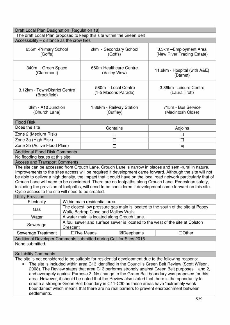
529
Draft Local Plan Designation (Regulation 18) The draft Local Plan proposed to keep this site within the Green Belt Accessibility – distance as the crow flies
655m -Primary School (Goffs)
2km - Secondary School (Goffs)
3.3km –Employment Area (New River Trading Estate)
340m - Green Space (Claremont)
660m-Healthcare Centre
(Valley View)
11.6km - Hospital (with A&E)
(Barnet)
3.12km - Town/District Centre
(Brookfield)
580m - Local Centre (1-5 Masons Parade)
3.86km -Leisure Centre
(Laura Trott)
3km - A10 Junction
(Church Lane)
1.86km - Railway Station
(Cuffley)
715m - Bus Service (Macintosh Close)
Flood Risk Does the site Contains Adjoins
Zone 2 (Medium Risk) ☐ ☐
Zone 3a (High Risk) ☐ ☐
Zone 3b (Active Flood Plain) ☐ ☒
Additional Flood Risk Comments No flooding issues at this site. Access and Transport Comments The site can be accessed from Crouch Lane. Crouch Lane is narrow in places and semi-rural in nature. Improvements to the sites access will be required if development came forward. Although the site will not be able to deliver a high density, the impact that it could have on the local road network particularly that of Crouch Lane will need to be considered. There are no footpaths along Crouch Lane. Pedestrian safety, including the provision of footpaths, will need to be considered if development came forward on this site. Cycle access to the site will need to be created. Utility Provision
Electricity Within main residential area
Gas The closest low pressure gas main is located to the south of the site at Poppy Walk, Bartrop Close and Mallow Walk.
Water A water main is located along Crouch Lane.
Sewerage A foul sewer and surface sewer is located to the west of the site at Colston Crescent
Sewerage Treatment ☐Rye Meads ☒Deephams ☐Other
Additional Developer Comments submitted during Call for Sites 2016 None submitted. Suitability Comments The site is not considered to be suitable for residential development due to the following reasons:
• The site is included within area C13 identified in the Council’s Green Belt Review (Scott Wilson, 2008). The Review states that area C13 performs strongly against Green Belt purposes 1 and 2, and averagely against Purpose 3. No change to the Green Belt boundary was proposed for this area. However, it should be noted that the Review also stated that there is the opportunity to create a stronger Green Belt boundary in C11-C30 as these areas have “extremely weak boundaries” which means that there are no real barriers to prevent encroachment between settlements.

530
• This site has weak boundaries to the east, south and west. These boundaries would not last beyond the Plan period or prevent further encroachment into the countryside.
• The Goffs Oak Development Options Report (Broxbourne Borough Council, 2016) identifies two categories of Green Belt sites which are not favoured. This site can fall into the second category which states that this site would “create unconnected pockets of housing that are totally unrelated to one another or to existing urban areas, and in the case of many sites would only be accessible via narrow rural lanes. An option that favoured such sites would need to provide new services/facilities such as primary schools in an appropriate location(s), collectively and proportionately funded by each scheme”. The Report continues by stating that the development of such sites would exacerbate the area’s already haphazard development pattern, and over time lead to the merging of urban areas.
Is this site considered to be suitable for development? ☐Yes ☒ No
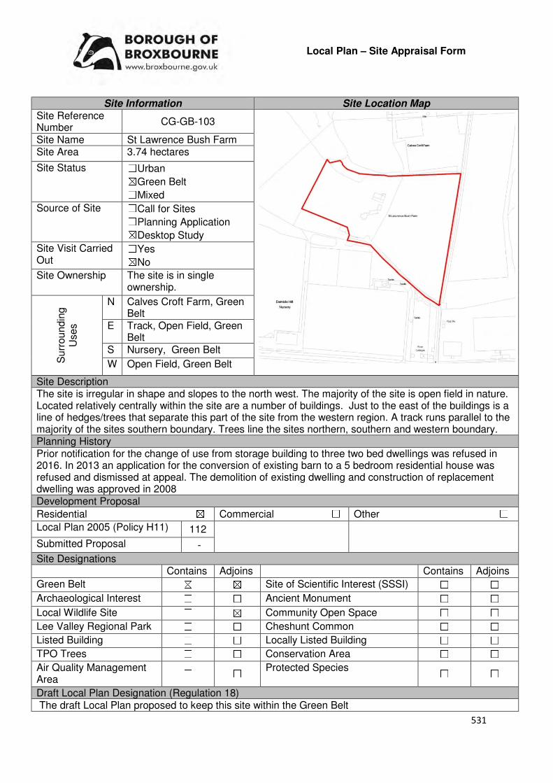
531
Local Plan – Site Appraisal Form
Site Information Site Location Map Site Reference Number
CG-GB-103
Site Name St Lawrence Bush Farm Site Area 3.74 hectares
Site Status ☐Urban ☒Green Belt ☐Mixed
Source of Site ☐Call for Sites ☐Planning Application ☒Desktop Study
Site Visit Carried Out
☐Yes ☒No
Site Ownership The site is in single ownership.
Surr
oundin
g
Uses
N Calves Croft Farm, Green Belt
E Track, Open Field, Green Belt
S Nursery, Green Belt
W Open Field, Green Belt
Site Description The site is irregular in shape and slopes to the north west. The majority of the site is open field in nature. Located relatively centrally within the site are a number of buildings. Just to the east of the buildings is a line of hedges/trees that separate this part of the site from the western region. A track runs parallel to the majority of the sites southern boundary. Trees line the sites northern, southern and western boundary. Planning History Prior notification for the change of use from storage building to three two bed dwellings was refused in 2016. In 2013 an application for the conversion of existing barn to a 5 bedroom residential house was refused and dismissed at appeal. The demolition of existing dwelling and construction of replacement dwelling was approved in 2008 Development Proposal
Residential ☒ Commercial ☐ Other ☐
Local Plan 2005 (Policy H11) 112
Submitted Proposal -
Site Designations Contains Adjoins Contains Adjoins
Green Belt ☒ ☒ Site of Scientific Interest (SSSI) ☐ ☐
Archaeological Interest ☐ ☐ Ancient Monument ☐ ☐
Local Wildlife Site ☐ ☒ Community Open Space ☐ ☐
Lee Valley Regional Park ☐ ☐ Cheshunt Common ☐ ☐
Listed Building ☐ ☐ Locally Listed Building ☐ ☐
TPO Trees ☐ ☐ Conservation Area ☐ ☐
Air Quality Management Area
☐ ☐ Protected Species ☐ ☐
Draft Local Plan Designation (Regulation 18) The draft Local Plan proposed to keep this site within the Green Belt
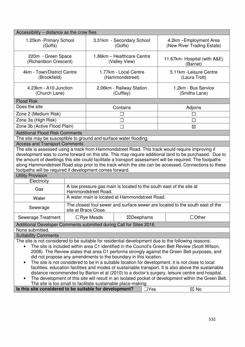
532
Accessibility – distance as the crow flies
1.25km -Primary School (Goffs)
3.31km - Secondary School (Goffs)
4.2km –Employment Area (New River Trading Estate)
220m - Green Space (Richardson Crescent)
1.86km – Healthcare Centre (Valley View)
11.67km- Hospital (with A&E)
(Barnet)
4km - Town/District Centre (Brookfield)
1.77km - Local Centre (Hammondstreet)
5.11km -Leisure Centre (Laura Trott)
4.23km - A10 Junction (Church Lane)
2.06km - Railway Station (Cuffley)
1.2km - Bus Service (Smiths Lane)
Flood Risk Does the site Contains Adjoins
Zone 2 (Medium Risk) ☐ ☐
Zone 3a (High Risk) ☐ ☐
Zone 3b (Active Flood Plain) ☐ ☒
Additional Flood Risk Comments The site may be susceptible to ground and surface water flooding. Access and Transport Comments The site is assessed using a track from Hammondstreet Road. This track would require improving if development was to come forward on this site. This may require additional land to be purchased. Due to the amount of dwellings this site could facilitate a transport assessment will be required. The footpaths along Hammondstreet Road stop prior to the track which the site can be accessed. Connections to these footpaths will be required if development comes forward. Utility Provision
Electricity
Gas A low pressure gas main is located to the south east of the site at Hammondstreet Road.
Water A water main is located at Hammondstreet Road.
Sewerage The closest foul sewer and surface sewer are located to the south east of the site at Brace Close.
Sewerage Treatment ☐Rye Meads ☒Deephams ☐Other
Additional Developer Comments submitted during Call for Sites 2016 None submitted. Suitability Comments The site is not considered to be suitable for residential development due to the following reasons:
• The site is included within area C1 identified in the Council’s Green Belt Review (Scott Wilson, 2008). The Review states that area C1 performs strongly against the Green Belt purposes, and did not propose any amendments to the boundary in this location.
• The site is not considered to be in a suitable location for development; it is not close to local facilities, education facilities and modes of sustainable transport. It is also above the sustainable distance recommended by Barton et al (2010) to a doctor’s surgery, leisure centre and hospital.
• The development of this site will result in an isolated pocket of development within the Green Belt. The site is too small to facilitate sustainable place-making
Is this site considered to be suitable for development? ☐Yes ☒ No
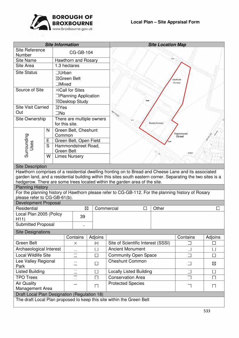
533
Local Plan – Site Appraisal Form
Site Information Site Location Map Site Reference Number
CG-GB-104
Site Name Hawthorn and Rosary Site Area 1.3 hectares
Site Status ☐Urban ☒Green Belt ☐Mixed
Source of Site ☒Call for Sites ☐Planning Application ☒Desktop Study
Site Visit Carried Out
☒Yes ☐No
Site Ownership There are multiple owners for this site.
Surr
oundin
g
Uses
N Green Belt, Cheshunt Common
E Green Belt, Open Field S Hammondstreet Road,
Green Belt W Limes Nursery
Site Description Hawthorn comprises of a residential dwelling fronting on to Bread and Cheese Lane and its associated garden land, and a residential building within this sites south eastern corner. Separating the two sites is a hedgerow. There are some trees located within the garden area of the site. Planning History For the planning history of Hawthorn please refer to CG-GB-112. For the planning history of Rosary please refer to CG-GB-61(b). Development Proposal
Residential ☒ Commercial ☐ Other ☐
Local Plan 2005 (Policy H11)
39
Submitted Proposal -
Site Designations Contains Adjoins Contains Adjoins
Green Belt ☒ ☒ Site of Scientific Interest (SSSI) ☐ ☐
Archaeological Interest ☐ ☐ Ancient Monument ☐ ☐
Local Wildlife Site ☐ ☐ Community Open Space ☐ ☐
Lee Valley Regional Park
☐ ☐ Cheshunt Common ☐ ☒
Listed Building ☐ ☐ Locally Listed Building ☐ ☐
TPO Trees ☐ ☐ Conservation Area ☐ ☐
Air Quality Management Area
☐ ☐ Protected Species ☐ ☐
Draft Local Plan Designation (Regulation 18) The draft Local Plan proposed to keep this site within the Green Belt

534
Accessibility – distance as the crow flies
1.4km-Primary School (Goffs)
2.27km - Secondary School (Goffs)
2.9km –Employment Area
(New River Industrial Estate)
160m - Green Space (Hammondstreet)
1.5km -Healthcare Centre (Valley View)
12.3km - Hospital (with A&E) (Barnet)
2.78km - Town/District Centre (Brookfield)
620m - Local Centre (Hammondstreet)
4km -Leisure Centre (Laura Trott)
3.1km - A10 Junction (Turnford)
2.52km - Railway Station (Cuffley)
93m - Bus Service (Smiths Lane)
Flood Risk Does the site Contains Adjoins
Zone 2 (Medium Risk) ☐ ☐
Zone 3a (High Risk) ☐ ☐
Zone 3b (Active Flood Plain) ☐ ☒
Additional Flood Risk Comments No flood risk issues identified for this site. Access and Transport Comments The site can be accessed from Hammondstreet Road or Bread and Cheese Lane. Due to the semi-rural nature of Bread and Cheese Lane, it is considered that Hammondstreet Road would be the most appropriate access point if development was to occur. There are no footpaths along Bread and Cheese Lane. There are footpaths on the northern side of Hammondstreet Road. There is a public right of way to the rear of the site. Utility Provision
Electricity Available at Bread and Cheese Lane or to the south at Hammondstreet Road
Gas A low pressure gas main is located along Hammondstreet Road and Bread and Cheese Lane
Water A water main and trunk main is located along Hammondstreet Road. A water main is located along Bread and Cheese Lane. A hydrant is located just outside Hawthorn.
Sewerage A foul sewer is located to the south of the site, near 432 and 433 Hammondstreet Road
Sewerage Treatment ☐Rye Meads ☒Deephams ☐Other
Additional Developer Comments submitted during Call for Sites 2016 No comments were submitted for Hawthorn. Promoter comments for Rosary can be found on CG-GB-61(b) Suitability Comments The site is not considered to be suitable for high-density residential development due to the following reasons:
• The site is included within area C10 identified in the Council’s Green Belt Review (Scott Wilson, 2008). The Review concludes that this area performs strongly against Green Belt purposes and no change to the boundary in this location was proposed
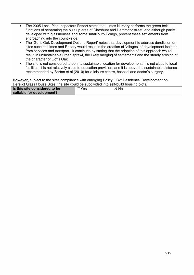
535
• The 2005 Local Plan Inspectors Report states that Limes Nursery performs the green belt functions of separating the built up area of Cheshunt and Hammondstreet, and although partly developed with glasshouses and some small outbuildings, prevent these settlements from encroaching into the countryside.
• The ‘Goffs Oak Development Options Report’ notes that development to address dereliction on sites such as Limes and Rosary would result in the creation of ‘villages’ of development isolated from services and transport. It continues by stating that the adoption of this approach would result in unsustainable urban sprawl, the likely merging of settlements and the steady erosion of the character of Goffs Oak.
• The site is not considered to be in a sustainable location for development; it is not close to local facilities, it is not relatively close to education provision, and it is above the sustainable distance recommended by Barton et al (2010) for a leisure centre, hospital and doctor’s surgery.
However, subject to the sites compliance with emerging Policy GB2: Residential Development on Derelict Glass House Sites, the site could be subdivided into self-build housing plots. Is this site considered to be suitable for development?
☐Yes ☒ No
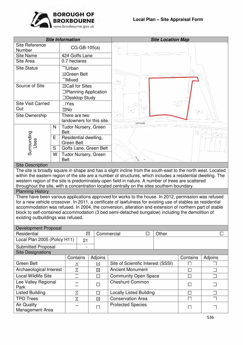
536
Local Plan – Site Appraisal Form
Site Information Site Location Map Site Reference Number
CG-GB-105(a)
Site Name 424 Goffs Lane Site Area 0.7 hectares
Site Status ☐Urban ☒Green Belt ☐Mixed
Source of Site ☒Call for Sites ☐Planning Application ☐Desktop Study
Site Visit Carried Out
☐Yes ☒No
Site Ownership There are two landowners for this site.
Surr
oundin
g
Uses
N Tudor Nursery, Green Belt
E Residential dwelling, Green Belt
S Goffs Lane, Green Belt
W Tudor Nursery, Green Belt
Site Description The site is broadly square in shape and has a slight incline from the south-east to the north west. Located within the eastern region of the site are a number of structures, which includes a residential dwelling. The western region of the site is predominately open field in nature. A number of trees are scattered throughout the site, with a concentration located centrally on the sites southern boundary. Planning History There have been various applications approved for works to the house. In 2012, permission was refused for a new vehicle crossover. In 2011, a certificate of lawfulness for existing use of stables as residential accommodation was refused. In 2004, the conversion, alteration and extension of northern part of stable block to self-contained accommodation (3 bed semi-detached bungalow) including the demolition of existing outbuildings was refused. Development Proposal
Residential ☒ Commercial ☐ Other ☐
Local Plan 2005 (Policy H11) 21
Submitted Proposal - Site Designations Contains Adjoins Contains Adjoins
Green Belt ☒ ☒ Site of Scientific Interest (SSSI) ☐ ☐
Archaeological Interest ☒ ☒ Ancient Monument ☐ ☐
Local Wildlife Site ☐ ☐ Community Open Space ☐ ☐
Lee Valley Regional Park
☐ ☐ Cheshunt Common ☐ ☐
Listed Building ☒ ☐ Locally Listed Building ☐ ☐
TPO Trees ☒ ☒ Conservation Area ☐ ☐
Air Quality Management Area
☐ ☐ Protected Species ☐ ☐
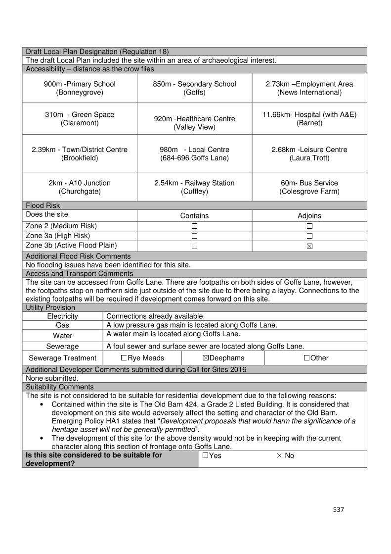
537
Draft Local Plan Designation (Regulation 18) The draft Local Plan included the site within an area of archaeological interest. Accessibility – distance as the crow flies
900m -Primary School (Bonneygrove)
850m - Secondary School (Goffs)
2.73km –Employment Area (News International)
310m - Green Space (Claremont)
920m -Healthcare Centre
(Valley View)
11.66km- Hospital (with A&E) (Barnet)
2.39km - Town/District Centre (Brookfield)
980m - Local Centre (684-696 Goffs Lane)
2.68km -Leisure Centre (Laura Trott)
2km - A10 Junction (Churchgate)
2.54km - Railway Station (Cuffley)
60m- Bus Service (Colesgrove Farm)
Flood Risk Does the site Contains Adjoins
Zone 2 (Medium Risk) ☐ ☐
Zone 3a (High Risk) ☐ ☐
Zone 3b (Active Flood Plain) ☐ ☒
Additional Flood Risk Comments No flooding issues have been identified for this site. Access and Transport Comments The site can be accessed from Goffs Lane. There are footpaths on both sides of Goffs Lane, however, the footpaths stop on northern side just outside of the site due to there being a layby. Connections to the existing footpaths will be required if development comes forward on this site. Utility Provision
Electricity Connections already available.
Gas A low pressure gas main is located along Goffs Lane.
Water A water main is located along Goffs Lane.
Sewerage A foul sewer and surface sewer are located along Goffs Lane.
Sewerage Treatment ☐Rye Meads ☒Deephams ☐Other
Additional Developer Comments submitted during Call for Sites 2016 None submitted. Suitability Comments The site is not considered to be suitable for residential development due to the following reasons:
• Contained within the site is The Old Barn 424, a Grade 2 Listed Building. It is considered that development on this site would adversely affect the setting and character of the Old Barn. Emerging Policy HA1 states that “Development proposals that would harm the significance of a heritage asset will not be generally permitted”.
• The development of this site for the above density would not be in keeping with the current character along this section of frontage onto Goffs Lane.
Is this site considered to be suitable for development?
☐Yes ☒ No
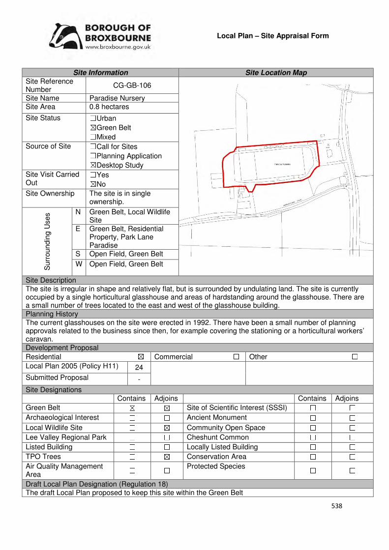
538
Local Plan – Site Appraisal Form
Site Information Site Location Map Site Reference Number
CG-GB-106
Site Name Paradise Nursery Site Area 0.8 hectares
Site Status ☐Urban ☒Green Belt ☐Mixed
Source of Site ☐Call for Sites ☐Planning Application ☒Desktop Study
Site Visit Carried Out
☐Yes ☒No
Site Ownership The site is in single ownership.
Surr
oundin
g U
ses N Green Belt, Local Wildlife
Site E Green Belt, Residential
Property, Park Lane Paradise
S Open Field, Green Belt
W Open Field, Green Belt
Site Description The site is irregular in shape and relatively flat, but is surrounded by undulating land. The site is currently occupied by a single horticultural glasshouse and areas of hardstanding around the glasshouse. There are a small number of trees located to the east and west of the glasshouse building. Planning History The current glasshouses on the site were erected in 1992. There have been a small number of planning approvals related to the business since then, for example covering the stationing or a horticultural workers’ caravan. Development Proposal
Residential ☒ Commercial ☐ Other ☐
Local Plan 2005 (Policy H11) 24
Submitted Proposal -
Site Designations Contains Adjoins Contains Adjoins
Green Belt ☒ ☒ Site of Scientific Interest (SSSI) ☐ ☐
Archaeological Interest ☐ ☐ Ancient Monument ☐ ☐
Local Wildlife Site ☐ ☒ Community Open Space ☐ ☐
Lee Valley Regional Park ☐ ☐ Cheshunt Common ☐ ☐
Listed Building ☐ ☐ Locally Listed Building ☐ ☐
TPO Trees ☐ ☒ Conservation Area ☐ ☐
Air Quality Management Area
☐ ☐ Protected Species ☐ ☐
Draft Local Plan Designation (Regulation 18) The draft Local Plan proposed to keep this site within the Green Belt
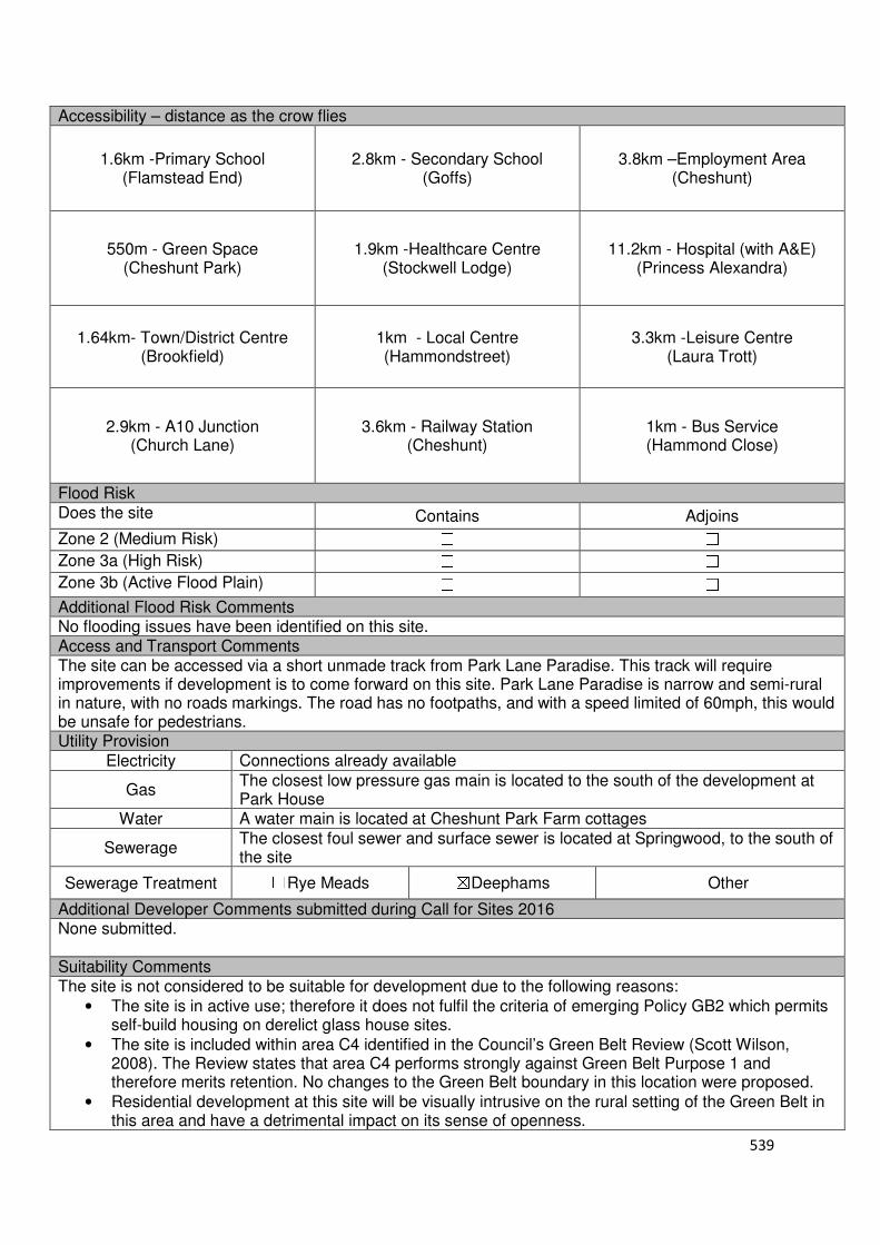
539
Accessibility – distance as the crow flies
1.6km -Primary School (Flamstead End)
2.8km - Secondary School (Goffs)
3.8km –Employment Area (Cheshunt)
550m - Green Space (Cheshunt Park)
1.9km -Healthcare Centre (Stockwell Lodge)
11.2km - Hospital (with A&E) (Princess Alexandra)
1.64km- Town/District Centre (Brookfield)
1km - Local Centre (Hammondstreet)
3.3km -Leisure Centre (Laura Trott)
2.9km - A10 Junction (Church Lane)
3.6km - Railway Station (Cheshunt)
1km - Bus Service (Hammond Close)
Flood Risk Does the site Contains Adjoins
Zone 2 (Medium Risk) ☐ ☐
Zone 3a (High Risk) ☐ ☐
Zone 3b (Active Flood Plain) ☐ ☐
Additional Flood Risk Comments No flooding issues have been identified on this site. Access and Transport Comments The site can be accessed via a short unmade track from Park Lane Paradise. This track will require improvements if development is to come forward on this site. Park Lane Paradise is narrow and semi-rural in nature, with no roads markings. The road has no footpaths, and with a speed limited of 60mph, this would be unsafe for pedestrians. Utility Provision
Electricity Connections already available
Gas The closest low pressure gas main is located to the south of the development at Park House
Water A water main is located at Cheshunt Park Farm cottages
Sewerage The closest foul sewer and surface sewer is located at Springwood, to the south of the site
Sewerage Treatment ☐Rye Meads ☒Deephams ☐Other
Additional Developer Comments submitted during Call for Sites 2016 None submitted. Suitability Comments The site is not considered to be suitable for development due to the following reasons:
• The site is in active use; therefore it does not fulfil the criteria of emerging Policy GB2 which permits self-build housing on derelict glass house sites.
• The site is included within area C4 identified in the Council’s Green Belt Review (Scott Wilson, 2008). The Review states that area C4 performs strongly against Green Belt Purpose 1 and therefore merits retention. No changes to the Green Belt boundary in this location were proposed.
• Residential development at this site will be visually intrusive on the rural setting of the Green Belt in this area and have a detrimental impact on its sense of openness.

540
• The site is not considered to be in a sustainable location; it is not in proximity to educational facilities, modes of sustainable transport or local facilities. It is also above the sustainable distance recommended by Barton et al (2010) for facilities and amenities, with the exception of Open Space.
Is the site considered to be suitable for development?
☐☐☐☐Yes ☒☒☒☒ No
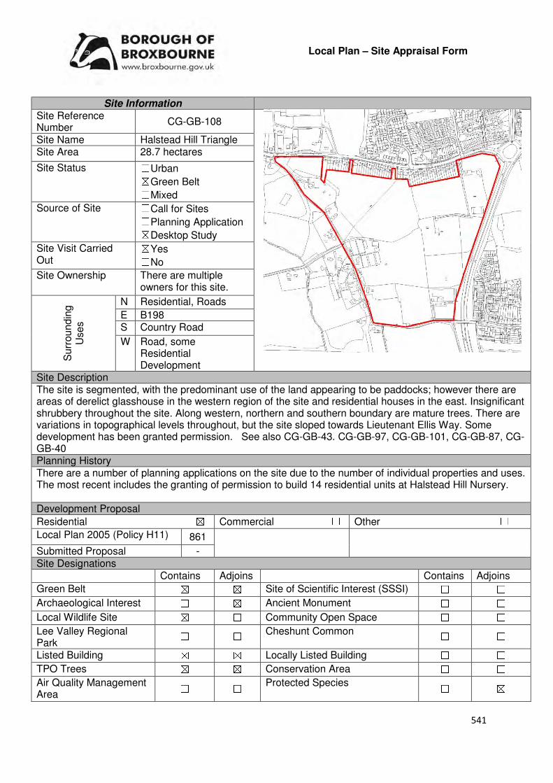
541
Local Plan – Site Appraisal Form
Site Information Site Reference Number
CG-GB-108
Site Name Halstead Hill Triangle Site Area 28.7 hectares
Site Status ☐Urban ☒Green Belt ☐Mixed
Source of Site ☐Call for Sites ☐Planning Application ☒Desktop Study
Site Visit Carried Out
☒Yes ☐No
Site Ownership There are multiple owners for this site.
Surr
oundin
g
Uses
N Residential, Roads
E B198 S Country Road
W Road, some Residential Development
Site Description The site is segmented, with the predominant use of the land appearing to be paddocks; however there are areas of derelict glasshouse in the western region of the site and residential houses in the east. Insignificant shrubbery throughout the site. Along western, northern and southern boundary are mature trees. There are variations in topographical levels throughout, but the site sloped towards Lieutenant Ellis Way. Some development has been granted permission. See also CG-GB-43. CG-GB-97, CG-GB-101, CG-GB-87, CG-GB-40 Planning History There are a number of planning applications on the site due to the number of individual properties and uses. The most recent includes the granting of permission to build 14 residential units at Halstead Hill Nursery. Development Proposal
Residential ☒ Commercial ☐ Other ☐
Local Plan 2005 (Policy H11) 861
Submitted Proposal - Site Designations Contains Adjoins Contains Adjoins
Green Belt ☒ ☒ Site of Scientific Interest (SSSI) ☐ ☐
Archaeological Interest ☐ ☒ Ancient Monument ☐ ☐
Local Wildlife Site ☒ ☐ Community Open Space ☐ ☐
Lee Valley Regional Park
☐ ☐ Cheshunt Common ☐ ☐
Listed Building ☒ ☒ Locally Listed Building ☐ ☐
TPO Trees ☒ ☒ Conservation Area ☐ ☐
Air Quality Management Area
☐ ☐ Protected Species ☐ ☒
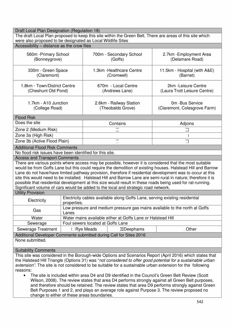
542
Draft Local Plan Designation (Regulation 18) The draft Local Plan proposed to keep this site within the Green Belt. There are areas of this site which were also proposed to be designated as Local Wildlife Sites Accessibility – distance as the crow flies
560m -Primary School (Bonneygrove)
700m - Secondary School (Goffs)
2.7km -Employment Area (Delamare Road)
330m - Green Space (Claremont)
1.3km -Healthcare Centre (Cromwell)
11.5km - Hospital (with A&E) (Barnet)
1.8km - Town/District Centre (Cheshunt Old Pond)
670m - Local Centre (Andrews Lane)
2km -Leisure Centre (Laura Trott Leisure Centre)
1.7km - A10 Junction (College Road)
2.6km - Railway Station (Theobalds Grove)
0m -Bus Service (Claremont, Colesgrove Farm)
Flood Risk Does the site Contains Adjoins
Zone 2 (Medium Risk) ☐ ☐
Zone 3a (High Risk) ☐ ☐
Zone 3b (Active Flood Plain) ☐ ☐
Additional Flood Risk Comments No flood risk issues have been identified for this site. Access and Transport Comments There are various points where access may be possible, however it is considered that the most suitable would be from Goffs Lane but this could require the demolition of existing houses. Halstead Hill and Barrow Lane do not have/have limited pathway provision, therefore if residential development was to occur at this site this would need to be installed. Halstead Hill and Barrow Lane are semi-rural in nature; therefore it is possible that residential development at this size would result in these roads being used for rat-running. Significant volume of cars would be added to the local and strategic road network. Utility Provision
Electricity Electricity cables available along Goffs Lane, serving existing residential properties.
Gas Low pressure and medium pressure gas mains available to the north at Goffs Lanes
Water Water mains available either at Goffs Lane or Halstead Hill
Sewerage Foul sewers located at Goffs Lane
Sewerage Treatment ☐Rye Meads ☒Deephams ☐Other
Additional Developer Comments submitted during Call for Sites 2016 None submitted. Suitability Comments This site was considered in the Borough-wide Options and Scenarios Report (April 2016) which states that the Halstead Hill Triangle (Options 31) was “not considered to offer good potential for a sustainable urban extension”. The site is not considered to be suitable for a sustainable urban extension for the following reasons:
• The site is included within area D4 and D9 identified in the Council’s Green Belt Review (Scott Wilson, 2008). The review states that area D4 performs strongly against all Green Belt purposes, and therefore should be retained. The review states that area D9 performs strongly against Green Belt Purposes 1 and 2, and plays an average role against Purpose 3. The review proposed no change to either of these areas boundaries.

543
• It is considered that this site has weak Green Belt boundaries that would not last beyond the Plan period and prevent further encroachment into the countryside.
• The Goffs Oak Development Options Report (Broxbourne Borough Council, 2016) states that this area has a number of environmental designations which would limit the amount of land available for ‘coherent options’. The Report also states that the site would be difficult to access as it can only “realistically be reached via narrow rural roads”.
• The fragmented pattern of landownership throughout the site would limit the potential for comprehensive development. The fragmented landownership will complicate the potential for the provision of a local centre/school or other infrastructure. It will also make it difficult to implement sustainable-place making.
• Included within the site boundaries are two local wildlife sites – Albury Fields and Meadow North of Barrow Lane. The Council will resist the development on local wildlife sites unless it can be demonstrated that it is in the interest of the community. The Council considers that the development of these wildlife sites is not in the interests of the community. It should be noted that this would not prevent the development of this site, but reduce its developable area and complicate the potential for provision of a local centre, school, or other requirements of sustainable place-making
Taking all the above considerations together, the Halstead Hill Triangle is not considered to be a reasonable option for comprehensive development. Smaller-scale options for sub parcels within the triangle are considered under separate entries within the SLAA. Is the site considered to be suitable for development?
☐☐☐☐Yes ☒☒☒☒ No

544
Local Plan – Site Appraisal Form
Site Information Site Location Map Site Reference Number
CG-GB-109
Site Name Watercress Road Field Site Area 0.6 hectares
Site Status ☐Urban ☒Green Belt ☐Mixed
Source of Site ☐Call for Sites ☐Planning Application ☒Desktop Study
Site Visit Carried Out
☐Yes ☒No
Site Ownership The site is in single ownership
Surr
oundin
g
Uses
N Residential
E Argent Way Informal, Argent Way
S Local Wildlife Site, Green Belt
W Cheshunt Common, Green Belt
Site Description The site is broadly square in shape and gradually slopes to the south. Located in the north western region of the site is a single structure. The majority of the site is covered in trees, with a small area of open field located close to the structure. Planning History The site was previously part of Burnham Nursery. Burnham nursery was granted permission for residential use, but this site remains. Bungalows, caravans and fencing were approved/refused at Burnham Nursery over the years. Development Proposal
Residential ☒ Commercial ☐ Other ☐
Local Plan 2005 (Policy H11)
18
Submitted Proposal - Site Designations Contains Adjoins Contains Adjoins
Green Belt ☒ ☒ Site of Scientific Interest (SSSI) ☐ ☐
Archaeological Interest ☐ ☐ Ancient Monument ☐ ☐
Local Wildlife Site ☒ ☒ Community Open Space ☐ ☒
Lee Valley Regional Park
☐ ☐ Cheshunt Common ☐ ☒
Listed Building ☐ ☐ Locally Listed Building ☐ ☐
TPO Trees ☐ ☐ Conservation Area ☐ ☐
Air Quality Management Area
☐ ☐ Protected Species ☐ ☐
Draft Local Plan Designation (Regulation 18) The draft Local Plan proposed to designate this site as Green Belt and a local wildlife site

545
Accessibility – distance as the crow flies
1.19km -Primary School (Goffs)
1.88km - Secondary School (Goffs)
2.86km –Employment Area (New River Trading Estate)
0m - Green Space (Argent Way)
1.08km-Healthcare Centre (Valley View)
12.11km- Hospital (with A&E) (Barnet)
2.65km - Town/District Centre (Brookfield)
380m - Local Centre (Hammondstreet)
3.65km -Leisure Centre (Laura Trott)
2.8km - A10 Junction (Church Lane)
2.4km - Railway Station (Cuffley)
185m - Bus Service (Macintosh Close)
Flood Risk Does the site Contains Adjoins
Zone 2 (Medium Risk) ☐ ☐
Zone 3a (High Risk) ☐ ☐
Zone 3b (Active Flood Plain) ☐ ☒
Additional Flood Risk Comments Rags Brook is located 100m to the south of the site. Access and Transport Comments The site can be accessed from Watercress Road. There are pathways on both sides of Watercress Road. Connections to these will be required. A public right of way runs through the middle of the site. This will need to be retained. Utility Provision
Electricity Connections available in the residential area to the north of the site.
Gas The closest low pressure gas main is located to the north of the site at Macintosh Close.
Water A water main is located to the south of the site at Ferny Road and Water Cress Road. A hydrant adjoins the site to the north.
Sewerage A foul sewer and surface sewer is located to the south of the site at Ferney Road and Watercress Road
Sewerage Treatment ☐Rye Meads ☒Deephams ☐Other
Additional Developer Comments submitted during Call for Sites 2016 None submitted. Suitability Comments The site is not considered to be suitable for residential development due to the following reasons:
• The site is included within area C11 identified in the Council’s Green Belt Review (Scott Wilson, 2008). The Review states that are C11 performs strongly against Green Belt purposes and proposed no amendment to the boundary in this area. However, it should be noted that the Review also states that there is the opportunity to create a stronger Green Belt boundary in C11-C30 as these areas have “extremely weak boundaries” which means that there are no real barriers to prevent encroachment between settlements.
• The site is designated as a Local Wildlife Site. The Council resists development on local wildlife sites unless it can be demonstrated that the development is in the public interest. The building of residential dwellings on this site is not considered to be in the public interest.
Is this site considered to be suitable for development? ☐Yes ☒ No
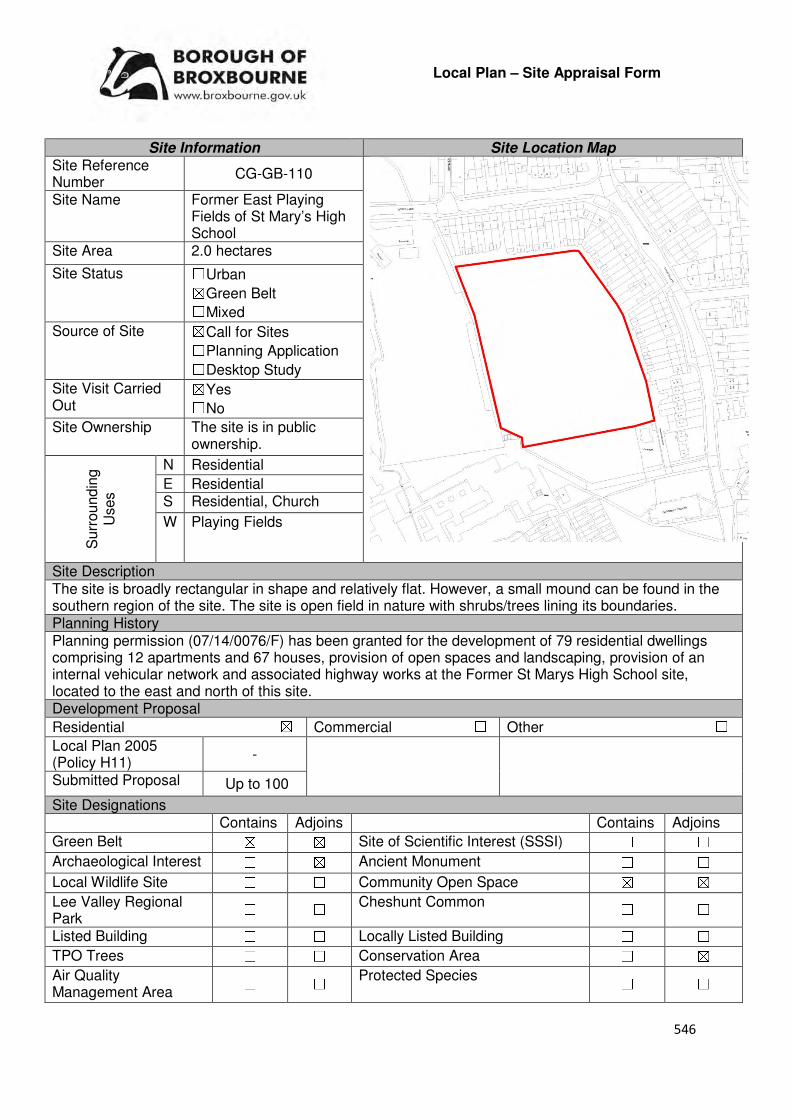
546
Local Plan – Site Appraisal Form
Site Information Site Location Map Site Reference Number
CG-GB-110
Site Name Former East Playing Fields of St Mary’s High School
Site Area 2.0 hectares
Site Status ☐Urban ☒Green Belt ☐Mixed
Source of Site ☒Call for Sites ☐Planning Application ☐Desktop Study
Site Visit Carried Out
☒Yes ☐No
Site Ownership The site is in public ownership.
Surr
oundin
g
Uses
N Residential
E Residential S Residential, Church
W Playing Fields
Site Description The site is broadly rectangular in shape and relatively flat. However, a small mound can be found in the southern region of the site. The site is open field in nature with shrubs/trees lining its boundaries. Planning History Planning permission (07/14/0076/F) has been granted for the development of 79 residential dwellings comprising 12 apartments and 67 houses, provision of open spaces and landscaping, provision of an internal vehicular network and associated highway works at the Former St Marys High School site, located to the east and north of this site. Development Proposal
Residential ☒ Commercial ☐ Other ☐
Local Plan 2005 (Policy H11)
-
Submitted Proposal Up to 100
Site Designations Contains Adjoins Contains Adjoins
Green Belt ☒ ☒ Site of Scientific Interest (SSSI) ☐ ☐
Archaeological Interest ☐ ☒ Ancient Monument ☐ ☐
Local Wildlife Site ☐ ☐ Community Open Space ☒ ☒
Lee Valley Regional Park
☐ ☐ Cheshunt Common ☐ ☐
Listed Building ☐ ☐ Locally Listed Building ☐ ☐
TPO Trees ☐ ☐ Conservation Area ☐ ☒
Air Quality Management Area
☐ ☐ Protected Species ☐ ☐

547
Draft Local Plan Designation (Regulation 18) The site was proposed to be designated as Green Belt and Open Space in the draft Local Plan. Accessibility – distance as the crow flies
160m -Primary School (Dewhurst Primary)
260m - Secondary School (Goffs)
1.72km –Employment Area (Fieldings Road)
0m - Green Space (contains and adjoins Goffs Lane
Local Parks)
280m-Healthcare Centre (Cromwell)
11.79km- Hospital (with A&E) (Princess Alexandra)
880m- Town/District Centre (Cheshunt Old Pond)
210m - Local Centre (16 Cromwell Avenue)
1.15km -Leisure Centre (Laura Trott)
500m- A10 Junction (Churchgate)
1.76km - Railway Station (Cheshunt)
62m- Bus Service (Dewhurst Road)
Flood Risk Does the site Contains Adjoins
Zone 2 (Medium Risk) ☐ ☒
Zone 3a (High Risk) ☐ ☐
Zone 3b (Active Flood Plain) ☐ ☐
Additional Flood Risk Comments The sites proximity to an area located in Zone 2 will need to be considered. Access and Transport Comments There is no current vehicle access to the site. However, vehicle access could be possible through the new residential development at the Former St Mary’s School site or from Goffs Lane. Goffs Lane and the new residential development to the south of the site have footpaths. Connections to these will be required. There is a public right of way along the sites western border. Cycle access to the site will need to be created. Utility Provision
Electricity Connections available to the east of the site
Gas A low pressure gas main is located along Goffs Lane and Churchgate
Water A water main is located to the south of the site at the new residential development on the Former St Mary’s school site, to the north along Goffs Lane and to the east at Churchgate
Sewerage A foul sewer and surface sewer is located along Goffs Lane and Churchgate
Sewerage Treatment ☐Rye Meads ☒Deephams ☐Other
Additional Developer Comments submitted during Call for Sites 2016 The promoter states that the site is no longer required for service needs. The former school playing fields were replaced and enlarged at the new site of St Mary’s High School at Bury Green Road, Cheshunt. The promoter continues by stating that the former playing fields were taken out of use in 2009 when the school relocated and they have been unused since that date. Consent to the disposal of these former playing fields has been granted under the provisions of s77 of the School Standards and Framework Act 1998. The promoter states that the site is available and vacant and can come forward within 1-5 years. Some feasibility work for this site has been undertaken in 2013, which the promoter stated will be refreshed to support the promotion of this site.
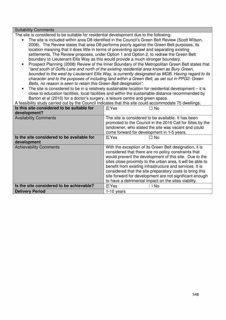
548
Suitability Comments The site is considered to be suitable for residential development due to the following:
• The site is included within area D8 identified in the Council’s Green Belt Review (Scott Wilson, 2008). The Review states that area D8 performs poorly against the Green Belt purposes, its location meaning that it does little in terms of preventing sprawl and separating existing settlements. The Review proposes, under Option 1 and Option 2, to redraw the Green Belt boundary to Lieutenant Ellis Way as this would provide a much stronger boundary.
• Prospect Planning (2008) Review of the Inner Boundary of the Metropolitan Green Belt states that “land south of Goffs Lane and north of the existing residential area known as Bury Green, bounded to the west by Lieutenant Ellis Way, is currently designated as MGB. Having regard to its character and to the purposes of including land within a Green Belt, as set out in PPG2: Green Belts, no reason is seen to retain this Green Belt designation”.
• The site is considered to be in a relatively sustainable location for residential development – it is close to education facilities, local facilities and within the sustainable distance recommended by Barton et al (2010) for a doctor’s surgery, a leisure centre and green space.
A feasibility study carried out by the Council indicates that this site could accommodate 75 dwellings. Is this site considered to be suitable for development?
☒Yes ☐ No
Availability Comments The site is considered to be available. It has been promoted to the Council in the 2016 Call for Sites by the landowner, who stated the site was vacant and could come forward for development in 1-5 years.
Is the site considered to be available for development
☒Yes ☐ No
Achievability Comments With the exception of its Green Belt designation, it is considered that there are no policy constraints that would prevent the development of this site. Due to the sites close proximity to the urban area, it will be able to benefit from existing infrastructure and services. It is considered that the site preparatory costs to bring this site forward for development are not significant enough to have a detrimental impact on the sites viability.
Is the site considered to be achievable? ☒Yes ☐ No
Delivery Period 1-10 years
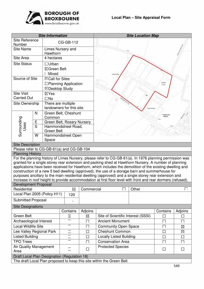
549
Local Plan – Site Appraisal Form
Site Information Site Location Map Site Reference Number
CG-GB-112
Site Name Limes Nursery and Hawthorn
Site Area 4 hectares
Site Status ☐Urban ☒Green Belt ☐Mixed
Source of Site ☒Call for Sites ☐Planning Application ☒Desktop Study
Site Visit Carried Out
☒Yes ☐No
Site Ownership There are multiple landowners for this site.
Surr
oundin
g
Uses
N Green Belt, Cheshunt Common
E Green Belt, Rosary Nursery S Hammondstreet Road,
Green Belt W Hammondstreet Open
Space
Site Description Please refer to CG-GB-61(a) and CG-GB-104 Planning History For the planning history of Limes Nursery, please refer to CG-GB-61(a). In 1976 planning permission was granted for a single storey rear extension and packing shed at Hawthorn Nursery. A number of planning applications have been received for Hawthorn, which includes the demolition of the existing dwelling and construction of a new 5 bed dwelling (approved), the use of a storage barn and summerhouse for purposes ancillary to the main residential dwelling (approved) and a single storey rear extension and increase in roof height to provide accommodation at first floor level with front and rear dormers (refused). Development Proposal
Residential ☒ Commercial ☐ Other ☐
Local Plan 2005 (Policy H11) 120
Submitted Proposal -
Site Designations Contains Adjoins Contains Adjoins
Green Belt ☒ ☒ Site of Scientific Interest (SSSI) ☐ ☐
Archaeological Interest ☐ ☐ Ancient Monument ☐ ☐
Local Wildlife Site ☐ ☐ Community Open Space ☐ ☒
Lee Valley Regional Park ☐ ☐ Cheshunt Common ☐ ☒
Listed Building ☐ ☐ Locally Listed Building ☐ ☐
TPO Trees ☐ ☐ Conservation Area ☐ ☐
Air Quality Management Area ☐ ☐
Protected Species ☐ ☐
Draft Local Plan Designation (Regulation 18) The draft Local Plan proposed to keep this site within the Green Belt

550
Accessibility – distance as the crow flies
1.4km -Primary School (Goffs Oak)
2.35km - Secondary School (Goffs)
2.9km –Employment Area
(New River Industrial Estate)
0m - Green Space (Hammondstreet)
1.5km -Healthcare Centre
(Valley View)
12.25km - Hospital (with A&E)
(Barnet)
2.78km - Town/District Centre (Brookfield)
700m - Local Centre
(Hammondstreet)
4km -Leisure Centre
(Laura Trott)
3.1km- A10 Junction (Turnford)
2.52km - Railway Station
(Cuffley)
90m - Bus Service (Dahlia Close)
Flood Risk Does the site Contains Adjoins
Zone 2 (Medium Risk) ☐ ☐
Zone 3a (High Risk) ☐ ☐
Zone 3b (Active Flood Plain) ☐ ☐
Additional Flood Risk Comments There are no flooding issues identified for this site. Access and Transport Comments The site can be currently accessed from Hammondstreet Road or Bread and Cheese Lane. The most appropriate access point for this site would be via Hammondstreet Road. This access point will require improvement if development was to occur. Depending on the density of the site, a transport assessment may be required. There are no footpaths along Bread and Cheese Lane. There are footpaths along the northern side of Hammondstreet Road. There is a public right of way to the rear of the site. Utility Provision
Electricity Available at Bread and Cheese Lane or to the south at Hammondstreet Road
Gas A low pressure gas main is located along Hammondstreet Road and Bread and Cheese Lane
Water A water main and trunk main is located along Hammondstreet Road. A water main is located along Bread and Cheese Lane. A hydrant is located just outside Hawthorn.
Sewerage A foul sewer is located to the south of the site, near 431 and 433 Hammondstreet Road
Sewerage Treatment ☐Rye Meads ☒Deephams ☐Other
Additional Developer Comments submitted during Call for Sites 2016. No representations were received for Hawthorn Nursery. Please refer to CG-GB-61(a) for the promoters comments on Limes Nursery. Suitability Comments The site is not considered to be suitable for high density residential development due to the following reasons:
• The site is included in area C10 identified in the Council’s Green Belt Review (Scott Wilson, 2008). The Review states that area C10 performs strongly against Green Belt purposes and no changes to the boundary in this location were proposed.
551
• The 2005 Local Plan Inspectors Report states that Limes Nursery performs the green belt functions of separating the built up area of Cheshunt and Hammondstreet, and although partly developed with glasshouses and some small outbuildings, prevent these settlements from encroaching into the countryside.
• The ‘Goffs Oak Development Options Report’ notes that development to address dereliction on sites such as Limes and Hawthorn would result in the creation of ‘villages’ of development isolated from services and transport. It continues by stating that the adoption of this approach would result in unsustainable urban sprawl, the likely merging of settlements and the steady erosion of the character of Goffs Oak.
• The site is not considered to be in a sustainable location for development; it is not close to local facilities, not relatively close to education provision and above the sustainable distance recommended by Barton et al (2010) for a leisure centre, doctor’s surgery and hospital.
However, subject to the sites compliance with emerging Policy GB2: Residential Development on Derelict Glass House Sites, the site could be subdivided into self-build housing plots. Is this site considered to be suitable for development?
☐Yes ☒ No
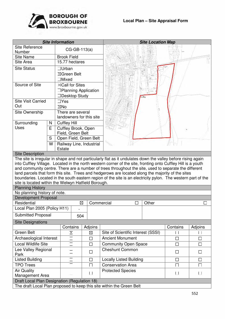
552
Local Plan – Site Appraisal Form
Site Information Site Location Map Site Reference Number
CG-GB-113(a)
Site Name Brook Field Site Area 15.77 hectares
Site Status ☐Urban ☒Green Belt ☐Mixed
Source of Site ☒Call for Sites ☐Planning Application ☐Desktop Study
Site Visit Carried Out
☐Yes ☒No
Site Ownership There are several landowners for this site
Surrounding Uses
N Cuffley Hill
E Cuffley Brook, Open Field, Green Belt
S Open Field, Green Belt
W Railway Line, Industrial Estate
Site Description The site is irregular in shape and not particularly flat as it undulates down the valley before rising again into Cuffley Village. Located in the north western corner of the site, fronting onto Cuffley Hill is a youth and community centre. There are a number of trees throughout the site, used to separate the different land parcels that form this site. Trees and hedgerows are located along the majority of the sites boundaries. Located in the south eastern region of the site is an electricity pylon. The western part of the site is located within the Welwyn Hatfield Borough. Planning History No planning history of note. Development Proposal
Residential ☒ Commercial ☐ Other ☐
Local Plan 2005 (Policy H11) -
Submitted Proposal 504
Site Designations Contains Adjoins Contains Adjoins
Green Belt ☒ ☒ Site of Scientific Interest (SSSI) ☐ ☐
Archaeological Interest ☐ ☐ Ancient Monument ☐ ☐
Local Wildlife Site ☐ ☐ Community Open Space ☐ ☐
Lee Valley Regional Park
☐ ☐ Cheshunt Common ☐ ☐
Listed Building ☐ ☐ Locally Listed Building ☐ ☐
TPO Trees ☐ ☐ Conservation Area ☐ ☐
Air Quality Management Area
☐ ☐ Protected Species ☐ ☐
Draft Local Plan Designation (Regulation 18) The draft Local Plan proposed to keep this site within the Green Belt

553
Accessibility – distance as the crow flies
50m-Primary School (Cuffley School)
3.16km - Secondary School (Goffs)
4.48km –Employment Area (News International)
920m - Green Space (Jones Road)
1.38km -Healthcare Centre (Valley View)
9.21km- Hospital (with A&E) (Barnet)
4.6km - Town/District Centre (Brookfield)
1.21km - Local Centre (1-3 Newgatestreet Road)
4.98km -Leisure Centre (Laura Trott)
4.32km - A10 Junction (Lieutenant Ellis
Way/Churchgate)
180m- Railway Station (Cuffley)
170m- Bus Service (Cuffley Railway Station)
Flood Risk Does the site Contains Adjoins
Zone 2 (Medium Risk) ☒ ☒
Zone 3a (High Risk) ☒ ☒
Zone 3b (Active Flood Plain) ☐ ☒
Additional Flood Risk Comments Due to Cuffley Brook adjoining the site to the east, there are parts of the eastern region of this site that are located within Flood Zone 2 and Flood Zone 3a. Any development should be avoided in this area and appropriate mitigation measures put in place. Any proposal should be required
Access and Transport Comments The site can be accessed from Cuffley Hill. Vehicle access to this site will require improvements if development was to come forward. Due to the amount of dwellings this site could accommodate a transport assessment will be required. A public right of way runs through the centre of the site. This will need to be retained or diverted (if absolutely necessary). Cuffley Hill has footpaths on both sides. Connections to these will be required. Cycle access to the site will need to be created.
Utility Provision
Electricity Available at the existing properties to the east of the site
Gas A low pressure gas main is located along Cuffley Hill.
Water A water main is located to the north east of the site at Cuffley Hill
Sewerage A foul sewer is located within the site. A surface sewer is located just to the north of the site.
Sewerage Treatment ☐Rye Meads ☒Deephams ☐Other
Additional Developer Comments submitted during Call for Sites 2016 None submitted. Suitability Comments The site is not considered to be suitable for residential development due to the following reasons:
• The Council’s Green Belt Review (Scott Wilson, 2008) identifies this site as part of area D27. The Review states that area D27 performs strongly against Green Belt purposes and proposed no amendment to the boundary in this location.

554
• The Inspector for the Broxbourne Local Plan Second Review 2001-2011, stated that land adjacent to Sopers Road “forms part of the important green wedge between Cuffley and Goffs Oak. It thus fulfils two of the important green belt functions of maintaining openness and preventing the coalescence of these two settlements. The existing boundary forms a firm edge to the built-up area of Cuffley which would be broken in an obtrusive manner if changed in the way sought by the objector”. It is considered that these comments are still relevant.
• It is considered that this site has weak Green Belt boundaries to the south that would not last beyond the Plan period or prevent further encroachment into the Green Belt.
Is this site considered to be suitable for development? ☐Yes ☒ No
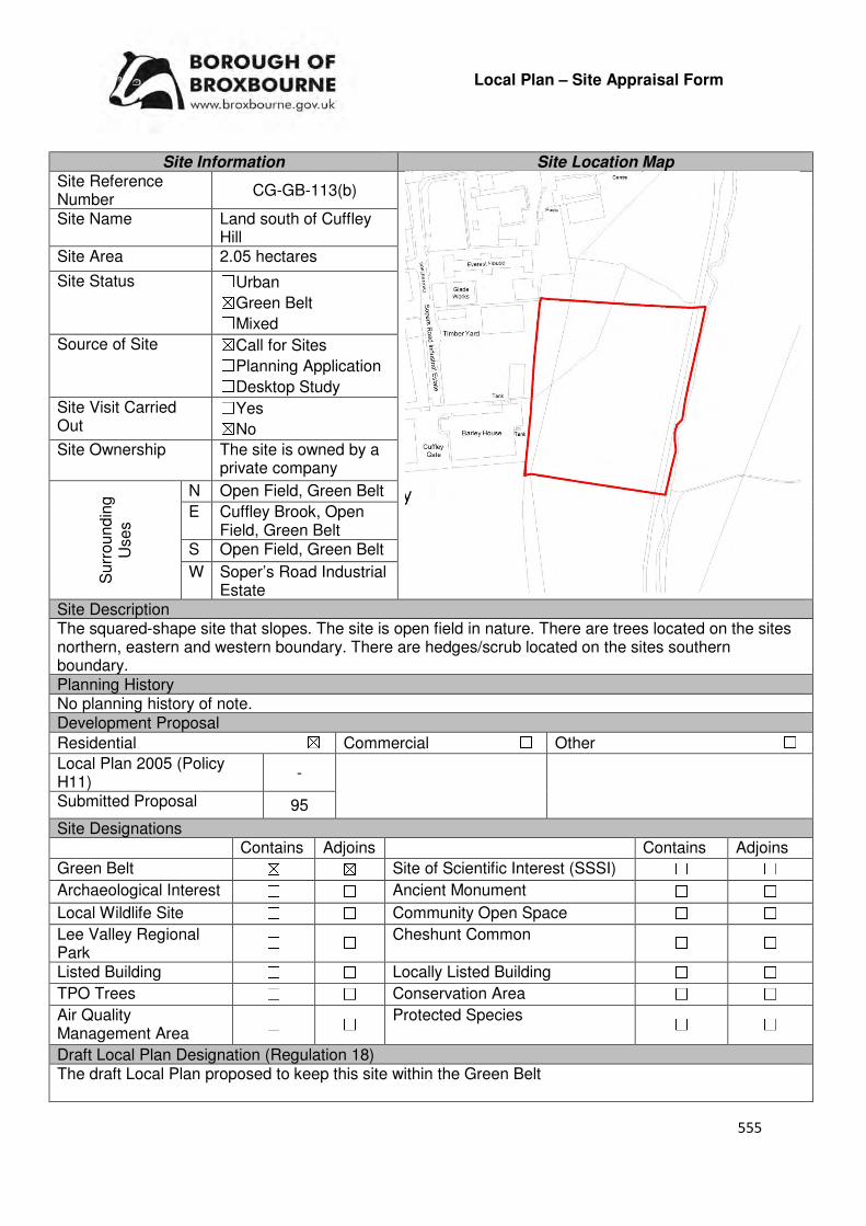
555
Local Plan – Site Appraisal Form
Site Information Site Location Map Site Reference Number
CG-GB-113(b)
Site Name Land south of Cuffley Hill
Site Area 2.05 hectares
Site Status ☐Urban ☒Green Belt ☐Mixed
Source of Site ☒Call for Sites ☐Planning Application ☐Desktop Study
Site Visit Carried Out
☐Yes ☒No
Site Ownership The site is owned by a private company
Surr
oundin
g
Uses
N Open Field, Green Belt
E Cuffley Brook, Open Field, Green Belt
S Open Field, Green Belt
W Soper’s Road Industrial Estate
Site Description The squared-shape site that slopes. The site is open field in nature. There are trees located on the sites northern, eastern and western boundary. There are hedges/scrub located on the sites southern boundary. Planning History No planning history of note. Development Proposal
Residential ☒ Commercial ☐ Other ☐
Local Plan 2005 (Policy H11)
-
Submitted Proposal 95
Site Designations Contains Adjoins Contains Adjoins
Green Belt ☒ ☒ Site of Scientific Interest (SSSI) ☐ ☐
Archaeological Interest ☐ ☐ Ancient Monument ☐ ☐
Local Wildlife Site ☐ ☐ Community Open Space ☐ ☐
Lee Valley Regional Park
☐ ☐ Cheshunt Common ☐ ☐
Listed Building ☐ ☐ Locally Listed Building ☐ ☐
TPO Trees ☐ ☐ Conservation Area ☐ ☐
Air Quality Management Area
☐ ☐ Protected Species ☐ ☐
Draft Local Plan Designation (Regulation 18) The draft Local Plan proposed to keep this site within the Green Belt
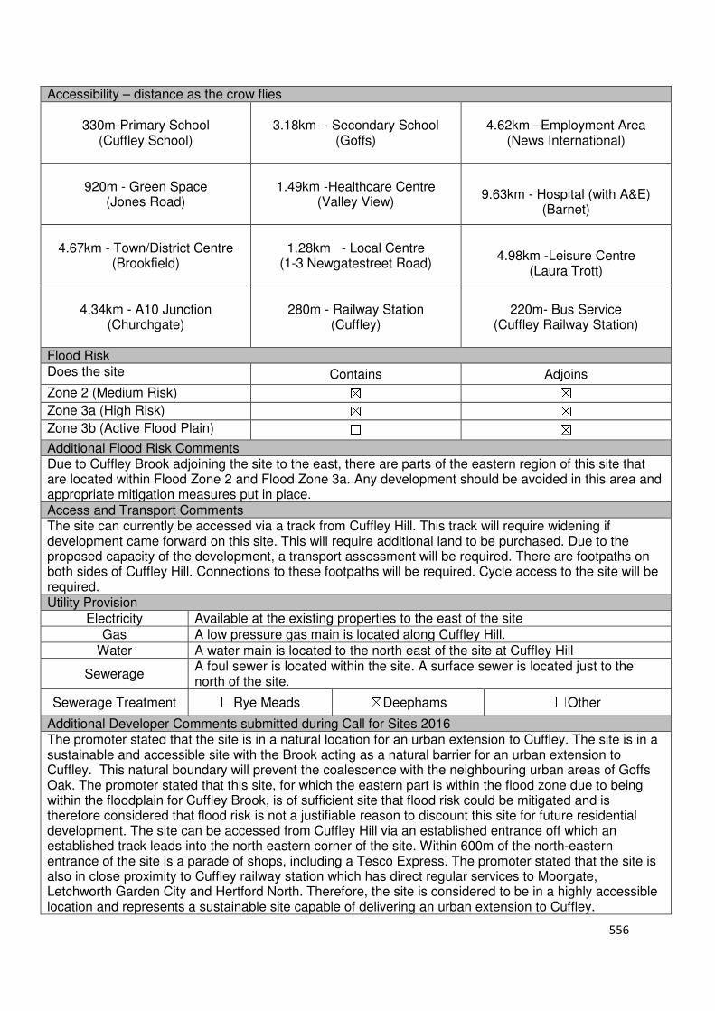
556
Accessibility – distance as the crow flies
330m-Primary School (Cuffley School)
3.18km - Secondary School (Goffs)
4.62km –Employment Area
(News International)
920m - Green Space (Jones Road)
1.49km -Healthcare Centre
(Valley View)
9.63km - Hospital (with A&E)
(Barnet)
4.67km - Town/District Centre (Brookfield)
1.28km - Local Centre
(1-3 Newgatestreet Road)
4.98km -Leisure Centre
(Laura Trott)
4.34km - A10 Junction
(Churchgate)
280m - Railway Station (Cuffley)
220m- Bus Service (Cuffley Railway Station)
Flood Risk Does the site Contains Adjoins
Zone 2 (Medium Risk) ☒ ☒
Zone 3a (High Risk) ☒ ☒
Zone 3b (Active Flood Plain) ☐ ☒
Additional Flood Risk Comments Due to Cuffley Brook adjoining the site to the east, there are parts of the eastern region of this site that are located within Flood Zone 2 and Flood Zone 3a. Any development should be avoided in this area and appropriate mitigation measures put in place. Access and Transport Comments The site can currently be accessed via a track from Cuffley Hill. This track will require widening if development came forward on this site. This will require additional land to be purchased. Due to the proposed capacity of the development, a transport assessment will be required. There are footpaths on both sides of Cuffley Hill. Connections to these footpaths will be required. Cycle access to the site will be required. Utility Provision
Electricity Available at the existing properties to the east of the site
Gas A low pressure gas main is located along Cuffley Hill.
Water A water main is located to the north east of the site at Cuffley Hill
Sewerage A foul sewer is located within the site. A surface sewer is located just to the north of the site.
Sewerage Treatment ☐Rye Meads ☒Deephams ☐Other
Additional Developer Comments submitted during Call for Sites 2016 The promoter stated that the site is in a natural location for an urban extension to Cuffley. The site is in a sustainable and accessible site with the Brook acting as a natural barrier for an urban extension to Cuffley. This natural boundary will prevent the coalescence with the neighbouring urban areas of Goffs Oak. The promoter stated that this site, for which the eastern part is within the flood zone due to being within the floodplain for Cuffley Brook, is of sufficient site that flood risk could be mitigated and is therefore considered that flood risk is not a justifiable reason to discount this site for future residential development. The site can be accessed from Cuffley Hill via an established entrance off which an established track leads into the north eastern corner of the site. Within 600m of the north-eastern entrance of the site is a parade of shops, including a Tesco Express. The promoter stated that the site is also in close proximity to Cuffley railway station which has direct regular services to Moorgate, Letchworth Garden City and Hertford North. Therefore, the site is considered to be in a highly accessible location and represents a sustainable site capable of delivering an urban extension to Cuffley.

557
Suitability Comments The site is not considered to be suitable for residential development due to the following reasons:
• The site is included in area D27 identified in the Council’s Green Belt Review (Scott Wilson, 2008). The Review states that area D27 performs strongly against Green Belt purposes and proposed no amendment to the boundary in this location.
• The Inspector for the Broxbourne Local Plan Second Review 2001-2011, stated that land adjacent to Sopers Road “forms part of the important green wedge between Cuffley and Goffs Oak. It thus fulfils two of the important green belt functions of maintaining openness and preventing the coalescence of these two settlements. The existing boundary forms a firm edge to the built-up area of Cuffley which would be broken in an obtrusive manner if changed in the way sought by the objector”. It is considered that these comments are still relevant for this site.
• It is considered that this site has weak Green Belt boundaries to the south that would not last beyond the Plan period or prevent further encroachment into the Green Belt.
Is this site considered to be suitable for development? ☐Yes ☒ No
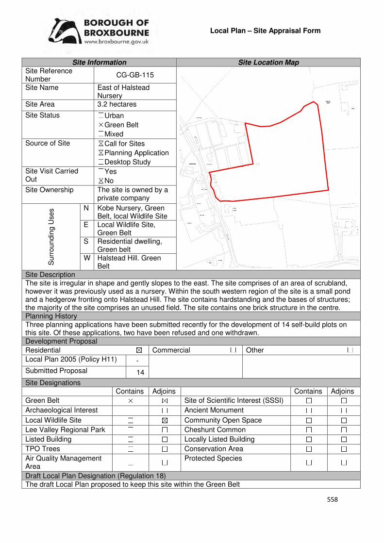
558
Local Plan – Site Appraisal Form
Site Information Site Location Map Site Reference Number
CG-GB-115
Site Name East of Halstead Nursery
Site Area 3.2 hectares
Site Status ☐Urban ☒Green Belt ☐Mixed
Source of Site ☒Call for Sites ☒Planning Application ☐Desktop Study
Site Visit Carried Out
☐Yes ☒No
Site Ownership The site is owned by a private company
Surr
oundin
g U
ses N Kobe Nursery, Green
Belt, local Wildlife Site E Local Wildlife Site,
Green Belt S Residential dwelling,
Green belt W Halstead Hill. Green
Belt Site Description The site is irregular in shape and gently slopes to the east. The site comprises of an area of scrubland, however it was previously used as a nursery. Within the south western region of the site is a small pond and a hedgerow fronting onto Halstead Hill. The site contains hardstanding and the bases of structures; the majority of the site comprises an unused field. The site contains one brick structure in the centre. Planning History Three planning applications have been submitted recently for the development of 14 self-build plots on this site. Of these applications, two have been refused and one withdrawn. Development Proposal
Residential ☒ Commercial ☐ Other ☐
Local Plan 2005 (Policy H11) -
Submitted Proposal 14
Site Designations Contains Adjoins Contains Adjoins
Green Belt ☒ ☒ Site of Scientific Interest (SSSI) ☐ ☐
Archaeological Interest ☐ ☐ Ancient Monument ☐ ☐
Local Wildlife Site ☐ ☒ Community Open Space ☐ ☐
Lee Valley Regional Park ☐ ☐ Cheshunt Common ☐ ☐
Listed Building ☐ ☐ Locally Listed Building ☐ ☐
TPO Trees ☐ ☐ Conservation Area ☐ ☐
Air Quality Management Area
☐ ☐ Protected Species ☐ ☐
Draft Local Plan Designation (Regulation 18) The draft Local Plan proposed to keep this site within the Green Belt

559
Accessibility – distance as the crow flies
460m-Primary School (Bonneygrove)
490m - Secondary School (Goffs)
2km –Employment Area (News International)
420m - Green Space
1.09km -Healthcare Centre (Cromwell Avenue)
11.6km- Hospital (with A&E) (Barnet)
2.04km- Town/District Centre (Cheshunt Old Pond)
1km - Local Centre (15-21 Cromwell Avenue)
2.26km -Leisure Centre (Laura Trott)
1.58km - A10 Junction (Churchgate)
2.82km- Railway Station (Cuffley)
347m - Bus Service (Colesgrove Farm)
Flood Risk Does the site Contains Adjoins
Zone 2 (Medium Risk) ☐ ☐
Zone 3a (High Risk) ☐ ☐
Zone 3b (Active Flood Plain) ☐ ☐
Additional Flood Risk Comments The site itself is not within a flood zone and Theobalds Brook is located 200m to the south and has no direct impact. The site does not suffer from surface water or ground water flooding but this may alter de[ending on the type of development. Access and Transport Comments The site can be accessed from Halstead Hill. Halstead Hill is semi-rural in nature. There are no footpaths along Halstead Hill and this part of the highway is unlit. The closest public footpaths to this site are those located on Goffs lane to the north and footpath along Barrow Lane to the south east. Utility Provision
Electricity Connections available at Halstead Hill
Gas A low pressure gas main is located along Halstead Hill
Water A water main is located along Halstead Hill.
Sewerage The closest foul sewer and surface sewer to the site are located along Goffs Lane, to the north of the site.
Sewerage Treatment ☐Rye Meads ☒Deephams ☐Other
Additional Developer Comments submitted during Call for Sites 2016 None submitted. Suitability Comments The site is not considered to be suitable for residential development due to the following reasons:
• The site is included in area D9 identified in the Council’s Green Belt Review (Scott Wilson, 2008). The Review states that area D9 performs strongly against Green Belt Purposes 1 and 2, and plays an average role against Purpose 3. The Review proposed no amendment to the boundary in this location.
• The Goffs Oak Development Options Report (Broxbourne Borough Council, 2016) identifies two categories of Green Belt sites that are not favoured. This site can fall within the second category, which comprises of Green Belt sites that do not adjoin or only marginally adjoin urban development, such as those along Crouch Lane, Newgatestreet Road and Halstead Hill. The Report states that “development of these sites would create unconnected pockets of housing that are totally unrelated to one another or to the existing urban areas, and in the case of many sites would only be accessible via rural lanes”. The report also states that it likely the development of these sites would exacerbate the area’s already haphazard development pattern, and over time lead to the merging of urban areas.
560
• A recent application (07/16/0612/F) for 14 self-build dwellings was refused for this site, with the decision notice provided the following reasons for its refusal: the proposed development is inappropriate within the Green Belt and would result in harm to the openness of the Green Belt, which would not be clearly outweighed by very special circumstances; due to insufficient information submitted the scale of the development, and the impact to the openness of the Green Belt and the impact to the rural character of the area, the proposed development would be contrary to Policy GB2 of the draft Broxbourne Local Plan 2016; the applicant has failed to demonstrate that the site could successfully accommodate a sustainable development of 14 self-build plots; the proposed development would not positively contribute towards the rural character and appearance of the area; and, the proposed development would not provide a safe and convenient environment for pedestrians to connect to the existing public highway footway network without harm to the Green Belt and the rural character of the area. This applicant appealed the Council’s decision; however, the appeal was dismissed.
Is this site considered to be suitable for development? ☐Yes ☒ No
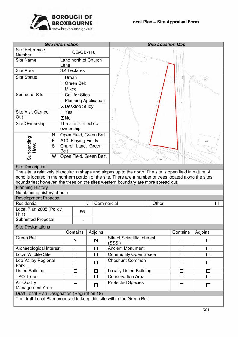
561
Local Plan – Site Appraisal Form
Site Information Site Location Map Site Reference Number
CG-GB-116
Site Name Land north of Church Lane
Site Area 3.4 hectares
Site Status ☐Urban ☒Green Belt ☐Mixed
Source of Site ☐Call for Sites ☐Planning Application ☒Desktop Study
Site Visit Carried Out
☐Yes ☒No
Site Ownership The site is in public ownership
Surr
oundin
g
Uses
N Open Field, Green Belt
E A10, Playing Fields S Church Lane, Green
Belt W Open Field, Green Belt,
Site Description The site is relatively triangular in shape and slopes up to the north. The site is open field in nature. A pond is located in the northern portion of the site. There are a number of trees located along the sites boundaries; however, the trees on the sites western boundary are more spread out. Planning History No planning history of note. Development Proposal
Residential ☒ Commercial ☐ Other ☐
Local Plan 2005 (Policy H11)
96
Submitted Proposal -
Site Designations Contains Adjoins Contains Adjoins
Green Belt ☒ ☒ Site of Scientific Interest (SSSI)
☐ ☐
Archaeological Interest ☐ ☐ Ancient Monument ☐ ☐
Local Wildlife Site ☐ ☐ Community Open Space ☐ ☐
Lee Valley Regional Park
☐ ☐ Cheshunt Common ☐ ☐
Listed Building ☐ ☐ Locally Listed Building ☐ ☐
TPO Trees ☐ ☐ Conservation Area ☐ ☐
Air Quality Management Area
☐ ☐ Protected Species ☐ ☐
Draft Local Plan Designation (Regulation 18) The draft Local Plan proposed to keep this site within the Green Belt

562
Accessibility – distance as the crow flies
910m -Primary School (Wormley)
230m - Secondary School (Broxbourne)
1.66km –Employment Area (New River Trading Estate)
40m - Green Space (Wormley)
668m -Healthcare Centre (Wormley Medical Centre)
8.93km - Hospital (with A&E)
(Princess Alexandra)
1.8km - Town/District Centre
(Brookfield)
600m - Local Centre
3.63km-Leisure Centre
(Laura Trott)
820m- A10 Junction (Turnford)
1.76km - Railway Station
(Broxbourne)
875m - Bus Service (Bell Lane)
Flood Risk Does the site Contains Adjoins
Zone 2 (Medium Risk) ☐ ☐
Zone 3a (High Risk) ☐ ☐
Zone 3b (Active Flood Plain) ☐ ☒
Additional Flood Risk Comments No flooding issues identified for this site. Access and Transport Comments The site can be accessed from Church Lane via a gate. This access point will require improvement if development was to come forward. Due to the amount of dwellings that this site could accommodate a transport assessment will be required. Utility Provision
Electricity Connections will be required.
Gas A low pressure gas main is located along Church Lane
Water A water main is located along Church Lane, to the south of the site
Sewerage The closest foul sewer and surface sewer is located to the east of site, close to the entrance of the Croft
Sewerage Treatment ☐Rye Meads ☐Deephams ☐Other
Additional Developer Comments submitted during Call for Sites 2016 None submitted. Suitability Comments The site is not considered to be suitable for residential development due to the following reasons:
• The site is included within area B19 identified in the Council’s Green Belt Review (Scott Wilson, 2008). The Review states that area B19 performs a strong role under Green Belt Purpose 1 and 3, and therefore strongly merits retention. The site does achieve a low score against Green Belt Purpose 2. The Review proposed no amendment to the boundary in this location.
• The site is located within Wormleybury Registered Historic Park and Garden. The Council will resist development within the Park
• It is considered that this site has weak Green Belt boundaries to the north, and west, which will not last beyond the Plan period or prevent further encroachment.
• This site is too small to facilitate sustainable place-making. The sites development will result in a small-scale, isolated pocket of development within the Green Belt.
Is this site considered to be suitable for development? ☐Yes ☒ No

563
Local Plan – Site Appraisal Form
Site Information Site Location Map Site Reference Number
CG-GB-117
Site Name Tudor Lodge Site Area 0.11 hectares
Site Status ☐Urban ☒Green Belt ☐Mixed
Source of Site ☒Call for Sites ☐Planning Application ☐Desktop Study
Site Visit Carried Out
☐Yes ☒No
Site Ownership The site is in private ownership.
Surr
oundin
g U
ses N Residential dwelling,
Green Belt E Tudor Nurseries, Green
Belt S Tudor Nurseries, Green
Belt W Burton Lane, Green
Belt Site Description The site is irregular in shape and is relatively flat. There are a number of structures located on the site and areas of hardstanding. The largest of the structures occupies the majority of the sites southern region. Planning History A planning application for 4 3-bed houses and 1 2-bed bungalow was withdrawn in 2016. A certificate of lawfulness for existing uses as B1 (a) offices was granted unconditional approval in 2002. Development Proposal
Residential ☒ Commercial ☐ Other ☐
Local Plan 2005 (Policy H11) -
Submitted Proposal 5
Site Designations Contains Adjoins Contains Adjoins
Green Belt ☒ ☒ Site of Scientific Interest (SSSI) ☐ ☐
Archaeological Interest ☐ ☐ Ancient Monument ☐ ☐
Local Wildlife Site ☐ ☐ Community Open Space ☐ ☐
Lee Valley Regional Park
☐ ☐ Cheshunt Common ☐ ☐
Listed Building ☐ ☐ Locally Listed Building ☐ ☐
TPO Trees ☐ ☐ Conservation Area ☐ ☐
Air Quality Management Area
☐ ☐ Protected Species ☐ ☐
Draft Local Plan Designation (Regulation 18) The draft Local Plan included this site within the proposed mixed-use residential development at Rosedale Park, as part of emerging Policy CH2.
564
Accessibility – distance as the crow flies
1km -Primary School (Woodside)
1.15km - Secondary School (Goffs)
2.7km –Employment Area (New River Trading Estate)
580m - Green Space (Goffs)
680m -Healthcare Centre (Valley View)
11.64km- Hospital (with A&E) (Barnet)
2.53km - Town/District Centre (Brookfield)
730m - Local Centre (684-696 Goffs Lane)
3km -Leisure Centre (Laura Trott)
2.31km - A10 Junction (Church Lane)
2.34km - Railway Station (Cuffley)
310m- Bus Service (Burton Lane)
Flood Risk Does the site Contains Adjoins
Zone 2 (Medium Risk) ☐ ☐
Zone 3a (High Risk) ☐ ☒
Zone 3b (Active Flood Plain) ☐ ☒
Additional Flood Risk Comments No flooding issues identified for this site Access and Transport Comments The site can be accessed via Burton Lane. There are no footpaths on either side of this part of Burton Lane. Footpaths begin at the entrance to White Haven Close and The Gateways. Pedestrian safety will need to be considered as part of any planning application for this site. Cycle access to the site will need to be created. Utility Provision
Electricity Connections available at the site
Gas A low pressure gas main is located along Burton Lane
Water A water main is located within the site Sewerage A foul sewer begins close to the sites south western corner.
Sewerage Treatment ☐Rye Meads ☒Deephams ☐Other
Additional Developer Comments submitted during Call for Sites 2016 None submitted. Suitability Comments The site is considered to be suitable for residential development due to the following reasons:
• As indicated in emerging Policy CH2, it is proposed that the Green Belt boundary is to be redrawn to Rags Lane and Burton Lane. Subject to this amendment to the Green Belt being approved by the Planning Inspectorate, this site will be removed from the Green Belt. With the proposed removal of the sites Green Belt designation, residential development on this site is accepted in principle. However, it should be noted that if the Green Belt boundary is not amended, this site will not be suitable for development as the above proposal will have a detrimental impact on the openness of the Green Belt and would encroach into the countryside.
It is considered that the development of this site for 5 dwellings will be overdevelopment. An appropriate density for this site should be determined through the pre-application/planning application process. Is this site considered to be suitable for development?
☒Yes ☐ No

565
Availability Comments The site has not been promoted to the Council through the 2016 Call for Sites or through the Local Plan consultation. The Council has not received any further planning application for the development of this site since an application was withdrawn in 2016.
Is the site considered to be available for development
☐Yes ☒ No
Achievability Comments The site is not available and therefore is not considered to be achievable.
Is the site considered to be achievable? ☐Yes ☒ No
Delivery Period -

566
Local Plan – Site Appraisal Form
Site Information Site Location Map Site Reference Number
CG-GB-119
Site Name Brook Farm Site Area 7.1 hectares
Site Status ☐Urban ☒Green Belt ☐Mixed
Source of Site ☒Call for Sites ☐Planning Application ☐Desktop Study
Site Visit Carried Out
☐Yes ☒No
Site Ownership There are three landowners for this site.
Surr
oundin
g
Uses
N Green Belt, Cuffley Brook
E Cuffley Brook, Green Belt
S Cuffley Hill, Green Belt
W Residential
Site Description The site is irregular in shapes and gradually slopes from west to east. The majority of the site is open field in nature, with a number of farm buildings and structures located within the south eastern corner. There are two lines of trees/hedgerows located within the site, which separate the site into three different segments. There are trees located along the sites boundaries, some of which are more spaced out in comparison to others. Part of the site is located within the Welwyn Hatfield district. Planning History There have been various planning applications for this site. The most recent include the change of use of land for holding 15 wedding receptions during the months from 1 March to 30 September each year with camping for a maximum of 50 wedding guests which was granted conditional approval, a prior approval for change of use of agricultural building to residential which was refused and extensions and alterations to existing milk parlour and conversion to new dwelling which was refused.
Development Proposal
Residential ☒ Commercial ☐ Other ☐
Local Plan 2005 (Policy H11)
Submitted Proposal 270
Site Designations Contains Adjoins Contains Adjoins
Green Belt ☒ ☒ Site of Scientific Interest (SSSI) ☐ ☐
Archaeological Interest ☐ ☐ Ancient Monument ☐ ☐
Local Wildlife Site ☐ ☐ Community Open Space ☐ ☐
Lee Valley Regional Park
☐ ☐ Cheshunt Common ☐ ☐
Listed Building ☐ ☐ Locally Listed Building ☐ ☐
TPO Trees ☐ ☒ Conservation Area ☐ ☐
Air Quality Management Area
☐ ☐ Protected Species ☐ ☐
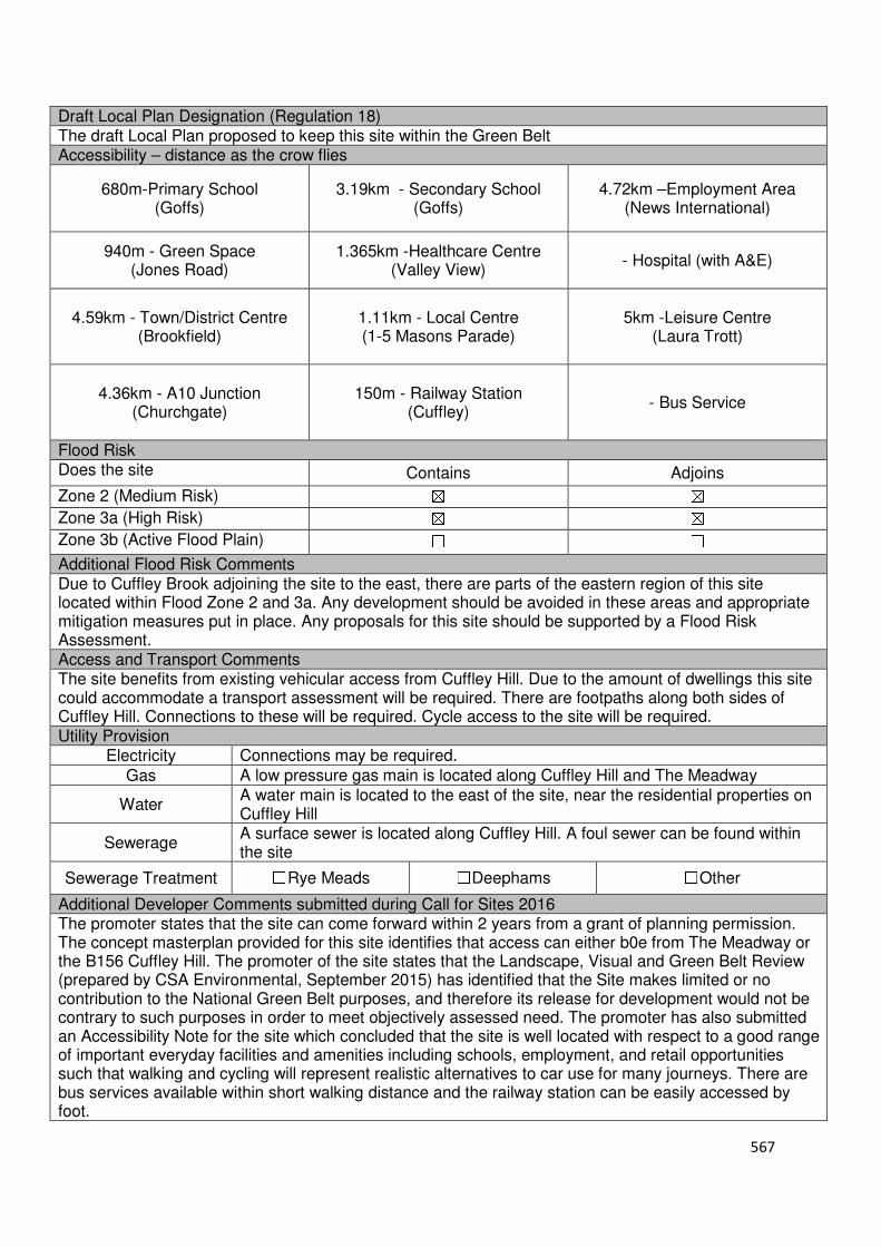
567
Draft Local Plan Designation (Regulation 18) The draft Local Plan proposed to keep this site within the Green Belt Accessibility – distance as the crow flies
680m-Primary School (Goffs)
3.19km - Secondary School (Goffs)
4.72km –Employment Area (News International)
940m - Green Space (Jones Road)
1.365km -Healthcare Centre (Valley View)
- Hospital (with A&E)
4.59km - Town/District Centre (Brookfield)
1.11km - Local Centre (1-5 Masons Parade)
5km -Leisure Centre (Laura Trott)
4.36km - A10 Junction (Churchgate)
150m - Railway Station
(Cuffley)
- Bus Service
Flood Risk Does the site Contains Adjoins
Zone 2 (Medium Risk) ☒ ☒
Zone 3a (High Risk) ☒ ☒
Zone 3b (Active Flood Plain) ☐ ☐
Additional Flood Risk Comments Due to Cuffley Brook adjoining the site to the east, there are parts of the eastern region of this site located within Flood Zone 2 and 3a. Any development should be avoided in these areas and appropriate mitigation measures put in place. Any proposals for this site should be supported by a Flood Risk Assessment. Access and Transport Comments The site benefits from existing vehicular access from Cuffley Hill. Due to the amount of dwellings this site could accommodate a transport assessment will be required. There are footpaths along both sides of Cuffley Hill. Connections to these will be required. Cycle access to the site will be required. Utility Provision
Electricity Connections may be required.
Gas A low pressure gas main is located along Cuffley Hill and The Meadway
Water A water main is located to the east of the site, near the residential properties on Cuffley Hill
Sewerage A surface sewer is located along Cuffley Hill. A foul sewer can be found within the site
Sewerage Treatment ☐Rye Meads ☐Deephams ☐Other
Additional Developer Comments submitted during Call for Sites 2016 The promoter states that the site can come forward within 2 years from a grant of planning permission. The concept masterplan provided for this site identifies that access can either b0e from The Meadway or the B156 Cuffley Hill. The promoter of the site states that the Landscape, Visual and Green Belt Review (prepared by CSA Environmental, September 2015) has identified that the Site makes limited or no contribution to the National Green Belt purposes, and therefore its release for development would not be contrary to such purposes in order to meet objectively assessed need. The promoter has also submitted an Accessibility Note for the site which concluded that the site is well located with respect to a good range of important everyday facilities and amenities including schools, employment, and retail opportunities such that walking and cycling will represent realistic alternatives to car use for many journeys. There are bus services available within short walking distance and the railway station can be easily accessed by foot.
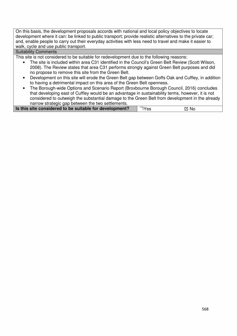
568
On this basis, the development proposals accords with national and local policy objectives to locate development where it can: be linked to public transport; provide realistic alternatives to the private car; and, enable people to carry out their everyday activities with less need to travel and make it easier to walk, cycle and use public transport. Suitability Comments This site is not considered to be suitable for redevelopment due to the following reasons:
• The site is included within area C31 identified in the Council’s Green Belt Review (Scott Wilson, 2008). The Review states that area C31 performs strongly against Green Belt purposes and did no propose to remove this site from the Green Belt.
• Development on this site will erode the Green Belt gap between Goffs Oak and Cuffley, in addition to having a detrimental impact on this area of the Green Belt openness.
• The Borough-wide Options and Scenario Report (Broxbourne Borough Council, 2016) concludes that developing east of Cuffley would be an advantage in sustainability terms, however, it is not considered to outweigh the substantial damage to the Green Belt from development in the already narrow strategic gap between the two settlements.
Is this site considered to be suitable for development? ☐Yes ☒ No

569
Local Plan – Site Appraisal Form
Site Information Site Location Map Site Reference Number
CG-GB-121
Site Name Land at Burnt Farm Ride
Site Area 2 hectares
Site Status ☐Urban ☒Green Belt ☐Mixed
Source of Site ☒Call for Sites ☐Planning Application ☐Desktop Study
Site Visit Carried Out
☐Yes ☐No
Site Ownership The site is in single ownership
Surr
oundin
g
Uses
N Residential properties, Green Belt
E Open Field, Green Belt S Track, Open Field,
Green Belt W Burnt Farm Ride, Open
Field, Green Belt
Site Description The site is irregular in shape and gradually slopes from north to south/south east. The site is open field in nature. A line of trees/hedgerow, runs from north to south within the eastern region of the site, approximately 20m shy of the eastern boundary. There are trees located on the sites northern, western and southern boundary. Planning History No planning history of note Development Proposal
Residential ☒ Commercial ☐ Other ☐
Local Plan 2005 (Policy H11)
60
Submitted Proposal
Site Designations Contains Adjoins Contains Adjoins
Green Belt ☒ ☒ Site of Scientific Interest (SSSI) ☐ ☐
Archaeological Interest ☒ ☒ Ancient Monument ☐ ☐
Local Wildlife Site ☐ ☒ Community Open Space ☐ ☐
Lee Valley Regional Park
☐ ☐ Cheshunt Common ☐ ☐
Listed Building ☐ ☒ Locally Listed Building ☐ ☐
TPO Trees ☐ ☐ Conservation Area ☐ ☐
Air Quality Management Area
☐ ☐ Protected Species ☐ ☐

570
Draft Local Plan Designation (Regulation 18) The draft Local Plan proposed to keep this site within the Green Belt Accessibility – distance as the crow flies
970m-Primary School (Woodside)
2.57km - Secondary School (Goffs)
3.61km –Employment Area (News International)
780m - Green Space (Jones Road)
1.5km -Healthcare Centre (Valley View)
9.57km - Hospital (with A&E) (Barnet)
4.17km- Town/District Centre (Cheshunt)
1.42km - Local Centre (1-3 Newgatestreet Road)
4.25-Leisure Centre (Laura Trott)
3.48km - A10 Junction (Lieutenant Ellis Way)
1.5km - Railway Station (Cuffley)
1.34km - Bus Service (Athenia Close)
Flood Risk Does the site Contains Adjoins
Zone 2 (Medium Risk) ☐ ☐
Zone 3a (High Risk) ☐ ☐
Zone 3b (Active Flood Plain) ☐ ☒
Additional Flood Risk Comments No flooding issues identified for this site. Access and Transport Comments The site can be accessed from Burnt Farm Ride. Burnt Farm Ride is only accessible to residents through a gated entrance. Pedestrian accessibility to the nearby urban areas will need to be considered for this site. Cycle access to the site will need to be created. Utility Provision
Electricity Connections may be required
Gas The closest low pressure gas main is located to the north of the site at Orchid Close.
Water The closest water main is located to the north of the site at Orchid Close
Sewerage A foul sewer is located to the north of the site at Orchid Close.
Sewerage Treatment ☐Rye Meads ☐Deephams ☐Other
Additional Developer Comments submitted during call for Sites 2016 The promoter of the site states that the site is vacant and can come forward within five years. It is considered that there are no contamination or legal/ownership issues that would prevent this site coming forward. The promoter notes that the site can be accessed directly from Burnt Farm Ride, or an alternative access is possible from Old Park Ride. The promoter of the site states that the site is in close proximity to the conurbation at Goffs Oak, it has direct access to Jones Road, close to Woodside Primary School. The promoter believes that this site could fulfil this requirement, including self-build potential as it adjoins a small existing cluster of residential accommodation and is generally well screened site. A below average housing density is propped in recognition of the site characteristics. Suitability Comments This site is not considered to be suitable for residential development due to the following reasons:
• The site is included in area D10 identified in the Council’s Green Belt Review (Scott Wilson, 2008). The Review states that this area performs a strong role under Green Belt Purpose 1 and therefore merits retention. The area also performs well against Purpose 3, and poorly against Purpose 2. It was not proposed to amend the Green Belt boundary in this location.
• It is considered that this site does not have strong Green belt boundaries on any side that would last beyond the Plan period and prevent further encroachment.

571
• The site is not considered to be in a suitable location for residential development. It is not close to local facilities and is above the sustainable distance recommended by Barton et al (2010) for a leisure centre, local green space, a doctor’s surgery and hospital.
• The development of this site will create an isolated pocket of housing within the Green Belt. In addition, the site is too small to facilitate sustainable place-making.
Is this site considered to be suitable for development? ☐Yes ☒ No
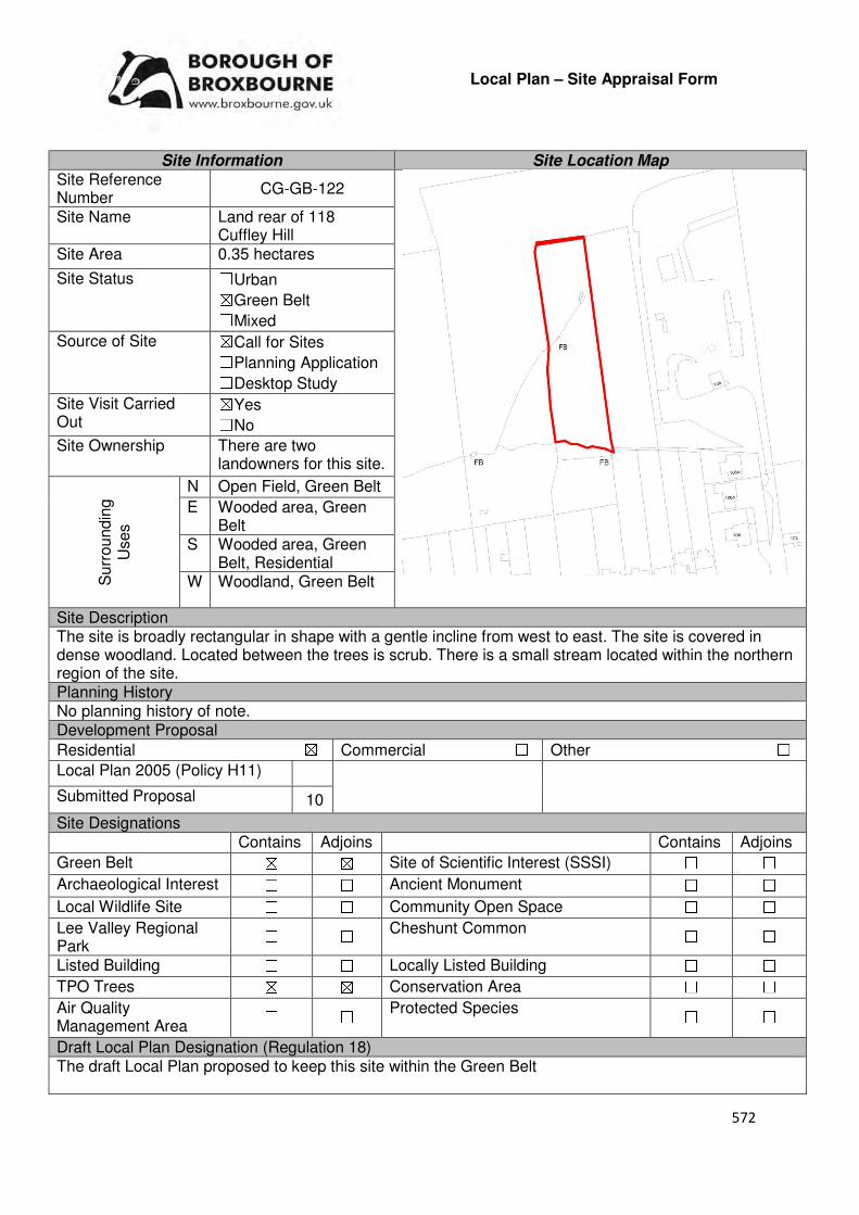
572
Local Plan – Site Appraisal Form
Site Information Site Location Map Site Reference Number
CG-GB-122
Site Name Land rear of 118 Cuffley Hill
Site Area 0.35 hectares
Site Status ☐Urban ☒Green Belt ☐Mixed
Source of Site ☒Call for Sites ☐Planning Application ☐Desktop Study
Site Visit Carried Out
☒Yes ☐No
Site Ownership There are two landowners for this site.
Surr
oundin
g
Uses
N Open Field, Green Belt
E Wooded area, Green Belt
S Wooded area, Green Belt, Residential
W Woodland, Green Belt
Site Description The site is broadly rectangular in shape with a gentle incline from west to east. The site is covered in dense woodland. Located between the trees is scrub. There is a small stream located within the northern region of the site. Planning History No planning history of note. Development Proposal
Residential ☒ Commercial ☐ Other ☐
Local Plan 2005 (Policy H11)
Submitted Proposal 10
Site Designations Contains Adjoins Contains Adjoins
Green Belt ☒ ☒ Site of Scientific Interest (SSSI) ☐ ☐
Archaeological Interest ☐ ☐ Ancient Monument ☐ ☐
Local Wildlife Site ☐ ☐ Community Open Space ☐ ☐
Lee Valley Regional Park
☐ ☐ Cheshunt Common ☐ ☐
Listed Building ☐ ☐ Locally Listed Building ☐ ☐
TPO Trees ☒ ☒ Conservation Area ☐ ☐
Air Quality Management Area
☐ ☐ Protected Species ☐ ☐
Draft Local Plan Designation (Regulation 18) The draft Local Plan proposed to keep this site within the Green Belt
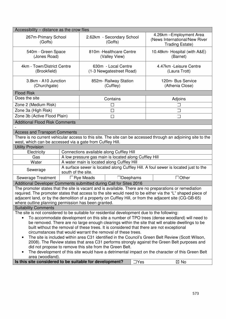
573
Accessibility – distance as the crow flies
267m-Primary School (Goffs)
2.62km - Secondary School (Goffs)
4.26km –Employment Area (News International/New River
Trading Estate)
540m - Green Space (Jones Road)
810m -Healthcare Centre (Valley View)
10.48km- Hospital (with A&E) (Barnet)
4km - Town/District Centre (Brookfield)
630m - Local Centre (1-3 Newgatestreet Road)
4.47km -Leisure Centre (Laura Trott)
3.8km - A10 Junction (Churchgate)
852m- Railway Station (Cuffley)
120m- Bus Service (Athenia Close)
Flood Risk Does the site Contains Adjoins
Zone 2 (Medium Risk) ☐ ☐
Zone 3a (High Risk) ☐ ☐
Zone 3b (Active Flood Plain) ☐ ☐
Additional Flood Risk Comments - Access and Transport Comments There is no current vehicular access to this site. The site can be accessed through an adjoining site to the west, which can be accessed via a gate from Cuffley Hill. Utility Provision
Electricity Connections available along Cuffley Hill
Gas A low pressure gas main is located along Cuffley Hill
Water A water main is located along Cuffley Hill
Sewerage A surface sewer is located along Cuffley Hill. A foul sewer is located just to the south of the site.
Sewerage Treatment ☐Rye Meads ☐Deephams ☐Other
Additional Developer Comments submitted during Call for Sites 2016 The promoter states that the site is vacant and is available. There are no preparations or remediation required. The promoter states that access to the site would need to be either via the “L” shaped piece of adjacent land, or by the demolition of a property on Cuffley Hill, or from the adjacent site (CG-GB-65) where outline planning permission has been granted. Suitability Comments The site is not considered to be suitable for residential development due to the following:
• To accommodate development on this site a number of TPO trees (dense woodland) will need to be removed. There are no large enough clearings within the site that will enable dwellings to be built without the removal of these trees. It is considered that there are not exceptional circumstances that would warrant the removal of these trees.
• The site is included within area C31 identified in the Council’s Green Belt Review (Scott Wilson, 2008). The Review states that area C31 performs strongly against the Green Belt purposes and did not propose to remove this site from the Green Belt.
• The development of this site would have a detrimental impact on the character of this Green Belt area (woodland).
Is this site considered to be suitable for development? ☐Yes ☒ No
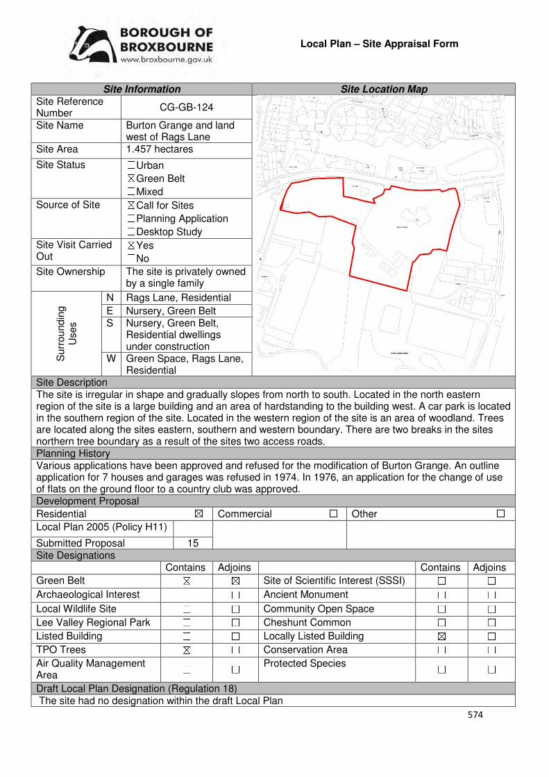
574
Local Plan – Site Appraisal Form
Site Information Site Location Map Site Reference Number
CG-GB-124
Site Name Burton Grange and land west of Rags Lane
Site Area 1.457 hectares
Site Status ☐Urban ☒Green Belt ☐Mixed
Source of Site ☒Call for Sites ☐Planning Application ☐Desktop Study
Site Visit Carried Out
☒Yes ☐No
Site Ownership The site is privately owned by a single family
Surr
oundin
g
Uses
N Rags Lane, Residential
E Nursery, Green Belt S Nursery, Green Belt,
Residential dwellings under construction
W Green Space, Rags Lane, Residential
Site Description The site is irregular in shape and gradually slopes from north to south. Located in the north eastern region of the site is a large building and an area of hardstanding to the building west. A car park is located in the southern region of the site. Located in the western region of the site is an area of woodland. Trees are located along the sites eastern, southern and western boundary. There are two breaks in the sites northern tree boundary as a result of the sites two access roads. Planning History Various applications have been approved and refused for the modification of Burton Grange. An outline application for 7 houses and garages was refused in 1974. In 1976, an application for the change of use of flats on the ground floor to a country club was approved. Development Proposal
Residential ☒ Commercial ☐ Other ☐
Local Plan 2005 (Policy H11)
Submitted Proposal 15 Site Designations Contains Adjoins Contains Adjoins
Green Belt ☒ ☒ Site of Scientific Interest (SSSI) ☐ ☐
Archaeological Interest ☐ ☐ Ancient Monument ☐ ☐
Local Wildlife Site ☐ ☐ Community Open Space ☐ ☐
Lee Valley Regional Park ☐ ☐ Cheshunt Common ☐ ☐
Listed Building ☐ ☐ Locally Listed Building ☒ ☐
TPO Trees ☒ ☐ Conservation Area ☐ ☐
Air Quality Management Area
☐ ☐ Protected Species ☐ ☐
Draft Local Plan Designation (Regulation 18) The site had no designation within the draft Local Plan
575
Accessibility – distance as the crow flies
720m-Primary School (Fairfields)
1.29km - Secondary School (Goffs)
2.32km –Employment Area (New River Trading Estate)
280m - Green Space (Argent Way)
1.06km-Healthcare Centre (Stockwell Lodge)
12.23km- Hospital (with A&E)
(Princess Alexandra)
2.1km- Town/District Centre (Brookfield)
240m - Local Centre
(Hammondstreet)
3.03km -Leisure Centre (Laura Trott)
2.16km - A10 Junction (Church Lane)
2.68km- Railway Station
(Cuffley)
340m- Bus Service (Peakes Lane)
Flood Risk Does the site Contains Adjoins
Zone 2 (Medium Risk) ☐ ☐
Zone 3a (High Risk) ☐ ☐
Zone 3b (Active Flood Plain) ☐ ☒
Additional Flood Risk Comments No flood risk issues identified for this site. Access and Transport Comments The site can be accessed via Rags Lane. This part of Rags Lane has footpaths along the northern side. Connections to these footpaths will be required. Cycle access to the site will need to be provided. Utility Provision
Electricity Connections may be available.
Gas A low pressure gas main is located along Rags Lane
Water A water main is located along Rags Lane
Sewerage The site is connected to a foul sewer. A surface sewer is located just to north of the site.
Sewerage Treatment ☐Rye Meads ☒Deephams ☐Other
Additional Developer Comments submitted during Call for Sites 2016 The promoter states that the site is partly occupied, but can come forward within the first five years. There are no constraints that will prevent development. Suitability Comments The site is only considered to be suitable for residential development if the Rosedale Park Development (CH2) is approved and the Green Belt boundaries are redrawn to Rags Lane and Burton Lane. This would remove the site from the Green Belt. If this development was not come forward, and then it is considered that the proposal for 15 dwellings on this site would have a detrimental impact on the openness of the Green Belt in this location, with there being no clear defensible Green Belt boundaries that would prevent further sprawl. The use of this site for residential purposes has been previously established, through an application to change the use of the ground floor from flats to a Country Club. However, due to the site containing a locally listed build, any development scheme will need to be sympathetic to setting of the building, which is one of the reasons for its inclusion on the Council’s local list. This site will need to be subject to masterplanning to be agreed through the pre-app process. Is this site considered to be suitable for development?
☒Yes ☐ No

576
Availability Comments The site has been promoted by the landowners to the Council through the Call for Sites process. It is considered that there are no legal/ownership issues that would prevent this site from coming forward.
Is the site considered to be available for development
☒Yes ☐ No
Achievability Comments The site is considered to be achievable. The preparation works required to bring this site forward are considered to be minimal due to the sites developed nature. It is considered that with the removal of the Green Belt designation, there will be no policy constraints that will prevent the site from coming forward.
Is the site considered to be achievable?
☒Yes ☐ No
Delivery Period 1-5 years

577
Local Plan – Site Appraisal Form
Site Information Site Location Map Site Reference Number
CG-GB-127
Site Name Lafiya House and grounds Site Area 3.94 hectares
Site Status ☐Urban ☒Green Belt ☐Mixed
Source of Site ☒Call for Sites ☐Planning Application ☐Desktop Study
Site Visit Carried Out
☒Yes ☐No
Site Ownership There are four landowners for this site.
Surr
oundin
g
Uses
N Goffs Lane, In-Ex Nursery
E Residential Dwelling, Green Belt
S Theobalds Brook, Open Fields, Green Belt, Local Wildlife Site
W Local wildlife site
Site Description The site is irregular in shape. Located within the northern region of the site is a residential dwelling, which sites in extensive garden land. The southern region of the site, which slopes towards Theobalds Brook, is open field in nature. Planning History The part re-development of site to include detached double garage with one bed flat over and garden workshop was refused in 2004. A single storey side extension was approved in 2004. The development of a detached double garage was refused in 1983. Development Proposal
Residential ☒ Commercial ☐ Other ☐
Local Plan 2005 (Policy H11) 118
Submitted Proposal -
Site Designations Contains Adjoins Contains Adjoins
Green Belt ☒ ☒ Site of Scientific Interest (SSSI) ☐ ☐
Archaeological Interest ☐ ☐ Ancient Monument ☐ ☐
Local Wildlife Site ☐ ☒ Community Open Space ☐ ☐
Lee Valley Regional Park ☐ ☐ Cheshunt Common ☐ ☐
Listed Building ☐ ☐ Locally Listed Building ☐ ☐
TPO Trees ☒ ☒ Conservation Area ☐ ☐
Air Quality Management Area
☐ ☐ Protected Species ☐ ☐
Draft Local Plan Designation (Regulation 18) Part of this site was proposed to be allocated for residential development in accordance with emerging policy GO3. The reminder of the site was proposed to be kept within the Green Belt.
578
Accessibility – distance as the crow flies
357m-Primary School (Woodside)
1.55km - Secondary School (Goffs)
3.2km –Employment Area (News International)
210m - Green Space (Goffs)
220m-Healthcare Centre (Valley View)
10.98km- Hospital (with A&E) (Barnet)
3.01km - Town/District Centre (Brookfield)
250m - Local Centre (684-696 Goffs Lane)
3.38km-Leisure Centre (Laura Trott)
2.74km - A10 Junction (Church Lane)
1.77km - Railway Station (Cuffley)
195m - Bus Service (War Memorial)
Flood Risk Does the site Contains Adjoins
Zone 2 (Medium Risk) ☐ ☐
Zone 3a (High Risk) ☐ ☐
Zone 3b (Active Flood Plain) ☐ ☒
Additional Flood Risk Comments No flood risk issues have been identified for this site. Access and Transport Comments The site can be accessed via Goffs Lane. This access point will require improving if development comes forward on this site. Road infrastructure within the site will need to be installed. Due to the amount of dwellings this site could accommodate, a transport assessment will be required. There are footpaths on both sides of Goff Lane. Connections to these will be required. Utility Provision
Electricity Underground cables available at Goffs Lane
Gas A low pressure gas main is located along Goffs Lane
Water A water main is located along Goffs Lane. A water hydrant is located just to the north of the site
Sewerage A foul sewer and surface sewer is located along Goffs Lane
Sewerage Treatment ☐Rye Meads ☐Deephams ☐Other
Additional Developer Comments submitted during Call for Sites 2016 The promoter states that the site can come forward within 5 years. Suitability Comments The site is not considered to be suitable for residential development due to the following reasons:
• Lafiya House and the field within the southern region of the site is Green Field in nature, in comparison to the brownfield nature of the remainder of the site. It is considered that the development on these areas of the site would significantly impact on the openness of the Green Belt
• Lafiya House contributes to a green frontage of Goffs Lane. The development of this area of the site will have a detrimental impact on the character of this area and will erode the separation of Goffs Oak and West Cheshunt
• The Council’s Green Belt Topic Paper (July 2017) states that “The Land at Lafiya House to the east of this site contains a large garden which has been promoted to the Council as a possible extension to the site allocation. However, given the largely greenfield nature of the site, and the contribution of the green frontage on Goffs Lane to the outskirts of the village, it is not considered that the Green Belt release should extend to encompass this site”.
Is this site considered to be suitable for development?
☐Yes ☒ No
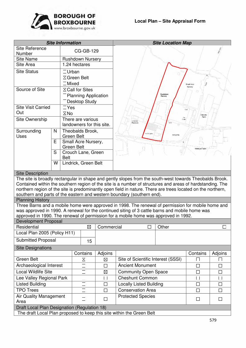
579
Local Plan – Site Appraisal Form
Site Information Site Location Map Site Reference Number
CG-GB-129
Site Name Rushdown Nursery Site Area 1.24 hectares
Site Status ☐Urban ☒Green Belt ☐Mixed
Source of Site ☒Call for Sites ☐Planning Application ☐Desktop Study
Site Visit Carried Out
☐Yes ☒No
Site Ownership There are various landowners for this site.
Surrounding Uses
N Theobalds Brook, Green Belt
E Small Acre Nursery, Green Belt
S Crouch Lane, Green Belt
W Lindrick, Green Belt
Site Description The site is broadly rectangular in shape and gently slopes from the south-west towards Theobalds Brook. Contained within the southern region of the site is a number of structures and areas of hardstanding. The northern region of the site is predominantly open field in nature. There are trees located on the northern, southern and parts of the eastern and western boundary (southern end). Planning History Three Barns and a mobile home were approved in 1998. The renewal of permission for mobile home and was approved in 1990. A renewal for the continued siting of 3 cattle barns and mobile home was approved in 1990. The renewal of permission for a mobile home was approved in 1992. Development Proposal
Residential ☒ Commercial ☐ Other ☐
Local Plan 2005 (Policy H11)
Submitted Proposal 15
Site Designations Contains Adjoins Contains Adjoins
Green Belt ☒ ☒ Site of Scientific Interest (SSSI) ☐ ☐
Archaeological Interest ☐ ☐ Ancient Monument ☐ ☐
Local Wildlife Site ☐ ☒ Community Open Space ☐ ☐
Lee Valley Regional Park ☐ ☐ Cheshunt Common ☐ ☐
Listed Building ☐ ☐ Locally Listed Building ☐ ☐
TPO Trees ☐ ☐ Conservation Area ☐ ☐
Air Quality Management Area
☐ ☐ Protected Species ☐ ☐
Draft Local Plan Designation (Regulation 18) The draft Local Plan proposed to keep this site within the Green Belt
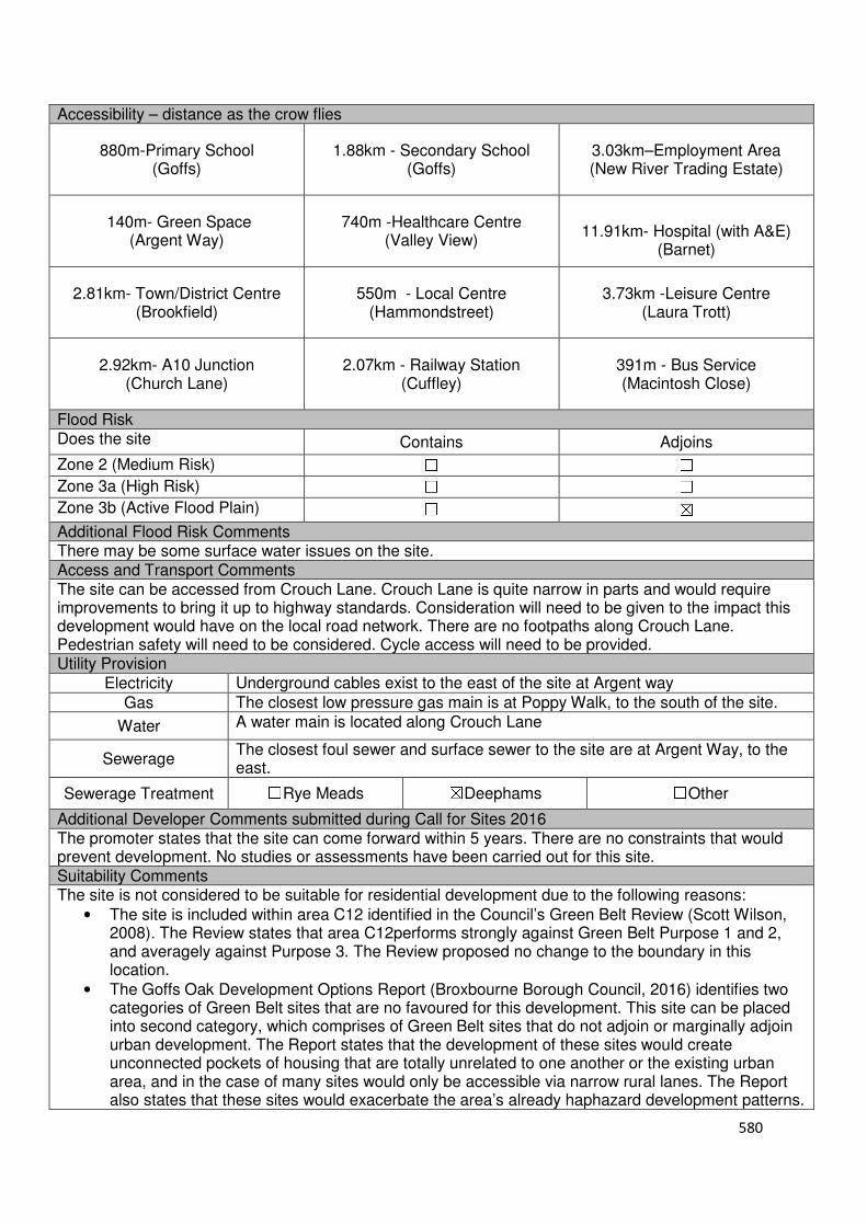
580
Accessibility – distance as the crow flies
880m-Primary School (Goffs)
1.88km - Secondary School (Goffs)
3.03km–Employment Area (New River Trading Estate)
140m- Green Space (Argent Way)
740m -Healthcare Centre (Valley View)
11.91km- Hospital (with A&E)
(Barnet)
2.81km- Town/District Centre (Brookfield)
550m - Local Centre (Hammondstreet)
3.73km -Leisure Centre (Laura Trott)
2.92km- A10 Junction (Church Lane)
2.07km - Railway Station (Cuffley)
391m - Bus Service (Macintosh Close)
Flood Risk Does the site Contains Adjoins
Zone 2 (Medium Risk) ☐ ☐
Zone 3a (High Risk) ☐ ☐
Zone 3b (Active Flood Plain) ☐ ☒
Additional Flood Risk Comments There may be some surface water issues on the site. Access and Transport Comments The site can be accessed from Crouch Lane. Crouch Lane is quite narrow in parts and would require improvements to bring it up to highway standards. Consideration will need to be given to the impact this development would have on the local road network. There are no footpaths along Crouch Lane. Pedestrian safety will need to be considered. Cycle access will need to be provided. Utility Provision
Electricity Underground cables exist to the east of the site at Argent way
Gas The closest low pressure gas main is at Poppy Walk, to the south of the site.
Water A water main is located along Crouch Lane
Sewerage The closest foul sewer and surface sewer to the site are at Argent Way, to the east.
Sewerage Treatment ☐Rye Meads ☒Deephams ☐Other
Additional Developer Comments submitted during Call for Sites 2016 The promoter states that the site can come forward within 5 years. There are no constraints that would prevent development. No studies or assessments have been carried out for this site. Suitability Comments The site is not considered to be suitable for residential development due to the following reasons:
• The site is included within area C12 identified in the Council’s Green Belt Review (Scott Wilson, 2008). The Review states that area C12performs strongly against Green Belt Purpose 1 and 2, and averagely against Purpose 3. The Review proposed no change to the boundary in this location.
• The Goffs Oak Development Options Report (Broxbourne Borough Council, 2016) identifies two categories of Green Belt sites that are no favoured for this development. This site can be placed into second category, which comprises of Green Belt sites that do not adjoin or marginally adjoin urban development. The Report states that the development of these sites would create unconnected pockets of housing that are totally unrelated to one another or the existing urban area, and in the case of many sites would only be accessible via narrow rural lanes. The Report also states that these sites would exacerbate the area’s already haphazard development patterns.

581
• It is considered that this site does not have strong green belt boundaries to the east and west that would prevent further encroachment and last beyond the Plan period.
However, subject to the sites compliance with emerging Policy GB2: Residential Development on Derelict Glass House Sites, the site could be subdivided into self-build housing plots. Is this site considered to be suitable for development? ☐Yes ☒ No
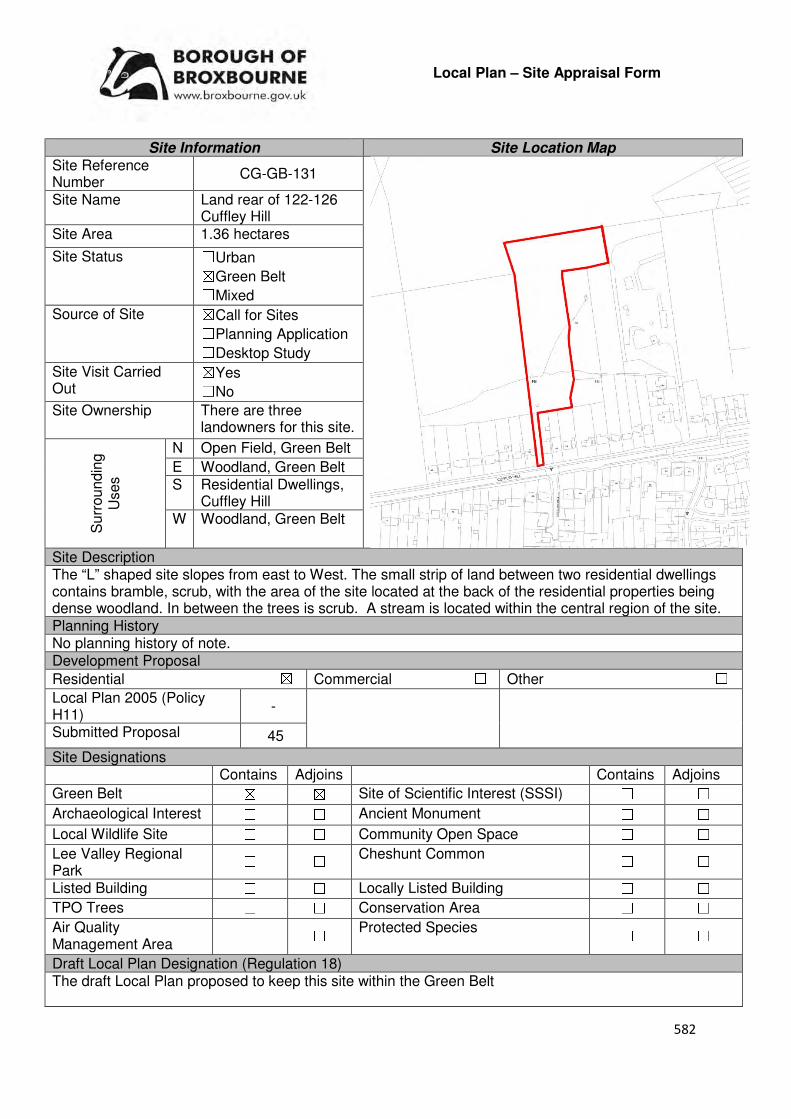
582
Local Plan – Site Appraisal Form
Site Information Site Location Map Site Reference Number
CG-GB-131
Site Name Land rear of 122-126 Cuffley Hill
Site Area 1.36 hectares
Site Status ☐Urban ☒Green Belt ☐Mixed
Source of Site ☒Call for Sites ☐Planning Application ☐Desktop Study
Site Visit Carried Out
☒Yes ☐No
Site Ownership There are three landowners for this site.
Surr
oundin
g
Uses
N Open Field, Green Belt
E Woodland, Green Belt S Residential Dwellings,
Cuffley Hill W Woodland, Green Belt
Site Description The “L” shaped site slopes from east to West. The small strip of land between two residential dwellings contains bramble, scrub, with the area of the site located at the back of the residential properties being dense woodland. In between the trees is scrub. A stream is located within the central region of the site. Planning History No planning history of note. Development Proposal
Residential ☒ Commercial ☐ Other ☐
Local Plan 2005 (Policy H11)
-
Submitted Proposal 45
Site Designations Contains Adjoins Contains Adjoins
Green Belt ☒ ☒ Site of Scientific Interest (SSSI) ☐ ☐
Archaeological Interest ☐ ☐ Ancient Monument ☐ ☐
Local Wildlife Site ☐ ☐ Community Open Space ☐ ☐
Lee Valley Regional Park
☐ ☐ Cheshunt Common ☐ ☐
Listed Building ☐ ☐ Locally Listed Building ☐ ☐
TPO Trees ☐ ☐ Conservation Area ☐ ☐
Air Quality Management Area
☐ ☐ Protected Species ☐ ☐
Draft Local Plan Designation (Regulation 18) The draft Local Plan proposed to keep this site within the Green Belt

583
Accessibility – distance as the crow flies
220m -Primary School (Goffs)
2.64km - Secondary School (Goffs)
4.26km –Employment Area (New River Trading Estate)
500m - Green Space (Jones Road)
790m-Healthcare Centre (Valley View)
10.39km- Hospital (with A&E) (Barnet)
4km - Town/District Centre (Brookfield)
530m - Local Centre (1-5 Mason’s Parade)
4.51km-Leisure Centre (Laura Trott)
3.86km- A10 Junction (Churchgate)
800m- Railway Station (Cuffley)
30m- Bus Service (Athenia Close)
Flood Risk Does the site Contains Adjoins
Zone 2 (Medium Risk) ☐ ☐
Zone 3a (High Risk) ☐ ☐
Zone 3b (Active Flood Plain) ☐ ☒
Additional Flood Risk Comments No flood risk comments for this site. Access and Transport Comments The site can be accessed via a gate from Cuffley Hill. The access point, including the sites visibility, will require improvements. If the access requires widening to ensure that it is highway compliant, additional land will need to be purchased. There are footpaths on both sides of Cuffley Hill. Connection to these footpaths will be required. Cycle access to the site will need to be created. Utility Provision
Electricity Electricity cables available along Cuffley Hill
Gas A low pressure gas main is located along Cuffley Hill
Water A water main is located along Cuffley Hill
Sewerage A surface sewer is located along Cuffley Hill. A foul sewer is located within the site.
Sewerage Treatment ☐Rye Meads ☒Deephams ☐Other
Additional Developer Comments submitted during Call for Sites 2016 The promoter of the site states that it is vacant and available. There are no known problems; therefore preparation/remediation work should be quick and low cost. The promoter stated that the site has road access; however, development would require access either from the adjacent Policy GO5 site to the East (CG-GB-62) or the demolition of one house on Cuffley Hill. The promoter states that there are no contamination or legal/ownership constraints. There are no constraints that would prevent this site from coming forward. Suitability Comments The site is not considered to be suitable for residential development due to the following reasons:
• To accommodate development on this site a number of TPO trees will need to be removed. There are no large clearings that would be able to accommodate dwellings without requiring the need to remove any of the protected trees. It is considered that there are no exceptional circumstances that would warrant the removal of these trees.
• The site is included within area C31 of the Council’s Green Belt Review (Scott Wilson, 2008). The Review states that area C31 performs strongly against Green Belt purposes and did not proposed to remove this site from the Green Belt.
• The development of this site would have a detrimental impact on the character of this Green Belt area.
Is this site considered to be suitable for development? ☐Yes ☒ No

584
Waltham Cross
Urban Sites
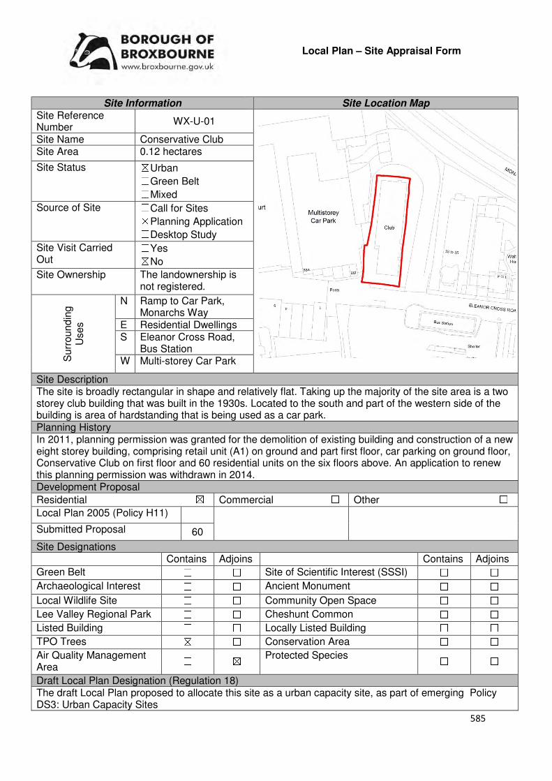
585
Local Plan – Site Appraisal Form
Site Information Site Location Map Site Reference Number
WX-U-01
Site Name Conservative Club Site Area 0.12 hectares
Site Status ☒Urban ☐Green Belt ☐Mixed
Source of Site ☐Call for Sites ☒Planning Application ☐Desktop Study
Site Visit Carried Out
☐Yes ☒No
Site Ownership The landownership is not registered.
Surr
oundin
g
Uses
N Ramp to Car Park, Monarchs Way
E Residential Dwellings S Eleanor Cross Road,
Bus Station W Multi-storey Car Park
Site Description The site is broadly rectangular in shape and relatively flat. Taking up the majority of the site area is a two storey club building that was built in the 1930s. Located to the south and part of the western side of the building is area of hardstanding that is being used as a car park. Planning History In 2011, planning permission was granted for the demolition of existing building and construction of a new eight storey building, comprising retail unit (A1) on ground and part first floor, car parking on ground floor, Conservative Club on first floor and 60 residential units on the six floors above. An application to renew this planning permission was withdrawn in 2014. Development Proposal
Residential ☒ Commercial ☐ Other ☐
Local Plan 2005 (Policy H11)
Submitted Proposal 60
Site Designations Contains Adjoins Contains Adjoins
Green Belt ☐ ☐ Site of Scientific Interest (SSSI) ☐ ☐
Archaeological Interest ☐ ☐ Ancient Monument ☐ ☐
Local Wildlife Site ☐ ☐ Community Open Space ☐ ☐
Lee Valley Regional Park ☐ ☐ Cheshunt Common ☐ ☐
Listed Building ☐ ☐ Locally Listed Building ☐ ☐
TPO Trees ☒ ☐ Conservation Area ☐ ☐
Air Quality Management Area
☐ ☒ Protected Species ☐ ☐
Draft Local Plan Designation (Regulation 18) The draft Local Plan proposed to allocate this site as a urban capacity site, as part of emerging Policy DS3: Urban Capacity Sites
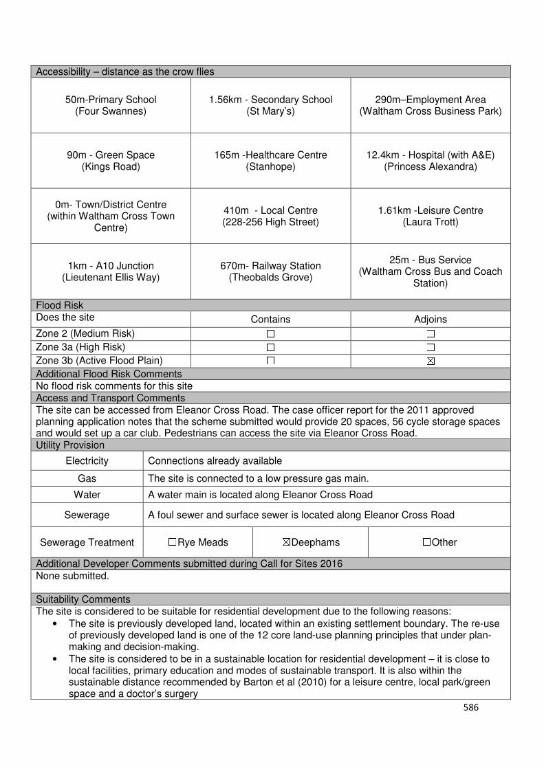
586
Accessibility – distance as the crow flies
50m-Primary School (Four Swannes)
1.56km - Secondary School (St Mary’s)
290m–Employment Area (Waltham Cross Business Park)
90m - Green Space (Kings Road)
165m -Healthcare Centre (Stanhope)
12.4km - Hospital (with A&E) (Princess Alexandra)
0m- Town/District Centre (within Waltham Cross Town
Centre)
410m - Local Centre (228-256 High Street)
1.61km -Leisure Centre (Laura Trott)
1km - A10 Junction (Lieutenant Ellis Way)
670m- Railway Station (Theobalds Grove)
25m - Bus Service (Waltham Cross Bus and Coach
Station)
Flood Risk Does the site Contains Adjoins
Zone 2 (Medium Risk) ☐ ☐
Zone 3a (High Risk) ☐ ☐
Zone 3b (Active Flood Plain) ☐ ☒
Additional Flood Risk Comments No flood risk comments for this site Access and Transport Comments The site can be accessed from Eleanor Cross Road. The case officer report for the 2011 approved planning application notes that the scheme submitted would provide 20 spaces, 56 cycle storage spaces and would set up a car club. Pedestrians can access the site via Eleanor Cross Road. Utility Provision
Electricity Connections already available
Gas The site is connected to a low pressure gas main.
Water A water main is located along Eleanor Cross Road
Sewerage A foul sewer and surface sewer is located along Eleanor Cross Road
Sewerage Treatment ☐Rye Meads ☒Deephams ☐Other
Additional Developer Comments submitted during Call for Sites 2016 None submitted. Suitability Comments The site is considered to be suitable for residential development due to the following reasons:
• The site is previously developed land, located within an existing settlement boundary. The re-use of previously developed land is one of the 12 core land-use planning principles that under plan-making and decision-making.
• The site is considered to be in a sustainable location for residential development – it is close to local facilities, primary education and modes of sustainable transport. It is also within the sustainable distance recommended by Barton et al (2010) for a leisure centre, local park/green space and a doctor’s surgery
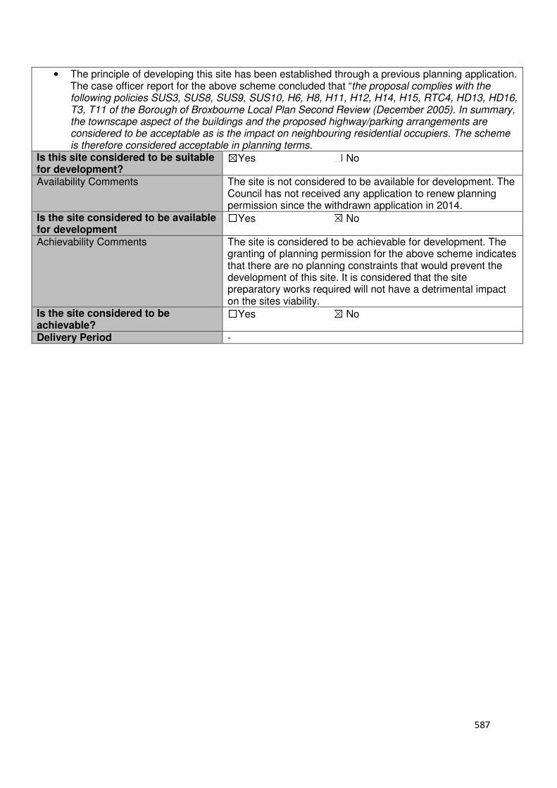
587
• The principle of developing this site has been established through a previous planning application. The case officer report for the above scheme concluded that “the proposal complies with the following policies SUS3, SUS8, SUS9, SUS10, H6, H8, H11, H12, H14, H15, RTC4, HD13, HD16, T3, T11 of the Borough of Broxbourne Local Plan Second Review (December 2005). In summary, the townscape aspect of the buildings and the proposed highway/parking arrangements are considered to be acceptable as is the impact on neighbouring residential occupiers. The scheme is therefore considered acceptable in planning terms.
Is this site considered to be suitable for development?
☒Yes ☐ No
Availability Comments The site is not considered to be available for development. The Council has not received any application to renew planning permission since the withdrawn application in 2014.
Is the site considered to be available for development
☐Yes ☒ No
Achievability Comments The site is considered to be achievable for development. The granting of planning permission for the above scheme indicates that there are no planning constraints that would prevent the development of this site. It is considered that the site preparatory works required will not have a detrimental impact on the sites viability.
Is the site considered to be achievable?
☐Yes ☒ No
Delivery Period -

588
Local Plan – Site Appraisal Form
Site Information Site Location Map Site Reference Number
WX-U-11
Site Name 232-285 High Street Site Area 0.51 hectares
Site Status ☒Urban ☐Green Belt ☐Mixed
Source of Site ☐Call for Sites ☐Planning Application ☒Desktop Study
Site Visit Carried Out
☐Yes ☒No
Site Ownership There are various landowners for this site.
Surr
oundin
g
Uses
N Residential dwellings, Trinity Lane
E Residential dwellings S Residential dwellings
W High Street
Site Description The site consists of three different land parcels, of which all are different shapes. Contained within these land parcels are a number of buildings and structures, of varying height levels.
Planning History There have been various applications for buildings located within this SLAA site. These applications include from advertisement consent, new shop fronts and change of use. Development Proposal
Residential ☒ Commercial ☐ Other ☐
Local Plan 2005 (Policy H11) 35
Submitted Proposal
Site Designations Contains Adjoins Contains Adjoins
Green Belt ☐ ☐ Site of Scientific Interest (SSSI) ☐ ☐
Archaeological Interest ☐ ☐ Ancient Monument ☐ ☐
Local Wildlife Site ☐ ☐ Community Open Space ☐ ☐
Lee Valley Regional Park
☐ ☐ Cheshunt Common ☐ ☐
Listed Building ☐ ☐ Locally Listed Building ☐ ☐
TPO Trees ☐ ☐ Conservation Area ☐ ☐
Air Quality Management Area
☐ ☐ Protected Species ☐ ☐
Draft Local Plan Designation (Regulation 18) The draft Local Plan proposed to allocate this site as an urban capacity site, as part of emerging policy DS3: Urban Capacity Sites
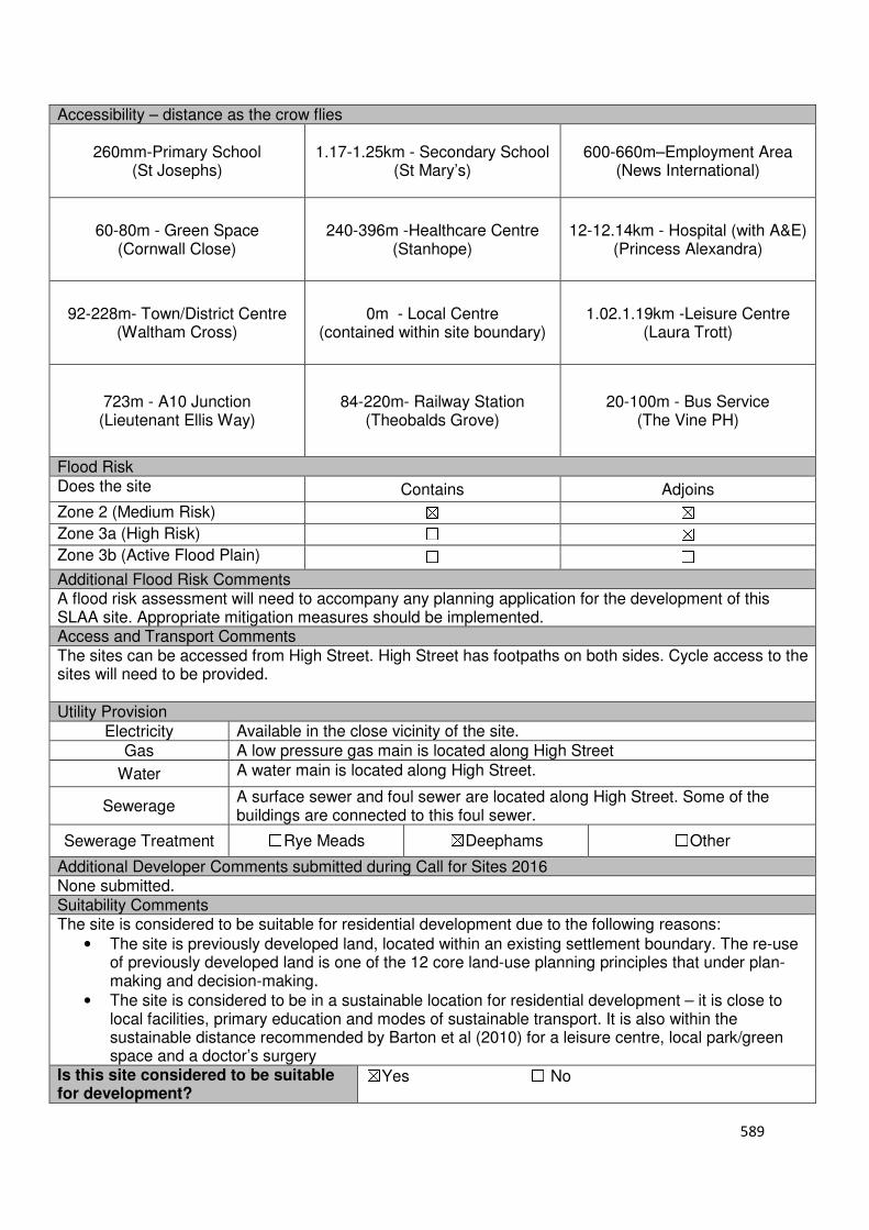
589
Accessibility – distance as the crow flies
260mm-Primary School (St Josephs)
1.17-1.25km - Secondary School (St Mary’s)
600-660m–Employment Area (News International)
60-80m - Green Space (Cornwall Close)
240-396m -Healthcare Centre (Stanhope)
12-12.14km - Hospital (with A&E) (Princess Alexandra)
92-228m- Town/District Centre (Waltham Cross)
0m - Local Centre (contained within site boundary)
1.02.1.19km -Leisure Centre (Laura Trott)
723m - A10 Junction (Lieutenant Ellis Way)
84-220m- Railway Station (Theobalds Grove)
20-100m - Bus Service (The Vine PH)
Flood Risk Does the site Contains Adjoins
Zone 2 (Medium Risk) ☒ ☒
Zone 3a (High Risk) ☐ ☒
Zone 3b (Active Flood Plain) ☐ ☐
Additional Flood Risk Comments A flood risk assessment will need to accompany any planning application for the development of this SLAA site. Appropriate mitigation measures should be implemented. Access and Transport Comments The sites can be accessed from High Street. High Street has footpaths on both sides. Cycle access to the sites will need to be provided. Utility Provision
Electricity Available in the close vicinity of the site.
Gas A low pressure gas main is located along High Street
Water A water main is located along High Street.
Sewerage A surface sewer and foul sewer are located along High Street. Some of the buildings are connected to this foul sewer.
Sewerage Treatment ☐Rye Meads ☒Deephams ☐Other
Additional Developer Comments submitted during Call for Sites 2016 None submitted. Suitability Comments The site is considered to be suitable for residential development due to the following reasons:
• The site is previously developed land, located within an existing settlement boundary. The re-use of previously developed land is one of the 12 core land-use planning principles that under plan-making and decision-making.
• The site is considered to be in a sustainable location for residential development – it is close to local facilities, primary education and modes of sustainable transport. It is also within the sustainable distance recommended by Barton et al (2010) for a leisure centre, local park/green space and a doctor’s surgery
Is this site considered to be suitable for development?
☒Yes ☐ No
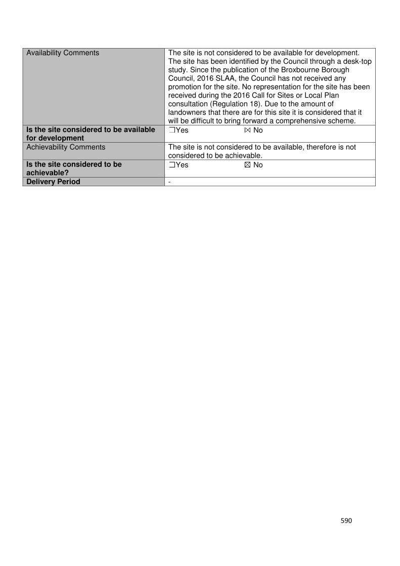
590
Availability Comments The site is not considered to be available for development. The site has been identified by the Council through a desk-top study. Since the publication of the Broxbourne Borough Council, 2016 SLAA, the Council has not received any promotion for the site. No representation for the site has been received during the 2016 Call for Sites or Local Plan consultation (Regulation 18). Due to the amount of landowners that there are for this site it is considered that it will be difficult to bring forward a comprehensive scheme.
Is the site considered to be available for development
☐Yes ☒ No
Achievability Comments The site is not considered to be available, therefore is not considered to be achievable.
Is the site considered to be achievable?
☐Yes ☒ No
Delivery Period -
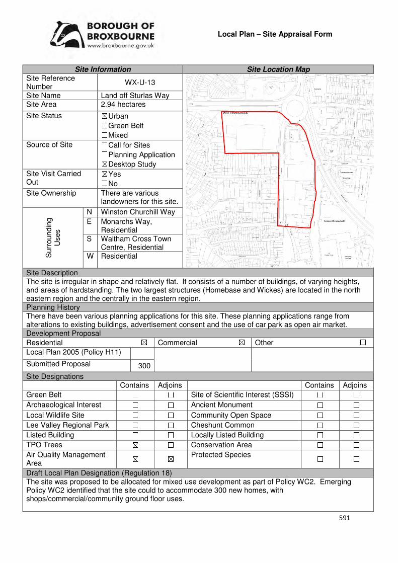
591
Local Plan – Site Appraisal Form
Site Information Site Location Map Site Reference Number
WX-U-13
Site Name Land off Sturlas Way Site Area 2.94 hectares
Site Status ☒Urban ☐Green Belt ☐Mixed
Source of Site ☐Call for Sites ☐Planning Application ☒Desktop Study
Site Visit Carried Out
☒Yes ☐No
Site Ownership There are various landowners for this site.
Surr
oundin
g
Uses
N Winston Churchill Way
E Monarchs Way, Residential
S Waltham Cross Town Centre, Residential
W Residential
Site Description The site is irregular in shape and relatively flat. It consists of a number of buildings, of varying heights, and areas of hardstanding. The two largest structures (Homebase and Wickes) are located in the north eastern region and the centrally in the eastern region. Planning History There have been various planning applications for this site. These planning applications range from alterations to existing buildings, advertisement consent and the use of car park as open air market. Development Proposal
Residential ☒ Commercial ☒ Other ☐
Local Plan 2005 (Policy H11)
Submitted Proposal 300
Site Designations Contains Adjoins Contains Adjoins
Green Belt ☐ ☐ Site of Scientific Interest (SSSI) ☐ ☐
Archaeological Interest ☐ ☐ Ancient Monument ☐ ☐
Local Wildlife Site ☐ ☐ Community Open Space ☐ ☐
Lee Valley Regional Park ☐ ☐ Cheshunt Common ☐ ☐
Listed Building ☐ ☐ Locally Listed Building ☐ ☐
TPO Trees ☒ ☐ Conservation Area ☐ ☐
Air Quality Management Area
☒ ☒ Protected Species ☐ ☐
Draft Local Plan Designation (Regulation 18) The site was proposed to be allocated for mixed use development as part of Policy WC2. Emerging Policy WC2 identified that the site could to accommodate 300 new homes, with shops/commercial/community ground floor uses.
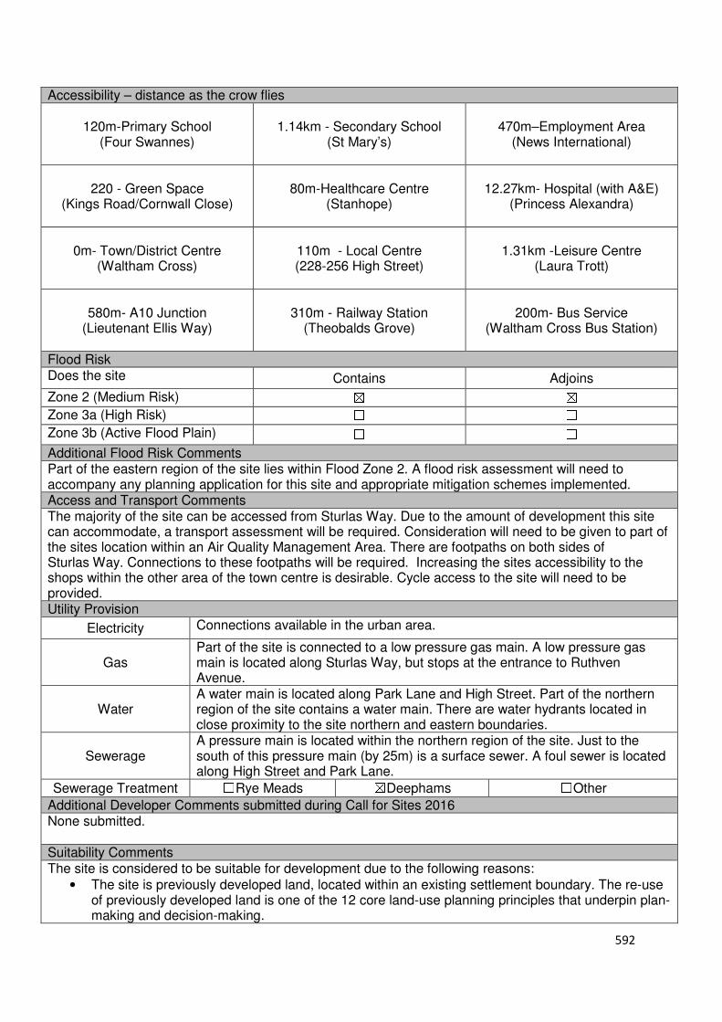
592
Accessibility – distance as the crow flies
120m-Primary School (Four Swannes)
1.14km - Secondary School (St Mary’s)
470m–Employment Area (News International)
220 - Green Space (Kings Road/Cornwall Close)
80m-Healthcare Centre (Stanhope)
12.27km- Hospital (with A&E) (Princess Alexandra)
0m- Town/District Centre (Waltham Cross)
110m - Local Centre (228-256 High Street)
1.31km -Leisure Centre
(Laura Trott)
580m- A10 Junction (Lieutenant Ellis Way)
310m - Railway Station (Theobalds Grove)
200m- Bus Service (Waltham Cross Bus Station)
Flood Risk Does the site Contains Adjoins
Zone 2 (Medium Risk) ☒ ☒
Zone 3a (High Risk) ☐ ☐
Zone 3b (Active Flood Plain) ☐ ☐
Additional Flood Risk Comments Part of the eastern region of the site lies within Flood Zone 2. A flood risk assessment will need to accompany any planning application for this site and appropriate mitigation schemes implemented. Access and Transport Comments The majority of the site can be accessed from Sturlas Way. Due to the amount of development this site can accommodate, a transport assessment will be required. Consideration will need to be given to part of the sites location within an Air Quality Management Area. There are footpaths on both sides of Sturlas Way. Connections to these footpaths will be required. Increasing the sites accessibility to the shops within the other area of the town centre is desirable. Cycle access to the site will need to be provided. Utility Provision
Electricity Connections available in the urban area.
Gas Part of the site is connected to a low pressure gas main. A low pressure gas main is located along Sturlas Way, but stops at the entrance to Ruthven Avenue.
Water A water main is located along Park Lane and High Street. Part of the northern region of the site contains a water main. There are water hydrants located in close proximity to the site northern and eastern boundaries.
Sewerage A pressure main is located within the northern region of the site. Just to the south of this pressure main (by 25m) is a surface sewer. A foul sewer is located along High Street and Park Lane.
Sewerage Treatment ☐Rye Meads ☒Deephams ☐Other
Additional Developer Comments submitted during Call for Sites 2016 None submitted. Suitability Comments The site is considered to be suitable for development due to the following reasons:
• The site is previously developed land, located within an existing settlement boundary. The re-use of previously developed land is one of the 12 core land-use planning principles that underpin plan-making and decision-making.
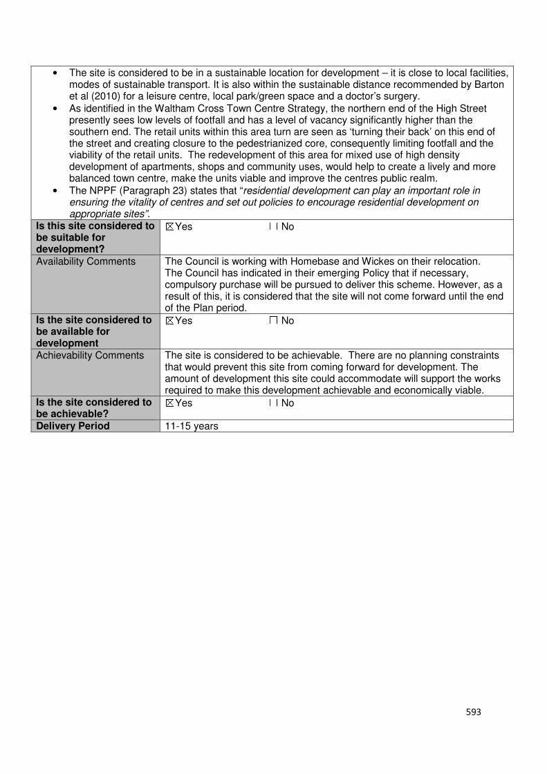
593
• The site is considered to be in a sustainable location for development – it is close to local facilities, modes of sustainable transport. It is also within the sustainable distance recommended by Barton et al (2010) for a leisure centre, local park/green space and a doctor’s surgery.
• As identified in the Waltham Cross Town Centre Strategy, the northern end of the High Street presently sees low levels of footfall and has a level of vacancy significantly higher than the southern end. The retail units within this area turn are seen as ‘turning their back’ on this end of the street and creating closure to the pedestrianized core, consequently limiting footfall and the viability of the retail units. The redevelopment of this area for mixed use of high density development of apartments, shops and community uses, would help to create a lively and more balanced town centre, make the units viable and improve the centres public realm.
• The NPPF (Paragraph 23) states that “residential development can play an important role in ensuring the vitality of centres and set out policies to encourage residential development on appropriate sites”.
Is this site considered to be suitable for development?
☒Yes ☐ No
Availability Comments The Council is working with Homebase and Wickes on their relocation. The Council has indicated in their emerging Policy that if necessary, compulsory purchase will be pursued to deliver this scheme. However, as a result of this, it is considered that the site will not come forward until the end of the Plan period.
Is the site considered to be available for development
☒Yes ☐ No
Achievability Comments The site is considered to be achievable. There are no planning constraints that would prevent this site from coming forward for development. The amount of development this site could accommodate will support the works required to make this development achievable and economically viable.
Is the site considered to be achievable?
☒Yes ☐ No
Delivery Period 11-15 years

594
Local Plan – Site Appraisal Form
Site Information Site Location Map Site Reference Number
WX-U-14
Site Name Medlock Electrical, 107-115 Eleanor Cross Road and The Friary
Site Area 1.31 hectares
Site Status ☒Urban ☐Green Belt ☐Mixed
Source of Site ☐Call for Sites ☐Planning Application ☒Desktop Study
Site Visit Carried Out
☐Yes ☒No
Site Ownership There are various landowners for this site.
Surr
oundin
g
Uses
N Lee Valley Regional Park,
E Residential S Eleanor Cross Road, Petrol
Station W Residential
Site Description The site is irregular in shape and relatively flat. The site consists of a numbers of structures, of varying levels and uses (residential and warehouse), and areas of hardstanding. A large residential building, which is broadly H-Shaped, takes up the majority of the central region of the site. The warehouse fronts on to Eleanor Cross Road, within the southern region of the site. There are a number of trees located within the site. Planning History There have been various applications for 107-115 Eleanor Cross Road, which includes temporary change of use 1985), additional roller shutter door to front of warehouse and alterations to car park area (1987), change of use from wholesale electrical goods warehouse to wholesale goods warehouse and workshop (1985, a similar application was refused in 1984). Development Proposal
Residential ☒ Commercial ☐ Other ☐
Local Plan 2005 (Policy H11) 39
Submitted Proposal
Site Designations Contains Adjoins Contains Adjoins
Green Belt ☐ ☒ Site of Scientific Interest (SSSI) ☐ ☐
Archaeological Interest ☐ ☐ Ancient Monument ☐ ☐
Local Wildlife Site ☐ ☐ Community Open Space ☐ ☐
Lee Valley Regional Park ☐ ☒ Cheshunt Common ☐ ☐
Listed Building ☐ ☐ Locally Listed Building ☐ ☐
TPO Trees ☐ ☐ Conservation Area ☐ ☐
Air Quality Management Area
☐ ☐ Protected Species ☐ ☐
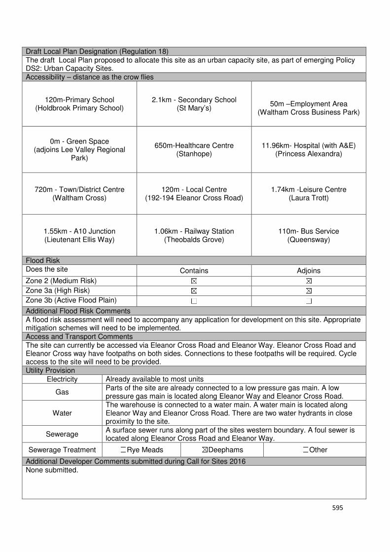
595
Draft Local Plan Designation (Regulation 18) The draft Local Plan proposed to allocate this site as an urban capacity site, as part of emerging Policy DS2: Urban Capacity Sites. Accessibility – distance as the crow flies
120m-Primary School (Holdbrook Primary School)
2.1km - Secondary School (St Mary’s)
50m –Employment Area
(Waltham Cross Business Park)
0m - Green Space (adjoins Lee Valley Regional
Park)
650m-Healthcare Centre
(Stanhope)
11.96km- Hospital (with A&E) (Princess Alexandra)
720m - Town/District Centre
(Waltham Cross)
120m - Local Centre
(192-194 Eleanor Cross Road)
1.74km -Leisure Centre (Laura Trott)
1.55km - A10 Junction (Lieutenant Ellis Way)
1.06km - Railway Station
(Theobalds Grove)
110m- Bus Service (Queensway)
Flood Risk Does the site Contains Adjoins
Zone 2 (Medium Risk) ☒ ☒
Zone 3a (High Risk) ☒ ☒
Zone 3b (Active Flood Plain) ☐ ☐
Additional Flood Risk Comments A flood risk assessment will need to accompany any application for development on this site. Appropriate mitigation schemes will need to be implemented. Access and Transport Comments The site can currently be accessed via Eleanor Cross Road and Eleanor Way. Eleanor Cross Road and Eleanor Cross way have footpaths on both sides. Connections to these footpaths will be required. Cycle access to the site will need to be provided. Utility Provision
Electricity Already available to most units
Gas Parts of the site are already connected to a low pressure gas main. A low pressure gas main is located along Eleanor Way and Eleanor Cross Road.
Water The warehouse is connected to a water main. A water main is located along Eleanor Way and Eleanor Cross Road. There are two water hydrants in close proximity to the site.
Sewerage A surface sewer runs along part of the sites western boundary. A foul sewer is located along Eleanor Cross Road and Eleanor Way.
Sewerage Treatment ☐Rye Meads ☒Deephams ☐Other
Additional Developer Comments submitted during Call for Sites 2016 None submitted.

596
Suitability Comments The site is considered to be suitable for residential development due to the following reasons:
• The site is previously developed land located within the existing settlement boundary. The re-use of land for residential housing would comply with one of the 12 core land-use planning principles that underpin plan-making and decision making.
• The site is considered to be in a sustainable location for residential development – it is close to local facilities, primary education and some modes of sustainable transport. It is also within the sustainable distance recommended by Barton et al (2010) for green space, doctor’s surgery and a leisure centre.
Is this site considered to be suitable for development?
☒Yes ☐ No
Availability Comments The site is not considered to be available. The site is in active use. There has been no promotion for the development of this site from any of the landowners in the Local Plan consultation (Regulation 18) and the Call for Sites 2016. This site could come forward in a piece-meal style due to the number of landowners.
Is the site considered to be available for development
☐Yes ☒ No
Achievability Comments The site is not considered to be available, and therefore it not considered to be achievable.
Is the site considered to be achievable?
☐Yes ☒ No
Delivery Period -
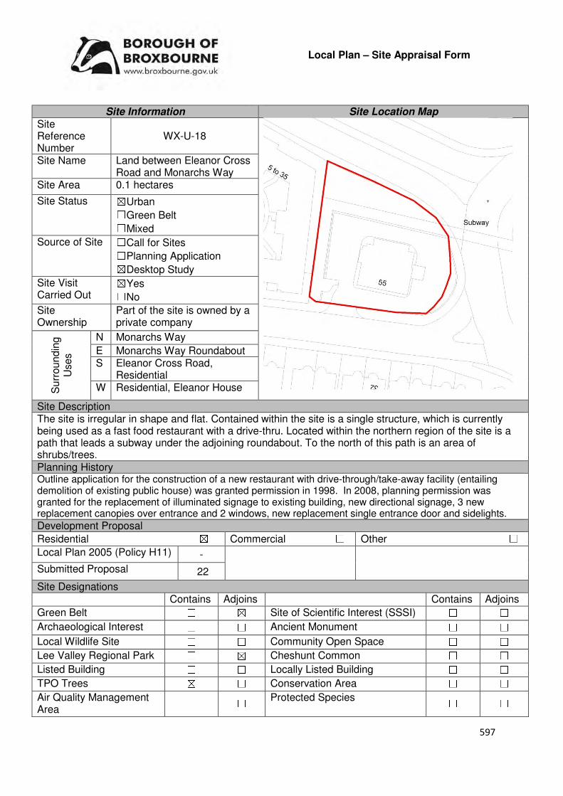
597
Local Plan – Site Appraisal Form
Site Information Site Location Map Site Reference Number
WX-U-18
Site Name Land between Eleanor Cross Road and Monarchs Way
Site Area 0.1 hectares
Site Status ☒Urban ☐Green Belt ☐Mixed
Source of Site ☐Call for Sites ☐Planning Application ☒Desktop Study
Site Visit Carried Out
☒Yes ☐No
Site Ownership
Part of the site is owned by a private company
Surr
oundin
g
Uses
N Monarchs Way
E Monarchs Way Roundabout S Eleanor Cross Road,
Residential W Residential, Eleanor House
Site Description The site is irregular in shape and flat. Contained within the site is a single structure, which is currently being used as a fast food restaurant with a drive-thru. Located within the northern region of the site is a path that leads a subway under the adjoining roundabout. To the north of this path is an area of shrubs/trees. Planning History Outline application for the construction of a new restaurant with drive-through/take-away facility (entailing demolition of existing public house) was granted permission in 1998. In 2008, planning permission was granted for the replacement of illuminated signage to existing building, new directional signage, 3 new replacement canopies over entrance and 2 windows, new replacement single entrance door and sidelights.
Development Proposal
Residential ☒ Commercial ☐ Other ☐
Local Plan 2005 (Policy H11) -
Submitted Proposal 22
Site Designations Contains Adjoins Contains Adjoins
Green Belt ☐ ☒ Site of Scientific Interest (SSSI) ☐ ☐
Archaeological Interest ☐ ☐ Ancient Monument ☐ ☐
Local Wildlife Site ☐ ☐ Community Open Space ☐ ☐
Lee Valley Regional Park ☐ ☒ Cheshunt Common ☐ ☐
Listed Building ☐ ☐ Locally Listed Building ☐ ☐
TPO Trees ☒ ☐ Conservation Area ☐ ☐
Air Quality Management Area
☐ ☐ Protected Species ☐ ☐
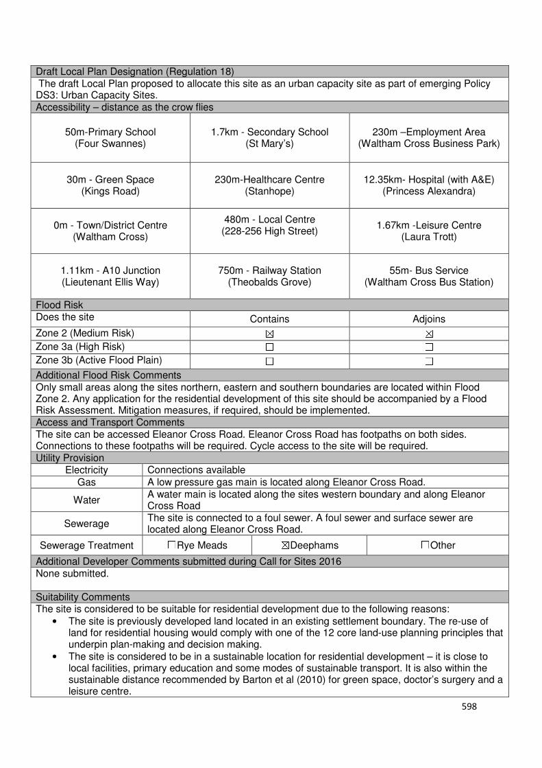
598
Draft Local Plan Designation (Regulation 18) The draft Local Plan proposed to allocate this site as an urban capacity site as part of emerging Policy DS3: Urban Capacity Sites. Accessibility – distance as the crow flies
50m-Primary School (Four Swannes)
1.7km - Secondary School (St Mary’s)
230m –Employment Area (Waltham Cross Business Park)
30m - Green Space (Kings Road)
230m-Healthcare Centre (Stanhope)
12.35km- Hospital (with A&E) (Princess Alexandra)
0m - Town/District Centre (Waltham Cross)
480m - Local Centre (228-256 High Street)
1.67km -Leisure Centre (Laura Trott)
1.11km - A10 Junction (Lieutenant Ellis Way)
750m - Railway Station (Theobalds Grove)
55m- Bus Service (Waltham Cross Bus Station)
Flood Risk Does the site Contains Adjoins
Zone 2 (Medium Risk) ☒ ☒
Zone 3a (High Risk) ☐ ☐
Zone 3b (Active Flood Plain) ☐ ☐
Additional Flood Risk Comments Only small areas along the sites northern, eastern and southern boundaries are located within Flood Zone 2. Any application for the residential development of this site should be accompanied by a Flood Risk Assessment. Mitigation measures, if required, should be implemented. Access and Transport Comments The site can be accessed Eleanor Cross Road. Eleanor Cross Road has footpaths on both sides. Connections to these footpaths will be required. Cycle access to the site will be required. Utility Provision
Electricity Connections available
Gas A low pressure gas main is located along Eleanor Cross Road.
Water A water main is located along the sites western boundary and along Eleanor Cross Road
Sewerage The site is connected to a foul sewer. A foul sewer and surface sewer are located along Eleanor Cross Road.
Sewerage Treatment ☐Rye Meads ☒Deephams ☐Other
Additional Developer Comments submitted during Call for Sites 2016 None submitted. Suitability Comments The site is considered to be suitable for residential development due to the following reasons:
• The site is previously developed land located in an existing settlement boundary. The re-use of land for residential housing would comply with one of the 12 core land-use planning principles that underpin plan-making and decision making.
• The site is considered to be in a sustainable location for residential development – it is close to local facilities, primary education and some modes of sustainable transport. It is also within the sustainable distance recommended by Barton et al (2010) for green space, doctor’s surgery and a leisure centre.

599
• The Waltham Cross Town Centre Strategy identifies that this site is disconnected from the town centre shops and services, which limits the sites potential for linked trips, and consequently results in the site making little contribution to the town centre’s success. The Strategy states that the site’s redevelopment for high quality residential and the re-provision of the retail unit at ground floor level would enable the creation of an attractive, landmark gateway to the town centre from Monarch’s way.
• The site is located within Waltham Cross Town Centre. The NPPF (Paragraph 23) states that “residential development can play an important role in ensuring the vitality of centres and set out policies to encourage residential development on appropriate sites”.
Is this site considered to be suitable for development?
☒Yes ☐ No
Availability Comments The site is not considered to be available. The site was identified by the Council are part of the Waltham Cross Town Centre Strategy. The Council has not received any promotion for the sites development from the landowner during the Call for Sites 2016 or the Local Plan (Regulation 18) consultation.
Is the site considered to be available for development
☐Yes ☒ No
Achievability Comments The site is not considered to be available, and therefore it not considered being achievable.
Is the site considered to be achievable?
☐Yes ☒ No
Delivery Period -
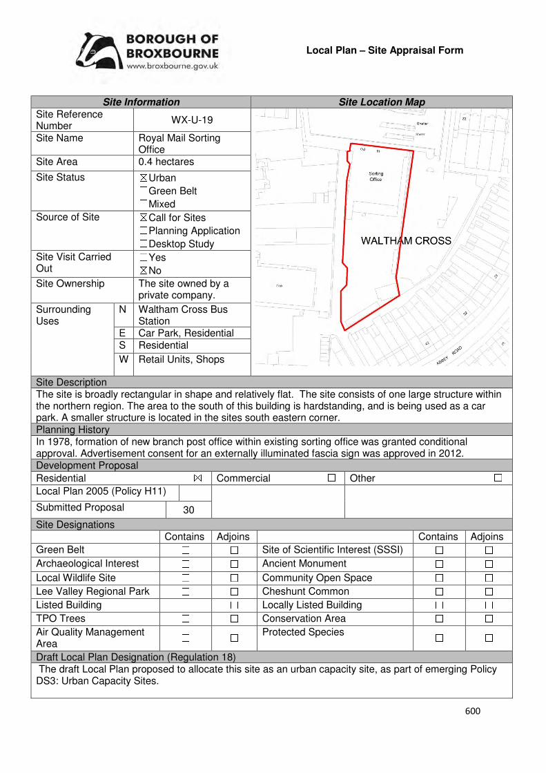
600
Local Plan – Site Appraisal Form
Site Information Site Location Map Site Reference Number
WX-U-19
Site Name Royal Mail Sorting Office
Site Area 0.4 hectares
Site Status ☒Urban ☐Green Belt ☐Mixed
Source of Site ☒Call for Sites ☐Planning Application ☐Desktop Study
Site Visit Carried Out
☐Yes ☒No
Site Ownership The site owned by a private company.
Surrounding Uses
N Waltham Cross Bus Station
E Car Park, Residential S Residential
W Retail Units, Shops
Site Description The site is broadly rectangular in shape and relatively flat. The site consists of one large structure within the northern region. The area to the south of this building is hardstanding, and is being used as a car park. A smaller structure is located in the sites south eastern corner. Planning History In 1978, formation of new branch post office within existing sorting office was granted conditional approval. Advertisement consent for an externally illuminated fascia sign was approved in 2012. Development Proposal
Residential ☒ Commercial ☐ Other ☐
Local Plan 2005 (Policy H11)
Submitted Proposal 30
Site Designations Contains Adjoins Contains Adjoins
Green Belt ☐ ☐ Site of Scientific Interest (SSSI) ☐ ☐
Archaeological Interest ☐ ☐ Ancient Monument ☐ ☐
Local Wildlife Site ☐ ☐ Community Open Space ☐ ☐
Lee Valley Regional Park ☐ ☐ Cheshunt Common ☐ ☐
Listed Building ☐ ☐ Locally Listed Building ☐ ☐
TPO Trees ☐ ☐ Conservation Area ☐ ☐
Air Quality Management Area
☐ ☐ Protected Species ☐ ☐
Draft Local Plan Designation (Regulation 18) The draft Local Plan proposed to allocate this site as an urban capacity site, as part of emerging Policy DS3: Urban Capacity Sites.
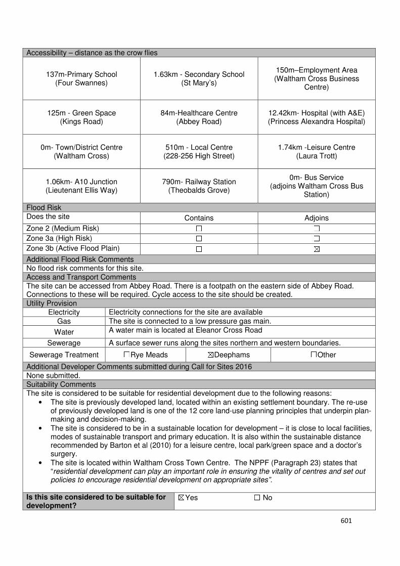
601
Accessibility – distance as the crow flies
137m-Primary School (Four Swannes)
1.63km - Secondary School (St Mary’s)
150m–Employment Area (Waltham Cross Business
Centre)
125m - Green Space (Kings Road)
84m-Healthcare Centre
(Abbey Road)
12.42km- Hospital (with A&E) (Princess Alexandra Hospital)
0m- Town/District Centre
(Waltham Cross)
510m - Local Centre
(228-256 High Street)
1.74km -Leisure Centre (Laura Trott)
1.06km- A10 Junction (Lieutenant Ellis Way)
790m- Railway Station (Theobalds Grove)
0m- Bus Service (adjoins Waltham Cross Bus
Station)
Flood Risk Does the site Contains Adjoins
Zone 2 (Medium Risk) ☐ ☐
Zone 3a (High Risk) ☐ ☐
Zone 3b (Active Flood Plain) ☐ ☒
Additional Flood Risk Comments No flood risk comments for this site. Access and Transport Comments The site can be accessed from Abbey Road. There is a footpath on the eastern side of Abbey Road. Connections to these will be required. Cycle access to the site should be created. Utility Provision
Electricity Electricity connections for the site are available
Gas The site is connected to a low pressure gas main.
Water A water main is located at Eleanor Cross Road
Sewerage A surface sewer runs along the sites northern and western boundaries.
Sewerage Treatment ☐Rye Meads ☒Deephams ☐Other
Additional Developer Comments submitted during Call for Sites 2016 None submitted. Suitability Comments The site is considered to be suitable for residential development due to the following reasons:
• The site is previously developed land, located within an existing settlement boundary. The re-use of previously developed land is one of the 12 core land-use planning principles that underpin plan-making and decision-making.
• The site is considered to be in a sustainable location for development – it is close to local facilities, modes of sustainable transport and primary education. It is also within the sustainable distance recommended by Barton et al (2010) for a leisure centre, local park/green space and a doctor’s surgery.
• The site is located within Waltham Cross Town Centre. The NPPF (Paragraph 23) states that “residential development can play an important role in ensuring the vitality of centres and set out policies to encourage residential development on appropriate sites”.
Is this site considered to be suitable for development?
☒Yes ☐ No
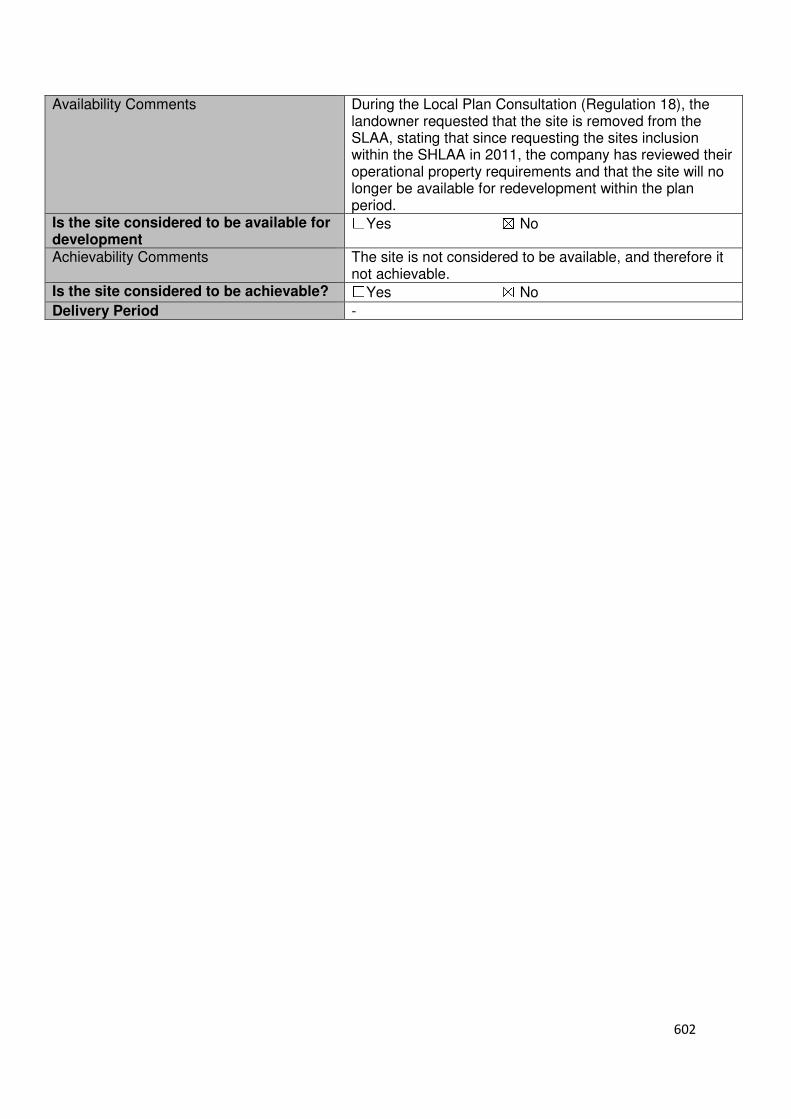
602
Availability Comments During the Local Plan Consultation (Regulation 18), the landowner requested that the site is removed from the SLAA, stating that since requesting the sites inclusion within the SHLAA in 2011, the company has reviewed their operational property requirements and that the site will no longer be available for redevelopment within the plan period.
Is the site considered to be available for development
☐Yes ☒ No
Achievability Comments The site is not considered to be available, and therefore it not achievable.
Is the site considered to be achievable? ☐Yes ☒ No
Delivery Period -
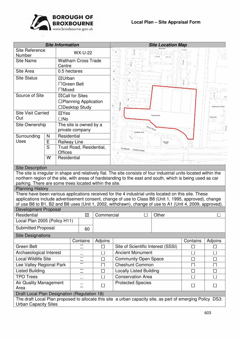
603
Local Plan – Site Appraisal Form
Site Information Site Location Map Site Reference Number
WX-U-22
Site Name Waltham Cross Trade Centre
Site Area 0.5 hectares
Site Status ☒Urban ☐Green Belt ☐Mixed
Source of Site ☒Call for Sites ☐Planning Application ☐Desktop Study
Site Visit Carried Out
☒Yes ☐No
Site Ownership The site is owned by a private company
Surrounding Uses
N Residential
E Railway Line S Trust Road, Residential,
Offices W Residential
Site Description The site is irregular in shape and relatively flat. The site consists of four industrial units located within the northern region of the site, with areas of hardstanding to the east and south, which is being used as car parking. There are some trees located within the site. Planning History There have been various applications received for the 4 industrial units located on this site. These applications include advertisement consent, change of use to Class B8 (Unit 1, 1995, approved), change of use B8 to B1, B2 and B8 uses (Unit 1, 2002, withdrawn), change of use to A1 (Unit 4, 2009, approved). Development Proposal
Residential ☒ Commercial ☐ Other ☐
Local Plan 2005 (Policy H11)
Submitted Proposal 60
Site Designations Contains Adjoins Contains Adjoins
Green Belt ☐ ☐ Site of Scientific Interest (SSSI) ☐ ☐
Archaeological Interest ☐ ☐ Ancient Monument ☐ ☐
Local Wildlife Site ☐ ☐ Community Open Space ☐ ☐
Lee Valley Regional Park ☐ ☐ Cheshunt Common ☐ ☐
Listed Building ☐ ☐ Locally Listed Building ☐ ☐
TPO Trees ☐ ☐ Conservation Area ☐ ☐
Air Quality Management Area
☐ ☐ Protected Species ☐ ☐
Draft Local Plan Designation (Regulation 18) The draft Local Plan proposed to allocate this site a urban capacity site, as part of emerging Policy DS3: Urban Capacity Sites

604
Accessibility – distance as the crow flies
177m-Primary School (Four Swannes)
1.79km - Secondary School (St Mary’s)
180m–Employment Area
(Waltham Cross Business Park)
100m - Green Space (Waltham Cross Local Park)
335m-Healthcare Centre
(Stanhope)
12.16km- Hospital (with A&E) (Princess Alexandra)
120m- Town/District Centre (Waltham Cross Town Centre)
550m- Local Centre (228-256 High Street)
1.65km -Leisure Centre (Laura Trott Leisure Centre)
1.24km - A10 Junction (Lieutenant Ellis Way)
120m- Railway Station
(Waltham Cross)
90m- Bus Service (Waltham Cross Railway Station)
Flood Risk Does the site Contains Adjoins
Zone 2 (Medium Risk) ☒ ☒
Zone 3a (High Risk) ☐ ☐
Zone 3b (Active Flood Plain) ☐ ☒
Additional Flood Risk Comments A flood risk assessment will need to accompany any planning application for the development of this site. Mitigation measures, if necessary, should be implemented. Access and Transport Comments The site can be accessed from Trust Road. Trust Road has footpaths on both sides. Connections to these footpaths will be required. Cycle access to the site will need to be created. Utility Provision
Electricity Electricity connections already available.
Gas A low pressure gas main is located within the site, just to the south of the 4 industrial units.
Water A water main is located along Trust Road and York Road.
Sewerage A foul sewer is located within the site, to the east of the 4 industrial units. A surface sewer is located along York Road. A pressured main is located along Trust Road.
Sewerage Treatment ☐Rye Meads ☒Deephams ☐Other
Additional Developer Comments submitted during Call for Sites 2016 The promoter stated that the site is currently occupied and the timescale for the existing use to cease is 6-8 years. The site has an existing safe access point, no site designations and to the promoters knowledge does not contain contaminated land nor had any previous hazardous uses at the site. The promoter noted that part of the site is subject to a restrictive covenant not to build within 100 feet of land owned by another without obtaining approval and complying with requirements. The promoter states that there a two-storey industrial buildings comprising 4 units currently situated on the site.
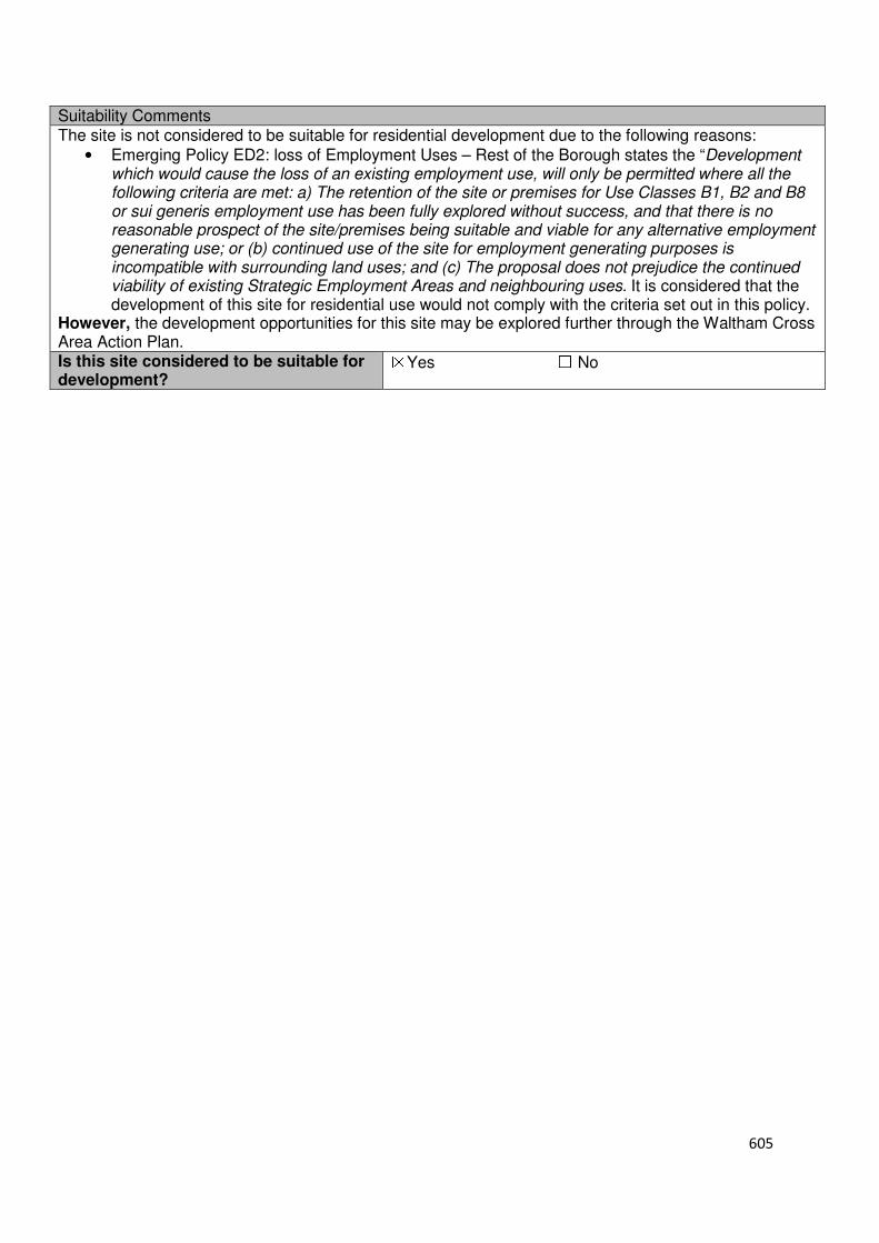
605
Suitability Comments The site is not considered to be suitable for residential development due to the following reasons:
• Emerging Policy ED2: loss of Employment Uses – Rest of the Borough states the “Development which would cause the loss of an existing employment use, will only be permitted where all the following criteria are met: a) The retention of the site or premises for Use Classes B1, B2 and B8 or sui generis employment use has been fully explored without success, and that there is no reasonable prospect of the site/premises being suitable and viable for any alternative employment generating use; or (b) continued use of the site for employment generating purposes is incompatible with surrounding land uses; and (c) The proposal does not prejudice the continued viability of existing Strategic Employment Areas and neighbouring uses. It is considered that the development of this site for residential use would not comply with the criteria set out in this policy.
However, the development opportunities for this site may be explored further through the Waltham Cross Area Action Plan. Is this site considered to be suitable for development?
☒Yes ☐ No
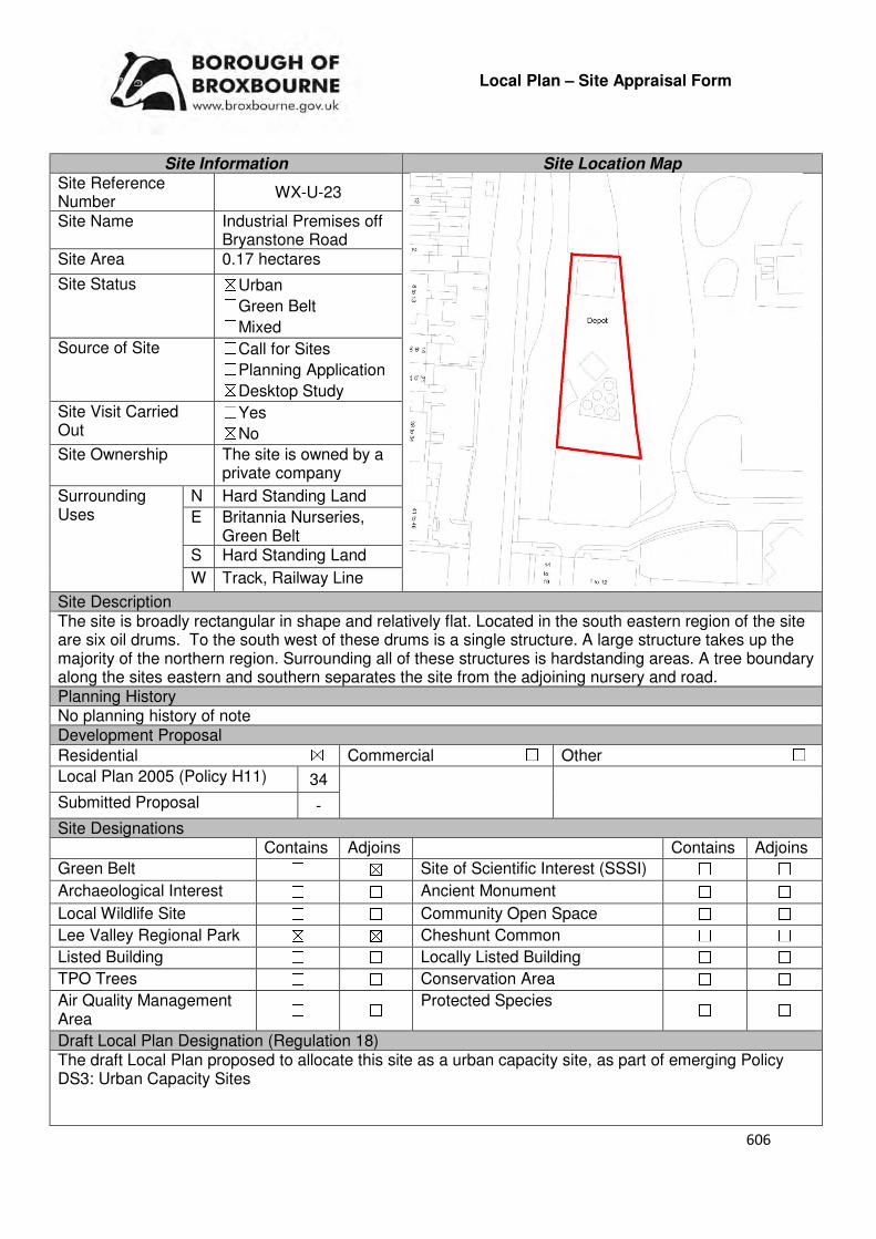
606
Local Plan – Site Appraisal Form
Site Information Site Location Map Site Reference Number
WX-U-23
Site Name Industrial Premises off Bryanstone Road
Site Area 0.17 hectares
Site Status ☒Urban ☐Green Belt ☐Mixed
Source of Site ☐Call for Sites ☐Planning Application ☒Desktop Study
Site Visit Carried Out
☐Yes ☒No
Site Ownership The site is owned by a private company
Surrounding Uses
N Hard Standing Land
E Britannia Nurseries, Green Belt
S Hard Standing Land
W Track, Railway Line
Site Description The site is broadly rectangular in shape and relatively flat. Located in the south eastern region of the site are six oil drums. To the south west of these drums is a single structure. A large structure takes up the majority of the northern region. Surrounding all of these structures is hardstanding areas. A tree boundary along the sites eastern and southern separates the site from the adjoining nursery and road. Planning History No planning history of note Development Proposal
Residential ☒ Commercial ☐ Other ☐
Local Plan 2005 (Policy H11) 34
Submitted Proposal -
Site Designations Contains Adjoins Contains Adjoins
Green Belt ☐ ☒ Site of Scientific Interest (SSSI) ☐ ☐
Archaeological Interest ☐ ☐ Ancient Monument ☐ ☐
Local Wildlife Site ☐ ☐ Community Open Space ☐ ☐
Lee Valley Regional Park ☒ ☒ Cheshunt Common ☐ ☐
Listed Building ☐ ☐ Locally Listed Building ☐ ☐
TPO Trees ☐ ☐ Conservation Area ☐ ☐
Air Quality Management Area
☐ ☐ Protected Species ☐ ☐
Draft Local Plan Designation (Regulation 18) The draft Local Plan proposed to allocate this site as a urban capacity site, as part of emerging Policy DS3: Urban Capacity Sites
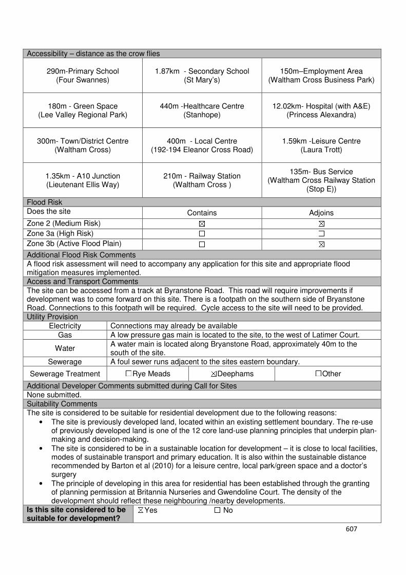
607
Accessibility – distance as the crow flies
290m-Primary School (Four Swannes)
1.87km - Secondary School (St Mary’s)
150m–Employment Area (Waltham Cross Business Park)
180m - Green Space (Lee Valley Regional Park)
440m -Healthcare Centre (Stanhope)
12.02km- Hospital (with A&E)
(Princess Alexandra)
300m- Town/District Centre
(Waltham Cross)
400m - Local Centre (192-194 Eleanor Cross Road)
1.59km -Leisure Centre (Laura Trott)
1.35km - A10 Junction (Lieutenant Ellis Way)
210m - Railway Station
(Waltham Cross )
135m- Bus Service (Waltham Cross Railway Station
(Stop E))
Flood Risk Does the site Contains Adjoins
Zone 2 (Medium Risk) ☒ ☒
Zone 3a (High Risk) ☐ ☐
Zone 3b (Active Flood Plain) ☐ ☒
Additional Flood Risk Comments A flood risk assessment will need to accompany any application for this site and appropriate flood mitigation measures implemented. Access and Transport Comments The site can be accessed from a track at Byranstone Road. This road will require improvements if development was to come forward on this site. There is a footpath on the southern side of Bryanstone Road. Connections to this footpath will be required. Cycle access to the site will need to be provided. Utility Provision
Electricity Connections may already be available
Gas A low pressure gas main is located to the site, to the west of Latimer Court.
Water A water main is located along Bryanstone Road, approximately 40m to the south of the site.
Sewerage A foul sewer runs adjacent to the sites eastern boundary.
Sewerage Treatment ☐Rye Meads ☒Deephams ☐Other
Additional Developer Comments submitted during Call for Sites None submitted. Suitability Comments The site is considered to be suitable for residential development due to the following reasons:
• The site is previously developed land, located within an existing settlement boundary. The re-use of previously developed land is one of the 12 core land-use planning principles that underpin plan-making and decision-making.
• The site is considered to be in a sustainable location for development – it is close to local facilities, modes of sustainable transport and primary education. It is also within the sustainable distance recommended by Barton et al (2010) for a leisure centre, local park/green space and a doctor’s surgery
• The principle of developing in this area for residential has been established through the granting of planning permission at Britannia Nurseries and Gwendoline Court. The density of the development should reflect these neighbouring /nearby developments.
Is this site considered to be suitable for development?
☒Yes ☐ No

608
Availability Comments No promotion for the development of this site has been promoted to the Council during the 2016 Call for Sites or the Local Plan (Regulation 18) consultation. No pre-application or planning application for this site has been received by the Council
Is the site considered to be available for development
☐Yes ☒ No
Achievability Comments The site is not considered to be available, therefore is not considered to be achievable.
Is the site considered to be achievable?
☐Yes ☒ No
Delivery Period -

609
Local Plan – Site Appraisal Form
Site Information Site Location Map Site Reference Number
WX-U-24
Site Name PR Pallets Site Area 0.36 hectares
Site Status ☒Urban ☐Green Belt ☐Mixed
Source of Site ☒Call for Sites ☐Planning Application ☐Desktop Study
Site Visit Carried Out
☐Yes ☒No
Site Ownership The site is in private ownership
Surr
oundin
g
Uses
N Station Road
E Waltham Cross Business Park, Industrial Units
S Waltham Cross Business Park , Industrial Units
W Residential, Open Space
Site Description The site is relatively rectangular in shape and relatively flat. The site consists of a number of structures located along the eastern boundary, with an area of hardstanding that to the west of these structures. This area of hardstanding is used to store pallets. There are some trees along the sites western boundary which separates it from the adjoining open space.
Planning History
No planning history of note. Development Proposal
Residential ☒ Commercial ☐ Other ☐
Local Plan 2005 (Policy H11)
Submitted Proposal
Site Designations Contains Adjoins Contains Adjoins
Green Belt ☐ ☐ Site of Scientific Interest (SSSI) ☐ ☐
Archaeological Interest ☐ ☐ Ancient Monument ☐ ☐
Local Wildlife Site ☐ ☐ Community Open Space ☐ ☒
Lee Valley Regional Park ☐ ☐ Cheshunt Common ☐ ☐
Listed Building ☐ ☐ Locally Listed Building ☐ ☐
TPO Trees ☐ ☐ Conservation Area ☐ ☐
Air Quality Management Area
☐ ☐ Protected Species ☐ ☐
Draft Local Plan Designation (Regulation 18) The draft Local Plan proposed to allocate this site as a urban capacity site, as part of emerging Policy DS3: Urban Capacity Sites.

610
Accessibility – distance as the crow flies
410m-Primary School (Holdbrook)
2.65km - Secondary School (St Mary’s School)
0m–Employment Area
(Waltham Cross Business Park)
0m - Green Space (adjoins Fisher Close)
1.15km -Healthcare Centre
(Key Health)
11.64km- Hospital (with A&E) (Princess Alexandra)
1.07km- Town/District Centre (Waltham Cross)
390m - Local Centre
(192-194 Eleanor Cross Road)
2.07km -Leisure Centre (Laura Trott)
2.12km - A10 Junction (Lieutenant Ellis Way)
840m- Railway Station
(Waltham Cross)
10m- Bus Service (Lea Road)
Flood Risk Does the site Contains Adjoins
Zone 2 (Medium Risk) ☒ ☒
Zone 3a (High Risk) ☒ ☒
Zone 3b (Active Flood Plain) ☐ ☒
Additional Flood Risk Comments A flood risk assessment will need to accompany any planning application for the development of this site. Appropriate mitigation measures will need to be implemented. Access and Transport Comments The site can be accessed from Station Road. There are footpaths along both sides of Station Road. Connections to these will be required. Cycle access to the site will need to be provided. Utility Provision
Electricity Electricity available
Gas A low pressure gas main is located along Station Road.
Water A water hydrant is located within the site. A water main is located along Station Road.
Sewerage A foul sewer is located 25m to the east of the site.
Sewerage Treatment ☐Rye Meads ☒Deephams ☐Other
Additional Developer Comments submitted by developer during Call for Sites 2016 None submitted. Suitability Comments The site is not considered to be suitable for residential development due to the following reasons:
• The site is included within the Waltham Cross Business Park. There is a general presumption against the loss of employment uses within the borough’s employment areas. As indicated in the emerging text, changes to non-employment uses within Strategic Employment Areas are less likely to be granted.
Is this site considered to be suitable for development?
☐Yes ☒ No

611
Local Plan – Site Appraisal Form
Site Information Site Location Map Site Reference Number
WX-U-25
Site Name Theobalds Grove Station Car Park
Site Area 0.36 hectares
Site Status ☒Urban ☐Green Belt ☐Mixed
Source of Site ☒Call for Sites ☐Planning Application ☐Desktop Study
Site Visit Carried Out
☒Yes ☐No
Site Ownership The site is owned by a private company.
Surrounding Uses
N Railway Lines
E High Street S Residential, Local
Centre W Residential
Site Description The site is broadly rectangular in shape and relatively flat. The site consists of hardstanding which is currently being used as a station car park. A fence along the sites northern boundary separates is from the adjoining road. Planning History There have been a number of applications for Theobalds Grove Station. None of these applications relate to Theobalds Grove Car Park. Development Proposal
Residential ☒ Commercial ☐ Other ☐
Local Plan 2005 (Policy H11)
Submitted Proposal 50
Site Designations Contains Adjoins Contains Adjoins
Green Belt ☐ ☐ Site of Scientific Interest (SSSI) ☐ ☐
Archaeological Interest ☐ ☐ Ancient Monument ☐ ☐
Local Wildlife Site ☐ ☐ Community Open Space ☐ ☐
Lee Valley Regional Park ☐ ☐ Cheshunt Common ☐ ☐
Listed Building ☐ ☐ Locally Listed Building ☐ ☐
TPO Trees ☐ ☐ Conservation Area ☐ ☐
Air Quality Management Area
☐ ☐ Protected Species ☐ ☐
Draft Local Plan Designation (Regulation 18) The draft Local Plan proposed to allocate this site as a urban capacity site as part of emerging Pol8icy DS3: Urban Capacity Sites
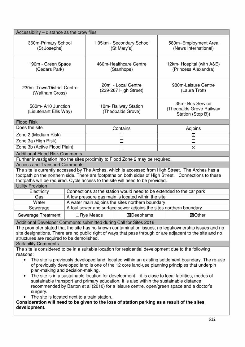
612
Accessibility – distance as the crow flies
360m-Primary School (St Josephs)
1.05km - Secondary School (St Mary’s)
580m–Employment Area
(News International)
190m - Green Space (Cedars Park)
460m-Healthcare Centre
(Stanhope)
12km- Hospital (with A&E) (Princess Alexandra)
230m- Town/District Centre
(Waltham Cross)
20m - Local Centre
(239-267 High Street)
980m-Leisure Centre (Laura Trott)
560m- A10 Junction (Lieutenant Ellis Way)
10m- Railway Station (Theobalds Grove)
35m- Bus Service (Theobalds Grove Railway
Station (Stop B))
Flood Risk Does the site Contains Adjoins
Zone 2 (Medium Risk) ☐ ☒
Zone 3a (High Risk) ☐ ☐
Zone 3b (Active Flood Plain) ☐ ☒
Additional Flood Risk Comments Further investigation into the sites proximity to Flood Zone 2 may be required. Access and Transport Comments The site is currently accessed by The Arches, which is accessed from High Street. The Arches has a footpath on the northern side. There are footpaths on both sides of High Street. Connections to these footpaths will be required. Cycle access to the site will need to be provided. Utility Provision
Electricity Connections at the station would need to be extended to the car park
Gas A low pressure gas main is located within the site.
Water A water main adjoins the sites northern boundary
Sewerage A foul sewer and surface sewer adjoins the sites northern boundary
Sewerage Treatment ☐Rye Meads ☒Deephams ☒Other
Additional Developer Comments submitted during Call for Sites 2016 The promoter stated that the site has no known contamination issues, no legal/ownership issues and no site designations. There are no public right of ways that pass through or are adjacent to the site and no structures are required to be demolished. Suitability Comments The site is considered to be in a suitable location for residential development due to the following reasons:
• The site is previously developed land, located within an existing settlement boundary. The re-use of previously developed land is one of the 12 core land-use planning principles that underpin plan-making and decision-making.
• The site is in a sustainable location for development – it is close to local facilities, modes of sustainable transport and primary education. It is also within the sustainable distance recommended by Barton et al (2010) for a leisure centre, open/green space and a doctor’s surgery.
• The site is located next to a train station. Consideration will need to be given to the loss of station parking as a result of the sites development.
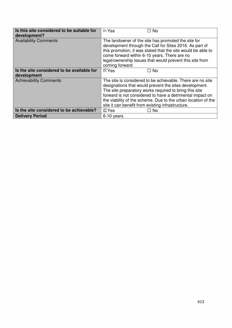
613
Is this site considered to be suitable for development?
☒Yes ☐ No
Availability Comments The landowner of the site has promoted the site for development through the Call for Sites 2016. As part of this promotion, it was stated that the site would be able to come forward within 6-10 years. There are no legal/ownership issues that would prevent this site from coming forward
Is the site considered to be available for development
☒Yes ☐ No
Achievability Comments The site is considered to be achievable. There are no site designations that would prevent the sites development. The site preparatory works required to bring this site forward is not considered to have a detrimental impact on the viability of the scheme. Due to the urban location of the site it can benefit from existing infrastructure.
Is the site considered to be achievable? ☒Yes ☐ No
Delivery Period 6-10 years

614
Local Plan – Site Appraisal Form
Site Information Site Location Map Site Reference Number
WX-U-27
Site Name Station Approach Industrial Units
Site Area 0.17 hectares
Site Status ☒Urban ☐Green Belt ☐Mixed
Source of Site ☒Call for Sites ☐Planning Application ☐Desktop Study
Site Visit Carried Out
☒Yes ☐No
Site Ownership There are various landowners for this site
Surrounding Uses
N Eleanor Cross Road
E Waltham Cross Station S Station Approach,
Local Open Space W Station Road
Site Description The site is irregular in shape and relatively flat. The site consists of a number of structures, the largest of which is located extends the majority of the site, from east to west. Surrounding these structures are areas of hardstanding. Planning History No planning history of note Development Proposal
Residential ☒ Commercial ☐ Other ☐
Local Plan 2005 (Policy H11)
14
Submitted Proposal
Site Designations Contains Adjoins Contains Adjoins
Green Belt ☐ ☐ Site of Scientific Interest (SSSI) ☐ ☐
Archaeological Interest ☐ ☐ Ancient Monument ☐ ☐
Local Wildlife Site ☐ ☐ Community Open Space ☐ ☐
Lee Valley Regional Park
☐ ☐ Cheshunt Common ☐ ☐
Listed Building ☐ ☐ Locally Listed Building ☐ ☐
TPO Trees ☐ ☐ Conservation Area ☐ ☐
Air Quality Management Area
☐ ☐ Protected Species ☐ ☐
Draft Local Plan Designation (Regulation 18) The draft Local Plan proposed to allocate this site as a urban capacity site, as part of emerging Policy DS23: Urban Capacity Sites
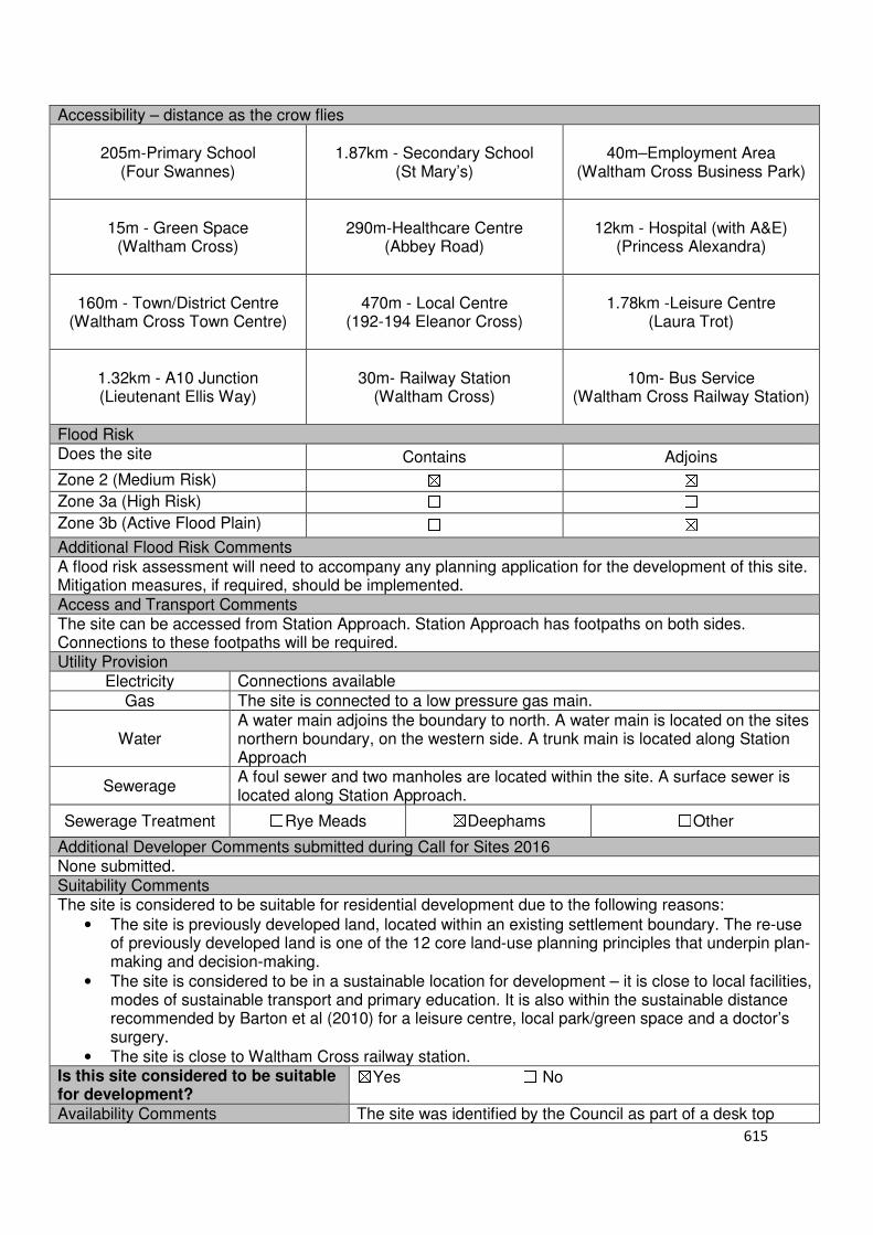
615
Accessibility – distance as the crow flies
205m-Primary School (Four Swannes)
1.87km - Secondary School (St Mary’s)
40m–Employment Area
(Waltham Cross Business Park)
15m - Green Space (Waltham Cross)
290m-Healthcare Centre
(Abbey Road)
12km - Hospital (with A&E) (Princess Alexandra)
160m - Town/District Centre (Waltham Cross Town Centre)
470m - Local Centre
(192-194 Eleanor Cross)
1.78km -Leisure Centre (Laura Trot)
1.32km - A10 Junction (Lieutenant Ellis Way)
30m- Railway Station
(Waltham Cross)
10m- Bus Service (Waltham Cross Railway Station)
Flood Risk Does the site Contains Adjoins
Zone 2 (Medium Risk) ☒ ☒
Zone 3a (High Risk) ☐ ☐
Zone 3b (Active Flood Plain) ☐ ☒
Additional Flood Risk Comments A flood risk assessment will need to accompany any planning application for the development of this site. Mitigation measures, if required, should be implemented. Access and Transport Comments The site can be accessed from Station Approach. Station Approach has footpaths on both sides. Connections to these footpaths will be required. Utility Provision
Electricity Connections available
Gas The site is connected to a low pressure gas main.
Water A water main adjoins the boundary to north. A water main is located on the sites northern boundary, on the western side. A trunk main is located along Station Approach
Sewerage A foul sewer and two manholes are located within the site. A surface sewer is located along Station Approach.
Sewerage Treatment ☐Rye Meads ☒Deephams ☐Other
Additional Developer Comments submitted during Call for Sites 2016 None submitted. Suitability Comments The site is considered to be suitable for residential development due to the following reasons:
• The site is previously developed land, located within an existing settlement boundary. The re-use of previously developed land is one of the 12 core land-use planning principles that underpin plan-making and decision-making.
• The site is considered to be in a sustainable location for development – it is close to local facilities, modes of sustainable transport and primary education. It is also within the sustainable distance recommended by Barton et al (2010) for a leisure centre, local park/green space and a doctor’s surgery.
• The site is close to Waltham Cross railway station. Is this site considered to be suitable for development?
☒Yes ☐ No
Availability Comments The site was identified by the Council as part of a desk top
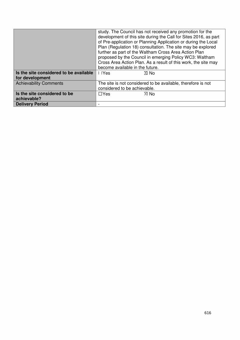
616
study. The Council has not received any promotion for the development of this site during the Call for Sites 2016, as part of Pre-application or Planning Application or during the Local Plan (Regulation 18) consultation. The site may be explored further as part of the Waltham Cross Area Action Plan proposed by the Council in emerging Policy WC3: Waltham Cross Area Action Plan. As a result of this work, the site may become available in the future.
Is the site considered to be available for development
☐Yes ☒ No
Achievability Comments The site is not considered to be available, therefore is not considered to be achievable.
Is the site considered to be achievable?
☐Yes ☒ No
Delivery Period -
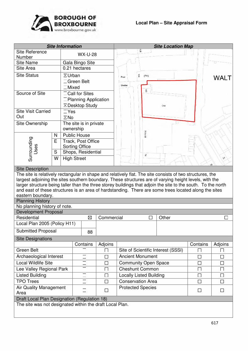
617
Local Plan – Site Appraisal Form
Site Information Site Location Map Site Reference Number
WX-U-28
Site Name Gala Bingo Site Site Area 0.21 hectares
Site Status ☒Urban ☐Green Belt ☐Mixed
Source of Site ☐Call for Sites ☐Planning Application ☒Desktop Study
Site Visit Carried Out
☐Yes ☒No
Site Ownership The site is in private ownership
Surr
oundin
g
Uses
N Public House
E Track, Post Office Sorting Office
S Shops, Residential
W High Street
Site Description The site is relatively rectangular in shape and relatively flat. The site consists of two structures, the largest adjoining the sites southern boundary. These structures are of varying height levels, with the larger structure being taller than the three storey buildings that adjoin the site to the south. To the north and east of these structures is an area of hardstanding. There are some trees located along the sites eastern boundary. Planning History No planning history of note. Development Proposal
Residential ☒ Commercial ☐ Other ☐
Local Plan 2005 (Policy H11)
Submitted Proposal 88
Site Designations Contains Adjoins Contains Adjoins
Green Belt ☐ ☐ Site of Scientific Interest (SSSI) ☐ ☐
Archaeological Interest ☐ ☐ Ancient Monument ☐ ☐
Local Wildlife Site ☐ ☐ Community Open Space ☐ ☐
Lee Valley Regional Park ☐ ☐ Cheshunt Common ☐ ☐
Listed Building ☐ ☐ Locally Listed Building ☐ ☐
TPO Trees ☐ ☐ Conservation Area ☐ ☐
Air Quality Management Area
☐ ☐ Protected Species ☐ ☐
Draft Local Plan Designation (Regulation 18) The site was not designated within the draft Local Plan.
618
Accessibility – distance as the crow flies
210m-Primary School (Four Swannes)
1.6km - Secondary School (St Mary’s)
275m–Employment Area
(Waltham Cross Business Park)
213m - Green Space (Waltham Cross)
110m-Healthcare Centre
(Abbey View)
8.2km- Hospital (with A&E) (Barnet)
0m- Town/District Centre (within Waltham Cross)
560m - Local Centre (228-256 High Street)
1.8km -Leisure Centre (Laura Trott)
1.05km - A10 Junction (Lieutenant Ellis Way)
380m- Railway Station
(Waltham Cross)
345m - Bus Service (Waltham Cross Bus Station)
Flood Risk Does the site Contains Adjoins
Zone 2 (Medium Risk) ☐ ☐
Zone 3a (High Risk) ☐ ☐
Zone 3b (Active Flood Plain) ☐ ☒
Additional Flood Risk Comments No flood risk comments for this site. Access and Transport Comments The site can be accessed from High Street Road. High Street Road has footpaths on both sides. Connections to these footpaths will be required. Utility Provision
Electricity Connections may already be available.
Gas The site is connected to a low pressure gas main
Water The site is already connected to a water main.
Sewerage The site is already connected to a foul sewer. A surface sewer is located along High Street.
Sewerage Treatment ☐Rye Meads ☒Deephams ☐Other
Additional Developer Comments submitted during Call for Sites 2016 None submitted. Suitability Comments The site is considered to be suitable for residential development due to the following reasons:
• The site is previously developed land, located within an existing settlement boundary. The re-use of previously developed land is one of the 12 core land-use planning principles that underpin plan-making and decision-making.
• The site is in a sustainable location for development – it is close to local facilities, modes of sustainable transport and primary education. It is also within the sustainable distance recommended by Barton et al (2010) for a leisure centre, open/green space and a doctor’s surgery.
• The NPPF (Paragraph 23) states that “residential development can play an important role in ensuring the vitality of centres and [LPA’s should] set out policies to encourage residential development on appropriate sites.
However, the development of this site for 88 units is considered to be an overdevelopment and does not reflect the density within the surrounding area. The Council considers that a more appropriate scale for this site would be between 40-50. Is this site considered to be suitable ☒Yes ☐ No
619
for development?
Availability Comments The site has been actively promoted to the Council for development.
Is the site considered to be available for development?
☒Yes ☐ No
Achievability Comments The site is considered to be achievable. There are no policy designations that would prevent this site from coming forward. Due to the sites urban nature it will be able to benefit from existing infrastructure. The cost for the site preparatory work to bring this site forward for development will depend on the scheme (i.e. conversion of existing building or demolition of existing building and creation of new building).
Is the site considered to be achievable?
☒Yes ☐ No
Delivery Period 1-5 years

620
Waltham Cross
Green Belt Sites
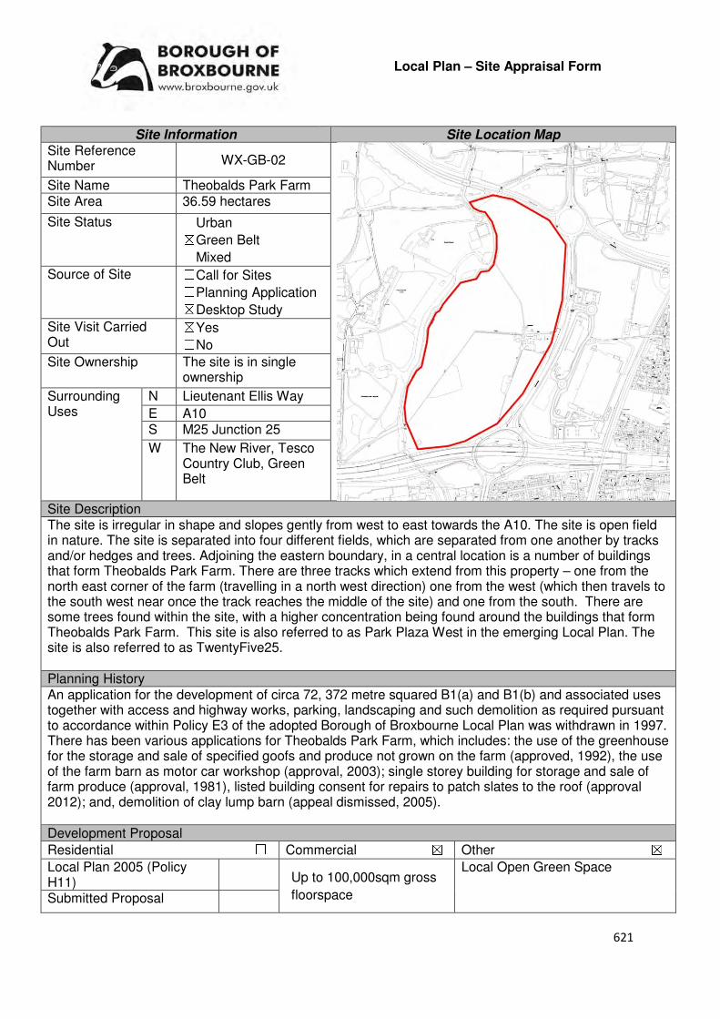
621
Local Plan – Site Appraisal Form
Site Information Site Location Map Site Reference Number WX-GB-02
Site Name Theobalds Park Farm Site Area 36.59 hectares
Site Status ☐Urban ☒Green Belt ☐Mixed
Source of Site ☐Call for Sites ☐Planning Application ☒Desktop Study
Site Visit Carried Out
☒Yes ☐No
Site Ownership The site is in single ownership
Surrounding Uses
N Lieutenant Ellis Way
E A10 S M25 Junction 25
W The New River, Tesco Country Club, Green Belt
Site Description The site is irregular in shape and slopes gently from west to east towards the A10. The site is open field in nature. The site is separated into four different fields, which are separated from one another by tracks and/or hedges and trees. Adjoining the eastern boundary, in a central location is a number of buildings that form Theobalds Park Farm. There are three tracks which extend from this property – one from the north east corner of the farm (travelling in a north west direction) one from the west (which then travels to the south west near once the track reaches the middle of the site) and one from the south. There are some trees found within the site, with a higher concentration being found around the buildings that form Theobalds Park Farm. This site is also referred to as Park Plaza West in the emerging Local Plan. The site is also referred to as TwentyFive25. Planning History An application for the development of circa 72, 372 metre squared B1(a) and B1(b) and associated uses together with access and highway works, parking, landscaping and such demolition as required pursuant to accordance within Policy E3 of the adopted Borough of Broxbourne Local Plan was withdrawn in 1997. There has been various applications for Theobalds Park Farm, which includes: the use of the greenhouse for the storage and sale of specified goofs and produce not grown on the farm (approved, 1992), the use of the farm barn as motor car workshop (approval, 2003); single storey building for storage and sale of farm produce (approval, 1981), listed building consent for repairs to patch slates to the roof (approval 2012); and, demolition of clay lump barn (appeal dismissed, 2005). Development Proposal
Residential ☐ Commercial ☒ Other ☒
Local Plan 2005 (Policy H11)
Local Open Green Space
Submitted Proposal
Up to 100,000sqm gross
floorspace

622
Site Designations Contains Adjoins Contains Adjoins
Green Belt ☒ ☒ Site of Scientific Interest (SSSI) ☐ ☐
Archaeological Interest ☒ ☐ Ancient Monument ☐ ☐
Local Wildlife Site ☐ ☐ Community Open Space ☐ ☐
Lee Valley Regional Park
☐ ☐ Cheshunt Common ☐ ☐
Listed Building ☒ ☐ Locally Listed Building ☐ ☐
TPO Trees ☐ ☐ Conservation Area ☐ ☐
Air Quality Management Area
☐ ☐ Protected Species ☐ ☐
Draft Local Plan Designation (Regulation 18) The draft Local Plan proposed to allocate this site for the development of a business campus, as part of emerging Policy PP1: Park Plaza West. The Policy states that the development will provide: up to 100,000 sqm gross floorspace; gateway development sensitive to the Green Belt setting; restricted to use classes B1a or B1b or others that support the campus; generous and well landscaped setting including southern area of the site to be laid out as public open space; landmark development at corner of A10 and Lieutenant Ellis Way; bus service; parking in accordance with Local Plan Guidelines; Pedestrian and cycle connections to be made to the urban area; New River and environs to be developed as a Green Corridor; and, Cecils Pond to be restored. Accessibility – distance as the crow flies
370m-Primary School (Hurst Drive)
210m - Secondary School (St Mary’s)
140m–Employment Area (News International)
150m - Green Space (Cedars Park)
960m-Healthcare Centre (Stanhope)
11.66km- Hospital (with A&E) (Barnet)
640m- Town/District Centre (Waltham Cross)
810m - Local Centre (239-267 High Street)
1.43km -Leisure Centre (Laura Trott)
0m- A10 Junction (adjoins Lieutenant Ellis Way and
M25 J25)
820m- Railway Station (Theobalds Grove)
386m - Bus Service (Bullsmoor Lane)
Flood Risk Does the site Contains Adjoins
Zone 2 (Medium Risk) ☐ ☐
Zone 3a (High Risk) ☐ ☐
Zone 3b (Active Flood Plain) ☐ ☒
Additional Flood Risk Comments The site may suffer from ground and surface water flooding and the southern area is within a source protection zone. Access and Transport Comments There is vehicle access to Theobalds Park Farm from the A10. This access point will need to be improved significant to be able to accommodate the amount of traffic that this site could generate. An additional entrance/exit point – how many and the location of these should be informed by modelling. Due to the amount of development this site could accommodate, a transport assessment will be required. It is considered that improvements to the highway capacity along the A10 corridor will be required to support development of this site. Improvements to the cycle and pedestrian access to this site will be required. The New River path adjoins the site to the west. This path will need to be maintained.
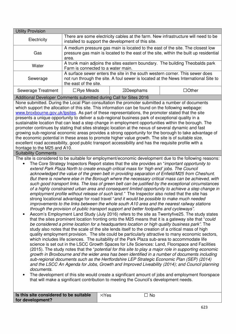
623
Utility Provision
Electricity There are some electricity cables at the farm. New infrastructure will need to be installed to support the development of this site.
Gas A medium pressure gas main is located to the east of the site. The closest low pressure gas main is located to the east of the site, within the built up residential area.
Water A trunk main adjoins the sites eastern boundary. The building Theobalds park Farm is connected to a water main.
Sewerage A surface sewer enters the site in the south western corner. This sewer does not run through the site. A foul sewer is located at the News International Site to the east of the site.
Sewerage Treatment ☐Rye Meads ☒Deephams ☐Other
Additional Developer Comments submitted during Call for Sites 2016 None submitted. During the Local Plan consultation the promoter submitted a number of documents which support the allocation of this site. This information can be found on the following webpage: www.broxbourne.gov.uk/lpsites. As part of these representations, the promoter stated that the site presents a unique opportunity to deliver a sub-regional business park of exceptional quality in a sustainable location that can lead a step change in employment opportunities within the borough. The promoter continues by stating that sites strategic location at the nexus of several dynamic and fast growing sub-regional economic areas provides a strong opportunity for the borough to take advantage of the economic potential in these areas to promote higher value growth. The site is of suitable size, excellent road accessibility, good public transport accessibility and has the requisite profile with a frontage to the M25 and A10. Suitability Comments The site is considered to be suitable for employment/economic development due to the following reasons:
• The Core Strategy Inspectors Report states that the site provides an “important opportunity to extend Park Plaza North to create enough critical mass for ‘high end’ jobs. The Council acknowledged the value of the green belt in providing separation of Enfield/M25 from Cheshunt. But there is nowhere else in the Borough where the necessary critical mass can be achieved, with such good transport links. The loss of green belt can be justified by the exceptional circumstances of a highly constrained urban area and consequent limited opportunity to achieve a step change in employment profile without release of such land.” The Inspector also noted that the site has strong locational advantage for road travel “and it would be possible to make much needed improvements to the links between the whole south A10 area and the nearest railway stations through the provision of public transport support and better footpaths and cycleways”.
• Aecom’s Employment Land Study (July 2016) refers to the site as Twentyfive25. The study states that the sites prominent location fronting onto the M25 means that it is a gateway site that “could be considered a prime location for a headquarters location or high quality business park”. The study also notes that the scale of the site lends itself to the creation of a critical mass of high quality employment provision. The site could be particularly attractive to many economic sectors, which includes life sciences. The suitability of the Park Plaza sub-area to accommodate life science is set out in the LSCC Growth Spaces for Life Sciences: Land, Floorspace and Facilities (2015). The study notes that the “potential for this site to play a major role in supporting economic growth in Broxbourne and the wider area has been identified in a number of documents including sub-regional documents such as the Hertfordshire LEP Strategic Economic Plan (SEP) (2014) and the LSCC An Agenda for Jobs, Growth and Improved Liveability (2014); and Council planning documents.
• The development of this site would create a significant amount of jobs and employment floorspace that will make a significant contribution to meeting the Council’s development needs.
Is this site considered to be suitable for development?
☒Yes ☐ No

624
Availability Comments The site is considered to be available. The site has been actively promoted for development during the Local Plan consultation. During the Local Plan representations the promoted stated the allocation of the Park Plaza West site to accommodate up to 100,000 sqm of B1a and B1b business floorspace.
Is the site considered to be available for development
☒Yes ☐ No
Achievability Comments The site is considered to be achievable. The amount of development that this site can accommodate will be able to support the installation of the necessary infrastructure and road improvements. With the exception of the sites Green Belt designation, it is considered that there are no policy constraints that would prevent this site from coming forward for development.
Is the site considered to be achievable?
☒Yes ☐ No
Delivery Period 1-15 years
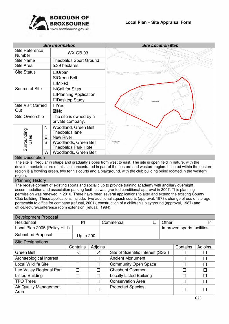
625
Local Plan – Site Appraisal Form
Site Information Site Location Map Site Reference Number
WX-GB-03
Site Name Theobalds Sport Ground Site Area 5.39 hectares
Site Status ☐Urban ☒Green Belt ☐Mixed
Source of Site ☒Call for Sites ☐Planning Application ☐Desktop Study
Site Visit Carried Out
☐Yes ☒No
Site Ownership The site is owned by a private company.
Surr
oundin
g
Uses
N Woodland, Green Belt, Theobalds lane
E New River S Woodlands, Green Belt,
Theobalds Park Hotel W Woodlands, Green Belt
Site Description The site is irregular in shape and gradually slopes from west to east. The site is open field in nature, with the development/structure of this site concentrated in part of the eastern and western region. Located within the eastern region is a bowling green, two tennis courts and a playground, with the club building being located in the western region. Planning History The redevelopment of existing sports and social club to provide training academy with ancillary overnight accommodation and association parking facilities was granted conditional approval in 2007. This planning permission was renewed in 2010. There have been several applications to alter and extend the existing County Club building. These applications include: two additional squash courts (approval, 1978); change of use of storage portacabin to office for company (refusal, 2001), construction of a children’s playground (approval, 1987) and office/lecture/conference room extension (refusal, 1984).
Development Proposal
Residential ☒ Commercial ☐ Other ☒
Local Plan 2005 (Policy H11)
Improved sports facilities
Submitted Proposal Up to 200
Site Designations Contains Adjoins Contains Adjoins
Green Belt ☒ ☒ Site of Scientific Interest (SSSI) ☐ ☐
Archaeological Interest ☐ ☐ Ancient Monument ☐ ☐
Local Wildlife Site ☐ ☐ Community Open Space ☐ ☐
Lee Valley Regional Park ☐ ☐ Cheshunt Common ☐ ☐
Listed Building ☐ ☐ Locally Listed Building ☐ ☐
TPO Trees ☐ ☐ Conservation Area ☐ ☐
Air Quality Management Area
☐ ☐ Protected Species ☐ ☐
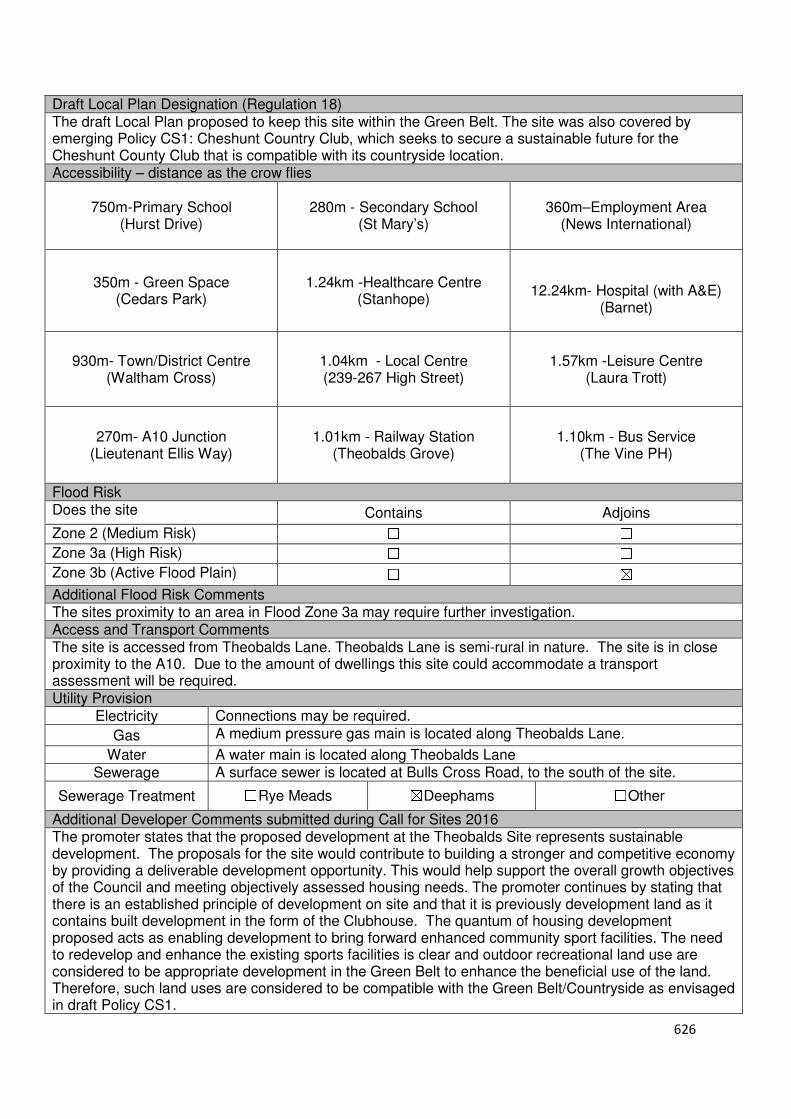
626
Draft Local Plan Designation (Regulation 18) The draft Local Plan proposed to keep this site within the Green Belt. The site was also covered by emerging Policy CS1: Cheshunt Country Club, which seeks to secure a sustainable future for the Cheshunt County Club that is compatible with its countryside location. Accessibility – distance as the crow flies
750m-Primary School (Hurst Drive)
280m - Secondary School (St Mary’s)
360m–Employment Area
(News International)
350m - Green Space (Cedars Park)
1.24km -Healthcare Centre
(Stanhope)
12.24km- Hospital (with A&E)
(Barnet)
930m- Town/District Centre
(Waltham Cross)
1.04km - Local Centre (239-267 High Street)
1.57km -Leisure Centre (Laura Trott)
270m- A10 Junction (Lieutenant Ellis Way)
1.01km - Railway Station
(Theobalds Grove)
1.10km - Bus Service (The Vine PH)
Flood Risk Does the site Contains Adjoins
Zone 2 (Medium Risk) ☐ ☐
Zone 3a (High Risk) ☐ ☐
Zone 3b (Active Flood Plain) ☐ ☒
Additional Flood Risk Comments The sites proximity to an area in Flood Zone 3a may require further investigation. Access and Transport Comments The site is accessed from Theobalds Lane. Theobalds Lane is semi-rural in nature. The site is in close proximity to the A10. Due to the amount of dwellings this site could accommodate a transport assessment will be required. Utility Provision
Electricity Connections may be required.
Gas A medium pressure gas main is located along Theobalds Lane.
Water A water main is located along Theobalds Lane
Sewerage A surface sewer is located at Bulls Cross Road, to the south of the site.
Sewerage Treatment ☐Rye Meads ☒Deephams ☐Other
Additional Developer Comments submitted during Call for Sites 2016 The promoter states that the proposed development at the Theobalds Site represents sustainable development. The proposals for the site would contribute to building a stronger and competitive economy by providing a deliverable development opportunity. This would help support the overall growth objectives of the Council and meeting objectively assessed housing needs. The promoter continues by stating that there is an established principle of development on site and that it is previously development land as it contains built development in the form of the Clubhouse. The quantum of housing development proposed acts as enabling development to bring forward enhanced community sport facilities. The need to redevelop and enhance the existing sports facilities is clear and outdoor recreational land use are considered to be appropriate development in the Green Belt to enhance the beneficial use of the land. Therefore, such land uses are considered to be compatible with the Green Belt/Countryside as envisaged in draft Policy CS1.
627
The promoter states that the Park Plaza proposals will dramatically change the setting of the site, therefore, the site should be considered against this radically evolving context rather than the existing predominant countryside setting. Ensuring the site is well integrated and connected to the Park Plaza proposals is a priority. The promoter states that the site and proposals will not have any additional impact on surrounding roads because there is already an established recreational use on site and it is currently operational. The site will also be able to benefit from the significant transport improvements proposed as part of the Park Plaza West development. A landscape-led design approach has been adopted which seeks to respect the existing character and nature of the site and surroundings. Suitability Comments The site is not considered to be suitable for residential development due to the following reasons:
• The site is included in areas D21 identified in the Council’s Green Belt Review (Scott Wilson, 2008). The Review states that area D21performs a strong role under Green Belt Purpose 1 and therefore merits retention. The site performs a medium to poor role against Green Belt Purposes 2 and 3. The Review proposed no change to the Green Belt in this location.
• The Council’s Green Belt Review identifies a number of weak and strong Green Belt boundaries. It is considered that this site has weak green belt boundaries to the south and east (non- protected woodland/trees). These boundaries would not last beyond the Plan period or prevent further encroachment.
• The site is not considered to be in a sustainable location for residential development. It is currently severed from local facilities by the A10, primary education facilities. It is also not within the sustainable distance recommended by Barton et al (2010) to a doctor’s surgery and hospital.
Is this site considered to be suitable for development? ☐Yes ☒ No
628
Commercial
Urban

629
Local Plan – Site Appraisal Form
Site Information Site Location Map Site Reference Number
HOD-UC-01
Site Name Plots F and L, RD Park Essex Road
Site Area 1.281 hectares
Site Status ☐Urban ☐Green Belt ☐Mixed
Source of Site ☐Call for Sites ☒Planning Application ☐Desktop Study
Site Visit Carried Out
☐Yes ☒No
Site Ownership The sites are owned by the Council
Surr
oundin
g
Uses
N Essex Road/Eagle House, Commercial
E Essex Road Roundabout/Essex Way
S Essex Way/ Industrial Units
W Railway Line Site Description Both sites are relatively flat. The site closest to the railway line is broadly oval in shape and developed in nature. Currently situated on the site is a scaffolding yard, which takes up a significant proportion of the site, and a car business, which is located in the eastern region. There are trees located along this sites boundaries, however, there are gaps where the vehicle access points on the southern boundary are located and on part of the northern boundary. The second site is irregular in shape. It contains no structures and has a number of trees along the boundaries. Planning History An application for the continued use of vacant industrial site as open storage, parking and containers was withdrawn in 2013. Development Proposal
Residential ☐ Commercial ☒ Other ☐
Local Plan 2005 (Policy H11)
Submitted Proposal
Site Designations Contains Adjoins Contains Adjoins
Green Belt ☐ ☐ Site of Scientific Interest (SSSI) ☐ ☐
Archaeological Interest ☐ ☐ Ancient Monument ☐ ☐
Local Wildlife Site ☐ ☐ Community Open Space ☐ ☐
Lee Valley Regional Park ☐ ☐ Cheshunt Common ☐ ☐
Listed Building ☐ ☐ Locally Listed Building ☐ ☐
TPO Trees ☐ ☐ Conservation Area ☐ ☐
Air Quality Management Area
☐ ☐ Protected Species ☐ ☐
3,844 sqm
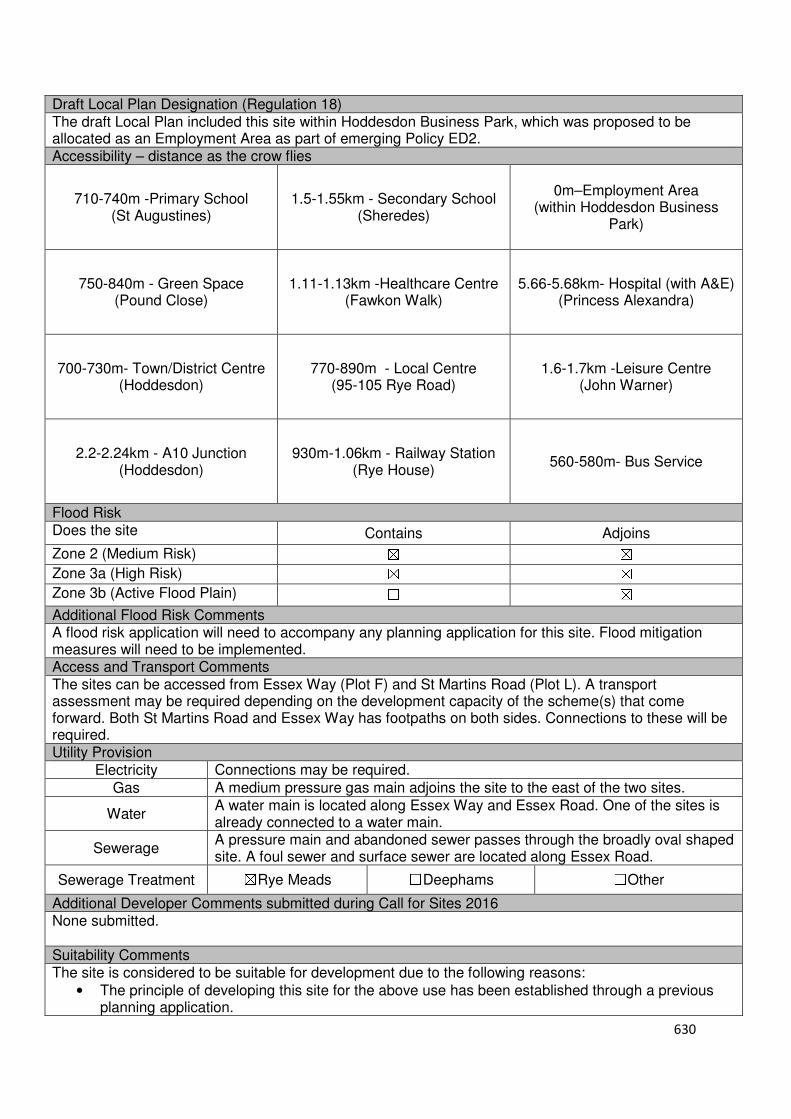
630
Draft Local Plan Designation (Regulation 18) The draft Local Plan included this site within Hoddesdon Business Park, which was proposed to be allocated as an Employment Area as part of emerging Policy ED2. Accessibility – distance as the crow flies
710-740m -Primary School (St Augustines)
1.5-1.55km - Secondary School (Sheredes)
0m–Employment Area
(within Hoddesdon Business Park)
750-840m - Green Space (Pound Close)
1.11-1.13km -Healthcare Centre
(Fawkon Walk)
5.66-5.68km- Hospital (with A&E) (Princess Alexandra)
700-730m- Town/District Centre
(Hoddesdon)
770-890m - Local Centre (95-105 Rye Road)
1.6-1.7km -Leisure Centre (John Warner)
2.2-2.24km - A10 Junction (Hoddesdon)
930m-1.06km - Railway Station
(Rye House)
560-580m- Bus Service
Flood Risk Does the site Contains Adjoins
Zone 2 (Medium Risk) ☒ ☒
Zone 3a (High Risk) ☒ ☒
Zone 3b (Active Flood Plain) ☐ ☒
Additional Flood Risk Comments A flood risk application will need to accompany any planning application for this site. Flood mitigation measures will need to be implemented. Access and Transport Comments The sites can be accessed from Essex Way (Plot F) and St Martins Road (Plot L). A transport assessment may be required depending on the development capacity of the scheme(s) that come forward. Both St Martins Road and Essex Way has footpaths on both sides. Connections to these will be required. Utility Provision
Electricity Connections may be required.
Gas A medium pressure gas main adjoins the site to the east of the two sites.
Water A water main is located along Essex Way and Essex Road. One of the sites is already connected to a water main.
Sewerage A pressure main and abandoned sewer passes through the broadly oval shaped site. A foul sewer and surface sewer are located along Essex Road.
Sewerage Treatment ☒Rye Meads ☐Deephams ☐Other
Additional Developer Comments submitted during Call for Sites 2016 None submitted. Suitability Comments The site is considered to be suitable for development due to the following reasons:
• The principle of developing this site for the above use has been established through a previous planning application.
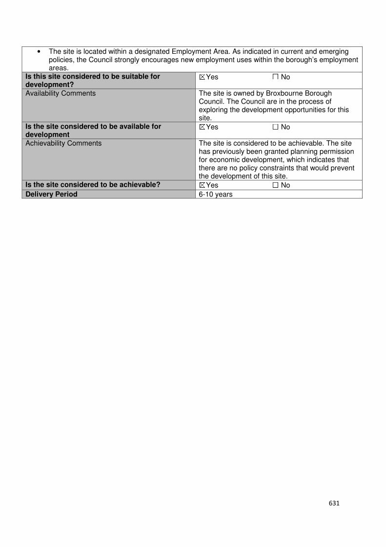
631
• The site is located within a designated Employment Area. As indicated in current and emerging policies, the Council strongly encourages new employment uses within the borough’s employment areas.
Is this site considered to be suitable for development?
☒Yes ☐ No
Availability Comments The site is owned by Broxbourne Borough Council. The Council are in the process of exploring the development opportunities for this site.
Is the site considered to be available for development
☒Yes ☐ No
Achievability Comments The site is considered to be achievable. The site has previously been granted planning permission for economic development, which indicates that there are no policy constraints that would prevent the development of this site.
Is the site considered to be achievable? ☒Yes ☐ No
Delivery Period 6-10 years

632
Local Plan – Site Appraisal Form
Site Information Site Location Map Site Reference Number
HOD-UC-02
Site Name South side of Essex Road and Railway, Plots H1 and H2
Site Area 0.966 hectares
Site Status ☐Urban ☒Green Belt ☐Mixed
Source of Site ☐Call for Sites ☒Planning Application ☐Desktop Study
Site Visit Carried Out
☐Yes ☒No
Site Ownership The site is owned by a private company
Surr
oun
din
g
Uses
N Industrial Unit
E St Martins Road S Industrial Unit
W Railway Line
Site Description The site is rectangular in shape and relatively flat. The site is an area of hardstanding that is currently being used for storage purposes. There does not appear to be any permanent structures on site. Planning History In 2007, a reserved matters application pursuant to outline application 7/0581/03/O/HOD for development comprising class B8 (storage and distribution) and ancillary class B1 (business) uses, for proposed ‘Units F, G, H1 and H2’ with landscaping was granted conditional approval. Development Proposal
Residential ☐ Commercial ☒ Other ☐
Local Plan 2005 (Policy H11)
Submitted Proposal
Site Designations Contains Adjoins Contains Adjoins
Green Belt ☐ ☐ Site of Scientific Interest (SSSI) ☐ ☐
Archaeological Interest ☐ ☐ Ancient Monument ☐ ☐
Local Wildlife Site ☐ ☐ Community Open Space ☐ ☐
Lee Valley Regional Park
☐ ☐ Cheshunt Common ☐ ☐
Listed Building ☐ ☐ Locally Listed Building ☐ ☐
TPO Trees ☐ ☐ Conservation Area ☐ ☐
Air Quality Management Area
☐ ☐ Protected Species ☐ ☐
Draft Local Plan Designation (Regulation 18) The draft Local Plan included this site within Hoddesdon Business Park, which was proposed to be allocated as an Employment Area as part of emerging Policy ED2.
2,454 sqm
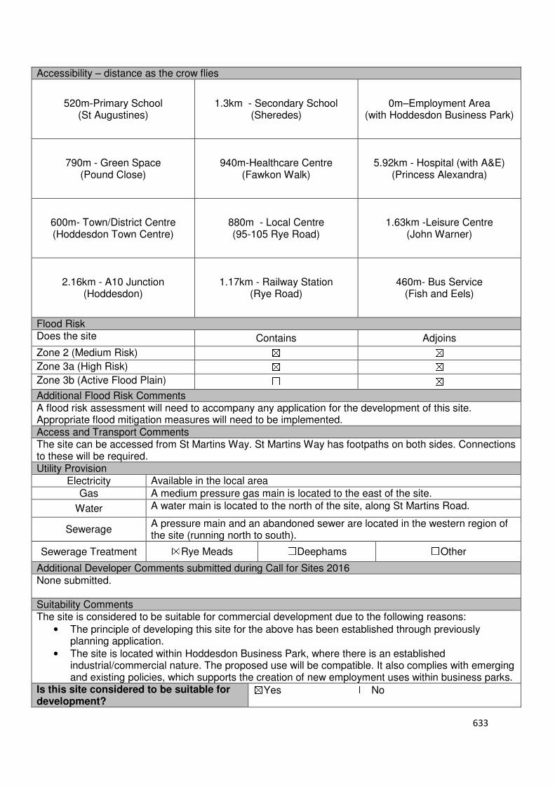
633
Accessibility – distance as the crow flies
520m-Primary School (St Augustines)
1.3km - Secondary School (Sheredes)
0m–Employment Area
(with Hoddesdon Business Park)
790m - Green Space (Pound Close)
940m-Healthcare Centre
(Fawkon Walk)
5.92km - Hospital (with A&E) (Princess Alexandra)
600m- Town/District Centre (Hoddesdon Town Centre)
880m - Local Centre (95-105 Rye Road)
1.63km -Leisure Centre (John Warner)
2.16km - A10 Junction
(Hoddesdon)
1.17km - Railway Station (Rye Road)
460m- Bus Service (Fish and Eels)
Flood Risk Does the site Contains Adjoins
Zone 2 (Medium Risk) ☒ ☒
Zone 3a (High Risk) ☒ ☒
Zone 3b (Active Flood Plain) ☐ ☒
Additional Flood Risk Comments A flood risk assessment will need to accompany any application for the development of this site. Appropriate flood mitigation measures will need to be implemented. Access and Transport Comments The site can be accessed from St Martins Way. St Martins Way has footpaths on both sides. Connections to these will be required. Utility Provision
Electricity Available in the local area
Gas A medium pressure gas main is located to the east of the site.
Water A water main is located to the north of the site, along St Martins Road.
Sewerage A pressure main and an abandoned sewer are located in the western region of the site (running north to south).
Sewerage Treatment ☒Rye Meads ☐Deephams ☐Other
Additional Developer Comments submitted during Call for Sites 2016 None submitted. Suitability Comments The site is considered to be suitable for commercial development due to the following reasons:
• The principle of developing this site for the above has been established through previously planning application.
• The site is located within Hoddesdon Business Park, where there is an established industrial/commercial nature. The proposed use will be compatible. It also complies with emerging and existing policies, which supports the creation of new employment uses within business parks.
Is this site considered to be suitable for development?
☒Yes ☐ No
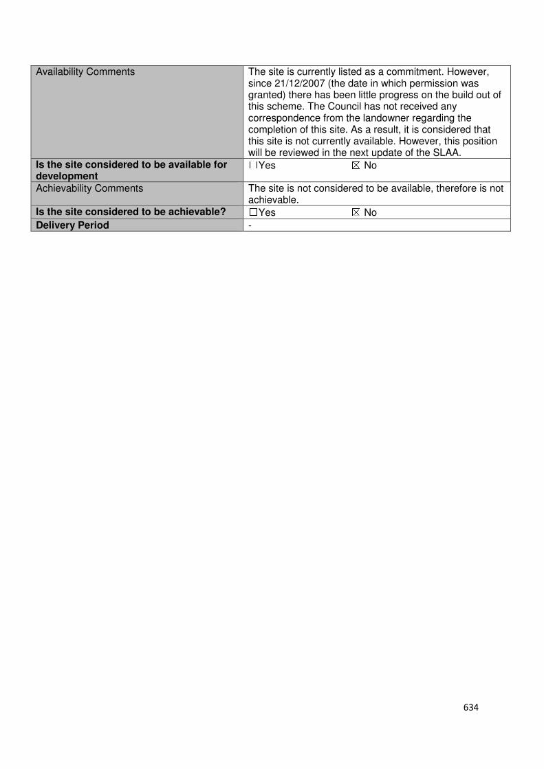
634
Availability Comments The site is currently listed as a commitment. However, since 21/12/2007 (the date in which permission was granted) there has been little progress on the build out of this scheme. The Council has not received any correspondence from the landowner regarding the completion of this site. As a result, it is considered that this site is not currently available. However, this position will be reviewed in the next update of the SLAA.
Is the site considered to be available for development
☐Yes ☒ No
Achievability Comments The site is not considered to be available, therefore is not achievable.
Is the site considered to be achievable? ☐Yes ☒ No
Delivery Period -
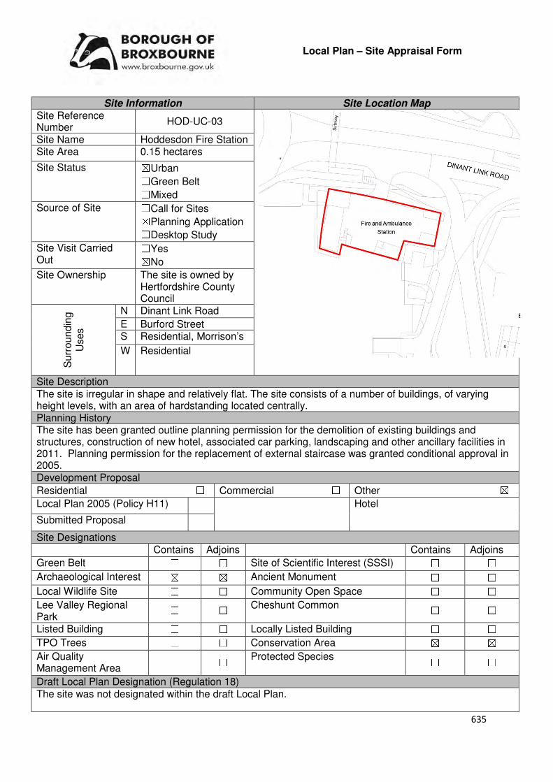
635
Local Plan – Site Appraisal Form
Site Information Site Location Map Site Reference Number
HOD-UC-03
Site Name Hoddesdon Fire Station Site Area 0.15 hectares
Site Status ☒Urban ☐Green Belt ☐Mixed
Source of Site ☐Call for Sites ☒Planning Application ☐Desktop Study
Site Visit Carried Out
☐Yes ☒No
Site Ownership The site is owned by Hertfordshire County Council
Surr
oundin
g
Uses
N Dinant Link Road
E Burford Street S Residential, Morrison’s
W Residential
Site Description The site is irregular in shape and relatively flat. The site consists of a number of buildings, of varying height levels, with an area of hardstanding located centrally. Planning History The site has been granted outline planning permission for the demolition of existing buildings and structures, construction of new hotel, associated car parking, landscaping and other ancillary facilities in 2011. Planning permission for the replacement of external staircase was granted conditional approval in 2005. Development Proposal
Residential ☐ Commercial ☐ Other ☒
Local Plan 2005 (Policy H11) Hotel
Submitted Proposal
Site Designations Contains Adjoins Contains Adjoins
Green Belt ☐ ☐ Site of Scientific Interest (SSSI) ☐ ☐
Archaeological Interest ☒ ☒ Ancient Monument ☐ ☐
Local Wildlife Site ☐ ☐ Community Open Space ☐ ☐
Lee Valley Regional Park
☐ ☐ Cheshunt Common ☐ ☐
Listed Building ☐ ☐ Locally Listed Building ☐ ☐
TPO Trees ☐ ☐ Conservation Area ☒ ☒
Air Quality Management Area
☐ ☐ Protected Species ☐ ☐
Draft Local Plan Designation (Regulation 18) The site was not designated within the draft Local Plan.
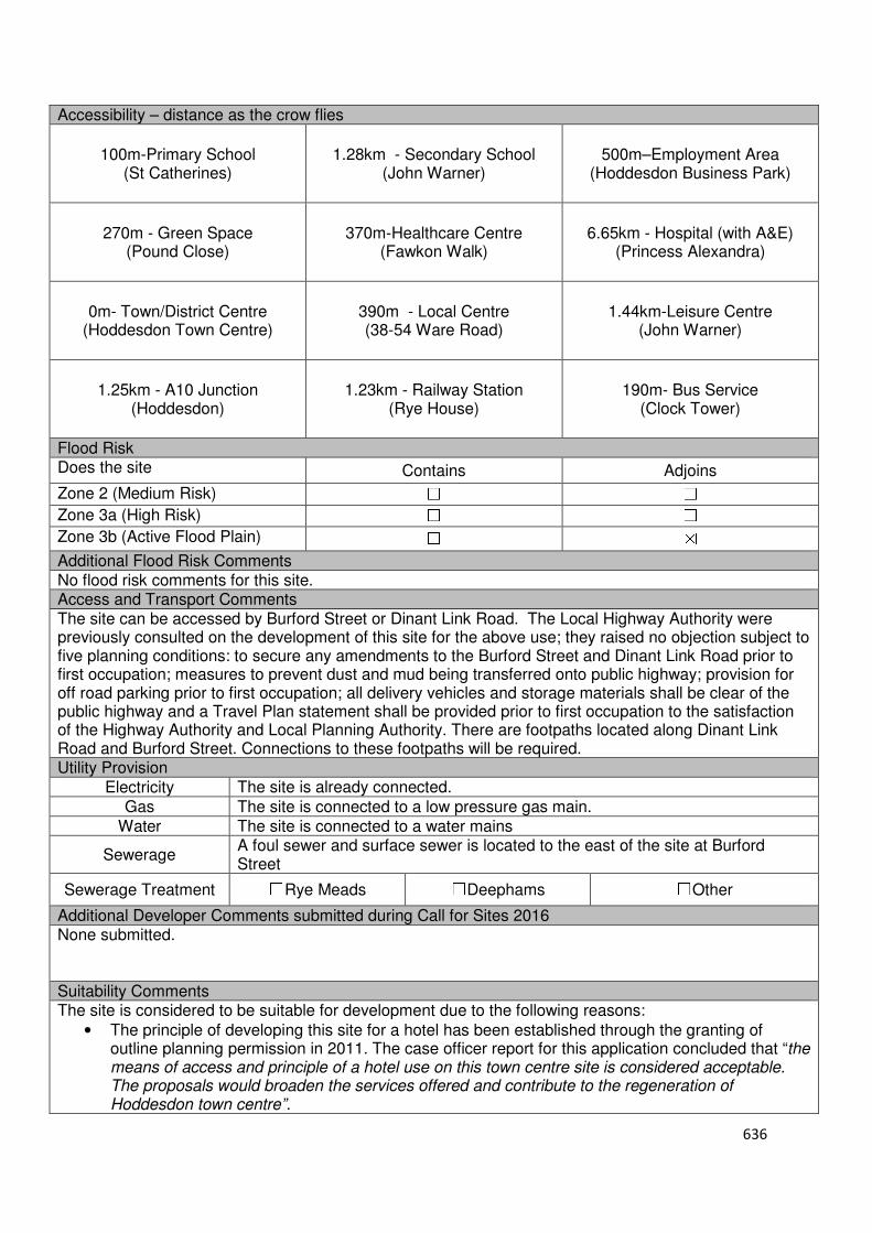
636
Accessibility – distance as the crow flies
100m-Primary School (St Catherines)
1.28km - Secondary School (John Warner)
500m–Employment Area (Hoddesdon Business Park)
270m - Green Space (Pound Close)
370m-Healthcare Centre (Fawkon Walk)
6.65km - Hospital (with A&E) (Princess Alexandra)
0m- Town/District Centre (Hoddesdon Town Centre)
390m - Local Centre (38-54 Ware Road)
1.44km-Leisure Centre (John Warner)
1.25km - A10 Junction (Hoddesdon)
1.23km - Railway Station (Rye House)
190m- Bus Service (Clock Tower)
Flood Risk Does the site Contains Adjoins
Zone 2 (Medium Risk) ☐ ☐
Zone 3a (High Risk) ☐ ☐
Zone 3b (Active Flood Plain) ☐ ☒
Additional Flood Risk Comments No flood risk comments for this site. Access and Transport Comments The site can be accessed by Burford Street or Dinant Link Road. The Local Highway Authority were previously consulted on the development of this site for the above use; they raised no objection subject to five planning conditions: to secure any amendments to the Burford Street and Dinant Link Road prior to first occupation; measures to prevent dust and mud being transferred onto public highway; provision for off road parking prior to first occupation; all delivery vehicles and storage materials shall be clear of the public highway and a Travel Plan statement shall be provided prior to first occupation to the satisfaction of the Highway Authority and Local Planning Authority. There are footpaths located along Dinant Link Road and Burford Street. Connections to these footpaths will be required. Utility Provision
Electricity The site is already connected.
Gas The site is connected to a low pressure gas main.
Water The site is connected to a water mains
Sewerage A foul sewer and surface sewer is located to the east of the site at Burford Street
Sewerage Treatment ☐Rye Meads ☐Deephams ☐Other
Additional Developer Comments submitted during Call for Sites 2016 None submitted. Suitability Comments The site is considered to be suitable for development due to the following reasons:
• The principle of developing this site for a hotel has been established through the granting of outline planning permission in 2011. The case officer report for this application concluded that “the means of access and principle of a hotel use on this town centre site is considered acceptable. The proposals would broaden the services offered and contribute to the regeneration of Hoddesdon town centre”.

637
• The site is within Hoddesdon Town Centre. As defined in the NPPF, tourism development (including theatres, museums, galleries and concert halls, hotels and conference facilities) are main town centre uses. The NPPF (Paragraph 24) states that “Local Planning Authorities….should require applications for main town centres uses to be located in town centres, then in edge of centre locations and only if suitable sites are not available should out of centre sites be considered”. Therefore, the development of this site for a hotel accords with National Planning Policy.
• The re-use of land that has been previously developed is encouraged within the National Planning Policy Framework.
Is this site considered to be suitable for development?
☒Yes ☐ No
Availability Comments For the development of this site to occur, the Fire Station and Ambulance station will need to be relocated to an alternative location. No alternative location has been promoted to the Council.
Is the site considered to be available for development
☐Yes ☒ No
Achievability Comments The site is not considered to be available, therefore is not considered to be achievable.
Is the site considered to be achievable?
☐Yes ☒ No
Delivery Period -
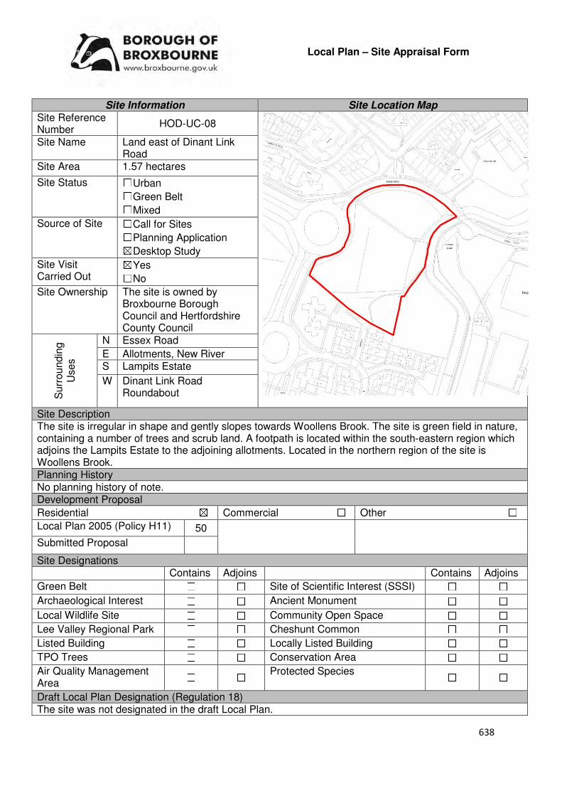
638
Local Plan – Site Appraisal Form
Site Information Site Location Map Site Reference Number
HOD-UC-08
Site Name Land east of Dinant Link Road
Site Area 1.57 hectares
Site Status ☐Urban ☐Green Belt ☐Mixed
Source of Site ☐Call for Sites ☐Planning Application ☒Desktop Study
Site Visit Carried Out
☒Yes ☐No
Site Ownership The site is owned by Broxbourne Borough Council and Hertfordshire County Council
Surr
oundin
g
Uses
N Essex Road
E Allotments, New River S Lampits Estate
W Dinant Link Road Roundabout
Site Description The site is irregular in shape and gently slopes towards Woollens Brook. The site is green field in nature, containing a number of trees and scrub land. A footpath is located within the south-eastern region which adjoins the Lampits Estate to the adjoining allotments. Located in the northern region of the site is Woollens Brook. Planning History No planning history of note. Development Proposal
Residential ☒ Commercial ☐ Other ☐
Local Plan 2005 (Policy H11) 50
Submitted Proposal
Site Designations Contains Adjoins Contains Adjoins
Green Belt ☐ ☐ Site of Scientific Interest (SSSI) ☐ ☐
Archaeological Interest ☐ ☐ Ancient Monument ☐ ☐
Local Wildlife Site ☐ ☐ Community Open Space ☐ ☐
Lee Valley Regional Park ☐ ☐ Cheshunt Common ☐ ☐
Listed Building ☐ ☐ Locally Listed Building ☐ ☐
TPO Trees ☐ ☐ Conservation Area ☐ ☐
Air Quality Management Area
☐ ☐ Protected Species ☐ ☐
Draft Local Plan Designation (Regulation 18) The site was not designated in the draft Local Plan.
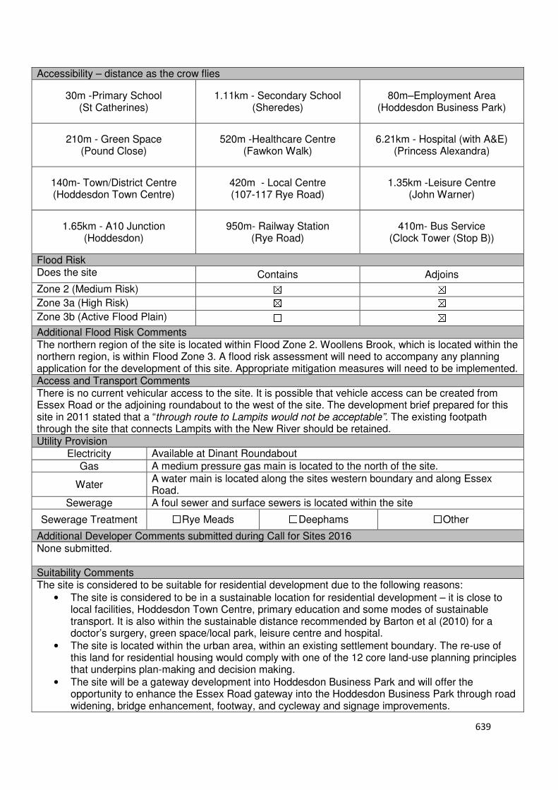
639
Accessibility – distance as the crow flies
30m -Primary School (St Catherines)
1.11km - Secondary School (Sheredes)
80m–Employment Area (Hoddesdon Business Park)
210m - Green Space (Pound Close)
520m -Healthcare Centre (Fawkon Walk)
6.21km - Hospital (with A&E) (Princess Alexandra)
140m- Town/District Centre (Hoddesdon Town Centre)
420m - Local Centre (107-117 Rye Road)
1.35km -Leisure Centre (John Warner)
1.65km - A10 Junction (Hoddesdon)
950m- Railway Station (Rye Road)
410m- Bus Service (Clock Tower (Stop B))
Flood Risk Does the site Contains Adjoins
Zone 2 (Medium Risk) ☒ ☒
Zone 3a (High Risk) ☒ ☒
Zone 3b (Active Flood Plain) ☐ ☒
Additional Flood Risk Comments The northern region of the site is located within Flood Zone 2. Woollens Brook, which is located within the northern region, is within Flood Zone 3. A flood risk assessment will need to accompany any planning application for the development of this site. Appropriate mitigation measures will need to be implemented. Access and Transport Comments There is no current vehicular access to the site. It is possible that vehicle access can be created from Essex Road or the adjoining roundabout to the west of the site. The development brief prepared for this site in 2011 stated that a “through route to Lampits would not be acceptable”. The existing footpath through the site that connects Lampits with the New River should be retained. Utility Provision
Electricity Available at Dinant Roundabout
Gas A medium pressure gas main is located to the north of the site.
Water A water main is located along the sites western boundary and along Essex Road.
Sewerage A foul sewer and surface sewers is located within the site
Sewerage Treatment ☐Rye Meads ☐Deephams ☐Other
Additional Developer Comments submitted during Call for Sites 2016 None submitted. Suitability Comments The site is considered to be suitable for residential development due to the following reasons:
• The site is considered to be in a sustainable location for residential development – it is close to local facilities, Hoddesdon Town Centre, primary education and some modes of sustainable transport. It is also within the sustainable distance recommended by Barton et al (2010) for a doctor’s surgery, green space/local park, leisure centre and hospital.
• The site is located within the urban area, within an existing settlement boundary. The re-use of this land for residential housing would comply with one of the 12 core land-use planning principles that underpins plan-making and decision making.
• The site will be a gateway development into Hoddesdon Business Park and will offer the opportunity to enhance the Essex Road gateway into the Hoddesdon Business Park through road widening, bridge enhancement, footway, and cycleway and signage improvements.
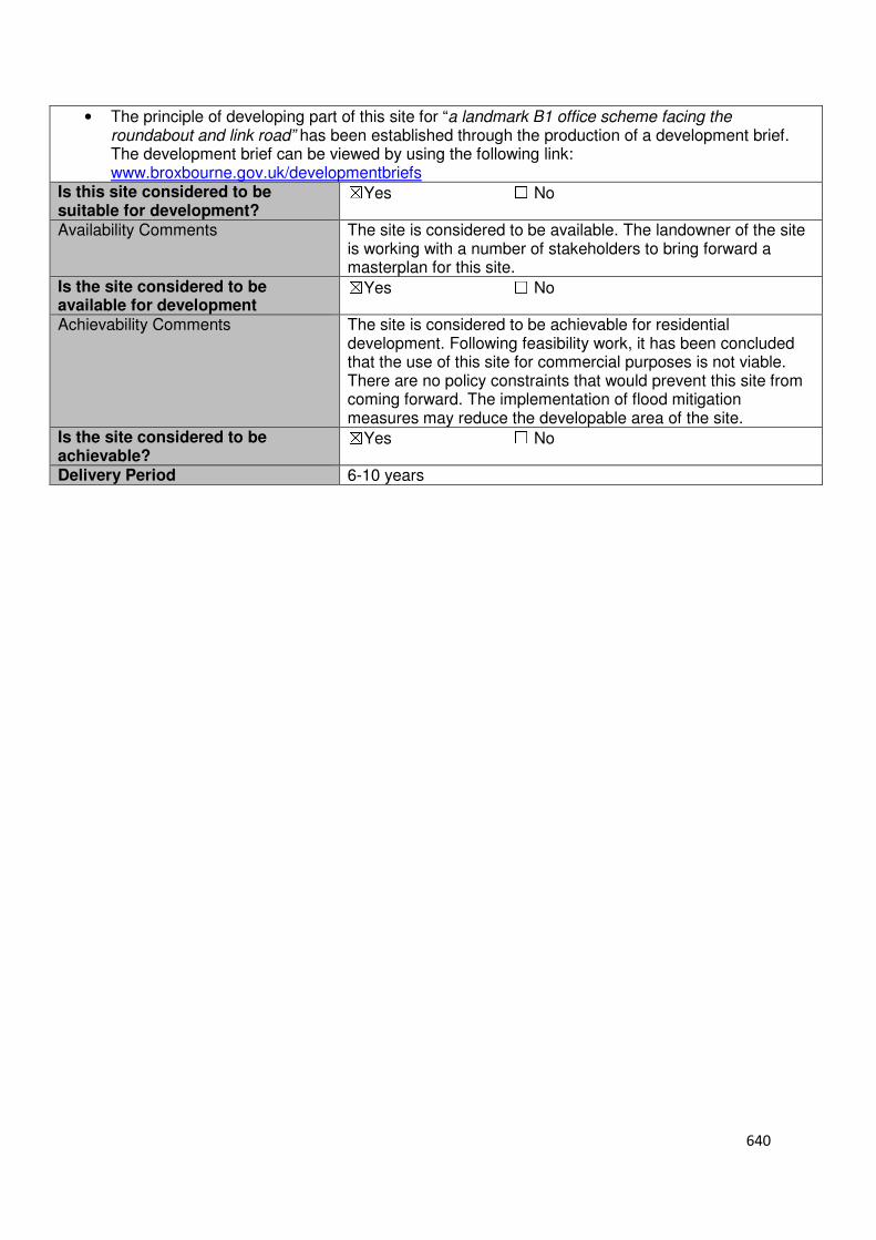
640
• The principle of developing part of this site for “a landmark B1 office scheme facing the roundabout and link road” has been established through the production of a development brief. The development brief can be viewed by using the following link: www.broxbourne.gov.uk/developmentbriefs
Is this site considered to be suitable for development?
☒Yes ☐ No
Availability Comments The site is considered to be available. The landowner of the site is working with a number of stakeholders to bring forward a masterplan for this site.
Is the site considered to be available for development
☒Yes ☐ No
Achievability Comments The site is considered to be achievable for residential development. Following feasibility work, it has been concluded that the use of this site for commercial purposes is not viable. There are no policy constraints that would prevent this site from coming forward. The implementation of flood mitigation measures may reduce the developable area of the site.
Is the site considered to be achievable?
☒Yes ☐ No
Delivery Period 6-10 years
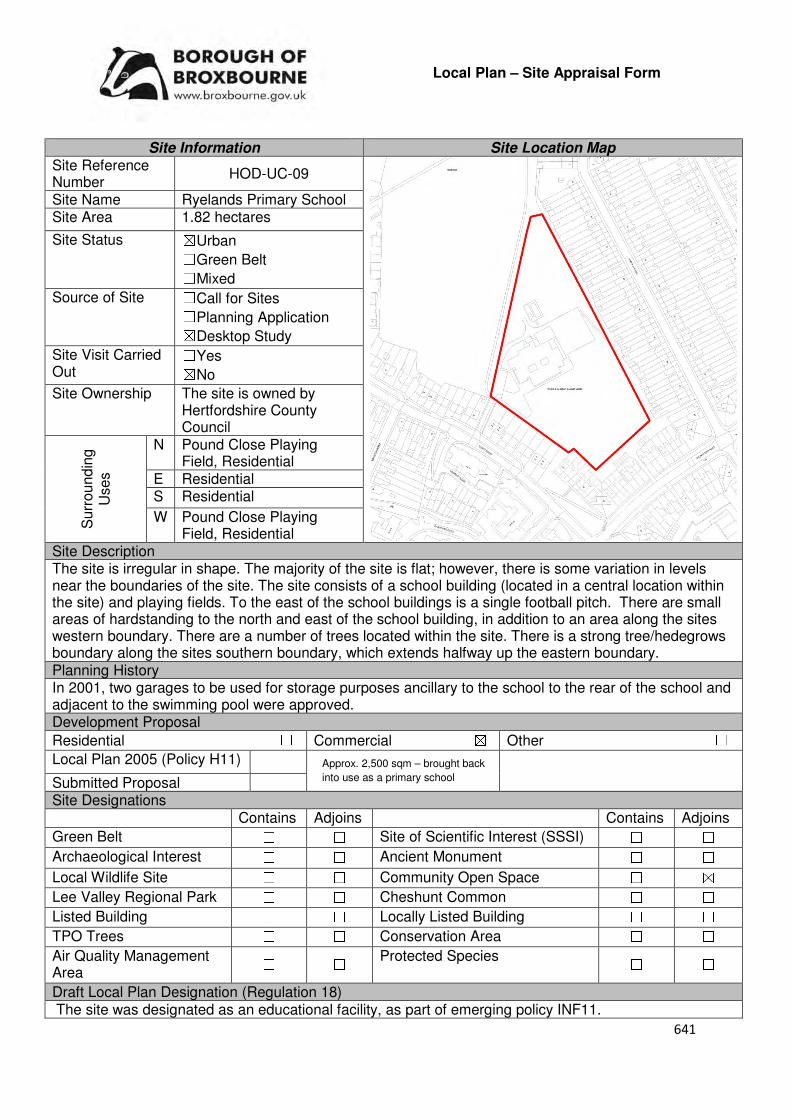
641
Local Plan – Site Appraisal Form
Site Information Site Location Map Site Reference Number
HOD-UC-09
Site Name Ryelands Primary School Site Area 1.82 hectares
Site Status ☒Urban ☐Green Belt ☐Mixed
Source of Site ☐Call for Sites ☐Planning Application ☒Desktop Study
Site Visit Carried Out
☐Yes ☒No
Site Ownership The site is owned by Hertfordshire County Council
Surr
oundin
g
Uses
N Pound Close Playing Field, Residential
E Residential S Residential
W Pound Close Playing Field, Residential
Site Description The site is irregular in shape. The majority of the site is flat; however, there is some variation in levels near the boundaries of the site. The site consists of a school building (located in a central location within the site) and playing fields. To the east of the school buildings is a single football pitch. There are small areas of hardstanding to the north and east of the school building, in addition to an area along the sites western boundary. There are a number of trees located within the site. There is a strong tree/hedegrows boundary along the sites southern boundary, which extends halfway up the eastern boundary. Planning History In 2001, two garages to be used for storage purposes ancillary to the school to the rear of the school and adjacent to the swimming pool were approved. Development Proposal
Residential ☐ Commercial ☒ Other ☐
Local Plan 2005 (Policy H11)
Submitted Proposal Site Designations Contains Adjoins Contains Adjoins
Green Belt ☐ ☐ Site of Scientific Interest (SSSI) ☐ ☐
Archaeological Interest ☐ ☐ Ancient Monument ☐ ☐
Local Wildlife Site ☐ ☐ Community Open Space ☐ ☒
Lee Valley Regional Park ☐ ☐ Cheshunt Common ☐ ☐
Listed Building ☐ ☐ Locally Listed Building ☐ ☐
TPO Trees ☐ ☐ Conservation Area ☐ ☐
Air Quality Management Area
☐ ☐ Protected Species ☐ ☐
Draft Local Plan Designation (Regulation 18) The site was designated as an educational facility, as part of emerging policy INF11.
Approx. 2,500 sqm – brought back
into use as a primary school
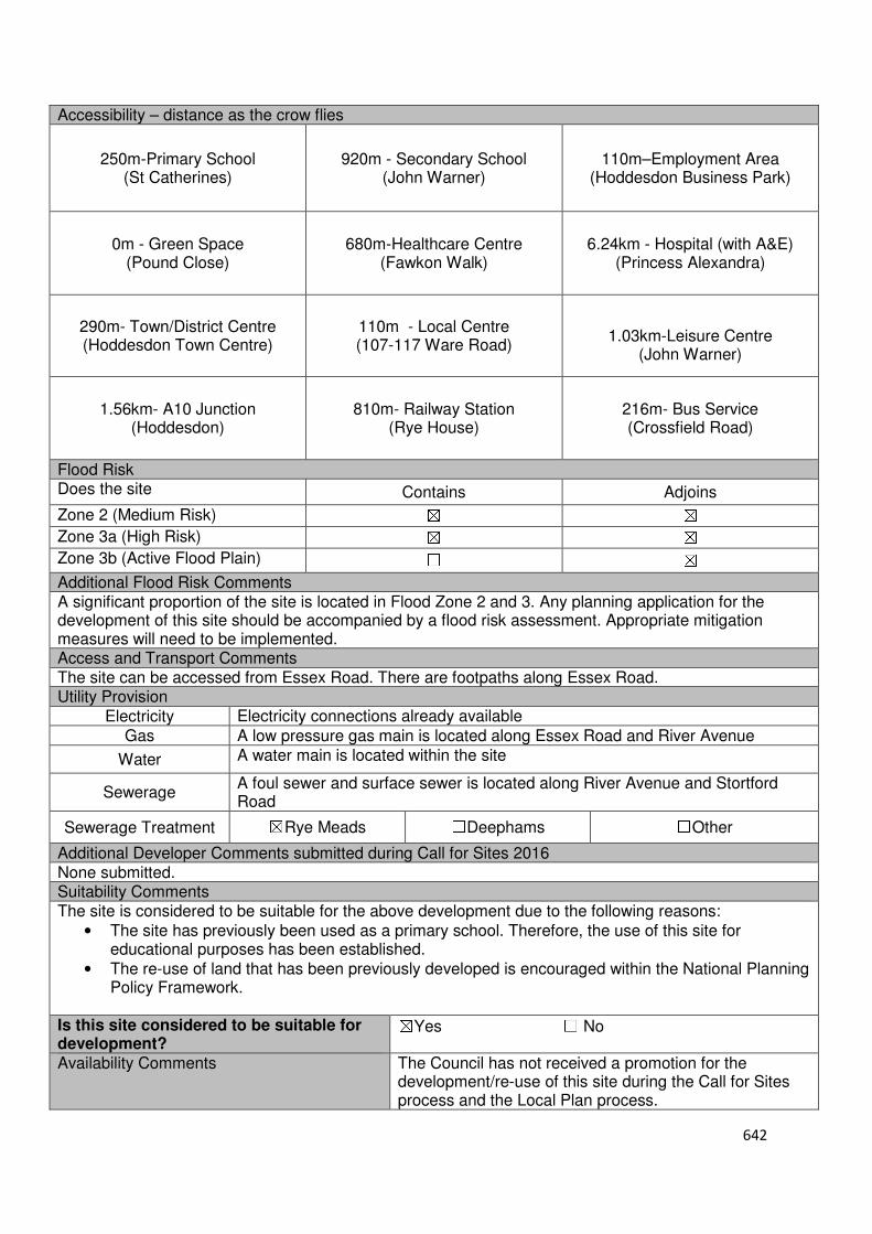
642
Accessibility – distance as the crow flies
250m-Primary School (St Catherines)
920m - Secondary School (John Warner)
110m–Employment Area
(Hoddesdon Business Park)
0m - Green Space (Pound Close)
680m-Healthcare Centre
(Fawkon Walk)
6.24km - Hospital (with A&E) (Princess Alexandra)
290m- Town/District Centre (Hoddesdon Town Centre)
110m - Local Centre (107-117 Ware Road)
1.03km-Leisure Centre
(John Warner)
1.56km- A10 Junction (Hoddesdon)
810m- Railway Station
(Rye House)
216m- Bus Service (Crossfield Road)
Flood Risk Does the site Contains Adjoins
Zone 2 (Medium Risk) ☒ ☒
Zone 3a (High Risk) ☒ ☒
Zone 3b (Active Flood Plain) ☐ ☒
Additional Flood Risk Comments A significant proportion of the site is located in Flood Zone 2 and 3. Any planning application for the development of this site should be accompanied by a flood risk assessment. Appropriate mitigation measures will need to be implemented. Access and Transport Comments The site can be accessed from Essex Road. There are footpaths along Essex Road. Utility Provision
Electricity Electricity connections already available
Gas A low pressure gas main is located along Essex Road and River Avenue
Water A water main is located within the site
Sewerage A foul sewer and surface sewer is located along River Avenue and Stortford Road
Sewerage Treatment ☒Rye Meads ☐Deephams ☐Other
Additional Developer Comments submitted during Call for Sites 2016 None submitted. Suitability Comments The site is considered to be suitable for the above development due to the following reasons:
• The site has previously been used as a primary school. Therefore, the use of this site for educational purposes has been established.
• The re-use of land that has been previously developed is encouraged within the National Planning Policy Framework.
Is this site considered to be suitable for development?
☒Yes ☐ No
Availability Comments The Council has not received a promotion for the development/re-use of this site during the Call for Sites process and the Local Plan process.
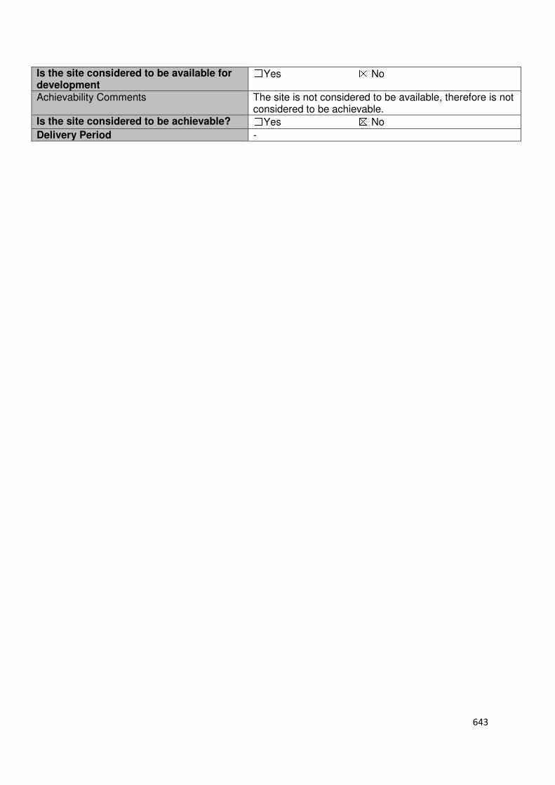
643
Is the site considered to be available for development
☐Yes ☒ No
Achievability Comments The site is not considered to be available, therefore is not considered to be achievable.
Is the site considered to be achievable? ☐Yes ☒ No
Delivery Period -
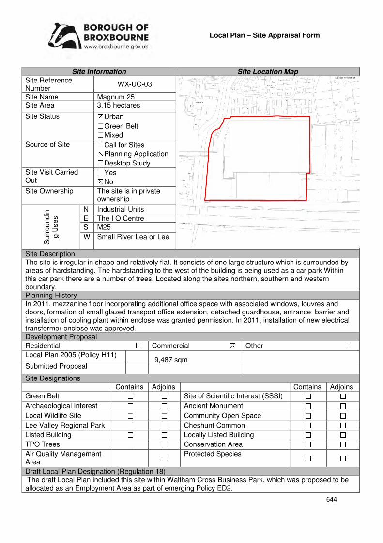
644
Local Plan – Site Appraisal Form
Site Information Site Location Map Site Reference Number
WX-UC-03
Site Name Magnum 25 Site Area 3.15 hectares
Site Status ☒Urban ☐Green Belt ☐Mixed
Source of Site ☐Call for Sites ☒Planning Application ☐Desktop Study
Site Visit Carried Out
☐Yes ☒No
Site Ownership The site is in private ownership
Surr
oundin
g U
ses
N Industrial Units
E The I O Centre S M25
W Small River Lea or Lee
Site Description The site is irregular in shape and relatively flat. It consists of one large structure which is surrounded by areas of hardstanding. The hardstanding to the west of the building is being used as a car park Within this car park there are a number of trees. Located along the sites northern, southern and western boundary. Planning History In 2011, mezzanine floor incorporating additional office space with associated windows, louvres and doors, formation of small glazed transport office extension, detached guardhouse, entrance barrier and installation of cooling plant within enclose was granted permission. In 2011, installation of new electrical transformer enclose was approved. Development Proposal
Residential ☐ Commercial ☒ Other ☐
Local Plan 2005 (Policy H11)
Submitted Proposal
Site Designations Contains Adjoins Contains Adjoins
Green Belt ☐ ☐ Site of Scientific Interest (SSSI) ☐ ☐
Archaeological Interest ☐ ☐ Ancient Monument ☐ ☐
Local Wildlife Site ☐ ☐ Community Open Space ☐ ☐
Lee Valley Regional Park ☐ ☐ Cheshunt Common ☐ ☐
Listed Building ☐ ☐ Locally Listed Building ☐ ☐
TPO Trees ☐ ☐ Conservation Area ☐ ☐
Air Quality Management Area
☐ ☐ Protected Species ☐ ☐
Draft Local Plan Designation (Regulation 18) The draft Local Plan included this site within Waltham Cross Business Park, which was proposed to be allocated as an Employment Area as part of emerging Policy ED2.
9,487 sqm
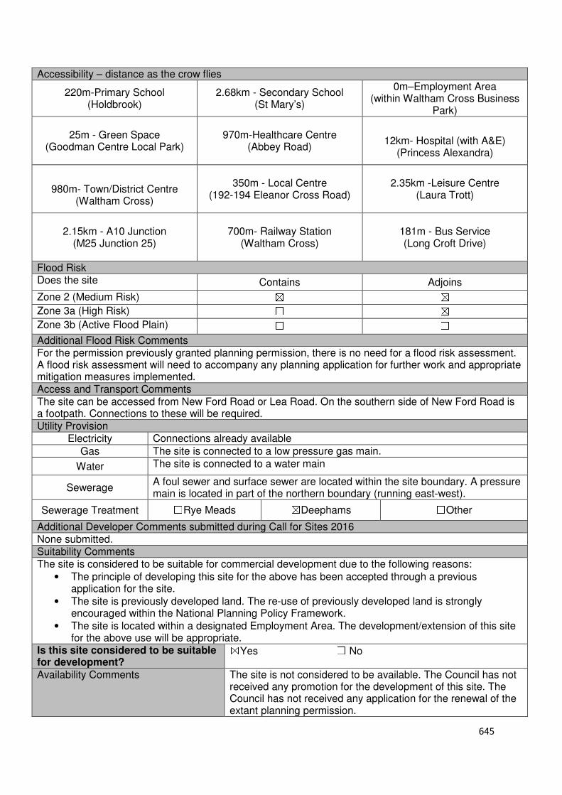
645
Accessibility – distance as the crow flies
220m-Primary School (Holdbrook)
2.68km - Secondary School (St Mary’s)
0m–Employment Area (within Waltham Cross Business
Park)
25m - Green Space (Goodman Centre Local Park)
970m-Healthcare Centre
(Abbey Road)
12km- Hospital (with A&E)
(Princess Alexandra)
980m- Town/District Centre
(Waltham Cross)
350m - Local Centre
(192-194 Eleanor Cross Road)
2.35km -Leisure Centre (Laura Trott)
2.15km - A10 Junction (M25 Junction 25)
700m- Railway Station
(Waltham Cross)
181m - Bus Service (Long Croft Drive)
Flood Risk Does the site Contains Adjoins
Zone 2 (Medium Risk) ☒ ☒
Zone 3a (High Risk) ☐ ☒
Zone 3b (Active Flood Plain) ☐ ☐
Additional Flood Risk Comments For the permission previously granted planning permission, there is no need for a flood risk assessment. A flood risk assessment will need to accompany any planning application for further work and appropriate mitigation measures implemented. Access and Transport Comments The site can be accessed from New Ford Road or Lea Road. On the southern side of New Ford Road is a footpath. Connections to these will be required. Utility Provision
Electricity Connections already available
Gas The site is connected to a low pressure gas main.
Water The site is connected to a water main
Sewerage A foul sewer and surface sewer are located within the site boundary. A pressure main is located in part of the northern boundary (running east-west).
Sewerage Treatment ☐Rye Meads ☒Deephams ☐Other
Additional Developer Comments submitted during Call for Sites 2016 None submitted. Suitability Comments The site is considered to be suitable for commercial development due to the following reasons:
• The principle of developing this site for the above has been accepted through a previous application for the site.
• The site is previously developed land. The re-use of previously developed land is strongly encouraged within the National Planning Policy Framework.
• The site is located within a designated Employment Area. The development/extension of this site for the above use will be appropriate.
Is this site considered to be suitable for development?
☒Yes ☐ No
Availability Comments The site is not considered to be available. The Council has not received any promotion for the development of this site. The Council has not received any application for the renewal of the extant planning permission.

646
Is the site considered to be available for development
☐Yes ☒ No
Achievability Comments The site is not considered to be available, therefore is not considered to be achievable.
Is the site considered to be achievable?
☐Yes ☒ No
Delivery Period -
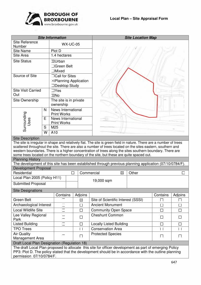
647
Local Plan – Site Appraisal Form
Site Information Site Location Map Site Reference Number
WX-UC-05
Site Name Plot D Site Area 1.4 hectares
Site Status ☒Urban ☐Green Belt ☐Mixed
Source of Site ☐Call for Sites ☒Planning Application ☐Desktop Study
Site Visit Carried Out
☐Yes ☒No
Site Ownership The site is in private ownership
Surr
oundin
g
Uses
N News International Print Works
E News International Print Works
S M25
W A10
Site Description The site is irregular in shape and relatively flat. The site is green field in nature. There are a number of trees scattered throughout the site. There are also a number of trees located on the sites eastern, southern and western boundaries. There is a higher concentration of trees along the sites southern boundary. There are some trees located on the northern boundary of the site, but these are quite spaced out.
Planning History The development of this site has been established through previous planning application (07/10/0784/F). Development Proposal
Residential ☐ Commercial ☒ Other ☐
Local Plan 2005 (Policy H11)
Submitted Proposal
Site Designations Contains Adjoins Contains Adjoins
Green Belt ☐ ☒ Site of Scientific Interest (SSSI) ☐ ☐
Archaeological Interest ☐ ☐ Ancient Monument ☐ ☐
Local Wildlife Site ☐ ☐ Community Open Space ☐ ☐
Lee Valley Regional Park
☐ ☐ Cheshunt Common ☐ ☐
Listed Building ☐ ☐ Locally Listed Building ☐ ☐
TPO Trees ☐ ☐ Conservation Area ☐ ☐
Air Quality Management Area
☐ ☐ Protected Species ☐ ☐
Draft Local Plan Designation (Regulation 18) The draft Local Plan proposed to allocate this site for officer development as part of emerging Policy PP3: Plot D. The policy stated that the development should be in accordance with the outline planning permission 07/10/0784/F.
19,000 sqm

648
Accessibility – distance as the crow flies
281m-Primary School (Hurst Drive)
1.04km - Secondary School
(St Mary’s)
0m–Employment Area (adjoins News International)
740m - Green Space (Cedars Park)
1.04km-Healthcare Centre (Abbey Road)
12.23km- Hospital (with A&E)
(Barnet)
850m- Town/District Centre
(Waltham Cross)
1.09km - Local Centre (228-256 High Street)
1.53km-Leisure Centre
(Laura Trott)
0m- A10 Junction
(adjoins Lieutenant Ellis Way junction)
1.18km- Railway Station (Theobalds Grove)
375m- Bus Service (Bullsmoor Lane, Great
Cambridge Road)
Flood Risk Does the site Contains Adjoins
Zone 2 (Medium Risk) ☐ ☐
Zone 3a (High Risk) ☐ ☐
Zone 3b (Active Flood Plain) ☐ ☒
Additional Flood Risk Comments There are no flood risk comments for this site. Access and Transport Comments The site can be accessed from the A10 at a traffic light junction. Utility Provision
Electricity Connections may be required
Gas A medium pressure gas main is located 225m to the east of the site.
Water News International Print Works is connected to a water main.
Sewerage An abandoned sewer is located within the site. A surface sewer is located 65m to the south west of the site.
Sewerage Treatment ☐Rye Meads ☒Deephams ☐Other
Additional Developer Comments submitted during Call for Sites 2016 None submitted. Suitability Comments The site is considered to be suitable for residential development due to the following reasons:
• The principle of developing this site has been established through a previous planning application.
• The site is strategically located (adjoining the A10 and M25) to support the proposed use of the site.
• The site is located next to News International, which is a designated employment area. Therefore, it is considered that the development of this site for employment use will be compatible with its surrounding.
Is this site considered to be suitable for development?
☒Yes ☐ No
Availability Comments The site is not considered to be available. The Council has been in correspondence with the landowner of this site regarding the development of this site.
Is the site considered to be available for development
☒Yes ☐ No
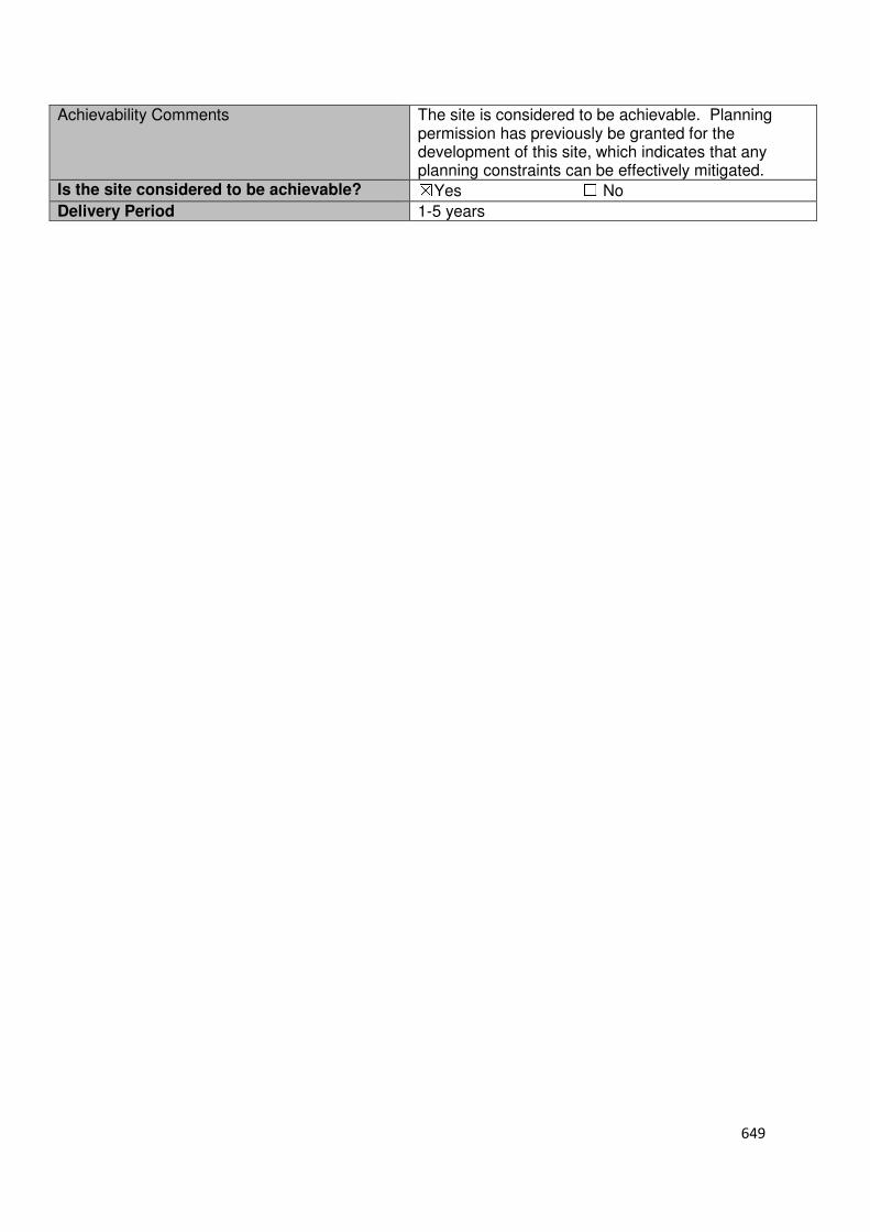
649
Achievability Comments The site is considered to be achievable. Planning permission has previously be granted for the development of this site, which indicates that any planning constraints can be effectively mitigated.
Is the site considered to be achievable? ☒Yes ☐ No
Delivery Period 1-5 years

650
Local Plan – Site Appraisal Form
Site Information Site Location Map Site Reference Number
WX-UC-06
Site Name Park Plaza North Site Area 10.31 hectares
Site Status ☒Urban ☐Green Belt ☐Mixed
Source of Site ☐Call for Sites ☒Planning Application ☐Desktop Study
Site Visit Carried Out
☐Yes ☒No
Site Ownership The site is owned by a private company
Surrounding Uses
N Winston Churchill Way
E Railway Line S News International,
Travelodge W Travelodge, A10
Site Description The site is irregular in shape and gradually slopes from west to east. The site is green field in nature. A number of trees/hedges are scattered throughout the site, with a pond located in the north eastern region. There is a track that runs from north to south located just off centre through the site. Planning History In 2002 outline planning permission was granted for the demolition of existing buildings and the development within Class b (Business Use) of up to 32,650 sqm with associated ancillary uses including the provision of car parking, access and infrastructure including highway and landscaping works. Development Proposal
Residential ☐ Commercial ☒ Other ☐
Local Plan 2005 (Policy H11)
Submitted Proposal
Site Designations Contains Adjoins Contains Adjoins
Green Belt ☐ ☒ Site of Scientific Interest (SSSI) ☐ ☐
Archaeological Interest ☐ ☒ Ancient Monument ☐ ☐
Local Wildlife Site ☐ ☐ Community Open Space ☐ ☒
Lee Valley Regional Park
☐ ☐ Cheshunt Common ☐ ☐
Listed Building ☐ ☐ Locally Listed Building ☐ ☐
TPO Trees ☐ ☐ Conservation Area ☐ ☐
Air Quality Management Area
☐ ☐ Protected Species ☐ ☐
Draft Local Plan Designation (Regulation 18) The draft Local Plan allocated the site for commercial use as part of emerging Policy PP2: Park Plaza North. This police stated that the site is allocated for a variety of small and medium sized enterprises.
50,000 sqm

651
Accessibility – distance as the crow flies
200m-Primary School (Hurst Drive)
570m - Secondary School (St Mary’s)
0m–Employment Area (adjoins News International)
40m - Green Space (Cedars Park)
520m-Healthcare Centre (Stanhope)
12.09km- Hospital (with A&E) (Princess Alexandra)
210m- Town/District Centre (Waltham Cross)
400m - Local Centre (228-256 High Street)
1.36km -Leisure Centre (Laura Trott)
0m- A10 Junction (adjoins Lieutenant Ellis Way
Junction)
420m- Railway Station (Theobalds Grove)
425m- Bus Service (The Vine PH)
Flood Risk Does the site Contains Adjoins
Zone 2 (Medium Risk) ☐ ☒
Zone 3a (High Risk) ☐ ☐
Zone 3b (Active Flood Plain) ☐ ☒
Additional Flood Risk Comments No flood risk comments for this site Access and Transport Comments The site could be accessed from the roundabout at Great Eastern Road, which currently serves the Travelodge. Due to the amount of commercial development this site could accommodate a transport assessment will need to accompany any planning application. There are footpaths along Great Eastern Road. Connections to these footpaths will be required. Utility Provision
Electricity Electricity cables available at the main urban area to the east or at News International Print Works
Gas The Travel Lodge to the west of the site is connected to a medium pressure main. A medium pressure main is also located along Great Cambridge Road.
Water The Travel Lodge to the south/west of the site is connected to a water main. A water main is also located in the residential area to the east of the site and along the Park Lane (Path) which forms the sites southern boundary.
Sewerage A foul sewer is located along the Park Lane (Path) to forms the sites southern boundary.
Sewerage Treatment ☐Rye Meads ☒Deephams ☐Other
Additional Developer Comments submitted during Call for Sites 2016. None submitted. During the Local Plan (Regulation 18) consultation, the landowner of the site states that they support the proposals for Park Plaza North to be developed for a variety of small and medium sized enterprises and to accommodate the relocation of businesses. However, the landowner raised concern that the site policy (PP2) does not give certainty to the overall strategy set out in section 10.4 of the Plan. The landowner/promoter continues by stating that to fairly complete with other strategic employment sites the borough and best meet occupier demands most successful business parks require ancillary and complementary uses that may not fall within the proposed uses set out in Policy PP2 and therefore recommends that the policy should increase flexibility of uses to encourage business to the borough. Suitability Comments The site is considered to be suitable for commercial development due to the following reasons:
• The site is strategically located to support the commercial use of this site. It adjoins the A10 and is close to the M25. It is also in close proximity to Theobalds Grove Train Station.
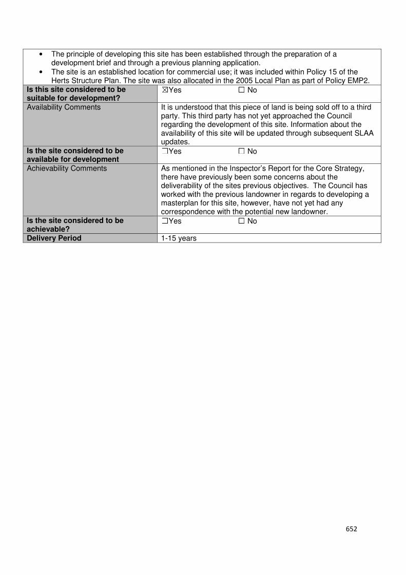
652
• The principle of developing this site has been established through the preparation of a development brief and through a previous planning application.
• The site is an established location for commercial use; it was included within Policy 15 of the Herts Structure Plan. The site was also allocated in the 2005 Local Plan as part of Policy EMP2.
Is this site considered to be suitable for development?
☒Yes ☐ No
Availability Comments It is understood that this piece of land is being sold off to a third party. This third party has not yet approached the Council regarding the development of this site. Information about the availability of this site will be updated through subsequent SLAA updates.
Is the site considered to be available for development
☐Yes ☐ No
Achievability Comments As mentioned in the Inspector’s Report for the Core Strategy, there have previously been some concerns about the deliverability of the sites previous objectives. The Council has worked with the previous landowner in regards to developing a masterplan for this site, however, have not yet had any correspondence with the potential new landowner.
Is the site considered to be achievable?
☐Yes ☐ No
Delivery Period 1-15 years
653
Appendix 4
Strategic Land Availability Maps
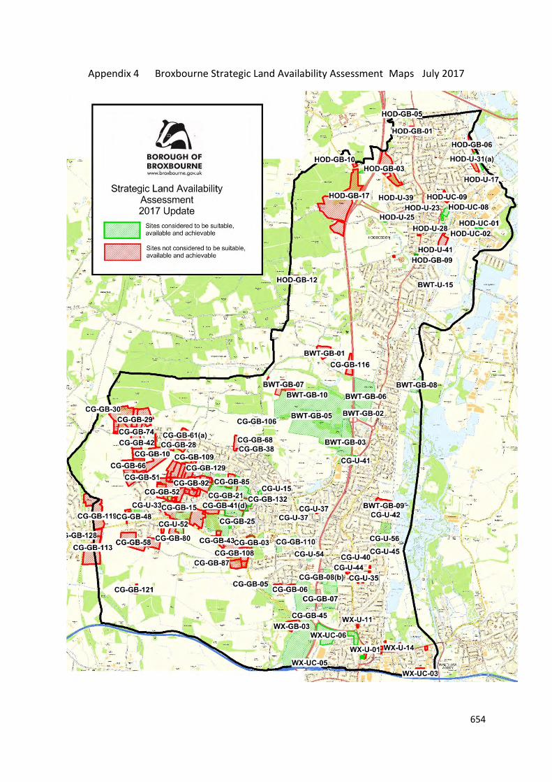
654
Appendix 4 Broxbourne Strategic Land Availability Assessment Maps July 2017
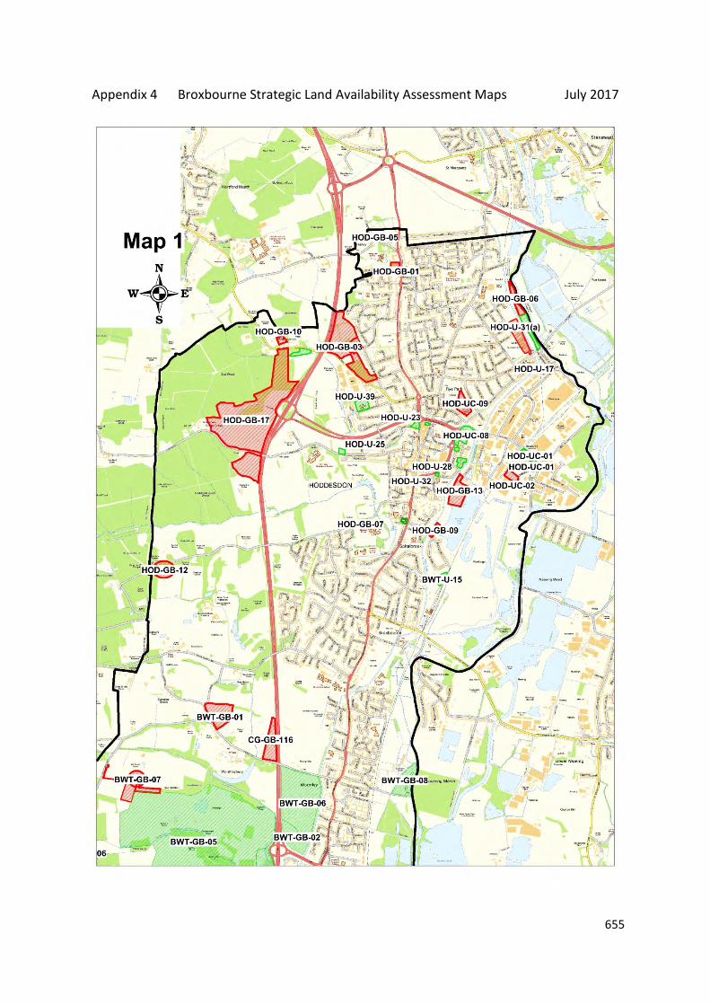
655
Appendix 4 Broxbourne Strategic Land Availability Assessment Maps July 2017
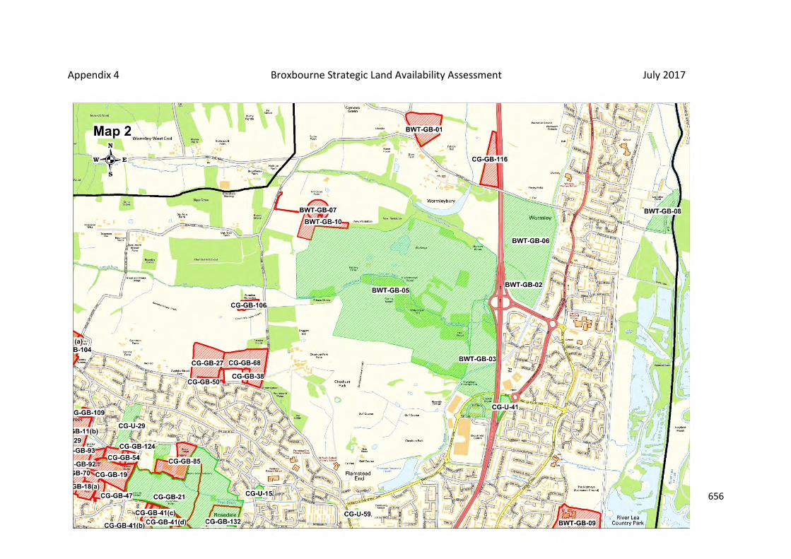
656
Appendix 4 Broxbourne Strategic Land Availability Assessment July 2017

657
Appendix 4 Broxbourne Strategic Land Availability Assessment July 2017
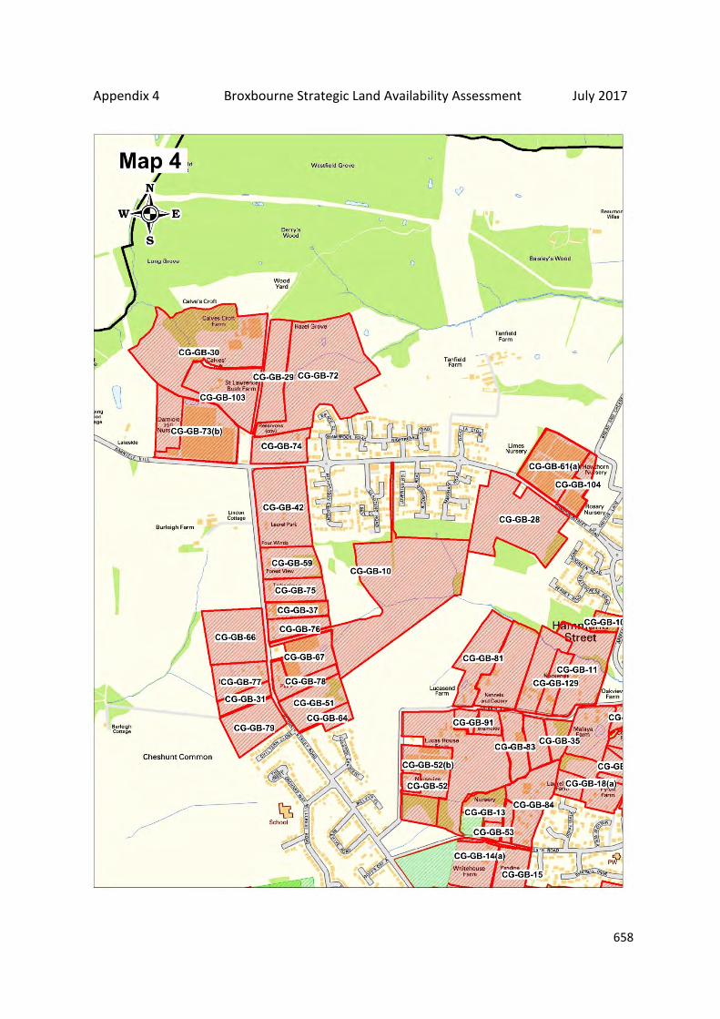
658
Appendix 4 Broxbourne Strategic Land Availability Assessment July 2017

659
Appendix 4 Broxbourne Strategic Land Availability Assessment July 2017

660
Appendix 4 Broxbourne Strategic Land Availability Assessment July 2017

661
Appendix 4 Broxbourne Strategic Land Availability Assessment July 2017

662
Appendix 4 Broxbourne Strategic Land Availability Assessment July 2017
663
Appendix 5
Housing Supply Trajectory
664
Appendix 5 Strategic Land Availability Assessment Housing Trajectory July 2015 S
LAA
Sit
e
Re
fere
nce
Cu
rre
nt
Sta
tus
Ad
dre
ss
Se
ttle
me
nt
Gro
ss
Co
mm
itm
en
t
Ne
t
Co
mm
itm
en
t
Un
de
r
con
stru
ctio
n
No
t st
art
ed
17
/18
18
/19
19
/20
20
/21
21
/22
22
/23
23
/24
24
/25
25
/26
26
/27
27
/28
28
/29
29
/30
30
/31
31
/32
Commitments 1543 1512 496 1047 388 207 217 136 123 147 119 104 73 0 0 0 0 0 0
BWT-GB-04
Commitment/
Proposed Local
Plan Allocation
Broxbourne
School Broxbourne 153 153 0 153 0 53 50 50 0 0 0 0 0 0 0 0 0 0 0
HOD-U-12
SLAA
Site/Proposed
Local Plan
Allocation
Former
Turnford
Surfacing Site Hoddesdon 40 40 0 40 0 0 0 0 20 20 0 0 0 0 0 0 0 0 0
BWT-GB-03 SLAA Site/Local
Plan Allocation
Brookfield
Riverside Turnford 250 250 0 250 0 0 0 50 75 75 50 0 0 0 0 0 0 0 0
BWT-GB-05
SLAA
Site/Proposed
Local Plan
Allocation
Brookfield
Garden Village Turnford 1250 1250 0 1250 0 0 0 0 0 100 105 105 140 140 140 140 140 120 120
CG-U-56
SLAA
Site/Proposed
Local Plan
Allocation
Cheshunt
Lakeside Cheshunt 1750 1750 0 1750 0 0 97 125 125 201 201 201 201 201 199 199 0 0 0
CG-GB-04
SLAA
Site/Proposed
Local Plan
Allocation
Half Moat
Manor House Cheshunt 60 60 0 60 0 0 0 20 40 0 0 0 0 0 0 0 0 0 0
CG-GB-05
SLAA
Site/Proposed
Local Plan
Allocation
Theobalds
Brook Field Cheshunt 100 100 0 100 0 0 0 50 50 0 0 0 0 0 0 0 0 0 0
CG-GB-44
SLAA
Site/Proposed
Local Plan
Allocation
Rags Brook
Valley Site Cheshunt 444 444 0 444 0 0 0 74 74 74 74 74 0 0 0 0 0 0 0
CG-GB-26
SLAA
Site/Proposed
Local Plan
Allocation Tudor Nursery Cheshunt 370 370 0 370 0 0 0 74 74 74 74 74 0 0 0 0 0 0 0
CG-GB-62
SLAA Site/
Proposed Local
Plan Allocation
Cuffley Hill
Comprehensive Goffs Oak 46 46 0 46 0 0 20 26 0 0 0 0 0 0 0 0 0 0 0
CG-GB-63
SLAA
Site/Proposed
Local Plan
Allocation
Goffs Lane
Comprehensive Goffs Oak 45 45 0 45 0 0 0 30 15 0 0 0 0 0 0 0 0 0 0
CG-GB-100
SLAA
Site/Proposed
Local Plan
Allocation
Cheshunt
Football Club Cheshunt 186 186 0 186 0 0 45 45 48 48 0 0 0 0 0 0 0 0 0
CG-GB-
14(b)
SLAA Site/
Proposed Local
Plan Allocation
White House
Farm Field Goffs Oak 22 22 0 22 0 0 22 0 0 0 0 0 0 0 0 0 0 0 0
CG-GB-71,
CG-GB-98
and CG-GB-
16
SLAA
Site/Proposed
Local Plan
Allocation
In-Ex Nursery,
Green Leaf
Nursery and
Tina Nursery Goffs Oak 80 80 0 80 0 0 0 40 40 0 0 0 0 0 0 0 0 0 0
CG-GB-32(b)
SLAA
Site/Proposed
Local Plan
Allocation
Bonneygrove
Wood Field
and V&E Club
Cheshunt
100 100 0 100 0 0 0 0 0 0 0 45 45 10 0 0 0 0 0

665
SLA
A S
ite
Re
fere
nce
Cu
rre
nt
Sta
tus
Ad
dre
ss
Se
ttle
me
nt
Gro
ss
Co
mm
itm
en
t
Ne
t
Co
mm
itm
en
t
Un
de
r
con
stru
ctio
n
No
t st
art
ed
17
/18
18
/19
19
/20
20
/21
21
/22
22
/23
23
/24
24
/25
25
/26
26
/27
27
/28
28
/29
29
/30
30
/31
31
/32
CG-U-29
SLAA
Site/Proposed
Local Plan
Allocation
Land south of
Hammondstree
t Road Cheshunt 44 44 0 44 0 0 0 0 0 0 0 0 0 0 0 0 0 44 0
WX-U-13
SLAA
Site/Proposed
Local Plan
Allocation
Land off Sturlas
Way
Waltham
Cross 300 300 0 0 0 0 0 0 0 0 0 0 0 0 75 75 75 75 0
CG-U-59 SLAA Site
Land rear of
Flamstead End
Shops Cheshunt 10 10 0 10 0 0 10 0 0 0 0 0 0 0 0 0 0 0 0
CG-U-47 SLAA Site Whit Hern Cheshunt 28 28 0 28 0 0 0 28 0 0 0 0 0 0 0 0 0 0 0
CG-U-54 SLAA Site
Borough
Council Offices Cheshunt 45 45 0 45 0 0 0 0 0 0 0 0 0 0 0 20 25 0 0
WX-U-28 SLAA Site Gala Bingo Site
Waltham
Cross 40 40 0 40 0 0 0 0 40 0 0 0 0 0 0 0 0 0 0
CG-GB-110 SLAA Site
Former east
Playing Fields
of St Mary's
High School Cheshunt 75 75 0 75 0 0 0 0 30 45 0 0 0 0 0 0 0 0 0
BWT-U-15 SLAA Site
Gas
Distribution
Station Broxbourne 36 36 0 36 0 0 0 0 0 0 0 0 0 0 0 0 0 0 36
CG-U-15 SLAA Site Fourfields Cheshunt 15 15 0 15 0 15 0 0 0 0 0 0 0 0 0 0 0 0 0
CG-U-40 SLAA Site Wolsey Hall Cheshunt 24 24 0 24 0 0 0 0 24 0 0 0 0 0 0 0 0 0 0
HOD-U-23 SLAA Site
19 Amwell
Street and
Scania House Hoddesdon 60 60 0 60 0 0 0 0 0 60 0 0 0 0 0 0 0 0 0
HOD-U-39 SLAA Site
Westfield
Primary School Hoddesdon 40 40 0 40 0 0 0 0 0 0 0 0 30 10 0 0 0 0 0
HOD-UC-08 SLAA Site
Land east of
Dinant Link Hoddesdon 50 50 0 50 0 0 0 0 0 0 25 25 0 0 0 0 0 0 0
HOD-U-36 SLAA Site
Lampit
Mansard Roofs Hoddesdon 33 33 0 33 0 33 0 0 0 0 0 0 0 0 0 0 0 0 0
HOD-GB-15 SLAA Site
Rosehill Bowls
Club Hoddesdon 9 9 0 9 0 0 0 0 0 0 0 0 9 0 0 0 0 0 0
WX-U-25 SLAA Site
Theobalds
Grove Station
Waltham
Cross 22 22 0 22 0 0 0 0 0 0 0 0 0 0 0 0 22 0 0
HOD-U-27 SLAA Site
Land to the
south of
Brewery Road Hoddesdon 22 22 0 22 0 0 22 0 0 0 0 0 0 0 0 0 0 0 0
HOD-U-35 SLAA Site
Former
Hoddesdon
Police station Hoddesdon 30 30 0 0 0 0 0 0 0 0 15 15 0 0 0 0 0 0 0
CG-U-57 SLAA Site
The
Whitehouse Cheshunt 61 15 0 61 0 0 15 0 0 0 0 0 0 0 0 0 0 0 0
Windfall 444 444 0 444 0 0 0 37 37 37 37 37 37 37 37 37 37 37 37
666
SLA
A S
ite
Re
fere
nce
Cu
rre
nt
Sta
tus
Ad
dre
ss
Se
ttle
me
nt
Gro
ss
Co
mm
itm
en
t
Ne
t
Co
mm
itm
en
t
Un
de
r
con
stru
ctio
n
No
t st
art
ed
17
/18
18
/19
19
/20
20
/21
21
/22
22
/23
23
/24
24
/25
25
/26
26
/27
27
/28
28
/29
29
/30
30
/31
31
/32
Sites
Self-Build
Sites 70 70 0 0 0 5 5 5 5 5 5 5 5 5 5 5 5 5 5
Total 7891 7820 496 7001 388 313 503 790 820 886 705 685 540 403 456 476 304 281 198
667
Appendix 6
Urban Capacity
668
SLAA Reference Number Site Name Settlement Gross Commitment Net Commitment
HOD-U-12 Former Turnford Surfacing Site Hoddesdon 40 40
CG-U-56 Cheshunt Lakeside Cheshunt 1750 1750
CG-U-29 Land south of Hammondstreet Road Cheshunt 44 44
WX-U-13 Land off Sturlas Way Waltham Cross 300 300
CG-U-59 Land rear of Flamstead End Shops Cheshunt 10 10
CG-U-47 Whit Hern Cheshunt 28 28
CG-U-54 Borough Council Offices Cheshunt 45 45
BWT-U-15 Gas Distribution Station Broxbourne 36 36
CG-U-15 Fourfields Cheshunt 15 15
CG-U-40 Wolsey Hall Cheshunt 24 24
HOD-U-23 19 Amwell Street and Scania House Hoddesdon 60 60
HOD-U-39 Westfield Primary School Hoddesdon 40 40
HOD-UC-08 Land east of Dinant Link Hoddesdon 50 50
HOD-U-36 Lampit Mansard Roofs Hoddesdon 33 33
CG-U-57 The Whitehouse Cheshunt 61 15
WX-U-25 Theobalds Grove Station Waltham Cross 22 22
HOD-U-27 Land to the south of Brewery Road Hoddesdon 22 22
HOD-U-35 Former Hoddesdon Police station Hoddesdon 30 30
Total 2610 2564
669
Appendix 7
Commercial Land Trajectory
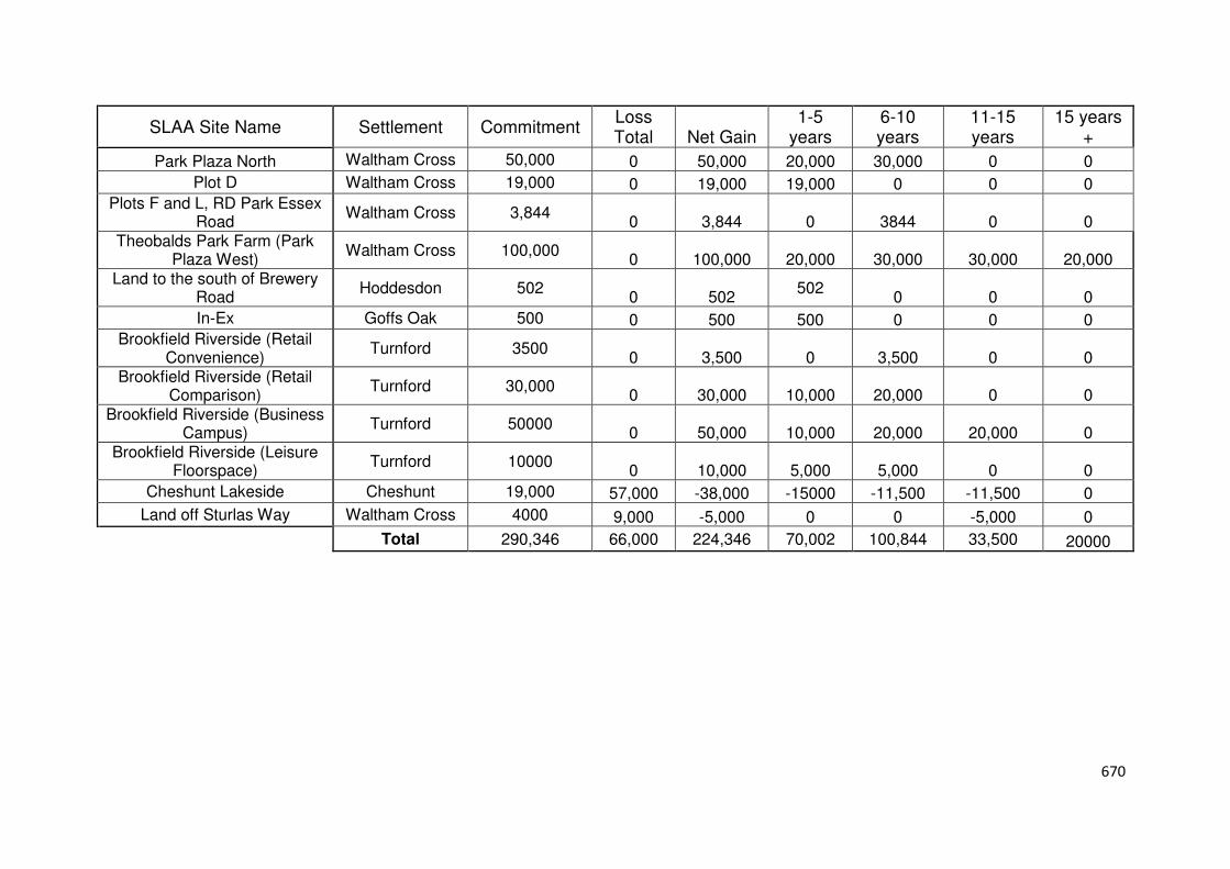
670
SLAA Site Name Settlement Commitment Loss Total Net Gain
1-5 years
6-10 years
11-15 years
15 years +
Park Plaza North Waltham Cross 50,000 0 50,000 20,000 30,000 0 0
Plot D Waltham Cross 19,000 0 19,000 19,000 0 0 0 Plots F and L, RD Park Essex
Road Waltham Cross 3,844
0 3,844 0 3844 0 0 Theobalds Park Farm (Park
Plaza West) Waltham Cross 100,000
0 100,000 20,000 30,000 30,000 20,000 Land to the south of Brewery
Road Hoddesdon 502
0 502 502
0 0 0
In-Ex Goffs Oak 500 0 500 500 0 0 0 Brookfield Riverside (Retail
Convenience) Turnford 3500
0 3,500 0 3,500 0 0 Brookfield Riverside (Retail
Comparison) Turnford 30,000
0 30,000 10,000 20,000 0 0 Brookfield Riverside (Business
Campus) Turnford 50000
0 50,000 10,000 20,000 20,000 0 Brookfield Riverside (Leisure
Floorspace) Turnford 10000
0 10,000 5,000 5,000 0 0
Cheshunt Lakeside Cheshunt 19,000 57,000 -38,000 -15000 -11,500 -11,500 0
Land off Sturlas Way Waltham Cross 4000 9,000 -5,000 0 0 -5,000 0
Total 290,346 66,000 224,346 70,002 100,844 33,500 20000

671
Housing Implementation Strategy Appendices

672
Appendix A
Build Out Rates

673
Gro
ss
Co
mm
itm
en
ts
05/0
6
06/0
7
07/0
8
08/0
9
09/1
0
10/1
1
11/1
2
12/1
3
13/1
4
14/1
5
15/1
6
16/1
7
To
tal C
om
ple
tio
ns
Total Dwellings Lapsed Total Dwellings Not
Yet Built
Co
nsen
t D
ate
2005/06 340
51 97 116 18 23 1 306 34 0
%Built 15 29 34 5 7 0 % Lapsed 10 % not built
2006/07 321
2 137 86 23 12 10 270 51 0
%Built 1 43 27 7 4 3 % Lapsed 16 % not built 0
2007/08 614
33 84 221 89 47 65 21 560 54 0
% Built 5 14 36 14 8 11 3 % Lapsed 9 % not built 0
2008/09 311
9 57 31 1 6 1 2 107 201 3
% Built 3 18 10 0 2 0 1 % Lapsed 65 % not built 1
2009/10 506
4 142 53 89 54 40 382 124 0
%Built 1 28 10 18 11 8 % Lapsed 25 % not built
2010/11 90
1 56 17 2 1 1 78 12 0
%Built 1 62 19 2 1 1 % Lapsed 13 % not built
2011/12 164
12 18 15 33 1 79 85 0
%Built 7 11 9 20 1 % Lapsed 52 % not built 0
2012/13 162
9 17 44 17 23 110 43 9
%Built 6 10 27 10 14 % Lapsed 27 % not built 6
2013/14 359
8 59 140 108 315 21 23
%Built 2 16 39 30 % Lapsed 6 %not built 6
2014/15 358
7 12 36 55 0 303
%Built 2 3 10 % Lapsed 0 % not built 85
2015/16 1180
10 92 102 0 1078
%Built 1 8 % Lapsed 0 %not built 91
2016/17 358
15 15 0 343
%Built 4 % Lapsed 0 % not built 96
Total Completions during Financial Year 494 283 298 202 333 279 180 204 118 184 183 274
674
Appendix B
Build Out Rates for Large Scale Sites
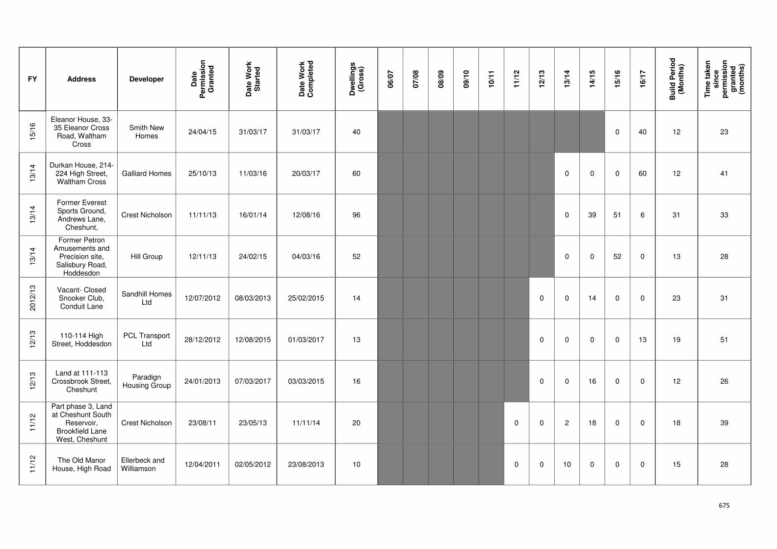
675
FY Address Developer
Date
P
erm
issio
n
Gra
nte
d
Date
Wo
rk
Sta
rted
Date
Wo
rk
Co
mp
lete
d
Dw
ellin
gs
(Gro
ss)
06/0
7
07/0
8
08/0
9
09/1
0
10/1
1
11/1
2
12/1
3
13/1
4
14/1
5
15/1
6
16/1
7
Bu
ild
Peri
od
(M
on
ths)
Tim
e t
aken
sin
ce
perm
issio
n
gra
nte
d
(mo
nth
s)
15/1
6 Eleanor House, 33-
35 Eleanor Cross Road, Waltham
Cross
Smith New Homes
24/04/15 31/03/17 31/03/17 40
0 40 12 23
13/1
4 Durkan House, 214-
224 High Street, Waltham Cross
Galliard Homes 25/10/13 11/03/16 20/03/17 60
0 0 0 60 12 41
13/1
4 Former Everest
Sports Ground, Andrews Lane,
Cheshunt,
Crest Nicholson 11/11/13 16/01/14 12/08/16 96
0 39 51 6 31 33
13/1
4
Former Petron Amusements and
Precision site, Salisbury Road,
Hoddesdon
Hill Group 12/11/13 24/02/15 04/03/16 52
0 0 52 0 13 28
2012/1
3
Vacant- Closed Snooker Club, Conduit Lane
Sandhill Homes Ltd
12/07/2012 08/03/2013 25/02/2015 14 0 0 14 0 0 23 31
12/1
3
110-114 High Street, Hoddesdon
PCL Transport Ltd
28/12/2012 12/08/2015 01/03/2017 13 0 0 0 0 13 19 51
12/1
3 Land at 111-113
Crossbrook Street, Cheshunt
Paradign Housing Group
24/01/2013 07/03/2017 03/03/2015 16 0 0 16 0 0 12 26
11/1
2
Part phase 3, Land at Cheshunt South
Reservoir, Brookfield Lane West, Cheshunt
Crest Nicholson 23/08/11 23/05/13 11/11/14 20
0 0 2 18 0 0 18 39
11/1
2
The Old Manor House, High Road
Ellerbeck and Williamson
12/04/2011 02/05/2012 23/08/2013 10 0 0 10 0 0 0 15 28
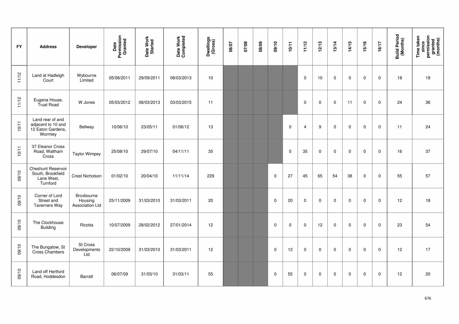
676
FY Address Developer
Date
P
erm
issio
n
Gra
nte
d
Date
Wo
rk
Sta
rted
Date
Wo
rk
Co
mp
lete
d
Dw
ellin
gs
(Gro
ss)
06/0
7
07/0
8
08/0
9
09/1
0
10/1
1
11/1
2
12/1
3
13/1
4
14/1
5
15/1
6
16/1
7
Bu
ild
Peri
od
(M
on
ths)
Tim
e t
aken
sin
ce
perm
issio
n
gra
nte
d
(mo
nth
s)
11/1
2
Land at Hadleigh Court
Wybourne Limited
05/08/2011 29/09/2011 08/03/2013 10 0 10 0 0 0 0 18 19
11/1
2
Eugena House, Trust Road
W Jones 05/03/2012 08/03/2013 03/03/2015 11 0 0 0 11 0 0 24 36
10/1
1 Land rear of and
adjacent to 10 and 12 Eaton Gardens,
Wormley
Bellway 10/06/10 23/05/11 01/06/12 13
0 4 9 0 0 0 0 11 24
10/1
1 37 Eleanor Cross
Road, Waltham Cross
Taylor Wimpey
25/08/10 29/07/10 04/11/11 35 0 35 0 0 0 0 0 16 37
09/1
0 Cheshunt Reservoir
South, Brookfield Lane West,
Turnford
Crest Nicholson 01/02/10 20/04/10 11/11/14 229
0 27 45 65 54 38 0 0 55 57
09/1
0 Corner of Lord
Street and Taverners Way
Broxbourne Housing
Association Ltd 25/11/2009 31/03/2010 31/03/2011 20 0 20 0 0 0 0 0 0 12 18
09/1
0
The Clockhouse Building
Ricotta 10/07/2009 28/02/2012 27/01/2014 12 0 0 0 12 0 0 0 0 23 54
09/1
0
The Bungalow, St Cross Chambers
St Cross Developments
Ltd 22/10/2009 31/03/2010 31/03/2011 12 0 12 0 0 0 0 0 0 12 17
09/1
0
Land off Hertford Road, Hoddesdon
Barratt
06/07/09 31/03/10 31/03/11 55
0 55 0 0 0 0 0 0 12 20

677
FY Address Developer
Date
P
erm
issio
n
Gra
nte
d
Date
Wo
rk
Sta
rted
Date
Wo
rk
Co
mp
lete
d
Dw
ellin
gs
(Gro
ss)
06/0
7
07/0
8
08/0
9
09/1
0
10/1
1
11/1
2
12/1
3
13/1
4
14/1
5
15/1
6
16/1
7
Bu
ild
Peri
od
(M
on
ths)
Tim
e t
aken
sin
ce
perm
issio
n
gra
nte
d
(mo
nth
s)
08/0
9
Former WX Service Station
Cornerstone Property Ltd
26/03/2009 31/03/2010 31/03/2011 14 0 0 14 0 0 0 0 0 0 12 24
08/0
9
260-264 Turners Hill, Cheshunt
Broxbourne Housing
Association 21/08/2008 31/03/2009 31/03/2010 22 0 22 0 0 0 0 0 0 0 12 19
08/0
9
201 & 205 High Road, Broxbourne
GG Properties UK Ltd
29/08/2008 31/03/2009 31/03/2010 13 0 13 0 0 0 0 0 0 0 12 19
07/0
8
Hertford Regional College, High Road
Belling Homes 23/07/07 31/03/08 27/09/13 225
0 13 70 19 45 64 20 0 0 0 66 70
07/0
8
Turnford Triangle, Turnford
London Merchant
Securities PLC 09/11/2007 31/03/2009 31/03/2011 80 0 0 32 48 0 0 0 0 0 0 24 40
07/0
8
Land south of Cock Lane
Hubert C Leach Limited
27/04/2007 31/03/2008 31/03/2011 75 18 34 5 18 0 0 0 0 0 0 36 47
07/0
8
Grove House, 281 High Street
Urban Vision Land
Developments Ltd
17/05/2007 31/03/2009 31/03/2010 30 0 0 30 0 0 0 0 0 0 0 12 34
07/0
8
9-11 High Street, Waltham Cross
Constable Homes
24/07/2007 31/03/2009 31/03/2010 37 0 0 37 0 0 0 0 0 0 0 12 32
06/0
7 Eleanor Cross Road
(north) Waltham Cross
L W Developments
28/12/06 31/03/07 31/03/08 58 0 58 0 0 0 0 0 0 0 0 0 12 15