J. Mrgic, Criss-crossing the Danube with Marsigli, Beogradski istorijski glasnik/Belgrade Historical...
15
БЕОГРАДСКИ ИСТОРИЈСКИ ГЛАСНИК BELGRADE HISTORICAL REVIEW Vol. II (2011) Филозофски факултет , Универзитет у Београду
Transcript of J. Mrgic, Criss-crossing the Danube with Marsigli, Beogradski istorijski glasnik/Belgrade Historical...
БЕОГРАДСКИ ИСТОРИЈСКИ ГЛАСНИК
BELGRADE HISTORICAL REVIEW
Vol. II (2011)
Филозофски факултет, Универзитет у Београду

5
Садржај / Content
Чланци / Papers
Marijana Ricl, Neokoroi in the Greek world 7Маријана Рицл, Неокори у грчком свету 25
Snežana Ferjančić, A Note on the History of the Legion IV Flavia 27Снежана Ферјанчић, Белешка о историји легије IV Flavia 34
Драгиша Бојовић, Зашто је плакао Свети Сава 37Dragiša Bojović, Why Saint Sava of Serbia Cried 44
Vlada Stanković, Comnenian Monastic Foundations in Constantinople: Questions of Method and Context
47
Влада Станковић, Задужбине Комнина у Цариграду: питања методе и историјског контекста
72
Maрија Копривица, Протопоп Прохор, свештеник и властеличић на дечанском властелинству у XIV веку
75
Marija Koprivica, Protopriest Prohor, a Clergyman and Aristocrat at Dečani Manor in 14th Century
88
Зорица Ђоковић, Разлози побуне Андроника IV Палеолога 1373. године 91Zorica Đoković, Reasons for the Andronicus IV Palaiologos’ Rebellion in 1373 104
Vladimir Aleksić, Medieval Vlach Soldiers and the Beginnings of Ottoman Voynuks 105Владимир Алексић, Средњовековни власи и почеци османских војнука 128
Ema Miljković, Who was rich and who was poor? Creation of the new Serbian “elite” in the Serbian 15th century society
129
Ема Миљковић, Ко је био богат, а ко сиромашан? Стварање нове „елите“ у српском друштву 15. века
142
Катарина Митровић, Сремски викар Лука Наталис (1681–1720) 143Katarina Mitrović, Th e Vicar of Syrmia Luka Natalis (1681–1720) 162
Jelena Mrgić, Criss-crossing the Danube with Marsigli 165Јелена Мргић, Прелазећи Дунав са Марсиљијем 175
Jovan Pešalj, Nadzor i kontrola stranaca u 18. veku. Slučaj Habzburške monarhije 177Jovan Pešalj, Supervision and Control of Foreigners in Eighteenth Century. Th e Case of
Habsburg Monarchy189

6
Jelena Paunović-Štermenski, British Diplomacy and the Celebration of the Fift ieth Aniversary of the Second Serbian Uprising
191
Јелена Пауновић-Штерменски, Британска дипломатија и прослава Педесето-го дишњице Другог српског устанка
203
Danko Leovac, Serbia and Russia During the Second Rule of Prince Miloš Obrenović (1858–1860)
205
Данко Леовац, Србија и Русија током друге владавине кнеза Милоша Обреновића (1858–1860)
218
Aleksandar Rastović, Th e Married Couple Dickinson–Berry on Serbia 221Александар Растовић, Брачни пар Дикинсон–Бери о Србији 230
Прилози / ContributionsOlga Zirojević, Prilozi za istoriju privrede. I. Šta je boranija (buranija)? II. Putevi
krompira231
Критике / CriticsNikola Samardžić, Kontroverze kontroverzi: Suočavanje s jugoslovenskim kontro ver-
zama. Inicijativa naučnika251
Прикази / ReviewsNemanja Vujčić: Adrian Goldsworthy, Th e Fall of the West. Th e Death of the Roman
Superpower, Phoenix publisher, London, 2010, pp. X+531; Peter Heather, Th e Fall of the Roman Empire, Oxford University Press, Oxford, 2005, XVI+576; Bryan Ward-Perkins, Th e Fall of Rome and the End of Civilization, Oxford University Press, Oxford, 2006, pp. VI+239
265
Nemanja Vujčić: Arjan Zuiderhoek, Th e Politics of Munifi cence in the Roman Empire: Citizens, Elites and Benefactors in Asia Minor, Cambridge University Press, Cambridge 2009, pp. XVII + 186
273
Лариса Орлов: Ј. Кодер, Византијски свет. Увод у историјску географију источног Медитерана током византијске епохе, превео са грчког и приредио Влада Станковић, Београд — Утопија 2011, 303 стр.
278
Владета Петровић: Десанка Ковачевић-Којић, Средњовјековна Сребреница : XIV–XV вијек, Посебна издања САНУ, књ. 668, Одељење историјских наука, књ. 29, Београд 2010, 312 стр.
281
Haris Dajč: Charles Ingrao, Nikola Samardžić, Jovan Pešalj, eds., Th e Peace of Passarowitz, 1718, West Lafayette: Purdue University Press, 2011, 310 pp (ISBN 978–1–55753–594–8). (srpski i engleski tekst)
285
Марија Вушковић: Ђорђе Микић, Аустроугарска ратна политика у Босни и Херцеговини 1914-1918, Бања Лука : Независни универзитет 2011, 566 стр.
290
Јелена Пауновић-Штерменски: Радош Љушић, Вујкина врата: хроника подгорског села Исток, Део 1, Београд – Фреска 2011, 184 стр., илустр.
292
Библиографија / BibliographyMирослав Поповић, Библиографија Србије за 2010. годину 295

165
Београдски историјски гласник II, 2011Belgrade Historical Review II, 2011
UDC: 91:929 Марсиљи Л. Ф. ; 908(497)”16/17”ID: 187235084
Jelena Mrgić, Ph.D.Assist. Professor, Department of History, Faculty of PhilosophyČika Ljubina 18–20, [email protected]
CRISS-CROSSING THE DANUBE WITH MARSIGLI*
For a good part of his life, count Luigi Ferdinando Marsigli (1658–1730) was connected with the Danube River and the region of Southeastern Europe. As the chief military surveyor and engineer during the War of the Holy League between the Habsburg and the Ottoman Empires (1683–1699), he had to fi nd practical solutions for Habsburg troops in the war zones, which involved the Danube River and its tributaries to a great extent. As a meticulous observer, Marsigli made signifi cant corrections and produced reliable geographical and topographical knowledge of the whole region. At the same time, he began to work enthusiastically on his masterpiece – Danubius Pannonico-Mysicus (printed in 1726). Aft er the Karlowitz Peace Treaty, he was the Imperial Envoy in the Commission for Border Demarcation (1699–1701), in which the Danube played a signifi cant role. Th e paper aims to renew scientifi c interest in this intriguing personality, presenting a short insight into the apparent duality of Marsigli’s work as a soldier and as a scientist, in the context of his education, travels and ‘Zeitgeist’.
Key words: Luigi Ferdinando Marsigli, Danube River, geography, cartography
Кључне речи: Луиђи Фердинандо Марсиљи, Дунав, географија, картографија
While working on my paper for a previous conference, aft er reading about Marsigli’s life and activities, my fi rst impulse as a historical geographer
* Th e paper originated from the conference presentation at 48. Deutscher Historikertag, Humboldt University in Berlin, September 28 – October 1, 2010. My gratitude goes to Verena Winiwarter (Prof. Dr, Dean of the Faculty for Interdisciplinary Studies of the Alpen Adria Uni-versity, Klagenfurt, Austria), to Richard C. Hoff mann (Prof. emeritus and Senior Scholar, De-partment of History, University of York, Toronto, Canada), and Martin Schmid (Assist. Prof. Dr, Faculty of Interdisciplinary Studies, Austria), who were kind to include me in their panel. Th e author received fi nancial aid from the German Research Foundation (Deutsche Forschungsge-meinschaft , DFG) and expresses her gratitude.

166
БИГ II (2011) 165–176
was to draw a map with all his itineraries.1 Th e immediate result was that I had become totally fascinated by Marsigli. I wanted to know how a man at that time could achieve all these relentless journeys and an impressive quality and quantity of published works and maps. Th e more I thought about it, the more it became apparent that I needed fi rst to understand his personality, before I could embark on reconstructing his system of thinking in regard not only to his great opus on the Danube and demarcation of borders, but more signifi cantly, to his spatial knowledge, geographical and cartographical skills. It would mean putting Marsigli’s works in the context of his life, education and scientifi c legacy. Secondly, the paper aims to rekindle interest in the scientifi c achievements of Marsigli, especially for the Danubian countries, of which Serbia is a member, in view of the current trends of employing historical knowledge in dealing with urgent environmental issues.2 Th e last historiographer to consider the relevance of Marsigli’s published and unpublished works for Serbian parts was Nikola Radojčić, who visited Bologna on several occasions and analyzed his legacy.3
Th e starting point would be his biography, which for the purpose of this text is presented here as a brief overview.4 Marsigli was born in 1658, into a noble Bologna family, but did not receive a formal education. Instead he travelled, as a sort of a Goliard, to hear lectures of several Italian scientists. Two of them made a permanent impact on young Marsigli: Geminiano Montanari and Marcello Malpighi – the fi rst founded Accademia della Traccia (translated as the ‘Academy of footprint/traces/tracks’) in Bologna, on the model of the Royal Society of London. Both scholars were the followers of Galileo’s, Descartes’ and especially Bacon’s ideas of ‘tracking down the true understanding of Nature along the… road of experience’. In Padua and Bologna they were busy pursuing experimental physics, laws of motion, capillarity, human and plant anatomy etc. Marsigli got an early acquaintance with several other Italian scholars in Florence, Naples
1 Mrgić 2011, 221––238, including the map “Marsigli’s Itineraries in South-Eastern Europe 1683-1700”.
2 Since 2003, Serbia is the full member of the International Commission for the Protec-tion of the Danube River, and has ratifi ed the Danube River Protection Document, for the main goal that surface waters and groundwater within the Danube River Basin are managed and used sustainably and equitably. (http://www.icpdr.org/icpdr-pages/serbia.htm). Th e international sci-entifi c network Danube Environmental History Initiative at the Center for Environmental History (Faculty for Interdisciplinary Studies of the Alpen Adria University, Klagenfurt, Austria) is dedi-cated to organization of multidisciplinary research – http://www.dehi.org.
3 Radojčić 1937, 334–343; ib. 1938, 342–355; ib. 1939, 356–367.4 For the full account of Marsigli’s life, see: Stoye 1994; a concise biography in: Cavazza
2008, 36–38.

167
JELENA MRGIĆ: Criss-crossing the Danube with Marsigli
and Rome such as A. Magliabechi, T. Cornelio and G. Borreli, who probably infl uenced his decision to pursue scientifi c quests on his own.5
Count Marsigli, though lacking a formal education, acquired a vast knowledge of the latest progress in astronomy, mathematics, biology, and medicine. He did, however, adopt something much more important: scientifi c, critical, ‘experimental thinking’ i.e. the empirical approach, together with an immense passion for discovering the mechanisms of Nature, its laws and structure, ‘the order of the things’. He set himself to become a ‘natural historian’, a true baroque personality whose intellectual curiosity had no limits. Th is was further accompanied by his highly developed social and communication skills in impressing powerful people, which fi rst gained Marsigli his membership in the Venetian diplomatic delegation sent to Constantinople in 1679.6 As of this point, one can also notice the complete absence of any trace of Marsigli’s private and emotional life from the written records, which had a strong infl uence on his personality. His energy and passion were directed toward scientifi c journeys and endeavours, and to a lesser degree, to sway the people in power, particularly those upon which Marsigli’s career and well-being had depended.7
It can be ascertained by his biography and his legacy, that prior to his mission in Constantinople, Marsigli had been collecting all the latest printed maps in Bologna, because he was able to discuss Blau’s Atlas Maior (1665) with Ebu Bekr, the most eminent offi cial Ottoman cartographer. Marsigli wrote that he had even considered in Istanbul making corrected maps of the Ottoman Empire, but eventually gave up on this idea and instead composed a study of the Marmara Sea (1681) and ‘Stato militare dell’Imperio Ottomano’(printed posthumously, in 1732). Marsigli’s Osservazioni intorno al Bosforo Tracio overo Canali di Constantinopoli together with Histoire physique de la mer (1725) is considered to be the key stone of marine science and its specialized cartography.8
His biggest chance for self-promotion appeared in 1683 with the onset of the War of the Holy League (1683–1699), when Marsigli manoeuvred his way into the highest Habsburg military headquarters, persuading the authorities
5 Cavazza 1980, 105–123; McConnell, 1993, 180; Pepe 2006, 141–151.6 Th e journal of this voyage Marsigli left unpublished, and some excerpts appeared in:
Frati 1904; the manuscript codex vol. 51 in the University Library of Bologna contains material from this journey – Manoscritti, diversi fatti nella prima andata e soggiorno di Constantinopoli – Radojčić 1957, 15; Hajdarhodžić 1996, 125, note 44.
7 Th is is suspected to be caused by an unreturned love of a noble mademoiselle in Bologna, see: Autobiografi a 1930, 7–8; Bene 2006, 118.
8 Autobiografi a, 20–21; Marsigli, Stato Militare 1972 (facsimile of the 1732 edition); ib., Histoire Physique de la Mer (Natural History of the Sea) 1999; Franceschelli – Marabini 2006, 129–139; Gercsak 2009, 17–26.

168
to appoint him as chief military engineer and surveyor. But no sooner had he began than Marsigli found himself in Ottoman captivity during the siege of Vienna and spent almost a year as a noble prisoner somewhere in the vicinity of the town of Konjic in Herzegovina. As a prolifi c writer, he left a vivid description of this rather unpleasant experience.9 Ever since his release in 1684, and until the end of the War, Marsigli was engaged in making the pontoon bridges for the Habsburg army, fi nding the most suitable river fords – mostly across the Danube and Tisza, but also the Sava and Morava Rivers, along with tracing the safest and most traversable roads. On several occasions, he was forced to dismantle a bridge and hastily relocate it completely, upstream or downstream. Th e geographical knowledge of these territories, including the hostile environments of swamps and marshlands, was of the highest strategic importance. Th erefore, although he didn’t mention it in his writings, Marsigli must have had the help of many local surveyors and road guides (Tur. kilavuzes), for the task, as was confi rmed by the Ottoman army. For the campaign of 1697, the Ottoman army used as many as 20 road guides for only a small stretch of Via militaris between Niš and Belgrade along the River Morava. Th is meant they hired local experts on the territory which had been under their continuous rule for well over two
Luigi Ferdinando Marsigli (1658–1730): Portrait of a young nobleman and scholar
9 La sciavitù del Generale Marsigli sotto i Tartari e i Turchi da lui stesso narrato, 1931. Criti-cal remarks on this edition in: Hajdarhodžić, 125, n. 45; Ragguaglio della schiavitù di Conte Luigi Ferdinando Marsigli 1996.
БИГ II (2011) 165–176

169
hundred years!10 Th e advancing Habsburg troops were certainly compelled to do the same to a greater extent, considering that they could have relied only on a handful of out-dated maps. What the true situation was regarding spatial representations of Transdanubian regions, is testifi ed to by the secretary of the British Embassy in Vienna, who was told by Marsigli in 1690 how the newly acquired parts were ‘shamefully misplaced and set down by guess in all the modern maps’.11 His achievements in the fi eld of presenting new and reliable geographical and topographical knowledge, in the form of cartographic images and written reports, are highly appreciated in German and Hungarian, but quite neglected in modern Serbian literature.12
Both Marsigli’s assignments, as an engineer during the War and as the chief commissioner during the demarcation work aft er the Karlowitz Peace Treaty, were his professional engagements, with clear orders and marked goals, and he performed his tasks impeccably, by providing clear and practical solutions. Marsigli’s maps and fortifi cation plans were sent on a daily basis to the Habsburg court.13 On his instructions and upon his drawings, Johan Christoph Müller made several dozen maps, including the fi nal delineation map.14
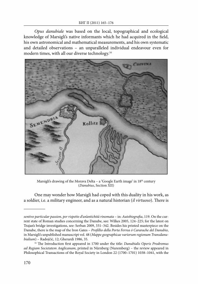
On the other hand, Marsigli had been all along pursuing his own, private scientifi c interests, testifi ed to by the fact that his most impressive work on the Danube was not commissioned, but was created on his own scientifi c initiative. It was the fi rst truly scientifi c enterprise on Europe’s second largest waterway ever to appear, encompassing a range of diverse subjects, including local geography, hydrology, riverine landscapes, constantly changing environments (see Picture 2 – the Morava Delta), ichthyology (T. IV – De piscibus), ornithology (T. V), geology, mineralogy, (T. III), and Roman antiquities (T. II). As a scholar and antiquarian, he described his study of the remnants of the Trajan’s famous bridge at the Danube gorge of Djerdap (Demirkapı, Iron Gates, Eisernes Tor) and expressed his great admiration and respect for this renowned antiquity.15
10 Agoston 2009, 65, n. 19.11 McConnell 1993, 179.12 Törok 2006, 419–428.13 Marsigli, Relazioni dei confi ni, 1986.14 Mappa geographico limitanea in qua Imperiorum Caesarei Ottomannici Confi nia in alma
Pacis Carlovitzensis Congressu decreta et a duobus utriusque imperii Commissaris instituta solenni expeditione …, Austrian State Archive, War Archive, Vienna (Östereichisches Staatsarchiv, Krieg-sarchiv, hereaft er ÖStA KA), Kartensammlung B IX c 634; Déak 2005, 83–96; Déak–Lapaine–Kljajić 2004, 69–80.
15 In questo intervallo di tempo, con l’aiuto di più di cento uomini, m’applicai ad osservare tutte le antichità romane, in quelle vicinanze esistenti, ed in particolare le vestigial del ponte di Traiano. Nel luogo in cui era stato il ponte suddetto, assai famoso, pretendeasi di fabbricarne un altro sul Danubio, anzi in più comodo sito per le Marcie; ed io, che aveva la cura di questa opera, ne
JELENA MRGIĆ: Criss-crossing the Danube with Marsigli
170
Opus danubiale was based on the local, topographical and ecological knowledge of Marsigli’s native informants which he had acquired in the fi eld, his own astronomical and mathematical measurements, and his own systematic and detailed observations – an unparalleled individual endeavour even for modern times, with all our diverse technology.16
Marsigli’s drawing of the Morava Delta – a ‘Google Earth image’ in 18th century(Danubius, Section XII)
One may wonder how Marsigli had coped with this duality in his work, as a soldier, i.e. a military engineer, and as a natural historian (il virtuoso). Th ere is
sentivo particular passion, per rispetto d’un’antichità rinomata – in: Autobiografi a, 119. On the cur-rent state of Roman studies concerning the Danube, see: Wilkes 2005, 124–225; for the latest on Trajan’s bridge investigations, see: Serban 2009, 331–342. Besides his printed masterpiece on the Danube, there is the map of the Iron Gates – Profi llio della Porta Ferrea ó Cararache del Danubio, in Marsigli’s unpublished manuscript vol. 48 (Mappe geographicae variorum regionum Transdanu-bialium) – Radojčić, 12; Gherardi 1986, 35.
16 Th e Introduction fi rst appeared in 1700 under the title: Danubialis Operis Prodromus ad Regiam Societatem Anglicanam, printed in Nürnberg (Nuremberg) – the review appeared in Philosophical Transactions of the Royal Society in London 22 (1700–1701) 1038–1041, with the
БИГ II (2011) 165–176

171
no doubt that Marsigli was a person of a high intelligence, with a special gift of an extremely high visual perception and a perfect sense of orientation. He showed excellence not only in geography, land surveying, geometry and cartography, but also in mechanics and engineering. His approach to all subjects was rigorously empirical. Observing Marsigli, one is immediately impressed by his highly energetic life, quick thinking and powers of decision making. His practicality and attentiveness to turn to whatever attracted his attention never fail to stand out. It seems that his most inner urge was kinetics – moving dynamics, velocity and change, which enabled him to endure all the physical strains of relentless journeys, more precisely – a life of peregrinations.
Th ere lies the basic reason why Marsigli was driven towards his research on the Danube River – it fascinated him as a powerful natural feature which is in perpetual movement, a fl owing ‘mega force’ that infl uences the surrounding environment, constantly changing both itself and the environs it runs through, deeply aff ecting the life of people on its river banks and being shaped by human impact in turn. Th is changing dynamic in human-river interactions, the interplay of natural features of the River Danube and human practices, Marsigli was eager to record in the fi eld and explain empirically rather than theoretically.17 Th erefore, it could be concluded that he basically managed to fi nd the perfect engagements to pursue his own interests. His military work enabled him to travel and to explore, to study Nature, conduct experiments and gain ‘learned experience’ (Experientia Literata – Francis Bacon).18
In regard to borders, Marsigli wrote extensively about frontiera, confi ne, termine, linea di demarcazione, limiti naturali19, and under orders, he decisively infl uenced the practical making of the fi rst modern borderline in the history, i.e. the Karlowitz Peace Treaty border – a very narrow, clearly marked terrestrial division between the two Empires, quite similar to present day state borders.20
conclusion that Signior Marsigli… deserves all the encouragement that the Learned World can pos-sible give him. Finally, as he promised, the deed was completed: Marsigli, Danubius Pannonico-Mysicus 1726; the latest interpretation and comments of the fi rst volume: Déak 2004.
17 On the river dynamics, see: White 1995; Cioc 2002. Th e concept of socio-natural sites as nexuses of human practices and material arrangement in regard to the Danube River is pro-moted in the Vienna’s environmental history discourse, see: Winiwarter et al. 2008; Schmid 2008; Schmid – Haidvogl 2008, 64–73; Schmid 2009, 59–79.
18 Pesic 1999, 81–94.19 Marsigli’s proposition during winter 1688/89 was to use the Danube, the Morava rivers
and the Haemus Mountain as ‘natural borders’ (limiti naturali), since he had previously surveyed this terrain on his return journey from Constantinople in 1680, and relied on his then remarks on this environment – Autobiografi a, 108–109ff .
20 Abou-el-Haj 1969, 467–475; Kovačević 1973.
JELENA MRGIĆ: Criss-crossing the Danube with Marsigli

172
However, it could be assumed upon his writings and his experience of determining the border line where there had been the shift ing of riparian land due to the river inundations and changes of the location of river bed (as was the case by the Terra Novense)21 that he regarded borders, political and natural, not as permanent creations but rather like membranes. Borders were more or less easily traversable, porous, with a constant fl ow of people, goods, disease, and information passing in both directions.
Th is is further supported by the fact that Marsigli made the map of the main trade routes (Mappa Geographica facta in usum Commerciorum…) connecting the Habsburg and the Ottoman Empire (again, it was not commissioned by Habsburg or any other authorities), and he showed no political borders whatsoever. Trade, as well as spreading of plague epidemics, was a trans-national and trans-boundary process, which he believed could be put under direct control of the State as its well-being and prosperity was the ultimate goal of mercantilism. Marsigli’s eff orts were a perfect working example of the ‘science of the day’.22
At the dawn of the Age of Enlightenment, Marsigli was a remarkable and quite unique person – a scholar, historian and antiquarian. Besides becoming a member of the most prestigious learned societies of his time – the Royal Society in London and Académie des Science in Paris, in 1714 Marsigli established his own Instituto delle Scienze e delle Arti in his beloved Bologna. Th rough his generous donations, the Institute acquired a rich library, an observatory, laboratories for physics and chemistry, a printing press, and collection of natural history artifacts.23
In accordance with contemporary integration processes in the Danube River Basin, we hope that Marsigli’s unpublished manuscripts will be more thoroughly researched, and that this ‘renaissance’ man is given the true credit he deserves within the scientifi c community of Southeastern Europe.
List of References
Selected works of L. F. Marsigli, used in this paper:Autobiografi a di Luigi Ferdinando Marsigli, ed. E. Lovarini, Bologna 1930.
21 Relationi I, 81ff .22 ÖStA KA Hofk riegsrat (HKR) Akten 1701 BLG Juli/42. Beilage von Relations 10; Mar-
sigli was also concerned with epidemics and drew a map: Mappa geographica, qua praecautio contra pestem post factam locorum, juxta pacis instrumentum, evacuationem ac demolitonem in confi nibus istis Cis Danubialibus instituenda ostenditu, where he proposed future check points on major trade routes, sanitary cordon and lazarettos: Jarcho 1983, 9–19.
23 McConnell 1986, 39–76; eadem 1993, 179–204; Cavazza 1990; Dietz 2010, 25–46.
БИГ II (2011) 165–176

173
Frati, Lodovico, Il viaggio da Venezia a Constantinopoli del conte Luigi Ferdinando Marsili, Nuovo Archivio Veneto 8, 1904.
La sciavitù del Generale Marsigli sotto i Tartari e i Turchi da lui stesso narrato, a cura di G. Lovarini, Bologna 1931.
Ragguaglio della schiavitù di Conte Luigi Ferdinando Marsigli, ed. B. Basile, Palermo 1996.
Stato Militare dell`Imperio Ottomanno. L`Etat Militaire de l`Empire Ottoman, Introduction by Manfred Krämer, Graz 1972 (facsimile of the 1732 edition).
Histoire Physique de la Mer (Natural History of the Sea), Translation, Introduction and Notes by Anita McConnell, Bologna: Museo di Fisica dell’Universita’ di Bologna, 1999.
Danubialis Operis Prodromus ad Regiam Societatem Anglicanam, Nuremberg 1700.Danubius Pannonico-Mysicus, observationibus geographicis, astronomicis, hydrographicis,
historicis, physicis perlustris et in Sex Tomos digestus, I–VI, Hagae comitum & Amstelodami 1726.
Relazioni dei confi ni della Croazia e della Transilvania a sua Maesta Cesarea (1699–1701), 2 vols., ed. Rafaella Gherardi (Modena: Mucchi, 1986).
Mappa geographico limitanea in qua Imperiorum Caesarei Ottomannici Confi nia in alma Pacis Carlovitzensis Congressu decreta et a duobus utriusque imperii Commissaris instituta solenni expeditione . . . , Austrian State Archive, War Archive, Vienna (Östereichisches Staatsarchiv, Kriegsarchiv, hereaft er ÖStA KA), Kartensammlung B IX c 634.
Mappa Geographica facta in usum Commerciorum… – ÖStA KA Hofk riegsrat (HKR) Akten 1701 BLG Juli/42. Beilage von Relations 10
Other references:Abou-el-Haj, Rifaat A. (1969): Th e Formal Closure of the Ottoman Frontier in Europe:
1699-1703, Journal of the American Oriental Society 89-3, 467–475.Agoston, Gabor (2009): Where Environmental and Frontier Studies Meet: Rivers, Forests,
Marshes and Forts along the Ottoman–Hapsburg Frontier in Hungary, in: Th e Frontiers of the Ottoman World, A.C.S. Peacock (ed.), Oxford: Oxford University Press, 57–79.
Bene, Sandor (2006): Acta Pacis – Peace with the Muslims (Luigi Ferdinando Marsili’s plan for the publication of the documents of the Karlowitz peace treaty), Camoenae Hungaricae 3, 113–146.
Cavazza, Marta (1980): Bologna and the Royal Society of London in the Seventeenth Century, Notes and Records of the Royal Society of London 35-2, 105–123.
Cavazza, Marta (1990): Settecento Inquieto – Alle origini dell’ Instituto delle Scienze di Bologna, Bologna.
Cavazza, Marta (2008): Marsigli (Marsili), Luigi Ferdinando, in: N. Koertge (ed.), New Dictionary of Scientifi c Biography vol. 5, 2008, 36–38.
Cioc, Mark (2002): Th e Rhine – An Eco-biography, Seattle – London.Déak, Antal András – Miljenko Lapaine – Ivka Kljajić (2004): Johan Christoph Müller
(1673–1721), Kartografi ja i geoinformacije 3, 69–80.
JELENA MRGIĆ: Criss-crossing the Danube with Marsigli

174
Déak, Antal András (2004): A Duna Fölfedezése (Th e Discovery of the Danube), Luigi Ferdinando Marsigli, Danubius Pannonico-Mysicus, Tomus Primus, Esztergom.
Déak, Antal András (2005): Zur Geschichte der Grenzabmarkung nach dem Friedensvertrag von Karlowitz, in: Das Osmanische Reich und die Habsburgermonarchie, Mitteilungen des Instituts für Österreichische Geschichtsforschung 48, 83–96.
Dietz, Betina (2010) Making Natural History: Doing the Enlightenment, Central European History 43, 25–46.
Franceschelli, Carlotta – Stefano Marabini (2006): Luigi Ferdinando Marsili (1658–1730): A pioneer in geomorphological and archaeological surveying, Geological Society of America Special Papers 411, 129–139.
Gercsak, Gabor (2009): Th e First Printed Isobath Map, Acta Geodaetica et Geophysica Hungarica 44 (1), 17–26.
Hajdarhodžić, Hamdija (1996): Bosna, Hrvatska, Hercegovina – Zemljovidi, vedute, crteži i zabilješke grofa Luigija Ferdinanda Marsiglija krajem XVII. stoljeća, Zagreb.
Jarcho, Saul (1983): Some Early Italian Epidemiological Maps, Imago Mundi 35, 9–19.Kovačević, Ešref (1973): Granice Bosanskog pašaluka prema Austriji i Mletačkoj republici
po odredbama Karlovačkog mira [Borders of the Bosnian eyalet with Austria and the Venetian Republic according to the articles of the Peace Treaty of Karlowitz], Sarajevo: Svjetlost.
McConnell, Anita (1986): L. F. Marsigli’s Voyage to London and Holland, 1721-22, Notes and Records of the Royal Society 41, 39–76.
McConnell, Anita (1993): L. F. Marsigli’s Visit to London in 1721, and His Report on the Royal Society, Notes and Records of the Royal Society of London 47-2, 179–204.
Mrgić, Jelena (2011): Tracking the Mapmaker – Th e Role of Marsigli’s Itineraries and Surveys at Karlowitz and Passarowitz, in: Th e Peace of Passarowitz 1718, Ch.W. Ingrao – N. Samardžić–J. Pešalj (eds.), Purdue University Press, 221–238.
Pepe, Luigi (2006): Universities, Academies, and Sciences in Italy in the Modern Age, in: Universities and Science in the Early Modern Period, M. Feingold and V. Navarro-Brotóns (eds.), Springer Verlag, 141–151.
Pesic, Peter (1999): Wrestling with Proteus: Francis Bacon and the “Torture” of Nature, Isis 90-1, 81–94.
Radojčić, Nikola (1937): Izveštaj o naučnom putovanju po Italiji, Godišnjak SKA 47, 329–342.
Radojčić, Nikola (1938): O proučavanju naučne ostavine grofa Alozija F. Marsilija u Bolonji, Godišnjak SKA 48, 342–355.
Radojčić, Nikola (1939): O proučavanju naučne ostavine grofa Alozija F. Marsilija u Bolonji, Godišnjak SKA 49, 356–367.
Radojčić, Nikola (1957): Lik Vojvodine krajem XVII veka po dokumentima u ostavini grofa Alojzija Ferdinanda Marsilija, Zbornik MS za prirodne nauke 12, 5–20.
Schmid, Martin – Haidvogl Gertrud (2008): Coupling the long-term dynamics of natural and social systems: Towards an environmental history of the Danube, in: P. Szabo – R. Hedl (eds.), Human Nature: Studies in Historical Ecology and Environmental History, Institute of Botany of the Academy of Sciences, Czech Republic, Brno, 64–73.
БИГ II (2011) 165–176

175
Schmid, Martin (2009): Die Donau als sozionaturaler Schauplatz. Ein konzeptueller Entwurf für umwelthistorische Studien in der Frühen Neuzeit, in: S. Ruppel - A. Steinbrecher (eds.), „Die Natur ist überall bey uns“. Mensch und Natur in der Frühen Neuzeit, Zürich, Chronos Verlag, 59–79. (http://umweltgeschichte.uni-klu.ac.at/dehi/dehi_download_area.html)
Schmid, Martin (2008): Battlefi elds and scientifi c fi elds. Luigi Ferdinando Marsigli’s Danubius Pannonico-Mysicus as observations of a socio-natural site (the middle Danube river basin in the late 17th cent.), invited paper presentation at the International Conference on the History of Fieldwork, Cartography and Scientifi c Exploration, Carlsberg Academy, Copenhagen, Denmark, August 15, 2008. (http://umweltgeschichte.uni-klu.ac.at/dehi/dehi_download_area.html)
Serban, Marko (2009): Trajan’s Bridge over the Danube, Th e International Journal of Nautical Archaeology 38-2, 331–342.
Stoye, John (1994): Marsigli’s Europe 1680-1730. Th e Life and Times of Luigi Ferdinando Marsigli, Soldier and Virtuoso, New Haven: Yale University Press.
Törok, Zsolt (2006): Luigi Ferdinando Marsigli (1658–1730) and early thematic mapping in the history of cartography, in: L. Zentai, J. Györff y and Zs. Törok (eds.), Térkép – tudomány / Map – Science, Budapest, 419–428.
White, Richard (1995): Th e Organic Machine. Th e Remaking of the Columbia River, New York.
Wilkes, John J. (2005): Th e Roman Danube. An archaeological survey, Th e Journal of Roman Studies 95, 124–225.
Winiwarter Verena et al. (2008): Long Term Socio-Ecological Research of a European Watershed – Towards an Environmental History of the Danube’s Riverine Landscapes (ENVIRDANUBE). Final Report for the ESF Exploratory Workshop, Vienna, Austria, 20-24 February 2008 (http://www.esf.org/index.php?eID=tx_nawsecuredl&u=0&fi le=fi leadmin/be_user/ew_docs/07-026_Report.pdf&t=1314120047&hash=b9e1ba1e8df6b8de7adeee79b3acda7d, accessed on September 14, 2009)
Јелена Мргић
ПРЕЛАЗЕЋИ ДУНАВ СА МАРСИЉИЈЕМ
Живот и велики део научног опуса грофа Луиђија Фердинанда Марсиљија (1658–1730) тесно су повезани са историјом и географијом југоисточне Европе. Током Великог бечког рата (1683–1699) био је ангажован као главни војни инжењер хабсбуршке армије испитујући терен за напредак трупа, одређујући најбоље путне комуникације и градећи понтонске мостове преко Дунава, Тисе, Саве и Мораве. Све време је водио дневнике, преписку, правио тачне географске карте, исправљао погрешне хидрониме и топониме, чиме је у дотадашњој историји цео овај регион први пут добио поуздане историјско-географске карте и описе. Те карте су биле добра основа за све будуће картографске приказе, као и за прецизно
JELENA MRGIĆ: Criss-crossing the Danube with Marsigli

176
одређивање и повлачење граница након Карловачког (1699) и Пожаревачког мира (1718). Гроф Марсиљи је био аустријски представник у комисији за разграничење између Хабсбуршког и Османског царства, а након две године исцрпљујућег рада на терену, створена је прва модерна гранична линија. Поред тог званичног посла, Марсиљи је следио своја лична, а разноврсна интересовања, и прикупљао грађу за шестотомно ремек-дело о Дунаву (Danubius Pannonico-Mysicus), објављено пре скоро три века (1726). Рад је покушај да се обнови интересовање и стране и домаће историографије за проучавање личности једног од последњих ерудита, његових објављених дела и обимне рукописне и картографске заоставштине.
БИГ II (2011) 165–176