J. M. Noguera Celdrán – A. Martínez Molina – E. Ruiz Valderas, Cartagena Port of Cultures...
13
4
Transcript of J. M. Noguera Celdrán – A. Martínez Molina – E. Ruiz Valderas, Cartagena Port of Cultures...

4
Cartagena portof cultures consortium
Consortium Carthagène, Port de Cultures

Panorámica de Cartagena (inglés)
Francés
Murcia
Cartagena was founded by Asdrúbal in 229 B.C., upon a geostrategic point in southeastern Spain. The city was later
conquered from Augusto by Escipión in 209 B.C., as capital of conventus Carthaginensis, and at which point it enjoyed a considerable urban growth, mostly down to it’s aristocracy and the support of the imperial house. Sunk in a crisis as from the middle of the II century, it became capital of the Cartaginense province in the times of the Roman Emperor Dioclecia-no. Following the visigothic invasion Carta-gena enjoyed a further boom phase throughout the VI and VII centuries as seat of the Spania byzantine province. However, between the VII and the XIII centuries, Cartagena suffe-red a further crisis with the Islamic madina remaining on the northern slope of Concep-ción Hill. In 1245 the city was reconquered by the Christians and the XIV and XV cen-turies that followed were once again steeped in crisis. The sheer excellence of it’s natural port, led to Cartagena becoming home to la Casa del Rey (The King’s home) in the XVI century, and then later in 1690 it became the base of the Spanish galleys. The XVIII cen-tury brought with it a period of splendor and in 1728 Cartagena became home to the Medi-terranean Maritime Department. An upsurge in the mining industry sparked a new phase of economic boom which lasted from the middle of the XIX century until 1921, although 1922 through to 1949 saw a new phase of depres-sion. A subsequent stage of mining and in-dustrial activity took place from 1950 to 1985, but the crisis that occurred in 1973/1974 led to a complete industrial collapse, which when coupled with the army’s retreat, set the scene for a further crisis, this time of an urban, eco-nomic and self-defining nature.
Since 1980, el Casco Antiguo de Cartagena (Cartagena’s Old Town) has been declared Bien de Interés Cultural (a cultural asset and protected by a law that governs Spain’s histo-rical heritage), and graded as a Conjunto His-tórico (Historical Site).
Carthagène fut fondée par Hasdrubal en 229 Av. JC., sur un site stratégique du Sud-est de la péninsule ibérique. Con-
quise pas Scipio en 209 Av. JC., elle connût depuis Auguste, en tant que conventus Cartha-gensis, un développement urbain notable grâ-ce à ses élites et l’appui de la maison impéria-le. Plongée dans une crise pendant la moitié du IIe siècle, elle fut la capitale de la province carthaginoise avec Dioclétien.
Après l’invasion wisigothe, elle a vécu une autre phase de prospérité aux VIe et VIe siè-cle comme siège de la province byzantine de Spania. Entre les VIIe et VIIIe siècles, elle connut un nouveau repli, demeurant la médi-ne islamique sur le flanc Nord du mont de la Conception. Reconquise par les chrétiens en 1245, les XIVe et XVe siècles furent de cri-se. La qualité de son port naturel l’a favori-sée pour qu’au XVIe elle devint le siège de la Maison royale, et plus tard, en 1670, la base des galères d’Espagne. Le XVIIIe siècle fut l’époque de sa splendeur, étant le siège du Département maritime de la Méditerranée. Après une nouvelle période de prospérité à partir de la moitié du XIXe jusqu’en 1921 grâce à la réactivation de l’exploitation mi-nière. De 1922 à 1949 elle a connu une nouve-lle phase de dépression. Une étape ultérieure d’activité minière et industrielle eût lieu de 1950 à 1985, mais la crise de 1973-74 provo-qua l’effondrement industriel, qui de pair avec le repli de l’armée entraîna une autre crise de nature urbaine, économique et d’identité.
Depuis 1980, la vieille ville de Carthagène est déclaré Bien d’intérêt culturel, en tant qu’ensemble historique, menée sous la tutelle de l’administration locale et régionale pour la récupération et la conservation du patrimoi-ne culturel. En vertu de cette déclaration, un Plan spécial d’Ordonnance et de protection de l’ensemble historique d’une superficie de 119,71 ha.
Cartagena Port Of Cultures Consortium
consortium carthagène, port de cultures
Vista aérea del Molinete (inglés)
Francés
Ascensor panorámico (inglés)
Francés
Teatro romano (inglés)
Francés
39
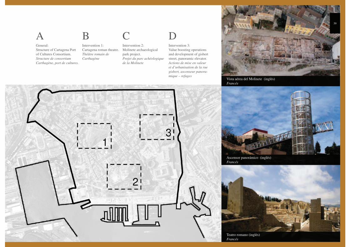
General:
Structure of Cartagena Port
of Cultures Consortium.
Structure de consortium
Carthagène, port de cultures.
AIntervention 1:
Cartagena roman theatre.
Théâtre romain de
Carthagène
BIntervention 2:
Molinete archaeological
park project.
Projet du parc achéologique
de la Molinete
CIntervention 3:
Value boosting operations
and development of gisbert
street, panoramic elevator.
Actions de mise en valeur
et d’urbanisation de la rue
gisbert, ascenseur panora-
mique – refuges
D
Conflictos. Cartagena Puerto de Culturas (inglés)
Francés
A Structure of Cartagena Port Of Cultures Consortiumstructure de consortium carthagène, port de cultures
Following the city’s economic, social and identity crisis during the 80’s and 90’s, local forces (institutions, technicians and towns-people), identified the need to re-orientate the city’s values in order
that it began to appreciate the wealth of it’s extraordinary cultural heri-tage.
In 1996, acting upon on the initiative of Cartagena’s Hotel and Catering Association, the services of an independent consultant were engaged in order that a study be carried out regarding the development of cultural tourism in the city, which duly served a dual purpose, firstly energizing the local economy and secondly ensuring that Cartagena became a natio-nal and international tourist and cultural reference point.
In 1999, the Region of Murcia and Cartagena’s Town Council promoted the creation of a tourism consortium, as a public entity, to help build upon this initiative and with the objective of creating and launching Cartagena Port of Cultures. This consortium got under way in 2001 and aims to:
destination.
-ture and basic equipment needed in order to ensure growth in tourism
city’s heritage is profitable from a social, economic and cultural viewpoint.
The society, Cartagena Port of Cultures is responsible for managing any investments that the Consortium might propose, including the con-traction of any public works that might be involved. Likewise, the Consortium must procure the necessary permits from the differing orga-nization both local and regional in order to carry out the proceedings and to ensure that the planning rules and regulations that apply to each
monument or historical site are complied with and thus met. As a requisite, it has been established that any restored buildings or archeological sites are owned by the Town Council or the Autonomous Region. The process is primarily based on archaeological and architectural proceedings together with museums.
In 2003, a business plan was put into place which elaborates upon the management models pertaining to each one of the sites and centers of touristic interest, and that are placed at the disposal of any discerning visitor. Here, both the levels of income and expenditure are outlined, and it is upon these figures that any entrance fees payable have been levied. The plan also maps out behavior rules, job definition and selection, as well as the training of any necessary personnel and management information systems.
All this combined with the pedestrianization of the city’s center, the restoration of both the waterfront and the military buildings by Cartagena’s University Polytechnic together with the important bids to restore the city’s heritage such as Cartagena Port of Cultures, The Roman Theatre and so on, have ensured that over the last 10 years Cartagena’s historical center has recovered both it’s social and economic activity.
Cartagena Port of Cultures Consortium is controlled by a Governing Body within which member organizations are represented. In order to working alongside them, an indi-
vidual corporation has been created whose Board of Directors is made up by representatives of the Consortium, and which acts as the executing body. As a result a greater level of flexibility has been gained with regards to the handling of investments, tax and labor benefits and the overall effective management of the organi-zation and it’s attributes.
Over the nine year period of it’s life span, The Action Plan de-veloped can be organized into 5 main sections, all of which are focused on the recovery of the city’s historical heritage:
well as signage throughout the city and it’s entry and exit po-ints.
Centers which highlight the tourist attractions and areas of in-terest.
-tures, the development of the Marketing Plan adopted to pro-mote the same, this development being carried out jointly with the Region of Murcia.
-ge the project, starting from the investment in the restoration of the city’s heritage.
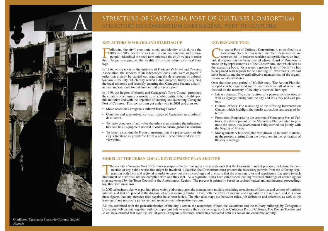
KEY ACTORS INVOLVED AND STARTING UP
MODEL OF THE URBAN LOCAL DEVELOPMENT PLAN ADOPTED
GOVERNANCE TOOL
Recorrido Barco Turístico. Alberto Molina Martínez (inglés)
Francés
Recorrido Decumano. Cartagena Puerto de Culturas (inglés)
Francés
41
Centro de interpretación de la Historia de Cartagena (inglés)
Francés
Du fait de la crise économique, sociale et d’identité de la ville durant les années 80 et 90, les acteurs locaux (institutions, techniciens et citoyens) com-
prirent qu.il était important de réorienter la nature de la ville vers la valorisation de son patrimoine culturel ex-traordinaire.
En 1996, à l’initiative de l’Association des hôteliers de Carthagène une consultation indépendante est entreprise, une étude pour le développement du tourisme culturel de la ville, pour atteindre un double objectif : d’un côté la dynamisation de l’économie locale, et de l’autre, faire de Carthagène une référence touristique et culturelle au ni-veau national et international.
En 1999, la région de Murcie et la Mairie de Carthagène ont été à l’origine, pour le développement de cette initia-tive, de la création d’un consortium touristique, en tant qu’entité publique à caractère administratif ayant comme objectif la création et la mise en marche du projet Cartha-gène, Port de Cultures. Le dit consortium se met en marche en 2001 et a pour finalité :
-thagène.
d’un contenu.
-tructures et les équipements de base nécessaires pour le développement de l’activité touristique.
vue social, économique et culturel la tâche de préserva-tion du patrimoine de la ville.
Le Consortium Carthagène port de cultures, est régi par la Junte du Gouvernement où sont représentées ses organisations membres et parallèlement une
Société anonyme est créée unipersonnelle dont le Conseil d’administration est formé de représentants du Consortium et agit comme organe exécutif. Ceci amène une souplesse dans les démarches d’investissement, des avantages fis-caux y de main-d’œuvre et une gestion efficace des équi-pements.
Le Consortium établit annuellement les actions de récupé-ration du patrimoine et d’expansion qu’il faut entreprendre, lesquelles sont financées par la Communauté autonome et les fonds de cohésion social qui gèrent cet organisme.
Au niveau de la gestion, il existe une direction, un per-sonnel de soutien et une commission technique constituée d’une équipe pluridisciplinaire de techniciens et de spécia-listes venant de chacune des institutions représentées dans le consortium, qui soutiennent techniquement le déroule-ment des projets.
Le Plan d’actions développé au cours de ses 9 années d’existence peut se structurer en cinq sections, concentrées sur la récupération du patrimoine historique:
d’un catamaran touristique.
-tres d’interprétation associés aux lieux de visite.
Carthagène, Port de Cultures, le développement du Plan de marketing pour la commercialisation du produit.
-tion du patrimoine et de sa mise en musées, un plan d’entreprise est établi pour sa gestion.
La Société Carthagène, Port de Cultures est celle chargée de gérer les inversions que lui propose le Consortium et d’établir les contrats pour les tra-
vaux. De cette façon, le Consortium doit obtenir les permis nécessaire auprès des divers organismes, tant locaux que régionaux pour la réalisation des actions et se tenir aux normes urbaines et aux dispositions en vigueur pour cha-que monument ou ensemble historique. Comme condition, il est établi que les édifices réhabilités ou les gisements soient la propriété de la Mairie ou de la Communauté au-tonome. Le processus se base principalement sur les ac-tions archéologiques, architecturales et de musées.
En 2003, un plan d’entreprise s’est mis en marche par le-quel se développent les modèles de gestion de chacun des gisements et centres d’intérêts touristique mis à la dispo-sition des visiteurs, tant au niveau des revenus que des dé-penses, de ce qui est perçu des prix d’entrée de chacun des lieux, les protocoles de travail, la définition, la sélection et la formation du personnel nécessaire, les systèmes de gestion informatiques.
Tout est relié à la piétonisation du centre-ville, la récupéra-tion du front de mer, la récupération des édifices militaire par une section de l’Université Polytechnique de Carthagè-ne et des importantes actions de récupération du patrimoi-ne de Carthagène, Port de Cultures, le théâtre romain, etc. qui ont fait qu’au cours des 10 dernières années son centre historique ait retrouvé son activité sociale et économique.
ACTEURS CLÉS IMPLIQUÉS ET DÉMARRAGE OUTIL DE GOUVERNANCE MODÈLE DU PLAN URBAIN LOCAL DE DÉVELOPPEMENT ADOPTÉ
Vista del Teatro Romano (inglés)
Francés
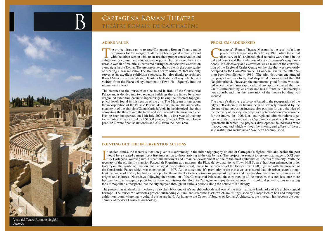
B Cartagena Roman Theatrethéâtre romain de carthagène
The project drawn up to restore Cartagena’s Roman Theatre made provisions for the merger of all the archaeological remains found with the urban web in a bid to ensure their proper conservation and
exhibition for cultural and educational purposes. Furthermore, the consi-derable wealth of materials uncovered during the consecutive excavation campaigns in the Roman Theatre, presented the city with the opportunity of creating a new museum, The Roman Theatre Museum, that not only serves as an excellent exhibition showcase, but also thanks to architect Rafael Moneo’s brilliant design, boasts a fantastic walkway which leads visitors from the Plaza del Ayuntamiento (Town-Hall Square), into the monuments interior.
The entrance to the museum can be found in front of the Consistorial Palace and is divided into two separate buildings that are linked by an un-derground exhibition corridor, ingeniously linking the different topogra-phical levels found in this section of the city. The Museum brings about the incorporation of the Palacio Pascual de Riquelme and the archaeolo-gical crypt of the church of Santa María la Vieja in the historical site, thus converting the theatre into the latest and most remarkable museum piece. Having been inaugurated on 11th July 2008, in it’s first year of opening to the public it was visited by 160.000 people, of which 32% were Euro-pean, 45% were Spanish nationals and 23% from the local area.
In ancient times, the theatre’s location given it’s supremacy in the urban topography on one of Cartagena’s highest hills and beside the port would have created a magnificent first impression to those arriving in the city by sea. The project has sought to restore that image to XXI cen-tury Cartagena, weaving into it’s path the historical and urbanical development of one of the most emblematical sectors of the city. With the
recovery of the old family mansion Pascual de Riquelme as a museum, the Plaza del Ayuntamiento (Town Hall Square) has been enhanced in order to carry out the symbolic function that it enjoyed over centuries past, thanks to the presence of the former Town Hall, together with the presence of the Consistorial Palace which was constructed in 1907. At the same time, it’s proximity to the port area has ensured that this urban sector throug-hout the course of history has had a cosmopolitan flavor, thanks to the continuous passage of travelers and merchandise that stemmed from assorted origins and cultures. Nowadays, following the restoration of the Consistorial Palace and the construction of the museum, this area has once more become the main reception point for travelers and visitors that flock to Cartagena to enjoy the excellence of it’s cultural projects, thus recreating the cosmopolitan atmosphere that the city enjoyed throughout various periods along the course of it’s history.
The project has enabled this modern city to claw back one of it’s neighbourhoods and one of the most valuable landmarks of it’s archaeological heritage. The museum’s attributes present outstanding cultural and scientific assets which are distinguished by a large lecture hall and temporary exhibition room, where many cultural events are held. As home to the Center of Studies of Roman Architecture, the museum has become the ben-chmark of modern Classical Archeology.
Cartagena’s Roman Theatre Museum is the result of a long project which began on 6th February 1990, when the initial discovery of it’s archaeological remains were found in the
old and desecrated Barrio de Pescadores (Fisherman’s neighbour-hood). It’s discovery and excavation was a result of the construc-tion of the Regional Crafts Centre on the site that was previously occupied by the Casa-Palacio de la Condesa Peralta, the latter ha-ving been demolished in 1986. The administrators encouraged the project in order to try and stop the deterioration of the Old Neighbourhood. However, the monuments good fortune was sea-led when the remains rapid cultural ascription ensured that the Craft Centre building was relocated to a different site in the city’s new suburb, and thus the renovation of the theatre building was secured.
The theatre’s discovery also contributed to the recuperation of the city’s self-esteem after having been so severely punished by the closure of numerous businesses, also pushing forward the idea of the recovery of the city’s heritage as a potential economic resource for the future. In 1996, local and regional administrations toge-ther with the financing entity Cajamurcia signed a collaboration agreement in which the projects development foundations were mapped out, and which without the interest and efforts of theses said institutions would never have been accomplished.
ADDED VALUE
POINTING OUT THE INTERVENTION ACTIONS
PROBLEMS ADDRESSED
Vista del Teatro Romano (inglés)
Francés
Vista del Teatro Romano (inglés)
Francés
Acceso al Museo. Palacio Riquelme (inglés)
Francés
43
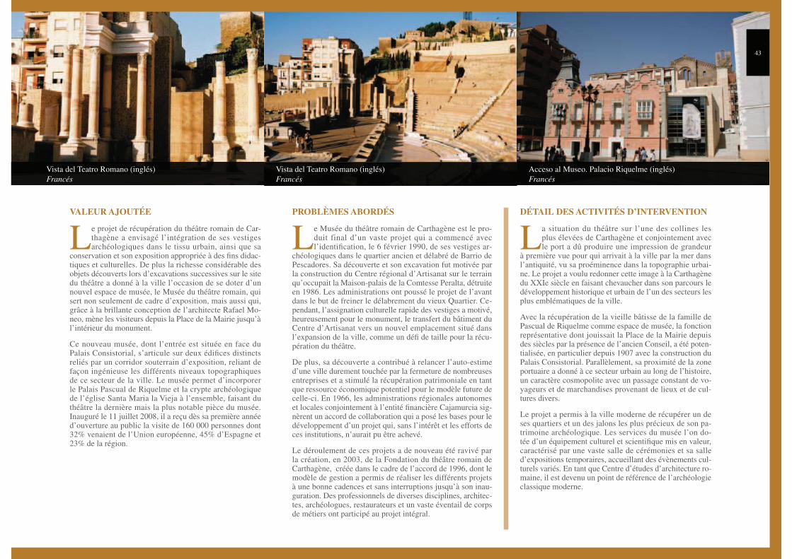
Le projet de récupération du théâtre romain de Car-thagène a envisagé l’intégration de ses vestiges archéologiques dans le tissu urbain, ainsi que sa
conservation et son exposition appropriée à des fins didac-tiques et culturelles. De plus la richesse considérable des objets découverts lors d’excavations successives sur le site du théâtre a donné à la ville l’occasion de se doter d’un nouvel espace de musée, le Musée du théâtre romain, qui sert non seulement de cadre d’exposition, mais aussi qui, grâce à la brillante conception de l’architecte Rafael Mo-neo, mène les visiteurs depuis la Place de la Mairie jusqu’à l’intérieur du monument.
Ce nouveau musée, dont l’entrée est située en face du Palais Consistorial, s’articule sur deux édifices distincts reliés par un corridor souterrain d’exposition, reliant de façon ingénieuse les différents niveaux topographiques de ce secteur de la ville. Le musée permet d’incorporer le Palais Pascual de Riquelme et la crypte archéologique de l’église Santa Maria la Vieja à l’ensemble, faisant du théâtre la dernière mais la plus notable pièce du musée. Inauguré le 11 juillet 2008, il a reçu dès sa première année d’ouverture au public la visite de 160 000 personnes dont 32% venaient de l’Union européenne, 45% d’Espagne et 23% de la région.
Le Musée du théâtre romain de Carthagène est le pro-duit final d’un vaste projet qui a commencé avec l’identification, le 6 février 1990, de ses vestiges ar-
chéologiques dans le quartier ancien et délabré de Barrio de Pescadores. Sa découverte et son excavation fut motivée par la construction du Centre régional d’Artisanat sur le terrain qu’occupait la Maison-palais de la Comtesse Peralta, détruite en 1986. Les administrations ont poussé le projet de l’avant dans le but de freiner le délabrement du vieux Quartier. Ce-pendant, l’assignation culturelle rapide des vestiges a motivé, heureusement pour le monument, le transfert du bâtiment du Centre d’Artisanat vers un nouvel emplacement situé dans l’expansion de la ville, comme un défi de taille pour la récu-pération du théâtre.
De plus, sa découverte a contribué à relancer l’auto-estime d’une ville durement touchée par la fermeture de nombreuses entreprises et a stimulé la récupération patrimoniale en tant que ressource économique potentiel pour le modèle future de celle-ci. En 1966, les administrations régionales autonomes et locales conjointement à l’entité financière Cajamurcia sig-nèrent un accord de collaboration qui a posé les bases pour le développement d’un projet qui, sans l’intérêt et les efforts de ces institutions, n’aurait pu être achevé.
Le déroulement de ces projets a de nouveau été ravivé par la création, en 2003, de la Fondation du théâtre romain de Carthagène, créée dans le cadre de l’accord de 1996, dont le modèle de gestion a permis de réaliser les différents projets à une bonne cadences et sans interruptions jusqu’à son inau-guration. Des professionnels de diverses disciplines, architec-tes, archéologues, restaurateurs et un vaste éventail de corps de métiers ont participé au projet intégral.
La situation du théâtre sur l’une des collines les plus élevées de Carthagène et conjointement avec le port a dû produire une impression de grandeur
à première vue pour qui arrivait à la ville par la mer dans l’antiquité, vu sa proéminence dans la topographie urbai-ne. Le projet a voulu redonner cette image à la Carthagène du XXIe siècle en faisant chevaucher dans son parcours le développement historique et urbain de l’un des secteurs les plus emblématiques de la ville.
Avec la récupération de la vieille bâtisse de la famille de Pascual de Riquelme comme espace de musée, la fonction représentative dont jouissait la Place de la Mairie depuis des siècles par la présence de l’ancien Conseil, a été poten-tialisée, en particulier depuis 1907 avec la construction du Palais Consistorial. Parallèlement, sa proximité de la zone portuaire a donné à ce secteur urbain au long de l’histoire, un caractère cosmopolite avec un passage constant de vo-yageurs et de marchandises provenant de lieux et de cul-tures divers.
Le projet a permis à la ville moderne de récupérer un de ses quartiers et un des jalons les plus précieux de son pa-trimoine archéologique. Les services du musée l’on do-tée d’un équipement culturel et scientifique mis en valeur, caractérisé par une vaste salle de cérémonies et sa salle d’expositions temporaires, accueillant des évènements cul-turels variés. En tant que Centre d’études d’architecture ro-maine, il est devenu un point de référence de l’archéologie classique moderne.
VALEUR AJOUTÉE PROBLÈMES ABORDÉS DÉTAIL DES ACTIVITÉS D’INTERVENTION

Aerial view of archaeological park project
Francés
C
The Molinete Archaeological Park is a project designed to en-hance Cartagena’s archaeological heritage as well as it’s urban and cultural recovery. The Cerro del Molinete (Mill Hill) is
one of the orographic features that has best characterized the city’s urban topography throughout the centuries. Around the middle of the II century B.C., Polibio, a Greek Historian named the hill arx Has-drubalis, maintaining that this was the place where the Carthaginian General erected his magnificent palaces. Since then, and although the polybian declaration has never been found among correspondence in the archaeological records, the hill’s history has been linked with the general’s name, creating a myth that together with the mixture of archaeology, surprise findings, legends and traditions has profoundly penetrated the collective imagination of the people.
The hill was densely populated from the IV to the VII centuries B.C., by Iberians, Carthaginians, Romans and Byzantines. After it’s depo-pulation over the course of another thousand years, it was re-occupied from the XVI century onwards, becoming a popular neighbourhood made up of winding streets, poor buildings and flour mills, the latter that give it it’s current name. After several attempts at urban rege-neration at the end of the XIX century and the beginning of the XX century, the neighbourhood was finally demolished in the decades of 1960-70; finally in 2001 the Interior Redesign of Moliente Special Plan (el Plan Especial de Reforma Interior del Molinete), founded the hill as an archaeological reserve area.
The recovery of the hill as an urban area has been procrastinated over time. The sector has been defined over the centuries by chaotic urban planning and degraded architecture. During the
first half of the XX century, it’s topography continued to be domi-nated by an irregular layout in the poor quarter. Between 1965 and 1973 the expropriation of estates and the remains of houses in the upper area of the hill were happened upon. These finds led to excava-tions being carried out during 1977-78.
Following years of uncertainty, PERI’s intervention ensured that any future building works be concentrated on the north face of the hill, leaving the rest as an archaeological reserve, where a park will be built. Since 2008 when the project was launched and being promo-ted and encouraged by Cartagena Port of Cultures and funded by the Town Council and Ministry of Culture and Tourism, it has not only served to promote the awareness of the hill’s rich archaeological heritage, but also it’s rehabilitation as an urban area and prestigious historic quarter, reclaiming the quality of it’s surroundings that had previously been lost with the degradation of the area and the popula-tion and economic activity that had been cleared out. In addition, the urbanization of the streets that mark out it’s boundaries, particularly in the east and south, will allow it’s connection to the historical center and it’s new suburb.
ADDED VALUE PROBLEMS ADDRESSED
Molinete Archaeological Park Projectprojet du parc achéologique de la molinete
The Molinete Archaeological Park Project will significantly boost the urban development of a large and important area in Cartagena’s historic centre. Provisionally planned to occupy an area of some 25.000m2, it will without doubt have a board impact on urban life. In fact the streets that surround the future park were repaved in 2009, linking it with the Calle Mayor (the High Street), being the main artery of the old
town and the new Health Centre of Casco Antiguo, whose basement and ground floor have been assigned to Cartagena Port of Cultures in order that they may use the same as the future venue of their Interpretation Centre. In this way, and with completely new accesses the park remains included in the centre’s new traffic circulation routes. Further more in 2010 provisions have been made for landscaping the top of the hill which will be accessible and will provide both the citizenry and tourists with a new vision of the city. In addition to this, the old buildings once refurnished will be re-occupied and new homes will be built on the vacant lots. The repopulation of this neighbourhood will also provoke growth in the economy and the formation of employment, via the installation of new businesses, such as those dedicated to the restoration works, all of which will make for the social integration and the communal evolvement of the area and it’s surroundings. All these actions, among many more, will revitalize once and for all the city’s historic centre together with it’s functionality and will serve to restore confidence to the citizens who will once more inhabit and roam through this area of the old town.
POINTING OUT THE INTERVENTION ACTIONS
45
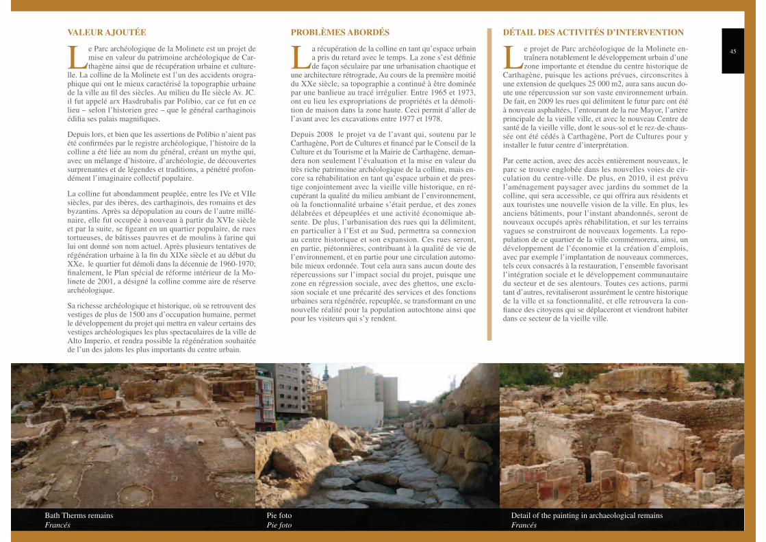
Bath Therms remains
Francés
Pie foto
Pie foto
Detail of the painting in archaeological remains
Francés
Le Parc archéologique de la Molinete est un projet de mise en valeur du patrimoine archéologique de Car-thagène ainsi que de récupération urbaine et culture-
lle. La colline de la Molinete est l’un des accidents orogra-phique qui ont le mieux caractérisé la topographie urbaine de la ville au fil des siècles. Au milieu du IIe siècle Av. JC. il fut appelé arx Hasdrubalis par Polibio, car ce fut en ce lieu – selon l’historien grec – que le général carthaginois édifia ses palais magnifiques.
Depuis lors, et bien que les assertions de Polibio n’aient pas été confirmées par le registre archéologique, l’histoire de la colline a été liée au nom du général, créant un mythe qui, avec un mélange d’histoire, d’archéologie, de découvertes surprenantes et de légendes et traditions, a pénétré profon-dément l’imaginaire collectif populaire.
La colline fut abondamment peuplée, entre les IVe et VIIe siècles, par des ibères, des carthaginois, des romains et des byzantins. Après sa dépopulation au cours de l’autre millé-naire, elle fut occupée à nouveau à partir du XVIe siècle et par la suite, se figeant en un quartier populaire, de rues tortueuses, de bâtisses pauvres et de moulins à farine qui lui ont donné son nom actuel. Après plusieurs tentatives de régénération urbaine à la fin du XIXe siècle et au début du XXe, le quartier fut démoli dans la décennie de 1960-1970; finalement, le Plan spécial de réforme intérieur de la Mo-linete de 2001, a désigné la colline comme aire de réserve archéologique.
Sa richesse archéologique et historique, où se retrouvent des vestiges de plus de 1500 ans d’occupation humaine, permet le développement du projet qui mettra en valeur certains des vestiges archéologiques les plus spectaculaires de la ville de Alto Imperio, et rendra possible la régénération souhaitée de l’un des jalons les plus importants du centre urbain.
La récupération de la colline en tant qu’espace urbain a pris du retard avec le temps. La zone s’est définie de façon séculaire par une urbanisation chaotique et
une architecture rétrograde, Au cours de la première moitié du XXe siècle, sa topographie a continué à être dominée par une banlieue au tracé irrégulier. Entre 1965 et 1973, ont eu lieu les expropriations de propriétés et la démoli-tion de maison dans la zone haute. Ceci permit d’aller de l’avant avec les excavations entre 1977 et 1978.
Depuis 2008 le projet va de l’avant qui, soutenu par le Carthagène, Port de Cultures et financé par le Conseil de la Culture et du Tourisme et la Mairie de Carthagène, deman-dera non seulement l’évaluation et la mise en valeur du très riche patrimoine archéologique de la colline, mais en-core sa réhabilitation en tant qu’espace urbain et de pres-tige conjointement avec la vieille ville historique, en ré-cupérant la qualité du milieu ambiant de l’environnement, où la fonctionnalité urbaine s’était perdue, et des zones délabrées et dépeuplées et une activité économique ab-sente. De plus, l’urbanisation des rues qui la délimitent, en particulier à l’Est et au Sud, permettra sa connexion au centre historique et son expansion. Ces rues seront, en partie, piétonnières, contribuant à la qualité de vie de l’environnement, et en partie pour une circulation automo-bile mieux ordonnée. Tout cela aura sans aucun doute des répercussions sur l’impact social du projet, puisque une zone en régression sociale, avec des ghettos, une exclu-sion sociale et une précarité des services et des fonctions urbaines sera régénérée, repeuplée, se transformant en une nouvelle réalité pour la population autochtone ainsi que pour les visiteurs qui s’y rendent.
Le projet de Parc archéologique de la Molinete en-traînera notablement le développement urbain d’une zone importante et étendue du centre historique de
Carthagène, puisque les actions prévues, circonscrites à une extension de quelques 25 000 m2, aura sans aucun do-ute une répercussion sur son vaste environnement urbain. De fait, en 2009 les rues qui délimitent le futur parc ont été à nouveau asphaltées, l’entourant de la rue Mayor, l’artère principale de la vieille ville, et avec le nouveau Centre de santé de la vieille ville, dont le sous-sol et le rez-de-chaus-sée ont été cédés à Carthagène, Port de Cultures pour y installer le futur centre d’interprétation.
Par cette action, avec des accès entièrement nouveaux, le parc se trouve englobée dans les nouvelles voies de cir-culation du centre-ville. De plus, en 2010, il est prévu l’aménagement paysager avec jardins du sommet de la colline, qui sera accessible, ce qui offrira aux résidents et aux touristes une nouvelle vision de la ville. En plus, les anciens bâtiments, pour l’instant abandonnés, seront de nouveaux occupés après réhabilitation, et sur les terrains vagues se construiront de nouveaux logements. La repo-pulation de ce quartier de la ville commémorera, ainsi, un développement de l’économie et la création d’emplois, avec par exemple l’implantation de nouveaux commerces, tels ceux consacrés à la restauration, l’ensemble favorisant l’intégration sociale et le développement communautaire du secteur et de ses alentours. Toutes ces actions, parmi tant d’autres, revitaliseront assurément le centre historique de la ville et sa fonctionnalité, et elle retrouvera la con-fiance des citoyens qui se déplaceront et viendront habiter dans ce secteur de la vieille ville.
VALEUR AJOUTÉE PROBLÈMES ABORDÉS DÉTAIL DES ACTIVITÉS D’INTERVENTION

Ascensor panorámico (inglés)
Francés
D
Gisbert Street came into being in 1878, in order to connect the sea to the city’s urban centre by means of an enormous quarry through the “Concepción” mountain ridge, and forms one of
Cartagena’s most significant urban elements. The urban outline of this access road divided this mountain, one of the most densely populated zones of Roman Cartagena, on two sides; Cerro de la Concepción can be found on one lateral and located on the other side are various mi-litary buildings which are presently being utilized by the Polytechnic University and the Roman Amphitheatre which constitutes one of the most important archaeological remains of the city.
Cartagena Port of Cultures proposes an urban transformation plan in the strategic enclave of Gisbert Street, which provides the fundamen-tal access between the city and the port and forms an almost obli-gatory crossing point to places of tourist and cultural interest which are found on the different sides of this artery of the City. The im-provement plans have been designed with a double purpose. On one hand, to re-establish the interrupted access to the Concepción Castle through the construction of a tower-elevator in order to compensate for an incline of 45 metres. This intervention is to be complemented by the construction of a building, at the foot of the tower-elevator, which acts as a retention wall for the slope of the mountain and has a double use: for administrative purposes on one hand, and on the other hand, to facilitate access to the Civil War Shelters, hence harnessing its value while at the same time remodelling this entire urban envi-ronment. In this way, the operation in Gisbert Street also includes the urbanisation and access to the archaeological sites and buildings that surround this artery.
Around 2001, under the management of Cartagena Port of Cul-tures, it was proposed to communicate together the areas that were disconnected from the route of Gisbert Street. Giving
prime importance to this objective, an outdoor elevator was projected from the face of the mountain corresponding to the Roman amphi-theatre and the military facilities, and plans were put forward for con-necting the other slope through a passageway allowing access to the Concepción Hill and Torres Park.
This project, which can be regarded as the ideal solution, was not completed, due to the fact that the projection area for the elevator was a privately owned property and a satisfactory agreement could not be reached with the titleholder. Hence the project was modified and the elevator was relocated to the opposite side of the street. The geotech-nical conditions of the new location were verified and the necessary research were carried out in order to check the consistency of the land, and this led to the discovery of some big access galleries that were perforated through the mountain for use as shelters during the Spanish Civil War, which in turn made it unadvisable to attach the elevator on that side of the hill. These circumstances gave rise to the design of the elevator as an isolated element; a more attractive architectonic form which lends character to this urban space. On the other hand, Gisbert Street was urbanised by the construction of a pedestrian access from the street up to the other side of the hill, making use of its orography.
ADDED VALUE PROBLEMS ADDRESSED
VALUE BOOSTING OPERATIONS AND DEVELOPMENT OF GISBERT STREET, PANORAMIC ELEVATORactions de mise en valeur et d’urbanisation de la rue gisbert, ascenseur panoramique – refuges
What started off as an initiative to solve a specific access problem ended up as an integral solution for the regeneration, restructuring and characterisation of this area and access route, so important for the city. The panoramic elevator constitutes a structural milestone of the route and is complemented by a building which is both architectural as well as functional, bringing back life to this long forgotten area.
This initiative has boosted the urban development of this area with new surrounding access ways, the creation of public and private zones, the construction of new residences and shops, etc. by the Cartagena City Council as well as private entities. This project has constituted a starting point for observing and touring in a distinct manner a city which now finds itself in the midst of a radical transformation.
This area, with a tourist information centre, has converted itself into a landmark for the visitor, who tends to commence his tours from this reference point. Approximately 40% of the tourists received by the city have initiated their tour from this point.
This project has contributed to the regeneration of an area that is very important for the city in the tourist, cultural, social and economical fields. We cannot forget that it is one of the accesses to the current Polytechnic University of Cartagena, to important archaeological sites and museums, to the Port and Concepción Hill. An area in decline has transformed into a zone of great architectural and artistic quality, and this has resolved access problems to elements and places of great heritage and scenic interest.
DETAILS ABOUT THE OPERATION
47
Ascensión. Sonia Moreno (inglés)
Francés
Ascensión. José Mª Castejón (inglés)
Francés
Pasarela (inglés)
Francés
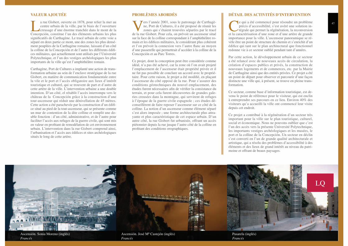
La rue Gisbert, ouverte en 1878, pour relier la mer au centre urbain de la ville, par le biais de l’ouverture creusage d’une énorme tranchée dans le mont de la
Concepción, constitue l’un des éléments urbains les plus significatifs de Carthagène. Le tracé urbain de cette voie a séparé en deux partie ce mont, une des zones les plus densé-ment peuplées de la Carthagène romaine, laissant d’un côté la colline de la Concepción et de l’autre les différents édifi-ces militaires, qui actuellement sont utilisés par l’Université Polytechnique, et l’un des vestiges archéologiques les plus importants de la ville qu’est l’amphithéâtre romain.
Carthagène, Port de Cultures a implanté une action de trans-formation urbaine au sein de l’enclave stratégique de la rue Gisbert, en matière de communication fondamentale entre la vile et le port et l’accès obligatoire aux lieux d’intérêt touristique et culturel, qui se trouvent de part et d’autre de cette artère de la ville. L’intervention urbaine a une double intention. D’un côté, el rétablit l’accès interrompu vers le château de la Concepción grâce à la construction d’une tour-ascenseur qui réduit une dénivellation de 45 mètres. Cette action a été parachevée par la construction d’un édifi-ce situé au pied de la tout-ascenseur, qui se présente comme un mur de contention de la dite colline et remplit une do-uble fonction : d’un côté, administrative, et de l’autre pour faciliter l’accès aux refuges de la guerre civile, qui sont mis en valeur en profitant de remodélation de cet environnement urbain. L’intervention dans la rue Gisbert comprend ainsi, l’urbanisation et l’accès aux édifices et sites archéologiques situés le long de cette artère.
Vers l’année 2001, sous le patronage de Carthagè-ne, Port de Cultures, il a été proposé de réunir les zones qui s’étaient trouvées séparées par le tracé
de la rue Gisbert. Pour cela, on prévoit un ascenseur situé sur la face de la colline correspondant à l’amphithéâtre ro-main et les édifices militaires, le considérant plus cohérent et l’on prévoit la connexion vers l’autre flanc au moyen d’une passerelle qui permettrait d’accéder à la colline de la Concepción et au Parc Torres.
Ce projet, dont la conception peut être considérée comme idéal, n’a pas été achevé, car la zone où l’on avait projeté l’emplacement de l’ascenseur était propriété privée et il ne fut pas possible de conclure un accord avec le proprié-taire. Pour cette raison, le projet a été modifié, en plaçant l’ascenseur du côté opposé de la rue. Pour s’assurer des conditions géotechniques du nouvel emplacement, des études furent nécessaires afin de vérifier la consistance du terrain, et pour cela furent découvertes de grandes gale-ries creusées dans la montagne, qui servirent de refuges à l’époque de la guerre civile espagnole ; ces études dé-conseillèrent de faire reposer l’ascenseur sur ce côté de la colline. La notion d’un ascenseur comme élément séparé s’est alors imposée ; une forme architecturale plus attra-yante et plus caractéristique de cet espace urbain. D’un autre côté, la rue Gisbert fut urbanisée, offrant un accès piétonnier depuis la rue jusque l’autre côté de la colline en profitant des conditions orographiques.
Ce qui a été commencé pour résoudre un problème précis d’accessibilité, s’est avéré une solution in-tégrale qui permet la régénération, la reconversion
et la caractérisation d’une zone et d’une artère de grande importance pour la ville. L’ascenseur panoramique se ré-vèle être un point de structure de chemin et s’enrichit d’un édifice qui tant sur le plan architectural que fonctionnel redonne vie à ce secteur oublié pendant tant d’années.
Par cette action, le développement urbain de ce secteur a été relancé avec de nouveaux accès de circulation, la création d’espaces publics et privés, la construction de nouveaux logements et de commerces, etc. par la Mairie de Carthagène ainsi que des entités privées. Ce projet a été un point de départ pour observer et parcourir d’une façon distincte une ville qui, à présent, se trouve en pleine trans-formation.
Ce secteur, comme base d’information touristique, est de-venu le point de référence pour le visiteur, qui est enclin à entreprendre ses parcours en ce lieu. Environ 40% des visiteurs qu’a accueilli la ville ont commencé leur visite depuis cet endroit.
Ce projet a contribué à la régénération d’un secteur très important pour la ville sur le plan touristique, culturel, social et économique. Nous ne pouvons oublier que c’est l’un des accès vers la présente Université Polytechnique, les importants vestiges archéologiques et les musées, le port et la colline de la Concepción. Un secteur en déclin s’est converti en l’un de grande qualité architecturale et artistique, qui a résolu des problèmes d’accessibilité à des éléments et des lieux de grand intérêt au niveau du patri-moine et offrant de beaux paysages.
VALEUR AJOUTÉE PROBLÈMES ABORDÉS DÉTAIL DES ACTIVITÉS D’INTERVENTION
LQ
5

![[Composite Cultures] - CORE](https://static.fdokumen.com/doc/165x107/6325e67de491bcb36c0a86c0/composite-cultures-core.jpg)