({IVE~ - City of Richmond
83
To: From: City of Richmond Public Works and Transportation Committee John Irving, P.Eng. MPA Director, Engineering Report to Committee Date: June 27, 2014 File: 10-6060-04-01/2014- Vol 01 Re: East Richmond Agricultural Water Supply Staff Recommendation That the report titled "East Richmond Agricultural Water Supply Update 2013" as attached to the staff report titled "East Richmond Agricultural Water Supply", dated June 27, 2014, from the Director, Engineering, be used as input in the five year capital program process. 9L'0 John Irving, P.Eng. MPA Director, Engineering (604-276-4140) Att.3 ROUTED To: Sewerage & Drainage REVIEWED BY STAFF REPORT I AGENDA REVIEW SUBCOMMITTEE 4266052 REPORT CONCURRENCE CONCURRENCE CONCURRENCE OF GENERAL MANAGER ------:/ INITIALS: CNCL - 426
-
Upload
khangminh22 -
Category
Documents
-
view
2 -
download
0
Transcript of ({IVE~ - City of Richmond
To:
From:
City of Richmond
Public Works and Transportation Committee
John Irving, P.Eng. MPA Director, Engineering
Report to Committee
Date: June 27, 2014
File: 10-6060-04-01/2014-Vol 01
Re: East Richmond Agricultural Water Supply
Staff Recommendation
That the report titled "East Richmond Agricultural Water Supply Update 2013" as attached to the staff report titled "East Richmond Agricultural Water Supply", dated June 27, 2014, from the Director, Engineering, be used as input in the five year capital program process.
9L'0 John Irving, P.Eng. MPA Director, Engineering (604-276-4140)
Att.3
ROUTED To:
Sewerage & Drainage
REVIEWED BY STAFF REPORT I AGENDA REVIEW SUBCOMMITTEE
4266052
REPORT CONCURRENCE
CONCURRENCE CONCURRENCE OF GENERAL MANAGER
~ ------:/
C/~~ INITIALS:
({IVE~ ~
CNCL - 426
June 27, 2014 - 2 -
Staff Report
Origin
In 2006, the City, in partnership with the Ministry of Agriculture and the Richmond Farmer's Institute (RFI), completed the original East Richmond Agricultural Water Supply Study (the Study) to address flood protection and irrigation needs for agricultural lands in East Richmond. Approximately $4.7M of drainage upgrades identified in the Study have been implemented or are included in Council approved capital projects that are scheduled for completion by the end of 2014.
The Study's update was started in 2013 to review progress and build upon the original study. This report presents the 2013 Study Update report (attachment 1) to Council for consideration and endorsement.
Findings of Fact
East Richmond land use is primarily agricultural. Approximately 2,788 Ha is available for agriculture and approximately 1,994 Ha are in agricultural production. This represents a 210 Ha (12%) increase in land in agricultural production since the 2006 study.
The drainage system in East Richmond serves both flood protection and irrigation purposes. Planning and operating the system to serve both of these purposes is a balancing act as drainage is fundamentally the opposite of irrigation. The complexity of the system requires hydraulic models and creative planning work for ongoing improvements that reduce flooding and improve irrigation which is ultimately required to improve the agricultural viability of the ALR.
The 2006 Study was a comprehensive review of the drainage system in the East Richmond ALR with a focus on improvements required to improve conditions for farming. The study identified a catalogue of proposed drainage and irrigation improvements based on hydraulic modeling and input from the farm community. From this catalogue, $4.7M of improvements have been implemented or are included in Council approved capital projects that are scheduled for completion by the end of2014. They include:
• 7.3 km of new or re-profiled ditches on Granville, No.7 Road, Westminster, Francis, and No.8 Road (listed from longest to shortest improvements),
• Five control structures, • Three pump station improvements, • One new drainage pump station (currently under construction at No.8 Road and
Granville); and • Remote salinity monitoring.
The goal ofthe 2013 Study Update was to review progress and build upon the original study. The 2013 Study Update report includes:
• A catalogue of infrastructure projects completed since the 2006 Study, • Updated hydraulic model that includes infrastructure improvements completed since the
2006 Study,
4266052 CNCL - 427
June 27,2014 - 3 -
.. A stakeholder consultation process, • An updated catalogue of proposed drainage and irrigation infrastructure improvements
for East Richmond (Attachments 2 and 3); and • A cost benefit analysis of proposed drainage and irrigation infrastructure improvements.
Stakeholder Consultation
The project team consulted with the Agricultural Advisory Committee (AAC), and hosted a public open house and hosted a workshop with City operations staff. The identified issues and concerns are documented in the 2013 Study Update report and were utilized in developing the recommended upgrade strategy.
On May 22,2014, the completed 2013 Study Update report was presented to the Agricultural Advisory Committee. There was discussion regarding the hydraulic modeling work as well as some of the results. In particular, committee members were interested in the recommended Sidaway Road improvements and the impacts of a proposed development at No.6 Road and Steveston Highway. The committee indicated general satisfaction with the update.
Improvement Strategy
The 2013 Study Update builds on the previous study and a number of the original recommendations are maintained in the update. The majority of the irrigation and flood protection problems identified by the farming community are south of Highway 91. As such, the majority of the recommended and completed improvements are south of Highway 91. Both the original 2006 study and the 2013 study update identify supplying water from the north arm of the Fraser River to the farm land south of Highway 91 as the preferred option. Primary reasons for this preference are:
• The water in the north arm of the Fraser River is of better quality for farming purposes than the water in the south arm,
• Topography and low ground elevations limit the distance water from the south arm ofthe Fraser can be pushed north; and
• It is the more cost effective option.
The update improves on the original study by:
• Adding detail to Sidaway and No.6 Road ditch re-grading, • Recommending additional ditch cleaning on No.7 Road, • Recommending new settings for No.6 Road South Pump Station; and • Recommending additional control structures in the south west quarter of the study area.
The additional control structures recommended at No.7 Road and Westminster and No.7 Road and Granville are key to accomplishing irrigation objectives in the south west area without flooding the south west area.
4266052 CNCL - 428
June 27, 2014 - 4 -
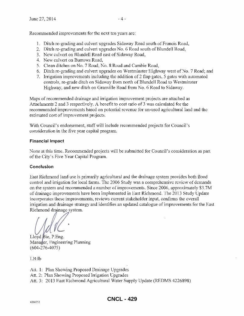
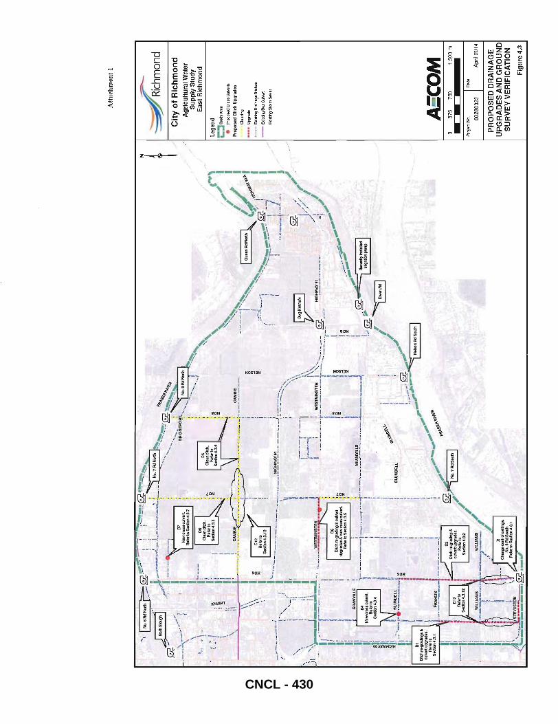
Recommended improvements for the next ten years are:
1. Ditch re-grading and culvert upgrades Sidaway Road south of Francis Road, 2. Ditch re-grading and culvert upgrades No.6 Road south of Blundell Road, 3. New culvert on Blundell Road east of Sid away Road, 4. New culvert on Burrows Road, 5. Clean ditches on No.7 Road, No. 8 Road and Cambie Road, 6. Ditch re-grading and culvert upgrades on Westminster Highway west of No. 7 Road; and 7. Irrigation improvements including the addition of 2 flap gates, 5 gates with automated
controls, re-grade ditch on Sidaway from north of Blundell Road to Westminster Highway, and new ditch on Granville Road from No. 6 Road to Sidaway.
Maps of recommended drainage and irrigation improvement projects are attached as Attachments 2 and 3 respectively. A benefit to cost ratio of 3 was calculated for the recommended improvements based on potential revenue for un-used agricultural land and the estimated cost of improvement projects.
With Council's endorsement, staffwill include recommended projects for Council ' s consideration in the five year capital program.
Financial Impact
None at this time. Recommended projects will be submitted for Council's consideration as part of the City's Five Year Capital Program.
Conclusion
East Richmond land use is primarily agricultural and the drainage system provides both flood control and irrigation for local farms. The 2006 Study was a comprehensive review of demands on the system and recommended a number of improvements. Since 2006, approximately $3.7M of drainage improvements have been implemented in East Richmond. The 2013 Study Update incorporates these improvements, reviews current stakeholder input, confirms the overall irrigation and drainage strategy and identifies an updated catalogue of improvements for the East
Richmond ~ystem.
Lloyd ie, P.Eng. Mana er, Engineering Planning (604-276-4075)
LB:lb
Att. 1: Plan Showing Proposed Drainage Upgrades Att. 2: Plan Showing Proposed Irrigation Upgrades Att. 3: 2013 East Richmond Agricultural Water Supply Update (REDMS 4226898)
4266052 CNCL - 429
'I
WII!'.
!!'!"~
--~
INO.6RdNOrthr::::~
'-'
I I
•. ~-.~
.-
'---
.-.,--1
.---•
-!
-; -
! --
~: -
-.-.
. ~.~,
~i
.rYJ--~
T~~."'
:~L.
~~...;-.. ~
~2...'~~ No
.7A~Nort
h ~
~~
' "
• ,._
!_,_
."
.' '<
, -~_
'11> ...
\
. _ ....
. _~ ,
I
---_,
_ ...
.!~'!.
.~S"""
'" ,--
.-,-
-;
! I
"-' s
:--';:,"
'\
~~
~
I . -
'-N
o I
•.. ,,
\..
I ~----
: --!-'
:-"-_-~l-
~~
.r"
I I!
"
,1
'-'
'. -
·1
.~' .
..~ ~
: i ~
I';
I ' ~
~ ' •.
, \
!; ...
II I
: ~,
. #"¥
'II.
,. I'
' "
, \\
j"
" ,.
. ~.,
',-,;; I
\\
I
~ --
.-j--
---.
---.
Z -'---
::-1~~
~/
I . .
I
Z
; ~
I ,~.
...
I au ..
nA
dN
Ort
h" I
, ...
I
I 'l!
.-'
! . -.~....."
G""''''
' _
,--
.---
.J .
,'
-_'_
__
: ,"
-""---j
'~~
r;;;J~' ,'*
I
I>,
: ___
____
_ . __
_ .!!'~~
~Y91
i :!
-,~ _
_ -~
M--
! I
i ."
II,
\, --
---
"--'.
:-=-,:
:-...:
;--,
: r
1---
--I
j' I
, I
Ii ,.
,;
• II
i -,~,
!
I' '.
' :
';1
'"
, ";
', ...
-:.
. ..
. J
\' '\
...J
. \
I I!
,-'
--r'--
-'
\\
.; 4!
.'
\r--
......!
.I.;.;
.,a,
I!i ! ..
~~-.",,!
1 k,
~K,"n."
I ~
. /
~ .. f
1) .
. -1'-
.-.. -
.-.-.
... -
.. ..
' ,!
I i\
\ \' .
'//
; .
I'
I ..
...
' ••
.• c .
.....
' .~
,. I
"',
"
I I,!
I
' "
r;·-·'
!'-~..;,..
'::::.:..-=·:
;-I-~---
~ . HIG~~
~.!L._. __
__
• ,<
i~4!'
: ~
A""
IOS
oct
ion
43
5
,z
fZ
0 -.
.",."'
" I
! .
~ L
! ~
I ~ .. ~
~..",.."
,. I
\_.__
___ I'
J I
z:
.:.-
-,.
.,
~I! ~
-l·-
.. ··--..
.. ·--r-
·-----~~
~~E---.
. --_
'-'-
-.
: r;
;;J ~
",.. m
I
I'
-.
-I
g-
~ ,
I I
i'
--
1,.1' r
;:J ~
~i II'!
. );
;6.-
~I ;!
I "
,~
:J:
...
:,,_
. !"
•• B':'U!:
'~ •• ,J
~ i
iG\;<,,
,o~~~!
!J' '
. '
I ~
, ..
0'
BLUN
DELL
..
, /
L !Z
, ,i
i'
! ,
.,
01
I •
I '
-:~<9/
~~~~:~~~~~~~
~ & i
i' :
.. ,.;
.-A.
,,, '0
. :'
I ,.
-N
.'"n
Ad So
.. h I
Sec
tion
,,3,1
j
FRA
NC
'S
",
; __ . __
___ -
---___
-:.1
~~
,.,'-..",.:
~~""'~
" ;~
012
Ditc
h fa
-gra
dlng
&
~-
: A
.,,,
10
I cu
'v,,
' upg
radO
G.
~
No,
7 A
d So
ulh I
S;c
tion
4.3.
12:
s!:~~r
~~3.2
/ .
. /
.
WIL
LIA
MS
.,
-~--
-;r-
-' I'
'l">"
~'"
t / , /
.--~'
Att
ach
me
nt
1
-:=
--..
';:~
hmond
Cit
y o
f R
ich
mo
nd
A
gri
cult
ura
l Wat
er
Su
pp
ly S
tud
y E
ast
Ric
hm
on
d
Lege
nd
;::
Stuc
lYA
re3
• P
ropo
sed
Cro
ss O
Jlve
rts
Pro
po
sed
Ditc
h U
pgra
des
Cle
anin
g
••••
Upg
rade
-_
.-E
xist
ing
Dra
inag
e D
itche
s
--
Exl
slln
g B
ox C
utve
rt
exis
ting
Sto
rm S
ewer
AS'C
OM
37
5 75
0 1,
500
m
Proj
ect N
o.
I Date
6028
8323
A
pril
2014
PR
OP
OS
ED
DR
AIN
AG
E
UP
GR
AD
ES
AN
D G
RO
UN
D
SU
RV
EY
VE
RIF
ICA
TIO
N
Fig
ure
4.3
CNCL - 430
June
27,
201
4 -
6-
f ... ./
/"
/
Att
ach
men
t 2
-::=
--.
~hm
ond
Cit
y o
f R
ich
mo
nd
A
gri
cultu
ral W
ater
S
up
ply
Stu
dy
Eas
t R
ichm
ond
leg
end
i" Ex
istin
g G
ates
'i" Pr
opO
SED
Gat
es
~ P
ump
Sta
llDns
--
Prop
osed
New
Ditc
h
-..
Pro
pose
d D
itch
Upg
rade
;::::
Stud
yAre
a • S
erv
ice
d A
rea
-.. -
....
....
Ph
asa
B.
Ser
vice
d A
rea
;:::
;Pha
se c
· Ser
vice
d Ar
ea
-_.-
Exi
stin
g O
rain
aglil
Ditc
hes/
Cul
v"rts
__
ElI[
stin
g8
oxC
l.Jve
rt
-E
xist
ing
Sto
rm S
ewer
AEC
OM
3
75
75
0 1,
500
m
--P
roje
ct N
o.
I Data
60
28
83
23
A
pril
20
14
OP
TIO
N 1
-IR
RIG
AT
ION
U
PG
RA
DE
S F
OR
SU
PP
LY
FR
OM
NO
RT
H A
RM
Fig
ure
CNCL - 431
Attachment 3
Water AE'COM
City of Richmond
FINAL REPORT East Richmond Agricultural Water Supply Update 2013
Prepared by:
AECOM 3292 Production Way, Floor 4 Burnaby, BC, Canada V5A 4R4 www.aecom .com
Project Number:
60288323
Date:
April 2014
604 444 6400 tel 604 294 8597 fax
CNCL - 432
AECOM City of Richmond
Statement of Qualifications and Limitations
FINAL REPORT East Richmond Agricultural Water Supply Update 2013
The attached Report (the "Report") has been prepared by AECOM Canada Ltd. ("Consultant") for the benefit of the client ("Client") in accordance with the agreement between Consultant and Client, including the scope of work detailed therein (the "Agreement").
The information, data, recommendations and conclusions contained in the Report (collectively, the "Information"):
• is subject to the scope, schedule, and other constraints and limitations in the Agreement and the qualifications contained in the Report (the "Limitations");
• represents Consultant's professional judgement in light of the Limitations and industry standards for the preparation of similar reports;
• may be based on information provided to Consultant which has not been independently verified; • has not been updated since the date of issuance of the Report and its accuracy is limited to the time period and
circumstances in which it was collected, processed, made or issued; • must be read as a whole and sections thereof should not be read out of such context; • was prepared for the specific purposes described in the Report and the Agreement; and • in the case of subsurface, environmental or geotechnical conditions, may be based on limited testing and on the
assumption that such conditions are uniform and not variable either geographically or over time.
Consultant shall be entitled to rely upon the accuracy and completeness of information that was provided to it and has no obligation to update such information. Consultant accepts no responsibility for any events or circumstances that may have occurred since the date on which the Report was prepared and, in the case of subsurface, environmental or geotechnical conditions, is not responsible for any variability in such conditions, geographically or over time.
Consultant agrees that the Report represents its professional judgement as described above and that the Information has been prepared for the specific purpose and use described in the Report and the Agreement, but Consultant makes no other representations, or any guarantees or warranties whatsoever, whether express or implied, with respect to the Report, the Information or any part thereof.
Without in any way limiting the generality of the foregoing, any estimates or opinions regarding probable construction costs or construction schedule provided by Consultant represent Consultant's professional judgement in light of its experience and the knowledge and information available to it at the time of preparation. Since Consultant has no control over market or economic conditions, prices for construction labour, equipment or materials or bidding procedures, Consultant, its directors, officers and employees are not able to, nor do they, make any representations, warranties or guarantees whatsoever, whether express or implied, with respect to such estimates or opinions, or their variance from actual construction costs or schedules, and accept no responsibility for any loss or damage arising therefrom or in any way related thereto. Persons relying on such estimates or opinions do so at their own risk.
Except (1) as agreed to in writing by Consultant and Client; (2) as required by-law; or (3) to the extent used by governmental reviewing agencies for the purpose of obtaining permits or approvals, the Report and the Information may be used and relied upon only by Client.
Consultant accepts no responsibility, and denies any liability whatsoever, to parties other than Client who may obtain access to the Report or the Information for any injury, loss or damage suffered by such parties arising from their use of, reliance upon, or decisions or actions based on the Report or any of the Information ("improper use of the Report"), except to the extent those parties have obtained the prior written consent of Consultant to use and rely upon the Report and the Information. Any injury, loss or damages arising from improper use of the Report shall be bome by the party making such use.
This Statement of Qualifications and Limitations is attached to and forms part of the Report and any use of the Report is subject to the terms hereof.
AECOM: 2012-01-06 © 2009-2012 A ECOM Canada Ltd All Rights Reserved.
Final Final ReporCApril 2014.Docx CNCL - 433
Aa'COM
April 28, 2014
Mr. Andy Bell, M.Eng., P.Eng. Engineering Planning City of Richmond 6911 NO.3 Road Richmond, BC V6Y 2C1
Dear Andy:
Project No:
Regarding:
60288323
FINAL REPORT
AECOM
3292 Production Way, Floor 4 Burnaby, BC, Canada V5A 4R4 www.aecom.com
East Richmond Agricultural Water Supply Update 2013
604 444 6400 tel 604 294 8597 fax
Please find attached three copies of the Final Report for the East Richmond Agricultural Water Supply Update 2013. This report includes an assessment of the current and future drainage conveyance and irrigation water supply, as well as proposed recommendations for both the drainage and irrigation systems.
We have enjoyed working with City Staff on this project and we look forward to providing our continued services to the City of Richmond. If there are any questions or concerns please don't hesitate to contact me at 604.444.6400
Sincerely, AECOM Canada Ltd.
Suman Shergill, P.Eng. Project Engineer
Enel. ee: SB:ss
Final Final Report_April 2014.Docx CNCL - 434

AECOM
Distribution List
'---'
City of Richmond FINAL REPORT East Richmond Agricultural Water Supply Update 2013
# of Hard Copies PDF Required Association I Company Name
1 I Yes City ofRictllTlOnd 1--
1 Yes City of Richmond
.. 3 Yes iCily ofR'vlllllUIIO
Revision Log
Revision # Revised By Date Issue I Revision Description
0 .'
SB. Sept 9,2013 Draft Report - Drainage Only -1 SB/SS Oct 2,2013 Draft Final Report
-~. 2 SB1SS '.' Dec 18 2013 Final Report· ~V""".,u'l<
3 SS Jan 4,2014 Updated Final Report ----:---
Final Report •• .,'
. '. 4 SS April;28, .2014
AECOM Signatures
Report Prepared By:
Final Final Report_April 2014.Docx
Suman Shergill, P. Eng,
Project Engineer
'. .
"
••
,
CNCL - 435
AECOM City of Richmond
Executive Summary
FINAL REPORT East Richmond Agricultural Water Supply Update 2013
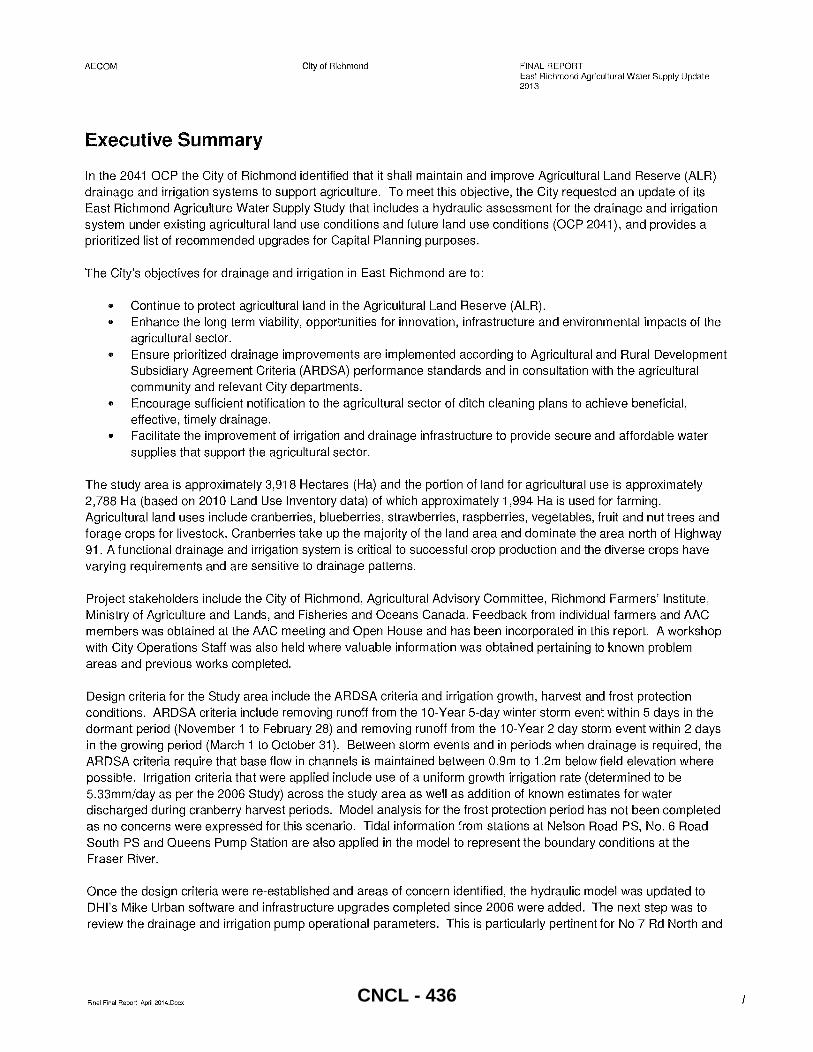
In the 2041 OCP the City of Richmond identified that it shall maintain and improve Agricultural Land Reserve (ALR) drainage and irrigation systems to support agriculture. To meet this objective, the City requested an update of its East Richmond Agriculture Water Supply Study that includes a hydraulic assessment for the drainage and irrigation system under existing agricultural land use conditions and future land use conditions (OCP 2041), and provides a prioritized list of recommended upgrades for Capital Planning purposes.
The City's objectives for drainage and irrigation in East Richmond are to:
.. Continue to protect agricultural land in the Agricultural Land Reserve (ALR).
.. Enhance the long term viability, opportunities for innovation, infrastructure and environmental impacts of the agricultural sector.
.. Ensure prioritized drainage improvements are implemented according to Agricultural and Rural Development Subsidiary Agreement Criteria (ARDSA) performance standards and in consultation with the agricultural community and relevant City departments.
.. Encourage sufficient notification to the agricultural sector of ditch cleaning plans to achieve beneficial, effective, timely drainage.
.. Facilitate the improvement of irrigation and drainage infrastructure to provide secure and affordable water supplies that support the agricultural sector.
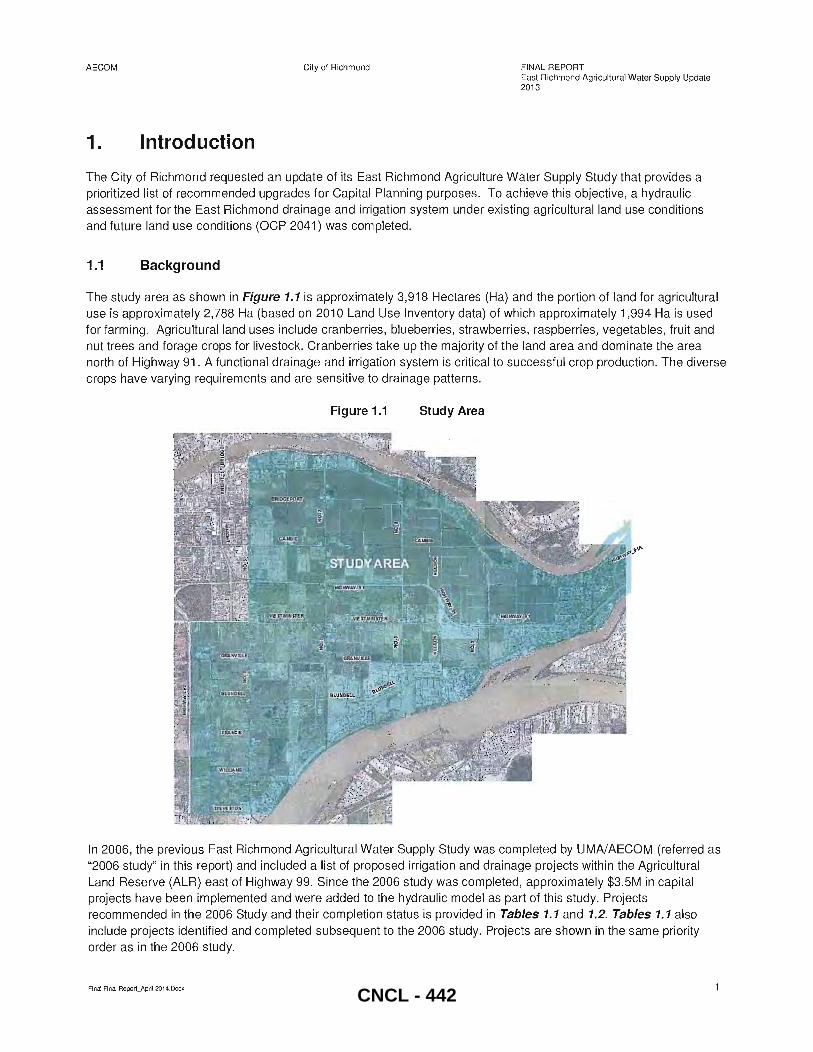
The study area is approximately 3,918 Hectares (Ha) and the portion of land for agricultural use is approximately 2,788 Ha (based on 2010 Land Use Inventory data) of which approximately 1,994 Ha is used for farming. Agricultural land uses include cranberries, blueberries, strawberries, raspberries, vegetables, fruit and nut trees and forage crops for livestock. Cranberries take up the majority of the land area and dominate the area north of Highway 91. A functional drainage and irrigation system is critical to successful crop production and the diverse crops have varying requirements and are sensitive to drainage patterns.
Project stakeholders include the City of Richmond, Agricultural Advisory Committee, Richmond Farmers' Institute, Ministry of Agriculture and Lands, and Fisheries and Oceans Canada. Feedback from individual farmers and AAC members was obtained at the AAC meeting and Open House and has been incorporated in this report. A workshop with City Operations Staff was also held where valuable information was obtained pertaining to known problem areas and previous works completed.
Design criteria for the Study area include the ARDSA criteria and irrigation growth, harvest and frost protection conditions. ARDSA criteria include removing runoff from the 10-Year 5-day winter storm event within 5 days in the dormant period (November 1 to February 28) and removing runoff from the 1 O-Year 2 day storm event within 2 days in the growing period (March 1 to October 31). Between storm events and in periods when drainage is required, the ARDSA criteria require that base flow in channels is maintained between 0.9m to 1.2m below field elevation where possible. Irrigation criteria that were applied include use of a uniform growth irrigation rate (determined to be 5.33mm/day as per the 2006 Study) across the study area as well as addition of known estimates for water discharged during cranberry harvest periods. Model analysis for the frost protection period has not been completed as no concerns were expressed for this scenario. Tidal information from stations at Nelson Road PS, No.6 Road South PS and Queens Pump Station are also applied in the model to represent the boundary conditions at the Fraser River.
Once the design criteria were re-established and areas of concern identified, the hydraulic model was updated to DHl's Mike Urban software and infrastructure upgrades completed since 2006 were added. The next step was to review the drainage and irrigation pump operational parameters. This is particularly pertinent for No 7 Rd North and
Final Final Report_April2014.Docx CNCL - 436
AECOM City of Richmond FINAL REPORT East Richmond Agricultural Water Supply Update 2013
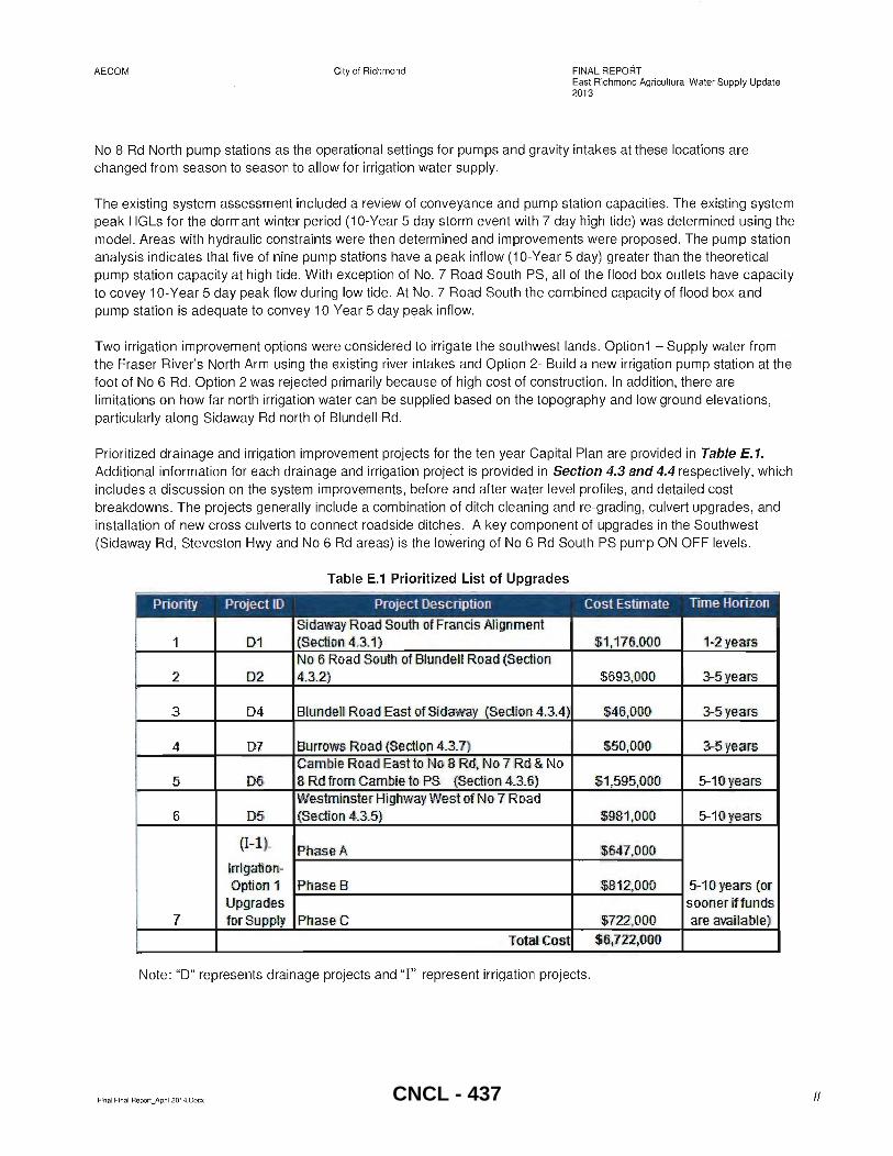
No 8 Rd North pump stations as the operational settings for pumps and gravity intakes at these locations are changed from season to season to allow for irrigation water supply.
The existing system assessment included a review of conveyance and pump station capacities. The existing system peak HGLs for the dormant winter period (1 O-Year 5 day storm event with 7 day high tide) was determined using the model. Areas with hydraulic constraints were then determined and improvements were proposed. The pump station analysis indicates that five of nine pump stations have a peak inflow (1 O-Year 5 day) greater than the theoretical pump station capacity at high tide. With exception of NO.7 Road South PS, all of the flood box outlets have capacity to covey 1 O-Year 5 day peak flow during low tide . At No.7 Road South the combined capacity of flood box and pump station is adequate to convey 10-Year 5 day peak inflow.
Two irrigation improvement options were considered to irrigate the southwest lands. Option1 - Supply water from the Fraser River's North Arm using the existing river intakes and Option 2- Build a new irrigation pump station at the foot of No 6 Rd . Option 2 was rejected primarily because of high cost of construction. In addition, there are limitations on how far north irrigation water can be supplied based on the topography and low ground elevations, particularly along Sidaway Rd north of Blundell Rd.
Prioritized drainage and irrigation improvement projects for the ten year Capital Plan are provided in Table E.1. Additional information for each drainage and irrigation project is provided in Section 4.3 and 4.4 respectively, which includes a discussion on the system improvements, before and after water level profiles, and detailed cost breakdowns. The projects generally include a combination of ditch cleaning and re-grading, culvert upgrades, and installation of new cross culverts to connect roadside ditches. A key component of upgrades in the Southwest (Sidaway Rd, Steveston Hwy and No 6 Rd areas) is the lowering of No 6 Rd South PS pump ON OFF levels.
Table E.1 Prioritized List of Upgrades
Priority Project (0 Project Description Cost Estimate Time Horizon
Sid away Road SouttJ of Francis Alignment 1 ID1 (Section 4.3.1) $1,176,000 1.:2 years
No 6 Ro,ad South of Blundell Road (Section 2 D2 4.3.2) $693,:000 3-5 years
3 04 Blun dell Road East of Sid away (Section 4.3.4) $46;000 3-5 years
i 4 07 Burrorws Road (Section 4.3.7) $50,000 3-5 years I Cambie Road Eastto No 8 Rd, No 7 Rd & No I
5 D6 8 Rd from Gambie to PS (Section 4.3.6) $1,595,000 5-10 " ear5 Westminster Highw ay West of No 7 Road
6 D5 (Section 4.3.5) $981,000 5-10 ye'ar5
(I-i). Phase A $647,000
Irrigati'on-Option 1 PhaseB $81,2,0000 5-10 years (or
Upgrades sooner iffunds 7 for Supply PhaseG $722,000 are available)
Total Cost $6,722,000
Note: "0" represents drainage projects and "I" represent irrigation projects.
Final Final Report_April 2014.00cx /I CNCL - 437
AECOM City of Richmond FINAL REPORT East Richmond Agricultural Water Supply Update 2013
A cost benefit analysis was completed to assess the economic, social and environmental impacts of the proposed drainage and irrigation improvements. The methodology applied is similar to the 2006 Study where the average potential revenue for un-used agricultural land was compared with the cost of infrastructure upgrades. Essentially, the net result is a benefit to cost ratio of approximately 3. Other factors that were explored include the potential savings to farmers for City supplied potable water, additional costs of drainage pump station maintenance and power, and potential reduced risk of economic impacts from flooding or loss of crops.
Further recommendations and improvements that were discussed at the Staff workshop and require additional investigation prior to inclusion in the current Capital Plan include the following items:
• Survey ground elevation (field elevations) along existing ditch on Cambie Rd (east and west of No 7 Rd). The ground elevation survey should also be completed for low lying areas along Sidaway and No 6 Rd south of Williams Road.
• Review capacity of the NO.7 Road South PS and flood box as it was identified as under capacity in Table 4.1
• Consider implementing the following projects identified in the 2006 Study as low priority works: o Construct 600m of ditch along Sidaway-East to connect the Blundell and Francis ditch systems o Upgrade ditch on east side of No 6 Rd between Granville Rd and Blundell Rd. This will further
increase conveyance along No 6 Rd and facilitate supply of irrigation water from North Arm.
• Repair or replacement of the failing headwall at the south ditch box culvert inlet on Cambie Rd just east of No 6 Road
• Ditch cleaning and re-profiling along CN Rail corridor between No 7 Rd and No 8 Rd (City needs permission from the railway for access)
• Ditch cleaning and re-profiling for south side of River Rd from the CN box (Cambie Rd alignment) east to Queens PS
• Box culvert flushing and cleaning for No 6 Rd north drainage corridor and further investigation of the jet fuel pipeline elevations
• Review the need and methods to remove invasive species such as Japanese Knotweed and Parrot Feather. • Review possibility of lowering the No 7 Rd North PS culvert and impact this would have on the downstream
ditch systems • Create a culvert inspection program for entire study area and in particular a review of who is responsible for
maintenance of cUlverts crossing Hwy 91 • Consider implementing a procedure that requires farmers to identify when and where new outfalls from fields
to municipal ditches are constructed • Coordinate operation of the CN box gravity intake (River Rd and Cambie Rd alignment) between farmers
and Operations staff • Facilitate farmers to coordinate water use from No 7 Rd North PS during harvest
Final Final Report_April2014.Docx III CNCL - 438
AECOM City of Richmond FINAL REPORT East Richmond Agricultural Water Supply Update 2013
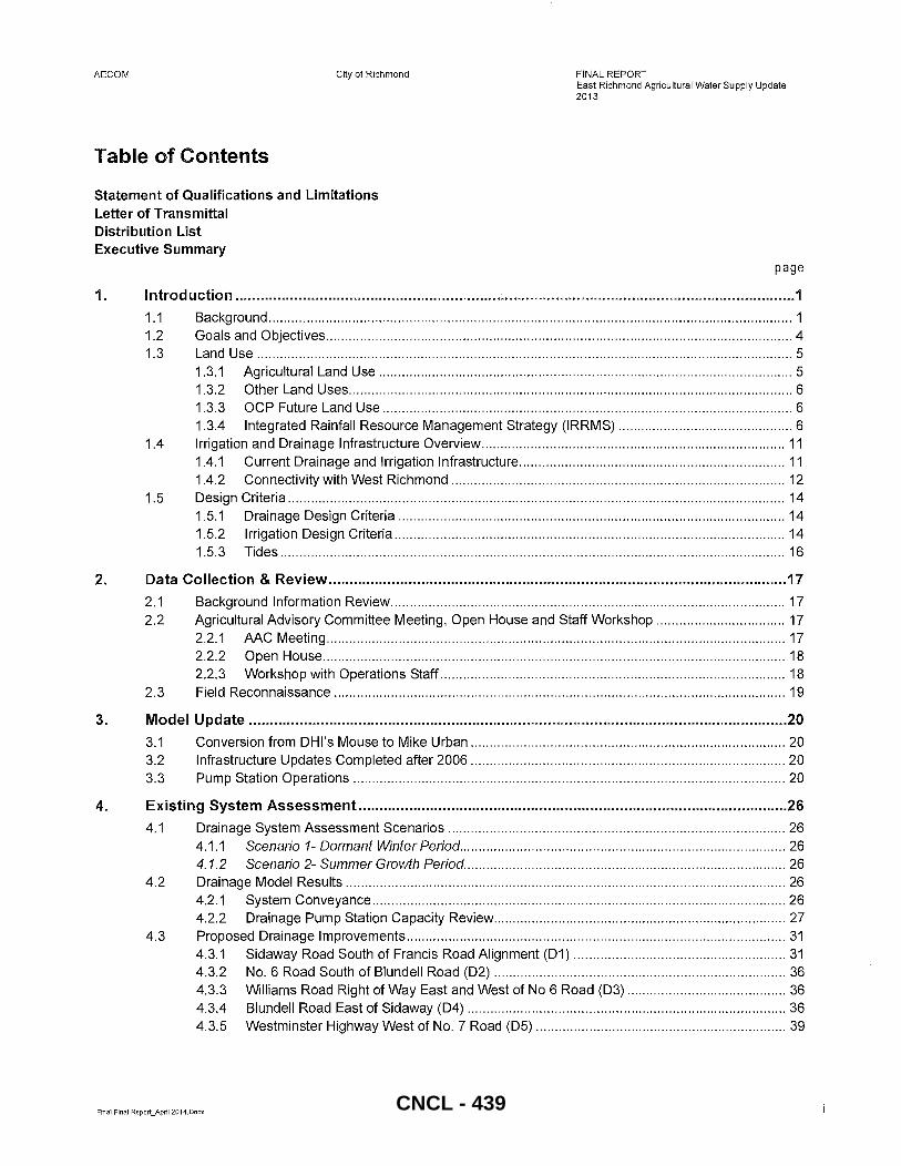
Table of Contents
Statement of Qualifications and Limitations Letter of Transmittal Distribution List Executive Summary
page
1. Introduction ..................................................................................................................................... 1
1.1 Background .......................................................................................................................................... 1 1.2 Goals and Objectives ........................................................................................................................... 4 1.3 Land Use ............................................................................................................................................. 5
1.3.1 Agricultural Land Use ............................................................................................................. 5 1.3.2 Other Land Uses ..................................................................................................................... 6 1.3.3 OCP Future Land Use ............................................................................................................ 6 1.3.4 Integrated Rainfall Resource Management Strategy (IRRMS) .............................................. 6
1.4 Irrigation and Drainage Infrastructure Overview ................................................................................ 11 1.4.1 Current Drainage and Irrigation Infrastructure ...................................................................... 11 1.4.2 Connectivity with West Richmond ........................................................................................ 12
1.5 Design Criteria ................................................................................................................................... 14 1.5.1 Drainage Design Criteria ...................................................................................................... 14 1.5.2 Irrigation Design Criteria ....................................................................................................... 14 1.5.3 Tides ..................................................................................................................................... 16
2. Data Collection & Review ............................................................................................................. 17
2.1 Background Information Review ........................................................................................................ 17 2.2 Agricultural Advisory Committee Meeting, Open House and Staff Workshop .................................. 17
2.2.1 MC Meeting ......................................................................................................................... 17 2.2.2 Open House .......................................................................................................................... 18 2.2.3 Workshop with Operations Staff ........................................................................................... 18
2.3 Field Reconnaissance ....................................................................................................................... 19
3. Model Update ................................................................................................................................ 20
3.1 Conversion from DHl's Mouse to Mike Urban ................................................................................... 20 3.2 Infrastructure Updates Completed after 2006 ................................................................................... 20 3.3 Pump Station Operations .................................................................................................................. 20
4. Existing System Assessment ...................................................................................................... 26
4.1 Drainage System Assessment Scenarios ......................................................................................... 26 4.1.1 Scenario 1- Dormant Winter Period ...................................................................................... 26 4.1.2 Scenario 2- Summer Growth Period ..................................................................................... 26
4.2 Drainage Model Results .................................................................................................................... 26 4.2.1 System Conveyance ............................................................................................................. 26 4.2.2 Drainage Pump Station Capacity Review ............................................................................. 27
4.3 Proposed Drainage Improvements .................................................................................................... 31 4.3.1 Sidaway Road South of Francis Road Alignment (01) ........................................................ 31 4.3.2 NO.6 Road South of Blundell Road (02) ............................................................................. 36 4.3.3 Williams Road Right of Way East and West of No 6 Road (03) .......................................... 36 4.3.4 Blundell Road East of Sidaway (04) .................................................................................... 36 4.3.5 Westminster Highway West of NO.7 Road (05) .................................................................. 39
Final Final Report_April2014.Docx CNCL - 439
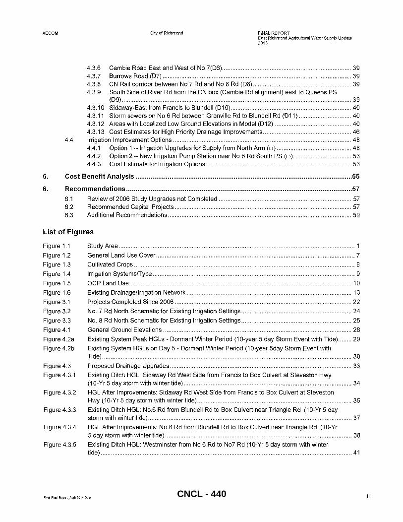
AECOM City of Richmond FINAL REPORT East Richmond Agricultural Water Supply Update 2013
4.3.6 Cambie Road East and West of No 7(06) ............................................................................ 39 4.3.7 Burrows Road (07) ............................................................................................................... 39 4.3.8 CN Rail corridor between No 7 Rd and No 8 Rd (08) .......................................................... 39 4.3.9 South Side of River Rd from the CN box (Cambie Rd alignment) east to Queens PS
(09) ....................................................................................................................................... 39 4.3.10 Sidaway-East from Francis to Blundell (01 0) ....................................................................... 40 4.3.11 Storm sewers on No 6 Rd between Granville Rd to Blundell Rd (011) ............................... 40 4.3.12 Areas with Localized Low Ground Elevations in Model (012) ............................................. 40 4.3.13 Cost Estimates for High Priority Drainage Improvements .................................................... 46
4.4 Irrigation Improvement Options ......................................................................................................... 48 4.4.1 Option 1 - Irrigation Upgrades for Supply from North Arm (1-1) ............................................ 48 4.4.2 Option 2 - New Irrigation Pump Station near No 6 Rd South PS (1-2) .................................. 53 4.4.3 Cost Estimate for Irrigation Options ...................................................................................... 53
5. Cost Benefit Analysis ................................................................................................................... 55
6. Recommendations ........................................................................................................................ 57
6.1 Review of 2006 Study Upgrades not Completed .............................................................................. 57 6.2 Recommended Capital Projects ........................................................................................................ 57 6.3 Additional Recommendations ............................................................................................................ 59
List of Figures
Figure 1.1
Figure 1.2
Figure 1.3
Figure 1.4
Figure 1.5
Figure 1.6
Figure 3.1
Figure 3.2
Figure 3.3
Figure 4.1
Figure 4.2a
Figure 4.2b
Figure 4.3
Figure 4.3.1
Figure 4.3.2
Figure 4.3.3
Figure 4.3.4
Figure 4.3.5
Study Area ........................................................................................................................................... 1
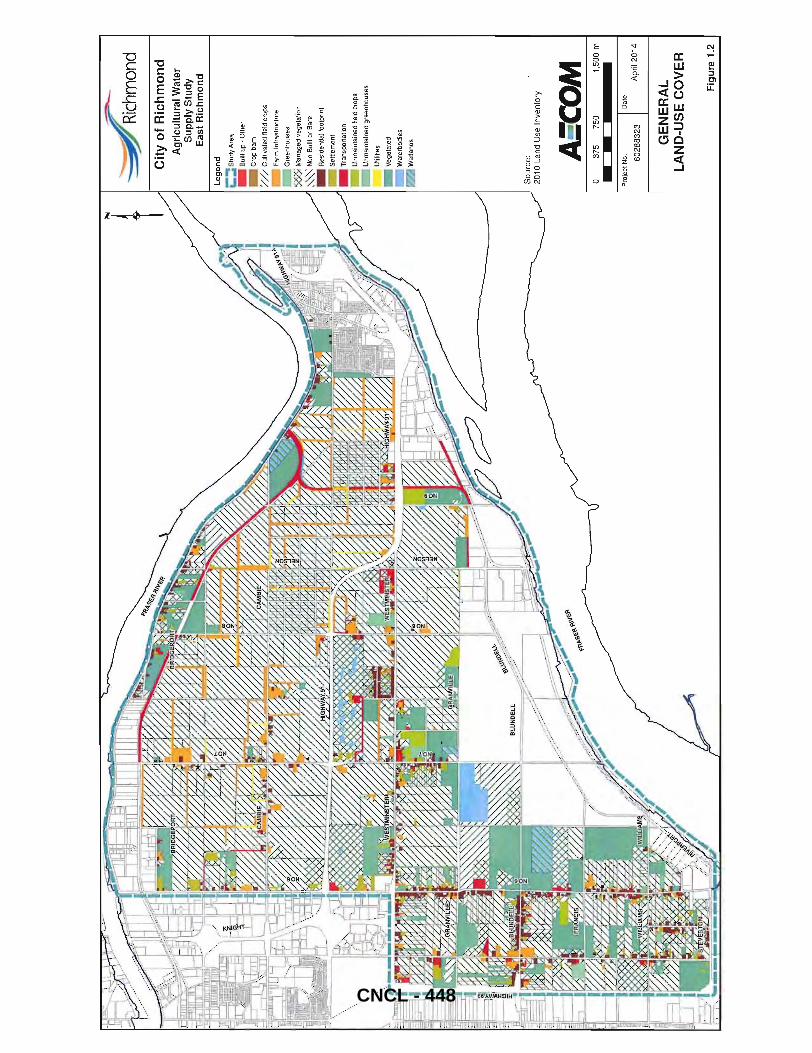
General Land Use Cover ..................................................................................................................... 7
Cultivated Crops .................................................................................................................................. 8
Irrigation Systems/Type ....................................................................................................................... 9
OCP Land Use ................................................................................................................................... 10
Existing Drainage/Irrigation Network ................................................................................................. 13
Projects Completed Since 2006 ........................................................................................................ 22
No.7 Rd North Schematic for Existing Irrigation Settings ................................................................. 24
No.8 Rd North Schematic for Existing Irrigation Settings ................................................................. 25
General Ground Elevations ............................................................................................................... 28
Existing System Peak HGLs - Dormant Winter Period (1 O-year 5 day Storm Event with Tide) ........ 29
Existing System HGLs on Day 5 - Dormant Winter Period (1 O-year 5day Storm Event with Tide) ................................................................................................................................................... 30
Proposed Drainage Upgrades ........................................................................................................... 33
Existing Ditch HGL: Sidaway Rd West Side from Francis to Box Culvert at Steveston Hwy (10-Yr 5 day storm with winter tide) ................................................................................................... 34
HGL After Improvements: Sidaway Rd West Side from Francis to Box Culvert at Steveston Hwy (1 O-Yr 5 day storm with winter tide) ........................................................................................... 35
Existing Ditch HGL: No.6 Rd from Blundell Rd to Box Culvert near Triangle Rd (1 O-Yr 5 day storm with winter tide) ........................................................................................................................ 37
HGL After Improvements: No.6 Rd from Blundell Rd to Box Culvert near Triangle Rd (10-Yr 5 day storm with winter tide) .............................................................................................................. 38
Existing Ditch HGL: Westminster from No 6 Rd to No7 Rd (10-Yr 5 day storm with winter tide) .................................................................................................................................................... 41
Final Final Report_April 2014.Docx ii CNCL - 440
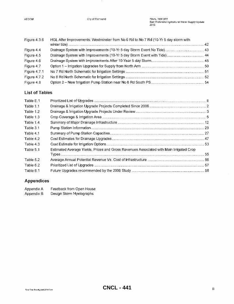
AECOM
Figure 4.3.6
Figure 4.4
Figure 4.5
Figure 4.6
Figure 4.7
Figure 4.7.1
Figure 4.7.2
Figure 4.8
City of Richmond FINAL REPORT East Richmond Agricultural Water Supply Update 2013
HGL After Improvements: Westminster from No 6 Rd to No 7 Rd (10-Yr 5 day storm with winter tide) ......................................................................................................................................... 42
Drainage System with Improvements (10-Yr 5 day Storm Event No Tide) ....................................... 43
Drainage System with Improvements (10-Yr 5 day Storm Event with Tide) ..................................... 44
Drainage System with Improvements After 10-Year 5 day Storm ..................................................... 45
Option 1 - Irrigation Upgrades for Supply from North Arm ............................................................... 50
No 7 Rd North Schematic for Irrigation Settings ............................................................................... 51
No 8 Rd North Schematic for Irrigation Settings ............................................................................... 52
Option 2 - New Irrigation Pump Station near No 6 Rd South PS ..................................................... 54
List of Tables
Table E.1
Table 1.1
Table 1.2
Table 1.3
Table 1.4
Table 3.1
Table 4.1
Table 4.2
Table 4.3
Table 5.1
Table 5.2
Table 6.2
Table 6.1
Appendices
Appendix A Appendix B
Prioritized List of Upgrades ................................................................................................................. II
Drainage & Irrigation Upgrade Projects Completed Since 2006 ......................................................... 2
Drainage & Irrigation Upgrade Projects Under Review ....................................................................... 3
Crop Coverage & Irrigation Area ......................................................................................................... 5
Summary of Major Drainage Infrastructure ....................................................................................... 12
Pump Station Information .................................................................................................................. 23
Summary of Pump Station Capacities ............................................................................................... 27
Cost Estimates for Drainage Upgrades ............................................................................................. 47
Cost Estimate for Irrigation Options ................................................................................................... 53
Estimated Average Yields, Prices and Gross Revenues Associated with Main Irrigated Crop Types ................................................................................................................................................. 55
Average Annual Potential Revenue Vs. Cost of Infrastructure ......................................................... 56
Prioritized List of Upgrades ............................................................................................................... 57
Future Upgrades recommended by the 2006 Study ......................................................................... 58
Feedback from Open House Design Storm Hyetographs
Final Final Report_ApriI2014.Docx iii CNCL - 441
AECOM City of Richmond
1. Introduction
FINAL REPORT East Richmond Agricultural Water Supply Update 2013
The City of Richmond requested an update of its East Richmond Agriculture Water Supply Study that provides a prioritized list of recommended upgrades for Capital Planning purposes. To achieve this objective, a hydraulic assessment for the East Richmond drainage and irrigation system under existing agricultural land use conditions and future land use conditions (OCP 2041) was completed.
1.1 Background
The study area as shown in Figure 1.1 is approximately 3,918 Hectares (Ha) and the portion of land for agricultural use is approximately 2,788 Ha (based on 2010 Land Use Inventory data) of which approximately 1,994 Ha is used for farming . Agricultural land uses include cranberries, blueberries, strawberries, raspberries, vegetables, fruit and nut trees and forage crops for livestock. Cranberries take up the majority of the land area and dominate the area north of Highway 91. A functional drainage and irrigation system is critical to successful crop production. The diverse crops have varying requirements and are sensitive to drainage patterns.
Figure 1.1 Study Area
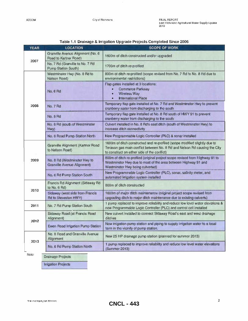
In 2006, the previous East Richmond Agricultural Water Supply Study was completed by UMA/AECOM (referred as "2006 study" in this report) and included a list of proposed irrigation and drainage projects within the Agricultural Land Reserve (ALR) east of Highway 99. Since the 2006 study was completed, approximately $3.5M in capital projects have been implemented and were added to the hydraulic model as part of this study. Projects recommended in the 2006 Study and their completion status is provided in Tables 1.1 and 1.2. Tables 1.1 also include projects identified and completed subsequent to the 2006 study. Projects are shown in the same priority order as in the 2006 study.
Final Final Report_April 2014.Docx CNCL - 442
I
AECOM
YEAR
2007
2008
2009
2010
2011
2012
2013
Note:
City of Richmond FINAL REPORT East Richmond Agricultural Water Supply Update 2013
Table 1.1 Drainage & Irrigation Upgrade Projects Completed Since 2006
LOCATION I
SCOPE OF WORK
Granville Avenue Alignment (No.6 1600m of ditch constructed and/or upgraded
Road to Kartner Road)
No. 7 Rd (Granville to No.7 Rd 1700m of ditch re-profiled
Pump Station South) .. .
Westminster Hwy (No, 8 Rd.to 800m of ditch re-profiled (scope revised from NO. 7 Rd to NO. 8 Rd due to Nelson Road) , environmental restrictions)
Flap gates installed at 3 locations:
• Commerce Parkway No.6 Rd
• Wireless Way
• International Place
No.7 Rd Temporary flap gate installed at No.7 Rd and Westminster Hwy to prevent cranberry water from discharging to the south
No.8 Rd Temporary flap gate installed at No.8 Rd south of HWY 91 to prevent cranberry water from discharging to the south
No. 8 Rd (south of Westminster Culvert installed in No. 8 Rd's east ditch (south of Westminster Hwy) to
Hwy) increase ditch connectivity
No. 8 Road Pump Station North New Programmable Logic Controller (PLC) & sonar installed
Granville Alignment (Kartner Road 1600m of ditch constructed and re-profiled (scope modified slightly due to Terason gas main conflict between No.8 Rd and Nelson Rd causing the City
to Nelson Road) to construct on either side of the conflict)
NO.8 Rd (Westminster Hwy to 800m of ditch re-profiled (original project scope revised from Highway 91 to Westminster Hwy due to most of the area between Highway 91 and
Granville Avenue Alignment) Westminster Hwy being culverted)
NO.6 Rd Pump Station South New Programmable Logic Controller (PLC), sonar, salinity meter, and automated irrigation system installed
Francis Rd Alignment (Sid away Rd 800m of ditch constructed
to No.6 Rd)
Sidaway (west side from Francis 1600m of major ditch maintenance (original project scope revised from Rd to Steveston HWY) upgrading ditch to major ditch maintenance due to existing culverts)
NO.7 Rd Pump Station South 1 pump replaced to improve reliability and reduce low level water elevations &
new Programmable Logic Controller (PLC) and control cell installed
Sidaway Road (at Francis Road New culvert installed to connect Sidaway Road's east and west drainage Alignment) ditches
Ewen Road Irrigation Pump Station New irrigation pump station and piping to supply irrigation water to a local farm in the vicinity of pump station.
NO. 8 Road and Granville Avenue New 25 HP drainage pump station (planned for summer 2013)
Alignment
No. 6 Rd Pump Station North 1 pump replaced to improve reliability and reduce low level water elevations (Summer 2013)
Drainage Projects
Irrigation Projects
Final Final Report_April 2014.Docx 2 CNCL - 443
AECOM City of Richmond FINAL REPORT East Richmond Agricultural Water Supply Update 2013
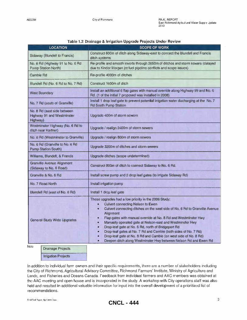
Table 1.2 Drainage & Irrigation Upgrade Projects Under Review
LOCATION SCOPE OF WORK
Sid away (Blundell to Francis) Construct 600m of ditch along Sid away-east to connect the Blundell and Francis ditch systems "
No. 6 Rd (Highway 91 to No.6 Rd Re-profile and smooth inverts through 2650in of ditches and storm sewers (delayed Pump Station North) ... due to Kinder Morgan jet fuel pipeline conflicts and scope issues)
Cambie Rd Re-profile 4000m of ditches
Blundell Rd (No. 6 Rd to NO.7 Rd) Construct 1600m of ditch
West Boundary Install an additional 6 flap gates with manual override along Highway 99 and No. 6 Rd. (1 of the initial 7 proposed was installed in 2008)
No. 7 Rd (south of Granville) Install 1 drop leaf gate to prevent potential irrigation water discharging at the No.7
Rd South Pump Station
No. 8 Rd (east side between Highway 91 and Westminster Upgrade 400m of storm sewers
Highway)
Westminster Highway (No.6 Rd to Upgrade / realign 2400m of storm sewers
ditch near Kartner)
No. 6 Rd (Westminster to Granville) Upgrade / realign 800m of storm sewers
No. 6 Rd (Granville to No. 6 Rd Upgrade 3200m of ditches and storm sewers
Pump Station South)
Williams, Blundell, & Francis Upgrade ditches (scope undetermined)
Granville Avenue Alignment Construct 800m of ditch to connect Sidaway to No. 6 Rd.
(Sidaway to No.6 Road)
Granville & No.6 Rd Install screw pump and 2 drop leaf gates (to irrigate Sid away Rd)
No. 7 Road North Install irrigation pump
Blundell Rd (east of No. 6 Rd) Install 1 drop leaf gate
These upgrades had a low priority in the 2006 Study:
• Culvert connecting Nelson to Ewen
• Culvert connecting ditches on the west side of No.6 Rd to Granville Avenue Alignment
• Flap gates with manual override at No.8 Rd and Westminster Hwy General Study Wide Upgrades
• Manually operated gate at Nelson-east and Westminster Hwy
• Drop-leaf gate at No.6 Rd, north of Bridgeport Rd
• Drop-leaf gates at No. 7 Rd and Cambie (both sides of No.7 Rd)
• Drop-leaf gate at No. 8 Rd and Cambie (on west side of No.8 Rd)
• Deepen ditch along Westminster Hwy between Nelson Rd and Ewen Rd
Note Drainage Projects
Irrigation Projects
In addition to individual farm owners and their specific requirements, there are a number of stakeholders including the City of Richmond, Agricultural Advisory Committee, Richmond Farmers' Institute, Ministry of Agriculture and Lands, and Fisheries and Oceans Canada. Feedback from individual farmers and AAC members was obtained at the AAC meeting and open house and is incorporated in the study. A workshop with City operations staff was also held and resulted in additional valuable information for input into the overall development of a prioritized list of recommendations.
Final Final Report_ApriI2014. Docx 3 CNCL - 444
AECOM City of Richmond
1.2 Goals and Objectives
FINAL REPORT East Richmond Agricultural Water Supply Update 2013
In Section 7.1 of its 2041 OCP, the City recognizes the importance of agriculture as a food source, environmental resource, a heritage asset and important contributor to the local economy. Most of the ALR in Richmond is outside of Greater Vancouver Regional District's (GVRO) servicing boundary.
It is the City's objective to maintain and improve ALR drainage and irrigation systems to support agriculture (Section 12.6, 2041 OCP) . Goals and objectives identified in Section 7 of the 2041 OCP that relate to drainage and irrigation have been incorporated into this study and include the following statements:
Drainage: • Continue to protect agricultural land in the ALR • Enhance all aspects of the agricultural sector including long term viability, opportunities for innovation,
infrastructure and environmental impacts • Ensure drainage improvements to the ALR occur in a prioritized order and according to Agricultural and
Rural Development Subsidiary Agreement Criteria (ARDSA) performance standards • Ensure drainage improvements are considered in a comprehensive manner in consultation with the
agricultural community and relevant City departments • Encourage sufficient notification to the agricultural sector of ditch cleaning plans to achieve beneficial,
effective, timely drainage
Irrigation: • Facilitate the improvement of irrigation and drainage infrastructure to provide secure and affordable water
supplies that support the agricultural sector
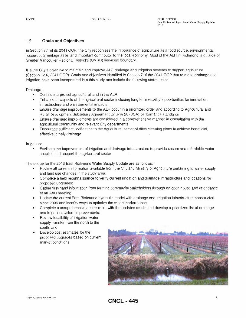
The scope for the 2013 East Richmond Water Supply Update are as follows: • Review all current information available from the City and Ministry of Agriculture pertaining to water supply
and land use changes in the study area; • Complete a field reconnaissance to verify current irrigation and drainage infrastructure and locations for
proposed upgrades; • Gather first-hand information from farming community stakeholders through an open house and attendance
at an AAC meeting; • Update the current East Richmond hydraulic model with drainage and irrigation infrastructure constructed
since 2006 and identify ways to optimize the model performance; • Complete a comprehensive assessment with the updated model and develop a prioritized list of drainage
and irrigation system improvements ; • Review feasibility of irrigation water
supply transfer from the north to the south; and
• Develop cost estimates for the proposed upgrades based on current market conditions.
Final Final Report_April 2014.Docx 4
CNCL - 445
AECOM
1.3 Land Use
1.3.1 Ag ricultural Land Use
City of Richmond FINAL REPORT East Richmond Agricultural Water Supply Update 2013
A comprehensive review of current agricultural land uses was completed by the Ministry of Agriculture in 2010 and is provided in the Ministry's Draft Land Use Inventory (LUI) Report (January 2013). Information presented in the LUI report was collected by completing drive-by surveys for all properties in the Agricultural Land Reserve.
During the LUI survey, data was collected on general land use and land cover including agricultural practices, irrigation, crop production methods, livestock, agricultural support (e.g. storage, compost and waste), and activities which add value to raw agricultural products. General land cover information collected in the LUI is presented in Table 1.3 and Figure 1.2. Agricultural land uses include berry cultivation (including cranberries, blueberries, strawberries, and raspberries), vegetables (including greenhouses), fruit and nut trees, and forage crops for livestock. Figure 1.3 shows the location of various cultivated crops in the area.
Cultivation of cranberries is the major land use for the area north of Highway 91 . Cranberry production involves significant investment by farmers in infrastructure such as ditches, reservoirs, control structures, and pumping irrigation equipment. Most of the cranberry crops in the north are supplied to Ocean Spray for the juice and canned cranberry market, and farming tends to be cooperative and organized with farmer's coordinating their schedules and sharing water resources.
South of Hwy 91 the most significant crops are blueberry, vegetable and forage along with nurseries and greenhouses. In the southwest portion of the study area, west of No 6 Road, there are numerous small urban lot developments and the area has a high amount of un-used farmland and land used for non-agricultural uses.
Table 1.3 Crop Coverage & Irrigation Area
Cultivated Field Crops I Area* (Ha)
I % of Cultivated Land I
% of Crop Area Irrigated
Berries 1,433 54 71
(cranberries) (873) (61 ) (98)
(blueberries) (492) (34) (31 )
(strawberries) (62) (4) (30)
(raspberries) (7) «1 ) (na)
Vegetables 647 24 54
Forage & Pasture 402 15 24
Nursery & Tree Plantations 64 2 84
Grains, Cereals, Oilseeds 37 1 na
Other** 73 19 na
2656 Ha* Total (Includes land outside
the study area)
Notes:
• Area based on the Ministry of Agriculture 2010 survey data that includes ALR in west Richmond. 1994 ha are located in east Richmond
** Other includes tree fruits, turf, vines, floriculture, nut trees, bare cultivated land, fallow land, land in crop transition
Source: 2010 Land Use Inventory
In addition, the LUI report includes data on irrigation water use recorded by crop type and irrigation system type (e.g. sprinkler, trickle, giant gun or sub-surface). The report notes that sprinkler systems are the most common type of irrigation system and are used on a broad range of crops, while trickle systems are the next most common and used
Final Final Report_ApriI201 4.Docx 5 CNCL - 446
AECOM City of Richmond FINAL REPORT East Richmond Agricultural Water Supply Update 2013
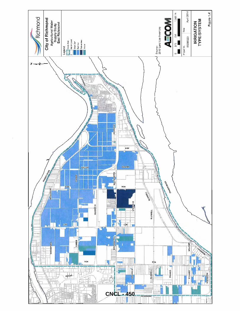
exclusively on berry, vegetable, nursery and vine crops. Subsurface systems were third and used on several types of crops. The coverage for each irrigation type as per the data collected for the LUI report is presented in Figure 1.4 and Table 1.1. As shown in the table, 71 % of all berry crops and 54% of all vegetable field crops are irrigated.
1.3.2 Other Land Uses
Other land uses in the study area include golf courses, large rural residential lots, industrial properties and the Hamilton residential area. At present there are five golf courses and driving ranges in East Richmond that use surface water for irrigation supplemented with City supplied water. Several of the large residential lots have hobby farms on the property that also draw water for irrigation and require drainage.
Industrial areas are located along the North and South Arm's of the Fraser River in East Richmond and are generally not included in the hydraulic model as they have their own drainage systems and do not draw water for irrigation purposes. Larger industrial properties located along the South Arm of the Fraser are occupied by Lafarge (concrete production) and Port Metro Vancouver. Each of these areas drain surface water directly into the Fraser River.
The Hamilton area is serviced by a local drainage system and only the major ditches and trunk sewers are included in the East Richmond hydraulic model. The area is serviced by the gravity outlets to the Fraser River during low tide and the Queen Road North Pump Station during high water levels, as well as a smaller pump station inland at 22740 Westminster Hwy.
1.3.3 OCP Future Land Use
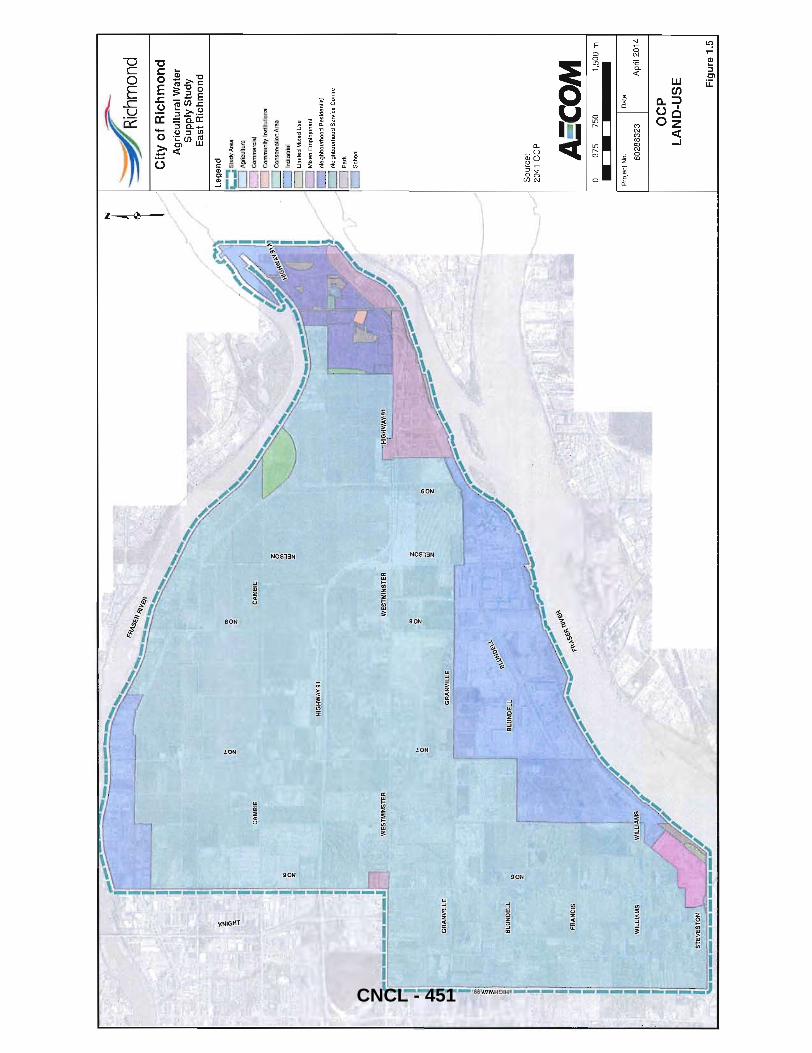
The 2041 OCP future land use information was obtained from the City and is shown in Figure 1.5. There are no major changes from the current land use in the study area and the primary land use remains agricultural meaning that land imperviousness is unlikely to significantly change.
An additional land use plan is currently being developed for the Hamilton area; however, its findings are not expected to significantly impact the outcome of this study.
1.3.4 Integrated Rainfall Resource Management Strategy (IRRMS)
The City's IRRMS is being completed in parallel to this study, and it makes recommendations to protect and enhance Riparian Management Areas (RMA's) to protect and improve water quality. Many of the East Richmond's watercourses have designated RMA's. The detailed design of drainage and irrigation capacity upgrades recommended through the East Richmond Agricultural Water Supply Update should aim to incorporate relevant IRRMS recommendations, such as protecting RMA setbacks and enhancing RMA's.
Final Final Report_ApriI2014.Docx 6 CNCL - 447
Ag
ricu
ltu
ral
Wat
er
Su
pp
ly S
tud
y E
ast
Ric
hm
on
d
Le
ge
nd
;:::: S
tudy
Are
a
.. B
uilt
up
-O
ther
• C
rop
barn
:/ // C
ultiv
ated
fie
ld c
rops
.. F
arm
Inf
rast
ruct
ure
.. G
reen
hous
es
~ M
anag
ed v
eget
atio
n
~, "
Non
Bui
lt or
Bar
e
.. R
esid
entia
l foo
tprin
t
"'
Sett
lem
ent
.. T
rans
port
atio
n
l1li
Unm
ainl
aine
d fie
ld c
rops
Sou
rce:
2
01
0 L
and
Use
In
ven
tory
A:C
OM
o
375
750
1,5
00 m
Pro
ject
No.
D
ale
60
28
83
23
A
pril
20
14
GE
NE
RA
L
LA
ND
-US
E C
OV
ER
Fig
ure
1.2
CNCL - 448
~
":::~
hmOnd
Cit
y o
f R
ich
mo
nd
A
gri
cult
ura
l Wat
er
Su
pp
ly S
tud
y E
ast
Ric
hm
on
d
Le
ge
nd
--
. '-.. E
xte
nd
ed
Stu
dy
Are
a2
c=:J
Not
Cul
tiva
ted
... B
lueb
errie
s
Flo
ricu
ltur
e
Fo
rag
e c
orn
l1li Fo
rage
. pa
stur
e
"G
rape
s
~Gr
ass
.. H
azel
nut I
filb
ert
j/ // M
ixed
gra
ss I
legu
me
.. M
ixed
veg
etab
les
~Nu
rser
y
• O
at,
.. O
ma
me
nta
ls a
nd
sh
rub
s
Oth
er
_po
tato
es
.. S
tra
wb
err
ies
.. T
rees
(p
lant
atio
n)
"V
eget
able
s
Sou
rce
: 20
10 L
and
Use
In
ven
tory
AaC
OM
37
5 75
0 1,
500
m
Pro
ject
No.
D
ate
6028
8323
A
pril
2014
CU
LTIV
AT
ED
C
RO
PS
1.3
CNCL - 449
~
:-~
hmOn
d C
ity
of
Ric
hm
on
d
Ag
ricu
ltu
ral
Wat
er
Su
pp
ly S
tud
y E
ast
Ric
hm
on
d
Le
ge
nd
;:::: S
tudy
Are
a
C]
Not
lrri
gate
d
~GiantGun
"Sp
rink
ler
"Su
b-s
urfa
ce
"-
TriC
kle
Sou
rce:
20
10 L
and
Use
In
vent
ory
A:C
OM
o
375
750
1,50
0 m
Proj
ect
No
. I D
ate
6028
8323
A
pril
2014
IRR
IGA
TIO
N
TY
PE
/SY
ST
EM
Fig
ure
1.4
CNCL - 450
C.,M
BIE
IWEs
TMiN
SJER
J I 1 I
:; z .,. ·0 z
HIGHWAXI~
~. z ., '0 z
.CA
MBi
E
_~~~
.~E~
,----==::::~---'-'=
~\j't
\Q«.y.~
~
z o ~ z z § w
z
:-., '.
.
:~.
z
~
-'::-~
hmOnd
Cit
y o
f R
ich
mo
nd
A
gri
cult
ura
l W
ater
S
up
ply
Stu
dy
Eas
t R
ich
mo
nd
Le
ge
nd
i::: St
udy
Are
a
[:=J
Agr
icul
ture
r==J
Com
mer
cial
CJ
Com
mun
ity I
nstit
utio
nal
c=J
Con
serv
atio
n A
rea
L=:J
Indu
stria
l
c=J
Lim
ited
Mix
ed U
se
C:=J
Mixe
d E
mpl
oym
ent
CJ
Neig
hbou
rhoo
d R
esid
entia
l
CJ Ne
ighb
ourh
ood
Ser
vice
Cen
tre
DPa,
' r=
:J Sc
hool
Sou
rce:
20
41 O
CP
AS'C
OM
o
375
750
1,50
0 m
Pro
ject
No
. I D
ate
6028
8323
A
pril
2014
OC
P
LA
ND
-US
E
Fig
ure
1.5
CNCL - 451
AECOM City of Richmond
1.4 Irrigation and Drainage Infrastructure Overview
1.4.1 Current Drainage and Irrigation Infrastructure
FINAL REPORT East Richmond Agricultural Water Supply Update 2013
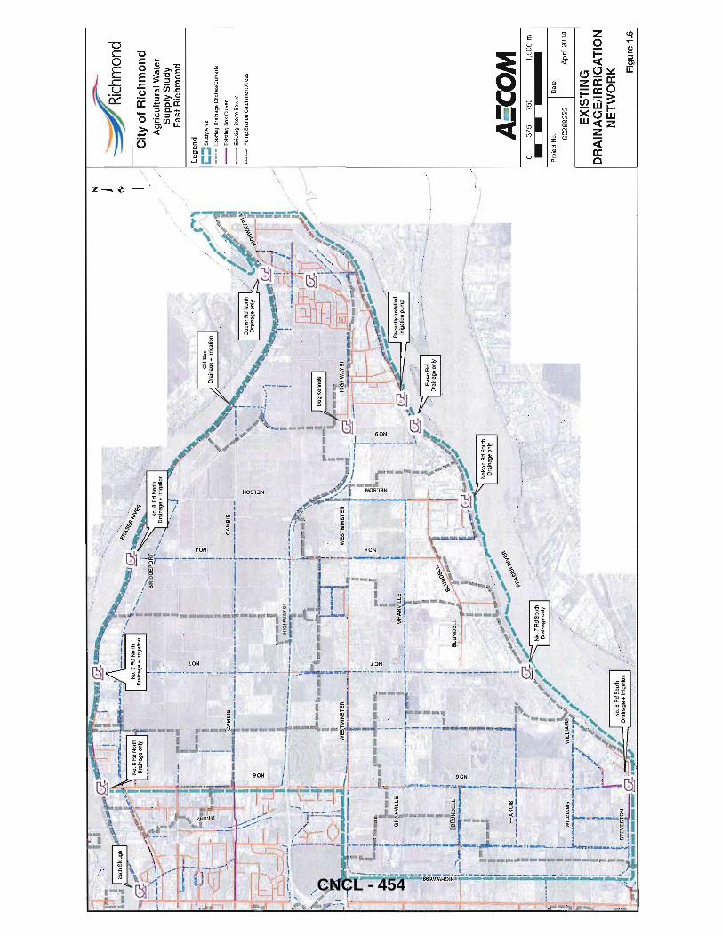
Figure 1.6 shows the current drainage and irrigation infrastructure in East Richmond. Major pump station catchments are also shown in the above figure. These are approximate boundaries as the ditches may be interconnected at some locations. The majority of the water supply for the area north of Highway 91 is provided through three gravity intakes at No 7 Road North PS and No 8 Road North PS and the CN Box on the North Arm of the Fraser River. During low tide periods water is also pumped into the drainage canals at No 8 Road Pump Station . Inland, there is a network of canals/ditches and control gates that convey drainage and irrigation water and are generally well maintained. In addition , there are two other drainage pump stations on the North Arm of the Fraser River, No 6 Rd North PS and Queens North PS, that do not provide irrigation water supply.
Irrigation and drainage infrastructure in the north is primarily geared towards cranberry production and water supply for frost protection and harvesting. The majority of the infrastructure was constructed in the 1990s as a result of an ARDSA funding program.
Water supply in the south is more challenging, particularly for the western region where there are known issues with a lack of fresh water supply and water quality. The primary source of irrigation water is from the No 6 Road South PS gravity intake and is limited due to the presence of salt water. Salt water is a particular concern in late summer and early fall when river flows are at their lowest level. There is a conductivity meter in place at the pump station that automatically closes the intake when salinity levels reach 700 micro Siemens. In addition, during summer months there is less rainfall and river water available to flush the system which can lead to water stagnation. Also there are a series of hold back structures that keep the water in the system during summer. Farmers have reported elevated iron levels in this area. As a result, many of the farmers in the southwestern portion of the study area use City supplied potable water.
There are three other drainage pump stations on the South Arm of the Fraser, No 7 Road South PS, Nelson Road South PS, and Ewen PS. None of these pump stations are able to supply irrigation water. In 2012 a low capacity irrigation pump and piping system was built near Ewen PS to service farms local to that area. There are two existing drainage pump stations inland: Dog Kennels at Dhillon Way and Westminster Highway that serves a small low lying area, and one at 22740 Westminster Highway. Both these station do not provide irrigation water supply. The City is also constructing a new drainage pump station at No 8 Road and the Granville Avenue alignment that will discharge into the Port Metro Vancouver drainage system to the south. A summary of the major drainage infrastructure is provided in Table 1.4.
It should be noted that farmers typically have private pumps and canals within their properties that have not been included in this study. This is particularly prevalent for cranberry farmers that have extensive private ditches and reservoirs to balance water requirements.
In addition to the pump stations and gravity/irrigation intakes listed above there are several flap gates and slide gates that are used to retain water in the ditch system. These exist at the following locations:
• Manual slide gates at the intersection of No 6 Rd and Triangle Rd as well as Westminster Hwy and Palmberg Rd ;
• Flap gates along No. 6 Rd at Commerce Parkway, Wireless Way and International Place to stop water from flowing west ;
• A flap gate at No. 7 Rd and Westminster Hwy to prevent cranberry water from discharging to the south; and
• A flap gate at No.8 Rd south of HWY 91 to prevent cranberry water from discharging to the south.
Final Final Report_April 2014.0ocx CNCL - 452

AECOM City of Richmond FINAL REPORT
I
East Richmond Agricultural Water Supply Update 2013
Table 1.4 Summary of Major Drainage Infrastructure
Theo,el;cal PS Intake/ I
Structure & Name Capacity Flood Box I Description I
(see note below) Dimensions I
Flood Box No change to pump start/stop levels between
No.6 Road North PS 1.14m3/s 2.8m X 1.5m
seasons, flap gates on river side for gravity outflows during low tides
Flood Box Fully automated with controls for low tide outflow slide
NO. 7 Road North PS 3.4m X 2.0m
gate & drainage PS for high tide, plus inflow slide gate
& Irrigation Intake at NO.7 2.09 m3/s Intake dia.
for irrigation water during high tide events.
Rd North 1200mm
Gravity inflow pipe reported to be installed too high but cannot be lowered due to ditch elevation.
NO.8 Road North PS Flood Box Drainage PS with integrated drainage flood box and
& Irrigation Intake at NO.8 2.41 m3/s 3 .7m X 2.3m
Rd North Intake dia. 1200mm separate irrigation PS
Flood Box No change to pump start/stop levels between
Queens PS (North) 3.07 m3/s 2.7m X2.0m
seasons, flap gates on river side for gravity outflows during low tides
eN Drainage Flood Box 3.7m X2.3m
Provides irrigation water and drainage for No 9 Rd (No.9 North) ditch system and is manually controlled
Ewen PS (South) No change to pump start/stop levels between
2.35 m% Flood Box dia. seasons, separate flood box structure with flap gates & Drainage Flood Box at
- 900mm on river side for gravity outflows during low tides 50m Ewen
away
Flood Box dia. No change to pump start/stop levels between
Nelson Road South PS 1.62 m3/s seasons, flap gates on river side for gravity outflows 1600mm
during low tides
Flood Box No change to pump start/stop levels between No. 7 Road South PS 2.90 m3/s 1.37m X 1.0m seasons, flap gates on river side for gravity outflows
(Twin Box) during low tides
Flood Box Drainage by gravity outflow during low tide and
NO.6 Road South PS 2.16 m% 3.4m X 1.5m
pumped flows for high tide events. Irrigation water supplied by 200mm valve structure.
Dog Kennels PS 0.17 m3/s NA Drainage for a small low lying area
(Westminster Hwy)
Note: Theoretical pump rates as provided by the City based on previous studies
1.4.2 Connectivity with West Richmond
There are three locations where the model is hydraulically connected to West Richmond; however, it is assumed that there is no flow entering the East model. The connections are modelled as a set boundary condition that was determined during the model development phase in 2006 and based on the 1 O-year 2 day event peak HGL.
Final Final Report_April 2014.Docx 12 CNCL - 453
t ,I/
O.
-ro
'
.~
-:::~
hmon
d C
ity o
f R
ich
mo
nd
A
gri
cult
ura
l Wat
er
Su
pp
ly S
tud
y E
ast
Ric
hm
on
d
Le
ge
nd
-.
.. '-.. S
tudy
Are
a
-_
.-E
xist
ing
Dra
inag
e D
itche
s/C
ulve
rts
--
Exi
stin
g B
ox C
ulve
rt
--
Exi
stin
g S
torm
Sew
er
--
Pum
p S
tatio
n C
atch
men
t Are
as
AS'C
OM
37
5 75
0 1,
500
m
Pro
ject
No
, I D
ale
60
28
83
23
A
pril
20
14
EX
IST
ING
D
RA
INA
GE
/IR
RIG
AT
ION
N
ET
WO
RK
Fig
ure
1.6
CNCL - 454
AECOM
1.5 Design Criteria
1.5.1 Drainage Design Criteria
City of Richmond FINAL REPORT East Richmond Agricultural Water Supply Update 2013
The City's Engineering Design Criteria includes design storms that are geared towards urban areas and not suitable for agricultural areas. Drainage Criteria defined by the Ministry of Agriculture was used for the model assessment in the 2006 Study and has also been used in this update.
All ALR lands follow the Agricultural and Rural Development Subsidiary Agreement Criteria (ARDSA). The BC Agricultural Drainage Manual provides information on the design of farmland drainage systems. This manual looks at crop types to be planted, soil types, water table depth, and local climate conditions. For farmers, an important issue for managing agricultural storm water is the duration it takes for land to drain. The length of time in which crops are saturated in water is much more critical to farmers than flooding. Different crops are sensitive to different flood periods; therefore, it is important that any changes implemented to upland areas also take into consideration the impacts to downstream farm areas.
The ARDSA criteria are as follows:
.. Remove runoff from the 10-year, 5-day storm, within 5 days in the dormant period (November 1 to February 28);
.. Remove runoff from the 10-year, 2 day storm, within 2 days in the growing period (March 1 to October 31);
.. Between storm events and in periods when drainage is required, the base flow in channels must be maintained at 1.2m below field elevation; and,
.. The conveyance system must be sized appropriately for both base flow and design storm flow.
It is also important to note that the freeboard, which is the elevation difference between the base flow water level in the channel and the field elevation, should be 1.2m as noted above; however, a freeboard of 0.8m may be acceptable in some areas depending on the crop usage because drainage of the plant! crop root zone may still be viable.
ARDSA design hyetographs for the 10-Year Winter (Harvest) and 10-Year growing season storm events were developed in the 2006 study and have been used for this study update. The hyetograph plots are shown in Appendix B.
In the hydraulic model the roughness coefficient (Manning's n value) used for all ditches cleaned since 2006 was 0.04, while for all others a value of 0.06 was used.
1.5.2 Irrigation Design Criteria
Due to the diversity of crops grown, irrigation requirements vary within the study area. Figure 1.3 (previously referred to) shows various cultivated crops and was used to verify the locations of irrigation demands in the hydraulic model. As a part of the LUI, information about type of irrigation used in the area was also collected and is discussed in Section 1.3.1. Figure 1.4 (previously referred to) shows various irrigation systems used in the area.
Irrigation demands can be separated into three different categories as follows-
I. Growth Irrigation: Irrigation water is mainly required for crop growth. The 2006 study assumed growth irrigation rate of 5.33mm/day throughout the area. This study adopted the same rate for growth irrigation.
II. Frost Irrigation: Cranberry growers, mainly north of Hwy 81, require irrigation for frost protection. Majority of cranberry farmers in this area rely on sprinkler irrigation system as shown in Figure 1.4. Freezing
Final Final Report_ApriI2014.Docx 14 CNCL - 455
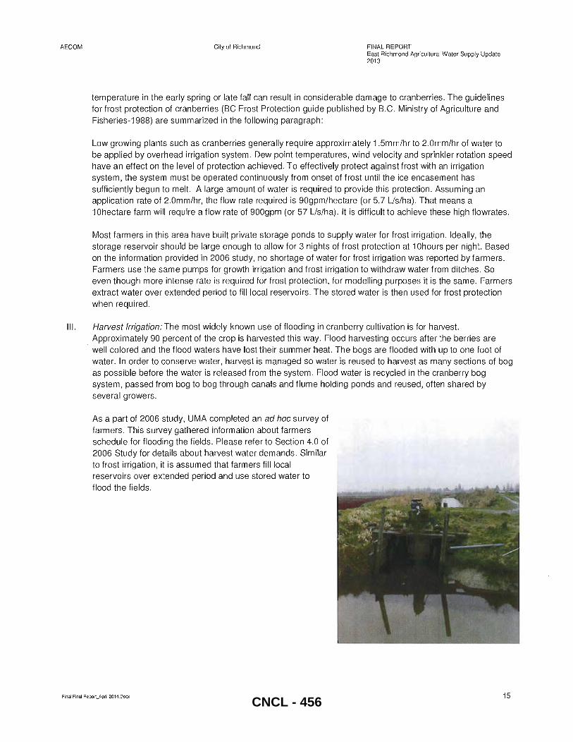
AECOM City of Richmond FINAL REPORT East Richmond Ag ricultural Water Supply Update 2013
temperature in the early spring or late fall can result in considerable damage to cranberries. The guidelines for frost protection of cranberries (BC Frost Protection guide published by B.C. Ministry of Agriculture and Fisheries-1988) are summarized in the following paragraph:
Low growing plants such as cranberries generally require approximately 1.5mm/hr to 2.0mm/hr of water to be applied by overhead irrigation system . Dew point temperatures, wind velocity and sprinkler rotation speed have an effect on the level of protection achieved. To effectively protect against frost with an irrigation system, the system must be operated continuously from onset of frost until the ice encasement has sufficiently begun to melt. A large amount of water is required to provide this protection. Assuming an application rate of 2.0mm/hr, the flow rate required is 90gpm/hectare (or 5.7 Lls/ha) . That means a 1 Ohectare farm will require a flow rate of 900gpm (or 57 Lls/ha). It is difficult to achieve these high flowrates.
Most farmers in this area have built private storage ponds to supply water for frost irrigation. Ideally, the storage reservoir should be large enough to allow for 3 nights of frost protection at 1 Ohours per night. Based on the information provided in 2006 study, no shortage of water for frost irrigation was reported by farmers. Farmers use the same pumps for growth irrigation and frost irrigation to withdraw water from ditches. So even though more intense rate is required for frost protection, for modelling purposes it is the same. Farmers extract water over extended period to fill local reservoirs. The stored water is then used for frost protection when required.
III. Harvest Irrigation: The most widely-known use of flooding in cranberry cultivation is for harvest. Approximately 90 percent of the crop is harvested this way. Flood harvesting occurs after the berries are
.. well colored and the flood waters have lost their summer heat. The bogs are flooded with up to one foot of water. In order to conserve water, harvest is managed so water is reused to harvest as many sections of bog as possible before the water is released from the system. Flood water is recycled in the cranberry bog system, passed from bog to bog through canals and flume holding ponds and reused, often shared by several growers.
As a part of 2006 study, UMA completed an ad hoc survey of farmers. This survey gathered information about farmers schedule for flooding the fields. Please refer to Section 4.0 of 2006 Study for details about harvest water demands. Similar to frost irrigation, it is assumed that farmers fill local reservoirs over extended period and use stored water to flood the fields.
Final Final Report_April 2014.Docx 15 CNCL - 456
AECOM City of Richmond
1.5.3 Tides
FINAL REPORT East Richmond Agricultural Water Supply Update 2013
As a part of 2006 Study tidal information was acquired from three recording stations located at Nelson Road Pump Station, No.6 Road South Pump Station and Queens Pump Station. Representative tides were developed for each station. For stations where no tidal data is available, representative tide from the nearest station is used for the following modelling scenarios:
.. Scenario 1 - To model winter drainage conditions during dormant period, a 7 day high tide cycle was developed and used with 1 O-year 5 day winter storm
.. Scenario 2 - To model summer drainage during growing period, a 4 day high tide cycle was developed and used with 10-year 2 day summer storm.
.. Scenario 3 - To model irrigation during growing period, a 3 day low tide cycle was developed to represent worst case scenario.
Please refer to section 4.2.1 of 2006 study for detailed tide information.
Final Final Report_ApriI2014.Docx 16 CNCL - 457
AECOM City of Richmond
2. Data Collection & Review
2.1 Background Information Review
In the 2006 study, a number of issues were identified:
• Poor drainage and ditch maintenance south of Highway 91
FINAL REPORT East Richmond Agricultural Water Supply Update 2013
• Concerns over competition for irrigation water and high cost of City supplied water .. Stagnant water and poor water quality, particularly the Sidaway / NO.6 Road area • Limited options for increasing ditch capacity due to topography, high ground water levels, private property
limitations, and traffic safety considerations • Balance between ditches providing both irrigation and positive drainage .. High cost for system upgrades
To alleviate some of these concerns the City has implemented several infrastructure improvements, some of which were recommended based on the previous analysis of the system under winter and summer conditions. The model scenarios corresponded with the water intensive cranberry growing and harvesting seasons as this is a primary land use in the study area. Infrastructure improvements that were implemented include installation of flow control structures, ditch re-grading, construction of new ditches and new pump station upgrades. A summary of the works completed since 2007 is provided in Section 3 Table 3.1.
In order to evaluate whether these same issues are still valid or if there are new concerns with the drainage and irrigation water supply the project team initiated meetings with the AAC and Operations Staff as well as an Open House to garner input from the general public.
2.2 Agricultural Advisory Committee Meeting, Open House and Staff Workshop
2.2.1 AAC Meeting
AECOM and City staff attended the Richmond AAC meeting on March 14, 2013. The AAC is appointed by City Council and there are ten voting members on the Committee, five of whom are nominated by the Richmond Farmer's Institute.
Background information on the project was presented along with the City's primary objective of identifying a prioritized list of drainage and irrigation upgrades within the ALR east of Highway 99. The goal for meeting with the AAC was to seek assistance from committee members and ultimately the farming community to identify drainage and irrigation issues, crop catalogue changes and any other pertinent information.
During the March 14, 2013 meeting, a Ministry of Agriculture representative gave a presentation on the latest Richmond Land Use Inventory (LUI) report (issued in 2013 and based on 2010 roadside survey). A brief description of the LUI report is provided in Section 1.3.1.
During the AAC meeting, several members provided comments on known drainage and irrigation issues. A summary of the comments recorded include the following items:
.. Review ditch profile and survey for Sidaway Rd between Williams and Steveston as conveyance is not good
.. Water quantity and quality in vicinity of Westminster Hwy and No 6 Rd needs to be improved
.. Review proposed upgrades from 2006 that have not yet been completed
.. Review ditch capacity improvements on No 6 Rd north of Cambie as it is already wide with steep side slopes
.. Confirm plans for re-profiling Cambie Rd ditch between No 6 Rd and No 7 Rd
Final Final Report_April 2014.Docx 17
CNCL - 458
AECOM City of Richmond
2.2.2 Open House
FINAL REPORT East Richmond Agricultural Water Supply Update 2013
An Open House was held on April 18, 2013 at City Hall to educate residents and farmers and encourage the community to voice their drainage and irrigation concerns. Poster boards including maps of the study area showing the Agricultural Land Use Inventory findings and East Richmond drainage and irrigation system upgrades, as well as descriptions for upgrade projects completed since 2006, were presented at the Open House. Attendees were asked to complete feedback forms or go to LetsTalkRichmond.ca to provide comments online.
A few drainage and irrigation concerns were raised at the Open House and are summarized below. The completed questionnaire forms that were received are included in Appendix A.
• Drainage ditches located on north and south sides of Westminster Hwy east of No 6 Rd are not effective in winter and spring and the ditches have been observed to flow in both directions. In summer there is no water for irrigation and City water is used by local area farmers. One vegetable farmer stated that City water is too cold and chlorinated such that vegetable quality is reduced and adds operational cost to buy water.
• Concern over increased impervious areas due to development of large houses on Blundell Rd between Sidaway Rd and No 6 Rd. The increased runoff may cause drainage problems in the area.
2.2.3 Workshop with Operations Staff
A workshop was held with City Operations Staff on May 1, 2013 to discuss known drainage and irrigation issues in the study area. The workshop was followed by a field trip with Operations Staff to visit several of the problem areas as well gain a further understanding of the system operation.
During the workshop it was noted that several of the cranberry farmers are increasing the size of their fields by amalgamating smaller plots into larger plots putting increased pressure on the drainage and irrigation systems. This is occurring at a number of locations north of Hwy 91 and one location in particular is west of No 6 Road between Bridgeport Rd and Cambie Rd.
The following locations were discussed as areas where maintenance works are required:
• Ditch cleaning and re-profiling on the south side of the Cambie Rd ditch between No 6 Rd and No 8 Rd. It was noted that east of No 8 Rd the ditch is on private land
• Repair or replacement of the failing headwall at the south ditch box culvert inlet on Cambie Rd just east of No 6 Road
• Ditch cleaning and re-profiling along CN Rail corridor between No 7 Rd and No 8 Rd (City needs permission from the railway for access)
• Ditch cleaning and re-profiling for south side of River Rd from the CN box (Cambie Rd alignment) east to Queens PS
• Box culvert flushing and cleaning for No 6 Rd north drainage corridor • Removal of invasive species (Japanese Knotweed) and training for staff to do this (areas to be determined
based on further field inspection)
Final Final Report~April2014.Docx 18 CNCL - 459
AECOM City of Richmond FINAL REPORT East Richmond Agricultural Water Supply Update 2013
In addition to the areas identified above, other known problem areas and concerns include:
.. Sidaway Rd from Steveston Hwy to Granville Ave is prone to flooding due to low topography. Solutions discussed include removal (or lowering) of culverts, additional ditch re-profiling and combination of automated gate structures and level sensors.
.. The area between Nelson Rd at Hwy 91 to Westminster Hwy is prone to flooding due to fields from the north draining south.
.. A lack of irrigation water in the south west area between Steveston Hwy and Highway 99. Concerns include: o Water quality and quantity-Farmers are currently supplementing ditch flows with City water which
has chlorine, temperature and cost implications; and o Salinity at the No 6 Rd irrigation intake during periods when the salt wedge is present in the Fraser
River South Arm. .. Limited ditch and box culvert capacity in No 6 Rd between Cambie Rd and No 6 Road North PS, including
the known obstruction of the Kinder Morgan jet fuel pipeline crossing on No 6 Road between Cambie Rd and Bridgeport Rd.
• Sloughing in ditch along No 8 Road north of CN railway tracks to River Road.
Other items discussed that are to be reviewed and may be potential study recommendations include:
.. Lowering the No 7 Rd North PS culvert and the impact this would have on the downstream ditch systems
.. A culvert inspection program of the entire study area and in particular a review of who is responsible for maintenance of culverts crossing Hwy 91
.. Procedures that requires farmers to identify when and where new outfalls from fields to municipal ditches are constructed
.. Coordination of operation for CN box gravity intake (River Rd and Cambie Rd alignment) with farmers and Operations staff
.. Coordinated water use by farmers from No 7 Rd North gravity intake and No 8 Rd North PS during harvest
2.3 Field Reconnaissance
At the onset of the project AECOM staff completed a site reconnaissance of the study area on March 12, 2013. A second site visit was completed on May 1, 2013 with City Staff. During the site visits further anecdotal information about the system's operation was recorded and has been incorporated into this report.
Final Final Report~April2014.Docx 19 CNCL - 460

AECOM City of Richmond
3. Model Update
3.1 Conversion from DHI's Mouse to Mike Urban
FINAL REPORT East Richmond Agricultural Water Supply Update 2013
The 2005 version of DHI's (Danish Hydraulic Institute's) MOUSE software was used for modelling in the 2006 study. This software is no longer available nor is it supported by DHI. The existing scenario model files from the 2006 study were converted from MOUSE into MIKE URBAN 2012.
3.2 Infrastructure Updates Completed after 2006
The model network was then updated based on the upgrades completed since 2006 as shown in Table 1.1 (previously referred to in Section 1.1). Record drawings and survey information for the infrastructure improvements listed in the table were provided by the City and incorporated into the updated model. Figure 3.1 shows the location of completed upgrades. Many were recommended in the 2006 East Richmond Agricultural Water Supply Study as high priority upgrades while other additional projects have also been completed based on input from Operations Staff. The upgrades were entered into the hydraulic model for both the drainage and irrigation scenarios.
3.3 Pump Station Operations
Details for the pump models and seasonal settings at each pump station are provided in Table 3.1 below. The information summarized in the table was provided by the City and also extracted from the 2006 Study.
To assist with meeting water requirements for different seasons, City Operations Staff alter the drainage pump start! stop levels at two northern pump stations: No 7 Rd North and No 8 Rd North. In addition, operational settings of the irrigation gate at No 7 Rd North and No 8 Rd North irrigation pump station are also changed from season to season. These two pump stations are the only stations where settings are altered from season to season to allow for irrigation water supply. Settings at all other pump stations are not changed over the course of the year unless Operations Staff are conducting routine maintenance or ditch cleaning works.
The alternate irrigation season pump start and stop settings for No 7 Rd North and No 8 Rd North pump stations are in place so that target water level elevations in the irrigation ditches can be achieved. The target levels for No 7 Rd North and No 8 Rd North Pump Stations are currently 0.217m and 0.575m geodetic elevations respectively (as shown in Figure 3.2 and Figure 3.3).
Control logic for the No 8 Rd North irrigation pump station is as follows:
• Under normal irrigation mode when the ditch water level drops 0.25m below the target water level (elevation 0.575m) the gravity inlet gate will open, but only if the tide is high enough to provide water. However, if at this time the tide is too low to deliver water then the irrigation pump will start.
• If the gravity inlet is delivering water and the tide drops then the gate will close. After the gate has closed the pump will not start unless the ditch water level reaches an elevation of 0.25m or more below the target level.
• Typically gravity inflows are sufficient to maintain water levels above the start level (0.25 m below target) and the pump rarely turns on through the summer. However, the gravity inflow typically cannot maintain the upper water level (0.5m above target) required during cranberry harvest and frost protection periods when farmers are drawing heavily on the ditch water.
• To maintain a consistent water level of 0.5m above the target both the gravity gate and pump controls are overridden. The pump start and stop levels are increased by 0.5m (pump start 0.825 and stop at 1.575).
Final Final Report_April 2014.Docx 20
CNCL - 461
AECOM City of Richmond FINAL REPORT East Richmond Agricultural Water Supply Update 2013
At No 8 Rd North the irrigation pump has been noted to pump continuously for a week such that the upper water level is not attained or only attained intermittently. At this time the gravity inlet gate elevations are also set higher so that the pump operates before the gate has an opportunity to open. This could possibly be caused by short circuiting of flow back to the river at No 7 Rd North PS as existing drainage pumps at No 7 Rd North start at O.4m elevation which is lower than No 8 Rd North target level (O.575m).
There is no dedicated irrigation pump at No 7 Rd North so inflows via the 1200mm diameter gravity irrigation intake pipe are controlled by the tides and the gate structure on the intake pipe. During the irrigation season the gate is set to be open between elevation O.14m and O.37m geodetic.
Final Final Report--.April 2014.Docx 21 CNCL - 462
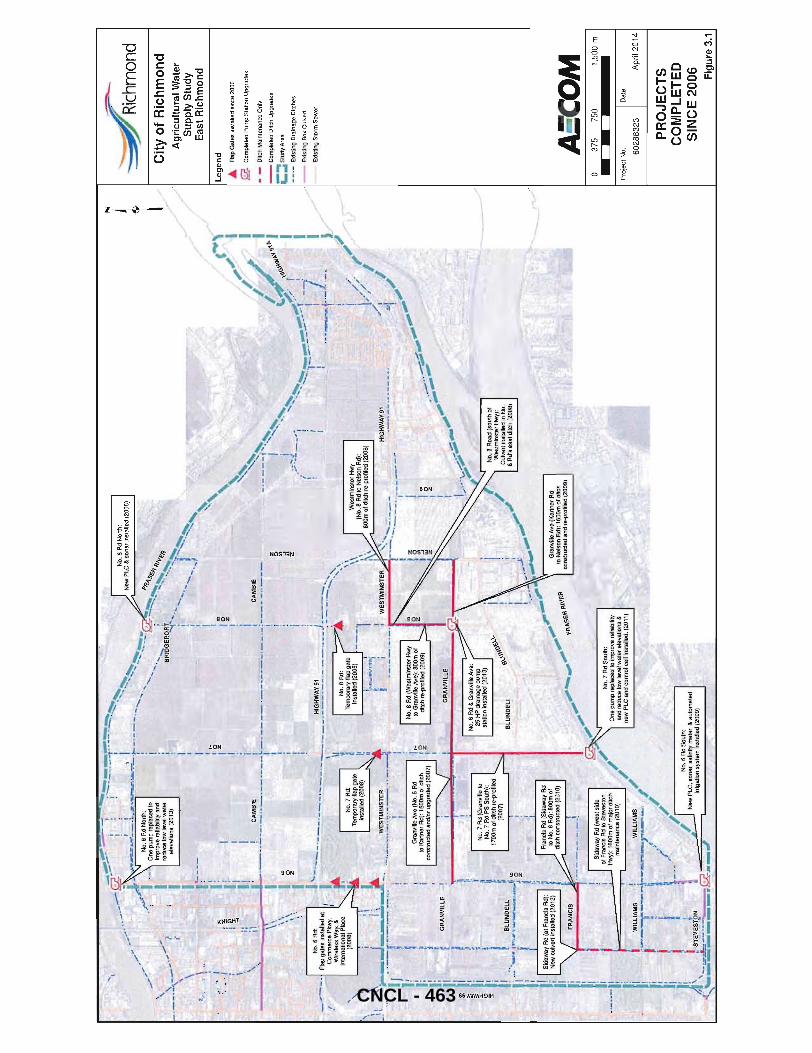
.'--
; _,
< ....
~_.
I \'
i '!
"" -=
--~~
hmOn
d , ~"'
.. .)
.....
. -_0_'
---"
j; '-:
' j'
City
of
Ric
hm
on
d
Ag
ricu
ltura
l Wat
er
Su
pp
ly S
tud
y E
ast
Ric
hm
on
d
"':=--
'~"""'"
'.""-""''
''''''''''''
''' •..
co ~~,~ ::
::. "
.,
t. /' ]
.. rI!!!!.
-: ~ _
:', ,_
! "
'"'"
.
/'
/
. -
, ,.
'''
'-..
, /
, _-,
.~·l-=.~~_ ,
_. '
__ "
"'"
_""
", .~
,..~
., "'
'''"
,/
/
-••
'0."
. i
_,.<
. ,
. '.
. "'''-
..,.. "
. .
_..
. ./
"
.•. -"...
.. ,-
,'.~''''i'
.. ""
'",
" ry
'~',
/ --'
:~J'~~~~or!I\:~~llt~:~:r
, ,,,
j1'-
",
• """
I '''.....
..~;;;."
:', ... ~~:. I''''-'~. .. .. :;
",
"',
','
/'
"'¥"
Le
ge
nd
;",I
olle
d s;
nce
200G
ele
valio
ns
(201
3)
~:I ~r.
l ',1
~ ,
' ...
; ':;';
., '
.'.'~, :',
---'<t
. /
'"
I ...
Fla
p G
ale
s
'\
--::t .
.. 1.,
• ..,
,
~_."_'
~.
'I
,.
' ....
!- i \ \.
'" .z
i~ ...
j:
"
'c
• ~,
~'. I
' "
. ~
, U
pgr
ad
es
' ~,.
'.
'. ",
. ".,
.-,
"'/
=
.,,-
~., i
... ~
i "
'" ".
, ,.'.
.~;t;.
I/
'!/
.O
I ~ :::
.:..
....
,.
: b
" ",.
.i ~ f'
~~ -"
''-'
''''' ~ . .,.. .
r: ~~./
I'
-'"
.
1 ___
_ C~:Pleled Ditch Upgrad
es
t •
, '-
, .
'~"'" "
" 'I
t
'-,
, '<
,."
, ....
. ,..? I
•• ,.
;:::~."
._
' ,
t "
....
_
.. --
--.'
.....
..
""
I . __
. "'_
..... .
" It
.....
.'.-
--
.. -.-
'I
'''.
..
. ",
. t
I .,.~"
""'., ,
~... __
_ l _
____
~_ .. _,_
.~. ,
; i" ''
'''""
.
_.<'I
:; . ...;
'e I
,--
Exi
slin
g S
torm
Se
we
r .. L
_._
.. _
.. _.
! ,.
! ,
;""-
"1
"""'''
''''''''''-
.;;.1 1
/'
.
, . "
, '-
r'-._
. t
/ '
~·i .. ~
. __
: _,
"
, ] _
_ ,'
..... ,. ', ..
"",,~/
\.,.
I ,-
'.""""~
___ .J,-
=-_,
,,,,,
'J'
. //
"
. ,1,"
'-"'"""'
~-c';~"
-7C-"'
----"'
_ ---i
"'~" _'~
"~ ~.
::
I,,;'
I
I ~ \\ \,
\\ ,.
No
.6 A
d:
_ ...
. -...
. ~
Flap
gat
es i
nsta
lled
at
,/ C
om
me
rce
Pkw
y.
Wire
less
Wa
y,&
In
tern
atio
nal P
lace
,
(20
08
)
I
---.
,-"
. "
. \I
'" '.,
-~.
'I
V .
.;,.
I ,
. --
" .
".
,,~~_~~'"
'_ •.•
• "
'.'1:,'
.I
.-r.
t
""..
:''''-'~'i
'!'
' "-,j)
~,u __
, __
. ' (~
.;;'
L _
__
__
">.,
•
" ,
';;:
'_
'.
! .,
,
. I
I \
_I \1
,~\
...J
liJ
-.' ..
.. -r=-t~~I~-·
···l·
·· )t
,
. 'j
! l
~. t.
: I;
~ ~i
I~
10 IZ
:
I '
~,
I _
I ~
.,-;;
.._
I~
'
..,_
No
.8 A
d (W
est
min
ste
r H
wy
to G
ran
ville
Ave
): 8
00
m o
f d
itch
re
-pro
Jile
d (2
00
9)
I '.
.,
I .;~_
l/~~
I' j
I i ~
£ G
RA
NV
illE
-~
~
GR~"
VII@J
I'
I
'I: Ii!.
j ~
I·
~
I j "
. I
BLUNQ~
l;l i. ~
" I!'--
_. r"~
' '---'''
-i ~
I ~
. "..
.."
(li-'-
' I
. ,
Fra
nci
s R
d (
Sid
aw
ay R
d I :
r.;
..;
'! ..
~ "_
,. ""
"'"
: ~
10 N
o.6
Rd
): B
OO
m o
f '.
' ~
" . .
-.,
III r
ditc
h co
nstr
uct
ed (
2010
) '\
~ -
....
' P
,\\fe
. R
. '!
, .
.., .
....
... ~
fl\~
SEI\
Ii ~~..,
! S
ida
wa
y A
d (
we
st s
ide
/:
'"7
-~ .--------=
----,
I o
f F
ran
cis
Rd
to S
teve
sto
n
--,
NO
.7 A
d S
ou
th:
"---
'11
Hw
y):
16
00
m o
f ma
jor
ditc
h
/ O
ne
pu
mp
re
pla
ced
10
imp
rove
re
liab
ility
I
ma
inte
na
nce
(2
01
0)
i a
nd
red
uce
lo
w l
eve
l wa
ter
ele
vatio
ns
&
I: -
~ -,
ne
w P
LC
an
d co
ntr
ol c
ell
inst
alle
d. (
2011
)
i W
ILLI
AM
S!
WIL
LIA
MS
.
/
! ":-
'-',_¥_-i--~~-r";;;;'-
';I
. J1
I
' ~ ,/'
.~;/
11'
1 ~
\-_.
-' //r-N
'-W-
P-L-C
-, s-on-~-~-~~
-lrn-1ty-s-~~-t
t~-:r,-&-a-UI-o
m-a'-le-d-'
.-,
" 'S
TE
VE
ST
ON
1
irri
ga
tion
sys
tem
in
sta
lled
(2
00
9)
.(~ ... '~~
":'-';
;;:" -...
~-.-,
.,
i
I~~"
"""
A:C
OM
37
5 75
0
Pro
ject
No
.
60
28
83
23
1,50
0 m
Dat
e
Apr
il 20
14
PR
OJE
CT
S
CO
MP
LET
ED
S
INC
E 2
006 Fig
ure
3.1
CNCL - 463
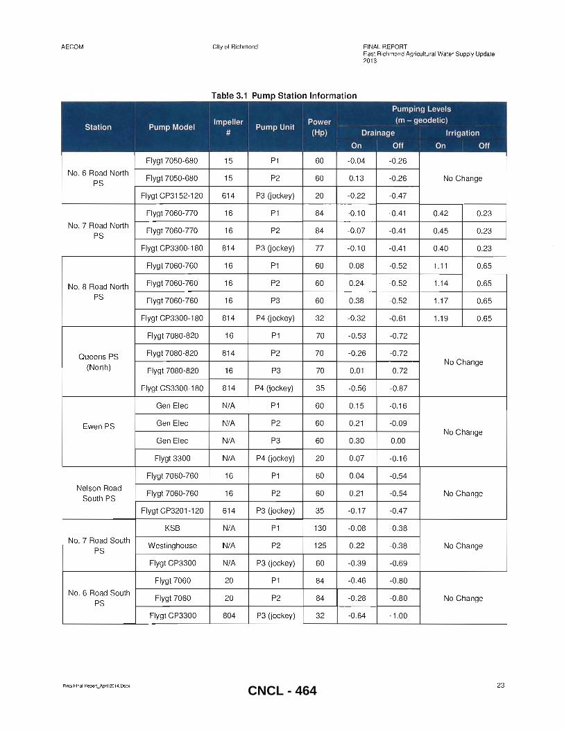
AECOM
Station Pump Model I
I i I
Flygt 7050-680
No. 6 Road North Flygt 7050-680
PS
Flygt CP3152-120
Flygt 7060-770
No. 7 Road North Flygt 7060-770
PS
Flygt CP3300-180
Flygt 7060-760
No.8 Road North Flygt 7060-760
PS Flygt 7060-760
Flygt CP3300-180
Flygt 7080-820
Queens PS Flygt 7080-820
(North) Flygt 7080-820
Flygt CS3300-1 80
Gen Elec
Ewen PS Gen Elec
Gen Elec
Flygt 3300
Flygt 7060-760
Nelson Road Flygt 7060-760
South PS
Flygt CP3201-120
KSB
No. 7 Road South Westinghouse
PS
Flygt CP3300
Flygt 7060
No. 6 Road South Flygt 7060
PS
Flygt CP3300
Final Final Report_ApriI2014.Docx
City of Richmond FINAL REPORT East Richmond Agricultural Water Supply Update 2013
Table 3.1 Pump Station Information
I
I Pumping Levels I
Impeller I Pump Unit
Power (m - geodetic)
# (Hp) Drainage Irrigation I On I Off On Off I ,
15 P1 60 -0.04 -0.26
15 P2 60 0.13 -0.26 No Change
614 P3 (jockey) 20 -0.22 -0.47
16 P1 84 -0.10 -0.41 0.42 0.23
16 P2 84 -0.07 -0.41 0.45 0.23
814 P3 (jockey) 77 -0.10 -0.41 0.40 0.23
16 P1 60 0.08 -0.52 1.11 0.65
16 P2 60 0.24 -0.52 1.14 0.65
16 P3 60 0.38 -0.52 1.17 0.65
814 P4 (jockey) 32 -0.32 -0.61 1.19 0.65
16 P1 70 -0.53 -0.72
814 P2 70 -0.26 -0.72 No Change
16 P3 70 0.01 -0.72
814 P4 (jockey) 35 -0.56 -0.87
N/A P1 60 0.15 -0.16
N/A P2 60 0.21 -0.09 No Change
N/A P3 60 0.30 0.00
N/A P4 (jockey) 20 0.07 -0 .16
16 P1 60 0.04 -0.54
16 P2 60 0.21 -0.54 No Change
614 P3 (jockey) 35 -0.17 -0 .47
N/A P1 130 -0.08 -0.38
N/A P2 125 0.22 -0.38 No Change
N/A P3 (jockey) 60 -0 .39 -0.69
20 P1 84 -0.46 -0.80
20 P2 84 -0.28 -0.80 No Change
804 P3 (jockey) 32 -0.64 -1.00
23
CNCL - 464
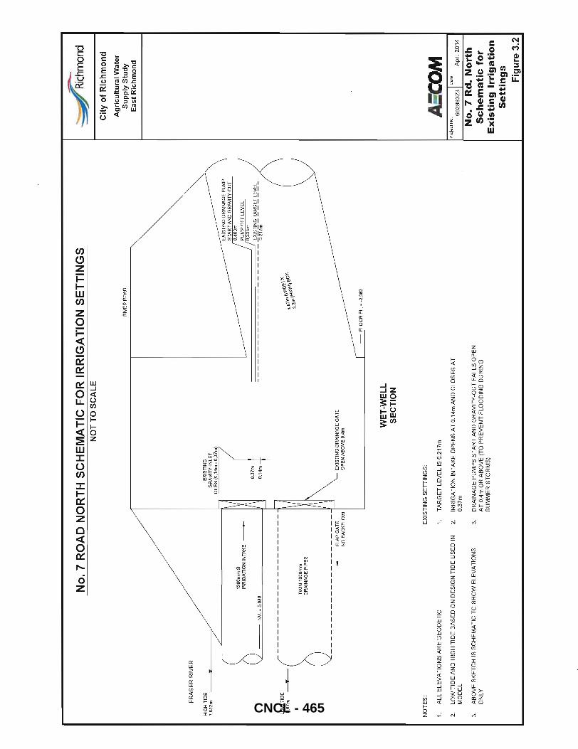
FR
AS
ER
RIV
ER
HIG
H TI
DE
1.63
2m
T
;;
No
.7 R
OA
D N
OR
TH
SC
HE
MA
TIC
FO
R I
RR
IGA
TIO
N S
ET
TIN
GS
N
OT
TO
SC
AL
E
EXIS
TIN
G
GR
AV
ITY
-IN
LE
T
RIV
ER R
OAD
EXIS
TIN
G D
RAI
NAG
E PU
MP
STAR
T AN
D G
RAV
ITY
OU
T
1200
mm
'"
IRR
IGAT
ION
INTA
KE
7 ~:~::t
! 0.40
0m
PUM
P O
FF L
EVEL
,
/ a.
233m
==
====
====
====
====
=--.,
EXI
STIN
G T
ARG
ET L
EVEL
IN
V. =
0.0
88
--
--
--
--
--
--
--
--
--
--
o.21
iin -
--
--
--
-O.6
7m
D
RAI
NAG
E PI
PES
LOW
TID
E ----:-
-b-
lWIN
16
00
mm
--
--
--
--
FLAP
GAT
E --------
-N
OB
AC
KFL
OW
EX
ISTI
NG
DR
AIN
AGE
GAT
E O
PEN
ABO
VE D
.4m
NO
TE
S:
1.
AL
L E
LEV
AT
ION
S A
RE
GE
OD
ET
IC
EX
IST
ING
SE
TT
ING
S:
1.
TA
RG
ET
LE
VE
L IS
0.2
17m
WE
T-W
EL
L
SE
CT
ION
2.
LO
W T
IDE
AN
D H
IGH
TID
E B
AS
ED
ON
DE
SIG
N T
IDE
US
ED
IN
2.
IR
RIG
AT
ION
IN
TA
KE
OP
EN
S A
T 0
.14m
AN
D C
LOS
ES
AT
M
OD
EL
03
7m
3.
AB
OV
E S
KE
TC
H I
S S
CH
EM
AT
IC T
O S
HO
W E
LEV
AT
ION
S
ON
LY
3.
DR
AIN
AG
E P
UM
PS
ST
AR
T A
ND
GR
AV
ITY
-OU
T F
ALL
S O
PE
N
AT
O.4
m O
R A
BO
VE
(T
O P
RE
VE
NT
FL
OO
DIN
G D
UR
ING
S
UM
ME
R S
TO
RM
S)
4.8 1
11'l'I
'J10 \
'.))(
. 3.
111' l;
\IG;\)
BO
)(.
~mond
Cit
y o
f R
ich
mo
nd
Ag
ricu
ltu
ral
Wat
er
Su
pp
ly S
tud
y E
ast
Ric
hm
on
d
AS'C
OM
P
roje
ct N
o,
I Date
6028
8323
A
pril
2014
No
. 7
Rd
. N
ort
h
Sc
he
ma
tic
fo
r E
xis
tin
g I
rrig
ati
on
S
ett
ing
s
Fig
ure
3.2
CNCL - 465
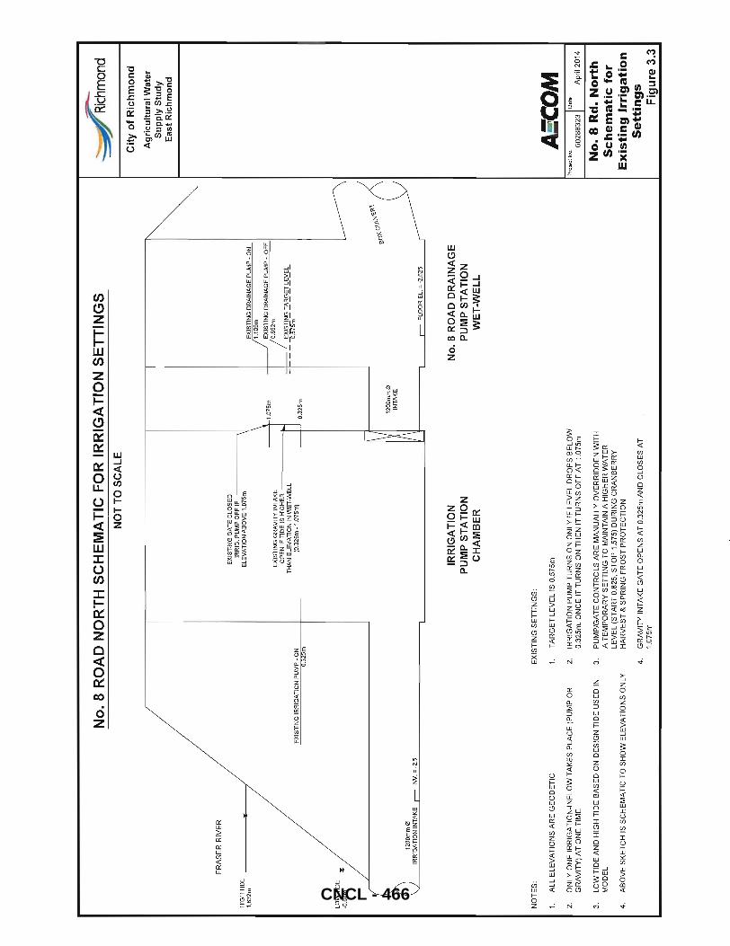
FR
AS
ER
RIV
ER
~~~~IDE
...
/
LO
W T
IDE
-O
.67m
No
.8 R
OA
D N
OR
TH
SC
HE
MA
TIC
FO
R I
RR
IGA
TIO
N S
ET
TIN
GS
N
OT
TO S
CA
LE
EX
IST
ING
IR
RIG
AT
ION
PU
MP
-O
N
a.32
5m
EX
IST
ING
GA
TE
CL
OS
ED
IR
RIG
. PU
MP
OF
F I
F ------~
ELE
VA
TIO
N A
BO
VE
1.0
75m
---+
4--
1.0
75
m
EX
IST
ING
GR
AV
ITY
IN
TA
KE
O
PE
N I
F T
IDE
IS
HIG
HE
R -----_~
TH
AN
EL
EV
AT
ION
IN
WE
T-W
EL
L
(O.3
25
m -
1.0
75
m)
---+
-L O
.325
m
EX
IST
ING
DR
AIN
AG
E P
UM
P -
ON
1
.10
9m
EX
IST
ING
DR
AIN
AG
E P
UM
P -
OF
F
O.6
52m
EX
IST
ING
TA
RG
ET
LE
VE
L
--
O.S
'75m
--
--
--
-
,.,
Rich
mon
d
Cit
y o
f R
ich
mo
nd
Su
pp
ly S
tud
y E
ast
Ric
hm
on
d
~
Ag
ricu
ltu
ral
Wat
er
b '-,
lr-i ----
---'
e
o)(
c\J\
-\l1
01'1
1200
mm
0
IRR
IGA
TIO
N I
NT
AK
E -=
INV. =
-2.5
NO
TE
S:
1.
AL
L E
LEV
AT
ION
S A
RE
GE
OD
ET
IC
2.
ON
LY O
NE
IR
RIG
AT
ION
-IN
FLO
W T
AK
ES
PLA
CE
(P
UM
P O
R
GR
AV
ITY
) A
T O
NE
TIM
E
EX
IST
ING
SE
TT
ING
S:
IRR
IGA
TIO
N
PU
MP
ST
AT
ION
C
HA
MB
ER
1.
TA
RG
ET
LE
VE
LIS
0.5
75m
2.
IRR
IGA
TIO
N P
UM
P T
UR
NS
ON
ON
LY I
F LE
VE
L D
RO
PS
BE
LOW
0.
325m
. ON
CE
IT
TU
RN
S O
N T
HE
N I
T T
UR
NS
OFF
AT
1.0
75m
3.
LOW
TID
E A
ND
HIG
H T
IDE
BA
SE
D O
N D
ES
IGN
TID
E U
SE
D I
N
3.
PU
MP
/GA
TE
CO
NT
RO
LS A
RE
MA
NU
ALL
Y O
VE
RR
IDD
EN
WIT
H
MO
DE
L A
TE
MP
OR
AR
Y S
ET
TIN
G T
O M
AIN
TA
IN A
HIG
HE
R W
AT
ER
LE
VE
L (S
TA
RT
0.8
25,
ST
OP
1.5
75)
DU
RIN
G C
RA
NB
ER
RY
4.
A
BO
VE
SK
ET
CH
IS
SC
HE
MA
TIC
TO
SH
OW
ELE
VA
TIO
NS
ON
LY
HA
RV
ES
T &
SP
RIN
G F
RO
ST
PR
OT
EC
TIO
N
4.
GR
AV
ITY
IN
TA
KE
GA
TE
OP
EN
S A
T 0.
325m
AN
D C
LOS
ES
AT
1.
075m
12
00
mm
0
INT
AK
E
-= FLO
OR
EL.
= -
2.6
25
No
, 8
RO
AD
DR
AIN
AG
E
PU
MP
ST
AT
ION
W
ET
-WE
LL
AS'C
OM
Pr
ojec
t N
o.
-I D
ate
60288323~
Apr
il 20
14
No
.8 R
d.
No
rth
S
ch
em
ati
c f
or
Ex
isti
ng
Irr
iga
tio
n
Se
ttin
gs
F
igu
re 3
.3
CNCL - 466
AECOM City of Richmond
4. Existing System Assessment
4.1 Drainage System Assessment Scenarios
FINAL REPORT East Richmond Agricultural Water Supply Update 2013
Assessment of existing drainage system was completed for the following two worst case scenarios:
4.1 .1 Scenario 1- Dormant Winter Period
For this scenario 1 O-Year 5-day design storm (as shown in Appendix B) and 7-day winter high tide (boundary condition) was used to evaluate the performance of drainage network.
In addition to storm runoff, cranberry harvest discharges were added as constant inflow into the model. Cranberry discharges vary from year to year depending upon the schedule developed between Ocean Spray and farmers. For modelling purposes, the volume and schedule of discharges was assumed to be same as per the 2006 Study. The model was set to run for 7 days with start date of November 1. A total cranberry harvest discharge volume of 308,447 m3 was added at two separate locations in the model for this scenario. This is equivalent to discharge from a 68.5 hectare farm with 0.45m of standing water. Since all the cranberry farmers do not discharge water on the same day and tend to coordinate water supply for reuse during harvest periods, this is a conservative assumption.
4.1.2 Scenario 2- Summer Growth Period
For this scenario 1 O-Year 2-day design storm (as shown in Appendix B) and 4-day summer high tide (boundary condition) was used to evaluate the performance of drainage network. The two day storm has higher peak rainfall intensity but lower total rain (volume) than the five day storm.
Since the cranberry harvest is at the cusp of the growing and dormant period, harvest discharges were added as constant inflow into the model. Based on the schedule assumed in the 2006 study, a total discharge of 252,678 m3
was added at two separate locations. For this scenario, the model was run for a period of 5-days to evaluate system performance after the storm is over.
4.2 Drainage Model Results
Analysis of the existing system indicates that there are several different factors that affect the maximum HGL at any location. The East Richmond drainage network is similar to the West Richmond drainage system as there are a lot of interconnected ditches but differs in that it serves the dual purposes of irrigation water supply and drainage conveyance.
4.2.1 System Conveyance
Several factors that contribute to conveyance problems and lack of irrigation water supply include capacity constraints, reliance on tide elevations, back water effects from pump stations and gravity outlets, and localized low ground elevations. For instance, at several locations the ground elevations in the hydraulic model were found to be very low when compared to neighbouring ground elevations (or attributes of adjacent ditch/culvert conduits), resulting in localized flooding. Locations where localized flooding was reported due to major discrepancies in ground elevations were often resolved by reviewing the digital elevation model (OEM) data for the study area as shown in Figure 4.1 and information available on Google Street View. The OEM raster image was generated using data supplied by the City for the 2006 Study. It should also be noted that the elevation data does not take into account infill areas since the topographic data was recorded.
To better understand if flooding in a certain area is caused by capacity constraints or back water from a pump station, the model was simulated with no boundary conditions (Le. no tide at outfalls) to allow the system to drain
Final Final Report_April 2014. Docx 26
CNCL - 467
AECOM City of Richmond FINAL REPORT East Richmond Agricultural Water Supply Update 2013
freely. Subsequently all ditch improvements discussed in the following section were first analysed with no boundary conditions prior to running the model with high tides. This also assisted in gaining a better understanding of pump station operation, capacities and on-off levels.
The existing model results for the dormant winter period (10-Year 5 day storm event) with tides are shown in Figure 4.2a. Flooding is predicted at several locations and is color coded based on the height of the maximum HGL above and below existing ground elevation. Figure 4.2b shows existing systems HGL after the 10-Year 5 day storm event has passed (on day 5) .
All model nodes were set to allow ponding in Mike Urban, which means even though the maximum HGL goes above the existing ground elevation, no water is lost in the model. This helps in keeping the total volume within the system to review the downstream capacity. The HGL results are conservative as no flood cells were modelled (in the 2006 study as well as this study) due to lack of detailed survey of adjoining fields . Flooding at each location was analysed in further detail to identify the cause of flooding and determine if ditch upgrades are required. In Section 4.3, various problem areas are identified and improvement options are recommended.
4.2.2 Drainage Pump Station Capacity Review
Drainage pump station capacities under Scenario 1 for the dormant winter period (10-Year 5-day design storm and 7-day winter high tide) were reviewed and the results are summarized in Table 4.1. For all locations where there is a flood box outlet, the capacity will vary as the tide level changes such that ultimately no flow occurs when the tide is higher than the wet well or upstream ditch water level.
Table 4.1 Summary of Pump Station Capacities ,
Flood Box 10-Year 5 day Theoretical , Flood Box I
I Structure & Name PS Capacity Size Capacity' Peak Inflow , Comments ,
m3/s I m3/s I m3/s I ,
No.6 Road North PS 1.14 2.8m X 1.5m 6.4 2.35 PS under capacity during high
tide periods
No.7 Road North PS 2.09 3.4m X 2.0m 12.0 3.35 Pump station under capacity
during high tide periods
NO.8 Road North PS 2.41 3.7m X2.3m 16.0 2.0 PS capacity is adequate
Queens PS 3.07 2.7m X2.0m 9.0 3.05 PS capacity is adequate
Ewen PS 2.35 NA NA 1.80 PS capacity is adequate
Nelson Road South 1600mm dia. 2.55
Pump station under capacity
PS 1.62 2.6
during high tide periods
1.37m X 1.0m PS and flood box individually
No. 7 Road South PS 2.90 (Twin Box)
3.3 4.10 under capacity. Combined
capacity is adequate.
NO.6 Road South PS 2.16 3.4m X 1.5m
8.0 3.65 Pump station under capacity
during high tide periods
Dog Kennels PS 0.17 NA NA 0.1 0 PS capacity is adequate
(Westminster Hwy)
Note: * Flood box capacity stated is calculated assuming HGL slope of 0.1%
As shown in Table 4.1, there are several pump stations where the capacity is less than the model predicted 10-Year 5 day inflow. With exception of No. 7 Road South PS, all of the flood box outlets have capacity to covey 10-Year 5 day peak flow during low tide. At NO.7 Road South the combined capacity of flood box and pump station is adequate to convey 10-Year 5 day peak flow.
Final Final Report_April 2014.Docx 27 CNCL - 468
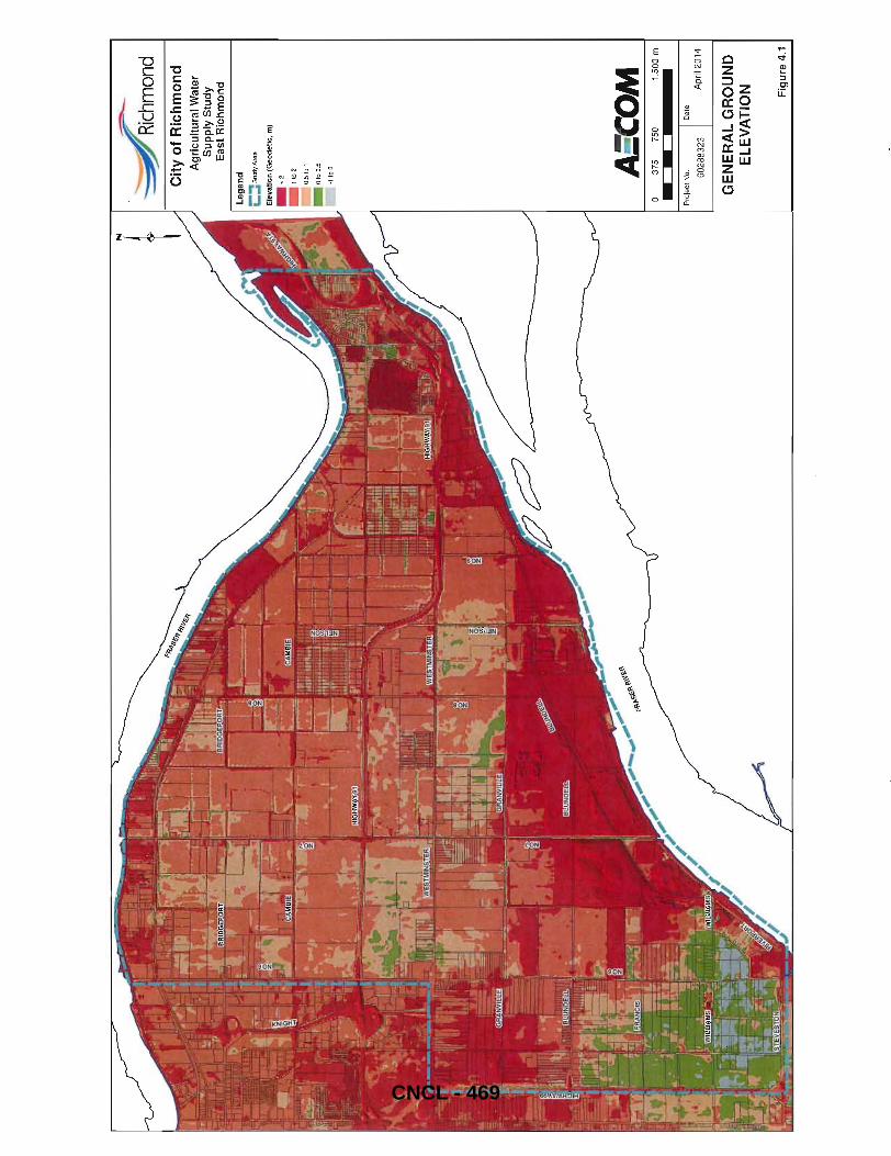
-=--
-.::
::6hm
ond
Cit
y o
f R
ich
mo
nd
A
gri
cultu
ral
Wat
er
Su
pp
ly S
tud
y Ea
st R
ichm
ond
-11
00
A:C
OM
37
5 75
0 1,
500
m
Pro
ject
No.
I Da
le
6028
8323
A
pril
2014
GE
NE
RA
L G
RO
UN
D
EL
EV
AT
ION
Fig
ure
4.1
CNCL - 469
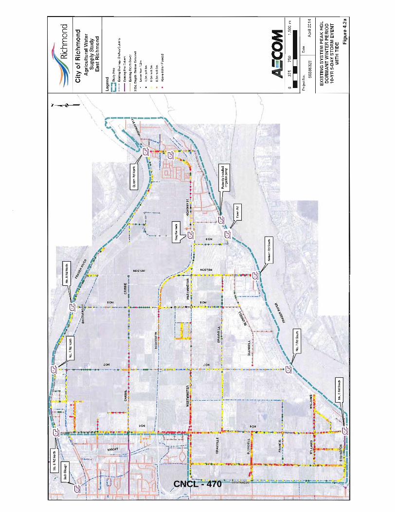
.... g
.. , I ~ 1 ~
-1 ~
1 i
... ......
. "
CA
MB
IE
._ .......
...... :--.
.... -----1
·------
.. z .
~
\ I '1
).
• ~ ~
. -·G
RA
NV
ILLE
I" • j.,
.. o z
,a>
"'
0 ...
""'·z
, ~
z z ~ z
'~'
I 4 it
GR
AN
VII
1LE
, t
'} ;'
. .1
~_'
: '.
1. 1,·
·~·-'-
·~:;--'
··""1
·_·'·
·~·"'~1
'.~
~ -c
~ _
";
+" ....
.. \ .
. -' -.
t, .
........
·,,:-:-·i
;r
... _.
c-.
f ~
I j,
~\..
\...):
.e-
i ~
f,. !
I <0
\.,:,-
,0.-
I ~
'" I
+
BLU
ND
ELL
"y
I
-' g
,
1 ~
.'
• ...
1 .
. ~ !t
:.'C
~i
..
-.,J
~ 1
'"
~ ~
":'-
1 'f
" ,
11.t
f'
-;
,1 ..
'-"-;;~
Ji ~
FRA
NC
IS
i I
~ .
..;;;
:"",
"'\~
~'" L
-.----.
......
. ..i>
. -.~
_~
: '
. .t:"
s«:.~
'.
j -
_,. ,
', fl'
~ !
: ~
-"
-<
,-/-
, !
,'-/
~.n.m
~ \
~ 'i'~ No.
7A
dS
ou
'h I
~ ~
.. f
//
~ 1'1
~
WIl
liA
MS
~
""-~L!
AM.s /
i
/ '
.. -,.·,. .. ·
r..-t
·~---~ .. · ,#
./
L 0
.I'
_.
" "
I: ~
".'
1 '
.. t
~ g
1~l
,;~
, *'
' /
.J 3 "'J.E
XES~ON
~.Lt
4. No
6 A
d S
outh
I
-".:_"'
:~';
":';
::;'_
r ~-•
• '"
l'1li L .,.' , ,
,:,-
,,/
./
.. ' /
" , r·
.... /
-=:-~
mond
Cit
y o
f R
ich
mo
nd
A
gri
cult
ura
l Wat
er
Su
pp
ly S
tud
y E
ast
Ric
hm
on
d
Le
ge
nd
i:::: S
tud
y A
rea
-_
. -E
xist
ing
Dra
ina
ge
Ditc
he
s/C
ulv
ert
s
--
Exi
stin
g B
ox
Cu
lve
rt
--
Exi
stin
g S
torm
Se
we
r
HG
L D
ep
th B
elo
w G
rou
nd
low
er t
han
1.2m
1.2m
to
O.9
m
O.9
mto
O.3
m
O.3
mto
O.O
m
Abo
ve O
.Om
I Fl
oode
d
AS'C
OM
o
375
750
1,5
00
m
Pro
ject
No
. D
ate
60
28
83
23
A
pril
20
14
EX
IST
ING
SY
ST
EM
PE
AK
HG
L
DO
RM
AN
T W
INT
ER
PE
RIO
D
10-Y
R 5
-DA
Y S
TO
RM
EV
EN
T
WIT
H T
IDE
Fig
ure
4.2
a
CNCL - 470
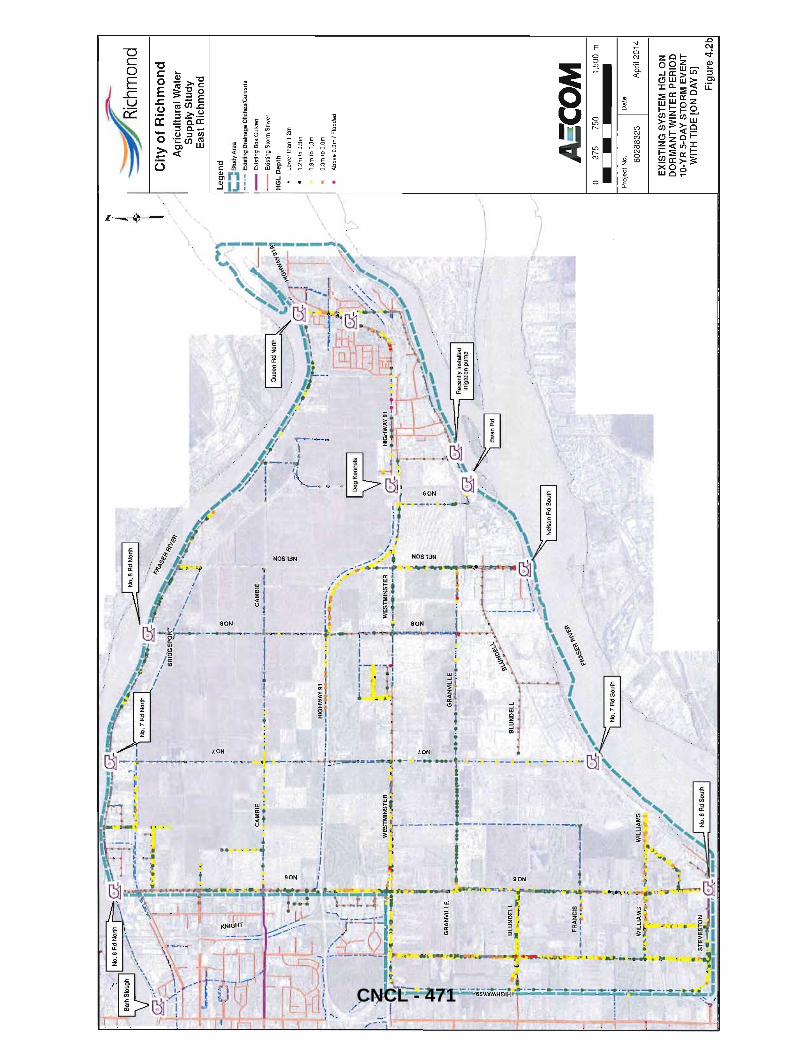
~ B::
SI~u::'~1
NO~:::N
onh b
~~~~-~
,... ,-,,':;
'~'-? (f
f"r
; ---
-L.!
I'
;; .
":"':~...!~
-~
",;,:
'.:'
.'1
_
....
... ~?
I.'
.-.
-I
\,
" ,~
_ j~
"'::~1
l~-:
·,-"""
-r~-"~-
·;·-,r~
'.""
~ .......
. __
l
. 1
N
" ,\
I
I
. '. ,
I 0
,7 A
d North
"~
_~~~'.~"-
;.,..N_O'_B
_Ad:"N::.o,rt"h
'l .
-,~
-.
, ~
• "'"
~,~
'?,
J". ~t·
'.'" I "
. ..,'
,".m"
,>'
;
/. ( (
( .. \
.'_
' '
'T,
. "'-
""
'"
'.'
~,
1 '
'"
. ..
. <.
' -cr
' .'.
I "1
I."
. . ~~
.. T
..... ,
... ",
... ",
"\
, .•
".
" '
f~
, "
~ .
~ 'I
. '
. I'
" ' ,
;
'<
~
. .
l. '-!
I'
! •
' ..
_ ,.
' .
," i
' I .
,
~
.. , ~ I
t.
',\\ 1
.. ' _
."'"
~".. '.
,. 1
., .
'" '\.'
. "
111
0
._
.... "
-_
,.
_,
! '''''.
' ",' 'v"'
'
I,' ". t
'l "
' ,.
0...
.'
' '"
.
, ."
~. ~"
". ".'". '
\'r1i!
; ,
:i"·-~
!i.."~o.· ·
. -.~~
<:;: .'<
;
/:~~~\j
.. __ .
___ C
,.
I>-
' '.
' ,
" ...
. '
.'~" o
" I
I _
_
...
...,..
,.-..
r{ _.
_)
, "
' " ...
. ' ' If
. "
I ,
]d'",
.=c".~-.. -
' I
' '
',..
'.
-....
.' l' /
.
--
\ ""\
;1 _
",,)
!} .: '
", -"C-;~"T
'--"='''
-: -~ J" ...
.. --;(:"'
~1 ''-'.;'
;: / =W"
·· '·"r
·j
!,
" \
' :
.,"
_~ ,!
~I ..
. ".
• I
"4=r
.e!"'"J
!'_M
.-I
,. _
: . ...
".
, _
1\'-
, __
.. _
\
,!
C"
/ '
I"
_.,.
'"
-=:,J
t..
w
' .
"'1
"--'
i
,-~, L
I
/
. . ... "~
" ~~,~~
, '
...
' ~
I '
., ., -,-
..,-_...
".,'
"
~ I
. ,,
---.!
-1
' +
\ l'
• '
t ''''~
~--1'
' W.B",~'
,",
J ""
i 1--
! i-~
I .. -·-
·--··
.. =-~':~.:.'''
-·'"·-~k
I, .
.,
--
="
1 •
... ~'"
•
..
."
'--<~I
" ..
_ 1
I .
. r"
I '
' J,
! 1
---1
--
' '
' •
' : "
I
j~~ l'
I 'I
" --.
. -••
. ,-
"''''
'-I
"'
" '
, I
~+ _
_' . !
' __
':
-'-~""
".-"""'''
...
I i'
'" ,
I 1
_ ,_
, '
_.
'.
.'~
.. ' ~'.
I'
; ~
.. "
" "
" )..
.~ -
. ~
"" ...
.,:.
,,~...
' "
;
" .'
,,' J
,~...
!.-r,;:J ~ M
.-.• ~~,--
~--"'::::"
':" .
y ,,,
." .').:_~LI <0
i ,~:.~
.-"".
" ....
.. '.
".~. -", "
..... "
')
Aec
enllv
;nS
lalie
d I
I .
,'
//,
'"
r~>
"~C/'
I ,
" ,"
.: " •
.. !t~;
" '17
!." {
. ':'
:f?
/ ,f _
..
,,-
l ,,!
,,'
i ~
"".:.
>;;;;
_,~,
;,_
i'
, !
l'
~;'~-
1 ~
~ _____ -. .... _~ ..
. _~~.-l
. "
,>;i:::
'-;:';'
'''''
,-" •
• ~ 1
. I
' /
""
-.,
..
.,...
•
t'
iI1 ' ,
""
,,,..
il
i J/~
/ i
~ ,. ~
. q
.... ~
.~ ,I
/
/ •.
•• """
f'
I, .
, ........ ,,-.. .
.,..~
" V!
!(lill
IM!'
J" /
. t:
! '~
_"')"/~
, ,
1'-.,
e.
,,'1#
I
:.. 1/
',.
,-"'#0
1:
, ---
~,..
, j'/
'ilo
• ~ ~
: Sr.!'~ES
TON ~
I~/.
.,,-_~ .• ~
.t
/'
__
__
r;;:
J .__
H
_
U
.-
r~-
• .,
..
---~
/
N
I ;:~
mOnd
t .1 C
ity
of
Ric
hm
on
d
Ag
ricu
ltura
l Wat
er
Su
pp
ly S
tud
y
~
Eas
t R
ich
mo
nd
/
,,"_
,.r-
Le
ge
nd
;:::
:: S
tudy
Are
a
-_
. -E
xist
ing
Dra
ina
ge
Ditc
he
s/C
ulv
erts
--
Exi
stin
g B
ox C
ulv
ert
--
Exi
stin
g S
torm
Se
we
r
HG
L D
ep
th
low
er th
an 1
.2m
1.2m
toO
.8m
O.9
mto
O.3
m
O.3
m1
0 O
.Om
Abo
ve D
.Om
/ Fl
oode
d
A:C
OM
o
375
750
1,5
00 m
Pro
ject
No.
D
ate
6028
8323
A
pril
201
4
EX
IST
ING
SY
ST
EM
HG
L O
N
DO
RM
AN
T W
INT
ER
PE
RIO
D
10-
YR
5-D
AY
ST
OR
M E
VE
NT
W
ITH
TID
E [
ON
DA
Y 5
]
Fig
ure
4.2b
CNCL - 471
AECOM City of Richmond
4.3 Proposed Drainage Improvements
FINAL REPORT East Richmond Agricultural Water Supply Update 2013
The following sections highlight the problems areas identified using the existing model and proposed upgrades for each area. In each case the hydraulic model was simulated for the winter (10-Year 5 day storm) and summer (10-Year 2 day storm with maximum summer tide) events to confirm the proposed upgrades have the desired effects. An overview of the proposed drainage upgrades is shown in Figure 4.3.
Please note that the ditch inverts as shown in the profiles in this section are conceptual elevations for modelling purposes. Elevations should be surveyed and verified during the detail design stage prior to construction. Additionally the areas identified on Figure 4.3 should be surveyed and data verified against current model elevations to confirm potential flood issues.
ARDSA criteria (discussed in Section 1.5.1) requires that in periods when drainage is required, the base flows should generally be maintained at 1.2 m below field elevation, although a freeboard of 0.9 m may also be acceptable. The criteria further requires that drainage ditches remove runoff from the 10-Year 5-day storm within 5 days in the dormant period and remove runoff from 10-Year 2 day storm within 2 days in the growing period. The purpose of these criteria is to allow for the free-drainage of outlets of local field drainage systems.
As discussed in the 2006 Study (Section 5.3) there are several issues to consider when reviewing these criteria. The first is that the areas dominated by cranberries are well established and successful under current drainage and irrigation conditions. In such case, minimal changes are proposed for these areas regardless of the ditch water levels being able to meet the ARDSA criteria. Only ditch cleaning is proposed as part of the drainage infrastructure upgrades.
Ditches in the study area serve the dual purpose of supplying irrigation water and removing drainage water. Meeting the 1.2 m freeboard requirement (or even 0.9m) is a challenge as the ditches are generally full supplying irrigation water throughout most of the area or conveying stormwater runoff that is backed up in the system due to high tide conditions. Model results for the drainage system with improvements following the 1 O-Year 5 day storm event are shown in Figure 4.6. The model predicted ditch HGLs are shown using 0.3m increments from ground level to represent the freeboard from the top of ditch level, which is assumed to correspond closely with the surrounding field elevations in most cases.
There are several locations where the 1.2m (or 0.9m) ARDSA freeboard criteria are not met. These include the Sidaway Rd west side ditches from Steveston Hwy to Westminster Hwy, Williams Rd east of No 6 Rd, Kartner Rd and Fedoruk Rd (which is a residential area), along Hwy 91 near No 8 Rd, and Granville Ave East of Neslon Rd, Nelson Rd South to the pump station, as well other isolated locations. Rationale for why these areas are not able to meet the freeboard criteria five days after the storm event is primarily due to the fact that the existing ditches are shallow and have a maximum depth of 1.2 m in many areas (even after improvement measures are implemented).
One option would be to construct deeper ditches; however, in the 2006 Study farmers reported the groundwater table to be approximately 300 mm to 900 mm (average of 700 mm) below ground level, so deeper ditches would potentially result in more pumping requirements and in areas with high iron content, possibly iron-affected water quality. The structural integrity of soils in East Richmond, which are predominantly silt and clay with silty and sandy loams, is also limiting factor such that steepening side slopes of the existing ditches is not possible is most areas. Furthermore, most of the area is already developed up to existing property lines, roadways, and ditches such that deeper ditches could require property acquisition, which is an expensive proposition.
4.3.1 Sidaway Road South of Francis Road Alignment (D1)
Figure 4.3.1 shows the existing ditch profile along the west side of Sidaway Rd from the Francis alignment to its entry point into the box culvert at Steveston Hwy. This ditch has large variation in bottom invert and shallow culverts
Final Final Report_April 2014. Docx 31 CNCL - 472
AECOM City of Richmond FINAL REPORT East Richmond Agricultural Water Supply Update 2013
at several locations. As shown in the figure, the area south of Williams Rd is generally lower in elevation as compared to surrounding areas which is reflected in the ditch profile.
In order to reduce flooding in this area the following improvements are recommended:
• Re-grade the existing ditch along Steveston Hwy and Sidaway Rd with uniform slope starting from its entry point into box culvert at Steveston Hwy to Francis Rd alignment. This includes clearing and re-grading of 350m of existing ditch along North side of Steveston Hwy from Palm berg Rd to Sideway Rd and 1,450m along West Side of Sideway Rd from Steveston Hwy to Francis Rd alignment.
.. Upgrade five existing 900mm diameter culverts along the North side of Steveston Hwy from Palmberg Rd to Sideway Rd to 1050mm diameter (for a total length of 55m of pipe) and match proposed ditch inverts
• Upgrade 15 existing culverts (ranging in diameter from 600mm to 750mm) along the West Side of Sideway Rd from Steveston Hwy to Francis Rd alignment to 900mm diameter (for a total length of 120m of pipe) and match proposed ditch inverts
It was noted that lowering the NO.6 Rd South PS ON/OFF elevation had a significant impact on the maximum HGL upstream. Given that the wet well floor is -2.9m geodetic elevation (based on information from the City), it was assumed that the jockey pump ON elevation could be adjusted to -0.9m (from -0.64m currently) and OFF elevation to -1.3m (from -1.0m currently). Similarly the ON/OFF elevations of lead and lag pump was lowered by 0.3m.
Figure 4.3.2 shows the maximum HGL after the system improvements were incorporated. Under the 10-Year 2 day storm with maximum summer tide the maximum HGL with improvements was found to be slightly lower than the winter 5 day storm.
Final Final Report_Apri12014.Docx 32 CNCL - 473
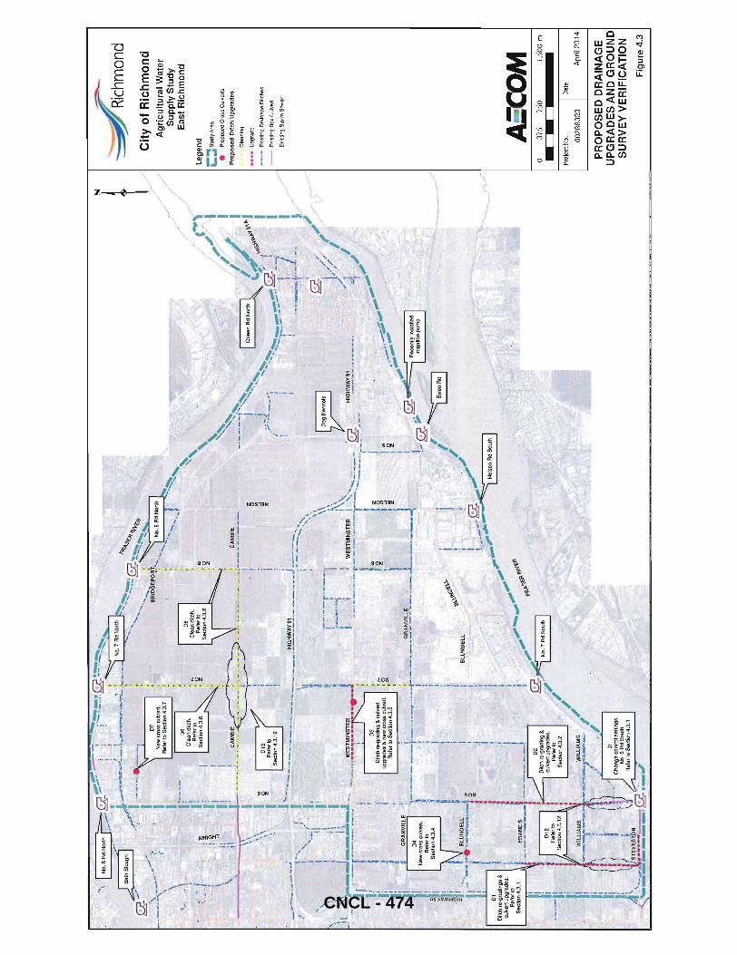
'. " !,
01
Ditc
h r
e-g
rad
ing
s &
cu
lve
rt up
grad
es.
Re
fer
to
Se
ctio
n 4
.3.1
"" ~
t ~~:o~
:d "~
..-_
// //
Ag
ricu
ltu
ral W
ater
"'",
./
/ S
up
ply
Stu
dy
'~
,/
/ E
ast
Ric
hm
on
d
~
/ /
ro\..\
)\\Q~:
:·'·
, ,/'
t4
¥l
~
-/ ~
j\1
,,~
, "
/~~
'"'''
. / /
/ '?
I
.... -.-
-.-::t
~ .... -
;~ " j~
<,.4/
_, I
",,,,,
;;
,..
!,~
Que
en R
d N
orth
I
_ ~fl.
"4 ~'\f:>
.1 I
·~.
'-~
0(.\6
'<'
, I
, I 1m
I~
• .~:
-"
.'.
~...
..
-r;
;-;J
/
( .~
~ "-'-
-"'
1 \",~~
fllll#:
g-
' I
,. ,
.... ~ _
__
__
.-._
. vL
--.
~
! i
-'1--'
--'
r .
• ..1
cr'
. I
":.--~
:K:l-..
,
: .,
......
.. .,
. I~
"~-~
--.
. 1.11
':,
fii/}<
;;"
,. ".
1t.o
..'-.
,;"
",,' .
,,' "
h ~
'L.l· ,
':"-~!<
) .. "
.. ~;,
/ !,_
.-··t~
-~ ,
y ',"
. ;~
~--=.,.
-,.".~
I
' "..
...
.' ,,,,.
..~.,
-
--.
..;:
; N
elso
" R
dS
o""
I
, ,,"
"';
-,;-
,,""
-.
Cc·'
., ,.~~'
fl'~S';I'I
'\~';1'
~. ,
;/
No.
7 R
d S
,"'h
I
I·~
. ,
, /-
(..=
-.-=
. .
W!E
UAM
S •..
' i
~ .. ; --
:')"
'''-
:;'''''
.' /~
,/
;-.,/
II
Ch
an
ge
co
ntr
ol
sett
ing
s.
NO
.6 A
d S
oU1h
./
Lege
nd
;::: S
tudy
Are
a
• P
rop
ose
d C
ross
Cu
lve
rts
Pro
po
sed
Dit
ch U
pg
rad
es
Cle
an
ing
••••
Up
gra
de
-_
.-E
xist
ing
Dra
ina
ge
Dit
che
s
--
Ex
istin
g B
ox
Cu
lve
rt
Exis
ting
Sto
rm S
ewer
A:C
OM
o
375
750
1,50
0 m
Pro
ject
No.
D
ate
60
28
83
23
A
pril
20
14
PR
OP
OS
ED
DR
AIN
AG
E
UP
GR
AD
ES
AN
D G
RO
UN
D
SU
RV
EY
VE
RIF
ICA
TIO
N
Fig
ure
4.3
CNCL - 474
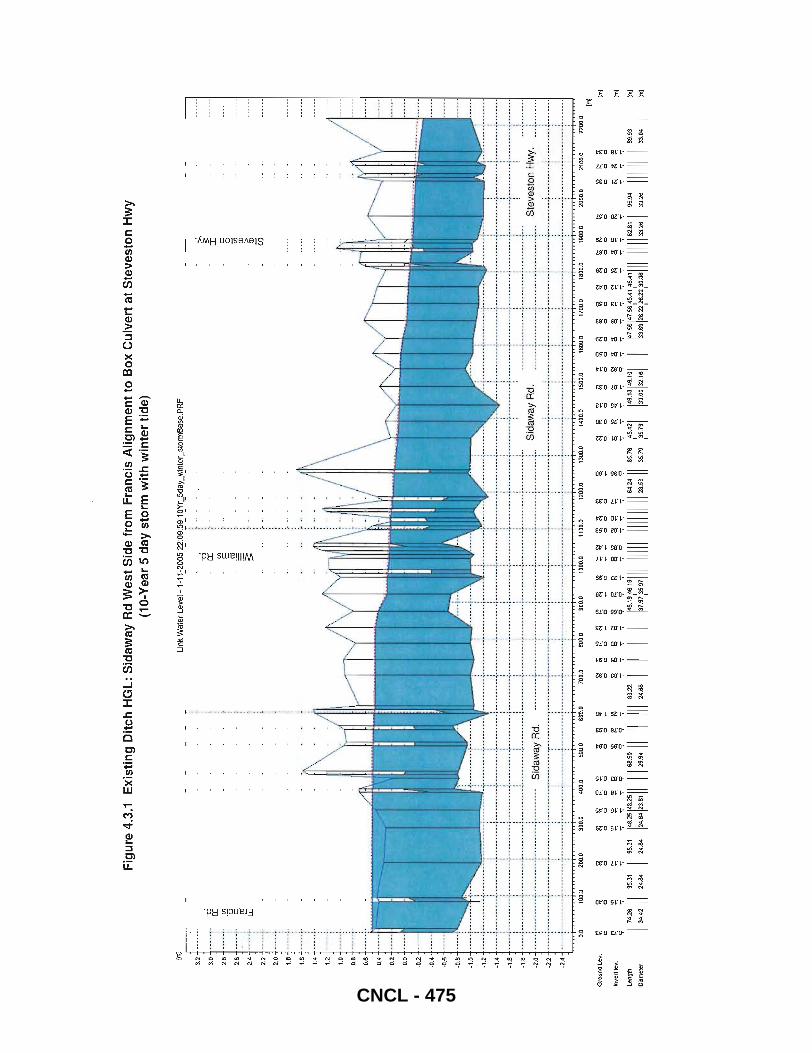
Iml l 2
.8
---
--.
2.S
_
.--
-.
2.4
----
--
2.2
2.0
1.8 1.6
1.4
1.2
1.0
0.8
0.6
0.4
0.2
0.0
·02
-0.4
-0.6
·0.8
-1.0
-a a::
U)
'0 c ro u:
-1.2
--
---
----
----
--
-1.4
--
--
---
----
----
-L6
---
--.-
.---
----
-1.6
.-
---
----
--.-
--
-2.0
--
---
-----
----
-
·22
..
...
....
....
. .
-2.4
--
---
----
----
--
Fig
ure
4.3
.1
Exi
stin
g D
itch
HG
L: S
ida
way
Rd
We
st S
ide
fro
m F
ran
cis
Alig
nm
en
t to
Bo
x C
ulv
ert
at
Ste
vest
on
Hw
y (1
O-Y
ear
5 d
ay
sto
rm w
ith
win
ter
tide)
....
....
. ~ ...
....
.
·········
·r··
·-·-
----
----
-~·~···-·--
---
-:..
···-
··--
-·
..
· ..
link
Wat
er L
evel
-'-
"~2005 2
3:09
::9_
'I!.Y
,=5d
aL":
inte
,_st
orm
Bas
e.PR
F
-a :>.
;::
----
-···
··.i----··
··--
-~·-
----
----
----
.
a::
U) E Jl1 $:
----
----
--~-
---..
....
. :----
--_._
.----
-----
--~-
-. -
_ ...
. -"--
. --
-.--
--.-
···-
----
--r-
--·-
---
I c o t5
OJ
>
OJ
U5
"----
--. _
_ ._._-
-----
_ .. _
---:..
... _
.. __
.. -
_ .. _
_ .-.
.
... _
------
_.-._-
-._-
----
...
_--....
. _ .. _
.... _-
--_ ..
. -
...
_-_ .
. _-
---_.
_---
-_._ .
....
-_ .
... --
-_.
::::::':::
f.::-.'.::
: ::::::::
:I::::::
::F:·:::
.·: :::::
:::::t::
:::::::t
::::::::
:: ::::::
::::;:::::
:::::
····
····
··f·
····
····
· ..
....
....
S
idaw
ay R
d.
. ...
....
.. ~ .
....
....
.. ~ .
....
....
....
....
... ~
....
....
. .
::::::
T:::::
::::;:
::::::
:::l::
::::::
::~:::
S
teve
ston
Hw
y.
Sid
away
Rd
. ,
",
, .
.,
-...
.. -.
--~-
-..
-----
-----
_._---
.....
. _--
----
-.. -_.
_ ..
_---
--_ ..
_. __
.... --_
.....
.. -..
----
-_._
-----
-_._-
--.. -.
. __ .
... .
_ .
. _-_
... -
-_ ..
... _
-. ..
. ..
....
.. . -
~ ..
. _ .
. __ .
-.. -_
. --_.-
---,..
-_. --
-_ ..
-_ .
....
-_ ....
. _.-
.-..
. -..
....
_ ..
-... -_
._ ..
--,
" "
. ,
" .
. •
" I
I •
. .,
, .
· "
" ,
. ..
. .
-_.-
_---
--0
----
-···
·· .
. ___
_ ...
_ .. _
_ ._.
___ .
....
. _._
._. _
____
____
__ ._
.. __
__ . _
____
_ .. _
. ___
____
...
-.. -
____
____
___ .
_ ..
------
-_.-.-
_. __
... _
.... _
.-._
... _
... -_
....
_ ..
... _
.. __
._-...
_---_
.. _-
... _
_ ...
....
__ ._
....
-..
_._--
----_
... _-
_ ..
, "
" ..
. ·
" "
..
. 0.
0 10
O,a
2(}Q
.O
300.
0
40
0.0
SOO
,O
60
0,0
700.
0 8
00.
0 90
0.0
10
00.0
11
00.0
12
00.
0 13
00,0
14
00,0
15
00
.0
1600
.0
1700
.0
180l
J,O
19
00,0
2
00
0,0
210
0.0
220
0.0
Gro
und
Le ....
~ c
~
~ '"
~ '"
~ c
~ "'
~
m
~
~ ~
N
~ ~
2 ~
§ g
~
ill ~
~ ~
~ ~
N
~ ~
fJ ~
~ ~
~ ci
2 ci
;:; ~
"" ~
::; "
::; '"
""":
<0:;
.., ..,
ci ::;
c ci
c
Inve
rt le
v.
~
on
~
'" '"
~
~ ~
"' ~
<l ~
<! i::!
~
C
N
~ ~
~
C
~
"' Q
~
on
~
N
q ~
en
cP:I
N
I()
~
C
~
" '"
~
r--;
...-:
.., ..,
.., ..,
" «:
! ""
: '"
~ ~
.., '"
"" ~
* C
! C
! --
: .-
; "'
i q
..-:
.., 9
'"T
'1
9 9
'":
<;>
., '";"
'";"
"7
"7
"7
Leng
th
II :::
II 95
.31
95.3
1
1'825
1'8
25
11 III :
:~ II I
I III
83
22
I
I I
I 1'6
19,'61
9 111
1111
1 11
1111
11 :
:::
II :~;:
,45.4
21
149' T'
°1
14758
1475
8 ,454
1,45
41
111
1111
:~: I
95.9
4
111
11 I 89
,93
Dia
met
er
24.8
4 24
.84
24.8
4 23
.61
2'1.
66
37.9
135
.97
35.
79
33.0
0 32
.18
33.8
9 26
.22
26.2
2 30
.06
33.
26
33
.04
, I
, ,
1m] 1m
]
1m]
1m]
1m]
CNCL - 475
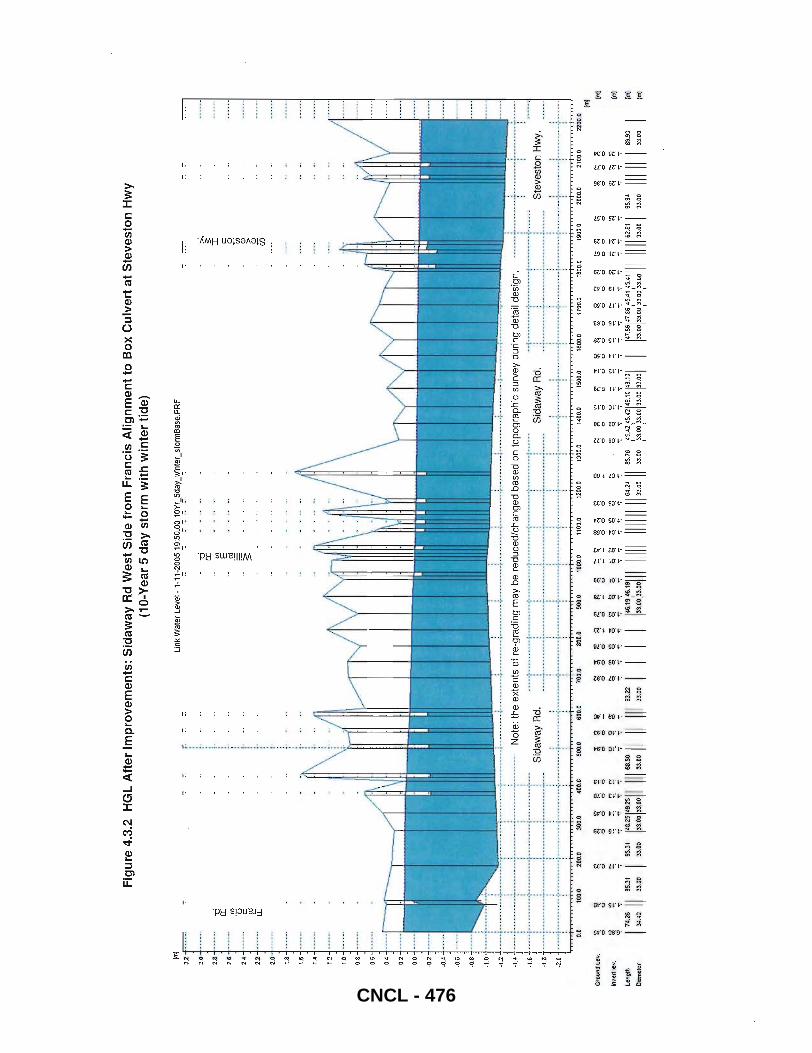
1m!
32
2.0
2 .• 2.6
2.4
22
2.0
1.8 1.6
1.4
1.2
1.0 0.8
0.6
0.4
0.2
0.0
-0.2
-0.4
-0.6
~().8
-1,0
-12
~1.4
-0
a:
(/)
'0
c ctl u:
7
-1.6
+--.-
+ ••
---
----
-1.S
-2..0
-+--
---t
----
----
-
I
Fig
ure
4.3
.2
HG
L A
fter
Im
pro
vem
ents
: S
idaw
ay R
d W
est
Sid
e fr
om
Fra
nci
s A
lign
men
t to
Bo
x C
ulv
ert
at S
teve
sto
n H
wy
(10-
Yea
r 5
day
sto
rm w
ith
win
ter
tid
e)
7
~~~~~~~~
~~[~ ~ ~~
~ ~~~~~ j~
~ ~~~~~~
~~ ·--
-----
-->--·
-···-·
·1---
-·----
-
lin
k W
ater
Lev
el-
,-, ~
-200
5 ~9
:50~O~ 'gY
r".5da
y_'~nter
_stormBase
.PRF
-0
a:
(/) E
~ :s:
Not
e: t
he e
xten
ts o
f re
-gra
ding
may
be
redu
ced/
chan
ged
base
d on
top
ogra
phic
sur
vey
durin
g de
tail
desi
gn.
:>,
;:: :r:
c o U5
Ql >
Ql
(jj
Sid
away
Rd.
::
::::
::::
:::
::::
:::
::::
::::
:-::::
:::::1:
::::::: :
:::::::::
:::::: S
idaw
ay R
d.::
:::::::::
1::::::
::: ::::::
:::: ,
, •
• ".
I .
. "
..
····
····
··t·
····
····
··j··
·---
--··
--
--..
....
.. --
.-.-
-.. --
--.-
.--
------
---·-
l'··-
------
-.. -.
-----
------
-----l
---··
···_·-r
---···
··_·
_·-·
·---
_·-t-
-----
----
---
----
--'.
Ste
vest
on H
wy.
.
. .
. .
. --
----
·---
~----
---·--
·l---
··-
-----l
·--·
·
0.0
100.0
200
.0 30
0.0
400.
0 50
0.0
600.0
70
0.0
800.0
900
.0 10
00.0
11
00.0
12
00.0
1 J
OO.O
10
400.
0 15
00.0
16
00.0
11
00.0
18
00.0
19
00.0
200
0.0
21
00.
D
2200.0
Gro
und
Lev.
Inve
rt le
v.
l.eng
lh
Oi3
met
er
~
ci
f;I "i 174.
26 II
~.42
95.31
33.0
0
SS.3
1
33.0
D
g)
~
~
~ ci
o ~
""':
"'":
..,
N
......
..-:.
~
..,
0
~
~
;: o
0 ~
r:
~
"7
"7
":'
"7
":'
"7
":'
1::::
1:::::
11 III :
::~ II
II III
83.22
33.0
0
~ ~
~ ~
,...
!O
."
....
q
q c:
q ":"
"7
I I
I I
m ci
~ g ..
~
N
~
"":
~ ~
§ ~
§ ~
~
~ '" o
~ ~
~ ~
~ ~
'" ci ~
~ ~
~ a
a C!
q a
q ~
~
~
q ~
'" .., ~
"7
"7
"7
";
"7
"7
"7
"7
"7
"7
"7
"7
"7
"7
"7
146.,9
'6.,91
11 111
11 11
1111
1164 .2 '
II 85.7
6 45.
4245.4
2149.,0
149.10
1 33
.00
:33.
0D
33.0
0 33
.00
:33.
00 :3
3.00
33
.00
33.0
0
'" '" m
~
~
t=i ~
lq
"7
"7
"7
"7
"7
"7
"7
"7
1'7.56
147_56
45.41
.5.41
III 11
1162
.~1 I
33.0
0 33
.00
:33.
00 :3
3.00
33
.00
95.9'
33.00
~ ~
a '"
~
'" <'!
<"
! "i
"7
"7
"7
1111
11
89.9
3
33.0
0
1m) 1m
)
1m)
1m]
1m)
CNCL - 476
AECOM City of Richmond
4.3.2 No.6 Road South of Blundell Road (02)
FINAL REPORT East Richmond Agricultural Water Supply Update 2013
Figure 4.3.3 shows the existing ditch profile along the East side of No.6 Rd from Blundell Rd to its entry point into the box culvert near Triangle Rd. Similar to the Sidaway Rd ditch, this ditch has a large variation in bottom invert and has shallow culverts at few locations.
In order to reduce flooding in this area the following improvements are recommended:
• Re-grade the existing ditch assuming a uniform slope starting from its entry point into the box culvert near Triangle Rd to Blundell Rd. This includes a total of 2,OOOm of clearing and re-grading of the existing ditch along East side of No.6 Rd
• Upgrade two existing 600mm diameter culverts along the above alignment to 1 050mm diameter (total length of 25m of pipe) and match proposed ditch inverts.
• Modifying the No.6 Rd South PS ON/OFF levels as described in Section 4.3.1 above.
Figure 4.3.4 shows the maximum HGL after the system improvements were incorporated.
4.3.3 Williams Road Right of Way East and West of No 6 Road (03)
Upgrades of existing ditches along Sid away Rd and No 6 Rd as described in the above two sections will lower the maximum HGL in connected ditches including ditches along Williams Rd. The model shows significant improvement in flooding along Williams Rd after the above improvements were incorporated. So, no further ditch upgrades may be required along Williams Rd alignment.
4.3.4 Blundell Road East of Sidaway (04)
Flows from the existing ditch on the East side of Sidaway Rd (north of Blundell) are currently diverted east along Blundell Rd. The model results show flooding along this ditch on the north side of Blundell Rd, East of Sidaway Rd. This ditch crosses a lot of driveways with varying culvert diameters.
The existing network does not show any cross connection between North side and South side ditch along Blundell Road. To reduce flooding in this area the following improvements are recommended:
• Install a new 15m long 600mm diameter cross culvert on Blundell Road, 100m east of Sidaway
After this upgrade was incorporated into the improvements model, the results show significant reduction in flooding along this ditch.
Final Final Report_April2014.Docx 36 CNCL - 477

Fig
ure
4.3
.3
Exi
stin
g D
itch
HG
L:
No
.6 R
d fr
om
Blu
nd
ell
Rd
to B
ox
Cu
lver
t n
ear
Tri
ang
le R
d
1m)
UnK
Wat
er_L
evel
-1-1
1-20
05 2
3:1
5:00
10
Yr_
5d
aL
win
ter_
stor
mB
ase
.PR
F
3.6
3.4 3.2
3.0
2.6
2.6
2.4
2.2
2.0 1.8
1.6
1.4 1.2 1.0
0.6
0.6
0.4
0.2
0.0
-0.2
-0.4
-D.6
-0.8
-1.Q
-0
CC
Qj
'0
c :J
CD
~~ ••••••••
• ~ ...... .
·22
--------~---------~----------
----
----
----
---
---
-
::: :::::
::::::::
::t:::::::
:::::::::
::::: ::::
:::::: ._
-_ .... -
:, i
----
.-.-
. --
----
----
,.--
----
---
----
----
---
----
----
'---
--.-
---
.--
----
--
----------
.. --------
----
----
---
----
----
r---
----
--
----
----
---
----
----
'---
----
---
-0
CC
en
'(3 c ~
LL
----
----
-'\-
----
----
---
----
--
---------~----------
---------
----
-----~ --
----
----
~ -
----
----
-.. --
----
---.
. ---
----
----
----
---
NO
.6
Rd
.
----
.---
---
--------
----
------
.. ---
----
--.. -
----
----
---
----
---
----
----
---
----
----
----
----
--r-
----
----
... ---
---
----
----
----
-•
__
_ ._
. _
__
_ •
_
__
__
__
__
__
__
__
__
....
__
__
__
__
_ J
__
__
__
__
__
__
__
__
__
_
0.0
100.
0 20
0.0
300.
0 40
0.0
500.
.1)
800
.0
700.
0 BO
O.O
900.
0 10
00.0
1
100.
0 12
00.0
13
01).0
14
00.0
1S
00.0
Gro
und
Le
v.
~ ~
~ g
Sl ~
~ ~
! ~
~ ~
~ ~~
. ~
~ ~
~ ~
~ ~
~
Inve
rt le
v.
~
~
~
~
I/)
~
~
~
~ ~
~
~ ~
(i
~ ~
~ ~ ~ a
~
$ ~
or;-"'7
"'7
'7
"'7
";"'7
"'7
99
"'7
'7
9
'7
,,;-,,;-9
'7
'7
'7
99
";-
len".
92.27
III "o
.n
103.94
".3
1 ".0
4
158.55
156.66
1",.74
111
76.85
176 .•
511
1116
6.43
161.53
1 I
II I
I 1
87 .26
162.8
01
92.20
DIa
met
er
SO.2
1 50
.21
50.6
1 SO
.61
34.0
8 34
.08
37,5
6 37
.56
41.4
1 49
.65
45.7
8 37
.10
24.5
5 33
.95
33.9
5
(10-
year
5 d
ay s
torm
wit
h w
inte
r ti
de)
-0
cc
en E
~ ~
NO
.6 R
d.
-----
----
----
----
----
----
----
~ ---
----
--~-
----
----
---
----
----
----
---
----
----
----
----
--,.-
----
----
-.--
----
----
----
--_
__
__
__
__
__
__
__
__
__
__
__
__
__
__
.... _
__
__
__
__
J _
__
__
__
__
__
__
__
_
1eOD
.O
1700
.0
1800
.0
1900
.0
2000
.0
2100
.0
~
El 1'1
~
1;'
I'l •
!'l !O
f .
9 9
ci
ci
ci
c:i
ci
ci
~
~ ~~
q ~
~
?4 ~
'7
"'7
"'7
'7
"7
"7
'7
'7
"7
94.08
181.06
1 II
92.3
1 178 .73
171 ...
178 .04
172
.6> I
47.1
2 47
.12
34.6
3 34
.83
38:9
8 38
.98
48.9
0
CNCL - 478
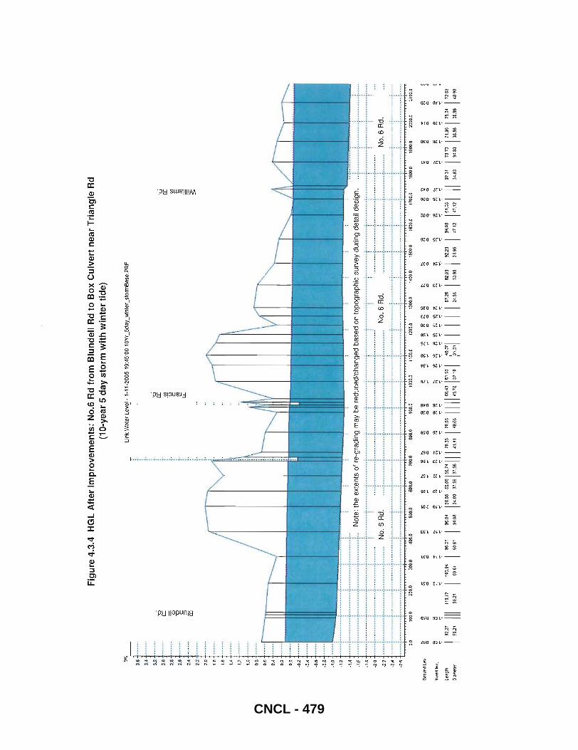
1m] ~
3.6
3.' ~I
-ci a:
2.~
----
-.
ro "0
2.
6 --
----
c ::l
2.4
•••
_--
1i5
2.2
2.0
1.8 1.. I.
'
1.2
1.0
O.S
0.6
0.4
0.2
0.0
-0.2
-0
.4
-0.6
Fig
ure
4.3
.4
HG
L A
fte
r Im
pro
vem
en
ts:
No.
6 R
d fr
om
Blu
nd
ell
Rd
to B
ox
Cu
lve
rt n
ear
Tri
ang
le R
d (1
0-ye
ar 5
da
y st
orm
wit
h w
inte
r ti
de)
!"
l'
Wnk
Wa
ler
LeV:!
-1
-11
-200
5 1
9:4
5:0
0 1
OY
r _5d
ay _ w
inle
r _ sl
onn
Bas
e. P
RF
-ci a:
(j)
-0
c ~
LL
-ci a:
(j) E
~
~
Not
e: t
he e
xten
ts o
f re
-gra
ding
may
be
redu
ced
/ch
an
ge
d b
ase
d o
n to
po
gra
ph
ic s
urv
ey
du
rin
g d
eta
il de
sign
_ •
__
__
• _
__
_ ~
__
• _
__
__
_
• 4
_.
__
••
••
__
..;
.. _
__
_ •
• _
__
• ~ •• _
_
_ _
_ _
_ _
_ _
__
_ ••••• .;
. _
__
• _
_ •••
• :.
. _
_ •
• _
__
_
._
_ _
. _
__
_ •
__
.; _
_ •
_
__
_ •••• ;. _
__
__
__
__
_ :.
. _
__
_
• _
__
__
~ _
__
__
• _
••• .
;.
__
__
__
_ •
_.
;.. _
__
•
_ •• _
__
; _
__
__
__
_
••
• I I.
" "..
...
I I
" •
• ,.
..
I •
I
. _. --
." --
-~-------'
'. ---
r----
---_ .
. ---
---_.
--,,_
.....
-_. --
r---
----
_ .. -
-_ ....
---i
· _. _
....
----
. -
....
... -
-..:-
----
----
. -;.
----
----
--; .
. _ ..
.. -_
.
____
____
__ ~--
----
-N
o_ 6
Rd
_ _ __
_ ~--
----
----
-----
-----
-i----
-----
--~--
--------
_______
__ '
, ,
, .
..
. ,
. .
. .,
------
-_. -
~ --
-----
--.
~ ..
-----
--_ ...
.... _-
_ ...
--~. --
-----
--. --
-. ---
-_ .. _-
-----
--..
....
....
....
....
....
....
... .
,
, ,
. .
. ,
, "
" ,
. .,
" ...
......
....
_---_
.... -
......
... _
......
.....
......
......
......
.. _ ..
......
.. _p-
------
------
----
0.0
100.
0 20
0.0
300.
0 "'
00.0
SO
O.O
600.
0 70
0.0
800.
0 90
0.0
1000
.0
1100
.0
1200
.0
1300
.0
1400
.0
1500
.0
t800
.0
1700
.0
1800
.0
1900
.0
2000
.0
2100
.0
Gro
und
lev
. ~
Ui ~
~
a ~
~
~
$ ~
~
~ ~
to
~ $
~ ~ ~ ~ ~
"": ~
~
~
~ ~
~
~ ~
~
o 0
0 0
N
....
0 0
00
0
00
0 0
0 9
90
ceo
0
Inve
rt le
v.
$ ~
~
~ ~
~ ~
~
~ ~
~
~ ~
COf
~ ~
~ ~ ~ ~ ~
~
~
~
~
~ ~
~ ~
f:l ~
";"
";"
";"
";"
";"
";"
";"
"7"
"":"
":'
";
"":'"
";"
":'
"";"
";'
";
":'
";'
'";
Leng
th
92.21
III
'110.
71
103.
94
9&.31
9&
.04
158.
5515
8.86
156.
1'1
11
16.85
11~
85
1111
1 86
.• 3
161.53
1 46
.371 I I
I I 61
.26
82.8
0 92
.20
94.08
16
1.08 I I
I 92.31
I 78.
13
171
.9&
11 8.
04
172
.83
D!am
ele
r 50
.21
51).2
1 50
.61
50.6
1 34
.08
34.0
8 31
.506
37.5
6 41
.41
49.6
5 4S
.78
37.1
0 :3
1.3
1 24
.55
33.9
5 33
.95
47.1
2 47
.12
34.8
3 :K
83
38,9
8 38
.98
48.9
0
CNCL - 479
AECOM City of Richmond
4.3.5 Westminster Highway West of No.7 Road (D5)
FINAL REPORT East Richmond Agricultural Water Supply Update 2013
Figure 4.3.5 shows the existing ditch profile along the North side of Westminster Hwy from No 6 Rd to No 7 Rd. The model shows flooding in the low lying areas East of No.6 Rd. Two homeowners in this area have reported drainage problems during the open house (please refer to Appendix A for property locations and issues).
To reduce flooding in this area the following improvements are recommended:
• Re-grade the existing ditch for 1400m • Upgrade all existing culverts (ranging from 600 to 900mm) to a minimum 900mm diameter (total length of
153m of pipe) • Install a new 16m long 900mm diameter cross culvert connecting the North side ditch with the existing
900mm storm sewer in street.
Once these improvements were incorporated into the model the peak HGL was lowered by 0.6m. Figure 4.3.6 shows the maximum HGL after the system improvements were incorporated.
4.3.6 Cambie Road East and West of No 7(D6)
Under existing conditions, there is significant flooding along the Cambie Rd ditch. When the roughness coefficient is reduced in the model to simulate ditch cleaning the flooding in this area is greatly reduced. Cleaning works are recommended for following ditches:
• Cambie Road from the box culvert east of No 6 Road to No 8 Road for a length of 3200m • No 7 Road from Cambie Road to No 7 Road North Pump Station for a length of 1965m • No 8 Road from Cambie Road to No 8 Road North Pump Station for a length of 1461 m
Once these maintenance works were incorporated into the model the HGL was lowered by 0.6m to 0.9m five days after the 10-Year 5 day storm event as shown in Figure 4.6. There is still flooding predicted during the peak of the storm due to localized low elevations in the vicinity of Cambie Rd and No 7 Rd.
4.3.7 Burrows Road (D7)
The existing storm sewer along Burrows Rd East of No.6 Rd shows flooding during a 10-Year 5 day event. The HGL in this section can be reduced by implementing the following upgrade:
• Installing a 15m long 600mm cross culvert connecting the storm manhole located East of Victory Street with existing ditch on South side of Burrows Street
4.3.8 CN Rail corridor between No 7 Rd and No 8 Rd (D8)
In addition to the above drainage upgrades, the City's operations staff has indicated the need for ditch cleaning and re-profiling along CN Rail corridor between No 7 Rd and No 8 Rd. Since this ditch is located in CN ROW, the City will need permission from the railway for access.
4.3.9 South Side of River Rd from the CN box (Cambie Rd alignment) east to Queens PS (D9)
The City's operations staff has also indicated the need for ditch cleaning and re-profiling for south side of River Rd from the CN box (Cambie Rd alignment) east to Queens PS.
Final Final Report_April 2014.Docx 39
CNCL - 480
AECOM City of Richmond
4.3.10 Sidaway-East from Francis to Blundell (010)
FINAL REPORT East Richmond Agricultural Water Supply Update 2013
The 2006 study recommended construction of 600m of ditch along Sidaway-East to connect the Blundell and Francis ditch systems. This is a low priority project that should be completed after the proposed downstream ditch upgrades along Sidaway are completed (downstream of Francis Alignment -see section 4.3.1 above)
4.3.11 Storm sewers on No 6 Rd between Granville Rd to Blundell Rd (011)
This project was also recommended as a part of 2006 study. This is a low priority project that should be completed after the proposed downstream ditch upgrades along No 6 Rd are completed (downstream of Blundell Alignmentsee section 4.3.2 above)
4.3.12 Areas with Localized Low Ground Elevations in Model (012)
Figures 4.4 and 4.5 show the model results for peak HGLs with all of the improvements incorporated with no tide or high tide, respectively. Figure 4.6 shows the model results with improvements after the 10-Year 5 day storm event. Minor flooding is shown to occur at a few locations and is attributed due to localized low ground elevations. These elevations should be verified in the field. To prevent local flooding it may be necessary to build soil berms at these locations.
Further recommendations and improvements that are low priority and require additional investigation prior to inclusion in the current Capital Plan include the following items:
• Review the pump station and flood box capacity at No 7 Rd South as well as Nelson Rd as it may be impacting the water level elevations in upstream ditches
• Install a manually operated flap gate at Nelson-east and Westminster Hwy (as identified in the 2006 Study) • Box culvert flushing and cleaning for No 6 Rd north drainage corridor and further investigation of the jet fuel
pipeline elevations
Final Final Report_ApriI2014.Docx 40 CNCL - 481
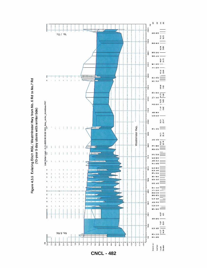
(m)
3.2~
~
3.0
2.S
J '
26
••••
• a:
'" 2
4
---
--a z
22
••
•••
2G
-----
i---
-----~
--. -_
.
-----~
---_ ..
1.
8
L6
-----
"_ ..
_--
1.4
1.2
1.0
0.8~
"
0.6
GA
.... •
•
0.2
0.0
·0.2
-0.4
·0.6
·0.8
-··
····
····
···
····
····
····
····
····
····
····
····
·
-1.0
....
--••
•• -
••••
•••
•• -
-••
••• -
•• -
.----
•• -
••• -
•• ---
--
-1.2
....
---_o~_"
. --
-----
---;
---_
... --
----;.
-' -.
--. --
---.1
.4 ..
.. --
•• -
. -.
----
--.
_ •••
0_.
___
po
.
_ •••• ~ •• _
__
__
__
__
_
-·1.6
.... ·-
-···
···
··-·
-···
···-
-···
·---
---·
.. ••
••••
••••
••
Gro
und
Lev.
klve
rtle
v.
0.0 ~ ~
$ ~
q q
'" ci "i
q
100.
0
~ '" .. q
200.
0 30
0.0
Fig
ure
4.3
.5
Exi
stin
g D
itch
HG
L:
We
stm
inst
er
Hw
y fr
om
NO
.6 R
d to
No.
7 R
d (1
Q-y
ear
5 d
ay
sto
rm w
ith
win
ter
tide
)
400.
0
Link
:!'a
ter L~
el.
2;;
":.2
00
5 00
:20:
00 10~5day_
winte
r_stonnBase
.PRF
-.:..
-" PO
:'
··----
-----
--l··-
-··---
----
....
....
. W
est
min
ste
r H
wy.
---
---_ .
....
. '._-
----
----
---
__
__
__
__
•
--
__
__
__
_
-_
__
-
--
-0
-_
__ •• _
_ •• _
__
__
__
__
__
__
_ •
_ •
__
__
__
__
_ •
_ ~ _
__
__
__
__
__
__ ~ _
__
_ 0
_
__
_
• _
_
SOG
,I)
60
0,0
, .,.
. .,.
, "
. .
'"
--
_o
w. _
_
--
_ ..... _
•••••• _
__
•
-_
__
__
_ •
• _
_ •• -
• _
_ •••••• _
••
••
__
__
__
__
-
_ ..... _
••• _
••• _
•••• ~ _
__
_ •
•• _
••• _
700.
0 80
0.0
~ a
!:;
PI ~
q q
~ ~ " q
900.
0
l<; g
1000
.0
1100
.0
1200
.0 ::; ., '"
~ '" ., '"
1300
.0
1400
.0
& ~
N
..
'"'7
C"i
C?
q L~ngth
Dia
met
er
III~::
II 7
1.97
22.9
1
83.S
7
0.9
1 111
111111
111111
11111I
1I1111
I1I1I1
1111I1
111111
1:~:
1 9
4.71
22.1
8 III
93.7
4
20.4
7 I I
71.4
0
19.6
2
SO.5
5 1".7
5 I
19.6
2 19
.86
100.
50
19.8
6
1111
11 67
.12
25.6
0
1$00
.0
t!'1 ~
160/
).0
~ ~
~ ~
C? q
I I 69
.67 I I
24
.73
82.:1
-6
39.
90
TI
a:
......
.. .
r--- ci
' Z
.J .. :
------
-
-----
------
------
----
---_ .
.. _._
--.. -_
._---
....
. _-_.
__ ..
:._---
-----
-_. __
.. _-
..... _--
--
. __ .
. __ .
....
....
.. _ .
.
1700
.0
18()O
.O
1m}
~ ~
~ ., '"
q q
II 70
.13
II I
38.3
5
{m}
{m}
1m}
{m}
CNCL - 482
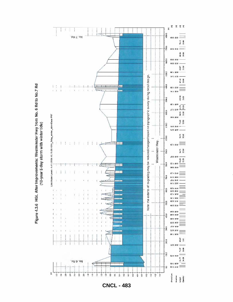
1m]
Fig
ure
4.3
.6
HG
L A
fter
Im
pro
vem
ents
: W
estm
inst
er
Hw
y fr
om
No
.6 R
d to
No.
7 R
d (1
0-ye
ar 5
day
sto
rm w
ith
win
ter
tid
e)
Link
'!'!a
ter Le~1 -
1-.:!
.!.-2
005
1B:1
5:00
10Y~5daLl
Vinter_s
tormBase.PRF
3.2
•••• : •
••••••
• o
.
.. : .
.: ..
3.0 2.8 :l·
-c::i a:
CD
2.2
•••••.
0 Z
2.D
............
1.8
1 .•
. -;"
.; ..
1.4
1.2
1.D
D.8
D .• D.4
D.2
D.D
·D2
-0.-4
-D,S
:il· •• • •••.•
••••••••••• • •••••
•••• 1 •••• •
•••••••
No
te:
the
ext
en
ts o
f re
:gra
din
g m
ay
be
re
du
ced
/ch
an
ge
d b
ase
d o
n to
po
gra
ph
ic s
urv
ey
du
rin
g d
eta
il d
esi
gn
.
· .
. --
----
----
--,,
----
-"._
----
,---
----
----
--,-
----
----
---
We
stm
inst
er
Hw
y.
· .
----
----
----
----
----
---
-------------
-------------.-
-------------,-
------------
· .
· .
· .
· .
----
---
---
----
----
---
----
----
----
---
----
----
----
-,.-
----
----
----
,---
----
----
--·
. ·
. .
----
----
----
,---
----
----
--,-
----
----
----
,---
----
----
' ·
. .
· .
. ·
. i
· .
. D.D
10
0.0
200.
0 30
0.0
400,
0 SO
D.O
600.
0 1DD
.D
8D ...
900.
0 fC
OO.O
1
100
.0
1200
.0
1300
.0
1400
.D
1500
.0
160
0.0
Gro
und
Lev.
~ ~
~ ~
~~~~~~~
$ fl{
~ ~ ~ ~
~ ~
~ §
* ~
~ ~
~ ~
~ >1
i'l 1\
~
~
~
m Ii:
ci
ci
Inve
rt l
ev.
~
ill :g
:g
~~~~~~:£
-~~~~~~~~~~ ~~
~ :g
~ ~
~ ~
~ ~~
~~
~~
r:j
9 9
q q
C?
'?
9 '?
q
'7'
9 Le
ngth
11
1151.
11 11
1,.97
I 8
3.87
1111
11
1111
1111
1111
11
1111
1111
1111
1111
11
1111
11
11 :::
'1
94.7
1
III 93
.74
I 71.4D
15
•. 55
141
751
100.
50
1111
11
81.12
I I .'.
81 I
I 82
,.
Oiamet
~r
34.3
6 33
.00
0.91
33
.00
3:3.
00
33.0
0 33
.00
33.0
0 33
.00
33,0
0 33
.00
33.0
0
t-----
---
1700
.0
~
-c::i a:
t" o Z
1800
.0
~ ~
~
II :~::~
III
1m] 1m
]
1m]
1m]
1m]
CNCL - 483
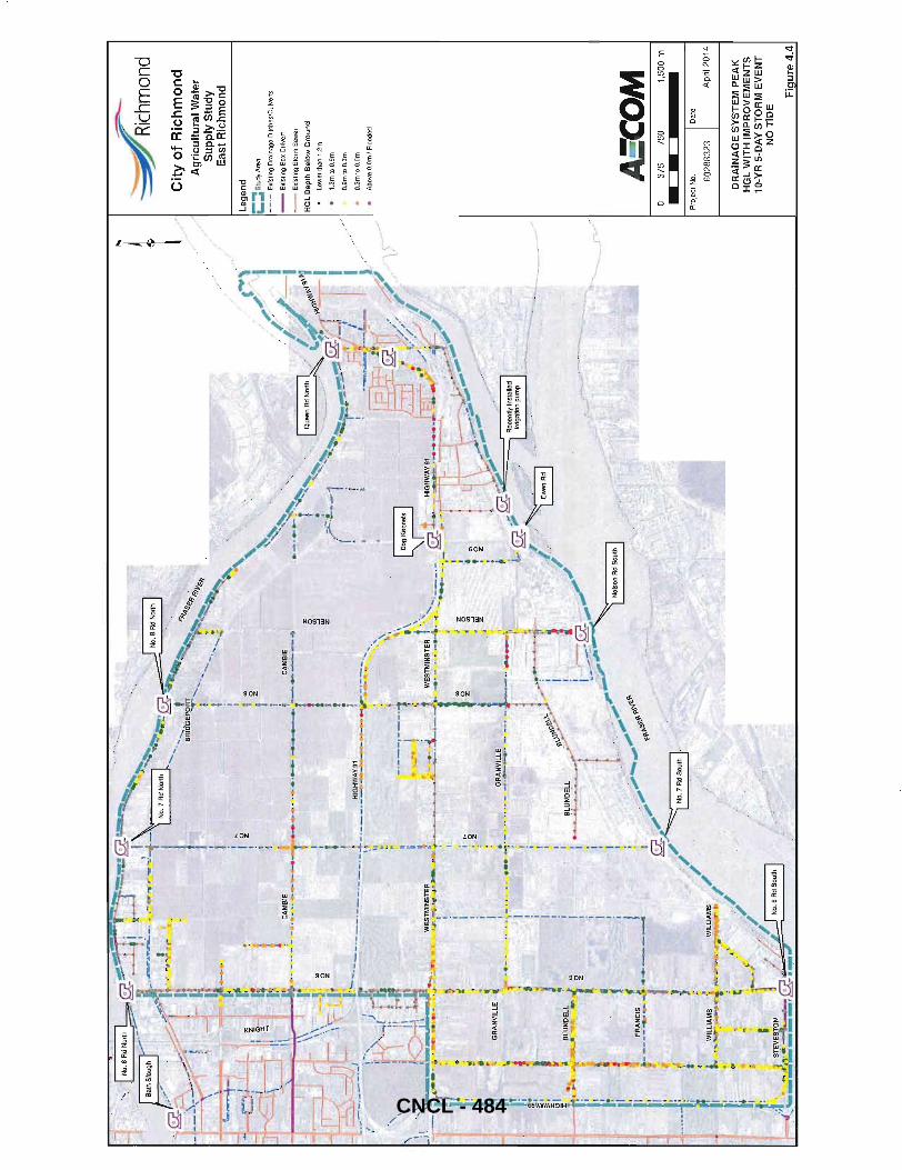
.~
. ~
GR
AN
VIL
!-E ~ ~ .'X
•
• -
.
~ • ~,
z
i , , I , ';r "
i I !"
I I
'"
..... '.
".
:0'
. z
, :~
• ,z
1
~.
1 i
~. " ."
, i
,"~~J~
~!~.;
._ ............. -......
----r--~--
... '
r·t--
-0
' ~
' .. ~
'",.
! •
, .. -;
._.
I , !.
I -:
:.:.
I i ,
.. _ .1~~~
_,
z ffi'
z' z ~ .z
.. o z
• . ;
;;:·
'1
;(
._
.. -
I
/ ,~\
. "'I
I
"" L
./" / ,
/
/
~
;--~
hmond
Cit
y o
f R
ich
mo
nd
A
gri
cult
ura
l Wat
er
Su
pp
ly S
tud
y E
ast
Ric
hm
on
d
Le
ge
nd
;:::
:::
Stu
dy A
rea
-_
.-E
xist
ing
Dra
inag
e D
itche
s/C
ulve
rts
--
EX
istin
g B
ox C
ulve
rt
--
Exi
stin
g S
torm
Se
we
r
HG
L D
ep
th B
elo
w G
rou
nd
low
er
than
1.2
m
1.2
mto
O.9
m
O.9
mto
O.3
m
O.3
mto
O. O
m
Abo
ve D
,Dm
f F
tood
ed
A:C
OM
37
5 75
0
Pro
ject
No.
6028
8323
1,50
0 m
Dat
e
Apr
il 20
14
DR
AIN
AG
E S
YS
TE
M P
EA
K
HG
L W
ITH
IM
PR
OV
EM
EN
TS
10
-YR
5-D
AY
ST
OR
M E
VE
NT
N
O T
IDE
Fia
ure
4.4
CNCL - 484
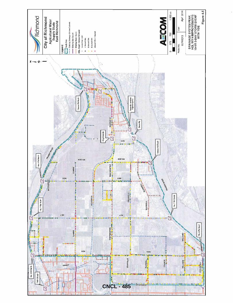
\
/
I I . .
. t,li .....
_. i
• I II
\WE
ST
MIN
ST
ER
'''-.c
., . ~
.: J.
.A1~
~~
.....u_>-
-..~
I
'GRANVI
L~~;;t . r··
-· f
.,
~~.'
"'~"
~-,,,
~.,
~
I/.~
~ / ////
/
/ ;'
-=--
-'::~
hmOn
d C
ity
of
Ric
hm
on
d
Ag
ricu
ltu
ral W
ater
S
up
ply
Stu
dy
Eas
t R
ich
mo
nd
Le
ge
nd
;:::: S
tud
y A
rea
-_
.-E
xist
ing
Dra
inag
e D
itch
es/
Cu
lve
rts
--
Exi
stin
g B
ox C
ulv
ert
--
Exi
stin
g S
torm
Se
we
r
HG
L D
epth
Bel
ow
Gro
un
d
Lo
we
r th
an 1
.2m
1.2
m 1
0 O
.9m
O.9
m t
o O
.3m
O.3
m t
o O
.Om
Ab
ove
O.O
m /
Flo
od
ed
AS'C
OM
37
5 75
0 1,
500
m
Pro
ject
No
. D
ate
6028
8323
A
pril
20
14
DR
AIN
AG
E S
YS
TE
M P
EA
K
HG
L W
ITH
IM
PR
OV
EM
EN
TS
10
-YR
5-D
AY
ST
OR
M E
VE
NT
W
ITH
TID
E F
igu
re 4
.5
CNCL - 485
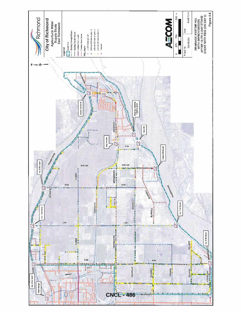
" , -, 1·
, ~ ;
CA
MB
IE
• ,=
-'.-:
._1_
"':"
_'.
' '. t
'. '<
",if'
~
,~,'
, ~ r~
\~
i >
I
_ ;
~~~M-~
' _ ..
.. ·--:·· ..
-·,!..:.
.~..
---
-r-
·-----
.. ! i I j i ~
.--=-~ ........
1 _~
.~\. \
-~/
z ~. .!Z'"
/
I ~
mond
1 / C
ity
of
Ric
hm
on
d
,/
Ag
ricu
ltu
ral W
ater
S
up
ply
Stu
dy
Eas
t R
ich
mo
nd
Leg
end
;:::: S
tudy
Are
a
-_
.-E
xist
ing
Dra
inag
e D
itche
s
--
Exi
stin
g C
ircul
ar C
ulve
rt
--
EX
istin
g B
ox C
ulve
rt
--
Exi
stin
g S
torm
Sew
er
HG
L D
epth
>O.9
m b
elow
gro
und
O.9
m t
o O
.Sm
be
low
gro
un
d
a.8
m t
o O
.3m
be
low
gro
un
d
O.3
m t
o D
.Om
be
low
gro
un
d
Floo
ded A:C
OM
o
375
750
1,50
0 m
Pro
ject
No.
D
ate
6028
8323
A
pril
20
14
DR
AIN
AG
E S
YS
TE
M H
GL
W
ITH
IM
PR
OV
EM
EN
TS
A
FT
ER
10
-YR
5-D
AY
ST
OR
M
EV
EN
T W
ITH
TID
E (
ON
DA
Y 5
)
Fig
ure
4.6
CNCL - 486
AECOM City of Richmond
4.3.13 Cost Estimates for High Priority Drainage Improvements
FINAL REPORT East Richmond Agricultural Water Supply Update 2013
Cost estimates for the high priority drainage improvements discussed above are provided in Table 4.2. All estimates are in 2013 CAD dollars. Cost estimate for low priority projects in not included in the above table.
All culvert upgrade project costs include an allowance for driveway restoration, headwalls and bypass pumping. Utility conflicts have not been investigated in this study. For ditch cleaning and re-grading projects, it is assume that the existing ditch cross sections will be reinstated. An allowance for engineering design and construction contingency of 25% is also added for each project area.
Final Final Report_April2014.Docx 46 CNCL - 487
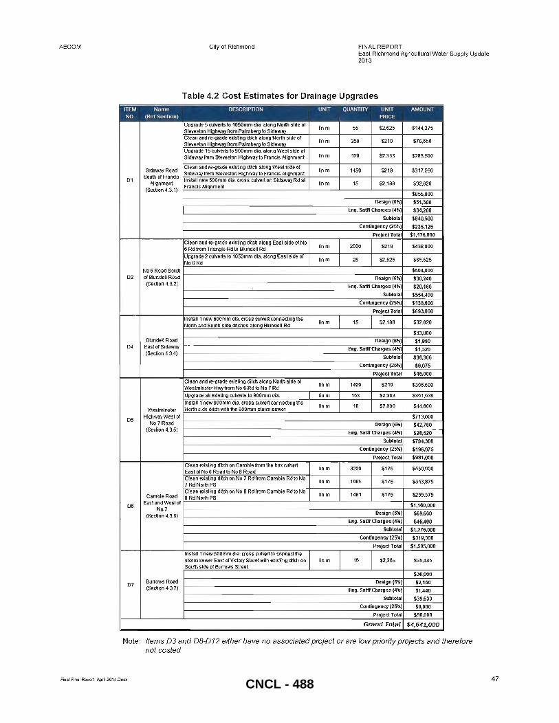
AECOM
D1
D2
D4
D5
D5
D7
Al ignment (Section 4.3.1)
Westminster
City of Richmond FINAL REPORT East Richmond Agricu~ural Water Supply Update 2013
Table 4.2 Cost Estimates for Drainage Upgrades
HighwayWeslof '------------------------------:,---,:--=+--'~====--_I No 7 Road .-(Section 4.3.5)
Burrows Road (Section 4.3.7)
Note: Items 03 and 08-012 either have no associated project or are low priority projects and therefore not casted
Final Final Report_April 2014.Docx 47 CNCL - 488

AECOM City of Richmond
4.4 Irrigation Improvement Options
FINAL REPORT East Richmond Agricultural Water Supply Update 2013
Irrigation options were analysed keeping in mind that irrigation deficiencies are of a biggest concern in the study areas south west portion. Although no major irrigation concern was reported in the area north of Hwy 91, the proposed ditch cleaning along No 7 Rd, No 8 Rd and Cambie will improve irrigation water flows in this area. The south-east portion of study area (south of Westminster Hwy and east of No 7 Rd) may warrant more detailed analysis in subsequent studies.
Two options were reviewed for the recommended irrigation system upgrades: Option 1 - Irrigation Upgrades for water supply from the Fraser River's North Arm and Option 2 - New Irrigation Pump Station near No 6 Rd South PS for water supply from the Fraser River's Main Arm. Details for these Options are summarized below.
4.4.1 Option 1 - Irrigation Upgrades for Supply from North Arm (I-I)
Option 1 includes a combination of items to facilitate the transfer of irrigation water from the North Arm of the Fraser River to the Southwest portion of the study area that do not have sufficient water supply during irrigation periods. The upgrades proposed are such that only surplus water from the area north of Westminister Hwy can be transferred south. The differential controls on the proposed automatic gate on No 7 Rd north of Westminister Hwy should be set in such a way that this gate only opens when the water level on north side exceeds the target level. This will make sure that the irrigation water supply for the north side is not affected by the proposed upgrades. It is assumed that all the proposed drainage upgrades North of Granville Ave are complete prior to implementing this option. Option 1 upgrades are divided into 3 phases. The following list of items are included in each phase of Option 1 and shown in Figure 4.7. The control settings for automatic gates as shown in Figure 4.7 are preliminary elevations and can be easily adjusted based on field conditions and water demands.
Phase -1A • Adjust settings at No 7 North irrigation intake and drainage pump station as shown in Figure 4.7.1 and
described below: o Increase target water level elevation from 0.217m to 0.575m (to match existing No 8 Rd North PS target
level) o Modify irrigation gate settings such that it closes at elevation of 0.75m (gate open elevation to remain as
isatO.14m) o Set irrigation gate to only open if tide level is higher than wetweillditch water level o Apply a 20 minute delay before irrigation gate reopens to reduce frequency of unintended opening and
closing due to fluctuating water levels o Modify drainage pump start level and gravity outlet elevation to 0.8m
• Adjust settings at No 8 North drainage pump stations as shown in Figure 4.7.2 and described below: o Target water level elevation remains at 0.575m o Modify irrigation pump ON elevation to 0.575m if tide level is lower than wetweil/ditch elevation o Modify irrigation pump OFF elevation to 0.8m o Set the gravity gate to open only if the tide level is greater the wetweil/ditch water level o Set the gravity intake irrigation gate to close at 0.8m or above o Apply a 20 minute delay before irrigation gate reopens to reduce frequency of unintended opening and
closing due to fluctuating water levels • Install two new seasonal flap gates
o East of No 7 Rd on Westminster Hwy o East of No 7 Rd on Granville Ave Alignment
• Install two new gates with automated controls o No 7 Rd south of Granville Ave o No 6 Rd south of Granville Ave
• Add controls to existing gate on No 7 Rd (North of Westminster) to provide differential upstream/downstream elevations such that area south of Westminster Hwy does not flood.
Final Final Report_April 2014.Docx 48
CNCL - 489
AECOM City of Richmond FINAL REPORT East Richmond Agricultural Water Supply Update 2013
When the water level in No 7 Rd ditch north of Westminster Hwy exceeds the target water level, the automatic gate north of Westminster Hwy (Gate-1 in Figure 4.7) opens to facilitate supply of surplus water to the south side. Gate-2 and Gate-3 will stay closed in summer to prevent flow towards east side. Automatic gates (4&5) will detain water in the ditches and prevent water from flowing south to the pump stations. These gates will stay closed until the water level in ditches rise to 0.75 (in case of a summer storm). Once the high level is reached they will automatically open to prevent flooding in upstream area. High level open setting is selected such that it is close to maximum level that can be achieved when No 7 Rd North gravity inlet is open. This will make sure there is no water flow to pump stations during dry irrigation period.
Phase -18 Phase-1 B should be initiated only after the successful completion of phase-1 A. Following is the list of items included in this phase:
• Install three new gates with automated controls o Palm berg Road upstream of box culvert (Gate-6) o No 6 Rd and Triangle Road upstream of box culvert (Gate-7) o Steveston Hwy upstream of box culvert (Gate-8)
In phase-1 B, the settings of Gate-5 can be adjusted such that it opens when the water level in Granville ditch exceeds its target level. Gates-6, 7 & 8 will detain water in the No 6 Rd and No 7 Rd ditches and prevent water from flowing south to the pump stations. Preliminary control settings are shown in Figure 4.7 based on ground profile.
Phase -1C This final phase will require construction of new ditch along Granville alignment between No 6 Rd and Sidaway. Prior to initiating this phase, we recommend that the City should look at the available right of way along this alignment. Following is the list of items included in this phase:
• Construct a new ditch along the Granville Alignment connecting No 6 Rd with Sidaway Rd (assuming 1 m base width with 1.5H:1 V side slopes and average depth of 1.5).
• Re-grade the existing ditch on the East side of Sidaway Rd for 1400m from North of Blundell Rd to Westminster Hwy
• Install a new gate (Gate-g) with automated control on Sidaway south of the proposed ditch.
Final Final Report_ApriI2014.Docx 49
CNCL - 490

~ ./
/ .'
-=--
-"::-~
hmOn
d C
ity
of
Ric
hm
on
d
Ag
ricu
ltu
ral W
ater
S
up
ply
Stu
dy
Eas
t R
ich
mo
nd
Leg
end
i: Ex
isli
ng
Ga
les
i' Pr
op
ose
d G
ate
s
~ P
um
p S
tatio
ns
--
Pro
pose
d N
ew D
itch
--
Pro
pose
d D
itch
Up
gra
de
;:::: S
tudy
Are
a
C::
Ph
ase
A -
Se
rvic
ed
Are
a
-..
'-.. P
ha
se B
-S
erv
ice
d A
rea
-..
'-.. Ph
ase
C -
Ser
vice
d A
rea
--
.-E
xist
ing
Dra
inag
e D
ilch
es/
Cu
lve
ns
--
Exi
stin
g B
OK
Cu
lve
rt
--
Exi
stin
g S
torm
Se
we
r
AS'C
OM
o
375
750
1,50
0 m
Pro
ject
No.
D
ate
6028
8323
A
pril
2014
OP
TIO
N 1
-IR
RIG
AT
ION
U
PG
RA
DE
S F
OR
SU
PP
LY
FR
OM
NO
RT
H A
RM
Fig
ure
CNCL - 491
No
.7 R
OA
D N
OR
TH
SC
HE
MA
TIC
FO
R I
RR
IGA
TIO
N S
ET
TIN
GS
N
OT
TO
SC
AL
E
FR
AS
ER
RIV
ER
HIG
H T
IDE
1.
63
2m
-----'1
'0''------7
'
PR
OP
OS
ED
G
RA
VIT
Y-l
NL
ET
O
PE
N (
D.1
4m-D
.75
m)
EX
IST
ING
G
RA
VIT
Y-l
NLE
T
RIV
ER
RO
AD
PR
OP
OS
ED
DR
AIN
AG
E P
UM
P
ST
AR
T A
ND
GR
AV
ITY
OU
T
O.8
00m
PR
OP
OS
ED
TA
RG
ET
LE
VE
L 1'"
O:"5
75m-
----
--
/ E
XIS
TIN
G D
RA
INA
GE
PU
MP
1200
mm
0
IRR
IGA
TIO
N I
NT
AK
E
~OPEN(D
.14m_D
.37+m)
D.7
5m
O.3
7m
I S
TA
RT
AN
D G
RA
VIT
Y O
UT
~~
/O.400
m _
__
_ ~ _
__
__
-./1
/ ~.~
~jmOFF
LEV
EL
EX
IST
ING
TA
RG
ET
LE
VE
L IN
V.
= D
.DBB
D.
14m
D
.14
m
-----------
--
----
--
-o.2
1iI
Ti-
------
LOW
TID
E --
-=--b-
TW
IN 1
6DD
mm
-D.6
7m
DR
AIN
AG
E P
IPE
S
-----
--
-FL
AP
GA
TE
--------
-N
OB
AC
KF
LO
W
EX
IST
ING
DR
AIN
AG
E G
AT
E
OP
EN
AB
OV
E D
.4m
4.8,
01 l'
J'J10
E.) Y
-. 3.~
01 ll-
lIGI-
I) e
OY-.
FLO
OR
EL.
= -
2.9B
3 L
-_
__
__
__
__
__
__
__
__
__
__
__
__
__
__
_ ~ _
_ ~ _
__
NO
TE
S:
1.
ALL
ELE
VA
TIO
NS
AR
E G
EO
DE
TIC
EX
IST
ING
SE
TT
ING
S:
1.
TA
RG
ET
LE
VE
LIS
O.2
17
m
WE
T-W
EL
L
SE
CT
ION
2.
LOW
TID
E A
ND
HIG
H T
IDE
BA
SE
D O
N D
ES
IGN
TID
E U
SE
D I
N
2.
IRR
IGA
TIO
N I
NT
AK
E O
PE
NS
AT
0.1
4m A
ND
CLO
SE
S A
T
MO
DE
L 0.
37m
3.
AB
OV
E S
KE
TC
H I
S S
CH
EM
AT
IC T
O S
HO
W E
LEV
AT
ION
S
3.
EX
IST
ING
DR
AIN
AG
E P
UM
PS
ST
AR
T A
ND
GR
AV
ITY
-OU
T
ON
LY
FA
LLS
OP
EN
AT
O.4
m O
R A
BO
VE
(TO
PR
EV
EN
T F
LOO
DIN
G
DU
RIN
G S
UM
ME
R S
TO
RM
S)
PR
OP
OS
ED
SE
TT
ING
S:
1.
TH
E P
RO
PO
SE
D T
AR
GE
T L
EV
EL
AT
No
.7 R
OA
D I
S 0
.575
m
WH
ICH
IS
TH
E S
AM
E A
S T
HE
EX
IST
ING
No.
B T
AR
GE
T L
EV
EL
2.
IRR
IGA
TIO
N G
AT
E O
PE
NS
AT
0.1
4m (
NO
CH
AN
GE
) A
ND
G
AT
E C
LOS
ES
AT
0.7
5m G
EO
DE
TIC
3.
IRR
IGA
TIO
N G
AT
E O
PE
NS
ON
LY I
F T
IDE
IS
HIG
HE
R T
HA
N
WE
T-W
ELL
/DIT
CH
LE
VE
L
4.
PR
OP
OS
ED
DR
AIN
AG
E P
UM
PS
ST
AR
T A
ND
GR
AV
ITY
OU
T
FA
LLS
OP
EN
AT
0.8
m O
R A
BO
VE
~hm
ond
Cit
y o
f R
ich
mo
nd
Ag
ricu
ltu
ral
Wat
er
Su
pp
ly S
tud
y E
ast
Ric
hm
on
d
AS'C
OM
P
roje
ct N
o.
I Date
6028
8323
A
pril
2014
No
. 7
Rd
. N
ort
h
Sc
he
ma
tic
fo
r P
rop
os
ed
Irr
iga
tio
n
Se
ttin
gs
F
igu
re 4
.7.1
CNCL - 492

No
.8 R
OA
D N
OR
TH
SC
HE
MA
TIC
FO
R I
RR
IGA
TIO
N S
ET
TIN
GS
N
OT
TO
SC
AL
E
~mond
Cit
y o
f R
ich
mo
nd
Su
pp
ly S
tud
y E
ast
Ric
hm
on
d
~
Ag
ricu
ltu
ral
Wat
er
HIG
H T
IDE
1
.63
2m
FR
AS
ER
RIV
ER
E
XIS
TIN
G G
AT
E C
LO
SE
D
IRR
IG.
PU
MP
OF
F I
F ------~
EL
EV
AT
ION
AB
OV
E 1
.07
5m
P
RO
PO
SE
D I
RR
IGA
TIO
N P
UM
P -
OF
F
a.8
00m
~1.075m
EX
IST
ING
DR
AIN
AG
E P
UM
P -
ON
1
.10
9m
EX
IST
ING
DR
AIN
AG
E P
UM
P -
OF
F
a.8
52
m
PR
OP
OS
ED
IR
RIG
AT
ION
PU
MP
-O
N
O.57
5m
\ E
XIS
TIN
G G
RA
VI1
Y I
NT
AK
E
OP
EN
IF
TID
E IS
HIG
HE
R ------
--IJ
TH
AN
EL
EV
AT
ION
IN
WE
T-W
EL
L
EX
IST
ING
TA
RG
ET
LE
VE
L -
-O
.57s
m-------
(O.3
25m
-1.
075m
) E
XIS
TIN
G I
RR
IGA
TIO
N P
UM
P -
ON
--
--+
-L a
.32
5m
a.
325m
LO
WT
IDE
-O
.B7m
b 12
00m
m 0
IR
RIG
AT
ION
IN
TA
KE
,--
INV
. =
-2.
5
NO
TE
S:
1.
ALL
ELE
VA
TIO
NS
AR
E G
EO
DE
TIC
2.
ON
LY O
NE
IR
RIG
AT
ION
-IN
FLO
W T
AK
ES
PLA
CE
(P
UM
P O
R
GR
AV
ITY
) A
T O
NE
TIM
E
3.
LOW
TID
E A
ND
HIG
H T
IDE
BA
SE
D O
N D
ES
IGN
TID
E U
SE
D I
N
MO
DE
L
4.
AB
OV
E S
KE
TC
H I
S S
CH
EM
AT
IC T
O S
HO
W E
LEV
AT
ION
S O
NLY
nf-, -~---'
IlO1-C
\lI-~C
\'.'
IRR
IGA
TIO
N
PU
MP
ST
AT
ION
C
HA
MB
ER
EX
IST
ING
SE
TT
ING
S:
1.
TA
RG
ET
LE
VE
L IS
0.5
75m
2.
IRR
IGA
TIO
N P
UM
P T
UR
NS
ON
ON
LY I
F L
EV
EL
DR
OP
S B
EL
OW
0.
325m
. O
NC
E I
T T
UR
NS
ON
TH
EN
IT
TU
RN
S O
FF
AT
1.0
75m
3.
PU
MP
/GA
TE
CO
NT
RO
LS A
RE
MA
NU
ALL
Y O
VE
RR
IDD
EN
WIT
H
A T
EM
PO
RA
RY
SE
TT
ING
TO
MA
INT
AIN
A H
IGH
ER
WA
TE
R
LEV
EL
(ST
AR
T 0
.825
, S
TO
P 1
.575
) D
UR
ING
CR
AN
BE
RR
Y
HA
RV
ES
T &
SP
RIN
G F
RO
ST
PR
OT
EC
TIO
N
4.
GR
AV
ITY
IN
TA
KE
GA
TE
OP
EN
S A
T 0
.325
m A
ND
CLO
SE
S A
T
1.07
5m
1200
mm
0
INT
AK
E
,--
FLO
OR
EL
. = -2
.625
No
.8 R
OA
D D
RA
INA
GE
P
UM
P S
TA
TIO
N
WE
T-W
EL
L
PR
OP
OS
ED
SE
TT
ING
S:
1.
NO
CH
AN
GE
IN
TA
RG
ET
LE
VE
L (0
.575
m)
2.
IRR
IGA
TIO
N P
UM
P O
N I
F LE
VE
L D
RO
PS
BE
LOW
0.5
75m
AN
D
TID
E IS
LO
WE
R T
HA
N W
ET
-WE
LL/D
ITC
H L
EV
EL
3.
IRR
IGA
TIO
N P
UM
P O
FF
AT
0.8
m G
EO
DE
TIC
4.
GR
AV
ITY
IR
RIG
AT
ION
GA
TE
OP
EN
S O
NLY
IF
TID
E I
S H
IGH
ER
T
HA
N W
ET
-WE
LL/D
ITC
H L
EV
EL
5.
GR
AV
ITY
IN
TA
KE
IR
RIG
AT
ION
GA
TE
CLO
SE
D A
T 0
.8m
OR
A
BO
VE
AaC
OM
P
roje
ct N
o,
I Dale
6028
8323
A
pril
2014
No
.8 R
d.
No
rth
S
ch
em
ati
c f
or
Pro
po
se
d I
rrig
ati
on
S
ett
ing
s
Fig
ure
4.7
.2
CNCL - 493
AECOM
4.4.2
City of Richmond FINAL REPORT East Richmond Agricultural Water Supply Update 201 3
Option 2 - New Irrigation Pump Station near No 6 Rd South PS (1-2).
Option 2 includes construction of a new irrigation pump station in the south to supply water to the southwest part of the study area as shown in Figures 4.8.
To provide water supply for growth irrigation (assuming an average rate of 5.33mm/day) for a 300hectare area, an irrigation pump station with a capacity of approximately 0.2 m3/s (200Us) is required. One possible option is to build a new pump station at the foot of No 6 Rd . Based on the surrounding existing ground elevations the maximum possible target water level for the pump station and ditches is approximately Om geodetic.
A feasibility study for such a pump station and intake would need to be completed prior to initiating any conceptual design for this Option . The current location is preliminary and depended on available land. An alternative location may be the foot of Wiliams Rd as the Fraser River depth may be deeper in th is area.
For Option 2, it is assumed that the drainage upgrades in the vicinity on Steveston Hwy, Sidaway Rd and No 6 Rd have been implemented. Costs for these items have not been included on the irrigation cost estimates.
As shown in Figure 4.8, the ditch along Sidaway Rd north of Blundell would need to have an invert of -0.6m elevation to facilitate the supply water from the new PS to th is area. Based on the existing ground elevations, an approximately 3m deep ditch would be required, which may not be feasible.
4.4.3 Cost Estimate for Irrigation Options
Cost estimates for irrigation improvement Options 1 and 2 are presented in Table 4.3. As noted in Section 4.3.9, all estimates are in 2013 CAD dollars and an allowance for engineering design and construction contingency of 25% has been added to each Option .
Table 4.3 Cost Estimate for Irrigation Options
ITEM Name DESCRIPTION UNIT QUANTTTY UNIT AMOUNT
NO. (Ref Section) PRICE
I Modify sellings al No 7 North PS and No 8 North PS LS 2 SO SO
Phasel A Install two new seasonal nap gates LS 2 560,000 $120,000
Install two new gates with automated controls LS 2 $175,000 S350,OOO
Re·grade existing ditch on East side of Sidaway Rd Lin m 1400 $219 5306,600
from North of Blundell Rd to Westminster Hwy I Phase1B
Construct a new ditch along the Granville Alignment Option 1 -Irrigation
connecting No 6 Rd with Sidaway Rd Lin m 835 $340 $283,900
)-1 Upgrades for Supply
Install three new gates wtlh automated controls from North Arm Phase1C LS 3 S175,000 $525,000
(Section 4.4.1) $1,586,000
Design (6%) $95,160
Eng. Sam Charges (4%) $63,440
Subtotal $1,744,600
Contingency (25%) $436,150
ProjectT otal $2,181,000
Irrigation Pump Slation LS 1 51,400,000 51,400,000
Intake piping LS 1 $500,000 5500,000
Power supply LS 1 5110,000 5110,000
Option 2 - New Install three new seasonal nap gates LS 3 $60,000 5180,000
i Irrigation Pump Station $2,190,000
1-2 near No 6 Rd South PS Design (6%) $131,400
(Section 4.4.2) Eng, Sam Charges (4%) $87,600
Subtotal $2,409,000
Contingency (25%) $602,250
ProjectT otal $3,012,000
Final Final Report_April 2014.Docx 53 CNCL - 494
, \ .\
:,'; I Ii II '-1 Ii t
Bas
ed o
n m
ax t
arge
t le
vel o
f Om
geo
detic
, di
tch
inve
rt o
f -0.
8m o
r lo
wer
will
be
requ
ired.
it
may
not
be
feas
ible
to
build
3m
dee
p di
tch
in t
his
area
.
/I~
/,iJ
~\_~~
z .. "
'~-
;~
~. I
",-"""
...
'--"
"---
-" ~
. ''
;,
:i.
\ ..
~\\
. -_
\:.\
r .'
\ .. -"\
.. -
i
~:,;
: '"' ..
... ;;,
,:
~l;
,.-,-.,
z o en
--' w
Z
'" o z
1.)
Loca
tion
of p
rop
ose
d i
rrig
atio
n p
um
p s
tatio
n is
ap
pro
xim
ate.
~.
vl'J~
mond
·1
Cit
y o
f R
ich
mo
nd
A
gric
ultu
ral W
ater
S
up
ply
Stu
dy
Eas
t R
ichm
ond
Le
ge
nd
i-E
xist
ing
Ga
les
~
Pro
po
sed
Fla
p-G
ate
s
~ E
xist
ing
Pum
p S
tatio
ns
{~_ P
ropo
sed
Irri
gatio
n P
ump
Sta
tion
'':::1 ;
::::
: Stu
dy
Are
a
<'0.-
....
;/ L.:
: Appr
ox.
SeN
ice
Are
a of
Pum
p S
tatio
n
-_
.-E
xist
ing
Dra
ina
ge
Ditc
he
s
--
Exi
stin
g C
ircu
lar
Cu
lve
rt
--
Exi
stin
g B
ox C
ulv
ert
--
Exi
stin
g S
torm
Se
we
r
A:C
OM
o
250
500
1,00
0 m
2.)
Ditc
h u
pg
rad
es
alon
g S
ida
wa
y an
d N
o.6
Roa
d sh
ould
be
com
ple
ted
pri
or
to c
onst
ruct
ion
of
new
irri
ga
tion
pum
p st
atio
n. S
ee S
ectio
n 4.
3 o
f re
port
fo
r de
tails
. P
roje
ct N
o.
60
28
83
23
Dat
e
Ap
ril 2
01
4
3.)
Tar
get
leve
l in
ditc
he
s ca
n be
con
trol
led
by p
um
p s
tatio
n se
ttin
gs.
4.)
Ba
sed
on
exis
ting
gro
un
d,
ma
x po
ssib
le t
arge
t le
vel
is O
m (
Ge
od
etic
).
OP
TIO
N 2
-P
RO
PO
SE
D
IRR
IGA
TIO
N U
PG
RA
DE
S
FO
R S
UP
PLY
FR
OM
S
OU
TH
AR
M Fig
ure
4.8
CNCL - 495
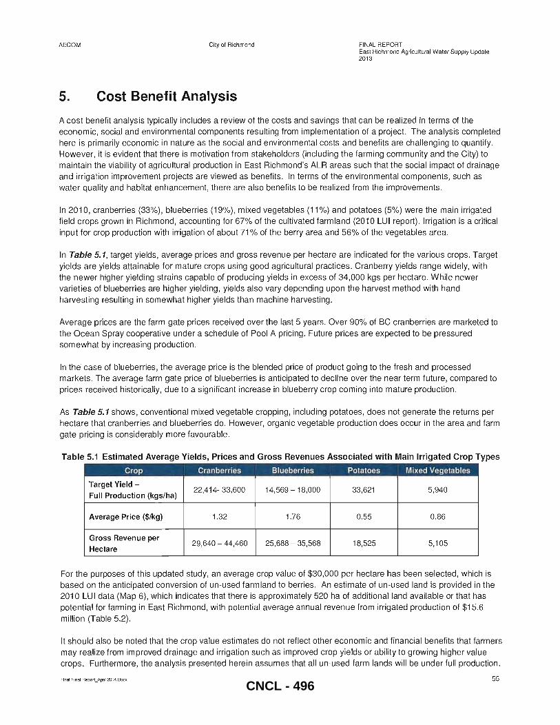
AECOM City of Richmond
5. Cost Benefit Analysis
FINAL REPORT East Richmond Agricultural Water Supply Update 2013
A cost benefit analysis typically includes a review of the costs and savings that can be realized in terms of the economic, social and environmental components resulting from implementation of a project. The analysis completed here is primarily economic in nature as the social and environmental costs and benefits are challenging to quantify. However, it is evident that there is motivation from stakeholders (including the farming community and the City) to maintain the viability of agricultural production in East Richmond's ALR areas such that the social impact of drainage and irrigation improvement projects are viewed as benefits. In terms of the environmental components, such as water quality and habitat enhancement, there are also benefits to be realized from the improvements.
In 2010, cranberries (33%) , blueberries (19%), mixed vegetables (11 %) and potatoes (5%) were the main irrigated field crops grown in Richmond, accounting for 67% of the cultivated farmland (2010 LUI report). Irrigation is a critical input for crop production with irrigation of about 71 % of the berry area and 56% of the vegetables area.
In Table 5.1, target yields, average prices and gross revenue per hectare are indicated for the various crops. Target yields are yields attainable for mature crops using good agricultural practices. Cranberry yields range widely, with the newer higher yielding strains capable of producing yields in excess of 34,000 kgs per hectare. While newer varieties of blueberries are higher yielding, yields also vary depending upon the harvest method with hand harvesting resulting in somewhat higher yields than machine harvesting.
Average prices are the farm gate prices received over the last 5 years. Over 90% of BC cranberries are marketed to the Ocean Spray cooperative under a schedule of Pool A pricing . Future prices are expected to be pressured somewhat by increasing production.
In the· case of blueberries, the average price is the blended price of product going to the fresh and processed markets. The average farm gate price of blueberries is anticipated to decline over the near term future, compared to prices received historically, due to a significant increase in blueberry crop coming into mature production.
As Table 5.1 shows, conventional mixed vegetable cropping, including potatoes, does not generate the returns per hectare that cranberries and blueberries do. However, organic vegetable production does occur in the area and farm gate pricing is considerably more favourable.
Table 5.1 Estimated Average Yields, Prices and Gross Revenues Associated with Main Irrigated Crop Types
Crop Cranberries Blueberries Potatoes Mixed Vegetables
Target Yield -22,414- 33,600 14,569 - 18,000 33,621 5,940
Full Production (kgs/ha)
Average Price ($/kg) 1.32 1.76 0.55 0.86
Gross Revenue per 29,640 - 44,460 25,688 - 35,568 18,525 5,105
Hectare
For the purposes of this updated study, an average crop value of $30,000 per hectare has been selected, which is based on the anticipated conversion of un-used farmland to berries . An estimate of un-used land is provided in the 2010 LUI data (Map 6), which indicates that there is approximately 520 ha of additional land available or that has potential for farming in East Richmond, with potential average annual revenue from irrigated production of $15.6 million (Table 5.2) .
It should also be noted that the crop value estimates do not reflect other economic and financial benefits that farmers may realize from improved drainage and irrigation such as improved crop yields or ability to growing higher value crops. Furthermore, the analysis presented herein assumes that all un-used farm lands will be under full production.
Final Final Report_April 2014.Docx 55 CNCL - 496
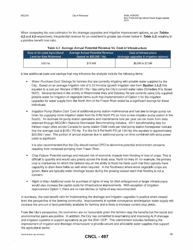
AECOM City of Richmond FINAL REPORT East Richmond Agricultural Water Supply Update 201 3
When comparing the cost estimates for the drainage upgrades and irrigation improvement options, as per Tables 4.2 and 4.3 respectively, the potential revenue for un-used land is greater (as shown below in Table 5.2) resulting in a positive benefit cost ratio .
Table 5.2 Average Annual Potential Revenue Vs. Cost of Infrastructure -----520 Ha $15.6M $6.0M to $7.0M
A few additional costs and savings that may influence the analysis include the following items:
• Water Purchase Cost: Savings for farmers that are currently irrigating with potable water supplied by the City. Based on an average irrigation rate of 5.33 mm/day (growth irrigation rate from Section 1.5.2) this equates to a cost per Hectare of $63.83 / Ha / day using the City's current water rates (Schedule B to Bylaw 5637) . Several farmers in the vicinity of Westminster Hwy and Sidaway Rd are currently using City supplied potable water for irrigation of vegetable farms such that implementation of Option 1 for the irrigation upgrades for water supply from the North Arm of the Fraser River would be a significant savings for these individuals.
• Irrigation Pump Station Cost: Cost of additional pump station maintenance and fuel due to longer pump run times for supplying more irrigation water from No 8 Rd North PS (or from a new irrigation pump station in the South) . An estimate for pump station operations and maintenance cost per year can be made from data obtained through AECOM's National Stormwater Benchmarking Initiative. 2011 benchmarking data for thirteen major cities across Canada for pump station O&M costs per total pump station horsepower indicate that the average cost is $150 / PS Hp. For the No 8 Rd North PS (at 134 Hp) this equates to approximately $20,000 / year. The portion of annual expense due to additional pump run time combined with extra power costs is significant.
It is also recommended that the City should contact DFO to determine potential environment concerns resulting from increased pumping from Fraser River.
• Crop Failure: Potential savings and reduced risk of economic impacts from flooding or loss of crops. This is difficult to quantify and would vary greatly across the study area. North for Hwy 91 for example, the primary crop is cranberries for which the farmers rely on the ability to flood the fields such that they typically have capability to drain there fields as well when required. In the Southwest where more vegetable crops are grown, there are typically water shortage issues during the growing season such that flooding is not a concern .
• Right of Way: Additional costs for purchase of rights-of-way for ditch enlargement or larger infrastructure would also increase the capital costs for infrastructure improvements. With exception of Irrigation improvement Option 1, there are no new ditches or rights-of-way recommended.
In summary, the cost benefit ratio for implementing the drainage and irrigation upgrades is positive when viewed from the perspective of the farming community. Improvements to system conveyance and irrigation water supply will increase the amount of land potentially available for farming and is likely to increase current crop yields.
From the City's perspective , the economics are not favourable given the farmers reap the benefits but the social and environmental gains are positive. In addition, the City has committed to maintaining and improving ALR drainage and irrigation systems to support agriculture as per the 2041 OCP. This commitment includes facilitating the improvement of irrigation and drainage infrastructure to provide secure and affordable water supplies that support the agricultural sector.
Final Final Report_April 2014.Docx 56 CNCL - 497
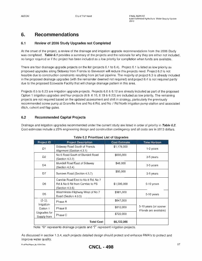
AECOM City of Richmond
6. Recommendations
6.1 Review of 2006 Study Upgrades not Completed
FINAL REPORT East Richmond Agricultural Water Supply Update 201 3
At the onset of the project, a review of the drainage and irrigation upgrade recommendations from the 2006 Study was completed. Table 6. 1 provides a summary of the projects and the rationale for why they are either not included, no longer required or if the project has been included as a low priority for completion when funds are available.
There are four drainage upgrade projects on the list (projects 6.1 to 6.4). Project 6.1 is listed as low priority as proposed upgrades along Sidaway from Francis to Steveston will reduce this projects need. Project 6.2 is not feasible due to construction constraints resulting from jet fuel pipeline . The majority of project 6.3 is already included in the proposed drainage upgrades (with the remainder deemed not required) and project 6.4 is not required partly due to the proposed Ecowaste Facility that will change drainage pattern in this area.
Projects 6.5 to 6.23 are irrigation upgrade projects. Projects 6.6 & 6.12 are already included as part of the proposed Option 1 irrigation upgrades and four projects (6.9, 6.10, 6.19 & 6.23) are included as low priority. The remaining projects are not required based on the updated assessment and shift in strategy, particularly the previously recommended screw pump at Granville Ave and No 6 Rd, and No 7 Rd North irrigation pump station and associated ditch, culvert and flap gates.
6.2 Recommended Capital Projects
Drainage and irrigation upgrades recommended under the current study are listed in order of priority in Table 6.2. Cost estimates include a 25% engineering design and construction contingency and all costs are in 2013 dollars.
Table 6.2 Prioritized List of Upgrades
Project 10 Project Description I
Cost Estimate I Time Horizon , ,
01 Sidaway Road South of Francis $1 ,176,000
1-2 years Al ignment (Section 4.3.1)
02 No 6 Road South of Blundell Road $693,000
3-5 years (Section 4.3.2)
04 Blundell Road East of Sidaway $46,000
3-5 years (Section 4.3.4)
07 Burrows Road (Section 4.3.7) $50,000
3-5 years
Cambie Road East to No 8 Rd, No 7
06 Rd & No 8 Rd from Cambie to PS $1,595,000 5-10 years
(Section 4.3.6)
05 Westminster Highway West of No 7 $981,000
5-10 years Road (Section 4.3.5)
(I- l). Phase A $647,000
Irrigation-$812,000 5-10 years (or sooner
Option 1 Phase B if funds are available)
Upgrades for Phase C $722,000
Supply from
Total Cost $6,722,000
Note: "D" represents drainage projects and "I " represent irrigation projects.
As discussed in section 1.3.4, each projects detailed design should protect and enhance RMA's to protect and improve water quality.
Final Final Report_ApriI 2014.Docx 57 CNCL - 498
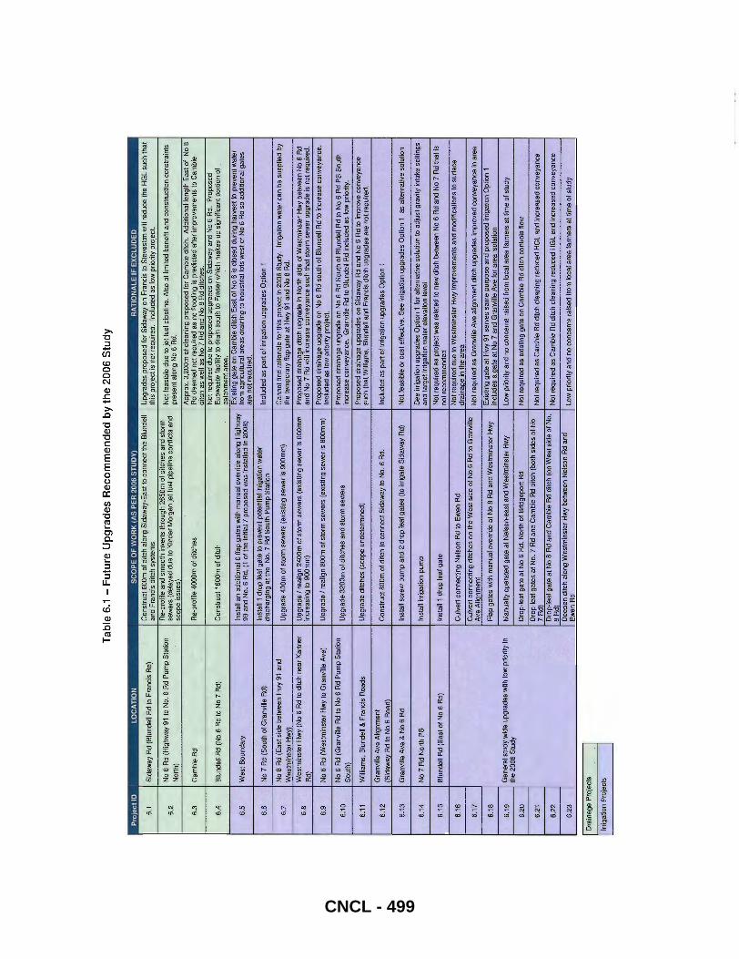
Tab
le 6
.1 -
Fu
ture
Up
gra
des
Rec
om
men
ded
by
the
2006
Stu
dy
PrO
ject
10
LO
CA
TIO
N
SC
OP
E O
F W
OR
K (
AS
PE
R 2
006
ST
UD
Y)
RA
TIO
NA
LE
IF E
XC
LU
DE
D
6.1
S
ida
wa
y R
d (B
lun
de
ll R
d to
Fra
ncis
Rd)
C
on
stru
ct 6
0Qm
of
ditc
h a
long
Sid
aw
ay-
Ea
st to
co
nn
ect
the
Blu
nd
ell
Upg
rad
es
pro
po
sed
fo
r S
ida
wa
y on
Fra
ncis
to
Ste
vest
on
will
red
uce
the
HG
L s
uch
tha
t an
d Fr
anci
s di
tch
syst
ems
" th
is p
roje
ct is
not
req
uire
d.
Incl
uded
as
low
prio
rity
proj
ect.
No
6 R
d (H
igh
wa
y 91
10
No
. 6.R
d P
um
p S
tatio~
Re-
pro
file
and
sm
oot
h in
vert
s th
roug
h 2
65
0m
of
ditc
he
s a
nd s
torm
N
ot fe
asib
le d
ue t
o je
t fu
el p
ipel
ine.
Als
o of
lim
ited
bene
fit a
nd c
onst
ruct
ion
cons
trai
nts
6.2
se
wer
s (d
ela
yed
due
to K
inde
r'M
orga
n je
t ,fue
l pip
elin
e co
nflic
ts a
nd
Nor
th)
.. sc
ope
issu
es')
pre
sen
t alo
ng N
o 6
Rd.
Appro~.
3.2
00
m o
f cl
ean
ing
pro
po
sed
fo
r C
am
bie
ditc
h.
Add
itio
nal
le
ng
th E
ast
of
No
8 6.
3 C
amb
ie R
d
Re-
pro
file
400
0m
9f
ditc
he
s R
d de
emed
not
req
uire
d as
no
floo
din
g is
pr.e
dict
ed a
fter
impr
ovem
ents
to
Ca
mbi
e d
itch
as w
ell
as N
o 7
Rd
and
No
8 R
d d
itch
es
. N
ot r
equi
red
due
'to p
ropo
sed
upg
rade
s on
Sid
away
and
,No
6 R
d.
Pro
pose
d 6.
4 B
lun
del
l R
d (N
o 6
Rd
to N
o 7
Rd)
C
onst
ruct
16
00
m o
f di
tch
.Eco
was
te f
acili
ty to
dra
in s
out
h to
Fra
ser
wh
ich
mak
es u
p si
gnifi
cant
po
rtio
n o
f ca
tchm
ent a
rea.
Inst
all a
n a
dd
itio
na
l 6
flap
ga
tes
with
ma
nu
al o
verr
ide
alo
ng H
igh
wa
y E
xist
ing
ga
te o
n C
am
bie
ditc
h E
ast
of
No
6 is
clo
sed
dur
ing
ha
rve
st t
o p
reve
nt
wa
ter
6.5
W
est
Bou
ndar
y 99
an
d N
o.6
Rd.
(1
of
the
initi
al 7
pro
po
sed
was
In
sta
lled
in 2
00B
) fr
om a
gric
ultu
ral a
reas
dra
inin
g to
ind
ust
rial l
ots
wes
t of
No
6 R
d so
add
ition
al g
ates
ar
e no
t re
quir
ed.
6.6
No
7 R
d (S
out
h o
f Gra
nvi
lle R
d)
Inst
all 1
dro
p le
af g
ate
to p
reve
nt
po
ten
tial i
rrig
atio
n w
ate
r In
clu
de
d a
s p
art
of
irri
gatio
n u
pg
rad
es
Op
tion
1
dis
cha
rgin
g a
t th
e N
o.7
Rd
So
uth
Pu
mp
Sta
tion
6.7
No
B R
d (E
ast
sid
e b
etw
ee
n H
wy
91 a
nd
Up
gra
de
40
0m
of s
torm
se
we
rs (
exi
stin
g s
ew
er
is 9
00
mm
) C
anno
t fin
d ra
tiona
le fo
r th
is p
roje
ct in
200
6 St
udy.
Irr
igat
ion
wat
er c
an b
e su
pplie
d by
W
est
min
ste
r H
wy)
th
e t
em
po
rary
fla
p g
ate
at H
wy
91 a
nd N
o B
Rd
.
6.B
W
estm
inst
er H
wy
(No
6 R
? to
ditc
h n
ear
Kar
tner
U
pgra
de /
real
ign
2400
m o
f sto
rm s
ewer
s (e
xist
ing
sew
er is
6DO
mm
P
ropo
sed
drai
nage
ditc
h up
grad
e in
Nor
th s
ide
of W
estm
inst
er H
wy
betw
een
No
6 R
d
Rd)
in
crea
sing
to 9
00m
m)
and
No
7 R
d w
ill i
ncre
ase
conv
eyan
ce s
uch
that
sto
rm s
ewe
r upg
rade
is n
ot r
equi
red.
6.9
No
6 R
d (W
est
min
ste
r H
wy
to G
ran
ville
Ave
) U
pg
rad
e I
rea
lign
BOO
m o
f st
orm
se
we
rs (
exi
stin
g s
ew
er
is B
OO
mm
) P
ropo
sed
drai
nage
upg
rade
on
No
6 R
d so
uth
of B
lund
ell
Rd
to i
ncre
ase
conv
eyan
ce.
Incl
uded
as
low
prio
rity
proj
ect.
6.1
0 N
o 6
Rd
(Gra
nvill
e R
d to
No
6 R
d P
um
p S
tatio
n
Up
gra
de
32
00
m o
f ditc
he
s an
d st
orm
se
we
rs
Pro
po
sed
dra
ina
ge
up
gra
de
on
No
6 R
d S
ou
th o
f B
lund
ell
Rd
to N
o 6
Rd
PS
So
uth
Sou
th)
incr
ea
se c
on
veya
nce
. G
ran
ville
Rd
to B
lund
ell
Rd
incl
ud
ed
as
low
pri
ority
.
6.11
W
illia
ms
, B
lund
ell &
Fra
ncis
Ro
ad
s U
pg
rad
e d
itch
es
(sco
pe u
nde
term
ine
d)
Pro
pose
d d
rain
age
upgr
ades
on
Sid
away
Rd
and
No
6 R
d to
im
prov
e co
nvey
ance
su
ch t
hat W
illia
ms,
Blu
ndel
l and
Fra
ncis
ditc
h up
grad
es a
re n
ot r
equ
ired.
6.1
2 G
ran
ville
Ave
Alig
nm
en
t C
on
stru
ct B
OO
m o
f d
itch
to c
on
ne
ct S
ida
wa
y to
No
.6 R
d.
Incl
ud
ed
as
pa
rt o
f ir
riga
tion
up
gra
de
s O
ptio
n 1
(S
ida
wa
y R
d to
No
6 R
oad)
6.1
3 G
ran
ville
Ave
& N
o 6
Rd
Inst
all
scre
w p
um
p a
nd
2 d
rop
lea
l ga
tes
(to
irri
ga
te S
ida
wa
y R
d)
Not
feas
ible
or c
ost e
ffect
ive.
See
irrig
atio
n up
grad
es O
ptio
n 1
as a
ltern
ativ
e so
lutio
n
6.1
4
No
7 R
d N
orth
PS
In
stal
l irr
igat
ion
pum
p S
ee i
rrig
atio
n up
grad
es O
ptio
n 1
for
alte
rnat
ive
solu
tion
to a
djus
t gra
vity
inta
ke s
ettin
gs
and
targ
et ir
rigat
ion
wat
er e
leva
tion
leve
l
6.1
5
Blu
nd
ell
Rd
(Eas
t o
f N
o 6
Rd)
In
stal
l 1 d
rop
le
af g
ate
N
ot
req
uir
ed
as
pro
ject
was
re
late
d t
o n
ew
ditc
h b
etw
ee
n N
o 6
Rd
an
d N
o 7
Rd
tha
t is
not r
ecom
men
ded
6.1
6 C
ulv
ert
con
nec
ting
Ne
lson
Rd
to E
we
n R
d N
ot r
equi
red
due
to W
estm
inst
er H
wy
impr
ovem
ents
and
mod
ifica
tions
to s
urfa
ce
dra
ina
ge
in t
he
are
a
6.17
C
ulv
ert
con
nect
ing
ditc
hes
on t
he W
est
side
of
No
6 R
d to
Gra
nvill
e N
ot r
equi
red
as G
ranv
ille
Ave
alig
nmen
t ditc
h up
grad
es im
prov
ed c
onve
yanc
e in
are
a A
ve A
lign
me
nt
I
6.1B
F
lap
gilt
es
wit
h m
anu,
,1 o
verr
ide
at
No
8 R
d an
d W
est
min
ste
r H
wy
Exi
stin
g g
ate
at
Hw
y 91
ser
ves
sam
e p
urp
ose
an
d p
rop
ose
d ir
rig
atio
n O
ptio
n 1
i
incl
ud
es
a g
ate
at
No
7 a
nd
Gra
nvi
lle A
ve f
or
are
a is
ola
tion
6.1
9 G
ene
ral s
tudy
wid
e up
gra
des
with
low
prio
rity
in
Ma
nu
ally
op
era
ted
ga
te a
t N
els
on
-ea
st a
nd W
es
tmin
ste
r H
wy
Low
prio
rity
and
no c
once
rns
rais
ed f
rom
loc
al a
rea
farm
ers
at ti
me
of s
tudy
th
e 2
00
6 S
tud
y
6.2
0
Dro
p-l
ea
f g
ate
at
No
6 R
d. N
ort
h o
f B
rid
ge
po
rt R
d N
ot re
quire
d as
exi
stin
g ga
te o
n C
amb
ie R
d di
tch
cont
rols
flo
w
6.2
1 D
rop
-lea
f g
ates
at N
o.7
Rd
and
Ca
mb
ie R
d d
itch
(bo
th s
ides
of
No
7 R
dl
No
t req
uire
d as
Cam
bie
Rd
ditc
h cl
eani
ng r
educ
ed H
GL
and
incr
ease
d co
nvey
ance
6.2
2
Dro
p-f
ea
f ga
te a
t N
o B
Rd
"nd
Ca
mb
ie R
d d
itch
(on
We
st s
ide
of
No.
N
ot r
equi
red
as C
ambi
e R
d di
tch
clea
ning
red
uced
HG
L an
d in
crea
sed
conv
eyan
ce
B R
dl
6.2
3
De
ep
en
ditc
h a
long
We
stm
inst
er
Hw
y b
etw
ee
n N
els
on R
d an
d Lo
w p
riorit
y an
d no
con
cern
s ra
ised
fro
m l
ocal
are
a fa
rmer
s at
tim
e of
stu
dy
Ew
en R
d
Dra
inag
e P
roje
cts
.. I
Irrig
atio
n P
roje
cts
I
CNCL - 499

AECOM City of Richmond
6.3 Additional Recommendations
FINAL REPORT East Richmond Agricultural Water Supply Update 2013
Further recommendations and improvements that were discussed at the Staff workshop and require additional investigation prior to inclusion in the current Capital Plan include the following items:
.. Survey ground elevation (field elevations) along existing ditch on Cambie Rd (east and west of No 7 Rd). The ground elevation survey should also be completed for low lying areas along Sidaway and No 6 Rd south of Williams Road.
e Review capacity of the NO.7 Road South PS and flood box as it was identified as under capacity in Table 4.1
.. Consider implementing the following projects identified in the 2006 Study as low priority works: o Construct 600m of ditch along Sidaway-East to connect the Blundell and Francis ditch systems o Upgrade ditch on east side of No 6 Rd between Granville Rd and Blundell Rd. This will further
increase conveyance along No 6 Rd and facilitate supply of irrigation water from North Arm.
e Repair or replacement of the failing headwall at the south ditch box culvert inlet on Cambie Rd just east of No 6 Road
.. Ditch cleaning and re-profiling along CN Rail corridor between No 7 Rd and No 8 Rd (City needs permission from the railway for access)
.. Ditch cleaning and re-profiling for south side of River Rd from the CN box (Cambie Rd alignment) east to Queens PS
.. Box culvert flushing and cleaning for No 6 Rd north drainage corridor and further investigation of the jet fuel pipeline elevations
.. Review the need and methods to remove invasive species such as Japanese Knotweed and Parrot Feather.
.. Review possibility of lowering the No 7 Rd North PS culvert and impact this would have on the downstream ditch systems
.. Create a culvert inspection program for entire study area and in particular a review of who is responsible for maintenance of culverts crossing Hwy 91
.. Consider implementing a procedure that requires farmers to identify when and where new outfalls from fields to municipal ditches are constructed
.. Coordinate operation of the CN box gravity intake (River Rd and Cambie Rd alignment) between farmers and Operations staff
.. Facilitate farmers to coordinate water use from No 7 Rd North PS during harvest
Final Final Report_April 2014.Docx 59 CNCL - 500
AECOM
Final Final Report~April 20i4.Docx
City of Richmond FINAL REPORT East Richmond Agricultural Water Supply Update 2013
APPENDIX A Feedback from Open House
60 CNCL - 501
City of Richmond
East Richmond Agricultural Water Supply Study Update
Public Feedback Form
Thank you for taking the time to provide feedback on East Richmond's drainage and irrigation system. Please describe below, successes, concerns or other relevant feedback relating to the City's irrigation
and drainage system:
Feedback (Please provide specific information and the property addresses of where it relates to):
I S5 q ( ue61fv1l ~- W
fJ 0 I (fi c;ev6-Cvv- ~ , - v
/,...) L.i ~ (\t] W~if
woJ-u ~? too coLi \
Your input is important to us and will be compiled and considered within the East Richmond Agricultural Water Supply Study Update, Please submit your comments by Friday, May 3, 2013 at 5:00 p.m.
• Fax: 604-276-4197
• Email: [email protected]
• Mail or drop off at City Hall: 6911 NO.3 Road, Richmond, BC V6Y 2C1
• Online: www.LetsTalkRichmond.ca
38184831 April 2, 2013
CNCL - 502
(j}L plp-<- +0 \r{~5~'O u:>tr-)
C'4j ~ ,
Lt J~~<:' ~ dz:.-L""
~~-====L J; ~--.--_--.-.-.o~ ~ ~. ()+c~ .=9Dwc, L,o~ VU~o
}dDO Ji~G~-----------
CNCL - 503
City of Richmond
East Richmond Agricultural Water Supply Study Update
Public Feedback Form
Thank you for taking the time to provide feedback on East Richmond's drainage and irrigation system. Please describe below, successes, concerns or other relevant feedback relating to the City's irrigation
and drainage system:
Feedback (Please provide specific information and the property addresses of where it relates to):
1 '+ I ~ 0 l~(;'&a--v- (+-v-t ~ 14-54-0 t.
Please provide your contact details should City staff wish to further discuss your feedback:
Name: Mr [~C1 V'I
Contact Telephone Number: _______________________ _
Email: _______________________________ _
Your input is important to us and will be compiled and considered within the East Richmond Agricultural Water Supply Study Update. Please submit your comments by Friday, May 3, 2013 at 5:00 p.m.
• Fax: 604-276-4197
• Email: [email protected]
• Mail or drop off at City Hall: 6911 No.3 Road, Richmond, BC V6Y 2C1
• Online: www.LetsTalkRichmond.ca
38184831 April 2, 2013
CNCL - 504
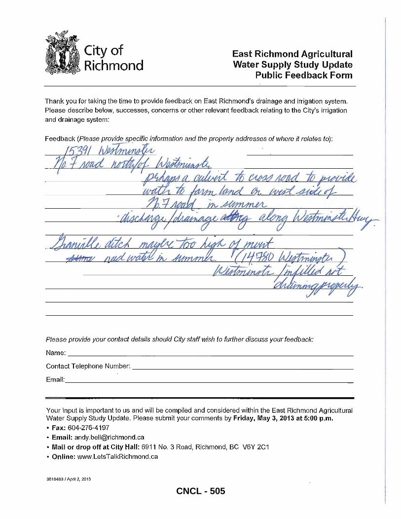
City of Richmond
East Richmond Agricultural Water Supply Study Update
Public Feedback Form
Thank you for taking the time to provide feedback on East Richmond's drainage and irrigation system. Please describe below, successes, concerns or other relevant feedback relating to the City's irrigation and drainage system:
Feedback (Please provide specific information and the property addresses of where it relates to):
JjI!1~/V~ . . ..
Please provide your contact details should City staff wish to further discuss your feedbac/(:
Name: ____________________________________________________________ ___
Contact Telephone Number: _____________________________________________ ___
Email: _____________________________________________________________ _
Your input is important to us and will be compiled and considered within the East Richmond Agricultural Water Supply Study Update. Please submit your comments by Friday, May 3,2013 at 5:00 p.m.
• Fax: 604-276-4197
• Email: [email protected]
• Mail or drop off at City Hall: 6911 NO.3 Road, Richmond, BC V6Y 2C1
• Online: www.LetsTalkRichmond.ca
38184831 Apri12. 2013
CNCL - 505
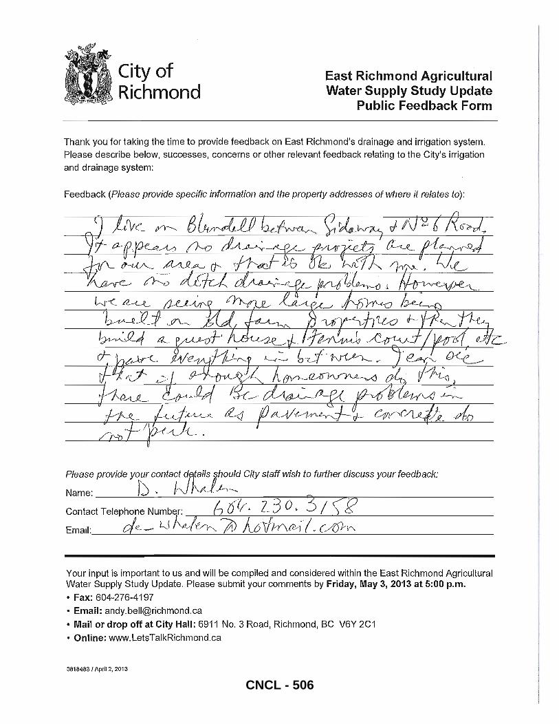
City of Richmond
East Richmond Agricultural Water Supply Study Update
Publ ic Feedback Form
Thank you for taking the time to provide feedback on East Richmond's drainage and irrigation system.
Please describe below, successes, concerns or other relevant feedback relating to the City's irrigation
and drainage system:
Feedback (Please provide specific information and the property addresses of where it relates to) :
Please provide your conta~t dntails ihould City staff wish to further discuss your feedback:
Name: f), IrJ r,-M.J~ __ Contact Telephone Number: b rfL/. z_ 3 o. 3 / j='f2 Email :._--.-::c!-,-.e.._-_I-J_·_l~_~_If._.~-----,-]Dc.......:......A:......:::l=-6-,,-\h_' Yr\_tG1-,-,-/~v--==cA._6J=---'\A. _______ _
Your input is important to us and will be compiled and considered within the East Richmond Agricultural Water Supply Study Update. Please submit your comments by Friday, May 3, 2013 at 5:00 p.m.
• Fax: 604-276-4197
• Email: [email protected]
• Mail or drop off at City Hall: 6911 No.3 Road, Richmond, BC V6Y 2C1
• Online: www.LetsTalkRichmond.ca
38184831 April 2, 2013
CNCL - 506
AECOM
Final Final Report_ApriI2014.Docx
City of Richmond FINAL REPORT East Richmond Agricultural Water Supply Update 2013
APPENDIX B Design Storm Hyetographs
61
CNCL - 507
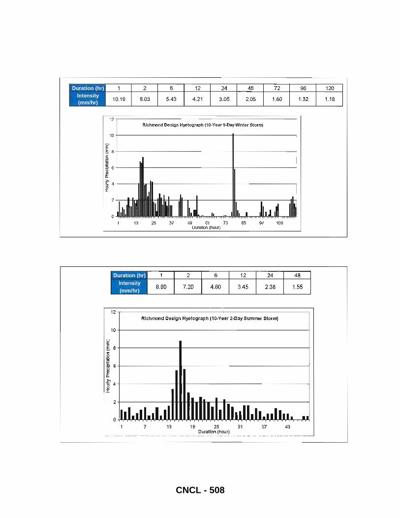
12 Richmond Design Hyetograph (10-Year 5-DayWlnter Storm)
'10 t--------------------i-- - ------------i
E S 8 +-----------------~---------~
.~ m "" 'fr 6 t------IIR--------- - - - - - --l;---------------i e Il.
~ 4+---~m6rH~------------ir_--------_____i o J:
E-
2 +----11-1.-
o 25 37 49 6" 73 85 97 109
Duration (hour)
12 ~-----------------------------------_,
Richmond Design Hyetograph (10.Year 2.Day Summer Storm)
10+----------------------------~
SS +--------____ ------------------__1 e o
16+--------~------------------------------~ ~ Q.
~ 4+--------~~._-----------------~ o I
2+--------. .. ~~~~_._.-----------__1
7 13 19 25 31 37 43 Duration (hour)
CNCL - 508