ISLANDS IN THE NILE SEA: THE MARITIME CULTURAL LANDSCAPE OF THMUIS, AN ANCIENT DELTA CITY
193
ISLANDS IN THE NILE SEA: THE MARITIME CULTURAL LANDSCAPE OF THMUIS, AN ANCIENT DELTA CITY A Thesis by VERONICA MARIE MORRISS Submitted to the Office of Graduate studies of Texas A&M University in partial fulfillment of the requirements for the degree of MASTER OF ARTS May 2012 Major Subject: Anthropology
Transcript of ISLANDS IN THE NILE SEA: THE MARITIME CULTURAL LANDSCAPE OF THMUIS, AN ANCIENT DELTA CITY
ISLANDS IN THE NILE SEA: THE MARITIME CULTURAL
LANDSCAPE OF THMUIS, AN ANCIENT DELTA CITY
A Thesis
by
VERONICA MARIE MORRISS
Submitted to the Office of Graduate studies of
Texas A&M University
in partial fulfillment of the requirements for the degree of
MASTER OF ARTS
May 2012
Major Subject: Anthropology

Islands in the Nile Sea:
The Maritime Cultural Landscape of Thmuis, an Ancient Delta City
Copyright 2012 Veronica Marie Morriss

ISLANDS IN THE NILE SEA: THE MARITIME CULTURAL
LANDSCAPE OF THMUIS, AN ANCIENT DELTA CITY
A Thesis
by
VERONICA MARIE MORRISS
Submitted to the Office of Graduate studies of
Texas A&M University
in partial fulfillment of the requirements for the degree of
MASTER OF ARTS
Approved by:
Chair of Committee, Shelley Wachsmann
Committee Members, Deborah Carlson
Nancy Klein
Head of Department, Cynthia Werner
May 2012
Major Subject: Anthropology

ABSTRACT
Islands in the Nile Sea:
The Maritime Cultural Landscape of Thmuis, an Ancient Delta City. (May 2012)
Veronica Marie Morriss, B.A., The Pennsylvania State University
Chair of Advisory Committee: Dr. Shelley Wachsmann
In ancient Egypt, the Nile was both a lifeline and a highway. In addition to its
crucial role for agriculture and water resources, the river united an area nearly five
hundred miles in length. It was an avenue for asserting imperial authority over the vast
expanse of the Nile valley. River transport along the inland waterways was also an
integral aspect of daily life and was employed by virtually every class of society; the
king and his officials had ships for commuting, as did the landowner for shipping grain,
and the ‘marsh men’ who lived in the northernmost regions of the Nile Delta.
Considering the role of water transport in ancient Egypt we know surprisingly little
about the maritime environment along the inland waterways of the Nile Delta. The
physical interface between man and river is frequently obscured by the dearth of
evidence for Delta waterways and fluvial harbors, and a lack of awareness for ancient
hydrological conditions.
iii
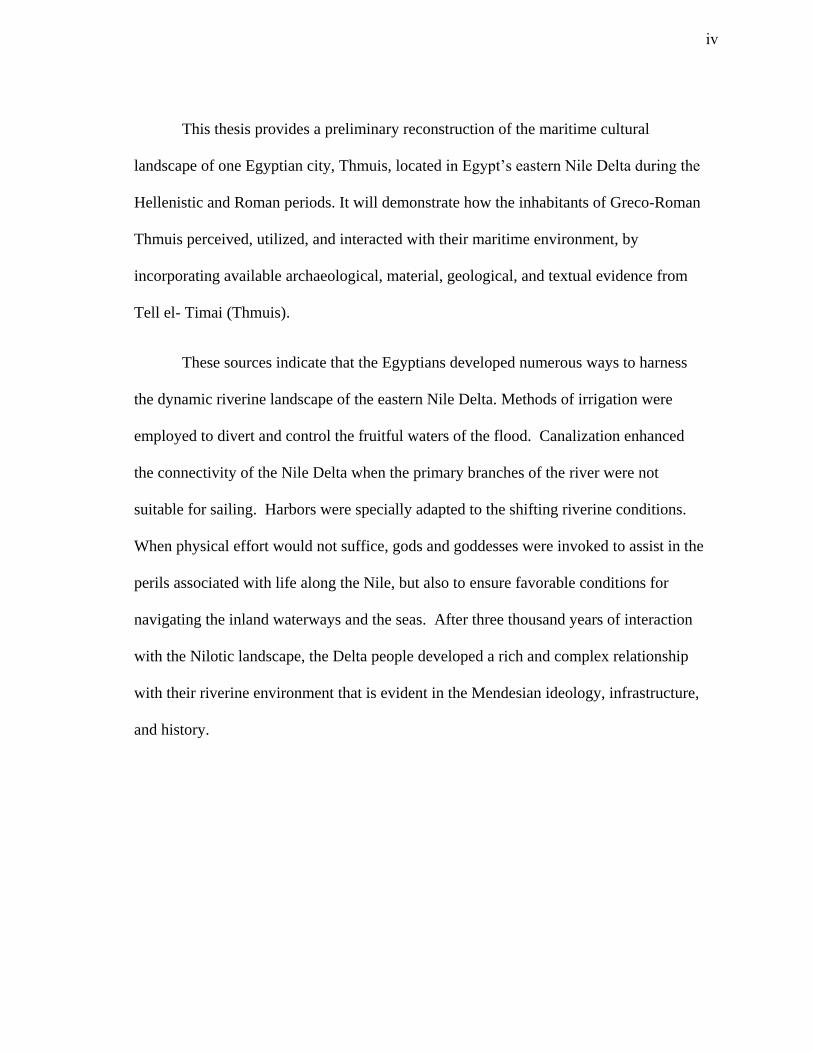
This thesis provides a preliminary reconstruction of the maritime cultural
landscape of one Egyptian city, Thmuis, located in Egypt’s eastern Nile Delta during the
Hellenistic and Roman periods. It will demonstrate how the inhabitants of Greco-Roman
Thmuis perceived, utilized, and interacted with their maritime environment, by
incorporating available archaeological, material, geological, and textual evidence from
Tell el- Timai (Thmuis).
These sources indicate that the Egyptians developed numerous ways to harness
the dynamic riverine landscape of the eastern Nile Delta. Methods of irrigation were
employed to divert and control the fruitful waters of the flood. Canalization enhanced
the connectivity of the Nile Delta when the primary branches of the river were not
suitable for sailing. Harbors were specially adapted to the shifting riverine conditions.
When physical effort would not suffice, gods and goddesses were invoked to assist in the
perils associated with life along the Nile, but also to ensure favorable conditions for
navigating the inland waterways and the seas. After three thousand years of interaction
with the Nilotic landscape, the Delta people developed a rich and complex relationship
with their riverine environment that is evident in the Mendesian ideology, infrastructure,
and history.
iv
DEDICATION
To my parents, Alexander and Lisa Staats Morriss
When the Nile comes over the land, the cities alone are seen rising above the water,
resembling more nearly than anything else the islands of the Aegean Sea….
Herodotus, Histories II.37
v
ACKNOWLEDGEMENTS
I wish to thank, first and foremost, my advisor and chair, Professor Shelley
Wachsmann, for his continued guidance and encouragement throughout this process. I
especially thank him for opening doors to new worlds and bringing fresh insights to
everyday life.
I would like to thank my mentor, Professor Robert Littman, who has been by my
side throughout my academic career and provided immense support to my endeavors in
Egypt. Without him this thesis would not have been possible. I also am indebted to the
many colleagues and mentors who aided my research in Egypt, particularly Jay
Silverstein, Mohamed Gabr, Dr. Matthew J. Adams, Professor Adam Shahat, and
Professor Donald Redford.
I would like to show my gratitude to my committee members, Professor Deborah
Carlson and Professor Nancy Klein, for their encouragement and insightful comments.
Thank you to my consummate editor, Doug Inglis, for his tireless efforts.
Last but not least, I would like to thank my parents, Lisa and Lex, for being a
pillar of support throughout all of my pursuits.
vi
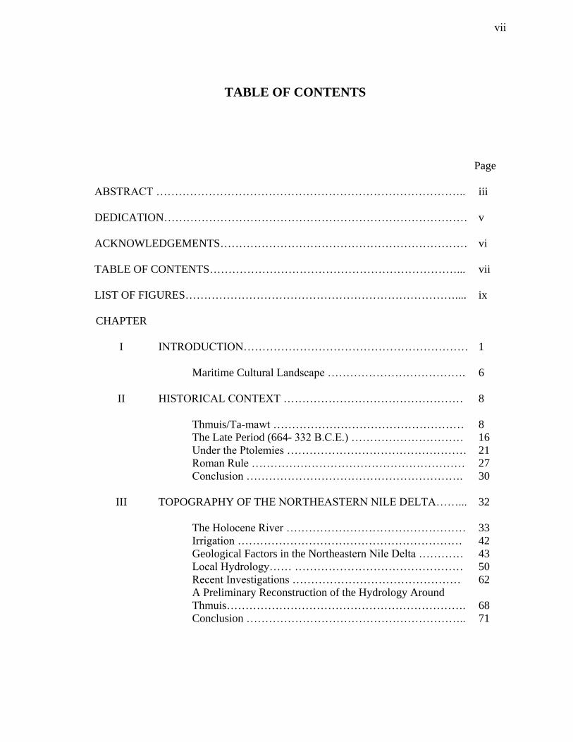
TABLE OF CONTENTS
Page
ABSTRACT ……………………………………………………………………….. iii
DEDICATION……………………………………………………………………… v
ACKNOWLEDGEMENTS………………………………………………………… vi
TABLE OF CONTENTS…………………………………………………………... vii
LIST OF FIGURES……………………………………………………………….... ix
CHAPTER
I INTRODUCTION…………………………………………………… 1
Maritime Cultural Landscape ………………………………. 6
II HISTORICAL CONTEXT ………………………………………… 8
Thmuis/Ta-mawt …………………………………………… 8
The Late Period (664- 332 B.C.E.) ………………………… 16
Under the Ptolemies ………………………………………… 21
Roman Rule ………………………………………………… 27
Conclusion …………………………………………………. 30
III TOPOGRAPHY OF THE NORTHEASTERN NILE DELTA……... 32
The Holocene River ………………………………………… 33
Irrigation …………………………………………………… 42
Geological Factors in the Northeastern Nile Delta ………… 43
Local Hydrology…… ……………………………………… 50
Recent Investigations ……………………………………… 62
A Preliminary Reconstruction of the Hydrology Around
Thmuis……………………………………………………….
68
Conclusion ………………………………………………….. 71
vii
CHAPTER Page
IV COGNITIVE APPROACH ……………………………………….. .. 73
The Hazards of Life Along the Nile ………………………… 74
Cognitive Terminology ……………………………………... 76
Religion ……………………………………………………... 81
The Mendesian Theology …………………………………… 90
Conclusion ………………………………………………….. 94
V THE THMUIS MOSAICS ………………………………………….. 96
Alexandria 21739 and Alexandria 21736 …………………... 97
Alexandria 21641 and Alexandria 20195 …………………... 114
Conclusion ………………………………………………….. 126
VI PHYSICAL INTERACTION WITH MARITIME SPACE ………... 129
Economic/Commercial ……………………………………. 130
Economic Role of Thmuis ………………………………….. 140
Nilotic Harbors ……………………………………………… 143
Thmuis ………………………………………………………. 156
Conclusion …………………………………………………... 159
VII CONCLUSION ……………………………………………………... 161
WORKS CITED …………………………………………………………………… 168
VITA ……………………………………………………………………………….. 181
viii
LIST OF FIGURES
FIGURE
Page
1-1. Location of the Mendesian nome in the northeastern Nile Delta …………. 2
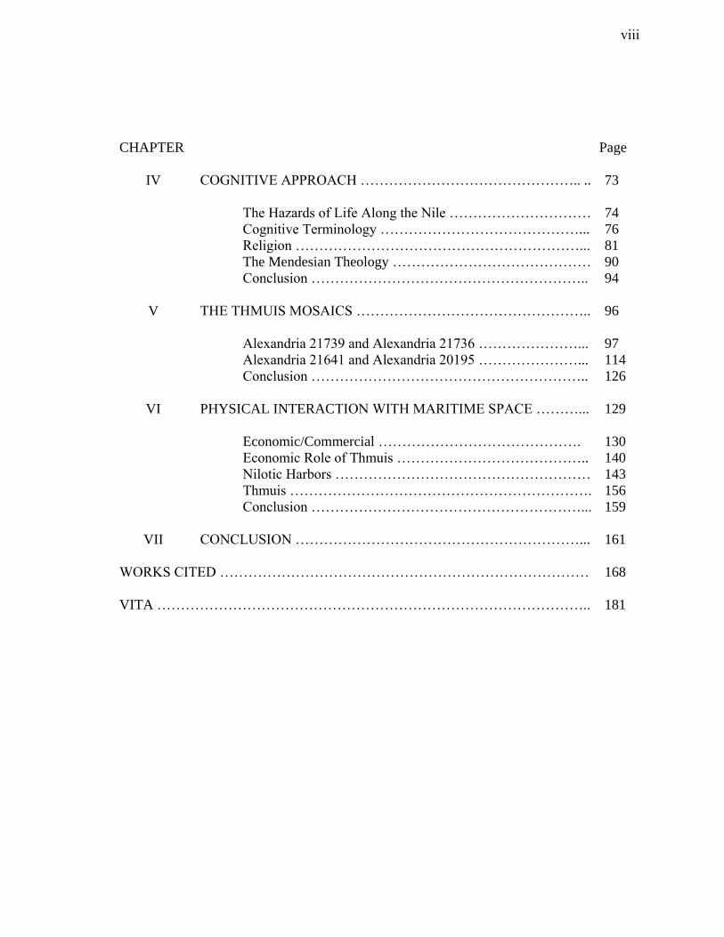
1-2. Distribution of the Predynastic levees of the Mendesian Nile (after
Redford 2010, fig. 1.1) …………………………………………………….
3
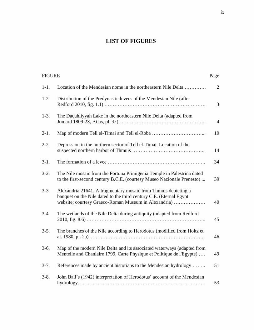
1-3. The Daqahliyyah Lake in the northeastern Nile Delta (adapted from
Jomard 1809-28, Atlas, pl. 35)……………………………………………..
4
2-1. Map of modern Tell el-Timai and Tell el-Roba …………………………...
10
2-2. Depression in the northern sector of Tell el-Timai. Location of the
suspected northern harbor of Thmuis ……………………………………...
14
3-1. The formation of a levee …………………………………………………..
34
3-2. The Nile mosaic from the Fortuna Primigenia Temple in Palestrina dated
to the first-second century B.C.E. (courtesy Museo Nazionale Prenesto) ...
39
3-3. Alexandria 21641. A fragmentary mosaic from Thmuis depicting a
banquet on the Nile dated to the third century C.E. (Eternal Egypt
website; courtesy Graeco-Roman Museum in Alexandria) ……………….
40
3-4. The wetlands of the Nile Delta during antiquity (adapted from Redford
2010, fig. 8.6) .……………………………………………………………..
45
3-5. The branches of the Nile according to Herodotus (modified from Holtz et
al. 1980, pl. 2a) .…………………………………………………………..
46
3-6. Map of the modern Nile Delta and its associated waterways (adapted from
Mentelle and Chanlaire 1799, Carte Physique et Politique de l'Egypte) ….
49
3-7. References made by ancient historians to the Mendesian hydrology ……..
51
3-8. John Ball’s (1942) interpretation of Herodotus’ account of the Mendesian
hydrology…………………………………………………………………..
53
ix
FIGURE
Page
3-9. Omar Tousson’s (1925) interpretation of Herodotus’ account of the
Mendesian hydrology ……………………………………………………..
54
3-10. Hydrological changes in the Nile Delta during the second century C.E. .…
56
3-11. Hydrological changes in the Nile Delta during the first century B.C.E. ….
57
3-12. Hydrological changes in the Nile Delta during the first century C.E. …….
58
3-13. The course of the Butic Canal in the mid-first century C.E. ………………
61
3-14. The results of Taha’s geophysical survey around Tell el-Roba and Tell el-
Timai (adapted from Taha 1998, fig. 49)………………………………….
64
3-15. A defunct channel of the Nile located during the 2010 Tell el-Timai
coring season ………………………………………………………………
65
3-16. The remains of the Butic Canal according to the Atlas Archeologique de
l’Egypte (modified from Hall and Bothmer 1980, pl. 13a) ………………..
67
3-17. The formation of a point bar ………………………………………………
69
3-18. The formation of a crevasse splay …………………………………………
70
4-1. Deified mooring stakes dated to the 18th Dynasty (adapted from Doyle
1998, fig. 8-1) ……………………………………………………………..
83
5-1. Alexandria 21739. The Sophilos mosaic discovered at Tell el-Timai in
1918 (Eternal Egypt website; courtesy Graeco-Roman Museum in
Alexandria) ………………………………………………………………..
98
5-2. Alexandria 21736. The anonymous mosaic discovered at Tell el-Timai
(Eternal Egypt website; courtesy Graeco-Roman Museum in Alexandria)..
99
5-3. Alexander Mosaic from Pompeii, Italy dated to 100 B.C.E. (courtesy
Museo Archeologico Nazionale, Italy) ……………………………………
104
5-4. Libation tables discovered at Tell el-Timai (Meulenaere and Mackay
1976, pls. 32e, 34e, 35c, 35f) ……………………………………………...
105
x
FIGURE
Page
5-5. Nilotic mosaic from the Casa del Fauno at Pompeii, Italy dated to 80-90
B.C.E. Museo Archeologico Nazionale, Italy, Inv. no. 10323 (Meyboom
1995, fig. 28)……………………………………………………………….
116
5-6. Rendition of the festival scene in the Nilotic mosaic from Palestrina. The
Royal Collection, Inv. no 19219 (© Her Majesty Queen Elizabeth II) ……
121
5-7. T-shaped harbor with quay at the Temple of Amun at Karnak. Inset at
bottom: detail of quay (adapted from Doyle 1998, fig. 8-8) ………………
125
5-8. Alexandria 20195. A Roman mosaic discovered at Tell el-Timai. The
scene depicts Alpheios and Arethousa (Eternal Egypt website; courtesy
Graeco-Roman Museum in Alexandria) …………………………………..
127
6-1. The district of Ro-nefer (modified from Mumford 1999-2004, Tell Tebilla
1) …………………………………………………………………………..
135
6-2. A summary of local and foreign commerce in the Mendesian nome
(adapted from Mumford 1999-2004, Tell Tebilla 8) ………………………
139
6-3. A ritual mooring scene dated to the 18th Dynasty in which the mooring
stakes are emphasized (adapted from Doyle 1998, fig. 8-5) ………………
144
6-4. A harbor scene from the 18th Dynasty. Syrian merchants unload and sell
their cargo at a waterfront (Daressy 1895, pl. XV) ……………………….
.
146
6-5. Various styles of mooring stakes (adapted from Doyle 1998, 8-4) ……….
149
6-6. Map of Avaris showing several recently discovered harbors (Bietak 2009,
17) …………………………………………………………………………
154
xi
CHAPTER I
INTRODUCTION
At the dawn of civilization in the Nile Valley, people settled upon four levees of
the Mendesian branch of the Nile (fig. 1.1).1 These sandy embankments protruded from
the landscape in a southwest to northeast direction and provided the earliest settlers a
safe abode from the annual floodwaters (fig. 1.2). Here the first settlement of Mendes,
initially known as ‘Anepat, “Place of Greenness,” forged its beginnings amidst the
watery landscape. A short distance north, the river emptied into the Mediterranean Sea,
later called by the Egyptians the “Great Green” or the “Great Syrian Sea.”2 Upon this
river, boats carrying cargoes from the eastern Mediterranean sailed to the various
entrepots within the eastern Nile Delta. To the east, marshes abounding with reeds and
papyri were accessible only by the local papyus-skiff. This area, known by the earliest
inhabitants as Laḫaḫta or the “Watery Place,” was a feature of the landscape until
modern times. It is depicted in the Description de l’Egypte maps as a large marsh
known as “the Daqahliyyah Lake” (fig. 1.3).3
This thesis follows the style and format of the American Journal of Archaeology.
1 Redford 2010, 211. The coring work of Larry Pawlish indicates that Mendes was constructed upon four
ancient levees aligned southwest to northeast.
2 For a discussion of the term Wadj-wer, see Meeks 1997 and Kitchen 1978.
3 Jomard 1809-28, Atlas pl. 35.
1
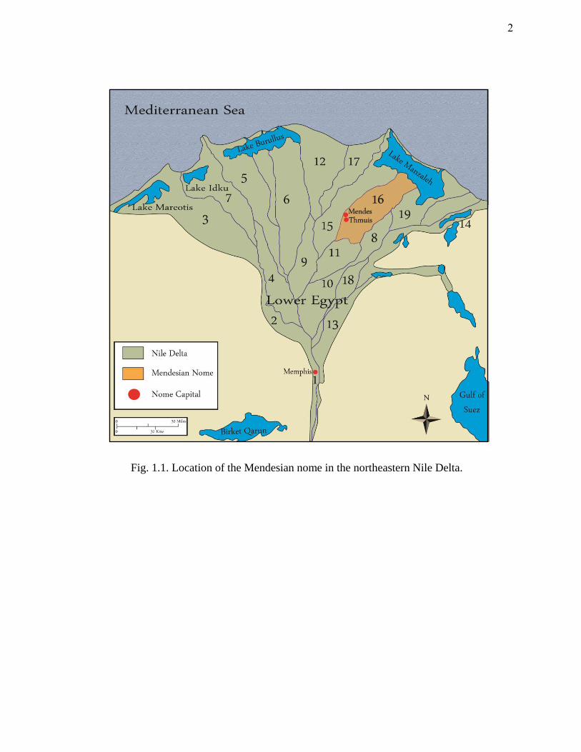
Fig. 1.1. Location of the Mendesian nome in the northeastern Nile Delta.
2

Fig. 1.2. Distribution of the Predynastic levees of the
Mendesian Nile (after Redford 2010, fig. 1.1).
3
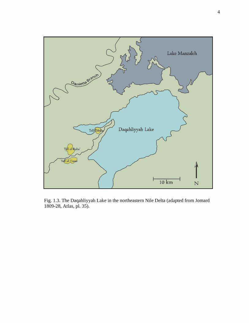
Fig. 1.3. The Daqahliyyah Lake in the northeastern Nile Delta (adapted from Jomard
1809-28, Atlas, pl. 35).
4
For nearly three millennia ‘Anepat slowly grew, settlement upon settlement,
destruction layer upon destruction layer, into a mound that now stands 9.6 m (31 ft)
above the surrounding landscape.4 The city flourished as a hub of trade; situated along
one of the eastern arteries of the Nile and within sight of the coast, the cities of Mendes,
and later Thmuis, provided to the merchants of the Levant and the northern Aegean
access to the markets and commodities of Egypt. The people of the Mendesian nome
adapted wholly to their dynamic riverine environs; they developed artificial canals,
basins, and harbors to control and utilize the waters of the Nile. When physical efforts
would not suffice they resorted to divine assistance to harness control over their
uncertain maritime environment. The local cults of the Mendesian nome reflect the
Egyptians’ cognitive understanding of the unpredictable environment in which they
lived. However, like the tides of time, the courses of the Nile shifted and the
descendants of ‘Anepat were eventually cut off from their lifeline. By the ninth century
C.E. the cities of Mendes and Thmuis were largely deserted.
The primary goal of this thesis is to examine the maritime space of ancient
Thmuis and to discover how the inhabitants of the city perceived, utilized, and interacted
with their riverine environment.
4 Holz (1969, 261-2) notes that Tell el-Timai stood 34 ft above the surrounding fields during his time.
5
Maritime Cultural Landscape
The foundation for the maritime cultural landscape maintains that there exists a
physical interaction between man and his surroundings. Any culture that has developed
an intimate connection with its maritime environment, whether be it at sea or along
inland waterways, will have a defined maritime space which is utilized via specialized
watercraft. Christopher Westerdahl first coined the term, maritime cultural landscape,
in 1978.5 Initially the term was established for heritage management purposes dealing
with both submerged and terrestrial remains. It was neither developed, nor suited, for
theoretical objectives; later the term was fleshed out and developed into an applicable
subdivision of maritime and nautical archaeology. Since then, numerous scholars have
tackled the study of maritime cultural landscapes and have subsequently provided a basis
for the implications and success of such a theory. While there is still room to debate the
intricacies of maritime cultural landscape theory, this does not fall within the scope of
this present study.
The underlying framework for this theory relies equally on material remains and
cognitive archaeology.6 Delving into the mindset of the ancient mariner is the ultimate
goal, and knowledge of both the physical and cognitive landscape of a particular society
is crucial for any attempt at understanding the maritime cultural landscape of the past.
Naturally, the theory encompasses all activities that fall under the category of human
5 Westerdahl 1978; see also Westerdahl 1992, 6.
6 Westerdahl 1994, 266.
6
utilization of maritime space. These will often include: settlement, fishing, shipping,
and various affairs that require water transport.
For an economy that was heavily reliant on river transport, harbors were an
integral feature in the maritime landscape of Egypt. Interest in the ‘Egyptian harbor’ has
increased in recent years. While fragmentary customs accounts and colorful tomb
paintings attest to the existence of harbors on the Nile, the archaeological evidence for
these facilities is scarce, particularly in the Nile Delta. Unlike the permanent and often
monumental facilities found at seaports, Nilotic harbors were constructed under entirely
different parameters. Fluctuating conditions, dictated by the flow of the Nile, influenced
the construction of riverine harbors. As a result, transitory facilities were often adopted
in lieu of more permanent designs using stone-works. Therefore, the task of locating
such facilities can often be problematic. Geophysical surveying and geological coring
are the foremost methods for delineating the harbors of the Nile Delta. The work of
several scholars has helped unveil the elusive Nilotic harbor and paved the way for
future studies of its design, function, and role. These elements are crucial to
understanding the physical interface between man and river.
7
CHAPTER II
HISTORICAL CONTEXT
Historical and archaeological sources provide significant data about maritime
activity at Thmuis and the city’s interaction with its landscape. This chapter reviews the
historical and political climate of Egypt from the Late Period through the Islamic
conquest, focusing on significant events pertinent to Thmuis’ existence and maritime
activity. As there is an abundance of available historical narratives concerning Egypt,
this chapter takes a narrow look at the development of the delta cities along the
Mendesian Nile.7
Thmuis/Ta-mawt
The Egyptian city of Ta-mawt (“new land”), known to the Greeks as Thmuis, is
located amidst the salt-ridden soils of the Eastern Nile Delta within the Dakhaliya
province.8 Today, the modern villages of Timai el-Amdid and Kafr el-Amir Abdulla Ibn
Salam encroach upon the North-East and North-West limits of the tell; Kafr el-Amir is
7 For the history of Egypt, see Shaw 2000; Grimal 1994; Redford 1992a; Redford 2001.
8 Ochsenschlager 1967, 32; Hansen 1965, 31.
8
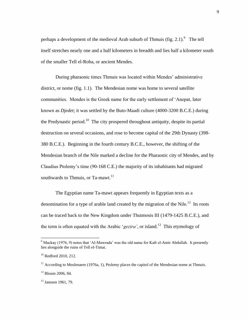
perhaps a development of the medieval Arab suburb of Thmuis (fig. 2.1).9 The tell
itself stretches nearly one and a half kilometers in breadth and lies half a kilometer south
of the smaller Tell el-Roba, or ancient Mendes.
During pharaonic times Thmuis was located within Mendes’ administrative
district, or nome (fig. 1.1). The Mendesian nome was home to several satellite
communities. Mendes is the Greek name for the early settlement of ‘Anepat, later
known as Djedet; it was settled by the Buto-Maadi culture (4000-3200 B.C.E.) during
the Predynastic period.10
The city prospered throughout antiquity, despite its partial
destruction on several occasions, and rose to become capital of the 29th Dynasty (398-
380 B.C.E.). Beginning in the fourth century B.C.E., however, the shifting of the
Mendesian branch of the Nile marked a decline for the Pharaonic city of Mendes, and by
Claudius Ptolemy’s time (90-168 C.E.) the majority of its inhabitants had migrated
southwards to Thmuis, or Ta-mawt.11
The Egyptian name Ta-mawt appears frequently in Egyptian texts as a
denomination for a type of arable land created by the migration of the Nile.12
Its roots
can be traced back to the New Kingdom under Thutmosis III (1479-1425 B.C.E.), and
the term is often equated with the Arabic ‘gezira’, or island.13
This etymology of
9 Mackay (1976, 9) notes that ‘Al-Mawrada’ was the old name for Kafr el-Amir Abdullah. It presently
lies alongside the ruins of Tell el-Timai.
10 Redford 2010, 212.
11 According to Meulenaere (1976a, 1), Ptolemy places the capitol of the Mendesian nome at Thmuis.
12 Blouin 2006, 84.
13 Janssen 1961, 79.
9
Fig. 2.1. Map of modern Tell el-Timai and Tell el-Roba.
10
‘Thmuis’ suggests the settlement developed on a relatively new area of land, perhaps a
landlocked island, which was created by the dynamic course of the Mendesian Nile.
The city itself is documented in historical texts from the fifth century B.C.E. until
to ninth century C.E. Although Herodotus (484 - 430 B.C.E.) provides the earliest
literary reference to Thmuis as a settlement in the nome of the Calasaries, it is possible
that the city’s origin can be traced back earlier.14
It is likely that Thmuis initially
developed as a suburb of neighboring Mendes. The notion that the cities were
contiguous in antiquity is still a matter of debate among scholars.15
Whether Thmuis
was a later development of Mendes or a separate municipal entity, the impingement of
cultivation in recent times has separated the settlements into two tells. These tells rise
several meters above the surrounding landscape, much as they did during antiquity.
Herodotus also provides in his account the first reference to the Mendesian
branch, a tributary of the Sebennytic branch, whose mouth opened along the coast of the
Mediterranean.16
The Mendesian Nile was the nome’s lifeline. As the tributary
migrated and slowly diminished in importance so did the prosperity and survival of the
cities within its vicinity. Thus, an understanding of the hydrology of the region is crucial
for the study of the maritime cultural landscape of Thmuis.
14 The Calasaries were one of the two military classes described Herodotus (Rawlinson 1928, II.166) in
Egypt.
15 Holz (1969, 254) notes the finding of pottery shards and worked stone in the agricultural fields between
the two tells as evidence that the two sites were contiguous during antiquity. To date, however, no
investigations have confirmed this hypothesis.
16 Hdt., II.17 (Rawlinson 1928).
11
During the first century C.E. Thmuis appears to have supplanted Mendes as
capitol of the Mendesian nome, and was responsible for the production and distribution
of the popular perfume, Unguentum Mendesium.17
The perfume industry, alluded to by
several historians, was started at Mendes and was perhaps later adopted by Thmuis. The
nome became famous for the production of this renowned and expensive unguent, which
was exported throughout the Mediterranean world up through Roman times.18
Certain places produce the best perfumes…of henna the Egyptian is judged the
best, next to it being the Cyprian and the Phoenician…The metopian and the
Mendesian are made best in Egypt, and are made from the oil obtained from
bitter almonds.19
While the manufacturing site at Mendes has yet to be discovered, unguent vessels
(unguentaria) are a common find at Mendes. Several unguentaria were also discovered
near the harbor of Thmuis during the 2009 and 2010 University of Hawaii field seasons.
Although they have not been dated their presence near the harbor presumably reflects
Thmuis’ continuation, or at least participation, in the Mendesian perfume industry.
At the beginning of the fourth century C.E. the city became an Episcopal See and
remained a stronghold for Christianity throughout the Coptic period up until the arrival
17 Meulenaere 1976a, 1; On the Mendesian perfume, see Plin. HN XIII.1 (Bostock and Riley 1855).
18 Redford 2010, 173.
19 Ath., 15.688 (Yonge 1854).
12
of the Arabs.20
Unfortunately, the textual record of Thmuis during these later centuries
is sparse and we are left with only a small collection of cursory references to the site.
During the first centuries of Islam under the Umayyad and Abbasid Dynasties, Arab
sources reveal that Thmuis retained a role as an administrative division (Kura).21
By the
time of the Fatimid Caliphs in the 10th
century AD, however, the city was abandoned
presumably due to the changing hydrology of the north-eastern Nile Delta.22
The recent history of Tell el-Timai is marked by intermittent exploration by
looters, archaeologists and farmers, known as fellahin, who remove the phosphate-rich
mudbrick (sebakhin) from the tell to use as fertilizer. The northernmost tip of the site
witnessed the brunt of sebakhin activity during the last two centuries, and excavation
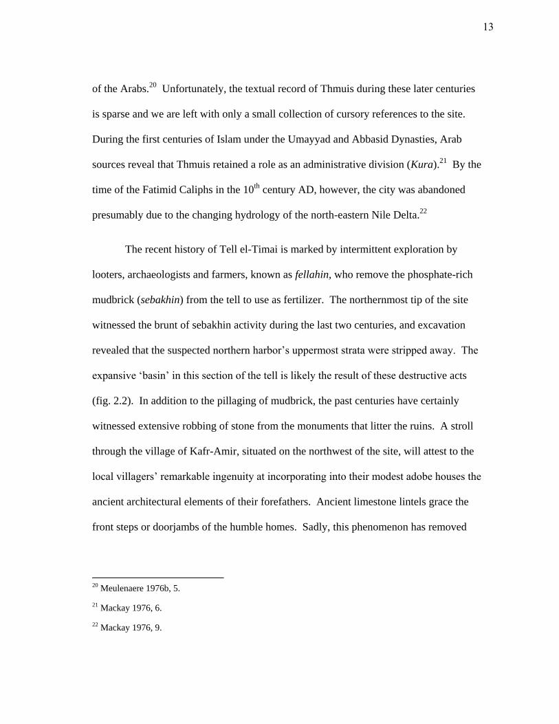
revealed that the suspected northern harbor’s uppermost strata were stripped away. The
expansive ‘basin’ in this section of the tell is likely the result of these destructive acts
(fig. 2.2). In addition to the pillaging of mudbrick, the past centuries have certainly
witnessed extensive robbing of stone from the monuments that litter the ruins. A stroll
through the village of Kafr-Amir, situated on the northwest of the site, will attest to the
local villagers’ remarkable ingenuity at incorporating into their modest adobe houses the
ancient architectural elements of their forefathers. Ancient limestone lintels grace the
front steps or doorjambs of the humble homes. Sadly, this phenomenon has removed
20 Meulenaere 1976b, 5.
21 Mackay 1976, 6.
22 Mackay 1976, 9.
13
Fig. 2.2. Depression in the northern sector of Tell el-Timai. Location of the
suspected northern harbor of Thmuis.
14
nearly all traces of Thmuis’ former marvels, including the Greco-Roman temple beside
the suspected harbor.
The Swiss Egyptologist Edouard Naville directed the first systematic exploration
of Tell el-Timai in 1892 for the Egypt Exploration Fund. His discovery of a burnt
storage house in the southwest extremity of the tell revealed the second largest cache of
papyri ever discovered in the Nile Delta.23
These documents offer a rare glimpse into
the economic and administrative system within the Mendesian nome during the Roman
period.24
Shortly after the discovery of the papyri, a group of four Hellenistic and four
Roman mosaics were discovered in the early 20th
century.25
The most beautiful of these
portray a Ptolemaic queen, perhaps Arsinoe II, with the prow of a ship atop her head.
The identification of the woman in these two mosaics, now housed in the Greco-Roman
Museum of Alexandria, has been the subject of debate among scholars.26
More recently,
the University of Hawaii has uncovered several phases of occupation and destruction in
the northern sector of the tell. The details of these findings will be discussed below as
they relate to the history of Thmuis.
23 Meulenaere 1976c, 15.
24 K. Blouin (2006) discusses the Mendesian corpus in her thesis.
25 Daressy 1914, 184; Blouin 2006, 261.
26 For a discussion of the Thmuis mosaics, see chapter V.
15
The Late Period (664- 332 B.C.E.)
One of the most transformational periods in Egyptian history followed the Third
Intermediate Period in Egypt, when internal strife and political division ran amuck. The
arrival of Greek settlers in the Nile Delta the seventh century B.C.E. prompted a lively
foreign trade that transformed Egypt economically, politically, and culturally. The
period under discussion can be broken into four distinct phases: the Saite dynasty (664-
525 B.C.E.); the First Persian Occupation (525-404 B.C.E.); a period of Egyptian
independence (404-343 B.C.E.); and the Second Persian Occupation (343-332 B.C.E.).27
Psammetichus I (664-610 B.C.E.), ruler of the north-western Delta town of Sais,
was the first of his time to appreciate the importance of foreign trade. With his rise to
power, and the beginning of the Saitic period, he implemented a foreign policy that
created a new ethnic niche within the Nile Delta. Although Greek merchants had
frequented Egypt since at least the eighth century B.C.E., the stationing of Greek
mercenaries by Psammetichus at key locations (stratopeda) throughout the Delta was a
new phenomenon.
He also regularly treated with kindness any foreigners who sojourned in Egypt of
their own free will…; and, speaking generally, he was the first Egyptian king to
open to other nations the trading places (emporia) throughout the rest of Egypt
and to offer a large measure of security to strangers from across the seas. For
27 For an account of the different phases of the Late Period see Lloyd 2000a.
16
his predecessors in power had consistently closed Egypt to strangers, either
killing or enslaving any who touched its shores.28
Psammetichus’ policy on foreign trade effectively opened Egypt to the Greeks.
Perhaps realizing the tremendous wealth associated with this trade, Amasis (570-526
B.C.E.), the successor of Psammetichus, ingeniously put it under state control through
the establishment of Naukratis in the western Nile Delta.29
This city became the chief
port of trade for Egypt, through which all imports had to pass and pay customs.30
Although short-lived, this policy put a strict control on Greek trade and directed all fiscal
profits to Pharaoh. In 525 B.C.E. the Persians invaded the eastern frontier of Egypt. At
the great Battle of Pelusium the superior naval and land tactics of Cambyses
overwhelmed the Egyptians. Under the Persians, restrictions through Naucratis were
abolished, and the strict control of Greek trade in Egypt was no longer in practice;
Naucratis lost its status as chief emporion. Greek trade relations in Egypt continued
unaltered, and possibly even increased, as Herodotus mentions:
When Cambyses the son of Cyrus was marching upon Egypt, many Hellenes
arrived in Egypt, some, as might be expected, joining in the campaign to make
profit, and some also coming to see the land itself…31
28 Diod. Sic., I.67.9-10 (Oldfather 2004).
29 Pfeiffer 2010, 16.
30 Hdt., II.179 (Rawlinson 1928).
31 Hdt., III.139 (Rawlinson 1928).
17
A Persian satrap presided over the administrative system already in place. While the
local towns maintained a degree of autonomy, all fiscal affairs were under the yoke of
the Persians. Aramaic gradually became the official language of state affairs.32
In an
effort to incorporate Egypt into the Persian network of communication, and perhaps also
to facilitate trade, Darius completed the construction of a canal (510-497 B.C.E.) begun
during the Saite period which effectively linked the Mediterranean with the Red Sea.33
The city of Thmuis emerged sometime during the middle of the first millennium
B.C.E., in the midst of the First Persian Occupation of Egypt (525-404 B.C.E.).
Although Herodotus is the first historian to speak of Thmuis, it is likely that the
settlement was already in place by his time.34
The same is true for his reference to the
Mendesian branch, which by all means was the region’s primary waterway since Pre-
dynastic times. Unfortunately, apart from Herodotus’ testimony, we know virtually
nothing of Thmuis during this time. The initial Persian conquest was punctuated by
revolts, instigated on all accounts by the exploitation of Egypt’s military, naval, and
economic resources.35
Amongst this unrest, a family of military leaders came forth from
the Mendesian nome, removed the rival claimants to the throne, and expelled the foreign
rulers from Egypt. The heavy yoke of Persian domination was thereby lifted and for half
a century Egypt, though riddled with instability, maintained her independence.
32 Redford 2010, 144.
33 Lloyd 2000a, 375; Redmount 1995; Sneh et al. 1975; Diod. Sic., I.33 (Oldfather 2004).
34 Hdt., II.166 (Rawlinson 1928).
35 Lloyd 2000a, 376.
18
At this time, Mendes reached the apex of her existence. As capital of 29th
Dynasty, the city prospered despite the quarrels that persisted between the various rulers.
Economic activity continued, unhindered by the instability of the fifth and fourth
centuries B.C.E. The discovery at Elephantine of a rare customs account, known as the
Ahiqar Scroll, offers a glimpse into Egypt’s trade relations with East Greece and
Phoenicia in 475 B.C.E.36
In addition to the invaluable information provided on
taxation, cargoes, and the sailing season during Classical antiquity, this document
reveals the existence of a lively foreign trading enterprise under the Persian Satrapy.
The location of the port alluded to in the Ahiqar Scroll is often associated with
Heracleion-Thonis in the western Nile Delta. However, the discovery of Greek
amphoras and Phoenician oil jars in the harbor warehouses at Mendes and of similar
wares at the satellite port of Tell Tebilla, provide evidence of this trade in the eastern
Nile Delta and reflect the Mendesian nome’s possible role as a port of call for the ships
mentioned in the Aramaic document.37
The vulnerability of the Mendesian mouth of the Nile as a primary eastern point
of entry into Egypt is witnessed on several accounts: first, in 454 B.C.E. when an
Athenian fleet sailed up the Mendesian Nile in a desperate attempt to liberate the Delta
during the initial Persian domination; and then, in 373 B.C.E. when Artaxerxes III
attempted to re-conquer Egypt by sending a fleet of 600 ships commanded by the satrap
36 Yardeni 1994.
37 Pfeiffer (2010) believes the ships mentioned in the Ahiqar Scroll paid duty at Heracleion-Thonis.
Redford (2010), however, provides evidence for this trade at the northwestern harbor of Mendes.
According to Gregory Mumford (1999-2004), the prevalence of East Greek and Phoenician wares is much
less pronounced at Tell Tebilla than it is at Naucratis.
19
Pharnabazos up the Mendesian branch to Memphis.38
Fortunately for the Egyptians,
Pharnabazos demonstrated a lack of determination; his invasion coincided with the
beginning of the inundation, and the Persians were forced to withdraw.
These accounts are testimony to the vitality of the Mendesian branch of the Nile
as a transit corridor between the Delta and the Mediterranean Sea; commercial and naval
vessels could enter the river mouth when conditions permitted. As the ceramic
assemblages from both Mendes and Thmuis indicate, the Mendesian River played a vital
role in the commercial and military ventures within the eastern Nile Delta. The mouth
was well-fortified with defenses since at least 374/373 B.C.E. when Nectanebo I
embarked on a wide-scale fortification effort that effectively secured all entrances to
Egypt by land and sea.39
Despite the Pharaoh’s strategic planning, Persian determination
to control Egypt was persistent, and in 343 B.C.E. Egypt fell for a second time to them.
A reign of terror followed as temples were plundered, defenses were toppled, and cities
were burned. Mendes was all but decimated perhaps in retribution for being a
stronghold of Egyptian independence; its harbor facilities were destroyed, its monuments
broken and burned, and its nobility butchered.40
This marked the beginning of Mendes’
slow but steady decline.
38 Redford 2010, 144, 181. Artaxerxes III finally succeeded in conquering Egypt in 343 B.C.E.
39 Lloyd 2000a, 380.
40 Redford 2010, 185.
20
Under the Ptolemies
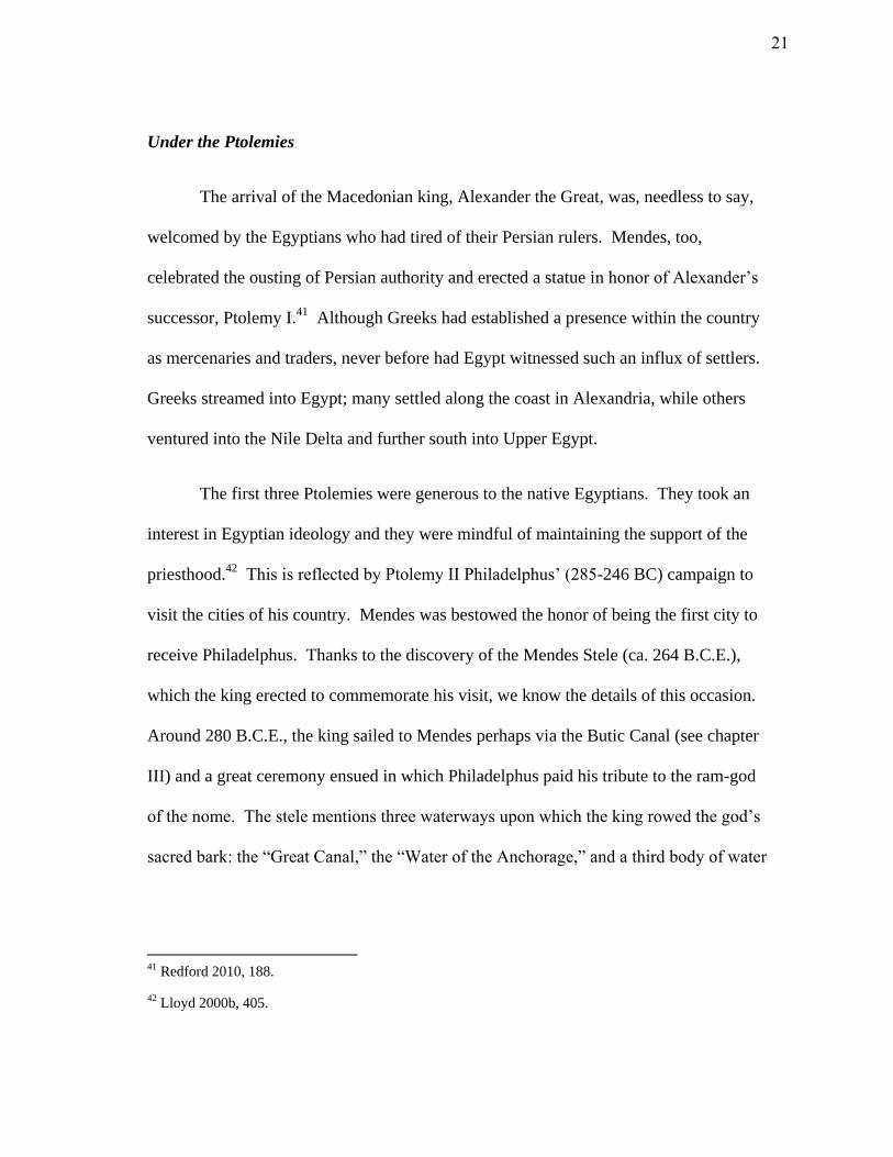
The arrival of the Macedonian king, Alexander the Great, was, needless to say,
welcomed by the Egyptians who had tired of their Persian rulers. Mendes, too,
celebrated the ousting of Persian authority and erected a statue in honor of Alexander’s
successor, Ptolemy I.41
Although Greeks had established a presence within the country
as mercenaries and traders, never before had Egypt witnessed such an influx of settlers.
Greeks streamed into Egypt; many settled along the coast in Alexandria, while others
ventured into the Nile Delta and further south into Upper Egypt.
The first three Ptolemies were generous to the native Egyptians. They took an
interest in Egyptian ideology and they were mindful of maintaining the support of the
priesthood.42
This is reflected by Ptolemy II Philadelphus’ (285-246 BC) campaign to
visit the cities of his country. Mendes was bestowed the honor of being the first city to
receive Philadelphus. Thanks to the discovery of the Mendes Stele (ca. 264 B.C.E.),
which the king erected to commemorate his visit, we know the details of this occasion.
Around 280 B.C.E., the king sailed to Mendes perhaps via the Butic Canal (see chapter
III) and a great ceremony ensued in which Philadelphus paid his tribute to the ram-god
of the nome. The stele mentions three waterways upon which the king rowed the god’s
sacred bark: the “Great Canal,” the “Water of the Anchorage,” and a third body of water
41 Redford 2010, 188.
42 Lloyd 2000b, 405.
21
over which he ferried the image of the god.43
The location and exact nature of these
waterways remains uncertain, but he is perhaps referring to a canal or tributary of the
river, a harbor, and a lake. If Philadelphus’ visit to the Mendesian nome did not
immediately win him the favor of the citizens, his elimination of transit dues (the ferry
toll and the bread tax) and reduction in taxes levied on the Mendesian township certainly
won him wide acclaim within the nome. The generosity of the king, however, was not
without motive.
Ptolemy II Philadelphus inherited a vast empire maintained through the
Ptolemaic naval supremacy achieved by his father. When Philadelphus visited Mendes
in 280 B.C.E., he was at the height of his power; he ruled a thalassocracy that extended
up the Levantine coast, into southern and western Anatolia, as far north as the Black Sea,
across the Aegean and into Southern Greece.44
His interest was not confined to the
Mediterranean Basin, but extended across the Indian Ocean and into the Far East, where
pearls, silk, and exotic spices abounded. Philadelphus’ establishment of the Red Sea
ports Berenike and Myos Hormos facilitated the India trade and ensured a consistent
flow of luxuries to the Hellenistic world. Alexandria reveled in its newly found success
and quickly became the cosmopolitan center of the world.
Careful to maintain this prestigious position against his foremost rivals, the
Macedonians and Seleucids, Philadelphus understood how important it was to adapt to
43 Redford 2010, 194.
44 Marquaille 2008, 46.
22
the needs of the Egyptians. Like his father Ptolemy I Soter, Philadelphus embraced the
title of Egyptian kingship that was required to establish control over the native
population. Unlike Ptolemy I, however, Philadelphus took this effort one step further by
establishing the first ruler-cult in Egypt.45
Egyptian tradition placed the pharaoh as
intermediary between the divine and the physical. Pharaoh carved out his place in the
chaotic universe by maintaining the role of protector of order (ma’at). Realizing the
importance of Egyptian ideology and determined to root the Ptolemaic dynasty within
the pharaonic tradition, Philadelphus made himself a god king and established his very
own cult. The king’s consort and sister, Arsinoe II, was also accorded divinity and was
incorporated into the pantheon of Greek and Egyptian gods. To affirm their presence
within the capital city Alexandria, two colossal statues of Philadelphus and Arsinoe-Isis
welcomed foreign ships that entered the great harbor of Alexandria.46
To establish common ground with their native neighbors, the newly established
Greek populace looked to the Egyptian pantheon for aspects of Greek ideology. The
most popular of these gods, Zeus and Aphrodite became the equivalents of Amun and
Isis.47
Although the equation of Egyptian deities with their Greek counterparts was
practiced perhaps as early as the Saitic period, under the Ptolemies this phenomenon
reached an apex.48
Ptolemy I was responsible for the introduction and promotion of the
45 Pfeiffer 2008, 388.
46 Pfeiffer 2008,387.
47 Pfeiffer 2008, 388.
48 Hockman 2010, 25.
23
Greco-Egyptian god Serapis. Along with his consort Isis, Serapis became an emblem of
Ptolemaic kingship, and thus the most venerated of gods during the Hellenistic period.
Under their protection, Egypt thrived both economically and culturally under the first
two Ptolemaic leaders.
During the third century B.C.E., Mendes and Thmuis partook in the brief return
to prosperity. Today, Ptolemaic pottery litters the surface of both sites. Coins
discovered in the harbor at Mendes attest to activity between the arrival of Alexander the
Great and Ptolemy IV (221-205 BC).49
The suspected harbor at Thmuis also bears
witness to much of this activity. Ceramics found within it, including Aegean amphora
fragments, indicate that the waterfront was in use between the third and mid-second
centuries B.C.E. These imports indicate that even with the dissolution of Ptolemaic
provinces in the Aegean between the late third and second centuries B.C.E., Aegean
imports apparently continued to enter Egypt unhindered. Philadelphus’ visit to the
Mendesian nome had a significant impact on the cities of Mendes and Thmuis. Greeks
settled amongst the Egyptians and several famous historians, including Asclepiades and
Thrasyllus, visited the cities. During these golden days Greeks and Egyptians interacted
on mutual terms. Several Egyptians from the Mendesian nome even maintained
distinguished positions in the local administration and military.50
Unfortunately, this
welcomed hiatus from the turbulence of the preceding times did not last.
49 Redford 2010, 199.
50 Lloyd 2000b, 405.
24
At the end of the third century B.C.E. unrest spread through Egypt. Dissatisfied
with the policies of Ptolemy IV (221-204 B.C.E.), the native Egyptians retaliated in what
became known as the Egyptian Revolt, whereby an independent kingdom was
established at Thebes. A failing economy resulted in an increase in taxation which, in
turn, led to insurgency. The Ptolemaic administration lost the vital support of the
Egyptian priesthood, which Philadelphus had so carefully maintained, and the country
was torn apart by political and nationalistic turmoil. In 196 B.C.E., Ptolemaic forces
subdued the rebel forces of Busiris, a neighboring town of Mendes.51
It is possible that Mendes and Thmuis shared a part in the revolution. Certainly,
the archaeological evidence corresponds to a significant upheaval during the second
century B.C.E. Activity at the harbor of Mendes tapers off after the death of Ptolemy IV
in 204 B.C.E., and many of the waterfront facilities were abandoned. At Thmuis,
destruction deposits dated to the mid-second century B.C.E. are evident in the harbor
and its associated facilities. Toppled mudbrick and scorched ceramics litter the
buildings surrounding the waterfront, while the discovery of ballistae and a decapitated
human skull within the harbor paint a vivid account of what ensued.52
Ptolemaic history
of the late fourth century B.C.E. documents the use of catapults and ballistae during the
famous Battle of Salamis.53
These anti-personnel projectiles were launched from the
smallest caliber of stone throwers, compact in design so that they could be used in urban
51 Redford 2010, 201.
52 Two ballistae were found during excavation in 2010, one within the harbor basin and the other in a
nearby structure.
53 Lloyd 2000b, 397; for more on Hellenistic navies, see Murray 2011.
25
conflict or aboard small warships or freighters, perhaps offensively stationed along the
Mendesian River. Small projectiles like these would have been used to target marines,
deck crews or shore personnel when used in either naval warfare or naval siege warfare.
The discovery of the two ballistae in the destruction deposits around Thmuis’ harbor
area might be evidence of a tactical attack on the city during the second century B.C.E.
It is not certain whether this attack was related to the revolts that characterize the
beginning of this century or to Antiochus IV Ephiphanes’ brief conquest of the Nile
Delta during the Sixth Syrian War.
A decrease in flow of the Mendesian Nile did not help economic matters, and by
the beginning of the first century B.C.E. the harbors of Mendes and Thmuis silted up
while the river meandered eastward.54
By this time the majority of Mendes’ inhabitants
had migrated south to Thmuis; the city probably established a new eastern harbor that
facilitated trade with the new course of the river. The damaged facilities surrounding the
suspected northern harbor at Thmuis were filled in with debris and prepared for a later
foundation. Unfortunately, these strata were stripped by sebakhin activity in recent
times. At the end of the century, a modest temple was constructed atop a mudbrick
structure which bordered the former harbor. The foundation was composed of re-used
and well-worn limestone blocks from the quarry of Tura in Cairo.55
Shortly thereafter,
Egypt fell to Rome.
54 Redford 2010, 201; Ceramic evidence within the harbor of Thmuis indicates a terminus around the mid-
second century B.C.E., following the destruction.
55 Samples of the limestone were analyzed by Adam Shahat, geologist of the Tell el-Timai Harbor Project.
26
Roman Rule
Roman interest in Egypt was centered upon three enterprises: agriculture, mineral
resources, and trade with the Far East.56
Rome’s heavy reliance on Egyptian grain put a
taxing burden on the centers of the Nile Delta. The Roman regime developed an
effective system of taxation, both in kind and currency, which milked Egypt’s resources
dry. Mineral extraction in the Eastern Desert became a focal point for the procurement
of exotic stones.57
Control of Egypt also equated to control over the vast imports of
luxuries from the Orient that passed through the ports of Berenike and Myos Hormos.58
Rome became rich at the expense of the Egyptians.
In addition to its economic position, Egypt also held a strategic military vantage
for Rome’s military campaigns in the east. In 68 C.E. Titus, son of the emperor
Vespasian, led a legion of troops to quell a Jewish revolt in Jerusalem. Josephus relates
that the ships of Titus sailed from Nicopolis (near Alexandria) along the Nile to Thmuis,
whereupon they disembarked and continued overland to Jerusalem.59
Regarding the
itinerary, it appears that Thmuis was as far east as Titus’ fleet could travel along the
inland waterways. This account provides some interesting details regarding the
hydrology of the eastern Nile Delta during this period (see chapter III), as well as the
56 Peacock 2000, 419.
57 Peacock 2000, 419.
58 On Roman trade in the Red Sea and beyond, see Sidebotham and Wendrich 1999; Sidebotham and
Wendrich 1996; Casson 1989; Peacock and Blue 2006.
59 Joseph, IV.11.5 (Whiston 1737).
27
strategic position Thmuis held along the eastern frontier. It is tempting to presume that
Titus moored his fleet of long-ships at a harbor of Thmuis for the duration of his
campaign, but there is no concrete evidence to validate this.
In the second half of the second century C.E., increased financial burdens,
coupled with crop failures and the spread of plague created a disastrous situation. The
papyri discovered at Thmuis offer accounts of this event.60
Intolerable conditions gave
rise to a group of armed rebels, known as Boukoloi. These bandits terrorized the
Mendesian nome and areas of the northern Nile Delta in what became known as the
Boukoloi Revolt. A vicious cycle began when the Roman administration retaliated with
extreme measures of taxation. Unable to meet the fiscal demands of the Roman Prefect,
villagers fled their land and joined the insurgents. Previously, taxes were adjusted
according to the flood and annual crop yield.61
Frustrated with the revolt, however, the
Roman administration drafted measures that effectively placed the tax-burdens of the
rebels upon the shoulders of the remaining villagers who had not departed. As a result,
the regions of the Nile Delta witnessed a massive depopulation. Philo of Alexandria (20
B.C.E. - 20 C.E.) relates:
Villages and towns are rapidly depopulated and emptied of their inhabitants,
who left the country and scattered in places where they had missed.62
60 Blouin (2006, 341-372) provides an account of the papyri which document the Boukoloi revolt.
61 Peacock 2000, 420; Blouin 2006, 38.
62 Blouin 2006, 373.
28
The revolt of the Boukoloi was detrimental to Thmuis and the rest of the
Mendesian nome. This was not the end for Thmuis, however. Christianity quickly
gained favor within the city walls and Thmuis became an Episcopal See at the beginning
of the fourth century C.E. In the mid-fourth century C.E., Ammianus Marcellinus (AD
353- 378) relates that the settlement was one of the most important Egyptian towns of
his time.63
Despite Diocletian’s’ great persecutions in 303 C.E., when in fact the local
bishop Phileas was martyred in Alexandria, the city remained a stronghold for
Christianity throughout the Coptic period up until the arrival of the Arabs.64
Mendes
appears to have survived as a ‘metropolis’ alongside Thmuis, but evidence of Christian
occupation at Mendes ends with the arrival of the Arabs in 641 C.E.65
Thmuis, however,
retained a role as an administrative division (Kura) during the first centuries of Islam
under the Umayyad and Abbasid Dynasties.66
By the time of the Fatimid Caliphs in the
10th
century C.E., after several attempted revolts which devastated the city, Thmuis was
finally abandoned.67
Several small suburbs that flanked the mounds of Tell el-Ruba and
Tell el-Timai persisted and retained the fragmentary names of the two former cities that
once dominated the region; Tata (Djedet), Mondid (Pr-banebdjed), and Tumay.68
Even
today, the vestiges of these ancient suburbs remain. Timai el-Amdid and Kafr el-Amir
63 Meulenaere 1976a, 2.
64 Meulenaere 1976b, 5; Redford 2010, 207; Peacock 2000, 431.
65 Redford 2010, 209.
66 Mackay 1976, 6.
67 Mackay 1976, 9.
68 Redford 2010, 210; Mackay (1976, 9) relates that Al-Mawrada was an old name for Kafr el-Amir
Abdullah.
29
Abdulla Ibn Salam, as they are now called, encroach upon the North-East and North-
West limits of the tell.
Conclusion
The Late Period of Egypt was a truly tumultuous era in which instability at home
and the threat of Persian occupation was constant. This was a time when the ports of
Egypt were essentially open to Greek trade, and Greek mercenaries were among the
Pharaoh’s elite guard. While military families vied for power, local gods and animal
cults dominated the religious scene. Thmuis was established amidst this backdrop,
perhaps as early as the fifth century B.C.E., alongside her sister-city, Mendes.
The Mendesian nome occupied a strategic military zone in the Nile Delta. Early
in her history, Thmuis probably functioned as a satellite harbor of Mendes, involved in
the thriving economic activity of the fifth through fourth centuries B.C.E. Following the
destruction of Mendes and Thmuis at the beginning of the Second Persian Occupation
(343- 332 B.C.E.), the cities witnessed a brief return to normalcy.
Ptolemaic thalassocracy encouraged trading ventures in the Mediterranean and
Aegean. Evidence from the harbors of Thmuis and Mendes attest to lively commercial
activity from these regions between the third and mid-second centuries B.C.E. The
period of revolution during the mid-second century B.C.E. destroyed the harbor facilities
30
at Thmuis. Thereafter, a declining Mendesian Nile marked the final end for the eastern
harbors at Mendes during the first century B.C.E.
With Mendes waning, Thmuis took the lead. Thmuis’ position in the
northeastern Nile Delta was utilized by the Romans for economic and military purposes.
The city’s location along the Butic Canal facilitated the transport of grain and provided
an attractive launching point for military ventures in the east. The Roman Empire’s high
demand for agricultural output ultimately put a heavy burden on the Mendesian nome.
In the second century C.E., faced with an economic crisis, the inhabitants of the nome
revolted in what became known as the Boukoloi Revolt. The consequences of the revolt
were disastrous for the city of Thmuis which never fully recovered.
31
CHAPTER III
TOPOGRAPHY OF THE NORTHEASTERN NILE DELTA
In recent years, interest in the paleo-hydrology and paleo-landscape of the Nile
Delta has increased. Several studies have partially traced the defunct branches of the
Nile to understand the effects of the river system on settlement patterns. A few of these
studies have been completed in the eastern Nile Delta, for instance at Pelusium. The
majority of research conducted, however, is heavily concentrated in the western Nile
Delta. The well-known sites of Naucratis, Thonis-Heracleion, and Alexandria have
attracted scholars for decades, and it is of no surprise that the majority of geological
work has centered on these areas. Despite the preponderance of attention in the west,
several notable studies have been completed in northeastern Delta, and have certainly
directed new light onto this region. Manfred Bietak’s geophysical work at Tell el-Daba ,
approximately 50 km northwest of Thmuis, has provided a model for future work in the
Nile Delta.69
Bietak demonstrated the efficiency and importance of incorporating
geophysical and geological data into archaeology, correlating settlement distribution of
Avaris with its surrounding hydrology. Jean-Daniel Stanley’s work along the
easternmost fringe of the Egyptian coastline has uncovered a wealth of information
regarding the evolution of Pelusium and the Pelusiac branch of the Nile. Several studies
69 Bietak 2009.
32
focused specifically on the sites of Mendes, Tell el-Timai, and Tell Tebilla seek to
understand aspects of the hydrology around these settlements. Apart from the work of
these scholars, few studies on the hydrology of the eastern Nile Delta have been
completed. For this reason, our understanding of the former waterways in the region is
minimal. The purpose of this chapter is to discuss the available historical,
archaeological, and geological evidence concerning the landscape and waterways of the
northeastern Nile Delta.
The Holocene River
The Nile River maintained an integral role in the economic, political and cultural
affairs of Egypt throughout antiquity. From the ancient Egyptian perspective the waters
of the Nile were the life-source for agriculture, commerce, and travel throughout the
extensive river valley. Settlement generally followed the course of the river; when a
river branch silted up or took a new course, settlements either perished or people devised
ways to divert the life-giving waters of the Nile. Most Egyptian settlements were
centered upon the river.
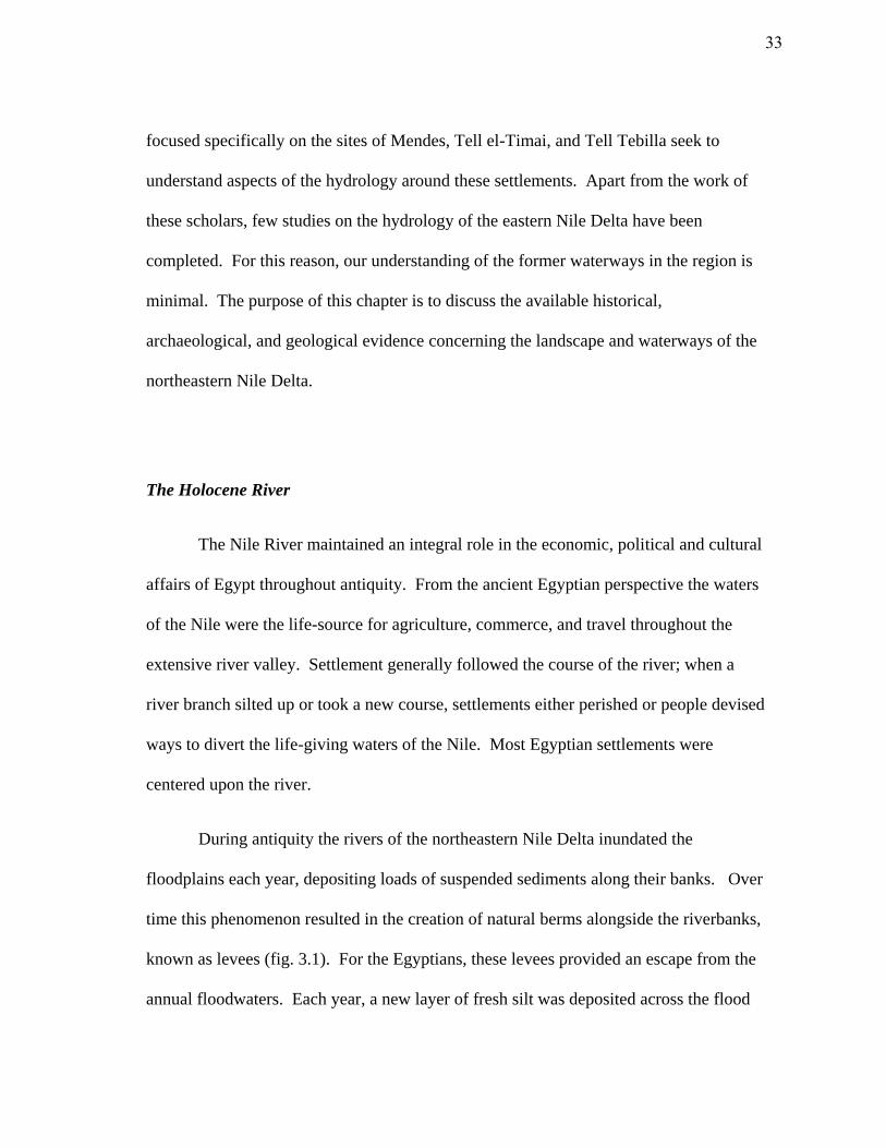
During antiquity the rivers of the northeastern Nile Delta inundated the
floodplains each year, depositing loads of suspended sediments along their banks. Over
time this phenomenon resulted in the creation of natural berms alongside the riverbanks,
known as levees (fig. 3.1). For the Egyptians, these levees provided an escape from the
annual floodwaters. Each year, a new layer of fresh silt was deposited across the flood
33
Fig. 3.1. The formation of a levee.
34
plain, and thereby increased its height. The levees upon which people settled,
maintained their height above the encroaching alluvial landscape through continuous
occupation. In fact, a distinctive feature of many tells today is their substantial elevation
relative to the nearly flat surrounding landscape.
People also inhabited natural sand islands created by the Paleolithic river. During
the early and mid-Pleistocene, forceful Nile floods created sand mounds, also known as
geziras (‘islands’) or turtle-backs.70
Originally these geziras stood above the alluvial
plain and often provided havens for settlement within the Nile Delta. Most of these sand
mounds were eventually buried by the continuous deposit of alluvial sediments. Today,
the only viable means for determining whether a settlement was established upon a levee
or a sand gezira is through coring. At Mendes cores revealed that the settlement was
established upon four ancient levees of the Mendesian Nile which ran southwest to
northeast (fig. 1.2).71
Given its name, ta-mawy (‘new land’), it seems logical that
Thmuis was also built atop a natural levee of the Mendesian River. Generally, this term
is employed for a type of land that is newly created by the meandering of the Nile.72
Coring in the northern sector of Tell el-Timai in 2009, however, revealed gezira sand in
a single auger at a depth of approximately 8-10 m. The presence of gezira sand
suggests that Thmuis was founded, at least partially, upon a Pleistocene turtle-back.
Additional coring across the tell is needed to substantiate this hypothesis.
70 Andres and Wunderlich 1992, 158.
71 Redford 2010, 2, 211-12.
72 Janssen 1961, 79.
35
The landscape of the Nile Delta underwent extensive changes throughout the
course of history. The most profound of these changes occurred more recently after the
construction of the two dams at Aswan in 1964 and several barrages on the Nile.73
One
of the most devastating results of the dam has been the departure of the annual Nile
flood. The majority (98%) of the flood discharge and suspended sediments are no longer
distributed across the Delta, causing extensive coastal erosion and increased salinization
of the groundwater.74
Consequently, the dynamic landscape of the ancient Nile Delta is
no longer evident. A crucial phenomenon when considering the Egyptian landscape is
the annual fluctuation of the river prior to the completion of the Aswan Dam.
For the Egyptians the area known as the Nile Delta was called, Mehit, or quite
literally, ‘the papyrus marsh.’ The region was called such because during antiquity at
least one third of the landscape was underwater throughout the year.75
Each summer
coinciding with the appearance of the star Sothis (Sirius), the waters of the Nile rose
following rains in the distant African Lakes plateau and the Ethiopian highlands.76
Unlike the Tigris and Euphrates rivers in Mesopotamia, the Nile inundation was a highly
predictable phenomenon that was usually detected in mid- June and peaked in late
August-September.77
During the period of inundation, the settlements of Lower Egypt,
73 Cooper 2008, 75; Banna and Frihy 2009, 1594.
74 Stanley and Warne 1993, 633.
75 Brier and Hobbes 1999, 218.
76 Cooper 2008, 75.
77 Cooper 2008, 75.
36
which were situated on natural levees and geziras, remained above the waters and
exuded the appearance of islands amidst a sea.78
With a little imagination it would be easy to think that you were lost in the middle
of a calm sea, but one without the slightest allure.79
When the river was at its highest, transport along the Nile was easiest. Water
levels rose to at least 2.5 m above the countryside and sometimes reached as high as 3.5
m during an exceptionally large flood.80
At this time, conditions along the main
branches of the river were at their best. This was generally the season when large
cargoes of stone and grain were loaded onto barges for transport.81
Land transport
proved both laborious and expensive so the transfer of men and goods was conducted
primarily on the river. Furthermore, the annual inundation, transformed the majority of
the inhabitable landscape into a watery abyss, making land routes virtually non-existent.
An interconnected system of waterways and artificial canals made the Nile Delta
navigable for most of the year, if not year round for watercraft with minimal draughts.82
78 Strabo, XVII.4 (Jones 1932); Diod. Sic. (Oldfather 2004, I.36) compares the Delta under inundation to
the Cyclades.
79 Fabre (2004-5, 46) cites this quote from a geographer who visited the Delta in 1935.
80 Cooper (2008, 78) mentions these levels from observations made in more recent times. Modern levels
of the flood (before Aswan High Dam) are comparable to those in the medieval Arab period. It is
assumed, therefore, that conditions on the Nile were generally similar throughout antiquity.
81 Cooper (2008, 85) notes that the practice of moving grain from the granaries to the transfer points at the
river ports was a yearly feat; Doyle 1998, 240; Lindsay (1968, 145) discusses a Roman document dating to
40 AD in which a landlord coordinates the transport of bulk commodities overland to the river ports before
the waters of the flood peaked.
82 Cooper 2008, 80; Strabo, XVII.4 (Jones 1932).
37
The first century C.E. Roman mosaic from the Temple of Fortune at Praeneste,
Italy (fig. 3.2) provides an alluring depiction of the Nile Delta under flood. A galley
transports troops near the shore of a temple, brailed-sailed vessels navigate across the
inundated plains, a private vessel hunts hippopotami in the marshes, and papyrus skiffs
skirt between villages. The mosaic offers an idyllic yet accurate scene of what life was
like in Nile Delta during the inundation. One of the Thmuis mosaics (fig. 3.3) would be
right at home amongst this waterscape.
The flood waters quickly declined between October and November, resulting in a
period of low Nile where only the primary river branches, and perhaps a few of the
major canals, were navigable by boat.83
When the river was at its lowest, navigation on
the inland waterways was fraught with difficulties and danger, and was presumably
impassible for larger cargo vessels. More recent accounts of the low Nile suggest that
the water level in the Delta was 6.5 m below those of the flood, and that the widths of
the river branches were reduced to half their normal span. In the early 20th
century, G.
Dempster described the sailing conditions during low Nile:
Navigation is… most unreliable… during the summer months when, on account
of sand bars, (the river) becomes almost impossible on certain reaches, except
for the shallowest draught boats.84
83 Cooper 2008, 75, 79-80.
84 Dempster 1917, 1.
38
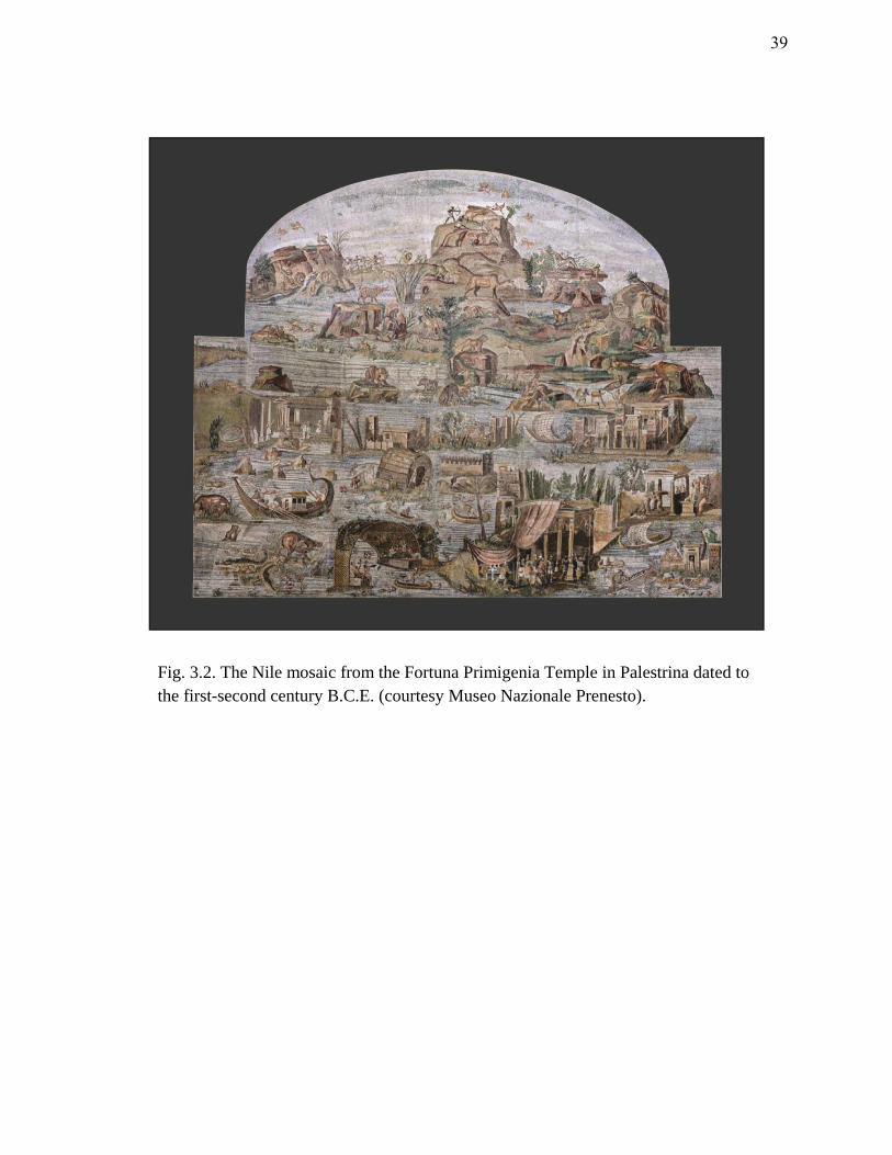
Fig. 3.2. The Nile mosaic from the Fortuna Primigenia Temple in Palestrina dated to
the first-second century B.C.E. (courtesy Museo Nazionale Prenesto).
39
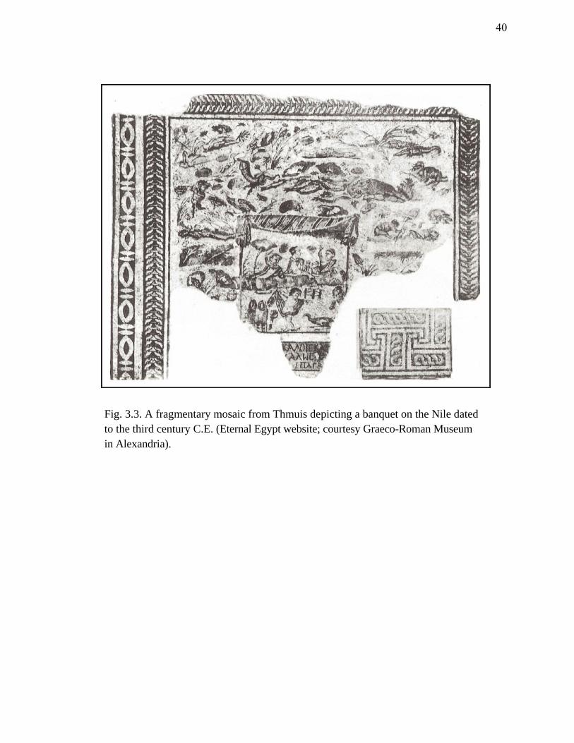
Fig. 3.3. A fragmentary mosaic from Thmuis depicting a banquet on the Nile dated
to the third century C.E. (Eternal Egypt website; courtesy Graeco-Roman Museum
in Alexandria).
40

Devices, known as nilometers, were employed to carefully monitor and measure
the waters of the Nile. These consist of either a staircase built into a well or a quay with
a fixed scale. The most common remains are from the Greco-Roman period.
Measurements were important predictors for the outcome of the harvest and, thereby, for
determining the annual land tax.85
One such nilometer, built in 715 C.E., still exists in
the heart of Cairo at el-Rawdah (Roda Nilometer). Plutarch (2nd
century C.E.) mentions
several Nilometers in the Nile Delta, including ones at Memphis, Xois (central-north
Nile Delta), and Mendes.86
Taking into account the economic role of the Nile Delta for
agriculture production (namely grain export), it is not unlikely for such devices to have
been employed throughout the region. The fact that Plutarch mentions Mendes as one of
cities with such a device indicates the nome’s dependence on the annual flood for
agriculture and trade.
Considering the aridity of the Nile Delta today, it is difficult to envision the
appearance it took during antiquity. Locating the former waterways that traversed the
landscape is the first step to understanding how the Egyptians interacted with this highly
dynamic and volatile riverine environment.
85 Peacock 2000, 420.
86 Blouin 2006, 156.
41
Irrigation
As early as the Amratian Period (4100-3600 BC), people employed rudimentary
forms of irrigation.87
Early in history these techniques were simple: the dredging of
river channels, the construction of earthen dams and the diversion of water into fields.88
Later, irrigation became more complex. Artificial waterways and lakes were excavated
to expand the natural floodplain and to maintain transport routes, while harbors and
quays were constructed to facilitate trade. To enhance economic productivity, the
Egyptians devised an ingenious method of basin irrigation which survived into the mid-
19th
century.89
Several basins of varying sizes were constructed alongside the river.
During the flood, water was let into these basins to a depth of 1-2 m and held for 40-60
days before it was drained.90
This was sufficient time for the suspended silt to be
deposited onto the fields. The basin-irrigation system that characterized the Nile Delta
landscape created a floodplain that was intersected with dykes, which held the flood
water for set periods.91
Prior to Roman times, the number of canals in the Nile Delta
made it virtually impossible to traverse the region from east to west, and also provided a
security barrier for the cities against overland attacks.92
87 Doyle 1998, 2.
88 Doyle 1998, 2.
89 Hurst 1957, 38.
90 Hurst 1957, 38.
91 Cooper 2008, 78.
92 Fabre (2004-5, 50) notes the construction of roads and the Butic Canal during the Roman period.
42
Egypt’s network of natural and artificial waterways formed a complex hydraulic
system that could have only been maintained through an organized government. The
construction of canals, and even lakes, became a popular royal endeavor about which
rulers often boasted.93
The papyri unearthed from Thmuis shed further light on
irrigation within the Mendesian nome (see below). The texts reveal that the nome
employed an extensive irrigation system that diverted, stored, and drained water for
cultivation purposes.94
The system was maintained through the implementation of
corvee labor and taxes levied by the state.95
Corvee labor and taxes played an integral
role in the maintenance of Egypt’s inland waterways since the Old Kingdom.96
The
development and maintenance of the hydraulic network around Thmuis and Mendes
reflects a highly organized Imperial enterprise centered on maximizing agricultural
production and commerce.
Geological Factors in the Northeastern Nile Delta
Figuratively and literally speaking, the eastern Nile Delta was highly fluid during
antiquity. Hydrological changes were swift and often the result of a combination of
natural and anthropogenic factors. The landscape was characteristically low and flat and
93 Doyle 1998, 2.
94 See Blouin 2006.
95 Blouin 2006, 165.
96 Hurst (1957, 49) suggests that the implementation of corvee labor for dredging canals dates back to the
Old Kingdom.
43
the former Nile branches which once transected Lower Egypt were prone to lateral
shifting.
At around 3000 B.C.E. the Nile Delta coastline was roughly 20-50 km south
(inland) from its present position. The coastal cordon consisted primarily of sand ridges
and wetlands (marshes and lagoons). These wetlands prevailed in the northern Nile
Delta for much of antiquity and extended farther inland than modern Lake Manzaleh
does today (fig. 3.4).97
Although the sea level progressively rose until approximately
500 B.C.E., the northern Delta plain maintained a slight elevation above the sea and
prograded northward at a rate of nearly 10 m per year due to the sediment load deposited
by the annual flood.98
During this span of time two primary eastern Nile branches, the
Mendesian and the Pelusiac, flowed strongly. The prevailing west-east offshore currents
of the Mediterranean gradually transported Nile sediments to the east, and resulted in a
general eastward migration of the two river lobes (fig. 3.5).99
Rates of subsidence are both high and variable across the northern Nile Delta. In
general, this variance has caused the relative northeastward tilting of the Delta plain.
The northeastern region of the Nile Delta is subject to numerous highly active tectonic
processes. The area is bounded on the northwest and southeast by two faults that lie
perpendicular to the coast, while the southern portion has a fault that is horizontal to the
97 Stanley and Warne 1993, 632.
98 Coutellier and Stanley 1987, 268; a recent study by Becker and Sultan (2009, 953) estimates that the
coastline around modern Damietta is subsiding at rate of 6-8 mm/yr, while the area around the ancient
Mendesian Nile is experiencing a moderate subsidence of 2-6 mm/yr.
99 Coutellier and Stanley 1987, 268.
44
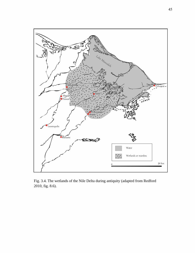
Fig. 3.4. The wetlands of the Nile Delta during antiquity (adapted from Redford
2010, fig. 8.6).
45
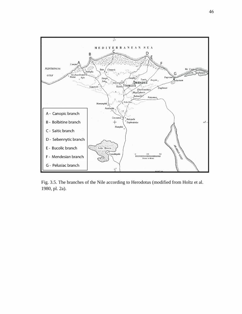
Fig. 3.5. The branches of the Nile according to Herodotus (modified from Holtz et al.
1980, pl. 2a).
46
coast. Due to these fault zones, the region comprising modern Lake Manzaleh (north of
Mendes and Thmuis) has traditionally experienced the highest rates of subsidence.100
These factors caused this region to remain inundated for much of antiquity up until the
beginning of the 19th
century.101
At the beginning of the Common Era, natural and anthropogenic factors resulted
in major changes in the local hydrology of the eastern Nile Delta. Population increase
during Hellenistic times put a significant demand on maximizing agricultural production.
Ultimately, this led to extensive land reclamation projects and increased canalization and
irrigation of the Delta plain.102
At the same time, Nile discharge, particularly in the
Mendesian branch, began to wane and the primary channels subsequently began to
gradually silt up. Delta progradation diminished and several branches had to be
artificially maintained through organized dredging, while others such as the Mendesian
could not be sustained due to diminished water flow.103
Seismic activity in the
northeastern-most portion of the Nile Delta, coupled with the substantial subsidence of
the central areas, gradually created a slight westward tilt. This favored a shifting of the
Nile branches toward the west.104
By the end of the first millennium C.E. the eastern
Delta tributaries were still in a state of decline. Further change was triggered by three
100 Stanley and Warne 1993, 629.
101 Coutellier and Stanley 1987, 269; Stanley and Warne 1993, 632.
102 Blouin (2006, 235, 373, 397) discusses the effects of canalization and irrigation on the local hydrology
of the Mendesian nome.
103 Stanley and Warne 1993, 632.
104 Van Wesemael 1988, 128; Stanley et al. 2008, 459.
47

major Nile floods in 813, 816, and 820 C.E.105
These events, evidenced by Nilometer
records, marked the beginning of the final end for the Pelusiac River. Loads of Nile
sediment, carried eastward along the coast by longshore currents, rapidly silted in the
Pelusiac Nile and effectively cut the settlement of Pelusium off from both the river and
the sea.106
Nile channel flow suddenly shifted from the northeast toward the northwest,
and the former Nile branches of the eastern Nile Delta (Pelusiac, Tanitic, and
Mendesian) migrated westward to the area now crossed by the Damietta branch.107
By the end of the first millennium C.E. the seven branches of the Nile,
proclaimed by classical historians, had declined to only two; Rosetta and Damietta (fig.
3.6). Defunct channels were subsequently converted into canals that no longer reached
the coast but irrigated the landscape.108
It is around this time that the present
configuration of Lake Manzaleh took shape. Sea level rise during the mid-first
millennium C.E. inundated the low coastal region of the northeastern Delta plain,
creating modern Lake Manzaleh, described as ‘an alkaline wilderness highly charged
with salts.’109
Regional geophysical and geoarchaeological studies in the northeastern
Nile Delta reveal a highly complex and variable evolution of hydrology. Natural and
anthropogenic processes, including seismic activity, coastal processes, subsidence, river
105 Goodfriend and Stanley 1999, 150.
106 Goodfriend and Stanley 1999, 150; Cooper 2008, 64.
107 Stanley et al. 2008, 459.
108 Stanley and Warne 1993, 632.
109 Said 1992, 264.
48
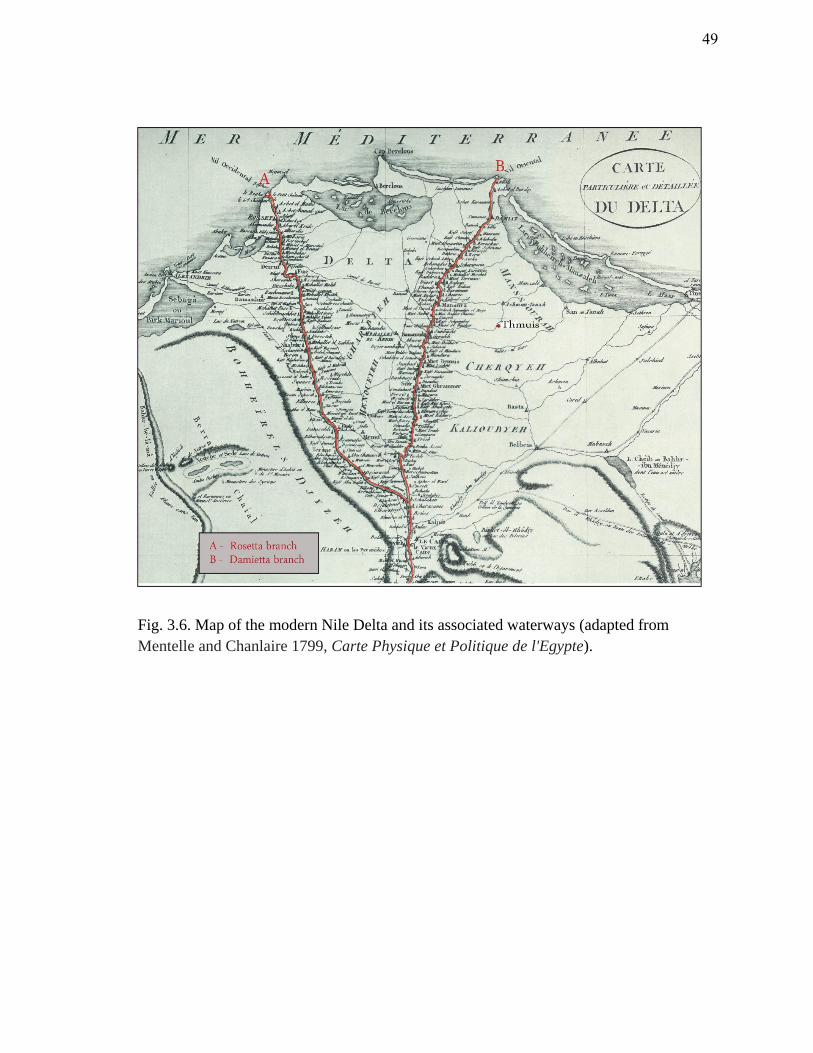
Fig. 3.6. Map of the modern Nile Delta and its associated waterways (adapted from
Mentelle and Chanlaire 1799, Carte Physique et Politique de l'Egypte).
49
discharge, climate change, sea level rise, and artificial irrigation, subjected the region to
extensive changes throughout history. The continual reworking of the landscape and
hydrology has left a complex evolutionary history that is evident only through extensive
geophysical examination and geological coring.
Local Hydrology
"Mendes, along the crag of the sea, farthermost horn of the Nile, where the goat-
mounting he-goats have intercourse with women."110
Due to the geological, natural, and human-induced processes described above,
the topography of the ancient eastern Nile Delta was highly fluid. Consequently, tracing
the defunct waterways that fed the region of Thmuis and Mendes has proven
problematic. While ancient authors from the fifth century B.C.E. up to the second
century C.E. refer to the Mendesian branch of the Nile (fig. 3.7), few actually provide
specific details regarding the route of the river.111
Occasionally, Mendes and Thmuis are
mentioned, perhaps indicating that a course of the river flowed somewhere within the
vicinity of the cities.112
Again, the sources are incredibly vague and leave much room
110 Strabo, XVII.19 (Jones 1932).
111 Cooper 2008, 30.
112 Strabo (Jones 1932, XVII.19-20) mentions the Mendesian nome in his description of the Mendesian
mouth; Pliny (Bostock and Riley 1855, HN V.11) states that the city of Mendes was one such town that
gave its name to its associated river (the Mendesian).
50
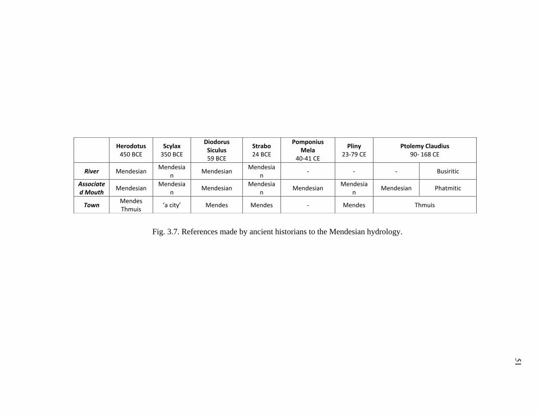
Herodotus
450 BCE Scylax
350 BCE
Diodorus Siculus 59 BCE
Strabo 24 BCE
Pomponius Mela
40-41 CE
Pliny 23-79 CE
Ptolemy Claudius 90- 168 CE
River Mendesian Mendesia
n Mendesian
Mendesian
- - - Busiritic
Associated Mouth
Mendesian Mendesia
n Mendesian
Mendesian
Mendesian Mendesia
n Mendesian Phatmitic
Town Mendes Thmuis
‘a city’ Mendes Mendes - Mendes Thmuis
Fig. 3.7. References made by ancient historians to the Mendesian hydrology.
51
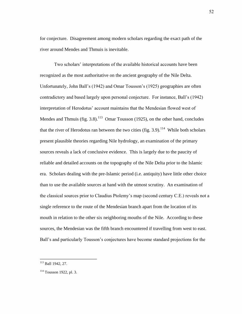
for conjecture. Disagreement among modern scholars regarding the exact path of the
river around Mendes and Thmuis is inevitable.
Two scholars’ interpretations of the available historical accounts have been
recognized as the most authoritative on the ancient geography of the Nile Delta.
Unfortunately, John Ball’s (1942) and Omar Tousson’s (1925) geographies are often
contradictory and based largely upon personal conjecture. For instance, Ball’s (1942)
interpretation of Herodotus’ account maintains that the Mendesian flowed west of
Mendes and Thmuis (fig. 3.8).113
Omar Tousson (1925), on the other hand, concludes
that the river of Herodotus ran between the two cities (fig. 3.9).114
While both scholars
present plausible theories regarding Nile hydrology, an examination of the primary
sources reveals a lack of conclusive evidence. This is largely due to the paucity of
reliable and detailed accounts on the topography of the Nile Delta prior to the Islamic
era. Scholars dealing with the pre-Islamic period (i.e. antiquity) have little other choice
than to use the available sources at hand with the utmost scrutiny. An examination of
the classical sources prior to Claudius Ptolemy’s map (second century C.E.) reveals not a
single reference to the route of the Mendesian branch apart from the location of its
mouth in relation to the other six neighboring mouths of the Nile. According to these
sources, the Mendesian was the fifth branch encountered if travelling from west to east.
Ball’s and particularly Tousson’s conjectures have become standard projections for the
113 Ball 1942, 27.
114 Tousson 1922, pl. 3.
52
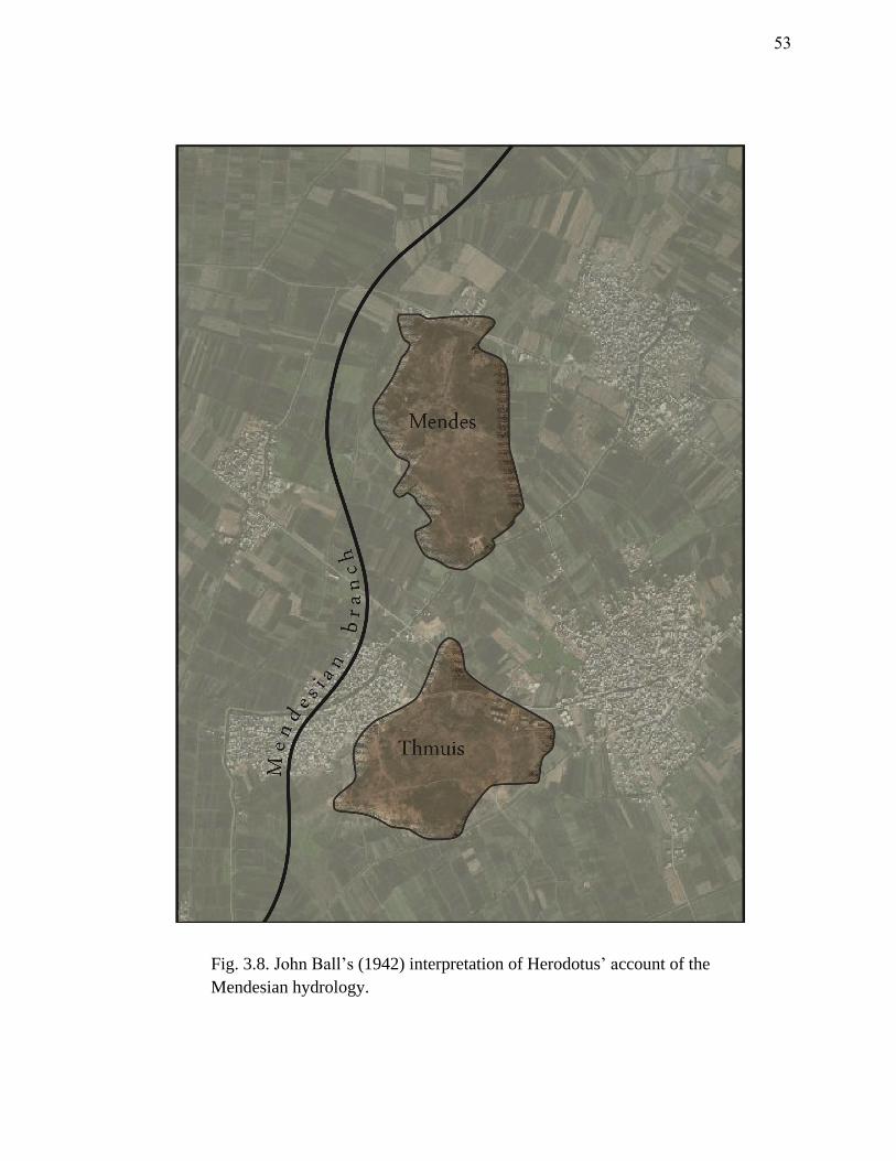
Fig. 3.8. John Ball’s (1942) interpretation of Herodotus’ account of the
Mendesian hydrology.
53
Fig. 3.9. Omar Tousson’s (1925) interpretation of Herodotus’ account of the
Mendesian hydrology.
54
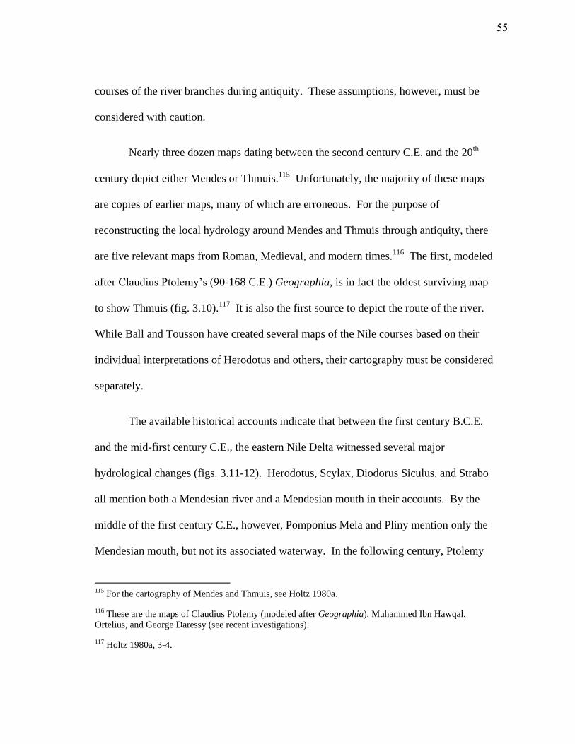
courses of the river branches during antiquity. These assumptions, however, must be
considered with caution.
Nearly three dozen maps dating between the second century C.E. and the 20th
century depict either Mendes or Thmuis.115
Unfortunately, the majority of these maps
are copies of earlier maps, many of which are erroneous. For the purpose of
reconstructing the local hydrology around Mendes and Thmuis through antiquity, there
are five relevant maps from Roman, Medieval, and modern times.116
The first, modeled
after Claudius Ptolemy’s (90-168 C.E.) Geographia, is in fact the oldest surviving map
to show Thmuis (fig. 3.10).117
It is also the first source to depict the route of the river.
While Ball and Tousson have created several maps of the Nile courses based on their
individual interpretations of Herodotus and others, their cartography must be considered
separately.
The available historical accounts indicate that between the first century B.C.E.
and the mid-first century C.E., the eastern Nile Delta witnessed several major
hydrological changes (figs. 3.11-12). Herodotus, Scylax, Diodorus Siculus, and Strabo
all mention both a Mendesian river and a Mendesian mouth in their accounts. By the
middle of the first century C.E., however, Pomponius Mela and Pliny mention only the
Mendesian mouth, but not its associated waterway. In the following century, Ptolemy
115 For the cartography of Mendes and Thmuis, see Holtz 1980a.
116 These are the maps of Claudius Ptolemy (modeled after Geographia), Muhammed Ibn Hawqal,
Ortelius, and George Daressy (see recent investigations).
117 Holtz 1980a, 3-4.
55
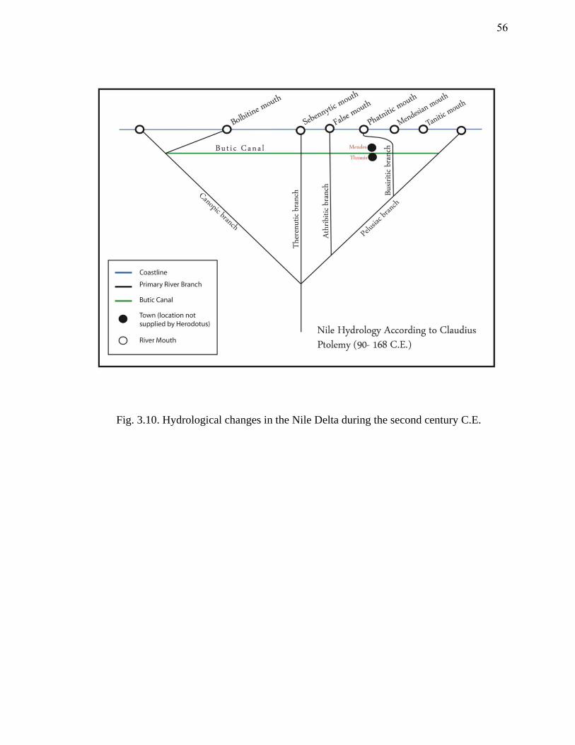
Fig. 3.10. Hydrological changes in the Nile Delta during the second century C.E.
56
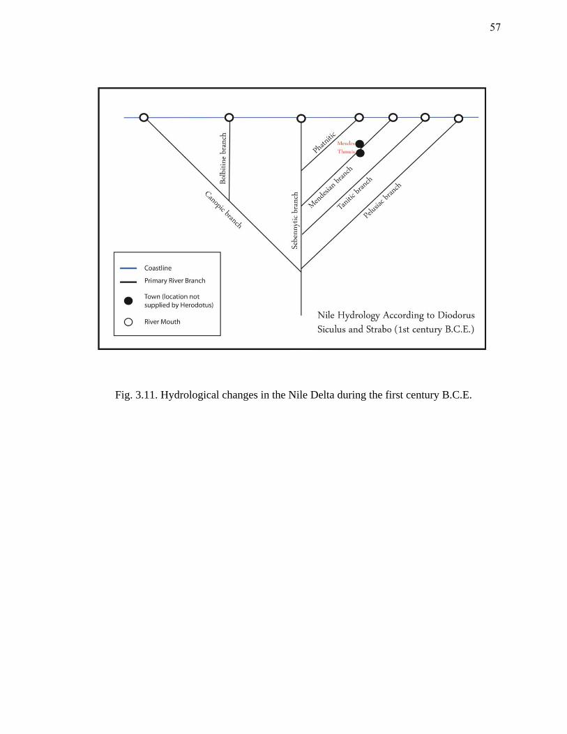
Fig. 3.11. Hydrological changes in the Nile Delta during the first century B.C.E.
57
Fig. 3.12. Hydrological changes in the Nile Delta during the first century C.E.
58
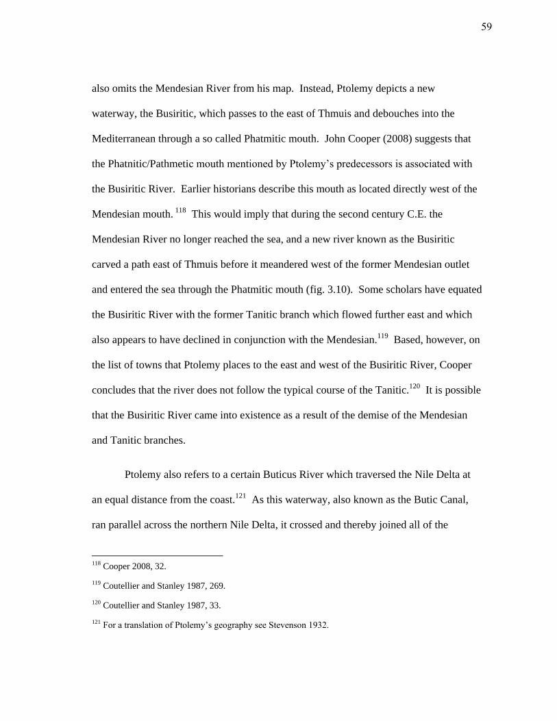
also omits the Mendesian River from his map. Instead, Ptolemy depicts a new
waterway, the Busiritic, which passes to the east of Thmuis and debouches into the
Mediterranean through a so called Phatmitic mouth. John Cooper (2008) suggests that
the Phatnitic/Pathmetic mouth mentioned by Ptolemy’s predecessors is associated with
the Busiritic River. Earlier historians describe this mouth as located directly west of the
Mendesian mouth. 118
This would imply that during the second century C.E. the
Mendesian River no longer reached the sea, and a new river known as the Busiritic
carved a path east of Thmuis before it meandered west of the former Mendesian outlet
and entered the sea through the Phatmitic mouth (fig. 3.10). Some scholars have equated
the Busiritic River with the former Tanitic branch which flowed further east and which
also appears to have declined in conjunction with the Mendesian.119
Based, however, on
the list of towns that Ptolemy places to the east and west of the Busiritic River, Cooper
concludes that the river does not follow the typical course of the Tanitic.120
It is possible
that the Busiritic River came into existence as a result of the demise of the Mendesian
and Tanitic branches.
Ptolemy also refers to a certain Buticus River which traversed the Nile Delta at
an equal distance from the coast.121
As this waterway, also known as the Butic Canal,
ran parallel across the northern Nile Delta, it crossed and thereby joined all of the
118 Cooper 2008, 32.
119 Coutellier and Stanley 1987, 269.
120 Coutellier and Stanley 1987, 33.
121 For a translation of Ptolemy’s geography see Stevenson 1932.
59
surviving Nile branches (fig. 3.10). By Ptolemy’s day the Butic Canal appears to have
been completed. A century earlier, when Josephus relates to us the journey of Titus
across the Nile Delta in his History of the Jewish War (c. AD 75), the canal was
seemingly still under construction.
Titus marched on foot as far as Nicopolis, which is distant twenty furlongs from
Alexandria; there he put his army on board some long ships, and sailed upon the
river along the Mendesian Nomus, as far as the city Tumuis; there he got out of
the ships, and walked on foot, and lodged all night at a small city called Tanis.
His second station was Heracleopolis, and his third Pelusium; he then refreshed
his army at that place for two days, and on the third passed over the mouths of
the Nile at Pelusium.122
From Josephus’ account it appears that during the first century C.E. the Butic
Canal crossed the Nile Delta only as far as Thmuis (fig. 3.13). Thereafter, any eastward
travel was either conducted on foot or confined to the primary Nile branches. This canal
seems to have been maintained into the 10th
century C.E. In 977 C.E., Arab geographer
Muhammed Ibn Hawqal refers to a Za’faraniyyah canal that runs west from the Damietta
branch to the Rosetta branch, roughly parallel to the coast.123
According to Cooper
(2008) there are several references to segments of this waterway by later authors. In the
16th
century, cartographer Ortelius (Abraham Ortel, 1527-1598) completed two maps
122 Joseph, IV.11.5 (Whiston 1737).
123 Cooper 2008, 50.
60
Fig. 3.13. The course of the Butic Canal in the mid-first century C.E.
61
depicting Thmuis. His original map (1565) shows Thmuis west of the Busiritic River
and there is no trace of the Butic Canal. Two decades later, Orelius made a second map
(1584) that is obviously largely copied from Ptolemy’s geography. This time he depicts
the Butic Canal running between Mendes (shown too far north) and Thmuis. Holtz
(1980) finds the discrepancy between these two maps as evidence for the absence of the
Butic Canal in the 16th
century. He suggests that Ortelius’ initial map was a far more
accurate rendition of the Nile Delta than his later copy.124
Nonetheless, Ptolemy’s
geography was copied for several centuries until, finally, in the 18th
and 19th
centuries
Pere Claude Sicard and James Burton visited Mendes and Thmuis and completed the
first accurate maps of the area. Unfortunately, by their day the former hydrology of the
eastern Nile Delta was largely unrecognizable.
Recent Investigations
Over the last two decades several geophysical and geological studies have been
completed in the northeastern Nile Delta.125
Despite this research, the accurate
configuration of the former Nile waterways is largely unknown. The handful of studies
completed at Mendes and Thmuis have barely unveiled the complex network of
waterways around the two sites. In 1998 Ayman Taha used several methods of
geophysical survey around Mendes and Thmuis to delineate the paleo-branches of the
124 Holtz 1980a, 5.
125 See Tronchere et al. 2008; Bietak 2009; El-Qady et al. 2006; Taha 1998.
62
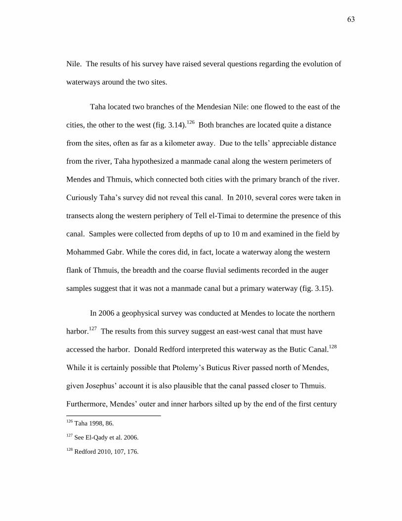
Nile. The results of his survey have raised several questions regarding the evolution of
waterways around the two sites.
Taha located two branches of the Mendesian Nile: one flowed to the east of the
cities, the other to the west (fig. 3.14).126
Both branches are located quite a distance
from the sites, often as far as a kilometer away. Due to the tells’ appreciable distance
from the river, Taha hypothesized a manmade canal along the western perimeters of
Mendes and Thmuis, which connected both cities with the primary branch of the river.
Curiously Taha’s survey did not reveal this canal. In 2010, several cores were taken in
transects along the western periphery of Tell el-Timai to determine the presence of this
canal. Samples were collected from depths of up to 10 m and examined in the field by
Mohammed Gabr. While the cores did, in fact, locate a waterway along the western
flank of Thmuis, the breadth and the coarse fluvial sediments recorded in the auger
samples suggest that it was not a manmade canal but a primary waterway (fig. 3.15).
In 2006 a geophysical survey was conducted at Mendes to locate the northern
harbor.127
The results from this survey suggest an east-west canal that must have
accessed the harbor. Donald Redford interpreted this waterway as the Butic Canal.128
While it is certainly possible that Ptolemy’s Buticus River passed north of Mendes,
given Josephus’ account it is also plausible that the canal passed closer to Thmuis.
Furthermore, Mendes’ outer and inner harbors silted up by the end of the first century
126 Taha 1998, 86.
127 See El-Qady et al. 2006.
128 Redford 2010, 107, 176.
63
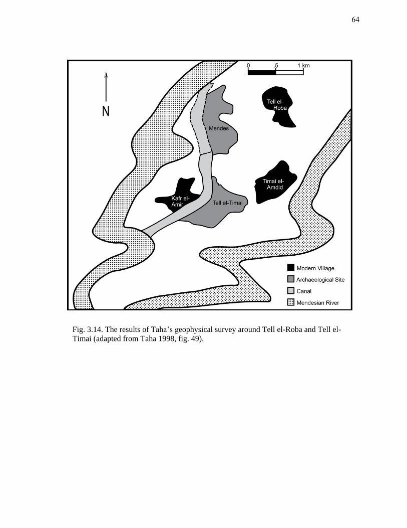
Fig. 3.14. The results of Taha’s geophysical survey around Tell el-Roba and Tell el-
Timai (adapted from Taha 1998, fig. 49).
64
Fig. 3.15. A defunct channel of the Nile located during the 2010 Tell el-Timai
coring season.
65
B.C.E., shifting focus to Thmuis. Although Mendes did not altogether disappear,
Thmuis became the primary center of occupation. Given its new status, it seems more
likely that the Butic Canal passed close to Thmuis. Josephus does relate that Titus
“sailed upon the river along the Mendesian Nomus, as far as the city Tumuis; there he
got out of the ships.”129
An undated map by George Daressy (1864-1938) depicts a rather unusual linear
ridge several miles east of Mendes (fig. 3.16).130
In 1965, Robert Holtz and several
members of the Mendes Expedition examined this ridge. He describes the anomaly as “a
narrow ridge, twelve to twenty-five feet high, that extends from east to west for about
four and one half miles.”131
Holtz believes this ridge to be the spoil pile from the
excavation of the Butic Canal. The ridge would have likely bordered the canal along its
southern bank, retaining the water much like a dyke would. The remains of this ridge
are no longer visible around Mendes and Tell el-Timai, however, Holtz noted that at
roughly three and a half miles east of Mendes, the ridge abruptly angles to the southwest.
This would imply a course that ran between the modern tells of Mendes and Tell el-
Timai. Holtz also remarks that the contour lines around the modern tells indicate that
the topography here is markedly lower and, therefore, favorable for such a canal
129 Joseph, IV.11.5 (Whiston 1737).
130 Holtz 1980a, 12.
131 Holtz 1980b, 22.
66

Fig. 3.16. The remains of the Butic Canal according to the Atlas Archeologique de
l’Egypte (modified from Hall and Bothmer 1980, pl. 13a).
67

trajectory between the sites.132
Given the evidence it seems probable that the Butic
Canal traversed the Mendesian nome just north of Thmuis.
A Preliminary Reconstruction of the Hydrology Around Thmuis
Given the dynamic nature of the eastern Nile Delta and the relatively modest area
that has been examined around Mendes and Thmuis at this stage, it is futile to provide an
accurate reconstruction of the former hydrology. Nonetheless, a preliminary
arrangement of the major waterways can be deduced from the available historical and
archaeological evidence. Various models are discussed below.
Based on the location of the harbors at Mendes and their corresponding material
evidence, it would seem that between the seventh and fourth centuries B.C.E., the
northwest and eastern limits of Mendes were accessible to the river.133
Tousson suggests
that the Mendesian of the fifth century B.C.E. flowed west of Thmuis and then
meandered between the sites to flow along the eastern side Mendes (fig. 3.9). One of the
augers collected in 2009 near the suspected harbor at Thmuis (northern tip of the tell)
included a rich sand horizon at a depth of 4-4.5 m. Adam Shahat, a local geologist from
Mansoura University, believes this to be evidence of one of the following scenarios: a) a
point bar at the concave side of a defunct channel formed when a river begins to
meander (fig. 3.17); or b) a crevasse splay related to high floods (when the river
132
Holtz 1980b, 22.
133 Redford 2010.
68
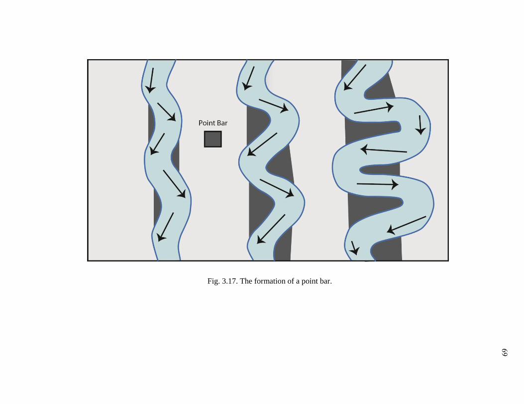
Fig. 3.17. The formation of a point bar.
69
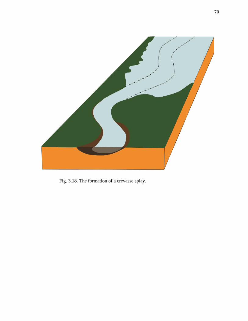
Fig. 3.18. The formation of a crevasse splay.
70

breaches its levee) (fig. 3.18).134
Both scenarios indicate that a branch of the Nile
flowed nearby. The cores from 2010 also indicate that at some point a branch of the
Nile was located along the western flank of Thmuis.
The Mendesian River steadily declined, beginning perhaps in the second century
B.C.E., but most certainly during the following century. The Mendesian mouth silted in
and became a false-mouth that was no longer connected to the Nile. Taha’s eastern
branch likely represents a phase of the general eastward migration of the river during
this time (fig. 3.14). Until dates of the river branches are obtained, however, this
remains unclear. Sometime in the first century C.E., the Butic Canal was partially
completed as far as Thmuis. It was probably upon this canal that Titus and his army
sailed to the city. By the second century C.E., the Mendesian was replaced by a more
easterly Busiritic River, and the Butic Canal now traversed all of the major sea-bound
branches of the Nile.
Conclusion
The modern Nile Delta bears little resemblance to its ancient topography.
Reconstructing the paleo-hydrology of the region is problematic due to the shifting
courses of waterways throughout history. Scholars have been interested in the changing
configuration of the Nile channels since antiquity. Ancient and medieval historians
compiled various reconstructions of the waterways. Recent scholars, such as Ball and
134 Personal communication with Adam Shahat.
71
Tousson, compiled their versions of Nile hydrology based upon the ancient sources.
Examination of the various natural and anthropogenic factors that influenced the Nile
Delta reveals a more complex hydrological evolution than what either Ball or Tousson
postulated. When the river branches of the eastern Nile Delta were flowing strong, the
prevailing west-east offshore currents of the Mediterranean supported a general eastward
shift of the waterways. In the first century C.E., however, natural and anthropogenic
factors caused the silting up of the Mendesian and Tanitic branches and a sudden
westward tilt to the Nile Delta. The construction of the Butic Canal might have been
either a response to the waning rivers or, among the several culprits that caused the
rivers’ decline. In the ninth century C.E., several unusually high floods ultimately
changed the configuration of the Nile Delta waterways. The Pelusiac silted in and
channel flow was suddenly directed west to the present Damietta branch. The former
waterways largely disappeared, and the inhabitants of the eastern Nile Delta were forced
to adapt to their changing landscape. Many, however, could not. Following the ninth
century C.E., Thmuis does not appear in medieval accounts.
72
CHAPTER IV
COGNITIVE APPROACH
Although the Nile was a relatively predictable river regarding its annual
inundation, life along its banks was not idyllic. Since the dawn of time, people were
conscious of the consequences and threats imparted by the river. The earliest inhabitants
along the Nile Valley employed various means of controlling and directing the river to
suit their needs. Methods of irrigation, such as levees and dams, were employed as early
as pre-dynastic times to divert and store the fruitful waters of the Nile.135
Later, more
advanced techniques, such as canals, reservoirs, and harbors provided the Egyptians with
a more extensive means of utilizing their riverine environment for farming, shipping,
and ways to manage the river’s inherent risks.136
Due to man’s close intercourse with his riverine environment, a unique
terminology and ideology developed in Egypt concerning the maritime environment and
its associated activities. The Egyptians’ keen awareness of maritime space is reflected in
their vocabulary. The purpose of this chapter is to examine the Egyptian’s cognitive
view of their maritime space and the system of beliefs which arose as a result of man’s
involvement with the maritime environment. Ideology was conveyed through the
135 Van Lepp (1995) discusses the evidence for organized artificial irrigation during the Amratian Period;
The Scorpion Macehead (Predynastic or first Dynasty) is a later example of organized irrigation works.
136 For more on risk management within the Mendesian nome during the Roman period, see Blouin 2006.
73
mythology, literature, and iconography of Egypt. Although this was a universal ideology
that was expressed throughout Egypt, it was also featured at a more personal level in the
local city cults. This chapter will discuss how the inhabitants of Thmuis incorporated
their local deities into this broader framework to assert divine control over the volatile
environment in which they lived.
The Hazards of Life Along the Nile
Life along the Nile presented a variety of benefits and misfortunes for the
Egyptians. While the river provided a means of sustenance and transportation, it often
wreaked havoc upon those who settled along its banks and who sailed upon its
waterways. Apart from the consequences of a low flood or the demise of a river branch,
the Nile also presented a series of hazards to the Egyptian sailor. As John Cooper
concluded in his 2008 dissertation on medieval navigation in Egypt, sailing along the
Nile was not as idyllic as is often assumed.137
Conditions on the Nile were generally
felicitous for water transport; the currents flow in a northerly direction while the
prevailing winds blow towards the south.138
Nile navigation, however, was extremely
dangerous and far from passive; it presented similar hazards, if not more, to those at sea.
Unexpected gales, storms, and treacherous shallows were threats encountered by Nile
boatman and seaman alike. Historical accounts of the Nile indicate that sudden storms
137 Cooper 2008, 75.
138 Cooper 2008, 74.
74
were a frequent cause of shipwreck along the river. When Florence Nightingale visited
Egypt in 1849 she experienced one such occasion:
“I saw one of the dhahabiehs (boat) which had overtaken us in the afternoon,
floating past up, bottom up.”139
The northerly Etesian winds felt in the summer provided steady propulsion for
Nile vessels when the river was at its lowest. However, during the winter months a
variety of wind patterns from the north and south, and gale-force gusts from the west
were frequent and the likely culprit of many shipwrecks. On the other hand, periods of
calm in which no winds blew were also problematic for ancient navigators who sailed
along the interior waterways.
Navigating the waters of the Nile was an active, seasonal and hazardous
endeavor that required precision, expertise, and adaptability to the fluctuating conditions
of the riverine landscape. Through their continual interaction with the river the
Egyptians developed a colorful understanding of the Nilotic landscape. Their perception
of this fertile, dynamic, and ominous environment is reflected in the distinctions they
used for this space, as well as in their religious ideology.
139 Nightingale 1854, 65.
75
Cognitive Terminology
The Egyptians interacted with their riverine environment since the Predynastic
Period.140
Iconography from Amratian pottery (4000-3500 BCE) and the Scorpion
Macehead (c.3050-2890 BCE) provide early evidence for the use of watercraft and
artificial irrigation. Although some scholars argue that the Egyptians did not sail the
open sea, there is evidence to suggest seaborne trade since the Naqada IIc/d period (c.
3500-3200 B.C.E.)141
This was the inevitable result of Egypt’s proximity to the sea.
Seagoing ships on the Fifth Dynasty temple causeways of kings Sahure and Unas, attest
to an established network of seagoing activity.142
For years scholars have debated the
seafaring capabilities of the Egyptians. The crux of the dispute has been the
questionable meaning behind the Egyptian terminology for specific bodies of water and
whether stone anchors discovered within Egypt were used by river craft or seagoing
vessels.143
Regardless of the Egyptians’ familiarity and close intercourse with the Nile
and the sea, their terminology for these maritime spaces was often vague and variable.
A consensus has yet to be made by scholars on the meanings of the various terms, such
140 Hollis 2009, 2. The Egyptians had been sailing on the Nile since Predynastic times and on the sea since
the Old Kingdom.
141 See Mark (1998) for more on Egypt’s sea connections with northern Syria during the Predynastic
period. A. Nibbi and C. Vandersleyen argue that the ancient Egyptians did not venture to sea. See Nibbi
1975; Nibbi 1979a; Nibbi 1981; Nibbi 1997; and Vandersleyen 1991. F or a synopsis of their work see
Meeks 1997. For a critical review of Nibbi’s work see Kitchen 1978; and Kitchen 1983.
142 See Basch 1985, 456; Hassan 1955, 139 fig. 2; Hollis 2009, 2; Smith 1965, fig. 6.
143 For more on the discussion of the function and use of Egyptian stone anchors, see Basch 1985; Basch
1994; Nibbi 1979b; Nibbi 1979c; Nibbi 1984; Nibbi 1992. Basch does not agree with Nibbi’s assertion
that stone anchors were employed on the Nile and are evidence that the Egyptians were not seafarers.
76

as Wadj-wer, Haunebut, Ra-haout, Yam, and Nun, which were employed by the
Egyptians to define their maritime zones.
Despite the Egyptians’ vast awareness of their maritime environs, they lacked a
distinct terminology for these spaces. Various terms were employed and shared
throughout the course of Egypt’s history to define the maritime space of the Nile River,
the Mediterranean Sea, and the Red Sea. Wadj-wer (literally, the ‘great green’) was a
god associated with fertility and the sea. His often androgynous body and close
association with water led earlier scholars to erroneously coin him a ‘Nile god.’144
He is
depicted in, The Book of Going Forth By Day, as a fecundity figure protectively
guarding two rectangular bodies of water identified as, “the lake of natron” and “the lake
of maet”. He is accompanied by the inscription, “Sea is his name,” and the god, Heh
(Chaos-god) is seated to his left. Wadj-wer became a personification of the sea and
various other bodies of water, including lakes and regions of the Nile.145
The oldest and most common term for the sea was Wadj-wer (‘great green’). It
was used to identify a space in and outside of Egypt depending on the textual context
and could identify several maritime realities.146
During the Old Kingdom Wadj-wer was
the general term for the sea, but it could also refer to branches of the Nile as well as
144 Faulkner et al. 2008, 159.
145 Fabre 2004-5, 12.
146 Cline (2010, 822) explains that the Egyptian phrase, “islands in the midst of the Great Green” could
refer to the Mediterranean sea but also the Aegean sea.
77

lakes in the Nile Delta and Fayoum.147
The ambiguity of the term led several scholars to
the radical conclusion that Egyptians were not aware of their maritime space, could not
designate it, and therefore never navigated on it.148
This view has since been largely
discredited by scholars due to the iconographic, textual, and archaeological evidence for
seafaring in ancient Egypt.149
The recent discovery of evidence for seagoing vessels and
trade at Mersa Gawasis further disproves the view that the Egyptians were not sailors.150
Another term that has prompted much discussion is Haunebut. It appears in the
Old Kingdom alongside Wadj-wer and seems to designate the coastal fringe of the Nile
Delta where freshwater and brackish water lagoons and swamps were prevalent.151
The
coastal cordon was a buffer zone between the Mediterranean and the Nile River and
ships entering or leaving the Nile Delta would cross this region. The vagueness of these
early terms is somewhat perplexing, yet the assumption that the Egyptians were not
aware of the different maritime zones of their world is inaccurate.
During antiquity the inundated regions of the Nile Delta were connected to the
Mediterranean Sea via the coastal cordon of river mouths, lakes, and lagoons. As
Herodotus relates, when the Nile broke its banks, the country was converted into a sea
147 Meeks 1997, 175.
148 For an overview of R.Herzog, A. Nibbi, C. Favard-Meeks, and V. Vandersleyen’s opinions on the term
Wadj-wer, see Meeks 1997.
149 See Basch 1985; Kitchen 1978 and 1983.
150 See Ward and Zazzaro 2010.
151 Fabre (2004-5, 15) explains that the term Haunebut was originally reserved for a population living on
the coastal margins of Egypt.
78
and nothing could be seen but the towns which looked like islands amidst the Aegean.152
While the Egyptians were obviously aware of the underlying differences between the
inland waterways of the Nile and the open ocean, assigning a fixed terminology for these
zones was evidently not necessary. While it is not clear to what extent seagoing ships
travelled along Egypt’s inland waterways, they must have been capable of entering the
Nile Delta through the river mouths.153
The connectivity of the river and the sea is
reflected in the amalgamation of meaning behind the terms for these environments.
Furthermore, the enterprise of navigating the Nile presented similar hazards, if not more,
to those of the sea. Unexpected gales, storms, and treacherous shallows were threats to
the Nile boatman just as they were to the seaman. It is easy to surmise, then, that to the
Egyptians the Nile River was in many ways a sea with its seasonal conditions,
fluctuating winds and currents, and the imminent threat of shipwreck.
Beginning in the New Kingdom, when the Egyptian Empire held vast territories
across the Levant, a shift in the Egyptians’ cognitive view of maritime space occurs.
Probably as a result of increased maritime trade, new terms appear that reflect a desire to
distinguish the various inland and sea zones of Egypt. While Wadj-wer and Haunebut
continue to be employed, Ra-haout, Yam, and Nun were used to distinguish new and
known realities. Ra-haout probably referred to the mouths of the Nile while Nun was
152 Hdt., II. 97 (Rawlinson 1928); Nibbi 1972, 12.
153 The New Kingdom tomb of Kenamun (Davies and Faulkner 1947, 40-6, pl. 8) provides the best
iconographic evidence of foreign seagoing ships travelling along the inland waterways of the Nile.
Similarly, the tomb of Nebamun (New Kingdom) (Säve-Söderbergh 1957, pl. 23) depicts Syro-Canaanite
ships, though a Nilotic context is not clear.
79
often used when referring to the Red Sea.154
Following the 18th
Dynasty the Semitic
word, Yam, was used on several occasions to designate inland bodies of water, as well
as the Mediterranean and Red Sea.155
While new terms for maritime zones found their
way into use, the overlap between terms that referred to the sea and inland waters
prevailed.
Not until the Hellenistic Period, when the Ptolemaic thalassocracy extended
across the Mediterranean, were the previously ambiguous terms for the sea finally
clarified. Wadj-wer and Haunebut respectively denoted the Mediterranean, or the ‘great
sea of Syria,’ and the Aegean.156
Nonetheless, modern Egyptians have maintained, to
some degree, the ambiguity of their ancient predecessors when defining their maritime
space. The various branches and tributaries of the Nile River are still commonly referred
to as “seas” (el-Bahr). The false assumption that the Egyptians could not define nor
distinguish their maritime space due to their lack of awareness or involvement in these
areas is unfounded. Egyptians were intimately involved with the marine environments
at sea and along the Nile. As the network of interaction with the Mediterranean, Aegean
and Red Seas expanded in the New Kingdom and reached an apex under the Ptolemies,
new terms were needed to define these maritime zones. The maritime space of the
Egyptians, specifically the waters of the Nile and the bordering seas, was an
interconnected region; this is reflected in the terms which were employed to delineate it.
154 Nibbi 1972, 16.
155 Nibbi 1972, 26-8.
156 Fabre 2004-5, 19; Meeks 1997, 188.
80
Religion
For the Egyptians, the afterlife was essentially a reflection of daily life. What
one did in life, one aspired to continue in the hereafter. By the Hellenistic period the
general view of the afterlife was far more optimistic than other ancient religions.157
If
the deceased could overcome the ominous supernatural threats of the underworld and
pass the final judgment of the gods, his soul was permitted to dwell in the
paradisiacal realm of Osiris, god of the dead. Egyptian religion is a complex system of
beliefs that went through several transformations over the course of history. While it is
not within the scope of this thesis to provide a detailed discussion of Egyptian religion,
several general observations are necessary prior to the examination of the Mendesian
ideology.
From early in Egypt’s history, the underworld (Duat) was viewed as a watery
abyss of rivers, marshes, and islands.158
This unearthly realm immediately calls to mind
the inundated landscape of the Nile Delta described by Strabo; “the whole Delta
becomes a lake and is underwater except for the settlements; these are situated on natural
hills…which when viewed from afar resemble islands.”159
In the Duat, deities and
spirits of the deceased sailed across the celestial landscape much as the living would on
earth. Menacing forces that plagued the living were also present in the afterlife.
157 Hollis (2009, 2) states that one reason Egyptian cults were so widespread in the Greek and Roman
worlds was because they promised ‘ecstatic salvation’ as opposed to the ‘very cold, non-charismatic
worship.’
158 Geraldine 2004, 121.
159 Strabo, XVII.4 (Jones 1932).
81
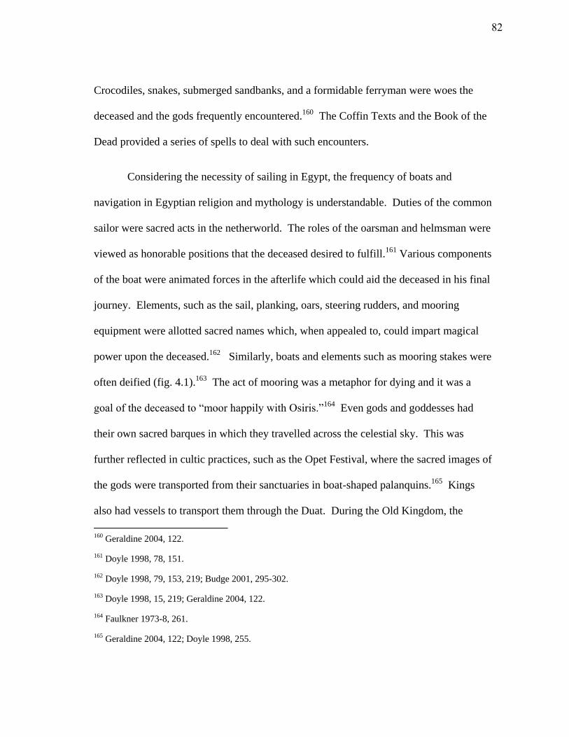
Crocodiles, snakes, submerged sandbanks, and a formidable ferryman were woes the
deceased and the gods frequently encountered.160
The Coffin Texts and the Book of the
Dead provided a series of spells to deal with such encounters.
Considering the necessity of sailing in Egypt, the frequency of boats and
navigation in Egyptian religion and mythology is understandable. Duties of the common
sailor were sacred acts in the netherworld. The roles of the oarsman and helmsman were
viewed as honorable positions that the deceased desired to fulfill.161
Various components
of the boat were animated forces in the afterlife which could aid the deceased in his final
journey. Elements, such as the sail, planking, oars, steering rudders, and mooring
equipment were allotted sacred names which, when appealed to, could impart magical
power upon the deceased.162
Similarly, boats and elements such as mooring stakes were
often deified (fig. 4.1).163
The act of mooring was a metaphor for dying and it was a
goal of the deceased to “moor happily with Osiris.”164
Even gods and goddesses had
their own sacred barques in which they travelled across the celestial sky. This was
further reflected in cultic practices, such as the Opet Festival, where the sacred images of
the gods were transported from their sanctuaries in boat-shaped palanquins.165
Kings
also had vessels to transport them through the Duat. During the Old Kingdom, the
160 Geraldine 2004, 122.
161 Doyle 1998, 78, 151.
162 Doyle 1998, 79, 153, 219; Budge 2001, 295-302.
163 Doyle 1998, 15, 219; Geraldine 2004, 122.
164 Faulkner 1973-8, 261.
165 Geraldine 2004, 122; Doyle 1998, 255.
82
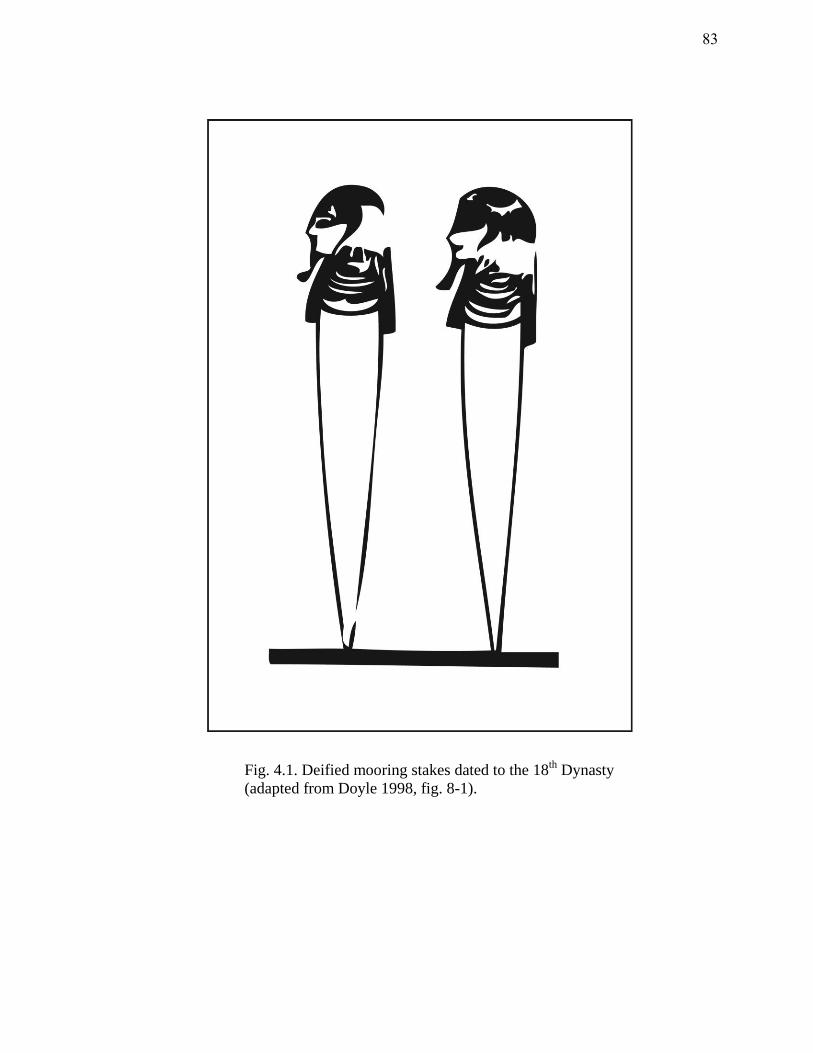
Fig. 4.1. Deified mooring stakes dated to the 18th
Dynasty
(adapted from Doyle 1998, fig. 8-1).
83
Pyramid Texts describe the voyage taken by the deceased king on a papyrus skiff, the
seminal watercraft of ancient Egypt.166
Sailing at sea and along the inland waterways of the Nile was a dangerous
enterprise and the divine were often invoked for protection. Goddesses were commonly
appealed to for aid in navigation in both the divine and real worlds. Hathor, mistress of
foreign lands, was commonly associated with elements of boats, such as the oars and the
rudder.167
Often depicted in human form with the ears and horns of a cow, Hathor was a
deity closely associated with the living king and queen. Her origins date back to the
Second Dynasty (2890-2686 B.C.E.) in Egypt and her cult first appears at Byblos
(modern Gebal in Lebanon, known in antiquity as Gubla or Keben/Kepen) in the Sixth
Dynasty (2345-2181 B.C.E.); “Hathor, Mistress of Dendera, who lives in Byblos.”168
In
the Coffin Texts, which appear at the beginning of the Middle Kingdom (c.2055-1650
B.C.E.) the deceased is reassured that, “Hathor, Lady of Byblos, makes the steering oar
of your barque.”169
The factors behind Hathor’s early and prolonged association with
Byblos remain uncertain, but they are presumably related to Byblos’ function as primary
port of exchange for quality wood. The cedar forests of northern Syria were exploited
by Egypt since the beginning of the Old Kingdom (c.2686-2160 B.C.E.).170
166 Geraldine 2004, 122.
167 Morenz and Keep 1992, 262.
168 Hollis 2009, 1.
169 Hollis 2009, 1.
170 Hollis 2009, 2.
84
Iconographic evidence for this trade was found in the causeways of the Fifth Dynasty
kings Sahure and Unas at Abusir and Saqqara.171
These timber resources provided wood
for boats, coffins, and various architectural items.172
A fragmented literary text dating to
the end of 20th Dynasty speaks of a voyage to Byblos by a certain priest named
Wenamun to purchase cedar for the construction of a new barque for the god Amun.173
The fruitful trade between Egypt and Byblos lasted millennia.
Hathor’s role as “Mistress of Byblos” seems to be associated with these
economic relations. A temple dedicated to the “Mistress of Byblos” was constructed at
Byblos around 2800 B.C.E., and appears to be directly related to merchant activity.174
In
this respect, the “Mistress of Byblos” offered protection to the merchants and traders that
frequented the port. Hathor, associated early-on with foreign lands, became a popular
guardian for Egyptian sailors. On the walls of Deir el-Bahari, Hatshepsut’s ships bring
offerings for “Hathor of Punt” so “that she may bring wind.”175
Indeed, the goddess has
several epithets that associate her with sailing, navigation, and foreign lands: “the
beautiful wind of Hathor” (Old Kingdom), “beautiful are the oars of Hathor” (Middle
Kingdom), “the Mistress of the Port,” and “Hathor of Nubia.”176
By the New Kingdom,
171 See Hassan 1955, 139 fig. 2; Smith 1965, fig. 6.
172 Hollis 2009, 2.
173 Egberts 2001, 495-6; see Pritchard (1969, 25-9) for a translation of the Wenamun text.
174 Hollis 2009, 2.
175 Naville 1898, Pl. LXXII (bottom left of plate); Sethe 1961, 323, II. 1-5.
176 Hollis 2009, 3.
85
however, when the tale of Wenamun’s voyage was composed, a new Egyptian deity had
gained prominence.
Isis, a goddess widely known in the Hellenistic and Roman worlds, first appears
in Egyptian texts in the Fifth Dynasty. Unlike Hathor who is firmly rooted in the living
world, Isis was a popular deity associated with the afterlife. Her early representations in
the Pyramid Texts portray her in a role as a mortuary goddess who nurtures and aides the
deceased.177
In the guise of mourning women, Isis and her sister Nephthys are
occasionally depicted at the bow and stern of funerary barques.178
Isis’ relation with
Osiris, god of the dead, as his sister and consort ultimately played a role in her rise to
prominence. By the New Kingdom, Isis assimilated the aspects and symbols
traditionally associated with Hathor.179
One of these associations was shipping; Isis
states, “I am the mistress of navigation.”180
However, it is not until the seventh century
B.C.E. that evidence for the Isis cult appears at Byblos. When Isis made her appearance
at Byblos, she remained closely associated with Hathor until the second century C.E.
when she was finally given an independent role in Plutarch’s, De Iside et Osiride, a twist
on the earlier Isis and Osiris myth. In this tale, Osiris, who has been locked in a chest
and thrown into the Tanitic branch of the Nile by his jealous brother Seth, is swept in the
Mediterranean Sea and carried by the currents to a shore near Byblos. Isis is portrayed
177 Hollis 2009, 1.
178 Fischer 1976.
179 Hollis 2009, 1.
180 Hollis 2009, 4.
86

as a strong ruler who watches over Egypt in her husband’s absence (probably a
reflection of the Ptolemaic queens). As a devoted sister and wife, she finally journeys to
Byblos to retrieve her dead husband who has been incorporated by the king of Byblos
into a pillar of a building. After a brief stay at Byblos, in which she makes herself known
to the queen there, Isis takes the body of Osiris and sails back to Egypt. By Plutarch’s
day, the Hellenized-Isis cult was widely-spread throughout the Roman Empire. Her
assimilation of the major Egyptian and Greek goddesses transformed her into a universal
goddess whose promise of “ecstatic salvation” attracted Egyptians, Greeks, and Romans
alike.181
At the end of the fourth century B.C.E., two Hellenized deities were born in
Egypt; Serapis and Isis. Serapis, a Greco-Egyptian god in whom the Egyptians saw the
equivalent of Osiris, incorporated several aspects of the savior god Zeus, the underworld
god Pluto, the fertility god Dionysus, and the healing god Asklepios.182
Although the
origin of this deity is somewhat obscure, he was quickly incorporated into the Ptolemaic
regime.183
Ptolemy I appears to be the first king to associate Serapis with Osiris-Apis (the
deified Apis Bull).184
The new god was provided with a consort who also appealed to
181 Morenz and Keep 1992, 263; Hollis 2009, 1-2.
182 Pfeiffer 2008, 391-2.
183 According to Heyob (1975, 6), it remains unclear whether Serapis was developed by Alexander the
Great or his successor, Ptolemy I.
184 Pfeiffer (2008, 389) notes that the Apis Bull at Memphis was closely tied to Egyptian kingship since
the Old Kingdom. Upon the sacred bull’s death, he was thought to transform into the god Osiris-Apis.
87
Egyptian and Greek interests. The Hellenistic Isis was born in Alexandria around the
same time as her consort, Serapis. Although she maintained many of the same aspects as
her Egyptian counterpart, the Hellenized Isis assimilated several qualities and roles from
Greece. For the Greeks, Isis fulfilled the role of Aphrodite; the foremost goddess of sea
power, beauty, marriage, and sexual desire.185
At the end of the fourth century B.C.E., about the same time the Greco-Egyptian
Isis appeared in Egypt and abroad, Aphrodite was a patron deity for royal women and
courtesans in Greece.186
Isis, therefore, became the goddess of many names and her all-
encompassing attributes fulfilled the needs of the Egyptians, Greeks, and later the
Romans. Her followers appealed to her for help in childbirth, illness, or navigation.187
Isis’ association with the sea flourished between late Ptolemaic times through the Roman
period; she was the “mistress of the winds,” “protector of sailors,” and thought to be the
“inventor of navigation and the sail.”188
Isis was sometimes provided with one of the
following epithets; Pharia, Pelagia, or Euploia. The distinction between the three
adjectives is unclear, but Pharia appears to be used as a synonym of the latter two
terms.189
Isis’ power over the sea made her the foremost deity of fisherman and sailors:
185 Carney 2000, 35-9.
186 Carney 2000, 34; Heyob 1975, 6. An inscription from Halicarnassus dated to the end of the 4th century
BCE is the oldest reference to Serapis and Isis outside of Egypt.
187 Versnel 1993, 45.
188 Williams 1985, 111.
189 Bricault (2000, 136) notes that the term Pharia is first attested in the late 1st century BCE and continues
to be used into the fourth century CE. Bricault (137) also discusses the reference to the deity by Tibullus
as Isis-Io (iuvenca Pharos).
88
“I soothe the sea and make it wave” and “I make the navigable unnavigable whenever it
pleases me.”190
During the third century B.C.E. the Isis cult spread along the coasts of Greece,
and Delos became one of the important centers of worship for Isis and Serapis.191
By the
second and first centuries B.C.E., Isis was widely known throughout Greece, in Boeotia,
Phocis, the Peloponnesus, Euboea, Epirus, Thessaly, Thrace and Macedonia, Rhodes, the
islands of the Aegean, and as far as Asia Minor.192
The cult spread along the coasts of
Italy during the second century B.C.E., flourishing in the port cities and centers of
trade.193
Eventually, the cults of Isis and Serapis had gained such support among the
lower classes that the Roman authorities began a period of persecution in the first
century B.C.E. The annual festival of the Ploiaphesia, and the later version known as the
Isidis Navigium, celebrated Isis’ role in nautical matters and continued to do so well into
the sixth century C.E.194
190 See Versnel 1993, 43.
191 Heyob 1975, 7.
192 Heyob 1975, 8.
193 Heyob 1975, 10-13.
194 Williams 1985, 111; see also Alföldi 1937.
89
The Mendesian Theology
Comparable to early Mesopotamian religion, the various roles and powers which
the Egyptians attributed to their local gods were directly related to the economic and
environmental conditions of the region in which the gods resided.195
The allotment of
certain deities for the protection of the economy was a result of the “numinous
experience in situations connected with basic life-sustaining situations.”196
Thus, since
its early inception the religious ideology of the Mendesian nome was highly focused on
fertility and yield. The earliest deity associated with Mendes and found on the nome
emblem, was the fish goddess Hatmehit (“foremost of the fishes”).197
Although
Hatmehit was known elsewhere for her participation in the Osiris myth, and an epithet of
hers was discovered in the temple of Dendera in Upper Egypt, she was not worshipped
outside of the Mendesian nome.198
As a fish goddess she was inherently related to the
watery environs around Mendes and Thmuis. A temple near the port of Mendes,
dedicated to her during the Ramesside period, perhaps reflects her association with water
travel and commerce.199
Her later syncretism (coalescence of one god with another)
with Isis and Nephthys further emphasizes her relation to fertility and the regenerative
195 See Silver (1995) for the economic role of gods.
196 Quote taken from Silver (1995, 8).
197 Geraldine 2004, 114; Meulenaere 1976d, 178.
198 Meulenaere 1976d, 178.
199 Blouin 2006, 274.
90
qualities of the Nile flood.200
Isis would later assimilate the attributes and position of the
fish-goddess in the Mendesian nome.
During the Greco-Roman period Hatmehit took on an additional role which
seems to be related to the perfume industry at Mendes and Thmuis. The following
inscription was found at the temple of Dendera in Upper Egypt: “Queen of Punt,
Mistress of Myrrh, who produces all the…, whose perfume is diffused throughout the
Two Lands.”201
This epithet calls to mind the earlier appellation of Hathor, chief deity
of Dendera temple, “Mistress of Punt.” Incense and myrrh were imported from Punt
perhaps as early as the Old Kingdom, but certainly during Hatshepsut’s reign in the New
Kingdom.202
Hathor’s association with this trade, as protector and guardian of Egyptian
sailors and ships, is clearly evident from her epithets. Her role in the incense trade
would have made her an attractive deity for the perfume industry of Mendes and
Thmuis. This would explain Hatmehit’s assimilation of the title, “Queen of Punt,
Mistress of Myrrh…” The fish deity’s importance for fertility and commerce in the
Mendesian nome extended into Roman times. Although eventually superseded by Isis in
the Greco-Roman period, fish reliefs discovered at Thmuis indicate that Hatmehit was
never fully abandoned.203
200 Blouin 2006, 273; According to Meulenaere (1976d, 178), and Morenz and Keep (1992, 140), Isis
occupies the place of Hatmehit in the Mendesian triad.
201 Meulenaere 1976d, 178.
202 Phillips (1997, 426) notes that references to Punt and the import of myrrh date back to the Fifth
Dynasty. The earliest reference is on the Palermo Stone.
203 Blouin 2006, 274.
91
Despite her prominence within the nome, Hatmehit was quickly overshadowed
by the ram god, Banebjded, perhaps as early as the Second Dynasty (2890-2686
B.C.E.).204
Banebjded was considered the northern equivalent of the ram god, Khnum,
and his association with Osiris ensured Mendes’ place in Egyptian mythology.205
According to two religious texts, the Book of the Heavenly Cow and the Coffin Texts,
the “ba (soul) of Osiris is the ram of Mendes.” 206
The ba of Osiris, therefore, was said
to have resided at Mendes after he was killed by his brother Seth. The prevalence of
pastoralism in the Nile Delta was no doubt reflected in the religious ideology of the
region. A significant proportion of the local town standards in Lower Egypt
incorporated images of cattle, and the cults of the Mnevis and Apis bulls in Heliopolis
and Memphis attest to the significance of the cattle economy of the Nile Delta.207
Similarly, the cults of Hatmehit and Banebjded were certainly a reflection of the
watery environs and pastoral economy of the Mendesian nome. Like the attributes of
Hatmehit, the ram god’s procreative abilities were also closely tied to fertility and the
annual Nile flood. By Greek times, legends of Banebjded’s sexual undertakings were
widely known. Strabo relates a version of this tale: “Mendes, along the crag of the sea,
farthermost horn of the Nile, where the goat-mounting he-goats have intercourse with
204 Meulenaere 1976d, 178.
205 Geraldine 2004, 114.
206 Geraldine 2004, 114.
207 Silver 1995, 8.
92
women."208
Banebjded’s regenerative abilities were closely associated with Osiris,
whose phallus, according to Egyptian mythology, was at Mendes.209
During the
Ptolemaic period, according to the Mendes Stele, Ptolemy II and III visited Mendes to
participate in the ritual worship of Banebjded.210
Harpocrates was a later addition to the Mendesian ideology. He is depicted as
the child Horus and appears during the Third Intermediate Period (1069-664 B.C.E.).211
The Mendesian Triad (Banebjded, Hatmehit, and Harpocrates) was often equated with
the Osiris, Isis, and Horus triad, especially during the Hellenistic period.
Other minor deities, such as Ptah, Imhotep and Sobek make an appearance in the
Mendesian nome.212
Several libation tables from Thmuis, depicting crocodiles in a
basin, are presumably related to the Sobek cult in the nome. Isis also appears to have an
individual role in the Mendesian nome during the Roman period. A papyrus from the
Delta city of Oxyrhynchus, dated between the beginning of the first century and the
second century C.E., attests to the extent of the Isis cult in Lower Egypt and abroad.213
The goddess’ titles are listed in a total of 67 cities in the Nile Delta. Two or possibly
208 Strabo, XVII.19 (Jones 1932).
209 Meulenaere 1976d, 179;Geraldine (2004, 114) finds evidence in the Coffin Texts that the soul of Osiris
took refuge at Mendes.
210 Redford 2010, 194.
211 Redford 2010, 194.
212 Meulenaere 1976d, 180.
213 Blouin 2006, 324.
93

three of these centers (if Thmuis is included) are within the Mendesian nome, and
indicate the strong presence of the Isis cult.214
Conclusion
The maritime space of Egypt was highly fluid and volatile. The Egyptians
developed a keen awareness of this space through their close interaction with the river
and the sea. In the past, several scholars erroneously attributed the Egyptians’ imprecise
terminology for these spaces to a lack of awareness. Such an argument, however, lacks
credibility when weighed against the evidence of sailing found on Gerzean pottery, in
the Old Kingdom tombs at Saqqara and Abusir, and at the Red Sea port of Mersa
Gawasis. For the Egyptians the Nile Delta was not a series of lines on a map; it was a
vast space. The mutability of terminology is a reflection of the mutability of the
maritime environment. Conditions along the river were never stable and the maritime
regions of the Nile Delta often overlapped. Accounts by ancient and modern historians
describe the likeness of inundated Nile Delta to a sea. A precise terminology for an
inconsistent landscape was not practical. Ideology also reflects the Egyptian perception
of an uncertain landscape. The earliest Mendesian gods, Hatmehit and Banebjded, were
tied to the fertility and economic yield of the river. When conditions were beyond
control, the Egyptians appealed to these deities for divine assistance. In a sense, the
Mendesian ideology was a method of risk management in response to the unstable
214 Blouin 2006, 324.
94

conditions of the Nile Delta. The fates of Mendes and Thmuis were ultimately
determined by the river.
95
CHAPTER V
THE THMUIS MOSAICS
In the early 20th
century a group of eight mosaics were discovered at Tell el-
Timai; four of these are Hellenistic and four are dated to the Roman period.215
As a
whole the collection testifies to the presence of a wealthy elite and, perhaps, a group of
skilled artisans at Thmuis.216
Four of these mosaics (Alexandria 21739, 21736, 21641,
and 20195) are pertinent to this study because they represent the maritime cultural
landscape of Thmuis. K. Blouin maintains the possibility that the mosaics were crafted
at Thmuis.217
Other scholars believe they were manufactured in Alexandria and later
transported to Thmuis. The signature of a mosaic craftsman from Alexandria, Sophilos
epoiei, is found on the upper corner of Alexandria 21739. W. A. Daszewski suggests this
indicates that the mosaic was crafted after an original, or paradeigma, and later
transported from a workshop to Thmuis. Also discovered at Tell el-Timai was a second,
more idealized mosaic (Alexandria 21736) without Sophilos’ signature. Although often
considered of inferior quality, this mosaic shares the same features that make the
215 Meulenaere and MacKay 1976, 211-12. According to Meulenaere and MacKay (1976, 211) the
Sophilos mosaic was discovered at Tell el-Timai in 1918 and later transported to Alexandria in 1924.
Daszewski (1985, 146) relates that three mosaics were discovered by Frank Rattigan in a Roman villa at
Tell el-Timai. One of these was sent to Alexandria and the other two were ‘reluctantly’ sold after their
discovery.
216 Blouin 2006, 262.
217 Blouin 2006, 262.
96
Sophilos mosaic unique and extraordinary. The other two mosaics that will be discussed
in this study depict a Nile banquet and a scene from the Greek mythological tale of
Alpheios and Arethousa. As a collection, these four mosaics represent both the
environment and maritime role of Thmuis.
Alexandria 21739 and Alexandria 21736
Currently housed in the Greco-Roman Museum in Alexandria, Alexandria 21739
and Alexandria 21736 (figs. 5.1- 2) testify to the mastery achieved by the Hellenistic
mosaic artists. Sophilos’ mosaic, dated stylistically to around 200 B.C.E., is the earliest
known example of the Greek style known as opus vermiculatum.218
In this technique
miniature tesserae are arranged around the outline of a feature in single or multiple rows.
The tesserae are generally so minute that it is often difficult to discern them as individual
pieces. The minute tesserae, ranging in size from 0.1-0.4 cm, and the broad color palette
permit an astonishing degree of detail.219
Discernible are folds of drapery, individual
strands of hair, shadows and light which fall over the subject’s face and neck, and the
tiny details along the ship’s hull. Thin strips of lead create a bold outline along the edge
of the stylis, or flagstaff, in the Sophilos mosaic.220
The overall effect of this technique
creates a halo that accentuates the feature in contrast to the background, which is
218 Waage 2011, 9. The dating of the Sophilos mosaic is uncertain but is generally placed around 200
B.C.E.
219 Dunbabin 1999, 25.
220 Dunbabin 1999, 25.
97
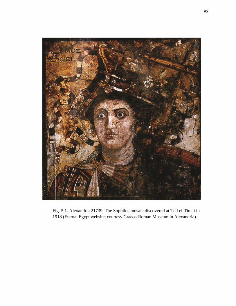
Fig. 5.1. Alexandria 21739. The Sophilos mosaic discovered at Tell el-Timai in
1918 (Eternal Egypt website; courtesy Graeco-Roman Museum in Alexandria).
98
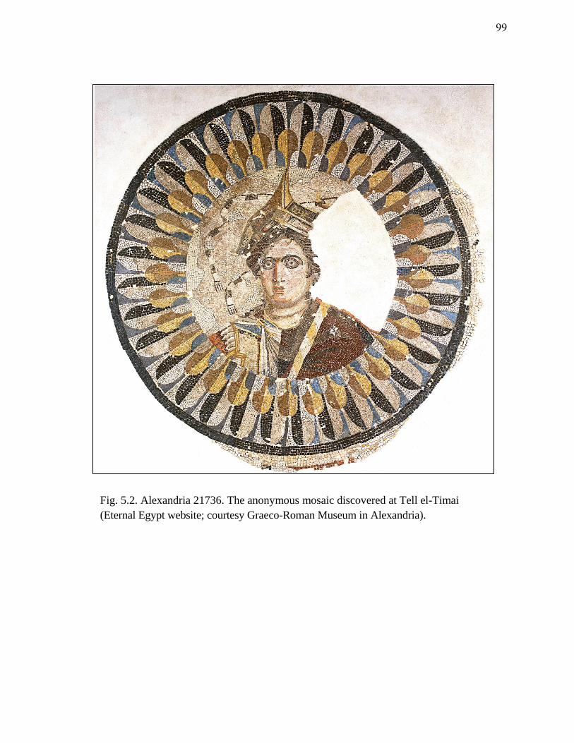
Fig. 5.2. Alexandria 21736. The anonymous mosaic discovered at Tell el-Timai
(Eternal Egypt website; courtesy Graeco-Roman Museum in Alexandria).
99
generally laid in a different pattern. This technique is generally reserved for the finest
figure work. The scenes in both mosaics are strikingly similar; each incorporates the
bust of a woman with the prow of a ship atop her head. What is especially unique about
these mosaics is that, as of this time, there are no known parallels for a Hellenistic queen
or a deity wearing a ship as a crown.221
The women share the features of a full face,
prominent eyes, a large and straight nose, and a small mouth. The hairstyles are equally
similar with a coiffure that is parted down the middle and drawn back behind the neck.
The fact that they are thematically identical is curious. K. Dunbabin believes the two
mosaics to be replicas of an inferior painting.222
The subject of the mosaics is widely
contested. In the past the central figures have been identified as a personified
Alexandria, Berenike II (c. 269-221 B.C.E.), or Arsinoe II (c. 316-270 B.C.E.).
Although the women bear a resemblance to several portraits of Arsinoe II, the
idealization of these pieces makes it risky to associate them based on her appearance
alone. A thorough examination of each mosaic reveals clues to the identification of the
women and the intended theme that each portrays. The elements and features of each
mosaic are critically examined in detail below.
The Sophilos mosaic (fig. 5.1) displays a fine level of craftsmanship in both
detail and perspective. The design of the ship, although highly distorted, is more
realistic than the ship featured in the anonymous mosaic (fig. 5.2). Immediately evident
221 This is based on an examination of available literature and the Lexicon Iconographicum Mythologiae
Classicae. There is a later parallel in Cornelis van Yk’s 1697 Dutch treatise, De Nederlandsche Scheeps-
bouw-konst Open Gestelt, where a maritime goddess wears a crown of ship prows and holds a rudder. The
goddess is probably a later rendition of Isis Euploia-Pharia-Pelagia.
222 Dunbabin 1979, 267; Dunbabin 1999, 25.
100
are an upward-curving stempost, elements of the ram including an embolos and a
proembolion supported by a pair of heavy wales that extend through the port side of the
hull, an ophthalmos (decorative eye), and a beribboned stylis (flagstaff).223
In order to
display what he must have felt were the key elements of the ship, Sophilos depicted the
prow in an amalgam of two views, joining a frontal body view with a sheer view of the
port side. While the starboard side does not disappear as one might expect if Sophilos
had used true perspective, the second ophthalmos which would be visible if viewing the
prow straight on, is hidden. The distortion of the ship calls to mind the ‘aspective’
technique in Egyptian art described by E. Brunner-Traut, where an object is rendered
“part for part as it really and ideally is, always, everywhere, and for everybody.”224
However, unlike the traditional two-dimensional aspective style, Sophilos employed a
degree of perspective to show the projecting sides of the ship where the parexeiresia
(outrigger) begins. The parexeiresia expands the sides of the hull and allows for a third
bank of oars without increasing the oar length or the angle of immersion. This design is
a distinguishing feature of the trireme; the primary naval weapon of the Ptolemies.
The symbols on the ship are barely discernible due the poor state of the mosaic’s
preservation. Sea creatures (a snake or a dolphin) and a laurel wreath are visible on the
port and starboard sides. Daszewski identifies a single cornucopia on the port side of the
223 As described by Casson (1971) the embolos is the primary ram, the proembolion is the subsidiary or
fore-ram, the ophthalmoi are the decorative eyes on the prow, and the stylis is the identification device
carried at the stern.
224 Brunner-Traut 1986, 424.
101
prow.225
The figure holds a stylis in her left arm, and the two ribbons which appear to be
secured to the top of the stylis flutter behind the woman to her right. The stylis, a pole
set up at the stern and usually fitted with a crosspiece, appears on Greek galleys after the
fifth century B.C.E.226
Its purpose was to carry a device, symbol, or name of the ship’s
chief deity.227
The two ribbons do not bear specific symbols or writings but they appear
strikingly similar to the ribbons associated with the dikeras, or double cornucopia; a
symbol which Ptolemy Philadelphus created to represent the deified Arsinoe.228
The
dikeras is often filled with garlands, sprouts of grain and bunches of grapes and is
thought to have been devised by the king to represent the fruitfulness of Arsinoe II. The
single cornucopia, or horn, was a symbol of Isis and appears quite frequently on
Hellenistic coins. It is possible that Ptolemy Philadelphus merely adapted this motif for
his queen. The dikeras is always associated with Arsinoe II and on the reverse of her
posthumous coins it is depicted with fluttering ribbons.229
The beribboned stylis might
indicate that the deified Arsinoe II was the protector of this particular ship.
The figure (figs. 5.1-2) is dressed in male military garb perhaps to reflect her
authority or to commemorate a naval battle. There are no other parallels in Hellenistic
royal portraits of a queen wearing this style of dress. Her cuirass (breastplate) is
225 Daszewski 1985, 145.
226 Casson 1971, 346; see also Svoronos 1914.
227 Casson 1971, 346.
228 Thompson 1955, 204.
229 Moore 1997, 57. Later the dikeras is sometimes depicted on coins of Cleopatra VII.
102
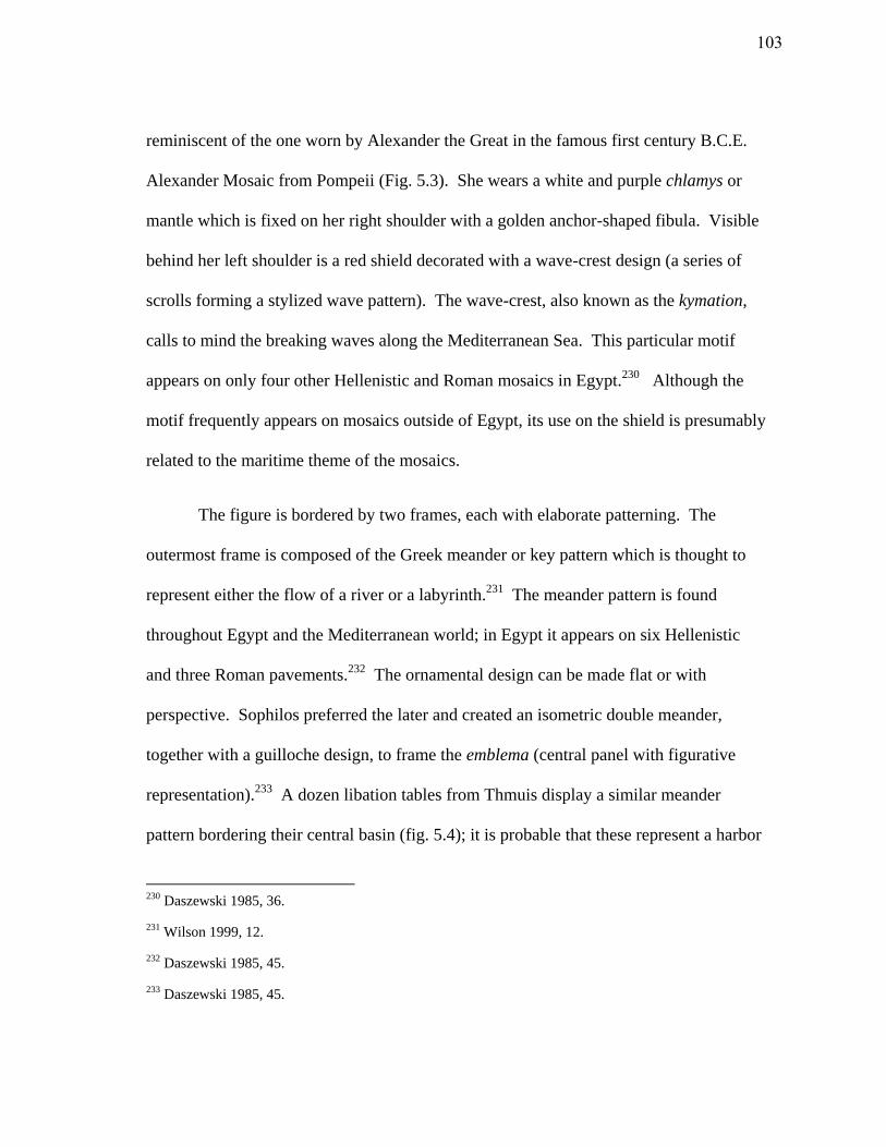
reminiscent of the one worn by Alexander the Great in the famous first century B.C.E.
Alexander Mosaic from Pompeii (Fig. 5.3). She wears a white and purple chlamys or
mantle which is fixed on her right shoulder with a golden anchor-shaped fibula. Visible
behind her left shoulder is a red shield decorated with a wave-crest design (a series of
scrolls forming a stylized wave pattern). The wave-crest, also known as the kymation,
calls to mind the breaking waves along the Mediterranean Sea. This particular motif
appears on only four other Hellenistic and Roman mosaics in Egypt.230
Although the
motif frequently appears on mosaics outside of Egypt, its use on the shield is presumably
related to the maritime theme of the mosaics.
The figure is bordered by two frames, each with elaborate patterning. The
outermost frame is composed of the Greek meander or key pattern which is thought to
represent either the flow of a river or a labyrinth.231
The meander pattern is found
throughout Egypt and the Mediterranean world; in Egypt it appears on six Hellenistic
and three Roman pavements.232
The ornamental design can be made flat or with
perspective. Sophilos preferred the later and created an isometric double meander,
together with a guilloche design, to frame the emblema (central panel with figurative
representation).233
A dozen libation tables from Thmuis display a similar meander
pattern bordering their central basin (fig. 5.4); it is probable that these represent a harbor
230 Daszewski 1985, 36.
231 Wilson 1999, 12.
232 Daszewski 1985, 45.
233 Daszewski 1985, 45.
103
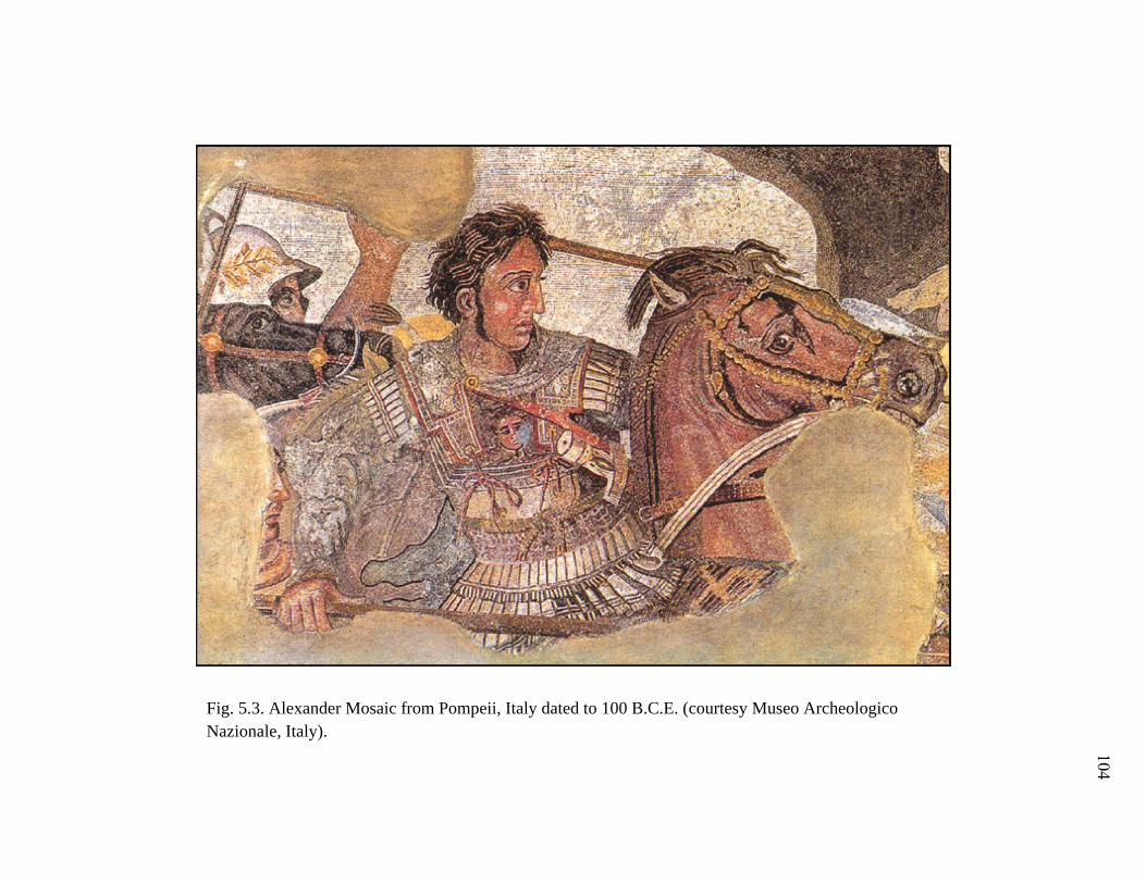
Fig. 5.3. Alexander Mosaic from Pompeii, Italy dated to 100 B.C.E. (courtesy Museo Archeologico
Nazionale, Italy).
104
Fig. 5.4. Libation tables discovered at Tell el-Timai (Meulenaere and
Mackay 1976, pls. 32e, 34e, 35c, 35f).
105
or sacred lake, as they are often filled with crocodiles and aquatic animals and contain a
stairway.234
The meander is common in mosaics and art, but usually has no symbolic
connotation. The frequency of the motif at Thmuis suggests, however, that it might have
held a symbolic connection to the riverine environment for the inhabitants of Thmuis.
The water landscape around Thmuis was a complex system of canals and waterways
reminiscent of a maze or labyrinth. The use of the meander in the border of the Sophilos
mosaic may have been intended to reflect the meandering course of the waterways
around Thmuis.
The anonymous mosaic (fig. 5.2) appears to be a somewhat inferior copy of
either a painting or the Sophilos mosaic (fig. 5.1).235
Its preservation, however, allows
for a more detailed inspection of the elements. The same features are discernible: the
prow of a ship (trireme), with its embolos and proembolion, and upward-curving stem.
Also evident is the military clothing from the Sophilos example, and traces of a shield
behind the central figure’s back. The mosaic is entirely two-dimensional and lacks the
perspective achieved by Sophilos. As a result, two ophthalmoi are shown and the
parexeiresia is difficult to discern. The markings on the ship, however, are recognizable.
A winged caduceus is displayed on each side of the bow. The starboard caduceus
incorporates a disk also seen in the Sophilos mosaic, which might represent the shen sign
(an Egyptian symbol for eternity and protection), a stylized double-uraeus disk, or a
234 See the catalogue of libation tables in Meulenaere and MacKay 1976.
235 National Gallery of Art (1999, 112) suggests the mosaics are a copy of an earlier painting which could
date to 246/245 B.C.E. or 241 B.C.E.
106
laurel wreath (an emblem of victory or distinction). Daszewski believes the motif is a
wreath.236
A sea creature (possibly a dolphin or snake) is evident on the starboard side
of the vessel, as in the Sophilos mosaic. These markings might be the episemon or
parasemon (name-device) that was commonly carved, painted or incorporated on a
bronze plaque at the bow of warships.237
Similarly, on the forward part of the cowl of
the Athlit Ram (late third or early second century B.C.E.) a caduceus is depicted.238
The
caduceus is frequently minted on coins throughout the Mediterranean and is associated
largely with Hermes, the messenger of gods and the guide and protector of sailors and
merchants, but also with Isis in the Navigium Isidis.239
The cult of Isis was prevalent in
the Mediterranean during the Hellenistic and Roman periods, and motifs referring to the
Navigium Isidis are frequently shown on the reverses of coins. One such motif is the
god Anubis (Egyptian equivalent of Hermes) holding a caduceus.240
Ships named after
the goddess Isis were common during the Roman period, so it is entirely possible that
the caducei in the Thmuis mosaic represent the parasemon of the ship, and reflect a
connection with the Isis cult.241
236 Daszewski 1985, 144.
237 Casson 1971, 344-345. According to Casson (1971, 344), the parasemon was the standard
identification feature of boats in Greco-Roman Egypt.
238 Murray 1991; Casson et al. 1991, 61.
239 McCabe 2008, 9.
240 Brady 1938, 90.
241 See Helms 1980.
107
Several scholars have discussed the theme of the Thmuis mosaics and the
identity of the women portrayed in them.242
E. Breccia was the first to regard the
mosaics as a personification of the maritime city of Alexandria. This view was largely
adopted until Daszewski presented evidence to suggest that the mosaics were portraits of
a Ptolemaic queen. Daszewski concluded that: a) the women do not share similarities to
any known personifications of Alexandria or other towns/provinces, b) the military dress
has parallels in other representations of Hellenistic rulers and the purple chlamys
indicates royalty, c) the shield is common on early Ptolemaic coins, and d) the figures
share features with queens Arsinoe II, Berenike II, and Arsinoe III (c. 235-204
B.C.E.).243
Daszewski finally concludes that while Arsinoe II would be the most likely
candidate among the three proposed queens, portraits of Berenike II bear the most
resemblance to the women in the Thmuis mosaics.244
However, as Blouin (2006) points
out, Ptolemaic royal portraits are heavily idealized and it is easy to find similarities in
the appearance of Arsinoe II, Berenike II and the women in the mosaics. According to
Blouin, the woman featured in both mosaics is Arsinoe II (282-270 B.C.E.), predecessor
of Berenike II and wife of Ptolemy II Philadelphus.245
While the royal portraits of
Arsinoe II yield uncanny similarities to the subjects of the Thmuis mosaics, the most
242 Adriani 1972; Blouin 2006; Breccia 1924 and 1932; Brown 1957; Bruneau 1972; Daszewski 1985;
Foucher 1960; Fuhrmann 1931; Rizzo 1929.
243 Daszewski 1985, 150-1.
244 Daszewski 1985, 151.
245 Blouin 2006, 266.
108
conclusive piece of evidence for Blouin’s (2006) argument is found on a stele discovered
at Mendes.
On the great Mendes Stele erected by Ptolemy Philadelphus (c. 280 B.C.E.) in
the Temple of the Ram, Ptolemy Philadelphus, his wife Arsinoe II, and their son present
offerings to the ram god Banebjded.246
Opposite this scene are Harpocrates, Banebjded,
Hatmehit, and the deified Queen Arsinoe.247
While the practice of the ruler-cult was not
unknown, Ptolemy Philadelphus was essentially the first pharaoh to establish for himself
and his queen a divine cult by royal decree.248
The Egyptians had a long tradition of
divinizing individuals based on extraordinary merit, as well as associating the king’s
wife with Hathor and Isis; this divine status was generally allocated posthumously; the
cults of Ptolemy II and Arsinoe II, however, were possibly established during their
lifetimes.249
Queen Arsinoe II is not as widely known as other Ptolemaic queens, such as
Cleopatra VII, yet her boldness and military prowess created a high standard for those
who followed her. Daughter of Berenike and Ptolemy I Soter, founder of the Ptolemaic
dynasty, Arsinoe II was first queen of Thrace before her marriage to Ptolemy II of
246 Redford (2010, 194) provides the date of Ptolemy II’s visit to Mendes.
247 Quack 2008, 276.
248 Pfeiffer 2008, 388.
249 Carney 2000, 35; Quack 2008, 277. The cult associated with the God’s Wife of Amun might be an
exception, though very different. During the New Kingdom up through the Saite Period, the royal women
with this title were thought to be the consorts of the god Amun. This title transformed the king, who was
previously not deified until death, into a demigod during his lifetime.; Lloyd 2000b, 403; Pfeiffer 2008,
388.
109
Egypt. After two failed marriages and the brutal murder of her two potential heirs,
Arsinoe II fled to Alexandria where she used her charm and guile to persuade her full
brother Ptolemy Philadelphus to divorce his wife (Arsinoe I).250
Their marriage in 276/5
B.C.E. began an incestuous trend in the Macedonian bloodline.251
As queen, Arsinoe II
Philadelphoi (‘brother-loving’) displayed her cunning ability to rule. She reorganized
the Ptolemaic army, joined in its campaigns abroad, and secured the Seleucid defeat
during the First Syrian War (274-271 B.C.E.).252
For Ptolemy Philadelphus, this
marriage was a politically-sound move. The power Arsinoe wielded as queen brought
forth a line of powerful and dangerous Ptolemaic women whose murderous plotting and
scheming created the instability for which the Macedonian kingship would later become
notorious. During her life, however, Arsinoe Philadelphus achieved wide acclaim
among the Greeks and Egyptians at home and abroad. Cities and ports in Greece were
named after her, as were several towns, nomes, harbors and streets in Egypt.253
Arsinoe
II’s death is one of the most widely contested dates in Ptolemaic chronology.254
Depending on the scholar, Arsinoe II died in either 270 or 268 B.C.E.255
This
chronological inconsistency has caused a debate over whether Arsinoe II was deified
250 Thompson 1955, 199.
251 Thompson 1955, 199.
252 Thompson 1955, 200.
253 Quaegebeur 1971, 242-3.
254 Ogden 2008, 382.
255 Cadell (1998) believes Arsinoe II’s death was in 270 B.C.E., while Grzybek (1990, 103-12) provides a
date of 268 B.C.E.
110
posthumously or during her lifetime. Supposing that the date of 268 B.C.E. is correct,
Arsinoe Philadelphus would have had an established cult while she was alive.256
Following her deification, the queen was incorporated into the local cults at
Alexandria, Mendes, Memphis, Pithom, Phacousa, Tanis, Pharbaitos, Karnak, Philae,
and according to the Pithom Stele at a northern Red Sea port.257
As with many later
queens, Arsinoe Philadelphus was identified with Aphrodite and Isis.258
Although
Aphrodite and Isis were often syncretized during the Hellenistic period, Arsinoe
Philadelphus’ connection to both goddesses allowed her appeal to extend to both Greek
and Egyptian subjects. Greek tradition likened royal women to Aphrodite, while the
pharaohs identified their royal women with Isis.259
Thus, Arsinoe thea Philadelphus Isis
and Arsinoe Aphrodite were one and the same, yet each reserved qualities that served the
needs of the multi-ethnic Ptolemaic empire.260
The attributes shared by Isis and
Aphrodite made them attractive benefactors and protectors of Ptolemaic royal women;
both goddesses maintained strong ties to naval power and navigation, their beauty
equated to power, and their sexual desire and maternal qualities made them good wives
and mothers. These divine traits became characteristic of Ptolemaic queens; they were
256 Gutzwiller 1992, 365.
257 Quaegebeur 1971, 242-3, 263.
258 Carney 2000, 33.
259 Carney 2000, 33.
260 For Arsinoe II’s identification with Isis and Aphrodite see Quaegebeur (1971, 247) and Carney (2000,
38-9).
111
powerful, cunning, alluring beauties whose decisive qualities could rule or destroy an
empire.
For Arsinoe Philadelphus it was easy to assume the syncretized role of Isis-
Aphrodite. At Cape Zephyrion (near Alexandria) Arsinoe Philadelphus was worshipped
as Aphrodite Euploia, protector of seafarers.261
Meanwhile, at the Nile Delta cities of
Sais and Mascara she was identified with the goddess Isis.262
According to the Mendes
Stele (ca. 264 B.C.E.), a cult statue of the deified Arsinoe Philadelphus was to be set up
in all the temples of Egypt. The stele also mentions on this occasion, the abolition of a
compulsory navigation toll and bread tax in the Mendesian nome.263
The divination of
Arsinoe Philadelphus, the incorporation of the royal family into the Mendesian
pantheon, and the elimination of the navigation and bread taxes recorded on the Mendes
Stele, according to K. Blouin, “highlights the special bond that united the Mendesian
nome and its water, commercial and religious environment to Arsinoe II.”264
Arsinoe Philadelphus’ connection to navigation and sailing is pronounced in
comparison with later Ptolemaic queens. Between 270 and 260 B.C.E. Ptolemaic sea
power was at its peak; the Ptolemaic fleet controlled both the Mediterranean and the
Aegean and was maintained by a network of harbors throughout the region.265
Like
261 A statue of Aphrodite Euploia also decorated the fourth century B.C.E. temple at Knidos in Turkey.
262 Quaegebeur 1971, 242-3; Carney 2000, 38; Quack (2008, 284) discusses the erection of a statue of Isis-
Arsinoe at Sais.
263 Quack 2008, 278.
264 Blouin 2006, 268.
265 Marquaille 2008, 49.
112
Ptolemy II’s thalassocracy, Arsinoe Philadelphus’ influence in the Mediterranean world
was extensive. Votive plaques dedicated to Arsinoe Philadelphus in her role as
Aphrodite Euploia were discovered at coastal cities in Cyprus, Lesbos, Delos, Paros, Ios,
Amorgos, Samos, Thera, Miletus and Eretria.266
Furthermore, at least 11 coastal cities in
the Mediterranean and the Aegean, and one along the Red Sea were named after her.267
Arsinoe Philadelphus’ association with Isis and Aphrodite in Egypt and abroad,
and her deification and connection with the navigation and bread tax at Mendes, attest to
the queen’s role and concern in maritime matters along the Nile and at sea.268
Arsinoe
Philadelphus was the ultimate symbol of Ptolemaic naval power. Her role as a maritime
divinity extended beyond Egypt into the Mediterranean and the Aegean, where she
represented both a queen and a goddess. As Arsinoe-Isis-Aphrodite she represented sea
power, fertility, and security and as the wife of Ptolemy II she legitimized the Ptolemaic
dynasty.269
Consideration of this evidence suggests the woman in both Thmuis mosaics is
Arsinoe II, portrayed in the guise of Isis-Arsinoe. The subjects’ obvious connection with
maritime and naval matters and the symbolic features of the ship that are associated with
the Isis cult support this hypothesis. Bearing in mind the roles of Thmuis and Mendes as
266 Marquaille (2008, 59) suggests Arsinoe II was worshipped in both private and public cults in these
coastal cities.
267 Marquaille 2008, 50, 59.
268 Arsinoe was given the epithets Euploia, Pharia, and Pelagia which are associated with both Isis and
Aphrodite.
269 Marquaille 2008, 59, 60.
113
prominent centers of maritime activity and trade in the third century B.C.E., the
discovery of these mosaics in the elite suburb of Thmuis is not unusual. Ptolemy II
Philadelphus’ visit to Mendes and his deification there of Arsinoe II implies at the very
least an imperial awareness of the cities. If the mosaics do represent the deified Isis-
Arsinoe, it is probable that an associated cult was located at Thmuis. The prevalence of
Isis in the Mendesian nome during Roman times might bear a connection to the earlier
cult of Arsinoe II Philadelphus.
Alexandria 21641 and 20195
The final mosaics that deserve mention are two Roman pavements. Alexandria
21641 was discovered at Tell el-Timai in 1912. Like all of the Thmuis mosaics, it too is
now housed in the Greco-Roman Museum in Alexandria. The mosaic depicts a Nilotic
scene and is datable to the third century C.E. Although Nilotic mosaics are frequently
unearthed at sites throughout the Mediterranean, in Egypt they are rare; Alexandria
21641 is the only one of its kind discovered in Egypt.
Nilotic mosaics form a group of artwork that date from the second century
B.C.E. throughout the Byzantine period in the eighth century C.E. They are named for
their pervasive themes of Nilotic imagery, including flowers, water plants, birds,
hippopotami, and crocodiles. Watercraft are also often included in these Nilotic scenes.
The prevalence and portrayal of various types of boats, as seen in the Nile Mosaic from
Palestrina (fig. 3.2), reflects the importance of water transport in Egypt, particularly in
114
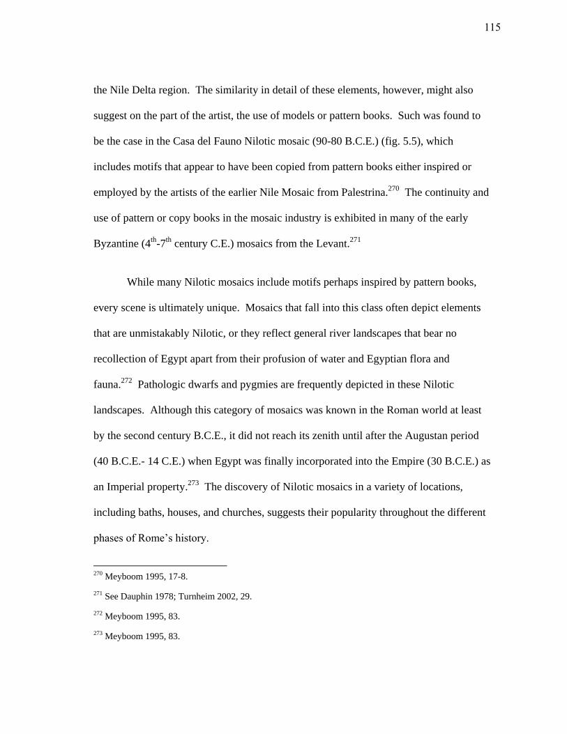
the Nile Delta region. The similarity in detail of these elements, however, might also
suggest on the part of the artist, the use of models or pattern books. Such was found to
be the case in the Casa del Fauno Nilotic mosaic (90-80 B.C.E.) (fig. 5.5), which
includes motifs that appear to have been copied from pattern books either inspired or
employed by the artists of the earlier Nile Mosaic from Palestrina.270
The continuity and
use of pattern or copy books in the mosaic industry is exhibited in many of the early
Byzantine (4th
-7th
century C.E.) mosaics from the Levant.271
While many Nilotic mosaics include motifs perhaps inspired by pattern books,
every scene is ultimately unique. Mosaics that fall into this class often depict elements
that are unmistakably Nilotic, or they reflect general river landscapes that bear no
recollection of Egypt apart from their profusion of water and Egyptian flora and
fauna.272
Pathologic dwarfs and pygmies are frequently depicted in these Nilotic
landscapes. Although this category of mosaics was known in the Roman world at least
by the second century B.C.E., it did not reach its zenith until after the Augustan period
(40 B.C.E.- 14 C.E.) when Egypt was finally incorporated into the Empire (30 B.C.E.) as
an Imperial property.273
The discovery of Nilotic mosaics in a variety of locations,
including baths, houses, and churches, suggests their popularity throughout the different
phases of Rome’s history.
270 Meyboom 1995, 17-8.
271 See Dauphin 1978; Turnheim 2002, 29.
272 Meyboom 1995, 83.
273 Meyboom 1995, 83.
115
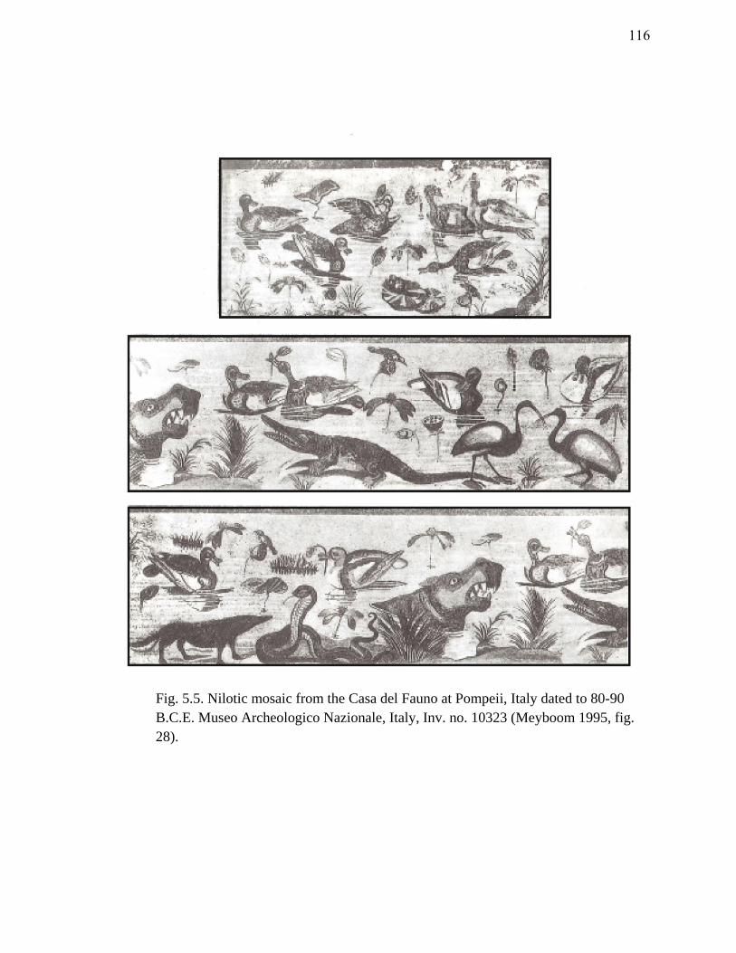
Fig. 5.5. Nilotic mosaic from the Casa del Fauno at Pompeii, Italy dated to 80-90
B.C.E. Museo Archeologico Nazionale, Italy, Inv. no. 10323 (Meyboom 1995, fig.
28).
116
The earliest Nilotic mosaics, those which were produced during the late
Hellenistic and early Roman periods, commonly exhibit episodic and literal landscape
scenes of the Nile Delta.274
The mosaic (fig. 3.2) from Palestrina, Italy, dated to 120-
110 B.C.E., is an example of the Hellenistic tradition of picture mosaics.275
Like the two
Hellenistic mosaics discussed above, this was probably directly inspired by painted
originals..276
The scene depicts a panoramic view of a naturalistic Nilotic landscape.
The upper portion of the mosaic portrays Upper Egypt or Nubia as a land of black
people, pygmy hunters, and exotic beasts, while the lower half provides a colorful view
of Lower Egypt with its flora and fauna, watercraft, and the rituals and celebrations
associated with the inundation.277
The Palestrina mosaic is arguably one of the most
colorful and elaborate Nilotic scenes ever discovered, providing a picturesque glimpse of
life on the Nile during the late Ptolemaic period. Additionally, the abundance of
watercraft in this piece reflects the importance to the Egyptians of riverine travel.
Herodotus offers a similar picture with his description of the Nile Delta during
inundation:
When the Nile has flooded the land, the cities alone appear above the water,
creating rather the same make as islands in the Aegean; the rest of Egypt
274 Turnheim 2002, 29.
275 For a discussion on the dating of the Nile Mosaic from Palestrina, see Meyboom 1995, 16-9.
276 Meyboom (1995, 93, n. 13) suggests that several models or compositions were at the disposal of the
artists who created the Palestrina mosaics and the Alexander mosaic from the Casa del Fauno in Pompeii.
These may have been painted or sketched copies of an original; Dunbabin 1999, 51.
277 Turnheim 2002, 25.
117
becomes a sea, only the towns emerge. In this case, people no longer travel by
boat along the river’s branches, but cut right across the plain.278
The end of the Hellenistic period began a transitional phase in mosaic artwork.
These transitional mosaics depict elaborate landscapes with buildings, boats, and, for the
first time, pygmies who are shown in hilarious situations, such as defending themselves
from hippopotami and crocodiles.279
Following the first century B.C.E., pygmies and
dwarfs meant to represent the Egyptian populace frequent Nilotic scenes.280
Although
ancient artists often confused the distinction between the pygmy and the dwarf, they
have underlying differences. The pygmies represent the black population of southern
Egypt, or the interior of Africa.281
They are often depicted with a reduced physique.
Meanwhile, dwarfs exhibit certain pathological characteristics of achondroplasia, such
as disproportionate limbs, large heads, and projecting buttocks.282
Pathological cases of
dwarfism were likely caused by inbreeding which was common in ancient Egypt.283
Dwarfs also had a connection with the Egyptian gods Ptah and Bes.284
Ptah provided
certain apotropaic powers, while Bes, who was himself a pathological dwarf, was a
278 Hdt. II.37 (Rawlinson 1928).
279 Dawson 1938, 185; Meyboom 1995, 82.
280 Meyboom 1995, 83.
281 Meyboom 1995, 150.
282 Achondroplasia is a bone growth disorder that causes the most common type of dwarfism; Meyboom
1995, 150; Dawson 1938, 186.
283 Meyboom 1995, 150; Dawson 1938, 185.
284 Meyboom 1995, 151.
118
powerful fertility figure. This makes sense as dwarfs were also believed to have a strong
sexual potency.285
These factors made them attractive symbols for fertility and the Nile
inundation. While often viewed as grotesque creatures, dwarfs emphasized the idyllic
state of Egypt created by the Nile flood. For the patrons who lived outside of Egypt, the
Hellenistic and early Roman mosaics (second century B.C.E. to the first century C.E.)
reflected the exotic appeal of life along the Nile and perhaps a salvation more powerful
than their own gods.
With the beginning of the Augustan period (40 B.C.E. - 14 C.E.), Nilotic mosaics
became popular throughout the Roman Empire. These took on the form of political
propaganda meant to unhinge the popularity of Egypt and its associated mystical cults.
Unlike the earlier Hellenistic mosaics, the Augustan period examples share a particular
lampooning and allegorical air. The former exotic appeal of Egypt is abruptly replaced
by the apparent licentious nature of Alexandria and the Egyptians. Pygmies and dwarfs,
which are seen in art as early as the second century B.C.E., no longer perform normal
everyday activities, but are portrayed in ludicrous sex acts and drinking scenes
reminiscent of the Nilotic festivals. Furthermore, the women who are involved in these
provocative scenes are fair-skinned and frequently don coiffures typical of the last court
285 Meyboom 1995, 152.
119
of Ptolemaic Egypt.286
These caricatures were perhaps a reminder of the immoral
behavior of the Egyptians under the Ptolemies.287
In several of these orgiastic scenes pygmies and dwarfs assume an identity
similar to that of the earlier Greek satyrs and maenads who are generally lascivious in
nature.288
These particular images, as well as the scenes in which pygmies are shown
performing acrobatic feats over crocodiles and hippopotami, appear to be mocking the
celebrations associated with the Nile flood. One such festival is depicted in the lower
portion of the Palestrina mosaic (fig. 5.6).289
Here a banquet scene is taking place
underneath a pergola. Such banquet scenes beneath pergolas or vela were common
during the time of inundation; they are frequently depicted in Nilotic scenes.290
A
similar scene was discovered at Thmuis (fig. 3.3). In addition to eating and drinking,
dancing and lovemaking were activities that were publically performed during these
inundation feasts. It was this type of carousing that Strabo described in the canal of
Canopus:
286 Mathews and Roemer 2003, 201.
287 Herodotus frequently recounts the bizarre customs of the Egyptians. His description (Rawlinson 1928,
II.60) of the festival of Bubastis, where naked women drunkenly danced along the Nile, is one such
account.
288 Mathews and Roemer 2003, 197; Meyboom (1995, 151-2) notes that dwarfs were also equated with
Dionysus during the classical world.
289 The Palestrina mosaic depicts the celebrations of the Khoiak festival and the inundation of the Nile.
For more on these festivals, see Meyboom 1995, 71-5.
290 Meyboom 1995, 70. Vela is the Latin term for a sail or a covering.
120
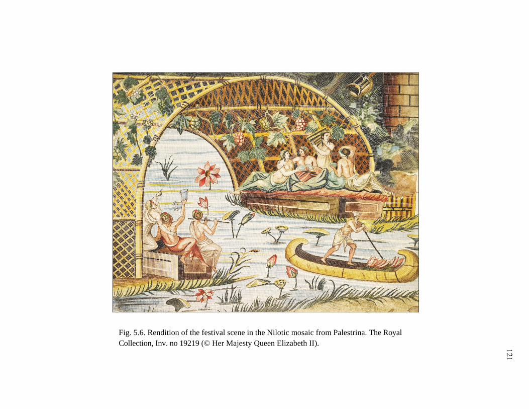
Fig. 5.6. Rendition of the festival scene in the Nilotic mosaic from Palestrina. The Royal
Collection, Inv. no 19219 (© Her Majesty Queen Elizabeth II). 121
For every day and every night is crowded with people on the boats who play the
flute and dance without restraint and with extreme licentiousness, both men and
women, and also with the people of Canobus itself, who have resorts situated
close to the canal and adapted to relaxation and merry-making of this kind.291
The Thmuis banquet scene which exists in a larger Nilotic landscape, dated to the
third century C.E., exhibits several allegorical elements typical of later Roman mosaics.
In Alexandria 21641 (fig. 3.3) a variety of flora decorate the scene, including lotus,
grasses, and reeds which are clumped horizontally throughout the piece. Nilotic fauna
are also shown, with aquatic birds, a cobra, a hippopotamus, and crocodiles scattered
throughout. Ground-lines create the effect of registers in some of the scenes. In the
upper left, a pygmy flees from a large bird while opposite another pygmy appears to
have fallen on his back and a third chases a bird. Meanwhile a fourth pygmy above
hunts a hippopotamus. These characters are reminiscent of those found in other Nilotic
scenes in which they represent the underprivileged native population of Egypt and
Nubia.292
In the bottom register three figures, shaded by a canopy or vela, enjoy a
banquet on a papyrus boat. Their disproportionate bodies and bulbous heads suggest
they are dwarfs. Given their attire and their role in the banquet they probably represent
the Hellenized or Greek population of Ptolemaic Egypt. Considering this scene
decorated an elite Roman household at Thmuis, this mosaic corresponds to the political
propagandistic themes of mosaic work typical of this period, in which the populations of
291 Strabo, XVII.17 (Jones 1932).
292 Meyboom 1995, 151.
122
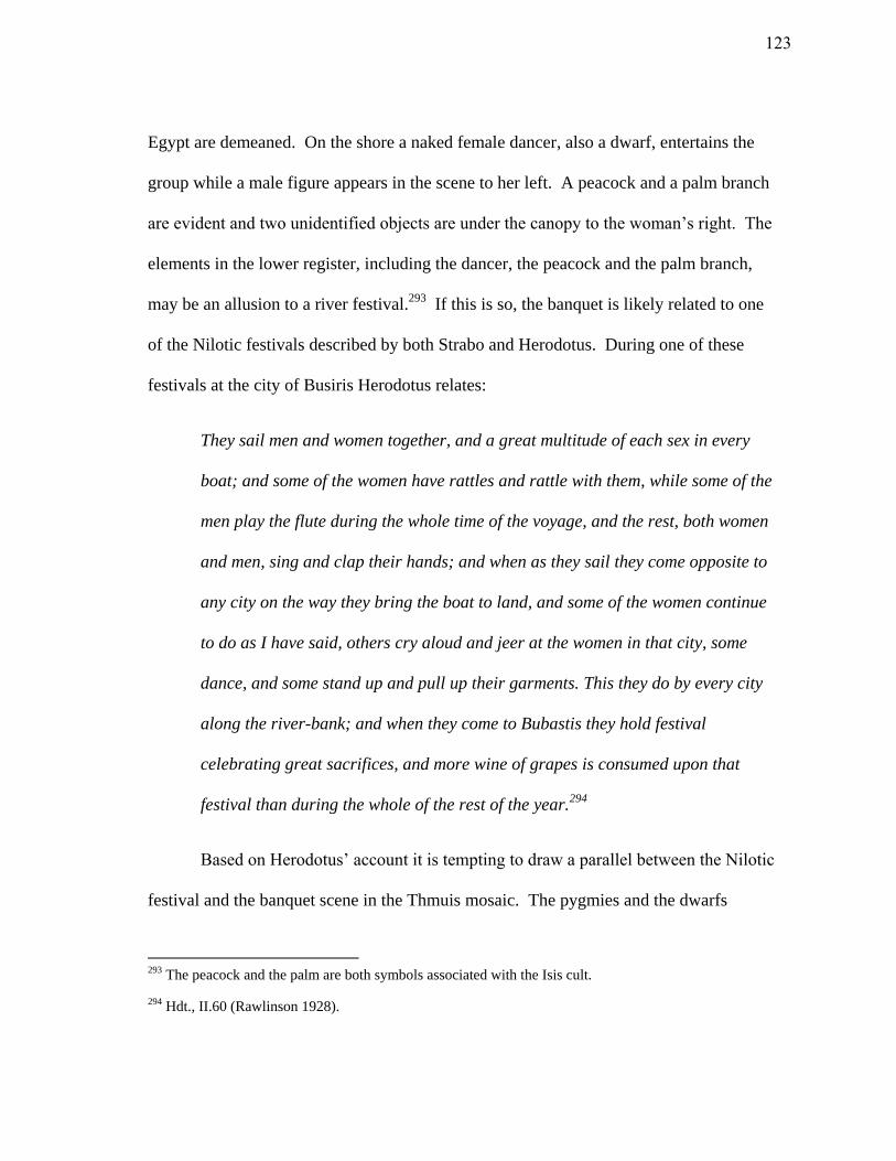
Egypt are demeaned. On the shore a naked female dancer, also a dwarf, entertains the
group while a male figure appears in the scene to her left. A peacock and a palm branch
are evident and two unidentified objects are under the canopy to the woman’s right. The
elements in the lower register, including the dancer, the peacock and the palm branch,
may be an allusion to a river festival.293
If this is so, the banquet is likely related to one
of the Nilotic festivals described by both Strabo and Herodotus. During one of these
festivals at the city of Busiris Herodotus relates:
They sail men and women together, and a great multitude of each sex in every
boat; and some of the women have rattles and rattle with them, while some of the
men play the flute during the whole time of the voyage, and the rest, both women
and men, sing and clap their hands; and when as they sail they come opposite to
any city on the way they bring the boat to land, and some of the women continue
to do as I have said, others cry aloud and jeer at the women in that city, some
dance, and some stand up and pull up their garments. This they do by every city
along the river-bank; and when they come to Bubastis they hold festival
celebrating great sacrifices, and more wine of grapes is consumed upon that
festival than during the whole of the rest of the year.294
Based on Herodotus’ account it is tempting to draw a parallel between the Nilotic
festival and the banquet scene in the Thmuis mosaic. The pygmies and the dwarfs
293 The peacock and the palm are both symbols associated with the Isis cult.
294 Hdt., II.60 (Rawlinson 1928).
123
emphasize the Nile’s abundance and fertility, while at the same time embodying the
exotic appeal of Egypt found in earlier Hellenistic mosaics. The piece also reflects a
certain satirizing by the Romans of the native and Hellenized Egyptian populace of the
earlier Ptolemaic period, a theme common after the Roman conquest in 30 B.C.E. The
pygmies are engaged in various acts of bird-hunting which might be viewed as amusing.
Meanwhile, the figures in the foreground participate in one of the indulgent Nile
festivals described by both Herodotus and Strabo.
The emblema is framed by two patterned borders. In the lower right corner of
the mosaic, a geometric pattern extends into the central scene. The motif appears to be a
meander similar to those portrayed on the Sophilos mosaic and the Thmuis libation
tables. Curiously, the overall design is T-shaped and is reminiscent of the typical
Egyptian harbor motif (fig. 5.7). The underlying theme of abundance, the possible
connotation to a riverine harbor, and the allusion to a Nilotic festival provides a unique
glimpse of the Egyptians’ cognitive view of the maritime landscape around Thmuis. At
the same time, the theme conforms to the Roman propaganda of the time by portraying
the Hellenized and native populace in a disdainful light. While it is impossible to
determine if the piece was crafted by an artisan from Thmuis, its place in an elite
household there implies that it held a certain symbolic purpose for the inhabitants of the
city. While the majority of Nilotic mosaics from this period served as political
propaganda outside of Egypt, the Thmuis mosaic does not appear to fall entirely into this
category given its local context. The festive banquet, which is juxtaposed by lurking
124
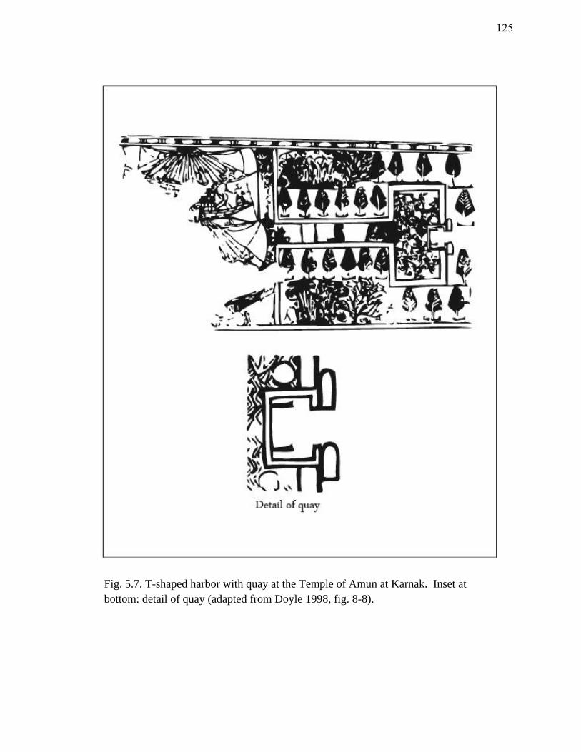
Fig. 5.7. T-shaped harbor with quay at the Temple of Amun at Karnak. Inset at
bottom: detail of quay (adapted from Doyle 1998, fig. 8-8).
125
crocodiles, a hippopotamus, and ominous birds, simultaneously exhibits the fruitful and
dangerous qualities of Thmuis’ riverine environs.
The final mosaic to be discussed in the collection, Alexandria 20195, is unique
(fig. 5.8). Like the other mosaics it provides a cognitive glance of the ancient landscape.
It testifies to the multi-ethnic character of Thmuis during the Roman Period. The mosaic
alludes to the Greek myth of Alpheios and Arethousa, in which Alpheios the river god
falls in love and pursues the nymph Arethousa. Although portions of the mosaic are
missing, the names of both individuals are inscribed above the figures. The nude god
chases Arethousa who, while looking backwards, flees. Apart from an occasional plant,
there is little flora to categorize this as a Nilotic scene. The inhabitants of Thmuis must
have been familiar with this legend and probably related such divine forces to their own
riverine environment.295
Conclusion
The discovery of the Thmuis mosaics provides evidence for the existence of a
wealthy elite, and possibly a class of skilled artisans in the city during the Hellenistic
and Roman periods. The four mosaics discussed above share a common feature:
importance of the maritime environment around Thmuis. Based on several elements in
the Sophilos and anonymous mosaics, the woman portrayed in each represents Isis-
295 Blouin 2006, 322.
126
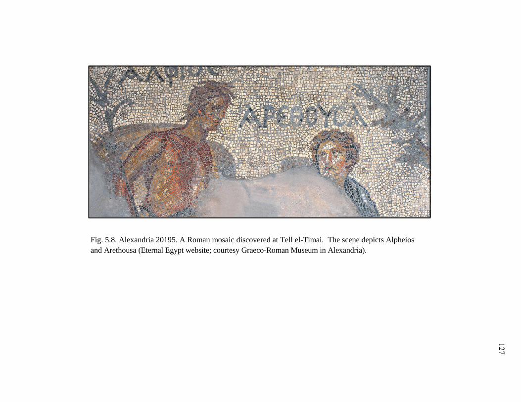
Fig. 5.8. Alexandria 20195. A Roman mosaic discovered at Tell el-Timai. The scene depicts Alpheios
and Arethousa (Eternal Egypt website; courtesy Graeco-Roman Museum in Alexandria).
127
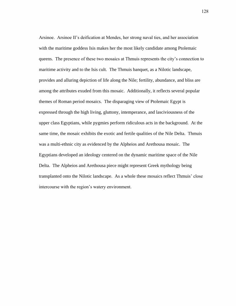
Arsinoe. Arsinoe II’s deification at Mendes, her strong naval ties, and her association
with the maritime goddess Isis makes her the most likely candidate among Ptolemaic
queens. The presence of these two mosaics at Thmuis represents the city’s connection to
maritime activity and to the Isis cult. The Thmuis banquet, as a Nilotic landscape,
provides and alluring depiction of life along the Nile; fertility, abundance, and bliss are
among the attributes exuded from this mosaic. Additionally, it reflects several popular
themes of Roman period mosaics. The disparaging view of Ptolemaic Egypt is
expressed through the high living, gluttony, intemperance, and lasciviousness of the
upper class Egyptians, while pygmies perform ridiculous acts in the background. At the
same time, the mosaic exhibits the exotic and fertile qualities of the Nile Delta. Thmuis
was a multi-ethnic city as evidenced by the Alpheios and Arethousa mosaic. The
Egyptians developed an ideology centered on the dynamic maritime space of the Nile
Delta. The Alpheios and Arethousa piece might represent Greek mythology being
transplanted onto the Nilotic landscape. As a whole these mosaics reflect Thmuis’ close
intercourse with the region’s watery environment.
128
CHAPTER VI
PHYSICAL INTERACTION WITH MARITIME SPACE
The inhabitants of Thmuis maintained a complex relationship with their natural
environment. Their perception of the fertile, yet highly volatile, Nile Delta was
expressed in their local theology, toponyms, and iconography. Evidence of human
interaction with the physical landscape of the Nile dates back to at least the Amratian
Period (4100-3600 B.C.E.) when motifs of watercraft decorate Gerzean pottery. During
this period, methods of directing and storing water were employed to levy control over
the natural environment. Despite a seemingly vague terminology for the maritime zones
along the Nile and the coasts, the Egyptians maintained an extensive knowledge of the
conditions and variability of these waterways; their familiarity with the physical
environment allowed them to exploit this space for commercial, military, and religious
purposes.
This chapter will focus on the manner in which the inhabitants of Thmuis
interacted with their maritime environment. Textual and material evidence points to the
utilization of natural and artificial waterways for food, profit, and risk management, as
well as for purposes of shipping, trade, and transportation. Harbors played an integral
role in the interplay between man and river. The physical remains of these facilities,
however, are rare and difficult to discern in the archaeological record. The harbors at
129
Thmuis and Mendes will be compared to other known examples to elucidate the
function, design, and role of the typical Nilotic harbor.
Economic/Commercial
Although records from papyri and ostraca frequently describe taxes, tolls, and
imperial monopolies on shipped goods, it is rare to find textual evidence for the specifics
of shipping and navigation in Egypt. Countless Greek and Roman papyri allude to a
lively economy of shipping and trade along the Nile, but few offer details. The
discovery of the Ahiqar customs account (475 B.C.E.) and the Naucratis Stele (380
B.C.E.) have yielded unprecedented information on the sailing season, the import of
foreign cargoes, and the customs exacted on merchant vessels entering Egypt.296
Papyrus generally does not withstand the damp conditions and high water table in the
Nile Delta, so the discovery of two collections of papyri at Philadelphia (Fayoum) and
Thmuis was remarkable.
The Zenon Archive, discovered in 1915, includes some of the most valuable texts
from the early Ptolemaic period. This collection of nearly 1,000 documents deals with
the private estate of Apollonius, who was the finance minister (dioiketos) of Ptolemy II
Philadelphus.297
Apollonius’ estate was situated in the city of Philadelphia in the
296 For more on the Ahiqar Scroll, see Yardeni 1994; for a translation of the Naucratis Stele, see Lichtheim
1973, 88.
297 Hain 1966, 699.
130
Fayoum region. The accounts, which span a period of 30 years during the mid-third
century B.C.E., yield insight into the Ptolemaic economy and accounting system. More
importantly, several of these texts document the arrival of foreign ships in the Nile
Delta, the customs paid on particular cargoes, and the operation of private and imperial
trade.
Evidence of trade in the Zenon Archive corresponds to the archaeological record.
Following the Persian destruction of Mendes in the fourth century B.C.E., the
Mendesian nome witnessed a brief return to normalcy.298
Despite a decline in flow of
the river, coins and Aegean amphora fragments from the harbors of Mendes and Thmuis
indicate that they were active between the third and mid-second centuries B.C.E.299
Ptolemy II Philadelphus’ visit to Mendes in 280 B.C.E. and the discovery at Thmuis of
several finely crafted mosaics dated to ca. 200 B.C.E., further indicate the prestigious
position held by the cities during this time. The Zenon Archive is the primary source of
information for trade and commerce in the Mendesian nom during the Hellenistic period.
Zenon was a Carian Greek who became Apollonius’ private secretary in 260
B.C.E.300
His meticulous records indicate that Mendes was a key redistribution center
for goods going and coming from various regions of the Nile Valley and the Nile
298 Redford 2010: 185, 199.
299 For more on Mendes, see Redford 2010, 199; the ceramics from Thmuis were unearthed during the
2010-11 field seasons.
300 Grier 1932, 222.
131
Delta.301
Flax, linen, and perfume were among the Mendesian nome’s chief exports.302
According to Pliny the Elder, Egyptian flax, which was primarily produced in the
northern Delta, was the finest in the ancient world.303
Several of Zenon’s letters indicate
that the Mendesian nome exported a quantity of its flax seeds to Apollonius’ estate in the
Fayoum.304
Once cultivated, Apollonius’ agents sold this flax at the Mendesian market.
In one instance, an agent informs Zenon that he would easily be able to dispose of
10,000 bundles of flax at the market of Mendes.305
A portion of the flax products (i.e.
seeds, oil, perfume) were probably also shipped abroad to various centers in the
Mediterranean. The production and trade of flax, and perhaps also linen and rope,
within the Mendesian nome continued well into the Roman period. A record from the
Upper Egyptian town of Oxyrhynchus from the fourth century C.E., notes the sale of
Mendesian flax.306
In Medieval times, long after the cities of Thmuis and Mendes had
diminished in importance, the flax industry thrived in the northern regions of modern
Lake Manzaleh.307
301 Blouin 2006, 309.
302 For a discussion on the Zenon papyri which document this trade, see Blouin 2006, 249-261.
303 Plin. HN. XIX.2 (Bostock and Riley 1855).
304 P.Cair.Zen.II. 59292; Blouin 2006, 252-3. Blouin also discusses the Zenon record, P.Lond.VII 1995.
305 P.Cair.Zen.III. 59470.
306 Blouin 2006, 310.
307 For more on the economy of Tinnis, the chief port of Lake Manzaleh during the Islamic period, see
Cooper 2008, 159.
132
Mendesian myrrh was one of the nome’s most sought after products. The origin
of the perfume industry dates back to at least the Late Period (ca. 664-323 B.C.E.).
Pliny describes the unguent of Mendes as one of the finest and most popular essences in
the ancient world.308
Correspondence between Zenon and one of his agents regarding
the purchase of several lead vessels of Mendesian myrrh (257 B.C.E.) suggests its
popularity in Egypt during the Ptolemaic period.309
Ptolemaic unguentaria found in and
around the harbors at Mendes and Thmuis are presumably remnants of this perfume
trade.310
Mendes and Thmuis’ strategic location along the primary eastern artery of the
Nile at the intersection between the northern lakes and the Mediterranean Sea provided
easy access to the merchants elsewhere in Egypt and abroad.
Our knowledge of foreign trade in Egypt dates largely from the Hellenistic
period. Late first millennium B.C.E. sources on Egyptian shipping (i.e. Ahiqar Scroll,
Naucratis Stele, Zenon Archive, and Revenue Laws Papyrus) indicate that domestic and
foreign trade was a complex enterprise that was carefully monitored by the pharaoh.
Imperial control over imports and exports dates back to the Old Kingdom when land and
sea routes were strictly supervised.311
Cargoes that arrived at the mouths of the Nile
were checked and valued by a customs authority before they could pass into the interior.
Under the Ptolemies, customs and various taxes were exacted on particular cargoes
308 Plin. HN. XIII.2 (Bostock and Riley 1855).
309 P.Cair.Zen.I. 59089.
310 Blouin 2006, 259; Several unguentaria were discovered during the University of Hawaii’s 2009-11
excavations at Tell el-Timai.
311 Preaux 1939, 371.
133
depending on their value in Egypt: oil and fine wine (50% tax), figs and wine from
Chios and Thasos (33.33% tax), honey, cheese, pickled fish and meat, nuts, sponges, etc.
(25 % tax), and wool (20% tax).312
Other items such as wood, iron, and horses which
were not readily available in Egypt presumably had lower duties.313
Despite the
seemingly high import fees on luxury items, foreign merchants could still profit from the
import of such commodities due to their relatively low cost abroad. For instance oil,
which was the most heavily taxed, was still profitable to sell in Egypt because it was
considerably cheaper in the Aegean.314
Although the available sources document only Pelusium and Alexandria as ports
of entry for foreign ships, other Delta ports surely existed. For Mendes and later
Thmuis, the coastal cordon of lagoons, marshes, and lakes in the region of modern Lake
Manzaleh afforded entrance to the Nile for seagoing vessels during antiquity and
medieval times.315
The city of Ro-nefer (‘beautiful mouth’), located 12 km north of
Mendes, was situated along the Mendesian Nile and the southern edge of the coastal
marshland (fig. 6.1). The city’s toponym suggests that it was probably located near the
mouth of the river.316
From the Old Kingdom on, its strategic location along the coast
312 This fragment of the Zenon Archive was published by Edgar (1923, 75) as ‘No. 73 Valuation by the
Customs of a Consignment of Goods from Syria.’
313 Preaux 1939, 376.
314 Edgar 1923, 91.
315 During the medieval period, the island of Tinnis in Lake Manzaleh was one of the most important ports
of Egypt. For more on Tinnis, see Cooper 2008.
316 Verreth 1998, 466. Pernouphis is the Greek transcription of pa-ro-nefer (‘the beautiful mouth’).
134
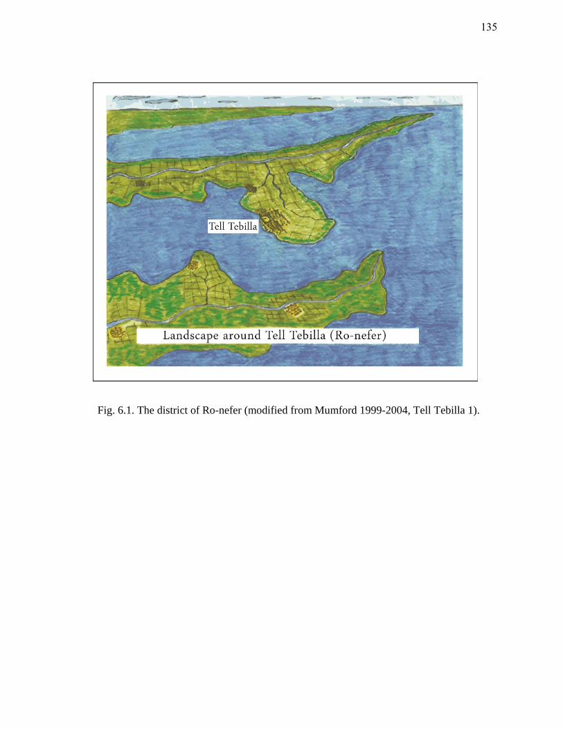
Fig. 6.1. The district of Ro-nefer (modified from Mumford 1999-2004, Tell Tebilla 1).
135
made it the chief maritime port for Mendes and later Thmuis.317
Foreign vessels that
arrived at the Mendesian mouth would have presumably passed a customs facility at Ro-
nefer (modern Tell Tebilla) before sailing or transshipping their cargoes to Mendes and
Thmuis for redistribution. The ports of Pelusium, and probably Mendes and Thmuis,
were favorable points of entry for small trading vessels from the Levant which might sail
up river to Memphis and on to Alexandria.318
While vessels could sail upstream to
various centers of trade, they might also hire porters for transshipping. On one occasion
in May-June 259 B.C.E., when the Nile was at its lowest, cargoes imported from Syria to
Pelusium for Apollonius were transshipped by river to Alexandria.319
This account from
the Zenon Archive indicates that river traffic and shipping were possible throughout the
year. Certain bulk cargoes, such as stone or grain, would have been restricted to the
season of high Nile.320
Contrary to the common supposition that the sailing season was
limited in antiquity, the Ahiqar Customs Account suggests that navigation was
conducted for 10 or 11 months of the year, although it tapered off during the winter
months.321
The relatively varying durations of stay by the Greek and Phoenician ships
listed in the Ahiqar Customs Account (between 7-20 days) supports the notion that
merchants either sailed their cargoes up the river to market centers, or delivered them to
porters who would subsequently transship them.
317 Mumford 2011.
318 Edgar 1923, 88.
319 A fragment of the Zenon Archive referred to by Edgar (1923, 74) as ‘No. 73 Valuation by the Customs
of a Consignment of Goods from Syria.’
320 Doyle 1998, 240.
321 Lipinski 1994, 66.
136
Prior to entering Egypt via the coastal ports, merchants had to pay various minor
taxes. These were not always assessed at fixed rates and often depended on the
discretion of the customs official. In the Zenon Papyri three taxes are evident: a harbor
tax, an oil tax (for provisioning the navy), and an inland toll on goods passing from one
district to another.322
On items that were controlled by state monopoly, such as oil,
merchants were restricted from transporting these goods freely into the interior. After
paying the hefty duty at customs, merchants could transport a small quantity of oil to the
interior for private use but had to pay a second tax on it.323
The state’s watchful eye on
the cargoes that passed into Egypt protected the domestic market.
Transshipment along the Nile and its canals was the primary modus operandi of
Egypt’s redistribution system. The waterways around Mendes and Thmuis (i.e. the
Mendesian Nile, the secondary waterways, and the Butic Canal) created an
interconnected communication system between the various towns and settlements in the
nome and around the Nile Delta. Meanwhile, the construction of the Butic Canal
sometime before the first century C.E. created an east-west corridor through the northern
Nile Delta.324
While the primary river branches remained the chief avenues of water
transport, the Butic Canal enhanced the network of communication between east and
west for purposes of commerce and security.
322 Edgar 1923, 76.
323 Edgar 1923, 90.
324 The precise date of the canal’s construction is uncertain. In Josephus’ day the canal went as far east as
Thmuis. Later, it continued all the way to Pelusium.
137
When Titus (39-81 C.E.) commanded his fleet of ships across the Nile Delta it
was probably along the Butic Canal. Given the ships sailed only as far east as Thmuis, it
is likely that the Butic Canal was not completed in the mid-first century C.E. By
Ptolemy Claudius’ day (90-168 C.E.), the Butic Canal continued eastward and joined the
Pelusiac branch of the Nile.325
The completion of the Butic Canal had lasting effects,
not only on the economy and security of the Nile Delta, but also on the local hydrology
of the Mendesian nome. Thmuis’ central location along this canal incorporated the
Mendesian nome into the east-west communication network and enhanced the city’s
domestic and foreign redistribution capabilities. Foreign cargoes reached Thmuis and
Mendes via two routes, either by way of the Mendesian mouth or along the network of
inland waterways (i.e. transshipment from other river mouths). The nome’s strategic
location near the sea coast, along a major artery of the Nile, and a short distance from the
eastern frontier furnished trade and communication (fig. 6.2). The far reaching trade
network of the Mendesian nome is apparent from the discovery of imported items from
southern Egypt (limestone, granite, flint, marl pottery, natron, carnelian, copper, etc.),
the Red Sea (turquoise, pearls, cowrie shells, incense), the Levant (bitumen, Cypro-
Phoenician vessels, Phoenician amphoras), West Africa (oil), Eastern and Southern
Greece (Samian and Chian amphoras, Attic ware), Italy (Gnathian ware), Turkey (Koan-
Knidian ware), and Afghanistan (lapis lazuli).326
325 Stevenson 1932, 102-3.
326 This list is based on the findings of imports at Mendes (Redford 2010), Tell el-Timai (2009 and 2010
field seasons), and at Tell Tebilla (Mumford 1999-2004, Tell Tebilla 8).
138
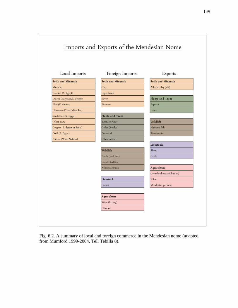
Fig. 6.2. A summary of local and foreign commerce in the Mendesian nome (adapted
from Mumford 1999-2004, Tell Tebilla 8).
139
At the same time, the proximity to the coast and the river made the settlements
around Thmuis and Mendes vulnerable to attack. Amidst the Persian conquest of Egypt,
one such attempt to infiltrate Egypt by river was prevented. In 454 B.C.E. a fleet of 50
Athenian warships entered the Mendesian Nile:
The Athenians moreover had sent fifty galleys more into Egypt for a supply of
those that were there already, which putting in at Mendesium, one of the mouths
of Nilus, knew nothing of what had happened to the rest, and being assaulted
from the land by the army and from the sea by the Phoenician fleet, lost the
greatest part of their galleys and escaped home again with the lesser part.327
The threat of sea invasion via the river mouths was constant. Nearly a century
after the Athenians, Artaxerxes managed to sail 600 ships up the Mendesian Nile in a
futile attempt to conquer Memphis.328
As a precaution the river outlets were probably
fortified.329
Economic Role of Thmuis
Thmuis played an integral role in the redistribution network of the Mendesian
nome. During the Late Period, when the settlement first appeared, it probably
functioned alongside Mendes in matters of trade and production. Initially Thmuis
327 Thuc. 1.110 (Hobbes and Grene 1989).
328 Redford (2010, 144 and 181) references both occasions.
329 Lloyd (2000a, 380) describes the fortifications of the river mouths in the fourth century B.C.E.
140
operated as a suburb of Mendes. Its harbors assisted in the commercial activity that
flourished throughout the fourth and third centuries B.C.E. Like Mendes, Thmuis
survived several periods of instability and continued as a production center of luxury
items, namely perfume and linen. The construction of the Butic Canal and the increased
canalization during the Roman Period contributed to the decline and disappearance of
the Mendesian Nile.330
As a result of changing hydrology under the first centuries of
Roman rule, Thmuis assumed Mendes’ former role as chief emporium. For a time,
Thmuis prospered and was home to a wealthy elite and a class of skilled artisans. The
heavy yoke of Roman rule, however, eventually created demands which the people and
the environment could not meet. By the sixth century C.E., the status of both Thmuis
and Mendes had fallen.
The Thmuis Archive, discovered in the southwest extremity of Tell el-Timai
following the excavations in 1892/3 and 1906, provides evidence of the economy of
Thmuis during the early Roman period.331
The majority of the carbonized papyri were
either destroyed in antiquity by a fire or by modern mishandling. Those documents that
survived are financial records from the late second to third centuries C.E.332
Unlike the
Zenon Archive these papyri offer no specifics regarding sailing and water transport; they
do inform us, however, about land management, irrigation, and agriculture within the
330 Blouin 2006, 65, 74.
331 Daressy 1914, 184; Bagnall and Rathbone 2004, 84.
332 Bagnall and Rathbone 2004, 84.
141
Mendesian nome.333
Together these documents give more clues to the involvement of
Thmuis with its maritime space in matters of commerce and economy.
Under Roman rule, the Nile Delta witnessed increased pressure from the state to
expand cultivated land. In hopes of increasing production and profitability, the
hydrology of the Mendesian nome was expanded. The construction of canals and
irrigation works put serious pressure on the already failing Mendesian and Tanitic
branches. The Thmuis Archive documents the existence of several artificial waterways
and reservoirs for retaining water.334
Four types of waterways are listed: diôrux,
hydragôgos, hydrêgos, and potistra. These appear to be artificial canals or secondary
waterways used for directing, storing, and draining flood waters to agricultural fields to
ensure an effective deposit of silt.335
The Thmuis Archive also provides evidence of
three methods for the storage of floodwater during the Roman period: the chôma, the
limnè, and the périchôma.336
The chôma was the equivalent of a dike. It was used to
direct and keep water in various canals, basins, or reservoirs. The limnè referred to
several inundated regions, including lakes, ponds, marshes, or retaining ponds. The
périchôma, on the other hand, corresponded to an area of an irrigation basin that was
surrounded by dikes and retained water.337
The inhabitants of Thmuis relied on these
333 Blouin (2006) discusses the Roman papyri from Thmuis in detail.
334 Blouin 2006, 157-67.
335 Blouin 2006, 157-60.
336 Blouin 2006, 163.
337 Blouin 2006, 165, 167.
142
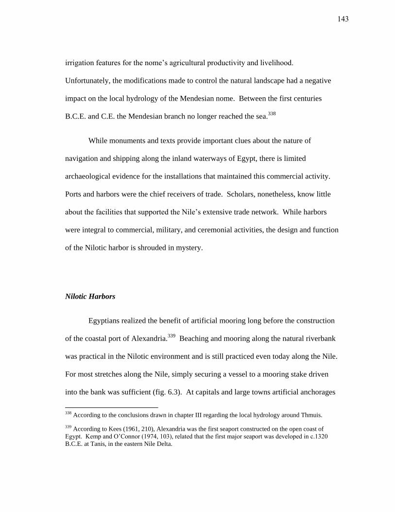
irrigation features for the nome’s agricultural productivity and livelihood.
Unfortunately, the modifications made to control the natural landscape had a negative
impact on the local hydrology of the Mendesian nome. Between the first centuries
B.C.E. and C.E. the Mendesian branch no longer reached the sea.338
While monuments and texts provide important clues about the nature of
navigation and shipping along the inland waterways of Egypt, there is limited
archaeological evidence for the installations that maintained this commercial activity.
Ports and harbors were the chief receivers of trade. Scholars, nonetheless, know little
about the facilities that supported the Nile’s extensive trade network. While harbors
were integral to commercial, military, and ceremonial activities, the design and function
of the Nilotic harbor is shrouded in mystery.
Nilotic Harbors
Egyptians realized the benefit of artificial mooring long before the construction
of the coastal port of Alexandria.339
Beaching and mooring along the natural riverbank
was practical in the Nilotic environment and is still practiced even today along the Nile.
For most stretches along the Nile, simply securing a vessel to a mooring stake driven
into the bank was sufficient (fig. 6.3). At capitals and large towns artificial anchorages
338 According to the conclusions drawn in chapter III regarding the local hydrology around Thmuis.
339 According to Kees (1961, 210), Alexandria was the first seaport constructed on the open coast of
Egypt. Kemp and O’Connor (1974, 103), related that the first major seaport was developed in c.1320
B.C.E. at Tanis, in the eastern Nile Delta.
143
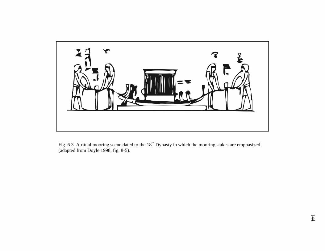
Fig. 6.3. A ritual mooring scene dated to the 18th
Dynasty in which the mooring stakes are emphasized
(adapted from Doyle 1998, fig. 8-5).
144
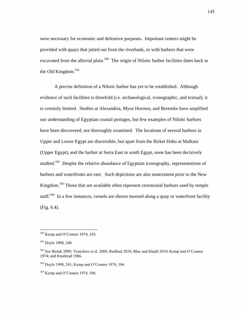
were necessary for economic and defensive purposes. Important centers might be
provided with quays that jutted out from the riverbank, or with harbors that were
excavated from the alluvial plain.340
The origin of Nilotic harbor facilities dates back to
the Old Kingdom.341
A precise definition of a Nilotic harbor has yet to be established. Although
evidence of such facilities is threefold (i.e. archaeological, iconographic, and textual), it
is certainly limited. Studies at Alexandria, Myos Hormos, and Berenike have amplified
our understanding of Egyptian coastal portages, but few examples of Nilotic harbors
have been discovered, nor thoroughly examined. The locations of several harbors in
Upper and Lower Egypt are discernible, but apart from the Birket Habu at Malkata
(Upper Egypt), and the harbor at Serra East in south Egypt, none has been decisively
studied.342
Despite the relative abundance of Egyptian iconography, representations of
harbors and waterfronts are rare. Such depictions are also nonexistent prior to the New
Kingdom.343
Those that are available often represent ceremonial harbors used by temple
staff.344
In a few instances, vessels are shown moored along a quay or waterfront facility
(Fig. 6.4).
340 Kemp and O’Connor 1974, 103.
341 Doyle 1998, 240.
342 See Bietak 2009; Tronchere et al. 2008; Redford 2010; Blue and Khalil 2010; Kemp and O’Connor
1974; and Knudstad 1966.
343 Doyle 1998, 241; Kemp and O’Connor 1974, 106.
344 Kemp and O’Connor 1974, 106.
145
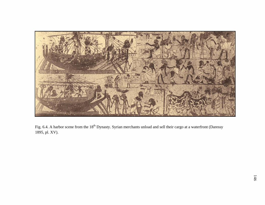
Fig. 6.4. A harbor scene from the 18th
Dynasty. Syrian merchants unload and sell their cargo at a waterfront (Daressy
1895, pl. XV).
146
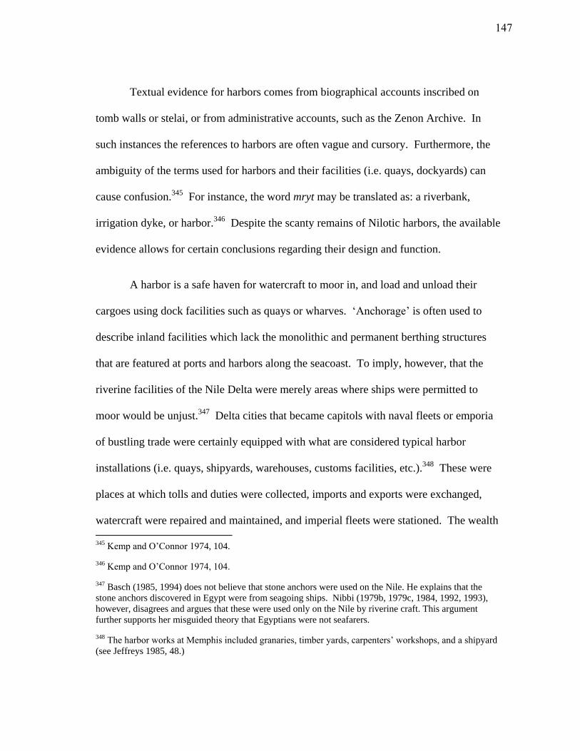
Textual evidence for harbors comes from biographical accounts inscribed on
tomb walls or stelai, or from administrative accounts, such as the Zenon Archive. In
such instances the references to harbors are often vague and cursory. Furthermore, the
ambiguity of the terms used for harbors and their facilities (i.e. quays, dockyards) can
cause confusion.345
For instance, the word mryt may be translated as: a riverbank,
irrigation dyke, or harbor.346
Despite the scanty remains of Nilotic harbors, the available
evidence allows for certain conclusions regarding their design and function.
A harbor is a safe haven for watercraft to moor in, and load and unload their
cargoes using dock facilities such as quays or wharves. ‘Anchorage’ is often used to
describe inland facilities which lack the monolithic and permanent berthing structures
that are featured at ports and harbors along the seacoast. To imply, however, that the
riverine facilities of the Nile Delta were merely areas where ships were permitted to
moor would be unjust.347
Delta cities that became capitols with naval fleets or emporia
of bustling trade were certainly equipped with what are considered typical harbor
installations (i.e. quays, shipyards, warehouses, customs facilities, etc.).348
These were
places at which tolls and duties were collected, imports and exports were exchanged,
watercraft were repaired and maintained, and imperial fleets were stationed. The wealth
345 Kemp and O’Connor 1974, 104.
346 Kemp and O’Connor 1974, 104.
347 Basch (1985, 1994) does not believe that stone anchors were used on the Nile. He explains that the
stone anchors discovered in Egypt were from seagoing ships. Nibbi (1979b, 1979c, 1984, 1992, 1993),
however, disagrees and argues that these were used only on the Nile by riverine craft. This argument
further supports her misguided theory that Egyptians were not seafarers.
348 The harbor works at Memphis included granaries, timber yards, carpenters’ workshops, and a shipyard
(see Jeffreys 1985, 48.)
147
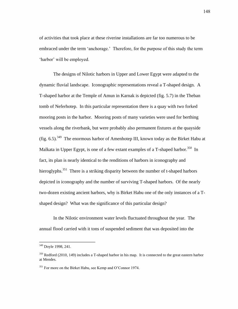
of activities that took place at these riverine installations are far too numerous to be
embraced under the term ‘anchorage.’ Therefore, for the purpose of this study the term
‘harbor’ will be employed.
The designs of Nilotic harbors in Upper and Lower Egypt were adapted to the
dynamic fluvial landscape. Iconographic representations reveal a T-shaped design. A
T-shaped harbor at the Temple of Amun in Karnak is depicted (fig. 5.7) in the Theban
tomb of Neferhotep. In this particular representation there is a quay with two forked
mooring posts in the harbor. Mooring posts of many varieties were used for berthing
vessels along the riverbank, but were probably also permanent fixtures at the quayside
(fig. 6.5).349
The enormous harbor of Amenhotep III, known today as the Birket Habu at
Malkata in Upper Egypt, is one of a few extant examples of a T-shaped harbor.350
In
fact, its plan is nearly identical to the renditions of harbors in iconography and
hieroglyphs.351
There is a striking disparity between the number of t-shaped harbors
depicted in iconography and the number of surviving T-shaped harbors. Of the nearly
two-dozen existing ancient harbors, why is Birket Habu one of the only instances of a T-
shaped design? What was the significance of this particular design?
In the Nilotic environment water levels fluctuated throughout the year. The
annual flood carried with it tons of suspended sediment that was deposited into the
349 Doyle 1998, 241.
350 Redford (2010, 149) includes a T-shaped harbor in his map. It is connected to the great eastern harbor
at Mendes.
351 For more on the Birket Habu, see Kemp and O’Connor 1974.
148
Fig. 6.5. Various styles of mooring stakes (adapted from Doyle 1998, 8-4).
149
waterways, basins, and across the fields. Occasionally, a high flood would carve an
entirely new river path across the landscape. Each year the inhabitants of the Nile
Valley were required to perform corvee labor which entailed, among other activities, the
dredging of the canals and waterways.352
The seasonality and variability of the river
required a unique harbor design that was adaptable to these shifting conditions.
Generally speaking, this design is simple and consists of a basin separated from but
accessible to the primary branch of the river via canal(s). In this regard, the upper
horizontal section of the T represents the basin, while the lower perpendicular section
recalls the canal that joins to the river. It was necessary for river harbors to be
independent of the primary river. This not only prevented erosion of harbor facilities by
the Nile flood, but also provided protection for watercraft from currents, unexpected
gale-force winds, high tides, or aggressors.353
The excavation of a harbor basin was an enormous feat. At Birket Habu an
estimated 11 million meters3 of earth were removed.
354 Meanwhile, the harbor at Serra
East in Sudan was entirely cut out of bedrock.355
Whenever possible, the Egyptians
made use of natural features in the landscape when determining the location of a harbor.
For instance, one of the harbors at ancient Avaris (Tell el-Daba ) was constructed within
352 Hurst 1957, 49; Thompson 2008, 29.
353 Bietak 2009, 15.
354 Kemp and O’Connor 1974, 126.
355 Knudstad 1966, 177; For more on the excavation at Serra East, see Hughes 1963.
150
a seasonal lake created by a defunct Nile channel.356
The inhabitants of Thmuis may
have also taken advantage of a crevasse-splay (fig. 3.16) formed when the river broke its
banks and followed a new course.357
Such areas would be ideal locations for harbors;
they were naturally inundated, protected from the river but close enough to access it with
a canal. Harbors could be located outside of a city’s defensive walls (i.e. the northern
and eastern harbors at Mendes) or integrated within the settlement (i.e. the harbors at
Avaris, Serra East, and Memphis). Harbors may have been placed for strategic purposes
(i.e. commerce, defense) or determined by the surrounding landscape. Textual accounts
indicate that naval fleets were berthed and launched from Nilotic harbors, and that
enemies often gained access to cities via their harbors.358
Quays and stone revetments are depicted in iconography and several physical
examples are known. These stone berthing structures were particularly useful for the
loading and unloading of stone cargoes. At Lake Moeris in the northwest Fayoum, a 311
m long and 19 m wide quay was constructed near the basalt quarries at Wadi el-Faras.359
Quays were integral to the water transport of stone for the construction of the Old
Kingdom pyramids and temple complexes at Memphis and Abusir. At the temple
complex of Unas at Abusir, a basin 140 m long was constructed for the shipment of
356 Bietak 2009, 16.
357 According to Adam Shahat (pers. com.), the cores from the suspected northern harbor at Tell el-Timai
suggest the area might have been a crevasse-splay at one point in history.
358 On Thutmose III’s naval campaigns to the Levant from Peru-nefer (Avaris) see, Gabriel 2009, 139-42;
Regarding the account of Piankhi’s conquest of Memphis during the eighth century B.C.E., see Jeffreys
and Smith 1988.
359 Harrell and Brown 1995, 85-7.
151
stone.360
The basin was flanked by two stone piers, 70 m long and 3 m wide, and
provided with a ramp for beaching vessels.361
An equivalent design was employed at the
pyramid complex of Pepi II.362
Several similar quays, however, have recently been
discovered in the northern lakes below Alexandria. 363
They are associated with the
Hellenistic and Roman harbors (Taposiris Magna and Marea/Philoxenite) in Lake
Mareotis. Based on the available archaeological and textual evidence, these harbors
were used primarily for commercial purposes unlike the quarry harbor at Wadi el-Faras.
Stone berthing facilities are not always found at Nilotic harbors. Often harbors
were simply a place to beach vessels upon a firm shore or hard.364
In a harbor basin
excavated from alluvium, the rise and fall of the water level can pose serious problems.
If the sides of the basin are cut vertically, the water level will undermine the sediment
and the sides will not remain stable. Therefore, Nilotic harbors that lacked stone, fired
brick, or plastered revetments were engineered in a manner that would withstand the
surges in the river. To do so, the edges of the basin were given a slope similar to modern
canals.365
The sloping banks protected the basin edges from erosion and allowed vessels
to be beached and unloaded. Lucy Blue’s investigations at the Roman/Islamic lagoon-
port of Myos Hormos along the Red Sea coast revealed a hard consisting of an amphora
360 Goyon 1971, 143.
361 Goyon 1971, 143.
362 Goyon 1971, 144.
363 Khalil 2010.
364 A hard is solid beach or slope used for hauling vessels from the water.
365 Kemp and O’Connor 1974, 123.
152
foundation covered with packed sediment.366
This created a solid landing for watercraft
in the lagoonal environment. Similarly, recent work at the eastern harbor at Mendes
suggests the presence of a hard where vessels were beached and unloaded.367
Such
rudimentary installations were both practical and efficient in the riverine and lagoonal
environments of the Nile Delta. At the smaller eastern harbor of Mendes, formerly
known as ‘the sacred lake,’ a hard is not immediately evident. Instead, the harbor
appears to have been bordered by a substantial mudbrick casemate structure that was
once covered with a limestone veneer.368
This technique may have been another method
for protecting harbor basins from the destructive effects of the rise and fall of the Nile.
Nilotic harbors come in a variety of sizes. The Birket Habu measures 2.4 x 1 km
and its depth is estimated to be nearly 6 m.369
The function of the harbor, given its
enormous size, is still speculative. No stone revetment walls or quays are evident in its
construction and it was connected to the Nile by a canal. It may reflect a combination of
practical, ceremonial, or symbolic uses.370
Two harbors recently discovered at Tell el-
Daba (Avaris) using geomagnetic survey, could have accommodated hundreds of
ships.371
Based on approximate measurements from Bietak’s (2009) map, harbor 1 is
about 425 m long and between 300-400 m in width (Fig. 6.6). Birket Habu and the
366 Blue 2007, 271-3.
367 Redford 2010, 151.
368 Redford 1992b, 64.
369 Kemp and O’Connor 1974, 108, 126.
370 Kemp and O’Connor 1974, 130.
371 Bietak 2009, 15-6.
153
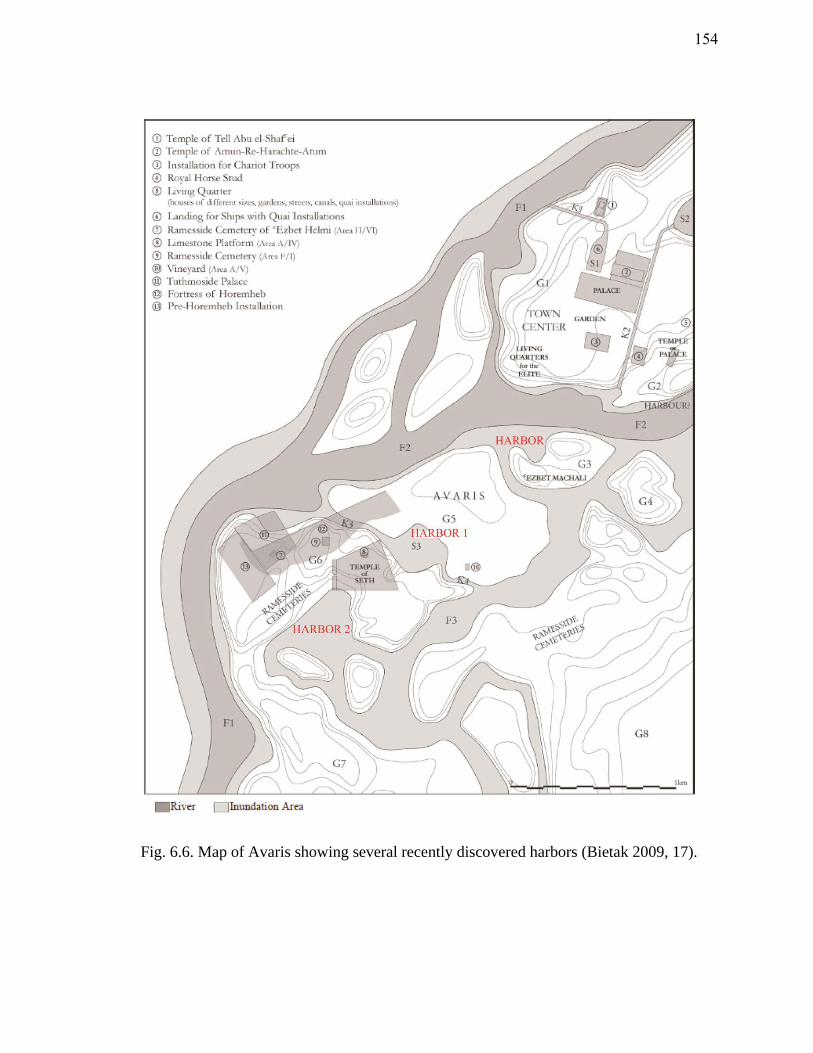
Fig. 6.6. Map of Avaris showing several recently discovered harbors (Bietak 2009, 17).
154
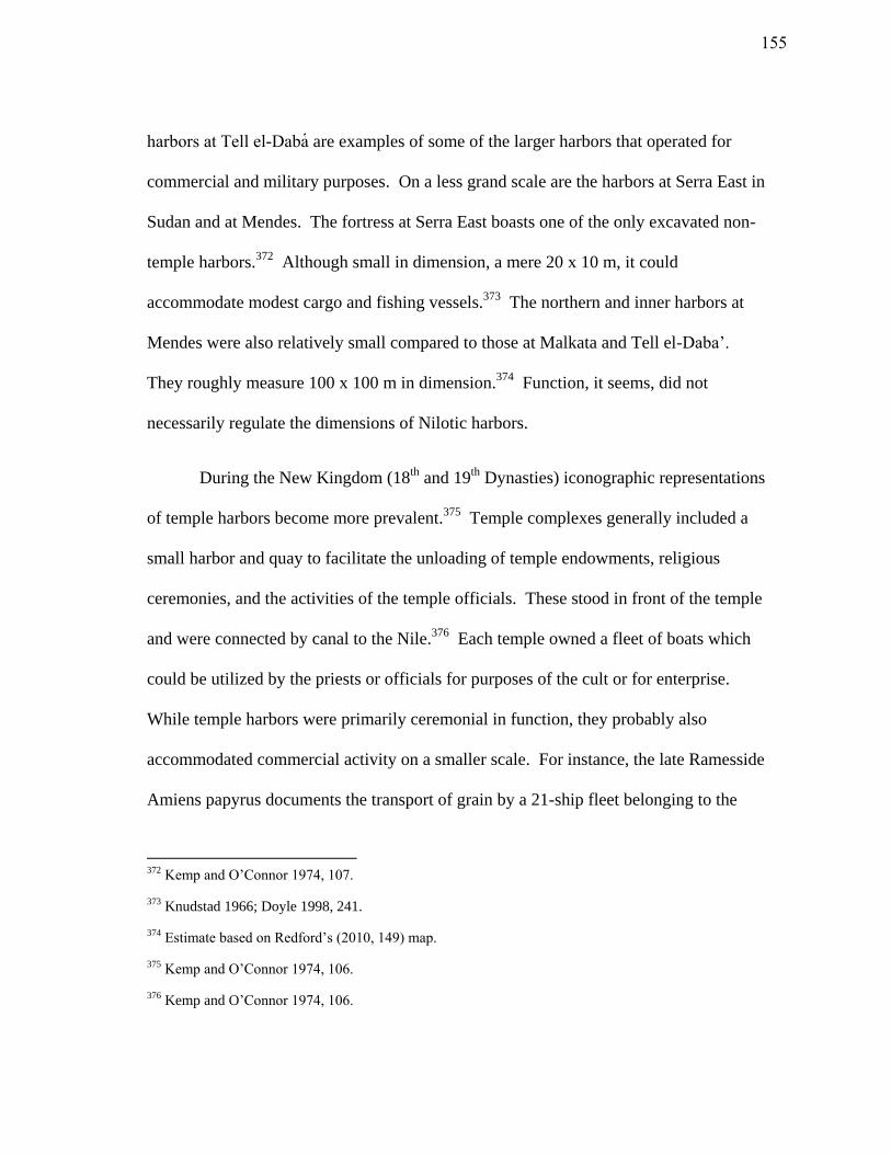
harbors at Tell el-Daba are examples of some of the larger harbors that operated for
commercial and military purposes. On a less grand scale are the harbors at Serra East in
Sudan and at Mendes. The fortress at Serra East boasts one of the only excavated non-
temple harbors.372
Although small in dimension, a mere 20 x 10 m, it could
accommodate modest cargo and fishing vessels.373
The northern and inner harbors at
Mendes were also relatively small compared to those at Malkata and Tell el-Daba’.
They roughly measure 100 x 100 m in dimension.374
Function, it seems, did not
necessarily regulate the dimensions of Nilotic harbors.
During the New Kingdom (18th
and 19th
Dynasties) iconographic representations
of temple harbors become more prevalent.375
Temple complexes generally included a
small harbor and quay to facilitate the unloading of temple endowments, religious
ceremonies, and the activities of the temple officials. These stood in front of the temple
and were connected by canal to the Nile.376
Each temple owned a fleet of boats which
could be utilized by the priests or officials for purposes of the cult or for enterprise.
While temple harbors were primarily ceremonial in function, they probably also
accommodated commercial activity on a smaller scale. For instance, the late Ramesside
Amiens papyrus documents the transport of grain by a 21-ship fleet belonging to the
372 Kemp and O’Connor 1974, 107.
373 Knudstad 1966; Doyle 1998, 241.
374 Estimate based on Redford’s (2010, 149) map.
375 Kemp and O’Connor 1974, 106.
376 Kemp and O’Connor 1974, 106.
155
Temple of Amun at Karnak.377
The ships were transporting grain collected from the
temple’s estates in the Nile Delta.378
Other textual sources indicate that the temples of
Abydos and Medinet Habu maintained substantial fleets of ships.379
Furthermore, the
ships belonging to the temples were often engaged in foreign trading enterprises, and on
occasion employed foreign traders.380
While temple harbors were generally small, they
might be enlarged if they were engaged in large scale trading operations, such as the
second harbor of Soleb Temple. Built by Amenhotep III, the larger harbor at Soleb
Temple is enormous relative to other examples of temple harbors.381
It occupied an
estimated area of 7500 m2 and was constructed to facilitate trade associated with the
temple.382
Harbors, therefore, were vital to the ceremonial and economic livelihood of
Egyptian temples.
Thmuis
Excavations at Tell-el Timai revealed that Thmuis’ suspected northern harbor,
perhaps accessible to the Mendesian Nile by a canal, was associated with the nearby
377 Castle 1992, 240; Janssen 2004.
378 Castle 1992, 240.
379 Castle 1992, 240.
380 Castle 1992, 243.
381 Kemp and O’Connor 1974, 107.
382 Kemp and O’Connor 1974, 107.
156
industrial quarter that flourished during the fourth century B.C.E.383
A number of
unguentaria discovered in the area may indicate the production and trade of the
Mendesian perfume at Thmuis during this time. Hellenistic ceramics and Rhodian
amphoras dated to the second half of the third century B.C.E. were discovered in fill
deposits around the suspected harbor basin. Several Aegean amphora fragments were
also discovered within the basin. These deposits are dated to the period following the
final Persian Occupation of Egypt. They provide evidence that the maritime economy at
Thmuis was active during this period.
In the beginning of the second century B.C.E., this activity came to an abrupt halt
and Thmuis appears to have been involved in the unrest which plagued the Nile Delta
around the end of the third century B.C.E. Extensive destruction deposits are evident in
the industrial quarter and the facilities surrounding the suspected harbor at Thmuis.
Following this tumultuous event, the northern industrial areas and harbor basin were
filled and leveled with debris for a later building foundation.
Donald Redford drew similar conclusions after examining archaeological
material from the harbor at Mendes. These deposits included coins dated to the periods
between Alexander the Great (332 B.C.E.) and Ptolemy IV (died 204 B.C.E.). Vast
quantities of early Ptolemaic pottery were also discovered across the tell.384
Historical
evidence attests to the fame of Mendes following Ptolemy II’s visit to the city (ca. 280
383 Preliminary dating phases were established according to the ceramic assemblages from the University
of Hawaii’s 2010-11 Tell el-Timai field seasons.
384 Redford 2010, 199.
157
B.C.E.), and a Greek population was established in the city during this period.385
At the
beginning of the second century B.C.E., activity at the harbor of Mendes ceased and
some of the storage facilities were abandoned.386
This corresponds to the destruction
deposits discovered around Thmuis’ suspected harbor.
Historical accounts indicate that, beginning in the first century B.C.E. major
hydrological changes were underway in the Nile Delta. The Mendesian River began to
ebb. The eastern harbors at Mendes, and perhaps the northern harbor at Thmuis, slowly
silted up. The northern basin at Thmuis was filled with a mix of cultural debris,
including dozens of Ptolemaic figurines of Bes, Isis, and Harpocrates. Further examples
of these were discovered nearby.387
Due to the enormity of votive figurines, particularly
in the suspected harbor basin, it has been suggested that these deposits came from a
bothros (temple/shrine clearing). Similar deposits, however, were discovered in the
smaller eastern harbor at Mendes. Hundreds of figurines of Bes, women on beds, and
musicians were deposited along the western bank of the harbor. Redford (2010) has
interpreted the Mendes harbor deposits as a final votive attempt to bring back the
disappearing waters. The figurines from Thmuis might represent a similar event.
Despite these futile acts, the eastern harbors at Mendes, and probably the
northern harbor at Thmuis, were completely silted up by end of the first century
385 The Thmuis mosaics which depict Arsinoe II also attest to a Greek presence at Thmuis during the 3rd
century B.C.E.
386 Redford 2010, 199.
387 Nearly two dozen figurines were discovered in and around the suspected harbor basin during the 2010-
11 University of Hawaii excavations.
158
B.C.E.388
The river migrated eastward and the majority of Mendes’ inhabitants moved
south to Thmuis.
Conclusion
Nilotic harbors had commercial, military, and ceremonial functions. They played
an integral part in the redistribution system along the Nile and ancillary canals. During
times of political unrest, the riverine harbors assisted in the transport and stationing of
troops and ships. Nilotic harbors may have, therefore, represented wealth and luxury, as
well as authority and security to the Egyptians. At the same time, the harbors along the
Nile took on a sacred function. For the Egyptians mooring was a metaphor for dying.
The afterlife was a dangerous place, so sailing across the heavenly realm and mooring
happily with Osiris was a paramount concern for the deceased. Considering this
ideology, the Nilotic harbor provided a safe abode from dangerous currents, unfavorable
winds, and shallow sandbars. Neferhotep’s Theban tomb provides an alluring depiction
of a Nilotic harbor (fig. 5.6). Papyrus thickets, lotus, and various kinds of trees line the
sacred harbor and create an overall feeling of fertility and tranquility.
When the Mendesian River declined and the harbors at Mendes finally silted up,
the inhabitants of the city enlisted divine assistance. Hundreds of votive figurines were
tossed into the receding waters of the great eastern harbor of Mendes, perhaps in an
388 Redford 2010, 201.
159

attempt to save the city’s primary port of trade. Unfortunately, the gods were silent; the
harbors of Mendes became salt pans.
160
CHAPTER VII
CONCLUSION
The waters of the ancient Nile comprised a complex and dynamic maritime
space. Each year the flood reshaped the landscape, erasing boundaries, dykes, and even
settlements. When the waters peaked, the Nile Delta was transformed into an inland sea,
and navigation routes along the canals and primary channels of the river were largely
obscured. Local knowledge of these transformations was necessary for survival. The
ancient Egyptians employed various measures to harness this environment: irrigation
optimized floodwaters for agriculture and animal husbandry, artificial canals and harbor
facilities maintained Egypt’s domestic and international commercial network, and
religious ideology provided a foundation for understanding and controlling the ominous
forces of nature. The river’s changing conditions ultimately shaped the infrastructure,
politics, history, and religion of the Nile Delta.
The Nile was Egypt’s primary source of wealth and power, but it was a mutable
system which was difficult to control. While the annual inundation rejuvenated the
landscape and facilitated water transport along the river’s waterways, it also carried with
it the potential to engulf settlements and reroute the course of the river. Despite the
dangers associated with the Nilotic environment, the abundance and fertility of the
Delta’s alluvial plains made Egypt one of the most agriculturally-efficient civilizations.
161
Excess produce was traded at the local level and sometimes exported by the state.
During the Hellenistic and Roman periods, the Nile Delta became the ‘bread-basket’ of
the Mediterranean. The Ptolemies supplied much of the Mediterranean with Egyptian
grain while the Romans later exported such quantities that the Egyptian countryside was
left barren.389
Naturally, the primary and secondary waterways of the Nile supported a
communication network that fostered commerce. As a result, Delta cities were often
centers of local and foreign trade. Those near the coast and along the primary river
branches functioned as both seaports and river ports.
Like other Delta cities, the bustling markets of Mendes and Thmuis depended on
the Nile. Cargoes from the Aegean and the Levant arrived via the Mendesian mouth and
were subsequently redistributed to the various centers of the Mendesian nome.
Meanwhile, luxury items from the Red Sea, including pearls, coral, and incense were
carried to the nome along the river’s secondary waterways. Local commodities were
also imported to and exported from the Delta cities. Both local and foreign merchants
travelled to the markets of Mendes and Thmuis to sell their wares and to fetch the best
price on Mendesian perfume and linen.
In response to the changing river, the Nile Delta underwent several historical
geo-political adaptations. Cities’ survival depended on their ability to accommodate and
adapt to the seasonal and climatic fluctuations of the riverine landscape. These
conditions were both highly variable and unpredictable. Seasonal floods were the source
389 Casson 1954, 171-4, 183.
162
of bounty, but if too low or too high, they could bring disaster. When the river did not
overflow its banks into the surrounding agricultural lands, fields were not watered and
crops failed. Alternatively, when the waters rose too high, river branches often broke
their levees and settlements were swept away. For these reasons the Egyptian economy
was dependent upon the flood level for food, taxation, and exchange. The river waters
were measured each year to calculate the annual land tax. If they were low, taxes were
adjusted accordingly.
Over the centuries, floods caused the branches of the Nile to wander. Geological
and seismic pressures in the northeastern Nile Delta pushed the primary river branches
eastward until the ninth century C.E., when the situation reversed. The Egyptians
adapted their infrastructure to the changing Nile. Harbor design reflects these
adaptations and hards, such as the one discovered at the lagoonal seaport of Myos
Hormos, provided erosion resistant areas to beach vessels. T-shaped harbors were also
the product of riverine context. These harbors, like Birket Habu, were protected by a
long canal from the surges of the Nile. Ultimately, the natural environment was the most
decisive factor when determining the size, layout, and location of a harbor. Despite the
advanced environmental planning apparent in their design, harbors could not always be
prevented from silting up and were abandoned as the river branches migrated.
The profound changes in river hydrology that occurred in the first century C.E.
had severe consequences. The river shifted, resulting in Mendes’ abandonment and
Thmuis’ assent to regional power. In response to hydrological pressure, the Butic Canal
163
was built to connect the vast maritime space of the northern Nile Delta; its appearance in
literary sources corresponds to the decline of the Mendesian and Tanitic Nile tributaries.
The canal’s expansion and continued maintenance in the following centuries reflects its
importance as a primary transit corridor for commerce and militaristic ventures. Thmuis
survived amidst this changing landscape due to its location along the Butic
communication network. At the end of the first millennium C.E., seismic activity in the
northeastern Nile Delta caused a westward shift in the landscape. Several high floods
instigated the final stage of river evolution. The former eastern Nile tributaries
disappeared and the Nile Delta took on its present configuration.
While the dynamic character of the Nile had a profound effect on local economy
and infrastructure, it also shaped Egyptian culture. Egyptian religious ideology reflects
several cognitive adaptations to the river. Though the Egyptians interacted with and
utilized their maritime space through shipping, irrigation, and farming, they must have
felt that the only way to maintain order within it was through divine assistance. Votive
offerings were cast into harbors to ensure the abundance of the Nile, while deities such
as Isis were called upon by weary sailors for protection on the high seas.
The celestial realm mirrored the physical world in many aspects. Gods and
goddesses were the intermediaries between the dead and the abysmal domain of the
afterlife. Sailing and its attending duties, such as rowing and mooring, took on a divine
character in the netherworld. While seemingly minor activities in the physical world, the
deceased hoped to perform these duties on the voyage through the afterlife. Elements of
164
the boat, including the mooring posts, were given magical names. The risks associated
with the river and navigation, were also encountered in the heavenly landscape. Spells
assisted the deceased in overcoming the danger of the crocodile, while invocations to
various deities assured favorable conditions for sailing.
The worship of gods imparted a degree of protection from the natural
environment. The Mendesian pantheon was enlisted to assist both the living and the
deceased in the perils associated with life along the Nile. Hatmehit’s and Banebjded’s
association with the fertile and abundant qualities of the riverine landscape, exhibit the
importance of agriculture and animal husbandry within the Mendesian nome. These
guardian deities were called upon as a form of risk management. In later times,
Hatmehit became the patron of the Mendesian perfume industry. Other deities, such as
Hathor, Isis, and Isis-Arsinoe were protectors of sailors who assisted with navigation.
The discovery of two mosaics at Thmuis, which bear an apparent connection to Isis-
Arsinoe, might reflect the city’s maritime heritage as a coastal port and redistribution
center.
Contrary to the opinion of many modern scholars, the Egyptians were keenly
aware of their maritime space. The variety of watercraft specialized for the open ocean,
the inland waterways of the Nile, and the coastal marshes all testify that the Egyptians
were in touch with these unique maritime realities. The Nile was a shifting sea, not a
static network of lines. The people who were familiar with this environment did not
necessarily document it. Fisherman and local pilots kept their own language of the river
165

that was probably inaccessible to scribes and historical commenters. As such, the terms
that have survived in literary, religious, and economic texts do not reveal the wealth of
designations probably employed for the various regions along the Nile. Delta place
names are a further reflection of spatial awareness. The names of settlements, such as
Ta-mawt (‘new land’) and Ro-nefer (‘beautiful mouth’), were frequently related to
features of the landscape, and could identify several maritime realities. While the
terminology for the maritime Mediterranean (Wadj-wer) and Aegean (Haunebut) spaces
became more precise under the Ptolemies, the use of Wadj-wer for the inland seas
persisted.
These seemingly vague maritime terms for the zones of the Nile Delta, however,
were not the product of a limited perception. The complex nature of the inland
waterways required detailed insider knowledge because the topography was constantly
changing. Navigation along the river was a dangerous enterprise and Egyptian pilots
were often hired to guide foreign cargoes through the labyrinthine waterways of the Nile
Delta. The fluidity of the inland seas defied a fixed spatial terminology. The Egyptians
developed a profound understanding of the elements within this space after millennia of
physical interaction with it. This deep cognitive knowledge is still found amongst the
inhabitants of the modern Nile.
Mendes and Thmuis were islands in the Nile Sea. The maritime environment of
the eastern Nile Delta shaped their history, development, and ideology. To survive, both
cities had to adapt and conform to the fluid conditions of the landscape. Dykes, artificial
166

canals, reservoirs, and harbors were employed to harness their control over the shifting
river, while deities were invoked to protect the inhabitants from the volatility of the Nile.
After three thousand years of interaction, the cities of Mendes and Thmuis were finally
cut off from their lifeline. Despite their attempts to control the river, the forces of nature
prevailed; the maritime space of the Nile Delta was ultimately untamable.
167
WORKS CITED
Adriani, A. 1972. Lezioni sull’art allesandrina. Napoli: Libraria scientifica editrice.
Alföldi, A. 1937. A Festival of Isis in Rome Under the Christian Emperors of the Fourth
Century. Budapest: Institute of Numismatics and Archaeology of the Pazmany
University.
Andres, W. and J. Wunderlich. 1992. “Environmental Conditions for Early Settlement at
Minshat Abu Omar, Eastern Nile Delta, Egypt.” In The Nile Delta in Transition from
the 4th
to 3rd
Millennium BC, edited by E.C.M. Van den Brink, 157-166. Tel Aviv: Van
den Brink.
Athenaeus.1854. The Deipnosophists 15, translated by C.D. Yonge. London: H.G. Bohn.
Bagnall, R., and D. Rathbone. 2004. Egypt from Alexander to the early Christians: an
archaeological and historical guide. Los Angeles: The J. Paul Getty Museum.
Ball, J. 1942. Egypt in the Classical Geographers. Cairo: Government Press.
Banna, M. and O. Frihy. 2009. “Natural and anthropogenic influences in the northeastern
coast of the Nile delta, Egypt.” Environmental Geology 57: 1593-1602.
Basch, L.1985. “Anchors in Egypt.” The Mariner’s Mirror 71: 453-467.
Basch, L. 1994. “Some remarks on the use of stone anchors and pierced stones in
Egypt.” The International Journal of Nautical Archaeology 23(3): 219-227.
Becker, R., and M. Sultan. 2009. “Land subsidence in the Nile Delta: inferences from
radar interferometry.” The Holocene 19(6): 949-954.
Bietak, M. 2009. “Perunefer: the principal New Kingdom naval base.” Egyptian
Archaeology 34: 15-17.
Blouin, K., 2006. “Homme et Milieu Dans Le Nome Mendesien a L’Epoque Romaine.”
PhD diss., Universite Laval.
Blue, L. 2007. “Locating the Harbour: Myos Hormos/Quseir al-Qadim: A Roman and
Islamic Port on the Red Sea Coast of Egypt.” The International Journal of Nautical
Archaeology 36(2): 265-281.
168
Blue, L. and E. Khalil. 2010. Lake Mareotis: Reconstructing the Past. Proceedings of the
International Conference in Archaeology on the Mareotic Region Held at Alexandria
University, Egypt 5th
-6th
April 2008. Oxford: Archaeopress.
Brady, T. 1938. “Review: A Festival of Isis in Rome under the Christian Emperors of
the Fourth Century.” The Journal of Roman Studies 28(1): 88-90.
Breccia, E. 1924. Le Musee Greco-Romain au cours de l’annee 1922-23. Alexandria:
Procaccia.
Breccia, E. 1932. Le Musee Greco-Romain au cours des annees 1925-31. Alexandria:
Procaccia
Bricault, L. 2000. “Une phare, une flotte, Isis, Faustine et l’annone.” Chronique
D’Egypte 75: 136-149.
Brier, B., and H. Hobbs. 1999. Daily Life of the Ancient Egyptians. Westport,
Connecticut: Greenwood Press.
Brown, B. 1957. Ptolemaic Paintings and Mosaics and the Alexandrian Style.
Cambridge: Archaeological Institute of America.
Bruneau, P. 1972. “Explorations Archeologiques de Delos XXIX.” In Les Mosaiques,
by P. Bruneau. Paris : E. de Boccard
Brunner-Traut, E. 1986. “Aspective.” In Principals of Egyptian Art, by H. Schäfer and
J. Baines, 421-448. Oxford: Griffith Institute.
Budge, E. W. 2001. The Egyptian Book of the Dead. London: Cassell.
Cadell, H. 1998. “A quelle date Arsinoe II Philadelphe est-elle decedee?” In Le Culte
Du Souverain Dans l’Egypte Ptolemaique au IIIe Siecle Avant Notre Ere, by H.
Melaerts, 1-5. Leuven: Peeters.
Carney, E. 2000. “The Initiation of Cult for Royal Macedonian Women.” Classical
Philology 45(1): 21-43.
Casson, L. 1954. “The Grain Trade of the Hellenistic World.” Transactions and
Proceedings of the American Philological Association 85: 168-187.
Casson, L. 1971. Ships and Seamanship in the Ancient World. New Jersey: Princeton
University Press.
Casson, L., trans. 1989. The periplus maris erythraei text with introduction, translation,
and commentary. Princeton: Princeton University Press.
Casson, L., R. Steffy, and E. Linder. 1991. The Athlit Ram. College Station: Texas A&M
University Press.
169
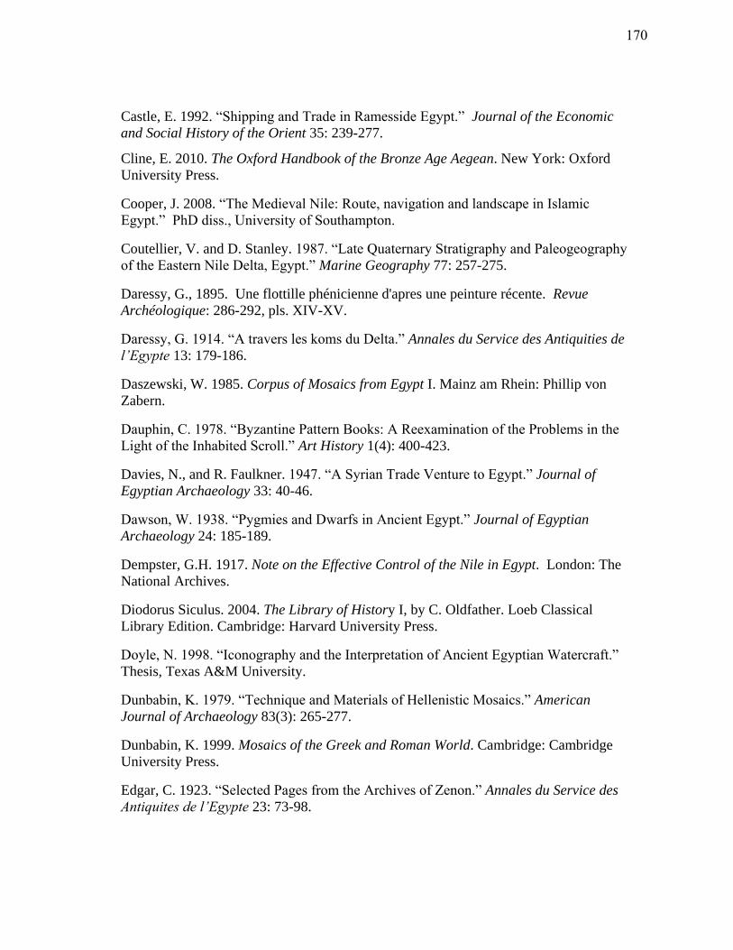
Castle, E. 1992. “Shipping and Trade in Ramesside Egypt.” Journal of the Economic
and Social History of the Orient 35: 239-277.
Cline, E. 2010. The Oxford Handbook of the Bronze Age Aegean. New York: Oxford
University Press.
Cooper, J. 2008. “The Medieval Nile: Route, navigation and landscape in Islamic
Egypt.” PhD diss., University of Southampton.
Coutellier, V. and D. Stanley. 1987. “Late Quaternary Stratigraphy and Paleogeography
of the Eastern Nile Delta, Egypt.” Marine Geography 77: 257-275.
Daressy, G., 1895. Une flottille phénicienne d'apres une peinture récente. Revue
Archéologique: 286-292, pls. XIV-XV.
Daressy, G. 1914. “A travers les koms du Delta.” Annales du Service des Antiquities de
l’Egypte 13: 179-186.
Daszewski, W. 1985. Corpus of Mosaics from Egypt I. Mainz am Rhein: Phillip von
Zabern.
Dauphin, C. 1978. “Byzantine Pattern Books: A Reexamination of the Problems in the
Light of the Inhabited Scroll.” Art History 1(4): 400-423.
Davies, N., and R. Faulkner. 1947. “A Syrian Trade Venture to Egypt.” Journal of
Egyptian Archaeology 33: 40-46.
Dawson, W. 1938. “Pygmies and Dwarfs in Ancient Egypt.” Journal of Egyptian
Archaeology 24: 185-189.
Dempster, G.H. 1917. Note on the Effective Control of the Nile in Egypt. London: The
National Archives.
Diodorus Siculus. 2004. The Library of History I, by C. Oldfather. Loeb Classical
Library Edition. Cambridge: Harvard University Press.
Doyle, N. 1998. “Iconography and the Interpretation of Ancient Egyptian Watercraft.”
Thesis, Texas A&M University.
Dunbabin, K. 1979. “Technique and Materials of Hellenistic Mosaics.” American
Journal of Archaeology 83(3): 265-277.
Dunbabin, K. 1999. Mosaics of the Greek and Roman World. Cambridge: Cambridge
University Press.
Edgar, C. 1923. “Selected Pages from the Archives of Zenon.” Annales du Service des
Antiquites de l’Egypte 23: 73-98.
170
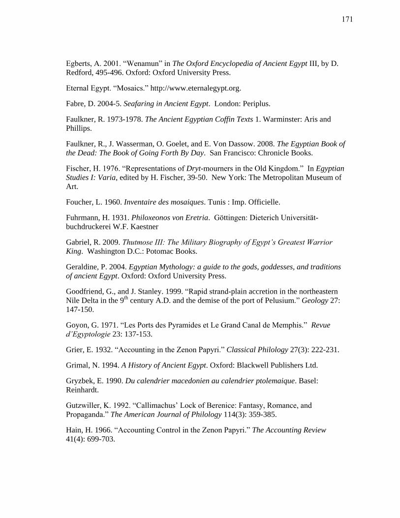
Egberts, A. 2001. “Wenamun” in The Oxford Encyclopedia of Ancient Egypt III, by D.
Redford, 495-496. Oxford: Oxford University Press.
Eternal Egypt. “Mosaics.” http://www.eternalegypt.org.
Fabre, D. 2004-5. Seafaring in Ancient Egypt. London: Periplus.
Faulkner, R. 1973-1978. The Ancient Egyptian Coffin Texts 1. Warminster: Aris and
Phillips.
Faulkner, R., J. Wasserman, O. Goelet, and E. Von Dassow. 2008. The Egyptian Book of
the Dead: The Book of Going Forth By Day. San Francisco: Chronicle Books.
Fischer, H. 1976. “Representations of Dryt-mourners in the Old Kingdom.” In Egyptian
Studies I: Varia, edited by H. Fischer, 39-50. New York: The Metropolitan Museum of
Art.
Foucher, L. 1960. Inventaire des mosaiques. Tunis : Imp. Officielle.
Fuhrmann, H. 1931. Philoxeonos von Eretria. G ttingen: Dieterich Universit t-
buchdruckerei W.F. Kaestner
Gabriel, R. 2009. Thutmose III: The Military Biography of Egypt’s Greatest Warrior
King. Washington D.C.: Potomac Books.
Geraldine, P. 2004. Egyptian Mythology: a guide to the gods, goddesses, and traditions
of ancient Egypt. Oxford: Oxford University Press.
Goodfriend, G., and J. Stanley. 1999. “Rapid strand-plain accretion in the northeastern
Nile Delta in the 9th
century A.D. and the demise of the port of Pelusium.” Geology 27:
147-150.
Goyon, G. 1971. “Les Ports des Pyramides et Le Grand Canal de Memphis.” Revue
d’Egyptologie 23: 137-153.
Grier, E. 1932. “Accounting in the Zenon Papyri.” Classical Philology 27(3): 222-231.
Grimal, N. 1994. A History of Ancient Egypt. Oxford: Blackwell Publishers Ltd.
Gryzbek, E. 1990. Du calendrier macedonien au calendrier ptolemaique. Basel:
Reinhardt.
Gutzwiller, K. 1992. “Callimachus’ Lock of Berenice: Fantasy, Romance, and
Propaganda.” The American Journal of Philology 114(3): 359-385.
Hain, H. 1966. “Accounting Control in the Zenon Papyri.” The Accounting Review
41(4): 699-703.
171
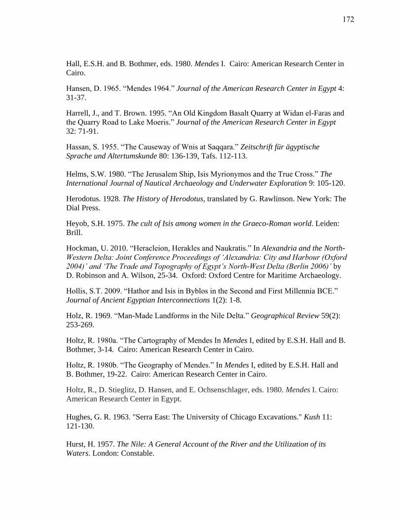
Hall, E.S.H. and B. Bothmer, eds. 1980. Mendes I. Cairo: American Research Center in
Cairo.
Hansen, D. 1965. “Mendes 1964.” Journal of the American Research Center in Egypt 4:
31-37.
Harrell, J., and T. Brown. 1995. “An Old Kingdom Basalt Quarry at Widan el-Faras and
the Quarry Road to Lake Moeris.” Journal of the American Research Center in Egypt
32: 71-91.
Hassan, S. 1955. “The Causeway of Wnis at Saqqara.” Zeitschrift für ägyptische
Sprache und Altertumskunde 80: 136-139, Tafs. 112-113.
Helms, S.W. 1980. “The Jerusalem Ship, Isis Myrionymos and the True Cross.” The
International Journal of Nautical Archaeology and Underwater Exploration 9: 105-120.
Herodotus. 1928. The History of Herodotus, translated by G. Rawlinson. New York: The
Dial Press.
Heyob, S.H. 1975. The cult of Isis among women in the Graeco-Roman world. Leiden:
Brill.
Hockman, U. 2010. “Heracleion, Herakles and Naukratis.” In Alexandria and the North-
Western Delta: Joint Conference Proceedings of ‘Alexandria: City and Harbour (Oxford
2004)’ and ‘The Trade and Topography of Egypt’s North-West Delta (Berlin 2006)’ by
D. Robinson and A. Wilson, 25-34. Oxford: Oxford Centre for Maritime Archaeology.
Hollis, S.T. 2009. “Hathor and Isis in Byblos in the Second and First Millennia BCE.”
Journal of Ancient Egyptian Interconnections 1(2): 1-8.
Holz, R. 1969. “Man-Made Landforms in the Nile Delta.” Geographical Review 59(2):
253-269.
Holtz, R. 1980a. “The Cartography of Mendes In Mendes I, edited by E.S.H. Hall and B.
Bothmer, 3-14. Cairo: American Research Center in Cairo.
Holtz, R. 1980b. “The Geography of Mendes.” In Mendes I, edited by E.S.H. Hall and
B. Bothmer, 19-22. Cairo: American Research Center in Cairo.
Holtz, R., D. Stieglitz, D. Hansen, and E. Ochsenschlager, eds. 1980. Mendes I. Cairo:
American Research Center in Egypt.
Hughes, G. R. 1963. "Serra East: The University of Chicago Excavations." Kush 11:
121-130.
Hurst, H. 1957. The Nile: A General Account of the River and the Utilization of its
Waters. London: Constable.
172
Janssen, J. 1961. “Translation and Commentary.” In Two Ancient Egyptian Ships Logs,
by J. Janssen, 67-90. Leiden, E.J. Brill.
Janssen, J. 2004. Grain Transport in the Ramesside Period: Papyrus Baldwin (BM EA
10061) and Papyrus Amiens. London: British Museum Press.
Jeffreys, D. 1985. The Survey of Memphis I. London: The Egypt Exploration Society.
Jeffreys, D. and H. Smith. 1988. “Memphis and the Nile in the New Kingdom: A
Preliminary Attempt at a Historical Perspective.” In Memphis et ses necropolis au
Nouvel Empire: nouvelles donnees, nouvelles questions, by A.P. Zivie, 55-66. Paris:
Editions du Centre National de la Recherché Scientifique.
Jomard, E.F., ed. 1809-28. Description de l’Egypte: ou, Recueil des observations et des
recherches qui ont ete faites en Egypt pendant l’expedition de l’armee francaise/ publie
par les orders de Sa Majeste l’empereur Napoleon le Grand. Paris: Imprimerie
Imperiale.
Josephus Flavius. 1737. The Works of Flavius Josephus, translated by W. Whiston.
London: W. Bowyer.
Kees, H. 1961. Ancient Egypt: A Cultural Topography. Edited by T.G.H. James.
Chicago: University of Chicago Press.
Kemp, B. and D. O’Connor. 1974. “An Ancient Nile Harbour: University Museum
Excavations at the ‘Birket Habu’.” International Journal of Nautical Archaeology 3(1):
101-136.
Khalil, E. 2010. “Waterfront Installations and Maritime Activities in the Mareotic
Region.” In Lake Mareotis: Reconstructing the Past, by L. Blue and E. Khalil. Oxford:
Archaeopress.
Kitchen, K. 1978. Review of The Sea Peoples and Egypt, by A. Nibbi. The Journal of
Egyptian Archaeology 61: 169-171.
Kitchen, K. 1983. Review of Ancient Egypt and some Eastern Neighbours, by A. Nibbi.
Palestine Exploration Quarterly 64: 77-79.
Knudstad, J. 1966. "Serra East and Dorginarti: A Preliminary Report on the 1963-64
Excavations of the University of Chicago." Journal of the Sudan Antiquities Service 14:
165-186.
Lexicon Iconographicum Mythologiae Classicae. Zurich: Artemis.
Lichtheim, M. 1973. Ancient Egyptian Literature. Los Angeles: University of California
Press.
173
Lindsay, J. 1968. Men and Gods on the Roman Nile. London: Frederick Muller.
Lipinski, E. 1994. “Aramaic Documents from Ancient Egypt.” Orientalia Lovaniensia
Periodica 29: 61-68.
Lloyd, A., 2000a. “The Late Period (664-332 BC)” In The Oxford Encyclopedia of
Ancient Egypt, by I. Shaw, 364- 387. Oxford: Oxford University Press.
Lloyd, A. 2000b. “The Ptolemaic Period (332-30 BC)” In The Oxford Encyclopedia of
Ancient Egypt, by I. Shaw, 388-413. Oxford: Oxford University Press.
Mackay, P. 1976. “Arabic Sources.” In Mendes II by Meulenaere, H. and P. Mackay.
Warminster: Aris and Phillips Ltd, 6-13.
Mark, S. 1998. From Egypt to Mesopotamia: A Study of Predynastic Trade Routes.
College Station: Texas A&M University Press.
Marquaille, C. 2008. “The Foreign Policy of Ptolemy II.” In Ptolemy II Philadelphus
and his World, by P. McKechnie and P. Guillaume, 39-64. Leiden: Brill.
Mathews, R., and C. Roemer. 2003. Ancient Perspectives on Egypt. London: Routledge
Cavendish.
McCabe, E. 2008. An Examination of the Isis Cult with Preliminary Exploration into
New Testament Studies. Lanham : University Press of America.
Meeks, D. 1997. “Navigation Maritime et Navires Egyptiens: Les Elements D’une
Controverse.” In Techniques et Economie Antiques et Medievales: le temps de
l'innovation, by D. Garcia and D. Meeks, 175-194. France: Errance.
E. Mentelle and P.G. Chanlaire. 1799. Carte Physique et Politique de l'Egypte. Paris:
Les auteurs.
Meulenaere, H. 1976a. “Greek and Roman Sources.” In Mendes II, by Meulenaere, H.
and P. Mackay, 1-4. Warminster: Aris and Phillips Ltd.
Meulenaere, H. 1976b. “Coptic Sources.” In Mendes II, by Meulenaere, H. and P.
Mackay, 5. Warminster: Aris and Phillips Ltd.
Meulenaere, H. 1976c. “Scholarly Exploration.” In Mendes II, by Meulenaere, H. and P.
Mackay, 14-18. Warminster: Aris and Phillips Ltd.
Meulenaere, H. 1976d. “Cults and Priesthoods of the Mendesian Nome.” In Mendes II
by Meulenaere, H. and P. Mackay, 178-181. Warminster: Aris and Phillips Ltd.
Meulenaere, H. and P. Mackay. 1976. Mendes II. Warminster: Aris and Phillips Ltd
174
Meyboom, P. 1995. The Nile Mosaic of Palestrina: early evidence of Egyptian religion
in Italy. Leiden: Brill.
Moore, M. 1997. The Athenian agora: results of excavations conducted by the American
school of classical studies at Athens. Hellenistic pottery: Athenian and imported
wheelmade table ware and related material 29. New Jersey: Princeton University Press.
Morenz, S. and A. Keep, 1992. Egyptian Religion. Ithaca: Cornell University Press.
Mumford, G. 1999-2004. “Tell Tebilla 1-11.” Survey & Excavation Projects in Egypt.
http://www.deltasinai.com.
Mumford, G. 2011. Tell Tebilla Project. http://www.arqueologiadeegipto.com/tell-
tebilla-project/.
Murray, W. 1991. “The Provenience and Date: The Evidence of the Symbols.” In The
Athlit Ram, edited by Casson, L. and R. Steffy, 51-66. College Station: Texas A&M
University Press.
Murray, W. 2011. The Age of the Titans: The Rise and Fall of the Great Hellenistic
Navies. Oxford: Oxford University Press.
National Gallery of Art. 1999. Studies in the History of Art. Washington: National
Gallery of Art.
Naville, E. 1898. The Temple of Deir el Bahari III. London: Egypt Exploration Fund.
Nibbi, A. 1972. The Sea Peoples: A Re-examination of the Egyptian Sources. Oxford:
Church Army Press and Supplies.
Nibbi, A. 1975. The Sea Peoples and Egypt. New Jersey: Noyes Press.
Nibbi, A. 1979a. “Some Remarks on the Assumption of Ancient Egyptian Sea-going.”
The Mariner’s Mirror 65: 201-208.
Nibbi, A. 1979b. “The Fifth Dynasty Anchor from Abusir.” Gottinger Miszellen 32: 39-
44
Nibbi, A. 1979c. “A Further Note on the Fifth Dynasty Anchor from Abusir.” Gottinger
Miszellen 33: 41-46.
Nibbi, A. 1981. Ancient Egypt and Some Eastern Neighbours. New Jersey: Noyes Press.
Nibbi, A. 1984. “Ancient Egyptian Anchors: A Focus on the Facts.” The Mariner’s
Mirror 70: 247-266
Nibbi, A. 1992. “A Group of Stone Anchors from Mirgissa on the Upper Nile.” The
International Journal of Nautical Archaeology 21(3): 259-267.
175
Nibbi, A. 1993. “Stone Anchors: The Evidence Re-assessed.” The Mariner’s Mirror 79:
5-26.
Nibbi, A. 1997. “An Answer to Lucien Basch on Ancient Egyptian Sea-Going, Stone
Anchors and Bread Offerings.” Discussions in Egyptology 38: 37-62.
Nightingale. F. 1854. Letters from Egypt. London: A.& G.A. Spottiswood.
Ochsenschlager, E. 1967. “The Excavations at Tell Timai.” Journal of the American
Research Center in Egypt 6: 32-51.
Ogden, D. 2008. “Bilistiche and the Prominence of Courtesans in the Ptolemaic
Tradition.” In Ptolemy II Philadelphus and his World, edited by P. McKechnie and P.
Guillaume, 353-385. Leiden: Brill.
P.Cair.Zen.I. 59089. “Cairo Zenon Papyri.” Photographic Archive of Papyri in the Cairo
Museum.
http://ipap.csad.ox.ac.uk/4DLink4/4DACTION/IPAPwebquery?vPub=P.Cair.Zen.&vVo
l=1&vNum=59089
P.Cair.Zen.II. 59292. “Cairo Zenon Papyri.” Photographic Archive of Papyri in the
Cairo Museum.
http://ipap.csad.ox.ac.uk/4DLink4/4DACTION/IPAPwebquery?vPub=P.Cair.Zen.&vVo
l=2&vNum=59292
P.Cair.Zen.III. 59470. “Cairo Zenon Papyri.” Photographic Archive of Papyri in the
Cairo Museum.
http://ipap.csad.ox.ac.uk/4DLink4/4DACTION/IPAPwebquery?vPub=P.Cair.Zen.&vVo
l=3&vNum=59470
Peacock, D., 2000. “The Roman Period (30 BC- AD 395).” In The Oxford Encyclopedia
of Ancient Egypt, by I. Shaw, 414-436. Oxford: Oxford University Press.
Peacock, D., and L. Blue, eds. 2006. Myos Hormos- Quseir al-Qadim: Roman and
Islamic Ports on the Red Sea. Oxford: Oxbow Books.
Pfeiffer, S. 2008. “The God Serapis, His Cult and the Beginnings of the Ruler Cult in
Ptolemaic Egypt” In P. Mckechnie and P. Guillaume’s Ptolemy II Philadelphus and his
World. Leiden: Brill, 387-408.
Pfeiffer, S. 2010. “Naukratis, Heracleion-Thonis and Alexandria: Remarks on the
Presence and Trade Activities of Greeks in the North-West Delta from the Seventh
Century BC to the End of the Fourth Century BC.” In Alexandria and the North-Western
Delta: Joint Conference Proceedings of ‘Alexandria: City and Harbour (Oxford 2004)’
and ‘The Trade and Topography of Egypt’s North-West Delta (Berlin 2006),’ by D.
Robinson and A. Wilson, 15-24. Oxford: Oxford Centre for Maritime Archaeology.
176
Phillips, J. 1997. “Punt and Aksum: Egypt and the Horn of Africa.” Journal of African
History 38: 423-457.
Pliny the Elder. 1855. The Natural History. Edited by J. Bostock and H. Riley. London:
H.G. Bohn.
Preaux, C. 1939. L’Economie Royale des Lagides. Bruxelles: Fondation Egyptologique
Reine Elisabeth.
Pritchard, J. ed. 1969. Ancient Near Eastern Texts Relating to the Old Testament.
Princeton: Princeton University Press.
El-Qady, G., A. El-Said, A. Mohamed, and F. Shaaban. 2006. “Application of
Geophysical Methods for Delineating the Old Harbour of Mendes.” Proceedings from
the 4th
International Symposium on Geophysics, Tanta, 40-49.
Quack, J. 2008. “Innovations in Ancient Garb? Hieroglyphic Texts from the Time of
Ptolemy Philadelphus.” In Ptolemy II and His World, by P. McKechnie and P.
Guillaume, 275-289. Leiden: Brill.
Quaegebeur, J. 1971. “ Documents concerning a Cult of Arsinoe Philadelphos at
Memphis.” Journal of Near Eastern Studies 30: 239-270.
Redford, D. 1992a. Egypt, Canaan, and Israel in Ancient Times. New Jersey: Princeton
University Press.
Redford, D. 1992b. “The First Season of Excavations at Mendes (1991).” The Society
for the Study of Egyptian Antiquities 18: 49-79.
Redford, D. 2001. The Oxford Encyclopedia of Ancient Egypt. Oxford: Oxford
University Press.
Redford, D. 2010. City of the Ram Man: The Story of Ancient Mendes. Princeton:
Princeton University Press.
Redmount, C. 1995. “The Wadi Tumilat and the Canal of the Pharaohs.” Journal of
Near Eastern Studies 54(2): 127-135.
Rizzo, G. 1929. La pittura ellenistico-romano. Milano: Treves.
Said, R. 1992. “The Geological History of the Nile Delta” In The Nile Delta in
Transition: 4th
-3rd
Millennium B.C., edited by F.C.M. Van den Brink, 259-267.
Jerusalem: The Israel Exploration Society.
Säve-Söderbergh, T. 1957. Four Eighteenth Dynasty Tombs. Oxford: Oxford University
Press.
Sethe, K. 1961. rkunden des gyptischen Altertum, IV. Berlin: Akademie-Verlag.
177
Shaw, I. 2000. The Oxford History of Ancient Egypt. Oxford: Oxford University Press.
Sidebotham, S., and W. Wendrich. 1996. “Berenike: Roman Egypt’s Maritime Gateway
to Arabia and India.” Egyptian Archaeology 8: 15-18.
Sidebotham, S., and W. Wendrich. 1999. “Berenike: an ancient emporium at the cross-
roads of the Mediterranean-Red Sea-Indian Ocean trade.” The Indian Ocean Review 12:
16.
Silver, M. 1995. “Gods as Inputs and Outputs of the Ancient Economy.” In Economic
Structures of Antiquity, by M. Silver. Westport, Connecticut: Greenwood Press.
Smith, W. 1965. Interconnections in the Ancient Near East. New Haven: Yale
University Press.
Sneh, A., T. Weissbrod, and I. Perath. 1975. “Evidence for an Ancient Egyptian Frontier
Canal: The remnants of an artificial waterway discovered in the northeastern Nile Delta
may have formed a part of the barrier called ‘Shur of Egypt’ in ancient texts.” American
Scientist 63(5): 542-548.
Stanley, J.D. and A.G. Warne. 1993. “Nile Delta: Recent Geological Evolution and
Human Impact.” Science 260: 628-634.
Stanley, J., M. Bernasconi, and T. Jorstad. 2008. “Pelusium, an Ancient Port Fortress on
Egypt’s Nile Delta Coast: Its Evolving Environmental Setting from Foundation to
Demise.” Journal of Coastal Research 24: 451-462.
Stevenson, E., trans. 1932. The Geography by Claudius Ptolemy, Greek Geographer of
the 2nd
Century A.D. New York: The New York Public Library.
Strabo. 1932. The Geography of Strabo VIII, translated by H.L. Jones. London: Harvard
University Press.
Svoronos, J. 1914. “Stylides, ancres, hierae, aphlasta, stoloi, akrostolia, embola,
proembola et totems marins." Journal International d'archeologie numismatique 16: 81-
152.
Taha, A.I. 1998. “Shallow Geophysical Studies for Archaeological and Hydrogeological
Investigation at El-Simbellawein District, Eastern Nile Delta, Egypt.” Thesis, Mansoura
University.
Thompson, D.B. 1955. “A Portrait of Arsinoe Philadelpos.” American Journal of
Archaeology 59: 199-206.
Thompson, D.J. 2008. “Economic Reforms in the Mid-Reign of Ptolemy Philadelphus.”
In Ptolemy II and His World, by P. McKechnie and P. Guillaume. Leiden: Brill.
178
Thucydides. 1989. The Peloponnesian War / Thucydides: the complete Hobbes
translation, with notes and new introduction by David Grene, translated by T. Hobbes
and edited by D. Grene. Chicago: University of Chicago Press.
Tousson, O. 1922. Memoire Sur Les Anciennes Branches Du Nile. Cairo: Institute
Francais d’Archeologie Orientale.
Tronchere, H., F. Salomon, Y.Callot, J.P. Goiran, L. Schmitt, I. Forstner-Muller, and M.
Bietak. 2008. “Geoarchaeology of Avaris: First Results.” Ägypten und Levante 18: 327-
339.
Turnheim, Y. 2002. “Nilotic Motifs and the Exotic in Roman and Byzantine Eretz
Israel.” Assaph. Section B: Studies in Art History 22: 17-40.
Vandersleyen, C. 1991. “Le sens de Ouadj-Our.” In Akten des vierten Internationalen
Agyptologen Kongresses Munchen 1985 4, by S. Schoske, 345-352. Hamburg: Helmut
Buske.
Van Lepp, J. 1995. “Evidence for Artificial Irrigation in Amratian Art.” Journal of the
American Research Center in Egypt 32: 197-209.
Van Wesemael, B. 1988. “The Relation Between Natural Landscape and Distribution of
Archaeological Remains in the Northeastern Nile Delta.” In The Archaeology of the
Nile Delta, Egypt: Problems and Priorities, by E. Van den Brink, 125-139. Amsterdam:
Netherlands Foundation for Archaeological Research in Egypt.
Verreth, H. 1998. “A Tax List from the Mendesios of the Time of Augustus.” In
Egyptian Religion: The Last Thousand Years, by W. Clarysse, A. Schoors, H. Willems,
and J. Quaegebeur, 455-476. Leuven: Peeters.
Versnel, H.S. 1993. Inconsistencies in Greek and Roman Religion: Transition and
reversal in myth and religion. New York: Brill.
Waage, F. 2011. “Mosaic.” In Encyclopædia
Britannica. http://original.search.eb.com.lib-ezproxy.tamu.edu:2048/eb/article-74110
Ward, C. and C. Zizzaro. 2010. “Evidence for Pharaonic Seagoing Ships at Mersa/Wadi
Gawasis, Egypt.” International Journal of Nautical Archaeology 39(1): 27-43.
Westerdahl, C. 1978. Marinarkeologisk inventering med utgangspunkt fran ett
norrlandskt exempel. C-uppsats, arkeologi. Unpublished Thesis, University of
Stockholm.
Westerdahl, C. 1992. “The Maritime cultural landscape.” The International Journal of
Nautical Archaeology 21(1): 5-14.
179
Westerdahl, C. 1994. “Maritime cultures and ship types: brief comments on the
significance of maritime archaeology.” The International Journal of Nautical
Archaeology 23(4): 265-270.
Williams, E.R. 1985. “Isis Pelagia and a Roman Marble Matrix from the Athenian
Agora.” The Journal of the American School of Classical Studies at Athens 54(2): 109-
119.
Wilson, E. 1999. Roman Designs. London: British Museum Press.
Yardeni, A. 1994. “Maritime Trade and Royal Accountancy in an Erased Customs
Account from 475 B.C.E. on the Ahiqar Scroll from Elephantine.” The Bulletin of the
American Schools of Oriental Research 293: 67-78.
Yk, C. 1697. De Nederlandsche Scheeps-bouw-konst Open Gestelt. Amsterdam: Hoorn.
180
VITA
Name: Veronica Marie Morriss
Address: Department of Anthropology
Texas A&M University
4352 TAMU
College Station, TX 77843-4352
Email Address: [email protected]
Website: http://www.divingarchaeology.com
Education: B.A., Classics and Ancient Mediterranean Studies, The
Pennsylvania State University, 2007
M.A., Anthropology, Texas A&M University, 2012
181