irA;: 1&;8; fa!alr-all:gl"! C:Q1t11fiscafedl tall!dl~
352
I '11...)8' .... ' .•• :.:1;1 ... ::.,. ... : ", ... :J!; ... ;.! .;ift) ".J Q ulr . /c:a, .... .. 1!i rf \ 1a""" ft .. tit ,8:11.' i .r . IV'IIIill irA;: 1&;8; fa!alr-all:gl"! C:Q 1 t11fiscafedl Volume 1: Report Evelvn Stokes 1997 U · The • mverSlty ofWaikato Te Whare Wananga 0 Waikato
-
Upload
khangminh22 -
Category
Documents
-
view
6 -
download
0
Transcript of irA;: 1&;8; fa!alr-all:gl"! C:Q1t11fiscafedl tall!dl~

I '11...)8' .... }I,I.~' ' .•• :.:1;1 ... ::.,. ... : ", ... :J!; ... ;.! ]ift:e:~\~a\ .;ift) 1111~ ".J Q UI~I ulr . /c:a, .... IJ.j"~· .. ,.~}
1!i rf \ 1a""" ft .. tit ,8:11.' i .r . IV'IIIill
irA;: 1&;8; fa!alr-all:gl"! C:Q1t11fiscafedl tall!dl~
Volume 1: Report
Evelvn Stokes 1997
U · The • mverSlty ofWaikato Te Whare Wananga
~o~~~~ 0 Waikato

t'/i ~,
(

The Allocation of Reserves for Maori
in the Tauranga Confiscated Lands
Volume 1: Report
Evelyn Stokes 1997
J University of Waikato Private Bag 3105 Hamilton, New Zealand
2
I.'
(

3
Contents
Jlreface ------------------------------------------------------------------------------------------- 7
1. IntrOduCtiOIl -------------------------------------------------------------------------------- 9 2. Legisiatioll for Native Reserves -------------------------------------------------------- 16
3. The Katikati Te JlUIla "Jlurchase" 1864 ------------------------------------------------ 25
4. Negotiatiolls 011 the Katikati Te Jlulla Block 1866 ----------------------------------- 37
5. CorrfroIltatioIl over Survey of the CoILfiscated Block 1866 ------------------------- 60
6. The "TauraILga Bush CampaigIL" 1867 ------------------------------------------------70
7. The TauraILga District LaILds Acts 1867 aILd 1868 ----------------------------------- 85
8. The Allocatioll of Reserves ill the Katikati Te JlUIla aILd CoILfiscated Blocks ---- 99
9. The Removal of RestrictioIlS 011 AlieIlatioIl of Reserves -------------------------- 127
10. The "Half-Caste Claims" -------------------------------------------------------------- 145
11. The TOWIl of TauraILga aILd TOWIlShip of GreertoIl--------------------------------- 155
12. EIldowmeIlt Reserves ullder the Native Reserves Acts ---------------------------- 167
13. Summary of Reserves Allocated by 1886 ------------------------------------------- 185
14. Summary of LaILds GraILted to Hapu ------------------------------------------------- 231
15. Some COIlc1udillg Commellts --------------------------------------------------------- 285
16. Referellces ------------------------------------------------------------------------------- 296
17. Appelldices:
1. Deeds for the Katikati Te Jlulla Block ------------------------------------------- 302
2. "LaILd could be awarded omy to loyal Natives ... " ----------------------------- 316
3. "Native custom" was "wiped out by the confiscatioll of laILd" --------------- 320
4. Judgmellt 011 the oWIlership of Lot 202, SectioIll, TOWIl ofTauraILga------ 323
5. OpiILiOIlS 011 the vestillg of Lot 210, Jlarish of Te JluIla, ill Jlelle Taka ------- 343

4
List of Figures ( 1. Tauranga Confiscated Lands ------------------------------------------------------------- 8
2. Tauranga Moana -------------------------------------------------------------------------- 10
3. Mackay's Panui 1866 -------------------------------------------------------------------- 42
4. Mackay's Sketch Plan 1867 ------------------------------------------------------------- 44
5. Plan on the Tawera Purchase Deed ---------------------------------------------------- 46
6. Plan of the "Ngaiterangi" Purchase Deed --------------------------------------------- 49
7. Reserves for "Ngaiterangi" on Deed No. 461 ---------------------------------------- 51
8. Plan of the "Pirirakau" Purchase Deed ------------------------------------------------ 53
9. Boundaries of the Katikati Te Puna "Purchase" -------------------------------------- 55
10. Hapu in the Confiscated Block --------------------------------------------------------- 61
11. Clarke's Sketch Map 1867 -------------------------------------------------------------- 78
12. Investigation of Titles of "Land Returned" ------------------------------------------- 88
13. Index Map of Tauranga Confiscated Lands ----------------------------------------- 100
14. Military Settlement and Native Reserves 1868 ------------------------------------- 102
15. Removal of Restrictions on Alienation ---------------------------------------------- 132
16. Tenure of the "Lands Returned" 1886 ----------------------------------------------- 143
17. The Town of Tauranga and Township of Greerton --------------------------------- 156 / ('\',
'\. ,I
18. a and b. Reserves in the Town of Tauranga ----------------------------------- 160- 161
19. Reserves in the Township of Greerton ----------------------------------------------- 162
20. Plan of the "Native Hostelry" Site --------------------------------------------------- 170
21. a, b, c and d. Plans of Native Reserves, Town of Tauranga -----------------171-174
22. Plan of the "Brookfield Reserve" ---------------------------------------------------- 175
23. Reserves Allocated by 1886: Confiscated Block ---------------------------------- 186
24. Mackay's Plan of Reserves Nov. 1866 ---------------------------------------------- 187
25. Te Puna Reserves ----------------------------------------------------------------------- 189
26. Reserves at Otumoetai, Bethlehem and Greerton ---------------------------------- 191
27. Reserves Allocated by 1886: Katikati Te Puna Block ---------------------------- 195
28. "Lands Returned": The Inland Blocks ---------------------------------------------- 199
29. "Lands Returned": East of Tauranga Harbour and Waimapu River------------- 200
30. "Lands Returned": Matakana and Rangiwaea ------------------------------------- 201
31. Relief ------------------------------------------------------------------------------------- 203
32. Soils -------------------------------------------------------------------------------------- 204
('

5
33. Vegetation c .1860 ----------------------------------------------------------------------- 205
34. Smith's Sketch Map and "Census" 1864 -------------------------------------------- 209
35. Kainga in 1864 -------------------------------------------------------------------------- 212
36. Maori Population 1881 ---------------------------------------------------------------- 216
37. Matakana and Rangiwaea ------------------------------------------------------------- 225
38. Nga Marae 0 Tauranga Moana-------------------------------------------------------- 233
39. Hapu East of Tauranga Harbour and Waimapu River -----------------------,..,.---- 240
AO. Huria: Lot 452 Parish ofTe Papa 1925 ------~-------------------------------------- 249
41. Hapu of the Wairoa Valley ------------------------------------------------------------ 255
42. The Omokoroa Reserves -------------------------------------------------------------- 268
43. "Unproductive Native Land" 1906 --------------------------------------------------- 291
44. Lands Reported on by Stout-Ngata Commission 1908 ---------------------------- 293
45. Maori Land 1930-1950 ---------------------------------------------------------------- 295

6
Te Papa viewed from Monmouth Redoubt in foreground to the CMSmission station and Mauao c.1870
Photo: Tauranga District Museum
c
i{

7
Preface
This report has been compiled at the request of the Chairperson of the Waitangi Tribunal, Chief Judge E.T. Durie. Before I was appointed as a member of the Tribunal, I had been commissioned to produce an overview report of Maori grievances in the Tauranga confiscated lands (Stokes 1990 and 1992). Since then a good deal more research has been done both by claimants and Tribunal staff. There remained a gap which I am now asked to fill, that is to review just how much land was granted to each hapu in Tauranga Moana. For reasons which will be explained in the introduction, this was not a simple task, given the circumstances of the allocation of reserves, the status allocated to grantees by Crown officials as "friendly" , or "surrendered rebels" , or individuals who were given "compensation", or awards for "loyalty" , or "services rendered". The administration of the reserves was also complex, and covered by numerous different pieces of legislation since the New Zealand Settlements Act 1863 under which the confiscation of Tauranga lands was proclaimed in 1865.
In compiling this report I acknowledge with much appreciation the assistance provided by staff of the Maori Land Court, Hamilton, in particular the present and former Registrars (Lindsay Wilson and Maehe Maniapoto) and Jim Shepherd; staff in the Department of Survey and Land Information (now Land Information New Zealand), particularly Don Prentice (now retired) and John Neal of the Maori Land Section in the Hamilton office; Jinty Rorke of the Tauranga Public Library; and staff in the University of Waikato Library, Hamilton. I also acknowledge gratefully the work of Max Dulton, Department of Geography ,University of Waikato who drafted the maps; Danelle Dinsdale who searched titles; Donald Stokes for his computer work to produce the lists of owners in Volume 2; and Lorraine Brown-Simpson and her staff in the University Secretarial Services who typed the text.
Finally I add a disclaimer. Because of my Tauranga connections, I am disqualified from acting. as a member of the Tribunal panel that will hear the Tauranga claims. This report has been c(}mpiled at the Chairperson's request to assist that Tribunal when it is· appointed. This report 'should not in any way be construed as an expression of opinion of the Waitangi Tribunal. I remain responsible for any interpretations contained therein.
Evelyn Stokes Professor of Geography University of Waikato December 1997

8
N GAT I
H A U A
Matamata.
Peria.
* Maungakawa
• Hanga
N GAT I • Kuranui
RAUKAWA
*
7 • Tapapa
TAURANGA CONFISCATED LANDS P,!, , ~ , . , ,'p
kllamotrn$
Figure 1
Land under New Zealand Settlements Act 1863 .
~ Confiscated·Bi.ock
~ CMSTe Papa Block
KatikatiTe Puna Block
DMOliti Island
(
{
GM:):9/96
(

9
1. Introduction
The Tauranga confiscated lands (Figure 1) comprise the area estimated at 214,000 acres
defined in the Schedule to the proclamation dated 18 May 1865 which declared this area to
be a "District" within the provisions of the New Zealand Settlements Act 1863 (New Zea
land Gazette 1865, p. 187). The "Sim Commission" inquiry into confiscated lands found
that "in fact 290,000 acres" were actually confiscated in the Tauranga district (AllIR 1928,
G-7, p. 19). In effect, the 1865 proclamation extinguished Native title, or Maori customary
tenure of this land, and the whole area became, ipso facto, Crown land. The proclamation
described this area as "the lands of the tribe Ngaiterangi" and also ordered:
that in accordance with the promise made by His Excellency the governor at Tauranga, on the sixth day of August, 1864, three fourths in quantity of the said lands shall be set apart for such persons of the tribe N gaiterangi as shall be determined by the Governor, after due enquiry shall be made (New Zealand Gazette 1865, p. 187)
There were several complicating factors in this situation. One was that both government
officials and the military in the 1860s used the name "Ngaiterangi" to describe all the Maori
in the district now known in Maori terms as Tauranga Moana. The reality was that Ngai Te
Rangi, a tribe of Mataatua descent, comprised a number of different hapu, who had settled
mainly on lands east of the Waimapu River, on Matakana and other islands and the coastal
fringes of Tauranga Harbour at Te Papa, Otfimoetai and the Katikati district. Ngati Ranginui,
a tribe of Takitimu descent comprised several hapu between the Wairoa and Waimapu Riv
ers, and Pirirakau occupied the Te Puna district west of the Wairoa. To the north, Hauraki
tribeslodged claims to the Katikati Te Puna district. Along the Kaimai range were several
hapu, descended from the original tangata whenua as well as Tainui ancestors, who held
rights inside the Tauranga confiscated lands. In particular, Ngati Haua and others had occu
pation rights at Omokoroa and various hapu of N gati Raukawa held customary rights in the
Kaimai district and valley of the Wairoa River. To the south-east and east Te Arawa inter
ests overlapped, particularly those of Wait aha of the Te Puke district and Ngati Rangiwewehi
inland around Piiwhenua-~igure~21.
At the time of Governor Grey's visit in August 1864 it was "agreed" by a few "Ngaiterangi
chiefs" that the lands that became known as the Katikati Te Puna Purchase would be "sold"

- - - Confiscation Line
= Confiscated B
Bush (1864)
10
Figure 2
-
-( \,
(

11
to the Crown. This transaction was disputed by hapu not party to it. The land which became
known as the Confiscated Block, was "agreed" should be between the Wairoa and Waimapu
Rivers, although a subsequent decision to extend this west across the Wairoa River into Te
Puna created a further grievance among Pirirakau and other inland hapu in particular. The
Te Papa peninsula itself, south to Gate Pa, an area of 1333 acres, had been granted by the
Land Claims Commission to the Church Missionary Society on the basis of a "purchase"
before 1840 (AJRR 1863, D-14). The balance area of the Tauranga confiscated lands made
up the "Lands Returned" (Figure 1).
In the period 1865-1867 negotiations with local people over reserves and other matters were
the responsibility of James Mackay Jr. and Henry Tacy Clarke, Civil Commissioners at
Thames and Tauranga respectively. One of their tasks was to investigate the claims ofHauraki
or Marumahu tribes in the Katikati Te Puna Block, and reserves to be allocated to Tauranga
Moana people in this area. They were also largely responsible for allocating reserves in the
Town of Tauranga and the Confiscated Block. The "Tauranga confiscated lands" comprise
the whole area proclaimed under the New Zealand Settlements Act 1863 (New Zealand
Gazette 1865, p 187). The "Confiscated Block" is the approximately 50,000 acres retained
by the Crown. The "Katikati Te Puna Block" is described as a purchase in many reports but
this transaction was really a form of compulsory acquisition by the Crown. The term cession
was also used for this acquisition which reflected the conflict between Governor Grey and
his Ministers over policy on confiscation (see AJHR 1864, B-2, Dalton 1967, Riseborough
1994). The effect of this debate on the ground in Tauranga Moana was that the Crown
acquired both the Katikati Te Puna and Confiscated Blocks, and the Town of Tauranga
(CMS Block) and reserves for Maori were allocated in all these blocks by Clarke and Mackay.
On 10 October 1867 the Tauranga District Lands Act 1867 was passed, validating all agree
ments and awards within the Tauranga confiscated lands to date. . The Tauranga District
Lands Act 1868 amended the Schedule to the 1867 Act to describe more accurately the
boundaries of the Tauranga confiscated lands. In 1868, Henry Tacy Clarke was appointed
Commissioner of Tauranga Lands. His task was to conduct the "due inquiry" stated in the
1865 proclamation and Tauranga DistrictLands Act 1867 "for the purpose of determining

12
for what persons of the tribe Ngaiterangi three-fourths in quantity of the lands" in the Tauranga ( .
confiscation "shall be set apart". Clarke was to operate under the provisions of the Tauranga
District Lands Act 1867 and the Commissioners Powers Act 1867 (New Zealand Gazette
1868, p. 354).
Clarke remained Commissionerunti11876 apart from a period in 1870 when William Gilbert
Mair held the position. From 1876 to 1878 the Resident Magistrate at Tauranga:; Herbert W.
Brabant, was appointed, and then J.A. Wilson was appointed (New Zealand Gazette 1878,
pp. 91,452,454,1088). Wilson was also a Judge of the Native Land Court and his duties
there prevented his working full time on settling Tauranga lands. In his report to the Native
Minister (AJHR 1879, G-8) Wilson summarised the situation in early 1879:
Administration completed 19,734 acres Administration incomplete 38,951 A waiting administration 77,636 Confiscated-military settlement 50,000 Katikati Te Puna Purchases 88,500
Total contents of block 274,821 acres
This total was considerably more than the estimated 214,000 acres stated in the 1865 procla
mation, but sti11less than the figure of 290,000 acres accepted in the inquiry into confiscated
lands by the Sim Commission in 1927 (AJHR 1928, G-7). Wilson also commented:
. this schedule shows the area of the block to be 60,000 acres above the highest estimate hither to made - all previous estimates being necessarily vague, and varying, I believe, from 208,000 to 215,000 acres (AJHR 1879, G-8, p. 2).
Over the period January-July 1879 Wilson investigated another 7 blocks, a total of 13,221
acres, and "of my predecessors' transactions I have individualized in Court, and partially
administered in way of surveys, roads &tc., 38,951 acres" making a total of 52,172 acres,
within which "I have set aside upwards of 7,000 acres as reserves for the Natives which, I
think, should be inalienable" (ibid). The issue of alienability and restrictions on alienation
of reserves, discussed in chapter 9, is important, as many of Clarke's awards were granted
with no restrictions on alienation.
(
(
1

13
At the end of 1880 H.W. Brabant, already Resident Magistrate at Tauranga, assumed again
the additional role of Commissioner of Tauranga Lands. In May 1886 Brabant reported to
the Native Minister that he had completed his task of "settling the titles to the lands returned
to the Ngaiterangi Tribe under the Tauranga District Lands Acts, 1867 and 1868" (AJHR
1886, G-lO, p. 1). Wilson and Brabant were concerned principally with the "Lands Re
turned", which Brabant estimated contained a total of 136,191 acres in 210 blocks, exclud
ing the Katikati Te Puna Purchase, Town of Tauranga and Confiscated Block.
Th~"surveys of these lands have all been completed, and the certificates of investigation of title have been sent to your office, with the exception of three which are now being prepared.
Applications have been and are being received from Natives for the subdivision of these lands, but these will be left for the ordinary operation of the Native Land Court after the Crown titles have issued (AJHR 1886, G-lO, p. 1).
After 1886 all "reserves" granted to Maori that had not been sold were treated as Maori land
within the jurisdiction of the Native Land Court. The few blocks of Crown land set aside as
"Native reserves" under Native Reserves Acts were, by 1886, administered by the Public
Trustee, mainly as educational endowments, and are reviewed in Chapter 12.
The process of allocation of reserves for Maori in the Tauranga confiscated lands was drawn
out over a long period from 1865 to 1886. The emphasis was on individualisation of Maori
titles, and most reserves were granted to three or fewer individuals in the Katikati Te Puna
Purchase and Confiscated Block. In the Lands Returned, the Commissioners followed more
closely the procedures of the Native Land Court under the Native Land Act 1873, and awarded
blocks to much larger groups of owners.
There were further differences in the way reserves were allocated in the 1860s and 1880s.
Immediately after the confiscation of Tauranga lands in 1865 and until about 1868, a pri
mary concern was whether a grantee was "friendly" or "loyal". No lands were to be granted
to "rebels". Reserves were awarded to individual "chiefs" as "compensation" or for "serv
ices rendered". This was the case in the lots awarded to individuals in the Town of Tauranga
and Township of Greerton which included grants to Te Arawa "chiefs" of tribes who were
not tangata whenua in Tauranga Moana. Another category of grants to "surrendered rebels"

14
was significant in the Confiscated Block. The people who had retreated inland and were still (,
labelled as "rebel" or "Hauhau" in the late 1860s were not eligible for reserves, and an
unrecorded number of people received no land grants in ancestral lands in the Confiscated
Block. By the time the Commissioners were dealing with the "Lands Returned" in the 1880s
the identification of "rebels" had become unimportant. By this stage, according to Commis-
sioner Wilson, the aim was to allocate 50 acres per head of Maori population as inalienable
reserves (AJHR 1879, G-8, p. 2). Commissioner Brabant appears to have conducted inves-
tigations of title along similar lines to the process in the Native Land Court. There is little
information about how earlier commissioners conducted their inquiries.
In previous reports (Stokes 1990 and 1992) the limited evidence of how reserves were nego
tiated has been reviewed and comment made on the gaps in documentation. In this report the
focus is on the actual reserves that were allocated, the complexities of administration, and
the factors that combined to allow many so-called inalienable reserves to be sold. The aim in
tracing through the title records available in the Maori Land Court, Land Titles Office and
Department of Survey and Land Information (now Land Information New Zealand) has
been to establish who was granted land, on what conditions, and try to determine how much ( ,
land each hapu was allocated. In Chapter 2 the relevant legislation is reviewed. The report
then considers the terms of "surrender" in 1864 and negotiations over Katikati Te Puna
Blocks 1864-1866 (Chapters 3 and 4), confrontations over survey of the Confiscated Block
(Chapter 5) and renewed military action in the "Tauranga Bush Campaign" in 1867 (Chapter
6). Chapter 7 reviews the operations of Commissioners appointed under the Tauranga
District Lands Acts 1867 and 1868. The grants made to named individuals in the Town of
Tauranga, Confiscated Block and Katikati Te Puna "Purchase" are considered in Chapter 8.
An important issue is whether, having allocated reserves to Maori, the Crown should have
been more pro-active in protecting Maori lands; the "restrictions on alienation" are consid-
ered in Chapter 9. These did not prevent sales to either Crown or private purchasers before
1886, or after, when Maori lands in the Tauranga confiscation came under the jurisdiction of
the Native Land Court. The allocation of reserves to "half-caste" families is reviewed in
Chapter 10. Reserves in the Town of Tauranga and Township of Greerton and various
endowment reserves are reviewed in Chapters 11 and 12. A summary of reserves allocated
(
15
to Maori by 1886 has been compiled in Chapters 13 and 14 with some concluding comments
in Chapter 15.

16
2. Legislation for "Native Reserves".
The term "reserve", or more usually "Native reserve", was often used very loosely in nine
teenth century land dealings. Its usual meaning before 1865 was land that had been "re
served", or excluded from the sale of a defined block of Maori land to the Crown, for the
continuing use or occupation by Maori, or to protect a wahl tapu. Such lands normally
remained in customary Maori tenure until brought before the Native Land Court for investi
gation of title sometime after 1865. However, there were also lands which, for various
reasons, had become Crown lands and were subsequently set aside as "Native reserves". In
oth~r words, these were Crown lands that were "reserved for Native purposes", either a
specified use such as a Native school or hostelry, or some unspecified benefit generally.
This important distinction was also made in the reserves in the confiscated lands. Some
Native reserves remained Crown lands and were administered by the Crown under various
Native Reserves Acts. Some reserves "for general Native purposes" were subsequently
referred to the Native Land Court for determination of owners and became Maori land.
Many reserves were awarded as Crown grants to named individuals, and in due course came
(
under the jurisdiction of the Native Land Court as Maori land, if they had not been sold in the (
meantime.
The administration of Native reserves that were Crown lands was formalised in the Native
Reserves Act 1856 which in its Preamble stated:
Whereas in various parts of New Zealand lands have been and may hereafter be reserved and set apart for the benefit ofthe aboriginal inhabitants thereof, and it is expedient that the .same should be placed under an effective system of management: And whereas the title of the said aboriginal inhabitants has been extinguished over some portions of such lands, and over other portions thereof such title has not been extinguished.
The Act provided for the appointment of "Commissioners of Native Reserves" who had full
powers and discretion to manage lands in their jurisdiction which, in section 6:
shall have been or shall be reserved or set apart for the benefit of the said aboriginal inhabitants over which lands the Native title shall have been extinguished, such Commissioners shall have and exercise over such lands full power of management and disposition, subject to the provisions of this Act; and, subject to such provisions, may exchange absolutely, sell lease or otherwise dispose of such lands in such manner as they in their
(
17
discretion shall think fit, with a view to the benefit of the aboriginal inhabitants for whom the same may have been set apart. And no purchaser lessee or other person paying money to such Commissioners shall be afterwards answerable for such money or be bound to see the application thereof.
However, in section 7, any sale, exchange or other alienation of such lands, including a lease
longer than 21 years, required the assent of the Governor. The Governor's assent was also
required to enable a Commissioner of Native Reserves, in section 8, to:
set apart any such lands as sites for churches, chapels or burial-grounds, and also by way of~pecial endorsement for schools, hospitals or other eleemosynary [charitable] institutions for the benefit of the said aboriginal inhabitants, and may either manage such lands forthe benefit of such special endowments, and may exercise in relation thereto the same powers as are hereby vested in them, or may with such assent as aforesaid transfer such lands to any person or persons body corporate or bodies corporate as Trustees of such endowments, subject to such provisions for insuring the proper application thereof as may be thought fit.
In section 14 provision was made for any lands reserved from a sale to the Crown to be
brought under their Act by the Governor "with the assent of such aboriginal inhabitants"
which in section 17 was to be ascertained and reported on by "some competent person"
appointed by the Governor. There was also provision in section 15 for conveyance or lease
of any lands in the jurisdiction of the Act:
to any of the aboriginal inhabitants for whose benefit the same may have been reserved or excepted, either for or without valuable consideration, and either absolutely or subject to such conditions as the said Commissioners may think fit.
The 1'~?_6 Act was amended by the New Zealand Native Reserves Amendment Act 1858, the
purpose of the amendment explained in the long title: "An Act to enable Commissioners of
_;Nf!!i~~ Reser~es t2_ Su~_~~_~~~!!ed'~"-_!!!!~~Ac!E~t ~~~_ a C_~~S~!~~~~'P~_~so~~y ~ab~~': __
unless "he shall be guilty of wilful neglect or default" .
In section 2 Native Reserves Act Amendment Act 1862, the Native Reserves Act 1856 was
amended so that the powers vested in Commissioners of Native Reserves were cancelled and
"shall vest in and may be exercised by the Governor". It also provided in section 7 for
extinguishment of "Native title" by Order in Council of the Governor "as effectually as if the
same had been ceded and conveyed by such Aboriginal Inhabitants to Her Majesty". In

18
section 8 the Governor could delegate powers to Commissioners who could advise him. The (
lands and revenue, and power to issue grants, remained with the Governor and Executive
Council who had to authorise any action of a Commissioner. A single full-time Commis-
sioner based in Wellington, George Swainson, was appointed. As Professor Ward com-
mented, "High-flown humanitarian theories of how Maori would benefit from the increased
value of their reserved lands" did not outweigh the reality that Maori did not control, nor
participate in the administration of Native reserves (Ward 1995, p.l51).
The Native Lands Act 1867, at section 13 provided that every Crown grant:
issued of any land comprised in any Native reserve shall contain a provision that the land therein comprised shall be inalienable except by the consent of the Governor by sale or mortgage or by lease for a longer period than twenty-one years.
This provision meant that when any Native reserve lands were granted to Maori then a re
striction on alienation applied. This also applied to reserves for Maori in the confiscated
lands, which became Crown lands by virtue of the proclamation of a confiscation under the
New Zealand Settlements Act 1863, and which, ipso facto, extinguished Native title.
The powers of the Governor to set aside lands by proclamation as reserves within areas
confiscated under the New Zealand Settlements Act 1863 were set out in the Confiscated
Lands Act 1867. In section 2 provision was made in cases where it was considered "just and
reasonable" when the Compensation Court either had not made, or had made insufficient
reserves, for the Governor to grant:
such. lands as to him shall seem fit for the purpose of compensating such persons of the several hapu or tribes whom he shall consider to be entitled to land by way of compensation or for whom he shall consider the same necessary by way of provision and out of such lands so reserved to grant such portion or portions thereof as he shall think fit to any such person or persons aforesaid or by warrant under his hand to set apart such portion or portions as he may think fit of such lands for the benefit of any such persons as aforesaid.
Native reserves could be granted to individuals or could be retained as Crown lands reserved
for general or specified "Native purposes". Grants to named persons would be made to
"friendly Natives" under section 3 whom the Governor shall think deserving and shall ap
pear to him to have acted in the preservation of peace and order and in suppressing the
( \
(

19
rebellion". In section 4 provision was made for grants for "surrendered rebels" who "have
been in rebellion and have subsequently submitted to the Queen's authority". There was
provision in section 5, in lands granted to more than one person, for subdivision of the grant
by partition by the Native Land Court under the Native Lands Act 1865. Sections 6 and 7
provided that some reserves that remained Crown land could be set aside by proclamation
for any specific purpose or for the benefit of Natives generally. Such reserves were in the
nature of endowments and are discussed separately in Chapter 12.
The 'Tl:l.uranga lands were confiscated by Order-in-Council in.1865 under the New Zealand
Settlements Act 1863 (New Zealand Gazette 1865, p. 187) but no Compensation Court pro
vided for under that Act was constituted in Tauranga. The reason given was that no cases
had been referred to it (AJHR 1867, A-13). Because there had been applications to the
Native Land Court for investigation of title to lands at Tauranga, Chief Judge Fenton an
nounced his intention to hold sittings in Tauranga in December 1865 but was advised that
the confiscated lands were outside the jurisdiction of this Court (Stokes 1990, pp. 141-144).
The proclamation confiscating Tauranga lands in effect extinguished Maori customary title
) in the whole area described in the Schedule, regardless of any promises by the Governor or
anyone else to return some lands to Maori ownership by way of a Crown grant or reserves
from purchase.
In 1866 the Civil Commissioners at Tauranga and Thames, Henry Tacy Clarke and James
Mackay Jr., had negotiated purchase agreements for the Katikati and Te Puna Blocks (Turton
1877 ,Deed Nos. 458-461). A number of "reserves" were listed in Deed No. 461 which were
described as "Lands Returned To Natives" (see Chapters 3 and 4). The legal situation was
that, as confiscated lands, the Katikati and Te Puna "purchases" were already Crown lands
by proclamation under the New Zealand Settlements Act 1863. The "reserves" in this case
were lands which the Crown agents, Civil Commissioners Clarke and Mackay confirmed,
after some (undocumented) negotiation, should be returned to Maori by way of Crown grants
or retained by the Crown as reserved for native purposes. To quell any concern over these
proceedings the Tauranga District Lands Act 1867, at section 2, validated "All grants, awards,
contracts or agreements of or concerning any of the land" included in the Tauranga lands

20
confiscated by proclamation under the New Zealand Settlements Act.
In 1869 Chief Judge Fenton of the Native Land Court, who was also a member of the Legis
lative Council, introduced a Native Reserves Bill, largely of his own drafting, which pro
vided for the repeal of previous Native Reserves Acts and the relevant sections of the N ati ve
Lands Act 1867, and the extension of the jurisdiction of the Native Land Court over "any
Native Reserve to which the Native title has been or shall be extinguished". Although the
Bill was passed in the Legislative Council it was defeated in the House of Representatives
and did not become law, mainly on the grounds of opposition to extending the powers of the
Naiive'Land Court and possible restriction on alienation of reserve lands (Ward 1995, pp.
251-252).
While this debate was going on, the Native Minister, Donald McLean appointed Charles
Heaphy as Commissioner of Native Reserves in October 1869. His duties were:
1. The administration of Native reserves held in trust by the Government, and other lands set apart for the benefit of the natives.
2. The supervision of Native hostelries.
3. The supervision and payment to the Natives of the proportionate amount due to them on sale of certain blocks at Remuera and elsewhere.
4. The supervision of lands taken under "The New Zealand Settlements Act, 1863", and "The New Zealand Settlements Amendment Act".
5. The recommendation to the Government of lands proper to be rendered inalienable ,by the Native owners, through the operation of the Native Lands Court, and generally the duties devolving on the "Trustee" contemplated in the provisions of the Native Reserves Act [sic], which passed the Legislative Council last Session.
6. A general supervision over the laying off of the main lines of road through the North Island, and setting apart of districts of land suitable for immigration from Europe (AJHR 1870, D-16, p. 3).
In his letter offering the appointment to Heaphy, McLean noted "your knowledge of the
circumstances under which most of the lands were set apart, your long experience as a sur
veyor in the various Provinces, and on the confiscated lands, and your acquaintance with the
tribes". McLean also suggested that Heaphy establish his office in Auckland, because "much
(
( "
(

21
of the work incidental to confiscated lands and reserves will lie in the North, together with
the greater part of that connected with the operation of the Native Lands Court". Heaphy
was also required "to classify the various Native reserves as soon as possible, bringing them
all under one schedule that shall be descriptive of the objects and circumstances of the trusts"
(AJHR 1870, D-16, p. 3). Over the next two years detailed schedules of Native reserves in
each Province were prepared and presented to Parliament. The list for Auckland Province,
containing reserves in the Tauranga confiscated lands, was presented in 1871 (AJHR 1871,
F-4).
The Native Reserves Act 1873 replaced all previous legislation and provided an administra
tive framework for Native reserves headed by the Commissioner, and a number of District
Commissioners who were to be advised by a Board containing three elected Maori repre
sentatives. The jurisdiction was set out in section 4:
This Act shall apply to all Native reserves heretofore made or hereafter to be made for the use or benefit of Aboriginal Natives; and the term "Native reserve" shall for the purposes of this Act include all lands and moneys issuing out of land which may have been or which may hereafter be reserved set apart or appropriated upon trust for the benefit of Aboriginal Natives under the provisions of this Act, or of any law heretofore in force or hereafter to be in force in the Colony, or under provisions of any contract promise or engagement heretofore lawfully made or entered into, or hereafter lawfully to be made or entered into with Aboriginal Natives.
The Native Reserves Act 1873 thus provided for the administration of Crown lands set aside
for specified or general Native purposes, as well as for certain reserves, still in Maori owner
ship 'Y!rich were being administered on trust for Maori beneficiaries. In this latter category
wereoanumber of reserves, such as the Wellington and South Island "Tenths", many the
subject of perpetual leases, a category of lands later known as "Maori Reserved Lands".
There were no lands in this category in the Tauranga confiscated lands. In the 1870s various
"reserves" were allocated to individual Maori in both the Confiscated Block and the Katikati
Te Puna Block, as well as in the Town of Tauranga and Township of Greerton. Although
many of these were listed in Heaphy's 1871 Schedule of Native Reserves in Auckland Prov
juce most were awarded as Crown grants to individuals and no longer considered to be
reserves under the Native Reserves Acts. Some Native reserves listed as such in 1871 were

22
referred to Commissioner Brabant for determination of Maori owners under the Tauranga (
District Lands Acts 1867 and 1868. A few "reserves" which for various reasons had not
been awarded as Crown grants were subsequently referred for investigation by the Native
Land Court. After 1886, when Commissioner Brabant had completed his investigations of
Tauranga lands under the Tauranga District Lands Acts, all "reserves" Crown granted to
Maori came under the jurisdiction of the Native Land Court as Maori land.
The only Native reserves in the Tauranga confiscated lands under the jurisdiction of the
Co~ssioner of Native Reserves under the Native Reserves Act 1873 were those for speci
fied purposes,such as a Native hostelry or school site, Native purposes generally, or endow
ments for schools or hospitals. Legally these remained Crown land reserved for the pur
poses set out in a notice in the New Zealand Gazette.
In his 1871 report Heaphy had commented that the 21 year maximum for a lease of any
Native reserve was "too short a term to be attractive to good tenants" and recommended
extension to 40 years, but this was not implemented. The revenue raised from such leases
was:
but a small income in relation to what is necessary for the legitimate - I do not allude to the political- government of the Natives. Educational and industrial institutions for their benefit are necessary, as well as hospital and lunatic and other asylums. All these expenses, which, whether borne by Provincial or General Governments, must be heavy, might be met by landed endowments.
··lwDuld, therefore, recommend a very considerable addition to be made to the reserves in confiscated blocks for such purpose, and append a list (List E) of convenient lands.
, :.
It is proper , however, to contemplate the arrival of a time when no distinction of race will exist as far as these purposes are concerned, and I would recommend that the terms of the trust should not be of such nature as to make the revenue available exclusively for the benefit of the Maoris (AJHR 1871, F-4, p. 5, emphasis in original).
Charles Heaphy remained Commissioner of Native Reserves, providing an efficient, if pa
ternalistic, administration until his death in 1881. In the Native Reserves Act 1882 the
administration of Native reserves hitherto vested in the Governor and Commissioner ofNa
tive Reserves was transferred to the Public Trustee. Not all reserves were immediately
transferred as the following summary submitted by the Public Trustee to the House of Rep-
I(
(

23
resentatives on 4 August 1885 indicates:
Previous to the death of Major Heaphy there were three Commissioners of Native Reserves - viz., Major Heaphy, Major Parris for the North Island, and Mr Alexander Mackay for the South Island. Upon the happening of that event, Mr Mackay was appointed sole Commissioner for the colony, which position he occupied until his appointment as Judge of the Native Lands Court on 1st July last, when he resigned the Commissionership of Native Reserves. The administration of such of the Native Reserves as fell within the definition of the Act next hereinafter referred to was transferred from the Commissioner of Native Reserves to the Public Trustee by "The Native Reserves Act,1882", and, since 1stJanuary 1883, the Public Trustee has been the responsible officer. There are, however, a number of reserves which do not fall under such definition, as to which the Public Trustee has no knowledge (AJHR 1886, G-7).
Most of the remaining Native reserves seem to have remained with the Public Trustee until
transferred to the administration of the Native Trustee in the 1930s. However, as will be
outlined in Chapter 12, many were diverted to other uses, a tacit acceptance of Heaphy's
recommended policy that Native reserves were not exclusively intended for the long-term
benefit of Maori.
In general, the concept of reserves for Maori, although ill-defined, was based on a desire to
ensure there were some lands for Maori use and occupation, and, to a lesser extent, to pro
vide endowments to fund social services for Maori, such as schools and hospitals. Over
riding this, however, was a much stronger policy which assumed longer-term assimilation of
Maori, and was implemented by the process of individualisation of title to Maori land. Al
though the Tauranga confiscated lands remained outside the jurisdiction ofthe Native Land
Courtunti11886, the aim of individualising Maori title was just as relevant. Complicating
the is'sue further in the Tauranga lands was the fact of confiscation itself which, ipso facto,
extinguished "Native title" or Maori customary tenure of land. The ancestral estate was
taken by the Crown, and re-allocated by commissioners, appointed by the Crown, who were
not required to take into account ancestral use and occupation, merely to ensure there were
sufficient reserves for Maori. The concept of sufficient reserves also remained poorly de
fined, and there was no effective protection mechanism to ensure that the reserves allocated
to Maori remained in Maori control. The result in Tauranga Moana, as will be outlined in
the following chapters, was that on top of the loss ofland in the Katikati Te Puna "purchase"
24
and Confiscated Block, traditional rights to land and resources were overturned, reserves (
were granted to some in areas where they had no ancestral rights, and social and economic
pressures were such that many of the reserves were also lost by 1886.
'"
(
(

25
3. The Katikati Te Puna ''Purchase'' 1864
The decision of the Crown to purchase the Katikati Te Puna Block appears to have been
made at the time Governor Grey, accompanied by Colonial Secretary and Native Minister
Fox and Attorney General Whitaker visited Tauranga on 5-6 August 1864. The official
record of proceedings was compiled from notes made by Civil Commissioner H.T. Clarke
and Government Interpreter E.W. Puckey. On 5 August there were speeches from local
rangatira welcoming the Governor and acknowledging that the "mana" or "authority" over
the land had been given up to the Governor. Clarification of this was sought by Grey:
Te Harawira replied: What we mean by the mana of the land being given up to you is, that you may consider the mana of the land yours. You may occupy it. Permit us to do so or not, as you please ....
I mean that you are to hold the land as your own, and to do what you like with it. When we made our submission to the Colonel, we gave up our arms and ourselves. The question about the land was left for you to decide; the decision therefore rests with you.
His Excellency thereupon made the following reply: I regret that you should have committed yourself to the evil courses which have caused so much misery to so many people. But since you have done this, you have made the best amends in your power by the absolute and unconditional submission you have made to the Queen's authority, which submission is hereby accepted by me on the Queen's behalf. I will see you again tomorrow, and will then inform you of the decision which has been come to upon all those questions we have spoken of this day; in the meantime informing you that in as far as circumstances will admit of you shall be generously dealt with. You will, for the future, be cared for in all respects as other subjects of the Queen; and the prisoners taken at Pukehinahina (Gate Pa) and Te Ranga shall be allowed to return to you, if you undertake to be responsible for their future good contact (AlHR 1867, A-20, p. 5. Emphasis in original).
At this stage the Governor appears to have accepted on behalf of the Queen a surrender of
the "mana of the land" by the rangatira of Tauranga Moana, and that local people accepted
the authority of the Crown and the right of the Governor to make decisions about their land,
including occupying it. However, we do not have a version of this in the Maori language to
determine just what the rangatira were saying to Grey. Nor is there a complete record of
Maori attendance which might indicate how representative of local hapu and iwi this hui

26
might have been. It is highly unlikely that the rangatira said they were giving up all their (
rights to the Tauranga Moana land, certainly not permanently alienating it. This interpreta-
tion is borne out in Grey's "promise" to deal with them "generously" and treat them "as
other subjects of the Queen". This message was reinforced in Grey's speech to the assem-
bled rangatira on 6 August:
At present I am not acquainted with the boundaries or extent of your land, or with the claims of any individuals or tribes. What I shall therefore do is this:- I shall order that settlements be at once assigned to you, as far as possible, in such localities as you may select, which shall be secured by Crown Grants to yourselves and your children. I will inform you in what manner the residue of your lands will be dealt with.
But as it is right in some manner to mark our sense of the honourable manner in which you conducted hostilities, neither robbing nor murdering, but respecting the wounded. I promise you that in the ultimate settlement of your lands the amount taken shall not exceed one-fourth part of the whole lands.
In order that you may without delay again be placed in a position which will enable you to maintain yourselves, as soon as your future localities have been decided, seed potatoes and the means of settling on your lands will be given you.
I now speak to you, the friendly Natives. I thank you warmly for your good conduct ( under circumstances of great difficulty. I will consider in what manner you shall be rewarded for your fidelity. In the meantime in any arrangement which may be made about the lands of your tribe, your rights will be scrupulously respected (AJHR 1867, A-20, p. 6).
Grey's promises to Tauranga Maori can be summarised:
::1.: Land to live on will be selected in localities to be chosen by the rangatira, and assist
···ance in resettlement (such as seed potatoes) will be given. These lands would be
reserved and secured for their descendants.
2. The Governor would return three quarters of their lands and only keep one quarter.
3. The "friendly Natives" would be rewarded in some way and their land rights would
be respected.
Just how these promises were to be implemented was not explained and, indeed, had prob
ably not been decided at this stage. No discussion of Crown purchase of any Tauranga lands
was recorded at the hui on 5 and 6 August 1864. (

( \
27
The Crown offer to "Tauranga Chiefs"
On 7 August 1864, the day after Grey's promise to return three quarters of the Tauranga
lands, H.T. Clarke wrote to Colonial Secretary Fox:
In obedience to your instructions I held a meeting on Friday night with the rebel Natives who have come in and submitted, for the purpose of endeavouring to ascertain their wishes on the subject of the land which the Governor should retain as a satisfaction for their having joined in the rebellion, and carried arms against Her Majesty's troops. After a dis~ussion of several hours, which was continued the following morning, they unanimogsly declined to adopt any other course than to leave the entire settlement of their lands to His Excellency the Governor, as they had declared at the public interview with him on the previous day, and to receive back from him so much as His Excellency might think proper to restore (AJHR 1867, A-20, pp. 6-7).
Clarke's account does not mention purchase, but Mackay's retrospective report dated 26
June 1867 suggests that the decision to purchase Katikati and Te Puna lands was made by
Whitaker and Fox at the time of their visit to Tauranga with Governor Grey:
His Excellency the Governor, accompanied by the Colonial Secretary and Native Minister (Mr Fox) and the Attorney General (Mr Whitaker) proceeded to Tauranga and on the 5th of August another meeting of natives was held. At this time the Ngaiterangi publicly gave up all their lands to be dealt with as the Governor pleased. His Excellency then said "he would retain one-fourth of the land, and the remaining three-fourths should be returned to the natives after due inquiry had been made". The boundaries of the land to be retained [i.e. the Confiscated Block] were not arranged at that time, which is one of the principal causes of the troubles that have since arisen.
The:ex-rebel natives being disarmed fears were entertained by the Ngaiterangi tribe, that their ancient enemies Taraia and the Thames people, would take advantage of their defenceless position and attack them. The Ongare tragedy of 1840 [sic, Taraia attacked Ongare in 1842] presenting itself to their minds. They therefore offered to sell to the Government all the land between the river Puna and Ngakuriawhare [sic], considering that the occupation of that part of the district by Europeans would place an insurmountable barrier between them and the Thames people. Messrs Fox and Whitaker agreed to purchase the land for the Government. His Excellency and the Ministers returned to Auckland. Shortly afterward several of the leading Ngaiterangi chiefs proceded there, and on the 26 August 1864 they received the sum of one thousand pounds (£1000) deposit on the block of land between Te Puna and Ngakuriawhare, and extending back to the summit of the Aroha range. The understanding was that the land should be surveyed and then when the area was ascertained either two or three shillings (2/- or 3/-) per acre should
28
be paid for the whole of it. The actual rate per acre was never definitely settled (National ( Archives Lel/1867/114).
In his report to the Native Minister on the state of land claims at Tauranga, dated 23 June
1865, Clarke provided some further context to Grey's "promises" and the role of Fox and
Whitaker:
When the Natives made their surrender to His Excellency the Governor the Ngaiterangi gave all their land into the hands of His Excellency.
The friendly Natives were parties to this arrangement.. ..
Before the Governor declared the terms upon which he would accept the surrender of Ngaiterangi, I was instructed by the late Ministers, Messrs. Whitaker. and Fox, to meet the Natives and try to induce them to give up some specific block ofland, but so many difficulties presented themselves, chiefly amongst themselves, that they abandoned the idea and adhered to their first determination of giving up all their land ....
His Excellency the Governor in his reply to the Ngaiterangi told them that he would return to them three-fourths of their land, retaining the remainder as a punishment for their rebellion. The Natives all expressed satisfaction at the liberality of the Governor.
It was afterwards proposed that the block of land to be confiscated was to be that portion ( of Tauranga between the rivers Waimapu, on the south, and Te Wairoa on the north; all . their land to the north of Te Puna the Natives were to be paid for at the rate of three shillings per acre. A deposit of £1,000 was paid upon it, the receipt for which will be found in the Treasury.
With regard to the block of land above described to be confiscated, the Natives, after a little reflection, took exception to the proposition; they stated, with justice, that if it was carried out the punishment would fall heavily upon some, while others would not lose an inch of land, although equally implicated in the war ....
It was also arranged that Ohuki and the Islands of Rangewaea [sic] and Motuhoashould be reserved for the Natives, that the claims should be, as far as practicable individualized, and that they should receive certificates which should be inalienable; this was not intended to exclude them from other reserves that it might be thought proper to make.
It was distinctly understood by the Natives at the time that peace was made, that Te Puna [block] would be absolutely required by the Government, but that it should be paid for. The Natives expressed themselves satisfied with this arrangement as it would place an armed force of Europeans between themselves and the Thames people, who they greatly feared would take advantage of their weakened and disarmed condition to revive some of their old land feuds (AJHR 1867, A-20, p. 12).
(

29
It is difficult to reconcile Clarke's view that Government "absolutely required" the Te Puna
lands for a settlement of the Waikato Militia (who had already arrived at Te Papa Camp),
with a freely made Maori offer to sell to the Government implied in Mackay's report. What
ever the nature of the threat from the "Thames Natives", it could justifiably be interpreted
that, in this transaction, Government Ministers Fox and Whitaker played an important role.
Governor Grey had left Tauranga on the evening of 7 August, but Whitaker and Fox had
stayed another week (Riseborough 1994, p. 27). There is no record of their negotiations but
it seems that these two Ministers took advantage of the disarmed and weakened state of the
Tauranga people by offering the £1000 deposit to a small number of "chiefs" to secure
further land. A number of "Chiefs" travelled to Auckland with Fox and Whitaker, calling on
Governor Grey at Kawau en route, where some prisoners taken at Gate Pa were released
(ibid, p. 29).
Theophilus Reale, District Surveyor, in a report dated 27 June 1865 after 10 months working
in the Tauranga district, provided his view of Grey's promises on 5-6 August 1864 and the
nature of the transaction when £1000 was paid in Auckland on 18 August 1864 as a deposit
on the Katikati Te Puna lands:
In the great loss which the tribe sustained at the Gate Pa and at Te Ranga, every leading supporter of the King movement fell. The remainder of the tribe thoroughly repentant, cordially returned to the old proposal of submission to the Government, and close alliance with the settlers; and in all the terms of their submission, it is evident that their one earnest desire was to bury all the old land feuds for ever, and to become independent of all their tribal enmities and entanglements by complete submission to the Government, and by obtaining the support of a numerous settlement of colonists on their territory .
Thus, at the meeting with His Excellency the Governor the 5th August 1864, all the speakers most emphatically declared that they gave up the mana of all their land absolutely to the Governor, when pressed to explain the mana, they stated they gave up all their land to him for him to deal with it as he thought fit. When informed that only one-fourth part would be confiscated, and pressed to set aside a block ofland for that purpose, they again unanimously declined to adopt any other course than to leave the entire settlement of the lands to the Governor ....
Subsequent to these terms being made at Tauranga with the Natives who had been in rebellion, a number of the loyal Natives went to Auckland to arrange more fully the carrying them out and on the 18th August further promises were made:

30
1. That surveyors should be sent back with them.
2. That roads should be commenced, and the Natives be employed on them.
3. That European settlers should speedily be sent.
4. That Crown Grants should be issued to the Natives &c.
And as it was found that any block of land which the Government might take by way of confiscations would be embarassed by claims to particular pieces, preferred by loyal members of the tribe, a purchase was made from these to include all lands belonging to the sellers, which the Government might take at three shillings per acre, and £1 ,000 was paid on account of this purchase, a sum which, at the price named, is likely to cover any claims .they have on the block required by the Government, which it was given out and understood was for the settlement of the 1 st Waikato Regiment.
The writer of this paper was employed to conduct the surveys, and in fulfIlment of the promises of the Government, he returned to Tauranga with the Natives accompanied by several assistants (AJHR 1867, A-20, pp. 13-14, emphasis in original).
There is no documentation of an agreement to sell the Katikati Te Puna land to the Crown.
The following "receipt", dated 26 August 1864, sets out the boundaries of this "purchase"
contained within what was not yet gazetted as the Tauranga confiscated lands. The procla-
(
mation of confiscation under the New Zealand Settlements Act 1863, dated 18 May 1865, (
was not published until 27 June 1865 (New Zealand Gazette 1865, p. 187). We have no
record of just how "agreement" was reached with the individuals whose names appear on
this receipt:
W,e whose names are hereunto subscribed have received from Henry T. Clarke on this 26th day of August [1864] the sum of £1000. This money is to rest upon one piece ofland at Tauranga. The commencement of the boundary is· at Ngahuria Whare [Nga Kuri a Wharei] to the north of Katikati, following around the outside boundary line of all the Ngaiterangi claiI:D.s. The boundary from the south is from Te Puna; thence running to the forest right across to one outside boundary line. The road to Waikato is within this piece of land now made sacred by this money to the Government (AJHR 1867, A-20, p. 6).
There followed a list of nine names of Tauranga rangatira, and the two interpreters, E.W.
Puckey and James Fulloon, who "witnessed the writing of the names and the giving of the
money". However, the names on this receipt do not entirely tally with a published "List of
Natives and Hapus who received the £1000 from Mr Henry Clarke" (AJHR 1867, A-20, p.
6).
(
31
Receipt List Clarke's List
Hohepa Hikutaia Hohepa
Wiremu Parera Parera
Wiremu Patene
Tomika Te Mutu Tomika
TePatu [?] Turere
,~urere Turere
Harniora Tu Harniora Tu
Raniera Te Hiahla Raniera
Bnoka
Tamati Mawao [sic]
Hapu Amount £
N gaitukairangi 91
Ngaitamawhawa [sic] 91
Ngaituwhiwhia
TePatu
Patutohora
Te Materawaha [sic]
"
91
91
91
91
91
272
91
£1,000
While nine names appear on each list there are unexplained discrepancies. On Clarke's list
the name Turere appears twice with the name Te Patu appearing under hapu, adding to the
confusion. The omission of Bnoka Te Whanake from the receipt list would explain his
remark at a meeting held by Colonel Haultain "with the Tauranga Natives" on 26 February
1866, at which he reminded them of the "agreement made in reference to the purchase of
certain lands for which you received one thousand pounds". To this Bnoka responded:
If the matter of the one thousand pounds (£1,000) had been done by all the tribe, well- but it was the work of the men who went to Auckland. I knew nothing of the arrangement to sell land at Katikati. Can you tell me where the boundaries are? Some of the people who lived peaceably on that land would object to being involved in that manner (AJHR 1867, A-20, p. 20).
It is tempting to suggest that Clarke's undated list was compiled later from memory, but this
does not explain why Bnoka, who claimed he did not go to Auckland and did not sign the
receipt, was recorded as receiving £272. No other documentation has been found which
might explain these discrepancies as no written agreement to sell was made.

32
In response to a request in June 1865 for some record "of the alleged purchase ofTe Puna (
&c. on which £1000 is said to have been advanced", H.T. Clarke replied:
The receipt for the £1000 will be found in the Treasury - the object for which the £1000 deposit was paid is stated on the face of the document. No other record that I am aware of has been kept (DOSLI files 1/5).
Filed with this is a document headed "Copy of Notice to Europeans" which is undated, but
probably issued in July 1866:
Whereas on the 6th August 1864 the tribe Ngaiterangi received from H.M. Govt. the sum of One Thousand Pounds (£1000) on account of their claims to a certain block of land in the District of Tauranga the boundaries whereof are hereafter described. And whereas by Deeds bearing date the 7th July 1866 the tribes Ngatitamatera, Ngatimaru and Tawera, absolutely conveyed and released unto the Crown all their rights title and interest in and to the said lands, I hereby caution all persons whatsoever from having any dealings in respect of, or paying any money on, upon, or on account of any portion of the said lands.
[signed] James Mackay Jr Civil Commissioner
Boundaries of the said lands referred to - Commencing on the seacoast at Ngakuriawhare[i] thence to the Arohaauta, thence along the summit of the watershed range to Mangakaiwhiria ( thence to Te Puna [stream] thence the seacoast to the point of commencement.
N.B. The District commencing at Ngakuriawhare[i] and extending to Wairakei is at present subject to the provisions of the New Zealand Settlements Act 1863 - 1865 (DOSLI files 1/5).
This boundary description includes all the land included in the Katikati Te Puna Purchase,
although the boundary was not yet surveyed. The boundaries of these blocks are considered
further below , as the inland boundary was later disputed.
Hauraki Claims in the Katikati Te Puna ''Purchase'',
Through September 1864, after news of the payment to "Ngaiterangi chiefs" was spread
about, a number of complaints were made by Hauraki leaders (Riseborough 1994, pp. 30-31;
National Archives Le1/1865/138).
On 10 September 1864 Nepia Te Ngarara of Ngati Tamatera wrote to Civil Commissioner
Mackay from Ohinemuri, advising that he had been to Mamora "to see about our dead" and
(

33
had found there a group of Ngati Porou who had been at the battle ofTe Ranga in Tauranga.
"We ejected those people as we did not wish them to enter within our boundaries". Ngati
Tamatera also objected to the Crown purchase of Katikati Block: "Katikati was a disputed
place. That place belongs to Ngatitamatera. Now this is very wrong, and that place shall not
be taken" (DOSLI files 1/5). Mackay annotated his translation of the letter on 22 September:
The lands claimed are in the district of Tauranga, and form a portion of those now under negociation [sic] with the tribe Ngaiterangi. The Ngatitamatera have expressed a deter. mination to obstruct the survey when commenced by the Government. The chief Ropata has requested them to remain quiet until the case can be considered by the Gov't (DOSLI files 1/5).
On 13 September 1864 Mackay had also received and translated a letter addressed to the
Governor from Taraia:
I have heard that you [ the Governor] have purchased Katikati from N gaiterangi for £2000. Friend the Governor this is wrong. The reason it is wrong is, you heard our former talk, that Katikati should be left as a burial place for Ngatitamatera, for Ngatipaoa, for Ngatimaru (this probably means they would sooner die fighting on that land, than part with it). Now do you hear Katikati will not be taken from me, because I know your thoughts, that is of you and Ngaiterangi. You are enticing me with a bait. I am frightened, my fright is -Katikati will not be parted with by me. Although you pay for it, it shall not be taken. I told you "if any person came forward to sell Katikati that you were not to give payment". You consented. Now hearken, if evil commences at Katikati that offence is not mine. It is you that cause me to do evil (DOSLI files 1/5).
On 21 September Te Kou 0 Rehua of Tawera (also known as Ngati PUkenga) wrote to the
Governor, objecting to the transaction, claiming ancestral rights in the Katikati Te Puna
lands,'and stated that his people should not be punished because they had not participated in
the fighting. An almost identical letter, also signed by Te Kou 0 Rehua, was sent on behalf of
Waitaha, which also asserted that Ngai Te Rangi rights were based on conquest, that despite
10 generations of occupation, ancestral title remained with Waitaha (Riseborough 1994, p.
31).
On 24 September, Colonial Secretary Fox, wrote to Governor Grey commenting on these
and other objections to the Katikati Te Puna transaction. Fox disagreed with Grey's insist
ence on cession of land, a policy advocated by the Colonial Office (see Dalton 1967, pp.
195-196 and 201), before authorising confiscation of lands from tribes in rebellion, as de-

34
fined in his proclamation of 11 July 1863, the day before imperial troops crossed the (
Mangatawhiri River to invade the Waikato territory of the Maori King Tawhiao. Fox com-
mented:
The Colonial Secretary has had interviews with the writers of the accompanying letters.
He understands that Te Kou-o-Rehua and his people formerly lived somewhere near Katikati, but left during the interminable wars between the Ngaiterangi, the Arawa and Thames tribes, in which no tribe ever achieved acknowledged victory or undisputed possession. The titles of all these seem to rest solely on the barbarian basis, that they fought the;r~. The extended claim now preferred to all the country is believed to be a mere fiction - much like that put in by the Arawas and repudiated by His Excellency when at Tauranga.
This case appears to the Colonial Secretary to afford an early and very clear proof of the inconvenience and impolicy of the cession principle as opposed to that of confiscation. The Native claimant Te Kou-o-Rehua said to the Colonial Secretary "If the Governor had taken this land because he had beaten the Ngaiterangi that would have been well. I should have said nothing; but now that it is being sold by the Ngaiterangi I will assert my claim", and he does assert one of that class of claims which tend inextricably to complicate Native questions about land, and which even by their own law, have no solid foundation.
The other letters refer to a still less agreeable phase of the question. The writers are Taraia who lately went from the Thames to Tauranga with 170 .armed men to fight with ( the Queen's Troops, and who now writes a threatening letter himself, and sends emissar-ies from the non-committed part of his Tribe, who write others, to advocate his claim to Katikati; a claim really based upon the fact that he there celebrated the last cannibal feast which occurred in New Zealand during the temporary administration of Mr Shortland in 1843 [sic = 1842].
The.Colonial Secretary expects unlimited claims of the same sort as these wherever the ~'C~ssion" principle may be attempted, none of which would probably have been heard of hadi~t,he principle laid down in His Excellency's proclamation of 11 July 1863 been consistently adhered to and made the basis of what is after all a forced acquisition of Native Lands under colour of a voluntary sale (National Archives G 17/3 no. 15; quoted by Riseborough 1994, p. 32).
This last remark would suggest that the Katikati Te Puna transaction with "Ngaiterangi chiefs"
was not viewed by the government of the day as an entirely "voluntary sale". Fox and other
ministers were pushing for the confiscation of all the Tauranga lands.
An investigation of the claims of Hauraki tribes to the Katikati Te Puna lands was proceeded
with by Civil Commissioners Clarke and Mackay, although it is not clear who authorised it,
or the terms of reference set for the inquiry. The following panui, signed by Mackay and (

35
dated 31 October 1864 was filed with the letters from Nepia Te Ngarara and Taraia quoted
above:
Ko te ono (6) 0 nga ra 0 Tihema 1864 te ra kua oti te whakarite he ra huihuinga mo Ngatitamatera mo Ngaiterangi mo Te Tawhera ki Akarana ki te kimi i te tikanga mo te whenua i Katikati. Me haeremai 6 nga tangata 0 Ngatitamatera, 6 nga tangata 0 Ngaiterangi, 6 nga tangata 0 Te Tawhera ki Akarana i tana ra.
Kei aua iwi te whakaaro ki a ratou tangata i pai ai ratou he kai korero mo tana whakawa.
This::was an invitation to Ngati Tamatera, Ngai Te Rangi and Tawera tribes to send six
representatives each, to Auckland, for a hearing of their claims on 6 December 1864. Each
tribe was to appoint a spokesman to argue his tribe 's case. It is not clear how this notice was
promulgated or what discussion preceded it. The file copy was annotated by Mackay "Copy
given to Kahukura". However, the notice suggests that it was intended to limit the attend
ance at the hearing to six from each tribe and restrict proceedings to the appointed spokes
men for each. The restrictions in this notice suggest that it was not considered necessary to
have representatives of the other Hauraki tribes, Ngati Paoa and Ngati Maru, present, nor
any others such as Pirirakau, Ngati Tokotoko, Ngati Hinerangi and so on who did not recog
nise any Ngai Te Rangi right to offer the Katikati Te Puna land to the Crown.
In a report dated 26 June 1867 Mackay provided a retrospective view of events leading to the
arbitration proceedings over Katikati Block:
which had for many years been disputed between the Thames and Tauranga people. When the Thames natives heard of the payment of the deposit (£1000 to Ngaiterangi), Te Mbananui, several of Taraia's relations and others of the tribe Ngatitamatera came to Auckland and objected to the Ngaiterangi selling the land. The Tawera tribe of Manaia, Hauraki also entered a protest against it. All these natives had an interview with Mr Fox at which myself and Mr H.T. Clarke, Civil Commissioner at Tauranga, were also present. It was then proposed to settle the question by arbitration. This was at once agreed to by the natives: The Thames people asking me to act on their behalf and Ngaiterangi electing Mr Clarke to be their arbitrator.
In December 1864 delegates from the Ngatitamatera, and Tawera tribes of the Thames and
the Ngaiterangi of Tauranga met at Auckland, and their claims were investigated by myself
and Mr Clarke as arbitrators (National Archives Lel!1867/114).
36
On 27 December 1864 Clarke and Mackay reported on their investigation which had been (
conducted over five days from 12 December. Te Moananui Tanumeha was spokesman for
Ngati Tamatera and the Tauranga people were represented by Hohepa Hikutaia and Te
Harawira. The decision of the arbitrators recognised Te Moananui's claims to Katikati Block,
and his descent from Ranginui, who with Waitaha were "the original owners of Tauranga
district". Ngai Te Rangi had "no claims by right of inheritance ... but they have their claims
on right of conquest only". It was also agreed that Katikati had been occupied by both Ngati
T~atera and Ngai Te Rangi and there had been periodic disputes between them. Although
m~chpf the area had been abandoned in the 1820s after the raids by Hongi Hika pf Nga
Puhi, :both Ngati Tamatera and Ngai Te Rangi had "exercised certain rights of ownership".
The arbitrators recommended that Katikati Block "be surveyed and valued, and that the
amount of the purchase money be equally divided" between Ngai Te Rangi and Ngati
Tamatera. A postscript was added to this decision on 28 December: "It having been pointed
out that there are some burial grounds within the block, it has been agreed to reserve these
from sale" (AIHR 1867, A-20, p. 7; for details of evidence taken see DOSLI files 114 and
transcript in Stokes 1992, pp. 87-104). (
On 5 December 1864 Te Kou 0 Rehua, on behalf of Tawera, petitioned Parliament to return
to them "our land which has been taken by the hand of Ngaiterangi together with the Gover
nor" (AIHR 1867, A-20, p. 11). On 13 December, Frederick Weld wrote from the Colonial
Secretary's Office requesting Mackay and Clarke investigate the Tawera claims (ibid). This
seems:to have been done in conjunction with the inquiry in Auckland which had beguri on 12
December. In a report dated 22 June 1865 sentto the Native Minister, Clarke-and Mackay
concluded: "That the Tawera can only fairly claim those portions ofland of which they have
retained possession, or which have been returned to them by their former conquerors" (AIHR
1867, A -20, pp. 10-11). Tawera had claimed rights in Tauranga lands extending east to the
Waimapu River. However, it was to be some time before any of the Hauraki tribes received
formal recognition of their claims in the Katikati Te Puna lands.
c

37
4. Negotiations on the Katikati Te Puna Block 1866
There was little progress on surveys, or settling military settlers or allocating reserves on the
Katikati Te Puna "Purchase" through 1865, because officials feared attacks on surveyors by
"Hauhau rebels" in the Kaimai ranges and/or fighting between Hauraki and Tauranga peo
ple. There was also some argument between officials as to whether the Native Land Court
should have jurisdiction in investigating Tauranga lands under the Native Lands Act 1865.
Chief.Judge Fenton went as far as commissioning a survey ofKatikati Te Puna lands, but on
the advice of Mackay and Clarke to the Native Minister this was not proceeded with. The
proclamation bringing the Tauranga district under the New Zealand Settlements Act 1863,
issued on 18 May 1865, put these lands outside the jurisdiction of the Native Land Court.
There was also some correspondence over a Compensation Court provided for in the New
Zealand Settlements Act but no such Court sat on the Tauranga lands. The "due enquiry"
promised by Governor Grey and referred to in the proclamation of 18 May 1865 was carried
out entirely by Clarke and Mackay. No formal records appear to have been kept beyond
rough notes of "promises" to various individuals. The Katikati Te Puna "Purchase" had not
been completed when all these lands were included in the proclamation confiscating Tauranga
lands under the New Zealand Settlements Act. There were also private purchasers making
deals with local people, offering prices for coastal lands around the harbour well in excess of
the three shillings per acre of the Crown's offer for Katikati Te Puna.
On 26,February 1866 Defence Minister Colonel Haultain attended a meeting at Tauranga to
consid~ land matters. The brief notes of proceedings indicate that there was. a. good deal of
confusion over just what lands were to be given up as confiscated by the Crown and the
terms of the Katikati Te Puna "Purchase". Colonel Haultain stated it was time to settle the
terms agreed at the time of surrender in August 1864:
You gave the Government a portion of land, three quarters of this land was to be returned to you. The object of the Government now is to obtain your assistance in carrying out this arrangement. The Government will adhere to the terms that were agreed upon.
Te Kuka: I ask what portion of land do you mean has been given up?
Colonel Haultain: Don't you know the boundaries of the land you gave up?

38
Enoka: Yes, we know them. All I gave at the surrender was for Katikati and along by the mountains to Wairake[i]. I explained to the Government there were certain lands at Katikati disputed by the Thames natives. The Governor replied: Give me the land; by and bye I will give you every third acre [i.e. three quarters], and keep the fourth acre [i.e. one quarter]. The fourth acre was taken for the sin (hara) I had committed, my land only was taken because I had sinned: it was not taken from the men who did not fight. The Governor
f
said let there be one piece (i.e. of land). I objected, and said it would not be just that another should suffer for me: let me pay with my property at Katikati and Wairake. Also, those who own the forest, let them do likewise. Then the mana of the land was given to the Governor, and the conversation ended; I have repeated all that was said then.
Colonel Haultain: The Governor said, on making peace, that he required one quarter of t:4~. whole block of land, containing about two hundred thousand acres (200,000), therefore fifty thousand (50,000) remain to the Government.
Enoka: No, the Governor did not say so to us, why has the Governor raised his demands? Why is the amount increased?
Colonel Haultain: The Governor has not increased his demands; he said what has first
been told to you, and this will be adhered to.
Pene Taka: How many men were in arms that the Governor should take so many acres?
( '.
Tomika: Yes, this is for the people that fought; I, who did not fight, will do as I like with ( my own land.
Colonel Haultain: The Government will require certain lands of friendly Natives, on which to put settlers for the protection of the district. What they take they will pay for.
Pene Taka: When you have taken these lands you will keep returning and taking more and more.
Colonel Haultain: The Government always adheres to what it promises.
·P~~e Taka: I wish to live among the Europeans but I am afraid the want of land may prevent my doing so.
Colonel Haultain: I wish you to think over this question. There was also an agreement made in reference to the purchase of certain lands for which you received one thousand pounds (£1,000). I have to remind you of that agreement, and will say nothing more at present further than that the terms made at the time of the surrender will be carried out by the Government (AffiR 1867, A-20, pp. 19-20).
Enoka then pointed out that only a few men had gone to Auckland to receive the £1000, that
he was not one of them and that the transaction did not involve the whole tribe. He wanted
to know the boundaries of the land involved, and noted that there would be objections from (

39
people "who had lived peaceably on that land". No answers were recorded and the meeting
ended with no decisions but with Haultain's promise of further meetings and a request to
"think over it". In his June 1867 report Mackay noted that since August 1864:
little was done towards surveying the district or locating "military settlers" on the land; until Colonel Haultain visited Tauranga in February 1866. He then found the natives disinclined either to sell land, or to give up quietly the one-fourth which His Excellency the Governor said he would take for the rebellion of the tribe (National Archives LeV 1867/114).
On 2(iMarch 1866 another meeting was held at Tauranga at which Governor Grey and
Frederick Whitaker, as Agent for the General Government, were present. There is little
record of discussions at this hui. Neither Clarke nor Mackay was present. In March 1867
Resident Magistrate W.G. Mair responded to a request "for information as to what tran-
spired" at this meeting at which Mair had acted as interpreter:
It was called for the purpose of deciding what portion of the confiscated land at Tauranga should be taken for settlement.
The Natives were informed that the eastern boundary should be the Waimapu River for a considerable distance, and then a line over a hill on which a single tree was visible, and on to the wooded country above Waohu [W aoku]; but Mr Civil Commissioner Clarke was to decide upon the exact course the line should take.
The survey was then to extend westward as far as would be necessary, to include an area of 50,000 acres; the Natives were distinctly informed that no point could be named as the probable limit on that side, but that it might extend as far as Te Puna [River]. They were rather excited at this, and said they would not consent; but upon being informed by the Governor that they had been treated better than any other tribe, but if necessary they should again be put down by force of arms, they accepted the proposals made to them. The words of their principal speaker Enoka being - "Governor, we have consented to your acres". "E Kawana [k]ua wha[k]aaetia 0 eka".
In the afternoon another meeting of the principal men was held at Colonel Harnilton's and at Mr Whitakers' request I drew up a memorandum of the conditions which was signed by the chiefs (AJHR 1867, A-20, p. 53).
In a retrospective review of proceedings written on 10 May 1867, Clarke expressed regret
that he had been unable to attend this meeting being "unavoidably absent in Auckland, at
tending the trials of the Natives implicated in the Opotiki and Whakatane murders" [ofVolkner
and Falloon] (AJHR 1867 ,A-20, p. 62).

40
Mackay's version of the meeting was written retrospectively in June 1867:
I am told by the natives that His Excellency then told them, "he wanted 50,000 acres of land, and if they would not give that he would take the whole of it". The natives then agreed to abide by the arrangements made on the 6th August 1864, and let the Crown retain 50,000 acres. A question arose as to the starting point, Mr Whitaker wished "the South Eastern boundary to be fixed at Maungatapu" and the natives desire it "to be at Waimapu". It was then agreed that the land should be taken from thence [Le. Waimapu River] towards Te Puna going back as far as possible. Mr Whitaker made several arrangements for reserving pieces of land for natives, in compensation for their claims within this block, and also to enable them to fulfil engagements entered into with Europeans for the sale of some of the land.
The question of the purchase of Katikati [Te] Puna block was arranged to be settled by Mr Clarke and myself, and a meeting was to be called at Katikati for that purpose.
After these proceedings the survey of the 50,000 acres [Confiscated Block] was again commenced (National Archives Le1/1867/114, emphasis in original).
No decisions were made about specific reserves but through March and April a number of
submissions were made to Whitaker in the form of lists of names of various hapu and re
quests for land ("Mr Whitaker's Tauranga papers" DOSLI files 1/3). These appear to have
been passed on to Civil Commissioners Mackay and Clarke for action (see Chapter 8).
It was not clear what the line of command to the Civil Commissioners should be. Clarke
sought clarification from the Native Minister on 13 Apri11866 as to whether he should act
on the instructions of the Agent of the General Government, Whitaker. He was concerned,
not about being instructed by Whitaker, but about possible conflict, "lest I should inadvert
ently,;a:ct contrary to [Government] wishes" (AJRR. 1867, A -20, p. 20). It seems that, for the
time being at least, Clarke and Mackay were instructed by the Agent of the General Govern
ment for the purpose of negotiating the Katikati Te Puna Purchase, and setting the bounda
ries and allocating reserves on the Confiscated Block.
(
(
(

41
The Katikati Te Puna ''Purchase'' Deeds
Whitaker officially instructed Mackay and Clarke on 10 April 1866 to call a meeting at
Katikati to finalise the Crown purchase of Katikati Te Puna lands. This meeting was "not to
discuss the purchase, but to settle who are to receive the money" (AlHR 1867 ,A-20, p. 64).
A printed notice was issued from the Civil Commissioner's Office, Auckland dated 12 May
1866, (over Mackay's name as Commissioner) advertising the hui to be held at Katikati on
20 June 1866 (Figure 3).
This meeting was advertised as an invitation to all the tribes interested in Tauranga district
lands north to Katikati to come and discuss terms, and who should be paid for these lands.
In his June 1867 report Mackay described how this meeting was held:
At the time appointed I, with several persons of the tribe Ngatitamatera, Ngatimaru and Tawera, travelled through the Thames and via Ohinemuri pass to Katikati. We were there met by Mr Commissioner Clarke, and as there was no food there it was determined to adjourn the meeting to Te Papa, Tauranga.
Natives of the Arawa, Ngatihaua, Ngatitamatera, Ngatimaru, Tawera, Ngati Paoa, and Ngaiterangi tribes assembled at Te Papa, Tauranga, and the Pirirakau hapu came from the back ranges and also joined the meeting. Some of the latter had not been at Te Papa since the commencement of hostilities.
The investigation of the various claims was commenced by Mr Clarke and myself on the 29th June and lasted until the 19th July (National Archives Lel/1867/114).
No detailed record of proceedings appears to have been kept,or if so, has not been located.
In this 1867 report Mackay listed the "result" of this investigation which is summarised as
follows, and on the map which accompanied his 1867 report (Figure 4):
1. Te Arawa had no claim to lands in the Katikati Te Puna Purchase, their stated bound
ary was from the Tauranga Harbour entrance at Maunganui to the Waimapu River to
PUwhenua. "They strongly contested the claims of the Ngaiterangi to lands at
Puwhenua".
2. Ngati Haua had rights at Omokoroa but these were not based on ancestry or con
quest, but on arrangements made in the time ofTe Waharoa before 1840.

42
PANUITANGA.
:ii' KO ng'a tangata }Iaori katoa 0 ia iwi 0 ia iwi e whai
tikauga ana ki nga whenua i te takiwa ki Tauranga, ki
Katikati, a e hiahia ana kia whakaputaina te ntu kia
ratou 1110 aua whenua, me huihui ki Katikati a te
Wenerei te 20 0 nga ra 0 Rune, 1866; kin, ata kimihia t.a
ratou tikallga ki aua wahi. Ki te mea ka kitea te tika 0
te paanga 0 te tallgata ki te whenua ka; puta te moni kia
ia i taua wa.
Ki te mea ka noho tetahi tangata., kihai i tae atu ki
taua hui-kei whakaaro ia teIla ka tahuri te Kawanatanga
ki tona korero, ki tona tononga utu a mud ake nei
ekore rawa e w hakaaetia te Kawanatanga.
NA TE MAKE,
Tari 0 te I{Olllihana,
Akarana, 12 Mei, 1866.
Figure 3
Komihana.
<:
(
(
43
3. Ngati Maru claimed "as joint occupiers with the Ngaiterangi of lands in the neigh
bourhood of Tuapiro and Te Tahawai". They agreed to accept £530 and "afterwards
combined their interest" with Ngati Tamatera.
4. Ngati Tamatera, that is the section led by Taraia and Te Moananui Tanumeha, agreed
to accept £600 for their claims in Katikati Block. Te Moananui had already accepted
£380 from Whitaker "for some other claims of that tribe". It was also agreed, "Some
burial grounds were to be reserved for them" .
5. Tawera, or Ngati PUkenga, agreed to accept £500 for their claims in the Katikati Te
Puna Block and lands south to Waimapu River, plus two allotments in the Town of
Tauranga and 100 acres of rural land.
6. Ngati Paoa, or at least the Ngati Hura hapu led by Maihi Te Hinaki, agreed to accept
£100 "for their claims to land near Hikurangi" on Katikati Block.
7. N gati Whanaunga "of the Thames" represented by Te Ruihana, agreed to accept £25
for their "small claim" .
8. "The Ngaiterangi tribe" (meaning all thehapu ofNgai TeRangi and Ngati Ranginui) ,
"although combined against all the people above mentioned, have innumerable fam
ily feuds among themselves and it was found impossible to come to any definite
terms with them, because of their own disagreements." However, they "were unani
mous" in opposing survey and payment per acre, preferring "a lump sum and re
quired nearly all the best of the land to be made into reserves for them" .
9. Pirirakau claims were disputed by Ngai Te Rangi, who stated they were restricted to
the forests inland between the Wairoa and Te Puna rivers, but conceded that
Maungapohatu could claim coastal land at Te Puna. Pirirakau were incensed by
some undiplomatic remarks of Hohepa Hikutaia and left the meeting on 11 July,
::sending a message on 12 July that they would not be party to any agreements made
... by "Ngaiterangi" on their behalf. Pirirakau claims were not resolved, as most were still considered to be unsurrendered rebels, and therefore not eligible for reserves.
Clarke and Mackay were already well aware of the differences among the hapu of
"Ngaiterangi". They did not distinguish between hapu of Ngati Ranginui of Takitimu de
scent and the hapu ofNgai Te Rangi of Mataatua descent. They did distinguish the Pirirakau
hapu, probably because they were still regarded as rebels, embracing Pai Marire, and there
fore considered difficult to deal with. Other hapu were occasionally mentioned by name but
most of the negotiations were with a few "Ngaiterangi chiefs". Clarke had warned in June

44
(
(
Figure 4 (A3 Fold Out map)
c

GMO:6/96
, , , ,
4
I !
~n1:Y'£150 of it was for their claims i lwhiwhia; !go. , '
res within the Military Sett1~ments
it be ,mistaken for Ngaiterangi [)hatu, (loyal chief ofPirirakau).
I, '.','" , " , r ~, ... WmkDriri. wlrlcl> h~ b"",
!
Fig.J

(
(
(
45
1865, in a report to the Native Minister, of the problems to come, which had already become
clear to the two Civil Commissioners during the Katikati "arbitration" in December 1864:
Most of the difficulties in settling the claims in this district will arise from the fact that the Ngaiterangi claim only by conquest. They did not destroy the original inhabitants but allowed them to remain as cultivators of the soil (not slaves), subject to the conquerors. Some of the principal chiefs took the best of the women as wives, and in some cases, some of the N gaiterangi women married men of the conquered tribe - the pure Ngaiterangi are now in the minority. The issue of these marriages have, when they have thought it would suit their purpose, ignored their claims through Ngaiterangi, and have fallen back on claims derived from the original occupants, this has been a cause of much bloodshed, even down toa very late date, and is now frequently the cause of angry debate. If any trouble arises in carrying out the plans of the Government it will arise from those who support the claims of the original inhabitants, many of whom have never come in [ie submitted to Crown authority] (AJHR 1867, A-20, p. 12).
In this context it is not difficult to see why Pirirakau took offence at Hohepa Hikutaia's
remark that they were "he Patakakai no te Rangihouhiri", that is the foodstore of the Ngai Te
Rangi ancestor Rangihouhiri.
On 20 July 1866 Mackay returned to Auckland and soon after was instructed by Whitaker to
complete the purchase agreements with Hauraki tribes for their claims in the Katikati Te
Puna Purchase. The following transactions were completed in 1866: 10 August: N gati Paoa
(Turton 1877, Deed No. 458); 14 August: Tawera (Turton 1877, Deed No. 459); 3 Septem
ber: Ngati Tamatera, Ngati Maru and Ngati Whanaunga (Turton 1877, Deed No. 460); 3
November: "Ngaiterangi" (Turton 1877, Deed No. 461). A separate transaction was agreed
with Pirirakau on 16 May 1871 (Turton 1877, Deed No. 462). Copies of these deeds are
reproduced in Appendix 1.
The signatories and payments by the Crown recorded in the various deeds are as follows:
NgatiPaoa: TePunaandKatikatiNo.1,DeedNo.458, 10 August 1866: payment by James
Mackay of £100 to "Chiefs and People of the Tribe Ngatihura of Ngatipaoa" Signatories:
Rawiri Takurua, Haora Tipa, Harata Kati, Tamati Tangiteruru, Maihi Te Hinaki and James
Mackay Jr. Receipts signed by Haora Tipa, Harata Kati and Tamati Tangiteruru for £25.
TaweraINgati Pilkenga: Te Puna and Katikati No.2, Deed No. 459,14 August 1866: pay
ment by James Mackay of £500 to "the Chiefs and People of the Tribe Tawera and
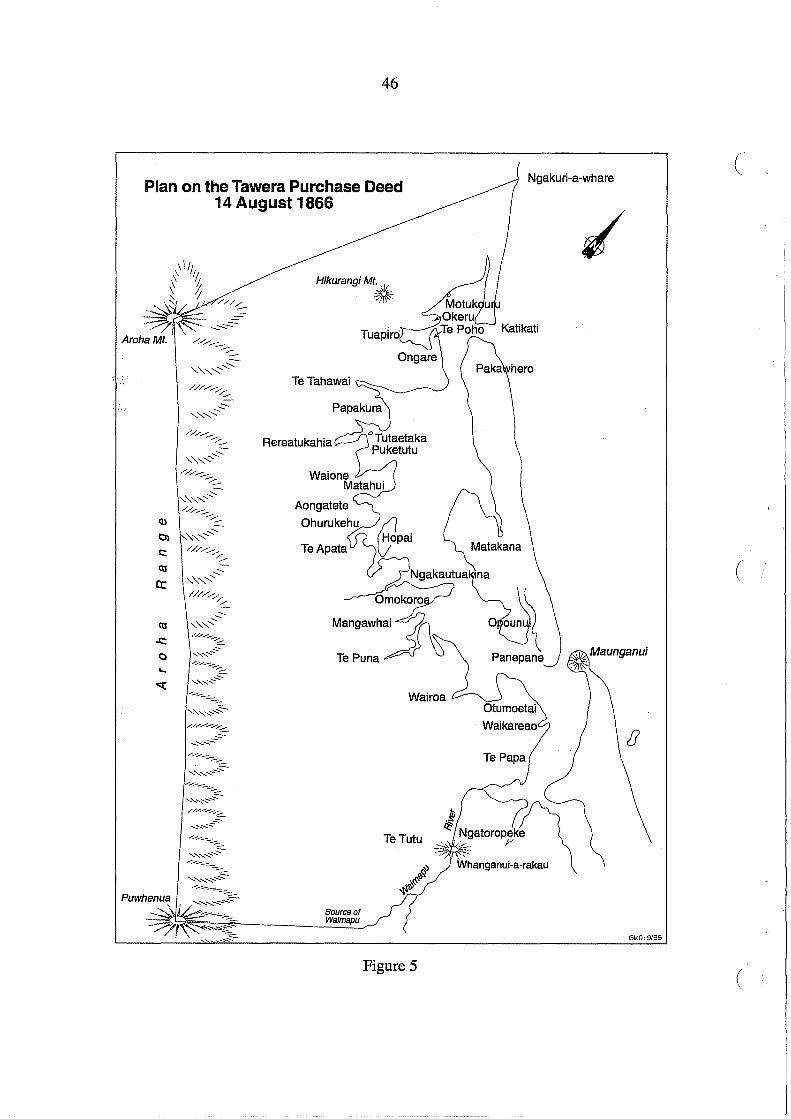
46
Plan on the Tawera Purchase Deed 14 August 1866
,'-,,.,:, .............. ///...-.-..-::.-
""-'" ....... .::::r"//...--........ --:::-
Ol ,'-" ....... , .............. c:: /////,/
r::;...
a:
C\l
..c:: o '-
..... / ............ --. /::::. ..::-, ....... ,""'""
// ....... _--.-;... ....... "' .............. ~
........ _----"" ............... :::::-. /// ...................... /-:::;:...
..:::........ ,-..........:::--
................... _----
...... , ........ .....:::;:.~ /// ...................... /~
..:::-, ......... -==-
.................... _----:::-....... ,,-..::::--..:::::-
.............. _----::::::::..
....... , ......... ~~ -........ _-----.......... , .......... .....:::::-~
Hikurangi Mt., '
:~
Rereatukahia
Waione Matahui
Aongatete
TeApata
Source of Walmapu
Wairoa
Figure 5
Ngakuri-a-whare (
(
GMO:9/96
(
47
Ngatipukenga" Signatories: Paroto Tawhiorangi, Paurini, Ruka Huritaupoki, Riritahi, Hone
Paurini, Ko te Ruruku, Hihi Taua, Ko Roki, Hemi Korohua, Hirini Ngawaka, Manuera,
Ratene, Hori Marino, Pumipi Te Pararewa, Nikora, Nga Kiore, Papira, Ngati and James
Mackay Jr. Receipt for £500 signed by Paroto Tawhiorangi, Paurini and Ruka Huritaupoki.
There was no mention of land grants in the text of Deed No. 459 or on the plan (redrawn in
Figure 5). Mackay's summary of the investigation of claims in June-july 1866 included
promises of £500 for lands in Katikati Te Puna Block and two town allotments and 100 acres
of rural land on the Confiscated Block. These were granted to two individual signatories.
Paroto Tawhiorangi was awarded Town of Tauranga, Section 2 Lot 13 (1 rood) and Parish of
Te Papa, Lot 13 (49 acres). Ruka Huritaupoki was awarded Town of Tauranga, Section 2
Lot 14 (1 rood) and Parish ofTe Papa, Lot 99 (49 acres).
Ngati Maru and Ngati Tamatera: Te Puna and Katikati No.4, Deed No. 460, 3 September
1866: payment by James Mackay of £1,130 to "the Chiefs and People of the Tribes Ngatimaru
and Ngatitamatera" Signatories: Te Moananui, Taraia Ngakuti, Teira Te Amora, Riwai
Kiore, Ihaka, Na Parata Te Mapu, Irihia, Wirope Hotereni Taipari, Tutuki, Te Rua, Karauna,
Ruihana, Mango, Keepa Te Wharau, Te Kereihe, Waituruturu, Wiremu Paka, W. Hopihona,
Eriatara, Hunia, Hingi Kerepuru, Hotereni Taipari, Piniaha, Haora Tipa, Tanewha Kitahi,
Morgan Hou and James Mackay Jr. Receipts signed by: Te Moananui for £25; Taraia
Ngakuti for £30; Te Moananui, Taraia Ngakuti, Teira, Riwai Kiore, Parata, Irihia, Karauna
for £1075; Tanewha Kitahi for £10; Ruihana for £25; Mokena Hou for £5; Riwai Kiore for
£10. The following areas were to be reconveyed to Ngati Maru and Ngati Tamatera in this
agreement: Pukewhakataratara (burial ground) 50 acres; Tiroa (burial ground) 5 acres; Te .. -
Paewai (burial ground) 5 acres; Takaihuehue 5 acres; Ng~~tuki a Hikawera 5 acres; Tangitu
5 acres. Pukewhakataratara and Ngatukituki a Hikawera are wahl tapu on the summit of the ,
range south of Mount Te Aroha. The other wahl tapu have not been located. No record has
been found that any of these reserves were surveyed and granted to Hauraki tribes. ;
"Ngaiterangi": Te Puna and Katikati No.3, Deed No. 461, 3 November 1866, payment of
£7700 by James Mackay to "Chiefs and People of the Tribe Ngaiterangi and its hapus"
Signatories: Te Moananui, Hamiora Th, Kepa TeAmohau, Te Patu, Te Ninihi, Tuaere, Temi,
Harawira, Hohepa Hikutaia, Te Kuka Te Mea, Hori Ngatai, Wiremu Parera, Tahere, Enoka
48
Make, Te Wharehera, Rotoehu, Mangapohatu, Tomika Te Mutu, Karora, Taraiti Wiripo, Hori (
Tupaea, Te Pum, Rangawaka, Hatiwira and James Mackay Jr. Receipts signed by: Te
Moananui, Enoka, Turere, Harawira, Tirni, 10 December 1866 for £700; Enoka, Moananui,
Te Kuka Te Mea, Huka Parera, Mere Taka, Te Puru, Wanakore Mangapohatu, Timi, Hohepa
Te Kai, Harawira, Turere, Paratoenga, Te Wharenui, Ngatia, Rotohia, Wherama Ananai,
Hohepa Hikutaia, Tenara, Ruka, Hori Ngatai, 24 June 1867, for £3000; Enoka, Hamiora Tu,
Te Moananui, Hemi Palmer, Heta, Tone, Hohepa Hikutaia, Heroke, Hamiora, Mere Taka,
Paikea, Akuhata Tupaea, Hamiora, Te Pum, Tirnoti, Hori Ngatai, Kepa Amohau, Rotoehu,
Riko, Harawira, Pini Te Wharehera, Hohepa Kai, Kuka Te Mea, Te Hatiwira, Wi Parera, 23
January 1868, for £3,000.
The following schedule was included in this agreement but not shown on the deed plan
(Figure 6):
List of Lands Returned to Natives
Otawhiwhi Ahipatiki
Otaratahae
Tahawai (N.S.) Tahawai (S.S.) Rereatukahia
Puketutu Matahui
Patu, Turere, Te Ninihi, and others - One hundred acres (100a.) Hori Tupaea and Moananui - Fifty acres (50a.) Enoka Make [sic = Whanake] and Hohepa - One hundred and forty-one acres (141a.) Enoka Make [sic = Whanake] - One hundred acres (100a.) Hohepa Hikutaia - Fifty acres (50a.) Hamiora Iwipau - Fifty acres (50a.) Rotoehu, Tirni, and others - Five hundred acres (500a.) Heni [sic = Heirs] of Tawaha - One hundred acres (100a.) Moananui and others - Two hundred and fifty acres (250a.) Moananui, Ngarae and others - Three hundred acres (300a.) Ruka Tamakohe - Eighty acres (80a.) Hohepa Te Kai - Two hundred acres (200a.) Ngatira and Te Kiri - One hundred and twenty acres (120a.) Hamiora Tu - Fifty acres (50a.) Hamiora Tangiawa and others - One hundred acres (100a.) Wi Parera, Taraiti, and others - Five hundred acres (500a.) Merania - One hundred acres (100a.) Harawira Tewi and others - Fifty acres (50a.) Hatiwira Umwahaika and others - One hundred and fifty acres (l50a.) Titipa and others - One hundred acres (100a.)
(
(

49
BAYOFPLENTY DISTRICT
[TAURANr:Aj
3
REREATIINAHIA
Figure 6. Plan of the "Ngaiterangi" Purchase Deed, 3 September 1866
.'.\
50
Te Kuka and others - Five hundred acres (500a.) Te Pum - One hundred acres (100a.) Ngapum, Te Pum, and others - Three hundred and fifty acres (350a.) Keepa - Fifty acres (50a.) Tewi and another - Eighty acres (80a.) Wiremu Hete, Hemi Pama, and others - One hundred acres (lOOa.) Hohepa Tangatahou - Sixty acres (60a.)
Te Apata Raniera te Hiahia and Riko - Two hundred acres (200a.) Rakera and Mirita - Twenty acres (20a.) Mere Taka - One hundred acres (100a.) Hori Tupaea - One hundred acres (100a.) Hamiora Tu and Mere Tu - Two hundred acres (200a.) Hone Poro and others - Two hundred acres (200a.) Pererika Taratoa and others - Two hundred acres (200a.) Moananui and Ngarae - Twenty acres (20a.) Atuakahae
Omokoroa Ngawaka Patuhoe and others of Ngatitokotoko - Four hundred acres (400a.)
ForestLand
Te Kiteki and Mere Toke - Twenty-eight acres (28a.) Hamuera Heheu - Twenty-five acres (25a.) Enoka Make [sic = Whanake] - Thirty acres (30a.) Timi - Thirty acres (30a.) Moananui - One hundred acres (100a.)
The reserves listed in Turton's Deed 461 have been matched as far as possible with lands that
were allocated as follows (Figure 7):
Names Area in Lot Nos. Parish Acres
Patu, Turere Te Ninihi and others 100 1,3 Katikati Hori Tupaea and Moananui 50 2 " Enoka Make [Whanake] and Hohepa 141 3,4 Tahawai Enoka Make [Whanake] 100 5 " Hohepa Hikutaia 50 6 " Hamiora Iwipau 50 7 " Rotoehu, Timi and others 500 9 " Heirs of Tawaha 100 21,23 " Moananui [Maraki] and others 250 12 " Moananui [Maraki] Ngarae and others 300 13,14 " Ruka Tamakohe 80 36 TeMania Hohepa Te Kai 200 11 Tahawai Ngatira and Te Kiri 120 48 TeMania
(
(
(

\ \ \ \ \ \ \
Matakana Island
• ,
\0 '0
, , , , , , PARISH OF TAHAWAI \aIi;
\0 ·a \g \~.
'''' I , ,-\ I ......
...... ... ~TAHAWAI ' ....
'(1)
\ \ \
C:.:WpARISH ........
PARISH OF KATIKATI ...... .../ ...... ~ @1
i
RESERVES FOR "NGAITERANGI" Listed in Turton's Deed No. 461
' ... ... ... I
...... <. ......... ... ... ... ... ... ~
Figure 7
Matakana Island
, PARISH OF APATA ,
" , , \ ,
I
.. .. " \
PARISH OF TEMANIA , - ---' ... ..
"" ,,(. ~ I
I '- ---\ ~.:-"" '~ ' .... .. ,.~. ' .. I
.... --' \ , ... _ 01
\ I \ \ \ ....
t
, , , , , , I I
PARISH OF TEPUNA
, " '" .... , .... -- ....
'~
O~.
GMO:4/97
VI I-'

52
HamioraTu 50 15 Tahawai Hamiora Tangiawa and others 100 41 TeMania Wi Parera, Taraiti and others 500 24,25,26,39 " Merania 100 19 " Harawira, Tewi [Kotai] and others 50 43 " Hatiwira Uruwahaika and others 150 32 " Titipa and others 100 27 " Te Kuka and others 500 33,35,46,47 " TePuru 100 45 " Ngapuru, Te Puru and others 350 37,38 " Keepa [Te Kiepa Amohau] 50 29 " Tewi and another 80 42 " Wiremu Hete, Hemi Pama and others 100 44 " Hohepa Tangatahau 60 28 " Raniera Te Hiahia and Riko 200 207 Apata Rakera and Mirita 20 210 " Mere Taka 100 206 " Hori Tupaea 100 209 " Hamiora Tu and Mere Tu 200 205,208 " Hone Poro and others 200 212 " Pererika Taratoa and others 200 211 " Moananui and Ngarae 20 213 " Ngawaka Patuhoe and others 400 52,53,187,188 TePuna
of Ngati Tokotoko Te Kiteki and Mere Toke 28 186 " Hamuera Heheu 25 51 " Enoka Make [Whanake] 30 (forest land) not located Timi 30 19 Tahawai
Moananui 100 49 TeMania
All but one of these reserves were surveyed and marked on Survey Office plans of 1869 and
1870 and are shown in Figure 7. A grant of Enoka Whanake's 30 acres of forest land has not
been located, although it may have been incorporated in Lot 50, Parish of Te Mania (100
acres), which was described as a Native reserve, a "General Wood Reserve for their own
uses". This reserve was adjacent to Moananui' s "forest land" , Lot 49.
Pirirakau: Te Puna and Katikati No.5, Deed No. 462, 16 May 1871: payment of £471 by
H.T. Clarke to "the Chiefs and People of the Tribe Pirirakau and Ngatihinerangi.. .. in consid-
(
(
(

53
eration of the claims of these three hapus (viz. Pirirakau, N gatihinerangi and Ngatitokotoko)
to the land sold by all the Ngaiterangi to the Government". Signatories: Kepa Ringatu,
Paratene, Te Kahukoti, Pukutoia, James Pottier [sic], Hori Teira and Henry T. Clarke. Pay
ment was made to the signatories at the time. The deed plan (Figure 8) was the same as that
accompanying the "Ngaiterangi" deed. Deed No. 462 was a belated recognition of the rights
ofPirirakau and other inland hapu which Clarke had refused to acknowledge in the dispute
over the survey of the boundary of the Confiscated Block during 1866-1867. This dispute is
reviewed in Chapter 5.
Figure 8. Plan of the "Pirirakau" Purchase Deed, 16 May 1871
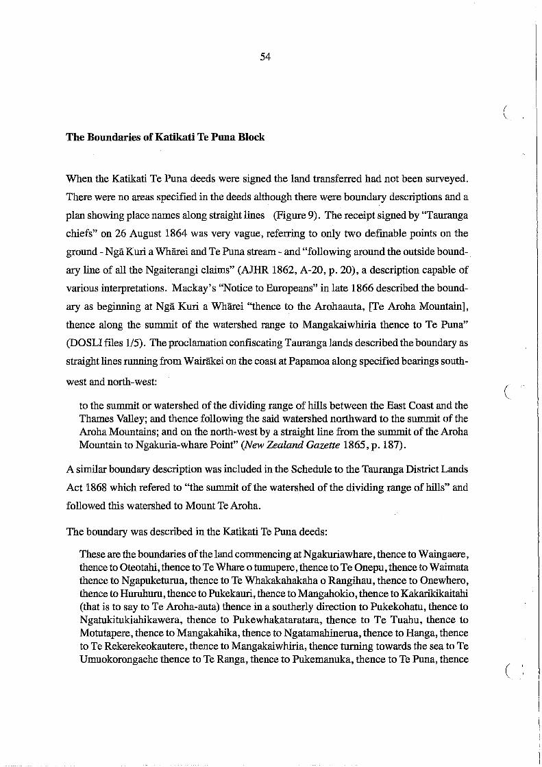
54
The Boundaries of Katikati Te Puna Block
When the Katikati Te Puna deeds were signed the land transferred had not been surveyed.
There were no areas specified in the deeds although there were boundary descriptions and a
plan showing place names along straight lines (Figure 9). The receipt signed by "Tauranga
chiefs" on 26 August 1864 was very vague, referring to only two definable points on the
ground - Nga Kuri a Wharei and Te Puna stream - and "following around the outside bound-.
ary line of all the Ngaiterangi claims" (AlHR 1862, A-20, p. 20), a description capable of
various interpretations. Mackay's "Notice to Europeans" in late 1866 described the bound
ary as beginning at Nga Kuri a Wharei "thence to the Arohaauta, [Te Aroha Mountain],
thence along the summit of the watershed range to Mangakaiwhiria thence to Te Puna"
(DOSLI files 1/5). The proclamation confiscating Tauranga lands described the boundary as
straight lines running from Wairakei on the coast at Papamoa along specified bearings south-
west and north-west:
to the summit or watershed of the dividing range of hills between the East Coast and the Thames Valley; and thence following the said watershed northward to the summit of the Aroha Mountains; and on the north-west by a straight line from the summit of the Aroha Mountain to Ngakuria-whare Point" (New Zealand Gazette 1865, p. 187).
A similar boundary description was included in the Schedule to the Tauranga District Lands
Act 1868 which refered to "the summit of the watershed of the dividing range of hills" and
followed this watershed to Mount Te Aroha.
The boundary was described in the Katikati Te Puna deeds:
These are the boundaries of the land commencing at Ngakuriawhare, thence to Waingaere, thence to Oteotahi, thence to Te Whare 0 tumupere, thence to Te Onepu, thence to Waimata thence to Ngapuketurua, thence to Te Whakakahakaha 0 Rangihau, thence to Onewhero, thence to Huruhuru, thence to Pukekauri, thence to Mangahokio, thence to Kakarikikaitahi (that is to say to Te Aroha-auta) thence in a southerly direction to Pukekohatu, thence to Ngatukitukiahikawera, thence to Pukewhakataratara, thence to Te Tuahu, thence to Motutapere, thence to Mangakahika, thence to Ngatamahinerua, thence to Hanga, thence to Te Rekerekeokautere, thence to Mangakaiwhiria, thence turning towards the sea to Te Umuokorongaehe thence to Te Ranga, thence to Pukemanuka, thence to Te Puna, thence
(
(
( I

Katikati Te Puna Purchase boundary on 1870 plan Wal'anLJ!anLJ
Katikati Te Puna Purchase Boundary on deed plans
Additional area included on Taweradeed
Watershed on Kaimai Ranges
55
Figure 9
BOUNDARIES OF THE ·KATIKATI TE PUNA
"PURCHASE"
I I
I I
I
I I
I
I I
I I
I I
I I
I I
I
••••••• • Ii OIaoo_"'"
Puwhenua ~ 5 10
I ! ! I , ! I
k1lometras
GMO:9/96

56
along the sea shore to Ngakuriawhare the commencing boundary (Turton 1877, Deed No. ( 458, Ngati Paoa).
Deed No. 460 (Hauraki tribes) had a similar boundary description with the addition of Te
Aroaro 0 paretapu between Hanga and Te Rekerekeokautere. Deed No. 461 ("Ngaiterangi")
varied in having Wharehakahaka 0 Rangihau instead ofTe Whakakahakaha 0 Rangihau, and
also including Te Aroaro 0 paretapu. Deed No. 462 (pirirakau) omitted this last name and
included the variant Whakahakahaka 0 Rangihau; Deed No. 459 (Tawera) included land
south of the Te Puna Block to the Waimapu River (Figure 5):
These are the boundaries of the land commencing at Ngakuriawhare, thence in a straight liireto the summit of the Aroha range, thence along that range to Puwhenua, thence turning and proceeding in a straight line to the source of the Waimapu Stream, thence descending by the stream to Whanganui-a-rakau, thence to Te Tutu, thence to Ngatoropeke thence by the Waimapu Stream to the sea thence by the sea coast to Ngakuriawhare the point of commencement (Turton 1877, Deed No. 459).
The Crown's failure to have the inland boundary along the Kaimai Range surveyed led some
local people, Ngati Hinerangi in particular, to believe there was still Maori land between the
Crown purchase and the confiscation boundary. A petition was sent to the Governor on 9 (
July 1877 by Te Parawhau and six others on behalf of Ngati Hinerangi requesting him "to
impose up on [their lands] a legal restriction so that it may be a permanent possession for us
and our children after us" (DOSLI files 5/28). Their land extended from the Waihou River
on the Waikato side and over the Kaimai Ranges into part of the Tauranga confiscated lands
in the Katikati Te Puna Block, an area of some 10,000 acres. Commissioner Brabant was
asked to comment and did so on 4 October 1877, apologising for the delay as Te Parawhau
and his people had been away in the Waikato:
They state that they apply to have the land they refer to made a reserve because it belongs to them and is being sold to Mr Mackay and Mr Whitaker Junior by the Waikato tribes whereas they wish to keep it for their children ....
It is not acknow ledge~ to be the exclusive property of the Ngatihinerangi but portions of it are claimed by various hapu and individuals - a small portion of one boundary as given I think overlaps the Katikati purchase and is the property of Government ....
IfthefiativestliereforewishedfoliavetlierrutletotlieseIaiidsproved they would have to apply both to the Native Lands Court and the Commr. of Tauranga Lands. I do not see
(

57
how the Ngatihinerangi can have the land reserved unless they fIrst prove their title to it. A title they no doubt have, but not an exclusive one (DOSLI fIles 5/28).
Brabant's notes on the meeting with Ngati Hinerangi on 1 October 1877 indicated other
potential claimants. Hamiora Paki stated that Ngati Pango had rights which were acknowl
edged by Te Parawhau. Tohatoha explained:
We sent our petition because Ngatimaru, Ngatiraukawa, Ngaiterangi and Ngatirangi are selling the land to Mackay and Whitaker (Junior) ofWaikato. Waiho[u] side has been surveyed but not this side. It was sold last July to Mr Mackay - Warbrick was with himbut we understood that Mr Whitaker was the real purchaser (DOSLI fIles 5/28).
Te P8.!awhau stated that "the people who are selling land" included Ngati Tokotoko, Ngati
Tamatera, Ngati Haua and Ngati Raukawa:
They are selling land which does not belong to them and have spent the money. They have sold to the Europeans of Cambridge - Mr Mackay and Mr Whitaker Junr. - Warbrick was arranging it at Tauranga (DOSLI fIles 5/28).
Enoka Whanake was also present and acknowledged that part of the Ngati Hinerangi claim
had been sold to Government by Ngai Te Rangi in the Katikati Te Puna Block. Some of the
places referred to, including Mangat5tara and Ngiimuwiihine, were inside the Tauranga con
fIscation line but not in the Katikati Te Puna Block. These lands were subsequently investi
gated by Commissioner Brabant in the 1880s. However, at the 1877 meeting Ngati Raukawa
claims to the area were also aired. Ngati Hinerangi did not get their reserve and their lands
outsi<1:e the confIscation line were taken through the investigation of title process in the Na
tive L!;llld Court in 1879 (see for example Okauia Block, Waikato Minute Book 3/311-449
and 4/1-41,176-195,276).
In 1880 the western boundary of the Katikati Te Puna Block along the Kaimai Ranges had
still not been surveyed and was again the subject of inquiry by local people to Government
and to Commissioner Brabant. The District Surveyor Auckland, S.P. Smith, wrote a
memorandum to the Surveyor General, noting the boundary descriptions in the Tauranga
District Lands Act 1868 and the Katikati Te Puna deeds and concluded that the confIscation
boundary and Katikati Te Puna Block boundary as shown on the deed plan (Figure 9) were
"identical - of this I think there can be no doubt" (DOSLI files 1/5). Although it had been

58
claimed there was a strip of Maori owned land between the confiscation line and the Katikati (
Te Puna Block, Smith refuted this, while acknowledging that there was still some
uninvestigated Maori land between the confiscation line and the straight line boundaries of
Waiharakeke Block, west of the confiscation line and outside the Tauranga district. Smith
thought it unlikely that the boundaries would be different, and assumed that the "very object
of the purchase was to extinguish all claims within the Confiscation boundary". He dis-
missed a claim by Raimona and others to the N ative'Minister for "Tuahu, a place on the main
range on the Aroha boundary just where the Rereatukahia Track crosses", on the grounds
that it was included in the Katikati Te Puna "purchase".
Smith did admit there might be some doubt about the south-western comer of the purchased
area:
the position of Mangakaiwhiria is uncertain. The boundary of the Whakamarama Block was surveyed so as to follow the line of purchase, and the plan shows a stream called Mangakaiwhiria as crossing the line some distance from the range. This stream probably has its source on the range and it is to this source in all probability that the purchase boundary was intended to run (DOSLI files 1/5, emphasis in original).
At this time Smith was not prepared to commission a survey as requested some time earlier
by Commissioner Wilson, and set out his grounds:
1st. That from the very uncertain nature of one of the boundaries to be defmed (a watershed on a nearly level plateau) that it would be very difficult and very costly - 2nd. That practically, the determination of the Katikati Te Puna boundary depending as it does on Native names, was in the hands of the Natives who could place them where they like - and wh()se interest it was to encroach on Govt. land as far as possible - 3rd. That at the time I received the application I had given notice to the surveyor who had been employed on Mr Wilson's surveys, that he would not be required ... and 4th that I felt there was a great danger in opening up the question of the confiscation boundary which (as far as I am aware) has been settled and agreed to on all sides, for a long time past. The danger I conceive consists in this. At the time of confiscation our knowledge of that country was exceedingly limited, and therefore the proclaimed boundary was made to follow a direction which with our present knowledge it never would have done .... Nor it so happens that the watershed (or properly speaking the water parting) in this part is a high, densely wooded flat plateau, in which it is often a matter of some difficulty to find water and that such water parting is exceeding sinuous and difficult if not impossible to follow. To obviate this a compromise was arrived at to accept certain points on the acknowledged
( i
(

59
water parting and to draw straight lines between them, assuming that such lines would give and take, as they practically do. These straight lines have heretofore been accepted by the Native Land Court on the one hand and the Tauranga District Court on the other, as the limit of their respective jurisdictions to lands on either side, therefore if the question were raised in one place it might as a sequence be raised in another, where the lands had already been adjudicated on and then lead to great confusion (DOSLI files 1/5).
Pirirakau and others had complained about a lack of clarity in establishing the western bound-
. ary of the Katikati Te Puna Block. On 25 September 1882 Brabant wrote. to T.W. Lewis,
Under$ecretary of the Native Department, noting that he had received some assistance from
the Survey Department in resolving a complaint about the survey of Waiharakeke Block
outside the Tauranga confiscation line. The claim was also made:
that the purchased block boundary does not extend so far south as the confiscation boundary, in fact that there is a strip of land between.
The natives in the case which I had referred to above were partly but not altogether wrong, they possibly may be wrong in this, but the difficulty they have had in getting any investigation has I think made them believe that Government are trying to cheat them. All that I suggest [is] that the survey department whenever a surveyor is in the district allow him to fix in the plan certain places mentioned in the deed of purchases. I gather from a late memo of the Chief Surveyor's that he thinks the natives would give false statements as to localities to prove their own case. This might certainly be the case if the matter was bungled, but if it was done under my supervision I should of course be on guard against such a proceeding (DOSLI files 5/28).
There is no record of any further inquiry. The boundary that eventually appeared on a cadastral
plan after survey is shown in Figure 9. The northern portion of the watershedto the south of
Te Ar9ha Mountain appears not to have been surveyed, and as already noted, the wahl tapu
reserves there promised to Hauraki tribes in Deed No. 460 were not defined or granted. All
this area remained Crown land.

60
5. Confrontation over Survey of the Confiscated Block 1866
At the meeting attended by Whitaker and Grey on 26 March 1866 it had been "agreed" that
the eastern boundary of the 50,000 acres to be confiscated should be in the vicinity of the
Waimapu River. A copy of the Maori text of a me morand urn dated 26 March 1866, signed
"Fred. Whitaker", but with no Maori signatures, is held in the Brown Papers at The Elms,
Tauranga:
Ko te tikanga tenei mo te rohe 0 te whenua e riro i a Te Kawana rna Te Karaka e whakatuturu, ki te Waimapu, ki to te Witika ranei ki waenga ranei 0 aua rohe, ka oti ia ia, ko te whakatuturutanga tena 0 te rohe 0 te whenua e riro ia Te Kawana mo te hara 0
Ngaiterangi.
The published official translation was:
(
The arrangement for the boundary of the land taken by the Governor is this:- Mr Clarke will settle defInitely the boundary at Waimapu or at Mr Whitaker's boundary, or between those places. When it has been decided by Mr Clarke, that is to be the permanent bound- C ary of the land to be taken by the Governor for the sin of Ngaiterangi (AlHR 1867, A-20, p.63).
This translation carried the names of six people: Tareha, Ranapia, Hone, Rawiri Taipari,
Arama Karaka, and Matene. These names belong to families in the Maungatapu - Hairini
area.,and were not representative of all "Ngaiterangi". Whitaker wrote a memorandum to
Clarke'on 10 April 1866:
The eastern boundary of the confiscated block is settled as appears by a paper herewith signed by the Natives interested; 50,000 acres are to be taken from that line towards Te Puna. The friendly Natives who have claims within the confiscated block are settled with ... Te Puna is not settled (AlHR 1867, A-20, p. 64)
It is not at all clear who all the "friendly Natives" might have been whom Whitaker "settled
with". Figure 10 shows the principal hapu and their kainga on the Confiscated Block. The
signatures on Whitaker's memorandum of 26 March were described by Clarke as "the prin
cipal Natives of Maungatapu". Clarke proceeded with an inspection of the land and reported
to Whitaker on 10 May 1866: (

61
iE RANG!
(
Figure 10
o Pa
.. Redoubt
• Kainga 1864
~ Cultivated areas
.. Boundary of 50,000 acres Confiscated Block
- - - Confiscated Boundary on First Survey
IlI!l!!mlll CMS Block
kllomotres

62
I have decided that the boundary line shall be the Waimapu up to a place called N gatoropeke; ( from thence a straight line up to the highest peak of One Tree Hill, continuing said straight line down the south side of hill till it strikes the Waimapu Stream, following up the stream into the forest.... I shall have to cut out a rather large reserve near the forest at Oropi; it is an old cultivation of the Natives, and has been in actual cultivation for many years ....
Clarke also noted that instructions for survey had not been issued but, "deeming it advisable
that the line should be cut forthwith", had taken it upon himself to employ the surveyor
Turner:
lhl:!;ve also employed Ranapia to accompany the. surveyors for two reasons; fIrst, to prevent annoyance to the survey party; and, secondly, as the principal land owner in this district, to thoroughly commit him to the present arrangement. I propose paying Ranapia six or eight pounds, if he carries out faithfully his compact with me (AJHR 1867 ,A-20, p. 64).
This line was duly surveyed, apparently without active opposition, and the survey parties
proceeded to layout farm sections for the military settlers.
The so-called "agreement" offered at the 26 March meeting, was given under duress. Subse
quent opposition to survey of the western boundary, west of the Wairoa River, was proof
enough that not all had agreed. Although he had not attended the meeting, Clarke's
restrospective report written in May 1867 indicated that the March 1866 agreement was
reached under threat of further military action:
The Ngaiterangi met His Excellency the Governor and Mr. Whitaker on the 26th March [1866]. The Governor declared his intention of taking out of the Tauranga District a block of land containing 50,000 acres, that being one-fourth of the estimated area.of this district. The Natives in their discussion of the matter showed a very different spirit to that ni:iriifested in 1864, and it was not until His Excellency told the Natives that he would resort to extreme measures if they would not comply that they succumbed and agreed to give up the 50,000 acres (AJHR 1867, A-20, p. 62).
In this memorandum Clarke also denied the "erroneous assertions" that the western bound
ary of the ConfIscated Block was fIxed at the Wairoa River. Mair had confIrmed that it had
been suggested at this meeting that the ConfIscated Block of 50,000 acres "might extend as
far as Te Puna", that local people became "rather excited at this, and said they would not
consent". When told by the Governor that "if necessary they should again be put down by
force of arms, they accepted the proposals made tothem" (AJHR 1867,A-20, p. 53). To
(
(

63
"accept" does not necessarily mean to agree. The local people had been told by Colonel
Haultain in February that the "Government will require certain lands" for military settlers
(AJHR 1867, A-20, p. 20). Whatever lands were required, it was likely some hapu would be
penalised more than others, "friendly" or "rebel".
The Government really required land suitable for settlement, not just any land. On 29 May
1866 District Surveyor Utting reported that insufficient "good agricultural land" could be
obtained in the "Waimapu Block" , that is between the W aimapu and Wairoa Rivers, "within
the limits of the confiscated land" because of its "rugged and broken character" inland (Dis
trict Surveyor's Letterbook 1866-1868). The inclusion of land west of the Wairoa River in
the Confiscated Block was not because 50,000 acres could not be found between the Wairoa
and Waimapu Rivers, but because there was insufficient "good agricultural land" for farm
sections promised to the men of the W aikato Militia already at Te Papa.
Pirirakau and other inland hapu objected to any survey of the boundary of the Confiscated
Block which included land west of the Wairoa River. In September 1866 Pirirakau, claim
ing the support of Ngati Haua, tried to stop the survey by taking away the surveyors' instru
ments. Wiremu Tamihana Tarapipipi of Ngati Haua had written to Clarke on 23 August
1866 and offered his services as a mediator, provided a government inquiry into the dispute
was held. Tamihana also wrote a letter on 2 September to the surveyors: "Stop your survey
ing, the place of blood [Confiscated Block] is on the other side of Te Wairoa; the place of
mon~y [Katikati Te Puna Block] is at Katikati" (AlHR 1867, A-20, p. 22). In other words,
the laIld between the Te Puna and Wairoa Rivers was not to be surveyed. Clarke was not
prepar.ed to accede to Tamihana's request "in the face of the .arrangement made by His Ex
cellency the Governor and Mr Whitaker with the Tauranga Natives on his late visit" (AlHR
1867, A-20, p. 20).
On 11 October 1866 Tamihana had written to the Governor about the survey ofTe Puna and
asked for "the sUrvey to be discontinued, lest we all again become confused, because we are
all now sitting in peace" (AlHR 1867, A-20, p. 23). Governor Grey replied in a letter dated
22 October 1866, noting that he had seen Tamihana's letters to Clarke and the surveyors:
I have ordered an inquiry to be made into this matter, that it may appear whether wrong

64
hbas bedren dOdne orhnot~ .. : I~wr~ng hhas bbeen donedbybthe shurvakiney?rs I will sefeththat the wrong ( ere esse ,wen laIr mqurry as een rna e, ut t e t g away 0 e surveyors'
instruments is an act which is not right. I wish you therefore, to write and tell the Pirirakau to give them up. In this way a quiet solution of the difficulty will be effected (AJHR 1867, A-20, p. 24).
On 30 October 1866 William Rolleston also wrote to Tamihana, indicating that the "Gov
ernment" had seen his letter of 11 October to Governor Grey, and assured him that there was
no intention to "put any new conditions upon the word of the Governor which he spoke to
the Ngaiterangi in 1864. The Governor's promise at that time will be faithfully kept" . . :-\ .
Rolleston also explained "that to survey land does not mean with the Europeans to seize it" !"".:,,,,
and suggested local Maori should "wait quietly till the Governor comes, and if any mistake
has been made in surveying the land it will then be rectified" (AJHR 1867, A-20, p. 26).
This letter was not delivered to Tamihana, the Governor did not come, and there was no
inquiry. Rolleston had written to Clarke, enclosing the letter to Tamihana, and requested
that it "be forwarded to him without delay". He also told Clarke to maintain his endeavours
to keep the peace but that "the surveys must for the present be stopped" (AJHR 1867, A-20,
p.23). Apparently Clarke did not consider an inquiry was needed, because Pirirakau and (
other inland hapu were regarded as both Hauhau and unsurrendered rebels. He knew their
grievance was not only that they objected to surveys west of the Wairoa river, but they also
refused to acknowledge the right of "Ngaiterangi" to negotiate on their behalf. The "agree-
ment" of Maungapohatu was really an acknowledgment of his rights in the Katikati Te Puna
Block. The boundary of the Confiscated Block was a separate issue.
Clarke intended to proceed with survey and had already dismissed Pirirakau and other inland
hapu claims in September 1866: "It could be easily shown that they are of the iDferior
people of Ngaiterangi, and that they were always kept in a state of vassalage" (AJHR 1867,
A-20, p. 23 emphasis in original). On 3 October he wrote to Native Minister Richmond:
These Natives fully relying on the countenance and support of William Thompson, have assumed a very defiant attitude very prejudicial to the peace and quiet of the district, and unless they are at once checked the disaffection will I fear spread and cause much future trouble (AJHR 1867, A-20, p. 23).
Mackay's attitude toward Pirirakau was expressed in a report to Rolleston dated 25 Septem
ber 1866: (

65
This tribe were very much inclined to be troublesome when I was last at Tauranga. I would point out that with the exception of some two or three persons they have all been in rebellion, and have not returned to their allegiance to this day. In my opinion it would only be just to confiscate all their lands, reserving about 2,500 acres for their use and occupation. Their lands are principally between Te Puna [River] and the Wairoa, and I would suggest that a portion of these should be given to those friendly Natives who have lost land in the [confiscated] block of 50,000 acres (AlHR 1867, A-20, p.22).
On 5 December 1866 R. Ralse, Assistant Under Secretary for Native Affairs, wrote to Mackay,
reprimanding him for not transmitting Rolleston's letter to Tamihana, which he "with the
concurrence of Mr. Civil Commissioner Clarke, thinking it unadvisable to forward" had
returned to the Native Secretary's Office. Ralse had been directed by Native Minister Rich
mond'to inform Mackay:
that the detention of this letter has the very unfortunate effect of making the action of the Governor almost inexplicable to Wiremu Tamihana Tarapipi [sic] except in the theory that they are absolutely indifferent to their word. His Excellency's letter, of an earlier date which has been duly forwarded, promises an inquiry without speaking of carrying out the survey in the meantime, whereas the letter you intercepted qualifies that promise by indicating that the survey will be proceeded with (AlHR 1867, A-20, p. 36).
Ralse was also confused because Rolleston had told Clarke on 30 October the surveys were
to be stopped "for the present". The issue for Ralse was not whether Tamihana's grievance
was "without foundation" but that he also spoke for Pirirakau. The Minister considered that
he "cannot admit the principle of any officer of this department placing himself between a
complainant and the government, and begs that in future such action may not be repeated"
(ibid).
This mild reprimand had no effect on the actions of Clarke and Mackay in Tauranga but the
failure to fulfIl the Governor's promise to Maori of an inquiry no doubt exacerbated an
already tense situation. In his retrospective review of events written in May 1867, Clarke
referred to the "interruptions" to the survey, which, "chiefly emanated from unsurrendered
Natives", and conveniently blamed these on the intervention ofWiremu Tamihana, who had
offered to mediate in the dispute. Pirirakau had been prepared to accept his offer. Clarke
wrote:
The surveyors were in frequent communication with the Natives who appeared on the whole friendly, and it was not until Wiremu Tamihana's return from Wellington in the
66
early part of September [after presenting a petition to Parliament] that symptoms of ac- ( tion opposed to the progress of surveys began to appear.
In the later part of September a body Of Natives belonging to the Pirirakau hapu crossed the Wairoa to the "undisputed confiscated land", took forcible possession of the surveyors' instruments and carried them off to the Whakamarama. An information was laid against the offenders in the Resident Magistrate's Court. A letter was written by His Excellency the Governor to Wiremu Tamihana blaming the Pirirakau for the outrage they had committed, and recommending Wiremu Tamihana to use his influence to get the instruments returned (AlHR 1867, A-20, p. 63).
In this.:account Clarke omitted to state that the Governor had promised Tamihana there would
be am-inquiry, that a subsequent letter from Rolleston to Tamihana had not been delivered,
and that no inquiry was conducted, because Clarke and Mackay had decided this was
unncessary. Tamihana had died at the end of December 1866, and this retrospective account
distorted his role during September and October, and the role he might have played as me
diator. Clarke distrusted Tamihana because he believed he had become a "Hauhau", had
"given up his Christianity", and no "Hauhau" could be trusted (Clarke to Smith MS283, vol.
1, pp. 78 and 112).
Whitaker instructed Clarke and Mackay in October 1866 to proceed with settling the Katikati
Te Puna "purchase" with "Ngaiterangi". A meeting was called on Motuhoa and began on 31
October 1866. Pirirakau were invited and given assurances of protection, but did not attend,
with the exception of Maungapohatu, although the "influential men of the various hapus of
Ngaiterangi" were present. The meeting continued the next day when discussion moved to
consider the inclusion of land west of the Wairoa River in the Confiscated Block. Mackay
reported: ..
The Natives were informed that all the Govemmentrequired was the 50,000 acres agreed on at the time His Excellency the Governor last visited this district; that I had inquired as to the quantity actually surveyed, and found that between the rivers Waimap[u] and Wairoa, and including Captain Heale's survey of Otumoetai west, there were 40,800 acres; and between the rivers Wairoa and Te Puna 14,200 acres, or a total area of 55,000 acres, being 5,000 acres in excess of the quantity arranged.
I then proposed to give back the 5,000 acres, and to make the Ruangarara Stream and Te Puna River the inland boundary of the last-named block, and leave those of the Waimapu and gastW~Qaas_~urv~yed, to include 38,000 acres.
(
(

67
After some discussion my suggestion was unanimously assented to. Maungapohatu, the old and principal chief of the Pirirakau, consented on behalf of that hapu, and was exceedingly pleased at a reserve of 300 acres being made for himself and people at Epeha and Waikaraka (AlliR 1867, A-20, p. 27).
The next two days "were occupied in negotiating with the Ngaiterangi hapus for their claims
to Te Puna and Katikati blocks". Maungapohatu's "reserve" was outside the purchase area,
on the disputed Te Puna land. Other reserves for individuals and hapu listed in the deed were
apparently decided at this time but there was no survey yet of the Katikati Te Puna "pur
chase;\·or the "Native reserves" to be excluded from the "sale". Since this land was already
included in the proclamation of 18 May 1865 it was technically Crown land, and in effect,
Clarke and Mackay were paying off certain "Ngaiterangi" leaders and allocating reserves
only to individuals for themselves andlor hapu as compensation for loyalty. A number of
reserves were subsequently allocated in the disputed Te Puna land to individuals belonging
to hapu that had never held any Maori customary rights there.
Pirirakau still refused to negotiate and so Mackay decided with (Clarke's agreement) to go
to Waiwhatawhata on 6 November 1866, accompanied by "Te Kuka (Native As~esor) Ruka,
Ruato and Hohepa, Native police". They talked with about 25 men of Ngati Rangi and
Pirirakau but they were not to be persuaded. Among the speakers Rawiri Tata replied: "From
Te Wairoa to Waipapa belongs to me. I will not give it up". He admitted that "Hori Tupaea
has a claim over our bodies" but denied his right to the land. In other words, while there may
have been some Pirirakau obligations to Ngai Te Rangi, the customary rights ofPirirakau on
the larid had been maintained. Rawiri Tata told Mackay: "William Thompson [Tamihana]
has given orders to stop the surveyors, and the whole affair is in.thehands of Thompson and
the Governor". He also said they were willing to give up the surveyors' instruments. Mackay
responded that reserves for Ngati Haua would be allocated at Omokoroa, where they had
been given occupation rights generations earlier, and therefore there was no need for further
involvement by Tamihana and Ngati Haua.
As far as the Governor was concerned I knew he had taken 50,000 acres of land for military settlement; and I also knew that he intended to retain it. That as to William Thompson and the Governor having to arrange the question I knew nothing of that. I considered that I was quite as well acquainted with the views of the Governor and the
68
Government, as William Thompson, and they might take my word as binding the Govern- ( ment (AJHR 1867,A-20, p. 28).
It is difficult to interpret Mackay's denial of knowledge of the Governor's promise of an
inquiry to Tamihana as anything other than a convenient lie.
Mackay returned to Te Puna and held a further meeting with "Ngaiterangi" , and told them he
intended to cut the survey line between Ruangarara Stream and Te Puna with military pro
tection if necessary. While Mackay on 8 November arranged military support with Colonel
Harrington, several "Ngaiterangi chiefs" met withPiriri:ik:au and Ngati Rangi at Te Irihanga.
That afternoon they reported back to Mackay that "Pirirakau had agreed not to interfere with
the survey themselves, but said another tribe would probably do so" (AJHR 1867, A-20, p.
29). Mackay interpreted this to mean the small group of Ngati Porou from Mataora, (a bay
on the eastern Coromandel coast near Whangamata), who were with Piriri:ik:au.
On 9 November, Mackay went with the survey party and "200 men ofH M 12th Regiment as
a covering party". They were accompanied by several "Ngaiterangi chiefs". The survey of
the boundary of the Confiscated Block betwen the Te Puna River and Ruangarara Stream, a
tributary of the Wairoa, was completed without further incident. At the time it was noted that
Piriri:ik:au numbered a total of 87 men, women and children. The fears of both Clarke and
Mackay seemed to be augmented by concern about the presence of a small group of Ngati
Porou from Mataora, "disaffected Arawa" led by Hakaraia in the Te Puke district, and ru
mours of possible alliances with tribes in the Waikato. On 19 November Mackay met with
Colori~l Haultain, Defence Minister, who agreed that 100 men of the Waikato Militia should
be posted at Omanawa to protect surveyors now working on subdivision of the Confiscated
Block east of the Wairoa River into farm sections.
Mackay's efforts to get Piriri:ik:au to agree to the Katikati Te Puna Purchase and drop their
opposition to surveys of the Confiscated Block were supported by some "Ngaiterangi chiefs"
who were subsequently rewarded for their contribution to the "Pirirakau Expedition" by
grants of seven acres each at Te Puna. Mackay listed the names of 25 men "who went on the
expedition against Pirirakau on the 8th to 13 November 1866" (DOSLI files 1/6). But only
the 14 "chiefs" were awarded land in the Parish ofTe Puna, as listed below:
c
(

69
Lot 10 Enoka Te Whanake
11 Wiremu Patene
12 Wiremu Parera
13 Hori Ngatai
14 Ruka Tamakohe
15 Hamiora Tangiawa
147 MaihiHaki
148 Hamiora Tu
149 Raniera Te Hiahia
150 Wiremu Te Matewai
151 Ngamanu
152 Wanakore Maungapohatu
163 Te Kuka Te Mea
Hohepa Hikutaia was also listed as a "chief' but Mackay's list was annotated against his
name: "not to have part of section 10". However, Lot 191 Parish of Te Puna, was awarded
to Hohepa Hikutaia as a reward for the "Pirirakau Expedition". All these grants to "Ngaiterangi
chiefs" were on the disputed part of the Confiscated Block west of the Wairoa River, on
ancestral lands of Pirirakau.
By the end of November 1866 the survey of the boundaries of the Confiscated Block was
completed, and the survey parties could proceed with subdivision into farms for military
settlers. But the grievances ofPirirakau and other inland hapu remained unresolved. As far
as Clarke and Mackay were concerned, the time was past for any negotiation with the
"unsurrendered rebels" in the "Hauhau country" inland. Mackay returned to Auckland and
reported on proceedings of the past month to Governor Grey at his home on Kawau. Clarke
remained at Tauranga over Christmas 1866.

70
6. The "Tauranga Bush Campaign" 1867
On 31 December 1866 the new District Surveyor, H.L. Skeet, reported to Clarke that a sur
vey party had been warned to move out of the Oropi area as "rebel Hauhaus were on their
way to seize both surveyors and camp" (AJHR 1867, A-20, p. 39). All the survey parties
were ordered back to Te Papa and the survey of the Oropi-Omanawaarea was abandoned for
the time being. Rumours abounded of an imminent attack by "Hauhaus' who lived in the
inland 'villages, supported by the Ngati Porou party from Mataora, and Hakaraia's Waitaha
people'from the Te Puke area. On 8 January Clarke reported to the Native Minister, J.C.
Richmond:
It is with great regret that I have again to report, for the information of the Government, that the repeated threats of the Ngatiporou Hauhaus to stop the surveys of confiscated lands in the district have at length been carried out.
A party of Hauhaus under Ropata and Kewine ... have again put a stop to the surveys, this
(
time in the Waimapu Block, on that portion of the survey left incomplete by Mr Gundry. (,' Mr Gundry left, having been warned by Mr Mackay that it was unsafe for him to continue , the work ...
The property of the surveyors has been carried off, and but for the timely warning given by the friendly Natives to the surveyors, I have very little doubt that murder would have been committed. The surveyors took a hasty departure having left their camp half an hour before the Hauhaus came up ....
After'carrying off the goods and instruments of the surveyors, the depredators went on their way on a visit to old Hakaraia, it is said on an invitation from that chief.
This morning I have heard that these [Ngati Porou] Hauhaus were the bearers of a letter from the King to Hakaraia, the purport of the letter is reported to be as follows: "This sick man has recovered, he will soon move his feet, the sword is unsheathed". Hakaraia is said to have acquiesced and that we are all to be attacked on the 15th instant.
All the surveys are at a standstill. I do not think it safe for the surveyors to go on with their work, unless made under the protection of a sufficient armed party (AJHR 1867,A-20, p. 37-38).
The Ngati Porou party were led by Ropata. According to Clarke's report on 25 October
1866, "Ropata stated that five of his companions were from Taranaki, that they had been sent
(

71
to murder any surveyors they could find at work on any confiscated land" (AJHR 1867, A-
20, p. 38). On 12 November Clarke had advised Richmond that reports of support offered to
Pirirakau "have been very much exaggerated", that only "the Ngatiporou and Taranaki party",
headed by Ropata and Kewene respectively, were with Pirirakau (ibid). Both Skeet and
Clarke referred to "Te Kaumarua", literally "the twelve", and sometimes translated as the
"Twelve Apostles". Skeet reported that "the Te Kaumarua party" who had seized the survey
instruments comprised about 30 armed men, "being a portion of the Hauhaus" from different
tribes'~but principally of the Ngatiporou and Ngaiterangi" (AJHR 1867 ,A-20, p. 39). From
the names listed these people belonged to inland hapu and were not Ngai Te Rangi, although
they were frequently referred to inaccurately as ~'disaffected Ngaiterangi". Clarke's esti
mate of the "Hauhau party" that visited Hakaraia, the Waitaha chief at Te Puke, was a total of
74, "all armed with double barrelled guns" (AJHR 1867, A-20, p. 37). A statement made by
Te Rau of Ngati Hangarau on 11 January 1867 following a visit to the inland village of
Paengaroa suggested the number of "Hauhaus" was about 24, led by Ropata of Ngati Porou,
and including Kewene (here identified with Ngati Porou), and representatives ofPirirakau,
Ngati Rangi and other inland hapu (AJHR 1867, A-20, p. 42).
Mackay's report of the incident, dated 10 January 1867, stated, "I have received information
of twenty -four men of the N gatiporou tribe (of Mataora, near Katikati), having proceeded on
to the confiscated block ... , with the intention of murdering the persons engaged in the survey
of the same". In the same report Mackay reported discussions with "the chief Tioriori Te
Hura :illid several Natives of Ngatihaua" and others who had attended thetangi for Wiremu
Tamihana:
They tell me that several of the Ngaiterangi and Pirirakau tribes of Tauranga were at the meeting; also Te Hira and his people from Ohinemuri (Thames). All present objected to the proceedings of the Ngati Porou in stopping the survey at Tauranga; and ascribed it to the fact of the removal of the covering party of Militia (100 men) who acted as a guard to the surveying parties (AJHR 1867, A-20, p. 40).
Various suggestions were made at the hui to go to Hakaraia and ask that Ngati Porou be sent
away. "The chief Tioriori says that he has persuaded the Pirirakau to remain quiet". Mackay
also reported that at a "large political meeting of friendly Natives" at Taupiri on 4 January it
72
had been unanimously decided that "friendly Natives would not go out of their own district (
to fight any rebels; but in the event of any attack within it, they would assist their European
neighbours in repelling it" (ibid). At this stage the dispute was over inclusion of land west of
the Wairoa River in the survey of the Confiscated Block in the Tauranga district. There was
no evidence of any threatened uprising west of the Kaimai ranges.
The troops were ordered out, presumably as a cautionary measure, on 17 January 1867. On
19 January Lieut. Colonel Philip Harrington, Commander of the First Waikato Regiment,
report~d to the Defence Minister, Colonel Haultain, in Wellington that in accordance with ".I.~ \
instructions he had occupied the Omanawa Redoubt on 17 January and left one subaltern
and. 20· men atPoteriwhi "to watch the ferry of the Wairoa River". Harrington ret:urD.ed to
headquarters at Te Papa the same day, leaving Captain Goldsmith in charge at Omanawa.
On 18 January Goldsmith reported that he had patrolled along the bank of the Wairoa, found
a whare had been burnt but no other damage. One patrol had gone up the Ruangarara Stream.
In his report Goldsmith described an encounter to the west of the Wairoa River:
Having received instructions from his Honour the Defence Minister to make myself ac-quainted with the roads on the left bank of the Wairoa I considered this a good opportu- ( nity to effect that purpose. I accordingly crossed the Wairoa at the bend near Captain Tovey's farm.
We marched westwards for about 21/ 2miles when the north and south roads were crossed. These are excellent bush roads and evidently much frequented.
We followed the East road about half a mile further when some Natives showed themselVes on the hills to the west.
We continued our march - the Sergeant Major leading the advance guard - I had personal command of the main body. Ensign Home had charge of support.
On approaching some Tupaki bushes fire was opened by the Maoris from behind the bushes - the Sergeant Major was shot through the shoulder - upon this I extended the men in the fern and returned the fire - the Maoris retreated, occasionally stopping to deliver their fire, we followed and drove them into the bush. We then retired in good order. Two Natives were seen to fall but were carried off by their comrades (National Archives Le 1/ 1867/120).
Harrington's response to this report was to ride out to Omanawa and arrest Goldsmith "for
leaving his post and bringing on a collision with the enemy without my instructions". The
(

73
incident occurred in the vicinity of the village of Te Irihanga.
Clarke's report, written on 28 January 1867 also described this incident:
On the 18th, unfortunately the officer in charge of the Omanawa Redoubt either mistaking his orders, or for some other cause, crossed over the Wairoa River to its west bank, with a force of forty men, they followed up the track to the first Maori village, Te Irihanga. The party, as it approached Te Irihanga, could see the Natives walking about, apparently without arms; presently one man was seen to advance; Corporal Willis, of the Militia, remarked to Sergeant-Major Ennis, of the Militia, who was leading the advance guard, that he thought he saw a rifle in the Maori's hand, the Seargent-Major replied, "never m.il:id, let them fire the first shot; hardly were the words out of his mouth when the Maori fired, and the Sergeant-Major fell, mortally wounded. The Militia were then extended in skirmishing order across the track, and a heavy fire was kept up on both sides for about three quarters of an hour, with what loss to the Natives is not known (AlHR 1867, A-20, p.43).
According to Clarke, the military force had been moved to Omanawa Redoubt as "a prepara
tory step towards making an attempt to catch the perpetrators of the late outrages upon the
surveyors". The expedition could be interpreted as an armed force sent to arrest a few Maori
who had obstructed the survey. Clarke noted: "A warrant was made out in due form com
manding the apprehension of Pene Taka and others of Ngaiterangi [sic], and Kewene and
others of the Ngatiporou" (ibid). Pene Taka was a chief of Ngati Rangi, allies ofPirirakau,
not Ngai Te Rangi.
That this unauthorised military action occurred on land already in dispute would have con
veyed ·fue message to Maori that military action, not talk, was the way Government intended
to re~?lve the matter. Clarke, already prejudiced in his attitude toward Pai Marire, was
prepared to believe in a conspiracy to drive the Pakeha into the sea. Pirirakau claims had not
been acknowledged in the Confiscated Block because Clarke had accepted the explanation
of Ngai Te Rangi who said that Pirirakau were a conquered people, an assessment that was
both inaccurate and unacceptable. Pirirakau were closely related to Ngati Haua, and had
appeared to heed Tamihana's plea, not long before his death, to remain calm. The arrival of
the Ngati Porou group appears to have confused the issue. There was no evidence of large
scale support in the form of fighting men from Waikato or Hauraki. The taking of the
surveyors' instruments was used as a pretext to clear out the Hauhau rebels. Clarke had

74
maintained his belief in a Hauhau conspiracy, described in his report on "the state of the (
Natives" on 18 April 1865, that it was "evident that a hostile movement is in contemplation
by the Waikato and their confederates, against the Arawa; which if carried out, will inevita-
bly involve many of Ngaiterangi Hapus" (AJHR 1865, E-4, p. 26). Te Arawa were tradi-
tional enemies of Waikato and Tauranga people, and in the 1860s most Te Arawa leaders
considered their best interests lay in co-operation with the Crown.
Governor Grey had issued a proclamation on 27 April 1865 which began:
Whereas a fanatical sect, commonly called Paimarire or Hauhau, has been for some time, andjs now ,engaged in practices subversive of all order and morality; and whereas the rites and practices of such fanatical sect, consisting as they partly do, in murder, in the public parade of the cooked heads of their victims, in cannibalism, and in other revolting acts, are repugnant to all humanity; and whereas Her Majesty the Queen has commanded her successive Governors in the colony of New Zealand not to tolerate, under any pretext whatever of religious or superstitious belief, customs subversive of order and morality and repugnant to humanity (New Zealand Gazette 1865, p. 129).
This proclamation asserted the powers of the Governor to "resist and suppress, by the force
of arms if necessary" the "fanatical doctrines, rites and practices" of Pai Marire, and con- (
cluded: "I calion well-disposed persons, whether Native or European, to aid and assist me
herein to the best of their ability". Civil Commissioner Clarke's reaction to the Governor's
proclamation was expressed in a personal letter to T.H. Smith on 12 May 1865:
The Arawa now have an authority (I will not give an opinion as to the legality of the proclamation) for pitching into their troublesome neighbours provided that they can satisfY;themselves as to their holding "fanatical Doctrine" - The Governor says or is made to sayithat he will suppress by force of arms if necessary all "fanatical doctrines" ·of the HaUhau character - 1 feel curious to' see the working of this - 1 should like to see one of the above "genus homo" caught and operated upon. 1 am seriously thinking of writing to Colonel Greer enclosing a copy of the Proclamation and asking him what assistance he is prepared to give in the event of a stand up resistance on the part of cantankerous individuals (MS283, vol. 1, p. 107).
H.T. Clarke, son of the CMS missionary George Clarke, was intransigent in his attitude
toward Pai Marire. No doubt his missionary upbringing influenced his response, that it
represented a repudiation of Christian teachings, a reversion to a "savage" state. On 3 Au
gust 1865 he wrote to Smith, confirming that Tamihana had become Pai Marire: "He has
(

75
given up his Christianity" (MS238 , vol. 1, p. 78). At no stage did Clarke appear to consider
the pacifist nature of the message in Te U a Rongopai, the gospel of Te U a, and consistently
interpreted Pai Marire as a political instrument of the King Movement to foment rebellion.
On 10 August 1865, he wrote to Smith: "1 do not - 1 never have trusted a Hauhau" (MS283,
vol. 1, p. 112).
In a concerted military campaign over the three months January-March 1867 all the Pirirakau
and Ngati Ranginui villages from Whakamarama to Waoku were burned and their crops dug
up anddestroyed. The details of military strategy and guerilla warfare recorded in Harrington 's
and other reports were not specific on who the "enemy"· were, beyond describing them as
"Natives", or "Hauhaus". James Bodell was one of the recently-discharged Waikato Militia
called into action in this "Tauranga Bush Campaign". He described his experiences as a
soldier in his "Reminiscences" written in the 1880s:
A fortnight after [his discharge] the Natives again mustered in force and for the next six months another little war was carried on and several engagements took place within 14 miles of Tauranga. In about a month we had 800 men comprised of the 12 Regt. Militia and native allies, the tribe known as the 'Arawas' professed to be Queen Natives, and fight for Her Majesty. On several occasions sharp engagements took place and several militia men were killed. All native villages that we came across were burnt and their crops destroyed. The Natives never made a stand but took to the Bush and we never seen above 20 at a time. Every European in the District was compelled to take Arms and all men under 40 years of age went to the front. The 3rd class Militia men married over 40 years protected the Town. At this time 1 was 36 although 1 did not belong to the force, still 1 had to carry Arms and do military duty. One Native settlement we looted a fine Lot of Poultry and the best Potatoes 1 had seen in New Zealand. We destroyed several Villages, could not tell how many of the Enemy we killed, they being in detached Parties, being in dense Bush. Their Presence were made known by the Ping of their bullets and a loud report. One of our men were killed who had volunteered, a Storekeeper, he left a Wife and 6 Children. 1 was told by a Native Chief some years after the enemy did not muster above 50 - 60 and they harassed fully 800 men for months. About July 1867 this little war ended and Peace reigned Supreme (Bodell 1982, pp. 165-166).
In contrast, Cowan asserted that in one incident near Whakamarama in mid February 1867
"several hundred Hauhaus were engaged" (Cowan 1983, vol. 2, p. 159).
Cowan's account of the "Tauranga Bush Campaign" (Cowan 1983, vol. 2, pp. 153-160)
tended to magnify the exploits of the militia, played down the grievances of local people and

76
interpreted them as "Hauhau rebels", the "enemy". There are significant differences in style (
between Cowan's version, which almost romanticises the "Tauranga Bush Campaign" as he
labelled it, and Harrington's more matter-of-fact account. For example, Cowan's narrative
of the initial engagement near Te Jrihanga on 18 January 1867 described it as "premature",
and omitted Harrington's arrest of Goldsmith for crossing the Wairoa without orders and so
precipitating military action. Belich (1986, p. 210) did not investigate the Tauranga Bush
Campaign in detail, inaccurately identified Hakaraia as a leader of Piririikau, and dismissed
the military action as part of the "small-scale fighting" that occured in the Tauranga, Rotorua
and":OI>otiki districts from November 1866 to July 1868.
In his report of28 January 1867 Clarke commented that he was having "great difficulty" in
assessing the attitude of "the notorious old chief Hakaraia". At this stage, W aitaha do not
appear to have been directly involved with the dispute, although Clarke reported that Hakaraia
had given instructions to construct a large whare at Oropi "on the undisputed confiscated
land ... for the purpose of accommodating a large party of hostile Natives" (AJHR 1867, A-
20, p. 42). Following the attacks on the Whakamarama villages, Clarke had left notices
suggesting that those who were responsible for "robbing the surveyors and firing into our
men" should "give themselves up at once" (ibid p. 43). Clarke also sent Ranapia of the Ngai
Te Ahi hapu to sound out the situation at Oropi:
He has returned, and states that old Hakaraia with his contingent is in the district, that he is resolved to drive the Pakeha into the sea; he has with him, it is reported this evening, a force of 150 men; that he is expecting large reinforcements from Puhirua, Patetere, and ·Waikato, he has not yet joined forces with Pirirakau. It is comtemplated that they will be able to muster in all about 400 fighting men.
Te Kuka, Native Assessor, at my request, has held communication with Rawiri Tata, Wiremu Kepa, Pene Taka, and the rest of this party. In reply to my letters left at the Jrihanga and Waiwhatawhata, Rawiri Tata said "go and tell your Pakeha that I have never surrendered, and will not surrender; I will yet drive them all into the sea" .
Pene Taka's language was even more violent; so that I do not see the least hope of their listening to reason.
The Pirirakau are expecting large reinforcements from the Thames and Mataora ...
I fear that this struggle will not be brought to a close without much bloodshed. The prestige of Hakaraia's name and his influence with all the surrounding Hauhau tribes will
(
(

77
gain him many followers, and from the old man's obstinate and determined character the contest will be a fierce one. Hakaraia is said to be acting quite independently of Pene Taka and the Pirirakau party. I have no hesitation in stating that these hostilities have for a very long time been in contemplation. It is estimated that the Natives have supplies enough in the ranges for a force of five hundred men for twelve months.
These large crops would never have been intended for sale to Europeans, as they have no means of getting them out to the coast (A1HR 1867, A-20, p.44).
Clarke also reported that he had met with Colonel Haultain, Defence Minister, who had
visited ,the Tauranga district the previous week. Haultain must have accepted Clarke's as
sessment of the situation as he issued instructions to Resident Magistrate Mair,at Rotorua "to
raise a force of Two hundred Arawas, to act in the rear of the enemy's position, first visiting
Te Puke, the headquarters of old Hakaraia" (ibid). In the event, only about 40 Te Arawa
troops marched to Te Puke directly, but this village had been abandoned, "the houses were
destroyed as ordered" and "a large portion of the surveyor's tools and instruments, taken at
Oropi" were discovered (A1HR 1867, A-20, p. 46). This must have reinforced Clarke's
perception of a conspiracy as Hakaraia had moved to Oropi.
Clarke reported on 10 February 1867 that the majority of Arawa troops under Mair, 154
men, had refused to advance on Te Puke unless they received "higher pay" and so were
marched along the beach from Maketu to Tauranga to meet with Defence Minister, Colonel
Haultain:
On the morning of the 1 st February, the Arawa chiefs had a conference with the Colonial Defence Minister, who engaged their services at three "shillings per diem, to be supplied witprations till they got into the enemy's country, when they were to forage for themselves (A1HR 1867, A-20, p. 46).
The next day the Arawa contingent took possession of the abandoned Kahakaharoa Pa and
on 4 February joined with the Militia in a combined attack on Ake Ake and Taumata. Clarke
noted that a "great number of Hauhau flags had been seen flying at.Taumata" (Figure 11).
Following the attack:
Taumata village was then destroyed, and three days were employed in destroying the cultivations, which were most extensive.
While the militia were engaged in destroying the cultivations, the Arawas scoured the

~.
o
78
Figure 11 Sketch Map Accompanying H.T. Clarke's Report 10 February, 1867.
(
(Raupatu Document Bank VoL 7, p.2440) ( ,

79
forest. One body advanced upon Oropi, which they completely destroyed. It was. unoccupied.
A great quantity of loot and a considerable supply of gunpowder fell into the hands of the Arawa.
Hakaraia's great flag, said to have been a gift from the King [Tawhiao], was also discovered, together with a large number of Hauhau flags. All these things were found concealed in the woods.
On the following days the Arawas extended their expeditions to Paengaroa, where they were met by a body of Hauhaus, but after a few heavy volleys they as usual retired.
They had, as at the other places, removed all their goods to the woods. The village was destroyed (AJHR 1867, A-20, p. 46).
In this report of 10 February 1867 Clarke also referred to an enclosed translation of a letter
from Hakaraia to Ngati Kereru and Te Arawa tribes generally, asking them not to come to
Tauranga to fight which suggested a different motive for Hakaraia's involvement in hostili
ties:
You will also observe that no mention is made of any lands; that the object of present hostilities is to revenge the deaths of those who fell at Te Ranga.
Pene Taka has given out that his is a similar motive; being a near relative of Rawiri (who fell at Te Ranga) , his object is to gain satisfaction (AJHR 1867, A-20, p. 46).
Through February and March the campaign of destruction of the inland villages and cultiva
tions continued. There were also many rumours and a few intercepted Maori letters. Clarke
adhered to his conspiracy scenario. On 12 March he reported:
On the afternoon of the 28th ultimo fires were seen to burst forth in almost all the villages ·~--·from-whieh-the-Natives-had-been-driven.-'These-frres-were-observed-by-both-Europeans _____ _
and Natives, and were interpreted to mean that the hostile Natives were in force, and were prepared to meet our men.
From information we have received it was supposed that a large body of Ngatiraukawa were in occupation of Kaimaai [sic], the nearest Tauranga Native settlement to Patetere.
The Arawas who remained in the district numbered 120; with these Mr Mair was directed to march to Paengaroa with the double object of covering the surveyors, who have been again set to work on the "undisputed" confiscated block, and to watch the movements of the hostile Natives then supposed to be in occupation of Kaimai (AJRR 1867, A-20, p. 49).

80
Meanwhile rumours of impending attacks on Te Arawa villages at Rotorua had reduced the (
Arawa force as some returned home. By 5 March the Arawa contingent in Tauranga had
been increased to 280 men, who embarked on an attack on Kaimai and Te Kaki villages over
the next few days. At Te Kaki Clarke reported:
Large and productive cultivations of potatoes and maize were found in this neighbourhood sufficient to maintain a large force for a long time. This is said to be the position Hakaraia intends to occupy. It is one most difficult of access and in the face of a large opposing force would be almost impregnable (AJHR 1867, A-20, p. 51).
On·6March Resident Magistrate Mainwaring reported to Clarke from the Waikato that there
were'''large cultivations about Patetere, and I know Hakaraia's idea is to remain there and
increase his numbers" (AJHR 1867, A-20, p. 52). On 9 March Dr Nesbitt reported to Clarke
from Ohinemutu that a party of about 300 "Waikato Hauhaus arrived in this neighbourhood
yesterday". They were camped in the Mamaku ranges, and it was rumoured that Te Arawa
villages around Lake Rotorua would be attacked (ibid).
By mid March 1867, according to Clarke, Te Arawa forces in the Tauranga district were
being pressured to return home to defend their lands against the rumoured Hauhau attack. (
Clarke decided to visit Rotorua, and sent a note to Defence Minister Haultain, "requesting
that no time might be lost in sending assistance, both European and Native, to our faithful
friends the Arawas" (AJHR 1867 ,A-20, p. 53). On 17 March there was an exchange of fire
at Te Koutii between local people and "a party of about sixty Hauhaus". By 20 March the
AraWf,!;:contingent and the Militia, commanded by Major McDonnell, arrived at Ohinemutu.
Thepaat Puraku was attacked and there was a further exchange of fIre in the surrounding ,,:.,.
foresi'iD. several incidents in late March. The last detachment of the 12th Regiment left
Tauranga on 8 April, leaving only 283 men of the First Waikato Regiment based at Te Papa.
On 12 April Clarke returned to Tauranga and reported that while the "hostile Natives" seemed
to have abandoned their positions in the Mamaku forest, another report suggested "that the
Hauhaus were again collecting in the neighbourhood of Whakamarama" , and "an attack was
threatened on the township of Te Papa itself as soon as the troops were removed and the
enemy could assemble sufficient force for that purpose" (AJHR 1867, A-20, p. 55). Clarke
considered this was justifIcation for transferring most of the Arawa contingent, 170 men,
(

81
back to Tauranga, leaving about 100 in Rotorua "to act on the defensive in the event of
another eruption of the enemy, which is not improbable" (ibid). Clarke also reported that
Ngati Haua efforts "to induce the Ngaiterangi to join in the disaffection have for the most
part failed", though a few "sympathised". Clarke did not, however, have sufficient faith in
Ngai Te Rangi commitment "to the side of the Government" to recommend that arms be
issued to them (ibid).
On 24 April 1867 Clarke reported further on his Rotorua visit and the conflicting attitudes
amongTe Arawa toward Ngati Rangiwewehi at Puhirua, who had been supporters of the
Kingit~ga. Wi Maihi Te Rangikaheke and others who were closely related maintained that
Ngati Rangiwewehi "were opposed to the present hostile movement" and would remain in
peace. Ngati Whakaue leaders, however:
contended that the Puhirua Natives were the source of all trouble in Rotorua. They had propagated Hauhauism; that the notorious Kereopa [killer of Volkner] was one of the tribe, and that even now many of them were actually bearing arms against the Queen's Government, and were assisting the Waikato party in desolating the country, and that it was well known that food and other supplies were also furnished to the hostile party by the same people (AJHR 1867, A-20, p. 55).
Clarke had called a hui of Te Arawa leaders to consider ways to resolve the uncertainty
caused by rumours of threatened Hauhau attack:
Why, said they, does the Government act thus; why do we lop at the branches instead of digging up the root. Here we are cutting off the branches. There is the root at Waikato untouched. The King is the root, he is the centre and strength of the Hauhau. If we could only get leave to dig him up all would soon be peace, for the branches for want of support would wither of themselves. We are tired of the fighting .... We wish for peace ... and the only way, in our opinion, that this can be done is by digging up the root (AJHR 1867, A-20, pp. 56-57).
Clarke acknowledged he felt sympathetic toward this attitude ofTe Arawa rangatira. How
ever, it was also significant, but not mentioned by Clarke, that only a generation earlier, in
the 1830s and 1840s Tauranga and Waikato tribes were fighting Te Arawa, and the old
animosities no doubt remained. Clarke could not be unaware of this and cynically allowed
the Arawa contingent to continue their old feuds.

82
Clarke's attitude toward Pai Marire, and the local "rebels" in particular, reflected the attitude (
of would-be settlers, whose opinions were echoed in an editorial in the local newspaper. The
lack of progress in settlement of the Tauranga district was blamed on the threat of "incur-
sions of the fanatics" which prevented military settlers taking up their farms:
No doubt if those refractory inpediments to our progress, the Hauhaus were removed, Tauranga would not be backward in its march of civilisation, possessing as it does a splendid harbor and rich land, replete with every natural convenience sufficient to make it one of the finest places in New Zealand .... It is the darkest hour before dawn. We have endeavoured to christianise the Maoris and behold ingratitude the most gross, and fanaticism almost approaching to idolitary [sic]! Be the result then on their own heads, and let them be driven before the irresistable current of christianity and civilisation (Tduranga Argus 20 April 1867).
Clarke reflected on Pai Marire and the Kingitanga in his report of 24 April 1867:
It is hardly necessary for me to again repeat that I have never looked upon Hauhauism in the light of a religion at all. I have now been, as it were, face to face with the Hauhau fanaticism ever since it was introduced into these districts, and my belief is confirmed, that it is a cleverly contrived political institution in support of the Maori King. Stronger by far than the old combination, from the circumstances that its inventors have brought to their aid the blind and superstitious belief of their followers. In fact some of their leaders ( are looked upon with as much reverence and fear as the old Maori Priesthood, and their beliefs implicitly obeyed. The one common object ridding the "New Canaan" of the Samaritans.
It may excite surprise that all their reverses have not tended to check the aggressions of the Hauhaus. I believe the true solution is as the Arawa chiefs have stated, "We have lopped at the branches, while the root is allowed to remain untouched". I am forced into .. , the belief, that until Hauhauism and Kingism are both put down, with a strong hand if nee&be, we shall not have permanent peace. Indeed it would be the most merciful course towards the Natives themselves to put it down without loss of time. If it is allowed to go on, I see nothing forit but the total destruction of the race (AlHR 1867 ,A-20, p. 57).
Clarke was convinced that there was a threat of a general Hauhau uprising, and that Pirirakau
were Hauhau, unsurrendered rebels and aggressors. There is little evidence of this. Pirirakau
had been fighting for their land and the government had refused to acknowledge their claims
to it.
However, Colonel Harrington did not share Clarke's views and on 14 May wrote to Captain
Holt, Under Secretary for Defence:
(
83
No aggressive movement has been made on the settlers of this district since the departure of the Imperial Troops [on 8 April 1867] and I therefore deem it most inexpedient to renew hostilities at a time when a large meeting is being held to discuss the question of peace or war.
I enclose copies of correspondence between Mr Clarke and myself but as the fact of the Hauhaus being at Whakamarama is so uncertain, I do not feel justified in again crossing the Wairoa for the purpose of looking for and destroying crops, which may be intended for a hostile Force or not.
I have arrived at this conclusion after mature and careful consideration of the instructions contained in your letter, which do not authorize my forming an expedition to look for provisions. I thiTIk it right to add that several of the men have been working on their land between Te Ranga and Pyes Pa (about 9 miles from this Township) during the last week and have received no obstructions. I therefore think it inadvisable to do anything at the present moment which could be construed as an act of aggression on our part (National Archives Lel/1867/120).
Clarke still believed in a Hauhau conspiracy inland of Tauranga. In a private letter dated 29
May 1867 to Mackay, now Civil Comniissioner in Auckland, Clarke expressed his views on
the situation. Mackay passed on to the government the following extract, signed by himself
and dated 31 May 1867:
News has been brought in by Te Moananui that the Hauhaus in this District have been largely reinforced by Natives from Ohinemuri, chiefly Ngatiporou, there are also several new faces from Waikato - they make no secret of their intentions. Fires have been seen every morning at Paengaroa, Te Kaki, and Kaimai, and it is my belief that the Hauhaus are making preparations.
The::information that the Hauhaus were disposed to terms is incorrect.
I ha.ve sent for more ammunition. I see nothing .for it butto go at it and settle the matter. '; ,.,~ ~
At the very time they were here in Tauranga asking for Hauhaus to make peace, the latter were laying a deep scheme for the destruction of the Pakeha. It has just become known that five of the Opotiki were here, and that their first act of aggression was committed immediately on their return home. Two men of the Waikato settlers have been either taken prisoner or killed. I am afraid the latter has been their fate (ibid).
Clarke was probably referring to the attack on four military settlers from the First Waikato
Regiment at Waioeka in the OpOtiki district on 21 May 1867, when two were killed (see
Cowan 1983, vol.2, p. 176).

84
On 11 June 1867, Defence Minister Haultain wrote to the "Officer Commanding, Colonial (
Forces, Tauranga" , noting a report that "hostile Natives are assembling in the neighbourhood
of Tauranga with the attention of making an attack". He directed him "to consult with"
Clarke and "should you be mutually agreed as to the necessity for reinforcements, you are to
employ a sufficient number of the Arawas and N gaiterangi to take the field with the Militia
and to expel the Rebels from the District" (National Archives Lel/18671120).
On 20 June Captain Goldsmith of the First Waikato Regiment responded with a report of a
recoilllaissance journey he had made to the inland villages which had been destroyed earlier "',"'; .
and abandoned: ,"':':',:.''''
The result of my proceedings here - that the only places on our Frontier in which Natives are present is at Whakamarama, these are a small party who are engaged removing into the interior the corpses of their country men who had been buried at or near Whakamarama. With this exception not one openly hostile Native is on our Frontier.
I have consulted with Mr Civil Commissioner Clarke on all Native subjects and his information entirely concords with mine.
I shall continue to keep a vigilant eye on the Frontier and am prepared for any emergency (ibid).
The effect of the "Tauranga Bush Campaign" on the process of allocation of reserves to
Maori was to exclude an unrecorded number ofPirirakau and other inland hapu on the grounds
that they were "Hauhau" and "unsurrendered rebels". Civil Commissioner Clarke's attitude
to \.WMarire was such that when he was appointed Commissioner under the Tauranga Dis
tricLLands Act 1867, he became sole arbiter of who was "friendly" or "loyal". "Hauhau
rebels", ipso facto, were not eligible for land grants under the Confiscated Lands Act 1867.
(
(

85
7. The Tauranga District Lands Acts 1867 and 1868
Between 1864 and 1867, when the Tauranga District Lands Act was passed validating all
previous Government transactions in the district, most of the burden of direct negotiation
with local people fell on the two Civil Commissioners, Henry Tacy Clarke at Tauranga and
James Mackay Jr of Thames. The office of Civil Commissioner had been created in 1861 as
part of Governor Grey's "new institutions" or "Runanga system". The Civil Commissioner
was head of a "District Runanga" which could make bylaws and deal with law and order
issues among Maori in that district. There was potential for conflict between a Civil Com
missioner who was "virtually Lieutenant Governor of a large Native District" and the long
established system of Resident Magistrates and their village runanga (Ward 1995, p. 132).
This was not an issue in Tauranga where Clarke had been Resident Magistrate since 1862
and was still addressed as such sometimes, even after he had been appointed Civil Commis
sioner. Mackay was appointed in the Thames district initially, but from 1865 was based in
the Civil Commissioner's Office in Auckland, and was also involved in negotiations on
behalf of Government in compensation awards in the Waikato confiscated lands over the
same period.
Although their powers in dealing with the Tauranga confiscated lands had not been defined,
Government seems to have relied heavily on these two Civil Commissioners to carry out the
arrangements for allocating reserves promised in the vague terms of surrender outlined by
Governor Grey at the "peacemaking" at Tauranga on 6 August 1864. The Tauranga lands
were confiscated to the Crown on 18 May 1865 by proclamation under the New Zealand
Settlements Act 1863 which enacted the Governors' promise to return three-quarters of the
land to Maori "after due enquiry shall have been made" (New Zealand Gazette 1865, p. 187).
A Compensation Court was provided for in the New Zealand Settlements Act 1863 but no
such court ever sat in the Tauranga district (AJHR 1867, A-13).
The Tauranga District Lands Act 1867 became law on 10 October 1867 and in section 2
provided:

86
All grants awards contracts agreements of or concerning any of the land described in the ( Schedule to this Act made or purported to have been made pursuant to and in accordance with the terms of the said Order in Council of the eighteenth of May one thousand eight hundred and sixty-five and all grants towards contracts or agreements of or concerning any of the said lands hereafter to be made or entered into by the Governor or by any person or persons authorized by the Governor in that behalf which shall be consistent with the terms of the said Order in Council are hereby declared to have been and to be absolutely valid and none of them shall be called in question by reason of any uncertainty in the said Order in Council or of any omission or defect or departure from any of the forms matters or things provided by "The New Zealand Settlements Act 1863" "The New Zealand Settlements Amendment and Continuance Act' and "The New·Zealand Settle-mep.ts Acts Amendment Act 1866" or either of the said Acts and it is hereby declared that notwithstanding anything in the said Order of Council to the contrary the whole of the lands specified in the Schedule to the said Order in Councilor in the Schedule hereto were by the said Order in Council du1y and effectively declared to be a District within the provisions of "The New Zealand Settlements Act 1863" and that the whole of the said lands was duly and effectually set apart reserved and taken under the said Act as sites for settlements for colonization and was duly and effectually declared to be required for the purposes of the said Act and to be subject to the provisions thereof.
The Tauranga District Lands Act 1868 was passed in· order to amend the Schedule of the
1867 Act to define more precisely the lands affected by this legislation. By the time the 1867 (
Act was passed, most of the reserves in the Katikati Te Puna and Confiscated Blocks had
been already allocated. These are considered in the next chapter. While there are significant
legal issues to be explored concerning the powers of the Civil Commissioners Clarke and
Mackay, and the need for validating legislation, these are beyond the scope of this report
which is intended to document what lands were returned to Maori ownership in the Tauranga
confiscation, to whom, where and under what conditions. A related issue was the relation
ship:with the Native Land Court which began operations in 1865 but was firmly kept out of
the Tauranga confiscated lands until the mid 1880s. These issues are reviewed in Stokes
(1990) and O'Malley (1995). This chapter reviews the operations of Commissioners ap-
pointed under the Tauranga District Lands Acts.
In 1868 H.T. Clarke was appointed Commissioner of Tauranga lands. From 1873 to 1879
he was based in Wellington as Under Secretary for the Native Department, and was followed
in that office by T.W. Lewis who served until 1891. Clarke remained Civil Commissioner
for Tauranga until 187 6 apart from about a year, January 1870 to January 1871, when William
(

87
Gilbert Mair was appointed. Few records remain of Mair's activities in this period. From
July 1876 Herbert W. Brabant who had been Resident Magistrate at Opotiki since 1871, and
became Resident Magistrate at Tauranga in 1876, was also appointed Commissioner, and
served until January 1878. For the next three months Clarke was reappointed Commis
sioner, then Brabant acted briefly until John Alexander Wilson was appointed Commis
sioner in July 1878. In January 1881 Brabant, still serving as Resident Magistrate, was
reappointed as Commissioner and held this office unti11886 when he completed his task of
inves~!gating the "Lands Returned to N gaiterangi" (AJHR 1886, G-lO). Figure 12 shows the
lands;:dealt with by the various Commissioners in the "Lands Returned".
The question of the jurisdiction of the Native Land Court in Tauranga confiscated lands was
raised from time to time, especially by Chief Judge Fenton, but for various reasons, Govern
ment chose to keep the Native Land Court out of Tauranga lands. For example, on 24
October 1869 the Under Secretary of the Native Department wrote to Fenton in response to
his suggestion that the Crown should decide what land it wanted to retain in the Tauranga
district, abandon the rest to Maori and allow titles to be settled in the Native Land Court.
) . The advice given to Fenton was that Native Minister Donald McLean considered that:
as the "Tauranga District Lands Act" has hitherto worked smoothly and is still in full and satisfactory operation, the Government cannot see the expediency of setting it aside and substituting "The Native Lands Act" in its stead. Such a course, it is believed, would convey a wrong impression to the Natives, and might occasion considerable disaffection (DOSLI fIles 2/8).
Fento~,,,,as also asked to forward all the applications and surveys relating to Tauranga lands .l:~'.~., >
received by the Native Land Court to the Civil Commissioner at Tauranga, H.T. Clarke, who
by this time had also been appointed Commissioner of Tauranga Lands.
Chief Judge Fenton did not alter his view that the Tauranga lands should be brought under
the jurisdiction of the Native Land Court. In 1880 he was instrumental in removing Wilson
as a Judge on the grounds that he spent too much time on Tauranga lands. Wilson petitioned
Parliament over his removal and his petition was heard by the Native Affairs Committee in
July 1882. The evidence of John Sheehan, Native Minister in 1878, explained the back
ground to Wilson's appointment as both Commissioner for Tauranga lands and Judge of the
Native Land Court:

INVESTIGATION OF TITLES OF
"LANDS RETURNED" 1867 .. 1886
Source: Compiled from AJHR 1886, G-10
88
II1II Titles investigated 1867-1876 (Commissioner Clarke)
Titles investigated 1877-1880 (Commissioners Mair, Clarke, Brabant, Wilson)
Titles investigated 1881-1886 (Commissioner Brabant)
Hit:gf.!J.#1 Title investigation commenced by Wilson 1878-1880 and completed by Brabant
o 5 10 LI ~~~~I-LI ~I~I~~~I
kilometres GMO:l0-97
Figure 12
(
(
(

89
There was a district round Tauranga which was taken in 1864, and it remained in 1878 almost in the same state that it was in 1864. The reserves were unsettled and undefined, and a block of country almost as large as from Opunake to New Plymouth, was consequently lying idle. I placed Mr Wilson there, and instructed him to get the whole thing settled up within twelve months. I also made him Native Land Court Judge. Between myself and the Chief Judge [Fenton] of the Native Land Court there was a difference of opinion as to whether a Judge should constantly occupy the same district, or whether he should be shifted about. I held that a Judge should always remain in his own district, because by doing so he gained a great deal of information that was of value to him in the settlement of cases; while Mr Fenton's theory was that it was far better to change the Judges from district to district. Mr Wilson was not long in office at Tauranga before he received instructions from Mr Fenton to attend another Court, but I countermanded that order, and wired to the Chief Judge to the effect that Mr Wilson was to stay where he was. I attribute Mr Wilson's dismissal to the fact that this disagreement existed between Mr Fenton and myself (AJHR 1882, I-lc, p. 2).
Wilson's salary of £600 per annum was that of a Judge of the Native Land Court. No extra
remuneration was given for his job as Commissioner for Tauranga Lands. The current Min
ister of Justice, William Rolleston, who was responsible for the Native Land Court, verified
this: "Well, nothing was voted for it; but practically the two offices were put together as
offices constantly are, and he was to hold the two for the one salary" (ibid, p. 7).
This hearing was of interest in relation to comments about the qualifications of Judges and
Commissioners in dealing with Maori lands. Wilson remarked, in response to a question
whether a Native Land Court Judge was required "to have any legal knowledge? - Yes: a
Judge .should have a thorough knowledge of the legislation affecting Native Lands, of Na
tivecustoms, and I think he ought to know the language" (AJHR 1882, I-lc, p. 5). Rolleston
was· asked:
Would a knowledge oflaw more than compensate for a knowledge of Native customs in dealing with land? - Well, I think that in a large number of cases, where very considerable interests are involved, and where it is essential there should be no mistake which might involve probably large sums of money, there should be two Judges together, one a lawyer and the other a man with a knowledge of Native customs.
o
Does "a knowledge of the law" refer only to laws as to the Natives passed by the New Zealand Parliament? - No; a knowledge of the law and legal process generally. The monetary interests passing through the Native Land Court are, as a rule, far greater than those passing through the Supreme Court, and it is exceedingly essential to have men of legal qualifications among the Judges (ibid, p. 9).

90
The explanation of the removal of Wilson from the Native Land Court was that the appoint- (.
ments of all the Judges lapsed with the passing of the Native Land Act 1880. Most were
subsequently reappointed, along with some new ones, but Wilson was not. Rolleston ac
knowledged that there were "difficulties" between Wilson and Fenton, but the reason Wilson
was not reappointed was not that he lacked ability, but that Fenton would not recommend
him.
Wilson's dual role seems to have rankled with the Chief Judge who in February and Novem
ber 1879 had written to the Native Minister requesting that Wilson "be confined to his duties
as TaUranga Commissioner" (ibid, p.18) Fenton told the Native Affairs Committee: "I
complained to the Minister that it was not fair to my department that it should pay a salary to
this gentleman if he was not able to do any more work in the Native Land Court this year
[1880]" (ibid, p. 12). Fenton had ordered Wilson to hold sittings of the Native Land Court
out of the Tauranga district at times which conflicted with his investigations as Commis
sioner of Tauranga Lands. Fenton also admitted that the "principal reason" Wilson was not
reappointe~ was "my strong remonstrances" and went on to explain: "I asked the Govern-
ment before to remove him from my department, because he was of no use to me; because he (
always pleaded duties connected with the Tauranga Land Act" (ibid, p. 13).
In October 1879 medical advice was given to Wilson to take sick leave, but he continued
working. Wilson was suffering from "brain exhaustion" over work, and worry, and the
stress ;of long working hours without the assistance of a clerk for much of the time. In
Januar.yd880, on further medical advice "to take a complete rest", he did request lea.ve for
three months which was granted by the Native Minister. According to Wilson, Fenton asked
him to resign in:February but Wilson did not do so on the grounds that two other judges were
on sick leave on full pay, including Judge Heale who was suffering from "a similar malady"
(Wilson 1884, p. 38). On 31 August 1880, while Wilson was holding a Native Land Court
sitting at Maketu, Fenton sent him a telegram: "The new Act is assented to and your Com-"
mission annulled. Mr Munro or 1 will come and take up the case. Please leave all papers
with the clerk" (ibid, p. 61). The Native Land Court Act did not actually pass into law until
1 October 1880 but Fenton saw his opportunity it seems. Wilson continued some sittings but
was not paid for some Court costs until he petitioned the Minister of Justice directly. His (

(
91
salary as a Judge ceased on 1 October 1880. However, Wilson continued with his work on
Tauranga lands which he had adjourned in order to hold Native Land Court sittings at Maketu.
On 19 May 1880 Justice Minister Rolleston had sent a telegram to Wilson while he was still
on sick leave asking his opinion about his two jobs:
It is embarrassing to the Land Court, that you should be employed upon other work, as I understand you will be during the whole year, and it does not seem right that the Native Land Court vote should bear the expense. Would it not be advisable that you should resign the Native Land Court, and adhere to the other work? (Wilson 1884, p. 5).
Rolleston did not offer an alternative salary for his job as Commissioner. Fenton also wrote
letters which Wilson said "did not give me much repose during the little sick leave that had
been granted" (ibid, p. 6). Wilson responded to Rolleston that "as a Judge of the Native
Land Court, I have a position and permanent employ. They were not lightly earned, nor can
I consent to resign them easily". He reminded Rolleston that he had been "required to move
to Tauranga by a previous Government to discharge various temporary duties there, outside
the Native Land Court Department, to which duties in relation to Land Court work I was
directed to give priority" (ibid).
Wilson went to Wellington in mid October 1880 to discuss the loss of his salary and position
as Judge with Rolleston, and was told his Commission had been annulled by the Native Land
Court Act 1880. According to Wilson (1884, p. 7) Rolleston said to him "What am I to say
to a man who is in constant conflict with the Chief Judge?" Rolleston also said that under the
new Act all Native Land Court Judges "will be lawyers. The Chief Judge says he must have
lawyers" . At this stage no new Judges had been appointed. but, of those· who were later
appointed several did not have legal qualifications. Rolleston suggested to Wilson that he
seek employment in the Native Department, and to that end Wilson met with Native Minis
ter Bryce. In Wilson's version of events:
On the same day I interviewed Mr Bryce. I still held the Royal Commission for settlement of Tauranga lands, and had the settlement of Native Reserves. I asked him respectfully what should be done in respect to my salary in view of the new attitude assumed by the Justice Department, whence I had hitherto drawn it. He replied that upon the subject of my inquiry he would take time to consider and would communicate with me at Tauranga by·-letter. I was more over directed to furnish certain detailed returns re Tauranga. I
92
returned to my office, made and forwarded the returns to Mr Bryce, and without a clerk, ( was working off heavy arrears through absence at Maketu [in Land Court sittings] and sick leave, when I received a letter from Mr Bryce, dated 15th November, 1880, dismiss-ing me at the end of December following, on the excuse "that it is intended that the Native Land Court shall undertake the duty of dealing with the remainder of the lands under the Tauranga District Land Act when the necessary legislation on the subject has been ef-fected". It is to be noted that such legislation was never attempted. The letter goes on to say, "The Native Minister desires to express to you his satisfaction with the manner in which you have performed the duties of your office, and his appreciation of the zealous and willing assistance you have, whenever called upon, afforded in native matters in your district" (Wilson 1884, p. 8, emphasis in original).
T.W .. Lewis, Under Secretary for Native Affairs, supplied a report on Wilson's petition to
the Native Affarrs Committee:
Generally I believe the statements made by the petitioner as to the services rendered by him in various capacities to be correct. As an officer of the Native Department Mr. Wilson, who is a gentleman of great ability and considerable knowledge and experience in Native matters, always manifested zeal, combined with unusual industry and capacity for work. So far as my experience goes he invariably rendered willing and valuable assistance in any matter referred to him during his period of service; although since his retirement this department has been much inconvenienced by his tacit refusal to give up to his successor ( as Royal Commissioner Minute-books and other documents relating to the Commission, though repeatedly asked by letter to do so.
In the latter part of 1880 the Native Land Court was transferred from the Native Department to the Justice Department and it was during this period that Mr. Wilson ceased to hold office as Judge. His appointment, with those of the other Judges, lapsed in consequence of the passing of the Native Land Act 1880, and he was not appointed under the ne\\LAct. I am unable to offer any report as to the reason he was not appointed.
As·~.commissioner of Tauranga District Lands Mr. Wilson was in the Native Department; but there was no salary attached to that appointment, which had always been held in conjunction with other offices.
When Mr. Wilson ceased to be Judge it rendered fresh arrangements necessary for continuing the Commission, and it was the intention of the Government that the Native Land Court should be enabled by legislation to deal with the remainder of the lands. Mr. Wilson was written to accordingly by direction of the Native Minister. He was at the same time requested to forward the formal resignation of his Commission, and to hand over the records and public property in his charge to Mr. Brabant, who had previously held the appointment of Commissioner, and who still performs the duties without salary, in conjunction with his offices of Resident Magistrate and Native Agent, Tauranga (AJHR 1882, I-1c, p. 21).
(

'(
93
Commissioner Brabant completed the investigation of titles in the Lands Returned in 1886,
the same year he was appointed as a Native Land Court Judge.
It is difficult to assess precisely what procedures were employed to conduct the investiga
tions by the Commissioners. No specific instructions were issued beyond the provisions of
the Commissioners Powers Act 1867. Clarke's retrospective explanations are discussed in
the next chapter, but he kept few records of his proceedings, "only rough notes" which do
not seem to have survived. Wilson himself explained the absence of detailed notes of evi-
dence about the blocks he investigated:
In January 1891, after I had ceased to be Commissioner, and after I had surrendered the property of the Government [including his seal as a Judge of the Native Land Court] in my possession to the gentleman appointed to receive it including a complete record of the titles recommended and after the Minister had received all reports and correspondence, a demand was made upon me, by letters in triplicate, to my notes as Commissioner. These were my private property, as the Government knew. The notes were useless to me, and had the Government acted justly towards me, they should have been welcome to them. As it was, I left their letters unanswered until they should pay me my salary. Of my three predecessors, none had been asked for their notes by Government on retiring from office; indeed two of them never made any, and none made even notes of evidence (Wilson 1884, p. 12, emphasis in original).
Later in the same publication Wilson commented that Ministers knew the notes were his
personal property, that "they would have no chance before a jury , otherwise they would have
sued f~r them, because the notes possessed a special historical value". Wilson turned "a deaf
ear to'their requests. I refused delivery because the Government vindictively retained £150
of salary that was due to me for the months of October, November and December 1880"
(ibid, p. 46). In 1882 Wilson told the Native Affairs Committee that the only documents he
still held were "some copies of my own notes made by my clerk. The notes are in connection
with inquiries I made with regard to certain lands at Tauranga". He maintained that they
were his "private property" but suggested "that if the Government had paid me my salary I
should have given up the notes" (AJHR 1882, I-1c, p. 4). Wilson's notes have not been
located.
In 1880 Commissioner Wilson reported that there was still an estimated 65,592 acres re
maining to be dealt with by the Commissioner's Court:

94
Surveys have been made over the greater portion of this land by Europeans, who hope to ( secure the blocks they have cut up.
In every case, excepting one, the plans of the blocks so surveyed are retained by the parties who made them, or caused them to be made - hence until the court sits I shall be ignorant of the number of surveys made, and of the amount of land contained in each. I estimate the total of these surveys, however at about 53,000 acres.
To this area of surveyed lands should be added 2,266 acres surveyed by Govt. as a reserve. Thus a balance of unsurveyed lands remains of say 10,000 acres, upon 7,000 acres of which many natives are living, their ancestors having occupied the same for many centuries ....
I should state that the rule in Tauranga, and the adjoining Bay of Plenty confiscated districts has always been to survey confiscation boundaries and Native Reserves free of expense to the natives. Moreover the completion of the Katikati Te Puna survey is an obligation that has been outstanding since 1866 (DOSLI files 4/21).
The lack of survey of the western boundary of the Katikati Te Puna Purchase has been
discussed in Chapter 4. In the 1880s survey liens were imposed on blocks in the "Lands
Returned". For example, in 1882 the survey lien on the Oropi No.1 Block (2550 acres) was
£94.13.0, and on Waoku No.1 Block (1995 acres) it was £75.14.0 (DOSLI files 4/21). The
fragmentary records of the Commissioners do not indicate clearly who paid for surveys but
it seems that the government surveys of lands for military settlers in the Katikati Te Puna
Purchase and Confiscated Block over the period 1864 to the early 1870s also included the
survey of reserves for Maori, not just the blocks gazetted as "Native Reserves". The ques
tion of payment for surveys was complicated by the activities of private land dealers negoti
ating,:purchase even before titles were investigated by the Commissioner. This issue is re
view<t~~:Chapter 9.
The process of obtaining a Crown grant was cumbersome and lengthy. In 1885 Commis
sioner Brabant expressed his frustration, as well as that of local people, in a response to T.W.
Lewis, Native Department, about a complaint to the Native Minister by Te Mete Raukawa
about the delay in issuing Crown grants after the land had passed through the Commission
er's Court at Tauranga:
Te Mete was speaking to some extent under a misapprehension. His idea is that whenever I settle the title to any block of land a Crown grant should at once issue and the Grant itself should be forwarded to the chief. I have explained to him that the lands department
(
will not part with the Grant even when ready unless they have an order from the whole of (

95
the Grantees - and Te Mete is so far satisfied that he cannot get the grants [for Tauwharawhara and Paengaroa No.2 Blocks]. What Te Mete and the tribe are really disatisfied about however is this - when I give my decision as to the ownership of a block of land, the owners hear the decision and (whenever they apply) see my certificate but they have no means of ascertaining what action is taken on my certificate at Wellington. In respect oflands which are not inalienable (i.e. open so far as leasing is concerned) I am continually asked by the Natives whether the Grant has issued or will issue and I am unable to give them any information.
What I should recommend would be that when you receive the certificates you should inform me what action the Government will take on them - and that the [Lands] Department should be asked to give me notice of the issue of grants referring to Tauranga DistrictLands (DOSLI fIles 5/27).
Lewis replied somewhat tersely, "that it has been the practice of this office, as soon as the
Governor gave directions for the issue of the Grants, to forward the papers to the Under
Secretary for Crown Lands, for the preparation of the Grants in the usual way" (DOSLI fIles
5/27). However, Lewis did agree to keep Brabant informed about the progress of Crown
grants through the Native Office and Crown Lands Office, but it was a slow progress. The
Crown grants for reserves promised in 1866 in the deeds for Katikati Te Puna Block were not
issued in most cases unti11871 and some even later. The whole process of settling titles to
reserves and issuing Crown grants was dragged out over many years. The only cases where
some haste was shown in issuing a Crown grant was when a sale of the land was envisaged.
This issue is considered more fully later in the discussion of individual reserves and aliena
tion of some of them.
In some· instances the Crown deliberately delayed the issue of Crown grants whfm a Crown
purchase was envisaged. For example, on 2 December 1880, James McKerrow, Surveyor
General, wrote to the Chief Surveyor Auckland, S. Percy Smith, advising him:
that the Gov't is of opinion the Maunganui Mountain should be preserved to the public under all circumstances and that no steps should be taken which could lead to any private person acquiring any part of it. You are therefore authorised to detain the proposed certificates for a time (DOSLI fIles 4/21).
Commissioner Brabant objected to this but also revealed he had a dual role in this situation:
I am acting as Commissioner of [Tauranga] lands and also have the direction for the Government of the purchase and it is for the purpose of Government completing this title that these certificates are required. I will therefore still ask to have the plans placed on the

96
certificate forms with as little delay as possible (DOSLI files 4/21).
The Commissioner's certificate, complete with a surveyed plan of a block, was required
before a Crown grant could be issued by the Governor. Itneeds to be borne in mind that the
Commissioner's job was considered to be an administrative one rather than judicial. The
legal question of whether there was a conflict of interest, in that the Commissioner was not
an independent judicial authority because he was also involved in Crown acquisition onand,
is one that needs further consideration.
In May 1881 Brabant responded to an invitation from the Native Minister to make some
suggestions OIi'the working of the Tauranga District Lands Acts: '. " , :
By these Acts a certain portion of the Tauranga Confiscated Lands were to be set apart for such persons of the Ngaiterangi tribe as should be determined by the Governor after due inquiry shall have been made.
(
The "inquiry" required by the Act has always been made by an officer appointed from time to time by the Government and called the Commissioner of Tauranga Lands. There is no direction in the Acts as to how the inquiry should be made, but the Commrs. have as far as I know always made it in an open court and have more or less closely assimilated their practice to that of the Judges of the Native Lands Court - the cases coming before ( them for decision being similar in character. I submit that where such important interests are involved the mode of proceeding in investigating the claims shuld be fixed by act or by regulations made by the Governor for that purpose - and in particular the mode in which notice of intended investigations should be given so as to shut out future claimants requires laying down authoritatively - the practice of the different commissioners not having been in all respects similar nor in any case authorized by law.
; :,In ~case the Government should think the matters of sufficient importance to move therein
. I beg leave respectfully to offer the following suggestions for an act or regulations.
1. The Commissioner should sit in open court to hear claims and should proceed as near as may be in accordance with the practice of the Native Land Court.
2. The Commissioner should give one month's notice of the sittings of his Court and of the names of the blocks to be investigated by circular addressed to the principal chiefs of the Ngaiterangi tribe and by advertisement in a newspaper published at Tauranga, and such advertisement should be deemed due notice for all parties concerned to attend the sitting.
3. The Commissioner should be allowed if he choose to appoint with the approval of the Government an assessor to sit with him and assist him in his investigations or in any
(

97
particular investigation. ,
4. Any native aggrieved by the decision of the Commissioner should be allowed within two months of such decision to apply to Government for a rehearing and if such rehearing be granted by the Government, they should appoint a temporary Commissioner to hear the same either alone or together with the Commissioner who heard the case.
5. The Commissioner should be allowed at his discretion to layoff roads through any claims investigated by him so that not more than 5 percent of the land be taken for roads provided that when any road goes through cultivations or enclosures the Commissioner may recommend a sum as compensation which if approved by Government shall be paid to the persons decided to be the owners of the land.
6. It is a matter for the consideration of the Government whether any fees should be charged as in the Native Land Court but a fee should at any rate be chargeable for a rehearing.
7. The Government might confer the same powers on the Commissioner as to forbidding the sale to natives of intoxicating liquors as is given by sec. 64 of the "Native Land Court Act 1880" to the Judges of that Court.
8. The Commissioner should have power to punish for contempt of his Court (DOSLI files 5/26, emphasis in original).
Although it had been suggested in 1880 that the task of investigating Tauranga lands would
be handed over to the Native Land Court, this did not occur until 1886, after Commissioner
Brabant had completed the title investigations and determined owners of the "Lands Re
turned" (AJHR 1886, G-lO). Brabant had been concerned about his lack of statutory pow
ers, in particular to layout roads, and had included this in his 1881 suggestions. The Native
Minister did not think new legislation or regulations were needed. On 1 June 1881 Under ..
Secretary Lewis wrote to Brabant:
I am directed by the Native Minister to state that he thinks it may prove very undesirable to introduce fresh legislation on the matter, and that with regard to the point of the roads, it seems to him to be one which probably ought not now be made the subject of an amending Act.
Respecting the other points referred to in your letter, Mr Rolleston considers that you can assimilate your practice to that of the Native Land Court without fresh legislation (DOSLI files 5/26).
Brabant wrote again to Lewis about roads on 24 October 1884, noting the 1881 correspond-
ence:

98
Since then I have done the best I could under the circumstances. In cases where roads were in actual use or were required to give access to blocks surveyed by my order, I have caused them to be surveyed and placed on my plans and certificates. I do not think however that I have any legal power to set aside these roads for the use of the public and conclude that legislation will eventually be necessary to justify what I have done and to provide for future requirements (DOSLI files 5/26).
The Auckland District Surveyor, S .P. Smith, thought some empowering legislation was needed
for roads in the Tauranga district. Even though procedures were similar to those of the
Native Land Court, that court still had no jurisdiction in lands described in the Tauranga
District Lands Acts. In March 1885 T.W. Lewis advised Brabant that the Native Minister -~, ~',
saw P:? need for special legislation:
There is nothing specific in "The Tauranga District Lands Act, 1867" as to the power to take lands for roads, but the Act declares that the lands affected shall be deemed to have been taken under "The New Zealand Settlements Act, 1863" and to be subject to its provisions. Whatever law, therefore, is applicable to the taking ofland under the last named Act is also applicable to this case of Tauranga lands, unless, of course, there is any other special legislation affecting them (DOSLI files 5/26).
By 1886 Brabant had finished his task as Commissioner, and the same year was appointed as
a Judge of the Native Land Court. The Native Land Court had already become involved in
Tauranga lands from 1878, but only in cases involving partitions of blocks in which owners
had already been determined by a Commissioner and Crown grants issued, and successions
to interests of deceased owners. The task of investigating title to Tauranga lands had been
u~.dert.aken by Commissioners appointed under the Tauranga District Lands Acts, but with
out any statutory guidelines such as those set out in the various Native Lands Acts. Further,
because investigation proceedings were so inadequately recorded,and in some cases the
records, if any ,have not survived, it is very difficult now to determine on what basis some of
the decisions were reached. It will become clear in the ensuing review of individual reserves
that the process of inquiry and allocation of lands to Maori in the Tauranga confiscated lands
fell far short of the independent judicial process that Maori as British subjects might have
expected from the Crown.
(
(
(

99
8. The Allocation of Reserves in the Katikati Te Puna and Confiscated
Blocks
Crown grants to Maori for lands in the Town of Tauranga, the Confiscated Block and Katikati
Te Puna Block (Figure 13), were mostly made under the provisions of the Confiscated Lands
Act 1867 which passed into law on 10 October 1867, the same day as the Tauranga District
Lands ·Act which validated all the "grants awards contracts or agreements" already made
within the Tauranga confiscated lands. Grants were made to Maori for various reasons
including "compensation", "loyalty", "services rendered", or reserves for "surrendered rebels,"
as well as to protect existing kainga. Most were made by Civil Commissioners Mackay and
Clarke in the period 1865-67, with a few more awarded by Clarke as Commissioner of
Tauranga lands in the late 1860s and early 1870s. Most ofthese awards were to one or two
named individuals. A few blocks were labelled Native reserves in the 1860s, but were not
gazetted as such, and in due course were dealt with by Commissioner Brabant under the
Tauranga District Lands Acts, or by the Native Land Court after 1886. A few grants were
made under section 6 of the Volunteers and Other Lands Act 1877:
The provision of "The Confiscated Lands Act, 1867", shall continue in operation, and shall be deemed to have been always in operation, in respect of any reserves promised to Natives or set apart for Natives under the said Act, at any time previous to the coming into operation of "The Waste Lands Administration Act, 1876" but which, for want of surveys or other unavoidable causes, could not be proclaimed previous to the time last mentioned.
Occasionally there was special legislation such as The Special Powers and Contracts Act
1879 which, as its long title explained, was "An Act to grant certain Special Powers to the
Governor to issue Crown Grants, and to enable him to carry out certain Contracts and Prom
ises". The Schedule to this Act, for example included the grant of Lots 132 and 133, Parish
ofTe Puna, to Hori Parengarenga, Miriama and Nepe. A similar Act in 1883 granted lands
to the Faulkner family, the children of John Lees Faulkner. Several "half-caste claims" were
made directly to Mackay or Clarke and were treated in much the same way as other awards
to individuals, and are described in more detail in Chapter 10.

o W t! ,!!!, !
kilometres
100
INDEX MAP OF TAURANGACONFISCATED LANDS
Figure 13
Confiscation boundary (Gazetted .1865)
Confiscated Block
Katikati TePuna Block
"Lands Returned" to Maori
[BlII Town of Tauranga and Township of Greerton
DM01fll
L/:sland
(
(
(

101
In the case of the Katikati Te Puna Purchase, some grants were listed in a deed (Turton 1877
Deed No. 461), as outlined in Chapter 4. In the Town of Tauranga some grants were made
on the basis of Governor Grey's "promises to Te Arawa Chiefs". These are considered in
Chapter 11. In the following pages, the grants made to individuals, including some made "in
trust" for their hapil, will be traced in the schedules of reserves, compiled by James Mackay
Jr. in 1866 and H.T. Clarke in 1867 and 1871, to be granted in the Town of Tauranga, the
Confiscated Block and the Katikati Te Puna Block. Figure 14 shows the areas surveyed for
military settlers and reserves for Maori allocated by 1868.
It is not at all clear how the process of allocating reserves to particular individuals was
carried out. There were some meetings to negotiate the Katikati Te Puna "purchase" deeds
in 1866. However, it also seems that individual applications were made to Whitaker in April
1866 and to the two Civil Commissioners, Mackay and Clarke. A few ofthese·were written
and have survived in the DOSLI files. A few were the result of petitions submitted to Parlia
ment. In general the documentation is fragmentary, and there are large gaps in the records.
In a response to questions by the Native Affairs Committee in 1879, Clarke admitted that he
kept no formal records of proceedings as Commissioner of Tauranga Lands, such as those of
the Native Land Court, "only rough notes" (AJHR 1879, Sess.l, 1-4, p.4). Mackay did leave
a few notes, but there is no formal record to explain how the lists which are set out below
were complied ..
Something of Clarke's attitude to his task is contained in a private letter to T.H. Smith, Civil
Commissioner at Maketu, dated 18 Apri11866, when he wrote about his role in sorting out
land matters in the Tauranga district:
I am here busy from morning to night this land business is taking up most of my time - I have had a ride today of more than twenty miles to inspect country to the South. Mr Whitaker and the natives have appointed me to Whakatuturu [settle] the boundary [of Confiscated Block] in the Maungatapu direction - I have made up my mind and expect to have some hot work - like all these artful fellows - they have chosen Ranapia as their spokesman a man who has not, as far as we know committed himself - Tareha, Menehiri, Hone and the others of the Ngaiteahi are quite quiet. I must confess these natives astonish me - all their bounce seems to be taken out of them - But if they can judge of their own interest they must see that they are great gainers by having their land taken from them - I was very much struck today when looking over the extent of the Tauranga district from

Summit of Ml.TeAroha
, , , , , " ,
, , ,
" .. --- .... ", r-----ENDOWMENT
FOR COLONIAL UNIVERSITY
102
o 5 10 I! !! ! I
,------,
kIlometres
"Lands Returned"
Reserves for Maori in Katikati Te Puna and Confiscated Blocks
Land Surveyed for Military Settlers by 1868
L-.. --.J Endowment for Colonial University
Figure 14
MILITARY SETTLEMENT AND
IINATIVE RESERVESII 1868
GMO:9/96
(
(
(

103
the top of the ranges to see the insignificant proportion of the cultivated land compared with the wide extent of available land lying waste - Surely it never was intended to be so. According to Mr. Whitaker's arrangement the natives have the very best of the land - they have all the islands and Ohuki Maungatapu and some choice blocks at Otumoetai - they have ten times more land than they will ever be able to make use of for themselves - My wish is now to push the survey on as quickly as possible - especially the external boundaries (Letters to TH. Smith, Auckland Institute and Museum Library MS 283, vol. 1, p. 116).
Mackay seems to have been largely responsible for allocation of reserves in the western part
of the Tauranga confiscation in 1866. The following list of "Native Reserves" in the Katikati
Te Puna Block was dated 10 July 1866 and compiled by James Mackay Jr. (nOSLI files 1/
5):
Locality Otawhiwhi Ahi Patiki Okeru
Otaratahae
Tahawai (N. side) Tahawai (S. side) Rereatukahia
Puketutu Matahui
Owners Patu, Turere, Te Ninihi and others Hori Tupaea and Moananui Te Hira Te Tauiri Enoka Make [Whanake] and Hohepa Hikutaia Enoka Make [Whanake] Hohepa Hikutaia Rotoehu, Timi and Ngaitamawhariwa [sic] Heirs of Tawaha Moananuima Ngaraema Ruka Hohepa Te Kai Wiremu Patene, Ngatira and Kuka's wife Kiri Hamiora Tu Hamiora Tangiawa W. Parera, Taraiti and others Meriana (McMillan) Harawira Tewi and another Hatiwira, brother and others Titipa and others
Aoangatete (Puketapu) Te Kuka and Ngaituwhiwhia (Tokirere) Te Pum
Ngapum and others Kiepa
Area in acres 100 50 50
150 100 50
500 100 200 300
80 250
120 50
100 500 100 50 80
150 100 500 100 350
50
104
W. Heti, Jas. Palmer, Joseph Palmer, Romana Kotiu and Teira Rewarewa 100 Hohepa Tangatahou 60
TeApata Raniera Te Hiahia and Riko 200 Rakera and Merita 20 Mere Taka and Hori Tupaea ma 200 Hamiora Tu 200 John Timbertoe, Wera, Horomana and others 200 Pererika Taratoa and Ngare hapu 200
~ , (Atuakahae) Moananui and Ngarae 20 Omokoroa Ngatitokotoko hapu-Rangiwaka and others 400
(Wiremu Bryan, Richard, Edward John to have land with Rangiwaka ima, not to have land elsewhere)
Tekiteki and Mere Toke 28 Forest landlKauri Enoka Make [Whanake] 30
Timi 30 For general use for fencing etc. 100
Kauri Hamiora Iwipau 50 Hamuera Heheu with Ngatitokotoko 25 Native Reserve under Native Reserves Act 1000
Total 6043 acres
This list is similar but not identical to the one attached to the "Ngaiterangi" deed for the
Katikati Te Puna Purchase (Turton 1877, Deed No. 461).
Mackay also produced a list of reserves in the Confiscated Block in July 1866 which is
.similar to that reproduced below as Clarke's list 1867. Attached to these lists in Mackay's
hand)yriting was the following "Memorandum of outstanding promises, engagements etc."
which suggests that many of the claims were "settled" on the basis of individual applications
to Mackay and Clarke:
Tomika to have a town allotment
Hori Tupaea to have [ditto]
Maihi and others at Pukewhanake to have sufficient land for their requirements. If not enough for Wiremu te Matewai within boundaries arranged with Mr Turner [surveyor], an addition to be made for him. Enoka agrees to allow a right of road through his piece. Maihi wishes to have a site for houses near the bank of the W airoa [River], but this is to be arranged between them.
( , .
(
(

105
Karora Materepo claims to have asked for a Reserve in addition to the 28 acres set aside for him at Omokoroa. His claim to be further considered.
Mr McMillan to be repaid the cost of survey at Matahui, as far as any part of it is now useful to the Government.
Mr Foley do. with respect to the survey of land reserved for Karora and Ngatitokotoko at Omokoroa.
Two town allotments to be selected for the Tawera Natives - One for Wirope Hoterene Taipari.
Paora's (half caste) relations to have a specified quantity of the 320 acres promised to Ranapiama?
Ranapia to have 60 acres extra and a town allotment?
Mr McMillan's 100 acres of land for his wife [Merania] to be taken near Matahui Point. Other land he is entitled to, to be taken at the bend of the Matahui Creek, as he wishes to have some flax there.
W. Thompson te Waharoa to have a piece of land at Huharua, claimed by him according to Rangiwaka, about 250 links wide and 4,000 to 5,000 [links] in length, a swamp and mudflat is the inland boundary.
Pumaomao to have land with the Ngare hapu.
Ngatitokotoko promised 50 acres up the Puna river in the confiscated block.
Hamuera Heheu promised twenty-five acres in purchased block, adjoining the lands of Ngatitokotoko.
James Palmer claims a piece of land at Otumoetai, granted to Tomika; he says his father .gave a vessel for it. If correct, he is to have a town lot at Te Papa [in Town of Tauranga].
Eiiia Tarawa (Returned Hauhau)to have twenty (20) acres in the purchased.block.
Katarina Tirakopi claims land at Waimapu, says she has received no compensation for her land taken. To be inquired into (DOSLI file 1/5).
In a report to the Under Secretary, Native Department, dated 31 July 1867, Mackay com
mented on the allocation of reserves in the Tauranga confiscated lands, and "the desirability
or otherwise" of a sitting of the Compensation Court or Native Land Court:
I would observe that the block of Fifty Thousand acres retained by His Excellency the Governor for the rebellion of the tribe Ngaiterangi was set apart on special arrangement between the Governor and them. The whole tribe, loyal and ex-rebel joined in the settle-

106
ment of this question. The great meetings held at Tauranga in June and November 1866 were convened with the intention of disposing of the loyal claims and thus superseding the necessity of a sitting of the Compensation Court, that is, if there ever was any such necessity. I presume there was none, for His Excellency confiscated the whole district and then made an arrangement "out of court" with the claimants to take 50,000 acres for the claims of the Crown therein.
As to the lands reserved or returned to Loyal Natives within the Military Settlements Block [confiscated] of 50,000 acres I would observe that these were at first to be more in the light of gifts from the Crown to the Natives on account of having lost land than as compensation. It is true that since the extension of the area of these to six thousand acres byMr Clarke and myself, that we and the Natives now look on it as compensation. The intention of the Governor in the first instance was evidently that the question of compensation to Loyal Natives should be adjusted out of three fourths of the whole district, to be returned to the tribe, and not out of the one fourth retained by him as the Order ill "Council [New Zealand Gazette 1865, p. 187] set forth "that in accordance with the promise made by His Excellency the Governor at Tauranga on the 6th August 1864 three fourths in quantity of the said land shall be set apart for such persons of the N gaiterangi tribe as shall be determined by the Governor after due inquiry shall have been made". This could hardly be done for any reason save than to afford power to compensate the loyal Natives for land taken from them in the one fourth (50,000 acre block) as His Excellency if merely desiring to give back the three fourths to the tribe could easily have done so without any trouble or inquiry by surrendering or abandoning the Crown's right to take the land in accordance with the provisions of the New Zealand Settlements Act.
The fact of the Natives having sold to the Crown the Katikati and [Te] Puna blocks which formed a considerable proportion of the Three fourths above alluded to, also to a certain extent altered the position of the case. However in arranging this question Mr Clarke and myself endeavoured to adjust any outstanding claims by making reserves for some of the loyal persons who had received but little before on account of their lands being within the Military Settlement Block of 50,000 acres, although they had but very small right to land otherwise within the Katikati and [Te] Puna blocks. We also proposed to the rebel party who owned the greater part of the purchased blocks that they should adjust the matter by giving a large share of the consideration money to the loyal claimants. Neither party however cared much for this proposition and it was negatived at the time by them, though I believe that in the apportionment of the Three Thousand Pounds instalment recently paid to them they behaved very liberally to the loyal claimants (DOSLI files 111, emphasis in original).
Mackay's approximate allocation of reserves for Maori is shown in Figure 4 which is a
redrawn version of his map compiled in May 1867. At this stage none of the reserves in the
Katikati Te Puna Block had been surveyed. On the Confiscated Block, surveys in the Town
of Tauranga and Otumoetai - Te Puna districts only had been carried out.
C " I
( /
(
(
107
On 25 June 1867 Clarke, acting as Civil Commissioner, Tauranga, produced a schedule of
lands, dated 31 May 1867, which he recommended be granted to Maori in the Confiscated
Block and Town of Tauranga. Lands to be granted were listed under separate categories:
1st. Quantity of land given to surrendered rebels within the fifty thousand acres confiscated in Tauranga.
2nd. Lands Given to Loyal Natives within the said block.
3rd. Lands given to Natives both loyal and surrendered the chief part of whom were rebels.
4th. Reserves under the "Native Reserves Act" within the said block;
5th; Town Sections promised but not yet allotted.
6th. Lands allotted to Military Settlers in Tauranga on Block Wairoa East [Bethlehem]. No land has been allocated to Settlers in BlockWairoa West [TePuna].
The following lists are extracted from the schedules of 31 May 1867. The actual lot numbers
have been omitted as there were changes in appellation in the 1860s and they do not corre
spond with the surveyed plans. The lists are indicative of the scale and nature of reserves
intended to be granted in 1867. There were numerous additions and modifications to this list
made by subsequent Commissioners operating under the Tauranga District Lands Acts 1867
and 1868 (the original lists are held in DOSLI files 2111).
Abstract ofthe Within Returns - Reserves made to Natives in Confiscated Block of 50,000 acres, together with the Quantity of Land allotted to Military Settlers up to 31st May 1867.
Area Return A East Wairoa a. r. p.
Land returned to Loyal Natives or awarded incompensation within the 50,000 acres Confiscated Block 822.2. O. Mixed - Most of Natives to whom allotted have been in Rebellion 1,160. O. O.
Return BEast Wairoa
Lands given to Surrendered Rebels within the 50,000 acres Confiscated Block 1,116.2. 2l.
Return C West Wairoa
Native Reserves within Confiscated Block at Tauranga awarded to Natives Loyal and Surrendered Mixed, Chief part Rebels 1,903.3. O.

108
ReturnD
Native Reserves under the Native Reserves Act within the
Confiscated Block
ReturnE
209.0.0.
Town Sections promised but not yet allotted (Area not known)
ReturnF
Lands allotted to Military Settlers in Tauranga 14,4002. O.
Clarke noted that "3792a 3r 21 p of the best land in the Confiscated Block, both from position
and quality, has been allocated to Natives". The lands in return F were awarded to military
settlers of the First Waikato Regiment as part of their terms of enlistment for military serv
ice. The names East Wairoa and West Wairoa refer to land in the Confiscated Block east and
west of the Wairoa River respectively.
Return A: Land Returned to Loyal Natives or Awarded in Compensation at Tauranga Within the 50,000 acres, Confiscated Block.
East Wairoa
Wife and half caste children of Johnson
Ruka Huritaupoki and Te Riritahi
Paroto Tawhiorangi
Riripeti Piahana, Heneri Perepi and others
Anam [Haua]
Wiremu Patene
Wiremu Parera
• ,,::,.;. Hohepa Hikutaia
Hamuera Paki
Hamiora Tu and Raniera Te Hiahia
Faulkner's half caste children
Tomika Te Mutu (Foley)
Turere and Te Patu
Ranapia (Forest) unallotted
Total
a.r.p.
108.0.0
50.0.0
50.0.0
85.0.0
80.0.0
10.0.0
10.0.0
10.0.0 .
10.0.0
71. 2. 0
88.0.0
100.0.0
100.0.0
50.0.0
822.2.0
(
( .
(

109
The underrnentioned are mixed, most of those Natives interested therein have been in rebellion.
Hamiora Tu a Te Materawaho
do. do. Forest
160.0.0
1000.0.0
Total 1160. O. 0
Return B: Land given to Surrendered Rebels within the 50,000 acres Confiscated Block.
East Wairoa
Otumoetai East
, Wiremu Paraone and Ngaitamarawaho hapu
Hori Ngatai and hapu
Enoka, Mika and Mohi
Hori Tupaea - Te Whanau 0 Tauwhao and Patutahora hapu
Pauro Ngati, Rewiri Maihi and Ngatihangarau hapu
Pene Taka - Ngatirangi and Ngatikahu hapu's
Temporary Reserve to be granted to Ngatikehu [sic]
subject to good behaviour
The following have not yet been allotted
Forest - Ngaiteahi hapu
Forest - Ngatiteoho hapu
Total
97.0.0
84.3.21
101. O. 0
110. O. 0
130.0.0
120.0.0
53.3.0
320.0.0
100.0.0
1116.2.21
Return C: Native Reserves within Confiscated Block at Tauranga awarded to Natives Loyal and Surrendered - Mixed.
WestWairoa
Otumoetai West:
Hori Tupaea and Ngaitauwaho hapu [sic = Ngai Tauwhao]
Kuku, Puru, Karora and Ngaituwhiwhia hapu
100.0.0
100.0.0

110
Hamiora Tu, Kuka Te Mea, Wiremu Patene,Wiremu Parera, ( Enoka Te Whanake, Raniera Te Hiahia, Hori Ngatai,
Wiremu Te Matewai, Ngamanu, Maihi Haki, Hamiora Tangiawa,
Wanakore Maungapohatu and Ruka Te Makae - to be subdivided
into 7 acre lots, road to be reserved along one side, allowance to
be made for swamp along one side 100.0.0
W. Heti, James Palmer, Joseph Palmer, Romana, Kotiu,
Tewa Rewarewa 77.3.0
Wiremu Parera, Ana Maria, Te Toto, Porieuira, Moumou
and Matiatia 35.0.0
Wiremu Patene, Hamiora Tangiawa and others 30.0.0
Tomika Te Mutu (individually) 50.0.0
Kiri Rangatira and Te Hohi 20.0.0
Ngamanu 30.0.0
lpu, Riria and others 40.0.0
Mere Taka 30.0.0
Kiepa 30.0.0
Hohepa Hikutaia and children 60.0.0
Rikihana, Tauri, Huriwaka, Kawa and Hohepa Hikutaia 40.0.0 ( Matenga Tawero 50.0.0
Harawira 50.0.0
Louise Charles Potier, James Potier, Alfred Potier and
Jane Potier, the father to have life interest in the same 208.0.0
Eriapeti Bidois, Jean Charles Bidois, Joseph Bidois,
', .. ,' _Henry Bidois, Festime Louis Bidois, Charles Louis Bidois,
Louis Napoleon Bidois, Jacques Bidois, Adelaide Bidois,
Makarita Bidois and Pierre Michael 0 Wa 163.0.0
Maungapohatu, Wanakore Maungapohatu and Pirirakau 340.0.0
Pukewhanake:
Maihi, Ihaka, Wiremu Te Matewai, Te Uara and others 100.0.0
Paorangi:
Hamuera Te Paki 50.0.0
Pukekounui:
Hori Ngatai and Ngatipango hapu to include mill dam 150.0.0
(

Two islands of Te Karaka -
A. Hori Ngatai
B. Enoka Make [Te Whanake]
Pukekounui:
Huhana Urawaere (Mrs Calloway)
111
15.0.0
5.0.0
30.0.0
Return D: Native Reserves under the Native Reserves Act within the Confiscated Block of 50,000 acres.
Otumoetai Block:
Wairoa West: Total
Return E: Town Sections not yet allotted
Tomika Te Mutu TeKuka Hamiora Tu Raniera Patene Hohepa Parera Ranapia Humana TeRiro Riro Ruka Huritaupoki Anam
92.0.0
63.0.0
54.0.0 209.0.0
And twelve sections for Arawa Chiefs according to promise made by His Excellency the~Govemor .
Return F: Land allotted to Military Settlers out of Confiscated Block to 31st May 1867.
Wairoa East:
Farm Sections
Town Allotments Gate Pa
" " TePapa
No land has been allotted on Block Wairoa West.
14,164. O. 0
180.0.0
56.2.0
Total 14,400.2.0

112
In 1871, Clarke, as Commissioner of Tauranga Lands, was instructed to compile for Parlia- (
ment, a report on lands granted to "Friendly Natives" and "Returned Rebels" and "lands
surrendered to Natives". The following is extracted from Clarke's list, dated 29 June 1871
(DOSLI files 2/11). It should be noted that although lot numbers are included, not all these
awards were actually granted as some changes were made later, and in other cases arrange-
ments had been made to sell before grants were awarded. These lists are therefore indica-
tive, not authoritative:
Abstract of the Accompanying Returns.
Description of Lands "
1. Lands awarded to friendly Natives within the 50,000 acres block actually confiscated
2. Lands awarded to returned Rebels within the 50,000 acre block actually confiscated
3. Lands awarded to mixed friendly and rebel Natives within the 50,000 acre block actually confiscated
4. Lands awarded to Natives in the Township of Tauranga and Greerton
5. Lands awarded to Natives within the Te Puna and Katikati purchased block estimated to contain 80,000 acres
6. Lands under operation of Tauranga District Lands Act to be surrendered to Natives. This is an approximate estimate.
Total
Area
3430.0.0
2708.3.21
645.0.0
15.3.1
6,909.0.0
64,000. O. 0 78,708.2.22
A note added sometime later on No.6 indicated that the area of lands actually returned was
136,191 acres, the total given by Commissioner Brabant in 1886 (AllIR 1886, G-lO,.p. 1).
The'lands in Schedule 1 were described as "compensation awards":
1. Schedule of lands awarded to Friendly Natives within the 50,000 acre block actually confiscated.
Parish ofTe Papa:
Names
Half caste children of Johnson Ruka Huritaupoki and another [Te Riritahi] Paroto Tawhiorangi Riripeti Piahana and others
Lot No.
93,12 99 13 116
Area in acres
108 49 49 85
(
(
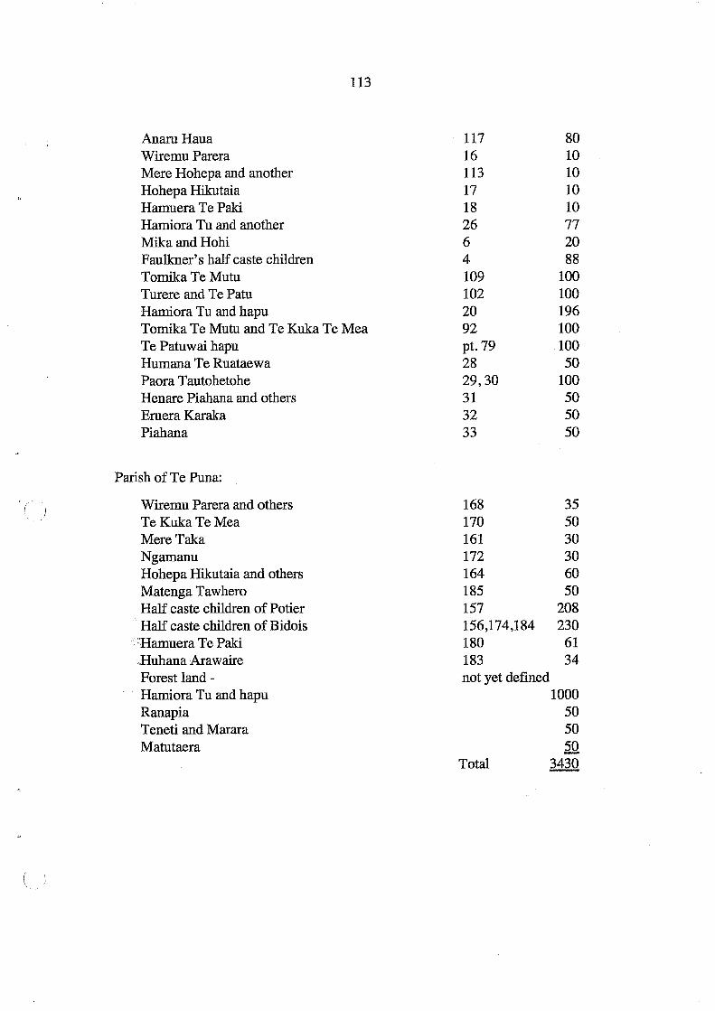
113
AnaruHaua 117 80 Wiremu Parera 16 10 Mere Hohepa and another 113 10 Hohepa Hikutaia 17 10 Hamuera Te Paki 18 10 Hamiora Tu and another 26 77 Mika and Hohi 6 20 Faulkner's half caste children 4 88 Tomika Te Mutu 109 100 Turere and Te Patu 102 100 Hamiora Tu and hapu 20 196 Tomika Te Mutu and Te Kuka Te Mea 92 100 Te Patuwai hapu pt. 79 100 Humana Te Ruataewa 28 50 Paora Tautohetohe 29,30 100 Henare Piahana and others 31 50 Emera Karaka 32 50 Piahana 33 50
Parish of Te Puna:
Wiremu Parera and others 168 35 Te Kuka Te Mea 170 50 Mere Taka 161 30 Ngamanu 172 30 Hohepa Hikutaia and others 164 60 Matenga Tawhero 185 50 Half caste children of Potier 157 208 Half caste children of Bidois 156,174,184 230
. Bamuera Te Paki 180 61 ,Huhana Arawaire 183 34 Forest land - not yet defined Hamiora Tu and hapu 1000 Ranapia 50 Teneti and Marara 50 Matutaera 50
Total 3430

114
2. Schedule of lands awarded to returned Rebels within the 50,000 acre block actually ( confiscated.
Parish of Te Papa:
Names
Wiremu Paraone and hapu Hori Ngatai and hapu Enoka Te Whanake and others Hori Tupaea and hapus Pauro Ngati and hapu Pene Taka and hapu Enoka Te Whanake Hori Ngatai Wiremu Paraone and hapu
Parish ofTe Puna:
Enoka Te Whanake Maihi Haki and others Maungapohatu and Pirirakau hapu
ForestLand
Ngaiteahi hapu Hone Reweti and hapu
Unappropriated Hiria Tireni
Lot No.
115 21,107,108 110 103 95 91 9 10
Area
100.0.0 84.3.21
81 110 130 120
not yet defmed
5 11
100
177,178 175,176 154,161
not yet defined " " "
125 60
382
320 100
will be required 2000 not yet defined 50 Total 3708.3.21
3. Schedule of lands awarded to mixed friendly and rebel Natives within the 50,000 acre block actually confiscated.
Parish of Te Papa:
Names Lot No. Area
Harniora Tu and Ngamanu 100 50
(
( I

Parish of Te Puna:
Names
Hori Tupaea and hapu Kuka Te Mea and hapu Hamiora Tu and others (compensation for services rendered)
Wi Heti and others Hemi Palmer and others Hamiora Tangiawa and others Kirirangatira and another Ipu and others Kiepa Te Amohau Rikihana and others Moananui Maraki
115
Lot No. Area
8 100 9 100 10,11 ,12,13 ,14 15,147,148,149 150,151,152,153 and part 158 103 173 50 167 35 169 30 171 20 160 40 162 30 163,164 100 165 47
Total 645
4. Schedule of Town lots awarded to Natives in the Township ofTauranga
Section 1: Lot No. Area
Wi Keepa Te Rangipuawhe and another 175 0.0.27 Arama Karaka and another 185 0.0.32 Araha Te Rahui and another 186 0.0.32 Te Waata Rauhi and another 190 0.0.32 Te Mapu and another 191 0.1.02 Ieni Tapihana and another 192 0.0.32 Wi Maihi Te Rangikaheke and another 201 0.0.32 Petera Pukuatua and another 226 0.0.32 Paora Te Amohau and another 227 0.0.32 Hori Haupapa and another 228 0.0.32 Ngahuruhuru and another 229 0.0.33 Maihi Kakauparaoa and another 176 0.0.31 Temuera Te Amohau 187 0.0.32
Total 2.2.21
[All the above town lots were awarded to fulfil the] "Promise to Arawa Chiefs by Sir George Grey in 1864 for services performed during the war".

116
Te Kuka Te Mea 8,9 0.1.8 Bnoka Te Whanake 145 0.0.32 Hori Ngatai 146 0.0.32 AnaruHaua 188 0.0.32 Hohaia Korouateka 189 0.0.32 Mrs Dihars (nee Irena Parerau Kawakawa) 75,78,79 0.2.0
Section 2:
Hori Tupaea 7 0.1.0 Humana Te Ruataewa 1 0.1.0 Hamiora Tu 5 0.1. 0 Raniera Te Hiahia 6 0.1. 0 Wiremu Parera 2 0.1.0 Wiropi Hotereni Taipari 12 0.0.35 Paroto Tawhiorangi 13 0.1. 0 Ruka Huritaupoki 14 0.1. 0 Aperaniko and another [Ngati Manawa] 17 0.1.0 Hohepa Hikutaia 20 0.1. 0 Ruato and another 21 0.1. 0 Moananui Tanumeha 25 0.1. 0 Ranapia Te Kahukoti 52 0.1.17 Parata Te Mapu 6 lots 749 to 754 1. O. 32 Wikiriwhi 191 0.1. 0 Humana Te Ruataewa "at Te Pahipoto" 343A 0.1. 0
Greerton:
Pihopa Ngamanu 2.0.0 Marata and others 3.0.0
Total 15.3.1
5. Lands awarded to Natives within the Te Puna and Katikati purchased block, estimated to contain 80,000 acres.
Names.
Parish of Katikati:
Te Patu and hapu Rapata Te Arakai Unappropriated
Lot No.
1 Bowentown not defined
Area
68 15 15
(
(
(

Parish of Tahawai
Te Hira Te Tuiri Hohepa Hikutaia Enoka Te Whanake (3 lots) Hamiora Te I wipau Rotoehu and others Paratene and others Hohepa Te Kai Moananui Maraki and others Hamiora Tu
Parish of Te Mania:
N gatira and another Hamiora Tangiawa and another Te Wi and another Harawira Kotai Wi Heti and others TePuru Te Kuka and hapu Te Moananui Maraki Ngapuru and others Ruka Tamakohe Merania (4 lots) Wiremu Parera and others Titipa and others Hohepa Tangatahou Kiepa Te Amohau Hatiwira and others Paratoenga General Wood Reserve for Natives
Parishiof Te Apata:
MereTu Hamiora Tu Pererika and others Mere Taka Hori Tupaea Raniera Te Hiahia Merita Hone Mutu and others Ngeri Ngarai
117
1 50 3,6 100 4,5,? 221 7 50 9 500 Undefined yet 150 11 200 12,13,14 550 15 50
48 120 41 100 42 80 43 50 44 100 45 100 33,35,46,47 500 49 100 37,38 350 36 80 19,20,23,? 275 24,25,26,39 514 27 100 28 60 29 50 32 150 not yet defined 60 50 100
205 100 208 100 211 200 206 103 209 100 207 207 [200] 10 200 212 200 213 18

118
Parish of Te Puna:
Raihi, Hakiriwhi and tribe [Ngati Haua] Tekiteki and another Te Makaka, Te Puru and others Te Puru and others Ngatitokotoko
49,50,56 240 186 28 52,53,187,188 400 51 25 Unappropriated 130
Total 6909 acres
Although lists of reserves had been compiled, this did not mean that Crown grants were
issued immediately. On 17 July 1872 Rapata Te Pokiha wrote from Ohinemuri inquiring
abouti¢.e Crown Grant for 15 acres ofland at Bowentown to be awarded to him. On Clarke's
187L:~ist 15 acres at Bowentown was awarded to Arakai which may have caused some
confusion as no grant had been made out. On 26 March 1873 Clarke supplied a plan show
ing the award to Ropata Te Arakai [sic] of Lot 19 Parish of Katikati, adjacent to the 68 acres
granted to Patu Turere, Te Ninihi and others which is the site of the present Otawhiwhi
Marae. Several other officials also annotated the translation of Rapata's letter after Clarke,
one suggesting this land "may be required for a Town at some future date" and that an
authority for issuing a Crown grant had not been received. On 7 April D. Pollen approved
the grant and noted "This is part of the land purchase arrangement, we have no right to take
it for any purpose". The final annotation was dated 19 April 1873, "Grant drafted Accord
ingly" (DOSLI files 2/13). It was now seven years after the Katikati Te Puna deeds were
signed. Filed with this was a receipt in Mackay's handwriting dated 26 February 1869, and
signed by Ropata Te Pokiha, for £10 "being compensation in full for all my claims to confis-
catedlands at Tauranga" (DOSLI files 2/13). The background to this award is not clear as
the name Rapata Te Arakai or Pokiha does not appear on any of the Katikati Te Puna deeds.
Some of Mackay's and Clarke's "promises" did not appear on the lists. Among Mackay's
papers is a "Memo for Mr Clarke", dated 27 February 1868:
Wiremu Tamihana Turanganui has applied to have some land given to him at Tauranga. It will be advisable to inquire into his claims, and if found correct, that a reserve should be made sufficient for his wants and requirements (DOSLI file 2/13).
There is no record of what inquiry was made, if any. A note under this memorandum, signed
by H.W. Brabant on 24 March 1886, suggests that nothing was done: "Judge Clarke says
(
(

119
that Lot 212 [parish of] Te Papa was intended for Wiremu Tamihana". This Tamihana
belonged to Ngai Tamarawaho, and should not be confused with Wiremu Tamihana of Ngati
Haua who had died in December 1866. On 17 November 1879 the application ofTamihana's
son, Wiremu Waitara of Ngai Tamarawaho to succeed to Lot 212 was heard in the Native
Land Court. His father had died on 7 June 1878 and no Crown grant had issued but he was
able to produce a "certificate of promise signed by H.T. Clarke Comr. to the effect that this
land had been given [to] Wiremu Tamehana [sic] but had not been C[row]n granted". The
succession order was granted, there being no objections, "the said land being absolutely
inalienable" (Tauranga MB 11242). There is no record why this block allocated to an indi
vidual was made inalienable but so many other grants to individuals had no restrictions on
alienation.
Some additional lands were granted in the 1870s and early 1880s to a few individuals, but by
1871 the pattern of reserves for Maori in the Town of Tauranga, Confiscated Block and
Katikati Te Puna Purchase had been established. In a few cases, such as the reserves at
Tahawai (Lot Nos. 18,20,21,22 and 23, Parish of Tahawai) , the owners were not identified
until 1884 when Commissioner Brabant investigated these titles. Lots 21 and 23 were as
signed to 8 people, the "Heirs of Tawaha", at last fulfilling the agreement set out in the
"Ngaiterangi" deed of 1866. Tawaha had been dead many years and his family continued
occupying the land. Lot 18 was awarded to Te Amo and 8 others who were occupying this
land. Lot 22, an old kainga known as Papakura, was awarded to 8 people described as Ngati
Teoteo. At the same time Brabant awarded Lot 97, Parish of Katikati, as a reserve for Te
Urungawera.
In October 1869 Major Charles Heaphy was appointed Commissioner of Native Reserves, a
task which included "the supervision of lands taken under the New Zealand Settlements Act
1863" (AJHR 1870, D-16, p. 3). Heaphy was also required "to classify the various Native
reserves" and prepare a schedule to be tabled at the next session of Parliament. This sched
ule was published in 1871 and included a number of "reserves" in the Tauranga confiscated
lands which were granted to individuals. The following list of Tauranga lands, all allocated
in 1866, has been extracted from Heaphy's schedule (AlHR 1871, F-4, pp. 15-16):

120
Class Al with a Specified Purpose - Trusts ( Date of Lot No. Parish Area Grantee Nature of Trust, Grant (acres) Object and Utilization
10 July 1866 1 Katikati 68 } Te Patu & 2 others Ngaitauwhao tribe;
" 3 " 32 } grant absolute
" 33 } TeMania 500 Te Kuka and another Ngaituwhiwhia tribe 35 } grant absolute 46 }
47 }
" 49&50 TePuna 202 Te Raihi and another Ngatibaua inalienable 56 " 38 " " " grant absolute
" 187&188 " 67 TeMakaka " " Ngatitokotoko;
grant absolute
3 Nov. 1866 9 TePuna 100 KukaTeMea Ngaituwhiwhia tribe; and 1 other grant absolute
" 8 " 100 Hori Tupaea Ngaitauwhao; " and 1 other grant absolute
" 169 " 30 Hamiora Tangiawa Ngatiirauwharo; and another grant absolute
" 211 " 200 Pererika Taratoa Tengare; grant absolute ( and another
" 16 } " 343 Maungapohaki [sic] Pirirakau tribe; *293 } and another inalienable
18 Nov. 1866 21 } TePapa 84.3.21 HoriNgatai Te Matewaitai tribe; 107 } and another grant absolute 108 }
21 Nov. 1866 156 } TePuna 230 Louis Pedois Pierre Bidois and 174 } [= Bidois] 10 other half castes;
"·,h_ 184 } grant absolute
" 157 TePuna 203 Charles Potier Charles Potier and 3 half castes; grant absolute
21 Nov. 1866 4 TePapa 88 John Lees Faulkner J. Faulkner and 11 half castes; grant absolute
28 Nov. 1866 103 TePapa 110 Hori Tupaea & another Ngaitauwhao, Patutohora and Papaunahi tribes
* Lot 293 is an error and should be Lot 154.
(

121
Although listed in a schedule of "Native Reserves", none of these lands were gazetted under
the Native Reserves Act. Heaphy commented: "In most cases certain named chiefs or heads
of families hold possession of these lands in trust for their people" (AJHR 1871, F-4, p. 3).
Once Crown grants were issued to the named individuals these lands were no longer admin
istered under the Native Reserves Acts. Only two grants (Ngati Haua and Pirirakau) were
listed as "inalienable". Heaphy also recorded that an area of 2500 acres at Oropi, Crown
land, had been reserved "for returning rebels and others" (AJHR 1871, F-4, p. 32). This area
was not defined, and was subsequently dealt with by Commissioner Brabant under the
Tauranga District Lands Acts in the early 1880s.
The assumption appears to have been that all these reserves (awarded under the Confiscated
Lands Act 1867) should be inalienable. Heaphy commented:
Certain ofthe returned rebels settled in the confiscated blocks have asked to be allowed to lease or sell the land allotted to them. Except in extreme cases, as, for instance, where the land is unsuitable for the native mode of cultivation and an exchange might be desirable, compliance with such request ought not, I think, to be conceded. If surrendered natives would lease or sell their allotments, or if their residence on them were not made indispensable, the act of submission might be resorted to for purposes of gain only. It is desirable that natives who come in [i.e. submit to Crown authority] should experience the advantage of civilisation - of roads and markets in settled districts - and that their improvement in circumstances should be apparent to those who hold themselves aloof. This can only be effected by making the lands inalienable, and by issuing Crown grants to those who have improved their holdings and fulfilled a prescribed term of residence (AJHR 1871, F-4,p.4).
This warning to ensure that reserves were inalienable appears to have gone unheeded. In
1871·Follett Halcombe, in a report on the Tauranga district, commented that the 10,000 acres
allocated to Maori by Clarke, as Commissioner of Tauranga Lands, "have nearly all fallen
into the hands of Europeans either by purchase or lease, and therefore cannot be held to
interfere in any way with the settlement of the district" (AJHR 1872), D-6). Ofthe "Lands
Returned" Halcombe noted:
I gather from Mr Clarke that, under a distinct agreement made with Sir George Grey by the Ngaiterangi in 1864, the grants of these lands, as also of the Island lands are made inalienable; that they are not, therefore, open to purchase. Much of this land is, moreover, under profitable occupation by the Maori owners, and what they do not use themselves

122
they will probably make some arrangements to let temporarily to Europeans. Judging ( from the facility with which they part with the bulk of their lands so soon as an individu-alized title has been granted it appears to me a wise provision that they should be re-stricted from pauperizing themselves and their descendants (AJHR 1872, D-6).
A review of Clarke's schedules of grants recommended to the Native Minister to be awarded
in the Katikati Te Puna and Confiscated Blocks in the early 1870s (DOSLI fIles 2111) indi
cated no cases where he recommended that grants be inalienable. Perhaps he assumed that a
restriction on alienation would be added at the time a Crown grant was issued, often several
years.afterthe awards were decided in 1866. This is the impression Clarke tried to convey in
his resjJonse to questions by the Native Affairs Committee in 1879 when he commented on
some.reservesin the Confiscated Block:
At that meeting in March 1866, certain reserves were made absolutely to the Natives before 1 returned from Auckland. There was one block of land of 190 acres made over to Hamiora Tu and Te Ritimana [sic], just on the other side of the Gate Pa. Another reserve was made to them at Otumoetai [sic] , and 1 was told it was proved to be the case that these lands were given them in consideration of money that had been paid to them on confiscated lands. Mr Chadwick bought a block near Gate Pa, Mr Craig bought one Lot, Mr Black another Captain Fraser another, and Mr Chadwick a second Lot. 1 was not aware of the circumstances until the Natives came to complain that the land at Gate Pa was sold. 1 made inquiries, and, to my astonishment, found that the Crown grant had been issued to two individuals. But it is just to say that the money was participated in by all. That took place in 1866. Mr Whitaker was there at the time (AJHR 1879, Sess 1,1-4, p. 3).
A letter to Whitaker, dated 6 February 1867, written by Hamiora Tu and Retimana Te Ao,
stated.in translation: '.,<:1
Friend Mr Whitaker, this is a word to you. Do you give up to Mr John Chadwick the Crown grant for Te Pahi [Lot 20, Parish ofTe Papa] for the 200 [196] acres ofland. which you decided at the commencement should be given to [us] (at Tauranga). Do you hearken, our agreement regarding Te Pahi has been settled. There is no other person coming in as claimant after us two. This matter is quite clear (DOSLI fIles 1/3).
This issue of a Crown grant was approved by Whitaker on 15 February 1867, and the land
was transferred to Chadwick thereafter.
A notice dated 8 January 1868 appeared in the New Zealand Gazette (1868, p. 50) that
reserves had been proclaimed for the following, all in the Parish ofTe Papa:
(
(

123
Hamiora Tu and Retimana Te Ao, Lot 20, 196 acres
Tomika Te Mutu and Te Kuka Te Mea, Lot 92, 100 acres
Tomika Te Mutu, Lots 105 and 109, 109 acres
All these blocks were sold by 1870. There are few records of these early transactions but no
restrictions on alienation of reserves seem to have been imposed. For example, on 24 De
cember 1866, in the Civil Commissioner's Office in Auckland, James Mackay Jr. Crown
Agent, wrote:
I certify that Tomika te Mutu and Kuka te Mea are entitled to a Crown. Grant for one hundred acres of land, being allotment No. 41 Otumoetai East· [=Parish of Te Papa Lot 92], the same having been given to them in part compensation for their claims to lands confiscated at Tauranga under the provisions of the New Zealand Settlements Act (DOSLI files 117).
On the same page Mackay added a note: "Mr Whitaker, recommended that the Grant be
made out without any restriction as to sale etc." Whitaker wrote on the same day, "Let Grant
be prepared". Still on the same day Mackay wrote underneath this, "Referred to the Chief
Surveyor to prepare a Crown Grant accordingly".
On 27 February 1867, an Auckland lawyer wrote to the Survey Office about the grant to
Tomika Te Mutu and Te Kuka Te Mea for Lot 92, an area of 100 acres in total:
The above Natives are entitled to Grants to 100 acres of land each [sic] situated in the Otumoetai East Block, Tauranga, and have sold their interest therein to our Clients Messrs Chadwick & Foley. Mr Whitaker promised us on 24th Decr . last, that these Grants should beIIlade out at once, as one of the grantees Tomika, was likely shortly to.die. Would you kindly make out the grants at your earliest convenience.
Written on this letter was a note that these transactions had already been recorded but the
delay had occurred because "some difficulty existed respecting the Parish and Parish Num
bers". It was about this time that new appellations were given on survey plans for Lots in the
Parish of Te Papa on the Confiscated Block.
The timing of these transactions suggests that agreements to sell had been negotiated either
before or at the same time as negotiations were being conducted on allocation of reserves.
Many ofthe Crown Grants to Maori were not issued unti11871 and later. These two grants
124
appear to have been prepared with almost indecent haste. Frederick Whitaker's official role (
was Agent of the General Government in Auckland. He was also closely associated with the
Auckland legal firm of Russell and Whitaker. It is not recorded whether any restrictions on
alienation of reserves were imposed, and if so, why they were removed. As will be indicated
in the next chapter, the fIrm of Russell and Whitaker was involved in other land transactions
in the Tauranga district through the 1870s and 1880s.
There are many questions still open about the dual role of Whitaker in an official capacity ,
haviIJ,g been Prime Minister in 1864 and the Auckland-based Agent for the General Govern-.jo'
ment in 1866-1867, when he was involved in meeting Tauranga Maori and approving Crown
grants for reserves, while privately he was continuing his active participation in his flrm's
dealing in Maori land. His Matakana transactions, for example, are reviewed in Chapter 13,
and he also encouraged other sales. Perhaps typical was a note written by Mackay to Whitaker,
dated 11 March 1867, which stated that Tomika Te Mutu was entitled to a Crown grant for
Lots 105 and 109, Parish of Te Papa at Otumoetai: "Recommended that this grant be made
out without any restrictions whatsoever as to sale and disposal of the lands thereby granted".
This was signed, "Authorized", by Whitaker on the same day (DOSLI flles 117). The land (
was sold soon after.
Although most of the reserves were allocated to individual "chiefs", this was no protection
against sale. In 1932 the descendants of Hamiora Tu petitioned Parliament for land. The
Co:rmhlssioner for Crown lands reported on this petition:
Hahnora Tu was a leading chief of the Ngaiterangi tribe being the head of a subtribe and hapu called the Ngati Materawaho.
Most of the Materawaho hapu were in rebellion, in fact the majority of the Ngaiterangi tribe were, in some districts the proportion being 95%.
Hamiora Tu was apparently loyal although the same could not be said of his hapu.
The following is an extract from a letter dated 31st July 1867, from Mr Mackay, Civil Co:rmhlssioner, to the Under Secretary, Native Department:
"The answer was almost unanimous in favour of the latter proposition (that the balance area be dealt with by the Native Land Court) - Hamiora Tu was the only dissentient but on my explaining to him that he had no cause of complaint as the most of his hapu had been
(

125
in the war and they had received 1,653 acres in the military settlements block and 420 acres in the Katikati Block or a total of 2,073 acres he withdrew his opposition."
Hamiora Tu appears to have identified himself with the loyalists for he was employed by the Governor under the Native Circuit Act 1858 as an assessor, and as such, received a salary. He was also one of the fourteen chiefs who assisted the Government Agent in the cutting of the boundary of the confiscated area ....
It is unfortunate for his successors that Hamiora alienated these lands but he was fairly treated by the Government of the day, and if the claims of any of his successors are entertained, it would be the prelude to a deluge of such representations (DOSLI files 5/33).
Attached to this report was a schedule of lands awarded to Hamiora Tu which were subse.,.
quently sold:
Lot No. Parish Area in Acres Date Sold
148 TePuna 7 2111011869
26 Te Papa 77 4/9/1869
100 Te Papa 52 20/1111873
111 TePapa 100 19/8/1867
20 TePapa 196 24/4/1867
112 Te Papa 100 10/7/1867
15 Tahawai 50 8/111877
208 Apata 100 4/1211868
Total 682 acres
The Commissioner concluded his report with the comment that the Sim Commission had
reported in 1928 on its investigation, the object of which "was to settle all grievances arising
out of confiscation". This report did not address the complexities of the social, economic
and political situation at Tauranga and the pressures to sell land as the only means to obtain
money for supplies following the disruptions of war and re-settlement.
Commissioner Wilson in 1879 noted that of the 16,825 acres of the lands returned already
granted without restriction, "14,623 acres - seven-eighths of the whole - have already been
sold at an average price under 2s.lOd. per acre" and suggested it was possible the balance
"may also be sold upon deeds unregistered" (AJHR 1879, Sess.I, G-8, p. 2). In 1880 Resi
dent Magistrate Brabant reported that local Maori had "received considerable sums from

126
Government for land purchase" but felt it had "really done them but little good" as the (l, money had been squandered and cultivations neglected in order t6 attend Court sittings (AIHR
1880, G-4). The following year Brabant also reported there were fewer cultivations and
attributed this "to the ease with which they can now obtain advances from speculators on
their lands". In spite of the restrictions on alienation imposed in 1878, Maori "who can show
any evidence of title can, it appears, always obtain advances, the purchaser trusting to time
or turn in the political wheel to enable him to perfect his title" (AJHR 1882, G-l).
Furthermore, Crown grants had been issued in many cases to individuals in "trust" for their :'>··r·
hapfi~;put with no protection mechanism in place to ensure that the hapu maintained. owner
ship and a sufficient economic base for the future. The issue of how each hapu fared in the
allocation of reserves is taken up again in Chapter 14. In Chapter 13 the allocation of re
serves is summarised in relation to the quality of land and population patterns, with further
comment on the impact of sales of reserves, including some where alienation was restricted.
(
(
127
9. The Removal of Restrictions on Alienation of Reserves
There was considerable ambivalence during the 1860s in Crown policy on imposing restric
tions on lands reserved for Maori, as Murray (1997, pp. 27-30) has pointed out. It was never
clearly defined whether the Crown had a responsible role as a trustee to retain lands in Maori
ownership, or whether it was a delaying tactic which assumed that alienation was inevitable.
In 1867, J.C. Richmond, Native Minister, wrote that the policy was intended to "give a
somewhat longer time and better chance for the adoption of European habits of mind before
the Maori settles down to the poverty and necessity for labor to which he must in most cases
come" (quoted by Murray 1997, p. 29). In other words, a restriction on alienation was a
short-term measure for retaining lands in Maori ownership to prevent Maori from becoming
landless and, in Richmond's words, "to protect the public generally, and the Natives them
selves, from the curse of pauperism; to prevent the establishment of a sort of gipsy race,
homeless and destitute, and idle" (ibid). There was no consideration, it seems, of the long
term welfare of Maori, or of what lands might be needed to provide a sufficient economic
base for each hapu in future. It was tacitly assumed that Maori would in due course be
assimilated and learn to live like European settlers.
The imposition of restrictions on alienation of reserves in the Tauranga confiscated lands
was largely at the discretion of the Commissioners appointed under the Tauranga District
Lands Acts. The restrictions on alienability for reserves defined in the various Native Lands
Acts did not apply in the Tauranga lands as these remained outside the jurisdiction of the
Native Land Court until 1886. A few of the reserves allocated in the Katikati Te Puna Block
were subsequently granted with restrictions, but most were not, including some which were
said to be in trust for hapu. On the Confiscated Block, many of the reserves were allocated
to individuals and quickly sold, some being subject to prior agreements to sell to European
settlers and land speculators.
By the 1870s when eligibility for grants in the Lands Returned was being investigated by the
Commissioners some cognisance was taken of the provisions in s.24 Native Land Act 1873:
128
It shall also be the duty of every District Officer to select, with the concurrence of the ( Natives interested, and to set apart, a sufficient quantity of land in as many blocks as he shall deem necessary for the benefit of the Natives of the district: Provided always that no land reserved for the support and maintenance of the Natives, as also for endowments for their benefit, shall be considered a sufficiency for their purposes, unless the reserves so made for these objects added together shall be equal to an aggregate amount of not less than fifty acres per head for every Native man woman and child resident in the district.
The concept of 50 acres (20.2 hectares) per head seems to have been recommended by Clarke
as a working formula to be applied in the administration of Tauranga lands. There is little
recorcl,,:of how this figure was decided on, or precisely what was meant by "a sufficient ',' ";" ~ , - - .
quantity of land". Although not always specifically stated, the general assumption by offi-.. J ~~ .
cials was that land not actually lived on and cultivated by Maori was somehow surplus to
their requirements and should be utilised more productively by settlers. Commissioner Wilson
referred to Clarke's "opinion" in his report on Tauranga lands in 1879:
As to this I would remark that the enactments under which Tauranga lands are administered contain no such provision, nor would it be possible to borrow the clause and apply it here in any way other than very partially, for the reason that the Natives in their hapus and tribes, as well as individually do not own land equally. A number of Natives at ( Tauranga own several hundred acres each, while many other Natives in the district have not a dozen acres apiece. The rule, if adopted, would not operate among the small land-owners, having less than 50 acres; while among the large owners it would have the effect of rendering many thousands of acres eligible for sale.
Viewing the question from its general aspect, it may perhaps be regarded thus: There is m~ph surplus Native land in the district which the Natives cannot cultivate or occupy. These lands are mostly rough fern and forest country, and cannot be advantageously leased in their present condition, except on very long terms, and this is doubtful. It is desirable, as well for the Native owners as for the district generally, that these lands should be utilized in some convenient and proper form. For this purpose the form of the 8th of November, 1878, has been promulgated: the Native owners, however, have not as yet availed themselves of it. They allege their wish to have it modified by granting a power of sale.
This, I think, is how the matter really stands at present. The Natives have made their representations, and I would respectfully submit that it seems to be a question for the consideration of the Government whether any power of sale should be allowed, and, if so, to what extent and under what conditions they should be permitted (AJHR 1879, Sess.l, G-8, pp.2-3).
(

129
In November 1878 a blanket restriction on alienation was imposed on Tauranga lands. In its
report on the petition ofTe Korowhiti Tuataka Douglas, concerning Ohauiti No.2 Block, the
Native Affairs Committee had recommended on 24 October 1878:
That, in the opinion of the Committee, no other portions of land in the Tauranga District which was returned by the Government to the Natives should be allowed to be alienated by way of sale or by way of lease, for a longer period than twenty-one years, and then only by public auction or public tender (AJHR 1879, Sess.I, 1-4, p.1).
On 8 November 1878 a telegram was sent by H.T. Clarke, Under SecretarY for Native Af
fairs,!o Commissioner Wilson advising him of this recommendation and asking that local
Maori be informed. The telegram was also published in the Bay of Plenty Times on 12
November 1878. The effect was that a restriction on alienation, except with the consent of
the Governor, was now imposed on all of lands reserved for Maori within the Tauranga
confiscated lands proclaimed under the New Zealand Settlements Act 1863.
During the course of investigation of Mrs Douglas' petition by the Native Affairs Commit
tee, Clarke was called to give evidence. He maintained that the removal of restrictions on
alienation of Ohauiti No.2 Block had been requested by the grantees in 1875 as they wished
to sell the land. Clarke had asked the Resident Magistrate at Tauranga, F.W. Roberts, to
investigate. Apparently, the grantees still wanted to sell to a Captain Morris who was al
ready occupying the land on an informal lease. Clarke reported that they had "a sufficiency
of land for their own purposes" and "that a very little of the land is fit for Native purposes; it
is hillY and broken". Native Minister McLean approved the issue of a Crown grant without
restriGtions (AJHR 1879, Sess. I, 1-4, pp.3 and 35). The whole of Ohauiti N.o .. 2 Block (6547
acres) was subsequently transferred to Captain Morris.
Clarke had been accused of assisting Captain Morris to purchase the Ohauiti No.2 Block but
he denied this. He was questioned further by the Committee:
... At the time you recommended the restriction should not be placed the land had Captain Morris a lease of it? - He had .
... For what length of time was the lease? - I do not know; I did not see it. I had nothing to do with Europeans. I had to deal with the Natives and the Government .
... Had Captain Morris a great advantage, when the restriction was taken off the land, over

130
any other European? - He was occupying and had cattle on it.
... Legally? - Well, I suppose occupation is nine points of the law. He could deal with the Natives very much better than any person outside .
... Was the lease he held a legal lease? - It could not have been a legal lease, because I am not aware that confiscated land can be let to anyone. There was no inquiry. The land never went before any Court ....
... Do you know a Mr Jonathan Brown? - Yes; he is a settler in Tauranga, and he is occu
pying at present a contiguous block (AlHR 1879, Sess. I, 1-4, pp.45).
In response to further questions it seems that Brown also held an informal lease on the
adjac:~Iit Waitaha No.2 Block (8082 acres) which was also granted without restriction in
1881 and then sold to Brown.
The Native Affairs Committee also questioned Clarke about his role as Commissioner of
Tauranga Lands:
... There is no appeal against your decision? - No, none .
(
... Then if a mistake was made by a Commissioner, could we get it reversed in any way? - The only way in which it could be done is to apply for a rehearing, and have another ( Commissioner, as was done in the Otawa case: Mr Brabant was Commissioner, the Natives felt aggrieved, and I was sent down by Mr Sheehan, and gave a judgment cancelling the first one .
... Upon fresh evidence? - The same evidence but given before another Commissioner. In deciding claims of this kind you have to run a give-and-take line, and 'weigh the daims of different hapus. The claims were not as between individuals, but between .hapus .
.. ~"Then did you take evidence when you took this case about the Maori's land? - I took notes of evidence; the whole inquiry lasted over six weeks .
... Is the evidence in existence? - I cannot say .
... Is your judgment in existence? - Yes .
... What form was followed of issuing advertisements? - A circular letter was printed and filled in, and sent to each tribe for circulation amongst their people .
... There was no public advertisement? - No .
... Then a person at a distance might have missed it altogether? - Yes; that is quite possible.
( . \ " I,

131
... And there were no formal records of the Court kept? - No .
... Not as they are kept in the Native Land Court? - No; not in the same way .
... Although it concerned property of great value, really? - Yes; no records were kept; only rough notes .
... Still, I mean no formal records such as are kept in the Native Land Court? - No; all matters relating to this land and the evidence taken have been referred to Mr Wilson, who is acting as Commissioner and Judge of the Native Land Court (AIHR 1879, Sess. I, 1-4, pp.3-4).
Unfortunately the records of this and other inquiries concerning blocks east of the Waimapu
River, including Otawa, have not been located. Wilson did not pass on his notes of evidence
to Commissioner Brabant when he was removed as both Commissioner of Tauranga Lands
and Judge ofthe Native Land Court in 1880.
Clarke was also questioned by the Native Affairs Committee about his procedure for remov
ing restrictions on alienation:
... Did you issue any public notice that the power of alienation over the land was to be given - in fact that the restriction on alienation was to be taken off? - There was no restriction upon the alienation of these blocks, but I told the Natives in open Court, that I would recommend the Government to do it; and when they pressed me not to put the restriction on, I told them that I would do it only on one condition, that the Natives should make written application to me, and I would lay it before the Government.
... When did you state in Court that you would recommend the restriction against alienation to be put on? - Not in any particular case, but in almost all the Tauranga cases I did so in open Court (AIHR 1879, Sess. I, 1-4, pp.5-6).
As Commissioner of Tauranga Lands, Clarke's policy on restrictions on alienation of re
serves in the Katikati Te Puna and Confiscated Blocks was, it seems, one of liberal discre
tion not to impose restrictions. In the Lands Returned he was guided by Governor Grey's
promises to reserve lands at Motuhoa, Matakana, Rangiwaea and Ohuki (Figure 15). On 13
January 1871, as Under Secretary in charge of the Native Department, Clarke advised Com
missioner Brabant that part of "Opounui Island" (Rangiwaea) had been investigated and
certificates issued under the Tauranga District Lands Acts preparatory to preparation of Crown
grants:
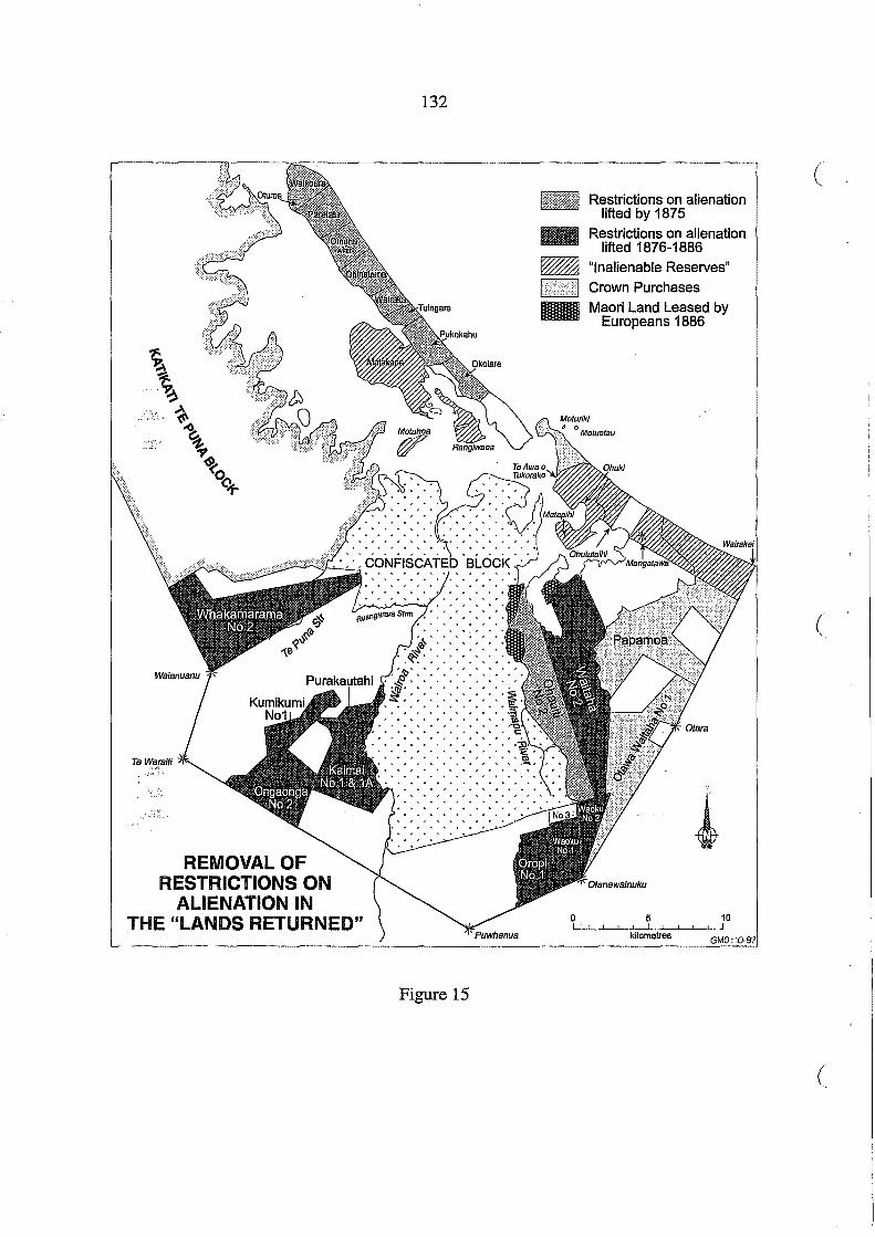
. ' .~ ,', ' ...
REMOVAL OF RESTRICTIONS ON
ALIENATION IN THE "LANDS RETURNED"
132
'tit'·','·',',' .
A~-:'>:-:<'>, '!l1','.','.'.',',', ' ,~> , , • , > •••
'iii' .. , , ... , ~ .. , , . , . , ~~'A~~~'A
Figure 15
o I
Restrictions on alienation lifted by 1875
Restrictions on alienation lifted 1876-1886
"Inalienable Reserves"
Crown Purchases
Maori Land Leased by Europeans 1886
5 ! I
kilometres
(
(
(

133
The rest of the Island to the Southwest [i.e. Matakana] is set apart as a Native Reserve (subject to subdivision by the Commissioner's Court) and is to be made inalienable by sale lease or mortgage for any term of years however short without the leave of the Governor first obtained. Such were the terms of the promise made by the Governor to Tauranga Natives at the General peace making in 1864 (DOSLI files 4/25).
In another letter dated 25 January 1877, Clarke indicated that similar restrictions applied for
the same reason to "Lands at OhukilMatapihi" (bounded by the harbour and in the north, a
line from Te Awa 0 Tukorako to the Bay of Plenty coast, and south by a line from Ohotutaihi
to the coast) and "lands at Mangatawa as far as the confiscated line and extending to the
coast". This implied that titles for all other lands returned east ofthe harbour and Waimapu
River could be issued without any alienation restrictions. Of the inland blocks Clarke stated:
"All lands at Kaimai and the forest at the back of Oropi to be made alienable or otherwise at
your discretion" (DOSLI files 4125).
In 1879 Commissioner Wilson reported that of the 19,734 acres of the Lands Returned for
which "administration" was completed, only 333 acres were "Granted absolutely inalien
able", another 2,576 acres were "Granted with alienability partially restricted" and the bal
ance 16,825 acres were granted with no restriction (AJHR 1879, Sess.I, G-8, p.1). The
investigation of a further 38,951 acres had been started and awaited completion of "indi
vidualization" and setting aside of "Native reserves":
Upon the question of reserves I would respectfully submit my opinion that all such reserves as are necessary to the support of the Natives in the way of cultivation and resi'dence should be rendered inalienable; otherwise, if I may judge by the past in this district, the Natives will sooner or later be tempted to sell them. I think the reserve of each hapu .sh0uld, if possible, be separate, that it should be of good quality, and sufficiently large to support the hapu. In making reserves I am endeavouring to conform to these conditions ....
Owing to the prohibition of 8th November last, forbidding the sale of Native lands in this district, private surveys have entirely ceased, the Natives being unable, and the Europeans unwilling, to pay for them. Hence, to settle these lands, it has become necessary that Government should defray the expense of surveys, taking security upon the land, when it is not a reserve, for the cost of the same ...
I should further report that, in consequence of the prohibition of sale above mentioned, a good deal of land in the district is kept out of the Court by those Natives who object to the order. I should say, however, that there is generally a minority in favour of the order (AJHR 1879, Sess.I, G-8, p.2).

134
Commissioner Wilson's request in 1879 that Government consider "whether any powers of (
sale be allowed, and, if so, to what extent and under what conditions" (AlHR 1879, Sess.I,
G-8, p.3) seems to have been ignored. In 1880 Wilson inquired about the same matter to
T.W. Lewis, the new Under Secretary for Native Affairs, and elicited the response:
that the Grants for these lands will be issued subject merely to the usual restrictions, viz., that the owners are not to sell mortgage or lease for a longer period than 21 years except with the consent of His Excellency the Governor (DOSLI files 4125).
In response to a similar inquiry in 1881, a copy of this letter was sent to Commissioner
Brabant who had replaced Wilson. On 16 March 1881 Brabant had explained to Lewis why
he wanted some clarification:
You are aware that alienability or otherwise by the Natives of the Tauranga lands dealt with by the Commissioner has long been a vexed question. The instructions to me when I formerly held office as Commissioner were that I was to use my discretion in regard to lands not actually in use by the natives but some time ago while Mr Wilson was Commissioner Government issued instructions that all Tauranga lands were to be made inalienable (except by leave of the Governor first obtained).
I find that speculators continued dealing with the lands and assume that these instructions ( which I have referred to have been reversed (DOSLI files 4/25)
The instructions to Brabant to maintain the restrictions on alienation did not resolve the
problem and he sought guidance from the Native Minister:
You are aware that within the last few months several applications have been made to the Gc,vernment for leave to be granted to Natives to sell lands in the Tauranga District. The prii6Uce has been for these applications to be referred by you to me for report. I should be gltl~,ifyou thought proper definitely to instruct me on what points the government require information before dealing with applications of this nature (DOSLI files 4/25)
The "Ministers Instructions" were set out by T.W. Lewis in December 1882, listing the
points to be considered:
1. That the Natives have amply sufficient other land for the maintenance of themselves and their successors, or that from the unsuitability of the land to be alienated for Native occupation, or other consideration it is to their interests to dispose of it.
2. That the owners of the land proposed to be alienated are unanimous in their desire to sell.

135
3. That the price proposed is prima facie fair and reasonable.
It has always and I think fairly been presumed by the Native Department that when restrictions are imposed it is not intended that the land should be alienated unless very good reason is shown. It is difficult to make the purchasers and even the Natives see the question from this point of view - the former simply looking at it from the standpoint that they desire to obtain the land - and the Natives that they wish to satisfy their present desire for money or what it will procure, the latter never I think considering the requirements of succeeding generations in view of which the restrictions are no doubt specially imposed (DOSLI files 4/25, emphasis in original).
Over.the period 1881-1884 Crown grants were issued to Maori owners with no restrictions
on alienation on the following blocks, which were all sold by 1886 (Figure 15):
Date of Block Grant 6 Aug 1881 WaitahaNo.2
Acres Reasons Given for Removal of Restrictions.
8082 This purchase was made in good faith and with the impression both on the part of the Natives and the purchaser that no restriction would be imposed. Mr Commissioner Wilson recommended its removal; and the late Sir D. McLean was said by Mr Brown [purchaser] to have approved of the purchase "provided the natives had sufficient land at Tauranga to live upon" and in accordance with recommendation ofN ative Affairs Commit-tee 28th October 1879 (AlHR 1883, G-4).
6 Sept 1881 WhakamaramaNo.2 7080 Mr Brabant R.M. reports that the Native owners are unanimous in their desire to sell and "they
11 Oct 1881 Kumikumi No.1 2617
20 May 1882 Waoku No.2 1656
have in my opinion, amply sufficient other land for their maintenance. The price named in the deed, 7s. per acre is, I learn, a price which has been agreed on, and is I think fair"(AlHR 1883, G-4). Mr Brabant R.M. reports that "he has made ample reserves in the block, and the vendors have sufficient other land for their support, and are unanimous in wishing to sell" (AlHR 1883, G-4). Mr Brabant RM. reports that "the land is in dense forest and is not required by the Native owners for their support being used only for pighunting" and he "can see no reason why the

136
Government should refuse its consent" (AlHR ( 1883, G-4).
22 June 1882 Waoku No.1 1995 Mr Brabant R.M. reports in favour of this sale as "it is dense forest, about fourteen or fifteen miles from Tauranga, more than a mile back from the Tauranga-Rotorua Road. It has not been used by the Natives except for pig-hunting, shooting birds &c. The price as far as I can judge is a fair one" (AlHR 1883, G-4).
22 June 1882 Oropi No.1 2550 Mr Brabant R.M. Tauranga reports that the Native owners have sufficient land for their subsistence; more over the block in question is forest and only used by them for pig-hunting and bird shooting (AJHR 1883, G-4).
':,~. ',1-'
4 March 1884 Kairnai No.1 ) 4500 3057 463
Mr Brabant R.M., Tauranga, reports that the Native owners are desirous to sell, and that they have sufficient other lands for their maintenance (AJHR 1884, Sess.II, G-5).
" " " "
" "
Ongaonga No.2 ) Purakautahi )
4 March 1884 Kairnai No.1A 1033 Mr Brabant R.M., Tauranga, reported that the Natives were unanimous in their wish to sell and that they possessed sufficient other land for their maintenance. Mr Brabant considers the price to be paid was a good one (AlHR 1885, G-7).
In 1886 restrictions on alienation were removed on the following blocks after investigation
by CornrnissionerBarton: Te Mahau (181 acres); Te IrihangaNo.l (685 acres); OtioraNo.l
(2441,?cres); and Waimanu No.1 (1274 acres) with the exception of the interests of three .. :'~ " .. "
owner~who had not agreed to sell (AJHR 1886, G-l1A). Barton also investigated applica-
tionsm:respect ofWaimanu No.1C (446 acres), Wairnanu No.2A (450 acres), Poripori No.1
(3000 acres) and Poripori No.2 (2696 acres). In the case ofWaimanu No.IC and Poripori
No.1 Barton found fraudulent dealings by rival purchasers and their agents and refused to
remove the restrictions on both blocks. In the case of Poripori No.2 Barton:
recommended that the restrictions be not removed, because it is a reserve for Native purposes made absolutely inalienable by the Commissioner Mr Brabant, at the request of the Natives in open court. The Native owners are by no means unanimous in requesting it to be thrown open for sale, and only a few of the owners have signed the transfer document. Mr Creagh [purchase agent] either purchased their interests before the land was declared an inalienable reserve, or without taking the trouble to ascertain that it was so declared (AJHR 1886, G-l1, p.6).
(
(

137
In Waimanu No.2A, Barton also found some evidence of dubious dealings by the same agent
but there were some "exceptional circumstances" which inclined him to recommend re
moval of restrictions:
The number of owners is thirty-seven and, although only thirteen have signed a transfer, I am informed that all are ready to sell their shares for the purpose of paying the expenses incurred on the contest in Court through which they obtained this block of 450 acres and also another block since made by Mr Brabant's Court an inalienable reserve of 800 acres.
The whole cost of the litigation and the maintenance of the hapu in Tauranga while the court was sitting was defrayed by a single Native named Ropata Karawe, who also conducted through the Court the case for his hapu. The. only method by which the hapu could rec()up him his expenses is by the sale of this land (AJHR 1886, G-11A, pp.6-7).
In 1885, on the recommendation of Native Minister John Ballance, a Wellington lawyer,
G .E. Barton, had been appointed as Commissioner "to inquire into all applications for re
moval of restrictions" (AJHR 1886, G-11, p.1). In January 1886 he began his inquiries in
Tauranga and produced his first report on 14 May:
In order to carry out the instructions in my Commission that I should "ascertain whether the persons to whom the land was proposed to be alienated had acted with good faith to the Maoris ," I have in each case inquired into all that had been done in the course of the negotiating; but I found it by no means an easy task to ascertain the existence of any improprieties, when such may have existed in the conduct of purchasers or their agents; my difficulty arising partly from the one-sided nature of the inquiry, partly from the fact that large numbers of the Natives interested in the principal lands under consideration had departed to the gumfields first before my arrival in Tauranga, and partly from the disinclination of the Maoris brought before me for examination to disclose any misconduct, even though they had suffered from it. The Natives whom I examined seemed to be actuated by ,a vague fear that they might lay themselves open to criminal proceedings, ending in imprisonment and loss of character. I have been informed that threats of such proceedings have been actually made, but cannot vouch for the truth of the statement, not having judicially inquired into it. Such being the attitude of the Natives, the only chance I had of reaching the facts where misconduct had taken place was through the quarrels of rival purchasers or from the intrinsic evidence afforded by the accounts kept and receipts taken during the negotiations of purchases, and upon the document of transfer (AJHR 1886, G-11, pp.1-2).
Barton referred to the telegram sent to Commissioner Wilson on 8 November 1878 and
advertised in the Bay of Plenty Times, imposing a blanket restriction on alienation ofTauranga
lands and concluded:

138
Notwithstanding this advertisement, much speculation in Tauranga Native lands took place ( in 1878, 1879, and 1880, and purchasers seem not to have been in the least deterred by it - if indeed they were aware of its existence. The Government too, treated the advertise-ment as a dead letter. His Excellency was advised to remove, and did remove, restrictions on many purchases made subsequently to its publication, not only in favour of persons who had settled upon and improved their purchases before applying, but also in favour of speculators who had not settled - and apparently did not mean to settle - on their lands (AJHR 1886,0-11, p.2).
Barton also noted that much of this "trafficking in Native lands" had occurred long before
any investigation by a Commissioner's Court, before any boundaries or "reserves" had been
settled, and in many cases where conflicting hapu claims remained unresolved. Barton re
ported·that he had:
made all reasonable allowance for informality and looseness under the circumstances; but I felt that such looseness opened a wide door for fraudulent practices, and therefore demanded from me a stricter scrutiny into every detail of the transactions than would otherwise be required; and the result of my investigations has shown that the agents or middlemen had in cases before me taken advantage of this looseness to defraud both their employers and the Natives. Their employers were debited with moneys that never reached the Native vendors, while the Native vendors were charged with these moneys although (/ they never received them. I found also that receipts were taken from Natives for pay-ments in such a manner that they would be easily manipulated, and were, in fact, manipu-lated, to represent payments on transactions to which they did not belong. I found that in some instances receipts were so handled as to cheat the Native vendor, by charging him with payments made to him for survey work as payments on account of land. I found blank, or nearly blank, receipts, signed ready to be filled up, but not filled up. I found blank transfers signed for the transfer of shares in a certain block of land, and afterwards ftl!~.d up with the addition of another block, the property.ofthe same owners, butnot sold by the majority of those who had so signed. I found a receipt given for a payment on a certain block altered fraudulently into a receipt for a payment on another block, which I have every reason to believe was never sold by the chief (now deceased) who gave the receipt ... I found receipts for the same payment entered in different places for different blocks. I found signatures of certain vendors signed in their own handwriting, and other signatures of the same vendors signed by "mark". I found one signature of a vendor in bold handwriting, and another of the same vendor written as if he had been intoxicated. I found whole batches of receipts signed by the mark of illiterate vendors, without any attestation by any person that such mark had been put there by the person whose name stood against it as having received the money. In short, I found that the books and docu-ments purporting to record the transactions of the agents and sub-agents were so manipu-lated and altered in different handwritings as to entirely destroy their reliability, espe-
(

.. \
139
cially taken in connection with the instances of actual fraud sworn to before me. In this case, which was one of the most tedious and keenly-contested of those brought before me, the hostility of the rival purchasers, who had lost money by paying the same Natives for the same land that was being sold to the claimants before me, aided me in discovering some of the above facts (AJHR 1886, G-ll, pp.2-3).
Barton was referring to the rivalry between Creagh and Wrigley over purchase of Poripori
and Waimanu Blocks. Barton's conclusion to his report on this was:
If the conduct of the agents in the transactions recorded in this report admits of any extenuation it is in the fact credibly vouched to me that in land transactions with the Natives such conduct is not the exception but the rule (AJHR 1886, G-11A, p.7).
Similar dubious practices had been identified in the activities of:government land purchase
officers (many of whom had also acted for private buyers). In 1880, evidence of such opera
tions was documented in an official enquiry by C.T. Batkin into the activities of a govern
ment officer, J.C. Young, who had been appointed to Tauranga in April 1878, and Abraham
Warbrick, his clerk and interpreter. Batkin summed up his findings:
It seems to have been common practice with Mr Young to make payments to Natives in want of money, and then to cast about for some block on which such payments could be charged as advances of purchase-money, and in charging the Natives the sums paid to storekeepers he seems in most cases to have assumed the right to charge the payment as on account of any block he thought fit, and occasionally to delegate the right to Mr Warbrick. As a natural result it frequently happened that Natives who had not even been consulted would find themselves not only enrolled as sellers, but as having received one or more payments on account (AJHR 1880, G-5).
Most 'of these accounts were made with storekeepers at Tauranga:
It is certain that many of the storekeepers at Tauranga exact a higher price from Natives than they do from Europeans for the same commodity, and Mr Young appears to have encouraged the practice by accepting a commission of moneys paid for stores supplied under orders from his office. I discovered two cases in which considerable sums had been deducted from Mr Young's private accounts as discount allowed on government accounts paid by him. The practice of allowing him such commissions was probably general, but complaint was made to me by one storekeeper that very little Government business fell into his hands because he had refused to allow Mr Young a commission on the sums paid (AJHR 1880, G-5).
Young apparently obtained Maori signatures to vouchers on which amounts of storekeepers'
accounts were filled in later. Batkin found "upwards of 170 of these blank voucher-forms,

140
receipted by the Natives" in Young's office. The practice of giving Maori land owners pay- (
ment in the form of orders on storekeepers was probably fairly widespread among land
purchase officers. Not surprisingly, accusations were made that Maori owners were thus
enticed into debt, and then forced to part with their land to payoff these debts. Batkin
commented:
Mr Young's system of purchase seems to have been founded on the plan adopted by the lowest order of land speculators - that of taking advantage of the wants or cupidity of the Natives in order to obtain a hold upon their lands ...
As:a:natural result of this system, the more idle and dissolute among the Natives seem to loo!c to the Government to supply them with anything they may require outside of their ordiiiary daily wants. The office-diary is filled with records of their demands for money and supplies; and during my stay in Tauranga and Maketu I was by many of them, "dunned" for money for rum or beer ...
The fact of my being concerned in the examination of the Land Purchase accounts was evidently considered a sufficient reason for assuming that I had command of government money and was at liberty to give it away on application (AJHR 1880, G-5).
Batkin provided detailed notes and minutes of evidence taken from Maori people in Tauranga
and Maketu. There was plenty of consistent evidence of fraudulent vouchers, including
some purported to be signed by a woman who could not write, and others in the names of
non-owners of the Te Puke Block, as well as those who claimed they had never consented to,
or asked for such payments in the form of storekeepers' accounts.
Youngwas dismissed from his job on 31 January 1880 and arrested. A preliminary hearing
was held in the Magistrate's Court in Taurangaon 28 February; In the Supreme Court in
Auckland, Young was arraigned on five indictments for larceny in a case heard 19-22. April
1880. He was acquitted on two charges and the other three were then withdrawn by the
Crown. The jury added a rider to the "Not guilty" verdict: "That the system of Native land
purchase expenditure, as disclosed by the evidence, is extremely loose and reprehensible,
and affords no sufficient check against fraud by persons employed as agents." The Judge
commented: "Gentlemen, that is the least you can say" and, in summing up, remarked to
Young that while he could not deprecate the verdict, he was "guilty of a gross dereliction of
duty and you cannot complain that you were suspected of a more serious offence". Batkin,
(

141
in his report completed after the trial, noted Young's efforts to put his property in trust for his
wife as "the action of a self-condemned man" and added his own observations on the case:
It is impossible to gather from the very meagre and confused account of the trial published in the Auckland papers (extracts of which I enclose) on what ground the verdict of the jury was based. I cannot, however, but regard the failure of these prosecutions as a deplorable miscarriage of justice (AJHR 1880, G-5).
Warbrick was described by Batkin as "an able co-adjutorthough his zeal on Young's behalf
often outran his discretion". Warbrick refused to appear before Batkin to explain his part in
the affliir and for this he was arrested, convicted and spent a term in gaol. There is no record
in the:ieports of the affair of how the fraudulent accounts were settled between storekeepers
and Maori debtors. Nor did this' case, as shown in Commissioner Barton's reports, lead to
any improvement in the tactics used to persuade Maori to sell their lands.
European pressure for land was such that the means of acquiring land from Maori owners
were seldom enquired into too closely. The local settler attitude was expressed in a Bay of
Plenty Times report on 18 February 1886 of a public meeting called "for the purpose of
inducing the Government to remove certain restrictions on Native Lands in this district".
Jonathan Brown, purchaser of Wait aha No.2 Block of over 8,000 acres, moved a resolution:
That in the opinion of the meeting the locking up of nearly 1,000,000 acres, or 1,500 square miles of Native land around Tauranga by restrictions of different kinds, is strangling the district, and it is the duty of the settlers generally to use every legitimate means in their power to cause these restrictions to be removed without delay.
This resolution was seconded by Tauranga lawyer, E.G.B.Moss, who·asked whether the
restrictions set out in the telegram to Commissioner Wilson of 8 November 1878 were:
either fair to the natives, or beneficial to the district. He thought that the natives should be allowed to dispose of their lands in the same way as Europeans were, and not be compelled to sell to the nominees of the Government of the day. Under the present state of affairs no one could afford to risk time, labour, and money in endeavouring to acquire land.
There were not more than four or five thousand natives in the district and 50 acres each, the area set apart by Government (a very liberal allowance) would leave a large acreage to be placed on the market, and this the Government should most certainly be asked to allow the Europeans to acquire.

142
The resolution was discussed, put, and passed unanimously. There was further discussion ,(
suggesting that a Commissioner be empowered "to inquire into the advisability of removing
restrictions generally", not block by block as Commissioner Barton had been doing. A
further resolution was passed to set up a committee comprising the Mayor of Tauranga, the
County Council Chairman and five others "to carry out the views of the meeting" .
In the 1880s pressures to remove restrictions on alienation of Maori land were coming from
both local settlers in the Tauranga district and speculator interests represented by the Auck-
land Jaw firm, Russell and Whitaker. The Crown was also purchasing Maori land on the
MOl.}.nt Maunganui peninsula and Papamoa Block (Figure 16). The Tauranga lawyer, E.G.B.
Moss, wrote a pamphlet, a scathing attack on the activities of speculators who, often in
competition with Government purchase officers, began negotiations with individuals for
sale long before title to a block of land was investigated by the Commissioner's Court or
Native Land Court:
The law formerly forbade negotiation, but until 1884 no penalty was provided. Therefore the risk was run, but only by rich companies or powerful syndicates. They could afford to defy the Government and to risk continuing the struggle till a change of Ministry, or some ( other conjuncture, enabled them to get their way. Numerous and well known are the cases in which, after a long and arduous struggle, the Government has withdrawn procla-mations, or abandoned its right of purchase, and allowed its opponents to complete their purchases in the end. Through this and many other difficulties thrown in the way of purchasers, native land buying became a monopoly of the unscrupulously wealthy and politically powerful, who alone cared to face the delays and expense with which such transactions were attended. Their profit, and the low price obtained by the native seller, are of course commensurate (Moss 1888, p.4).
Moss also commented on the failure to recognise the existence of trusts in many Crown
grants for reserves:
Native Ministers have loudly deplored the fact that native trustees have sometimes sold trust property and embezzled the proceeds. Are the hands of Government itself quite clean in such matters? ....
While on this subject, let me add that the cases in which land has been acquired by certain natives in trust for other natives or for tribes, and afterwards Crown granted to these natives without mention of the trust, are so numerous that it is extraordinary a Commissioner has not long since been appointed to inquire into them (Moss 1888, p.5).
(

TENURE OF THE "LANDS RETURNED"
1886 Source: AJHR 1886, G-10
143
Figure 16
IUIIIlI WII //~
tmmmmI
o I
Town of Tauranga Government Purchase
: Completed Government Purchase
: Under Negotiation Private Purchase Maori Land Leased by Europeans Maori Title
5 ! I ! I
kilometres
144
This issue was of particular concern in the sale of reseves on the Katikati Te Puna and Con- (
fiscated Blocks.
With a background of dealing with land transactions in the Tauranga district, E.G.B. Moss
made some suggestions for alleviating what he saw as the failure of Government to control
dubious land dealing:
Let each native make his own bargain for his own interest in the land. Refuse to acknowledge bargains with, and disallow all payments hereafter made to tribes or bodies of natives. Let the deeds be in Maori as well as in English. Compel the interpreter to give to ea.cb native a copy of the document he has signed. Also, a memo in Maori stating the pri,ge agreeci upon, how much of it has been paid, and how much he is still to receive and whbn. All chance of misunderstanding would then be obviated ....
It would be easy to provide fairly for their future. Let all lands that they could possibly use be rendered inalienable, and, while making part of it a common, as in the Old English times, let the remainder be individualised, so that each Native may have a piece of land of his own, and be encouraged to live as we do.
Let the natives be allowed to do as they please with the rest of their lands, either to sell or lease without restrictions, which only diminish the price they receive. Individualise these lands as far as possible so that each owner can be independent of the rest (Moss 1888, ( pp.6-7).
This is an interesting contemporary comment on dealings in Maori land in the 1880s which,
while supporting the process of individualisation of title to Maori land, also recognised a
need to protect a community land base for future Maori needs. However, Crown policy of
restric:tion on alienation of Tauranga lands remained, at best, ambivalent, and at worst, by
issuirig Crown grants which treated trustees as owners, and by allowing removal ofrestric
tionsg:~ so many blocks, promoted the loss oflands. After 1886, Tauranga lands came under
the jurisdiction of the Native Land Court which, by this time, had been given powers to
review the alienability of reserves and impose restrictions.
(

145
10. The "Half-Caste Claims"
The children born ofPakeha fathers and Maori mothers were treated separately in the alloca
tion of reserves to Maori. One important difference was that the inheritance through a woman,
the mother, was the significant factor, whereas most of the other reserves in the Katilcati Te
Puna and Confiscated Blocks were awarded to men, either individually or to "chiefs" in trust
for their hapfi. The wife of a Pakeha settler, such as Merania McMillan, who was living in the
Tauranga district, was able to establish her claims at the beginning. Merania was awarded
100 acres at Matahui (Lot 19, Parish ofTe Mania) listed in the "Ngaiterangi" deed (Turton
1877, Deed No. 461). Others had to make separate claims later, especially if the family had
moved away from the district. The children's interests were often pursued by the father, or
one of the children, or a close connection who understood something of the Pakeha world
and the system of compensation in the form of awards in the confiscated lands. The records
are fragmentary but the following notes indicate how some families pursued their claims and
their "half-caste" children were awarded land.
The Calloway Family
Among Mackay's "memos" was the following, dated 20 November 1866:
Huhana Te Arawaere, wife of John Calloway claims a piece of land on the south bank of Te Wairoa at a place called Mangapukatea, on behalf of herself and five children (one son and four daughters). The land is said to have been made over to the son Robert Calloway byKopa te Wheke and Te Tera both of te Ngare (Te Tera was killed in rebellion at the Gate Pa). It appears that Huhana Calloway is a non-resident, has never resided on the land.
Recommended:
That Huhana and family be allowed thirty acres (30) at Mangapukatea. 30 acres of land have been reserved above Hori Ngatai's block at Pukekonui Wairoa.
It was also noted that "Huhana professes to have claims at Puketi and Ruangarara" but is not
known if these were pursued (DOSLI files 1/7). The land allocated to Huhana Karawera
(Calloway) was Lot 183 Parish ofTe Puna (34 acres) and a Crown grant was issued in 1868.
In the 1930s this block was leased then sold (CT577/295).

146
The Johnson Family
Fairfax Johnson, on 8 May 1866, applied for "a piece of land belonging to my wife and
children" on the eastern bank of the Wairoa River:
I beg also to state that I had been living for above twenty years upon this block until such time as I had to leave in order to join the Civil Service at Maketu, when I left the Wairoa I had a considerable portion of this land under cultivation consisting of wheat, com, potatoes &c. with a well stocked garden and orchard which owing to the introduction of the Troops into Tauranga prevented me realizing the fruits of my industry .
I B:Uhe same time was repeatedly reassured by the Civil Commissioner at Maketuthat all m~~osses would be compensated. .
.•.. '!, ...
I also beg to state that my dwelling House and out buildings were destroyed. by Her Majesty's Forces including Household and Agricultural implements with one Brood Mare, pigs, poultry &c (DOSLI files 117).
On 11 November 1866, Mackay recommended that Riripeti Hotene, wife of Fairfax Johnson,
and her family "be allowed sixty acres of land to include Mr Johnson's residence and gar
den". The area subsequently allocated to the Johnson family was 105 acres.
The Crown grant for the family of Fairfax Johnson was not immediately prepared. For some
time the file was misplaced and no action was taken in spite ofletters from Johnson. In 1871
a question arose over the statutory authority under which a Crown grant was to be made.
There was a furthur legal question about the nature of the trust. A draft grant for 100 acres,
Lot 93 Parish ofTe Papa, was prepared in the name of Fairfax Johnson, Settler, although a
plan o~lthe grant carried the words "in trust". Attorney General Prendergast was a,sked to "I'l"
rule on,this and he advised the Secretary for Crown Lands on 21 March 1873: '::;1\'·
The Grant, if made in trust, must define the shares of each child and the trusts on which it is to be held. Such a grant as that drawn would give to each child an equal share, and leave it in doubt what should be done with theland or the profits. The better course would be to ascertain from the award what each child's share should be, give a separate grant for each, and appoint a trustee under the Maori Real Estate Act, 1867 (DOSLI files 2/14).
There was no immediate action and in February 1875 Fairfax Johnson, who seems to have
been living on this land, wrote another letter to H.T. Clarke suggesting the Crown grant:
be made out in the names of my children and not in Trust to me, they are all come to the age of maturity and I cannot see the necessity of making me the Trustee for adults.
(
(
(

147
The following are the names for the Crown Grant -Charles Johnson Williams Fairfax Johnson Jane Johnson (Potier) Mary Anne Fairfax Johnson (Brown)
H.T. Clarke wrote to the Native Minister on 5 March 1875 suggesting that Johnson's request
that the grant be made to his children "overcomes the difficulty" (DOSLI files 2/14). There
was no immediate action and on 15 July 1876 Clarke requested the Under Secretary for
Crown Lands to tell him whether a Crown grant for Lot 93 had been prepared. It had already
been agreed in August 1875 that an additional area of 5a3r 12p, Lot 12 Parish ofTe Papa,
should also be included in the grant, as it had been awarded to the family of Fairfax Johnson
at the same time as Lot 93. The further delay, explained in August 1876, "has resulted from
an alteration of the line of road traversing the property, and generally, the incompleteness of
the original survey" (DOSLI fIles 2/14). A Crown grant to Fairfax Johnson's four children
was finally issued on 17 October 1876, for Lot 93, Parish ofTe Papa, an area of 105a 3r 12p,
which included Lot 12.
Families of French Traders: Potier, Bidois and Borell
During the 1830s four French traders settled at the month of the Wairoa River. Charles
Potier, Louis Bidois and Emil Borell all took Maori wives, and all had children. The fourth
man was Michel Ottenon, but no claims were lodged by descendants of this name.
Roha!30rell, wife of Emil Borell, had applied for land but details have not survived. The
Auckland Survey Office advised on 12 May 1868 that Lots 1, 2 & 3 of "MtHeale's survey
at Otumoetai, containing 300 acres" , had been set apart for Mrs Borell. There seems to have
been some confusion over the authority for this award, no grant had issued, and it was que
ried in 1874. It was suggested that this award was among Mackay's schedules for 1870, but
this was not so, although it was indicated on the 1870 "Plan of Surveys on the Confiscated
Land" (DOSLI Head Office Plan A69). Finally it transpired that an order to the Inspector of
Surveys to prepare a Crown grant for the 300 acres at Te Puna had been sent by Clarke on 28
May 1870 (DOSLI files 2/12). The Borell family award was for 300 acres, Parish of Te
Puna, Lots 1, 2 and 3 on the peninsula known as Raropua, where Borell descendants still
own land. In 1928,50 acres of Lot 1 were sold to Archibald and Isabella Snodgrass (CT5721
148
132), and 99 acres, parts of Lots 1 and 3, were sold to Frederick Shroff (CT484/97).
The Potier family claims were noted by Mackay in 1866:
Wife - Porina Te Arapapa of Ngatihuna hapu of Pirirakau (dead) children - Louis Charles Potier
James Potier Alfred Potier Jane Potier (wife of Joseph Faulkner)
Claim land at Oikemoke - Waipa, and Te Puna
Have lived there for 26 years.
Maclql.Y noted on 11 November 1866 that "208 acres reserved at Wairoa West" (DOSLI files "."(.> ,
1/7). On the 1870 plan this was Lot 157, Parish ofTe Puna, 203 acres. Another block of 53
acres, Lot 177 Parish of Te Puna, was also granted to the Potier family, making a total of 256
acres.
The Bidois family claim was confirmed in a note by Hetaraka dated 8 March 1865 setting
out the boundaries of the land at Te Puna where the French trader Louis Bidois and his
family had lived. Mackay made the following notes on a copy of this letter:
Jean Charles Bidois Baptised Mar 12/48 Joseph Bidois " Feb 12/50 Henry Bidois " Decr.1850 Festime Louis Bidois " June 1853 Adelaide Bidois " Oct 1, 1854 Charles Louis Bidois " Decr.17/56 Lollis Napoleon Bidois " July 1860
}::~':.~.
Jaqq~es Bidois " Decr.1862 Mlikarita " Oct 25/64 By marriage of Irihapeti with first husband has issue Pierre Michael 0 Wanou (DOSLI files 117).
Mackay noted on 20 November 1866 that 163 acres be reserved at "Wairoa West". On the
1870 plan these were Parish ofTePunaLots 156 (114 acres) and 184 (45 acres) a total of 159
acres. Lot 174 (71 acres) was also awarded to the Bidois family. Both the Potier family and
Bidois family reserves were at Te Puna where their descendants still live.
(
(
(
149
The Nicholls Family
On 25 September 1866 William Nicholls wrote from an Auckland address to Governor Grey:
On the last day of December 1864 certain members of my family addressed a letter to your Excellency respecting their claims to land at Tauranga enclosing a plan of a portion of the land belonging to the Ngatimura tribe to which their mother belonged. Having received no answer to that communication and believing a limit of inquiry into these claims is about to take place I have the honour to request that your Excellency will direct the plan and other inclosures forwarded with the letter may be returned to me so that my family may be enabled to prosecute their claim within the period appointed by the Commissioners (DOSLI files 2/13).
Annotations on this letter indicate that it was referred to the Native Office but officials could
fmd no trace of the original letter and plan. A query was addressed to Fenton as Senior
Judge of the Compensation Court who responded that he understood the papers had been
"referred to the Private Secretary's Office". Nothing more was done for several years.
The Nicholls family petitioned Parliament and in due course H.T. Clarke was questioned by
the Native Affairs Committee. Clarke acknowledged that "to a certain extent theirdaims
have been allowed". However, he also considered they claimed lands of the hapu "to which
they have not the shadow of a right" and referred to a plan which is not in the petitions file.
In 1866 Mr Mackay and I had a large meeting at Tauranga to which all the Thames natives were invited. The Arawa were present and the whole question of these claims was gone into. The Nicholls at that time never put in any claim, although they were at the Thames and one of the sons was at the meeting. They made a claim to about 50 acres on the Rangiwaea Island and that extent of land was granted to them. Subsequently they made another claim which Mr Mackay and myself investigated the matter and did not consider the claim a good one, but Sir D. McLean in consideration of their connection with the Ngaiterangi tribe authorised a reserve of 100 acres which has been granted and made inalienable (National Archives Le1/1876/7; RDB vol. 1, pp. 222-223).
The Native Affairs Committee reported that it had no recommendation to make on this peti
tion (AJHR 1876,1-4).
At some time in the mid 1870s it seems to have been agreed that 100 acres in Lot 4, Parish of
Te Puna, should be granted to the Nicholls family. Correspondence in 1875 and 1876 culmi
nated in a memorandum by H.T. Clarke dated 2 June 1876:

150
Hon. Native Minister requests that a Crown Grant be prepared in favor [sic] of Susan, Charlotte, James, William and Sarah Nicholl[s] of the Thames for Lot No.4 Parish ofTe Puna -land to be inalienable without leave of the Governor first obtained (DOSLI fIles 2/13).
A Crown grant (CTI2/177) was issued on 20 November 1876 to "Charlotte Guilding, wife
of John William Richard Guilding of Ohinemuri, Native Interpreter, Susan Nicholls, James
Nicholls, William Nicholls and Sarah Nicholls, half-caste children of William Nicholls of
Tauranga, Settler". The restriction on alienation was soon removed from this .title. A Native
Office memorandum, dated 13 June 1877, stated: "I do not think we need to maintain a
restii~tion on this. The Nicholls family are quite able to take care of themselves" (National ,,,,'\'.,
Archiy~s MA13/22, No 77/4384, quoted by Murray 1997, p. 61). The family may w.ell have
beenarready contemplating sale. On 10 May 1878 the land was transferred to "Robert
Campbell Fraser of Te Puna, Settler" .
The Bryan Family
The interpreter A. Warbrick wrote on 16 November 1866, requesting land be granted to
William Bryan at Huhama, Omokoroa, which he claimed through his mother who had died
about 16 months earlier. Warbrick said he had promised her he would endeavour to obtain ( '.
the son's share in lands which his mother claimed with the wife of Rangiwaka Te Pam and
Karora. "I have known this boy from his infancy and have always found him an honest
upright and industrious youth". Mackay annotated the letter on 20 November 1866: "To
have land at Omokoroa" (DOSLI fIles 1/7). It is not known under what name any interest in
land may have been awarded, but the name William Bryan does not appear in lists of owners
of re~~fves at Omokoroa. In Mackay's list dated 10 July 1866, land to be awarded to ;/fJ·Y:.," . I
Ngatitokotoko, 400 acres at Omokoroa, was annotated "Wiremu Bryan, Richard, Edward,
John to have land with Rangiwaka rna, not to have land elsewhere" (DOSLI fIles 1/5). The
Ngati Tokotoko reserves were Parish ofTe Puna, Lots 52 (265 acres), 53 (68 acres), 187 (51
acres) and 188 (16 acres), on the Omokoroa peninsula.
The Faulkner Family
Sometime in the late 1830s John Lees Faulkner moved from the Bay of Islands and estab
lished a trading station and boat building yard on the beach at Otumoetai. He was joined in
his shipping business, mainly carrying local produce to Auckland, by his son-in-law Captain
(

151
Daniel Sellars. Clarke awarded 88 acres, being Lot 4, Parish ofTe Papa.
In 1873 the Native Affairs Committee considered a petition from Alfred Faulkner, son of
John Lees Faulkner, seeking more land for all the Faulkner children. In his evidence to the
committee on 15 August 1873, H.T. Clarke explained how some grants had been made in the
Tauranga confiscated lands:
In the month of April 1866 Mr Whitaker then Superintendent [of Auckland Province] and was also General Government Agent went with Sir George Grey to Tauranga to [e ]ffect a final settlement of the land that had been confiscated .. Mr Whitaker made awards to those people entitled to receive land or who were at any rate entitled to receive compensation. He:settled nearly everything with the exception of.the claims preferred by the half-cast [sic] Faulkners. Not being satisfied he held their claims over for me to make further inquiries. I made further inquiries and stated the result of these at the time they were made to Mr Whitaker. I found that Rihapeti, the mother of these half-castes claimed through an old native chief Tahere. This chief Tahere was then dead. Tommy Tahere and his brother Harawira were then living. I ascertained that Tahere's claim without question was good according to native custom for 200 acres. I am not alluding to the land outside the confiscated block. It was perhaps not quite so much as 200 acres but I recollect that that was the basis of my calculation. I considered Harawira and his brother Tommy Tahere who were both in active rebellion were what I would call first rate claimants. Rihapeti the mother of these children was a second rate claimant and the children themselves having a European father third rate claimants. If I had acted strictly they would have had only 44 acres instead of 88 acres. In fact they would not have had even that but simply a one-third of the proportionate share of the 200 acres ... I think that Faulkner's children were given their fair share. I reported the whole circumstance to Mr Whitaker and he quite agreed with me (National Archives Lel/1873/1O; RDB vol. 1, pp. 81-83).
Clarke went on to comment that none of the Faulkner children had complained to him about ...
the 88. acres granted, nor had others put forward claims on their behalf in the Jands outside
the Confiscated Block. Harawira and Tommy Tahere "were rebels and forfeited their rights" .
In response to further questions from the Native Affairs Committee, Clarke indicated that
John Lees Faulkner had only claimed "about 2 acres" for himself, being "the ground on
which his house stands" and the block of 88 acres was "in trust for his family every one of
the family being named in the grant". In a family of 11 children this meant 8 acres each in
the land behind the Faulkner family home at Otumoetai. In response to a question whether
this was "valuable land" Clarke answered "yes" , and in response to a further question whether
he considered "the offer a very liberal one", Clarke answered, "Yes I do. Every bit of the

152
land is enclosed and cultivated" (National Archives Le1l1873/1O; RDB vol. 1,p. 84).
The Native Affairs Committee reported on 25 September 1873, and clearly did not accept
Clarke's explanation that none of the Faulkners had complained and that the grant was a
liberal one. The chairman wrote:
I am directed to report that your Committee are of opinion that eight acres of land is not sufficient to induce a man to settle or obtain a living.
Your Committee therefore recommend that the Government should award each of the half-caste sons of Rihapeti thirty acres of land out of the confiscated lands in the district 'on.condition that they occupy and cultivate the land so awarded at least two years previous to getting a title.
We wish further to state that we recommend the grant to be made, not that they are entitled to it, but on grounds of public policy, that they should be encouraged to settle and cultivate (National Archives Le1l1873/1O; RDB vol. 1, p. 80).
There was no immediate action and it is not known how a decision was made later to allocate
land in the Parish of Katikati, or to include the daughters in the awards.
(
In 1881 Commissioner Brabant dealt with an application from Alfred Faulkner of Katikati (
for land to be awarded to the children of Rihapeti, the Maori wife of John Lees Faulkner. A
son-in-law, W .H. Beazley also wrote, on behalf of his children, as his wife, Elizabeth Riripeti,
was now dead. Brabant agreed that a block ofland in the Parish of Katikati comprising Lots
18,20,22,85,86 and 87, approximately 380 acres in total, should be subdivided for the
descendants of Rihapeti. The cost of survey was borne by the Faulkner family. In 1882
there was some concern that the proposed award was part of the lands already allocated by
Government to the Stewart Special Settlement and special legislation would be needed (DOSLI
flles 5/29). The issue of Crown grants to the Faulkner descendants was validated by the
Special Powers and Contracts Act 1883, as explained in the Schedule to the Act:
The half-caste children of Rihipete Puhi (Mrs Faulkner), of Tauranga who had not joined in rebellion, petitioned Parliament for compensation for land which had been confiscated by the Government, and the Native Affairs Committee, on 25th September, 1873,recommended that the sons of Rihipete should be awarded thirty acres each out of the lands in the Tauranga district. Subsequently Sir Donald McLean, as Native Minister, promised that Rihipete's daughters should have two hundred acres between them.
(

153
The Crown grants were to be issued as follows, all in Parish of Katikati antevested to 11 May
1877:
Names Lot No. Subdivision of Area in acres
John Faulkner (Hald Pakana) of Tauranga 1 Lot 20 30
Joseph Faulkner, of Tauranga 2 20 30
Maria Maxwell (wife of James
Maxwell of Hokianga, Settler) 3 20 40
Jane Sellars (widow of Daniel Sellars,
deceased) 4 ·20 40
Children of Elizabeth Beazley, deceased:
Elizabeth Regina, William Henry, George,
John, Mary Eliza Mumo, Sarah Jane,
of Hokianga 5 20 40
Christopher Faulkner, of Katikati 6 18&20 30
Isabella Neighbour (wife of James
Lovel Neighbour, of Tauranga, Settler) 7 18&20 30
Jervis Faulkner, of Tauranga 8 18 30
Eliza Bush (wife of Robert Smelt Bush of
Opotild ,Gentleman) 9 18 40
Alfred Faulkner of Katikati 10 18&22 30
Children of George Faulkner, deceased:
George Frederick Christopher and Clara
Ml:l.Ud 85,86,87 30
The Edwards Family
Benjamin Edwards wrote from Bowentown to Commissioner Brabant on 6 July 1876:
I most respectfully beg to lay our mother's case before you. She is an aboriginal native and is connected both with Ngaiterangi and Pirirakau tribes being a near relative ofTe Va Maungapohatu on Te Pirirakau side and of Wi Kotero and others on Ngaiterangi side. She has spent the best part of her life amongst Europeans with her two sons, myself, and my brother who is away at present following an occupation. Our father died when we were but children. Our mother has only lately returned to her people through the urgent

154
request of her relatives and unfortunately discovered the lands either confiscated through ( the late wars or sold and consequently her portion went with the rest. At the various times when lands were allotted to natives in the Tauranga district she was unable to present herself as a claimant in common with her people, being away in another part of the colony. I was unable then to render any assistance separated as I was from her on Government service. But I have now left the service and [have] taken this the earliest opportunity of placing myself in communication with you and to solicit your favour in recommending us for a piece of land. I take the liberty of drawing your attention to the other half-castes connected with Ngaiterangi and Pirirakau tribes who had land allotted to them through family connections (DOSLI flIes 5/28).
Edw~9:s also noted that his mother held "a large interest on the island of Tuhua through her
ancestor Puiti whose son Te Hauauru was her father". In 1884 when Commissioner Brabant .~. ..
investigated the title on Tuhua the names Erueti Te Hauauru/Benjamin Edwards and Tame
Erueti Te HeketualThomas Edwards were included in a list of 120 owners. However, no
other grants to the Edwards family have been identified, although it has not been investi
gated whether they inherited other interests later through succession orders of the Native
Land Court.
HoriParengarenga,Miriama and Nepe
The Schedule to the Special Powers and Contracts Act 1879 which authorised the Governor
to issue Crown grants for land in fulflIment of "certain Contracts and Promises" included the
following:
To~~fulf1l a promise made to certain half-castes in satisfaction of claims over lands in the Tau:ranga District.
«':~i· ,
To;~p.thorize the Governor to issue to Hori Parengarenga, Miriama and Nepe as ten~ts in common, Crown grants for Lots 132 and 133, Parish of Te Puna, County of Tauranga, containing 82 acres, more or less. Land to be inalienable by sale or mortgage, or by lease for longer than twenty-one years in possession, except with the consent of the Governor. Grant to be subject to the provisions of the Crown Grants Act 1866 and Acts amending the same.
The background to this award is not known. On the 1870 survey plan (DOSLI Head Office
PlanA69) Lots 132 (32 acres) and 133 (50 acres) are shown as unallocated military settlers'
lots inland near the bush south of Omokoroa.
(
(

155
11. The Town of Tauranga and Township of Greerton
The area described in the survey plans in the 1860s as the Town of Tauranga had already
been granted to the Church Missionary Society (CMS) under the Land Claims Ordinance
1841 (Figure 17). Te Papa No.1 Block (30 acres) was purchased in 1838 and Te Papa No.
2 Block (1,000 acres) in 1839 by Rev. A.N. Brown on behalf of the CMS (Turton 1882,
Deed Nos. 410 and 411). These purchases (Old Land Claims 444C and 444D) were re
vieweg by the Land Claims Commissioner in 1842 and allowed. A Crown Grant was issued
to the Trustees of the Church Missionary Society, dated 2 July 1852,for 1333acres, com
prising the whole Te Papa peninsula south to Gate Pa (AJHR 1863, D-14, p. 53).
Imperial Troops landed at Te Papa in January 1864, a military camp was established adja
cent to the Strand, and CMS mission buildings were taken over, with the exception of the
mission house, the residence of Archdeacon Brown. Te Papa No.2 Block (south of the
mission house) had been leased to Samuel Clarke who let it to Government 1864-1867.
Protracted negotiations between the CMS and Government led to the transfer ofTe Papa No.
1 and 2 Blocks to the Crown with the CMS retaining the mission house and surrounds, and
every fifth section in the Town of Tauranga (Gifford and Williams 1940, pp. 253-261).
The Town of Tauranga was surveyed in 1866. The completed plan was handed over to
Colonel Harrington in September for allocation of military settlers' lots. There was some
correspondence between the Chief Surveyor Auckland and District Surveyor Tauranga about
location of a "Market Reserve" (fmally located on Lot 289 on Cameron Road) an "open
square" and a Town Hall site possibly on the Redoubt site, and various other public reserves
(District Surveyor's Letter Book 1866-67, Tauranga Public Library). None of this corre
spondence referred to any Native reserves. The Township of Greerton was surveyed about
the same time but no information has been located about how reserves were allocated there.
On 26 June 1867 Clarke was given approval by W. Rolleston, Under Secretary for Native
Affairs, to set apart 24 lots in the Town of Tauranga for "certain Arawa and Ngaiterangi
chiefs ... in fulfilment of promises made to them by His Excellency". Clarke was asked "to
select and suggest to the Government the requisite number of sections avoiding any which

o Cl
Motuopae
Huria
eMS Mission Station
/ I
(
"
156
TOWN OF TAURANGA
SUBURBS OF
\ TAURANGA
\ Gate Pa \
THE TOWN OF TAURANGA AND
TOWNSHIP OF GREERTON
L:J Boundary of Crown Grant to Church _ _ Missionary Society 1852 L _ .2 Town boundaries surveyed
1865-1870
\ ..........
N
-r
o k
o 100 ! , ! • I ! t t • I !
M.tres
GMO:6/96
\ '\ Z \ TOWNSHIP \~. ~ OF \ ~ \ GREERTON \ JOe. -'\ ~
\ \ ~ .",...... -- -- -- -- --..... .~ '- -- -- -- o~
~Q<: <;>~
0 ....
Cb-?~. ;s>~
Figure 17
Te Ranga Battle Site ~
E1I
~S/Oo,f-
(
(
(

157
may be required for Public Reserves" (DOSLI files 2/10). Presumably the selection was
made soon after this and before 28 October 1867 when a public notice was issued of sale by
auction to be held in Auckland on 2 December 1867 of Crown lands in the Town ofTauranga
and Confiscated Block. Clarke left no record of how he made his selection in 1867, or for
town lots subsequently granted.
Figures 18a and b, and 19 show in map form the location of all the lands allocated to Maori,
including both the Crown lands set aside as "Native Reserves" (discussed in Chapter 12) and
those awarded to individual Maori grantees. Town lots awarded by 1875 are summarised in
the following table, with areas shown in acres, roods and perches:
Summary of Reserves in the Town of Tauranga and Township of Greerton
A. Crown Lands ("Native Reserves")
Native Hostelry (NZ. Gazette 1878 p. 630) Town of Tauranga:
Section 1: Lots 2, 3, 6,7 1. 2. 00
Reserves for General Native Purposes (Native Reserves in 1871, were reallocated as
educational endowments, N Z. Gazette 1872, p. 607), Town of Tauranga:
Section 1: Lot 72 0.2.23 Lots 140, 141 O. 1.24
Section 2: Lots 3,4 0.1.00 Lot 193 0.2.00
Suburbs:
Lots 604-613 Lots 702, 703 Lots 714, 715 Lot 50
10.0.00 2.0.00 2.0.00 5.0.00
Native School Site (NZ. Gazette 1878 p. 630), Town of Tauranga:
Section 2: Lots 275,276,277,280,281,282 1. 2. 00
Endowment Lands "for support of Natives" (recommended by Heaphy 1871, AJHR F4,
1871), Town of Tauranga:
Section 2: Lots 77,78,89,90 Town Belt, part of, West of Block 34 (not located) Township of Greerton: Lots 233-238
1. O. 00 9.3.16 6.0.00

158
B. Grants to individuals: (
Town of Tauranga:
Section 1:
Lots: 8,9 Te Kuka Te Mea 0.0.28 10 Hoani Ngaamu (A) 0.0.12 11 Aporo Te Tipitipi (A) 0.0.16 75,78,79,124,125 Irena Parerau Kawakawa (Mrs Dihars) 0.2.25 85 Te Pokiha Taranui and others (A) 0.0.16 86 Heremaia and others 0.0.16 138,139 Waata Taranui (A) 1. 0.15 143 Wiremu Mita Hikairo 0.0.32 144 Hiria Tireni 0.0.32 145 Enoka Te Whanake 0.0.32 146 Hori Ngatai 0.0.32 147 Wikiriwhi Tuahu (A) 0.1.02 175 Wiremu Kepa Te Rangipu (A) 0.0.27 176 Maihi Kakauparaoa and Pauro (A) 0.0.31 185 Arama Karaka and Niheta (A) 0.0.32 186 Auaha Te Rahui and Te Oraora (A) 0.0.32 ( 187 Temuera Te Amohau (A) 0.0.32 188 H. Anaru Haua 0.0.32 189 Hohaia Korouateka 0.0.32 190 Te Waata Rauhi Taranui and Te Pokiha Taranui(A) 0.1.02 191 Te Mapu and Wiremu Matene Te Huaki (A) 0.0.32 192 Jeni Tapihana and Emera Te Uremutu (A) 0.0.32
.201 Wiremu Maihi Te Rangikaheke and " .. ;":.:",. Taupo Te Hura (A) 0.0.32
202 N.R. [Anaru Haua by occupation] 0.0.32 226 Petera Pukuatua and Henare Pukuatua (A) 0.0.31 227 Paora Te Amohau and Rewi Tereanuku (A) 0.0.32 228 Hori Haupapa and Rotohiko Haupapa (A) 0.0.32 229 Ngahuruhuru and Pererika Ngahuruhuru (A) 0.0.33 343A (pahipoto) Humana Te Ruataewa 0.1.00
Section 2:
Lot 1 Humana Te Ruataewa 0.1.00 2 Wiremu Parera 0.1.00 5 Hamiora Tu 0.1.00 6 Raniera Te Hiahia 0.1.00
(
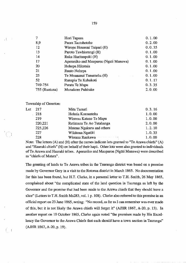
( 7 8,9 12 13 14 17 20 21 25 52 749-754 755 (Ruatuna)
Township of Greerton:
Lot 217 218
159
Hori Tupaea Paora Tautohetohe Wirope Hotereni Taipari (H) Paroto Tawhiorangi (H) Ruka Huritaupoki (H) Aperaniko and Mauparoa (Ngati Manawa) Hohepa Hikutaia Ruato Hohepa Te Moananui Tanumeha (H) Ranapia Te Kahukoti Parata Te Mapu Munakore Puhirake
Mita Tamati Hohaia Korouateka
0.1.00 0.2.00 0.0.35 0.1.00 0.1.00 0.1.00 0.1.00 0.1.00 0.1.00 0.1.17 0.3.35 2.0.00
0.3.16 1. O. 00
219 Wiremu Katene Te Mapu 1. O. 00 220,221 Retimana Te Ao Tutahanga 2. O. 00 225,226 Matene Ngakuru and others 1. 2.10 227 Wikitona Ngatiki 1. O. 35 228 Wiremu Raukawa 1. O. 00
Note: The letters (A) and (H) after the names indicate lots granted to "Te Arawa chiefs" (A) and "Hauraki chiefs" (H) on behalf of their hapu. Other lots were also granted to individuals ofTe Arawa and Hauraki tribes. Aperaniko and Mauparoa (Ngati Manawa) were described as "chiefs of Matata" .
The granting of lands to Te Arawa tribes in the Tauranga district was based on a promise
made by Governor Grey in a visit to the Rotoruadistrict in March 1865. No documentation
for this has been found, but H.T. Clarke, in a personal letter to T.H. Smith, 26 May 1865,
complained about "the complicated state of the land question in Tauranga as left by the
Governor and the promise that had been made to the Arawa chiefs that they should have a
slice" (Letters to T .H. Smith Ms283, vol. 1 p. 108). Clarke also referred to this promise in an
official report on 23 June 1865, noting: "No record, as far as I can remember was ever made
of this, but it is not likely the Arawa chiefs will forget it" (AJHR 1867, A-20, p. 13). In
another report on 10 October 1865, Clarke again noted "the promises made by His Excel
lency the Governor to the Arawa Chiefs that each should have a town section in Tauranga"
(AJHR 1867, A-20, p. 19).

RESERVES IN THE TOWN OF TAURANGA
III Native Reserves
160
CJ Grants to Individual Maori
Tauranga Borough Endowments and Public Reserves
.uu Church MisSionary Society
Figure 18a
, .~ MO!~ ,
(
(
'(
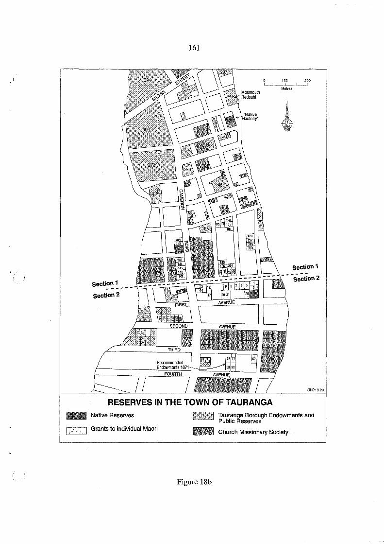
161
0 100 200 I I I
Metres
~ .. ~
section 1
section 1 ---------S:Cilon 2
section 2
GMO:9-96
RESERVES IN THE TOWN OF TAURANGA
... Native Reserves
Grants to individual Maori
Tauranga Borough Endowments and Public Reserves
_ Church Missionary Society
Figure 18b

162
Reserves in the Township of Greerton III". Endowment lands "for support of Natives" ~~ recommended by Heaphy, 1871 ~= Grants to Individual Maori
/:>. ~-9/~
Race Course ~ GMOB/96
Figure 19
(
(
o 200 I! ! I ! ! ! ! I ! !
Metres
(

163
Te Arawa claims in the Tauranga confiscated lands were set out in a letter dated 26 March
1866 sent to Whitaker by W. Te Rangikaheke and W. Hikairo. They had asked for talks on
the question of land for the road to Rotorua from Tauranga via Mangorewa, suggesting it be
purchased by the Crown "so that it may be the Queen's highway" - "ki a hokona hei huarahi
ma Te Kuini". They also wanted assurance on the town lots - "the one acre which has been
given up by Ngaiterangi for their transgression" - "ko te eka kotahi 0 Tauranga kua riro nei
hei utu mo te hara 0 Ngaiterangi". The translator added here: "i.e. let a money payment be
given for the claims of the Arawa within the [confiscated] block". The letter went on to
suggest: "Ko te mana rohe ko Ngaiterangi ki a mohio koe ki taku ko te awa nui tonu 0
Tauranga". This was translated as: "The boundary between the Ngaiterangi and ourselves is
the Tauranga harbour - i.e. the proper left bank of the Tauranga harbour" (DOSLI files 1/3).
Te Awanui was the name usually given to the harbour entrance at Mount Maunganui and
this implies that Te Arawa had claims to all the lands east of the entrance and the eastern
harbour itself and land east of the Waimapu River. This amounted to an assertion of Te
Arawa claims to territory held before Ngai Te Rangi settled in this area. As already noted
the Te Arawa hapu Waitaha and Ngati Rangiwewehi exercised customary rights to lands
inside the confiscation line in the south-east. These were in due course considered by Com
missioner Brabant in the 1880s. There is no indication that there was any existing customary
right of Te Arawa hapu in the Town of Tauranga in the nineteenth century.
In a summary of reserves allocated up to 31 May 1867 H.T. Clarke noted 12 Town of Tauranga
sections were to be allocated to "Arawa Chiefs". In a memorandum dated 15 July 1867,
James Mackay listed the "lots selected for natives within Tauranga Township" (DOSLI fIles
1/5) which included the following reserves for Te Arawa tribes in Section 1, Town ofTauranga:
Ngatiwhakaue Ngatipikiao Ngatirangitihi N gatikereru Ngatitarawhai Ngatituhourangi N gatiunukopoko [sic]
Lots 225, 227, 228, 229 Lots 190, 191 Lot 185 Lot 202 Lot 186 Lots 175,176 Lot 201
All these were described as being granted for "Loyalty and services rendered". There was
also an award of Lot 17, Section 2, to Ngati Manawa, on similar grounds because of support

164
for Te Arawa. All these tribes were considered to have provided assistance to the Govern- (),
ment and military.
The following list was compiled from Clarke's schedules of "Town Lots awarded to Natives
in the Township of Tauranga" 1871 and 1875 (DOSLI files 1/5) and headed "Promise to
Arawa Chiefs by Sir George Grey in 1864 for services performed during the war". All lots
were in Section 1, Town of Tauranga, and were approximately one quarter acre each.
Lot 175 Lot 176
·:L6t 185
Lot 186 Lot 190 Lot 191 Lot 192 Lot 201
Lot 226 Lot 227 Lot 228 Lot 229
Wi Keepa te Rangipuawhe and Wikiriwhi Te Tuahu (Tiihourangi) Maihi Kakauparaoa and Pauro (Tiihourangi) Arama Karaka and Niheta (Ngati Rangitihi) Auaha Te Rahui and Te Oraora (Ngati Tarawhai) Te Waata Rauhi Taranui and Te Pokiha Taranui (Ngati Pikiao) Te Mapu and Wiremu Matene Te Huaki (Ngati Pikiao) Ieni Tapihana and Emera Te Uremutu (Ngati Pikiao) Wiremu Maihi Te Rangikaheke and Taupo Te Hura
(Ngati Uenukukopako) Petera Pukuatua and Henare Pukuatua (Ngati Whakaiie) Paora Te Amohau and Rewi Tereanuku (Ngati Whakaiie Hori Haupapa and Rotohiko Haupapa (Ngati Whakaiie) Ngahuruhuru and Pererika Ngahuruhuru (Ngati Whakaiie)
Lot 202 which had been allocated to Ngati Kerem on Mackay's list had no Crown Grant issued
and was subject to investigation by the Maori Land Court in 1924 in which it was found that Te
Arawa had no further claim. In 1939 an application was made by Charles Haua for title on the
grOl.m,ds of occupation which was not resolved until the 1960s (DOSLI File 14/32 and see · .... ,i:,. /.
Appendix 4). Mackay's 1867 list had been amended in that the Ngati Pikiao awards were
changed from Lots 201 and 202 to Lots 190 and 191. However, the total of 12 sections prom
ised were granted to Te Arawa chiefs as a reward for services rendered. Some additional
grants to Te Arawa were made after 1867 as follows, but detailed circumstances are not known:
Lot 187, Section 1 was allocated to Temuera Te Amohau, one of the "Arawa chiefs" in
Clarke's 1871 list. On 17 June 1870 Clarke had requested a Crown grant be made out for
this Lot in the name of Temuera Te Amohau, "Aboriginal Chief of Rotorua" , which was "in
fulfilment of a promise made by the Honourable the Native Minister" (DOSLI files 2/13).
In Clarke's 1875 list two more lots in Section 1, were granted: Lot 10 to Aporo Te Tipitipi
(
(,

165
and Lot 11 to Hoani Ngamu, both described as "Rotorua chiefs", but no reasons were given.
Lot 192, Section 1, was awarded to Ngati Raukawa according to a schedule on the plan
S0441 , on what grounds is not known but it was not implemented. In Clarke's 1871 list Lot
192 was included in the "Promise to Arawa Chiefs" to be awarded to "Ierri Tapihana and
another" (Eruera Te Uremutu).
There was no restriction on alienation on any of these grants of town lots to individuals and
many were soon sold. For example, in May 1883 the transfer of Lot 201, Section 1, by Wi
Maihi Te Rangikaheke to EGB Moss, a Tauranga lawyer, was approved by the Trust Com
missioner (DOSLI fIles 5/27).
Mackay appears to have remained involved in allocating lands, even after Clarke had been
appointed Commissioner of Tauranga Lands. On 6 March 1868 Mackay arranged for Lots
75,78,79, 124 and 125, Section 1, Town ofTauranga, to be awarded to Irene Pareraukawakawa,
wife of Louis Dihars, in acknowledgement of her claims (DOSLI fIles 2/12). These lots were
also sold. On 10 August 1887 Fairfax Johnson wrote to Commissioner Brabant on behalf of
the children of Irena Pareraukawakawa Dihars seeking information about lands granted to
her:
The family state that at the time the land was given to their Mother they were all Minors and that their Father and Mother have sold the whole of the five lots appropriating the proceeds to their own use.
One Lot was sold to James Morrison formerly of the Victoria Hotel who sold it to James Bordell and it is now the site of the Temperance Hotel; another Lot was sold to a Mr Reid who died some years back; two other Lots were sold to Mr Grey Timber Merchant and now forms his timber yard ... the fifth lot the Family are not certain to whom it was sold but they think they remember their Father saying he had sold it to Mr Thos. Wrigley; these are all the particulars the Family have given me but wished me to urge upon you as Trust Commissioner to supply them with instructions how to proceed to reclaim their just shares out of these allotments (DOSLI fIles 5/28).
Brabant's reply is not recorded in the fIle but since the sales had been completed some years
earlier, there is little he could have done for the children who were apparently "living on a
Gum field" somewhere.
On 30 September 1868 Mackay agreed "to give to Parata te Mapu six allotments in the

166
Township at Te Papa, Tauranga as compensation for his claims to lands at Te Wairoa Tauranga, (
confiscated by the Governor" (DOSLI files 2/12). These were Lots 749-754, Section 2,
Town of Tauranga, but the circumstances of this award were not recorded. Mackay also
granted another application for land in 1869 from Katarina Munakore Puhirake who said
"that Mr Clarke had told her that Mr Mackay would give her a certificate for a piece of land
at Te Ruatuna, Tauranga, of two acres" (DOSLI flIes 2/12). This was Lot 755, Section 2,
Town of Tauranga. Again, the circumstances of this award were not recorded.
Alfred Warbrick was a "half-caste" with Te Arawa connections who had acted as interpreter ·m~ .
during the negotiations with Pirirakau over survey of the western boundary of the ConfIs-
cated Block in November 1866 and resided in Tauranga. On 19 November 1868 he wrote to
Mackay reminding him of his promise to grant the half acre on which he resided in the Town
of Tauranga and quoted Mackay's words:
Recommended that in consideration of useful information at various times furnished by Mr Warbrick to the Native Department and the services he has rendered in interpreting for the Officer Commanding H.M. Forces at Tauranga that if possible the land he at present occupies in the Township of Te Papa be granted to him.
Warbrick added that "a strong recommendation from Mr Commissioner H.T. Clarke" also
supported his request. Mackay annotated the letter on 13 July 1869: "Recommended that
the land in question be granted to Mr Warbrick" (DOSLI files 2/12). It is not known which
lot in the Town of Tauranga was awarded to him.
For most of the town lots Crown grants were issued in the early 1870s, but a few were not settled ,.... .
until years later. The small section fronting theWaikareao estuary, near the CMS mission house,
and known as "Pahipoto Reserve" , was before Commissioner Brabant on 5 .september on 5 Sep
tember 1881. Lot 343A, Section 1, Town of Tauranga, had been awarded by Clarke to Humana
Te Ruataewa but no grant issued. Wi Heti applied to succeed. There was no opposition, and it
was established that Wi Heti was a son of the deceased Humana Te Ruataewa, and his half brother
"Te Humana Junior" was also deceased. A certificate of title was ordered by Commissioner
Brabant in the name of Wi Heti (Brabant's MBlI147 and Brabant's Notes p. 2 in DOSLI file 3/
16). Lot 202, Section 1, Town of Tauranga, remained without a title, occupied by the Haua
family, and its ownership was finally resolved in Court proceedings in 1964 (see Appendix 4).
(
(

167
12. Endowment Reserves under the Native Reserves Acts
In previous chapters, discussion has been focussed entirely on the various reserves actually
allocated to Maori in the Tauranga confiscated lands. However, as Murray (1997, p.5) has
pointed out there were, in principle, since 1840 two groups of reserves: one for use and
occupation by Maori, the other "intended to provide a fund for the benefit of Maori" .. This
chapter is concerned with the latter group which can be conveniently described as "endow
ment reserves". Section 7 Confiscated Lands Act 1867 provided for the Governor, by proc
lamation published in the New Zealand Gazette, to reserve:
such lands as he may think fit as sites for buildings for educational purposes for the Native race or as sites for buildings for educational purposes for the inhabitants of the colony generally and also out of such lands to make reserves for the endowment of educational institutions already or hereafter to be established in the Colony.
Apart from the provision of section 6 of the Act which empowered the Governor to impose
"such conditions restrictions and limitations he may think fit" on any reserve under the 1867
Act, there was no specific reference to the Native Reserves Act. However, most of the
reserves discussed in this chapter were at some stage identified as "Native Reserves" and
listed in Heaphy's 1871 report as Commissioner of Native Reserves (AJHR 1871, F-4).
Reserves administered under the Native Reserves Acts were usually considered to be Crown
land reserved, as stated in a proclamation in the New Zealand Gazette, for a specific purpose
(such as a "native hostelry" or "Native school"), or for "Native purposes" or "Native ben
efit" generally. By 1886 the following lands had been identified as Native Reserves in the
Tauranga confiscated lands:
1. Reserves for a Specified Purpose:
Town of Tauranga
Section 1, Lots 2, 3, 6, 7 (1 rood 8 perches) for Native Hostelry (New Zealand Gazette 1878, p. 630): Section 2, Lots 275,276,277,280,281,282 (1 acre 2 roods) site for a Native School (New Zealand Gazette 1878, p. 630)

168
Parish of Te Papa (' Lot 8A (2 acres, 6 perches) site for a Native School [Bethlehem], (New Zealand Gazette 1885, p. 508). Lot 452A (16 perches) site for a Native School [Judea] (New Zealand Gazette 1885, p. 508). Lot 15, Motuopae, was reserved under s.227 Land Act 1885 for "Use of aboriginal natives" (New Zealand Gazette 1886, p. 1469). This island in the Waikareao Estuary is an urupa of Ngai Tamarawaho of Judea and has been treated as Maori land, as a burial reserve.
2. Reserves for General Native Purposes:
Town.of Tauranga
Section 1, Lots 72,140, 141 (4 roods 3 perches) Section 2, Lots 3,4,193,604-613,702,703,714,715 (14 acres 3 roods)
Suburbs of Tauranga
Lot 50 ( 5 acres)
Parish of Te Papa
Lots 14,114 (159 acres 2 roods 20 perches) "Brookfield Reserve"
All these were listed as "For Benefit of Natives Generally" in Heaphy's 1871 list (AJHR
1871, F-4, p. 41) but in 1872 were reserved as endowments for educational institutions (New
Zealand Gazette 1872, p. 607).
L~t8, Parish of Katikati (357 acres) although listed as a Native Reserve by Heaphy (AJHR
1871, F-4, p. 41), does not appear to have been gazetted. Many of the so-called Native
reserves identified in Heaphy's 1871 list were, by 1886, allocated to individual Maori by
commissioners under the Tauranga District Lands Acts and Confiscated Lands Act. This
chapter reviews only those reserves remaining under the Native Reserves Act in 1886 when
jurisdiction over the Tauranga lands allocated to Maori was transferred to the Native Land
Court.
Reserves in the Town of Tauranga
Several allotments in the Town of Tauranga were Crown lands, to be administered under the
Native Reserves Act. In Heaphy's 1871 list, "Class B 1 - Reserves for a Specified Purpose",
C I
(

'I
169
an area of 1 rood 8 perches comprising Lots 2,3,6 and 7, Section 1 Town of Tauranga
(Figure 20), was set aside on 16 October 1866 "For Native Hostelry site" (AllIR 1871, F-4,
p. 39). In "Class B2 - For Benefit of Natives Generally", the following reserves were set
aside in 1866 in the Town of Tauranga (AllIR 1871, F-4, p. 41; Figures 21 a-d):
Section 1 Lot 72 Oa.2r.23p Lots 140,141 0.1.24
Section 2 Lots 3,4 0.1.00 Lot 193 0.2.00 Lots 604-613 10.0.00 Lots 702,703 2.0.00 Lots 714,715 2.0.00
Suburbs of Tauranga Lot 50 5.0.00
Two adjacent blocks at Otumoetai which have corrie to be known locally as the "Brookfield
Reserve", Lots 14 and 114, Parish ofTe Papa, were also listed (Figure 22) and will be con
sidered here as their administrative history as Native reserves was similar to that of the town
lots.
The Native Hostelry
On Section 1, Lots 2, 3, 6 and 7, an area of 1 rood 9 perches, was reserved under s.l44 Land
Act 1877 "as a site for Native hostelry" (New Zealand Gazette 1878, p. 630). A hostelry was
built on the land and this reserve was genuinely used for the benefit of local Maori. The site
is now occupied by the Tauranga Moana Centre and the office of the Tauranga Moana Maori
Trust Board.
Native School Sites
An area of 1 acre 2 roods, comprising Lots 275,276,277,280,281 and 282, Section 2 Town
of Tauranga was reserved under s.l44 Land Act 1877 "As a site for a Native School" (New
Zealand Gazette 1878, p.630). A "Native Boarding school" was built on this site but details
are sketchy. The Bay of Plenty Times (18 August 1881) reported that there were nine boys in
this "boarding establishment-for -the-sons of-chiefs '\-Theyattended -the Tauranga Bistrict
School, described as "the European district school" , and were making "good progress"; one
boy was preparing for the "Junior Civil Service exam". The school seems to have been
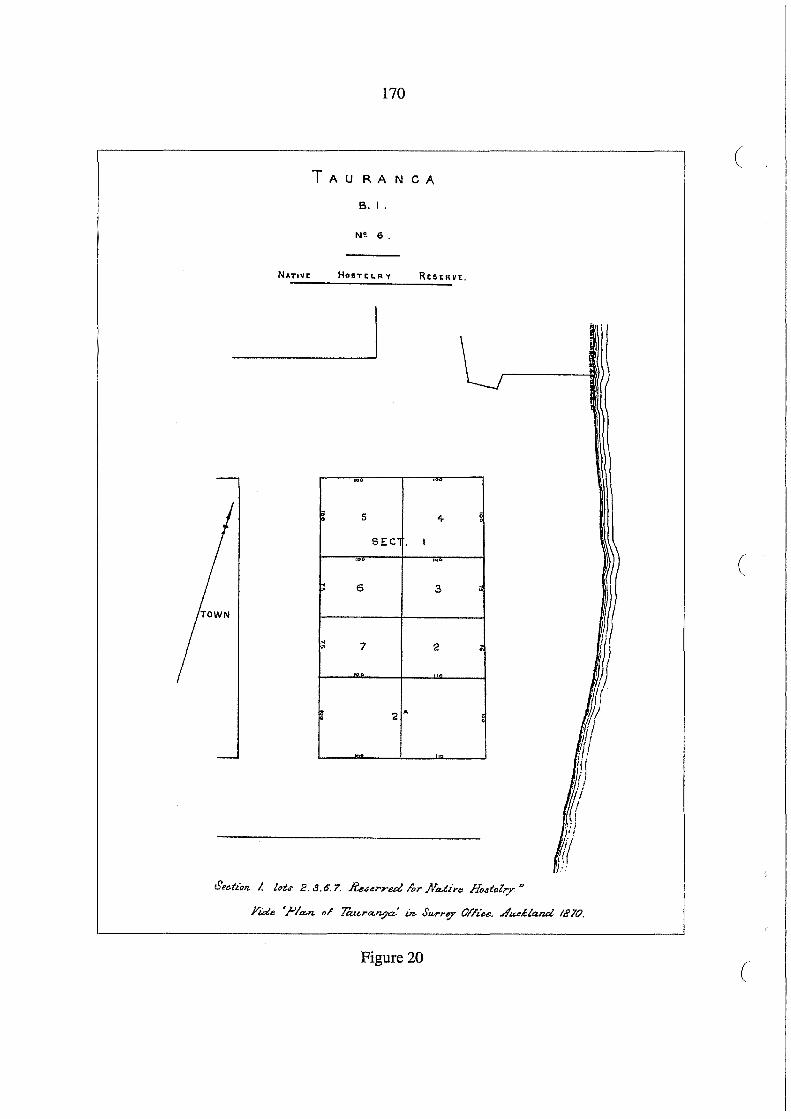
170
( TAURANCA
B. I.
NI! 6.
HOIlTEt.RY RESERVE.
, .. ,
- 5 i 4
SEC I , .. ,. (
I"! 6 3 ;
~ 7 2 • "0 '-"-
~ 2 .. . . ...11lL
Figure 20 c
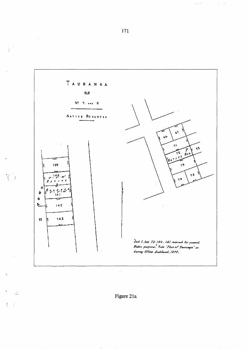
TAU
N~
NATIVE
-'0.' . . ; las
-. ~ .' ,!9 .. u' ; ! H II T I .- E
,. ~
~
RES E. /I .f, t;, $ : uJ •• 1/ ..
• 14'
0 0'- . '-; 142 .. 11 ; t4a -
R A N Q A
B.2
T ••• , 8
R£f>EIIVLS
171
~
.Jut- I. tar., 72: 14-t). /41. "",,.,.....:l. lor .,,_d
.Y~ .. "lV/"'''''': YuU- 'PUuvol" J'¢U,I'anya' u. J'kn'''f' tJl'l'iu- ..t~.III7().
Figure 21a

-
SE C T.
-
II
L
604 R Ii:
605
t') -606 (;
60T '#Ar/~E
6S1 H,u#",1'W
i 702
(,llll.n.
.A
"U,tE
: 708 . , lOI P'I"US
172
( T A U R A N G A
8.2
H' g. 10 • b II.
To", •
I
.. , 610
E 60e'" :
y £ D
f' D 1/ 611 : .... ..,
1/ " It ~ t Sit
60; :
1113 P HPDIFS
(
\
L r
704 71+
712
715 err,. ~IO f) ~ ... ~
116
"TOl
-
I I r
Figure 21b
(

2
173
T A U RAN G A
B.2 N: IS •• 0 I 4
TOWN ---
I I
194 . }
l
\ \ ---
.. , : 1
~ ...
S
= 2 : ~ n. 2 ' ..
II"·· i~· II" . S : NAT I V £
2S RE S E R V E
;; 4"';-'-1' . " n •
I I ;r .. b4n. 2, {.e- 3.<1'. /93 . . _.,,,<1 I'.r F",.,.J JrJi."I'W'P""': Y,;,4 :"""" •. r
!i'4JU'1Ut:If1l- / in. JW"yl-Y ()//iu-.i1'"""'lA-J, /1170.
Figure 21c

174
(
TAURANCA
B.2
SUBURBAN LAIID
49
\ 51 ~Q
50
NATIVE RtsERVE
( $'. t/~,/
/ -1-
/ 47 46
Figure 21d
(
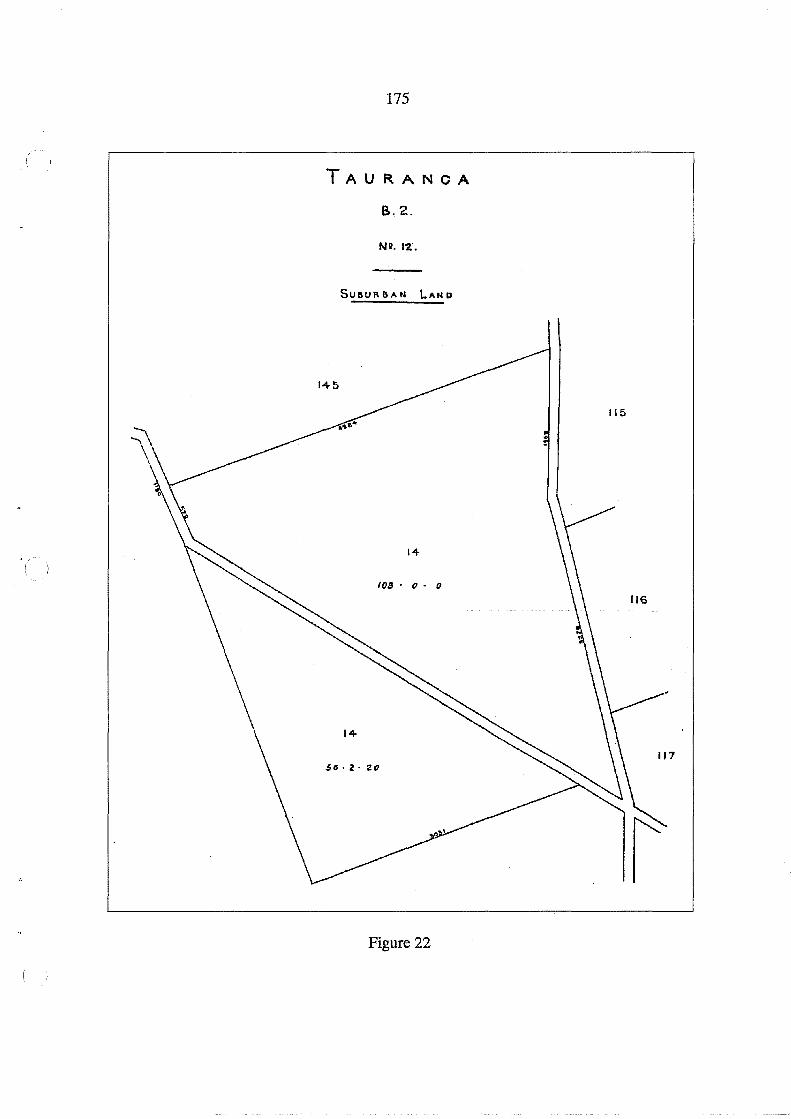
175
TAURANOA
B.2.
Nil. 12.
SUSUR SA N LAN D
14
108' (J. 0
Figure 22
115
116
117

176
closed the following year as the Bay of Plenty Times reported on 6 June 1882 that the estab- (
lishment was "to be closed and the native boys residing there are to be removed to St Stephen's
School, Parnell, Auckland". By late 1883 "the old native school" had been closed, and the
property which included "a dwelling house and a large school room" had been "leased for a
term of years" to a Tauranga resident, Mr Fitzgibbon Louch (Bay of Plenty Times 13 October
1883).
The property appears to have been leased in the 1880s and 1890s. In response to an inquiry
to the Commissioner of Crown lands it was noted on 23 November 1906 the six lots had
been gazetted as a site for a Native school and therefore did not come within his jurisdiction,
and were under the control of the Native Schools Department in Wellington (DOSLI flle 14/
32, vol. 1). Another letter on the same file stated that this information was given in error:
The sections in question comprise site of the old Tauranga Native Boarding School that was placed in the hands of the Commissioner of Crown Lands, Auckland in 1893, as though they were reserved as a site for a Native School in Gazette of 1886 p. 630, yet as the school does not now exist it was decided in 1893 that the sections should be administered and dealt with by the Commissioner of Crown Lands in the same manner as any other Crown reserves.
It was further noted that the original gazetting as a Native school was in 1878, and that a
Crown lands officer had reported in 1898 that the place was "sadly out of repair and fast
going to ruin". In April 1907 the Commissioner of Crown Lands inquired about the needs in
Taurapga for land for public reserves or school sites. The Crown Lands Ranger in Tauranga
resportdedin June with a recommendation that the property he handed over to the Tauranga
Borough Council. In November the Commissioner of Crown Lands proposed offering a
lease of 14 years at a rental of 8 shillings per week with no compensation for improvements.
There was at the time an occupant on the property named Berridge, but by June 1909 Berridge
was about to depart (DOSLI flle 14/32, vol. 1).
Two other natives school sites were also reserved: Lots 8A and 452A Parish of Te Papa
(New Zealand Gazette 1885, p. 508). Lot 8A was reserved from Lot 8 Parish of Te Papa
which was awarded by H.T. Clarke in 1867 as a reserve for Ngati Kahu. A Native school did
operate there for some time but the present Bethlehem School is on another site, across the
(
(

177
road from Lot 8A. In 1978 two sections of 1099m2 and 1100m2, part of Lot 8A, were "set
apart for teachers' residences" (New Zealand Gazette 1978, p. 1145). The land has been the
subject of negotiation between Ngati Kahu and the Crown concerning its return to Maori
ownership. Lot 452A was part of Lot 452 at Judea. A total of 111 owners were listed for this
lot on CT167/152, issued in 1884, which excluded the school site, located on the road front
age next to the meeting house at Huria Marae. A school was erected there in ,the 1880s, but
closed permanently in the early 1890s, and the site appears to have remained in use by Ngai
Tamarawaho.
Reserves for General Native Purposes
The other Native reserves in the Town of Tauranga on Heaphy's list in 1871 had been set
aside for general Native purposes and no uses specified. For reasons that remain unclear, it
was decided in 1872 that these lands and the Brookfield Reserve would be used for general
educational purposes. These reserves were gazetted under the Confiscated Lands Act 1867
as "reserved and set apart for the endowment of Educational Institutions already or hereafter
to be established in the Colony" (New Zealand Gazette 1872, p. 607). Under the Native
Reserves Act 1882 the administration of Native reserves was transferred to the Public Trus
tee. In 1882 Commissioner Alexander Mackay commented to the Public Trustee in his
"Report on the State and Condition of Native Reserves in the Colony":
At Tauranga there are twenty-two sections containing a total of 123 acres and 9 perches. These lands were set apart under "The Confiscated Lands Act, 1867", and have been proclaimed as reserves for educational purposes under that Act, but the immediate pur-pos~has not yet been defined (AJHR 1883, G-7). ",
For many years these Native reserves (which were Crown lands) remained either unused or
were leased to local Pakeha settlers. In 1871 leases were negotiated for some of the Town of
Tauranga reserves. Section 2, Lots 604-613 (6 acres) 702 and 703 (2 acres) and 714 and 715
(2 acres) were leased to T.S. Grace for 21 years from 1 July 1871 at 5 shillings per acre for
the first 7 years, 10 shillings for the second 7 years, and 20 shillings for the third 7 years,
making a total of £2.10.0 per annum in the first 7 years. Lot 50, Suburbs ofTauranga, an area
of 5 acres was leased to H.L. Skeet from 1 July 1871 for 21 years at 2 shillings and 6 pence
per acre for the first 7 years, 5 shillings per acre in the second 7 years, and 10 shillings per

178
acre in the third 7 years making a total of 12 shillings and 6 pence per annum in the first 7 (
years. The Commissioner of Native Reserves, Charles Heaphy, commented:
These lands had been for some time under agreement for lease, but owing to the existence of doubts as to power under the respective Acts, they could not, until the present month [July 1871] be definitely let (AJHR 1871, F-4, p. 4).
Heaphy also expected that at least four more Tauranga town lots would be leased and sug
gested that "21 years is too short a term to be attractive to good tenants" and that a better
term might be 40 years. i,.~ .
In his1877 report Commissioner Heaphy noted that he had received in the past year, £3.10.0
rent from T.S. Grace for his leases, and 12 shillings and 6 pence from Noah Parsons who had
taken over the lease of Lot 50, Suburbs of Tauranga. He also received rents at £5 per annum
each from T. Corbett for Section 2, Lots 3 and 4, F. Koller for Section 1, Lots 140 and 141,
and J.W. Gray for Section 1, Lot 72. He also reported that the Brookfield Reserve Lots 14
and 114, Parish ofTe Papa, an area of 159a 2r 20p, "has been let, after advertisement" for 21
years to Mr R.C. Jordan at £25 per annum. "This section is much cut up by roads crossing it,
which deteriorates from its value as a farm, and has until lately, prevented its letting" (AJHR
1877, G-3, p. 2). In 1886 T.S. Grace, T. Corbett and J .W. Gray still held their leases, J. McNaughton
had taken over the lease of Lot 50, Suburbs of Tauranga, and E.C. Denny had taken over the
Brookfield Reserve lease. In addition Lots 140 and 141, Section 1, had been leased to Messrs.
Wrigley and Hall, and Lot 193, Section 2, to E.K. Mulgan (AlHR 1886, G-15).
Tauranga Educational Endowment Reserves
In 1896 all of the Native Reserves (except the hostelry site and Lot 50, Suburbs of Tauranga)
were vested in the Auckland Education Board under the Tauranga Educational Endowment
Reserves Act, 1896. The preamble to the Act set out the administrative history of the re
serves to date:
Whereas by Proclamation made by the Governor on the tenth day of July, one thousand eight hundred and seventy-two, under the Confiscated Lands Act 1867 and gazetted on the fifteenth day of July, one thousand eight hundred and seventy-two, the lands specified in the First and Second Schedules hereto were reserved and set apart for the endowment of educational institutions in the colony: And whereas the said lands have been adminis-
( ;'

179
tered and leased by the Public Trustee, and the rents and proceeds derived therefrom have been accumulated in his hands, and the rents and proceeds thereof, should be utilised in manner hereinafter provided.
The land described in the First Schedule was 3 acres, part of Lot 114, Parish of Te Papa,
which was in Section 2 of the Act vested as "an estate in fee-simple" in the Auckland Educa
tion Board. This was the site of the recently opened Otumoetai School and this primary
school is still operating there. In Section 3 of the Act the lands in the Second Schedule,
including all the Town of Tauranga reserves and the balance of Lots 114 and 14 in the
"Brookfield Reserve", were "vested in the Public Trustee for an estate in fee-simple as an
endowment for Native Schools". The Public Trustee could lease these lands, and any in
come received, plus that already accumulated, was to be "paid into the Public Account to the
credit of a special deposit account in aid of Native Schools" (Section 5). The moneys re
ceived would, under Section 7, "be applied by the Minister of Education in such manner as
he thinks fit in aid of Native schools".
Summary of "Educational Endowments"
Town of Tauranga
Sec 1 + " +
Sec 2 + " + " +
" + " +
" + Suburbs
Parish of Te Papa
* Lot 72 * Lots 140, 141 * Lots 3,4 * Lot 193 * Lots 604-613 ("Nicholson Field" Tauranga Boys' College)
* Lots 702, 703 * Lots 714, 715
Lots 275, 276, 277,280,281, 282("Native school site" 1878-1883) * Lot 50
+ Lots 14, 114 (part of Lot 114 is site of Otumoetai Primary School)
* +
reserved for educational purposes (New Zealand Gazette 1872, p.607) reserved under Tauranga Educational Endowment Reserves Act 1896
The administration of these endowment lands as Native reserves vested in the Public Trustee
seems to have been transferred to the Native Trustee in the early 1930s. They are variously

180
described in DOSLI fIle 14/32 as Native reserves or education reserves. A letter from the (
Native Trust Office in February 1932 sought information about surveys of the reserves for
the purpose of getting Certificates of Title for each. The list included Lot 50, Suburbs of
Tauranga, which was not on the Schedule ofthe Tauranga Educational Endowment Reserves
Act 1896, but appears to have been treated as though it was. There was also some confusion
in the fIle over the appellation of Lot 50 as Parish ofTe Papa, which describes another piece
of land which has never been a Native reserve. Lot 50, the Native reserve, has been vari-
ously described as Suburbs of Tauranga, or Section 2, or Section 3, Town of Tauranga. The
subsequent fate of Lot 50, Suburbs of Tauranga, is not recorded on this file and has not been
investigated.
The only area used for educational purposes was Lots 604-613, Section 2 Town of Tauranga,
an area of 10 acres made available as playing fields for the new Tauranga College con
structed on the adjacent "Hillsdene" site in the mid 1940s. All of the other educational en
dowments in the Town of Tauranga appear to have been leased and/or sold to third parties.
Part of the "Brookfield Reserve" (an area of 3 acres) was used for Otumoetai School and the
rest leased. On 8 September 1941 the "Native Trustee, a corporation sole constituted by The
Native Trustee Act, 1930" was issued with a Certificate of Title (CT747/284 South Auckland
District) vesting an area of 97 a 2r 20p, being Lots 1, 3 and 4, part of the original Lot 114
Parish ofTe Papa. This title did not include Lot 14 of 56a 2r 20p, shown on the 1871 plan
(Figure 22), but which was listed as a Native Reserve in the list published in 1900 (in the
Legislative Council paper No. 20). On this list Lot 14 was described as occupied by Maori
and some improvements had been made. The status of this occupation is not known and the
block appears to have been leased subsequently. The Native Trustee on 1 October 1941
leased the land in CT747/284 to Robert Betham for 21 years from 1 December 1940. In
1952 and 1954 proclamations taking parts of the land as road reduced the total area in the
title to 92a. 3r. 22p. The entries on CT747/284 end with the following undated statement:
Pursuant to the provisions of Sec. 29( 1) Reserves and Other Lands Disposal Act 1951 the within described land is vested in Her Majesty the Queen as Crown Land subject to the Land Act 1948.
Cancelled pursuant to Sec. 29(5) Reserves and Other Lands Disposal Act 1951.
(
(

181
In the 1950s Lots 14 and 114 were subdivided for residential and commercial purposes in the
Brookfield shopping centre, but the details of this transfer from the control of the Maori
Trustee have not been investigated.
Miscellaneous Other Reserves
Lot 8, Parish of Katikati:
In Heaphy's 1871 Schedule of Native reserves Lot 8 Parish of Katikati, 357 acres, was listed
in the:category of "B2 - For Benefit of Natives Generally"" set aside in 1868 and owned by
the Crown. No lease or other information was given (AJHR 1871, F-4, p.41). It was also
listed in 1886, in a "General Return of Native Reserves in . the Auckland Provincial Land
District" with no other information given (AJHR 1886, G-15, p. 8). In the Schedule of
Native Reserves in Legislative Council paper No. 20, 1900, an area of 1310 acres was listed
as Lot 8 Matakana under "Katikati Parish". The description, Lot 8 Parish of Katikati, could
therefore refer to part of Lot 8 on Matakana Island, known as Pukekahu, an area of over 1500
acres in the centre of the sandy area fronting the Bay of Plenty, which was awarded by H.T.
Clarke to Hemi Paama, Hohepa Paama, Puimanuka and Te Kuka and sold in 1869. Another
Lot 8 Parish of Katikati, on the mainland, was unallocated on the 1870 plan of Tauranga
confiscated lands (DOSLI Head Office A69/F5). No record has been found that this block
was gazetted as a Native Reserve. It was probably incorporated in the lands granted to
George Vesey Stewart in the Katikati No.1 Settlement in 1875.
Lot 4S;Section 1, Town of Tauranga (Town Hall Site):
Some ';early plans held in the DOSLI office, Hamilton, carry an annotatibn"Native Pur
poses" on Lot 45, Section 1, Town of Tauranga. These include a large roll plan, S0441,
undated which has been used as a "record sheet", and a compiled plan based on S0441
prepared in 1934. However, a plan published by the Survey Office, Auckland, in 1883, titled
"Section No.1 Town of Tauranga Surveyed by Messrs Warner, Goldsmith and Turner 1865
to 1878" has no such annotation on Lot 45. The history of transactions on this land is
reviewed here because it has been claimed by some local people that the Town Hall site is
Maori land, but apart from the annotation on S0441, no other evidence has been found that
it was ever gazetted as a Native reserve.

182
Since 1885 this land has ~een reserved for municipal purposes. A number of reserves were (
vested in the Tauranga Borough Council under section 38 Land Act 1877 Amendment Act
1884 (New Zealand Gazette 1885 pp. 792-793) and in a second notice which replaced this
(New Zealand Gazette 1885, pp. 1018-1019). In both notices Lot 45 was described in the
schedules as "Endowment in aid of the Borough funds". In 1886 a Certificate of Title (CT43/
48) was issued for Lot 45 in the name of the "Mayor, Councillors and Burgesses of the
Borough of Tauranga". In 1929 there was some correspondence between the Town Clerk
and Commissioner of Crown Lands over the status of Lot 45 in the light of the proposal by
the, Borough Council to erect a new library and municipal buildings on this site (DOSLI file
14/32wol. 3). As a consequence a new notice was published which noted that the land was
an endowment in aid of borough funds: "And whereas it is expedient that the purpose of the
reservation over such land shall be changed to a site for a town hall and other municipal
buildings". Under section 7(1)(a) Public Reserves Domains and National Parks Act 1928
the purpose of the reserve was changed from Borough endowment land to "a site for a town
hall and other municipal buildings" (New Zealand Gazette 1930, p. 3619).
The evidence that Lot 45, the Town Hall site, is or was a "Native Reserve" is tenuous. There
is no record in the Maori Land Court, nor is there likely to be, because the Tauranga lands
were administered by Commissioners under the Tauranga District Lands Acts until 1886.
Thus the Native Land Court had no jurisdiction until after 1886 when a Certificate of Title
had already been issued to the Borough for Lot 45. In any case, a "Native Reserve", also
described as "Reserve for general native purposes", usually remained Crown land, and any
income derived (eg from leases) went to the Crown to be used for "native purposes".
Any argument for "Native Reserve" status for Lot 45 revolves around the annotation on the
compiled S0441 and the roll plan. Earlier draft versions of the survey of the Township of
Tauranga have not been located. Perusal of field books is unlikely to yield further informa
tion either, because the surveyors were not responsible for allocation of native reserves or
other Maori grants. One interpretation is that in an early draft plan, Lot 45 was proposed as
a possible native reserve, and this annotation was subsequently copied in later versions. Or
it could have been an error in draughting and subsequently copied. It is relevant that in the
( I ,
( \ ,I
183
list of reserves under the heading "Reference" reproduced on both the roll plan and compiled
plan S0441 , Lot 45 does not appear among those "allotments Reserved for Native pur
poses". A list of Native Reserves in Auckland Province was published in 1871 with a "Re
port from the Commissioner of Native Reserves" (AJHR 1871, F-4). The Commissioner
was Charles Heaphy, who was Chief Surveyor in 1866, with whom the District Surveyor
was corresponding about the survey of the Town of Tauranga. As "Trustee of Native Re
serves" , Heaphy is unlikely to have omitted Lot 45 from his list if it had been a reserve. In
the Journals of the Legislative Council 1900, No. 20, a comprehensive list of "Native Re
serves'in the Colony" was published, but Lot 45 was not included. In respect of Lot 45, the
Town Hall site, it must be concluded, in the absence of further information that (1) an anno
tation on a map or compiled plan held by DOSLI such as S0441 does not give legal status to
a native reserve and (2) no other document, Gazette notice or other supporting evidence has
been found to suggest that Lot 45 was ever given official or legal recognition as a "Native
Reserve".
Other Endowment Lands:
In 1871 Commissioner Heaphy included the following blocks in his "List E - Lands that may
advantageously be proclaimed as Endowments for support of Natives in Lunatic Asylums,
Hospitals and other Charitable Institutions":
Township of Tauranga, Section 2, Lots 77,78,89,90
. Town Belt, part of, West of Block 34
.' Township of Greerton, Lots 233 to 238
1.0.0
9.3.16
6.0.0
These blocks would have remained Crown lands and no evidence has been located that any
of them were ever vested in Maori owners, or gazetted as endowments for Maori benefit.
The precise location of the portion of "Town Belt" is not known. There was no formally
named Town Belt in the early survey plans of the Town of Tauranga but it could well refer to
the area between Tauranga and Greerton described on the plans as "Suburbs of Tauranga" .
An area "West of Block 34" would locate it in the vicinity of Lot 50 Suburbs of Tauranga,
which was labelled "Reserved for General Native Purposes" on S0441.
184
This review of "Native reserves" in the Tauranga confiscated lands is fragmentary and in- (
complete. However, from the evidence available it is clear that, although some lands were
set aside as Native reserves, almost all were subsequently diverted to other purposes, and
little benefit, if any, accrued to local Maori. The one exception was the "Native hostelry
site" on The Strand in the City of Tauranga which was later used for the Tauranga Moana
community centre.
(

185
13. Summary of Reserves Allocated by 1886
This chapter is intended to provide an overview of all the lands allocated to Maori, including
hapu reserves, individualised grants, "half-caste" family awards, and Native reserves for
general or specific purposes. The reserves are listed and mapped, followed by some com
ments on the quality of the land in the reserves, and then population patterns in 1864 through
to the 1880s are reviewed. Finally some comment is made on land sales. A full list of all the
reserves and an index of names can be found in Volume 2 of this report.
Reserves on the Confiscated Block
The reserves allocated on the coastal lands at Te Puna, Lower Wairoa River, Bethlehem,
Otumoetai and near Greerton are shown in Figure 23. In comparing this with Mackay's
sketch plan in Figure 24, it seems that many of these reserves had already been allocated in
November 1866, including the "Pirirakau Expedition" grants. As will become clear in the
following lists, many grants at Te Puna were made to some individuals and hapu with no
ancestral rights there. The reserves at Bethlehem and Otumoetai were a close approximation
to established occupational and ancestral rights, although the rationale for the location of the
Tawera awards is not known. Nor is it known on what basis individual grants were made at
Greerton. The Native Reserves at Otumoetai (Lots 14 and 114, Parish of Te Papa) were
reviewed in Chapter 12. The fate of Lot 205, Parish ofTe Puna, labelled a Native Reserve,
is not known. In the following pages these reserves are listed and mapped in more detail.
Reserves at Te Puna
All these Lots are in the Parish of Te Puna, between Te Puna and Wairoa Rivers and are
shown in Figure 25.
Hapu Reserves ''in trust" but granted to individuals:

11
~.
RESERVES ALLOCATED BY 1886 KATIKATI - TE PUNA BLOCK
.. Lands awarded to hapu "in trusf'
fi{it'{fil Lands awarded to "half-caste" children "in trust"
[::::NR.;:;.j Native Reserve
Grants to individuals
~~ .. " rants!orl ~. > . S.v~n Acre~edition' I I ' ·Pln~. ~6_ ~ 1 ____ _
~
Figure 23
:,""-"",
PARISH
OF
TE PAPA
TOWN
OF
TAURANGA
.z ~
'%. ~ ~ ~
.~
"""'" 00 0\

,.. :> o Z UJ
.:W
~ W UJ w a: LL o z :3 Do
!P
~ ~ :E
187

188
NgatiKuku: Lot 182 (200 acres) Hori Ngatai, Renata Toriri and Te Aria (
"Half-caste" Families:
Borell Family: Lots 1,2&3 (300 acres) Bidois Family: Lots 156 (114 acres)
174 (70 acres) 184 (45 acres) Total 229 acres
Potier Family: Lots 157 (203 acres) 177 (53 acres) Total 256 acres
Nicholls Family: Lot 4 (100 acres)
Grants to Individuals:
Lot 158 (41 acres) Hohepa Hikutaia Lot 160 (40 acres) Te Ipu and Riria Lot 161 (30 acres) Mere Taka Lot 162 (30 acres) Kiepa Te Amohau Lot 163 (40 acres) Rikihana Lot 164 (60 acres) Hohepa Hikutaia and his children Lot 165 (47 acres) Harawira
( Lot 167 (35 acres) Hemi Paama and Romana Lot 168 (35 acres) Aria, Poriwira, Maria and Wiremu Parera Lot 170 (50 acres) Te Kuka Te Mea and Tomika Te Mutu Lot 171 (20 acres) Hohi Kuti and Kiri Rangatira Lot 172 (30 acres) Ngamanu Lot 175 and 176 (60 acres) MaihiHaki Lot 178 and 179 (161 acres) Enoka Te Whanake Lot 180 (61 acres) Hamuera Te Paki Lot 183 (34 acres) Huhana Kararewa (Calloway) Lot 185 (50 acres) Matenga Tawhero Lot 203 (53 acres) Pauro Ngati
Native Reserves:
Lot 205 (92 acres)
''Pirirakau Expedition" Grants (all 7 acres each):
Lot 10 Enoka Te Whanake Lot 13 Hori Ngatai Lot 11 Wiremu Patene Lot 14 Ruka Tamakohe Lot 12 Wiremu Parera Lot 15 Hamiora Tangiawa ( )

189
TE PUNA RESERVES
Figure 25
Grants to Individuals
HapO Reserves "In trust"
.. "Half-caste" Families
ilHlmmml "Native Reserves"
"Pirirakau Expedition" Grants

190
Lot 147 MaihiHaki Lot 151 Ngamanu Lot 148 Hamiora Tu Lot 152 Wanakore Maungapohatu Lot 149 Raniera Te Hiahia Lot 153 Te Kuka Te Mea Lot 150 Wiremu Te Matewai Lot 191 Hohepa Hikutaia
Reserves at Otumoetai, Bethlehem and Greerton
All these Lots are in the Parish of Te Papa and are shown in Figure 26.
Hapu Reserves ''in trust":
Ngai Tauwhao, Patutohora and Papaunahi: Matewaitai (Ngati Kuku):
Ngati Kahurere:
Ngai Tamarawaho:
Ngati Hangarau
Wairoa Lands Granted in 1886:
Lot 103 (110 acres) Hori Tupaea and Te Ninihi Lots 107 and 108 (53 acres) and Lot 21 (32 acres) Hori Ngatai and Renata Toriri,
total 85 acres Lot 110 (81 acres) Bnoka Te Whanake and Ihaka Te Ko Lot 452 (42 acres) Native Reserve awarded to 112 owners in 1884 Lot 115 (100 acres) Paraone Koikoi and Te Wairoa
Lot 95 (130 acres) Rewi Maihi and Pauro Ngati
Lot 8 (52 acres) Native Reserve for Ngati Kahu, granted to 34 owners in 1886
Lot 91 (120 acres) and Lot 453 (143 acres) were both granted to the same 56 owners in
1886. All three grants were made under section 6 of the Volunteers and Other Lands Act
1877. Of the 34 Ngati Kahu owners in Lot 8, 18 were also included in Lots 91 and 453
which'.were awarded to Ngati Kahu and Ngati Rangi.
Tawera (Ngati Piikenga) Awards:
Lot 13 (49 acres) Paroto Tawhiorangi
Lot 99 (49 acres) Ruka Huritaupoki and Riritahi
Both these awards were provided for in the Tawera Deed for Katikati Te Puna Block (see
Appendix 1), but were not allocated there.
Native Reserves:
Lot 8A (2 acres)
Lot 452A (1 acre)
Bethlehem
Judea
(
/ \

191
RESERVES AT OTUMOETAI, BETHLEHEM AND GREERTON
Figure 26
Grants to Individuals
"Native Reserves"
HapO Reserves "In trust"
_ "Half-caste" Families
Wairoa Lands granted 1886
~
TE PAPA
192
Both these Lots were set aside as sites for Native Schools (New Zealand Gazette 1885, p. (
508)
Lot 15 (10 acres) Motuopae, was set aside as a Burial Reserve (New Zealand Gazette 1886,
p.1469)
Lots 14 and 114 (159 acres) were initially reserved "For Benefit of Natives Generally"
(AJHR 1871, F-4, p. 41) but then gazetted as educational endowments (New Zealand Ga
zette 1872, p. 607)
''Half';Caste'' Families:
Children of Fairfax Johnson: Lots 12 and 93 (111 acres) Faulkner Family: Lot 4 (88 acres) Faulkner children
Lot 217 (10 acres) Riripeti Whakana Lot 3 (10 acres) John Lees Faulkner, based on a pre-1840 transaction.
Grants to individuals at Otumoetai:
Lot 6 (20 acres) Mika and Hohi Lot 16 (10 acres) Wiremu Parera Lot 17 (10 acres) Hohepa Hikutaia Lot 18 (10 acres) Hamuera Te Paki Lot 26 (77 acres) Hamiora Tu and Raniera Te Hiahia Lot 100 (52 acres) Hamiora Tu and Ngamanu Lot 102 (100 acres) Te Patu and Turere Lot 105 and 109 (129 acres) Tomika Te Mutu Lot 111 and 112 (200 acres) Hamiora Tu and Retimana Te Ao Lot113 (10 acres) Mere Hohepa and Te Ruato LotU6 (85 acres) Riripeti Piahana, Henare Piripi and Raiha Piripi Lot 117 (80 acres) AnaruHaua
Heale's plan of Otumoetai in 1865 (S0428) showed the following as "purchasers" at
Otumoetai, but it is not clear whether these purchases were from Maori, and if so from
whom, although these lots are interspersed with the reserves along the Otumoetai beach
frontage:
Lot 5 (110 acres) Lot 101 (53 acres) Lot 106 (11 acres)
Thomas Craig Emanuel Sweeny Robert Matheson
(
(
193
A half-acre lot with his house on it was granted to James Farrow in 1868 in the vicinity of the
Otumoetai Pa on the basis of a pre 1840 transaction but this does not appear on survey plans
of 1869-70. It was either incorporated in Matheson's purchase of Lot 106 or his subsequent
purchase of Lot 107. A sketch of Farrow's land is reproduced in Jenks (1990, p. 18).
Grants to Individuals at Bethlehem:
Lot 9 Lot 10 Lot 92
(5 acres) (10 acres) (100 acres)
Enoke Te Whanake Hori Ngatai Tomika Te Mutuand Te KukaTe Mea
Grants to Individuals at Greerton:
Lot 20 (196 acres) Hamiora Tu and Retimana Te Ao Lot 22 (50 acres) Ranapia Lot 23 (50 acres) Marara and Tirita Lot 24 (50 acres) Matutaera Lot 28 (50 acres) Humana Te Ruataewa Lot 29 (50 acres) Paora Tautohetohe Lot 31 (50 acres) Henare Piahana and Erimana Piahana Lot 32 (50 acres) Emera Karaka Lot 33 (50 acres) Wiremu Piahana Lot 212 (40 acres) Wiremu Tamehana (Tamihana)
Most of these lots were soon sold; for example, by 1870 Lots 22,23 and 24 had become part
of the "Racecourse Reserve" (DOSLI Head Office Plan A69).
Inland Reserves on the Confiscated Block, Parish of Te Papa:
LotNo. Area (acres) No. of owners
446 336 89 447 77 2 448 75 2 449 25 1 534 300 NR 535 865 83 536 650 111 (Ngai Tamarawaho) 537,538 318 52 (Ngati Hangarau) 170,171 300 NR

194
These reserves were not allocated to owners until the 1880s, at the time when the inland (
blocks in the "Lands Returned" were being investigated by Commissioner Brabant. No
records appear to have survived to indicate the rationale for allocation of these reserves
which are considered later in the section on the Lands Returned, and mapped in Figure 28.
Reserves in the Katikati Te Puna Block
A number of reserves were allocated here on the basis of negotiations set out in the
"Ngaiterangi Deed" (see Appendix 1) and described in Chapter 4, although there is little
record of the rationale for allocating specific reserves. A number of other reserves were
allocated after 1866 in response, it seems, to specific requests. For example, the grants to the
Faulkner Family and Hori Parengarenga were both in the category of "half-caste" families,
and the "Te Urungawera Reserve" was vested in 59 owners in 1884. All the reserves are
mapped in Figure 27 and listed as follows:
Hapu Reserves
Whanau a Tauwhao: Lot 1 (68 acres) and Lot 3 (32 acres) Parish of Katikati, Te Ninihi,
Te Urungawera: Ngai Tamawhariua: Ngati Teoteo: Ngai Tuwhiwhia:
TeNgare:
Ngati Tokotoko:
NgatiHaua:
Te Patu and Te Turere "in trust". Lot 97 (162 acres) Parish of Katikati, vested in 59 owners. Lot 9 (500 acres) Parish of Tahawai, Rotoehu and Timi Te Rua. Lot 22 (50 acres) Parish of Tahawai, vested in 8 owners. Lots 33,35,46 and 47 (500 acres) Parish ofTe Mania, Te Kuka and TePuru. Motuhoa (249 acres) was not part of the Katikati Te Puna Block and was allocated to Te Kuka Te Mea and Te Puru "in trust" for Ngai Tuwhiwhia. Lot 211 (200 acres) Parish of Apata, Kiepa Te Amohau, Pereika and Taratoa. Lots 52,53,187 and 188 (400 aGres) Parish ofTe Puna, Patuhoe, Te Makaka and Te Puru. Lot 211 (50 acres) Parish of Te Puna, vested in 22 owners. Lots 49, 50 and 56 (240 acres) Parish ofTe Puna, Te Raihi and Hakiriwhi "in trust".
(
(
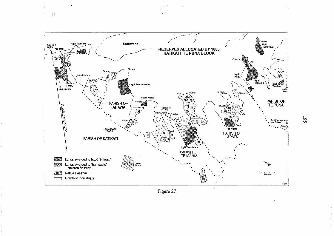
, \ Te Family \ Urungawera
,
\ , , ,
Matakana
\() '\0
"" W , ,~,
PARISH OF TAHAWAI a.
\~ ,!!?. \5' ,::I
\C. ,::I \co
I , ,-\
dID~~It'~AI
\ \
PARISH OF KATIKATI
, I
!fml Lands awarded to hapu "in trust"
[%1:&>1 Lands awarded to "half-caste" children "in trust"
1:<:tlR>j Native Reserve
c::::J Grants to individuals
'" I"~ g. ........ 1 \ t..::I
\ \
.<7~.~ .: . .t~~~ Tunbor
-{~,;~~:~.:
;'e!{; :~,~{~ Rosorvo
RESERVES ALLOCATED BY 1886 KATIKATI TE PUNA BLOCK
Te~
PARISH OF APATA
PARISH OF
.,. .-\
, TE MANIA " ....... ...., ,.- - .... _\ ,~ , ~
,, __ -- .... I
\ ~-" / "" :' ,. .... 49 ' r ..... - ,
:':-SO~'. , .... - 1 ':N~'; -. <"'~' .
Figure 27
, , , PARISH OF TEPUNA , , ,
I
, ,
'~
1
k11on:otres
, ,
TcNaarc
,..... \0 Ul
196
''Half-Caste'' Families: (
Faulkner Family: Lots 18,20,22,85,86 and 87 (380 acres) Parish of Katikati Hori Parengarenga and others: Lots 132 and 133 (82 acres) Parish ofTe Puna.
Individual Grants:
Parish of Apata:
Lot 205 (100 acres) MereTu 206 (100 acres) Mere Taka 207 (200 acres) Raniera Te Hiahia :208 (100 acres) Hamiora Tu 209 (100 acres) Hori Tupaea 210 (20 acres) Merita and Rakera 212 (200 acres) Hone Mutu, Horomona and Wera 213 (20 acres) NeriNgarae
Parish of Katikati:
Lot 2 (50 acres) Hori Tupaea and Te Moananui 19 (15 acres) Rapata Te Arakiri (Te Pokiha)
( 23 (31 acres) Wi Kotero ,
Parish of Tahawai:
Lot 1 (50 acres) Hira Te Tauri 3 (50 acres) Hohepa Hikutaia 4 (91 acres) Enoka Te Whanake 5 (100 acres) Enoka Te Whanake 6 (50 acres) Hohepa Hikutaia 7 (50 acres) Hamiora Te I wipau 11 (200 acres) Hohepa Hikutaia 12 (250 acres) Te Moananui Maraki 13 & 14 (300 acres) Ngarae and Te Moananui Maraki 15 (50 acres) HamioraTu 17 (53 acres) Enoka Te Whanake 18 (50 acres) vested in 9 owners 19 (30 acres) Timi TeRua 21 &23 (100 acres) vested in 8 owners
(

197
Parish of Te Mania:
Lot 19 (100 acres) Merania Te Rangihau 20 & 23 (100 acres) Hohepa Hikutaia and Merania McMillan 24,25,26 & 39 (514 acres)Taraiti and Wiremu Parera 27 (100 acres) Pane Titipa 28 (60 acres) Hohepa Tangatahau 29 (50 acres) Kiepa TeAmohau 32 (150 acres) Hatiwira Uruwahaika 34 (50 acres) Paratoenga 36 (80 acres) Ruka Tamakohe 37 & 38 (350 acres) Ngapuru and Te Puru 41 (100 acres) Hamiora Tangiawa and Waiari 42 (80 acres) Tewi 43 (50 acres) Harawira Kotai 44 (100 acres) Herni Paama, Romana, Teira Rewarewa and
WiremuHeti 45 (100 acres) Te Puru 48 (120 acres) Ngatira and Te Kiri 49 (100 acres) Te Moananui Maraki 68 (80 acres) Merania McMillan
Parish of Te Puna:
Lot 51 (25 acres) (28 acres) (50 acres)
186 210
Native Reserves:
Lot 73 & 74 (467 acres) 20 (104 acres) 75 (47 acres) 50 (100 acres)
Hamuera Mere Toke and Tekiteki PeneTaka
Parish of Katikati ("Timber Reserve") Parish of Tahawai Parish of Tahawai Parish of Te Mania ("General Wood Reserve")
Note: Tutaetaka, a small island of 3 acres, was vested in 19 owners but became an urupa
reserve. No title was ever issued for Motukouru (Motukoura) which is the subject of an
application to the Maori Land Court for investigation as Maori customary land. Neither of
these islands was part of the Katikati Te Puna Block.
198
The ''Lands Returned"
In 1886 Commissioner Brabant completed a report on the "Lands Returned to Ngaiterangi
Tribe under Tauranga District Land Acts" (AJHR 1886, G-lO). Brabant and previous Com
missioners had "dealt with" 210 separate blocks which he suggested had "a gross area of
136, 191 acres". In Volume 2 of this report these blocks and their original owners have been
listed and indexed by name of block and owner. No attempt will be made here to summarise
what amounted to a total individualisation of title to all the "Lands Returned" to Maori
within :the Tauranga confiscated lands. There was no investigation of title recorded as re
quiredin the Native Land Court. With no record at all for many blocks beyond the list of
original owners held in the Maori Land Court, and only fragmentary records of proceedings
for others, it is impossible to establish the basis for many of these lists.
Every block was vested in multiple individual owners, and numbers in each block ranged
from less than 10 to over 100. There were no "hapu reserves" , although it seems that hapu
leaders did produce separate lists of people to be included in the final list. The result was that
(
for each block, the list of owners may include one or more hapu, plus a few other individuals (
who may have had no ancestral rights. This certainly appears to have been the interpretation
documented in subsequent Native Land Court decisions (see Appendix 3) which indicate
that ancestral rights and occupation were not the only basis for allocating individuals to
blocks of land. This view was set out in a decision on partition of Te Umahapuku No.1
Block on Matakana Island made in February 1912 by Judge Browne:
:Ma,!ahou contended that the rights to the land were decided according to. Native custom bur this is not correct. All the rights according to Native custom were wiped out by the confiscation of the land and the land is therefore to all intents and purposes a gift from the Crown to the persons in the list. It is true that many persons have been included who if the land had not been confiscated would have been entitled as owners under Native custom. But again as Matahou admits a great many others were included who had absolutely no right to the land according to Native custom (Tauranga MB 7/135).
It has been a frequent complaint in Tauranga Moana that lands were awarded to the "wrong"
people. This occurred in allocation of reserves in the Confiscated Block and Katikati Te
Puna Block. It also occurred in the Lands Returned, but the extent of this remains impossi-
(

"LANDS RETURNED": THE INLAND BLOCKS
• Kainga Block Boundary Subdivision of Block
Iwwii!l Reserves - Parish of Te Papa _. .._... Boundary of Confiscated Block
199
Figure 28
CONFISCATED BLOCK
o 1 234 5
kllomatres
ble to demonstrate. Any analysis of particular names, and the blocks they are listed in, is
frustrated by a lack ofrecord of which hapu or ancestor an individual may have been claimed
to have rights, or whether other factors were paramount, including finding land for "loyal"
Maori and "returned rebels" whose ancestral lands may have already been taken on the Con
fiscated Block or disappeared in the Katikati Te Puna "purchase". The Commissioners had
arbitrary powers to allocate individuals in blocks, and left little record of why their decisions
were made. There is also little record of why the land was divided up in the way it was (see
Figures 28, 29 and 30). Whether this was the work of surveyors using convenient land
marks, or whether various hapu pointed out their boundaries is not recorded. Maori chainmen
were employed by survey parties in the late 1870s and 1880s but not in the 1860s when there
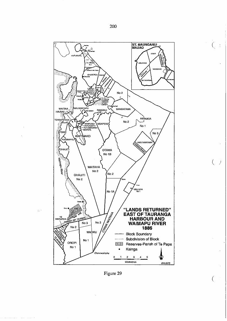
200
• o
Figure 29
"LANDS RETURNED" EAST OF TAURANGA
HARBOUR AND WAIMAPU RIVER
1886 Block Boundary Subdivision of Block Reserves-Parish of Te Papa
~ Kainga
2 3 4 5
kilometres
('
( /
(

OTUROA
PARETATA No2
o 1 . 2 ! " ,i I I ,., t !
kilomotros
201
"LANDS. RETURNED" MATAKANA and RANGIWAEA
·1886
Figure 30

202
was so much opposition to surveys. As will be explained in more detail in Chapter 14, all the
hapl1 of Tauranga Moana had their ancestral rights and title to these lands extinguished, and
subsequent lists of owners in each block represented adjustments to accommodate those
who had lost lands in the Confiscated Block and the Katikati Te Puna "purchase". These
comments also apply to the inland reserves in the Parish of Te Papa to which owners were
allocated in the 1880s (Figure 28).
The Quality of the Land
The physical environment of Tauranga Moana varies from rugged, forest-covered hill coun
try of the Kaimai Range, merging in the south with the undulating surface of the Mamaku
plateau which on its fringes is deeply dissected by gullies formed by northward flowing
streams, to the coastal lowlands around the harbour. The Kaimai Range is an uplifted block
with its steep scarp facing west towards the Waikato and on its eastern side sloping more
gently in undulating hills towards Tauranga Harbour, which with rising sea levels about
20,000 years ago, has drowned a former dissected hill country region. The coastal lowlands
around the harbour are broken by swamps and small areas of alluvial deposits. The ranges (
are made up of older andesitic rocks, ignimbrites and rhyolites, the latter forming outcrops at
prominent landmarks including Mauao (Mount Maunganui), Mangatawa, Minden and
Bowentown Heads. The lands adjoining the open sea of the Bay of Plenty are made up of
sands, forming tombolos attaching Bowentown Heads and Mauao to the mainland, and a
bar ac,f.oss the harbour forming a substantial part of Matakana Island. The highest points of
the Klijrnai Range are over 600 metres above sea level (Figure 31). :.'\f:' " . ,1"'.':
The soils formed on this land are closely related to the ash showers that have covered the
older volcanic rocks. The soils formed on Taupo and Kaharoa ash were deficient in cobalt,
and the disease in stock called "bush sickness' was first identified in the region in the nine
teenth century and often called "Tauranga disease". It was not until the 1930s that the lack of
the trace element cobalt was identified as the cause. In much of the hill country the land was
too steep to form complete soil profIles or was otherwise affected by hilly slopes. Around
the harbour on the coastal lowlands, agriculture and horticulture was possible almost every
where except in the deep swamps, or coastal sands (Figure 32). The steep hill country was
(

Under 150 m
150 - 300m
300 - 450m
450 - 600m
Over 600m
, , .. , , , , ,
Watershed on Kaimai Ranges
, , ,
203
Figure 31
RELIEF
5 10 ~-L~~!~!~-L~!-L!~!
kilometres
GMO:3197
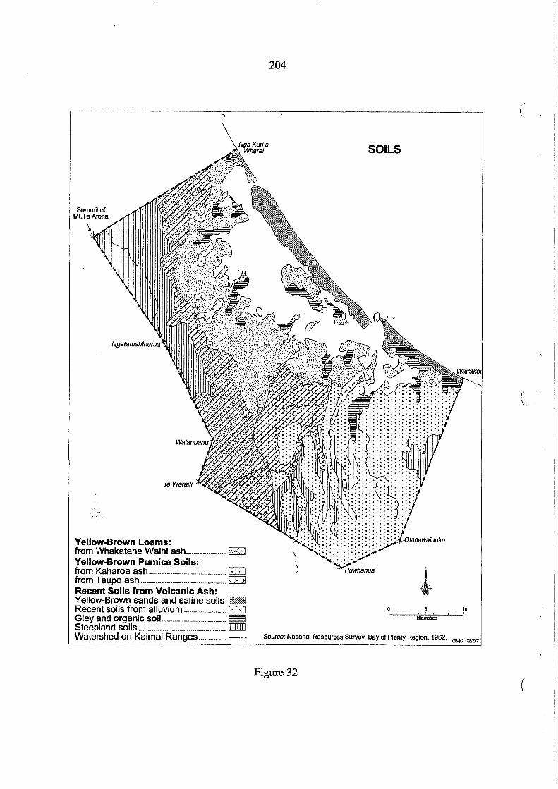
Summit of Mt.TeAroha
Ngatamahinerua
Yellow-Brown Loams: from Whakatane Waihi ash ____ uu _______ u ____ .I·:·:::::·.:(j Yellow-Brown Pumice Soils: from Kaharoa ash __________________________________________ c=;] from Taupo ash _______________________________________________ G2l Recent Soils from Volcanic Ash: Yellow-Brown sands and saline soils IllR Recent soils from alluvium -----------------------Illl Gley and organic soiL. ________________________________ ~ Steepland soils _______________________________________________ [[[[[[] Watershed on Kaimai Ranges ______________ . - --
204
(
SOILS
(
5 10 ! !
kJlometres
Source: National Resources Survey, Bay of Plenty Region, 1962. GMO: 12/97
Figure 32 (

mmww Coastal scrub
~'"J'"3 Swamp
Fern and Manuka
(4t~f~~~ Podocarp Forest
,. Scattered Kauri
Confiscation Boundary
Watershed on Kaimai Ranges
205
Figure 33
VEGETATION c.1860
5 10 I I I I
kUometres
GMO:2/97

206
covered in forest in 1860 (Figure 33) and much of it still is, albeit modified by logging and (
the depredations of deer, goats and opossums, or replaced with exotic plantings. The coastal
lowlands were in scrub, the result of clearance for cultivation by many generations of Maori
occupation.
In assessing the quality of land, three categories can be identified: inland forested hill coun
try; undulating lowlands around the harbour; and coastal sands and swamps. Caution is
required in assessing quality, whether the perspective is from Maori customary usage or
potent~,al for economic development. All of these lands were mahinga kai, although the
principal horticultural areas were around the harbour shores and selected sites near the forest
edge in the catchments of the Te Puna, Wairoa and Waimapu Rivers. These same lowlands
were also seen by Pakeha settlers as the most desirable for farm development, while the
forested ranges were a source of timber, and possibly gold and other minerals, which had
been reported by the late 1860s.
The resources of the waterways, rivers, harbour and open ocean were also part of the tradi-
tional mahinga kai and no distinction was made between areas above and below mean high (
water mark. As Hori Ngatai said (in English translation) to Native Minister Ballance in
1885:
Now, with regard to the land below high water mark immediately in front of where I live [at Whareroa], I consider that is part and parcel of my own land ... part of my own garden. From time immemorial I have had this land, and had authority over all the food in the sea (AJHR 1885, G-l).
The Co,mmissioners dealing with Tauranga lands had mostly avoided any consideration of
Maori customary rights to the resources of the waterways. On 2 February 1888 Commis
sioner Brabant wrote to the Native Minister, commenting on a claim by Tawaha Te Riri and
Timi Te Rua ofNgai Tamawhariua to the shark fishery at Katikati, i.e. in the waters off the
Katikati or Bowentown entrance to Tauranga Harbour:
The letter of the Katikati natives is intended to open a very large question. Ever since I have acted as Commissioner to decide titles within the Confiscated Block I have been from time to time asked by various natives to decide the native title to 1) Salt water marshes (where birds and eggs are obtained), 2) Sand flats and islands covered at high water (where shellfish are obtained) & 3) Fisheries within the harbour.
(

207
I have always replied to such applications, that I did not understand my Commission to extend to anything below high water mark. Mr Commr. Clarke's letter of Decr. 6,1871 was brought to me to prove (as the natives thought), that he was of a different opinionwhen I pointed out however that Mr Clarke had only given the right of fishing to them subject to Sir D. Mclean's approval (which had never been given) they asked me to forward a letter of theirs to Mr Ballance enclosing Mr Clarke's letter which I did without remark. In order that the importance of the question may be understood I may point out that any recognition of these fishery claims of the natives wQuld result 1) in their preventing all fishing by Europeans in the harbour & 2) in the various hapus quarrelling amongst themselves as to the right to fish at particular spots (DOSLI files 5/28).
The response from Wellington was predictable: the Minister accepted the advice of a Native
Department official, W.J. Morpeth:
I do not think it is necessary to go into the question of the fishery rights wh[ich] is a rather vexed one, but merely reply in respect of Mr Clarke's old letter.
I suggest that the natives be informed that Mr Clarke has been communicated with & he says that he only gave the natives who referred the dispute to him the right to fish for sharks for the one season, but that it was not to be continued without the sanction of the then Native Minister, that sanction it appears was not given (DOSLI files 5/28).
Brabant was told to write accordingly to Tawaha Te Riri and Timi Te Rua and he did so on 15
February 1888.
Maori customary rights to fisheries and mahinga kai in the swamps, waterways and sand
banks of the harbour were not at any stage acknowledged by officials dealing with Tauranga
lands, with the possible exception of Clarke's approval of one shark-fishing season. Al
thougl;tMaori continued to fish, and take birds and shellfish, and so exercise their customary
rights ,there was no legal recognition of these rights in the Tauranga district. In 1885 Ballance
told Hori Ngatai that the Queen owns the land below high water mark. When the Commis
sioners for Tauranga Lands awarded reserves along the coast the grants were for the area
above highwater mark, that is they had riparian rights. But subsequent partitions and subdi
visions have ensured that riparian rights have been replaced on most blocks with an espla
nade reserve, the "Queen's chain". While fisheries and waterways issues are beyond the
scope of this report, it is a significant part of the context of allocating reserves to Maori in the
Tauranga confiscated lands that the Maori perspective on the indivisibility ofland and water
was ignored.

208
Population Patterns (
In February 1864 Civil Commissioner T.H. Smith compiled two returns of the adult total
male population of the Tauranga district, and those who had gone to the Waikato to join the
fighting against British troops who had invaded in July 1863 (A1HR 1864, E-2, pp. 13-14).
He also provided a sketch map reproduced in Figure 34. One list showed a total adult male
population of 571 and the other of 542. Using the list with a total of 571 men (List 1) the
male population has been mapped on Smith's sketch map, with additional place names.
Both lists, showing hapu (the spelling of the original is retained) and kainga are reproduced
below:
List 1: Smith's Return of Adult Male Population 1864 No. on Settlement Tribe Gone to Total Adult Map Waikato Males 1 Maungatapu Ngatihe, Ngatiwhainoa )
Ohinekahu Te Whanauwhero ) Auhi Tokitoki Ngatirakei, Ngatiruea ) TeApititu Te Matekiwaho ) 5 74
2 Poiki or Hairini (hoisted King flag) Ngai te Ahi 16 30 ( Poihakena, Ranana N gatiruahine 3 11 Okaeke, Tongaparoa Ngatitama, Ngatirehu 0 13
3 Te Matapihi, Tumatanui Karikari, Te Mania, Te Rangihouhiri, Ngaitukairangi ) Te Rauwahine Ngapotiki, Ngatitapu, Ngatiuarere ) 10 78 Otuawahia Ngatipau 0 12
4 Opoutea Ngatirawharo 0 20 5 Huria Ngaitamarawaho 18 30 6 Otumoetai W Patutahora 2 13
Otuatara (hoisted King flag) Te Matewaitai 19 25 7 Peterehema Ngatihangarau 19 21 8 Papaoharia, Poteriwhi Ngatitamahapai, Ngatirangi )
Pukekonui,Purakautahi Ngatipango, Ngatimotai ) 30 43 9 Opounui TeNgare 4 30 10 Matakana Ngaitamawhariua 30 31 11 Poututerangi (hoisted King flag) Te Pirirakau 23 27 12 TeNgarue Ngatitokotoko 20 21 13 Motuhoa TePohoera 4 12
" I Tuhua, Mayor Island Te Urungawera 19 23 Motiti,Orongatia Te Whanau 0 Tawhao, )
Te Papaunahi ) 11 22 Otungahoro, &c. TePatuwai 0 35
233 571 (

'~-....--- ~
J~'~" . ',/;7'
v I/."! .. !/
r.( '.: (1(( , t· \\11 '<. .,) '." ',\,.' ··M
TE NGARUV';" .~~ .. . ~: I . . • ~ :1'
12 '''\;\'' I".':, MATA, ~.,~;Ir!£~~'~~~ '. . . ! ~,;,
~'I:;" 1;' l ·0 ; ~ .;~ ~
('\"i/.: :1 ,I. . ; ,. .. .. 'q ~. . ; \'1
~' " '" \'::;\~ ~,"\II?
TE PUNA''J. ~.~'·th i,! ~"~~~}:~~I
' . Jill'; '.:€~' ':":~ri v.) 11i-:-~~_-,.) ,'!~
.. .'~;,'. ,.::- '::' il.~\~\ll~\' II ~"":~!(~. / .
J'" OpoU I:' 9 Ji j( \~: ' ~ ,':\.~~ANGIW ~,,' A
\.: .'-.- 'i~ ~; ;! , 01' ,( \' . ~f>o.\\\ ..,l, ~ .,=-.,.
~~~-'" ." .. '~l': ,\. 0' «.1'~I,j\\'IMUNGANUI :.~~~!~,,:-,-- l\'~ : ": <:·.t~r{ :'
0' 7 .1" ,II'~: I\;'! 'l" 8 OTUMOETA1" ." :," ,\' / 6 ~l'\" .,} 'II
\ ' lll" ,'/ l' ~/ 1~:' . ,'f " q, ...dJ :/ ,-;iJ !i _ ___ - "=---= =--............ : I •• :; ! i
~ . Il I 'i.l , \ TE PAPAp, "" \i~:. 4 l;
L ,:., ',\1, ~l, :. "" \'
... ~ ~!r'<'~'['~:=-::;'~"'=-):' :\ .7/ r'.7/~'~,:,,:;:';Ef;:,i.iIllX1ATA:1?11! 3'" \\ o()\\l.€. /..-=--.:"-',, , . _ " ., ~\ < 2 ~= Jl"~'" .' ; U"'G"'''I\PU2,.:::~- , flIl\ " ff~''\""." :---, \ \
",,\~. '-;..}).: , ;
T.H. SMITH'S SKETCH MAP ':'( ;:.~:~,' .: \~ February 1864
TE NG~~~}" • .."):N
: 21 ~ , . , . ' .......... "
.jJ,'I'
J"~'i :·:ll
(iff \:~~ , \~
.. -.... \. r'" . :: 31 : NO of adult males . .........
""\~ '\\ I}
'i," .
fiji ff,'.'
f"
'.i)li ·1~
MATAKA~;z.i~'{';\{\ 1;[[' 31': .:' i,l
~ '1' "'.-' ii' it , /1:',' ,f ")' i.li \i, IJ/ ,', I \ 1.:"\,1/ .. , :1. ~, ), .
i' :. q ill ), " ~" " 1,1 ,I~ i .
, ' .; ,;~ I, fl
~""",\tl? ' 1,\
Not Mapped: Tuhua 23 Motiti 57 Total adult males 571
TePuna Stream "). ~'-:-'- .~", 9. ~'. ~"f~ I)"
'<,-- ",~, ',~ q i 1\ ",,-- Ilri\'e~'''. ':,~r' ji! . ~ l ·'d~~",,--',!, ,'jl, \~~ ,
: ... ~., . ,..' .. f\K\~ ,1.t(r-·, III I ! POUTUTERANGI 27 \\\", '''YIII.' I '. ,I
\. ~'" Opo'u~¥Jr':'3-0: i); ;, ... --------\.~, \~~~>--/}?r:' NGIW ~A \' , \\01' " J
_----. ~' . ~f>o.\, i, i1 ,,=-"
PUKEKONUI ". ~gr"'" -- '~\,: , \.(1" «.,f~~~!IMUNGANUI : :. ~.;.r--·~--!~·PETEREHEMA U\~ : ': -:\t:~'·(\~ :' • //C' PAPAOHARIA ',21 " • '. I '~' " '
" / •• --.' '. ~l", .!J '1\ \' ---. ' 38 ~"r" ,f I' \ /. ,.- 30 .... ... i;!. " 'f ' .
'',I:: 43 ,/ --OiUMOETAI':' \' :',1,1.; IN "-'. .. 'I HilRIA.. \ '. OTUATARf\ ./~.. J! ',' VI'" , _____ . . ,,' =.~: .'," '/ ". \1 i , .... .TE -PAPA~"; i I iJ ", '\ ---' LfJ' ""~\V· ,l,
,. ••••• ---::--........ " ',~': ," ':\\~HA;~ROA ~l i \ • ~ .• ""-,,,=- • ~ """. ,,'-', ,~ 1\\ \ " '-rr"~ :,,'>.~ ~.'7:-."¥.!.'!,'" r"::-'''"",- .,.>:'~" OPOUlFl\'.
: '(' r ,/,~,*-' ,;f; IIIATA:l?llj~li - ,~-, .. :, \\1' ' :~\)\\t.€.~.# </f.CE.~-"~._ '~":.~~,; ATANU,I.~'/ ~\\\ ... v. .. (t>~'" 54 HAIRINI G·p,.,.i\p~:(f~;·· J.t:~90 '... " '. flII\UN.. ~""'~""":-:'-' ' \ •••• • •••• " .: "'~". '-'.' 'j \'.- ! \.
---- ______ -... AUHITOKlTOKl'~ 'J, "..:J. • KJI!lIKAR! .
T.H. SMITH'S "CENSUS" -··-.••• 74:· :::-;.~::- -.:: ,/ '\\ February 1864 ···-_____ .. -oHINfiKAHU \'
Source: AJHR 1864. E-2 .
~
Figure 34
N o \0

210
Summary (
East Side of Tauranga 34 out of 238 West Side of Tauranga 169 out of 253 Islands off the Main, not down [sic] in Sketch 30 out of 80
233 out of 271
List 2: "Return showing the Number of Natives who have joined the Waikato Insurgents"
No. on Sketch Names of Native Settlements Gone to Total showing Waikato Adult Male Localities (Adult Males) Population
1 Maungatapu ) Ohinekahu ) Aubi Tokitoki ) TeApititu ) 5 73
2 Poike or Hairini ) Poihakena, Ranana ) Okaeke Tongaparoa ) 18 53
3 Te Matapibi, Tumatanui ) ( Karikari, Te Mania, Te Ruawahine ) 7 66 4 Opoutea [0] 20 5 Huria, Otuawahia 18 41 6 Otumoetai W, Otuatara 20 36 7 Peterehema 19 21 8 Papaohara Poteriwhi )
Pukekounui, Purakautahi ) 29 41
9 Opounui (Te Ngare tribe) 4 30 10 Matakana, Tuhua, Motiti 93 105 11 Poututerangi 23 27 12 Te Ngarue 20 21 13 Motuhoa 4 8
[Total] 260 542
'" In the following table the figures for total adult males from List 1 and List 2 have been put
together, retaining the group numbers on Smith's lists:
(
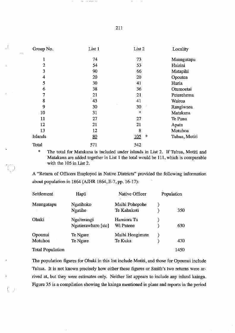
211
Group No. List 1 List 2 Locality
1 74 73 Maungatapu 2 54 53 Hairini 3 90 66 Matapihi 4 20 20 Opoutea 5 30 41 Huria 6 38 36 Otumoetai 7 21 21 Peterehema 8 43 41 Wairoa 9 30 30 Rangiwaea
10 31 * Matakana 11 27 27 TePuna 12 21 21 Apata 13 12 8 Motuhoa
Islands 80 105 * Tuhua, Motiti
Total 571 542
* The total for Matakana is included under islands in List 2. If Tuhua, Motiti and Matakana are added together in List 1 the total would be 111, which is comparable with the 105 in List 2.
A "Return of Officers Employed in Native Districts" provided the following information
about population in 1864 (AJHR 1864, E-7, pp. 16-17):
Settlement Hapu Native Officer Population
Maungatapu Ngatihoko Maihi Pohepohe ) Ngatihe TeKahukoti ) 350
Ohuki N gaiterangi Hamiora Tu ) Ngatierawharo [sic] WiPatene ) 630
Opounui TeNgare Maihi Hongimate ) Motuhoa TeNgare TeKuka ) 470
Total Population 1450
The population figures for Ohuki in this list include Motiti, and those for Opounui include
Tuhua. It is not known precisely how either these figures or Smith's two returns were ar
rived at, but they were estimates only. Neither list appears to include any inland kainga.
Figure 35 is a compilation showing the kainga mentioned in plans and reports in the period

Bush - - - • Confiscation Line ............. Watershed on Kaimai Ranges
~,
~
Figure 35
~. ,~
N ;-...>
N

213
1864-65. This does not mean all were occupied at the same time, although many were
permanent settlements. In particular, Otumoetai and Maungatapu were often described as
principal settlements. For many Ngati Ranginui hapu their traditional pattern of settlement
included both coastal and inland kainga on the forest margins, and there was a good deal of
mobility between them.
The calculation of total population from an estimate of numbers of "warriors" is problem
atic. In his book Te Iwi Maori (1991, pp. 34-35) Professor Ian Pool quoted the French
demographer Rallu and suggested "that a ratio of 3.25 persons per male 15-64 years would
be reasonable". If Smith's estimate of 571 adult males (very few of whom would have been
over 64) is multiplied by 3.5 this gives a total of 1998.5, approximately 2000 total popula
tion. This may be excessive, and a ratio of 2.5 to each adult male may be more appropriate.
This figure was appropriate in a comparison with the 1878 and 1881 Maori census for the
Tauranga district:
Year No. of Adult Males
1878 Census 438 1881 Census 410 1864 Smith's Census 571
Total Population
1091 1020 [1428]
Ratio
438x2.5 = 1095 41Ox2.5 = 1025 571x2.5 = 1427.5
This estimated total of 1428 is comparable with the total of 1450 compiled from the 1864
Return. However, in none of these totals can it be guaranteed that the total popUlation was
counted. A return sent to the Colonial Office in London in 1868 suggested that the "prob
able":number of Maori in the Tauranga district was 1168 (GBPP 1868, vol.15, p. 127). It is
likely that many had taken refuge inland and were not counted. The death toll in fighting in
1864 and 1867 could also account for a drop in total population. However, all these figures
have to be used with a great deal of caution as they are only estimates and the actual total
population is not known.
The first census of Maori popUlation was conducted in 1874, and again in 1878 and 1881.
All these provided information in terms of hapu and kainga (later censuses did not). The
figures for Tauranga district are summarised in the following tables:

214
Maori Population 1874 (AlHR G-7, 1874, pp. 7-8): (
Hapu Residence Total Population N gaiterangi [sic] Whareroa, Poripori 146 Ngati Hangarau Peterehema, Opounui 132 Ngati Whainoa Maungatapu 100 NgatiHe Maungatapu 63 Materawaho Matapihi 84 Ngai Tamarawaho Huria 58 Ngati Mateika Oruamatua 47 Matekiwaho Oruamatua 17 Ngai Tuwhiwhia Opureora 55 Whanau a Tauwhao Rangiwaea 86 Te Urungawera Katikati, Tuhua 57 Ngatiwakarua* [sic] Papakura 22 Ngai TeAhi Hairini 89 Ngati Pilkenga Otu [Ngapeke] 68 NgatiKahu Poteriwhi 17 Ngati Tama Poripori 12 Pirirakau Te Puna, Te Umu 0 Korongaehe 69 NgatiRangiwewehi Omokoroa 54 Patuwai Motiti 69 Total 1,245
* This name may be an error; the Papakura reserve was awarded to Ngati Teoteo
Maori Population 1878 (AlHR 1878, G-2, pp. 20-21): (
Hapu Residence Total Population Ngati Mateika Oruamatua 45 Matekiwaho Orumatua 18 Ngati Whainoa Maungatapu 88 NgatiHe Maungatapu 47 Ngait~rangi [sic] Whareroa 131 Mateiawaho Matapihi 69 Whanau a Tauwhao Rangiwaea 65 Ngai TeAhi Hairini 87 Ngai Tamarawaho Huria 56 Ngati Hangarau Peterehema, Opounui 107 Ngati Pilkenga Ngapeke 60 Ngati Kahu Poteriwhi, Rangiwaea 28 Te Urungawera Katikati, Tuhua 40 Ngai Tuwhiwhia Opureora 51 Pirirakau TePuna 65 Ngati Whakama* [sic] Papakura 16 Ngati Rangiwewehi Te Umu 0 Korongaehe 45 '(
Patuwai Motiti 64 NgatiHaua Opureora 4 Total 1,086
* This name may be an error for Wakarua (see 1874 list) or Whakarua; the Papakura reserve was awarded to Ngati Teoteo. (

215
Maori Population 1881 (AJHR 1881, G-3, pp. 19-20)
Hapu
Matewaitai Ngatipau [sic] Materawaho Matekiwaho Ngati Mateika NgatiHe Ngati Pukenga Ngai TeAhi NgatiRehu Whanau a Tauwhao Patut6hora TeNgare Ngai Tuwhiwhia NgatiMura Ngai Tamarawaho Ngati Hangarau Ngati Pango NgatiKahu NgatiRangi Pirirakau Ngatirau [sic] Ngati Teoteo Ngati Hurimaioro Te Urungawera Ngati Rangiwewehi Total
Residence
Whareroa Whareroa Matapihi Otuawahia Mangatawa Maungatapu Ngapeke Hairini Waoku Rangiwaea Rangiwaea Opounui Opureora Kutaroa Huria Peterehema Wairoa Wairoa, Kaimai Huharua Raropua Rereatukahia Rereatukahia Tuapiro Tuapiro, Tuhua Huharua
Total Population
33 20 56 23 67 91 31 64 33 26 32 47 38 31 72 71 25 31 15 47 27 23 14 49 54
1,020
In the Hauraki lists for each census was a category "Gum Diggers from various parts of the
Island". Some of these would have been Tauranga people. The total number of immigrant
gum diggers in the Hauraki district were listed: 150 in 1874 (AJHR 1874, G-7, p. 7); 50 in
1878 (AJHR 1878, G-2, p. 20); and 50 in 1881 (AJHR 1881., G-3, p. 19). In Figure 36 the
population figures listed in the 1881 census have been mapped, and the kainga listed in the
1874 and 1878 censuses which no longer appear to be occupied are also shown. This may be
deceptive. Very few inland kainga are shown but there could be several explanations. They
may have been occupied seasonally, but not at the time of the census. Some kainga were
abandoned after people were killed in the fighting in 1867, but the lands were not abandoned
in the 1870s. Because the inland kainga were still regarded as hostile territory in the 1870s
enumerators may have avoided going there. Alternatively, the enumerator may have only
listed the principal settlement of a hapu on the coast and included the total for that hapu
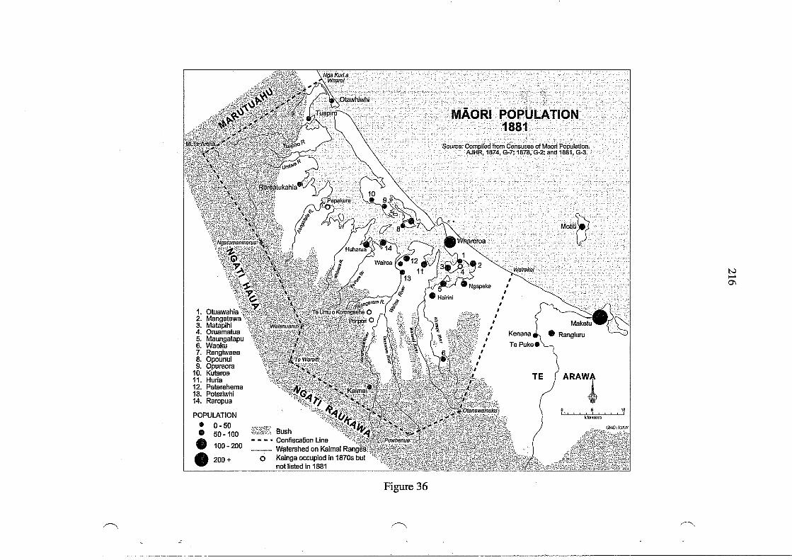
~
.:
1. Otuawahia 2. Mangatawa 3. Matapihi 4. Oruamatua 5. Maungatapu 6. Waoku 7. Rangiwaea 8. Opounui 9. Opureora
10. Kutaroa 11. Huria 12. Peterehema 13. Poteriwhi 14. Raropua
POPULATION
• • • • 0-50 50-100
100-200
200+
Bush - - - • Confiscation Line ........ ,.... Wlltershed on Kaimai
o Kainga occupied in 1870s but not listed in 1881
Figure 36
.~
ARAWl 5 10
I ! • !
kilometres
~
N ...... 0\
217
under that. Once again, the Maori census figures have to be treated with a good deal of
caution but they are indicative of where the Maori population was located.
''Leading Men"
A relevant issue is the concept of "leading men" or "chiefs" who were recognised by govern
ment officials. One form of recognition was an appointment as "Assessor" under the Native
Circuit Courts Act 1858. In 1864 the following were recorded as appointed to this position
at a salary of £30 per annum: Maihi Pohepohe, Te Kahukoti, Hamiora Th, Wi Patene, Maihi
Hongimate and Te Kuka (AJHR 1864, E-7, p. 17). A list of "leading men" included in a
dispatch to the Colonial Office in 1868 included: Hamiora Th, Wiremu Parera, Enoka Te
Whanake, Te Kuka, Maihi Pohepohe, R. Te Hiahia and Te Ranapia (GBPP 1868, vol. 15, p.
127). Another list of "chiefs" recorded by Mackay included those who accompanied him on
the "PirirakauExpedition" in November 1866: Enoka Te Whanake, WiremuPatene, Wiremu
Parera, Hori Ngatai, Ruka Tamakohe, Hamiora Tangiawa, Maihi Haki, Hamiora Th, Raniera
Te Hiahia, Wiremu Te Matewai, Ngamanu, Wanakore Maungapohatu, Te Kuka Te Mea
(DOSLI files 1/6). Each of the 14 "chiefs" received a land grant of 7 acres at Te Puna for
their assistance. Unfortunately, few of these lists of "chiefs" included their hapu affiliations,
and most could claim kin connections to more than one. Many of these names appear in land
grants but it was not always clear whether such awards were made to individuals as outright
owners, or as trustees for their hapu. Nor is it clear on what basis the awards were made, but
"loyalty" , "compensation" and "services rendered" were all factors. It is not possible to take
this discussion much further because neither Clarke nor Mackay provided sufficient docu
mentation of the reasons for recommending particular grants.
A related issue is whether Maori concepts of leadership were adequately recognised. The
"loyal chiefs" were recognised by officials but one perceived as a "rebel", especially an
"unsurrendered rebel", was not recognised, regardless of his status in Maori terms. In his
1872 report Sergeant Major Philip Putnam of the Armed Constabulary listed the "loyal chiefs"
as: Hamiora Th and Raniera Te Hiahia (who both "acted as guides for Imperial Troops")
also Hohepa Hikutaia, Te Kuka and "a few others of lesser note". It is not at all clear how
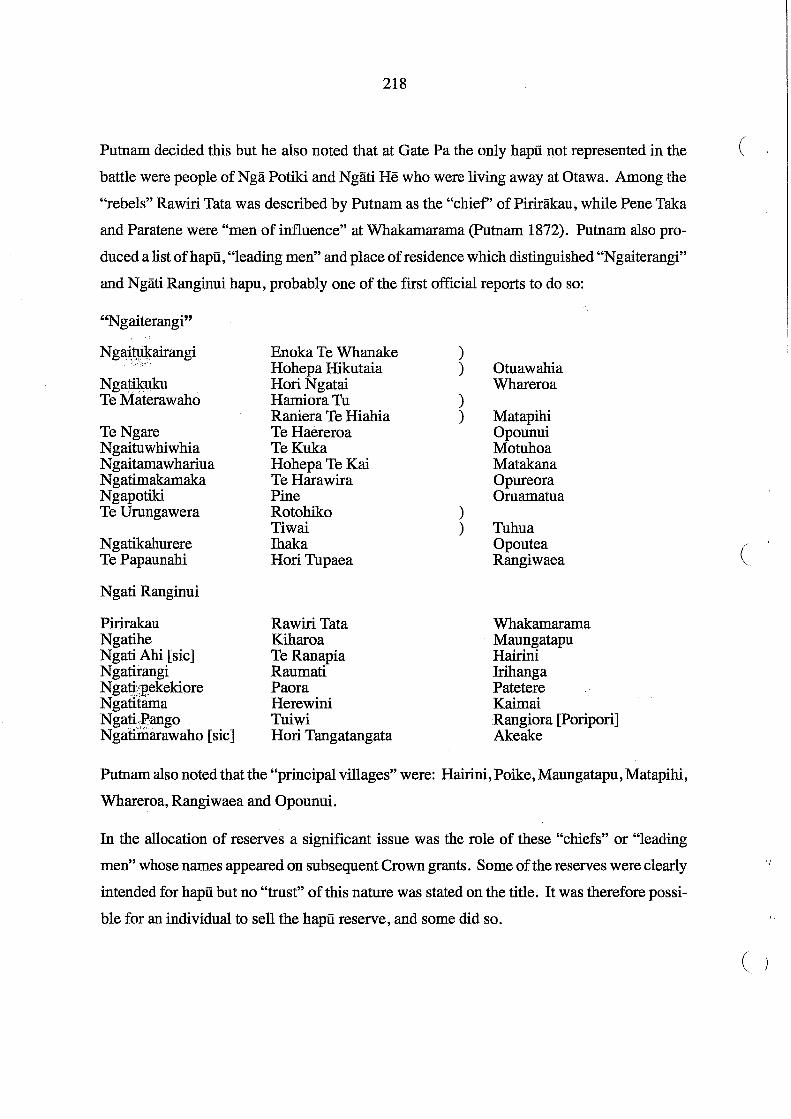
218
Putnam decided this but he also noted that at Gate Pa the only hapu not represented in the (
battle were people of Nga Potiki and Ngati He who were living away at Otawa. Among the
"rebels" Rawiri Tata was described by Putnam as the "chief' of Pirirakau, while Pene Taka
and Paratene were "men of influence" at Whakamarama (putnam 1872). Putnam also pro-
duced a list of hapu , "leading men" and place of residence which distinguished "Ngaiterangi"
and Ngati Ranginui hapu, probably one of the first official reports to do so:
"Ngaiterangi"
Ng~~airangi
NgatiJ.cuku Te Materawaho
Te Ngare Ngaituwhiwhia Ngaitamawhariua Ngatimakamaka Ngapotiki Te Urungawera
Ngatikahurere Te Papaunahi
Ngati Ranginui
Pirirakau Ngatihe Ngati Ahi [sic] Ngatirangi Ngati:pekekiore Ngatliama NgatiiBango NgatiIDarawaho [sic]
Enoka Te Whanake Hohepa Hikutaia Hori Ngatai Hamiora Tu Raniera Te Hiahia TeHaereroa TeKuka Hohepa Te Kai TeHarawira Pine Rotohiko Tiwai Ihaka Hori Tupaea
Rawiri Tata Kiharoa Te Ranapia Raumati Paora Herewini Tuiwi Hori Tangatangata
) )
) )
) )
Otuawahia Whareroa
Matapihi Opounui Motuhoa Matakana Opureora Oruamatua
Tuhua Opoutea Rangiwaea
Whakamarama Maungatapu Hairini Jrihanga Patetere Kaimai Rangiora [Poripori] Akeake
Putnam also noted that the "principal villages" were: Hairini, Poike, Maungatapu, Matapihi,
Whareroa, Rangiwaea and Opounui.
In the allocation of reserves a significant issue was the role of these "chiefs" or "leading
men" whose names appeared on subsequent Crown grants. Some of the reserves were clearly
intended for hapu but no "trust" of this nature was stated on the title. It was therefore possi
ble for an individual to sell the hapu reserve, and some did so.
(
'/
( )

(
219
Land Sales
The sale of many reserves by individuals named in Crown grants has already been alluded to
in Chapter 8. It has not been possible to follow up every grant but the fact that many were
sold was becoming obvious to several observers in the 1870s, including Commissioner H.T.
Clarke. In some cases, hapu reserves on the Katikati Te Puna and Confiscated Blocks were
able to be sold because the Crown grants were issued to individuals who were prevailed
upon to sell. There is little information about the context of many early sales, but the disrup
tion of war in 1864 and 1867, the reduced planting and destruction of crops , the mobility of
people and uncertainty about lands to be awarded, as well as indebtedness, all contributed to
sales in the 1860s and 1870s. By the late 1870s land purchase agents had gone further, by
imposing a voucher system which led to further indebtedness to storekeepers, plus the dis
ruptions of having to attend Native Land Court hearings on blocks outside the confiscation
line. These matters have been reviewed in Chapter 9, where it has been demonstrated that in
some land transactions the dealings can be described as fraudulent. The significant issue is
the failure of the Crown to enforce the restrictions on alienation which had been recom
mended. Even when a blanket restriction was imposed in 1878, it seemed all too easy to
have the restrictions lifted.
An undated list of "Lands Awarded by the Agent of General Government [Whitaker] in
March 1866" among Clarke's papers of the early 1870s (DOSLI files 2/13) indicated that the
following reserves in the Confiscated Block, all in the Parish ofTePapa, had been alienated:
Name, of grantee Lot No. Area in acres Remarks AnaruHaua 117 80 50 acres sold Wiremu Parera [16] 10 Leased Mere Hohepa (Patene) [113] 10 Sold Hohepa Hikutaia [17] 10 Sold Hamiora Tu and another 26 77 Sold Hamiora Tu and another [112] 100 Sold Tomika Te Mutu 109 100 Sold Turere and Te Patu 102 100 Leased Hamiora Tu and hapu 20 196 Sold TeKuka 92 100 Sold Hori Ngatai and hapu 21,107,108 85 Leased

Enoka Te Whanake Hori Tupaea and others Hamiora Tu and Ngamanu
110 103 100
220
81 110 50
Leased Leased
Sold
The sales of Lots 20,92,105 and 109 in the late 1860s have already been commented on in
Chapter 8. Not all ofthese sales had been completed because of delays in the issue of Crown
grants. For example, Clarke's authority for the issue of a grant for Lot 100, awarded to
Hamiora Tu and Ngamanu, was sought. Clarke responded on 15 July 1874: "This is one of
Mr Whitaker's compensation awards made in the year 1866" and recommended the Crown
grari{b~ issued (DOSLI files 2/13). The sale of the block was then completed.
Even those who thought reserves had been allocated to them found too often that they had
not been included in the grant, and that the individual(s) who were had sold their land. In
November 1883 Commissioner Brabant received a letter from E.G.B. Moss, a Tauranga
lawyer writing on behalf of "N gatitane" , asking about the sale of Lots 175 and 176, Parish of
Te Puna, which had been granted Maihi Haki on 20 August 1878:
(
The land in question comprises an old settlement of Ngatitane called Pukewhanake and at a meeting held at Motuhoa in the year 1865 or 1866 this land was promised by Messrs. J. ( Mackay and H.T. Clarke to Maihi Haki, Te Vira Taharangi, Hone Taharangi, Kahuporera, Ririhau and others of Ngatitane - on all the maps it has appeared as allotted to Maihi and .others and only recently have my clients found out that it has been granted to Maihi Haki and sold by Maihi to Capt. Clark - I shall feel obliged if you can inform me why this land was subsequently granted to Maihi Haki (nOSLI files 5/28).
Brabant responded on 19 November 1883:
I h~rve seen Maihi Haki who states that the land was awarded by Mr Commr. Clarke to bini personally. I have searched but have been unable to find any record in this office of the issue of this Grant of any recommendation by the Commissioner for its issue (nOSLI files 5/28).
Because the land had already been sold there is little Commissioner Brabant could
have done, and Moss would have had to advise his clients accordingly. The lack of
detailed accurate records of meetings held by Whitaker, Clarke and Mackay, and
their promises about lands to be awarded, made subsequent investigation of the
circumstances of many promises impossible to determine. The impact of sales of
reserves in the Katikati Te Puna and Confiscated Blocks is discussed in more detail (

. i
221
in Chapter 14 which reviews the lands allocated to each hapii.
Long before the Commissioners of Tauranga Lands had begun investigating titles in the
"Lands Returned," would-be purchasers were already negotiating deals with local Maori.
On 12 November 1868 Te Kuka Te Mea and Te Puru signed a Memorandum of Agreement
with James Bannatyne Graham of Auckland for a large area of land described as Ta Patae
.Block, in the Kaimai district. Acknowledgement was made of a first instalment of £90, a
second instalment of £100 was "to be paid so soon as the survey of the said land is completed
and the remainder and balance of such purchase money on the issue of a Crown grant" to be
followed by a "good and valid conveyance in law" to Graham. It seems likely that Auckland
interests were trying to secure land rumoured to contain gold, but no details of this transac
tion have been located. Neither Te Kuka Te Mea nor Te Puru, both of Ngai Tuwhiwhia,
could claim exclusive rights in the area. However, on 18 March 1875 the Crown purchased
Graham's interests for £150 (Turton 1877, Deed No. 480). The Crown does not appear to
have asserted its interest in these lands. By the 1880s a number of inland blocks were trans
ferred to private purchasers, including Auckland interests represented by the firm of Russell
and Whitaker, as outlined in Chapter 9.
The Matakana Island land sales provide a case study of an area in the "Lands Returned"
where there was little protection from would-be purchasers. There is little specific docu
mentation but it is clear that the Auckland lawyers Russell and Whitaker were involved in
land transactions on Matakana in the late 1860s. As a government representative Whitaker
had be.~n involved in allocating reserves in 1866. H.T. Clarke referred to a purchase of land
on "Rangiwaea" by Thomas Russell when questioned by the Native Affairs Committee in
1879. He referred to the promises made by Sir George Grey as Governor in 1864, and who
was now a member of the Committee:
But I know that you distinctly told the Natives that all the land at Rangiwaea, [including Matakana] and Motuhou [sic], Ohuke [sic], and Maungatapu was to be reserved for them absolutely, and they were not to be allowed to deal with or sell the land to Europeans. That is on record, I think, in Auckland. It arose in the matter of the sale of land at Rangiwaea [Matakana] Island. An application was made to Sir Donald McLean, asking him to approve the alienation of a block of land to Mr Thomas Russell. I distinctly stated then that land was absolutely reserved by the promise you made in 1864, and ought not to be alienated.

222
... And what became of the land? - It was restored again to the Natives. I daresay you may ( remember some three or four years ago a note of £800 was asked for as a refund to Mr Thomas Russell. That is the way the Government settled it, and the land is now in the hands of the Natives (AJHR 1879,1-4, p. 2).
On 2 April 187 4 the two Auckland solicitors Frederick Whitaker and Thomas Russell signed
an agreement with the Crown:
Whereas the said Frederick Whitaker and Thomas Russell have purchased from the Native owners various blocks of land situated on the Island of Matakana in the Harbour of Tauranga as appears by the several agreements Specified in the Schedule to this deed, And whereas the amount expended by the said Frederick Whitaker and Thomas Russell in ,part payment for the said land together with interest and expenses amounts to the sum of Eight hundred and frfty-seven pounds, And whereas the Honorable Donald Maclean on behalf of the Colonial Government of New Zealand is desirous of reserving the Island of Matakana for public purposes and has requested the said Frederick Whitaker and Thomas Russell to accept the amount expended by them in purchasing the said Blocks of land and to transfer all their right and interest to Her Majesty the Queen which they have consented to do (Deed No. 170 Matakana Island, held in DOSLI Head Office).
Attached to the deed is a "Schedule of Agreements" and copies of all except one of the
individual agreements. The payments in most cases were a deposit, with the balance to be (
paid when a fmal conveyance was signed, after survey and title had been granted. Some of
the later agreements, which were signed over a period of 14 months in 1868-69, referred to
proving title in the Native Land Court. It should have been well known to Whitaker that the
Tauranga lands were administered by a Commissioner appointed under the Tauranga Dis
trict'Eands Act 1867 . . ,': ~
"Schedule of Agreements" attached to Matakana deed:
Date Names of Sellers Names of Lands ' ,Price Area (£) (acres)
1868 Oct. 30 Te Moananui Mauao Te Awa Kokopu 50 1000 Oct. 30 Te Kereiti Te Moananui Whakarongotakitaki)
Murupo Te Waipuna) 50 2000 Nov. 2 Taraiti Tukunui Te Rangihau )
Timi Terua ) Whakapapa 25 500 Nov. 3 MaoRawiri )
Wharekawa) Waihirere 30 800 Nov. 7 Taraiti Tukunui Te Rangihau )
Bnoka ) Tiraupatiki 30 400 (

(
223
Nov. 9 Taraiti Tukunui ) Hera, wife of Te Moananui ) TeWaipuna 20 300
Nov. 10 Te Moananui Mauao Te Whakatopo 40 600 Nov. 14 Timi TeRua Te Rae Opunau 15 200 Nov. 19 Hamiora Tu Kopuatete)
Hemonui ) 27 350 Nov. 19 Raniera Te Hiahia
Timi Terua Oupototo 30 400 Dec. 4 Taraiti Tukunui ) Hamakariri, Te Pepepe, )
Timi Terua ) Maraehaua )12 84 ,Dec. 5 TeWharenui adjoining Mrs Nicols' . Lands 12 80 Dec. 15 Taraiti Tukunui )
Timi Terua ) Hauatu 12 100 Dec. 17 Hamiora Tu Pukenui, Opau 12 300
1869 Oct. 29 Te Muri Rotoehu ) Kirete Te Moananui ) Hakanui, Hapenui 3 20
Oct. 29 Te Wharenui Ngamotu ) Kirete Te Moananu ) Herewini Paetaha 5 100
Oct. 29 Herewini Tirimana Mokaiwakanui 1 3 Oct. 29 Telpu Pukekaroro 6 50 Oct. 29 Raimona Whetu Te Au Kanapanapa 5 256 Oct. 29 Raimona Whetu Te Aukanapanapa 11 349 * Dec. 17 Raimona Whetu Opikiau 5 27
Total £391 4919 acres
* No copy of this agreement with the deed but listed on the Schedule
An undated letter among other Maori letters to Whitaker dated March 1866 (DOSLI files 1/3)
appears to set out the lands which the writers wanted to retain (wahl tuturu):
He whakamarama tenei naku ki nga whenua i Matakana ki a mohio ai koe i aku whenua Kopuaetete 1, ko Waitotoro 2, Whakapiripaua 3, Te Pourewa 4, Omoho 5, Te Tukiakaro 6, Kikowheke 7. Ko enei whenua kei tu a 0 Matakana ka tuku atu e matou ki te [ ? ] tu ri i Akarana a matou nei w[h]enua
Ki aTe Witika [Whitaker] ki a Te Make [Mackay] ki a Henare [H.T. Clarke] Hei wahl tuturu mo matou
Na Te Hatiwira NaWhaika Na Telpu Na matou [ka]toa
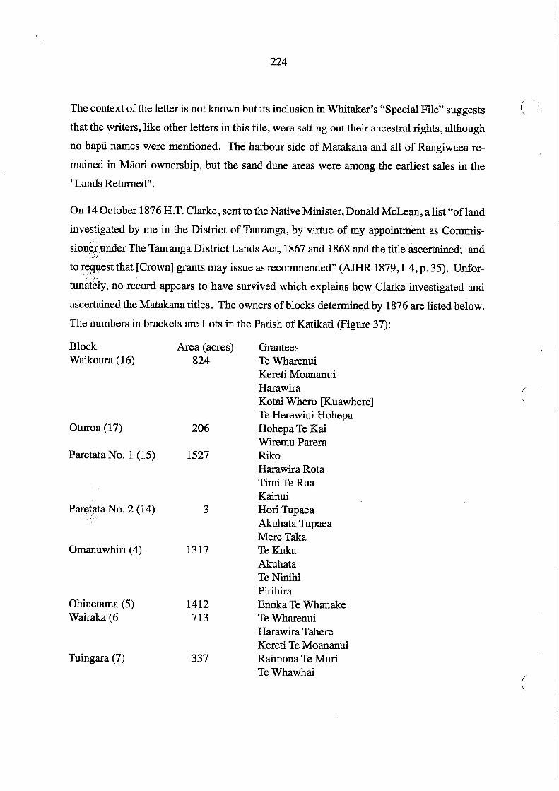
224
The context of the letter is not known but its inclusion in Whitaker's "Special File" suggests (:
that the writers, like other letters in this file, were setting out their ancestral rights, although
no hapu names were mentioned. The harbour side of Matakana and all of Rangiwaea re-
mained in Maori ownership, but the sand dune areas were among the earliest sales in the
"Lands Returned ll•
On 14 October 1876 H.T. Clarke, sent to the Native Minister, Donald McLean, a list "ofland
investigated by me in the District of Tauranga, by virtue of my appointment as Commis
sionff~nder The Tauranga District Lands Act, 1867 and 1868 and the title ascertained; and
to re9uest that [Crown] grants may issue as recommended," (AIHR 1879,1-4, p. 35). Unfor
tunat~iy, no record appears to have survived which explains how Clarke investigated and
ascertained the Matakana titles. The owners of blocks determined by 1876 are listed below.
The numbers in brackets are Lots in the Parish of Katikati (Figure 37):
Block Waikoura (16)
Oturoa (17)
Paretata No.1 (15)
Paret~ta No.2 (14)
Omanuwhiri (4)
Ohinetama (5) Wairaka (6
Tuingara (7)
Area (acres) 824
206
1527
3
1317
1412 713
337
Grantees Te Wharenui Kereti Moananui Harawira Kotai Whero [Kuawhere] Te Herewini Hohepa Hohepa Te Kai Wiremu Parera Riko Harawira Rota Timi TeRua Kainui Hori Tupaea Akuhata Tupaea Mere Taka TeKuka Akuhata Te Ninihi Pirihira Bnoka Te Whanake Te Wharenui Harawira Tahere Kereti Te Moananui Raimona Te Muri TeWhawhai
(
(

14 3.0.8
Hori Tupaea's Pa
225
MATAKANA and RANGIWAEA
c=J Block Boundaries 1886
Lands sold by 1886 1i~~nm~j~~H
l1li
Figure 37
Lands sold in 1920's Lands taken under
Public Works AcHor "Harbour Works" (NZ . Gazette ·1922,. p3247)
Note: the numbers refer to Lot numbers, Parish of Katikati
PANEPANE·

Pukekahu (8)
Okotare (9) Purakau No.1 (11)
PurBkau No. 2(12) Panepane (l3)
1310
767 1170
44 143
226
Hohepa Hikutaia HemiPaama Hohepa Paama Puimanuka (also known as Kiepa Te Amohau) TeKuka Kiepa Te Amohau (aka Puimanuka) Puimanuka (aka Kiepa Te Amohau) TeKuka Te Ninihi Paikea Tu Ropera Hohepa Hikutaia HemiPaama Purakau Turere Hori Ngatai Renata Toriri Keita Te Aria Hamuera Te Paki HoneTeMapi
For all of these blocks Clarke recommended that the Crown grant should be issued "without
restrictions". In contrast, the recommendation at the same time for Motuhoa (249 acres) was
that the island was awarded to Te Kuka Te Mea and others: "Alienation to be restricted
without consent of the Governor first obtained" (AJHR 1879, Sess. I. 1-4, p. 36). Of the
Matakana blocks in all, except Purakau Nos. 1 and 2, the names of grantees appeared on
plans dated 1869 and 1870. During December 1869 purchase agreements were negotiated
with the grantees by William Daldy, an Auckland businessman, for Waikoura, Oturoa, Paretata
N0~~:l and 2, Omanuwhiri, Wairaka, Okotare and Pukekahu Blocks. In September }873 a
similar agreement was made with Enoka for Ohinetama, making a total of 8079 acres pur
chased by Daldy (Woodley 1993, pp. 18-23). These agreements all predated Clarke's rec
ommendation for issue of Crown grants in 1876. It is doubtful whether Crown grants were
ever issued to the Maori owners of these blocks, although the Certificate of Title, dated 3
August 1878, issued to Daldy for these lands referred to grants to these various owners
(Woodley 1993, pp. 22-23). The transactions were arranged through the Auckland law firm,
Russell and Whitaker.
(I
(
(

227
In July 1884 Captain William Daldy wrote to Brabant complaining about Maori occupation
of the 8000 acres that he had purchased on Makakana Island (Figure 37): "For some years
the natives have been taking [kauri] gum off the land encouraged by the storekeepers at
Katikati". Daldy had sent "a person down who understood the native language who warned
them" and another warning was issued two years later. Daldy had since leased the land "for
gumdigging" and wanted the Maori occupiers evicted. He claimed that he had been de
prived of royalties of £3 per ton for the 50 tons of gum removed in the previous 12 months.
Brabant investigated and wrote back to Daldy on 21 August:
I have seen several of the chiefs of the party digging gum. Their story .is that Lot 4 [Omanuwhiri] was owned by three persons (quasi trustees for the hapu of whom two only sold to you, that Lot 15 [paretata No.1] was owned by four persons of whom three only sold to you. The other Lots they acknowledge the complete sale of - that they have to keep possession of Lots 4 & 15 until the purchase is completed (DOSI files, 5/31).
Brabant declined to do anything further until asked by Government. Daldy consulted his
lawyers in the Auckland legal firm of Russell and Whitaker who advised him that he had
indeed completed the purchase of all the blocks. Daldy wrote to the Native Minister enclos
ing a copy of Brabant's letter and Brabant was then directed "to bring about an amicable
settlement". Brabant had another meeting with the Maori occupiers who were adamant that
not all the shares in the land had been bought and "a balance of the purchase money remains
unpaid". Daldy refused to comply with Brabant's request to supply the deeds that had been
signed, so that these could be shown to the Maori occupiers. On 23 October Brabant re
ported to the Native Minister:
The land for which I understand Captain Daldy has a Land Transfer Title consists of 8 blocks (in all 8000 acres). Each block was granted to from four to six individuals I presume quasi-trustees for the hapus. The natives as far as I know all admit that sales of six ofthese blocks, in regard to the other two - some of the grantees are dead - those alive tell the hapus that the sale was never completed & the latter continue to occupy. Whether this is true I do not know.
Had I been placed by Capt. Daldy in possession of full information and had the information been such as w[oul]djustify me advising the natives they were clearly in the wrong, it is quite possible they w[ oul]d have given in quickly - at least I thought so from what they said - but as Capt. Daldy does not send me his documents & accounts I do not see how I can assist him. The sale is stated to have taken place in 1869 before the days of Trust Com[missione]rs and I have no means of obtaining information from any official

228
source. I have asked Judge H.T. Clarke if he knows anything of the transaction. He says ( he only heard in a general way that Capt. Daldy was negociating [sic] for these lands (DOSLI files 5/31).
Daldy may well have obtained some signed deeds for these transactions but there was clearly
a difference of opinion over what had been transacted. On 25 November Brabant was ad
vised that the Native Minister considered that Government should take no further action.
Daldy sold all his Matakana blocks in 1896 (Woodley 1993, p. 27). Tuingara Block, which
layb~tween Daldy's purchases, was apparently transferred in a deed, dated 24 December
1889,!;:~0 James Home for £59. This sale was not confirmed by the Native Land Court until
1897:CWoodley 1993, p. 34). :'\ i:/);,.,.,
H.T. Clarke had been Commissioner of Tauranga Lands and from 1873 to 1879 was based in
Wellington as Under Secretary to Native Affairs, although he briefly acted as Commissioner
at times in this period. He was subsequently appointed a Judge of the Native Land Court. In
April 1877 he visited Tauranga to investigate some alleged disturbances between Maori and
Pakeha settlers over land at Omokoroa. In his report on land transactions (in which he
encouraged the sale of the Omokoroa reserves reviewed in Chapter 14) Clarke commented (
"on the present state of matters in the Tauranga District" as he saw them:
There is a small section of Europeans in Tauranga who I fear, if they persist in making the reckless statements they have on various occasions given expression to, will exercise a baneful influence on the Natives of the district, and retard the progress of settlement. Their one leading idea appears to be to obtain from the Natives "by hook or by crook" all 'th~Jands that can be procured, without any regard to the future wants of the Natives, or :the-political questions so often involved in matters relating to Native title. In fact,.t;hey spe8k and write as though they had a vested right in the lands now in the possession bf the Natives. This is well known to those most interested, and a certain section of them are determined to obstruct what they consider "Pakeha" encroachment, and with some slight show of reason. They see thousands of acres of valuable lands awarded to military settlers lying waste, and yet the Europeans are hankering after the limited extent of hill country still in their possession. I regret to say that a large section of the Natives are being imbued with the sentiment, "Let us eat and drink, for tomorrow we die." They are perfectly oblivious to the future, and will inevitably pauperize themselves and their successors if the Government do not stretch forth a protective hand to save them from their own reckless extravagance. It is quite a common thing to hear people say that "they are not children, and therefore quite capable of looking after their own interests." If they are not children, they are equally unable to act with judgment and discretion so far as their landed
(
" <
229
property is concerned, and equally require their interests to be guarded by some authority wiser than themselves (AJHR 1877, G-l, pp. 26-27.
On the face of it this statement is hypocritical. H.T. Clarke, the former Commissioner, was
Under Secretary, the appointed head of the Native Department, an agent of Government. Yet
Clarke had effectively been the agent to ensure the alienation of the Omokoroa reserves. It
could be argued that it was Clarke's role to protect Maori titles to their reserves, not sell
them. But Clarke was a creature of his times. His bias against Pai Marire and failure to
comprehend the nature of this religious movement has already been outlined. Ten years
after the "Tauranga Bush Campaign" he still regarded the "Hau-Hau party" as "malcon
tents" because they continued to support the Kingitanga. Clarke also continued to deal with
Ngai Te Rangi leaders, Hori Ngatai and Bnoka Te Whanake in particular, and accepted with
out question that Pirirakau and other Ngati Ranginui hapu had been conquered and therefore
had no rights. It is not surprising Pirirakau and N gati Ranginui continued to resent this
interpretation.
The dispute at Omokoroa in 1877 was blamed on Pirirakau, a term that officials used to
included all the inland hapu who supported the Kingitanga, and with whom some of Ngati
Rangiwewehi ofTe Arawa had allied. There is no evidence Ngati Haua were involved but,
as noted earlier, Clarke was equally biased against them, because of their involvement with
the Kingitanga. Nor did Clarke take seriously the inalienable status of some of the Omokoroa
and other reserves. The higher priority appears to have been protection of Pakeha settlers,
and removal of any Maori faction who appeared to threaten the progress of Pakeha settle
ment .. There was no change in official attitude toward Maori who had been classified by
officials as "rebels". Manuera ofPirirakau, as reported by Clarke, summed up the attitude of
those who supported the Kingitanga that they awaited "the day of the Governor and Tawhiao" ,
that is that there would then be a settlement of all their grievances, but "that in all probability
the Pakeha would, as they always did, have their own way" (AJHR 1877, G-l, p. 25).
There was no inquiry into Pirirakau grievances and the attitude persisted that unsurrendered
rebels were not entitled to land (see for example the Native Land Court decision in 1910 on
ownership of Parish of Te Puna Lot 154 in Appendix 2). While there are many among
Pirirakau who take pride in their descent from "unsurrendered rebels", the hard facts in the
230
aftermath of the confiscation were that there were local people who were landless, who (
squatted where they could on unoccupied land near the coast. It was also the situation that
others became landless when their reserves were sold by "trustees" who were treated as
individual owners. In an official list of "landless" Maori in the Waikato, Thames Valley and
Tauranga districts, published in 1900, there were more than 330 Tauranga names (AJHR
1900, G-1).
(
(
231
14. Summary of Lands Granted to Hapu
This chapter reviews the allocation of reserves in terms of the hapu of Tauranga Moana, with
particular emphasis on those affected in the Katikati Te Puna and Confiscated Blocks. The
pattern of Maori settlement was disrupted by Crown acquisition of these blocks and· subse
quent sales of many of the reserves. The chapter ends with an attempt to summarise popula':'
tion movements to 1886. One of the difficulties in compiling this chapter has been the large
number ofhapu names no longer in use, or which have been changed for whatever reason,
since the 1860s. This summary ofhapu has been set out geographically in. terms of present
day marae and hapu groupings, beginning with the Ngai Te Rangi hapu who formerly occu
pied the Confiscated Block. The review then moves to the lands east of the harbour, and the
marae of Ngai Te Rangi and Ngati Pukenga and the rohe of hapu of Te Arawa. Next the
Ngati Ranginui Lands of the Confiscated Block are reviewed, the several hapu of the Waimapu
Valley, Ngai Tamarawaho, Ngati Hangarau, the complex pattern of ancestral rights in the
Wairoa Valley, the main corridor inland, Pirirakau the Omokoroa reserves, and finally the
lands of the western harbour. The modem pattern of marae shown in Figure 38 is the result
of shifts in population patterns following the confiscation and re-allocation of lands in Tauranga
Moana.
The complexity of ancestral rights in Tauranga Moana was recognised in Commissioner
Brabant's comment in 1881, when he requested that the Under Secretary for Native Affairs,
T.W. Lewis, provide "Native Assessors" to assist him:
The Judges of Native Lands Court always sit with assessors, the cases I have to decide are as difficult and important as those which come before that Court ... the Tauranga titles are more intricate than the average ... (DOSLI files 5/27).
It is most unfortunate that Brabant and his fellow Commissioners of Tauranga Lands failed
to record the detailed evidence of ancestral rights in Tauranga Moana. It is also unfortunate
that there is little surviving evidence of how decisions on reserves were made, where they
were allocated and to whom. Some of these decisions appear to have been arbitrary and do
not reflect any consideration of ancestral rights. It is important to reiterate that the procla
mation confiscating the Tauranga lands under the New Zealand Settlements Act 1863 extin-

232
guished all ancestral or customary Maori title. All of Tauranga Moana was taken by the (
Crown. The allocation of reserves was therefore seen as grants of Crown land to Maori.
This process also applied to the"Lands Returned".
Within the Confiscated and Katikati Te Puna Blocks a number of reserves were allocated to
individuals "in trust" for their hapu. Unfortunately, very few of these were made inalien
able, and in all cases the Crown grants were issued in the names of individuals with no
reference to the name of their hapu or the existence of a trust. That a trust existed was
acknowledged in a schedule published in 1886 of "Lands granted to certain Natives in trust
forthemselves and others" (A1HR 1886,0-15, p. 12). By this time many of these reserves
had been sold. Some of the reserves acknowledged existing kainga but the rationale for
others was not recorded. The following list provides a summary of the reserves allocated "in
trust" to various hapu:
Katikati Te Puna Block:
Parish Lot No. Areas (acres) Hapu Katikati 1,3 100 Ngai Tauwhao
" 97 162 Te Urungawera Tahawai 22 50 Ngati Teoteo
" 9 500 Ngai Tamawhariua Apata 211 200 TeNgare TeMania 33,35,46,47 500 Ngai Tuwhiwhia TePuna 52,53,187,188,211 450 Ngati Tokotoko
" 49,50,56 240 NgatiHaua
Confiscated Block:
Parish Lot No. Areas (acres) Hapu TePuna 8 100 Ngai Tauwhao
" 9 100 Ngai Tuwhiwhia " 16,154 343 Pirirakau " 169 30 Ngati Rawhare (Rauwharo) " 182 204 NgatiKuku
TePapa 8 52 NgatiKahu " 21,107,108 85 Matewaitai " 95 130 Ngati Hangarau
" 103 110 Ngai Tauwhao, Patut5hora and Papaunahi
(
(

, , ~~ "",
~t-~ ,;,'
TeAroha " j,,; .....
, , , , ,
" ') , .......... . , , , \.. "" ...... \
, ': , .\ , \ , i
\~i \",
Ngatamahinerua \ ...
~ ,\ ,",
'1" ~
~ c:. '1'
1. Tutereinga
,\ (" (i, ,
" , , , , WaianUanU)
I I
I I
iTe Weraiti ....
'It", 4tQ _ ......
'.til', ........ ~-i(l, "I ..
2. Paparoa 3. Poutiiterangi 4. Peterehema (Bethlehem) 5. Huria (Judea)
- - - • Confiscation Line ............. Watershed on Kaimai Ranges
~-i~ ~)
Figure 38
I I
I I
I I
I
TE
~ 5 ,.
, I ! I
kilometres
GMO:10/97
N w w

TePapa " "
110 115,452 15 (NR)
234
81 142
10
Ngati Kahurere Ngai Tamarawaho Motuopae/Urupa Reserve
Some of the reserves near the southern boundary of the Confiscated Block were also allo
cated to hapu in particular, Parish ofTe Papa Lot 536 (Ngai Tamarawaho) and Lots 537 and
538 (Ngati Hangarau). However, all these inland reserves were dealt with by Commissioner
Brabant in the 1880s and awarded to long lists of individual owners,most of them from
several hapu in each reserve. No records have been found of how these names were decided
altho~gh they appear to have been compiled from lists handed in to Commissioner Brabant
by vaiiious hapu representatives.
Hapii of Ngai Te Rangi at Otumoetai
The several kainga along Otumoetai beach comprised the principal settlement in Tauranga
Moana before 1864. There is no detailed list of all the hapu there. Smith's 1864 list included
(
13 adult males ofPatutohora (now incorporated in Whanau a Tauwhao) in Otumoetai West, (
and 25 adult males of Te Matewaitai at Otuatara at the eastern end of Otumoetai Beach
(AJHR 1864,E-2,p.13). !fthis total adult male population of38 is multiplied by 2.5 then an
estimated total population of 95 lived in these kainga. A number of reserves were allocated
to hapu, and granted to individuals "in trust", all in the Parish of Te Papa:
Ngai Tauwhao, PatutOhora and Papaunahi: Lot 103 (110 acres) to Hori Tupaea and Te Ninihi' '.
;' . .'". ' Matewaitai (Ngati Kuku): Lots 107 and 108 (53 acres) and Lot 21 (32 acres) to Hori
Ngatai and Renata Toriri (total 85 acres); Ngati Kahurere: Lot 110 (81 acres) to Enoka Te Whanake and Ihaka Te Ko.
By the late 1860s the Otumoetai kainga had been abandoned and most of the lands sold or
leased. Whanau a Tauwhao (include PatutOhora and Papaunahi) under Hori Tupaea consoli
dated at Rangiwaea. Matewaitai and Ngati Kahurere settled at Whareroa.
Contemporary records suggest that other hapu, including Ngai Tuwhiwhia, also claimed
rights at Otumoetai. Among the Tauranga confiscation papers in the DOSLI mes is one
labelled "Special File 5, Mr Whitaker's Tauranga Papers 1866" (DOSLI mes 1/3). It con-(

235
tains a number of Maori letters, addressed to Whitaker, and sometimes Mackay and Clarke
as well, setting out claims to lands in the Tauranga district. There are also several lists
referring to hapu claims on the Confiscated Block at Otumoetai, Bethlehem (Peterehema)
and Judea (Huria). After Gate Pa and Te Ranga, many of the occupants of these kainga
moved either inland, or to the islands of Matakana and Rangiwaea, and to Whareroa. That
they received some encouragement from the military to do so is suggested in a letter from
T6rriika Te Mutu to Whitaker which was translated as:
Let your thoughts in relation to my piece of land be clear. I have no clai.ni to Rangiwaea, thexColonel told me to go thither to the island. You have given landto those who were in arms therefore I write to you about my piece at Otumoetai. Let me have mine (DOSLI fIles 1/3).
Filed with this, in the same handwriting as the translation, was a "List of men, women and
children under Tomika Te Mutu of the Ngaituwhiwhia tribe". The names included Tomika,
Makere, Patariki, Te Hira, Hiria, Parata, Makimaki, Te Kuka and "four children", Te Puru,
Te Makaka, Nihorangi, a total of 15 people. "Their settlement was at Otumoetai, & Tomika
was in treaty with Mr Foley" (ibid). The list was annotated "100 acres - & 1/2 frontage".
Individual grants were made to Te Kuka and Tomika Te Mutu at Otumoetai and Bethlehem
, as follows, but there was no reference to any trust for Ngai Tuwhiwhia:
Parish ofTe Papa Lots 105 and 109 (129 acres) to Tomika Te Mutu at Otumoetai; Parish ofTe Papa Lot 92 (100 acres) to Tomika Te Mutu and Te Kuka Te Mea at Bethlehem.
Both grants were sold in the late 1860s (see Chapter 8). On 7 June 1868 Te Kuka wrote from
Motuhoa (which had been awarded to him for Ngai Tuwhiwhia) to Chief Judge Fenton of
the Native Land Court, and the letter was passed on to H.T. Clarke:
I am a peaceable man [he tangata atu noho ahau]. I have not taken up arms against the Queen unto the day and this land was taken away; my land has been taken away, it has been taken by the Governor; Araitanga at Otumoetai is one piece and Te Haupapa at Te Puna another. I do not understand the cause of their being taken away (DOSLI fIles 2/9).
Clarke annotated the letter "This charge is most unreasonable and quite untrue" and noted
that the lands awarded to Te Kuka and Tomika in the Confiscated Block included 100 acres
at Otumoetai, 100 acres at Peterehema (Bethlehem) and two lots of 50 and 100 acres at Te

236
Puna, a total of 350 acres. In addition 50 acres each had been awarded to them individually (
"Making in all 450 acres within the Confiscated block of 50,000 [acres] more than their
share".
Te Kuka's letter and translation was passed on to J.C. Richmond who annotated the transla
tion on 26 September 1868:
Reply that the govt are not aware that te Kuka's land is taken. More than half the land of the hapu has, they have been informed, been given over to Tomika and him (DOSLI files
.2/9).
The response on behalf of the government of the government seems to miss the point that Te
Kukahad identified particular places by name that were significant to him but which were
no longer available to his hapu Ngai Tuwhiwhia. It is not revealed by Clarke in any of his
records just what area was considered to be "owned" by Ngai Tuwhiwhia, or where, and
how the 450 acres returned in separate pieces at Otumoetai, Bethlehem and Te Puna could be
considered to be equivalent to half the land of the hapu, or "more than their share". Nor did
Clarke or any government official address the issue that ifTe Kuka had not been "in rebel
lion" then why should his hapu lose any land. Ngai Tuwhiwhia had also been allocated 500
acres (Lots 33,35,46 and 47) in the Katikati Te Puna Block, awarded to Te Kuka and Te
Puru "in trust", but these lands were included in the "Ngaiterangi Deed" reserves (Appendix
1) and were not at issue here.
EnokatTe Whanake submitted a list of"34 men and women and children" and asked Whitaker
"to :grant him a reserve at his old settlement Waikareao". The list of names included: Enoka,
Ruka,',iWitika, Patai, Hawa, Whenua, Hamiora, Ihaka, Koma, Ruato, Hakaraia,.Hirini,
Kapurautao,Arapeta, Reneti, Hati, Ipu, Kaa, Tupara, Tutu, Meriana, Purau, Tanurere, Hoko,
Ruiha, Ripeka, Miriama, Makere, Heni, Ngaruhi. These were all adults. "Ngatamariki"
(children) were: Waihaupapa, Hikareia, Ani Patene, Taopueru. The list was annotated "60
acres" (DOSLI files 113). Lot 110 Parish ofTe Papa (81 acres) was allocated to Enoka Te
Whanake and Ihaka Te Ko for the hapu Ngati Kahurere, located at the eastern end of Otumoetai
beach and fronting Waikareao estuary. Ngati Kahurere were a section of Ngai Tfikairangi
who also claimed rights at Te Papa, Karewa, Mauao and the lands between there and Whareroa.
(
( \

" "
237
Another item in Whitaker's "Special File" stated: "List of men and women and children
residing at Roma &c. [Otumoetai Pal under Rori Tupaea & Whangamata". There followed
a list of 33 names and "another" unnamed, divided into two groups. Under the heading "Te
Ngatipaipairoa tribe residing at Otumoetai", the 14 names included: Rori Tupaea, his son
Akuhata, Te Mamairoa, Raterete, Tupaea, Maki, Reiupene, Kaihanu, Mariea & another, Rahia,
Te Ipoipo, Ngahaka. Under the heading "Te Patutahora" 20 names were listed: Petara
Whangamata, Tikikawhena, Turuhira, Tamawha, Rariata, Erena, Rakapa, Tami, Wiripo,
Renare, Rata, Taituha, Rihara, Powai, Timana,Werahiko, Maria, Riria, Mata, Tiki. The list
was annotated "100 acres, 10 Kainga" (DOSLI fIles 1/3). Lot 103 Parish ofTe Papa (110
acres) was granted to Rori Tupaea and Te Ninihi "in trust" for Ngai Tauwhao, Patut6hora
and Papafinahi.
Also in Whitaker's "Special File" was a list of eight names, submitted on 28 Marsh 1866,
with no hapu affiliation: Pane, Taraiti, Rangiwahoroa, Ko Ngarae, Ko Rori, Ko Paraone, Ko
Mere, Ko Ane. Attached to the list was a comment:
List of persons claiming land within the confiscated block - 8 in all. These persons in all probability were included in lists already supplied, if so, their claims have been settled by Mr Whitaker (DOSLI fIles 1/3).
No evidence has been found to indicate that this "probability" had been checked out.
It has not been possible to summarise in detail the lands allocated to hapu of Ngai Te Rangi
who had been living at Otumoetai, beyond noting .particular reserves. All these hapu had
rights elsewhere in the "Lands Returned". Ngai Tuwhiwhia were awarded the whole island
of Motuhoa, and consolidated their settlement around the marae at Opureoraon Matakana
Island. Ngai TUkairangi, as already noted, consolidated in the Whareroa district. Whanau a
Tauwhao comprised the hapu also known as Ngai Tauyvhao, Papaunahi, Patut6hora and Te
Urungawera, who had rights on Motiti, Tuh~a, Rangiwaea and at Otawhiwhi (see Stokes
1980d). In the 1880s both Rangiwaea and Whareroa emerged as important Maori centres in
Tauranga Moana, with a population made up principally of people displaced from the
Otumoetai kainga on the Confiscated Block.
Whareroa was not permanently inhabited before the mid 1860s but was occupied periodi
cally as a camp site for collecting shellfish. When the title to Whareroa Block was investi-
238
gated by Commissioner Wilson, there was some dispute over ownership which led to a peti- ( .
tion to Parliament by Moananui Wharenui and others. When this petition was heard by the
Native Affairs Committee in August 1880, Hone Makarauri described the settlement:
Some of the petitioners are living on the land at the present time. They have weatherboard houses there and gardens and cultivations. Some of them are Maori houses. That land is not extensively cultivated, but just round about their dwellings they have small gardens where they cultivate cucumbers, melons, and so on. The soil is light and sandy. This land is not the land that was occupied formerly by natives, it was only after the fight between the Europeans and the Maoris that this section of the natives came and located themselves on that spot, because the inland part of the country had been confiscated by the;'Qovernment (National Archives Lel/1880/6; Raupatu Document Bank vol. 3, p. 825).
In the same hearing Te Reweti Ngatai, son ofHori Ngatai, noted that the petitioners sought a
rehearing of Whareroa which had been awarded to Hori Ngatai and his people:
The petitioners do not all belong to one distinct hapu. Some belong to one hapu and some to another. When I was there no stranger could come on that land and take anything that was growing on it unless they went first to my father and his people and asked leave to do so. Things remained in that state up to the time of the hearing of the block, when it was awarded by the [Commissioner's] Court to my father (ibid p. 837).
Te Reweti conceded that Hori Ngatai had allowed Ruka Tamakohe to build his house there.
"he was turned off another piece with others, but my father gave him a piece of this land to
live upon ... because he was related to my mother" (ibid, p. 838). The dispute must have
been sorted out because on 5 September 1881 the Whareroa Block came before Commis
sioner:Brabant. Hori Ngatai stated that the block had been adjudicated on by Commissioner
Wilson, the list of owners was read and passed with no objections.
The list of 55 owners of Whareroa Block was made up of 26 adult males, 19 adult females
and 10 children, 6 boys and 4 girls. This is comparable with the 1881 Maori Census which
listed 33 Matewaitai and 20 Ngatipau [sic] living at Whareroa. In the Maori Census for 1874
and 1878 the figures for Whareroa were 146 and 131 respectively, and described collectively
as "Ngaiterangi". This may reflect an initial status ofWhareroa as a refuge for several Ngai
Te Rangi hapu, By the 1880s the community was firmly under the leadership ofHori Ngatai
whose people were usually described as Matewaitai or Ngati Kuku. There appears to have
(
been little or no investigation of ancestral rights, or occupation in 1840, as would have oc- (
239
curred in a Native Land Court investigation of title. It is difficult, without any record of the
hearings by Commissioner Wilson, and only a brief record of Commissioner Brabant's pro
ceedings, to assess the nature of ancestral rights in the area, or the extent of disruption that
occupation by hapu migrants from Otumoetai had caused. It appears that what was recog
nised in the list of owners was occupation in the late 1870s under Hori Ngatai.
Matakana and Rangiwaea also became refuge areas for hapu who had removed themselves
from kainga on the mainland in the Confiscated Block. As noted above Ngai Tuwhiwhia
established their marae at Opureora and the population there listed in the Maori Census in
1874 was 55, in 1878 reduced to 51, and in 1881 only 38. However, in 1881 Ngati Mura, 31
people, were also listed as living at Kutaroa, although this hapu was known as Ngati Tauaiti.
This marae was demolished in the 1980s and the Matakana community consolidated in the
upgraded Opureora Marae. On Rangiwaea, two marae were established. Opounui (listed in
some old land records as Oponui) was established by Te Ngare who formerly lived on coastal
lands west of the Omokoroa peninsula. In the 1881 Maori Census 47 people of Te Ngare
were recorded at Opounui. Although Te Ngare were not listed separately in 1874 or 1878, it
was recorded that some Ngati Kahu and Ngati Hangarau people were of Opounui but their
numbers were incorporated in the totals for these two hapu, who lived mainly at Wairoa and
Bethlehem respectively. Rangiwaea Marae was the focus of Whanau a Tauwhao with a
population of 86 in 1874, reduced to 65 in 1878, and 58 (including 32 PatutOhora who were
recorded separately) in 1881.
Ngai Te Rangi Hapii East ofTauranga Harbour
Although the ancestral lands east of Tauranga Harbour were all in the "Lands Returned" all
of these hapu were affected by sales to the Crown and by leases and sales to private purchas
ers (Figure 39). The Crown purchase of the blocks in what came to be Mount Maunganui
Borough were, in effect, compulsory purchases. These blocks were investigated by Com
missioner Brabant in 1881-1883 (see Stokes 1993 pp. 289-352), although some investiga
tion had been done by Commissioner Wilson earlier, but no records have been found. Brabant
also had an important role in negotiating acquisition of these blocks for the Crown (see
Stokes 1993, pp. 395-402 for more detail). The hapu affected were:

240
•
Figure 39
023
kilometres
HAPU OFTAURANGA
HARBOUR AND WAIMAPU RIVER
1886 Block Boundary
Subdivision of Block Reserves-Parish of Te Papa
Lands sold, leased or under negotiation for sale in 1886
Kainga
(
(

241
Ngai Tuwhiwhia who had interests acknowledged in Oruahine and Hukitawatawa Blocks on Mauao, and the ocean shore of Hopukiore and Te Maire Blocks. Ngai TUkairangi who had interests acknowledged in Awaiti and Waikorire Blocks on Mauao and the harbour side of Hopukiore and Te Maire Blocks. Ngai Tamawhariua interests were acknowledged in TeAwa 0 Tukorako Block and the adjacent southern part of Te Maire Block. Ngati Kuku interests were acknowledged in Motukauri Block on Mauao, Moturiki, and in the Whareroa Block which was just outside the purchased area. Whanau a Tauwhao were acknowledged in Motuotau.
The effect of these purchases was to remove from Maori ownership the whole of Mauao, the
maunga tapu, sacred mountain and ancestral pa of both Ngati Ranginui and Ngai Te Rangi.
The purchases also removed from Maori control the much-prized sea food, kai moana, of the
rocky coasts and sandy beaches of the area. As already noted, Ngai Tuwhiwhia consolidated
their community at Opureora Marae on Matakana, and Whanau a Tauwhao on Rangiwaea.
Ngai Tamawhariua marae were established at Rereatukahia and Matakana (Rangihouhiri).
A section ofNgai TUkairangi who lived at Otumoetai moved to Whareroa, where Hori Ngatai
of Ngati Kuku emerged as leader. In due course Ngati Kuku and Ngai Tukairangi merged
and Whareroa Marae is usually known as the marae of Ngai TUkairangi. The name Ngati
Kuku is still sometimes used but the old name of Ngati Kahurere is no longer heard. In the
1960s a second marae ofNgai TUkairangi, Hungahungatoroa, was developed on the Matapihi
peninsula.
To the east on the Mangatawa and Papamoa Blocks were Nga Potiki, descendants of
Tamapahore with some close links to Te Arawa hapu. The Crown purchase· of Papamoa No.
1 Block for "Special Settlements" reduced their lands to Mangatawa andPapamoa No.2
Blocks. In 1881 the Maori Census recorded 67 people at "Mangatawa". Their principal
settlement was at Karikari but by the early twentieth century there were people living at
Mangatawa where Tamapahore Marae was established.
The Matapihi peninsula remained in Maori ownership, and there were several kainga around
its shores. The details of ancestral rights which may have been recorded by Commissioners
have not survived. There was probably some mobility here, as several hapu had rights. For
a time, Ngati Mateika, who were part ofNga Potiki, lived at Oruamatua where 47 people in
1874 and 45 in 1878 were recorded in the Maori Census. Other hapu on Matapihi were

242
Materawaho, (84 people in 1874 and 69 in 1878) and Matekiwaho (about 18 people in the (
1870s and 23 in 1881). The hapu on Matapihi built their meeting house Tapukino in 1881,
and it is from this ancestor that the hapu name Ngati Tapu that is now used is derived. Ngati
Tapu and Ngai Tukairangi formerly had a pa, Otamataha, on Te Papa peninsula on the site of
the CMS mission station and military cemetery. After an attack in 1828 by the Hauraki tribe
Ngati Maru, and many deaths there, a new kainga was established at Matapihi. In 1901 the
old wharenui was moved to a new site where it still stands on Waikari Marae.
Hapii of Te Arawa
Before Ngai Te Rangi took the pa on Mauao which was shared by Ngati Ranginui and Waitaha,
Te Arawa people had extended their rohe west to the Waimapu River and Tauranga Harbour
to the entrance at Mauao. Inland, several hapu associated with Ngati Rangiwewehi had
ancestral rights which were acknowledged in their names allocated as owners in the Waoku
Block. The rohe of Waitaha straddled the confiscation line between Otanewainuku and
Wairakei. Their rights were acknowledged in the Otawa Waitaha Blocks, most of which
were purchased by the Crown, leaving only Waitaha No.1 Block-and Otawa No.2 in Maori (
ownership. On the other side of the confiscation line the Crown also purchased the Te Puke
Block. Negotiations for this block had begun in the early 1870s but lapsed for a time be-
cause of vigorous opposition to a survey begun in 1876. During 1878 the title was investi-
gated by the Native Land Court and arrangements made for purchase and completion of
survey~'during 1879. Waitaha had 1000 acres reserved for them.in this large block which
extended from Otanewainuku to the sea. Here their marae was established on land called
Mano~ka, meaning 1000 acres. Waitaha and other Te Arawa owners of Te Puke Block were
also victims of the fraudulent activities of Government purchase officer J.C. Young (see
Chapter 9).
Tawera (Ngati Pukenga) at Ngapeke
On 5 December 1864 Te Kou 0 Rehua and eight others petitioned Parliament, objecting to
Ngai Te Rangi selling Tauranga lands. "Show your regard to us by returning to us our land
which has been taken by the hand of Ngaiterangi, together with the Governor" (AJHR 1867,
(

243
A-20, p. 11). The Tawera claims extended from Katikati to the Waimapu River. On 13
December 1864 Native Minister Weld asked Clarke and Mackay to investigate the Tawera
claims. In June 1865 they reported their investigation over a period of four days, time and
location unspecified. Spokesmen for Tawera were Te Pamini and Wiremu Te Whareiro, and
for Ngai Te Rangi were Hohepa Hikutaia, Hamiora Tu and Emera Tamapahore. "Many
other natives of both tribes were present".
In summary it was agreed: "Ranginui and Waitaha were the original owners of the Tauranga
District" and Tawera were "descended from Waitaha". It was also agreed that Ngai Te Rangi
rights were based on conquest:
That the Ngaiterang~ and Te Tawera frequently fought against each other, and finally the Ngaiterangi, Ngatihf.,[sic] and Ngatihike [sic] tribes united, and drove the Tawera from Tauranga - the two la~. mentioned hapus being descended from Waitaha and closely related to Te Tawera. This occurred about seventy years ago ... That immediately after the expulsion of Te Tawera, the Ngaiterangi, Ngatihi and Ngatihoke [sic] divided the land amongst them.
That the year 1855 a dispute arose between Ngatihi (Maihi Pohepohe) and Ngaiterangi (Rawiri Puhiraki) about an "eel pa" which resulted in war (1857). On this occasion the Ngatihi and Ngatihoke invited the Tawera to return to Tauranga and reinstated them on a small portion of their original claims (AJHR 1867, A-20, p. 11).
Clarke and Mackay recommended:
That the Tawera can only fairly claim those portions of land of which they have retained possession, or which have been returned to them by their former conquerors (AJHR 1867, A;:20, p. 11).
,.
In 1877 a petition by Wiremu Te Whareiro and others of Ngati Pukenga was considered by
the Native Affairs Committee. H.T. Clarke, now Under Secretary for Native Affairs in Wel
lington, was called to give evidence on 23 October and was adamant that Ngati Pukenga had
only claimed lands west of the Waimapu River: "about 85 years ago they were driven out of
Tauranga by the Ngatihe and Ngaeterangi [sic]". He went on to state that in the previous
investigation, "We went patiently into the question". Clarke also claimed that one of the
petitioners had come to see him while he was still Commissioner of Tauranga Lands about a
claim to land east ofWaimapu:

244
I said, "Your position is this: if the party occupying it are willing to give you any portion (\, of the land, that portion will be recognised by the Government," upon that he went to Ngatihe and got them to make over a portion of the land (National Archives Lel/1877/5).
The land made over was Ngapeke Block (1496 acres), which Clarke believed "was disputed
between Ngatihe and Ngatipotiki", so that Ngati Pukenga occupation would be a buffer
between them. Clarke had already advised Commissioner Brabant on 25 January 1877:
Any claim advanced by Ngatipukenga within the Tauranga District not to be entertained except to such lands as have been given back to them by Ngaiterangi or Ngatihi [sic] to which the givers can establish a good title -such was the decision given by the Arbitrators in December 1864 and has been maintained ever since (DOSLI files 4/25.
Thelands allocated to Ngati Pilkenga were:
Ngapeke Block (1496 acres) 81 owners Parish ofTe Papa Lot 13 (49 acres) Paroto Tawhiorangi Parish ofTe Papa Lot 99 (49 acres) Ruka Huritaupoki and Riritahi Town of Tauranga Section 2 Lot 13 (1 rood) Paroto Tawhiorangi Town of Tauranga Section 2 Lot 14 (1 rood) Ruka Huritaupoki
Total 1594 acres 2 roods
According to the Tawera deed (see Appendix 1) payment of £500 was made to extinguish
Tawera claims in the Katikati Te Puna Block and lands inside the confiscation line east to the
Waimapu River. The receipt was signed by Paroto Tawhiorangi, Paurini and RukaHuritaupoki.
This deed also included provision for two grants of 50 acres and two "town allotments" , all
subsequently sold.
The population of Ngati Pukenga at Ngapeke in the Maori Census was:
1874 68 1878 60 1881 31
Ngati Pukenga have maintained their marae, Whetu-o-te-rangi, and their identity within
Tauranga Moana, based on their Ngapeke lands.
(
(

/
245
Hapii of the Waimapu Valley
The Waimapu River formed much of the eastern boundary of the Confiscated Block where
several hapu held ancestral rights including N guai Te Ahi of Hairini, and N gati He and N gati
Whainoa of Maungatapu. The population as recorded in Maori Censuses was:
1874 1878 1881 . Maungatapu: Ngati Whainoa 100 88
NgatiHe 63 47 91 Hairini: Ngai TeAhi 89 87 64
Ngati Ruahine ofWaimapu Marae were not recorded separately. By 1881 the name Ngati
Whainoa had fallen into disuse and appears to have merged with Ngati He. The name Ngati
Hoko was also used sometimes in the 1870s but this also is no longer used. None of these
hapu were allocated reserves in the Confiscated Block. Some individuals received grants at
Greerton but the basis for these was not recorded. In the 1880s the reserves inland on the
Confiscated Block were allocated to lists of owners, which included names from these hapu.
The ownership of the Oropi Blocks was acknowledged to Ngai TeAhi and Ngati lIe. Oropi
No.1 (2550 acres) was vested in 53 owners and sold by 1886. No.2 (600 acres) was vested
in 128 owners and retained. Several small blocks adjacent to Oropi were awarded to lists of
owners as follows:
Moukunui (221 acres) Otauna (202 acres) Weraroa No.1 (100 acres) Weraroa Nos. 2&3 (84 acres)
Ngati Heitiki (21 owners) Ngati Tapu and Waengarua (34 owners) Ngati Ruahine and Ngati Hinepare (49 owners) Ngati Rangiwahine (1 and 12 owners)
Te Ahiroa and Taumata Blocks were awarded to Ngai Tamarawaho and are discussed below.
Waoku Block was awarded to several hapu with mainly Te Arawa affiliations: Ngati Rehu,
Ngati Rakei, Ngati Te Awhai, Ngati Tama and Waitaha.
In the absence of detailed records of proceedings in which evidence of ancestral claims
might have been given, it is difficult to be more specific about these hapu. On 30 March
1866 a letter signed by 30 people on behalf of Ngati He acknowledged the boundary of the
Confiscated Block at the Waimapu River, and the rohe ofTe Arawa inland. The letter also
sought a kainga tuturu, a permanent living place for the 30 signatories. Presumably the lands

246
on the Maungatapu peninsula were seen to serve that purpose, where Maungatapu Marae is (
established, continuing the long occupation of this area. No records of how these lands were
allocated have survived. A fragmentary record of Brabant's investigation of Hairini Block
in 1881 has survived, which indicates that the claimant hapu was Ngati Hinemate. There
were several individual counter claimants, as well as spokesmen for two other hapu, Ngati
Heitiki and Te Whanauwhero. There are no details but Brabant accepted the claims ofNgati
Hinemate and a few individuals who could prove ancestry to Hinemate, but dismissed the
other claims.
A large area of the lands of the Waimapu Valley hapu which had not been confiscated was
sold in the 1870s. In 1876 Clarke recommended a Crown grant be issued withoutrestric
tions for 6547 acres of Ohauiti No.2 Block. This transaction has already been discussed in
Chapter 9. It was the omission of her name from the list of grantees that provoked Te Korowhiti
Tuataka, wife of Edward Douglas, to petition Parliament for redress of her grievances (AJHR
1879, Sess.l, 1-4). She was subsequently awarded the Ngawaro Block, to the south outside
the confiscation line. Ohauiti No.2 Block had been vested in 35 owners, and the adjacent
Waitaha No.2 Block vested in 84 owners, but on what basis can not now be determined. The
effect of the Ohauiti sale to Captain Morris, and the sale of Wait aha No.2 Block (8082 acres)
to Jonathan Brown about the same time, was to curtail severely the lands available to these
hapu. The three marae at Maungatapu (Ngati He), Hairini (Ngai Te Ahi) and Waimapu
(Ngati Ruahine) have been engulfed by the growth of Tauranga City since the 1950s.
Ngai Tamarawaho
The list of Ngai Tamarawaho in Whitaker's "Special File" was described as: "List of men,
women and children under Brown Te Koikoi, in all 65 . The old settlement of the tribe was at
Judea". This suggests that few were living there in 1866, having retreated to their inland
kainga at Taumata and Akeake. The list included the following names: Wharepoaka, Hori,
Iharaira, [parawhau - name crossed out], Hoani Nopera, Parata, Kokohai, Matiu, Otehau,
Hemi, Tamehana, Wira, Hemi, Petera, Turuhira, [Iwi Kingi - crossed out], Te Kapa, Wetini,
Mohi, Kararai, Ngawaiwera, Ngakarepe, Mere Parata, Hana, Ruta, Hariata, Mare, Marara,
(
(
247
Ruiha, Hara, Hopaea, Ruiha Piripi, Pekerangi, Keita, Wharetaka, Miria, Rata, Rau, Te
Ruahuihui, Ihakara. In a separate column with a line around it is another list of names:
Anam, Ripeti, Ihakara, [Ruiha Pu - name crossed out], Wharemaea, Rapata, Reupena, Henare
Piripi, Hirini, Piniha, Pare, Auru tamaiti [young boy], Arona, Henare Piahana, Kaa, Ngarehu,
tana Wahine [his wife], Kiawaha, Irimana. This list ends with "te Iwi Kuini Na Anam"
(DOSLI files 1/3).
Presumably Anam compiled the lists, which are in the same handwriting, but it is not clear
whether the second list was intended to distinguish the people who had subinitted to the
Queen:~s law, "Te iwi Kuini" , from the rest; "I wi Kingi" (King people) was crossed out in the
list. The total number of names on both lists, including those crossed out, and treating
tamaiti and tana wahine as separate people, comes to 65. The list was annotated "80 to 100 j"
acres". In 1864 T.H. Smith had estimated Ngai Tamarawaho to include 30 adult males (AJHR
1864, E-2, p. 13). Ngai Tamarawaho were allocated Lot 452 Parish of Te Papa, which on
survey was found to be 42 acres, but earlier estimates suggest it was intended to award 80
acres to the hapii.
On 10 February 1871 Clarke wrote to the Native Minister recommending additional land for
Ngai Tamarawaho:
I find upon careful inquiry that the Ngai Tamarawaho hapu muster 45 males and 33 females - Total 78. They have no land on the Eastern side of the Harbor [sic] ofTauranga. All their land with the exception of a little forest has been confiscated. The land set apart for them (80 acres) a great part of which is swamp is quite inadequate .. I therefore recommend that a further award of 100 acres may be made as near the present allocation as possible (DOSLI files 2/13).
Approval must have been given immediately as a schedule of grants to be prepared, signed
by Clarke and dated 17 April 1871 , included a block of 100 acres, Lot 115, Parish ofTe Papa,
to be made out to Paraone Koikoi and Wairoa, "Aboriginal Chiefs of Tauranga, in trust for
the Ngaitamarawaho tribe". The same list also included Lot 95, Parish ofTe Papa, an area of
130 acres at Bethlehem to be granted to the "Aboriginal Chiefs" Rewi Maihi and Pauro
Ngati "in trust for the Ngatihangarau tribe". Unsigned copies of both these grants, neither of
which had any restriction on alienation, were included in the same file. These two blocks
248
granted to Ngai Tamarawaho and Ngati Hangarau were in the category of "lands awarded to (
returned rebels" (DOSLI files 2/13).
The Crown grants were not immediately issued as a question arose over the nature of the
trusts. The matter was referred to Attorney-General Prendergast who advised the Secretary
for Crown Lands on 21 March 1873:
As to the lands for tribes: the Confiscated Land Act, 1867, must be followed. Mr Clarke says that the case falls within section 4 of that Act. Under that section the Governor may reserve out of Confiscated Lands and make grants to persons who having been in rebellion, and have submitted. I presume the names of the tribes cannot be given [on the Crown Grant]. After the warrants are made, the land can be referred to Native Lands Court for subdivision when and if thought necessary but a grant cannot be issued unless the names and shares of the grantees are known (DOSLI files 2114).
It is not clear what happened after this. Putnam (1872) recorded that Ngai Tamarawaho were
living at Akeake, and that the Chief Paraone "had lately died", and had been succeeded as
leader by Hori Tangatangata. Clarke's list of awards dated 29 June 1871 included Lot 115,
Parish ofTe Papa, awarded to "Wiremu Paraone and hapu" in the "Schedule of lands awarded
to returned Rebels". There is no record in Clarke's papers of any restriction on alienation (
placed on Lot 115. On 15 June 1881 a Certificate of Title (CT 25/15) was issued in the name
of David Lundon ofTauranga, Settler, for the whole 100 acres of Lot 115, Parish ofTe Papa,
for which a Crown grant had been issued on 4 July 1878 to "Paraone Koikoi and another". It
seems the block had been leased to Lundon but no record has been found to explain the
circumstances of this sale, or why this block, having been awarded as additional land for the
hapfi.,.did not seem to have any restriction on alienation.
Lot 452 remained in occupation by Ngai Tamarawaho (Figure 40) but was labelled Native
Reserve in the survey plans although apparently not gazetted. On 7 November 1884 Lot 452
was awarded to 112 owners, presumably by Commissioner Brabant, but no record of these
proceedings has survived, beyond the list of original owners held in the Maori Land Court,
Hamilton. In 1910 a Certificate of Title issued for Lot 452, Parish ofTe Papa (CT167/152) ,
listed the same names as owners of the block. In 1885 Lot 452A, an area of 2 acres, was
divided off and set aside as a "Native School Site" (New Zealand Gazette 1885, p. 508). A
school operated in the 1880s but was closed permanently in the early 1890s. In 1953 the ('

249
IlL -~ -~ Lot 115 -~ -~ ~ - ~ - ~ - ~ - ~ ~ --2l!<i--"""""' __ _
Lot 116
Lot 8
-~ -"""'.""';-""'""""'
'IIL_~_~_~_~_~_~_ ,IlL _~ _~ _~ _~ _~ _~
'IIL_~_~_~_~_~_ I I", _~ _~ .~ .~ _~
'" _ ~ _ ~C!!'{!lrl!..d~ _ "-- -~ -~by:clu. -~
14w _ :clk _ .. \1..... _ ~ _ ~
I", _ sJ1ldl!~ _ ~ _ ~-~-~-~ -~ -~ -~ -~
Figure 40
Cultivated
Taml Ilil
~ Swamp Block Boundary Track
250
"Swamp Reserve" was set aside as a Maori reservation (recreation reserve) and over the next (
few years drained and developed as sportsfields. In the mid 1960s much of the balance area,
apart from the marae (set aside as a Maori reservation in 1948), was partitioned into indi-
vidually owned residential sections. The burial ground on the island called Motuopae was
set aside as a reserve for the "use of aboriginal natives" under section 227 of the Land Act
1885 (New Zealand Gazette, 1886, p. 469).
Lot 116 Parish of Te Papa adjacent to Lots 115 and 452, was also occupied by Ngai
TamaI~waho. On 19 November 1866 Katerina and Piahana wrote to Whitaker from Matapihi,
requesting land on the grounds that they had remained friendly toward Pakeha and had not :':'(
participated in the war. This letter was accompanied by a note fromA. Warbrick of the same
date, suggesting that Piahana had some rights to land awarded to Hamiora Tu on the confis
cated block but Katerina, his wife, was of the hapu Ngati Tutamatea "who owned the land at
Judea" and she had not been granted any land yet. Mackay annotated Piahana's letter: "Land
given in No. 26 Otumoetai East" (DOSLI files 1/7). This block was later given the appella
tion Parish of Te Papa Lot 116 and granted to three siblings, Riripeti Piahana, the eldest,
Henare Piripi and Raiha (or Ruiha) Piripi.
In evidence given to the Native Land Court in 1890 over partition of the block Wi Piahana,
husband of Riripeti, one of the grantees, explained how he had requested land from Whitaker,
Mackay had been the interpreter, and Clarke had arranged the grant. Henare Piripi was also
known.Jl.s Ranganui Te Kaponga and is referred to in Piahana's account as Ranganui: , ,:~"
Md:3larke proposed to put in my name but I objected. I said don't put me in. I have love fortIlem because they have no other land. Piripi was their father. That is why I thought it would be right to give the 3 the land. Ruiha was at Hauraki and Ranganui at Kapiti. I put them in the land in their absence. We then lived at Poeke, when we rented that we came to Hairini - afterwards we went on to this land, we have lived on it since 1872. I wished all to live there together. When Ranganui ret[urne]d from Kapiti, my son built a ditch on the rohe. I suggested to Ranganui that N'Tamarawaho should come there and cultivate, they did not agree. I have always wished Ranganui and Ruiha should live on this land. Afterwards I leased the land to defray expenses of fencing etc (Tauranga MB7/108-109).
Wiremu Piahana had been granted 50 acres at Greerton, Lot 33 Parish ofTe Papa. Some 50
acres of the total 85 acres of Lot 116 was leased during the 1880s by David Lundon who had
(
acquired the adjacent Lot 115. The leased area was partitioned out and subsequently sold, (
251
the Piahana family remaining in occupation of the remaining area adjoining Lot 452, known
among Ngai Tamariiwaho as Matahoroa. In the late 1960s, most of this area was subdivided
for suburban roads and housing. In 1967 a Certificate of Title (CT7D/625) for Lot 116A5,
an area of21 acres, was issued to Ranginui David Winiata, Reohau Warena and Alfred Tarawa,
for land formerly owned by 17 owners. With mortgages to Beazley Homes and the ANZ
Bank this block was transformed into 47 Lots, plus roads and esplanade reserves vested in
Tauranga Borough Council. A Certificate of Title (CT 713/17) for Lot 116A4 (11 acres 3
roods) was issued in 1939 to Katerina Piahana .. There were several successors, but because
some interests were vested in other owners in 1969, there were fewer than four owners, and
this block ceased to be Maori land by status declaration under the Maori Affairs Act 1967.
This block was also subdivided into roads and suburban residential lots .
Lot 80, Parish of Te Papa, and known as Te Reti, was an area of unallocated Crown land
which was occupied by a section ofNgai Tamariiwaho who became known as Ngiiti Matepu.
This name, a contraction of mate i te pu, death by the gun, referred to the loss of lives at Gate
Pa and Te Ranga. In 1907 Te Rauhea Paraone and two others petitioned Parliament for title
to this land and the Native Affairs Committee recommended that it be referred to Govern
ment for further inquiry (petition 259/1907, AJHR 1907,1-3). The inquiry was referred to
the Native Land Court under section 17 Native Land Claims Adjustment Act 1910:
17. (1.) The Native Land Court is hereby authorized and directed to inquire and ascertain what members of the Ngatimatepu Tribe, of Tauranga, shall be included. in the certificate of title (hereinafter referred to) of Lot 80, Block X, Tauranga Survey District, to determine the relative interests of the persons so ascertained, and to report its findings to the Governor.
(2.) For the purposes of such inquiry the Court shall give due weight to the claims of such members of the said tribe as have occupied the said land, either by themselves or their parents or grandparents, since the year eighteen hundred and seventy.
(3.) The Governor is hereby authorized and empowered to execute a warrant for the issue of a certificate of title for the said land to the persons so ascertained by the Court, as tenants in common, in the shares determined by the Court.
(4.) The said land shall upon the issue of the certificate of title become Native freehold land within the meaning of the Native Land Act, 1909, and shall, without any other authority than this section, be subject to Part XVI of that Act.

Summary:
Lot 116 Parish of Te Papa Lot 452 Parish of Te Papa (Huria) Lot 536 Parish of Te Papa Taumata No. 1 Block Taumata No.2 Block Te Ahiroa Block Total
Plus Lot 80 Parish of Te Papa Grand Total
252
100 acres 42 acres
650 acres 3062 acres 2279 acres 496 acres
6629 acres
57 acres 6686 acres
( 2 owners - sold) (112 owners) (111 owners) (95 owners) (124 owners) (45 owners)
(awarded in 1910)
Of these only Lots 80, 116 and 452 were coastal lands, the rest inland at the edge of the
forest, (Lot 536), or in forested hill country (Taumata and Te Ahiroa Blocks). Ngai
Tamarawaho population in the Maori Census was:
1874 58 1878 56 1881 72
Ngai Tamarawaho have maintained their marae at Huria, the wharenui is Tamatea
Pokaiwhenua. Since the 1950s this marae community has been engulfed by the growth of
Tauranga City.
Ngati Hangarau
;','.-
The;lj~tofNgati Hangarau "residing" at Bethlehem in Whitaker's' "Special File" included:
"Men,women and children 60 souls in all- in the ranges 30 persons of the same party. The
Chief is Rewiri Turanga". The list of names included 13 men: Rewiri, Pauro, Hohepa,
Nikorora, Rau, Te Mete, Niheta, Aweroa, Iharaia, Wineti, Pipongia, Karnira. The names of
other men, and the women and children, were not listed. The list was annotated "130 acres"
(DOSLI files 1/3). Smith (ArnR 1864, E-2, p. 13) listed 21 adult males at Peterehema in
1864. The land awarded to Ngati Hangarau, to be vested in Rewi Maihi and Pauro Ngati,
was Lot 95 Parish of Te Papa, known as Peterehema (Bethlehem). Although subsequently
partitioned and some lots individualised, Lot 95 is still largely Maori, containing the marae,
urupa and kainga of Ngati Hangarau.
(
(
(

253
Inland, the reserves around Paengaroa, Lots 537 and 538 Parish ofTe Papa, were awarded to
52 owners of Ngati Hangarau hapil. Of the lands returned the Tauwharawhara (72 owners)
and Paengaroa No.2 (53 owners) blocks were awarded to Ngati Hangarau.
Summary: Lot 95 Parish of Te Papa Lots 537 & 538 Parish of Te Papa Tauwharawhara Block
130 acres 318 acres 2268 acres 2890 acres 5606 acres
Paengaroa No.2 Block Total
The total population of Ngati Hangarau listed in the Maori Census was:
1874 132 1878 107 1881 71
On 8 September 1883 Te Mete Raukawa of Ngati Hangarau wrote to Commissioner Brabant
asking about the allocation of 20 acres in the Confiscated Block to Pirikahu, Eria and Moerangi,
promised by Mackay, and documented in a memorandum by Mackay to Commissioner Clarke
dated 18 February 1872. Brabant wrote to Under Secretary T.W. Lewis on 13 September
enclosing a translation of the letter from Te Mete Raukawa, described by Brabant as "a chief
of the Ngati hangarau hapu of Ngaiterangi". Brabant also enclosed:
An original document signed by Mr Mackay promising the land which I found amongst some old unrecorded documents in this office. The promise as far as I can ascertain has never been carried out. I beg to recommend. that I be authorized to select 20 acres out of the Confiscated block [and] settle a list of names for the same (DOSLI files 5/28).
Lewis wrote back on 24 September acknowledging receipt of this letter and enclosures:
In reply I am directed by the Native Minister to state that, it appears to him that the promise contained in Mr Mackay's Memorandum was made in consequence of the Natives having come in from the bush, and was intended to apply to something to be done for them at the time, which was probably carried out in some other way.
Under the circumstances Mr Bryce is disposed to regard the promise as obsolete, or as otherwise fulfilled (DOSLI fIles 5/28).
No record has been found of just how this promise might have been fu1fI11ed, if indeed it ever
was. Brabant was effectively prevented from taking the matter any further.

254
Hapii of the Wairoa Valley
The Wairoa River provided an important corridor between the harbour and the forest and it is
not surprising that many hapu claimed ancestral interests in the river system and surrounding
lands. Lands on both banks of the river below the Ruangarara Stream were confiscated. In
Whitaker's "Special File" of Tauranga papers in 1866 the following notes were recorded:
At Peterehema there are the Mateawa tribe. At the Wairoa heads - Pata Haua - Ngatirangi, the chief Pene Taka. At the same place Ngatitama, the chief Te Whaepapa. The men in th~(iwo [total] 50 (DOSLI files 1/3).
,'1,,'-
;, ",
There ,were no lists of names in the file for people living on the lower Wairoa River, al-
though there was a separate list for Ngati Hangarau at Peterehema. In 1864 there had been
kainga on both sides of the Wairoa River at Pukewhanake, Pukekonui, Poteriwhi and
Papaoharia, in the vicinity of the present Wairoa Marae.
Lands on the east bank in the Parish of Te Papa were awarded to Ngati Kahu and Ngati
Rangi. Lot 8 was originally set aside as a reserve for Ngati Kahu, as "surrendered rebels",
(
provided they remained peaceful. It was not until 1886 that lands were granted at Wairoa to (
Ngati Kahu and Ngati Rangi under Section 6 Volunteers and Other Lands Act 1877:
Lot 8 (52 acres) Ngati Kahu (vested in 34 owners) Lot 91 (120 acres) and Lot 453 (143 acres) Ngati Kahu and Ngati Rangi (both vested in the same 56 owners, 18 of whom were also in Lot 8).
Across;the river Lot 182 Parish ofTe Puna (200 acres) was granted to Hori Ngatai, Renata
Toriri.and Te Aria "in trust" for Ngati Kuku. Hori Ngatai maintained that he had acted for
Ngati Pango and subsequently some from that hapu settled there on ancestral lands. How
ever, most of the Te Puna lands on the west bank of the Wairoa River were allocated to
various hapu, mostly as individual grants. Pene Taka of Ngati Rangi (who was often identi
fied with Pirirakau) was allocated Lot 210 Parish ofTe Puna at Huharua and this is discussed
below in the review of the Pirirakau reserves.
In the forested ranges of the "Lands Returned" west of the Confiscated Block the ancestral
rights were complex (Figure 41). Commissioner Brabant's investigation of the Kaimai Block
(7078 acres) in 1881 also included Kumikumi (3240 acres), Ongaonga (4390 acres),
(

HAPU OF THE INLAND BLOCKS
• Kainga Block Boundary . Subdivision of Block·
1*$11\11 Reserves - Parish ofTe Papa [S:J Lands sold by 1886 f2ZZl Inalienable reserves
CONFISCATED BLOCK
• Kahakaharoa
o
Figure 41
2 3 4 5
kilometres
N VI VI
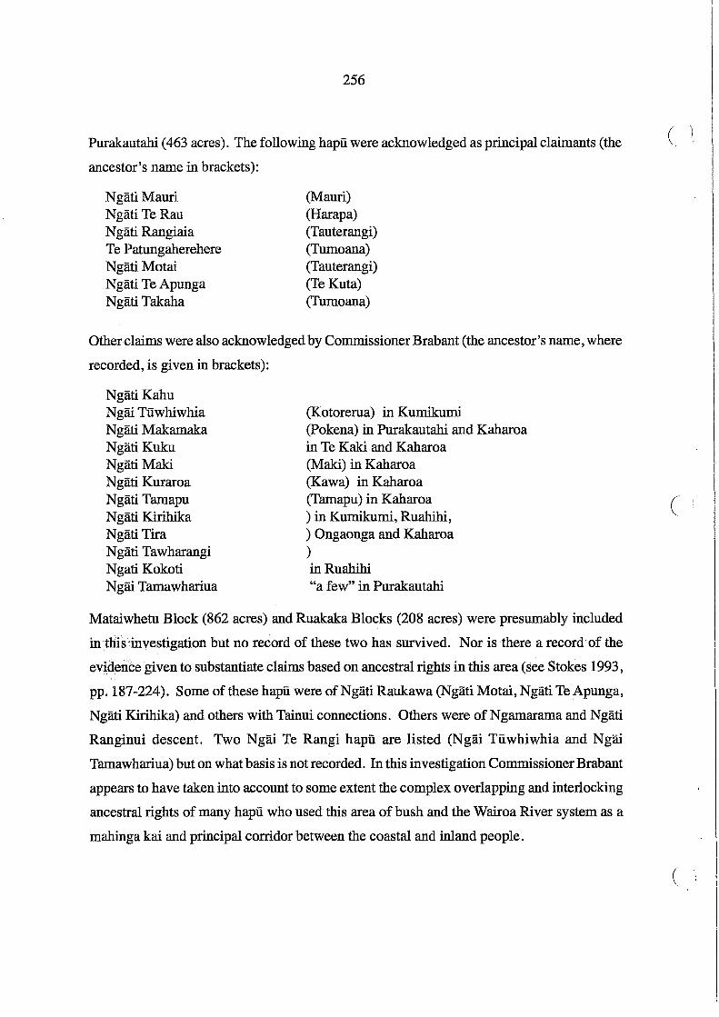
256
Purakautahi (463 acres). The following hapu were acknowledged as principal claimants (the
ancestor's name in brackets):
NgatiMauri Ngati TeRau N gati Rangiaia Te Patungaherehere Ngati Motai Ngati Te Apunga Ngati Takaha
(Mauri) (Harapa) (Tauterangi) (Tumoana) (Tauterangi) (Te Kuta) (Tumoana)
Other claims were also acknowledged by Commissioner Brabant (the ancestor's name, where
recorded, is given in brackets):
NgatiKahu Ngai Tuwhiwhia Ngati Makamaka Ngati Kuku NgatiMaki Ngati Kuraroa Ngati Tamapu Ngati Kirihika Ngati Tira Ngati Tawharangi Ngati Kokoti Ngai Tamawhariua
(Kotorerua) in Kumikumi (pokena) in Purakautahi and Kaharoa in Te Kaki and Kaharoa (Maki) in Kaharoa (Kawa) in Kaharoa (Tamapu) in Kaharoa ) in Kumikumi, Ruahihi, ) Ongaonga and Kaharoa ) in Ruahihi "a few" in Purakautahi
Mataiwhetu Block (862 acres) and Ruakaka Blocks (208 acres) were presumably included
in this'investigation but no record of these two has survived. Nor is there a record of the
evidence given to substantiate claims based on ancestral rights in this area (see Stokes 1993,
pp. 187-224). Some of these hapu were of Ngati Raukawa (NgatiMotai,Ngati TeApunga,
Ngati Kirihika) and others with Tainui connections. Others were of Ngamarama and Ngati
Ranginui descent. Two Ngai Te Rangi hapu are listed (Ngai Tuwhiwhia and Ngai
Tamawhariua) but on what basis is not recorded. In this investigation Commissioner Brabant
appears to have taken into account to some extent the complex overlapping and interlocking
ancestral rights of many hapu who used this area of bush and the Wairoa River system as a
mahinga kai and principal corridor between the coastal and inland people.
( \
(
(
257
The Whakamarama - Mangatotara district to the west of Kaimai was equally complex in the
many hapu who claimed rights there (see Stokes 1993, pp. 147-186). Like Kaimai, there
were hapu with Tainui connections such as Ngati Tokotoko, Ngati Pango and Ngati Hinerangi,
who were linked to Ngati Haua as well as descent from the aboriginal Ngamarama. Others
such as Pirirakau and Ngati Rangi had both Ngamarama and Ngati Ranginui connections.
The various hapu were acknowledged in the several blocks as follows (the ancestors' names
are given in brackets where recorded):
Whakamarama Block: (10,417 acres)
Te Mahau Block (181 acres): Te Jrihanga Block (1029 acres): Oteora Block (2703 acres):
Te Waimanu Block (3370 acres): Mangatotara Block (7660 acres):
Poripori Block (5700 acres):
Pirirakau Ngati Huna Ngati Rape Ngati Rua Ngati Hereawai Ngati Hinerangi Ngati Tokotoko Ngati Taka (Puhi) Ngati Rangi (Paretotaha) Ngati TeAo (Tupuhi) Ngati Hinerangi N gati Pau (Tunakairoro) Ngati Tokotoko (Tokotoko, Tangata and Kura) Ngati Pango (Pukaki) Ngati Riha (Te Riha) Ngati Hinerangi (Koperu) NgatiPango - others?
The . records for Poripori Block are incomplete, but the claimants for the whole block in
cluded Ngati Pango (principal claimant), Ngati Hinerangi, Ngati Taka. and ~gati Rotu, while
the northern part of the block was claimed by Ngati Tane and Ngai Tukairangi, and an east-
em strip by Ngai Tuwhiwhia and Ngati Tira. Both the northern and eastern portions fronted
on to the Wairoa River and it is likely that the two Ngai Te Rangi hapu, Ngai Tuwhiwhia and
Ngai TUkairangi were claiming mahinga kai rights in the block. It is very frustrating that
Brabant's records of investigation of title are so fragmentary and that oral traditions, waiata
and whakapapa given in evidence were not recorded. These inland blocks were on the mar
gins of several tribal areas, and had acted as refuge areas after disputes over land in earlier
generations. These disputes would almost invariably have been followed by strategic mar
riages as part of the peace-making. As a result, the kin networks of these hapu are particu-

258
lady intricate, although many of the hapu names are no longer used. In the next section the (
reserves granted to Pirirakau and Ngati Rangi are considered in more detail. Ngati Tokotoko
and Ngati Haua reserves at Omokoroa are also reviewed below.
It is not possible to determine specific areas for each hapu as subdivisions and allocation of
owners in the inland blocks were closely related to proposed sales, often negotiated before
the blocks were investigated by Commissioner Brabant (see Chapter 9). Inalienable re
serves were set aside in some blocks (see Figure 41). The evidence of Mr Creagh in the " "
Native.Land Court in 1888 in respect of Poripori Block (one of the blocks investigated by
Co~ssioner Barton) illustrates that sales were a distorting factor:
I am a surveyor and surveyed Poripori No.1. I was present when the Poripori Subdivision was made and when the names were given in. It was understood amongst the Natives that Poripori No.1 was for sale, and it was arranged that I should find a purchaser. A list was furnished to me of the owners. I was present at the purchasing of nearly all the shares. It was the general wish that Haaka's share [non seller] should be cut off all those I spoke to about it agreed to this. I know the block. I think near the bush is the best position, it is all fern land, 69 owners have sold to Mr Friedlander. I acted as Agent.
Firth Wrigley, who was also a would-be purchaser, and claimed to have paid for interests in .(
Poripori, was in Court and allowed to question Creagh:
I remember Mr Barton Commr. sitting in Tauranga and I saw his report. He took my papers but I have got them back. I have heard that some owners sold to you, I saw papers with Mr Barton but no proper deed of yours ....
~,.Qpmmittee of the House of Rep [resentative ] s sat on the matter after Mr Barton '8 report -.,reyersed it and decided that the restrictions should be taken off. Ithink the land on the J;i:ve~ is as valuable as that above because of the river frontage (Tauranga MB 3/100-101).
Creagh also stated that none of the sales of individual interests in the block were by children
and noted that Hori Ngatai had conducted the title investigation in Commissioner Brabant's
Court. He commented that Ngatai had also "acted as a sort of agent between the natives
[and] the purchasers of the land". As already indicated in Chapter 9, the land allocation
process in the inland blocks of the "Lands Returned" was complicated by pressures from
would-be investors and speculators, mainly from Auckland, wanting to acquire these blocks
not only for potential sale and settlement but also the possibility of gold and other minerals
in the Kaimai Ranges.

259
Pirirakau
In May 1871 Pirirakau received a payment of £471, which was shared with N gati Hinerangi
and Ngati Tokotoko, a belated recognition of the ancestral rights of these hapu in the Katikati
Te Puna Block (Deed No. 462, Turton 1877, see Appendix 1). During the hui on Motuhoa
at the beginning of November 1866, when Clarke and Mackay were settling reserves in the
Katikati Te Puna Block and the boundary of the Confiscated Block, "Maungapohatu, the old
and principal chief of the Pirirakau" was promised "a reserve of 300 acres being made for
himself and people at Epeha and Waikaraka" (A1HR 1867, A-20, p. 27). This reserve was
granted in two adjacent blocks at Te Puna, Lots 16 and 154 (343 acres), outside the Katikati
Te Puna "purchase" but apparently in recognition of Pirirakau claims in it, as no other re
serve had been allocated to them. Both Lots 16 and 154 were granted to Maungapohatu and
his son Te Wanakore "in trust" for Pirirakau. However, because of their participation in the
"Tauranga Bush Campaign" in 1867, and continued adherence to Pai Marire and the
Kingitanga, the whole hapu of Pirirakau and other hapu allied to them, were branded
"unsurrendered rebels" by Clarke and other officials, and no other reserves were granted.
In December 1873 Native Minister Donald McLean visited Tauranga and attended a meeting
with Pirirakau and allied hapu at Raropua, Te Puna. In his speech responding to the wel
come McLean said:
This discussion of ours is a legacy of war. Let us now turn our attention to fighting with the:land, and get as much under cultivation as possible. You remember the old proverb, "th" fame of a warrior is short-lived, while that ofa man strong to cultivate food is lasting~,~. Tum your strength to the soil: overcome it, that the women and children may laugh at the sight of plenty (A1HR 1877, G-2, p. 9).
Pene Taka of Ngati Rangi responded in turn:
Come and listen to the words of McLean. He says we are to cultivate largely. How am I to do so, when I have no land. Yes! We will cultivate largely; our plough shall reach from this [land] to Otumoetai. Mr McLean you have only to say the word and I will commence at once (ibid).
There were other speakers and McLean invited Maori leaders to meet with him at Te Papa.
Several responses suggested that all the talk should be at this hui. Pene Taka spoke again,

260
airing the Pirirakau grievance that, not only did they have no land to cultivate, but their (
ancestral lands had been given to others:
Mr Clarke and I have often quarrelled about this iand. Mr Clarke had no right to locate settlers here ... I object to the land here being given to people from other places. Do not locate anyone here, either Pakeha or Maori. Bnoka and Hori Kingi have asked for half the land to be given back to them. Do not listen to him Mr McLean; he has got plenty [of] land; do not give him any more (ibid, p. 10).
McLean spoke again:
Twish to make it clear to you about what I meant with regard to cultivating the soil. I do notwish you to suppose that I gave you leave to cultivate any other than those lands that have been allotted to you by Mr Clarke. I have heard that large and valuable reserves have been made for you. There is much more land than the Pirirakau can ever use. You must not therefore expect more land (ibid).
McLean was misinformed, as the only reserves for Pirirakau were 343 acres in Lots 16 and
154 Parish ofTe Puna. Their other lands outside the Confiscated Block were mostly forest
covered, dissected hill country, and their title had not yet been recognised. Or perhaps Clarke
had told him he did not intend to set aside other reserves. Whatever the explanation, no (
further land was allocated and for several years Pene Taka and his people, along with some ,
Ngati Rangiwewehi occupied Omokoroa and, after 1877, Huharua. In 1883 Pene Taka was
awarded Lot 210 Parish ofTe Puna, part of Huharua, but the title was not settled until long
after his death.
In late 1880 Makere Rangitonoa and others ofPirirakau applied to the Native Minister for a
grant of 50 acres at Te Puna. The request was referred to Brabant who responded on 14
March 1881 that 50 acres, part of Lot 205, Parish ofTe Puna should be awarded, "the Grant
to be inalienable except with the leave of the Governor first obtained" (DOSLI files 5/28).
The grantees were to be Aperahama Ruahine (m.a.) Makere Rangitonoa (f.a.), Pirimona
(m.a.), Wiki Matiu (m.a.) and Ihaka (m.c.) but no Crown grant appears to have been issued.
On the same day Brabant wrote a separate letter on the question of lands for Pirirakau to the
Under Secretary, T.W. Lewis:
I have the honour to call the Hon. The Native Minister's attention to the fact that some years ago Mr Henry Clarke Commr. caused certain lands in the parish ofTe Puna (sched-
(

)
261
ule herewith) to be temporarily reserved for the disaffected Pirirakau hapu who were then and are still squatting without leave on Crown lands.
I believe Mr Clarke intended only to give these lands to them in the event of their making a satisfactory submission.
They have never done so, and I hear from the survey department that one or more of the Lots have since been sold. I beg to suggest that steps should be taken to set these lands aside for such Natives as the Commissioner of Tau [ranga] Lands shall from time to time consider should have them - and that any of this Hapu applying to the Commr. should have some share allotted to him.
You are well aware [of] the grievance this hapu have - and that there is some grounds for it and as we have failed to deal with them as a whole- I think we may nowtry to satisfy individuals - no doubt the others will follow (DOSLI files 5/28).
Brabant enclosed a "Schedule of land supposed to be reserved for the Pirirakau" as follows.
All lots were in the Parish of Te Puna:
Lot No. Acres 24 100
199 125 204 57 205 98 206 81
34 204 33 200 29 162 28 100 27 200 37 137 36 200 31 300 32 200 35 100
In Aprll1881 the Crown Lands Department withdrew these blocks from sale, and Brabant
was asked to discuss the matter with Native Minister Ballance during his visit to Tauranga.
The Commissioner of Crown Lands wanted to deal with other lands at Te Puna. Brabant was
again asked to comment, writing to T.W. Lewis on 13 May 1881:"the Pirirakau and
Ngatirangiwewehi hapu, generally known as Hauhau, have squatted on Crown lands in Te
262
Puna Parish and certainly would not move off unless forced". Brabant recommended "that (
no step be taken to deal with them at present" (DOSLI files 5/28). In 1886 only Lot 205 had
been allocated as a Native Reserve but remained Crown land. None of the other blocks in
Brabant's "Schedule" was allocated to Pirirakau or any other Maori.
The legal status of some of the reserves remained problematic, with no Crown grants issued
until long after 1886 when the Commissioners of Tauranga Lands had completed their task.
For example, Lot 210, Parish of Te Puna (50 acres), was part of the site of the surveyed
Township of Te Puna which was never allotted. In 1871 Follett Halcombe, reporting on
landsdn the Tauranga district, commented that he could "see no use in continuing the farce of
a township at Te Puna, as the main road must be inland, and the harbour ofTauranga at the Te
Puna point is quite impracticable for any useful navigation" (AJHR 1872, D-6). The penin
sula was known to Maori as Huharua.
In the late 1870s Huharua was occupied by Maori. In the 1881 Maori Census 15 people of
Ngati Rangi and 54 Ngati Rangiwewehi were recorded as living at Huharua (AJHR 1881, G-
3, p. 20). It has not been ascertained how it was decided that Lot 210 should be allocated to (
Pene Taka who was usually identified by officials as a Pirirakau leader. Lot 210 was not
included on Commissioner Clarke's 1871 list of reserves. In 1882 Lot 210 was allocated to
Pene Taka and the adjacent Lot 211 to Ngati Tokotoko (DOSLI files 5/27). It seems that
Ngati Rangi, Pene Taka's hapu who had allied with Pirirakau in opposing the extension of
the Confiscated Block west of the Wairoa River, had occupied Huharua for some time, but
no title was issued to them. Ngati Rangi also were included in titles to Lots 91 and 453 at
Wairoa:'in the Parish ofTe Papa, awarded in 1886.
On 2 May 1917, under Section 11,Native Land Amendment Act 1912, Judge Wilson in the
Native Land Court made an order vesting Lot 210 in Pene Taka, by now deceased. This
sparked some legal argument over the validity of this order, with opinions expressed by the
Solicitor General and the Chief Judge of the Native Land Court which are reproduced in
Appendix 5. The question was whether Lot 210 was still Crown land, whether it had been
"lawfully set aside or reserved for the Native Penetaka Thaia", under what authority, and
whether the appropriate procedures had been followed. This exchange of opinions serves to
(

. ,
263
illustrate that, with the passage of time, there was some confusion about the status of remain
ing reserves in the Tauranga confiscated lands. It is possible that Ngati Rangi had decided to
consolidate their settlement with Ngati Kahu at Wairoa by 1920. Presumably, Ngati
Rangiwewehi had either returned to their home on the western shores of Lake Rotorua or
joined with Ngati Rangi and Pirirakau. The circumstances leading to the sale of Lot 210 are
not known. On 21 September 1920 a certificate oftitle (CT308/78) was issued to Thomas
Plummer for the 50 acres 1 rood 12 perches of Lot 210, Parish of Te Puna. The peninsula
called Huharua subsequently became known as Plummer's Point.
There:was also litigation over the Pirirakaureserves, Lots 16 and. 154,Parish.ofTe Puna. In
November 1886 Brabant recorded that Kerekau Maungapohatu had informed him that the
County Council "had sold their reserve Lot 16, Te Puna, for rates". The Council had appar
ently sought a Court ruling and "sold the land under the belief that it is European land and
not Maori as it is included in the Property Tax valuations" (DOSLI files 5/28). Brabant
sought clarification from the District Land Registrar in Auckland on 13 November 1886:
It appears from records here that the above Lot together with Lot 154 was set aside by Mr Commr. Clarke as a reserve for natives of the Pirirakau tribe - they have occupied it for the last 15 years, and have now complained to me that they are asked to move off by [a] European who claims to have bought at a sale by the Co. Co. [County Council] for non payment of rates. The Co[ unty] CI[ er]k informs me that in their books the land appears as leased to a Mr Stevenson and that the mistake, if any, has arisen in the Property Tax Office. May I ask you to be so good as to inform me to whom the land was granted, with what restrictions, and whether any lease to Stevenson or sale by the Supreme Court is registered (DOSLI files 5/28).
The District Land Registrar replied on 17 November 1886, listing the following undated
dealings registered against Lot 16, Parish ofTe Puna:
Lease Maungapohatu to Craig Assignment Craig to Macfarlane Memorial Craig versus Macfarlane Assignment Macfarlane to Craig Crown Grant Maungapohatu and Wanakore as trustees Conveyance Registrar Supreme Court to Duthie
Brabant immediately informed Kerekau Maungapohatu, but as the land was now sold, he
could do little but sympathise. There is no explanation why the County Council listed

264
Stevenson as lessee, or why such an error as selling land without checking title occurred. (.
However, it seems that the transfer was somehow stopped but the details are not known.
The title to Lot 154 Parish of Te Puna became an issue when Te Wanakore applied to the
Native Land Court to succeed to the interests of his late father Maungapohatu. The Crown
Grant was issued in 1870 and ante vested to 3 November 1866, the date of the hui on Motuhoa
when many reserves were allocated in the Katikati Te Puna and Confiscated Blocks. Both
Maungapohatu and his son Te Wanakore were named as grantees "in trust" for Pirirakau.
The Court would not in this instance allow Te Wanakore to succeed. In due course an Order
in Council was.issued on 25 September 1909 empowering the Native Land Court to hold an
inquiry to determine the beneficial owners in the trust. In April 1910 the inquiry was con
ducted by Judge Browne and his decision is reproduced in Appendix 2. The Court found that
Pirirakau had not surrendered, and that title vested in the two grantees and their successors:
Apart from the fact that the Confiscated Land Act under which the Grant in question was issued provides that land would be awarded only to loyal Natives or surrendered rebels, the Court does not think it reasonable to suppose that those members of the Pirirakau who were in rebellion and never surrendered are entitled to come in now and take advantage of ( an arrangement which they absolutely refused to agree to at the time it was made: nor does the Court for a moment think it was ever intended by the Commissioners that those who continued in rebellion should participate in the award (Tauranga MB7/52).
This was a bitter blow to the Pirirakau families living on the land, the only coastal lands
remaining to them, as they thought. A group of Pirirakau appealed the decision, on the '.
grounds the Court had not carried out a proper inquiry required by. the Order in Council, but
the appeal was dismissed in November 1910.
In August 1911.Potaua Maihi and others petitioned Parliament for a further inquiry and the
Native Affairs Committee recommended an inquiry (petition No. 146/11, AJHR 1911, 1-3).
In October 1911 Te Wanakore also petitioned Parliament (petition No. 323/11), seeking to
maintain the status quo and that no action be taken until he was given the opportunity to be
heard by the Native Affairs Committee, which recommended an inquiry for this petition too
(AJHR 1912,1-3). It is not clear what happened next but it seems that the Crown purchased
Lot 154 from Te Wanakore and vested it in the Public Trustee. It was later vested in the
Waiariki District Maori Land Board under Section 8 Native Land Claims Adjustment Act (

265
1914. In April 1916 an application by the Native Minister to determine the beneficial own
ers was heard by the Native Land Court. The block was partitioned and allocated as follows:
Lot 154A Lot 154B Lot 154 C Lot 154D
20 acres for descendants of the original grantees 5 acres for the Bidois family 5 acres for the Potier family 263 acres for all Pirirakau including the owners of Lots 154 A,B andC.
In March 1923 another Native Land Court hearing under the Native Land Amendment Act
and Native Land Claims Adjustment Act 1922 removed the descendants of the original grantees
from the list of owners of Lot 154 D (Tauranga MB 11/130-133 , 157). The effect of these
proceedings over many years was to disrupt and divide Pirirakau and create more uncer
tainty over what little remained of their ancestral lands.
In the allocation of ownership of the "Lands Returned" there was no question about the
status ofPirirakau as owners, whether "Hauhau" and unsurrendered rebels or not, when the
Whakamarama Block was awarded to them. In November 1866 Lots 16 and 154 had been
) awarded to them, and granted to Maungapohatu and Te Wanakore as trustees for the hapu.
Other lands were apparently set aside for Pirirakau in the 1870s but were not awarded to
them, because they were still unsurrended rebels. In 1874 Native Officer at Tauranga, Hopkins
Clarke, reported:
Hauhauism in this district may be looked on as a thing of the past, existing only in name. Those that call themselves Hauhaus mix freely with their European neighbours, and in no way attempt to disturb the peace that both races are enjoying. When my other duties have allowed me time to visit them, I have done so, and found them very ,hospitable, and inclined to settle peacefully and cultivate their land. A large portion of the Pirirakau hapu
.. have made a permanent settlement at Te Puna, and only return to the edges of the bush to plant their crops of early potatoes (AJRR 1874,0-2, p. 5).
Summary: Lots 16 and 154 Parish ofTe Puna Whakamarama No.1 Whakamarama No.2 Whakamarama No. 2A Total
343 3330 7080
735 11,499
acres (2 owners) acres ( 181 owners) acres (23 owners) acres (2 owners) acres
Only Lots 16 and 154 were on the coast, and awarded to only two owners. The Whakamarama
blocks were all inland, forest-covered, and mostly dissected hill country of the Kaimai Ranges,

266
and shared with other hapu as noted above. Whakamarama No.2 Block was sold by 1886. (
The Pirirakau population at Te Puna in the Maori Census was:
1874 1878 1881
69 65 47
Pirirakau have centred their community life on four marae in the Te Puna district. The oldest
is Tutereinga Marae, developed in the 1920s on Lot 154, the Pirirakau reserve. Paparoa
Marae was established on Borell family land and Poututerangi on Bidois family land. In
1934 Tawhitinui Marae was established on land purchased by William Nicholas, who had
Ngati·.Haua connections but married into Pirirakau, and this is still known as the Nicholas
family marae.
The Omokoroa Reserves: Ngati Haua and Ngati Tokotoko
In his report dated 26 June 1867 Mackay explained the reasons for allocating reserves to
Ngati Haua during the investigation of claims to Tauranga lands conducted by him and H.T.
Clarke in July 1866:
The Ngatihaua tribe represented by both loyal and rebel natives, only succeeded in making out claims to a piece of land about four hundred acres at Omokoroa, and also fIfty acres at Purakaunui (Memo: Another reserve of about eight acres was afterwards made ... 8 acres Huharua Reserve). It appeared that at one time they had been entitled to occupy
. more land on account of the aid rendered to the Ngaiterangi by Te Waharoa (the father of Willlam Thompson) in their wars with the Arawa and Thames tribes, but .the Ngatihaua had. given up all claims to these at a great meeting held some years ago at Ohuki, Tauranga. ''The:'pieces at Omokoroa and Purakaunui were reserved for them, this was however much against the wish of the Ngaiterangi who would rather have .seen .them receive a cash settlement.
It was evident that the Ngatihaua had no claim either through ancestry or conquest; but merely from being allowed to occupy for the reasons above stated. Te Waharoa had asked for permission to do so in order to be near a port where he could obtain supplies of gunpowder from trading vessels (National Archives Lel/1867/114).
Mackay's "Sketch Plan" of Tauranga lands which accompanied this report indicated that
Ngati Haua reserves were to be located at the northern end of the Omokoroa Peninsula (see
Figure 4).
(
(

267
The reserves allocated to Ngati Haua (Figure 42) were Parish ofTe Puna:
Lot 49 Lot 50 Lot 56 Total
150 acres 52 acres 38 acres
240 acres
All three Lots were vested in two individuals, Te Raihi and Hakiriwhi, "in trust". Lots 49
... and 50 were listed as "inalienable", and Lot 56 as a "grant absolute" in Heaphy's 1871 list of
Native Reserves (AJHR 1871, F-4, p. 16). On 8 June 1869 Mackay sent the following
telegram to Charles Marshall at the Civil Commissioner's Office, Auckland:
There was to be a reserve of 8 acres for Ngatihaua Natives at Huharua Tauranga. This runs through the centre of Te Puna Township from the Beach in a strip about 2 chains wide. Will you select allotments up to eight acres in the Town in lieu thereof, giving some sea frontage, get them adjacent and in good positions as the original holding is the best in the town.
A copy of this telegram was annotated by Marshall on the same day "Selected at the Huharua
Point or Headland. Subject to Mr Mackay's approval" (DOSLI files 2/12). However, this
proposed reserve does not appear to have been allocated and became incorporated into Lot
210 Parish ofTe Puna which was awarded to Pene Taka in 1882.
Reserves were also allocated to Ngati Tokotoko, a hapu of Tainui descent, with ancestral
rights in the Kaimai Ranges: Parish of Te Puna, Lots 52, 53, 187 and 188, a total of 400
acres .. Only Lots 187 and 188 (67 acres) appeared as Native Reserves (but as a "grant abso
lute"}:onHeaphy's 1871 list (AJHR 1871,F-4,p.16). Two small areas of 25 acres each were
granted to individuals: Parish ofTe Puna Lot 51 to Hamueraand Lot 186 to Mere Toki and
Tekiteki (Figure 42). Although all these lands appeared on Clarke's 1871 list of reserves, no
record of the circumstances of this allocation has been found.
Ngati Haua lived at various times in the Tauranga district before the 1860s, often at Omokoroa,
and sometimes at Motuhoa and Matakana. Te Waharoa, father ofWiremu Tamihana Tarapipipi,
was at Motuhoa when he was taken ill in August 1838 during an epidemic of erysipelas. He
was carried inland to Matamata Pa and died there in September. Tarapipipi succeeded his
father as leader of Ngati Haua and kept alive their occupation rights at Omokoroa. In 1860
he and some Ngati Haua were living in the Tauranga district (AJHR 1860,F-3,p.147). There

"', .. I ". ~ t, I
0 I
268
THE OMOKOROA RESERVES
D Ngati Haua Reserves
I{/{::{:j Ngati Tokotoko Reserves
Military Settlers lots
Individual Maori Grants
Captain Fraser's farm
Gellibrand's farm
Roads surveyed 1869
\ 500 1000 I I I I I metres
Figure 42
Omokoroa Pa
Hamuera 25ac
Rauhuia
Huharua
GMO:4-97
(
(
(

269
were long-standing kin linkages of Ngati Haua with Piririikau, Ngati Tokotoko and Ngati
Rangi. Tarapipipi was also much influenced by Christianity. He was one of Archdeacon
A.N. Brown's first converts when he was stationed at Matamata, and when Brown moved to
Tauranga, Tarapipipi maintained his relationship with him and the CMS mission station. By
the late 1860s N gati Haua had mostly returned to their settlements west of the Kaimai Ranges.
In 1874 there was a settlement of 54 Ngati Rangiwewehi at Omokoroa (AJHR 1874, G-7, p.
8). Some members of this hapU of Te Arawa had supported the Kingitanga and supported
Piririikau during the Tauranga Bush Campaign. They were, therefore, branded "rebels" and
remained in the Tauranga district, knowing there would not be a great deal of support for
their stand among Te Arawa if they returned to the Rotorua district. Some Piririikau and a
few Ngati Haua were also living at Omokoroa in the late 1870s. In April 1877 H.T. Clarke,
now Under Secretary for Native Affairs, visited Tauranga on behalf of the Native Minister in
response to a memorandum from Resident Magistrate Brabant "reporting a disposition on
the part of the Pirirakau and Ngatihaua Natives to interfere and quarrel with the adjacent
European settlers" (AJHR 1877, G-l, p. 24). According to Clarke's report after this visit, the
quarrel seems to have involved the leasing of the Omokoroa reserves to Mr J.T. Gellibrand
(Clarke spelled his name Gillibrand although Jenny Woods' history of Omokoroa, for which
a source was the Gellibrand family papers, used this spelling). Piririikau "obstructions"
were said to have included taking some fencing timber, squatting on the land of Captain
Fraser (see Figure 42) and "threatening" Mrs Fraser. Only one person was involved in the
latter:and he denied any intention to intimidate her when he went to the house to discuss the
destruction of some of his crops by Fraser .
. Clarke met with "the Ngaiterangi chiefs", Hori Ngatai and Enoka Te Whanake, who "with
out hesitation stated that a great deal of unnecessary excitement had been created by the
Europeans". They also "suggested that it would probab~y offer a favourable opportunity to
get rid of the N gatihaua element from the Tauranga District by allowing the Natives to alien
ate the land to the Europeans who at present held it under lease". Enoka claimed that he had
opposed the allocation of reserves to Ngati Haua at Omokoroa because it was part of his
ancestral lands. Clarke's report continued:
Later in the day I had a long conversation with Pene Taka, the recognized leader of the

270
Hau-Hau party in Tauranga, in the presence ofHori Ngatai, Enoka and Te Kuka. He, as is ' ( his usual manner, indulged in a great deal of extravagant language, which really meant nothing; but he fInished up by saying that [King] Tawhiao had issued a "panui," desiring all those people who acknowledged his authority to keep their hands behind them, and that all the fIghting now-a-days was to be with the mouth. He stated that the Hau-Haus had been greatly irritated by the false accusations of the Europeans, and by the intemper-ate language of the Ngaiterangi; that I might rest assured that no violence would be at-tempted by the Natives; but, he added, the Pirirakau were bound by their principles to protest vigorously against the occupation of land, whether confiscated or purchased to which they believed they had a claim (AffiR 1877, G-l, pp. 24-25).
Pene''Faka also complained "that the reserves that had been made for the Pirirakau and him
self were not adequate". Clarke replied:
if that was the case they should make the facts known to the Government, and not to expect to gain their ends by annoying their European neighbours; that I was commissioned to tell them, and all the Natives of Tauranga, that the Government were determined to maintain the Europeans in the peaceful occupation of the lands to which they were legally and justly entitled (AJHR 1877, G-l , p. 25).
Two days later Clarke met with the Ngati Haua representatives who had been summoned to
Tauranga, including Te Raihi, Hakiriwhi, Tana Te Waharoa (son of Tarapipipi) , Paul Merritt C (paora Meriti) and others, as well as Enoka Te Whanake and Hori Ngatai of Ngai Te Rangi:
The whole question of the Omokoroa Reserve was discussed amongst themselves. The principal points I gathered were, that, after a vain effort to lease the land in 1867, Raihi had given Paul Merritt leave to occupy Omokoroa on behalf of Ngatihaua. That in March 1871, when the great Te Aroha claim was being investigated by the Native Land Court, Te Raihi and Hakiriwhi, being short of funds, asked Mr Gill of the Native Office, then residing in Auckland, to take it on a lease of twenty-one years. Mr Gill at first refused but subsequently agreed for the above term at £20 per annum. That Mr Gill afterwards saw Paul Merritt and told him of the lease, but informed him that he might still occupy the land till he required it. Paul at that time never questioned the rights of Raihi and Hakiriwhi to lease the land. That when Tana te Waharoa heard that Raihi and Hakiriwhi had for three years been drawing and appropriating the rents, he thought it time to interfere. He then wrote to Paul Merritt telling him to keep possession of the land. That, although the Ngatihaua expressed their dissatisfaction to Te Raihi and Hakiriwhi, they still continued to appropriate the rents. Raihi admitted having received £120 from Mr Gill (AJHR 1877, G-l, p. 25).
By this stage Gellibrand had taken over Gill's lease "and held the land legally", and would
also need to be involved in any arrangements Ngati Haua might make. Although Clarke (

271
acknowledged Ngati Haua had "some cause of complaint" against the trustees, Te Raihi and
Hakiriwhi, his principal concern seems to have been to secure European occupation rather
than investigate Maori complaints about inadequate reserves.
There were more meetings and Ngati Haua agreed to sell Lots 49 and 50 to Gellibrand for
£350, a price which Clarke considered "fair - indeed high". Clarke agreed to make a recom
mendation to the Governor to remove the restrictions on alienation of the reserves. Ngati
Rangh::vewehi also agreed "to move off Omokoroa" but Clarke was disappointed they in
tended.to remain with Pirirakau in the Tauranga district, declining his recommendation "to
return to their own country, Rotorua" (AJHR 1877, G-l, p. 26). In the 1878 Maori Census
45 Ngati Rangiwewehi were recorded as living at Te Dmu 0 Korongaehe, inland near Te
Irihanga (AJHR 1878, G-2, p. 21). Clarke did not report on any meetings with N gati Tokotoko.
Perhaps they were represented among Pirirakau, as he regularly lumped all the inland hapu
together as Hauhau, and if he named them at all, then all were Pirirakau. However, the
owners of the Ngati Tokotoko reserves and the two individual grants at Omokoroa were also
persuaded to sell. On 15 June 1880 a certificate of title (CT 19/131) was issued to Joseph
Tice Gellibrand for an area of 765 acres comprising Parish ofTe Puna Lots 49, 50, 51 , 52, 53,
54,55,63,186,187 and 188. The sum of the areas of these Lots comes to 797 acres, but the
discrepancy can probably be explained by the deductions for roads surveyed by 1869 and
other boundary adjustments on survey. The following table summarises the transactions
compiled from Gellibrand's records (see Woods 1980, pp. 58-61,100-104,158-161):
NgatiHaua Reserves:
Lots 49 and 50 (202 acres) granted to Te Raihi and Hakiriwhi "in trust": 28 March 1871: Lease to R.J. Gill for 21 years, at £20 per annum; 29 December 1876: Lease transferred to J.T. Gellibrand for £300; 26 April 1877: Land sold to Gellibrand for £350 plus expenses, total £450. Payment of the £350 was made in instalments as follows: 30 April 1877: £170 - £120 for Ngati Haua, £50 for Tana Te Waharoa 2 June 1877: £20 - Paul Merritt 13 June 1877: 25 June 1877: 13 August 1877:
£100 - "paid to Grantor on account of Ngati Rangiwewehi" £30 - Paul Merritt £30 - balance paid to Commissioner Brabant on account of Te Raihi and Hakiriwhi
272
Ngati Tokotoko Reserves:
Lots 52 and 53 (333 acres) granted to Te Makaka, Te Puru and Ngawaka Patuhoe "in trust",
sold to R.I. Gill in 1868, and sold to J.T. Gellibrand in 1877 for £650.
Lots 187 and 188 (67 acres) granted to Te Makaka, Te Puru and Ngawaka Patuhoe, leased to
R.J. Gill in 1870, lease transferred to J.T. Gellibrand in 1876 for £300, and land sold to
Gellibrand in 1877 for £100, paid to the three grantees.
Indi~raua1 Grants:
Lot 51 (25 acres) granted to Hamuera, sold to Gellibrand in 1877 for £30 (paid to Kirimaere
in Gellibrand's records).
Lot 186 (25 acres) granted to Mere Toki (Toke) and Tekiteki, sold to Gellibrand in 1877 for
£70 (paid to Mere Toki and her husband, and a woman representing Tekiteki, according to
Gellibrand's records).
Military Settlers' Lots:
Lot 54 (40 acres) granted to Frank Lake in 1869 Lot 55 (45 acres) granted to Joseph Ayton in 1869 Lot 63 (50 acres) granted to George Slater in 1868
By 1877 Frank Lake had also acquired Lots 55 and 63 when he sold all three to J .T. Gellibrand,
price ·unknown.
An account of these transactions from Gellibrand's point of view has been compiled by
Woods (1980) from Gellibrand's records. He is referred to as Tice in this account. It seems
that when he took over Gill's lease, Gellibrand indicated his desire to purchase Lots 49, 50,
187 and 188:
Lots 49 and 50 were not so easy to acquire. Ngaiterangi disputed the right of Ngati Haua to dispose of the land and made their complaint known to Under Secretary of the Native Office, Wellington, Henry Tacey Clarke. Through Herbert William Brabant, the Resident Magistrate, Tauranga, Clarke asked Tice to agree to a conference being held between the two parties, which Tice did. In the meantime Pirirakau prevented him from occupying his freehold land at "Lakes" opposite Te Puna (Station Road). On March 23 he and Mr
(
(
(
273
Burrows went over to choose a site for the house. When they arrived, Mr Fullerton's cutter was seen on the beach, loaded with fencing rails, and surrounded by Maoris. Tice learned that Pirirakau had re-Ioaded all the rails and threatened to burn any they found on the beach. The search for a house site was adjourned "sine die" as Tice put it, and everyone returned to Tauranga straight away, leaving the beach to Pirirakau.
The following day Tice called on Mr E.M. Edgecumbe, Chairman of the Town Board, and arranged for a public meeting to be held in the Temperance Hall on Wednesday 4th April at 6.30pm to discuss the native land question. Edgecumbe, as it happened, was also proprietor of The Bay of Plenty Times, and as a result of hearing Tice's story ofPirirakau's obstruction, reported on the incident in the next issue of the newspaper. Commissioner Herbert Brabant was quickly on the scene the following Saturday, March 24th. Pirirakau tried their usual blustering tactics which failed to impress the Magistrate, and after advising them of the consequences of interfering in Tice's lawful business, they agreed to desist.
The meeting was well attended and enabled the settlers to let off a goodly amount of steam. Mr Wrigley was most vociferous. He believed "everyone had waited long enough for Government to open up the out-country districts for settlement". He went on to say that although a great proportion of the purchase money had been paid over to the natives, of the 80,000 acres available for settlement, only 12,000 acres had been taken up by "certain individuals who had sufficient interest to get the land. The balance of the 80,000 acres was perhaps being held over for the same persons." It was his opinion that no obstruction rested with the natives, and believed they were as anxious for settlement as anyone. Wrigley concluded his remarks by pointing out that the northern members in the House of Representatives were in the minority and couldn't care less about the fate of the Bay of Plenty, but if the southern members knew "their warmest sympathy would be given". So it was up to the settlers present to inform the southern members in the House, otherwise "God help us."
Tice obviously believed that no obstruction lay with the Maoris . either, and'as if to prove Wrigley's comments true, followed the meeting up with an appointment to see Penetaka, Chief of Pirirakau. The two duly met in Richard Jordan's [land agent] Office on The Strand, on Monday, the 9th April, 1877, and discussed their respective points of view. At the end of the interview Penetaka asked Tice to write down the following words in his Memoranda Book:
"That it was the wish of his heart that I should go down to Omokoroa at once and take my land and bllild my house and be his Chief and look after his interests."
Penetaka wrote a document in Maori to this effect addressed to the Governor and requested it to be forwarded to the authorities. Never again did Pirirakau worry Tice and the two men remained on good terms. In fact many years later Penetaka supplied maize for the farm turkeys and took charge of a working party engaged to drain a large swamp down by the Waipapa River. His signed receipts for wages are on file ....
274
The dispute over Lots 49 and 50 looked like being resolved on April 24 when Tice learned ( from Jordan that Henry Tacey Clarke had agreed to uplift the entail, on condition that five chief men of Ngati Haua asked Government to do so. Jordan was instructed to proceed at once to purchase the land.
On April 26, Ngati Haua agreed to sign a Deed of Conveyance the following day, naming their price at £350 plus expenses. Tice agreed to a price not exceeding £2 an acre, or £404 in all, on the strict understanding that he obtained immediate and absolute possession. He also hoped that Paul Meriti and the other "Ngaiterangi whi whi" [Ngati Rangiwewehi] who were living on the Point would leave as soon as the Deed was executed.
The. following day, as arranged, the Ngati Haua grantees arrived at Jordan's office and signed the Conveyance in the presence of Henry Tacey Clarke and Herbert Brabant. On the day after, Saturday April 28th, the actual handing-over ceremony took place on the headland, with Wiremu [Tana] Tamihana and other Ngati Haua leaders arriving.by sea, while Richard Jordan, Paul Meriti, and Peter Grant travelled to Omokoroa by road. Peter Grant was working on the peninsula for Tice at the time and acted as one of his representatives, and Jordan's witness. The large whare Paul had occupied was given to Peter to hold on behalf of Tice, Paul agreeing to receive £50 in full and fmal payment for it, together with all improvements. Furthermore, it was also agreed that Paul should leave the Point on May 12th and that no money would change hands until such time as all the Ngati Rangiwewehi had gone. Two days later Richard Jordan met Herbert Brabant and Civil Commissioner Hopkins Clarke at Omokoroa. They informed him that everything was in order and to their satisfaction. On the strength of that information Tice made out a cheque for £202.12.6 in part payment for Lots 49 and 50. Little did he realise, however, that it would take another three to four months before the matter was completely settled. Delays and bunglings between the brothers Clarke not only caused frustration and inconvenience to both the Maori and Tice, but also added considerably to the cost of the trans-action. In fact, at one stage, Tice even had to ask the Maoris to stir up some action of their 0W:J?: to try and get the matter settled.
FromTice's Memoranda Book of June 13thwe find "Telegram sent by H.T.Clarke, (U.S. [Under Secretary Native Department] Wellington) to R.C. Jordan 'Re Omokoroa I,.ots 49 and 50' stating that the Governor's consent not required for the Conveyance, but that the Native Minister, Dr Pollen, approves of the alienation of the land. Mr Jordan there and then, as my agent, sought an interview with Mr Hopkins Clarke [Native Office, Tauranga] at the Government Building and stated to him in a business way that the whole of the responsibility "re Lots 49, 50 Omokoroa" would rest with the Govt. The 'Ngaiterangi whi whi' [Ngati Rangiwewehi] from Te Puna Point (lately of Omokoroa Point) arrived in town today and demanded payment of £100, upon an order from Te Raihi and Hakiriwhi - I gave Mr Jordan a cheque for £100 on his producing to me a 'memorandum' from Mr Brabant to the effect that the money was. due on Te Raihi's order. Mr Jordan took the money up to the Government Building and paid £80 to the natives in the presence of Mr Hopkins Clarke and left £20 with Mr Clarke to pay as soon as the proper recipients were
(
(

275
present to give a receipt." Previous to this, however, there were a number of telegrams and a letter from Henry Tacey Clarke in Wellington, all of which were sent to Richard Jordan as Tice's official agent, and these show quite clearly how confused the two brothers were as to the discharge of their respective duties. On June 16, Tice wrote in his Memoranda Book "Called and had interview with Mr Hopkins Clarke at the Govt. Building, re delay and misunderstanding of "uplifting entail" on Lots 49,50 Omokoroa. Mr Clarke assures me that Mr H.T. Clarke at Wellington had 'wired' to him to the effect that he had been altogether misled on the matter, and had made a mistake in sending back the conveyance 'without the Governor's consent being attached.' Mr H.T. Clarke requests us to send it back at once thro' his brother at the Govt. Building. The 'Conveyance' having rea~hing Mr R.C. Jordan thro' the post, Mr Jordan took it up at once to Mr H. [Hopkins] Clarke, so that it might be forwarded by the next boat." As Tice remarked later, the whole bus.iness was "passing strange".
Both conveyances - for Lots 49, 50 and 187, 188 finally went to Auckland - with the Governor's consent attached - on July 23rd, but it was not till August 13 that Tice was able to square up with the Maoris. Following payment being made, he handed all the native receipts to Jordan, who in tum handed them to Magistrate Herbert Brabant. Freehold possession was thus finally given and taken (Woods 1980, pp. 100-104).
The sale of the Omokoroa reserves, as detailed in J .T. Gellibrand's personal papers, provides
one of very few examples where transactions involving transfer of Maori title by lease and
sale has been reasonably well documented. These transactions also raise the question of the
role of officials of the Native Department in assisting in the transfer of Maori land instead of
protecting Maori ownership of their reserves.
The only land left in Maori ownership on the Omokoroa peninsula was Lot 56 (38 acres)
which was granted to Te Raihi and Hakiriwhi "in trust" for the Ngati Haua tribe. The title
remainyd in this form until 1935 when it came before the Native Land Court in an applica
tion to ascertain beneficial owners. By this stage the 38 acres had been split into two pieces
by the taking of a strip of land for the East Coast Main Trunk Railway. Evidence given at
this hearing indicated that Ngati Haua people used to camp on this block when visiting the
Tauranga district, partiCUlarly for fishing expeditions, and that Ngati Haua people had lived
there at various times. The judgment on this case, delivered by Judge MacCormick at
Ngaruawahia on 26 November 1936, is quoted in full, from a typescript in Maori Land Court
files, because it seems to be the only instance in the Tauranga confiscated lands where the
continuing existence of a trust for a tribe was recognised by the Native Land Court:

276
Lot 56 Parish of Te Puna
Application by Wiremu Nikorahi to Ascertain beneficial owners.
This application was partly heard at Tauranga on 12th August 1935 when the evidence of the applicant was taken. It being common ground that the land belonged to Ngatihaua the matter was then adjourned to Ngaruawahia. At the latter place Mr Cooney stated he was acting for certain claimants and asked for a further adjournment to enable him to examine records and to consider position. Mr Cooney has now appeared and intimated that after fullest inquiry he does not find himself able to contend that any particular individuals of Ngatihaua have any exclusive rights in the land. The Court considers this a proper admission on the part of counsel and is entirely of the opinion that none of the claimants has established any exclusive right.
~', .'{ . ... ,' ~s land was in 1869 the subject of a Crown Grant to two natives Te Raihi and Te Hakiriwhi "m trust forthe Ngatihaua tribe". Inquiry from the Native Department and Land Department for any records or information as to the circumstances under which the Grant issued had little result, but it was ascertained that the Grant issued under the New Zealand Settlements Acts of 1863 and 1865 but there was nothing to show the reason for the Grant. However the records show that the Crown purchased Te Puna and Katikati Blocks during the years 1866 to 1871, that Mr Jas Mackay Junior acted for the Crown in the purchases and prepared a sketch showing the locations of the various hapus and tribes. Ngatihaua
(
were shown on this sketch as occupying a peninsula in Tauranga Harbour known as ( Omokoroa of which Allotment 56 Te Puna Parish forms part. This suggests a possible reason for the Crown grant.
It may have no bearing on this case but it would appear that there is some connection between a section of Ngatihaua and Ngaiterangi. This is shown in the Journals of the House of Representatives 1867 A20 Page 13. This connection is chiefly through Pirirakau a hapu said to belong to both tribes.
Such occupation as has been deposed to has not been continuous during any lengthy period.
The Court therefore is not prepared to exercise jurisdiction under Part V of The Native Land Act 1931. The Trust is still in existence and there would be no objection to appointing new Trustees in lieu of the deceased Grantees. In the face of the Trust the Succession Order to Te Raihi in respect of this land on 9th Sept. 1914 appears invalid and steps should be taken to have it set aside.
The position might be clarified either by moving to have the land created a Native Reserve or by special legislation.
The significant issue in this judgment was that the Court recognised the continuing existence
of a trust, and the status ofTe Raihi and Hakiriwhi as trustees, not owners. The block was ( '-

277
vested in the Maori Trustee to be held in trust for members of the Ngati Haua tribe. No list
of beneficial owners was compiled. The block was leased from the early 1950s. In the early
1980s the lease was surrendered and the block was vested in trustees appointed by the Maori
Land Court under Section 438 Maori Affairs Act 1953 and named Ngati Haua Tribal Trust.
The block remains Ngati Haua tribal land with any profits to be distributed to Ngati Haua
marae.
Hapii of the Western Harbour
One of the difficulties in determining the hapuwho held ancestral rights in the lands around
the western part of Tauranga Harbour is that occupation was abandoned in the 1820s follow
ing Nga Puhi raids in Hauraki and the Bay of Plenty. These lands were also contested by
Hauraki tribes as outlined in Chapters 3 and 4. Most of the reserves in the Katikati Te Puna
Block were grants to individuals, as listed in the previous chapter. There were also several
hapu reserves granted "in trust" to individuals, but in the late 1860s through 1870s many of
these reserves were sold. For example, of the reserves at Ongare and Kauri Point, several
Lots were sold in 1868-69, including Lot 9 Parish of Tahawai (500 acres) granted to Rotoehu
and Timi Te Rua "in trust" for Ngai Tamawhariua. By the late 1870s only Lot 5 Parish of
. Tahawai (100 acres) remained in Maori ownership, but it had been leased for 99 years.
When the lease expired control of the block reverted to Maori in a trust established by the
Maori Land Court. The establishment of the Katikati Special Settlement in 1875 brought in
Pakeha settlers and increased the pressure to sell or lease the reserves. A number of old
kainga were abandoned. For example, Te Ngare who had been allocated Lot211 Parish of
Apata (200 acres) established their marae on Rangiwaea at Opounui. In the Maori Census
1881 a total of 47 people ofTe Ngare were recorded at Opounui.
Several of the reserves at Tahawai had not been allocated to owners, although they were
occupied by small numbers of Maori. In 1884 Brabant investigated these blocks, which
were all in the Parish ofTahawai. Lots 21 and 23 (100 acres) were deemed to be the reserve
listed in the "Ngaiterangi Deed" for the "Heirs of Taw aha" (Appendix 1). Brabant reported
to the Native Office in May 1884:

278
Tawaha, a chief has been dead for many years, but Te Riri Tawaha his nephew has always (\ occupied this land. I have no papers to show that this is the same 100 acres mentioned in the deed but I know it from the fact that there is no other 100 acres at Tahawai reserved for the heirs of Tawaha (DOSLI fIles 5/28).
In the same letter Brabant noted that Lots 18 and 22 had been surveyed and set aside as
reserves by Clarke but not allocated. On 15 January 1874 Clarke had noted that Lot 18 (50
acres) was "for Te Amo and her children to include the land they have in cultivation" (DOSLI
files 5/28). Brabant noted in his May 1884 letter that Te Amo "thought she should have got
mort?Aand, was very dissatisfied and has once, if not twice petitioned Parliament on the
subject" (DOSLI fIles 5/28). Lot 18 was vested in 9 owners.
Lot 22 Parish ofTahawai (50 acres) was noted by Clarke on 9 November 1873 as aninalien
able reserve "in trust" for Ngati Teoteo. This land, known as Papakura, was to be vested in
Riko, Kurawhero, Pumamao, Wharekawa and Hiroa, but no Crown grant was issued. The
population atPapakura was listed in the Maori Census as 22 in 1874 and 16 in 1878. In 1881
Ngati Teoteo was recorded as 23 people at Rereatukahia. In 1884 Brabant vested Lot 22 in
8 owners. By 1885 the kainga had been abandoned and the adjacent settler, Thomas H.
Fletcher, complained to Brabant about:
Trespassing cattle which are sent in numbers to graze on the Maori reserve as a common and have broken down the fence erected by Maoris between my land and this settlement and do me much injury since the Maoris have left this settlement about 2 years ago when they were here all was right please say can this reserve be sold or let or given for grazing or can the entrance which is about 12ft wide be shut so as to hinder Trespassers (DOSLI fIles 5/28).
Brab~t replied that the reserve could not be sold without the consent of the· GoverP.or, but
that Fletcher could if he wished make an offer to the owners to lease it. Lot 22 was leased
and subsequently sold.
A number of the reserves granted to individuals were probably intended as providing lands
for hapu represented by the individuals named on the grant, or at least their extended fami
lies. That some of these were sold, leaving descendents landless, has already been com
mented on. One further example is the lands in the Parish of Tahawai at Rereatukahia allo
cated to Hohepa Te Kai: Lot 11 (200 acres) and Te Moananui Maraki: Lots 12 (250 acres),
(
(
.!
279
13 (263 acres), and 14 (37 acres). In August 1878 Lot 12 was before the Native Land Court.
Ngapiri Marata Moananui, son of Te Moananui Maraki stated:
This land has been sold. I should like to know who was the interpreter who interpreted the Deed of Sale of this land. I believe that if he [Te Moananui Maraki] parted with the land he parted with it foolishly. I believe he did not get the whole of the money for this land. The Interpreter ought to know whether he was properly paid or not (Tauranga MB 1115).
A conveyance was produced in Court showing a transfer to Henry Stephen Skeet, dated 12
February 1869, for £37.10.0, attested by ThomasH. Smith and interpreted by Gilbert Mair,
Licensed Interpreter, and a further transfer to Richard Thomas Gill, dated 10 March 1869,
for £80. Te Moananui Wharenui stated in Court:
I object to the sale of this land because this land was given in trust to Te Moananui [Maraki] for the tribe Ngatimura. The map of this land is in the Survey Office - Te Moananui and others means the whole of his hapu - on the Crown Grant only Te Moananui's name appears but on the map Te Moananui and others (Tauranga MB 1116).
He went on to support Ngapiri's statement, saying: "Te Moananui sold the land without the
consent of his children". He also explained that there had been a "gift" of 50 acres of this
. land which:
belong to Hohepa te Winika. Given to him by Hohepa te Kai these 50 acres were sold without the consent of Hohepa te Winika. The gift ... was witnessed by many persons -this land was sold clandestinely (Tauranga MB 1117).
Hohepa Te Winika also appeared in Court and stated:
That land was sold clandestinely by Te Moananui without the knowledge of his children or other relatives - if we had heard of this transaction of his we should have objected at the time. This is why we have petitioned Parliament to have this land returned to us - under the understanding that this land was given to Te Moananui and others - we have already sent a Petition to the Govt. concerning Rereatukahia to be returned to us (Tauranga MB 11 19).
The petition of "Winika Hohepa" (Petition No. 143/1878) was heard by the Native Affairs
Committee in October 1878. H.T. Clarke was called on to explain that the land was "within
the Te Puna and Katikati purchase" and part of it had already been before the Native Affairs
Committee. Clarke stated:

280
When that land was sold, Moananui [Maraki], as I stated on a previous occasion, asked ( for a reserve of 500 acres for himself and his family. Hohepa te Kai, another Chief of the same tribe, asked for a reserve of 250 acres adjoining this reserve. This land was granted to Hohepa te Kai individually. No one else was interested in it at all. When the land was being surveyed Hohepa te Kai and Moananui came before me and Hohepa te Kai volun-tarily stated that he gave up 50 acres that he had got himself to Moananui. That gave Moananui 550 acres and Hohepa te Kai 200 acres. You will find that Crown Grants are made out in that way. I took a memorandum of it, and ordered the survey to be made out according to this arrangement. Both men are now dead, and that is the reason why these different applications have come in. That is the whole story about the reserve.
How was this 50 acres sold? - It is alleged to have been sold to Mr Gill. I believe he bought part of Moananui's reserve. It was a matter of petition two years ago (National AI~hives Le 1/1878/6; Raupatu Document Bank Vol. 1, pp.311-314).
The earlier petition has not been located but in this hearing Clarke maintained that Te Moananui
Maraki had "a perfect legal right to dispose of' the land. The Native Affairs Committee
decided to make no recommendation on this petition (AlHR 1878,1-3).
The circumstances surrounding the leases and sales of reserves around the western harbour
are poorly documented. The effect was to force Maori to remove themselves elsewhere,
some to Matakana and Rangiwaea. The few who remained seem to have consolidated in the
small area of Maori land remaining at Rereatukahia where the marae was established under
the umbrella ofNgai Tamawhariua. The other marae of this hapu is Rangihouhiri on Matakana
Island.
In the 1870s the remaining Maori communities sought access to the timber resources of the
bush on the Kaimai Ranges. Te Moananui Maraki had already been allocated 100 acres of
bush in Lot 49 Parish ofTe Mania. The adjacent Lot 50 (100 acres) was set aside as a Native
reserve, described as a "General Wood Reserve". Tawaha and others at Tahawai applied to
Commissioner Brabant for an area of bush, which he was prepared to support but could not
allocate immediately. On 17 September 1879 Brabant advised the Chairman of the Waste
Lands Board in Auckland that his recommendation to set aside a timber reserve "from which
Natives might cut timber for their own use" had been approved by the Native Department. On
19 September 1879 Brabant was advised by the Commissioner of Crown Lands that "he has
been requested to cause 200 ac. of land at Katikati to be surveyed in order that the same may be
set apart as a Timber Reserve for the use of the Natives at Katikati" (DOSLI files 5/28). How-
c
(

281
ever the survey was not done immediately and on 11 March 1881 Brabant requested that it
be "done as soon as possible" and be located "as near the Tahawai Native Reserve as possi
ble". In October 1883 Brabant was sent a plan showing Lot 74 Parish of Katikati as a Timber
Reserve of 263 acres, although he was subsequently advised that the area was 270 acres.
The adjacent Lot 73 of 197 acres was labelled "Native Reserve". It was recommended for
sale by the Stout Ngata Commission in 1908 (AJHR 1908, G-1K). All of these reserves
remained Crown land, and do not appear to have been gazetted as Native reserves, or allo
cated to Maori owners.
One hapu reserve that was not part of the "Ngaiterangi Deed" was Te Urungawera Reserve,
Lot 97 Parish of Katikati. This hapu was a section of Whanau a Tauwhao who lived on
Tuhua, and derived their name from an incident in 1836 when Tautari attacked their pa on
Tuhua and burned all their canoes hauled up on the beach below (see Stokes 1980d, pp. 37-
39). Apparently Te Urungawera petitioned the Native Minister for land. On 9 December
1873 H.T. Clarke sent a memorandum to the surveyor A.C. Turner:
The Honorable the Native Minister directs that you will be good enough to layoff for the Urungawera hapu (to be arranged by Hori Tupaea as their principal man) one hundred and fifty acres ofland on the north side of the Waiau River to be taken back to the confiscated line as laid down by Mr Mackay. The land is required for use and occupation and therefore should be good cultivable soil (DOSLI files 5/28).
On survey this block was found to contain 164 acres but no further action was taken. Some
time late in 1879 or 1880 a list of 59 owners was determined by Commissioner Wilson,
althOUg;~ no other details were recorded.
In 1881 the matter came to the attention of Commissioner Brabant when the Under Secretary
for Native Affairs sought clarification of the status of the reserve, whether it was "intended
to be granted to the natives" or "only to be made a reserve for the use of natives named".
Brabant replied on 23 May 1881:
This is a block of land granted by Sir Donald Maclean some years ago to Te Urungawera in consideration of their claims on the Katikati purchased block. The grant was made at the request of the late chiefHori Tupaea, and the Ngaiterangi who were supposed to have had moneys which might more properly have been paid to the Urungawera. The land should certainly be granted to the Natives and Government would probably as a tribal reserve make it inalienable without consent of the Governor ...

282
As I find that Mr Commissioner Wilson settled the names for the grant after due inquiry I (\ have not thought it necessary to go into that question again (DOSLI files 5/28).
A Crown grant for Lot 97, Parish of Katikati (162 acres) was issued on 24 November 1882
(CT24/25) in equal shares to the following: Te Tohatoha, Te Kaiwa, Tarau, Te Morehu, Te
Wiremu, Potie, Wakatotara, Kaka, Kawhena, Taiharuru, Paora, Takerata, Hape, Hokirua,
Maihi, Te Rata, Te Riha, Hohepa, Te Ponui, Peta Koraki, Marino, Te Kiriwai, Ngahipi, Hirini,
Hekara, Ngawai, Heera, Papapine, Ngakapu, Huhana, Hariata, Turi, Taura, Mariana, Urupehia,
Te Harihari, Tokerau, Rania, Irona, Neko, Ngaroahiahi, Towhau, Heni, Mokomoko, Mangere,
Te Ohuka, Tiki, Raiha, Peti, Tinimeene, Wi Kotero, Mutu, Kuhi, Anitana, Mere, Nahi, Te ,:,M:,
Ngar9pi, Te Araroa, and Te Amoroa, a total of 59 owners. The population ofTe Urungawera
in the Katikati district and Tuhua was listed in the Maori Census as 57 in 1878, but decreas
ing to 40 in 1878 and 49 in 1881. In 1901 the kainga on Tuhua was abandoned but the island
was visited regularly by Whanau a Tauwhao seeking kaimoana.
The allocation of additional land for Te Urungawera had been supported by Hori Tupaea.
Wh~au a Tauwhao had been allocated, land near the western entrance to Tauranga Harbour,
Lot 1 (68 acres) and Lot 3 (32 acres) Parish of Katikati, granted "in trust" to Te Ninihi, Te (
Patu and Te Turere. Hori Tupaea had also recieved an individual grant with Te Moananui of
50 acres in Lot 2, adjacent to Lot 3, a place called Ahi Patiki. A further grant for Whanau a
Tauwhao, in addition to those made at Otumoetai described earlier, was on Pirirakau land at
Te Puna, Lot 8 Parish ofTe Puna (100 acres), vested "in trust" in Hori Tupaea and Akuhata
Tupa~~~ This block was sold, but the reserves at Otawhiwhi and Ahi Patiki remained in
Maori, .. qwnership. There was a kainga atAhi Patiki in the 1870s where a me~ting house was
built in 1878 (Stokes 1980d, pp. 68-69). The Ahi Patiki lands were sold for residential
subdivision in the 1970s. There was also a small kainga at Otawhiwhi on Lot 1, and a
meeting house was built there in the 1880s. A new house was built in 1916. The present
Otiiwhiwhi Marae was rebuilt in the 1980s (Stokes 1980d, pp. 70-77).
Matakana and Rangiwaea acted as refuge areas for Ngai Te Rangi hapu. As already noted in
the previous chapter, much of the sand dune area of Matakana was quickly sold. No records
have survived to ascertain how owners were allocated on the remaining area of Matakana
and Rangiwaea. However, as the Native Land Court decision on partition ofTe Umuhapuku (

283
No.1 Block suggests (see Appendix 3), these lands were not allocated on the basis of ances
tral title but were used to allocate lands to many individuals who might otherwise be landless.
As a result, the ownership lists contain a mixture of names. On Matakana the marae commu
nities have consolidated since the 1880s; Ngai Tuwhiwhia at Opureora and Ngai Tamawhariua
at Rangihouhiri Marae. On Rangiwaea the two marae communities were centred on Opounui
(Te Ngare) and Rangiwaea Marae (Whiinau a Tauwhao).
Conclusions on the Allocation of Reserves to Hapii
It is not possible to to establish in numerical terms just how many.acres were allocated to
each hapu. Indeed, it is difficult to be precise about what constituted ahapu in the 1860s and
1870s, as many grants appeared to be for individuals on behalf of their whiinau, sometimes
expressed as "the children" , but usually an extended family was implied. Or at least that was
how many descendants interpreted the grants made to individual ancestors, especially when
they found out their reserves had been sold. Underlying the whole process of allocation of
reserves was the policy of individualisation of Maori titles, a process already established in
the operation of the Native Land Court under the Native Lands Act 1865 on lands outside the
confiscation line.
In Tauranga Moana the Maori title to all the lands inside the line described in the proclama
tion in 1865, and again in the Tauranga District Lands Act 1868, was extinguished. It all
became Crown land, some of which Crown-appointed officials allocated to Maori, under
powers'not clearly defined. Initially, Civil Commissioners Clarke and -Mackay were given
this task although the role of Whitaker in 1866 remains unclear. Afier the ,passing of the
Tauranga District Lands Act 1867, commissioners were appointed, but their powers were
undefined in the Act. There was no appeal procedure except by petition to the Native Min
ister, Parliament, or the Governor, and there were numerous petitions.
All of the hapu received some land, although Pirirakau, as "unsurrendered rebels", were
denied additional reserves in the coastal lands which would have made their allocation com
parable with others. Pirirakau and their allied Ngati Ranginui hapu of the Wairoa valley also
suffered from the burning of their villages and destruction of crops during the "Tauranga

284
Bush Campaign" in 1867. All of the Ngati Ranginui hapu on the Confiscated Block found (
themselves confmed to very small reserves on coastal lands, quite inadequate for their future
needs, however measured. Their only other lands were inland, in dissected bush country,
some of which remains in forest, and unsuitable for farming. Ngai Te Rangi hapu on the
Confiscated Block and Katikati Te Puna Block mostly migrated, leaving only a few small
communities in the western harbour and none at Otiimoetai, formerly the principal settle-
ment of Tauranga Moana. Matakana, Rangiwaea and Whareroa became refuge areas for
Ngai Te Rangi. On the "Lands Returned" east of the harbour and Waimapu River, the ances
tral.Apldings of various hapu of Ngai Te Rangi, Ngati Piikenga and Te Arawa (Waitaha in
parti~plar) were disrupted by sales of land before 1886. The "compulsory purchase',' by the
Crown of Mauao and adjoining peninsula was a loss for all the hapu as Mauao is the maunga
tapu of Tauranga Moana.
In conclusion then:
All the hapu of Tauranga Moana were allocated some land
All the hapu were affected to a greater or lesser extent by loss of land in the Confis- ( cated Block and the compulsory purchase of Katikati Te Puna Block
Because the confiscation extinguished Maori customary title, there was inadequate attention paid to ancestral rights to particular lands and resources.
The failure of Crown officials to restrict the alienation of hapu reserves exacerbated the loss oflands.
- ,There was massive social and economic disruption among all the hapu because of ",:~:the prolonged and complex land transactions over the period 1865 toJ886.
c
285
15. Some Concluding Comments
By 1886 not only had the people of Tauranga Moana lost substantial areas of ancestral lands
in the Confiscated Block and Katikati Te Puna Block, but more than half of the "Lands
Returned" had also been alienated. An important issue to be considered is whether the
reserves allocated to Maori were adequate for their foreseeable needs. A related issue is
whether there should have been more effective restrictions on alienation to ensure that the
land resource base of the hapu of Tauranga Moana was adequate for future needs. This is a
difficult concept to consider in retrospect. It did not appear to be an issue that was brought
up for discussion among officials. It seems to have been assumed that in the long term Maori
would be expected to adapt to European ways, that any farming activities would follow
European methods, and that individualisation of Maori title would encourage this desirable
end. In 1877 H.T. Clarke did attempt to set a rough ratio of people to land area, although his
calculations were based on an inaccurate estimate of a total area in the Tauranga confiscated
lands of 214,000 acres. The Sim Commission in 1928 had accepted a figure of 290,000
acres. Clarke argued in 1877 that there was still land in the Tauranga district that could be
made available for European settlement:
The Tauranga District is estimated to contain 214,000 acres. This Government have purchased 80,000 and confiscated 50,000. I estimate at the very least 15,000 acres have been acquired from the Natives by private individuals, making a total of 145,000 acres. By "The Native Lands Act, 1873" sec. 24, there is a proviso that "No land reserved for the support and maintenance of the Natives, as also endowments for their benefit, shall be considered a sufficiency for such purpose, unless the reserves so made for these objects added together shall be equal to an aggregate amount of not less than fifty acres per head for every Native man, woman and child" .
The Native popUlation of Tauranga by last census [1874], was 1,245. Taking this as a basis of calculation, the Tauranga Natives ought to have 62,500 acres: adding those figures to the acreage already acquired gives a total of 207,250 acres, leaving a small balance of 6,750 acres open for purchase (AJHR 1877, G-l, p. 27).
But these calculations do not take into account the quality of the land, which was variable,
ranging from saline swamp to good horticultural land, to steep, forest-covered ranges. Nor
was there any statement of how Maori were supposed to live on their 50 acres although it

286
seems to be implied that some sort of farming was envisaged. Clarke's figures were also
underestimated. As already noted, the Sim Commission estimate of the total area of the
Tauranga confiscated lands was 290,000 acres. In 1877 the Katikati Te Puna Block bound
ary had not all been surveyed, but 80,000 acres was also probably underestimated. A com
puter check on the area suggests at least 100,000 acres were acquired by the Crown in this
compulsory purchase.
In Volume 2 of this report all the blocks allocated to Maori between 1864 and 1886, except
those in the Town of Tauranga and Township of Greerton, have been compiled into one list
with the names of the original owners of each block. On the basis of this list the area allo
cated to Maori in the Tauranga confiscated lands (excluding Town of Tauranga and Town
ship of Greerton) was:
Katikati Te Puna and Confiscated Block 16,602 acres
"Lands Returned" 134,946 acres
Total 151,548 acres
(
It is not possible to determine the population from the list of 4193 names of owners for (
several reasons, including variations in spelling (each variation is listed separately), the re-
cording of alternative names in different lists for the same person, the passage of time over
the two decades that it took the Commissioners to fmalise the Tauranga reserves, and the
different methods of allocating owners ("leading men" in the 1860s and all men, women and
childr~n in the 1880s). However, the population figures for the Maori Census of 1874,1878
an4J881, in spite of possible inaccuracies in enumeration, can be used to provide a rough :::: ... :,",
ratio of land p~r person. In each case the total area of 151,548 acres was divided by the
population.
1874: 1245 people = 122 acres per person 1878: 1086 people = 139.5 acres per person 1881: 1020 people = 148.5 acres per person
However, by 1886 a substantial area of the "Lands Returned" had been alienated. The fol
lowing table was compiled from figures set out in Commissioner Brabant's report on "Lands
Returned" (AJHR 1886, G-lO):
(

287
Crown purchase completed Crown purchase incomplete
Private purchase completed Private leases
Total alienated (acres,roods,perches)
4,957.1.06 13,936.2.26
49,243.0.08 1,224.2.38
) ) 18893.3.32
) ) 50,467.3 .06
69,361.2.38
The total area of the "Lands Returned" was, according to Brabant's calculation, 136,191
acres and 39 perches. Ignoring the roods and perches the total alienations, including leases,
deducted from the total area indicates that more than half of the "Lands Returned" was
removed from Maori ownership and control by 1886:
Total area Less alienations Balance
136,191 acres 69,362 acres 66,829 acres Maori land
The total area of the blocks in the "Lands Returned" in the computer list in Volume 2 of this
report is 134,946 acres, a difference of 1 ,255 acres from Brabant's total. This is not a signifi
cant difference for several reasons: the computer list used whole acres and ignored roods
and perches; Brabant described his total as "a gross area of 136,191 acres" and in many
blocks deductions for roads had not been made; the computer list used the figures for whole
acres, derived from Maori Land Court records and Certificate of Title, and checked against
early cadastral plans. Discrepancies in areas on survey were inevitable, and appeared on
some of the plans. For example, some of the discrepancies in blocks in the sand dune area of
Matakana can be related to erosion and/or accretion of the shore line, and in other blocks
around the harbour to inaccurate determination of high water mark in tidal mudflats and
swamps. In the heavy bush of the ranges many areas were not accurately surveyed in the
1880s. Wherever possible the areas stated in the computer list were derived from the earliest
authoritative record that could be located. Given the large number of blocks, the many
records, and the fragmentary nature of most of them, it can be expected that errors have crept
in. However, this discrepancy in specific figures does not detract from the important conclu
sion that by 1886 over half of the "Lands Returned" to Maori had been wrested from Maori
control.
By 1886 a considerable number of the reserves in the Confiscated and Katikati Te Puna
Blocks had also been alienated, but it has not been possible to determine accurately just how

288
many in 1886. The usual pattern was a lease, often followed by a sale. A very conservative (
estimate would be that at least half of the area of 16,602 acres on the computer list allocated
in reserves had been alienated. If so, then a further 8300 acres should be deducted. The
figures from Brabant's list will be used for this calculation:
Total area allocated: Lands Returned 136,191 acres Less alienations 69,362 acres Balance 66,829 Reserves 16,602 acres Less alienation 8,301 acres Balance 8,301 Total area alienated 75,130 acres
The total area allocated to Maori, using Brabant's figure for "Lands Returned", and the
computer list for reserves is:
Lands Returned Reserves Total allocated Less alienations Balance
136,191 acres 16,602 acres
152,743 75,130 77,613 acres
If the popUlation: land ratio is recalculated on the basis of population figures in the Maori
Census and a total area of 77,613 acres of land available to Maori then a different pattern
emerges:
1874: 1245 people 1878: 1086 people 1881: 1020 people
= 62 acres per person = 71 acres per person = 76 acres per person
These figures need to be treated with some caution as there are likely inacuracies in the
population numbers, and the area of land alienated by 1886 is probably underestimated.
Another factor that needs to be taken into account is that much of the land remaining in
Maori ownership in 1886 was dissected, forest-covered land not suitable for farm develop
ment. If even half the land available to Maori in 1886 is not farmable, then the ratios are
reduced to somewhere between 30 and 35 acres per person of good land. The concept of a
people: land ratio is a very crude measure indeed. The important issue is that the land
resource for Maori of Tauranga Moana was already severely depleted by 1886.
(

289
From the mid 1870s the Pakeha population was increasing with an influx of settlers in the
Katikati Special Settlement in 1875 and Te Puke Special Settlement in 1880. By 1880 the
Pakeha population outnumbered Maori in Tauranga County:
Year 1874 1878 1881 1891 1901 1906 1911 1916 1921
Maori 1245 1086 1020 1497 1301 2040 1718 1703 2190
Pakeha 920
1447 2408 2448 2665 3046 4278 5632 7725
The figures for 1874-1881 in this table represent Tauranga district excluding Maketu-Rotorua
for the Maori population, but the Pakeha popUlation in these years is for the whole county
which then included the Maketu and Rotorua districts. Although there were few Pakeha
settlers in these districts before 1880, the popUlation figures are inflated because of the dif
ferent area involved. From 1891 onwards the figures are all for Tauranga County, which
included the Maketu district. Another measure of Maori population in Tauranga Moana is to
list the population described as "Ngaiterangi" in the Maori Census, which included hapu of
Ngai Te Rangi, Ngati Ranginui and Ngati Pfikenga of Tauranga Moana:
1874 1878 1881 1886 1891 1896 1901
1122 973 966 944 884 848 870
After 1901 Maori Census figures were no longer compiled on a tribal or hapu basis. This
definition of Maori population is limited as only "Ngaiterangi" actually resident in the dis
trict at Census time were counted.
Not only was the land resource base depleted but by the 1900s the Maori population was
increasing, and Pakeha pressure for land for settlement was also increasing. If Maori were

290
not farming their land it was assumed by many Pakeha that it should be made available for (
Pakeha settlers. What did not seem to be part of the policy was provision for capital and
expertise to be made available to Maori farmers. On 21 September 1905 the Legislative
Council ordered that a return be prepared "giving the estimated total acreage of Native land
in the North Island unoccupied or unproductive" and a general report on blocks of over 1000
acres in this category (Legislative Council Paper Session II, 1906, No.5). In Tauranga
County the following blocks were identified within the confiscated lands (Figure 43):
Coastal Blocks Area (acres) ApproxNo. No. Of of occupants owners
Matakana Island 4412 35 595 Whareroa 1254 20 59 Mangatawa 1295 45 175 Hikutawatawa 1089 23 Pt. Papamoa 2 1665 15 99 Pt. Papamoa 2610 50 99
Inland Blocks Whakamarama 3866 203 Waimanu 1 etc. 3370 271 Poripori 1 and 2 5700 112 Mangatotara 1 1104 83 Mangatotara 3 1000 8 Kaimai 1 C and 2 3008 178 Tauwharawhara 2268 74 Paengaroa 2890 53 Otawa 1 and 2 2380 126
With <the exception of the Papamoa blocks which were described as "second class land" , the
coastal blocks were all "first class land" and "open", that is, not covered in bush. All the
inland blocks were bush-covered, second class land, and, except for Otawa, contained millable
timber. All these blocks were considered "fitted for close settlement", but this assessment
can best be described as optimistic for the forest-covered blocks in the Kaimai Ranges.
The Stout Ngata Commission reported on "Native Lands and Native-Land Tenure" in the
Tauranga district in June 1908 (AJHR 1908, G-IK). The report covered the "central part" of
Tauranga County, excluding Te Arawa lands of the Te Puke-Maketu districts in the county.
Also excluded was the "northern part" because the Commission had not yet "met the Maoris
(
( "

Katikati - Te Puna
291
"UNPRODUCTIVE NATIVE LAND" 1906
Block './_l.,<.,~
0 I I
~ 5 10
I I I I kHometras
"Unproductive" Maori Land 1906 (Blocks over 1000 acres)
1:;::;::::::::::1 Lands already sold by 1886
Note: Only blocks over 1 ,000 acres were listed
GMO:3/97
Figure 43
292
interested, who are connected with the Ngatihaua Maoris resident in or near Waharoa". Pre- (
sumably this referred to the Whakamarama and Mangatotara blocks in which Ngati Tokotoko,
N gati Hinerangi and other hapu as well as Pirirakau had interests. The lands reported on
have been mapped in Figure 44. It was not a complete review of all the Maori lands in the
district as only two blocks on Matakana and none on Rangiwaea and Motuhoa were consid-
ered. Nor were the few remaining reserves in the Katikati Te Puna Block considered, apart
from a recommendation to sell Lot 73 Parish of Katikati (197 acres), which had been set
aside .. as a Native reserve but not gazetted. On the Confiscated Block Lots 452 and 116B
(Huria:) and Lot 80 (Te Reti) in the Parish of Te Papa, all Ngai Tamarawaho lands, and Lot
446 Parish of Te Papa were listed as kainga lands.
The Commissioners summarised their recommendations as follows:
Lands leased or under negotiation for lease 1,444a. Or. Op. Lands under Maori occupation 26,037 1 36 Lands to be dealt with under
Native Land Settlement Act 1907: For lease 9,452 1 8 For sale 6,037 0 24
Total 42,970 3 28
The Commissioners also commented generally on Maori lands in the district:
The bulk of the lands in the Tauranga County (central portion) were confiscated, and the lands now owned by the Maoris were handed back to them for their sustenance and support. There are 2,040 Maoris in the county, and 1,999 Europeans [not including the population of the Town of Tauranga]. When the lands in the northern part are dealt with it will be'found that the area of land left to the Maoris for their own occupation, and leased to Europeans, will not amount to 90,000 acres, or less than 45 acres each. The area possessed by Europeans per head will be at least three times as great as that left to the Maoris. The Maoris on the whole seem active and energetic. Most of the county work and of the farm labour of the Europeans is done by the Maoris, and but for this supply of Maori labour it would be impossible to carry on farming. The Maoris are also employed in agriculture for themselves, and produce maize, wheat, oats and root-crops. They have been successful also in dairying, and have on one block four hundred milking cows. There is, however, little attempt to carry on farming on individualistic lines, and the incorporation system has not been tried. They have, however, come to amicable decisions amongst themselves, so that there is some security of title to the occupants. This, however, is a county in which there is need of guidance by some agricultural expert, so that
(
(

293
Katikati - Te Puna Block i''-_''",,~
o 5 10 I t ! t J , I
kilometres
Te Weraitl
Lan~~recommended for general settlement
1-:-:':-:-:-:':'1 ........
'·021
Lands to be Gazetted under Native Land Settlement Act 1907
Under negotiation for lease
Lands reserved for Maori occupation
1:~;!m!,!;ij!:iJil;l:1 Kainga and cultivations
... Other lands
Figure 44
LANDS REPORTED ON BY STOUT - NGATA COMMISSION
1908
GMO:3/97

294
the undeniable advantages of climate and soil might be better utilised (AlHR 1908, G- ( 1K, p.1).
This last recommendation was not acted on although the Commissioners' comments about
the potential of the Tauranga district for horticulture and orcharding were well-founded.
The distribution of remaining Maori lands in Tauranga Moana in the twentieth century was
determined by the patterns of confiscation and purchase before 1886. Through the decades
to the 1950s there was a gradual erosion of the remaining land resource, with small pieces
here and there sold, or as in the case of the "Tauranga Aerodrome", and the "Rifle Range
Reserve" at Papamoa, taken under the Public Works Act. The construction of the East Coast
Main Trunk Line over the period 1913-1928 had also meant loss of some lands. Figure 45,
which was compiled in the late 1950s from Tauranga County Council and Department of
Lands and Survey records, provides a snapshot of Maori land holdings by about 1950. The
map is indicative but not totally accurate, as small blocks less than 10 acres were not mapped.
The year 1950 was a turning point for the Tauranga district because a decision was made to
develop the port, and this stimulated urban growth. The Town of Tauranga was transformed
from a small, rural, fishing village and agricultural service centre, with a population of less
than 5000, into an aggressively expanding urban area. This created further pressure on
Maori lands, and more loss of lands through sales for subdivisions, and more public works
takings for the port and new transport routes. In the inland blocks there were sales of some
lands for non payment ofrates in the late 1960s and 1970s. However, all this is another story
which is beyond the scope of this report.
(
(

- ,
.. .. .. .. .. Summit of ..
MtTe Aroha .. "
~,~ ~ ~ ~ ~
'''--, , \,
\ \ ~ , ~ ~ ~ , ~ ,
\ ) ~ , ~~ ~ ,
.. .. .. .. .. .. .. .. .. ..
~,
Ngafamahinerua"\, ,
\\ \, \' \\
\'
\~ \
\ \
\ \
\ Waianuanu*
I I
I I
I
Te Weraifi* .. .. ....
Maori Land 1950
~ Maori Land Alienated 1930-1950
Watershed on Kaimai Ranges
.. .. .. ..
295
Figure 45
I I
I I
I I
I I
I I
I
o 5 10 I !, I! I
kilometres
GMO:l0/97
296
16. References
Manuscript Sources
Brown,A.N.1835-1884: Letters and Papers. The Elms, Tauranga.
Clarke, H.T. 1861-1866: Letters to T.H. Smith. (typescript) Tauranga Public Library.
Department of Survey and Land Information (DOSLI files): Tauranga Confiscation, files now held in the Hamilton office of Land Information New Zealand, and reproduced in
... ,B-aupatu Document Bank, Waitangi Tribunal, vols. 124-127 (see note on DOSLI files below).
Department of Survey and Land Information: Hamilton office, File 14/32, Papers re Native Reserves in the Tauranga district.
District Surveyor, Tauranga 1866-1868: Letterbook. Tauranga Public Library.
Halcombe, A.F., 1872: Report on Blocks at Tauranga. National Archives 1M 72/131.
Haultain, T.W. 1867: Papers relating to the recent military operations at Tauranga. National Archives Le1l1867/120.
Mackay, J. Jr., 1867: Report by Mr Mackay on the Katikati Purchase and other questions relating to the District of Tauranga. National Archives Le1l1867/114. (
Maori Land Court: Commissioner Brabant's Minute Book No.1 Judge Wilson's Minute Book No.9 Tauranga Minute Books (passim) Maketu Minute Books 1 and 2 Waikato Minute Books 4, 6 and 7
Putnam, P. 1872: Topographical Report on the Tauranga District. National Archives CD 721 1149.
Smith, T.H., 1864-1865: Miscellaneous Papers. Ms 283, Auckland Institute and Museum Library.
Official Publications
Appendices to the Journals o/the House o/Representatives (AJHR). Appendices to the Journals o/the Legislative Council (AJLC). Great Britain Parliamentary Papers (GBPP) Irish University Press edition. New Zealand Gazette. New Zealand Parliamentary Debates (NZPD) New Zealand Statutes
(

Newspapers
Bay of Plenty Times New Zealand Herald Tauranga Argus
Other Publications and Reports
297
Bodell, J. 1982: A Soldier's View of Empire, The Reminiscences of James Bodell, 1831-92. Edited by K. Sinclair, London, Bodley Head.
Cowan, J. 1983: The New Zealand Wars. Wellington, Government Printer, 2 Vols.
Dalton, B.J. 1967: War and Politics in New Zealand 1855-1870. Sydney University Press.
Gifford, W.H. and Williams, H.B. 1940: A Centennial History ofTauranga. Dunedin, Reed.
Jenks,H.J. [1990]: Forgotten Men, TheSurveyofTaurangaandDistrict 1864-1869. Tauranga Historical Society.
Mikaere, B. 1997: Te Raupatu 0 Pirirakau, The Pirirakau Claim Historical Report. Report for Waitangi Tribunal.
Miles, A. 1993: Kopukairoa, Tauranga Telecom Site. Waitangi Tribunal Resarch Series 1993/4.
Moss, E.G.B. 1888: Native Lands and their Incidents. Auckland, Wilson and Horton.
Murray, J.E. 1997: Crown Policy on Maori Reserved Lands, 1840 to 1865, and Lands Restricted from Alienation 1865 to 1900. Waitangi Tribunal, Rangahaua Whanui Series National Theme L.
Nightingale, T. 1996: The Commissioners ofTauranga Lands 1868-1886. Report for Waitangi Tribunal.
Oakman, R. 1965: Whakamarama School and District. Tauranga, Don Kale Printing Co.
O'Malley, V.1995: The Aftermath of the TaurangaRaupatu, 1864-1981. An Overview ,Report Commissioned by the Crown Forestry Rental Trust.
Pool,1. 1991: Te Iwi Maori: A New Zealand Population, Past, Present and Projected. Auckland University Press.
Riseborough, H. 1994: The Crown and Tauranga Moana 1864-1868. A Report for the Crown Forestry Rental Trust.
Stokes, E. 1980a: A History of Tauranga County. Palmerston North, Dunmore Press for Tauranga County Council.
Stokes, E. 1980b: Pai Marire and the Niu at Kuranui. University ofWaikato, Centre for Maori Studies and Research Occasional Paper No.6.

298
Stokes, E. 1980c: Tauranga Moana, The Impact of Urban Growth. University ofWaikato, ( Centre for Maori Studies and Research Occasional Paper No.7.
Stokes, E. 1980d: Whanau a Tauwhao, A History of a Ngaiterangi Hapu. University of Waikato, Centre for Maori Studies and Research, Occasional Paper No.8.
Stokes, E. 1980e: Matakana and Rangiwaea, A Report on an Island Community. University ofWaikato, Centre for Maori Studies and Research, Occasional Paper No. 10.
Stokes, E. 1983: Ngamanawa, A Study of Conflicts in the Use of Forest Land. University of Waikato for the Ngamanawa Incorporation.
Stokes, E. 1990: Te Raupatu 0 Tauranga Moana: The Confiscation of Tauranga Lands,A 'Report for the Waitangi Tribunal, Hamilton, University of Waikato.
Stok~~~ E. 1992: Te Raupatu 0 Tauranga Moana, Volume 2: Documents Relating to Tribal -lIistory, Confiscation and Reallocation of Lands. Hamilton, University ofWaikato.
Stokes, E. 1997: Pai Marire and Raupatu at Tauranga 1864-1867. New Zealand Journal of History 31(1), pp. 58-84.
Stone, R.C.J. 1973: Makers of Fortune, A Colonial Business Community and its Fall. Auckland and Oxford University Press.
Tauranga District Maori Council 1989: Nga Marae me nga Iwi 0 te Moana 0 Tauranga. Tauranga, Moana Press.
Turton, H.H. 1877: Maori Deeds of Land Purchase in the North Island of New Zealand. Vol. 1, Auckland Province, Wellington, Government Printer.
Turton,H.H.1877: Plans of Land Purchases in the North Island of New Zealand. Wellington, Government Printer.
Waitangi Tribunal 1994: Te Maunga Railways Land Report. Wellington, Brookers.
Ward,A.D.1995: A Show of Justice: Racial "Amalgamation" in Nineteenth Century New ,',Zealand. Auckland University Press.
Wilson, J.A. 1884: The Modus Operandi of Judgment Without Trial, or; How I Lost My .Judgeship. Auckland, Freeman's Journal Office.
Woodley, S. 1993: Matakana Island. Waitangi Tribunal Research Series 1993/5.
Maps and Plans
1. Plans held by the Department of Survey and Land Information, now Land Information New Zealand: (a) Head Office, Wellington: A15: Confiscated Land at Tauranga, 1 inch to 40 chains [1867]. A16: Tauranga District, 1 inch to 20 chains, Auckland, Survey Department, February
1868.
{ ,
(

299
A28: Plan of the District of Tauranga, 1 inch to 40 chains [1865]. A52: Plan of Land Surveyed in the Katikati Block, 1 inch to 40 chains, Auckland,
Office of the Inspector of Surveys, May 1868. A69: Plan of Surveys on the Confiscated Land, Tauranga, 1870. . A78: Plan of the Tauranga Confiscated Block, 1 inch to 1 mile, Auckland, Waikato
Lands Office, 9 February 187l. A94: Stewart's Special Settlement, Katikati, surveyed by E.C. Goldsmith [1875].
(b) Hamilton Office: Roll Plan B43: Plan of Surveys in the Confiscated Block, Tauranga 1 inch to 40 chains,
Auckland Survey Office, 1869 [with numerous annotations post 1869]. SO 428: Otumoetai Block, Tauranga, Surveyed by T. Heale, 1865. SO 441: Plan of Tauranga [Town, c.1870 with later annotations] ML 9760: Plan of Native Reserves between the Wairoa and Te Puna Rivers [c. 1870].
2. Other manuscript maps and plans:
Te Papa Anchorage and Channel, Tauranga Harbour, 1864, National Archives ADCD 1864/3071.
Sketch Map of Tauranga and Waikato Districts by Mr Mackay, January 7th 1871, University ofWaikato Library.
3. Published maps, held in the University ofWaikato Library:
Index Map ofTauranga County, Cadastrall:63360,Auckland Survey Office, September 1893.
Tauranga, NZ Cadastral Map County Series 1:63360, Third Edition, August 1955. Section No.1 Town of Tauranga. Surveyed by Messrs. Warner, Goldsmith and Turner.
Auckland, New Zealand Survey, 1883. Section No.2 [Town of] Tauranga. Surveyed by C.B. Frasi, F.J. Utting and E.C.
Goldsmith. Auckland, New Zealand Survey, 1902. Town of Tauranga. Auckland, NZ Lands and Survey, 1909. Town and Suburbs of Greerton. Auckland, New Zealand Survey, 1887. Tauranga. Topographical Depot of the War Office, 1864,2 inches to 1 mile.
Note on ''DOSLI fIles"
The records of the Tauranga Confiscation held by the Hamilton office of the Department of Survey and Land Information (DOSLI), and now known as Land Information New Zealand (LINZ) , have been referred to in this report as DOSLI files. In 1989 with the co-operation of Don Prentice, then in charge of the Maori Land Section of DOSLI, I undertook the task of sorting out several large boxes of unnumbered and mixed up files relating to the Waikato, Tauranga and eastern Bay of Plenty confiscated lands, which were subsequently copied and incorporated into the Raupatu Document Bank by the Waitangi Tribunal. The Tauranga papers were sorted into 5 box files which contain 33 folders, numbered by box and folder.

300
For example DOSLI files 3/17 refers to Box 3 and Folder 17. In The Raupatu Document ( Bank the DOSLI files are located as follows:
RDB, Vol. 124. RDB, Vol. 125 RDB, Vol. 126 RDB, Vol. 127
DOSLI files 111 - 117 DOSLI files 2/8 - 3/16 DOSLI files 3/17 - 4/25 DOSLI files 4/26 - 5/33
The Tauranga records in the DOSLI files cover the period from December 1864 to 1886, including papers on the Katikati Te Puna "purchase", reports from James Mackay Jr., H.T. Clarke and others, and lists of "awards" made before the Tauranga District Land Acts were passed, (Folders 1-7). The Native Land Court had no jurisdiction but there is correspondence about-this and some legal opinions in Folder 8, and letters to Chief Judge Fenton in· Folder 9 which indicate some peripheral involvement. Folders 10-15 cover the period of Commissioner H.T. Clarke's jurisdiction 1868-78. There is little evidence of work done by Commissioner H.W. Brabant in this period and none by W. G. Mair. Folders 16-33 cover the period of Brabant's administration which included finalising work of allocating reserves and issue of Crown Grants started by Mackay and Clarke in the Katikati Te Puna Block, Confiscated Block and Township of Tauranga. The major task of investigating titles of "Lands Returned" was begun by Commissioner J. Wilson and completed by Brabant in 1886. For a complete schedule of "Lands Returned" see AJHR 1886, G-lO.
Index of Folders
Box 1: 1. Reports of James Mackay Jr. 1866-67 2. Reports ofH.T. Clarke and T. Heale 1865 3. "Mr Whitaker's Tauranga Papers" 1865-66 4. Katikati Block Arbitration 1864-65 5. Katikati Te Puna Purchase 6. Papers on Pirirakau 1866-67 7. Mackay's Awards 1866
Box 2: 8. Correspondence of Chief Judge Fenton 1865-67 9. Maori letters to Chief Judge Fenton 1868-71 10. Miscellaneous Papers 1866-67 11. H.T. Clarke's Schedules of Awards 1868-75 12. Mackay's Awards 1868-71. 13. H.T. Clarke's Correspondence and Papers 1866-76 14. Fairfax Johnson papers 1870-76 15. Petition of Mrs Korowhiti Douglas
(

301
Box 3: 16. Brabant's Notes of Evidence 1881-86 17. "Assessor's Notes" 1881 18. Mount Maunganui 19. Hopukiore, Motuotau, Moturiki, Te Maire and Whareroa Blocks 20. Karewa and Tuhua
Box 4: 21. Commissioner Wilson's Awards and Brabant's Revisions 1880-86 22. Brabant's List of Lands Returned 1885 23 . Crown Grants
. 24.:Papers on Brabant's Appointment as Commissioner of Tauranga Lands 1881 25. . . Papers on Removal of Restrictions on Alienation 1876-84 26. Miscellaneous papers 1879..:85
Box 5: 27. Brabant's Correspondence and Papers 1881-86 28. Papers on Awards in Katikati Te Puna Purchase 1873-87 29. Faulkner Family papers 30. Papers re Dispute over Timber Cut in Mangorewa Gorge 31. Captain Daldy's Dispute re Matakana Island 1884 32. Petitions of Children of Philip Tapsell 1886 33. Report on Claim by Descendants of Hamiora Tu

302
Appendix 1 : Deeds for the Katikati Te Puna Block
Source: H.H. Turton 1877: Maori Deeds of Land Purchase in the North Island of New Zealand. Vol. 1, Auckland Province, Wellington, Government Printer
Deed No. 458 : The Ngati Paoa Deed, August 1866 Deed No. 459 : The Tawera Deed, August 1866 Deed No. 460 : The Ngati Maru and Ngati Tamatera Deed, September 1866' Deed No. 461 : The "Ngaiterangi Deed", November 1866 Deed No. 462 : The Pirirakau, Ngati Hinerangi and Ngati Tokotoko Deed, May 1871
(
( i
(

303
The Ngati Paoa Deed August 1866
Deeds-No, 458. TJ~ PUN .......... Nl) KA'l'IKA1'[ ThoCK No, 1, ~1\AI1It,\NCl.I, l~,\Y 0.' l'I,l'N'l'Y DJlI'!'llIO'l',
TEN!!:r l'uKAl'UKA. i tllhituhil~ i lCllci tclmll IJ lI~n ra u AkulmLa i III tMl 0 to i~~tllu Al'ilti l!:W() 110 PuJtapulm lino hnlw tillo hOl~tll tillo iultll wlmlmuLi atll na matoll ll:1 IIga RallgaLim 1110 Ilg,\ 'J\:LlIl-(;\b~ n NWLlihul':L, () NgILI;ipllUJ~ 110 I'alull uglL ingO:L 0 mall i 1"1\1'0 nei a Jwi wlllLkuatu tOlll'i PuJIllJlulm IllO 1Illl.I.UlI 111(\ i> llIr1lU\1 W!J:llIlLllllgll UlU 0 maiou \lI'j 1110
to tuhiluhillga 0 U ~lInloll illgmL ki trmci pllklL)lulm i I"ltI'O i tc 1';t (\ wiliLi nei klla whttkartlrlm,\'uWll.tiIL klln. tino tlllulIJlL 1'jJ.\\'ILtin. niu ki IL \Viki(ori;l Kililli () Ing:Lmni ki Olm uri ki IIgl\ lCillgi ki nga lCuiui II IIIl1ri illl) i It. in. 1110 Ulll~ IJW It I'ntun c whulllu'ilc ai hoi whakaritcngt\ 1110 lJga Paulla IIwni KollLlli I'Il.U (£WO) lum ullin IlIlli ki :t matCltl c'l'iomi IHnko 1Il0 to Kuiui (It 0 wlmllnaol,ia 1lOi tl IIl1tt.}U to ril'(lJl~n IIl1li 0 aUtL mOil i) Ito t:Ullt wlLhi IVhel11la. lmLol~ kci 10 IIL1dwn "i '1'lLIu'llIlgll 11\1 j;o Puna, 1111 KltLillnt i llgll. illgOlL 0 lalla wlLhi whcUUI\ Jill ngn !'Ohe lwi 1'lLl'n i to "J'ukaplI'Jul n(li U 1I1:111 lLlllt t.o kON!!'1I whalmhnCTll }[(J to llIapi Iwi{i 0 tllim wlwllIm lmlL ll.piiiLhL Id tOllci, lifo OJIIL l'ulL:\U Jill) (11111 Iwwhalu lIlo Olll\ \\'ui 1110 ona. ;lWI\. llui 1110 olin I'otn 1110 Oll/L Itwn l'i!'jki 1I11.l 11ga 111(11\ lcaton u tmUt wholllln (t l'ungn l'Illlui 0 l'ill'() l'IUllli i to IIlILf:IL 0 tnlln. WllOllIlIt 1Il0 U lIutton t.i!wllgn mo 0
mlLtou hLke 1110 " lIIa!.')!1 JllL:Lnga lu~t(Httnllgn lei tlllla wILhi i Kill Hum LUlIu hilL Kuini \ViJdtOl,ilL ki OWL UI'i Iti IUIlL l'lIllei Il wllllltn.rhc ILi hoi tino mall Illun all(} iOllll ILI.U, A hei 1011l1 mo to IIWtUU wlllLkaautn,lIfjlL ld Jlgu. lilmngn Imtua Iw l:mwi l'lIllapullll luut tuhituhia lIei II IIIILtllU jllgo.~ lUO 0 IIlILttm Lilian, A hoi tohu hold mo 10 whlL\Ultwt!lllgll 0 L() :Kuini (I 'Illgamlli mo I;tu:t \Valli Ici ng:L l,ilmngn llllilllL II tOlwi PUICllpu11f1.lollL 1,llllilL lIei to ingoIL Cl !J~jclUi flflLlw K IIi IV hal,lu'j Le W 11(\11 IIlL, '1\ () II/.::L l'nllO (lfwi il I.n lin WIWlIlI:t J, Il t.i IJIllIIL i Ngnltlll,jlLwhat'o, lilL l'm'll Wnillli1wl'u, 1m !'C1't) OLt!()illhi 1\1\ t','I';: tc Whal'I!-("l.ulIllLpm'u kiL "OI'(J Ln 0110(111, I',L I'm'tl WlLiJIIILI'IL, 1m "tH'O NgalHIJwl.lIl'lIIL, 1m !'''''(: iIi 'WhllklLhalwhakll-IIl'nligilllLll, I'lL J'(\I'(J 10 Olluwhm'o, lilL 1'(\1'0 1[II1'lIliUI'II, 1m rel'll I'lIlwlmul'i, 1m I'UI'{1l\1aug:L-1",ldu, 1m t'orl) KlIli:II'il,ilmil,:lhj (nnt Iii tu ArIlIIlLonllla), 1m l'Ul'1I hi I.ft tllllg-a 1'1IIwlwhlltu, IIlL I'UI'\! Ngll\,ultilllliiILitil\a\\'UI'lL IIiL "O!'O 1'1I1wwhalmllll'ILIILI'IL. 1m "UI'U [0 'l'llllhtl, 1m rill'\)
1IIutlllnpCI'l', Ji,L I'I'I'U )\,llIlIl-\lIILl1hili:L, l'll I'm'u NgltlaIlIlLhilll"'llll, 1m !'UN) .llLLlIg:L, lllL 1'U1'1l lu Unkm'l'!cc-ooJmultll,tl, lia 1'01'13 1vhLlIgn\;:liwhil'in, ImllLhi 1m Wlllll,i lI111i WilldliL 1.\1 lIl(uum, to 'IJ lIIulwl'ollgaell1l, li:L l'l!rll I 0 1{t~II~IL, 1t1~ l't~I'(\ .Pu IWUlllllulm, 1m I'CI'O to PUlla, Imlahi len Imul'o i t.o tnhlLI1I1UL 1II00LII;~ lL-N gakul'ilL\vlml'o to I'oho 0 to LilllltLIl\lg;~,
RAWJlU '1',\ICUltUA, 'l'Ahu'l'r'I',\Jwl'l'J.:IWRU, 11.\011.\ ~I'JJ':\, .1 A M I~~ ·M/lelc\. \', ;r Ie,
1 L\ /(A'I',\ KA'l'f:.> Loua LIIIIII, 11 A JIll 'I'g U INJUU :.: his murk, Ngn. Kid LiLil'o ki to 1.IIJlit.nhingu. II 11gil illglJlt
lliO 1;0 l'iJ'lIllga II Ilga /11011 i-II ulltu'C }langu, Pil·ihi Malia, liCi taupo, \V ILillli i'",
lflGG, 10 August,
]~A 1" 011 l)I,ENTl: J)1S'I'mC'1',
TE PUNA AND KATIKATI NO, I.
KIlIt l'ir'u lIlai i a llllLlt)1I i ~()J1CL to tclmu 0 nga, l'll 0 .A klllll\ttt 1800 110 to K aWlllll1.- TIcccip~ for £75, LanglL, ho !IICIL humiLi lUI. 'I'll M,Llie, nglL 1II11lli H whitll 'l'l:kllll 1Vr:L I'iIIHL lllLllllU, ko telt\hi Wlthi () tc lII(}ui wll1LllIu'iLc Illll to WhlJlIUtL 1\111\ whalll1uhulLLilL lri 1'111.0 ld tOllui llllk:\Jlulm,
£75 , 0 . O. 1I,IQIlA 'J'Il'A,
:I [\It,\ 'I'.\. TeA'l'r :I hoI' lIlark 'I'Ahf,l'l'l ~L\,'NUl'l'EIlUUU,
Kua ril'o 11ll\i i !llmu i Lend Ie (.c);au 0 nr,:L I'lL 0 Almhll.tll 18GO lI() to K:LWlllln.111.11gIL TIocniJlt for £25, ]10 Uloa houmi lIlL to l\'II~lw, lIgn moni 'J~ I'WL t.(lI[I~1I IIU\ l'illJ:t p;tlllll\ (£25) Ito ie!;;thi wabi o tu moni whakal'1lL', U10 to W!tOUll,L ku:t wllldmn.lllmLin ki roto Id tunei Illllmpuka,
£25.0,0, 1\fAl1rr TE IIrNAlCI :t bis mark,
'Witness io Higll:LtUI'UH-G (Jorgo li\'OWII, rJicou~od Illtorprottll', Auckland,
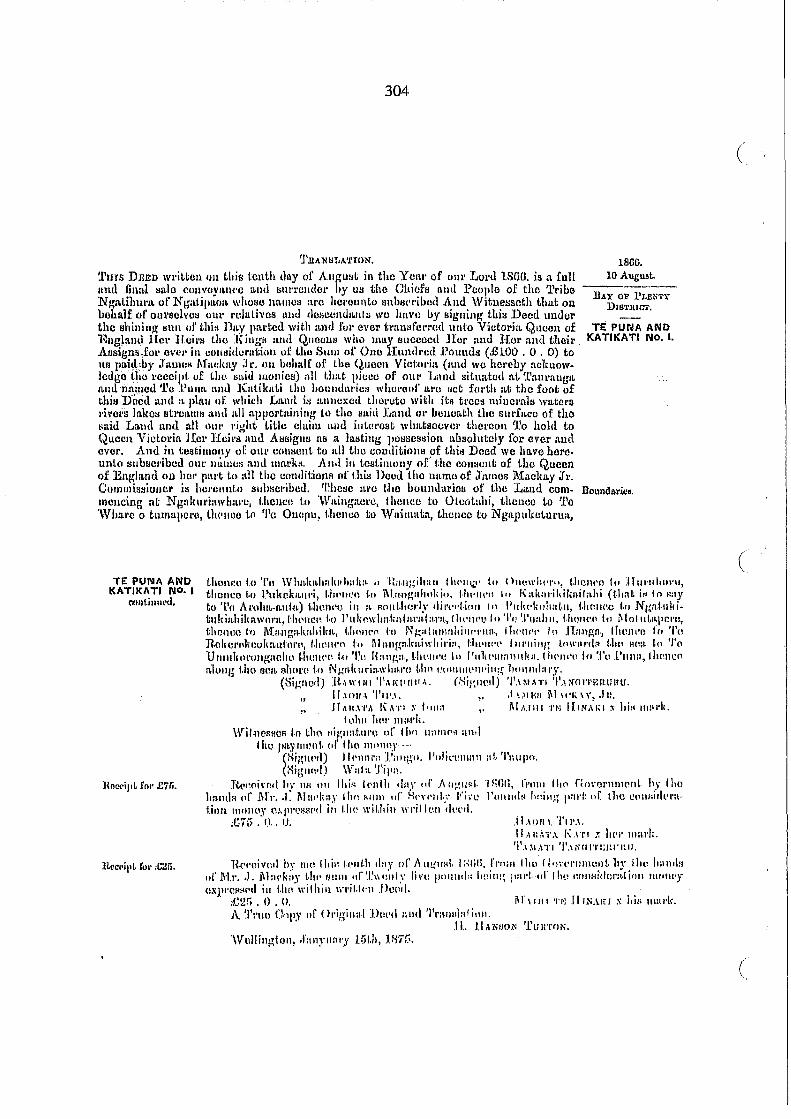
304
'I'RAN I:! T,A'rrON, 1866, TIlTS DEED written Oil this tenth day 01' A.llgu~t in the Y ClLI' of Olll' Lord lSGU, is a luJl lind final lIale cuuvoylLIH'e [HId l:!U\'l'clldcl' by lHl tho Ohiefs nlHt People of tho 'l'ribe NgaLihul,!t of Nt;atipILfH1 whoso na-mlll.l 111'0 IIm'oullLo l.Iuhm'I'ibu<! And \Vitnel.lscth that ou behalf of oU1'II1:1voI:I OUl' l'ollltivcs lIud CIOIlCUIlUILIlIIl wo have uJ signing this Deed uuder the shining SIII1 ul' thiN ])I~Y \Hl.rtcu with :LIld lUI' over tl'a.UIIIC1'I'(ld unto Victoria Qucen of ]~Ilgl!md 11m' Heil's the :tOUgH IIl1d QII()CU8 who IIlltY I:luccec(l Hcr ntHI HOI' and tl1cir Assigns.10!' eve!' in uOllsitlCl'utioll or the StUll of' Olle Hunch'e(l J?oullda (£100 , 0 . 0) to lIR pahl::by ;h~ulI!lI I\fllc:klLY J 1', 011 b(\llI~lr of tIle Q.ucon Victlll'ia (anJ we hereby nelnlOlvlcdgotho roceipt of t.11ll Imid monics) 1111 LlIllI; picco of Olll' lJanJ situated at Il':ml'lmgIL nndnamcd'1'0 .Punll. ancl Klltikati lho hOUlllhwiull wlwl'cur ILI'O Kot fl.ll,th ILt tlle foo\; of thill'Doml IWU It pIau of which Ln.nrt iI'J :ulllCXCtl tlH.\L'uto with its troCt! millel'a111 wat~rs l'i\'OI;S In.kcl:I Btl'lJi~mK 11ml lLIl appertllinillg to the /laid IJtlml 01' bCIlOa.I,h the SUl'ftLCO of tho ~Ilid Laud una all OUI' J'ight Lillo claim anu illLm'est wlmtsocVC1' thel'cOIl 'l'o hold to Quecn Viulol'i:L Her Heil's autl A!laigns :IS IL 1nlltiJlg 1,ol.lscsl:Iion ltbsolutuly for evol' aud ever, And in testimony of 0111' COtltlUUt to ILII tho conditioll!! of thi!l ])ood we have hercunto subllcl'ibctl OUt' nUlIlw; lUllluHJ.l'1'!I. All.} ill tosLilllt)uy of'tho comwut of tho Queen of England Oll 11(11' p:u't tu ILll tile conditioJls of l.hil.l UtlOU tho IllLlllO of J'am08 1\:[nc]Ul.y J'I', CornmissiollCl' i:l hCl'cllnt,() SUhSCl'iblld, 'ehc:lc :LI'O I.ho bOll1Hlarios of tho L,md COInmencing ali N galHlI'iawltm'll, {.hcnce lo 'WILillglltll'O, 1 hOIH!O to Olcot:Lhi, thcnce Lo '1'0 \Vh:J.rc 0 tllmapOI'c, lli<'llllO tn 'I'c Ouoflu, 1.}J(lJIco to 'Yllillllltll, t.henco to NgalHillcLul'Ult,
10 August,
!lAY OF I'LENTY DIB'flUCT,
TE PUrM AND KATIKATI NO, I,
BOLmdariea.
TE PUIIIA AND KATIKATI ilia. I
C1<tlll.inurd,
UClCl'iI'L fOl' £7fi,
thon':ll to 'I'll 'YllIl-lmhlllutlm Ii:,. II ·l:a.lIgilllIli I hC'1l \,i.c' to OIl(lwh('I'II, l,hOlH'O III :I I 111'1111111'11,
thence 1,0 Plllwkltlll'i, 1.1'1'111.'1\ j·n 1\1.:ml!;uhnldo, l·h(,I(('o In 1\ltiwl·jJ,ilmilaili (I.hal; i" In f<:1,V
to 'Pn Ih~l\II~':L1d.tL) l,hmll'o iI, I~ IHlIII.llm·l:" .lil'c,,'I·illll III PIIII('liuhat.lI, I.hmwo t.o NI~nJllilitllldlLhilmwurll, (:hl'llctI f·() I'll l(cwlmli:\.!lwlI·1 a·r:I, (lII'IWll '0 'I'c.' '.1'11:.1111, j.lwIW(l III l\lnIIlLltI'CI't" l;hC111l0 I',) l\lu.ngH.lw.hilm, UIC!IH'11 hI N~a{lIll1nhillr'I'IIIl., (Twllc'l' 10 .\l:mgn., IhllJl\'1J fo'l'u n,oIIeJ'"lwullfLuhll''', f.lwll('f) 1-0 ~1i1.III~I1.lmi\\'llil'i:t, Un'lIr'l' flll'llillg f.(l\~·III'rll'! t.!1\' HIli!· ,.1) '/'(1 UlIIlllwt'llIIg:wllll f.lIl!ll('P. 1.11 '1.'0 ({:I.lIl~:t·, I.-II\III"C,: III I'nli!'1I111111l1I.ll,tll('llc'\' I" Tt. 1'111111, IlwllI:(1 l~lolllT tllll Bell. ~h()1'(! t·t) NJ..:ldl(l\'i:~\\"h:M'() Lim (~C1ll1\1H'III'i\l:~ 1,C1l1llrluIT.
l (mgllut.I) ]{ .. \WIIII '1',\/{\f(!tr,l. (Higlle,lj 'I'.IM,IT! "',\i'HlI'I'iW-UltU,
" 11.101/·\ '1'11'.1, ,. ,I ',_II';!! ~III'I\ \\', ,In, ,. .If hl!.\·I',1 ICITI ); l'IlIa " i\LUIII TN 1111'1.\1,( :t hi~ 111:\1,1"
lllllli 111'1' I1IU·I'I.,
\Yi/·I1ClltlCR '·n (;1H"\ 11igll:ltlll'~' ,,1' Iht) 1111111[':1 :t1l.1 1IlL\ pa.Yllllml, (If flao IllPI1IlY· ."
(K;I~I\('!l) JlI'lHll'(! l':l1I(.\"u, Pulirelllllll III, Taupn. (:~ignl!{) \V:II:t 'J'i I'll,
n('c~(1i ... rl1t ht" 1111 III I Illil'! 11'11111 tillY of .A 1I~~Il~I. ·1~;IlIi. 1'".1111 1111' nu'oo1'llllllml. h,r Iho h:tlHlll III' 1\[", .J: i\1 :11'1i1l.), j lin RUllI 1If' HI"·!'ld,:.- Vil"e I'UlIll":l IH\ill~; 1':11'1: lIr dlO e('IIi'irl~'I'lIl,iOI1 IlWIIOY O,\/ll'e:;(':I'(/ ill I.llt~ ",il,hill wril.lt\1I del'!1.
;(:;7i) , f.l .. 0, .H.I 1)11 I. '1'11'.1. 11.11:,', 'j'.\ 1\.1 T I :; II ('I' ilIa.]'/;.
'1'.DI,ITI'I'.II;(lI'I'l;(t!·ltlI.
R('/'I)i v(\II hr 111(\ I hili 1.('lIr.1t ,Ia y 0(' ,\ lI!.(lIftl. I :,lili, froiU 11m n ')\'('I'lIl1lUllt 11)" I he hl1l11111
IIf'M.I' .• 1. i\\IH'ki'J 1.I.C'1;111111 ,,(".Ill1o'llf.\, lin, 1!Cllllld:< ,,~.ill!~ 1':11'1. "I' rho eOIlHidm'l\.lioll 1IIf111C'Y
()Xl"'C~tl(',L ill l.h(1 wilhill \n'il,kll .i>C!.r1, ;e2!i , 0 . n. iH 11111 '1'1-: 11 nU.lo x i,i/; 1II1ll'k,
A '.I'I'IUl (hpJ' Ill' Ol'igill;d. UIlI'd 111111 'I'mllltlll f illJl .
.11.. l.IANI.IOi.'l 'l'UJITfH.,
'W 1111 inv;l on~ .ra 1l)"lIlll'y u)(.h, 11-17["
(
(
(
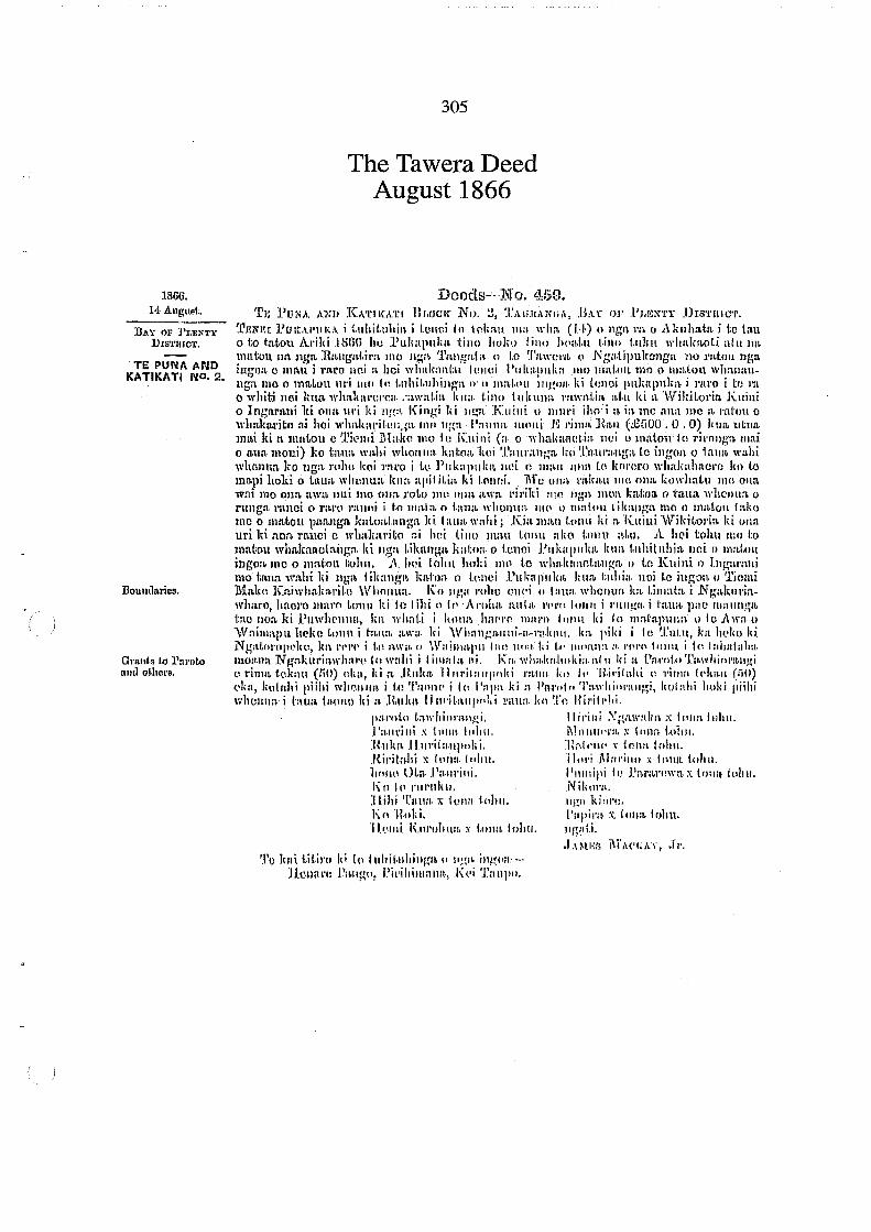
1866, H.AlIglI~I:,
DAY OF ]'r.llNTY nlSI'mOT,
TE PUNA AND KATIKATI NO, 2.
DOllllllllric9,
Ol':lllts to l'nroto omloUwre,
305
The Tawera Deed August 1866
Doods-···1\J o. 459. 'rl'; I'ONA AXil K.\'rIKII.TI BI.tlCK NI). !J, TAli.ltllNIIA, HAL 1)10' .PJ,I'X't'y JhS'1'ltlC'l'.
'l'1~1m( l'ultAl'l/IU. i 1.IIhil.lIhil1. i lUllci In If'lin1l. 111:1. ,,"lin, (1.'1·) (ll1gl~ 1':. 0 ~\lillllat:t i 1;c lau o to i:n.t·on AI'i1d HmO IIlI l'ul\aplllm 1;ill() hulm I illo hoaf," t.illn t.lIlm whnlmol.i af.ll 1m mlltou lHt nga J{:~Ilg'nt,il'lL IlIO llga 'l'nngrd". () 1.0 ~1':t\\"Cl'n 1,1 Ngatipulwllgu lIO mtoll nga iug-on, 0 mn.u i l'aro Hei n hei whalm.itf:ll fmlUi Plllti"!ll1lill 11111 llml.\lllll1l1 0 1II11.tOll wh:m:mllg:t 1110 0 mn.Lolt lI!'i 1110 t.1l 1,llhil,llhillA':\ (l n nla(,t'll )1I1~'JII. ki tOlloi JlII"llpuk.~ i rm'o i tfl I'a
o whiti nei lm .... wlmlulI'CI'Cli. ";1\\'a(.i:~ Iilla· t.ino j 1I klll.Ht 1':lwll.i.ia :!.I.ll ki :t ·Wil;ilol'in. KlIini o Ingnrnui lti ona lII'i ki 1I!!:~ Kill/;; Id 1I!.:":t :Kuilli II IIIl11'i iltoi:t ia me finn me;~ I·[ti'tm 0 w1mklJ.l'ito n.i hoi wll1\llIIril'(!Ii,~tL IIlIl llga !':lImn mnll i .g J'ill1l1, ]~.a.1l (£:)00 . 0 .0) Jilm utlla. In!ti ki It maLou c :l'h:lIIi IHa.lw mo Ie .Kuini (n 0 ,,·lml':H'H!I·jn. lH:i llllmtOll;le ril'Ollga IIl:ti o a.un, lIloni) ko tmm \\,I~hi when 11:1. kn.l;o:t lwi ~1'l(.\ll·lLnl~:t Iw '.l'mu':J.lII.tn. to iugal! 0 1:LUlt walli wholltln. ko uga )'(11m kci ra1'O i I.\) ]lllk:ljlllim llI~i (1 lI1ail Hila 1.0 IWI'(~r() wllalmhncl'o 1(1) 1.0
m:J.J)i llOki 0 bum wltC11lUL kiln. Rl'il i(.i:~ J,i I.nlwi, 1\'f U ulla mlmll 1110 OIHL kowhaLu IlW onn, lvm mo 011/1. :tW;~ Jlui lilt) OWL l'oLo )11(1 ('IlHL awn. I'il'ild :11(1 lJt\'a lIw:t Iml;on, 0 tuua whcllua 0
fUllgn. ranci 0 r:W(l )'llIlIIi i 1:0 lII:~ln, 0 i.:l1m \\,\!Cll1la. 111(\ I) mal.('1l li/mllg-a mo Il m:l.ioll I:Llw me 0 llla.tOtl pannga JmlmLI.nnga l(i talllL wahi; .Kin man 1.01111 IIi n. Kuiui \V'ildtol'i:\ ki ()JIll
uri Id non. l"ltllci c whn]c:tl'ito ::i lllli till!) mall \.(111\1 :\liO 1;01111 :~I;lI, A h(Oi toll" 1110 to matou wlmlmncln.l1g:t Iti Ilga I.ilii\nga Jmbl/!. 0 lcnci PIII"'1llilm ImIL l'llhit lIhi,\ nci () nml.lIl! ingon. 11100 lllfil:on (;O!IIl, A Iwi 101111 Jlnki 1110 t.o Wllldt:l:tot.a.lIg-a. 1/ tc Kuini. I) IltWU':Uli mo (;:lIIa wn.hi I,i lIg;~ lilmnw~ h:~hm 0 l(lllci .I'1l1.11plIlm Inm j;lllii:l. 1Ioi to iU~l1n. I) 'l'imni 1.:fa1w K.niwhal(:J.l'il·ll \\'bOlllln.. Kn 11~;:t mlm ()f1(,j (11:11111. wl!cl1ua 1m l.illlat:L i :N".~Jml'jtlwlmro, !lnm'o maro L\I1\11 ki ill I illi n II' . A mit:.. IIlltH. l'pl'n 1111111 i 1·1I111~1I· i I':tu:t pliO Ilta.llnp;:t tao lIon.ld .l'uwhrllll:l., 1m whnl.i i 11111111. hm'l'n l1UlI'll f"llll Id 10 nml':tjlllila \l 10 J\\\":I. ()
'\V'ni11lapu hl'kn l.nl111 i h.,nn, :tW:I. Iii ·Wh;mJ.!.J.Illli-Il.-m.lIllIl, I"" l'i/,j i 10 '.1.'111.11, ka Ill'l\(} IIi. Ngal.rll·llpl.,lw, J\II l't'I'(' i 1.11 aw". I) \irniuml'lI (an lllla I;i (." Illnal1't :1.1'(\1"1\ jOlla if<, Inhalalm. momm N g:l.lmri:~wh:U"(~ III wnhi i I iHHlI:~ IIi. Kn. wlmlmllllil ill.:tI II Iii :t 1.':!.I'ol. .. ·.I.'H.wllifll'n.lI~i l~ l'illlit tolwtl (Iill) nl,:!., I,i 1\ H.lIll1l. 'Il1I1'ihlll(1Jlld mil II. Iir! II' ·H.i!·ililhi n ,.illHi h'lmll (ill)) dw, Iwlnhi piilti wht.1lllIH. i \.0 '.I'nnn<' i (0 I'np:t JIi J1. Iln.I,,,t,, '1'".\\'i1i"I'aIlMi, hol:d,i l'llld l'iihi wllCll\J:I. i bllm j;Wl1t) hi II- :RlIlm IllJI'jl'l\lIp"l,i 1':1Il:1 .. lIn Tn Hi"ill'lti.
IllU'ol.O t.:~\\'hiuralll!i. II it'ill i ;'>.'~Il\\':dm ;>;; 1 (Ilia IlIlm . . 1'a'IIl'illi x tJlIla. 1111111. i\lnllul'm ~, lun:; 1.01111. Rllim .ll.lII·iln.lIJlolli. :1::'.1"11(' x 101m 101111. Ril'il.ahi x It1JHI.j"hu. '1lol'i M:n·intl x f011lL l.olnL Iml((l OI,I! . .I'mll'illi, Plilldpi Ie J.':~I':W(!\\"l~ x trma !tlltU. 1\01111'111'111111. Nilwl'll. ] I.illi Tnt1ll. x 101111 1."I!!I, .11)(11 IdOl'!:.
loin'll.old, ['apir,!, :'(, 111mb lr,l111. '1 J ... \llIi KI11'ulmrt, x t01ll!. iohu. lIg:d.i .
~I'o Jwt l.if.il'u Id 1(, t IIhil.lIhinga " 11.!:i~ il1~(I:t:-.]lellnl'll 1'1>1I!~(l, Pi"iltiulIlIlIl.,O .!\(,j TUllpO.
• I.HlI·;t; j'i"\('I';'U', ;rl'.

306
·KIIl!. I'i,'" Illa.i i a wilton j /wl.li 1,\ t()l\;I'I'I~Il-l i;'ha tJ ugn I'll 0 J\liIIlllda I I) fill , JH~ '(1jelUi
'~lal,1\ 11111 II' 1\ lIilli, JI;!;;~ IIIIIlIi I·: I'inlil, !1.iLli I'illum (X:i:)!) 'It: 11(." WIIilJWI'i,.,) Illi.l Le 1IIIl'IIIHl
1"1lI whakahuali.t l,i J'lIl" Iii I Hllei PU1'ClPlIl(:1
j\ILi Lit il'il Iii to utll)lgl~ 0 lIga 1I10ni--JI l:!I;U'l! I-augn, .Pit'ihiulilillI, Kui 'l'alllHl,
'l'/l.lNIlI.A'I'1 O]li,
1',\ "(n't'l'I'.1 1\' II HI 11.\ N" I.
]I,UIIlINI X tWill lohll. ItUKA lJUJtl'l',tUL'UIU,
'1'11111 'fll::"':U wl'il.l:1ll1 nil Lhir< l'olirtuclll,h (HI.h) ,IiI,), ,If AII1{IIi:!L ill lim V'CiL!' of' (ml' "m't! I.HUIi i,i.'/L 1'1111 allli Iinn.1 ;;nlo I:UJI\"'j'a!II:U all(1 HIII'I';!lIIlul' IJ'y liN 1,11(: ('hil,I~; allli I'CiJph: 01' L1w '\'"jl", 'l"I\H11"L :LI\(l N:~:ltif'lIlwtlg" WIIUIW mUlIllH ILI'C hCI'ulIlIlu lillbll,:l'ihl'.! A lid \Vil,· IlIJiI:!Hl.h that 011 iH\lmlf 01 OIlI';:iI'lv"H 0111' rdal.irt::.! .tIIt! dH~I)lilltlILllI:f1 W(' I!:LI'I': 11)' Ki;!;lIillg I.hif! DI:t:tlllllt!CI'lhollhiuillg' :alll ur I.lli:1 ll:~y pm-tetl wilh :llhll:H' ('\'l:I' Il'lt!1,d'''''I'cd unto \' icl,llI'ia (~IIl:l!Il uf' Hngi:lII(1 1 Lei' :t l.dl'H (Iw .K illl{!; :lIltl «~UOCII~ WIll) llUIJ ~;lI(:la:c" :I r LlI' ll,nd '1lur IIHd theil' i\.li:lit,:llll 1'(11' 0\'01' ill (!IJIII,itlul':tlioll oj' filII HUHl or .I!'j\'U HIlIlIIt'(lIl .I:'ntllldM (.tiiOO, (), U) tn lis pnil! IIY .,.LIIIUS II,ladmy (Ill holml!' (11' Lilli (lllt!t111 ViduJ'i:L (:tlld \I'll
hordlY IICkllUlI'lodp;c tlw \'(l(!(lipt 01' tIll! :;aid IIIOlIOY!!) all tllnt pit:l\Jl' of Olll' .Lalllll .• iLuatod at 'I'aurlmga aut! named ',l'aul'HlIl-{iL 1.110 bl/umlat'kll ",hCl'ouf IWC Met [OI'ila aL Lilo foot oj' Lhis V,lOt! IUlII a pla.n or wlaidl l,:md ill HIlIICXCt! tlWl'ct() wilh ill> il'Ul'N lllilU.ll'alll \\'ntCl'!l l'iw\'11 lalwlI !;I.\'(lallll; :mcl .tll aplwd:lilling til t.ho 8llid J.ILIIiI 01' hOllon,t.iI t 110 S\ll'I:1t~B ot'tho Hllhl .L:md allli all Olll' "i:.;'''t. I itlc cluim ami inttll'c);t \\'lmt~I)(\\'(\['1hlll'1I0l1 'I'll l'lll.l 10 q.1HlCll
Vid(wiu HOI' licil's Ilnd AI:I"igllfl a:; a bllliug' pm:llBIl:!ioll abli'l]uLol,l' fOI' IJI'lH' t~llli C\'Ol',
AmI ill tlJl>l,illlullY of 0111' 1;,))1,1011\: tn :III 11m I:lIJII)iI'iUlli:l ,,1' lIdo 1)11("[ W(\ 1111.1'0 hm'cunto ',lIbllC\'illl.lll (lilt' IUUIlCH nlllt IUlll'I,:;. 11.IItl ill LI,:4iIlWIIY ,.!' 1.1 III t'('IU:Wllt or t,lw (~llocn of
·I':Il~lall() (Ill hl!I' p:ll't to all 1110 '!I'Jlltiif,iHIlt> oJ: I !liN l)"lJIl I Itt! lIalllO til' ,l'allW::I 1Hnlllmy, .Jr. CIIIIIIII;:'mioIlUl' ii:! Ilill'Ulllilo IHtlHIl'I'ilu,,1. '!'''e:m I~I'(' 1110 hllllllt!:U'irJIi or 11111 Land 1:11111-IIl(mcilig at .Ngllliul'iawh:wc. IIWIII'I\ ill OL I:!ll'lli!~hl, lilli' to (he :;U Il)III it; III' t.Jw J\I'OII:t 1'll1IgC, lIWIIC1\ alollg Uml. i'allg'o to :t!lIwlll'iIUII, r.lWl1CO t,IlI'lIill:~ it!!,) IJI"""'l\lling ill a :;l.i':Lig-itl; line tu tho HOlll'CO ol" Ihe '\\T:1imapu I-HI'{!lIIII, l,hclU!l~ tlmlt:llllllillg i taL ~;\.Jooalll hi ·Whallgauui-a· mkall, t1lOlH'c to '1'0 Tutu, thmwo ttl Ngatol'opdw lll{lIJCll by the '''II,jlll:lpulltl'call1 to 1110 X():\, f 11(Jncu hy the sea l'(>:l;lt Ll N gal, 1I1'il~whal'u UIU 'Point of C()lI1nH\lIl!CIl1~'1I1. '.L'!tmc is I'HIl()Il\'l~yoll to ]hl.l'o1.o 'l'awhim"lIIgi 1il'l.y (iiO) :L1!I'C!I:l, LII Hllka ][ul'iLHII!lIII,i ltm11'u H.iri, tahi lifi.y (50) lLcrc~, ono allnltncllL ill 'i\, I'.~pa lllwlH,hip til Pill'lJlo ~I':LI\'!tiUl,;tlIgi, HmltlllO alltl~Jncra:t in the said township to J~lJlm 1I1Il'il:LUpoki 111111 'j~t! ]{il'itr.lm.
Pal'(II.u'I'awltilll'ILIIgi, lfil'illi Numnl.ka x hill 11mI'll, l'aul'ini x hi~ 1II111'1t. ~tmlllCl':~ x hi::! lIIat,k, Ruku HUl'ilalipoki, n:~tollo .t hil! mlLl'I" Ril'il:lhi x Iii:! mul'l" ] [0"; MIIl'illo :.t hi!:! IIIllI''', HOllO .J>nlll'illi. l'ulIlipi to ll:U'lll'OW:L x hi:; lIml'jL KI) tu Jt\ll'ukn, NikOl':t, 11 ihi '1~'llUl x hill mll,!'I., NWt Kiol'll,
Kil ]{"Id. 'J'apil'jl x hi:; 11ll~I'I\, Hemi KIJI'ohulL x hi!) lIIal'l(. N g:~t.i.
.J.l.~IN::l .i\LwK,\\' •• 1'1', Wi f.1I01l11 1,(1 aignntul'l)ll-
11011:\1'0 Pungo, l'IJlit'lHllllll. 'Paupn,
TE. PUNA MID KATII(ATI NO, 2
"'llIt,illlll~1.
ltoecipt fur ,c;.;uO,
lS(iIi, 1,1 AlIgIIS~,
]JJ. Y IW b,RN'i'\,
DIS'I.'lIlC'l',
TE PUNA AND KATIKATI NO, 2,
llQuudlll'ica,
Gl'lInts 10 PlJ.l'olo :ltIll olhcl'~'
U(!(,Hi\'oU hy W.I (1II Lhi~ I'UlIl'Ill"IIf.h .la.Y ell' :\ uglllJl; I f;;(it;, 1'1'011\ .TauH!J:l l\'1:ldilLy ;1'1'. oll ltllcoitlL f,n' £600, i>dULIl' or Uw Qllcem, t.ho l:IlIllI III: "'ivll 1.lllIull'ull PUI1Utlti (J.:fiOIJ) iJciliU t.Il1l l!oJHlitiul'IILiulI IIl1l1Wy 1'111' 1.110 Imul sct: (ill'I,1I ill 1110 witlli(l \\'I'i(.h~1I ])I:ut!,
\\'H.IIW,,' 1.0 tlw paymont or IIII! llHlllny--' .II UIIIU'O !),mgu, Polil:lIlll11Il, 'Paupu,
1'.ldW'I'O 'J'o\WII IOIlAlW I,
PAlilLlNf X hill 1I1I1I'1t.
l?u\u. HIlJll'!'AUL'OIH,
(
c
A II'I'UO ('(lI'Y of Ol'ig-innl Duct! allel ~Jll'illljj/;Lliou, (,. H, lLu;;;1I1i 'I'UH'l'ON,
'Wol/iug-lulI, .JILlHlitI'y l:!LII, lti75,
307
The Ngati Maru and Ngati Tamatera Deed September 1866
D(;)(Kl~-N·o. 1160. j!j(j(j.
'1'1·; 1'111'<.\ ANJ) J(..\'I'II\.\'I'I" Ih,OIJI\ No. ·1" ~I'AU1L1Ntl,\, H.\Y (Il,' l'r;r,N'I'Y ])IS'l'ltlU'l'.
~I"::;I':I. 1:1~1~.\l·III';\ ~. tl1l1.i.i.lll~ja i ll:~H'i .Iu {4II'1l II Jt}51~ m u 11"1\11 UI;':11 III,. i til (all U Lo latou )\11111 IHhh 110 I UI,.tPlll,,~ 1.1111 1101.0 1l1ltl IlI)al:lI I.llw I.lIlm w!uL!mlll.1 al,1I 1);! IIHLtOIlIl'L
!I:,{IL H:ul:1lllil% 1.'10 IIgl! 'l'allgallL ~ NL{lllii'HIl'1J " NlAatilaltlah'l'IL 1111 1'ltLUIl llgiL iUgOIL (} lila;! 11",11'\1 IIUI,:t IWI whaln~IIt.II. LUIWI .1'1ikaplll'lL 11111 mllj,. II I 1110 II 11111(.(111 Wllltlll\lIllW! llIll " JI):t~'~1I U!'I Ill\) ill t.Hllltultlll;.lil '! 1I Iilal.~u iUg'!!l I,i {mm; I'lIlml'lIlLiL i l'IW(J i ttl I'll (\
\\'11111 IWI Idlll whakm'cl'o:t 1'ltIVaj,IOL lilln I.IIIH 1III,IIna I'Hwali'LlIllIld a \\riliitIJloi-t 1("lIilli Il
Iligill'lI.lli I~i '''m.' III'! Id IIga. 1\ ingi Iii 1I:~lt Kllil,i II 11I1I1'i iltu i a ill Ill,) alHL J,;u'a' J'ltLIIIl
tl wlllli.al·lt.u :11 hOI 1\'11:d';II·II.l!IIg;~ 11,11 1Ig-:l l'aulU! lJIlllli .KIII.Lld ,mull 1 litllahi !'all II lUI'\!
I.U/WlI \,Ull 'lIl.lIi~ 1l1.1i I,i it lIlal.uu l.\ 'l.'iulIIi tHa\,u (.1. l\'!aclill,y, J·I'.) IlII) le Kuiui (a u
:1 SOl'LOlllitlll·.
.BAY O~' PUN'I'Y }) IS'I'IUG'l'.
TE PUNA AND KATIKATI NO.4.
hieD, J,;I,laO,
TE PUNA AND KATIKATI NO·4
oon~inued.
Native Rennnoa; 1. l'ukowho.kn·
tnrotarB h. 50 ... 2. Tirol' 50.. 3. PacwAi BB, 4. TBli;nilmohllo 511.. 5. N gatukituki un. G. !1'angiLu ... 60..
1vhakaa.otin nei 0 matou te rironglL mai 0 a.un moni) 1,0 tn,un. wahi whenua katoa kei to takiwn. ki 'l'.'l.UI'll,uga k() to Puuo., lto Kn.Wmti ))gn. illgon. 0 t.atl:t \Vn.lli whenun. ]to nga rohe kei raro i to Pulmpllka noi c man ana. to koraro wllakahaorc ko to mapi hoki a taun. whcnua ]ulIIoapititia ld tonoi. 1\1:0 ona ra.kau mo ona ltOwhatu me oua. wai me ana; awn. nui me ona roto me ona Mva ririlti me nga. IDOll. Imtoa 0 taua whonua o runga ranei 0 raro ranei i to mata 0 tn.ua ,vhenua mo 0 mntou tikanga me 0 matou take me 0 matou pann~rt. kaooamnga. ki taun. wa.lli, Kin. mau ton'll Jd a Kuini "\Vikitoria. ki ana uri ki ann. ronei 0 whaka.rito .n.i hoi tino mau tonu oko tonu atu, A hei tohl1 mo to matou whakn.aetn.ugn. ki lIgn. tiknnga ]mton 0 tenei Pukapuka kua tuhitubia )lei 0
maiou ingoa mo 0 matou tohu. A hci tohu hoki IDO to wbnkan.etllllga 0 to Kuini 0
Ingu.rani mo ta,m" wabi ki nga tilmnga lta\;on. 0 tOlloi rUKa}mlm kUI\ t.uhin. nei te ingo!lo o Tiemi MaIm Kaiwhalmrit.e "\Vhouno., 1(0 nga l'oho enOL 0 tnuG whonua. h timata. i Ngo.kuriawblll'o 1m rero Waingaoro, Ita roro Otcotnhi, Ito. roro To whare 0 tumapere, k!lorore to Onepu, ka rore W nimain, kilo rare N gnpukotul'un., 1m 1'01'0 to Wlmlmlmlmlmknorangihau, karere to Onowhero, ]m I'cro Huruhul'u, lea l'oro Pultcltauri, 1m 1'01'0 Mangahokio, kilo rero Kakarikiknitn.hi earn ki to .A:roha. autn.) kat,nM klL l'erc ki te tOllga Pulmkohatu, len. rero Ngatukit;ukiahikawero, 1m rora Pul;:owhaka'katnrnt.'1.fa, Ita, roro to TuallU, ka. rore Motutal)orc, ka roro Maugakahilm, 1m rol'c Ngatamahinerua, lm.rere IInnllgn, ka rero to Aronro-o-parot.'lpu, kilo roro to Uekerekookauterc, ·kD. rllro Mangalmiwl1iria, kn.tahi }{II.
whati mni. ",balm, to mOnTI3 to Umuo!torongMhc, 1m rore to Rn.ugn, Ita rero Pultcm:mulm, karere lio Puna katahi kilo hn.ero i to tnlmt.'l.lm momm :~-Ngakul'in.wlJare to roho 0 to timatn.ngn,
Kotahi piiili whomlll. lma whnkahollia koi Pukcwhalm\;.'1mt.n.r:1J ko to "\V n.lIi 'l'I~PU ko to nui 0 taun. walli () rima talmu (60) aka, Kotnhi piihi ltci to TirO/L kei to WahiTsl;>U Ito to nlli 0 rima (6) elm. Kotal1i lliihi koi to Pnawai lto to Wnbi 'l'apu ko to nUl 0
rima (5). elm. Kotahi piihi ltd Tn.lmihuehlla 0 rimn. (5) ngn. eka. Kotabi piihi kai Ngl1ol.ukitukiahiltawora 0 riron. ngn. aka. Kotllhi piihi koi 1'l1ugitu 0 rima ngn. eka.
to moa.n:mui. 'l'arain. Ngakuti x his mark. 'l'eit':J. To Amara x his lllllrk. Rlwai Kioro x ltie mark. Ihalm x hia nl!\rk, inC Paratn to mnpu. lrihia x ton", tohu. Wipc Hotorcni 1'aipnri. Tutuld x hia mark. To :Rna x hill mnrk, Knrn.uua x his lDark. Ruilllmn. x 11i8 mark. Mango.
J,ulES MACKAY, Jr. Kecpn. to Whnra.u x his mark, To .Kcreihe x his mark. "\Val turuturu. '\Virolnu Paka. ·W. HUI)ihona x his mark, EI'iatm'n. ;t Jlil' JlI:lorlc. lIullia x hiB mark. Hingi Korcpurll. lIotorcl1i 'I'ILipari x bie mark. l'ill in.l1a x his mark, hn.orn. ~I'ipa. 'l'nllowl!a Kitahi x biB mo.rk. Morgan lIou.
N ga kat tiLiro ki to tubit.ubingn. 0 nga illgolL mo to rirougn. 0 ngn moni-
John W, 'l'horp, of Delmont, Thallle", Settlor. J. W, R. Guilding, StorokeolJor, Kallirallga.
308
1866. 1(; Mllroll.
Kun. riro mai i abau i to tokau mIL rima 0 lIgll. ra 0 Macho 18G6-DO to Wbitika lIgn. mODi E run. telu1.\I rna rima pll.una, ko tetll.hi walli 0 ngn mani whakarito kun whakaahUIl.f;ia. ki rota ki tCllci pu[mpuka.
£25.0. O.
to WOll.uo.nui. T:lraill. N gll.kuti :t hia mark. 'l'eira x lIis mark. ltiwai lCiore x his mnt'lt.
nit Parll.tl~. lrihil1. x his mark. Knrn.uua x his ma.rk.
1866. 3' Soptember.
Kua riro mai i alu:1l i ten~i to tom 0 nga rn. 0 Hopot!lmn; 1866 nga moni Kow.hi Tekau Pa.unn. rna aku tlknngn. kl te W)lBDUn. kull. whn.kaahuatm kl raro nei.
£10.0. D. ReocipHor £10. 'I'.UiEWlr,\. KITAIII:X his mark.
1866. n Soptember.
:Roceip~ for £25,
Kua. riro mai i alJau i. tCDci to taru 0. ngll. rn. ? Hepotoma 1866, ngn. moni E rua Tokau M'n. rima. Pauna hOI utu rna aku tlknuga Itl to whenna kuo. whakaahuatia ki roto nei.
£25.0. O. Itu[J[ANA. X his mark. Receipt for £5. Kua. nra mai i abn.u E riwa. Pauna 110 moni i noko nlte i Lo moni whakarito klla
whaka.nhua.tia ki rota. £5.0. O. MOKENA liou,
Ku!\ riro mai i nhau Kol.l1.lli'Tl.llrau ll:UllllL he moul i nc1w nlw i to mOl1i whukarite klla whllkaahunthl. ki roLu.
£10.0,0,
1Vitucssos to thtl aiglllLi,1I1'C1i of lUlU payments to '1.1araill Ngalmti, ~I'e .l\{OILniUlUi, 'l'uira, Riwai Kio!'", l',lJ'llbL hihiu., ](1Ll'l\lIllI1., 'I'a.ncw}llL Kitahi, Ruihl1.nl~ l1.u(l l\{ok(JJlI\ Hou-
Jolm W. 'J~horp, J'. W. It. Guilding,
TE PUNA AND KATIKATI NO.4
continuetl. Receipt for £10, a.dditiollul.
'l'UANSr,,\'l'lOrf. 1866. '1.'m6 DEED wriL\;an nil thill third dl~y ot' Septemb~r in UIO YClU' of om' TJord 1800 is 0. S Soptembor. full and nnnl 3nl0 Cfl1lVllYi11lC;0 lUll! 1I11l'l'Onlltll' by 1111 Lho Ohief!:! ILlIll ]~oople of tho 'l'dbelS Ng:LLimaru lLud NglliitIUlllLl;ol'a. W]IOI:!ll 1l1~lII(l1j I\I'C !tel'ulInto tluulICI'ibctl And Witncssoth DA1I~~~::'N'l"lI: that on behalf of Olil'II01Vlltl our l'olative8 IIIHI dUllouudllULli wo hu.vu l.Iy I;igning this Doed undel' tho sltining :lUll of' thill u"Y Il:u'ted widl I'lid 1'01' over tl'ILUIIl'Orl'lICl unto Vicltorla TE PUNA AND Quoen of' Eng)ILntl Hot· Heil'l$ tbe ]Gllgll IIollfl Q.tloellll who Ulay lIucccod Her lmtl. Hm' KATIKATI NO.4. lLnd their Assigull £01' eVtlL' ill COllllidorlLtioll of tho BUill of 0110 tholllllmd ouo hundred and thirty Pounds (.En 130.0 . 0) to us paid by .rlulla~ ]\:[aclmy tho Y oungOl' 011 ue)lIL}t' FrieD, £1.130. or t,be Quecn Victoria (1\1111 wo horoh.v 1~c1mowlt.l{lgo Ule l'oceillt of tho lIn.itl. ll1olleys) aU that picco of 0111' Land lIiclmtuu lit 'L'lUU'UllgIL nlltt llllUlOd '1'0 l'Ulll\ amI KILtilmti the boundtlrios w11croof ure aot furth at tho foot of thill Decd unci 110 plnn of whicll Lmld iii annexell theroto with its tl'eOIl, millomls, Wl\tOl'S, l'ivet's,lo.keB, IItrelllllB, aud all appertain-ing Lo tho HaiJ. Laml 01' l.JClHl:tLh Lho IIlII'rauo ot' tho :mi(l IJlll\t{ IUlIl an.OUI' right Litlo ullLim alld intm'cat wlmtluJOvuL' tllorooll 'I'll lUll,) til Quoon Vh,tot'in HCl'lI uiru I\.lItl Assigns l\l! n. lasting ]loslIClIsimt ILblloiLltuly flol' uVCl' 1I1ll1 evol'. Alld ill t~lItilllo1\y or om' COUBOl1t to ILU tho couilitiolllJ ot' Lhis need wo luwo llOrollnto aulJat:wibml Ollt' munOH amI marks. Aud in tolltimony ot' tho COlitlUll t of LIm (~Ll(.l(m of )~lIghlnd 011 Iter pal'l; tu al1 tho
(
(
conditions of this l)eed tllO JIIuno of Jamoll l\faclcny Jr. OOlllluiBsioneL' it! llerouuto Imhacribod. 'l'hCllo m'o ~ho bOlllHlal'ioa ot' Lho ]~i1.nd cOlUUlcncing at Nga]c\ll'iawIlnro, DoulldarioB. ( tll6nce to "\Vl\i.ogIlOI'O, thence to Oteotuhi. thence to 're Whlll'(l 0 tUlnll.perlt thence to To Onopu, thence to \Vaimatu, thenco to NgaJlukotm'ulL, tllolllle to te WhaICllhnka.hllolll-omllgihall. tlumco to OnOWllOl'U, ilu.mce tn lIul'l!hm'u, tlllmce to Pukolmuri, thence to Manga.holtio, thence til KllknrildlmitlLhi (tlaat is to Hay to '1'e .thoha. auta) Lholll!o in IL liouthcdy dircctioll to IJulCilkaliatll, thence to NgatukitukiIL11ilmwtll'lL thOllCO to Puke-whll.kn.tarll&:1l'lJ., I.llll11Ce to '1.'11 'l'lll1.hu, tllollCC to 1\iolutllPOI'C, thaneo to Mangl1.ka.hiIm, thenco to N glltu.mahillol·mt, t.honoe to IInnllgll., lhclll:C lio '1'0 Al'On.I·I) 0 lllLl'Otn.pU, thonce to 1'0 ll.okerekeoknutOl·e, Lhonco to Mallgnlmiwhil'i:l, lihonco tlll'lIiug tow:l.l·i1s the Hello to

(
309
're UmllokOl·onga.oho, tllOnco to 'j~o ItiLllgll, thollCO to PulWlImlllllm, thonce to '1'0 I'una., thence along th(l /:l(lR ShOl'(J tn Ngalml'i:~wharo tho comm!!llcillg lJoulldttry. A piece of Nutivo Resorves: laud (,t tho burial place iLt Pukowll!\lcllotlll'alILI'IL il:l l'oconvoyed, the oxtOllt is fift,y (50) 1. Pukewhnkll-acres. A pieco of fivo lUll'Ct; at to ~rit'oa bm'hLl grouud a.ml :\ pieco of livo (5) nCl'Oll at To t.RI'ILLuTII ••• 600.
Paewai burial gruund. A llioco of' fivo 1\01'0:1 I.\.~ 'l'ukILihuulmo. A pioco of five acres at ;. ~~ro<~ni ~:. NglltukitukiahiltawOl·:L. A llioco of fivo n.cl'el:! ilL Ijll\lIgitu. 4: Tuk:ihuehu;' 5a:
.TA.i\ms MA.CKAY JR. 6. Ngatuldtuki 5a.. (Signed) To Moauanui. Keepl1. to Wharau x his mark. 6. Tllllgitu lia..
',l1l1.l'aia N galmti x his umrk. To Kot'oiho :x his mark. 'l'eil'!\ tc Amora. x his mark. "\¥'a.ituruturu. RiwlIoi ICiol'c x his mlu·k. Wiromu Pnltn. Ihl1.ka. W. HopilllLnn.x his·mark. Na l'!\l'ILtn to Mo.pu. Erio.~nrn. x 1Iis·mark. Irihia x his mark. lIunin. :x: his ma.rk. 'Wirope Hotereni 'l'atipm·i. Hingikeren. Pm·n. 'j~utuld x llia murk. IIotoroni Taipari x hia ma.rk. To nUlL x his murk Piniaha x Ilia murk. 'fCal'a.LlI1a x his lUarl,. lIa.ora rripa.. Ituihaua. x hia mar),. 'fancw!m J{itahi x his mark. lIfango. Morgan lIou.
'Witn6Sseli to the Bignn.tlll·C/I and thu paylllollt of the money-
(Signod) John W. 'l'horp, ot' ]JOh110111;, 'l'juullOS, SeWer. (Signell) J. \V. R. Guildillg, Storui(Oopel', ICI\U3.81·anga,
1866. 15 MOl'ob.
Itccmvcd by mil on tho fifteonth ilay of }\fm'ell 186Ci from MI'., Whita.kcr tho Sum of l'wenty fivc pounds, being ptw\; of tho coulliucl'atiol1 mOlloy expressed ill tho within written Deed. 'R --cc-cl-·p-l;-ro-r-£-SG.
£25.0. O. (Sil.) 'l'E MOANA.NUI. 186G. R.cceived by mo on tho twonty second day of March 186G from Mr. '\Vhitn.1ter tho
Bum of Thirty pound:!, being pad of t·he COllilidOl·o.Lioll 1ll0llClY e.xpressed in the within written Doed.
22 Mal·ch.
:Receipt for £30. £30. O. O. T..I.ltAU NO.l.KUTl X llia mal'k. Received by us this third dl~Y oE SoptomLcl' in tho yeM' of oUt' IJol'd 0110 thollStmd
eight humb.·ed :.tud sixty six tho Hum O[ Ono thowmncl :tlHI SC\·ull(.y jive llollnds paid to
TE PUNA AND KATIKATI NO.4
continuod.
1866. S Eleptomber.
Rocoipt; for £1,075.
1866. SBopt.omber.
Reooip~ £01' £10. 1866.
S Boptomber.
ltocoipb for £26.
lloooipf; for £6.
Rocoipt lor £10, additional.
us by, the brmds of J·mnoB. Mn.clmy, Uaqro .Jr. CommisRiollllr, being I:ho bnlnnce of the \lomlldo1'ntioll money exproBllod in the :lbove-wl'iI,l;oll Dcml.
£1071> • 0 • 0, (Sd.) te MOI1.UUIlUi.
'1'I\.1'nio. N glSkuti x bis mark. '1'oira :x. llis mark. RiwlIoi Kioro :x. hiB mark.
111\ Parn.tn. Jrihin, x his mark. ](n.rauun :x. his ma.rk.
Bocoivod by mo tllis tllird dlloY: of. SOI,[,embor .1.866 the Bum of Ten pounds, in considoro.tion of my chtim to the 1l1.uu Bot forth in tho within wl'iLten Doed.
£10.0. O. (Bll.) 'fANIi:WHA Kl'l'.UlI x' bis mark.
Roceived by 100 tbis third £lRy of Scptum1.l(11· 18(j(j tho EllUl! of !1'\Vlmty five Pounds, as payment for my claim to the land sot forl:h in UtO within writton Doell.
£26.0_ O. (Sd.) J.tUllJ:/l.NA x his mark.
:Received by lnG tbe sum of lfivo pounds being ill :tddition to tho conaiderntion money expressed within.
£5.0. O. (8d.) MOKENA Hou.
Received bv me the sum of 1'011 POllUd3 being ill :ulditioll to the consideration money expressed within.
£10.0 . O. (S<1.) ltn" Al KlOn.1O x his ma.rk.
A Tl'ue Copy of O"iginal Deed lIoud ~I:rallfllati()ll. - n. HANSON TURTON.
Wellingtoll, .ro.1HlI1.l·Y 14th, 1871:i.

1866. 3 Noyembcr.
:BAY OP PLEHXl" DIS:rmCT.
TE PUNA AND KATIKATI NO·3.
£7,700.
lJOundBriC8.
Nn.tivo RORerY8s. [6,000 acre&.]
310
The "N gaiterangi" Deed November 1866
Deeds-No. 461, TE PUllA. AND KATIKA~'I BLOOK No. H, TAUltANG,\., BA.Y of PJ,ENTY DIB!I'Rmr.
TENEt !)UlCAPUKA i t,uhi~uhia. i tenni tom 0 llgo. rll. () Nl)wcma. i to tau 0 to to.toll Ariki 18GG he Pukapuka tino 1101to I,inC) hoatll tino tulcu wlmlm.ot.i atu Da matou nn. nga ltangatirn. mEl l1gn.l'n.ugn.IH'\. 0 Ngnitcrangi mo 01l1l.11:!.lllt 1",1:011. no l'atou llgn. ingon. e man i raro nei a. hoi wlll1.kllnhu tOlloi Puknpulm mo m",ton IlIIl () matou whanaunga mo o ma~ou uri rno to tllhiLuhingn. 0 0 mntou iugo:!. lii tcmoi l'uknpuka i raro i to ra c whiti nei kuo. who.lml'ol·olL rawatia 1mn. tino tukuun. r;l.wRt.ill. atu hi & Wikitoria Kuini 0 Ingnrani ki ona uri ki uga Kingi lei nga Kuini 0 mlll'[ iho i It ia.·mc a.nn. me a ratou 0 wha.lmrito ni hoi whalmritellga mo n~a 1'n.UlllI llloni e whitu -mano 0 whitu ra.n kua. utua. mai ki n. matou 0 James Mn.ckay .Tulll'. mo to Kuini (n. e whakn.aotia Dei e matou to rirongn. mni a nua. moni) Ito tn.ua wahi whonua. kn.tOIL kei 'I.e tn.kiwa. o Taurnllga ko Te PlUm Ito Kn.tiknti to inga:\. 0 tllUIL wahi wbollun ko nga. rohe kei raro i te Pukapuko. nei 6 mau nun. to korero whaka. hlleloo ko to lnn.pi hoki a tllua whenua kua. apititia ki tonai. Mo ona rll.knu mo onu ltowhl1tu me Olla wBi me ona. awa nui me ona roto me ana awa ririki rue nga mea katoa 0 taua whenua 0 runga. rnnei 0
raro ranoi i to matn. 0 taua wheDun mo 0 matou tikangn me 0 WlLtou take mo 0
matou paanga. klltonta.nga. ki taua. wa.hi j Kia mll.u tonu Id a. Kuini 1Vikitoria. ki ona uri ki ana. rnnoi 0 whakarito ni 11ei tino mnu tOlln ako toml n.Lu, .A. hoi tabu mo to mlLtou whakaa.otanga IIi nga. tikangu. katoa 0 tenoi Pukapukn. kun. tuhituhia nei 0 matou ingoa me 0 ma.tou tohu. .A. hoi tohu hoki mo to whakaa.etangn. 0 to Kuini 0 Ingarani ruo tnna wahi ki ngn. tikanga. kn.toa 0 tenei Pukal)Ulm. kua tnl1ilL lIci te ingoa. 0 James Mackay Junr. Kaiwhakarite Whcuua. Ko nga. rollo enei 0 taua. wllonun. ka timata. i Nga Kuri-a~wha.ro ka rere Waingacro ka. rere Otcotn.hi ka. rere to wha.rootumapere ka rere to Oncpu 1m rere Wnimal.a. ka. rare llga Pukoturua ka. 1'01'0 to 1Vharelmkahaka 0 Rangihau ka. rero to Onewl1ero ka rerc Huruhuru kilo raro l)ukokauri ka. rero Mangahokio ka. 1'01'0
Kakarikikaita.hi a.ra hi to Aroba. a.utn. katnhi 1m rore ki to tonga Pukokohatu ka. rere Ngo.tuldtnkiallikn.wora. kn. rct·o Pukowll11.katllrntnrn. 1m. roro to Tuahu ka rere Motuta. pere kilo roro Maullgakahilm 1m rere N gaiaJuahinoruu. Ita r(,·TO J[n.:1.llgn. kilo rore te Aroaro o Parel;llpu ka rere te Uekereltcokllutere 1m l'ere :M:rmgnlmiwhirin. katnhi .ka. wha~i mai whnka to moann. te Umuokorongn,oho ka raro '1'0 RanglL kll. rero Pukemnnulm ka rero To Puna Imtahi 1m 111\01'0 j to tll.hat.'\hn InO!l.1l1\ a·-N gakuri n. \Vl1o.1'o to rohe 0 te titna.tanga.. Tonci n.no otalJi ,)iiIi Ivholll1l1. Itoi roto i llgl~ roho Dei 0 ono mano eka (6,000 ncres) kull. whn.knliokiu ki ngn. ta.ngata nu~ori ko ngn. tilm.ngn. 0 nun. pilii kai tun 0 to pukapuka. nei.
Na. to lUoananui. Nn I-ImniOl·n. Tu. Kapil. to nmoba.u. to Pa.Utl. to ninibi. '1'1111.01'0 x 1;ODa !ioJm. 'romi x. II:wn.wi ,0:,.
JUlES MA.CKAY, Jr., Oommt'o
'['a.hare. JiJnolm Make. lio \V hn.rcl!cl'IL. .ltot.ocllU x tona tohu. M:mgn.pohatu x tonR tobu. l'omilm to mutll. K.o.rol'!\. l:ll°n.iLi Wiri}lo x bis mark.
(
(
(

Kai titira-
Hollepn llikutnill.. To Kulcn. 1'0 M eu.. Hari N gntai. Wh'emLL l'm·oro..
311
Hori Tupaen. x tona,tahu, 1.0 pUI'U. l'lmgawakl1. Hntil·jrl~.
Ham'y '1', Clarke, Civil Commissioner, 1'aurll.nga, H.'N, 'Wal'ncr, in chargo of SUI'\'OY l)ept., Tn.uranga.
Kua Tiro DIal i tL matOll i tenci m lIgl~ mODi 15 wllitu l'an pamll~ moni £700 lto otahi o nga moni i whnlmtllturntin. hoi utu mo to whollur~ kull. tukua Id to Kuilli-e mau nei to rulUa me nga rolla i tnn. 0 to Ka,wonn.ln. Dei.
to ll1o:Ulllnni.' l~IlOk:l. 'l'uroro x mull, tab 11.
Kai titiro i nin. ingOlL mo 1lg'1l. m!l.kn. i te 10 0 nga I'll. 0 'l'ihem:l. 1866-
1I1lrlJ.1V ira. Timi :t to'nn. tohn.
W. G. Mail', Resideut Mn.~istrato ot' Opotiki. Itieh. J. Gill, Clel'k of R.M. COHrt, 1'llurangn.
TE'PUNA'AND KATIKATI NO.3
continued.
1866, 10 DocoDlbor.
:Recoipt for £700.
Kun. riro DII~i i a mlLtou i tonal rua telmu mil. w]m 0 llglLra. 0 HUlle 1867 i ate 1867. Karab (Henry '1'. Clarke) lIglL mOlli e tOl'U llmno paunn. (£BOOO) ko etalli 0 Ilgamoni i 2·t June. whakatuturutin. hoi u~u mo to WhOllUa. Ieua tukun. ld to Kuilli e mau nei to ahua 0 to -------""henna rna nga roho i tun. 0 to KaWClln.ta uei. :Rocllipt (or £3,000,
]~Ilokn. monnanui. Te Kuka To Mell., Hulm Parera, morc talm. 1,'01>uru. W anlllcOl'O ~{nngn.llobl\t\l. 1,liUli :c tona. tohu. Hohepa. to Kai. H a.mwira..
Kai titiro i to tnhingo. 0 ngRoingoll mo ugn tohu. I kite hold i to whlllm.putnnga. 0 uga. ul0ni-
Turero l[,
l'o,l'atoenga.. to Wharenui. ngatifl.. l'otohiu. Whol'a Jll!l. !l.nanai. lIoltepn. Hikutaia. tonnl'llo. Ruka. Hod N gntni.
W. G. Mrur, llesidenb MagiBtra.te of Opotiki, Ricl!. J, Gill, Clerk of RM, OOUl't, Tauruuga,
Kua. riro mai i a matou i icnoi rua tekllu ml~ toru 0 Hanueri 1868 i a To Kara.ka IS68, (Henry T. Clarke) llgn. llIolli 0 tOl'U IDUIIO I'nuna £8000 ko to tuklluga. whakn.mutunga 28 J'anullry. o nga. moui mo to WllCmU\ lena aLi to tuku 0 NgBitol'nngi Id IL Te Kuiui 0 mau Dei te R • .Ii £3000 ahuB 0 ta.iUl. wbcnuu. me nga l'oho i tun. 0 to lCa.wollnta. nei. COOIP~ ur r •
Enoka. te puru. IIlLUliora Tn. TilllOti, to mOllnallui. ,lIorl Ngatai. lIomi 1111111101', KapIL AmolulU. Heta. no~oohu. '!'Ime. ltilto. lIohepa Hikutnin, Hm'awira. HCI·okc. l'illi 'ro Whal'ohora. Ihminl'a. Hohopa lCui. Mere trnkn, lCulm 1'6 IDca. Paikon. . te ]lIlotiwil'a. Akullllota'rllpl1.ca. 'Vi Pa.J'OI'n.. lIamiol'll.
'Kai titiro' i to tu1linga. 0 uga ingon. lllO ngn. tolm i ldte hoki i te whulmplll.llnga 0 ngn moni--
, Gilbcrt Mail', Intol'prctCl'. Rich. J'. Gill, Oltwk ot' n.M. Court, 'lluurltllgll.
TUA.liIlLA!1'10N'. 16SS.
Tma DEio:D written 0\1 this thil'c1 liny of November in 1.]16 Year of our LOl'd 1866 is n S Novomber. fill] nnd fhud aulo COllVCYlIlICO RlIti lIurrclultw hy us the Chiers and Peoplo or tho Tribe DAY Ol!' PLllN'rY NgaitorlJ.llgi anci itl! ha]lIIt1 wlu)l!u lInlllllll m'o 1IOI'clInto Buulim'ibtlll All.i WitlloslIetb that DlSTllIC'.r. 011 uehal£ of IlUl'Blllveli OU1' rolative!1 I~lld uOl!cclldautll we lUL\'o hy signing thil! Dcu(lundllf tho shining 1:;1111 of tlda rilLy pill'lell with nml l'IH' tlvC!' t"llIu:lfm'I'ed 11l1lu Victor'in Queon TE PUNA AND of EllgIll.lullltll' JI.Oi1'6 Lll(} Kingtl IIm\ QUtlOUli who limy 81wcelld Hel' and Hcr Iloll£llhcil' KATIKATJ NO.3. Assigus for eve!' ill eOIlBidcml,ioli of t.ho !I II III of Hoven thOUBILlld seven hundred Pouuua (£7700. 0.0) to liB plLid by JlLllH!tI Mnclmy JUll}" on beball' of Ule Queen VictOJ·j!~ (and £7,700, wc hereby ackuow]tldgo thu l'eccipt of tho said moniea) all tllat l>iocc of our Land situntod nt 'l'lI.urlLugn IUIiI munod 'J.'o Puna .11ld KntiknLi the bouuuarlOs whereof !l.1'O sot i'orLh at the fooL uf Lhitl Dooll lLllcll~ )Jlnll of which JJ!l.ntl il;l UllllOl:od tboroto with its trecs millcl'ultnvatt'll'li "iV(lr:l luko!! stl'cnms jmtl ILIlILPllol'f.n.iuing to tho aiLiu LlLna 01' Imncn.~h the surfaco of tho Imhll,lLlIu alld i~ll Olll' ri!)hl, iiblo 4;inim I\lld iuterest whn.tsooyOI' thol'con ;

TE PUNA AND KATIKATI NO.3
continuod.
BouniWiCII.
1866. 10 Docember.
1867. 240 June.
Recoipt Cor £3,000.
312
To hold to Queen Vichoria lIor Hoira aud Assigns M n.llLBting possossiou abBolutely for ever and over, And in i;astimony of our cousent to all the conditions of this Deed we hnve h.creunto subscribed our nnmOl! and marks. And in tcstiulony of the consent of the Queell of England on hoI.' part to all the conditions of this Decd the na.me of In.mos Jrfacby Junr. Oommissioner is berounto suhscribod. Thoso nro tho bonndaries of tho La.nd commencing at Ngnlturi a. wharo thenco to Waingaero tbellce to Oteotahi thence to To wharootumapero tholleo to to Onopn thonco to Waimatn. thenco to Ngapukcturua thellce to 1Vharehakahalm 0 R[~ugiha.u thonco to Ouewhoro thonco to Hnruhul'u tllOllCO to Pukeka.uri thonco to Mangaholcio thellce to Kaknrikilmitahi tbat is to say to Te Arohn. nuta thence in n southerly {lirectioll to Pukclcobn.tu tlulDco to Ngatuldtukiahikawom thenee to Pukewhn.lut.tnrntnra. thonce to To Tua,lm thenco to Ivlotntapore thence to lIfo.uga.!Eahikn. thonce to.Ngatnmahillerua tllenco to lIun,ngn. thenco to to-Aroaro 0 Pare. h.pu thence to ta RC]torokeo][ll,utero thenco to M:anga)miwhiri:J. thence turning towards tho sen. to to Umllokorongaohe thence to Te Jl3ngn. thence to Pukema.nu1m thenco to To Puna. thonce ruong Itllo son. shore to N gn.lmri n. whll.ro tho commencing boundary. Thol'O aro certain lands within theBe boundRI·jcB to tho oxtont of six thousand acrcs (6.000. acrell) which Illwo been returned to tho llatives tho pa.rticulars of which aro described on tho back horeof.
WitnesSCB-
Na. to Monuanui. N n. IInl1liorn. Tn. Kella te allloIUl.ll. to ]~lLtU. te ninihi. Tunora x his mark. ~roUli A. Uarawit·{\. lIohopa. IIiItutnin. Ttl Kultn. Te Men. lIori Ngatni. Vviremu Parera.
.JAMES MAoKAY, J r' t
Oommr. Tnhero. Enoltn. :M:l\!to. te whafOhero.. Rotoebu x hin mark. Mal1glLpob:~i;u x his mark TOlllika. to Mutll. Kn.l·om. t.'l.l'aiLi Wiripo x his mark. JIori 'fupaca x his murk. j;o pill'll. I':mgnwnklt. lfatil'iro..
Henry T. Clarke, Oivil OOJUmissioner. Tauraugn. H. N. Warner, ill charge of Sun·oy DC}I!;., Taurn.nga.
We have this dny received tbe Bum of Seven huudred Pounds £700 being a. J>ortiou of the amount agreed upon ItB J,lnymenli for the laud that 11M beoll convoyod to the Queon, tho plan and boundaries of winch aro OIl tho other Ilido of i.llia Doed.
to mOlUll\llui. II3r:l.wil·a. Enokn.. Timi x his mark. Turcl'o x his mark.
WUnease8 to signatures and marks 011 t110 10th Decembor 180G-
W. H. Mair, Resident Magistrn.to of Opot.iki. Rich. J. Gill, Olork of ItJ\t Oourt, Taurauga.
"Ve ba.vo receivod ou tbis Dwollty fourth d[~y of Juno 1867 fl'om Uenry T. ClarIte Esqre. the sum of ThrEl6 thousand POlilltls (£3000) being II, l)or~ioll of the n.mount agreed upon M pn.ymont for tho IImd which h[LS been com'eyed to tho Queon, the pinn and boundarieB of which n.re on tho other aide of thiB Deed.
Euolta. Turero. mORnn.JlUi. l)n.ra~oellgn. 1'0 Kuka '1'0 IvIen. to Wharonui. Hulm. Pafara.. ngatin, mero tll-kIL. rol;tlhin. Te 1lUI'U, Whorn.lDn. annnILi. "\Vnnalwro Mnngl1.polintu. Hohopn. JIikutl1.i. 1.'imi x bis marl" j;ona1'l1. lIoheplI;To KRi. Rub. }{ltrl\wira.. Hod Ngntn.i.
WitnosBos to sigulLtures !Llld marlls. 'Who ruso BILW tho lm.lmon~ of tho monay-
W. G. Mall', lteaident Mltgistrltte of OpoMki. Itich, J. Gill, Clerle of RM. Court, 'faurIlllgn.
1868. We have received 011 this ~wonty third dRY of .r (mUllry 18G8 from Honry T. Oillot'ke 23 JIlllIlIIrJ" Esquiro tho sum of Throo thollS!md Poullds (£3000) being tho fiual payment ef nU
-Recoi--·p-L-CO-I'-£3-.00-0-.- 1110noys on account of tho lluul that hM hoeu cOllVllyod by Ngn.itorl1.ugi to tho Quoen, the plan "nel boundnriOl! of wllicl1 31'0 on the other sida of this Doed,
Enoka. to puru. liamiol'll Tu. Till1o~i. tEl mO!L1Janui. IIori N gatn.i. lIcmi Fa.lmer. Kepa A1l10hau. Rota. Rotochu. TOllO, Itilto. Hollopn, IIilmtaiR. IT (l.l'M'I'irn.
(
(
(

Heroko. Hamiom. :A1el'o ~l'nlm. Pnilmn.. AJmlmta'l'ulluun. HamiDI·n.
'Witnesscs to signatures allll lI11U'lt~, und who also saw tho }'ll.ymcnL of thu 111onoy-
a ilbOl't Mn,it', In LUI'l)l'olol'.
313
l'illi 'I'll '-\ThILl'oherll. Holwpll, K(~i. KuILa'ro MUlL.
to hIl.Liwit·l\. 1ViPIU'em.
moho .T, Gill, ()lor], of RM. (Jourt, 'l'mll'l\llgll,
LIST O~' LANDB ltWl'lTllNl'!D TO NA'l'!VgB.
Otllwltiwbi PI\Ln, ~I'ul'61'o, '1'0 Ninihi, lilld othol'Il-0no hurltll'od aCl'OS
(10011..) Ahipntild... Hlll'i ~'ulmcn. /LIILl Monu!llIui-Vifly acl'OIi (fiOn..) O\wrll '1'0 Hil'" 'ru 'l'uiri-1!'il'ty Ml'Ufl (5011.)
Euolm l\Iu.ko lLllll Hohep~Ollo llllllLlrou null fOdy-ono ncros (BIlL.)
OtnrlLtabno Flnolm Mltlm-Ono Illllldl'od acres (1001\.) Uohopa lIilUlluiu-]!'if~y ncrcs (501L.) Hnmiol'a IwipIUl·_·l!'ifty, aCI'Cl'I (501~.)
TE PUNA AND KATIKATI NO.3
cOlltinued.
'1'alul.wai (N.S.) ... Rotocll1l, 'l'imi, and uthcl's-l"i\'o hundred am'os (500a,) 'l'ILbawai (~.S.)... Helli ell! ~~~l\vltlll~-Ono IlUndt'cd acrel! (lOOn.) , '. RCl'eIttuklLhilL ,.. l\fo!l.lIll.llui 1L1ld othel'l:I-'l'wo llUllllrcd and fifty acros (25011.) ,. .,' 1'2 •• ~: l., , . ,I ,
Monnsnui, Nglll'ilo. 11.1\(1 ClthcI'B-'l'!tl'OO llUlltll'ctll~crell (800a.) " .'~ /._'f;r r./':" ·1
Rulm 'J\llmllltOho-]~ighLy acroll (SOa,) HolllllIIL 1.'0 .Kl\i-~PlI'o hllluh'od m:l'OIJ (2001L.} NglLtiJ·t\ all!1 '1'0 Kiri-Ollo IlIllJllrou ILIld twoul,y aCI'cs (12011..) HIWliol'iL %l-ll'ifty acrel! (SOn.)
l>ulcetutu IImniOl';1, fJ'lll1ghnvlI (mU O(.IIOI'8-0ue hunul'ocl act'elS (lOOn.) l\:labLhui ... 'Wi j)lLl'era, 'l'm'niH, ILlltl othel'll-],'i\ro hundred llCl'Oil (500110.)
MOl'lluia-Ollo huuclroLl norel! (100a.) lI:wlLwil'lL 1.'ewi !l.nd oLhol'JI-Fifty nerel! (50a.) Hl1.tiwh·n, Ul'IlWl\haikn aud ol,l1e1'/l-Olle hlmdt'od anu fifty
nel'OIl (1501~.) '1'itipIL IUld others-Duo 1l11mh'eu /\Crae (lOOn.) 'l'e Kulm JUul othol'Il-1!'ive lilliulred acres (500a,) 'l'o PUI'u-One huuLlrcd acros (100110.) Ngn.pm'u, Te PUl'U, and otllol'I:I-'l'lu'oo lmudrocl and fifty acres
(S50n.) Keepn-:mfty nm'oll (50a,) Tewi und nllOUU.lI'-)~ighl;y acrcs· (SOa.) '\VIl'cmu Hote, IIemi llama, n.ud oth(,rS-Olle llUudrml acros
(lOOn..) lIohepa 'l'll11gILllLhou-Sb:l.y ncres (GOa.)
To Ap!Ltl1.... ll.nniel'lL to lIiahiu.l1lHllWco--~I'wo hundred ncres (200(1.,) RakeI'lL and lIfil'ita-'l'wcnty lIel'CS (20a,) 1\1:1.11'0 'l'alm-One hundred n61'OS (lOOn.) Horr ~L'npllcl\-Ono hundrod nCl'oa (lOOIL.) Hilmiorll. Tn alld Mere Tn-Two hundred acres (20011..) HOIlU Poro aud others-Two hundred acrcs (200n.) PcrorilUl. 'l'aratOlL 'awl othel's-'l'wo hundred ncreH (200a.)
Atuakabae Moananui aud N'"gnrue-Twcnty am'oll (20a.) Omokoroa NgawlLku. PatullOo aud ethol's of N gl~titokotolto-Four hundred
acrcs (400a.) Te Kitelti and Mere Toke-Twenty-eight narcs (28110.) Hamucl'a Hcbou-Tweuty-fivo nares (25Il,)
Forest Lllud Elloka Malte-'l'hirty Rel'eS (30n.,) Timi-ThirLy acres (SOil.) Moa.n:mui-One huudl'ocl am'os (100a.)
.A Truc Oopy of Original Deed, Trnnala.tiou, and Schedule. lIA.NBON' H. TURTON'.
Wellington, In.nu:\.ry 12th, 1875.
314
The Pirirakau, Ngati Hinerangi and Ngati Tokotoko Deed May 1871
Deeds-No. 462. TJ<.: PUNA AND lU..l.'IX.cLTr TILeon: No, 5, TAUUANGA, BAY OF PLEN'l'Y DIB'l'llICT.
1871. 16 Mny.
TENEt PUKAl'UK.\. i tubituhia i tonei to)Cn.ll mil. ana a nga rn. 0 Mai i te tall 0 to tatou .A.l·iki 1871 he Pukapuka tino boko tino hoatu tino tulm whnImoti ILtu uu. mlLtou 1)IL nga Rangatirn mo ngtL TlUlgatl\ 0 to PiI·h·a.1cll.ll () Ngatihinoranll'i no mtou ll"IL ing-OIL e !nau i rar? nei It hoi ~vha~all.tu tOlloi l'u~ILllUl{~ ~uo m~Ltou mo 0 ~lo.tOU \\'hlUlIL~lglL mc o l!,n.tou uri mo to tuhltuhm.glL.o 0 UlI.Ltou m(;Olt Ju tonol Pulmlll1klL i l'J1I'O i to l'IL I,} whiti nel ]tun. whalmrel'cn. l'awatm kun. tlllO tukUllll. rawu.tin ILtn Id a Wikitol'ia lCuini 0
DAY 011 l'LI!NTY DISTBIO'l'.
·TE PUNA AND KATIKATI NO·5.
TE PUNA AND KATIKATI NO.5
continued.
Boundllric8.
Rocaipt for £4'11.
Iugal'Ani ki onll. ul'i ki uga Kingi Id nglL KUlui b muri 'il1o)i 'n: in. mc ana mo a ratou 13 whllkarite ai hoi whnkllritcnga mo llga Panlla mODi e \VIla. rau e whitu tekau mil. tabi' kun ntul1tuai ki II. matoll 6 Houry '].'. Olarl<e mo Lo ICuini (a e whn.lranetin. Dei e matou to rironga. mal b aua mOlli) ko tuua wn.hi whellun. Imtoa kci to Takiwl!. ki Tnuranga. ko Te Puna KO Ko.ti1(uti ngll ing-on 0 tnu" wahi whonull. 110 nga roha Jeei 1'11.1'0 i te Puknpuka Dei e ma.u ILntL te korol'o wllukallllcre ko te mapi llOki 0 taull. whenua. kua. n.pititie. ki tonei. Meona. rakn.u me on3. kowlLntll me ana \Yai mo Olln. awn nui me ona. rotc me ona. awa ri.ri1..-i me ngu. mea. katoa 0 tll.\lI\, whcnut~ 0 l'1lugll. rallci 0 raro ranai i to mata 0 mUlL whenua. me 0 matou tilcu.nga. me 0 milton tnko 1II0 0 matou pn.n.uga katoatangn lei taua. wahl j Kia ma.u tOIlU ld a Kuini Wildtoria ld OUIl. uri ki nnl~ ranai e wha,1uu'itc ai hei tina mau wnu ake tonu ILtU. J.\.. hei tohu mo to mutoh whn.lmactanga ki nga. tiklLngll. knton. 0 tonei Puka. pub kua tuhituhill. nei 0 mILton illgOIl me 0 matou tohu. .A. hoi tobu hoki mo to wba.: Juuwtanga 0. to Kuini 0 Illgaru.ni U10 tl1na wahi ki ngn. tikanga kll.toa 0. tenoi Puka.puka. kua tuMn. noi te ingoa 0. Henry T. Ohtl'lca Ko.iwho.karito Wbenua. Ko ngB. rohe enai 0.
tllUU. WhODUI\ ka tiuutta i NgaltUl·iawha.l·e ka ]'orc Wangaero kilo l'crc Otcotahi ka. rere te Whuro 0. tumo.pol'o 1m rere to Onepu kilo 1'01'0 '\Vaimatll. leai rete N gapuketurun. ka rere to Whakahaka 0 l{ILllgilmu 1m rero te OIlO WhOl'o. ltlll'cro to Huruhuru ka rere Pukekauri kll rere Mnllgahokio ][a. l'ere KaklLl'ikikaituhi arn. ld to Arcba a uta kn. rere ki te tonga l'ukekoha.tu kn 1'ore NgatukituJd IL IIilm.wcrn. Ita r01'O Pukewhalmtarntara. ka rere to '!'ualm ka l'ere Motutnpe1'6 kilo rore lbngnJmhika ka rero Ngataumhiucrua. ka rero HIl.Dga. ka rero to Relterokckautcre ka rere Mo.ugako.iwhiria katahi kn. whati mai whakato moana To Umu 0 Koronga.eho ka. rere to Rallga ka rere Pukemanuka k!l. roro to Puna. ka. tl\.bi ku. lllwre i to talltLtlLha moa.u!l. a Ngalnll'iawhare te robe 0 to timatangll.. Ko ngll roho teuci 0 to "benua i tukua e NgnitcrlLngi kilL to lCuilli, ara.ki to Ka.wa.nllota.nga..
Kun. riro mu.i i n. mlLtou i Lonei tokan rna ono 0 nga ru. 0 Moi to tau Itotahi mano e waru rau 0 whitll takau mil. taM i II. To Karll.ka. (Henry Ta.cy Ola.rke) ngn. moni 6 wha. rau o whitu teka.u ma taM llll.unn. £471 ho ritongll. mo II. matou pna.uga mo a onoi hapu e torn JlI0 to Piril·a.knu ma Ngo.tihinomugi 1U0 Ngutitokotoko ki to wl10nuai tukulLO NglLitor.o.ngi kll.toa. ki to lCu.wau!l.t.anglL ko lIgu l'01le 0 tll.ua whonun. me to abua. e Ulau ake nei.
KE!'A RINGA!l'lJ. PAllATEliE, TE KAllUJtOTI X ton:!. tohu,
PUKUTOIA. x tonn. tohu. JAlIIES PO:rTll!:R. Honr TErnA.
HENRY T. OL.A.l1KE, Civil Oommissioner.
Kai titiro i to tuhillga. 0 ngn ingOl~ me to tukungn. liloni -Hopkins Clarice, Clol'le, It.M. Oourt, Taul'augn, ltobert S. ]3UIl}I, Olel'k, C.O. OfIice, Auckland.
(
(
(

1871. 16 Mo.,..
:B.a.'!' OF PLBNT'l! DISTRICT.
TE PUNA AND KATIKATI NO,5.
Doundaries.
ROOllipt for £4.71.
315
'llR.A.NSLATION.
THIS DEED writl;en all this sh.toonth day at' Ma.y in the Year of our Loru 18n is Il. full and final sale tlODveyu.llco and lIul'rendor by us tbo Ohiefs n.nd People of tho Tribe }li!·irnkau ILml. Ngatihincl'nugi whoso na.mes are hereunto subscribod And Witnesseth that on behalf or ourselves Olll' l'ell~tivol! and descendauts we havo by signing this Deed uuder tbe Sllilliug BUll of thi!! dl~Y plLl'ted with and for over trnnsferred unto VictorilL Queen of l!luglaud HOi' Heirs tho Kings ILllIl Queens ,vilo may succeed Her and ReI' and their AIISigUB for ever in eonsidOl'lLLion of the sum of Four Hundred and Seventy One Pounds (£471. 0.0) to UII paitl by Henry '1'. Ohl.l'ke 011 bclllili of the Queen Victoria (and we hereby acknowledge the receill\; of tho said monics) all tl)nt piece of our Land situated at TaurMgll. and nu.med Te Puna Ilnd Katiknti the· b.ounda.ries w]loreof arc sot forth at tbe foot of thiB Deed aud a plnn of which Laud is annexed theroto with its trees minerals wlLterB rivel's lakes strenUls and all apportaining to the said.Land or bcnclLth the surface of the Baid IJand and aU our i'ight title c1nim Ilnd interest whatsoever thereon To hold to Qucen Victoril1 lIor Heirs and Assigns as 1\ lasting pOBl/eRsion absolutely for ever and evel'. And in testimony of our conlleut to all the conditions of this Deed we have hereunto subscribed out' llames and mll.rkd. And iu testimony of the COD sent of the Queen of EngllLnd on her part to all the cou(litions of tms Doed the name of Henry T, Ola.rke Oommissioner iu herennto subscribed. 'l'heee are the boundarios of the Land commencing at N glLkuriaw hu.re tllellce .to W ningll.tlre thcnce to 0 tootahi tllollce to Te Wharo-o-Tuma-1101'0 thonco to To Onopu thence to W' u.iwatn. tlience to N gapuketurua thence to te '\TJmknlmkll.Jtalm 0 nl~llgihall thenco to Ollewllel·o tbepco to Huruhuru tllence to Pukekauri tlulllca to Mangll.laokio tlloJlce to KILkariklkllitahi that isoto Bn.y to Te At'oha auto. theuceilln. lIouthel'ly direction to TUlLhu thonce to Motutl1o}10re thenco to MlLngakahiku. thenco to N gn.t.itahlabinerua thenco to H!l.uga thence to 11.ekerokcokantere thOllce to ManglLkaiwhirilL t.hence turning tOWlll'dll the son to to Umuoltorongnoho thence to Te lln.nga. thence to Pukomanuka tllo1\cO to Te Puna thence along tho .soa shore to NglLkuril1whare tho commencing bOUlld1L1'Y. TllOse are the boundaries of· tho laud Bold by N gaiternngi 1.0 tIle Queen, tlllLt jl! to Blly to the Govormnent.
We havo received on this sixteent.h day of May ill tho year one thouslLnd:eight hundred and soventy Ollo£l'om Hon!'y TILcy Clarko the !lUlU of FOUl' hundredaud seventy ono poundll flterling (£'.l!71) ill cousiucl'o.ti6n of the ch\ims of these three hapus (viz, Firirakau N gl~tihi1l6rnllgi IIond N RlI.iilokotolto) to tho JAlnd sold. by all the N gairerangi to tho Government the lloulldarioll alld descript.ion (m",p) of which. al'O given above.
Sd. KEPA. RmoA.!ru. Pmro'l'Oti. PA.nA.TENE. JAMES POTTIER, T.E K.A.IlUKO!rf. RonI TE:mA.,
RENny T. 0LAll.XE, Civil Commissioner.
Witness to signatures and payment of tho money-(Sd.) Hopkins Olal'ko, Olerk to R.:r.r. Oourt,.Tauranga,
noberL S. Bush, Clork, 0,0. Offico, Auckland.
A True Oopy of Original Dced nnd TranBlation. II. HANSON TunToN.
Wellington, January 15th, 1875.

316
Appendix 2 : "Land could be awarded only
to loyal Natives or surrendered rebels"
Extract from Native Land Court Tauranga Minute Book 7/48-53
Lot 154, Parish ofTe Puna
This land is the subject of a Crown Grant under "The New Zealand Settlements Act, 1863," "'Fhe'I")Tew Zealand Settlements Amendment and Continuance Act 1865", and "The ConfiscatedLand Act 1867." The Grant affects two sections ofland, viz, Allotment No. 16, parish ofTePuna, containing 50 acres and Allotment No. 154 containing 293 acres. It is dated the 24th day of August 1870 and is ante-vested to the third day of November 1866. These two pieces ofland are granted to Maungapohatu and Te Wanakore, aboriginal chiefs ofTauranga, in trust for the Pirirakau tribe, their heirs and assigns.
Under the provisions of Section 15 of "The Native Land Court Act 1894" the Governor, by Order-in-Council dated the 25th day of September, 1909, conferred jurisdiction on the Native Land Court to investigate and determine the names of the Natives beneficially entitled under the trust to "all that piece or parcel of land containing 293 acres, more or less, situate in the land district of Auckland, and known as Allotment 154 Parish ofTe Puna, being part of the land comprised in a Crown Grant dated the 24th day of August, 1870."
In pursuance of this Order-in-Council the matter was advertised for hearing, and the Court proceeded to investigate the matter on the lst day of April, 1910 and following days. Mr Wihapi appeared on behalf of the Pirirakau tribe, who claimed to be beneficially entitled under the trust, and Mr ALD. Fraser, on behalf of the original grantees or their representatives who asserted that in accordance with the Act under which the land was granted, and taking into consideration the conduct of the Pirirakau tribe both prior and subsequent to the award of the land by the Compensation Court, there were no Pirirakau who could be held to be beneficially entitled beyond the grantees themselves.
The Act of 1863 above mentioned provides that where the Governor in Council shall be satisfied that any Native tribe or section of a tribe has since the 1st of January, 1863 been engaged in rebellion against Her Majesty's authority, it shall be lawful to declare that any land being the property of or in possession of such tribe or section, shall be a district within the meaning of the Act, and further that he may set aside sites for settlements in such district and take land for such settlements, and such land shall be deemed to be Crown land. Provided that compensation shall be granted to all persons who shall have any title, interest, or claim to any land taken under the Act but no compensation shall be granted to any of the persons following:-
(
(
(
317
Who since the first day of January 1863 have been engaged in levying or making war against Her Majesty, or who have aided or assisted such persons, or who have conspired to levy war, or who have been concerned in any outrage against person or property or who being required by proclamation to deliver up arms in their possession, have neglected or refused to do so after a certain day to be specified in such proclamation.
It was further provided by the Act of 1865 that land might be granted instead of money by way of compensation out of any land within the same province, subject to the provisions of the Act.
The facts in connection with the rebellion of the Pirirakau tribe and the granting of this land are ve,ry fully set out in the correspondence on the subject of affairs at Tauranga which appears in the Appendix to the Journals of the House of Representatives for 1867 (parliamentary Paper A No. 20). They are as follows:-
Tauranga was declared a District within the meaning of the Act, and a proclamation was issued on the rebels to surrender their arms. They all complied with the proclamation with the exception of a small section (the Pirirakau tribe), and it was arranged at a pacification meeting held by His Excellency the Governor at Tauranga in 1864 that 50,000 acres of their land should be confiscated. With regard to this small section that had not surrendered, the following proclamation was issued after the meeting, in compliance with the Act of 1863:-
"Whereas it appears that there are about 30 men of the Tauranga tribe who have not submitted, and it is desirable that they should be informed of the terms upon which their submission will be accepted: Now therefore it is hereby declared and made known that the submission of the men above referred to will be accepted on the same terms as the Governor in the name of Her Majesty has granted to those who have already submitted at Tauranga, provided they come in and give up their arms within twenty-one days of this date, and in the event of their not doing so within that time this promise will cease to be of any effect.
(sd) G. Grey. Tauranga, 16th August 1864".
The correspondence shows that they did take advantage of this proclamation, for on 23rd June 1865 Mr Clarke, Native Commissioner, writes to the Honourable W.B.D. Mantell with respect to a claim made by Wiremu Tamehana to the land at Te Puna as follows:-
"As he never asserted a claim to land in that locality, it is supposed that he wrote that letter at the instance of some of the Pirirakau tribe (Tauranga) who have never made their submissions."

318
When the Crown came to survey the 50,000 acres of confiscated land, the Surveyors were ( stopped by the Natives and their instruments taken away. The following are extracts of a letter dated 20th September 1866 from Mr Clarke to the Honourable Mr Richmond on the subject:-
"I have to report for the information of His Excellency'S Government that the surveys on the North bank of the Wairoa have been stopped by the Pirirakau natives and the instruments of the surveyors taken away." And:
"I would here remark that independently of the arrangements made by His Excellency it would have been a manifest injustice to the other Tauranga natives that the Pirirakau - the most implicated in the rebellion, many of whom have never surrendered and who are now the m6st troublesome in the district - should be allowed to escape without the forfeiture of a shigleacre of land while their less guilty neighbours have in some instances lost n,early all the land they possessed." .
On the 25th September 1866 Mr Mackay, Civil Commissioner wrote to the Hon[ oura]ble Mr Rolleston on the same matter:
"I have received information from Mr Commissioner Clarke that the survey of the Block of 50,000 acres arranged by Ngaeterangi to be given for their share in the rebellion, has been interrupted by a small hapu named the Pirirakau (number 87 men, women, and children). I would point out that with the exception of some two or three persons they have all been in ( rebellion and have not returned to their allegiance to this day" .
The correspondence further shows that a meeting of the Tauranga Natives with Commissioners Clarke and Mackay was held at Motuhoa early in November, 1866, at which an arrangement was come to as to the extension of the confiscated land on the west side of the Wairoa. The Pirirakau were repeatedly invited to attend the meeting, but failed to do so. It was at.this meeting that the award in question was made. The Commissioners returned from Motlihoa to Tauranga on the 3rd November, and expressed the intention of going back there oIl.~eMonday morning, and if the Pirirakau still absented themselves, to go to their settlement ill the ranges. They did not attend, and Mr Mackay went to their settlement. Mr Clarke states respecting this visit:-
"They flatly refused to listen to all Mr Mackay's proposals, and threatened to tomahawk both Mr Mackay and the surveyors if they attempted to prosecute a survey."
They denied that they had ever made peace with the Governor and stated that they would neither give land for their rebellion, nor give land for money.
At the conclusion of his letter to Mr Richmond on the subject, Mr Clarke adds:-
"As long as these Pirirakau natives (who number only 30 men) are allowed to defy the Government, so long will this District be in an unsettled state."
(

! )
319
The result was that it was decided to proceed with the survey of the confiscated boundary under military protection. The survey was resisted by the Pirirakaus, assisted by Waikatos and Ngatiporou Hauhaus, and a campaign of some duration took place. There were several engagements, and a number of Europeans and friendly natives were killed or wounded. Even after hostilities were commenced, invitations were sent to the Pirirakau to come in and surrender, but they absolutely refused to do so. There is no information in the Appendices as to the conclusion of the matter, but it appears from the evidence given before this Court, by Te Wanakore, the surviving trustee who was called on behalf of the Pirirakau, that they never surrendered or gave up their arms but retired to the bush at Okauia, where they lived for some years.
The position therefore shortly is that the Pirirakau went into rebellion at the commencement of hostilities, were in rebellion at the time the award was made, and remained in. rebellion for some years afterwards, thereby causing the Government great expense and the loss of valuable lives. And although overtures were repeatedly made to them to agree to the arrangements made by the Commissioners with the Ngaeterangi, they refused to do so. Apart from the fact that the Confiscated Land Act under which the Grant in question was issued provides that land could be awarded only to loyal Natives or surrendered rebels, the Court does not think it reasonable to suppose that those members of the Pirirakau who were in rebellion and never surrendered are entitled to come in now and take advantage of an arrangement which they absolutely refused to at the time it was made: nor does the Court for a moment think it was ever intended by the Commissioners that those who continue in rebellion should participate in the award.
The evidence adduced by the Pirirakau themselves before this Court in support of their case practically corroborates the facts set out in the correspondence, viz., that they were all in rebellion and never surrendered, excepting the two grantees, Maungapohatu and Te Wanakore and two women Mrs Potier and Mrs Bidois, who had married Frenchmen. These women have each received a separate award of land in the locality of the land in question, and the Court therefore holds that the only persons who can be entitled to that land are the two grantees. These two surrendered with the rest of Ngaeterangi after the fight atthe Gate Pa, and it appears from the correspondence that they subsequently rendered valuable assistance to the Government.
Four families of the Pirirakau have been residing on the land for some considerable time, and the Court before giving a decision endeavoured to get the parties to come to some agreement. Te Wanakore consented to give them 80 acres, which comprises more than the land covered by their kaingas and cultivations. At first they agreed, but there subsequently seems to have been a revival of their old time spirit, for their conductor came into Court afterwards and stated that he had been instructed to withdraw the consent.
An order will therefore be made in accordance with this decision.
320
Appendix: 3 "Native custom" was "wiped out by the confiscation of the land"
Extracts from Native Land Court Tauranga Minute Book 7/134-136 and 157-159
Partition ofTe Umuhapuku No.1 Block.
The application to have the shares in this Block declared equal was opposed by Matahou te Waru on behalf of certain families whom he represented. He asked that an increased interest be allotted to those families on account of members of them having been omitted from the award ,in the first instance and gave evidence in support of his application. The Court was satisfied that without the consent of the other owners it could not give effect to his request and therefore did not think it necessary to call on the other side to reply.
Matahou's contention was that in the cases of other families the members had all been included but with respect to the families he represented some of the members had been left out. As to the persons specifically mentioned by him he admitted that some were deliberately omitted by himself at the original enquiry at the instigation of his father, -under a misapprehension he now states - and others were not born at the time.
Even if it saw the desirability of giving effect to Matahou's request (which it does not) the Court is of opinion that it is not practicable to do so. It has of course no power to add names to the list and if as suggested an additional award were made there is no guarantee that those members of the families alleged to be omitted would benefit in any way. The persons getting the additional shares would in all probability treat them as their own.
Now spyaking generally as to whether or not the shares should be equal this Block is confiscated land returned by the Government to loyal natives or surrendered rebels as compensation forland taken from them on account of the rebellion. The following facts therefore must b~ admitted:- .
(1) That all the persons in the list or the persons whose representatives they are were either surrendered rebels or loyal natives.
(2) That land had been taken from each one of them on account of the rebellion and
(3) that they were all entitled to compensation.
Matahou contended that the rights to the land were decided according to Native custom but this is not correct. All the rights according to Native custom were wiped out by the confiscation of the land and the land is therefore to all intents and purposes a gift from the Crown to the persons in the list. It is true that many persons have been included who if the land had not
(
(, '.
, /
321
been confiscated would have been entitled as owners under Native custom. But again as Matahou admits a great many others were included who had absolutely no right to the land according to Native custom and if his contention is correct these persons would be entitled to a nominal interest only. But as stated before his contention is not correct. The whole nature of the award and the reasons for it preclude that idea. The land was granted as compensation and in the absence of any indication to the contrary the Court must hold that the intention was that every person in the list of owners should have a substantial interest in it,and it is on this basis that the shares will have to be allotted. It would seem that Mr Brabant when sitting as Commissioner held some kind of an enquiry as to the persons entitled according to Native Custom but this was only, the Court thinks, for the purpose of placing the Natives as far as could be done on the land theY,originally owned and thereby inflicting as little hardship as possible. That he did not intend that the original owners should take exclusively is shown by the number of outsiders included in the list.
The Court therefore has no alternative but to declare the shares as equal. There is no other possible way of defining the interests.
As to the persons asserted by Matahou to have been omitted from the Block the Court doubts very much if there ever was an intention to include them. If they were entitled to compensation and made a claim at the proper time they probably got it elsewhere. In any case it is too late to make a claim for compensation on their behalf. It would seem however that the majority of them were absent from the District at the time the compensation Court sat and that they were deliberately left out.
(Tauranga MB7/134-136)
Decision on Tu Mauao's claim in Te Umuhapuku No.1 Block Partition
The facts of this case are that Tu Mauao claimed for himself and the persons in his list the land inside his fences and so much of the land outside as would make up the area to which they were entitled. His claim was objected to by Merehira Akapita on the ground that her father worked on the land within the fences, that an uncle of hers was buried there, and that the claimants had occupied since last November only.
The claimant admitted that they had occupied and fenced the portion in dispute since last November only but denied that he had ever heard of any occupation by Merehira's father on that part. Even admitting the latter fact as true however it would appear that her father left off working in 1888 and no one had worked there up to the time the claimants came on to it. Merehira certainly never worked there herself. She is and has been for the last year living at Rangiwaea but prior to that she lived with her husband on another portion of the Block altogether called Whangaoau.

322
As to the child buried on the land within the fences he was according to the evidence almost ( as nearly related to the claimants as to the objector.
As stated by the Court in a previous decision affecting the same Block this is not land the ownership of which was ascertained according to Native Custom. Therefore Native Custom cannot be applied in partitioning it. Still speaking generally if there are any persons who have been for generations and are now occupying a particular part of it, it is but right that their interests should be located as far as possible in the vicinity of that particular part. This principle however does not affect the present case. There is no one but the claimants occupying the portion in dispute at the present time nor has there been any occupation on the part of the objectors since 1888, and even that it was occupied then is doubtful.
·';"1,',;
As a rule the Court will give no weight to recent occupation of the kind now brought forward in support of this claim, but in this particular instance it cannot see that the person opposing has any better right to the part in dispute than those claiming it. The sole question for decision is whether Merehira will or will not suffer any hardship if the claimants are awarded that portion. The Court does not think that she will and, apart from that, it will be much more convenient for her to have her interest located in the part of the Block where she and her husband lived together.
Beyond Merehira none of the other owners made any objection to the claimants being given the land within their fences.
The Court will therefore award to Tu Mauao and the persons in his list the land they claim. The boundaries will not be fixed however nor any order made until it is seen how the remainder of the Block is to be partitioned.
The Court would like to add that the disputes with respect to this Block seem to have arisen solely because a small minority of the owners, who would probably be entitled according to Native Custom if the land had not been confiscated, refuse to recognise the exact position and the fact that it was returned by the Crown as compensation to the persons in the list of owners. They persist in asserting that the title has been decided according to Native Custom and claim that on that account they are entitled to a larger share than the other owners. This contention has caused a considerable amount of unnecessary trouble and inconvenience both to the Court and the other owners. Owing to it matters have had to be settled by the Court which might very easily and muchmore satisfactorily have been arranged outside. When the owners of the Matakana Block adjoining found out the true position they eagerly seized on the opportunity of settling their differences outside and there is no reason why the owners of Umuhapuku No.1 should not have done the same.
(Tauranga MB7/157-159)
(
(
323
Appendix:4 Judgment on the ownership of Lot 202,
Section 1, Town of Tauranga
IN THE SUPREME COURT OF NEW ZEALAND
NORTHERN DISTRICT
AUCKLAND REGISTRY
BETWEEN CHARLES WILLIAM HAUA of
Tauranga,Blacksrrrith
Plaintiff.
and KATA TAMIHANA Otherwise known as Kata Thompson of Rotorua, retired
First Defendant
and THE DISTRICT LAND REGISTRAR
HEARING: JUNE 27,28 and 29,1960
C01JNSEL: Morgan for Plaintiff
Dillon for First Defendant
Rosen for Second Defendant
JUDGMENT: 27.9.60
of the Land Transfer Office at Auckland
Second Defendant
JUDGMENT OF HARDIE BOYS. J.
When, as here, a claim is made to title arising by prescription from possession since the year 1875 and the origins of the claim go back to still earlier dates, one tends to become more interested in the fascinating history of early New Zealand settlement than in the questions of fact and law which call for decision; these latter will inevitably make this judgment a long one, but I would be doing posterity a disservice did I not briefly relate the background of

324
history against which the land in question comes now to be dealt with in this Court more than a century after its acquisition from the Maori owners.
The Church of England Mission had in 1838 and 1839 purchased land from the Ngaiterangi Chiefs of Tauranga and there established its Mission, the buildings of which are still preserved and are linked in history with Gate Pa and the famous battles of the Maori Wars fought around it. Most of Ngaiterangi Tribe were in rebellion [in] those troublesome times but following the peace-making the Government of the day, as part of its plan for restoring order (and because the recognised route to Rotorua from the North passed through Tauranga), endeavoured, at first without success, to acquire a township site from the Church. Eventually in 1867 a site, which today largely comprises the Tauranga Borough, was purchased by the CrdWn from the Church. Shortly before completion of that purchase, as a gesture in the peace/making upon which he was engaged, Sir George Grey, who was then Governor, while in Tauranga promised that twelve of the loyal chiefs of the Arawa Tribe from Rotorua would be awarded a town section each in acknowledgment of their services to the Crown. A similar promise appears to have been made to certain of the Ngaiterangi Chiefs, with the result that the Native Under-Secretary requested the Civil Commissioner of Tauranga to select and suggest to the Government the requisite number of sections "avoiding any which may be required for public reserves". In somewhat abundant fulfilment of that requisition the Civil Commissioner on 15th July, 1867, selected 26 sections, setting against each section or group of sections the name of the Chief or the Tribe or Hapu to whom the grant was to go.
Whether by mistake, compromise or otherwise is not clear, but the fact is that, after some transposition of Lot numbers on the Civil Commissioner's recommended list, 25 of the 26 were finally made the subject of Crown grants [to] various Chiefs or Tribes, but Lot 202, with which the present proceedings are concerned, remained and to this day remains still in the ostensible ownership of the Crown. This came about in a curious way; in the original list Lots 201 and 202 were set down against Ngati Pikiao, Lot 190 against Ngati Kereru and Lot 191 against Ngati Uenukukopako (all Arawa sub-Tribes). Apparently somewhere in the Civil C;ommissioner's Office the list was altered so that 201 was set down against Ngati Uenu1@<:opako, 202 against Ngati Kereru and 190 along with 191 againstNgati Pikiao; but when the Crown grants were actually made Ngati Uenukukopako received no grant, and Ngati Kereru received 201 instead of 202.
At some stage thereafter, and certainly prior to the year 1921, public maps of the Tauranga Borough showed against Lot 202 the letters "N.R." which all parties accept as signifying "Native Reserve", but nothing has been located in any official or other document to support that appellation*. In the instructions originally given to select sections there was a direction to avoid land required for public reserves so that Lot 202 was not bought for that purpose and at the close of the argument before me Mr. Dillon, for the Defendant, expressly accepted Mr.
*Note. Since the passing of the Maori Purposes Act 1947 the word "Maori" is substituted for the word "Native" appearing in most statutes prior to that date, and I make that transposistion throughout this judgment.
(
(
(

325
Morgan's submissions-founded upon a detailed examination ofthe Maori Reserves Act 1882 (containing references to the Acts of 1856 and 1862), the Maori Reserved Lands Act 1955 and the Tauranga Educational Endowment Reserves Act 1896- that Lot 202 was not Maori reserved land or part of a Maori reserve; as I shall mention later, however, Mr. Dillon claims that the preamble to s .80 of the Maori Purposes Act 1931 makes Lot 202 land held for Maori Purposes.
This slip'twixt cup and lip in disposing of Lot 202 appears, on all the evidence before me, to have passed unnoticed, not only by the Crown but also, surprisingly enough, by the Ngati Uenukukopako people until the year 1921 when, in the course of a comprehensive survey in the Tauranga district of lands "looked on as Crown lands subject to Native claims" , a report was obtained from a Mr. Kensington, then the Crown Lands Ranger, on the physical state, value and occupancy of Lot 202. The Ranger reported its improvements to consist of three chains of fencing and described it as "not occupied" .
The Maori Land Amendment and Maori Land Claims Adjustment Act was passed the following year 1922, and pursuant to s.6 of that Act the Chief Judge of the Maori Land Court directed an enquiry into Lot 202. The Court sat once in Tauranga on 16th May 1924, and onc;e at Rotorua on 2nd December 1924, pursuant to that direction. At the first sitting one Potaua Tangitu claimed the section through Paraone Koikoi - the original vendor of the land to the Church Missionary Society, Koikoi being [of] the Hapu of the Ngati Ranginui. Mr. Darby (of the Lands Department at Auckland) is shown by the Maori Land Court minutes to have explained that Lot 202 was set aside for Ngati Pikiao (as indeed it was on the original list ) and in the face of this Potaua Tangitu announced that he could say nothing. One is not surprised, therefore, to fmd that at the second meeting on 2nd December, 1924, Morehu Te Kirikau claimed the section for himself and his Hapu, Ngati Pikiao; but Mr. Knight (who seems to have appeared in place of Mr Darby) pointed out that Ngati Pikiao had received Lots 190 and 191 instead and that therefore they had received their reward for services rendered.
Tamihana Tikitere, the father of the present First Defendant (their Hapubeing Ngati Uenukukopako who received no grant in 1867) attended that Rotorua meeting and. his only contribution to the proceedings appears to be the assertion that "it is known that certain sections were set aside for certain Tribes". The Court minutes end with the note, "Case to stand over for present" .
The file of the Maori Land Court relating to the section, put in by consent, concludes the portion of its records which sets forth the foregoing history, with a paragraph which reads:
"Therefore, in pursuance of our attempt to clear up for all time the question of those sections situation in various parts of the District, which had in the early days been set aside for Native purposes, and for various reasons had not been disposed of by way of grants, Lot 202 of Section 1 Town of Tauranga was included in the statute which eventu-

326
ally passed the House as Section 39 Native Land Amendment and Native Land Claims ( Adjustment Act 1927".
The allotment of 25 instead of 12 sections of the Tauranga Borough would, one might think, have abundantly satisfied the original proposal, but (no doubt pursuant to its duty to secure any piece of land properly claimable by a Maori) the Maori Land Court and Maori Affairs Department kept the ultimate destination of Lot 202 open for consideration.
Nothing further, however, was done until 1938 when the Commissioner of Crown Lands reminded the Registrar of the Court of the 1924 sittings, stated that he did not appear to have been told the result of the enquiry, and asked whether any order had been made declaring any persoI! to be the owner. In reply the Registrar stated that the matter had not been before the Couri'~again and he thought an application by the Minister under s.80 (1) of the 1931 Act woul4~he necessary. The fue recommences with a letter under the hand of the then Minister of Lands dated 9th September 1939, and intituled: ...
"Under Section 80 of the Native Purposes Act 1931. In the Native Land Court of New Zealand Waiariki District."
making application to the Court for orders in respect of Lot 202. In a covering letter dated 19th September 1939, the Chief Surveyor of the Auckland District office requested the Registrar of the Court to have his head office arrange for the issue of an Order in Council confer-ring jurisdiction upon the Court to deal with the matter. (
It is convenient at this point to note the provisions of the Maori Purposes Act 1931 and how they came to be applied to Lot 202. Section 39 of the Maori Land Amendment and Maori Land Claims Adjustment Act 1927 in a preamble recited that various areas of Crown land in the Auckland Provincial District had from time to time been marked on public maps and elsewhere as allocated or set apart for Maori purposes and that doubts had arisen as to the authority for and the purpose of setting apart of such areas. It then proceeded, in accordance with what the preamble called "certain recommendations" made by the Court "after full enquiW~", to deem the lands in the Second Schedule to be Crown land set apart for.1Maoris. Lot 202 was not one of these areas. Subsection 7, however, went on to provide:
"The Governor General may upon application by the Minister of Land by Order in Council confer on the (Maori Land) "Court jurisdiction to make orders" under this section "in respect of' (inter alia) "Section 1 of Lot 2 Tauranga or of any other Crown land which there is good reason to believe was intended to be reserved or set apart for the use benefit or occupation of Maoris notwithstanding that there may be no authentic record of the reserving or setting apart of such land for Maori."
By s.52 of the Maori Land Amendment and Maori Land Claims adjustment Act 1929 there was substituted for the reference in s.39(7) of the 1927 Act to "Section 1 of Lot 2 Tauranga" the description "Lot 202 of Section 1 Town of Tauranga."
(

327
The Maori Purposes Act 1931 repealed both the 1927 and the 1929 provisions and by s.80 re-enacted the combined effect of the two earlier statues so far as, the same have been already quoted and went on to provide:
(a) by subs.2 that the Court was authorised to ascertain and determine what persons are entitled to the benefit of the lands.
(b) by subs A that no claim arising out of Native Customary Title should prevaiL
(c) By subs.6 that all orders made should have the same force and effect as freehold orders made under the principal Act.
It was pursuant to this provision that an Order in Council was made on 29th November, 1939, and was gazetted on 7th December 1939 (New Zealand Gazette Vol. 3, p.3451) conferring on the Maori Land Court jurisdiction to make orders under s ;80 of the 1931 Act in respect of Lot 202.
Some correspondence in 1940 indicates that the application was included in the Tauranga panui for the 20th February 1940, but that the Court required both the N gati Pikiao and Tauranga Maoris to be represented. On 15th April, 1940, the Chief Surveyor, Auckland District Office, informed the Registrar that in December 1938 Messrs. Cooney and Jamieson, solicitors, Tauranga, on behalf of the Plaintiff, had written to the Under-Secretary for Lands stating that he had been residing on the land for many years, and this is the first signal on the Maori Land Court file of knowledge of Plaintiff's present claim. The Chief Surveyor also referred to the report of the Crown Lands Ranger in 1921 that the Lot was not then occupied. In 1941 the Chief Surveyor presses the Court to have the application disposed of, and in a letter dated 19th August, 1941, he says (inter alia):
"Repeated efforts have been made by this Department to have the application brought before the Court but apparently none of the natives who may have claim are sufficiently interested to attend the Court."
A gap 'of six years then occurs and on 27 May 1947 the Chief Surveyor of the Auckland District Office again asks the Registrar whether any reliable application has yet been made to the Court for Lot 202. It appears that the matter was minuted to Mr. Roach (a witness who appeared before me) and he replied on 27th May 1947, stating that nothing had been done since the 1924 sittings. In 1948 there is correspondence between the Registrar of the Court at Rotorua and the Court at Auckland asking for searches of the title in order to see whether it is still Maori owned, an enquiry possibly prompted by the realisation that as long before as 1938 Plaintiff had indicated his claim based on possession. The Auckland Registrar, after a search, replied that there is no registered title to Lot 202 at the Land Transfer Office, although Haua is shown as the occupier according to Valuation Department records.

328
It was not until 1953 that matters really started to move. On 22nd June of that year, Head C Office of the Maori Affairs Department writes to Rotorua informing the registrar that Haua had made application for the land to be brought under the Land Transfer Act "setting up adverse possession by himself and family for many years". Mr. Dillon, the Registrar, replies on 8th July 1953, stating that since 1924 no further evidence had been given to the Court to enable it to make an Order, although the application had been advertised a number of times, fIrst for the Tauranga Courts and since 1949 for the Rotorua Courts. He says that Ngati Pikiao are the principal claimants and that the matter had been discussed with prominent members of the Tribe and that they had promised to do something to establish the claims of the Tribe. The Chief Surveyor then wrote on 13th July, 1953, informing the District Officer of the;-Maori Affairs Department at Rotorua that a representative of his Department would attend· the Maori Land Court at Tauranga commencing on 28th July 1953, and he ended his letters.aying:
"It seems that if the claimants mentioned do not take steps to prosecute this matter the Honourable Minister may ask that the application be struck out."
It is to be remembered that the whole of the Maori Land Court activity (or inactivity) since 1939 stems from the letter of the Minister of Lands, and that it was his application which was before the Court. The Chief Surveyor wrote again on 15th September 1953, informing the Registrar of the Court at Rotorua of Haua's application for title and stating that, as no claim-ants had come before the Court, his Head Office was of opinion that there was no evidence ( brought forward which could contravert Haua's claim to a prescriptive title under the Land Transfer Act. He notifIed the Registrar that action had been taken to obtain the consent of the Surveyor General and the assent of the Governor General to issue of that title. The next minute is very revealing. It is dated 22nd September 1953, under the hand of a Mr. Leach, to whom some of the correspondence had been minuted, and it says:
"The Registrar. It would seem that Ngati Pikiao have missed out... Since receiving memo, dat~d 15.9.53 from the Chief Surveyor, I have not seen Mr. Vercoe or any of the others mentioned in our memo, to Head Office of 8.7.53".
There is a further minute addressed to Judge Harvey under date 24th September 1953, reading:
"Will you formally dismiss application in view of Lands memo of 15.9.53?"
The result was a long letter by the District Officer to the Chief Surveyor dated 9th October 1953, raising as against Haua all the grounds then existing that are now relied on by the First Defendant before the Court.
On 17th May, 1954, a circular letter was sent out by the Registrar of the Rotorua Maori Land Court to two members each of Ngati Kereru, Ngati Pikiao (including Mr. Vercoe) and Ngati Uenukukopako informing them that Lot 202 was intended as an award to Tribes and Chiefs,
(

329
particularly the Arawa, who assisted the Crown against Ngaiterangi in the Maori Wars and advising them that the Court would sit on 21st May 1954, to enable them to make a claim·if they so desired. On 14th May 1954, there is a memo, addressed by the Registrar to Mr Karaitiana, who was (I am told) solicitor for the Maori Affairs Department, to have him prosecute the application for Vercoe of Ngati Pikiao, and he duly appeared before the Court on 17th May; his submissions contained reference to the correspondence between the Crown Lands Department andhis own which I have already summarised. Mr,Wright,LegalQfflcer of the Lands and Survey Department at Hamilton, also appeared and informed the Court that he had heard only the previous week that the matter was coming before the Court that day and that Mr H.R. Vercoe was claiming the section for Ngati Pikiao. He had then got in touch with the Commissioner of Crown Lands and learned that both the Surveyor Gene~al and the Govemor General had assented to the application for title made by Haua under s.19 of the Land Transfer Act 1952 and that it had been forwarded by the Director General of Lands to the District Land Registrar. This was indeed the fact, but the Judge is minuted as saying to Mr Wright:
"The Court must remind you that application has been made by the Minister of Lands, and that application is still current and undisposed of. The Minister of Lands could either have prosecuted his application to completion or asked for permission to withdraw it. He has done neither, although this in all likelihood is not to his discredit."
Mr. Wright replied:
"Officers of my Department have at times made tentative arrangements to have the matter brought on without success because no applicants for the section could be found nor it appears can they be found to-day".
The Court then adjourned the application to Friday, 21st May 1954, and directed that the leaders of Ngati Kareru, Ngati Uenukukopako and Ngati Pikiao be notified. At that adjourned hearing Mr. Wright stated that he had been instructed by the Commissioner of Crown Lands, Hamilton, to ask that the application be permitted to be withdrawn, but leave to withdraw was not granted.
Mr. Cooney, on behalf of Haua, produced to the Court declarations as lodged with the District Land Registrar in 1953; First Defendant was present and stated that he was not sufficiently prepared to go on with the case that day, and it was therefore adjourned to the Tauranga sittings which took place on the 8th July 1954. Mr. Grant appears to have attended then in support of the Minister's application; Mr. Dillon appeared "on behalf of Maori owners who were originally allocated this section" (although he is probably referring to Ngati Uenukukopako rather than to Ngati Pikiao against whose name Lot 202 was placed in the originally recommended allocations); Mr. Cooney again appeared for Haua. Mr. Grant's attitude is summarised in the minutes as follows:

330
"It was the Crown view that this application could have been adjourned until the applica- ( tion to the D.L.R. had been disposed of, but we are not making a point of this. There is no suggestion of withdrawing the application from before the Court. The Crown has no objection to Mr. Dillon endeavouring to show that some Maori owner is entitled to an order."
It is difficult to reconcile this changed attitude with the concurrent consents of His Excellency and of the Surveyor General then in the hands of the District Land Registrar to issue a European title to Haua.
Mr. Cooney was reported thus:
"M,y attitude is that the Court Order if made will not prevail over Haua's title and that theJ..:e has been inordinate delay on the part of the Maori claimants in pressing their claims . Possibly I have no standing in this matter."
That was true enough as the present Plaintiff for whom he was appearing was not a Maori, both his father and grandfather having married Europeans. Decision was reserved and then on 23rd December 1955 Judge Harvey made an Order declaring Tamihana Tikitere deceased (the father of the First Defendant) of the Ngati Uenukukopako Tribe to be the person entitled and vesting the land in him for an estate of freehold in fee simple.
Through counsel Haua endeavoured to have the Chief Judge cancel or amend the Court order, Judge Harvey having quite soon after the making of the Order ceased to be a Judge of the Court. In the original application there is quoted a letter that does not appear on the files produced, written by the Secretary of Maori Affairs to the Lands Department apparently in 1953, a portion of which reads:
"It doesn't seem to me to be necessary at this stage to take any action on the application to the Court by your Minister in this matter. Mr. Haua has made application for the issue of a title and if he can satisfy the District Land Registrat as to the facts,·he. must succeed whether or not the Crown has promised the land to someone else. If Mr; Haua's claim is successful, the application falls to the ground and can then be withdrawn. If the claim is refused then no harm is done and the present application can stand."
As has been seen, however, the Maori Land Court, with knowledge of Haua's claim, with knowledge of the Land Department's consent and His Excellency's assent to Haua's application for title and of the desire of the Minister to withdraw the application which gave rise to the Court's jurisdiction, went ahead with a proceeding to which the present Plaintiff as a European could not be a party, and awarded Lot 202 to someone else. There are several memoranda on the Chief Judge's file passing between Plaintiff and First Defendant on the one hand, and the Chief Judge on the other; but in the end the determination of the Chief Judge ruled out Plaintiff's objection and his last pronouncement, dated 12th February 1959, is headed "Interim Decision". It ends as follows:
(
(

331
"As there would be no right of appeal against a dismissal of this application I propose to defer my final decision upon it so as to give the applicant an opportunity of taking proceedings in another Court to test the validity and effect of the Order-in-Council. If such proceedings be taken and the decision upon them produced before me I will then give further consideration to this application.
However as it seems that the Court which could make such a declaration would also be competent to quash the order of the Maori Land Court if it had been made without jurisdiction it appears to me that it would be more satisfactory if the application were to take proceedings in the other Court which could give him the remedy which he seeks, that is the quashing of the order.
The applicant is required to notify the Registrar on or before March 13th 1959 what action if any he proposes to take with a view to having the Order in Council declared invalid, and to further notify the Registrar immediately any proceedings shall have been issued.
If no notification of the issue of proceedings shall have been received by the Registrar on or before April 10th 1959 the applicant will be required to show cause why the application should not be dismissed upon the ground that he has failed to prove the alleged mistake by the Court, namely, the conduct of the proceedings without jurisdiction."
These proceedings are the consequence.
At the outset of the hearing before me, I was concerned to enquire why neither the Attorney General (as representing the Crown whose Order in Council was attacked) nor the Maori Land Court (whose order is attacked) was represented before this Court; but Mr. Rosen as a Crown Solicitor and representing the District Land Registrar as Second Defendant was able to inform me that, so far as the Attorney General is concerned, the matter was regarded as entirely a private dispute between Plaintiff and First Defendant; and that, so far as the Maori Land Court was concerned, the Chief Judge had given an interim decision only, so that what had been done there was not beyond recall.
Mr. Rosen pointed out also that any title claimed by Defendant by virtue of the Maori Land Court's order would be subject to the combined effect of s.lO(c) of the Land Transfer Act 1952 and s.36 of the Maori Affairs Act 1953. Under the latter enactment, the registration of any order affecting title becomes subject to s.79 of the Land Transfer Act 1952, which provides that "any certificate of title issued upon the first bringing of land under this Act" (which would be the case here, whether a certificate of title was issued to Plaintiff or to First Defendant)" ... shall be void as against the title of any person adversely in occupation of and rightfully entitled to that land .. " Mr. Rosen therefore points out, and in my view properly, that it is quite unnecessary for the Court to make any of the orders sought in the claim and counterclaim, such as declaring the Order in Council ultra vires and invalid, declaring the Maori Land Court's order to have been made in excess of jurisdiction, quashing the Maori

332
Land Court order and directing Second Defendant to issue a certificate of title to him, as (\ ' Plaintiff asks; or declaring the Order in Council intra vires, declaring that the Maori Land Court had jurisdication to make the order of December 1955 or directing the Second De-fendant to register the order and issue a certificate of title, as the counterclaim seeks; for the District Land Registrar will set upon whatever declaration of rights this Court pronounces as its judgment in the matter.
I come then to consider the claim which the Plaintiff makes that by 1935 his possessory title had ripened into maturity.
Subject to comment as to the statutory declarations of two persons now deceased, the evidence'satisfies me that from at least the year 1871 Plaintiff's grandfather Anam lived on Lot 188 in',Elizabeth St., Tauranga, on which there grew a large plum tree, so that is was popularlycalled "The Plum Tree Section": next to it was, first, Lot 189 and then Lot 202 on the comer of Elizabeth and Grey Streets. Anam Haua and his family and descendants lived in the house on the plum tree section but all three Lots were at a very early stage enclosed by a fence as though they constituted one lot. There was a large shed on Lot 189 and an iron shed for a time on 202, but in the main the latter was used as a garden for grazing of horses and at times for tethering them as they fed from nosebags whilst the owners went shopping. This form of occupation continued until 1912 when the house on Lot 188 was burned down at a time when it was occupied by Anam's widow, later Mrs. Rolfe and later still Mrs. Linton (referred to by some witnesses as "Granny Linton"), Andrew (Plaintiff's uncle), Plaintiff's ( father James, and his children. For a time after the fire Plaintiff's family lived in the shed on Lot 189 and then shifted to a house across the road. The comer section 202 was still used for grazing horses, and, when in 1920 or thereabouts the Borough Council in the course of raising the road level buried the fences, they were re-erected by the Hauas with a separate fence around 202 and a double gate, with a padlock, diagonally across the comer of Grey and Elizabeth Streets. James Haua for a time worked in a blacksmith's shop further along Grey Street and used to let the grazing, in part to customers of the shop and in part to men working on the:~harf or shopping, but this was stopped at one time (and it is not shown for how long) as a complaint of lack of feed and water made to the Police by a Mr. Lane, the stable propri-etor with whose business this letting of grazing was no doubt in competition. James Haua went to live at Matapihi in 1926 but crossed by water daily to Tauranga where he and Plain-tiff for five years, until 1931 when the former died, carried on a blacksmithing business in Grey Street in the same block as Lot 202, still charging grazing for horses on the enclosed section. Thereafter Plaintiff carried on the business and the letting of grazing at 1/- per head per day until in 1950 he built his own smithy on the section and has since operated from there; he says that only after this did he take down the enclosing fence.
It has already been noted that as early as 1938 he had commenced through his solicitor to take the steps that all but led to the issue to him of a title to Lot 202 by the District Land Registrar who had satisfied himself of Haua's prima facie claim and was about to advertise
(

333
the application under s.23 of the Land Transfer Act 1952 as the final step for the completion of the securing of a title to Haua. Further action was, however, suspended when there came to his notice the concurrent activities of the Maori Land Court which led to the order of December 1955 already referred to.
Mr. Dillon objected to the use of the declarations made in statutory form in 1952 by Crabbe and Harvey - now deceased. These declarations had been prepared along with the declarations by Plaintiff and Rolfe to support Haua's application to the District Land Registrar and were the ones later produced to the Maori Land Court in support of an attack brought by Plaintiff against the proceedings of that Court, and to support an appeal therefrom based on the ground that by 1935, at least, Plaintiff's title had matured by prescription.
It is true that, because of the very purpose for which the declarations were procured and because they were made at a time when Plaintiff had no knowledge of Defendant's claim to the section, Defendant had no opportunity to cross-examine upon them; but it is within my discretion to admit them for what proof they afford, pursuant to ss.3 and 4 of the Evidence Amendment Act 1945. I admit them for three reasons. In the first place, this is not a contest where Plaintiff sets up a case of 60 years' possession adverse to the true title of Defendant but adverse to the title of the Crown; and, except for a barely mentioned suggestion that people grazed horses on Lot 202 and did so without permission from any Haua, there is not, from fIrst to last, a suggestion that any persons other than the Hauas had the use, occupation and possession of the comer section. The evidence is therefore not in conflict with the testimony of others and, just as the recollection of other witnesses survived such crossexamination as they were-subject to, so do I believe that cross-examination of these declarants would not have subtracted from the value of their evidence in chief.
Secondly, although the basis of admission of declarations by deceased persons in pedigree cases is in part that there is an absence of interest to misrepresent, there is also a basis founded on necessity, for such enquiries generally involve remote facts of family history. So here, with a claim going back 60 years before 1935, it must be the case that most of the witnesses who could testify are now dead.
It is well known to New Zealand law, when dealing with Maori affairs, that, because they had no written language, the history of their genealogy, as well as all the Maori lore which we possess, comes down to modem times by a process which would be regarded as hearsay. One of the responsibilities of an Elder of a Tribe or Hapu is to be the reciter to his generation of events of the past, which have come down to him from his own ancestors and can be repeated word for word when required on ceremonial occasions. The Whakapapa, the recital, in some cases going right back to the canoe, of Maori genealogy has often been accepted in the Courts, as, for example, in determining fractions of Maori blood in disputed Maori votes upon an Election Petition as was in fact done in dealing with the matters referred to in In the Raglan Election Petition No.4 1948 N.Z.L.R. 65 at p.88, line 1.

334
Thirdly, Defendant relies on the contents of Kensington's 1921 report which is not even in ( the form of a declaration and, just as I use the evidence of that report for what it is worth, so do I with the declarations of those now deceased. Accepting these disputed declarations, and adding their content to the evidence given before me, there is abundant evidence of the use of Lot 202 by Plaintiff and his ancestors since the year 1871.
Against this Defendant sets the evidence of three witnesses: that is Mr. Rewhiti comes first chronologically and goes back to the years between 1899 and 1914; it really only amounts to this, that his father sometimes used Lot 202, as he and other Maoris used other vacant sections, for tethering horses or leaving his horse and buggy when he went shopping. Whilst he has no recollection of any permission being asked or payment made, he agrees that such could'have occurred without his knowing, and it does not displace the evidence of Plaintiff and Piahana that payment was made at the rate of 1/- per day. Indeed, he himself recalls the shedoldt to which Plaintiff's witnesses refer. In the period from 1922 to 1928, when he was once again in Tauranga, he refers by name to some Maori people who made similar use of the section in those years and amongst them are the Rerenuis and Taikatos who were named by Plaintiff as people who paid for their grazing. This witness also remembers the enclosure of the lot by a fence, although rather vaguely, in the same sort of way as Rolfe, remembers others putting carts and gigs on the section by arrangement with Plaintiff's father-though Rolfe did not think there was any charge.
Next, there is the 1921 report of the Crown Lands Ranger, Mr. Kensington, who then de- ( scribed the section as "not occupied" but this is illiptical and can connote no more than the absence of a dwelling. There were three chains of 6 wire fencing, but the report contains no reference to whether this was the three chains on the street frontage or the three chains of boundary fencing (for the allotment has a frontage of two chains to Grey Street and one chain to Elizabeth Street). Obviously this report is made after the road level was raised in 1920 and, taken in conjunction with other evidence, it is more likely to be a reference to streeffencing notwithstanding there being no mention of the gate on the splay at the comer. No one suggests that the Crown rather than the Hauas did any of this fencing.
Lastly"there is the evidence of Mr. Roach who was Judge's Associate in 1924 and inspected the section before the sitting of the Court at Tauranga in May 1924 and found it "unoccupied"; but he agrees that that description merely means that there was no house or person on it. He saw signs of use as a horse paddock and some fencing described as "just an ordinary very delapidated post and wire fence."
By his statement of claim Plaintiff alleges unrestricted occupation of the land since 1875 (though his evidence in part goes back to 1871) and on the evidence which I have just summarised, I find the facts established in his favour. As to the law, Haua claims that by 1935 the Crown title to the land had been extinguished by virtue of the provisions of the Imperial Act known as the Crown Suits Act 1769 (Nullum Tempus Act). See Statutes at Large Vol. 28,
(

335
p.161; Chitty's Statutes Vol. 7, p.627. That Act remained in force in New Zealand until repealed in 1950.
It has been long laid down that the onus of proof rests heavily on a Plaintiff in such a case and that the occupation or possession must be shown to be, over the full period, "actual, open and manifest, exclusive and continuous."
I proceed to deal with each of these requirements in turn.
Actual: "Evidence of occupation must vary with the character of the land, the uses to which it may be put and all the surrounding conditions"
per Chapman, J. in Martin v.Brown 191231 N.Z.L.R. 1984, 1092. As was said in that case, so might it be said here, that the only way in which any one could be expected to occupy this land in the early years, short of building a house on the property of another,would be by grazing stock upon it and keeping a garden there. Chapman J. pointed out that there could be occupation without fencing if that were unnecessary, but the usual evidence of such occupation is that of a fence capable of keeping stock in and out. F.B. Adams, J. in Robinson v. Attorney General 1955 N.Z.L.R. 1230, 1235, in dealing both with this and another of the aforementioned requirements, said:
"The intrusion was not occasional but persistent. If, as I think it did, it amounted to possession, it is irrelevant... that the land was oflittle value and capable only of a limited user".
Nor is it necessary to show that every inch of the ground has at some time or other been used; such menticulous proof is unncessary (ibid. p.l234).
Having regard to the fact that, until the house on Lot 188 was burned down, the whole three sections, 188, 189 and 202, were enclosed and used as one; that thereafter the shed on 189 was .the home and later still, when the family moved across the road, 202. was still used as part garden and part horse paddock - sometimes in association with blacksmithing activities in Grey Street; that when the road was raised in 1920 submerging the. old fences, a new fence enclosed 202 with a gate and padlock on the splay of the comer; and that ,except for an iron shed part of the time, this Lot was never a house section as such, but a paddock, I am satisfied that occupation was actual within the legal definitions of that word.
Open and Manifest: There is no question but that the evidence satisfies this requirement. Some of the cases use the word "Notorious", see Robinson v. Attorney General (Supra) p. 1234 line 25. The use of the land by the Hauas was notorious- it was known as Haua's paddock and many supposed them to own it. They paid rates on it for many years, certainly since 1910, but the Borough Council's earlierrecords were destroyed by fire in that year. In Bank of Victoria v. Forbes 13 V.L.R. 760 (quoted in Martin v. Brown (supra) 1093) Higinbotham, C.J. remarked that such payment

336
"is a fact of the highest significance in connection with the question of adverse posses- ( sion. It is conclusive to show that the true owner is not in actual occupation."
The test none the less is that which is to be found expressed by Cooper, J. in McDonell v. Giblin and anor. 190423 N.Z.L.R. 660 where at p.662 he summarises the cases as requiring a claimant to show
" .... possession ... so open and manifest as to necessarily give to the rightful owner the knowledge or the means of knowledge that possession adverse to his title had been taken ... the possession which is claimed to be adverse. to his rights must be sufficiently obvious to give to such owner the means of know ledge that some person has entered into possession adversely to his title and with the intention of making a title against him; it must be sufficiently open and manifest that a man reasonably careful of his own interests would, if liv;ing in the locality and passing the allotment from time to time, by his observation have reasonably discovered that some person had taken possession of the land."
As here, the land there in question was a comer section in a Borough (Wanganui) and Defendant relies strongly on Cooper, J's rejection of the claim to title made by the person in possession. The facts were, however, altogether different; 20 years' adverse possession was required to be proved, so that many people were able to testify to the earlier conditions of the allotment, and the learned Judge accepted the evidence as showing that the only adverse possession in the fIrst fIve years was some occasional grubbing of gorse and thistles and repair of fences; more-over, the land was to a great extent unfenced so that, until the claimant ( fenced it properly 16 or 17 years before her claim was made, there was nothing to prevent straying cattle going upon it and she herself only intermittently used it for a house cow which was sometimes tethered there.
The only suggestions that are offered to show that others, who might have been concerned to question the Haua's presence on the land, may have been deceived by lack of apparent occupation.are in relation to the visits of Mr. Kensington, the Crown Lands Ranger in 1921, Mr. Roacll.' the Maori Land Court Judge's Associate in 1924, and Mr. Rewhiti's recollections as a bOY:,';F.or all that there are these references to the site.being unoccupied or used by others for therr horses, none the less the fencing itself and the presence, in Rewhiti's recollection, of the shed, together with indications of use as a horse paddock, would all qualify to give notice to anyone who represented the Crown or Maori owners claiming title that some person was openly making use of this section.
In my view Plaintiff satisfIes the proof that his and his ancestors' possession was open and manifest.
Exclusive: Fencing, again, has importance in establishing this necessary element. The only suggestions against exclusive possession by the Haua family were those already discussed in the evidence of Mr. Rewhiti and when in cross-examination it was put to some of Plaintiff's witnesses (and denied) that the section was known to the Maori people and used as a sort of
('
(
337
reserve to which they might go as a resting place. There was no warrant for the letters "N.R." appearing on the Borough map, for, as already shown, this was Crown land and not Maori Reserve.
The cases show that on the one hand very little evidence of others' use and occupation of land is required to defeat a claim to exclusive possession or to show that the rightful owner has not abandoned it: In re Vernon's Estate (1901) 1 Ir.R.1; but on the other hand, the nature and character of the land itself will always be taken into account so that, for instance, the claim made in Robinson v. Attorney-General (supra) at p.1235 was not defeated by the fact that members of the public passed to and fro over land by way of access to fords and that boys intruded in search of birds' nests. Defendant relies strongly on Allen v. Smellie and Anor. 1911 31 N.Z.L.R. 305 and Leigh v. Jack 1879 5 Ex.D.264. The first of these cases; however, involved acts done by the true owner as indicative ofnon..;abandonment and it is in that respect that it was there relevant that In re Vernon's Estate (supra) should be cited. The act of the owner was pursuant to the very reason and purpose why the land had been acquired, though merely to walk: over it (p.308) would not have been enough to interrupt adverse possession. Leigh v. Jack contains Cockburn, C.J.'s statement at p.271:
"If a man does not use his land either by himself or by some person claiming through him, he does not necessarily discontinue possession of it."
And Bramwell, L.J. at p.273 said:
"In order to defeat a title by dispossessing the former owner, acts must be done which are consistent with his enjoyment of the soil for the purposes for which he intended to use it."
It was held that the land had been left vacant in order at some future time to devote it to public purposes, and Defendant had merely used the land until the time should come for carrying out the object originally contemplated. Accordingly, the true owner was not regardedas having been dispossessed.
Defendant argues that from 1867 onwards there is clear evidence of the Crown's intention to give away Lot 202 to some Tribe or Hapu (of which Defendant's is one) deserving of reward for services in the Maori Wars and that, whatever use the Haua family has made of it in the meantime, is merely a use within the purpose for which the section was intended, not adverse to the Crown and not indicative of abandonment by the Crown so that the decision of Reed, J. in Whatatiri v. The King 1938 N.Z.L.R. 676, should govern this present situation. That case arose out of the Orakei land on the Auckland foreshore which had been the subject of a gift from the Maoris to the Crown, and then a grant by the Crown to the Church as a trust, in slightly different terms from those contained in the Deed of Gift; but both contemplated the use of the land for the purposes of a Church and a school. These purposes were for many years carried fully into effect but eventually the school was burnt down and claimants based their claim on 20 years' occupation of the school house. In part the decision against
338
them was founded upon their own possession being no more than that of many other Maori ( families, so that they could never have maintained an action for trespass against other occu-pants, in part on lack of continuity of occupation and in part, in the words of Reed, J. (p.690) quoting the headnote of Leigh v. Jack (supra), because
"acts of user committed upon land, which do not interfere and are consistent with the purposes to which the other intends to devote it, do not amount to a 'dispossession' of him and are not evidence of 'discontinuance of possession' ."
He concluded his judgment, p.692, with these words;
"If this case had instead of being framed as a claim for the proprietary rights of one individual been framed as a claim for a title by prescription to the general body of Natives belonging to the hapu and the members of which occupied the land, they would still have been met by the insuperable objection that the trustees had never gone out of possession, that the occupation by the Natives was consistent with the purpose to which the trustees intended to devote it, and that there had been no entry into possession adverse to the title of the trustees and with the intention of making a title against them."
In my view none of these propositions assists the Defendant. The Crown, far from regarding the Lot as held for some, as yet unfulfilled, Maori purpose, seems to have believed that nearly 120 years ago it had been the subject of a grant to a loyal Arawa Chief or Hapu. The Crown never asserted a right of possession so that no question of adverse possession in a ( controversial sense ever arose. In my view the Haua's possession was exclusive.
Continuity: It is not necessary that there should be possession for 24 hours a day throughout the required period: McDonell v. Giblin & Anor (supra) at p.663, "but the possession must have reasonable continuity". Again~ the character of the particular piece of land must be regarded: Robinson v. Attorney General (supra) per EB. Adams, J. at p.1234:
"Icannot say that the whole has ever been in actual use at any moment of time or that eveJ:Y inch of the ground has at some time or other been used. But such meticulous proof ispnnecessary. A whole block of land may be occupied by its user in part onlyjf such pa.rtiaJ. user sufficiently evidences an animus possidendi in regard to the whole. In my opinion, the fair and proper view in the present case is that the animus possidendi extended to the whole, and that there was, in fact, continuous occupation of the whole: cf., Lord Advocate v. Blantyre (1879) 4 App.Cas.770, 791."
Mr. Dillon does not so much rely on this aspect of continuity as upon two other considerations: (1) that Plaintiff himself as distinct from his ancestors has not been in possession for anything like a continuous period of 60 years, (b) That the Maori Purposes Act 1931, pursuant to an Order in Council under which the Maori Land Court finally made its 1955 order, interrupted and put an end to whatever continuous possession there had been theretoforeand it is common ground that Plaintiff must prove continuous possession for 60 years up to 1935. (

339
As to the first point, Asher v. Whitlock 1865 L.R.l Q.B.l is relied upon equally by both contestants. Its chief authority is for its proposition that a possessory interest, not yet fully matured into title by the necessary period of continuous possession, is devisable. It postulates also, in conformity with a proposition to be found in many other cases, that, once in possession, the possessor has rights, such as the maintaining of an action for trespass, which he can exercise against the whole world except the true owner. But the First Defendant contends that it shows also that the possession of one intruder cannot be tacked on to that of another so as to make the period of limitation run from the date of entry into possession of the first intruder. That, in my view, whilst true of the case of a stranger coming into and remaining in possession or of the case of independent intruders with intervals between successive intrusions, does not apply to descent through the members of one family. The Plaintiffs in Asher v. Whitlock succeeded, not because they were last in possession or had themselves been in possession for the statutory period, but because they were heirs at law of a lady who had come into possession as the successor to a devisable interest which first her father and then her mother had acquired by their own possession.
Charles William Haua is not the devisee of this land under any will nor is he the successor either of Anam, his grandfather, or Andrew, his uncle; nor is he the sole successor of James, his father, under rules as to descent upon intestacy. He is the ninth child of the second son of Anam, but he in person continued after his father died the chain of possession that has been proved back to 1871 through father, uncle and grandfather.
No other co-equal claimant challenges his right to possession and if he did he would be met by his failure to have been in possession of the land over the last 34 years at least. Plaintiff's position is akin to that of the children discussed in Willis v. Earl Howe 18932 Ch.545 where Kay, LJ. said at p.553:
"A continuo}ls adverse possession for the statutory period, though by a succession of persons not claiming under one another, does, in my opinion, bar the true owner."
As to the second point, neither counsel was able to refer me to any case in which it has been decided that a statute such as the Maori Purposes Act 1931 standing by itselfis sufficient to interrupt the continuity of adverse possession.
Without question the physical possession of Plaintiff was never brought to an end by the Crown; but Mr. Morgan very properly concedes that, if before the period of 60 years had expired, an action for possession or ejectment had been brought by the Crown, this would have put an end to the continued running of the necessary period; see May v. Martin 1885 11 V.L.R. 562 (Victoria Supreme Court F.C. in the judgment of Williams , J. 580-1 and Holyroyd, J.587-8). Mere paper operations, however, including the assertion of a claim to title, do not per se stop the possession of the actual occupant or interfere with the maturing of his title: O'Neil v. Hart 1905 V.L.R. 107; and even a letter written to the occupier objecting to possession was held not to be enough in Robertson v. Butler 1915 V.L.R. 31. On the other hand, a

340
claim for compensation following a resumption of the land under the Public Works Act, ( brought by the true owner within the period of limitation, was held effectively to stop the running of time against the true owner, it being equivalent to a fIrst step in an action for ejectment; Re Lodger and Minister for Public Works ex parte Singleton 1898 19 LR. (N.S .W) Equ.4l.
Had our land transfer system been in operation at the time the Crown acquired this land from the Church Missionary Society in 1867, there would have been in existence, when the Maori Purposes Act 1931 came into force, a certifIcate of title in the name of the Crown as, what has been called in the cases, the documentary owner; under the deeds system of land titles exist~g in that year 1867, the position is just the same. When, therefore, the Maori Purposes Act 19.31 refers more than once to "Crown Land", the statute is speaking no more than the litera1)l1lth according to the documentary title. In line with the Australian authorities to which" I have just referred, I do not regard anything in the statute or done under the Order in Council by the Minister of Lands or the Maori Land Court within the permissive acts referred to in the statute as an act which would put an end to the continued running of the period of adverse possession which had commenced in 1871.
Mr. Dillon does not contend that the 1931 Act conferred on the Maori Land Court the power to deal with privately owned European land; but he urges that, even if the statutes beginning in 1927 and going on to 1931 do not operate to disturb the continuity of Haua's adverse possession as at the latter date, nonetheless what was done in 1939 by the Order in Council ( and in 1954 and 1955 by the Maori Land Court relates back to 1931 at the latest, and, further, that throughout the period of 20 years between 1935, when Haua's title matured, and 1955, when the Maori Land Court made its order, the 1931 Act had the effect of a legislative declaration that Lot 202 is still Crown Land. Accordingly, he invokes the principle that is best illustrated in Labrador Company v. The Queen 1893 A.C. 104. The appellant company there had claimed a particular type of title to land by a grant made in 1661, but by the Seigniorial Act of 1854 the Legislature had declared the title to be held otherwise. The judgment of their Lordships in the Judicial Committee, delivered by Lord Hannen; p.123, deterri:i:ined that:
"Even if it could be proved that the Legislature was deceived, it would not be competent for a Court of law to disregard its enactments. If a mistake has been made the Legislature alone can correct it... The Courts of law cannot sit in judgment on the Legislature but must obey and give effect to its determination."
Mr. Dillon therefore argues that what was done in 1939 and again in 1955 it clothed with the authority of the 1931 statute and results in the Legislature having said in those later years that Lot 202 was still Crown land; and further that, notwithstanding the perfecting in 1935 of a right of the Plaintiff to claim title for privately owned European land, the continued speaking of the statute, however mistakenly, declares Lot 202 to be Crown land until in 1955 the Maori Land Court declared it to be Defendant's. c

1-
341
It is true that, were the Legislature even today, through being deceived or by mistake or inadvertence, solemnly and by express words to declare that Lot 202 was either Crown land or held for an estate in fee simple by some person other than the Plaintiff, nothing that this Court could do could alter the statute. But the most that the Act of 1931 in its preamble does is to refer to various areas of Crown land having been marked on public maps as allocated or set apart for Maori purposes and that doubts have arisen as to the authority and the purpose for setting apart many such areas. Therefore, by s.l. it was ordained that the Governor General may upon the application of the Minister confer upon the Court jurisdiction to make orders in respect of Lot 202 as being part of the lands mentioned in s.39 of the Maori Land Amendment and Maori Land Claims Adjustment Act 1927 as amended in 1929. I do not see how there can be a relation back to 1931 in the operative effect of anything lawfully done under that permitted authority in 1954 and 1955. Nor can the preamble (particularly when it refers to doubts) create some trust for Maori purposes so as to support Mr. Dillon's contention that the Hauas only occupied the land for one of the purposes for which the Crown acquired and held it.
Giving due weight to the fact that the enactments referred throughout to "Crown Land", these references in my view fall far short of such a legislative declaration, either that Lot 202 was held for Maori purposes or that it is owned for an estate in fee simple by the Crown, as would destroy the possessory title of the Plaintiff, which by 1931 was 4 years short of ripening into a prescriptive title. Reed, J. in Whatatiri v. The King (supra) distinguished Labrador Company v. The Queen (supra and said at p.688 in reference to the case before him:
"There can be no inference that the Legislature knew that a native claimed ownership by prescription and that the statute was intended to destroy that claim" .
And he went on to refer to Metropolitan Asylum District v. Hill 1881 6 A.C .193, where Lord Watson said:
"Where the terms of the statute are not imperative but permissive, when it is left to the discretion of the persons empowered to determine whether the general powers committed to them shall be put into execution or not. I think the fair inference is that the Legislature intended that discretion to be exercised in strict conformity with private rights."
Contrary to what Mr. Dillon urges, there is nothing imperative in the references to Crown land contained in the statutes affecting this claim. In an earlier part of this judgment I have set out at some length the correspondence between one Department of State, that of Lands, and another, the Maori Affairs Department, in order to show how far the authorised executive agents of the Crown had gone before 1955 in recognising the justice of Haua's claim to title and seeking to withdraw any inference from what happened in 1939 that the Crown had asserted that Lot 202 was Crown Land and not privately owned European land.
Holding as I do this view, it becomes unnecessary for me to consider cases such as Public Trustee v. Registrar General of Land 1899 17 N.Z.L.R. 577 where an Order in Council,

342
purporting to give The Maori Land Court jurisdiction to investigate and determine the ownership of certain lands which were in fact vested in the Public Trustee, was declared ultra vires and void; nor to consider the claim made by the Plaintiff that the proceedings in the Maori Land Court should be set aside as being contrary to natural justice because Plaintiff was not given proper opportunity to present his case. These considerations become even less important in the light of the submission by Mr. Rosen on behalf of the Crown that it is necessary for this Court to do more than to make a declaration as to the rights of the respective claimants to the issue of a certificate of title. I understand both Mr. Morgan and Mr. Dillon to accept this submission; certainly Mr. Morgan did, and in the view I take it is in any case unnecessary to consider whether the Order in Council was intra vires and valid, for it is the consequences of what followed from it rather than the Order in Council itself, which become of prime importance. The Plaintiff's own claim to the issue of a certificate· of title cou.~(i not be granted in any event in terms of the prayer of the statement of claim because s.23 et seq. of the Land Transfer Act 1952 set out the further steps which the District Land Registrar must now take before actually issuing a title.
I declare the parties' rights accordingly and hold that Plaintiff's prescriptive title prevails over the award of Lot 202 to First Defendant: put the other way round, the First Defendant's title to Lot 202 under the order of the Maori Land Court gives way under s.79 of the Land Transfer Act 1952 to the title of the Plaintiff who, in terms of that section, is a person adversely in actual occupation and rightfully entitled to the land.
As to costs, I desire to hear submissions (which can be made in writing). I shall need to know the value of the land in dispute and then to determine both the incidence and the scale of costs, bearing in mind that it is the Plaintiff, in part only, who has brought the Defendants before the Court; in even greater part it is the Maori Land Court's order that has occasioned their appearance.
SOLICITORS: COONEY, JAMIESON, LEES AND MORGAN, TAURANGA
For Plaintiff
URQUHART, ROE, KEANE AND DILLON, ROTORUA
For First Defendant.
CROWN SOLICITOR, AUCKLAND
For Second Defendant.
(
( ,
(

343
Appendix 5: Opinions on the Vesting of Lot 210,
Parish of Te Puna, in Pene Taka
The Solicitor General to the Under Secretary for Lands, 14 February 1918:
Native Land Amendment Act, 1912, Section 11
Lot 210, Parish of Te Puna
I am of opinion that the Order made by Judge Wilson of the Native Land Court on the 2nd May 1917 under Section 11 of the Native Land Amendment Act, 1912, is for more than one reason ultra vires and inoperative, and that no grant can be issued in pursuance thereof.
1. In the first place, the order is based on the supposition that the effect of the above section as amended by Section 13 of the Native Land Amendment Act, 1914, is to confer upon the Government an unrestrained discretionary power to reserve for the benefit of any individual Native any area of Crown Land, and to grant such Crown Land to the Native as a gratuity. I have already by a memo of the 27th November 1917 a copy of which I attach hereto advised you that in my opinion this is not so. Section 11 of the Act of 1912 applies only to Crown Land that has been set aside or reserved or is proposed to be set aside or reserved for the use or benefit of Natives. The section does not itself confer any authority for such reservation. The reservation must be made under some sufficient statutory authority. When it has been so made or when it is proposed to be so made, Section 11, together with the amending provisions of the Act of 1914 provide the necessary machinery by which the reservation can be given effect to in the way of a grant to the Natives.
It may be that as a matter of fact in this individual case, the land in question was at some previous period lawfully set aside or reserved for the Native Penetaka Tuaia. If so, that reservation, if duly proved before the Native Land Court can be given effect to under Section 11 of the Act of 1912. The order, however, does not proceed upon any such supposed reservation, but is clearly based on the erroneous supposition above mentioned It recites that it is proposed to set aside and reserve all those pieces of Crown Land, situated in the Auckland Land District and known as Lot 210 Parish ofTe Puna for the use or benefit of Natives. Proposed by whom and under what authority. If this could be done at all, the whole of the Crown Lands of the Colony could be presented to the Natives as a free gift.
2. The second defect in the order is that it provides for an ante-vesting date. Apart altogether from the difficulty as to the date of commencement of the Land Transfer Act, I

344
find no provision for an ante vesting date in Section 13 of the Native Land Amendment (I . Act, 1914. The ante-vesting date in a Crown Grant or Certificate of Title in lieu of Crown Grant is the date on which the grantee fIrst became entitled in law to receive the grant. Where the grant is made under the special provisions of the above Section I cannot see that the grantee has any right to receive the grant until the governor in the exercise of his discretionary power order the grant to issue. There can be no date men-tioned in the Governor's Warrant, therefore, except the date of that Warrant itself. It is clear that the ante vesting date was inserted in the Judge's order merely in order to enable a European purchaser of this land to avoid difficulties in which he has become involved by taking a conveyance from Natives before they had obtained any title. He
"', , took this conveyance, however with his eyes open after he had been informed that no trace of the issue of any Crown Grant could be found.
:.3. The third defect in the Order is that it is made in favour of a deceased Native. I am aware of no authority for this. It is the duty of the Native Land Court to ascertain the Natives who at the time of enquiry are entitled to the grant. If any such persons were entitled they were the successors ofPenetaka Tuaia and not the dead man himself.
I have to advise therefore that if this land is to be granted to Natives under Section 11 of the Native Land Amendment Act, 1912, the proceedings must be based on some pre-existing reservation under a proper statutory authority of the land for the use and benefit of Natives. This reservation should be proved to the satisfaction of the Native Land Court and the duty of the Court is to determine as a matter of evidence who are ()' the Natives now entitled to the benefit of that reservation. On the report of the Court being received by the Governor he can direct a Land Transfer Certificate to be issued without ante-vesting date to the Natives so found to be presently entitled.
Sgnd JOHN W. SALMOND
Solicitor General
Crown Law Office
14th February, 1918.
(

345
Chief Judge, Native Land Court, to the Under Secretary for Lands 20 February 1918:
re Lot 210 Parish of Te Puna and
Judge Wilson's decision thereon.
I may say as follows:
1. I do not consider that Judge Wilson has power to make any order in this matter. (He appears to have made an Order). I think that Section 11 of 1912 Act only gives him power to enquire and report to the Governor. This view is borne out by the amendment of that Section by Section 13 of 1914Act which speaks of it as a report only. I think as an Order it is ultra vires. If he had power to make an order under this New Jurisdiction conferred by Section 11 of the 1912 Act, then I think the Solicitor General would hold that Judge Wilson should exercise the new jurisdiction in conformity with the practice of "The Native Land Act, 1909", and also that Section 33 of that Act would apply re putting in the name of the deceased (see also 99/1909 Act.)
2. It might be contended that the Governor might reject Judge Wilson's work as an order and treat it as a report only, but if this Were done, I feel sure it would cause confusion in the future practice, and therefore such a course would be inadvisable.
3. It will be seen that Section 11/1912 deals not only with lands alleged to be already set aside but also lands proposed to be set aside. Does this section contemplate that in such a case the Judge is expected to enquire as to what procedure the Minister and the Governor will take when they do set aside proposed land. Is not the Judge justified in assuming that the Governor and the Minister will take the legal and proper steps. The jurisdiction conferred by Section 1111912 is in regard only to names and relative interests to go into the title. Nothing is said in that section requiring the Judge to report on whether the land has been properly set aside or will be properly set aside. The Judge's report does not set any land aside; it only means that if the land is to be or has been set aside, and if a title is to be issued, it is to be for those persons mentioned in the report and according to the relative interest so reported on, and to this extent alone, it is binding on the Crown. I doubt if it is binding on the Crown at all, as it is only a report and I think the Crown may reject it, or perhaps part of it.
4. It will be seen by the application of the Minister for Lands in the present case (a copy whereof is attached) that the reference to us is only as to the names of the persons who are to go into the title. If we had taken jurisdiction to enquire into the conduct of the Minister for Lands and his Department in the setting aside of the land it might have been resented, but if the application had stated as an issue for the enquiry a question as to the legality of the setting aside, then we would have been glad to make an enquiry into such issue, and to have reported thereon to His Excellency, and in such case we

346
would have had to require the Lands Department to be represented at the enquiry and (( I produce evidence on the issue.
5 . I would feel grateful therefore if you would refer this letter and the file to the Solicitor General so that we may have settled what is the proper practice to be pursued by your Department and ours in dealing with all such applications as the present one.
6. I am very glad that the issue has been raised by the Solicitor General as in the past both our Department and yours have been very lax in issuing title to Natives for Crown Lands without proper proof that the Natives could legally geL the same. We did not seem to realise that constitutionally the Crown could only dispose of its lands under some statutory authority.
7 . If the Solicitor General could see his way to lay down the proper practice to follow I would be very glad to forward the information to each of our Judges.
(Sgnd) Jackson Palmer
Chief Judge.
The Solicitor General to the Under Secretary for Lands, 11 March 1918:
Native Land Amendment Act Section 11
With reference to your memorandum of the 6th instant, accompanied by a memo of the Chief Judge of the Native Land Court dated 20th February, I desire to make the following observations.
1. 1 agree with the view expressed by you that Section 11 of the Native Land Amendment Act, 1912, together with the amending section of the Act of 1914, should be repealed. They are based on essential misconceptions, and it is difficult to see how they can have any practical operation. At present, they are being used illegally to make gifts of Crown Lands to Natives who have no right or title thereto.
2. If, however, these provisions are still to be retained on the Statute Book and application made thereunder to the Native Land Court, the applications so made by the Minister of Lands ought to set out specifically the facts which constitute the basis of the Court's jurisdiction. That is to say, the application should in the first place set out either that the land has been reserved for the use or benefit of the Natives or that it is proposed so to be reserved, and in either case should state the statutory authority under which the reservation or proposed reservation is effected. The application should in
( ['
)
(

r
347
the second place indicate generally who the Natives are for whose use or benefit the reservation is intended. For example, the descendants of A.B. deceased, or the members of a particular tribe or hapu, or the Native inhabitants of a certain locality.
3. On the receipt of such an application it will be the duty of the Native Land Court in the first instance to satisfy itself that the conditions precedent to its jurisdiction exist, namely, that the statutory authority for reservation so cited in the application exists and is sufficient.
4. If satisfied on this point the Native Land Court will then proceed to ascertain the individuals who in accordance with the general indication so given of the Crown's intention, are to be included in the Certificate of Title as entitled to the benefit of the reservation.
5.1n the case of Lot 210, Parish ofTe Puna, no such procedure as above mentioned was followed. The application made to the Native Land Court was in the following terms -
"I have the honour to request that you will cause an enquiry to be held in terms of Section 11 of the Native Land Amendment Act 1912 to ascertain what persons shall be included in the Certificate of Title or other instrument of Title of Lot 210 Parish of Te Puna, containing 50 acres I rood 16 perches."
It will be noticed that this application contains no statement either as to the reservation or proposed reservation of this land. Nor does it contain any indication as to the class of persons for whose benefit it was reserved. Nevertheless in pursuance of that application, I find that Judge Wilson made an order containing the following provisions -
"It is hereby adjudged and determined that Penetake [sic] Tuaia is and is hereby declared to be entitled to the parcel of land hereinbefore described."
I am unable to understand by what procedure the Court arrived at such a conclusion as to the rights of this Native. How did the Court know what the intentions of the Crown were in its proposal, as recited in the Order, to set aside and reserve this piece of Crown Land for the use or benefit of Natives? No indications as to the intentions of the Crown were given in the application, and I am not aware that the Crown was represented in the proceedings before the Court.
6. I agree with the view expressed by the Chief Judge of the Native Land Court that the section in question contemplates not an Order of the Native Land Court, but a report by that Court to the Governor. Judge Wilson's proceedings were therefore erroneous in so far as they assume the form of a judicial order.
JOHN W. SALMOND
Solicitor General
Crown Law Office, 11th March 1918
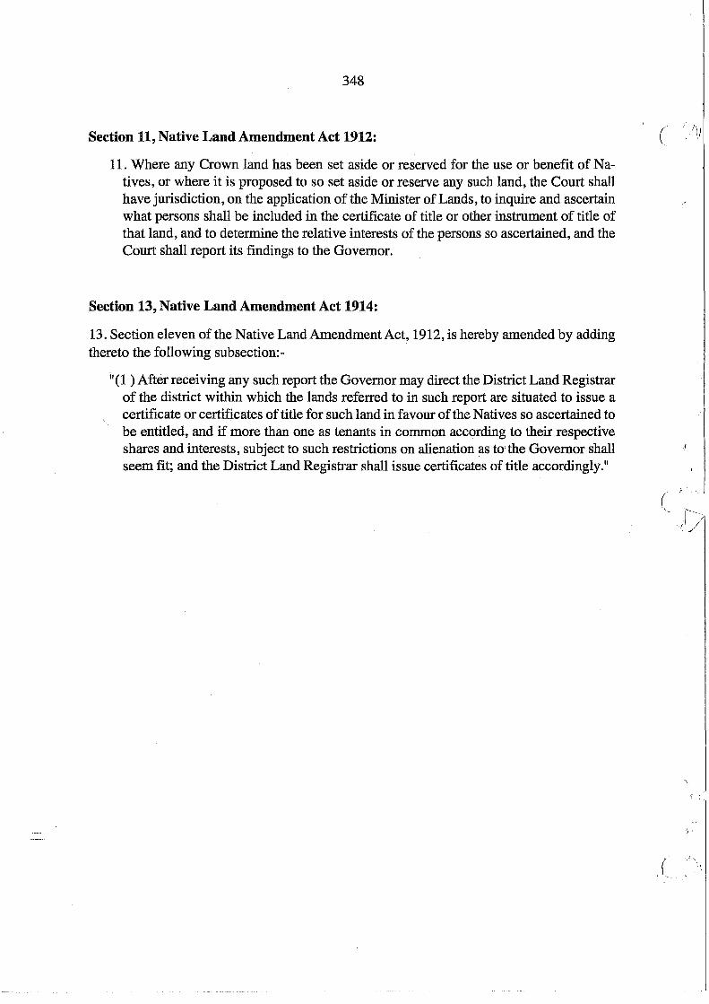
348
Section 11, Native Land Amendment Act 1912:
11. Where any Crown land has been set aside or reserved for the use or benefit of Natives, or where it is proposed to so set aside or reserve any such land, the Court shall have jurisdiction, on the application of the Minister of Lands, to inquire and ascertain what persons shall be included in the certificate of title or other instrument of title of that land, and to determine the relative interests of the persons so ascertained, and the Court shall report its findings to the Governor.
Section 13, Native Land Amendment Act 1914:
13. Section eleven of the Native Land Amendment Act, 1912, is hereby amended by adding thereto the following subsection:-
i'(1 ) After receiving any such report the Governor may direct the District Land Registrar of the district within which the lands referred to in such report are situated to issue a certificate or certificates of title for such land in favour of the Natives so ascertained to be entitled, and if more than one as tenants in common according to their respective shares and interests, subject to such restrictions on alienation as tO'the Governor shall seem fit; and the District Land Registrar shall issue certificates of title accordingly."
(
'"
(