Investigation of Factors of Dust Storms and Solutions for Combating (With Emphasis on West Asia...
78
Geoinformatics Research Institute of the Univercity of Tehran Vice President for Science and Technology- The Headquarter for Water Technology Development, Drought, Degradation and Environment Investigation of Factors of Dust Storms and Solutions for Combating (With Emphasis on West Asia Region) English Version
-
Upload
independent -
Category
Documents
-
view
1 -
download
0
Transcript of Investigation of Factors of Dust Storms and Solutions for Combating (With Emphasis on West Asia...

Geoinformatics Research Institute of the
Univercity of Tehran
Vice President for Science and Technology-
The Headquarter for Water Technology
Development, Drought, Degradation and
Environment
Investigation of Factors of Dust Storms and
Solutions for Combating
(With Emphasis on West Asia Region)
English Version
Report Title:
An investigation about the factors of dust storms and
solutions for combating
(With emphasis on West Asia Region)
Vice President for Science and
Technology
2
University of Tehran- Geoinformatics Research Institute (UT-GRI)
Dr. Ali Darvishi Boloorani, Faculty member of the University of Tehran and manager of
Geoinformatics Research Institute (GRI), email: [email protected] & [email protected],
Office: +98(021)61113520, Cell phone: +98(0)9126192724
Mr. Seyed Omid Nabavi, PhD student in Department of Geography and Regional Research,
University of Vienna, Austria, and colleague of GRI, email: [email protected] &
Dr. Hossein Ali Bahrami, faculty member of Agrology Department, Tarbiat Moddares University,
email: [email protected]
Dr. Seyed Kazem Alavipanah, faculty member of Remote sensing and GIS department,
geography faculty, University of Tehran and colleague of GRI, email: [email protected]
Dr. Hossein Mohammadi, faculty member of Physical Geography Department, University of
Tehran, email: [email protected]
Mr. Mohammad Ali, Nezammahalleh, PhD Student of Geomorphology and colleague of GRI,
physical Geography department, University of Tehran, email: [email protected]
Report Title:
An investigation about the factors of dust storms and
solutions for combating
(With emphasis on West Asia Region)
Vice President for Science and
Technology
3
University of Tehran- Geoinformatics Research Institute (UT-GRI)
Contents:
Foreword: 4 1. Introduction 5
2. Desertification and dust storm in North of China, North Africa, and the United States 10 3. Desertification phenomenon and dust storm activities in South West Asia 21 4. Desertification and dust storm phenomena in Sistan Region 38 5. Desertification and dust storm phenomena in Aral Sea Region 42 6. Solutions to combat desertification 46 7. Activities against desertification in China 56 8. Activities against desertification in the WAR 57 9. Fixation of erosional areas in Iran 63 10. Fixation of sand dunes by growing plant species 65 11. Recommendations for future works 65 12. Organizations, scholars, and experts related to studies of dust storms in the WAR 66 13. References 70

Report Title:
An investigation about the factors of dust storms and
solutions for combating
(With emphasis on West Asia Region)
Vice President for Science and
Technology
4
University of Tehran- Geoinformatics Research Institute (UT-GRI)
Foreword:
Dust storms are one of the main environmental challenges, particularly in West Asian Region. The
phenomenon has great harmful impacts on the countries of the region including Iran, Iraq, Syria,
Kuwait, and other countries around Persian Gulf. Intensification of the phenomenon in recent years
made it necessary to find a suitable solution to combat against the devastating events. Therefore, the
headquarter of water resources development, drought, erosion and environment assigned a project
entitled “Investigation of Dust Storms in West Asian Region” to Geoinformatic Research Institute
(GRI) of the University of Tehran in order to study the regional phenomenon. United Nations
Environmental Program (UNEP) Regional Office of West Asia (ROWA) also supported this project
because of its regional nature and the need for participation from national, regional and international
organizations.
The output and outcomes of this project entitled “Investigation of Dust Storms in West Asian
Region” is three reports:
Primary Investigation of Dust Storm Sources in West Asia (With an Emphasis on Storms
Came to Iran)
Analysis of Fundamentals, Identification Criteria, and Modeling of Dust Storms (With
emphasis on West Asia Region)
Investigation of factors of dust storms and solutions for combating (With emphasis on
West Asia Region)
Members of the team are greatly thankful to kind cooperation of all professors, students, colleagues,
and the experts who assisted in conduction of this project. The team is also especially grateful to
vice-president for science and technology affairs of Islamic republic of Iran and UNEP-ROWA. All
kinds of criticism and suggestions are warmly welcomed by the team members.
Dr. Hossein Ali Bahrami
Secretariat of the headquarter of
water resources development,
drought, erosion and environment
technologies (vice-president for
science and technology affairs of
Islamic republic of Iran)
Dr. Ali Darvishi Bolourani
The head of International
Geoinformatic Reseach Institute of
the University of Tehran (GRI) and
the executer of the project
Dr. Abdol Majid Hadad
Environemntal Program of United
Nations, Regional Office of West
Asia (UNEP-ROWA)

Report Title:
An investigation about the factors of dust storms and
solutions for combating
(With emphasis on West Asia Region)
Vice President for Science and
Technology
5
University of Tehran- Geoinformatics Research Institute (UT-GRI)
1. Introduction
Processes for identifying factors that affect dust storms generation and the solutions for combating
these phenomena are not separable from the activities conducted for determining the sources of dust
storm. Hence, identification of the factors that generate dust storms and the combating procedures
must be based on temporal patterns and spatial distributions of the phenomena in source areas. It
must also be based on related natural and human parameters of these areas. For example, as in the
investigations some agricultural lands are recognized as sources where generate dust particles, the
role of human activities is evident in developing of these areas. It is obvious that the approaches to
combat the dust storm resulted from human devastating activities are different from those originated
from natural factors. In other words, the most efficient methods to control the phenomena are those
with the highest compatibility with natural and human factors.
Definition of desertification is the achievement of United Nations Conference on Environment and
Development (UNCED) in 1992. In this definition, not only generating factors of dust storm and
desertification are similar but the masses of dust are originated from specific regions. These regions
either had been formed as desert areas in geologic times or are developing now in neighboring areas
around these regions. In this definition desertification is land degradation in arid, semi-arid, and dry
sub-humid areas resulting from various factors, including climatic variations and human activities
(Kadomura, 2001). Soil erosion by water or wind including dust storm is an example of land
degradation in other supplementary definitions of United Nations Convention to Combat
Desertification (UNCCD). By this way, the desertification phenomenon is the main cause of dust
storm events. However, movements of dust masses increase extents of desert areas. This serves as an
effect that intensifies its cause1. Summarily, investigation of the factors that generate and develop
desert areas can be considered as works about the processes that result in creation of sources of dust
storm and their intensifications. It is necessary to consider management of desert areas and prevent
desertification in order to combat dust storm events. Hence, hereafter the factors of desertification
and related solutions are synonymous to factors of generating dust storms and solutions for
combating dust storm.
- Definitions for desertification
Difficult executive plans in desert areas reveal the fact that rehabilitation of these areas is very hard,
expensive and sometimes impossible (Chen and Tang, 2005). Therefore, specification of factors in
order to prevent development of desert areas is one of the concerns of researchers and authorities in
environmental and natural resources issues (Kertesz, 2009, Croitoru and Sarraf, 2010, Geist and
Lambin, 2004). A way to know the effective factors in a natural phenomenon is the definitions of
that. Although, there is a certain definition of desertification in this report, but there is no consensus
between this definition and others. Different viewpoints about effective factors in development of
desert areas may be one of the causes for the lack of common views. The term of desertification was
first outlined by Lavauden in 1927 in an investigation about pasture areas in the south of Tunisia
(Dregne, 2002). However, in this study the term was just applied to refer to a reduction in forage for
ranching without any attention to causes of desertification. Aubreville (1949) has also applied the
term of desertification in a study about devastated forests of West Africa. Although, he did not
As an effect intensifies its own cause, it would be a positive feedback and in reverse situation it would be negative. 1
Report Title:
An investigation about the factors of dust storms and
solutions for combating
(With emphasis on West Asia Region)
Vice President for Science and
Technology
6
University of Tehran- Geoinformatics Research Institute (UT-GRI)
explain factors of desertification but he identified devastating human activities as the main cause for
reduction in forests. Application of the definition in a forest area is indicative of the fact that
desertification is not limited to arid areas. It also shows that human activities in vegetated areas can
also produce this situation in the form of destruction of trees, severe soil erosion, and conversion of
the forests into the areas with no biologic values. The definition of desertification by UNEP in 1990
may be the first formal statement of the factors related to this phenomenon. Based on this definition,
desertification/land degradation, in the context of assessment, is land degradation in arid, semi-arid
and dry sub-humid areas resulting from adverse human impact. Land in this concept includes soil
and local water resources, land surface and vegetation or crops. Degradation implies reduction of
available resource potential by one or a combination of processes acting on land. These processes
include water erosion, wind erosion and sedimentation by those agents, long term reduction in the
amount or diversity of natural vegetation, where relevant, and salinization and sodication
(Kadomura, 2001). A salience in this definition is that human adverse activities are considered as the
only effective factor in development of desert areas with no considerable attention to natural causes.
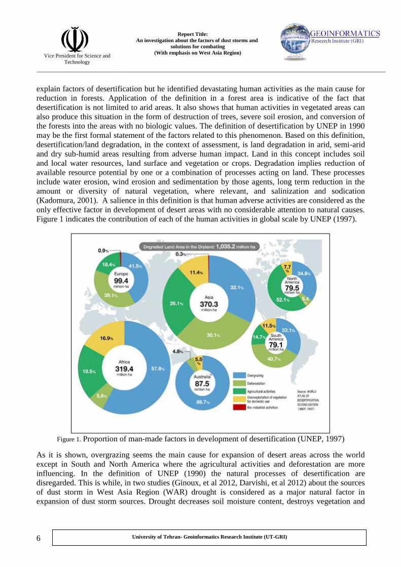
Figure 1 indicates the contribution of each of the human activities in global scale by UNEP (1997).
Figure 1. Proportion of man-made factors in development of desertification (UNEP, 1997)
As it is shown, overgrazing seems the main cause for expansion of desert areas across the world
except in South and North America where the agricultural activities and deforestation are more
influencing. In the definition of UNEP (1990) the natural processes of desertification are
disregarded. This is while, in two studies (Ginoux, et al 2012, Darvishi, et al 2012) about the sources
of dust storm in West Asia Region (WAR) drought is considered as a major natural factor in
expansion of dust storm sources. Drought decreases soil moisture content, destroys vegetation and

Report Title:
An investigation about the factors of dust storms and
solutions for combating
(With emphasis on West Asia Region)
Vice President for Science and
Technology
7
University of Tehran- Geoinformatics Research Institute (UT-GRI)
makes active areas for generating dust storm2. The influence of such cases in the world made United
Nations in 1992 to introduce natural process of climate change in definitions of desertification. In the
recent definition the term of land degradation has more comprehensive and extensive meaning
compared with the definition of UNEP (1990). Therefore, “Land Degradation” means reduction or
loss in arid, semi-arid, and dry subhumid areas, of biological or economic productivity and
complexity of rainfed cropland, or range, pasture, forest, and woodlands resulting from land uses, or
from a process or combination of processes, including processes arising from human activities and
habitation patterns, such as: (1) soil erosion caused by wind and/or water; (2) deterioration of the
physical, chemical, and biological or economic properties of soil; and (3) long-term loss of natural
vegetation.
- Factors of desertification
It is worthy to mention that the occurrence of dust storm, even in its extremes, is usual and known
phenomena of land ecosystem in desert areas. What makes researches and investigations on
happening of this phenomenon to be necessary in the WAR is the sudden increment of dust storms
with adverse financial and health casualties. Hence, in most of the works about processes of
generating dust storms, the main focus of studies is on the factors that make the occurrence of the
event multiplied in a short time interval. On the other hand, use of the term “factors of
desertification” does not mean these areas are definitely converted into desert regions and
rehabilitation of the influenced areas can be observed in some cases. Given that the beginning of dust
storm can often be observed in the first stages of desertification, whether the final results of
desertification cause complete destruction of biological resources or not, the conditions of these areas
are investigated as factors of desertification. In most of studies, to have a coherent analysis of the
factors of desertification, these are divided into two categories of human and natural factors. In this
report, before analyzing the issues in common categories, we will examine the factors based on their
precedence of occurrence under the name of primary and subsidiary processes. Then, they are
analyzed based on their natural and human origins and also their contribution in desertification.
The primary processes effective in expansion of desert areas, mainly originated from adverse human
activities, are including overgrazing, non-precision agricultural activities, mismanagement of surface
and ground water resources, deforestation, land use change, industrial and chemical pollutions and
also drought (as the only natural agent). These processes in the primary stages influence non desert
areas and destroy continuously environmental resources. This may develop into the complete
destruction of the environmental resources. In addition, as these processes are mainly anthropogenic
(except drought), they are not in cycle of natural elements of ecosystem. Therefore, they don’t have
sensible interaction (feedback) with desertification. However, intensification of desert condition in
some cases makes human populations to utilize natural resources, inappropriately. For instance, with
increasingly reduction in nutrient resources for ranching over the pastures, not only the grazing
would not be declined but it encourages the ranchers to use the vegetations with less nourishment
values. These vegetations might be preserved from grazing before the destruction occurred in
pastures. As another example, a decrease in ground water resources and its salinization for
agriculture does not reduce the use of water by farmers. Instead, it may compel the farmers to use
This is necessary to mention that occurring drought in a few years cannot develop desert areas in a region. The 2
repetition of the phenomenon in many decades continuously along with lots of other conditions may activate the
processes that result in elimination of biologic elements and increment of desert areas and dust storm sources.

Report Title:
An investigation about the factors of dust storms and
solutions for combating
(With emphasis on West Asia Region)
Vice President for Science and
Technology
8
University of Tehran- Geoinformatics Research Institute (UT-GRI)
more water for dilution of the resources. This trend may continue to cause salinization and
destruction of agricultural lands.
On the contrary, we have subsidiary processes of desertification that can be results of the
desertification. These processes do not play a major role in desertification in the initial stages of
desert development. Indeed, after the occurrence of primary processes of desertification, e.g.
overgrazing, non precision agriculture, and salinization, a severe destruction of biological resources
and vegetation may be emerged. The result of these processes would be activation of the subsidiary
processes of desertification, e.g. water and wind erosions. The subsidiary processes of desertification
and the primary factor of drought are at the cycle of natural environment and in interaction with
desertification. The terret of these processes is the amount of vegetation (Figure 2).
Figure 2. cycle of subsidiary processes of desertification such as soil erosion (by wind and water) and
the primary process of drought (climate) based on vegetation destruction (D’Odorico, et al 2013).
As it can be seen in the arrows on Figure 2, drought occurs prior to vegetation destruction and
desertification (primary factor). On the contrary, soil erosion will be appeared after the destruction of
vegetation in that region (subsidiary factor). It is worthy to mention that both processes are in a cycle
that can affect each other and at the same time can be influenced by each other. As a result of these
mutual relations, destruction of vegetation will be appeared. The atmospheric element of
precipitation and soil erosion do not just increase desertification but they may alleviate the process of
desertification, in some cases. The precipitation through three relations of hydrologic cycle, surface
energy balance, and dust particles (as a subsidiary factor) can either influence surface vegetation or
be affected by that. As a result of vegetation destruction, about 10 to 35 percent of local moisture
into the atmosphere will be decreased. This is while, in some cases increases in surface albedo
(relation of surface energy equilibrium) due to vegetation destruction can make up for this moisture
decrease through convection flow. It can even increase precipitation in some cases. It is obvious that
this increase in precipitation can reduce the trend of desertification. Dust particles both as a
subsidiary factor in desertification process and as an atmospheric phenomenon can have considerable

Report Title:
An investigation about the factors of dust storms and
solutions for combating
(With emphasis on West Asia Region)
Vice President for Science and
Technology
9
University of Tehran- Geoinformatics Research Institute (UT-GRI)
mutual relations in this cycle. Although, movements of dust particles can develop the borders of
desert regions, but its influence in concentration of water vapor, as nuclei, and augment in
precipitation may reduce the speed of desertification trend (D’Odorico, et al 2013). Water erosion in
the lack of proper vegetation cover can remove a considerable amount of surface soil and biologic
elements and intensify desert conditions. As this movement of soil particles is well managed by
stabilization of sedimentary deposits, a suitable area will be provided downstream for growth of
vegetation and agriculture.
This can be concluded that unless the interrelated mutual relations are examined and recognized in
the study region, specification of all processes of desertification cannot be possible. Analysis of the
processes that result in desertification indicates that all these factors are as a result of population
growth in the past centuries. This is while; the researchers have announced this fact that the
decreasing in population takes a long time and may be impossible. Therefore, they attempt to
examine the factors of desertification and subsequently to combat this phenomenon. Hence, the
solutions are attempted to be presented so that they can both meet the requirements of human
population and conserve the environment. Finally, it can be mentioned that some of the social and
environmental factors of desertification, because of difficulties in quantitative measurements of their
contribution, are less investigated in many studies. Some of these factors that strongly recommended
to be examined in future studies are including: population and administrative policies of
governments, attitudes of local communities about exploitation and conservation of natural
resources, physical characteristics of these areas such as slope and position towards flooding flows,
and inflammability of vegetations (Conacher, 2004).
Given the variety of definitions and the difficulties in measurement of the factors effective in
desertification, it does not appear easy to understand the contribution of each factor. Nevertheless,
here, we have tried to introduce the factors of desertification, as much as possible, in the WAR and
other regions in northern hemisphere (Figure 3). The main focus of this report is upon the conducted
researches about the factors effective in desertification and subsequently formation of dust storm in
the WAR. The analyses of the factors in other regions of the world are mainly based on the
prominent studies. Hence, with more exact studies and in local scales some inconsistencies with the
results of these studies and the next section of this report can be expected.

Report Title:
An investigation about the factors of dust storms and
solutions for combating
(With emphasis on West Asia Region)
Vice President for Science and
Technology
10
University of Tehran- Geoinformatics Research Institute (UT-GRI)
Figure 3. Desert regions and the regions under the influence of desertification (United States
Department of Agriculture, 1998)
It is important to note the geographical distribution of regions under the influence of desertification
(Figure 3). The spatial distribution of desert areas (gray color) and the areas susceptible to desert
development (red color) show concentration of these areas in WAR and central Asia (USDA3, 1998).
These conditions make it necessary to pay more attention to the investigations about effective factors
in occurrence of this phenomenon in WAR. This is for finding appropriate solutions in order to
prevent these areas from converting into desert areas and from their attachment to adjacent deserts.
In addition to WAR, United States of America, North of Africa, North of China are either under the
influence of desert conditions or in transient stages into these areas.
2. Desertification and dust storm in North of China, North Africa, and the United States
What can be concluded from the documents related to desertification is the incontrovertible role of
population changes as the major factor and origin (direct or indirect) of other factors, whether natural
or anthropogenic, in this phenomenon. Hence, we take a glance at information about demographic
condition of the regions where are under the influence of desertification. Then, we address the
factors of desertification, in details.
The current changes in human population (UN, 2011) indicate considerable growth rate in different
countries particularly the regions where will be influenced by desertification till 2025 (Figure 4).
Therefore, in the WAR and North Africa, where include the main regions susceptible to
desertification, the population growth rate will be increased to more than 40% in some countries
including Iraq, Afghanistan, Yemen, Chad, Niger, Mali. The results of these circumstances will be an
increase in exploitation of natural resources and regeneration of additional factors of desertification
including overgrazing, non precision agriculture, and inappropriate use of surface and ground water
resources.
3 http://www.nrcs.usda.gov/wps/portal/nrcs/detail/soils/use/?cid=nrcs142p2_054003

Report Title:
An investigation about the factors of dust storms and
solutions for combating
(With emphasis on West Asia Region)
Vice President for Science and
Technology
11
University of Tehran- Geoinformatics Research Institute (UT-GRI)
Figure 4. Population changes until 2025 (UNCCD, 2011) 4
Use of the term “population changes” as one of the main factors of desertification, here, implies that
not only the increasing of population density may destroy biologic resources but, in some cases, the
population decrement due to human casualties and group migration (Exodus) can also develop the
borders of desert regions.
). Due to some http://www.zoinet.org/webThis map is produced by ZOI environmental network using data from UN ( 4
limitation in projecting the map, North and South America is not displayed on. population rate in America is 10 percent
that increase population up to 40 million people till 2025.
Report Title:
An investigation about the factors of dust storms and
solutions for combating
(With emphasis on West Asia Region)
Vice President for Science and
Technology
12
University of Tehran- Geoinformatics Research Institute (UT-GRI)
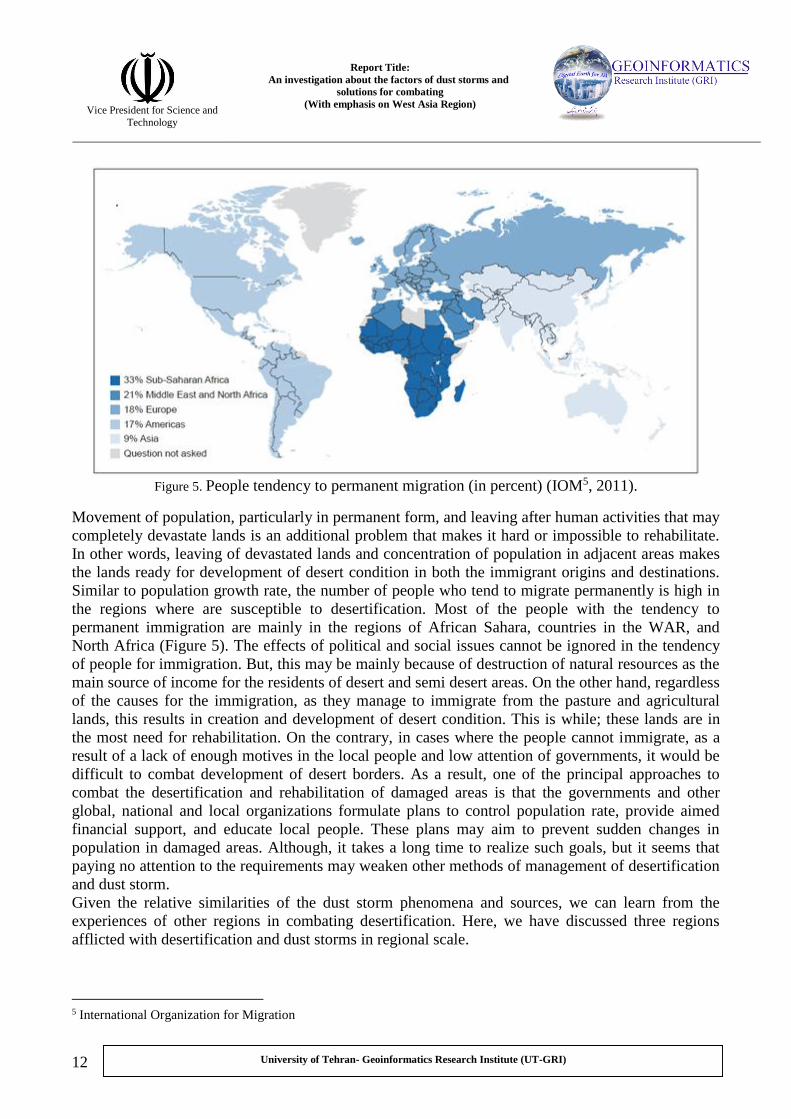
Figure 5. People tendency to permanent migration (in percent) (IOM5, 2011).
Movement of population, particularly in permanent form, and leaving after human activities that may
completely devastate lands is an additional problem that makes it hard or impossible to rehabilitate.
In other words, leaving of devastated lands and concentration of population in adjacent areas makes
the lands ready for development of desert condition in both the immigrant origins and destinations.
Similar to population growth rate, the number of people who tend to migrate permanently is high in
the regions where are susceptible to desertification. Most of the people with the tendency to
permanent immigration are mainly in the regions of African Sahara, countries in the WAR, and
North Africa (Figure 5). The effects of political and social issues cannot be ignored in the tendency
of people for immigration. But, this may be mainly because of destruction of natural resources as the
main source of income for the residents of desert and semi desert areas. On the other hand, regardless
of the causes for the immigration, as they manage to immigrate from the pasture and agricultural
lands, this results in creation and development of desert condition. This is while; these lands are in
the most need for rehabilitation. On the contrary, in cases where the people cannot immigrate, as a
result of a lack of enough motives in the local people and low attention of governments, it would be
difficult to combat development of desert borders. As a result, one of the principal approaches to
combat the desertification and rehabilitation of damaged areas is that the governments and other
global, national and local organizations formulate plans to control population rate, provide aimed
financial support, and educate local people. These plans may aim to prevent sudden changes in
population in damaged areas. Although, it takes a long time to realize such goals, but it seems that
paying no attention to the requirements may weaken other methods of management of desertification
and dust storm.
Given the relative similarities of the dust storm phenomena and sources, we can learn from the
experiences of other regions in combating desertification. Here, we have discussed three regions
afflicted with desertification and dust storms in regional scale.
5 International Organization for Migration
Report Title:
An investigation about the factors of dust storms and
solutions for combating
(With emphasis on West Asia Region)
Vice President for Science and
Technology
13
University of Tehran- Geoinformatics Research Institute (UT-GRI)
- Northern half of China
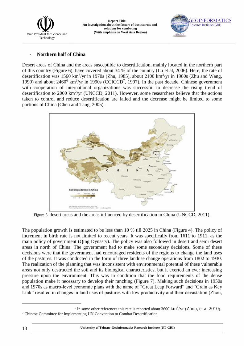
Desert areas of China and the areas susceptible to desertification, mainly located in the northern part
of this country (Figure 6), have covered about 34 % of the country (Lu et al, 2006). Here, the rate of
desertification was 1560 km3/yr in 1970s (Zhu, 1985), about 2100 km3/yr in 1980s (Zhu and Wang,
1990) and about 24606 km3/yr in 1990s (CCICCD7, 1997). In the past decade, Chinese government
with cooperation of international organizations was successful to decrease the rising trend of
desertification to 2000 km2/yr (UNCCD, 2011). However, some researchers believe that the actions
taken to control and reduce desertification are failed and the decrease might be limited to some
portions of China (Chen and Tang, 2005).
Figure 6. desert areas and the areas influenced by desertification in China (UNCCD, 2011).
The population growth is estimated to be less than 10 % till 2025 in China (Figure 4). The policy of
increment in birth rate is not limited to recent years. It was specifically from 1611 to 1911, as the
main policy of government (Qing Dynasty). The policy was also followed in desert and semi desert
areas in north of China. The government had to make some secondary decisions. Some of these
decisions were that the government had encouraged residents of the regions to change the land uses
of the pastures. It was conducted in the form of three landuse change operations from 1802 to 1930.
The realization of the planning that was inconsistent with environmental potential of these vulnerable
areas not only destructed the soil and its biological characteristics, but it exerted an ever increasing
pressure upon the environment. This was in condition that the food requirements of the dense
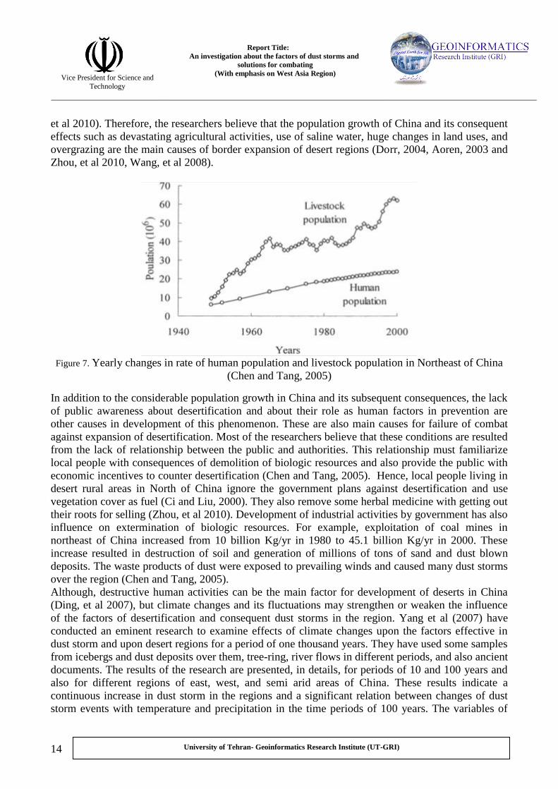
population make it necessary to develop their ranching (Figure 7). Making such decisions in 1950s
and 1970s as macro-level economic plans with the name of “Great Leap Forward” and “Grain as Key
Link” resulted in changes in land uses of pastures with low productivity and their devastation (Zhou,
). Zhou, et al 2010(/yr 2kmIn some other references this rate is reported about 3600 6 7 Chinese Committee for Implementing UN Convention to Combat Desertification
Report Title:
An investigation about the factors of dust storms and
solutions for combating
(With emphasis on West Asia Region)
Vice President for Science and
Technology
14
University of Tehran- Geoinformatics Research Institute (UT-GRI)
et al 2010). Therefore, the researchers believe that the population growth of China and its consequent
effects such as devastating agricultural activities, use of saline water, huge changes in land uses, and
overgrazing are the main causes of border expansion of desert regions (Dorr, 2004, Aoren, 2003 and
Zhou, et al 2010, Wang, et al 2008).
Figure 7. Yearly changes in rate of human population and livestock population in Northeast of China
(Chen and Tang, 2005)
In addition to the considerable population growth in China and its subsequent consequences, the lack
of public awareness about desertification and about their role as human factors in prevention are
other causes in development of this phenomenon. These are also main causes for failure of combat
against expansion of desertification. Most of the researchers believe that these conditions are resulted
from the lack of relationship between the public and authorities. This relationship must familiarize
local people with consequences of demolition of biologic resources and also provide the public with
economic incentives to counter desertification (Chen and Tang, 2005). Hence, local people living in
desert rural areas in North of China ignore the government plans against desertification and use
vegetation cover as fuel (Ci and Liu, 2000). They also remove some herbal medicine with getting out
their roots for selling (Zhou, et al 2010). Development of industrial activities by government has also
influence on extermination of biologic resources. For example, exploitation of coal mines in
northeast of China increased from 10 billion Kg/yr in 1980 to 45.1 billion Kg/yr in 2000. These
increase resulted in destruction of soil and generation of millions of tons of sand and dust blown
deposits. The waste products of dust were exposed to prevailing winds and caused many dust storms
over the region (Chen and Tang, 2005).
Although, destructive human activities can be the main factor for development of deserts in China
(Ding, et al 2007), but climate changes and its fluctuations may strengthen or weaken the influence
of the factors of desertification and consequent dust storms in the region. Yang et al (2007) have
conducted an eminent research to examine effects of climate changes upon the factors effective in
dust storm and upon desert regions for a period of one thousand years. They have used some samples
from icebergs and dust deposits over them, tree-ring, river flows in different periods, and also ancient
documents. The results of the research are presented, in details, for periods of 10 and 100 years and
also for different regions of east, west, and semi arid areas of China. These results indicate a
continuous increase in dust storm in the regions and a significant relation between changes of dust
storm events with temperature and precipitation in the time periods of 100 years. The variables of

Report Title:
An investigation about the factors of dust storms and
solutions for combating
(With emphasis on West Asia Region)
Vice President for Science and
Technology
15
University of Tehran- Geoinformatics Research Institute (UT-GRI)
temperature and precipitation with significant negative relations get correlation values of 51 and 63
percent in 100 years periods over some regions.
Finally, what can be considered as principal factor of desertification in China is initially the policy of
population increase as a long time experience in this country. This human factor leads to subsidiary
processes including land use change, pasture destruction, soil salinization and etc. These have
consecutively developed desert areas in north of China. Furthermore, lack of awareness of local
people about desertification, inappropriate government policies in development of economic
activities and disregarding conservation of environmental resources have all intensified destruction
of biological resources. Precipitation fluctuations as a supplementary factor affected the destructed
areas and enforced the desertification processes and consequent events such as dust storm in the
region.
- North Africa
About 40 percent of Africa is under the influence of desertification (Jones, et al 2013). Nearly half of
the regions (one billion hectare) are located around Sahara, in North Africa Desert (Dregne, 2002).

Report Title:
An investigation about the factors of dust storms and
solutions for combating
(With emphasis on West Asia Region)
Vice President for Science and
Technology
16
University of Tehran- Geoinformatics Research Institute (UT-GRI)
Figure 8. desertification vulnerability of Africa (Jones, et al 2013).
This figure just shows vulnerability of Africa relative to desertification and the current desert areas
are not depicted on. In this figure, Sahara Desert is in the north and equatorial forests are in the
center, by gray color, and far from desertification influence. However, in the present study Sahara
Desert is one of the main regions in generating dust storms.
Population growth not only in North Africa but in other regions of the continent is as a principal
factor for desertification (Nicholson, et al 1998, Ouma and Ogallo 2007). Le Houérou, (1996)
mentioned the fact that the population of Africa is doubled from the past three decades (Figure 9).
This means an increase in population, which is more than 21 million per year, and the consequent
pressure upon environmental resources. This can be seen by the fact that the most eroded areas of the
continent are coincident with the most populated areas including highland of Ethiopia, Chad, and
Darfur in Sudan (Darkoh, 1998). According to figure 4, population growth in North Africa in 2025
would not be different from the past decades.
If this trend of population growth continues to 2050, half of the agricultural lands of Africa will no
longer be usable and to 2025 just 25 percent of the population can access minimum nutrition
resources (UN, 2007). Same as China, the huge amount of population in Africa led to extra amount
of livestock and inappropriate use of agricultural lands and forest resources. Based on conducted
studies (UNEP 2007) by up to 1992 equal to 25 percent of pastures, agricultural lands, and forest
areas were intensively destroyed. Equal to 15 percent of pastures (194 million hectare) have mostly
influenced by desertification due to grazing.

Report Title:
An investigation about the factors of dust storms and
solutions for combating
(With emphasis on West Asia Region)
Vice President for Science and
Technology
17
University of Tehran- Geoinformatics Research Institute (UT-GRI)
Figure 9. Population growth in Africa from 1900 to 2000. ( ) represents population of arid areas in the
south of Sahara Desert, ( ) east Africa, ( ) Sahel Region, and ( ) South Africa from 1190 to 2000
(Le Houérou, 1996)8.
In addition to population growth, processional migration got an especial form in Africa e.g., half of
men in Mali have migrated into neighboring countries or Europe. On the opposite, Nairobi (the
capital of Kenya) has experienced an increase of 800 percent in population due to immigration from
neighboring regions. In this area people were afflicted from 1963 to 2005 by poverty as a result of
drought and development of desert boundaries. Population changes, may be as result of internecine
conflicts and international wars, have led to complete extinction of abandoned areas and destruction
of natural resources in destination areas of migration (Darkoh, 1998).
The countries with the most poverty including Mali, Niger, Central Africa, and Chad are coincident
with the marginal areas of Sahara Desert which mostly affected by desertification. This cannot be
accidental. Indeed, severe poverty in a population more than 40 percent of people in these countries
indicates incontrovertible role of desertification in destruction of environmental resources, i.e., lose
of income resources of human population. Furthermore, it must be mentioned that not only the
severity of poverty is due to desertification, but this phenomenon serve as a factor that make local
people to utilize intensively environmental resources to meet their requirements. In return, this
causes intensification of desertification. In fact, in these regions, the poverty prevailing on the
society reduces access to lands and causes reluctance among people to learn optimal ways for use of
natural resources. It is while, the people living near the regions are dependent upon exploitation of
natural resources to meet their basic needs (UNCCD, 2011, UN, 2007, Darkoh, 1998).
Le Houérou in 1992 based on different references and annual report of FAO. The chart was presented by 8

Report Title:
An investigation about the factors of dust storms and
solutions for combating
(With emphasis on West Asia Region)
Vice President for Science and
Technology
18
University of Tehran- Geoinformatics Research Institute (UT-GRI)
Figure 10. People with daily income less than 1.25 USD (UNCCD, 2011)9.
The role of climate changes and its fluctuations in desertification in North Africa is so important that
the convention for protection against desertification was formulated. This convention was as the
result of the concern of global community about occurrence of drought and destruction of
environmental resources particularly in Sahel region10 in 1960s and 1970s (Cullet, 2001). However,
some researchers believe that these drought events were transient and soil dryness could not lead to
desertification (Hellden, 1991, Hellden, 1994 and Tucker, 1991). But, severity of these fluctuations
in precipitation led to destruction of vegetation and erosion of surface soil and, consequently, dust
storm events (Darkoh, 1998).
Determination of precise contribution of each of the processes in occurrence of desertification and
subsequent dust storm in North Africa requires lots of precise investigations and studies. However, it
can be concluded that this region, same as north of China, was disturbed continuously by the
influence of human factors. Occurrence of harsh droughts, such as the events of 1960s and 1970s,
changed the condition for providing huge dust masses.
- United States
In a review of desertification process in United States (US), “Great Plains” and “dust storm” in
1930s emerged as keywords in many studies (Hansen, 2005, Cutler, et al 2007, Allen and Fenster,
1986, Sachs, 1994). The Great Plain region expands from southern Canada and continues from
) http://www.zoinet.org/web/ZOÏ using United Nations data (This map is depicted by 9
Sahel region is located in the boundary between dense vegetation of equatorial region and Sahara Desert in Africa. 10

Report Title:
An investigation about the factors of dust storms and
solutions for combating
(With emphasis on West Asia Region)
Vice President for Science and
Technology
19
University of Tehran- Geoinformatics Research Institute (UT-GRI)
central areas of the United States towards the south of the country. The semi arid climate with
presence of vast plains and rangelands are characteristics of the region where are suitable for
agriculture and ranching. Until 1930s as a result of World War I in Europe and wet years in 1920s
the pasture areas were intensively used for agriculture, particularly wheat crops. Ranching and
keeping livestock were developed so that the economy of local people were more than ever
dependent upon use of natural resources, particularly vegetation, surface and ground water. The
Golden period of productivity in these agricultural lands suddenly dropped in the beginning of 1930s
with severe drought of this period. As it can be observed in Figure 11, deviation of rainfall from the
mean of 100 years period indicates decline of rainfall in 1930s.
Figure 11. Deviation of annual rainfall from the mean of one hundred years period in Amarillo City,
Texas State (in South of US)
The immediate result of this drought was severe destruction of vegetation and exposure of ploughed
soils to swift southern winds. The soils were transformed by southern wind and caused enormous
dust storms. These masses of dusts are called “Dust Bowl” or “Dirty Thirties” (Hornbeck 2012).
Figure 12 illustrate the approximate extent of these storms.

Report Title:
An investigation about the factors of dust storms and
solutions for combating
(With emphasis on West Asia Region)
Vice President for Science and
Technology
20
University of Tehran- Geoinformatics Research Institute (UT-GRI)
Figure 12. the areas under the influence of dust storm of 1930s. Dust Bowl in Great Plains
(Baumhardt, 2003)
Truth Finding Committee responsible for research about this phenomenon rejected the hypothesis of
influence of climate change in formation of this event. The committee attributed this happening to
prevalence of agriculture and ranching activities that were special to humid climates and propagated
inconsistently in semi arid climate of this region. Some causes stated for soil destruction and
occurrence of dust storm events includes: rigorous economic stagnancy of 1930s, sharp decrease in
values of agricultural products and subsequent release of cultivated lands, prevalence of one product
cultivation of winter wheat, in that this prevent saving of water in summer, division of agricultural
lands into smaller pieces, prevalence of feudalism (renting), repeated movements of soil in
cultivation, and finally the severe drought in the form of climate fluctuations (Lockeretz, 1978,
Baumhardt, 2003).
It is noteworthy that with occurrence of more severe drought event in 1950s relative to 1930s (Figure
11), the losses, as reported, to agricultural lands and pastures were less than those in 1930s
(Lockeretz, 1978). This can be because of amendatory and precautious measures taken by authorities
and executed by support of the local people. Exploring and monitoring the exact factors effective on
environmental degradation, they replaced repeated cultivation of wheat-Sorghum by one product
cultivation. By this action the saving of water increased from 20 percent in 1930s to 40 percent in
1950s. Furthermore, they prevented the occurrence of further enormous storms by accurate
irrigation, combining agricultural lands, reforms in land ownership rules, and as the most important
by laughing of soils without disturbance11.
What needs to be discussed separately is population change in the afflicted areas (Baumhardt, 2003).
Unlike many regions of the world faced with drought and desertification, the population of Great
Plain was just adjusted. In other words, decrease in population in destructed regions was reported 12
percent until 1940 (Hornbeck, 2012). In fact, despite of severe degradation of agricultural lands, the
government using economic supports managed to keep the amount of population appropriate to the
environmental capabilities of the area. This was in order to rehabilitate these degraded lands. This is
while, in other regions like Africa with decrease in rainfall, the vegetation, and performance of
In classic method, to increase porosity of soil, its layers are ploughed in different ways. In modified method, the upper 11
layer of soil is removed and after the entrance of air into the soil and mixture of previous layers, the surface soil is came
back to its primary situation.

Report Title:
An investigation about the factors of dust storms and
solutions for combating
(With emphasis on West Asia Region)
Vice President for Science and
Technology
21
University of Tehran- Geoinformatics Research Institute (UT-GRI)
agriculture a considerable quantity of local population, due to lack of support, will have to emigrate
collectively.
What can be concluded from the Dust Bowl Event in US in 1930s is that as we assume the influence
of climate changes it is not advised to attribute sudden increase in desertification and dust storm to
this. In fact, basic situation for abrupt changes in occurrence of dust storm is generated by human
destructive activities. After destruction of biological resources, particularly vegetation, a slight
temporal decline in precipitation will convert the region into a source for dust storm. Investigation
about the principal factors affecting desertification and devising some appropriate modification
methods in agricultural, economic and population activities are actions taken by American
authorities in tackling with this phenomenon. Indeed, selecting competent and operational methods,
that are consistent with requirements of the public and capabilities of the environment, led to an
increase in resistance of the ecosystem of the region (human or natural) against drought in the next
decades with a decrease in dust storm events.
3. Desertification phenomenon and dust storm activities in South West Asia
It is noticeable that in most of regional and trans-regional studies about dusts, some dust storms are
mentioned that just occurred in desert areas, e.g., Sahara in Africa (Darkoh, 1998), Gobi in Mongolia
and China (Zhou, et al 2010), Rub Al Khali in Saudi Arabia, and Syria Desert in West Asia (Darvishi
Bloorani, et al 2012). However, the factors generating these phenomena are not clearly considered by
researchers. The occurrence of dust and sand storms in desert areas is somehow normal and most of
the conducted studies are focused on semi arid regions and the regions under the influence of
desertification. Hence, in a review of the studies related to desertification factors in WAR, the works
have been explored that are mainly based on prevailing human and natural factors effective in
generation of dust storms. These factors are prevalent in three main regions as followings:
1. Tigris and Euphrates Basins in Turkey, Iraq, Syria, and partly south west of Iran
2. Sistan Basin in Afghanistan and Iran
3. Aral Sea Basin in central Asia
Based on the previous evidence, these regions that are in semi arid areas of the WAR have mostly
experienced desertification and many dust storm events (Prospero, et al 2002, Ginoux, et al 2012,
Esmaili, et al 2006, Darvishi, et al 2012, Goudie and Middleton, 2006).
- Tigris and Euphrates drainage basins
The watersheds of these two rivers are well known natural features in Middle East (Figure 13).
Highlands of Turkey are the main origins of these two rivers. About 90 percent of Euphrates water
and 45 percent of Tigris are originated from these mountains. About 10 percent of Euphrates water is
from Syria and about 51 and 9 percent of Tigris water are from Iraq and Iran, respectively. It is
worthy to note that the exact and updated information about this statistics is not available. This is not
just for these two watersheds but for other areas in the WAR. The main available information is the
research works, e.g., Dregne and Cho (1992) and UNEP (1992). Based on the studies of Dregne and
Cho (1992) the countries in watersheds of Tigris and Euphrates are vehemently under the influence
of desertification. In Iraq, about 90 % of pasture lands (34.5 million hectares), about 72 % of dry
farming (1.4 million hectares), and about 70 % of irrigated farming (1.25 million hectares) are
influenced by moderate to severe desertification. In Syria, the statistics are, respectively, about 90 %

Report Title:
An investigation about the factors of dust storms and
solutions for combating
(With emphasis on West Asia Region)
Vice President for Science and
Technology
22
University of Tehran- Geoinformatics Research Institute (UT-GRI)
(11.9 million hectares), 70 % (3.5 million hectares), and 17 % (110 thousands hectares) (AFED 12,
2008).
Figure 13. watersheds of Tigris and Euphrates (Holmes, 2010).
Based on these statistics, in both countries of Iraq and Syria rangelands are under the influence of
overgrazing and severe degradation of environment. In Iraq there is no difference between land
degradation in dry and irrigated agriculture lands. This condition may be due to enormous
evaporation rate, low quality of irrigation systems, and sometimes saline water. Although,
salinization of soil in Syria is not so high, but dry farming lands are about to converting into desert
areas. According to UNEP (1992) the situation is almost similar in other basins of these rivers in
other countries (Figure 14) (AFED, 2008). UNEP and ISRIC13, with collaboration of scientists and
experts from entire the world and based on its own definition of desertification conducted a research
work in identification of human factors of desertification from 1987 to 1990. The research work is
entitled Global Assessment of Human-Induced Soil Degradation (GLASOD). Based on these
researches, the most important factor of desertification in south west of Iran and south east of Iraq is
the destructive agricultural activities and in highlands of Turkey is demolition of forest vegetation.
12 Arab Forum for Environment and Development 13 International Soil Reference and Information Centre

Report Title:
An investigation about the factors of dust storms and
solutions for combating
(With emphasis on West Asia Region)
Vice President for Science and
Technology
23
University of Tehran- Geoinformatics Research Institute (UT-GRI)
Figure 14. the areas under the influence of soil erosion in WAR (UNEP and ISRIC 1990). (a) erosion
resulted from agricultural activities, (e) cultivation of alternative vegetation for combustion and
sheltering, (f) deforestation, (g) grazing of livestock, (i) soil pollution resulted from industrial
activities.
Although, the results of these studies include comprehensive information of desertification factors
for different geographical regions, but have some inconsistencies with the results of other recent
studies, i.e., in Figure 14, the northern half of the study area of this research is introduced as an area
without desertification. This is while by Darvishi et al. (2012) these areas were revealed to be the
main sources in generation of dust storm. The main cause of this inconsistency may be the focus of
UNEP on human factors of desertification. This is while, according to this later research, the main
cause of desertification in northwest of Iraq and east of Syria is severe drought in the region.
Furthermore, according to this figure, destructive agricultural activities are considered as the only
cause of degradation of environmental resources in southern half of the watershed. However, it is
clear that in this region the agricultural activities cannot be the only cause for desertification and
conversion of that area into dust storm sources. Therefore, in order to explore the conducted
researches and studies about southern and northern half of drainage basins of Tigris and Euphrates,
each of these portions are presented in separate sections.

Report Title:
An investigation about the factors of dust storms and
solutions for combating
(With emphasis on West Asia Region)
Vice President for Science and
Technology
24
University of Tehran- Geoinformatics Research Institute (UT-GRI)
- Desertification and dust storm phenomenon in northern part of Tigris and Euphrates
Drainage Basin
This basins are coincident with desert regions of northwest of Iraq and southeast of Syria. In recent
years dust sources in the regions are extremely active and affected large areas of the WAR,
especially western and southwestern of Iran and other countries around Persian Gulf (Taghavi and
Asadi, 2008, Mofidi and Jafari, 2011). According to Darvishi et al (2012) the dust sources located in
northwest of Iraq and east of Syria are divided into two sub-clusters in terms of their activity and
effectiveness on the areas where located in their path, i.e., Iran and countries around Persian Gulf
(Figure 15). In this division, the dust sources located in Iraq (A) have more activity and frequency of
occurrence compared with those located in Syria (B). Based on land cover map of the region, most
part of this cluster of dust is composed of desert and semi-desert regions where are almost devoid of
vegetation (Figure 15).
Figure 15. land cover of dust cluster in northern part of Tigris and Euphrates Drainages (Darvishi, et al
2012).
Despite that the predicted population growth for Iraq until 2025 was more than 40 % (Figure 4), the
population density in dust sources of northern part is not much considerable. In other words, in the
most of the regions under the influence of desertification the population growth and density is
considered as effective factors of development of this phenomenon. But, in northern half of Tigris
and Euphrates Drainages population density is low and some desert areas in the region have no
residents (Figure 16).

Report Title:
An investigation about the factors of dust storms and
solutions for combating
(With emphasis on West Asia Region)
Vice President for Science and
Technology
25
University of Tehran- Geoinformatics Research Institute (UT-GRI)
Figure 16. population density map of Syria (Izady, 2013a) and the map of population density and
ethnicity composition of Iraq (Izady, 2011). The white color areas have low population density14.
Therefore, main factor of desertification and generation of dust masses in northwest of Iraq and east
of Syria cannot be related to population changes and destructive human activities like other regions
of this study15. More detailed studies indicate that the main factor of numerous dust storms of
previous decade (mainly cluster A) was the severe drought (Darvishi, et al 2012). Some believe such
drought was never experienced in the half past century (Trigo et al, 2010). Based on the available
data, the region is experiencing consecutive droughts from 2004 (from November to April) to its
peak in 2008 (Figure 17). In this year the annual precipitation in some regions decreased to below 20
% of the average (Darvishi, et al, 2012).
are brief because of some limitations in displaying the maps. Original maps are available at The figures 14
http://gulf2000.columbia.edu/maps.shtml
es are considered as main factors of desertification in Population density and increase and destructive human activiti 15
some regions including north of China, North Africa, and central plains of the United States of America. It is obvious
that with focused studies on these regions there is the possibility to identify areas with natural factors like drought.
Report Title:
An investigation about the factors of dust storms and
solutions for combating
(With emphasis on West Asia Region)
Vice President for Science and
Technology
26
University of Tehran- Geoinformatics Research Institute (UT-GRI)
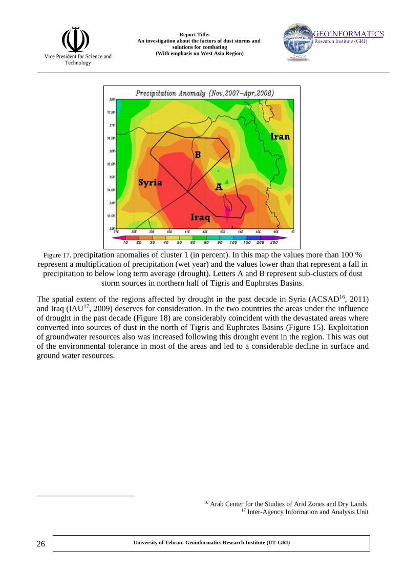
Figure 17. precipitation anomalies of cluster 1 (in percent). In this map the values more than 100 %
represent a multiplication of precipitation (wet year) and the values lower than that represent a fall in
precipitation to below long term average (drought). Letters A and B represent sub-clusters of dust
storm sources in northern half of Tigris and Euphrates Basins.
The spatial extent of the regions affected by drought in the past decade in Syria (ACSAD16, 2011)
and Iraq (IAU17, 2009) deserves for consideration. In the two countries the areas under the influence
of drought in the past decade (Figure 18) are considerably coincident with the devastated areas where
converted into sources of dust in the north of Tigris and Euphrates Basins (Figure 15). Exploitation
of groundwater resources also was increased following this drought event in the region. This was out
of the environmental tolerance in most of the areas and led to a considerable decline in surface and
ground water resources.
Arab Center for the Studies of Arid Zones and Dry Lands 16
Agency Information and Analysis Unit-Inter 17
Report Title:
An investigation about the factors of dust storms and
solutions for combating
(With emphasis on West Asia Region)
Vice President for Science and
Technology
27
University of Tehran- Geoinformatics Research Institute (UT-GRI)
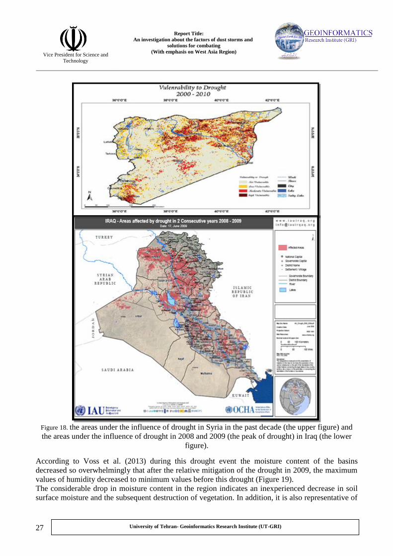
Figure 18. the areas under the influence of drought in Syria in the past decade (the upper figure) and
the areas under the influence of drought in 2008 and 2009 (the peak of drought) in Iraq (the lower
figure).
According to Voss et al. (2013) during this drought event the moisture content of the basins
decreased so overwhelmingly that after the relative mitigation of the drought in 2009, the maximum
values of humidity decreased to minimum values before this drought (Figure 19).
The considerable drop in moisture content in the region indicates an inexperienced decrease in soil
surface moisture and the subsequent destruction of vegetation. In addition, it is also representative of

Report Title:
An investigation about the factors of dust storms and
solutions for combating
(With emphasis on West Asia Region)
Vice President for Science and
Technology
28
University of Tehran- Geoinformatics Research Institute (UT-GRI)
extreme utilization of groundwater resources. These circumstances, due to use of saline water, could
lead to intensification of desertification and development of incipient dust sources18.
Figure 19. annual mean of moisture content anomalies in Tigris and Euphrates drainage basins 19(in
millimeters).
When the drought occurred in Iraq and Syria, at the same time changes in amount and time of snow
were recorded in highlands of Turkey as the main source for the two rivers. This may have additional
devastating effect upon the pastures and lands surrounding the two rivers. Investigating climatic and
hydrologic information in two periods of 17 years (i.e., 1972-1988 and 1990-2006), Sen et al (2011)
were able to recognize changes in temperature and time of peak flow in the two rivers. According to
their results, temperature increase in Siberia caused a decline in speed and intensity of cold air from
north east towards Turkey and replaced warm air from south to the region. One of the eminent
implications of the effects of the temperature increase on snow melting trend can be observed in
records of maximum river flows in Tigris and Euphrates, i.e., the maximum flow occurs 5 days
before the average in the first half of March. In addition that the sudden snow melting in highlands
result in damaging flooding flows, it reduces the possibility to use the water resources in drought
years, particularly for agriculture. Indeed, in addition to the droughts happened in Tigris and
Euphrates watersheds as a result of climatic fluctuations, the total trend of temperature increase (may
be as a result of climate changes) caused rapid melting of snow covers. This would undoubtedly have
negative impacts upon aridity of agricultural lands and pastures which are dependent on surface
flows downstream. It is worthy to note that the early happening of maximum snow melting and
subsequently maximum surface flows is representative of continuous temperature changes in
regional scale. Through increase in evaporation and changes in local atmospheric flows, this can, as a
separate factor, intensify droughts, desertification, and dust storms.
bout As there are not enough data about soil condition of Iraq and Syria, it is not possible to state certainly a 18
salinization of soil in these areas. However, based on the experiences these conditions can be expected for the region.
The original title of this figure is moisture content of Euphrates River drainage basin. The values of Tigris were 19
mip.fr/en/soa/hydrologie/hydroweb/Page_3.html-http://www.legos.obsthe extent projected at estimated by

Report Title:
An investigation about the factors of dust storms and
solutions for combating
(With emphasis on West Asia Region)
Vice President for Science and
Technology
29
University of Tehran- Geoinformatics Research Institute (UT-GRI)
The natural factors of drought (climate fluctuations) and temperature change (climate changes20)
played a major role in decrease of water flows in Tigris and Euphrates and degradation of their
surrounding lands. Although the natural factors have played the major role, but management of water
resources (human factors) in the countries of the basin might have deteriorated the situations. In
recent years, construction of different storage infrastructures for restore and regulation of water
resources (Figure 20) emerged as an environmental and political problem among the countries of the
region (Kibaroğlu and Kramer , 2011, Yalcinkaya, 2010, Ayboga, 2009, Philip, et al 2006, The
corner House and KHRP 21, 2007, KHRP, 2005).
Figure 20. Reservoir constructions built in Tigris and Euphrates Rivers (Kibaroglu and Scheumann,
2011)
A common point that weakens the reliability of the results of the present works is the ethnic and
political biases. It can be concluded that in all the studies this was admitted about the two rivers that
the impoundment and regulation structures play a devastating role. This is resulted from a decline in
discharge and quality of water. For instance, Kibaroglu and Scheumann (2011) investigated the
history of political circumstances prevailing on the region in combat against the crisis. Despite their
avocations of the policies of Turkey in this regard, they stated that if these conditions are continued
and all the current and planned projects are completed on Tigris and Euphrates, exploitation of the
Getting a definite conclusion about occurrence of climate changes in each region requires very complicated studies. 20
This cannot be demonstrated by common analyses and methods in a region. So, the term of climate change here is just
relying on the previous researches and does not definitely confirm that. 21 Kurdish Human Rights Project

Report Title:
An investigation about the factors of dust storms and
solutions for combating
(With emphasis on West Asia Region)
Vice President for Science and
Technology
30
University of Tehran- Geoinformatics Research Institute (UT-GRI)
water resources will be more than inflows into the rivers till 2040. Given economic, political, and
social crisis in the countries of the region and the lack of friendly relationships among them, it is
hardly possible to solve the problems in the near future. The results of all these events, particularly
the drought of 2007-2009, can be found in the recorded information about destruction of more than
40% of agricultural lands in the north of the basins (IAU22, 2009, ACSAD, 2011). In another
example, despite of low population density in northwest of Iraq and east of Syria, the consecutive
consequences of drought and water resources decline have forced more than 4000 families to
immigrate from damaged areas. The peak of the immigration i.e., 267 families in a simultaneous
movement, was from 2007 to 2009 when coincide with the greatest decline in precipitation (IOM23,
2010).
Finally, the principal cause of desertification and dust storm in northern half of Tigris and Euphrates,
particularly the desert areas between them, can be attributed to drought. This is while; the destruction
of coastal areas between the two rivers was additionally due to decrease in surface flows, flooding,
and decline in quality of water. Population changes and abandon of the affected areas have
supplemented the factors of desertification. Consequently, this resulted in more destruction of
environmental resources and intensification of desertification factors and dust storms in the region.
- Southern half of Tigris and Euphrates Basins
One other region that is overwhelmingly under the influence of desertification and generates masses
of dust storm in WAR is southern half of Tigris and Euphrates Watershed in southeast of Iraq
(Darvishi, et al 2012). The region is extended from north of Baghdad to mouth of Shatt al-Arab
River (Arvand Rood) in northwest of Persian Gulf. This region, called also as Mesopotamia, in terms
of vegetation situation is in semi-desert category and in some portions in desert category (Figure 21).
Agency Information and Analysis Unit-. Inter 22
23.International Organization for Migration

Report Title:
An investigation about the factors of dust storms and
solutions for combating
(With emphasis on West Asia Region)
Vice President for Science and
Technology
31
University of Tehran- Geoinformatics Research Institute (UT-GRI)
Figure 21. surface cover in dust storm sources in southeast of Iraq. This is coincident with southern
half part of watershed of Tigris and Euphrates Rivers (Darvishi, et al 2012).
Unlike the northern half of the watershed, a considerable quantity of population resides in
southeastern plains of Iraq (Figure 16). Hence, in primary evaluations unlike the northern half,
human devastating activities can be considered as one of factors of desertification in the southeast of
Iraq. In fact, the region and the mountainous areas of northern Iraq was the ancient Fertile Crescent24
zone that attracted lots of population (Jaradat, 2002). Essential difference of cultivation in southern
half of the watershed compared with dry agriculture of upstream is its dependence upon ground and
surface water resources (Schnepf, 2003). This is while most of the ground and surface water
resources are largely saline (Kibaroglu and Scheumann, 2011). After the ground and surface flows
are transported in a long distances from their origins in Turkey highlands into the plains and terminal
basins, they get more salt progressively. This is mainly due to evaporation and wastewater of
agriculture. Moreover, fresh groundwater tables are positioned in the vicinity of saline waters of
Persian Gulf in one hand and groundwater resources are also overused of for agriculture. As a result,
the saline waters proceeds towards water tables of fresh water. The consequence of these
circumstances can be found in the studies of Al-Jiburi and Al-Basrawi (2011). They indicated that
the ground water resources are considerably salty in southern half of watershed of Tigris and
Euphrates (Figure 22).
d pass over Iraq, Turkey and Syria This is a crescent like region that is extended from southeast regions of Iran an24
towards the eastern coast of Mediterranean Sea

Report Title:
An investigation about the factors of dust storms and
solutions for combating
(With emphasis on West Asia Region)
Vice President for Science and
Technology
32
University of Tehran- Geoinformatics Research Institute (UT-GRI)
Figure 22. underground water saltiness rate in downer mesopetomia (Al-Jiburi and Al-Basrawi, 2011)
According to Figure 21 and 22, the main area of dust storm source are located in southeast of Iraq.
The area is coincident with ground water tables where in the best situation has brackish water and in
the most parts has Salty, very salty and Brine water. Dregne (2010) maintain that the salinity of
water in coastal areas of Tigris and Euphrates is an essential and ancient problem for farmers in use
of surface water resources. In other words, the farmers have serious difficulties in use of surface and
ground water resources. Using of both the resources leads to overwhelming salinization of
agricultural lands.
The destructive effects of this salinization in water resources of the region can be clear when we pay
attention to extensive agricultural activities. From about 9.5 million hectares of arable lands in Iraq
(half of this is just allocated to subsistence agriculture and grazing), about 2.5 million hectares (more
than half of the lands with the ability for mass production) are located downstream Tigris and
Euphrates Watershed. The later lands are under the influence of irrigated agriculture, mainly
dependent upon surface and under surface water). It is evident that agricultural activity that is just
irrigated by saline water will results in destruction and lowers the productivity (Schnepf, 2003).
In addition to the overuse of fertile lands of the region, in the last 30 years management and planning
of agricultural activities in Iraq was changed greatly particularly in the southern half of the
watershed. These changes served as a separate factor in intensification of desertification
phenomenon. In 1980s the main attempt by government of Iraq was that encourage the private sector
to participate more actively in production of agricultural goods, particularly wheat. As a result of this
policy, these goods increased about 14 and 28 percent relative to 1970s. Paying more attention to
basic agricultural goods such as wheat leads to propagation of one product agriculture. This, in turn,
caused loss of soil moisture content in warm period and extreme erosion. Given population growth in

Report Title:
An investigation about the factors of dust storms and
solutions for combating
(With emphasis on West Asia Region)
Vice President for Science and
Technology
33
University of Tehran- Geoinformatics Research Institute (UT-GRI)
Iraq in 1980s in one hand and the war between this country and Iran that compelled many work
forces to join in military as soldiers on the other hand, the increase in production could not meet the
needs and the government had to import (nearly 70%) these basic goods. After Persian Gulf War and
sanctions against Iraq from 1990 to 2003 and also separation and autonomy of Kurdish regions with
fertile lands from the country, the imports of agricultural goods was replaced by domestic production
over the southeast farm lands. It is evident that increase of demand induced cultivation of lands
where were previously used for grazing of as non-agriculture lands. However, these lands didn’t
have the capability for mass production of agricultural products. Thus, cultivation of the areas
without using advanced methods, lack of access to fertilizers and pesticides, lack of required
machineries, and also the lack of awareness of optimized exploitation by farmers all resulted in
salinization, severe erosion and destruction of fertile regions of southeast of the country (Schnepf,
2003).
Based on the studies of Gibson (2012) in the two periods of war and sanctions in 1980s and 1990s
not only the extent of cultivated areas did not decrease, but the cultivated areas increased in some
regions. However, the productivity of the land regressively decreased in the periods. The
implications of the destruction can easily be observed after the Bath regime was dismissed in 2003
when the law of mandatory cultivation was abrogated. Indeed, this can be said that a large part of
active sources of dust in south of Iraq are the agricultural lands that were under cultivation of one
product agriculture in a long time, mainly using saline water for irrigation. These areas were
abandoned and degraded severely after the mandatory rules were abrogated (Figure 23).

Report Title:
An investigation about the factors of dust storms and
solutions for combating
(With emphasis on West Asia Region)
Vice President for Science and
Technology
34
University of Tehran- Geoinformatics Research Institute (UT-GRI)
Figure 23. (the left figures) the illustration of the figures from left to right and from up to down are
vegetation changes in center and parts of southern Iraq in war between Iraq and Iran 1980-1988, the
initial sanction of United Nations in 1999-2000, and severe sanctions in 2000-2003 and the years
after the war between Iraq and United States of America (Operation Iraqi Freedon) in 2003 to 2011;
(the right) agricultural lands in three periods in beginning of sanctions (1991), Saddam dismissal
(2003), years after war (2011) (Gibson, 2012).
Although, during the war of Iraq and Iran the agricultural areas of southern Tigris and Euphrates
have not influenced, but it has considerable negative impacts on marshland areas. During 8 years of
the war the marshland areas were as front line of military battles. The two sides used to dry the
marshes for better performance of military operations. During the period, a huge part of central
marsh lands, Hur Al Hoveizeh and Al Hemmar were disappeared due to military battles (UNEP,
(2001) Patrow). In addition to the war in the region, the marshland areas same as agricultural ones
were influenced by defective decision makings of central government. These defective decisions
were so that with control of surface flows contributed in destruction of this environmental region
(Figure 24).

Report Title:
An investigation about the factors of dust storms and
solutions for combating
(With emphasis on West Asia Region)
Vice President for Science and
Technology
35
University of Tehran- Geoinformatics Research Institute (UT-GRI)
Figure 24. dams and water regulation structures in southeast of Iraq, located in upstream of Hor Al
Hoveyzeh, Hor Al Hemmar, and Central Marshlands (the blue color in the image).
Figure 24 illustrates some parts of southeastern Iraq with structures that impound and regulate water
flow of the rivers. In addition to upstream dams of the two rivers, Iraq government had decided to
build structures to control surface flows in southeast of the country. The primary goals of these
constructions were: (1) control of upstream wastewater into agricultural lands (2) decrease in
entrance of salt and polluted waters into the marshlands of southern Iraq and decline of agricultural
activities on dried areas, (3) development in exploitation of oil fields of the area and expansion of
cultivated lands in upstream areas of marshlands, in response to international sanctions. However,
political hostilities and conflicts against population of the region in 1991 was another purpose of
these constructions. Hence, these policies were executed in order to control water resources and
agricultural activities as the only income of local people of the region. Development of these water
constructions, with drying of agricultural lands downstream of the dams, expanded cultivated areas
initially. But, due to decrease in water flow over time, as a result of drought and dam building in
other countries, and increase in salt a considerable area of the lands newly cultivated were converted
into salty and decertified areas (Al-Ansari and Knutsson, 2011, (UNEP (2001) Partow, H).
Moreover, marshlands in extreme areas of the watershed were dried, up to 2003, into 10 % of its
initial extent due to a decrease in inflow water. This destruction is so severe that even after large
areas of the land is reclaimed (in desertification section of the report it will be discussed in more
details), the difference between the initial land and the reclaimed one is considerable (Figure 15).

Report Title:
An investigation about the factors of dust storms and
solutions for combating
(With emphasis on West Asia Region)
Vice President for Science and
Technology
36
University of Tehran- Geoinformatics Research Institute (UT-GRI)
Figure 25 . Marshlands in southeast of Iraq (left picture) in 1973 and 2011 (IAU, 2012), remained
lands (dark green) and destructed lands (pale green). Historical stages in destruction of the
marshlands of Mesopotamia (Fitzpatrick, 2004).
In figure 25, in addition to destructed areas of marshland, the different stages in degradation of
vegetation are also depicted. The first essential changes in ecosystem of the region were occurred
through drainage operations in 1980s and 1990s. A considerable parts of marshland areas were dried.
Due to extreme evaporation and movement of salts to the surface, the area became considerably
salty. This is while with leveling and grading operations up to 2003 some of these vulnerable areas
were cultivated and irrigated again via reclamation operations.

Report Title:
An investigation about the factors of dust storms and
solutions for combating
(With emphasis on West Asia Region)
Vice President for Science and
Technology
37
University of Tehran- Geoinformatics Research Institute (UT-GRI)
Figure 26. changes in marshlands of southeastern Iraq (Darvishi Bloorani, et al 2012).
Despite of extensive activities for reclamation of marshlands in southeast of Iraq in the recent
decade, a large area of the reclaimed region is again destructed and under the influence of erosion,
mainly due to the severe droughts in 2007 and 2009 (Figure 26). In this figure, the stages of severe
destruction of marshlands (2000 and 2003), reclamation of some parts (2006) and further destruction
of the reclaimed areas (2009) is depicted. In the recent years, some areas of marshland where had
been destructed in the past decades served as the sources of dust storms. These areas transferred huge
masses of dense dusts into southwest of Iran and the countries around Persian Gulf.
The regions under the influence of desertification and dust storm sources in southeast of Iraq are
located in an area where had been residential densely by human populations. Human factors of
desertification played a major role in destruction of the region unlike the northern half of Tigris and
Euphrates. The intensified cultivation from the past and the salt surface and subsurface water are the
principal factors of desertification in southeastern Iraq. In the recent decades, the policies of Iraq
central government in extreme exploitation of the lands of the area for agriculture in war and
sanction periods have intensified desert conditions in south of Tigris and Euphrates. Furthermore,
building a variety of hydro structures, impoundment of surface flows, drying of agricultural lands
and marshlands in southeast of Iraq are some other destructed areas under the influence of human
factors of desertification. Occurrence of severe drought, as natural factor of desertification, can be
considered as factors destructed reclaimed marshlands, intensified desertification and formed dust
storm sources southeast of Iraq.

Report Title:
An investigation about the factors of dust storms and
solutions for combating
(With emphasis on West Asia Region)
Vice President for Science and
Technology
38
University of Tehran- Geoinformatics Research Institute (UT-GRI)
4. Desertification and dust storm phenomena in Sistan Region
Sistan Region has a water body downstream as Hamoon Plain. It was under the influence of
desertification and an active source of dust storm in past decades (Goudie and Middleton, 2006).
Hence, in most of desertification studies, the researchers paid more attention to this part of Sistan
Basin. The marshy land of Hamoon25 is located downstream of Sistan Basin (Figure 27). The plain is
equal to 2500 square kilometers (about 5 % of the entire basin) and in high water years entire of the
basin or a large part would be inundated (Beek, 2008). Helmand River provides a huge proportion of
water for Hamoon Lake. It originates from Hendookesh Highlands and passes all its way in east-west
direction in Afghanistan and reach the water body. Other major rivers of the water body are Khash,
Farah and the Arashkan Rivers.
Figure 27. Helmand Basin and hydro-structures built on that in Afghanistan (Beek, 2008)
Unlike other water bodies and terminal plains, salt content of Hamoon Lake is very low and it is a
freshwater resource. The main reason of this is washing of salts via flooding flows of Hirmand and
its transfer through Shile Passage into God e Zerreh Swamp. The freshwater resource, occasional
inundations of the rivers of the region, and water level changes of Hamoon, regardless of minor
damages, made these coasts, particularly delta of Helmand River, fertile and high population
intensity in historical periods. Archaeological surveys in Hamoon Plain have indicated that an
ancient civilization had been formed in a city entitled Burnt City about 5000 years ago and
dependent upon Hamoon Lake (UNEP, 2006). The present statistics also indicate that a large
population, about 400000 people who some are Afghan refugees, are inhabitants in a boundary
between Iran, Afghanistan and Pakistan (Beek, 2008). It is noteworthy that majority of the
Puzak, Chong Sorkh. -e-Hamoon Hirmand, Hamoon Saberi, Hamoon Baringak, HamoonHamoon Plain is divided into 25
In addition, as the flow of water is submerged into Hamoon Plain (once in every 8 to 10 years) a depression entitled God
e Zerreh in Afghanistan would receive some of the flooding flow and salts (UNEP, 2006).

Report Title:
An investigation about the factors of dust storms and
solutions for combating
(With emphasis on West Asia Region)
Vice President for Science and
Technology
39
University of Tehran- Geoinformatics Research Institute (UT-GRI)
population in Sistan Basin are living in the vicinity of Hamoon Lake within border of Iran. This is
while around the coast of the lake in Afghanistan and also along the rivers of the basin there are no
considerable population intensity due to economic and security issues (Izady, 2013b).
Figure 28. population intensity of Hamoon Plain (Izady, 2013b). Population within the border of
Afghanistan is not depicted on this figure.
One other physical characteristic of the region is blowing of the wind known as 120-day or Levar
Wind. This wind blow in a northwest-southeast direction in summer under the influence of high
pressure in north and northeast of Iran and a low pressure on Sistan Plain (Mofidi, 2013). In most of
the cases, the occurrence of the swift flow is concomitant with dense dust storms. With the
prevalence of desertification condition in the region it operate more overwhelmingly and destructive
(Figure 29).

Report Title:
An investigation about the factors of dust storms and
solutions for combating
(With emphasis on West Asia Region)
Vice President for Science and
Technology
40
University of Tehran- Geoinformatics Research Institute (UT-GRI)
Figure 29. the general path of 120-day Wind and dust storms from dry plain od Hamoon (Khosravi,
2010).
However, based on the high population concentration around Hamoon (such as southeast of Iraq) the
role of human activities can be considered as one of the principal factors of desertification in the
region. In addition, unlike southeast Iraq, the rivers entering into the plain are not permanent and
surrounding water bodies and deltas are experiencing extreme fluctuations. Indeed, the agricultural
activities of the plain are affected by the extreme fluctuations of water levels and surface flows as the
nature of the region. In wet periods with water inundations entire of the plain or some part of that
was submerged and converted into a lake where its coasts were used for agriculture. While in some
other years, with a decrease in surface flows, the bed of Hamoon and its delta were converted into a
dry desert susceptible for erosion (Figure 30).
Figure 30. satellite image of Hamoon in 1976 and 2001 (Partow, 2003)
Building impoundment and regulation structures (as human factors) upon the rivers of Sistan Basin
(particularly Helmand) are likely to reduce surface flows in the region. The most important dams on
the basin in Afghanistan are Arghandab and Kajaki that were built in 1952 and 1953, respectively, by
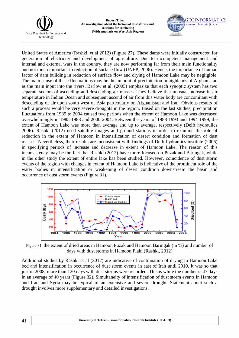
Report Title:
An investigation about the factors of dust storms and
solutions for combating
(With emphasis on West Asia Region)
Vice President for Science and
Technology
41
University of Tehran- Geoinformatics Research Institute (UT-GRI)
United States of America (Rashki, et al 2012) (Figure 27). These dams were initially constructed for
generation of electricity and development of agriculture. Due to incompetent management and
internal and external wars in the country, they are now performing far from their main functionality
and not much important in reduction of surface flow (UNEP, 2006). Hence, the importance of human
factor of dam building in reduction of surface flow and drying of Hamoon Lake may be negligible.
The main cause of these fluctuations may be the amount of precipitation in highlands of Afghanistan
as the main input into the rivers. Barlow et al. (2005) emphasize that each synoptic system has two
separate sectors of ascending and descending air masses. They believe that unusual increase in air
temperature in Indian Ocean and subsequent ascend of air from this water body are concomitant with
descending of air upon south west of Asia particularly on Afghanistan and Iran. Obvious results of
such a process would be very severe droughts in the region. Based on the last studies, precipitation
fluctuations from 1985 to 2004 caused two periods when the extent of Hamoon Lake was decreased
overwhelmingly in 1985-1988 and 2000-2004. Between the years of 1988-1993 and 1994-1999, the
extent of Hamoon Lake was more than average and up to average, respectively (Delft hydraulics
2006). Rashki (2012) used satellite images and ground stations in order to examine the role of
reduction in the extent of Hamoon in intensification of desert condition and formation of dust
masses. Nevertheless, their results are inconsistent with findings of Delft hydraulics institute (2006)
in specifying periods of increase and decrease in extent of Hamoon Lake. The reason of this
inconsistency may be the fact that Rashki (2012) have more focused on Puzak and Baringak, while
in the other study the extent of entire lake has been studied. However, coincidence of dust storm
events of the region with changes in extent of Hamoon Lake is indicative of the prominent role of the
water bodies in intensification or weakening of desert condition downstream the basin and
occurrence of dust storm events (Figure 31).
Figure 31. the extent of dried areas in Hamoon Puzak and Hamoon Baringak (in %) and number of
days with dust storms in Hamoon Plain (Rashki, 2012)
Additional studies by Rashki et al (2012) are indicative of continuation of drying in Hamoon Lake
bed and intensification in occurrence of dust storm events in east of Iran until 2010. It was so that
just in 2008, more than 120 days with dust storms were recorded. This is while the number is 47 days
in an average of 40 years (Figure 32). Simultaneity of intensification of dust storm events in Hamoon
and Iraq and Syria may be typical of an extensive and severe drought. Statement about such a
drought involves more supplementary and detailed investigations.

Report Title:
An investigation about the factors of dust storms and
solutions for combating
(With emphasis on West Asia Region)
Vice President for Science and
Technology
42
University of Tehran- Geoinformatics Research Institute (UT-GRI)
Figure 32. Number of days with dust storms (with visibility less than 2 km), recorded at Zabol Station
in Hamoon Hirmand Delta (Rashki et al, 2012)
The main cause of intensification in desert condition in the region is drought in Afghanistan, severe
reduction in surface flow of Sistan Basin and drying of Hamoon Lake. However, the role of
agricultural activities in destruction of cultivated lands and acceleration of soil erosion cannot be
ignored. According to the information hardly available (due to security issues in the region), about
120000 hectares of lands in the region are now cultivated. If the recent drought is continued and
hydro-structures are reconstructed in Afghanistan, the cultivated lands may convert into desert
regions and permanent sources of dust storms. Hence, based on the conducted studies, the best
solution to cope with these conditions is that reduce cultivated lands to about 21000 hectares (Delft
hydraulics, 2006).
As it was mentioned, desertification and dust storm in Hamoon Plain is resulted from severe drought
in Afghanistan, reduction of surface flow, drying of Hamoon Lake and the surrounding delta. The
role of constructed dams on the rivers of Sistan Basin and agricultural activities seems to be less
effective in generating desert condition in the region. However, getting more deterministic results
involves more detailed investigations. Presence of concentrated cultivation over delta section of
Hamoon Lake has been effective on intensification of desert condition.
5. Desertification and dust storm phenomena in Aral Sea Region
The area among the border of Uzbekistan and Kazakhstan one of the most extensive basins and the
fourth largest lake of the world, entitled Aral Sea, is included; the lake has a basin about 2.7 million
square kilometers and an area about 68300 square kilometers (UNEP, 2005). Amu Darya and Syr
Darya are the main rivers of this drainage basin (Figure 33). Approximately 68 and 32 % of water
flow from highlands of Tajikistan, Kyrgyzstan, Uzbekistan and Afghanistan and other countries of
Central Asia (proportional to 51, 25, 10, 9, and 5 %, respectively) are conveyed into this lake by the
two rivers (Chatterjee, 2007).

Report Title:
An investigation about the factors of dust storms and
solutions for combating
(With emphasis on West Asia Region)
Vice President for Science and
Technology
43
University of Tehran- Geoinformatics Research Institute (UT-GRI)
Figure 33. drainage basin of Aral Sea (UNEP and ENVSEC, 2011)
Although in different parts of Aral Sea the influence of desertification processes such as erosion and
saltification require more examination, but same as Sistan Basin the most obvious result of the
processes is observable in terminal part at Lake of Aral. In other words, majority of studies in
relation to desertification in the basin were mainly focused upon drying of Aral Sea, erosion and
destruction of surrounding deltas.
Figure 34. the process of drying at Aral Sea (UNEP and ENVSEC 2011)26 and the occurrence of dust
storms as a result of desertification (Earth Observatory, 2010)27
In the second half of twentieth century (particularly in 1960s) Aral Sea has experienced essential sea
level changes. A retrogressive decadence is continuing till now. Direct result of the sea level decline
and drying of surrounding deltas is severe dust storms (Figure 34). This in turn can be a cause for
intensification of desertification in neighboring regions (Micklin, 2007).
As it was mentioned earlier, similar aspect of Aral and Sistan Basin is drying and desertification in
downstream water bodies. This is while; it seems the principal causes of drying in the two lakes are
completely different. Population density maps in Aral Basin indicate well distribution of human
population over the region (Figure 35). Concentration of human population is mainly along rivers
d. The original picture has more details, for needs and restrictions of this study some parts have been remove 26
earthobservatory.nasa.gov/NaturalHazards/view.php?id=43299 27

Report Title:
An investigation about the factors of dust storms and
solutions for combating
(With emphasis on West Asia Region)
Vice President for Science and
Technology
44
University of Tehran- Geoinformatics Research Institute (UT-GRI)
and on deltas. In other words, in Sistan Basin population concentration is low in upstream areas; this
is because of different problems in Afghanistan as the origins of the rivers of the basin and the
absence of required possibilities for development of human societies. Therefore, reduction of surface
flow and drying of Hamoon cannot be attributed to human activities upstream. This is while in Aral
Basin human societies are greatly concentrated in nearest locations relative to river flows. So, the
principal reason for drying of Aral might be reduction of surface flows as a result of development of
agricultural activities (human factor) in neighboring countries (Aladin, 2007).
Figure 35. population concentration in Central Asian Region (UNEP and ENVSEC, 2011)
In order to revive decaying economy of Central Asian countries including Uzbekistan, Turkmenistan,
Tajikistan, and others, the government of Soviet Union in 1960s made it mandatory that cotton must
be cultivated in some fertile lands (UN, 2011). Need for huge volume of water for continuous
irrigation is one of the characteristics of this product. Hence, the government has decided to
construct diversion canals to convey river flow towards the lands previously had dry condition
(UNEP and ENVSEC, 2011). Karkum Canal is an eminent huge construction that conveys a
considerable volume of water (500 million cubic meters) towards the previously dry lands in
Turkmenistan. Approximately 90 % of the water conveyed by this canal and other constructions
upon Amu Darya and Syr Darya Rivers are consumed for agricultural activities particularly cotton
and recently wheat (Chatterjee, 2007). In 1950 to 1990, the area of the cultivated portions
surrounding Amu Darya and Syr Darya has experienced unprecedented increase, about 150 and 130
%, respectively. It is noteworthy that some countries including Tajikistan, Turkmenistan, and
Uzbekistan are increasingly dependent upon incomes from agricultural products. As in the countries
about 20, 25, and 28 %, respectively, of gross domestic product are provided by these goods (UNEP
and ENVSEC, 2011). Although, the prosperity of agricultural activities in the region saved economy
of the countries, but reduction and pollution of surface flow are destructive consequences of the
activities dependent upon irrigation. Both the reduction and pollution of surface flows exacerbate
desertification processes in Aral and the riparian areas of the flows downstream. Consequence of the
reduction in water flow of Aral Basin can easily be observed in drying out of the terminal lake.
Decay of Amu Darya and Syr Darya by salinization and entrance of wastewater into the rivers are
considered as environmental crisis in the region. The final consequence of these crises will be
appeared in the near future (UN, 2011). Based on researches (Spoor, 1998) the salinity ratio in
agricultural wastewater and the primary water used (the water entered into farms for irrigation) is
between 3.3 and 7.1 gallon per liter along Amu Darya River. This salinity along with municipal

Report Title:
An investigation about the factors of dust storms and
solutions for combating
(With emphasis on West Asia Region)
Vice President for Science and
Technology
45
University of Tehran- Geoinformatics Research Institute (UT-GRI)
wastewater has such enormous destructive potential that may convert the reclaimed lands again into
dry areas (Spoor, 1998).
Multiple use of agricultural wastewater downstream of Aral Basin has more devastating impacts. The
extent of lands with high salinity was increased about 57 % just in a decade, from 1990 to 2000, on
Amu Darya Basin (increased from 1.16 to 1.82 million hectares). The situation was more violent in
the lands irrigated by Syr Darya River, i.e., the value was 79 % (increased from 0.34 to 0.61 million
hectares) (UNEP, 2005). In the recent years there were attempts to rehabilitate Aral Lake and to
reform agricultural techniques in the region. These works have obtained some achievements such as
reclamation of northern Aral (IFAS28, 2003). Because of some factors, devastation of agricultural
lands of the water body and its coastal regions was not far from expected. These factors are including
dependence of the region economy on agricultural activities, political discords in the region, and also
the need for enormous volume of water to rehabilitate Aral Sea (Micklin, 2007).
Temperature change is another influencing factor in the region. As it was mentioned about Tigris and
Euphrates, increase in temperature affects the temporal distribution of surface flows resulted from
snow melting. The increase makes a shift in maximum flow of the region from middle of the warm
season to the early of warm season. This condition is obviously recorded both the rivers. Although,
the total flow discharged was not altered in the two rivers, inter-annual fluctuations indicate increase
in surface flows in the early of warm period (Sulton, 2009). The result of this condition is
deterioration of the effects of dryness when the water is absent in the middle and the late of warm
period.
Figure 36. Regions under the influence of desertification in Aral Sea Region
Figure 36 indicate the areas affected by desertification in Aral Sea Basin. Majority of the areas of
dust storm generation (the yellow arrows in the figure) are coincident with dried portions of Aral Sea
and also the coasts of the basin. These areas in long time didn’t have biological potential under the
influence of cultivation. As a result, principal factor of desertification and formation of dust storm
sources in Aral could be due to high population density. The consequence of this influence is
extreme exploitation of water resources and agricultural lands. This, in turn, led to drying out of
. International Fund of Rescue of Aral28
Report Title:
An investigation about the factors of dust storms and
solutions for combating
(With emphasis on West Asia Region)
Vice President for Science and
Technology
46
University of Tehran- Geoinformatics Research Institute (UT-GRI)
terminal water bodies and vehement devastation of previously fertile lands on the coasts of the rivers.
Temperature increase, changes in seasonal intensity of surface flows and increase of dryness in the
middle of warm season are also other factors of intensification of drying condition and desertification
in the region.
As a conclusion of these studies on desertification in different areas of the world, this can be said that
human factors, particularly population density and movements, play an incontrovertible role in the
destruction of biological resources. Indeed, in most of the regions under the influence of
desertification, the human needs for water, soil, and vegetation resources to meet their requirements
for subsistence cause destruction of soil surface and vegetation. In these regions soil productivity has
a decaying trend that impedes regrowth of natural and agricultural vegetation. Consequently, erosion
of bare soil by water and wind flows is inevitable. In addition to human factors, drought is also an
important cause of desertification. This appears as main factor in some regions such as Hamoon.
Although getting more exact results about the factors of desertification and appropriate solutions
involves detailed studies. For this we need to consider the followings:
1. Inadequate information to show a clear description of desertification and the proportion of
natural and human factors is one of the major defects of the conducted studies, particularly in
the WAR. In most of the researches because of the rareness in available data, the researchers
explained the influence of these factors in general conclusions. For the same reason, there is
not the possibility to show a clear and precise explanation of desertification, especially in the
WAR. This is while; the principal goal of the studies about the factors of desertification is
precise segregation of the effective factors and determining the proportions of these factors.
This targeted to provide suitable solutions to combat desertification and then dust storms. In
other words, as long as the exact identification of desertification factors is not realized, use of
the combat methods cannot be optimistic. Hence, in addition to individual works in research
centers, the required information for the exact segregation of the factors must be obtained by
operational and field works in local scales. By this way and creation of comprehensive
database, not only the solutions for combating desertification would be more competent, but
possible changes in the expansion of the affected areas would be more accurate.
2. Disregarding conduction of studies with comprehensive approach is another defect of the
available researches. In many of the studies in this field the mere attention to the human or
natural factors of desertification presented some results that did not have the integrity and
confidence for operational and execution stages to combat the disaster. As a result, one of the
opportunities is comprehensive study of desertification factors. It is noteworthy that the
success of any execution plan is greatly dependent upon investigations about exact
characteristics of dust storm sources including water, soil and vegetation resources.
6. Solutions to combat desertification
The aim of the works mentioned here is mainly achievement of required information for taking
efficient method in combating desertification and subsequently decreasing dust storm events. In
other words, the success of presented solutions in execution stages is related essentially to precision
and accuracy of the studies in research stages. These are particularly important in recognition of the

Report Title:
An investigation about the factors of dust storms and
solutions for combating
(With emphasis on West Asia Region)
Vice President for Science and
Technology
47
University of Tehran- Geoinformatics Research Institute (UT-GRI)
factors of dust storm generation and characteristics of the sources. Spatial-temporal properties of the
desertified areas are appeared as another important issue. In fact, recognition of the factors in
destruction of biologic resources is one of the essential elements for tackling this phenomenon.
However, developing indices and systems for monitoring spatial and temporal changes of desertified
and desertifing areas can be considered as another necessary measure to check expansion of desert
boundaries. The importance of the on time detection of desert boundaries expansion would be clear
when conversion of an area from semidesert state into desert one means complete destruction of that
area. In such situations it would be very difficult or impossible to return to the previous conditions.
Hence, in every ecosystem non-desert (with good vegetation cover) and desert (without vegetation)
are known as stable condition while semiarid conditions are unstable or bi-stable (Figure 37 a).
Figure 37. different states in an ecosystem (D’Odorico, 2013). a: stable and unstable, b: resiliency to
its previous state (transient)
Based on this fact, if a region is fallen in a desert condition, despite of its negative effects on human
and natural ecosystem, the ecosystem will reach a stable state that it can be difficult to return to its
previous transient or unstable state (semidesert). On the other hand, the closer is an ecosystem to the
extreme of curve, more difficult would be its return to the previous state. This is called less resilient
condition. Although, the state of a region in non-desert condition is stable for ecosystem but it is less
stable relative to desert condition. This is well illustrated in Figure 37 b representing the sharper
slope of the curve towards desert condition. In fact, disregarding densely vegetated areas, they will
take the same trend taken by desert areas. So, they convert from desert condition into semidesert and
eventually into complete degradation and desertification (D’Odorico, 2013). Therefore, recognition
of efficient indices to diagnose spatial and temporal distribution of desert condition and possible
changes is a subject in the studies aimed at tackling desertification. Obtaining deterministic indices
of desertified or transient areas provides the authorities with necessary information to select accurate
and appropriate ways. First, we explore the indices for assessment of desertification and then
consider the practical solutions for combating the phenomena.
- Desertification monitoring indices
As it was mentioned, degradation and decline of soil productivity are the main consequence of
desertification. As a result, in some studies, the detection of influenced areas by desertification is
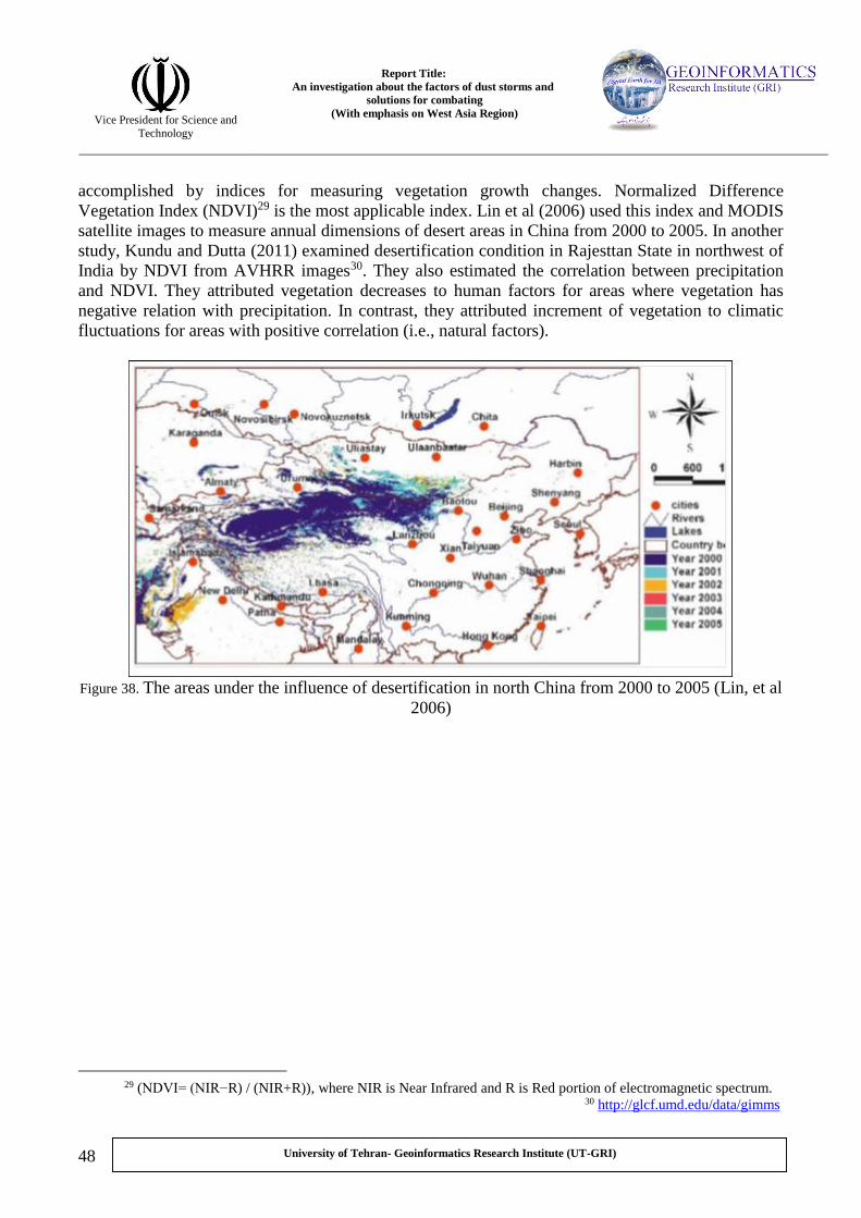
Report Title:
An investigation about the factors of dust storms and
solutions for combating
(With emphasis on West Asia Region)
Vice President for Science and
Technology
48
University of Tehran- Geoinformatics Research Institute (UT-GRI)
accomplished by indices for measuring vegetation growth changes. Normalized Difference
Vegetation Index (NDVI)29 is the most applicable index. Lin et al (2006) used this index and MODIS
satellite images to measure annual dimensions of desert areas in China from 2000 to 2005. In another
study, Kundu and Dutta (2011) examined desertification condition in Rajesttan State in northwest of
India by NDVI from AVHRR images30. They also estimated the correlation between precipitation
and NDVI. They attributed vegetation decreases to human factors for areas where vegetation has
negative relation with precipitation. In contrast, they attributed increment of vegetation to climatic
fluctuations for areas with positive correlation (i.e., natural factors).
Figure 38. The areas under the influence of desertification in north China from 2000 to 2005 (Lin, et al
2006)
), where NIR is Near Infrared and R is Red portion of electromagnetic spectrum. )R) / (NIR+RNDVI= (NIR−( 29
http://glcf.umd.edu/data/gimms 30
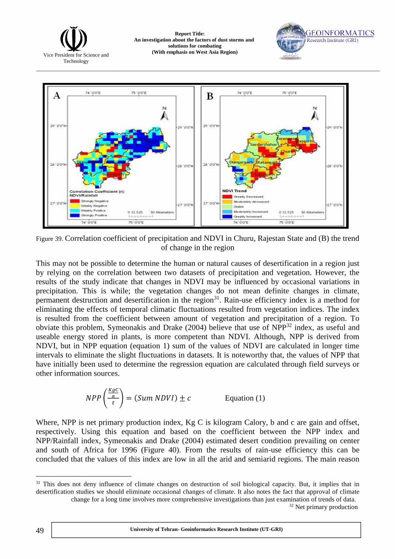
Report Title:
An investigation about the factors of dust storms and
solutions for combating
(With emphasis on West Asia Region)
Vice President for Science and
Technology
49
University of Tehran- Geoinformatics Research Institute (UT-GRI)
Figure 39. Correlation coefficient of precipitation and NDVI in Churu, Rajestan State and (B) the trend
of change in the region
This may not be possible to determine the human or natural causes of desertification in a region just
by relying on the correlation between two datasets of precipitation and vegetation. However, the
results of the study indicate that changes in NDVI may be influenced by occasional variations in
precipitation. This is while; the vegetation changes do not mean definite changes in climate,
permanent destruction and desertification in the region31. Rain-use efficiency index is a method for
eliminating the effects of temporal climatic fluctuations resulted from vegetation indices. The index
is resulted from the coefficient between amount of vegetation and precipitation of a region. To
obviate this problem, Symeonakis and Drake (2004) believe that use of NPP32 index, as useful and
useable energy stored in plants, is more competent than NDVI. Although, NPP is derived from
NDVI, but in NPP equation (equation 1) sum of the values of NDVI are calculated in longer time
intervals to eliminate the slight fluctuations in datasets. It is noteworthy that, the values of NPP that
have initially been used to determine the regression equation are calculated through field surveys or
other information sources.
𝑁𝑃𝑃 (𝐾𝑔𝐶
𝑎
𝑡) = (𝑆𝑢𝑚 𝑁𝐷𝑉𝐼) ± 𝑐 Equation (1)
Where, NPP is net primary production index, Kg C is kilogram Calory, b and c are gain and offset,
respectively. Using this equation and based on the coefficient between the NPP index and
NPP/Rainfall index, Symeonakis and Drake (2004) estimated desert condition prevailing on center
and south of Africa for 1996 (Figure 40). From the results of rain-use efficiency this can be
concluded that the values of this index are low in all the arid and semiarid regions. The main reason
This does not deny influence of climate changes on destruction of soil biological capacity. But, it implies that in 31
desertification studies we should eliminate occasional changes of climate. It also notes the fact that approval of climate
change for a long time involves more comprehensive investigations than just examination of trends of data.
Net primary production 32

Report Title:
An investigation about the factors of dust storms and
solutions for combating
(With emphasis on West Asia Region)
Vice President for Science and
Technology
50
University of Tehran- Geoinformatics Research Institute (UT-GRI)
for this may be the slight growth of vegetation due to overwhelming evapotranspiration in such
regions. Nevertheless, the values of this index in arid regions affected by desertification are less than
non-desertified regions. Finally, though in this study just one map was drawn, but for better
understanding of desertification trend in the region it seems necessary to calculate the index for
several consecutive years and even for several decades. Doing so may have great ability for
monitoring the trend of changes.
Figure 40. the amount of effective precipitation (dry matter in kilogram per hectare per year in
millimeter) in central and south Africa in 1996 (Symeonakis and Drake, 2004).
Although, vegetation growth is somewhat representative of soil health and high productivity, but
some plants like Chañar as halophyte plant adapted to desert areas cannot be a good criterion for
biological health for an area (Collado, 2002). Hence, Symeonakis and Drake (2004) recommended
other indices in addition to NDVI for monitoring of desert condition. They maintain that runoff
coefficient (ratio of runoff flow to effective storm rainfall, i.e., the total rainfall that can produce
surface flow) is one of the most competent indices to recognize destructed areas33. This is evident
that destructed areas which lose their vegetation have more coefficient of surface flow relative to the
surrounding regions. They also presented an additional relation to assess rate of soil erosion
(equation 2).
VceSkOFE 07.066.12 Equasion (2)
unoff. Details of these methods are out of the scope of this The study used complicated relations to acquire surface r 33
paper. Runoff data can be collected from NECP and ECMWF.

Report Title:
An investigation about the factors of dust storms and
solutions for combating
(With emphasis on West Asia Region)
Vice President for Science and
Technology
51
University of Tehran- Geoinformatics Research Institute (UT-GRI)
Where, E is amount of soil erosion in millimeter, k is the coefficient of erodibility, OF is the amount
of surface flow, S is slope of region, and Vc represents percent of vegetation. The areas susceptible
to erosion and destruction in Africa have been depicted using these two indices (Figure 41).
Figure 41. (A) the areas under the influence of desert condition based on surface runoff coefficient and (B) based on
intensity of erosion (Symeonakis and Drake, 2004).
In figure (41-A), there is a black color circle in the northeast Africa where has the most destruction
of biological resources based on runoff coefficient. This area in figure (41-B), which shows the
desertification map based on soil erosion, is depicted as a vulnerable region. As the data from these
maps be considered simultaneously, it is clear that the area has semiarid condition with very sparse
vegetation cover. As a result, as long as the surface runoff is increasing in the area (Figure 41-A), all
the conditions lead to severe erosion of surface soil (Figure 41-B).
Xiao et al (2006) work presented the criteria for measuring desertification in northeast China (Inter
Mongolia). In this study, changes in soil texture are considered as a criterion to determine the rate of
destruction in biological resources. Indeed, premise of the research is that in the areas under the
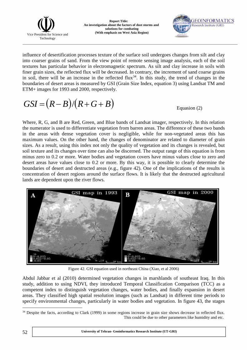
Report Title:
An investigation about the factors of dust storms and
solutions for combating
(With emphasis on West Asia Region)
Vice President for Science and
Technology
52
University of Tehran- Geoinformatics Research Institute (UT-GRI)
influence of desertification processes texture of the surface soil undergoes changes from silt and clay
into coarser grains of sand. From the view point of remote sensing image analysis, each of the soil
textures has particular behavior in electromagnetic spectrum. As silt and clay increase in soils with
finer grain sizes, the reflected flux will be decreased. In contrary, the increment of sand coarse grains
in soil, there will be an increase in the reflected flux34. In this study, the trend of changes in the
boundaries of desert areas is measured by GSI (Grain Size Index, equation 3) using Landsat TM amd
ETM+ images for 1993 and 2000, respectively.
BGRBRGSI / Equasion (2)
Where, R, G, and B are Red, Green, and Blue bands of Landsat imager, respectively. In this relation
the numerator is used to differentiate vegetation from barren areas. The difference of these two bands
in the areas with dense vegetation cover is negligible, while for non-vegetated areas this has
maximum values. On the other hand, the changes of denominator are related to diameter of grain
sizes. As a result, using this index not only the quality of vegetation and its changes is revealed, but
soil texture and its changes over time can also be discerned. The output range of this equation is from
minus zero to 0.2 or more. Water bodies and vegetation covers have minus values close to zero and
desert areas have values close to 0.2 or more. By this way, it is possible to clearly determine the
boundaries of desert and destructed areas (e.g., figure 42). One of the implications of the results is
concentration of desert regions around the surface flows. It is likely that the destructed agricultural
lands are dependent upon the river flows.
Figure 42. GSI equation used in northeast China (Xiao, et al 2006)
Abdul Jabbar et al (2010) determined vegetation changes in marshlands of southeast Iraq. In this
study, addition to using NDVI, they introduced Temporal Classification Comparison (TCC) as a
competent index to distinguish vegetation changes, water bodies, and finally expansion in desert
areas. They classified high spatial resolution images (such as Landsat) in different time periods to
specify environmental changes, particularly in water bodies and vegetation. In figure 43, the stages
Despite the facts, according to Clark (1999) in some regions increase in grain size shows decrease in reflected flux. 34
This could be due to other parameters like humidity and etc.

Report Title:
An investigation about the factors of dust storms and
solutions for combating
(With emphasis on West Asia Region)
Vice President for Science and
Technology
53
University of Tehran- Geoinformatics Research Institute (UT-GRI)
of degradation in marshlands of Iraq can be observed. This is while; the classification of images
(1973) indicates considerable proportion of vegetation in marshland areas. In 1990, the water bodies
and densely vegetation covers were replaced by clay soils and agricultural lands. In 2000, addition to
more destruction of water bodies and dense vegetation covers, the desert areas (Sebkha) can clearly
be observed in floodplains of previous decades.
Figure 43. classification of surface vegetation covers in marshlands of southeastern Iraq (Abdul Jabbar, 2010)
Fadhil (2009) determined the rate of sand dune expansion in central areas of Iraq by Normalized
Differential Sand Dune Index (NDSDI) from Landsat (equation 4 and Figure 44).
2/2 SWIRRSWRIRRNDSDI Equasion (4)
Where, R and SWIR2 are red and shortwave infrared (between 2.08 and 2.35) bands in Landsat
Imager, respectively. The range is as -1<NDSDI>1. Sand covered areas have negative values,
vegetated areas are positive and the water bodies show the highest frequency of positive values. As
the results, from 1990 to 2000 the sand covered areas in central Iraq have vigorously increased. This
is typical of intensification of desertification and dust storm events in the country.

Report Title:
An investigation about the factors of dust storms and
solutions for combating
(With emphasis on West Asia Region)
Vice President for Science and
Technology
54
University of Tehran- Geoinformatics Research Institute (UT-GRI)
Figure 44. ten year changes of sand dunes in central Iraq (Fadhil, 2009)
Despite of the capabilities of the indices, many of them rather to indicate desertification are just able
to specify the boundaries of the areas where either are completely desertified or destruction of
biological resources is in final stages. However, the main purpose of such studies is quick
recognition of vulnerable areas to take appropriate approaches in order to prevent degradation of
natural and human resources and to advise a planning for rehabilitation. Taking a precautious
measure to happening of desertification, Sepehr et al. (2007) specified most of the factors effective in
destruction of biological resources. They attempted to determine the relative importance and weights
of each factor. They classified different regions by a variety of indices. In addition to determining
desertified areas, they suggested the areas vulnerable relative to this phenomenon. Here, each factor
that is effective in desertification, e.g., soil texture, is considered as a layer. According to this
method, all the factors as layers are assigned weights, from 1 as the least effective to 2 as the most
effective. This weighting is based on the magnitude of their influence in desertification (by expert
opinion). Then, using geometric mean, the different layers were converted into one of the main
indices, e.g., soil quality index (equation 5).
nnx LayerLayerLayerIndex
1
21 ...* Equasion (5)
Where, x represents the indices obtained from layers, and n is the number of layers applied to
provide the index of interest. Using this equation, they offered 6 indices of Soil Quality, Climate,
Vegetation, Erosion, Ground Water, and Demography. Then, the information layers obtained from
these indices were combined again using equation 5 to give the final layer. The final combined layer
indicated, as it can be seen in Figure 45, intensity of desertification in Fidoye–Garmosht plain in Fars
province, southwest Iran.

Report Title:
An investigation about the factors of dust storms and
solutions for combating
(With emphasis on West Asia Region)
Vice President for Science and
Technology
55
University of Tehran- Geoinformatics Research Institute (UT-GRI)
Figure 45. intensity of desertification in Fidoye–Garmosht Plain southwest of Iran (Sepehr, 2007)
- Approaches to combat desertification and dust storm
Taking competent approaches in combating against desertification and subsequently dust storms
involves assumption of the fact that the dust storms are resulted from both human and natural factors.
Hence, the solution for this problem can be the most efficient if they are presented as a package
containing environmental, social, economic, cultural and even political solutions. All the factors led
to generation and development of deserts are must be considered as a whole. One-factoral
approaches cannot be optimistic for the solution. For example, mere focus on rehabilitation
operations in devastating areas and stabilization of erodible regions, disregarding the deficiencies of
local people may just solve the problem temporarily and cannot make definite treatment. Moreover,
the emphasis on the use of the method of stabilization for the regions under the influence of erosion
may be just efficient for cases which dust storm sources are limited and desertification factors are
just restricted in the surrounding areas. In occurrence of huge pervasive dust storms especially in the
WAR, this can be observed that wind-blown deposits are originated from vast areas in thousands of
kilometers. The natural and human influencing factors of these storms are derived from trans-
boundary vast areas. Therefore, for combating huge dust storms due to desertification, priority must
be given to the approaches that are economically operational in vast areas. In most of the studies, the
emphasis is upon the operational works and activities for combating at the dust storm sources where
are coincident with the desertification phenomenon. Nevertheless, in the recent years some new
advanced technologies may be coming to confine the event of dust storms through direct checking of
the moving dust particles. It seems there must be more researches to find out about the applicability
of new technologies and their possible environmental effects.

Report Title:
An investigation about the factors of dust storms and
solutions for combating
(With emphasis on West Asia Region)
Vice President for Science and
Technology
56
University of Tehran- Geoinformatics Research Institute (UT-GRI)
Here, it will be attempted to choose some successful experiences from the regions afflicted by this
problem. These experiences include novel methods of combating desertification, particularly those
emphasizing on management of human activities. Since the examples of the activities in America
have been mentioned in the section of factors of desertification and the lack of considerable activities
in Africa, we avoid discussion about the activities in these two regions. Hence, the activities done in
China as a country with huge experiences in tackling with desertification are reviewed. Finally, we
have tried to assess the operations that recently carried out in WAR.
7. Activities against desertification in China
About 34 % of China has high potential to convert into desert. So, the country has begun one of the
most extensive plans against desertification since 1987. In the recent years, all desertification
activities of China have been focused on three domains: (1) promotion of science and technology
related to desertification, (2) the adoption of programmatic approaches appropriate to the condition
of each region, (3) securing policy and legislation support to guarantee the programs. Based on
conducted planning, the first stage of research works must lead to formulation of theoretical
principles. These make the necessary background for recognition and modeling of temporal pattern
and spatial distribution of desertification and its generating causes. Moreover, finding of
technologies appropriate to circumstances of a region and finally establishment of monitoring,
forecasting and early warning systems is the other goals of this stage of studies. In the second stage,
the activities against desertification got more practical perspectives. By this way, the appropriate
approach to the natural and human condition of a region will be taken based on the findings of
studies and researches in this stage. The set of actions that are carried out in the third stage are
allocated to formulation of the laws and making policies. The laws and policies somehow advocate
the actions conducted in previous stages.
The results of these types of research activities, in the first stage, is the identification of resistant
plant species and devise of monitoring, forecasting, and early warning systems for different regions
of China. The de-desertification of three north (Northeast, North and Northwest China) or Great
Green Wall are eminent examples in operational activities against desertification. Although, the
operations have been initiated before planning and aiming at combating desertification, when the
planning was conducted, it appeared in new configurations. In some parts of northern China, the plan
had considerable achievements including increase in vegetation cover from 5.05 % at the beginning
to 6.05 % in 2001. The achievements of several other operational activities are the results of the
changes in aiming against desertification that was begun in 1991 and was also relatively successful
in the form of 10 year project entitled “A National Plan to Combat Desertification”. The occurrence
of several devastating dust storms in 2000 resulted in formulation of another project in this year to
continue the de-desertification programs. This was mainly carried out by planting of saplings in
suburb of Beijing. Furthermore, another project was executed from 1999 to 2002 to convert
agricultural marginal lands into pasture and forest regions. This project was adopted warmly by
farmers. Based on this project, the farmers get financial supports and foods for the lands that they
converted into forest areas. Finally, the prominent example of the legal support of the activities was
approval of the Law on Preventing and Combating Desertification (LPCD) by national congress of
China in 2001. It was executed in 2002. Based on the law, three main steps must be taken till 2050:
(1) preventing the intensification of desertification (from 2002 to 2010), (2) decreasing the
dimensions of desert areas (2010 -2030), and (3) development of resistant biomes in vulnerable areas
(2030-2050).

Report Title:
An investigation about the factors of dust storms and
solutions for combating
(With emphasis on West Asia Region)
Vice President for Science and
Technology
57
University of Tehran- Geoinformatics Research Institute (UT-GRI)
Despite of all the activities and successes in China, there are many problems that impede full
achievement of the goals. One is the lack of a unified decision making organization for de-
desertification activities. Although, State Forestry Administration (SFA) of China is responsible for
formulating the activities related to desertification, but about 18 other ministries and organizations
are influencing the decision making processes. Deficiencies in financial resources are another reason
for failure of de-desertification projects in the country. For example, the costs required for
reclamation was 750 Yuan per hectare, and the maximum funding performed for this was just 75.
The third obstacle is a top-down development approach or a mandatory development plan from
government to the public in executing local and regional projects, instead of participatory
development with local people. This is not only for this country and also not only for desertification
activities. In many of developing countries, development projects are executed by mandatory process
and top-down approaches. The importance of local people participation in planning is disregarded in
contexts of the execution projects. This was the reason for failure of many mega-projects. As it was
mentioned, the limited participation of local people who are involved in desertification problems is
another important obstacle in achievement to the goal of combating against devastation of biological
resources (Lu, et al 2006).
Therefore, about desertification and de-desertification phenomenon in China it can be concluded that
despite of several decades of experiences in combating against desertification and some successes
obtained, the country was not able to achieve the specified goals. This is because of the lack of
adequate financial support, may be due to the vast extent of desert areas affected, the limited
participation by local people in formulating the programs, and also the lack of unification among the
organizations. These are also the tips that must be regarded in planning for de-desertification efforts
not only in China but in other countries afflicted by the phenomenon.
8. Activities against desertification in the WAR
As it was mentioned in the section of the extent of desertification, the WAR is faced with extreme
vulnerability of bio-resources. The countries of Iraq, Syria, Iran, Turkey, and Afghanistan have
watersheds and vast plains where are extremely devastated. There areas are now in the center of
considerations for combating against desertification activities and dust storm events. In this section,
we try to scrutinize some works previously carried out. This scrutinizing is mainly focused on
Mesopotamia and briefly on Sistan Watershed and Aral Lake Basin.
- Activities against desertification in Sistan Watershed
Sistan Watershed has very complicated environmental circumstances, particularly in Hamoon Lake
as the terminal area of the drainage (Figure 46). Now, Afghanistan does not have stable political and
social condition. In addition, the main destruction of biological resources is occurred surrounding
Hamoon Plain as the terminal basin. Most of the studies were mainly concentrated on Hamoon for
water resource management in borders of Iran. Due to poverty in the region, people need to use
natural resources, e.g., agriculture in deltas and fisheries in Hamoon water body. On the other hand,
the policies of Afghan government are focused on agricultural activities. Therefore, Hamoon and
surrounding deltas are increasingly devastating. The direct result of this can be observed in
desertification and formation of huge dust storms in the region. In one hand, this is necessary to meet
the substantial needs of local people, and on the other, this is also essential to protect natural
resources for sustainable development. Therefore, Water Research Institute (WRI) of Iran with the

Report Title:
An investigation about the factors of dust storms and
solutions for combating
(With emphasis on West Asia Region)
Vice President for Science and
Technology
58
University of Tehran- Geoinformatics Research Institute (UT-GRI)
collaboration of research consortium of the Netherland managed by Delft Hydraulic research group
(2006) made an effort to predict forthcoming condition related to changes in agricultural activities
and its impacts on water resources of the region.
Figure 46. position of Hamoon Lake (Beek, et al 2008)
Based on the conducted studies, about 36 % of the people in the region are dependent on water
resources for their subsistence, i.e., agriculture and fisheries. Furthermore, the unemployment rate
has been estimated about 50% for this region. In such condition, development of agricultural
activities seems to be necessary. Total cultivated agricultural lands have been estimated to be about
120,000 hectares. Central government of Iran plan to increase the agricultural lands up to 125,000
hectares in order to solve unemployment problem. This is while water resources are scarce in the
region and even access to water for drinking can just be possible by using chahnimeh (small lake)
(Figure 46) that water storage is about 950 million cubic meters in them. The maximum volume of
water available is about 5.935 million cubic meters per year. This value often decreases up to 1.196
with sharp declines in surface flow. But, the required water for agricultural activities covering now
an area of 120,000 hectares is about 2.096 million cubic meters. What is notable here is that even if
the required water for agricultural purposes with the present volume (2.096 cubic meters) is supplied,
about 50% of the area of Hamoon Lake will be disappeared. These conditions are clearly indicative
of the fact that there are water shortage and pressure on water resources in the region. Therefore, this
is not feasible to increase agricultural activities without regarding the resources. In order to
investigate the different alternatives and their impacts on development of agricultural activities and
natural ecosystem of the region particularly Hamoon water body, the research group for the region
outlined the integrated water resources management. They also have explored different conditions of

Report Title:
An investigation about the factors of dust storms and
solutions for combating
(With emphasis on West Asia Region)
Vice President for Science and
Technology
59
University of Tehran- Geoinformatics Research Institute (UT-GRI)
water allocation to agriculture and other sectors using RIBASIM software model35. In execution of
this model they analyzed the situation of supply and demand in water resources and agricultural
sector in base case. They also outlined five different strategies: (1) building storages (chahnimeh 4)
merely to supply drinking water requirements; (2) adhering the conditions of the first strategy in
addition to the possibility to exploit the water storage under construction for agriculture; (3)
developing irrigated cultivated areas from 120000 hectares into 245000 hectares (the increase of
125000 hectares) without using the water storages under construction; (4) adhering the conditions of
the third strategy in addition to the possibility to exploit the water storage under construction for
agriculture; (5) decreasing irrigated cultivated areas from 120000 into 21000 hectares in order to
monitor changes in Hamoon. Basing the planning on the ecosystem and economic condition of this
region in 1970s as ideal conditions occurred in the region, the impacts of current conditions on the
five strategies were investigated in 7 economic and ecosystem perspectives. These 7 perspectives
are: (1) rate of guarantee in supplying drinking water; (2) rate of the coefficient between supply and
demand for required water in agriculture sector; (3) rate of production in agricultural sector; (4) rate
of production in fisheries sector (aquatics of Hamoon); (5) vulnerability in ecology of Hamoon; (6)
vulnerability in health of local people (under the influence of dust storm events); (7) the number of
years with minimum profit about 50 % in agriculture and fisheries in 1970s.
The results from executing the model based on the present state and the five strategies are as follows,
ecosystem and economic conditions resulted from:
1. the present state: given the coefficient of 0.63 between supply and demand in agriculture
sector, this is now undoubtedly infeasible to meet the requirements of the sector from these
resources. Any increase in the area of agricultural lands just deteriorates the situation.
2. the first strategy (building new water reservoir merely for drinking use): if this strategy is
taken the agricultural sector, as it is expected, will be damaged and, however, the guarantee
for supplying drinking water will be the most. The Hamoon will also be affected by these
changes.
3. second strategy (building new water reservoir for simultaneous use in drinking and
agricultural sectors): taking this strategy causes prosperity and enhancement in agricultural
sector and a decline in securing of drinking water supply. However, the condition may be
improved by legislation of some particular laws concerning exploitation of the reservoir.
4. the third strategy (development of agricultural areas without application of the reservoir
under construction): although by this strategy the agricultural activities will to some extent be
developed, but the rate of securing access to water resources will be declined to unacceptable
level of 0.42 for agriculturists. Furthermore, ecosystem of Hamoon is severely devastated,
return period of drying in Hamoon Saberi is affected and this increases the risk of dust
storms. The return period of Hamoon overflow will be dropped to 17 years (for time of
studies this was 11 years) that increases thickness of salt masses.
5. the fourth strategy (development of agricultural areas using the storages under construction):
although the strategy can improve farming in the region, but the rate of securing supplying
aulics and WRI, Delft hydr( Integrated Water Resources Management for the Sistan Closed Inland Delta, Iran“Refer to 35
2006)” to see more for use of the model and data.

Report Title:
An investigation about the factors of dust storms and
solutions for combating
(With emphasis on West Asia Region)
Vice President for Science and
Technology
60
University of Tehran- Geoinformatics Research Institute (UT-GRI)
water is retained 0.45 % that is due to constant capacity of the water storage under
construction. Moreover, the rate of accessibility of local people to drinking water resources
may be decreased. This can be improved by reforms in some laws.
6. fifth strategy (decreasing the cultivation area under irrigation to 21000 hectares): if this
strategy is taken, though the agricultural sector will undergo enormous deficiencies but the
guarantee for supplying water in drinking and the remained farming areas will be increased.
This is noteworthy that the results are estimated with the assumption that the input of water from
Afghanistan into Iran will not be altered in the following years. In the case of increase in exploitation
from surface and ground water resources and decrease in input water into Hamoon, the destructions
can be more severe than those can be appeared due to surface flow changes inside Iran. The reason is
that the main part of water entering into Hirmand is originated from Afghanistan. Hirmand is the
only surface flow from inside Iran which affects the water body.
As final result of the study this can be stated that more than the influence of shortage in resources
upon the agricultural activities what may be more influential is the present water fluctuations in the
resources. These variations cause severe alterations in the extent of farming lands and subsequently
more erosion. Furthermore, the agricultural activities with the present extent (120000 hectares) can
just be accomplished by building new water storages. Any increase in that can lead to severe
destruction of biological resources. Even with supplying the required water for agricultural activities,
Hamoon will be fallen in extent. This means increase of areas prone to generating dust storms.
Finally, this can be said that any changes in regulation or impoundment of surface flows in
Afghanistan make it impossible to supply water for agricultural activities in Iran. These are
conditions that emphasize on mutual cooperation between the two countries to determine their water
right in order to achieve a sustainable development, particularly in agricultural sector.
- Activities against desertification Tigris and Euphrates Watershed
As it was mentioned in section of factors of desertification, a considerable part of the processes,
particularly the human ones, are occurring downstream of Tigris and Euphrates drainage. These
situations led to increasingly destruction of vegetation covers and marshlands in southeast of Iraq.
Hence, one of the prominent activities against desertification phenomenon in the WAR was executed
here by support of international institutions in order to rehabilitate the marshlands (Figure 47).
Financial funding in the project entitled “Support for Environmental Management of The Iraqi
Marshlands” was underwritten based on an agreement between this country and Japan with supports
by Italy. The project was executed by UNEP and the Iraqi experts from 2004 to 2009 (UNEP, 2010).
The overall goals of the operational research are:
1- Scrutiny on the present state of marshlands to determine goals, to collect updated
information, and to allocate the proper tools for measurement and management.
2- Enhance the required capabilities for Iraqi decision makers and agents of local people in
entire aspects of management of marshland areas including political and administrative
perspectives, and the tools for estimation and monitoring of performance.
3- Recognition of Environmentally Sound Technology (EST) to supply drinking water and to
meet the needs of local people, management of wetlands and making them practical in pilot
areas.

Report Title:
An investigation about the factors of dust storms and
solutions for combating
(With emphasis on West Asia Region)
Vice President for Science and
Technology
61
University of Tehran- Geoinformatics Research Institute (UT-GRI)
4- Recognition of basic needs to determine a framework and making coordination in order to
formulate a management plan for marshland areas in long time. This plan should be based on
the consequences of the studies in pilot sites and relationships among different management
sectors.
Figure 47. limitation in rehabilitation of marshland areas in southeast of Iraq (UNEP, 2010).
To achieve the determined goals, the research and executive activities were conducted in three
phases as follows (Figure 47):
- First phase (2004): rehabilitation of marshlands with financial support of 11 million USD by
Japan. This is including determination of appropriate strategy to execute operation,
collaboration with other organizations for collecting data, making of the works guidelines,
setting of the infrastructures to make the project operational, and performing pilot study and
awareness.
- Second phase (2006): the research work was made operational in two separate stages with
financial support of approximately 2 million USD by Italy and Japan. The purposes of this
phase are outlined in three titles:
1- Collection and analysis of the available data from all sources of water, environmental
condition, landuse, and sharing of information to treat the deficiencies in management of
marshland areas.
2- Design of an information foundation of Iraq marshlands to provide different organizations
with access to these data, and
Report Title:
An investigation about the factors of dust storms and
solutions for combating
(With emphasis on West Asia Region)
Vice President for Science and
Technology
62
University of Tehran- Geoinformatics Research Institute (UT-GRI)
3- Devise and development of proper hardware in national and state levels and strengthening the
present capabilities in collection, management and analysis of data.
- Third phase (2007): this was performed by financial support of 900,000 USD by Japan. The
purposes of the phases are:
1- Attempt to find alternate energy sources to provide the residents of pilot areas with drinking
water supply via EST.
2- Enhancing quality of water and conditions of wetlands in pilot areas by EST, and
3- Making decision makers, executives and local people aware of the environmental issues of
marshlands through expert teams and local competent people for comprehensive management
of marshlands.
Although, absolute achievement to the goals is somewhat difficult because of the insecurity problems
in Iraq and severe droughts in the past decades, but this research and operational projects is one of
the most eminent activities against desertification in WAR. The salient point about this project is that
it is based on management procedures and reforming biological behaviors of local people. Some of
the achievements of the project are including identification of the best solutions to combat against
factors of destruction in health and biological resources of the region, getting more easily access to
healthy drinking water, improvement in conditions of wastewater removal in pilot study areas,
reviving ecosystem infrastructures in the region, collecting required data for marshland management,
and creation of training and information infrastructure for Iraqi decision makers for better monitoring
of marshland areas36. Addition to these achievements, the most important outcome of the project is
revival and rehabilitation of a considerable part of aquatic and vegetation areas of the marshlands in
southeast of Iraq (Figure 48). The realization of this can incontrovertibly be very effective to prevent
further destruction of biological resources and subsequently dust storm occurrences in the region37.
”. nagement of The Iraqi MarshlandsSupport for Environmental MaRefer to “ 36
This is appropriate to note that much of the rehabilitated areas were again destroyed by the drought event from 2007 to 37
2009.

Report Title:
An investigation about the factors of dust storms and
solutions for combating
(With emphasis on West Asia Region)
Vice President for Science and
Technology
63
University of Tehran- Geoinformatics Research Institute (UT-GRI)
Figure 48. rehabilitated areas of marshland in southeast Iraq after revival operations.
It is worthy to note that UNEP with collaboration of UNESCO38 has endeavored to protect
marshlands in long time since 2009. This may guarantee revival and protection of a considerable part
of Iraqi marshlands as one of the valuable ecosystem reserves in the WAR.
Despite that a radical combat against desertification causes, management procedures of human
activities can play a major role in preventing expansion of destructed desert areas, fixation methods
must be used to counter rapidly against the causes, in some parts with emergency situation. Hence, in
the next parts, the researches about fixation of erosional deposits in Iran, as a country with
experience in this field, are reviewed.
9. Fixation of erosional areas in Iran
Investigation and researches about desertification return back to 1930s and the first practical actions
to counter the phenomenon were initiated in late 1950s. The first governmental organization entitled
Soil and Water Conservation Committee was responsible for desert issues in the country. This
organization has now its responsibilities under the name of organization of desert affairs under the
supervision of Iranian Forest, Rangeland and Watershed Management Organization (FRWO).
The first operation for fixation of sandy windblown deposits was conducted in 1950 in 40 hectares of
Khuzestan Plain (Hamidyeh, Albaravyeh, and Albaji) using oil mulch. In another case, in 1961 a
The United Nations Educational, Scientific and Cultural Organization 38

Report Title:
An investigation about the factors of dust storms and
solutions for combating
(With emphasis on West Asia Region)
Vice President for Science and
Technology
64
University of Tehran- Geoinformatics Research Institute (UT-GRI)
large area in Haresabad, north of Khorasan Province in the northeast Iran, was detected as the areas
afflicted with the problem of sand movements. Here, the fixation of a considerable area was made by
different actions including planting trees. With more experience learned by research institutes in the
country, many actions were devised and applied for the fixation of sand movements. Some of these
actions are mulching, control of surface flows, establishment of windbreakers, and planting saplings
and seedlings.
- Fixation of moving sands by mulching
Oil mulch (Hydrocarbon colloid) is a by-product of petroleum. This material in some countries such
as Iran was very cheap and in some cases for free in fixation of sand dunes. The first use of oil mulch
returns back to 1890s in Russia. Iran was the first to use this material in the Middle East. The main
aim of the use is to cement soil particles and subsequently prepare condition for re-growth of
vegetation cover (Amiraslani and Dragovich, 2011). The eminent case of this have observed in
Kerman Province of Iran so that the mulching before vegetating could increase germination up to
three times (Jafarian, 2006). Unlike what it might be expected, in Iran not only there is no evidence
of negative effects of mulching, but the positive effects of that on increase of biological activities,
moisture content, and soil organic matter is reported in many regions (Pouyafar and Askari
Moghadam, 2006). From 1960s to 1990s about 190,000 hectares of desert areas in Iran was fixated
by this method. These activities were contributed to increase of vegetation and preventing
movements of sand masses and development of desert areas (Amiraslani and Dragovich, 2011).
- Fixation of sand covers by controlling surface flows
Although, rainfall is negligible in desert areas and formation of surface flows is not as much as those
in humid areas, but due to sparse vegetation even regular rainfall events may lead to devastating
flooding. Hence, one of the principal methods for the fixation of sand masses is to control the speed
of surface flow by vegetation cover or by creating natural brakes. Watershed and aquifer
management operation in Gareh Bygone Plain in 1980s is a successful example for fixation of
erosional deposits by the control of surface flows. Management of surface flow not only decreased
considerably the movements of sand particles into adjacent areas, but has many positive results.
These results are increase in ground water resources up to 25 %, promotion in production of barley
from 700 kg per hectare to more than 2150 kg per hectare, augment of vegetation in pastures,
development of apiculture, and finally development of job opportunities in the region (Amiraslani
and Dragovich, 2011).
- Fixation of moving sand dunes by building windbreakers
Similar to surface flows of water, the swift flow of wind cause considerable erosion in desert areas.
Hence, in most of the desert areas of Iran it is tried to decrease the speed of wind by natural (e.g.,
trees) or non-natural (e.g., walls or fences) brakes. Although the method is frequently used in many
regions of Iran, but due to its relatively limited applicability and also not recording its information
there is not available evidence about the exact results of the procedures. However, in many regions
where dried woods of dead trees are used as windbreakers, which are consistent with ecosystem of
the region, the rate of movements of sand particles have been declined greatly (Amiraslani and
Dragovich, 2011).

Report Title:
An investigation about the factors of dust storms and
solutions for combating
(With emphasis on West Asia Region)
Vice President for Science and
Technology
65
University of Tehran- Geoinformatics Research Institute (UT-GRI)
10. Fixation of sand dunes by growing plant species
Re-vegetating of trees and shrubs is itself additional optimal goals in the methods of fixation of
eroded areas. In fact, in many of the de-desertification activities the main objective is to restore
native vegetation covers of an area in surfaces of the soils under erosion. This is in order for
preventing additional destruction of those areas and rehabilitating that area into its previous normal
condition. In some other regions with more relatively suitable conditions for growth of vegetation,
the shrubs and herbs including Haloxylon persicum, Calligonum comosum, Smirnovia iranica,
Astragalus squarrosus, Panicum antidotale are planted and preserved under supervision and in
controlled condition. Among these species persicum is more frequently used in desert areas of Iran,
except in foothills of Zagros, coastal areas of Bushehr and Hormozgan with higher average
precipitation. For example, application of persicum and Calligonum comosum in Reza Abad Region,
Semnan Province of Iran, has improved physical-chemical conditions of soil including structure,
organic matter and nutrients. Furthermore, it also caused increasing growth of native plant species
such as Stipagrostis pennata (Zehtabian, et al 2006).
11. Recommendations for future works
Investigation about the activities against desertification as the main factor in development of the
areas prone to generation of dust storms has implications for future studies.
1- A variety of indices and methods are introduced to measure the intensity and magnitude of
desertification. But almost all the methods are confined to a limited region and a given period
of time in many of the researches. Hence, it seems necessary that researchers, with the
purpose of establishing a comprehensive database for desertification processes in the WAR,
detect competent indices for monitoring changes in desert areas susceptible to dust storm
activities by constitution of local research groups. It is evident that if the goal is achieved, not
only spatial changes in destructed areas will be revealed, but the suggested activities against
desertification will be more updated and more consistent with the circumstances of the
region.
2- Suggesting solutions against desertification involves precise field works and just doing
researches cannot outline competent methods for combating desertification. For example, in
some destructed areas some agricultural products are cultivated that require a plenty of water
during their growth. One of the solutions to avoid more destruction of ground water resources
and salinization of the soils is that convert these crops into more resistant ones in desert areas.
Nevertheless, in such suggestions it is necessary to consider some additional issues. These
issues are productivity of the alternative crops, available market for sales, and accessibility to
the inputs of agriculture. Such a comprehensive examination in projects of de-desertification
is possible just by conducting field surveys and close mutual relationship with local people
and their participation.

Report Title:
An investigation about the factors of dust storms and
solutions for combating
(With emphasis on West Asia Region)
Vice President for Science and
Technology
66
University of Tehran- Geoinformatics Research Institute (UT-GRI)
12. Organizations, scholars, and experts related to studies of dust storms in the WAR
Subject: meteorological data including visibility
Organization or people: United States Center for Climate Studies (NNDC)
Descriptions: meteorological data particularly visibility is essential for studies of dust storms. Given
the current restrictions in relationship between regional organizations, use of this international
database is recommended.
Address: http://www7.ncdc.noaa.gov/CDO/cdo
Subject: aerosol density data
Organization or people: aerosol robotic network for measurement of aerosols, AERONET
Descriptions: AERONET ground stations are very precise sources in characterizing of dusts. These
data can be used for identification of dust masses and also validation and verification of simulation
models of dust storms.
Address: http://aeronet.gsfc.nasa.gov
Subject: reception of aerosol density data
Organization or people: Giovanni information center
Descriptions: this database provides access to data of TOMs sensor that indicate aerosol density.
These data are available with NetCDF format type as an applicable and compatible type in some
software including ESRI-ArcGIS.
Address: http://gdata1.sci.gsfc.nasa.gov/daac-bin/G3/gui.cgi?instance_id=toms
Subject: atmospheric aerosol data in vertical profile
Organization or people: CAlIPSO sensor data
Descriptions: using these data, a considerable part of limitations in exploring vertical dispersion of
aerosols, particularly dust particles, will be obviated.
Address: http://www-calipso.larc.nasa.gov/
Subject: geology, agrology, and hydrology maps and papers in Iraq and relation with Iraqi experts
Organization or people: Iraq organization of geological data survey (GEOSURV-IRAQ)
Descriptions: shortage of access to earth related data is the major shortcoming of present studies. A
plenty of thematic and geologic maps of Iraq and also related articles can be obtained by referring to
this organization. There are maps available about quaternary deposits, mineralogy, geomorphology,
hydrology, geological hazards and etc. at different scales of 1:250000, 1:500000, and 1:1000000.
Many of the researchers here are faculty members in universities of Iraq. This is an opportunity to
make scientific cooperation with these experts.
Address: http://www.geosurviraq.com/en/index.html
Subject: access to algorithms and data for modeling dust storm phenomenon
Organizations and people:
- Atmospheric research center of marine forces of United States of America (COAPMS)
- Center for meso-scale models of Europe (research plan, MACC -II)
- Center of super calculations of Barcelona (BSC-DREAM)
Descriptions: modeling of dust storms is one of the important stages of the researches. Using the
algorithms of these models a considerable part of the modeling framework will be accomplished.

Report Title:
An investigation about the factors of dust storms and
solutions for combating
(With emphasis on West Asia Region)
Vice President for Science and
Technology
67
University of Tehran- Geoinformatics Research Institute (UT-GRI)
Moreover, using the outputs of these models for formulation of a more competent model can be one
of the important achievements of the forthcoming researches.
Addresses:
Atmospheric research center of marine forces of United States of America (COAPMS)
http://www.nrlmry.navy.mil/aerosol
Center for meso-scale models of Europe (research plan, MACC -II)
http://www.copernicus-atmosphere.eu/
Center of super calculations of Barcelona (BSC-DREAM)
http://www.bsc.es/earth-sciences/mineral-dust-forecast-system/bsc-dream8b-forecast/north-
africa-europe-and-middle-ea-0
Subject: data and information on agrology and desertification
Organization or people: international soil information institute (ISRIC)
Descriptions: this is an influential institute in providing soil information and atlases and some data of
desertification.
Address: http://www.isric.org/
Subject: the studies published by United Nations and other institutes in Iraq
Organization or people: information analysis center of UNs (JAPU, Iraq)
Descriptions: the center is responsible for analysis and publication of information obtained as a result
of the research works conducted in Iraq by UNs. There are a vast amount of reports, maps, and
atlases related to Iraq in this database.
Address: http://www.japuiraq.org/
Subject: data and information about changes of water bodies
Organization or people: center for geophysics, space and ocean studies (LEGOS)
Descriptions: this center produces a variety of data including changes of water bodies in different
areas of the world. Given the present limitations in access to hydrologic data of the countries in the
WAR, using data of this center can be useful in conduction of the researches.
Address: http://www.legos.obs-mip.fr/
Subject: operational experiences in desertification activities
Organization or people: forest, rangeland, and watershed management of Iran (FRWO)
Descriptions: practical experiences can be used in desertification activities. This organization is the
principal authority in charge of executing de-desertification activities in Iran. Field work experience
of the researchers from this organization can be very helpful.
Address: http://www.frw.org.ir
Subject: practical and research experiences in desert areas
Organization or people: Arabian countries center for studies of arid and drylands (ACSAD)
Descriptions: this center is responsible for different studies related to problems of arid areas
including desertification and water resources shortcomings. Hence, the experiences of the
researchers and data obtained from other countries of Middle East in this center can be helpful in
conduction of future researches.
Address: http://www.acsad.org/
Subject: scientific consultations
Report Title:
An investigation about the factors of dust storms and
solutions for combating
(With emphasis on West Asia Region)
Vice President for Science and
Technology
68
University of Tehran- Geoinformatics Research Institute (UT-GRI)
Organization or people: Dr. Paul Ginoux
Descriptions: he is one of the pioneers on the studies of recognition and also explanation of aerosols
effects in the atmosphere. One of his invaluable efforts is compilation of dust storm models, their
verification and validation, and also identification of dust storm sources in different regions of the
world.
Address: http://www.gfdl.noaa.gov/pag-homepage
http://www.gfdl.noaa.gov/paul-ginoux-recognized-for-pioneering-research-on-dust-aerosols
Subject: scientific consultations
Organization or people: Prof. Steven A. Ackerman
Descriptions: he is specialist in studies of dust storm by means of remote sensing data. He presented
algorithms for identification of dust particles particularly for MODIS data. Many investigations have
also been conducted by him about the effects of aerosols on energy balance of the earth.
Address: http://cimss.ssec.wisc.edu/wxwise/ack.html
Subject: scientific consultation
Organization or people: (Emeritus) Prof. Andrew Goudie
Descriptions: he is a prominent professor on studies of dust storm with approach of field work and
the principles of geomorphology.
Address : http://www.geog.ox.ac.uk/staff/agoudie.html
Subject: scientific research consultation
Organization or people: Dr. Nicholas Middleton
Descriptions: most of his researches are allocated to identification of desert areas and desertification
phenomenon. One of his eminent work is participation in producing global atlas of desertification
(1997).
Address: http://www.geog.ox.ac.uk/staff/nmiddleton.html
Subject: scientific consultation and gaining gel and hydrogels of soil fixation
Organization or people: Dr. Gholam Ali, Falzi, Hakim Sabzevari University (0098-9373537388)
Descriptions: he helped to gain gels and nanopolymeric hydrogels for fixation of soil. These
materials are tested in and examined in laboratory. These have also been used in real environment in
desert areas of Aran, Bidgol, and Kashan.
Address: [email protected]
Subject: official and research relationship with international and Iraqi organizations involving in the
phenomenon
Organization or people: research institutes of Iraq
Descriptions: in the following some of the influential organizations and institutes of Iraq in different
natural events including dust storms are listed. Relation with these organizations will be helpful not
only in research domains but in administrative affairs.
Iraqi Ministry of Environment
Website: http://www.moen.gov.iq/
Email: [email protected]
Tele: 7901486756
Ministry of water resources

Report Title:
An investigation about the factors of dust storms and
solutions for combating
(With emphasis on West Asia Region)
Vice President for Science and
Technology
69
University of Tehran- Geoinformatics Research Institute (UT-GRI)
Website: http://www.mowr.gov.iq/english
Email: [email protected]
Tele: 0096417720240
Ministry of health
Website: http://moh.gov.iq/english/
Email: [email protected]
Tele: 07702428166
Ministry of higher education and scientific research
Website: http://www.en.mohesr.gov.iq
Email: [email protected]
Nature Iraq
Website: http://www.natureiraq.org/site/en/
Email: [email protected]
Ministry of municipalities and Public works
Website: http://www.mmpw.gov.iq/
Email: [email protected]

Report Title:
An investigation about the factors of dust storms and
solutions for combating
(With emphasis on West Asia Region)
Vice President for Science and
Technology
70
University of Tehran- Geoinformatics Research Institute (UT-GRI)
References
• Abdul Jabbar M. F., Al-Ma'amar A. F., and Shehab A. T. 2010: Change Detection in Marsh,
South Iraq, Using Remote Sensing and GIS Applications. Iraqi Bulletin of Geology and
Mining. 6: 17- 39.
• ACSAD 2011: Drought vulnerability in the Arab region.
http://www.unisdr.org/files/23905_droughtsyriasmall.pdf
• AFED 2008: Aridity, Drought and Desertification.
http://www.afedonline.org/afedreport/Full%20English%20Report.pdf
• Aladin N., Plotnikov I., Ballatore T., and Micklin P 2007: Biodiversity of the Aral Sea and
Possible Ways of Rehabilitating and Conserving its Remnant Water Bodies. Proceedings of
Taal: The 12th World Lake Conference. 382-391.
• Al-Ansari N., and Knutsson S., 2011: POSSIBILITIES OF RESTORING THE IRAQI
MARSHES KNOWN ASTHE GARDEN OF EDEN. Water and Climate Change in the
MENA-Region Adaptation, Mitigation,and Best Practices International Conference April 28-
29, 2011 in Berlin, Germany
• Al-Jiburi H. K., and Al-Basrawi N. H. 2011: Hydrology of The Mesopotamia. Iraqi Bull.
Geol. Min. Special Issue, Geology of the Mesopotamia Plain 4:83- 103.
• Allen R. R., and Fenster, C. R. 1986: Stubble-Mulch Equipment for Soil and Water
Conservation in the Great Plains. J. Soil Water Cons, 41: 11–16.
• Amiraslani F., and Dragovich D. 2011: Combating desertification in Iran over the last 50
years: an overview of changing approaches. J Environ Manage. 92: 1-13.
• Aoren Q. 2003: Changes and innovations of the property right system of grassland. Inner
Mongolia Social Sciences, 24: 116–120 (in Chinese).
• Aubreville, A. (1949). Climats, Forêts et Désertification de l'Afrique Tropicale. Paris, Société
d'Editions Géographiques, Maritimes et Coloniales.
• Ayboga E 2009: Report about the impacts of the Southeastern Anatolia Project (GAP) and
the Ilisu Dam on the downstream countries Iraq and Syria. Initiative to Keep Hasankeyf
Alive. Online access :[http://kh-arburg.npage.de/get_file.php?id=16616268&vnr=978479].
• Barlow M., Wheeler M., Lyon B., and Cullen H. 2005: Modulation of Daily Precipitation
over Southwest Asia by the Madden–Julian Oscillation. Mon. Wea. Rev, 133: 3579–3594.

Report Title:
An investigation about the factors of dust storms and
solutions for combating
(With emphasis on West Asia Region)
Vice President for Science and
Technology
71
University of Tehran- Geoinformatics Research Institute (UT-GRI)
• Baumhardt R. L. 2003: Dust Bowl Era. Encyclopedia of Water Science, Second Edition
:246–250.
• Beek E. V., Bozorgy B., Vekerdy Z., and Meijer K 2008: Limits to agricultural growth in the
Sistan Closed Inland Delta, Iran. Irrig Drainage Syst (2008) 22:131–143.
• CCICCD 1997: China Country Paper to Combat Desertification. China Forestry Publishing
House, Beijing, 40pp.
• Chatterjee P., Gugarats H., Caner E., Du Jardin M., Goss A., Sahnai H. K., Anderson E.,
Harris B., and Bissar Marco 2007: CASE STUDY 4: The Aral Sea Basin. Online access:
[http://www.caee.utexas.edu/prof/mckinney/ce397/Readings/case-study4_Aral_Sea.pdf].
• Chen Y., and Tang H. 2005: Desertification in north China: background, anthropogenic
impacts and failures in combating it. Land Degradation & Development, 16: 367–376.
• Ci L., and Liu Y. 2000: Population Increase’s Driving Impact on Desertification. Resources
and the Environment in Arid Areas, 14:28-33.
• Collado A. D., Chuvieco E., and Camarasa, A. 2002: Satellite remote sensing analysis to
monitor desertification processes in the crop-rangeland boundary of Argentina. Journal of
Arid Environments, 52: 121-133.
• Conacher A. J., 2004: Land degradation and desertification: history, nature, causes,
consequences and solutions, in M. Sala (ed.), Theme 6.14 Geography, in Encyclopedia of
Life Support Systems (EOLSS), Developed under the auspices of the UNESCO, EOLSS
Publishers, Oxford, UK. http://www.eolss.net.
• Croitoru L., and Sarraf M. 2010: The cost of environmental degradation: case studies from
the Middle East and North Africa. Directions in development; environment. Washington, DC:
World Bank.
• Cullet P. 2001: The Desertification Convention: a Progress Report. Online access
[http://www.ielrc.org/content/w0104.pdf].
• Cutler D. M., Miller G., and Norton D. M. 2007: Evidence on Early-Life Income and Late-
Life Health from America’s Dust Bowl Era. Proceedings of the National Academy of
Sciences, 104: 13244–49.
• D’Odorico P., Bhattachan A., Davis K.F., Ravi S., and Runyan C.W. 2013: Global
desertification: drivers and feedbacks. Adv. Water Res., 51: 326-344.
Report Title:
An investigation about the factors of dust storms and
solutions for combating
(With emphasis on West Asia Region)
Vice President for Science and
Technology
72
University of Tehran- Geoinformatics Research Institute (UT-GRI)
• Darkoh M. B. K 1998: The nature, causes and consequences of desertification in the drylands
of Africa. Land Degradation & Development, 9:1-20.
• Darvishi Bloorani A., Nabavi S. O., Bahrami H. A., Alavipanah S. K., Mohammadi H.,
Nezammahalleh H., and Khandan R. 2012: Primary Study and Investigation of Dust Storm
Sources in West Asia Region (With an Emphasis on Storms Came to Iran). Geoinformatics
Research Institute (GRI), University of Tehran.
• Delft hydraulics and WRI 2006: Integrated Water Resources Management for the Sistan
Closed Inland Delta, Iran. Online access:
[http://www.deltares.nl/en/project/1210544/integrated-water-resources-plan-for-sistan-inland-
delta-in-iran].
• Ding Y., Ren G., Zhao Z., Xu Y., Luo Y., Li Q., and Zhang J. 2007: Detection, causes and
projection of climate change over china: An overview of recent progress. Advances in
Atmospheric Sciences, 24:954–971.
• Dorr J. 2004: Desertification of the Gobi. Carleton Geology Department.
https://www.pdffiller.com/en/project/14028687.htm#red5631645.
• Dregne H. 2002. Land degradation in the drylands. Arid Land Research and Management,
16: 99–132.
• Dregne H. E. 2010: Land Degradation in the Drylands. International Center for Arid and
Semiarid Land Studies. Texas Tech University. Lubbock, Texas, USA.
• Dregne H. E., and Chou N. T. 1992: “Global Desertification Dimensions and Costs.” In:
Degradation and Restoration of Arid Lands, Texas: Texas University Press, 249-282.
• Esmaili O., Tajrishy M., and Arasteh P. D. 2006: Evaluation of dust sources in Iran through
remote sensing and synoptical analysis. AECRIS Proceedings, 136 – 143
• Fadhil A. M. 2009: Land Degradation Detection Using Geo-Information Technology for
Some Sites in Iraq. Journal of Al-Nahrain University, 12: 94-108.
• Fitzpatrick R. W. 2004: Changes in Soil and Water Characteristics of Some Natural, Drained
and Reflooded Soils in the Mesopotamian Marshlands: Implications for Land Management
Planning,” CSIRO Land and Water Client Report, N.p.: CSIRO.
• Geist H. and Lambin E.F. 2004: Dynamic Causal Patterns of Desertification. American
Institute of Biological Sciences. 54:817-829.

Report Title:
An investigation about the factors of dust storms and
solutions for combating
(With emphasis on West Asia Region)
Vice President for Science and
Technology
73
University of Tehran- Geoinformatics Research Institute (UT-GRI)
• Gibson G R., 2012: War and Agriculture: Three Decades of Agricultural Land Use and Land
Cover Change in Iraq. Dissertation submitted to the faculty of the Virginia Polytechnic
Institute and State University in partial fulfillment of the requirements for the degree of
Doctor of Philosophy In Geospatial and Environmental Analysis.
• Ginoux P., Prospero J. M., Gill T. E., Hsu N. C., and Zhao M. 2012: Global scale attribution
of anthropogenic and natural dust sources and their emission rates based on MODIS Deep
Blue aerosol products. Reviews of Geophysics, 50: RG3005.
• Goudie A. S., and Middleton N. J. 2006: Desert Dust in the Global System; ISBN-10 3-540-
32354-6 Springer Berlin Heidelberg New York
• Hansen Z. K. 2005: On the Great Plains by Geoff Cunfer. Journal of Economic History 65:
1162–63.
• Hellden U. 1991: Desertification: time for assessment. Ambio, 20:372-383.
• Hellden, U. 1994: Forum: Desertification, fact or fiction?. Our Planet, 6, 33.
• Holmes, K 2010: Tigris and Euphrates River basins [elevation]. Online access:
[http://hdl.handle.net/1828/2398]
• Hornbeck R. 2012: The Enduring Impact of the American Dust Bowl: Short- and Long-Run
Adjustments to Environmental Catastrophe. American Economic Review 2012, 102: 1477–
1507.
• Houérou H. N. 1996: Climate change, drought and desertification. Journal of Arid
Environments, 34: 133–185.
• IAU 2009: IRAQ - Cropland affected by drought in 2 Consecutive years 2008 – 2009.
Published online [http://www.japuiraq.org/maps.asp].
• IAU 2012: IRAQ - Southern Governorates / Marshland Districts-IRAQ – Classification Map1973-
2011. http://www.jauiraq.org/documents/1819/IAU_Iraq_Marsland_1973_2011.pdf
• IFAS 2003: ARAL: The history of Dying Sea. Online access:
[www.preventionweb.net/files/1767_VL102300.pdf].
• IOM 2010: Iraq Displacement Reports.
http://reliefweb.int/sites/reliefweb.int/files/resources/F09976DD29B45ECD852577EB006F5
ABD-Full_Report.pdf.
• IOM. 2011: Gallup World Poll: The Many Faces of Global Migration.

Report Title:
An investigation about the factors of dust storms and
solutions for combating
(With emphasis on West Asia Region)
Vice President for Science and
Technology
74
University of Tehran- Geoinformatics Research Institute (UT-GRI)
• Izady M. 2011: Iraq, Ethnic groups. Online access:
[http://gulf2000.columbia.edu/maps.shtml].
• Izady M. 2013a: Syria, Demography and Population Density. Online access:
[http://gulf2000.columbia.edu/maps.shtml].
• Izady M. 2013b: Iran, Demography and Population Density. Online access:
[http://gulf2000.columbia.edu/maps.shtml].
• Jafarian V. 2006: The effect of petroleum mulching on seed germination of desert plants in
Iran. International Symposium on Drylands Ecology and Human Security, Dubai, Abstract
2006/154.
• Jaradat A. A. 2002: Agriculture in Iraq: Resources, Potentials, Constraints, and Research
Needs and Priorities. NCSC Research Lab, ARS-USDA.
• Jones A., Breuning-Madsen H., Brossard M., Dampha A., Deckers J., Dewitte O., Gallali T.,
Hallett S., Jones R., Kilasara M., Le Roux P., Micheli E., Montanarella L., Spaargaren O.,
Thiombiano L., Van Ranst E., Yemefack M. , Zougmoré R. (eds.) 2013: Soil Atlas of Africa.
European Commission, Publications Office of the European Union, Luxembourg. 176 pp.
• Kadomura H. 2001: Combating Desertification and Drought. Encyclopedia of Life Support
Systems (EOLSS). EOLSS Publishers, Oxford, UK. http://www.eolss.net.
• Kertész A. 2009: The global problem of land degradation and desertification Hungarian
Geographical Bulletin, 58: 19–31.
• Khosravi M 2010: A Survey on the Vertical Distribution of Dust and Particle to Arise from
Storms in Middle East Case study: Sistan, Iran. 4th International Congress of The Islamic
World Geographers.
• KHRP 2005: The Cultural and Environmental Impact of Large Dams in Southeast Turkey.
National University of Ireland, Galwy. Online access: [www.khrp.org].
• Kibaroğlu A., and Kramer A 2011: Turkey's Water Policy: National Frameworks and
International Cooperation. Springer.
• Kibaroglu A., and Scheumann W. 2011: Euphrates-Tigris Rivers System: Political
Rapprochement and Transboundary Water Cooperation. In Turkey's Water Policy (pp. 277-
299). Springer Berlin Heidelberg.

Report Title:
An investigation about the factors of dust storms and
solutions for combating
(With emphasis on West Asia Region)
Vice President for Science and
Technology
75
University of Tehran- Geoinformatics Research Institute (UT-GRI)
• Kundu A., and Dutta D. 2010: Monitoring desertification risk through climate change and
human interference using Remote sensing and GIS techniques. International Journal of
Geomatics and Geosciences, 2:21-33.
• Lin M. L., Chu C. M., Shih J. Y., Wang Q. B., Chen C. W., Wang S., ... & Lee, Y. T. 2006:
Assessment and monitoring of desertification using satellite imagery of MODIS in East Asia.
In Asia-Pacific Remote Sensing Symposium. International Society for Optics and Photonics:
641123-641123.
• Lockeretz W. 1978: The Lessons of the Dust Bowl. American Scientist, 66: 560-569.
• Lu Q., Wang S., Squires, V., and Yang Y. 2006: Desertification and dust storms in China:
impacts, root causes and mitigation strategies. Chinese Forestry Science and Technology, 5:
22-35.
• Micklin P. 2007: The Aral Sea Disaster. Annu. Rev. Earth Planet. Sci. 35:47-72.
• Mofidi A., and Jafari S. 2011: The Role of Regional Atmospheric Circulation over the
Middle East on the Occurrence of Summer Dust-storms in Southwest Iran. Geographical
Studies of Arid Zones Volume 2, Issue 5, 17-45.
• Mofidi A., Kamali S., and Zarrin A 2013: Evaluation of the RegCM4 model coupled with
Dust module on identification of dust storm features over the Sistan region. First National
Conference on Climatology of Iran.
• Nicholson S. E., Tucker C. J., and Ba M. B. 1998: Desertification, drought, and surface
vegetation: An example from the West African Sahel. Bulletin of the American
Meteorological Society, 79: 815-829.
• Ouma G. O., and Ogallo L.A. 2007: Desertification in Africa. Promotion of Science and
Technology (POST). Vol. XIII: 22-25.
• Partow H. 2003: Sistan oasis parched by droughts, in Atlas of global change: United Nations
Environmental Programme, Oxford University Press, 144–145.
• Philip, W. et al. 2006. A Review of the Hydrologic and Geomorphic Impacts of the proposed
Ilisu Dam. Online access: [http://m-h-
s.org/ilisu/upload/PDF/Analysen/D7._PWA_Ilisu_Report_02.2006.pdf].
• Pouyafar A.M., and Asgari Moghadam Z., 2006: Investigation of the environmental impacts
of oil mulch application. Jangal-o-Marta 70, 36e41 (in Persian).

Report Title:
An investigation about the factors of dust storms and
solutions for combating
(With emphasis on West Asia Region)
Vice President for Science and
Technology
76
University of Tehran- Geoinformatics Research Institute (UT-GRI)
• Prospero JM, Ginoux P, Torres O, Nicholson SE, and Gill TE 2002: Environmental
characterisation of global sources of atmospheric soil dust identified with the Nimbus 7 total
ozone mapping spectrometer (TOMS) absorbing aerosol product. Rev Geophys, 40:2–31
• Rashki A., Kaskaoutis D., Rautenbach C. J. D., and Eriksson P 2012: Changes of Permanent
Lake Surfaces, and Their Consequences for Dust Aerosols and Air Quality: The Hamoun
Lakes of the Sistan Area, Iran. Online access: [http://dx.doi.org/10.5772/48776].
• Rashki, A 2012: Seasonality and mineral, chemical and optical properties of dust storms in
the Sistan region of Iran, and their influence on human health. Doctoral Thesis. University of
Pretoria.
• Sachs A. 1994: Dust to Dust: Forgotten Lessons of America’s Great Agricultural
Catastrophe. World Watch, 7: 32–35.
• Schnepf R. 2003: Iraq's Agriculture: Background and Status, Congressional Research
Service. Report for Congress, Library of Congress, Washington, D.C., 6 p.
• Sen O. L., Unal A., Bozkurt D., and Kindap T. 2011: Temporal changes in the Euphrates and
Tigris discharges and teleconnections. Environmental Research Letters, 6: 024012.
• Sepehr A., Hassanli A. M., Ekhtesasi M. R., and Jamali J. B. 2007: Quantitative assessment
of desertification in south of Iran using MEDALUS method. Environ Monit Assess. 134:
243-254.
• Spoor, M. 1998: The Aral Sea Basin Crisis: Transition and Environment in Former Soviet
Central Asia. Development and Change, 29: 409–435. doi: 10.1111/1467-7660.00084.
• Sulton R. 2009: Impacts of climate change on water resources in Central Asia. Online access:
[http://www.isn.ethz.ch/Digital-Library/Publications/Detail/?ots591=0c54e3b3-1e9c-e1e-
2c24-a6a8c7060233&lng=en&id=111790].
• Symeonakis E., and Drake N. 2004: Monitoring desertification and land degradation over
sub-Saharan Africa. International Journal of Remote Sensing, 25: 573-592.
• Taghavi F., and Asadi A 2008: The Persian Gulf 12th April 2007 Dust Storm: Observation
and Model Analysis, 2008 EUMETSAT Meteorological Satellite Conference, Darmstadt,
Germany,8-12 September, EUMETSAT P-52
• The corner House and KHRP. 2007: The Ilisu Dam: Downstream Water Impacts and Iraq
Report of Fact Finding Mission to Iraq. [http://www.thecornerhouse.org.uk/resource/ilisu-
dam-downstream-water-impacts-and-iraq-0].

Report Title:
An investigation about the factors of dust storms and
solutions for combating
(With emphasis on West Asia Region)
Vice President for Science and
Technology
77
University of Tehran- Geoinformatics Research Institute (UT-GRI)
• Trigo R.M., Gouveia C., Barriopedro D., (2010) "The intense 2007-2009 drought in the
Fertile Crescent: Impacts and associated atmospheric circulation". Agricultural and Forest
Meteorology, 150, 1245-1257
• Tucker C. J., Dregne H. E. and Newcomb W. W. 1991: Expansion and contraction of the
Sahara Desert from 1980 to 1990. Science, 253: 299-301.
• UN 2007: Africa Review Report on Drought and Desertification. Online access
[http://www.uneca.org/publications/africa-review-report-drought-and-desertification].
• UN 2011: Second Assessment of Transboundary Rivers, lakes and groundwaters. Online
access: [http://www.unece.org/?id=26343].
• UNCCD 2011: Desertification: a Visual Synthesis. Bonn: Available online at:
www.unccd.int/knowledge/docs/Desertification-EN.pdfs
• UNEP 1997: World Atlas of Desertification 2ED.
• UNEP 2005: Global International Waters Assessment Aral Sea, GIWA Regional assessment
24. University of Kalmar. Online access:
[http://www.unep.org/dewa/giwa/publications/r24.asp].
• UNEP 2006: History of Environmental Change in the Sistan Basin Based on Satellite Image
Analysis: 1976 – 2005.
• UNEP 2007: Global Environmental Outlook (GEO, 4).
http://www.unep.org/geo/geo4/report/GEO-4_Report_Full_en.pdf.
• UNEP and ENVSEC 2011: Environment and Security in the Amu Darya basin. Online
access: [http://www.grida.no/publications/security/book/4881.aspx].
• UNEP and ISRIC 1990: Global Assessment of Human Induced Soil Degradation.
http://www.isric.org/projects/global-assessment-human-induced-soil-degradation-glasod.
• UNEP, 2010: Support for Environmental Management of The Iraqi Marshlands. Online
access: [http://marshlands.unep.or.jp/].
• UNEP, Partow, H 2001: The Mesopotamian Marshlands: Demise of an Ecosystem Early
Warning and Assessment Technical Report, UNEP/DEWA/TR.01-3 Rev. 1 Division of Early
Warning and Assessment United Nations Environment Programme Nairobi, Kenya
• Voss K A., Famiglietti J S., Lo M., de Linage C., Rodell M., Swenson S C., 2013:
Groundwater depletion in the middle east from GRACE with implications for transboundary

Report Title:
An investigation about the factors of dust storms and
solutions for combating
(With emphasis on West Asia Region)
Vice President for Science and
Technology
78
University of Tehran- Geoinformatics Research Institute (UT-GRI)
water management in the Tigris-Euphrates-western Iran region. Water Resources Research;
DOI: 10.1002/wrcr.20078.
• Wang T., Xue X., Luo Y. Q., et al. 2008: Human causes of aeolian desertification in Northern
China. Sciences in Cold and Arid Regions, 1: 1-13.
• Xiao J., Shen Y., Tateishi R., Bayaer W., 2006: Development of topsoil grain size index for
monitoring desertification in arid land using remote sensing. International Journal of Remote
Sensing, 27: 2411–2422.
• Yalcinkaya S. 2010: The Euphrates and Tigris Rivers Basin. Online access:
[http://www.ce.utexas.edu/prof/mckinney/ce397/Topics/Tigris/Tigris_Slides_2010.pdf].
• Yang X., Ding Z., Fan X., Zhou Z., Ma N. 2007:Processes and mechanisms of desertification
in northern China during the last 30 years, with a special reference to the Hunshandake Sandy
Land, eastern Inner Mongolia. Catena 71: 2-12.
• Zehtabian G.R., Azarnivand H., Jafari M., Nazeri K., Esmaeelzadeh H., 2006: The effects of
Haloxylon aphyllum and Calligonum comosum species in stabilization and reclamation of
sand dunes of Rezaabad, Semnan province. Biaban 11:167-175 (in Persian).
• Zhou L., Yang G., Wang T. 2010: Analysis on driving factors of desertification in northern
china A case study of yanchi county. IGARSS:2127-2130.
• Zhu Z., and Wang T., 1990: An analysis on the trend of land desertification in northern China
during the last decade based on examples from some typical areas. Acta Geographica Sinica,
45: 430–440.
• Zhu, Z., 1985: Status and trend of desertification in northern China. Journal of Desert
Research, 5:3–11.