INTERSECTING VALUES IN RAILS TO TRAILS LANDSCAPES
368
University of Kentucky University of Kentucky UKnowledge UKnowledge University of Kentucky Doctoral Dissertations Graduate School 2011 VALUES IN PLACE: INTERSECTING VALUES IN RAILS TO TRAILS VALUES IN PLACE: INTERSECTING VALUES IN RAILS TO TRAILS LANDSCAPES LANDSCAPES Lisa Rainey Brownell University of Kentucky, [email protected] Right click to open a feedback form in a new tab to let us know how this document benefits you. Right click to open a feedback form in a new tab to let us know how this document benefits you. Recommended Citation Recommended Citation Brownell, Lisa Rainey, "VALUES IN PLACE: INTERSECTING VALUES IN RAILS TO TRAILS LANDSCAPES" (2011). University of Kentucky Doctoral Dissertations. 197. https://uknowledge.uky.edu/gradschool_diss/197 This Dissertation is brought to you for free and open access by the Graduate School at UKnowledge. It has been accepted for inclusion in University of Kentucky Doctoral Dissertations by an authorized administrator of UKnowledge. For more information, please contact [email protected].
-
Upload
khangminh22 -
Category
Documents
-
view
3 -
download
0
Transcript of INTERSECTING VALUES IN RAILS TO TRAILS LANDSCAPES
University of Kentucky University of Kentucky
UKnowledge UKnowledge
University of Kentucky Doctoral Dissertations Graduate School
2011
VALUES IN PLACE: INTERSECTING VALUES IN RAILS TO TRAILS VALUES IN PLACE: INTERSECTING VALUES IN RAILS TO TRAILS
LANDSCAPES LANDSCAPES
Lisa Rainey Brownell University of Kentucky, [email protected]
Right click to open a feedback form in a new tab to let us know how this document benefits you. Right click to open a feedback form in a new tab to let us know how this document benefits you.
Recommended Citation Recommended Citation Brownell, Lisa Rainey, "VALUES IN PLACE: INTERSECTING VALUES IN RAILS TO TRAILS LANDSCAPES" (2011). University of Kentucky Doctoral Dissertations. 197. https://uknowledge.uky.edu/gradschool_diss/197
This Dissertation is brought to you for free and open access by the Graduate School at UKnowledge. It has been accepted for inclusion in University of Kentucky Doctoral Dissertations by an authorized administrator of UKnowledge. For more information, please contact [email protected].

ABSTRACT OF DISSERTATION
Lisa Rainey Brownell
The Graduate School
University of Kentucky
2011

VALUES IN PLACE: INTERSECTING VALUES IN RAILS TO TRAILS
LANDSCAPES
_____________________________________
ABSTRACT OF DISSERTATION _____________________________________
A dissertation submitted in partial fulfillment of the
requirements for the degree of Doctor of Philosophy in the
College of Arts and Sciences at the University of Kentucky
By Lisa Rainey Brownell
Lexington, Kentucky
Director: Dr. Karl Raitz, Professor of Geography
Copyright © Lisa Rainey Brownell 2011

ABSTRACT OF DISSERTATION
This dissertation is a study of the values and meanings people attach to places and why exploring those values is important in trails and historic preservation planning. From a foundation in critical humanistic geography and values based preservation literatures, the dissertation examines three rails to trails projects as case studies. Primary research questions include: how does a landscape become valued, devalued, and/or revalued through time? In what ways do different values of different people or groups intersect in rails to trails landscapes and how do they shape the landscape? How do historic values intersect with economic, social, political, and other values as these relate to landscape preservation? A subset of questions deals with the interactions between trails, historic preservation, and geography. What common ground do these three areas already share and what is the potential for further connections between and through them?
The project contributes to the geographical tradition of interpreting ordinary landscapes but also works towards bringing together the common ground of three disparate endeavors: cultural geography, historic preservation, and trails planning around the theme of “values in place.”
KEYWORDS: Cultural Landscape, Values, Rails to Trails, Historic Preservation
______Lisa Brownell______________
______January 21, 2011__________

VALUES IN PLACE: INTERSECTING VALUES IN RAILS TO TRAILS
LANDSCAPES
By
Lisa Rainey Brownell
Dr. Karl Raitz
Director of Dissertation
Dr. Michael Samers Director of Graduate Studies

RULES FOR THE USE OF DISSERTATIONS
Unpublished dissertations submitted for the Doctor’s degree and deposited in the University of Kentucky Library are as a rule open for inspection, but are to be used only with due regard to the rights of the authors. Bibliographical references may be noted, but quotations or summaries of parts may be published only with the permission of the author, and with the usual scholarly acknowledgments. Extensive copying or publication of the dissertation in whole or in part also requires the consent of the Dean of the Graduate School of the University of Kentucky. A library that borrows this dissertation for use by its patrons is expected to secure the signature of each user.
Name Date
________________________________________________________________________
________________________________________________________________________
________________________________________________________________________
________________________________________________________________________
________________________________________________________________________
________________________________________________________________________
________________________________________________________________________
________________________________________________________________________
________________________________________________________________________
________________________________________________________________________
________________________________________________________________________
________________________________________________________________________

DISSERTATION
Lisa Rainey Brownell
The Graduate School
University of Kentucky
2011

VALUES IN PLACE: INTERSECTING VALUES IN RAILS TO TRAILS
LANDSCAPES
_____________________________________
DISSERTATION _____________________________________
A dissertation submitted in partial fulfillment of the
requirements for the degree of Doctor of Philosophy in the
College of Arts and Sciences at the University of Kentucky
By Lisa Rainey Brownell
Lexington, Kentucky
Director: Dr. Karl Raitz, Professor of Geography
Lexington, Kentucky
2011
Copyright © Lisa Rainey Brownell 2011

Dedicated to Ellie, whose arrival both delayed and inspired the completion of this project.
And to Jonas: you will never know a Mama distracted by dissertation work.

iii
Acknowledgements
First, enormous gratitude goes to Ellen Hostetter, who never lost faith in my ability to finish this project and who continually offered encouragement and support. She scraped my incoherent ideas together and helped me “see the forest.” Who else would be willing to read a draft that was barely in complete sentences, much less coherently structured thoughts? Thanks too for organizing the outstanding AAG sessions in which I’ve been able to try out some of these ideas.
For Karl, who so gently guided me to a piece of work of which I can be truly proud. Credit is also due for his tireless efforts to convert my “Minnesota vernacular” style into something a bit more academic. I am honored to be a member of the “Raitz School” (thanks, fellow Raitz Schoolian Taro Futamura).
Thanks to Ted Grossardt, without whom I never would have been introduced to the world of rails to trails. My journey on the Abandoned Railroad Inventory Project for the Kentucky Transportation Center began in a job interview in which he asked me “how do you feel about small planes? Do you mind getting dirty and hiking through trackless woods?” One of my first tasks on that project was to go buy a small machete for hacking through the woods (never did find one, but could have used it more than once!). Thanks for taking the chance on someone with no GIS experience and limited field work experience. I’ve never been so lost as I was with two other geographers, a GPS unit, a compass, and a set of topographic maps. But man, it sure was fun. It was a joy to work on your team and there is nothing I miss more about leaving Kentucky.
For Rich, without whose ideas that helped me bridge my traditional “old-timey geography” roots (thanks, TF, again) to important theoretical frameworks this project would not have been possible. Thanks also for years of faithful assistance as Director of Graduate Studies and in helping me navigate the system from afar.
For Michael Samers, the director of graduate studies: our every correspondence seemed to center on some sort of crisis, but I very much appreciate the way you helped me see this project through so many logistical details. And to Hugh Deaner, thank you for your willingness to help deliver the final product to the graduate school.
To Ned, thanks for agreeing to be a reader on this project, your insights and support were valuable to me. I’m sure you thought I’d disappeared before I re-emerged with this final draft!
To the larger community of the University of Kentucky geography department: You all have been an amazing support system for me academically and personally through the years and I count it as privilege to have been a part of such a collegial and truly constructive community.
To the whole Geography Department at the University of Minnesota, my alma mater and current employer: Who could ask for a more understanding and supportive environment in which to write a dissertation in geography? I reaped all of the benefits of being among a great group of scholars and colleagues but enjoyed the fact that none of them was actually on my committee! Thanks go especially to Abdi Samatar, my chair at

iv
the University of Minnesota, for instituting and enforcing first “dissertation Fridays” and then “dissertation mornings” to help ensure that I finished. As my workload grew in my advising role, I was never pressured to give up time to work on my dissertation. I could have never finished it working in any other environment – who else would let me work on it “on the clock?” Special thanks go to Mike Foster and Mark Lindberg in the U of MN cartography lab for their expert assistance on my maps. They turned out beautifully.
To Fraser Hart at the University of Minnesota: A few slides of a familiar hog farm from my home county and a brief conversation after class as a junior in college led to conversations about rural change which led to a research project on abandoned farmsteads which led to a conviction that geography was home for me. He assumed I would of course go on to graduate school and faithfully supported me all along. I could always count on good natured chastising that “things were taking too long.” After all of my courses and reading on methodology, it all boils down to what Fraser taught me as an undergrad: keep your ears and eyes open and your mouth shut and back up what you learn in the field with thorough archival work.
A special remembrance for Roger Miller, who passed away in May, 2010. Roger was an influential professor of mine as an undergrad and a valued colleague and friend most recently. It’s in large measure Roger’s fault that I even went to graduate school in the first place. I distinctly remember sitting in his office as a senior in college when he asked me “are you studying for your GRE?” I thought “my what?” but said “umm, yeah” and started to do so. Thank you Roger for all you contributed to this scholar and to our whole U of MN geography family.
The Kentucky rails to trails community was invaluable in inspiring the scope and purpose of this project. I can’t express how much I enjoyed learning about the abandoned rail resources in the state and watching trails come to fruition. The chance to work with members of the Kentucky Rails to Trails Council, staff at the Transportation Cabinet, and local citizens from around the state made this project very rewarding. I hope to come back years from now and enjoy a marvelous network of rail trails!
And to my family and friends: many of you barely understand what this whole “geography” thing is all about (that’s state capitals and stuff, right?), but I do thank you for sticking with me all along, for asking after my progress, and for celebrating success with me.

v
Table of Contents
Acknowledgements ............................................................................................................ iii Table of Contents .................................................................................................................v List of Tables ................................................................................................................... viii List of Boxes ...................................................................................................................... ix List of Figures .................................................................................................................... iii Chapter 1 : Introduction .......................................................................................................1
Research Questions ..........................................................................................................6 Outline of dissertation sections ........................................................................................7 Theoretical contributions..................................................................................................8 Applied contributions .....................................................................................................10
Chapter 2 : Rails, trails, and historic preservation: an introduction ...................................14 A brief history of railroad abandonment ........................................................................14 Railroad abandonment process .......................................................................................18 The rails to trails movement ...........................................................................................21 A brief history of historic preservation in the U.S. ........................................................25 Some notes about current practice and research ............................................................32 Historic preservation and rail trails – how do they fit together? ....................................38 Transportation Enhancements: impact on rail trails and historic preservation ..............46 Comparison of Minnesota and Kentucky Transportation Enhancement programs .......51 Accounting for differences in state TE programs ..........................................................54
Chapter 3 : Contexts and legacies: frameworks for research .............................................59 Humanistic geography and critical theory .....................................................................59 Landscape and place .......................................................................................................63 Meaning, value, memory, and identity ...........................................................................68 Meaning/ Value ..............................................................................................................68 Memory ..........................................................................................................................71 Identity ...........................................................................................................................75 Values-based preservation and the intersection of geographical and historic preservation literatures ...................................................................................................76 Reconciling values-based preservation with the geographic literature ..........................81 Connections to transportation and trails planning practice ............................................87
Chapter 4 : Methods ...........................................................................................................92 Interviewing ...................................................................................................................95 Participant observation .................................................................................................105 Archives .......................................................................................................................108 Rationale for using multiple sources ............................................................................113 Placing interviews ........................................................................................................114 Constructing the interviewer and interviewees ............................................................117 Positionality and research issues ..................................................................................121 When to stop .................................................................................................................122 Information to answer central and secondary questions ..............................................124 Analysis of interviews and the written record ..............................................................125 Integration of primary and secondary information ......................................................128 Validity measures .........................................................................................................129

vi
Chapter 5 : Case studies: landscape histories ..................................................................132 Types of rails to trails projects around the country ......................................................132 A note on methodology ................................................................................................134 Muhlenberg County Rail Trail .....................................................................................135
Introduction ..............................................................................................................135 Background ...............................................................................................................135 Creation ....................................................................................................................139
Oldham County Greenway ...........................................................................................146 Introduction ..............................................................................................................146 Background ...............................................................................................................147 Creation ....................................................................................................................154
Bruce Vento Nature Sanctuary .....................................................................................161 Introduction ..............................................................................................................161 Background ...............................................................................................................164 Creation ....................................................................................................................178
Chapter 6 : Values matter in landscapes ..........................................................................191 Muhlenberg County......................................................................................................195
The community’s values: on its own terms ..............................................................200 Recreation and wellness value ..................................................................................203 Community connection value ...................................................................................204 Nature value ..............................................................................................................205 Economic values .......................................................................................................206 Historic value ............................................................................................................208
Oldham County ............................................................................................................213 Quality of life value ..................................................................................................216 Values for healthy lifestyles .....................................................................................218 Environmental values ...............................................................................................220 Property values .........................................................................................................222 Transportation value .................................................................................................224 Preservation values: historic and landscape .............................................................226
Bruce Vento Nature Sanctuary .....................................................................................236 Values shifting over time ..........................................................................................236 Values for community connections ..........................................................................239 Nature values ............................................................................................................241 Education Value .......................................................................................................243 Recreation value .......................................................................................................245 Historic values ..........................................................................................................246
Chapter 7 : Landscapes and community values ...............................................................258 Muhlenberg County Rail Trail .....................................................................................259 Landscape that makes things happen ...........................................................................259
Paradigm shifts .........................................................................................................259 Health and wellness, recreation, and quality of life .................................................260 From the medical establishment to the public ..........................................................262 Landscape that brings people and ideas together .....................................................264
Landscape that physically manifests values from the community and beyond ...........265 Discourses of history ................................................................................................265

vii
Discourse of nature ...................................................................................................267 Broader discourses materialized through local landscapes ......................................269
Oldham County Greenways .........................................................................................272 Landscape that makes things happen ...........................................................................272
Historic preservation / landscape preservation .........................................................272 Quality of life, recreation, and alternative transportation .........................................273
Landscape that brings people and ideas together .........................................................275 Historic preservation/landscape preservation and new growth ................................275
Landscape that physically manifests values from the community and beyond ...........276 Landscape preservation/historic preservation ..........................................................277 “Rural way of life” in light of development .............................................................279 Quality of life: Attractive place to mobile suburbanites ...........................................279 Broader discourses materialized through local landscapes ......................................280
Bruce Vento Nature Sanctuary .....................................................................................284 Landscape that makes things happen ...........................................................................284 Landscape that brings people and ideas together .........................................................285 Landscape that physically manifests values from the community and beyond ...........287
Outdoor values: trails/public greenspace, natural resources, the river, conservation287 History and historic preservation ..............................................................................292 Alternative transportation .........................................................................................293 Native American History ..........................................................................................294 Broader discourses materialized through local landscape ........................................296
Chapter 8 : Conclusion.....................................................................................................301 Bridging disciplines ......................................................................................................303 Schein’s framework ......................................................................................................305 Why do values in place matter? ...................................................................................306 Who is this for? ............................................................................................................307 Future directions ...........................................................................................................307
Bibliography ....................................................................................................................310 Vita ...................................................................................................................................349

viii
List of Tables
Table 2.1: Railroad Mileage: Percent lost from 1920 to 2008 .......................................... 14
Table 4.1: Interviews ........................................................................................................ 97
Table 4.2: Participant Observation ................................................................................. 106
Table 4.3: Archives ......................................................................................................... 108
ix
List of Boxes
Box 2.1: Secretary of the Interior’s Standards for Rehabilitation: Guidelines for Rehabilitating Historic Buildings ..................................................................................... 27
Box 2.2: National Register criteria ................................................................................... 30
Box 5.1: The members of the Lower Phalen Creek Project Steering Committee (as of 2009) ............................................................................................................................... 184

iii
List of Figures
Figure 1.1.1: Between Versailles and Lawrenceburg, in Anderson County, Kentucky (near Young’s High Bridge). .............................................................................................. 1
Figure 2.1.1 Railroads of the United States at the end of the nineteenth century ............. 15
Figure 2.2: Extent of U.S. rail system, 2008 ..................................................................... 17
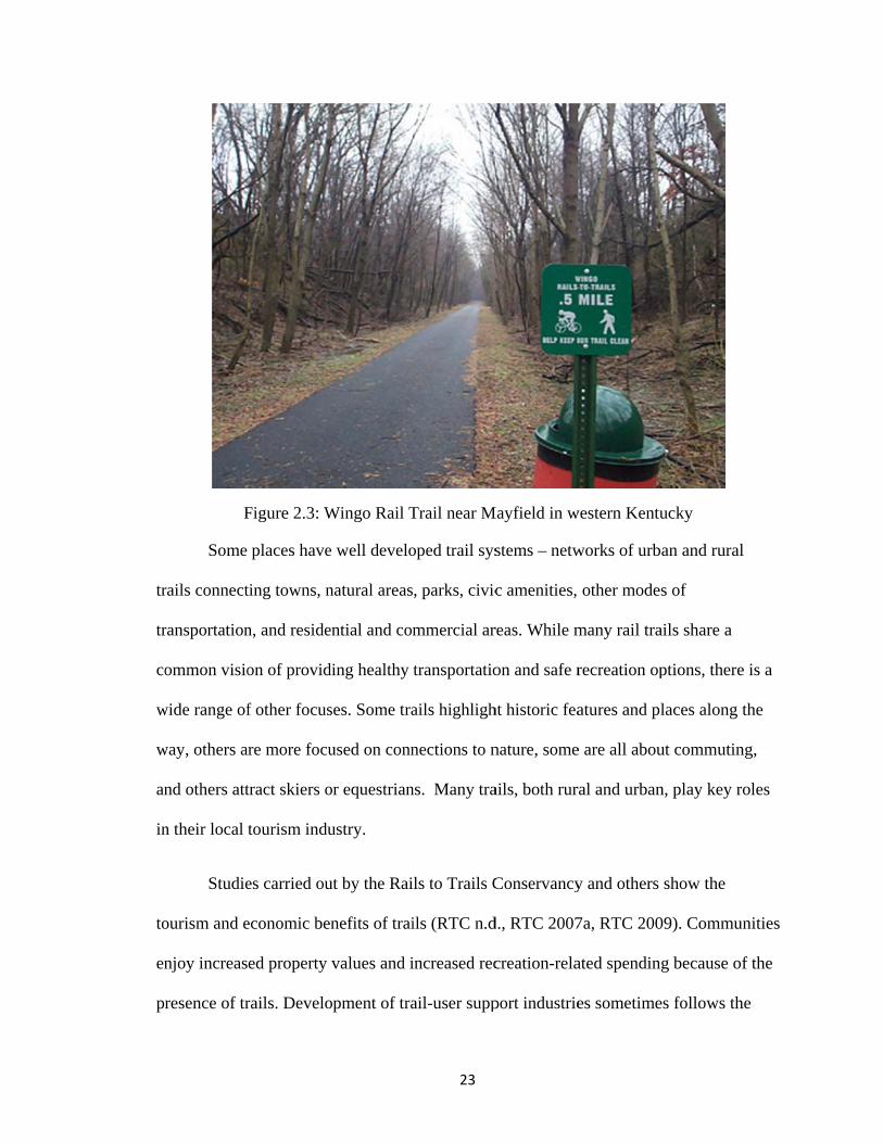
Figure 2.3: Wingo Rail Trail near Mayfield in western Kentucky ................................... 23
Figure 2.4: Miles of Rail Trails by State, 2010................................................................. 24
Figure 2.5: Ad for the National Trust for Historic Preservation ....................................... 32
Figure 2.6: Irvington Depot, Irvington, KY ...................................................................... 48
Figure 2.7:Comparison of Minnesota and Kentucky Programmed TE Funds .................. 53
Figure 4.1: Some abandoned railroad corridors were easier to find than others .............. 93
Figure 4.2: Ad for flower shop in Muhlenberg Leader-News ........................................ 111
Figure 5.1: Map of Muhlenberg County Rail Trail......................................................... 136
Figure 5.2: Caboose at Greenville trailhead ................................................................... 138
Figure 5.3: Abandoned PAL line west of Greenville ..................................................... 141
Figure 5.4: Map of Oldham County Greenways – Phase I, LaGrange ........................... 148
Figure 5.5: Trackside view of former L&N RR depot, LaGrange. ................................. 150
Figure 5.6: Interurban station with interurban train. ....................................................... 150
Figure 5.7: Map of Oldham County Greenways ............................................................. 151
Figure 5.8: A train passes “Kaelin’s Trackside Restaurant” in LaGrange ..................... 160
Figure 5.9: A train runs down Main Street, LaGrange ................................................... 160
Figure 5.10: Map of Bruce Vento Nature Sanctuary area .............................................. 163
Figure 5.11: Carver’s Cave ca. 1875 .............................................................................. 165
Figure 5.12: Map showing Phalen Creek’s wetlands in the river flood plain................. 169
Figure 5.13: Bruce Vento Sanctuary area, ca. 1892. ...................................................... 170
Figure 5.14: Rail yard on Vento Site, ca. 1925 ............................................................... 171

iv
Figure 5.15: Rail yard on Vento Site, ca. 1940 ............................................................... 171
Figure 5.16: Car cleaners at site (Standard Oil Co. building still stands at site), ca. 1930......................................................................................................................................... 172
Figure 5.17: Bruce Vento Nature Sanctuary site map .................................................... 174
Figure 5.18: Vento Site aerial view, 2006 ...................................................................... 176
Figure 5.19: Vento Site aerial view, 1985. ..................................................................... 176
Figure 5.20: Former Standard Oil building at Vento site ............................................... 177
Figure 5.21: A young hiker enjoys the trail through Vento’s prairie area. ..................... 187
Figure 5.22: Map of Bruce Vento Sanctuary and Downtown St. Paul ........................... 189
Figure 6.1: The Ditto-Landsdale House in West Point, KY ........................................... 193
Figure 6.2: Railroad depot in Central City, KY .............................................................. 196
Figure 6.3: Passenger depot in Greenville, KY .............................................................. 197
Figure 6.4: Mountain type Locomotive .......................................................................... 197
Figure 6.5: c. 1964 Peabody Coal Company .................................................................. 198
Figure 6.6: Abandoned railroad corridor strewn with trash in Carter County, KY ........ 198
Figure 6.7: PAL caboose at Greenville trailhead. ........................................................... 199
Figure 6.8: From elsewhere in central Kentucky, but indicative of the general attitude about private property rights in the state. ........................................................................ 201
Figure 6.9: Community’s views of what’s important along the trail: a map that is posted at the trailheads ............................................................................................................... 202
Figure 6.10: Trailside Icee, a business that opened up along the Muhlenberg Rail Trail.......................................................................................................................................... 207
Figure 6.11: Oldham County logos that display references to the centrality of the railroad.......................................................................................................................................... 230
Figure 6.12: Welcome sign to LaGrange. ....................................................................... 231
Figure 6.13: A trail sign shows the way to various trails, parks, and other amenities from the Vento Sanctuary hub. ................................................................................................ 245
v
Figure 6.14: Concrete slabs (used for railroad car maintenance) extant at the Vento Sanctuary......................................................................................................................... 248
Figure 6.15: Half of the sign circle at entrance to Bruce Vento Nature Sanctuary ........ 253
Figure 6.16: Interpretive sign .......................................................................................... 253
Figure 6.17: Details the signs in the sign circle. ............................................................. 254
Figure 6.18: Jim Rice drums and sings near entrance to Wakan Tipi, 10/09.. ............... 256
Figure 7.1: Walkers on the Greenville end of the Muhlenberg County Rail Trail ......... 263
Figure 7.2: Notice board at the Greenville trailhead ....................................................... 266
Figure 7.3: Near the Central City trailhead ..................................................................... 268
Figure 7.4: Trails under construction at Wendell Moore Park ....................................... 274
Figure 7.5: Commerce Parkway trail segment, shortly after 2009 completion .............. 276
Figure 7.6: Oldham County Greenway on west edge of downtown LaGrange. ............. 278
Figure 7.7: Trails that connect Vento Sanctuary to nearby parks and regional trails. .... 289
Figure 7.8: Jim Rice speaks with a group of visitors to the Vento Sanctuary ................ 295
Figure 8.1: Abandoned rail line near Moorman, KY ...................................................... 301
Figure 8.2: Completed rail trail in Uniontown, KY ........................................................ 301

C
(
ev
(J
ra
p
b
pr
pr
Chapter 1 : I
Figure 1.1.(near Young
Council a
Places
veryday plac
Jackson 1980
ailroad corrid
edestrian tra
ecome comm
reservation w
Rail tr
reservation i
Introductio
.1: Between g’s High Bridand the Rails
conver
s have a lot t
ces people’s
0). This diss
dors. Many
ails built upo
munity gathe
where a rem
rails are a bi
in action – m
n
Versailles adge). Rail tras to Trails Corsion of this
to tell us if w
communitie
sertation focu
communitie
on abandoned
ering places,
mnant of a pa
it of an odd c
many people
1
and Lawrencail advocatesonservancy hcorridor to a
we take some
es create refl
uses on one
s have an int
d railroad rig
, transportati
st time gains
choice thoug
involved do
ceburg, in Ans, including have been wa trail for ma
e time to sto
lect what tha
particular ty
terest in con
ght of way. R
ion routes, a
s a new use.
gh as a place
on’t view it a
nderson Couthe Kentuck
working on neany years.
op, look, and
at communit
ype of everyd
nverting thes
Rail trail lan
and places of
e to study his
as historic pr
unty, Kentucky Rails to Tegotiating th
d listen. The
ty values
day place: re
se places into
ndscapes ofte
f historic
storic
reservation.
cky Trails he
elict
o
en

2
Many believe historic preservation is only about important houses where important men
lived (and died); architecturally accurate restorations; corbelling and cornices; and, of
course, places marked with plaques. Rail trails have some of those historic
characteristics, but they are by default historic preservation in action – preserving a
transportation corridor intact, even if there is no historic building, bridge, or tunnel.
Alternative uses after railroad abandonment (other than trails) usually end up fragmenting
the corridor and that remnant of the past is lost. Reusing railroad corridors as trails
preserves the integrity of the corridor that was assembled for the original use and gives
visitors a sense of what it was like before.
Many in historic preservation see the highest and best use for historic structures
and sites to be continued active everyday use instead of “museum-izing” them. The
preservation of rail corridors as rail trails accomplishes this. There is a logical and
perceptual connection between historic preservation and the rails to trails movement. One
of my research goals is to bridge this gap and strengthen the connections.
I am particularly drawn to the idea that rail trails tell a story about values in
place1. Once, the corridor was valued for its economic promise – industry and commerce
depended on railroads. Goods and people moved in and out. There was no more
important link in the US than the railroads. Railroads gained a value beyond economics
too – they helped shape the national imagination, played an important part in our story of
growth, change, settlement, and development. Railroads became an icon that’s still
powerful today. But things changed. Cars and trucks altered the American transportation
1 Values in place is a phrase borrowed from Brian Goodey, though I do not use it in the same sense that he does (Goodey 1982).

3
scene. The economic reality of railroads shifted. Lines were abandoned and tracks were
pulled as people and goods moved more by highway than by railway. Railroad corridors
in communities across the nation became devalued. These were places of derelict
buildings, weeds, trash, crime (or at least a perception of it); they were eyesores, ignored
(Jakle and Wilson 1992). Then as the idea of reusing the corridors for recreation spread, a
revaluation of these places happened. Now, they are once again valued for their
transportation usefulness, but this time to two-wheeled commuters. Once again they are
community gathering places – not at the depot for the afternoon mail or the arrival of
relatives – but as a daily routine of recreation that brings a community’s people out to
meet together. Values about exercise and health, economic development and tourism,
historic preservation and education are played out around the development of rails to
trails projects around the country.
It is in this context that I began to explore the idea of “values in place”, or what
preservationists term “values-based” or “values-centered preservation.” This preservation
principle provides a way to address “both the contemporary and historic values of a
place” (Mason 2006). Already we can see that we’re talking about values – ones that
change over time, that are different from one person or group to the next, and that can be
wildly different even for one place at one time. When the practice of preservation
planning flows from this framework it necessarily means that we have to find out what
these different values are – by inviting participation, by listening and talking to the
stakeholders be they lay people or experts – and leaving room to adapt as these values
shift over time.
4
This is hardly a new idea. In the world of transportation planning, engineers and
planners have formally focused on context sensitive design (CSD) since the late 1990s.
CSD – or as it is commonly now known: Context Sensitive Solutions (CSS) – now
augment the AASHTO (American Association of State Highway and Transportation
Officials) engineering manual that is the standard for highway design2. The Federal
Highway Administration had a goal for CSS integration into all state departments of
transportation by 2007. By 2010, slightly more than half of the states have some sort of
policy or legislation relating to CSS and more than two thirds of the states’ department of
transportation staff have participated in CSS training (Context Sensitive Solutions
Clearinghouse).
The idea that values get played out in places and that community values are
important in creating and understanding places has a long history in geography as well.
Geographers have long thought and wrote about the “meanings of place” and “sense of
place” and the ways that values and meanings are created and assigned and interpreted in
different ways in different times and places. (Jackson 1980, Lewis 1979, Duncan and
Duncan 2001c, Massey 1993, and many others)
But in historic preservation, how have community values been approached? The
everyday practice of preservation has been “top down”. Professionals determine which
places are the important ones that should be designated as officially historic. But this is
certainly changing as preservation efforts focus new attention on vernacular landscapes,
places important to the everyday lives of workers, immigrants, the poor, slaves, Native
Americans, and so on. Also, in preservation scholarship and practice, until recently, there
2 Flexibility in Highway Design (FHWA1997) is the CSS handbook for transportation professionals.
5
has been an implicit idea that value is somehow just “there.” Indeed, the National
Register of Historic Places nomination criteria statement begins by saying “The quality of
significance in American history, architecture, archeology, engineering, and culture is
present (it’s just present) in districts, sites, buildings, structures, and objects that possess
integrity of location, design, setting, materials, workmanship, feeling, and association”
(see Box 2.2 on p. 30). But why is it present? Who decides what is significant and why?
Values-based preservation is a reaction to this – it is a purposeful attempt to address the
significance of places by finding out what people value about historic landscapes.
I have examined these ideas through three in depth case studies in two states (two
in Kentucky and one in Minnesota). The Muhlenberg County Rail Trail in western
Kentucky is an example of a trail that was planned almost entirely without public input or
asking the people in the community what they value. In the end the trail itself ended up
being a highly valued part of the community, but it was a difficult process. The way it has
developed as an important community place is instructive on how people value historic
landscapes and how they remake those places to fit with their values. The Oldham
County Greenway in La Grange, Kentucky, is an example of a trail that came from local
support but one that adapted as local values became clearer and as difficulties along the
way forced changes to the plan. The Bruce Vento Nature Sanctuary and trails in St. Paul,
Minnesota, is an example of a grassroots project that had its origin and its success rooted
in the involvement of many local and state stakeholders. Values as diverse as ecological
restoration, historic preservation, and Native American sacred sites are represented at this
place through the way it was developed and interpreted.

6
Research Questions
My central research questions were: how does a landscape become valued,
devalued, and/or revalued through time? The title of this dissertation was my central
theme: values in place. In what ways do different values of different people or groups
intersect in rails to trails landscapes and how do they shape the landscape? How do
historic values intersect with economic, social, political, and other values as these relate
to landscape preservation? How have different discourses expressed their values in the
context of rail corridor conversions? And what does knowing about values in place (what
they are and whose they are) contribute to in the planning process? Who should care?
Why should we care? And what should be done with the knowledge? A subset of
questions deals with the interactions between trails, historic preservation, and geography.
What common ground do these three areas already share and what is the potential for
further connections between and through them?
I am defining discourse as a certain “way of talking about and understanding the
world” (Jorgensen and Phillips 2002:1), a sense of shared meaning (Duncan 1990, Schein
1997). But this definition includes an understanding that even though a discourse “fixes
meaning in a particular way,” it does not command meaning to be “fixed exactly in that
way forever” (Jorgensen and Phillips 2002:29). It is understood that meanings are not
fixed across time, space, or different social groups. This definition of discourse is not
confined to a sense of only language or visual communication but to all “social practice”
(Jorgensen and Phillips 2002:67, after Fairclough 1993, 1995). In this dissertation, some
of the key discourses whose ideas and meanings are expressed through the trail
landscapes include local and national trail advocates, historic preservation interests (local
7
and national), local citizens and community groups, and advocates for smart growth,
walkable communities, and active living.
Outline of dissertation sections
I begin by introducing the three major concepts relevant in this study: historic
preservation, rails to trails, and values-based preservation. Next I situate my research
within the larger geographical, historic preservation, and trails literatures. Within
geography, my research is at home in the long legacy of landscape and place studies that
focus on everyday places and the meanings of those places to the people and groups that
use them. Within the larger cultural landscape body of human geography research, I
identify most with critical humanistic geography as a way to best address the influence of
not only institutions on places, but to also examine the relationship between places and
individuals. Within historic preservation, much research has begun to borrow from
cultural landscape literatures in geography. What resonates most with my research is an
endeavor called “values-based preservation.” Briefly, this is a theory/method that
involves investigating the values held by members of a community and then
incorporating those values into a development project. I discuss all of these theoretical
frameworks at greater length in Chapter 3.
In Chapter 4 I discuss my methodological frameworks that I employed in field
work and archival research and how they tie back to the theoretical foundations upon
which my work is built. I tacked back and forth between the archive and the field, each
informing steps in the other. In a quest to find out what people value about places, it was
essential to talk to those people, but in examining how they portrayed these values the
archive was useful too.

8
Chapters 5, 6, and 7 comprise the in-depth discussion of the case study sites. For
these three sections I employ Richard Schein’s methodological framework for
interpreting cultural landscapes (Schein 2009). This framework starts in Chapter 5 with
the histories of each place, an explanation of what the sites look like, how they got that
way, and what has changed over time.
Chapter 6 is an examination of the meanings and values that intersect at each site.
Each of the three case studies has some values in common, but each has unique values
that are present. These values were gleaned from a combination of participant
observation, archival research, and interviews with stakeholders.
Chapter 7 concludes with an exploration of the way that these intersecting values
and meanings serve to mediate and facilitate the wide variety of agendas held by the
numerous stakeholders at each site. It also examines the way stakeholder discourses are
materialized in the landscapes (Schein 1997, 2009). I conclude the dissertation by
outlining the connections of the research and future directions for further research.
Theoretical contributions
Through my work I extend the geographic discussion about how meaning is
mapped onto the world through articulations of public memory in place, and how
identities are contested and negotiated there. I want to situate historic preservation and
trails planning as spaces where this happens, and not just at monuments, memorials, and
museums but as historic landscapes of everyday life (Glassberg 2001, Hayden 1995) such
as rail trails. There is still a lot of potential for connections between geography and
historic preservation, though many researchers are weaving them together. Critical
human geography together with a sensitive understanding of place experience can inform

9
historic preservation research and practice, and a study of historic preservation in places
can inform geographical explorations of meaning, collective memories, and identities
articulated in place.
My case studies of railroad corridor trails are examples of places that are centers
of meaning in the lived experience of people (Tuan 1976, Godkin 1980). It would seem
that they are rather inconsequential – unlike national landmarks or memorials to tragic
pasts – but on further thought, they are meaningful through their everyday-ness, the way
they are woven into the daily lives of people. In connecting special places, trails become
special places. In addition, this study fills a hole in scholarship; “both preservationists
and geographers have ignored” the rails to trails movement and its role in historic
preservation (Bowen 2008: 40).
I am concerned about building a nuanced and careful understanding of people’s
experiences in trails landscapes. I tried to combine the understanding of the multiplicity
of places with an attempt to understand how people really understand this multiplicity. I
thought I would discover that (at least) some people understand (at least) some of the
multiplicities at work constructing and contesting meaning in places. Though Duncan
(1990: 18) argues that an outsider (and academic) perspective can help to bring
“unacknowledged causal conditions” to light, he does affirm the importance of exploring
and taking seriously the way people think of and find meaning in places. A combination
of an outsider/academic viewpoint with a careful examination of local stakeholders’
viewpoints leads to a more nuanced understanding of the meanings at work in place.

10
My research contributes to conversations in geography around place meaning and
value, expressions of public memory in the landscape, and how meaning and value are
constructed and contested in place. Though there is hardly a recognizable subfield called
critical humanistic geography, I think that is the most fitting home for my work (Adams,
et al. 2001). It seems that humanistic geography lacked clear direction in attempts to
define the perspective and how to carry out studies within it (Relph 1981). This is an
attempt in that direction, but it is informed by critical understandings of systems of power
and influence beyond the individual and beyond the local. In that way, this dissertation is
also an attempt toward a nuanced, critical understanding of the complexities of place;
understanding that neither of these projects is complete and my contributions won’t
complete them.
Applied contributions
Understanding the way trails are meaningful can have implications for the
planning, development, and management of trails (Coeterier 2002, Hayden 1995).
Understanding the ways people engage with historic landscapes, locally valued places of
community interaction, or landmarks can help shape planning to better meet people’s
needs, to avoid previous pitfalls, and to be more effective from the start.
One of the most significant barriers to trail development is public opinion. It is
extremely common for communities to see a negative value to trail development: they
associate it with increased crime, lower property values, trespassing, noise, wasted public
dollars, or simply the idea that it has nothing to do with them or their lives. A better
understanding of how people and communities engage with and value the past in places

11
can teach trail planners how to engage people in the planning and visioning process3.
Perhaps a lesson from the Muhlenberg County trail that could be applied elsewhere is that
people value reminders of the past through what they conceive of as a historic landscape.
Questions of authenticity don’t appear to affect the meaning of place in people’s
experience. Without this lesson, planners might rely on customary preservation practice
that emphasizes restoration as close as possible to a documentable, verifiable past.
Examining how trails become special places of community activity can also
inform trail development and management. Attention to what aspects are most valued by
people help trail planners to meet community needs. The Rails to Trails Conservancy
casts trails in a role of physical and symbolic connectivity. Trails physically connect
people to places such as neighborhoods, schools, shops, parks, and civic amenities. They
also connect people through interactions among neighbors, family members, and
community members of different ages, abilities, and background. Finally, they connect
people to the past through reuse and interpretation of historic corridors, structures, and
artifacts (RTC website). While these generalizations are certainly debatable in particular
places and cases, a better understanding of how people actually experience these
connections can enhance the process.
There are numerous parallels with context sensitive design in highway planning.
This is a process that incorporates a community’s values into the process from the start
and it can have a critical effect on the success of a project. The Federal Highway
Administration defines context sensitive design as
3 Visioning is the actual term used in the field of public participatory planning. It is defined as a process by which the values and shared goals for a site/community are delineated through community involvement activities. These values are then incorporated into the plan for changes/new construction in the community.

12
a collaborative, interdisciplinary approach that involves all stakeholders to develop a transportation facility that fits its physical setting and preserves scenic, aesthetic, historic, and environmental resources, while maintaining safety and mobility (FHWA 2004b).
This approach is fairly new in highway planning and it should be more intuitive
for trails planning – trails are more likely in the first place to fit into a place’s context.
But in trails planning there is not much reflection on the way people’s values may vary
from place to place – they are generalized for the whole nation. The mere act of building
a rail trail seems to satisfy an important goal in opposition to the status quo, but the way
that trails are planned is equally important once that first barrier is overcome.
I anticipate my research to be useful to trails planners by introducing another
dimension to trail planning in demonstrating the importance of a careful understanding of
community values and place meanings. These insights can be applied to historic
preservation as well. In addition, a secondary goal of my research in the practical realm is
to increase awareness among trails and historic preservation interests of the immense
potential for cooperation. Values-based preservation, as a theory/method, is the thread
binding all of the different pieces together. As a theory, it is based on the belief that
values matter in the way that places shape people and people shape places and that it is
important to know what people and what values are at play in a place. As a method, it can
inform academic geographic research and is quite similar to what geographers have
previously endeavored to do through ethnography as they examine senses of place. It is
also vital to historic preservation and trails planning practice. Professionals must inquire
about the community’s values when working on a new project and must allow the
projects to be informed and directed by those values. This research makes the

13
connections between these three areas more apparent and suggests ways that practitioners
of each can strengthen these connections.
Copyright © Lisa Rainey Brownell 2011

14
Chapter 2 : Rails, trails, and historic preservation: an introduction
In this chapter I will introduce three fundamental elements of my research:
railroads, rail trails, and historic preservation. This chapter introduces the reader to the
contexts in which these three elements function and also the ways in which they interact.
Because the connections between the three may not be initially clear, the chapter
examines the argument for their connections and the fruitfulness of examining rails to
trails landscapes as places of historic preservation.
A brief history of railroad abandonment
At its peak in 1916, the rail network in the United States included some 254,000
miles of railroad (RTC 2010). The current inventory is around 140,000 miles
(Association of American Railroads 2009). What has happened that so much was
abandoned? And what has happened to those corridors that were abandoned?
Table 2.1: Railroad Mileage: Percent lost from 1920 to 2008
Place 1920 miles 2008 miles
% lost
Kentucky 3929 2558 35%
Minnesota 9114 4528 50%
United States 254,037 139,326 45%
2008 data from Association of American Railroads 1920 data from The Routledge Historical Atlas of the American Railroads, Stover 1999

bu
D
sc
ot
pr
ar
sc
R
Figure
From: A Bas
While
uilt, there w
Depression y
crap metal d
therwise ma
rosperity for
This a
reas became
cholars deba
Railroad aban
2.1: Railroa
sic History o
e rail lines w
were certain
ears many ra
during the ye
arginal line
r railroads, b
activity coinc
e accessible b
ate how prim
ndonment is
ads of the Un
of the United
were abando
n eras that
ailroad comp
ears of WW
s. The wa
but steady de
cided with a
by car and m
mary the influ
also a produ
15
nited States a
d States, 194
oned during
stand out w
panies becam
WII spurred th
ar brought
ecline return
a rise in autom
more goods b
uence of the
uct of a wide
at the end of
44, Charles A
every deca
with more
me unprofita
he salvage o
a short-live
ed shortly af
mobile and t
began to be s
auto was on
e array of va
f the nineteen
A. Beard and
ade since the
abandonmen
able and fail
of functiona
ed increase
fter the war
truck use in
shipped by tr
n the demise
ariables that
nth century
d Mary R. Be
e first lines
nts. During
led. The nee
ally abandon
in business
ended.
the U.S. Mo
ruck, althoug
of railroads
changed in
eard
were
g the
ed for
ned or
s and
ore
gh
s.

16
importance over time and from place to place. These variables related to poor
management of the railroad companies, labor issues, changes in markets affecting
shippers, burdensome regulation, initial over-construction, and unequal government
subsidies to other modes of travel (Black 1975, Saunders 2001). Other factors include
rising fuel and maintenance costs. The 1960s were “characterized by the collapse and
consolidation of many great railroads, and by the abandonment of passenger service by
nearly all of the surviving roads” (Yenne 2005: 10). Indeed, Amtrak was born in 1971 as
an answer to the loss of passenger service during the 1960s (Saunders 2001).
During the 1970s, the Interstate Commerce Commission streamlined the
abandonment process, allowing carriers to abandon lines more easily and quickly
(Schweiterman 2001). Another wave of railroad abandonment came in the 1970s and
1980s as almost all of the major railroad companies in the Northeast and Great Lakes
regions faced bankruptcy. The federal response to the crises in the rail industry included
the 1973 Regional Rail Reorganization Act (3-R Act), which allowed for the creation of
Conrail, a federal corporation to take over operation of seven bankrupt freight lines (these
were: Penn Central, Erie Lackawanna, Lehigh & Hudson River, Boston & Maine, Ann
Arbor, Lehigh Valley, and Reading) (Schwieterman 2001). This led to further
abandonment of redundant and marginal lines. The 3-R Act focused on the bankrupt
lines of the Northeast and Great Lakes; the 4-R Act (Railroad Revitalization and
Regulatory Reform Act of 1976) addressed railroad issues nationwide. This act
mandated public rail planning and made state rail planning a requirement in order to
participate in federal rail subsidy programs. This was a change from previous years when
the planning of railroad networks was left to railroad companies and to their regulatory

b
n
fo
F
S
m
m
ra
fu
pr
odies. It was
ecessary bec
or the provis
igure 2.2: Ex
The ra
taggers Rail
marketing (A
many change
ailroad scene
undamentally
rocess aband
s apparent th
cause “coord
sion of rail se
xtent of U.S
ailroad indus
l Act in 1980
Association o
s in the 1960
e, the Stagge
y and foreve
donments m
hat coordinat
dinated feder
ervices was
. rail system
Map cre
stry was furt
0, as the fede
f American
0s, 1970s, an
ers Act “did
er” (Saunder
ore quickly.
17
ted rail plann
ral-state poli
virtually non
m, 2008
eated by Mike F
ther deregula
eral governm
Railroads 20
nd 1980s tha
change the e
rs 2001: 188)
As a result
ning at the s
icy featuring
n-existent pr
Foster, Univers
ated in the U
ment gave up
010). Thoug
at had great i
economics o
). This act a
t of the chang
tate and fede
g large scale
rior to 1973”
sity of Minnes
United States
p control ove
gh this act wa
impact on th
of American
also required
ge in regulat
eral levels w
public plann
” (Hord1978
ota Cartograph
s after the
er pricing an
as only one o
he American
railroading
d the ICC to
tions, railroa
was
ning
8:53).
hy Lab
nd
of
n
ads
18
were able to lower their costs, lower prices for shippers, and increase their productivity
and profitability (Wilner 1997). Because of the drive for greater efficiency and the eased
abandonment process, more lines were abandoned during this time.
The 1980s were also a time of important railroad company mergers. Instead of
the old way of powerful railroad companies absorbing smaller, weaker lines, now railroad
mergers and consolidations were between strong companies. Some of these included the
Norfolk & Western and Southern RY to become Norfolk Southern and the consolidation
of the Chessie System (C&O and B&O) and the Seaboard System (L&N, Seaboard Coast
Line, Atlantic Coast Line, and Carolina, Clinchfield & Ohio) into CSX Transportation
(Wilner 1997). These are two of Kentucky’s major companies today, along with Illinois
Central (which itself is a result of a merger with Gulf, Mobile & Ohio and that now has
been consolidated into Canadian National) and a variety of regional and small shortline
carriers. Figure 2.2 shows the current national rail network including Class I carriers,
regional railroads, and shortlines.
Railroad abandonment process
A railroad company wishing to formally abandon a line (or portion of a line) must
file an application with the federal Surface Transportation Board (STB). The STB took
over abandonment authority from the Interstate Commerce Commission in 1995 when
the ICC was abolished by an act of Congress (STB 1997). The carrier can apply to
abandon their line if there has been no traffic over it in two years (called a “Notice of
Exemption”) and none of the former customers or communities served have registered a
formal complaint over the lack of service. The exemption refers to the fact that they are
exempt from the rigorous “regulatory scrutiny” from the federal agency (STB 1997:
19
2).The carrier can also apply if there has been so little traffic during the last two years
that there was no chance for profit (called a “Petition for Exemption”). Companies
serviced by the railroad can challenge these filings, but that is rare. The Surface
Transportation Board reviews the balance between the railroad company’s economic
losses stemming from operation of an unprofitable line with the impact on the community
experiencing the loss of rail service (STB 1997). Permission to abandon is almost always
granted if it is determined that the community impact is not too severe.
The application requires several things from the railroad: a system diagram map,
a notice of intent published in newspapers in the affected communities, and the
abandonment application narrative that lays out the costs, effects, and various
informational data. The public then has a period of 45 days to contest the abandonment
application (or to file for a Notice of Interim Trail Use). Prior to filing this application,
the abandoning railroad also has to submit an environmental impact statement and a
historic resources study (called Section 106 – see below for more information on this).
There are procedures in place to allow another company to buy the line and
assume operations: the STB offers a document called So You Want to Start a Small
Railroad to guide interested parties through this process. Another provision allows an
organization to preserve the corridor for trail, commuter rail, energy transmission, or
other alternative public uses (STB 2008, STB 1997). This is accomplished through a
request for trail use/public use of the line. If this use is agreed to by the railroad and the
STB, the line can then proceed to railbanking procedures.
20
Railbanking was defined by Congress in the National Trails System Act of 1983.
Railbanking is a system by which a railroad wishing to abandon a corridor does not really
abandon it in the sense that its property reverts to original or adjacent landholders, but the
“railbanked” land is retained in corridor form and is then leased, sold, or given to a
private or public entity that assumes management of the corridor. The purpose of
railbanking is to maintain the integrity of the corridor for future railroad use, should it
ever be needed, but to also secure its interim use as a trail.
Railroad property ownership only becomes an issue when the railroad abandons
the line and wants to dispose of the corridor. Adjacent landowners often believe that,
once abandoned, railroad land that was held in easements will revert to them. But in fact
railroads acquired property for their corridors in a number of different ways and it is
common to see many of these operating in a single corridor. Some railroad property is
held in fee simple, where the railroad bought the land outright. Other property,
particularly in the western United States, was granted to the railroad by the federal
government. Portions of corridors were created through easements, where the railroad
bought the right to run the corridor across a piece of property, but not the property itself.
In some cases land was condemned for railroad use and in some it is unclear how exactly
the railroad came to own the property (STB 1997, RTC 2009).
Railbanking addresses the problems faced by both the abandoning railroad and
the public interests who want to secure an interim trail use. Disposing of many small
property parcels is time consuming and expensive for railroads. Negotiating and paying
for the purchase of multiple small parcels in order to reconstruct a corridor after it has
been abandoned is very difficult, if not impossible, for trails groups. A railbanked

21
corridor can be sold in one piece by the railroad and the railroad does not have the
expense of removing features like bridges since they have value to the new user.
The National Trails System Act railbanking provision has been challenged many
times by opponents. Much of the opposition is tied to different understandings of what in
fact should happen to railroad land at the point of abandonment. The Supreme Court
“unanimously ruled, in the case of Preseault v. United States, that preserving a corridor
for future rail use through railbanking is a legitimate exercise of governmental power.
This decision protects a railroad's legal right to transfer all forms of its ownership,
including easements, to a trail group” (RTC n.d., accessed 7/8/09). Continued legal action
revolves around the idea that railbanking is preventing the use of a property by its rightful
owner and thereby constitutes a “taking” of private property. Some small settlements
have been paid by the federal government, but these have been rare (Brewer 2004).
The rails to trails movement
Rail trails are recreational trails built on abandoned railroad corridors. After a
railroad company abandons a line, they remove the tracks and the railbed (and often the
bridges, tunnels, culverts, and other infrastructure) is reused as a base for a trail. The
rails to trails movement had its origins in the 1960s with the Elroy-Sparta Trail in
Wisconsin, the first formal rail trail developed in the US. Others soon followed, such as
the Illinois Prairie Path near Chicago that also opened in the early 1960s. There are now
almost 20,000 miles of rail trails in the US.
To some extent the timing of these developments is tied to the trends of railroad
abandonment as many more lines became unprofitable and were abandoned in the 1960s

22
and 1970s. Especially after railroad deregulation in the 1980s, the pace of abandonment
picked up as it became easier for a railroad company to cease operations on a line.
The national rail trail advocacy organization, the Rails to Trails Conservancy, was
founded in 1986 – in response to the passage of the Trails System Act and the growth in
rail trail development following the institution of railbanking. This organization, based in
Washington, D.C., promotes policy at the federal and state levels, assists local trail
organizations in developing trail networks, and provides general information on trails and
greenways (including a GIS database of all trails, funding data, and “how to” materials).
As of 2010, there are 19,548 miles of rail trails (the cumulative mileage of 1,631
rail trails) in the US (RTC website 2010). Of that total, 2,764 miles of trails have been
built using railbanked corridors (a total of 5,079 miles of corridors are railbanked, but the
remainder has not yet been converted to trails) (Fowler 2009). Another 724 projects for
an additional 8,676 more miles are in progress. Michigan (2,392 miles), Minnesota
(2,327 miles), and Wisconsin (1,782 miles) have the greatest number of miles of trails,
while Kentucky (32 miles), North Dakota (28 miles), New Mexico (26 miles), and
Hawaii (16 miles) have the fewest (refer to Figure 2.3). The longest completed rail trail is
the Katy Trail State Park in Missouri at 225 miles.
tr
tr
co
w
w
an
in
to
en
pr
F
Some
rails connect
ransportation
ommon visio
wide range of
way, others a
nd others att
n their local
Studie
ourism and e
njoy increas
resence of tr
Figure 2.3: W
places have
ting towns, n
n, and reside
on of provid
f other focus
re more focu
tract skiers o
tourism indu
es carried ou
economic be
ed property
rails. Develo
Wingo Rail T
e well develo
natural areas
ential and com
ding healthy
ses. Some tra
used on conn
or equestrian
ustry.
ut by the Rai
nefits of trai
values and i
opment of tra
23
Trail near M
oped trail sys
, parks, civic
mmercial ar
transportatio
ails highligh
nections to n
ns. Many tra
ls to Trails C
ils (RTC n.d
increased rec
ail-user supp
Mayfield in w
stems – netw
c amenities,
reas. While m
on and safe r
ht historic fea
nature, some
ails, both rur
Conservancy
d., RTC 2007
creation-rela
port industrie
western Kentu
works of urb
other mode
many rail tra
recreation op
atures and pl
e are all abou
ral and urban
y and others
7a, RTC 200
ated spendin
es sometime
ucky
an and rural
s of
ails share a
ptions, there
laces along t
ut commutin
n, play key ro
show the
09). Commun
g because of
es follows th
l
e is a
the
ng,
oles
nities
f the
he

op
sh
at
p
or
F
em
A
pening of a t
hops, and oth
ttract residen
laces like th
r shop near t
igure 2.4: M
Recen
mphasize the
Active transp
trail. Places
her tourist at
ntial and com
at it is not to
the trail.
Miles of Rail
ntly, trail adv
e importance
portation effo
such as bike
ttractions gr
mmercial dev
ourist dollars
Trails by St
Map cre
vocates and h
e of the built
orts ensure th
24
e rental and r
ow in trail c
velopment s
s as much as
ate, 2010
eated by Mike F
healthy livin
t environme
hat residents
repair shops
communities
since they are
s local reside
Foster, Univers
ng advocates
nt in the hea
s have acces
s, cafes, cam
. Some trails
e such vital
ents who wis
sity of Minnes
s have joined
alth outcome
s to places to
mpgrounds, g
s in urban ar
pathways. In
sh to live, wo
ota Cartograph
d forces to
es of the pub
o walk and
ift
reas
n
ork,
hy Lab
blic.

25
exercise (instead of just drive) in their daily life. This is not just a transportation issue but
a key issue of public health in the realm of chronically high rates of obesity (RTC 2007).
Former railroad corridors are particularly well suited for conversion to
bike/pedestrian trails because of realities of railroad engineering. Railroad locomotives
are not able to climb grades beyond two or three percent. Grades above five percent are
reserved for only a few (mostly now defunct) narrow gauge logging and mining railroads
in extremely difficult topography. Some of these grades necessitated switch-backs which
were not feasible for use with commercial freight or passenger lines. Trails converted
from former railroad lines are by their nature accommodating to all users (assuming a
paved surface). Novices and experts alike can enjoy a walk or ride without hills and trails
can be built to ADA (Americans with Disabilities Act) standards.
A brief history of historic preservation in the U.S.
Historic preservation4 is the process of preventing the destruction and promoting
the rehabilitation and restoration of historic sites, structures, and landscapes with
interpretation to the public where appropriate. One of the early preservation efforts in the
US that continues to be instructive was the protection and restoration of Mount Vernon in
1858 by the Mount Vernon Ladies Association. Many early preservation projects were
sites or buildings associated with the “founding fathers” of the US and were undertaken
by volunteer members of elite groups. Historic preservation was a project of “little blue
haired ladies in tennis shoes,” as the saying goes.
“So influential was Ann Pamela Cunningham’s victory at Mount Vernon that her efforts established certain presuppositions about historic preservation in America.
4 Elsewhere in the world historic preservation is referred to as heritage conservation or heritage preservation. The U.S. appears to be the only place to call it this.
26
These assumptions included the idea that private citizens, not government, were the proper advocates for preservation; that only buildings and sites associated with military and political figures were worthy of preservation; that such sites must be treated as shrines or icons; and that women would assume a dominant role in the acquisition and management of such properties. Thus was established the uniqueness of the preservation movement in America among sovereign states of the world.” (Murtagh 2006: 16)
An important foundation to the preservation movement was the creation of the National
Park Service in 1916. The National Park Service (NPS) still plays an important role in
preservation as the home of the National Register of Historic Places and as the agency
that sponsors most federal preservation programs (Tyler 2000). In addition to the
National Register, some of these programs include: the Historic American Buildings
Survey and the Historic American Engineering Record, National Center for Preservation
Technology and Training, Park Historic Structures and Cultural Landscapes, Archeology
and Ethnography Program, and the American Indian Liaison Office (Tyler 2000). Both
the NPS and historic preservation are nested under the authority of the Secretary of the
Interior. Indeed, the Secretary of the Interior’s Standards for Rehabilitation: Guidelines
for Rehabilitating Historic Buildings guides much preservation work in the U.S. The holy
scripture of historic preservation work, SHPOs and other preservation officials judge
projects against these standards and some funding relies on adherence to them (codified
in 36 CFR 67 for use in the Federal Historic Preservation Tax Incentives program). These
guidelines were originally written in 1977 and have been revised since then.

27
The National Historic Preservation Act of 1966 (Public Law 89-665) had a large
impact on what the practice of historic preservation was to become in the US. The new
interstate highway system and urban renewal programs’ destructive effects on cities and
Box 2.1: Secretary of the Interior’s Standards for Rehabilitation: Guidelines for Rehabilitating Historic Buildings
The ten standards are as follows. The guidelines are much more extensive and can be accessed at: http://www.nps.gov/hps/tps/tax/rhb/index.htm.
1. A property shall be used for its historic purpose or be placed in a new use that requires minimal change to the defining characteristics of the building and its site and environment.
2. The historic character of a property shall be retained and preserved. The removal of historic materials or alteration of features and spaces that characterize a property shall be avoided.
3. Each property shall be recognized as a physical record of its time, place, and use. Changes that create a false sense of historical development, such as adding conjectural features or architectural elements from other buildings, shall not be undertaken.
4. Most properties change over time; those changes that have acquired historic significance in their own right shall be retained and preserved.
5. Distinctive features, finishes, and construction techniques or examples of craftsmanship that characterize a property shall be preserved.
6. Deteriorated historic features shall be repaired rather than replaced. Where the severity of deterioration requires replacement of a distinctive feature, the new feature shall match the old in design, color, texture, and other visual qualities and, where possible, materials. Replacement of missing features shall be substantiated by documentary, physical, or pictorial evidence.
7. Chemical or physical treatments, such as sandblasting, that cause damage to historic materials shall not be used. The surface cleaning of structures, if appropriate, shall be undertaken using the gentlest means possible.
8. Significant archeological resources affected by a project shall be protected and preserved. If such resources must be disturbed, mitigation measures shall be undertaken.
9. New additions, exterior alterations, or related new construction shall not destroy historic materials that characterize the property. The new work shall be differentiated from the old and shall be compatible with the massing, size, scale, and architectural features to protect the historic integrity of the property and its environment.
10. New additions and adjacent or related new construction shall be undertaken in such a manner that if removed in the future, the essential form and integrity of the historic property and its environment would be unimpaired.

28
landmarks throughout the 1950s and 1960s were important factors that led to the passage
of this act (Tyler 2000). The act also created the National Register of Historic Places. The
National Historic Preservation Act shaped the philosophy and theory underpinning
historic preservation practice, as well as outlining the procedures (Murtagh 2006, Tyler
2000). The federal government’s concept of historic preservation broadened to include
not just those sites and buildings of national significance but also those of regional, state,
and local significance, as well as those with architectural merit (Murtagh 2006).
The National Register of Historic Places is “the official list of the Nation's historic
places worthy of preservation” (National Park Service 2010) and it is housed within the
National Park Service, under the Secretary of the Interior. Not only buildings, but also
corridors, sites, structures, and entire districts comprised of many buildings and sites can
be nominated to the National Register. Over 80,000 properties are listed in the National
Register. Listing on the register does not protect a building or site from destruction, but it
does offer it an “official status” and recognition as being historic and allows the site’s
owners to apply for various grants and tax credits that benefit historic buildings.
An important part of this legislation, “Section 106”, established a series of checks
and balances to ensure that historically significant properties are not harmed in projects
where federal money is spent (such as roads or bridges, HUD, railroads, etc.). This had an
indirect effect on the practice of historic preservation. A professional industry of
consultants who could perform Section 106 evaluations for government contracts grew in
the years after 1966. Some consulting firms focus primarily on this aspect of
preservation.
29
The Advisory Council on Historic Preservation is “an independent federal agency
that promotes the preservation, enhancement, and productive use of our nation's historic
resources, and advises the President and Congress on national historic preservation
policy” (ACHP website). It too was formed as part of the 1966 Historic Preservation Act.
The three main areas in which the ACHP works are in preservation initiatives (such as
promoting heritage tourism); communication, education and outreach; and federal agency
programs. The primary focus of the last area is the role ACHP plays in administering the
review process for Section 106 of the National Historic Preservation Act. If there is a
finding of adverse impact in a project under review, it must be mitigated by either
reworking the plan or if destruction of a historic resource cannot be avoided, the resource
must be thoroughly documented for the archive. Most decision-making on Section 106
reviews happens at the state level, but the ACHP gets involved in “controversial or
precedent-setting situations” (ACHP website).
Another crucial piece of the historic preservation mosaic to come out of the 1966
Preservation Act was the creation of State Historic Preservation Offices (and officers).
SHPOs serve as liaisons between the states and federal government on issues such as
nominations to the National Register, Section 106 reviews, federal historic preservation
tax credits, and preservation planning.

30
Private, non-profit advocacy organizations also play an important role in
influencing policy, shaping outcomes for particular historic places, and working with the
Box 2.2: National Register criteria
Available here: http://www.nps.gov/nr/publications/bulletins/nrb15/nrb15_2.htm.
The quality of significance in American history, architecture, archeology, engineering, and culture is present in districts, sites, buildings, structures, and objects that possess integrity of location, design, setting, materials, workmanship, feeling, and association, and:
A. That are associated with events that have made a significant contribution to the broad patterns of our history; or
B. That are associated with the lives of persons significant in our past; or
C. That embody the distinctive characteristics of a type, period, or method of construction, or that represent the work of a master, or that possess high artistic values, or that represent a significant and distinguishable entity whose components may lack individual distinction; or
D. That have yielded or may be likely to yield, information important in prehistory or history.
Criteria Considerations
Ordinarily cemeteries, birthplaces, graves of historical figures, properties owned by religious institutions or used for religious purposes, structures that have been moved from their original locations, reconstructed historic buildings, properties primarily commemorative in nature, and properties that have achieved significance within the past 50 years shall not be considered eligible for the National Register. However, such properties will qualify if they are integral parts of districts that do meet the criteria or if they fall within the following categories:
a. A religious property deriving primary significance from architectural or artistic distinction or historical importance; or
b. A building or structure removed from its original location but which is primarily significant for architectural value, or which is the surviving structure most importantly associated with a historic person or event; or
c. A birthplace or grave of a historical figure of outstanding importance if there is no appropriate site or building directly associated with his or her productive life; or
d. A cemetery which derives its primary importance from graves of persons of transcendent importance, from age, from distinctive design features, or from association with historic events; or
e. A reconstructed building when accurately executed in a suitable environment and presented in a dignified manner as part of a restoration master plan, and when no other building or structure with the same association has survived; or
f. A property primarily commemorative in intent if design, age, tradition, or symbolic value has invested it with its own exceptional significance; or
g. A property achieving significance within the past 50 years if it is of exceptional importance.

31
public and policy makers. The pre-eminent national organization is the National Trust for
Historic Preservation. The Trust is “a private, nonprofit membership organization
dedicated to saving historic places and revitalizing America's communities….Founded in
1949 [it] provides leadership, education, advocacy, and resources to protect the
irreplaceable places that tell America’s story” (NTHP website). The organization is
actually a quasi-public organization “with the purpose of linking the preservation efforts
of the National Park Service and the federal government with activities of the private
sector” (Tyler 2000: 42). The Trust is active in many aspects of preservation from
sponsoring an annual conference to lobbying congress to launching public information
campaigns. These campaigns often coincide with National Historic Preservation Week;
the ad below (Figure 2.5) appeared in May 2003.

S
b
(M
p
gu
pr
v
Figure 2.5:print o
ome notes a
It was
egan to beco
Marvelli 200
lanners and
uidelines lik
reservation l
olunteers are
Ad for the Noutlets durin
about curre
s after the 19
ome more “p
06: ix). High
consultants
ke Section 10
lay-people fa
e still integra
National Trung National H
nt practice
966 National
professional,
her education
became mor
06 and nomi
far outnumbe
al to the prac
32
ust for HistoHistoric Pres
and researc
l Historic Pre
, institutiona
n and gradua
re common,
nations to th
ered paid pro
ctice of histo
ric Preservaservation W
ch
eservation A
al, well-fund
ate programs
especially in
he National R
ofessionals (
oric preserva
ation that appWeek, May 5-
Act that prese
ded, and main
s began; prof
n relation to
Register. Fo
(Murtagh 20
ation through
peared in ma-12, 2003.
ervation prac
nstream”
fessional
federal
rty years ago
06). Now,
h local board
any
ctice
o
ds
33
and commissions and historic sites, but it is increasingly professionalized. Since its
origins in the US, historic preservation practice has shifted from “an elitist hobby to a
populist movement to an academic course of study” (Thomson 2004: ix) and “a
regulatory discipline” (Bentel 2004: 44). Current practice today is also characterized by
both state organizations (SHPOs) and private preservation advocacy groups (like The
Preservation Alliance of Minnesota) working with federal programs and offices (Murtagh
2006).
The philosophy of preservation practice has shifted to recognize the diversity of
American cultures and places and the importance of telling the stories of all groups, not
just those of the elite “fathers and mothers of American history.” Attention to Native
American culture and place has been attested to by the establishment of the Tribal
Historic Preservation Offices. There has also been a new focus on the places of
vernacular or everyday life instead of just those of national importance and high
architectural merit (Murtagh 2006, Lee 2004, Bentel 2004, Hayden 1995). Another
important change has been from preserving primarily single landmarks (usually
buildings) to preserving districts and entire historic landscapes. One can read the history
of the preservation movement as a series of paradigm shifts: from patriotism and a
“founding father focus” to a focus on buildings with strong aesthetic, architectural, and
historic value (as defined at that time) to the latest shift with a focus on the much more
intangible values and meanings of places (Murtagh 2006, Stipe 2003, Bentel 2004, Lee
2004).
The guiding theory behind preservation practice has also been shifting. Though
some historic preservation scholars would argue that there was little theory applied to

34
practice until recently, there have always been underlying values and ideas that shaped
the directions of preservation practice (Thomson 2004, Williams 2005). Norman Tyler
writes “[t]he underlying philosophy of the historic preservation movement in the United
States is defined more through activities than through theory. Once could conclude
‘Preservation is as preservation does’” (Tyler 2000: 18). Stipe explains that
“[p]reservation’s basic values have vastly changed since 1966. The early associative
values centered almost exclusively on history and architecture as the most valued cultural
resources. In recent years, however, we have moved beyond that narrow view” (2003:23).
He speaks of preservation as an entity with ideas and values; by this he means the
practice (and practitioners) of preservation as a whole. J. B. Jackson relates shifts in how
historical events are commemorated through the built landscape with the way Americans’
views of the past have changed: no longer do we see “the basis of our historical
existences as a sequence of political events” but we see the past as “a period usually
referred to as The Old Days,” a time when “a kind of golden age prevailed” (1980: 98).
Even though there has been a shift in preservation theory, operationally
preservation practice is still constrained by guidelines, policies, and programs that are
focused on “material culture” (Stipe 2003: 462). The challenge, Stipe notes, is “to
demonstrate the relationship between material culture – a building, a group of buildings,
a landscape, a structure, an archeological site – with the larger set of intangible social and
environmental values we seek to portray and preserve” and to then express those values
to the public (2003: 462). Most state historic preservation offices endeavor to survey their
state’s historic resources. These survey programs are more extensive inventories than the
official National Register of Historic Resources or other official historic landmark

35
designations. Both Minnesota and Kentucky have well established survey programs and
these are foundational to preservation planning. The inventory forms for both states still
focus primarily on the material structures and site contexts: building materials,
architectural styles, building function, maps, and photographs. But in Kentucky they have
acknowledged the broadened scope of this endeavor from only homes of the elite leaders
in Kentucky’s early history to “a more comprehensive view of the cultural and historic
resources that make Kentucky unique” including “barns and outbuildings, commercial
buildings, industrial sites, cemeteries, monuments, objects, and landscapes” (KHC 2010).
Kentucky has over 83,000 properties in its inventory and these surveys can be
completed by preservation professionals or SHPO staff as well as laypeople (we
completed several as students in UKY’s historic preservation documentation course). The
survey in Kentucky is a two page form completed by the field recorder. The
archeological survey in Kentucky is administered by the Office of State Archeology.
Minnesota has more than 50,000 historic structures in their survey record and uses them
not only to help identify which properties might need further preservation efforts, but also
to help preservation planners develop a coherent system of property types and historic
contexts which are then used in preservation planning. In addition to the standing
structures inventory, Minnesota also maintains an archeology inventory that includes
approximately 16,500 sites. Unlike Kentucky, Minnesota surveys must be completed by
someone who meets the U.S. Department of the Interior professional qualifications
standards and are recorded in report form (including bibliography, archival research, and
an argument for which historic contexts the recorded property belongs to) instead of on a
brief survey form. The records from these two inventories are available to the public at

36
the state historic preservation office in St. Paul, though some archeological survey
records have restricted access in order to protect the sites.
In preservation practice there has been a shift towards an emphasis on “ambience
and the preservation of place” instead of just buildings or historic associations (Stipe
2003: 465). Place theory, as Stipe explains it in the context of historic preservation, is
“built on a much more inclusive range of associative values than those enumerated in the National Register criteria….The concept is not hindered by crisply elaborated federal standards or necessarily by state-local regulatory processes….Place theory does not count numbers or calculate the percentage of ‘contributing’ or ‘noncontributing’ buildings. The associative values on which it is built value equally the vernacular with high style and the intangible with the tangible. Underlying all is an emphasis on local initiative and cooperation” (Stipe: 466).
Place theory in preservation practice meshes with the “cultural turn” in geography
that occurred in the late 1980s and early 1990s. Mason advocates for a new notion of “the
essential nature of significance” in historic preservation, one “that as an expression of
cultural meaning, it must be expected to change, involve multivalence and contention,
and be contingent on time, place, and other factors” (2003: 65) Places are understood not
just as sets of individually, intrinsically historically significant buildings, but as wholes;
as contexts that both reflect and shape the meanings held dear by those who live in and
through and near them. Places are so much more than the sum of their parts.
Debates around the idea of “significance” demonstrate these theory shifts in
preservation practice. A new understanding of the meaning of significance as a creation
of the members of the culture who make, perceive, and use the place and not as
something that resides, inherently, in places puts this theory into practice. I will address
this debate in more detail in Chapter Three.

37
Currently, preservation advocates are working hard to sell preservation as
economic development, as green/sustainable development, and as a jobs generator. In
recession era budgets, endeavors such as historic preservation are often seen as non-
essential, as extras for the wish list, but not worthy of funding when so many other
budgets are decimated by decreased tax revenue or funding cuts. In Minnesota in 2010
advocates successfully lobbied for and secured passage of historic preservation tax
credits legislation. After eleven previous failures of this bill, it is telling that it passed this
year in light of record breaking budget shortfalls and the infamous “unallotment” decreed
by Governor Tim Pawlenty (by which he reduced the state budget after it was approved
by the legislature; the Minnesota Supreme Court later ruled that he violated the law and
overstepped his authority). The reason the advocates were able to move the bill through
to passage was because they aligned it with job creation, with building trades unions,
architects, engineers, and local economic development and real estate interests. In
addition they had data to support the fact that preservation projects generate more high
paying jobs than conventional new construction (McDonald 2010). Kentucky
implemented its historic preservation tax credit program in 2005. Thirty percent of
rehabilitation expenses on owner-occupied structures are offered as a tax credit (not to
exceed $60,000). For other types of structures, a 20 percent tax credit is available. Since
2005 over $9 million have been awarded in 214 projects (KHC 2010). Nationally, there is
a Federal Historic Preservation Tax Incentives program administered by the National
Park Service in cooperation with the IRS and the State Historic Preservation Offices. This
program, established in 1986, includes two tax credits: one is a 20 percent tax credit for
certified rehab work done on certified historic buildings (not including owner occupied

38
residential buildings). The other is a 10 percent tax credit for rehab of non-residential and
non-certified historic buildings built prior to 1936. Certified historic means that the
building must be listed on the National Register of Historic Places or be in a National
Register designated historic district (National Park Service 2009).
A recent proposal at the national level ties preservation to jobs and sustainability
through an energy efficiency rebate program called HOME STARS (Lally 2010). This
program assists owners to increase their property’s energy efficiency by giving them
rebates for replacing windows with better insulating ones. The historic preservation
amendment allows owners to retrofit historic windows instead of just rewarding owners
for trading old windows for (what are often) unsympathetically designed, character-
destroying (and lower quality) replacements.
These examples bring us back to the idea of values, especially in the economic
sense. Preservation has had to defend its economic value to communities and has had to
work to quantify its values in terms of economic development, jobs, tax revenue, tourist
revenue, and so on. This is a difficult venture in a realm whose focus is to preserve things
with intangible (“priceless”) values of the cultural, historic, aesthetic, or memorial variety
(Mason 2005:16).
Historic preservation and rail trails – how do they fit together?
Are rail trails historic preservation? Or, why use rail trails as a case study to
examine historic preservation, an unconventional choice? Why not use houses, buildings,
districts, or even railroad depots as a focus? I could have chosen any number of historic
districts, homes, battle sites, bridges, or civic buildings. But I believe railroad corridors
provide an excellent example of how heritage values play out in everyday practice in

39
communities around the US. They are well suited to a study of this type because these
trails are a place of everyday use. They are not museums or sites that people only visit on
vacations or grade school field trips. They are not removed from daily life. In these
places we can see how people really value historic places that they can use, be in, and
experience, versus a historic site that is “set apart” or only occasionally used or
experienced.
A corridor, as a space, is somewhere between a structure and a district. NRHP
defines district as “a significant concentration, linkage, or continuity of sites, buildings,
structures, or objects united historically or aesthetically by plan or physical development”
and a structure as a “functional construction made for purposes other than creating
shelter, such as a bridge” (National Park Service 1997). A corridor is a structure that
forms the foundation around which a railroad district is formed. Marty Perry, National
Register Coordinator for the Kentucky Heritage Council, presented the idea that railroad
corridors can and should be nominated to the National Register of Historic Places and
that this action can work as a planning tool for both trail advocates and preservation
advocates attending the 2002 Kentucky Trails and Greenways Conference. This was a
novel idea to the trails folks there, mainly trail advocates and professionals from the
Kentucky-Indiana region, who generally underestimate the historic importance of rail
corridors (their focus is typically more on the recreational, health, or community aspects
of trails). It was also off the radar for many historic preservation stakeholders who are
more focused on historic structures, sites, and associations with influential people or
important events.

40
A few railroad corridors (some abandoned, some active) have been successfully
nominated to the National Register (19 in all [Merritt 2008])5. One of these examples is
found in Minnesota: the Chicago, Milwaukee and St. Paul Railroad Grade Separation
(now in use as the Midtown Greenway, a bike and pedestrian trail in Minneapolis). This
former rail line was nominated to the national register in 2005; the Greenway opened to
trail traffic in 2000. The last active part of the rail line was abandoned just prior to that.
The railroad was built through south Minneapolis in a grade-separating trench. This
trench, the retaining walls, and the bridges are all included in the nomination as integral
parts to the historic corridor. Other examples include: a portion of Western Maryland
Railway which is now part of the Chesapeake and Ohio Canal National Historical Park.
Here, the argument was made in the nomination that the corridor was significant not so
much for its history as a railroad corridor, but for its proximity to the route of the
Chesapeake and Ohio Canal and its importance in protecting the integrity of that corridor
(NRHP database).
While Perry continued to propose this idea to trails and historic preservation
stakeholders in the Commonwealth, to my knowledge only one Kentucky rail corridor
has been nominated to the National Register. This corridor is the Lexington Extension of
the Louisville and Southern Railroad from Lawrenceburg to Versailles (including the
Young’s High Bridge at Tyrone). Perry (personal communication 2008) related that
Kentucky used to have a standard response to railroad companies seeking abandonment
5 I count around 33 (NRHP Database 2008). Merritt offers no definition of what constitutes a “railroad corridor” for her count. Of the 33 railroad corridors nominated to the NR, if they are active, they are mainly tourist railroads. Many are abandoned and/or converted to trails. There is little to no precedent for declaring active freight railroads to the register.

41
approval: all corridors could be National Register eligible. This of course was not met
favorably by the railroads, but the SHPO worked out a system with the railroads so that
the process was not onerous, the losses were mitigated through the Section 106 process,
and the railroads were, ultimately, able to abandon the lines they wanted to abandon. But
with staff and leadership changes at the SHPO this agreement was no longer followed
and they went back to the more conservative and more widely held opinion that only the
depots, bridges, and other buildings and structures related to the railroads, not the
corridors themselves, are National Register eligible.
Similar to the experience in Kentucky, Minnesota chose to approach historic
railroad corridors proactively. The Minnesota Department of Transportation completed a
study of historic railroad corridors in the state – including both active and abandoned
corridors – so that they could plan ahead of time how best to evaluate these places for
potential nominations to the National Register of Historic Places (Schmidt and Pratt
2007). This project also served to study the broader historical significance of the railroad
in Minnesota and to create a Multiple Property Documentation Form, a tool that can be
used for future studies and nominations. This project was not a survey of all railroad
corridors in Minnesota, but a study of the state’s railroad resources and an assessment of
the secondary sources available to document their histories.
In the Multiple Property Documentation Form (MPDF) called Railroads in
Minnesota 1862-1956, submitted to the National Register of Historic Places, the authors
of this document stated that “thousands of miles of historical-period railroad corridors are
potentially eligible for listing in the national Register of Historic Places” (Schmidt and
Pratt 2007:1). The purpose of this document was to assist future determinations of

42
National Register eligibility of railroad resources since it is very common for MN/DOT
projects to impact rail corridors. The MPDF includes a description of what a railroad
corridor historic district can/would include and a description of what National Register
areas of significance apply (transportation and engineering) under National Register
Criterion A6. The document defines railroad corridors as “the entire railroad right of
way, not just the railroad bed or individual buildings. The railroad corridor as a historic
district may be composed of many elements, including at minimum the railroad roadway
(tracks, railroad bed, elevated or depressed grades, and ditches), and also contributing
bridges, depots, and maintenance, operations, and commercial structures within railroad
stations and yards” (Schmidt and Pratt 2007:5). It also laid out the other districts that
could be nominated in addition to corridors: station historic districts, railroad yard
historic districts, railroad grade separation structures, railroad depots, and so forth.
Aside from these types of “official stamps” of historic merit, I assert that rail trail
development is inherently an act of historic preservation, regardless of the existence of
artifacts of one sort or another along or within the corridor. John Jakle (1988: 4) called
an abandoned railroad corridor a “450 mile historic district.” Preserving a corridor intact
for reuse as a rail trail preserves the integrity of the rail line in the sense that it is not
broken up into piecemeal properties and land uses. It also preserves the integrity of the
line in the sense that it maintains a transportation use, albeit transportation of a different
flavor. Marty Perry argues that “no other single event or resource had more historic
impact in reshaping Kentucky’s cities and its economy than the arrival of railroads….
Thus, railroads are by definition historically significant, and usually retain enough
6 Sites, districts, or buildings “that are associated with events that have made a significant contribution to the broad patterns of our history” are included under Criterion A (National Park Service 2002).

43
material and spatial intactness to meet the test of integrity [referring to the National
Register criteria]” (personal communication 8/08).
These corridors are significant not only for what they tell about the important
place of the railroad in American communities but also as a document of engineering
technology. Preservation of railroad corridors keeps a transportation route intact, but also
maintains a story of engineering necessary to operate a railroad: a nearly flat grade
accomplished often through a series of cuts, fills, bridges, trestles, tunnels, and route
choices. It is not only the structures that are significant but the landscape manipulation as
well.
This connection between historic preservation and railroad corridors was put to
the test at a hearing before the Committee of Transportation and Infrastructure,
Subcommittee on Railroads, Pipelines, and Hazardous Materials, U.S. House of
Representatives (June 5, 2008). This hearing, held in response to a bill amendment
reauthorizing funding for Amtrak, reviewed an amendment7 that proposed railroads be
exempted from Historic Preservation regulations in order to expedite repairs,
maintenance, and delivery of service to railroad customers. Testifying at the hearing were
representatives of the two railroad companies whose complaints prompted the
introduction of the amendment, general counsel from the National Trust for Historic
Preservation, a representative from the National Council of State Historic Preservation
Officers, a representative from the Rails to Trails Conservancy, and the Executive
Director of the Advisory Council on Historic Preservation.
7 This amendment was subsequently withdrawn, due most certainly in part to this hearing.
44
While all of these witnesses agreed that railroads are central to the American
imagination and a core part of our economic, cultural, and geographic stories, they
differed in their ideas about how the historic fabric should be treated and protected. One
of the main differences was that railroad representatives believed that only certain
elements of railroad operations should be deemed historic and not the corridors
themselves, while those representing the historic preservation organizations and the trails
group believed that the corridors are an essential part of the railroad whole. Elizabeth
Merritt, General Counsel for the National Trust for Historic Preservation stated that,
given that the essence of the railroad both now and historically has been to connect one place to another, it is fitting that the corridors themselves – the connection as well as its inherent elements – are recognized as historically significant (Merritt 2008).
Representatives of the railroads argued that declaring entire active railroad
corridors as eligible to the National Register presented “procedural, financial and legal
obstacles to the continued operation of vital transportation services” (Simmons 2008).
Thomas Brooks, VP for Projects and Chief Engineer of the Alaska Railroad went as far
as to say that “the effect of expansively applied historical laws and regulations imperils
our ability to maintain safety.” He went on to say that it limits a railroad’s ability to be a
vital part of a state’s economy (Brooks 2008). These representatives used words like
“mundane” to describe pieces of the railroad landscape such as bridges, culverts, signals,
and sidings (Brooks 2008). Members of the historic preservation community commonly
refer to items like these as “contributing features” of a historic district, features that may
not be eligible to be nominated to the register on their own, but are important when

45
viewed collectively. This is an example of two competing and overlapping discourses
talking about the same places with different words and different values for different ends.
A 2010 fundraising contest sponsored by American Express is another example of
the way that rails to trails and historic preservation interests are working together more
than ever. Non-profit groups in various categories (health and wellness, environment and
wildlife, arts and culture, etc.) competed against one another to get the most votes from
their supporters over a period of three months. The winners received a $200,000 grant
from American Express. Both the National Trust for Historic Preservation and the Rails
to Trails Conservancy competed fiercely for this money. As a member of both groups, I
received relentless pleas via mail, email, and social networking sites to “vote today!” and
assure their group’s place at the top. These two organizations were in the “Arts and
Culture” category; the Rails to Trails Conservancy had to add a note of explanation to
each correspondence explaining this. It read “Why ‘Arts & Culture?’ Because rail-trails,
and the rail lines they're built on, are an indelible part of our American landscape and
heritage.” Over the course of the voting period each group was within five percentage
points of the other; in the end American Express declared it a tie and awarded $200,000
to each organization. In their press statements following the announcement, both the
NTHP and the RTC extolled the virtues of the other group and confirmed their
commitments to similar goals: preservation of heritage and historic landscapes,
improving quality of life, and sustainable economic development. A member comment
on the NTHP Facebook page following the win confirmed this sentiment. The question
was “what’s next for historic preservation?” The member responded:

46
What's next is integration: with land conservation and with the overall design strategy for the built environment. I was glad to see the online contest for funds come out a 'draw' between NTHP and Rails to Trails -- people want both approaches. What's next is working together, rather than competing for scarce resources (NTHP Facebook page 6/17/10).
Transportation Enhancements: impact on rail trails and historic preservation
Transportation Enhancements is a federal program that pays for non-highway
transportation related projects. It is a reimbursement program that matches 80 percent to
the sponsoring state or local government agency’s 20 percent. Both rail trails and historic
preservation projects are eligible for funding under the program and each of the three
case studies in this project received transportation enhancement funding (at least once)
that paid for some portion of its construction8.
Congress enacted the Intermodal Surface Transportation Efficiency Act (ISTEA)
in 1991 as a response to a changing agenda within the Federal Highway Administration
since the Interstate Highway System was effectively complete. In the words of the
Secretary of Transportation at the time, Samuel Skinner, the act “will create jobs, reduce
congestion, and rebuild our infrastructure. It will help maintain mobility. It will help State
and local governments address environmental issues. Finally, it will ensure America's
ability to compete in the global marketplace of the 21st Century” (Skinner, n.d.). A rather
vague and wide sweeping statement, Secretary Skinner was referring to the way that the
act addressed not only highway transportation, but intermodal transportation including
8 Muhlenberg County Rail Trail received two TE payments: $213,956 for initial construction in 1999 and $16,000 for installation of lights along one mile of trail in 2002. In 1999 Oldham County Greenway received TE funds in the amount of $320,000 to pay for initial construction of .62 miles of trail in LaGrange and to purchase and restore the depot. It received an additional $60,000 for rehabilitation of the depot in 2003. In 2006 the Bruce Vento Nature Sanctuary received TE funds to pay for trail construction, signage, and landscaping in the amount of $1.1 million (this amount also went towards construction of other connecting trails from Swede Hollow, Indian Mounds Park, etc.).

47
mass transit, enhancements, safety improvement programs, intelligent transportation
systems technology, and congestion mitigation programs.
One of the sub-programs of ISTEA was the Surface Transportation Program. This
program directs federal funds to the states who then distribute the monies. The act
allowed for greater discretion at the state level for how to spend federal dollars. This was
a departure from past practice (Campbell 1996). Ten percent of these funds are
designated for Transportation Enhancement uses: activities that are generally
environment-related (Skinner, n.d.).
To receive TE funds, a project must fall under one of the following twelve
categories.
1. Provision of pedestrian and bicycle facilities
2. Provision of bicycle and pedestrian safety and education programs
3. Acquisition of scenic or historic easements and sites
4. Scenic or historic highway programs including tourist and welcome centers
5. Landscaping and scenic beautification
6. Historic preservation
7. Rehabilitation and operation of historic transportation buildings, structures, or
facilities
8. Conversion of abandoned railway corridors to trails
9. Control and removal of outdoor advertising
10. Archaeological planning and research
11. Environmental mitigation of highway runoff pollution, reduce vehicle-caused
wildlife mortality, and maintain habitat connectivity
12. Establishment of transportation museums

m
se
in
th
pr
li
ch
h
ea
In add
must have som
erved transp
nvolved in or
hey will dete
rioritization
In the
ink” to surfa
hanged to pr
as a far reac
ach state inte
dition to falli
me demonst
ortation nee
r affected by
ermine which
system amo
Fi
language of
ce transporta
rojects had to
hing effect w
erpreted the
ing under on
trated relatio
ds in the pas
y transportat
h projects of
ong the differ
igure 2.6: IrvFunded
f the original
ation but in t
o be “related
when it come
guidelines.
48
ne of the twe
onship to tran
st, continues
tion. States a
f which type
rent categori
vington Depd under TE C
l ISTEA leg
the reauthori
d to” surface
es to which t
This revision
elve establish
nsportation.
s to serve the
are allowed d
es will be fun
ries.
pot, IrvingtonCategory 7
gislation, proj
rization as TE
e transportati
types of proj
n impacted T
hed categori
This can me
em, or is som
discretion to
nded; there i
n, KY
ojects had to
EA-21, the l
ion. This sub
ojects were e
TE-funded h
es, a project
ean the proje
mehow other
o choose how
s no federal
have a “dire
language
btle differen
ligible and h
historic
t
ect
rwise
w
ect
ce
how
49
preservation projects in particular as more preservation projects were determined to be
“related to” transportation even if they were not “directly linked” to transportation.
Preservation projects funded under TE moved from the typical railroad depot or canal
lock and dam to roadside taverns and even rural schools. The argument for funding
roadside taverns under TE was based on taverns’ very existence dependent on their
proximity to a road. The rural school argument was more tenuous: the decline of rural
schools was precipitated by improvements in transportation and bussing (both of these
examples are from Kentucky). The Federal Highway Administration released some
guidance to state TE managers on this issue to help clarify the process (FHWA 2004a).
They stated that that the following considerations can help confirm the relationship to
surface transportation:
1. the project’s proximity to a highway or a pedestrian/bicycle corridor
2. whether the project enhances the aesthetic, cultural, or historic aspects of the
travel experience, and
3. whether it serves a current or past transportation purpose.
Because states are allowed to decide how to allocate their TE funds and how to determine
which applicants to award funding to, there is a wide variety in interpretation. Some
states choose to require a more stringent link to transportation while others seem to be
“stretching the link” (FHWA 2004a, Clements 2004). Current guidance in Kentucky
states that “proximity to a highway or transportation facility alone is not sufficient to
establish a relationship to surface transportation” (Kentucky Transportation Cabinet
2010). The guidelines go on to say that every application must establish the relationship
of the project to surface transportation (Kentucky Transportation Cabinet 2008). Jan
50
Clements, retired director of TE programs in Kentucky, stated that the “biggest problem
with the TE program is its flexibility” (2004).
In 1998 Congress reauthorized this legislation as the Transportation Equity Act
for the 21st Century (TEA-21). The TE program remained much as it was with a few
refinements to guidelines and procedures. The major changes in this reauthorization
concern the way the Federal-Aid Highway Program is funded within the federal budget,
with TEA-21 providing for greater equity in funding as well as new guaranteed funding
(Schweppe 2001).
The most recent reauthorization in 2005 was titled SAFTEA-LU (Safe,
Accountable, Flexible, Efficient Transportation Equity Act: A Legacy for Users).9 One
change made in SAFETEA-LU with specific regard to Transportation Enhancements was
a clarification in the guidelines that says historic battlefields are eligible under the
provision for acquiring scenic easements or scenic or historic sites (FHWA). Another
change that is important to trail interests is the founding of a program called Safe Routes
to School. This funding program helps local school districts improve bicycle and
pedestrian facilities and safety for their students to be able to walk or bike to school.
Another new program was the Non-motorized Transportation Pilot Program. This
program exists to assist cities in connecting all of their transportation systems: transit,
trails, sidewalks, bike lanes, and more. Minneapolis/St. Paul, Minnesota is one of the four
cities chosen as pilot locations. Funding for SAFETEA-LU extends through December
31, 2010 as part of the HIRE (Hiring Incentives to Restore Employment) act, but its
future is currently tied up in negotiations over the next transportation reauthorization bill.
9 One can only imagine what the next one will be called!

51
Comparison of Minnesota and Kentucky Transportation Enhancement programs
Minnesota and Kentucky have different ways of managing the transportation
enhancement funding application process, though recent changes in Kentucky made the
processes more similar. In Minnesota there is a state-level coordinator for transportation
enhancement programs at the Minnesota Department of Transportation in the Office for
Environmental Services, Cultural Resources Unit, but the process is quite decentralized.
The Area Transportation Partnerships are the regional administrators of this program in
Minnesota. The ATPs correspond to the eight MNDOT regions. They solicit applications,
rank the applications, and select the funding winners. Membership on these partnership
committees is made up of a mix of MNDOT engineers and planners, transit
representatives, regional planners, local leaders such as mayors or county commissioners,
and representatives from Native American communities, though most have transportation
experience and not preservation experience (Chambers and Anderson 2005).
There are no state-wide guidelines or selection criteria that the ATPs must follow.
Indeed, Mark Anderson, State TE Coordinator, related that there is resistance from the
regional ATPs to the idea of central guidelines (2005). They like having the discretion to
decide what to fund. Shawn Chambers (Supervisor within the MN DOT’s Office of
Investment Management) felt that this decentralized model led to greater participation in
the transportation enhancement program; there was a greater feeling of ownership among
the local partners (2005). Representative of this decentralized selection process,
Chambers and Anderson directed me to look around for each ATP’s selection criteria,
“they should be online somewhere” (2005). They did not have copies readily available; I
was able to find them for some regions but not for all. One district encourages applicants

52
to propose projects that are a part of larger transportation projects. Another district gives
priority to projects that carry out parts of previously adopted area plans and many
districts encourage projects with great public benefit and high quality design.
In Kentucky the TE program is within the state Transportation Cabinet in the Office of
Local Programs (OLP) which is a division of the Department of Rural and Municipal
Aid. The OLP is also home to the other SAFTEA-LU programs including Congestion
Mitigation/Air Quality, Safe Routes to School, Transportation System and Community
Preservation, and Scenic Byways/Highways programs. Project applications are reviewed
within the OLP. From there, they go to Shane Tucker, Kentucky’s TE coordinator, who
then sends them to his director. The Secretary of the Transportation Cabinet and the
Governor have approval authority. All projects are supposed to be sent to the Federal
Highway Administration for final approval before awards are announced, but Mr. Tucker
did not mention this step to me in his description of the process. This system corrects
some past problems. The former system was one where applications went from state
agencies (like the Kentucky Heritage Council) to the governor’s office where they
sometimes were awarded and announced without FHWA approval, which was
problematic because the FHWA tends to have a narrower interpretation of eligibility than
those responsible for selecting projects in Kentucky (Clements 2004).

Figure
1. Ped/Bik2. Ped/Bik3. Acquisi
easeme4. Scenic 5. Landsc6. Historic7. Rehab a
transpofacilitie
$163,934
$1
$259
e 2.7: Compa
Key to Categor
ke facilities ke safety and edition of scenic onts and sites or historic highaping and scenic preservation and operation ortation building
es
4,676
$1,015,660
116,563
9,520
MProgr
arison of Min
ries
d activities or historic
hway programsic beautification
of historic gs, structures or
$15,183$0
Minnesorammed
53
nnesota and
n
r
$6,083,909
ota: Distd TE fun
Kentucky P
8. Convecorrid
9. Inventoutdoo
10. Arche11. Enviro
pollutconne
12. Establ
$2
$3,691,411
89,845
tributionnds by C
Programmed
ersion of abanddors to trails tory, control, anor advertising
eological plannionmental mitigtion and provisiectivity lishment of tran
$117,658
$1,487
$15,284,0
22,486,717
1
n of Category
TE Funds
doned railway
nd removal of
ing and researchation of runoff on of wildlife
nsportation mus
7,120
094
y
1
2
3
4
5
6
7
8
9
h
seums

54
Some of the criteria that Kentucky TE reviewers use to evaluate projects include:
a demonstrated need for the project, demonstrated transportation relationship, community
support, a benefit to the community (through jobs, tourism, etc.), proof of matching
funds, project readiness, cohesion with statewide, regional, or local plans, and an overall
distribution of TE funds across the state and across all twelve funding categories
(Kentucky Transportation Cabinet 2008). Shane Tucker said that the top three selection
criteria were economic development impacts, need, and addressing safety issues (2009).
A secondary criterion was distributing funds across projects from all regions of the state.
Accounting for differences in state TE programs
The situations in the two states are practically opposite one another. Kentucky is
characterized by a centralized administration, high up in the transportation cabinet and
governor’s office, with lots of influence and involvement from staff and leadership at the
Kentucky Heritage Council (State Historic Preservation Office). In Minnesota the
process is almost completely decentralized to the regions and administered by local
MNDOT staff. The State Historic Preservation Office plays no official role in the
process. Indeed, almost all of the professionals who have roles in the program come from
transportation backgrounds. There is virtually no one involved who has historic
preservation experience.
Officials at the Minnesota Department of Transportation explained the current
situation as one of “momentum”: the people running the program and the community
groups applying for TE funds have experience with transportation projects and have seen
success with trails. They continue to do what they know and what they know will
succeed. Chambers and Anderson related that transportation officials are comfortable

55
with trails projects because they are like roads; you can count traffic the same way, the
engineering is similar, and they are familiar to people. Related to this, they thought that
local government sponsors (counties and towns, generally), are more willing to come up
with the 20 percent match for the TE funds for a bike/pedestrian project because of the
demonstrated track record of trail projects in Minnesota. Chambers and Anderson also
said that there is a perception out there (likely unfounded) that historic preservation
projects are more difficult to propose, get approved, and manage and that is why some
local sponsors avoid them. In addition to the lack of experienced historic preservation
people present in the process is the amount of participation by strong trails supporters.
Not only does the MNDOT support trails, but trails in general in Minnesota enjoy strong
financial and leadership support through their administration in the state Department of
Natural Resources. Throughout the state the trails lobby is very organized and has many
allies.
Another difference is that Minnesota awards more money per project but funds
fewer projects. In Kentucky there are many small projects all over the state but fewer
large ones. Jan Clements, former TE program director in Kentucky saw this as a function
of the political system in Kentucky and a reflection of the relationships between the
governor’s office and supporters around the state. Another factor of difference between
the two states is the sheer abundance of abandoned railroad corridors in Minnesota versus
Kentucky; Minnesota has lost nearly 4,600 miles of railroad and Kentucky has lost
around 1,300 (see table on page 14). In what may be a telling indication of the
administration of Transportation Enhancements in Kentucky at the time (Proctor 2001), a
booklet about TE produced by the Kentucky Heritage Council in cooperation with the

56
Kentucky Transportation Cabinet does not mention anywhere within it, even once, that
projects need to be in some way related to surface transportation.
In Kentucky, from the start of TE funding in the 1990s the process has been
concentrated at the top of state government and administration, not out in the local
communities and regions. Even though Kentucky has an active and well developed
system of Area Development Districts, they are not generally involved in the process like
Minnesota’s Area Transportation Partnerships are. Shane Tucker, current TE program
coordinator in Kentucky stated that the reason the ADDs are not involved is because they
are charged with helping all of the communities in their regions and don’t want to have to
choose to benefit one over another (Tucker 2009). From very early on the Kentucky
Heritage Council (State Historic Preservation Office) was quite involved in proposing
projects, in oversight, in public relations related to TE, and in communicating to the
public about how to get funding and what can be funded. Currently, oversight has moved
back into the Transportation Cabinet and the Heritage Council is only involved in Section
106 oversight for TE projects (Tucker 2009).
Two state level Kentucky Transportation Cabinet staff members (neither of whom
work for the cabinet any longer) expressed to me on separate occasions that local
community groups were told by the Kentucky Heritage Council that projects needed to
include some aspect of historic preservation in order to be funded (including my case
study in Oldham County). This is patently untrue under the federal eligibility guidelines
from the Federal Highway Administration; this misinformation/manipulation was the
source of much trouble from the Federal Highway Administration with the way Kentucky
runs its program. None of my Kentucky case study contacts stated that this was the case,

57
but I did not ask them about it directly. I asked them about their interactions with the state
and with KHC and neither mentioned historic preservation caveats. But, there are of
course an unknown quantity of projects out there never proposed and never completed
perhaps because of a perception that they would not qualify.
The majority of the oversight of the TE program came from Kentucky Heritage
Council staff, the reverse of the Minnesota situation. One staff member at KHC was paid
by the Transportation Cabinet to oversee the program. Other than a few staff members at
the KYTC, there was little other notice from transportation offices of the program. It did
not receive the support, staffing, funding, and publicity that it needed and deserved, in
Jan Clements’s opinion (2004).
The Oldham County Greenway project in LaGrange, Kentucky fits the model that
this discussion puts forward for the state of Kentucky: a site with a historic preservation
project as its centerpiece and a trail as an add-on. The Muhlenberg County Rail Trail
example is the exception to Kentucky’s seeming rule: it doesn’t contain any historic
preservation aspects in the TE funding. It is clear that the trends and averages are not
predictive nor do they tell the story of every project. The Bruce Vento Sanctuary in St.
Paul, with its attention to historic preservation and interpretation, does not seem to fit the
Minnesota TE model, but the Transportation Enhancement funding went towards the
construction of the trail and a small bit towards interpretive signage; they did not apply
for funding under any of the historic preservation related categories. The project effort
now to restore and adaptively reuse the historic industrial building has not been funded
through TE (though it may in the future). The amount of TE funding this trail received is
large, but not uncommon in the Minnesota context. Between 2004 and 2006 all rail trail

58
projects funded through TE received at least $300,000 and many non-rail trail
pedestrian/bike facility projects received upwards of $775,000 each.
A thorough understanding of three foundations to this research: railroads, trails,
and historic preservation will help the reader navigate the subsequent chapters. Rail trail
developments like the ones we will examine in more detail through the case studies are
part of a larger context of rising and falling railroad fortunes, shifting ideas about historic
landscape preservation, and recreation around the US. This chapter outlined some of the
important characters in the rail, trail, and preservation stories both at the national level
and for my case studies. Next, the discussion turns to an examination of the relevant
literatures that support this research. These literatures are in both geography and in
historic preservation, with particular attention to the connections between the two fields.
Following the theoretical foundations, chapter five will discuss the case studies in detail.
Copyright © Lisa Rainey Brownell 2011

59
Chapter 3 : Contexts and legacies: frameworks for research
This chapter traces the contexts and legacies within which this research is built.
These contexts are within humanistic and critical cultural geography and also historic
preservation literatures. Values-based preservation theory and method provides the bridge
between these lines of inquiry. The overarching goals of this project were to discover,
through the three case studies, how people and their communities value and revalue
historic landscapes and to examine how students of those places can come to know those
values and implement them in creating historic preservation and recreation projects that
resonate with the communities in which they are located. The frameworks for this
research provide a basis for the following questions: why is it a worthwhile endeavor to
ask these types of questions? Why should geographers or historic preservation
professionals or trail planners care about values? The next chapter on methodologies will
move from the “whys” to the “hows.”
Humanistic geography and critical theory
The idea of endeavoring as a humanistic geographer resonated with me early in
my research because the stories people tell about themselves in and through their places
are so compelling. Any place, any person – set into context unfolds a rich, layered story
that tells us of what is valued. The stories I explore surrounding these three landscapes of
historic preservation and recreational re-valuation are both the stories of individuals and
the stories of the contexts within which they operate.10 I cannot tell one story without the
other. Humanistic geography allows me to address both with a satisfying depth.
10 These contexts include local/state/national government, citizens groups, non-profits, local economic and cultural situations, to name a few.
60
Humanistic geography is difficult to characterize as a unified whole (Entrikin
2001). Its practitioners draw from many diverse philosophies, methodologies, and
humanist thinkers of the past, but they do share a common principle: “bringing human
beings in all of their complexity to the centre-stage of human geography” (Cloke et al.
1991: 58). Humanistic geography seeks to understand the human world by studying
people’s “geographical behavior as well as their feelings and ideas in regard to space and
place” (Tuan 1976).
The other uniting theme of humanistic geography was its disenchantment with
positivist and empiricist scholarly practice (Daniels 1985). Some of the focal points of
study were landscape iconography, mental maps, environmental perception, and everyday
geographies. Questions central to humanistic geography were “what is the nature of
human experience? How do place, landscape, and space define and provide context to
this experience? How do humans make the world into a home?” (Adams, et al. 2001: xv).
In geography, “humanistic geography” came to refer to “the study of meaning and
experience and the move beyond the traditional concern with linking concepts to their
referents toward an interest in relating meaning to subjects” (Entrikin and Tepple 2006:
33). J.B. Jackson and his keen eye for examining everyday landscapes was an important
influence on humanistic geography in the 1970s. It was Jackson’s attention to landscape’s
symbolic meanings and expressions of collective beliefs that define the humanistic
geographical enterprise (Wylie 2007).
Methodologically, most humanistic geographers shared a use of
participatory/experiential fieldwork; in particular, participant observation in order to
understand people’s lived experiences in places (Daniels 1985, Johnston 1997, Rowles

61
1978). Many humanistic geographers also utilized analysis of visual and written texts and
the landscape (Johnston 1997, Adams, et al. 2001).
Critiques of humanistic geography stated that there was too much emphasis on the
individual actor in place and no regard for the influence of external structures and
systems. Marwyn Samuels (1979), however, demonstrates a definite understanding of the
way places are created through the interplay of “author and context,” the individual and
the structural. He protests theories and methods that write out the role of the individual in
place making saying that “unless we are prepared to accept our own irrelevance, we
require a logic and a method prepared to assert the decisive role of the individual in the
making and meaning of the landscape” (Samuels 1979: 60). He continues by arguing that
the “biography of landscape,” the full story of a place, is incomplete without “the authors
and their meanings in the context;” the two cannot be separated (1979: 63).
Methodologically, he says that these meanings can be learned by asking people in
interviews and discussions, by listening, and by examining their records and documents.
Critics recognize that Samuels acknowledges the role of external structures and not just
individuals in shaping landscapes, but say that he still presents a “virtually institutionless
world” where even the most marginalized still retain an ability to shape their world (Pred
1984: 279).
Geographers continue to work in this tradition but very few refer to it as
humanistic geography anymore. Adams et al. (2001: xvi) call new practices in this
tradition “critical humanist geographies.” They define this as not a rejection of
humanistic geography, but a “maturation” in which researchers continue to pursue the
study of everyday lived experiences, individual understandings of physical, social, and

62
symbolic contexts, and how places are constructed but now include influence from
contemporary social theories such as feminism, post-structuralism, post-colonialism, and
others (Adams, et.al 2001).
Humanistic geography was critiqued for its narrow definition of human
subjectivity, one that ignored social dimensions (Daniels 1985). The progression into a
critical humanistic geography is characterized by a focus on multiplicity of places instead
of a quest for universal human experiences or essences of places. Critical humanistic
geographers acknowledge the role of outside and large scale structures in place and
identity making, not just human agency (Adams, et.al 2001, Cloke, et al. 1991).
Though few would acknowledge ties to a humanistic tradition, some current
research does embody some of the principles of humanistic approaches for studying
places alongside contributions from critical theory on the ways that meanings in place are
contested and negotiated. (Adams et al. 2001). The endeavor to understand place
meanings is carried out through an exploration of the different meanings that intersect in
place, leading to a more nuanced understanding of what that place has meant and
continues to mean to those who experience it.
It seems like humanistic geography, as an approach, was hampered by not having
a well-developed practice. By this I mean that many of the writings were on what
humanistic geography could or should address, but not how one could carry it out (e.g.
Tuan 1976, Buttimer 1976, Meinig 1983, though see Ley and Samuels 1978 for some
exceptions). Of course, it could never have a set of “rules for practice;” that would
contradict the spirit of the pursuit in the first place, but there was not really a developed

63
idea of theory and method for the pursuit of understanding place experiences (Samuels
1979).
Landscape and place
This section will discuss the dual concepts of landscape and place, give a brief
genealogy of their usage in geographic inquiry, and explain how these concepts are
defined and deployed in this dissertation. Landscape has been a central concern of
geographic inquiry since Carl Sauer’s influential scholarship in the 1920s (Duncan 1990,
Schein 1997). Sauer’s Berkeley School of cultural landscape survey encouraged study of
migration, diffusion, and delineating regional culture areas – a rather scientific study of
material culture (Groth 1997, Duncan 1990, Johnston, et al. 2000). Later cultural
geographers criticized Sauer’s approach as reifying culture, removing individual action
from the understanding of culture (a “superorganic” concept of culture, Duncan 1980).
Humanistic geographers’ return to studies of place experience was in opposition to
positivist approaches, which, ironically, characterized these earlier landscape studies
(Cosgrove 1985).
A debate centered upon these issues: on the one hand, Sauerian cultural landscape
studies were criticized for their superorganic approach, leaving out the possibility of
human agency. On the other hand, humanistic approaches were criticized for assigning
too much agency to the human authors of landscapes. The mediation of these two
perspectives is the idea that there cannot be one or the other, structures and authors are
co-implicated in the making of places and each other (Schein 1997). Duncan and Duncan
(2001: 389) argue that geography has moved too far towards examining “individual
human agency, autonomy and intentionality” and it should again focus more on systems

64
of hegemonic inequalities and social justice issues, evidence that the mediation between
these two points of view is ongoing.
Landscape and place are sometimes spoken of in the same ways: as sites of
meaning and connection, as material, as texts (Schein 1997, Meinig 1979). Indeed, they
often define each other as in Sauer’s classic definition of the cultural landscape which
included the statement “the essential character of a place” (Hayden 1997, citing Sauer
1925). In humanistic geography place was the major focus of inquiry as the site of human
experience. One of the critiques lodged against humanistic geography was that there was
much discussion on the principles it espoused but little discussion of how to practice it or
what a study based on these principles may look like (Daniels 1985, Relph 1981). In
critical human geography the idea of place has become a strong focus as an “open-ended
and porous entity,” nodes where multiple local, national, and international meanings
intersect (Barnes and Gregory 1997: 294). Landscapes (or places) are understood as
socially constructed through the renegotiation of contested meanings and mutually
constitutive of the identities and power systems of those groups who create them (Duncan
1990). This dissertation treats landscapes as places and refers to them as such. This is
because in geography both landscapes and places are described as intersections of
meaning, both result from social constructions, both are ways of understanding our
worlds (Barnes and Gregory 1997, Cresswell 2004). Scholars of place speak often of the
meanings in and connections to landscapes in the same way they speak of the meanings
in and connections to places (Clay 1980, Hayden 1995). It is for these reasons that I
conflate the two words.

65
Place, along with space, has been called the core of geographic study (Tuan 1977,
Adams, et. al 2001). In the humanistic tradition, the meaning and experience of places is
a central focus. Place is considered a “space meaningful for [people]” (Houston 1978:
224). But it has a paradoxical nature: it seems like a solid concept, but it can have so
many meanings all focused simultaneously. Places are at once material and symbolic and
“cannot be reduced to the concrete or the ‘merely ideological’” (Cresswell 1996: 13,
emphasis added).
Place is a confusing concept because it has been thought of in so many different
ways in geography (Hayden 1995, Agnew 1993). It has had locational connotations –
area, locality; it has referred to types of places – city, state, village; it has suggested
territorial meanings – home, turf, community; and it has had metaphorical meanings –
social status, or relative position (Harvey 1993, Hayden 1995).
Place is a context for social relations, but has been conflated with community,
which is not always the case. Community can happen without any ties to place, and
neighbors living in a place often share no characteristics of community other than
proximity. Place is not merely the “backdrop” to social processes, it is a part of them
(Agnew 1993, Godkin 1980, Entrikin 1991).
During the early part of the 20th century, geographic inquiry focused on studying
places either for the purpose of forming generalizeable rules about morphology or to
examine the particularities of unique places. Both of these pursuits shared the idea that
places had some kind of fundamental nature that could be discovered and analyzed when
viewed from the outside (Barnes and Gregory 1997). Humanistic geography countered

66
this in the 1970s with an approach that studied places from the inside, believing that
places were subjectively and personally experienced. Beginning in the1980s, social
theoretical debates in geography contended that places were not just subjective but were
shaped by outside influences and systems of power as well (the issue of structure and
agency). Developing from this were Post-structural views that place has no single
essence, but is instead a “locus of myriad external relations,” where the constructed
identities of people are shaped by numerous local and global forces (Barnes and Gregory
1997: 294).
Adams, et al. (2001) identifies three themes for interpreting place in
contemporary geographic scholarship. The first is experience and identity, or exploring
the meanings in places. The second is imagination and social construction, or the idea
that places are socially produced by a variety of discourses that intersect there. The third
idea is one of paradox and modernity, or the idea that places are dynamic, fluid and have
a contested and constantly renegotiated character (Adams et. al 2001).
The first of these frameworks, the idea that one can explore the meanings of
places through experience and identity, has perhaps the longest history in geography.
This pursuit became most focused during the 1970s as humanistic geography developed
in opposition to the positivistic and strongly quantitative practice in the discipline through
the 1960s. The heart of humanistic approaches was that places are centers of meaning to
humans (Godkin 1980, Tuan 1976, Entrikin 1991). Extending from this is the idea that
people can form a link to places, an “affective bond” that Tuan calls “topophilia” (Tuan
1974). Bound up in the idea of a bond to a place is the idea that place anchors identity; it

67
is a component of both our social and personal identities (Buttimer 1980, Entrikin 1991,
1997, Duncan and Duncan 2001).
The second framework for studying place outlined by Adams, et. al suggests the
way that places are socially constructed and imagined. Places have no inherent meanings.
Meanings emerge through the context of social relations focused there; place making is a
“shared endeavor” (Blokland 2001: 270). Places are foundations for relationships,
identities, and memories, but all of these things are mutually constitutive (Sack 1993,
Hayden 1995, Blokland 2001).
The third framework through which we can study place recognizes the dynamic
and multiple nature of place. We speak of collective memories or collective identities
bound to places, but place identity is always contested and it is far from collective
(Withers 1996). Massey proposes a “progressive” sense of place, one that conceives of
place as fluid and enmeshed, always “becoming.” Places cannot be essentialized or
bounded and are not just intrinsically invested with meaning or identity that can be
perceived by all (Massey 1993, 1994, Cresswell 1996). Places are tied in infinite ways to
other places and influences which serve to create place identities as much as any
distinctive qualities and histories of specific places (Massey 1993, Barnes and Gregory
1997, Entrikin 1997). Massey envisions places as interconnected nodes in a web of
experiences, “articulated moments in networks of social relations and understandings”
(1993:66).

68
Meaning, value, memory, and identity
Meaning/ Value
Meaning is as important as place as part of the geographical pursuit. Post-
structural and other contemporary social theoretical approaches to geography focus on
the multiple, shifting, and socially constructed nature of meaning in place. Humanistic
approaches focused strongly on examining experience and meaning in place, but are less
reflective on the multiple meanings possible in place and the opportunity for significant
contestations of meaning (Barnes and Gregory 1997).
An underlying assumption is that meanings are constituted in the material world
and that these meanings, however many, can be discerned (Withers 1996, Sack 1993).
Interpreting the meaning of places involves interpreting the meanings conferred and
understood by people and groups who use, create, and change those places (Gibson
1978). Because, ultimately, it is people who “invest places with social and cultural
meaning” (Hayden 1995: 78). Meaning is found in the interaction of place and identity
(Adams et. al 2001).
This interaction of place and identity implies that there is almost never one
uniform meaning held by all. Meanings in place are contested and negotiated by those
who experience them (Duncan 1990). The struggle or negotiation can provide new or
different meanings (Withers 1996). But it is important to remember that these
negotiations are not necessarily (even rarely) fair among all the stakeholders. Issues of
power are necessarily tied to meanings that are associated with places – the “official”
meanings, the ones expressed in the built environment, the meanings experienced by

69
people in their everyday lives in agreement with or resistance to meanings expressed by
others (Withers 1996, Peet 1996).
One can think of value and meaning as linked concepts; they are in many cases
used interchangeably when speaking about what matters to people – the connections
people have to a place or the position a place holds in the lives of those who experience
it. An organizing concept of my research is the idea of “values in place.” This is the idea
that the sets of beliefs about what is important are expressed on the landscape by the
groups and people who have a role in shaping it. The other sense of value is central as
well: values are assigned to places as people use them and they become a part of their
everyday world. My research is primarily concerned with exploring the intangible values
relating to meaning, quality of life, preservation of a historic landscape, and appreciation
of nature and community, but other senses of tangible value are often assigned to rail
trails: economic, tourism, or health benefit value.
Two things are implied by value which is both a noun and a verb: one may value
something by placing a worth on it or one may have values, the set of beliefs about what
is important to a person. Both of these senses of value are valid in geographic study. Ley
and Samuels (1978) write that the intention of humanistic geography is to uncover human
values, especially as related to places. Buttimer (1974) addresses in great detail what
values mean to geography, but not how to explore people’s values in place. Instead, she
writes of how to examine one’s own values as a geographer in doing geographical study,
and the ways that values enter into research and practice. Values were once seen as
something dangerous and to be avoided in good empirical science (and avoiding them
was seen as possible, as well).

70
Once again, the ideas that help us understand place and meaning, help us to
understand value. It is socially constructed, mutually constitutive along with the others; it
is shifting, and multiple across time, space, and among groups. Things that people value
in the landscape shape social relations and social relations shape values (Duncan and
Duncan 2001). Values change over time (sometimes very quickly, sometimes quite
slowly) and these changes are reflected in the landscape as places are valued, devalued,
and revalued (Carter-Park and Coppack 1994). Value, like meaning, is not inherent in a
place. It can change and must be created in the first place by those who interact with the
place (DeLyser 1999). It seems to be true that especially when faced with loss or rapid
change, places’ values increase (DeLyser 1999, Glassberg 2001). Value is articulated in
place through landscapes. Marking places in an official way, or recognizing important
everyday sites of memory, “makes places visible by linking what ordinarily cannot be
seen – a community’s values and reminiscences, its history – to features in the physical
environment” (Glassberg 2001: 124).
I use the word “value” interchangeably with the word “meaning” throughout this
dissertation. In my experiences of interviewing local trail users and leaders, they
responded positively and extensively to questions about “how do you (or the community)
value this place?” versus the more nebulous “what does this place mean to you?” In
interviews, my notes prompted me to ask people what places meant to them, but it was
always translated through my Minnesota vernacular verbal filter and came out in
conversation as “what do you value about this place?” Or “how is it important in your
community?” This usage was more natural and universal and became the primary. Some

71
participants used the word meaning independently of my prompting or questions and in
those cases I would follow their lead.
Memory
“Memory” is closer to the way that people experience the past than is “history,”
which is perceived as something long ago, only read about in books and studied in
school, not lived and retold in everyday life (Rosenzweig and Thelen 1998). In the
interplay between personal and public memory people often convert public events into
personal remembrance with ties to personal experiences (Lowenthal 1985, 1989). For the
purposes of my research, I will be focusing on public memory rather than personal
memories.
Memory, like meaning, is a constructive activity that happens in social
relationships (Radley 1982, Lowenthal 1989). This idea is inherent in the concept of
public memory. A shared history or public memory has “elements of a past remembered
in common as well as elements forgotten in common” (Glassberg 2001). Collective
remembering is not so much the fact that group members all can remember an event or
place, but that they remember and retell the stories together as a group (Blokland 2001).
Public memories are not just the opposite of official memories; it is important to
recognize that there are deep connections between them (Till 1999).
Memory is crucial to our sense of identity (Lowenthal 1985, Hayden 1995). We
determine who we are in part through past experiences, both personal and shared. Not
only is memory constitutive of identity, it is also intimately tied to meaning and place
(Withers 1996). Memory is supported and triggered by places (Hayden 1995, Radley
1982), but places are articulations of memory, and landscape depends, at least in part, on
72
memory for its creation (Withers 1996, Johnson 1994, 1996, Entrikin 1997). Till writes
that social memory is the process by which “myths and values” can be “mapped” onto the
world by a society (Till 2001:275). Blokland (2001) found that actual places became the
foundations for shared memories, as collective remembering began in recalling places
and events in place. This served as a base for constructing new social relations among
new acquaintances or in strengthening bonds among “insiders” who shared places and
memories in common. Memory, place, and one’s sense of history are all inextricably
intertwined:
The memory of a place becomes a language through which we recall our past social networks and emotions. We remember places as the settings for past social experience and these places, as we remember them, can have even more emotional impact on us than our experience of them at the time (Glassberg 2001: 115).
Just like meanings and sense of place, memory is not inherent or essential based
on group membership, but is instead shifting, with multiple meanings, and is sensitive to
context (Withers 1996). Even shared experiences are remembered differently by
members of a group. Local contestations over how the past is remembered often reflect
national debates, as well as incorporating local concerns and factors (Johnson 1994,
1995, 1996). The process of remembering (and re-remembering) revalues and devalues
things and places as their meanings are reinterpreted through the changing contexts of the
present (Radley 1982). Places of memory, whether official or everyday, remain active
over time as sites of meaning construction even if their original purpose has come to an
end (DeLyser 1999, 2001). Memory transforms the past; it focuses the past through a
process of screening things out. Lowenthal writes, “Memory not only conserves the past
but adjusts recall to current needs. Instead of remembering exactly what was, we make

73
the past intelligible in the light of present circumstances” (1975: 27). This process of re-
forming the past circles back to place through the mutually constitutive relationship
between place and memory. We reshape landscapes to conform to our reshaped ideas of
the past as we save, restore, and make new places, but these new or reformed places also
serve to further shape us and our memories and identities in place (Lowenthal 1975,
1989).
In the same way that meaning is mediated through structures of power that come
together in a place, memory can also become naturalized (Hoelscher 1998, Dwyer 2000).
These structures become embedded in the place and memories tied to it in a way that they
become stabilized and masked, though this is not always and everywhere the case
(Duncan and Duncan 2001, 1988). The process of working out new meanings and re-
remembering comes through the confrontation of the dominant meanings with alternative
or contested meanings.
In geography these ideas about memory are discussed primarily through the
contexts of memorials, monuments, and museums, not everyday places or “memory
places” (Glassberg 2001: 157). The key connection that I addressed in my research is the
way that memory and values are anchored in place. Memory places are material
expressions of discourses (Till 1999) or as Schein puts it: discourses materialized (1997).
This can apply to officially designated places or those that over time become important
places in a community. Glassberg (1996) emphasizes that everyday landmarks of social
life and remembering are important to collective memory and place as well as officially
designated landmarks. Hayden (1995) too remarks that social memory is evoked in
preserved and designated monuments, but it is also powerfully present in everyday

74
places. “Urban landscapes are storehouses for these social memories, because natural
features such as hills or harbors, as well as streets, buildings, and patterns of settlement,
frame the lives of many people and often outlast many lifetimes” (Hayden 1995: 9)
I had to translate the insights of the geographic work centered on monuments and
memorials to historic preservation and everyday special places. There is an even closer
correspondence between monuments and “iconic” historic preservation projects such as
the homes of famous statesmen or sites of national significance. In the case of locally
significant historic sites such as railroad corridors and depots, the contested place
meanings and values are no less important or evident, just operating on a smaller scale.
The processes still share key similarities in that they are acts of collective remembrance
mapped onto places – decisions have to be made regarding what will be remembered in
what manner and who will participate in the remembering.
It is difficult to compare some of the ideas presented in research on memorials to
historic preservation projects because the nature of the remembrances is so different even
though the activities may be similar (for example, the preservation of Martin Luther
King, Jr.’s childhood home). Most of the memorials discussed in geographic literature
address tragic, violent, or contentious pasts, tied up with personal loss and community
pain (e.g. Auschwitz: Charlesworth 1994; the Holocaust: Till 1999; the Civil Rights
Movement: Dwyer 2000; the 1798 Irish Rebellion: Johnson 1994; the Civil War and
contemporary race relations in the South: Hodder 1999). In my case studies, the public
memories tied to the places are much more commonly positive: memories of railroad
days, for example.

75
Social memory, collective memory, and public memory are referred to in the
same way, though some authors differentiate nuanced meanings to the different phrases. I
use the term public memory in this study. Steven Hoelscher defines public memory as
“the body of beliefs and ideas about the past that help a society or group make sense of its
past, and future” (1998: 372). Our memories are distinctly individual but we attach them
to collective stories of the “remembered past” to create deeper meaning and connection
(Lowenthal1985). Geographers have focused mainly on monuments, memorials, and
museums as places where public memory is articulated (Johnson 1994, 1996; Dwyer
2000; Till 1999, 2001; Withers 1996; Peet 1996). Exploration of expressions of memory
is seen as a way to study social change, to examine how dominant ideas are embedded in
places and public memories, and to learn how discourses are both embedded in and
contested in places (Till 1999, Hoelscher 1998, Johnson 1994). Illustrating the depth of
connection between the concepts, Lowenthal calls landscape “the seat of collective
memory” (1997: 180).
Identity
Identity and public memory are dependent on each other for their creation;
identity depends on renegotiating contested meanings and memories and public memory
is shaped through the identities of those who remember from the present (Withers 1996,
Lowenthal 1985). In the same way, landscape and identity are mutually dependent and
mutually constitutive. Landscapes are not just a “backdrop,” they play an active role in
framing social life, values, and identities (Duncan and Duncan 2001: 387). Like
landscape, identity is fluid, multiple, and contested but people still try to “stabilize”
identities and “anchor them in place” (Duncan and Duncan 2001: 391). Places reveal the

76
meanings and identities of those who live and act there and the way that these meanings
are “rewritten and reread” (Johnson 1994).
Identity studies came to the fore in geography within critical theories such as
feminism, post-colonialism, and post-structuralism (among others) in the 1980s and ‘90s.
These studies focused on the construction, maintenance, and contestation of identity and
the way it is performed (Del Casino and Hanna 2000). While drawing on many identity
theorists from the humanities and social science, geographers “pushed these identity
theorists to ‘spatialize’ their theories” (Gallaher 1997: 256). Here the ideas about how
construction of identity and construction of place are interdependent processes were
explored.
The concepts of landscape (or place), value, social memory, and identity are
“inextricably intertwined” (Glassberg 2001: 8); historic preservation exists at the
intersection of identity, memory, and place. How do historic preservation professionals
address these issues of memory and identity in the context of the values people have of
places? One way is through “values-based preservation.” The next section explores this
concept and its ties to the cultural geographical traditions.
Values-based preservation and the intersection of geographical and historic
preservation literatures
Values-based preservation is both a theory and a method. Values-based
preservation (also called values-centered preservation) “acknowledges the multiple, valid
meanings of a particular place. It acknowledges their multiplicity, their changeability, and
the fact that values come from many different sources” (Mason 2006). It is a way of
describing how historic preservation practice can assess community values relating to
77
places and incorporate those values in every step of the planning process as historic
places are defined, restored, redeveloped, and used. The three basic principles of values
based preservation are: 1) decisions are based on people’s/groups’ values for place, 2)
decisions are reached by prioritizing some values over others, and 3) planners have to
know what these values are and who holds them (Mason 2003).
While it is hardly an earth-shattering idea (that planners should find out what the
community values), it is a very different approach than traditional historic preservation
practice has taken in the past. Traditional practice in historic preservation was
characterized by a top-down, experts-only view of decision making. Officials, historians,
and preservation boards decide what is historic, what is not, how it should be developed
and interpreted, and how it should be used. This is based on the premise that historic
value is inherent in sites and structures, that significance resides naturally in a historic
place. The idea that a site’s value could be a social construction was not considered.
Increasingly in preservation practitioners are turning to place theories that acknowledge
“the memories, ideas, and other social motivations that drive the urge to physically
preserve the built environment” (Mason 2003: 68).
Many refer to The Burra Charter (1979) as one of the first official documents to
advocate for a values-centered approach in historic preservation. This document, released
by Australia ICOMOS (International Council on Monuments and Sites), laid out models
for a participatory planning process and also suggested that a primary goal of
preservation should relate to “cultural significance” and not just material sites or objects
(Mason 2006, Australia ICOMOS 1999). In the most recent revision of this document,
“cultural significance” is defined thus: “aesthetic, historic, scientific, social or spiritual

78
value for past, present or future generations. Cultural significance is embodied in the
place itself, its fabric, setting, use, associations, meanings, records, related places and
related objects [italics in original]. Places may have a range of values for different
individuals or groups (p. 2).” The Burra Charter has served as a model for other historic
preservation plans around the world. Especially important has been the process in the
charter that outlines the importance of (and how to do) researching the actual values
associated with a place by asking those in the community who value it.
The Getty Conservation Institute11 was also instrumental in supporting research
on “values and economics of cultural heritage” (Avrami, et al 2002: 3). These values
included cultural values, economic values, and environmental values. An ongoing project
brought together specialists from various fields to study the issue of values in heritage
conservation. Three reports were published as a result of this project; one addressed
economic issues in heritage preservation (Mason 1998), the second addressed issues that
needed attention (Avrami, et al 2000), and the third addressed the idea of values and
some methodological approaches (de la Torre 2002). These reports are oft cited in
subsequent publications that apply values-based preservation methods and theories.
Randall Mason, a professor in the Graduate Program in Historic Preservation at
the University of Pennsylvania’s School of Design, is one of the key figures in the
delineation of values-based preservation theories and methods (Mason 1998, 2003, 2006,
2008; Avrami, Mason, and de la Torre 2000; Weiner and Mason 2006). So it is not
11 From their document (2002): “The Getty Conservation Institute works internationally to advance conservation and to enhance and encourage the preservation and understanding of the visual arts in all of their dimensions – objects, collections, architecture, and sites. The Institute serves the conservation community through scientific research; education and training; field projects; and the dissemination of the results of both its work and the work of others in the field.”
79
surprising that several recent theses that discuss values-based preservation have been
written by his students (Ruedig 2007, Farah 2009). In one of the first publications to
address values based preservation as both a theory and a method in opposition to the
status quo in preservation practice, Mason wrote that,
Values-centered theory … acknowledges the dynamics of preservation and allows us to model (if not solve) the reality of the multiple, contested, and shifting values ascribed to historic preservation sites and projects. It is a body of theory that leads, in practice, to a significance concept that is flexible and multivalent, instead of an older model that succeeded best in placing buildings and sites ‘under glass,’ segregated from society like museum objects (2003: 70).
In this dissertation, Mason’s work is the device for connecting geographical inquiry with
historic preservation and transportation planning theory and practice.
Many historic preservation organizations around the world have embraced a
values-based preservation. In particular, Canada, the UK, and Australia/New Zealand see
widespread use of this method. In practice “the former ‘old’ buildings-related focus has
been replaced by a values-centered methodology which promotes ‘places’ that are
associated with a range of qualities (archaeological, architectural, cultural, etc) and a
wide range of types of places (sites, structures, areas, archaeological sites, etc)”
(McClean and Greig 2007:19).
In practice, values-based preservation features expanded and deliberate outreach
to local stakeholders in both project planning and interpretation to promote “socially
inclusive…public history and urban preservation” (Hayden 1996: 12). Ethnographic
methods combined with public meetings or design charettes are common approaches
used to ask what people value about their communities and envision for their historic
places (Ketz 2009, Low 2002, Jonker and Cook 2007). The role of the expert is not

80
erased in values-based preservation. It is still essential that facilitators be present to elicit
values from the public but also people who question the process rigorously asking: Who
isn’t speaking? Whose values aren’t being heard? Or, whose values are being subjugated
by the predominant public values? (Ketz 2009, Spennemann 2006). Beyond collecting
this information, the most important step is incorporating it into projects and using it to
shape the outcomes. These places, shaped by public input, will go on in turn to shape
future perceptions of those places (or of historic places in general).
Values-based preservation is an appropriate framework to apply to case studies
like mine. The three case studies in this project include views of the process at three
different places on the values-based preservation (or planning) spectrum. The Vento site
is far to one end: this process was driven almost entirely by the community’s values for
recreation, the environment, and preservation. The Oldham County example is
somewhere in the middle – the community values recreation and connections and historic
landscapes, but the process was still driven mostly by a committed small group of
advocates. The Muhlenberg County example is one from the other end of the spectrum.
Very little was done in the way of investigating what the community valued about the
place, and in fact there was quite a bit of vocal community opposition to the trail project.
But in the end, after the project was built, it became a very important and valuable place
in the community. Values-based preservation helps especially with thinking of how what
I learned through these case studies can be of use to future trails and historic preservation
planners. It highlights the effectiveness of this theory/method and the worth of discerning
what it is that the public values and incorporating those values into the planning process
and the final project alike. In terms of frameworks and lineages, values based

81
preservation is an effective way to see how many of the ways geographers have been
studying places works in a practical application like historic preservation and trails
planning.
Reconciling values-based preservation with the geographic literature
Values-based preservation reflects, and grew from, many of the core ideas from
cultural geography, particularly studies on place meanings. Preservation researchers
describe how the significance of historic places is “made, not found” in the way that
geographers describe how place meanings are constructed socially, and how landscapes
have a role in both shaping culture and being shaped by culture (Mason 2003:66).
Cultural geographers began “questioning [landscape’s] status as a material thing”
and turned their attention from just the material forms and patterns of the cultural
landscape to the symbolic meanings held within these places – the meanings held by
those who formed them, the meanings conveyed to users/views, and the way these
meanings shaped those who encountered the places (Riesenweber 2008: 26). While
Mason is trained as a geographer, many of the historic preservation professionals who
embrace values based preservation in practice (both with that name and without) do not
share a cultural geography tradition. Many professionals have employed values-based
preservation practices without calling them such or even being aware of such an
approach.
Historic preservation literature and practice are beginning to draw on the
geographical debates on the social construction of place and identity (Tomlan 1999,
Hayden 1995). This is particularly true in the case of determining historical significance.
In historic preservation practice, “significance is shorthand for the meanings of a place,

82
and the ways a place is made useful” (Mason 2003). Statements of significance are the
primary piece of historic preservation practice. This statement contains clues to a
preservationist’s “theory, ideology and politics” in addition to the reasons why he or she
thinks a site is in need of preservation or important (Mason 2003). In order for a structure
or landscape to be nominated to the National Register of Historic Places, a statement of
significance must be drafted which situates the site’s significance in one of four criteria
for evaluation (National Register of Historic Places 2002, see Box 2.2 on p. 30). Criterion
A refers to sites that are “associated with events that have made a significant contribution
to the broad patterns of our history”. Criterion B refers to places that “are associated with
the lives of significant persons in our past”. Criterion C relates to structures that “embody
the distinctive characteristics of a type, period, or method of construction, or that
represent the work of a master, or that possess high artistic values, or that represent a
significant and distinguishable entity whose components may lack individual distinction.”
And Criterion D is used mostly in cases of archeological sites. It states that the site “has
yielded or may be likely to yield, information important in history or prehistory.”
Currently, the National Register language states “the quality of significance in
American history, architecture, archeology, engineering, and culture is present in
districts, sites, buildings, structures, and objects that possess integrity of location, design,
setting, materials, workmanship, feeling, and association.” This statement implies that
significance resides in places and artifacts inherently; one only needs to identify it (Perry
2004). The nature of these criteria is such that significance and integrity are the guiding
principles of historic preservation. A structure that retains original workmanship,
materials, and “feeling” but that has been moved, even across the street, from its original

83
location is deemed to not possess integrity of location and therefore ineligible for listing
on the National Register (Tyler 2000). This same building may have immense
significance locally or even on a wider scale in terms of its meaning to residents as a
place of memory or site of important historical events. Though these criteria are not rigid
laws, they are typically interpreted in this strict manner. Their problematic potential is
being debated among historic preservationists, but alternatives are not forthcoming.
This way of thinking about significance fixes meaning at one point in time, one
point of view with no room to re-evaluate (or re-value) a site over time (Mason 2003).
The idea that significance is tied to integrity is one key piece of meaning that the
preservation community holds but this is something that most people outside of that
community don’t think about. Instead, the popular view of significance is tied to
memory, of the association of places with personal or community memories.
Riesenweber (2008) summarizes this by saying
As the narratives historic preservation constructs and materializes shape our view of the past, it accomplishes social reproduction by legitimizing landscapes that reinforce certain views of the past and elide others.…Historic preservation is thus a powerful process for designing landscapes that, while they form the ‘taken-for-granted’ settings of daily life, silently engage in shaping who we are (p. 32).
Current debate in historic preservation has begun to address the idea that
significance is inherent and counter it with ideas that significance, as well as authenticity,
are socially constructed, not intrinsic qualities of things that are spatially and temporally
fixed (Green 1999, Barthel 1996, Hoelscher 1998, Mason 2003, Riesenweber 2008).
We can conceive of historic preservation as a discourse that is materialized on the
landscape through various structures such as zoning or National Register historic districts
84
and designations (Schein 1997). The landscape normalizes what is contained in these
supporting discourses (local or national regulations) and in turn structures expectations
and ideas about what “historic” should look and be like and how it is to be valued (Schein
1997). Riesenweber writes that it would be useful to understand the role of historic
preservation as a social group itself, one that has specific values, meanings, and ideas that
the rest of the world isn’t likely to share. Indeed, “the preservation movement itself is
socially constructed” (Riesenweber 2008: 29).
Historic preservation is a discourse that socially constructs the boundaries of
significance (for one example) which in turn shape historic preservation as practiced.
Very little of the preservation literature attends to these debates, though there is certainly
a recognition that the framing ideology that drives historic preservation has changed over
the years. What began as a concentration on nationally significant shrines to statesmen
and restoring prominent mansions has shifted to include locally significant community
structures and vernacular dwellings (and entire cultural landscapes) belonging not to the
dominant white male elite, but to women, the working class, immigrants, slaves, and
other marginalized groups (Stipe 2003, Hayden 1995).
The shift toward valuing vernacular structures and inclusive cultural landscapes
fits with humanistic geography’s concerns for everyday lived experience. Historic
preservation practice moves from the mission to understand lived experience in a place to
interpreting it to others through museums, restorations, or reuse projects. It also shares a
common origin with humanistic geography in that it was, at least in part, a reaction to
modernist attempts to rationalize the landscape by eradicating old buildings (Barthel
1996). Preservation had earlier origins on a small scale in the United States (Mt. Vernon

85
in the 19th century and Williamsburg in the 1930s, for example), but widespread,
formalized preservation activity did not occur until the passage of the National Historic
Preservation Act in 1966. This action was contemporary with reactions in geography
against positivist scholarship.
Current activities in historic preservation are increasingly consistent with critical
human geography interests in examining systems of power embedded in landscape, place
as a locus of complex local, regional, and global relations, and the way identities are
constructed in place. These explorations occur most often in interpreting historic
structures and landscapes. The process of finding out the variety of values associated
with a place “can lead to more relevant and useful ways to understand and manage the
built environment as a connected landscape, instead of a disconnected collection of
historic buildings” (Mason 2003: 71). More historic sites are being interpreted in ways
that tell not only the “heroic statesman’s” story, but also all of the other people who were
part of the place (Barthel 1996, Johnson 1996, Hayden 1995). Hayden describes her work
with community-based public history projects in Los Angeles that seek to tell the stories
of Japanese-Americans, African-Americans, and Latinos. The stories that were
meaningful to residents and descendants, and ways to tell the stories, were discovered
through not only archival research but collaboration with community groups. Johnson
(1996) presents a site of historic preservation as a place where meanings are contested
and situated in a complex web of local, national, and international interconnections.
Preserved places do not float in isolation, displaying their inherent qualities of
authenticity, significance, and meaning. Readers will learn more about how this is true at
the Bruce Vento Nature Sanctuary in Chapter 5. Here, what on the surface seems like an

86
interesting bit of local history and archeology (remnants of St. Paul’s first brewery and a
cave with Native American carvings) turns out to be a very complex story about
European settlement, subjugation of Native peoples, and the interactions between Native
Americans and Whites in relation to the alcohol industry.
Some outcomes from this movement towards values-centered approaches in
preservation have been actual case studies that show the theories in action (Weiner and
Mason 2006, Taplin, et al 2002). One of these methodologies is called REAP: Rapid
Ethnographic Assessment Procedures (Taplin, et al 2002). This method has been used
successfully by the National Park Service in planning improvements to Independence
National Historic Park in Philadelphia and is approved by the NPS for use elsewhere.
REAP is a method “designed to illuminate significant cultural values and to draw out
special meanings (Taplin, et al 2002:80). This ethnographic method is different from
other more traditional processes in that it is designed to be completed quickly, with a
research team instead of one researcher, and by using multiple techniques to ascertain
information from stakeholders. Some of these techniques include semi-structured
interviews with laypeople and experts, focus groups, transect walks, and behavior
mapping (Taplin, et al 2002:87). These techniques are supported with historical and
archival research. A first step in this process is determining exactly which communities
are associated with the place and who should be consulted about their values for the
place. From there researchers conduct a variety of different types of interactions to learn
about the values the communities have for the place. The interviews, focus groups, and
transect walks all involve direct interaction between stakeholders and researchers while
behavior mapping entails just the observations of the researchers of the use of a space.
87
The REAP process is but one example of a methodology for learning about a
community’s place values. Other projects around the country, large and small, have used
(or used more often) less formalized procedures for learning community values. In the
process of developing the Vento Sanctuary, for example, planners hosted a series of
community meetings where people could come to learn about the proposed plans for the
site, express their opinions and ideas about the plans, and suggest new ideas. Even now,
after the site has been complete and open to the public for more than five years, the
steering committee still hosts public meetings for new proposals or changes such as
planning for the newly acquired abandoned industrial building (future interpretive center)
or planning for future trail connections. Oldham County planners contracted with
consultants to write a new greenways master plan in 2008. These consultants employed
public opinion surveys and a series of public meetings and a “stakeholders summit” to
learn about what the community wants and needs in terms of trails and parks. Even
Muhlenberg County, on the opposite end of the values-based preservation spectrum, held
an informal meeting on the proposed trail site early on in project planning to get input
from community members.
Connections to transportation and trails planning practice
There are some useful parallels between values-based preservation theories and
methods in historic preservation and the larger movement in planning as a whole towards
more public participation.12 Transportation planning in particular has an entire “industry”
evolving from “context sensitive solutions” (previously referred to as context sensitive
design). Context sensitive solutions (CSS in DOT parlance) is “a collaborative,
12 What is not clear to me at this point is if anyone in these two camps has realized these parallels. Do they work together to incorporate their processes? Do they view them as parallel?

88
interdisciplinary approach that involves all stakeholders to develop a transportation
facility that fits its physical setting and preserves scenic, aesthetic, historic and
environmental resources, while maintaining safety and mobility. CSS is an approach that
considers the total context within which a transportation improvement project will exist”
(Federal Highway Administration 2010 - quoted at Context Sensitive Solutions
Clearinghouse). Methods for involving the public range from traditional public hearings
to more cooperative listening/visioning sessions and utilizing technology such as
collaborative geospatial/geovisual decision support systems (Bailey and Grossardt 2010).
From this we can see that CSS is a way for transportation planners to determine what
values (contexts) are associated with the place and how those values can best be
addressed in sensitive project planning.
Within CSS literature there are many examples of state DOT’s that apply
“placemaking principles” to their CSS procedures. The FHWA states that “the goal of
placemaking ‘is to create a place that has both a strong sense of community and a
comfortable image, as well as a setting and activities and uses that collectively add up to
something more than the sum of its often simple parts’” (Project for Public Spaces, as
quoted on Contextsensitivesolutions.org). This site, created as a resource for
transportation professionals, quotes Project for Public Spaces extensively – in their
definition, in their list of placemaking principles, in their references, and in their
recommendations for where to receive training in placemaking. Not surprisingly, the site
was created for the FHWA by the Project for Public Spaces in collaboration with Scenic
America (a national nonprofit organization working on preserving the “visual character”

89
of America’s rural and urban landscapes)13The placemaking principles are grouped into
four categories that include: philosophical underpinnings, planning with the community,
designing with the community, and implementation(these principles were developed by
the Wisconsin DOT following PPS ideas).14
At the Federal Highway Administration they refer to the Context Sensitive Design
movement by the title “Thinking Beyond the Pavement” (a name from a 1998 conference
and publication on the subject). It is interesting to note that two of the partners along
with the federal agencies in this effort are both the Kentucky Transportation Cabinet and
the Minnesota Department of Transportation (other partners include FHWA, American
Association of State Highway and Transportation Officials, Utah DOT, Maryland DOT,
and Connecticut DOT). At the Thinking Beyond the Pavement conference (1998),
attendees defined seven “qualities of excellence in transportation design.” These qualities
are:
The project satisfies the purpose and needs as agreed to by a full range of stakeholders. This agreement is forged in the earliest phase of the project and amended as warranted as the project develops.
The project is a safe facility for both the user and the community. The project is in harmony with the community, and it preserves environmental,
scenic, aesthetic, historic, and natural resource values of the area, i.e., exhibits context sensitive design.
13 Other partners on the resource site include: American Association of State Highway and Transportation Officials, National Park Service, Federal Transit Administration, Institute for Transportation Engineers, and National Association of City Transportation Officials.
14 Philosophical Underpinnings: 1. The community is the expert. 2. Highways create place. 3. Teamwork is fundamental. 4. Obstacles create opportunity. Planning with the Community: 5. Learn by observing. 6. Develop a joint vision. Designing with the Community: 7. Form supports function. 8. Synergistic solutions. Implementation: 9. Start with quick, small, visible success. 10. Money will follow vision and action. 11. The project is never complete.

90
The project exceeds the expectations of both designers and stakeholders and achieves a level of excellence in people's minds.
The project involves efficient and effective use of the resources (time, budget, community) of all involved parties.
The project is designed and built with minimal disruption to the community. The project is seen as having added lasting value to the community.
Qualities one and three are particularly relevant to my discussion here: the early
and continuous involvement of the whole range of stakeholders and the creation of a final
product that takes into account the values held by these stakeholders.
The Rails to Trails Conservancy offers a “meeting in a box” in its online resource
library. Groups can download directions for how to assemble a stakeholder committee,
present the idea of trails to a community in a public meeting format, and how to contact
the media. It details the process right down to what to say on an invitation to the
meeting, what technology to use to present, and how to give an effective public
presentation.
The RTC itself also serves as a consultant through its “TrailDART” division
(Trail Development Assistance Response Team) (RTC 2005). This group works with
communities to develop trail plans, complete mapping projects, do studies and
presentations, and coordinate public involvement in the trail development process.
Though it is not explicit, one can assume that ascertaining public values is part of this
public involvement process. From much RTC literature it is apparent that their goal is
not only helping communities to learn what the public values but in educating the public
to the value of rail trails.
This chapter traced the theoretical contexts and legacies that frame my research.
These legacies come from a cultural landscape geography tradition rich in observation

91
and description; added to that are both humanistic and critical theoretical frameworks. In
addition, this research fits into the context of current research and practice within historic
preservation (itself a product of critical and traditional cultural geography). Within
historic preservation, the theory and method described as values-based preservation is the
most fruitful context in which to place my research. Values-based preservation accounts
for many of the same concerns that critical human geography has but is also applicable in
everyday preservation practice. The next chapter will address the ways these contexts and
legacies are employed through a multi-method process in order to find out what values
community members associate with the trails landscapes and the ways in which those
values have been deployed.
Copyright © Lisa Rainey Brownell 2011

92
Chapter 4 : Methods
This project was based upon a multi-methods approach. A combination of
extensive and intensive participant observation (or observant participation), individual
and group interviews, and thorough archival research allowed me to learn about what I
was seeing in place. These methods of gathering information were targeted at all
stakeholders from everyday trail users and members of the public, through local leaders
and officials, to federal bureaucrats and leaders of national organizations. Each method
provided useful information. Some information from one contradicted what I learned
from another; each of the three strengthened and supported the other two methodologies.
Woven through these endeavors was the framework of discourse analysis – that is,
discerning the different discourses at work in a place and the different messages and
values they communicate directly and indirectly through promotional materials, signage,
the words of individuals, and myriad other ways.
My choice of methods is supported by my theoretical foundation in humanistic
geography. Extensive participant observation, augmented by interviews and close
examinations of archival materials are at the center of humanistic geographical research
as it allows the researcher to learn in great depth the varied stories that intersect in a
place.
In this chapter I will explain in detail the methods I chose, their outcomes and
shortcomings, and implications of their use. I will use examples from my research to
show the ways in which these methods were carried out and how they tie back to the
literature from which I draw my guidance.

93
A discussion of how those case studies were chosen will provide a context for
methods employed. My introduction to the world of rails to trails came through a two
year research project entitled “The Kentucky Abandoned Railroad Inventory Project”
(see Fig. 4.1). I was the lead researcher on the project for the Kentucky Transportation
Center, a research center within the University of Kentucky, that primarily contracts with
the Commonwealth of Kentucky and the Kentucky Transportation Cabinet. This project
came out of state legislation (HB 221, passed in 2000) that created a state rail trail
Figure 4.1: Some abandoned railroad corridors were easier to find than others in our survey of the state for the Kentucky Transportation Cabinet.

94
development office and called for an inventory of abandoned railroad resources with an
eye towards future rails to trails development. Through this research I came to know the
people around the state working on rails to trails projects and support-building and I
became familiar with many different projects from which I could select my case studies.
I choose the Muhlenberg County site because it is Kentucky’s only rail trail of
significant length, had received Transportation Enhancement funding, and was an
example of local government and citizen support (and opposition). I chose the Oldham
County greenway for some of the same reasons – it also experienced local support and
received Transportation Enhancement funding – but also for some other reasons. Its
relationship to historic preservation was different since it prominently features a restored
depot and passes along historic Main Street in LaGrange. It was also an effective
counterpoint in terms of setting: a suburban county near to the state’s largest city
(Louisville) versus Muhlenberg County in rural western Kentucky. Because Oldham
County is still a work in progress and Muhlenberg County is complete (for now) the two
contrasting projects provided useful points of comparison.
A post-qualifying exam return to my home in Minnesota and a desire for a further
counterpoint case study determined my choice of the Vento site in St. Paul. This site
shared some features in common with the other two: Transportation Enhancement
funded, rails to trails project, and had some aspects of historic preservation. But the
Vento site provides a setting that is in the downtown core of a very large metropolitan
area, a very different infrastructure of support and development, and a project that
purposely addressed many different values: historic, recreational, ecological,
transportation, and cultural. I think the three cases as a whole tell the story of the variety

95
that exists around the country in rail trail projects. They explore cases where there was
strong opposition (Muhlenberg), strong support (Vento), urban, rural, and suburban
settings, aspects of historic preservation values, ecological values,
recreation/transportation values, and community connection values. As a set they also
exemplify the range and variety of community involvement in local trail plans.
Interviewing
My information-gathering strategy involved one-on-one interviews, small group
interviews, and participant observation. While there are a variety of approaches to
interviewing, my approach is decidedly informal and much more akin to conversation
(Campbell 2004). The key informants I interviewed included local rail trail group leaders,
local elected and appointed officials, and state level professionals involved in trails,
transportation, and historic preservation. Interviews with professionals from national
organizations provided insight and context to what has happened in Kentucky and
Minnesota. I also interviewed local residents who have been involved in trail planning
and advocacy and who are users of the trails (please see tables 4.1, 4.2, and 4.3 for more
details).
Short surveys were a part of two phases of interviewing: trail users at the
Muhlenberg Rail Trail and trail advocates at the Kentucky Trails and Greenways
Conference. At the trail I used surveys as an entry point, a way to make contact with trail
users. We set up a table at the trailhead, offering free bottled water, and asked people to
fill out the short survey. This opened up the opportunity to talk with them about the trail.
Some users were not interested in completing the survey; others completed the survey
and were not interested in speaking more, but several were happy to talk to us about the

96
trail. At the conference the survey was included in the packet for all attendees, many of
whom turned in completed surveys (34 out of 62 attendees). During the conference
reception, attendees had the option to be interviewed instead of just filling out the survey
on their own. I interviewed three people in this way.
Some interviews with local trail advocates were conducted in small groups of two
or three, but these typically informal conversations grew out of participant observation.
Other interviews with locals were one-on-one. Interviews with leaders, officials, and
professionals typically were one-on-one, but some of my interactions with these people
were in small groups as well. Some of them work in teams on trail related issues at their
respective organizations, and it was easier for them (and logical) to meet with me as a
group. An example of this is the staff at the Kentucky Heritage Council – I met with three
of them at once for a group interview and discussion. Another example was the
Transportation Enhancement staff at the Minnesota Department of Transportation who I
interviewed together.
I attended rail-trail-related group meetings when possible to observe and, in the
case of Kentucky Rails to Trails Council, to participate. I did not conduct focus groups or
large group sessions. Some of my interviews had to be done over the phone and via
email because of the challenge of moving halfway through the dissertation process.
The interviews were semi-directive with questions from me to guide discussion,
but lots of room left for new questions to come out of the discussion based on the leading
of the informant. I had a set of basic questions that I asked all informants, but other

97
questions were tailored to their unique experiences regarding trail building, community
involvement, or historic preservation.
Table 4.1: Interviews
Person/group Date Place Notes
National leaders/experts
Rob Draper April, 2004 FHWA offices, Washington, D.C.
Team leader at FHWA (now retired) for Byways, Bike-Ped, Trails, and Enhancements programs
Bethaney Bacher April, 2004 FHWA offices,
Washington, D.C.
Staff member for Byways, Bike-Ped, Trails, and Enhancements programs office at FHWA
Keith Laughlin May, 2004 KY Trails and Greenways Conference
President of Rails to Trails Conservancy
Local leaders/experts
David Morgan, Becky Proctor, and Patrick Kennedy
August, 2004 KY Heritage Council conference room
Director (now retired) of KHC,
conducted as group interview with Proctor(TE programs coordinator) and Kennedy(TE oversight for KTC and restoration project manager)
Judge Rodney Kirtley
July, 2004 On the Muhlenberg County Rail Trail
Muhlenberg County Judge Executive (now former)

98
Lee Creech July, 2004 Governor’s Office for Local Development, Frankfort, KY
KY Rail Trail Development Officer (now retired)
Laura Taylor April, 2003 Legislative Research Commission offices, KY State Capitol building, Frankfort, KY
Legislative Research Commission, Tourism and Economic Development Committee Staffer for the KY Legislature
Marty Perry August, 2008 Via email KY Heritage Council National Register Coordinator
Paula Nye July, 2004 KY Transportation Cabinet conference room
Former KY Bike/Ped Coordinator
Jan Clements July, 2004 KY Transportation Cabinet conference room
Former KY TE coordinator
Nancy Theiss August, 2004 Oldham County History Center
Oldham County History Center director
Paul Clinton August, 2004 On and near Oldham County Greenway in Lagrange, KY
President of Greenways for Oldham County (former)
Keith Lovan February, 2006
KYRTC Conference
President of KY Rails to Trails Council
Shane Tucker August, 2009 Phone interview Federal Programs Manager (TE) for KY Transportation Cabinet
Shawn Chambers October, 2005
MN DOT offices, St. Paul, MN
Planning Director, MN Dept. of Transportation
Mark Anderson October, 2005
MN DOT offices, St. Paul, MN
Principal Planner, MN Dept. of Transportation

99
Sarah Clark April, 2009 Coffee Shop Bruce Vento Trail project manger
Carol Carey May, 2009 Swede Hollow Café
Chair, Lower Phalen Creek Project Steering Committee, neighborhood resident
Karin DuPaul June, 2009 Swede Hollow Café
Lower Phalen Creek Project Steering Committee, neighborhood resident
Don Ganje June, 2009 St. Paul city offices St. Paul Parks and Recreation Dept.
Anne Ketz September, 2009
Her office Historic preservation consultant
Lay-people
Trail enthusiasts February, 2006
KYRTC conference
Muhlenberg Rail trail users
August, 2004 Muhlenberg County Trail, Greenville, KY
Vento Sanctuary interns and volunteers
October, 2009
On site at Vento Sanctuary
Included high school interns from the Community Design Center and adult volunteers
I had two basic categories of questions. The first dealt with personal connections
to and experiences of places. The second dealt with conscious use of place and value
discourses. Questions that would fit into the first category were aimed mainly at local
residents who use trails or are involved in building them. Some of these questions
included: What do you think of as the special places in your community? Do you think
about the rail trail in that way? How important is the trail to the everyday life of your
community? How do you see people using it? How do you hear them talking about it?

100
What do you think people value most about the trail? What do you value most about the
trail? What do you think of some of the historic buildings or railroad structures that are
near the trail?
The other category of question addresses some of the ways that community
members and leaders can use the common values for historic or community places for
other purposes, or in a strategic way. These questions, addressed mainly to local officials,
state level officials and professionals, and national professionals, included: How do you
think the public values the historic landscape or historic structures? How have these ideas
changed or guided the way you promote trails/developed this trail? In what ways did you
try to highlight historic features in this trail project? What kind of potential is there for
cooperation among trail and historic preservation interests? Or, for national leaders, how
do you guide local groups to highlight historic features, to work with preservation folks
to get things done, to frame the historic value of places, or to encourage marketing of
historic value? Another question for national leaders was how do you think local people
value places historically and how do you personally think of rail trails in terms of historic
value?
In surveys, I asked questions first to assess the respondent’s relationship to rail
trails (daily user, occasional user, what kinds of use) and their thoughts on what was
valuable and enjoyable about the trails they used. In the survey of trail advocates at the
conference, I asked more extensive questions on historic elements of trails they used and
their opinions on the value of historic elements. I also asked broader questions on what
they think of when they think of “the past” and what are the most important places in
their communities.

101
There were a variety of possible outcomes from conducting interviews. The ideal
outcome was that I would be able to learn about how people articulate their values for
place, learn what places matter to them and why, and learn how the historic shaped the
way they developed or conceive of developing their trails. But I recognized that while I
may learn some or all of those things, I may not be able to get answers to my questions
that make sense to me, or I may get answers to questions I haven’t yet thought of asking.
Ley and Mountz advise researchers to “hold lightly” to preexisting expectations and any
knowledge gained before entering the field, making this knowledge “accountable to
fieldwork, rather than…imprison field data within preconceived positions. The field
researcher must never suspend the capacity to be surprised” (2001: 236).
Especially in Kentucky, I was surprised at the different story that each player told
about the same events. State level professionals told it differently from the local
stakeholders and from their counterparts in other divisions and agencies. Local advocates
told it differently from one another. I did not experience this in the Minnesota example.
By the time I interviewed the third local stakeholder I could have told the story as well as
she did; they each told it essentially the same way. I have no explanation for this
difference and do not assign any special significance to it. These events reinforced the
idea that values shift over time, across space, and among stakeholders at the same project.
I also anticipated that people would have varying abilities to articulate the
answers to my questions about value and meaning, even though they may have deep
feelings about places. I would be in error, though, to assume that “ordinary” folks are
somehow less able to articulate place meaning than “experts” (Burgess et al 1988). The
opposite, in fact, is just as likely to be true; years of study about meanings of place have

102
not helped me to express the meaning of my own home place beyond a flash of images
and a deep (but nebulous) feeling of belonging. People may also say that they have never
thought about it, or they value these places for reasons completely unrelated to anything
historic. When asked to list important places in their communities respondents to my
survey listed some expected places such as courthouses and parks but also places like
Wal-Mart, an amusement park, and malls. Through the interviewing process I learned
that many local experts and lay people had very sophisticated and well articulated ideas
about the ways places were valuable to them and to their communities. One surprisingly
deep attachment to place came out through my interview with Anne Ketz, the historic
preservation consultant who worked on the Vento project. She was making the point that
it’s important to search for what the community values from many different sources and
angles, so as not to miss something. She told me about a Hmong man she spoke to about
the Mississippi River (the Vento site and the City of St. Paul are along the Mississippi).
Anne Ketz: You know these constant connections with the Mississippi and the Mekong River and it was so symbolic for him because the Mekong River for the Hmong, many of the Hmong including his family, represented the path to freedom because they literally had to swim across the river to get away. And so he had this symbolism and the connections between the Mekong and the Mississippi.
Lisa Brownell: Yeah, I never would have thought about that.
Anne Ketz: No, so when you talk about those community values, it’s pretty interesting stuff. It’s not just the continuum of history but it’s actually modern day stories that get overlaid, yeah.
While this was not a man I interviewed about the Vento site, it was an indication of how
the community members can be tied to a place in ways that are not expected and not
readily apparent.

103
Helping them help me to better understand their individual and collective values
There is a variety of creative methods that are available to help people explain to
me (and then help me understand what they mean about) their individual and collective
values. The most exciting and interesting ones to me are going with them out to the trail
or to other meaningful community places and having them show me and tell me about
places they value. These ideas did serve the purpose well – we were able to talk more
freely about whatever site or feature they wanted to mention, they felt as if they were on
their home turf, and it felt more comfortable and less like an “interview.” I employed this
whenever the interviewee was willing and able to meet me on site. These interviews
included the ones with Judge Rodney Kirtley and trail users in Muhlenberg County, Paul
Clinton and Nancy Theiss in Oldham County, and trail users and interns at the Bruce
Vento Nature Sanctuary.
Using pictures to elicit stories and ideas is another method that was useful.
Glassberg (2001) used pictures of places in the community in meetings with community
members to find out where the special memory-sites were. He and his research team
found that many of the “special places” were not officially designated or places that they
anticipated. Some were remembered places that weren’t even there anymore. Price
(2001) relates that using pictures in the field during interviews was an important tool for
dialogue. She had current and historic pictures of places and people that were meaningful
to those she wanted to speak with and the pictures served to break the ice and attract
people to talk to her. I more often used an illustrated site map to help interviewees talk
about the place. For the Vento case study, I used a promotional brochure that features
104
photos and a detailed map of the site. People liked to point to different places as they
talked about them and it helped them to jog their memories.
One of the most useful ways of helping my research participants aid my
understanding of their meanings and values was to use words and phrases of their
definitions and not mine. I had to be careful to use words that were meaningful to them
and not words that I think should be meaningful or that were meaningful only to me.
Rosenzweig and Thelen (1998) undertook a large survey of American ideas about
history. They learned in pilot surveys that the words “history,” “heritage,” and “past”
held very different meanings for people and determined that “the past” meant everything
including family stories. “History” meant something learned in school, boring books, and
what happened a long time ago with very little relation to their lives. I learned from this
example by using “the past” as a more inclusive phrase for history and it also prompted
me to look for other words that may not be defined in the same way by everyone.
Coeterier (2002) relates another example. He and his co-researchers determined
that historic value was identified as an important part of people’s environmental
perception. Beyond this, they had to examine the nature of these values in relation to
landscapes, how these values differed from those of the “expert” decision makers in
planning and preservation, and what those differences could mean for future projects and
management. They discovered that emotional ties and affection for places was one
important difference between “experts” and lay people and among lay people who were
residents and those who were non-residents (Coeterier 2002). I think that the ideas of
meaning and value are a bit fuzzy so I tried out some new phrases with people. I used
“values” as a term more often than “meaning” – people seemed to understand when I

105
would ask “what are some things that are highly valued in your community?” or “what
are the different ways the community values this trail?” But sometimes, at first, because I
didn’t want to put my words in their mouths, I would use different ways to say “values”
such as “what is important to people who use the trail?” or “why do you think the old
caboose is so popular?” This approach worked well and almost always led to a
conversation around what the community valued about the trails (whether or not the word
“value” was ever used).
Participant observation
Participant observation was another strategy employed in this study. I participated
in the Kentucky Rails to Trails Council (KRTC) monthly meetings, social events, and
conferences while I lived in Kentucky and I continue to participate on the KRTC list
serve. I participated in regional conferences and discussions on trail issues with advocates
from other states. I was an observant participant as I worked on the Kentucky Abandoned
Railroad Inventory Project. Our work on it allowed me to meet with staff at the Kentucky
Transportation Cabinet over the course of two years. I was also able to interact with staff
at the Kentucky Governor’s Office for Local Development, which was the home of the
Rail Trail Development Office (and Officer, Lee Creech) and also some of Kentucky’s
legislators and staff at the Legislative Research Council through informational hearings. I
went with other members of the KRTC group to explore the potential of a newly
abandoned rail corridor in Eastern Kentucky and to speak with the Judge Executives of
the three counties through which it traveled. In Minnesota I observed several meetings of
the Bruce Vento Nature Sanctuary project’s steering committee and I visited the site on
two trail open house events (in addition to other times on my own).

106
Using my case study trails as a pedestrian, cyclist, or roller-blader opened up
another avenue of participant observation. I was able to observe how people use the trail
and experience the trail myself. This also allowed me to interact with other users to learn
more about their experiences.
Table 4.2: Participant Observation
Organization/Event Dates Place
Kentucky Rails to Trails Council 2001-2006 Lexington, KY and throughout the state of KY
Abandoned Railroad Inventory Project and advisory committee
2001-2003 Lexington, Frankfort, and throughout the state of KY
KYRTC/Greenway Conferences 2002, 2004, 2006
Frankfort, Louisville, and Lexington, KY
KYRTC events (booths, parades, board meetings, meetings with local officials)
2001-2006 Lexington, KY, various sites throughout Kentucky
Bruce Vento Nature Sanctuary Steering Committee meetings and open house events
2009-2010 Dayton’s Bluff Neighborhood Council offices and Vento Sanctuary site
Museum visits 2004 Oldham County History Museum
Trail visits 2001-20010 Muhlenberg, Oldham, and Vento
Rails to Trails Conservancy conference
2005 Minneapolis, MN
National Trust for Historic Preservation conferences
2004, 2007 Louisville, KY and St. Paul, MN
MN SHPO conferences
MN SHPO internship
2004-2010
2004
Various sites throughout MN
MN SHPO office, St. Paul, MN
MN Land and Legacy Fund Workshop
2010 Minneapolis Park Board Headquarters

107
Participant observation led to a richer analysis, as I interacted with people in
settings outside of formal interviews (even interviews I set up to be informal are not
perceived in the same way as ordinary interaction). Engaging in participant observation
led me to new contacts for further interviews, and it eased future communication with
contacts through providing some common ground – “breaking the ice,” so to speak.
Being an observant participant also led to new insights into how people use and value
their trails, and how the trail building and visioning process has happened and continues
to happen. These experiences gave me the chance to see how the visions for the future
were worked out among the stakeholders within different groups, how they framed their
values for the trails, and to learn about the messages they wanted to communicate to the
public.
Participant observation has limitations and merits cautions. I participated mainly
in the Kentucky Rails to Trails Council, the group that advocates and supports rail trail
efforts around the state. Even though it is a statewide organization, all of the members
that attend meetings are from Central Kentucky and most are from Lexington. There is a
lack of knowledge about what is happening around the state and in local trail efforts. On
the other hand, one can learn what the leadership at the state level is thinking and how
they reach out to or learn from the local groups. This is especially evident at the biennial
conference, in newsletters, and in individual actions that assist groups around the state.
One change that has occurred recently to engage a broader state-wide participation has
been the use of a call-in conference line for meetings. This way, remote participants can
be involved in the meeting and contribute to the discussion and decision making process.

108
Archives
I drew from many sources for archival information. To gain information about the
individual case studies I examined local newspaper stories and advertisements about the
trail projects and community meetings. The meeting minutes and records (some) for the
local trail advocacy groups were also available as were the records from the local
sponsoring agencies for the trail projects (the County Fiscal Courts). I also considered
other promotional and informational material produced by the advocacy groups or the
local governments. All records relating to the Transportation Enhancement funding for
Kentucky projects are available for review at the Division of Multimodal Programs at the
Kentucky Transportation Cabinet. These include the original funding applications and
letters of support submitted by the communities as well as any other forms that
accompanied the projects such as appraisals and invoices. I looked at the TE application
for the Vento project that was in the steering committee’s possession. Other local
archives include county comprehensive greenway, recreation, and land use plans and
professionally produced trail plans.
Table 4.3: Archives
Source Dates Description
Kentucky Rails to Trails
Council
2001-2010 Variety of membership literature, informational material, website, magazine, marketing materials, and donation solicitations.
National Rails to Trails Conservancy
2001-2009 Website, promotional materials, magazine, blogs, social media, membership correspondence, publications, and research reports.

109
National Transportation Enhancements Clearinghouse
Accessed 2003-2010 (data on site covers 1997-2010)
Publications on Transportation Enhancements funds, national summary publications, state TE data
Kentucky Transportation Cabinet
2001-2010 Website, promotional materials, TE application files
Kentucky Heritage Council/SHPO
2004-2010 Websites, State Historic Preservation Plan, publications, promotional materials, interpretive signs, newsletters, blog posts, social media
Local Rail Trail groups: Greenways for Oldham County, Muhlenberg County Rails to Trails, Bruce Vento Nature Sanctuary
2001-2010 Websites, publications, promotional materials, interpretive signs, newsletters, meeting minutes, blog posts, and social media.
Local history organizations: Oldham County Historical Society, Swede Hollow Neighborhood Organization
2004-2010 Websites, newsletters, exhibits, plans, tour brochures, and other publications
Minnesota Historical Society/SHPO
2004-2010 State Historic Preservation Plan, publications, brochures, membership mailings, promotional materials, blog posts, social media
Minnesota Dept. of Transportation
2004-2010 Website, publications
FHWA and TE documentation 1998-2010 Website, publications, communications
Newspaper articles and ads 2001-2010 Oldham County Era, Louisville Courier-Journal, Muhlenberg Leader-News, RoundAbout Madison, IN, St. Paul Pioneer Press, Minneapolis Star-Tribune
110
The funding applications express the communities’ ideas about their trail project,
why it will be valuable to the community, and what it will provide to whom. More
accurately, these applications express the authors’ ideas about the role the projects would
play in the communities.15 In Muhlenberg County’s application, there are no letters of
support from any individual or group except for the required one from the sponsoring
agency. Oldham County’s application was more extensive and included letters from the
mayor of LaGrange, and eleven letters from individuals and businesses committing to
matching dollars or in-kind donations.
These application packets are useful in that they provide insight into how the
counties officially conceived of their projects, and some idea of community support.
They are lacking, though, in insight into how individuals and the advocacy groups
thought about the projects and the process that led up to these official applications. This
absence made it necessary to find other sources that help explain how decisions were
made that led to the applications as they were completed.
15 The authors were: in Oldham County’s case the Fiscal Court and a consultant, in Muhlenberg County’s case the Fiscal Court, in the Vento trail’s case the steering committee and project administrative staff.

pu
w
A
pr
C
(e
T
h
Fig
One o
ublic’s value
was common
Adjacent to ra
roximity to t
Clearly the tr
economic, us
State p
Transportatio
ow each of t
gure 4.2: Ad
of the most e
e for a trail w
to see class
ail trail. Call
the trail as b
ail is a comm
se, and other
publications
on Cabinet, a
these groups
d for flower s
entertaining a
was through
ified ads wit
l…”. Also co
both an amen
munity landm
rs) of places
s from the Ke
and the Kent
s envisions tr
111
shop in Muh
and enlighte
newspaper a
th copy that
ommon wer
nity and a wa
mark and som
in proximity
entucky Her
tucky Rails t
rail building
hlenberg Lea
ning sources
ads in the M
read “Traile
e business p
ayfinding tec
mething that
y to it.
ritage Counc
to Trails Cou
g, historic pre
ader-News 4
s for underst
Muhlenberg L
er for rent. 2
print ads that
chnique (see
t increases th
cil, the Kentu
uncil provide
eservation, a
4/18/01
tanding the
Leader-News
bedrooms.
t mentioned
e figure 4.2).
he value
ucky
ed insight in
and
s. It
.
nto

112
transportation enhancements and in turn how these ideas may have influenced the trail
building process in each of the case studies. National publications from Rails to Trails
Conservancy, Federal Highway Administration Transportation Enhancements program,
the National Trust for Historic Preservation, National Register of Historic Places, and
others in the preservation community helped to reveal their ideas about trail building,
historic preservation, value of historic resources in communities and how they are
expressed to the public through their programs. Each of these organizations has numerous
informational and marketing publications that provide insight into what the groups value
about trails, about historic places, or about the planning process. Not only that, these
publications tell us what the organizations want the public to know about what they value
and the ways they want the public to know it.
Social networking tools such as Facebook, Twitter, and blogs were useful to
examine as additional marketing and promotional messages. All of the national groups
(Rails to Trails Conservancy and National Trust for Historic Preservation) are active in
social media as well as the local groups (Kentucky Heritage Council, Minnesota
Historical Society, and the Bruce Vento Nature Sanctuary).
Archival records of course have their own set of limitations. Because the
documents were created by people or groups they reflect the beliefs and positions of their
authors. They are also limited by the fact that not every document is archived. Some
records are lost, unreadable, or otherwise unavailable (Pocock 2002). Drawing on the
available archival records as broadly as possible can help ease some of these problems.
What is missing from an archival collection often says nearly as much about the issue as
113
does what is there. Sometimes the individuals responsible for archiving records express
their own biases in what is preserved and what is not.
Rationale for using multiple sources
Some researchers adhere to the argument that only people themselves can express
the social value of a place, but this denies the role of other sources as records of a place’s
significance in the life of a community (Pocock 2002). These other sources include a
wide variety of material and textual artifacts available in archives, in the possession of
individuals, or accessible through observation of the landscape (Lowenthal 1985, Duncan
and Duncan 2001b, Harner 2001). Pocock (2002) identifies written texts, visual sources,
and observation as three main sources of data about the social value ascribed to a place
by people. Written texts include everything from scholarly books to newspapers to
personal diaries, letters, and blogs. Visual sources are photographs and films and can be
in the context of family snapshots, professional advertising brochures, documentaries, or
any other image. Others add the landscape as both a visual and textual source for
interpretation and many other elements that give clues to social values such as signs and
plaques, songs, slogans, and official seals (Duncan and Duncan 2001b, Harner 2001).
One rationale for using visual sources and written texts is that they allow for an
analysis over time of changing or fixed social values associated with a place. While the
nature of sources changes over time and with technology, the archives can still be
compared for their content and themes (Pocock 2002). Another rationale is that, in the
same way participant observation helps to support what is learned from formal
interviews, exploring visual and textual sources can help to crosscheck what is learned
from listening to what people say about the social value of a place (Pocock 2002). As

114
with any method of gathering data, there are limitations to oral interviews, especially
when the intent of ascertaining ideas of social value is known. People become nervous,
think they should say the “right answer” that the interviewer is looking for, or forget
about everyday places thinking that the researcher would not be interested in them.
Balancing oral interviews with written and visual sources can help to temper these
limitations and biases.
It is useful to examine a variety of written, visual, and oral sources from local,
state, and national organizations and agencies involved with the process of trail building
because projects constructed locally are intrinsically tied to the local relationships and
values but also to the relationships of those individuals and agencies to others at the state
and national scale (Glassberg 2001, Breen 1989).
Placing interviews
The place where we conduct the interviews can have a large effect on how
comfortable the participants are and what kind of information they share. Interviews are
not only an interaction between the interviewer and participant, but the interaction of
each person with the place as well (Sin 2003). Ideas expressed in an interview situation
are, at least partially, “structured by the spatial context in which they are conducted” (Sin
2003: 306). I see two primary reasons for wanting to be sensitive to place when
interviewing. The first is concern for differential power relations between participants
and interviewer: the location chosen can cast one or the other into the “expert” position.
The second reason is that the interaction with the place itself can provide meaningful
context that words alone in another place could not (Elwood and Martin 2000, Sin 2003).
It is also important to understand that information sharing that happens in place may have

115
the potential to change both parties in their understanding of themselves, each other, and
the place (Sin 2003).
As often as possible, I interviewed my participants at the trail or site of the future
trail. One benefit of this is that they could show me places as they talk about them. For
example as we talk about how the trail in Muhlenberg was built and some of the historic
features along it, Judge Kirtley was able to show me the features. While I have visited my
case study trails several times, I don’t know them as well as the community members
who have worked for years on them and this prevents me from thinking I know about the
place they are talking about when really I may not.
Another benefit addresses some of the possible power relationships. It was clear
in this situation that they are the experts and I have a lot to learn. In addition, especially
in the case of local trail advocates, they are excited about and concerned for their trails
and being there at the places make them more apt to talk about features and stories as
they are reminded of them. Interviews in place were particularly useful with local trail
users and leaders. I conducted interviews with Judge Rodney Kirtley and Paul Clinton on
site at their respective trails and I also spoke with trail users and volunteers on site in
Muhlenberg County and at Vento Sanctuary.
Being on site certainly made it easier to comment on the process of trail building,
on the features that the public engages with, and on other issues as the places jogged the
memories of the person I interviewed. But in the cases of people who I could not
interview on site, their insights were also quite detailed and valuable. Some of the only
problems with this were when the person would mention a feature that I couldn’t picture

116
or wasn’t familiar with. They were forced to explain it in more detail to me or I just had
to nod and smile and try to catch up with what they were talking about. This is when
using an illustrated site map at off-trail interviews was very useful.
Many officials and professionals could not get away from their work to visit a
trail site with me so we met wherever they were comfortable (I always let them choose
the place). Most often this was their own offices or a conference room at their office. This
setting created the feeling of them being on their own turf and me being the visitor, the
student, and that was just fine with me. I think in most cases it made the interviewees
comfortable enough to express the things they wanted to say. There were a few
exceptions to this. Some Kentucky transportation officials had some contentious opinions
to express and were not comfortable speaking about them in their office setting with
colleagues around. A humorous exception to this exception was the interview with Jan
Clements, the retiring Kentucky Transportation Enhancements coordinator, which took
place in a conference room at the Kentucky Transportation Cabinet. Her interview was
sprinkled with many comments of “heck, I can say that. What are they going to do, fire
me? Ha!”
Some trail advocates wanted to conduct the interview at a coffee shop in the
neighborhood. This is how I interviewed several of the Bruce Vento steering committee
members – at the local neighborhood hangout. It was especially fun and informative to
see them interrupt our interview to say hello and chat with other local folks who came in
and out. This setting too was a place that put them at ease and was their choice.

117
Constructing the interviewer and interviewees
Participants in my research and I constructed each other in multiple ways: they
can be seen as experts in relation to me, a young student who doesn’t know anything. Or
they could be constructed as not knowing anything and I’m the expert from the university
who knows all about trails and place meanings and doesn’t need them to tell me anything.
They might essentialize themselves as small town folks who don’t really think about
those things or as small town folks who think about those things much more than city
people. I may be constructed by them as a real outsider, especially at first, because I am
not from Kentucky and I’m not from their town. I discovered while doing the initial
abandoned railroad inventory research that my status as a student at the University of
Kentucky goes a long way in making me less of an outsider, and that my status as a
young woman removed some of the threatening impressions that some locals have for
outsiders. Even in St. Paul, the fact that I am from Minneapolis set up an insider/outsider
tension since I am not as familiar with their city as my own.
In relationships with trail advocacy groups I think we both constructed ourselves
as equals with different knowledges but similar goals. I am admitted to their circles on an
equal level because they recognize I have knowledge about and interest in rails to trails
issues and I respect their experience and years of work. In a few cases some of my
informants have constructed me as having power to effect change – conflating knowledge
of rail trail potential around the state with some ability to see that potential transformed
into reality. This is flattering but a bit of an uncomfortable and frustrating feeling (since it
is completely false).

118
In interactions with professionals at the state level I employed different self-
constructing strategies. One is the equal, one who knows a lot about the kinds of issues
they deal with all the time, particularly in the case of Multimodal and trails development
professionals. The other is the young college student working on a project who is just
there to listen and learn. Some of the state staffers viewed me in this way to the extreme:
even after two years of working on the Kentucky Abandoned Railroad Inventory project
some members of the advisory board still couldn’t understand that the girl was the one
doing the work. They directed all of their communication to my director who repeatedly
had to say “I don’t know. Ask Lisa. She did the research”.
As I interviewed Sarah Clark, staffer on the Bruce Vento project, she visibly
changed the way she related and communicated with me after she learned I was a
doctoral student doing dissertation research and not “just a college student.” She said she
often speaks to beginning landscape architecture students who are working on class
projects and have big ideas of how they (The Lower Phalen Creek/Vento Sanctuary
Project) could do their project better and she was glad for a change from that scenario. I
had, in modesty, introduced myself as merely a student studying the site for a research
project. Skepticism toward academics was not evident in interviews of trail users but
Anne Ketz, historic preservation consultant for the Vento project, expressed it directly.
She said that academics wrongly assume that “knowledge in a place is rooted in books
and libraries” but “the value of a place is way less tangible than [that].” Because of the
possibilities of these kinds of perceptions, I was cautious in appearing too “academic” to
my informants.
119
All of these situations hold the opportunity for transformation on my part and the
part of the participants. Before completing my field work I thought a great deal about
tending to the nervousness of the interviewees, ignoring of course my own shyness at
interviewing even people I know well! My own feelings affect how I ask questions and
which ones I ask. Past experience has shown me that there is a large initial barrier but that
once I begin the conversation it becomes easier. Again and again I have watched my own
transformation as a researcher within individual interviews and from time to time as I
become more confident and at ease. These transformations happen as I perceive what
they are thinking about me and the whole process of being interviewed (or just chatting,
as an interview usually turns into, much to our mutual relief). I think this change affects
how they respond because in a formal interview situation there is some impulse to try to
answer the “right” way or the way that the interviewer may want; this is less true in
interactions that are, or at least feel as if they are, ordinary conversations.
Almost without fail, I found my interviewees to be completely at ease with the
conversations. An odd exception was the group interview of David Morgan, Becky
Shipp, and Roger Stapleton at the Kentucky Heritage Council. Because I asked them a lot
of questions about the Transportation Enhancements program, trying to get at why
Kentucky used such a disproportionate amount of its TE funds for historic preservation
versus trail building, I think Mr. Morgan was on the defensive and the others followed his
lead. He spent a good portion of the time while we were talking thumbing through a
printed database of TE projects in the state pointing out to me the ones that included trails
“here’s one!” and so on. I suspect individual interviews with the other two in the room

120
might have yielded different insights than the group interview did, but I deferred to their
(his?) preferences.
I had to make a technological decision that was also deeply tied to this idea of
differential power relationships and comfort in an interview situation. For my first few
years of research I did not use any type of recording device. I relied entirely on hand
written notes and my memory and I later would transcribe the interview notes from them
into more complete typed records. There are of course many pros and cons with this
decision. On the one hand, I definitely lost some nuance, a few ideas, and some
wonderful precise quotes. Especially as time stretched on, my notes were not as effective
as a recording would have been in helping me to use these archives to their full potential
for analysis. But on the other hand, the idea of recording my voice made me nervous, it
made me not act myself, and it steals some of the authenticity of my own voice from the
interview process. Also, I believe that even if the interviewee consents to being recorded,
they too think they can’t quite be themselves. Several times in interviews people would
ask that I not write something down, so I think that if they were being recorded they
would have been even less forthcoming. But then, fully knowing the complications of
deciding to change my mind, I began to use a digital recorder for interviews, transcribing
them later. I recorded some of the later interviews relating to the Bruce Vento Sanctuary.
This inconsistency pains me, but I am much happier with the details I was able to take
away from each interview and none of my interviewees expressed concern at being
recorded. I still felt wooden, but hope that I was as authentic as possible.
Every research experience is shaped by the researcher and the participants; both
are likely to be changed through the process, both are integral parts of the process

121
(England 1994). The research may change the way interviewees look at themselves and
their ideas through the opportunity it affords them to reflect on their values, experiences,
and the meanings they find in places (England 1994). This may not be something they are
accustomed to doing, especially with a near-stranger from outside their family and
community.
They may come to understand new ways of looking at their communities and
special places through me sharing ideas with them or through discussion with others.
They may come to see themselves as experts on their place if I demonstrate that’s how I
view them and take seriously all that they have to tell me, though this type of comment is
usually dismissed with embarrassment.
Positionality and research issues
Reflexivity in research is “a strategy for situating knowledges: that is, as a means
of avoiding the false neutrality and universality of so much academic knowledge” (Rose
1997: 306). Situating ourselves as researchers involves making clear our position in
relation to our research subjects and also acknowledging the limits of our research
conclusions, avoiding any claims to universality. Each researcher is tied up in multiple
contexts that come to play in doing research. These can be class, age, gender, ethnicity,
life experience, place of residence, and sundry other contexts. Any one of these can
“shape our capacity to tell the story of others” (Ley and Mountz 2001). Reflexivity calls
for the researcher to both look inward at her own positions and look outward at the
relationships with those being researched in a self-conscious and self-critical way
(Mohammed 2001).
122
Rose (1997) discusses the difficulties with the idea of reflexivity; it is in fact
hugely difficult to account for all of our positions in relation to those we research and
especially to imagine the implications of those relationships. It presumes that the
researcher is able to make sense of very complicated webs, and that those webs can even
be understood in the first place (Rose 1997, Duncan and Duncan 2001a). Being reflexive
can help us as researchers to be aware of uneven relationships but it can’t change or
remove them (England 1994).
When to stop
I chose to end the field work process when I started knowing what answers to
expect when I asked questions. If I correctly anticipated what people would say because I
had heard it so many times the same way before, I probably had enough information to
quit (Hart 1996). This situation is called “saturation,” and is defined as the time when “no
new themes or constructs emerge” (Baxter and Eyles 1997: 513). I had to weigh this
against my research goals. Had I asked the questions I wanted to ask? Had I considered
thoroughly the new questions that had arisen during the course of the research? Do I feel
like I can answer the questions I set out to answer in a way that I and those whose
experiences I am seeking to explain will find satisfactory?
This rather simplistic measure had to be combined with at least two other
measures. The first is that I spoke to a fairly broad cross section of people, in keeping
with the way I proposed to do my research. This means not just lay people, or leaders, or
state officials. The other measure is one of practicality and common sense. My research
could go on for a long time because, as we have learned, meanings and values change
over time. I might be able to capture these changes if I stay at it long enough, but that is

123
not very practical with the scope of this project and my goal to finish it in a reasonable
amount of time.
Validity is not measured by the size of the sample and its generalizability to other
cases but the way that meanings are interpreted from the interviews, experiences, and
archival material (Baxter and Eyles 1997). This means that the data is not misinterpreted
by me, as seen by those whom I researched and as viewed by others outside the case in
relation to other literature.
It would seem sensible that my analysis of people’s values and meanings for
historic landscapes in their communities should correspond to the way these values are
(or look to be) expressed on the landscape. But accounting for dual meanings makes the
research more reliable and valid as an explanation of places and reality of the people who
live there (Ley and Mountz 2001). It would be a richer explanation if it accounts for these
shifting and multiple meanings. Sometimes people make decisions that seem to be the
opposite of their values.
Trail advocates may make decisions that don’t follow directly from their values
and may even seem contradictory, but they reveal an insightful understanding of the
issues of place meaning, the value of historic landscapes, and “special places.” It was
challenging to try to discover the ways participants negotiated between personal values,
group values, and the variety of other discourses that came to play in the process of trail
development. This process was especially evident in the Bruce Vento site as the project
managers had to carefully navigate the conflicting values of the historic features on the
site. How should the sacred Native American cave be interpreted in its proximity to the
124
ruins of the first Euro-American brewery in St. Paul (with all the accompanying actual
and symbolic destruction of the settlers and their alcohol industries on Native
populations)?
Information to answer central and secondary questions
I used archives, participant observation, and interviews in combination to get at
how the different intersecting discourses use the ideas “historic” or “sense of the past” in
words, actions, or built landscapes and to find out in what ways places are valued,
devalued, and revalued. For example, newspaper stories about a trail express community
value of the place as it shows people using the trail in photographs and in relating how
many people use it in different ways. Values are expressed by individuals directly and
indirectly. I tried to elicit this in interviews by asking questions such as how do you use
the trail? Is it important to you and your family? How do you think it is important in the
community? What did you think of the rail corridor when it still had trains running on it?
When it was abandoned? When you heard it would be redeveloped? I tried to discover
the ideas about the historic value of the corridor and related structures by asking people
what they see as being historic along the trail and how these places contribute to the trail
experience (or not).
In Muhlenberg County, interest in historic preservation has expanded since the
completion of the trail. A caboose was moved in to serve as a small museum, an adjacent
school was planned to be restored as a community center, and railroad-related and other
historic-themed artifacts were installed or replicated in the trail corridor. In Oldham
County, a rapidly suburbanizing neighbor of Louisville, there is concerted effort in the
community to focus on its history and sense of place through programs sponsored by the

125
Oldham County Historical Society. A children’s program at the County History Center
for Spring 2004 was entitled “Finding My Sense of Place” and included workshops on
nineteenth century crafts, local natural disasters, and caring for others in the community;
a subsequent exhibit at the museum was called “Mapping My Special Places.” I gained
insight into values concerning historic places and other community places through
exploring these programs and exhibits.
Examining the national literature helped me understand, to a certain extent, how
some of these ideas are encouraged and handed down to local groups. The historic value
of railroad corridors and structures is a strong focus, for example, at the national Rails to
Trails Conservancy. This combination of local and national, primary and secondary, and
the constant tacking back and forth between to compare meanings, looking for
contradictions or reinforcements enriched my analysis and opened new avenues of
understanding what values intersected in the different trail cases.
Analysis of interviews and the written record
I relied on discourse and content analysis to explore the meanings of the
communication of speakers and authors (both individuals and organizations or agencies)
who are stakeholders in the trail building processes at my three case studies. The
intersection of diverse discourses through the process of trail building is the focus of this
research. It is here in the interplay of multiple understandings of a sense of history and
place value that new understanding can be gained.
Content analysis is “a method of inquiry into symbolic meaning of messages,”
understanding that messages have many meanings and that those meanings are not
necessarily shared (Krippendorff 1980). Content analysis is a method that is capable of

126
examining attitudes, interests, and values of groups (Krippendorff 1980, after Berelson
1952).
Content analysis can be thought of as within the bounds of the larger process of
discourse analysis because it is “a way of understanding the symbolic qualities of
texts…the way that elements of a text always refer to the wider cultural context of which
they are a part” (Rose 2001:55). Content analysis provides some practical direction as a
method within the larger theory/method of discourse analysis. If landscapes can be
thought of as “discourses materialized” (Schein 1997) then a first step to understanding
how this happens is to examine what discourses have an impact on the place and what
those discourses express.
I define discourse as a certain “way of talking about and understanding the world”
(Jorgensen and Phillips 2002:1), a sense of shared meaning (Duncan 1990, Schein 1997).
But this definition includes an understanding that even though a discourse “fixes meaning
in a particular way,” it does not command meaning to be “fixed exactly in that way
forever” (Jorgensen and Phillips 2002:29). It is understood that meanings are not fixed
across time, space, or different social groups. This definition of discourse is not confined
to a sense of only language or visual communication but to all “social practice”
(Jorgensen and Phillips 2002:67, after Fairclough 1993, 1995).
The use of discourse analysis as a method presumes an acceptance of the basic
ideas of discourse theory. There are many discourse analytical approaches (Fairclough,
Foucault, Laclau and Mouffe) but they all share some common characteristics. These
include: the idea that there is not just one, pre-existing system of meaning but instead

127
there are many systems and these are constantly being maintained and reshaped in
context; and that the maintenance and transformation of these systems should be the
focus of analysis of the places where discourses (systems of meaning) are in action
(Jorgensen and Phillips 2002:12). Discourse is conceived as being both constituting and
constitutive of the social world. It plays a part in shaping “social identities, social
relations, and systems of knowledge and meaning” (Jorgensen and Phillips 2002:67, after
Fairclough 1995).
Within content analysis, I used the methods of qualitative content analysis. These
methods are distinguished from traditional content analysis by a stronger focus on the
meaning of texts instead of the frequency of particular words or themes (Titscher, et al.
2000). Qualitative content analysis takes into account shifts of meaning dependent on
context. This method helped me to answer my research questions because it helped me to
understand the way a group or individual conceives of a sense of the past or the value of a
place.
Qualitative content analysis contrasts with other ethnographic methods, grounded
theory in particular, in that, while it is sensitive to shifting meanings, it still approaches
texts with a set of categories already in place before examination (Titscher, et al. 2000).
Grounded theory seeks to develop categories through the process of examining the texts
and has little interest in frequency analyses (Strauss and Corbin 1994, Titscher, et al.
2000). Ethnographic methods such as grounded theory can help inform the use of
qualitative content analysis when it is employed in the preliminary stages of research to
help discern and frame the categories and themes that will shape future analysis.

128
The primary stakeholders whose discourses are materialized on the trail
landscapes of my three cases are those of the local trail advocates, opponents, and
residents; local leaders and officials; state and national historic preservation agencies;
state transportation departments; federal programs such as Transportation Enhancements
and Federal Highway Administration; and state and national rails to trails organizations.
By examining the written record of the trail-building process I looked for key
themes as they related to questions of historic preservation, landscape values, and paths
to the past (Rose 2001, Lowenthal 1985). Themes were strengthened by references that
groups and individuals made to them during interviews or meetings that I observed. It
was important to refer back and forth between the reading and listening to learn what the
key themes were and how they were expressed the same or differently. Content analysis
also helped to illuminate what was missing from the different archives in comparison
with each other and with what was spoken. In addition I looked for ways that the
communities and agencies conceive of a sense of history, how they expressed it in their
written record or their words, and the way they articulate their value of the trail corridors
as historic places. These themes are informed not only by examination of the words and
actions of the stakeholders but also through the literature on historic preservation,
community expressions of social value, and social memory.
Integration of primary and secondary information
I do not believe either primary or secondary information is inherently more valid;
both teach different things. Statistics on trail funding or how Transportation Enhancement
money was spent within a state is valid and important, but they are not the whole story.
Secondary information formed the basis for questions to ask of the primary information.

129
For example, as of 2003, Kentucky spendt ten times as much of its TE money on historic
preservation projects as any other state (National Transportation Enhancements
Clearinghouse 2010 [2004]). These statistics caused me to ask “why?” of my informants
who are familiar with the process, directed me to read the TE applications to learn more
about how communities conceive of the historic value of transportation-related projects,
and told me to start reading archival information with that question in mind. In the same
way, primary information directs me back to the secondary information to look for
different patterns once I had a bit more insight into the process.
Validity measures
Because I am looking at the information produced by discourses (shared-
meaning-makers), it is all biased in some way and more so for organizations like the
Rails to Trails Conservancy since they are actively and unashamedly promoting an
agenda. This is less true for local governments and state agencies, but each of these
certainly has distinct goals and values in mind. I had to keep these potential biases in
mind as I read, looked, and listened. I didn’t necessarily discard any information because
it was biased, but that bias, as observed, became another dimension of the analysis. It was
more difficult to deal with information that was unrepresentative. For example, in
Muhlenberg County, the Judge Executive went ahead with planning the trail even though
the idea was not widely supported in the community at the time. So his words and actions
were highly unrepresentative, yet meaningful in telling the story of the process. The
activities of the local trail groups may not be representative of the communities as a
whole, but only of the active discourses involved in the building of the trails. Constant
contextualizing with other sources produced by different individuals and groups on the

130
same issue, where possible, and contextualizing with interviews and other spoken words,
helped to keep balance among the information I collected.
I employed two measures of validity to assess my research at completion and
along the way: coherence and fruitfulness (Jorgensen and Phillips 2002). Coherence
refers to the way that the framework and analysis should be congruent, that they are
comprehensible and plausible. The coherence is testable by the reader through using
extensive quotations from interviews and from texts to show examples of how the
discourses were analyzed. Fruitfulness refers to the “explanatory potential” of the
analysis and its capacity to lead to new understandings (Jorgensen and Phillips
2002:125). The fruitfulness of the research applies both to future academic applications
for further understanding of place meanings in geography or other disciplines, and also to
trail-building communities and historic preservation interests.
In the following three chapters I move to a detailed description and analysis of the
three case studies: Muhlenberg County Rail Trail and Oldham County Greenways in
Kentucky, and Bruce Vento Nature Sanctuary in Minnesota. I employ a framework
devised by Richard Schein to organize my analysis (Schein 2009). This framework for
interpreting cultural landscapes calls first for landscape histories, or detailed descriptions
of the landscapes. From there it moves on to interpretation of the meanings and values
groups and individuals assign to/experience in the landscapes. Finally the framework
calls for a detailed analysis of the ways landscapes mediate or facilitate meanings and an
examination of the discourses materialized through the places. Schein’s framework
shaped my analysis, but I did not have it as I was doing most of my research prior to
2009; I fit my research into the framework he laid out. I use his methodology to describe
131
and analyze what I discovered through my qualitative research methods of participant
observation, interviews, and archival research. This framework is a useful bridge between
traditional landscape observation, so important to geographical tradition, and current
critical human geography theoretical foundations. It does not deny the researcher the
opportunity of careful and fruitful landscape description but does not stop there, leaving
off important analysis of the forces at play and meanings played out in place.
Copyright © Lisa Rainey Brownell 2011

132
Chapter 5 : Case studies: landscape histories
To examine these three case studies in more detail I’ll be using a methodological
framework developed by Richard Schein (2009). It helps the landscape observer to
explore not just what a cultural landscape looks like and how it got that way, but how it
works, how it is understood, and what it means to those who live and move in and
through the place. His framework lays out four steps. The first is telling the landscape
history of the place being studied: what is it like, what is the history, what are its parts,
who built its parts, why and when did it develop as it did? I address these points in this
chapter. The next step moves on to interpretation from description: what does it mean, as
a place, to the people who use it? What values are tied up in the place and whose values
are they? This step examines meaning on both individual and group scales. I address
these points in Chapter 6: Landscape Meanings and Values.
The third step asks us to look at how the place facilitates and mediates social,
cultural, political, economic, or other meanings and conversations. And the final step
involves examining the landscape as “discourse materialized” – in seeing what larger
discourses are illustrated through the place. I address both of these topics in relation to
all three case studies in Chapter 7: Landscapes and Community Values.
Types of rails to trails projects around the country
Almost every rail trail project has some element of historic preservation in its
intent and goals because every rail corridor that is converted into a trail prevents the
partitioning and obliteration of an historic site. Some projects focus more consciously
than others on the historic aspects of the corridor and the structures that supported its use
as a railroad.

133
Nationally, there are two main modes of trail projects. First are those with a few
or no remaining historic structures, developed first and foremost as recreational or
transportation amenities. The trails were built first and, as they were used, any historic or
railroad-related structures near the trail were given attention and restored, either by a
private entity or by the public agency that manages the trail (or jurisdiction through
which the trail passes). Two common scenarios illustrating this are depots that are
restored as trail-user businesses such as restaurants or bike shops, or depots that are
restored as trail information and service centers with restrooms and maps. Another
variation of this type is the trail project that piques community interest in railroad or other
historic structures that were lost before the trail was built. There are many communities
that have reconstructed replicas of mills, depots, or bridges to recall the corridor’s past.
Second are those projects that have historic structures as the focal point. Many
times this structure is a community rallying point, a symbol of community identity, or
becomes an attractive place for adaptive reuse. A trail project becomes a way to preserve
and bring attention and new life to a historic structure. The trails in these types of projects
are in a way secondary in that they are developed after the structure is restored.
The amenity and historic structure types form the ends of a wide continuum. Most
completed trails are hybrid projects – some combination of recreation-nature and historic
landscape feature. Hybrid trails enjoy community support for their recreational purpose,
but the remaining historic structures such as depots and bridges enhance the trails’ value
to users. There are many variations within the hybrid category in terms of the timing,
scale, and number of restoration projects that occur along a trail.

134
I have chosen to examine three trail projects representative of trail-building
experiences nationwide. Two of these projects are in Kentucky: the Muhlenberg County
Rail Trail in western Kentucky and the Oldham County Greenway in suburban
Louisville. The third is in Minnesota: the Bruce Vento Nature Sanctuary. All three of
these cases are hybrid projects; they each feature historic structures but also have a focus
on recreational use or connection to natural amenities.
A note on methodology
To tell these landscape histories I first had to learn what the stories of each place
were. This process involved site visits to familiarize myself with how the landscapes
looked, their elements, and how people used them. Some site visits incorporated
interviews with local advocates or professionals involved in the trail development
process. Other visits were primarily participant observation as I either walked, bicycled,
or roller-bladed on the trails with my family or alone. Off site interviews with key players
in the trails’ stories added another layer to each story as I learned about the history, the
public opinions for, and the development process for each site. Archival research was the
next important way that I learned about the sites. This included historical photos, maps,
and books, newspaper accounts of the trail development, marketing materials produced
by the different trail managers, planning documents, funding applications, filings with the
Surface Transportation Board, committee meeting minutes, social media posts, and
websites. This combination of landscape observation supported by archival and
qualitative research worked well to collect information not only on the biographies of the
sites, but also to learn about the meanings and values associated with them and the

135
discourses materialized through them, as we will see in subsequent chapters (Lewis 1993,
Hart personal communication).
Muhlenberg County Rail Trail
Introduction
The Muhlenberg County Rail Trail is six miles long and connects the towns of
Central City and Greenville, Kentucky. These Western Kentucky coal-field towns are
each home to around 5,000 people and an additional small town, Powderly, lies between
them. This project showcases the way that values for a place shift up and down over time
as use and purpose changes. This trail developed with a recreation focus and interest in
historic sites and structures came after completion of the trail, as the public’s interest
increased. I chose this trail as a case study because it is the longest (to date) completed
trail in Kentucky and one that trail advocates use as an example of success. It is also
representative of the difficulties trail advocates have had in building rail trails in the state
in terms of community opposition and negotiations. The trail is an effective example of
how a rail trail can contribute to rural life in community, economic, and recreational
terms. Muhlenberg County is also a fruitful case study to examine “values in place.”
While their community shares many values in common with other trail communities, the
way these values are expressed through and about the trail are unique. This endeavor to
discover the connections of people to places is fundamental to the humanistic
geographical tradition: the human story in place.
Background
The right of way that became the Muhlenberg County Rail Trail began its railroad
service in 1871 as part of the Elizabethtown and Paducah Railroad (Vernon 1873). After
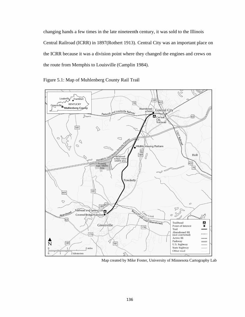
ch
C
th
th
F
hanging han
Central Railro
he ICRR bec
he route from
igure 5.1: M
nds a few tim
oad (ICRR)
cause it was
m Memphis t
Map of Muhle
mes in the lat
in 1897(Rot
a division po
to Louisville
enberg Coun
Map cre
136
te nineteenth
thert 1913).
oint where th
e (Camplin 1
nty Rail Trai
eated by Mike F
h century, it w
Central City
hey changed
1984).
il
Foster, Univers
was sold to t
y was an imp
d the engines
sity of Minnes
the Illinois
portant place
s and crews
ota Cartograph
e on
on
hy Lab

137
The line remained part of the ICRR until it was sold off in an early 1980s
restructuring process. The Paducah and Louisville Railway (PAL) was formed at that
time to take over operation of ICRR’s trackage in Kentucky and has become Kentucky’s
largest regional shortline railroad with about 265 miles of track in the state (Paducah and
Louisville Railway 2010). The arrival of the railroad in the 1870’s supported the growth
of Muhlenberg County’s coal industry. The coal industry required rail to transport the
coal from mine to tipple and from tipple to market outside the county. A Muhlenberg
County historian stated that “it was because of the railroads that the mines were opened
and the towns built” (Camplin 1984: 203).
The last train ran on the line in 1996, serving a slag facility on the Beech Creek
Lead (STB filing 1998). The PAL RR began official abandonment proceedings in 1998
and the trail effort began soon after. During the summer of 1998 the Kentucky Rails to
Trails Council filed a “trail use condition” with the Surface Transportation Board (STB)
on behalf of Muhlenberg County. This began the railbanking procedure by opening
official negotiations with the abandoning railroad. A Notice of Interim Trail Use (NITU)
decision was issued later that summer by the STB. The NITU states that the rail corridor
can be used as a trail in the “interim” period should the rail line ever be reactivated.
When the PAL RR abandoned the line, they left four original railroad bridges for
reuse by the trail. All basic steel girder bridges over small streams, they did not provide
any special scenic or historic amenities, though their presence did save the trail builders
many thousands of dollars in bridge reconstruction costs. Railroad signal lights were also
left in place along the line. Judge Kirtley expressed a desire for the trail planners to leave
a “railroad feel” to the trail. They also added a few more signal lights to encourage this.

In
m
h
P
tw
A
is
A
m
w
n 2003 the P
museum and
The tr
as a small tr
owderly it c
wo miles nor
Also found he
Trave
s what locals
Areas, includ
many bird spe
wildlife view
Paducah and
trail center a
Fi
rail is six fee
railhead park
onnects to th
rth from Gre
ere is the po
ling northea
s call it). Thi
des wetlands,
ecies, fish, b
ing platform
Louisville R
and to furthe
igure 5.2: Ca
et wide, pave
king lot at Gr
he city park.
eenville. Thi
pular covere
ast, the trail u
is area, form
, ponds, cree
beaver, and o
m and posted
138
RR donated a
er add to the
aboose at Gr
ed in asphalt
reenville and
. Most of th
s end has the
ed bridge and
user passes t
mer mine land
eks, open fie
other wildlife
bird identifi
a caboose to
“historic rai
reenville trai
t with one fo
d another tra
e traffic on t
e larger park
d train caboo
through the “
ds reclaimed
elds, and woo
fe. Local Boy
fication signs
o the trail for
ilroad feel.”
ilhead
oot wide grav
ailhead at Ce
the trail com
king area and
ose.
“nature area”
d as Wildlife
oded areas. I
y Scout troop
s.
r use as a sm
vel shoulder
entral City. I
mes in the firs
d is lit at nig
” of the trail
e Manageme
It is home to
ps built a
mall
rs. It
In
st
ght.
l (this
nt
o
139
At the Central City terminus, trail users leave the railroad right of way - the only
part of the trail that does not follow the original right of way exactly. Here users pass a
long abandoned and derelict school building (the result of school consolidation years ago)
alongside the trail head. It went unnoticed while the right of way was an active and then
abandoned railroad, but as trail users “rediscovered” it, there was a community effort to
save the building from destruction and reuse it as a community center. As of 2004, plans
were in place to restore the building as a community wellness/fitness center that would
house an indoor pool in the former gym and provide space for classes and events; I was
unable to ascertain the current status of this project. These plans mesh with the trail’s new
role in the communities’ wellness activities.
The county made several additions to the trail beside the actual railroad-related
artifacts (whether originally from this line or not). One addition is a covered bridge built
over an original railroad bridge. Even though no railroad ever constructed wooden
covered bridges like this (they were built only for roads and horse traffic), locals thought
it added “historic feel” to the place and it became very popular with community members
and especially children. Another addition is community notice boards at the trail heads.
These boards are sheltered by hip roofed structures purposely reminiscent of traditional
depot architecture. Kirtley notes that, in his opinion, these are the most popular places in
town to post notices.
Creation
In 1998 a friend of Rodney Kirtley, the Judge Executive of Muhlenberg County,
introduced him to the idea of rails to trails. The Judge’s friend saw potential in the soon-
to-be-abandoned P and L line and invited the Judge on a Saturday mountain bike ride

140
along the rough ballast surface of the abandoned line. It was Kirtley’s first ride on the
line and he noticed all of the illegal dumping and junk-filled backyards abutting the trail,
but immediately liked his friend’s idea of the rail trail. On Monday Judge Kirtley called
the Paducah and Louisville Railroad. He discovered that he’d missed out on the western
portion of the corridor because it had already been abandoned and sold off, but the parts
not yet officially abandoned were still available for railbanking (the Greenville to Central
City line and the Beech Creek Lead [see Figure 5.1]). The abandonment notice made
front page news in the Muhlenberg County Leader-News in April 1998. There was
mention of a county bicycle club that formed recently and an ad for a ride they organized.
In this it stated that “an additional goal [of the club] is to promote a coalition to develop a
safe route between Greenville and Central City for Muhlenberg County families to walk,
cycle or skate safely. This is greatly needed and will make our community a more
desirable place to live” (MLN 8/19/98, ad for Bye Bye Bicycle Club). It is not clear if
this club was involved in trails planning or shared some members with the future trails
committee, but it does indicate that there was at least some interest in safe pedestrian
facilities in the county before the trail plans were publicly announced.
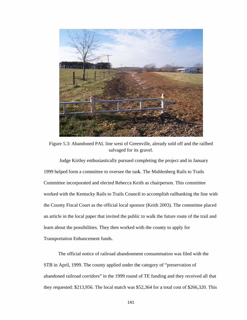
1
C
w
th
an
le
T
S
ab
th
Figure 5.3
Judge
999 helped f
Committee in
worked with t
he County Fi
n article in th
earn about th
Transportatio
The o
TB in April,
bandoned ra
hey requeste
: Abandoned
e Kirtley ent
form a comm
ncorporated a
the Kentuck
iscal Court a
he local pap
he possibiliti
on Enhancem
fficial notice
, 1999. The c
ailroad corrid
d: $213,956
d PAL line wsalv
thusiastically
mittee to ove
and elected R
ky Rails to Tr
as the officia
er that invite
ies. They the
ment funds.
e of railroad
county appli
dors” in the
. The local m
141
west of Greevaged for its
y pursued co
ersee the task
Rebecca Kei
rails Counci
al local spon
ed the public
en worked w
abandonme
ied under the
1999 round
match was $
enville, alreagravel.
ompleting th
k. The Muhl
ith as chairp
il to accomp
nsor (Keith 2
c to walk the
with the coun
ent consumm
e category o
of TE fundin
52,364 for a
ady sold off a
e project and
lenberg Rail
person. This
lish railbank
2003). The co
e future route
nty to apply f
mation was fi
of “preservat
ng and they
a total cost o
and the railb
d in January
s to Trails
committee
king the line
ommittee pla
e of the trail
for
filed with the
ion of
received all
f $266,320.
bed
y
with
aced
l and
e
that
This

142
mix of TE money and matching funds from Muhlenberg County paid for the construction
of the trail during the summer of 2000. The trail opened officially in October 2000, but
the community started using the pathway even before paving was complete (Keith 2003).
In a subsequent round of Transportation Enhancement funding (2002), the county added
lights for the first mile of the trail from this trailhead which is popular with users after
work into the evening. Officially, the trail is a linear county park six miles long by sixty-
six feet wide (Kirtley 2004a).
Judge Kirtley thought it was a great “feel good project” and that “we’re gonna be
heroes” but was surprised to find only six supporters and 144 opponents at the first public
hearing, a county magistrates meeting. In-town opponents were concerned with the
prospect of increased crime that a trail through their backyards was sure to bring.
Residents of the agricultural area through which the trail would pass wanted the
opportunity to connect their divided fields and gain a bit of acreage back from the right of
way. They were also opposed to trail users passing between and near their properties
(Kirtley 2004a).
The magistrates tabled the project, telling Judge Kirtley “I can’t believe you’ve
done this!” But Kirtley called the Rails to Trails Conservancy who told him “don’t give
up!” To compromise and at least build something, Kirtley and the trail supporters chose
to just develop the line that led from Greenville to Central City and not pursue a spur line
that ran primarily through agricultural land. The most outspoken opposition came against
the rural spur line.

143
The model of just a few supporters was not a recipe for trail success. Without the
broad support of local businesses, residents, and leaders, this trail should never have been
built. Indeed, in most places, it would have languished and stalled, but Judge Kirtley had
a large impact on its success. His leadership and support for the trail carried it through,
along with the few dedicated supporters on the Rails to Trails Committee.
The opening week of the new trail in August 2000 brought more surprises. The
trail was so busy; one could hardly get on it. The local Wal-Mart Supercenter sold out of
bicycles. Kirtley said “overnight it was the most popular thing we’d ever done.” More
than 300 people used the trail each day. Within the first month the parking areas at the
trail heads had to be doubled in size to accommodate all the users. It soon became clear
that the trail should have been built at an eight foot width instead of six. In assessing the
changes the trail brought to the county Kirtley said the “quality of life has jumped to a
different level.” (Kirtley 2004a).
The Wendell Ford Training Center (an Army National Guard training facility)
adjacent to trail provided some assistance with the trail and also use it for training. The
county also formed a unique partnership with the county jail and local state correctional
facility for inmate labor. This “jail to trail” arrangement provides ongoing assistance with
trail maintenance and construction. Inmates provided labor to construct the covered
bridge (a local lumber company donated the materials). They also help with regular trash
pickup and mowing (Kirtley 2004a). Kirtley stated that they have had no problems with
this arrangement whatsoever and it has proved a key piece of the financial puzzle of
maintaining the trail.
144
As time passed businesses that backed up to the trail reoriented from the road to
the trail. One car dealer moved his cars to face the trail – slow moving pedestrians were
more likely to stop and look at the cars than motorists speeding by. Several new
businesses opened up near the trail. Even non-adjacent businesses saw the trail’s impact.
Restaurant and motel owners noted that many of their customers drove in from an hour
away to use the longest paved rail trail in the state. Adjacent homeowners cleaned and
opened their yards to the trail. They bought bikes and former opponents became
supporters. One individual built a gazebo on his property near the trail and sold
refreshments to trail users.
Community groups use the trail for events such as a March-of-Dimes fundraiser
walk. The trailhead in Powderly is a small city park with picnic areas and a bandstand.
This spot is popular as a site for on-trail events, though initially the city of Powderly
fought the trail. The high school cross country team uses the trail for practices and
doctors in the area now prescribe trail walking to their patients to improve their health.
Historic preservation opportunities and goals emerged as the trail enjoyed more
and more use by the community. The school building in Central City is one example of
this. New attention is also being paid to the former coal mine sites adjacent to the trail.
Beginning in 1887 there were coal tipples in the Powderly area for underground mines; it
was one of the most heavily mined areas of Muhlenberg County with at least nine mines
in the vicinity (Camplin 1984). After the 1930s Peabody Coal Company bought
everything and began surface mining operations. Those mines played out and now the
land is being reclaimed as wildlife management areas adjacent to the trail on both sides.
Former haul roads that intersect with the trail are planned as mountain bike trails. There

145
was a recent effort underway to provide interpretive signs to highlight these sites and tell
the area’s history of mining.
Muhlenberg County’s trail building story is an uncommon one: it is rare for a
project championed by one or only a few people to get very far without a change in
support at either the government or community level. But Judge Kirtley was a popular,
charismatic leader in the county (and a Republican, which probably helped to sell the
idea to conservatives who are generally more reluctant to support this type of project). I
interviewed him on the trail (literally) one summer afternoon: we started out talking at
the Greenville trailhead and since we didn’t have our bikes, Judge Kirtley suggested we
simply drive the length of the trail in his car because, after all, “I’m the Judge, it’s not
like I’ll get a ticket!” So off we went driving down the trail right of way, waving at
everyone along the way – no one was particularly surprised to see him driving there. This
allowed us to see features along the way and it let him tell me the story of how each item
came about; including the signs, ATV trails and compromises with that, the Boy Scout
bird watching platforms, the other trailheads at Powderly and Central City, and
neighboring businesses and homes.
The Muhlenberg County Rail Trail is instructive as an example of a trail project
originally focused on recreational use, but is now focused on historic preservation,
interpretation, and the addition of “historic themed” features as the trail has become a
popular part of the community. Many trails around the country share a similar history in
that they were preserved and converted for recreational use and their subsequent
community support led to historic preservation and interpretation efforts.
146
Oldham County Greenway
Introduction
The Oldham County Greenway began its life as a right of way for the electric
interurban train between the years of 1907 and 1935. That line ran from Louisville to
LaGrange, a small county seat town (population about 5,700) the next county north east
of Louisville. Oldham County is a rapidly suburbanizing community in the Louisville
metropolitan area – its population has grown from 46,000 in 2000 to 58,095 in 2009;
many of these residents live in subdivisions outside of the city limits (Uhde 2007, U.S.
Census Bureau 2007). Population estimates for 2025 expect it to grow to over 86,000
people and by 2050 the Census Bureau estimates the county’s population will be
116,000. The county and the City of LaGrange are actively anticipating this growth
through planning initiatives, including designating land for parks, trails, and open space.
I chose this case study as a counterpoint to the Muhlenberg County Rail Trail.
Though also in Kentucky, the Oldham trail shares very little in common with the
Muhlenberg trail. Its setting in a suburban area is one important difference but the
environment of community support for its development is also a key difference. The
goals and function of the trail, and its future role in a planned network of trails, are also
quite different from the Muhlenberg County example. The Oldham County Greenway
helps to illustrate the range and variety of experiences relating to rail trails in Kentucky
(and around the country). I also chose this trail because it is a project in progress. At the
time I began my research they had just opened Phase One of the trail, a mere six-tenths of
a mile of walkway. This case study has allowed me to study the process in action.

147
Background
The Oldham County Greenway began as a plan to convert the former right of way
of the old electric interurban railway into a pedestrian trail. Starting in the first decade of
the twentieth century, the Louisville and Interurban Railroad (L & I RR) built lines
radiating out from Louisville to surrounding communities. In 1911 they acquired the
Louisville and Eastern Railroad (L & E RR), a company with lines to LaGrange,
Shelbyville, and other small towns east of Louisville (Kleber 2001). After enjoying a
peak of ridership during the 1910s and 1920s, the L and I RR was completely abandoned
by 1935. The interurban system was well developed in Kentucky by this time; Louisville,
Lexington, and Cincinnati had many lines radiating out to surrounding communities. It
was a network that present-day regional transportation planners pine for as metro areas
such as Louisville rebuild regional heavy and light rail systems. The interurban line to
LaGrange shared a right of way with the Louisville and Nashville Railroad which is still
active today as a CSXT freight line.

F
L
d
co
st
(o
tr
ap
p
fo
bu
ro
igure 5.4: M
Phase
LaGrange and
owntown. T
onstruction o
tretch on the
on the easter
rail furniture
pproximately
laces and ha
ollow the rig
usinesses do
oller blade o
Map of Oldha
I began in 2
d constructio
hese six tent
on the interu
e depot prope
rn end from t
e such as lim
y six feet wi
ave not been
ght-of-way o
owntown on
n this portio
am County G
Map cre
2003 and inc
on of the trai
ths of a mile
urban right o
erty) and a p
the depot tow
mestone bench
ide. The desi
recently rec
of the trail. T
Main Street
on of the trail
148
Greenways –
eated by Mike F
cluded the re
il’s first six t
e of trail are
of way (on th
portion of “tr
wards down
hes, signs, a
ignated sidew
constructed.
The “trail” rig
t and it is cle
l (see Figure
– Phase I, La
Foster, Univers
estoration of
tenths of a m
made up of
he west end o
rail” designa
ntown). The n
and bollards.
walks are on
Users must
ght of way s
ear that users
e 5.2).
aGrange
sity of Minnes
f the L&N Ra
mile, connect
a small port
of downtown
ated on to ex
new constru
The trail its
nly three fee
cross the str
shares sidew
s are not able
ota Cartograph
ailroad depo
ting the depo
tion of new
n and a shor
xisting sidew
uction includ
self is paved
et wide in som
reet twice to
alks in front
e to bicycle
hy Lab
ot in
ot to
rt
walks
des
and
me
o
t of
or

149
The depot restoration was a central focus for the project. It was not in derelict
condition, but had been vacant for some time. The interior was reconfigured to
accommodate the Chamber of Commerce offices and a small trailhead with a room for
trail user information and restrooms. This depot served the Louisville and Nashville
Railroad (now CSXT) during its passenger days. It stands adjacent to these still active
railroad tracks. The exterior features a red tile hipped roof and stucco wall finish.
Sanborn maps from 1915 seem to indicate that the depot was moved from its original
location. It is unclear when this move happened and why it would be moved only a few
hundred feet to the east and slightly south, away from the tracks. A move would also
(usually) negate eligibility to the National Register of Historic Places, though this is
probably not an issue since the structure is not individually nominated but is instead
included as a contributing structure within a historic district. This move might explain
why the depot no longer has its passenger platform and why the brick course around the
base has also been replaced at some point, in a less than authentic way, so it looks a bit
odd. The depot that served the Interurban railroad line stood at the west end of
downtown. It was constructed in 1907 and was torn down in 1992 (NRHP 1988, Oldham
Era 1994) (see picture below).

F
Figure 5.5Chamber
Figure 5.6: In
: Trackside r of Commer
nterurban sta
view of formrce and trailh
ation with info
150
mer L&N RRhead facilitie
nterurban traioreground, 1
R depot, LaGes for the Ol
in. Louisvill1908.
Grange, nowdham Count
le and Nashv
w offices of thty Greenway
ville RR trac
he y.
cks in

w
ot
F
C
tr
P
A
w
F
16
mto
Until
which only tw
ther pieces o
igure 5.3). T
Commerce Pa
ravels from F
hase II was
Allen Lane ap
which will ex
igure 5.7: M
This trail is no
may simply be ao Trails Counci
2008, the pr
wo-tenths wa
of the trail ne
The Commer
arkway), Pha
First Avenue
scheduled fo
pproximately
xtend the trai
Map of Oldha
ot even listed oan omission. Gil.
roject was la
as new, non-
etwork are n
rce Parkway
ase I, opened
e west to All
or a fall 2009
y 1.7 miles.
il all the way
am County G
Map cre
on the KYRTC
Greenways for O
151
rgely a prop
-sidewalk co
now complet
y Greenway (
d during the
len Lane, a d
9 completion
Trail easem
y west to KY
Greenways
eated by Mike F
C website detailOldham County
posal. Six-ten
onstruction)
te or in proce
(a bike/pede
summer of
distance of a
n date. This
ments have be
Y 393 (see F
Foster, Univers
ling completedty has actively
nths of a mil
is hardly not
ess in Oldha
estrian trail p
2009. This t
approximatel
s phase conti
een secured f
igure 5.3).
sity of Minnes
d rail trails in thparticipated w
le of trail (of
teworthy!16
am County (s
parallel to
trail segmen
ly 1.25 miles
inues west fr
for Phase III
ota Cartograph
he state, thoughwith Kentucky R
f
Two
see
t
s.
rom
I
hy Lab
h it Rails

152
These two pieces will add three miles of trails and there are five more phases
(plus a bridge over Interstate 71) outlined in the Master Plan. Commerce Parkway runs
south of LaGrange and eventually will connect to the downtown Interurban Greenway via
sidewalks and trails. The ten foot wide trail shares a right-of-way with the parkway, a
newer road planned as a connector to the area’s growing (and yet to be built) suburban
commercial and residential developments. Commerce Parkway is not a limited access
highway but it is an alternative to the busy old state highway that runs between LaGrange
and Buckner, parallel to Interstate 71. A new school and public library are proposed
along Commerce Parkway and the trail will also provide access to two “Park and TARC”
sites (TARC is the Transit Authority of River City, the public transit agency for the
Louisville metro area) (Murner 2007).
The second project is the Wendell Moore Park trails. These are multi use loop
trails in a park adjacent to the Commerce Parkway Greenway, eventually to be connected
with the county’s trail network. The trails in Wendell Moore Park are designed as a series
of loops that connect amenities and provide users of all abilities a place for safe
recreation. There will be a quarter mile loop, a half mile loop, and a one mile loop. The
trails overlook Reformatory Lake (lovelier than the name implies!) and connect to a
fishing dock and scenic picnic areas.
Greenway development in Oldham County began at the same time as massive
residential growth. Nine thousand new residents moved to Oldham County between 2000
and 2007 (Uhde 2007). During those years the county issued at least 500 housing permits
each year; in 2003 it issued 831 and in 2004 742 (Ellis 2005).The population of the
county has been growing rapidly since the 1970s. The completion of I-71 through

153
Oldham County in 1969 was the true gateway to this growth; since its construction the
county’s population has quadrupled (Uhde 2007). The county was already a bedroom
community to Louisville prior to the construction of the freeway, but its status as a
commuter community exploded after the freeway. In 2000 the Census reported that 67
percent of Oldham County workers commuted to another county to work (Uhde 2009b,
U.S. Census Bureau 2009). Nancy Theiss, director of Oldham County History Center,
said that the opening of the interstate “was the real mark when Oldham County shifted
from an agricultural community to an urban community” (quoted by Uhde 2009b).
Between 1970 and 1980 the population in the county grew 89 percent, the highest growth
rate of any Kentucky county in that period (Uhde 2009b, U.S. Census Bureau 2009).
During the same time land in farms decreased from 107,356 acres to 60,024 acres (U.S.
Census Bureau 2007).
But like the rest of the nation, Oldham County is suffering the effects of the
housing bust and general recession. Since a peak in 2006 in the rate of population
increase (then 3.07 percent) this rate has decreased to 0.6 percent in 2009(Oldham Ahead
2010, based on Census data and estimates). The net population increase in 2009 (at 370
people) was the lowest since 1971. The decline in population growth lagged slightly
behind the decrease in residential building permits. There, the peak occurred earlier in
2003 and has decreased steadily since then from 831to only 111 residential building
permits issued in 2009 (Census data aggregated on Oldham Ahead website). This number
is the lowest number of permits recorded in the last thirty years.

154
The population growth has meant a struggle in the county to keep up with
growing demands for schools, roads, sewer capacity, recreational amenities, and other
needs. Many subdivisions are built in rural areas and lack connection to city sewer
services. Sewer facilities in some places are overwhelmed and beyond capacity even as
new subdivisions are built (Ellis 2005). One problem Oldham County has faced is the
lack of businesses relative to housing. The county’s tax base is dependent on housing and
lacks the revenue that extensive commercial or industrial development would bring. The
county is working on developing incentives to lure high paying, low nuisance
employment, but it is difficult in the current economic realities.
It is a classic suburbanizing landscape, the type that smart growth activists rail
against as being wasteful, imprudent, and downright unfriendly to both humans and the
environment. All of the ingredients of “non-smart” growth are present in Oldham
County: a lack of population density so that it is difficult to support infrastructure,
disparate rural subdivisions not connected by anything but busy feeder roads, no
accommodations for pedestrians, an entirely car dependent streetscape that is not
accessible to the poor, the young, the old, or the carless (save for downtown LaGrange),
no mixed uses, and one that threatens historic natural and cultural landscapes with
destruction. The very rural character that draws people to the place is simultaneously
being threatened by the arrival of those same people.
Creation
Local residents began their efforts to convert this long-abandoned right of way
into a recreational trail in 1997 by forming the organization “Greenways for Oldham
County.” When completed, the greenway will connect LaGrange to Pewee Valley, a

155
suburb of Louisville 13 miles away. From there they foresee it connecting into
Louisville’s network of trails. This project’s focus is the depot whose restoration is the
centerpiece of Phase I, though most community support for the project focuses on the
potential of the trail to connect residents to community amenities and provide a site for
safe recreation.
Greenways for Oldham County describe the beginning of their effort as a
response to the need for better connectivity between communities (Greenways for
Oldham County 2010). The citizen group began to work with county planning and zoning
staff and local officials. In 1999 Greenways for Oldham County, with the sponsorship of
Oldham County Fiscal Court, applied for and received Transportation Enhancements
program funding for Phase I of their project. The project received $320,000 in TE funds
for the “construction of a .62 mile trail with landscape, signing, purchase, and
rehabilitation of a historic L&N depot as trailhead” (National Transportation
Enhancements Clearinghouse 2010). This funding was applied for under category eight:
rail corridor preservation and trail development. In 2003 the project received an
additional $60,000 towards the rehabilitation of the depot. This round of funding was
under category seven: preservation of historic transportation facilities. It is unclear why
the first project was not under this category since it appears that most of that money went
towards the purchase and rehab of the depot. In their original application document,
Greenways for Oldham County indicated that this project fit into these categories: one
(provision of facilities for pedestrians and bicycles), two (provision of safety and
educational activities for pedestrians and bicycles), three (acquisition of scenic easements
and scenic or historic sites), five (landscaping and other scenic beautification), six

156
(historic preservation), seven (rehabilitation and operation of historic transportation
facilities), and eight (preservation of abandoned railroad corridors). The group chose
category seven as the primary one for the project, but was awarded the money under
category eight. My suspicion is that this change happened at the state level, in order to
make it look like they were actually funding trails or to otherwise satisfy some
requirement of the Governor’s office, which was primarily in charge of the TE program
at that time. The two largest items in the project’s proposed budget related to the
acquisition and rehabilitation of the depot: $190,000 for land acquisition and $45,000 for
historic structure rehabilitation (these numbers are just the federal portion and do not
include required local match funds of at least 20 percent).
Greenways for Oldham County and the Oldham County Fiscal Court
cooperatively hired a private landscape architecture firm to develop an interurban
greenway master plan for the project, which was released to the public in 2003. Oldham
County Planning and Zoning and the Oldham County Fiscal Court also commissioned a
county Bike, Pedestrian, and Greenways Master Plan in 2008, completed by consultants
Brandstetter Carroll Inc. The County plan includes more than just the interurban and
added plans for a network of pedestrian and bicycle facilities (Foster 2008).The
Interurban route between LaGrange and PeWee Valley remains “the ‘backbone’ of the
Oldham County Greenway’s vision” (OCPZ 2008). This backbone essentially follows the
old interurban route, but the actual right of way was rejected for the trail after the
completion of an environmental study (Kissel 2005). This study found that steep slopes
and issues with gaining easements would make the interurban route unfeasible. The
chosen right of way includes sites already owned by the county or the City of LaGrange

157
to avoid property issues and to save a larger proportion of funds for construction. In 2008
the County Planning Commission approved the plan with a vote of 13-0.
The process of writing the 2008 master plan involved a significant amount of
citizen participation in the planning process. The consultants held review meetings,
public workshops, worked with a citizen steering committee, and completed a community
attitude and interest survey. They also co-sponsored a Greenways Summit in 2007 where
29 local and regional agencies, non-profits, and private companies presented as
stakeholders in the trails planning process.
The greenway project enjoys strong support in local and county government,
among community groups such as the Lions’ Club, and among citizens of the area.
Evidence of this widespread support is that Paul Clinton, president of Greenways for
Oldham County, was honored as the grand marshal of the county’s 2003 summer
celebration, Oldham County Day. The theme of that year’s celebration was “Green Paths
to Preservation” and it highlighted the potential of greenway projects in preserving
historic resources. Greenways for Oldham County has also been a past recipient of
money raised at fundraising events associated with Oldham County Day.
In addition, Clinton stated he never heard a word of opposition to the project (as
of 2004) – in public meetings or anywhere else. But that didn’t mean the project moved
forward quickly. The organization’s issue was not with community opposition, or even
with government opposition, but with a lack of support at the county level. The project
was not opposed; it was just “not a priority” to the Judge Executive. Clinton expressed
frustration at the frequent new Judge Executives who “fired all the old staff and
reappointed new staff.” Each time he and the Greenways for Oldham County group had

158
to re-explain the project and “re-educate” the newcomers. This slowed progress
significantly. Since 1997 Oldham County has had three judge executives: John Black
(D): elected in 1992 and served two terms; Mary Ellen Kinser (R): elected in 2002; and
the current Judge Executive Duane Murner (R): elected in 2007(but not running for re-
election in 2010). Murner appears to be a strong supporter of greenways. Greenways for
Oldham County describes him as “a longtime supporter of trails” and of their
organization (GOC 2010). The Fiscal Court’s Oldham County Vision Council
(commissioned by J. E. Murner) identified trails, greenways, and parks as amenities that
the county needs to plan for and fund (Troutman 2007).
The Oldham County Greenway is representative of other trail projects that have as
their focus a historic structure or building. The Louisville and Nashville depot (circa
1910) was listed as a contributing building in the Central LaGrange Historic District’s
nomination to the National Register of Historic Places in 1988. This structure is a rallying
point for the community and an icon for the project. This trail will eventually become a
project that focuses on recreation and transportation as well as historic preservation when
built out to its full extent.
Paul Clinton (2004) related the story of how the depot became part of the project:
“It had a for sale sign. It was fate.” It was his idea to add it to the grant and to use one
room of the building as a trail head. He couldn’t say for sure if the addition of the depot
helped them get the grant, but staff at the state transportation cabinet seemed to think it
was an important factor. Though Clinton says he was not told by anyone he needed to
include the depot to get the grant, in his opinion, up to that time, Transportation

159
Enhancement funded projects “were all buildings.” The rules, however, state the money
is primarily for non-motorized transportation, for trails.
The first phase of the Oldham County Greenway began in downtown LaGrange.
In many ways the town’s form is like many other small towns in Kentucky. Its focus is a
classic courthouse square. The historic core, including the commercial area, some
residential districts, the courthouse, and some religious and transportation landscapes, is
on the National Register of Historic Places as the Central LaGrange Historic District
(nominated in 1988). It contains many buildings dating from 1840-1938 (City of
LaGrange 2007). The city is an active participant in Kentucky’s Main Street program,
designed “to encourage downtown revitalization and economic development within the
context of historic preservation” (KY Heritage Council 2010). LaGrange is also a
“Preserve America” community – this is a federal program instituted in 2003 (or was, if
the program’s funding is cut for FY 2011 as is proposed). A Preserve America
designation is largely a ceremonial honor to recognize excellence in historic preservation,
but it also allows participant communities to apply for grant funds.
What is unusual about LaGrange is the place of the railroad both literally and
figuratively in the city. The CSXT freight line runs directly down the middle of Main
Street, through the historic downtown, and past the courthouse square. Up to thirty slow
freights rumble through every day just feet from the front doors of small shops and cafes.
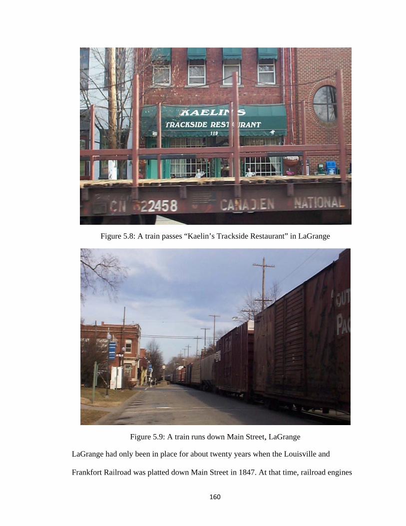
L
F
Figu
LaGrange had
rankfort Rai
ure 5.8: A tra
Figure
d only been
ilroad was pl
ain passes “K
5.9: A train
in place for
latted down
160
Kaelin’s Tra
runs down M
about twent
Main Street
ackside Resta
Main Street,
ty years whe
t in 1847. At
aurant” in La
, LaGrange
en the Louisv
t that time, ra
aGrange
ville and
ailroad engin
nes

161
and cars were at a much smaller scale; some were even still pulled by horses. This line
was an extension of the very first railroad built in Kentucky from Lexington to Frankfort
(begun in 1831). Later in the nineteenth century this line was absorbed into the Louisville
and Nashville Railroad. By 1851 the rail connection between Lexington and Louisville
(and the Ohio River) was complete (Connelly and Coulter 1922). It is almost certain that
the LaGrange’s decision makers in the 1840s could not foresee the impact of a future
busy freight line right through the center of town. The town continues to deal with the
consequences of this decision and is working with the railroad on safety improvements
and noise reduction measures.
Bruce Vento Nature Sanctuary
Introduction
The Bruce Vento Nature Sanctuary is located along the Mississippi River,
adjacent to downtown St. Paul, Minnesota. It is separated from surrounding
neighborhoods by freeways, active railroad corridors, bluffs, and a vast area of
abandoned industrial land. The Bruce Vento Nature Sanctuary creates a new point of
connection for pedestrians through trail segments. Downtown St. Paul, local
neighborhoods, and the extensive local and regional trail systems in the Northeast metro
(including a trail that travels 174 miles to Duluth) connect through the Vento hub (see
Figure 5.4). The trail was named for the late congressman who served the interests of
Minnesotans on a variety of environmental and outdoors issues.
This trail project is unique in that it incorporates a rails to trails development,
attends to historic preservation of remnants of the industrial landscape, attempts to re-
establish the natural, native ecosystem of the site, and focuses on the sacred significance
162
of various sites to local Native American groups. The impetus for the project began at the
citizen level with Friends of Swede Hollow (a volunteer community organization) and
grew to include support from local, state, and federal government and non-profit sources.
The public was involved in the planning and development process and continues to be
involved in steering committees and volunteering at the site.
I chose the Bruce Vento trail as a case study because it focuses on both historic-
features and recreation/transportation and includes aspects of environmental education
and remediation. I also chose it as a counterpoint to the Kentucky case studies. The
Minnesota story is quite different in terms of public opinion of trails, state and local
support and funding for trails, its history of trail development, and in the current number
of rail trail miles on the ground. I think the Vento Sanctuary is representative of a project
that really works because of the way it developed through community support and there
are many lessons that can be applied to other projects in the future.

F
m
an
pr
ca
m
as
th
fa
to
igure 5.10: M
But th
my other case
nd funded at
roject receiv
ategory. I fo
members I int
s a rail trail,
his may be b
acilities” and
o think of the
Map of Bruc
he Bruce Ven
e studies: it w
t least partia
ved $1.1 mill
ound it odd th
terviewed (S
even though
because they
d not “preser
e place as m
ce Vento Nat
Map cre
nto trail also
was an aband
lly through T
lion in TE fu
hat despite th
Sarah Clark,
h they are ea
applied for
rvation of an
more of a natu
163
ture Sanctua
eated by Mike F
o fits into the
doned rail co
Transportati
unds under th
his fact, thre
Carol Carey
ach intimatel
the TE fund
n abandoned
ure area than
ary area
Foster, Univers
e general sel
orridor that w
on Enhancem
the pedestria
ee of the key
y, and Anne
ly aware of i
ding category
d railroad cor
n a trail in an
sity of Minnes
ection criter
was redevelo
ment funds.
an and bicycl
y steering com
Ketz) did no
its railroad p
y of “pedestr
rridor.” The
nd of itself.
ota Cartograph
ria that I used
oped as a tra
In 2006 this
le facilities
mmittee
ot view the p
past. I suppo
rian/bicycle
ey each seem
hy Lab
d for
ail
s trail
place
se
med

164
Background
The site, most of which was owned by Burlington Northern Santa Fe Railroad,
included twenty-seven acres of abandoned rail yards. One of the largest rail road
maintenance yards in the Midwest, much of this yard had been used for rail car
maintenance and cleaning in addition to fuel and other storage (Metropolitan Council
2008, Terrell and Vermeer 2004). Originally, the site was where Phalen Creek and Trout
Brook came together and flowed into the Mississippi River; a large wetland area fed by
creeks and natural springs. But by the 1970s, when the railroad pulled out, the site was a
brownfield suffering from contaminated and compacted soils and an abundance of
invasive species (Karlson 2004, Clark and Middleton 2008).
The area around the Vento Sanctuary was significant to the Hopewell people, a
Native American culture who called the region home thousands of years ago. Burial
mounds, a few of which remain preserved in Mounds Park at the top of Dayton’s Bluff,
are one of the only remnants of their presence there. Dakota groups still present in
Minnesota trace their ancestry to the Hopewell peoples and also hold the area of the
Vento Sanctuary in high significance spiritually and culturally (Monks 2006). Wakan
Tipi, a natural cave central to Dakota creation mythology and used ceremonially for
generations, is found on the eastern edge of the Vento Sanctuary. This cave contained
many carvings of symbolic figures (Terrell and Vermeer 2004). In 1680, Father Louis
Hennepin, a French priest and explorer, landed at the site with Dakota representatives
(Anfinson 2003). After Jonathan Carver, a British explorer, “discovered” Wakan Tipi in
1767, it was renamed Carver’s Cave and remained an important landmark for early
European explorers and settlers.

al
ar
st
fe
m
th
th
Early
lso sawmills
rcheological
torage facilit
ew homes an
made use of t
hese opening
he brewery in
C
settlers of S
s) and reside
l research on
ties existed t
nd boarding
the natural sa
gs for beer st
n 1884. Afte
Figure 5.1Courtesy of M
St. Paul bega
nces in the 1
n the site rev
there in the s
houses servi
andstone cav
torage (Mon
er a fire in 19
165
1: Carver’s Minnesota H
n to use the
1850s (Terre
vealed that a
second half o
ing the brew
ves in the blu
nks 2006). G
900, he reloc
Cave ca. 187Historical So
area for indu
ell and Verm
complex of
of the ninete
wery employe
uffs and carv
German immi
cated to the
75 ciety
ustry (mainl
meer 2004). H
beer brewin
eenth century
ees. The Nor
ved out large
igrant Jacob
West Seven
ly breweries
Historical an
ng, aging, an
y in addition
rth Star Brew
er caverns fr
Schmidt bo
nth neighborh
but
nd
d
n to a
wery
rom
ught
hood

166
(Historic St. Paul no date and Milburn 2006). Schmidt’s Brewing Company grew to
become one of the state’s venerable brewers and was a fixture in the neighborhood for
over 100 years.
Starting in 1862, this site has been shaped by railroads. In 1857 the Minnesota &
Pacific Railroad Company was chartered to lay tracks from Stillwater on the St. Croix
River (Minnesota’s eastern boundary), through St. Paul, St. Anthony (which later became
Minneapolis), and west to Breckinridge (located on the Red River) (Veenendaal 1999).
After much difficulty, the M&PRR never got past grading the line and laying some ties.
The railroad was reorganized and refinanced as the St. Paul and Pacific Railroad (SP&P
RR). In 1862 this company completed the first ten miles of track from St. Paul to St.
Anthony. This line began in downtown St. Paul, along the river levee, traveled east
towards what was to become the Bruce Vento Nature Sanctuary and traveled northwest
up the Trout Brook stream valley towards St. Anthony (Milburn 2006, Veenendaal 1999).
This was the first railroad in St. Paul and the first railroad in Minnesota. The SP&P RR
went on to become part of the Great Northern Railroad empire (of James J. Hill fame).
In 187217 the Chicago and St. Paul Railroad became the first rail line built on
what is now the sanctuary (Chicago, Milwaukee, St. Paul and Pacific RR 1968,
Woolworth and Woolworth 1980). While it was ten years after Minnesota’s first rail line,
it was significant because it was only Minnesota’s second rail link to the national network
(Veenendaal 1999). Just a few years prior to these connections (the first came in 1867),
goods and passengers made the trip to St. Paul via river boats on the Mississippi (or,
17 Construction ranged from 1869-1872 – Veenendaal (1999) said it was finished in 1870; the railroad said 1872; Woolworth (1980) said construction was going on in 1869.

167
more rarely, overland) and then were transferred to the rail network (Veenendaal 1999).
This line went on to become the Chicago, Milwaukee and St. Paul Railroad, then the
Chicago, Milwaukee, St. Paul and Pacific Railroad (CMSt.P and P RR), known as the
“Milwaukee Road”. In the 1970s this line became part of the Soo Line family as that
company absorbed the struggling Milwaukee Road. Branching north up the Phalen Creek
corridor was the St. Paul and Duluth Railroad. By the early years of the twentieth century
the Chicago, Burlington and Quincy Railway (CB & Q RY) ran east along the river
parallel to the CMSt.P and P RR (Veenendaal 1999).
In 1970 the Northern Pacific Railway, the Great Northern Railway, the Spokane,
Portland and Seattle Railway Co. (SP&S), and the Chicago, Burlington and Quincy
Railway consolidated to become what is now known as the Burlington Northern (BN)
(Veenendaal 1999, BNSF 2010). In 1995 BN merged with the Atchison, Topeka, and
Santa Fe Railway (AT & SF) to become the Burlington Northern Santa Fe Railway
Company (BNSF) (BNSF 2010). It was from the BNSF that the city of St. Paul
purchased the abandoned rail yard that became the sanctuary.
During its time as an active railroad yard, the Vento site was anything but a
peaceful sanctuary. At its peak dozens of parallel tracks ran here (Curtice and Annan
1908, Hopkins 1916). Railroad employees cleaned and serviced train cars at the yard. At
the unwheeling shop they removed, rebuilt and reinstalled wheels. It was a noisy,
dangerous place in constant motion. There was a Northern Pacific Railway “coach
unwheeling shop” and two long rows of buildings called “coach yard buildings” and
“commissary” buildings (Sanborn Map Company 1926, MN Transfer Railway 1930).
These buildings, one belonging to the Northern Pacific Railway, the other to the

168
Minneapolis, St. Paul, and Sault Ste. Marie Railway (Soo Line) included a carpentry and
paint shop, electricians’ shop, carpet cleaning areas, storehouses, an ice house, a
lunchroom for workers, and coal and oil storage (Sanborn Map Company 1926). This rail
yard was just one piece of a much larger area of rail yards serving the passenger depot in
downtown St. Paul and freight operations from the region. A larger yard still operates just
down river, and several other yards were developed up Trout Brook and along the
important rail corridor between St. Paul and Minneapolis. These rail yards speak to the
centrality of the Twin Cities as a regional railroad hub for both freight and passengers.
Much of the original floodplain was altered by extensive filling, leveling, raising,
and cutting back of the bluffs in order to expand the rail yard. During this time, much of
Wakan Tipi (Carver’s Cave) was lost by the destruction of the bluffs (Anfinson 2003).
The first railroad on the site, the Chicago and St. Paul Railroad removed the face of the
bluff around Wakan Tipi’s entrance around 1869 during construction of their line
(Woolworth and Woolworth 1980, citing 8/24/1869 article in St. Paul Dispatch). The
entrance was obscured by rock falls and it was briefly re-opened in 1913 for tourism
purposes, but these enterprises never prospered. In the 1970s the cave was studied again
and steel doors were placed on the opening to protect the cave from vandals and
“explorers” (Woolworth and Woolworth 1980). Archeological studies in 2003-2004
estimate approximately twenty feet of fill at the site – deeper near the river and shallower
near the bluffs (Terrell and Vermeer 2004: 9). The river’s edge had been pushed back
more than five hundred feet by 1940 through fill projects to expand the rail yard (Pitz
2001). In addition, the creeks that flowed to the river were confined to sewer tunnels.

A
or
After adjacen
riginal topog
Figure 5.12
nt freeway co
graphy.
2: Map show
onstruction i
wing Phalen
169
in the 1950s
Creek’s wet1885).
the area was
tlands in the
s further alte
river flood p
ered from its
plain (Hopki
s
ins

FraE
igure 5.13: Bail yard wheEverything s
the Mississthis
Bruce Ventore it says “Bouth of the dippi River. Cs time the Br
o Sanctuary aBurlington Fidotted line isCarver’s Cavrewery was s
170
area, ca. 189ill” (referrings fill; the dotve is also denstill operatin
92. Here youg to Chicagotted line dennoted here in
ng on the site
u can see theo, Burlington
notes the orign the lower re (Donnelley
e expansion on & Quincy ginal shorelinright corner.y1892).
of the RY). ne of . At

FigPh
FigPh
gure 5.14: Rahoto courtesy
gure 5.15: Rahoto courtesy
171
ail yard on Vy Minnesota
ail yard on Vy Minnesota
Vento Site, caHistorical S
Vento Site, caHistorical S
a. 1925 Society
a. 1940 Society

im
1
S
o
v
en
on
ex
ra
Figure 5.16:
Follow
mportance an
980s most o
oil and Wate
f the site, bu
ictim to van
ncampments
nly things th
xtensive pol
ailroad clean
: Car cleanerPh
wing the fort
nd necessity
f the tracks a
er Conservat
ut did little to
dals, illegal
s, and it beca
hat could sur
lution of the
ning, fueling
rs at site (Stahoto courtesy
tunes of railr
y by the 1970
and structure
tion District
o maintain it
dumping of
ame overgro
rvive on such
e soil from y
, and repair
172
andard Oil Cy Minnesota
roads around
0s. The rail
es had been
). Burlingto
t. As a result
f garbage and
own with ten
h degraded a
ears of heav
operations (
Co. building Historical S
d the nation,
yard was ab
removed (P
on Northern
t, for more th
d other waste
nacious invas
and compact
vy petrochem
(Clark 2009,
still stands aSociety
, this rail yar
bandoned the
itz 2001, Ra
Santa Fe ret
han twenty y
es, a site of h
sive species
ted soil). The
mical use rela
Monks 200
at site), ca. 1
rd declined i
en and by the
amsey Count
tained owner
years it was
homeless
and weeds (
ere was
ating to the
6).
1930
in its
e
ty
rship
(the

173
The City of St. Paul acquired the property in 2002 at a cost of $2.17 million
(Metropolitan Council 2008). Opened to public use in 2005, today the site contains a loop
trail that links the parking area to the different areas of the nature sanctuary. This 1.5-
mile new trail now connects eighty-five miles of regional trails (Pitz 2001). The Bruce
Vento Regional Trail, to which the Vento Sanctuary connects, sees nearly 120,000 users
annually. The Sam Morgan Trail (along the river, on the other side of the active BNSF
tracks from the sanctuary) sees approximately 189,000 users annually. A pedestrian
bridge over the railroad tracks will eventually connect these two regional trails through
the Vento Sanctuary. The Metropolitan Council estimates that trail use could rise by 25
percent when the connection is completed (2006 data, Metropolitan Council 2008).

F
en
tr
th
in
n
fo
w
igure 5.17: B
At the
ncircled by i
rail past sma
he three cave
ndustries. Hu
ative plantin
orest, dry pra
wetlands (Low
Bruce Vento
e west end of
interpretive
all ponds, up
e openings, a
undreds of n
ngs (Clark 20
airie, oak sav
wer Phalen C
o Nature San
Map cre
f the sanctua
signs telling
the hillside
and to exami
new trees hav
008). There
vanna, oak w
Creek Projec
174
nctuary site m
eated by Mike F
ary are a park
g the story of
through the
ine the remn
ve been plan
are six distin
woodland, bl
ct 2008) (see
map
Foster, Univers
rking area an
f the place. V
oak savanna
nants of the r
nted and the l
nct biomes r
luff prairie,
e Figure 5.5)
sity of Minnes
nd the entran
Visitors can
ah, along the
railroad and
land has bee
represented t
and spring-f
). The caves
ota Cartograph
nce which is
follow the g
e bluff to exp
brewery
en reseeded i
there: floodp
fed stream an
that were
hy Lab
gravel
plore
in
plain
nd

175
associated with the brewery are viewable through iron grates. Wakan Tipi is set back
quite a distance behind a pond and its opening is secured with a heavy steel door. The
drainage in the sanctuary is designed, in part, to serve as rain gardens that filter water
back to the river. It also serves to protect the caves from unauthorized entry as they each
have a pool at their entrance.
Several parallel active rail lines continued to operate on the river side of the site.
Between these tracks and the river, Warner Road was constructed, making use of the vast
expanse of fill here. A chain link fence separates the area from the active rail corridor.
Between the active tracks and the concrete slabs that remain from rail car maintenance
days, the visitor can imagine what it was like to stand in the middle of an active rail yard.
Indeed, the site is very popular with railfans (railroad and train enthusiasts) for watching
and photographing trains (it was rated the number one spot in the Twin Cities for train
watching by Trains magazine in 2006). The active tracks still belong to BNSF, but many
other regional and national carriers use the tracks including Amtrak. It is a truly multi-
modal site: railroad tracks, surface roads, interstate highways, barge traffic on the river,
and pedestrian/bicycle trails all converge here.
From the photo below, one can get a sense of the scale of the former operations
on the site. The thin parallel white lines in the middle of the sanctuary are long concrete
runways that ran between railroad tracks and were part of the rail car maintenance and
repair facilities. One runway was left intact at its full length. Parts of some of the others
were left to give visitors a sense of their extant, but many were removed as part of the
ecological remediation effort. The second picture (1985) shows the full extent of the

co
b
Ft
oncrete slabs
efore it beca
Figure 5.19: Vtrain servicin
s. That photo
ame extensiv
F
Vento Site ang slabs. Co
o was taken
vely overgrow
Figure 5.18:
aerial view, 1urtesy of Ra
176
after the trac
wn.
Vento Site a
1985. Here yamsey Count
cks were rem
aerial view, 2
you can see tty Soil and W
moved from
2006
the full extenWater Conse
the rail yard
nt of the conervation Dist
d but
ncrete trict.

ac
(w
in
fr
ow
co
pr
P
co
F
A larg
cquired by th
who bought
nterpretive c
rom the US E
wned by the
onvert this b
roposal was
lanning for t
ommittee an
Figure 5.20:
ge abandone
he St. Paul P
it from a pri
enter for the
Environmen
e Standard O
building into
not approve
the proposed
nd communit
Former Stanin
d industrial b
Park and Rec
ivate develop
e trails and sa
ntal Protectio
Oil Company
housing as p
ed because it
d interpretive
ty stakeholde
ndard Oil bunterpretive c
177
building dom
creation Dep
per). They h
anctuary thro
on Agency. I
y and used fo
part of a larg
t was ruled i
e center is on
ers.
uilding at Vecenter and co
minates the v
partment from
hope to reuse
rough a brow
In the railroa
or fuel storag
ger developm
incompatible
ngoing in co
ento site; proommercial sp
vista. This b
m the Trust
e the structur
wnfield redev
ad days, the b
ge. Develope
ment, but ult
e with the Na
ooperation w
oposed for repace.
building was
for Public L
re as an
velopment g
building wa
ers proposed
timately this
ature Sanctu
with the steer
edevelopmen
Land
rant
s
d to
s
uary.
ring
nt as

178
Creation
The core group of citizen-advocates for the Vento site that eventually formed the
steering committee came from the Friends of Swede Hollow, a local neighborhood group.
Swede Hollow is just upstream along the old Phalen Creek (now buried in storm drains)
and railroad route (now abandoned). This valley was home to succeeding generations of
immigrants to St. Paul: first Scandinavian, but later from elsewhere in Europe and finally
from Mexico. In the 1950s the hollow was cleared of its substandard houses (there was
no sewer service to the area). By the 1980s the valley was threatened by a road project.
Neighbors formed the Friends of Swede Hollow group to resist this threat. The group
worked with the St. Paul Garden Club and preserved the hollow as a park. Over the years
the group was active in cleaning up the site, interpreting its history, planting native
plants, leading tours, creating guidebooks, and advocating. The Friends group was
affiliated with (and indeed shared many members with) the Upper Swede Hollow
Neighborhood Association, the official neighborhood group.
By the early 2000s the Upper Swede Hollow Neighborhood Association was
working on various efforts to address greenspace and planning issues. One idea was to
someday daylight (remove it from its sewer tunnel confinement back to an above-ground
path) Phalen Creek and reconnect the neighborhood to the river. Part of the creek’s
original route went through the site that was to become the Vento Sanctuary. At the same
time, the then mayor of St. Paul, Norm Coleman, began initiatives to reconnect the city to
the Mississippi riverfront through new development, restoration, parks, etc. (Saint Paul
on the Mississippi Development Framework, 1997). The convergence of these two ideas
allowed the group to pursue the project; without this timing Carol Carey, a neighborhood

179
resident and chair of the Vento project’s Steering Committee, said it would have just
“looked like a kooky idea” (2009).
Another development enterprise underway on the Eastside of St. Paul at the same
time as the Vento Sanctuary was the Phalen Corridor redevelopment project. This project
began as a way to address the industrial blight, lack of jobs, abandoned industrial
facilities, poverty, and need for housing and commercial development in the area. A
formerly central but now much diminished railroad corridor was converted into a
parkway and adjacent brownfield sites were redeveloped. Now the corridor is home to the
road, a pedestrian and bicycle trail, and the railroad (in some sections). It connects
neighborhoods previously isolated by the rail corridor and contributes to the economic
development and quality of life of the Eastside. Bruce Vento was also instrumental in
securing funding and support for the Phalen Corridor (Milburn 2006).
Early in the planning for the Phalen Corridor, leaders were looking for a way to
get the project started, to make the public aware of it, and encourage groups, individuals
and businesses to be involved in it. They were surprised that the new bike trail on the
abandoned rail corridor that ran through Swede Hollow Park became so important to the
Phalen Corridor project. Allen Lovejoy, a planner with the city of St. Paul remarked “I
never dreamed a bike trail would be a catalyst to start a redevelopment project. I mean
really, a bike trail?” (Milburn 2006). The stakeholder committee for the rail trail became
the starting point for the larger redevelopment project. Craig Johnson, an Eastside banker
involved in this initial committee remembered thinking,
When you looked at all the jobs that had been down in that corridor, all the lives that had been supported by those businesses, I’m sorry, but a bike trail didn’t seem to be enough! Those of us in the business community began to talk. We wanted more from that corridor – a lot more” (Milburn 2006: 55).
180
This is the framework in which the Vento project grew. The Eastside was a neighborhood
that supported trails and parks, but expected them to be part of a larger enterprise to
support development and an increased quality of life.
A key step to the success of the Vento project was the early interest of Dan Reyes,
a project manager at the McKnight Foundation, a local philanthropic organization that
funds the arts, family and children’s programs, environmental initiatives, and numerous
other local and international programs. Reyes took a sabbatical from his job to work on
the first action plan for the project. He also secured funding for Citizens for a Better
Environment, a group that provided early support and the first dedicated staff members to
work on the Vento site. During this process Reyes also did some of the initial
“matchmaking” between interested stakeholders and funders (Clark 2009, Carey 2009).
Reyes connected the staff working on the project with Weiming Lu, the president
of the Lowertown Redevelopment Corporation (now retired). This organization works in
the Lowertown neighborhood of downtown St. Paul – the quadrant of downtown that
contains many of the old warehouse buildings and the mostly vacant Union Depot train
station. Weiming Lu spent years in urban planning in Texas, California, and Minnesota
and brought both planning expertise and political savvy to the Vento project (Lee 2008).
He became an instrumental member of the project’s steering committee and started them
on the road to a professionally packaged vision that was then marketable to the
community, local, state, and national officials, and funding sources. Sarah Clark, current
staffer with the Bruce Vento Nature Sanctuary, saw the involvement of Mr. Lu and the
Lowertown Redevelopment Corporation as the “real birth” of the project.
181
At this time two part time staff people were brought on to manage the project.
Sarah Clark oversees fundraising, outreach, planning, and grant writing and Amy
Middleton is in charge of the on-the-ground ecological restoration aspects of the site.
Sarah Clark related that it was “the continuity of permanent staff that really made a big
difference in the success and progress of the project.” They wanted to be an asset to the
city and help make things happen because “The community is really just nagging if they
aren’t bringing resources to the table.” The resources the Vento staff brought included
help in grant writing for various funding sources (Clark 2009).
The two staffers worked with two committees to keep the project on track: a
technical advisory committee and a community advisory committee. Later, many of the
participants on these committees became members of the project steering committee of
the Lower Phalen Creek Project. Carol Carey stressed the importance of the involvement
of these committee members because they became not just “involved” in the process but
“invested” in the project. Some of these same groups became key implementation
partners later on – including the Trust for Public Land, the Minnesota Department of
Natural Resources, the Minnesota Pollution Control Agency, and St. Paul Parks and
Recreation Department. The “community involvement dovetailed to the agency piece”
(the participation of government agencies and regional/national organizations); it was a
“great marriage of a wild idea and a process that represented real grassroots community
vision” (Carey 2009).
Groups from all adjacent neighborhoods participated in the process – they were
asked to appoint representatives to join the technical and community advisory
committees. These included Swede Hollow, Railroad Island, Lowertown, Dayton’s Bluff,

182
and Payne-Phalen (see Figure 5.4). The public was also invited to open houses and
meetings along the way to participate in the process. During the planning for soil
remediation there were a few federally mandated public meetings. The federal agency
folks were surprised that people actually attended! Meetings are advertised through
flyers, local email lists, and in the neighborhood newspapers. While public participation
at regular steering committee meetings is welcomed, they save the big advertising for
when they are at important decision points. Public clean-up days and Eco-Steward
volunteer events at the site also have big turnouts from the public.
In 2001 consultants worked with the staff and committees to produce a vision
document titled “A Community Vision for Lower Phalen Creek: Improving our
Watershed, Revitalizing our Communities.” Through giving the project a title and an
“official document” it made it more real for the community; it “ignited the idea that
Wow! This could happen!” (Carey 2009).
After the project was well on its way to realization the steering committee formed.
This committee includes members from the original technical and community advisory
committees and represents the full spectrum of involvement in the process. And now,
even though the site is nearly completed, already open to the public, and owned by the
City of St. Paul, the committee is still active in “steering” the project. Carey relates
several reasons for this involvement: to continue to push the agenda since, if it was only
under city management, would be relegated to a list of many sites and projects; to
maintain community control and ownership of the process; and because there is some
mistrust of the public agencies that could take over management.

183
The four key foci of this committee are water quality, greenspace, trails, and
community connections (both literally and figuratively). Trails were part of the plan not
just for recreation’s sake but for their community connections aspects. The missing trail
connections – between the site and downtown, the river, and the adjacent neighborhoods
–rallied people to interest and involvement. The need for connections resonated with
local residents and the focus on connections and the nature sanctuary also was vital for
obtaining funding for the project.

184
The way the early years of the project played out proved to be very important to
later success. By engaging so many people and agencies early on it created a truly strong
Box 5.1: The members of the Lower Phalen Creek Project Steering Committee include (as of 2009)
Carol Carey, Chair, Executive Director, Historic St. Paul. Former Executive Director, Upper Swede Hollow Neighborhood Association. Weiming Lu, President, Lowertown Redevelopment Corporation (retired). Karin DuPaul, Community Organizer, Dayton’s Bluff Community Council, Upper Swede Hollow Neighborhood Association Board Member, Friends of Swede Hollow Board President, Dayton’s Bluff District Four Board member. Chip Lindeke, Partner, Rafferty Rafferty Tollefson Lindeke Architects, Inc. Paul Mohrbacher, Community Relations Manager, Science Museum of Minnesota. Sarah Clark, Lower Phalen Creek Project Staff, Project Manager Amy Middleton, Lower Phalen Creek Project Staff , Project Manager Kristin Murph Dawkins, East Side Neighborhood Development Company Board member, Friends of Swede Hollow Board member, Payne Avenue Business Association member. Christine Baeumler, Assistant Art Professor, University of Minnesota, Vice President, Friends of Swede Hollow Board. Denny Thompson, Planner, Minnesota Department of Natural Resources, Saint Paul Bicycle Advisory Board member, Friends of Swede Hollow member. Dan McGuiness, Mississippi River Program Director, Audubon Society. Colleen Ashton, Friends of Swede Hollow Board member, Mounds Park Association member. Lower Phalen Creek Project Partners Audubon Society Capitol Region Watershed District CapitolRiver Council City of Saint Paul City Council City of Saint Paul Division of Parks and Recreation City of Saint Paul Office of the Mayor City of Saint Paul Department of Public Works City of Saint Paul Department of Planning and Economic Development Community Design Center of Minnesota District 4 Dayton’s Bluff Community Council District 5 Payne-Phalen Planning Council East Side Neighborhood Development Company Friends of the Mississippi River Friends of Swede Hollow Great River Greening Historic Saint Paul Lowertown Redevelopment Corporation Metropolitan State University Minnesota Department of Natural Resources Minnesota Department of Transportation Minnesota Environmental Initiative Minnesota Pollution Control Agency National Park Service Mississippi National River and Recreation Area Phalen Corridor Initiative Railroad Island Implementation Task Force Ramsey County Board of Commissioners Saint Paul Garden Club Saint Paul Riverfront Corporation
185
foundation and a good organizing principle. This foundation was put to the test when
news of the project reached the community at large. A group looking for soccer field land
heard of the site’s parkland proposal and thought the site would also be good site for their
needs. The steering committee did not see this as a compatible use for the site because it
did not accomplish the ecological restoration goal. They used the connections they had in
place and began lobbying any city, county, regional, state, and federal officials and
agencies who had any interest or influence.
The soccer field proposal was defeated and the challenge served to energize the
participants, focus the efforts, and spread the word and build support for the project at all
levels of government. During the fight the Vento site supporters faced accusations of
being “tree huggers” who thought “birds are better than people” for advocating protected
habitat over soccer fields for kids. But in the end these accusations served to galvanize
and focus the supporters’ beliefs in the goals of the project. Carey, chair of the steering
committee, pointed out that it was so important to have the coalition in place, full of
talented experts and passionate locals, already working together so that when the
challenge came, they were ready to work together and tackle the problem.
All of this happened before the property had been secured! It was still in private
hands (Burlington Northern Santa Fe Railway) and nothing was guaranteed. Before
purchase was negotiated, the community steering committee had to complete plans for
environmental remediation, ecological restoration, and Section 106 historical
documentation (Clark and Middleton 2008). They also contracted with a consultant to
work on the community vision plan for the site (completed the year before purchase).

186
Here again it was the staff’s role that made the difference in providing the continuity
necessary to keep the project going.
One of the project partners, The Trust for Public Land, assigned a development
expert to work with Sarah Clark and an attorney to negotiate with the railroad. TPL
worked for more than three years to negotiate the purchase. Much of the difficulty
stemmed from the pollution on the site. The railroad was enthusiastic about having a
polluted and almost certainly very expensive to remediate site off its hands, but they
envisioned selling it to an industrial user who would not worry about the soil safety. The
site was zoned for industrial use and two proposed uses were for a concrete truck transfer
station and an asphalt recycling plant (Monks 2006). The city was also reluctant to
become the new owner of such a polluted site, as much as they wanted it for a park. The
Trust for Public Land was able to create a cleanup plan that utilized a combination of
private and public funding and insulated both BNSF and the City of St. Paul from great
expense. TPL also bought insurance against “unforeseen environmental problems” to
further protect the interested parties (Monks 2006).
More than $7 million in funds from federal, state, local, private, and non-profit
group sources have made the Vento Sanctuary’s development possible (Helms, 2007).
Much of its development is because of not only broad governmental or financial support
but also dedicated local stakeholders. Funding sources included money from the
Metropolitan Council, Transportation Enhancements, the National Park Service, the US
Environmental Protection Agency, Minnesota Department of Natural Resources Metro
Greenways Program, an earmark in the federal transportation bill in 2005, a variety of
private foundations, nonprofits, and individual supporters.

m
d
co
le
N
la
w
ab
tr
w
One o
moving from
ocument into
onservation
egitimized th
National Park
and acquisiti
Figu
After
where over 10
bandoned fo
rash, applian
which involve
of the key ste
community
o the officia
agreement w
he project an
k Service’s M
ion in 2002.
ure 5.21: A y
the City of S
00 volunteer
or decades it
nces, and all
ed removing
eps in the suc
support to a
al City of St.
with the Min
nd led to its e
Mississippi N
young hiker e
St. Paul purc
rs removed o
had become
manner of o
g the top laye
187
ccess of the
a community
Paul Compr
nnesota Depa
eventual suc
National Riv
enjoys the tr
chased the si
over 50 tons
e a major dum
other waste. A
er of pollute
Bruce Vento
y vision docu
rehensive Pl
artment of N
cess. Coope
ver and Recre
rail through V
ite they hoste
of debris. B
mping groun
After cleanu
ed soil and tr
o Nature San
ument to the
lan. In additi
Natural Resou
eration came
eation Area
Vento’s prai
ed a trash cl
Because the s
nd for constr
up, soil reme
rucking in se
nctuary was
e adoption of
ion, the
urces further
from the
to accompli
irie area.
lean up even
site had been
ruction debr
ediation bega
everal inches
f this
r
ish
nt
n
is,
an
s of

188
clean topsoil (Clark and Middleton 2008, Clark 2009). By spring of 2005 the soil
remediation and site reconstruction was largely completed and the sanctuary opened to
the public in May 2005.
The nature sanctuary is named after Minnesota Congressman Bruce Vento. He
served twelve terms and was a faithful supporter of parks, trails, and environmental
causes. After Bruce Vento’s death in 2000 another member of congress, Martin Sabo,
was able to secure the final funding in Vento’s honor through the National Park Service
to purchase the property (Monks 2006). The park became part of the Mississippi National
River and Recreation Area.
Because of this federal funding the Section 106 process was initiated. Section 106
of the National Historic Preservation Act, required for all federally funded projects,
examines potential impacts on historic resources and addresses plans to either avoid or
mitigate those potential impacts. The Vento project team contracted the services of local
historic resources consultant Anne Ketz and her company, The 106 Group. It was through
this process that the committee and the community began learning about the history of
the site.
The next steps for the Bruce Vento Nature Sanctuary include determining how to
connect the site to the river, currently separated by a fence, an active rail line, and a road,
and how to continue to connect the site to downtown and capitalize on development that
may occur there as light rail comes to St. Paul. The city is moving forward to buy missing
pieces, the “next big frontier” for the site (Clark 2009). Some of these missing pieces lie
between the site and Lowertown and are adjacent to the new light rail maintenance
facility (as yet undeveloped) (see Figure 5.8).

F
si
“e
pr
ed
D
fo
igure 5.22: M
Anoth
ite, much lik
environment
rogram, sum
ducational p
Dodge by foc
This c
or examining
what rthey hto askat part
Map of Bruc
her frontier b
ke the Dodge
tal education
mmer camps
programs for
cusing more
chapter fulfil
g cultural lan
really matterhave come tok how and whticular lands
ce Vento San
Map cre
being explor
e Nature Cen
n and habitat
for children
school grou
on the histor
lled the first
ndscapes: a d
rs is investigo be, to wondhy they mattscapes, detai
189
nctuary and D
eated by Mike F
ed is develop
nter, another
t restoration
n, facility ren
ups. One idea
ric aspects o
step in Sche
detailed hist
gating particuder how theyter, and to fils are impor
Downtown S
Foster, Univers
ping revenu
r local natura
organization
ntals, birthda
a was to diff
of the site ins
ein’s (2009)
tory of the pl
ular landscapy are receiveigure out howrtant…(2009
St. Paul
sity of Minnes
ue-generating
al area. Dodg
n” that hosts
ay parties, fa
ferentiate the
stead of just
methodolog
lace. He wri
apes – to unded and lived w they work9: 380).
ota Cartograph
g potential fo
ge is an
s a preschoo
arm tours, an
e site from
the ecologic
gical framew
tes,
derstand howin and throu
k. When look
hy Lab
or the
l
nd
cal.
work
w ugh, king

190
Here we learned of how each of the three case study trail landscapes came to be, how
they are used, what features they have, and what some of the obstacles and successes they
had along the way to completion. We all understand the need to move beyond
description to interpretation and analysis, but without description one cannot interpret or
analyze. In the next chapter we move on to ask how and why each of these places matters
in the lives of individuals and their communities and why that is important.
Copyright © Lisa Rainey Brownell 2011

191
Chapter 6 : Values matter in landscapes
In this chapter I will continue to work within the Schein’s framework for
examining landscapes by exploring the meanings that individuals and groups associate
with places (2009). Schein suggests we ask “what the landscape means to the individual
and collective identities of people who live in and through the landscape; interpreting
cultural landscapes as unwitting autobiographies” (referring to Lewis 197918). By
unwitting autobiographies Lewis (and Schein) are referring to the way that landscapes tell
the stories people tell about themselves, when they don’t realize they are telling those
stories.
It is important to remember why one would study cultural landscapes in the first
place. One aspect of the answer to this question is that it is at the core of humanistic
geographical tradition: the endeavor to discover the compelling stories of human
connections to places and meanings built there that are at the center of human experience.
But beyond just wanting to know these stories (a joy, in themselves) we seek to
understand them in order to better understand the people who create and use the places
that anchor the stories because maybe if we understand more, we can make places that
are more useful or meaningful or likely for people to build connections to, in short, better
places. Yi-Fu Tuan wrote that the humanistic geographer “will show how place is a
shared feeling and a concept as much as a location and a physical environment. He [sic]
can suggest means by which a sense of place may be enhanced” (1976: 275). This is
especially true in planning contexts, whether for trails or historic preservation. Places
matter because people matter.
18 Peirce Lewis wrote that “human landscape is our unwitting autobiography, reflecting our tastes, our values, our aspirations, and even our fears, in tangible, visible form” (1979: 12).
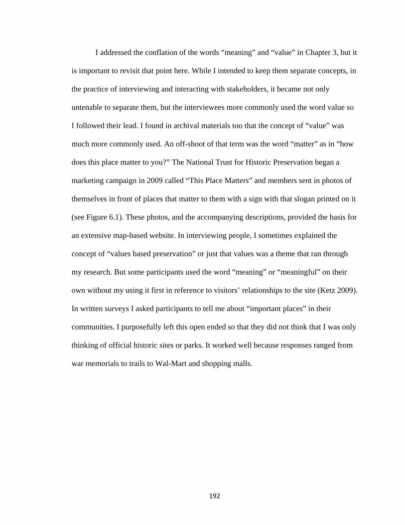
192
I addressed the conflation of the words “meaning” and “value” in Chapter 3, but it
is important to revisit that point here. While I intended to keep them separate concepts, in
the practice of interviewing and interacting with stakeholders, it became not only
untenable to separate them, but the interviewees more commonly used the word value so
I followed their lead. I found in archival materials too that the concept of “value” was
much more commonly used. An off-shoot of that term was the word “matter” as in “how
does this place matter to you?” The National Trust for Historic Preservation began a
marketing campaign in 2009 called “This Place Matters” and members sent in photos of
themselves in front of places that matter to them with a sign with that slogan printed on it
(see Figure 6.1). These photos, and the accompanying descriptions, provided the basis for
an extensive map-based website. In interviewing people, I sometimes explained the
concept of “values based preservation” or just that values was a theme that ran through
my research. But some participants used the word “meaning” or “meaningful” on their
own without my using it first in reference to visitors’ relationships to the site (Ketz 2009).
In written surveys I asked participants to tell me about “important places” in their
communities. I purposefully left this open ended so that they did not think that I was only
thinking of official historic sites or parks. It worked well because responses ranged from
war memorials to trails to Wal-Mart and shopping malls.
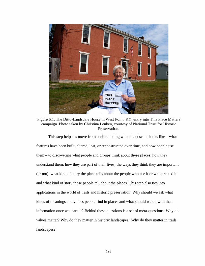
F
fe
th
un
(o
an
ap
k
in
v
la
Figure 6.1: Tcampaign.
This s
eatures have
hem – to disc
nderstand th
or not); what
nd what kind
pplications i
inds of mean
nformation o
alues matter
andscapes?
The Ditto-La. Photo taken
step helps us
been built, a
covering wh
hem; how the
t kind of stor
d of story tho
in the world
nings and va
once we learn
r? Why do th
andsdale Houn by Christin
s move from
altered, lost,
hat people an
ey are part o
ry the place
ose people t
of trails and
alues people
n it? Behind
hey matter in
193
use in West Pna Leuken, c
Preservatio
understandi
, or reconstru
nd groups thi
of their lives;
tells about t
ell about the
d historic pre
find in place
d these questi
n historic lan
Point, KY, ecourtesy of Non.
ing what a la
ucted over ti
ink about the
; the ways th
the people w
e places. Thi
eservation. W
es and what
ions is a set
ndscapes? W
entry into ThNational Tru
andscape loo
ime, and how
ese places; h
hey think the
who use it or
is step also ti
Why should w
should we d
of meta-que
Why do they m
his Place Maust for Histor
oks like – wh
w people use
how they
ey are impor
who created
ies into
we ask what
do with that
estions: Why
matter in tra
atters ric
hat
e
rtant
d it;
t
y do
ails

194
Railroad corridors are places that play important roles in the lives of communities
economically, spatially, and historically. They contain a wealth of historic fabric, as they
usually pass through the core of towns, with key industries and businesses adjacent. They
tell an important story about American landscapes, about transportation, settlement,
urban morphology, business and industry. Railroads traditionally hold a lot of value,
nostalgia, and lore, especially in places where trains no longer run, where the passing of
the railroad was seen as a passing of the good old days. Active railroads are sources of
annoyance and even danger (for noise, crossings, accidents with humans and animals),
necessary for commerce (sought after by town boosters), or just hardly-thought-about
parts of the landscape. After abandonment, the place of railroad corridors in communities
often changed greatly. Residents over time came to ignore the corridors, fear them as
places of crime, or complain about them as eyesores. Railroads converted into trails have
been revalued through a new use as a site of community recreation and enjoyment of
nature, but derive a good measure of value from their association with the railroad
history, now translated through nostalgia to be defined in the quaint depots and
picturesque bridges and tunnels.
These ideas assume that there is a way that landscapes and places can come to be
valued by people and that the history of a place contributes to this value. (Glassberg
2001, Hayden 1995) Historic value of a place is one of a set of many values that intersect
and overlap, increase and diminish. Some of these other values can include economic,
social, personal, or political. (de la Torre 2002, Listokin et al 1998, Mason 2008) All of
these values can be a factor in a preservation project such as a rails-to-trails conversion.
There are many ways that a sense of the past is translated into values, and many ways that

195
those values can be deployed toward an end. These values, as they relate to a sense of the
past or to an historic place, are played out on the landscape in different ways in different
places by the numerous stakeholders who are part of a preservation or trail project.
Muhlenberg County
The Muhlenberg County Rail Trail experience tells a story about how values
attached to an historic landscape change over time and as its use is transformed. In this
case study we see an example of how a change to a historic landscape – from dereliction
to trail – changed the community and what they valued about the place. It shows how
values for recreation and community connections, for economic growth and nature, and
for health and wellness were not completely new to Greenville and Central City, but
focused and intensified around the new trail. Especially in the case of recreation and
health, new community values developed as a direct result of the development of the rail
trail. Muhlenberg County is also an example of why values matter in trail planning. Their
uphill public opinion battle could perhaps have been mitigated by working more closely
with the public all along the planning process.
The abandonment of the former Illinois Central RR (then Paducah and Louisville
RR) line between Central City and Greenville was tied to the decline of surface mining in
the county. Muhlenberg County led the nation in coal production in 1964, 1969, and
1970, but after a peak in 1972, production has since been outstripped by Appalachian
counties and especially the Powder River Basin of Wyoming (Camplin 1984, U.S.
Energy Information Administration 2009).The primary customers along the line stopped
production at their mines and railroads without customers are quickly abandoned! Central
City is still served by a CSXT railroad line whose customers include local businesses and

th
in
ad
ra
su
fi
he coal indus
n the Greenv
The ra
ddition to its
ailroad to mo
uch as Louis
iguratively, a
P
stry; the aban
ville/Beech C
ailroad was e
s value on th
ove things in
sville or Padu
and the railro
FiguPhoto courte
ndoned line
Creek and Po
essential for
he coal indus
n and out and
ucah. The ra
oads were la
ure 6.2: Railesy of Dunca
196
was redund
owderly area
transporting
stry. Other co
d it was the c
ailroad was t
arge employe
lroad depot ian Center Mu
dant in light o
as.
g goods, peo
ommercial e
connection t
the center of
ers themselv
in Central Cuseum, Gree
of new minin
ople, and info
enterprises re
to larger reg
f town literal
ves.
ity, KY enville, KY (
ng circumsta
formation in
elied on the
ional centers
lly and
(n.d)
ances
s

Phot
Figure 6.4: Paducah fo
Figuto courtesy o
“Mountain tfor further di
ure 6.3: Passof Duncan C
type Locomostribution ci
197
senger depotCenter Museu
otive would rca 1955” (f
t in Greenvium, Greenvi
haul 100 cofrom www.m
lle, KY ille, KY (circ
al cars frommuhlenbergc
ca 1938)
m Central Citycountyky.com
y to m)

Figure 6.5: c
Figure 6 (I have no
c. 1964 Peab
Machinery
.6: Abandono photos of M
body Coal Calso at D
y used to ext
ned railroad cMuhlenberg
198
ompany (froDuncan Cultutract overbur
corridor stre’s corridor psimilar scen
om www.muural Center)rden in surfa
ewn with trasprior to trail ne)
uhlenbergcou
ace mining o
sh in Carter developmen
untyky.com,
operations
County, KYnt, but this is
, but
Y s a

ra
st
ov
w
co
o
qu
b
ex
The co
ailroad aband
tone ballast (
vergrown ey
way and allow
orridor as a p
f rails to trai
uickly move
ecame one o
xercise, mee
ommunity g
doned the lin
(the county e
yesore. Neig
wed the back
potential ass
ils and move
ed from deva
of the most h
eting with oth
Figu
gave little val
ne, except in
earned $70,0
hbors to the
ks of their pr
set to the com
ed the idea fo
alued to valu
highly valued
hers, enjoyin
ure 6.7: PAL
199
lue to the co
n its value as
000 from the
line dumped
roperties to b
mmunity unt
orward. Onc
ued. Within a
d places in th
ng nature, an
caboose at G
orridor after t
s property an
e sale of the
d their garba
become tang
til the Count
ce the trail w
a very short
he communi
nd visiting h
Greenville tr
the Paducah
nd the salvag
ballast). It b
age and junk
gled in weed
ty Judge Exe
was develope
period of tim
ity as a site f
historic railro
railhead.
h and Louisv
ge value of th
became an
k in the right
ds. Few saw t
ecutive learn
ed, the landsc
me the trail
for recreatio
oad artifacts.
ville
he
t of
the
ned
cape
n,
.

200
The community’s values: on its own terms
The Muhlenberg County rail trail addresses the values of the community on its
own terms – values of recreation and health and community connections. Kirtley says
that through this project they are “meeting the needs of our community” and it’s the
“nicest, feel good, quality of life project we’ve done.” The “on its own terms” perspective
is important here. It’s not enforcing an outside idea of what recreation has to be (Kirtley
calls this the “spandex super-fit crowd”) but it is whatever the community has wanted it
to be (work boots, coveralls, overweight people, and Wal-Mart bicycles).
This principle of doing things “on their own terms,” without outside influence and
interference, appears to be a common perspective in the county. A chapter on recent coal
history (as of 1984) in a Muhlenberg County history book concluded “It would seem that
after 162 years of operations and 610,000,000 tons produced, Muhlenberg Countians
would not have to stand by idly while some far off misguided persons attempt to
eliminate our major industry by closing the mines.” This chapter began with the heading
“Environmentalists crippling coal industry” (Camplin 1984: 221). We can infer the
influence of this perception on an idea such as rails to trails.
During the trail planning process strong opposition coalesced around ideas about
private property rights, privacy, increased crime, and rural land use (agricultural interests
wanted to convert the corridor to farm use to reconnect their properties). After the
corridor was converted to a trail, the place became valued as an important location for the
community. Kirtley traveled the state telling the story of how the community came
around to support the trail – some people overnight, others over time. One regular trail
w
sh
th
tr
nu
bu
w
te
lo
4/
walker told h
he loves it no
Figure 6.8:
Ads in
he trail. One
rails walkwa
umerous lav
ut these plac
way that a gra
erms.” Anoth
ocated: “Nex
/18/01). Thi
im that her h
ow.
From elsewa
n the local n
ad advertise
ay in Powder
vish subdivis
ces enjoy a b
ander home
her ad uses t
xt to Clark's
s is an imme
husband was
where in centabout private
ewspaper, th
es a mobile h
rly” (MLN 1
sions. Here y
boost in prop
would, anot
the trail as a
Appliance A
ense shift in
201
s one of the s
tral Kentucke property ri
he Muhlenbe
home for ren
1/24/01). Mu
you find a m
perty value fr
ther example
landmark in
Across from
value in just
strongest op
ky, but indicaights in the s
erg Leader-N
nt, highlighti
uhlenberg Co
mix of modest
from proxim
e of the comm
n explaining
the Walking
t a few short
ponents duri
ative of the gstate.
News, testify
ing it is “adj
ounty is not
t houses and
mity to the tra
munity’s val
where its bu
g Trail in Gr
t years.
ing planning
general attitu
y to the value
acent to rail
home to
d mobile hom
ail in the sam
lues “on its o
usiness is
reenville” (M
g, but
ude
e of
s to
mes,
me
own
MLN

F
Figure 6.9: CCommunity’’s views of w
202
what’s imporat the trailhe
rtant along theads
he trail: a mmap that is po
osted

203
Recreation and wellness value
Many local residents had no other safe place to ride their bikes or walk prior to
the construction of the trail; rural roads in the area are narrow with no shoulder or
sidewalks and are unsafe even for adults, much less children, to be pedestrians. One
resident stated simply “I didn’t walk before the trail was built” (Carver 2004c). An
elderly couple I interviewed at the trailhead said that they use the trail almost daily in the
cooler months (even in the winter) but not as much when it’s hot. Over 90 percent of the
trail users I interviewed listed “health” as their top reason for using the trail. The next
most common responses were “fun” and “recreation” at 35 percent (combined). Some
comments from the users surveyed show how much the trail is valued as a safe place to
exercise. In response to the question “what is your or your family’s favorite part of the
trail?” a user replied “you can walk without worry or cars!” Another responded “you can
actually walk or bike and not worry about the traffic.” Ironically, several trail users
complained about the speed and density of bicycle traffic on the trail as a hindrance to
safe walking – another consequence of building out the trail at six feet wide instead of
ten. An article in the local paper outlined how to begin an exercise regimen and
concluded “Try rails to trails” (Muhlenberg Leader-News 2001c).
The recreation value of the trail is evident by the number of scheduled events.
These include the March of Dimes fundraising walks, cross country team practices, a
runners’ clinic sponsored by the local hospital in honor of National Physical Therapy
month, and a community “Valentine’s Day Trail Walk” that involved walkers starting
from both ends and meeting in the middle for hot chocolate and fellowship, to name a
few. Kirtley often mentioned that doctors in the area prescribe trail walking to their
204
patients. A KET (Kentucky Educational Television) program called CommonHealth
Kentucky featured the trail in an episode titled “Reducing obesity through activity.”
Becky Keith, chairperson of the Muhlenberg County Rail Trail advocacy group and a
nurse practitioner with the local public health department, spoke in this program of the
value of exercise as the “fountain of youth” and the important role the trail plays in
providing a safe place for local residents to exercise. In 2005, more than 400 people
signed up in teams of four in a county campaign to “Get Moving, Start Losing.” This was
a campaign to lose a collective 1000 pounds in the county and centered on trail walking.
Community connection value
The rail trail serves as both a physical connection between Greenville and Central
City, and as a way to connect people within the community to each other. Daily use of
the trail is common in the community; many people have an evening or after-work
routine that involves walking the trail and meeting with friends and family. On-trail
interviews in 2004 found that 78 percent of respondents used the trail at least once per
week; 28 percent stated that they used the trail at least once per day. Judge Kirtley related
in a talk at the KY Trails and Greenways Conference (2004) that there are groups of
moms who meet to walk the trail with their babies in strollers. There are seniors groups
who meet for coffee and trail walking. The trail is valued not only as a place of recreation
but as a place of connecting with people – it’s the small town café in motion. Keith
Laughlin, president of the Rails to Trails Conservancy, called rail trails “a new kind of
front porch” (2004). A group of eight women, interviewed in the local newspaper,
explain how they meet to walk at the trail “at least five days a week” and cite the trail’s

205
safety, easy access, and no-cost exercise as primary benefits in addition to being able to
“catch up with what’s going on with everyone” (Carver 2004).
The trail serves the full range of ages in the community from babies to the elderly
because of its accessibility. One trail user surveyed on site in 2004 remarked that his
family liked using the trail because it was “something you can all do together.” The
Muhlenberg County Public Library sponsored a summer reading program series of local
scavenger hunts for children that included a hunt along the rail trail (Muhlenberg Leader-
News 2003c). There is also an annual family bicycling event held at the trail.
Nature value
The Muhlenberg County Rail Trail passes from a more “urban” end in Greenville
and Powderly through a rural section on its way to Central City. This rural section is
primarily reclaimed surface mining lands that are now part of the Peabody Wildlife
Management Area with forests, marshes, ponds, and open fields. The mine lands have
been abandoned since the early 1980s so the area is an established habitat for birds, fish,
beaver, and other animals. A local Boy Scout troop constructed a bird watching platform
roughly halfway between Greenville and Central City. The troop also posted a sign that
reads “Rails to Trails – Common Birds” and shows pictures to help watchers identify
fifty species of birds. Both nature watching and fishing attract users to this portion of the
trail. A brochure produced by the local chambers of commerce touts “numerous sightings
of rare birds and animals in their natural habitats” as a reason to come use the trail. The
pictures in this brochure all are of natural features along the trail (except for one of the
caboose): the rail corridor through scenic rock cuts, fall leaves, summer foliage, and
ponds along the trail. The initial Transportation Enhancement funding application (1999)
206
from the county stated the intent that this trail would provide “a natural habitat and
hopefully nurture wildlife and plants.”
Economic values
Kirtley relates in a Kentucky Educational Television (KET) video that before
construction, adjacent businesses felt that the trail would not have a positive impact and
some even feared a negative impact. But the reality turned out to be quite the opposite.
Businesses lining the trail learned that slow moving walkers are more likely to stop and
look at things than people speeding past in cars. The car dealership directly on the trail
aligns its cars for maximum exposure to trail users. Of the dealer, Kirtley said “He sells
more cars to walkers than he does to drive-bys” (Kirtley in KET 2004). Other businesses
reported an uptick in business from trail users who drive in from around the region to use
the trail. The Greenville end of the trail is across the road from a typical highway strip of
stores and restaurants. As a visitor to the trail it was very convenient to have a meal
across the road and then walk or ride the trail, though it felt a bit contradictory to be
eating at DQ or McDonald’s and then exercising on the trail! A few small enterprises
have opened to serve trail traffic including the seasonal “Trailside Icee” located directly
on the right of way.
Businesses routinely advertise their proximity to the trail – both as a landmark
and as a selling point. One hotel in Central City advertises its proximity to the trail on its
website (Best Western: http://www.bestwesternkentucky.com/central-city-hotels/). In the
section that highlights area activities of interest to tourists the trail is the only item. This
is a bit misleading though because the county does in fact have many other historic

at
co
p
fo
sh
ab
19
TrsomisThtocore
ttractions.19
ommercial b
ark and rails
Figure 6.10
Kirtle
olks aren’t w
hould be at l
bandoned ra
The most welravis. Communons: John Prine
musicians. Ther home to the This park is part
o several historottage, the homeconstructed 19
Ads in the lo
buildings for
s to trails.”
: Trailside Ic
y would like
willing to driv
least twelve
ail corridor w
l known is the nity pride in itse Avenue, Everre is a monumeThumb Pickers t performance ric buildings thme of Merle Tra920’s coal min
ocal newspa
r sale. One re
cee, a busine
e to see the t
ve too far to
miles in leng
was not railba
association wi
s musical historly Brothers Boent on the lawnHall of Fame. space (it has a
hat have been mavis, and a c. 1ing town.
207
aper also high
eads “plenty
ess that open
trail grow as
o come for a
gth to draw o
anked, so th
ith music legenory is evident inoulevard, and a
n of City Hall inAdjacent to thstage for outdo
moved to the sit935 two-room
hlight the pr
y of parking,
ned up along
more of a re
six mile trai
overnight vi
he likelihood
nds such as then the many strealso by the pron Central City
he Hall of Famoor music evente. These inclu
m school buildin
roximity of t
direct acces
g the Muhlen
egional tour
il. His opinio
isitors. The r
d of extendin
e Everly Brotheeets renamed f
ominent monumto the Everly Be in Powderly nts) and part mude a typical shng. The park al
the trail to
ss to industri
nberg Rail Tr
ism amenity
on is that a tr
remainder of
ng it is quite
ers and Merle for famous musments to these Brothers. Powdis Paradise Par
museum; it is hohotgun style milso features a
ial
rail.
y, but
rail
f the
sical
derly rk. ome iner’s

208
small. A trail like the proposed 36 mile Dawkins Line trail in Magoffin, Breathitt, and
Johnson counties (in Eastern Kentucky) is more likely to draw people from hours (and
even states) away because it is a weekend excursion instead of a one or two hour
excursion.
Historic value
The trail’s historic value was acknowledged through recognition of past coal
mining activity and its history as a railroad. The county promoted this new, collectively
recognized historic value by building “historic railroad themed” additions to the trail,
through historic railroad artifacts, and by giving historic preservation attention to adjacent
historic buildings. Old railroad employees/enthusiasts spearheaded bringing in a former
Paducah and Louisville RY caboose and filling it with railroad memorabilia for a small
museum. They also built the platform around the caboose out of old railroad ties and
installed other railroad artifacts here including a baggage cart and signal lights. This
platform is meant to evoke the feeling of a railroad station platform.
One former railroad employee spoke of the importance of the railroad to the
community, “the railroad meant a lot to the county…It employed a lot of people…There
were three shifts working around the clock here” (Greenwood, quoted in Carver 2004b).
He goes on to say he hopes the caboose placed at the trail will help remind people how
important the railroad was to the community while it was active and how important it still
is “in the memories of many people there” (Carver 2004b). The peak years of mining
were also the peak years of the railroad and after mining the railroads employed the next
largest number of people in the county (Camplin 1984).

209
Trail users surveyed on site gave varying opinions on the value of historic
features in relation to the trail. People liked the covered bridge and caboose, but fewer
than half of respondents said that railroad or mining history associated with the corridor
factored into their valuation of it. One user remarked that he remembered the mines and
the coal hauling trains and another said that it was important to her to keep history in
mind, but several others said it made no difference to them.
The covered bridge on the Greenville trailhead is a good illustration of the way
historic values are played out in the community, on their own terms. Covered bridges are
not an authentic piece of railroad history (indeed, they were built for roads during horse
and carriage days), but it has a “historic feel” that resonates with the public. Many trail
users I spoke to mentioned it as one of their favorite spots on the trail. While interviewing
staff from the Kentucky Heritage Council I brought up this bridge. Surprisingly, they
defended the bridge. They didn’t disparage it as an inauthentic, out of context,
reconstruction. One of them even tried to justify it as authentic with reference to the snow
sheds built over mountain railroads out west, an argument not any more related than
covered highway bridges! I expected them to take a more purist historic preservationist
attitude, wanting both historic and historic-themed reconstructions to maintain a sense of
authenticity. I am not even certain that they saw the irony or why I even brought it up as
an odd feature.
How do local residents think about history? What connections do they make to
history? The Muhlenberg County Public Library’s Genealogy and Local History Annex
provides resources and expertise for people to research their ancestry, especially in
relation to county sites and events. The Annex acts like a typical county history museum

210
or historical society in that it provides information to visitors and puts on a few programs
on history topics, but the focus is on genealogical research, offering classes to the public.
In the county newspaper, the weekly library news column publishes a lot of information
on doing genealogical research. This impression that history means genealogy was
illustrated in another newspaper story that began “History is more than just genealogy,
dates, and events” (Muhlenberg Leader News 2003d). The existence and format of the
Annex gives insight into the ways that local residents value and find meaning in the past.
Here the entry point to history is through family connections and stories. This seems to be
true for a lot of Kentucky. History means genealogy, family cemeteries, living in places
that still have the family name, and a strong feeling of connection to places through these
family ties. The past is never very distant; it is part of everyday life, but through the lens
of family and not through academic or official historic offerings (Rosenzweig 1998). This
desire for connection to place through family ties is an important thread in both people’s
senses of history and place (Glassberg 2001).
A (fairly) recent history of Muhlenberg County illustrates the pull of family
histories (Camplin 1984). Chapters are centered on each town and settlement (extant and
lost) in the county; text within these chapters pays attention primarily to who settled these
places and who the key characters were through the years. Subsequent chapters focus
specifically on individuals then move on to the important companies, schools, and
cemeteries in the county, with extended sections on the coal and oil industries. As of
1998 this book was still advertised for sale in the Muhlenberg County newspaper.
Indicating the way that local residents engage with history, a newspaper ad touted the
“hundreds of family names mentioned” in the book and that it was the only “useful and

211
comprehensive” book on Muhlenberg County history since 1913 (Rothert 1913). Another
county history book entitled Muhlenberg County, Kentucky: History and Families, 1799-
1996 (Turner Publishing Co. 1996) also shows the way that genealogy is a primary
connection county residents make to history. Of 304 pages, only the first sixty-five could
be called the “history” section of the book; the remainder is entirely genealogies of
individual families, in alphabetical order. Even those sixty five pages are not all history;
some of them are advertisement “histories” of local businesses and churches. The
publisher’s (and authors’) value for genealogy as a path to the past is evident in the front
matter of the book. The publisher wrote, “The history of various churches, schools,
organizations, businesses and most importantly, the histories of hundreds of families, are
also now documented in this historic volume” (emphasis added)(Turner Publishing Co.
1996: 3). This value was further reinforced through Judge Executive Rodney Kirtley’s
proclamation of October 22-27, 1995, as “Family History Week” in Muhlenberg County.
His proclamation reads, in part, “Whereas, Muhlenberg County has long been rich in the
values and traditions of family heritage; and whereas, the Muhlenberg County
Genealogical Society has been a blessed leader and an integral part in obtaining an
account of the families that have made Muhlenberg County the rich and proud county
that it has become…”(Turner Publishing Co. 1996:3). We have to be mindful though that
people do not approach history only at the town museum or the locally published history
book. There are many inputs and influences to an individual’s or a community’s sense of
history such as personal memories, schooling, family, popular culture, past residences
and travels, political and economic situations, and so on (Glassberg 2001).

212
Somewhat rare for the state of Kentucky, Muhlenberg County has relatively few
sites listed on the National Register of Historic Places. There are only eleven sites, nine
of which are in Greenville (National Park Service 2010). When doing a keyword search
of Muhlenberg County’s newspaper archives (2001-2007), a search for the phrase
“historic preservation” yielded no results. This lack of National Register sites might mean
that there has been little local leadership on nominations, though the state preservation
office (Kentucky Heritage Council) is quite active state-wide in assisting with
nominations. It may have something to do with a local sense of history or of what is
“historic” but I can only speculate. It is yet to be seen what larger effects (if any) the trail
may have on historic preservation or local history pursuits in the county; perhaps there
will be a greater focus on historic buildings and artifacts (as in the vacant high school
adjacent to the trailhead). My sense is that there are many more influencing factors in this
process than any trail (even a very popular and important one) could provide. An
exploration of the local community’s sense of history supports our understanding of how
the historic values of the railroad landscape are expressed and understood among the
people of Muhlenberg County. While some other trail projects focus more on buildings
(authentically historic or reconstructed replicas), the Muhlenberg trail connects people to
history through remembering the stories of people involved in railroading and mining and
through a loosely historic looking, but much loved covered bridge and the old caboose.
The value is placed not so much on official and authentic historic artifacts as connections
to the past.
In sum, values matter in Muhlenberg County’s rail trail landscape because they
influenced not only the way the trail was developed but how it came to be used and loved

213
as an important place in the community. To view this landscape through the “values in
place” lens gives us a fuller picture of what the trail landscape means to the community.
The rail trail has become a central node in the network of social interactions in the
community and a significant “memory place” (Glassberg 2001). This is because of the
value the place has as a site for connecting with family and friends, and as a place where
community events happen. We see the way the railroad corridor moved from being an
economically and socially central landscape to being devalued after abandonment. After
redevelopment as a trail we see the valued as a community gathering place and a catalyst
for progress in the realms of recreation and health and wellness. The Muhlenberg County
rail trail is hardly a good example of values based preservation in action, but as a case
study it speaks to the power of a method for practice that incorporates community values
and input from early on in the planning process. It is difficult to speculate what might
have happened there had the county worked to accomplish extensive community buy in.
They may not have ever gotten it and the project may never have been completed. This
may be a case where “top down” planning was the most effective strategy; in the end the
community ended up with something that became valuable to them, but perhaps there
were few who envisioned its potential value. The Muhlenberg County example is a
telling one for the case of shifting values over time; this site moved from valued, to
devalued, to revalued in a totally new way.
Oldham County
The endeavor to examine the intersecting values in the Oldham County Greenway
example is a much different one than that of Muhlenberg County, not just because of the
trails’ settings, but also because the stage of development. The three mile trail section of

214
Oldham County Greenways just opened in 2009 and there is not a significant period of
years to examine how the community has come to value these places. More of the
examination here focuses on the process of determining the need for trails, advocating for
their construction, and their role in larger community values. In this case, trails play a key
role in the vision that residents have for the future of their communities in the face of
rapid population change and development.
Unlike Muhlenberg County and Vento Sanctuary, it is difficult to assess and
describe the shifting values for the Oldham County greenway site. The downtown
LaGrange portion is only 0.6 mile long, of which only 0.2 mile was new construction (the
rest was extant sidewalks), though the non- trail development of the depot is significant
too. Only the western-most one tenth of a mile of right of way was former interurban
railway corridor. That area was a small grassy boulevard prior to conversion to trail, not a
trashy, weedy abandoned railroad corridor. The new three mile segment was not a
railroad corridor conversion, it is a new pathway constructed by a new roadway through
what was once agricultural land. We can speak in general of how the community values
its greenways, the way values shifted for land uses, and how preservation of agricultural
uses and vistas is important, but the actual sites of the trails are not like the trail sites in
the other two case studies in the sense of the valued/devalued/revalued life cycle. The
situation in Oldham County with respect to support for the trail project was also very
different from that of Muhlenberg County. Paul Clinton, past president of Greenways for
Oldham County, stated that he never heard a word of opposition to the trail project. It
wasn’t a process of defeating the opposition; it was a process of building support in all of

215
the appropriate places and working out logistics and funding to get the trail on the
ground.
In a rapidly suburbanizing place such as Oldham County, threats to agricultural
land don’t come in the form of trails. The threats are subdivisions, big box retail, strip
malls, and expanded road capacity. The value set associated with the Oldham County
Greenways is tied to both the county’s history and to its future. Planners envision the
trails network as both an amenity to attract residents and serve their needs but also as a
device to preserve a landscape and a way of life that made the county attractive in the
first place. Much of the language around trails development in the county focuses on
“quality of life” elements: transportation options, recreation, natural resources, and
historic resources. Brandstetter-Carroll hosted a summit for trail stakeholders to
contribute ideas and express their opinions. Part of the firm’s job was to incorporate
extensive public involvement in the planning process. This included public surveys and
this hearing (they called it a summit). Twenty-nine different groups made brief
presentations at the meeting including many expected ones like Greenways for Oldham
County and Metro Louisville Parks, but many others came as well such as a group
representing developers and realtors20. The Oldham County Bike, Pedestrian, and
Greenway Master Plan, released in 2008 by consulting firm Brandstetter Carroll on
behalf of the Oldham County Fiscal Court and Planning and Zoning department,
20 Attendees at the stakeholder summit included: Judge-Executive Duane Murner, Oldham County Planning and Zoning, Greenways for Oldham County, Oldham County Vision Council, Kentuckiana Regional Planning and Development Agency (who paid for the master plan), Brandstetter Carroll Inc., URS (a planning, design, and construction management firm who advocated for water quality planning), Metro Louisville Parks, Louisville Bicycle Club, two developers, a realtor, Oldham County Economic Development Authority, Oldham Ahead, Friends of Westport, Brownsboro Conservation Council, Harrods Creek Trail Association, Oldham County History Center, Oldham County Equine Council, Kentucky Trail Riders Association, North Oldham Lions Club, Oldham County YMCA, Yew Dell Gardens, and an engineer from Fuller, Mossbarger, Scott, and May.

216
identified five primary ways that greenways and trails are valuable to the public: they
improve communities (through appearance and access), they encourage healthy lifestyles,
they increase property values, they allow alternative transportation, and they improve the
environment. I found that stakeholders mention all of these values with the addition of
one more: preservation values (both landscape preservation and historic preservation
related to structures). These values form a framework for the discussion that follows.
Quality of life value
Stakeholders in Oldham County envision trails and greenways contributing to
quality of life through “appearance and access.” By these, they are referring to both the
aesthetic qualities a greenway brings but also as a practical transportation option. A
quality of life opinion survey performed by Oldham Ahead in 2001 found that 97 percent
of those surveyed had either a good, very good, or excellent perception of quality of life
in Oldham County (Oldham Ahead 2001, sample size = 400). The top two issues of
importance to those surveyed was maintaining the high quality of Oldham County public
schools and protecting individual property rights. Number five on the list was “managing
growth to ensure a higher quality of life” for county residents. About 70 percent of
respondents thought that residential growth was occurring too rapidly and 61 percent
perceived that “natural, scenic, cultural and/or historic resources” were “threatened by
growth” (Oldham Ahead 2001: 21). Seventy-five percent of respondents favored the use
of county tax dollars to buy land for more parks and open space. In the area there seems
to be a general acceptance of land use planning as a tool to mitigate the negative effects
of urban growth (such as traffic, pollution, or school crowding) but there is also an
overarching belief that the rights of property owners must be protected at all costs.

217
Residents are generally not in favor of restricting property uses even for the common
good.
In 1999 county residents invited a team of international planning experts to
conduct a cooperative study of Oldham County’s issues relating to growth. That study,
called the Countryside Exchange, became the organization now called Oldham Ahead,
which was formed to implement many of the ideas that came out of the exchange study.
The Countryside Exchange planners identified five key issues through public meetings:
1) Managing growth through efficient land use, 2) Sustaining and diversifying the
economy, 3) Involving the community, 4) Preserving and enhancing natural and cultural
resources, and 5) Expanding recreational opportunities (Oldham County Countryside
Exchange 2000). The overarching theme was how to promote growth while still
protecting what was most valued in the community. This report is probably the first, and
still one of the only, that refers to the growth in the county as not good or bad in and of
itself, but “rather, the problem is sprawling development in the form of spreading, low
density, totally automobile dependent housing, shopping, and industrial parks” (Oldham
County Countryside Exchange 2000, no page numbers). The nature of growth must be
addressed in order to maintain the quality of life that residents enjoy.
In 2007, Duane Murner, the county Judge Executive, appointed a task force called
the Oldham County Vision Council and directed them to lay out the vision for the county
in four years. One point of their vision was “by 2011 Oldham County has a ‘managed
growth’ philosophy that provides adequate and efficient infrastructure and utilities; great
schools; open spaces, greenways, trails and parks, and the continued high quality of life
we enjoy as residents of the county” (Oldham County Vision Council 2007: 3). Here
218
they are approaching the findings of the Countryside Exchange report that sprawl and the
status quo are not working and that a new approach through “smart growth” will be
better, but they don’t go as far as to say that they support “smart growth.”
The TEA-21 grant application in 1998 was prepared by Claire Bennett Associates,
the same landscape architecture firm that then prepared the initial greenway master plan
in 2003. The summary statement in the application situates the greenway as a project that
will “improv[e] the quality of life across the county” in the way that it will link
residential centers, amenities, and recreational areas with an alternative form of
transportation (Oldham County Fiscal Court 1998: 2). Greenways for Oldham County,
the non-profit group formed to support the development of trails in the county, states that
their mission is “to encourage the creation of trails and greenway corridors, parks, and
preserves in order to enhance and conserve the quality of life for the citizens and wildlife
of Oldham County, Kentucky” (Greenways for Oldham County website 2010).
Values for healthy lifestyles
In light of the county’s growth trajectory, county planning and zoning agencies
have been active in addressing the current and anticipated future needs of county
residents for recreation and green space for all ages. The greenway plans were
legitimized by inclusion into long range county plans. The 2008 greenway master-
planning process included extensive surveys, focus groups, and community meetings in
order to learn what the community wanted in terms of trails and recreation opportunities
in Oldham County. Two-thirds of survey respondents expressed a need for paved bike
and walking trails (ranked number two in a list of twenty-eight items including
playgrounds, soccer fields, golf courses, and natural areas, among others). When asked
219
how important particular recreation amenities were to households, respondents answered
that paved walking and biking trails are the most important (out of the same twenty-eight
choices). The greenway plan (2008) placed a strong emphasis on the value of trails to
helping encourage a healthy lifestyle; indeed, the third goal of the plan was to “encourage
healthy lifestyles” (after linking county amenities and reducing auto dependency)
(Oldham County Planning and Zoning 2008: 1).
There are two aspects of “healthy lifestyles” that trails planners refer to when
thinking about trails. One is the sense of encouraging physical activity and the other is
fostering safe pathways for pedestrians to use, protected from road traffic. A network of
greenways serves both of these goals and these health/safety and health/fitness aspects
are woven through discussions on both alternative transportation and exercise. Several
local residents, interviewed in the Louisville Courier-Journal, expressed how dangerous
it is to bike, walk, or run in Oldham county and how difficult it is to run a route greater
than three miles because of the lack of sidewalks and predominance of dangerous
roadways (Uhde 2006, 2008a, 2008b, 2008c). Some runners even drive to Jefferson
County (Louisville) to work out because of trails available there. One runner stated “It's
pretty dangerous to run in Oldham County. You're mostly running on roads because
there's no place else to go" (Patrick Welborn, quoted by Uhde 2008c). Another Oldham
runner said "There is not a place where you can do six miles in the entire county" (Rita
Willis, quoted by Uhde 2008b). A 2007 survey completed by the consultants who wrote
the 2008 Greenways Master Plan found that 80 percent of residents surveyed lived in
neighborhoods that lacked sidewalks and felt unsafe walking or biking alongside traffic
(Oldham County Planning and Zoning 2008: 2).
220
The brochure produced by Greenways for Oldham County (GOC) refers to health
and fitness benefits almost as an aside, so obvious that they barely merit a mention. The
text quickly moves on to some of the less expected benefits such as social, tourism, and
economic aspects of trail development (Greenways for Oldham County no date). The
recreational potential is a major focus for the loop trails under development in Wendell
Moore Park, especially to visitors to the nearby senior center as the trails are level and
accessible with plentiful benches. GOC focuses more attention to the recreational
potential of these trails on their website. Also, in reference to the new Commerce
Parkway trail segments, Greenways for Oldham County states, “[t]he planned path would
provide a safe place for pedestrians and bicyclists without the use of highways and
present an exercise option to residents” (GOC website 2009).
There is much less focus on the dire health situation of Oldham County or
Kentucky in general in discussions about the greenways. Perhaps this is because the
county was rated the healthiest county in the state by the Kentucky Institute of Medicine
in The Health of Kentucky: A County Assessment (2007). This report compared such
things as demographic data, health access, health outcomes, and behavioral factors and
though Oldham ranked higher than any other Kentucky county, they still lag behind the
national average on some other measures of health outcomes such as cancer rates.
Environmental values
Communication about Oldham County Greenways related to environmental
values is both similar to and different from the other case studies. In one sense it is very
different because the greenways themselves are envisioned as a way to conserve wildlife
habitats and natural landscapes but actually, with what has been built and what is

221
proposed next, the trail is merely going in as a sidewalk in an already
developed/developing place, not as a hedge against development nor does it provide
access to natural areas such as Muhlenberg or Vento. Future trails may be more nature-
focused or they may provide some habitat, but not so far. It is more of an idea of the
environment – that trails and greenways are things related to nature and therefore
opposite of rampant suburban growth. Here, greenspace serves as the signifier of rural
landscapes but in reality, the new trails (especially along Commerce Parkway) are just
small ways to mitigate some effects of sprawl, not create a landscape of “nature”. They
are similar to the other case studies in that the trails are envisioned as a broadly accessible
place for people to enjoy outdoor recreation.
There is little mention of environmental values by various stakeholders; their
emphasis is much stronger on the safety and recreation benefits of dedicated
bike/pedestrian pathways. An exception is the mission statement of Greenways for
Oldham County; it is very focused on both people and nature:
“The organization serves as an Oldham County, Kentucky community resource for the benefit of the county's residents and visitors to promote the creation of greenways that will preserve and enhance the natural environment and outdoor recreational opportunities, for the quality of life for citizens and wildlife.”
Elsewhere on GOC’s website they highlight some general environmental benefits of trails
and greenways, but not necessarily specific to the actual greenways built or planned for
in Oldham County.
Many stakeholders expressed how beautiful the landscape is in the county (horse
farms, the river, agricultural areas, rolling hills, lakes) and how much of a draw that
landscape is to new residents, yet they also mentioned how hard it is to enjoy that
222
landscape unless your home happens to adjoin it. People mention a lack of trails,
sidewalks, public access greenspace, and parks or nature areas. Other residents speak of
the tension between development and the environment. Some of the impacts have been
habitat destruction, farmland reduction, and pollution from lack of sewer capacity. Trails
and greenways in general are viewed as a way to mitigate the effects of development.
Property values
More so than at either of the other two case studies, property values are a central
value associated with trail development in Oldham County. The area’s development and
economic growth is driven largely by residential home building and increases in home
value. This is an important issue for both homeowners and the county government since
the county is such a bedroom community and so much of the tax revenue comes from
residential property taxes. Greenways for Oldham County mentions it as a benefit to the
community as does the 2008 Greenways Master Plan, which states that trails can improve
the values of nearby properties by 20 percent or more citing a study by the Trust for
Public Land(Crompton 2007). Realtors and developers mentioned the way that proximity
to and presence of trails and greenways increases property values.
One realtor at the parks and greenways summit highlighted a new subdivision
with planned internal trails (and mentioned that others are doing this as well), but it failed
to connect to an external, county wide network. This is the same old problem others
mentioned of being able to walk a mile or two, but not get anywhere and not be able to
safely run six miles. She highlighted the way that trails increase property values
nationally and also referred to studies done by the National Association of Home
Builders that found trails, sidewalks, and parks were ranked as the second, third, and

223
fourth most important amenities that homebuyers wanted. This realtor mentioned that
households who move to Kentucky from other places around the country expect there to
be trails and parks21. Trails are a piece of the competition for attracting new residents.
One of the new subdivisions near the new Commerce Parkway trail has plans for a
connection to the trail; one of the home builders marketing homes there mentions that the
neighborhood is “adjoining LaGrange greenway system” (O’Rourke and Associates
2009). This neighborhood features neo-traditional home designs, each with a prominent
front porch and sidewalks out front, yet still features a street system of culs de sac and
only one entrance from the feeder road. So there are some concessions to new urbanism
and smart growth but still quite a bit of the status quo as well.
Not all residents of already-built neighborhoods agree that trails will benefit them
with higher property values or in other ways. One of the future trail segments proposed
by county planners was a segment along Harrod’s Creek in northern Oldham County.
This segment would rely on easements through private property. Residents there
expressed concern about their safety and property values. Though extensive research22
disproves these fears, the trails planners decided to not pursue developing that trail
segment and instead focus on segments for which there is greater public support (Uhde
2007b).
Greenways for Oldham County also refers to studies done by others to make the
point that property values tend to increase in proximity to trails and parks (specifically a
21 This was my family’s experience as well in moving from Minneapolis, Minnesota to Lexington, Kentucky in 1999. We were disoriented by the lack of paved, urban pedestrian trails we had come to expect. 22 See, for example: Greer 2000, Karadeniz 2008, Seattle Engineering Department 1987, and numerous reports and fact sheets available from the Rails to Trails Conservancy at RTC.org.

224
study done by the National Park Service 1995). They make the point that the whole
community benefits from increased property values, not just those property owners, as
tax revenues then increase.23 It does not appear that any study has been done to assess the
impact of proximity to parks and trails to property values in Oldham County; this is
logical seeing how the trails are all quite new and there are so many other studies out
there. The concern with property values in Oldham County in relation to trails is two-
fold: some residents and developers believe that their property values will be boosted by
proximity to trail networks; others perceive that trails running near their properties will
lower their property values. The vast abundance of research supports the former view and
not the latter, but it makes the opinions of those property owners no less important.
Transportation value
Much of the conversation about Oldham County Greenways uses the words
“connection,” “connectivity,” or “connecting.” The goals are to connect the individual
communities and neighborhoods within the county to one another, to connect people to
places like parks, schools, and libraries, and to connect Oldham County trail networks to
the trails in Jefferson County (Louisville metro). The network of trails is designed not
just for recreation but for transportation; it allows people to travel to places they need to
go and would have otherwise needed to drive to such as school, work, and shopping
destinations. Planned future trail segments will make these trips easier than what is
currently in place.
23 It does not appear that any study has been done to assess the impact of proximity to parks and trails to property values in Oldham County; this is logical seeing how the trails are all quite new and there are so many other studies out there.

225
Greenways for Oldham County uses the “connecting” idea as its slogan:
“connecting our communities.” They repeatedly focus on the connections the trail
network will create and the importance of providing alternative transportation choices in
their rapidly developing county. On a page justifying the Commerce Parkway trail
segment, GOC highlights the access the trail will provide to housing developments,
businesses and public amenities such as the new public library, the health department,
and a planned elementary school. As the county redesigns and upgrades the capacity of
its roads, it is designing in bike and pedestrian facilities and planning to complete them at
the same time as road construction. Nationally, there is a movement for “Complete
Streets” that embraces this concept: roadways should not just accommodate car and truck
traffic, but also should provide facilities for pedestrians, bikes, and transit (National
Complete Streets Coalition 2010). Commerce Parkway sits in the middle of three major
upcoming road upgrades: Kentucky Highway 53 on the eastern end, Kentucky Highway
393 on the western end, and a proposed future overpass that will extend south from Allen
Lane over Interstate 71 (see Figure 5.3 on page 147). All of these projects are being
designed with pedestrian facilities. In terms of multi-modal connections, Commerce
Parkway is already home to two Park and TARC (park and ride for Transit Authority of
River City system) facilities: one at the east end and one at the west end. This allows
commuters to drive, bike, or walk to catch their buses.
Two of the goals of the 2008 Greenways Master Plan relate directly to
transportation. The first is “link parks, schools, neighborhoods, and commercial areas
across the county” and the second is “reduce dependency on the automobile” (Oldham
County Planning and Zoning 2008: 1). The Oldham County Master Plan (adopted 2002

226
and readopted in 2007) also includes bicycle and pedestrian facilities as central
transportation needs. One of the goals of this plan under a section called the
“Transportation Element” was to “coordinate the Major Thoroughfare Plan with other
modes of travel, including bus transit, rail, airport, pedestrian and bicycle, to
comprehensively address mobility issues and needs within Oldham County” (Oldham
County Planning and Zoning 2002/2007, quoted in Oldham County Planning and Zoning
2008: 125).
Trails and recreation planners in Oldham County recognize that as the population
grows there will be increased needs for alternative transportation and pedestrian
connectivity. The greenways are a vital component of this plan and reflect the
community’s need and value for trails as expressed in the 2008 Greenways Plan. Many
subdivisions feature stand-alone trails but of key importance are connections that provide
destinations and the option to travel many miles on safe, off road routes.
Preservation values: historic and landscape
In 2003 planners for the Oldham County Day celebration choose as their theme
“Green Paths to Preservation,” based on the greenway project. Paul Clinton, then
president of Greenways for Oldham County, served as the grand marshal of the parade
that year, so they created the theme based on the greenway project. “Green Paths to
Preservation” refers not just to preservation of green space and rural landscapes but also
to preservation of historic places and features. This event is indicative of the way that
preservation values of both varieties weave throughout the Oldham County Greenway
story. Indeed, in Oldham County it’s sometimes difficult to talk about historic
preservation without talking about the rural landscape – both are threatened by the fast
227
rate of growth and change. Here, the rural landscape includes agricultural lands and
horse farms in particular but also natural and wooded areas. An editorial written by a
county resident in the Louisville Courier-Journal summarizes a common feeling in
Oldham County. She asks what people want,
A second overpopulated, ugly, gated community … or a pristine, beautiful, blackfenced horse farm with beautiful thoroughbreds, yearlings and colts romping around?. . ..Oldham County and this commonwealth need to seriously examine … whether the Commonwealth of Kentucky wants to be known for the preservation of its Kentucky Bluegrass horse farm heritage or for ugly subdivisions that are completely changing its complexion (Norris 2003).
County residents have responded to decreased farm acreage, increased population,
expanded road capacity, and sprouting strip malls and commercial areas in ways that
protect the landscape and historic structures that support the sense of place in LaGrange
and Oldham County – the landscape that drew them to the area in the first place. Bill
Macintire, the historic site survey coordinator with the Kentucky Heritage Council,
estimated that around 400 historic sites and structures had been surveyed in Oldham
County, but that “of course, it’s growing so fast a lot of it’s threatened” (quoted in Elson
2004)24. Forty-five sites in the county are listed on the National Register of Historic
Places.
Greenways for Oldham County enjoys strong support from Oldham Ahead, an
organization whose mission is to “preserv[e] the rural nature and quality of life in
24 The state survey of historic properties is distinct from properties nominated to the National Register of Historic Places. This survey is a written and photographic record of historic buildings and sites throughout Kentucky. The survey forms can be completed by professionals and amateurs alike (I completed a few as part of historic preservation coursework). Officially called the Kentucky Historic Resources Inventory, more than 80,000 sites have been recorded. More information can be found here: http://heritage.ky.gov/natreg/histbldgsurv/.
228
Oldham County, Kentucky” and whose motto is “preserving a rural legacy for the 22nd
century”(Oldham Ahead website 2009). The group
supports land-use planning, economic development and advocacy efforts that enhance the county's natural and cultural resources while sustaining and diversifying the county's economy. Oldham Ahead is dedicated to perpetuating the agricultural and equine industries, preserving the environment and expanding recreational opportunities throughout the county (Oldham Ahead website 2009).
Greenways are a way to address many of the things they value and support; it was a
natural partnership. Other county preservation/smart growth advocacy groups also
support trails and greenway development. One who spoke in support of trails at the
Greenway Summit was the Friends of Westport, a “volunteer community preservation
and development group.” Another was the Brownsboro Conservation Council, whose
mission is to “ensure a stronger voice for those effected [sic] by any future growth and
development of Brownsboro” and whose motto is “planning the future by protecting the
past.” Their website gives some indication of the values espoused by this group. There is
a poll on the home page that reads “Your Choice. Your Future. Brownsboro as…” and
allows the reader to click only one of seven choices: 1)Nature Preserves, 2)Rural and
Agricultural, 3) Mini-farms and Estates, 4) Single-family Homes and Gated
Communities, 5) Condominiums and Apartments, 6) Malls and Shopping Centers, or 7)
Industrial Parks. Poll results so far show that 35 percent of respondents chose “rural and
agricultural” and 31 percent chose “Mini-farms and Estates” (as of 6/24/10, BCC
website). It is not surprising that malls and shopping centers received only one vote.
County planning agencies are working to address the relentless population growth
and the related stress on infrastructure (Ellis 2005, Oldham County Planning and Zoning
2005 Annual Development Report – referenced in Oldham County Planning and Zoning

229
2008). One major problem in the county has been sewer capacity. Some sewer facilities
were at or near maximum capacity, and one was even cited for being beyond capacity and
causing pollution. Meanwhile permits continued to be issued for new developments.
Recently, the county began construction on two new sewer plants, but many large one to
two acre lot rural subdivisions continue to build with septic systems instead of hooking in
to the sewer system (Uhde 2009c). Indeed, one town in the county, PeeWee Valley, has
no sewer service and all development is mandated at one acre or more for residential lots
to accommodate septic systems (Chaplin 2004). Some subdivisions advertise “sewer
hookups” as a marketing piece since this has been such a contentious issue. Open space
preservation in new subdivisions is another regulation the county is working on. Sewer
capacity is related to landscape preservation because as sewer capacity goes,
development follows. In places that are not hooked up to a centralized sewage system,
lots must be large enough to handle individual septic systems. Places that have
inadequate sewer systems either delay development until they can be expanded, can lead
to pollution if development outpaces additional capacity, or can actually stifle
development if expansion is significantly delayed. Suburban growth and landscape
preservation interests are both keenly attuned to the sewer capacity developments in
suburban Louisville.
LaGrange embraces the railroad’s centrality in its town identity. Remember that
the CSXT railroad line runs directly down the middle of Main Street, right through the
core of the community. More than twenty freight trains pass through each day attracting
tourists and rail fans alike (Uhde 2009a). The town motto is “We’re on track” and this
motto appears all over town: on banners hung from light poles, on welcome signs at the

ed
v
“L
L
H
(1
ab
S
fe
F
dge of town,
ariety of sou
LaGrange: A
LaGrange,” u
Hayden write
1995: 15). L
bout issues r
omeone nee
eel as I do” (
igure 6.11: O
, on city doc
uvenirs at sev
A Train Run
uses a stylize
es that identi
LaGrange cit
relating to L
eded to step u
(McKinney 2
Oldham Cou
cuments, and
veral of the d
s Through It
ed graphic of
ty, history, a
ty councilwo
aGrange’s a
up and be ac
2004).
unty logos th
230
d on the wate
downtown s
t”. The Main
f the downto
and the built
oman and lif
active freight
ctive. I felt th
hat display re
er tower. Tra
shops that fe
n Street prog
own and the
t environmen
fe-long resid
t line, said “T
his was my p
eferences to
ain enthusias
ature trains o
gram, “Disco
train tracks
nt are all “in
dent Lucy Ri
The trains ar
place. All co
the centralit
sts can buy a
or tracks or
over Downto
as its logo.
ntertwined”
icketts, speak
re a part of m
ouncil memb
ty of the rail
a
read
own
king
me.
bers
lroad.
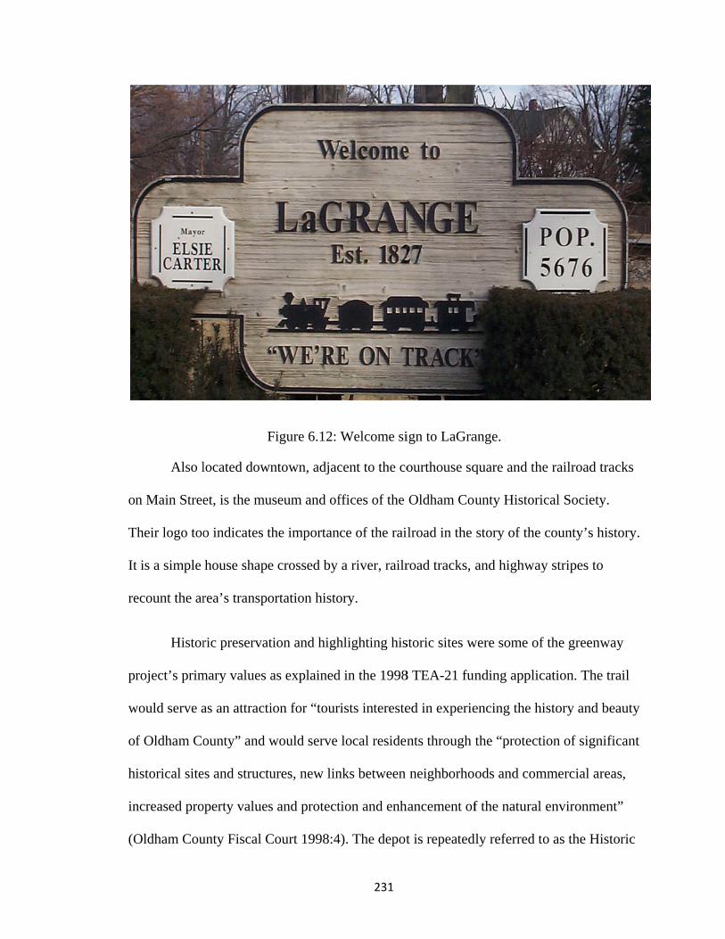
on
T
It
re
pr
w
o
h
in
(O
Also l
n Main Stree
Their logo too
t is a simple
ecount the ar
Histor
roject’s prim
would serve a
f Oldham Co
istorical site
ncreased pro
Oldham Cou
F
located down
et, is the mu
o indicates th
house shape
rea’s transpo
ric preservat
mary values a
as an attracti
ounty” and w
es and structu
operty values
unty Fiscal C
Figure 6.12:
ntown, adjac
useum and of
he importan
e crossed by
ortation histo
tion and high
as explained
ion for “tour
would serve
ures, new lin
s and protect
Court 1998:4
231
Welcome si
cent to the co
ffices of the
nce of the rai
a river, railr
ory.
hlighting his
d in the 1998
rists intereste
local residen
nks between
tion and enh
4). The depot
ign to LaGra
ourthouse sq
Oldham Cou
lroad in the
road tracks,
storic sites w
8 TEA-21 fun
ed in experie
nts through
neighborho
hancement of
t is repeated
ange.
quare and the
unty Histori
story of the
and highway
were some of
nding applic
encing the hi
the “protecti
ods and com
f the natural
dly referred t
e railroad tra
ical Society.
county’s his
y stripes to
f the greenw
cation. The t
istory and be
ion of signif
mmercial are
environmen
o as the Hist
acks
story.
ay
trail
eauty
ficant
as,
nt”
toric

232
Depot (always capitalized). Historic elements are pieces of the landscape that increase the
value of the whole package – history as commodity (Lewis 1975, Lowenthal 1996).
Lewis argues that many times we “preserve things because they pay: preservation will
attract tourists, affluent residents, and ultimately produce higher real estate values and
thus higher tax yields” (Lewis 1975: 16). This argument speaks to decision makers
(lawmakers, developers, banks) who are used to dollar value rationales, but this
perspective can be problematic because it then forces preservationists to put a dollar
value on something that is culturally or intangibly valuable.
Heritage tourism and downtown revitalization are important for LaGrange.
Preserving and reusing the historic railroad depot is but one piece of LaGrange’s historic
preservation program in its downtown area that enhances the town’s attraction as an
historic destination. There is a well-established record of research on “areas that more
readily lend themselves to quantification: rehabilitation, housing, heritage tourism, and
downtown revitalization” (Listokin et al 1998: 423, see also Listokin et al 2010,
Rypkema 2005). Participation in the Main Street Program and the synergy of having so
many historic homes, businesses, and civic buildings in one historic streetscape are also
keys to LaGrange’s success, in addition to the surrounding historic rural landscape.
There is little disagreement that historic preservation makes a quantifiable economic
contribution to a community, but there is much discussion on how best to quantify those
contributions (Mason 2005).
The landscape architects who authored the first trail master plan (1998) tied their
proposed design elements to historic elements in the cultural and natural landscapes that
surround the trail’s route. The design “commemorate[s] the rich history of the Kentucky
233
landscape by selecting materials and forms indigenous to the area” (CBA 2003: 5). Trail
seating and signage are to be constructed of large limestone blocks reminiscent of the
“large, oversized, limestone boulders used as foundation elements for several significant
historic buildings in LaGrange” (CBA 2003: 5). The other design element borrowed from
the surrounding landscape was the iconic four-board horse fence. This element was used
throughout the trail design in fencing, bollards, the trail logo, and signage. Some of these
elements were adopted into the final design (the limestone benches and bollards) but
others were not (the logo). Joann Green, landscape architect with the firm hired to
produce the greenway’s master plan, expressed the value of the trail as a site to “celebrate
the heritage of the original interurban route” (McKinney 5/2003).
The role of the Oldham County Historical Society (OCHS) in the greenway
development is not direct. But the historical society’s values and their community-based
programming indirectly offer strong support for the trail and the preservation of the
Louisville and Nashville Railroad depot. In the TEA-21 funding application the authors
state that Phase One of the greenway project meets “the goals of the County’s most
recent comprehensive plan and the objectives of the Oldham County Historical Society”
(Oldham County Fiscal Court 1998:4). The current director of the OCHS, Nancy Theiss,
is intent on focusing on the meanings of places through the programming, exhibits, and
activities at the museum and historical society. Recent examples include local
archeological digs where adults and children were invited to participate, a community art
project called “paint the pickets” (of the history center’s fence) with a theme of “what
does history mean to me?”, and Saturday living history events for children. The historical
society office and museum is located across the street from the county courthouse on
234
Main Street in LaGrange (down which the many daily freight trains travel). Theiss
instituted regular sense of place hands-on workshops for children that focused on “local
cultural and natural history” (OCHS 2006: 3). The workshops covered topics such as
pioneer cooking, archeology, local Native American cultures, and diaries as archives. The
history center also hosted events for the larger community on the same “sense of place”
theme, beginning in 2003. A 2004 special exhibit entitled “Mapping my Sense of Place”
featured the interactive “Riverlab”: a sand and water exhibit where visitors can see how
streams and rivers flow and function. Another part of this exhibit included an opportunity
for visitors to view a variety of local maps and aerial photos and a chance to “make their
own maps of their community and locate the special features of Oldham County that
make it unique” (OCHS 2004: 4). A representative from the OCHS spoke at the
greenways summit on the important corridors that trails and greenways will help to
preserve, protect, and highlight to the public. Some of these places included truck farms
and vineyards along highway 146, the railroad and interurban corridor in LaGrange
leading to other towns, the Ohio River valley in general, early settlements in Brownsboro
and along Hwy 42, and PeeWee Valley.
It seems that the LaGrange depot was not just a community rallying point or a
symbol of the community’s value of historic landscapes, but a tool to acquire trail
funding. Here historic preservation was an acceptable activity to the community, but not
necessarily the only important one. It was a step toward attaining a trail, and the trail was
valued by an even broader audience than historic preservation may have had. This is an
unexpected type of value placed on historic landscapes and landscape features, different
from more common ways of valuing such as memorializing important events, recalling

235
pleasant childhood days, exemplifying an architectural style or kind of craftsmanship, or
as a teaching tool. Here, preservation of an historic landscape feature could be interpreted
to be a tool used in a complex process of procuring grant money. I read this as a strategic
use of the historic landscape as a commodity to sell a project (trails) to the public or,
more likely, the state to get funding. Though this speculation was not directly
substantiated through interviews with locals, it was supported by comments from
Transportation Center staff members (both former staff now – one of whom referred to
the LaGrange depot as “that stupid depot”), and by examining the Transportation
Enhancement funding application for the project. I think Greenways for Oldham County
used a value for historic structures to get the trail project funded and rolling, but GOC
was not really in the historic buildings business, they were in the trails business. The
depot is a great trailhead and everyone agrees its preservation is a wonderful asset to the
historic core of LaGrange, but it was not the ultimate goal of the greenways movement in
Oldham County.
Values matter in examining Oldham County’s greenway landscape because the
values tied up in the trail development tell us much about the communities these trails
connect. The proposal, design, and construction process tell how a community has
responded to development pressures and changing population. An examination of either
the development story or the greenway story apart from the other is an incomplete picture
of the whole. This counterpoint case study shows how different communities’
experiences with and values for rail trails can be. Oldham and Muhlenberg counties share
some things in common like a value for the recreation and health aspects of their trails,
236
but their approaches to historic values and their other core values are quite different,
reflecting their very different settings.
The Oldham County example gives insight into the ways that values based
preservation (both historic and landscape preservation) is practiced in the realm of
transportation projects. The engineering consulting firm who wrote the greenway master
plan employed some commonly used techniques in order to find out what the
community’s stakeholders valued about their community and what their vision was for
the place. These techniques included surveys, listening sessions (public meetings), and a
“stakeholders’ summit.” Even though trails were, for the most part, not opposed by the
public or by those in public office, the planners made concerted a effort to listen to the
stakeholders and respond to their concerns and wishes in the plans.
Support for trails and parks in Oldham County is a signifier for the desire to both
shift to keep up with the changes in the county and also to retain what in the first place
attracted the people and growth that brought those changes. Trails are an amenity to
attract and retain young families and homebuyers; they are a marketable amenity for new
businesses that choose to locate operations there. The Greenways for Oldham County
envisions trails at the center of what the county’s people value: a healthy, safe lifestyle
with lots of amenities including outdoor recreation, alternative transportation, natural
resources, and historic landscapes.
Bruce Vento Nature Sanctuary
Values shifting over time
The Vento Sanctuary, perhaps more so than the other two case studies, shows the
full array of values that can be represented in one small rail trail site. In this example, we

237
see not only that there are many intersecting values held by the various stakeholder
groups, but that these values are sometimes contradictory and must be skillfully
negotiated. Vento is an example of how grassroots planning for historic preservation and
trails projects can enrich the final result through neighborhood relationships to the site
and the process. At the Vento Sanctuary, values matter because they informed the
planning committee and project funders of what was important to the community, they
helped the community to come together to rally for the preservation and restoration of
this site through a difficult, long, and expensive process, and they matter because this site
is so significant to so many different stakeholders for so many different reasons (none
more important than the next).
Users, regional planning agencies, city leaders, and other stakeholders recognize
the many different ways this place is valuable in the community. A Metropolitan Council
memo (2008) cites the cost of cleanup as “minimal when compared with the recreational,
economic, and social benefits that the Bruce Vento Nature Sanctuary will provide to the
region.” The vision document completed early in the planning refers to the area as being
“rich with ecological, recreational, and social value” (Pitz 2001 [no page numbers]).
Before European exploration and settlement, the site was integral to both the daily
life of local Native American populations but also to their spiritual foundations. Dakota
people consider Wakan-Tipi, a natural cave within the river bluffs, to be a site of origin
for their people. This cave was also used for healing and other ceremonial purposes (Ketz
2007). As a result, this site was, and continues to be, one of special spiritual and cultural
value to local Native American groups. The larger flood plain area at the confluence of
Phalen Creek, Trout Brook, and the Mississippi river was near three Native American

238
settlements. Kaposia, or Little Crow’s village, was about three miles downstream. This
village was home for Dakota people during the summer months and existed from around
1750 to 1837 when the Dakota were forced by a treaty agreement to move the village to
the west bank of the river (Miller 1986). On top of the bluffs overlooking the Vento site
were a series of burial mounds belonging to the Hopewell Culture (circa 2000 years ago).
Only six of the sixteen original mounds remain, as part of Indian Mounds Park.
After Euro-American settlement, the nature sanctuary site was valued for its
convenience and connections for transportation; first for the river and later the railroads –
connecting up and down the river, to downtown St. Paul, and up the Phalen Creek
corridor to points north. The railroads substantially altered the site – adding fill to expand
the yards, cutting away the bluffs to gain more area, building the land higher. This was a
very valuable site for industrial railroad activity for decades. It was not valued for its
ecological or cultural significance, as evidenced by the level of alteration and degree of
pollution there.
The site became unvalued, ignored, and full of garbage, after the railroad
abandoned operations. This park and trail project received very little opposition because
of its condition before conversion to parkland; any investment was clearly an
improvement and not many people complained. Less than ten years ago the Phalen Creek
Partnership group began thinking about the site’s potential. A new vision of value and
meaning grew out of ideas for reclaiming the site as a connection to the river, as a
connection between neighborhoods to downtown, and as a connection between existing
key trail segments. Newer sensitivities to the need for understanding the region’s natural
history and ecology also prompted some of this work.
239
When asked her thoughts on what values intersect at the Vento site, steering
committee chairperson Carol Carey listed them as geology, the environment, the Native
American sacred site, European exploration and settlement, the brewery industry and the
railroads, the contemporary story of connections between people and places, community
involvement, and trails. She summarized these as “the river, railroads, and beer!” (Carey
2009). Her assessment well represents the values for the site that other stakeholders
expressed, though not all listed them as extensively as she did.
Values for community connections
In this section I address the two-fold meaning of “community connections.” The
first of these is physical connections within the community in the form of trail networks
linking neighborhoods and destinations that formerly were isolated from one another for
pedestrians or bicyclists. The second sense is connections between people in the region
through participation in the planning process and continued involvement at the site.
The process of negotiation illustrates the important value/meaning for community
connections through the site. From the very start public participation and investment in
the process has been a fundamental element to Vento’s planning and development
(DuPaul 2009, Carey 2009, Ketz 2009, Clark 2009, Metropolitan Council 2008).
Community involvement was a hallmark of the project and the planners saw their work as
not just a way to create a nice park, but as “a springboard for broader neighborhood
improvement and urban revitalization” (Pitz 2001 [no page numbers]). Sarah Clark, one
of Lower Phalen Creek Project’s staff members, summarized the process this way
we developed a vision for the watershed that defines our common aspirations….High engagement from the community helps ensure that the project goals and objectives will reflect what people really want – and the more people

240
want the project, the more they will pursue it and maintain their passion through the often long and challenging process of implementation(Clark and Middleton 2008).
Weiming Lu, president of the Lowertown Redevelopment Corp., one of the
twenty-five groups involved in the process, said the project and its success are unusual.
"This is not a government or a developer's idea. It's a lot of dedicated people, willing to
do what is necessary, getting behind this and making it happen," he said. (Karlson 2004)
Don Ganje, St. Paul Park and Recreation staff member recalled the process as
memorable because of the degree of public participation.
It’s really been an interesting project mainly from that community standpoint because frankly, I mean we do an awful lot of community outreach and involvement but this was one where they came to us basically, and dragged us into the thing. And you know it was frankly really a pretty horrible piece of property! (Ganje 2009)
He went on to explain how they are unique among community supporters of parks in St.
Paul. Other parks also have strong community support, but this group has had many of
the same people involved since the very beginning and has been steadily working all
along. And, unlike other efforts, the steering committee has continued to “steer” the
project even after the City of St. Paul bought and took responsibility for the property. The
committee leadership expressed a desire to keep the effort on track, driving towards the
next step instead of letting it get lost amongst a huge inventory of City projects.
The development of the Bruce Vento Nature Sanctuary fit in with St. Paul’s
vision and goals for reconnection to the Mississippi (as outlined in Saint Paul on the
Mississippi Development Framework, St. Paul Riverfront Corporation 1997). In an
introductory letter, St. Paul’s then mayor, Norm Coleman, stated,

241
It [the development framework] is premised on the concept of integrating rather than segregating, the city’s social, environmental, and economic assets. And, it calls for reconnecting the river, the downtown, and the neighborhoods as a vibrant whole (page ii).
One principle laid out in this vision document was increased investment in the “public
realm”: streets and parklands. Improving access to the Mississippi River was an
important part of this principle. Two other principles addressed the need to improve
connections (physical and visual) and to increase options in the city’s transportation
network. This referred primarily to pedestrian connections but also to street networks,
parking, and transit.
Indeed, the idea of “connection” is more than a “feel good” notion about “bike
trails for the sake of bike trails” (Carey 2009). Connections here meant the very real
promise of economic redevelopment and quality of life improvements for the residents
and businesses of Lowertown and other neighborhoods adjacent to the Sanctuary who
would benefit from new bicycle and pedestrian routes as amenities, as transportation, and
as community space (Monks 2006).
Nature values
One of the primary values found at the Vento site is the value of nature in the
broadest sense. I was interested to learn if people from the neighborhood think of the
place as a natural area or an industrial place. Carey said that they think of it as “a natural
place, but an urban one.”A chance to see plants growing, streams flowing, birds, and a
cave (however altered), is especially valuable in an urban setting. The St. Paul newspaper
described the place as an “urban wilderness” (Yuen 2007), “an inner-city wilderness”
(Brothers 2007), and an “urban oasis” (Ferraro 2005). There are several subsets to this
value of nature. Restoration of the site’s ecology is important. Visitors are able to learn

242
about, see, and even help to accomplish the restoration of native ecosystems. The site is
divided into six different ecosystems to show the variety of native ecosystems present in
the area (though in reality, these biomes would not all be present in one small site such as
this)25. Karin DuPaul, president of Friends of Swede Hollow and active on the steering
committee, related that neighborhood residents value the site for the fact that “you know
to start with it’s no longer a, um, a dump. (laughing) And um, now you can walk down
there and you know, there’s a lot of birds, especially people who like, you know, natural
settings, I think people are seeing it as a real asset” (DuPaul 2009).
At an open house event in October 2009 sponsored by the project steering
committee, they made an effort to illustrate the regional and international migration
connections made through the site. Volunteers displayed maps of the paths of migratory
birds along the Mississippi River Flyway (which connects Canada to South America) and
served coffee from Costa Rica, the winter destination of some bird species that fly
through the Vento site on their way south. The Audubon Society has recognized the site
as an Important Bird Area (one of 35 in the state), a place “recognized for [its]
outstanding value to bird conservation” (sign, on site). Vento is part of the larger Twin
Cities Mississippi River Important Bird Area.
Underlining the public value for nature at this site was early involvement and
monetary support from the Minnesota Department of Natural Resources. Because the
Vento steering committee was able to secure a conservation easement over the site, this
opened up funding through the DNR (Ganje 2009). Throughout Minnesota, the DNR has
25 These biomes include: floodplain forest, dry prairie, oak savanna, oak woodland, bluff prairie, and spring-fed streams and wetlands.
243
long been active in trail building and maintenance; they administrate the state trails
system which includes many rail trails, some of which are over one hundred miles in
length.
Education Value
Education has been an important subset of both the environmental and historical
values of the site. The Community Design Center’s Youth Conservation Corps was
created in response to the need for restoration work. These young interns work in clean
up, restoration, leading tours, and peer education. The plans for the interpretive center
also build from this value for education. The Science Museum of Minnesota and the
National Park Service are involved in this planning process (among others). The City of
St. Paul acquired the 36,000 square foot abandoned industrial building, and 1.85 acres of
property on which it stands, in 2008. Early visions for this building see its future as an
“ecomuseum”, a place where the site’s geologic, cultural, industrial, and natural history
can be interpreted to the public. This building will also include facilities to enable the site
to be a field trip destination for the region’s school children; it will include restrooms and
eating and meeting spaces. For the other three quarters of the space, planners envision
multiple potential uses including a pre-school, offices, café, bike shop, non-profit group
meeting space, and exhibit space (Lower Phalen Creek Project 2009). Goals for
interpretation at the site all focus on history, but in four different areas: geologic history,
ecological history, human history, and park history. The development of the interpretive
center would move the site to a new level as a regional center for natural and cultural
history. Currently, the steering committee sees the interpretive signage at the site playing
an educational role in the stead of organized programming and exhibits. This signage will
244
continue to be an important educational piece at the site, but will be enhanced by an
interpretive center.
Early on in the Community Vision plan one of the stated goals of the Lower
Phalen Creek Project was to “Build long-term environmental stewardship programs with
local youth” (Pitz 2001 [no page numbers]). The process of reclaiming the landscape
from neglect and garbage and restoring it to a healthy, native ecosystem is the centerpiece
of the environmental education value. The need for environmental education sites was
great in St. Paul; at the time of the site’s purchase “school children [were] bussed to
suburbs and beyond to experience outdoor environmental programs. With its remarkable
natural features close by, the Bruce Vento Nature Sanctuary at Lower Phalen Creek can
fill the need for understanding nature's important functions right in the center of St. Paul”
(Pitz 2001 [no page numbers]). City Council President Kathy Lantry calls the sanctuary
"a teaching park for urban dwellers" (Yuen 2005). Some of the environmental and
historical educational topics at the site include “interpretation of bird migration, bluff
geology, cave formation (Carver’s Cave, Montana Bill’s Cave), natural springs,
watershed function, drainage to the river, the history of the Mississippi River floodplain,
history of Phalen Creek, stone-lined canal on Fourth Street, and railroad bridges,
including the historic East Seventh Street stone arch bridge” in addition to Native
American histories associated with the site(City of St. Paul 2010).

F
R
ar
so
2
P
w
T
an
m
w
N
Figure 6.13:
Recreation v
Recre
re all valued
omething the
009). This a
aul and the d
was one of th
The site sees
nd these trai
many parks in
was develope
Nearby to the
A trail sign
value
ation, and it
d here. The i
e public ralli
rea was a “m
downtown a
he primary dr
high trail tra
ils, but also a
n the metro a
ed to be a nat
e sanctuary a
shows the wthe V
ts subsets: co
idea of trail c
ied around w
missing link”
area and the M
rivers that sp
affic counts p
as a recreatio
area with pla
ture sanctuar
are several n
245
way to variouVento Sanctu
ommuting, e
connections
when the pro
” between gr
Mississippi R
purred the de
primarily as
onal destinat
aygrounds, p
ry and trails
ew office de
us trails, parkuary hub.
exercise, and
resonated w
oject was in t
reat trails no
River. A des
evelopment
a connectio
tion in and o
picnic areas,
are the prim
evelopments
ks, and othe
d fun family
with people a
the planning
orth and east
sire to conne
process (Ka
on point betw
of itself. The
or commun
mary recreati
s including c
r amenities f
outdoor acti
and was
g stages (Car
of downtow
ect these plac
arlson 2002).
ween downto
e site is not l
nity building
ional feature
ounty and st
from
ivity,
rey
wn St.
ces
.
own
like
s. It
e.
tate

246
offices like the Pollution Control Agency and the Ramsey County office building. The
trail connections through Vento make it possible for these and other downtown workers
to commute to work via bike or to take a midday run or ride on nearby trails.
Redevelopment of Lowertown in St. Paul as a residential neighborhood through
converted and newly constructed lofts has also been important. As so many new people
(and businesses) call Lowertown home, it is very important that they have access to
recreational activities and are not neighbors to unpleasant industrial activities (as would
have been the case had the asphalt plant located there) (Lee 2008, quoting Weiming Lu).
Minnesota is a place with strong and longstanding values for trails and outdoor
recreation ranging from quiet hiking and bird watching, to fishing, hunting,
snowmobiling, and all-terrain vehicles. There are many conflicts (on use, on principle,
and on funding) between motorized recreation advocates and non-motorized recreation
advocates, but this is not an issue in urban areas as those uses are not permitted in cities.
Historic values
Clark and Carey both described some tension between interest groups associated
with nature value and historic value but also much compromise and consensus as they
determine what would be destroyed, what would be saved, and what would be featured or
not on the site. There is a constant amicable tension between the competing and
overlapping values at the site: history, environment, and community. The steering
committee always has to negotiate the appropriate balance (Clark 2009).
The steering committee works to highlight the importance of both nature and
history for the place and how they are intertwined. The combination of nature and history
is present on much of the signage at and publicity for the site. They also had to work to

247
compromise between the two in deciding how to develop the site. One example: the large
concrete walkway slabs that remained from the days when the site was used for rail car
maintenance. They are 800 feet long and six feet wide, in ten parallel rows thirteen feet
apart at the center of the site (Pitz 2001). The steering committee struggled to decide
what to do with them. Some wanted to preserve them intact to remember the industrial
history there. Others wanted to remove them completely. One of the key goals of the
project was to restore the native ecosystem which was hard to do if parts of the site were
covered in concrete. Besides, the argument went, while we want to remember the
railroads, we have to also remember that it was the railroads that destroyed much of the
natural ecosystem! The compromise was to leave one slab in place at its full length plus a
few portions of the other slabs to retain a feel for what the site was like, but remove the
rest to make way for habitat restoration. Native trees were planted in long rows along the
remaining slabs and where the other slabs were to retain a linear feel. The next task was
to explain the concrete slabs’ story and significance because just looking at them, no one
would know what they were for. A future interpretive panel will explain the slabs to
visitors.

th
h
an
h
w
an
H
id
d
la
an
Figure 6.1
The n
he stories of
elping home
nnual Dayto
omes availab
walking tours
nd home pur
Housing Serv
dentity and f
evelopment
and's history
nd belonging
14: Concrete
eighborhood
those places
eowners to re
on’s Bluff Va
ble and redu
s of historic
rchase and re
vices . A stro
flowed from
of the Vento
y would be in
g” (Pitz 200
e slabs (used
d was alread
s. There wer
estore their h
acant Home
uce the impac
Swede Hollo
ehabilitation
ong sense of
local residen
o site. The C
nterpreted an
1 [no page n
248
d for railroadSanctuary
dy home to a
re many prog
historic hous
Tour (organ
cts of foreclo
ow, Dayton’
n assistance f
f local history
nts instrume
Community V
nd kept alive
numbers]). C
d car mainteny
strong value
grams highli
ses. Some ex
nized to adve
osures on th
’s Bluff, and
from Dayton
y was an imp
ental in plann
Vision plan f
e to enrich vi
Carey related
nance) extan
e of historica
ighting local
xamples incl
ertise the wo
he neighborh
d Third Stree
n’s Bluff Ne
portant piece
ning into the
for the site s
isitors with a
d that the pro
nt at the Vent
al places and
l history and
lude the sem
onderful hist
hood), guides
et neighborho
eighborhood
e of local
e vision and
stated that “T
a sense of pl
oject “fit in w
to
d of
d
mi-
toric
s for
oods,
final
The
lace
with

249
the development values and community values that people on the steering committee
had” already and that “it’s about place and character – building on what came before”
(Carey 2009). It should be noted here that Carol Carey, chair of the project steering
committee, is also the executive director of Historic St. Paul, a non-profit historic
preservation advocacy group whose mission is “to preserve, protect and enhance the
historic character of Saint Paul neighborhoods” (Historic Saint Paul 2010). Historic Saint
Paul was one of the partner organizations in the development of the Bruce Vento Nature
Sanctuary; they also sponsored the educational panels in the sign circle at the entrance to
the sanctuary.
The ties to local immigrant/blue collar neighborhoods are also important. Some
are still extant such as Dayton’s Bluff and Railroad Island, others are not such as Swede
Hollow and Connemara Patch (between the sanctuary and Swede Hollow, many homes
here were lost to railroad expansion and the rest were razed in the 1950s through eminent
domain prior to construction of I-94). These neighborhoods, particularly Swede Hollow,
still play a very important role in the East Side’s identity as a place. The role of the
former railroad yards as a place of employment is very closely tied to these residential
areas (see map in Chapter 5 for locations of these neighborhoods).
Layers of historical stories exist at the site, some more visible than others.
Foundations of the Northstar Brewery are evident near the bluff and visitors can peer into
the opening of Brewery Cave, a natural cave that was reshaped for use by the brewery to
age and store beer. Archeologists discovered these foundations during the historical
research for Section 106 (see below). The Northstar Brewery, founded in 1855, was one
of St. Paul’s earliest breweries (Terrell and Vermeer 2004). This brewery was a
250
predecessor of the company that went on to become Jacob Schmidt Brewing Company, a
fixture on the East Side of St. Paul for decades. The historical consultants recommended
the brewery site as eligible for listing on the National Register for Historic Places and any
work that may disturb the site should be done under consultation with the State Historic
Preservation Office (Terrell and Vermeer 2004).
The Vento site contains a cave, Wakan Tipi, which is considered to be a sacred
place to local Native American groups. Wakan Tipi is a difficult term to translate from
the Dakota to English. Tipi means “dwelling place” and Wakan is sometimes translated
as “sacred”, “spirit”, or “holy”. Other sources translate it as “the dwelling place of the
Great Spirit” (Pitz 2001) or “spirit house” (Clark 2008). Because the Dakota world view
sees the earth as mother, “caves represent the places where we were born from our
mother” or “the heart of our mother” (Rice 2009). This particular cave is especially
significant in Dakota creation stories and Wakan Tipi is considered the “Garden of Eden”
of the Dakota peoples (Rice 2009). Because of federal funding, the project was required
to do a Section 106 review26. This review triggered the notification of the four federally
recognized Dakota tribes in the area to consult on the project and their representatives
were involved throughout the planning and interpretive process.
This site within the site has proven to be the most contentious. The steering
committee is dedicated to sensitively interpreting all of the sites and stories within the
project area, but the research revealed two conflicting stories and their accompanying
values overlapped one site. Wakan Tipi was a natural cave sacred to Native American 26 Section 106 refers to a part of the National Historic Preservation Act of 1966 and is a regulation enacted to prevent and mitigate adverse affect on historic properties by federal undertakings. See also Chapter 2, page 28 for more info on Section 106. In both Minnesota and Kentucky, the state historic preservation office (SHPO) works with the federal agency and local partners on Section 106 reviews.
251
tribes who called the area home for thousands of years prior to European settlement. The
cave was later renamed Carver’s Cave after an early explorer. In St. Paul’s early days,
breweries developed along the river making use of the springs for their waters and the
caves to store and age the beer. Wakan Tipi was enlarged and altered to serve this
purpose. As the breweries moved off the site, the railroads also altered the cave as they
carved off the face of the bluff to enlarge the flat area for rail yards. The ecological value
of the site and the restoration work meshes well with the Native American stories tied to
the site; the healing of the land is metaphoric for the healing of relationships between
Native and Euro-American peoples through the process of renewing this site. For
example, a good deal of symbolic significance is tied to the bald eagle among Dakota
people (Brooke 1996). As Mr. Rice was drumming and singing at the opening to Wakan
Tipi during a Sanctuary open house event in Fall 2009, an eagle flew overhead. He was
excited to see it and switched to a song that honored the eagle. Eagle populations have
increased in the Mississippi River valley in recent decades; some nests have been
identified very near to downtown St. Paul (though not in the Vento Sanctuary).
The conflicting values and stories revealed during the Section 106 research
revolve around the relationship between Native American land use and histories and the
settlement of White Europeans with their alcohol industries. It is both a literal and
symbolic story told here of the way that alcohol obliterated Native American culture.
Through the research both Wakan Tipi and the ruins of the Northstar Brewery were
deemed eligible for nomination to the National Register of Historic Places.
It was also difficult because there is no one representative voice of “the Dakota”
peoples, but instead there are many disparate groups that are “the Dakota.” Leonard

252
Wabasha, cultural resources director for the Mdewakanton Dakota Community in nearby
Shakopee, Minnesota, has worked consistently with the steering committee and on the
Section 106 process (Carey 2009). He also led a tour of the site during the 2007 National
Trust for Historic Preservation conference that was held in St. Paul (Clark 2009).
Even though it was a difficult situation, unlike typical Section 106 processes, the
owners of the site were not proposing to destroy or pave over significant sites (most
Section 106 research is tied to highway projects). Their intent was to maintain, restore,
reconnect, and interpret. The process, therefore, was easier but is not complete. There is
no consensus on how the cave and brewery ruin sites should be interpreted to the public
through signage (see extant signs in photos 6.13, 6.14, and 6.15). There is an immense
range of time included in the eras of significance of the site and a large range of values.
There was no pressure to choose just one period of significance for the site, though Sarah
Clark mentioned that it seems like the “period of significance always seems to be placed
at when the white guys start building things” (Clark 2009). The steering committee has
left the interpretation piece open and will continue to work with tribal representatives.
They hope to be able to tell the story without glossing over the “hard parts” (Carey 2009).

Figure 6.15: Half of the sign circ
Figure
253
cle at entranc
6.16: Interp
ce to Bruce
pretive sign
Vento Natur
re Sanctuary
y

ar
ta
si
pu
in
pr
p
th
re
re
Figure 6community
There
rea, in additi
ake “many st
igns will be
ublic in 200
n a circle aro
rocess of reh
eoples, and t
he area. The
esult of a “re
esidents, and
6.17: Detailsy was involv
are also pla
ion to the run
takeholder m
in addition t
5. These sig
ound the trail
habilitating i
the way that
content, as w
eal multiple
d Dakota rep
s the signs inved and the b
generat
ans to erect a
nways sign.
meetings” to
to the “sign c
ns greet visi
l entrancewa
its ecology, t
t the neighbo
well as the a
stakeholder
presentatives
254
n the sign cirbottom one htions of Nati
an interpretiv
Even these
plan and car
circle” that w
itors entering
ay. These sig
the significa
orhood has b
arrangement
process” inv
s. The circle
rcle. The tophighlights thive people.
ve sign by th
two relative
rry out (Clar
was erected w
g from the p
gns address t
ance of Waka
been involve
and present
volving the s
format was
p one highlighe importanc
he oak wood
ely straightfo
rk 2009). Th
when the sit
arking area
the history o
an Tipi to N
ed in the rede
ation of the
steering com
an idea that
ghts how the ce of the site
dland restorat
orward signs
hese two new
te opened to
and are arran
of the site, th
Native Ameri
evelopment
signs, was th
mmittee, loca
the tribal
to
tion
s will
w
the
nged
he
ican
of
he
al

255
representatives advocated; circles are culturally symbolic and significant and it was a way
to honor their culture’s presence in this place. While these signs mention the sacred
Wakan Tipi site briefly, they were not a “hot-button issue” like the signs they would like
to design for the actual cave entrance (Clark 2009). In my observation, many visitors to
the site read the signs as they entered, but it was not a significant survey. The site
planners hope that the interpretive signs will help visitors to understand that this place
holds deep importance to Minnesota’s ecological story, settlement history, its industrial
growth, and also sacred significance to Native people. Their hope is that the signs will
expand visitors’ views of the site from “a nice trail and park” to encompass these areas of
significance, but of course that goal can only be accomplished if people read the signs.
Even unread signs have an effect on viewers as signs create an impression that a place is
Important or Historic. Lowenthal (1979: 111) writes that signs “make the visible past feel
more like the written record.”
The City of St. Paul, in creating the landscape plan for the site, decided how to
protect the Wakan Tipi site, but didn’t make any decisions beyond that. Don Ganje, a
landscape architect from the St. Paul Park and Recreation department related that they
just left the existing, unattractive metal wall across the cave entrance: “we left that in
place because the tribes, really to this date, still don’t know what they want to do with it,
how they want to interpret it. So we have a lot of work left to do on that particular
interpretation part of this” (Ganje 2009).
Local Native American groups still use the site for annual meetings and
ceremonies. Jim Rice, a member of the Sisseton Dakota tribe, held his wedding there in
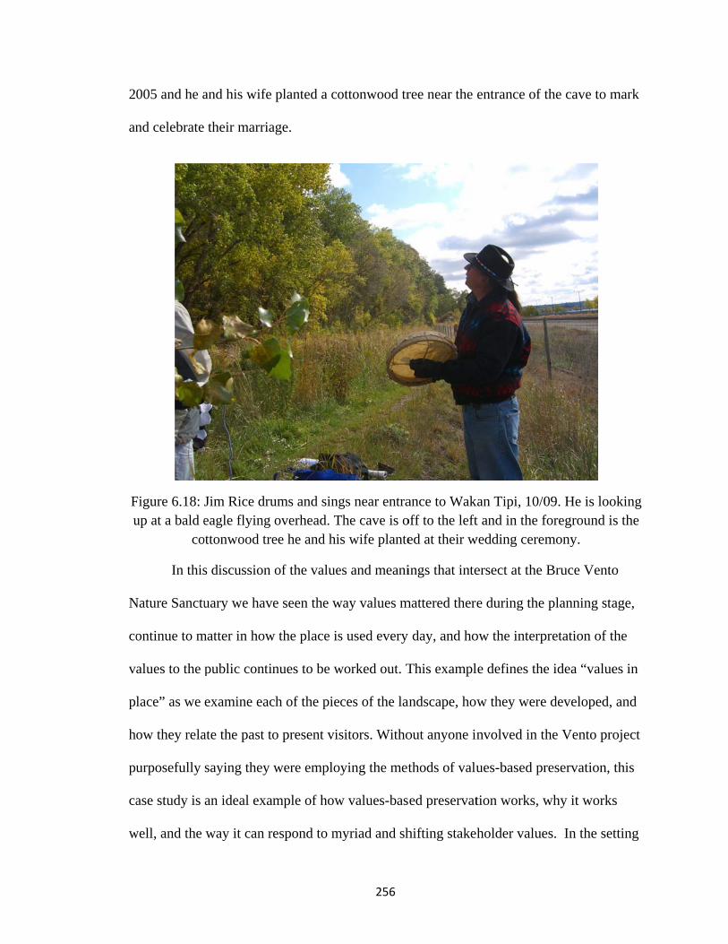
2
an
Fu
N
co
v
p
h
pu
ca
w
005 and he a
nd celebrate
Figure 6.18: up at a bald e
co
In this
Nature Sanctu
ontinue to m
alues to the
lace” as we
ow they rela
urposefully
ase study is
well, and the
and his wife
their marria
Jim Rice drueagle flying
ottonwood tre
s discussion
uary we hav
matter in how
public contin
examine eac
ate the past to
saying they
an ideal exa
way it can r
planted a co
age.
ums and singoverhead. Tee he and hi
of the value
e seen the w
w the place is
nues to be w
ch of the piec
o present vis
were employ
ample of how
respond to m
256
ottonwood tr
gs near entraThe cave is os wife plante
es and meani
way values m
s used every
worked out. T
ces of the lan
sitors. Witho
ying the met
w values-bas
myriad and sh
ree near the
ance to Wakoff to the lefted at their w
ings that inte
mattered there
day, and ho
This exampl
andscape, how
out anyone in
thods of valu
ed preservat
hifting stakeh
entrance of t
kan Tipi, 10/0t and in the f
wedding cerem
ersect at the
e during the
ow the interp
le defines the
w they were
nvolved in th
ues-based pr
tion works, w
holder value
the cave to m
09. He is looforeground imony.
Bruce Vento
planning sta
pretation of t
e idea “value
e developed,
he Vento pro
reservation,
why it works
es. In the set
mark
oking s the
o
age,
the
es in
and
oject
this
s
tting

257
of cultural geography lineage, this step of delving into the meanings and values in place
is an important part of the critical humanistic geography endeavor; one must examine
what meanings are in a place, how those meanings shift and differ from group to group,
and how they came to be, in order to understand the landscape.
In the context of Schein’s framework for landscape interpretation this step of
discerning and investigating the meanings and values with which people imbue
landscapes is an essential bridge between the first step of telling the biography of the
landscape and the final steps of examining the way that the landscape facilitates and
mediates ideas and values and materializes stakeholder discourses in place (Schein 2009).
We will move on to these final steps in Chapter 7.
Copyright © Lisa Rainey Brownell 2011

258
Chapter 7 : Landscapes and community values
In this chapter I will contextualize my three study sites in relation to step three
and step four of Schein’s (2009) methodological framework for interpreting landscapes.
These steps are: examining the landscape as a facilitator/mediator and examining the
landscape as discourse materialized. I employ three organizing themes across the three
case studies: landscapes that make things happen (facilitate), landscapes that bring people
and ideas together (mediate), and landscapes that physically manifest community and
national values (discourses materialized).
When I write about landscapes making things happen, it is in the sense that things
are said or done in a new way, in a way that would not have been possible had that
landscape not been the way that it is now. This is not in the sense that the landscape is
actually doing something; it is not active, but its presence and its use and the act of
creating it can cause changes. But in the same sense that we study landscapes as texts
(Duncan 1990), we understand landscapes to “do” things in the way that the written word
can “do” things. Words cause people to act, words elicit emotions both positive and
negative, words lodge in the heart and mind, and words help to shape who we are and
want to become. Places “do” these things as well, even though they are not living, acting
things. Landscapes are our “unwitting autobiographies” (Lewis 1979) in the sense that
they are stories already written but landscapes are also discourses materialized (Schein
1997) in the sense that they are being rewritten all the time. Landscapes are not just the
text, but are also the author as they shape social relations, community values, and
function as normative forces (Schein 2003).

259
For mediation I interpret this to mean the way that landscapes both figuratively
and literally bring people together. Figuratively refers more to ideas: what ideas are
expressed to the public through a trail landscape? Ideas about the past, about the natural
world, about health or recreation, and ideas about cultures are just a few of the
possibilities. Literally, trails bring people together within the space of the trail; people
come together in the social space of the trail and through the process of cooperation to
plan and maintain the trail.
Muhlenberg County Rail Trail
The trail landscape in Muhlenberg County served both to mediate between
disparate ideas of what should be done with the abandoned rail line (no trail! and yes
trail!) and to facilitate a paradigm shift in the communities. The rail trail is now almost
universally supported and has brought a new set of strengthened values for recreation,
exercise, and wellness. Kentucky is perennially at the bottom of state lists when it comes
to quality of life, health outcomes, child health, obesity, incidence of disease, and so on.
The reasons for these conditions are the subjects of numerous other dissertations, but part
of it is related to infrastructure – do people have access to places to exercise and develop
healthy habits? Residents of Muhlenberg County saw the potential of the trail as a place
to exercise as it was under construction; indeed, the trail was heavily in use even before
the official grand opening.
Landscape that makes things happen
Paradigm shifts
In the case of the Muhlenberg County Rail Trail, the trail landscape facilitated a
change in the community and the values held there. This place made possible a paradigm

260
change where recreation – safe, accessible, outdoor recreation – became something of
great value to the community after the initial trail proposal was vehemently opposed.
Tied to this was a paradigm shift about health and wellness and the need to have readily
available ways to address some of the dire health problems facing Kentuckians, many of
which can be addressed, at least partially, through regular exercise. The trail landscape
helped to accomplish what probably already was an issue on the minds of local residents:
a need for safe and healthy recreation, but the means for accomplishing that did not exist
prior to the trail.
Health and wellness, recreation, and quality of life
Active living27 as a way to wellness through the space of the rail trail is at the core
of this paradigm shift. Newspaper articles and ads pointed towards the health benefits of
trail walking. The local department of health campaign for “Get Moving, Start Losing” in
which the county was challenged to lose a collective 1,000 pounds revolved around trail
walking. All of these things show that the discourses of health and wellness, active living,
and recreation are being facilitated in the local community through this trail landscape.
They are being interpreted on their own terms.
Several times per year Kentucky is reported at or near the bottom of various
health, education, well being, or general quality of life measures. Kentucky is ranked
seventh in the nation for adult obesity rates at 29 percent, fourth for child obesity rates
(37.1 percent), seventh for rates of diabetes among adults (9.9 percent), and second for
27 Active Living by Design is a movement, founded and funded by the Robert Woods Johnson Foundation that “creates community-led change by working with local and national partners to build a culture of active living and healthy eating.” The movement’s vision is to help create “healthy communities, where routine physical activity and healthy eating are accessible, easy and affordable to everyone” (activelivingbydesign.org).
261
physical inactivity (30.4 percent of adults physically inactive) according to a survey
completed by the Robert Wood Johnson Foundation and Trust for America’s Health
(Levi et al 2009). Conversely, Minnesota ranked 51st in physical inactivity with 16.3
percent of adults reporting an inactive lifestyle (out of 50 states and Washington D.C.).
Kids Count data (Kids Count Data Center 2010) puts Kentucky at forty-first in the nation
on overall child well being measures.
Forbes (Ruiz 2009, citing Healthways/Gallup survey) ranked Minnesota in first
place for physical health and fifth for the well being index. Kentucky was at forty-ninth –
even Mississippi ranked higher in the well being index (at forty-eighth – a rare exception
to the “thank God for Mississippi” clause to these types of surveys). Kentucky ranked
forty-ninth out of fifty for physical health as well.
Within the state of Kentucky, Muhlenberg County has not fared well. In The
Health of Kentucky: A County Assessment the county was ranked number 100 out of 120
counties on a variety of health measures including health outcomes, health care access,
and behavioral factors (Kentucky Institute of Medicine 2007). Some of the behavioral
factors such as the prevalence of diabetes, obesity, smoking, and a lack of physical
activity were higher than the national average; almost twice as many county residents (47
percent) lacked physical activity compared to the national average (24 percent).
Though the development of the Muhlenberg County rail trail was not directly in
response to these types of reports, they are part of the environment in which support for
the trail has grown. Indeed, the trail was featured on a Kentucky Educational Television
series called The CommonHealth of Kentucky. This show touted the health benefits of
262
rail trails in general and visited the Muhlenberg County trail to highlight its success in
providing a place for safe recreation to people of all ages and abilities (KET 2004).
National rail trail (and trails in general) groups align themselves as an important part of
quality of life and improving a community’s (and its residents’) health (Rails to Trails
Conservancy 2008, Wilkinson, et al 2002). A fact sheet published by the Rails to Trails
Conservancy speaks of an Alabama trail that “touched off a health revival” in its
community after it provided a safe place for exercise – something not available prior to
its opening (Rails to Trails Conservancy n.d.).
From the medical establishment to the public
Evidence of this paradigm shift is found in who has supported the trail along the
way. An early supporter and member of the steering committee is Rebecca Keith, a local
nurse practitioner. She calls exercise “the fountain of youth” and goes on to say that
“[p]eople that exercise daily look younger, feel younger, stay younger, because they are
healthier, they can move, they can do the things they want to do and they enjoy life a lot
more” (KET 2004). She and other local health professionals prescribe trail walking to
their patients as a way to improve their health. This message of exercise is expanding
from the medical establishment across the local community to include young people, and
everyday regular folks who before may not have given much thought to the value of
active living. Some of the initial opposition to the trail was the perception that it would
only be used by the “spandex super fit types” and wasn’t for the rest of the people but this
idea was quickly dismissed after the trail opened (Kirtley 2004a and 2004b). This is one
example of the trail’s role as a normative landscape, a place that suggests what ought to
be (Schein 2003).

tr
tr
Ju
C
F
in
L
la
b
The M
rails in gener
rail developm
udge Execut
County projec
our of the fo
ncluding new
Legislative R
Figure 7
The co
andscape alte
acked the tra
Muhlenberg C
ral in Kentuc
ment around
tive Kirtley).
cts funded th
ourteen proje
w walking tra
Research Com
7.1: Walkers
onstruction o
erations, as w
ail cleaned th
County Rail
cky. The trai
the state and
. Recent evid
hrough their
ects funded i
ails in local
mmission 20
on the Gree (photo co
of the Muhle
well as parad
hem up and
263
Trail also h
il continues
d region (pa
dence of this
share of the
in 2010 inclu
parks, sidew
010).
enville end ourtesy of Ro
enberg Coun
digm alterati
reoriented to
helped to faci
to work as a
articularly thr
s is found in
e state’s Coa
uded some a
walks, or pav
of the Muhleodney Kirtle
nty Rail Trai
ions. Proper
o the new “m
ilitate a shift
a facilitator o
rough the w
n the list of M
al Severance
aspect of ped
ving existing
nberg County)
il facilitated
rty owners w
main street”
ft in ideas abo
of further rai
work of forme
Muhlenberg
Tax revenu
destrian facil
g trails (Kent
ty Rail Trail
some actual
whose yards
in their back
out
il
er
es.
lities
tucky
l
l
k

264
yards. Residents are known to sit in lawn chairs facing the trail to be able to say hello to
their neighbors passing by (Kirtley 2004b). Business owners adjacent to the trail, such as
the used car dealer, reoriented their products to the trail walking customers, away from
the fast moving automobile traffic. New small businesses opened to serve trail users. In
these cases the landscape was actually altered directly because of the presence of trail.
None of these changes to the cultural landscape of Muhlenberg County would have
happened had the rail line been left as an abandoned and overgrown corridor.
Landscape that brings people and ideas together
The Muhlenberg County rail trail serves to bring the concept of active living to
the local population, in a place that previous to this trail had little opportunity for safe,
free, off-road exercise. The project did not import a “foreign” version of exercise and
recreation, but allowed the community to take ownership: recreation on their own terms.
These terms include coveralls instead of spandex and Wal-mart bicycles instead of
expensive road bikes, for example. The presence of the trail landscape brought the people
of Muhlenberg County together with the idea and practice of active living.
The idea of rail trails in general was an unknown in much of Kentucky at the time
this trail was built. Now the popularity of this trail is serving to spur rail trail
development elsewhere in Kentucky. It serves as a useful and practical model to mediate
these ideas “from outside” about rail trails to communities around the Commonwealth
(Big Lovely and Big Sandy trails in central/eastern Kentucky, for example). The further
expansion of the rail trail network in Kentucky owes some credit to the way that this
project mediated the idea of successful rail trail projects to the state. In a state where we
had to define the very idea of “rail trails” to state legislators, the advertising effects of

265
this project cannot be understated.28 The railroad artifacts that were left intact and the
ones brought in to reconstruct a historic railroad landscape serve to communicate local
history to the public; once again on their own terms through the way they used local
volunteers who were former railroad employees.
In Muhlenberg County the trail acts literally to bring people together. It serves as
an important social space in the small communities it serves. Mothers come together
there with their children, friends and relatives gather to visit and exercise together, school
and community events take place on the trail. The towns of Greenville, Central City, and
Powderly are close-knit, small communities with a rich community life. It is not as if the
trail created a social space where none existed before, but it did create a new social space
that enriches the social life of the community in a way that is highly valued and heavily
used there by all ages of people.
Landscape that physically manifests values from the community and beyond
Discourses of history
The discourses of history and other paths to the past are present at the Muhlenberg
County Rail Trail too. Connecting present users with past railroad history is one of the
primary goals of trail managers. From the extant railroad artifacts such as signal towers
and whistle signs to the placement of a Paducah and Louisville Railroad caboose at one
of the trailheads, users can interact with authentic railroad historic features. But beyond
the authentic are two other interesting pieces: the covered bridge and the notice boards.
Neither of these is original, of course. The notice boards were built purposely with hip 28 Hearing before the Kentucky Interim Joint Committee on Economic Development and Tourism, July 15, 2004. I, along with other representatives from the Kentucky Rails to Trails Council presented about the benefits and obstacles to rail trail development. We began with a definition of trails and photos of successful projects. The legislators had many questions on the concept before we moved on to discussing the benefits. It was eye-opening for both sides.

ro
w
tu
w
T
cl
sa
d
fe
oofs and tow
without any s
urned out to
Peopl
with the histo
Trail users I i
limbing on t
ay that using
iscourse, but
eatures that i
wn signs rem
specific railro
be one of th
Figure
e engage wit
oric railroad
interviewed
the caboose a
g the “depot-
t there is a s
is important.
miniscent of tr
oad inspirati
he most popu
e 7.2: Notice (Photo co
th historic d
artifacts and
along the tra
and playing
-inspired” no
atisfaction a
. These “unim
266
raditional ra
ion, but just
ular and attra
e board at thourtesy of Ro
iscourses alo
d the reconst
ail mentione
on it and the
otice boards
and pride and
mportant” it
ailroad depot
as a “histori
active parts o
he Greenvilleodney Kirtle
ong the trail
tructed histor
d how much
e covered br
constitutes e
d sense of fu
tems in the l
ts. The bridg
ic-looking” p
of the whole
e trailhead ey)
mainly thro
rically-inspi
h their childr
ridge. Not m
engaging wi
un associated
andscape are
ge was built
place that ha
e trail project
ough interact
ired features
ren enjoyed
many users w
ith a historic
d with these
e also impor
as
t.
tion
.
would
c
rtant

267
for us, as students of places and the cultures that create them, to examine29. The whole
enterprise of moving in a caboose and other railroad memorabilia and building a platform
around it to evoke a train station was another way the public engages with history
through this landscape. The plan was for the caboose to serve as a small railroad history
museum and a video of reminiscences was created, but I’m unsure if this
museum is open regularly to the public. The way that local schools and the public library
use the site as part of education on local history is another way that people engage with
historical discourses here. These “inauthentic” and “unhistorical” features in the historic
railroad corridor are much more significant than meets the eye. They anchor the historic
site (railroad) to the present through their importance as community and family gathering
places. History for many people is viewed through the local lens: their own families and
communities. Glassberg writes “the histories that matter most to us are the familiar ones,
populated by our families” (2001: 208).
Discourse of nature
The way that rural Kentuckians enjoy the great outdoors varies widely, like
anywhere else, but ATVs are a very popular outdoor recreation activity as is hunting and
fishing. It was very important for the trail managers (the county, in this case) to
compromise with the ATV users in the area. The trail itself is not open to motorized
vehicles (except in the case of Judge Executive’s personal cars! [see Chapter 5] and
emergency vehicles), but the trail right of way provides access to some key ATV areas in
some of the reclaimed mining lands and mine haul roads. The trail managers decided to
29 Peirce Lewis writes “Caution! If a scholar starts studying elephant-shaped hotels, he is likely to be denounced, or ridiculed, or pointedly ignored by self-styled ‘serious scholars,’… Students of landscape must learn to ignore such folk … so keep your eyes open, and remember that you’re trying to understand nothing less serious (or less funny) than American culture” (1979: 30).
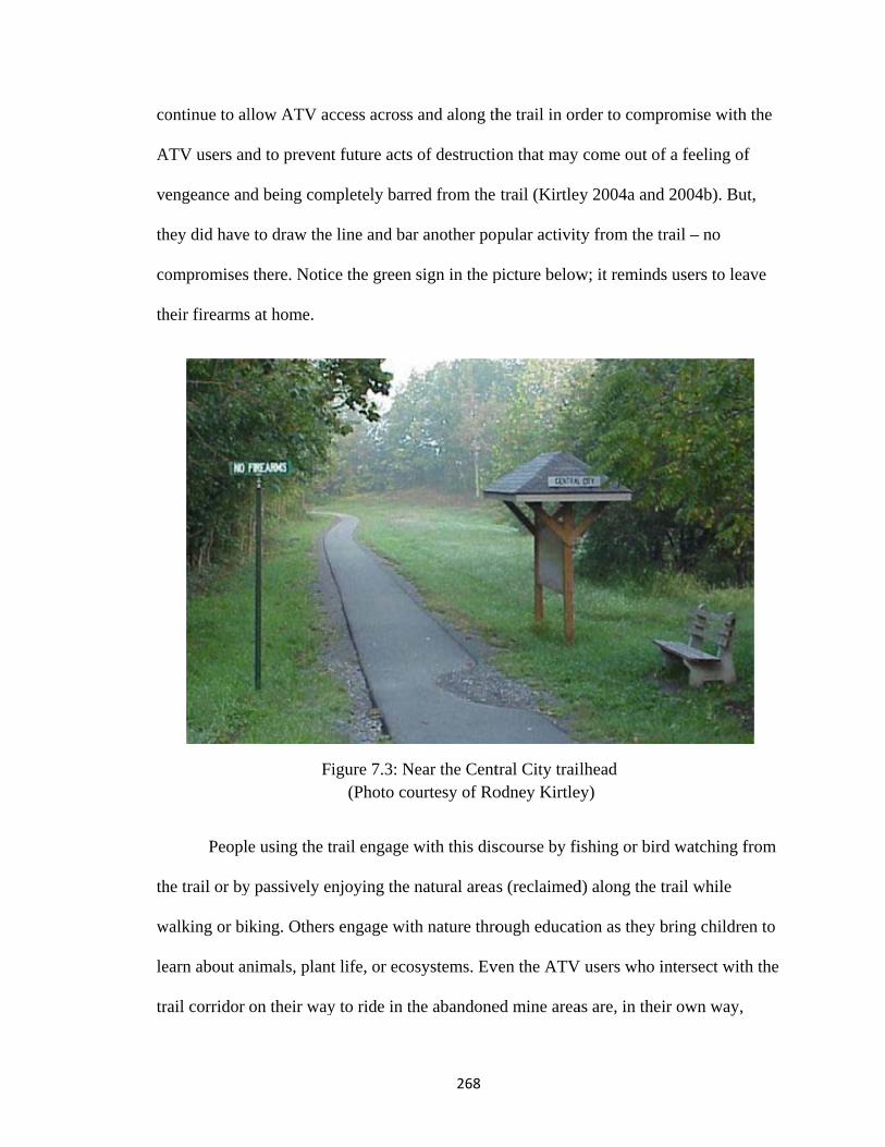
co
A
v
th
co
th
th
w
le
tr
ontinue to al
ATV users an
engeance an
hey did have
ompromises
heir firearms
Peopl
he trail or by
walking or bi
earn about an
rail corridor
llow ATV ac
nd to prevent
nd being com
e to draw the
there. Notic
s at home.
F
e using the t
y passively e
iking. Others
nimals, plant
on their way
ccess across
t future acts
mpletely barr
e line and bar
ce the green
igure 7.3: N (Photo co
trail engage w
njoying the
s engage wit
t life, or eco
y to ride in th
268
and along th
of destructio
red from the
r another pop
sign in the p
Near the Centourtesy of Ro
with this dis
natural areas
th nature thro
systems. Ev
he abandone
he trail in or
on that may
trail (Kirtley
pular activit
picture below
tral City traiodney Kirtle
scourse by fi
s (reclaimed
ough educat
ven the ATV
ed mine area
rder to comp
come out of
y 2004a and
ty from the t
w; it reminds
lhead ey)
ishing or bird
d) along the t
tion as they b
V users who i
as are, in thei
promise with
f a feeling of
d 2004b). Bu
trail – no
s users to lea
d watching f
trail while
bring childre
intersect with
ir own way,
h the
f
ut,
ave
from
en to
h the

269
valuing the nature discourse of the trail. They are of course in some cases also hastening
its destruction, but even users with an oppositional discourse (as pedestrian trail and ATV
trail advocates often are) sometimes have the same values for the same place.
Broader discourses materialized through local landscapes
In what way does the trail landscape mediate national agendas or discourses to the
Muhlenberg County public? It’s difficult to think about the Muhlenberg County rail trail
outside of the larger context of rails to trails across the US and the national Rails to Trails
Conservancy. This trail would never have happened without their technical support and
the support of the Kentucky Rails to Trails Council. But it also never would have
happened if legislation such as the railbanking laws had not been in place. The RTC has
been instrumental in supporting this legislation and working with landowners and trail
managers as the law has been challenged in court. Kentucky is hardly a groundbreaker
when it comes to rail trail development, so we can see that the larger rails to trails
movement has influenced Kentucky communities as they see what other places have done
with their abandoned rail trails. The Muhlenberg County Rail Trail is a local, physical
manifestation of the larger discourse and value for preservation of abandoned railroad
corridors as advocated by organizations such as the Rails to Trails Conservancy and the
Kentucky Rails to Trails Council. Unlike the Minnesota case study, there was little
influence from other state agencies here in Muhlenberg County in relation to trails. The
state Department of Natural Resources does not have the same responsibility for trail
management as the Minnesota DNR. In Kentucky this agency oversees forestry, mining,
conservation, and land preservation. The Kentucky State Parks oversee trails within state

270
parks, but these tend to be shorter trails, not the long connecting state trails that the state
of Minnesota manages in addition to state parks.
The larger discourse of historic preservation through the filter of the Kentucky
Heritage Council or the National Trust for Historic Preservation is less evident in
Muhlenberg County than in the other two case studies. Aside from the initial finding of
no impact in the Section 106 review completed at abandonment, these organizations had
limited involvement in this particular corridor. The trail has no extant railroad buildings
and no other adjacent (officially designated) historic structures.
The theme that keeps appearing in study of the Muhlenberg rail trail is “on its
own terms.” The values woven through this trail landscape have roots beyond the
community and connections regionally and nationally, but the interpretation is unique.
On each of the three main values materialized here: values for nature, for wellness, and
for history, each are interpreted in a distinct way that reflects the community. This
message is a powerful one in Kentucky (and elsewhere) as the story of this trail is relayed
around the state: your trail isn’t about people coming in from outside saying you have to
only enjoy it from your expensive bikes with spandex outfits. You can walk in your boots
after work and enjoy visiting with your neighbors. So too with nature appreciation and
historic features; these examples illustrate that there is room for local interpretation and
negotiation to accommodate the local values.
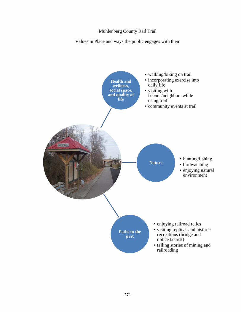
Values i
Muhlen
in Place and
H
soan
271
nberg County
ways the pu
Health and wellness,
ocial space, d quality of
life
Paths to tpast
y Rail Trail
ublic engage
• walki• incor
daily • visitin
friendusing
• comm
the
• e• v
rn
• tr
Natu
es with them
ing/biking orporating exe
lifeng with ds/neighborsg trailmunity event
enjoying railvisiting replirecreations (notice boardtelling storierailroading
ure•••
m
n trailercise into
s while
ts at trail
lroad relicsicas and hist(bridge and ds)es of mining
• hunting/fis• birdwatchi• enjoying n
environme
toric
and
shinging
natural ent

272
Oldham County Greenways
In a place in transition from small towns and horse farms to suburbia, trails
similar to those developed and proposed by Greenways for Oldham County serve a
different purpose and fulfill different needs than trails in places like Muhlenberg County.
In Oldham County the trails are envisioned as an important piece of development: a way
to both attract amenity-focused homebuyers and also preserve some features of the
landscape deemed valuable to long-time residents as well as new ones.
Landscape that makes things happen
Oldham County Greenways give an example of a community envisioning the
potential of their trail to be a hedge against the change that population growth and
suburban development have brought to the area. Here trails are valued not only for what
they are but what they are perceived to be able to do: preserve and enhance aspects of the
natural and cultural landscape that give the place its essential and attractive character that
drew the new residents in the first place.
Historic preservation / landscape preservation
The greenways in Oldham County facilitate a vision that the residents have for
their home: the vision to preserve the “rural feel” of a place that is rapidly suburbanizing
and securely in the orbit of a large metropolitan area. For the most part, when we talk
about “preservation” and trails, we think of historic preservation of depots, bridges, and
the corridor itself. Those are all keenly relevant here, but part of a larger story of land and
landscape and identity preservation through the setting aside of greenspace in a place
where rural land is being developed quickly and dramatically.

273
So far, the trails are more of a hedge against landscape change from development.
The pieces currently in place: downtown LaGrange’s six tenths of a mile (mostly on
sidewalks), Wendell Moore Park’s trails, and the Commerce Parkway segment, are not
particularly significant when it comes to preserving greenspace. It is the vision for the
trail network that is significant here when it comes to landscape preservation. Future
plans envision the trails playing a more active role in preserving viewsheds and natural
habitat corridors. As for historic preservation, the restoration of the abandoned Louisville
and Nashville Railroad depot in downtown LaGrange was a centerpiece of the first phase
of trail development and is the only aspect of historic preservation included in the trails
so far (albeit an important piece!).
Quality of life, recreation, and alternative transportation
The plan for this network of trails also facilitates the vision for a quality of life in
the county that includes alternative transportation options and recreational facilities that
are accessible to all (both geographically and in design/features). The vision statement of
Greenways for Oldham County reads “to encourage the creation of trails and greenway
corridors, parks, and preserves in order to enhance and conserve the quality of life for the
citizens and wildlife of Oldham County” (Greenways for Oldham County 2010). All
three of these points are interconnected – quality of life is tied to more recreational
opportunities, and more transportation options increases the quality of life of residents at
all stages of life from childhood to the elderly.
The new trail network facilitates this vision in each of its three parts. At the
Commerce Parkway section, the new trail connects a commercial area (with movie
theater, restaurants, and strip malls) to the new library, a future school site, future

su
T
se
th
A
fi
d
to
ubdivisions,
The Wendell
eniors. Thes
he county sen
Also in Wend
ishing lake, p
owntown La
o the restored
a church, th
Moore Park
e trails are in
nior/commu
dell Moore P
playgrounds
aGrange trai
d depot, but
Figure 7.4:Photo
he county hea
k trails provid
n one quarte
unity center.
Park are an a
s, golf course
l segment do
a future trai
: Trails undeo courtesy of
274
alth departm
de increased
er, one half, a
They feature
array of recre
e, picnic gro
oesn’t really
il will conne
er constructiof Greenways
ment, and two
d access for o
and one mile
e level surfa
eation oppor
ounds, ball fi
y provide any
ct to the Com
on at Wendes for Oldham
o Park and T
outdoor recr
e loops and a
aces and ben
rtunities such
ields, and ten
y new conne
mmerce Park
ell Moore Pam County
TARC facilit
reation to are
are adjacent
nches for rest
h as a pool,
nnis courts. T
ections other
kway segme
ark
ties.
ea
to
ting.
The
r than
ent.

275
Landscape that brings people and ideas together
Historic preservation/landscape preservation and new growth
Trails in Oldham County serve as a tool to mediate between the desire and
necessity (and inevitability) of commercial and residential development and the desire to
retain aspects of tradition, history, and the “feel” of the place. They are means toward the
goal of preventing a total transformation of the county away from what residents love
about it. Trails are tools embraced by the local units of government and by local
developers from both directions: because they care about the place but also because they
understand that the availability of nearby trails raises property values, makes
communities attractive to potential residents, and improve quality of life. They are a
smart business and political decision.
But, it doesn’t mean that trails in the county will provide a solution to the tension
between the suburban development status quo and landscape preservation interests. Trails
merely allow another outlet for these competing discourses to work themselves out and
find some common ground. With or without trails these conversations would go on. An
acceptance of trails and inclusion of connections to them in new subdivisions doesn’t
mean they are any closer to embracing other tenets of smart growth. Trails are a point of
agreement for development people. Whether you support the status quo subdivisions or
smart growth or somewhere in between, most agree that trails are good for their bottom
line and are marketable amenities that increase property values and the desirability of
their properties.

L
th
w
co
qu
m
a
ar
co
el
Landscape th
Many
he place (or a
ways they are
oncurrent id
uestion look
myriad discou
rural highw
re working i
ommercial, r
lement in a c
Figure
hat physica
y different sta
at least their
e materialize
eas and pars
ks like the on
urses materi
way. But this
in anticipatio
residential, a
complex sub
7.5: Comm
lly manifest
akeholder gr
r visions ove
ed on the lan
sing out wha
ne below (se
alized here;
is a landscap
on of signific
and other dev
burban neigh
erce Parkwa
276
ts values fro
roups in Old
erlap) so to e
ndscape is a m
at is shared a
e Figure 7.4
it is just a te
pe in flux an
cant change.
velopment a
hborhood.
ay trail segm
om the comm
dham County
examine the
matter of see
and what is n
4) it can be d
en foot wide
nd one where
. The adjacen
and soon this
ment, shortly
munity and
y share the sa
different dis
eing these ov
not. When th
difficult to se
ribbon of as
e its manage
nt properties
s trail will be
after 2009 c
d beyond
ame vision f
scourses and
verlapping a
he landscape
ee evidence o
sphalt parall
ers and owne
s are zoned f
e an importa
completion
for
d the
and
in
of the
leling
ers
for
ant

277
Landscape preservation/historic preservation
The discourse of rural landscape preservation is materialized through the
development of Oldham County greenways. These corridors contribute to the goal of
preserving park and greenspace – and planning well for that preservation – long before
development occurs. Some of the benefits put forward by Greenways for Oldham County
(GOC) include wildlife habitat preservation and stream buffer protection. GOC states that
the greenways will, “protect environmentally important lands and native plants and
animals, [and] also link people with the natural world and outdoor recreational
opportunities” (Greenways for Oldham County 2010). The goal of landscape preservation
is two-fold: both in the sense of conservation for habitats and environmental protection
but also to preserve some of the character the elements of the natural environment
provided to the place. These elements included open fields and vistas, stands of trees, and
creek valleys, for example. Some evidence of this is in the choices for trail furniture and
signage elements. As discussed in previous chapters, these elements hearken to the
surrounding landscapes of horse farms and historic limestone foundations.
The other facet of preservation expressed through this landscape is that of historic
preservation. The acquisition and restoration of the Louisville and Nashville RR depot in
LaGrange in Phase I of the project was the historic preservation centerpiece of the
Oldham County project. Historic preservation is clearly something that is important to
communities in the county – especially LaGrange. Their historic downtown and
neighborhoods are a major asset to tourism and sense of place. Through the efforts of the
Main Street program and the local chamber of commerce, the town has done much to
promote its historic streetscape. The community identity is built to a large degree on the
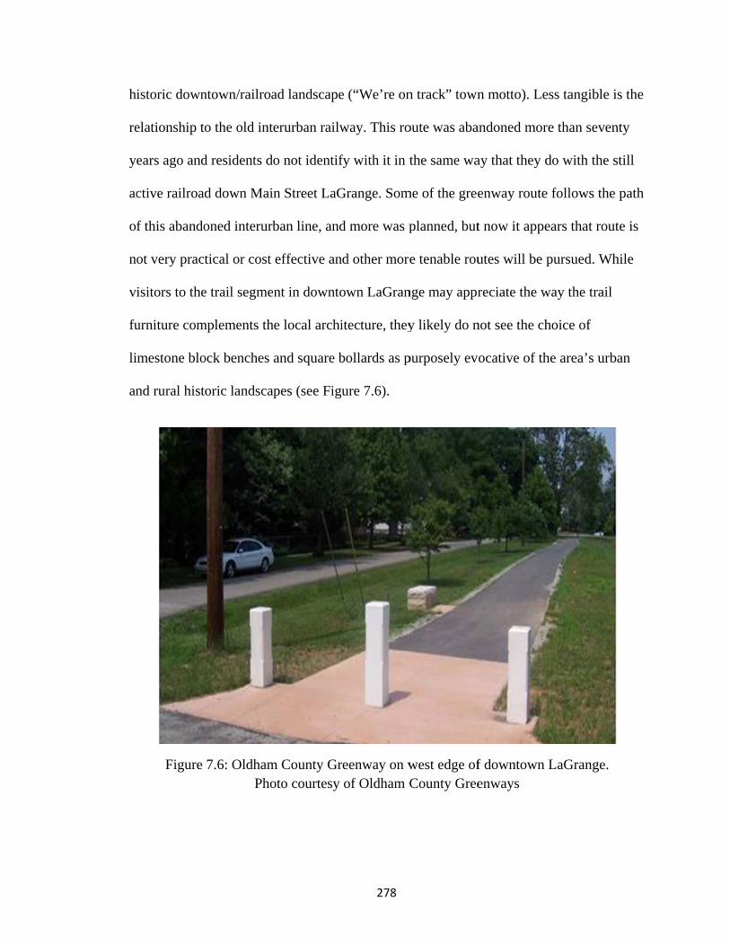
h
re
y
ac
o
n
v
fu
li
an
istoric down
elationship to
ears ago and
ctive railroad
f this abando
ot very pract
isitors to the
urniture com
imestone blo
nd rural hist
Figure
ntown/railroa
o the old int
d residents d
d down Mai
oned interurb
tical or cost
e trail segme
mplements th
ock benches
oric landsca
7.6: OldhamPho
ad landscape
erurban railw
o not identif
n Street LaG
ban line, and
effective an
nt in downto
he local archi
and square b
apes (see Fig
m County Groto courtesy
278
e (“We’re on
way. This ro
fy with it in t
Grange. Som
d more was p
nd other more
own LaGran
itecture, they
bollards as p
ure 7.6).
reenway on wof Oldham C
n track” town
oute was aba
the same wa
me of the gree
planned, but
e tenable rou
nge may appr
y likely do n
purposely ev
west edge ofCounty Gree
n motto). Le
andoned mor
ay that they d
enway route
t now it appe
utes will be p
reciate the w
not see the ch
ocative of th
f downtown enways
ess tangible i
re than seven
do with the s
e follows the
ears that rou
pursued. Wh
way the trail
hoice of
he area’s urb
LaGrange.
is the
nty
still
e path
ute is
hile
ban

279
“Rural way of life” in light of development
There are conflicting values in Oldham – those who support development in the
status quo (large lots, subdivisions, $500,000 homes, built in rural and natural areas) and
those who see development running roughshod over the natural and agricultural
environments. A recent subdivision was approved for land that had been zoned as
conservation land. Neighbors were understandably opposed to this development.
Developers did have to make some concessions for open space and hooking up to city
water and sewer. The old irony here of course is that realtors marketing homes in some of
the hundreds of subdivisions use language such as: “The rolling hills give you
unbelievable views of neighboring farms” (The Schafer Team 2009). Groups such as
Oldham Ahead are trying to preserve those views, hills, and farms from the likes of The
Schafer Team! A long-time local resident remarked “What everybody was drawn to
originally was the rural character of this county and now it’s gone” (Komis 2005). This
value for the rural character of the area paradoxically goes hand in hand with the next
value, that of attracting residents to the area. These values are in constant tension.
Quality of life: Attractive place to mobile suburbanites
One factor that drives the support and development for a trail network in Oldham
County is a desire on the part of planners and leaders to be competitive in the suburban
marketplace. The communities in the county and their attendant housing developments
compete for the projected additional 30,000 residents in the county by 2025. The
Louisville Metropolitan area is home to 1.2 million people, the largest metro area in the
state (U.S. Census Bureau 2009). The metro area includes Jefferson County (which
contains the city itself), five counties across the Ohio River in Indiana, and eight other
counties in Kentucky. Oldham County leadership knows they are competing with many

280
other attractive suburban residential areas around the metro area including Bullitt,
Shelby, and Spencer County. Planners and developers have discovered that it takes more
than lovely homes and pleasant vistas to attract homeowners. It takes good schools,
convenient commercial and civic amenities, and features attractive to young and active
residents such as trails, parks, walkable communities, and multiple transportation options.
Trails around the country have been positioned as major amenities to attract
residents to communities. They have been proven to raise (or at least help to sustain)
property values for properties adjacent to them. In homeowner communities driven by the
almighty property value, this is a very important selling point, perhaps even more
important than the actual physical health benefit or recreational enjoyment benefit! The
use of trails seems irrelevant; it is the appearance of trails and greenspace that boosts
property values. The hope is for an eventual well developed network of trails instead of
these piecemeal trail segments that lead nowhere and connect little.
Broader discourses materialized through local landscapes
In what way does the trail landscape mediate national agendas or discourses to the
Oldham County public? Some of the broader discourses manifest through the Oldham
County Greenways include historic preservation (both state and national), and different
ideas about growth, development, and land preservation.
Within historic preservation, there are a number of different voices present in the
area. LaGrange has an active Main Street program and has received numerous state and
national grants funding preservation projects. The entire downtown area is listed as a
historic district on the National Register of Historic Places. And though the extent is
unclear, the Kentucky Heritage Council had some influence on Phase One of the trail

281
project and the restoration of the Louisville and Nashville RR depot. Much of the local
discourse on the character of the town of LaGrange centers on its historic buildings and
streetscape and the presence of the railroad through town. This discourse on historic
preservation ties in closely with discussions on landscape preservation as groups focus on
the historic horse farm/agricultural landscape of the county that is threatened by further
development.
While I observed almost no references to smart growth as a label for the type of
growth advocated by some in the county, elements of it were certainly present30. This
seemed to be counter to the continued development of “status quo” subdivisions that
lacked connections to other places, consisted of large lots, were not mixed use, and were
almost entirely auto-dependent. Surveys of residents (done as part of the Trails and
Greenways Master Plan in 2008) hint at desires for something different, for more
connectivity and walkability in the area. Organizations such as Friends of Westport and
Oldham Ahead advocate for a form of development closely akin to smart growth. Though
again, they do not refer to it as such; using more commonly the phrase “growth
management”.
Oldham County is a place in transition; it is experiencing significant change to its
land use, population, and economic base in light of suburban growth as a bedroom
community to Metropolitan Louisville. There is conflict and overlap between goals and
visions for the county; greenways are one example of this. Trails and parks are seen as
both a hedge against the changes in land use but also as a way to attract residents and 30 Most references to “smart growth” or “sprawl” I saw were in articles in the Louisville Courier-Journal and in the Oldham Era, though Oldham Ahead had a section of “smart growth links and organizations” on its website and I saw one online PowerPoint presentation on smart growth by Oldham County Planning director Louise Allen.

282
investment to the county. This paradox will continue to be worked out as growth
advances in the area. The hope is that trails can serve to mitigate some of the negative
aspects of suburban growth.

Values i
Oldha
in Place and
P
283
am County G
ways the pu
Landscape Preservation
Historic Preservation
Rlifde
Attractiveneto suburba
residents/Quality of li
Greenways
ublic engage
n/
n
• vis• wa
dow• enj• vis
mu
Rural way of fe in light of evelopment
ess an / ife
• tra• co• tra• ad
raam
es with them
siting the depalking/shoppwntown LaGjoying rural siting historicuseum
• workgrow
• decrylands
• workthat achara
ails in subdivonnectivityansportationdvocate for/bange of recremenities
m
poting/visiting
Grangevistasc sites and
king towardswth"ying loss of scapesking for orgaaim preserveacter
visions
n optionsbuild a widereational
s "managed
rural
anizations e rural
r

284
Bruce Vento Nature Sanctuary
The Vento case in Minnesota is in sharp contrast to the Kentucky case studies
because of the context within which it was developed. In a state/region with long-
standing values for trails it was not as much of a fight to build it in the first place (as it
was in Muhlenberg County). Instead, it is yet another testament to the dominant paradigm
that is trails and alternative transportation in Minnesota. Other key themes at Vento
include mediation between Native American and Euro-American cultures and histories
and connections between people and nature.
Landscape that makes things happen
The values facilitated through the Vento site include a new focus on
environmental awareness to the youth of the East Side – students who otherwise wouldn’t
have many local opportunities to learn about biomes, invasive species, or migratory
paths. The Bruce Vento Nature Sanctuary facilitates the maintenance of a dominant
Minnesota paradigm: it echoes larger values of connecting people to the environment,
people to places, and places to places through the trail networks. None of these are
exactly new paradigms in the city or in Minnesota. Some of these values were already
well established, even the dominant paradigms (trails and outdoor recreation). This is a
value evident throughout Minnesota but is reinforced by the development here. Others
have grown in the last thirty years, but were further strengthened here.
The site facilitates valuing the past and for historic preservation both inside its
boundaries and nearby places. The development of the Bruce Vento Nature Sanctuary not
only accomplished the cleanup of the site after years of neglect, but its existence sustains
the revitalization. No one dumps garbage there anymore and there is little fear of crime or

285
chance of stumbling upon a homeless encampment. There is a respect for the site as a
place for the community and there are more “eyes on the street” as the site is used heavily
all day and all year (and perhaps increased patrols as well). Perceptions of crime and
littering that come along with trails often disappear once the trail is on the ground; those
are more likely to be seen in an unused, undeveloped landscape than a completed trail
project. These are outcomes that would have not happened without the trail and
sanctuary’s development. Another outcome that is planned is the restoration and reuse of
the Standard Oil Building adjacent to the sanctuary. Interest in preserving and reusing
that building would certainly not have existed had the sanctuary not been completed.
Landscape that brings people and ideas together
The ceremony held at the sanctuary’s opening showed how this site is a place
where people and ideas are reconciled. Anne Ketz, the historical consultant who did the
Section 106 review, recounted it in this way:
The official opening ceremony for the sanctuary was a landmark event, with participation from community partners, politicians and many Native people. Prayers and speeches were made, drummers played, and there was a tangible sense of a collective vision and desire for a rebirth of this land and a sharing of its important cultural and ecological history (2006: 3).
Here the mediation is both literal and figurative. The trail helped to accomplish
the literal bringing together of disparate interests – Dakota tribal representatives, St. Paul
neighbors, politicians, and planners – at one place and time to celebrate the common
ground of the opening of the Sanctuary. It is figurative in that it furthers understanding
and communication between the local Native American cultures and the cultures of other
local residents – both long term resident cultures and relative newcomers like

286
Lao/Hmong immigrants. Many of the young interns who work at the site are Southeast
Asian youth from the nearby neighborhoods.
The site provides a spatial context for mediation between the Dakota people and
the rest of the public. The restoration of the land and ecosystem to native species is a part
of healing for past wrongs against land and people. Vento Sanctuary reconciles the
contentious European settlement story with the Native American sense of belonging to
this place through the steering committee’s sensitive development and interpretation. The
planners chose to step very carefully and respect the story. They didn’t just start with
Anglo settlement, and they chose not to tell the story of the brewery in great detail, the
brewery story must be reconciled with the story of how the European settlers (and their
alcohol) impacted the Native Americans. This process is a long way from conclusion and
will continue to be worked out over many years.
Another way that the Vento Sanctuary mediates is around the dual theme of
“nature/history” so prominent in the vision for the site. Nature is mediated
(communicated, explained, interpreted, connected) to the site’s visitors and neighbors.
These people may have little understanding of the ecology of the place, the importance of
the river, the habitats the site provides, and how natural landscapes can be restored after
degradation. Tied to the way the site provides a context for mediating ecology to visitors
is the way that the site communicates the stories of the past to the public. One of the core
foci of the steering committee is to tell the history of the site and through it the history of
the city, the state, and the region.

287
The Vento Sanctuary, along with other urban natural areas in the Twin Cities,
serves the purpose of connecting people to the land and the stories tied to it. Especially
for urban youth who may not have any generational ties to the place, places such as
Vento provide a way for people to find meaning in their city not just in their homes,
streets, or relationships but in the stories both natural and cultural.
Landscape that physically manifests values from the community and beyond
The Bruce Vento Nature Sanctuary manifests many of the values traditionally
associated with the Twin Cities and the state of Minnesota and its residents: values placed
upon outdoor recreation, natural resources, parks and trails, alternative transportation, the
Mississippi River, education and families, Native American culture, and history. Each of
these stories plays out in the place of the nature sanctuary. The idea of discourses
materialized in the landscape (Schein1997) correlates with this dissertation’s theme of
“values in place”: the values of those who had roles in shaping the place are evident and
physically manifested in that place.
Outdoor values: trails/public greenspace, natural resources, the river, conservation
The Vento Sanctuary would not exist without advocacy from individuals and
groups who support the development and conservation of natural resources and open
space. This support ranged from participation on steering committees to committing
thousands of dollars in funding and ongoing maintenance. The sanctuary itself is a
material expression of these discourses and is a testament of the strong values for these
things.
Minnesota has a long-established record of developing rail trails (some of the first
were legislatively authorized in the late 1960s) and the statistics point to this history. The

288
state is second only to Michigan in number of miles of rail trails with 2,327 miles (RTC
2010). One place from which much financial, planning, vision, and leadership support
comes is the state, primarily the state Department of Natural Resources. The DNR
manages Minnesota’s state trails (most are rail trails); most of these trails are dozens of
miles long and some are over one hundred miles. Also in Minnesota is a network of over
21,000 miles of seasonal snowmobile trails. Many of these trails use roadway ditches and
the margins of farm fields where signage is the only permanent infrastructure but other
trails have dedicated rights of way. A grant-in-aid program funds local volunteer efforts
to maintain these trails. It was a difficult and multi-year endeavor to acquire and develop
the Vento Sanctuary, but it was possible because of the infrastructure of support and
expectations that both the public and state and local leadership has for trails and parks in
Minnesota. Trails and other outdoor recreation amenities in Minnesota serve as normative
landscapes, places that both reflect and perpetuate the values underlying them (Schein
2003).

R
in
h
is
al
31
amwsubysa
Figure 7.7Remnants of
Broo
The C
ncrease appr
istoric/cultur
s manifest31.
llocated, but
The question mended to ded
wetlands, prairieupport our parky increasing thales until the ye
7: Trails thatf abandoned
ok canal unde
Clean Water,
roved by vote
ral resources
The state is
t its existenc
that was on theicate funding tes, forests, andks and trails; anhe sales and useear 2034?"
t connect Verailroad brid
er the bridge
Land, and L
ers in 2008 t
s, is another
still in the p
ce is telling o
e 2008 Generalto protect our dd fish, game, annd to protect, ee tax rate begin
289
ento Sanctuadge infrastrue (natural str
Legacy Ame
to fund natur
example of
process of pl
of the degree
l Election ballodrinking water nd wildlife habenhance, and renning July 1, 20
ary to nearbyucture visiblream that wa
endment, a 0
ral resources
f how this dis
lanning for h
e to which M
ot stated: “Shasources; to pro
bitat; to preservestore our lakes009, by three-e
y parks and re on the righ
as confined t
0.38 percent
s, water qual
scourse of tr
how the proc
Minnesotans
all the Minnesootect, enhance,ve our arts and s, rivers, streameighths of one
regional trailht with the Tto canal).
sales tax
lity, and
rail/park supp
ceeds will be
value natura
ota Constitution and restore oucultural herita
ms, and groundpercent on tax
ls. Trout
port
e
al and
n be ur ge; to dwater able
290
cultural resources. There is little material evidence of this particular funding stream on
the landscape yet because it is so new. The amendment includes four separate funds: the
Outdoor Heritage Fund (33 percent of tax proceeds), the Arts and Cultural Heritage Fund
(33 percent of tax proceeds), the Parks and Trails Legacy Fund (14.25 percent of tax
proceeds), and the Clean Water Fund (19.75 percent of tax proceeds). So far the Arts and
Cultural Heritage Fund has begun to allocate money to applicants, but the other funds are
still in the planning stages. Nina Archabal, director of the Minnesota Historical Society
and State Historic Preservation Officer spoke of the way this amendment represented the
“basic values of Minnesotans” in its focus on clean water, parks and trails, and the arts
and that its successful adoption “shows the true heart of Minnesotans” (Archabal 2009).
As part of the planning process for the Parks and Trails Legacy Fund, the
Minnesota Department of Natural Resources, in partnership with the non-profit Citizens
League, conducted seventeen community workshops around the state during the spring of
2010. The purpose of these workshops was to learn about the public’s “vision and values
for Minnesota parks and trails” and to use that input as the foundation for writing the
twenty-five-year long range plan for how to spend the revenue from the Legacy Fund
(MNDNR/Citizens League 6/15/10). Most of these workshops around the state attracted
well over fifty participants; some had over ninety. The one I attended in Minneapolis had
nearly seventy people in attendance. Participants were a decidedly self-selected group of
strong park and trail advocates, many of whom work for various state, local, or non-profit
agencies active in the world of trails and parks. At tables of six to eight participants plus
a facilitator, we discussed things such as what are the primary benefits of outdoor
recreation, what the funding priorities should be, how to increase participation in outdoor

291
recreation, how to deal with budget challenges, and what our vision for Minnesota’s
parks and trails is for the next twenty-five years. Then we registered our individual votes
via wireless key pads for instant views of the opinions of the whole group. This workshop
reinforced the way that trails and parks are an expected and even demanded public good.
One participant said “people expect police protection, and fire protection in their
communities but parks really drive a community and drive people to want to stay in a
community.” A strong indication of the unrepresentative group assembled at the
workshop (aside from the fact it was overwhelmingly white, middle aged, and male) was
the way the group voted on how to deal with budget challenges: 51 percent agreed that
raising taxes was an acceptable solution, by far the largest number of any of the ideas (the
next most popular idea was sharing management with local agencies with 35 percent).
The public as a whole would probably not be so supportive of increased taxes, but they
did vote to institute the Legacy Fund in the first place. Many states across the nation are
closing parks, cutting hours, cutting programming and staff, even selling property but
Minnesota is one of the only places that is actively planning for future development and
expansion instead of retrenchment.
How does the public engage with the values for natural resources and open space?
They come to the Vento Sanctuary to bird watch, or to see the restored and growing
ecosystems. Some visit to paint or photograph at the site. They participate as volunteers
at the site doing cleanup or restoration work. Others participate in the internships through
the Youth Conservation Corps. Some engage more passively with these values through
reading the interpretive signs or by simply walking or biking through the sanctuary or
even appreciating its presence without using the site at all.

292
History and historic preservation
History was always present in the process of building a vision for the site through
planning and development. There are values for the stories of the place, known and
unknown, visible and invisible. A weedy, trashy, mess became evidence of a significant
railroad story. A roughly barricaded hole in the bluff became known as a site of
considerable symbolic importance to generations of Native American people. Listening
to and validating Native voices is encouraged here. The compelling histories told through
the site were important motivators to committee members, funders, and the public. The
need to tell these stories provided impetus to its completion; it was not just another bike
trail (though it still would have been built probably even if that was the case).
These values for history manifest at the site through the attention to the different
layers of history present there: the Native American story of Wakan Tipi and nearby
settlements, the early settler story of the Northstar Brewery and St. Paul’s first industries,
and the story of the railroads that altered and expanded the site as an important rail yard.
The negotiation process by the steering committee with the disparate interests represented
there testifies to the values for history and preservation. There was a desire on the
committee’s (and the city’s) part to preserve elements of all of these periods of
significance and not tell one story at the expense of another. Remnants of the concrete
railroad maintenance pads were left in place as a visual clue to the industrial past.
Corners of the brewery foundation were left exposed to show evidence of its location
(along with the brewery cave, a natural cave expanded for use in the beer making
process). Wakan Tipi’s entrance is still carefully (if not aesthetically) protected, even
though much of the cave was destroyed during the railroad expansions at the site.

293
How does the public engage with the values for history or historic preservation at
the Vento Sanctuary? Most engagement is passive, through observation, by exploring and
viewing the site, and by reading the interpretive signs. Visitors can see remnants of the
brewery foundations and peer into the caves used by the brewery. They can see the closed
entrance to Wakan Tipi. They can walk along the concrete slabs left from the railroad
maintenance facility. Some special events and tours at the site provide guided tours and
educational opportunities. In the future, visitors to the site might be able to more actively
experience the history of the site through the restoration of the former industrial building
into an interpretive center.
Alternative transportation
There is much debate on the merits of non-personal automobile transportation
projects (or more precisely, the public financing of such projects), even in Minnesota
where support for trails and public transport are quite strong. But trails like this one
continue to be built around the state. The Vento site served as a missing link in an already
extensive regional trail network. It connected several local trails and made it possible to
travel from downtown St. Paul to Duluth entirely on paved off-road trails. Once a bridge
is built over the active rail line, the site will connect to trails farther to the south.
Even in Minnesota’s harsh winter climate, Minneapolis is near the top in numbers
of bicycle commuters32 (second only to Portland, OR). Much of this figure is because of
an extensive network of off-road trails and on-road bicycle lanes in addition to seamless
connections to public transportation (all buses and light rail trains have bike racks).
Turning parkland into pieces of a larger network and not just unconnected destination
32 Portland had 5.96 percent of commuters traveling by bike; Minneapolis had 4.27 percent (2008 American Community Survey data, refers only to commuting to work and not leisure trips).
294
pieces is a key goal of regional park and trail advocates (and lay people as evidenced in
Parks and Trails Legacy Fund workshops – especially from communities with trails
lacking links). In addition, a key part of trail success is building trails that connect places
where people live to places they want and need to go. The Vento site does this well as it
connects Lowertown St. Paul with its Farmers’ Market, condos, entertainment, and
offices to neighborhoods on the Eastside and beyond. The public engages with the values
for alternative transportation through their feet and their bicycles by using the trails
through the site for recreation and commuting.
Native American History
The site serves to mediate between Native American culture and history and white
European culture and history but it also displays physical manifestations of Native
American discourses and of the communications and connections between Native and
White cultures in Minnesota today. In many ways, the relationship between Native
American groups and Euro-American groups in Minnesota is still healing from
generations of difficulties. Conflicts still arise over interpretations of treaty rights, the
influence of now-wealthy tribes with successful urban casinos, residual pain from years
of forced relocation to reservations, and the memory of the 1862 Dakota Conflict with
white settlers. In the past ten years, several sites in the Twin Cities metro area have been
subject to public debate over use and interpretation in the realm of Native American
history and claims to significance. The Bruce Vento Nature Sanctuary was developed
into public parkland in the midst of these conflicts and was shaped by the planners’ desire
to do their best to incorporate Native American groups in the planning process, to respect
the sacred Wakan Tipi site, and to develop and interpret that area according to their

w
D
re
FA
tr
fo
w
A
sm
tr
gr
wishes. The s
Dakota band
epresentative
Figure 7.8: JAmerican tra
The h
rajectory to t
orgetting, the
went through
American rep
maller clues
ree planted b
roups leave
steering com
during the p
es from a va
im Rice speaaditions and
the
istory of the
the site’s his
en rediscove
a cycle of b
presentatives
on the lands
by the pond o
no evidence
mmittee consu
planning proc
ariety of loca
aks with a grthe history o
e one he plan
e Native Ame
story: it is a s
ery, revaluin
being valued
s at the open
scape are ev
outside of W
e on the land
295
ulted the cul
cess and con
al native grou
roup of visitof the site. Tnted at his m
erican prese
story of sign
ng, and honor
, devalued, a
ing ceremon
en more pow
Wakan Tipi. M
scape, but th
ltural resourc
ntinues to co
ups.
tors to the VThe cottonwo
marriage cere
nce on the s
nificance, sub
r once again
and revalued
nies was a po
werful. One
Most current
his tree, plan
ces director
onsult with tr
Vento Sanctuood tree in th
emony.
ite is sort of
bjugation, de
n in the same
d. The presen
owerful state
of these is th
t uses of the
nted by Jim R
from a metr
ribal
ary about Nahe foregroun
f a parallel
evaluation,
e way the sit
nce of Nativ
ement, but th
he cottonwo
site by triba
Rice and his
ro
ative nd is
e
ve
he
od
al
wife

296
at their wedding ceremony on the site, testifies to the site’s importance to both them
personally and to the significance of the site within Native American culture. The tree
itself is unmarked and unassuming and I am fortunate to have learned its story from Jim.
Broader discourses materialized through local landscape
In what way does the trail landscape mediate national agendas or discourses to the
public in the St. Paul/Minneapolis metro area? As discussed above, Minnesota enjoys a
high level of support for parks and trails at many levels from citizens to local and state
government organizations. This support is then leveraged to bring in federal money and
support for trails and recreation.
The Bruce Vento nature Sanctuary is a local, physical manifestation of the larger
discourse and value for preservation of abandoned railroad corridors as advocated by
organizations like the Rails to Trails Conservancy, though it does not appear that the
RTC had any direct involvement in Vento’s development. Indirectly, the Vento site exists
because of the advocacy of the RTC for programs and legislation like railbanking and
Transportation Enhancement funds. More than $1 million came from the TE program to
fund the development of the Vento Sanctuary and connecting trails.
Unlike Kentucky, historic preservation is not at such a central position in the eyes
of the governor or state funding streams. Just in the past year after eleven years of trying
did the state pass a historic preservation tax credit program. Very little Transportation
Enhancement funding was used for historic preservation-related projects over the years.
State TE coordinators speculated that Minnesotans have a different sense of history in
some ways. They thought that perhaps because our settlement history is so recent, our
ideas about what is “historic” are different. In addition, they cited the power of inertia in

297
transportation versus preservation projects – there is such a long legacy of project success
with trail projects that officials are reluctant to try something too far away (Chambers and
Anderson 2005). This is not to say that the Minnesota State Historic Preservation Office
is not active around the state or that historic preservation as a whole is not supported. It is
just to say that there is a different level of support and money available for preservation
versus trails, especially in Transportation Enhancement funding. It is telling that this
project received TE funds under category one: pedestrian and bicycle facilities and not
under one of the categories that relate to historic preservation.
Behind the scenes, but vital to the development of the Vento Sanctuary, was the
support of local and national groups that advocate for natural resource preservation. Two
major players at the Vento site were the Trust for Public Land (TPL) and the Minnesota
Department of Natural Resources (DNR). The TPL was instrumental in acquiring the
property from the railroad; they supplied an attorney who assisted with the negotiations.
The TPL also helped create a plan for environmental remediation and the new design for
the site. They also helped obtain liability insurance for the site while it was under
development (TPL 2006). While there is no distinct imprint of the involvement of Trust
for Public Land within the Vento site, the very presence of the developed park and trails
is testament to their influence. The DNR was active in securing funding and support for
the development of the Vento Sanctuary. The DNR Metro Greenways Program assisted
with restoring the native ecosystems to the site. In addition, the DNR is active in trails
and greenways advocacy around the state and applied their extensive experience and
support to the project.

298
The Vento site is a place that normalizes a dominant paradigm for trails and
outdoor recreation in Minnesota, but that doesn’t mean it was without conflict or
negotiation in its development. Almost as prominent as its embracing of dominant ideas
was the number of potential conflicts: between commercial and recreational uses,
between different types of park uses, between those who would highlight the historic
versus the ecological, between the different histories represented there. But planners have
managed to accommodate these conflicts and even hope in the future to highlight them
(especially the conflicting histories of white settlers and Native Americans). A lesson
from this case is the power of listening to community values in a place and designing the
project based on those values.
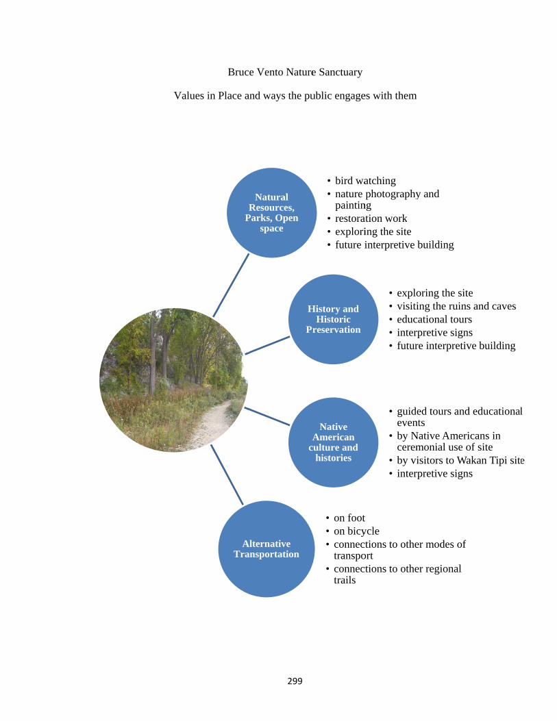
Values i
Bruce V
in Place and
NRe
Pars
AlterTransp
299
Vento Nature
ways the pu
Natural sources, ks, Open space
H
Pr
Ac
rnative portation
e Sanctuary
ublic engage
• bird wa• nature
paintin• restora• explori• future i
History and Historic
reservation
Native American
culture and histories
• on foot• on bicy• connec
transpo• connec
trails
es with them
atchingphotography
ngation working the siteinterpretive
• explo• visiti• educ• inter• futur
• guideven
• by Ncerem
• by vi• inter
tyclections to otheortctions to othe
m
y and
building
oring the siteing the ruins
cational toursrpretive signre interpretiv
ed tours andntsNative Amerimonial use oisitors to Warpretive sign
er modes of
er regional
es and cavesssve building
d educational
icans in of siteakan Tipi sites
l
e

300
In this chapter we explored the ways in which landscapes can facilitate ideas and
values, the ways they can mediate between people and ideas, and the ways that discourses
are realized as physical expressions in place. It is useful to remember why this endeavor
is important. We explore values in places because people matter; their stories matter, and
knowing them more deeply can lead to the development of places that resonate more with
a community, that fully embrace what communities most value.
The three case studies explored in this research each do the same thing and
different things. They each express what matters to the people who had a role in creating
them. In Muhlenberg County the trail became a new paradigm in the community: it
changed the way people valued the railroad corridor as it became a valuable community
space for recreation and wellness. In Oldham County the greenway network is envisioned
as a way to protect a paradigm held dear (for a variety of reasons): that of rural character
and vistas. The trails help to both preserve the landscape and also, paradoxically, attract
amenity-seeking suburban dwellers to the place. In Minnesota at the Vento Sanctuary the
trail and park extended, maintained, and helped to normalize the dominant trails
paradigm already supported and expected in the region. In the following concluding
remarks, we will revisit some of the major themes of this dissertation, address the
contributions it makes within and outside academia, and explore some possible future
directions for research.
Copyright © Lisa Rainey Brownell 2011

C
v
th
d
ec
Chapter 8 : C
This d
alues matter
hrough the th
evalued, and
conomic, so
Conclusion
Figure
Figur
dissertation e
r in trail and
hree rail trail
d/or revalued
cial, politica
e 8.1: Aband
re 8.2: Comp
explored the
historic pres
l case studie
d through tim
al, and other
301
doned rail lin
pleted rail tra
connections
servation pro
es were how
me? And how
values as th
ne near Moo
ail in Uniont
s between va
ojects. The
does a lands
w do historic
hese relate to
rman, KY
town, KY
alues and pla
central ques
scape becom
c values inte
o landscape p
ace and why
stions addres
me valued,
ersect with
preservation
y
ssed
?

302
One of the foundational assertions of this dissertation is that rails to trails projects are
inherently acts of historic preservation. By choosing to leave a former rail corridor intact
and reusing it for a new transportation use, the integrity and “feel” of the place as a
corridor is preserved and many of the auxiliary pieces of the railroad landscape are
preserved as a result such as bridges, depots, culverts, and signals. Also, the development
of a trail often leads to positive economic impacts on the communities it passes through,
an echo of the original effect of the rail line. This reinvestment often translates to
preservation of other historic fabric in trail towns. Both trail advocates and preservation
advocates readily recognize the inherent common ground between the two interests but
do not directly promote trail development as historic preservation. The Rails to Trails
Conservancy refers to the National Trust for Historic Preservation as “good friends”
(RTC 2010a) and the National Trust refers to the RTC as “close collaborators” (NTHP
2010b). Rail trails are not outlier examples of historic preservation projects; they are
squarely in the middle of what preservation wishes to accomplish today: the preservation
of communities and cultural landscapes that continue to be used by the communities in
which they are located and not just individual, disconnected buildings apart from
everyday life.
Following that assertion, the examination of rail trails as a cultural landscape in
geographic research is also a new endeavor. There is much precedent for exploring
ordinary landscapes in geographic research (Jackson 1980, Meinig 1979, Groth and
Bressi 1979, among others) and many aspects of railroad transportation have received
attention in geography (Vance 1995, Borchert 1987). Historic preservation has also been
well studied (Page and Mason 2004, Stipe 2003, Murtagh 2006), but examining rail trails

303
as a cultural landscape and as an act of historic preservation is a new line of inquiry
bridging disciplines.
The primary theme running throughout the entire dissertation was that of “values
in place,” the idea that values held by communities and individuals are manifest in and
through the places that they create, use, and care about. The purpose of the dissertation
was to examine how we learn about these values, why it matters to learn about them,
what to do with the information once we learn it, and who can benefit from learning more
about communities’ “values in place.”
The Bruce Vento Nature Sanctuary provided an example of the way community
values for a place changed dramatically over the years from sacred Native American
gathering place, to important industrial area, to neglected and vandalized “no man’s
land,” to parkland with educational, recreational, transportation, historical, and ecological
values. The Muhlenberg County Rail Trail told a story of a community that did not know
that it would value a trail so highly until it was built in spite of a lack of community
support. The trail is now one of the central community gathering places, tourist
attractions, and points of pride in the county. In Oldham County, we saw not so much
how community sentiment towards trails changed over time, but how changing
community values supported the development of a trail as an expression of those values.
Bridging disciplines
This idea of values in place unifies ideas from many different traditions and areas
of professional practice including humanistic and critical geographical traditions,
transportation planning, and historic preservation. This research contributed to bridging
these three disciplines that otherwise have minimal interaction. There has certainly been
304
much recent conversation in historic preservation that ties in ideas from cultural
geography, but there are still many more opportunities to enrich practice there and in
trails planning with insights on values in place.
Each of these areas has some degree of focus on finding out what people believe
is significant or valuable about places, though each has different purposes in mind.
Values-based (or values-centered) preservation is the best fit for a theory/method that
encompasses what is important to each of these different areas. Values-based
preservation is a way of describing how historic preservation practice can assess
community values relating to places and incorporate those values in every step of the
planning process as historic places are defined, restored, redeveloped, and used. A
values-centered approach is at the core of the effort to bring together historic preservation
and geographical practice and research. This dissertation contributes to the conversation
between these interests by serving as a translation between the two, who often speak of
similar issues in similar ways. Randall Mason (2007) put this approach at the core of
preservation practice when he said,
“The future of the field of historic preservation depends on ability to make arguments for saving places on many different values. The key job of preservation is to reconcile different appraisals of value (for example economic, cultural, social, or historic)”.
Values-based preservation can be extended to enterprises other than preservation
such as trails and parks or transportation planning (indeed, it exists in these realms under
a variety of different titles). Through the case studies in this dissertation we have learned
the ways that a values-focused method can be effective and fruitful. A values-based

305
approach in preservation and trails is also an effective way to make connections between
applied and theoretical interests.
A critical humanistic geographical tradition provided a setting for this research.
The legacy of humanistic geography include an emphasis on human experience in place
(places matter because people matter) and the contributions of critical human geography
in the foundations of this research included sensitivity to systems of power and influence
beyond the individual and beyond the local and how those things interact with individual
experiences in place.
Schein’s framework
Schein’s (2009) “framework for interpreting ordinary landscapes” has been a
useful approach for laying out place stories, exploring the meanings and values that
people and communities have attached to those places, and analyzing ways that the places
facilitate, mediate, and physically materialize ideas and values. His framework is not just
an academic or theoretical exercise. It is approachable and broadly applicable to virtually
any place.
This dissertation expanded Schein’s model in new ways by weaving through it
humanistic concerns in place-based research. Schein’s model focuses on “landscape as a
part of broader social and political and economic and cultural discourses that are at once
disciplinary through the landscape’s place as a tangible visible scene/seen, even as those
discourses are open to challenge in and through the landscape itself” (Schein 2009: 398).
I have expanded the framework by considering people’s connections to and through
landscapes, why those matter, and what can be done with that knowledge. The model is
enriched and carried in new directions when the researcher interacts with people who

306
value the landscape in question. Methods including participant observation, interviews,
surveys, and focus groups bring the investigation of community values and meanings out
of the archive to the very people creating and using the place.
Why do values in place matter?
It was important to step back in this research and ask two questions: why is
geographic research concerned with values in place? and who is this for? The pursuit of
understanding of places and the people and cultures who create and find meaning in them
is a worthy one because that understanding can be used for much good, not just as an
academic exercise. Places matter because people matter, and because people matter,
making places that resonate with people, that people love and connect with, matters.
Knowing the communities’ values and senses of place and history help those involved
with making places (such as planners) to make better ones. Within geography, place,
along with space, has been called the core of geographic study (Tuan 1977, Adams, et. al
2001). In the humanistic tradition, the meaning and experience of places is a central
focus. The combination of values and place as a locus of study is important because place
is not merely “where things happen” but part of why social processes happen the way
they do. It is a different pursuit than the more literary purposes of many regional writers
who seek to capture the essence of a place in words or explore the implications of a
place’s meaning, or the power of place to shape identity, though not entirely separate
from pursuits like those.33
33 Two literary anthologies have been a continual inspiration for my work as a geographer since undergraduate days: Imagining Home: Writing from the Midwest and Inheriting the Land: Contemporary Voices from the Midwest ed. by Mark Vinz and Thom Tammaro. Another Minnesota example is The Heart Can Be Filled Anywhere on Earth by Bill Holm. Home and Beyond: A Collection of Kentucky Short Stories ed. by Morris Allen Grubbs is a good representative of the Kentucky version of this genre.

307
Who is this for?
It was important for me to be able to answer the question “who is this for?” with
someone other than myself. This research, in the way it brings together often disparate
camps of theory and method, is for anyone who is involved in making places: trails
advocates, historic preservation advocates, community members interested in livable
communities, as well as academics in geography, planning, or preservation. Some
avenues to share this work with others in trails and historic preservation include
presentations at conferences, articles in professional publications, participation on citizen
panels and, potentially, advisory boards for individual projects, and guest lectures in
historic preservation university courses.
Future directions
This project works towards connecting various disciplines around the common
ground of exploring values in places and towards recognizing how values matter not just
in theory, but in the real places, hearts, and lives of real people. Beyond adding to the
broader collection of geographical knowledge, the goal of this work is to assist and
promote, in some small way, greater public participation in planning, visioning, and
interpreting plus maintaining great recreational and/or historical places in our
communities. I think there are very real opportunities for applying Schein’s framework in
everyday planning practice in the analysis of what communities value about places.
Public input is growing in importance and commonly plays at least some role in project
development, as seen in the three case studies and in background information on
transportation and historic preservation planning. Planners and communities, however,
still strive for greater public inclusion and this four part framework could be applied
(perhaps in modified form) to a variety of projects. A natural next step would be to apply

308
this framework to an actual trail or historic preservation project from start to finish. In
each of these case studies, I was a mere observer and had no role in deciding
methodology for obtaining public input or determining community values. In addition, I
was examining the projects retrospectively through the lens of Schein’s model; a very
different experience than actively applying it from the start.
One possible way to implement this framework in the planning for a real project
would be to incorporate this exercise into the community service learning portion of a
cultural geography course. I’ve used examples of rail trails to teach about transportation
and urban morphology and I’ve used historic preservation case studies to teach about
layers of urban history and meaning in familiar places. Through established community
service learning arrangements, it would be quite straightforward to partner a class with a
community group, public agency, or consulting firm to provide assistance with a trail or
preservation project in which we could help employ aspects of Schein’s framework to
learn about the meanings and values the community holds for that place. In essence,
students could act as “consultants” to help facilitate this methodology through interviews,
community meetings, and researching archival materials in cooperation with the project
leads.
In a broader view, this study opened questions for how else one might learn more
about the interactions between discourses and landscapes through the examination of
values held by individuals attached to places. Future studies could rely more heavily on
interviews with individual community members in order to explore how values shift over
time and interact with landscape changes. Of particular interest would be studies of rail

309
trail or other historic landscapes where people with memories of, and attachment to the
place, span its history and uses before and after restoration or reuse.
I argue that historic preservation, trails, and other endeavors around sustainable
development, smart growth, and active living will become preeminently important in
places around the U.S. as economic realities change and as people become more aware of
the benefits of these types of development in terms of jobs, the environment, health and
wellness, livable communities, and historic preservation. Keith Laughlin, president of
Rails to Trails Conservancy characterized the rails to trails movement as “at a tipping
point” of support (2004). Preservation advocates speak of their movement in the same
way. If this is in fact the case, it will be important to conduct more research into the
implications of these types of development in many realms: economic, urban form,
community values and meanings, health, transportation, etc. Geographic research is at the
center of these concerns and is well positioned to make important contributions there.
Copyright © Lisa Rainey Brownell 2011

310
Bibliography
Adams, Paul C., Steven Hoelscher, and Karen E. Till, eds. 2001. Textures of Place: Exploring Humanist Geographies. Minneapolis: University of Minnesota Press. Advisory Council on Historic Preservation. Main website. Accessed October 4, 2010. http://www.achp.gov/. Agnew, John. 1993. “Representing Space: Space, Scale and Culture in Social Science.” In James Duncan and David Ley, eds. Place/Culture/Representation. London: Routledge. Alanen, Arnold R. and Robert Z. Melnick. 2000. Preserving Cultural Landscapes in America. Baltimore: The Johns Hopkins University Press. Allen, Benjamin Joseph. 1974. “The Economic Effects of Rail Abandonment on
Communities: A Case Study.” Unpublished dissertation, University of Illinois – Urbana/Champaign.
American Association of State Highway and Transportation Officials (AASHTO). 2000. TEA Challenge: Leading the Way. Washington, D.C.: AASHTO. Anderson, Mark. (Principal Planner, MN Dept. of Transportation). Interview by author, St. Paul, MN, October 2005. Anfinson, John O. 2003. River of History: A Historic Resources Study of the Mississippi National River and Recreation Area. St. Paul: US Army Corps of Engineers and National Park Service. Archabal, Nina. 2009. Address, Minnesota State Historic Preservation Conference, Chanhassen, MN, September 17, 2009. Archibald, Robert R. 1999. A Place to Remember: Using History to Build Community. Walnut Creek, CA: Altamira Press. Association of American Railroads. “Class I Railroad Statistics.” Accessed June 10,
2009. http://www.aar.org/~/media/aar/Industry%20Info/AAR%20Stats%202010%200914.ashx
Association of American Railroads. 2010. “The Impact of the Staggers Rail Act of 1980.” Accessed August 10, 2010.
http://www.aar.org/~/media/aar/backgroundpapers/impactofthestaggersrailactof1980.ashx.

311
Avrami, Erica, Marta de la Torre, and Randall Mason, eds., 2000. The Values and Benefits of Cultural Heritage Conservation: Research Report. Los Angeles, CA: Getty Conservation Institute. Avrami, Erica, Marta de la Torre, and Randall Mason, eds., 2002. Assessing the Values of Cultural Heritage. . Los Angeles, CA: Getty Conservation Institute. Bailey, Keiron and Theodore Grossardt. 2010. “Toward Structured Public Involvement: Justice, Geography and Collaborative Geospatial/Geovisual Decision Support Systems.” Annals of the Association of American Geographers. Jan. 2010, Vol.
100, No. 1, pp. 57-86. Baker, Theresa R. 2001. A Method to Assess the Potential Value of Railway Corridors as
Recreation Trails: A Case Study of Three Nova Scotia Rail-Trails. Unpublished Master’s thesis. Queen’s University, Kingston, Ontario.
Barnes, Trevor and Derek Gregory, eds. 1997. Reading Human Geography: The Poetics and Politics of Inquiry. London: Arnold. Barthel, Diane. 1996. Historic Preservation: Collective Memory and Historical Identity. New Brunswick, NJ: Rutgers University Press. Baxter, Jamie and John Eyles. 1997. “Evaluating Qualitative Research in Social Geography: Establishing ‘Rigour’ in Interview Analysis.” Transactions of the Institute of British Geographers. NS Vol. 22, pp. 505-525. Beard, Charles and Mary Beard. 1944. A Basic History of the United States. Philadelphia: Blakiston Belanger, Anouk. 2002. “Urban Space and Collective Memory: Analysing the Various Dimensions of the Productions of Memory.” Canadian Journal of Urban Research. Vol. 11, Issue 1, pp. 69-92. Bemisderfer, Timothy R. 1995. “Using abandoned railroad rights-of-way in rural
Landscapes as Nature Conservation and Linear Recreation Areas.” Unpublished Master of Landscape Architecture thesis. University of Georgia.
Bentel, Paul. 2004. “Where Do We Draw the Line? Historic Preservation’s Expanding Boundaries.” Future Anterior. Vol. 1, no. 4, pp. 42-49. Black, William R. and James F. Runke. 1975. The States and Rural Rail Preservation:
Alternative Strategies. Lexington, KY: The Council of State Governments. Blokland, Talja. 2001. “Bricks, Mortar, Memories: Neighbourhood and Networks in Collective Acts of Remembering.” International Journal of Urban and Regional Research. Vol. 25, No. 2, pp. 268-283.

312
BNSF. Main website. Accessed February 7, 2010. http://www.bnsf.com/. Bookspan, Shelley. 2001. “Preservation, Memory, and Values.” The Public Historian. Vol. 23, No. 1, pp. 5-8 (Fall 2001). Borchert, John R. 1987. America’s Northern Heartland: An Economic and Historical
Geography of the Upper Midwest. Minneapolis: University of Minnesota Press. Bowen, Dawn. 2008. “Preservation Through Recreation: The Dahlgren Railroad Heritage Trail.” Pioneer America Society Transactions. Vol. 31, pp. 39-47 (2008). Brandstetter Carroll Inc. 2008. Oldham County Parks & Rec Master Plan (Draft). LaGrange, KY: Oldham County Park and Rec. Accessed online at: http://www.oldhamahead.org/OC_Parks&Rec_Master_Plan_Draft_July2009.pdf. Last accessed on: 8/20/09. Breen, T.H. 1989. Imagining the Past: East Hampton Histories. New York: Addison- Wesley Publishing Company. Brewer, Richard. 2004. Conservancy: The Land Trust Movement in America, Hanover:
University Press of New England. Brooke, James. 1996. “Agency Struggles to Meet the Demand for a Sacred Treasure.” The New York Times. Sec A, p. 10, column 1. Brooks, Thomas. 2008. “Testimony of Mr. Thomas E. Brooks, Assistant Vice President for Projects and Chief Engineer, Alaska Railroad Corporation.” Presented before U.S. House of Representatives Committee on Transportation and Infrastructure, Subcommittee on RRs, Pipelines, and Hazardous Materials, Hearing on the Historic Preservation of Railroads and Facilities. 6/5/08. Accessed online at: http://transportation.house.gov/Media/File/Rail/20080605/Brooks%20Testimony %20- %20Alaska%20RR%20-%206-5-08.pdf. Last accessed on 8/15/08. Brothers, Bruce. “Whether on foot or 2 wheels, you'll love Vento trail additions.” St. Paul Pioneer Press. P. G4. 7/8/07. Brownsville Conservation Council. Main website. Accessed on June 24, 2010. http://brownsboroconservation.org/ Burbank, Cynthia. 2005. “A Federal Affair: Agencies Weigh In.” Presentation at TrailLink 2005 Conference, sponsored by the Rails-to-Trails Conservancy. Minneapolis, MN, 7/28/05. Bureau of Transportation Statistics. 2010. U.S. National Transportation Atlas. Accessed
online: http://www.bts.gov/publications/national_transportation_atlas_database/2010/.

313
Burgess, J., M. Limb, and C.M. Harrison. 1988. “Exploring Environmental Values Through the Medium of Small Groups.” Environment and Planning A. Vol. 20, pp. 309-326. Butler, Ruth. 2001. “From Where I Write: The Place of Positionality in Qualitative Research.” In Melanie Limb and Clair Dwyer, eds. Qualitative Methodologies for Geographers: Issues and Debates. London: Arnold. Buttimer, Anne. 1974. Values in Geography. Commission on College Geography Resource Paper No. 24. Washington, D.C.: Association of American Geographers. Buttimer, Anne. 1976. “Grasping the Dynamism of the Lifeworld.” Annals of the Association of American Geographers. Vol. 66, No. 2, pp. 277-292. Buttimer, Anne. 1980. “Home, Reach, and the Sense of Place.” In Anne Buttimer and David Seamon, eds. The Human Experience of Space and Place. New York: St. Martin’s Press. Buttimer, Anne. 1983. The Practice of Geography. London: Longman House. Buttimer, Anne. 1993. Geography and the Human Spirit. Baltimore: The Johns Hopkins University Press. Campbell, Marie and Frances Gregor. 2004. Mapping Social Relations: A Primer in Institutional Ethnography. Walnut Creek, CA: AltaMira Press. Campbell, Sarah. 1996. “Testimony on Behalf of the Surface Transportation Policy Project on ISTEA’s Surface Transportation Program.” Historic Preservation Forum. Vol. 11, no. 1, pp. 22-28. Camplin, Paul. 1984. A New History of Muhlenberg County. Nashville: Williams Printing. Carey, Carol. (Chair, Lower Phalen Creek Project Steering Committee). Interview by author, St. Paul, MN, May 2009. Carter Park, Deborah and Philip M. Coppack. 1994. “The role of Rural Sentiment and Vernacular Landscapes in Contriving Sense of Place Within the City’s Countryside.” Geografiska Annaler. Vol. 76B, No. 3, pp. 161-172. Carver, Samantha. 2004a. “Caboose dedication Thursday.” Muhlenberg Leader-News. 2/25/04, p. A-1. Carver, Samantha. 2004b. “P&L caboose dedicated to Rails to Trails.” Muhlenberg Leader-News. 3/5/04, p. D-1.

314
Carver, Samantha. 2004c. “Happy trails to you: Walkers enjoy fun, fitness and friends on trail.” Muhlenberg Leader-News. 4/14/04, p. D-1. Carver, Samantha. 2004d. “Local trail to be featured in national publication.” Muhlenberg Leader-News. 5/5/04, p. A-1. Casey, Edward S. 1987. Remembering: A Phenomenological Study. Bloomington: Indiana University Press. Chambers, Shawn. (Planning Director, MN Dept. of Transportation). Interview by author, St. Paul, MN, October 2005. Chaplin, Steve. 2004. “Pewee Valley tackles lot sizes: 1-acre minimum is city's goal.” Louisville Courier-Journal. 8/18/04, p. G1. Charlesworth, Andrew. 1994. “Contesting Places of Memory: The Case of Auschwitz.” Environment and Planning D: Society and Space. Vol. 12, No. 5, pp. 579-593. Chicago, Milwaukee, St. Paul and Pacific RR. 1968. A Brief History…The Milwaukee
Road. Accessed on website: http://www.oldmilwaukeeroad.com/content/brief/doc.htm.
City of LaGrange. 2007. “LaGrange Historic District Guidelines: Information,
Guidelines, and Procedures.” Accessed online at http://www.lagrangeky.net/Docs/PDF/LHDCGuidelines_200708.pdf. Last accessed on: 11/6/09.
City of St. Paul. 2008. City of St. Paul, Minnesota Request to US Environmental Protection Agency (USEPA) Brownfields Cleanup Grant Program. St. Paul: City of St. Paul. City of St. Paul. 2010. Comprehensive Plan. St. Paul: City of St. Paul. Accessed at: http://www.stpaul.gov/index.aspx?nid=3427 City of St. Paul Historic Preservation Comprehensive Plan Task Force. 2008. The St. Paul Comprehensive Plan - Historic Preservation Plan: Public Hearing Draft. St.
Paul: City of St. Paul. Accessed at: http://www.stpaul.gov/DocumentView.asp?DID=6403.
Claire Bennett Associates. 2003. Oldham County Interurban Greenways Master Plan.
Indianapolis, IN: Claire Bennett Associates in cooperation with Greenways for Oldham County and Oldham County Fiscal Court.

315
Clark, Sarah. 2008. Mississippi National River and Recreation Area - Bruce Vento Nature Sanctuary: A Natural Gem in the Heart of Saint Paul. U.S. National Park Service website. http://www.nps.gov/miss/parknews/vento_auth-clark.htm. Accessed 12/16/08. Clark, Sarah. (Staff, Lower Phalen Creek Project). Interview by author, St. Paul, MN, April 2009. Clark, Sarah and Amy Middleton. 2008. “A Multifaceted, Community-Driven Effort to Revitalize an Urban Watershed: The Lower Phalen Creek Project.” In R. L. France, ed. Handbook of Regenerative Landscape Design. Boca Raton, FL: CRC Press. Clay, Grady. 1980. Close Up: How to Read the American City. Chicago: University of Chicago Press. Clements, Jan. (Transportation Enhancements Coordinator [retired], Kentucky Transportation Cabinet). Interview by author, Frankfort, KY, July 2004. Clinton, Paul. 2004. (President of Greenways for Oldham County [former]). Interview by author, LaGrange, KY, August 2004. Cloke, Paul, Chris Philo, and David Sadler. 1991. Approaching Human Geography: An Introduction to Contemporary Theoretical Debates. New York: The Guilford Press. Coeterier, J. F. 2002. “Lay People’s Evaluation of Historic Sites.” Landscape and Urban Planning. Vol. 59, pp. 111-123. Cone, Cynthia Abbott. 2008. Through Their Own Eyes: Excepts from Student Journals. St. Paul: Community Design Center Summer Youth Conservation Corps. Accessed at: http://www.comdesignctrmn.org/pdf/through_their_own_eyes.pdf. Connelly, William and E.M. Coulter. 1922. History of Kentucky. New York: American Historical Society. Context Sensitive Solutions Clearinghouse. Main website. Accessed on May 3, 2010. http://www.contextsensitivesolutions.org/ Cosgrove, Dennis. 1985. “Prospect, Perspective, and the Evolution of the Landscape Idea.” Transactions of the Institute of British Geographers. Vol. 10, No. 1, pp. 45- 62. Costello, Dan and Lisa Schamess. 2001. Building on the Past, Traveling to the Future: A Preservationist’s Guide to the Federal Transportation Enhancement Provision. Washington, D.C.: FHWA and National Trust for Historic Preservation.

316
Creech, Lee. (Director, Kentucky Rail Trail Development Office). Interview by author, Frankfort, KY, July 2004. Cresswell, Tim. 1996. In Place/Out of Place: Geography, Ideology, and Transgression. Minneapolis: University of Minnesota Press. Cresswell, Tim. 2004. Place: A Short Introduction. Oxford: Blackwell Publishing. Crompton, John. 2007. “The Impact of Parks and Open Spaces on Property Taxes.” In Constance de Brun, ed. The Economic Benefits of Land Conservation. The Trust for Public Land. Cullingworth, Barry. 1997. “Historic Preservation in the USA.” Built Environment. Vol. 23, No. 2, pp. 137-143. Cupper, Dan. 1991. “Rails to Trails, History Underfoot: Not Just Good Recreational
Policy, It's Good Railroad Policy.” Trains. Vol. 51 num 7. May, 1991. pp. 24-26. Curtice, David and C.L. Annan. 1908. Curtice’s Revised Atlas of the City of St. Paul. St. Paul, MN: H.M. Smyth Printing Company. Daniels, Stephen. 1985. “Arguments for a Humanistic Geography.” In R.J. Johnston, ed. The Future of Geography. London: Methuen. Datel, Robin Elisabeth. 1985. “Preservation and a Sense of Orientation for American Cities.” The Geographical Review. Vol. 75, No. 2 (April 1985), pp. 125-141. de la Torre, Marta, ed. 2002. Assessing Values in Heritage Conservation. Los Angeles,
CA: Getty Conservation Institute. Del Casino, Vincent and Stephen Hanna. 2000. “Representations and Identities in Tourism Map Spaces.” Progress in Human Geography. Vol. 24, No. 1, pp. 23-46. Delyser, Dydia. 1999. “Authenticity on the Ground: Engaging the Past in a California
Ghost Town.” Annals of the Association of American Geographers. Vol. 89, No. 4, pp. 602-632 (1999).
DeLyser, Dydia. 2001. “When Less is More: Absence and Landscape in a California Ghost Town.” In Paul C. Adams, Steven Hoelscher, and Karen E. Till, eds. Textures of Place: Exploring Humanist Geographies. Minneapolis: University of Minnesota Press. Denzin, Norman K. and Yvonna S. Lincoln, eds. 1994. In Handbook of Qualitative Research. Eds. London: Sage Publications.

317
Doherty, Susan. 1998. Rail-trails and Community Sentiment: A Study of Opposition to Rail-trails and Strategies for Success. Washington, D.C.: Rails-to-Trails Conservancy. Donnelley, Reuben. 1892. “Plat Map of St. Paul.” Donnelley’s Atlas of the City of St. Paul, Minnesota: Complete in Two Volumes. Chicago: Reuben H. Donnelley Corporation. Dowling, Robyn. 2000. “Power, Subjectivity and Ethics in Qualitative Research.” In Ian Hay, ed. Qualitative Research Methods in Human Geography. Oxford: Oxford University Press. Draper, Rob. 2004. (Team leader at FHWA [retired] for Byways, Bike-Ped, Trails, and Enhancements programs). Interview by author, Washington, D.C., April 2004. Duncan, James S. 1990. The City as Text: The Politics of Landscape Interpretation in the Kandyan Kingdom. Cambridge: Cambridge University Press. Duncan, James and David Ley, eds. 1993. Place/Culture/Representation. London: Routledge. Duncan, James S. and Nancy G. Duncan. 1988. “(Re)reading the Landscape.” Environment and Planning D: Society and Space.Vol. 6, pp. 117-126. Duncan, James S. and Nancy G. Duncan. 2001a. “The Aestheticization of the Politics of Landscape Preservation.” Annals of the Association of American Geographers. Vol. 91, No. 2, pp. 387-409. Duncan, James S. and Nancy G. Duncan. 2001b. “Theory in the Field.” Geographical Review. Vol. 91, No. 1/2. Duncan, James S. and Nancy G. Duncan. 2001c. “Sense of Place as a Positional Good.” In Adams, Paul C., Steven Hoelscher, and Karen E. Till, eds. Textures of Place: Exploring Humanist Geographies. Minneapolis: University of Minnesota Press. DuPaul, Angela and Karin DuPaul. N.d. A Swede Hollow Walking Tour (brochure). St. Paul, MN: Friends of Swede Hollow. DuPaul, Karin. (Chair, Friends of Swede Hollow and Lower Phalen Creek Project steering committee member). Interview by author, St. Paul, MN, June 2009. Dwyer, Owen J. 2000. “Interpreting the Civil Rights Movement: Place, Memory, and Conflict.” Professional Geographer. Vol. 52, No. 4, pp. 660-671. Eaken, Amanda and Joshua Hart. 2001. Tunnels on Trails: A study of 78 Tunnels on 36 Trails in the United States. Washington, D.C.: Rails-to-Trails Conservancy.

318
Ellis, Leslie. 2005. “Home building still on roll.” Louisville Courier-Journal. 3/16/05, p. G-1. Elschide, Dana Lear. 1999. Muhlenberg Leader-News. “Court okays proposed ‘Rails to Trails’ project.” 3/10/99, p. A-1, A-11. Elson, Martha. 2004. Louisville Courier-Journal. “Landmarks of distinction: Sites valued for history dot Louisville area.” 9/22/04, p. A1. Elwood, Sarah A. and Deborah G. Martin. 2000. “’Placing’ Interviews: Location and Scales of Power in Qualitative Research.” Professional Geographer. Vol 52, No. 4, pp. 649-657. Embrace Open Space. 2008. “Bruce Vento Nature Sanctuary Event.” On Embrace Open
Space website “News Room Articles” page: http://www.embraceopenspace.org/index.asp?Type=B_LIST&SEC=%7BDD6A39C2-79EA-4F7E-BBEB-01788B620928%7D. Last accessed: 12/16/08.
England, Kim V. L. 1994. “Getting Personal: Reflexivity, Positionality, and Feminist Research.” Professional Geographer. Vol. 46, No. 1, pp. 80-89. Entrikin, J. Nicholas. 1991. The Betweenness of Place: Towards a Geography of Modernity. Baltimore: The Johns Hopkins University Press. Entrikin, J. Nicholas. 1997. “Place and Region 3.” Progress in Human Geography. Vol. 21, No. 2, pp. 263-268. Entrikin, J. Nicholas. 2001. “Geographer as Humanist.” In Paul C. Adams, Steven Hoelscher, and Karen E. Till, eds. Textures of Place: Exploring Humanist Geographies. Minneapolis: University of Minnesota Press. Entrikin, J. Nicholas and John H. Tepple. 2006. “Humanism and Democratic Place- Making.” In Stuart Aitkin and Gill Valentine, eds. Approaches to Human Geography. London: Sage Publications. Environmental Protection Agency. 2008. “Bruce Vento Nature Sanctuary: Former Railroad Maintenance Facility Cleaned Up and Transformed into Nature Sanctuary.” Brownfields, 11/08, EPA 560-F-08-316. Fabos, Julius Gy and Jack Ahern (editors). 1996. Greenways: The Beginning of an
International Movement. Amsterdam/New York: Elsevier. Fairclough, Norman. 1993. “Critical Discourse Analysis and the Marketisation of Public Discourse: The Universities.” Discourse & Society. Vol. 4, no. 2, pp. 133-168. Fairclough, Norman. 1995. Critical Discourse Analysis. London: Longman.

319
Farah, Jenna. 2009. “The Implications of the Second Vatican Council on Historic American Catholic Architecture.” Historic Preservation MS thesis, University of Pennsylvania. Federal Highway Administration. N.d. A Quick Guide to Transportation Enhancements: Making our Communities More Livable (brochure). Washington, D.C.: FHWA. Federal Highway Administration. 1997. Flexibility in Highway Design. Washington, D.C.: FHWA. The Federal Highway Administration. 2004a. “FHWA Final TE Guidance.” Accessed online at: http://www.fhwa.dot.gov/environment/te/1999guidance.htm. Federal Highway Administration. 2004b. “Context Sensitive Design.” Website http://www.fhwa.dot.gov/csd/, accessed 4/19/04. Fentress, James and Chris Wickham. 1992. Social Memory. Cambridge, MA: Blackwell Publishers. Ferraro, Nick. “From eyesore to urban oasis - community groups and hundreds of visitors celebrate the opening of the $5.7 million Bruce Vento nature sanctuary in St. Paul.” St. Paul Pioneer Press. P. C1. 5/22/05. Flink, Charles A., Kristine Olka, and Robert M. Searns. 2001. Trails for the Twenty-First
Century: Planning, Design, and Management Manual for Multi-Use Trails. Rails to Trails Conservancy. Washington: Island Press.
Foster, John. 2008. “P&Z approves trail system plan.” Oldham Era Online. 3/26/08. Accessed online at: http://www.lcni5.com/cgi- bin/storyviewarchive.cgi?041+200842.News.2008326-3710-041- 041007.archive+News. Accessed 8/18/08. Foster, John. 2009. “Construction Ahead: Oldham County Greenway.” Oldham Era Online. 3/25/09. Accessed online at: http://www.oldhamera.com/cgi- bin/c2.cgi?041+article+News+20090325111523041041007. Last accessed 3/27/09. Fowler, John. 2008. “Testimony for the Record.” Presented to the Subcommittee on Railroads, Pipelines and Hazardous Materials of the Committee on Transportation and Infrastructure, US House of Representatives. 6/5/08. Accessed online at: http://www.railtrails.org/. Last accessed on: 8/14/08.
320
Fowler, Marianne. 2008. “RTC Testimony on Historic Preservation.” Presented to the Subcommittee on Railroads, Pipelines and Hazardous Materials of the Committee on Transportation and Infrastructure, US House of Representatives. 6/5/08. Accessed online at: http://www.railtrails.org/resources/documents/whatwedo/policy/RTCTestimonyHistoricPreservation_060508.pdf. Last accessed on: 8/14/08.
Fowler, Marianne. 2009. “Review of federal railbanking: successes, statistics, and landowner impacts.”Testimony presented to the Surface Transportation Board at public hearing “Twenty-five Years of Railbanking: A Review and Look Ahead, STB Ex Parte No. 690.” Accessed online: http://www.americantrails.org/resources/railtrails/fowler-railbanking-testimony- STB- July-2009.html. Gallaher, Carolyn. 1997. “Identity Politics and the Religious Right: Hiding Hate in the Landscape.” Antipode. Vol. 29, No. 3, pp. 256-277. Ganje, Don. (St. Paul Park and Recreation). Interview by author, St. Paul, MN, June 2009. General Assembly of the Commonwealth of Kentucky. 2000. House Bill 221: An Act relating to a Rails to Trails Program. 2000 Regular Session. Accessed online at: www.lrc.state.ky.us/recarch/00rs/HB221.htm. Last accessed 4/22/03. Gibson, Edward. 1978. “Understanding the Subjective Meaning of Places.” In David Ley and Marwyn Samuels, eds. Humanistic Geography: Prospects and Problems. Chicago: Maaroufa Press, Inc. Gilderbloom, John, Erin House, and Matthew Hanka. 2007. Historic Preservation in
Kentucky. Hodgenville, KY: Preservation Kentucky. Accessed online at: http://www.preservationkentucky.org/pdf/Preservation%20in%20Kentucky%20FINAL.pdf. Last accessed on 8/20/08.
Glassberg, David. 1996. “Public History and the Study of Memory.” The Public Historian. Vol. 18, No. 2, pp. 7-23. Glassberg, David. 2001. Sense of History: The Place of the Past in American Life.
Amherst: University of Massachusetts Press. Glischinski, Steve. 2006. “Minneapolis-St. Paul, Minn.: Railroad Hub of the Upper Midwest.” Trains Magazine. July 2006. Godkin, Michael A. 1980. “Identity and Place: Clinical Applications Based on Notions of Rootedness and Uprootedness.” In Anne Buttimer and David Seamon The Human Experience of Space and Place. New York: St. Martin’s Press.

321
Gold, John R. and Jacquelin Burgess, eds. 1982. Valued Environments. London: George, Allen, and Unwin. Goodey, Brian. 1982. “Values in Place: Interpretations and Implications from Bedford.” In Valued Environments (Gold and Burgess, eds.). London: George, Allen, and Unwin. Gotschl, Thomas and Kevin Mills. 2008. Active Transportation for America: The Case
for Increased Federal Investment in Bicycling and Walking. Washington, D.C.: Rails to Trails Conservancy. Accessed online at: http://railtrail.org/resources/documents/whatwedo/atfa/ATFA_20081020.pdf. Last accessed 10/21/08.
Green, Howard L. 1999. “The Social Construction of Historical Significance.” In Michael Tomlan, ed. Preservation of What, for Whom? A Critical Look at Historical Significance. Ithaca, NY: National Council for Preservation Education. Greenways for Oldham County. 2007. Connecting our Communities. Brochure. LaGrange, KY: Greenways for Oldham County. Greenways for Oldham County. Main website. Accessed last on October 11, 2010, http://www.oldhamcountygreenways.org/. Greer, Donald L. 2000. “Omaha Recreational Trails: Their Effect on Property Values and Public Safety.” Omaha: Rivers, Trail, and Conservation Assistance division of the National Park Service. Groth, Paul and Todd W. Bressi, eds. 1997. Understanding Ordinary Landscapes. New Haven: Yale University Press. Harner, John. 2001. “Place Identity and Copper Mining in Sonora, Mexico.” Annals of the Association of American Geographers. Vol. 91, No. 4, pp. 660-680. Hart, John Fraser. 1996. Personal communication, August 1996. Harvey, David. 1993. “From Space to Place and Back Again: Reflections on the Condition of Postmodernity.” In John Bird, Barry Curtis, Tim Putnam, George Robertson, and Lisa Tickner, eds. Mapping the Futures: Local Cultures, Global Change. London: Routledge. Hay, Ian, ed. 2000. Qualitative Research Methods in Human Geography. Oxford: Oxford University Press. Hayden, Delores. 1995. The Power of Place: Urban Landscapes as Public History. Cambridge, MA: The MIT Press.
322
Hayden, Delores. 1997. “Urban Landscape History: The Sense of Place and the Politics of Space.” In Paul Groth and Todd W. Bressi, eds. Understanding Ordinary
Landscapes. New Haven: Yale University Press. Levi, Jeffrey, Serena Vinter, Liz Richardson, Rebecca St. Laurent, and Laura Segal. 2009. “F as in Fat: How Obesity Policies are Failing in America, 2009.” Produced cooperatively by the Robert Wood Johnson Foundation and Trust for America’s Health. Available online at: http://healthyamericans.org/reports/obesity2009/Obesity2009Report.pdf. Historic Saint Paul. N.d. “Historic Saint Paul: Celebrate Heritage, Renew Neighborhoods, Strengthen Community” (brochure). St. Paul, MN: Historic Saint Paul. Historic Saint Paul. 2010. Main website. Accessed June 17, 2010. http://www.historicsaintpaul.org/. Hodder, Robert. 1999. “Redefining a Southern City’s Heritage: Historic Preservation Planning, Public Art, and Race in Richmond, Virginia.” Journal of Urban Affairs. Vol. 21, No. 4, pp.437-453. Hoelscher, Steven. 1998. “Tourism, Ethnic Memory and the Other-Directed Place.” Ecumene. Vol. 5, No. 4, pp. 369-398. Honeyman, Joel. 1995. A Method for Assessing the Impact of Railroad Abandonment on
Rural Communities. Fargo, ND: Upper Great Plains Transportation Institute. Hopkins, G.M. 1885. City of St. Paul (map). Philadelphia, Pa.: G. M. Hopkins Co. Hopkins, G.M. 1916. Plat book of the city of Saint Paul, Minn., and suburbs: from official records, private plans and actual surveys. Philadelphia, Pa.: G. M. Hopkins Co. Hord, Thomas A., Jr. 1978. Light Density Rail Line Abandonments: A Geographic
Perspective. Unpublished dissertation. University of Kansas, Lawrence, Kansas. Houston, James M. 1978. “The Concepts of ‘Place’ and ‘Land’ in the Judeo-Christian Tradition.” In David Ley and Marwyn S. Samuels Humanistic Geography: Prospects and Problems. Chicago: Maaroufa Press, Inc. Ivy, Mark I. 2001. Predicting Attitudes towards a Proposed Greenway Trail: The Role of
Past Experience. Unpublished dissertation. North Carolina State University, Raleigh, North Carolina.
Jackson, John Brinckerhoff. 1980. The Necessity for Ruins and Other Topics. Amherst:
University of Massachusetts Press.

323
Jakle, John A. 1988. “Abandonment in America: Lessons from the Cloverleaf Line.” Pioneer America Society Transactions. Vol. 11, pp. 1-8. Jakle, John A. and David Wilson. 1992. Derelict Landscapes: The Wasting of America’s Built Environment. Savage, MD: Rowman and Littlefield Publishers, Inc. Johnson, Nuala C. 1994. “Sculpting Heroic Histories: Celebrating the Centenary of the 1798 Rebellion in Ireland.” Transactions of the Institute of British Geographers. Vol. 19, pp. 78-93. Johnson, Nuala C. 1995. “Cast in Stone: Monuments, Geography, and Nationalism.” Environment and Planning D: Society and Space. Vol. 13, pp. 51-65. Johnson, Nuala C. 1996. “Where Geography and History Meet: Heritage Tourism and the Big House in Ireland.” Annals of the Association of American Geographers. Vol. 86, No. 3, pp. 551-566. Johnston, R.J. 1997. Geography and Geographers: Anglo-American Geography since
1945, fifth edition. London: Arnold. Johnston, R.J., Derek Gregory, Geraldine Pratt, and Michael Watts, eds. 2000. The Dictionary of Human Geography. Oxford: Blackwell. Jonker, Berdine and Denise Cook. 2007. Regional District of Kitimat-Stikine Heritage Registry Implementation Plan. Regional District of Kitimat-Stikine, British Columbia. Jorgensen, Marianne and Louise Phillips. 2002. Discourse Analysis as Theory and Method. London: Sage Publications. Karadeniz, Duygu. 2008. The Impact of the Little Miami Scenic Trail on Single Family Residential Property Values. MA Thesis: Master of Community Planning in School of Planning of College of Design, Art, Architecture, and Planning, University of Cincinnati. Karlson, Karl. 2002. “‘Sanctuary for people’ - a land acquisition helps create a park in the shadow of downtown and East Side bluffs.” St. Paul Pioneer Press. P.B1. 11/23/02. Karlson, Karl. 2004. “’People's Park’ coming to pass - Vento Nature Sanctuary is the result of citizens working to reclaim a sullied river parcel.” St. Paul Pioneer Press, p. B-1. 12/12/04. Keith, Rebecca. 2003. “Muhlenberg Rails to Trails.” Email correspondence to Kentucky Rails to Trails Council and membership.

324
Kennedy, Patrick. (Kentucky Heritage Council, Restoration Project Manager). Interview by author, Frankfort, KY, August 2004. Kentucky Educational Television. 2004. “Reducing Obesity Through Activity.” The CommonHealth of Kentucky (show #104). Aired on KET 2004, available online at www.ket.org. Kentucky Geological Survey. 2004. “Kentucky Geological Survey Coal Production Database.” Accessed at http://kgsweb.uky.edu/DataSearching/Coal/. Kentucky Heritage Council. 2003. Planning to Preserve: the 2004 State Historic
Preservation Plan for the Commonwealth of Kentucky. Frankfort, KY: Kentucky Heritage Council and the State Historic Preservation Office. Accessed online at: http://www.state.ky.us/agencies/khc/preservation_plan_files/presplan.pdf. Last accessed on: 8/8/08.
Kentucky Heritage Council. 2010. Main website. Accessed at: http://heritage.ky.gov/. Kentucky Institute of Medicine. 2007. The Health of Kentucky: A County Assessment. Lexington, KY: Kentucky Institute of Medicine. Accessed online at: http://www.kyiom.org/pdf/healthy2007a.pdf. Kentucky Legislative Research Commission. 2010. “Senate Budget Report: HB 290/SCS, 2010 Regular Session of the General Assembly. Vol Ia, Part II – Capital Projects: N. Coal Severance Tax Projects.” March 22, 2010. Frankfort, KY: Legislative Research Commission. Accessed online: http://www.lrc.ky.gov/budget/10rs/4002budsum.pdf. Kentucky Rails to Trails Council. N.d. Abandoned Railways: Resources Worth Saving (brochure). Lexington, KY: Kentucky Rails to Trails Council. Kentucky Rails to Trails Council. N.d. Walk, ride, or run along the trails that rails built. (brochure). Lexington, KY: Kentucky Rails to Trails Council. Kentucky Rails to Trails Council. 2001-2010. Trail Time (newsletter). Available online at www.kyrailtrail.org. Kentucky Transportation Cabinet. N.d. Transportation Enhancements (brochure). Frankfort, KY: Kentucky Transportation Cabinet. Kentucky Transportation Cabinet. N.d. Transportation Enhancements (applicant guide). Frankfort, KY: Kentucky Transportation Cabinet, Office of Special Programs. Kentucky Transportation Cabinet. 2010. “Transportation Enhancements” (website). Accessed on May 7, 2010. http://tea21.ky.gov/te/tehome.htm.

325
Kentucky Transportation Cabinet. 2008. “Office of Local Programs TE Training Workshop Slideshow.” Accessed on May 7, 2010. http://tea21.ky.gov/Training%20Workshop%2008.pdf. Ketz, Anne. 2006. “Opportunities and Challenges: The Politics and Ethics of
Interpretation.” Presentation at: Interpreting World Heritage Conference: Using Interpretation to Create Sustainable Heritage Tourism Conference. Puerto Rico, 5/06. Accessed at: http://www.106group.com/pdf/papers_conferences/IWH_Paper_Anne_Ketz.pdf.
Ketz, Anne. 2007a. “Dakota Stories and Places: Bruce Vento Nature Sanctuary and Wakan Tipi.” The Minnesota Preservationist. Vol. 10, no. 1, p. 5. Ketz, Anne. 2007b. “Partnerships and New Interpretations of Neglected Native American
Stories and Places.” Paper presented at National Association of Interpreters Annual Conference, Wichita, KS. 11/07. Accessed at: http://www.106group.com/pdf/papers_conferences/NAI_2007_Anne_Ketz_Paper.pdf.
Ketz, Anne. (Principal, The 106 Group). Interview by author, St. Paul, MN, September 2009. Kids Count Data Center. “Kentucky Data Profile.” Accessed on June 7, 2010. http://datacenter.kidscount.org/data/bystate/StateLanding.aspx?state=KY Kirtley, Rodney. 2004a. “Rail Trails at the County Level.” Presentation at Kentucky Trails and Greenways Conference, Frankfort, KY. Kirtley, Rodney. 2004b. (Judge Executive [former], Muhlenberg County, KY). Interview by author, Greenville, KY, July 2004. Kirtley, Rodney. 2006. “Muhlenberg County Trails.” Presentation at Kentucky Trails and Greenways Conference, Lexington, KY. Kissel, Nathaniel. 2005. “Greener Pastures? Engineers to Explore an Alternate Route for
Greenway to Avoid Right-of-Way Issues.” The Oldham Era. 2/25/05, accessed online at: http://www.oldhamgreenways.org/Greener%20Pastures%2025%20Feb%202005%20Oldham%20Era.pdf. Last accessed: 6/5/09.
Kleber, John. 2001. The Encyclopedia of Louisville. Lexington, KY: University Press of Kentucky. Kobayashi, Audrey. 2001. “Negotiating the Personal and the Political in Critical Qualitative Research.” In Melanie Limb and Clair Dwyer, eds. Qualitative Methodologies for Geographers: Issues and Debates. London: Arnold.
326
Komis, Danielle. 2005. “A Sprawling Community: A Look at the Effects of Suburban Sprawl in Oldham County.” 10/13/2005. The Oldham Era. Krippendorff, Klaus. 1980. Content analysis : an introduction to its methodology. Beverly Hills: Sage Publications. Kurtz, Matthew. 2002. “Re/membering the town body: methodology and the work of local history.” Journal of Historical Geography. Vol. 28, No. 1, pp. 42-62, January 2001. Lally, Pat. 2010. “With Healthcare Votes Settled, Congress Moves to Energy-Creating Jobs.” On The Hill, National Trust for Historic Preservation, blog post at: http://www.preservationnation.org/take-action/advocacy-center/on-the-hill/. 3/26/2010. Larson, Michael E. 1992. Rails to Trails: Factors that Influence the Success of
Conversion. Master of Landscape Architecture thesis. Kansas State University, Manhattan, Kansas.
Laughlin, Keith. (President, Rails to Trails Conservancy). Interview by author, Frankfort, KY, May 2004. Lee, Antoinette. 2004. “From Historic Architecture to Cultural Heritage: A Journey Through Diversity, Identity, and Community.” Future Anterior. Vol. 1, no. 2, Fall 2004, pp. 15-23. Lee, Antoinette. 2008. “An Interview with Weiming Lu.” CRM: The Journal of Heritage
Stewardship. Vol. 5, no. 2. (no page numbers online). Accessed online at: http://crmjournal.cr.nps.gov/03_spotlight_sub.cfm?issue=Volume%205%20Number%202%20Summer%202008&page=1&seq=1.
Lewis, Peirce F. 1975. “The Future of the Past: Our Clouded Vision of Historic Preservation.” Pioneer America: The Journal of The Pioneer America Society. Vol. 7, No. 2, pp. 1-20, July 1975. Lewis, Peirce F. 1979. “Axioms for Reading the Landscape: Some Guides to the American Scene.” In D.W. Meinig, ed. Interpretation of Ordinary Landscapes: Geographical Essays. New York: Oxford University Press. Lewis, Peirce F. 1993. “Common Landscapes as Historic Documents.” In Steven Lubar and W. David Kingery, eds. History from Things: Essays on Material Culture. Washington DC: Smithsonian Institution Press.

327
Ley, David and Alison Mountz. 2001. “Interpretation, Representation, Positionality: Issues in Field Research in Human Geography.” In Melanie Limb and Clair Dwyer, eds. Qualitative Methodologies for Geographers: Issues and Debates. London: Arnold. Ley, David and Marwyn S. Samuels. 1978. Humanistic Geography: Prospects and Problems. Chicago: Maaroufa Press, Inc. Limb, Melanie and Clair Dwyer, eds. 2001. Qualitative Methodologies for Geographers: Issues and Debates. London: Arnold. Lindsey, Greg, Mattie Maraj, and SonCheong Kuan. 2001. “Access, Equity, and Urban
Greenways: An Exploratory Investigation.” The Professional Geographer. vol. 53 no. 3. pp. 332-346.
Listokin, David, Barbara Listokin, and Michael Lahr. 1998. “The Contributions of Historic Preservation to Housing and Economic Development.” Housing Policy Debate. Vol. 9, Issue 3. Pp. 431-478. Listokin, David, Michael Lahr, Charles Heydt, and David Stanek. 2010. First Annual
Report on the Economic Impact of the Federal Historic Tax Credit. Washington, DC: Historic Tax Credit Coalition.
Little, Charles E. 1990. Greenways for America. Baltimore: The Johns Hopkins University Press. Little, J. Rodney. 2008. “Railroad Exemption House Testimony.” Testimony before US
House of Representatives Committee on Transportation and Infrastructure, Subcommittee on RRs, Pipelines, and Hazardous Materials, Hearing on the Historic Preservation of Railroads and Facilities. 6/5/08. Accessed online at: http://www.ncshpo.org/webscrap/current/pdflegislation/RR%20Exemption%20House%20Testimony.pdf. Last accessed on: 8/15/08.
Low, Setha. 2002. “Anthropological-Ethnographic Methods for the Assessment of Cultural Values in Heritage Conservation.” In Marta de la Torre, ed. Assessing the Values of Cultural Heritage (The Getty Conservation Institute). Lower Phalen Creek Project. 2008. Bruce Vento Nature Sanctuary, St. Paul, MN: An Oasis of Nature in the Heart of the City. (Site guide and map). St. Paul: Lower Phalen Creek Project. Lowenthal, David. 1975. “Past Time, Present Place: Landscape and Memory.” The Geographical Review. Vol. 65, No. 1, pp. 1-36 (January 1975). Lowenthal, David. 1985. The Past is a Foreign Country. Cambridge: Cambridge University Press.

328
Lowenthal, David. 1989. “The Timeless Past: Some Anglo-American Historical Preconceptions.” The Journal of American History. Vol. 75, No. 4, pp. 1263- 1280. Lowenthal, David. 1996. Possessed by the Past: The Heritage Crusade and the Spoils of History. New York: The Free Press. Lowenthal, David and Marcus Binney, eds. 1981. Our Past Before Us: Why do we save it? London: Temple Smith. Lower Phalen Creek Project. 2008. Bruce Vento Nature Sanctuary Site Guide (map). St. Paul, MN: Lower Phalen Creek Project. Lower Phalen Creek Project. 2009. Bruce Vento Nature Sanctuary interpretive center fact sheet. St. Paul, MN: Lower Phalen Creek Project. Accessed at: http://www.mepartnership.org/documents/InterpFactSheet.pdf. Lynch, Kevin. 1972. What Time is This Place? Cambridge, MA: The MIT Press. Mack, Linda. 2006. “Riverfront Revival--2 Ways: How different strategies are playing
out in Minneapolis and St. Paul”. Planning. Vol. 72, no. 10, pp. 22-27. Marvelli, Marissa. 2006. “Consensus or Conflict? The Power of Ideology Critique in Historic Preservation.” Future Anterior. Vol. 3. No. 2, pp. ix-xii. Mason, Randall, ed. 1998. Economics and Heritage Conservation: A Meeting Organized by the Getty Conservation Institute. Los Angeles, CA: Getty Conservation
Institute. Mason, Randall. 2001. Determining Significance: What Makes a Landmark? “Program Excerpts.” New York: Place Matters.
Accessed at: http://www.placematters.net/pm_event_archive_061201.html Mason, Randall. 2002. “Assessing Values in Conservation Planning: Methodological Issues and Choices.” In: Assessing the Values of Cultural Heritage, edited by Marta de la Torre. pp. 5-30. Mason, Randall, David Myers, and Marta de la Torre. 2003. Port Arthur Historic Site: A Case Study. Los Angeles, CA: Getty Conservation Institute. Accessed online at
http://www.getty.edu/conservation/publications/pdf_publications/port_arthur.pdf. Mason, Randall. 2004. “Fixing Historic Preservation: A Constructive Critique of ‘Significance’.” Places: Forum of Design for the Public Realm. Vol. 16, no. 1, pp. 64-71.

329
Mason, Randall. 2005. Economics and Historic Preservation: A Guide and Review of the Literature. Washington DC: The Brookings Institution, Metropolitan Policy Program. Mason, Randall. 2006. “Theoretical and Practical Arguments for Values-Centered Preservation.” CRM Journal. Summer 2006, pp. 21-48. Mason, Randall. 2007. Presentation in panel session “Valuing Heritage: Re-examining Our Foundations” at the National Trust for Historic Preservation National Conference. St. Paul, MN. October 4, 2007. Mason, Randall. 2008. “Be Interested and Beware: Joining Economic Valuation and Heritage Conservation.” International Journal of Heritage Studies. Vol. 14, no. 4, July 2008, pp. 303-318. Massey, Doreen. 1993. “Power-Geometry and a Progressive Sense of Place.” In John Bird, Barry Curtis, Tim Putnam, George Robertson, and Lisa Tickner Mapping the Futures: Local Cultures, Global Change. London: Routledge. Massey, Doreen. 1994. Space, Place, and Gender. Minneapolis: University of Minnesota Press. Mazour, Leonard P. 1988. Converted Railroad Trails: The Impact on Adjacent Property.
Unpublished Master of Landscape Architecture Thesis. Kansas State University, Manhattan, Kansas.
McCLean, Robert and Karen Greig. 2007. Sustainable Management of Historic Heritage. Wellington, NZ: New Zealand Historic Places Trust Pouhere Taonga. McDonald, Bonnie. 2010. “Tax Credits in Tough Times: How Minnesota Got It Done.”
Blog post on PreservationNation, blog of the National Trust for Historic Preservation. Accessed at: http://blogs.nationaltrust.org/preservationnation/?p=9878. Last accessed 5/5/10.
McKinney, Helen. 2003a. “Rails to Trails: Interurban Greenway begins Phase I of its
bicycle path.” Roundabout Madison County. 5/03, accessed online at: http://www.roundaboutmadison.com/Inside%20Pages/Archived%20Articles/2003/5_03%20RailsToTrails.html. Last accessed on 8/11/08.
McKinney, Helen. 2003b. “Oldham County Day 2003: Project Guild created event to
show community pride.” Roundabout Madison County. 7/03, accessed online at: http://www.roundaboutmadison.com/Inside%20Pages/Archived%20Articles/2003/7_03%20Project%20Guild.html. Last accessed: 8/11/08.
330
McKinney, Helen. 2004. “Getting on track: City, federal, CSX officials continue negotiations on future track redesign: Murner takes lead in guiding fate of Main Street in La Grange.” Roundabout Madison County. 11/04, accessed online at: http://www.roundaboutmadison.com/Inside%20Pages/Archived%20Articles/2004/11_04%20Train%20Tracks%20Update.html. Last accessed 8/11/08.
McKinney, Helen. 2006. “Healthy travel: Greenways committee provides community
Resource for Oldham Countians.” Roundabout Madison County. 5/06, accessed online at: http://www.roundaboutmadison.com/Inside%20Pages/Archived%20Articles/2006/5_06%20Healthy%20travel.html. Last accessed 8/11/08.
McKinney, Helen. 2007. “Greenways for Oldham County seeks grant money for pathway.” Roundabout Madison County. 3/07, accessed online at:
http://www.oldhamgreenways.org/Greenways%20Grant%20March%202007%20RoundAbout.pdf. Last accessed 6/5/09.
Means, Mary. 1999. “Happy Trails: Regional Cooperation is Alive and Well in Heritage
Corridors.” Planning. August 1999. pp. 4-9. Meinig, D.W. 1983. “Geography as an Art.” Transactions of the Institute of British Geographers. N.S. 8, pp. 314-328. Merritt, Elizabeth. 2008. “Testimony of Elizabeth Merritt, Deputy General Counsel,
National Trust for Historic Preservation.” Testimony before US House of Representatives Committee on Transportation and Infrastructure, Subcommittee on RRs, Pipelines, and Hazardous Materials, Hearing on the Historic Preservation of Railroads and Facilities. 6/5/08. Accessed online at: http://www.preservationnation.org/issues/transportation/additional-resources/ESM_testimony_NRsubcte_RR-HP_06_05_08.pdf. Last accessed on: 8/15/08.
Metropolitan Council. 2008. “Bruce Vento Nature Sanctuary master plan review and request for Park Acquisition Opportunity Grant to acquire 3 parcels, City of St. Paul.” 5/1/08, memo to Metropolitan Parks and Open Space Commission. St. Paul, MN: Metropolitan Council. Middleton, D. and D. Edwards, eds. 1982. Collective Remembering. London: Sage. Milburn, Curt. 2006. The Phalen Corridor: Rebuilding the Pride of the East Side of St. Paul. St. Paul: East Side Neighborhood Development Company. Miller, Frances. 1986. “Glimpses of Kaposia: The Village of Little Crow.” Over the Years. Vol. 26, No. 3, pp. 1-11. Dakota County Historical Society.

331
Minnesota State Historic Preservation Office. 2006. Gaining Ground: A Preservation Plan for Minnesota’s Historic Properties, 2006-2010. St. Paul, MN: Minnesota Historical Society. Minnesota Transfer Railway. 1930. The Minnesota Transfer RY. Co. map of St. Paul, Minneapolis and vicinity. St. Paul, MN: Minnesota Transfer Railway. Misztal, Barbara A. 2003. Theories of Social Remembering. Philadelphia: Open University Press. Mitchell, Don. 1992. “Heritage, Landscape, and the Production of Community: Consensus History and its Alternatives in Johnstown, Pennsylvania.” Pennsylvania History. Vol. 59, No. 3, pp. 198-226. Mohammad, Robina. 2001. “‘Insiders’ and/or ‘outsiders’: Positionality, Theory and Praxis.” In Melanie Limb and Clair Dwyer, eds. Qualitative Methodologies for Geographers: Issues and Debates. London: Arnold. Monks, Vicki. 2006. “Off the Tracks.” Land and People. The Trust for Public Land.
Spring 2006. Accessed on website: http://www.tpl.org/tier3_cd.cfm?content_item_id=20634&folder_id=3228, no page numbers.
Morgan, David. 2004. (Director, Kentucky Heritage Council and State Historic Preservation Officer). Interview by author, Frankfort, KY. August, 2004. Morris, Hugh. 2002. Trails and Greenways: Advancing the Smart Growth Agenda. Washington, D.C.: Rails to Trails Conservancy. Accessed online at: http://www.railstotrails.org/resources/documents/resource_docs/TGSmartgrowth.
pdf. Last accessed 9/23/10. Muhlenberg County Fiscal Court. 1998. “TEA-21 Transportation Enhancement Program Application.” Submitted to Kentucky Transportation Cabinet, Frankfort, KY. Available upon request from their public files. Muhlenberg County Rails to Trails. N.d. “Rails to Trails” (brochure). Greenville, KY: Greenville Chamber of Commerce. Muhlenberg Leader-News. “P&L to Abandon rail service of some track here.” 4/15/98, p. A-1. Muhlenberg Leader-News. “Rails to Trails proposal hits snag.” 3/3/99, p. A-1. Muhlenberg Leader-News. “Rails to Trails will walk part of new trail.” 3/17/99, p. A-11. Muhlenberg Leader-News. “Walking trail opens to public.” 9/6/00, p. A-1.
332
Muhlenberg Leader-News. “ ‘Rails to Trails’ peps up local walking craze.” 10/11/00, p. A-1. Muhlenberg Leader-News. 2001a. “Valentine Trail Walk to be held February 9.” 1/31/01, p. A-1. Muhlenberg Leader-News. 2001b. “Jacob's Well opens on trail.” 4/25/01, p. A-1. Muhlenberg Leader-News. 2001c. “Suggestions for Starting an Exercise Program.” 4/25/01, p. A-9. Muhlenberg Leader-News. 2001d. “$1 million+ auditorium planned for Powderly.” 10/3/01, p. A1, A-11. Muhlenberg Leader-News. 2001e. “$60,000 for lighting, widening: Muhlenberg County, Central City receive funding for Rails to Trails.” 11/14/01, p. A-10. Muhlenberg Leader-News. 2001f. “Lights coming for Rails to Trails.” 12/5/01, pp. A-1, A-12. Muhlenberg Leader-News. 2003a. “On the right track.” 1/15/03, p. A-5. Muhlenberg Leader-News. 2003b. “Fitness center plans unveiled.” 4/23/03, p. A-1. Muhlenberg Leader-News. 2003c. “On expedition.” 6/4/03, p. A-4. Muhlenberg Leader-News. 2003d. “County's Rails to Trails to be featured by KLC (KY League of Cities).” 10/1/03, p. A-1, A-6. Muhlenberg Leader-News. “Take me back to Muhlenberg County - special coal history edition.” 9/10/03, pp. A-1, A-10. Muhlenberg Leader-News. 2004. “Public libraries genealogy and local history annex often used as local tourist guide.” 10/20/04, p. C-6. Murner, Duane. 2007. Greenways Summit presentation, 9/26/2007. Powerpoint accessed at: http://www.oldhamcountygreenways.org. Murtagh, William. 2006. Keeping Time: The History and Theory of Historic Preservation in America. Hoboken, NJ: John Wiley and Sons. National Complete Streets Coalition. 2010. Main website. Accessed at: http://www.completestreets.org/.

333
National Park Service. 1992 (1995). Illustrated Guidelines for Rehabilitating Historic Buildings: The Secretary of the Interior’s Standards for Rehabilitation. Washington, D.C.: National Park Service. Accessed 2010 at:
http://www.nps.gov/hps/tps/tax/rhb/index.htm. National Park Service. 1995. Economic Impacts of Protecting Rivers, Trails, and Greenway Corridors: A Resource Book. NPS: Rivers, Trails and Conservation Assistance Program. National Park Service. 1997. National Register Bulletin: How to Complete the National Register Registration Form. Washington, D.C.: National Park Service. Accessed at: http://www.nps.gov/history/nr/publications/bulletins/pdfs/nrb16a.pdf. National Park Service. 2002. The National Register of Historic Places (brochure). Washington, D.C. National Park Service. Accessed at: http://www.nps.gov/nr/publications/bulletins/brochure/. National Park Service. 2009. Historic Preservation Tax Incentives. Accessed at: http://www.nps.gov/history/hps/tps/tax/download/HPTI_brochure.pdf. National Park Service. 2010. Main website for the National Register of Historic Places. Accessed at: http://www.nps.gov/nr/. Includes database of properties and listing criteria. National Register of Historic Places. 1988. “Central LaGrange Historic District.” LaGrange, KY. National Register #: 88001316. Accessed online at: http://www.nps.gov/nr/research/. National Register of Historic Places. 2002. “How to Apply the National Register Criteria
for Evaluation.” Bulletin #15. Accessed online at www.cr.nps.gov/nr/publications/bulletins/nrb15/.
National Register of Historic Places. 2004. “Lexington Extension of the Louisville Southern Railroad.” Lawrenceburg and Versailles, KY. National Register # 04000789. Accessed online at: http://www.nps.gov/nr/research/. National Transportation Enhancements Clearinghouse. 2005. Communities Benefit! The
Social and Economic Benefits of Transportation Enhancements. Washington, D.C.: National Transportation Enhancements Clearinghouse.
National Transportation Enhancements Clearinghouse. N.d. A Guide to Transportation Enhancements. Washington, D.C.: National Transportation Enhancements Clearinghouse.

334
National Transportation Enhancements Clearinghouse. 2002. Enhancing America’s Communities: A Guide to Transportation Enhancements. Washington, D.C.: National Transportation Enhancements Clearinghouse. National Transportation Enhancements Clearinghouse. 2007a. Transportation
Enhancements: Summary of Nationwide Spending as of FY 2006. Washington, D.C.: National Transportation Enhancements Clearinghouse.
National Transportation Enhancements Clearinghouse. 2007b. Enhancing America’s Communities: A Guide to Transportation Enhancements. Washington, D.C.: National Transportation Enhancements Clearinghouse. National Transportation Enhancements Clearinghouse. 2002-2010. TE Corner (formerly called Connections): The National Transportation Enhancements Clearinghouse Newsletter. Washington, D.C.: National Transportation Enhancements Clearinghouse. National Transportation Enhancements Clearinghouse. 2010. Main website and database for all TE projects since program inception. Accessed at: http://www.enhancements.org/. National Trust for Historic Preservation. 2010a. Main website. Accessed at: http://www.preservationnation.org/. National Trust for Historic Preservation. 2010b. “National Trust wins $200,000 from American Express' Members Project sharing honors with Rails-to-Trails Conservancy,” email communication to members. June 2, 2010. Nora, Pierre. 1989. “Between Memory and History: Les Lieux de Memoire.” Representations. Vol. 26, pp. 7-24. Norris, Christina. 2003. Letter to the Editor. Louisville Courier-Journal. 1/31/2003, p. A- 8. Oberstar, James. 2008. “Opening Statement.” Presented before US House of Representatives Committee on Transportation and Infrastructure, Subcommittee
on RRs, Pipelines, and Hazardous Materials, Hearing on the Historic Preservation of Railroads and Facilities. 6/5/08. Accessed online at: http://transportation.house.gov/Media/File/Rail/20080605/JLO.pdf. Last accessed 8/15/08.
Ogborn, Miles. 1996. “History, Memory and the Politics of Landscape and Space: Work in Historical Geography from Autumn 1994 to Autumn 1995.” Progress in Human Geography. Vol. 20, No. 2, pp. 222-229. Oldham Ahead. 2010. Main website. Accessed at: http://www.oldhamahead.org.
335
Oldham Ahead. 2001. A Public Opinion Survey on the Quality of Life and Land-Use Planning Issues in Oldham County. Prepared by Horizon Research International.
Louisville, KY. Accessed at: http://www.oldhamahead.org/OldhamAheadPollResultsDec2001.pdf.
Oldham County Countryside Exchange. 2000. Oldham County, Kentucky: Creating a Vision for the Future. Accessed on Oldham Ahead website http://www.oldhamahead.org/report.htm. Oldham County Fiscal Court. 1998. Oldham County Interurban Greenway: 1998 TEA-21
Program Application. Prepared by Claire Bennett Associates and submitted by Oldham County Fiscal Court and Greenways for Oldham County.
Oldham County Fiscal Court. 2008. Oldham County Greenways Plan. LaGrange, KY:
Oldham County Fiscal Court. Accessed online at: http://www.oldhamgreenways.org/Oldham%20County%20Greenways%20Plan%20FOR%20WEB.pdf. Last accessed: 11/12/08.
Oldham County Historical Society. 2004. “Calendar of Events, Fall 2004.” History Central. Vol. 5, no. 3, Fall 2004, pp. 4-5. Oldham County Historical Society. 2006. “Sense of Place History Workshops for Children 2006.” History Central. Vol. 2, no. 4, Winter 2006, p. 3. Oldham County Planning and Zoning. 2002. The Future by Design: Oldham County
Comprehensive Plan. LaGrange, KY: Oldham County Planning Commission. Accessed online at: http://www.oldhamahead.org/CompPlan26Feb02OldhamCounty.pdf. Last accessed on: 7/29/10.
Oldham County Planning and Zoning. 2008. Oldham County Bicycle, Pedestrian, and
Greenway Trails Master Plan. LaGrange, KY: Oldham County Planning Commission. Accessed online at: http://www.kipda.org/files/PDF/Transportation_Division/Information/Oldham_County_Greenways_Plan_FOR_WEB.pdf. Last accessed on: 4/30/09.
Oldham County Vision Council. 2007. Report to Oldham County Fiscal Court. LaGrange, KY: Oldham County Vision Council. Accessed at: http://www.oldhamcounty2020.com/Oldham_County_Vision_Council_Report_17 Jul07.pdf. Oldham Era. 2009. “Trail will extend to Ky. 393.” The Oldham Era. 12/23/09, accessed
online at: http://www.oldhamera.com/cgi-bin/c2.cgi?041+article+News+20091223232247041041001. Last accessed on: 2/5/10.
336
Oldham Era. 2009. “Greenway section opens.” The Oldham Era. 7/1/09, accessed at: http://www.oldhamera.com/cgi- bin/c2.cgi?041+article+News+20090701095035041041001 Olick, Jeffrey K. and Joyce Robbins. 1998. “Social Memory Studies: From ‘Collective Memory’ to the Historical Sociology of Mnemonic Practices.” Annual Review of Sociology. Vol. 24, pp. 105-140. Olson, Jeff. 2001. “Millennium Trails: ‘Honor the Past, Imagine the Future’.” Journal of
Physical Education, Recreation, and Dance. Vol. 72, No. 1, January 2001, pp. 23- 26.
O’Rourke and Associates. 2009. “Three New Villages: Oldham County Artisan Park, Celebration Park and Villages of Ballard Glen.” In What’s New at O’Rourke and Associates, 12/11/09. Accessed March 21, 2010. http://orourkeassoc.com/news_detail.asp?id=10). Paducah and Louisville Railway. Main website. Accessed June 7, 2010. http://www.palrr.com/. Page, Max and Randall Mason, eds. 2004. Giving Preservation a History: Histories of Historic Preservation in the United States. New York: Routledge. Peet, Richard. 1996. “A Sign Taken for History: Daniel Shays’ Memorial in Petersham, Massachusetts.” Annals of the Association of American Geographers. Vol. 86, No. 1, pp. 21-43. Peet, Richard. 1998. Modern Geographical Thought. Oxford: Blackwell. Perry, Marty. 2002. “The National Register and Rail corridors: Wringing the Most Out of the Past.” Presentation at Kentucky Rails to Trails Council Rail-Trails and Greenways Conference, Frankfort, KY: 3/2/02. Perry, Marty. 2004. (National Register Officer, Kentucky Heritage Council). Presentation to Historic Preservation: Documentation II class at the University of Kentucky. 3/10/04. Perry, Marty. 2008. (National Register Officer, Kentucky Heritage Council). Personal communication via email, August 2008. Pitz, Marjorie. 2001. A Community Vision for Lower Phalen Creek: Improving our Watershed, Revitalizing our Communities. St. Paul, MN: Martin & Pitz Associates Landscape Architects with Barr Engineering for Lower Phalen Creek Project.

337
Plane, Ann Marie. 2002. “Embracing the Present: How Societies Create and Recreate ‘the Historical’.” The Public Historian. Vol. 24, No.2, pp. 5-8 (Spring 2002). Pocock, Celmara. 2002. “Identifying Social Values in Archival Sources: Change, Continuity and Invention in Tourist Experiences of the Great Barrier Reef.” Littoral 2002, The Changing Coast. Pp. 281-290. Pocock, D. C. D. 1982. “Valued Landscape in Memory: the View from Prebends’ Bridge.” Transactions of the Institute of British Geographers. No. 7, pp. 354-364. Pred, Allen. 1984. “Place as Historically Contingent Process: Structuration and the Time- Geography of Becoming Places.” Annals of the Association of American Geographers. Vol. 74, No. 2, pp. 279-297. Price, Marie D. 2001. “The Kindness of Strangers.” Geographical Review. Vol. 91,
No. 1-2, pp. 143-150. Proctor, Becky, ed. 2001. Kentucky Takes The Road Less Traveled: Kentucky Historic Preservation and the Transportation Enhancement Program. Frankfort, KY: Kentucky Heritage Council and Kentucky Transportation Cabinet. Proctor, Becky. (Transportation Enhancements Program Coordinator at Kentucky Heritage Council). Interview by author, Frankfort, KY, August 2004. Project for Public Spaces, Inc. 2000. Public Parks, Private Partners: How Partnerships
are Revitalizing Urban Parks. New York: Project for Public Spaces, Inc. Punch, Maurice. 1994. “Politics and Ethics in Qualitative Research.” In Handbook of Qualitative Research, eds. Norman K. Denzin and Yvonna S. Lincoln . London: Sage Publications. Radley, Alan. 1982. “Artefacts, Memory and a Sense of the Past.” In Collective Remembering (D. Middleton and D. Edwards, eds.). London: Sage. Rails to Trails Conservancy. N.d. Economic Benefits of Trails and Greenways. Washington, D.C.: Rails to Trails Conservancy. Accessed online at:
http://www.railstotrails.org/resources/documents/resource_docs/tgc_economic.pdf.
Rails to Trails Conservancy. N.d. Health and Wellness Benefits of Trails and Greenways, Accessed February 16, 2010. Washington, D.C.: Rails to Trails Conservancy. http://www.railstotrails.org/resources/documents/resource_docs/tgc_historic.pdf.
338
Rails to Trails Conservancy. N.d. Historic Preservation and Community Identity. Washington, D.C.: Rails to Trails Conservancy. Accessed online at: http://www.railstotrails.org/resources/documents/resource_docs/tgc_historic.pdf. Last accessed 9/23/10. Rails to Trails Conservancy. N.d. Preserving Historic and Cultural Resources. Washington, D.C.: Rails to Trails Conservancy. Rails to Trails Conservancy. N.d. Railbanking - what, where, why, when, and how?
Accessed July 8, 2009. http://www.railstotrails.org/resources/documents/resource_docs/RTC%20Fact%20Sheet_Railbanking.pdf.
Rails to Trails Conservancy. N.d. Trails and Greenways for Livable Communities. Washington, D.C.: Rails to Trails Conservancy. Accessed online at: http://www.railstotrails.org/resources/documents/resource_docs/tgc_fs_livable.pd f. Last accessed 9/23/10. Rails to Trails Conservancy. N.d. Who Actually Owns the Right-of-Way? Washington,
D.C.: Rails to Trails Conservancy. Accessed June 9, 2009. http://www.railstotrails.org/resources/documents/resource_docs/RTC_FactSheet_Right%20of%20Way.pdf
Rails to Trails Conservancy. 2001-2010. Rails to Trails (membership magazine). Washington, D.C.: Rails to Trails Conservancy. Rails to Trails Conservancy. 2003a. “Conservation.” Article in Benefits of Trails section of Rails-to-Trails Conservancy website. Accessed 9/19/03. www.railtrails.org/benefits/conservation/default.asp. Rails to Trails Conservancy. 2003b. “Historical and Cultural Preservation.” Article in Benefits of Trails section of Rails-to-Trails Conservancy website. Accessed online at: www.railtrails.org/benefits/conservation/preservation/default.asp. Last accessed 9/19/03. Rails to Trails Conservancy. 2004. “Muhlenberg County Rail-Trail, Kentucky.” In Trail
of the Month archive, RTC website: http://www.railstotrails.org/news/recurringfeatures/trailmonth/archives/0405.html. Accessed: 8/12/08.
Rails to Trails Conservancy. 2005. Trail Development Assistance Response Team: A Service of Rails-to-Trails Conservancy. Washington, D.C.: Rails to Trails Conservancy.

339
Rails to Trails Conservancy. 2007a. From Trail Towns to Trail Oriented Development: Trails and Economic Development. Washington, D.C.: Rails to Trails
Conservancy. Accessed online at: http://www.railstotrails.org/resources/documents/whatwedo/TrailLink%2007%20program_Economic%20Develop.pdf
Rails to Trails Conservancy. 2007b. Healthy Places for Healthy People: Active Transportation and Health. Washington, D.C.: Rails to Trails Conservancy.
Accessed online at: http://www.railstotrails.org/resources/documents/whatwedo/TrailLink%2007%20Program_Active%20Transportation%20and%20Health.pdf. Last accessed 9/23/10.
Rails to Trails Conservancy. 2008. Active Transportation for America: The Case for Increased Federal Investment in Bicycling and Walking. Washington, D.C.: Rails to Trails Conservancy. Accessed online at: http://www.railstotrails.org/resources/documents/whatwedo/atfa/ATFA_2008102 0.pdf. Rails to Trails Conservancy. 2009. Trail User Surveys and Economic Impact: A Comparison of Trail User Expenditures. Washington, D.C.: Rails to Trails Conservancy. Accessed online at: http://www.railstotrails.org/resources/documents/resource_docs/Comparison_of_ Trail_Users_Surveys_FINAL.pdf Rails to Trails Conservancy. 2010a. “RTC wins $200,000 in the Members Project,” email communication to members. June 4, 2010. Rails to Trails Conservancy. 2010b. “Rail Trail Statistics.” http://www.railstotrails.org/ourWork/trailBasics/trailStats.html. Updated 2/2010, accessed 8/27/10. Ramsey County Soil and Water Conservation District. Aerial photos 1974, 1985. Accessed February 10, 2010. https://gis.ci.stpaul.mn.us/gis/gismo_public/html/. Relph, Edward. 1981. Rational Landscapes and Humanistic Geography. London: Croom Helm. Rice, Jim. Presentation at Bruce Vento Nature Sanctuary, St. Paul, MN. October 10, 2009. Riesenweber, Julie. 2008. “Landscape Preservation and Cultural Geography.” In Richard Longstreth, editor Cultural Landscapes: Balancing Nature and Heritage in Preservation Practice. Minneapolis: University of Minnesota Press.

340
Rose, Gillian. 1997. “Situating Knowledges: Positionality, Reflexivities and other Tactics.” Progress in Human Geography. Vol. 21, No. 3, pp. 305-320. Rose, Gillian. 2001. Visual Methodologies: An Introduction to the Interpretation of Visual Methods. London: Sage Publications. Rosenzweig, Roy and David Thelen. 1998. The Presence of the Past: Popular Uses of History in American Life. New York: Columbia University Press. Rowles, Graham. 1978. “Reflections on Experiential Field Work.” In David Ley and Marwyn S. Samuels, eds. Humanistic Geography: Prospects and Problems. Chicago: Maaroufa Press, Inc. Rowles, Graham. 1980. “Toward a Geography of Growing Old.” In Anne Buttimer and David Seamon, eds. The Human Experience of Space and Place. New York: St. Martin’s Press. Rothert, Otto. 1913. A History of Muhlenberg County. Louisville, KY: John P. Morton and Co., Inc. Ruedig, Reagan Baydoun. 2007. “The Plastic Club of Philadelphia: A Site Management Study and Building Analysis.” Historic Preservation MS thesis, University of Pennsylvania. Ruiz, Rebecca. 2009. “America’s Best States to Live.”Forbes, 3/11/09. Accessed at: http://www.forbes.com/2009/03/11/united-states-healthy-lifestyle-health-healthy- living.html. Ryan, Karen-Lee and Sharon Benjamin. 1994. Rails-to-Trails Conservancy at the
Junction: A Vision for Reconnecting America. Washington, D.C.: Rails to Trails Conservancy.
Rypkema, Donovan D. 2005 (revised).The Economics of Historic Preservation: A Community Leader's Guide. Washington, DC: National Trust for Historic Preservation. Sack, Robert D. 1993. “Power of Place and Space.” Geographical Review Vol. 83, No. 3, pp. 326-329. Saint Paul Planning Commission. 2001. Area Plan Summary: Trout Brook-Lower Phalen
Greenway Addendum to the Comprehensive Plan for St. Paul. St. Paul: St. Paul Planning Commission. Accessed at: http://mn-stpaul.civicplus.com/DocumentView.asp?DID=3145. Last accessed: 9/13/2010.
341
Samuels, Marwyn.1979. “The Biography of Landscape.” In D.W. Meinig, ed. The Interpretation of Ordinary Landscapes. New York: Oxford University Press. Sanborn Map Company. 1926. Saint Paul (Ramsey County, MN). Sanborn Map Company. From the University of Minnesota Borchert Map Library Digital Collection. Satterly, Julie. “Walkable Community Workshop Offers Insight on KY 393.” The
Oldham Era. 3/11/04, accessed at: http://www.oldhamgreenways.org/Walkable%20Community%20Workshop%20Era%2011%20Mar%2004.pdf. Last accessed: 6/5/09.
Saunders, Richard, Jr. 2001. Merging Lines: American Railroads, 1900-1970. DeKalb,
IL: Northern Illinois University Press. Savage, Kirk. 1999. “The Past in the Present.” Harvard Design Magazine. No. 9, pp. 1-5 (Fall 1999). Schama, Simon. 1995. Landscape and Memory. New York: Alfred A. Knopf. Schafer Team, The. 2009. Flickr photo caption for picture of “Clarke Pointe” subdivision in Oldham County. Accessed at: http://theschaferteam.com. Schein, Richard H. 1997. “The Place of Landscape: A Conceptual Framework for Interpreting an American Scene.” Annals of the Association of American Geographers v. 87, no. 4, pp. 660-680. Schein, Richard H. 2003. “Normative Dimensions of Landscape,” in Everyday America: Cultural Landscape Studies after J.B. Jackson. Chris Wilson and Paul Groth, eds. Berkeley: University of California Press. Schein, Richard H. 2009. “A Methodological Framework for Interpreting Ordinary Landscapes: Lexington, Kentucky’s Courthouse Square.” Geographical Review. Vol. 99, Issue 3, pp. 377-402. Schmidt, Andrew and Daniel Pratt. 2007. Minnesota Statewide Historic Railroads Study
Project Report. St. Paul, MN: Minnesota Department of Transportation. Accessed online at: http://www.dot.state.mn.us/environment/pdf_files/rail/rrfpr.pdf. Last accessed on: 10/23/08.
Schneider, Ron. 2004. “Rail Trails and Transportation Enhancement Funding.” Presentation at Kentucky Trails and Greenways Conference, Frankfort, KY. Schwartz, Barry. 1982. “The Social Context of Commemoration: A Study in Collective Memory.” Social Forces. Vol. 61, No. 2, pp. 374-402 (December 1982).

342
Schweppe, Ellen. 2001. “Legacy of a Landmark: ISTEA After 10 Years.” Public Roads. Nov/Dec 2001, pp. 2-6. Schwieterman, Joseph P. 1996. “Keeping Track: An Inventory of Rail Service to U.S.
Urban Areas.” Transportation Quarterly. Vol 50, No. 1, Winter 1996, pp. 65-78. Schwieterman, Joseph P. 2001a. “Abandoned Corridors: A Historical Assessment.” Railroad History. Issue 185, Autumn 2001, pp. 21-45. Schwieterman, Joseph P. 2001b. When the Railroad Leaves Town: American Communities in the Age of Rail Line Abandonment, Eastern United States. Kirksville, MO: Truman State University Press. Seattle Engineering Department. 1987. Evaluation of the Burke-Gilman Trail’s Effect on Property Values and Crime. Seattle: Engineering Department, Office for Planning. Simmons, Patrick. 2008. “Testimony on Historic Preservation of Railroad Property and
Facilities.” Presented before the Subcommittee on Railroads, Pipelines and Hazardous Materials of the Committee on Transportation and Infrastructure, U.S. House of Representatives. 6/5/08. Accessed online at: http://transportation.house.gov/Media/File/Rail/20080605/Simmons.pdf. Last accessed on: 8/15/08.
Sin, Chih Hoong. 2003. “Interviewing in ‘Place’: The Socio-spatial Construction of Interview Data.” Area. Vol. 35, No. 3, pp. 305-312. Skinner, Samuel. N. d. Intermodal Surface Transportation Efficiency Act of 1991 – Summary. Washington, D.C.: U.S. Department of Transportation. Accessed at: http://ntl.bts.gov/DOCS/ste.html. Spennemann, Dirk H.R. 2006. “Gauging Community Values in Historic Preservation.” CRM Journal. Summer 2006, pp. 6-20. St. Paul Riverfront Corporation. 1997. Saint Paul on the Mississippi: Development
Framework. St. Paul: St. Paul Riverfront Corporation/City of St. Paul. St. Paul Riverfront Corporation. 2007. Saint Paul on the Mississippi: Development
Framework. St. Paul: St. Paul Riverfront Corporation/City of St. Paul. Accessed at: http://www.riverfrontcorporation.com/?page_id=529.
Stake, Robert E. 1994. “Case Studies.” In Handbook of Qualitative Research. Eds. Norman K. Denzin and Yvonna S. Lincoln. London: Sage Publications. Stipe, Robert E., ed. 2003. A Richer Heritage: Historic Preservation in the Twenty-first Century. Chapel Hill: The University of North Carolina Press.

343
Stoess, Jacquelyn. “Chamber of Commerce Relocates to Historic Train Depot.” The Oldham Era. 7/16/04, accessed online at: http://www.oldhamgreenways.org/Chamber%20Relocates%20Era%2016%20July%2004.pdf. Last accessed: 6/5/09.
Stokes, Samuel N., A. Elizabeth Watson, and Shelley S. Mastran. 1997. Saving America’s Countryside: A Guide to Rural Conservation, 2nd Edition. For The National Trust for Historic Preservation. Baltimore: The Johns Hopkins University Press. Stokowski, Patricia A. 2002. “Languages of Place and Discourses of Power: Constructing New Senses of Place.” Journal of Leisure Research. Vol. 34, No. 4, pp. 368-382. Stover, John F. 1999. The Routledge Historical Atlas of the American Railroads. New
York: Routledge. Strang, Victoria. 1997. Uncommon Ground: Cultural Landscapes and Environmental Value. Oxford: Berg. Strauss, Anselm and Juliet Corbin. 1994. “Grounded Theory Methodology: An Overview.” In Handbook of Qualitative Research. Denzin and Lincoln, eds. London: Sage Publications. Summerby-Murray, Robert. 2002. “Interpreting Deindustrialised Landscapes of Atlantic
Canada: Memory and Industrial Heritage in Sackville, New Brunswick.” The Canadian Geographer. Vol. 46, No. 1, pp. 48-62.
Surface Transportation Board. 1997 Abandonments and Alternatives to Abandonment. Washington, D.C.: Surface Transportation Board. Accessed online at: http://www.stb.dot.gov/stb/docs/Abandonments%20and%20Alternatives1.pdf. Surface Transportation Board. 1998a. “Paducah & Louisville Railway, Inc. –
Abandonment Exemption – in Muhlenberg County, Kentucky (AB-468-3-X): Decision”. Washington, D.C.: Surface Transportation Board. Accessed online at: www.stb.dot.gov/Decisions.
Surface Transportation Board. 1998b. “Paducah & Louisville Railway, Inc. –
Abandonment Exemption – in Muhlenberg County, Kentucky (AB-468-3-X): Trail Use Condition.” Washington, D.C.: Surface Transportation Board. Accessed online at: www.stb.dot.gov/Filings.
Surface Transportation Board. 1998c. “Paducah & Louisville Railway, Inc. –
Abandonment Exemption – in Muhlenberg County, Kentucky (AB-468-3-X): Decision and Notice of Interim Trail Use or Abandonment.” Washington, D.C.: Surface Transportation Board. Accessed online at: www.stb.dot.gov/Decisions.

344
Surface Transportation Board. 2008. Abandonments and Alternatives to Abandonment. Washington, D.C.: Surface Transportation Board. Accessed online at: http://www.stb.dot.gov/stb/docs/Resources/AB%20Book%20Final%20June%202 008%20with%20Appendices.pdf. Surface Transportation Board. 2009. “Twenty-Five Years of Rail Banking: A Review and Look Ahead.” Public Hearing before the Surface Transportation Board. 7/8/09. STB ex Parte No. 690. Hearing video accessed online at: Taplin, Dana, Suzanne Scheld, and Setha Low. 2002. “Rapid Ethnographic Assessment in Urban Parks: A Case Study of Independence National Historical Park.” Human Organization. Vol. 61, No. 1, Spring 2002, pp. 80-93. Taylor, Laura. 2003. (Kentucky Legislative Research Commission staffer). Interview by author. Frankfort, KY, April 2003. Terrell, Michelle and Andrea Vermeer. 2004. Archeological Monitoring and Phase I/II Archeological Survey and Evaluation for the Bruce Vento Nature Sanctuary at Lower Phalen Creek, St. Paul, Ramsey County, Minnesota. A report submitted to City of St. Paul, Real Estate Division. St. Paul, MN: The 106 Group. The 106 Group, Inc. 2008. “Bruce Vento Nature Sanctuary.” Accessed at:
http://www.106group.com/pdf/sellsheets/bruceventonaturesanctuary.pdf. Last accessed 12/16/08.
Theiss, Nancy. 2004. (Director of Oldham County Historical Society). Interview by author, LaGrange, KY, August 2004. Thompson, Laura. 2001. “The Long Good Buy: How to Plan, Fund, and Complete a
Multijurisdictional Recreational Corridor.” Planning. May 2001. pp. 4-9. Thompson, Robert Garland. 2004. “Preservation in Search of the Historic: New Methods, Expanding Boundaries.” Future Anterior. Vol.1, no. 2, Fall 2004, pp. ix-xiv. Till, Karen E. 1999. “Staging the Past: Landscape Designs, Cultural Identity and Erinnerungspolitik at Berlin’s Neue Wache.” Ecumene Vol. 6, No. 3, pp. 251-283. Till, Karen E. 2001. “Returning Home and to the Field.” Geographical Review. Vol. 91, No. 1/2. Titscher, Stefan, Michael Meyer, Ruth Wodak, and Eva Vetter. 2000. Methods of Text and Discourse Analysis. London: Sage Publications. Tomlan, Michael A., ed. 1999. Preservation of What, for Whom? A Critical Look at Historical Significance. Ithaca, NY: National Council for Preservation Education.

345
Troutman, Elizabeth. “Summit collects input on trails and paths.” Oldham Era Online. No date. Accessed online at: http://www.lcni5.com/cgi-bin/storyviewarchive.cgi?041+20071016.News.2007101-546-041-041007.archive+News. Last accessed 8/18/08.
Troutman, Elizabeth. 2007. “Path Leads to Plan.” Oldham Era Online. 10/3/07, accessed
online at: http://www.oldhamgreenways.org/Path_Leads_to_Plan_Oldham_Era3Oct07.pdf. Last accessed 6/5/09.
Trust for Public Land. 2006. “Brownfields to Parks Examples.” Written 8/2006, accessed 7/2010 at www.tpl.org. Tuan, Yi-Fu. 1974. Topophilia: A Study of Environmental Perception, Attitudes, and Values. Englewood Cliffs, NJ: Prentice-Hall. Tuan, Yi-Fu. 1976. “Humanistic Geography.” Annals of the Association of American Geographers. Vol. 66, No. 2, pp. 266-276. Tucker, Shane. (Transportation Enhancements Coordinator [former], Kentucky Transportation Cabinet). Interview by author, via telephone, August 2009. Turner Publishing Company. 1996. Muhlenberg County, Kentucky: History and Families, 1799-1996. Paducah, KY: Turner Publishing Company. Tyler, Norman. 2000. Historic Preservation: An Introduction to its History, Principles, and Practice. New York: W.W. Norton and Company. Uhde, Andrea. 2006. “Trail projects would connect Oldham.” Louisville Courier-Journal.
4/13/06, p. B-3. Uhde, Andrea. 2007a. “Walking, riding and cycling paths could connect county's communities.” Louisville Courier-Journal. 10/3/07, accessed online at:
http://www.oldhamgreenways.org/CJ%20Summit%20Report%203%20Oct%2007.pdf. Last accessed on: 6/5/09.
Uhde, Andrea. 2007b. “Trailblazers want bike lanes, walking paths across county.” Louisville Courier-Journal. 10/24/07, p. G-9. Uhde, Andrea. 2008a. “Plan for walking paths, bike trails goes public.” Louisville Courier-Journal. 2/6/08, p. G-10. Uhde, Andrea. 2008b. “Bike, pedestrian path to link cities.” Louisville Courier-Journal. 4/2/08, p. G-13.

346
Uhde, Andrea. 2008c. “No sidewalks, fast cars make for scary running.” Louisville Courier-Journal. 4/9/08, p. G-15. Uhde, Andrea. 2008d. “Trail work continues: One path is complete; two others will follow this year and next.” Louisville Courier-Journal. 11/19/08, accessed online at:http://www.oldhamgreenways.org/Path_Leads_to_Plan_Oldham_Era3Oct07.pd f. Last accessed on: 6/5/09. Uhde, Andrea. 2009a. “LaGrange trains charm; and infuriate.” Louisville Courier- Journal. 6/17/2009, p. G-6. Uhde, Andrea. 2009b. “Interstate changes nature of Oldham County.” Louisville Courier- Journal. 7/27/09, p. G-5. Uhde, Andrea. 2009c. “Three sewer projects OK'd; Two older plants to be eliminated.” Louisville Courier-Journal. 11/18/2009, p. G-2. U.S. Census Bureau. 2007. Oldham Ahead website citing 2007 U.S. Census of Agriculture. U.S. Census Bureau. 2009. Census estimates. Accessed at: http://www.census.gov/popest/estimates.html. U.S. Census Bureau. 2008. American Community Survey. Accessed at http://www.census.gov/acs/www/. U.S. Energy Information Administration. 2009. “Coal Production and Number of Mines
by State and Mine Type.” Accessed April 20, 2010. http://www.eia.doe.gov/cneaf/coal/page/acr/table1.html
U.S. House of Representatives Committee on Transportation and Infrastructure, Subcommittee on RRs, Pipelines, and Hazardous Materials. 2008. “Background
Summary for Hearing on the Historic Preservation of Railroads and Facilities.” Accessed online at: http://transportation.house.gov/Media/File/Rail/20080605/SSM_RR_6-5-08.pdf. Last accessed on: 8/14/08.
Vance, James E. 1995. The North American Railroad: Its Origin, Evolution, and
Geography. Baltimore: Johns Hopkins University Press. Veenendaal, Augustus J. 1999. The Saint Paul and Pacific Railroad: An Empire in the Making, 1862-1879. DeKalb, IL: Northern Illinois University Press.

347
Vernon, Edward, ed. 1873. American railroad manual for the United States and the Dominion: also, an epitome or brief history of the charter under which each road was originally constructed, Volume 1. New York: American Railway Manual Company.
Ward, Don. “Bikes, trains and walking trails: Oldham’s Interurban Greenway gets boost
with $320,000 grant: Group wants a bicycle-walking trail to link county.” Roundabout Madison County. 6/99, accessed online at: http://www.roundaboutmadison.com/Inside%20Pages/Archived%20Articles/1999/6_99%20OC%20Greenway.html. Last accessed 8/11/08.
Weiner, Vicki and Randall Mason. 2006. Fulton Street Mall: New Strategies for
Preservation and Planning. Brooklyn, NY: Pratt Center for Community Development.
Wilkinson, W.C., N. Eddy, G. MacFadden, and B. Burgess. 2002. Increasing Physical Activity Through Community Design: A Guide for Public Health Practitioners. Washington, D.C.: National Center for Bicycling & Walking. Williams, Jessica. 2005. “Theories Toward a Critical Practice.” Future Anterior. Vol. 2,
no. 2, Winter 2005, pp. vii-ix. Wilner, Frank N. 1997. Railroad Mergers: History, Analysis, Insight. Omaha, NE:
Simmons-Boardman Books. Withers, Charles W. J. 1996. “Place, Memory, Monument: Memorializing the Past in Contemporary Highland Scotland.” Ecumene. Vol. 3, No. 3, pp. 325-344. Woolworth, Alan and Nancy Woolworth. 1980. “Carver’s Cave: An Enduring Landmark
on the Upper Mississippi River.” In: An Introduction to Caves of Minnesota, Iowa, and Wisconsin: Guidebook for the 1980 National Speleological Society Convention. Accessed at: http://www.fromsitetostory.org/sources/papers/carverscave/carverscave2.asp.
Wylie, John. 2007. Landscape. New York: Routledge. Yahner, Thomas G. and Daniel J. Nadenicek. 1997. “Community by Design: Contemporary Problems – Historic Resolve.” Landscape and Urban Planning. Vol. 39, pp. 137-151. Yenne, William. 2005. Atlas of North American Railroads. St. Paul, MN: MBI
Publishing Co. Yuen, Laura. 2005. “Sacred site is reborn as city sanctuary - restoration of oft-abused St. Paul floodplain celebrated Saturday.” St. Paul Pioneer Press, p.A-1 , 5/19/05.

348
Yuen, Laura. 2007. “Making a run from the city.” St. Paul Pioneer Press. P. B1. 7/13/2007.

349
Vita
Lisa Rainey Brownell
Born February 15, 1975 in Springfield, Illinois
Education: University of Kentucky 2001 MA, Geography. Thesis title Community by Design: Spaces of Community in American Megachurches. University of Minnesota 1998 BA, Individually Designed Interdepartmental Major. Professional Positions: Assistant Academic Advisor 2005 to present University of Minnesota Department of Geography Adjunct Professor 2005 to present Saint Catherine University Research Assistant 2001 to 2004 Kentucky Transportation Center Teaching Assistant 1999 to 2001 University of Kentucky Department of Geography Publications: “Values in Place: Exploring Community Values at the Bruce Vento Nature Sanctuary.” Material Culture (forthcoming 2011).
“Historic Preservation and Kentucky’s Transportation Enhancements Funding Process.” Kentucky Spaces and Places. Vol. 2, no. 1, Spring 2006, pp. 27-38. “Redundant Farmsteads in Minnesota.” CURA Reporter. Vol. 28, no. 3, September 1998, pp. 1-6.