Dependent component analysis for blind restoration of images degraded by turbulent atmosphere

1
Interrelationships between hydrology and ecology in tropical peat swamps
J.H.M. Wösten1*, J. van den Berg2, P. van Eijk3, G.J.M. Gevers4, W.B.J.T. Giesen5,
A. Hooijer6, Aswandi Idris7, P.H. Leenman3, Dipa Satriadi Rais7, C. Siderius1, M.J. Silvius8,
N. Suryadiputra8, Iwan Tricahyo Wibisono8
1Alterra, Wageningen University and Research Centre, the Netherlands; 2Agricultural
Economics Research Institute, Wageningen University and Research Centre, the Netherlands;
3Wageningen University, the Netherlands; 4International Agricultural Centre, Wageningen
University and Research Centre, the Netherlands; 5Arcadis Euroconsult, the Netherlands; 6WL
| Delft Hydraulics, the Netherlands; 7Jambi University, Jambi, Sumatra, Indonesia; 8Wetlands
International, the Netherlands and Indonesia.
*Correspondence Address: Henk Wösten, Alterra, Wageningen University and Research
Centre, P.O. Box 47, 6700 AA Wageningen, the Netherlands. Email: [email protected]
2
Abstract
Interrelationships between hydrology and ecology are established for the Air Hitam Laut
watershed in Jambi Province, Sumatra, Indonesia. The developed relational diagram predicts
how modelled regional groundwater levels and flooding patterns are related to the occurrence
of different vegetation types in this peatland watershed. In dry conditions when groundwater
levels are deeper than 1 m below soil surface, fire risk increases. When areas susceptible to
fire actually burn and both vegetation and peat disappear, the total inundated area will expand
with a factor five. In wet conditions with groundwater levels of more than 1 m above soil
surface for a prolonged period of time, flooding limits restoration possibilities as plant species
cannot successfully regrow. In the intermediate range, rehabilitation of different plant species
is promising and is related to the actual hydrological regime.

3
Introduction
Peat swamp forests are characterised by the mere fact that they occur on peat soil where the
vegetation itself provides the material for the formation of these organic soils. In south-east
Asia most peat soils developed in or near coastal plains as early as 30 000 years BP (Page et
al., 2004). The total area of peat swamps in south-east Asia is estimated to be about 33 million
hectares (RePPProT, 1990), of which 82% are located in Indonesia, 8.8% in Papua New
Guinea and 8.3% in Malaysia with smaller areas in the Philippines (240 000 ha), Vietnam
(183 000 ha) and Thailand (68 000 ha). Peat depth usually ranges from 1 to 8 meters, but in
some areas it can be as much as 24 meters (Diemont & Supardi, 1987; Giesen, 2003). Poor
drainage, permanent waterlogging, high rainfall, and substrate acidification are conditions in
which plant residues accumulate faster than they decay (Brady, 1997). Peat swamps are
recognized as important reservoirs of carbon (Andriesse, 1988; Page & Rieley, 1998) and they
exhibit a whole range of important ecological and natural resource functions (Table 1). Peat
swamp forests are often regarded as being relatively low in biodiversity, compared to other
tropical rain forests. However, most of the tree families of lowland evergreen dipterocarp rain
forest are found in peat swamp forests and these forests are the dominant habitat for several
rare and endangered animals (Giesen, 2003). Peat rivers and streams have black and clear
water as a result of high levels of polyphenols, tannins and other degradation products of
organic matter, and they have low silt levels (Maltby et al., 1996). Peat rivers and streams do
have a high diversity of freshwater fish species. For example in Peninsular Malaysia they
contain about 20% of all freshwater fish species (Ismail, 1999). Tropical peat swamp forests
are under tremendous pressure from agricultural development and forestry (Rieley et al.,
1996). Already in the early 1990s over 90% of the peat swamp forests in Sumatra were
affected by human interventions transforming large areas of this valuable ecosystem into

4
abandoned waste lands (Anderson & Bowen, 2000; Giesen, 2003). The resulting peat
oxidation and fires cause carbon emissions to the atmosphere, contributing significantly to the
global greenhouse effect (Page et al., 2002). Hydrology is important to the ecology of this
increasingly threatened habitat, and thus water and water management plays a key role in
sustaining its support functions for both biodiversity and the livelihoods of local communities
(Bonell & Bruijnzeel, 2005). Figure 1 (Dawson et al., 2000) shows how lack of water (e.g.
drought) is the prerequisite for the start of fires in peatlands. Sufficient available biomass and
dry peat make the fires spread rapidly. Clearing and logging of pristine forest facilitate fire
spread by supplying flammable material. Increased wind circulation in the forest and more
sunlight that penetrates to the forest floor, in turn, encourages growth of understorey
vegetation. As a result, temperatures increase and humidity and soil moisture decrease, adding
to the susceptibility to second and subsequent fires. This way, the first fires severely damage
the remaining forest and significantly increase the risk of recurrent fire disasters (Siegert et
al., 2001). This destructive development can only be stopped by rewetting the area and by
reinstating the hydrological integrity of the peat swamp ecosystem (Ritzema et al., 1998;
Wösten & Ritzema, 2001).
The present study on the interrelationships between hydrology and ecology focuses on the Air
Hitam Laut (literally: “black water flowing to the sea”) watershed in Jambi province,
Sumatra, Indonesia. A large part of this watershed bisects Berbak National Park, which was
established as a Ramsar site (“wetland of international importance under Ramsar Convention
on Wetlands (1971)”) because of its representativeness for peat swamp forest habitats in
south-east Asia. The specific objectives of this study are:

5
• to collect and analyse hydrological and ecological data of the Air Hitam Laut watershed
and the Berbak peat swamp forests;
• to develop a eco-hydrological relational diagram as a tool for policy and decision-making
to clearly depict the hydrological and ecological interdependencies of watershed
protection/restoration and ecosystem health;
• to enhance awareness on the importance of river basin and ecosystem based management
among the Indonesian and Jambi province authorities aiming at optimizing their peat
swamp restoration activities.
6
General description of the Air Hitam Laut watershed
Topography and soils
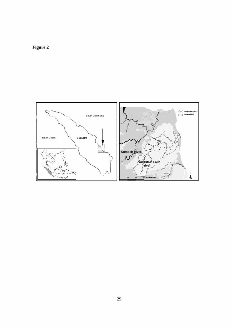
The Air Hitam Laut watershed is located on Sumatra’s coastal plain, in the eastern part of
Jambi Province, Indonesia (Figure 2). It is a typical black water river, originating about 60 km
inland in the middle of a landscape dominated by peat swamp forest and meandering through
flat lowland alluvial plains. The main fluctuations in landscape topography are formed by peat
domes that developed over thousands of years intersected by black water rivers and streams.
The highest elevation is about 20 to 25 meters. All mineral (sub) soils consist of light to heavy
clays, including potential acid sulphate soils along the coast. The organic or peat soils
(histosols) consist mainly of saphric (most humified) peat with a top layer of moderately to
least humified (hemic to fibric) peat. Along the coast, peat generally can be found a few km
inland, but in some places it reaches the coast. Zones of alluvial soils are found along stretches
of the Air Hitam Laut river, ranging from a few hundred meters to over 1 km width. These are
followed by zones of shallow peat (< 3 m) and deep peats on pleistocene terraces more inland
(Silvius et al., 1984). The mineral soil levee along the coast underneath the peat is about 2-3
meter above present mean sea level. The topography of the mineral subsoil is rather flat
(Furukawa 1994). A realistic Digital Elevation Model (DEM) of the soil surface of the
watershed at a 900 by 900 m grid size is created using radar imagery (Wösten et al., 2005).
Climate and hydrology
The eastern lowlands of Sumatra have a tropical rain climate with a dry season ranging from
May till October and a rainy season from November till April. Annual rainfall ranges from
1306 mm/yr in the dry El Niño year 1997 to 3412 mm/yr in the wet year 1984. Long-term
Photo: M.J. Silvius

7
average annual rainfall is 2466 mm/yr while evapotranspiration is fairly constant throughout
the year at an average of 1300 mm/yr. The Air Hitam Laut is a typical peat river flowing from
the south-west to the north-east into the south China Sea. The main water courses in the Air
Hitam Laut watershed are shown in Figure 3. Peat swamps are characterized by their diffuse
drainage pattern whereby runoff flows through the micro-topography of hummocks and
hollows. Most water is discharged over or through the upper topsoil. Only a very small
amount (< 3%) of the rainfall percolates to deeper layers and contributes to groundwater flow
(Hooijer, 2005). Hydraulic conductivity in the Air Hitam Laut watershed yielded values close
to 30 m/d. Over the whole year water tables in the watershed are mostly at or just below soil
surface. Generally groundwater levels dropped not more than approximately 1 m below soil
surface which is typical for intact peat swamps. The groundwater level is the defining
characteristic of peat swamp hydrology, not only is it close to soil surface for most of the time,
but it is almost the soil surface, as peat consists of over 85% of water.
Biodiversity
The Air Hitam Laut watershed is dominated by two habitat types – freshwater swamp forest
and peat swamp forest. In Berbak National Park it covers respectively 60 000 hectares (32%)
and 110 000 hectares (59%). Other natural habitats include rivers, dry beach forest, mangrove
swamps and mudflats. Since 1965 new habitats were formed as a result of agricultural
reclamation and fires at the perifery of the reclamations, mainly along the coast. Generally the
riparian forests are 15-25 meters high, while the peat and freshwater swamp forests attain
heights of 35 to 45 meters with emergents reaching 50 to 60 meters. A total of at least 261
flowering species are recorded in the National Park, of which 67% trees and shrubs, 17%
liana’s, and 8% herbs and epiphytes. At least 227 bird species are recorded, including 9
8
hornbills, and rare species such as the Milky Stork (Mycteria cinerea), Storm’s Stork (Ciconia
stormi) and White-winged Wood Duck (Cairina scutulata). The mudflats along the coast are
visited by thousands of migratory waders, including the rare Eastern Curlew (Numenius
orientalis), Asian Dowitcher (Limnodromus semipalmatus) and Nordman’s Greenshank
(Tringa guttifer). The area has a rich mammalian fauna, including endangered species such as
the Sumatran Tiger (Panthera tigris), Sumatran Rhino (Dicerorhinus sumatrensis), Siamang
(Symphalangus syndactylus), White-handed Gibbon (Hylobates agilis), Malaysan sunbear
(Helarctos malayensis) and Malaysan Tapir (Tapirus indicus). Together with the adjacent
Sembilang National park in the south, the area is one of the most important tiger reserves in
Indonesia. Reptiles include the rare Riverine Terrapin (Orlitia borneensis), Estuarine
crocodile and the False Gharia (Tomistoma schlegelii) (a crocodilian species restricted to peat
swamp forest streams).
Illegal logging activities
Widespread illegal logging in Berbak is rampant and continues almost unabated. Use is made
of existing infrastructure, such as logging trails and rail systems, and the authorities have been
ineffective in their attempts to halt this. Along the upper Air Hitam Laut river, dozens of
illegal camps are observed both within the park and just outside. Most of these camps are used
for illegal logging activities, although they are also used by fisherfolk and jelutung collectors.
Groups of illegal loggers transport – apparently without impunity – sawn timber of Kempas
Koompassia malaccensis, Meranti Shorea species, Ramin Gonystylus bancanus and Punak
Tetramerista glabra via lorries on the existing concessionaire’s rail system. Timber poaching
was also common along the river Air Hitam Dalam, where rafts of sawn timber (mainly
Meranti and Ramin) were regularly observed. This has largely been stopped through joined
Photo: M.J. Silvius
9
action by local communities and the National Park authority, involving confiscation of illegal
logs and construction of an entrance gate to block further log transport. The condition of
Berbak National Park has been severely affected by illegal logging and fires, which have
obviously degraded the conservation and overall value of the park. However, significant
portions of relatively intact forest remain, along with populations of rare and endangered
species. It is therefore essential to invest in curbing these illegal activities as soon as possible,
to prevent further loss and allow the system to recover. This will not be possible in all areas or
cases, and some active rehabilitation may be required. Alternatively, if the illegal activities are
allowed to continue, it is expected that the park will be ‘lost’ within the next 1-2 decades.
Land use
Until recently the upper-catchment of the Air Hitam Laut river was relatively undisturbed.
The main economic activity was forestry (selective logging). However, the area has recently
been opened up for oil palm plantations under an official transmigration scheme. The newly
established cluster of villages and its plantations are located on over 10 meter deep peat. The
development scheme is accompanied by spontaneous settlers occupied primarily with logging
of adjacent forests. Downstream lies a forestry concession, which built a rail system to
transport logs to the river. The concession had a licence until 2004, but reportedly it received
an extension. Large parts of the area along the railway have been deforested and seriously
affected by fires. The railway is also intensively used by the local people and harvesters from
outside the area to access the forests and illegally extract logs and non-timber forests products
such as latex of the Jelutung tree (Dyera lowii). Harvesting of non-timber forest products
represents an important supplementary activity for commercial and subsistence uses. This
includes food, construction materials, household utensils, and medicines. These uncontrolled

10
activities extend well into the adjacent Berbak National Park. The Berbak area received
protection as a Game Reserve as far back as 1935 by a decree of the governor of the
Netherlands-Indies government. It then covered about 250 000 ha, with an eastern boundary
following the eastern coastline of Jambi province. However, in the 1960s large areas from the
protected area were exised following large scale agricultural developments and coastal
reclamations by spontaneous transmigrants from south Sulawesi. Management of the reserve
commenced in the early 1970s, involving the establishment of several observation posts. In
1991, upon Indonesia’s ratification of the Ramsar convention, Berbak became its first Ramsar
site in recognition of the area’s international importance particularly as a representative
example of the south-east Asian peat swamp forests. One year later its legal status was further
upgraded as a National Park, covering about 185 000 ha.
Hydrological monitoring and modeling
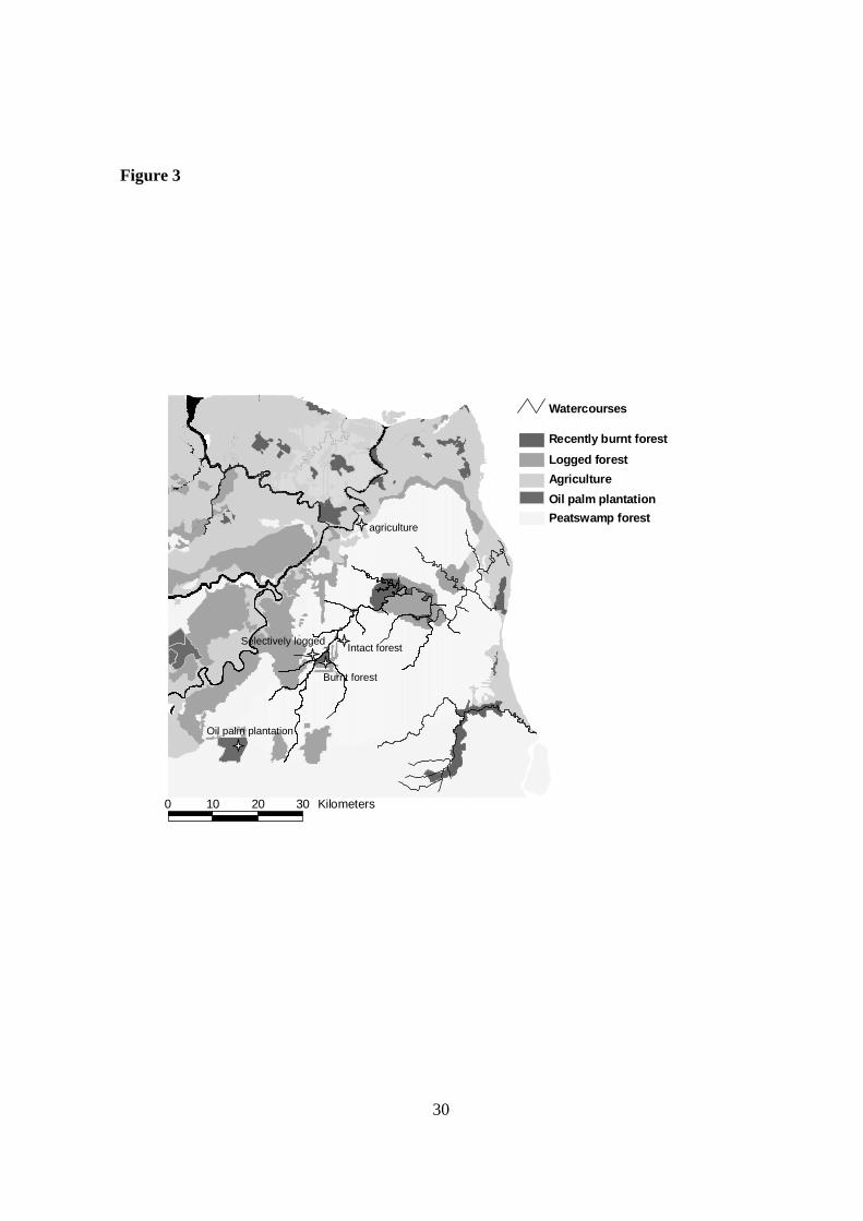
In the watershed, five major land uses are distinguished: intact forest, partly logged forest,
burnt forest, agriculture and oil palm plantation (Figure 3). Within each land use type,
representative study sites have been selected and instrumented for the measurement of
groundwater levels, rainfall and river discharges (Wösten et al., 2005). Considerable efforts
have been made to accurately measure groundwater levels, as this is the key parameter in
peatland hydrology (Hooijer, 2005). The hydrology of the Air Hitam Laut watershed has been
modelled with the SIMGRO (SIMulation of GROundwater flow and surface water levels)
hydrological model which combines groundwater and surface water flow (Dik, 2004). The top
of the mineral layer is set as aquifer bottom and the continuous aquifer layer of peat has a
conductivity of 30 m/d. Peat thickness and conductivity result in hydraulic transmissivities
ranging from 30 till 450 m2/d. Model outcome has been calibrated and validated using

11
measured groundwater levels at representative sites in the basin, measured discharge in the
Air Hitam Laut river and flooding patterns as deducted from radar images (Siderius, 2005;
Wösten et al., 2005).
12
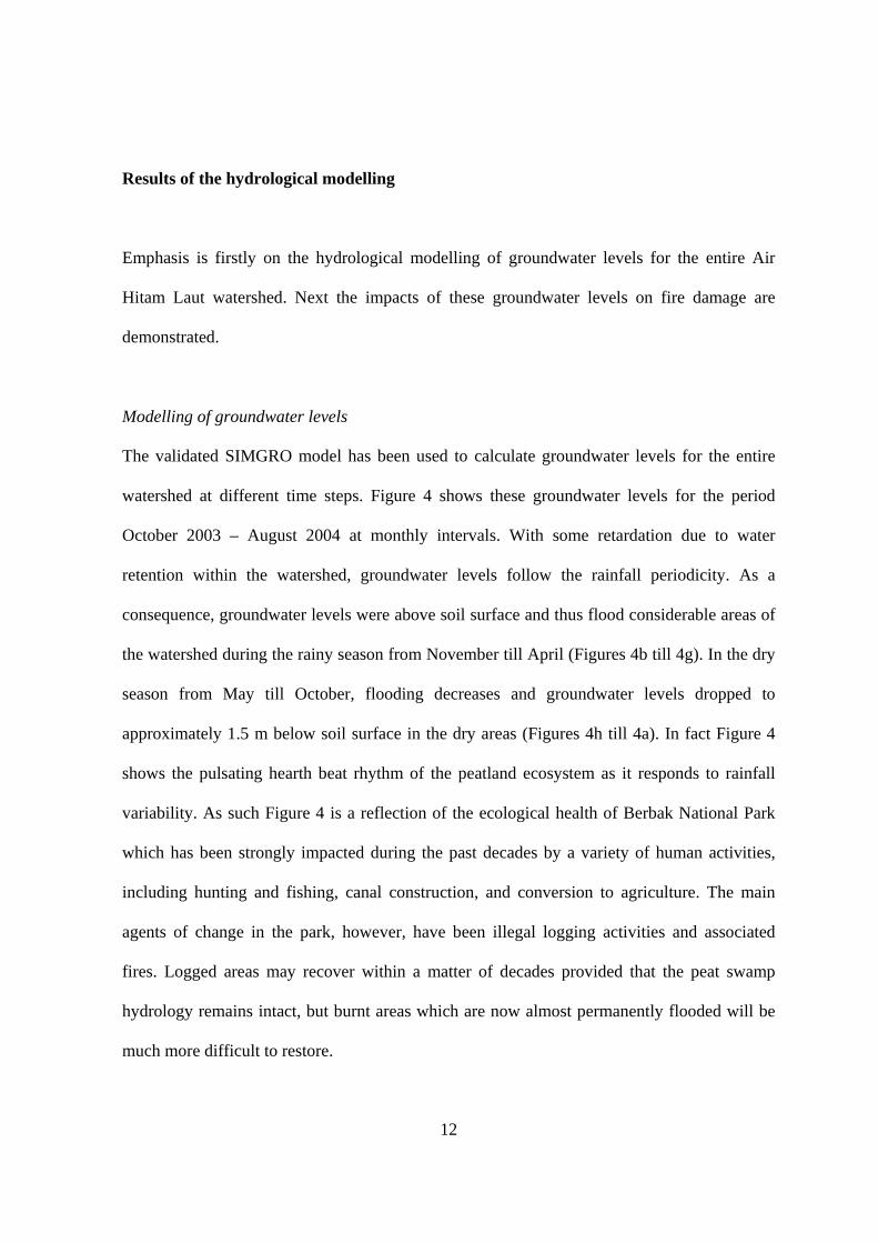
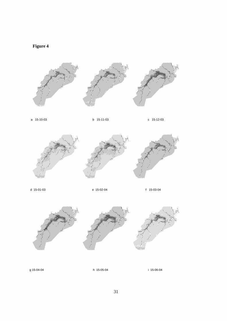
Results of the hydrological modelling
Emphasis is firstly on the hydrological modelling of groundwater levels for the entire Air
Hitam Laut watershed. Next the impacts of these groundwater levels on fire damage are
demonstrated.
Modelling of groundwater levels
The validated SIMGRO model has been used to calculate groundwater levels for the entire
watershed at different time steps. Figure 4 shows these groundwater levels for the period
October 2003 – August 2004 at monthly intervals. With some retardation due to water
retention within the watershed, groundwater levels follow the rainfall periodicity. As a
consequence, groundwater levels were above soil surface and thus flood considerable areas of
the watershed during the rainy season from November till April (Figures 4b till 4g). In the dry
season from May till October, flooding decreases and groundwater levels dropped to
approximately 1.5 m below soil surface in the dry areas (Figures 4h till 4a). In fact Figure 4
shows the pulsating hearth beat rhythm of the peatland ecosystem as it responds to rainfall
variability. As such Figure 4 is a reflection of the ecological health of Berbak National Park
which has been strongly impacted during the past decades by a variety of human activities,
including hunting and fishing, canal construction, and conversion to agriculture. The main
agents of change in the park, however, have been illegal logging activities and associated
fires. Logged areas may recover within a matter of decades provided that the peat swamp
hydrology remains intact, but burnt areas which are now almost permanently flooded will be
much more difficult to restore.
13
Fire damage
Fire damage in the Air Hitam Laut watershed is difficult to predict with a model as no matter
what fire prevention measures are taken, fires are likely to occur in the future. To demonstrate
the impact of peat fires a new surface map (DEM) is constructed simulating the situation after
larger areas have been burned. Areas are selected which during the dry El Niño year 1997
have a groundwater level deeper than 1 m below soil surface and therefore can be considered
to be susceptible to recurrent fires. This may be a conservative estimate as Usup et al. (2004)
demonstrate that groundwater levels deeper than 0.5 m already strongly increase fire
susceptibility. Actually, calculated groundwater levels in 1997 appeared to drop to
approximately 1.5 m below soil surface in these dry areas. The assumption being made is that
fires cause a decrease of the surface elevation of the affected areas by 1 meter. The
combination of the newly burned areas with the already burned areas results in a new surface
map (DEM). This new DEM has been used to calculate groundwater levels and flooding
patterns. The impact on the hydrology and more important on the flooding extent is shown in
Table 2. As can be seen, the extent of flooded areas increases considerably. Especially the
deeply flooded areas with more than 1.5 m inundation will increase with almost a factor 5
(from 0.9 to 4.3%). This will make restoration impossible as described by van Eijk &
Leenman (2004). Results of the model predictions were confirmed by field observations
revealing large areas that were first affected by fires in 1982. These areas were located mainly
adjacent to the then newly reclaimed agricultural areas along the coast and along the Air
Hitam Laut river near the coast. During the 1997-1998, El Niño major fires hit the core zone
of Berbak National Park. About 20 000 ha in the core part of the park, mainly along the Air
Hitam Laut river were destroyed. These fires were obviously linked to widespread illegal
logging and related human activities. In the following years, smaller fires occurred in parts of
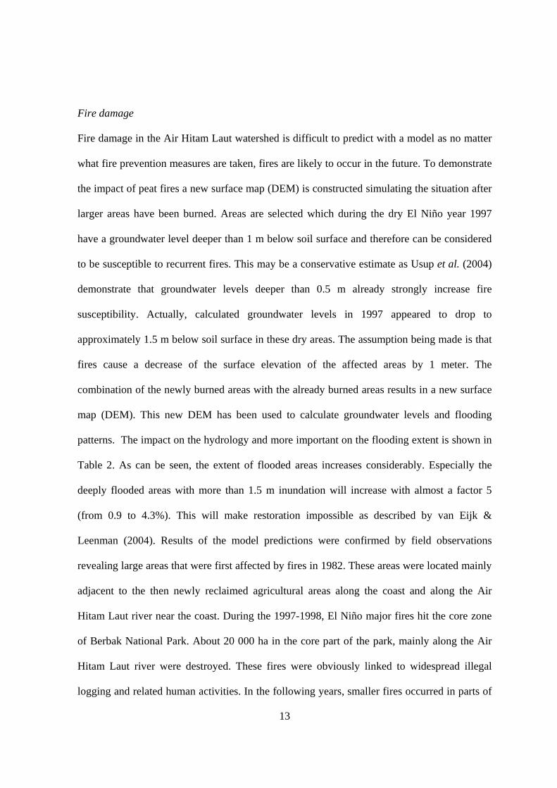
Photo: M.J. Silvius

14
these areas on an annual basis. As mentioned before, fires do not occur in peat swamp forests
under natural conditions due to its wet nature. However, satellite images proved that prior to
the major fires in 1997-1998 the core zone of Berbak National Park already showed a canopy
with smaller tree crowns (indicated by finer grain on image) and an overall lower cover
(indicated by paler green colour) that differed from the surrounding unaffected areas (Giesen,
2003). Field observations confirm that this can be explained by illegal logging activities that
apparently resulted in degraded forests as early as 1992. The open canopies and accessible dry
fuel paved the way for fires (Dawson et al., 2000; Siegert et al., 2001). The El Niño fires
started in September 1997. A satellite image from 18 August 1997 shows that large
rectangular blocks of forest extending over several hundred hectares each along the Air Hitam
Laut had been clear-felled and were affected by fire a month later. Such clearings cannot be
explained by small-scale illegal logging or shifting cultivation, but are coordinated and large-
scale activities. Parts of the resulting burnt areas have burned again several times since and
turned into temporal lake habitats, while others appear to be regenerating and are covered with
secondary shrub and tree stands of pioneer species (e.g. Macaranga).

15
Restoration options
There is little experience with and knowledge about the successful restoration of degraded
peat swamp forests. Many projects that have been carried out therefore failed. However, to
increase success rates, two main issues need to be addressed in peat swamp forest restoration,
namely:
• Which species need to be planted when restoring peat swamp forests?
• Once suitable species are identified, what are the hydrological conditions that favor
regrowth?
Species
Experience and know-how in Indonesia as to which species are suitable to restore degraded
peat swamps is usually restricted to exotic species (e.g. Acacia sp.) which are inappropriate
for planting in conservation areas, or is limited to species found in mature peat swamp forest
that cannot survive under harsh, pioneer conditions. Some experience with peat swamp forest
restoration exists in the region especially in Thailand, and to a lesser extent Vietnam (Nuyim,
2000, 2003; Maltby et al., 1996). However, the species composition found in these areas
differs entirely from that found in Berbak National Park. Consequently, the present study
emphasised on the identification of species that already occur in degraded, burnt sites in
Berbak, as they are indigenous and either fire tolerant or pioneering species. It is expected that
the use of natural pioneers in restoration projects, rather than climax tree species, will enhance
natural establishment of additional species and thus significantly speed up the natural
regeneration process. In total, 21 tree and shrub species and 2 palm species with good
potential for replanting trials and restoration programmes have been identified (van Eijk &

16
Leenman, 2004). These species are now being grown in nurseries for use in ongoing
restoration programmes in Berbak.
Hydrological conditions
Rewetting and reinstating the hydrological integrity of the watershed with groundwater levels
at or close to soil surface is an absolute requirement for successful restoration of peat swamps.
Blocking of illegal logging canals by multiple, inexpensive dams constructed from locally
available wood and organic material, seems to be an appropriate technique. In areas with
severe loss of peat by fires, not the absence of water but the surplus of water resulting in
flooded areas hampers restoration. Flooding is usually more extensive and lasts longer in the
most badly affected areas. Some of the sites severely affected by multiple fires are now
flooded almost year round (Figure 4). To assess the influence of abiotic factors on
regeneration, a vegetational survey has been carried out in areas that differed in fire history,
peat depth and hydrology. Analysis in CANOCO (PCA) revealed a particularly strong link
with both flooding height and flooding duration. Areas with short and shallow flooding are
more diverse (in terms of species richness), more well-developed (in terms of basal area and
three height) and contain more climax peat swamp forest species (van Eijk & Leenman,
2004). This in contrast to sites that are deeply flooded during much of the year where species
are poor and which can be regarded as temporal lakes rather than as regenerating forest.
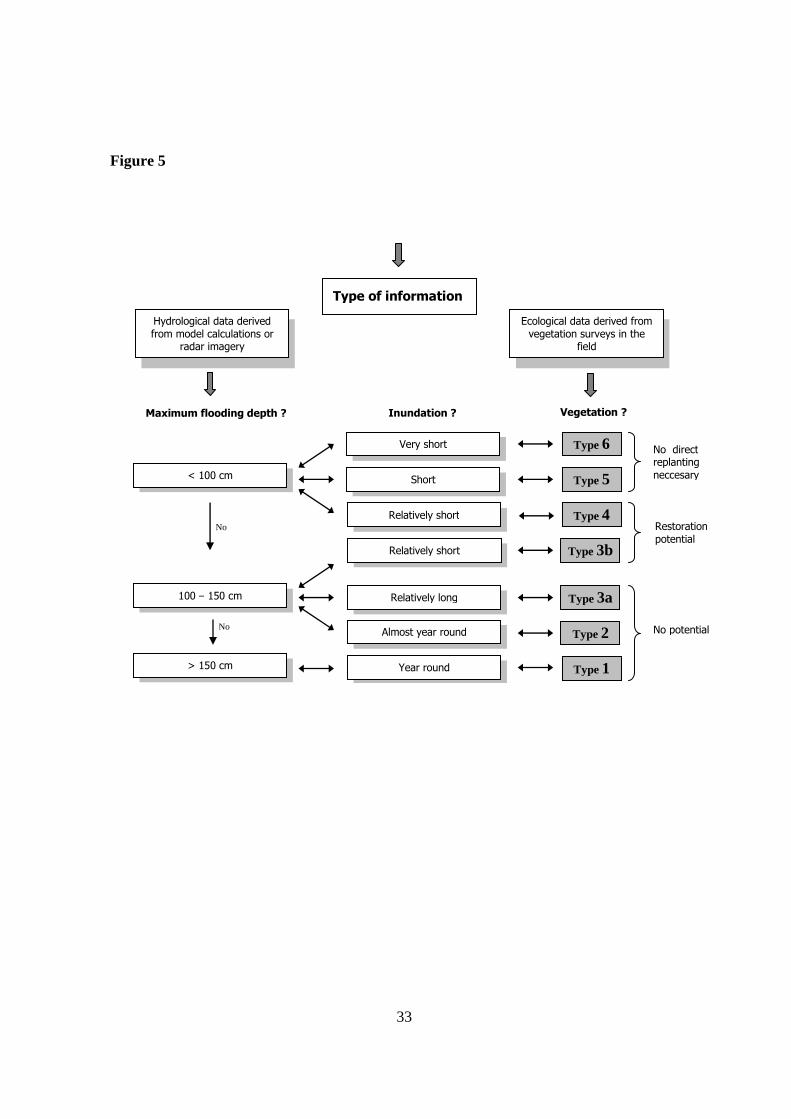
Different hydrological regimes (Figure 4) as calculated with SIMGRO are found to generate
distinct vegetation types (Figure 5 and Table 3). PCA-analysis and clustering in TWINSPAN
enabled to describe six clearly recognizable types (Table 3). The rate of vegetational
development in each type enabled to assess the suitability for replanting under a certain set of
hydrological conditions. This enabled to translate hydrological data resulting from model

17
calculations into vegetation types and to use these vegetation types for assessment of an area's
suitability for replanting (Figure 5). The other way around identification of vegetation types in
the field (based on a small set of easily recognisable key species) provides direct information
on the spot’s hydrology. As very minor changes in hydrology might reflect significant
changes in vegetational development, assessment of vegetation types in the field seems to be
the most reliable strategy to select areas suitable for restoration (van Eijk & Leenman, 2004).
Generally speaking, deeply flooded areas are to be avoided, while areas that are already
regenerate vigorously do not need further assistance in restoration. The remaining sites are the
ones at which replanting best can be targeted. Combining hydrological and ecological
knowledge enables National Park managers to select areas where replanting is likely to be
most successful and thus helps to allocate the limited restoration funds most efficiently.
However, before embarking on restoration it is absolutely necessary that illegal logging and
fires will be stopped.
18
Conclusion and discussion
The many human induced land use changes in the Air Hitam Laut watershed all cause
groundwater levels to be lowered by drainage resulting in increased soil subsidence and fire
susceptibility as well as salt water intrusion and acidification problems in the coastal
agricultural areas. Sustainable development, forest restoration, fire prevention and biodiversity
conservation will require reinstatement of the hydrological integrity of the entire watershed
with groundwater levels at or close to soil surface. In this respect, the developed relational
diagram showing the interaction between hydrology and ecology will be a useful tool.
However, application of this tool needs to be accompanied by economic measures to improve
the livelihoods of local people, by effective law enforcement and by good governance. At the
same time land use planning in peatlands should follow an ecosystem approach, taking into
account the hydrological vulnerability of peat domes and the ecological relationships with the
surrounding habitats and land uses. In peat swamp forests it is warranted to consider multi-
river basin complexes, as multiple watersheds may be dependent on shared peat domes, and
impacts on one river basin may affect the shared hydrological basis. An example of this is
found in the shared water source area of the Air Hitam Laut, Benu and Merang river basins at
the boundary of Jambi and South Sumatra provinces. Thus, in addition to the ecosystem
approach, wise use of peatlands requires a change of the single sector priority approach (only
plantations) to an integrated, holistic planning strategies, involving all sectors (local people,
nature conservation, forestry, agriculture, plantations) to ensure that attention is given to
potential impacts on the ecosystem as a whole. A prerequisite for successful integrated
planning is the (enhancement of) awareness of various stakeholders of the full scale of
hydrological and ecological values of peatlands.
19
Acknowledgements
This publication is produced in Indonesian and Dutch partnership under the “Promoting the
river basin and ecosystem approach for sustainable management of SE Asian lowland peat
swamp forests” project funded by the Partners for Water Programme, the Netherlands. The
project hugely benefited from the valuable support of various individuals and organisations.
To all of them we express our deepest gratitude. Special thanks to Dirk Hoekman and his
colleagues of the Department of Environmental Sciences of Wageningen University for their
support in developing the Digital Elevation Model.
20
References
Anderson, I.P. & Bowen, M.R. (2000) Fire zones and the threat to the wetlands of Sumatra,
Indonesia. Forest fire prevention and control project, departemen Kehutanan, Kantor
Wilayah Propinsi Sumatera Selatan & European Union.
Andriesse, J.P. (1988) Nature and Management of Tropical Peat Soils. FAO Soils Bulletin 59,
Rome.
Brady, M.A. (1997) Effects of vegetation changes on organic matter dynamics in three coastal
peat deposits in Sumatra, Indonesia. In: J.O. Rieley and S.E. Page (Eds), Biodiversity and
Sustainability of Tropical Peatlands. Samara Publications, Cardigan, UK. pp. 113-134.
Bonell, M. & Bruijnzeel L.A. (2005) Forest, water and people in the humid tropics. Past,
present and future hydrological research for integrated land and water management.
Cambridge University Press. United Kingdom.
Dawson, T.P., Butt, N. & Miller, F. (2000) The ecology of forest fires, in: Proceedings of the
workshop on minimizing the impact of forest fire on biodiversity in ASEAN. Regional Centre
for Biodiversity Conservation.
Dik, P.E. (2004) SIMGRO user’s guide. Alterra report 913.2. Wageningen, the Netherlands.
Diemont, W.H. & Supardi. (1987) Accumulation of organic matter and inorganic constituents
in a peat dome in Sumatra, Indonesia. In Symposium on Peat and Peatlands for
Development. International Peat Societ. Yogyakarta, Indonesia, pp. 12.
van Eijk, P. & Leenman, P.H. (2004) Regeneration of fire degraded peatswamp forest in
Berbak National Park and implementing in replanting programmes. Water for food &
ecosystems programme project on: “Promoting the river basin and ecosystem approach for
21
sustainable management of SE Asian lowland peatswamp forests”. Alterra, Wageningen, the
Netherlands.
Furukawa, H. (1994) Coastal wetlands of Indonesia: environment, subsistence and
exploitation. Kyoto University Press, Kyoto.
Giesen, W. (2003) Causes of peatswamp forest degradation in Berbak National Park and
recommendations for restoration. Water for food & ecosystems programme project on:
“Promoting the river basin and ecosystem approach for sustainable management of SE
Asian lowland peatswamp forests”. ARCADIS euroconsult, Arnhem, the Netherlands.
Hooijer, A. (2005) Hydrology of tropical wetland forests: recent research results from
Sarawak peatswamps, in: M. Bonell and L.A. Bruijnzeel (Eds) Forest, water and people in
the humid tropics. Cambridge University Press, United Kingdom. pp. 447-461.
Ismail, Z. (1999) Survey of fish diversity in peat swamp forest, in: C.T. Yuan and P.
Havmoller (Eds) Sustainable Management of Peat Swamp Forest in Peninsular Malaysia.
Forestry Department Peninsular Malaysia, Kuala Lumpur. pp. 173-198.
Maltby, E., Burbridge, P. & Fraser, A. (1996) Peat and acid sulphate soils: a case study from
Vietnam, in: E. Maltby, C.P. Immirzi and R.J. Safford (Eds) Tropical lowland peatlands of
Southeast Asia. Gland, Switzerland, IUCN. pp. 187-197.
Nuyim, T. (2000) Whole aspects of nature and management of peat swamp forest in Thailand,
in: T. Iwakuma et al. (Eds) Proceedings of the International Symposium on Tropical
Peatlands. Bogor, Indonesia, 22-23 November 1999. Hokkaido University and Indonesian
Institute of Science, Bogor, p: 109-117.
Nuyim, T. (2003) Experience in Research and Management of Peat Swamp Forest in
Thailand. Paper presented at the workshop on “Workshop on wise use and sustainable
peatlands management practices”, held in Bogor, Indonesia, on 13-14 October 2003, 25 pp.
22
Page, S.E., Wüst, R.A.J., Weiss, D., Rieley, J.O., Shotyk, W. & Limin, S. (2004) A record of
Late Pleistocene and Holocene carbon accumulation and climate change from an equatorial
peat bog (Kalimantan, Indonesia): implications for past, present and future carbon dynamics.
J. Quaternary Sci. 19: 625-635.
Page, S.E., Siegert, F., Rieley, J.O., Boehm, H-D.V., Jaya, A. & Limin, S. (2002) The amount
of carbon released from peat and forest fires in Indonesia in 1997. Nature, 420: 61-65.
Page, S.E. & Rieley, J.O. (1998) Tropical peatlands: a review of their natural resource
functions, with particular reference to Southeast Asia. International Peat Journal, 8: 95-106.
RePPProT. (1990) A national overview from the regional physical planning programme for
transmigration. UK Overseas Development Administration and Directorate BINA
Programme. Jakarta, Indonesia, Ministry of Transmigration.
Rieley, J.O., Page, S.E. & Setiadi, B. (1996) Distribution of peatlands in Indonesia, in: E.
Lappalainen, (Eds) Global peat resources. Jyväskylä, Finland: International Peat Society.
pp. 169-178.
Ritzema, H.P., Mutalib Mat Hassan, A. & Moens, R.P. (1998) A new approach to water
management of tropical peatlands: a case study from Malaysia. Irrigation and Drainage
Systems 12: 2, 123-139.
Siderius, C. (2005) A hydrological model of the Air Hitam laut watershed and the impact of
various land use scenarios. Water for food & ecosystems programme project on:
“Promoting the river basin and ecosystem approach for sustainable management of SE
Asian lowland peatswamp forests”. Alterra, Wageningen, the Netherlands.
Siegert, F., Ruecker, G., Hindrichs, A. & Hoffman, A.A. (2001) Increased damage from fires
in logged forests during droughts caused by El Niño. Nature, 414: 437-440.

23
Silvius, M. J., Simons, H.W. & Verheugt, W.J.M. (1984) Soils, vegetation, fauna and nature
conservation of the Berbak game reserve, Sumatra, Indonesia.
Usup, A., Hashimoto, Y., Takahashi, H. & Hayasaka, H. (2004) Combustion and thermal
characteristics of peat fire in tropical peatland in Central Kalimantan, Indonesia. Tropics,
14: 1-19.
Wösten, J.H.M. & Ritzema, H.P. (2001) Land and water management options for peatland
development in Sarawak, Malaysia. International Peat Journal, 11: 59–66.
Wösten, J.H.M., Hooijer, A., Siderius, C., Dipa Rais & Aswandi Idris (2005) Modelling
tropical peatland water management at river basin scale: a case study for the Air Hitam Laut
watershed in Indonesia. Submitted for publication.
24
List of tables
Table 1 Overview of functions and attributes of peat swamp forests and their benefits
and uses.
Table 2 Percentages of areas flooded before and after increased fire damage.
Table 3 Different vegetation types, their ecology and their relation to hydrology.
List of figures
Figure 1 Feedback system associated with forest fires (derived from Dawson et al.
2000).
Figure 2 Location of the Air Hitam Laut watershed.
Figure 3 Water courses of the Air Hitam Laut watershed.
Figure 4 Calculated flooding extent and groundwater levels in the Air Hitam Laut
watershed at different dates.
Figure 5 A relational diagram for successful restoration of degraded peat swamp forests.

25
Table 1
FUNCTIONS BENEFITS AND USES
Regulation of hydrology Flood and flow regulation
Mitigation of floods and droughts in downstream areas. Peatlands can serve as overflow areas in flooding periods, while in the dry season the stored water is slowly released.
Prevention salt water intrusion
Agriculture in tidal areas may benefit from upstream peat swamps as a source of fresh water for irrigation and in providing a continuous freshwater wedge preventing or mitigating salt water intrusion.
Water supply In rural coastal areas, peat swamps may be the only source of potable and irrigation water for many months.
Climate stabilisation Carbon storage Peat swamps are huge carbon storage areas. Carbon stored in peat represents 33% of the
world’s soil carbon pool, representing 70% of all carbon stored in biotic systems. If disturbed by drainage and burning, the carbon is released into the atmosphere as CO2
contributing to the greenhouse effect. Almost 20x more carbon is stored underground as peat than above the ground in vegetation. In 1997, 1 - 2.5 billion tonnes of carbon, equal to 15-40% of the annual global emissions from burning of fossil fuels, were released by peat swamp fires in Indonesia, resulting in significant health problems and millions of lost workdays, as well as significant impacts to tourism and transport sectors. Value of carbon is between $7 and $9 per tonne.
Carbon sequestration Healthy peat swamp forests may actively accumulate carbon, thus helping to decrease the greenhouse effect. Release of methane has been found to be negligible.
Climate regulation The presence of peat swamp forests and associated large mass of freshwater effects the climate on micro and meso scale. The forests act as wind break and absorb heat. Forested lowlands attract more rain compared to deforested areas, having a higher albedo effect.
Biodiversity “Capturable biodiversity” value is estimated at $3/ha/year, excluding intrinsic value of species, ecotourism potential or internationally marketed pharmaceuticals.
Gene pool Peat swamp forests in South-east Asia fulfil an increasingly important role as gene bank, as other lowland forests have been even more affected by logging and land conversion. For many animal species it provides an important habitat, especially in combination with freshwater and/or mangrove swamp forests.
Wildlife habitat Peat swamp forests constitute a habitat for many rare or endangered species, such as e.g. Sumatran Tiger, Asian Tapir, Orang utan, Proboscis Monkey, Siamang, Storm’s Stork, Hornbills and the False Gavial. The black water rivers in Asia have a high degree of localised endemism of fish species and have a very high ichthyologic biodiversity.
Plant habitat Over 300 species of trees have been recorded in peat swamp forests of Sumatra. From Berbak alone more than 261 plant species are known.
Landscape Peat swamps forests occupy a specific place in south-east Asian lowland landscapes, forming an ecological destined mosaic of different vegetation types in mangroves, between old beach ridges, and river levees and interchanged with freshwater swamp forests.
Wilderness Peat swamp forests have value as wilderness area; i.e. remote areas far away from civilisation. This may offer an additional attraction to tourists.
Source of natural products
Peat swamps provide a large number of valuable timber species, including Ramin (Gonystylus bancanus), Jelutung (Dyera lowii ), Meranti (Shorea spp.). Socio-economic studies in Indonesia indicate that local community livelihoods may depend for over 80% on the peat swamp forests rather than agriculture.
Research and education
The combination of the above functions, attributes and uses, makes peat swamp forests very interesting subjects for research and education.
Social-cultural environment
Peat swamp forests, their natural products and wild life play a substantial role in Dayak culture in Kalimantan, and as such have a considerable social-cultural value.

26
Table 2
Flooding depth
(cm)
Areas flooded in present situation
(%)
Areas flooded in future situation
(%)
350 to150
0.9
4.3
150 to100
2.8
3.1
100 to 50
3.8
3.5
50 to 10
4.3
10.9
10 to – 150
88.1
78.3

27
Table 3
Vegetation type Ecology Hydrology
Type 1. Screw palm and sedge dominated lake -type
Low diversity (< 5 species per 0,1 ha), only Pandanus helicopus and Thoracostachyum bancanum can proliferate.
Flooding is year round and deep (150 - 200 cm)
Type 2. Grass dominated seasonal lake -type
Low diversity (5-10 species per 0,1 ha), Hymenachne amplexicaulis dominates as most other species cannot stand the flooded conditions. Natural regeneration is poor.
Maximum flooding is moderately deep ( 100 -150 cm) and almost year round. Likely to be subject to annual fires.
Type3a. Sedge dominated early regeneration -type
Moderately low diversity (10-15 species per 0,1 ha). Ferns (Blechnum indicum) and sedges (Scleria purpurascens) dominate. Due to long inundation natural regeneration is quite poor.
Maximum flooding is moderately deep (100-150cm). Inundation in the wet season is relatively long.
Type 3b. Fern dominated early regeneration –type
Moderately high diversity (15-25 species per 0,1 ha). High fern cover (Blechnum indicum). As inundation is relatively short, pioneer tree species are able to establish.
As 3a. Inundation is relatively short.
Type 4. Fern dominated tree establishment –type
Diversity is high (>25 species per 0,1 ha). Pioneer species (e.g. Macaranga pruinosa, Alstonia pneumatophora) are able to proliferate well.
Maximum flooding is low ( < 100 cm). Inundation in the wet season is relatively short.
Type 5. Tree dominated early forest – type
Diversity is high (>25 species per 0,1 ha). Pioneer tree species (mainly Macaranga) reach 7-10 metres, seven years after fire. Fern cover decreases. Improved micro climate reduces the risk for annual fires
Maximum flooding is low ( < 100 cm) Inundation in the wet season is short.
Type 6. Tree dominated well developed forest –type
Diversity is high. Pioneer tree species form a closed canopy (up to 15 m seven years after fire) climax tree species are able to establish. Micro climate reduces fire risk. Fern cover is low.
Maximum flooding is low (<100 cm). Inundation is very short.

28
Figure 1
DEGRADATION / CLEARANCE OF TROPICAL FOREST (e.g. due to prior burning events, logging or the opening up of mature forest by roads)
DROUGHT
FIRE SPREADS QUICKLY DUE TO AVAILABILITY OF FLAMMABLE MATERIAL
FIRE STARTS BY ACCIDENT
OR PURPOSELY (e.g. land clearance, arson)
• SUNLIGHT ENCOURAGES GROWTH
OF UNDERSTOREY • WIND DRIES OUT DEAD
MATERIALS RESULTING IN
INCREASED FIRE SUSCEPTIBILITY
CANOPY OPENED UP, DEAD MATERIALS
PRODUCED
FIRE
29
Figure 2
0 10 20 30 Kilometers
watershedwatercourses
N
South China Sea
Indian Ocean Sumatra
Kumpeh river
Air Hitam Laut river
30
Figure 3
Recently burnt forest
Agriculture
Logged forest
Peatswamp forest
Watercourses
Oil palm plantation
0 10 20 30 Kilometers
agriculture
Selectively logged
Oil palm plantation
Intact forest
Burnt forest
31
Figure 4
a 15-10-03 b 15-11-03 c 15-12-03
d 15-01-03 e 15-02-04 f 15-03-04
g 15-04-04 h 15-05-04 i 15-06-04
32
j 15-07-04 k 15-08-04
Flooding
-2m - -1m-1m - - 0.5m -0.5m - -0.1m-0.1m - 0.1m0.1m - 0.5m0.5m - 1m1m - 2m2m - 2.5m
groundwaterlevels
33
Figure 5
Type 3b
Type 3a
< 100 cm
100 – 150 cm
> 150 cm Year round
Type 6
Type 5
Type 4
Type 2
Type 1
Relatively long
Very short
Short
Relatively short
Almost year round
No
No
No direct replanting neccesary
Restoration potential
No potential
Maximum flooding depth ?
Inundation ?
Relatively short
Hydrological data derived from model calculations or
radar imagery
Ecological data derived from vegetation surveys in the
field
Vegetation ?
Type of information
Copyright © 2022 FDOKUMEN