International Geology Review Jurassic to Cenozoic tectonics of the Zagros Orogen in northwestern...
26
This article was downloaded by: [University of Wollongong] On: 08 January 2014, At: 15:29 Publisher: Taylor & Francis Informa Ltd Registered in England and Wales Registered Number: 1072954 Registered office: Mortimer House, 37-41 Mortimer Street, London W1T 3JH, UK International Geology Review Publication details, including instructions for authors and subscription information: http://www.tandfonline.com/loi/tigr20 Jurassic to Cenozoic tectonics of the Zagros Orogen in northwestern Iran M. Mohajjel a & C.L. Fergusson b a Department of Geology, Tarbiat Modares University, Tehran, Iran b School of Earth & Environmental Sciences, University of Wollongong, Wollongong, New South Wales, Australia Published online: 30 Oct 2013. To cite this article: M. Mohajjel & C.L. Fergusson (2014) Jurassic to Cenozoic tectonics of the Zagros Orogen in northwestern Iran, International Geology Review, 56:3, 263-287, DOI: 10.1080/00206814.2013.853919 To link to this article: http://dx.doi.org/10.1080/00206814.2013.853919 PLEASE SCROLL DOWN FOR ARTICLE Taylor & Francis makes every effort to ensure the accuracy of all the information (the “Content”) contained in the publications on our platform. However, Taylor & Francis, our agents, and our licensors make no representations or warranties whatsoever as to the accuracy, completeness, or suitability for any purpose of the Content. Any opinions and views expressed in this publication are the opinions and views of the authors, and are not the views of or endorsed by Taylor & Francis. The accuracy of the Content should not be relied upon and should be independently verified with primary sources of information. Taylor and Francis shall not be liable for any losses, actions, claims, proceedings, demands, costs, expenses, damages, and other liabilities whatsoever or howsoever caused arising directly or indirectly in connection with, in relation to or arising out of the use of the Content. This article may be used for research, teaching, and private study purposes. Any substantial or systematic reproduction, redistribution, reselling, loan, sub-licensing, systematic supply, or distribution in any form to anyone is expressly forbidden. Terms & Conditions of access and use can be found at http:// www.tandfonline.com/page/terms-and-conditions
-
Upload
independent -
Category
Documents
-
view
0 -
download
0
Transcript of International Geology Review Jurassic to Cenozoic tectonics of the Zagros Orogen in northwestern...
This article was downloaded by: [University of Wollongong]On: 08 January 2014, At: 15:29Publisher: Taylor & FrancisInforma Ltd Registered in England and Wales Registered Number: 1072954 Registered office: Mortimer House,37-41 Mortimer Street, London W1T 3JH, UK
International Geology ReviewPublication details, including instructions for authors and subscription information:http://www.tandfonline.com/loi/tigr20
Jurassic to Cenozoic tectonics of the Zagros Orogen innorthwestern IranM. Mohajjela & C.L. Fergussonb
a Department of Geology, Tarbiat Modares University, Tehran, Iranb School of Earth & Environmental Sciences, University of Wollongong, Wollongong, NewSouth Wales, AustraliaPublished online: 30 Oct 2013.
To cite this article: M. Mohajjel & C.L. Fergusson (2014) Jurassic to Cenozoic tectonics of the Zagros Orogen in northwesternIran, International Geology Review, 56:3, 263-287, DOI: 10.1080/00206814.2013.853919
To link to this article: http://dx.doi.org/10.1080/00206814.2013.853919
PLEASE SCROLL DOWN FOR ARTICLE
Taylor & Francis makes every effort to ensure the accuracy of all the information (the “Content”) containedin the publications on our platform. However, Taylor & Francis, our agents, and our licensors make norepresentations or warranties whatsoever as to the accuracy, completeness, or suitability for any purpose of theContent. Any opinions and views expressed in this publication are the opinions and views of the authors, andare not the views of or endorsed by Taylor & Francis. The accuracy of the Content should not be relied upon andshould be independently verified with primary sources of information. Taylor and Francis shall not be liable forany losses, actions, claims, proceedings, demands, costs, expenses, damages, and other liabilities whatsoeveror howsoever caused arising directly or indirectly in connection with, in relation to or arising out of the use ofthe Content.
This article may be used for research, teaching, and private study purposes. Any substantial or systematicreproduction, redistribution, reselling, loan, sub-licensing, systematic supply, or distribution in anyform to anyone is expressly forbidden. Terms & Conditions of access and use can be found at http://www.tandfonline.com/page/terms-and-conditions
Jurassic to Cenozoic tectonics of the Zagros Orogen in northwestern Iran
M. Mohajjela and C.L. Fergussonb*aDepartment of Geology, Tarbiat Modares University, Tehran, Iran; bSchool of Earth & Environmental Sciences, University of
Wollongong, Wollongong, New South Wales, Australia
(Accepted 8 October 2013)
The Zagros Mountains of Iran formed by continental collision from closure of the Neo-Tethyan Ocean. The Zagros Orogenunderlying the mountain range reflects a much longer history with the Pan-African basement and Phanerozoic successions.New mapping, radiometric ages, and stratigraphic analyses have enabled advances in our understanding of the Jurassic toCenozoic tectonic history. The northwestern Zagros Orogen consists of three belts: (1) the Zagros Fold and Thrust Belt,divided into the outer Zagros Simply Folded Belt and the inner High Zagros Belt; (2) the Zagros Suture Zone includingradiolarite, ophiolite, and Bisotun limestone thrust sheets; and (3) the Sanandaj–Sirjan Zone, which contains abundantmetamorphic rocks. Late Cretaceous ophiolites of the Kermanshah region are part of the outer ophiolite belt of the ZagrosOrogen and have formed in passive margin and supra-subduction zone settings. Major events include early Mesozoic rifting,Jurassic subduction followed by a more cryptic interval of subduction in the Cretaceous, multiple ophiolite emplacement onthe Arabian margin in the Late Cretaceous to Eocene, and collision of central Iran and the Arabian margin in the Oligocenewith final closure of the shallow Tethyan seaway in the mid-Miocene. A Middle to Late Jurassic plutonic belt, the Qorveh–Aligodarz Plutonic Belt, formed a magmatic arc with subdued topography related to a moderately NE-dipping subductionzone under the Sanandaj–Sirjan Zone. An Early Cretaceous unconformity reflects limited uplift followed by widespreadmarine deposition with intercalated volcanic rocks in the Sanandaj region. Subduction continued with a low-lying arc thatunderwent trenchward advance. In the Late Cretaceous to Oligocene interval, the Neo-Tethyan Ocean closed with ophioliteobduction over the Arabian Peninsula margin and major shortening affected the Sanandaj–Sirjan Zone with uplift andplutonism. Much of the forearc of the Jurassic to Cretaceous arc system has been lost by tectonic erosion along a low-angleEocene subduction zone prior to collision. Flattening of the subducting slab in the Late Cretaceous and Palaeogene explainsthe inland retreat of the arc to central Iran. Continental collision initiated in the Oligocene but the Tethyan seaway remainedopen until the mid-Miocene.
Keywords: continental collision; northwestern Iran; Sanandaj–Sirjan Zone; subduction; Zagros Orogen
Introduction
The Zagros Mountains are part of the Alpine–Himalayanbelt and formed from continental collision by closure ofthe Neo-Tethys. Collision is ongoing with the Arabian andEurasian plates converging at ~22 mm year−1 in a nearlynortherly direction (Agard et al. 2011). To the northwest,the Iranian collision zone merges into a complex pattern offormer oceanic domains and continental blocks that pre-sently occur in Anatolia (Robertson et al. 2012). To theeast, the Zagros Mountains have a narrow transition intothe convergent margin along the Makran (Regard et al.2010). Much farther northeast, the Indian–Eurasian colli-sion zone displays a more advanced stage of developmentas shown by the widespread involvement of basement inthrust slices in the collision zone and formation of theTibetan Plateau (Hatzfeld and Molnar 2010; Yin 2010).
The Zagros Orogen underlies the Zagros Mountains andconsists of Pan-African metamorphic basement overlain bya thick Phanerozoic succession along with remnants fromthe Neo-Tethys (Berberian and King 1981; Alavi 1994,2004, 2007; Hassanzadeh et al. 2008). In this account, the
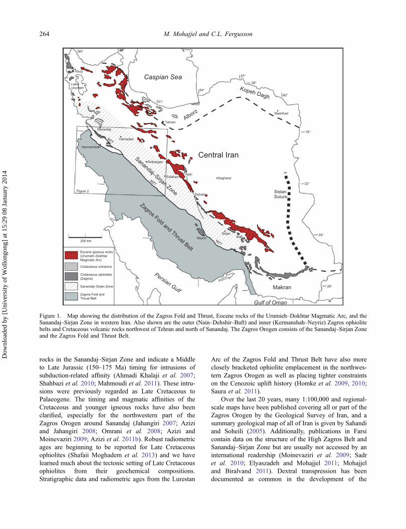
Zagros Orogen is subdivided into the Zagros Fold andThrust Belt, the Zagros Suture Zone, which includes theMain Zagros Thrust, the Sanandaj–Sirjan Zone, and theLate Cretaceous ophiolite belt (Figure 1). The Zagros Foldand Thrust Belt is subdivided into the inner High ZagrosBelt (or imbricate thrust belt) and the outer Zagros SimplyFolded Belt. Widespread metamorphic rocks are character-istic of the Sanandaj–Sirjan Zone, but very low-grade toweakly metamorphosed rocks and sedimentary rocks arealso common (Mohajjel et al. 2003). The Sanandaj–SirjanZone is also known as the Sanandaj–Sirjan metamorphicbelt (Sarkarinejad and Azizi 2008), although we prefer theformer term because many rock units display minimalmetamorphism. Development of the Zagros Orogen in theCenozoic is closely related to the southwestern margin ofthe central Iran block including the Urumieh–DokhtarMagmatic Arc.
Since our earlier review (Mohajjel et al. 2003), manyadvances in the understanding of the northwestern ZagrosOrogen have occurred. Abundant new radiometric agesand geochemical analyses have been published on igneous
*Corresponding author. Email: [email protected]
International Geology Review, 2014Vol. 56, No. 3, 263–287, http://dx.doi.org/10.1080/00206814.2013.853919
© 2013 Taylor & Francis
Dow
nloa
ded
by [
Uni
vers
ity o
f W
ollo
ngon
g] a
t 15:
29 0
8 Ja
nuar
y 20
14
rocks in the Sanandaj–Sirjan Zone and indicate a Middleto Late Jurassic (150–175 Ma) timing for intrusions ofsubduction-related affinity (Ahmadi Khalaji et al. 2007;Shahbazi et al. 2010; Mahmoudi et al. 2011). These intru-sions were previously regarded as Late Cretaceous toPalaeogene. The timing and magmatic affinities of theCretaceous and younger igneous rocks have also beenclarified, especially for the northwestern part of theZagros Orogen around Sanandaj (Jahangiri 2007; Aziziand Jahangiri 2008; Omrani et al. 2008; Azizi andMoinevaziri 2009; Azizi et al. 2011b). Robust radiometricages are beginning to be reported for Late Cretaceousophiolites (Shafaii Moghadem et al. 2013) and we havelearned much about the tectonic setting of Late Cretaceousophiolites from their geochemical compositions.Stratigraphic data and radiometric ages from the Lurestan
Arc of the Zagros Fold and Thrust Belt have also moreclosely bracketed ophiolite emplacement in the northwes-tern Zagros Orogen as well as placing tighter constraintson the Cenozoic uplift history (Homke et al. 2009, 2010;Saura et al. 2011).
Over the last 20 years, many 1:100,000 and regional-scale maps have been published covering all or part of theZagros Orogen by the Geological Survey of Iran, and asummary geological map of all of Iran is given by Sahandiand Soheili (2005). Additionally, publications in Farsicontain data on the structure of the High Zagros Belt andSanandaj–Sirjan Zone but are usually not accessed by aninternational readership (Moinevaziri et al. 2009; Sadret al. 2010; Elyaszadeh and Mohajjel 2011; Mohajjeland Biralvand 2011). Dextral transpression has beendocumented as common in the development of the
Sanandaj–Sirjan Zone
Caspian Sea
Persian Gulf
Gulf of Oman
Kermanshah
Hamadan
Tehran
Neyriz
EsfahanNain
Sanandaj–Sirjan ZoneFigure 2
Zagros Fold and Thrust Belt
LakeUrumieh
Sanandaj
BaftSirjan
Mashhad
SistanSuture
Saghand
Khoy
MZT
MZT
MZT
Golpaygan
Zagros Fold andThrust Belt
Cretaceous ophiolites(Zagros)
Cretaceous volcanics
Eocene igneous rocks(Urumieh–DokhtarMagmatic Arc)
200 km
Central Iran
45° 48°48°
57°
54°
60°
38°
35°
32°
29°
26°
51°
Dehshir
Makran
Alborz
Kopeh Dagh
Figure 1. Map showing the distribution of the Zagros Fold and Thrust, Eocene rocks of the Urumieh‒Dokhtar Magmatic Arc, and theSanandaj‒Sirjan Zone in western Iran. Also shown are the outer (Nain‒Dehshir‒Baft) and inner (Kermanshah‒Neyriz) Zagros ophiolitebelts and Cretaceous volcanic rocks northwest of Tehran and north of Sanandaj. The Zagros Orogen consists of the Sanandaj–Sirjan Zoneand the Zagros Fold and Thrust Belt.
264 M. Mohajjel and C.L. Fergusson
Dow
nloa
ded
by [
Uni
vers
ity o
f W
ollo
ngon
g] a
t 15:
29 0
8 Ja
nuar
y 20
14
Sanandaj–Sirjan Zone (Mohajjel and Fergusson 2000;Sarkarinejad 2007; Sarkarinejad and Azizi 2008;Sarkarinejad et al. 2008, 2009). Seismic receiver functionanalysis has provided data on the deep crust under theZagros Mountains and it has been inferred that Arabiancrust has underthrust central Iran (Paul et al. 2010). Theseseismic results in addition to constraints from seismictomography have formed the basis for several crustal-scale cross sections for the northwestern Zagros Orogen(Agard et al. 2011; Vergés et al. 2011).
In the last decade, and especially in the last few years,considerable data and detailed analyses have been publishedon the Cenozoic tectonic development of the Zagros colli-sion zone (Alavi 2004, 2007; Vernant et al. 2004; Agardet al. 2005, 2011; Authemayou et al. 2006; Hatzfeld andMolnar 2010; Hatzfeld et al. 2010; Nemati and Yassaghi2010; Wrobel-Daveau et al. 2010; Mouthereau 2011;Vergés et al. 2011; Mouthereau et al. 2012; McQuarrieand van Hinsbergen 2013). Syntheses by Agard et al.(2011) and Mouthereau et al. (2012) concentrated on LateCretaceous to Cenozoic development, reviewing constraintson the stratigraphic and deformation history and examiningthe geodynamics of the system in regard to slab break-offand crust-thickening during collision.
We have several aims in presenting this review. First,we present an updated account of structure of the Sanandaj–Sirjan Zone, Zagros Suture Zone, and the High Zagros Beltof the Zagros Fold and Thrust Zone in northwestern Iranbetween Kermanshah and Shahrekord (Figure 2). We onlybriefly address the Late Cretaceous ophiolites of Zagros,which have recently been reviewed by Shafaii Moghadamand Stern (2011). Aspects of the stratigraphy and chrono-logical data relevant to structure and tectonic history areincluded, but readers are referred to original sources forlithological and stratigraphic detail. Second, a revised tec-tonic history for the Jurassic to Palaeogene is presentedwith an emphasis on the nature of the magmatic arcs,associated deformation, and their related subduction zones.Third, we also briefly discuss the timing of continentalcollision in the Zagros using constraints from within thenorthwestern Zagros Orogen. In regard to the age of colli-sion in the Himalayan Orogen (Aitchison et al. 2007),timing of the Arabian–Iranian continental collision hasalso been difficult to establish, with estimates rangingfrom the Late Cretaceous (Alavi 2004, 2007) to the lateMiocene (McQuarrie et al. 2003).
Rock units and structure of the collision zone in thenorthwestern Zagros of Iran
Zagros Simply Folded Belt
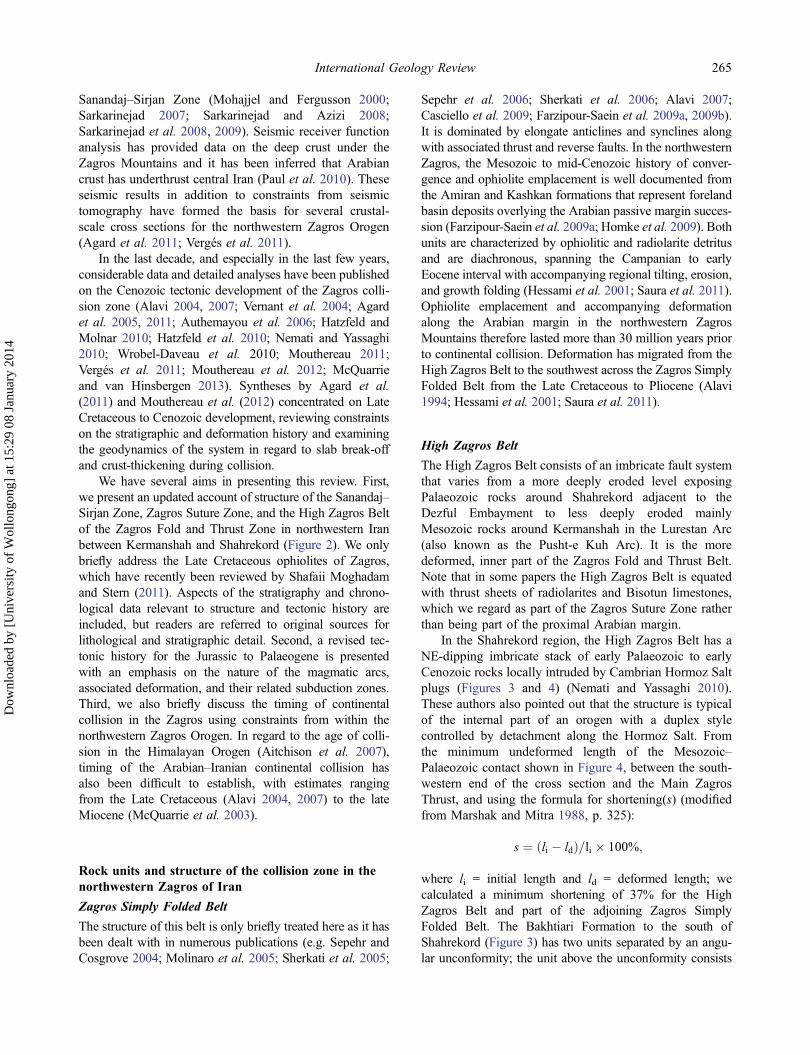
The structure of this belt is only briefly treated here as it hasbeen dealt with in numerous publications (e.g. Sepehr andCosgrove 2004; Molinaro et al. 2005; Sherkati et al. 2005;
Sepehr et al. 2006; Sherkati et al. 2006; Alavi 2007;Casciello et al. 2009; Farzipour-Saein et al. 2009a, 2009b).It is dominated by elongate anticlines and synclines alongwith associated thrust and reverse faults. In the northwesternZagros, the Mesozoic to mid-Cenozoic history of conver-gence and ophiolite emplacement is well documented fromthe Amiran and Kashkan formations that represent forelandbasin deposits overlying the Arabian passive margin succes-sion (Farzipour-Saein et al. 2009a; Homke et al. 2009). Bothunits are characterized by ophiolitic and radiolarite detritusand are diachronous, spanning the Campanian to earlyEocene interval with accompanying regional tilting, erosion,and growth folding (Hessami et al. 2001; Saura et al. 2011).Ophiolite emplacement and accompanying deformationalong the Arabian margin in the northwestern ZagrosMountains therefore lasted more than 30 million years priorto continental collision. Deformation has migrated from theHigh Zagros Belt to the southwest across the Zagros SimplyFolded Belt from the Late Cretaceous to Pliocene (Alavi1994; Hessami et al. 2001; Saura et al. 2011).
High Zagros Belt
The High Zagros Belt consists of an imbricate fault systemthat varies from a more deeply eroded level exposingPalaeozoic rocks around Shahrekord adjacent to theDezful Embayment to less deeply eroded mainlyMesozoic rocks around Kermanshah in the Lurestan Arc(also known as the Pusht-e Kuh Arc). It is the moredeformed, inner part of the Zagros Fold and Thrust Belt.Note that in some papers the High Zagros Belt is equatedwith thrust sheets of radiolarites and Bisotun limestones,which we regard as part of the Zagros Suture Zone ratherthan being part of the proximal Arabian margin.
In the Shahrekord region, the High Zagros Belt has aNE-dipping imbricate stack of early Palaeozoic to earlyCenozoic rocks locally intruded by Cambrian Hormoz Saltplugs (Figures 3 and 4) (Nemati and Yassaghi 2010).These authors also pointed out that the structure is typicalof the internal part of an orogen with a duplex stylecontrolled by detachment along the Hormoz Salt. Fromthe minimum undeformed length of the Mesozoic‒Palaeozoic contact shown in Figure 4, between the south-western end of the cross section and the Main ZagrosThrust, and using the formula for shortening(s) (modifiedfrom Marshak and Mitra 1988, p. 325):
s ¼ li � ldð Þ=li � 100%;
where li = initial length and ld = deformed length; wecalculated a minimum shortening of 37% for the HighZagros Belt and part of the adjoining Zagros SimplyFolded Belt. The Bakhtiari Formation to the south ofShahrekord (Figure 3) has two units separated by an angu-lar unconformity; the unit above the unconformity consists
International Geology Review 265
Dow
nloa
ded
by [
Uni
vers
ity o
f W
ollo
ngon
g] a
t 15:
29 0
8 Ja
nuar
y 20
14
of early Miocene conglomerate and shallow marine rocksand the unit below the unconformity is Oligocene(?) con-glomerate (Fakhari et al. 2008). The age of thrusting in thispart of the High Zagros Belt is further constrained byapatite (U–Th)/He thermochronometry that shows most
cooling in the High Zagros Belt as early Miocene, withdeformation continuing into the late Miocene (Gavillotet al. 2010).
Southwest of Azna, the High Zagros Belt containsweakly deformed conglomerate of the Bakhtiari
Hasanrobat288 Ma
Anticline
Thrust fault or fault
Representative structures
CTS
HZRF
Mountainfront
flexure
KSF
HZB
HZB
Ca
100 km
Zagros03seismic line(Paul et al.
2010)
Toeline ofZagros crust
Alavi (2007) AA’
Alavi (2007) BB’
Azna
0
Cross section cc’
Alavi (2007) CC’
Crosssection
dd’
Cross section bb’
Crosssection
aa’
Aligodarz
Vergés et al. (2011)Crustal section
Deformationfront
Hamadan
Dorud
Kermanshah
Khorramabad
Sanandaj
Golpaygan
Nahavand
Esfahan
Shahrekord
Borujerd
Qorveh
Sonqor
MRF
MRF
MRF
MZT
AmiranAnticline
Figure 3
MahallatCa
35
34
33
49484746 50 51
32
KSF
Iraq
Iraq
Sanandaj-Sirjan Zone (SSZ)
Urumieh–Dokhtar Magmatic Arc (UDMA)
CaCa
radiolarites (Mesozoic)
Bisotun limestone (Mesozoic)
Ophiolites (Late Cretaceous)
metamorphic complexes (Precambrian to Jurassic)
Hamadan Phyllite (Triassic–Jurassic)
Granite (mainly Jurassic, QAPB)
Mafic-intermediate volcanics(Mesozoic)
Sedimentary rocks (Cretaceous)
alluviumCa
Gabbro (Eocene)
Bakhtiari Conglomerateand equivalents
35–37 Ma(Taa–Baysaran)
157–149 Ma167–153 Ma
157 Ma
172–169 Ma
165 Ma
168 Ma 170 Ma
35 Ma
55 Ma(Kamyaran)
Ca
Ca
N
Zagros Suture Zone (ZSZ)
Mafic volcanic and sedimentaryrocks (Eocene)
Ca
Undifferentiated
Zagros Simply Folded Belt (ZSFB)
High Zagros Belt (HZB)
Oligo-Miocenesedimentary rocks
Sedimentary and volcanic rocks(Cretaceous–Eocene)
Eocene volcanic rocks Undifferentiated
ZSFB
ZSFB
QAPB
SSZ
UDMA
ZSZ
Figure 5
Figure 7
Figure 13
Figure 12X
MutehAu Mine596 ± 22 Ma578 ± 24 Ma
588 ± 23 Ma
DezfulEmbayment
Lurestan Arc
MZT
SSZ
Figure 2. Regional map of the Zagros Orogen in northwestern Iran. See Figure 1 for location. Abbreviations: CTS, Cehel TaghiSyncline; HZRF, High Zagros Reverse Fault; KSF, Kuh-e Sefid Fault; MRF, Main Recent Fault; MZT, Main Zagros Thrust; QAPB,Qorveh–Aligodarz Plutonic Belt. Also shown are the locations of cross sections AA′, BB′, and CC′ from Alavi (2007), the Zagros03seismic experiment from Paul et al. (2010), and the crustal cross section from Vergés et al. (2011). The toe line showing thenortheastward extent of Arabian crust in the subsurface is also shown (from Paul et al. 2010). For cross sections aa′, bb′, cc′, and dd′,see Figures 4, 6, 9, and 14, respectively. Ages of granites in the Sanandaj–Sirjan Zone are from Ahmadi-Khalaji et al. (2007), Mahmoudiet al. (2011), and Esna-Ashari et al. (2012). The extent of the QAPB (Qorveh–Aligodarz Plutonic Belt) is shown by the dotted line. U–Pbzircon ages on granites from the Muteh Gold Mine and on gneiss from farther west are from Hassanzadeh et al. (2008). The age of thePermian granite at Hasanrobat is from Alirezaei and Hassanzadeh (2012).
266 M. Mohajjel and C.L. Fergusson
Dow
nloa
ded
by [
Uni
vers
ity o
f W
ollo
ngon
g] a
t 15:
29 0
8 Ja
nuar
y 20
14

Formation that extends 50 km parallel to regional strike(Figure 5). These synorogenic deposits mostly formedduring Pliocene deformation. Several footwall synclinesoccur below NE-dipping thrusts and are interpreted asfault-propagation folds (Sadr et al. 2010, in Farsi)
(Figure 6). Northwest of Dorud, the High Zagros Belt iscovered by a large thrust sheet of Bisotun limestone (theKuh-e Farangui tectonic unit of Homke et al. 2010) andsome Mesozoic volcanic rocks (Figure 2) (Mohajjel et al.2003). The structure of this thrust sheet is poorly known as
Pbc
PbcPbc
M
M
PeP
PeP
PeP PePPeP
PeP
PeP
Mz
Mz
Mz
Mz
Mz
Mz
Mz
Mz
Mz
PeP
PePPeP
PeP
Pz PzPz
Pz
Pz
Pz
Pz
M-Pbc
Kl
Kl Kl
Kl
Kl
Kl
Kl
Kl
Kl
KlKl
Kl
Kl
Kl
Kl
Kl
Kl
Kl
Kl
KlKl
KlKl
Kl
Kl
KlKl
20 km0
32° 30′
32°
51°50°
N
Shahrekord
Zayandehrouddam lake
Pabdeh, Jahrum and Asmari Fms (Palaeocene–early Miocene)
Pz
Mz
Lalun, Mila, Dalan and Kangan Fms (Palaeozoic and Triassic)
Surmeh, Neyriz, Garau and Sarvak Fms (Mesozoic)
M
Bakhtiari Fm (Pbc = Pleistocene–Pliocene,M–Pbc = Miocene–Pliocene, O?bc = Oligocene?)
Gachsaran and Agha–Jari Fms (Miocene)
Hormoz salt plugs (Cambrian)
Zagros Fold and Thrust Belt
Sanandaj–Sirjan ZoneLimestone (Cretaceous)
Schist, phyllite, marble, sandstone, metadolerite, deformed granitoids (low-grade zone)
Schist, marble, gneiss, amphibolite, eclogite, deformed granitoids (high-grade zone)
Sandstone, siltstone, volcanics, phyllite, marble (very low-grade zone)
Anticline
Thrustfault
MT
BZT
MS
KT
AT
MZT
BT
Cross section
M-PbcO?bc
Pbc
Figure 3. Geological map of the Shahrekord region compiled and reinterpreted from Fakhari et al. (2008), Nemati and Yassaghi (2010),and Babaahmadi et al. (2012). For location, see Figure 2. Note that the Bakhtiari Formation south of Shahrekord consists of Oligocene(?)and early Miocene parts (Fakhari et al. 2008). Abbreviations: AT, Ardal Thrust; BT, Ben Thrust; BZT, Bazoft Thrust; KT, KuhrangThrust; MS, Mili Splay; MT, Mafaroon Thrust; MZT, Main Zagros Thrust.
Pz PzPz
PzMz Mz
MzPbc
Pbc PbcMPeP
PePPeP
Mz
PePPeP Kl
Kl Kl
HsHsHs Hs Hs
Undifferentiated metamorphics at depth
Main Zagros Thrust
High-grade rocks(including eclogites)
0HS = VS
Sealevel
–4000
–8000
–12,000
4000
m
SW NEBreak in section line
Zagros SimplyFolded Belt
High Zagros Belt
Pan-African basement
Sanandaj–Sirjan Zonea a’
10 km
Figure 4. Cross section aa′ to the northwest of Shahrekord. For location, see Figures 2 and 3. See Figure 3 for a key to geological units.The structure of the Zagros Fold and Thrust Belt is redrawn and reinterpreted from Nemati and Yassahi (2010). The high-grade rocks(including eclogites) of the Sanandaj–Sirjan Zone form the core of an antiform.
International Geology Review 267
Dow
nloa
ded
by [
Uni
vers
ity o
f W
ollo
ngon
g] a
t 15:
29 0
8 Ja
nuar
y 20
14

it has only been mapped at 1:250,000 and 1:100,000scales. Its map distribution indicates a minimum horizon-tal thrust displacement to the WSW of 40 km, assumingthat it has been derived from the Zagros Suture Zone andhas overridden the radiolarites (Figure 5). It predates theupper part of the Bakhtiari conglomerates, which are gen-erally considered Pliocene (Homke et al. 2010, p. 663).
The High Zagros Belt, 30–40 km southeast ofKermanshah (Figure 7), has a 2000 m-thick Cretaceous toEocene succession of competent cliff-forming limestoneinterbedded with shale and clastic rocks of the Sarvak,Ilam, Gurpi, Amiran, and Kashkan formations. These rockunits are strongly folded about ENE-trending axes. Detailedcross sections based on mapping of excellent exposures are
given by Elyaszadeh and Mohajjel (2011, in Farsi) and areredrawn and reinterpreted in Figure 8. Overturned folds areassociated with NE-dipping imbricate thrust faults and aretypical of fault-propagation folds. From the method ofMarshak and Mitra (1988, p. 324–325), wavelengths(<2–5 km) of the fold train have been used to determinethe depth to décollement at 2–3 km below the surfacewithin the Garau Formation below the Sarvak Formation(Figure 8). To the southwest, Casciello et al. (2009) haveshown that décollements occur at several stratigraphic hor-izons (see also Farzipour-Saein et al. 2009b), including inweak shale and marl of the Garau Formation. In one area inthe cross section (Figure 8), 4 km southwest of the Kuh-eSefid Fault, a small-scale imbricate thrust system soles into
10 km0
Dorud
AznaAligodarz
49° 15' 49° 30'33° 30'
33° 15'
MRF
MZT
CNT
GGT
GGT
RT
HphJcpx
Jcpx
Jcpx
Jcpx
Jcpx
Jcpx
Jcpx
Jcpx
JcpxJcpx
OM
OM
OM
OM
Pbc
Pbc
Pbc
Pbc
Pbc
Pbc
Pbc
PbcPbc
PbcPbc
MbcMbc
Mbc
Kg
Kg
OM Kds
Kds
Pm
Pm
PmPm
Jv
Jv
Jv
Jv
Jv
Jv
Jv
Jv
Jv
Jv
KllKll
KllKll
Kr
Kr
JK
JK
JK
JK
JK
Tr
Tr
TrPzl
Pzu
Pzu
Pm
Jl
Jl
Pzu
Hph
Sch
Sch
Kr
OM
Jcpx
Sanandaj-Sirjan zone
June Complex
Metacarbonate (Permian)
Hamadan Phyllite (Triassic–Jurassic)
Granite (Jurassic)
Schist
HphPmSch
Jcpx
Zagros Suture Zone
JvJl
KllKr
JK
Volcanics (Jurassic)
Limestone (Jurassic)
Metalimestone (Jurassic–Cretaceous)
Radiolarites (Cretaceous)
Limestone (Cretaceous)
Zagros Fold and Thrust Belt
Pzl
Pzu
TrKdsKg
Zagun, Lalun, Mila Fms (early Paleozoic)
Faraghun, Dalan Fms (late Palaeozoic)
Khaneh Kat, Dashtak, Neyriz, SurmehFms (Triassic–Jurassic)
Dariyan, Sarvak Fms (Cretaceous)
Garau Formation (Cretaceous)
PbcMbcOM
Upper Bakhtiari Formation (Pliocene)
Lower Bakhtiari Formation (Miocene)Marine sedimentary rocks(Oligocene–Miocene)
TownCrosssection
SynclineAnticline
Strike–slipfault
Thrustfault
N
Figure 5. Geological map of the Azna region compiled and reinterpreted from the Aligodarz 1:100,000 geological map of Soheili et al.(1992), the Khorramabad 1:250,000 geological map (Soheili 1993), and Sadr et al. (2010). For location, see Figure 2. Abbreviations:CNT, Cheshmeh–Narges Thrust; GGT, Galeh–Ghorchak Thrust; MRF, Main Recent Fault; MZT, Main Zagros Thrust; RT, radiolaritethrust.
268 M. Mohajjel and C.L. Fergusson
Dow
nloa
ded
by [
Uni
vers
ity o
f W
ollo
ngon
g] a
t 15:
29 0
8 Ja
nuar
y 20
14

a décollement developed along the base of the upper SarvakFormation; thus décollements occur locally at two levels.Shortening of 33% has been calculated for the cross sectionin Figure 8, based on the minimum undeformed length of acompetent limestone in the upper Sarvak Formation (Sv(u))between the thrust fault labelled A and the Kuh-e SefidFault (see shortening formula given above). As expected,this shortening is much greater than in the adjoining ZagrosSimply Folded Belt where shortening ranges 11.5% to17.5% (Vergés et al. 2011). The timing of deformation inthis part of the High Zagros Belt is poorly constrained.
Farther to the southeast near Khorramabad (Figure 2), theCehel Taghi Syncline shows syndepositional growth withdevelopment of a syncline with a steeply NE-dipping limbduring the Campanian to Maastrichtian (Saura et al. 2011).
The Kuh-e Sefid Fault forms a 200 m-wide zoneexposed in a new highway cutting south of Kermanshahand consists of fault breccia with blocks of limestone,shale, and thin-bedded folded radiolarian chert. Shear fab-rics in the fault zone indicate an overall dip of 50° NE anddown-dip striations indicate up-dip slip. The dip of thefault is steeper than most faults in the radiolarites to the
Pzl
Pzu
Tr
Kg
Pzl
PzuTr
Kds Kr
OM
4000
3000
2000
1000
–1000
–2000
–3000
–4000
–5000
–6000
0
m
Pzl HphJcpxJcpx
PmJv
Jv
KllJv
JK
km100
HS = VS
Kll
Jv
Jl
MainRecentFault Main Zagros Thrust
Galeh–GhorchakThrust
Cheshmeh–NargesThrust
bSW
b’NE
A T
Figure 6. Cross section bb′ from the Azna region. For location, see Figures 2 and 5. See Figure 5 for a key to geological units.Movement of blocks either side of the Main Recent Fault: A, away; T, towards.
A B CD
E
L
M
P Q U
34° 00′
34° 30′ 34° 30′
47°
30′
48°
00′
47°
00′
Pliocene and younger sediments
Oligo-Miocene limestone and clastic rocks
Mesozoic metamorphic rocks (Sanandaj–Sirjan Zone)
Zagros Suture ZoneEocenelimestone Eocene gabbro
radiolarites, minor limestone (Jurassic, Cretaceous)
EoceneigneousrocksEocene
turbiditesCretaceous ophiolites (mainly ultramafic rocks)
Gabbro (age unknown)
Bisotun limestones (Cretaceous, some Triassic, Jurassic )
limestone (Cretaceous)
Sahneh
Harsin
10 km0
Kermanshah
Zagros Fold and Thrust Belt
Kuh-e Sefid
Bisotun Fault
Figure 8
Figure 10
Fault
Figure 7. Geological map of the Kermanshah and Harsin 1:100,000 geological map areas simplified and reinterpreted from Shahidi andNazari (1997) and Bavandpur and Hajihoseini (1999), respectively. Locations of detailed cross sections are given across the High ZagrosBelt (Figure 8) and the radiolarites (Figure 11). For the location of this map, see Figure 2.
International Geology Review 269
Dow
nloa
ded
by [
Uni
vers
ity o
f W
ollo
ngon
g] a
t 15:
29 0
8 Ja
nuar
y 20
14

northeast and the High Zagros Belt to the southwest(Figure 9). It is therefore possible that the Kuh-e SefidFault is an out-of-sequence reverse fault similar to those ofthe Zagros Simply Folded Belt (Molinaro et al. 2005;Vergés et al. 2011) and cuts across the thin-skinnedstructures.
Zagros Suture Zone
The Zagros Suture Zone includes radiolarites, Bisotun lime-stones, and ophiolites that are widely exposed in theKermanshah region (Figures 7 and 10), as described byBraud (1987) and Saccani et al. (2013). Radiolarites form amajor belt northeast of the Kuh-e Sefid Fault (Figure 7) andare dominated by thin-bedded radiolarian chert and shale butalso include beds of pelagic limestone, limestone nodules,and blocks of limestone. Prominent limestone horizons havebeen mapped northeast of the Kuh-e Sefid Fault and also10 km west of Harsin (Bavandpur and Hajihoseini 1999).The stratigraphy and structure of the radiolarite successionhas been examined in detail 30 km east-southeast ofKermanshah (Figure 7), where detailed sampling and
radiolarian biostratigraphy was undertaken along numeroussections by Gharib and De Wever (2010). They documenteda 250–300 m-thick succession of shale and radiolarite over-lain by massive limestone with an age span of Early Jurassicto Early Late Cretaceous (early Pliensbachian to Turonian),whereas previously these limestone horizons were consid-ered Triassic (Bavandpur and Hajihoseini 1999).
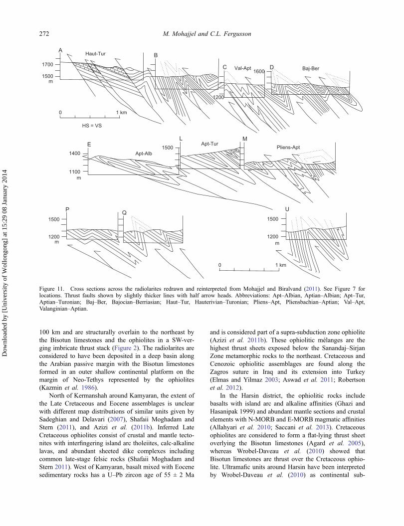
Tight folds associated with thrust faults abound in thedetailed sections (Figure 11) sampled by Gharib and DeWever (2010), as documented by Mohajjel and Biralvand(2011, in Farsi). The thin-bedded nature of the successionhas promoted chevron folding and formation of faultaccommodation structures in fold hinges, as illustratedby the model of Ramsay and Huber (1987, p. 423). Thefolds are SW-verging with overturned limbs cut by thrustfaults indicative of fault-propagation structures, althoughat much smaller scales than in the High Zagros Belt to thesouthwest (see above). It is clear from stratigraphic dupli-cations shown by Gharib and De Wever (2010) that thesuccession has been repeated in numerous thrust slicesacross the belt (Figure 11). The abundant mesoscopicfolds, common chevron fold style, the thinly bedded
0 2 km
SW NE
Sv(l)Il
GuAmKa
Normal faults Sv(u)
HS = VS
0
1000
2000
m
0
1000
2000
m
Break insection
Sv (l)Gu
AmIl
IlIl Il
Il
K
Sv(l)
IlAmSv(u)
Sv(l)Sv(l)
Sv(l)
Sv(l)
Sv(u)
Sv(u)K
Kuh-e SefidFault
Ga
Ga
GaGa Ga
Ga Ga
fz
Figure 8. Cross section of the High Zagros Belt redrawn and reinterpreted from Elyaszadeh and Mohajjel (2011). See Figure 7 forlocation. Abbreviations: Am, Amiran Formation; Ga, Garau Formation; Gu, Gurpi Formation; Il, Ilam Formation; Ka, KashkanFormation; Sv(l), lower Sarvak Formation; Sv(u), upper Sarvak Formation; fz, fault zone.
SW NE
HS = VS
0
2000
m
Kuh-e SefidFault
10 km0
Break insection
Bl
OphRadiolarites
Break insection
2000
m0
c c′
???
Figure 9. Cross section cc′ from the Kermanshah region. See Figure 2 for location. The Kuh-e Sefid Fault is interpreted as a reversefault moderately dipping to the NE that has cut thin-skinned structures in the adjoining units. The Bisotun limestones are shown thrustover the Cretaceous ophiolite (Wrobel-Daveau et al. 2010). Abbreviations: Bl, Bisotun limestone; Oph, ophiolite. The shaded layersouthwest of the Kuh-e Sefid Fault is a limestone marker in the upper Sarvak Formation (see Figure 8).
270 M. Mohajjel and C.L. Fergusson
Dow
nloa
ded
by [
Uni
vers
ity o
f W
ollo
ngon
g] a
t 15:
29 0
8 Ja
nuar
y 20
14

nature of the succession, and closely spaced faults areconsistent with greater shortening than that encounteredin the High Zagros Belt. For example, Ramsay and Huber(1987, p. 423) indicated shortening in excess of 50% forchevron folding in rocks with a bed thickness to limblength ratio of <0.01 where fold interlimb angles are<60° (i.e. comparable to interlimb angles in the crosssections shown in Figure 11).
North and northeast of Kermanshah, the mountainousterrain is formed by thick Bisotun limestones of LateTriassic to Middle–Late Cretaceous age (Braud 1978).Structural trends change from northwesterly to the north-west of Kermanshah to an ENE trend north of theBisotun Fault, which truncates the underlying NW-trend-ing radiolarites over at least 20 km (Figure 7). Theradiolarites trend to the NW from Kermanshah for over
M/D????
Pal
eoge
neC
reta
ceou
sJu
rass
icT
riass
icP
erm
ian
Neo
gene
Qua
t
ZagrosSimplyFolded
Belt
HighZagros
Belt Radiolarites Bisotunlimestones
Ophiolites
Sanandaj–Sonqorregion
Borujerd–Hamadan
region
-La
teM
iddl
eM
iddl
eLa
teLa
teE
arly
Ear
lyE
arly
Eoc
ene
Pal
eo-
cene
-O
ligo-
cene
Mio
cene
Pilo
-ce
ne
Golpaygan(east)region
Sand/gravel
Conglomerate
Sandstone
Mixed clastics/carbonate
OphioliteCarbonate
Marl/shale
Radiolarites
Granite,gabbro
M/DMetamorphism/deformation
Volcanicrocks
Phyllite
Metacarbonate
Metamorphiccomplex
Dolomite/shale
Evaporites
Zagros Suture Zone(Kermanshah–Harsin region)
Sanandaj–Sirjan Zone
Shale
Sandstone/conglomerate
Sandstone/shale/limestone
D
DD
D
D
Figure 10. Time–space plot for Permian and younger rocks from SW to NE across the Zagros Orogen in the Kermanshah region.
International Geology Review 271
Dow
nloa
ded
by [
Uni
vers
ity o
f W
ollo
ngon
g] a
t 15:
29 0
8 Ja
nuar
y 20
14
100 km and are structurally overlain to the northeast bythe Bisotun limestones and the ophiolites in a SW-ver-ging imbricate thrust stack (Figure 2). The radiolarites areconsidered to have been deposited in a deep basin alongthe Arabian passive margin with the Bisotun limestonesformed in an outer shallow continental platform on themargin of Neo-Tethys represented by the ophiolites(Kazmin et al. 1986).
North of Kermanshah around Kamyaran, the extent ofthe Late Cretaceous and Eocene assemblages is unclearwith different map distributions of similar units given bySadeghian and Delavari (2007), Shafaii Moghadam andStern (2011), and Azizi et al. (2011b). Inferred LateCretaceous ophiolites consist of crustal and mantle tecto-nites with interfingering island arc tholeiites, calc-alkalinelavas, and abundant sheeted dike complexes includingcommon late-stage felsic rocks (Shafaii Moghadam andStern 2011). West of Kamyaran, basalt mixed with Eocenesedimentary rocks has a U–Pb zircon age of 55 ± 2 Ma
and is considered part of a supra-subduction zone ophiolite(Azizi et al. 2011b). These ophiolitic mélanges are thehighest thrust sheets exposed below the Sanandaj–SirjanZone metamorphic rocks to the northeast. Cretaceous andCenozoic ophiolitic assemblages are found along theZagros suture in Iraq and its extension into Turkey(Elmas and Yilmaz 2003; Aswad et al. 2011; Robertsonet al. 2012).
In the Harsin district, the ophiolitic rocks includebasalts with island arc and alkaline affinities (Ghazi andHasanipak 1999) and abundant mantle sections and crustalelements with N-MORB and E-MORB magmatic affinities(Allahyari et al. 2010; Saccani et al. 2013). Cretaceousophiolites are considered to form a flat-lying thrust sheetoverlying the Bisotun limestones (Agard et al. 2005),whereas Wrobel-Daveau et al. (2010) showed thatBisotun limestones are thrust over the Cretaceous ophio-lite. Ultramafic units around Harsin have been interpretedby Wrobel-Daveau et al. (2010) as continental sub-
A
1500
1700
B
C D
1200
1600
m
Haut-Tur
Val-Apt Baj-Ber
0 1 km
1100
1400
m
E1500
Apt-Alb
L MApt-Tur
Pliens-Apt
P
1200
1500
m
Q1500
1200m
U
HS = VS
0 1 km
Figure 11. Cross sections across the radiolarites redrawn and reinterpreted from Mohajjel and Biralvand (2011). See Figure 7 forlocations. Thrust faults shown by slightly thicker lines with half arrow heads. Abbreviations: Apt–Albian, Aptian–Albian; Apt–Tur,Aptian–Turonian; Baj–Ber, Bajocian–Berriasian; Haut–Tur, Hauterivian–Turonian; Pliens–Apt, Pliensbachian–Aptian; Val–Apt,Valanginian–Aptian.
272 M. Mohajjel and C.L. Fergusson
Dow
nloa
ded
by [
Uni
vers
ity o
f W
ollo
ngon
g] a
t 15:
29 0
8 Ja
nuar
y 20
14

lithospheric mantle exposed by extensional detachmentsand subsequently obducted onto the Arabian margin.Eocene igneous rocks include mafic pillow lavas, deep-marine turbidites, pelagic limestone, and gabbro and areinterpreted as part of an island arc assemblage thrust overthe Cretaceous ophiolites (Braud 1987; Shahidi and Nazari1997; Agard et al. 2005; Wrobel-Daveau et al. 2010).These ophiolitic assemblages have their thrust contactssealed by a late Oligocene to Miocene sedimentary suc-cession indicating a potential upper constraint on conti-nental collision (Agard et al. 2005).
The ophiolites of the Kermanshah region are part ofthe outer ophiolite belt of the Zagros Orogen, which alsoincludes ophiolites at Neyriz and elswhere southeast ofSirjan along the Main Zagros Thrust (Shafaii Moghadamand Stern 2011). An inner ophiolite belt is recognizedalong the northeastern boundary of the southeastern partof the Sanandaj‒Sirjan Zone (Figure 1). Although theexposures of ophiolite are discontinuous, the inner belt isregarded as linked with ophiolites in the Nain regionnortheast of the Urumieh‒Dokhtar Magmatic Arc andthus extending into central Iran (Shafaii Moghadam et al.2009). No ophiolite has been found along the northeasternboundary of the Sanandaj‒Sirjan Zone between Esfahanand Sanandaj, and we consider that the inner ophiolite beltis therefore restricted to the southeast. In an earlier synth-esis, Alavi (1994) argued that the inner ophiolite beltrepresented the main suture of the Zagros Orogen andthat the ophiolites of the outer belt, such as at Neyrizand Kermanshah, are derived from this belt rather thanbeing upthrust along the Main Zagros Thrust. We, how-ever, along with others (e.g. Agard et al. 2005, 2011;Wrobel-Daveau et al. 2010) recognize that the outerophiolite belt has been emplaced along the Main ZagrosThrust rather than being a klippe isolated from the innerbelt. Alavi’s (1994) suggestion was based on the premisethat the Sanandaj‒Sirjan Zone consisted of a stack ofthrust slices including Cretaceous rocks thrust over unitssuch as the Hamadan Phyllite, which we previouslyrejected (Mohajjel et al. 2003; see below).
Another thrust sheet containing radiolarites, similar tothose of the Kermanshah region, is thrust against lateMesozoic units of the High Zagros Belt south of Azna(Figures 5 and 6). These radiolarites are strongly foldedwith sub-vertical to steeply dipping axial planes, a SWvergence, and are cut by thrust faults (Sadr et al. 2010, inFarsi). A synorogenic sedimentary breccia unit withmostly radiolarite pebbles and boulders, 100 m wide, isexposed along the southwestern side of the radiolaritethrust sheet. Bedding within the radiolarites is sub-verticalto steeply NE-dipping and they are unconformably over-lain by gently dipping Oligocene–Miocene sedimentary,shallow marine rocks, indicating that the strong folding inthe radiolarites predated the Oligocene.
Sanandaj–Sirjan Zone
The Sanandaj–Sirjan Zone occurs between the ZagrosSuture Zone and the southwestern boundary of theUrumieh–Dokhtar Magmatic Arc (Figure 2). It includes arange of stratigraphic successions, volcanic rocks, multi-ply deformed metamorphic rocks, intrusive igneous com-plexes, and common brittle faults. U–Pb data fromgranites and related intrusive rocks in a belt from Qorvehto Aligodarz (Figure 2) indicate Jurassic ages (Ahmadi-Khalaji et al. 2007; Shahbazi et al. 2010; Mahmoudi et al.2011; Esna-Ashari et al. 2012) rather than Late Cretaceousto Palaeogene as previously considered (Mohajjel et al.2003). We refer to these intrusive rocks as the Qorveh–Aligodarz Plutonic Belt (Figure 2).
Precambrian rocks along the Sanandaj–Sirjan Zoneoccur in the Lake Urumieh region (Hassanzadeh et al.2008; Azizi et al. 2011a), and also east and north ofGolpaygan (Figure 2). Late Neoproterozoic Pan–AfricanU–Pb zircon ages have been determined from graniticrocks and gneissic basement near the Muteh Gold Mine(Hassanzadeh et al. 2008). 40Ar/39Ar cooling ages andlow-angle mylonitic foliation in these rocks are consistentwith extensional tectonics during the Eocene between 56and 39 Ma (Moritz et al. 2006), similar to central Iran(Verdel et al. 2007). A unit of Precambrian metamorphicrocks occurs between Shahrekord and Aligodarz (Sahandiand Soheili 2005) and includes eclogites 40 km north ofShahrekord (Davoudian et al. 2008). No definitive radio-metric ages on these rocks have been published; they are abasement metamorphic complex of pre-Cretaceous age.
In the Muteh Gold Mine area, northeast of Golpaygan(Figure 2), the Neoproterozoic metamorphic and graniticrocks and overlying Palaeozoic succession (Moritz et al.2006) are typical of the basement and stratigraphic succes-sion in central Iran. Farther north in the Mahallat area(Figure 12), the succession consists of Neoproterozoiccarbonates, Cambrian sandstone and shale, Permian–Triassic carbonates, Jurassic shale and sandstone,Cretaceous dominantly carbonate succession includingAptian–Albian limestone, and Cenozoic units (Thieleet al. 1968; Sheikholeslami 2008). The pre-Pliocene suc-cession lacks any angular unconformities, although timebreaks are indicated by missing Ordovician to Devonianrocks and disconformities occur at the base of theCretaceous and Eocene units. An unconformity is alsowidely developed in central Iran at the base of theCretaceous succession (Berberian and King 1981, p.240), although the Jurassic and Cretaceous successionshave no angular discordance (Radfar 1993). A PermianA-type granite also occurs in this part of the Sanandaj–Sirjan Zone (Figure 2) (Alirezaei and Hassanzadeh 2012).Eocene and older units are folded and uplifted along a NE-trending thrust fault that has been reactivated after thePliocene (Figure 12; Sheikholeslami 2008). Most of the
International Geology Review 273
Dow
nloa
ded
by [
Uni
vers
ity o
f W
ollo
ngon
g] a
t 15:
29 0
8 Ja
nuar
y 20
14

shortening is pre-Pliocene given that flat-lying Plioceneunits unconformably overlie tilted Eocene rocks and thusthe folding and most of the thrusting was probablyMiocene. The unusual NE trend of these structures mayreflect reactivation of extensional faults formed in theEocene like those near the Muteh Gold Mine (Moritzet al. 2006).
Metamorphic rocks include the widespread LateTriassic to Early Jurassic Hamadan Phyllite (Figure 2),dominated by black phyllite and less abundant sandstoneand carbonate. These rocks are metamorphosed up togreenschist and locally amphibolite facies conditions andhave horizontal schistosity (Berberian and Alavi-Tehrani1977; Sepahi et al. 2004; Agard et al. 2005). Mediumpressure to medium temperature metamorphism affectedthese rocks (Agard et al. 2005) and predated intrusion of
the Middle to Late Jurassic plutons and is therefore ofEarly to Middle Jurassic age. Southwest of the HamadanPhyllite, more varied metamorphic rocks include Permianmetacarbonates, widespread marble, schist, quartzite, andamphibolite (Figure 5). These rocks are known in theDorud district as the June Complex, which has beenintruded by strongly foliated granite west of Azna, buttheir age is poorly documented (Mohajjel and Fergusson2000).
In the Azna region, these metamorphic rocks formseveral thrust duplexes overlying Late Jurassic–EarlyCretaceous volcanic rocks (Figures 5 and 6) consistentwith S/C fabrics in fault zones showing a NE over SWshear sense (Sadr et al. 2010, in Farsi). Several nappescontaining the June Complex and Permian metacarbonatereflect frontal rolling and nappe emplacement during
P
P
J
J
J J
J
P
P
P
Np
Np
Np
Np
Np
C C
C
CC
K
K
KQ
J
K K PP
P PP
PCb
Q
Q
QQ K
KK
K
EE
E
E
E
EE
EE
E
E
E
E K
J
J
J J
K
K
Q
Q
Q
Q
Q
Q
Q
Q
K
K
K
K K
K
K
K
JJJ
J
Cb
KK
J K
K
K K
Pl
PlPl
Np
Q
Mahallat
0 5 km
34° N 34° N
50°
E50
° E
50°
30′ E
33° 45′ N33° 45′ N
N
K
Cb
Cretaceous limestone, shale
J Jurassic shale, sandstone, limestone (Shemshak Fm, Badamu Fm)
E
Quaternary sediments
Eocene sandstone, limestone, conglomerate, marl
Carboniferous shale, sandstone
Neoproterozoic to Cambrian dolomite (Soltanieh Fm)
Overturnedanticline
Thrustfault
Cross section
QPl Pliocene marl, conglomerate, sandstone
Pliocene akali granite
Triassic limestone
P Permian limestone, dolomite, sandstone
C Cambrian shale, sandstone (Lalun–Zagun Fm)
Np
A
B
B
A
U UU
U Overturnedsyncline
C?0 5 km H.S. = V.S.
A B
m mP
J2000
1000
0
3000
E
K
EJ K
2000
1000
0
3000
Figure 12. Geological map and cross section of the northern half of the Mahallat 1:100,000 geological map. Simplified and redrawnfrom Sheikholeslami (2008). See Figure 2 for location.
274 M. Mohajjel and C.L. Fergusson
Dow
nloa
ded
by [
Uni
vers
ity o
f W
ollo
ngon
g] a
t 15:
29 0
8 Ja
nuar
y 20
14

gravitational spreading of the thrust wedge during conti-nental collision (Merle 1998). Elsewhere, such as in theHarsin region, metamorphic rocks of the Sanandaj–SirjanZone have been thrust over units of the adjacent ZagrosSuture Zone (Agard et al. 2005).
Granitic plutons of the Qorveh–Aligodarz Plutonic Belt(Figure 2) include the Alvand plutonic complex aroundHamadan (Shahbazi et al. 2010), plutons east of Borujerd(Ahmadi-Khalaji et al. 2007), plutons near Aligodarz(Esna-Ashari et al. 2012), and the Gorveh pluton(Mahmoudi et al. 2011). Their ages all fall in the range172–149 Ma with the oldest plutons near Borujerd at 172–168 Ma. They are typically massive and post-date majordeformation and metamorphism in the Hamadan Phylliteand June Complex. Plutons with similar ages of 173–147Ma have also been found in the Neyriz region in the south-eastern Sanandaj–Sirjan Zone (Fazlnia et al. 2007, 2009) andJurassic granite, its age determined from field relationships,is found 40 km SSE of Esfahan (Zahedi 1976).
Late Jurassic to Cretaceous volcanic rocks and inter-bedded shallow marine carbonate and clastic rocks arecommon northeast of the Zagros Suture Zone (Figures 2,5, 10, and 13) in the northwestern Sanandaj‒Sirjan Zone,with a prominent belt occurring southwest of the meta-morphic rocks (the marginal subzone of Mohajjel et al.2003). The Late Jurassic volcanic rocks are of intermedi-ate composition and are the same age as younger plutonsin the Qorveh–Aligodarz Plutonic Belt. Cretaceous unitsconsist of carbonates, including abundantOrbitolina-bearing limestone, clastic, and volcanic rocks.Locally, such as 45 km southwest of Golpaygan (Mohajjelet al. 2003), the Cretaceous rocks overlie Jurassic rocksabove an angular unconformity indicating folding in theEarly Cretaceous.
For over 300 km along strike from Hamadan SE tobeyond Golpaygan, Cretaceous clastic and carbonate rocksnon-conformably overlie the Hamadan Phyllite with thehiatus encompassing the age range of the Qorveh–
0 10 km
48° 30′
34°
Aleshtar
Borujerd
Samen
Nahavand
Hph
Hph
Hph
Hph
Hph
Hph
Hph
Hph
Hph
Hph
Jcpx
Jcpx
Jcpx
JcpxJl
MlOM
Pc
Pc
Pc
Pc
Jcpx
Jcpx
Kv
KvPc
Pm
Pm
Pm
Kl
ZagrosFold and
Thrust Belt
Kir
June ComplexMetacarbonate (Perm)
Hamadan Phyllite(Trias–Jur)
Granite (Jur)
Hph
PmJcpx
Ml
Kir
JlVolcanics (Cret)
Metalimestone (Jur)
Basalt-chert (Cret)
Limestone (Miocene)
Kl Limestone (Cret)
Pc
OM
Conglomerate(Pliocene)
Marine sedimentaryrocks (Oli-Mio)
Kv
Cross section
N
MRF
MRF
Figure 13. Geological map of the region west of Borujerd. Compiled and reinterpreted from the Nahavand 1:100,000 geological map ofHossaini-Doust and Mahdavi (1992) and the Borujerd 1:100,000 geological map of Hajmolla-Ali et al. (1989), Alavi and Mahdavi(1994), and Mohajjel and Behyari (2010). For location, see Figure 2. Abbreviation: MRF, Main Recent Fault. Thrust faults shown asthicker lines with black triangles on the hanging wall.
International Geology Review 275
Dow
nloa
ded
by [
Uni
vers
ity o
f W
ollo
ngon
g] a
t 15:
29 0
8 Ja
nuar
y 20
14

Aligodarz Plutonic Belt (Mohajjel et al. 2003; Mahmoudiet al. 2011). The unconformity at the base of the overlyingCretaceous succession of the Sanandaj–Sirjan Zone indi-cates that uplift and erosion must have occurred in the LateJurassic to earliest Cretaceous. Nowhere does the unconfor-mity overlie the Jurassic plutonic rocks, indicating that theyremained at depth despite the uplift. In the Mahallat district,the Triassic–Jurassic units are unmetamorphosed and haveno angular discordance with the overlying Cretaceous suc-cession (Figure 12), as is typical of central Iran.
The Cretaceous units between Hamadan andShahrekord are folded in tight synclines and the deforma-tion was considered latest Cretaceous because massiveLate Cretaceous to Palaeogene plutons of the Qorveh–Aligodarz Plutonic Belt were considered to have post-dated the folding (Mohajjel et al. 2003). These plutonshave been shown to be Middle to Late Jurassic (see above)and thus predate the deformation. Nevertheless, a latestCretaceous age for the deformation is consistent withrelationships in the Sonqor region, where the Cretaceoussuccession is overlain by an angular unconformity at thebase of a weakly folded Palaeocene to Eocene volcanic tosedimentary succession (Eshragi et al. 1996). In contrast,in the Sanandaj region, a conformable succession of LateJurassic, Cretaceous, and Palaeocene units are unconform-ably overlain by Oligocene–Miocene rocks, indicatingfolding in the late Eocene (Zahedi and Hajian 1985). TheCretaceous succession consists of 2000–3000 m of alter-nating clastic, carbonate, and volcanic units (Figure 10)(Zahedi and Hajian 1985). Fission track cooling ages of45–35 Ma from both bedrock samples and detrital apatitegrains found in Miocene and younger clastic successionsindicate uplift in the Sanandaj–Sirjan Zone in the middleto late Eocene (Homke et al. 2010). In the Mahallat area, amajor deformation has produced NE-trending thrust faultsand overturned folds that affect the Eocene and older unitsand predate flat-lying Pliocene units, although minorpost-Pliocene fault reactivation has probably occurred(Figure 12) (Sheikholeslami 2008).
Northeast of the Zagros Suture Zone, within theSanandaj–Sirjan Zone west of Sanandaj, the Cretaceous to
Eocene succession is intruded by Eocene gabbroic to dioriticplutons and granitic dikes with zircon ages of 36–35 Ma(Azizi et al. 2011b). One of these Eocene plutons at Taa–Baysaran, SW of Sanandaj (Figure 2), has intruded theEocene succession but is non-conformably overlain byOligo–Miocene clastic and carbonate rocks (Sadeghian andDelavari 2007). These Oligo–Miocene rocks are equivalentsof the lower Red and Qom formations of central Iran andthese relationships indicate late Eocene folding, uplift, anderosion. The Eocene ophiolite of the Zagros Suture Zone andthe Eocene igneous rocks in the Sanandaj–Sirjan Zone(Figures 2 and 7) were referred to as the Early TertiaryMagmatic Domain by Agard et al. (2011). We prefer totreat these two assemblages as separate units consistent withthe age difference of nearly 20 million years between them(Azizi et al. 2011b). Another small pluton, the Gosheh–Tavandasht Complex, has a U–Pb zircon age of 35Ma south-east of Borujerd (Mahmoudi et al. 2011).
Main Recent Fault and related structures
The Main Recent Fault is associated with topographicdepressions and valley-fill sediments but in many areasthe fault is not accurately mapped, such as betweenSahneh and Nahavand (Figure 2). Offsets of drainagebasins and mis-alignments of wind gaps with major riversindicate dextral strike-slip displacement of ~50 km alongthe Main Recent Fault mainly in the last 3 to 5 million years(Talebian and Jackson 2002). In contrast, on the basis ofdisplaced ophiolite contacts north of Kermanshah, a muchlower maximum dextral offset of 16 km has been found byAlipoor et al. (2012). In the Nahavand region, the fault hastwo overlapping strands (Figure 2) resulting in a contrac-tional overlap zone, with development of a zone of E–W toESE-aligned ridges formed mainly by upthrust JurassicBisotun limestones (Mohajjel and Behyari 2010). Theseare back-thrust to the north over Miocene limestone(Figures 13 and 14), which forms Kuh-e Garin with peaksover 3600 m high. Miocene limestone is structurally over-lain to the north by a N-dipping thin thrust slice ofOligocene–Miocene sandstone, marl, and limestone.
A T
01000200030004000
m0
1000200030004000
m
Jl Jl JlMl
MlOM
ZFTB
Kir SSZ metamorphics
HS = VS
? ?
?
Kv
Ks
Change in trendof cross section
dS
d’NEMain Recent Fault
Kv
Alluvial cover
Figure 14. Cross section dd′ from the Nahavand region. For location, see Figures 2 and 13. Redrawn and reinterpreted from Hossaini-Doust and Mahdavi (1992) and Mohajjel and Behyari (2010). Offset across the Main Recent Fault is conjectural and under alluvial cover.Abbreviations: A, away; T, towards; Kv, Cretaceous volcanics; Jl, Jurassic limestone; Ks, Cretaceous sedimentary rocks; Ml, Miocenelimestone; SSZ, Sanandaj–Sirjan Zone; ZFTB, Zagros Fold and Thrust Belt.
276 M. Mohajjel and C.L. Fergusson
Dow
nloa
ded
by [
Uni
vers
ity o
f W
ollo
ngon
g] a
t 15:
29 0
8 Ja
nuar
y 20
14

Southeast of Dorud, the Main Recent Fault is developedalong steepened thrusts of the High Zagros Belt (Figure 5).
Central Iran and the Urumieh–Dokhtar Magmatic Arc
The central Iran block has Pan-African metamorphic andgranitic basement overlain by a Phanerozoic stratigraphicsuccession with the Eocene Urumieh–Dokhtar MagmaticArc in the southwest containing abundant mafic to inter-mediate volcanic and intrusive rocks, with calc-alkaline toshoshonitic chemistry (Berberian and King 1981; Alavi1994, 2007; Hassanzadeh et al. 2008). New U–Pb zirconand 40Ar/39Ar ages show that peak volcanism lasted 17million years from 55 to 37 Ma (Verdel et al. 2011). LateMiocene to Quaternary igneous rocks include adakites andalkaline rocks (Jahangiri 2007; Omrani et al. 2008; Aziziand Moeinevaziri 2009). The Urumieh–Dokhtar MagmaticArc is the southwestern part of a wide domain of Eoceneigneous activity throughout much of Iran and adjoiningregions (Vincent et al. 2005; Allen and Armstrong 2008).Volcanic rocks are overlain by a thick, late Oligocene toRecent, clastic succession with a prominent carbonate unit(Qom Formation) in the late Oligocene to early Miocene(Morley et al. 2009). Deformation synchronous with sedi-mentation has developed strike-slip faults, thrust faults,and folds in a transpressional phase that overlapped sedi-mentation in the last 10 million years (Morley et al. 2009).
Tectonic history
A revised tectonic history of the High Zagros Belt, ZagrosSuture Zone, and Sanandaj–Sirjan Zone is presented. TheSanandaj–Sirjan Zone and adjacent parts of central Iranformed part of the late Neoproterozoic orogenic belt alongthe Arabian margin of Gondwana (Hassanzadeh et al.2008; Horton et al. 2008). The overlying sedimentarysuccession is consistent with a setting as part of theGondwana craton with widespread continental deposition(Berberian and King 1981). In most reconstructions of theNeo-Tethys, the Sanandaj–Sirjan Zone is attached to atleast part of central Iran and rifted away from theArabian margin (Ricou 1994; Stampfli and Borel 2002;Bagheri and Stampfli 2008). Alternatively, the Sanandaj–Sirjan Zone has been shown as separated from central Iranby a wide Neo-Tethyan Ocean in the Early Jurassic(Golonka 2004), thereby implying the existence of asuture along the northeastern boundary of the Sanandaj–Sirjan Zone (i.e. the inner ophiolite belt, which occursalong the southwestern margin of the Urumieh–DokhtarMagmatic Arc in the southeastern Zagros at Dehshir andBaft; Shafaii Moghadam et al. 2010; Shafaii Moghadamand Stern 2011). This reconstruction is not followed herebecause in the Golpaygan region, Jurassic shale overliesPalaeozoic rocks and Neoproterozoic basement consistentwith a connection to central Iran. The Jurassic shale
thickens westwards towards the Hamadan Phyllite withno evidence for a suture. Additionally, the inner ophiolitebelts are thought to have formed during closure of smallocean basins developed by rifting in the Jurassic to LateCretaceous (Bagheri and Stampfli 2008; ShafaiiMoghadam et al. 2009; Agard et al. 2011).
Permian–Triassic rifting
Part of central Iran and the Sanandaj–Sirjan Zone wererifted from Gondwana and the Arabian margin in thePermian to Triassic to form the Neo-Tethys (Stampfliet al. 1991; Alavi 1994, 2004; Ricou 1994). Direct evi-dence of this rift event is poorly documented in the ZagrosFold and Thrust Belt apart from a seismic section in theDezful Embayment showing inversion of a half-grabenwith a thick section of Permian–Triassic growth strata inthe Rag-e Sefid Anticline (Sepehr and Cosgrove 2004). Anunconformity between Triassic evaporite, dolomite, andlimestone and overlying Jurassic to Cretaceous continentaldeposits of the Zagros Simply Folded Belt is also attrib-uted to this event (Alavi 2004, p. 5). Some basalts ofPermian age occur in the High Zagros Belt and syn-depositional normal faulting has been documented in theTriassic Khaneh Kat Formation west of Neyriz (Navapouret al. 2010). Evidence for rifting in the Sanandaj–SirjanZone was outlined in Mohajjel et al. (2003) and includesdeposition of Permian metacarbonate rocks and Triassicclastic, carbonate, and mafic igneous rocks of the JuneMetamorphics. The early Permian A-type Hasanrobatgranite near Golpaygan has also been related to this riftevent (Alirezaei and Hassanzadeh 2012).
Jurassic convergent margin along the Sanandaj–SirjanZone
Elongate plutons form a belt over 350 km along the trendof the northwestern Sanandaj–Sirjan Zone and are ofMiddle to Late Jurassic age (172–149 Ma) with a subduc-tion-related magmatic arc geochemical affinity (Ahmadi-Khalaji et al. 2007; Mahmoudi et al. 2011; Esna-Ashariet al. 2012). In the Qorveh region, mafic rocks of thenorthern Qorveh–Aligodarz Plutonic Belt have beenlocally related to an island arc setting followed by colli-sion with part of the Sanandaj–Sirjan Zone (Azizi andAsahara 2013). However, this suggestion is based on themagmatic affinity of the inferred island arc rocks and theirlocalized NNE–SSW trend compared with the dominantNW–SE trend of the Qorveh–Aligodarz Plutonic Belt. Nosuture zone has been identified associated with this colli-sion, and more data are required on the metamorphic rocksof the Qorveh area to test this hypothesis. South of theLake Urumieh region of northwestern Iran, the Qorveh–Aligodarz Plutonic Belt has not been identified. At adistance of 500 km beyond the southeast termination of
International Geology Review 277
Dow
nloa
ded
by [
Uni
vers
ity o
f W
ollo
ngon
g] a
t 15:
29 0
8 Ja
nuar
y 20
14
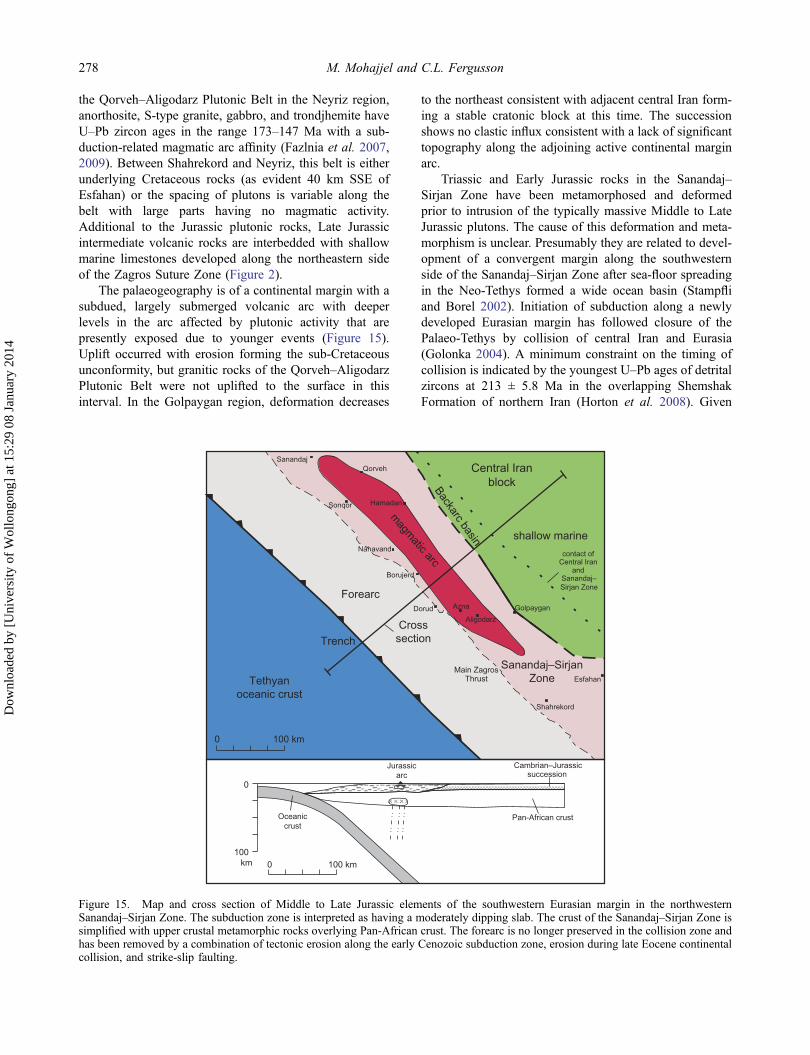
the Qorveh–Aligodarz Plutonic Belt in the Neyriz region,anorthosite, S-type granite, gabbro, and trondjhemite haveU–Pb zircon ages in the range 173–147 Ma with a sub-duction-related magmatic arc affinity (Fazlnia et al. 2007,2009). Between Shahrekord and Neyriz, this belt is eitherunderlying Cretaceous rocks (as evident 40 km SSE ofEsfahan) or the spacing of plutons is variable along thebelt with large parts having no magmatic activity.Additional to the Jurassic plutonic rocks, Late Jurassicintermediate volcanic rocks are interbedded with shallowmarine limestones developed along the northeastern sideof the Zagros Suture Zone (Figure 2).
The palaeogeography is of a continental margin with asubdued, largely submerged volcanic arc with deeperlevels in the arc affected by plutonic activity that arepresently exposed due to younger events (Figure 15).Uplift occurred with erosion forming the sub-Cretaceousunconformity, but granitic rocks of the Qorveh–AligodarzPlutonic Belt were not uplifted to the surface in thisinterval. In the Golpaygan region, deformation decreases
to the northeast consistent with adjacent central Iran form-ing a stable cratonic block at this time. The successionshows no clastic influx consistent with a lack of significanttopography along the adjoining active continental marginarc.
Triassic and Early Jurassic rocks in the Sanandaj–Sirjan Zone have been metamorphosed and deformedprior to intrusion of the typically massive Middle to LateJurassic plutons. The cause of this deformation and meta-morphism is unclear. Presumably they are related to devel-opment of a convergent margin along the southwesternside of the Sanandaj–Sirjan Zone after sea-floor spreadingin the Neo-Tethys formed a wide ocean basin (Stampfliand Borel 2002). Initiation of subduction along a newlydeveloped Eurasian margin has followed closure of thePalaeo-Tethys by collision of central Iran and Eurasia(Golonka 2004). A minimum constraint on the timing ofcollision is indicated by the youngest U–Pb ages of detritalzircons at 213 ± 5.8 Ma in the overlapping ShemshakFormation of northern Iran (Horton et al. 2008). Given
Forearc
magm
atic arc
Tethyanoceanic crust
Sanandaj–SirjanZone
shallow marine
0 100 km
Hamadan
Dorud
Sanandaj
Golpaygan
Nahavand
Esfahan
Shahrekord
Borujerd
Qorveh
Sonqor
Aligodarz
Azna
Central Iranblock
Trench
contact ofCentral Iran
andSanandaj–Sirjan Zone
Main ZagrosThrust
0
100km 0 100 km
Oceaniccrust
Pan-African crust
Jurassicarc
Cambrian–Jurassicsuccession
Crosssection
Backarc basin
Figure 15. Map and cross section of Middle to Late Jurassic elements of the southwestern Eurasian margin in the northwesternSanandaj–Sirjan Zone. The subduction zone is interpreted as having a moderately dipping slab. The crust of the Sanandaj–Sirjan Zone issimplified with upper crustal metamorphic rocks overlying Pan-African crust. The forearc is no longer preserved in the collision zone andhas been removed by a combination of tectonic erosion along the early Cenozoic subduction zone, erosion during late Eocene continentalcollision, and strike-slip faulting.
278 M. Mohajjel and C.L. Fergusson
Dow
nloa
ded
by [
Uni
vers
ity o
f W
ollo
ngon
g] a
t 15:
29 0
8 Ja
nuar
y 20
14

that the depositional age of the Hamadan Phyllite extendsinto the Jurassic (Braud 1987; Soheili et al. 1992), it isapparent that subduction was initiated no earlier than 190–180 Ma, at least 20 million years after the collision alongthe Palaeo–Tethyan suture.
Cretaceous tectonic setting
Eurasian margin
The main indicator of the Cretaceous tectonic setting inthe northwestern Sanandaj–Sirjan Zone is the marine suc-cession containing intercalated, basaltic to andesitic basal-tic, calc-alkaline rocks with a continental arc geochemicalsignature (Azizi and Jahangiri 2008; Azizi andMoinevaziri 2009). These rocks are most widely devel-oped in the Sanandaj region and extend northwestwardstowards Lake Urumieh. Towards the southeast, the volca-nic rocks are much less common and the succession con-sists dominantly of Aptian–Albian limestone overlyingconglomerate and sandstone (Figure 10) with minor
intermediate volcanic rocks (Mohajjel et al. 2003). Insome areas, such as 45 km southwest of Golpaygan, avolcanic succession ranges from the Jurassic into the EarlyCretaceous (Mohajjel et al. 2003). The Cretaceous volca-nic arc (Figure 16) developed farther west of the precedingQorveh–Aligodarz Plutonic Belt and overlapped exposedJurassic volcanic rocks. It appears that the Cretaceous arcis truncated southeastwards along the Main Zagros Thrust,although it is possible that the arc dies out to the SE(Figures 2 and 16). Additionally, Cretaceous volcanicrocks occur in northern Iran north of Tehran (Figure 1)(Annells et al. 1975) and are also scattered elsewhere innorthern Iran (Verdel et al. 2011). By analogy with wes-tern North America in the Laramide Orogeny, Verdel et al.(2011) inferred an episode of flat slab subduction for theCretaceous in central and northern Iran. Late Cretaceousshortening affected Cretaceous units and underlying rocksof the Qorveh–Aligodarz Plutonic Belt in the arc to back-arc region and is related to an inferred flattening of thesubducting slab. This deformation is synchronous with
Forearc
Tethyanoceanic crust
Sanandaj–SirjanZone
Shallow marine
Cretaceousarc
Axis of Jurassic arc
0 100 km
Hamadan
Dorud
Sanandaj
Golpaygan
Nahavand
Esfahan
Shahrekord
Borujerd
Qorveh
Sonqor
Aligodarz
Azna
Central Iranblock
Trench
Contact ofCentral Iran
andSanandaj–Sirjan Zone
Main ZagrosThrust
0
1000 100 kmkm
Oceaniccrust
Pan-African crust
Jurassicpluton
Cambrian–Cretaceoussuccession
Cretaceousarc basin
Subductioncomplex
Crosssection
Figure 16. Map and cross section of Early Cretaceous elements of the southwestern Eurasian margin in the northwestern Sanandaj–Sirjan Zone. A moderately dipping subduction zone to the northeast is shown, but note that this only applies to the region northwest ofDorud. The Cretaceous magmatic arc has migrated trenchward accompanying growth of a hypothetical subduction complex so that theaxis of the Jurassic arc is now in a backarc setting. The arc is still topographically subdued. The arc is apparently truncated to the SEalong the Main Zagros Thrust or alternatively it dies out to the SE, which may be related to segmentation of the slab (see text).
International Geology Review 279
Dow
nloa
ded
by [
Uni
vers
ity o
f W
ollo
ngon
g] a
t 15:
29 0
8 Ja
nuar
y 20
14

ophiolite generation and emplacement throughout theZagros.
Cretaceous ophiolites are widely developed in andneighbouring central Iran including the inner ophiolitebelt of the Zagros Orogen extending to the Nain ophiolite,the Sistan Suture Zone of eastern Iran, and ophiolites innorthern Iran. A supra-subduction zone affinity has beendocumented for the inner ophiolite belt (ShafaiiMoghadam et al. 2010; Shafaii Moghadam and Stern2011) and also for part of the Sistan Suture Zone(Saccani et al. 2010). One explanation for these ophiolitesis that they developed after Cretaceous rifting in a backarcsetting followed by closure, with generation of LateCretaceous supra-subduction zone ophiolite (ShafaiiMoghadam et al. 2009; Saccani et al. 2010; Agard et al.2011).
Arabian margin
In the Kermanshah region, initiation of ophiolite obduc-tion is no better constrained than Campanian from the ageof the Amiran turbidites, reflecting flexural subsidence infront of the advancing ophiolite (Alavi 2004; Homke et al.2009). Diachronous advance of the clastic wedge acrossthe Zagros Simply Folded Belt indicates that ophioliteobduction extended from the Late Cretaceous into theEocene (Saura et al. 2011). As for Oman, obduction wasdriven by subduction of the Arabian passive margin north-eastwards under this newly initiated arc. This contrastswith the idea that both the inner and outer ophiolite beltsof the Zagros Orogen developed as part of a single coher-ent forearc lithosphere near the southwest Eurasian marginof the Neo-Tethys (Shafaii Moghadam and Stern 2011;Shafaii Moghadem et al. 2013). Others show that theKermanshah ophiolite includes older elements in additionto a supra-subduction zone component formed in a newlyinitiated subduction zone adjacent to the Arabian passivemargin and distant from the ophiolites of the inner Zagrosbelt and central Iran (Allahyari et al. 2010; Agard et al.2011; Saccani et al. 2013). Complicated relationships eastof Harsin reflect a long history of convergence withrepeated episodes of thrusting, out-of-sequence thrusting,and back-thrusting (Agard et al. 2005, 2011; Wrobel-Daveau et al. 2010).
Early Cenozoic magmatic arc
The broader context for the northwestern Zagros Orogenin the Palaeogene was the intermediate igneous activity inthe Urumieh–Dokhtar Magmatic Arc and more widelythroughout central Iran and in the Caucasus (Allen andArmstrong 2008; Verdel et al. 2011). Eocene igneousactivity and accompanying extensional tectonics, such asin the Saghand region of central Iran, have been consid-ered a response to rollback and slab steepening in a largely
continental region (Verdel et al. 2007, 2011). This wasunaccompanied by formation of either new ocean floor orinfant arc crust that in contrast was widely formed in theLate Cretaceous in the contracting Tethyan Ocean.
Limited igneous activity with granitic to gabbroicrocks at ca. 35 Ma affected the Sanandaj–Sirjan Zoneadjacent to the Zagros Suture Zone (Azizi et al. 2011b;Mahmoudi et al. 2011). These plutons reflect anomalousigneous activity in the forearc, as occurs in the earlyCenozoic convergent margin in southern Alaska (Gasseret al. 2012) and adjacent to the Nankai Trough in south-west Japan (Kimura et al. 2005). In both cases, the anom-alous near-trench magmatism is related to subduction ofactive oceanic spreading centres. The backarc basin mag-matic affinity of the gabbroic pluton southwest ofSanandaj (Azizi et al. 2011b) is consistent with subductionof an actively spreading backarc basin. These plutonicrocks were rapidly uplifted following intrusion, as shownby apatite cooling ages of 45–35 Ma for the Sanandaj–Sirjan Zone (Homke et al. 2010) and the unconformablyoverlying Oligocene–Miocene succession (Sadeghian andDelavari 2007).
Closure of Neo-Tethys and timing of collision
Global reconstructions show that a wide but continuouslyclosing seaway existed along the Zagros Orogen until themiddle to late Cenozoic (Ricou 1994; Şengör et al. 1996;McQuarrie et al. 2003; Golonka 2004; Seton et al. 2012;McQuarrie and van Hinsbergen 2013). A Palaeocene toearly Eocene timing of collision was favoured by Ghasemiand Talbot (2006) and also argued by Mazhari et al.(2009) on the basis of Eocene bimodal plutonic rocksconsidered to be post-collisional. However, it has beenargued that collision was no earlier than the late Eocenebased on the cessation of regional Eocene volcanismacross Iran and in the Talysh (Vincent et al. 2005; Allenand Armstrong 2008). Collision must have also followeddevelopment of minor Eocene ophiolite fragments pre-served in the suture zone near Kermanshah (Wrobel-Daveau et al. 2010; Azizi et al. 2011b).
Constraints on the timing of collision based on strati-graphy and structure in the High Zagros Belt, ZagrosSuture Zone, and Sanandaj–Sirjan Zone in the northwes-tern Zagros Orogen are scarce. For example, shortening inthe Zagros Suture Zone involving the radiolarites aroundKermanshah is impressive (Figure 11) but is presumablyrelated to emplacement of the Cretaceous ophiolite duringpassive margin–island arc collision rather than beingrelated to the continental collision (Vergés et al. 2011).Similarly, much of the deformation in the Harsin district innorthwestern Iran reflects ophiolite emplacement withaccretion of the Eocene island arc related to the continen-tal collision. On the basis of structural and stratigraphicrelationships in the Harsin district, Agard et al. (2005)
280 M. Mohajjel and C.L. Fergusson
Dow
nloa
ded
by [
Uni
vers
ity o
f W
ollo
ngon
g] a
t 15:
29 0
8 Ja
nuar
y 20
14

argued for collision prior to 25–23 Ma. This is consistentwith the Oligocene(?) age of synorogenic conglomerate inthe High Zagros Belt near Shahrekord (Figure 3) docu-mented by Fakhari et al. (2008). It seems likely thatcollision preceded widespread deposition of Oligocene–Miocene units along the suture zone and in central Iranand the Zagros. In a scaled reconstruction utilizing platetectonic constraints with GPlates, McQuarrie and vanHinsbergen (2013) showed that continental collisionmost likely occurred at 27 Ma. Thus collision followedthe 35 Ma shut-down of widespread magmatic activity.
After continental collision, the Tethyan seaway stillremained in existence although presumably only as awide epeiric sea following subduction of all of the oceaniccrust. Closure of this epeiric sea connecting the wideningIndian Ocean with the Mediterranean Sea occurred in theMiocene around 15 Ma based on isotopic evidence forwarm and saline water entering the Indian Ocean up untilthis time (Woodruff and Savin 1989). Along the suture,folding of Oligocene–Miocene successions and incorpora-tion of Pliocene conglomeratic wedges into thrust slicesshows that deformation was widespread in the LateNeogene, although many of the thrust faults are clearlyreactivated structures from earlier ophiolite emplacement.Comprehensive treatments of the Neogene tectonic historyof the Zagros Orogen are given by Agard et al. (2011) andMouthereau et al. (2012).
Discussion
Jurassic to Eocene subduction zones
Most tectonic reconstructions for the Jurassic toPalaeogene history of the Zagros show active subductionoccurring along the southwestern margin of the Sanandaj–Sirjan Zone. Much less agreement exists about the natureof those subduction zones. For example, Agard et al.(2011) show a steeply dipping slab in the northwesternZagros Orogen in the Late Cretaceous that steepens in thePalaeogene followed by slab break-off associated withEocene magmatic activity in the Zagros Suture Zone.Alternatively, Verdel et al. (2011) proposed a Laramide-style, gently dipping slab for the Late Cretaceous followedby slab rollback associated with formation of the EoceneUrumieh–Dokhtar Magmatic Arc. Shafaii Moghadam andStern (2011) argued that Zagros ophiolites reflect animportant episode of subduction initiation along the south-western margin of Eurasia. For the Eocene, Mouthereauet al. (2012) show a steeply dipping slab that at depthbends to an almost flat, stagnant slab.
From the Middle Jurassic to the Cretaceous, thepalaeogeography of the Zagros Orogen around Sanandajis consistent with trenchward advance of the arc (Figures15 and 16). A subducting slab with a moderate dip to theNE, with either rollback or net accretion occurring in the
forearc from growth of a subduction complex, can accountfor this at least locally. For the Cretaceous subductionzone, it has been argued by comparison with theLaramide Orogeny of the western USA that the dipangle of the subduction zone must have been relativelylow to account for shortening and for Cretaceous igneousactivity in northern Iran (Verdel et al. 2011). This does notexplain the continuing Cretaceous magmatic activity in theSanandaj region, nor is it consistent with widespread shal-low marine sedimentation in the Sanandaj–Sirjan Zoneand central Iran in the Cretaceous (Berberian and King1981). An explanation for co-existing magmatic activity inthe Sanandaj region and northern Iran is that the slab issegmented so locally it is steeper adjacent to Sanandaj andelsewhere has a low-angle dip (cf. the segmentedLaramide slab of Saleeby 2003). A reduction in slab dipin the Late Cretaceous accounts for cessation of volcanismaround Sanandaj and explains the Late Cretaceous short-ening in the Qorveh–Aligodarz Plutonic Belt. Such low-angle subduction may have also pre-conditioned the back-arc in central Iran prior to the Eocene flare-up of igneousactivity (Verdel et al. 2011). We suggest that relocation ofthe magmatic arc to the Urumieh–Dokhtar Magmatic Arcaccompanied a minimal change in slab dip angle after theshallowing of the slab in the Late Cretaceous and/orPalaeocene (Figure 17). Thus repositioning of the arcwell inboard of the trench reflects a new slab depth at125 km or so, suitable for magma generation in subduc-tion zones (Stern 2002, Figure 3).
In active subduction zones, the arc-trench gap isusually 160 ± 60 km (Stern 2002), whereas the Qorveh–Aligodarz Plutonic Belt and the Cretaceous arc successionin the Sanandaj region presently lie adjacent to the ZagrosSuture Zone, indicating that much of the forearc crust ismissing. While some of the forearc must have beenremoved during erosion associated with the collision, themake-up of the leading edge of the Sanandaj–Sirjan Zonewith a varied assemblage of medium grade to very low-grade metamorphic rocks indicates a lack of pervasivedeep erosion and implies that some other mechanismoperated. Two possibilities are that the forearc has beenremoved by either strike-slip transport during oblique con-vergence or by an episode of intense subduction erosion inthe Eocene. Subduction erosion is a widespread processand is occurring along more than half of the presentlyactive subduction zones (Clift and Vannucchi 2004; Stern2011), and we consider this process to be the most likelyexplanation for the loss of the Jurassic–Cretaceous forearc.We note that Shafaii Moghadam and Stern (2011) identifyLate Cretaceous Zagros ophiolites as representing theforearc but find their arguments unconvincing.
The Late Cretaceous Neo-Tethys was characterized bywidespread development of infant arc crust generated atnewly formed subduction zones that have been related toincreased convergence rates (Agard et al. 2011). Ophiolite
International Geology Review 281
Dow
nloa
ded
by [
Uni
vers
ity o
f W
ollo
ngon
g] a
t 15:
29 0
8 Ja
nuar
y 20
14

emplacement has resulted especially where these infant arcassemblages have developed near passive margins result-ing in island arc–passive margin collisions, as is welldocumented for the Lurestan Arc (Allahyari et al. 2010;Saccani et al. 2013). Continuing closure of the Neo-Tethysin the Late Cretaceous to Palaeogene was probably asso-ciated with subduction of a more topographically hetero-geneous oceanic plate involving infant island arcs, backarcbasins as indicated by the Eocene ophiolitic rocks north ofKermanshah (Azizi et al. 2011b), and various ribbonmicrocontinents such as must have formed basement tothe Bisotun limestones. This oceanic assemblage wouldhave been more conducive to subduction erosion than lesstopographically varied oceanic crust (Clift and Vannucchi2004; Stern 2011) and therefore may have played a sig-nificant role in the removal of the missing Jurassic toCretaceous forearc.
Crustal structure
A cross section of the crustal structure of the northwesternZagros Orogen has been constructed from radial receiverfunction records and crustal velocity models (Paul et al.2010). This shows a Moho depth of about 42 km acrossthe Zagros Fold and Thrust Belt that deepens into theSanandaj–Sirjan Zone where the Moho reaches a maxi-mum depth of 56 ± 2 km. A low-velocity zone that crossesthe whole crust, and occurs at the surface coincident withthe Main Zagros Thrust, has been interpreted as a majorthrust fault with central Iran and the Sanandaj–Sirjan Zonethrust over Arabian crust (Paul et al. 2010; Agard et al.2011, Figure 9). Thus in this interpretation, Arabian crustwedges out to the northeast under central Iran with thecontact between the plates having a relatively low-angledip of 10–15°. This amount of underthrusting is markedly
less than that thought to occur in the Indian–Eurasiancollision zone (Hatzfeld and Molnar 2010).
An alternative interpretation based on seismic tomo-graphy showed the Main Zagros Thrust changing from alow-angle dip (~10°) in the uppermost crust to a fault witha 50° NE dip through most of the middle and lower crust(Vergés et al. 2011). The tomographic sections show broadfeatures in the crust and mantle and are a reflection ofchanging physical properties rather than necessarilyreflecting different plates, especially for the crust. Forboth central Iran and the Arabian plate, the crust is com-positionally similar and consists of crystalline rocksformed by Pan-African orogenesis and overlain by athick Phanerozoic succession. It is possible that the crustalvariations in seismic tomography reflect variations in phy-sical properties, such as thermal state, that are now inde-pendent of structures that were initiated with ophioliteemplacement over 70 million years and culminated incollision in the mid-Cenozoic.
Our interpretations of shallow crustal structures arebased on exposed structures as shown in the regionalcross sections (Figures 4, 6, 9, and 14) and highlight thedevelopment of low-angle structures related to thrustingand associated fault-propagation folding in the HighZagros Belt and in the radiolarities. Low-angle thrustingis also evident along the eastern boundary to the ZagrosSuture Zone where metamorphic rocks of the Sanandaj–Sirjan Zone have thrust over the former during theMiocene phase of collision (Agard et al. 2005, 2011).Subduction erosion during the Eocene has presumablyalso thinned the Sanandaj–Sirjan Zone. We thereforefavour the interpretation of crustal structure presented byPaul et al. (2010) for the northwestern Zagros Orogen. Wesuggest that the mismatch between basement length at150 km and the 180 km length of undeformed shallow
0
1000 100 kmkm
Oceaniccrust
Eocenearc
Jurassicpluton
Eocenepluton
Forearc
Pan-Africancrust
Figure 17. Cross section of Eocene elements of the southwestern Eurasian margin in the northwestern Sanandaj–Sirjan Zone. Thelocation of the cross section is the same as that for the Jurassic subduction zone (see Figure 15). In the Late Cretaceous, shallowing of thesubducting slab caused deformation in the backarc and igneous activity was driven away from its former location to be re-established asthe Urumieh–Dokhtar Magmatic Arc in the Eocene. Closer to the trench, anomalous Eocene plutons are adjacent to the Jurassic magmaticarc. The forearc has been lost presumably mainly from tectonic erosion along the Late Cretaceous to Eocene subduction zone, along withuplift and erosion during the early stages of continental collision in the late Eocene. Strike-slip displacement of forearc crust may alsohave occurred although this crust has yet to be identified in the Zagros Orogen.
282 M. Mohajjel and C.L. Fergusson
Dow
nloa
ded
by [
Uni
vers
ity o
f W
ollo
ngon
g] a
t 15:
29 0
8 Ja
nuar
y 20
14
crustal rocks found by Vergés et al. (2011) is more con-sistent with a lower, rather than a steeper, dip of the MainZagros Thrust in the middle and lower crust.
Conclusions
The Zagros Orogen in northwestern Iran betweenShahrekord and Sanandaj consists of a Cenozoic zone ofcontinental collision that has developed after more-or-lesscontinuous subduction since the Middle Jurassic.Subduction was apparently initiated after the closure ofthe Palaeo-Tethys by accretion of the Cimmerian blocks toEurasia and is associated with Middle Jurassic meta-morphism and deformation in the Hamadan Phyllite andother units of the Sanandaj–Sirjan Zone. A moderatelyNE-dipping subduction zone was associated with Middleto Late Jurassic plutonic rocks of the Qorveh–AligodarzPlutonic Belt and related volcanic rocks that formed in amainly marine environment, indicating that the arc wastopographically subdued. Some uplift in the latest Jurassicto Early Cretaceous resulted in some erosion but theJurassic plutonic rocks remained below the surface. Thearc advanced trenchward in the Cretaceous in the Sanandajregion but remained a mainly marine topographically sub-dued feature.
The Late Cretaceous was an interval of rapid change inthe Middle East, with increased convergence rates asso-ciated with ophiolite obduction along the Arabian passivemargin (Agard et al. 2011). In the Kermanshah region,ophiolite obduction was associated with a prolonged epi-sode of foreland basin migration across the Zagros Foldand Thrust Belt (Homke et al. 2009; Saura et al. 2011),with imbrication and widespread fault-propagation foldingin the radiolarites and the High Zagros Belt. The higherconvergence rates are associated with Late Cretaceousshortening in the Qorveh–Aligodarz Plutonic Belt. Someuncertainty exists about the dip of the subducting slab inthe Cretaceous; for the Sanandaj region, the slab appearsto have remained moderately dipping to the NE, whereasVerdel et al. (2011) argued that the slab was almost flat toaccount for magmatic activity in northern Iran. By thePalaeogene, a subducting flat slab must have existed andwas followed by development of the Urumieh–DokhtarMagmatic Arc along the southwestern margin of centralIran. Island arc and backarc basin development in the Neo-Tethys continued in the early Eocene. Thus subduction ofa much more topographically irregular underthrustingplate occurred under the Sanandaj–Sirjan Zone, whichpromoted tectonic erosion of the overriding plate andloss of the forearc associated with the Jurassic andCretaceous subduction zones. Continental collision fol-lowed shut-down of volcanic activity along theUrumieh–Dokhtar Magmatic Arc in the Oligocene consis-tent with stratigraphic constraints from the northwesternZagros Orogen (McQuarrie and van Hinsbergen 2013).
Development of the Main Recent Fault and its associationwith shortening across the Zagros Mountains in the last 15million years or so remains poorly understood.
AcknowledgementsM. Mohajjel acknowledges joint work undertaken with studentsincluding A. Babaahmadi, M. Behyari, M. Biralvand, R.Elyaszadeh, and A.H. Sadr. Field activities were supported bythe Tarbiat Modares University. C. Fergusson acknowledgessupport from the GeoQuEST Research Centre at the Universityof Wollongong. We thank the referees Dr Khalil Sarkarinejad, DrCharles Verdel, and the Editor Professor Dr Bob Stern for theirconstructive reviews that have significantly improved the article.
ReferencesAgard, P., Omrani, J., Jolivet, L., and Mouthereau, F., 2005,
Convergence history across Zagros (Iran): Constraints fromcollisional and earlier deformation: International Journal ofEarth Sciences Geologische Rundschau, v. 94, p. 401–419.
Agard, P., Omrani, J., Jolivet, L., Whitechurch, H., Vrielynck, B.,Spakman, W., Monie, P., Meyer, B., and Wortel, R., 2011,Zagros Orogeny: A subduction-dominated process:Geological Magazine, v. 148, p. 692–725.
Ahmadi Khalaji, A., Esmaeily, D., Valizadeh, M.V., andRahimpour-Bonab, H., 2007, Petrology and geochemistryof the granitoid complex of Boroujerd, Sanandaj-SirjanZone, Western Iran: Journal of Asian Earth Sciences, v. 29,p. 859–877.
Aitchison, J.C., Ali, J.R., and Davis, A.M., 2007, When andwhere did India and Asia collide?: Journal of GeophysicalResearch, v. 112, BO5423, 19 p. doi:10.1029/2006JB004706.
Alavi, M., 1994, Tectonics of the Zagros Orogenic belt of Iran:New data and interpretations: Tectonophysics, v. 229, p.211–238.
Alavi, M., 2004, Regional stratigraphy of the Zagros fold-thrustbelt of Iran and its proforeland evolution: American Journalof Science, v. 304, p. 1–20.
Alavi, M., 2007, Structures of the Zagros fold-thrust belt in Iran:American Journal of Science, v. 307, p. 1064–1095.
Alavi, M., and Mahdavi, M.A., 1994, Stratigraphy and structureof the Nahavand region in western Iran and their implicationsfor the Zagros tectonics: Geological Magazine, v. 131, p.43–47.
Alipoor, R., Zaré, M., and Ghassemi, M.R., 2012, Inception ofactivity and slip rate on the Main Recent Fault of ZagrosMountains, Iran: Geomorphology, v. 175–176, p. 86–97.
Alirezaei, S., and Hassanzadeh, J., 2012, Geochemistry andzircon geochronology of the Permian A-type Hasanrobatgranite, Sanandaj–Sirjan belt: A new record of theGondwana break-up in Iran: Lithos, v. 151, p. 122–134.
Allahyari, K., Saccani, E., Pourmoafi, M., Beccaluva, L., andMasoudi, F., 2010, Petrology of mantle peridotites and intru-sive mafic rocks from the Kermanshah ophiolitic complex(Zagros belt, Iran): Implication for the geodynamic evolutionof the Neo-Tethyan oceanic branch between Arabia and Iran:Ofioliti, v. 35, p. 71–90.
Allen, M.B., and Armstrong, H.A., 2008, Arabia–Eurasia colli-sion and the forcing of mid-Cenozoic global cooling:Palaeogeography, Palaeoclimatology, Palaeoecology, v. 265,p. 52–58.
International Geology Review 283
Dow
nloa
ded
by [
Uni
vers
ity o
f W
ollo
ngon
g] a
t 15:
29 0
8 Ja
nuar
y 20
14

Annells, R.N., Arthurton, R.S., Bazley, R.A., and Davies, R.G.,1975, Explanatory text of the Qazvin and Rasht quadranglesmap, Quadrangles E3 and E4: Tehran, Geological Survery ofIran, 94 p.
Aswad, K.J.A., Aziz, N.R.H., and Koyi, H.A., 2011, Cr-spinelcompositions in serpentinites and their implications for thepetrotectonic history of the Zagros Suture Zone, KurdistanRegion, Iraq: Geological Magazine, v. 148, p. 802–818.
Authemayou, C., Chardon, D., Bellier, O., Malekzadeh, Z.,Shabanian, E., and Abbassi, M.R., 2006, Late Cenozoicpartitioning of oblique plate convergence in the Zagrosfold-and-thrust belt (Iran): Tectonics, v. 25, TC3002, 21 p.doi:10.1029/2005TC001860.
Azizi, H., and Asahara, Y., 2013, Juvenile granite in theSanandaj–Sirjan Zone, NW Iran: Late Jurassic–EarlyCretaceous arc–continent collision: International GeologyReview, v. 55, p. 1523–1540.
Azizi, H., Chung, S.-L., Tanakac, T., and Asaharad, Y., 2011a,Isotopic dating of the Khoy metamorphic complex (KMC),northwestern Iran: A significant revision of the formation ageand magma source: Precambrian Research, v. 185, p. 87–94.
Azizi, H., and Jahangiri, A., 2008, Cretaceous subduction-relatedvolcanism in the northern Sanandaj-Sirjan Zone, Iran:Journal of Geodynamics, v. 45, p. 178–190.
Azizi, H., and Moinevaziri, H., 2009, Review of the tectonicsetting of Cretaceous to Quaternary volcanism in northwes-tern Iran: Journal of Geodynamics, v. 47, p. 167–179.
Azizi, H., Tanaka, T., Asahara, Y., Chung, S.L., and Zarrinkoub,M.H., 2011b, Discrimination of the age and tectonic settingfor magmatic rocks along the Zagros thrust zone, northwestIran, using the zircon U–Pb age and Sr–Nd isotopes: Journalof Geodynamics, v. 52, p. 304–320.
Babaahmadi, A., Mohajjel, M., Eftekhari, A., and Davoudian, A.R., 2012, An investigation into the fault patterns in theChadegan region, west Iran: Evidence for dextral brittletranspressional tectonics in the Sanandaj–Sirjan Zone:Journal of Asian Earth Sciences, v. 43, p. 77–88.
Bagheri, S., and Stampfli, G.M., 2008, The Anarak, Jandaq andPosht-e-Badam metamorphic complexes in central Iran: Newgeological data, relationships and tectonic implications:Tectonophysics, v. 451, p. 123–155.
Bavandpur, A.K., and Hajihoseini, A., 1999, Geological map ofKermanshah quadrangle 5458: Geological Survey of Iran,scale 1:100,000, 1 sheet.
Berberian, M., and Alavi-Tehrani, N., 1977, Structural analysesof Hamadan metamorphic tectonites, in Berberian, M., ed.,Contribution to the seismotectonics of Iran (part 3):Geological Survey of Iran, Report 40, p. 239–260.
Berberian, M., and King, G.C., 1981, Towards a palaeogeogra-phy and tectonics evolution of Iran: Canadian Journal ofEarth Sciences, v. 18, p. 210–265.
Braud, J., 1978, Geological map of Kermanshah quadrangle C6:Geological Survey of Iran, scale 1:250,000, 1 sheet.
Braud, J., 1987, Paleogéographique, magmatique et structuralede la region Kermanshah, Iran [Thèse de étate]: Paris,Universié de Paris, 430 p.
Casciello, E., Vergés, J., Saura, E., Casini, G., Fernández, N.,Blanc, E., Homke, S., and Hunt, D.W., 2009, Fold patternsand multilayer rheology of the Lurestan Province, ZagrosSimply Folded Belt (Iran): Journal of the GeologicalSociety, London, v. 166, p. 947–959.
Clift, P., and Vannucchi, P., 2004, Controls on tectonic accretionversus erosion in subduction zones; implications for the originand recycling of the continental crust: Reviews of Geophysics,v. 42, RG2001, 31 p. doi:10.1029/2003RG000127.
Davoudian, A.R., Genser, J., Dachs, E., and Shabanian, N., 2008,Petrology of eclogites from north of Shahrekord, Sanandaj-Sirjan Zone, Iran: Mineralogy and Petrology, v. 92, p. 393–413.
Elmas, A., and Yilmaz, Y., 2003, Development of an obliquesubduction zone – Tectonic evolution of the Tethys SutureZone in Southeast Turkey: International Geology Review, v.45, p. 827–840.
Elyaszadeh, R., and Mohajjel, M., 2011, Structural style of highZagros Zone based on thrust fault system in SoutheastKermanshah: Scientific Quarterly Journal, Geosciences(Iran), v. 20, p. 61–68 (in Farsi).
Eshragi, S., Jafarian, M.B., and Eglimi, B., 1996, Geologicalmap of the Songhor quadrangle, 5559: Geological Surveyof Iran, scale 1:100,000, 1 sheet.
Esna-Ashari, A., Tiepolo, M., Valizadeh, M.-V., Hassanzadeh, J.,and Sepahi, A.-A., 2012, Geochemistry and zircon U–Pbgeochronology of Aligoodarz granitoid complex, Sanandaj-Sirjan Zone, Iran: Journal of Asian Earth Sciences, v. 43, p.11–22.
Fakhari, M.D., Axen, G.J., Horton, B.K., Hassanzadeh, J., andAmini, A., 2008, Revised age of proximal deposits in theZagros foreland basin and implications for Cenozoic evolu-tion of the High Zagros: Tectonophysics, v. 451, p. 170–185.
Farzipour-Saein, A., Yassaghi, A., Sherkati, S., and Koyi, H.,2009a, Basin evolution of the Lurestan region in the Zagrosfold-and-thrust belt, Iran: Journal of Petroleum Geology, v.32, p. 5–20.
Farzipour-Saein, A., Yassaghi, A., Sherkati, S., and Koyi, H.,2009b, Mechanical stratigraphy and folding style of theLurestan region in the Zagros Fold–Thrust Belt, Iran:Journal of the Geological Society, London, v. 166, p.1101–1115.
Fazlnia, A.N., Moradian, A., Rezaei, K., Moazzen, M., andAlipour, S., 2007, Synchronous activity of anorthositic andS-type granitic magmas in the Chah-Dozdan batholith,Neyriz, Iran: Evidence of zircon SHRIMP and monaziteCHIME dating: Journal of Sciences, Islamic Republic ofIran, v. 18, p. 221–237.
Fazlnia, A.N., Schenk, V., van der Straaten, F., andMirmohammad, M., 2009, Petrology, geochemistry, and geo-chronology of trondhjemites from the Qori Complex, Neyriz,Iran: Lithos, v. 112, p. 413–433.
Gasser, D., Rubatto, D., Bruand, E., and Stüwe, K., 2012, Large-scale, short-lived metamorphism, deformation, and magma-tism in the Chugach metamorphic complex, southern Alaska:A SHRIMP U–Pb study of zircons: Geological Society ofAmerica Bulletin, v. 124, p. 886–905.
Gavillot, Y., Axen, G.J., Stockli, D.F., Horton, B.K., and Fakhari,M.D., 2010, Timing of thrust activity in the High Zagrosfold–thrust belt, Iran, from (U–Th)/He thermochronometry:Tectonics, v. 29, TC4025, 25 p. doi:10.1029/2009TC002484.
Gharib, F., and De Wever, P., 2010, Mesozoic radiolarians fromthe Kermanshah Formation (Iran): Comptes Rendus Palevol,v. 9, p. 209–219.
Ghasemi, A., and Talbot, C.J., 2006, A new tectonic scenario forthe Sanandaj–Sirjan Zone (Iran): Journal of Asian EarthSciences, v. 26, p. 683–693.
Ghazi, A.M., and Hassanipak, A.A., 1999, Geochemistry ofsubalkaline and alkaline extrusives from the Kermanshahophiolite, Zagros Suture Zone, Western Iran: Implicationsfor Tethyan plate tectonics: Journal of Asian EarthSciences, v. 17, p. 319–332.
Golonka, J., 2004, Plate tectonic evolution of the southern marginof Eurasia in the Mesozoic and Cenozoic: Tectonophysics, v.381, p. 235–273.
284 M. Mohajjel and C.L. Fergusson
Dow
nloa
ded
by [
Uni
vers
ity o
f W
ollo
ngon
g] a
t 15:
29 0
8 Ja
nuar
y 20
14

Hajmolla-Ali, A., Husseini, M., Farhadian, M.B., and Sedagat,E., 1989, Geological map of the Borujerd quadrangle 5757:Geological Survey of Iran, scale 1:100,000, 1 sheet.
Hassanzadeh, J., Stockli, D.F., Horton, B.K., Axen, G.J., Stockli,L.D., Grove, M., and Schmitt, A.K., 2008, Douglas WalkerU–Pb zircon geochronology of late Neoproterozoic–EarlyCambrian granitoids in Iran: Implications for paleogeogra-phy, magmatism, and exhumation history of Iranian base-ment: Tectonophysics, v. 451, p. 71–96.
Hatzfeld, D., Authemayou, C., Van Der Beek, P., Bellier, O.,Lavé, J., Oveisi, B., Tatar, M., Tavakoli, F., Walpersdorf, A.,and Yamini-Fard, F., 2010, The kinematics of the ZagrosMountains (Iran), in Leturmy, P., and Robin, C., eds.,Tectonics and stratigraphic evolution of Zagros and Makranduring the Mesozoic–Cenozoic: London, Geological Society,Special Publication 330, p. 19–42.
Hatzfeld, D., and Molnar, P., 2010, Comparisons of the kine-matics and deep structures of the Zagros and Himalaya andof the Iranian and Tibetan Plateaus and geodynamic implica-tions: Reviews of Geophysics, v. 48, RG2005, 48 p.doi:10.1029/2009RG000304.
Hessami, K., Koyi, H.A., Talbot, C.J., Tabasi, H., and Shabanian,E., 2001, Progressive unconformities within an evolvingforeland fold-thrust belt, Zagros Mountains: Journal of theGeological Society of London, v. 158, p. 969–981.
Homke, S., Vergés, J., Serra-Kiel, J., Bernaola, G., Sharp, I.,Garcés, M., Montero-Verdu, I., Karpuz, R., and Goodarzi,M.H., 2009, Late Cretaceous–Paleocene formation of theproto-Zagros foreland basin, Lurestan Province, SW Iran:Geological Society of America Bulletin, v. 121, p.963–978.
Homke, S., Vergés, J., van der Beek, P., Fernández, M., Saura,E., Barbero, L., Badics, B., and Labrin, E., 2010, Insights inthe exhumation history of the NW Zagros from bedrock anddetrital apatite fission-track analysis: Evidence for a long-lived orogeny: Basin Research, v. 22, p. 659–680.
Horton, B.K., Hassanzadeh, J., Stockli, D.F., Axen, G.J., Gillis, R.J., Guest, B., Amini, A., Fakhari, M.D., Zamanzadeh, S.M., andGrove, M., 2008, Detrital zircon provenance of Neoproterozoicto Cenozoic deposits in Iran: Implications for chronostratigra-phy and collisional tectonics: Tectonophysics, v. 451,p. 97–122.
Hossaini-Doust, J., and Mahdavi, M.A., 1992, Geological map ofNahavand quadrangle 5658: Geological Survey of Iran, scale1:100,000, 1 sheet.
Jahangiri, A., 2007, Post-collisional Miocene adakitic volcanismin NW Iran: Geochemical and geodynamic implications:Journal of Asian Earth Sciences, v. 30, p. 433–447.
Kazmin, V.G., Ricou, L.F., and Sbortshikov, I.M., 1986,Structure and evolution of the passive margin of the easternTethys: Tectonophysics, v. 123, p. 153–179.
Kimura, J.-I., Stern, R.J., and Yoshida, T., 2005, Re-initiation ofsubduction and magmatic responses in SW Japan duringNeogene time: Geological Society of America Bulletin, v.117, p. 969–986.
Mahmoudi, S., Corfu, F., Masoudi, F., Mehrabi, B., andMohajjel, M., 2011, U–Pb dating and emplacement historyof granitoid plutons in the northern Sanandaj–Sirjan Zone,Iran: Journal of Asian Earth Sciences, v. 41, p. 238–249.
Marshak, S., and Mitra, G., 1988, Basic methods of structuralgeology: New York, Prentice-Hall, 446 p.
Mazhari, S.A., Bea, F., Amini, S., Ghalamghash, J., Molina, J.F.,Montero, P., Scarrow, J.H., and Williams, I.S., 2009, TheEocene bimodal Piranshahr massif of the Sanandaj-SirjanZone, NW Iran: A marker of the end of the collision in the
Zagros orogen: Journal of the Geological Society, London,v. 166, p. 53–69.
McQuarrie, N., Stock, J.M., Verdel, C., and Wernicke, B.P.,2003, Cenozoic evolution of Neotethys and implications forthe causes of plate motions: Geophysical Research Letters, v.30, 4 p. doi:10.1029/2003GL017992.
McQuarrie, N., and van Hinsbergen, D.J.J., 2013,Retrodeforming the Arabia-Eurasia collision zone: Age ofcollision versus magnitude of continental subduction:Geology, v. 41, p. 315–318.
Merle, O., 1998, Emplacement mechanisms of nappes and thrustsheets: Dordrecht, Kluwer Academic Press, 169 p.
Mohajjel, M., and Behyari, M. 2010, Young transpressive positiveflower structure along the Zagros collision zone, Nahavandarea, west Iran, in Buckman, S., and Blevin, P., eds., NewEngland Orogen 2010: Proceedings of a Conference Held atthe University of New England, Armidale, New South Wales,Australia, November 2010, p. 242–251.
Mohajjel, M., and Biralvand, M., 2011, Folding style inKermanshah radiolarites and its significance in collision tec-tonic of NW Iran: Scientific Quarterly Journal Geosciences(Iran), v. 19, p 75–82 (in Farsi).
Mohajjel, M., and Fergusson, C.L., 2000, Dextral transpressionin Late Cretaceous continental collision, Sanandaj–SirjanZone, western Iran: Journal of Structural Geology, v. 22, p.1125–1139.
Mohajjel, M., Fergusson, C.L., and Sahandi, M.R., 2003,Cretaceous-Tertiary convergence and continental collision,Sanandaj-Sirjan Zone, western Iran: Journal of Asian EarthSciences, v. 21, p. 397–412.
Moinevaziri, H., Azizi, H., Mehrabi, B., and Ezadi, F., 2009,Oligocene magmatism in Zagros thrust zone (Sahneh-Marvan): Neo-Tethys subduction in Paleocene: ScienceMagazine, the University of Tehran, v. 34, p. 113–122 (inFarsi).
Molinaro, M., Leturmy, P., Guezou, J.-C., and Frizon deLamotte, D., 2005, The structure and kinematics of thesoutheastern Zagros fold-thrust belt, Iran: From thin-skinnedto thick-skinned tectonics: Tectonics, v. 24, TC3007, 19 p.doi:10.1029/2004TC001633.
Moritz, R., Ghazban, F., and Singer, B.S., 2006, Eocene gold oreformation at Muteh, Sanandaj-Sirjan tectonic zone, westernIran: A result of late-stage extension and exhumation ofmetamorphic basement rocks within the Zagros Orogen:Economic Geology, v. 101, p. 1497–1524.
Morley, C.K., Kongwung, B., Julapour, A.A., Abdolghafourian,M., Hajian, M., Waples, D., Warren, J., Otterdoom, H.,Srisuriyon, K., and Kazemi, H., 2009, Structural develop-ment of a major Cenozoic basin and transpressional belt incentral Iran: The central basin in the Qom-Saveh area:Geosphere, v. 5, p. 325–362. doi:10.1130/GES00223.1.
Mouthereau, F., 2011, Timing of uplift in the Zagros belt/Iranianplateau and accommodation of late Cenozoic Arabia–Eurasiaconvergence: Geological Magazine, v. 148, p. 726–738.
Mouthereau, F., Lacombe, O., and Vergés, J., 2012, Building theZagros collisional orogen: Timing, strain distribution and thedynamics of Arabia/Eurasia plate convergence: Tectonophysics,v. 532–535, p. 27–60.
Navapour, P., Angelier, J., and Barrier, E., 2010, Mesozoicextensional brittle tectonics of the Arabian passive margin,inverted in the Zagros collision (Iran, interior Fars), inLeturmy, P., and Robin, C., eds., Tectonics and stratigraphicevolution of Zagros and Makran during the Mesozoic–Cenozoic: London, Geological Society, Special Publication330, p. 65–96.
International Geology Review 285
Dow
nloa
ded
by [
Uni
vers
ity o
f W
ollo
ngon
g] a
t 15:
29 0
8 Ja
nuar
y 20
14

Nemati, M., and Yassaghi, A., 2010, Structural characteristics ofthe transitional zone from internal to external parts of theZagros orogen, Iran: Journal of Asian Earth Sciences, v. 39,p. 161–172.
Omrani, J., Agard, P., Whitechurch, H., Benoit, M., Prouteau, G.,and Jolivet, L., 2008, Arc-magmatism and subduction historybeneath the Zagros Mountains, Iran: A new report of ada-kites and geodynamic consequences: Lithos, v. 106, p.380–398.
Paul, A., Hatzfeld, D., Kaviani, A., Tatar, M., and Péquegnat, C.,2010, Seismic imaging of the lithospheric structure of theZagros mountain belt (Iran), in Leturmy, P., and Robin, C.,eds., Tectonics and stratigraphic evolution of Zagros andMakran during the Mesozoic–Cenozoic: GeologicalSociety, London, Special Publication 330, p. 5–18.
Radfar, J., 1993, Geological map of Kashan quadrangle 6257:Geological Survey of Iran, scale 1:100,000, 1 sheet.
Ramsay, J.G., and Huber, M.I., 1987, The techniques of modernstructural geology, Volume 2, folds and fractures: London,Academic Press, 700 p.
Regard, V., Hatzfeld, D., Molinaro, M., Aubourg, C., Bayer, R.,Bellier, O., Yamini-Fard, F., Peyret, M., and Abbassi, M.,2010, The transition between Makran subduction and Zagroscollision: Recent advances in its structure and active defor-mation, in Leturmy, P., and Robin, C., eds., Tectonics andstratigraphic evolution of Zagros and Makran during theMesozoic–Cenozoic: London, Geological Society, SpecialPublication 330, p. 43–64.
Ricou, L.E., 1994, Tethys reconstructed: Plates, continental frag-ments and their boundaries since 260 Ma from CentralAmerica to South-eastern Asia: Geodinamica Acta (Paris),v. 7, p. 169–218.
Robertson, A.H.F., Parlak, O., and Ustaömer, T., 2012, Overviewof the Palaeozoic–Neogene evolution of Neotethys in theEastern Mediterranean region (southern Turkey, Cyprus,Syria): Petroleum Geoscience, v. 18, p. 381–404.
Saccani, E., Allahyari, K., Beccaluva, L., and Bianchini, G.,2013, Geochemistry and petrology of the Kermanshahophiolites (Iran): Implication for the interaction betweenpassive rifting, oceanic accretion, and OIB-type componentsin the Southern Neo-Tethys Ocean: Gondwana Research, v.24, p. 392–411.
Saccani, E., Delavari, M., Beccaluva, L., and Amini, S., 2010,Petrological and geochemical constraints on the origin of theNehbandan ophiolitic complex (eastern Iran): Implication forthe evolution of the Sistan Ocean: Lithos, v. 117, p. 209–228.
Sadeghian, M., and Delavari, S.T., 2007, Geological map ofKamyaran quadrangle 5359: Geological Survey of Iran,scale 1:100,000, 1 sheet.
Sadr, A.H., Mohajjel, M., and Yassaghi, A., 2010, Structuralanalysis of Zagros collision zone, West Aligodarz:Scientific Quarterly Journal Geosciences, v. 19, p. 149–158(in Farsi Iran).
Sahandi, M.R., and Soheili, M., 2005, Geological map of Iran:Geological Survey of Iran, scale 1:1,000,000, 1 sheet.
Saleeby, J., 2003, Segmentation of the Laramide Slab – Evidencefrom the southern Sierra Nevada region: Geological Societyof America Bulletin, v. 115, p. 655–668.
Sarkarinejad, K., 2007, Quantitative finite strain and kinematicflow analyses along the Zagros transpression zone, Iran:Tectonophysics, v. 42, p. 49–65.
Sarkarinejad, K., and Azizi, A., 2008, Slip partitioning andinclined dextral transpression along the Zagros ThrustSystem, Iran: Journal of Structural Geology, v. 30, p.116–136.
Sarkarinejad, K., Faghih, A., and Grasemann, B., 2008,Transpressional deformations within the Sanandaj–Sirjanmetamorphic belt (Zagros Mountains, Iran): Journal ofStructural Geology, v. 30, p. 818–826.
Sarkarinejad, K., Godin, L., and Faghih, A., 2009, Kinematicvorticity flow analysis and 40Ar/39Ar geochronology relatedto inclined extrusion of the HP–LT metamorphic rocks alongthe Zagros accretionary prism, Iran: Journal of StructuralGeology, v. 31, p. 691–706.
Saura, E., Vergés, J., Homke, S., Blanc, E., Serra-Kiel, J.,Bernaola, G., Casciello, E., Fernandéz, N., Romaire, I.,Casini, G., Embry, J.C., Sharp, I.R., and Hunt, D.W., 2011,Basin architecture and growth folding of the NW Zagrosearly foreland basin during the Late Cretaceous and earlyTertiary: Journal of the Geological Society London, v. 168,p. 235–250.
Şengör, A.M.C., and Natal’in, B.A., 1996, Paleotectonics ofAsia: Fragments of a synthesis, in Yin, A., and Harrison, T.M., eds., The tectonic evolution of Asia: Cambridge,Cambridge University Press, p. 486–640.
Sepahi, A.A., Whitney, D.L., and Baharifar, A.A., 2004,Petrogenesis of andalusite–kyanite–sillimanite veins andhost rocks, Sanandaj-Sirjan metamorphic belt, Hamadan,Iran: Journal of Metamorphic Geology, v. 22, p. 119–134.
Sepehr, M., Cosgrove, J., and Moieni, M., 2006, The impact ofcover rock rheology on the style of folding in the Zagrosfold-thrust belt: Tectonophysics, v. 427, p. 265–281.
Sepehr, M., and Cosgrove, J.W., 2004, Structural framework ofthe Zagros Fold–Thrust Belt, Iran: Marine and PetroleumGeology, v. 21, p. 829–843.
Seton, M., Müller, R.D., Zahirovic, S., Gaina, C., Torsvik, T.,Shephard, G., Talsma, A., Gurnis, M., Turner, M., Maus, S.,and Chandler, M., 2012, Global continental and ocean basinreconstructions since 200 Ma: Earth-Science Reviews, v.113, p. 212–270.
Shafaii Moghadem, H., Corfu, F., and Stern, R.J., 2013, U‒Pbzircon ages of Late Cretaceous Nain-Dehshir ophiolites,Central Iran: Journal of the Geological Society London, v.170, p. 175–184.
Shafaii Moghadam, H., and Stern, R.J., 2011, Geodynamic evo-lution of Upper Cretaceous Zagros ophiolites: Formation ofoceanic lithosphere above a nascent subduction zone:Geological Magazine, v. 148, p. 762–801.
Shafaii Moghadam, H., Stern, R.J., and Rahgoshay, M., 2010,The Dehshir ophiolite (central Iran): Geochemical constraintson the origin and evolution of the Inner Zagros ophiolite belt:Geological Society of America Bulletin, v. 122, p.1516–1547.
Shafaii Moghadam, H., Whitechurch, H., Monsef, I., andRahgoshay, M., 2009, Significance of Nain-Baft ophioliticbelt (Iran): Short-lived, transtensional Cretaceous back-arcoceanic basins over the Tethyan subduction zone: ComptesRendus Geoscience, v. 341, p. 1016–1028.
Shahbazi, H., Siebel, W., Pourmoafee, M., Ghorbani, M., Sepahi,A.A., Shang, C.K., and Vousoughi Abedini, M., 2010,Geochemistry and U–Pb zircon geochronology of theAlvand plutonic complex in Sanandaj–Sirjan Zone (Iran):New evidence for Jurassic magmatism: Journal of AsianEarth Sciences, v. 39, p. 668–683.
Shahidi, A.R., and Nazari, B., 1997, Geological map of Harsinquadrangle 5558: Geological Survey of Iran, scale1:100,000, 1 sheet.
Sheikholeslami, M.R., 2008, Geological map of Mahallat quad-rangle 6057: Geological Survey of Iran, scale 1:100,000, 1sheet.
286 M. Mohajjel and C.L. Fergusson
Dow
nloa
ded
by [
Uni
vers
ity o
f W
ollo
ngon
g] a
t 15:
29 0
8 Ja
nuar
y 20
14
Sherkati, S., Letouzey, J., and Frizon de Lamotte, D., 2006,Central Zagros fold-thrust belt (Iran): New insights fromseismic data, field observation, and sandbox modelling:Tectonics, v. 25, TC4007, 27 p. doi:10.1029/2004TC001766.
Sherkati, S., Molinaro, M., Frizon de Lamotte, D., and Letouzey,J., 2005, Detachment folding in the Central and EasternZagros fold-belt (Iran): Salt mobility, multiple detachmentsand late basement control: Journal of Structural Geology, v.27, p. 1680–1696.
Soheili, M., 1993, Geological map of Khorramabad quadrangleD7: Geological Survey of Iran, scale 1:250,000, 1 sheet.
Soheili, M., Jafarian, M.B., and Abdollahe, M.R., 1992,Geological map of Aligudarz quadrangle 5956: GeologicalSurvey of Iran, scale 1:100,000, 1 sheet.
Stampfli, G., Marcoux, J., and Baud, A., 1991, Tethyan marginsin space and time: Palaeogeography, Palaeoclimatology,Palaeoecology, v. 87, p. 373–409.
Stampfli, G.M., and Borel, G.D., 2002, A plate tectonic modelfor the Paleozoic and Mesozoic constrained by dynamic plateboundaries and restored synthetic oceanic isochrones: Earthand Planetary Science Letters, v. 196, p. 17–33.
Stern, C.R., 2011, Subduction erosion: Rates, mechanisms, andits role in arc magmatism and the evolution of the continentalcrust and mantle: Gondwana Research, v. 20, p. 284–308.
Stern, R.J., 2002, Subduction zones: Reviews of Geophysics,v. 40, RG1012, 38 p. doi:10.1029/2001RG000108.
Talebian, M., and Jackson, J., 2002, Offset on the Main RecentFault of NW Iran and implications for the late Cenozoictectonics of the Arabia–Eurasia collision zone: GeophysicalJournal International, v. 150, p. 422–439.
Thiele, O., Alavi-Naini, M., Assefi, R., Houshmandzadeh, A.,Seyed-Emami, K., and Zahedi, M., 1968, Explanatory text ofthe Golpaygan quadrangle E7: Geological Survey of Iran,scale 1:250,000, 24 p.
Verdel, C., Wernicke, B.P., Hassanzadeh, J., and Guest, B., 2011,A Paleogene extensional flare-up in Iran: Tectonics, v. 30,TC3008, 20 p. doi:10.1029/2010TC002809.
Verdel, C., Wernicke, B.P., Ramezani, J., Hassanzadeh, J.,Renne, P.R., and Spell, T.L., 2007, Geology and thermo-chronology of Tertiary Cordilleran-style metamorphic corecomplexes in the Saghand region of central Iran:Geological Society of America Bulletin, v. 119,p. 961–977.
Vergés, J., Saura, E., Casciello, E., Fernàndez, M., Villaseñor, A.,Jiménez-Munt, I., and García-Castellanos, D., 2011, Crustal-scale cross-sections across the NW Zagros belt: Implicationsfor the Arabian margin reconstruction: Geological Magazine,v. 148, p. 739–761.
Vernant, P., Nilforoushan, F., Hatzfeld, D., Abbassi, M.R., Vigny,C., Masson, F., Nankali, H., Martinod, J., Ashtiani, A.,Bayer, R., Tavakoli, F., and Chéry, J., 2004, Contemporarycrustal deformation and plate kinematics in Middle Eastconstrained by GPS measurements in Iran and northernOman: Geophysical Journal International, v. 157, p.381–398.
Vincent, S.J., Allen, M.B., Ismail-Zadeh, A.D., Flecker, R.,Foland, K.A., and Simmons, M.D., 2005, Insights from theTalysh of Azerbaijan into the Paleogene evolution of theSouth Caspian region: Geological Society of AmericaBulletin, v. 117, p. 1513–1533.
Woodruff, F., and Savin, S.M., 1989, Miocene deepwater ocea-nography: Paleoceanography, v. 4, p. 87–140.
Wrobel-Daveau, J.-C., Ringenbach, J.-C., Tavakoli, S., Ruiz, G.M.H., Masse, P., and Frizon de Lamotte, D., 2010, Evidencefor mantle exhumation along the Arabian margin in theZagros (Kermanshah area, Iran): Arabian Journal ofGeosciences, v. 3, p. 499–513.
Yin, A., 2010, Cenozoic tectonic evolution of Asia: A prelimin-ary synthesis: Tectonophysics, v. 488, p. 293–325.
Zahedi, M., 1976, Geological map of Shahreza quadrangle 6354:Geological Survey of Iran, scale 1:100,000, 1 sheet.
Zahedi, M., and Hajian, J., 1985, Geological map of Sanandajquadrangle C5: Geological Survey of Iran, scale 1:250,000, 1sheet.
International Geology Review 287
Dow
nloa
ded
by [
Uni
vers
ity o
f W
ollo
ngon
g] a
t 15:
29 0
8 Ja
nuar
y 20
14