Integrated technologies for museum communication and interactive Apps in the PON DiCet project
15
Integrated technologies for museum communication and interactive Apps in the PON DiCet project Francesco Gabellone IBAM CNR, Istituto per i Beni Archeologici e Monumentali, Lecce, Italy www.itlab.ibam.cnr.it [email protected] Abstract. This paper illustrates some results obtained by the IBAM ITLab in the Cultura e Turismo: DiCet project financed with National Operational Program (Programmi Operativi Nazionali – PON) funds. In this project procedures were developed to produce technical models for an efficient management of 3D and 2D resources, and to define best practices and methodical protocols for quality certification and process standardization, capable of increase cross-sector dialogue. The sites were identified as a function of a supply-and-demand analysis with regard to a placement on the market of innovative models and services based on the creation of hyper-realistic digital models and virtual scenarios. Particular attention was given to those uses that permit greater visibility, protection, and conservation of cultural assets characterized by difficult access, vulnerability, seismic risk, hydro-geological risk, etc. In view of this, innovative models and tools were designed and developed for capitalizing on and exploiting cultural heritage, understood as an integrated and complex system conceived as a holistic model strongly based on the use of ICT technologies. Virtual enjoyment is understood here as a form of representing reality that accelerates and strengthens cognitive capacities, which is to say it becomes capable of generating extremely sensitive, “virtuous” learning processes based on metaphors of the real world, and thus easy to use and understand. Operationally, our working group has made some Augmented Reality solutions available; these enable the interactive display – directly in situ and especially on mobile devices – of archaeological monuments integrated within the urban fabric. A simple solution allows the user to display an interactive 3D reconstruction directly on the real site, using the latest- generation gyroscope function. In addition to this, certain inaccessible monuments of the cities of Lecce and Catania have been virtualized, mainly using image-based technologies and ultra-realistic laser scanning, to allow them to be visited remotely both via smartphone and on large virtual theatres. In any case the virtual reconstruction of the ancient monuments is the starting point of communication process and represent the point of interest around which every technological solution is proposed. Keywords: 3D reconstruction, virtual heritage, Palmieri, Lecce, Image-based, laser scanning
Transcript of Integrated technologies for museum communication and interactive Apps in the PON DiCet project

Integrated technologies for museum communication and interactive Apps in the PON DiCet project
Francesco Gabellone
IBAM CNR, Istituto per i Beni Archeologici e Monumentali, Lecce, Italy www.itlab.ibam.cnr.it
Abstract. This paper illustrates some results obtained by the IBAM ITLab in the Cultura e Turismo: DiCet project financed with National Operational Program (Programmi Operativi Nazionali – PON) funds. In this project procedures were developed to produce technical models for an efficient management of 3D and 2D resources, and to define best practices and methodical protocols for quality certification and process standardization, capable of increase cross-sector dialogue. The sites were identified as a function of a supply-and-demand analysis with regard to a placement on the market of innovative models and services based on the creation of hyper-realistic digital models and virtual scenarios. Particular attention was given to those uses that permit greater visibility, protection, and conservation of cultural assets characterized by difficult access, vulnerability, seismic risk, hydro-geological risk, etc. In view of this, innovative models and tools were designed and developed for capitalizing on and exploiting cultural heritage, understood as an integrated and complex system conceived as a holistic model strongly based on the use of ICT technologies. Virtual enjoyment is understood here as a form of representing reality that accelerates and strengthens cognitive capacities, which is to say it becomes capable of generating extremely sensitive, “virtuous” learning processes based on metaphors of the real world, and thus easy to use and understand. Operationally, our working group has made some Augmented Reality solutions available; these enable the interactive display – directly in situ and especially on mobile devices – of archaeological monuments integrated within the urban fabric. A simple solution allows the user to display an interactive 3D reconstruction directly on the real site, using the latest-generation gyroscope function. In addition to this, certain inaccessible monuments of the cities of Lecce and Catania have been virtualized, mainly using image-based technologies and ultra-realistic laser scanning, to allow them to be visited remotely both via smartphone and on large virtual theatres. In any case the virtual reconstruction of the ancient monuments is the starting point of communication process and represent the point of interest around which every technological solution is proposed.
Keywords: 3D reconstruction, virtual heritage, Palmieri, Lecce, Image-based, laser scanning

2
1 Introduction
The DiCet project purses the objective of creating a platform enabling the processes of sustainable development for a smart city, based on the spread of knowledge and on an innovative model for the correct use and enhancement of the cultural heritage. The project supplies, through an open platform, smart services of cultural asset-capitalization, capable of strengthening social inclusion and encouraging the formation of virtuous places, either real or digital, where you can create, develop and share information in order to improve the life of citizens and companies within a desirable framework of social and economic growth. DiCeT is based on a social innovation approach, where the services are co-created involving all actors of an ecosystem oriented towards smart culture and tourism (companies, research, public authorities, final users). The project analyses and builds innovative solutions for the elements that constitute the cultural offer: namely the knowledge of cultural heritage to offer to the users (tourists, citizens, curators, researchers, etc.), its use, its conservation and preservation. With regard to the use, we want to implement (by extending and improving open source technologies already built in the past) a smart system capable of enabling the concept of exploration (increased usage) of cultural heritage. Information, narratives, relevant and pertinent stories that enrich its vision, tracing the life of cultural assets, manipulating and/or moving virtually within them, documenting and sharing their use. The digital exploration is carried out using mobile services and applications that integrate automated reasoning systems, user interfaces that are multimodal, multimedia, proactive, captivating, immersive, participatory and based on new interaction metaphors that integrate Smartphone, large fixed displays and devices directly in the environment. This can be done by means of virtual and augmented reality tools and new forms of interaction (adaptive storytelling: personalized multimedia narratives constructed on-the -fly). This article discusses some of the achieved results concerning the 3D reconstruction of some monuments of Lecce, their reconstructive study and the digital solutions adopted for their on-site use, but also for communication purposes in the Living Lab space. This is conceived as a living museum, that allows to prepare for the visit, but also to improve the knowledge of monuments already visited.
2 Integrated techniques for the virtual visit
The first case study we intend to explain, regards the 3D survey of the Hypogeum Palmieri, a monumental chamber tomb located in the centre of Lecce (south Italy), which currently can’t be opened to tourists visit. This monument is located in a private residence and is therefore part of a larger research objective of the IBAM ITLab, aimed to use 3D-based digital technologies to allow the virtual visit of inaccessible places. In the survey of the Palmieri hypogeum the technique of "Camera Mapping" was used in order to obtain a realistic and metrically accurate 3D model. The survey was executed by an indirect active method, with the use of a laser scanner Leica ScanStation 2.

3
Fig. 1. 3D survey of Palmieri hypogeum. Texture mapping after the baking process
The 3D survey involved both the entrance corridor, characterized by an illustrated frieze running on the right and left hand side of the entrance stairs, plus four spaces that are radially distributed downstairs. During the same survey campaign, all the photographic shots required for a documentation of the conditions of the spaces and for further texture mapping tasks of 3D models have been taken. Each picture has been conveniently treated with PTLens software of Tom Niemann. In this way, the distortions induced by the lenses have been filtered out. The 3D model has been subsequently optimized in order to achieve a specific texture mapping, adopting some camera projection methodologies on multiple patches experimented on purpose and documented by our laboratory in recent years. The correct mapping of the three-dimensional model acquired through laser scanning is usually one of the most problematic issues in order to process the data and offer a verisimilar restitution of the artefact under test. The results of this method1 are visible in the attached images, but the real utility of this technique in this project is related to the possibility of obtaining a unique mesh with only three large textures applied in UVW mode. This has allowed an easy porting of the 3D model and an efficient management of high resolution textures (10000x10000 pixels) with classical LOD systems. Thanks to the availability of this model, and with the fundamental contribution of the ISTI CNR of Pisa, one of the components has been tested for the creation of interactive multimedia presentations, aimed at allowing the use of the monument on the web. The 3DHOP application is available at the URL: http://vcg.isti.cnr.it/palmieri/. The central component of the 3DHOP allows the navigation of the 3D model with the movement restricted on a path: in practice we can imagine the camera fixed on a rail. Navigation’s hotspots have been added moving the camera operated by the user within the 3D model of the hypogeum, with the result of an optimal real time navigation of the 3D data. In addition to the web application, a
1 See: http://cipa.icomos.org/fileadmin/template/doc/PRAGUE/056.pdf

4
native application for iOS has been implemented. This application displays in real time the Palmieri hypogeum, using an interface based on the mobile iPad Air sensors. Considered the remarkable difficulty of the process of texturing based on "Camera Mapping", that we had to use for mapping meshes obtained from laser scanner, the ability to get so expeditious and excellent model in a complete automatic way, with texture, is a great benefits for everyone, not negligible even for those using scanners with integrated camera. The particular nature of automatic generation of 3D models from photos are now widely discussed and widely used by non-specialists. The presence of two figured friezes in the entrance dromos of the Palmieri hypogeum, we suggested to use image-based techniques in order to obtain the highest possible verisimilitude of the relief elements. It seems certainly unusual to replace the laser scanning technique with the latter. However, the examples below demonstrate that the texture accuracy, in these cases, is the most important element of the whole acquisition process. In our experience it has been used a Canon 5DMKII, with 24 MP. The 3D models of the two friezes are very similar in terms of geometric resolution and associated textures. Both are calculated with Agisoft PhotoScan, using medium parameters of accuracy and moderate depth filter. It was not possible to calculate these models with higher parameters due to long waiting times, not compatible with the delivery of the work. However, it took a full coverage of the parts to be detected with photos taken in a way of moving a dolly camera, i.e. with large overlap between contiguous frames, to get a 3D model virtually indistinguishable from the real. How often it happens to ascertain, any deficit in the sub-millimetric definition of these models is compensated by the wealth of high-resolution textures. Thanks to UVW mapping, even the smallest details, such as surface scratches, small efflorescence, small holes, are well represented. About the management of native UVW, should be highlighted considerable management software for parts undercut and sides characterized by a complex plastic. As it is well known, the management of the mapping of these subjects involves a considerable engagement with software sometimes expensive and not always equally effective. Both models, with the actual length of about 3 meters by 2 meters high, were restituted with about 300 images from 24 MP each, at a resolution of 2 mm and 3 million of polygons in total. A resolution certainly not very high, but it is adequate to describe in detail the studied friezes. Moreover, the prerogative of each survey must be the final purpose and his effectiveness. As no survey can be perfect, we need a compromise and a purpose for the survey itself. This survey could go up the mesh definition, but for the purposes of a tourist use and a study of the figurative style would give redundant and superfluous data. Unnecessary and difficult to manage.

5
Fig. 2. Image-base model of the figured frieze in phong shading. The low amount of noise is generally an indicator of good quality of 3D model.
The figure 2 shows the 3D model of the figured frieze in phong shading mode. In this image you can appreciate both the level of detail of meshes and the amount of noise. In particular, as often happens for this type of restitution, the noise level increases with the level of uncertainty of measurement. This is related to many factors, some internal, depending for example by the algorithm itself used by the software for the generation of 3D points. Among the external causes of noise generation, that are attributable to the operator or to the settings of shoots, we can certainly report three parameters at least. The first is related to ISO, this should be set to the lowest value, and otherwise high ISO values will induce additional noise to images. The second is linked to the quantity of images, and then the photo coverage. The third is, in our experience, due to the correct lighting of real scene. Good lighting produces, of course, best shooting conditions, taking the possibility of very low uncertainty in the identification of the individual pixels, the movement of which must be tracked in space, in accordance with the algorithm of structure-from-motion. In this work only LED lamps (6500 °K) were used for lighting.

6
Fig. 3a and 3b. The figured frieze. On the top the 3D model with 3 Millions of polygons, the lower image shows a model with 250 K polygons. The differences on the textured areas are really very low.
I would like to remark in this example (Figure 3) the low visible differences between the 3D model in high resolution (three million of polygons) and the low resolution model with 250 K polygons. As you can see, the huge difference in the mesh resolution not produce important differences, because the richness of texture, as mentioned above, allows you to maintain a high level of photographic detail. Of course, this result brings clear advantages in terms of portability of files, especially on mobile device and for all those augmented reality applications that require light 3D models.

7
3 Semi-augmented reality for the on-site visit
As previously mentioned, these 3D models were used for a virtual tour with different types of hardware, but all the proposed solutions make use of real time 3D systems. Furthermore, it has been experienced other forms of use of it, more simple use modes possibility, which do not require special hardware equipments. In these applications, that could be called “semi augmented reality” and that are based on observable panoramas, the innovative element is the ability to connect the virtual reconstruction on the real context with an immediate dimensional and spatial feedback. These simple solutions allow to create an overlap between the real experience and the virtual information (multimedia information, geo-located data, analytical data, and so on) in an environment wherein the multimedia elements “increasing” information on reality can be progressively added, superimposed and displayed through a “direct vision” approach. There are several ways to view in AR mode. The most classic form presents a simple superimposition of information directly displayed on the framed object. Texts, images and other information appear directly on the framed object, but in some implementations of graphics libraries it is possible to overlap simplified three-dimensional models that help to understand the archaeological structures within the urban fabric. The idea of linking 3D models in the real environment has been experienced for a long time now, even in the manufacturing industry, in automotive, in fashion. Moreover, many research groups have developed solutions that allow to contextualize 3D objects directly on a smartphone. The use of these libraries, however, is strongly affected by the limitations of the various computational device, compromising, as a matter of fact, the fruition on many poorly performing equipment. One solution to this limitation is given by a hybrid mode of AR, in which ultra-realistic three-dimensional reconstructions are mixed with high-resolution spherical VR panoramas. Many sceptics and lovers of performing technologies lose sight of these old solutions, well supported in HTML5, where the aspiration to technicality generates a communicative effectiveness, easiness of use and quality of yield.
The basic idea of this solution is very simple. The three-dimensional model of the old building is placed in the center of the spherical panorama, taking care of finalizing this process to the linking of the attachment points to the points detected on the ground and reported in the 3D scene. These attachment points must exactly match those in the landscape. Therefore, they have to rotate accordingly to the camera when this one focuses on the centre of gravity of the VR panorama. In this way, we can show the 3D object perfectly anchored to the real scene. Within this process, special attention has been devoted to the lighting of the scene and to the implementation of a set-up that recreates the same environmental conditions present in the actual scenario, in order to provide a convincing result, that can be perfectly superimposed to the site. This solution allows to view the various monuments in their original context, in an "optimized" and efficient management, even in particularly complex scenarios. Specifically, this happens to old buildings stacked in urbanized environments, where the adoption of a simplified 3D model, without shadows, without radiosity and with low texture

8
resolution would provide a poor integration. An unacceptable quality of the final result, not to say about the meaningful problem of the items located at various depths, which partially obliterate the reconstruction and are partially obliterated by the reconstruction in turn. In one AR scene, a 3D object should solve all these problems, plus the problems related to the real time restitution. In the solution shown in these pages, the reconstructed three-dimensional model is integrated into the urban fabric by means of a simple masking that considers various objects placed in depth, the global illumination and, last but not least, the point of view of the observer.
Fig. 4a and 4b. Semi AR application. The virtual reconstruction of the amphitheatre of Lecce superimposed to the real site.

9
The use of spherical panoramas or javascript enabled us to create simple applications in which visitors interact with the view in front of him, having finally as result an overlap with the reconstruction. A similar approach was also used in the graphic reconstruction of a few years ago: for example the onion skin or the rotoscoping techniques used in animated films. A simple approach based on GPS allows to recognize the points on which there is a semi-augmented reality view.
4 A simple interactive JavaScript to reveal 3d reconstruction
Of course the possibilities to interactively reveal an image over another one are infinite, there is only a problem of creativity linked to this. Despite this we must consider the importance of various problems, for example the porting on different browsers, on different smartphones, on different platforms. One last question, may the heaviest of all, is the ability to create complex scripts with cross-platform languages, such as JavaScript. Unfortunately my architectural studies does not allow me great programming options, but as always in these cases, the creativity and the ability to respond to concrete problems suggest some interesting answers. My goal in this project is to create an interactive transition between the current state of a monument and its reconstruction perfectly superimposed on it. I would like to create a simple slide that would allow to do this in a very simple and intuitive way. So I would like to share my experience presenting this robust solution, which does not require a specialized preparation in programming. The solution I found is based on some free library of jQuery Foundation, non-profit trade association for web developers. jQuery is a fast, small, and feature-rich JavaScript library. It makes things like HTML document traversal and manipulation, event handling, animation, and Ajax much simpler with an easy-to-use API that works across a multitude of browsers. With a combination of versatility and extensibility, jQuery has changed the way that millions of people write JavaScript. To start you download from the jQuery web-site “before-after” libraries2. First, your before and after images must be the same size. Both images must exist within a containing div which must have an ID. See this example.
<div id="container"> <div><img alt="before" src="before.jpg" width="600" height="366" /></div> <div><img alt="after" src="after.jpg" width="600" height="366" /></div> </div>
All images must have the width and height declared otherwise the plugin won’t work in Safari, Chrome, and any other webkit-based browsers. The plugin requires jQuery (of course) and the draggable component of jQueryUI. Both files are bundled with the
2 http://www.catchmyfame.com/catchmyfame-jquery-plugins/jquery-beforeafter-plugin/

10
plugin however you can point to other copies if you prefer (e.g. jquery on Google and jqueryui on Google). Upload the plugin files on your site and link to them:
<script type="text/javascript" src="jquery.min.js"></script> <script type="text/javascript" src="jquery-ui.min.js"></script> <script type="text/javascript" src="jquery.beforeafter.js"></script> <script type="text/javascript"> $(function(){ $('#container').beforeAfter(); }); </script>
Fig. 5. Virtual reconstruction of roman theatre of Lecce. The interactive approach based on jQuery library.
The approach is really simple. The most problematic element is instead the creation of two overlapping images, which requires severe procedures to find the exact camera location in the real photo, which must be used to calculate the rendering to be superimposed over it. There are several solutions to calculate the position of a camera in real photos. The first way is to use the perspective lines, it’s necessary to find the center of vision which is the geometric center of the frame. This is done by drawing diagonal lines. The center of vision is where those lines cross in the exact center of the frame. Next find the left and right vanishing points as per the principles of two point perspective. The procedure continues with the search for the principal point and the camera field of view in according with principles of descriptive geometry.
The second way, today thankfully easier than the previous, is to use specialized software for digital photogrammetry, like EOS Systems Photomodeler or PhotoMatch for Maxon Cinema4D eases the integration of 3D elements in loaded background
11
photos by calibrating the camera and by offering specialized modeling tools. An example of this simple technique is shown in Figure 5.
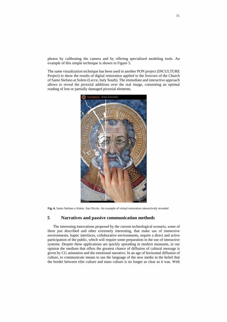
The same visualization technique has been used in another PON project (INCULTURE Project) to show the results of digital restoration applied to the frescoes of the Church of Santo Stefano at Soleto (Lecce, Italy South). The immediate and interactive approach allows to reveal the pictorial additions over the real image, consenting an optimal reading of lost or partially damaged pictorial elements.
Fig. 6. Santo Stefano a Soleto. San Nicola. An example of virtual restoration interactively revealed
5 Narratives and passive communication methods
The interesting innovations proposed by the current technological scenario, some of them just described and other extremely interesting, that make use of immersive environments, haptic interfaces, collaborative environments, require a direct and active participation of the public, which will require some preparation in the use of interactive systems. Despite these applications are quickly spreading in modern museums, in our opinion the medium that offers the greatest chance of diffusion of cultural message is given by CG animation and the emotional narrative. In an age of horizontal diffusion of culture, to communicate means to use the language of the new media in the belief that the border between elite culture and mass culture is no longer as clear as it was. With

12
this in mind, the role of virtual heritage also consists in transmitting information using the language of modern mass media and cognitive metaphors of serious games, considering these as cultural paradigms for a form of communication that is freed from the classic rules of elite culture. These new perspectives have determined an increase in the demand of digital technologies able to transmit historical-cultural contents, naturally with greatest scientific rigor. Where communication has become an important component of the museum presentation and organisation, the museums have become home to a new way of conceiving cultural communication, and looking for new dynamics of social communication. The introduction of communication forms based on emotional narration are the most successful examples of the new methods available to contemporary museum studies. There is no doubt that everything that gravitates around virtual heritage can no longer avoid confronting the themes used by those who would raise awareness in the wider public, nor the new epistemological challenges that result from them. The historical competence of the average citizen is now formed largely by information that comes from the new media, thus creating a great increase in the demand for products with a high technological content, with the aim of popularising historical re-evocations and reconstructions of the past.
Fig. 7. The amphitheatre of Lecce. A frame of narrative approach for the DiCet project.
Conscious of this, we have created for the DiCet project some movies where the archaeological monuments of Lecce in the roman age are the focus of a narrative. In about six minutes made entirely in 3D Computer Animation and stereoscopic mode, we tried to tell at a glance the main features of the three monuments under study, the Palmieri hypogeum, the Theater and the Amphitheater. The visitor has the opportunity to understand in a synthetic way and with an emotional narrative, historical data, planimetric and architectural info, preparing for a more detailed visit that can take on site or on the extras interactive application. But perhaps the most interesting aspect is the ability to re-contextualize the fragments of the statues in the Theater scene, the friezes and the porticus of the Amphitheater, the original appearance of the Palmieri hypogeum.

13
For the Palmieri hypogeum, in particular, analysis based on the integrated survey has allowed us to formulate a reconstructive proposal of the monument, which gives a partially original reading of the monumental tombs in Messapian age. The study of the monument was started with the search for any traces of painting on the walls. a very important aspect, as recent discoveries testify to the widespread use of colour also on grave goods and not just on architectural surfaces. The analysis carried out by means of video microscope and on samples taken from relevant areas, allowed us to identify only a few traces of red colour on the boundary lines of the wall decoration in false ashlar-work.
Fig. 8a and 8b. The Palmieri hypogeum of Lecce, virtual reconstruction. Two frames of narrative approach for the DiCet project.

14
A different treatment of the surface of the plaster, partly smooth and partly worked with an "orange peel" effect, gives to the parietal decorations a shallow plastic movement, with a simple red line of demarcation between the different blocks. The overview shows an unexpected sobriety of polychromies, played only on the effect of chiaroscuro given by the false ashlar-work and the red colour of the walls of the dromos. The same colours are found on the figural frieze (red and white) and on the floral frieze (red, green and blue). An example, this, of concrete interdisciplinary approach, carried out to give form and substance to an increasing demand of information and suggestions, that people from every cultural background claim.
Fig. 9. The theatre of Lecce, virtual reconstruction. A frame of narrative approach for the DiCet project.
Conclusions
Virtual enjoyment is understood here as a form of representing reality that accelerates and strengthens cognitive capacities, which is to say it becomes capable of generating extremely sensitive, “virtuous” learning processes based on metaphors of the real world, and thus easy to use and understand. Operationally, our working group has made some Augmented Reality solutions available; these enable the interactive display – directly in situ and especially on mobile devices – of archaeological monuments integrated within the urban fabric. A simple solution allows the user to display an interactive 3D reconstruction directly on the real site, using the latest-generation gyroscope function. In addition to this, certain inaccessible monuments have been virtualized, chiefly using image-based technologies and ultra-realistic laser scanning, to allow them to be visited remotely both via smartphone and on large virtual theatres. We used many digital techniques and the most expedient possible to provide an efficient

15
product to communicate the archaeology and associated contents. We have so many technologies available today, but the central point is always the quality factor, which summarizes itself all the capacity of humans to manage them to produce something that has a value over time. Because the promising technologies of today will be obsolete tomorrow, the technological aspect can never equal the human's ability to produce emotional products, also with traditional means.
Acknowledgements
Special thanks to Ivan Ferrari and Francesco Giuri (IBAM - ITLab team) for the great contribute in every 3d work process. Maria Teresa Giannotta, Francesco D’Andria and Maria Chiffi for the reconstruction of Palmieri hypogeum. The Guarini family for great support during the survey campaigns of Palmieri hypogeum.
References
1. F. D’Andria, La Puglia romana, in La Puglia dal Paleolitico al Tardoromano, Milano 1979, pp. 329-330J.
2. F. D’Andria, Enciclopedia Treccani, s.v. Lecce (v. vol. IX, p, 522) p. 522
3. G.Bendinelli, Un ipogeo sepolcrale a Lecce, in Ausonia, 8, 1913, p. 9-26
4. L’Arab Gilda, L’ipogeo Palmieri di Lecce. In: Mélanges de L’Ecole française de Rome. Antiquité T. 103, N°2, 1991. pp. 457-497
5. Micalella M. Un antico ipogeo a Lecce, in Apulia, 4, 1912, p.93-112.
6. Tiné Bertocchi F., La pittura funeraria apula, Napoli, Macchiaroli Editore, 1964.
7. Gabellone F., Giannotta M.T., “Marta Racconta”: a project for the virtual enjoyment of inaccessible monuments”, CHNT 18, International Conference on Cultural Heritage and New Technologies, Stadt Archäologie, Wien, November 11-13 2013.
8. Gabellone F., Giannotta M.T., Ferrari I., Dell’Aglio A., “ From museum to original site: 3d environment for the virtual visit of finds re-contextualized in their original provenance”, 2013 Digital Heritage International Congress, 28 Oct – 1 Nov 2013, Marseille, France (DigitalHeritage),Vol.2, Marseille 2013, pp. 215-222.
9. Gabellone F., Ferrari I., Giuri F., 2012: “A quick method for the texture mapping of meshes acquired by laser scanner”, Aleš Cepek (ed.) Journal f Geoinformatics FCE CTU, Faculty of Civil Engineering, Czech Technical University in Prague, vol. 9, Prague: 107-115.