Initial Study/Mitigated Negative Declaration College Park ...
476
FINAL Initial Study/Mitigated Negative Declaration College Park Demolition Project Prepared for: California State University Chico 400 W First Street Chico, California 95929 Contact: Sandra Beck, AIA, LEED AP Prepared by: 1102 R Street Sacramento, California 95811 Contact: Brian Grattidge JANUARY 2018
-
Upload
khangminh22 -
Category
Documents
-
view
1 -
download
0
Transcript of Initial Study/Mitigated Negative Declaration College Park ...
FINAL
Initial Study/Mitigated Negative Declaration
College Park Demolition Project
Prepared for:
California State University Chico 400 W First Street
Chico, California 95929
Contact: Sandra Beck, AIA, LEED AP
Prepared by:
1102 R Street
Sacramento, California 95811
Contact: Brian Grattidge
JANUARY 2018

Printed on 30% post-consumer recycled material.

Initial Study/Mitigation Negative DeclarationCollege Park Demolition Project
10493i January 2018
TABLE OF CONTENTS
Section Page No.
ACRONYMS AND ABBREVIATIONS .................................................................................... II
1 INTRODUCTION..............................................................................................................1 1.1 Project Overview ........................................................................................ 1 1.2 California Environmental Quality Act Compliance ................................... 1 1.3 Public and Agency Review ......................................................................... 2 1.4 Organization of the Initial Study................................................................. 3
2 PROJECT DESCRIPTION ..............................................................................................5 2.1 Project Location and Setting ................................................................................... 5
2.1.1 University Campus...................................................................................... 5 2.1.2 Project Site .................................................................................................. 5
2.2 Project Background ................................................................................................. 6 2.2.1 Master Plan Building Program and Master Plan Map ................................ 6 2.2.2 Master Plan Population Growth .................................................................. 7
2.3 Project Objectives ................................................................................................... 8 2.3.1 Project-Specific Objectives ......................................................................... 9
2.4 Project Components ................................................................................................ 9 2.4.1 Demolition .................................................................................................. 9 2.4.2 Interim Parking Use .................................................................................... 9 2.4.3 Utilities and Energy Use ........................................................................... 10 2.4.6 Master Plan EIR Mitigation Monitoring & Reporting Program ............... 11
2.5 Project Approvals.................................................................................................. 11
3 FINDINGS AND ENVIRONMENTAL DETERMINATION .....................................13
4 INITIAL STUDY CHECKLIST ....................................................................................15
5 REFERENCES AND PREPARERS ............................................................................105 5.1 References Cited ................................................................................................. 105 5.2 List of Preparers .................................................................................................. 111
APPENDICES
A. Species Tables B. Cultural Resources Report C. Responses to Comments D. Mitigation Monitoring and Reporting Program

Initial Study/Mitigation Negative Declaration College Park Demolition Project
TABLE OF CONTENTS (CONTINUED)
Page No.
10493 i January 2018
FIGURES
1 Regional Map ...................................................................................................................113
2 Vicinity Map ....................................................................................................................115
3 Site Map ...........................................................................................................................117
4A Site Photos .......................................................................................................................119
4B Site Photos .......................................................................................................................121
TABLES
1 Parcel Data ...........................................................................................................................5
2 Population (Headcount) Since Master Plan EIR Base Year ................................................7
3 Project Approvals...............................................................................................................11
4 GHG Emissions Sources in California ..............................................................................54

Initial Study/Mitigation Negative Declaration College Park Demolition Project
10493 ii January 2018
ACRONYMS AND ABBREVIATIONS
Acronym/Abbreviation Definition
ACOE U.S. Army Corps of Engineers
ACUPCC American College and University Presidents’ Climate Commitment
ASF assignable square feet
BAAQMD Bay Area Air Quality Management District
BCAG Butte County Association of Governments
BCAQMD Butte County Air Quality Management District
CAAQS California Ambient Air Quality Standards
CAP Climate Action Plan
CARB California Air Resources Board
CCR California Code of Regulations
CDFW California Department of Fish and Wildlife
CEQA California Environmental Quality Act
CESA California Endangered Species Act
CFR Code of Federal Regulations
CFWC California Fish and Wildlife Commission
CHL California Historical Landmarks
CHRIS California Historical Resources Information System
City City of Chico
CMP congestion management program
CNDDB California Natural Diversity Database
CNPS California Native Plant Society
CPUC California Public Utilities Commission
CRHR California Register of Historical Resources
CRPR California Rare Plant Rank
CSC Species of Special Concern
DPR Department of Parks and Recreation
DSA Division of the State Architect
EIR environmental impact report
EPA U.S. Environmental Protection Agency
FESA federal Endangered Species Act
FTES full-time equivalent students
GHG greenhouse gas
GSF gross square feet
GWP global warming potential
HRTR Historical Resources Technical Report
IPCC Intergovernmental Panel on Climate Change
LEED Leadership in Energy and Environmental Design
MBTA Migratory Bird Treaty Act
MMT million metric ton
NAAQS National Ambient Air Quality Standards

Initial Study/Mitigation Negative Declaration College Park Demolition Project
10493 iii January 2018
Acronym/Abbreviation Definition
NAHC Native American Heritage Commission
NHTSA National Highway Traffic Safety Administration
NPDES National Pollutant Discharge Elimination System Permit
NRHP National Register of Historic Places
OEHHA Office of Environmental Health Hazard Assessment
OPR Governor’s Office of Planning and Research
PCAPCD Placer County Air Pollution Control District
RCA Resource Conservation Area
RFS Renewable Fuel Standard
ROG reactive organic gas
RPS Renewable Portfolio Standard
RTP Regional Transportation Plan
RWQCB Regional Water Quality Control Board
SCS Sustainable Communities Strategy
SMAQMD Sacramento Air Quality Management District
SVAB Sacramento Valley Air Basin
SWPPP Storm Water Pollution Prevention Plan
University California State University, Chico
USFWS U.S. Fish and Wildlife Service
ZNE zero net energy

Initial Study/Mitigation Negative Declaration College Park Demolition Project
10493 1 January 2018
1 INTRODUCTION
1.1 Project Overview
California State University, Chico (University), proposes to demolish ten detached single-family
residences on land owned by the University. The residences are located on ten separate parcels in
the College Park neighborhood near the University. Demolition of all residential units and
accessory structures would include the following actions: removal of all recyclable materials
such as copper pipes and copper wiring; abatement of materials containing regulatory levels of
lead, asbestos, and universal wastes (e.g., fluorescent light tubes) that contain such materials;
breaking up the buildings and foundations; and then removal of the crumbled buildings. Asbestos
abatement and demolition notification shall be consistent with the Asbestos National Emission
Standards for Hazardous Air Pollutants (NESHAP). Dust control shall be maintained consistent
with the Butte County Air Quality Management District (BCAQMD) Rule 205. The University
may also make the buildings available (through auction or other mechanism) for relocation to
qualified persons.
All existing on-site utilities including water, sanitary sewer, gas, electricity, and communication
services would be removed. Utility removal would include, but not be limited to, removal of
existing underground pipe, conduit, wire, structures, vaults, poles, footings, boxes, transformers,
etc. Capping and removal of proprietary utility lines would be coordinated with the utility owner.
Existing landscaping would be removed and green waste will be diverted to an appropriate facility.
1.2 California Environmental Quality Act Compliance
The California Environmental Quality Act (CEQA), which serves as the main framework of
environmental law and policy in California, emphasizes the need for public disclosure and
identifying and preventing environmental damage associated with proposed projects. Unless the
project is deemed categorically exempt, CEQA is applicable to any discretionary project that
must be approved by a public agency in order to be processed and established. This project does
not fall under any of the statutory or categorical exemptions listed in the 2013 CEQA Statute and
Guidelines (California Public Resources Code, Section 21000 et seq.; 14 California Code of
Regulations (CCR) 15000 et seq.), and, therefore, must meet CEQA requirements.
The Board of Trustees of the California State University (Trustees of the California State
University) certified the CSU Chico 2005 Master Plan Environmental Impact Report (2005
Master Plan EIR) (SCH No. 2004092071) in 2005. The project conforms to the Master Plan
building program and, therefore, the CEQA analysis for the project will be tiered to the 2005
Master Plan EIR. Tiering refers to using the analysis of general matters contained in a broader

Initial Study/Mitigation Negative Declaration College Park Demolition Project
10493 2 January 2018
EIR, such as the CMP EIR, with later EIRs or Negative Declarations on narrower projects,
incorporating by reference the general discussions from the broader EIR, and concentrating the
later EIR or Negative Declaration solely on the issues specific to the project (14 CCR 15152(a)).
A later EIR is required when the Initial Study (IS) or other analysis finds that the later project
may cause a significant effect on the environment that was not adequately addressed in the prior
EIR (14 CCR 15152(f)). As indicated in Section 3, a tiered Initial Study/Mitigated Negative
Declaration will be prepared for the project, based on the results of this tiered Initial Study.
The 2005 Master Plan EIR is hereby incorporated by reference and referred to throughout this
tiered Initial Study. The 2005 Master Plan EIR and related documents (e.g., Trustees of the
California State University Approval, Mitigation Monitoring and Reporting Program, Findings
of Fact, Notice of Determination) are available to the general public at http://www.csuchico.edu/
pdc/masterplan.shtml.
1.3 Public and Agency Review
This Initial Study is being was circulated for public and agency review from November 1 to
November 30, 2017. Copies of this document, the 2005 Master Plan, and the 2005 Master Plan
EIR are available for review online at http://www.csuchico.edu/pdc/masterplan.shtml and at the
following locations:
Planning, Design, and Construction
Kendall Hall Room 109
California State University, Chico
400 West First Street, Chico, California 95929
Meriam Library
Room 305 Special Collections
California State University, Chico
400 West First Street, Chico, California 95929
Comments on this Initial Study and proposed Mitigated Negative Declaration must be were
received by November 30, 2017. Comments should be were mailed or emailed to the lead
agency:
Sandra Beck, AIA, LEED AP
Director, Planning, Design, and Construction and Campus Architect
California State University, Chico
400 West First Street, Chico, California 95929-0018
530.898.3285
Initial Study/Mitigation Negative Declaration College Park Demolition Project
10493 3 January 2018
1.4 Organization of the Initial Study
This Initial Study is organized into the following sections:
Section 1 – Introduction: Summarizes the Initial Study's relationship to the 2005 Master Plan
EIR, the tiering process, the scope of the document, the project’s review and approval processes,
and the document's organization.
Section 2 – Project Description: Includes a description of the project, including the need for the
project, the project’s objectives, and the elements included in the project.
Section 3 – Findings and Environmental Determination: Indicates whether impacts associated with
the project are significant, and what, if any, additional environmental documentation is required.
Section 4 – Initial Study Checklist: Contains the Environmental Checklist form for each
resource area. The checklist is used to assist in evaluating the potential environmental impacts of
the project with respect to the 2005 Master Plan EIR.
Section 5 – References and Preparers: Lists references used in the preparation of this
document. Includes the names of individuals contacted in preparation of this document.
Initial Study/Mitigation Negative Declaration College Park Demolition Project
10493 4 January 2018
INTENTIONALLY LEFT BLANK

Initial Study/Mitigation Negative Declaration College Park Demolition Project
10493 5 January 2018
2 PROJECT DESCRIPTION
2.1 Project Location and Setting
2.1.1 University Campus
The project is on the existing campus located in the City of Chico, California (see Figure 1,
Regional Map). The University’s main campus is 119 acres and is generally bounded by the
Union Pacific Railroad right-of-way on the west; by West Sacramento, Legion, and Mansion
Avenues on the north; by the Esplanade, Children’s Park, Salem, and Normal Streets on the east;
and by West Second and West Third Streets on the south (see Figure 2, Vicinity Map). The
campus is northwest of downtown Chico and north of Chico’s Historic District. To the north,
west, and south, residential land uses surround the campus.
The University campus is located on state land under the jurisdiction of the Trustees of the
California State University. Streets and private property surrounding the campus in all directions
are under the jurisdiction of the City of Chico (City).
2.1.2 Project Site
The project site consists of ten (10) non-contiguous parcels in the College Park neighborhood north
of the campus (see Figure 2, Vicinity Map). The project site is bordered by the University campus
on the west side (Esken and Konkow Halls) and south (University Stadium), West Sacramento
Avenue to the north, and Chico High School to the east. The parcels are located on Stadium Way,
Warner Street, La Vista Way, and Brice Avenue (see Figure 3, Site Map). Each parcel has a
single-family residence located on it. Table 1 identifies the location and size of each parcel and the
date each house was built. The total area of the ten parcels is approximately 1.86 acres.
Table 1
Parcel Data
Street Address Parcel Number Built Date (per
County Assessor) Area (acres)
602 Brice Avenue 003-130-006-000 1946 0.31
615 Brice Avenue 003-130-010-000 1951 0.21
616 Brice Avenue 003-130-005-000 1946 0.16
628 Brice Avenue 003-130-003-000 1948 0.18
608 La Vista Way 003-120-013-000 1940 0.16
0.12
615 La Vista Way 003-120-016-000 1947 0.12
629 La Vista Way 003-120-015-000 1947 0.12

Initial Study/Mitigation Negative Declaration College Park Demolition Project
10493 6 January 2018
Table 1
Parcel Data
Street Address Parcel Number Built Date (per
County Assessor) Area (acres)
630 Stadium Way 003-120-009-000 1947 0.17
725 Warner Street 003-130-011-000 1950 0.27
899 Warner Street 003-120-011-000 1939 0.16
Source: Butte County Assessor’s Office
2.2 Project Background
2.2.1 Master Plan Building Program and Master Plan Map
The University Master Plan, adopted by the Trustees of the California State University in 2005,
addresses all aspects of future physical development and land use on the campus to
accommodate the enrollment ceiling of 15,800 full time equivalent students (FTES) (CSU Chico
2005a). The Master Plan provides a comprehensive framework for the physical development of
the University campus. It addresses the acquisition of property, older facilities, changing student
demographics, and the need for additional academic building space and other support space to
accommodate the anticipated growth in enrollment. To accommodate the projected growth in
enrollment and academic activities, the adopted Master Plan accommodates a building program
that envisions development of 588,701 gross square feet (GSF) of new and replacement non-
residential building space on campus, and development or conversion of up to 1,298 additional
beds (Table 2-2, CSU Chico 2005a).
The existing adopted Master Plan includes a land use map that locates major uses and buildings
to guide the siting of future campus facilities. The land use map maintains the current general
configuration of land uses on the campus, which consist of a concentrated campus core
surrounded by student and campus support, student housing, and recreational/physical education
uses. Most of the growth in facilities would occur through demolition and replacement of
substandard buildings, and minor reassignments of existing space. The 2005 Master Plan
identifies the project site for acquisition and for future housing development and parking.
Although the project site is not included in the Master Plan land use diagram, the number of
potential student housing “beds” and parking spaces are described in the Master Plan and
included in the Master Plan Environmental Impact Report (EIR) project description.
Initial Study/Mitigation Negative Declaration College Park Demolition Project
10493 7 January 2018
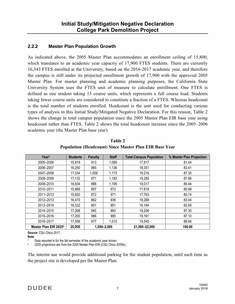
2.2.2 Master Plan Population Growth
As indicated above, the 2005 Master Plan accommodates an enrollment ceiling of 15,800,
which translates to an academic year capacity of 17,900 FTES students. There are currently
16,343 FTES enrolled at the University, based on the 2016-2017 academic year, and therefore
the campus is still under its projected enrollment growth of 17,900 with the approved 2005
Master Plan. For master planning and academic planning purposes, the California State
University System uses the FTES unit of measure to calculate enrollment. One FTES is
defined as one student taking 15 course units, which represents a full course load. Students
taking fewer course units are considered to constitute a fraction of a FTES. Whereas headcount
is the total number of students enrolled. Headcount is the unit used for conducting various
types of analysis in this Initial Study/Mitigated Negative Declaration. For this reason, Table 2
shows the change in total campus population since the 2005 Master Plan EIR base year using
headcount rather than FTES. Table 2 shows the total headcount increase since the 2005–2006
academic year (the Master Plan base year).
Table 2
Population (Headcount) Since Master Plan EIR Base Year
Year1 Students Faculty Staff Total Campus Population % Master Plan Projection
2005–2006 15,919 913 1,085 17,917 81.44
2006–2007 16,250 965 1,136 18,351 83.41
2007–2008 17,034 1,009 1,173 19,216 87.35
2008–2009 17,132 971 1,182 19,285 87.66
2009–2010 16,934 888 1,195 19,017 86.44
2010–2011 15,989 857 972 17,818 80.99
2011–2012 15,920 872 971 17,763 80.74
2012–2013 16,470 862 936 18,268 83.04
2013–2014 16,332 901 951 18,184 82.65
2014–2015 17,268 945 993 19,206 87.30
2015–2016 17,200 966 995 19,161 87.10
2016–2017 17,556 977 1,012 19,545 88.84
Master Plan EIR 20252 20,000 1,500–2,000 21,500–22,000 100.00
Source: CSU Chico 2017. Note: 1 Data reported is for the fall semester of the academic year shown. 2 2025 projections are from the 2005 Master Plan EIR (CSU Chico 2005b).
The interim use would provide additional parking for the student population, until such time as
the project site is developed per the Master Plan.
Initial Study/Mitigation Negative Declaration College Park Demolition Project
10493 8 January 2018
2.3 Project Objectives
The primary objective of the Master Plan is to accommodate the anticipated growth in student
enrollment. Replacement of aging and inefficient academic facilities is critical to supporting
students and providing a high quality education. The project objectives that are drawn from the
Master Plan are based on the physical planning principles derived from the long-term vision for
the University. The Master Plan and project-specific objectives are provided below.
Campus Master Plan Objectives
Campus Environment
Use open space as an organizational element
Promote a strong expression of landscape including a range of sizes and appropriate
species of trees
Promote a walkable campus that provides a logical progression of spaces
linking destinations
Preserve the natural characteristics of Big Chico Creek while permitting visual enjoyment
of them as viewed from the campus
Emphasize a scale of facilities that is compatible with human activities and perceptions
Promote facilities that are part of a recognizable “family” of related structures, hardscape,
and other environmental elements identified with CSU Chico.
Discourage the presence of the automobile and other motorized vehicles while
encouraging pedestrian and bicycle modes of movement
Promote built systems that respect, maintain and work with the natural environment
Relationship with the Community
Promote facilities that minimize aesthetic and functional conflicts with neighboring uses
and facilities
Permit a free flow of pedestrian activity between the University and downtown Chico
Student Life
Provide facilities that enrich the total student experience at CSU Chico at levels
commensurate with other universities competing with CSU Chico.
Initial Study/Mitigation Negative Declaration College Park Demolition Project
10493 9 January 2018
Promote facilities that retain students on campus that reduce their need to leave the
campus for various daily activities
Provide a sufficient number and variety of spaces on campus that promote human interaction
Dynamic leadership in advancing agriculture, natural resource management and
environmental sciences, and related areas
2.3.1 Project-Specific Objectives
Acquire land for future student housing and parking near existing campus residential
areas consistent with the Master Plan.
Implement an appropriate interim use that eliminates unsafe conditions and minimizes costs.
2.4 Project Components
2.4.1 Demolition
The University proposes to demolish ten detached single-family residences on land owned by the
University. The residences are located on ten separate parcels in the College Park neighborhood
near the University. Demolition of all residential units and accessory structures would include
the following actions: removal of all recyclable materials such as copper pipes and copper
wiring; abatement of materials containing regulatory levels of lead, asbestos, and universal
wastes (e.g., fluorescent light tubes) that contain such materials; breaking up the buildings and
foundations; and then removal of the crumbled buildings. Asbestos abatement and demolition
notification shall be consistent with the Asbestos National Emission Standards for Hazardous Air
Pollutants (NESHAP). Dust control shall be maintained consistent with the Butte County Air
Quality Management District (BCAQMD) Rule 205. The University may also make the
buildings available (through auction or other mechanism) for relocation to qualified persons.
All existing on-site utilities including water, sanitary sewer, gas, electricity, and communication
services would be removed. Utility removal would include, but not be limited to, removal of
existing underground pipe, conduit, wire, structures, vaults, poles, footings, boxes, transformers,
etc. Capping and removal of proprietary utility lines would be coordinated with the utility owner.
Existing landscaping will be removed and green waste will be diverted to an appropriate facility.
2.4.2 Interim Parking Use
The site will be graded and a layer of gravel installed as the vehicle parking surface. It is
anticipated that approximately 250 parking spaces will be created on the ten (10) parcels. The

Initial Study/Mitigation Negative Declaration College Park Demolition Project
10493 10 January 2018
University currently has access to 140 parking spaces on land near the project site owned by
Chico Unified School District. The University will no longer have access to these spaces after
the end of 2017. The College Park parcels will provide replacement parking spaces. The parking
spaces will be used by a mix of staff, faculty, and students.
Lighting and Landscaping
Lighting will be installed in the interim parking areas as needed for student safety.
Reconstruction of some sidewalk may be required for driveway access. The interim parking
surface will be gravel.
2.4.3 Utilities and Energy Use
Water
The parcels are served by existing waterlines, and served by the California Water Service
Company. The parking lots would not need a regular domestic water supply. Hose bibs may be
provided in some areas for maintenance purposes.
Wastewater
The parcels are served by the existing City of Chico sewer lines. No wastewater would be
generated by the parking lots, and no service laterals are required.
Stormwater
The parcels are served by the existing stormwater infrastructure. The project site is part of the
Lindo Channel stormwater drainage basin.
Energy, Steam, and Chilled Water
The parcels are currently served by PG&E. Electrical service would be required for the proposed
parking lot lighting. Gas service is available but will be disconnected prior to demolition and is
not required for the interim use. The parcels would not be served by the campus central plant for
steam, chilled water, or electrical service.
Solid Waste
If trash and recycling receptacles are provided at the interim parking lots, they would be
collected as part of the campus solid waste service.

Initial Study/Mitigation Negative Declaration College Park Demolition Project
10493 11 January 2018
2.4.6 Master Plan EIR Mitigation Monitoring & Reporting Program
As part of the 2005 Master Plan approval, the Trustees of the California State University adopted
a Mitigation Monitoring and Reporting Program. The mitigation measures included in this
program are already being implemented as part of the Master Plan, the certified Master Plan EIR,
and the project and, therefore, are considered to be part of the project and do not need to be
readopted. The applicable mitigation measures from the Mitigation Monitoring and Reporting
Program and any adopted project-specific measures will be included in the Final MND.
2.5 Project Approvals
This section describes actions required for project approval by state, regional, and local agencies.
Discretionary approvals include adoption of the MND under CEQA and schematic plans and
other approvals as summarized in Table 3. Additional approvals could also be necessary by the
Responsible Agencies noted below.
Table 3
Project Approvals
Authorizing Jurisdiction or Agency Action
California State University (Campus Building Official)
Final MND Adoption
Project Plans/Schematic Plans and others as necessary Approval
Division of the State Architect
Accessibility Compliance Approval
Regional Water Quality Control Board
National Pollutant Discharge Elimination System Permit (NPDES) – Storm Water Pollution Prevention Plan (SWPPP) and Notice of Intent to Comply with NPDES Construction General Permit
Enforce Construction General Permit Requirements
Butte County Air Quality Management District
Demolition Rule Compliance
City of Chico (Public Works Department)
Water Connections; Right-of-Way Encroachment (sidewalk) Approval

Initial Study/Mitigation Negative Declaration College Park Demolition Project
10493 12 January 2018
INTENTIONALLY LEFT BLANK

Initial Study/Mitigation Negative Declaration College Park Demolition Project
10493 13 January 2018
3 FINDINGS AND ENVIRONMENTAL DETERMINATION
The Trustees of the California State University find that the project could have a “potentially
significant impact” or “potentially significant unless mitigated” impact on the environment, but
the effects (1) were adequately analyzed in the 2005 Master Plan EIR pursuant to applicable
legal standards, and (2) were addressed by mitigation measures based on that earlier analysis, as
described on Section 4, Initial Study Checklist. The project would not result in a potentially
significant new or increased impact over and above those identified in the 2005 Master Plan,
with the implementation of additional project-level mitigation measures identified in this Initial
Study. The Trustees of the California State University have decided to prepare a tiered Mitigated
Negative Declaration.

Initial Study/Mitigation Negative Declaration College Park Demolition Project
10493 14 January 2018
INTENTIONALLY LEFT BLANK

Initial Study/Mitigation Negative Declaration College Park Demolition Project
10493 15 January 2018
4 INITIAL STUDY CHECKLIST
ENVIRONMENTAL FACTORS POTENTIALLY AFFECTED:
The evaluation of potential environmental impacts provided in Section 4 of this Initial Study
determined that the project would not result in new or increased environmental impacts over and
above those identified in the 2005 Master Plan EIR for the topics that are not checked below. Topics
with a check mark below are potentially significant but would be reduced to a level that is clearly less
than significant with implementation of mitigation measures identified in this Initial Study.
Aesthetics Agriculture and
Forestry Resources Air Quality
Biological Resources Cultural Resources Geology and Soils
Greenhouse Gas Emissions Hazards and
Hazardous Materials
Hydrology and
Water Quality
Land Use and Planning Mineral Resources Noise
Population and Housing Public Services Recreation
Transportation and Traffic Tribal Cultural
Resources
Utilities and
Service Systems
Mandatory Findings
of Significance

Initial Study/Mitigation Negative Declaration College Park Demolition Project
10493 16 January 2018
DETERMINATION: (To be completed by the lead agency)
On the basis of this initial evaluation:
I find that the proposed project COULD NOT have a significant effect on the
environment, and a NEGATIVE DECLARATION will be prepared.
I find that although the proposed project could have a significant effect on the
environment, there will not be a significant effect in this case because revisions in the
project have been made by or agreed to by the project proponent. A MITIGATED
NEGATIVE DECLARATION will be prepared.
I find that the proposed project MAY have a significant effect on the environment, and an
ENVIRONMENTAL IMPACT REPORT is required.
I find that the proposed project MAY have a “potentially significant impact” or
“potentially significant unless mitigated” impact on the environment, but at least one
effect (1) has been adequately analyzed in an earlier document pursuant to applicable
legal standards, and (2) has been addressed by mitigation measures based on the earlier
analysis as described on attached sheets. An ENVIRONMENTAL IMPACT REPORT is
required, but it must analyze only the effects that remain to be addressed.
I find that although the proposed project could have a significant effect on the
environment, because all potentially significant effects (a) have been analyzed adequately
in an earlier ENVIRONMENTAL IMPACT REPORT or NEGATIVE DECLARATION
pursuant to applicable standards, and (b) have been avoided or mitigated pursuant to that
earlier ENVIRONMENTAL IMPACT REPORT or NEGATIVE DECLARATION,
including revisions or mitigation measures that are imposed upon the proposed project,
nothing further is required.
Signature
Date

Initial Study/Mitigation Negative Declaration College Park Demolition Project
10493 17 January 2018
EVALUATION OF ENVIRONMENTAL IMPACTS:
1. A brief explanation is required for all answers except “No Impact” answers that are
adequately supported by the information sources a lead agency cites in the parentheses
following each question. A “No Impact” answer is adequately supported if the referenced
information sources show that the impact simply does not apply to projects like the one
involved (e.g., the project falls outside a fault rupture zone). A “No Impact” answer
should be explained where it is based on project-specific factors as well as general
standards (e.g., the project will not expose sensitive receptors to pollutants, based on a
project-specific screening analysis).
2. All answers must take account of the whole action involved, including off-site as well as
on-site, cumulative as well as project-level, indirect as well as direct, and construction as
well as operational impacts.
3. Once the lead agency has determined that a particular physical impact may occur, then
the checklist answers must indicate whether the impact is potentially significant, less than
significant with mitigation, or less than significant. “Potentially Significant Impact” is
appropriate if there is substantial evidence that an effect may be significant. If there are
one or more “Potentially Significant Impact” entries when the determination is made, an
Environmental Impact Report (EIR) is required.
4. “Negative Declaration: Less Than Significant With Mitigation Incorporated” applies
where the incorporation of mitigation measures has reduced an effect from “Potentially
Significant Impact” to a “Less-Than-Significant Impact.” The lead agency must describe
the mitigation measures, and briefly explain how they reduce the effect to a less than
significant level (mitigation measures from “Earlier Analyses,” as described in No. 5,
may be cross-referenced).
5. Earlier analyses may be used where, pursuant to the tiering, program EIR, or other CEQA
process, an effect has been adequately analyzed in an earlier EIR or negative declaration.
Section 15063(c)(3)(D). In this case, a brief discussion should identify the following:
a. Earlier Analysis Used. Identify and state where they are available for review.
b. Impacts Adequately Addressed. Identify which effects from the above checklist were
within the scope of and adequately analyzed in an earlier document pursuant to
applicable legal standards, and state whether such effects were addressed by
mitigation measures based on the earlier analysis.
c. Mitigation Measures. For effects that are “Less than Significant with Mitigation
Measures Incorporated,” describe the mitigation measures which were incorporated

Initial Study/Mitigation Negative Declaration College Park Demolition Project
10493 18 January 2018
or refined from the earlier document and the extent to which they address site-specific
conditions for the project.
6. Lead agencies are encouraged to incorporate into the checklist references to information
sources for potential impacts (e.g., general plans, zoning ordinances). Reference to a
previously prepared or outside document should, where appropriate, include a reference
to the page or pages where the statement is substantiated.
7. Supporting Information Sources: A source list should be attached, and other sources used
or individuals contacted should be cited in the discussion.
8. This is only a suggested form, and lead agencies are free to use different formats;
however, lead agencies should normally address the questions from this checklist that are
relevant to a project’s environmental effects in whatever format is selected.
9. The explanation of each issue should identify:
a. The significance criteria or threshold, if any, used to evaluate each question; and
b. The mitigation measure identified, if any, to reduce the impact to less than significance.
Potentially Significant
New or Increased
Impact
Less-Than-Significant New
or Increased Impact with Mitigation
Incorporated
Less-Than-Significant
New or Increased
Impact
No New or Increased
Impact
I. AESTHETICS – Would the project:
a) Have a substantial adverse effect on a scenic vista?
b) Substantially damage scenic resources including, but not limited to, trees, rock outcroppings, and historic buildings within a state scenic highway?
c) Substantially degrade the existing visual character or quality of the site and its surroundings?
d) Create a new source of substantial light or glare which would adversely affect day or nighttime views in the area?
Initial Study/Mitigation Negative Declaration College Park Demolition Project
10493 19 January 2018
Discussion
The 2005 Master Plan EIR considered building and related facility construction and demolition
on the University campus and on the project site. The analysis below reflects the aesthetics
analysis provided in Section 3.1 of the 2005 Master Plan EIR and the site visit conducted by
Dudek staff.
a) Would the project have a substantial adverse effect on a scenic vista?
No New or Increased Impact. The 2005 Master Plan EIR determined that the 2005
Master Plan buildout would have a less-than-significant impact on scenic vistas. There
are no designated scenic vistas in the vicinity of the University campus or project site.
The project site is flat and developed with single-family houses. The project site is
surrounded by roadways, walkways, and the University campus athletic fields, buildings,
and parking facilities to the west and south. As the project site is located in a developed
area and is not near a designated scenic vista, the project would not have a substantial
adverse effect on a scenic vista, and no new or increased impact would occur.
b) Would the project substantially damage scenic resources including, but not limited to,
trees, rock outcroppings, and historic buildings within a state scenic highway?
No New or Increased Impact. The project site is not visible from a state scenic
highway. In addition, no unusual natural resources are present on the project site, and the
existing buildings have been determined not to be eligible historic resources. No impact
would occur.
c) Would the project substantially degrade the existing visual character or quality of the
site and its surroundings?
No New or Increased Impact. The 2005 Master Plan EIR concluded that full buildout of
the 2005 Master Plan would have a less-than-significant impact on scenic resources and
visual character with mitigation measures incorporated.
The project site is bordered by the University campus on the west (Esken and Konkow
Halls) and south (University Stadium), West Sacramento Avenue to the north, and Chico
High School to the east. The parcels that comprise the project site are located on Stadium
Way, Warner Street, La Vista Way, and Brice Avenue (see Figure 3, Project Setting).
The project site is designated as Medium-High Density Residential by the City of Chico,
consistent with proposed uses on the project site (Chico 2013).
Initial Study/Mitigation Negative Declaration College Park Demolition Project
10493 20 January 2018
The project site is located on land that is relatively flat, and developed with ten single-
family residences on ten non-contiguous parcels adjacent to the University campus. The
existing houses on the project site date from between 1939-1951, and have neutral, light-
colored exteriors with dark brown or gray roofs. All residences contain yards with grass
lawns interspersed with medium to large trees (See Figure 4A and 4B, Site Photos).
The proposed project would demolish buildings and remove onsite utilities and
landscaping on ten parcels located in the College Park neighborhood north of the
University campus. During the interim period after demolition and prior to construction
of student housing and surface parking, the site would be graded and a layer of gravel
installed as a vehicle parking surface. Lighting would be installed in these interim
parking areas, as needed, for safety.
The 2005 Master Plan identifies the project site for acquisition and for future housing
development and parking. Although the project site is not include in the Master Plan land
use diagram, the number of student housing beds and parking spaces are described in the
Master Plan, and the use of the project site would be consistent with planned uses
described in the Master Plan and Master Plan EIR.
As the proposed project involves demolition of existing buildings, impacts to the visual
character and quality of the project site could result. During demolition, materials from
demolished structures would be visible on the project site. Once these materials are
removed, the site would be graded and a layer of gravel would be installed for the interim
vehicle parking surface.. There are existing parking lots on all sides of the project site,
including two University student housing lots to the west, Chico High School parking to
the east, and a parking lot at College Drive and Warner Street. Therefore, parking is not a
new visual feature in the project area. Furthermore, Furthermore, the number of sensitive
viewers is limited (consisting of a few houses interspersed with the University owned
parcels, and homes north of West Sacramento Avenue with limited views. Therefore, the
proposed project would not result in new or increased impacts to the visual character or
quality of the site and its surroundings.
d) Would the project create a new source of substantial light or glare which would
adversely affect day or nighttime views in the area?
No New or Increased Impact. The 2005 Master Plan EIR determined that the Master
Plan buildout would have a less-than-significant impact related to light and glare with the
implementation of Master Plan EIR Mitigation Measures 3.1-3a and 3.1.3b.

Initial Study/Mitigation Negative Declaration College Park Demolition Project
10493 21 January 2018
The proposed project would demolish buildings and remove onsite utilities and
landscaping on ten to-be-acquired parcels located in the College Park neighborhood and
install interim surface vehicle parking on these parcels. The proposed project would
include lighting in the interim parking areas for student safety.
The CSU Chico 2005 Master Plan includes guidelines for lighting fixtures on the campus.
The plan identifies different lighting level zones and calls for illuminating all primary and
critical pedestrian routes between buildings, parking, campus edges, and outdoor activity
areas. The lighting levels correspond to minimal standards. The proposed project would
be required to implement mitigation measures identified in Section 3.1 of the 2005
Master Plan EIR related to light and glare impacts. These include Measures 3.1-3a and
3.1-3b. As the proposed project would follow the 2005 Master Plan lighting and design
guidelines and mitigation measures for lighting and glare impacts in the 2005 Master
Plan EIR, lighting and glare impacts would be minimized. Therefore, no new or increased
light and glare impacts would occur.
Master Plan Mitigation Measures
Mitigation Measure 3.1-3a: New lighting proposed for future projects as a result
of implementation of the 2005 Master Plan shall be directed downward and shall
not shine onto adjacent properties. Additionally, all new lighting shall adhere to
the guidelines in the 2005 Master Plan, including:
1. The off-site visibility and potential glare of the lighting will be restricted by
specification of non-glare fixtures, and placement of lights to direct
illumination into only those areas where it is needed.
2. Appropriate fixture selection and light placement shall minimize light
pollution and enhance natural color rendition. All lighting shall utilize
refractive lenses and be shielded to reduce glare into buildings and
neighboring areas.
3. Walkway lighting fixtures shall not be mounted higher than twenty feet unless
necessary for security reasons.
Mitigation Measure 3.1-3b: Individual developments associated with the 2005
Master Plan shall minimize lighting to areas required for safety, security, or
normal operations on the main campus and at the ATRC [Agricultural Teaching
and Research Center] and shield lighting from public view to the greatest extent
possible. The direction and shielding of lighting shall be regulated to reduce light
spillage, light pollution, and glare. Highly directional light fixtures shall be used

Initial Study/Mitigation Negative Declaration College Park Demolition Project
10493 22 January 2018
with non-glare lighting fixtures. All lighting and light shields shall be installed
and operated consistent with manufacturer’s specifications.
Potentially Significant
New or Increased
Impact
Less-Than-Significant New
or Increased Impact with Mitigation
Incorporated
Less-Than-Significant
New or Increased
Impact
No New or Increased
Impact
II. AGRICULTURE AND FORESTRY RESOURCES – In determining whether impacts to agricultural resources are significant environmental effects, lead agencies may refer to the California Agricultural Land Evaluation and Site Assessment Model (1997) prepared by the California Department of Conservation as an optional model to use in assessing impacts on agriculture and farmland. In determining whether impacts to forest resources, including timberland, are significant environmental effects, lead agencies may refer to information compiled by the California Department of Forestry and Fire Protection regarding the state’s inventory of forest land, including the Forest and Range Assessment project and the Forest Legacy Assessment project; and forest carbon measurement methodology provided in Forest Protocols adopted by the California Air Resources Board. Would the project:
a) Convert Prime Farmland, Unique Farmland, or Farmland of Statewide Importance (Farmland), as shown on the maps prepared pursuant to the Farmland Mapping and Monitoring Program of the California Resources Agency, to non-agricultural use?
b) Conflict with existing zoning for agricultural use, or a Williamson Act contract?
c) Conflict with existing zoning for, or cause rezoning of, forest land (as defined in Public Resources Code section 12220(g)), timberland (as defined by Public Resources Code section 4526), or timberland zoned Timberland Production (as defined by Government Code section 51104(g))?
d) Result in the loss of forest land or conversion of forest land to non-forest use?
e) Involve other changes in the existing environment which, due to their location or nature, could result in conversion of Farmland, to non-agricultural use or conversion of forest land to non-forest use?
Discussion
The 2005 Master Plan EIR considered building and related facility construction and
demolition on the University campus and on the project site. The 2005 Master Plan EIR
(Section 5.1) found agricultural issues to be “less than significant” and did not include a
detailed analysis of agricultural resources.

Initial Study/Mitigation Negative Declaration College Park Demolition Project
10493 23 January 2018
The analysis reflects the Master Plan EIR analysis and a review of California Resources Agency
Farmland Mapping and Monitoring Program maps for Butte County.
a) Would the project convert Prime Farmland, Unique Farmland, or Farmland of
Statewide Importance (Farmland), as shown on the maps prepared pursuant to the
Farmland Mapping and Monitoring Program of the California Resources Agency, to
non-agricultural use?
No New or Increased Impact. The 2005 Master Plan EIR found all agricultural impacts
to be less than significant. The FMMP designates the project site as Urban and Built-Up
Land (FMMP 2014). The project would not convert any Important Farmland to non-
agricultural use. No impact would occur.
b) Would the project conflict with existing zoning for agricultural use, or a Williamson
Act contract?
No New or Increased Impact. The project site is designated as Urban and Built-Up
Land by the FMMP and is not subject to a Williamson Act contract. Therefore, the
project would not conflict with existing zoning for agricultural use or a Williamson Act
contract, and no impact would occur.
c) Would the project conflict with existing zoning for, or cause rezoning of, forest land
(as defined in Public Resources Code section 12220(g)), timberland (as defined by
Public Resources Code section 4526), or timberland zoned Timberland Production (as
defined by Government Code section 51104(g))?
No New or Increased Impact. The project site is not located on or adjacent to land
zoned for forest land or timberland, including timberland zoned Timberland Production.
No impact would occur.
d) Would the project result in the loss of forest land or conversion of forest land to non-
forest use?
No New or Increased Impact. The project site is not located on or in the vicinity of land
zoned for forest land, and, therefore, would not have impacts related to loss or conversion
of forest lands.
Initial Study/Mitigation Negative Declaration College Park Demolition Project
10493 24 January 2018
e) Would the project involve other changes in the existing environment which, due to
their location or nature, could result in conversion of Farmland, to non-agricultural
use or conversion of forest land to non-forest use?
No New or Increased Impact. The project site is not located on or adjacent to any
agricultural or forest land. For this reason, the project would not involve changes to the
existing environment that could cause conversion of Farmland or forest land to non-
agricultural use. No impact would occur.
Potentially Significant
New or Increased
Impact
Less-Than-Significant New
or Increased Impact with Mitigation
Incorporated
Less-Than-Significant
New or Increased
Impact
No New or Increased
Impact
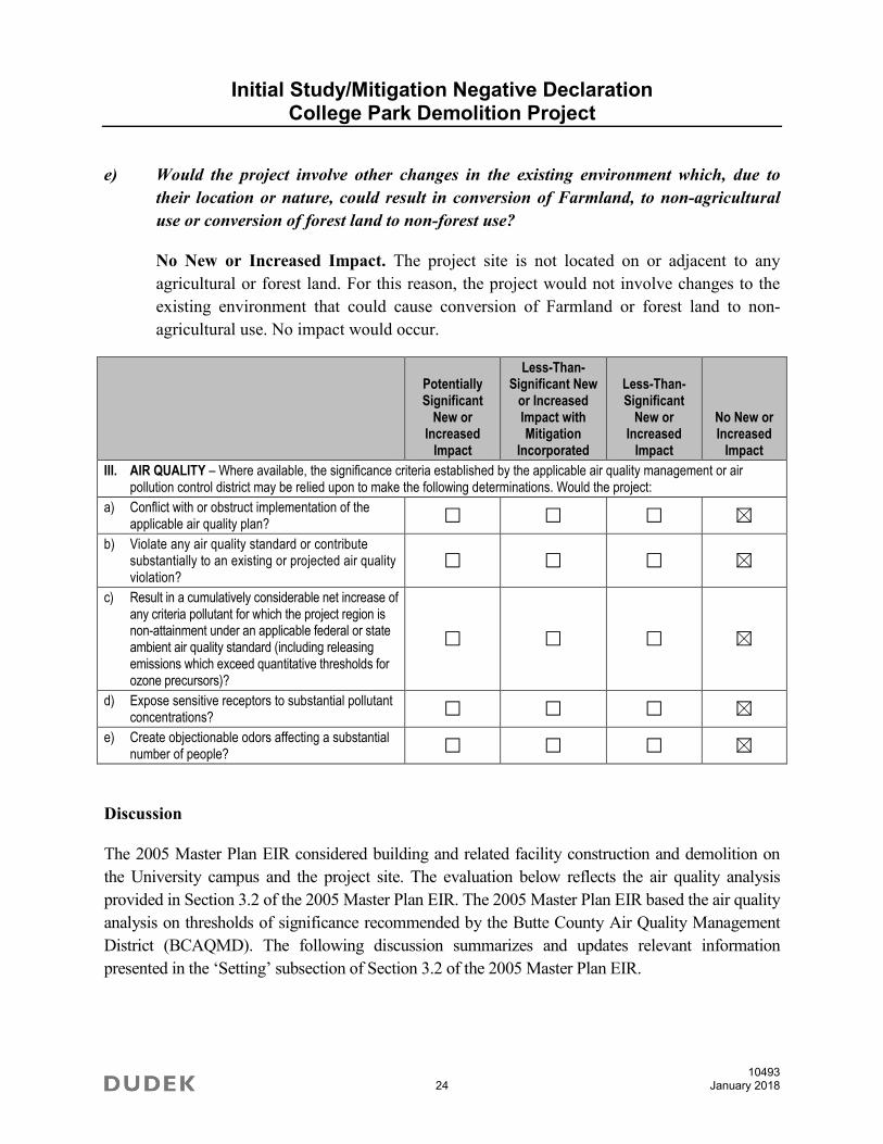
III. AIR QUALITY – Where available, the significance criteria established by the applicable air quality management or air pollution control district may be relied upon to make the following determinations. Would the project:
a) Conflict with or obstruct implementation of the applicable air quality plan?
b) Violate any air quality standard or contribute substantially to an existing or projected air quality violation?
c) Result in a cumulatively considerable net increase of any criteria pollutant for which the project region is non-attainment under an applicable federal or state ambient air quality standard (including releasing emissions which exceed quantitative thresholds for ozone precursors)?
d) Expose sensitive receptors to substantial pollutant concentrations?
e) Create objectionable odors affecting a substantial number of people?
Discussion
The 2005 Master Plan EIR considered building and related facility construction and demolition on
the University campus and the project site. The evaluation below reflects the air quality analysis
provided in Section 3.2 of the 2005 Master Plan EIR. The 2005 Master Plan EIR based the air quality
analysis on thresholds of significance recommended by the Butte County Air Quality Management
District (BCAQMD). The following discussion summarizes and updates relevant information
presented in the ‘Setting’ subsection of Section 3.2 of the 2005 Master Plan EIR.

Initial Study/Mitigation Negative Declaration College Park Demolition Project
10493 25 January 2018
Climate and Topography
The project is located within the Sacramento Valley Air Basin (SVAB), which includes
Sacramento, Shasta, Tehama, Butte, Glenn, Colusa, Sutter, Yuba, Yolo, and portions of Solano
and Placer Counties. The SVAB extends from south of Sacramento to north of Redding and is
bounded on the west by the Coast Ranges and on the north and east by the Cascade Range and
Sierra Nevada. The project is located within the City, which is located in Butte County. Chico is
located in the northern Sacramento Valley, a broad, flat valley bounded by the coastal ranges to
the west and the Sierra Nevada to the east.
The climate of the project area is characterized by hot, dry summers and cool, wet winters.
During the summer months from mid-April to mid-October, significant precipitation is unlikely
and temperatures range from daily maximums approaching 100°F to evening lows in high 50s
and low 60s. During the winter, highs are typically in the 60s with lows in the 30s.
Wind direction is primarily up- and down-valley due to the channeling effect of the mountains to
either side of the valley. During the summer months, surface air movement is from the south,
particularly during the afternoon hours. During the winter months, wind direction is more variable.
The mountains surrounding the valley can also contribute to elevated pollutant concentrations
during periods of surface of elevated surface inversions. These inversions are most common in
late summer and fall. Surface inversions are formed when the air close to the surface cools more
rapidly than the warm layer of air above it. Elevated inversions occur when a layer of cool air is
suspended between warm air layers above and below it. Both situations result in air stagnation.
Air pollutants accumulate under and within inversions, subjecting people in the region to
elevated pollution levels and associated health concerns. The surface concentrations of pollutants
are highest when these conditions are combined with smoke from agricultural burning or when
temperature inversions trap cool air, fog, and pollutants near the ground.
Criteria Air Pollutants
The federal Clean Air Act requires the U.S. Environmental Protection Agency (EPA) to identify
National Ambient Air Quality Standards (NAAQS) to protect public health and welfare. National
standards have been established for ozone (O3), carbon monoxide (CO), nitrogen dioxide (NO2),
sulfur dioxide (SO2), particulate matter equal to or less than 10 microns in aerodynamic diameter
(PM10), particulate matter equal to or less than 2.5 microns in aerodynamic diameter (PM2.5), and
lead (Pb). In California, sulfates, vinyl chloride, hydrogen sulfide, and visibility-reducing
particles are also regulated as criteria air pollutants. These air pollutants are termed “criteria air
pollutants” because they are regulated by developing specific public health- and welfare-based
Initial Study/Mitigation Negative Declaration College Park Demolition Project
10493 26 January 2018
criteria as the basis for setting permissible levels. Pursuant to the 1990 Federal Clean Air Act
Amendments, the EPA classifies air basins (or portions thereof) as attainment, nonattainment, or
unclassified for each criteria air pollutants, based on whether or not the NAAQS had been
achieved. California has adopted ambient standards that are more stringent than the federal
standards for the criteria air pollutants. Under the California Clean Air Act, the California Air
Resources Board (CARB) has designated areas as attainment, nonattainment, or unclassified
with respect to the California Ambient Air Quality Standards (CAAQS). The EPA and the
CARB use air quality monitoring data to determine if each air basin or county is in compliance
with the applicable standards. If the concentration of a criteria air pollutant is lower than the
standard or not monitored in an area, the area is classified as attainment or unclassified (and
unclassified areas are treated as attainment areas). If an area exceeds the standard, the area is
classified as nonattainment for that pollutant. An area is designated nonattainment–transitional to
signify that the area is close to attaining the standard for that pollutant.
Butte County is designated as a nonattainment area for both federal and state O3 standards. The
EPA has classified Butte County as a “marginal” nonattainment area for the 8-hour O3 standard.
In addition, Butte County is designated as a nonattainment area for the state PM10 standard and
nonattainment for the state and federal PM2.5 standards. The EPA has classified the Chico urban
area as “maintenance” for the CO standard (i.e., redesignated from nonattainment). Butte County
is in attainment or unclassified for all other criteria air pollutants (CARB 2016a, EPA 2017).
Toxic Air Contaminants
Toxic air contaminants (TACs) are toxic substances released into the air, which have the potential
to cause adverse health effects in humans. TACs are generated by a number of sources, including
stationary sources such as dry cleaners, gas stations, combustion sources, and laboratories; mobile
sources such as automobiles; and area sources such as landfills. Adverse health effects associated
with exposure to TACs may include carcinogenic (i.e., cancer-causing) and non-carcinogenic
effects. Non-carcinogenic effects typically affect one or more target organ systems and may be
experienced either on short-term (acute) or long-term (chronic) exposure to a given TAC.
Examples include certain aromatic and chlorinated hydrocarbons, certain metals, and asbestos.
a) Would the project conflict with or obstruct implementation of the applicable air
quality plan?
No New or Increased Impact. Air quality plans describe air pollution control strategies to
be implemented by a city, county, or region. The primary purpose of an air quality plan is to
maintain attainment of CAAQS or NAAQS, or to bring an area that does not attain a
CAAQS or an NAAQS into compliance with the requirements of the federal and state Clean

Initial Study/Mitigation Negative Declaration College Park Demolition Project
10493 27 January 2018
Air Acts. The project area is designated nonattainment for the NAAQS and CAAQS for O3
and PM2.5 standards, as well as the CAAQS for PM10. The BCAQMD is responsible for
formulating and implementing air quality plans to address state and federal planning
requirements within their respective jurisdictions. The air quality attainment plans and reports
present comprehensive strategies to reduce emissions of O3 precursors (ROG and NOx) and
PM10 from stationary, area, mobile, and indirect sources. Such strategies include the adoption
of rules and regulations; enhancement of CEQA participation; adoption of local air quality
plans; and implementation of control measures for stationary, mobile, and indirect sources.
The 2005 Master Plan EIR determined that the impacts of 2005 Master Plan buildout
related to potential conflicts with applicable air quality plans would be less than significant
with mitigation incorporated (applicable mitigation measures are discussed in section (b),
below). The proposed uses on the project site are consistent with those considered for the
site in the 2005 Master Plan. Since demolition and construction of interim surface parking
associated with the project would not substantially increase air pollutant emissions within
the SVAB, as explained in further detail under criterion (b), the project would not interfere
with the BCAQMD plans to achieve or maintain attainment for the criteria air pollutants.
The project would not conflict with or obstruct implementation of applicable air quality
plans, and this impact would be less than significant. No new or increased impact would
occur compared to the Master Plan EIR.
b) Would the project violate any air quality standard or contribute substantially to an
existing or projected air quality violation?
No New or Increased Impact. The 2005 Master Plan EIR determined that the impacts of
2005 Master Plan buildout related to the violation of air quality standards would be less
than significant with mitigation incorporated. The proposed project would demolish
buildings and remove onsite utilities and landscaping on ten to-be-acquired parcels
located in the College Park neighborhood north of the University campus. The project
site would be graded and a layer of gravel installed as a vehicle parking surface during
the interim period after demolition and prior to construction of student housing and
surface parking.
Demolition.
Demolition of buildings and structures on the project site would result in the temporary
addition of pollutants to the local air shed caused by soil disturbance, fugitive dust
emissions, and combustion pollutants from on-site demolition equipment, as well as from
off-site trucks hauling debris from demolition and from workers travelling to and from the
Initial Study/Mitigation Negative Declaration College Park Demolition Project
10493 28 January 2018
site. Demolition emissions can vary substantially from day to day, depending on the level
of activity, the specific type of operation and, for dust, the prevailing weather conditions.
Therefore, an increment of day-to-day variability exists.
The 2005 Master Plan EIR notes that construction and demolition impacts would be
localized and would not be concentrated at one location or period of time, occurring
instead at several locations for a period of several months at any one location.
Construction and demolition dust impacts are considered to be potentially significant on a
localized basis, requiring implementation of Master Plan EIR Mitigation Measure 3.2-1,
implementation of standard BCAQMD dust control measures.
Implementation of the proposed mitigation measures would reduce impacts regarding
dust emissions. Butte County has been designated attainment or unclassified for all
national ambient air quality standards except the 1-hour/8-hour ozone standards and
PM2.5, and nonattainment for the California standards for ozone, PM2.5 and PM10.
Emissions of these air pollutants would be reduced with the above mitigation measure.
Therefore, demolition-related emissions of criteria air pollutant would be less than
significant and no additional mitigation measures are required. No new or increased
impacts would occur compared to the Master Plan EIR.
Operation.
The project does not include stationary sources that would emit air pollutants.
Additionally, on-road vehicle emissions associated with the proposed interim surface
parking area and the nominal increase in FTE under the project are captured in the 2005
Master Plan EIR analysis, which identified that the project site would be used for
parking. Furthermore, as existing single-family residences on the project site would be
demolished, air quality impacts from previous uses would be eliminated and air pollutant
emissions resulting from the proposed project would be similar or less than prior.
Therefore, operational criteria air pollutant impacts of the project would be less than
significant, and no additional mitigation measures are required. No new or increased
impacts would occur compared to the Master Plan EIR.
Initial Study/Mitigation Negative Declaration College Park Demolition Project
10493 29 January 2018
c) Would the project result in a cumulatively considerable net increase of any criteria
pollutant for which the project region is non-attainment under an applicable federal or
state ambient air quality standard (including releasing emissions which exceed
quantitative thresholds for ozone precursors)?
No New or Increased Impact. The 2005 Master Plan EIR determined that the impacts of
2005 Master Plan buildout related to the emission of non-attainment criteria pollutants
would be less than significant with mitigation measures incorporated. As discussed for
criterion (b), the project’s regional air emissions would be less than significant during
demolition and interim parking area construction and operation. The applicable BCAQMD
thresholds are designed to assist the region in attaining the applicable CAAQS and
NAAQS by reducing potential criteria air pollutant emissions that would otherwise occur.
Therefore, the criteria air pollutant emissions associated with the proposed project would
not result in a cumulatively considerable net increase of any criteria pollutant for which the
project region is in nonattainment. This impact would be less than significant. No new or
increased impacts would occur compared to the Master Plan EIR.
d) Would the project expose sensitive receptors to substantial pollutant concentrations?
No New or Increased Impact. The 2005 Master Plan EIR determined that the impacts of
2005 Master Plan buildout related to the exposure of sensitive receptors to substantial
pollutant concentrations would be less than significant. Although the BCAQMD has not
adopted risk thresholds, the BCAQMD have recommendations for three risk-related air
quality indicators for sensitive receptors: cancer risks, noncancer health effects, and
increases in ambient air concentrations of PM2.5 (BCAQMD 2014). These impacts are
addressed on a localized rather than regional basis and are specific to the sensitive
receptors identified for the project. Sensitive receptors are groups of individuals,
including children, the elderly, the acutely ill, and the chronically ill, that may be more
susceptible to health risks due to chemical exposure, and sensitive-receptor population
groups are likely to be located at hospitals, nursing homes, schools, parks and
playgrounds, childcare centers, and residences (BCAQMD 2014). The project site is
located immediately adjacent to single-family residences.
“Incremental cancer risk” is the net increased likelihood that a person continuously
exposed to concentrations of TACs resulting from a project over a 9-, 30-, and 70-year
exposure period would contract cancer based on the use of standard Office of
Environmental Health Hazard Assessment (OEHHA) risk-assessment methodology
(OEHHA 2015). In addition, some TACs have non-carcinogenic effects. TACs that
would potentially be emitted during demolition activities would be diesel particulate
Initial Study/Mitigation Negative Declaration College Park Demolition Project
10493 30 January 2018
matter, emitted from heavy-duty construction equipment and heavy-duty trucks.
Additionally, existing single-family houses that would be demolished may contain
asbestos based on the age of original construction. According to the OEHHA, health
risk assessments, which determine the exposure of sensitive receptors to toxic
emissions, should be based on a 30-year exposure period for the maximally exposed
individual resident; however, such assessments should be limited to the period/duration
of activities associated with the project (OEHHA 2015). Thus, the duration of proposed
demolition activities would only constitute a small percentage of the total 30-year
exposure period. Additionally, construction contractors would be required to comply
with applicable CARB air toxic control measures (ATCMs), including ATCMs to
reduce diesel particulate matter emissions from heavy-duty construction equipment and
diesel trucks. The National Emission Standards for Hazardous Air Pollutants
(NESHAPs) for asbestos would apply as well, as they pertain to demolition of buildings
that may include asbestos in order to minimize exposure. Based on the short-term
duration of demolition and compliance with applicable regulations to minimize TAC
exposure (such as materials containing asbestos), the project would not result the
exposure of sensitive receptors to substantial air pollutant concentrations.
Regarding operation of the proposed interim vehicle surface parking, the proposed project
would not result in non-permitted stationary sources that would emit substantial air pollutants
or TACs. Dust control would be maintained consistent with the BCAQMD Rule 205.
In summary, the project would not expose sensitive receptors to substantial pollutant
concentrations or health risk during construction or operations, and this impact would be
less than significant on a project-level and cumulative basis. No new or increased impacts
would occur compared to the Master Plan EIR.
e) Would the project create objectionable odors affecting a substantial number of people?
No New or Increased Impact. BCAQMD has identified typical sources of odor, a few
examples of which include manufacturing plants, rendering plants, coffee roasters,
wastewater treatment plants, sanitary landfills, and solid waste transfer stations
(BCAQMD 2014). The project would not include uses that have been identified by
BCAQMD as potential sources of objectionable odors. During demolition, the various
diesel-powered vehicles and equipment used on site could create localized odors. These
odors would be temporary and would not likely be noticeable for extended periods of
time beyond the project’s site boundaries. The 2005 Master Plan EIR found odor impacts
to be less than significant. No new or increased impacts would occur compared to the
Master Plan EIR.

Initial Study/Mitigation Negative Declaration College Park Demolition Project
10493 31 January 2018
Master Plan Mitigation Measures
Mitigation Measure 3.2-1. Consistent with BCAQMD Indirect Source Review
Guidelines, the following construction dust and equipment exhaust emissions
measures should be required in all construction contracts:
Watering should be used to control dust generation during demolition of
structures and break-up of pavement.
Cover all trucks hauling demolition debris from the site.
Use dust-proof chutes to load debris into trucks whenever feasible.
Water all active construction sites at least twice daily. Frequency should
be based on the type of operation, soil and wind exposure.
Use chemical soil stabilizers on inactive construction areas (disturbed lands
within construction projects that are unused for at least four consecutive days).
On-site vehicles limited to a speed of 15 mph on unpaved areas.
Plant vegetative ground cover in disturbed areas as soon as possible.
Cover inactive storage piles.
Paved streets adjacent to the development site should be swept or washed at
the end of each day as necessary to remove excessive accumulations of silt
and/or mud which may have accumulated as a result of activities on the
development site.
Post a publicly visible sign with the telephone number and person to contact
regarding dust complaints. This person shall respond and take corrective
action within 24 hours. The telephone number of the BCAQMD shall also
be visible to ensure compliance with BCAQMD Rule 201 and 207
(Nuisance and Fugitive Dust Emissions).
Provide temporary traffic control as appropriate during all phases of
construction to improve traffic flow (e.g. flag person).
Require contractors to minimize exhaust emissions by maintaining
equipment engines in good condition and in proper tune according to
manufacturer's specifications and by not allowing construction equipment
to be left idling for long periods.

Initial Study/Mitigation Negative Declaration College Park Demolition Project
10493 32 January 2018
Potentially Significant
New or Increased
Impact
Less-Than-Significant New
or Increased Impact with Mitigation
Incorporated
Less-Than-Significant
New or Increased
Impact
No New or Increased
Impact
IV. BIOLOGICAL RESOURCES – Would the project:
a) Have a substantial adverse effect, either directly or through habitat modifications, on any species identified as a candidate, sensitive, or special status species in local or regional plans, policies, or regulations, or by the California Department of Fish and Game or U.S. Fish and Wildlife Service?
b) Have a substantial adverse effect on any riparian habitat or other sensitive natural community identified in local or regional plans, policies, regulations, or by the California Department of Fish and Game or U.S. Fish and Wildlife Service?
c) Have a substantial adverse effect on federally protected wetlands as defined by Section 404 of the Clean Water Act (including, but not limited to, marsh, vernal pool, coastal, etc.) through direct removal, filling, hydrological interruption, or other means?
d) Interfere substantially with the movement of any native resident or migratory fish or wildlife species or with established native resident or migratory wildlife corridors, or impede the use of native wildlife nursery sites?
e) Conflict with any local policies or ordinances protecting biological resources, such as a tree preservation policy or ordinance?
f) Conflict with the provisions of an adopted Habitat Conservation Plan, Natural Community Conservation Plan, or other approved local, regional, or state habitat conservation plan?
Discussion
Section 3.3 of the California State University, Chico, Campus Master Plan 2005 EIR addresses
the effects of campus growth on biological resources. The biological impact analysis in the 2005
Master Plan EIR was based on a review of the following:
Campus Master Plan (CSU Chico 2005a)
City of Chico General Plan (City of Chico 2011)
Terrestrial Vegetation of California (Barbour and Major 1990)

Initial Study/Mitigation Negative Declaration College Park Demolition Project
10493 33 January 2018
The Jepson Manual, Higher Plants of California (Hickman 1996)
Inventory of Rare and Endangered Vascular Plants of California (Skinner, Pavlik, and
Vorobik 2001)
CNDDB (California Department of Fish and Game 2004)
The campus setting is based on the 2005 Master Plan EIR. A site-specific analysis was also prepared.
Special-status biological resources present or potentially present on site were identified through an
updated online literature search using the following sources: U.S. Fish and Wildlife Service
(USFWS) Information, Planning and Conservation (IPaC) Trust Resource Report; California
Department of Fish and Wildlife (CDFW) California Natural Diversity Database (CNDDB); and
the California Native Plant Society (CNPS) online Inventory of Rare and Endangered Vascular
Plants. The database searches for the CNDDB and CNPS reports included the 7.5’ USGS Chico
quadrangle. The IPaC search included the project site and one-mile buffer surrounding the site.
California Rare Plant Rank (CRPR) 1 and 2 plant species were included in the CNPS search. A
site survey was conducted by a qualified biologist on August 15, 2017.
The following discussion summarizes and updates relevant information presented in the ‘Setting’
subsection of Section 3.3 of the 2005 Master Plan EIR, where needed, and includes the results of
the project-level analysis.
Setting
The main portion of the 119-acre campus is primarily urban and almost entirely built-out,
containing academic and administration buildings, parking facilities, recreational facilities, and
turf fields. Natural habitat is limited to the riparian corridor located along Big Chico Creek,
which bisects the campus from east to west and is one of many tributaries to the Sacramento
River. Blue elderberry (Sambucus mexicana), which is the host plant for the federally listed
valley elderberry longhorn beetle (Desmocerus californicus dimorphus) is abundant along the
banks of Big Chico Creek and mature trees are interspersed throughout the campus.
The project site consists of ten (10) non-contiguous parcels in the College Park neighborhood
north of the campus (see Figure 2, Vicinity Map). The project site is bordered by the University
campus on the west side (Esken and Konkow Halls) and south (University Stadium), West
Sacramento Avenue to the north, and Chico High School to the east. The project site contains ten
single-family homes, along with associated landscaping and paved areas. The site is completely
developed and most of the properties are landscaped with ornamental plant species. No natural
habitat occurs in the vicinity of any of the homes; however, several mature trees exist throughout
the site. Most of the homes are vacant and deteriorating due to age and lack of upkeep.

Initial Study/Mitigation Negative Declaration College Park Demolition Project
10493 34 January 2018
Regulatory Setting
The criteria used in the 2005 Master Plan EIR to evaluate impacts were based on the significance
criteria contained in Appendix G of the CEQA Guidelines, which states a project may have a
significant adverse impact on the environment if it will:
Have a substantial adverse effect, either directly or through habitat modifications, on any
species identified as a candidate, sensitive, or special-status species in local or regional
plans, policies, or regulations, or by the California Department of Fish and Wildlife
(CDFW) or U.S. Fish and Wildlife Service (USFWS).
Have a substantial adverse effect on any riparian habitat or other sensitive natural community
identified in local or regional plans, policies, regulations or by the CDFW or USFWS.
Have a substantial adverse effect on federally protected wetlands as defined by Section
404 of the Clean Water Act (including, but not limited to, marsh, vernal pool, coastal,
etc.) through direct removal, filling, hydrological interruption, or other means.
Interfere substantially with the movement of any native resident or migratory fish or
wildlife species or with established native resident or migratory wildlife corridors, or
impede the use of native wildlife nursery sites.
Conflict with any local policies or ordinances protecting biological resources, such as a
tree preservation policy or ordinance.
Conflict with the provisions of an adopted Habitat Conservation Plan, Natural Community
Conservation Plan, or other approved local, regional, or state habitat conservation plan.
Federal
Federal Endangered Species Act (FESA)
The FESA prohibits the taking, possession, sale or transport of endangered species. Pursuant to
the requirements of FESA, a federal agency reviewing a project within its jurisdiction must
determine whether any federally listed threatened or endangered species could be present in the
project site and determine whether the project will have a potentially significant impact on such
species. In addition, federal agencies are required to determine whether the project is likely to
jeopardize the continued existence of any species proposed to be listed under FESA or result in
the destruction or adverse modification of critical habitat proposed to be designated for such
species (16 U.S.C. 1536[3], [4]). Projects that would result in “take” of any federally listed
threatened or endangered species are required to obtain authorization from NMFS and/or
USFWS through either Section 7 (interagency consultation) or Section 10(a) (incidental take

Initial Study/Mitigation Negative Declaration College Park Demolition Project
10493 35 January 2018
permit) of FESA, depending on whether the federal government is involved in permitting or
funding the project.
Migratory Bird Treaty Act (MBTA)
The MBTA regulates or prohibits taking, killing, possession of, or harm to migratory bird
species listed in Title 50 Code of Federal Regulations (CFR) Section 10.13. The MBTA is an
international treaty for the conservation and management of bird species that migrate through
more than one country, and is enforced in the United States by the USFWS. Hunting of specific
migratory game birds is permitted under the regulations listed in Title 50 CFR 20. The MBTA
was amended in 1972 to include protection for migratory birds of prey (raptors).
State
California Endangered Species Act (CESA)
Under the CESA, the California Fish and Wildlife Commission (CFWC) has the responsibility of
maintaining a list of threatened species and endangered species. CDFW also maintains lists of
species of special concern. A Species of Special Concern (CSC) is a species, subspecies, or
distinct population of an animal native to California that currently satisfies one or more of the
following (not necessarily mutually exclusive) criteria:
Is extirpated from the state or, in the case of birds, in its primary seasonal or breeding role
Is listed as federally, but not state-, threatened or endangered
Meets the state definition of threatened or endangered but has not formally been listed
Is experiencing, or formerly experienced, serious (noncyclical) population declines or
range retractions (not reversed) that, if continued or resumed, could qualify it for state
threatened or endangered status
Has naturally small populations exhibiting high susceptibility to risk from any factor(s),
that if realized, could lead to declines that would qualify it for state threatened or
endangered status
CESA prohibits the take of California listed animals and plants in most cases, but CDFW may
issue incidental take permits under special conditions. Pursuant to the requirements of CESA, a
State agency reviewing a project within its jurisdiction must determine whether any state-listed
endangered or threatened species could be present in the project site and determine whether the
project would have a potentially significant impact on such species.

Initial Study/Mitigation Negative Declaration College Park Demolition Project
10493 36 January 2018
California Fish and Game Code, Sections 3503, 3511, 3513
California Fish and Game Code, Section 3503, states that it is unlawful to take, possess, or
needlessly destroy the nests or eggs of any bird, except as otherwise provided by this code or any
regulation made pursuant thereto. California Fish and Game Code, Section 3503.5, protects all
birds-of-prey (raptors) and their eggs and nests. Section 3511 states fully protected birds or parts
thereof may not be taken or possessed at any time. Section 3513 states that it is unlawful to take
or possess any migratory non-game bird as designated in the MBTA.
Local
California State University, Chico Campus Master Plan 2005 EIR
The CSU Chico Master Plan relates in several ways directly and indirectly to the natural
environment. In all cases, these relationships involve the conservation of natural resources. The
most visible relationship the campus has to the natural environment is represented by the
presence of Big Chico Creek, which has been designated by the City as a Resource Conservation
Area (RCA). The creek and its related riparian habitat, which flows through the center of the
campus, occupy approximately 12 acres of land. The City General Plan calls for 100-foot
protective buffer/non-development set-back zones from the top of creek banks to insure space for
open space corridors (the City has since reduced this buffer but it remains a mitigation measure
in the 2005 Master Plan EIR). These corridors would permit low-impact recreational use
activities such as bike and pedestrian pathways in these corridors.
Impacts and Mitigation Measures
a) Would the project have a substantial adverse effect, either directly or through habitat
modifications, on any species identified as a candidate, sensitive, or special status
species in local or regional plans, policies, or regulations, or by the California
Department of Fish and Game or U.S. Fish and Wildlife Service?
Less-Than-Significant New or Increased Impact with Mitigation Incorporated.
Twelve special-status wildlife species and one special-status plant species have the
potential to occur in the vicinity of the project site, although no occurrences have been
recorded on the site (see Appendix A). However, all but one of these species were
removed from consideration due to the absence of suitable habitat or soils within or
adjacent to the project site, or the site was outside of the species range.

Initial Study/Mitigation Negative Declaration College Park Demolition Project
10493 37 January 2018
These were the valley elderberry longhorn beetle (Desmocerus californicus dimorphus),
steelhead (Oncorhynchus mykiss irideus), Chinook salmon (Oncorhynchus
tshawytscha), delta smelt (Spirinchus thaleichthys), California red-legged frog (Rana
draytonii), giant gartersnake (Thamnophis gigas), vernal pool tadpole shrimp
(Lepidurus packardi), vernal pool fairy shrimp (Branchinecta lynchi), conservancy
fairy shrimp (Branchinecta conservatio), least Bell’s vireo (Vireo bellii pusillus),
tricolored blackbird (Agelaius tricolor), and Butte County meadowfoam (Limnanthes
floccosa ssp. californica).
The single remaining wildlife species, Swainson’s hawk (Buteo swainsoni), has a low
potential to nest within or adjacent to the project site. Although there is no suitable
foraging habitat on site, Swainson’s hawk could potentially nest in the mature trees on
site and forage in the agricultural habitat to the west. There is one occurrence record for
Swainson’s hawk approximately 3.5 miles south of the site; however, there are several
occurrences approximately 5 miles west of the site along the Sacramento River.
While permanent direct impacts to special-status animals are not expected, indirect
impacts to special-status nesting bird species and native migratory bird species
protected by the federal MBTA and Section 3503.5 of the California Fish and Game
Code, which specifically protects raptors, are possible during construction activities.
Specifically, temporary direct and indirect impacts to native nesting birds within and
adjacent to the project site could occur due to construction-related noise, lighting, and
tree removal. The proposed project involves the removal of several trees that have the
potential to support native nesting bird species. Furthermore, although no special-status
bat species were revealed in the CNDDB or IPaC records searches, several bat species
protected under California Fish and Game Code could potentially roost in the structures
planned for demolition.
The 2005 Master Plan EIR addresses impacts to nesting raptors and special-status species
in Mitigation Measure 3.3-1b by requiring wildlife reconnaissance level surveys along
the Big Chico Creek or in the vicinity of the ATRC prior to construction to determine the
presence or absence of special-status animals, including nesting raptors. However, the
measure does not include nesting bird surveys for bird species protected by the MBTA
that may be present at the project site or preconstruction roosting bat surveys. Therefore,
project-specific Mitigation Measures BIO-1 and BIO-2 shall be implemented prior to and
during construction activities to avoid impacts to nesting birds protected by the MBTA
and to special-status bat species.

Initial Study/Mitigation Negative Declaration College Park Demolition Project
10493 38 January 2018
Project-specific Mitigation Measures BIO-1 and BIO-2, below, would ensure that
potential disturbances to special-status wildlife species during construction are minimized
and/or avoided.
With the implementation of project Mitigation Measures BIO-1 and BIO-2, the proposed
project would have a less-than-significant impact on candidate, sensitive, or special-status
plant and wildlife species.
b) Would the project have a substantial adverse effect on any riparian habitat or other
sensitive natural community identified in local or regional plans, policies, regulations,
or by the California Department of Fish and Game or U.S. Fish and Wildlife Service?
No New or Increased Impact. The 2005 Master Plan EIR found that habitat impacts
would be less than significant with implementation of Mitigation Measure 3.3-1a. The
project does not include work within the creek channel or riparian area. No natural
vegetation communities exist within or adjacent to the site. Therefore, the proposed
project would not have a substantial adverse effect on any riparian habitat or other
sensitive natural community.
c) Would the project have a substantial adverse effect on federally protected wetlands as
defined by Section 404 of the Clean Water Act (including, but not limited to, marsh,
vernal pool, coastal, etc.) through direct removal, filling, hydrological interruption, or
other means?
No New or Increased Impact. Because of the developed nature of the project site, there
are no federally protected wetlands within or adjacent to the site. The 2005 Master Plan
EIR found that impacts to waters of the U.S., including wetlands, would be less than
significant with implementation of Mitigation Measure 3.3-3. This measure requires a
review of proposed projects “along Big Chico Creek” to be reviewed by a qualified
biologist to determine if the project would have an impact on the Creek. As the proposed
project would be located approximately 0.2 mile from Big Chico Creek, the project would
not modify, remove, interrupt or fill Big Chico Creek. Therefore, the proposed project
would not have a substantial adverse effect on a federally protected wetland.
d) Would the project interfere substantially with the movement of any native resident or
migratory fish or wildlife species or with established native resident or migratory
wildlife corridors, or impede the use of native wildlife nursery sites?
No New or Increased Impact. Big Chico Creek provides habitat for chinook salmon
and Central Valley steelhead, along with other native resident fish species such as
Initial Study/Mitigation Negative Declaration College Park Demolition Project
10493 39 January 2018
rainbow trout (Oncorhynchus mykiss) and Sacramento sucker (Catostomus occidentalis).
The riparian habitat along the corridor of Big Chico Creek likely provides cover and food
resources for native resident urban wildlife species including raccoon (Procyon lotor),
Virginia opossum (Didelphis virginiana), and striped skunk (Mephitis mephitis). This
area is also likely used for local movement of these species on a day-to-day basis to
acquire food and cover resources. However, these species are highly adapted to life in an
urban environment where regular human disturbance and development is common. The
area along Big Chico Creek adjacent to the University is not a known wildlife nursery
site for terrestrial wildlife species, although anadromous fish species are known to use the
creek for spawning.
The 2005 Master Plan EIR found that impacts to native resident or migratory wildlife
species, or with migratory corridors or nursery sites, would be less than significant with
implementation of Mitigation Measure 3.3-1b. The proposed project would be located
approximately 0.2 mile from Big Chico Creek. Therefore, the proposed project would not
interfere substantially with the movement of any native resident or migratory wildlife species.
Therefore, the proposed project would not interfere substantially with any native resident or
migratory wildlife species or with established native resident or migratory wildlife corridors,
or impede the use of native wildlife nursery sites.
e) Would the project conflict with any local policies or ordinances protecting biological
resources, such as a tree preservation policy or ordinance?
Less-Than-Significant New or Increased Impact.
The City of Chico requires a permit for removal of any street trees. While the University
is not subject to City ordinances on University-owned property, the University will
coordinate any street tree removals with the City.
f) Would the project conflict with the provisions of an adopted Habitat Conservation
Plan, Natural Community Conservation Plan, or other approved local, regional, or
state habitat conservation plan?
No New or Increased Impact. The proposed project site is located in an entirely
urbanized area and is not subject to any habitat conservation plans or natural community
conservation plans, nor is it adjacent to any properties that have an adopted plan.
Therefore, no new or increased impact related to conflicts with an adopted plan would
result with implementation of the project.

Initial Study/Mitigation Negative Declaration College Park Demolition Project
10493 40 January 2018
Mitigation Measures
The following project level mitigations shall be implemented:
Mitigation Measure BIO-1: To avoid impacts to special-status and native migratory
birds protected by the federal Migratory Bird Treaty Act (MBTA), a nesting bird survey
will be completed by a qualified biologist no earlier than 2 weeks prior to construction
during the nesting season (February 1–August 30) to determine if any special-status or
other native migratory birds are nesting on or near the site (including a 250-foot buffer
for raptors and a 0.5-mile buffer for Swainson’s hawk). If any active nests are observed
during surveys, an avoidance buffer will be determined and flagged by the qualified
biologist based on species, location, and planned construction activity. These nests would
be avoided until the chicks have fledged and the nests are no longer active. Any nesting
habitat (i.e., trees and vegetation) will be removed outside of the breeding bird season to
avoid impacts to nesting birds. If it is infeasible to remove trees or other vegetation
outside of the breeding season, a survey will be performed no earlier than 1 week prior to
removal to determine if active nests are present. (Note: This mitigation measure
incorporates and supersedes Master Plan EIR Mitigation Measure 3.3-1b.)
Mitigation Measure BIO-2: To avoid impacts to special-status bat species, no sooner
than 30 days prior to demolition, a preconstruction roosting bat survey shall be performed
by a qualified biologist (i.e. a biologist with several years’ experience performing
roosting bat surveys, capable of identifying signs of roosting such as urine stains, guano
piles, etc.) to determine if roosting bats or maternity colonies exist in any of the ten
homes. If any active roosts are observed, consultation with CDFW will be sought to
potentially develop an exclusion plan, under the direction of CDFW. If maternity roosts
are observed, demolition should be postponed until the maternity colonies have
dispersed, usually between late August and the end of September.
Potentially Significant
New or Increased
Impact
Less-Than-Significant New
or Increased Impact with Mitigation
Incorporated
Less-Than-Significant
New or Increased
Impact
No New or Increased
Impact
V. CULTURAL RESOURCES – Would the project:
a) Cause a substantial adverse change in the significance of a historical resource as defined in §15064.5?
b) Cause a substantial adverse change in the significance of an archaeological resource pursuant to §15064.5?

Initial Study/Mitigation Negative Declaration College Park Demolition Project
10493 41 January 2018
Potentially Significant
New or Increased
Impact
Less-Than-Significant New
or Increased Impact with Mitigation
Incorporated
Less-Than-Significant
New or Increased
Impact
No New or Increased
Impact
c) Directly or indirectly destroy a unique paleontological resource or site or unique geologic feature?
d) Disturb any human remains, including those interred outside of formal cemeteries?
Discussion
The 2005 Master Plan EIR considered building and related facility construction on the
University campus including the project site. See Section 3.4 of the 2005 Master Plan EIR for the
analysis of cultural impacts associated with the 2005 Master Plan. The Master Plan EIR includes
the following mitigation measure:
Mitigation Measure #3.4-2c. Prior to the demolition, or alteration, of any
building or structure greater than 45 years in age within the 119 acre CSU
Chico campus area or one of the land acquisition areas, a qualified
architectural historian and historian should be retained to evaluate the potential
significance of these resources.
Although the project site is not part of the 119-acre campus area, it contains structures over 45
years that would become the property of the University. Therefore, a site-specific evaluation was
conducted for the proposed project. The Cultural Resources Report for the College Park
Demolition Project is attached as Appendix B of this Initial Study.
The purpose of the Report is to evaluate the built environment resources located on the
project site for the National Register of Historic Places (NRHP), California Register of
Historical Resources (CRHR), and California Historical Landmarks (CHL) to satisfy
requirements of the California Environmental Quality Act and California Public Resources
Code, Sections 5024 and 5024.5, for state-owned properties. The study involved completion
of a California Historical Information System (CHRIS) records search, outreach with the
Native American Heritage Commission (NAHC) and local tribes/groups, a pedestrian survey
of the project area for built-environment resources, and recordation and evaluation of 10
properties for historical significance.

Initial Study/Mitigation Negative Declaration College Park Demolition Project
10493 42 January 2018
Dudek requested a CHRIS records search from the Northeast Information Center, which houses
cultural resources records for Butte County. Dudek received the results on July 26, 2017. Thirty-eight
previously conducted studies were identified within the record search area. Of these studies, three
overlap the current project area: The Archaeology and Prehistory of Plumas and Butte Counties,
California: In Introduction and Interpretive Model (Kowta 1988, NEIC No. 000839), Cultural
Resource Assessment of the California State University, Chico Master Plan 2004 Area, Butte
County, California (Peak & Associates 2004, NEIC No. 006685), and Cultural Resources Survey for
the CSU, Chico Track Restroom Improvement Project, Butte County, California (Reid 2008, NEIC
No. 009465).
No previously recorded cultural resources or NRHP/CRHR-eligible resources were identified within
the direct project area as a result of the studies. However, the Cultural Resource Assessment of the
California State University, Chico Master Plan 2004 Area, Butte County, California (Peak &
Associates 2004) identified the project area as having the potential to encounter historic and
prehistoric subsurface deposits, and recommended tribal consultation and archeological monitoring
for any ground-disturbing activities. The study also recommended that, prior to the demolition or
alteration of any built-environment resources greater than 45 years of age within the CSU Chico
campus area, a qualified historian architectural be retained to evaluate the potential significance of
these resources (Peak & Associates 2004). The Cultural Resources Survey for the CSU, Chico Track
Restroom Improvement Project, Butte County, California (Reid 2008) identified a number of
prehistoric and historic resources within the 0.5-mile-radius buffer, so monitoring was recommended
for the ground-disturbing aspects of the project.
Sixty-five previously recorded resources were identified within one half-mile of the project area.
The closest resource to the project area is the Chico Rancheria Indian Cemetery, located
approximately 0.2 miles from the project area. This historic-era cemetery for members of the
Northwest Maidu Mechoopda tribe includes stone and wooden grave markers and was
established in 1869 (Boston 1983).
Dudek contacted the NAHC on August 3, 2017, to request a search of its Sacred Lands File for
the proposed project site and surrounding area. The NAHC responded on August 5, 2017,
indicating that the search did not identify any Native American resources in the vicinity of the
project site or surrounding search area.
Dudek reviewed multiple files pertaining to the history of the City of Chico and the CSU Chico
campus on July 5 and July 6, 2017. The collection included City directories, multiple newspaper
articles, campus maps, photographs, letters, and campus reports, which were all used in the
preparation of the historical context. Dudek contacted Nancy Brower at the Butte County
Historical Society and Elizabeth Stewart at the Chico Heritage Association. No additional
Initial Study/Mitigation Negative Declaration College Park Demolition Project
10493 43 January 2018
information was identified from the county or city historical societies. Historic aerial
photographs of the project area, ranging from 1941 to 2012, were also reviewed.
Dudek Architectural Historian Sarah Corder completed an architectural history survey on July 6,
2017. All buildings on the project site were photographed, researched, and evaluated in
consideration of NRHP, CRHR, and CHL designation criteria and integrity requirements, and in
consideration of potential impacts to historical resources under CEQA. None of the properties
were found eligible for listing in the NRHP, CRHR, or CHL based on the significance evaluation
and national and state eligibility criteria.
a) Would the project cause a substantial adverse change in the significance of a historical
resource as defined in §15064.5?
No New or Increased Impact. The 2005 Master Plan EIR determined that buildout of
the 2005 Master Plan would result in a less-than-significant impact to historical resources
with mitigation incorporated. One of the Mitigation Measures, Mitigation Measure 3.4-
2c, states that prior to the demolition, or alteration, of any building or structure greater
than 45 years, a qualified architectural historian and historian shall be retained to evaluate
the potential significance of these resources. As described above, a Cultural Resources
Report has been prepared per the requirements of this mitigation measure and is included
as Appendix B.
The project site contains ten residential properties, located at 602 Brice Avenue, 615
Brice Avenue, 616 Brice Avenue, 628 Brice Avenue, 608 La Vista Way, 615 La Vista
Way, 629 La Vista Way, 630 Stadium Way, 725 Warner Street, and 899 Warner Street
within the City of Chico. These properties were mainly built in Ranch style of residential
buildings, which was one of the most popular architectural styles from the 1930s-1970s.
These buildings were evaluated for NRHP, CRHR, and CHL designation criteria, and
were also assessed for integrity. As a result of the evaluation, none of the 10 properties
appear to be eligible for inclusion in the NRHP, CRHR, CHL, or local register (status
code 6Z) due to a lack of significant historical associations and compromised
integrity. A complete discussion for the residences is provided in the Cultural Resources
Report for the project.
One of the properties, 630 Stadium Way, was the residence of William Henry (“Old
Hutch”) Hutchinson, a noted western historian and CSU Chico professor, from 1960 to
1976. In 1980, Hutchinson moved to another residence north of CSU Chico, 1611 Spruce
Avenue, where he lived until his death in 1990. The courtyard between Trinity Hall and
Kendall Hall was dedicated on June 11, 1979, in his honor. The Cultural Resources

Initial Study/Mitigation Negative Declaration College Park Demolition Project
10493 44 January 2018
Report evaluated the properties for historical significance through four criterion: Is/Does
the subject property
1. Associated with events that have made a significant contribution to the broad
patterns of our history
2. Associated with the lives of persons significant in our past
3. Embody the distinctive characteristics of a type, period, or method of
construction, or that represent the work of a master, or that possess high artistic
values, or that represent a significant and distinguishable entity whose
components may lack individual distinction
4. Have yielded, or may be likely to yield, information important in prehistory or history
Firstly, the property was built in a style that was popular for the time and is consistent
with the post-WWII housing trend that occurred across the country. Therefore, the
property is not considered historically significant under the first criterion. Secondly, as
discussed above, the property was the home of William Henry Hutchinson and his wife
Esther Ethel Ormsby from 1960 to (at least) 1976. For the subject property to be eligible
under this criterion, it must be shown that Hutchinson gained importance while
occupying the subject property. Research indicates that his time at the subject property
overlaps some of his most important contributions to Chico and CSU Chico. Hutchinson
maintained residence that this address during his tenure at CSU Chico and publication of
his most-important book, Oil, Land, and Politics: The California Career of Thomas R.
Bard. However, it is unclear whether or not Hutchinson did some or most of his writing
at the residence. Additionally, Hutchinson authored numerous books prior to his
residency at Stadium Way, including his 1946 edits to a collection of previously
unpublished works by Eugene Manlove Rhodes, The Little Waddies. Hutchinson edited
other writings of Rhodes, including The Rhodes Reader (1957) and The Line of Least
Resistance (1958). Hutchinson completed his first biography on Rhodes in 1956, titled A
Bar Cross Man. Furthermore, Hutchinson’s local significance is more closely aligned
with the recent history of CSU Chico than any broader associations with the City of
Chico. Although Hutchinson lived at the subject property during his time as a professor
and writer, the property itself does not convey his importance to CSU Chico, nor can it be
directly tied to his important publications. An off-campus residence such as the subject
property is less closely associated with his important contributions to CSU Chico and his
work as a respected local historian and author. Finally, the property has been altered by
subsequent owners and building permit research indicates that repairs had to be made to
the home after a fire in 1981, although the extent of interior repair/alteration is unclear.

Initial Study/Mitigation Negative Declaration College Park Demolition Project
10493 45 January 2018
Therefore, the property is not considered historically significant under the second
criterion. Thirdly, the residence is an average and non-unique example of the post-WWII
ranch style construction popular in the 1940s. Additionally, since its construction, the
residence has had several alterations, including: replacement windows, replacement door,
and replacement roofing. Finally, the subject property does not appear eligible as a
contributor to a historic district. Therefore, the property is not considered historically
significant under the third criterion. Fourth and lastly, there is no evidence to suggest that
this property has the potential to yield information important to state or local history, nor
is it associated with a known archaeological resource. Therefore, the property is not
considered historically significant under the fourth criterion. Based on the discussion
above, 630 Stadium Way does not appear eligible as a resource under NRHP or CRHR
criteria and removal of the residence would not result in an historical impact. The subject
properties are not a historical resource under CEQA, and do not appear to be a historical
resource eligible for the Master List of state owned properties (PRC 5024(a)). Therefore,
the proposed demolition of the subject properties would result in a less-than-significant
impact to historical resources under CEQA. No new or increased impacts would occur
compared to the Master Plan EIR.
b) Would the project cause a substantial adverse change in the significance of an
archaeological resource pursuant to §15064.5?
No New or Increased Impact. The Cultural Resources Report for the project included an
evaluation of archaeological resources. Northeast Information Center records indicate
that no archaeological or built environment resources have been previously recorded
within the proposed project area. The intensive pedestrian survey failed to identify any
archaeological resources. In consideration of the severity of past disturbance to native
soils, the topographic setting, and the negative inventory results, the likelihood of
encountering unanticipated significant subsurface archaeological deposits or features is
considered low. The project would not impact any potentially significant archaeological
resources, and no additional archaeological investigation or monitoring is required.
c) Would the project directly or indirectly destroy a unique paleontological resource or
site or unique geologic feature?
No New or Increased Impact. The 2005 Master Plan EIR determined that buildout of
the 2005 Master Plan would result in a less-than-significant impact to paleontological
resources and unique geologic features. No new or increased impacts would occur
compared to the Master Plan EIR.

Initial Study/Mitigation Negative Declaration College Park Demolition Project
10493 46 January 2018
d) Would the project disturb any human remains, including those interred outside of
formal cemeteries?
No New or Increased Impact. The 2005 Master Plan EIR found potential disturbance of
human remains to be a less-than-significant impact. As discussed in impact discussion
(b), in consideration of the severity of past disturbance to native soils, the topographic
setting, and the negative inventory results, the likelihood of encountering human remains
is considered low.
California law, including Health and Safety Code, Section 7050.5, and Public Resource
Code, Section 5097.98, describes the procedure for accidental discovery of human remains.
Compliance with existing law would ensure that potential impacts are less than significant.
Potentially Significant
New or Increased
Impact
Less-Than-Significant New
or Increased Impact with Mitigation
Incorporated
Less-Than-Significant
New or Increased
Impact
No New or Increased
Impact
VI. GEOLOGY AND SOILS – Would the project:
a) Expose people or structures to potential substantial adverse effects, including the risk of loss, injury, or death involving:
i) Rupture of a known earthquake fault, as delineated on the most recent Alquist-Priolo Earthquake Fault Zoning Map issued by the State Geologist for the area or based on other substantial evidence of a known fault? Refer to Division of Mines and Geology Special Publication 42.
ii) Strong seismic ground shaking?
iii) Seismic-related ground failure, including liquefaction?
iv) Landslides?
b) Result in substantial soil erosion or the loss of topsoil?
c) Be located on a geologic unit or soil that is unstable, or that would become unstable as a result of the project, and potentially result in on- or off-site landslide, lateral spreading, subsidence, liquefaction or collapse?
d) Be located on expansive soil, as defined in Table 18-1-B of the Uniform Building Code (1994), creating substantial risks to life or property?
Initial Study/Mitigation Negative Declaration College Park Demolition Project
10493 47 January 2018
Potentially Significant
New or Increased
Impact
Less-Than-Significant New
or Increased Impact with Mitigation
Incorporated
Less-Than-Significant
New or Increased
Impact
No New or Increased
Impact
e) Have soils incapable of adequately supporting the use of septic tanks or alternative waste water disposal systems where sewers are not available for the disposal of waste water?
Discussion
The 2005 Master Plan EIR considered building and related facility construction and demolition
on the University campus and on the project site. See Section 3.5 of the 2005 Master Plan EIR
for the analysis of geology and soils impacts.
a) Would the project expose people or structures to potential substantial adverse effects,
including the risk of loss, injury, or death involving:
i) Rupture of a known earthquake fault, as delineated on the most recent Alquist-
Priolo Earthquake Fault Zoning Map issued by the State Geologist for the area
or based on other substantial evidence of a known fault? Refer to Division of
Mines and Geology Special Publication 42.
No New or Increased Impact. The 2005 Master Plan EIR found this impact to be
less than significant. The project site is located in an area of low surface rupture
and fault-related surface disturbance. The State has not designated any Alquist-
Priolo Special Studies Zones within the area of the University campus, nor are
there any known or inferred active faults. Therefore, no impact would occur from
rupture of a known Alquist-Priolo earthquake fault zone.
ii) Strong seismic ground shaking?
No New or Increased Impact. The 2005 Master Plan EIR found this impact to be
less than significant. Review of current Fault-Rupture Hazard Zone mapping
indicates that the project site is not within a Fault-Rupture Hazard Zone. The
nearest mapped Fault-Rupture Hazard Zones are located approximately 70 miles
from the site and are associated with the Dunnigan Hills Fault Zone.

Initial Study/Mitigation Negative Declaration College Park Demolition Project
10493 48 January 2018
iii) Seismic-related ground failure, including liquefaction?
No New or Increased Impact. The 2005 Master Plan EIR found this impact to be
less than significant. The California Seismic Hazard Mapping Act (1990) requires
that the State Geologist delineate various seismic hazards zones on Seismic
Hazards Zones Maps. The maps identify areas where soil liquefaction and
earthquake-induced landslides are most likely to occur. The project site is not
included on any of the Seismic Hazard Zone Maps released to date. The nearest
known active fault is the Cleveland Hill fault, 26 miles southeast of the campus.
Several other unnamed faults are located in the Chico vicinity. The Chico area
does not have a history of major or severe seismic activity.
The policies of the Butte County Seismic Safety Element state that all known seismic
information should be taken into account in making land use decisions, and that
schools should not be located in known active fault areas. All new proposed projects
are required to be built under the seismic requirements of the Uniform Building
Code. The University conducts studies and ground motion analysis as part of the
design process for new facilities in accordance with State law. Building plans must be
approved by the Division of the State Architect for compliance with handicapped
law. The plans are also reviewed by the Seismic Peer Review Board and an
independent plan checking agency.
Liquefaction is a process whereby water in unconsolidated sand and other
granular materials is subjected to pressure usually caused by ground motion.
Since fluids are not compressible and granular materials are, especially when
shaken, the water seeks release. As water moves out of materials such as sand, it
causes the granular material to flow and lose strength. Such materials, in effect,
behave as a quicksand. The ground literally flows out from under the buildings.
Earthquake shaking is the major cause of liquefaction and has resulted in
extensive severe damage in other areas. Potential for damage from liquefaction is
low in the City. The University conducts studies and ground motion analysis as
part of the design process for new facilities in accordance with State law. All
building plans must be approved by the State Fire Marshall and the Division of
the State Architect (DSA).
iv) Landslides?
No New or Increased Impact. The 2005 Master Plan EIR considered, but
identified no impacts related to landslides. The main campus and the project site are

Initial Study/Mitigation Negative Declaration College Park Demolition Project
10493 49 January 2018
located on sites where the topography is generally flat so minimal changes in
topography would result and therefore landslides would be unlikely to occur.
b) Would the project result in substantial soil erosion or the loss of topsoil?
No New or Increased Impact. The 2005 Master Plan EIR found that erosion
impacts would be less than significant with mitigation incorporated. The soil types
that occur on the project site generally contain deposits of fine-grained sand, silt and
clay derived from the same source of modern alluvium, and Vina-Farwell and
Honcut soils associations. These soil types have minimal erosion hazard associated
with them. The proposed project would be required to implement Best Management
Practices (BMPs) as identified in Mitigation Measure 3.5-3 of the 2005 Master Plan
EIR. BMPs and erosion control are further discussed under Hydrology and Water
Quality, below.
No unusual site-specific or project specific conditions have been identified. Therefore,
with implementation of the BMPs, there would be no new or increased impact.
c) Would the project be located on a geologic unit or soil that is unstable, or that would
become unstable as a result of the project, and potentially result in on- or off-site
landslide, lateral spreading, subsidence, liquefaction or collapse?
No New or Increased Impact. The 2005 Master Plan EIR considered, but found no
impacts related to unstable soils. The potential for damage from liquefaction on the
project site and in the City is low. The University conducts studies and ground motion
analysis as part of the design process for new facilities in accordance with State law. The
plans are also reviewed by the Seismic Peer Review Board and an independent plan-
checking agency. Soils tests are normally performed by project architects or engineers as
part of the design process for any new University facility. Therefore, because the project
would comply with relevant policies and regulations, impacts associated with seismic-
related ground failure would be less than significant.
d) Would the project be located on expansive soil, as defined in Table 18-1-B of the
Uniform Building Code (1994), creating substantial risks to life or property?
No New or Increased Impact. The 2005 Master Plan EIR considered, but identified no
impacts related to expansive soils. The Vina-Farwell and Honcut soil associations
associated with the project site are both well-drained. Campus policy requires compliance
with the California Building Code, which includes provisions for construction on
expansive soils such as proper fill selection, moisture control, and compaction during

Initial Study/Mitigation Negative Declaration College Park Demolition Project
10493 50 January 2018
construction. The project would comply with all relevant laws and regulations, and
therefore this impact would be less than significant.
e) Would the project have soils incapable of adequately supporting the use of septic tanks
or alternative waste water disposal systems where sewers are not available for the
disposal of waste water?
No New or Increased Impact. No septic tanks or alternative wastewater disposal systems
are included in the project, as no wastewater would be generated on the project site during
demolition or operation of interim vehicle parking lots. No impact would occur.
Potentially Significant
New or Increased
Impact
Less-Than-Significant New
or Increased Impact with Mitigation
Incorporated
Less-Than-Significant
New or Increased
Impact
No New or Increased
Impact
VII. GREENHOUSE GAS EMISSIONS – Would the project:
a) Generate greenhouse gas emissions, either directly or indirectly, that may have a significant impact on the environment?
b) Conflict with an applicable plan, policy or regulation adopted for the purpose of reducing the emissions of greenhouse gases?
Discussion
The 2005 Master Plan EIR considered building and related facility construction and demolition
on the University campus and on the project site. The 2005 Master Plan EIR, certified in 2005,
did not analyze potential campus-wide impacts related to greenhouse gas (GHG) emissions, as
Appendix G of the CEQA Guidelines at that time did not address GHG emissions and there were
no established thresholds. As such, this section presents the environmental and regulatory
setting, impacts of the project on the environment, and proposed measures to mitigate any
identified significant impacts.
The Greenhouse Effect
Climate change refers to any significant change in measures of climate, such as temperature,
precipitation, or wind patterns, lasting for an extended period of time (decades or longer). A
GHG is any gas that absorbs infrared radiation in the atmosphere; in other words, GHGs trap
heat in the atmosphere. The greenhouse effect is the trapping and build-up of heat in the
atmosphere (troposphere) near the Earth’s surface. The greenhouse effect traps heat in the
Initial Study/Mitigation Negative Declaration College Park Demolition Project
10493 51 January 2018
troposphere through a threefold process as follows: Short-wave radiation emitted by the Sun is
absorbed by the Earth, the Earth emits a portion of this energy in the form of long-wave
radiation, and GHGs in the upper atmosphere absorb this long-wave radiation and emit it into
space and toward the Earth. The greenhouse effect is a natural process that contributes to
regulating the Earth’s temperature. Without it, the temperature of the Earth would be about 0°F
(−18°C) instead of its present 57°F (14°C). If the atmospheric concentrations of GHGs rise, the
average temperature of the lower atmosphere will gradually increase. Global climate change
concerns are focused on whether human activities are leading to an enhancement of the
greenhouse effect.
Climate Forcing Substances
Climate forcing substances include GHGs and other substances such as black carbon and
aerosols. A GHG is any gas that absorbs infrared radiation in the atmosphere; in other words,
GHGs trap heat in the atmosphere. GHGs include, but are not limited to, carbon dioxide (CO2),
methane (CH4), nitrous oxide (N2O), O3, water vapor, hydrofluorocarbons (HFCs),
hydrochlorofluorocarbons (HCFCs), perfluorocarbons (PFCs), and sulfur hexafluoride (SF6).
Some GHGs, such as CO2, CH4, and N2O, occur naturally and are emitted to the atmosphere
through natural processes and human activities. Of these gases, CO2 and CH4 are emitted in the
greatest quantities from human activities. Manufactured GHGs, which have a much greater heat-
absorption potential than CO2, include fluorinated gases, such as HFCs, HCFCs, PFCs, and SF6,
which are associated with certain industrial products and processes. A summary of the most
common GHGs and their sources is included in the following text.1
Carbon Dioxide. CO2 is a naturally occurring gas and a by-product of human activities and is
the principal anthropogenic GHG that affects the Earth’s radiative balance. Natural sources of
CO2 include respiration of bacteria, plants, animals, and fungus; evaporation from oceans,
volcanic out-gassing; and decomposition of dead organic matter. Human activities that generate
CO2 are from the combustion of coal, oil, natural gas, and wood.
Methane. CH4 is a flammable gas and is the main component of natural gas. Methane is
produced through anaerobic (without oxygen) decomposition of waste in landfills, flooded rice
fields, animal digestion, decomposition of animal wastes, production and distribution of natural
gas and petroleum, coal production, and incomplete fossil fuel combustion.
1 The descriptions of GHGs are summarized from the Intergovernmental Panel on Climate Change (IPCC)
Second Assessment Report (1995), IPCC Fourth Assessment Report (2007), CARB’s Glossary of Terms Used in GHG Inventories (2015), and EPA’s Glossary of Climate Change Terms (2016a).

Initial Study/Mitigation Negative Declaration College Park Demolition Project
10493 52 January 2018
Nitrous Oxide. Sources of N2O include soil cultivation practices (microbial processes in soil and
water), especially the use of commercial and organic fertilizers, manure management, industrial
processes (such as in nitric acid production, nylon production, and fossil-fuel-fired power
plants), vehicle emissions, and the use of N2O as a propellant (such as in rockets, racecars,
aerosol sprays).
Fluorinated Gases. Fluorinated gases are synthetic, powerful GHGs that are emitted from a
variety of industrial processes. Several prevalent fluorinated gases include the following:
Hydrofluorocarbons: HFCs are compounds containing only hydrogen, fluorine, and
carbon atoms. HFCs are synthetic chemicals that are used as alternatives to O3 depleting
substances in serving many industrial, commercial, and personal needs. HFCs are emitted
as by-products of industrial processes and are used in manufacturing.
Hydrochlorofluorocarbons: HCFCs are compounds containing hydrogen, fluorine,
chlorine, and carbon atoms. HFCs are synthetic chemicals that are used as alternatives to
O3depleting substances (chlorofluorocarbons).
Perfluorocarbons: PFCs are a group of human-made chemicals composed of carbon and
fluorine only. These chemicals were introduced as alternatives, along with HFCs, to the O3
depleting substances. The two main sources of PFCs are primarily aluminum production
and semiconductor manufacturing. Since PFCs have stable molecular structures and do not
break down through the chemical processes in the lower atmosphere, these chemicals have
long lifetimes, ranging between 10,000 and 50,000 years.
Sulfur Hexafluoride: SF6 is a colorless gas that is soluble in alcohol and ether and
slightly soluble in water. SF6 is used for insulation in electric power transmission and
distribution equipment, semiconductor manufacturing, the magnesium industry, and as a
tracer gas for leak detection.
Black Carbon: Black carbon is a component of fine particulate matter, which has been
identified as a leading environmental risk factor for premature death. It is produced from
the incomplete combustion of fossil fuels and biomass burning, particularly from older
diesel engines and forest fires. Black carbon warms the atmosphere by absorbing solar
radiation, influences cloud formation, and darkens the surface of snow and ice, which
accelerates heat absorption and melting. Black carbon is a short-lived species that varies
spatially, which makes it difficult to quantify the global warming potential. Diesel
particulate matter emissions are a major source of black carbon and are TACs that have
been regulated and controlled in California for several decades to protect public health. In
relation to declining diesel particulate matter from CARB’s regulations pertaining to
diesel engines, diesel fuels, and burning activities, CARB estimates that annual black

Initial Study/Mitigation Negative Declaration College Park Demolition Project
10493 53 January 2018
carbon emissions in California have reduced by 70% between 1990 and 2010, with 95%
control expected by 2020 (CARB 2014).
Water Vapor: The primary source of water vapor is evaporation from the ocean, with
additional vapor generated by sublimation (change from solid to gas) from ice and snow,
evaporation from other water bodies, and transpiration from plant leaves. Water vapor is
the most important, abundant, and variable GHG in the atmosphere and maintains a
climate necessary for life.
Ozone: Tropospheric O3, which is created by photochemical reactions involving gases
from both natural sources and human activities, acts as a GHG. Stratospheric O3, which is
created by the interaction between solar ultraviolet radiation and molecular oxygen (O2),
plays a decisive role in the stratospheric radiative balance. Depletion of stratospheric O3,
due to chemical reactions that may be enhanced by climate change, results in an
increased ground-level flux of ultraviolet-B radiation.
Aerosols: Aerosols are suspensions of particulate matter in a gas emitted into the air through
burning biomass (plant material) and fossil fuels. Aerosols can warm the atmosphere by
absorbing and emitting heat and can cool the atmosphere by reflecting light.
Global Warming Potential
Gases in the atmosphere can contribute to climate change both directly and indirectly. Direct effects
occur when the gas itself absorbs radiation. Indirect radiative forcing occurs when chemical
transformations of the substance produce other GHGs, when a gas influences the atmospheric lifetimes
of other gases, and/or when a gas affects atmospheric processes that alter the radiative balance of the
Earth (e.g., affect cloud formation or albedo). The Intergovernmental Panel on Climate Change (IPCC)
developed the global warming potential (GWP) concept to compare the ability of each GHG to trap
heat in the atmosphere relative to another gas. The GWP of a GHG is defined as the ratio of the time-
integrated radiative forcing from the instantaneous release of 1 kilogram of a trace substance relative to
that of 1 kilogram of a reference gas (IPCC 2014). The reference gas used is CO2; therefore, GWP-
weighted emissions are measured in metric tons of CO2 equivalent (MT CO2E).
The current version of CalEEMod, Version 2016.3.1, assumes that the GWP for CH4 is 25 (so
emissions of 1 MT of CH4 are equivalent to emissions of 25 MT of CO2), and the GWP for N2O
is 298, based on the IPCC Fourth Assessment Report (IPCC 2007).
Greenhouse Gas Emissions Inventories
Per the EPA’s Inventory of U.S. Greenhouse Gas Emissions and Sinks: 1990–2014 (2016b), total
United States GHG emissions were approximately 6,870.5 million metric tons (MMT) CO2E in

Initial Study/Mitigation Negative Declaration College Park Demolition Project
10493 54 January 2018
2014. The primary GHG emitted by human activities in the United States was CO2, which
represented approximately 80.9% of total GHG emissions (5,556.0 MMT CO2E). The largest
source of CO2, and of overall GHG emissions, was fossil-fuel combustion, which accounted for
approximately 93.7% of CO2 emissions in 2014 (5,208.2 MMT CO2E). Total United States GHG
emissions have increased by 7.4% from 1990 to 2014, and emissions increased from 2013 to
2014 by 1.0% (70.5 MMT CO2E). Since 1990, United States GHG emissions have increased at
an average annual rate of 0.3%; however, overall, net emissions in 2014 were 8.6% below 2005
levels (EPA 2016b).
According to California’s 2000–2014 GHG emissions inventory (2016 edition), California
emitted 441.5 MMT CO2E in 2014, including emissions resulting from out-of-state electrical
generation (CARB 2016b). The sources of GHG emissions in California include transportation,
industry, electric power production from both in-state and out-of-state sources, residential and
commercial activities, agriculture, high global-warming potential substances, and recycling and
waste. The California GHG emission source categories and their relative contributions in 2014
are presented in Table 4.
Table 4
GHG Emissions Sources in California
Source Category Annual GHG Emissions (MMT CO2E) Percent of Totala
Transportation 159.53 36
Industrial uses 93.32 21
Electricity generationb 88.24 20
Residential and commercial uses 38.34 9
Agriculture 36.11 8
High global-warming potential substances 17.15 4
Recycling and waste 8.85 2
Totals 441.54 100
Source: CARB 2016b. Notes: Emissions reflect the 2014 California GHG inventory. MMT CO2E = million metric tons of carbon dioxide equivalent per year
a Percentage of total has been rounded, and total may not sum due to rounding. b Includes emissions associated with imported electricity, which account for 36.51 MMT CO2E annually.
During the 2000 to 2014 period, per capita GHG emissions in California have continued to drop from
a peak in 2001 of 13.9 MT per person to 11.4 MT per person in 2014, representing an 18% decrease.
In addition, total GHG emissions in 2014 were 2.8 MMT CO2E less than 2013 emissions. The
declining trend in GHG emissions, coupled with programs that will continue to provide additional
GHG reductions going forward, demonstrates that California is on track to meet the 2020 target of
431 MMT CO2E (CARB 2016b).

Initial Study/Mitigation Negative Declaration College Park Demolition Project
10493 55 January 2018
Potential Effects of Human Activity on Climate Change
Globally, climate change has the potential to affect numerous environmental resources through
uncertain impacts related to future air temperatures and precipitation patterns. The 2014
Intergovernmental Panel on Climate Change Synthesis Report (IPCC 2014) indicated that
warming of the climate system is unequivocal, and since the 1950s, many of the observed
changes are unprecedented over decades to millennia. Signs that global climate change has
occurred include warming of the atmosphere and ocean, diminished amounts of snow and ice,
and rising sea levels (IPCC 2014).
In California, climate change impacts have the potential to affect sea-level rise, agriculture,
snowpack and water supply, forestry, wildfire risk, public health, and electricity demand and
supply (CCCC 2006). The primary effect of global climate change has been a 0.2°C rise in
average global tropospheric temperature per decade, determined from meteorological
measurements worldwide between 1990 and 2005. Scientific modeling predicts that continued
emissions of GHGs at or above current rates would induce more extreme climate changes during
the twenty-first century than were observed during the twentieth century. A warming of about
0.2°C (0.36°F) per decade is projected, and there are identifiable signs that global warming could
be taking place.
Although climate change is driven by global atmospheric conditions, climate change impacts are
felt locally. A scientific consensus confirms that climate change is already affecting California.
The average temperatures in California have increased, leading to more extreme hot days and
fewer cold nights. Shifts in the water cycle have been observed, with less winter precipitation
falling as snow, and both snowmelt and rainwater running off earlier in the year. Sea levels have
risen, and wildland fires are becoming more frequent and intense due to dry seasons that start
earlier and end later (CAT 2010).
An increase in annual average temperature is a reasonably foreseeable effect of climate change.
Observed changes over the last several decades across the western United States reveal clear
signals of climate change. Statewide average temperatures increased by about 1.7°F from 1895 to
2011, and warming has been greatest in the Sierra Nevada (CCCC 2012). By 2050, California is
projected to warm by approximately 2.7°F above 2000 averages, a threefold increase in the rate of
warming over the last century. By 2100, average temperatures could increase by 4.1°F to 8.6°F,
depending on emissions levels. Springtime warming—a critical influence on snowmelt—will be
particularly pronounced. Summer temperatures will rise more than winter temperatures, and the
increases will be greater in inland California, compared to the coast. Heat waves will be more
frequent, hotter, and longer. There will be fewer extremely cold nights (CCCC 2012). A decline of

Initial Study/Mitigation Negative Declaration College Park Demolition Project
10493 56 January 2018
Sierra Nevada snowpack, which accounts for approximately half of the surface water storage in
California, by 30% to as much as 90% is predicted over the next 100 years (CAT 2006).
Model projections for precipitation over California continue to show the Mediterranean pattern
of wet winters and dry summers with seasonal, year-to-year, and decade-to-decade variability.
For the first time, however, several of the improved climate models shift toward drier conditions
by the mid-to-late twenty-first century in central and Southern California. By the late century, all
projections show drying, and half of them suggest 30-year average precipitation will decline by
more than 10% below the historical average (CCCC 2012).
Wildfire risk in California will increase as a result of climate change. Earlier snowmelt, higher
temperatures, and longer dry periods over a longer fire season will directly increase wildfire risk.
Indirectly, wildfire risk will also be influenced by potential climate-related changes in vegetation
and ignition potential from lightning. However, human activities will continue to be the biggest
factor in ignition risk. It is estimated that the long-term increase in fire occurrence associated with
a higher emissions scenario is substantial, with increases in the number of large fires statewide
ranging from 58% to 128% above historical levels by 2085. Under the same emissions scenario,
estimated burned area will increase by 57% to 169%, depending on the location (CCCC 2012).
Reduction in the suitability of agricultural lands for traditional crop types may occur. While effects
may occur, adaptation could allow farmers and ranchers to minimize potential negative effects on
agricultural outcomes by adjusting timing of plantings or harvesting and changing crop types.
Public health-related effects of increased temperatures and prolonged temperature extremes,
including heat stroke, heat exhaustion, and exacerbation of existing medical conditions, could be
particular problems for the elderly, infants, and those who lack access to air conditioning or
cooled spaces (CNRA 2009a).
Regulatory Setting
Federal
Massachusetts vs. EPA. On April 2, 2007, in Massachusetts v. EPA, the Supreme Court
directed the EPA Administrator to determine whether GHG emissions from new motor vehicles
cause or contribute to air pollution that may reasonably be anticipated to endanger public health
or welfare, or whether the science is too uncertain to make a reasoned decision. In making these
decisions, the EPA Administrator is required to follow the language of Section 202(a) of the
Clean Air Act.

Initial Study/Mitigation Negative Declaration College Park Demolition Project
10493 57 January 2018
On December 7, 2009, the EPA Administrator signed a final rule with the following two distinct
findings regarding GHGs under Section 202(a) of the Clean Air Act:
The Administrator found that elevated concentrations of GHGs—CO2, CH4, N2O, HFCs,
PFCs, and SF6—in the atmosphere threaten the public health and welfare of current and
future generations. This is referred to as the “endangerment finding.”
The Administrator further found the combined emissions of GHGs—CO2, CH4, N2O, and
HFCs—from new motor vehicles and new motor vehicle engines contribute to the GHG
air pollution that endangers public health and welfare. This is referred to as the “cause or
contribute finding.”
These two findings were necessary to establish the foundation for regulation of GHGs from new
motor vehicles as air pollutants under the Clean Air Act.
Energy Independence and Security Act of 2007. On December 19, 2007, President George W.
Bush signed the Energy Independence and Security Act of 2007. Among other key measures, the
Act would do the following, which would aid in the reduction of national GHG emissions:
1. Increase the supply of alternative fuel sources by setting a mandatory Renewable Fuel
Standard (RFS) requiring fuel producers to use at least 36 billion gallons of biofuel in 2022.
2. Set a target of 35 miles per gallon for the combined fleet of cars and light trucks by
model year 2020 and directs National Highway Traffic Safety Administration (NHTSA)
to establish a fuel economy program for medium- and heavy-duty trucks and create a
separate fuel economy standard for work trucks.
3. Prescribe or revise standards affecting regional efficiency for heating and cooling
products and procedures for new or amended standards, energy conservation, energy-
efficiency labeling for consumer electronic products, residential boiler efficiency, electric
motor efficiency, and home appliances.
EPA and NHTSA Joint Final Rules for Vehicle Standards. On April 1, 2010, the EPA and
NHTSA announced a joint final rule to establish a national program consisting of new standards
for light-duty vehicles model years 2012 through 2016 that is intended to reduce GHG emissions
and improve fuel economy. The EPA approved the first-ever national GHG emissions standards
under the Clean Air Act, and NHTSA approved Corporate Average Fuel Economy standards
under the Energy Policy and Conservation Act (75 FR 25324–25728), which became effective
on July 6, 2010. The EPA’s GHG standards require new passenger cars, light-duty trucks, and
medium-duty passenger vehicles to meet an estimated combined average emissions level of 250
grams of CO2 per mile in model year 2016. The Corporate Average Fuel Economy standards for

Initial Study/Mitigation Negative Declaration College Park Demolition Project
10493 58 January 2018
passenger cars and light trucks will be phased in between 2012 and 2016. The rules will
simultaneously reduce GHG emissions, improve energy security, increase fuel savings, and
provide clarity and predictability for manufacturers. In August 2012, the EPA and NHTSA
approved a second round of GHG and Corporate Average Fuel Economy standards for model
years 2017 and beyond (77 FR 62624–63200). These standards will reduce motor vehicle GHG
emissions for cars and light-duty trucks by model year 2025.
Clean Power Plan and New Source Performance Standards for Electric Generating Units.
On October 23, 2015, EPA published a final rule (effective December 22, 2015) establishing the
Carbon Pollution Emission Guidelines for Existing Stationary Sources: Electric Utility
Generating Units (80 FR 64510–64660), also known as the Clean Power Plan. These guidelines
prescribe how states must develop plans to reduce GHG emissions from existing fossil-fuel-fired
electric generating units. The guidelines establish CO2 emission performance rates representing
the best system of emission reduction for two subcategories of existing fossil-fuel-fired electric
generating units: (1) fossil-fuel-fired electric utility steam-generating units, and (2) stationary
combustion turbines. Concurrently, EPA published a final rule (effective October 23, 2015)
establishing Standards of Performance for Greenhouse Gas Emissions from New, Modified, and
Reconstructed Stationary Sources: Electric Utility Generating Units (80 FR 64661–65120). The
rule prescribes CO2 emission standards for newly constructed, modified, and reconstructed
affected fossil-fuel-fired electric utility generating units. Implementation of the Clean Power
Plan has been stayed by the U.S. Supreme Court pending resolution of several lawsuits.
State
The statewide GHG emissions regulatory framework is summarized below by category: state
climate change targets, building energy, renewable energy and energy procurement, mobile
sources, solid waste, water, and other state regulations and goals. The following text describes
executive orders (EO), assembly bills (AB), senate bills (SB), and other regulations and plans
that would directly or indirectly reduce GHG emissions.
Climate Change
The state has taken a number of actions to address climate change. These include executive
orders, legislation, and CARB plans and requirements. These are summarized below.
EO S-3-05. EO S-3-05 (June 2005) established California’s GHG emissions reduction targets
and laid out responsibilities among the state agencies for implementing the EO and for reporting
on progress toward the targets. This EO established the following targets:
By 2010, reduce GHG emissions to 2000 levels

Initial Study/Mitigation Negative Declaration College Park Demolition Project
10493 59 January 2018
By 2020, reduce GHG emissions to 1990 levels
By 2050, reduce GHG emissions to 80% below 1990 levels
EO S-3-05 directed the California Environmental Protection Agency to report biannually on
progress made toward meeting the GHG targets and the impacts to California due to global
warming, including impacts to water supply, public health, agriculture, the coastline, and
forestry. The Climate Action Team was formed, which subsequently issued reports from 2006 to
2010 (CAT 2016).
EO B-18-12. EO B-18-12 (April 2012) directed state agencies, departments, and other
entities under the governor’s executive authority to take action to reduce entity-wide GHG
emissions by at least 10% by 2015 and 20% by 2020, as measured against a 2010 baseline.
EO B-18-12 also established goals for existing state buildings for reducing grid-based energy
purchases and water use.
EO B-30-15. EO B-30-15 (April 2015) identified an interim GHG reduction target in support of
targets previously identified under S-3-05 and AB 32. EO B-30-15 set an interim target goal of
reducing GHG emissions to 40% below 1990 levels by 2030 to keep California on its trajectory
toward meeting or exceeding the long-term goal of reducing GHG emissions to 80% below 1990
levels by 2050 as set forth in S-3-05. To facilitate achieving this goal, EO B-30-15 called for
CARB to update the Scoping Plan to express the 2030 target in terms of MMT CO2E. The EO
also called for state agencies to continue to develop and implement GHG emission reduction
programs in support of the reduction targets.
AB 32. In furtherance of the goals established in EO S-3-05, the legislature enacted AB 32
(Núñez and Pavley), the California Global Warming Solutions Act of 2006 (September 27,
2006). AB 32 provided initial direction on creating a comprehensive multiyear program to limit
California’s GHG emissions at 1990 levels by 2020 and initiate the transformations required to
achieve the state’s long-range climate objectives.
SB 32 and AB 197. SB 32 and AB 197 (enacted in 2016) are companion bills. SB 32 codified
the 2030 emissions reduction goal of EO B-30-15 by requiring CARB to ensure that statewide
GHG emissions are reduced to 40% below 1990 levels by 2030. AB 197 established the Joint
Legislative Committee on Climate Change Policies, consisting of at least three members of the
Senate and three members of the Assembly, in order to provide ongoing oversight over
implementation of the state’s climate policies. AB 197 also added two members of the
Legislature to the Board as nonvoting members; requires CARB to make available and update (at
least annually via its website) emissions data for GHGs, criteria air pollutants, and TACs from

Initial Study/Mitigation Negative Declaration College Park Demolition Project
10493 60 January 2018
reporting facilities; and, requires CARB to identify specific information for GHG emissions
reduction measures when updating the scoping plan.
CARB’s 2007 Statewide Limit. In 2007, in accordance with California Health and Safety Code,
Section 38550, CARB approved a statewide limit on the GHG emissions level for year 2020
consistent with the determined 1990 baseline (427 MMT CO2E).
CARB’s Climate Change Scoping Plan. One specific requirement of AB 32 is for CARB to
prepare a “scoping plan” for achieving the maximum technologically feasible and cost-effective
GHG emission reductions by 2020 (Health and Safety Code, Section 38561(a)), and to update
the plan at least once every 5 years. In 2008, CARB approved the first scoping plan. The Climate
Change Scoping Plan: A Framework for Change (Scoping Plan) included a mix of
recommended strategies that combined direct regulations, market-based approaches, voluntary
measures, policies, and other emission reduction programs calculated to meet the 2020 statewide
GHG emission limit and initiate the transformations needed to achieve the state’s long-range
climate objectives. The key elements of the Scoping Plan include the following (CARB 2008):
1. Expanding and strengthening existing energy efficiency programs as well as building and
appliance standards
2. Achieving a statewide renewable energy mix of 33%
3. Developing a California cap-and-trade program that links with other Western Climate
Initiative partner programs to create a regional market system and caps sources
contributing 85% of California’s GHG emissions
4. Establishing targets for transportation-related GHG emissions for regions throughout
California, and pursuing policies and incentives to achieve those targets
5. Adopting and implementing measures pursuant to existing state laws and policies,
including California’s clean car standards, goods movement measures, and the Low
Carbon Fuel Standard (LCFS 17 Cal. Code Regs., Section 95480 et seq.)
6. Creating targeted fees, including a public goods charge on water use, fees on high GWP
gases, and a fee to fund the administrative costs of the State of California’s long-term
commitment to AB 32 implementation
The Scoping Plan also identified local governments as essential partners in achieving California’s
goals to reduce GHG emissions because they have broad influence and, in some cases, exclusive
authority over activities that contribute to significant direct and indirect GHG emissions through their
planning and permitting processes, local ordinances, outreach and education efforts, and municipal
operations. Specifically, the Scoping Plan encouraged local governments to adopt a reduction goal
Initial Study/Mitigation Negative Declaration College Park Demolition Project
10493 61 January 2018
for municipal operations and for community emissions to reduce GHGs by approximately 15% from
then levels (2008) by 2020. Many local governments developed community-scale local GHG
reduction plans based on this Scoping Plan recommendation.
In 2014, CARB approved the first update to the Scoping Plan. The First Update to the Climate
Change Scoping Plan: Building on the Framework (First Update) defined the state’s GHG
emission reduction priorities for the next 5 years and laid the groundwork to start the transition to
the post-2020 goals set forth in Executive Orders S-3-05 and B-16-2012. The First Update
concluded that California is on track to meet the 2020 target but recommended a 2030 mid-term
GHG reduction target be established to ensure a continuum of action to reduce emissions. The
First Update recommended a mix of technologies in key economic sectors to reduce emissions
through 2050 including energy demand reduction through efficiency and activity changes; large-
scale electrification of on-road vehicles, buildings, and industrial machinery; decarbonizing
electricity and fuel supplies; and the rapid market penetration of efficient and clean energy
technologies. As part of the First Update, CARB recalculated the state’s 1990 emissions level,
using more recent global warming potentials identified by the Intergovernmental Panel on Climate
Change, from 427 MMT CO2e to 431 MMT CO2E (CARB 2014).
In 2015, as directed by EO B-30-15, CARB began working on an update to the Scoping Plan to
incorporate the 2030 target of 40% below 1990 levels by 2030 to keep California on its trajectory
toward meeting or exceeding the long-term goal of reducing GHG emissions to 80% below 1990
levels by 2050 as set forth in S-3-05. The Governor called on California to pursue a new and
ambitious set of strategies, in line with the five climate change pillars from his inaugural address,
to reduce GHG emissions and prepare for the unavoidable impacts of climate change. In the
summer of 2016, the Legislature affirmed the importance of addressing climate change through
passage of SB 32 (Pavley, Chapter 249, Statutes of 2016).
In August 2017, CARB approved the 2017 Climate Change Scoping Plan Update (2030 Scoping
Plan) (CARB 2017a). The 2030 Scoping Plan builds on the successful framework established in
the initial Scoping Plan and First Update, while identifying new, technologically feasible and
cost-effective strategies that will serve as the framework to achieve the 2030 GHG target and
define the state’s climate change priorities to 2030 and beyond. The strategies’ “known
commitments” include implementing renewable energy and energy efficiency (including the
mandates of SB 350), increased stringency of the Low Carbon Fuel Standard, measures
identified in the Mobile Source and Freight Strategies, measures identified in the proposed Short-
Lived Climate Pollutant Plan, and increased stringency of SB 375 targets. To fill the gap in
additional reductions needed to achieve the 2030 target, it recommends continuing the Cap-and-
Trade Program and a measure to reduce GHGs from refineries by 20%.
Initial Study/Mitigation Negative Declaration College Park Demolition Project
10493 62 January 2018
For local governments, the 2030 Scoping Plan replaced the initial Scoping Plan’s 15% reduction
goal with a recommendation to aim for a community-wide goal of no more than six MT CO2E
per capita by 2030 and no more than 2 MT CO2E per capita by 2050, which are consistent with
the state’s long-term goals. These goals are also consistent with the Under 2 MOU and the Paris
Agreement (UNFCCC 2016), which are developed around the scientifically based levels
necessary to limit global warming below 2°C. The 2030 Scoping Plan recognized the benefits of
local government GHG planning (e.g., through climate action plans (CAPs)) and provide more
information regarding tools CARB is working on to support those efforts. It also recognizes the
CEQA streamlining provisions for project level review where there is a legally adequate CAP.2
The Scoping Plan recommends strategies for implementation at the statewide level to meet the
goals of AB 32, SB32 and the Executive Orders and establishes an overall framework for the
measures that will be adopted to reduce California’s GHG emissions. A project is considered
consistent with the statutes and EOs if it meets the general policies in reducing GHG emissions
in order to facilitate the achievement of the state’s goals and does not impede attainment of those
goals. As discussed in several cases, a given project need not be in perfect conformity with each
and every planning policy or goals to be consistent. A project would be consistent, if it will
further the objectives and not obstruct their attainment.
CARB’s Regulations for the Mandatory Reporting of Greenhouse Gas Emissions. CARB’s
Regulation for the Mandatory Reporting of Greenhouse Gas Emissions (17 CCR 95100–95157)
incorporated by reference certain requirements that EPA promulgated in its Final Rule on Mandatory
Reporting of Greenhouse Gases (Title 40, Code of Federal Regulations (CFR), Part 98). Specifically,
Section 95100(c) of the Mandatory Reporting Regulation incorporated those requirements that EPA
promulgated in the Federal Register on October 30, 2009, July 12, 2010, September 22, 2010,
October 28, 2010, November 30, 2010, December 17, 2010, and April 25, 2011. In general, entities
subject to the Mandatory Reporting Regulation that emit over 10,000 MT CO2E per year are required
to report annual GHGs through the California Electronic GHG Reporting Tool. Certain sectors, such
as refineries and cement plants, are required to report regardless of emission levels. Entities that emit
more than the 25,000 MT CO2E per year threshold are required to have their GHG emission report
verified by a CARB-accredited third-party verified.
CARB’s Short-Lived Climate Pollutant Reduction Strategy — SB 605 and SB 1383. SB 605
(September 2014) required CARB to complete a comprehensive strategy to reduce emissions of
2 Sierra Club v. County of Napa (2004) 121 Cal.App.4th 1490; San Francisco Tomorrow et al. v. City and
County of San Francisco (2015) 229 Cal.App.4th 498; San Franciscans Upholding the Downtown Specific Plan v. City & County of San Francisco (2002) 102 Cal.App.4th 656; Sequoyah Hills Homeowners Assn. V. City of Oakland (1993) 23 Cal.App.4th 704, 719.

Initial Study/Mitigation Negative Declaration College Park Demolition Project
10493 63 January 2018
short-lived climate pollutants in the state no later than January 1, 2016. As defined in the statute,
short-lived climate pollutant means “an agent that has a relatively short lifetime in the
atmosphere, from a few days to a few decades, and a warming influence on the climate that is
more potent than that of carbon dioxide” (SB 605). SB 605, however, did not prescribe specific
compounds as short-lived climate pollutants or add to the list of GHGs regulated under AB 32.
In developing the strategy, CARB was to complete an inventory of sources and emissions of
short-lived climate pollutants in the state based on available data, identify research needs to
address any data gaps, identify existing and potential new control measures to reduce emissions,
and prioritize the development of new measures for short-lived climate pollutants that offer co-
benefits by improving water quality or reducing other criteria air pollutants that impact
community health and benefit disadvantaged communities. CARB released the Proposed Short-
Lived Climate Pollution Reduction Strategy (SLCP Strategy) in April 2016 for public review and
comment. The SLCP Strategy focused on methane, black carbon, and fluorinated gases,
particularly HFCs, as important short-lived climate pollutants.
Governor Brown signed SB 1383 (Lara) in September 2016. This bill requires CARB to approve and
implement a strategy to decrease emissions of short-lived climate pollutants to achieve a reduction in
methane by 40%, hydrofluorocarbon by 40%, and anthropogenic black carbon by 50% below 2013
levels by 2030. In response to SB 1383, CARB revised the SLCP Strategy and released the Final
Short-Lived Climate Pollutant Reduction Strategy in March 2017 (CARB 2017b).
Building Energy
Title 24, Part 6. Title 24 of the California Code of Regulations was established in 1978 and
serves to enhance and regulate California’s building standards. While not initially promulgated
to reduce GHG emissions, Part 6 of Title 24 specifically established Building Energy Efficiency
Standards that are designed to ensure new and existing buildings in California achieve energy
efficiency and preserve outdoor and indoor environmental quality. These energy efficiency
standards are reviewed every few years by the Building Standards Commission and the CEC
(and revised if necessary) (California Public Resources Code, Section 25402(b)(1)). The
regulations receive input from members of industry, as well as the public, with the goal of
“reducing of wasteful, uneconomic, inefficient, or unnecessary consumption of energy”
(California Public Resources Code, Section 25402). These regulations are carefully scrutinized
and analyzed for technological and economic feasibility (California Public Resources Code,
Section 25402(d)) and cost effectiveness (California Public Resources Code, Sections
25402(b)(2) and (b)(3)). As a result, these standards save energy, increase electricity supply
reliability, increase indoor comfort, avoid the need to construct new power plants, and help
preserve the environment.
Initial Study/Mitigation Negative Declaration College Park Demolition Project
10493 64 January 2018
The current Title 24 standards are the 2016 standards, which became effective on January 1, 2017.
In general, single-family homes built to the 2016 standards are anticipated to use about 28% less
energy for lighting, heating, cooling, ventilation, and water heating than those built to the 2013
standards, and nonresidential buildings built to the 2016 standards will use an estimated 5% less
energy than those built to the 2013 standards (CEC 2015).
Title 24, Part 11. In addition to the CEC’s efforts, in 2008, the California Building Standards
Commission adopted the nation’s first green building standards. The California Green Building
Standards Code (Part 11 of Title 24) is commonly referred to as CALGreen, and establishes
minimum mandatory standards as well as voluntary standards pertaining to the planning and design
of sustainable site development, energy efficiency (in excess of the California Energy Code
requirements), water conservation, material conservation, and interior air quality. The CALGreen
standards took effect in January 2011 and instituted mandatory minimum environmental
performance standards for all ground-up, new construction of commercial, low-rise residential and
state-owned buildings and schools and hospitals. The CALGreen 2016 standards became effective
January 1, 2017. The mandatory standards require the following (24 CCR Part 11):
Mandatory reduction in indoor water use through compliance with specified flow rates
for plumbing fixtures and fittings
Mandatory reduction in outdoor water use through compliance with a local water
efficient landscaping ordinance or the California Department of Water Resources’ Model
Water Efficient Landscape Ordinance
65% of construction and demolition waste must be diverted from landfills
Mandatory inspections of energy systems to ensure optimal working efficiency
Inclusion of electric vehicle charging stations or designated spaces capable of supporting
future charging stations
Low-pollutant emitting exterior and interior finish materials, such as paints, carpets, vinyl
flooring, and particle boards
The CALGreen standards also include voluntary efficiency measures that are provided at two
separate tiers and implemented at the discretion of local agencies and applicants. CALGreen’s
Tier 1 standards call for a 15% improvement in energy requirements; stricter water
conservation, 65% diversion of construction and demolition waste, 10% recycled content in
building materials, 20% permeable paving, 20% cement reduction, and cool/solar-reflective
roofs. CALGreen’s more rigorous Tier 2 standards call for a 30% improvement in energy
requirements, stricter water conservation, 75% diversion of construction and demolition waste,

Initial Study/Mitigation Negative Declaration College Park Demolition Project
10493 65 January 2018
15% recycled content in building materials, 30% permeable paving, 25% cement reduction,
and cool/solar-reflective roofs.
The California Public Utilities Commission, CEC, and CARB also have a shared, established
goal of achieving zero net energy (ZNE) for new construction in California. The key policy
timelines include (1) all new residential construction in California will be ZNE by 2020, and (2)
all new commercial construction in California will be ZNE by 2030.3
Title 20. Title 20 of the California Code of Regulations requires manufacturers of appliances to
meet state and federal standards for energy and water efficiency. Performance of appliances must
be certified through the CEC to demonstrate compliance with standards. New appliances
regulated under Title 20 include refrigerators, refrigerator-freezers and freezers; room air
conditioners and room air-conditioning heat pumps; central air conditioners; spot air
conditioners; vented gas space heaters; gas pool heaters; plumbing fittings and plumbing
fixtures; fluorescent lamp ballasts; lamps; emergency lighting; traffic signal modules;
dishwaters; clothes washers and dryers; cooking products; electric motors; low voltage dry-type
distribution transformers; power supplies; televisions and consumer audio and video equipment;
and battery charger systems. Title 20 presents protocols for testing for each type of appliance
covered under the regulations and appliances must meet the standards for energy performance,
energy design, water performance and water design. Title 20 contains three types of standards for
appliances: federal and state standards for federally regulated appliances, state standards for
federally regulated appliances, and state standards for non-federally regulated appliances.
Senate Bill 1. SB 1 (Murray) (August 2006) established a $3 billion rebate program to support the
goal of the state to install rooftop solar energy systems with a generation capacity of 3,000
megawatts through 2016. SB 1 added sections to the Public Resources Code, including Chapter 8.8
(California Solar Initiative), that require building projects applying for ratepayer-funded incentives
for photovoltaic systems to meet minimum energy efficiency levels and performance requirements.
Section 25780 established that it is a goal of the state to establish a self-sufficient solar industry in
which solar energy systems are a viable mainstream option for both homes and businesses within
10 years of adoption, and to place solar energy systems on 50% of new homes within 13 years of
adoption. SB 1, also termed “Go Solar California,” was previously titled “Million Solar Roofs.”
California AB 1470 (Solar Water Heating). This bill established the Solar Water Heating and
Efficiency Act of 2007. The bill makes findings and declarations of the Legislature relating to
3 See, e.g., CPUC, California’s Zero Net Energy Policies and Initiatives, Sept. 18, 2013, accessed at
http://annualmeeting.naseo.org/Data/Sites/2/presentations/Fogel-Getting-to-ZNE-CA-Experience.pdf. It is expected that achievement of the zero net energy goal will occur via revisions to the Title 24 standards.

Initial Study/Mitigation Negative Declaration College Park Demolition Project
10493 66 January 2018
the promotion of solar water heating systems and other technologies that reduce natural gas
demand. The bill defines several terms for purposes of the act. The bill requires the commission
to evaluate the data available from a specified pilot program, and if it makes a specified
determination, to design and implement a program of incentives for the installation of 200,000
solar water heating systems in homes and businesses throughout the state by 2017.
Renewable Energy and Energy Procurement
SB 1078. SB 1078 (Sher) (September 2002) established the Renewable Portfolio Standard (RPS)
program, which required an annual increase in renewable generation by the utilities equivalent to
at least 1% of sales, with an aggregate goal of 20% by 2017. This goal was subsequently
accelerated, requiring utilities to obtain 20% of their power from renewable sources by 2010 (see
SB 107, EO S-14-08, and S-21-09).
SB 1368. SB 1368 (September 2006), required the CEC to develop and adopt regulations for
GHG emission performance standards for the long-term procurement of electricity by local
publicly owned utilities. These standards must be consistent with the standards adopted by the
California Public Utilities Commission (CPUC).
AB 1109. Enacted in 2007, AB 1109 required the CEC to adopt minimum energy efficiency
standards for general-purpose lighting, to reduce electricity consumption 50% for indoor
residential lighting and 25% for indoor commercial lighting.
EO S-14-08. EO S-14-08 (November 2008) focused on the contribution of renewable energy
sources to meet the electrical needs of California while reducing the GHG emissions from the
electrical sector. This EO required that all retail suppliers of electricity in California serve 33%
of their load with renewable energy by 2020. Furthermore, the EO directed state agencies to take
appropriate actions to facilitate reaching this target. The CNRA, through collaboration with the
CEC and California Department of Fish and Wildlife (formerly the California Department of
Fish and Game), was directed to lead this effort.
EO S-21-09 and SBX1-2. EO S-21-09 (September 2009) directed CARB to adopt a regulation
consistent with the goal of EO S-14-08 by July 31, 2010. CARB was further directed to work
with the CPUC and CEC to ensure that the regulation builds upon the RPS program and was
applicable to investor-owned utilities, publicly owned utilities, direct access providers, and
community choice providers. Under this order, CARB was to give the highest priority to those
renewable resources that provide the greatest environmental benefits with the least
environmental costs and impacts on public health and can be developed the most quickly in
support of reliable, efficient, cost-effective electricity system operations. On September 23,

Initial Study/Mitigation Negative Declaration College Park Demolition Project
10493 67 January 2018
2010, CARB initially approved regulations to implement a Renewable Electricity
Standard. However, this regulation was not finalized because of subsequent legislation (SB X1-
2, Simitian, statutes of 2011) signed by Governor Brown in April 2011.
SB X1 2 expanded the Renewables Portfolio Standard by establishing a renewable energy target
of 20% of the total electricity sold to retail customers in California per year by December 31,
2013, and 33% by December 31, 2020, and in subsequent years. Under the bill, a renewable
electrical generation facility is one that uses biomass, solar thermal, photovoltaic, wind,
geothermal, fuel cells using renewable fuels, small hydroelectric generation (30 megawatts or
less), digester gas, municipal solid waste conversion, landfill gas, ocean wave, ocean thermal, or
tidal current, and that meets other specified requirements with respect to its location.
SB X1-2 applies to all electricity retailers in the state including publicly owned utilities, investor-
owned utilities, electricity service providers, and community choice aggregators. All of these
entities must meet the renewable energy goals listed above.
SB 350. SB 350 (October 2015) further expanded the RPS by establishing a goal of 50% of the
total electricity sold to retail customers in California per year by December 31, 2030. In addition,
SB 350 included the goal to double the energy efficiency savings in electricity and natural gas
final end uses (such as heating, cooling, lighting, or class of energy uses on which an energy-
efficiency program is focused) of retail customers through energy conservation and efficiency.
The bill also requires the CPUC, in consultation with the CEC, to establish efficiency targets for
electrical and gas corporations consistent with this goal.
Mobile Sources
AB 1493. AB 1493 (Pavley) (July 2002) was enacted in a response to the transportation sector
accounting for more than half of California’s CO2 emissions. AB 1493 required CARB to set
GHG emission standards for passenger vehicles, light-duty trucks, and other vehicles determined
by the state board to be vehicles that are primarily used for noncommercial personal
transportation in the state. The bill required that CARB set GHG emission standards for motor
vehicles manufactured in 2009 and all subsequent model years. CARB adopted the standards in
September 2004. When fully phased in, the near-term (2009–2012) standards will result in a
reduction of about 22% in GHG emissions compared to the emissions from the 2002 fleet, while
the mid-term (2013–2016) standards will result in a reduction of about 30%.
EO S-1-07. EO S-1-07 (January 2007, implementing regulation adopted in April 2009) sets a
declining LCFS for GHG emissions measured in CO2E grams per unit of fuel energy sold in
California. The target of the LCFS is to reduce the carbon intensity of California passenger

Initial Study/Mitigation Negative Declaration College Park Demolition Project
10493 68 January 2018
vehicle fuels by at least 10% by 2020 (17 CCR 95480 et seq.). The carbon intensity measures
the amount of GHG emissions in the lifecycle of a fuel, including extraction/feedstock
production, processing, transportation, and final consumption, per unit of energy delivered.
SB 375. SB 375 (Steinberg) (September 2008) addresses GHG emissions associated with the
transportation sector through regional transportation and sustainability plans. SB 375 requires
CARB to adopt regional GHG reduction targets for the automobile and light-truck sector for
2020 and 2035 and to update those targets every 8 years. SB 375 requires the state’s 18 regional
metropolitan planning organizations (MPOs) to prepare a Sustainable Communities Strategy
(SCS) as part of their Regional Transportation Plan (RTP) that will achieve the GHG reduction
targets set by CARB. If a MPO is unable to devise an SCS to achieve the GHG reduction target,
the MPO must prepare an Alternative Planning Strategy demonstrating how the GHG reduction
target would be achieved through alternative development patterns, infrastructure, or additional
transportation measures or policies.
Pursuant to Government Code, Section 65080(b)(2)(K), a SCS does not (i) regulate the use of
land; (ii) supersede the land use authority of cities and counties; or (iii) require that a city’s or
county’s land use policies and regulations, including those in a general plan, be consistent with
it. Nonetheless, SB 375 makes regional and local planning agencies responsible for developing
those strategies as part of the federally required metropolitan transportation planning process and
the state-mandated housing element process.
Advanced Clean Cars Program and Zero-Emissions Vehicle Program. The Advanced Clean
Cars program (January 2012) is a new emissions-control program for model years 2015 through
2025. The program combines the control of smog- and soot-causing pollutants and GHG
emissions into a single coordinated package. The package includes elements to reduce smog-
forming pollution, reduce GHG emissions, promote clean cars, and provide the fuels for clean
cars (CARB 2011). To improve air quality, CARB has implemented new emission standards to
reduce smog-forming emissions beginning with 2015 model year vehicles. It is estimated that in
2025 cars will emit 75% less smog-forming pollution than the average new car sold today. To
reduce GHG emissions, CARB, in conjunction with the EPA and the NHTSA, adopted new
GHG standards for model year 2017 to 2025 vehicles; the new standards are estimated to reduce
GHG emissions by 34% in 2025. The ZEV program will act as the focused technology of the
Advanced Clean Cars program by requiring manufacturers to produce increasing numbers of
ZEVs and plug-in hybrid electric vehicles in the 2018 to 2025 model years.
EO B-16-12. EO B-16-12 (March 2012) required that state entities under the governor’s
direction and control support and facilitate the rapid commercialization of ZEVs. It ordered
CARB, CEC, CPUC, and other relevant agencies to work with the Plug-in Electric Vehicle

Initial Study/Mitigation Negative Declaration College Park Demolition Project
10493 69 January 2018
Collaborative and the California Fuel Cell Partnership to establish benchmarks to help achieve
benchmark goals by 2015, 2020, and 2025. On a statewide basis, EO B-16-12 established a
target reduction of GHG emissions from the transportation sector equaling 80% less than 1990
levels by 2050. This directive did not apply to vehicles that have special performance
requirements necessary for the protection of the public safety and welfare.
AB 1236. AB 1236 (October 2015) (Chiu) required a city, county, or city and county to approve
an application for the installation of electric vehicle charging stations, as defined, through the
issuance of specified permits unless the city or county makes specified written findings based
upon substantial evidence in the record that the proposed installation would have a specific,
adverse impact upon the public health or safety, and there is no feasible method to satisfactorily
mitigate or avoid the specific, adverse impact. The bill provided for appeal of that decision to the
planning commission, as specified. The bill provided that the implementation of consistent
statewide standards to achieve the timely and cost-effective installation of electric vehicle
charging stations is a matter of statewide concern. The bill required electric vehicle charging
stations to meet specified standards. The bill required a city, county, or city and county with a
population of 200,000 or more residents to adopt an ordinance, by September 30, 2016, that
created an expedited and streamlined permitting process for electric vehicle charging stations, as
specified. The bill also required a city, county, or city and county with a population of less than
200,000 residents to adopt this ordinance by September 30, 2017.
Water
EO B-29-15. In response to the ongoing drought in California, EO B-29-15 (April 2015) set a
goal of achieving a statewide reduction in potable urban water usage of 25% relative to water use
in 2013. The term of the EO extended through February 28, 2016, although many of the
directives have become permanent water-efficiency standards and requirements. The EO
includes specific directives that set strict limits on water usage in the state. In response to EO B-
29-15, the California Department of Water Resources has modified and adopted a revised
version of the Model Water Efficient Landscape Ordinance that, among other changes,
significantly increases the requirements for landscape water use efficiency and broadens its
applicability to include new development projects with smaller landscape areas.
Solid Waste
AB 939 and AB 341. In 1989, AB 939, known as the Integrated Waste Management Act
(California Public Resources Code, Sections 40000 et seq.), was passed because of the increase
in waste stream and the decrease in landfill capacity. The statute established the California
Integrated Waste Management Board, which oversees a disposal reporting system. AB 939

Initial Study/Mitigation Negative Declaration College Park Demolition Project
10493 70 January 2018
mandated a reduction of waste being disposed where jurisdictions were required to meet
diversion goals of all solid waste through source reduction, recycling, and composting activities
of 25% by 1995 and 50% by the year 2000.
AB 341 (Chapter 476, Statutes of 2011 (Chesbro)) amended the California Integrated Waste
Management Act of 1989 to include a provision declaring that it is the policy goal of the state
that not less than 75% of solid waste generated be source-reduced, recycled, or composted by the
year 2020, and annually thereafter. In addition, AB 341 required the California Department of
Resources Recycling and Recovery (CalRecycle) to develop strategies to achieve the state’s
policy goal. CalRecycle conducted several general stakeholder workshops and several focused
workshops and in August 2015 published a discussion document titled AB 341 Report to the
Legislature, which identifies five priority strategies that CalRecycle believes would assist the
state in reaching the 75% goal by 2020, legislative and regulatory recommendations and an
evaluation of program effectiveness (CalRecycle 2012).
Other State Actions
Senate Bill 97. SB 97 (Dutton) (August 2007) directed the Governor’s Office of Planning
and Research (OPR) to develop guidelines under CEQA for the mitigation of GHG
emissions. In 2008, OPR issued a technical advisory as interim guidance regarding the analysis
of GHG emissions in CEQA documents, which indicated that a project’s GHG emissions,
including those associated with vehicular traffic, energy consumption, water usage, and
construction activities, should be identified and estimated (OPR 2008). The advisory further
recommended that the lead agency determine significance of the impacts and impose all
mitigation measures necessary to reduce GHG emissions to a level that is less than significant.
The CNRA adopted the CEQA Guidelines amendments in December 2009, which became
effective in March 2010.
Under the amended Guidelines, a lead agency has the discretion to determine whether to use a
quantitative or qualitative analysis or apply performance standards to determine the significance
of GHG emissions resulting from a particular project (14 CCR 15064.4(a)). The Guidelines
require a lead agency to consider the extent to which the project complies with regulations or
requirements adopted to implement a statewide, regional, or local plan for the reduction or
mitigation of GHG emissions (14 CCR 15064.4(b)). The Guidelines also allow lead agencies to
consider feasible means of mitigating the significant effects of GHG emissions, including
reductions in emissions through the implementation of project features or off-site measures. The
adopted amendments do not establish a GHG emission threshold, instead allowing a lead agency
to develop, adopt, and apply its own thresholds of significance or those developed by other
agencies or experts. The CNRA also acknowledges that a lead agency may consider compliance

Initial Study/Mitigation Negative Declaration College Park Demolition Project
10493 71 January 2018
with regulations or requirements implementing AB 32 in determining the significance of a
project’s GHG emissions (CNRA 2009a).
With respect to GHG emissions, the CEQA Guidelines state in Section 15064.4(a) that lead
agencies should “make a good faith effort, to the extent possible on scientific and factual data,
to describe, calculate or estimate” GHG emissions. The CEQA Guidelines note that an agency
may identify emissions by either selecting a “model or methodology” to quantify the emissions
or by relying on “qualitative analysis or other performance based standards” (14 CCR
15064.4(a)). Section 15064.4(b) states that the lead agency should consider the following when
assessing the significance of impacts from GHG emissions on the environment: (1) the extent a
project may increase or reduce GHG emissions as compared to the existing environmental
setting; (2) whether the project emissions exceed a threshold of significance that the lead
agency determines applies to the project; and (3) the extent to which the project complies with
regulations or requirements adopted to implement a statewide, regional, or local plan for the
reduction or mitigation of GHG emissions (14 CCR 15064.4(b)).
EO S-13-08. EO S-13-08 (November 2008) was intended to hasten California’s response to the
impacts of global climate change, particularly sea-level rise. It directed state agencies to take
specified actions to assess and plan for such impacts. It directed the CNRA, in cooperation with
the California Department of Water Resources, CEC, California’s coastal management agencies,
and the Ocean Protection Council, to request that the National Academy of Sciences prepare a
Sea Level Rise Assessment Report by December 1, 2010. The Ocean Protection Council,
California Department of Water Resources, and CEC, in cooperation with other state agencies,
were required to conduct a public workshop to gather information relevant to the Sea Level Rise
Assessment Report. The Business, Transportation, and Housing Agency was ordered to assess
within 90 days of issuance of the EO the vulnerability of the state’s transportation systems to
sea-level rise. The Governor’s Office of Planning and Research and the CNRA are required to
provide land use planning guidance related to sea-level rise and other climate change impacts.
The EO also required the other state agencies to develop adaptation strategies by June 9, 2009, to
respond to the impacts of global climate change that are predicted to occur over the next 50 to
100 years. A discussion draft adaptation strategies report was released in August 2009, and the
final 2009 California Climate Adaptation Strategy report was issued in December 2009 (CNRA
2009a). An update to the 2009 report, Safeguarding California: Reducing Climate Risk, was
issued in July 2014 (CNRA 2014). To assess the state’s vulnerability, the report summarized key
climate change impacts to the state for the following areas: agriculture, biodiversity and habitat,
emergency management, energy, forestry, ocean and coastal ecosystems and resources, public
health, transportation, and water.

Initial Study/Mitigation Negative Declaration College Park Demolition Project
10493 72 January 2018
2015 State of the State Address. In January 2015, Governor Brown in his inaugural address and
annual report to the Legislature established supplementary goals, which would further reduce
GHG emissions over the next 15 years. These goals include an increase in California’s
renewable energy portfolio from 33% to 50%, a reduction in vehicle petroleum use for cars and
trucks by up to 50%, measures to double the efficiency of existing buildings, and decreasing
emissions associated with heating fuels.
2016 State of the State Address. In his January 2016 address, Governor Brown established a
statewide goal to bring per capita GHG emission down to two tons per person, which reflects the
goal of the Global Climate Leadership Memorandum of Understanding (Under 2 MOU) to limit
global warming to less than two degrees Celsius by 2050. The Under 2 MOU agreement pursues
emission reductions of 80% to 95% below 1990 levels by 2050 and/or reaching a per capita
annual emissions goal of less than 2 metric tons by 2050. A total of 135 jurisdictions
representing 32 countries and 6 continents, including California, have signed or endorsed the
Under 2 MOU.
Local
Butte County Air Quality Management District. The BCAQMD has not adopted thresholds of
significance for GHGs. In the CEQA Air Quality Handbook (BCAQMD 2014), the BCAQMD
recommends projects evaluate GHG impacts based on compliance with a Climate Action Plan
(CAP) or the goals and policies regarding GHGs of the applicable General Plan, or if these are
not available, to evaluate the project’s total GHG emissions according to the goals of AB 32 and
the Scoping Plan or to thresholds of other jurisdictions.
California State University Chico. In 2007, the University President signed the American
College and University Presidents’ Climate Commitment (ACUPCC), which requires signatory
campuses to develop a CAP to achieve carbon neutrality by an established date. The CSU Chico
CAP, completed in 2011, established the campus GHG reduction goal of climate neutrality by
2030, with an interim target of reaching 1990 levels by 2020 (CSU Chico 2011a).
City of Chico. The City’s 2020 Climate Action Plan outlines strategies, organized within a
flexible ten-year framework, for a significant reduction of greenhouse gas emissions that are
directly and indirectly generated by local activities. The Plan includes actions to reduce energy,
water, and fuel consumption and to reduce the amount of waste going into the landfill. The plan
implements GHG reduction goal in the Chico 2030 General Plan of 25% below 2005 emission
levels by the end of 2020. The CAP lists, and estimates GHG emission reductions for, actions
that will directly or indirectly reduce emissions from local activities. The Plan does not apply to

Initial Study/Mitigation Negative Declaration College Park Demolition Project
10493 73 January 2018
the activities and operation of California State University, and does not include suggested
thresholds of significance for evaluating development projects.
Thresholds of Significance
Neither the University nor the BCAQMD have adopted quantitative GHG thresholds for projects
under CEQA. In light of the lack of established GHG emissions thresholds that would apply to
the proposed project, Section 15064.7(c) of the CEQA Guidelines specifies that “when adopting
thresholds of significance, a lead agency may consider thresholds of significance previously
adopted or recommended by other public agencies, or recommended by experts, provided the
decision of the lead agency to adopt such thresholds is supported by substantial evidence.” The
CEQA Guidelines do not prescribe specific methodologies for performing an assessment,
establish specific thresholds of significance, or mandate specific mitigation measures. Rather, the
CEQA Guidelines emphasize the lead agency’s discretion to determine the appropriate
methodologies and thresholds of significance that are consistent with the manner in which other
impact areas are handled in CEQA (CNRA 2009b).
Therefore, to establish additional context in which to consider the order of magnitude of the
proposed project’s GHG emissions, this analysis accounts for the following considerations by
other government agencies and associations about what levels of GHG emissions constitute a
cumulatively considerable incremental contribution to climate change:
Under AB 32, facilities (stationary, continuous sources of GHG emissions) that generate
more than 25,000 MT CO2E per year must report their GHG emissions to CARB.
The Bay Area Air Quality Management District (BAAQMD) had adopted 1,100 MT
CO2E per year as a project-level “bright line” GHG significance threshold that would
apply to operational emissions from mixed land-use development projects and 10,000
MT CO2e per year as the significance threshold for operational GHG emissions from
stationary-source projects (BAAQMD 2010).
The Sacramento Air Quality Management District (SMAQMD) adopted 1,100 MT CO2E
per year as the threshold for both construction and operational phases for land
development projects. SMAQMD also adopted 1,100 MT CO2E per year as the
construction phase threshold and 10,000 MT CO2E per year as the operational phase
threshold for stationary-source projects (SMAQMD 2015).
Similar to both the BAAQMD and SMAQMD, the Placer County Air Pollution Control
District (PCAPCD) adopted 1,100 MT CO2E per year as the de minimis level for the
operational phase of land use projects and 10,000 MT CO2E per year as the “bright line”

Initial Study/Mitigation Negative Declaration College Park Demolition Project
10493 74 January 2018
threshold for the construction and operational phase of land use projects and stationary-
source projects (PCAPCD 2016).
The above thresholds have been adopted by other air districts in Northern California based on
substantial evidence. Based on these thresholds, the most stringent of 1,100 MT CO2E per year has
been applied to the proposed project for the construction and operational phases of development.
a) Generate greenhouse gas emissions, either directly or indirectly, that may have a
significant impact on the environment?
Less-Than-Significant New or Increased Impact.
Demolition. Demolition of existing buildings and structures on the project site would result in
GHG emissions, which are primarily associated with use of off-road demolition equipment, on-
road hauling and vendor trucks to carry debris from the site, and worker vehicles.
Interim Parking Use. Interim parking use would not result in a substantial increase in
GHG emissions. As existing residences on the project site would be demolished and
replaced with surface parking areas, GHG emissions would likely reduce, as operation of
residences consumes more energy than maintenance of interim parking spaces.
Therefore, the project’s demolition and operational GHG emissions would be less
than significant.
b) Conflict with an applicable plan, policy or regulation adopted for the purpose of
reducing the emissions of greenhouse gases?
Less-Than-Significant New or Increased Impact.
The CSU Chico CAP, completed in 2011, established the campus GHG reduction goal of
climate neutrality by 2030, with an interim target of reaching 1990 levels by 2020 (CSU
Chico 2011a). The demolition of existing housing units and the interim use would not be
inconsistent with this objective. This impact would be less than significant.

Initial Study/Mitigation Negative Declaration College Park Demolition Project
10493 75 January 2018
Potentially Significant
New or Increased
Impact
Less-Than-Significant New
or Increased Impact with Mitigation
Incorporated
Less-Than-Significant
New or Increased
Impact
No New or Increased
Impact
VIII. HAZARDS AND HAZARDOUS MATERIALS – Would the project:
a) Create a significant hazard to the public or the environment through the routine transport, use, or disposal of hazardous materials?
b) Create a significant hazard to the public or the environment through reasonably foreseeable upset and accident conditions involving the release of hazardous materials into the environment?
c) Emit hazardous emissions or handle hazardous or acutely hazardous materials, substances, or waste within one-quarter mile of an existing or proposed school?
d) Be located on a site that is included on a list of hazardous materials sites compiled pursuant to Government Code Section 65962.5 and, as a result, would it create a significant hazard to the public or the environment?
e) For a project located within an airport land use plan or, where such a plan has not been adopted, within two miles of a public airport or public use airport, would the project result in a safety hazard for people residing or working in the project area?
f) For a project within the vicinity of a private airstrip, would the project result in a safety hazard for people residing or working in the project area?
g) Impair implementation of or physically interfere with an adopted emergency response plan or emergency evacuation plan?
h) Expose people or structures to a significant risk of loss, injury or death involving wildland fires, including where wildlands are adjacent to urbanized areas or where residences are intermixed with wildlands?
Discussion
The 2005 Master Plan EIR considered building and related facility construction and demolition
on the University campus and on the project site. The analysis below reflects the campus-wide
hazards and hazardous materials analysis provided in Section 3.6 of the 2005 Master Plan EIR.

Initial Study/Mitigation Negative Declaration College Park Demolition Project
10493 76 January 2018
a) Would the project create a significant hazard to the public or the environment through
the routine transport, use, or disposal of hazardous materials?
No New or Increased Impact. The 2005 Master Plan EIR found that the 2005 Master
Plan would not directly result in the use or disposal of hazardous materials, and the
adoption of the Master Plan would not result in hazardous emissions or hazardous
materials or waste. Small amounts of hazardous materials could be used as landscaping
chemicals and cleaning agents. As these chemicals are regulated by federal and State
agencies, they would be stored and handled according to existing regulations.
Demolition and construction equipment could require the use of petroleum-based fuels,
which would be transported to the site occasionally by vehicle and occur on the site for
short periods of time. These materials would not be stored on the site, and would be used,
stored, and transported according to all applicable federal, state, and local regulations.
There are no unusual conditions at the project site, or proposed activities, that would
result in a potentially significant impact. Therefore, impacts associated with the transport,
use, or disposal of hazardous materials, the release of hazardous materials into the
environment, and the possibility of hazardous emissions into the environment near
existing or proposed schools would be less than significant.
b) Would the project create a significant hazard to the public or the environment through
reasonably foreseeable upset and accident conditions involving the release of
hazardous materials into the environment?
No New or Increased Impact. See impact discussion (a).
c) Would the project emit hazardous emissions or handle hazardous or acutely
hazardous materials, substances, or waste within one-quarter mile of an existing or
proposed school?
Less than Significant New or Increased Impact. This potential impact was not
analyzed in the 2005 Master Plan EIR. The project site is about 60 feet from the Chico
High School property, although the nearest school building is 0.2 miles from the project
site. Project operation would not result in the use, transportation, or storage of hazardous
materials on the project site. During demolition and construction activities, small
amounts of hazardous materials could be used as cleaning agents and petroleum-based
fuels. As these chemicals are regulated by federal, State, and local agencies, they would
be used, stored, transported, and handled according to existing regulations. The quantities

Initial Study/Mitigation Negative Declaration College Park Demolition Project
10493 77 January 2018
and types of materials would not represent a health risk. Therefore, the potential impact is
less than significant.
d) Would the project be located on a site that is included on a list of hazardous materials
sites compiled pursuant to Government Code Section 65962.5 and, as a result, would it
create a significant hazard to the public or the environment?
No New or Increased Impact. The 2005 Master Plan EIR found that the project is not
included on any federal, state, or local list of hazardous materials sites, and would not create a
significant hazard to the public or the environment. (impact would be less than significant).
e) For a project located within an airport land use plan or, where such a plan has not
been adopted, within two miles of a public airport or public use airport, would the
project result in a safety hazard for people residing or working in the project area?
No New or Increased Impact. Chico Municipal Airport, the nearest public airport, is
located 4 miles north of the project site. The project site is not within the Airport
Influence Area. Therefore, no impact would occur resulting in a safety hazard associated
with a public airport or a public use airport.
f) For a project within the vicinity of a private airstrip, would the project result in a safety
hazard for people residing or working in the project area?
No New or Increased Impact. There is a privately owned airport, Ranchaero Airport,
approximately 1 mile to the west of the University campus. This airport is a private
airport (AirNav 2017). The airport was previously available for public use, per the 2005
Master Plan EIR. The EIR found the potential impact to be less than significant. In
addition, since that time, the airport is no longer accessible to the public. Therefore, no
new or increased impact would occur.
g) Would the project impair implementation of or physically interfere with an adopted
emergency response plan or emergency evacuation plan?
No New or Increased Impact. The Master Plan includes the closure of three street segments
within the central campus. The 2005 Master Plan EIR found that full buildout of the 2005
Master Plan would result in a less-than-significant impact with mitigation incorporated. Prior
to closure of any of the three street segments, a plan should be developed that will ensure
that there will be no interference with an emergency response plan or emergency
evacuation plan.

Initial Study/Mitigation Negative Declaration College Park Demolition Project
10493 78 January 2018
No part of the affected street segments are part of the project site. The proposed project is
consistent with the Master Plan and would not create a new or increased impact relative
to emergency access.
h) Would the project expose people or structures to a significant risk of loss, injury or
death involving wildland fires, including where wildlands are adjacent to urbanized
areas or where residences are intermixed with wildlands?
No New or Increased Impact. Wildland fire was not addressed in the 2005 Master Plan
EIR. The project site is located in an urban area and is not at high risk from wildland fire
(CalFire 2008). Therefore, no impact would occur. Fire protection is further discussed in
Section XIV, Public Services.
Potentially Significant
New or Increased
Impact
Less-Than-Significant New
or Increased Impact with Mitigation
Incorporated
Less-Than-Significant
New or Increased
Impact
No New or Increased
Impact
IX. HYDROLOGY AND WATER QUALITY – Would the project:
a) Violate any water quality standards or waste discharge requirements?
b) Substantially deplete groundwater supplies or interfere substantially with groundwater recharge such that there would be a net deficit in aquifer volume or a lowering of the local groundwater table level (e.g., the production rate of pre-existing nearby wells would drop to a level which would not support existing land uses or planned uses for which permits have been granted)?
c) Substantially alter the existing drainage pattern of the site or area, including through the alteration of the course of a stream or river, in a manner which would result in substantial erosion or siltation on- or off-site?
d) Substantially alter the existing drainage pattern of the site or area, including through the alteration of the course of a stream or river, or substantially increase the rate or amount of surface runoff in a manner which would result in flooding on- or off-site?
e) Create or contribute runoff water which would exceed the capacity of existing or planned stormwater drainage systems or provide substantial additional sources of polluted runoff?
f) Otherwise substantially degrade water quality?

Initial Study/Mitigation Negative Declaration College Park Demolition Project
10493 79 January 2018
Potentially Significant
New or Increased
Impact
Less-Than-Significant New
or Increased Impact with Mitigation
Incorporated
Less-Than-Significant
New or Increased
Impact
No New or Increased
Impact
g) Place housing within a 100-year flood hazard area as mapped on a federal Flood Hazard Boundary or Flood Insurance Rate Map or other flood hazard delineation map?
h) Place within a 100-year flood hazard area structures which would impede or redirect flood flows?
i) Expose people or structures to a significant risk of loss, injury or death involving flooding, including flooding as a result of the failure of a levee or dam?
j) Inundation by seiche, tsunami, or mudflow?
Discussion
The 2005 Master Plan EIR considered building and related facility construction and demolition
on the University campus and on the project site. The discussion below reflects the campus-wide
hydrology and water quality analysis provided in Section 3.7 of the 2005 Master Plan EIR.
a) Would the project violate any water quality standards or waste discharge requirements?
No New or Increased Impact. The 2005 Master Plan EIR determined that buildout of
the 2005 Master Plan on the main University campus would result in a less-than-
significant impact on water quality and would not violate water quality standards. No
wastewater would be generated on the project site due to the proposed project, and
minimal water would be used on the project site. As the project site is currently
occupied by residential units and paved driveways that would be demolished and
removed, and would be graded and covered with gravel that would not significantly
increase surface runoff, it is not anticipated that a significant change in impervious
surface would occur. As described in item (c) below, the project site is served by the
City storm drainage system.
Both the City and the University are subject to stormwater regulations. The National
Pollution Discharge Elimination System (NPDES) Storm Water Program mandates that
owners or operators of small, municipal, separate, storm sewer systems (MS4s) require
detention and other pretreatment facilities for all storm drainage runoff prior to
discharge (SWRCB 2013). Both the City and the University are considered Small MS4s
(a service population of less than 100,000 people) and are covered by the State Water

Initial Study/Mitigation Negative Declaration College Park Demolition Project
10493 80 January 2018
Resources Control Board Phase II MS4 permit (WQ Order No. 2003-0005-DWQ).
Compliance with local, state, and federal regulations would ensure that impacts to
water quality remain less than significant and do not violate water quality standards or
waste discharge requirements.
The proposed project would be required to implement Mitigation Measure 3.5-3 of the 2005
Master Plan EIR and would be subject to the General Permit for Storm Water Discharges
Associated with Construction and Land Disturbance Activities. To comply with the
Construction General Permit, construction projects disturbing over one acre must implement
Storm Water Pollution Prevention Plans (SWPPPs), which specify Best Management
Practices (BMPs) to reduce the contribution of sediments, spilled and leaked liquids from
construction equipment, and other construction-related pollutants to storm water runoff.
Mitigation Measure 3.5-3 also identifies potential BMPs to reduce storm water quality
impacts, and the two requirements would be implemented in the SWPPP.
No unusual site-specific or project specific conditions have been identified. Therefore,
with implementation of the BMPs, there would be no new or increased impact.
b) Would the project substantially deplete groundwater supplies or interfere substantially
with groundwater recharge such that there would be a net deficit in aquifer volume or
a lowering of the local groundwater table level (i.e., the production rate of pre-existing
nearby wells would drop to a level that would not support existing land uses or planned
uses for which permits have been granted)?
No New or Increased Impact. The 2005 Master Plan EIR determined that buildout of the
2005 Master Plan would result in a less-than-significant impact to groundwater supplies on
the main campus. The 2005 Master Plan proposes to provide facilities to serve an increase of
2,900 AY FTES full time equivalent students (from 15,000 to 17,900). California Water
Service Company’s network of wells provides water supplies to the campus and the City.
Full buildout of the 2005 Master Plan would account for a less than 2% increase in campus
demand. No water supply issues were identified in the 2005 Master Plan EIR.
The 2005 Master Plan EIR also states that buildout of the 2005 Master Plan would not
interfere with groundwater recharge. The proposed project would not substantially
increase the impervious surface area at the project site and would require minimal water
use. Therefore, the proposed project would not substantially deplete groundwater supplies
or interfere substantially with groundwater recharge.

Initial Study/Mitigation Negative Declaration College Park Demolition Project
10493 81 January 2018
c) Would the project substantially alter the existing drainage pattern of the site or area,
including through the alteration of the course of a stream or river, in a manner which
would result in substantial erosion or siltation on- or off-site?
No New or Increased Impact. The 2005 Master Plan EIR determined that buildout of
the 2005 Master Plan would result in a less-than-significant impact to existing drainage
patterns on the University campus. The project site is located in the Lindo Channel
drainage basin, as is the University campus north of Big Chico Creek. The project site is
served by City of Chico storm drain lines, including 12” and 15” lines in Warner Street,
lines in Stadium Way and Brice Way, and inlets at the west end of Brice Avenue and
College Drive. The proposed project would not alter street drainage or inlets in the
project area (although it may be necessary to replace some sections of sidewalk, curb and
gutter). In addition, the project would result in less impervious surface, as structures and
driveways would be replaced by gravel parking lots. Therefore, no new or increased
impact would occur.
d) Would the project substantially alter the existing drainage pattern of the site or area,
including through the alteration of the course of a stream or river, or substantially
increase the rate or amount of surface runoff in a manner which would result in
flooding on- or off-site?
No New or Increased Impact. See impact discussion (a).
e) Would the project create or contribute runoff water which would exceed the capacity of
existing or planned stormwater drainage systems or provide substantial additional
sources of polluted runoff?
No New or Increased Impact. See impact discussion (a).
f) Would the project otherwise substantially degrade water quality?
No New or Increased Impact. See impact discussion (a).
g) Would the project place housing within a 100-year flood hazard area as mapped on a
federal Flood Hazard Boundary or Flood Insurance Rate Map or other flood hazard
delineation map?
No New or Increased Impact. The 2005 Master Plan EIR determined that full buildout
of the 2005 Master Plan would account for a less-than-significant impact on flood
hazards. The proposed project would not include housing or construction of buildings or

Initial Study/Mitigation Negative Declaration College Park Demolition Project
10493 82 January 2018
structures. The City controls flood flows under a flood management program. Water is
diverted around the City, thereby eliminating flood flows in the vicinity of the campus.
The City General Plan states that most of the land subject to flooding hazards is not
within the urban development boundary on the General Plan Land Use Diagram.
Therefore, there no impact would occur.
h) Would the project place within a 100-year flood hazard area structures which would
impede or redirect flood flows?
No New or Increased Impact. See impact discussion (g).
i) Would the project expose people or structures to a significant risk of loss, injury
or death involving flooding, including flooding as a result of the failure of a levee
or dam?
No New or Increased Impact. The 2005 Master Plan EIR determined that full buildout of
the 2005 Master Plan would result in no impact from dam failure. The main campus and
the project site are not located within the inundation area of an upstream dam. Therefore,
no impact would occur from failure of a levee or dam due to the proposed project.
j) Inundation by seiche, tsunami, or mudflow?
No New or Increased Impact. There are no significant water bodies in the vicinity of the
project site. Therefore, there is no potential for inundation by a seiche or a tsunami. The
project site has less than 1% slope, and therefore, a mudflow is not possible. The
proposed project would have no impact on inundation by a seiche, tsunami, or mudflow.
Master Plan Mitigation Measures
Mitigation Measure 3.5-3: Future development projects that may occur as a result of
implementation of the CSU Chico Campus Master Plan 2004 shall comply with Best
Management Practices. Examples of Best Management Practices include, but are not
limited to the following:
Placing fiber rolls around on-site drain inlets to prevent sediment and construction
related debris from entering inlets.
Placing fiber rolls along the perimeter of the site to reduce runoff flow velocities and
prevent sediment from leaving the site.

Initial Study/Mitigation Negative Declaration College Park Demolition Project
10493 83 January 2018
Placing silt fences downgradient of disturbed areas to slow down runoff and
retain sediment.
Specifying that all disturbed soil will be seeded, mulched, or otherwise protected by
October 15th.
Stabilizing construction entrance to reduce the tracking of mud and dirt onto public
roads by construction vehicles.
Applying hydraulic mulch that temporarily protects exposed soil from erosion by
raindrop impact or wind.
Potentially Significant
New or Increased
Impact
Less-Than-Significant New
or Increased Impact with Mitigation
Incorporated
Less-Than-Significant
New or Increased
Impact
No New or Increased
Impact
X. LAND USE AND PLANNING – Would the project:
a) Physically divide an established community?
b) Conflict with any applicable land use plan, policy, or regulation of an agency with jurisdiction over the project (including, but not limited to the general plan, specific plan, local coastal program, or zoning ordinance) adopted for the purpose of avoiding or mitigating an environmental effect?
c) Conflict with any applicable habitat conservation plan or natural community conservation plan?
Discussion
The 2005 Master Plan EIR considered building and related facility construction and demolition
on the University campus and on the project site. The analysis below reflects the campus-wide
land use and planning analysis provided in Section 3.8 of the 2005 Master Plan EIR.
a) Would the project physically divide an established community?
No New or Increased Impact. The 2005 Master Plan EIR determined that the
implementation of the Master Plan 2005 would not divide an established community as
planned growth and development would occur on existing sites that are already
developed and have long been enmeshed in the surrounding area. The proposed project is
at the edge of the campus and, although it would affect several parcels, not all of which
are contiguous, the overall development pattern would expand adjacent University uses.

Initial Study/Mitigation Negative Declaration College Park Demolition Project
10493 84 January 2018
Neither the residential neighborhood to the north nor the high school campus would be
physically divided.Therefore, no new or increased impact would occur.
b) Would the project conflict with any applicable land use plan, policy, or regulation of
an agency with jurisdiction over the project (including, but not limited to the general
plan, specific plan, local coastal program, or zoning ordinance) adopted for the
purpose of avoiding or mitigating an environmental effect?
No New or Increased Impact. The proposed project is identified in the Master Plan and
its location and use are consistent with the Master Plan. Therefore, the project does not
conflict with the 2005 Master Plan or any applicable land use plan, policy, or regulation
of an agency with jurisdiction over the project. The 2005 Master Plan EIR determined
that improvements included in the Master Plan would not conflict with land uses or
policies adopted for mitigating environmental effects. In addition, the City General Plan
designates the project site as Medium-High Density Residential, which is consistent with
the campus Master Plan use (note that University and City plan consistency is not
required, but does help demonstrate the low potential for land use conflicts).
c) Would the project conflict with any applicable habitat conservation plan or natural
community conservation plan?
No New or Increased Impact. The proposed project site is located in a developed urban
area and is not subject to any habitat conservation plans or natural community
conservation plans. Therefore, no impact would occur.
Potentially Significant
New or Increased
Impact
Less-Than-Significant New
or Increased Impact with Mitigation
Incorporated
Less-Than-Significant
New or Increased
Impact
No New or Increased
Impact
XI. MINERAL RESOURCES – Would the project:
a) Result in the loss of availability of a known mineral resource that would be of value to the region and the residents of the state?
b) Result in the loss of availability of a locally-important mineral resource recovery site delineated on a local general plan, specific plan, or other land use plan?

Initial Study/Mitigation Negative Declaration College Park Demolition Project
10493 85 January 2018
Discussion
The 2005 Master Plan EIR considered building and related facility construction and demolition
on the University campus and on the project site. Mineral resources are listed in Section 5.1,
Effects Found Not to Be Significant, of the Master Plan EIR.
a) Would the project result in the loss of availability of a known mineral resource that
would be of value to the region and the residents of the state?
No New or Increased Impact. The project site is currently developed with existing
single-family residences and does not serve as a mineral resource recovery site. Per the
2005 Master Plan EIR, no known mineral resources exist on the project site. Therefore,
demolition and construction of interim surface parking on the site would not impede
extraction or result in the loss of availability of a known mineral resource, and no impact
would occur.
b) Would the project result in the loss of availability of a locally important mineral
resource recovery site delineated on a local general plan, specific plan, or other land
use plan?
No New or Increased Impact. See impact discussion (a).
Potentially Significant
New or Increased
Impact
Less-Than-Significant New
or Increased Impact with Mitigation
Incorporated
Less-Than-Significant
New or Increased
Impact
No New or Increased
Impact
XII. NOISE – Would the project result in:
a) Exposure of persons to or generation of noise levels in excess of standards established in the local general plan or noise ordinance, or applicable standards of other agencies?
b) Exposure of persons to or generation of excessive groundborne vibration or groundborne noise levels?
c) A substantial permanent increase in ambient noise levels in the project vicinity above levels existing without the project?
d) A substantial temporary or periodic increase in ambient noise levels in the project vicinity above levels existing without the project?

Initial Study/Mitigation Negative Declaration College Park Demolition Project
10493 86 January 2018
Potentially Significant
New or Increased
Impact
Less-Than-Significant New
or Increased Impact with Mitigation
Incorporated
Less-Than-Significant
New or Increased
Impact
No New or Increased
Impact
e) For a project located within an airport land use plan or, where such a plan has not been adopted, within two miles of a public airport or public use airport, would the project expose people residing or working in the project area to excessive noise levels?
f) For a project within the vicinity of a private airstrip, would the project expose people residing or working in the project area to excessive noise levels?
Discussion
The 2005 Master Plan EIR considered building and related facility construction and demolition
on the University campus and on the project site. The evaluation below reflects the campus-wide
noise analysis provided Section 3.9 of the 2005 Master Plan EIR.
a) Would the project result in exposure of persons to or generation of noise levels in
excess of standards established in the local general plan or noise ordinance, or
applicable standards of other agencies?
Less than Significant New or Increased Impact. The 2005 Master Plan EIR found that
project-related noise – both traffic generated noise and on-campus operations – would not
exceed the applicable standard. Note that the EIR relied upon the City’s noise standards in
effect at the time the EIR was prepared (2004) – while the City’s municipal noise standards
do not apply to the California State University, they represented a suitable threshold of
significance for the noise impact analysis. For outdoor activity areas, the Master Plan EIR
identified 55 dBA Leq (hourly) as the acceptable exterior noise level for sensitive land uses.
In instances where the ambient noise level already exceeds the standard (in this case 55
dBA), an increase of more than 3 dBA (the level at which a change in noise levels is
audible to the typical person) is typically used as a significance criteria.
The proposed project would involve the demolition of ten single-family residential units
and associated structures and installation of interim surface parking. Construction of
surface parking would involve grading the site and addition of a layer of gravel. Demolition
activities would be temporary, and therefore would not account for substantial long-term
exposure of persons to excessive noise levels. Furthermore, noise standards established in
Initial Study/Mitigation Negative Declaration College Park Demolition Project
10493 87 January 2018
the City’s municipal code would be followed during project demolition activities.
Therefore, impacts related to demolition noise would be less than significant.
The project would not involve the construction or operation of buildings or structures.
Interim use of the project site for parking could contribute to increased traffic noise in the
project vicinity. The 2005 Master Plan EIR found that increased traffic noise would be a
less-than-significant impact. Interim parking use would provide additional parking for the
current student population, and would not induce population growth on the campus or in
the campus vicinity. As the proposed project is consistent with the Master Plan, and
would not cause new vehicular traffic within the campus vicinity, impacts related to
traffic noise would be less than significant.
b) Would the project result in exposure of persons to or generation of excessive
groundborne vibration or groundborne noise levels?
No New or Increased Impact. The 2005 Master Plan EIR found the potential for
earthborn construction vibration as a result of activities associated with the campus to be
less than significant. The proposed project would involve the demolition of ten single-
family residential units and associated structures and installation of interim surface
parking. Construction of surface parking would involve grading the site and addition of a
layer of gravel. Demolition activities, grading, and installation of gravel would be
temporary and would not involve principal sources for vibration generation, such as
blasting and pile driving. Therefore, no new or increased impact would occur.
c) Would the project result in a substantial permanent increase in ambient noise levels in
the project vicinity above levels existing without the project?
Less than Significant New or Increased Impact. The proposed project would not
involve the construction or operation of buildings or structures. The project would
involve the demolition of ten single-family residential units and associated structures and
installation of interim surface parking. Use of the project site for interim parking could
contribute to increased traffic noise in the project vicinity. However, as the proposed
project would serve the current student population and would not increase vehicular use
in the vicinity of the campus, the project would not result in a substantial permanent
increase in ambient noise levels. As demolition activities would be temporary, this would
not account for a permanent increase in ambient noise levels. Therefore, impacts related
to ambient noise levels would be less than significant.

Initial Study/Mitigation Negative Declaration College Park Demolition Project
10493 88 January 2018
d) Would the project result in a substantial temporary or periodic increase in ambient
noise levels in the project vicinity above levels existing without the project?
Less than Significant New or Increased Impact. The project would involve the
demolition of ten single-family residential units and associated structures and
installation of interim surface parking. Demolition activities could result in a
temporary increase in ambient noise levels. The 2005 Master Plan EIR found
construction noise to be a potentially significant temporary impact and identified
Mitigation Measures 3.9-3a, b, and c to reduce construction noise. Implementation of
these Master Plan mitigation measures, listed below, would ensure that the project
would result in a less than significant impact regarding a substantial temporary or
periodic increase in ambient noise levels.
e) Would the project be located within an airport land use plan or, where such a plan has
not been adopted, within two miles of a public airport or public use airport, would the
project expose people residing or working in the project area to excessive noise levels?
No New or Increased Impact. The project site is located 4 miles away from the nearest
public airport, Chico Municipal Airport, and is outside of the noise contours for the
airport (Butte County 2000).
f) Would the project be within the vicinity of a private airstrip, would the project expose
people residing or working in the project area to excessive noise levels?
No New or Increased Impact. A private airport, Ranchaero Airport, is located
approximately 1 mile west of the project site. There are no documented aircraft noise
issues on campus related to private operations at this facility.
Master Plan Mitigation Measures
Mitigation Measure 3.9-3a: All heavy construction equipment and all stationary
noise sources (such as diesel generators) shall be in good working order and have
manufacturer installed mufflers.
Mitigation Measure 3.9-3b: Equipment warm up areas, water tanks, and equipment
storage areas shall be located in an area as far away from existing residences as is
feasible.
Mitigation Measure 3.9-3c: All construction shall be between the hours of 7:00
a.m. and 9:00p.m. daily except Sundays and holidays. Construction activities
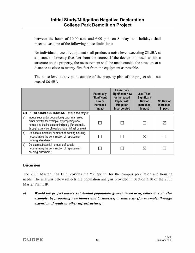
Initial Study/Mitigation Negative Declaration College Park Demolition Project
10493 89 January 2018
between the hours of 10:00 a.m. and 6:00 p.m. on Sundays and holidays shall
meet at least one of the following noise limitations:
No individual piece of equipment shall produce a noise level exceeding 83 dBA at
a distance of twenty-five feet from the source. If the device is housed within a
structure on the property, the measurement shall be made outside the structure at a
distance as close to twenty-five feet from the equipment as possible.
The noise level at any point outside of the property plan of the project shall not
exceed 86 dBA.
Potentially Significant
New or Increased
Impact
Less-Than-Significant New
or Increased Impact with Mitigation
Incorporated
Less-Than-Significant
New or Increased
Impact
No New or Increased
Impact
XIII. POPULATION AND HOUSING – Would the project:
a) Induce substantial population growth in an area, either directly (for example, by proposing new homes and businesses) or indirectly (for example, through extension of roads or other infrastructure)?
b) Displace substantial numbers of existing housing, necessitating the construction of replacement housing elsewhere?
c) Displace substantial numbers of people, necessitating the construction of replacement housing elsewhere?
Discussion
The 2005 Master Plan EIR provides the “blueprint” for the campus population and housing
needs. The analysis below reflects the population analysis provided in Section 3.10 of the 2005
Master Plan EIR.
a) Would the project induce substantial population growth in an area, either directly (for
example, by proposing new homes and businesses) or indirectly (for example, through
extension of roads or other infrastructure)?
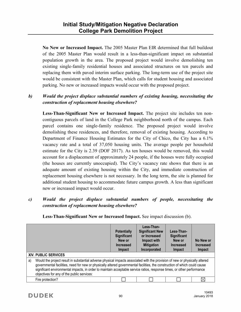
Initial Study/Mitigation Negative Declaration College Park Demolition Project
10493 90 January 2018
No New or Increased Impact. The 2005 Master Plan EIR determined that full buildout
of the 2005 Master Plan would result in a less-than-significant impact on substantial
population growth in the area. The proposed project would involve demolishing ten
existing single-family residential houses and associated structures on ten parcels and
replacing them with paved interim surface parking. The long-term use of the project site
would be consistent with the Master Plan, which calls for student housing and associated
parking. No new or increased impacts would occur with the proposed project.
b) Would the project displace substantial numbers of existing housing, necessitating the
construction of replacement housing elsewhere?
Less-Than-Significant New or Increased Impact. The project site includes ten non-
contiguous parcels of land in the College Park neighborhood north of the campus. Each
parcel contains one single-family residence. The proposed project would involve
demolishing these residences, and therefore, removal of existing housing. According to
Department of Finance Housing Estimates for the City of Chico, the City has a 6.1%
vacancy rate and a total of 37,050 housing units. The average people per household
estimate for the City is 2.39 (DOF 2017). As ten houses would be removed, this would
account for a displacement of approximately 24 people, if the houses were fully occupied
(the houses are currently unoccupied). The City’s vacancy rate shows that there is an
adequate amount of existing housing within the City, and immediate construction of
replacement housing elsewhere is not necessary. In the long term, the site is planned for
additional student housing to accommodate future campus growth. A less than significant
new or increased impact would occur.
c) Would the project displace substantial numbers of people, necessitating the
construction of replacement housing elsewhere?
Less-Than-Significant New or Increased Impact. See impact discussion (b).
Potentially Significant
New or Increased
Impact
Less-Than-Significant New
or Increased Impact with Mitigation
Incorporated
Less-Than-Significant
New or Increased
Impact
No New or Increased
Impact
XIV. PUBLIC SERVICES
a) Would the project result in substantial adverse physical impacts associated with the provision of new or physically altered governmental facilities, need for new or physically altered governmental facilities, the construction of which could cause significant environmental impacts, in order to maintain acceptable service ratios, response times, or other performance objectives for any of the public services:
Fire protection?
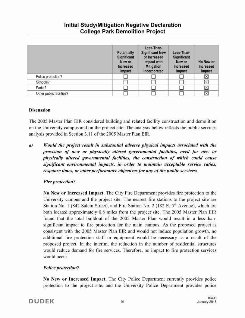
Initial Study/Mitigation Negative Declaration College Park Demolition Project
10493 91 January 2018
Potentially Significant
New or Increased
Impact
Less-Than-Significant New
or Increased Impact with Mitigation
Incorporated
Less-Than-Significant
New or Increased
Impact
No New or Increased
Impact
Police protection?
Schools?
Parks?
Other public facilities?
Discussion
The 2005 Master Plan EIR considered building and related facility construction and demolition
on the University campus and on the project site. The analysis below reflects the public services
analysis provided in Section 3.11 of the 2005 Master Plan EIR.
a) Would the project result in substantial adverse physical impacts associated with the
provision of new or physically altered governmental facilities, need for new or
physically altered governmental facilities, the construction of which could cause
significant environmental impacts, in order to maintain acceptable service ratios,
response times, or other performance objectives for any of the public services:
Fire protection?
No New or Increased Impact. The City Fire Department provides fire protection to the
University campus and the project site. The nearest fire stations to the project site are
Station No. 1 (842 Salem Street), and Fire Station No. 2 (182 E. 5th Avenue), which are
both located approximately 0.8 miles from the project site. The 2005 Master Plan EIR
found that the total buildout of the 2005 Master Plan would result in a less-than-
significant impact to fire protection for the main campus. As the proposed project is
consistent with the 2005 Master Plan EIR and would not induce population growth, no
additional fire protection staff or equipment would be necessary as a result of the
proposed project. In the interim, the reduction in the number of residential structures
would reduce demand for fire services. Therefore, no impact to fire protection services
would occur.
Police protection?
No New or Increased Impact. The City Police Department currently provides police
protection to the project site, and the University Police Department provides police

Initial Study/Mitigation Negative Declaration College Park Demolition Project
10493 92 January 2018
protection to the University campus, with backup provided by the City Police
Department. The 2005 Master Plan EIR found that the total buildout of the 2005 Master
Plan would result in a less-than-significant impact to police protection with mitigation
incorporated. Mitigation Measure 3.11-1a would increase the number of “Blue Light”
emergency telephones and community service officers on campus as needed (and
therefore does not require changes or additions to the proposed project). The proposed
project is consistent with the 2005 Master Plan EIR, and no new or increased impact to
police protection services would occur.
Schools?
No New or Increased Impact. The 2005 Master Plan EIR found a slight increase in
student population at K–12 schools may result from families of staff and faculty additions
necessitated by the increase in student population, but this increase is expected to be
minimal, and would have a less-than-significant impact on K–12 school facilities. The
interim use, student parking, would not increase demand for K-12 school facilities.
Therefore, no new or increased impact to school facilities would occur.
Parks?
No New or Increased Impact. Impacts to parks are discussed in Section XV, Recreation.
Other public facilities?
No New or Increased Impact. The 2005 Master Plan EIR found that full buildout of the
Master Plan would result in less-than-significant impacts to medical facilities. The
proposed project is consistent with the Master Plan, and therefore, no new impact to other
public facilities would occur.
Master Plan Mitigation Measures
Mitigation Measure 3.11-1a: Currently there are several “Blue Light” emergency
telephones located throughout the campus which ring directly into the Communications
Center of the University Police Department. These auto-dialing phones may be used to
summon emergency police, fire or medical assistance. Before construction is completed
on new facilities on the main campus, new “Blue Light” phones can be added to ensure
safety at these locations.
Community Service Officers (CSO) of the CSU Chico Police Department are student
positions. The CSO provides support to the staff of sworn and non-sworn police

Initial Study/Mitigation Negative Declaration College Park Demolition Project
10493 93 January 2018
personnel. Duties include parking enforcement, special event security, escort detail,
bicycle licensing, property engraving, room unlocks, clerical dispatch support, and
campus lot patrol. More of these positions can be created if needed to ensure proper
enforcement of laws and safety concerns.
Potentially Significant
New or Increased
Impact
Less-Than-Significant New
or Increased Impact with Mitigation
Incorporated
Less-Than-Significant
New or Increased
Impact
No New or Increased
Impact
XV. RECREATION
a) Would the project increase the use of existing neighborhood and regional parks or other recreational facilities such that substantial physical deterioration of the facility would occur or be accelerated?
b) Does the project include recreational facilities or require the construction or expansion of recreational facilities which might have an adverse physical effect on the environment?
Discussion
The 2005 Master Plan EIR considered building and related facility construction and demolition
on the University campus and on the project site. The analysis below reflects the recreation
analysis provided in Section 3.12 of the 2005 Master Plan EIR.
a) Would the project increase the use of existing neighborhood and regional parks or
other recreational facilities such that substantial physical deterioration of the facility
would occur or be accelerated?
No New or Increased Impact. The 2005 Master Plan EIR found that the implementation
of the Master Plan would not have a significant effect on existing neighborhood and
regional parks. While buildout of the Master Plan would increase the campus population,
the Master Plan includes construction of recreational facilities to meet the needs of the
campus (including the Wildcat Recreation Center). Furthermore, the interim parking use
would not account for an increase in population within the project area, and would
therefore not account for an increase in demand for recreational facilities. The proposed
project is consistent with the Master Plan and would not result in new or increased
recreational impacts.

Initial Study/Mitigation Negative Declaration College Park Demolition Project
10493 94 January 2018
b) Does the project include recreational facilities or require the construction or
expansion of recreational facilities, which might have an adverse physical effect on
the environment?
No New or Increased Impact. The project would not demolish existing recreational
facilities and would not construct new or expand current recreational facilities. The
proposed project would have no new or increased impact on recreational facilities.
Potentially Significant
New or Increased
Impact
Less-Than-Significant New
or Increased Impact with Mitigation
Incorporated
Less-Than-Significant
New or Increased
Impact
No New or Increased
Impact
XVI. TRANSPORTATION/TRAFFIC – Would the project:
a) Conflict with an applicable plan, ordinance or policy establishing measures of effectiveness for the performance of the circulation system, taking into account all modes of transportation including mass transit and non-motorized travel and relevant components of the circulation system, including but not limited to intersections, streets, highways and freeways, pedestrian and bicycle paths, and mass transit?
b) Conflict with an applicable congestion management program, including, but not limited to level of service standards and travel demand measures, or other standards established by the county congestion management agency for designated roads or highways?
c) Result in a change in air traffic patterns, including either an increase in traffic levels or a change in location that results in substantial safety risks?
d) Substantially increase hazards due to a design feature (e.g., sharp curves or dangerous intersections) or incompatible uses (e.g., farm equipment)?
e) Result in inadequate emergency access?
f) Conflict with adopted policies, plans, or programs regarding public transit, bicycle, or pedestrian facilities, or otherwise decrease the performance or safety of such facilities?

Initial Study/Mitigation Negative Declaration College Park Demolition Project
10493 95 January 2018
Discussion
The 2005 Master Plan EIR considered building and related facility construction and demolition
on the University campus and on the project site. The evaluation below reflects the campus-wide
transportation analysis provided in Section 3.13 of the 2005 Master Plan EIR.
a) Would the project conflict with an applicable plan, ordinance or policy establishing
measures of effectiveness for the performance of the circulation system, taking into
account all modes of transportation including mass transit and non-motorized travel
and relevant components of the circulation system, including but not limited to
intersections, streets, highways and freeways, pedestrian and bicycle paths, and
mass transit?
No New or Increased Impact. The 2005 Master Plan EIR analyzed the build out of the
campus to accommodate 17,900 FTES and concluded that there would be both a direct
impact due to campus growth (Impact 3.13-1), and a cumulative traffic impact due to
campus and other development through the year 2025 (Impact 3.13-6). Notably, the
intersection of West Sacramento Avenue and Warner Street, the nearest major
intersection to the project site, was studied in the Master Plan EIR, and both near-term
and cumulative impacts were found less than significant.
The proposed project would remove single-family homes and replace them with an
interim use of surface parking for staff, faculty, and students. The site is expected to yield
approximately 250 spaces. The University currently leases 140 spaces from Chico
Unified School District. Thus, there would be a net increase of 110 spaces in the project
vicinity. The traffic analysis in the 2005 Master Plan EIR considered both the vehicle
trips generated by the implementation of the Master Plan, and the associated parking. The
Master Plan traffic analysis considered 17,900 FTES (which the University has not
exceeded), and 1,430 new parking spaces. The University has only constructed a fraction
of this amount (including the Normal Ave. Parking Structure #2, with approximately 370
spaces), and in addition, has lost 173 parking spaces as a result of the Arts & Humanities
(Taylor II) project. In addition, the 2009 Transportation Demand Management Plan
identified a loss of 400 parking spaces in and around the University, which means
parking supply has actually shrunk since the Master Plan has been adopted. Thus, the
proposed amount of parking is far short of the amount considered in the Master Plan EIR
traffic analysis, which considered future housing and parking uses on the project site.
The University has also considered if there could be a significant localized peak hour
impact due to the interim parking use. This is somewhat difficult to determine, as parking

Initial Study/Mitigation Negative Declaration College Park Demolition Project
10493 96 January 2018
is generally studied as part of the overall land use that it serves (in this case, a university)
rather than as a separate generator of vehicle trips. Therefore, two methods were used to
determine the potential number of additional vehicles during the A.M. peak hour. The
first is to look at the net new parking spaces, 110. The Master Plan EIR identified an 88%
utilization rate for campus parking. Assuming that 88% of the parking spaces would be
filled during the A.M. peak hour yields 97 new peak hour trips. Alternatively, an EIR
prepared by the University of California Los Angeles (SCH# 199909101) identified a trip
generation of 3.753 one-way trips day for each parking space (1.9 round trips per day, so
each space is typically occupied by two different cars each day, on average). The A.M.
peak hour trips are typically around 10% of the daily trips, which would yield 41 trips
(110 spaces x 3.753 trips x 0.10 peak hour trips). However, the Master Plan EIR uses an
A.M. peak hour rate of 0.21 for students. Using this higher rate yields 87 trips (110
spaces x 3.753 trips x .0.21). The next step is to take out the existing trips created by on-
going occupancy of the existing homes to be removed. The trip generation for a single
family home is 9.52 trips per dwelling unit (DU) for average daily trips and 0.75 trips per
DU for AM peak hour (ITE 2012). For 10 homes, it would be 95 daily trips, and 8 AM
peak hour trips. Using the highest estimate of A.M. peak hour parking trips, 96, and
reducing the 8 existing residential trips gives a net increase of 88 peak hour trips. A
commonly accepted threshold for justifying a traffic study is 100 peak hour trips
(Caltrans 2002). Therefore, there is no substantial evidence that the interim parking
would cause an impact that has not been previously considered in the Master Plan EIR.
The project is consistent with the assumed land use for the site and would not increase
student enrollment or the local population. No increase in traffic would occur due to the
proposed project. Therefore, no new or increased impact would occur.
b) Would the project conflict with an applicable congestion management program,
including, but not limited to level of service standards and travel demand measures, or
other standards established by the county congestion management agency for
designated roads or highways?
No New or Increased Impact. The passage of Proposition 111 in June 1990 established
a process for each metropolitan county in California that has an urbanized area with a
population over 50,000 to prepare a congestion management program (CMP).
Implementation of the CMP was made voluntary by the passage of AB 2419 in 1996.
Some counties in California have maintained CMPs; however, Butte County does not.
Therefore, there is no impact.

Initial Study/Mitigation Negative Declaration College Park Demolition Project
10493 97 January 2018
c) Would the project result in a change in air traffic patterns, including either an increase
in traffic levels or a change in location that results in substantial safety risks?
No New or Increased Impact. The Chico Municipal Airport is 6 miles north of the
University campus and Ranchaero Airport, located approximately 1 mile to the west of
the campus, is a privately owned airport available for public use. The project site is not
within the airport influence zone for either airport (Butte County 2000) and will not have
any effect on air traffic. Therefore, there is no new or increased impact with regard to air
traffic patterns.
d) Would the project substantially increase hazards due to a design feature (e.g., sharp
curves or dangerous intersections) or incompatible uses (e.g., farm equipment)?
No New or Increased Impact. The project would not change any roadway and
transportation facility geometrics and would not introduce any new design features that affect
existing transportation facilities. The proposed project is consistent with the 2005 Master
Plan and does not introduce any incompatible uses. The 2005 Master Plan EIR did not find
any potentially significant transportation impacts related to design or incompatible use. The
project will have no new or increased impact with regard to increased design hazards or
incompatible uses. Therefore, there is no new or increased impact.
e) Would the project result in inadequate emergency access?
No New or Increased Impact. The project would not change or relocate any emergency
vehicle access points. The 2005 Master Plan EIR discussed emergency access in the Hazards
Analysis (Section 3.6). Refer to Item VIII of this Initial Study checklist for further discussion.
The project would provide adequate emergency access, and therefore, there is no new or
increased impact.

Initial Study/Mitigation Negative Declaration College Park Demolition Project
10493 98 January 2018
f) Would the project conflict with adopted policies, plans, or programs regarding public
transit, bicycle, or pedestrian facilities, or otherwise decrease the performance or safety
of such facilities?
Less-Than-Significant New or Increased Impact with Mitigation Incorporated. The
2005 Master Plan EIR discusses the transit, bicycle, and pedestrian system serving the
University, but did not identify any potentially significant impacts. The project and site-
specific issues are further discussed below.
Pedestrian Facilities
The 2005 Master Plan includes design guidelines for new buildings, which state that
building form and placement should reinforce, rather than interrupt important pedestrian
pathways and assist in pedestrian navigation and wayfinding (CSU Chico 2005a).
Additionally, the 2005 Master Plan and the Transportation Demand Management Plan
(CSU Chico 2009) acknowledge the need to separate bicycle and pedestrian traffic to
minimize intermodal conflict as well as increase safety for pedestrians, particularly the
mobility challenged and disabled community.
The proposed project would occur on ten noncontiguous parcels located in the College
Park neighborhood. Demolition would occur on these parcels, and reconstruction of
sidewalk would occur as necessary to support pedestrian access. Therefore, the project
would not conflict with adopted plans, policies, or programs regarding pedestrian
facilities or the safety of those facilities. No new or increased pedestrian impacts would
occur compared to the Master Plan EIR.
Bicycle Facilities
As the proposed project would occur on ten noncontiguous parcels in the College Park
neighborhood, and the project site does not contain any existing bicycle facilities, bicycle
facilities would not be impacted.
Transit Facilities
Transit service in the City is provided by Butte Regional Transit (B-Line). The campus is
served by Routes 3, 8, and 9. Routes 8 and 9 stop on Warner Street near the project site at
West 1st Street and Route 8 stops at West Sacramento Avenue northwest of the project
site. Route 8 provides access to the Nord Avenue residential area northwest of the
campus as well as the downtown transit center at 2nd Street and Normal Street. Route 9
provides access to the residential area north of the campus as well as the downtown

Initial Study/Mitigation Negative Declaration College Park Demolition Project
10493 99 January 2018
transit center. Implementation of the project will not affect the bus stops on Warner Street
nor would it conflict with any plans or policies regarding public transit. Therefore, there
is no new or increased impact related to adopted transit plans, policies, or programs or the
safety of those facilities.
Potentially Significant
New or Increased
Impact
Less-Than-Significant New
or Increased Impact with Mitigation
Incorporated
Less-Than-Significant
New or Increased
Impact
No New or Increased
Impact
XVII. TRIBAL CULTURAL RESOURCES – Would the project cause a substantial adverse change in the significance of a tribal cultural resource, defined in Public Resource Code section 21074 as either a site, feature, place, cultural landscape that is geographically defined in terms of the size and scope of the landscape, sacred place, or object with cultural value to a California Native American tribe, and that is:
a) Listed or eligible for listing in the California Register of Historical Resources, or in a local register of historical resources as defined in Public Resources Code section 5020.1(k) or
b) A resource determined by the lead agency, in its discretion and supported by substantial evidence, to be significant pursuant to criteria set forth in subdivision (c) of Public Resources Code Section 5024.1. In applying the criteria set forth in subdivision (c) of Public Resource Code Section 5024.1, the lead agency shall consider the significance of the resource to a California Native American tribe.
Discussion
The Northeast Information Center records search, prepared as part of the Cultural Resources
Report, did not indicate the presence of any archaeological or tribal cultural resources. The
intensive pedestrian survey failed to identify any potential resources. The Native American
Heritage Commission (NAHC) search of the Sacred Lands File failed to indicate the presence of
Native American resources. Subsequent information outreach with NAHC-listed tribal
representatives has been completed by letter. In consideration of the severity of past disturbance
to native soils, the topographic setting, and the negative inventory results, the likelihood of
encountering unanticipated significant subsurface archaeological deposits or features is
considered low. In addition, the University has contacted the tribes requesting notice under
Assembly Bill 52, and no concerns regarding tribal cultural resources have been raised.
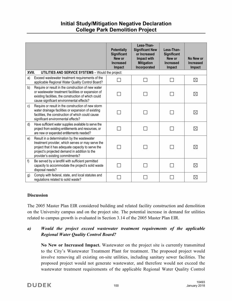
Initial Study/Mitigation Negative Declaration College Park Demolition Project
10493 100 January 2018
Potentially Significant
New or Increased
Impact
Less-Than-Significant New
or Increased Impact with Mitigation
Incorporated
Less-Than-Significant
New or Increased
Impact
No New or Increased
Impact
XVIII. UTILITIES AND SERVICE SYSTEMS – Would the project:
a) Exceed wastewater treatment requirements of the applicable Regional Water Quality Control Board?
b) Require or result in the construction of new water or wastewater treatment facilities or expansion of existing facilities, the construction of which could cause significant environmental effects?
c) Require or result in the construction of new storm water drainage facilities or expansion of existing facilities, the construction of which could cause significant environmental effects?
d) Have sufficient water supplies available to serve the project from existing entitlements and resources, or are new or expanded entitlements needed?
e) Result in a determination by the wastewater treatment provider, which serves or may serve the project that it has adequate capacity to serve the project’s projected demand in addition to the provider’s existing commitments?
f) Be served by a landfill with sufficient permitted capacity to accommodate the project’s solid waste disposal needs?
g) Comply with federal, state, and local statutes and regulations related to solid waste?
Discussion
The 2005 Master Plan EIR considered building and related facility construction and demolition
on the University campus and on the project site. The potential increase in demand for utilities
related to campus growth is evaluated in Section 3.14 of the 2005 Master Plan EIR.
a) Would the project exceed wastewater treatment requirements of the applicable
Regional Water Quality Control Board?
No New or Increased Impact. Wastewater on the project site is currently transmitted
to the City’s Wastewater Treatment Plant for treatment. The proposed project would
involve removing all existing on-site utilities, including sanitary sewer facilities. The
proposed project would not generate wastewater, and therefore would not exceed the
wastewater treatment requirements of the applicable Regional Water Quality Control
Initial Study/Mitigation Negative Declaration College Park Demolition Project
10493 101 January 2018
Board. Therefore, the proposed project would have no new or increased impact on
wastewater treatment.
b) Would the project require or result in the construction of new water or wastewater
treatment facilities or expansion of existing facilities, the construction of which could
cause significant environmental effects?
No New or Increased Impact. The 2005 Master Plan EIR determined that buildout of
the 2005 Master Plan would account for a less-than-significant impact on water supply
and wastewater systems. Water on the project site is currently provided by the California
Water Service Company, and served by existing water lines. The proposed project would
involve removing all existing on-site utilities, including water pipes. A minimal amount
of water would be necessary for dust suppression and cleanup measures. Interim parking
lots would not require regular domestic water supply. As discussed above, the proposed
project would not generate wastewater, and therefore would not require or result in the
construction of new wastewater treatment facilities. As the proposed project would only
require a minimal amount of water for dust suppression and cleanup, the project would
not require or result in the construction of new water or wastewater treatment facilities or
expansion of existing facilities. Therefore, the proposed project would have no new or
increased impact on water or wastewater treatment facilities.
c) Would the project require or result in the construction of new storm water drainage
facilities or expansion of existing facilities, the construction of which could cause
significant environmental effects?
No New or Increased Impact. The project will utilize the current storm drainage system
serving the project site. The project will comply with MS4 requirements (see impact
discussion IX(a)), which may require additional on-site detention or water quality
features. No additional off-site stormwater drainage facilities are required.
d) Would the project have sufficient water supplies available to serve the project from
existing entitlements and resources, or are new or expanded entitlements needed?
No New or Increased Impact. The 2005 Master Plan EIR concludes that full buildout of
the 2005 Master Plan would result in a less-than-significant impact on water supply. The
proposed project would not require a regular domestic water supply, and only a minimal
amount of water would be necessary for dust suppression and cleanup measures.
Therefore, no new or increased impact to water supply would occur.

Initial Study/Mitigation Negative Declaration College Park Demolition Project
10493 102 January 2018
e) Would the project result in a determination by the wastewater treatment provider,
which serves or may serve the project that it has adequate capacity to serve the
project’s projected demand in addition to the provider’s existing commitments?
No New or Increased Impact. The 2005 Master Plan EIR concludes that full buildout of
the 2005 Master Plan would result in a less-than-significant impact on wastewater
treatment services. Wastewater on the project site is currently treated at the City’s
Wastewater Treatment Plant. The interim use would not generate wastewater. The long
term (student housing use) would be consistent with the Master Plan. Therefore, no new
or increased impact to wastewater treatment services would occur.
f) Would the project be served by a landfill with sufficient permitted capacity to
accommodate the project’s solid waste disposal needs?
No New or Increased Impact. The 2005 Master Plan EIR concluded that full
buildout of the 2005 Master Plan would result in a less-than-significant impact to
solid waste management facilities. The 2005 Master Plan EIR determined that overall
volumes of solid waste generated would not increase with full buildout of the 2005
Master Plan. The interim parking use would generate less solid waste than the current
residential uses. The University campus is served by the Neal Road Landfill in
Durham, California.
g) Would the project comply with federal, state, and local statutes and regulations related
to solid waste?
No New or Increased Impact. The 2005 Master Plan EIR concluded that full buildout of
the 2005 Master Plan would result in a less-than-significant impact to solid waste
management facilities. The 2005 Master Plan EIR determined that overall volumes of
solid waste would not increase with full buildout of the 2005 Master Plan. The proposed
project would account for a minimal increase in solid waste. As during demolition and
interim surface parking operation the project would comply with federal, state, and local
statutes and regulations regarding solid waste, no new or increased impact to solid waste
regulations would occur.

Initial Study/Mitigation Negative Declaration College Park Demolition Project
10493 103 January 2018
Potentially Significant
New or Increased
Impact
Less-Than-Significant New
or Increased Impact with Mitigation
Incorporated
Less-Than-Significant
New or Increased
Impact
No New or Increased
Impact
XIX. MANDATORY FINDINGS OF SIGNIFICANCE
a) Does the project have the potential to degrade the quality of the environment, substantially reduce the habitat of a fish or wildlife species, cause a fish or wildlife population to drop below self-sustaining levels, threaten to eliminate a plant or animal community, reduce the number or restrict the range of a rare or endangered plant or animal or eliminate important examples of the major periods of California history or prehistory?
b) Does the project have impacts that are individually limited, but cumulatively considerable? (“Cumulatively considerable” means that the incremental effects of a project are considerable when viewed in connection with the effects of past projects, the effects of other current projects, and the effects of probable future projects)?
c) Does the project have environmental effects which will cause substantial adverse effects on human beings, either directly or indirectly?
Discussion
a) Does the project have the potential to degrade the quality of the environment,
substantially reduce the habitat of a fish or wildlife species, cause a fish or wildlife
population to drop below self-sustaining levels, threaten to eliminate a plant or
animal community, reduce the number or restrict the range of a rare or endangered
plant or animal, or eliminate important examples of the major periods of California
history or prehistory?
No New or Increased Impact. As discussed above, the proposed project would not
degrade the habitat of a fish or wildlife species with implementation of programmatic and
project-specific mitigation measures. The project site does not contain significant
historical resources that would be impacted by project implementation.

Initial Study/Mitigation Negative Declaration College Park Demolition Project
10493 104 January 2018
b) Does the project have impacts that are individually limited, but cumulatively
considerable? (“Cumulatively considerable” means that the incremental effects of a
project are considerable when viewed in connection with the effects of past projects, the
effects of other current projects, and the effects of probable future projects)?
No New or Increased Impact. The cumulative context for the proposed project is the
continued buildout of the University campus. This Initial Study is tiered from the 2005
Master Plan EIR, which considers full buildout of the Master Plan, and the
accommodation of 17,900 FTES. As described herein, the project is consistent with the
Master Plan and would not result in new or increased cumulative impacts.
c) Does the project have environmental effects which will cause substantial adverse
effects on human beings, either directly or indirectly?
No New or Increased Impact. The project would not result in impacts that would affect
the health or safety of human beings, directly or indirectly.
Initial Study/Mitigation Negative Declaration College Park Demolition Project
10493 105 January 2018
5 REFERENCES AND PREPARERS
5.1 References Cited
14 CCR 15000–15387 and Appendices A through L. Guidelines for Implementation of the
California Environmental Quality Act, as amended.
AirNav. 2017. “Ranchaero Airport. FAA Identifier CL56.”
https://www.airnav.com/airport/CL56. Accessed April 14, 2017.
BAAQMD (Bay Area Air Quality Management District). 2010. CEQA Air Quality Guidelines. May 2010. Accessed April 2017. http://www.baaqmd.gov/~/media/files/planning-and-research/ceqa/draft_baaqmd_ceqa_guidelines_may_2010_final.pdf?la=en
Barbour and Major. 1990. Terrestrial Vegetation of California.
BCAG (Butte County Association of Governments). 2014. 2013/2014 Traffic Counts.
BCAQMD (Butte County Air Quality Management District). 2014. CEQA Air Quality
Handbook. Adopted October 23, 2014.
BCAQMD. 2017. Personal communication via telephone with Ursula Parker, Senior Air Quality
Specialist with BCAQMD. January 4, 2017.
Butte County. 2000. Airport Land Use Compatibility Plan. December 20, 2000.
CalFire (California Department of Forestry and Fire Protection). 2008. Very High Fire Hazard
Severity Zones in Local Responsibility Areas Map: Chico. May 28, 2008
Caltrans (California Department of Transportation). 2002. Guide for the Preparation of Traffic
Impact Studies. December 2002.
California Public Resources Code, Section 21000–21177. California Environmental Quality Act,
as amended.
CSU (California State University). 2014. Sustainability Policy.
CalRecycle (California Department of Resources Recycling and Recovery). 2012. California’s
New Goal: 75 Percent Recycling.

Initial Study/Mitigation Negative Declaration College Park Demolition Project
10493 106 January 2018
CARB (California Air Resources Board). 2008. Climate Change Proposed Scoping Plan: A
Framework for Change. December 12, 2008. http://www.arb.ca.gov/cc/scopingplan/
document/psp.pdf.
CARB. 2011. Staff Report: Initial Statement of Reasons for Proposed Rulemaking, Public
Hearing to Consider the “LEV III” Amendments to the California Greenhouse Gas and
Criteria Pollutant Exhaust and Evaporative Emission Standards and Test Procedures and
to the On-Board Diagnostic System Requirements for Passenger Cars, Light-Duty
Trucks, and Medium-Duty Vehicles, and to the Evaporative Emission Requirements for
Heavy-Duty Vehicles. December 7, 2011.
CARB. 2014. First Update to the Climate Change Scoping Plan Building on the Framework
Pursuant to AB 32 – The California Global Warming Solutions Act of 2006. May 2014.
Accessed December 2016. http://www.arb.ca.gov/cc/scopingplan/2013_update/
first_update_climate_change_scoping_plan.pdf.
CARB. 2015. “Glossary of Terms Used in Greenhouse Gas Inventories.” April 2017.
https://www.arb.ca.gov/cc/inventory/faq/ghg_inventory_glossary.htm.
CARB. 2016a. “Air Quality Standards and Area Designations.” Area Designations Maps/State
and National. Page last reviewed May 5, 2016. Accessed June 2016.
http://www.arb.ca.gov/desig/desig.htm
CARB. 2016b. “California Greenhouse Gas Inventory – 2016 Edition.” June 17, 2016. Accessed
December 2016. http://www.arb.ca.gov/cc/inventory/data/data.htm.
CARB. 2017a. The 2017 Climate Change Scoping Plan Update. January 20. Accessed January
2017. https://www.arb.ca.gov/cc/scopingplan/2030sp_pp_final.pdf.
CARB. 2017b. Short-Lived Climate Pollutant Reduction Strategy. March 2017. Accessed April 2017. https://www.arb.ca.gov/cc/shortlived/meetings/03142017/final_slcp_report.pdf
CAT (California Climate Action Team). 2006. Climate Action Team Report to the Governor
Schwarzenegger and the Legislature. Sacramento, California. March 2006. Accessed
December 2016. http://www.climatechange.ca.gov/climate_action_team/
reports/2006report/2006-04-03_FINAL_CAT_REPORT.PDF.
CAT. 2010. Climate Action Team Biennial Report. Sacramento, California. April 2010.
Accessed December 2016. http://www.energy.ca.gov/2010publications/CAT-1000-2010-
004/CAT-1000-2010-004.PDF.

Initial Study/Mitigation Negative Declaration College Park Demolition Project
10493 107 January 2018
CAT. 2016. Climate Action Team Reports. Accessed December 2016. http://climatechange.ca.gov/
climate_action_team/reports/index.html.
CCCC (California Climate Change Center). 2006. Our Changing Climate: Assessing the Risks to
California. CEC-500-2006-077. July 2006. Accessed September 2016.
http://www.energy.ca.gov/2006publications/CEC-500-2006-077/
CEC-500-2006-077.PDF.
CCCC. 2012. Our Changing Climate 2012: Vulnerability & Adaptation to the Increasing Risks
from Climate Change in California. July 2012. Accessed December 2016.
http://www.energy.ca.gov/2012publications/CEC-500-2012-007/
CEC-500-2012-007.pdf.
CDFG (California Department of Fish and Game). 2004. CNDDB.
CEC (California Energy Commission). 2015. “2016 Building Efficiency Standards Frequently
Asked Questions.” Accessed December 2016. http://www.energy.ca.gov/title24/
2016standards/rulemaking/documents/2016_Building_Energy_Efficiency_
Standards_FAQ.pdf.
Chico (City of Chico). 2012. City of Chico 2020 Climate Action Plan. Accessed July 2017.
http://www.chicosustainability.org/documents/ClimateActionPlan.pdf.
Chico (City of Chico). 2013. “City of Chico General Plan Diagram.” Accessed July 2017.
http://www.chico.ca.us/planning_services/documents/HiResGPMap.pdf
CNRA (California Natural Resources Agency). 2009a. 2009 California Climate Adaptation
Strategy: A Report to the Governor of the State of California in Response to Executive
Order S-13-2008. Accessed December 2016. http://resources.ca.gov/docs/climate/
Statewide_Adaptation_Strategy.pdf.
CNRA. 2009b. Final Statement of Reasons for Regulatory Action: Amendments to the State
CEQA Guidelines Addressing Analysis and Mitigation of Greenhouse Gas Emissions
Pursuant to SB 97. December 2009.
CNRA. 2014. Safeguarding California: Reducing Climate Risk An Update to the 2009
California Climate Adaptation Strategy. July 31. Accessed December 2016.
http://resources.ca.gov/docs/climate/Final_Safeguarding_CA_Plan_July_31_2014.pdf.
CSU Chico (California State University, Chico). 2005a. Campus Master Plan. June 2005.

Initial Study/Mitigation Negative Declaration College Park Demolition Project
10493 108 January 2018
CSU Chico. 2005b. Campus Master Plan Final Environmental Impact Report (SCH #2004092071).
June 2005.
CSU Chico. 2009. Transportation Demand Management Plan. May 14, 2009. Prepared by
Fehr & Peers.
CSU Chico. 2011a. Climate Action Plan. May 23, 2011.
CSU Chico. 2011b. Initial Study/Mitigated Negative Declaration for the Normal Avenue Parking Structure (Parking Structure 2). SCH# 2011022059. February 2011.
CSU Chico. 2017. Science Replacement Building: Programming and Feasibility Study Report.
March 3, 2017. Prepared by Smith Group JJR.
City of Chico. 2011. 2030 General Plan. Adopted 2011.
DOF (State of California, Department of Finance). 2017. E-5 Population and Housing Estimates for
Cities, Counties and the State — January 1, 2011- 2017. Sacramento, California, May 2017.
Dudek. 2017. Field observations.
EPA (U.S. Environmental Protection Agency). 2016a. “Glossary of Climate Change Terms.”
August 9, 2016. Accessed December 2016. https://www3.epa.gov/
climatechange/glossary.html.
EPA. 2016b. Inventory of U.S. Greenhouse Gas Emissions and Sinks: 1990–2014 EPA 430-R-
16-002. Washington, D.C.: EPA. April 15, 2016. Accessed December 2016.
https://www3.epa.gov/climatechange/Downloads/ghgemissions/
US-GHG-Inventory-2016-Main-Text.pdf.
EPA. 2017. “EPA Region 9 Air Quality Maps and Geographic Information.” Last updated March
7, 2017. Accessed March 2017. http://www.epa.gov/region9/air/maps/.
FMMP (Farmland Mapping and Monitoring Program). 2014. California Resources Agency,
Division of Land Resources Protection. Farmland Mapping and Monitoring Program.
Butte County. 2014.
Hickman. 1996. The Jepson Manual, Higher Plants of California.

Initial Study/Mitigation Negative Declaration College Park Demolition Project
10493 109 January 2018
IPCC (Intergovernmental Panel on Climate Change). 1995. IPCC Second Assessment Synthesis
of Scientific-Technical Information Relevant to Interpreting Article 2 of the U.N.
Framework Convention on Climate Change.
IPCC. 2007. IPCC Fourth Assessment Synthesis of Scientific-Technical Information Relevant to
Interpreting Article 2 of the U.N. Framework Convention on Climate Change.
IPCC. 2014. Climate Change 2014 Synthesis Report: A Report of the Intergovernmental Panel
on Climate Change. Contribution of Working Groups I, II and III to the Fifth Assessment
Report of the Intergovernmental Panel on Climate Change. Accessed December 2016.
http://www.ipcc.ch/report/ar5/syr/.
ITE (Institute of Transportation Engineer). 2012. Trip Generation Manual. 9th Edition
OEHHA (Office of Environmental Health Hazard Assessment). 2015. Air Toxics Hot Spots Program, Risk Assessment Guidelines, Guidance Manual for Preparation of Health Risk Assessments. February 2015.
OPR (Governor’s Office of Planning and Research). 2008. CEQA and Climate Change: Addressing
Climate Change through California Environmental Quality Act (CEQA) Review.
Ottoboni pers com. 2017. Ottabani, Brendan. City of Chico Development Services Engineer.
Personal Communication. February 28, 2017.
PCAPCD (Placer County Air Pollution Control District). 2016. Placer County Air Pollution
Control District Policy – Review of Land Use Projects Under CEQA. Adopted October
13, 2016. Accessed April 2017. https://www.placer.ca.gov/~/media/apc/documents/
planning/thresholds/ceqareviewpolicy.pdf?la=en
Peak & Associates Inc. 2004. Cultural Resource Assessment of the California State University,
Chico Master Plan 2004 Area, Butte County, California.
Skinner, Pavlik, and Vorobik. 2001. Inventory of Rare and Endangered Vascular Plants of California.
SMAQMD (Sacramento Metropolitan Air Quality Management District). 2015. SMAQMD
Thresholds of Significance Table. Updated May 2015. Accessed April 2017.
http://www.airquality.org/LandUseTransportation/Documents/
CH2ThresholdsTable5-2015.pdf.
State Water Resources Control Board (SWRCB). 2013. Phase II Small MS4 General Permit.
Order No. 2013-0001-DWQ - Attachment B. February 5, 2013.

Initial Study/Mitigation Negative Declaration College Park Demolition Project
10493 110 January 2018
Transportation Injury Mapping System (TIMS). 2017. “Safe Transportation Research and
Education Center.” University of California, Berkeley. 2017. Accessed on March 17,
2017: https://tims.berkeley.edu/.
UNFCCC (United Nations Framework Convention on Climate Change). 2016. The Paris
Agreement. October 5. Accessed February 2017. http://unfccc.int/paris_agreement/
items/9485.php.

Initial Study/Mitigation Negative Declaration College Park Demolition Project
10493 111 January 2018
5.2 List of Preparers
California State University Chico
Planning, Design, and Construction
Sandra Beck, AIA, LEED AP
Jenna Wright Additional University Staff Consulted
Mike Guzzi, P.E., Executive Director, Facilities Management and Services
Dudek
Ann Sansevero, AICP
Brian Grattidge
Shilpa Iyer
Biological Resources: Lisa Achter
Cultural Resources: Sarah Corder, MFA
Samantha Murray, MA
Sarah Brewer, BA
Adam Giacinto, MA, RPA

Initial Study/Mitigation Negative Declaration College Park Demolition Project
10493 112 January 2018
INTENTIONALLY LEFT BLANK

YubaCity
WilliamsBealeAFBLinda
LomaRica
Challenge-Brownsville
Palermo
SouthOrovilleThermalito
Oroville OrovilleEast
Durham
Magalia
Concow
Chico Paradise
Chester
RedBluff
Glenn County
Tehama County
Shasta County
Nevada County
Sutter County
Colusa CountyColusa County
Lake County
Glenn County
Glenn County
Butte County
Butte County
Butte County
Butte CountyPlumas County
Plumas County
Tehama County
Tehama County
Tehama County
?65
?149
?172
?89
?70?191
?32
?162
?45
?20
?99
?36
§̈¦5
Regional Map
CSU Chico College Park Project
SOURCE: ESRI Basemaps
Date:
7/17/2
017 -
Last sa
ved by
: rstro
bridge
- Pa
th: Z:\
Projec
ts\j104
9301\
MAPD
OC\DO
CUME
NT\IS
MND\F
igure1
_Regi
onal.m
xd
0 105 MilesnFIGURE 1
Project Site
!̂
Initial Study/Mitigation Negative Declaration College Park Demolition Project
10493 114 January 2018
INTENTIONALLY LEFT BLANK
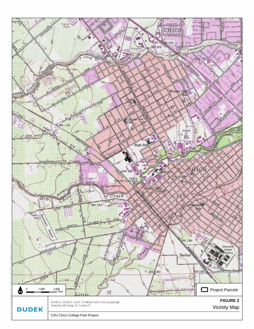
Vicinity Map
CSU Chico College Park Project
SOURCE: SOURCE: USGS 7.5-Minute Series Chico QuadrangleTownship 22N; Range 1E; Section 27
Date:
7/17/2
017 -
Last sa
ved by
: rstro
bridge
- Pa
th: Z:\
Projec
ts\j104
9301\
MAPD
OC\DO
CUME
NT\IS
MND\F
igure2
_Vicin
ity.mx
d
0 2,0001,000 Feetn Project Parcels
FIGURE 2

Initial Study/Mitigation Negative Declaration College Park Demolition Project
10493 116 January 2018
INTENTIONALLY LEFT BLANK

Site Map
CSU Chico College Park Project
SOURCE: Butte County GIS; Bing Maps (Accessed 2017)
Date:
7/17/2
017 -
Last
saved
by: rs
trobrid
ge -
Path:
Z:\Pr
ojects
\j1049
301\MA
PDOC
\DOCU
MENT
\ISMN
D\Figu
re3_S
iteMap.
mxd
0 10050 Feetn Project Parcel
FIGURE 3

Initial Study/Mitigation Negative Declaration College Park Demolition Project
10493 118 January 2018
INTENTIONALLY LEFT BLANK

FIGURE 4ASite Photos
CSU Chico College Park Project
Date:
8/25/2
017 -
Last s
aved b
y: rstro
bridge
- Pa
th: Z:\
Projec
ts\j104
9301\M
APDO
C\DOC
UMEN
T\ISM
ND\Fig
ure4A
_SiteP
hotos.
mxd
630 Stadium Way 899 Warner Street 608 La Vista Way
629 La Vista Way 615 La Vista Way
Initial Study/Mitigation Negative Declaration College Park Demolition Project
10174 120 January 2018
INTENTIONALLY LEFT BLANK

FIGURE 4BSite Photos
CSU Chico College Park Project
Date:
8/25/2
017 -
Last s
aved b
y: rstro
bridge
- Pa
th: Z:\
Projec
ts\j104
9301\M
APDO
C\DOC
UMEN
T\ISM
ND\Fig
ure4B
_SiteP
hotos.
mxd
628 Brice Avenue 616 Brice Avenue 602 Brice Avenue
615 Brice Avenue 725 Warner Street

Initial Study/Mitigation Negative Declaration College Park Demolition Project
10174 122 January 2018
INTENTIONALLY LEFT BLANK
APPENDIX A
Species Tables

Appendix A Special-Status Species with Known or Potential Occurrence in the
Vicinity of the Proposed College Park Demo Project, Chico, California.
10493 A-1 October 2017
Common Name
Scientific Name Federal/State Status Habitat Associations Potential to Occur in the Project Site
Invertebrates
conservancy fairy shrimp
Branchinecta conservatio
Endangered/None
The conservancy fairy shrimp is adapted to seasonally inundated features and occur primarily in vernal pools, seasonal wetlands that fill with water during fall and winter rains and dry up in spring and summer. Typically the majority of pools in any vernal pool complex are not inhabited by the species at any one time. Different pools within or between complexes may provide habitat for the fairy shrimp in alternative years, as climatic conditions vary.
No potential to occur due to lack of suitable aquatic habitat.
valley elderberry longhorn beetle
Desmocerus californicus dimorphis
Threatened/None The valley elderberry longhorn beetle is completely dependent on its host plant, elderberry (Sambucus spp.), which occurs in riparian and other woodland communities in California’s Central Valley and the associated foothills. Female beetles lay their eggs in crevices on the stems or on the leaves of living elderberry plants. When the eggs hatch, larvae bore into the stems. The larval stages last for one to two years. The fifth instar larvae create emergence holes in the stems and then plug the holes and remain in the stems through pupation. Adults emerge through the emergence holes from late March through June. The short-lived adult beetles forage on leaves and flowers of elderberry shrubs.
No potential to occur. No elderberry shrubs were observed in the vicinity of any houses within the project site.
vernal pool fairy shrimp
Branchinecta lynchi Threatened/None Vernal pool fairy shrimp is adapted to seasonally inundated features and occur primarily in vernal pools, seasonal wetlands that fill with water during fall and winter rains and dry up in spring and summer. Typically the majority of pools in any vernal pool complex are not inhabited by the species at any one time. Different pools within or between complexes may provide habitat for the fairy shrimp in alternative years, as climatic conditions vary.
No potential to occur due to lack of suitable aquatic habitat.
vernal pool tadpole shrimp
Lepidurus packardi Endangered/None Vernal pool tadpole shrimp is associated with low-alkalinity seasonal pools in unplowed grasslands. The vernal pool tadpole shrimp is found only in ephemeral freshwater habitats, including alkaline pools, clay flats, vernal lakes, vernal pools, vernal swales, and other seasonal wetlands in California. Suitable vernal pools and seasonal swales are generally underlain by hardpan or sandstone. This species inhabits freshwater habitats containing clear to highly turbid water, with water temperatures ranging from 50 to 84 degrees Fahrenheit.
No potential to occur due to lack of suitable aquatic habitat.
Fish
Central Valley steelhead
Oncorhynchus mykiss irideus
(NMFS)
Threatened/None
Central Valley steelhead spawn downstream of dams on every major tributary within the Sacramento and San Joaquin River systems.
Regardless of life history strategy, for the first year or two of life rainbow trout and steelhead are found in cool, clear, fast‐flowing permanent streams and rivers where riffles predominate over pools, there is ample cover from riparian vegetation or undercut banks, and invertebrate life is diverse and abundant.
No potential to occur. Suitable habitat for this species is not present within or adjacent to the project site.
Chinook salmon Oncorhynchus tshawytscha (Central Valley Spring Run)
Threatened/Threatened Adult Central Valley spring‐run Chinook salmon leave the ocean to begin their upstream migration in late January and early February, and enter the Sacramento River between March and September, primarily in May and June. Spring‐run Chinook salmon generally enter rivers as sexually immature fish and must hold in freshwater for up to several months before spawning. While maturing, adults hold in deep pools with cold water. Spawning normally occurs between mid‐August and early October, peaking in September.
No potential to occur. Suitable habitat for this species is not present within or adjacent to the Project Site.
Delta smelt
Hypomesus transpacificus
Threatened/Endangered
Delta smelt are a euryhaline species. For a large part of their one-year life span, delta smelt live along the freshwater edge of the mixing zone, where the salinity is approximately 2 ppt. Shortly before spawning, adults migrate upstream from the brackish-water habitat associated with the mixing zone and disperse widely into river channels and tidally influenced backwater sloughs. They spawn in shallow, fresh or slightly brackish water upstream of the mixing zone. Most spawning happens in tidally influenced backwater sloughs and channel edgewaters.
No potential to occur. Suitable habitat for this species is not present within or adjacent to the project site.

Appendix A (Continued)
10493 A-2 October 2017
Common Name
Scientific Name Federal/State Status Habitat Associations Potential to Occur in the Project Site
Reptiles and Amphibians
California red-legged frog
Rana draytonii Threatened/ SSC
California red-legged frogs occur in different habitats depending on their life stage, the season, and weather conditions. Breeding habitat includes coastal lagoons, marshes, springs, permanent and semi-permanent natural ponds, and ponded and backwater portions of streams. These frogs also breed in artificial impoundments including stock ponds, irrigation ponds, and siltation ponds. Creeks and ponds with dense growths of woody riparian vegetation, especially willows (Salix spp.) are preferred, although the absence of vegetation at an aquatic site does not rule out the possibility of occupancy. Adult frogs prefer dense, shrubby or emergent riparian vegetation near deep, still or slow moving water, especially where dense stands of overhanging willow and an intermixed fringe of cattail (Typha sp.) occur adjacent to open water.
No potential to occur due to a lack of suitable aquatic habitat within or adjacent to the project site.
giant gartersnake
Thamnophis gigas Threatened/Threatened Giant gartersnake is found in isolated populations restricted to the Central Valley of California. It is found in freshwater marsh and wetlands, irrigation ditches, low gradient streams and rice fields containing emergent vegetation. Adjacent upland habitat is necessary for cover and aestivation.
No potential to occur due to lack of suitable upland or aquatic habitat within or adjacent to the project site.
Birds
least Bell’s vireo Vireo bellii pusillus Endangered/Endangered Least Bell's vireo primarily occupies riverine riparian habitats along water, including dry portions of intermittent streams that typically provide dense cover within 1 to 2 meters off the ground, often adjacent to a complex, stratified canopy.
No potential to occur due to lack of suitable habitat within or adjacent to the project site.
Swainson’s hawk Buteo swainsoni None/Threatened Swainson’s hawk spends the breeding season in the Central Valley of California and is commonly found in agricultural areas, riparian habitat or open grasslands containing solitary trees for nesting. Diet consists of small mammals and reptiles.
Low potential to occur due to the availability of suitable nesting habitat within and adjacent to the project site and suitable foraging habitat west of the project site. There are several occurrence records approximately five miles west of the project site along the Sacramento River and one occurrence approximately 3.5 miles southeast of the project site along the Union Pacific railroad tracks.
tricolored blackbird
Agelaius tricolor None/Candidate Endangered Tricolored blackbird is a colonial species found almost exclusively in California. It utilizes wetlands, marshes and agricultural grain fields for foraging and nesting. The tricolored blackbird population has declined significantly in the past 6 years due to habitat loss and harvest of grain fields before young have fledged.
No potential to occur due to lack of suitable habitat within or adjacent to the project site.
Plants
Butte County meadowfoam Limnanthes floccosa ssp. californica
Endangered/Endangered, CRPR 1B.1
Annual herb found in valley and foothill grassland (mesic), vernal pools. Elevation 50-930 meters. Blooms Mar-May.
No potential to occur. Suitable habitat for this species is not present within or adjacent to the project site.

APPENDIX B
Cultural Resources Report


CULTURAL RESOURCES REPORT FOR THE COLLEGE PARK DEMOLITION PROJECT California State University, Chico
PREPARED FOR:
CALIFORNIA STATE UNIVERSITY, CHICO Planning, Design & Construction
Chico, California 95929-0018
Contact: Sandra Beck, Director and Campus Architect
PREPARED BY:
Sarah Corder, MFA, and Samantha Murray, MA
Sarah Brewer, BA, and Adam Giacinto, MA, RPA
DUDEK 1102 R Street
Sacramento, California 95811
SEPTEMBER 2017

PRINTE D O N 30 % POST -CO NS UM ER RE CY CL ED M A TE RI AL.

CULTURAL RESOURCES R EPORT CSU CHICO COLLEGE PA RK DEMOLITION PROJECT
10493 I DUDEK SEPTEMBER 2017
TABLE OF CONTENTS
SECTION PAGE
ACRONYMS AND ABBREVIATIONS . . . . . . . . . . . . . . . . . . . . . . . . . . . . . . . . . . . . . . . . . . . . . . . . . . . . . . . . . . . . . . . . . . . . . . . . . . . . . . . . . I I I
EXECUTIVE SUMMARY . . . . . . . . . . . . . . . . . . . . . . . . . . . . . . . . . . . . . . . . . . . . . . . . . . . . . . . . . . . . . . . . . . . . . . . . . . . . . . . . . . . . . . . . . . . . . . . . . . V
1 INTRODUCTION . . . . . . . . . . . . . . . . . . . . . . . . . . . . . . . . . . . . . . . . . . . . . . . . . . . . . . . . . . . . . . . . . . . . . . . . . . . . . . . . . . . . . . . . . . . . . . . . . . . . 1
1.1 Project Description .............................................................................................................................. 1
1.2 Project Location ................................................................................................................................... 2
1.3 Regulatory Setting ................................................................................................................................. 2
1.4 Project Personnel ................................................................................................................................ 15
2 HISTORIC CONTEXT . . . . . . . . . . . . . . . . . . . . . . . . . . . . . . . . . . . . . . . . . . . . . . . . . . . . . . . . . . . . . . . . . . . . . . . . . . . . . . . . . . . . . . . . . . . 17
2.1 Historical Overview of the City of Chico ....................................................................................... 17
2.2 Historical Overview of California State University, Chico .......................................................... 21
2.3 Residential Architecture in the Project Area .................................................................................. 25
3 BACKGROUND RESEARCH . . . . . . . . . . . . . . . . . . . . . . . . . . . . . . . . . . . . . . . . . . . . . . . . . . . . . . . . . . . . . . . . . . . . . . . . . . . . . . . . . . 27
3.1 CHRIS Records Search...................................................................................................................... 27
3.2 NAHC and Native American Correspondence ............................................................................. 37
3.3 Building Development Research ...................................................................................................... 37
4 FIELD SURVEY . . . . . . . . . . . . . . . . . . . . . . . . . . . . . . . . . . . . . . . . . . . . . . . . . . . . . . . . . . . . . . . . . . . . . . . . . . . . . . . . . . . . . . . . . . . . . . . . . . . 41
4.1 Description of Surveyed Resources ................................................................................................. 41
5 SIGNIFICANCE EVALUATIONS . . . . . . . . . . . . . . . . . . . . . . . . . . . . . . . . . . . . . . . . . . . . . . . . . . . . . . . . . . . . . . . . . . . . . . . . . . . . . 63
5.1 Property 1: 602 Brice Avenue ........................................................................................................... 63
5.2 Property 2: 615 Brice Avenue ........................................................................................................... 66
5.3 Property 3: 616 Brice Avenue ........................................................................................................... 70
5.4 Property 4: 628 Brice Avenue ........................................................................................................... 73
5.5 Property 5: 608 La Vista Way ........................................................................................................... 76
5.6 Property 6: 615 La Vista Way ........................................................................................................... 79
5.7 Property 7: 629 La Vista Way ........................................................................................................... 83
5.8 Property 8: 630 Stadium Way ........................................................................................................... 86
5.9 Property 9: 725 Warner Street .......................................................................................................... 91
5.10 Property 10: 899 Warner Street ........................................................................................................ 94
6 FINDINGS . . . . . . . . . . . . . . . . . . . . . . . . . . . . . . . . . . . . . . . . . . . . . . . . . . . . . . . . . . . . . . . . . . . . . . . . . . . . . . . . . . . . . . . . . . . . . . . . . . . . . . . . . . . 99
6.1 Significance Evaluation Findings ..................................................................................................... 99
6.2 Finding of No Adverse Effect .......................................................................................................... 99
7 BIBLIOGRAPHY . . . . . . . . . . . . . . . . . . . . . . . . . . . . . . . . . . . . . . . . . . . . . . . . . . . . . . . . . . . . . . . . . . . . . . . . . . . . . . . . . . . . . . . . . . . . . . . . 101

CULTURAL RESOURCES R EPORT CSU CHICO COLLEGE PA RK DEMOLITION PROJECT
10493 I I DUDEK SEPTEMBER 2017
APPENDICES
A Preparer’s Qualifications
B CONFIDENTIAL Records Search Results
C Tribal Outreach
D DPR Forms
FIGURES
1 Regional Map ...................................................................................................................................................... 3
2 Vicinity Map ........................................................................................................................................................ 5
3 Site Map ............................................................................................................................................................... 7
4 Diamond Match Factory Chico in 1927 (DC 2017) ................................................................................... 19
5 W.H. “Old Hutch” Hutchinson (CSUC 2016) ............................................................................................ 25
6 Properties Evaluated ........................................................................................................................................ 43
7 Main Elevation, View to Northwest (Image # IMG_3435) ...................................................................... 45
8 Main Elevation, View to Southwest (Image # IMG_3414) ...................................................................... 47
9 Main Elevation, View to Northwest (Image # IMG_3402) ...................................................................... 49
10 Main Elevation, View to Northwest (Image # IMG_3397) ...................................................................... 50
11 Main Elevation, View to Northwest (Image # IMG_3316) ...................................................................... 52
12 Main Elevation, View to Southeast (Image # IMG_3348)........................................................................ 54
13 Main Elevation, View to Southeast (Image # IMG_3351)........................................................................ 55
14 Main Elevation, View to Northwest (Image # IMG_3532) ...................................................................... 57
15 Main Elevation, View to Southwest (Image # IMG_3571) ...................................................................... 59
16 Main Elevation, View to Southwest (Image # IMG_3558) ...................................................................... 60
TABLES
1 Previously Conducted Cultural Resources Studies Within 0.5 Miles of Project Area ........................... 27
2 Previously Recorded Cultural Resources Within 0.5 Miles of the Project Area ..................................... 31
3 Record of Native American Heritage Commission Correspondence ...................................................... 37
4 Summary of Property Significance Evaluations .......................................................................................... 99

CULTURAL RESOURCES R EPORT CSU CHICO COLLEGE PA RK DEMOLITION PROJECT
10493 I I I DUDEK SEPTEMBER 2017
ACRONYMS AND ABBREVIATIONS
APN Assessor’s Parcel Number
CCBP City of Chico Building Permit
CEQA California Environmental Quality Act
CFR Code of Federal Regulations
CHL California Historical Landmark
CHRIS California Historical Resources Information System
City City of Chico
CRHR California Register of Historical Resources
CSU California State University
DPR Department of Parks and Recreation
MLD most likely descendant
NAHC Native American Heritage Commission
NEIC Northeast Information Center
NPS National Park Service
NRHP National Register of Historic Places
PRC California Public Resources Code
SHPO State Historic Preservation Officer

CULTURAL RESOURCES R EPORT CSU CHICO COLLEGE PA RK DEMOLITION PROJECT
10493 IV DUDEK SEPTEMBER 2017
INTENTIONALLY LEFT BLANK
CULTURAL RESOURCES REPORT CSU CHICO COLLEGE PA RK DEMOLITION PROJECT
10493 V DUDEK SEPTEMBER 2017
EXECUTIVE SUMMARY
Dudek was retained by California State University (CSU), Chico to complete a cultural resources study for a
project that proposes demolition of 10 single-family residences near the CSU Chico campus in the City of
Chico, Butte County, California (project site). The study involved completion of a California Historical
Information System (CHRIS) records search, outreach with the Native American Heritage Commission
(NAHC) and local tribes/groups, a pedestrian survey of the project area for built-environment resources,
and recordation and evaluation of 10 properties for historical significance. The significance evaluations
included conducting archival and building development research for each property; outreach with local
libraries, historical societies, and advocacy groups; and completion of a historic context.
This study was conducted in accordance with Section 15064.5(a)(2)-(3) of the California Environmental
Quality Act (CEQA) Guidelines, and the project site was evaluated in consideration of California Register of
Historical Resources (CRHR) and City of Chico Historic Resources Inventory eligibility and integrity
requirements. Furthermore, as required under California Public Resources Code (PRC) Sections 5024 and
5024.5, CSU Chico is required to provide notification and submit documentation to the State Historic
Preservation Officer (SHPO) for any project having the potential to affect state-owned historical resources
on or eligible for inclusion in the Master List. In accordance with PRC Section 5024(a), all properties were
also evaluated in consideration of the National Register of Historic Places (NRHP) and California Historical
Landmark (CHL) criteria and integrity requirements.
The CHRIS records search results indicated that no archaeological or built-environment resources have
been previously recorded within the proposed project area. The NAHC search of the Sacred Lands File
failed to indicate the presence of Native American resources. Subsequent outreach with NAHC-listed tribal
representatives was completed through mailed letters. In consideration of the severity of past disturbance to
native soils, the topographic setting, and the negative inventory results, the likelihood of encountering
unanticipated significant subsurface archaeological deposits or features is considered low. The project as
currently designed would not impact any potentially significant archaeological resources, and would not
result in a significant effect to archaeological resources. Standard protection measures for unanticipated
discoveries of archaeological resources and human remains have been provided (see Section 6.2, below).
All 10 properties evaluated for historical significance appear to be not eligible for inclusion in the NRHP,
CRHR, CHL, or local register (6Z) due to a lack of significant historical associations and compromised
integrity. These properties are not considered historic resources for the purposes of PRC Section 5024.5.
Therefore, the proposed project would not adversely affect state-owned historic resources on the
Master List (SHPO concurrence pending). Further, the proposed project would have a less-than-
significant impact on historical resources for the purposes of CEQA.

CULTURAL RESOURCES REPORT CSU CHICO COLLEGE PA RK DEMOLITION PROJECT
10493 VI DUDEK SEPTEMBER 2017
INTENTIONALLY LEFT BLANK

CULTURAL RESOURCES REPORT CSU CHICO COLLEGE PA RK DEMOLITION PROJECT
10493 1 DUDEK SEPTEMBER 2017
1 INTRODUCTION
Dudek was retained by California State University (CSU), Chico to complete a cultural resources study for a
project that proposes demolition of 10 single-family residences near the CSU Chico campus in the City of
Chico, Butte County, California (project site) (see Figure 1, Regional Map). The study involved completion
of a California Historical Information System (CHRIS) records search, outreach with the Native American
Heritage Commission (NAHC) and local tribes/groups, a pedestrian survey of the project area, and
evaluation of 10 properties for historical significance. The significance evaluations included conducting
archival and building development research for each property; outreach with local libraries, historical
societies, and advocacy groups; and completion of a historic context.
This study was conducted in accordance with Section 15064.5(a)(2)-(3) of the California Environmental
Quality Act (CEQA) Guidelines, and the project site was evaluated in consideration of California Register of
Historical Resources (CRHR) and City of Chico Historic Resources Inventory eligibility and integrity
requirements. Furthermore, as required under California Public Resources Code (PRC) Sections 5024 and
5024.5, CSU Chico is required to provide notification and submit documentation to the State Historic
Preservation Officer (SHPO) for any project having the potential to affect state-owned historical resources
on or eligible for inclusion in the Master List. In accordance with PRC Section 5024(a), all properties were
also evaluated in consideration of the National Register of Historic Places (NRHP) and California Historical
Landmark (CHL) criteria and integrity requirements.
1.1 Project Description
CSU Chico proposes to acquire 10 parcels of land near campus. Each parcel contains a detached single-
family residence. All residential units and accessories would be removed from the parcels. Building
demolition would take place in a staged sequence, as follows: removal of all recyclable materials such as
copper pipes and copper wiring; abatement of materials containing regulatory levels of lead, asbestos, and
universal wastes (e.g., fluorescent light tubes); breaking up of the buildings and foundations; and removal of
the crumbled buildings. Asbestos abatement and demolition notification would be consistent with the
Asbestos National Emission Standards for Hazardous Air Pollutants. Dust control would be maintained
consistent with the Butte County Air Quality Management District Rule 205.
All existing on-site utilities, including water, sanitary sewer, gas, electricity, and communication services,
would be removed. Utility removal would include removal of existing underground and/or aboveground
pipe, conduit, wire, structures, vaults, poles, footings, boxes, transformers, and other related components.
Capping and removal of proprietary utility lines would be coordinated with the utility owner.
Existing landscaping would be removed and green waste diverted to an appropriate facility.

CULTURAL RESOURCES REPORT CSU CHICO COLLEGE PA RK DEMOLITION PROJECT
10493 2 DUDEK SEPTEMBER 2017
For interim parking uses, the project site would be graded and a layer of gravel installed as the vehicle
parking surface. Parking spaces would be created on the 10 parcels. Reconstruction of some sidewalk may
be required for driveway access.
1.2 Project Location
The project site consists of 10 non-contiguous parcels located in the College Park neighborhood north of
the CSU Chico campus (see Figure 2, Vicinity Map). The project site is bordered by the CSU Chico campus
on the west (Esken and Konkow Halls) and south (University Stadium), West Sacramento Avenue on the
north, and Chico High School on the east. The parcels are located on Stadium Way, West Street, La Vista
Way, and Brice Avenue (see Figure 3, Site Map). The project site is located within Township 22 North,
Range 1 East of the U.S. Geological Survey 7.5-minute Chico Quadrangle.
1.3 Regulatory Sett ing
State
Public Resources Code Sections 5024 and 5024.5
PRC Sections 5024 and 5024.5 provide the following guidance:
5024 (a–h): Describes the process of inventorying and evaluating state-owned historical resources in
consultation with the SHPO.
5024.5 (a–g): Describes the process of identifying adverse effects and development of alternatives and
mitigation for state-owned historical resources in consultation with, and as determined by, the SHPO.
Review of Projects Affecting State-Owned Historical Resources
Under PRC Sections 5024(f) and 5024.5, state agencies must provide notification and submit documentation
to the SHPO early in the planning process for any project having the potential to affect state-owned
historical resources on or eligible for inclusion in the Master List (buildings, structures, landscapes,
archaeological sites, and other nonstructural resources). Under PRC Section 5024(f), state agencies request
the SHPO’s comments on the project.
Under PRC Section 5024.5, it is the SHPO’s responsibility to comment on the project and to determine if it
may cause an adverse effect (PRC Section 5024.5), defined as a substantial adverse change in the significance
of a historical resource (PRC Section 5020.1(q)). In this case, historical resources are defined as resources
eligible for or listed in the NRHP and/or resources registered for or eligible for registering as a CHL.
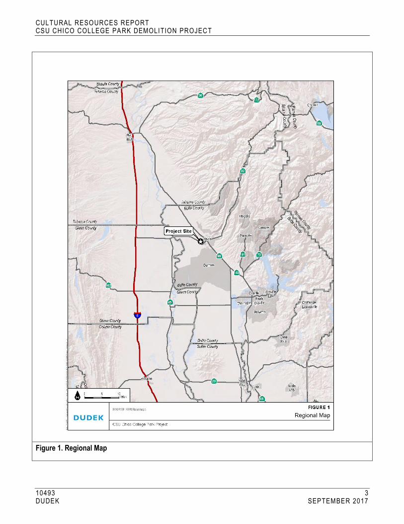
CULTURAL RESOURCES REPORT CSU CHICO COLLEGE PA RK DEMOLITION PROJECT
10493 3 DUDEK SEPTEMBER 2017
Figure 1. Regional Map

CULTURAL RESOURCES REPORT CSU CHICO COLLEGE PA RK DEMOLITION PROJECT
10493 4 DUDEK SEPTEMBER 2017
INTENTIONALLY LEFT BLANK

CULTURAL RESOURCES REPORT CSU CHICO COLLEGE PA RK DEMOLITION PROJECT
10493 5 DUDEK SEPTEMBER 2017
Figure 2. Vicinity Map

CULTURAL RESOURCES REPORT CSU CHICO COLLEGE PA RK DEMOLITION PROJECT
10493 6 DUDEK SEPTEMBER 2017
INTENTIONALLY LEFT BLANK

CULTURAL RESOURCES REPORT CSU CHICO COLLEGE PA RK DEMOLITION PROJECT
10493 7 DUDEK SEPTEMBER 2017
Figure 3. Site Map

CULTURAL RESOURCES REPORT CSU CHICO COLLEGE PA RK DEMOLITION PROJECT
10493 8 DUDEK SEPTEMBER 2017
INTENTIONALLY LEFT BLANK

CULTURAL RESOURCES REPORT CSU CHICO COLLEGE PA RK DEMOLITION PROJECT
10493 9 DUDEK SEPTEMBER 2017
National Register of Historic Places
Although there is no federal nexus for this project, the subject properties were evaluated in consideration of
the NRHP designation criteria and integrity requirements to comply with PRC Sections 5024 and 5024.5.
The NRHP is the United States’ official list of districts, sites, buildings, structures, and objects worthy of
preservation. Overseen by the National Park Service (NPS) under the U.S. Department of the Interior, the
NRHP was authorized under the National Historic Preservation Act, as amended. Its listings encompass all
National Historic Landmarks, as well as historic areas administered by NPS.
NRHP guidelines for evaluation of historic significance were developed to be flexible and to recognize the
accomplishments of all who have made significant contributions to the nation’s history and heritage. Its
criteria are designed to guide state and local governments, federal agencies, and others in evaluating potential
entries in the NRHP. For a property to be listed in or determined eligible for listing, it must be
demonstrated to possess integrity and to meet at least one of the following criteria listed below:
The quality of significance in American history, architecture, archaeology, engineering, and culture is present
in districts, sites, buildings, structures, and objects that possess integrity of location, design, setting,
materials, workmanship, feeling, and association, and:
A. That are associated with events that have made a significant contribution to the broad patterns of
our history; or
B. That are associated with the lives of persons significant in our past; or
C. That embody the distinctive characteristics of a type, period, or method of construction, or that
represent the work of a master, or that possess high artistic values, or that represent a significant and
distinguishable entity whose components may lack individual distinction; or
D. That have yielded, or may be likely to yield, information important in prehistory or history.
Integrity is defined in NRHP guidance, How to Apply the National Register Criteria for Evaluation, as “the ability
of a property to convey its significance. To be listed in the NRHP, a property must not only be shown to be
significant under the NRHP criteria, but it also must have integrity” (NPS 1990). NRHP guidance further
states that properties must have been completed at least 50 years ago to be considered for eligibility.
Properties completed fewer than 50 years before evaluation must be proven to be “exceptionally important”
(criteria consideration G) to be considered for listing.
A historic property is defined as “any prehistoric or historic district, site, building, structure, or object
included in, or eligible for inclusion in, the NRHP maintained by the Secretary of the Interior. This term
includes artifacts, records, and remains that are related to and located within such properties. The term
includes properties of traditional religious and cultural importance to an Indian tribe or Native Hawaiian
organization and that meet the NRHP criteria” (36 Code of Federal Regulations (CFR) Section 800.16(i)(1)).

CULTURAL RESOURCES REPORT CSU CHICO COLLEGE PA RK DEMOLITION PROJECT
10493 10 DUDEK SEPTEMBER 2017
Effects on historic properties under Section 106 of the National Historic Preservation Act are defined in the
assessment of adverse effects in 36 CFR Sections 800.5(a)(1) as follows:
An adverse effect is found when an undertaking may alter, directly or indirectly, any of the characteristics of
a historic property that qualify the property for inclusion in the National Register in a manner that would
diminish the integrity of the property’s location, design, setting, materials, workmanship, feeling, or
association. Consideration shall be given to all qualifying characteristics of a historic property, including
those that may have been identified subsequent to the original evaluation of the property’s eligibility for the
National Register. Adverse effects may include reasonably foreseeable effects caused by the undertaking that
may occur later in time, be farther removed in distance, or be cumulative.
Adverse effects on historic properties are defined as follows (36 CFR 800.5 (2)):
(i) Physical destruction of or damage to all or part of the property;
(ii) Alteration of a property, including restoration, rehabilitation, repair, maintenance, stabilization,
hazardous material remediation and provision of handicapped access, that is not consistent with
the Secretary’s Standards for the Treatment of Historic Properties (36 CFR Part 68) and
applicable guidelines;
(iii) Removal of the property from its historic location;
(iv) Change of the character of the property’s use or of physical features within the property’s setting
that contributes to its historic significance;
(v) Introduction of visual, atmospheric or audible elements that diminish the integrity of the
property’s significant historic features;
(vi) Neglect of a property which causes its deterioration, except where such neglect and deterioration
are recognized qualities of a property of religious and cultural significance to an Indian tribe or
Native Hawaiian organization; and
(vii) Transfer, lease, or sale of property out of Federal ownership or control without adequate and
legally enforceable restrictions or conditions to ensure long-term preservation of the property’s
historic significance.
To comply with Section 106 of the National Historic Preservation Act, the criteria of adverse effects are
applied to historic properties, if any exist in the project area of potential effects, pursuant to 36 CFR
Sections 800.5(a)(1). If no historic properties are identified in the area of potential effects, a finding of “no
historic properties affected” would be made for the proposed project. If there are historic properties in the
area of potential effects, application of the criteria of adverse effect (as described above) would result in
project-related findings of either “no adverse effect” or of “adverse effect.” A finding of no adverse effect
may be appropriate when the undertaking’s effects do not meet the thresholds in criteria of adverse effect
(36 CFR Sections 800.5(a)(1)), in certain cases when the undertaking is modified to avoid or lessen effects,

CULTURAL RESOURCES REPORT CSU CHICO COLLEGE PA RK DEMOLITION PROJECT
10493 11 DUDEK SEPTEMBER 2017
or if conditions are imposed to ensure review of rehabilitation plans for conformance with the Secretary of
the Interior’s Standards for the Treatment of Historic Properties (codified in 36 CFR Part 68).
If adverse effects were expected to result from a project, mitigation would be required, as feasible, and
resolution of those adverse effects by consultation may occur to avoid, minimize, or mitigate adverse effects
on historic properties pursuant to 36 CFR Part 800.6(a).
California Historical Landmarks
CHLs are buildings, structures, sites, or places that have been determined to have statewide historical
significance by meeting at least one of the criteria listed below (OHP 2017):
The first, last, only, or most significant of its type in the state or within a large geographic region
(Northern, Central, or Southern California).
Associated with an individual or group having a profound influence on the history of California.
A prototype of, or an outstanding example of, a period, style, architectural movement or
construction or is one of the more notable works or the best surviving work in a region of a pioneer
architect, designer or master builder.
The resource also must have written consent of the property owner, be recommended by the State
Historical Resources Commission, and be officially designated by the Director of California State Parks.
CHLs #770 and above are automatically listed in the CRHR (OHP 2017).
California Register of Historical Resources
In California, the term “historical resource” includes “any object, building, structure, site, area, place, record,
or manuscript which is historically or archaeologically significant, or is significant in the architectural,
engineering, scientific, economic, agricultural, educational, social, political, military, or cultural annals of
California” (PRC Section 5020.1(j)). In 1992, the California legislature established the CRHR “to be used by
state and local agencies, private groups, and citizens to identify the state’s historical resources and to indicate
what properties are to be protected, to the extent prudent and feasible, from substantial adverse change”
(PRC Section 5024.1(a)). The criteria for listing resources on the CRHR were expressly developed to be in
accordance with previously established criteria developed for listing in the NRHP, enumerated below.
According to PRC Section 5024.1(c)(1–4), a resource is considered historically significant if it (i) retains
“substantial integrity,” and (ii) meets at least one of the following criteria:
(1) Is associated with events that have made a significant contribution to the broad patterns of
California's history and cultural heritage.
(2) Is associated with the lives of persons important in our past.

CULTURAL RESOURCES REPORT CSU CHICO COLLEGE PA RK DEMOLITION PROJECT
10493 12 DUDEK SEPTEMBER 2017
(3) Embodies the distinctive characteristics of a type, period, region, or method of construction, or
represents the work of an important creative individual, or possesses high artistic values.
(4) Has yielded, or may be likely to yield, information important in prehistory or history.
To understand the historic importance of a resource, sufficient time must have passed to obtain a scholarly
perspective on the events or individuals associated with the resource. A resource fewer than 50 years old
may be considered for listing in the CRHR if it can be demonstrated that sufficient time has passed to
understand its historical importance (see California Code of Regulations, Title 14, Section 4852(d)(2)).
The CRHR protects cultural resources by requiring evaluations of the significance of prehistoric and historic
resources. The criteria for the CRHR are nearly identical to those for the NRHP, and properties listed or
formally designated as eligible for listing in the NRHP are automatically listed in the CRHR, as are state
landmarks and points of interest. The CRHR also includes properties designated under local ordinances or
identified through local historical resource surveys.
California Environmental Quality Act
As described further below, the following CEQA statutes and guidelines are of relevance to the analysis of
archaeological, historic, and tribal cultural resources:
PRC Section 21083.2(g) defines “unique archaeological resource.”
PRC Section 21084.1 and CEQA Guidelines Section 15064.5(a) defines “historical resources.” In
addition, CEQA Guidelines Section 15064.5(b) defines the phrase “substantial adverse change in the
significance of an historical resource”; it also defines the circumstances when a project would
materially impair the significance of an historical resource.
PRC Section 21074(a) defines “tribal cultural resources.”
PRC Section 5097.98 and CEQA Guidelines Section 15064.5(e) set forth standards and steps to be
employed following the accidental discovery of human remains in any location other than a
dedicated ceremony.
PRC Sections 21083.2(b)-(c) and CEQA Guidelines Section 15126.4 provide information regarding
the mitigation framework for archaeological and historic resources, including examples of
preservation-in-place mitigation measures; preservation-in-place is the preferred manner of
mitigating impacts to significant archaeological sites because it maintains the relationship between
artifacts and the archaeological context, and may also help avoid conflict with religious or cultural
values of groups associated with the archaeological site(s).
Under CEQA, a project may have a significant effect on the environment if it may cause “a substantial
adverse change in the significance of an historical resource” (PRC Section 21084.1; CEQA Guidelines
Section 15064.5(b)). If a site is either listed or eligible for listing in the CRHR, or if it is included in a local
register of historic resources, or identified as significant in a historical resources survey (meeting the

CULTURAL RESOURCES REPORT CSU CHICO COLLEGE PA RK DEMOLITION PROJECT
10493 13 DUDEK SEPTEMBER 2017
requirements of PRC Section 5024.1(q)), it is a “historical resource” and is presumed to be historically or
culturally significant for the purposes of CEQA (PRC Section 21084.1; CEQA Guidelines Section
15064.5(a)). The lead agency is not precluded from determining that a resource is a historical resource even
if it does not fall within this presumption (PRC Section 21084.1; CEQA Guidelines Section 15064.5(a)).
A “substantial adverse change in the significance of an historical resource” reflecting a significant effect
under CEQA means “physical demolition, destruction, relocation, or alteration of the resource or its
immediate surroundings such that the significance of an historical resource would be materially impaired”
(CEQA Guidelines Section 15064.5(b)(1); PRC Section 5020.1(q)). In turn, the significance of a historical
resource is materially impaired when a project (CEQA Guidelines section 15064.5(b)(2)):
(1) Demolishes or materially alters in an adverse manner those physical characteristics of an historical
resource that convey its historical significance and that justify its inclusion in, or eligibility for,
inclusion in the California Register; or
(2) Demolishes or materially alters in an adverse manner those physical characteristics that account for
its inclusion in a local register of historical resources pursuant to Section 5020.1(k) of the PRC or its
identification in an historical resources survey meeting the requirements of Section 5024.1(g) of the
PRC, unless the public agency reviewing the effects of the project establishes by a preponderance of
evidence that the resource is not historically or culturally significant; or
(3) Demolishes or materially alters in an adverse manner those physical characteristics of a historical
resource that convey its historical significance and that justify its eligibility for inclusion in the
California Register as determined by a lead agency for purposes of CEQA.
Pursuant to these sections, the CEQA inquiry begins with evaluating whether a project site contains any
historical resources, then evaluates whether that project would cause a substantial adverse change in the
significance of a historical resource such that the resource’s historical significance is materially impaired.
If it can be demonstrated that a project would cause damage to a unique archaeological resource, the lead
agency may require reasonable efforts be made to permit any or all of these resources to be preserved in
place or left in an undisturbed state. To the extent that they cannot be left undisturbed, mitigation measures
are required (Section 21083.2(a), (b), and (c)).
Section 21083.2(g) defines a unique archaeological resource as an archaeological artifact, object, or site about
which it can be clearly demonstrated that without merely adding to the current body of knowledge, there is a
high probability that it meets any of the following criteria:
(1) Contains information needed to answer important scientific research questions and that there is a
demonstrable public interest in that information.
(2) Has a special and particular quality such as being the oldest of its type or the best available example
of its type.

CULTURAL RESOURCES REPORT CSU CHICO COLLEGE PA RK DEMOLITION PROJECT
10493 14 DUDEK SEPTEMBER 2017
(3) Is directly associated with a scientifically recognized important prehistoric or historic event or person.
Impacts to non-unique archaeological resources are generally not considered a significant environmental
impact (PRC Section 21083.2(a); CEQA Guidelines Section 15064.5(c)(4)). However, if a non-unique
archaeological resource qualifies as tribal cultural resource (PRC Sections 21074(c) and 21083.2(h)), further
consideration of significant impacts is required.
CEQA Guidelines Section 15064.5 assigns special importance to human remains and specifies procedures to
be used when Native American remains are discovered. As described below, these procedures are detailed in
PRC Section 5097.98.
California Health and Safety Code
California law protects Native American burials, skeletal remains, and associated grave goods, regardless of
their antiquity, and provides for the sensitive treatment and disposition of those remains. Health and Safety
Code Section 7050.5 requires that if human remains are discovered in any place other than a dedicated
cemetery, no further disturbance or excavation of the site or nearby area reasonably suspected to contain
human remains can occur until the County Coroner has examined the remains (Health and Safety Code
Section 7050.5b). PRC Section 5097.98 outlines the process to be followed in the event that remains are
discovered. If the coroner determines or has reason to believe the remains are those of a Native American,
the coroner must contact the NAHC within 24 hours (Health and Safety Code Section 7050.5c). The
NAHC would notify the most likely descendant (MLD). With the permission of the landowner, the MLD
may inspect the site of discovery. The inspection must be completed within 48 hours of notification of the
MLD by the NAHC. The MLD may recommend means of treating or disposing of, with appropriate
dignity, the human remains and items associated with Native Americans.
Local
City of Chico Historic Preservation Ordinance
As part of the City of Chico Municipal Code, its Historic Preservation Ordinance (Chapter 19.37, Historic
Preservation) gives the following criteria (Subsection 19.37.040, Historic Resource Designation Criteria):
A. Landmark and Landmark Overlay Zoning District Significance Criteria. Upon the recommendation
of the board and approval of the City Council, an historic resource may be designated a landmark, or
a definable geographic area may be designated a landmark overlay zoning district, if the resource or
area meets any of the following criteria and retains a high level of historic integrity.
1. The resource or area is associated with events that have made a significant contribution to the
broad patterns in the history of Chico, the State of California, or the nation;
2. The resource or area is associated with individuals who were significant in the history of Chico,
the State of California, or the nation;

CULTURAL RESOURCES REPORT CSU CHICO COLLEGE PA RK DEMOLITION PROJECT
10493 15 DUDEK SEPTEMBER 2017
3. The resource or area embodies the distinctive characteristics of a type, period, architectural style or
method of construction, represents the work of a master designer, or possesses high artistic values.
B. Additional Factors to be Considered in Landmark Designation. In determining whether to designate
a resource a landmark, the following additional factors may be considered, if applicable:
1. A resource moved from its original location may be designated a landmark if it is significant
primarily for its architectural value, or if it is one of the most important surviving structures
associated with an important person or historic event.
2. A birthplace or grave may be designated a landmark if it is that of an historical figure of
outstanding importance in the history of Chico, the state, or the nation.
3. A cemetery may be designated a landmark if it represents a group of persons or an era that collectively
is significant in the broad patterns in the history of Chico, the State of California, or the nation.
4. A reconstructed building may be designated a landmark if the reconstruction is historically
accurate based on sound historical documentation, is executed in a suitable environment, and if
no other original structure that has the same historical association exists.
5. A resource achieving significance within the past fifty years may be designated a landmark if the
resource is of exceptional importance within the history of Chico, the state or the nation.
C. Additional Factors to be Considered in Designating a Landmark Overlay Zoning District. In
deciding whether to apply the landmark overlay zoning district to a geographic area, the following
additional factors may be considered, if applicable:
1. To be designated a landmark overlay zoning district, the contributing properties must retain
historic integrity and the collective value of the district contributors may be greater than the
individual resources within the landmark district.
2. A landmark overlay zoning district should exhibit a recognizable style or era of design, an
association of design integrity, setting, materials, and workmanship.
1.4 Project Personnel
All cultural resources technical work in support of this report was completed by Dudek staff. Oversight and
preparation of this technical report was conducted by Dudek’s Architectural History Principal Investigator
Samantha Murray, MA. Fieldwork, archival research, and preparation of Department of Parks and
Recreation (DPR) forms were conducted by Architectural Historian Sarah Corder, MFA. Sarah Brewer, BA,
contributed to archaeological components of this report, including review and summary of CHRIS records
search results. Adam Giacinto, MA, RPA, acted as archaeological principal investigator and prepared
archaeological recommendations. All project staff meet or exceed the Secretary of the Interior’s Professional
Qualification Standards (36 CFR Part 61) in architectural history and archaeology. Preparer’s qualifications
are located in Appendix A.

CULTURAL RESOURCES REPORT CSU CHICO COLLEGE PA RK DEMOLITION PROJECT
10493 16 DUDEK SEPTEMBER 2017
INTENTIONALLY LEFT BLANK

CULTURAL RESOURCES REPORT CSU CHICO COLLEGE PA RK DEMOLITION PROJECT
10493 17 DUDEK SEPTEMBER 2017
2 HISTORIC CONTEXT
2.1 Historical Overview of the City of Chico
In 1843, Edward A. Farwell and William Dickey visited the present-day Chico area on a hunting expedition.
Farwell and Dickey came from Sacramento (at the time known as Sutter’s Fort) and were interested in
obtaining land grants. Dickey chose the land on the north side of the Sacramento River creek and Farwell
chose the land to the south. Dickey named his land Arroyo Chico (small creek) (Wells 1882).
Around the same time, General John Bidwell visited the area for the first time and purchased land from
Dickey and Farwell (Wells 1882). General Bidwell pioneered one of the first emigrant parties of Americans
to the state of California (Hoover et al. 1966). John Bidwell was born in New York in 1819 and had spent
most of his childhood working on his father’s farm. At the age of 19, Bidwell moved west and settled in
Ohio where he spent 2 years as a schoolmaster. After Ohio, he continued west to Missouri in search of
adventure and land, and settled on a plot on the west side of the Missouri River. While on a trip to St. Louis,
a claim jumper built a cabin on his land in Missouri, forcing Bidwell out. Unable to claim his land back,
Bidwell set out to California and met with John Sutter in Sacramento (Moon 2003). Bidwell was employed
by Sutter until he acquired the lands previously owned by Dickey and Farwell (original grantees of Rancho
Arroyo Chico) in the Sacramento Valley (Hoover et al. 1966).
Although the land grants of General Bidwell were situated on Rancho Chico by 1845, the town was not laid
out until 1860. General Bidwell built the first house in the Chico area in 1849, which was destroyed by fire
in 1852 and later replaced by an adobe building (no longer extant). The first United States mail service
arrived in Chico in 1851, and the town’s first postmaster A.H. Barber (Wells 1882).
In 1852, Hall and Crandall began running stages from Marysville to Shasta. The stages would pass through
Hamilton and Neal’s ranch and Chico. Bidwell opened a hotel on his land during this period, since it had become
a station on the stage route for travelers needing refreshments and rest. Bidwell ran the hotel for a number of
years. Later, he returned to farming and stock raising, planting fruit trees, wheat, and other grains.
Until 1860, all of the improvements south of Chico Creek were confined to Bidwell’s premises. In 1860, the
town-plat of Chico was laid out by county surveyor J.S. Henning, who had been commissioned by Bidwell and
his wife Annie. Shortly after, several individuals, including Richard Breese and E.B. Pond, moved to town and
began development. Breese built a house and several others soon followed. Pond constructed the town’s first
brick-and-mortar store, on the corner of First and Main Streets, which he ran beginning in 1861 (Wells 1882).
Bidwell donated land to schools and congregations. In 1862, Woodman’s Academy, Chico’s most
prominent and long-lasting 19th century private school, opened on Block 81 (CHA 1983). Jane H. Voorhees
was the first teacher (Wells 1882). The Salem Street School, Chico’s first public schoolhouse, was built in

CULTURAL RESOURCES REPORT CSU CHICO COLLEGE PA RK DEMOLITION PROJECT
10493 18 DUDEK SEPTEMBER 2017
1866 and served the area for nearly 10 decades. The Oakdale School building was built on the south bank of
Little Chico Creek (not on Bidwell’s land) in 1874 and operated until the late 1940s (CHA 1983).
The town of Chico was showing great promise in the farming and grain industries. Wheat became the staple
product, and the acreage rapidly increased over the years. Chico became the principal market for the grain and
furnished supplies to the rest of the country, establishing a trade that boosted the local economy. Many
individuals left the foothills and the mountains and moved to Chico in hopes of prosperity. In 1864, Chico had a
population of 500 and a variety of businesses, including a brewery, a law office, and a tin and stove store.
It was not until construction of the Oregon and California Railroad in 1870 that the town of Chico and the
eastern part of Butte County further developed. Prior to the railroad, the Sacramento River (located 6 miles
away) and horse-pulled wagons were the only outlets for trade and business operations with other cities
(Wells 1882). With completion of the railroad, Butte County became a leader in pine production and soon
boasted five lumber yards; two mills; a foundry; two blacksmith shops; five harness makers; three livery
stables; two wagon makers; one brewery; one sash, door, and blind factory; and 13 saloons (Reid 2008).
In 1872, the City of Chico (City) was incorporated. A lot on Main Street that would house the City Hall
building, at the time referred to as the station house, was donated by General Bidwell. Later that year, a two-
story station house was erected. The main floor contained six large rooms to be occupied by various City
officers, and three cells to hold public offenders. The second floor contained a large room for public
meetings (Wells 1882). In 1874, in hopes of growing his town and securing the county seat for Chico,
General Bidwell donated a park to the City. Although Chico failed in its efforts to win the county seat, the
tree-lined park, which was intended as the site of a county courthouse, became the center of present-day
downtown (CHA 1983).
During the 1870s, lumber had become the main industry of the area. Starting in 1871, two sawmills were
established on Big Chico Creek by the Chico Flume and Lumber Company. Prior to the Chico Flume and
Lumber Company becoming the Sierra Flume and Lumber Company in 1875, a flume for rough-cut lumber
was built from Butte Meadows to Chico. The success of Sierra Flume and Lumber Company was short-
lived, and by the turn of the 20th century, financial issues pushed the owners to sell the land they acquired in
the 1870s (Schwimmer 2011).
The timing of the financial downfall of the Sierra Flume and Lumber Company coincided with the rise of
the Diamond Match Company in the United States. In 1901, the Chico Investment Company facilitated the
transition of the Sierra Flume and Lumber land to the Diamond Match Company. The facilitation and
establishment of the Chico Investment Company was the work of several key executives of the Diamond
Match Company, most notably John Heard Comstock and Fred M. Clough. Once under the ownership of
the Diamond Match Company, Clough was appointed the first Pacific Coast manager for the Diamond
Match Company. The Chico location opened in 1903, and in 1904 and 1905, buildings were constructed to
support operations at this facility. The site had multiple buildings, yards, and a machine shop. Figure 4
shows the Diamond Match Company in 1927 when it employed hundreds of residents of Chico. The

CULTURAL RESOURCES REPORT CSU CHICO COLLEGE PA RK DEMOLITION PROJECT
10493 19 DUDEK SEPTEMBER 2017
Diamond Match Company would be an industrial fixture for Chico until the sale of the plant in 1984 and its
closure in 1989 (Booth et al. 2005; DC 2017; Schwimmer 2011).
Figure 4. Diamond Match Factory Chico in 1927 (DC 2017)
The rise of the lumber industry in Chico and the surrounding area also had a significant impact on the
architectural development of the area. Until the mid-1880s, the booming lumber industry made millwork
available for local construction endeavors, thus making it an important and accessible building material for
the growth and development of the City of Chico. However, a series of fires in 1870s caused a great deal of
destruction to the wooden buildings throughout the City. Due to the significant destruction caused by the
fires, the City took two important steps toward fire safety: switch from wooden structures to brick
structures, and establish the first volunteer fire company in Chico (CHA 1983; DC 2017).
Industrialization and the railroads influenced development in Chico, but agriculture still played a significant
role in the economic system for the City throughout the 19th and 20th centuries. According to the History
Timeline prepared by the Chico Heritage Association and Butte County Historical Society, in the 1870s,
farmers in Chico were producing a variety of crops, including wheat, barley, almonds, figs, and a variety of
fruits. Advancements in transportation made it easier for the farmers to export their crops. In the 1880s,
barley became an important crop to the local economy when it is used for the Chico Brewery. By 1904, the
City was chosen to be a U.S. Agricultural Experiment Station, which greatly increased the variety of plants
and products produced not only in Chico, but also throughout California. The success and diversification of
crops in cities like Chico would prove to be key to efforts in World War I, as Chico became a huge
contributor of food for the war effort. An example of this is seen with the explosion of the rice industry

CULTURAL RESOURCES REPORT CSU CHICO COLLEGE PA RK DEMOLITION PROJECT
10493 20 DUDEK SEPTEMBER 2017
from its introduction in Chico in 1910 to the end of World War I in 1918, when Butte County grew 30,000
acres of rice (DC 2017; Moon 2003).
In addition to agricultural production, agricultural support services such as canning, drying, and packing
became a significant contributor to the growth and development of the area in the 20th century. Success
was seen throughout the early years of the 20th century, but the industry was taken to a new level with the
establishment of CalPak/Del Monte Plant #64 in Chico in 1919. CalPak/Del Monte was the canning and
fruit processing giant in California throughout most of the 20th century. The Chico plant was one of many
plants throughout California, and its major function was the packaging of prunes and apricots starting in
1919. The establishment of CalPak/Del Monte starting in 1916 had a significant effect on cities like Chico,
and created jobs for people in the processing sector of agriculture instead of the traditional farming sector
(Holmes 2013; Moon 2003).
By the 1920s, Chico had taken steps to make itself a modern city with the creation of paved streets,
increased suburban development, public parks, and the planning of State Highway 99. In the 1920s, the City
paved streets and removed wooden sidewalks. Chico Historian Debra Moon’s analysis of the Census
information from 1900, 1910, and 1920 captures the essence of the City’s growth in the early 20th century,
and helps show a shift from a predominately agrarian community to a modern urban city (Moon 2003):
A 1920 census for Chico showed a population of 15,517. Chico had grown more than
expected even through some rough times. The county’s population at that time was 42.2
percent urban compared to 1910, when the population was 27.9 percent urban, and 1900
when it was only 15.34 percent urban.
Although the growth of the population contributed to this shift, there were other factors in the late 19th and
early 20th centuries that helped to urbanize Chico. One such factor was the donation of Bidwell Park in
1905 by Annie Bidwell. The generous donation of more than 1,900 acres for use as a public park was a big
step toward urbanization in Chico in the 20th century (Booth et al. 2005; DC 2017; Moon 2003).
Other steps toward urbanization included construction of the Chico Municipal Building in 1916, which
helped to create a city plaza concept with the combination of the municipal building and the post office.
Downtown businesses also took steps toward modernization and urbanization with the removal of wooden
awnings and posts from their storefronts. Healthcare advancements in Chico led to the start of the Enloe
Hospital in 1913, which began a series of healthcare center developments spanning the 20th century,
resulting in the modern medical complexes seen in Chico today. The many steps toward modernization
attracted not only businesses and people to Chico, but also movie productions, including Robin Hood, Gone
with the Wind, Kane, Last of the Cowboys, Folly of a Life of Crime, and Alamo Charlie. However, modernization and
urbanization did not result in the goal for Chico of being the new county seat for Butte County in the 1914
county seat race (Booth et al. 2005; DC 2017; Moon 2003).

CULTURAL RESOURCES REPORT CSU CHICO COLLEGE PA RK DEMOLITION PROJECT
10493 21 DUDEK SEPTEMBER 2017
Like other cities in the United States, advancements in aviation had a profound effect on Chico. In 1935, the
City acquired land located immediately north of town to create a municipal airport. However, these plans were
sidelined by World War II, since the War Department decided to lease the airport land for establishment of an
Army Corps base. The decision by the War Department to lease the airport land was significant to residential
and commercial development patterns of Chico, since it brought new people to the area for employment and
training. At the height of its use, the Army base employed 4,000 people, and thousands of people received
basic training or support training at the facility. The base continued in its operation until 1945, after which
many of the people employed and/or trained at the base chose to make Chico their permanent home. To
support this population boom, houses needed to be constructed quickly and cost effectively, so popular styles
like the Ranch house became a feasible option (Booth et al. 2005; DC 2017; Moon 2003).
Development and increased suburbanization continued in Chico in the late 1940s and 1950s, and by 1961,
an article from the San Francisco Examiner captured the essence of mid-20th century development in Chico
(SFE 1961):
A tour of the city and its outskirts displays the growth of subdivisions, the establishment of
shopping centers and the construction of factories for light industry.
The increased population also facilitated the need for churches, schools, service stations, and infrastructure
improvements such as additional stoplights and parking meters. Historic aerial photographs from the 1940s
show that neighborhoods were being plotted for increased residential developments, especially in the
College Park area (Booth et al. 2005; DC 2017; Moon 2003; NETR 2017).
Another important institution growing throughout the first half of the 20th century was CSU Chico.
Population increases, steps toward modernization, improvements in transportation, and the close of World
War II were all significant to the growth and development of the City and CSU Chico. Development of the
City and CSU Chico ran parallel to each other, and influenced larger patterns of residential, cultural, and
economic development (Booth et al. 2005; Moon 2003).
2.2 Historical Overview of California State University, Chico
In 1887, Bidwell donated an 8-acre cherry orchard to the northern branch of the State Normal School for
Chico. The campus opened in 1889 with five faculty members and 90 students (Wells 1882).
In 1921, the Chico State Normal School became Chico State Teachers College and added a junior college
curriculum, awarding a certificate after 2 years. Later in 1924, the college added bachelor’s degrees to its
program. The original Normal School building was destroyed in a 1927 fire; a new building was completed
on its site in 1929 and was named Kendall Hall. In 1935, the school underwent another change when the
California Legislature converted California teachers colleges to state colleges, resulting in Chico State
Teachers College being renamed as Chico State College. During that period, chimes were installed in the

CULTURAL RESOURCES REPORT CSU CHICO COLLEGE PA RK DEMOLITION PROJECT
10493 22 DUDEK SEPTEMBER 2017
school’s Trinity Tower, the first biology laboratory was established at Eagle Lake, and the school granted its
first bachelor’s of science and master’s degrees.
Like other educational institutions during the war years, Chico State College experienced difficulties, including
the lack of housing on campus from 1940 through 1947. However, following World War II, Chico State
College experienced growth and development that warranted housing options. In 1947, temporary housing
was established for veterans with the creation of 57 one- and two-bedroom apartments for married college
veterans. By 1949, two temporary dormitories were constructed to house an additional 160 single men.
Other post-war growth and development on campus included construction of Ayers Hall for Science, Music
and Speech in 1951; construction of two temporary dormitories for 60 women and 70 men in 1952;
construction of the Physical Education Building, the University Center, and Yuba Hall in 1956; and
construction of the Applied Arts and Sciences building and a temporary cafeteria building in 1957. Although
many of these buildings were temporary constructions, by 1959, buildings that were more permanent were
constructed, including Glenn Hall, Lassen Hall, Shasta Hall, and a library building. By 1960, the college
became one of 15 colleges in the State College System for California.
Building and development continued on campus throughout the 1960s, and in 1972, the college became
known as California State University, Chico. Reflecting this change, the university underwent more program
changes, including switching academic departments previously congregated by schools into colleges.
Currently, the campus contains 240 acres of rangeland, 800 acres of farmland, and 2,330 acres of ecological
reserves (CSUC 2015a, 2015b; Lindsay 1979).
W.H. “Old Hutch” Hutchinson
William Henry (“Old Hutch”) Hutchinson (see Figure 5) was a noted western historian and CSU Chico
professor, born on August 13, 1911, in Denver, Colorado. “He worked at various times as a horse wrangler,
a cowboy, a boiler fireman, and a mucker in mines” (California State Library 1998).
From 1933 to 1946, Hutchinson served in the Merchant Marines and worked as chief purser on passenger
vessels, including the Matson–Oceanic liner Monterey (California State Library 1998; Oakland Tribune
1936). During World War II, he served as a Lieutenant Commander in the United States Maritime Service
where he saw duty in the South Pacific, North Atlantic, and Mediterranean (California State Library 1998).
Hutchinson met his wife Esther Ethel Ormsby (1908–1990), nicknamed “Red,” while being evacuated from
China on a troop ship during World War II. She had been working as a Deputy Marshall for the U.S.
Treasury Department. The couple married in Fairfield Connecticut in 1942 and moved to San Francisco in
1946. The couple had two sons together: Warren and James Hutchinson (NMSU Library 2017).
Census records provide a timeline for other places Hutchinson lived throughout his life: Denver, Colorado
(beginning with his birth in 1911); a short stint in Eastland, Texas, in the 1920s; a return to Denver in the

CULTURAL RESOURCES REPORT CSU CHICO COLLEGE PA RK DEMOLITION PROJECT
10493 23 DUDEK SEPTEMBER 2017
1930s; working as a chief purser on passenger vessels during the Great Depression; serving as a Lieutenant
Commander in the U.S. Maritime Service during World War II (California State Library 1998); and a
residence in San Francisco, California in the 1940s (although he was at sea for several years). After living at
630 Stadium Way in Chico from 1960 to 1976, he moved to another residence in Chico in 1980, located at
1611 Spruce Avenue, north of CSU Chico.
After World War II, the Hutchinsons moved to Butte County and Old Hutch became a freelance writer. By
1956, he had published more than 120 fact and fiction pieces about the American West for a variety of well-
known publications (Feather River Bulletin 1956). He also wrote, narrated, and produced several historical
pageants on California, and maintained regular appearances on radio and television shows (California State
Library 1998). The nickname “Old Hutch” is the name of a character he played on a weekly radio program
put on by a Chico station. Each week, Old Hutch would tell his audience historic tales of the old west
(Portola Reporter 1955). Hutchinson also worked as a columnist for the San Francisco Chronicle and
frequently contributed to the Chico Enterprise-Record (California State Library 1998).
Hutchinson eventually became a widely published author and historian, best known for his 1966 two-
volume biography of Senator Thomas R. Bard: Oil, Land, and Politics: The California Career of Thomas R. Bard.
The book was nominated for a Pulitzer Prize and won the Commonwealth Club’s Silver Medal. Other
books authored by Hutchinson include his 1946 edits to a collection of previously unpublished works by
Eugene Manlove Rhodes, The Little Waddies. Hutchinson edited other writings of Rhodes’, including The
Rhodes Reader (1957) and The Line of Least Resistance (1958). Hutchinson received much praise for breathing
new life into Rhodes’ work and demonstrating that stories of the old west are an important American
contribution to literature (Independent Star-News 1957). Hutchinson completed his first biography on
Rhodes in 1956, titled A Bar Cross Man, followed by an annotated bibliography, A Bar Cross Liar. He also
authored works on the history of New Mexico, including Another Verdict for Oliver Lee and Whiskey Jim and a
Kid Named Billie (NMSU Library 2017).
Hutchinson also played a role in the history of a local agricultural fair in Butte County. Put on by the Third
District Agricultural Association, it became known as the Silver Dollar Fair because of the actions of
Hutchinson. In 1950, Hutchinson was working as publicist for the Butte District Fair. The fair had run into
financials problems after local merchants were no longer interested in supporting it. Old Hutch developed a
visual marketing strategy to clarify the importance of the fair to local businesses. He ordered 50,000 silver
dollars from the U.S. Mint and declared that much of the fair’s business transactions would be made with
these coins. The shiny, heavy coins filled cash registers to the brim and sent a clear message to merchants
about the value of the fair. The coins also inspired the fair’s present name. Event though the fair eventually
reverted to more conventional currency, the name endured (Silver Dollar Fair 2017).
Hutchinson taught part-time at Chico State College, Sonoma State College, and San Francisco State between
1953 and 1964. He earned his master’s degree from Chico State College in 1961, and served as a full-time
faculty member at Chico State from fall 1964 until his retirement in 1978.

CULTURAL RESOURCES REPORT CSU CHICO COLLEGE PA RK DEMOLITION PROJECT
10493 24 DUDEK SEPTEMBER 2017
Newspapers, reviewers, friends, and faculty have expressed much respect for Hutchinson’s contribution to
the history of the west, and he is considered “an acknowledged authority on western history” (Redlands
Daily Facts 1965). Other accolades include being voted “Best Californian” in 1965 by the Common Wealth
Club. Hutchinson received the Chico State Distinguished Teacher Award in 1968, and was labeled an
Outstanding Professor in the CSU System in 1977. As previously mentioned, he was also nominated for a
Pulitzer Prize in 1966 (Watkins et al. 1990).
It appears that Old Hutch left behind an enduring legacy on the CSU Chico campus. In 2011, President
Paul J. Zingg partially credited Hutchinson with influencing the way in which the university approaches
campus infrastructure projects, specifically referencing his book A Precious Sense of Place (1991), which
appears to have been published by the Friends of the Meriam Library shortly after Hutchinson’s death.
Zingg also notied how Hutchinson’s “sense of place” influenced the 2004 Master Plan (Zingg 2011):
The first of these is William H. “Old Hutch” Hutchinson’s lovely history of the early
decades of our campus in his aptly titled book, A Precious Sense of Place. Drawing upon his
own fascination with “the many local geographies that have been and remain an essential
part” of his life, Old Hutch’s account reveals that the University has been deeply informed
from the beginning by a respect for the natural environment and a proud, but not arrogant,
sense of exceptionalism regarding its mission as the second oldest campus in the California
State University system. Our “sense of place” encompasses both our role in the North State
and California higher education and also our location in a college town, bordered by historic
neighborhoods and a vibrant downtown, and committed to a traditional, residential
identity.… It is remarkable how Old Hutch’s affirmation of a sense of place and our master
plan’s dedication to it grace the design of our campus.
The courtyard between Trinity Hall and Kendall Hall was dedicated on June 11, 1979, in his honor.
Hutchinson enjoyed the campus atmosphere, and could often be found sitting on a bench in the courtyard
that now bears his name (CSUC 2016).
Hutchinson died of a heart attack in Chico on March 11, 1990. Red would follow closely behind him,
passing away less than 1 month after his death.
CULTURAL RESOURCES REPORT CSU CHICO COLLEGE PA RK DEMOLITION PROJECT
10493 25 DUDEK SEPTEMBER 2017
Figure 5. W.H. “Old Hutch” Hutchinson (CSUC 2016)
2.3 Resident ial Architecture in the Project Area
Ranch Style (c. 1935–1975)
The Ranch house is a style of architecture that was popular starting in the 1930s and fell out of popularity by
the 1980s. In the 1930s and early 1940s, the Ranch house was part of the Small House movement that was
brought into fashion by the Federal Housing Administration. Like the Minimal Traditional house, the Ranch
house could be constructed quickly and use modern materials that could be mass-produced. The style
provided an easy option for large-scale housing tracts during the 1930s and 1940s to meet the needs of
relocated war-effort workers and those of soldiers returning home and starting families. Following the war
years, a new era of prosperity brought about a departure from the Small House movement, and the Ranch
house became a popular house type throughout the late 1940s through the 1970s (Gottfried and Jennings
2009; Hess 2004; McAlester 2015).
The Ranch house of the 1930s and 1940s maintained similar characteristics to newer versions, but small lot
sizes in housing tracts made the concept of the rambling Ranch house almost impossible. In the 1950s,
post-war prosperity combined with increased lot sizes made the larger and more recognizable Ranch house
possible. The ability of the Ranch house to exist in different sizes and arrangements made it one of the most
popular house choices throughout the United States across multiple social classes (Gottfried and Jennings
2009; Hess 2004; McAlester 2015).

CULTURAL RESOURCES REPORT CSU CHICO COLLEGE PA RK DEMOLITION PROJECT
10493 26 DUDEK SEPTEMBER 2017
Key characteristics of the Ranch style of architecture are the following (Gottfried and Jennings 2009; Hess
2004; McAlester 2015):
One story in height
Gabled or hipped roofs constructed with a low pitch and moderate overhang
Offset entry points causing asymmetry in the façade
Focus on horizontal and rambling forms
Focus on informality
Entry points are typically placed under the roof overhang on the façade
Use of large picture-style windows on the façade
Variations on the eave overhang, typically boxed eaves or exposed rafter tails, or the less-common
boxed rafters
Large chimneys
Variety of exterior cladding, including brick and stone
Attached garage, typically incorporated into the façade
Front and rear yards
Large rectangular blocks as the basis for plan design, as simply rectangular or a combination of
rectangular blocks to create L, U, and T shapes

CULTURAL RESOURCES REPORT CSU CHICO COLLEGE PA RK DEMOLITION PROJECT
10493 27 DUDEK SEPTEMBER 2017
3 BACKGROUND RESEARCH
3.1 CHRIS Records Search
Dudek requested a CHRIS records search from the Northeast Information Center (NEIC), which houses
cultural resources records for Butte County. Dudek received the results on July 26, 2017. The search
included any previously recorded cultural resources and investigations within a 0.5-mile radius of the project
site. The CHRIS search also included a review of the NRHP; CRHR; California Points of Historical Interest
list; California Inventory of Historic Resources; CHL list; the Directory of Properties in the Historic
Property Data Files for Butte County; the Handbook of North American Indians, Vol. 8, California; and
Historic Spots in California. A letter from the NEIC summarizing the results of the records search and a
bibliography of prior cultural resources studies is provided in Confidential Appendix B of this report.
Previous Technical Studies
Thirty-eight previously conducted studies were identified within the 0.5-mile records search radius. Of these
studies, three overlap the current project area: 000839, 006685, and 009465 (see Table 1). A brief summary
of the three studies is provided in the paragraphs that follow.
Table 1. Previously Conducted Cultural Resources Studies Within 0.5 Miles of Project Area NEIC
Report No. Title of Study Date Author(s)
In Project Area?
000601 Archaeological/Historical Report on the Proposed Student Housing Project Area Located on the Campus of California State University at Chico
1981 Desautels, Roger No
000827 Technical Report: Cultural Resources Survey for the US Sprint Fiber Optic Cable Project – Oroville, California to Eugene, Oregon
1987 Minor, Rick, Jackson Underwood, Rebecca Apple, Stephen Dow Beckham, and Clyde Woods
No
000827 US Sprint Fiber Optic Cable Project – Oroville, California to Eugene, Oregon: Addendum #1 to the Technical Report
1987 Shackley, M. Steven, Rick Minor, Rebecca Apple, Stephen Dow Beckham, Trudy Vaughan, Clyde M. Woods, and Jan E. Wooley
No
000827 US Sprint Fiber Optic Cable Project – Oroville, California to Eugene, Oregon: Addendum #4 to the Technical Report, Cultural Resources Survey of the Proposed Regeneration Stations and Point of Presence Sites from Oroville to Eugene
1987 Vaughan, Trudy No
000827 Testing Report: US Sprint Fiber Optic Cable Project – Oroville, California to Eugene, Oregon/Archaeological Testing of Four Sites in California: CA-BUT-5, THE-1468, SHA-1684, SIS-332, Addendum #2 to the Technical Report
1987 Shackley, M. Steven No
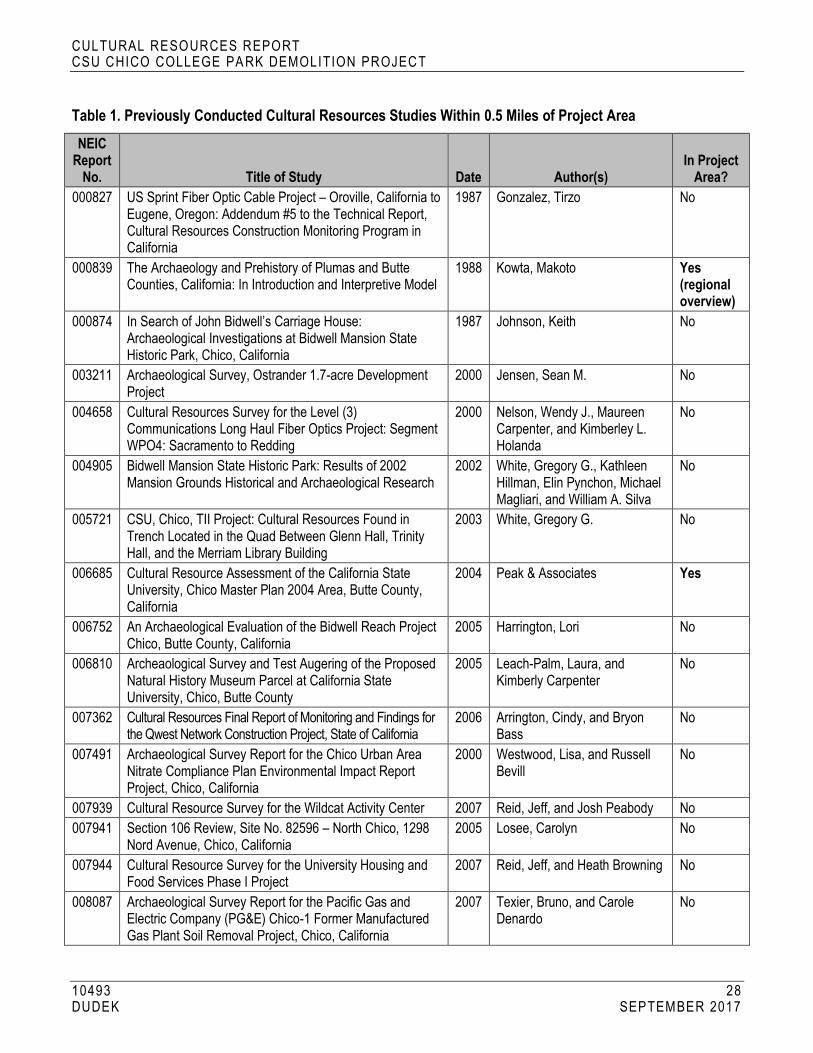
CULTURAL RESOURCES REPORT CSU CHICO COLLEGE PA RK DEMOLITION PROJECT
10493 28 DUDEK SEPTEMBER 2017
Table 1. Previously Conducted Cultural Resources Studies Within 0.5 Miles of Project Area NEIC
Report No. Title of Study Date Author(s)
In Project Area?
000827 US Sprint Fiber Optic Cable Project – Oroville, California to Eugene, Oregon: Addendum #5 to the Technical Report, Cultural Resources Construction Monitoring Program in California
1987 Gonzalez, Tirzo No
000839 The Archaeology and Prehistory of Plumas and Butte Counties, California: In Introduction and Interpretive Model
1988 Kowta, Makoto Yes (regional overview)
000874 In Search of John Bidwell’s Carriage House: Archaeological Investigations at Bidwell Mansion State Historic Park, Chico, California
1987 Johnson, Keith No
003211 Archaeological Survey, Ostrander 1.7-acre Development Project
2000 Jensen, Sean M. No
004658 Cultural Resources Survey for the Level (3) Communications Long Haul Fiber Optics Project: Segment WPO4: Sacramento to Redding
2000 Nelson, Wendy J., Maureen Carpenter, and Kimberley L. Holanda
No
004905 Bidwell Mansion State Historic Park: Results of 2002 Mansion Grounds Historical and Archaeological Research
2002 White, Gregory G., Kathleen Hillman, Elin Pynchon, Michael Magliari, and William A. Silva
No
005721 CSU, Chico, TII Project: Cultural Resources Found in Trench Located in the Quad Between Glenn Hall, Trinity Hall, and the Merriam Library Building
2003 White, Gregory G. No
006685 Cultural Resource Assessment of the California State University, Chico Master Plan 2004 Area, Butte County, California
2004 Peak & Associates Yes
006752 An Archaeological Evaluation of the Bidwell Reach Project Chico, Butte County, California
2005 Harrington, Lori No
006810 Archeaological Survey and Test Augering of the Proposed Natural History Museum Parcel at California State University, Chico, Butte County
2005 Leach-Palm, Laura, and Kimberly Carpenter
No
007362 Cultural Resources Final Report of Monitoring and Findings for the Qwest Network Construction Project, State of California
2006 Arrington, Cindy, and Bryon Bass
No
007491 Archaeological Survey Report for the Chico Urban Area Nitrate Compliance Plan Environmental Impact Report Project, Chico, California
2000 Westwood, Lisa, and Russell Bevill
No
007939 Cultural Resource Survey for the Wildcat Activity Center 2007 Reid, Jeff, and Josh Peabody No
007941 Section 106 Review, Site No. 82596 – North Chico, 1298 Nord Avenue, Chico, California
2005 Losee, Carolyn No
007944 Cultural Resource Survey for the University Housing and Food Services Phase I Project
2007 Reid, Jeff, and Heath Browning No
008087 Archaeological Survey Report for the Pacific Gas and Electric Company (PG&E) Chico-1 Former Manufactured Gas Plant Soil Removal Project, Chico, California
2007 Texier, Bruno, and Carole Denardo
No

CULTURAL RESOURCES REPORT CSU CHICO COLLEGE PA RK DEMOLITION PROJECT
10493 29 DUDEK SEPTEMBER 2017
Table 1. Previously Conducted Cultural Resources Studies Within 0.5 Miles of Project Area NEIC
Report No. Title of Study Date Author(s)
In Project Area?
008087 Historic Resources Evaluation Report for the Pacific Gas and Electric Chico-1 Former Manufactured Gas Plant Generator Building, Chico, California, APN 04-038-004
2007 Carole Denardo No
008087 Archaeological Monitoring, Testing, and Evaluation at the Chico-1 Former Manufactured Gas Plant Site City Block 62, Chico, California
2007 Texier, Bruno, and Carole Denardo
No
008087 Archaeological Monitoring and Phase II Evaluations, Chico-1 Former Manufactured Gas Plant Site City Block 63, Chico, California
2007 Rodman, Tobin No
008108 Archaeological Reconnaissance of the Proposed Storm Drain Pipe Route within the Sacramento Avenue Assessment District
1979 Manning, James P. No
009465 Cultural Resources Survey for the CSU, Chico Track Restroom Improvement Project, Butte County, California
2008 Reid, Jeff Yes
009749 A Cultural Resource Study of the Proposed Big Chico Creek/Bidwell Avenue Restoration Project, City of Chico, Butte County, California
2007 Tuttle, Tiffany No
009749 An Addendum to: The Big Chico Creek/Bidwell Avenue Restoration Project Cultural Resource Study
2008 Harrington, Lori No
009800 Cultural Resources Survey for the CSU, Chico Alumni Glenn Rehabilitation Project, Chico, California
2008 Reid, Jeff No
009827 Cultural Resources Study of the Bidwell Project, AT&T Mobility Site N. CA-C014, 212 Cherry Street, Chico, Butte County, California 95928
2008 Bilat, Lorna No
009917 Architectural Evaluation of the University Center Building, CSU, Chico
2008 Brookshear, Cheryl No
010865 An Archaeological Evaluation of the Children’s Playground and Labyrinth Project, Chico, California
2009 Harrington, Lori No
010893 An Archaeological Evaluation of 1st and 2nd Street Couplet Project Butte County, Chico, California
2010 Harrington, Lori No
012670 Cultural Resources Records Search and Site Visit Results for T-Mobile West, LLC Candidate SC06536A (Downtown Chico), 212 Cherry Street, Chico, Butte County, California
2014 Wills, Carrie D., and Kathleen A. Crawford
No
012675 Cultural Resource Records Search and Site Visit Results for T-Mobile West, LLC Candidate SC06536A (Downtown Chico), 212 Cherry Street, Chico, Butte County, California
2013 Willis, Carrie, and Kathleen Crawford
No
012858 Cultural Resources Investigation for AT&T Mobility CVL00240 “Bidwell” 212 Cherry Street, Chico, Butte County, California
2015 Lossee, Carolyn No
012970 CSU Chico – Bridge Replacement/Restoration Project, Cultural Resources Survey Report
2014 Baxter, R. Scott, and Katherine Anderson
No
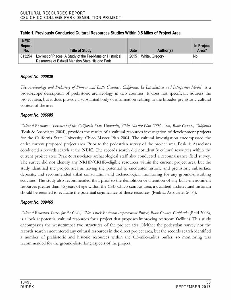
CULTURAL RESOURCES REPORT CSU CHICO COLLEGE PA RK DEMOLITION PROJECT
10493 30 DUDEK SEPTEMBER 2017
Table 1. Previously Conducted Cultural Resources Studies Within 0.5 Miles of Project Area NEIC
Report No. Title of Study Date Author(s)
In Project Area?
013254 Lovliest of Places: A Study of the Pre-Mansion Historical Resources of Bidwell Mansion State Historic Park
2015 White, Gregory No
Report No. 000839
The Archaeology and Prehistory of Plumas and Butte Counties, California: In Introduction and Interpretive Model is a
broad-scope description of prehistoric archaeology in two counties. It does not specifically address the
project area, but it does provide a substantial body of information relating to the broader prehistoric cultural
context of the area.
Report No. 006685
Cultural Resource Assessment of the California State University, Chico Master Plan 2004 Area, Butte County, California
(Peak & Associates 2004), provides the results of a cultural resources investigation of development projects
for the California State University, Chico Master Plan 2004. The cultural investigation encompassed the
entire current proposed project area. Prior to the pedestrian survey of the project area, Peak & Associates
conducted a records search at the NEIC. The records search did not identify cultural resources within the
current project area. Peak & Associates archaeological staff also conducted a reconnaissance field survey.
The survey did not identify any NRHP/CRHR–eligible resources within the current project area, but the
study identified the project area as having the potential to encounter historic and prehistoric subsurface
deposits, and recommended tribal consultation and archaeological monitoring for any ground-disturbing
activities. The study also recommended that, prior to the demolition or alteration of any built-environment
resources greater than 45 years of age within the CSU Chico campus area, a qualified architectural historian
should be retained to evaluate the potential significance of these resources (Peak & Associates 2004).
Report No. 009465
Cultural Resources Survey for the CSU, Chico Track Restroom Improvement Project, Butte County, California (Reid 2008),
is a look at potential cultural resources for a project that proposes improving restroom facilities. This study
encompasses the westernmost two structures of the project area. Neither the pedestrian survey nor the
records search encountered any cultural resources in the direct project area, but the records search identified
a number of prehistoric and historic resources within the 0.5-mile-radius buffer, so monitoring was
recommended for the ground-disturbing aspects of the project.

CULTURAL RESOURCES REPORT CSU CHICO COLLEGE PA RK DEMOLITION PROJECT
10493 31 DUDEK SEPTEMBER 2017
Previously Recorded Cultural Resources
No previously recorded cultural resources were identified within the project area as a result of the NEIC
records search. Sixty-five previously recorded resources were identified within a 0.5-mile-radius of the
project area (see Table 2).
The closest resource to the project area is P-04-004052, the Chico Rancheria Indian Cemetery, located
approximately 0.2 miles away from the project area. This is a historic-era cemetery for members of the
Northwest Maidu Mechoopda tribe, and includes stone and wooden grave markers. According to the site
record (Boston 1983), the cemetery was established in 1869, after the Mechoopda village moved to land
donated by John Bidwell, the founder of Chico. Bidwell had employed Mechoopda tribe members on his
ranch and arranged to have them stay on the ranch, rather than be forced into reservations (Boston 1983).
Because the Mechoopda were able to maintain their customs, early ethnographers such as A.L. Kroeber
were able to record valuable information about lifestyles and language from the Mechoopda of this
rancheria (Boston 1983).
Table 2. Previously Recorded Cultural Resources Within 0.5 Miles of the Project Area
Primary No. Trinomial Age Resource Name/Description Resource
Type Date (Author) P-04-000295 CA-BUT-
000295/H Prehistoric, Historic
Site includes midden, housepits, shell and glass beads, metal, and ceramics
Site 1968 (Dorothy Hill)
P-04-000574 CA-BUT-000574
Historic Mechoopda Ind. Rancheria; Chico Rancheria
Site 1967 (J. Chartkoff and K. Johnson)
P-04-002886 Historic Historic period refuse deposit Site 2004 (N. Neuenschwander, Peak & Associates)
P-04-002936 Historic Historic period refuse deposit Site 2006 (H. Browning and E. Nilsson, URS Corporation)
P-04-003000 CA-BUT-003000H
Historic Chico Soda Works: warehouses with eight structural foundation features, refuse deposit, cistern, and oil pipeline
Site 2006 (Bruno Texier, Garcia and Associates)
P-04-003001 CA-BUT-003001H
Historic Chico-1 MGP Gas and Water Works and Historic MGP Generator: contains brick footings, a wooden underground storage tank, water pipe and cast iron conveyance, and redwood piping
Site 2006 (Bruno Texier and Carole Denardo, Garcia and Associates); 2007 (Tobin Rodman, Garcia and Associates)
P-04-003136 Historic University Center building Building 2008 (Cheryl Brookshear & Jarma Jones, JRP Historical Consulting)

CULTURAL RESOURCES REPORT CSU CHICO COLLEGE PA RK DEMOLITION PROJECT
10493 32 DUDEK SEPTEMBER 2017
Table 2. Previously Recorded Cultural Resources Within 0.5 Miles of the Project Area
Primary No. Trinomial Age Resource Name/Description Resource
Type Date (Author) P-04-003137 Historic California Water Service Company
water tower and tank Structure 2008 (Dana E. Supernowicz,
Historic Resource Associates)
P-04-003820 CA-BUT-003820/H
Prehistoric, Protohistoric, Historic
Bidwell Mansion State Historic Park: includes lithic scatter, groundstone, glass trade beads, foundations, landscaping/orchard, wells/cisterns, water conveyance systems, standing structures, Bidwell development at Rancho Chico headquarters, bridges, Bidwell monuments
Site 2015 (Greg White, Leslie Steidl, Sub Terra Consulting, Department of Parks and Recreation); 2015 (Greg White, Leslie Steidl, Sub Terra Consulting, Department of Parks and Recreation)
P-04-003899 Historic Saint John’s Episcopal Church; OHP Property Number 49372 OHP PRN - NPS-82002171-0000
Building (Unknown, Unknown)
P-04-003928 Historic Annie E. K. Children’s Playground; OHP Property Number 049400; OHP PRN 5926-0042-0000
Site 1983 (Will Shapiro, Chico Heritage Association)
P-04-003929 Historic Masonic Temple; OHP Property Number 049401; OHP PRN 5926-0043-0000
Building 1983 (Will Shapiro, Chico Heritage Association)
P-04-003930 Historic Collier Hardware; OHP Property Number 049402; OHP PRN 5926-0044-0000
Building 1981 (William Shapiro, Chico Heritage Association)
P-04-003931 Historic Bidwell Memorial Presbyterian Church; OHP Property Number 049403; OHP PRN 5926-0045-0000
Building 1982 (Nanette Coulter, Yochio Kusaba, Chico Heritage Association)
P-04-003932 Historic 1st Street Warehouse (California Packing Corp. Plant No. 64); OHP Property Number 049404; OHP PRN 5926-0046-0000
Building 1983 (William Hood, Chico Heritage Association)
P-04-003933 Historic Central Valley Pipe Company (Diamond Match Co. Warehouse); OHP Property Number 049405; OHP PRN - 5926-0047-0000
Building 1983 (William Hood, Emily Newton, Chico Heritage Association)
P-04-003935 Historic El Rey Theater (Majestic Theater); OHP Property Number 049407; OHP PRN 596-0049-0000
Building 1981 (Judy Smith, Chico Heritage Association)

CULTURAL RESOURCES REPORT CSU CHICO COLLEGE PA RK DEMOLITION PROJECT
10493 33 DUDEK SEPTEMBER 2017
Table 2. Previously Recorded Cultural Resources Within 0.5 Miles of the Project Area
Primary No. Trinomial Age Resource Name/Description Resource
Type Date (Author) P-04-003936 Historic Madison Bear Garden (Luck
Building, Native Daughters of Golden West, 1933-76); OHP Property Number 049408; OHP PRN 5926-0050-0000
Building 1983 (Emily Newton, Yosio Kusaba, Chico Heritage Association)
P-04-003939 Historic Sierra Hall (W.B. Dean House); OHP Property Number 049410; OHP PRN 5926-0239-0011; OHP PRN 5926-0053-0000
Building 1983 (Maribeth Ross, Yoshio Kusaba, Chico Heritage Association)
P-04-003940 Historic OHP Property Number 049420; OHP PRN 537.9-04-0034; OHP PRN 537.9-04-0032; OHP PRN NPS-91000636-0020; OHP PRN 5926-0056-0000
Building 1983 (Judy Pepper, Mancy McDougal, Chico Heritage Association)
P-04-003941 Historic Lambda Pi Fraternity (The White house); OHP Property Number 049421; OHP PRN NPS-91000636-0022; OHP PRN 5926-0057-0000
Building 1982 (Karen Zinniel, Chico Heritage Association)
P-04-003942 Historic Walker Home; OHP Property Number 049422; OHP PRN NPS-91000636-0023; OHP PRN 5926-0058-0000
Building 1981 (Sarah Heigho, Chico Heritage Association)
P-04-003961 Historic “Off Broadway” (Bidwell's Store); OHP Property Number 049448; OHP PRN 5926-0081-0000
Building 1982 (Lisa Agler, Chico Heritage Association)
P-04-003968 Historic Reynolds House; OHP Property Number 049467; OHP PRN NPS-91000636-0128; OHP PRN 5926-0098-0000
Building 1983 (Karen D. Johnson, Chico Heritage Association)
P-04-003969 Historic Earll House; OHP Property Number 049468; OHP PRN NPS-891000636-0131; OHP PRN 5926-0099-0000
Building 1982 (Karen Zinniel, Chico Heritage Association)
P-04-003973 Historic OHP Property Number 049475; OHP PRN NPS-91000636-0146; OHP PRN 5926-0103-0000
Building 1983 (Jayne May, Chico Heritage Association)
P-04-003974 Historic “The Bakery” (George Crosette House); OHP Property Number 049476; OHP PRN NPS-91000636-0148; OHP PRN 5926-0104-0000
Building 1983 (Giovanna R. Jackson, Chico Heritage Association)

CULTURAL RESOURCES REPORT CSU CHICO COLLEGE PA RK DEMOLITION PROJECT
10493 34 DUDEK SEPTEMBER 2017
Table 2. Previously Recorded Cultural Resources Within 0.5 Miles of the Project Area
Primary No. Trinomial Age Resource Name/Description Resource
Type Date (Author) P-04-003979 Historic Ringel Park; OHP Property Number
049482; OHP PRN 5926-0110-0000
Building 1983 (Will Shapiro, Chico Heritage Association)
P-04-003982 Historic South of Campus Neighborhood; OHP Property Number 073320; OHP PRN NPS-91000636-9999; OHP PRN 04-0004
District 1988 (John Gallardo, Giovanna R. Jackson, Elizabeth Stewart, Chico Heritage Association)
P-04-003987 Historic French House (William H. Zwisler House); OHP PRN - 537.9-04-0014; OHP PRN NPS-91000636-0018; OHP PRN 5926-0055-0000
Building 1983 (Giovanna R. Jackson, Chico Heritage Association)
P-04-003988 Historic International Studies (Charles Ball House); OHP Property Number 049416; OHP PRN 537.9-04-0020; OHP PRN NPS-91000636-0017; OHP PRN 5926-0054-0005
Building 1983 (Giovanna R. Jackson, Chico Heritage Association)
P-04-003989 Historic J.V. Richardson House; OHP Property Number 049415; OHP PRN 537.9-04-0019; OHP PRN NPS-91000636-0016; OHP PRN 5926-0054-0004
Building 1983 (Giovanna R. Jackson, Chico Heritage Association)
P-04-003990 Historic C.C. Richardson House; OHP Property Number 049414; OHP PRN 537.9-04-0015; OHP PRN NPS-91000636-0015; OHP PRN 5926-0054-0003
Building 1983 (Giovanna R. Jackson, Chico Heritage Association)
P-04-003991 Historic German House (Rouke-Haile House); OHP Property Number 049413; OHP PRN 537.9-04-0018; OHP PRN NPS-91000636-0014; OHP PRN 5926-0054-0002
Building 1982 (Norma Craig, Giovanna R. Jackson, Chico Heritage Association)
P-04-003992 Historic Spanish House (H.W. Crew House); OHP Property Number 049412; OHP PRN 537.9-04-0017; OHP PRN - NPS-91000636-0013; OHP PRN 5926-0054-0001
Building 1982 (Norma Craig, Chico Heritage Association)
P-04-003993 Historic OHP Property Number 049419; OHP PRN 5926-0055-0000
Building 1982 (Anne Slade, Chico Heritage Association)
CULTURAL RESOURCES REPORT CSU CHICO COLLEGE PA RK DEMOLITION PROJECT
10493 35 DUDEK SEPTEMBER 2017
Table 2. Previously Recorded Cultural Resources Within 0.5 Miles of the Project Area
Primary No. Trinomial Age Resource Name/Description Resource
Type Date (Author) P-04-004011 Historic Mavis Todd Brown House (Bernard
House); OHP Property Number 049488; OHP PRN - NPS-91000636-0105; OHP PRN 5926-0116-0000
Building 1982 (Jeanne Boston, Giovanna R. Jackson, Chico Heritage Association)
P-04-004020 Historic Van Liew House; OHP Property Number 049498; OHP PRN 5926-0126-0000
Building 1983 (S.S. Newton, Chico Heritage Association)
P-04-004021 Historic E.I. Miller House; OHP Property Number 049499; OHP PRN 5926-0127-0000
Building 1983 (John Michael, Giovanna Jackson, Chico Heritage Association)
P-04-004022 Historic OHP Property Number 049500; OHP PRN 5926-0128-0000
Building 1983 (Lynn Hoffman, Giovanna Jackson, Chico Heritage Association)
P-04-004023 Historic Chico Museum (Chico Free Public Library); OHP Property Number 049501; OHP PRN 5926-0129-0000
Building 1981 (Beth Tausczik-Olsen, Chico Heritage Association)
P-04-004030 Historic Citrus School; OHP Property Number 049509; OHP PRN 5926-0137-0000
Building 1983 (Maribeth Ross, Yoshio Kusaba, Chico Heritage Association)
P-04-004031 Historic Barceloux House (Hiebert House); OHP Property Number 049511; OHP PRN 5926-0139-0000
Building 1983 (Jeanne Lane, Chico Heritage Association)
P-04-004032 Historic Waters House; OHP Property Number 049512; OHP PRN 5926-0140-0000
Building 1983 (Grant Branson, Chico Heritage Associaiton)
P-04-004033 Historic Veteran’s Memorial Hospital; OHP Property Number 049513; OHP PRN 5926-0141-0000
Building 1982 (James Roy Nash, Chico Heritage Association)
P-04-004036 Historic Bidwell Millstones (Bidwell’s Mill Site); OTIS Resource Number 049510; OHP PRN 5926-0138-0000; OHP PRN SPHI-BUT-004
Building 1983 (Giovanna R. Jackson, Chico Heritage Association)
P-04-004037 Historic William Nason House; OHP Property Number 049514; OHP PRN 5926-0142-0000
Building 1984 (Marilyn Steinheimer, Chico Heritage Association)
P-04-004038 Historic F.J. Boucher House; OHP Property Number 049515; OHP PRN 5926-0143-0000
Building 1984 (Dave M. Brown, Chico Heritage Association)

CULTURAL RESOURCES REPORT CSU CHICO COLLEGE PA RK DEMOLITION PROJECT
10493 36 DUDEK SEPTEMBER 2017
Table 2. Previously Recorded Cultural Resources Within 0.5 Miles of the Project Area
Primary No. Trinomial Age Resource Name/Description Resource
Type Date (Author) P-04-004040 Historic Stamper House; OHP Property
Number 049517; OHP PRN 5926-0145-0000
Building 1983 (Giovanna R. Jackson, Chico Heritage Association)
P-04-004041 Historic OHP Property Number 049518; OHP PRN 5926-0146-0000
Building 1983 (John Gallardo, Chico Heritage Association)
P-04-004049 Historic President’s Residence (Dr. Moulton’s House); OHP Property Number 049526; OHP PRN 5926-0154-0000
Building 1983 (Karl Wahl, California State University, Chico)
P-04-004052 Historic Chico Rancheria Indian Cemetery (Mechoopda Indian Cemetery); OHP Property Number 049529; OHP PRN 5926-0157-0000
Building 1983 (Jeanne Boston, Chico Heritage Association)
P-04-004064 Historic C. Robert Laxson Auditorium (Auditorium and Assembly Building); OHP Property Number 049592; OHP PRN 5926-0176-0004
Building 1983 (Karl Wahl, California State University, Chico)
P-04-004065 Historic Trinity Hall (Old Library, Campus Activities Center -CAC); OHP Property Number 049454; OHP PRN 5926-0176-0003
Building 1983 (Karl Wahl, California State University, Chico)
P-04-004066 Historic Glenn Kendall Hall (Administration Building and New Main Building); OHP Property Number 049590; OHP PRN 5926-0176-0002
Building 1983 (Karl Wahl, California State University, Chico)
P-04-004071 Historic E.E. Shepard Home; OHP Property Number 049598; OHP PRN 5926-0181-0000
Building 1984 (E. Stewart, Chico Heritage Association)
P-04-004072 Historic Roseanna O’Hair House; OHP Property Number 049599; OHP PRN 5926-0182-0000
Building 1984 (Robin Williams, Chico Heritage Association)
P-04-004078 Historic C.A. Wright House; OHP Property Number 049605; OHP PRN 5926-0188-0000
Building 1984 (E. Stewart, Chico Heritage Association)
P-04-004081 Historic Frank A. Clough House; OHP Property Number 049608; OHP PRN 537.9-04-0005; OHP PRN 5926-0191-0000
Building 1984 (Robert Mortensen, E. Stewart, Chico Heritage Association)
P-04-004082 Historic Priel House; OHP Property Number 049609; OHP PRN 5926-0192-0000
Building 1984 (Carol Michel, Chico Heritage Association)
P-04-004083 Historic Strain House; OHP Property Number 049610; OHP PRN 5926-0193-0000
Building 1984 (Carol Michel, Chico Heritage Association)

CULTURAL RESOURCES REPORT CSU CHICO COLLEGE PA RK DEMOLITION PROJECT
10493 37 DUDEK SEPTEMBER 2017
Table 2. Previously Recorded Cultural Resources Within 0.5 Miles of the Project Area
Primary No. Trinomial Age Resource Name/Description Resource
Type Date (Author) P-04-004084 Historic Barry House; OHP Property Number
049611; OHP PRN 5926-0194-0000 Building 1984 (carol Michel, Chico
Heritage Association)
P-04-004085 Historic Donohue House; OHP Property Number 049612; OHP PRN 5926-0195-0000
Building 1984 (Sherry Snowden, Chico Heritage Association)
P-04-004157 Historic Chico State Physical Sciences Bridge
Structure 2013 (Katherine Anderson, ESA)
P-04-004158 Historic Chico State Gus Manolis Bridge; Chico State Selvester’s Café Bridge
Structure 2013 (Katherine Anderson, ESA)
3.2 NAHC and Native American Correspondence
Dudek contacted the NAHC on August 3, 2017, to request a search of its Sacred Lands File for the
proposed project site and surrounding area. The NAHC responded on August 5, 2017, indicating that the
search did not identify any Native American resources in the vicinity of the project site or surrounding
search area. On July 13, 2017, CSU Chico Planning, Design, and Construction, as the lead agency, sent
letters to all NAHC-listed tribes that have previously requested notifications of project pursuant to
Assembly Bill 52 requirements. These letters contained a description and maps of the project and site,
summarized the Assembly Bill 52 process and timing, and provided the lead agency representative contact
information (see Appendix C). No responses have been received to date (see Table 3). Per PRC Section
21080.31(d), the 30-day period for a tribe to request consultation has closed.
Table 3. Record of Native American Heritage Commission Correspondence
Name and Title Tribe/Organization Date of Assembly Bill 52 Tribal Outreach (Letter)
Response Received?
Gene Whitehouse, Chairperson United Auburn Indian Community of Auburn Rancheria
July 13, 2017 No
Dennis E. Ramirez, Chairperson Mechoopda Indian Tribe of Chico Rancheria
July 13, 2017 No
3.3 Building Development Research
Extensive archival research was conducted in support of this Historical Resources Technical Report. Short
descriptions of the research efforts are provided below.

CULTURAL RESOURCES REPORT CSU CHICO COLLEGE PA RK DEMOLITION PROJECT
10493 38 DUDEK SEPTEMBER 2017
CSU Chico Special Collections and University Archives
On July 5 and 6, 2017, Dudek staff reviewed a variety of collection materials in person pertaining to the
history of the City of Chico and the CSU Chico campus. The collection included City directories, multiple
newspaper articles, campus maps, photographs, letters, and campus reports, which were all used in the
preparation of the historic context (see Section 2, above).
Butte County Historical Society Archives
Dudek visited the Butte County Historical Society in person on July 7, 2017, and met with Nancy Brower.
Ms. Brower looked through the Butte County Historical Society archives and stated that she did not have
any information regarding any of the properties within the project site. Ms. Brower was able to provide
resources on the history of Chico that were used in the preparation of the historic context (see Section 2).
Chico Heritage Association
Dudek contacted the Chico Heritage Association’s Elizabeth Stewart via email and inquired about the
subject properties. Ms. Stewart responded that she did not locate any information related to the subject
properties, but stated that some of her colleagues may be able to assist with the background research on the
City and adjacent areas. Dudek visited the Chico Heritage Association on July 6, 2017, and spoke with two
staff members who confirmed that there was no specific information about the subject properties or the
previous occupants of the homes, but did provide information that aided in preparation of the historic
context (see Section 2). The Chico Heritage Association explained that the Chico Museum recently
completed a large-scale research effort on important people in the history of Chico, and suggested that
Dudek contact the museum for possible information about the people who lived in the subject properties
throughout the years.
Chico Museum
At the direction of the Chico Heritage Association, the Chico Museum was contacted via email multiple
times for additional information pertaining to the residents of the subject properties over the years. No
response has been received to date.
City of Chico Building Division
Dudek visited the City of Chico Building Division in person on July 6, 2017. Dudek was informed that all
building permit files begin in 1952, and there were no building permits before that year on file. All available
building permit files for each property were reviewed to understand construction histories.
CULTURAL RESOURCES REPORT CSU CHICO COLLEGE PA RK DEMOLITION PROJECT
10493 39 DUDEK SEPTEMBER 2017
City of Chico Planning Division
Dudek contacted Shannon Costa, assistant planner for the City of Chico, via email on July 6, 2017. Dudek
was provided with information on neighborhood development related to the subject properties. Ms. Costa
then directed Dudek to the Butte County Assessor’s office for any additional information.
Butte County Assessor’s Office
Dudek used the Butte County Assessor’s online parcel information system to obtain information on the
subject properties. Dudek also contacted the assessor’s office via email to see if any additional information is
available in the assessor’s files. The assessor’s office was unable to provide any additional information
related to any of the properties within the project area.
Aerial Photograph and Historic Map Review
Sanborn Fire Insurance Company maps for the City of Chico were prepared in the following years: 1884,
1886, 1890, 1902, 1909, 1921, and 1949. None of the Sanborn maps reviewed included the project area,
which is likely due to later development in this area. Historic aerial photographs for the project area were
available for the following years: 1941, 1947, 1969, 1998, 2005, 2009, 2010, and 2012 (NETR 2017). The
1941 aerial photograph shows very little development in the project area. It shows that the property does
not appear to be subdivided for housing, but is a large undeveloped parcel of land with development on all
sides. The 1947 aerial photograph shows increased residential development and division of the large parcel
into smaller residential lots. One major difference between the 1941 and the 1947 aerial photographs is that
Brice Avenue, Stadium Way, and La Vista Way are now visible. By 1969, the neighborhood is almost fully
developed with residential properties. In 1969, there are large open parcels of land to the south and west of
the neighborhood, but by 1998, there is significant development on these parcels, including large campus
buildings, access roads, and parking lots. Additionally, the areas to the south and west are now heavily
landscaped and pedestrianized (NETR 2017).

CULTURAL RESOURCES REPORT CSU CHICO COLLEGE PA RK DEMOLITION PROJECT
10493 40 DUDEK SEPTEMBER 2017
INTENTIONALLY LEFT BLANK

CULTURAL RESOURCES REPORT CSU CHICO COLLEGE PA RK DEMOLITION PROJECT
10493 41 DUDEK SEPTEMBER 2017
4 FIELD SURVEY
Dudek Architectural Historian Sarah Corder conducted a pedestrian survey of the project site on July 6,
2017. The project site includes 10 residential properties that are adjacent to a fully developed college campus
and located in a fully developed residential neighborhood. All buildings were photographed, researched, and
evaluated in consideration of NRHP, CRHR, and CHL designation criteria and integrity requirements, and
in consideration of potential impacts to historical resources under CEQA. The survey entailed walking all
sides of the buildings and the surrounding campus.
Dudek documented the subject property using field notes, digital photography, and close-scale field maps.
Photographs of the project area were taken with a Canon Power Shot SX160 IS digital camera with 16
megapixels and 16x optical zoom. All field notes, photographs, and records related to the current study are
on file at Dudek’s Pasadena, California, office.
4.1 Description of Surveyed Resources
The project site contains 10 residential properties that were constructed more than 50 years ago. All
properties were numbered and are referred to by number in the property descriptions that follow and in
Figure 6.

CULTURAL RESOURCES REPORT CSU CHICO COLLEGE PA RK DEMOLITION PROJECT
10493 42 DUDEK SEPTEMBER 2017
INTENTIONALLY LEFT BLANK
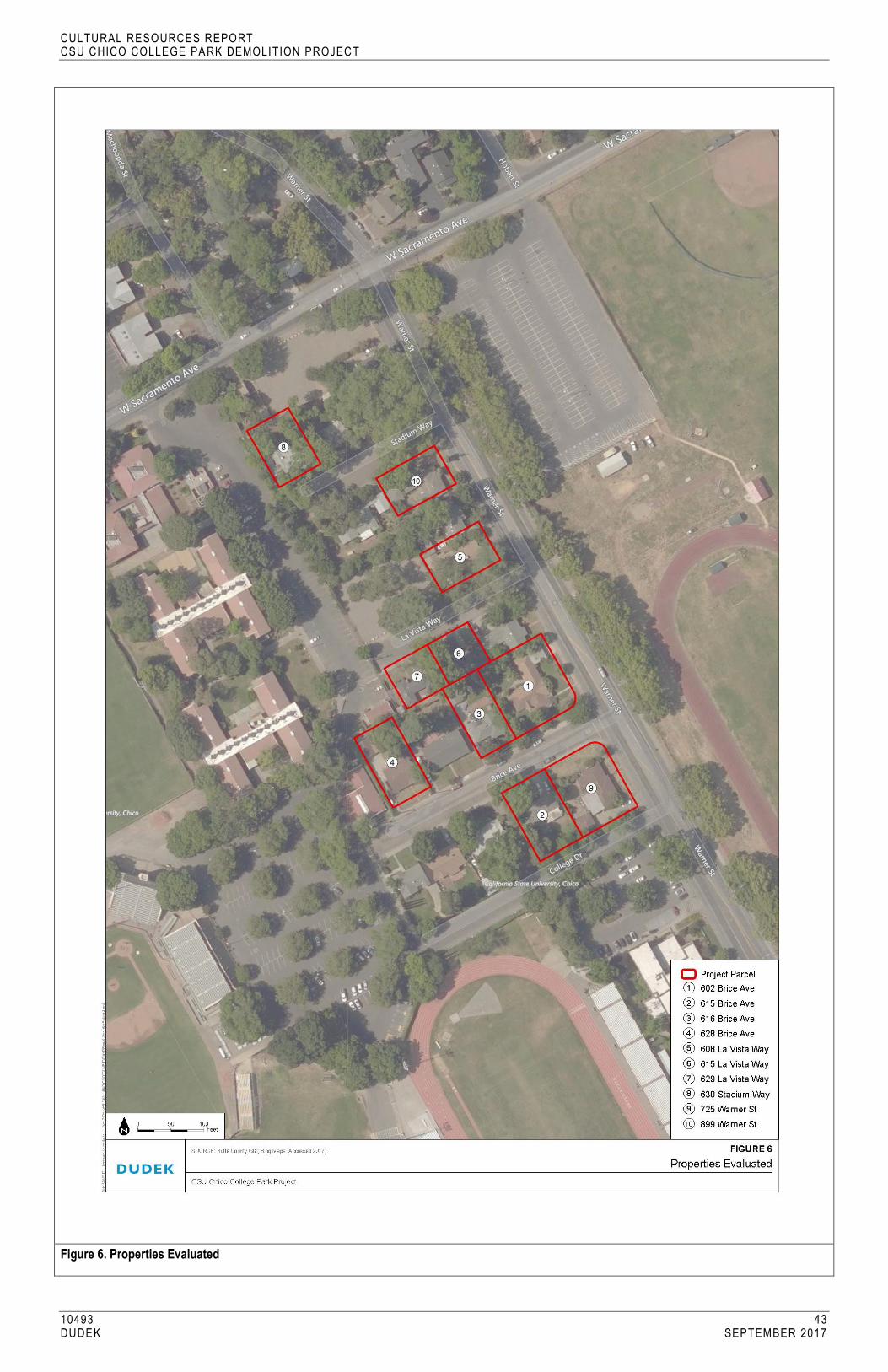
CULTURAL RESOURCES REPORT CSU CHICO COLLEGE PA RK DEMOLITION PROJECT
10493 43 DUDEK SEPTEMBER 2017
Figure 6. Properties Evaluated
CULTURAL RESOURCES REPORT CSU CHICO COLLEGE PA RK DEMOLITION PROJECT
10493 44 DUDEK SEPTEMBER 2017
INTENTIONALLY LEFT BLANK
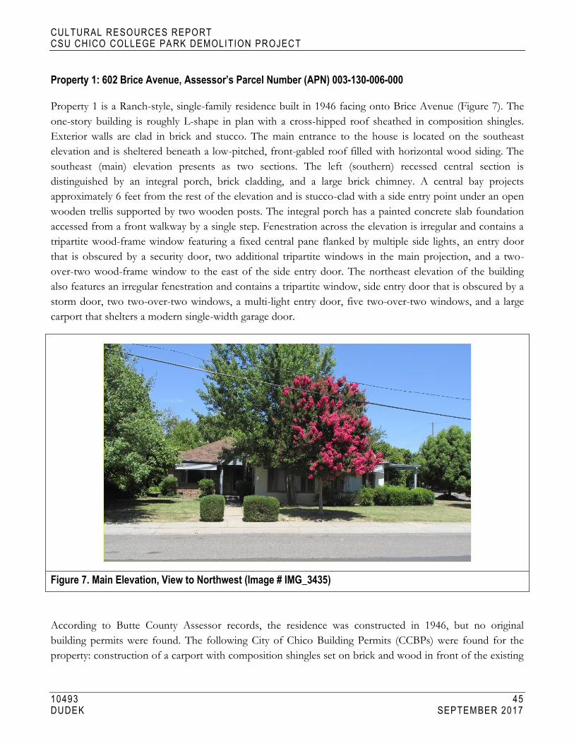
CULTURAL RESOURCES REPORT CSU CHICO COLLEGE PA RK DEMOLITION PROJECT
10493 45 DUDEK SEPTEMBER 2017
Property 1: 602 Brice Avenue, Assessor’s Parcel Number (APN) 003-130-006-000
Property 1 is a Ranch-style, single-family residence built in 1946 facing onto Brice Avenue (Figure 7). The
one-story building is roughly L-shape in plan with a cross-hipped roof sheathed in composition shingles.
Exterior walls are clad in brick and stucco. The main entrance to the house is located on the southeast
elevation and is sheltered beneath a low-pitched, front-gabled roof filled with horizontal wood siding. The
southeast (main) elevation presents as two sections. The left (southern) recessed central section is
distinguished by an integral porch, brick cladding, and a large brick chimney. A central bay projects
approximately 6 feet from the rest of the elevation and is stucco-clad with a side entry point under an open
wooden trellis supported by two wooden posts. The integral porch has a painted concrete slab foundation
accessed from a front walkway by a single step. Fenestration across the elevation is irregular and contains a
tripartite wood-frame window featuring a fixed central pane flanked by multiple side lights, an entry door
that is obscured by a security door, two additional tripartite windows in the main projection, and a two-
over-two wood-frame window to the east of the side entry door. The northeast elevation of the building
also features an irregular fenestration and contains a tripartite window, side entry door that is obscured by a
storm door, two two-over-two windows, a multi-light entry door, five two-over-two windows, and a large
carport that shelters a modern single-width garage door.
Figure 7. Main Elevation, View to Northwest (Image # IMG_3435)
According to Butte County Assessor records, the residence was constructed in 1946, but no original
building permits were found. The following City of Chico Building Permits (CCBPs) were found for the
property: construction of a carport with composition shingles set on brick and wood in front of the existing

CULTURAL RESOURCES REPORT CSU CHICO COLLEGE PA RK DEMOLITION PROJECT
10493 46 DUDEK SEPTEMBER 2017
garage in 1950 (CCBP #10025); a roof built over a new 8- by 25-foot patio in 1952 (CCBP #685); addition of a
louvered sunshade over the front porch, including change of a window to a door in 1953 (CCBP #1426);
installation of a television antenna in 1954 (CCBP #262); an electrical permit for an addition in 1964 (CCBP
#3871); replacement of ceramic tiles in a bathroom in 1965 (CCBP #5222); partial reroof with composition
shingles in 1996 (CCBP #B96-00430); and replacement of a water heater in 2001 (CCBP #PO1-00527).
Observed alterations to the house with unknown dates include the addition of security doors, addition of metal
louvers over windows on the main elevation, reconfiguration of entry points on the northeast elevation, addition
of an open trellis on the northeast elevation, and replacement of the garage door.
Research of all City directories from the date of construction showed that the house was predominately
owned and occupied by Harry Nichols Jr. and his wife Sally. Mr. Nichols is listed in directories as a farmer.
The only other name that was associated with the house was Mr. Alan Sagouspe, who was listed as an owner
of the property on a building permit from 2001 (CCBP # P01-00527).
A review of historic maps and aerial photographs was conducted as part of the archival research effort for
this property. All Sanborn maps for the City of Chico were reviewed, and the project area was not included
on any of the maps. Historic aerial photographs were reviewed for the property from the following years:
1941, 1947, 1969, 1998, 2005, 2009, 2010, and 2012. In 1941, most of the area was not developed, with the
exception of a few buildings on Warner Avenue. In 1941, the intersecting streets of Brice Avenue, La Vista
Way, and Stadium Way are not visible. The 1947 aerial photograph indicates there was increased
development in the area, including an L-shaped residence on the corner of Warner Avenue and Brice
Avenue, which is consistent with the 1946 date of construction for 602 Brice Avenue. By 1947, the
intersecting streets of Brice Avenue, Stadium Way, and La Vista Way are visible. The remaining years of
historic aerial photographs offer limited information, as the house is largely obscured by trees (NETR 2017).
Property 2: 615 Brice Avenue, APN 003-130-010-000
Property 2 is a Ranch-style, single-family residence built in 1951 facing onto Brice Avenue (Figure 8). The
one-story building is irregular in plan with a cross-hipped roof with composition shingles. The northwest
(main) elevation presents as three sections. A left (northern) section projects approximately 4 feet forward
from the main body of the house and is clad in stucco. This section features a single-car-width garage, a
recessed central section distinguished by a partial-width broad entry porch that is clad with vertically
oriented wooden siding, and a right (western) section projecting approximately 6 feet from the central
section that is clad in stucco. The integral porch has a concrete slab foundation accessed from a front
walkway by a single step, with wooden posts supporting the roof. Fenestration across the elevation is
irregular and contains a single-car-width sectional garage door, a wood-frame tripartite window featuring a
fixed central pane flanked by side lights, an entry door with a side light, and a set of three aluminum-frame
horizontal slider windows in the western projection.

CULTURAL RESOURCES REPORT CSU CHICO COLLEGE PA RK DEMOLITION PROJECT
10493 47 DUDEK SEPTEMBER 2017
Figure 8. Main Elevation, View to Southwest (Image # IMG_3414)
According to Butte County Assessor records, the residence was constructed in 1951. The following CCBPs were
found for the property: original building permit for a one-story wood and stucco house with an attached garage
in 1951 (CCBP #262); plumbing and sewer permit for one toilet, one basin, one bath, one sink, and one tray in
1951 (CCBP #241); electrical permit for a new dwelling with six circuits, 16 switches, 13 outlets, meter, and #12
wire in 1951 (CCBP #4783); construction of the roof and north and west walls on the patio with wood frame
and stucco with dimensions of 15 by 20 feet in 1953 (CCBP #1341); installation of a water heater in 1957 (CCBP
#710); replacement of the furnace in 1965 (CCBP #5139); electrical permit for a new meter in 1979 (CCBP
#9235); replacement of the shake roof in 1984 (CCBP #5033); and reroof with composition shingles in 2002
(CCBP #B02-395). Observed alterations to the house with unknown dates include replacement windows,
replacement front entry door, and replacement garage door.
Archival research found the following people associated with the property:
1952–1963 – James and Thelma Bachand, sergeant for the Chico Police Department
1965 – Philip and Kristen Mast, student
1966–1978 – George Bachand, retired
1979 – Betty French
1984 – Barbara Stanley, DDS, dentist
2002 – Michael and Kristene Wagner

CULTURAL RESOURCES REPORT CSU CHICO COLLEGE PA RK DEMOLITION PROJECT
10493 48 DUDEK SEPTEMBER 2017
Based on archival research, it appears that the early owners of the house also occupied the house. However,
more recent City directories and building permits suggest that the house was likely a rental property for
California State University Chico students and was no longer owner-occupied starting in 1990.
A review of historic maps and aerial photographs was conducted as part of the archival research effort for
this property. All Sanborn maps for the City of Chico were reviewed, and the project area was not included
on any of the maps. Historic aerial photographs were reviewed for the property from the following years:
1941, 1947, 1969, 1998, 2005, 2009, 2010, and 2012. In 1941, most of the area was not developed, with the
exception of a few buildings on Warner Avenue. In 1941, the intersecting streets of Brice Avenue, La Vista
Way, and Stadium Way are not visible on the map. The 1947 aerial photograph indicates that there is
increased development in the area, but there is no building on the parcel associated with 615 Brice Avenue.
By 1947, the intersecting streets of Brice Avenue, Stadium Way, and La Vista Way are visible. The 1969
aerial photograph indicates additional development in the area, including the parcel associated with 615
Brice Avenue, which is consistent with the 1951 date of construction. The remaining years of historic aerial
photographs offer limited information, as the house is largely obscured by trees (NETR 2017).
Property 3: 616 Brice Avenue, APN 003-130-005-000
Property 3 is a Ranch-style, single-family residence built in 1946 facing onto Brice Avenue (Figure 9). The
one-story building is roughly rectangular in plan with a hipped roof covered with composition shingles. The
building is clad in stucco with brick wainscoting on the lower half of the southeast (main) elevation. The
southeast (main) elevation features an offset to the east integral porch located in a short recess, which is
flanked by the other two sections of the façade that feature irregular fenestration. The integral porch has a
painted concrete slab foundation accessed from a front walkway by two steps. The fenestration across the
elevation is irregular and contains a one-over-one replacement window with false grilles, a large three-light
window, a paneled entry door, and a one-over-one replacement window with false grilles. There is also a
brick chimney that pierces the roof. A one-story, single-car-width garage is located south of the main house
and is accessed via a concrete driveway.

CULTURAL RESOURCES REPORT CSU CHICO COLLEGE PA RK DEMOLITION PROJECT
10493 49 DUDEK SEPTEMBER 2017
Figure 9. Main Elevation, View to Northwest (Image # IMG_3402)
According to Butte County Assessor records, the residence was constructed in 1946; however, no original
building permit was found. The following CCBPs were found for the property: a plumbing and sewer
connection permit in 1951 (CCBP #217), electrical permit for clothes dryer in 1953 (CCBP #5292), 12- by
18-foot addition to the rear of house in 1956 (CCBP #623), construction of a 17- by 24-foot roof patio in
1956 (CCBP #623), construction of a 9- by 15-foot addition to the side of the garage in 1956 (CCBP #623),
sewer work from 1964 to 1965 (CCBP #3123 and CCBP #3306), installation of composition roofing in
1984 (CCBP #5300), and reroofing with composition roofing in 1992 (CCBP #B1146). The only observed
alteration to the house is replacement vinyl windows on all visible elevations.
Archival research found the following people associated with the property:
1948–1952 – T.J. and Margaret Broedlow, manager of Zellerbach Paper Company
1953–1970 – Paul G. Jones, campus barber
1984 – Paragon Property Management
1992 – Mike Costanza
Based on archival research, it appears that the early owners of the house also occupied the house. However,
more recent City directories and building permits suggest that the house was likely a rental property for CSU
Chico students and was no longer owner-occupied starting in the mid-1980s.
A review of historic maps and aerial photographs was conducted as part of the archival research effort for
this property. All Sanborn maps for the City of Chico were reviewed, and the project area was not included

CULTURAL RESOURCES REPORT CSU CHICO COLLEGE PA RK DEMOLITION PROJECT
10493 50 DUDEK SEPTEMBER 2017
on any of the maps. Historic aerial photographs were reviewed for the property from the following years:
1941, 1947, 1969, 1998, 2005, 2009, 2010, and 2012. In 1941, most of the area was not developed, with the
exception of a few buildings on Warner Avenue. In 1941, the intersecting streets of Brice Avenue, La Vista
Way, and Stadium Way are not visible. The 1947 aerial photograph indicates that there was increased
development in the area, but the subject property is not visible due to tree coverage and poor image quality.
By 1947, the intersecting streets of Brice Avenue, Stadium Way, and La Vista Way are visible. The remaining
years of historic aerial photographs offer limited information, since the house is largely obscured by trees
(NETR 2017).
Property 4: 628 Brice Avenue, APN 003-130-003-000
Property 4 is a Ranch-style, single-family residence built in 1948 facing onto Brice Avenue (Figure 10). The one-
story building is roughly rectangular in plan, with stucco cladding and a cross-gabled roof covered with
composition shingles. The front-facing gable is filled with horizontal wood siding and contains a louvered vent.
The southeast (main) elevation presents as two sections: a left (southern) section distinguished by a partial-width
broad entry porch, and a right (eastern) section projecting approximately 4 feet. The integral porch consists of a
painted concrete slab accessed by a front walkway and three concrete steps. The porch’s overhanging eave is
supported by three 4- by 4-inch painted wood posts. Fenestration across the elevation is irregular, consisting of a
two-over-two wood frame window, a large tripartite picture window with a central pane surrounded by multiple
lights, a simple wooden entry door located at the easternmost edge of the porch, and a two-over-two wood-
frame window that features wooden board and batten shutters. The front yard of the house is circumscribed by a
white picket fence, and there is a concrete driveway located to the south.
Figure 10. Main Elevation, View to Northwest (Image # IMG_3397)
CULTURAL RESOURCES REPORT CSU CHICO COLLEGE PA RK DEMOLITION PROJECT
10493 51 DUDEK SEPTEMBER 2017
According to Butte County Assessor records, the residence was constructed in 1948; however, no original
building permit was found. The following CCBPs were found for the property: television antenna in 1953
(CCBP #199), multiple requests from 1963 to 1971 to the City for filling in holes caused by construction
(CCBP #s 405, 3296, 7788, 6500), replacement gas service in 1981 (CCBP #103400), installation of
composition roofing in 1986 (CCBP #B7988), electrical service upgrade in 1995 (CCBP #C95-01161), and
an addition and remodel of a room and bathroom in 2001 (CBPP #C01-00733). The only observed
alteration to the house is a replacement entry door on the main elevation.
Archival research found the following people associated with the property:
1950–1958 – Helen Rahe, secretary
1960–1962 – Mack McConnelly
1963 – James Martin, teacher at Chico State
1964–1970s – Ed McConnley, retired
1975 – Julio Medina, builder
1986–1990s – Alan Miller
2001 – Tom Patty
Based on archival research, it appears that the early owners of the house also occupied the house. However,
more recent City directories and building permits suggest that the house was likely a rental property for CSU
Chico students and is no longer owner occupied.
A review of historic maps and aerial photographs was conducted as part of the archival research effort for
this property. All Sanborn maps for the City of Chico were reviewed, and the project area was not included
on any of the maps. Historic aerial photographs were reviewed for the property from the following years:
1941, 1947, 1969, 1998, 2005, 2009, 2010, and 2012. In 1941, most of the area was not developed, with the
exception of a few buildings on Warner Avenue. The 1947 aerial photograph indicates that there is
increased development in the area, but there is no building on the parcel associated with 628 Brice Avenue.
By 1947, the intersecting streets of Brice Avenue, Stadium Way, and La Vista Way are visible. The 1969
aerial photograph indicates additional development in the area, including the parcel associated with 628
Brice Avenue, which is consistent with the 1948 date of construction. The remaining years of historic aerial
photographs offer limited information, since the house is largely obscured by trees (NETR 2017).
Property 5: 608 La Vista Way, APN 003-120-013-000
Property 5 is a Ranch-style, single-family residence built in 1940 facing onto La Vista Way (Figure 11). The
one-story building is irregular in plan, with a gabled roof sheathed in composition shingles. Exterior
cladding includes horizontal and vertical wood siding and stucco. The southeast (main) elevation presents as
five sections. The left section is a front-gabled single-car-width garage clad in horizontal wood siding. A

CULTURAL RESOURCES REPORT CSU CHICO COLLEGE PA RK DEMOLITION PROJECT
10493 52 DUDEK SEPTEMBER 2017
short enclosed breezeway clad in horizontal wood siding connects the garage to the house. The breezeway
contains a simple wooden entry door sheltered beneath a side-entry porch. The next section of the house
projects approximately 3 feet from the central block and is clad in stucco. The central block of the house is
distinguished by a partial-width broad-entry porch and is clad in vertical wood siding. The last section of the
house (to the far right) is on the same plane as the central block and is distinguished by a large brick eave-
wall chimney and is clad in horizontal wood siding. The integral porch has a painted concrete slab
foundation accessed from a front walkway by a single step, with three 4- by 4-inch wooden posts supporting
the roof. Fenestration on the primary elevation is irregular and contains a single-car-width sectional garage
door, a one-over-one wood-frame window, a simple wooden entry door, a bay window in the projection,
paired six-over-one windows, a main entry door obscured by a security screen, and two six-over-one
windows flanking the brick chimney. A large air conditioning unit is mounted in the center of the roof.
Figure 11. Main Elevation, View to Northwest (Image # IMG_3316)
According to Butte County Assessor records, the residence was constructed in 1940; however, no original
building permit was found. The following CCBP was found for the property: installation of new roof-
mounted 3-ton HVAC unit in 1997 (CCBP #97-00192). The building permit folder also contained a service
request from 1974 for tree trimming (CCBP #1929) and a code violation in 2002 for illegal dumping of tree
trimmings. Observed alterations to the house from unknown dates include additions to the south of the
house with an enclosed breezeway, a garage, reconfiguration of entry points on the south side of the main
elevation, and addition of security door on main entry door.

CULTURAL RESOURCES REPORT CSU CHICO COLLEGE PA RK DEMOLITION PROJECT
10493 53 DUDEK SEPTEMBER 2017
Archival research found the following people associated with the property:
1945 – Henry E. and Mabel Wiest, vice president of North Valley Tractor and Equipment Company
1948–1950 – Donald J. and Kathleen Quinn, secretary of the Chico Chamber of Commerce
1953–1956 – Henry E. and Frances L. Wiest, driver for Chico Wood Products
1958 – Clinton E. and Patricia Walden, drapery installer for Chico Carpet and Draperies
1960 – Eugene McElroy, salesman
1961 – Frances Ramsdell
1962 – Henry Wiest
1963–1980 – Sidney Shnayer, teacher at Chico State
1997 – John Jeffries
2002 – Fraser and Mary Panerio Page et al.
A review of historic maps and aerial photographs was conducted as part of the archival research effort for
this property. All Sanborn maps for the City of Chico were reviewed, and the project area was not included
on any of the maps. Historic aerial photographs were reviewed for the property from the following years:
1941, 1947, 1969, 1998, 2005, 2009, 2010, and 2012. In 1941, most of the area was not developed, with the
exception of a few buildings on Warner Avenue. Poor image quality resulted in limited information about
the building, which should be visible in 1941 given its 1940 date of construction. The 1947 and 1969 aerial
photographs indicate that there is increased development in the area, and there is an irregular-shaped
building located on the parcel associated with 608 La Vista Way. The remaining years of historic aerial
photographs offer limited information, since the house is largely obscured by trees (NETR 2017).
Property 6: 615 La Vista Way, APN 003-120-016-000
Property 6 is a Ranch-style, single-family residence built in 1947 facing onto La Vista Way (Figure 12). The
one-story building is irregular in plan with horizontal wood siding and a cross-hipped roof sheathed in
composition shingles and featuring a decorative scallop trim below the fascia. The northwest (main)
elevation presents as two sections: a left (northeast) section set back approximately 4 feet from the central
block of the house that features a single-car-width garage, and a central block of the house that contains the
offset main entrance. The front entrance is located beneath a shed roof extension and sits atop a concrete
slab foundation accessed from a front walkway by two steps. The porch roof is supported by one wooden
knee bracket. The other bracket appears to be missing, which is causing structural failure of the porch roof.
Fenestration across the primary elevation is irregular and contains a single-car-width sectional garage door,
paired one-over-one vinyl replacement windows, a replacement paneled entry door with divided fanlight
detail, and two paired one-over-one replacement windows.

CULTURAL RESOURCES REPORT CSU CHICO COLLEGE PA RK DEMOLITION PROJECT
10493 54 DUDEK SEPTEMBER 2017
Figure 12. Main Elevation, View to Southeast (Image # IMG_3348)
According to Butte County Assessor records, the residence was constructed in 1947; however, no original
building permit was found. The following CCBPs were found for the property: construction of an addition
measuring 9 by 12 feet to the kitchen for use as a breakfast nook in 1955 (CCBP #257), erection of a
television antenna in 1956 (CCBP #204), an upgrade to the electrical system in 1957 (CCBP #23), sewer
repairs in 1984 (CCBP #5024), roof repairs in 1984 (CCBP #2061), removal and replacement of the
composition shingle roof in 1996 (CCBP #96-00237), an upgrade to the electrical system in 1998 (CCBP
#98-00030), replacement of the HVAC unit in 2000 (CCBP #00-00981), and sewer lateral repair in 2012
(CBPP #413706). Observed alterations to the house with unknown dates include replacement windows,
replacement entry door, and replacement garage door.
Archival research found the following people associated with the property:
1948 – C.E. and Thelma Nicklett, salesman
1952 – Carl and Ethel Duley, principal of Hooker Oak School
1955 – Earl Perry
1956–1969 – Harry E. and Jesse Wilson, employee of Pac Telephone
1970–1978 – Sam S. Simmons
1984 – Joe and Noel Collura
1996–2000 – Kristen Swigart

CULTURAL RESOURCES REPORT CSU CHICO COLLEGE PA RK DEMOLITION PROJECT
10493 55 DUDEK SEPTEMBER 2017
A review of historic maps and aerial photographs was conducted as part of the archival research effort for
this property. All Sanborn maps for the City of Chico were reviewed, and the project area was not included
on any of the maps. Historic aerial photographs were reviewed for the property from the following years:
1941, 1947, 1969, 1998, 2005, 2009, 2010, and 2012. In 1941, most of the area was not developed, with the
exception of a few buildings on Warner Avenue. In 1941, the intersecting streets of Brice Avenue, La Vista
Way, and Stadium Way are not visible. The 1947 aerial photograph indicates that there is increased
development in the area, including a rectangular building on the parcel associated with 615 La Vista Way,
which is consistent with the 1947 date of construction. By 1947, the intersecting streets of Brice Avenue,
Stadium Way, and La Vista Way are visible. The remaining years of historic aerial photographs offer limited
information, since the house is largely obscured by trees (NETR 2017).
Property 7: 629 La Vista Way, APN 003-120-015-000
Property 7 is a Ranch-style, single-family residence built in 1947 facing onto La Vista Way (Figure 13). The
one-story building is irregular in plan with horizontal wood siding and a cross-hipped roof covered with
composition shingles. The northwest (main) elevation presents as three sections: a left (eastern) section set
back approximately 4 feet from the main body of the house accessed by a concrete driveway, a central
section with an entry porch in the cross-hip roof, and a right (western) section projecting approximately 4
feet from the central section. The porch has a painted concrete slab foundation and is accessed from a front
walkway by a single step, with a single 4- by 4-inch wooden post supporting the roof. The porch also
features a simple wood railing and raked detailing on the fascia. Fenestration across the elevation is irregular
and consists of a replacement entry door in the eastern recessed section, a one-over-one wood frame
window, a large fixed picture window with diagonal wooden shutters, a paneled main entry door, and a two-
over-two wood frame window on the right projection.
Figure 13. Main Elevation, View to Southeast (Image # IMG_3351)
CULTURAL RESOURCES REPORT CSU CHICO COLLEGE PA RK DEMOLITION PROJECT
10493 56 DUDEK SEPTEMBER 2017
According to Butte County Assessor records, the residence was constructed in 1947; however, no original
building permit was found. The following CCBPs were found for the property: TV antenna in 1953 (CCBP
#10), reroof with composition shingles in 1995 (CCBP #1995), and electrical work in 1999 (CBPP #99-
00171). There is also an encroachment permit with no permit number from 2002 that indicates sewer work
was completed. Other observed alterations to the house with unknown dates include replacement windows,
replacement door, and addition of a rooftop HVAC unit.
Archival research found the following people associated with the property:
1948 – J.J. and Phyllis Neves, baker
1950–1956 – Henry A. and Phyllis Clough, postal carrier
1957 – Julia Wainscott, secretary at Chico State
1958 – Elwun P. and Hazel Milhorn, engineer
1960–1961 – Lester Anderson
1962–1970 – Henry Clough, field claim representative for Farmers Insurance
1975–1978 – Dennis German, welder
1985 – Jeff Huber
1990 – Mike Francis, student
1995–1999 – Francis Stanley Allen
A review of historic maps and aerial photographs was conducted as part of the archival research effort for
this property. All Sanborn maps for the City of Chico were reviewed, and the project area was not included
on any of the maps. Historic aerial photographs were reviewed for the property from the following years:
1941, 1947, 1969, 1998, 2005, 2009, 2010, and 2012. In 1941, most of the area was not developed, with the
exception of a few buildings on Warner Avenue. In 1941, the intersecting streets of Brice Avenue, La Vista
Way, and Stadium Way are not visible. The 1947 aerial photograph indicates that there was increased
development in the area, and construction activity at 629 La Vista Way suggests that the house was in the
process of being built, which is consistent with the 1947 date of construction. By 1947, the intersecting
streets of Brice Avenue, Stadium Way, and La Vista Way are visible. The remaining years of historic aerial
photographs offer limited information, since the house is largely obscured by trees (NETR 2017).
Property 8: 630 Stadium Way, APN 003-120-009-000
Property 8 is a Ranch-style, single-family residence built in 1947 facing onto Stadium Way (Figure 14). The
one-story building is irregular in plan with horizontal wood siding and gabled roof covered in composition
shingles. The single-car garage contains a low-pitched front-gabled roof with narrow eaves clad in
composition shingles. The garage is connected to the main house via a short breezeway. The left (southern)
section is recessed approximately 6 feet from the main body of the house that is distinguished by an entry

CULTURAL RESOURCES REPORT CSU CHICO COLLEGE PA RK DEMOLITION PROJECT
10493 57 DUDEK SEPTEMBER 2017
door with concrete stoop. The center section projects approximately 4 feet forward and is distinguished by
an integral covered porch. The right (northeastern) section is slightly recessed from the projection and
features a set of paired windows. The front door is oriented perpendicular to the main elevation, facing
south onto the porch. The floor of the porch is concrete and is accessed from a front walkway, with two 4-
by 4-inch painted wood posts supporting the roof. Fenestration across the primary elevation is irregular,
containing a modern entry door, a one-over-one wood window, a large tripartite picture window with a
fixed center pane flanked by two sliding windows, and a set of paired single lite windows.
Figure 14. Main Elevation, View to Northwest (Image # IMG_3532)
According to Butte County Assessor records, the residence was constructed in 1947; however, no original
building permit was found. The following CCBPs were found for the property: construction of a 9- by 14-foot
addition to rear of house in 1950 (CCBP #9969); construction of an addition to the end of the garage in 1950
(CCBP #9969); construction of a television antenna in 1954 (CCBP #00446); construction of a television
antenna in 1955 (CCBP #74); kitchen remodel with movement of a window and addition of drain board in
1955 (CCBP #307); plumbing work in 1956 (CCBP #449); addition of family room, addition of a serving
room, and modifications to a bathroom in 1956 (CCBP #961); construction of an addition in 1957 (CCBP
#702); addition of a swimming pool in 1959 (CCBP #2266); remodel in 1966 (CCBP #2557); a reroof in 1981
(CCBP #1225); repairs due to fire damage in 1981 (CCBP #1366); electrical work in 1988 (CCBP #7949);
sewer lateral repair in 1999 (CCBP #411075); and a reroof with composition shingles in 2005 (CCBP #05-
00224). Observed alterations to the house with unknown dates include replacement windows and door.
Archival research found the following people associated with the property:
1948 – Evelyn McKenzie
1950–1958 – Earl and Wandalee Dohrn, service station manager and Dohrn’s Shell Service

CULTURAL RESOURCES REPORT CSU CHICO COLLEGE PA RK DEMOLITION PROJECT
10493 58 DUDEK SEPTEMBER 2017
1960–1975 – William Hutchinson, writer
1980–1988 – Michael Vaupel
1990 – Corbs Gorath, student
2005 – Frederick and Jessalyn Gorath
2007 – Robert Ciapponi
A review of historic maps and aerial photographs was conducted as part of the archival research effort for this
property. All Sanborn maps for the City of Chico were reviewed, and the project area was not included on any
of the maps. Historic aerial photographs were reviewed for the property from the following years: 1941, 1947,
1969, 1998, 2005, 2009, 2010, and 2012. In 1941, most of the area was not developed, with the exception of a
few buildings on Warner Avenue. In 1941, the intersecting streets of Brice Avenue, La Vista Way, and Stadium
Way are not visible. The 1947 aerial photograph indicates that there is increased development in the area,
including an irregular shaped residence on the corner of Warner Avenue and Brice Avenue, which is
consistent with the 1947 date of construction for 630 Stadium Way. By 1947, the intersecting streets of Brice
Avenue, Stadium Way, and La Vista Way are visible. The remaining years of historic aerial photographs offer
limited information, since the house is largely obscured by trees (NETR 2017).
Property 9: 725 Warner Street, APN 003-13-011-000
Property 9 is a Ranch-style, single-family residence built in 1950 facing onto Warner Street (Figure 15). The
one-story building is irregular in plan with horizontal wood siding and a cross-hipped roof sheathed in
composition shingles. The northeast (main) elevation presents as three sections: a left (eastern) section that is
part of the central block of the house, a center projection that projects approximately 6 feet from the central
block of the house and is distinguished by large corner windows, and a right (north) section that is part of the
central block of the house and is distinguished by a partial-width broad entry porch. The integral porch has a
concrete slab foundation accessed from a front walkway by a single step, with three 4- by 4-inch wooden posts
supporting the roof. Fenestration across the elevation is irregular and contains a corner window on the east
side of the elevation, two corner windows in the projection, an entry door with side light, and a tripartite
picture window consisting of a single fixed pane with multiple side lights. All windows are wood framed.
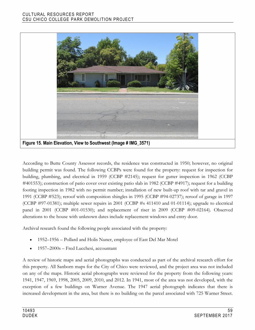
CULTURAL RESOURCES REPORT CSU CHICO COLLEGE PA RK DEMOLITION PROJECT
10493 59 DUDEK SEPTEMBER 2017
Figure 15. Main Elevation, View to Southwest (Image # IMG_3571)
According to Butte County Assessor records, the residence was constructed in 1950; however, no original
building permit was found. The following CCBPs were found for the property: request for inspection for
building, plumbing, and electrical in 1959 (CCBP #2145); request for gutter inspection in 1962 (CCBP
#401553); construction of patio cover over existing patio slab in 1982 (CCBP #4917); request for a building
footing inspection in 1982 with no permit number; installation of new built-up roof with tar and gravel in
1991 (CCBP #523); reroof with composition shingles in 1995 (CCBP #94-02737); reroof of garage in 1997
(CCBP #97-01381); multiple sewer repairs in 2001 (CCBP #s 411410 and 01-01114); upgrade to electrical
panel in 2001 (CCBP #01-01530); and replacement of riser in 2009 (CCBP #09-02164). Observed
alterations to the house with unknown dates include replacement windows and entry door.
Archival research found the following people associated with the property:
1952–1956 – Pollard and Holis Nuner, employee of East Del Mar Motel
1957–2000s – Fred Lucchesi, accountant
A review of historic maps and aerial photographs was conducted as part of the archival research effort for
this property. All Sanborn maps for the City of Chico were reviewed, and the project area was not included
on any of the maps. Historic aerial photographs were reviewed for the property from the following years:
1941, 1947, 1969, 1998, 2005, 2009, 2010, and 2012. In 1941, most of the area was not developed, with the
exception of a few buildings on Warner Avenue. The 1947 aerial photograph indicates that there is
increased development in the area, but there is no building on the parcel associated with 725 Warner Street.

CULTURAL RESOURCES REPORT CSU CHICO COLLEGE PA RK DEMOLITION PROJECT
10493 60 DUDEK SEPTEMBER 2017
By 1947, the intersecting streets of Brice Avenue, Stadium Way, and La Vista Way are visible. The 1969
aerial photograph indicates additional development in the area, including the parcel associated with 725
Warner Street, which is consistent with the 1950 date of construction. The remaining years of historic aerial
photographs offer limited information because the house is largely obscured by trees (NETR 2017).
Property 10: 899 Warner Street, APN 003-120-011-000
Property 10 is a single-family residence built in 1939 facing onto Warner Street (Figure 16). Due to extensive
alterations to the residence, the original architectural style cannot be determined. The one-story building is
irregular in plan with replacement horizontal wood siding and a hipped roof sheathed in composition
shingles. The northeast (main) elevation presents as two sections: the central block of the house, which
features an offset entry point, and the right (northern) section, which features a large brick exterior eave wall
chimney and is recessed approximately 4 feet from the central block of the house. The main point of entry
features a poured concrete stoop clad with brick veneer and is accessed from a front walkway and two
curved steps. The front entry is also accented by brick veneer detailing at-grade flanking the entry door and
under a fixed wood-frame picture window. Fenestration across the elevation is irregular and contains a one-
over-one wood frame window, a simple wood entry door, the large picture window, and another window
that is largely obscured by a tree on the north side of the house.
Figure 16. Main Elevation, View to Southwest (Image # IMG_3558)
According to Butte County Assessor records, the residence was constructed in 1939; however, no original
building permit was found. The following CCBPs were found for the property: electrical work in 1957
(CCBP #943); removal and replacement of old window sash in 1960 (CCBP #2861); repairs to composition
shingle roof in 1973 (CCBP #8501); removal and replacement of existing siding on the house and garage in

CULTURAL RESOURCES REPORT CSU CHICO COLLEGE PA RK DEMOLITION PROJECT
10493 61 DUDEK SEPTEMBER 2017
1986 (CCBP #7989); replacement of windows in 1986 (CCBP #7989); electrical work, including new wiring
in walls and new box, in 1986 (CCBP #8399); reroof with composition shingles in 1987 (CCBP #9457); and
installation of a Payne heating and cooling unit in 1987 (CCBP #9497). Observed alterations to the house
with unknown dates include a replacement entry door, addition of brick veneer detailing, and
reconfiguration of openings on the main elevation.
Archival research found the following people associated with the property:
1940–1980 – Van and Alice Normoyle
1985–1987 – Sharon Wallace
Van Normoyle had a variety of occupations according to archival research, including salesman, manager of
the Park Hotel, and restaurateur.
A review of historic maps and aerial photographs was conducted as part of the archival research effort for
this property. All Sanborn maps for the City of Chico were reviewed, and the project area was not included
on any of the maps. Historic aerial photographs were reviewed for the property from the following years:
1941, 1947, 1969, 1998, 2005, 2009, 2010, and 2012. In 1941, most of the area was not developed, with the
exception of a few buildings on Warner Avenue. Poor image quality resulted in limited information about
the subject property, which should be visible in 1941 given its 1939 date of construction. The 1947 aerial
photograph indicates additional development in the area, including a building located on the parcel
associated with 899 Warner Street. The remaining years of historic aerial photographs offer limited
information because the house is largely obscured by trees (NETR 2017).
CULTURAL RESOURCES REPORT CSU CHICO COLLEGE PA RK DEMOLITION PROJECT
10493 62 DUDEK SEPTEMBER 2017
INTENTIONALLY LEFT BLANK

CULTURAL RESOURCES REPORT CSU CHICO COLLEGE PA RK DEMOLITION PROJECT
10493 63 DUDEK SEPTEMBER 2017
5 SIGNIFICANCE EVALUATIONS
5.1 Property 1: 602 Brice Avenue
NRHP/CRHR Statement of Significance
In consideration of the project site’s history and requisite integrity, Dudek finds Property 1 not eligible for
listing in the NRHP or CRHR based on the following significance evaluation and in consideration of
national and state eligibility criteria.
Criterion A/1: Associated with events that have made a significant contribution to the broad patterns of our history.
Archival research did not find any associations with events that have made a significant contribution to the
broad patterns of local or regional history. The subject property is one of many single-family residences
from approximately the same period of construction (1930s–1950s), and no historical associations or
patterns of development were identified. Residential development in Chico followed industrial development
with the rise of companies like the Diamond Match Company. Establishment of the Chico Army Air Field
(Air Field) in the early 1940s created an increased military presence in Chico in the years leading up to
World War II, which had a direct effect on residential development in Chico during and after the war.
During the war, housing was needed for active-duty service members and their families. Following the war,
housing was needed for returning service members who were ready to settle down and start families in
Chico, and for service members who chose to stay in Chico following closure of the Air Field in 1945.
These patterns of development were seen across the United States in the years leading up to and following
World War II, when industry began to boom and residential development became a priority to house a
growing post-war population. Due to a lack of significant associations with events important to history, the
subject property does not appear eligible under NRHP/CRHR Criteria A/1.
Criterion B/2: Associated with the lives of persons significant in our past.
All owner and occupant names identified with the subject property were researched for possible
significance. Archival research failed to indicate any associations with significant persons. For these reasons,
the subject property does not appear eligible under NRHP/CRHR Criteria B/2.
Criterion C/3: Embody the distinctive characteristics of a type, period, or method of construction, or that represent the work of a master, or that possess high artistic values, or that represent a significant and distinguishable entity whose components may lack individual distinction.
To support a rapidly growing population in the years surrounding World War II, builders in Chico turned to
one of the most popular architectural styles of the time, the Ranch style. The subject property was
constructed in 1946 when Chico (and much of the United States) was experiencing a residential boom in
response to local industrial and military-related growth. Although the subject property retains the most basic

CULTURAL RESOURCES REPORT CSU CHICO COLLEGE PA RK DEMOLITION PROJECT
10493 64 DUDEK SEPTEMBER 2017
elements of the Ranch style (i.e., one story in height, use of large picture windows, variety of cladding,
asymmetry in the façade), the building exhibits substantial alterations that have compromised its integrity,
including reconfiguration of entry points on the northeast elevation, addition of an open trellis on the
northeast elevation, addition of a carport, addition of louvers over windows on the main elevation, and
replacement of the original garage door. The result is a relatively altered and unremarkable example of a
Ranch-style residence. Archival building permit research did not identify the name(s) of the original builder
or architect, but the building is not likely to be the work of a master architect or important creative
individual. Finally, the subject property does not appear eligible as a contributor to a historic district. For all
of these reasons, the subject property does not appear eligible under NRHP/CRHR Criteria C/3.
Criterion D/4: Have yielded, or may be likely to yield, information important in prehistory or history.
There is no evidence to suggest that this property has the potential to yield information important to state
or local history, nor is it associated with a known archaeological resource. Therefore, the property is
recommended not eligible under NRHP/CRHR Criterion D/4.
California Historical Landmark Statement of Significance
In consideration of the subject property’s history and requisite integrity, Dudek finds the property not
eligible for designation as a CHL based on the following significance evaluation and in consideration of
CHL eligibility criteria.
The first, last, only, or most significant of its type in the state or within a large geographic region (Northern, Central, or Southern California).
The subject property is a modest and altered example of a Ranch-style single-family residence constructed in
1946. The building represents a common residential house form that was popular throughout the United
States following World War II due to the ability to mass produce materials and plans. It is not the first or
last Ranch-style residence to be constructed in Chico, nor is it a significant example of its type. The subject
property is not known to be the work of an important architect, builder, engineer, or designer, nor was it
built using an innovative construction technique. Therefore, the subject property is recommended not
eligible for listing as a CHL under this criterion.
Associated with an individual or group having a profound influence on the history of California.
All owner and occupant names identified with the subject property were researched for possible
significance. Archival research failed to reveal any associations with significant individuals from the past.
Therefore, the subject property is recommended not eligible for listing as a CHL under this criterion.

CULTURAL RESOURCES REPORT CSU CHICO COLLEGE PA RK DEMOLITION PROJECT
10493 65 DUDEK SEPTEMBER 2017
A prototype of, or an outstanding example of, a period, style, architectural movement or construction or is one of the more notable works or the best surviving work in a region of a pioneer architect, designer or master builder.
The building represents a common Ranch-style house that was popular throughout the United States in the
years following World War II due to the ability to mass produce materials and plans. The subject property is
not a prototype or outstanding example of its style. It exhibits the most basic design features of the Ranch
style, but is altered from its original form and cannot be considered a valuable example of the style.
Furthermore, the building is not known to be the work of an important architect, builder, engineer, or
designer, and is not known to have been built using an innovative construction technique. Therefore, the
subject property is recommended not eligible for listing as a CHL under this criterion.
City of Chico Criteria
City of Chico historic resource designation criteria closely follow those of the NRHP and CRHR with
regard to consideration of important events, people, and architectural merit. Based on the
NRHP/CRHR/CHL criteria discussion above, the subject property is recommended as not eligible for
listing under all City of Chico designation criteria.
Integrity Discussion
Integrity is the authenticity of a historical resource’s physical identity as evidenced by the survival of
characteristics that existed during the resource’s period of significance, and the historical resource’s ability to
convey that significance. To be listed in the NRHP, a property must not only be shown to be significant under
the NRHP criteria, but it also must have integrity. Similar stipulations apply to listing at the state level, but the
threshold is lower for the CRHR, particularly if the site has potential to yield significant scientific or historic
information. The evaluation of integrity is sometimes a subjective judgment, but it must always be grounded in
an understanding of a property’s physical features and how they relate to its significance. In consideration of
the NRHP, historic properties either retain integrity or they do not. Seven aspects or qualities, in various
combinations, define integrity: location, design, setting, materials, workmanship, feeling, and association (NPS
1990). To retain historic integrity, a property generally possesses several, if not most, of the aspects. The
retention of specific aspects of integrity is paramount for a property to convey its significance.
The subject property’s integrity is as follows:
Location: The building is sited on the original location of construction in its original orientation. Therefore,
the subject property retains integrity of location.
Design: The building was subjected to several alterations over time that have significantly compromised its
integrity of design, including reconfiguration of entry points on the northeast elevation, addition of a carport
in front of the original garage, addition of an open trellis on the northeast elevation, the addition of louvers
CULTURAL RESOURCES REPORT CSU CHICO COLLEGE PA RK DEMOLITION PROJECT
10493 66 DUDEK SEPTEMBER 2017
over windows on the main elevation, and replacement of the garage door. Therefore, the building does not
maintain integrity of design.
Setting: Although the subject property maintains its original property boundaries, the surrounding areas have
changed significantly over time. The property’s integrity of setting was compromised by development of
CSU Chico, as noted when comparing the 1969 historic aerial photograph to the 1998 historic aerial
photograph. In 1969, there are large open parcels of land to the south and west of the neighborhood, but by
1998, there is significant development on these large parcels, including large campus buildings, access roads,
and parking lots. Additionally, the areas to the south and west are now heavily landscaped and
pedestrianized. Therefore, the property’s integrity of setting is present, but is diminished by development in
and around the CSU Chico campus (NETR 2017).
Materials: Numerous alterations to the house have compromised the property’s material integrity, including
the addition of metal louvered sunshades, construction of a wooden trellis, addition of the carport, and
replacement of the garage door. All of these alterations introduced new materials to the subject property
that were not part of the original design. Therefore, the building does not maintain integrity of materials.
Workmanship: Similar to the issue with materials, the physical evidence of craftsman’s skills in
constructing the original building was compromised by the exterior alterations to the building.
Therefore, the building no longer retains its integrity of workmanship.
Feeling: The alterations made to the subject property significantly impact the building’s ability to correlate to
a single-family residence designed in the Ranch style of architecture. Currently the building reads as two
separate properties when evaluating the southeast (main) elevation and the northeast (side) elevation. Multiple
entry points on the northeast elevation create a feeling of a multi-family unit and distract from the original
design and feeling as a single-family residence. Therefore, the property no longer retains its integrity of feeling.
Association: The property has no direct links with important events or people. Therefore, the building does
not have integrity of association.
In summary, the subject property appears not eligible under all NRHP, CRHR, and CHL designation
criteria. Further, the property exhibits diminished integrity of setting, feeling, and association, and no longer
retains integrity of design, materials, or workmanship. Consequently, the property does not maintain the
requisite integrity to warrant listing in the NRHP or CRHR, or as a CHL.
5.2 Property 2: 615 Brice Avenue
NRHP/CRHR Statement of Significance
In consideration of the project site’s history and requisite integrity, Dudek finds Property 2 not eligible for
listing in the NRHP or CRHR based on the following significance evaluation and in consideration of
national and state eligibility criteria.

CULTURAL RESOURCES REPORT CSU CHICO COLLEGE PA RK DEMOLITION PROJECT
10493 67 DUDEK SEPTEMBER 2017
Criterion A/1: Associated with events that have made a significant contribution to the broad patterns of our history.
Archival research did not find any associations with events that have made a significant contribution to the
broad patterns of local or regional history. The subject property is one of many single-family residences
from approximately the same period of construction (1930s–1950s), and no historical associations or
patterns of development were identified. Residential development in Chico followed industrial development
with the rise of companies like the Diamond Match Company. Establishment of the Chico Army Air Field
in the early 1940s created an increased military presence in Chico in the years leading up to World War II,
which had a direct effect on residential development in Chico during and after the war. During the war,
housing was needed for active-duty service members and their families. Following the war, housing was
needed for returning service members who were ready to settle down and start families in Chico, and for
service members who chose to stay in Chico following closure of the Air Field in 1945. These patterns of
development were seen across the United States in the years leading up to and following World War II,
when industry began to boom and residential development became a priority to house a growing post-war
population. Due to a lack of significant associations with events important to history, the subject property
does not appear eligible under NRHP/CRHR Criteria A/1.
Criterion B/2: Associated with the lives of persons significant in our past.
All owner and occupant names identified with the subject property were researched for possible
significance. Archival research failed to indicate any associations with significant persons. For this reason,
the subject property does not appear eligible under NRHP/CRHR Criteria B/2.
Criterion C/3: Embody the distinctive characteristics of a type, period, or method of construction, or that represent the work of a master, or that possess high artistic values, or that represent a significant and distinguishable entity whose components may lack individual distinction.
To support a rapidly growing population in the years surrounding World War II, builders in Chico turned to
one of the most popular architectural styles of the time, the Ranch Style. The subject property was
constructed in 1951 when Chico (and much of the United States) was experiencing a residential boom in
response to local industrial and military-related growth. Although the subject property retains the most basic
elements of the Ranch style (i.e., one story in height, use of large picture windows, variety of cladding,
asymmetry in the façade), the building exhibits substantial alterations that have compromised its integrity,
including replacement roof, replacement windows, replacement garage door, and replacement entry door.
The result is a relatively altered and unremarkable example of a Ranch-style residence. Archival building
permit research did not identify the name(s) of the original builder or architect, but the building is not likely
to be the work of a master architect or important creative individual. Finally, the subject property does not
appear eligible as a contributor to a historic district. For all of these reasons, the subject property does not
appear eligible under NRHP/CRHR Criteria C/3.

CULTURAL RESOURCES REPORT CSU CHICO COLLEGE PA RK DEMOLITION PROJECT
10493 68 DUDEK SEPTEMBER 2017
Criterion D/4: Have yielded, or may be likely to yield, information important in prehistory or history.
There is no evidence to suggest that this property has the potential to yield information important to state
or local history, nor is it associated with a known archaeological resource. Therefore, the property is
recommended not eligible under NRHP/CRHR Criterion D/4.
California Historical Landmark Statement of Significance
In consideration of the subject property’s history and requisite integrity, Dudek finds the property not
eligible for designation as a CHL based on the following significance evaluation and in consideration of
CHL eligibility criteria:
The first, last, only, or most significant of its type in the state or within a large geographic region (Northern, Central, or Southern California).
The subject property is a modest and altered example of a Ranch style single-family residence constructed in
1951. The building represents a common residential house form that was popular throughout the United
States following World War II due to the ability to mass produce materials and plans. It is not the first or
the last Ranch-style residence to be constructed in Chico, nor is it a significant example of its type. The
subject property is not known to be the work of an important architect, builder, engineer, or designer, nor
was it built using an innovative construction technique. Therefore, the subject property is recommended not
eligible for listing as a CHL under this criterion.
Associated with an individual or group having a profound influence on the history of California.
All owner and occupant names identified with the subject property were researched for possible
significance. Archival research failed to reveal any associations with significant individuals from the past.
Therefore, the subject property is recommended not eligible for listing as a CHL under this criterion.
A prototype of, or an outstanding example of, a period, style, architectural movement or construction or is one of the more notable works or the best surviving work in a region of a pioneer architect, designer or master builder.
The building represents a common Ranch-style house that was popular throughout the United States in the
years following World War II due to the ability to mass produce materials and plans. The subject property is
not a prototype or outstanding example of its style. It exhibits the most basic design features of the Ranch
style, but is altered from its original form and cannot be considered a valuable example of the style.
Furthermore, the building is not known to be the work of an important architect, builder, engineer, or
designer, and is not known to have been built using an innovative construction technique. Therefore, the
subject property is recommended not eligible for listing as a CHL under this criterion.

CULTURAL RESOURCES REPORT CSU CHICO COLLEGE PA RK DEMOLITION PROJECT
10493 69 DUDEK SEPTEMBER 2017
City of Chico Criteria
City of Chico historic resource designation criteria closely follow those of the NRHP and CRHR with
regard to consideration of important events, people, and architectural merit. Based on the
NRHP/CRHR/CHL criteria discussion above, the subject property is recommended not eligible for listing
under all City of Chico designation criteria.
Integrity Discussion
Location: The building is sited on the original location of construction in its original orientation. Therefore,
the subject property retains integrity of location.
Design: The building was subjected to several alterations over time that have significantly compromised its
integrity of design, including replacement roof, replacement windows, replacement entry door, and
replacement garage door. Therefore, the building does not maintain integrity of design.
Setting: Although the subject property maintains its original property boundaries, the surrounding areas have
changed significantly over time. The surrounding area’s integrity was compromised by development of CSU
Chico, as noted when comparing the 1969 historic aerial photograph to the 1998 historic aerial photograph.
In 1969, there are large open parcels of land to the south and west of the neighborhood, but by 1998, there
is significant development on these large parcels, including large campus buildings, access roads, and parking
lots. Additionally, the areas to the south and west are now heavily landscaped and pedestrianized (NETR
2017). Therefore, the property’s integrity of setting is present but is diminished by development in and
around the CSU Chico campus.
Materials: There have been numerous alterations to the house that have compromised the property’s
material integrity, including roof replacement, window replacement, door replacement, and garage door
replacement. All of these alterations introduced new materials to the subject property that were not part of
the original design. Therefore, the building does not maintain integrity of materials.
Workmanship: Similar to the issue with materials, the physical evidence of a craftsman’s skills in
constructing the original building was compromised by the exterior alterations to the building.
Therefore, the building no longer retains its integrity of workmanship.
Feeling: Alterations made to the subject property and the surrounding residential neighborhood have
impacted the building’s ability to convey its historic sense of post–World War II residential development in
Chico. Therefore, the property no longer retains its integrity of feeling.
Association: The property has no direct links with important events or people. Therefore, the building does
not have integrity of association.
In summary, the subject property appears not eligible under all NRHP, CRHR, and CHL designation
criteria. Further, the property exhibits diminished integrity of, setting, feeling, and association, and no longer

CULTURAL RESOURCES REPORT CSU CHICO COLLEGE PA RK DEMOLITION PROJECT
10493 70 DUDEK SEPTEMBER 2017
retains integrity of design, materials, or workmanship. Consequently, the property does not maintain
requisite integrity to warrant listing in the NRHP or CRHR, or as a CHL.
5.3 Property 3: 616 Brice Avenue
NRHP/CRHR Statement of Significance
In consideration of the project site’s history and requisite integrity, Dudek finds Property 3 not eligible for
listing in the NRHP or CRHR based on the following significance evaluation and in consideration of
national and state eligibility criteria.
Criterion A/1: Associated with events that have made a significant contribution to the broad patterns of our history.
Archival research did not find any associations with events that have made a significant contribution to the
broad patterns of local or regional history. The subject property is one of many single-family residences
from approximately the same period of construction (1930s–1950s), and no historical associations or
patterns of development were identified. Residential development in Chico followed industrial development
with the rise of companies like the Diamond Match Company. Establishment of the Chico Army Air Field
in the early 1940s created an increased military presence in Chico in the years leading up to World War II,
which had a direct effect on residential development in Chico during and after the war. During the war,
housing was needed for active-duty service members and their families. Following the war, housing was
needed for returning service members who were ready to settle down and start families in Chico, and for
service members who chose to stay in Chico following closure of the Air Field in 1945. These patterns of
development were seen across the United States in the years leading up to and following World War II,
when industry began to boom and residential development became a priority to house a growing post-war
population. Due to a lack of significant associations with events important to history, the subject property
does not appear eligible under NRHP/CRHR Criteria A/1.
Criterion B/2: Associated with the lives of persons significant in our past.
All owner and occupant names identified with the subject property were researched for possible
significance. Archival research failed to indicate any associations with significant persons. For this reason,
the subject property does not appear eligible under NRHP/CRHR Criteria B/2.
Criterion C/3: Embody the distinctive characteristics of a type, period, or method of construction, or that represent the work of a master, or that possess high artistic values, or that represent a significant and distinguishable entity whose components may lack individual distinction.
To support a rapidly growing population in the years surrounding World War II, builders in Chico turned to one
of the most popular architectural styles of the time, the Ranch style. The subject property was constructed in
1946 when Chico (and much of the United States) was experiencing a residential boom in response to local
industrial and military-related growth. Although the subject property retains the most basic elements of the
CULTURAL RESOURCES REPORT CSU CHICO COLLEGE PA RK DEMOLITION PROJECT
10493 71 DUDEK SEPTEMBER 2017
Ranch style (i.e., one story in height, variety of cladding, asymmetry in the façade), the building exhibits
substantial alterations that have compromised its integrity, including replacement windows, replacement entry
door, and replacement roofing. The result is a relatively altered and unremarkable example of a Ranch-style
residence. Archival building permit research did not identify the name(s) of the original builder or architect, but
the building is not likely to be the work of a master architect or important creative individual. Finally, the subject
property does not appear eligible as a contributor to a historic district. For all of these reasons, the subject
property does not appear eligible under NRHP/CRHR Criteria C/3.
Criterion D/4: Have yielded, or may be likely to yield, information important in prehistory or history.
There is no evidence to suggest that this property has the potential to yield information important to state
or local history, nor is it associated with a known archaeological resource. Therefore, the property is
recommended not eligible under NRHP/CRHR Criterion D/4.
California Historical Landmark Statement of Significance
In consideration of the subject property’s history and requisite integrity, Dudek finds the property not
eligible for designation as a CHL based on the following significance evaluation and in consideration of
CHL eligibility criteria.
The first, last, only, or most significant of its type in the state or within a large geographic region (Northern, Central, or Southern California).
The subject property is a modest and altered example of a Ranch-style single-family residence constructed in
1946. The building represents a common residential house form that was popular throughout the United
States following World War II due to the ability to mass produce materials and plans. It is not the first or
last Ranch-style residence to be constructed in Chico, nor is it a significant example of its type. The subject
property is not known to be the work of an important architect, builder, engineer, or designer, nor was it
built using an innovative construction technique. Therefore, the subject property is recommended not
eligible for listing as a CHL under this criterion.
Associated with an individual or group having a profound influence on the history of California.
All owner and occupant names identified with the subject property were researched for possible
significance. Archival research failed to reveal any associations with significant individuals from the past.
Therefore, the subject property is recommended not eligible for listing as a CHL under this criterion.
A prototype of, or an outstanding example of, a period, style, architectural movement or construction or is one of the more notable works or the best surviving work in a region of a pioneer architect, designer or master builder.
The building represents a common Ranch-style house that was popular throughout the United States in the
years following World War II due to the ability to mass produce materials and plans. The subject property is
CULTURAL RESOURCES REPORT CSU CHICO COLLEGE PA RK DEMOLITION PROJECT
10493 72 DUDEK SEPTEMBER 2017
not a prototype or outstanding example of its style. It exhibits the most basic design features of the Ranch
style, but is altered from its original form and cannot be considered a valuable example of the style.
Furthermore, the building is not known to be the work of an important architect, builder, engineer, or
designer, and is not known to have been built using an innovative construction technique. Therefore, the
subject property is recommended not eligible for listing as a CHL under this criterion.
City of Chico Criteria
City of Chico historic resource designation criteria closely follow those of the NRHP and CRHR with
regard to consideration of important events, people, and architectural merit. Based on the
NRHP/CRHR/CHL criteria discussion above, the subject property is also recommended not eligible for
listing under all City of Chico designation criteria.
Integrity Discussion
Location: The building is sited on the original location of construction in its original orientation. Therefore,
the subject property retains integrity of location.
Design: The building was subjected to several alterations over time that have significantly compromised its
integrity of design, including replacement roofing, replacement windows, and replacement entry door.
Therefore, the building does not maintain integrity of design.
Setting: Although the subject property maintains its original property boundaries, the surrounding areas have
changed significantly over time. The surrounding area’s integrity was compromised by development of CSU
Chico, as noted when comparing the 1969 historic aerial photograph to the 1998 historic aerial photograph.
In 1969, there are large open parcels of land to the south and west of the neighborhood, but by 1998, there
is significant development on these large parcels, including large campus buildings, access roads, and parking
lots. Additionally, the areas to the south and west are now heavily landscaped and pedestrianized (NETR
2017). Therefore, the property’s integrity of setting is present but is diminished by development in and
around the CSU Chico campus.
Materials: Numerous alterations to the house have compromised the property’s material integrity, including
roof replacement, window replacement, and door replacement. All of these alterations introduced new
materials to the subject property that were not part of the original design. Therefore, the building does not
maintain integrity of materials.
Workmanship: Similar to the issue with materials, the physical evidence of a craftsman’s skills in
constructing the original building was compromised by the exterior alterations to the building.
Therefore, the building no longer retains its integrity of workmanship.

CULTURAL RESOURCES REPORT CSU CHICO COLLEGE PA RK DEMOLITION PROJECT
10493 73 DUDEK SEPTEMBER 2017
Feeling: Alterations made to the subject property and the surrounding residential neighborhood have
impacted the building’s ability to convey its historic sense of post–World War II residential development in
Chico. Therefore, the property no longer retains its integrity of feeling.
Association: The property has no direct links with important events or people. Therefore, the building does
not have integrity of association.
In summary, the subject property appears not eligible under all NRHP, CRHR, and CHL designation
criteria. Further, the property exhibits diminished integrity of, setting, feeling, and association, and no longer
retains integrity of design, materials, or workmanship. Consequently, the property does not maintain
requisite integrity to warrant listing in the NRHP or CRHR, or as a CHL.
5.4 Property 4: 628 Brice Avenue
NRHP/CRHR Statement of Significance
In consideration of the project site’s history and requisite integrity, Dudek finds Property 4 not eligible for
listing in the NRHP or CRHR based on the following significance evaluation and in consideration of
national and state eligibility criteria.
Criterion A/1: Associated with events that have made a significant contribution to the broad patterns of our history.
Archival research did not find any associations with events that have made a significant contribution to the
broad patterns of local or regional history. The subject property is one of many single-family residences
from approximately the same period of construction (1930s–1950s), and no historical associations or
patterns of development were identified. Residential development in Chico followed industrial development
with the rise of companies like the Diamond Match Company. Establishment of the Chico Army Air Field
in the early 1940s created an increased military presence in Chico in the years leading up to World War II,
which had a direct effect on residential development in Chico during and after the war. During the war,
housing was needed for active-duty service members and their families. Following the war, housing was
needed for returning service members who were ready to settle down and start families in Chico, and for
service members who chose to stay in Chico following closure of the Air Field in 1945. These patterns of
development were seen across the United States in the years leading up to and following World War II,
when industry began to boom and residential development became a priority to house a growing post-war
population. Due to a lack of significant associations with events important to history, the subject property
does not appear eligible under NRHP/CRHR Criteria A/1.
Criterion B/2: Associated with the lives of persons significant in our past.
All owner and occupant names identified with the subject property were researched for possible
significance. Archival research failed to indicate any associations with significant persons. For these reasons,
the subject property does not appear eligible under NRHP/CRHR Criteria B/2.

CULTURAL RESOURCES REPORT CSU CHICO COLLEGE PA RK DEMOLITION PROJECT
10493 74 DUDEK SEPTEMBER 2017
Criterion C/3: Embody the distinctive characteristics of a type, period, or method of construction, or that represent the work of a master, or that possess high artistic values, or that represent a significant and distinguishable entity whose components may lack individual distinction.
To support a rapidly growing population in the years surrounding World War II, builders in Chico turned to
one of the most popular architectural styles of the time, the Ranch style. The subject property was
constructed in 1948 when Chico (and much of the United States) was experiencing a residential boom in
response to local industrial and military-related growth. Although the subject property retains the most basic
elements of the Ranch style (i.e., one story in height, variety of cladding, asymmetry in the façade) and is
relatively unaltered on the exterior, the building is an unremarkable and an ubiquitous example of a Ranch-
style residence seen throughout the United States, and does not warrant consideration as an individual
property. Further, the subject property is not eligible as a contributor to a historic district, since the
surrounding neighborhood contains modest examples of altered Ranch-style residences. Archival building
permit research did not identify the name(s) of the original builder or architect, but the building is not likely
to be the work of a master architect or important creative individual. For all of these reasons, the subject
property does not appear eligible under NRHP/CRHR Criteria C/3.
Criterion D/4: Have yielded, or may be likely to yield, information important in prehistory or history.
There is no evidence to suggest that this property has the potential to yield information important to state
or local history, nor is it associated with a known archaeological resource. Therefore, the property is
recommended not eligible under NRHP/CRHR Criterion D/4.
California Historical Landmark Statement of Significance
In consideration of the subject property’s history and requisite integrity, Dudek finds the property not
eligible for designation as a CHL based on the following significance evaluation and in consideration of
CHL eligibility criteria.
The first, last, only, or most significant of its type in the state or within a large geographic region (Northern, Central, or Southern California).
The subject property is a modest and altered example of a Ranch-style single-family residence constructed in
1948. The building represents a common residential house form that was popular throughout the United
States following World War II due to the ability to mass produce materials and plans. It is not the first nor
last Ranch-style residence to be constructed in Chico, nor is it a significant example of its type. The subject
property is not known to be the work of an important architect, builder, engineer, or designer, nor was it
built using an innovative construction technique. Therefore, the subject property is recommended not
eligible for listing as a CHL under this criterion.

CULTURAL RESOURCES REPORT CSU CHICO COLLEGE PA RK DEMOLITION PROJECT
10493 75 DUDEK SEPTEMBER 2017
Associated with an individual or group having a profound influence on the history of California.
All owner and occupant names identified with the subject property were researched for possible
significance. Archival research failed to reveal any associations with significant individuals from the past.
Therefore, the subject property is recommended not eligible for listing as a CHL under this criterion.
A prototype of, or an outstanding example of, a period, style, architectural movement or construction or is one of the more notable works or the best surviving work in a region of a pioneer architect, designer or master builder.
The building represents a common Ranch-style house that was popular throughout the United States in the
years following World War II due to the ability to mass produce materials and plans. The subject property is
not a prototype or outstanding example of its style. It exhibits the most basic design features of the Ranch
style, but is altered from its original form and cannot be considered a valuable example of the style.
Furthermore, the building is not known to be the work of an important architect, builder, engineer, or
designer, and is not known to have been built using an innovative construction technique. Therefore, the
subject property is recommended not eligible for listing as a CHL under this criterion.
City of Chico Criteria
City of Chico historic resource designation criteria closely follow those of the NRHP and CRHR with
regard to consideration of important events, people, and architectural merit. Based on the
NRHP/CRHR/CHL criteria discussion above, the subject property is recommended not eligible for listing
under all City of Chico designation criteria.
Integrity Discussion
Location: The building is sited on the original location of construction in its original orientation. Therefore,
the subject property retains integrity of location.
Design: The building was subjected to several alterations over time that have significantly compromised its
integrity of design, including replacement roofing and replacement entry door. Therefore, the building does
not maintain integrity of design.
Setting: Although the subject property maintains its original property boundaries, the surrounding areas have
changed significantly over time. The surrounding area’s integrity was compromised by development of CSU
Chico, as noted when comparing the 1969 historic aerial photograph to the 1998 historic aerial photograph.
In 1969, there are large open parcels of land to the south and west of the neighborhood, but by 1998, there
is significant development on these large parcels, including large campus buildings, access roads, and parking
lots. Additionally, the areas to the south and west are now heavily landscaped and pedestrianized (NETR
2017). Therefore, the property’s integrity of setting is present but is diminished by development in and
around the CSU Chico campus.

CULTURAL RESOURCES REPORT CSU CHICO COLLEGE PA RK DEMOLITION PROJECT
10493 76 DUDEK SEPTEMBER 2017
Materials: Numerous alterations to the house have compromised the property’s material integrity, including
roof replacement and door replacement. All of these alterations introduced new materials to the subject property
that were not part of the original design. Therefore, the building does not maintain integrity of materials.
Workmanship: Similar to the issue with materials, the physical evidence of a craftsman’s skills in
constructing the original building was compromised by the exterior alterations to the building.
Therefore, the building no longer retains its integrity of workmanship.
Feeling: Alterations made to the subject property and the surrounding residential neighborhood have
impacted the building’s ability to convey its historic sense of post–World War II residential development in
Chico. Therefore, the property no longer retains its integrity of feeling.
Association: The property has no direct links with important events or people. Therefore, the building does
not have integrity of association.
In summary, the subject property appears not eligible under all NRHP, CRHR, and CHL designation
criteria. Further, the property exhibits diminished integrity of setting, feeling, and association, and no longer
retains integrity of design, materials, or workmanship. Consequently, the property does not maintain
requisite integrity to warrant listing in the NRHP or CRHR, or as a CHL.
5.5 Property 5: 608 La Vista Way
NRHP/CRHR Statement of Significance
In consideration of the project site’s history and requisite integrity, Dudek finds Property 5 not eligible for
listing in the NRHP or CRHR based on the following significance evaluation and in consideration of
national and state eligibility criteria.
Criterion A/1: Associated with events that have made a significant contribution to the broad patterns of our history.
Archival research did not find any associations with events that have made a significant contribution to the
broad patterns of local or regional history. The subject property is one of many single-family residences
from approximately the same period of construction (1930s–1950s), and no historical associations or
patterns of development were identified. Residential development in Chico followed industrial development
with the rise of companies like the Diamond Match Company. Establishment of the Chico Army Air Field
in the early 1940s created an increased military presence in Chico in the years leading up to World War II,
which had a direct effect on residential development in Chico during and after the war. During the war,
housing was needed for active-duty service members and their families. Following the war, housing was
needed for returning service members who were ready to settle down and start families in Chico, and for
service members who chose to stay in Chico following closure of the Air Field in 1945. These patterns of
development were seen across the United States in the years leading up to and following World War II,

CULTURAL RESOURCES REPORT CSU CHICO COLLEGE PA RK DEMOLITION PROJECT
10493 77 DUDEK SEPTEMBER 2017
when industry began to boom and residential development became a priority to house a growing post-war
population. Due to a lack of significant associations with events important to history, the subject property
does not appear eligible under NRHP/CRHR Criteria A/1.
Criterion B/2: Associated with the lives of persons significant in our past.
All owner and occupant names identified with the subject property were researched for possible
significance. Archival research failed to indicate any associations with significant persons. For this reason,
the subject property does not appear eligible under NRHP/CRHR Criteria B/2.
Criterion C/3: Embody the distinctive characteristics of a type, period, or method of construction, or that represent the work of a master, or that possess high artistic values, or that represent a significant and distinguishable entity whose components may lack individual distinction.
To support a rapidly growing population in the years surrounding World War II, builders in Chico turned to
one of the most popular architectural styles of the time, the Ranch style. The subject property was
constructed in 1940 when Chico (and much of the United States) was experiencing a residential boom in
response to local industrial and military-related growth. Although the subject property retains the most basic
elements of the Ranch style (i.e., one story in height, variety of cladding, asymmetry in the façade, large
chimney), the building exhibits substantial alterations, including additions to the south of the house with an
enclosed breezeway, a garage, reconfiguration of entry points on the south side of the main elevation,
addition of a security door at the main entry point, and the addition of rooftop air conditioning unit. The
result it is a relatively altered and unremarkable example of a Ranch-style residence. Archival building permit
research did not identify the name(s) of the original builder or architect, but the building is not likely to be
the work of a master architect or important creative individual. Finally, the subject property does not appear
eligible as a contributor to a historic district. For all of these reasons, the subject property does not appear
eligible under NRHP/CRHR Criteria C/3.
Criterion D/4: Have yielded, or may be likely to yield, information important in prehistory or history.
There is no evidence to suggest that this property has the potential to yield information important to state
or local history, nor is it associated with a known archaeological resource. Therefore, the property is
recommended not eligible under NRHP/CRHR Criterion D/4.
California Historical Landmark Statement of Significance
In consideration of the subject property’s history and requisite integrity, Dudek finds the property not
eligible for designation as a CHL based on the following significance evaluation and in consideration of
CHL eligibility criteria.

CULTURAL RESOURCES REPORT CSU CHICO COLLEGE PA RK DEMOLITION PROJECT
10493 78 DUDEK SEPTEMBER 2017
The first, last, only, or most significant of its type in the state or within a large geographic region (Northern, Central, or Southern California).
The subject property is a modest and altered example of a Ranch-style single-family residence constructed in
1940. The building represents a common residential house form that was popular throughout the United
States during World War II due to the ability to mass produce materials and plans. It is not the first or the
last Ranch-style residence to be constructed in Chico, nor is it a significant example of its type. The subject
property is not known to be the work of an important architect, builder, engineer, or designer, nor was it
built using an innovative construction technique. Therefore, the subject property is recommended not
eligible for listing as a CHL under this criterion.
Associated with an individual or group having a profound influence on the history of California.
All owner and occupant names identified with the subject property were researched for possible
significance. Archival research failed to reveal any associations with significant individuals from the past.
Therefore, the subject property is recommended not eligible for listing as a CHL under this criterion.
A prototype of, or an outstanding example of, a period, style, architectural movement or construction or is
one of the more notable works or the best surviving work in a region of a pioneer architect, designer or
master builder.
The building represents a common Ranch-style house that was popular throughout the United States in the
years following World War II due to the ability to mass produce materials and plans. The subject property is
not a prototype or outstanding example of its style. It exhibits the most basic design features of the Ranch
style, but is altered from its original form and cannot be considered a valuable example of the style.
Furthermore, the building is not known to be the work of an important architect, builder, engineer, or
designer, and is not known to have been built using an innovative construction technique. Therefore, the
subject property is recommended not eligible for listing as a CHL under this criterion.
City of Chico Criteria
City of Chico historic resource designation criteria closely follow those of the NRHP and CRHR with
regard to consideration of important events, people, and architectural merit. Based on the
NRHP/CRHR/CHL criteria discussion above, the subject property is recommended not eligible for listing
under all City of Chico designation criteria.
Integrity Discussion
Location: The building is sited on the original location of construction in its original orientation. Therefore,
the subject property retains integrity of location.

CULTURAL RESOURCES REPORT CSU CHICO COLLEGE PA RK DEMOLITION PROJECT
10493 79 DUDEK SEPTEMBER 2017
Design: The building was subjected to several alterations over time that have significantly compromised its
integrity of design, including construction of an addition, reconfiguration of entry points on the main
elevation, addition of rooftop air conditioning unit, and addition of a security door to the main entry point.
Therefore, the building does not maintain integrity of design.
Setting: Although the subject property maintains its original property boundaries, the surrounding areas have
changed significantly over time. However, the surrounding area’s integrity was compromised by development
of CSU Chico, as noted when comparing the 1969 historic aerial photograph to the 1998 historic aerial
photograph. In 1969, there are large open parcels of land to the south and west of the neighborhood, but by
1998, there is significant development on these large parcels, including large campus buildings, access roads,
and parking lots. Additionally, the areas to the south and west are now heavily landscaped and
pedestrianized (NETR 2017). Therefore, the property’s integrity of setting is present but is diminished by
development in and around the CSU Chico campus.
Materials: Numerous alterations to the house have compromised the property’s material integrity, including an
addition to the south of the house, reconfiguration of entry points, addition of a rooftop air conditioning unit,
and installation of a security door. All of these alterations introduced new materials to the subject property that
were not part of the original design. Therefore, the building does not maintain integrity of materials.
Workmanship: Similar to the issue with materials, the physical evidence of a craftsman’s skills in
constructing the original building was compromised by the exterior alterations to the building.
Therefore, the building no longer retains its integrity of workmanship.
Feeling: Alterations made to the subject property and the surrounding residential neighborhood have
impacted the building’s ability to convey its historic sense of post–World War II residential development in
Chico. Therefore, the property no longer retains its integrity of feeling.
Association: The property has no direct links with important events or people. Therefore, the building does
not have integrity of association.
In summary, the subject property appears not eligible under all NRHP, CRHR, and CHL designation
criteria. Further, the property exhibits diminished integrity of setting, feeling, and association, and no longer
retains integrity of design, materials, or workmanship. Consequently, the property does not maintain
requisite integrity to warrant listing in the NRHP or CRHR, or as a CHL.
5.6 Property 6: 615 La Vista Way
NRHP/CRHR Statement of Significance
In consideration of the project site’s history and requisite integrity, Dudek finds Property 6 not eligible for
listing in the NRHP or CRHR based on the following significance evaluation and in consideration of
national and state eligibility criteria.

CULTURAL RESOURCES REPORT CSU CHICO COLLEGE PA RK DEMOLITION PROJECT
10493 80 DUDEK SEPTEMBER 2017
Criterion A/1: Associated with events that have made a significant contribution to the broad patterns of our history.
Archival research did not find any associations with events that have made a significant contribution to the
broad patterns of local or regional history. The subject property is one of many single-family residences
from approximately the same period of construction (1930s–1950s), and no historical associations or
patterns of development were identified. Residential development in Chico followed industrial development
with the rise of companies like the Diamond Match Company. Establishment of the Chico Army Air Field
in the early 1940s created an increased military presence in Chico in the years leading up to World War II,
which had a direct effect on residential development in Chico during and after the war. During the war,
housing was needed for active-duty service members and their families. Following the war, housing was
needed for returning service members who were ready to settle down and start families in Chico, and for
service members who chose to stay in Chico following closure of the Air Field in 1945. These patterns of
development were seen across the United States in the years leading up to and following World War II,
when industry began to boom and residential development became a priority to house a growing post-war
population. Due to a lack of significant associations with events important to history, the subject property
does not appear eligible under NRHP/CRHR Criteria A/1.
Criterion B/2: Associated with the lives of persons significant in our past.
All owner and occupant names identified with the subject property were researched for possible
significance. Archival research failed to indicate any associations with significant persons. For this reason,
the subject property does not appear eligible under NRHP/CRHR Criteria B/2.
Criterion C/3: Embody the distinctive characteristics of a type, period, or method of construction, or that represent the work of a master, or that possess high artistic values, or that represent a significant and distinguishable entity whose components may lack individual distinction.
To support a rapidly growing population in the years surrounding World War II, builders in Chico turned to
one of the most popular architectural styles of the time, the Ranch style. The subject property was
constructed in 1947 when Chico (and much of the United States) was experiencing a residential boom in
response to local industrial and military-related growth. Although the subject property retains the most basic
elements of the Ranch style (i.e., one story in height, asymmetry in the façade, attached garage), the building
exhibits substantial alterations, including replacement windows, replacement entry door, replacement garage
door, and replacement roofing. The result it is a relatively altered and unremarkable example of a Ranch-
style residence. Archival building permit research did not identify the name(s) of the original builder or
architect, but the building is not likely to be the work of a master architect or important creative individual.
Finally, the subject property does not appear eligible as a contributor to a historic district. For all of these
reasons, the subject property does not appear eligible under NRHP/CRHR Criteria C/3.

CULTURAL RESOURCES REPORT CSU CHICO COLLEGE PA RK DEMOLITION PROJECT
10493 81 DUDEK SEPTEMBER 2017
Criterion D/4: Have yielded, or may be likely to yield, information important in prehistory or history.
There is no evidence to suggest that this property has the potential to yield information important to state
or local history, nor is it associated with a known archaeological resource. Therefore, the property is
recommended not eligible under NRHP/CRHR Criterion D/4.
California Historical Landmark Statement of Significance
In consideration of the subject property’s history and requisite integrity, Dudek finds the property not
eligible for designation as a CHL based on the following significance evaluation and in consideration of
CHL eligibility criteria.
The first, last, only, or most significant of its type in the state or within a large geographic region (Northern, Central, or Southern California).
The subject property is a modest and altered example of a Ranch-style single-family residence constructed in
1947. The building represents a common residential house form that was popular throughout the United
States following World War II due to the ability to mass produce materials and plans. It is not the first or
last Ranch-style residence to be constructed in Chico, nor is it a significant example of its type. The subject
property is not known to be the work of an important architect, builder, engineer, or designer, nor was it
built using an innovative construction technique. Therefore, the subject property is recommended not
eligible for listing as a CHL under this criterion.
Associated with an individual or group having a profound influence on the history of California.
All owner and occupant names identified with the subject property were researched for possible
significance. Archival research failed to reveal any associations with significant individuals from the past.
Therefore, the subject property is recommended not eligible for listing as a CHL under this criterion.
A prototype of, or an outstanding example of, a period, style, architectural movement or construction or is one of the more notable works or the best surviving work in a region of a pioneer architect, designer or master builder.
The building represents a common Ranch-style house that was popular throughout the United States in the
years following World War II due to the ability to mass produce materials and plans. The subject property is
not a prototype or outstanding example of its style. It exhibits the most basic design features of the Ranch
style, but is altered from its original form and cannot be considered a valuable example of the style.
Furthermore, the building is not known to be the work of an important architect, builder, engineer, or
designer, and is not known to have been built using an innovative construction technique. Therefore, the
subject property is recommended not eligible for listing as a CHL under this criterion.

CULTURAL RESOURCES REPORT CSU CHICO COLLEGE PA RK DEMOLITION PROJECT
10493 82 DUDEK SEPTEMBER 2017
City of Chico Criteria
City of Chico historic resource designation criteria closely follow those of the NRHP and CRHR with
regard to consideration of important events, people, and architectural merit. Based on the
NRHP/CRHR/CHL criteria discussion above, the subject property is recommended not eligible for listing
under all City of Chico designation criteria.
Integrity Discussion
Location: The building is sited on the original location of construction in its original orientation. Therefore,
the subject property retains integrity of location.
Design: The building was subjected to several alterations over time that have significantly compromised its
integrity of design, including replacement windows, replacement entry door, replacement garage door, and
replacement roofing. Therefore, the building does not maintain integrity of design.
Setting: Although the subject property maintains its original property boundaries, the surrounding areas have
changed significantly over time. The surrounding area’s integrity was compromised by development of CSU
Chico, as noted when comparing the 1969 historic aerial photograph to the 1998 historic aerial photograph.
In 1969, there are large open parcels of land to the south and west of the neighborhood, but by 1998, there
is significant development on these large parcels, including large campus buildings, access roads, and parking
lots. Additionally, the areas to the south and west are now heavily landscaped and pedestrianized (NETR
2017). Therefore, the property’s integrity of setting is present but is diminished by development in and
around the CSU Chico campus.
Materials: Numerous alterations to the house have compromised the property’s material integrity, including
replacement windows, replacement entry door, replacement garage door, and replacement roofing. All of
these alterations introduced new materials to the subject property that were not part of the original design.
Therefore, the building does not maintain integrity of materials.
Workmanship: Similar to the issue with materials, the physical evidence of a craftsman’s skills in
constructing the original building was compromised by the exterior alterations to the building.
Therefore, the building no longer retains its integrity of workmanship.
Feeling: Alterations made to the subject property and the surrounding residential neighborhood have
impacted the building’s ability to convey its historic sense of post–World War II residential development in
Chico. Therefore, the property no longer retains its integrity of feeling.
Association: The property has no direct links with important events or people. Therefore, the building does
not have integrity of association.

CULTURAL RESOURCES REPORT CSU CHICO COLLEGE PA RK DEMOLITION PROJECT
10493 83 DUDEK SEPTEMBER 2017
In summary, the subject property appears not eligible under all NRHP, CRHR, and CHL designation
criteria. Further, the property exhibits diminished integrity of setting, feeling, and association, and no longer
retains integrity of design, materials, or workmanship. Consequently, the property does not maintain
requisite integrity to warrant listing in the NRHP or CRHR, or as a CHL.
5.7 Property 7: 629 La Vista Way
NRHP/CRHR Statement of Significance
In consideration of the project site’s history and requisite integrity, Dudek finds Property 7 not eligible for
listing in the NRHP or CRHR based on the following significance evaluation and in consideration of
national and state eligibility criteria.
Criterion A/1: Associated with events that have made a significant contribution to the broad patterns of our history.
Archival research did not find any associations with events that have made a significant contribution to the
broad patterns of local or regional history. The subject property is one of many single-family residences
from approximately the same period of construction (1930s–1950s), and no historical associations or
patterns of development were identified. Residential development in Chico followed industrial development
with the rise of companies like the Diamond Match Company. Establishment of the Chico Army Air Field
in the early 1940s created an increased military presence in Chico in the years leading up to World War II,
which had a direct effect on residential development in Chico during and after the war. During the war,
housing was needed for active-duty service members and their families. Following the war, housing was
needed for returning service members who were ready to settle down and start families in Chico, and for
service members who chose to stay in Chico following closure of the Air Field in 1945. These patterns of
development were seen across the United States in the years leading up to and following World War II,
when industry began to boom and residential development became a priority to house a growing post-war
population. Due to a lack of significant associations with events important to history, the subject property
does not appear eligible under NRHP/CRHR Criteria A/1.
Criterion B/2: Associated with the lives of persons significant in our past.
All owner and occupant names identified with the subject property were researched for possible
significance. Archival research failed to indicate any associations with significant persons. For these reasons,
the subject property does not appear eligible under NRHP/CRHR Criteria B/2.
Criterion C/3: Embody the distinctive characteristics of a type, period, or method of construction, or that represent the work of a master, or that possess high artistic values, or that represent a significant and distinguishable entity whose components may lack individual distinction.
To support a rapidly growing population in the years surrounding World War II, builders in Chico turned to one
of the most popular architectural styles of the time, the Ranch style. The subject property was constructed in
1947 when Chico (and much of the United States) was experiencing a residential boom in response to local

CULTURAL RESOURCES REPORT CSU CHICO COLLEGE PA RK DEMOLITION PROJECT
10493 84 DUDEK SEPTEMBER 2017
industrial and military-related growth. Although the subject property retains the most basic elements of the
Ranch style (i.e., one story in height, asymmetry in the façade, use of large picture-style windows), the building
exhibits substantial alterations, including replacement windows, replacement entry door, replacement roofing,
and addition of a rooftop air conditioning unit. The result it is a relatively altered and unremarkable example of a
Ranch-style residence. Archival building permit research did not identify the name(s) of the original builder or
architect, but the building is not likely to be the work of a master architect or important creative individual.
Finally, the subject property does not appear eligible as a contributor to a historic district. For all of these reasons,
the subject property does not appear eligible under NRHP/CRHR Criteria C/3.
Criterion D/4: Have yielded, or may be likely to yield, information important in prehistory or history.
There is no evidence to suggest that this property has the potential to yield information important to state
or local history, nor is it associated with a known archaeological resource. Therefore, the property is
recommended not eligible under NRHP/CRHR Criterion D/4.
California Historical Landmark Statement of Significance
In consideration of the subject property’s history and requisite integrity, Dudek finds the property not
eligible for designation as a CHL based on the following significance evaluation and in consideration of
CHL eligibility criteria.
The first, last, only, or most significant of its type in the state or within a large geographic region (Northern, Central, or Southern California).
The subject property is a modest and altered example of a Ranch-style single-family residence constructed in
1947. The building represents a common residential house form that was popular throughout the United
States following World War II due to the ability to mass produce materials and plans. It is not the first or
the last Ranch-style residence to be constructed in Chico, nor is it a significant example of its type. The
subject property is not known to be the work of an important architect, builder, engineer, or designer, nor
was it built using an innovative construction technique. Therefore, the subject property is recommended not
eligible for listing as a CHL under this criterion.
Associated with an individual or group having a profound influence on the history of California.
All owner and occupant names identified with the subject property were researched for possible
significance. Archival research failed to reveal any associations with significant individuals from the past.
Therefore, the subject property is recommended not eligible for listing as a CHL under this criterion.

CULTURAL RESOURCES REPORT CSU CHICO COLLEGE PA RK DEMOLITION PROJECT
10493 85 DUDEK SEPTEMBER 2017
A prototype of, or an outstanding example of, a period, style, architectural movement or construction or is one of the more notable works or the best surviving work in a region of a pioneer architect, designer or master builder.
The building represents a common Ranch-style house that was popular throughout the United States in the
years following World War II due to the ability to mass produce materials and plans. The subject property is
not a prototype or outstanding example of its style. It exhibits the most basic design features of the Ranch
style, but is altered from its original form and cannot be considered a valuable example of the style.
Furthermore, the building is not known to be the work of an important architect, builder, engineer, or
designer, and is not known to have been built using an innovative construction technique. Therefore, the
subject property is recommended not eligible for listing as a CHL under this criterion.
City of Chico Criteria
City of Chico historic resource designation criteria closely follow those of the NRHP and CRHR with
regard to consideration of important events, people, and architectural merit. Based on the
NRHP/CRHR/CHL criteria discussion above, the subject property is recommended not eligible for listing
under all City of Chico designation criteria.
Integrity Discussion
Location: The building is sited on the original location of construction in its original orientation. Therefore,
the subject property retains integrity of location.
Design: The building was subjected to several alterations over time that have significantly compromised its
integrity of design, including replacement windows, replacement entry door, replacement roofing, and
addition of a rooftop air conditioning unit. Therefore, the building does not maintain integrity of design.
Setting: Although the subject property maintains its original property boundaries, the surrounding areas have
changed significantly over time. The surrounding area’s integrity was compromised by development of CSU
Chico, as indicated when comparing the 1969 historic aerial photograph to the 1998 historic aerial
photograph. In 1969, there are large open parcels of land to the south and west of the neighborhood, but by
1998, there is significant development on these large parcels, including large campus buildings, access roads,
and parking lots. Additionally, the areas to the south and west are now heavily landscaped and
pedestrianized (NETR 2017). Therefore, the property’s integrity of setting is present but is diminished by
development in and around the CSU Chico campus.
Materials: Numerous alterations to the house have compromised the property’s material integrity, including
replacement windows, replacement entry door, replacement roofing, and addition of a rooftop air
conditioning unit. All of these alterations introduced new materials to the subject property that were not
part of the original design. Therefore, the building does not maintain integrity of materials.

CULTURAL RESOURCES REPORT CSU CHICO COLLEGE PA RK DEMOLITION PROJECT
10493 86 DUDEK SEPTEMBER 2017
Workmanship: Similar to the issue with materials, the physical evidence of a craftsman’s skills in
constructing the original building was compromised by the exterior alterations to the building.
Therefore, the building no longer retains its integrity of workmanship.
Feeling: Alterations made to the subject property and the surrounding residential neighborhood have
impacted the building’s ability to convey its historic sense of post–World War II residential development in
Chico. Therefore, the property no longer retains its integrity of feeling.
Association: The property has no direct links with important events or people. Therefore, the building does
not have integrity of association.
In summary, the subject property appears not eligible under all NRHP, CRHR, and CHL designation
criteria. Further, the property exhibits diminished integrity of setting, feeling, and association, and no longer
retains integrity of design, materials, or workmanship. Consequently, the property does not maintain
requisite integrity to warrant listing in the NRHP or CRHR, or as a CHL.
5.8 Property 8: 630 Stadium Way
NRHP/CRHR Statement of Significance
In consideration of the project site’s history and requisite integrity, Dudek finds Property 8 not eligible for
listing in the NRHP or CRHR based on the following significance evaluation and in consideration of
national and state eligibility criteria.
Criterion A/1: Associated with events that have made a significant contribution to the broad patterns of our history.
Archival research did not find any associations with events that have made a significant contribution to the
broad patterns of local or regional history. The subject property is one of many single-family residences
from approximately the same period of construction (1930s–1950s), and no historical associations or
patterns of development were identified. Residential development in Chico followed industrial development
with the rise of companies like the Diamond Match Company. Establishment of the Chico Army Air Field
in the early 1940s created an increased military presence in Chico in the years leading up to World War II,
which had a direct effect on residential development in Chico during and after the war. During the war,
housing was needed for active-duty service members and their families. Following the war, housing was
needed for returning service members who were ready to settle down and start families in Chico, and for
service members who chose to stay in Chico following closure of the Air Field in 1945. These patterns of
development were seen across the United States in the years leading up to and following World War II,
when industry began to boom and residential development became a priority to house a growing post-war
population. Due to a lack of significant associations with events important to history, the subject property
does not appear eligible under NRHP/CRHR Criteria A/1.

CULTURAL RESOURCES REPORT CSU CHICO COLLEGE PA RK DEMOLITION PROJECT
10493 87 DUDEK SEPTEMBER 2017
Criterion B/2: Associated with the lives of persons significant in our past.
All owner and occupant names identified with the subject property were researched for possible
significance. Only one name warranted further research: William Henry Hutchinson (also known as “Old
Hutch”). See Section 2.2, above, for more information.
Following NRHP Guidance for Criterion B (Boland n.d.; NPS 1990), it is important to first assess the
importance of Old Hutch in relation to the historic context. Archival research reveals that Hutchinson is
significant within the local context of CSU Chico (see Section 2.2), with a period of significance from 1960
to 1976. This period captures the time when he lived at residence, his tenure as a full-time professor at CSU
Chico, and publication of perhaps his most important book. For the subject property to be eligible under
this criterion, it must be shown that Hutchinson gained importance while occupying the subject property.
Permit records and City directories confirm that Old Hutch lived at the residence on Stadium Way from at
least 1960 through 1976, although it is very likely that he lived at the home until at least 1978 when he
retired as a professor. This is further evidenced by the fact that the next owner did not occupy the property
until 1980. Research indicates that his time at the subject property overlaps some of his most important
contributions to Chico and CSU Chico. Hutchinson was a professor of California and Western History at
CSU Chico from 1953 through 1978 (he became a full-time professor beginning in 1964). He earned his
Master’s Degree in History from CSU Chico in 1961. In 1965, he was voted “Best Californian” by the
Common Wealth Club. Hutchinson received the Chico State Distinguished Teacher Award in 1968, and was
labeled an Outstanding Professor in the CSU system in 1977. His Pulitzer Prize–nominated book Oil, Land,
and Politics: The California Career of Thomas R. Bard was published in 1966 (Watkins et al. 1990).
Hutchinson also authored numerous books prior to his residency at Stadium Way, including his 1946 edits
to a collection of previously unpublished works by Eugene Manlove Rhodes, The Little Waddies. Hutchinson
edited other writings of Rhodes, including The Rhodes Reader (1957) and The Line of Least Resistance (1958).
Hutchinson completed his first biography on Rhodes in 1956, titled A Bar Cross Man.
It is also necessary to ascertain the length of time and nature of Hutchinson’s association with the subject
property. Old Hutch lived at the subject property from at least 1960 through 1976 (very likely until 1978),
and he continued to live in Chico until his death in 1990. The subject property was his primary residence
during that time, and he shared it with his wife Esther Ethel Ormsby (1908–1990), also known to locals as
“Red.” City directories from 1960 and 1976 verify that Old Hutch and Red lived at the subject property.
Census records also provide a timeline of Hutchinson’s other residences throughout his life, including his
home in Denver, Colorado (beginning with his birth in 1911); a short stint in Eastland, Texas, in the 1920s;
a return to Denver in the 1930s; working as a chief purser on passenger vessels during the Great
Depression; serving as a lieutenant commander in the U.S. Maritime Service during World War II
(California State Library 1998); and a residence in San Francisco, California, in the 1940s (although he was at
sea for several years). After his time at the subject property, he moved to another residence in Chico in 1980

CULTURAL RESOURCES REPORT CSU CHICO COLLEGE PA RK DEMOLITION PROJECT
10493 88 DUDEK SEPTEMBER 2017
located at 1611 Spruce Avenue, north of CSU Chico. In consideration of Hutchinson’s productive life as a
writer and a professor, the subject property is the most relevant.
Hutchinson’s local significance is more closely aligned with the recent history of CSU Chico than any
broader associations with the City of Chico. Although Hutchinson lived at the subject property during his
time as a professor and writer, the property itself does not convey his importance to CSU Chico, nor can it
be directly tied to his important publications. Although Hutchinson published arguably his most important
work while living at the subject property, this significance is not conveyed by the property. It is also
unknown where Hutchinson did most of his writing and research. Further, none of the local historians or
faculty interviewed about the Hutchinson house drew any important connections between the man and the
property. Further, after his retirement, CSU Chico dedicated the courtyard between Trinity Hall and Kendall
Hall in his honor on June 11, 1979. Labeled with wooden signage as “W.H. Hutchinson/Old Hutch’s
Plaza,” the plaza is a place strongly associated with Hutchinson, as students and faculty have fond memories
of him sitting on a specific bench in the courtyard enjoying the environment or chatting with students
(CSUC 2016). An off-campus residence such as the subject property is less closely associated with his
important contributions to CSU Chico and his work as a respected local historian and author.
The subject property itself has integrity issues. Although the subject property’s exterior retains requisite
integrity to the period of significance, the property’s interior has been altered since Old Hutch and Red
occupied it. It appears that the Hutchinsons added a swimming pool to the property when they first moved
in, and remodeled the home in 1966. Building permit research indicates that repairs had to be made to the
home after a fire in 1981, although the extent of interior repair/alteration is unclear.
In consideration of the information presented here, it does not appear that the subject property meets the
high burden of proof required under this criterion, as Hutchinson’s important contributions as a professor
and writer are much more closely aligned with the CSU Chico campus than the off-campus home he shared
with his wife. Further, the subject property does not contain specific features or elements that convey Old
Hutch’s significance, and its integrity has been altered since the couple vacated it. Finally, the home has not
been identified as important by the local historians and faculty who knew him. For all of these reasons, the
subject property does not appear eligible under NRHP/CRHR Criteria B/2.
Criterion C/3: Embody the distinctive characteristics of a type, period, or method of construction, or that represent the work of a master, or that possess high artistic values, or that represent a significant and distinguishable entity whose components may lack individual distinction.
To support a rapidly growing population in the years surrounding World War II, builders in Chico turned to
one of the most popular architectural styles of the time, the Ranch style. The subject property was
constructed in 1947 when Chico (and much of the United States) was experiencing a residential boom in
response to local industrial and military-related growth. Although the subject property retains the most basic
elements of the Ranch style (i.e., one story in height, asymmetry in the façade, gabled roofline), the building
exhibits alterations, including replacement windows, replacement door, and replacement roofing. The result

CULTURAL RESOURCES REPORT CSU CHICO COLLEGE PA RK DEMOLITION PROJECT
10493 89 DUDEK SEPTEMBER 2017
is an altered and unremarkable example of a Ranch-style residence. Archival building permit research did
not identify the name(s) of the original builder or architect, but the building is not likely to be the work of a
master architect or important creative individual. Finally, the subject property does not appear eligible as a
contributor to a historic district. For all of these reasons, the subject property does not appear eligible under
NRHP/CRHR Criteria C/3.
Criterion D/4: Have yielded, or may be likely to yield, information important in prehistory or history.
There is no evidence to suggest that this property has the potential to yield information important to state
or local history, nor is it associated with a known archaeological resource. Therefore, the property is
recommended not eligible under NRHP/CRHR Criterion D/4.
California Historical Landmark Statement of Significance
In consideration of the subject property’s history and requisite integrity, Dudek finds the property not
eligible for designation as a CHL based on the following significance evaluation and in consideration of
CHL eligibility criteria.
The first, last, only, or most significant of its type in the state or within a large geographic region (Northern, Central, or Southern California).
The subject property is a modest and altered example of a Ranch-style single-family residence constructed in
1947. The building represents a common residential house form that was popular throughout the United
States following World War II due to the ability to mass produce materials and plans. It is not the first or
the last Ranch-style residence to be constructed in Chico, nor is it a significant example of its type. The
subject property is not known to be the work of an important architect, builder, engineer, or designer, nor
was it built using an innovative construction technique. Therefore, the subject property is recommended not
eligible for listing as a CHL under this criterion.
Associated with an individual or group having a profound influence on the history of California.
All owner and occupant names identified with the subject property were researched for possible
significance. Archival research failed to reveal any associations with significant individuals from the past. As
discussed in consideration of NRHP/CRHR Criterion B/2, W.H. Hutchinson’s important contributions as
a CSU Chico professor and writer are much more closely aligned with the CSU Chico campus than the off-
campus home he shared with his wife. Further, the subject property does not contain specific features or
elements that convey his significance, and its integrity has been altered since the property was vacated by the
Hutchinsons in the late 1970s. Finally, the home has not been identified as important by the local historians
and faculty who knew him. Therefore, the subject property is recommended not eligible for listing as a CHL
under this criterion.

CULTURAL RESOURCES REPORT CSU CHICO COLLEGE PA RK DEMOLITION PROJECT
10493 90 DUDEK SEPTEMBER 2017
A prototype of, or an outstanding example of, a period, style, architectural movement or construction or is one of the more notable works or the best surviving work in a region of a pioneer architect, designer or master builder.
The building represents a common Ranch-style house that was popular throughout the United States in the
years following World War II due to the ability to mass produce materials and plans. The subject property is
not a prototype or outstanding example of its style. It exhibits the most basic design features of the Ranch
style, but is altered from its original form and cannot be considered a valuable example of the style.
Furthermore, the building is not known to be the work of an important architect, builder, engineer, or
designer, and is not known to have been built using an innovative construction technique. Therefore, the
subject property is recommended not eligible for listing as a CHL under this criterion.
City of Chico Criteria
City of Chico historic resource designation criteria closely follow those of the NRHP and CRHR with
regard to consideration of important events, people, and architectural merit. Based on the
NRHP/CRHR/CHL criteria discussion above, the subject property is recommended not eligible for listing
under all City of Chico designation criteria.
Integrity Discussion
Location: The building is sited on the original location of construction in its original orientation. Therefore,
the subject property retains integrity of location.
Design: The building was subjected to several alterations over time that have compromised its integrity of
design, including replacement windows, replacement door, and replacement roofing. Therefore, the building
does not maintain integrity of design.
Setting: Although the subject property maintains its original property boundaries, the surrounding areas have
changed significantly over time. However, the surrounding area’s integrity was compromised by CSU Chico
development, as noted when comparing the 1969 historic aerial photograph to the 1998 historic aerial
photograph. In 1969, there are large open parcels of land to the south and west of the neighborhood, but by
1998, there is significant development on these large parcels, including large campus buildings, access roads,
and parking lots. Additionally, the areas to the south and west are now heavily landscaped and
pedestrianized (NETR 2017). Therefore, the property’s integrity of setting is present but is diminished by
development in and around the CSU Chico campus.
Materials: Numerous alterations to the house have compromised the property’s material integrity, including
replacement windows, replacement door, and replacement roofing. All of these alterations introduced new
materials to the subject property that were not part of the original design. Therefore, the building does not
maintain integrity of materials.

CULTURAL RESOURCES REPORT CSU CHICO COLLEGE PA RK DEMOLITION PROJECT
10493 91 DUDEK SEPTEMBER 2017
Workmanship: Similar to the issue with materials, the physical evidence of a craftsman’s skills in
constructing the original building was compromised by the exterior alterations to the building.
Therefore, the building no longer retains its integrity of workmanship.
Feeling: Alterations made to the subject property and the surrounding residential neighborhood have
impacted the building’s ability to convey its historic sense of post–World War II residential development in
Chico. Therefore, the property no longer retains its integrity of feeling.
Association: The property has no important associations with important events or people. Therefore, the
building does not have integrity of association.
In summary, the subject property appears not eligible under all NRHP, CRHR, and CHL designation
criteria. Further, the property exhibits diminished integrity of setting, feeling, and association, and no longer
retains integrity of design, materials, or workmanship. Consequently, the property does not maintain
requisite integrity to warrant listing in the NRHP or CRHR, or as a CHL.
5.9 Property 9: 725 Warner Street
NRHP/CRHR Statement of Significance
In consideration of the project site’s history and requisite integrity, Dudek finds Property 9 not eligible for
listing in the NRHP or CRHR based on the following significance evaluation and in consideration of
national and state eligibility criteria.
Criterion A/1: Associated with events that have made a significant contribution to the broad patterns of our history.
Archival research did not find any associations with events that have made a significant contribution to the
broad patterns of local or regional history. The subject property is one of many single-family residences
from approximately the same period of construction (1930s–1950s), and no historical associations or
patterns of development were identified. Residential development in Chico followed industrial development
with the rise of companies like the Diamond Match Company. Establishment of the Chico Army Air Field
in the early 1940s created an increased military presence in Chico in the years leading up to World War II,
which had a direct effect on residential development in Chico during and after the war. During the war,
housing was needed for active-duty service members and their families. Following the war, housing was
needed for returning service members who were ready to settle down and start families in Chico, and for
service members who chose to stay in Chico following closure of the Air Field in 1945. These patterns of
development were seen across the United States in the years leading up to and following World War II,
when industry began to boom and residential development became a priority to house a growing post-war
population. Due to a lack of significant associations with events important to history, the subject property
does not appear eligible under NRHP/CRHR Criteria A/1.

CULTURAL RESOURCES REPORT CSU CHICO COLLEGE PA RK DEMOLITION PROJECT
10493 92 DUDEK SEPTEMBER 2017
Criterion B/2: Associated with the lives of persons significant in our past.
All owner and occupant names identified with the subject property were researched for possible
significance. Archival research failed to indicate any associations with significant persons. For these reasons,
the subject property does not appear eligible under NRHP/CRHR Criteria B/2.
Criterion C/3: Embody the distinctive characteristics of a type, period, or method of construction, or that
represent the work of a master, or that possess high artistic values, or that represent a significant and
distinguishable entity whose components may lack individual distinction.
To support a rapidly growing population in the years surrounding World War II, builders in Chico turned to
one of the most popular architectural styles of the time, the Ranch style. The subject property was
constructed in 1950 when Chico (and much of the United States) was experiencing a residential boom in
response to local industrial and military-related growth. Although the subject property retains the most basic
elements of the Ranch style (i.e., one story in height, asymmetry in the façade, use of large picture-style
windows), the building exhibits substantial alterations, including replacement windows, a replacement entry
door, and replacement roofing. The result is a relatively altered and unremarkable example of a Ranch-style
residence. Archival building permit research did not identify the name(s) of the original builder or architect,
but the building is not likely to be the work of a master architect or important creative individual. Finally,
the subject property does not appear eligible as a contributor to a historic district. For all of these reasons,
the subject property does not appear eligible under NRHP/CRHR Criteria C/3.
Criterion D/4: Have yielded, or may be likely to yield, information important in prehistory or history.
There is no evidence to suggest that this property has the potential to yield information important to state
or local history, nor is it associated with a known archaeological resource. Therefore, the property is
recommended not eligible under NRHP/CRHR Criterion D/4.
California Historical Landmark Statement of Significance
In consideration of the subject property’s history and requisite integrity, Dudek finds the property not
eligible for designation as a CHL based on the following significance evaluation and in consideration of
CHL eligibility criteria.
The first, last, only, or most significant of its type in the state or within a large geographic region (Northern, Central, or Southern California).
The subject property is a modest and altered example of a Ranch-style single-family residence constructed in
1950. The building represents a common residential house form that was popular throughout the United
States following World War II due to the ability to mass produce materials and plans. It is not the first or
the last Ranch-style residence to be constructed in Chico, nor is it a significant example of its type. The
subject property is not known to be the work of an important architect, builder, engineer, or designer, nor

CULTURAL RESOURCES REPORT CSU CHICO COLLEGE PA RK DEMOLITION PROJECT
10493 93 DUDEK SEPTEMBER 2017
was it built using an innovative construction technique. Therefore, the subject property is recommended not
eligible for listing as a CHL under this criterion.
Associated with an individual or group having a profound influence on the history of California.
All owner and occupant names identified with the subject property were researched for possible
significance. Archival research failed to reveal any associations with significant individuals from the past.
Therefore, the subject property is recommended not eligible for listing as a CHL under this criterion.
A prototype of, or an outstanding example of, a period, style, architectural movement or construction or is one of the more notable works or the best surviving work in a region of a pioneer architect, designer or master builder.
The building represents a common Ranch-style house that was popular throughout the United States in the
years following World War II due to the ability to mass produce materials and plans. The subject property is
not a prototype or outstanding example of its style. It exhibits the most basic design features of the Ranch
style, but is altered from its original form and cannot be considered a valuable example of the style.
Furthermore, the building is not known to be the work of an important architect, builder, engineer, or
designer, and is not known to have been built using an innovative construction technique. Therefore, the
subject property is recommended not eligible for listing as a CHL under this criterion.
City of Chico Criteria
City of Chico historic resource designation criteria closely follow those of the NRHP and CRHR with
regard to consideration of important events, people, and architectural merit. Based on the
NRHP/CRHR/CHL criteria discussion above, the subject property is recommended not eligible for listing
under all City of Chico designation criteria.
Integrity Discussion
Location: The building is sited on the original location of construction in its original orientation. Therefore,
the subject property retains integrity of location.
Design: The building was subjected to several alterations over time that have significantly compromised its
integrity of design, including replacement windows, replacement entry door, and replacement roofing.
Therefore, the building does not maintain integrity of design.
Setting: Although the subject property maintains its original property boundaries, the surrounding areas have
changed significantly over time. The surrounding area’s integrity was compromised by CSU Chico
development, as noted when comparing the 1969 historic aerial photograph to the 1998 historic aerial
photograph. In 1969, there are large open parcels of land to the south and west of the neighborhood, but by
1998, there is significant development on these large parcels, including large campus buildings, access roads,
and parking lots. Additionally, the areas to the south and west are now heavily landscaped and

CULTURAL RESOURCES REPORT CSU CHICO COLLEGE PA RK DEMOLITION PROJECT
10493 94 DUDEK SEPTEMBER 2017
pedestrianized (NETR 2017). Therefore, the property’s integrity of setting is present but is diminished by
development in and around the CSU Chico campus.
Materials: Numerous alterations to the house have compromised the property’s material integrity, including
replacement windows, replacement entry door, and replacement roofing. All of these alterations introduced
new materials to the subject property that were not part of the original design. Therefore, the building does
not maintain integrity of materials.
Workmanship: Similar to the issue with materials, the physical evidence of a craftsman’s skills in
constructing the original building was compromised by the exterior alterations to the building.
Therefore, the building no longer retains its integrity of workmanship.
Feeling: Alterations made to the subject property and the surrounding residential neighborhood have
impacted the building’s ability to convey its historic sense of post–World War II residential development in
Chico. Therefore, the property no longer retains its integrity of feeling..
Association: The property has no direct links to important events or people. Therefore, the building does
not have integrity of association.
In summary, the subject property appears not eligible under all NRHP, CRHR, and CHL designation
criteria. Further, the property exhibits diminished integrity of setting, feeling, and association, and no longer
retains integrity of design, materials, or workmanship. Consequently, the property does not maintain
requisite integrity to warrant listing in the NRHP or CRHR, or as a CHL.
5.10 Property 10: 899 Warner Street
NRHP/CRHR Statement of Significance
In consideration of the project site’s history and requisite integrity, Dudek finds Property 10 not eligible for
listing in the NRHP or CRHR based on the following significance evaluation and in consideration of
national and state eligibility criteria.
Criterion A/1: Associated with events that have made a significant contribution to the broad patterns of our history.
Archival research did not find any associations with events that have made a significant contribution to the
broad patterns of local or regional history. The subject property is one of many single-family residences
from approximately the same period of construction (1930s–1950s), and no historical associations or
patterns of development were identified. Residential development in Chico followed industrial development
with the rise of companies like the Diamond Match Company. Establishment of the Chico Army Air Field
in the early 1940s created an increased military presence in Chico in the years leading up to World War II,
which had a direct effect on residential development in Chico during and after the war. During the war,

CULTURAL RESOURCES REPORT CSU CHICO COLLEGE PA RK DEMOLITION PROJECT
10493 95 DUDEK SEPTEMBER 2017
housing was needed for active-duty service members and their families. Following the war, housing was
needed for returning service members who were ready to settle down and start families in Chico, and for
service members who chose to stay in Chico following closure of the Air Field in 1945. These patterns of
development were seen across the United States in the years leading up to and following World War II,
when industry began to boom and residential development became a priority to house a growing post-war
population. Due to a lack of significant associations with events important to history, the subject property
does not appear eligible under NRHP/CRHR Criteria A/1.
Criterion B/2: Associated with the lives of persons significant in our past.
All owner and occupant names identified with the subject property were researched for possible
significance. Archival research failed to indicate any associations with significant persons. For these reasons,
the subject property does not appear eligible under NRHP/CRHR Criteria B/2.
Criterion C/3: Embody the distinctive characteristics of a type, period, or method of construction, or that represent the work of a master, or that possess high artistic values, or that represent a significant and distinguishable entity whose components may lack individual distinction.
To support a rapidly growing population in the years surrounding World War II, builders in Chico turned to
one of the most popular architectural styles of the time, the Ranch style. The subject property was
constructed in 1939 when Chico (and much of the United States) was experiencing a residential boom in
response to local industrial and military-related growth. Although it is likely that the subject property was
originally constructed as a Ranch-style house, all character-defining features of any architectural style have
been lost. The result it is a heavily altered and unremarkable example of a vernacular residence. Archival
building permit research did not identify the name(s) of the original builder or architect, but the building is
not likely to be the work of a master architect or important creative individual. Finally, the subject property
does not appear eligible as a contributor to a historic district. For all of these reasons, the subject property
does not appear eligible under NRHP/CRHR Criteria C/3.
Criterion D/4: Have yielded, or may be likely to yield, information important in prehistory or history.
There is no evidence to suggest that this property has the potential to yield information important to state
or local history, nor is it associated with a known archaeological resource. Therefore, the property is
recommended not eligible under NRHP/CRHR Criterion D/4.
California Historical Landmark Statement of Significance
In consideration of the subject property’s history and requisite integrity, Dudek finds the property not
eligible for designation as a CHL based on the following significance evaluation and in consideration of
CHL eligibility criteria.

CULTURAL RESOURCES REPORT CSU CHICO COLLEGE PA RK DEMOLITION PROJECT
10493 96 DUDEK SEPTEMBER 2017
The first, last, only, or most significant of its type in the state or within a large geographic region (Northern, Central, or Southern California).
The subject property is a modest and heavily altered vernacular single-family residence that was constructed
in 1939. The building represents a common residential house form that was popular throughout the United
States during World War II due to the ability to mass produce materials and plans. It is not the first or the
last vernacular residence to be constructed in Chico, nor is it a significant example of its type. The subject
property is not known to be the work of an important architect, builder, engineer, or designer, nor was it
built using an innovative construction technique. Therefore, the subject property is recommended not
eligible for listing as a CHL under this criterion.
Associated with an individual or group having a profound influence on the history of California.
All owner and occupant names identified with the subject property were researched for possible
significance. Archival research failed to reveal any associations with significant individuals from the past.
Therefore, the subject property is recommended not eligible for listing as a CHL under this criterion.
A prototype of, or an outstanding example of, a period, style, architectural movement or construction or is one of the more notable works or the best surviving work in a region of a pioneer architect, designer or master builder.
The building represents a common vernacular house that was popular throughout the United States in the
years during World War II due to the ability to mass produce materials and plans. The subject property is
not a prototype or outstanding example of a particular style. It is heavily altered from its original form and
cannot be considered a valuable example of the style. Furthermore, the building is not known to be the
work of an important architect, builder, engineer, or designer, and is not known to have been built using an
innovative construction technique. Therefore, the subject property is recommended not eligible for listing as
a CHL under this criterion.
City of Chico Criteria
City of Chico historic resource designation criteria closely follow those of the NRHP and CRHR with
regard to consideration of important events, people, and architectural merit. Based on the
NRHP/CRHR/CHL criteria discussion above, the subject property is recommended not eligible for listing
under all City of Chico designation criteria.
Integrity Discussion
Location: The building is sited on the original location of construction in its original orientation. Therefore,
the subject property retains integrity of location.

CULTURAL RESOURCES REPORT CSU CHICO COLLEGE PA RK DEMOLITION PROJECT
10493 97 DUDEK SEPTEMBER 2017
Design: The building was subjected to several alterations over time that have significantly compromised its
integrity of design, including replacement siding, entry reconfiguration, replacement windows, replacement
entry door, and replacement roofing. Therefore, the building does not maintain integrity of design.
Setting: Although the subject property maintains its original property boundaries, the surrounding areas have
changed significantly over time. However, the surrounding area’s integrity was compromised by CSU Chico
development, as noted when comparing the 1969 historic aerial photograph to the 1998 historic aerial
photograph. In 1969, there are large open parcels of land to the south and west of the neighborhood, but by
1998, there is significant development on these large parcels, including large campus buildings, access roads,
and parking lots. Additionally, the areas to the south and west are now heavily landscaped and
pedestrianized (NETR 2017). Therefore, the property’s integrity of setting is present but is diminished by
development in and around the CSU Chico campus.
Materials: Numerous alterations to the house have compromised the property’s material integrity, including
replacement siding, entry reconfiguration, replacement windows, replacement entry door, and replacement
roofing. All of these alterations introduced new materials to the subject property that were not part of the
original design. Therefore, the building does not maintain integrity of materials.
Workmanship: Similar to the issue with materials, the physical evidence of a craftsman’s skills in
constructing the original building was compromised by the exterior alterations to the building.
Therefore, the building no longer retains its integrity of workmanship.
Feeling: Alterations made to the subject property and the surrounding residential neighborhood have
impacted the building’s ability to convey its historic sense of post–World War II residential development in
Chico. Therefore, the property no longer retains its integrity of feeling.
Association: The property has no direct links with important events or people. Therefore, the building does
not have integrity of association.
In summary, the subject property appears not eligible under all NRHP, CRHR, and CHL designation
criteria. Further, the property exhibits diminished integrity of setting, feeling, and association, and no longer
retains integrity of design, materials, or workmanship. Consequently, the property does not maintain
requisite integrity to warrant listing in the NRHP or CRHR, or as a CHL.

CULTURAL RESOURCES REPORT CSU CHICO COLLEGE PA RK DEMOLITION PROJECT
10493 98 DUDEK SEPTEMBER 2017
INTENTIONALLY LEFT BLANK

CULTURAL RESOURCES REPORT CSU CHICO COLLEGE PA RK DEMOLITION PROJECT
10493 99 DUDEK SEPTEMBER 2017
6 FINDINGS
6.1 Signif icance Evaluation Findings
Dudek surveyed 10 residential properties, all built at least 50 years ago. Each property was photographed,
researched, and recorded on the appropriate set of DPR forms (Appendix D). Each property was also
evaluated for historical significance in consideration of NRHP, CRHR, CHL, and City of Chico designation
criteria and integrity requirements. Table 4 provides a summary of all properties evaluated and the associated
findings. As a result of the significance evaluations, none of the 10 properties appear to be eligible for
inclusion in the NRHP, CRHR, CHL, or local register (status code 6Z) due to a lack of significant historical
associations and compromised integrity.
Table 4. Summary of Property Significance Evaluations
Map No.* Street Address City Assessor’s Parcel
Number Year Built (per
County Assessor) Evaluation Findings**
1 602 Brice Avenue Chico 003-130-006-000 1946 6Z
2 615 Brice Avenue Chico 003-130-010-000 1951 6Z
3 616 Brice Avenue Chico 003-130-005-000 1946 6Z
4 628 Brice Avenue Chico 003-130-003-000 1948 6Z
5 608 La Vista Way Chico 003-120-013-000 1940 6Z
6 615 La Vista Way Chico 003-120-016-000 1947 6Z
7 629 La Vista Way Chico 003-120-015-000 1947 6Z
8 630 Stadium Way Chico 003-120-009-000 1947 6Z
9 725 Warner Street Chico 003-130-011-000 1950 6Z
10 899 Warner Street Chico 003-120-011-000 1939 6Z
* Corresponds to Figure 6 ** Status Code 6Z = not eligible for inclusion in the NRHP or CRHR
6.2 Finding of No Adverse Effect
Built Environment Resources
All 10 properties evaluated for historical significance appear not eligible for inclusion in the NRHP, CRHR,
CHL, or local register (6Z) due to a lack of significant historical associations and compromised integrity.
These properties are not considered historic resources for the purposes of PRC Section 5024.5. Therefore,
the proposed project would not adversely affect state-owned historic resources on the Master List
(SHPO concurrence pending). Further, the proposed project would have a less-than-significant impact on
historical resources for the purposes of CEQA.

CULTURAL RESOURCES REPORT CSU CHICO COLLEGE PA RK DEMOLITION PROJECT
10493 100 DUDEK SEPTEMBER 2017
Archaeological Resources
Based on the negative results of the NEIC records search, NAHC correspondence, and tribal outreach, no
additional archaeological mitigation is recommended. The proposed project area has been substantially
disturbed. In consideration of the severity of past disturbance to native soils, the topographic setting, and
the negative inventory results, the likelihood of encountering unanticipated significant subsurface
archaeological deposits or features is considered low. The project as currently designed would not impact
known archaeological resources, and would not result in a significant effect to archaeological resources.
Standard protection measures for unanticipated discoveries of archaeological resources and human remains
are provided below.
Unanticipated Discovery of Archaeological Resources
In the event that unanticipated archaeological resources (sites, features, or artifacts) or paleontological
resources are exposed during construction activities for the proposed project, all construction work
occurring within 100 feet of the find would immediately stop and the lead agencywould be notified. A
qualified archaeologist, meeting the Secretary of the Interior’s Professional Qualification Standards,would be
retained and provided the opportunity to evaluate the significance of the find and determine whether or not
additional study is warranted. Should it be required, temporary flagging may be installed around this
resource in order to avoid any disturbances from construction equipment. Depending upon the significance
of the find under CEQA (14 California Code of Regulations Section 15064.5(f); PRC Section 21082), the
archaeologist may record the find to appropriate standards (thereby addressing any data potential) and allow
work to continue. If the archaeologist observes the discovery to be potentially significant under CEQA or
Section 106 of the National Historic Preservation Act, additional efforts may be warranted.
Unanticipated Discovery of Human Remains
In accordance with Section 7050.5 of the California Health and Safety Code, if potential human remains are
found, the lead agency staff and the County Coroner must be immediately notified of the discovery. The
coroner would provide a determination within 48 hours of notification. No further excavation or
disturbance of the identified material, or any area reasonably suspected to overlie additional remains, can
occur until a determination has been made. If the County Coroner determines that the remains are, or are
believed to be, Native American, the coroner would notify the NAHC within 24 hours. In accordance with
PRC Section 5097.98, the NAHC must immediately notify those persons it believes to be the MLD from
the deceased Native American. Within 48 hours of this notification, the MLD would recommend to the lead
agency her/his preferred treatment of the remains and associated grave goods.

CULTURAL RESOURCES REPORT CSU CHICO COLLEGE PA RK DEMOLITION PROJECT
10493 101 DUDEK SEPTEMBER 2017
7 BIBLIOGRAPHY
Boland n.d. “Guidelines for Evaluating and Nominating Properties Associated with Significant Persons.”
National Register Bulletin 32. U.S. Department of the Interior, National Park Service.
https://www.nps.gov/nr/publications/bulletins/nrb32/.
Booth, Edward, John Nopel, Keith Johnson, and Darcey Davis. 2005. Images of America Chico.
Charleston, South Carolina: Arcadia Publishing.
Boston, J. 1983. Historic Resources Inventory Form for the Chico Rancheria Indian Cemetery (04-004052).
On file with the NEIC.
California State Library. 1998. “Biography.” Guide to the William H. Hutchinson Papers, 1951–1990. California
History Room, California State Library. http://www.oac.cdlib.org/findaid/ark:/13030/
tf6s2004sd/entire_text/.
CHA (Chico Heritage Association). 1983. “Chico Historic Resource Survey.” Chico, California. Accessed
July 31, 2017. http://www.chico.ca.us/document_library/departments/planning_department/
Historic_Resources_Inventory/Introduction.pdf.
CSUC (California State University, Chico). 2015a. “Buildings.” Accessed July 31, 2017.
https://www.csuchico.edu/traditions/campus/buildings.shtml.
CSUC. 2015b. “History.” Accessed July 31, 2017. http://www.csuchico.edu/traditions/history/.
CSUC. 2016. “W.H. ‘Old Hutch’ Hutchinson.” Accessed August 2017.
http://www.csuchico.edu/erfsa/hall-of-honor/faculty-archive/hutchinson-w-h.shtml.
DC (Downtown Chico). 2017. “History Timeline of Downtown Chico.” Accessed July 31, 2017.
http://www.downtownchico.com/history-timeline.htm.
Feather River Bulletin. 1956. “Hutchinson Author Of Another Book.” Feather River Bulletin (Quincy,
California). February 16, 1956. Page 3. Accessed online via www.newspapers.com.
Gottfried, Herbert, and Jan Jennings. 2009. American Vernacular Buildings and Interiors 1870–1960. New York:
WW. Norton and Company.
Hess, Alan. 2004. The Ranch House. New York: Harry N. Abrams.
Holmes, Todd. 2013. “Farmer’s Market: Agribusiness and the Agrarian Imaginary in California and the Far
West.” California History Volume 90, Number 2.

CULTURAL RESOURCES REPORT CSU CHICO COLLEGE PA RK DEMOLITION PROJECT
10493 102 DUDEK SEPTEMBER 2017
Hoover, Mildred Brooke, Hero Eugene Rensch, and Ethel Grace Rensch. 1966. Historic Spots in California.
Third Edition. Stanford, California: Stanford University Press.
Independent Star-News. 1957. “The Rhodes Reader.” Independent Star-News (Pasadena, California). December
8, 1957. Accessed online via www.newspapers.com.
Lindsay, L. 1979. “Physical Changes of California State University Chico Campus.” Accessed at the
University Archives in person on March 23, 2017. Journal of the California Historical Society Volume 90,
Number 2.
McAlester, Virginia Savage. 2015. A Field Guide to American Houses. New York: Alfred A. Knopf.
Moon, Debra. 2003. Chico, Life and Times of a City of Fortune. Charleston, South Carolina: Arcadia Publishing.
NETR (National Environmental Title Research). 2017. Historic aerial photographs dates 1941, 1947, 1969, 1998,
2005, 2009, 2010, and 2012. Accessed August 31, 2017. https://www.historicaerials.com/viewer#.
NMSU (New Mexico State University) Library. 2017. “W.H. Hutchinson Papers.” One file with the New
Mexico State University Library. Accessed electronically at https://rmoa.unm.edu/docviewer.php?
docId=nmlcu1ms0082.xml.
NPS (Nation Park Service, U.S. Department of the Interior). 1990. National Register Bulletin: Technical
Information on the National Register of Historic Places: Survey, Evaluation, Registration, and
Preservation of Cultural Resources. How to Apply the National Register Criteria for Evaluation.
https://www.nps.gov/nr/publications/bulletins/pdfs/nrb15.pdf.
Oakland Tribune. 1936. “Change in Personnel.” Oakland Tribune. March 3, 1936. Page 33D. Accessed
electronically via www.newspapers.com.
OHP (California Office of Historic Preservation). 2017. “California Historical Landmarks.” Accessed
August 2017. http://ohp.parks.ca.gov/?page_id=21387.
Peak & Associates. 2004. “Cultural Resource Assessment of the California State University, Chico Master
Plan 2004 Area, Butte County, California. Prepared by Peak & Associates Inc. Chico, California.
Portola Reporter. 1955. “Forest History will be on TV.” Portola Reporter. April 7, 1955. Page 5. Accessed
online via www.newspapers.com.
Redlands Daily Facts. 1965. “West Book.” Redlands Daily Facts (Redlands, California). April 6, 1965. Page 9.
Accessed online via: www.newspapers.com.
CULTURAL RESOURCES REPORT CSU CHICO COLLEGE PA RK DEMOLITION PROJECT
10493 103 DUDEK SEPTEMBER 2017
Reid, J. 2008. Cultural Resources Survey for the CSU, Chico University Farm Utilities Improvement Project, Butte County,
California. Prepared for CSU Chico by URS Corporation.
Sanborn (Sanborn Fire Insurance Company Maps). Various years. Accessed July 31, 2017.
Schwimmer, Mike. 2011. “Diamond Match Company’s Chico Plant.” Accessed July 31, 2017.
http://www.matchpro.org/Archives/2011/Chico%20Plant.pdf.
SFE (San Francisco Examiner). 1961. “Chico – A Memorial to a Courageous Pioneer.” San Francisco
Examiner. August 13, 1961.
Silver Dollar Fair. 2017. “About Us – Mission Statement – Fair History.” Silver Dollar Fair. Electronic
document: http://www.silverdollarfair.org/General-Info/About-Us/.
Watkins, T., Doyce B. Nunis Jr., Thomas R. Cox, and Don Bufkin. 1990. “News and Notes.” Western
Historical Quarterly. Vol. 21, No. 3 (Aug. 1990), pp. 405–408. Published by Oxford University Press.
Electronic document: http://www.jstor.org/stable/969746.
Wells, Harry L. 1882. History of Butte County, California-Volume II. San Francisco, California: Francis,
Valentine & Co.
Zingg. 2011. “Our Campus, Our Place.” Inside Chico State. Electronic document: http://www.csuchico.edu/
inside/2011-09-22/presidents-corner.shtml.

CULTURAL RESOURCES REPORT CSU CHICO COLLEGE PA RK DEMOLITION PROJECT
10493 104 DUDEK SEPTEMBER 2017
INTENTIONALLY LEFT BLANK

APPENDIX A Preparer’s Qualifications

DUDEK Page 1 of 13
EDUCATION
California State University, Los Angeles MA, Anthropology, 2013
California State University, Northridge BA, Anthropology, 2003
PROFESSIONAL AFFILIATIONS
California Preservation Foundation
Society of Architectural Historians
National Trust for Historic Preservation
Samantha Murray, MA Senior Architectural Historian and Built Environment Lead
Samantha Murray is a senior architectural historian with
12 years’ professional experience in in all elements of cultural
resources management, including project management,
intensive-level field investigations, architectural history studies,
and historical significance evaluations in consideration of the
California Register of Historical Resources (CRHR), the National
Register of Historic Places (NRHP), and local-level evaluation
criteria. Ms. Murray has conducted hundreds of historical
resource evaluations and developed detailed historic context
statements for a multitude of property types and architectural
styles, including private residential, commercial, industrial, educational, medical, ranching, mining, airport,
and cemetery properties, as well as a variety of engineering structures and objects. She has also provided
expertise on numerous projects requiring conformance with the Secretary of the Interior’s Standards for
the Treatment of Historic Properties.
Ms. Murray meets the Secretary of the Interior’s Professional Qualification Standards for both Architectural
History and Archaeology. She is experienced managing multidisciplinary projects in the lines of
transportation, transmission and generation, federal land management, land development, state and local
government, and the private sector. She has experience preparing environmental compliance
documentation in support of projects that fall under the California Environmental Quality Act
(CEQA)/National Environmental Policy Act (NEPA), and Sections 106 and 110 of the National Historic
Preservation Act (NHPA). She also prepared numerous Historic Resources Evaluation Reports (HRERs) and
Historic Property Survey Reports (HPSRs) for the California Department of Transportation (Caltrans).
Dudek Project Experience (2014-2017)
Development
Yosemite Avenue-Gardner Avenue to Hatch Road Annexation Project, City of Merced, Merced
County, California. Ms. Murray managed and reviewed the historic resource significance evaluation of a
single-family residence/agricultural property within the proposed project site. The evaluation found the
property not eligible under all NRHP and CRHR designation criteria. The project proposes to annex 70
acres from Merced County to the City of Merced and to construct and operate the University Village
Merced Student Housing and Commercial component on an approximately 30-acre portion of the project
site. No development is proposed on the remaining 40 acres.
Schouten House Property Evaluation, California State University, Chico Research Foundation,
Butte County, California. Ms. Murray prepared a historic resource evaluation report and DPR form for a
former single-family residence located at 2979 Hegan Lane in Butte County, California, in consideration of
CRHR and local level eligibility criteria and integrity requirements. The University Research Foundation was
proposing demolition of the property.
Avenidas Expansion Project, City of Palo Alto, Santa Clara County, California. Ms. Murray peer
reviewed a historical resource evaluation report for the property at 450 Bryant Street. The peer review
SAMANTHA MURRAY, MA – CONTINUED
DUDEK Page 2 of 13
assessed the report’s adequacy as an evaluation in consideration of state and local eligibility criteria and
assessed the project’s conformance with the Secretary of the Interior’s Standards for Rehabilitation.
Robertson Lane Hotel Commercial Redevelopment Project, City of West Hollywood, California. Ms.
Murray is currently serving as architectural historian and peer reviewer of the historical evaluation report.
The project involved conducting a records search, archival research, consultation with local historical
groups, preparation of a detailed historic context statement, evaluation of three buildings proposed for
demolition in consideration of local, CRHR, and NRHP designation criteria, and assistance with the EIR
alternatives analysis.
Rocketship Senter Road Public Elementary School Project, City of San Jose, Santa Clara County,
California. Ms. Murray served as architectural historian and prepared a historic resource evaluation report
in compliance with the City of San Jose’s historic preservation ordinance. Ms. Murray evaluated a 1960s
church building in consideration of NRHP, CRHR, and local designation criteria and integrity requirements.
Jack in the Box Drive Through Restaurant Project, City of Downey, Los Angeles County, California.
Ms. Murray served as architectural historian and lead author of the cultural resources study which included
evaluation of two historic resources in consideration of national, state, and local criteria and integrity
requirements. The study also included a records search, survey, and Native American Coordination.
San Carlos Library Historical Resource Technical Report, City of San Diego, California. Ms. Murray
served as architectural historian and author of the Historical Resource Technical Report for the San Carlos
Library. Preparation of the report involved conducting extensive building development and archival
research on the library building, development of a historic context, and a historical significance evaluation
in consideration of local, state, and national designation criteria and integrity requirements. The project
proposes to build a new, larger library building.
Historical Evaluation of 3877 El Camino Real, City of Palo Alto, California. Ms. Murray served as
architectural historian, originally providing a peer review of another consultant’s evaluation. The City then
asked Dudek to re-do the original evaluation report. As part of this work Ms. Murray conducted additional
archival research on the property and evaluated the building for historical significance in consideration of
local, state, and national designation criteria and integrity requirements. The project proposes to demolish
the existing building and develop new housing.
429 University Avenue Historic Resources Evaluation Report Peer Review, City of Palo Alto,
California. Ms. Murray conducted a peer review of a study prepared by another consultant, and provided
a memorandum summarizing the review, comments, and recommendations, and is currently working on
additional building studies for the City of Palo Alto.
1050 Page Mill Road Historic Resources Evaluation Report Peer Review, City of Palo Alto, Santa
Clara County, California. Ms. Murray conducted a peer review of a study prepared by another
consultant, and provided a memorandum summarizing the review, comments, and recommendations.
Big Chico Creek Ecological Reserve (BCCER) Henning Property Historical Evaluation, California
State University, Chico, California. Ms. Murray authored the historical significance evaluation report for a
property located at 3521 14 Mile House Road as requested by the California State University Chico
Research Foundation. The property is historically known as the Henning Property and has served as the
BCCER conference center in recent years. The Foundation is considering demolition of the existing

SAMANTHA MURRAY, MA – CONTINUED
DUDEK Page 3 of 13
property due to numerous safety concerns and the high cost associated with bringing the building up to
current code requirements.
635 S. Citrus Avenue Proposed Car Dealership MND, City of Covina, California. Ms. Murray served as
architectural historian and archaeologist, and author of the cultural resources MND section. The project
proposes to convert an existing Enterprise Rent-a-Car facility into a car dealership. As part of the MND
section, Ms. Murray conducted a records search, Native American coordination, background research,
building permit research, and a historical significance evaluation of the property. The study resulted in a
finding of less-than-significant impacts to cultural resources.
8228 Sunset Boulevard Tall Wall Project, City of West Hollywood, California. Ms. Murray prepared
DPR forms and conducted building development and archival research to evaluate a historic-age office
building. The project proposes to install a tall wall sign on the east side of the building.
Historic Resource Evaluation of 8572 Cherokee Drive, City of Downey, California. Ms. Murray served
as architectural historian and project manager. She prepared a historical resource evaluation report and a
set of DPR forms to evaluate a partially demolished residence that was previously determined eligible for
inclusion in the NRHP (known as the Al Ball House). The current owner is proposing to subdivide the lot
and develop four new homes.
Montclair Plaza Expansion Project, City of Montclair, California. Resources MND section, which
included an evaluation of several department store buildings proposed for demolition. The project
proposes to expand the existing Montclair Plaza Shopping Center.
Foothill 533 IS/MND, City Ventures, City of Glendora, California. Ms. Murray served as architectural
historian, archaeologist, and author of the cultural resources IS/MND section. As part of the cultural study,
Ms. Murray recorded and evaluated five historic-age commercial/industrial properties proposed for
demolition as part of the project. The project proposes to develop a series of new townhomes.
Normal Street Project, City of San Diego, California. Ms. Murray served as architectural historian and
co-author of the Historical Resources Technical Report for properties located at 3921-3923; 3925-3927;
3935 Normal Street for the City of San Diego’s Development Services Department Ms. Murray assisted
with the final round of comments from the City and wrote the historical significance evaluations for all
properties included in the project.
Education
Kings Beach Elementary School Modernization Project, Tahoe Truckee Unified School District, Tahoe
City, Placer County, California. Ms. Murray served as architectural historian and co-author of the cultural
resources study. The study involved evaluation of the existing school for NRHP, CRHR and local eligibility,
conducting archival and building development research, a records search, and Native American coordination.
Cypress College Facilities Master Plan Program EIR, City of Cypress, Orange County, California. The
North Orange County Community College District (NOCCCD) is undertaking a comprehensive improvement
and building program to make upgrades and repairs to existing buildings, as well as to construct new facilities
to improve the safety and education experience of those attending Cypress College. The College proposed to
implement the Facilities Master Plan to more effectively meet the space needs of the projected on-campus
enrollment through the next decade and beyond, while constructing and renovating facilities to meet the
SAMANTHA MURRAY, MA – CONTINUED
DUDEK Page 4 of 13
District’s instructional needs. Ms. Murray authored the cultural resources study for the project, which
included a significance evaluation of all 1960s and 1970s buildings on campus proposed for demolition or
renovation. As a result of the significance evaluation, including consideration of CRHR evaluation criteria
and integrity requirements, the original 1960s–1970s campus appears to be eligible as a historic district
under CRHR Criterion 3 for conveying a concentration of planned buildings, structures, and associated
elements united aesthetically by their embodiment of the Brutalist style. The study also entailed conducting
extensive archival and building development research, a records search, Native American coordination,
detailed impacts assessment, and development of mitigation measures for project conformance with the
Secretary of the Interior’s Standards for Rehabilitation.
Tahoe Lake Elementary School Facilities Master Plan Project, Tahoe Truckee Unified School
District, Tahoe City, Placer County, California. Ms. Murray served as architectural historian and lead
author of the cultural resources study. She recorded and evaluated the Tahoe Lake Elementary School Building
for NRHP, CRHR, and local level criteria and integrity considerations. The study also entailed conducting archival
and building development research, a records search, and Native American coordination.
San Diego State University (SDSU) Open Air Theater Renovation Project, SDSU and Gatzke Dillon
& Balance, LLP, San Diego, California. Ms. Murray served as architectural historian and prepared a
technical memorandum that analyzed the project’s potential to impact the OAT theater (a contributing property
to the San Diego State College NRHP Historic District). This included conducting a site visit, reviewing proposed
site and design plans, and preparing a memorandum analyzing the project’s conformance with the Secretary of
the Interior’s Standards for the Treatment of Historic Properties.
Mt. San Jacinto College (MSJC) Master Plan Project, City of San Jacinto, Riverside County,
California. Ms. Murray served as architectural historian, archaeologist, and lead author of the cultural resources
study. As part of the study she evaluated 11 buildings for NRHP, CRHR, and local level criteria and integrity
requirements. The buildings were constructed prior to 1970 and proposed for demolition as part of the project.
The study also entailed conducting extensive archival and building development research at District offices, a
records search, and Native American coordination.
San Diego State University (SDSU) Engineering and Sciences Facilities Project, SDSU and Gatzke
Dillon & Balance, LLP, San Diego, California. Ms. Murray served architectural historian, archaeologist,
and lead author of the Cultural Resources Technical Report for the SDSU Engineering and Interdisciplinary
Sciences Building Project. The project required evaluation of 5 historic-age buildings in consideration of
NRHP, CRHR, and local designation criteria and integrity requirements, an intensive level survey, Native
American coordination, and a records search. The project proposes to demolish four buildings and alter a
fifth as part of the university’s plan to update its engineering and science facilities.
Fullerton College Facilities Master Plan Program EIR, North Orange County Community College
District, City of Fullerton, Orange County, California. 2017. The North Orange County Community
College District (NOCCCD) is undertaking a comprehensive improvement and building program to make
upgrades and repairs to existing buildings, as well as to construct new facilities to improve the safety and
education experience of those attending Fullerton College. The College proposed to implement the Facilities
Master Plan to more effectively meet the space needs of the projected on-campus enrollment through the next
decade and beyond, while constructing and renovating facilities to meet the District’s instructional needs. Ms.
Murray co-authored and oversaw the cultural resources study. All buildings and structures on campus over 45
years old and/or or proposed for demolition/substantial alteration as part of the proposed project were

SAMANTHA MURRAY, MA – CONTINUED
DUDEK Page 5 of 13
photographed, researched, and evaluated in consideration of NRHP, CRHR, and local designation criteria and
integrity requirements, and in consideration of potential impacts to historical resources under CEQA. As a result
of the significance evaluation, three historic districts and one individually eligible building were identified within
the project area. The study also entailed conducting extensive archival and building development research, a
records search, Native American coordination, detailed impacts assessment, and development of mitigation
measures for project conformance with the Secretary of the Interior’s Standards for Rehabilitation.
The Cove: 5th Avenue Chula Vista Project, E2 ManageTech Inc., San Diego, California. Ms. Murray
served as architectural historian and co-author of the CEQA report. The project involved recordation and
evaluation of several properties functioning as part of the Sweetwater Union High School District
administration facility, proposed for redevelopment, as well as an archaeological survey of the project area.
Energy
J-135I Electrical Distribution and Substation Improvements and J-600 San Dieguito Pump Station
Replacement Project, Santa Fe Irrigation, San Diego County, California. Ms. Murray served as
architectural historian and prepared the Department of Parks and Recreation (DPR) forms and associated
memo concerning replacement of the original 1964 San Dieguito Pump Station. Ms. Murray recorded and
evaluated the pump house for state and local significance and integrity considerations. As part of this
effort she conducted background research, prepared a brief historic context, and a significance evaluation.
Expert Witness
Robert Salamone vs. The City of Whittier. Ms. Murray was retained by the City of Whittier to serve as
an expert witness for the defense. She peer reviewed a historic resource evaluation prepared by another
consultant and provided expert testimony regarding the contents and findings of that report as well as
historic resource requirements on a local and state level in consideration of the City of Whittier’s Municipal
Code Section 18.84 and CEQA. Judgement was awarded in favor of the City on all counts.
Healthcare
Hamilton Hospital Residential Care Facility Project, City of Novato, Marin County, California. Ms.
Murray served as architectural historian, prepared a cultural resources study, and assessed the proposed
project’s design plans for conformance with the Secretary of the Interior’s Standards for the Treatment of
Historic Properties. The project proposed to construct an addition and make alterations to an NRHP-listed
district contributing property. With review from Ms. Murray, the project was able to demonstrate
conformance with the Standards for Rehabilitation.
Culver Place Assisted Living Project, DJB Architects, Culver City, California. Ms. Murray served as
architectural historian, archaeologist, and author of the Letter Report for a Cultural and Paleontological
Resources Study. Ms. Murray conducted the intensive-level cultural resources survey of the project area,
conducted background research, and coordinated with local Native American groups. The project
proposes to construct an assisted living facility on a large private property in Culver City.
Transportation
SR-86 and Neckel Road Intersection Improvements and New Traffic Signal Light Project, Caltrans,
City of Imperial, California. Ms. Murray served as Principal Architectural Historian, and author of the
HPSR and Finding of No Adverse Effect document. The project involved an intensive field survey, Native
American and historic group coordination, a records search, and recordation and NRHP and CRHR
evaluation of two historic drainage canals proposed for improvement as part of Caltrans intersection

SAMANTHA MURRAY, MA – CONTINUED
DUDEK Page 6 of 13
improvement project. All documents were signed and approved by Caltrans District 11 and the Caltrans
Cultural Studies Office.
California Boulevard Roundabout Project, OmniMeans, City of Napa, California. The California
Department of Transportation (Caltrans) and the City of Napa worked together to deliver a cooperative
project encompassing three intersections: First Street/California Boulevard, Second Street/California
Boulevard, and State Route 29 (SR-29) northbound off-ramp/First Street. The City of Napa (City) proposed
improvements at the First Street/California Boulevard and Second Street/California Boulevard intersections
within the County of Napa. It was proposed to reconfigure these two intersections to improve traffic
operations and accommodate the reversal in travel direction on First and Second Streets between
California Boulevard and Jefferson Street. The project also proposes to modify the SR-29 northbound off-
ramp and First Street intersection with a modern roundabout. Ms. Murray served as Principal Architectural
Historian and archaeologist, preparing of the Area of Potential Effects (APE) map and subsequent
preparation of Caltrans documentation, including an Archaeological Survey Report (ASR), Historical
Resources Evaluation Report (HRER), Finding of No Adverse Effect Report (FNAE), and Historic Property
Survey Report (HPSR). This included an evaluation of seven previously unevaluated properties for the
NRHP and CRHR, and consideration of impacts to the West Napa Historic District.
Water/Wastewater
Morena Reservoir Outlet Tower Replacement Project, City of San Diego, California. Ms. Murray
evaluated the 1912 Morena Dam and Outlet Tower for NRHP, CRHR, and local level eligibility and integrity
requirements. The project entailed conducting extensive archival research and development research at
City archives, libraries, and historical societies, and preparation of a detailed historic context statement on
the history of water development in San Diego County.
69th
and Mohawk Pump Station Project, City of San Diego, California. Ms. Murray served as
architectural historian and lead author of the Historical Resource Technical Report for the pump station
building on 69th and Mohawk Street. Preparation of the report involves conducting extensive building
development and archival research on the pump station building, development of a historic context, and a
historical significance evaluation in consideration of local, state, and national designation criteria and
integrity requirements.
Pump Station No. 2 Power Reliability and Surge Protection Project, City of San Diego, California.
Ms. Murray served as architectural historian and prepared an addendum to the existing cultural resources
report in order to evaluate the Pump Station No. 2 property for NRHP, CRHR, and local level eligibility and
integrity requirements. This entailed conducting additional background research, building development
research, a supplemental survey, and preparation of a historic context statement.
Orange County Central Utility Facility Upgrade, County of Orange Public Works, City of Santa Ana,
Orange County, California. To further the County’s long-term goals of operational safety, improved
efficiency, cost effectiveness, and supporting future campus development plans, the proposed Central
Utility Facility Upgrade project consisted of improvements and equipment replacements recommended by
the Strategic Development Plan for the CUF’s original utility systems. Ms. Murray served as architectural
historian and archaeologist, and prepared the cultural resources MND section. As part of this effort Ms.
Murray conducted a detailed review of historic resource issues within and around the proposed project
area to assess potential impacts to historic buildings and structures. The proposed project involved
improvements to 16 buildings located within the Civic Center Campus. As a result of the cultural resources
SAMANTHA MURRAY, MA – CONTINUED
DUDEK Page 7 of 13
analysis, it was determined that the proposed project would not result in a substantial adverse change to
any of the historic-age buildings or the associated Civic Center Plaza walkways/landscaping.
Bear River Restoration at Rollins Reservoir Project, Nevada Irrigation District, Nevada and Placer
Counties, California. Ms. Murray served as architectural historian and co-author of the Cultural Resources
Inventory Report. Ms. Murray conducted background research on the 1963 Chicago Park Powerhouse
Bridge and prepared a historic context for the Little York Township and Secret Town Mine.
Otay River Estuary Restoration Project (ORERP), Poseidon Resources, South San Diego Bay,
California. Ms. Murray served as architectural historian for the documentation of Pond 15 and its
associated levees. The project proposes to create new estuarine, salt marsh, and upland transition habitat
from the existing salt ponds currently being used by the South Bay Salt Works salt mining facility. Because
the facility was determined eligible for listing in the NRHP, the potential impacts caused by breeching the
levees, a contributing feature of the property, had to be assessed.
Other Project Experience (2008-2014)
LADPW BOE Gaffey Pool and Bathhouse Project, Los Angeles County, California (2014). Ms. Murray
served as project manager, field director for the intensive-level cultural resources survey, and primary
author of the cultural resources technical report. Ms. Murray reviewed proposed design plans for new
construction within an NRHP-listed historic district for conformance with the Secretary of the Interior’s
Standards. The LADPW BOE proposed to conduct various improvements to the Gaffey Street Pool and
surrounding area, located in Upper Reservation of Fort McArthur in San Pedro, California.
Metro Green Line to LAX Project (2013-2014). Ms. Murray served as project manager for a multi-
disciplinary project that includes cultural resources, biology, and paleontology. The Los Angeles County
Metropolitan Transportation Authority (Metro), Federal Transit Administration (FTA), Federal Aviation
Administration (FAA) and Los Angeles World Airports (LAWA) have initiated an Alternatives Analysis
(AA)/Draft EIS/Draft EIR for the Metro Green Line to Los Angeles International Airport (LAX) project. The
AA/DEIS/DEIR is being prepared to comply with NEPA and CEQA. This study will examine potential
connections between the planned Metro Crenshaw / LAX Transit Corridor Project’s Aviation/Century
Station and the LAX Central Terminal Area (CTA) located approximately one mile to the west. Client: Terry
Hayes Associates.
LADPW BOE Downtown Cesar Chavez Median Project, Los Angeles County, California (2013). Ms.
Murray served as field director for the intensive-level cultural resources survey, and co-author of the
Caltrans ASR and HRER. The City of Los Angeles Department of Public Works (LAPDW), Bureau of
Engineering (BOE), proposes to provide for transportation enhancements along West Cesar Chavez
Boulevard in the downtown area of Los Angeles. Client: LADPW BOE, Lead Agency: Caltrans, District 7.
Edwards Air Force Base Historic Context and Survey, Multiple Counties, California (2013). Ms.
Murray served as lead architectural historian and project manager for survey and evaluation of 17
buildings and structures located throughout the base, and preparation of a Cold War historic context
statement, an analysis of property types, and registration requirements for all built environment resources
on base. Client: JT3/CH2M Hill.
San Gabriel Trench Grade Separation Project (Phases I, II, and III); Cities of San Gabriel, Alhambra,
and Rosemead, Los Angeles County, California (2008–2010, 2011-2014). Ms. Murray served as
SAMANTHA MURRAY, MA – CONTINUED
DUDEK Page 8 of 13
Archaeologist, Architectural Historian, and Osteologist throughout various stages of the project. The
project consisted of conducting a cultural resources assessment for a proposed grade separation located
within the cities of San Gabriel, Alhambra, and Rosemead. The proposed project would lower a 2.2 mile
section of Union Pacific Railroad tracks in the immediate vicinity of the historic Mission San Gabriel
Arcángel. Ms. Murray was involved in both the archaeological and architectural history components of this
project. This includes the archaeological and architectural history field surveys, archaeological testing of
the site and completion of over 100 DPR forms for the evaluation of built environment resources. She also
served as the on-site human osteologist. Client: Terry A. Hayes Associates, LLC. Agency: Caltrans.
Azusa Intermodal Parking Facility Project, Azusa, Los Angeles County, California (2012). Ms. Murray
served as field director, assistant project manager, and primary report author for the intensive-level
cultural resources survey and cultural resources technical report, which included evaluation of several built
environment resources adjacent to an existing NRHP district. The City of Azusa proposed to construct an
approximately 39-foot high, four-story parking structure, bus bays for passenger loading/unloading for
layovers, and electric charging stations for patrons of the future Gold Line Foothill Extension Azusa Station.
Client: Terry Hayes Associates.
Terminal Island Historic Building Evaluations, Los Angeles County, California (2011). Ms. Murray
served as project manager, field director for the architectural history survey, and primary author of the
technical report. She formally evaluated 16 Port of Los Angeles-owned properties on Terminal Island for
NRHP and CRHR eligibility, as well as local level eligibility. Client: CDM; Port of Los Angeles.
LOSSAN San Luis Rey River and Second Track Project, Oceanside, San Diego County, California
(2011). Ms. Murray served as primary author for the technical report and conducted the intensive-level
cultural resources field survey. The project proposes to construct a new 0.6-mile section of double-track to
connect two existing passing tracks, and replace the existing San Luis Rey River Bridge. She prepared the
cultural resources technical report and evaluated the bridge for NRHP, CRHR, and local level criteria and
integrity requirements. Client: HNTB Corporation.
LADPW BOE San Pedro Plaza Park Project, Los Angeles County, California (2011). Ms. Murray served
as project manager, field director for the intensive-level cultural resources survey, and primary author of
the cultural resources technical report. She evaluated the entire park for local, CRHR, and NRHP eligibility
and integrity requirements. The LADPW BOE proposed to conduct various outdoor improvements to the
San Pedro Plaza Park. Client: LADPW BOE.
Crenshaw /LAX Transit Corridor Project, Los Angeles County, California (2011). Ms. Murray supervised
architectural history survey and participated in the evaluation of over 100 built environment resources that
may be affected by the Los Angeles County Metropolitan Transportation Authority’s (Metro’s) proposed
Crenshaw/LAX Transit Corridor Project. The project is approximately 8.5 miles in length and is located within
the cities of Los Angeles and Inglewood, Los Angeles County, California. The project was subsequently
approved by SHPO with no comments. Client: Terry Hayes Associates, LLC; Agency: Metro.
LOSSAN Control Point San Onofre to Control Point Pulgas Double Track Project, San Diego
County, California (2011). Ms. Murray served as field director for the archaeological and architectural
history survey and co-authored the technical report. She conducted a survey and evaluation of cultural
resources in support of the Los Angeles to San Diego, California (LOSSAN) Control Point (CP) San Onofre
to CP Pulgas Double Track Upgrade Project. The project is located within the boundaries of the Marine
SAMANTHA MURRAY, MA – CONTINUED
DUDEK Page 9 of 13
Corps Base (MCB) Camp Pendleton in Northern San Diego County, on federal land that is part of a long-
term lease to the rail operator. Client: HNTB Corporation.
Half Moon Bay Airport Taxiway and Access Road Improvement Project, San Mateo County,
California (2010). Ms. Murray served as field director for the archaeological and architectural history
survey and co-authored the technical report. She conducted a cultural resources survey of 21.65 acres
situated on three areas within the 313-acre airport property, and evaluated airport properties for the CRHR
and NRHP. Half Moon Bay Airport is located approximately 5 miles north of the City of Half Moon Bay in
unincorporated San Mateo County, California. Client: Coffman Associates.
Sunset Avenue Grade Separation Project, Riverside County, California (2010). Ms. Murray served as
field director for the archaeological and architectural history survey and co-authored the ASR, HRER, and
HPSR reports. The project involved a proposed grade separation of Sunset Avenue, which crosses the
UPRR in the City of Banning, Riverside County. She conducted a 43.6-acre survey for cultural resources,
and prepared environmental compliance documentation in accordance with Caltrans. Client: Kimley-Horn
and Associates, Inc.; Agency: Caltrans District 8.
Hollister Avenue Bridge Seismic Retrofit Project, Santa Barbara County, California (2010). Ms.
Murray supervised the architectural history survey of surrounding properties. The project proposed the
seismic retrofit of Union Pacific Railroad (UPRR) Bridge 51C-0018 on Hollister Avenue in an unincorporated
area of Santa Barbara County, located between UPRR mile posts 362.08 and 362.41. Client: Santa Barbara
County Public Works Department; Agency: Caltrans District 5.
Nogales Grade Separation/Gale Avenue Widening/Evaluation of 938 Nogales Street; City of
Industry, Los Angeles County, California (2009). Ms. Murray participated in the architectural history
field survey of several properties and co-authored the report. The project consisted of conducting a
cultural resources assessment for a proposed grade separation project that would lower Nogales Street
beneath the Union Pacific Railroad tracks and widen a 0.83 mile section of Walnut Drive/Gale Avenue
located in the City of Industry. Client: Terry A. Hayes Associates, LLC. Agency: Caltrans.
Integrated Cultural Resources Management Plan Update for MCLB Barstow, San Bernardino
County, California (2011-2014). Served as project manager for the 2014 ICRMP update of the 2011
ICRMP that she authored. The update includes survey and evaluation of two historic road segments,
recordation and preparation of a conditions assessment of the Rattlesnake Rock Art site, and revision of
the NRHP nomination for the site. Client: NAVFAC Southwest.
Integrated Cultural Resources Management Plan, Naval Air Station, Lemoore, Kings County,
California (2009-2012). Served as project manager and primary author of the Final ICRMP document.
The project consists of preparing a management plan for the protection and management of cultural
resources located within Naval Air Station, Lemoore. The management plan inventories known cultural
resources, summarizes relevant laws and regulations, and establishes management priorities for the
installation. Client: NAVFAC SW (U.S. Navy).
Integrated Cultural Resources Management Plan, Naval Weapons Station, Seal Beach, Detachment
Corona, Riverside County, California (2009-2011). Served as project manager and primary author of
the Advance Draft document. The project consists of preparing a management plan for the protection and
management of cultural resources located within Naval Weapons Station, Seal Beach, Detachment Corona.

SAMANTHA MURRAY, MA – CONTINUED
DUDEK Page 10 of 13
The management plan inventories known cultural resources, summarizes relevant laws and regulations,
and establishes management priorities for the installation. Client: NAVFAC SW (U.S. Navy).
Integrated Cultural Resources Management Plan, Naval Weapons Station, Seal Beach, Orange
County, California (2009-2011). Served as project manager and primary author of the Advance Draft
document. The project consists of preparing a management plan for the protection and management of
cultural resources located within Naval Weapons Station, Seal Beach. The management plan inventories
known cultural resources, summarizes relevant laws and regulations, and establishes management
priorities for the installation. Client: NAVFAC SW (U.S. Navy).
Integrated Cultural Resources Management Plan, Naval Air Weapons Station China Lake; Inyo,
Kern, and San Bernardino Counties, California (2009-2011). Served as co-author of the final
document. The project consists of preparing a management plan for the protection and management of
cultural resources located within Naval Air Weapons Station China Lake. The management plan inventories
known cultural resources, summarizes relevant laws and regulations, and establishes management
priorities for the installation. Client: NAVFAC SW (U.S. Navy).
Select Technical Reports (as lead author)
Murray, Samantha. 2015. Historic Report for the property located at 3167 Senter Road, San Jose, California
95111, Assessor’s Parcel Number (APN) 494-01-022. Prepared for Launchpad Development and the
City of San Jose.
Murray, Samantha and Salli Hosseini. 2015. Cultural Resources Study for Tahoe Lake Elementary School
Facilities Master Plan Project, Tahoe City, Placer County, California. Prepared for the Tahoe Truckee Unified
School District.
Murray, Samantha. 2015. SDSU Open Air Theatre Renovation Historical Resources Technical
Memorandum. Prepared for SDSU.
Murray, Samantha. 2015. Cultural Resources Study for the Mt. San Jacinto Community College District, San
Jacinto Campus Master Plan Project, City of San Jacinto, Riverside County, California. Prepared for the Mt.
San Jacinto Community College District.
Murray, Samantha and Salli Hosseini. 2015. Cultural Resources Study for the Jack in the Box Drive-Through
Restaurant Project, City of Downey, Los Angeles County, California. Prepared for the City of Downey.
Murray, Samantha. 2015. Cultural Resources Study for the Hamilton Hospital Residential Care Facility
Project City of Novato, Marin County, California. Prepared for the City of Novato.
Murray, Samantha. 2015. Historic Property Survey Report for the SR-86 Neckel Road Intersection
Improvements and New Traffic Signal Light Project in the City and County of Imperial, California. Prepared
for the City of Imperial and Caltrans District 11.
Murray, Samantha. 2015. Historical Resources Evaluation Report for the California Boulevard Roundabouts
Project, City and County of Napa, California. Prepared for the City of Napa and Caltrans District 4.

SAMANTHA MURRAY, MA – CONTINUED
DUDEK Page 11 of 13
Murray, Samantha. 2015. Historic Property Survey Report for the California Boulevard Roundabouts
Project, City and County of Napa, California. Prepared for the City of Napa and Caltrans District 4.
Samantha Murray, Salli Hosseini, Angela Pham, and Adam Giacinto. 2015. Cultural/Historical Resource
Technical Report: Morena Reservoir Outlet Tower Replacement Project Lake Morena Village, San Diego
County, California, Services R-308078 Task Order No. 30. Prepared for the City of San Diego.
Samantha Murray, Salli Hosseini, Adriane Dorrler, and Brad Comeau. 2015. Cultural/Historical Resource
Technical Report: 69th and Mohawk Pump Station 5017 69th Street / 6910 Mohawk Street, San Diego,
California 92115. Prepared for the City of San Diego.
Murray, Samantha and Adam Giacinto. 2015. Cultural Resources Technical Report for the SDSU
Engineering and Interdisciplinary Sciences Building. Prepared for SDSU.
Murray, Samantha. 2015. Historical Resource Technical Report: San Carlos Library 7265 Jackson Drive, San
Diego, California 92119. Prepared for the City of San Diego.
Murray, Samantha. 2015. Cultural Resources Study for the Robertson Lane Hotel and Commercial
Redevelopment Project, City of West Hollywood, Los Angeles County, California. Prepared for the City of
West Hollywood.
Murray, Samantha. 2015. Historic Resource Evaluation Report: 3877 El Camino Real Palo Alto, California
94306. Prepared for the City of Palo Alto.
Murray, Samantha. 2015. Addendum to Phase I Cultural Inventory for Pump Station No. 2 Power Reliability
and Surge Protection Project, San Diego County, California (WBS# S-00312.02.02). Prepared for the City of
San Diego.
Murray, Samantha. 2015. Significance Evaluation of the Property at 8572 Cherokee Drive, City of Downey,
Los Angeles County, California. Prepared for the City of Downey.
Murray, Samantha. 2014. Peer Review of Historic Resource Evaluations for 429-447 University Avenue and
425 University Avenue, Palo Alto, California. Prepared for the City of Palo Alto.
Murray, Samantha. 2014. Peer Review of the Draft Historic Resource Evaluation for 1050 Page Mill Road,
Palo Alto, California. Prepared for the City of Palo Alto.
Murray, Samantha. 2014. Significance Evaluation of the Property at 3521 14 Mile House Road, Forest
Ranch, Butte County, California. Prepared for California State University, Chico.
Murray, Samantha, Adam Giacinto, and Justin Castells. 2014. Cultural and Paleontological Resources Inventory
for the Cove Development project, City of Chula Vista, California. Prepared for E2 ManageTech Inc.
Murray, Samantha, Steven Treffers, and John Dietler. 2014. Cultural Resources Survey Report for the Gaffey
Pool and Bathhouse Project in San Pedro, City of Los Angeles, Los Angeles County, California. Prepared
for the City of Los Angeles Department of Public Works Bureau of Engineering.

SAMANTHA MURRAY, MA – CONTINUED
DUDEK Page 12 of 13
Murray, Samantha. 2013. Historic Property Survey Report for the Downtown Cesar Chavez Median Project,
City and County of Los Angeles, California. Prepared for the City of Los Angeles Department of Public
Works Bureau of Engineering and Caltrans District 7.
Murray, Samantha, Steven Treffers, and Shannon Carmack. 2013. Historic Context Statement Report for
Evaluation of Cold War-era Properties on Edwards Air Force Base, California. Prepared for JT3, LLC.
Murray, Samantha, Steven Treffers, and Shannon Carmack. 2013. Cultural Resources Survey Report for the
Azusa Intermodal Parking Facility Project, City of Azusa, Los Angeles County, California. Prepared for Terry
A. Hayes Associates
Murray, Samantha, Steven Treffers, and John Dietler. 2012. Final Cultural Resources Survey Report for the
CP East Brook to CP Shell Double Track Project, San Diego County, California. Prepared for HNTB Corporation.
Murray, Samantha and John Dietler. 2012. Cultural Resources Survey Report for the Ford City Delivery
Meter Station Project, Kern County, California. Prepared for Mojave Pipeline Company.
Murray, Samantha, Steven Treffers, Mary Ringhoff, and Jan Ostashay. 2011. Built Environment Evaluation
Report for Properties on Terminal Island, Port of Los Angeles, City and County of Los Angeles, California.
Prepared for CDM and the Port of Los Angeles.
Murray, Samantha, Cheryle Hunt, and John Dietler. 2011. Cultural Resources Survey Report for the South
San Fernando Valley Park and Ride Project, City and County of Los Angeles, California. Prepared for the
City of Los Angeles Department of Public Works Bureau of Engineering.
Murray, Samantha, Brandi Shawn, and John Dietler. 2011. Cultural Resources Survey Report for the San
Pedro Plaza Park Project in San Pedro, City of Los Angeles, Los Angeles County, California. Prepared for
the City of Los Angeles Department of Public Works Bureau of Engineering.
Murray, Samantha and John Dietler. 2011. Cultural Resources Survey Report for the WKN Wagner Wind
Project, Palm Springs, Riverside County, California. Prepared for the Altum Group.
Murray, Samantha, Laura Hoffman, and John Dietler. 2011. Integrated Cultural Resources Management
Plan for the Marine Corps Logistics Base, Barstow, California. Prepared for the U.S. Department of the
Navy NAVFAC SW and Marine Corps. Logistics Base Barstow.
Murray, Samantha, Robert Ramirez, and John Dietler. 2011. Integrated Cultural Resources Management
Plan for Naval Weapons Station Seal Beach, Detachment Corona, Riverside County, California. Prepared
for the U.S. Department of the Navy NAVFAC SW.
Murray, Samantha and John Dietler. 2010. Cultural Resources Overview and Survey Report for the Poso
Creek Delivery Meter Station Project, Kern County, California. Prepared for El Paso Corporation.
Publications
Gross, C., Melmed, A., Murray, S., Dietler, S., and Gibson, H. 2012. Osteological Analysis In Not Dead but
Gone Before: The Archaeology of Los Angeles City Cemetery, edited by H. Gibson and S. Dietler,
AECOM Cultural Heritage Publication Number 4, San Diego.
SAMANTHA MURRAY, MA – CONTINUED
DUDEK Page 13 of 13
Murray, S. 2013. The People of Plaza Church Cemetery (1822-1844): An Osteological Analysis of Los
Angeles’ First Cemetery. UMI Dissertation Publishing, ProQuest, LLC., Michigan.
Presentations
Historical Resources under CEQA. Prepared for the Orange County Historic Preservation Planner
Working Group. Presented by Samantha Murray, Dudek. December 1, 2016. Ms. Murray delivered a
one-hour PowerPoint presentation to the Orange County Historic Preservation Planner Working Group,
which included planners from different municipalities in Orange County, regarding the treatment of
historical resources under CEQA. Topics of discussion included identification of historical resources,
assessing impacts, avoiding or mitigating impacts, overcoming the challenges associated with impacts to
historical resources, and developing effective preservation alternatives.
Knowing What You’re Asking For: Evaluation of Historic Resources. Prepared for Lorman
Education Services. Presented by Samantha Murray and Stephanie Standerfer, Dudek. September
19, 2014. Ms. Murray and Ms. Standerfer delivered a one-hour PowerPoint presentation to paying
workshop attendees from various cities and counties in Southern California. The workshop focused on
outlining the basics of historical resources under CEQA, and delved into issues/challenges frequently
encountered on preservation projects.
Relevant Training
CEQA and Historic Preservation: A 360 Degree View, CPF, 2015
Historic Designation and Documentation Workshop, CPF, 2012
Historic Context Writing Workshop, CPF, 2011
Section 106 Compliance Training, SWCA, 2010
CEQA Basics Workshop, SWCA, 2009
NEPA Basics Workshop, SWCA, 2008
CEQA, NEPA, and Other Legislative Mandates Workshop, UCLA, 2008

DUDEK Page 1 of 3
EDUCATION
Sonoma State University
BA, Cultural Anthropology, archaeology emphasis, 1999
Cabrillo College
AA, Liberal Studies, 1997
PROFESSIONAL AFFILIATIONS
Society for California Archaeology
Sarah Brewer Archaeologist
Sarah Brewer is an archaeologist with more than 16 years’
professional experience in cultural resource management in
California. She has managed both survey crews and lab
processing, and carries extensive experience in field excavation,
survey, lab processing, data management, and reporting.
Project Experience
Education
Modular Student Housing Project, University of California (UC), Santa Cruz. Completed cultural
resources inventory (records search, survey and reporting) for the UC Santa Cruz Modular Student
Housing Project.
Energy
Pit 3, 4, and 5 Hydroelectric Project APE Expansion (FERC No. 233), Stillwater Sciences, Shasta
County, California. Conducted an archaeological survey to identify and record cultural resources for a
hydroelectric project property expansion along the Pit River in Shasta County, California.
Sanborn Solar, Terra-Gen LLC, Kern County, California. Led a team on an archaeological survey to
identify and record cultural resources for a solar farm project in Mojave, California.
Dodge Flats, NextEra Energy Resources, Washoe County, Nevada. Led a team on a reconnaissance-
level survey to identify and record cultural resources for a solar farm project near Reno, Nevada.
Tehachapi Renewable Transmission Project, Southern California Edison, Kern and Los Angeles
Counties, California. Conducted an archaeological survey to identify and record cultural resources for a
transmission line upgrade related to a wind farm. Survey was from Pasadena to Tehachapi, Los Angeles
and Kern Counties, California.
Big Creek Hydroelectric Project FERC relicensing, Southern California Edison, Fresno and Madera
Counties, California. Conducted an archaeological survey to identify and record cultural resources for a
Federal Energy Regulatory Commission (FERC) relicensing project covering several reservoirs in Fresno and
Madera Counties, California.
Municipal
On-Call Projects, City of Monterey, California. Prepared the following reports for the City of Monterey:
Cultural Resource Constraints Review for Mar Vista Storm Drain Improvements Project
Cultural Resource Constraints Review for Via Paraiso Handrail Improvements Project
Cultural Resource Section 106 Review for the Presidio Sewer Manhole Project (Manholes PC03-
035 and -045 on Sewer Lines TV-103 and TV-104)

SARAH BREWER – CONTINUED
DUDEK Page 2 of 3
El Cerrito Avenue Sewer Improvements Archaeological Test Excavations, Hillsborough, California.
Excavated archaeological rapid recovery units in prehistoric sites along El Cerrito Avenue in Hillsborough,
California, for a sewer line replacement project.
Water/Wastewater
Interlake Tunnel and Spillway Modification, Horizon Water and Environment LLC, Monterey and
San Luis Obispo Counties, California. Led an archaeological survey team to identify and record cultural
resources around the Lake San Antonio shoreline. Recorded 11 new sites, updated 3 previously-recorded
sites and documented 24 isolates. The survey covered more than 1,200 acres. This project will join Lake
Nacimiento with Lake San Antonio by tunnel so the lake levels can be controlled and managed.
As-Needed Monitoring Projects, Stillwater Ecosystem, Watershed and Riverine Sciences, Shasta
County, California. Prepared the following reports:
2016 Archaeological Site Monitoring Program Pit 1 Hydroelectric Project (Federal Energy
Regulatory Commission (FERC) No. 2687)
2016 Archaeological Site Monitoring Program Pit 3, 4, and 5 Hydroelectric Project (FERC No. 233)
2016 Archaeological Site Monitoring Program Hat Creek Hydroelectric Project (FERC No. 2661)
Cultural Resources Monitoring Report for Pit 3, 4, and 5 Hydroelectric Project (FERC No. 233)
Hazard Tree Removal, Northshore Campground
Cultural Resource Monitoring Report for the Lake Britton Shoreline Stabilization Project
Cultural Resources Monitoring Report for Pit 3, 4, and 5 Hydroelectric Project (FERC No. 233)
Hazard Trees Removal, Delucci Ridge and Dusty Campground
Relevant Previous Experience
Surveying and Excavation Projects, Various Locations, California. Performed field and lab work on a
variety of survey and excavation projects in Fresno, Kern, Los Angeles, Madera, Monterey, and Santa Cruz
Counties and the city of Santa Clara. Survey tasks ranged from reconaissance-level to intensive inventory efforts,
complete with on-site site recording, digitization of site records and graphic illustration. Excavation efforts
ranged from Phase I testing to data recovery efforts. Labwork included post-field processing of artifacts,
creating artifact catalogs and performing basic analysis, as well as preparing collections for curation. Report
production tasks included writing, formatting, and editing reports that detailed the archaeological findings.
Specialized Training
MOCHE-UNC Archaeological Field School, 1999. Huanchaco, Peru.
Publications
Brewer, S. and T. Jackson. 2009a. Archaeological Reconnaissance Report for the Southern California Edison
12kV Substation Replacement Project at Powerhouses 2 and 2A near Big Creek, High Sierra Ranger
District, Sierra National Forest, Fresno County, California. Submitted to Southern California Edison.
Brewer, S. and T. Jackson. 2009b. Archaeological Survey Report for the Aera Energy Coaling Gas Pipeline
Project in Fresno County, California. Submitted to Live Oak Associates.
Brewer, S. and T. Jackson. 2009c. Archaeological Survey Report for the Occidental Petroleum Gunslinger
Project in Kern County, California. Submitted to Quad Knopf.
SARAH BREWER – CONTINUED
DUDEK Page 3 of 3
Culleton, B., T. L. Jackson and S. Brewer. 2005. Cultural Response to Environmental Change in the Buena
Vista Basin: Archaeological Data Recovery at Eight Sites on the Former Naval Petroleum Reserve
No. 1 (Elk Hills), Kern County, California. Submitted to ICF Consulting.
Culleton, B.J., R.H. Gargett and T. L. Jackson. 2005. Data Recovery Excavations at CA-SCR-60/130 for the
Pajaro Valley Water Management Agency Local Water Supply and Distribution Project.
(unpublished report).
Culleton, B.T., T.L. Jackson, J. Fisher and S. Brewer. 2002. Archaeological Data Recovery at CA-KER-3079
for Occidental Petroleum SOZ Well 33-25S. Submitted to ICF Consulting.
Gargett, R. H. and T. L. Jackson, 2002. Archaeological Data Recovery Excavations at CA-MNT-229 for
Proposed Roadway Improvements at State Route 1 and Dolan Road, Moss Landing, Monterey
California. Prepared for Duke Energy North America. Submitted to California Department of
Transportation, District 05.
DUDEK Page 1 of 3
EDUCATION
Savannah College of Art and Design
MFA, Historic Preservation, 2004
Bridgewater College
BA, History, 2002
CERTIFICATIONS
Certified Historic Preservation Consultant, Commonwealth of Virginia
Secretary of the Interior’s Standards in Architectural History and History, exceeds requirements
PROFESSIONAL AFFILIATIONS
National Trust for Historic Preservation
Los Angeles Conservancy
Society for Architectural Historians
Sarah Corder Architectural Historian
Sarah Corder is an architectural historian with more than 10
years’ professional experience throughout the United States in
the fields of architectural history and historic preservation. Prior
to coming to Dudek, she owned and operated a historic
preservation consulting business in Virginia. Throughout her
career, Ms. Corder managed and worked on a variety of
projects including National Register of Historic Places (NRHP)
nominations, tax credit rehabilitation projects, Save America’s
Treasures projects, and numerous transportation projects. She
served as a historic preservation project manager or
architectual historian on all projects.
Relevant Project Experience
As-needed CEQA Planning Services, SFO, San Francisco,
California. Ms. Corder prepared a historical resources
assessment report that included 28 properties in consideration of national, state and local criteria and
integrity requirements. The project also included a survey, archival research, records search and
preparation of DPR forms for each property.
Castellija School Project Focused Environmental Impact Report (EIR), Palo Alto, California. Ms.
Corder prepared a cultural resource study that included 11 historic resources in consideration of national,
state, and local criteria and integrity requirements. The study also included a survey, archival research, and
a records search.
CSU, Chico, Siskiyou Hall, Chico, California. Ms. Corder prepared a historical resources technical report
for Siskiyou Hall located on the CSU, Chico campus. The project also included a survey, archival research,
and a records search.
Envinronmental Services Retaininer, Southern California. Ms. Corder assisted with the preparation of a
historical resources technical report for a DMV building in San Diego, California. Her contributions included
archival research and preparation of historic context sections.
Fullerton College Master Plan Program Environmental Impact Report (EIR), Fullerton, California.
Ms. Corder prepared a cultural resource study that included 25 historic resources in consideration of
national, state, and local criteria and integrity requirements. The study also included a survey, archival
research, and a records search.
Olivewood Village Historic Resources Assessment, Pasadena, California. Ms. Corder prepared a historical
resources technical report for an institutional building in consideration of national, state, and local criteria and
integrity requirements. The study also included a survey, archival research, and a records search.
Owlwood, Los Angeles, California. Ms. Corder prepared a cultural resources study for a residenital
building in consideration of national, state, and local criteria and integrity requirements. The study also
included archival research, and a records search.

SARAH CORDER – CONTINUED
DUDEK Page 2 of 3
Pacific Freeway Center, Fontana, California. Ms. Corder prepared a cultural resources survey report for
a large industrial complex in consideration of national, state, and local criteria and integrity requirements.
The study also included preparation of DPR form, archival research, survey, and a records search.
University Villages, Merced Student Housing Project, Merced, California. Ms. Corder prepared a
cultural resources letter report for a residenital agricultural complex in consideration of national, state, and
local criteria and integrity requirements. The study also included preparation of a DPR form, archival
research, survey, and a records search.
Relevant Previous Experience
Development
East Los Angeles College Environmental Impact Report (EIR), South Gate, California. Served as
architectural historian for the project. Evaluated and recorded historic period buildings, and developed
mitigation measures.
Wetlands Pocket Park, Los Angeles, California. Served as architectural historian for the project.
Evaluated and recorded historic period buildings.
Transportation
Crenshaw/Los Angeles International Airport (LAX) Transit Corridor, Cities of Los Angeles and
Inglewood, California. Served as architectural historian for the project. Evaluated and recorded historic
period buildings.
Alameda Corridor–East Construction Authority (ACE) San Gabriel Trench Grade Separation, Los
Angeles County, California. Served as architectural historian for the project. Evaluated and recorded
historic period buildings.
NRHP Evaluations and Nominations
Old Town Historic District, Harrisonburg, Virginia. Served as project manager and architectural
historian for the project. Evaluated and recorded 450 historic buildings and structures, prepared
presentations for public meetings, performed extensive primary and secondary source research, and
managed survey teams.
Whitesel Brothers, Harrisonburg, Virginia. Served as project manager and architectural historian for the
project. Evaluated and recorded historic building and prepared an NRHP nomination.
Ramsay, Greenwood, Virginia. Served as project manager and architectural historian for the project.
Evaluated and recorded 17 historic buildings and structures and prepared an NRHP nomination.
George Chrisman House, Linville, Virginia. Served as project manager and architectural historian for the
project. Evaluated and recorded historic buildings and structures and prepared an NRHP nomination.
David and Catherine Driver Farm, Timberville, Virginia. Served as project manager and architectural
historian for the project. Evaluated and recorded 823 acres of farming complex including seven historic
buildings and five structures and prepared an NRHP nomination.

SARAH CORDER – CONTINUED
DUDEK Page 3 of 3
Professional Experience
SWCA Environmental Consultants, Pasadena, California. Served as an architectural historian and a
project coordinator for multiple programs. Responsibilities included historic resource surveys, primary and
secondary research, and quality assurance (QA)/quality control (QC) and senior level oversight for
hundreds of California Department of Parks and Recreation forms. (2009–2014)
Sabe Preservation Consulting, Harrisonburg, Virginia. Owned a historic preservation consulting
services firm. Responsibilities included NRHP nomination preparation and inventory; rehabilitation project
management; Section 106 review; Main Street planning and development; building condition assessment
and Historic American Buildings Survey (HABS) documentation; management of all financial documents;
client interaction; leading public meetings and workshops; and management of employees, interns and
subcontractors. (2004–2009)
Owens-Thomas House Museum, Savannah, Georgia. Served as preservation project manager for a
nineteenth century plaster conservation project. Responsibilities included plaster conservation, management
and training of staff and student interns, photographic documentation, presentation of project information to
the public and museum staff, preparation of weekly reports, and safety compliance. (2005–2006)

DUDEK Page 1 of 21
EDUCATION
San Diego State University MA, Anthropology, 2011
Santa Rosa Junior College AA, Anthropology, 2004
Sonoma State University BA, Anthropology/Linguistics, 2006
PROFESSIONAL AFFILIATIONS
Register of Professional Archaeologists
Society for California Archaeology American Anthropological Association Institute of Archaeomythology
American Anthropological Association
Adam Giacinto, MA, RPA Archaeologist
Adam Giacinto is an archaeologist with more than 11 years'
experience preparing cultural resource reports, and managing
archaeological survey, evaluation, and data recovery-level
investigations. His research interests include prehistoric hunter-
gatherer cultures and contemporary conceptions of heritage. His
current research focuses on the social, historical, archaeological,
and political mechanisms surrounding heritage values. He has
gained practical experience in archaeological and ethnographic
field methods while conducting research in the throughout
California, Mexico, and Eastern Europe.
Mr. Giacinto brings additional specialized experience in cultural
resources information processing gained while working at the
South Coastal Information Center. He has worked as part of a nonprofit collaboration in designing and managing
a large-scale, preservation-oriented, standardized database and conducting site and impact predictive Geographic
Information Systems (GIS) analysis of the cultural resources landscape surrounding ancient Lake Cahuilla. He
provides experience in ethnographic and applied anthropological methods gained in urban and rural settings,
both in the United States and internationally.
Selected Projects
McCoy Solar Energy Project, Blythe, California. As Principal Investigator, Mr. Giacinto supervised,
implemented, and reported upon compliance efforts under Section 106 of the NHPA, BLM Guidelines,
CEQA, and County of Riverside Guidelines. General responsibilities included day-to day scheduling
oversight of Native American monitors and archaeologists, tribal interface, management of cultural
monitoring implementation, and agency reporting. Worked with the Dudek Compliance team to provide
cultural summaries for 14 variance requests. Reporting included preperation and submittal of daily cultural
resource summaries to interested tribal parties and the BLM, monthly summaries of cultural compliance
status and treatment of unanticipated finds, bi-weekly BLM-McCoy Solar, meetings and a montitoring
summary report. Mr. Giacinto was the lead in two formal trainings with monitors and counsel members
from the Colorado River Indian Tribes regarding federal and state regulations relating to human remains,
County and BLM guiding documents, identification of cultural material, and the multiple understandings of
“cultural resources”.
Blythe Solar Power Project, Blythe, California. As Principal Investigator, Mr. Giacinto supervised,
implemented, and reported upon cultural compliace and construction monitoring efforts under Section
106 of the NHPA, BLM Guidelines, California Energy Commission Guidelines, CEQA, and County of
Riverside Guidelines. General responsibilities included day-to day scheduling oversight of Native American
monitors and archaeologists, tribal interface, management of cultural monitoring implementation, and
agency reporting to both the BLM and Energy Commission. Reporting included preperation and submittal
of daily cultural resource summaries to interested tribal parties, Energy Commission, and the BLM, monthly
summaries of cultural compliance status and treatment of unanticipated finds, bi-weekly BLM-McCoy
Solar, meetings and a montitoring summary report. Mr. Giacinto was the lead in multiple trainings.

ADAM GIACINTO - CONTINUED
DUDEK Page 2 of 21
Wind Energy Project, Confidential Client, Riverside, California. As principal cultural investigator, Mr.
Giacinto prepared the cultural scope and schedule, coordinated the records search, NAHC and Native
American consultation, archaeological survey, and preparation of a technical report for the County of
Riverside that provided management and compliance recommendations relating to identified cultural
resources. Additional responsibilities included coordination of paleontological and Native American
monitor subconsultants.
Ocotillo Wind Energy Facility Third Party Compliance Monitoring, Bureau of Land Management
(BLM), Imperial County, California. As third party observer, Mr. Giacinto collaborated with the BLM in
maintaining cultural compliance with federal environmental policies. In addition, processed archaeological
and Native American comments for BLM attention.
Shu'luuk Wind Project Cultural Resource Study Survey, Campo Environmental Protection Agency
and Invenergy LLC, Campo Indian Reservation, California. As field director, Mr. Giacinto managed two
teams of archaeologists, consisting of seven total practitioners, in conducting a survey of the 2,400-acre
study area in a general inventory of potentially impacted cultural resources. Worked with Campo
Environmental Protection Agency, of the Campo Kumeyaay Nation, in forming management objectives
and integrating six Native American Monitors into daily survey activities.
Napa Roundabouts Project, City of Napa, California. As Principal archaeological investigator, Mr.
Giacinto completed Native American coordination, preperation of an ASR and HRER, review of historical
and geoarchaeological documentation, and successfully developed, implemented, and reported upon an
XPI Investigation, including preperation of a XPI Proposal and technical report. Mr. Giacinto managed
fieldwork, which included survey, the use of mechanical geoprobes and hand excavation with the intent of
identifying the potential for both prehistoric and historical-era resouces within the NRHP-eligible West
Napa Historic District. A successful mitigation strategy was developed for the City of Napa and Caltrans,
within federal, state and local regulatory contexts.
Caltrain Electrification Project, Cities of San Francisco, San Mateo, Palo Alto and San Jose, California.
As Co-Principal Investigator, Mr. Giacinto supervises, implements, and reports upon cultural inventory and
compliance efforts under Section 106 of the NHPA, Joint Power Board, Project MOA, CEQA, and local
Guidelines for the San Francisco to San Jose section. General responsibilities include oversight of Native
American monitors, built environment specialists and archaeologists, management of cultural monitoring
implementation and site treatment, client reporting, meetings and report preperation. Implementation of
mitigation included exploratory archaeological investigations at multiple NAHC-eligible resources.
San Pablo Broadband Project, City of San Pablo, California. As principal cultural investigator, Mr.
Giacinto coordinated a Northwest Information Center (NWIC) records search, Native American Heritage
Commission (NAHC) sacred lands file search, tribal outreach, and preparation of a constraints study,
ARMR-style technical report and monitoring plan, and IS/MND under CEQA and Section 106 for the entire
City of San Pablo area. Work included preperation of a regional sensitivity study for known and buried
cultural resoures by applying a weigheted geologic, soils, geotechnical, slope, landscape, and previous
technical study innformation. A mitigation strategy was prepared to meet City needs within in this area
containing numerous sensitive NRHP/CRHR-listed archaeological (Nelson Mound sites) and built
environment resources.

ADAM GIACINTO - CONTINUED
DUDEK Page 3 of 21
California High Speed Rail, Fresno, California. As Co-Principal Investigator, Mr. Giacinto supervised,
implemented, and reported upon cultural inventory and compliance efforts under Section 106 of the
NHPA, Federal Rail Authority, CEQA, and local Guidelines for Fresno to Bakersfield section. General
responsibilities included day-to day scheduling oversight of Native American monitors, built environment
specialists and archaeologists, management of cultural monitoring implementation and site treatment,
client reporting, meetings and report preperation. Mr. Giacinto was the lead in multiple trainings.
SFO RCC/ Air Train Project, San Francisco International Airport, California. As principal cultural
investigator, Mr. Giacinto coordinated a NWIC records search, NAHC sacred lands file search, tribal
outreach, and preparation of a constraints study, ARMR-style technical report for compliance with CEQA
and Section 106. Work included an assessment of known resources and potential for unanticipated buried
cultural resoures by consulting geologic, soils, historical map, geotechnical, slope, landscape, and previous
technical study innformation. Preparation of a report and maps that met SHPO, FAA and Airport staff
needs. The report addressed anticipated subsurface disturbance that would result from proposed project
components and analyzed the potential for impacts to unanticipated archaeological deposits. The report
resulted in the recommendation of No Historic Properties Effected based on the review of archival data,
previous investigations, and clear geomorphic evidence demonstrating that the proposed RCC/AirTrain
footprint was planned in an area underlain by modern fill and Bayshore Mud considered not suitable to
support the presence of developed cultural deposits.
Confidential Power Project, Wadsworth, Nevada. As principal investigator, Mr. Giacinto coordinated a the
Nevada Cultural Resource Information System (NVCRIS) records search, prepared a study of prehistoric and
historical-era constraints, oversaw drone photography, predictive analyses (slope, aspect, drainage, eleveation,
geomorphic), archaeologial survey sampling, and prepareda full report with appropriate mitigation.
Confidential Solar Project, Calneva, Nevada. As principal investigator, Mr. Giacinto coducted a NVCRIS
records search and prepared a critical issues analysis for cultural resources.
Confidential Wind Project, Eastern San Diego County, California. As principal investigator, Mr. Giacinto
managed a SCIC records search, NAHC SLF search, and coordinated surveys of 500 acres of private land.
Surevey of an additional 1200 acres of BIA-managed land is currently in pending. Project involves county, US
federal, and tribal federal agency review and compliance with a variety of regulatory conditions.
Yokohl Ranch Development Project, The Yokohl Ranch Company, LLC, Tulare County, California. As co-
principal investigator and field director, Mr. Giacinto managed 15 archaeologists in conducting significance
evaluation of 118 historical and prehistoric cultural resources throughout the 12,000 acre Yokohl Valley area.
Operated as tribal interface, and facilitated the respectul handling and reburial of sensitive cultural material with
the tribes, applicant, and NAHC.
Yokohl Ranch Cultural Resources, The Yokohl Ranch Company, LLC, Tulare, California. As Principal
investigator and field director, Mr. Giacinto managed 15 archaeologists in conducting 1,900 acres of
survey throughout the Yokohl Valley.
Water and CEQA Plus
Water Tank Project, City of Rohnert Park, Sonoma County, California. As Principal archaeological
investigator, Mr. Giacinto coordinated a Northwest Information Center (NWIC) records search, Native
American Heritage Commission (NAHC) and Native American correspondence, archaeological survey, and

ADAM GIACINTO - CONTINUED
DUDEK Page 4 of 21
preparation of a technical report. Project involved extended phase I exploratory probing of identified
resources and high-probability areas for unidentified resources, site recordation, a geomorphic analysis,
and preperation fo a monitoring plan meeting both CEQA considerations and Section 106 compliance for
USACE review. An appropriate mitigation strategy was developed and provided to the City of Ronert Park.
New Hogan Reservoir Project, Calaveras County, California. As principal investigator, Mr. Giacinto
coordinated a Central California Information Center (CCIC) records search, Native American Heritage
Commission (NAHC), archaeological survey, and preparation of a constraints study with management
recommendations for Calaveras County Water District to meet CEQA compliance.
Auburn Recycled Wastewater Treatment Plant Secondary Process Upgrade Improvement Project,
City of Auburn, California. As principal investigator, Mr. Giacinto managed the survey, archival searches,
tribal correspondence, and reported mangement recommendations for a cultural resources inventory.
Considerations included compliance under CEQA and Section 106 of the NHPA.
Recycled Water Pipeline Project, City of Woodland, California. As principal investigator, Mr. Giacinto
managed the survey, archival searches, tribal correspondence, and reported mangement
recommendations for a cultural resources inventory. Considerations included compliance under CEQA and
Section 106 of the NHPA.
Las Gallinas Treatment Plant Secondary Upgrade Improvement Project, Las Gallinas, Marin
County, California. As principal investigator, Mr. Giacinto managed the survey, archival searches, tribal
correspondence, and reported mangement recommendations for a cultural resources inventory and
evaluation review completed for the Las Gallinas Valley Sanitary District. Considerations included
compliance under CEQA and Section 106 of the NHPA.
Pure Water Plan Constraints Study and PEIR, City of San Diego, California. As Principal investigator
and field director, Mr. Giacinto managed preperation of a constraints study for the Pure Water Project.
Work involved a records search of over 100 mile linear miles of San Diego. Site record information from
more than 1,236 cultural resources was processed, coded, and integrated within a geospatial sensitivity
model to identy archaeological and built environment constraints throughout the proposed alignment.
This information was integrated within a PEIR and is currently being used to assist with management
planning through the project alignment. Maps were then generated using generalized grid units (1000 x
1000 meters in size) to provide a visual model of relative archaeological resource sensitivity while
maintaining the appropriate level of confidentiality for public dissemination to assist in planning.
El Dorado Irrigation 2017 Flume Replacement Project, Riverton, El Dorado County, California. As
Principal archaeological investigator, Mr. Giacinto coordinated a North Central Information Center (NCIC)
records search, Native American Heritage Commission (NAHC) and Native American information outreach,
archaeological survey, and preparation of a technical report for EID under CEQA regulatory context. An
appropriate mitigation strategy was developed for this cultural inventory, including updates to the El
Dorado Canal, Olgiby Grade, and additional historic-era sites.
El Dorado Irrigation District Emergency Tree Harvest, El Dorado, California. As Principal
archaeological investigator, Mr. Giacinto coordinated a North Central Information Center (NCIC) records
search, Native American Heritage Commission (NAHC) and Native American information outreach,
archaeological survey, and preparation of a technical report for CalFire and EID under CEQA regulatory
ADAM GIACINTO - CONTINUED
DUDEK Page 5 of 21
context. An appropriate mitigation strategy was developed for this cultural inventory, including updates to
the El Dorado Canal.
Santa Margarita Hidden Ridge Project, Orange County, California. As principal investigator, Mr.
Giacinto managed the survey, SCCIC archival searches, tribal correspondence, and reported mangement
recommendations for a cultural resources inventory. The proposed interesected two NRHP-listed
resources and a NRHP-listed archaeological district. Mr. Giacinto developed and managed testing efforts
to approriately define significant deposits and prepared a monitoring plan. Considerations included
compliance under CEQA and Section 106 of the NHPA, and project was successfully permitted.
South Orange County Water Authority Brine line Project, Orange County, California. As principal
investigator, Mr. Giacinto managed an updated survey, archival searches, tribal correspondence, and
reported mangement recommendations for a cultural resources inventory requiring Army Corps review for
Section 106 compliance. Mr. Giacinto successfully re-deliniated NRHP-listed archaeological resource
boundaries based on review of survey and archival data. Considerations included compliance under
CEQA and Section 106 of the NHPA.
El Toro Recycled Water Project, Orange County, California. As principal investigator, Mr. Giacinto
managed the survey, archival searches, tribal correspondence, and reported mangement
recommendations for a cultural resources inventory. Considerations included compliance under CEQA and
Section 106 of the NHPA.
Santa Ana Watershed Project Authority Reach 5 Project, Riverside County, California. As principal
investigator, Mr. Giacinto managed provided recommendations to SAWP for a monitoring approach that would
satisfy both State Water Boad and Pechanga tribe interests. Project included archaeological monitoring of areas
along Tescal Canyon Road and met compliance under CEQA and Section 106 of the NHPA.
Carlsbad Desalination Third Addendum to EIR Biological Survey and Monitoring, Poseidon Water
LLC, Carlsbad, California. As archaeological consultant, Mr. Giacinto conducted archaeological
monitoring and consultation on an as-needed basis.
Lake Morena Dam Project, Lake Morena, City of San Diego, California. As Principal investigator, Mr.
Giacinto managed a SCIC records search, NAHC and Native American correspondence, archaeological
survey, agency correspondence, and preparation of a archaeological and built environment technical
report work related to dam improvements.
Hanson El Monte Pond Restoration, Lakeside’s River Park Conservancy, San Diego, California. As
Principal investigator, Mr. Giacinto managed the field efforts, reporting, and agency interface for a cultural
inventory. Resources were evaluated for significance under county guidelines, CEQA, and Section 106 of
the NHPA. Worked with the Army Corps for submittal of documents to SHPO.
Hamilton Hospital Project, City of Novato, California. As principal investigator, Mr. Giacinto managed
tribal and archaeological fieldwork and methodological reporting relating to the extended Phase I
inventory geoprobe drilling and shovel test pit excavation. Considerations included compliance under
CEQA and local regulations.
Laurel Ridge Project, City of Novato, Marin County, California. As third party cultural consultant, Mr.
Giacinto reviewed technical report findings and recomendatiosn for compliance with CEQA and Section
ADAM GIACINTO - CONTINUED
DUDEK Page 6 of 21
106 compliance. Recomendations were made to ensure that all mitigation strategies were well grounded
and defensible.
Private Pier Project, City of Tiburon, Marin County, California. As Principal archaeological investigator,
Mr. Giacinto coordinated a Northwest Information Center (NWIC) records search, Native American
Heritage Commission (NAHC) and Native American correspondence, archaeological survey, and
preparation of a technical report. An appropriate mitigation strategy was developed and provided to the
County of Marin for this negative cultural inventory.
Oakmont Senior Living Facility, City of Novato, Marin County, California. As Principal archaeological
investigator, Mr. Giacinto coordinated a Northwest Information Center (NWIC) records search, Native
American Heritage Commission (NAHC) and Native American correspondence, archaeological survey, and
preparation of a technical report. An appropriate mitigation
UC Merced Student Housing Project, Merced County, California. As principal investigator, Mr.
Giacinto coordinated a Central California Information Center (CCIC) records search, Native American
Heritage Commission (NAHC) and Native American correspondence, archaeological and historic
architectural survey, and preparation of a technical report. Mr. Giacinto prepared and reviewed
management recommendations for CEQA considerations and Section 106 compliance.
New Hogan Reservoir Project, Calaveras County, California. As principal investigator, Mr. Giacinto
coordinated a Central California Information Center (CCIC) records search, Native American Heritage
Commission (NAHC), archaeological survey, and preparation of a constraints study with management
recommendations for Calaveras County Water District to meet CEQA compliance.
Royal Gorge Trails Project, Donner Summit, Donner Land Trust, Placer County, California. As
Principal archaeological investigator, Mr. Giacinto coordinated and completed a North Central Center
(NCIC) records search, Native American Heritage Commission (NAHC) and Native American
correspondence, archaeological survey, and preparation of a technical report. An appropriate mitigation
strategy meeting federal, state, and local standards was developed and provided to the client for this
negative cultural inventory.
Emergency Helipad Project, Tahoe-Truckee Airport District, South Lake Tahoe, Placer County,
California. As Principal archaeological investigator, Mr. Giacinto coordinated a North Central Center
(NCIC) records search, Native American Heritage Commission (NAHC) and Native American
correspondence, archaeological survey, and preparation of a technical report. An appropriate mitigation
strategy meeting federal, state, and local standards was developed and provided to the client for this
negative cultural inventory.
MCWRA Interlake Spillway Project, Monterey and San Luis Obispo Counties, California. As Co-
Principal archaeological investigator, Mr. Giacinto provided oversight and management of Inventory and
Evalutation. Project involved survey of Lake San Antonio and outflow at Lake Nacimiento, as well as
evaluation of the Lake San Antonio historic-era dam.
South Lake Solar Project, Fresno County, California. As principal investigator, Mr. Giacinto coordinated
a San Joaquin Valley Information Center (SJVIC) records search, Native American Heritage Commission
(NAHC), review of existing information, and preparation of a Critical Issues Analysis.

ADAM GIACINTO - CONTINUED
DUDEK Page 7 of 21
Donner Trail Elementary School Project, Truckee, Placer and Nevada County, California. As
archaeologist, Mr. Giacinto coordinated a North Central Information Center (NCIC) records search, Native
American Heritage Commission (NAHC) and Native American correspondence, archaeological survey, and
preparation of a technical report. An appropriate mitigation strategy meeting state and local standards
was developed and provided to the client for this negative cultural inventory.
Tahoe Lake Elementary School Project, South Lake Tahoe, California. As archaeological investigator,
Mr. Giacinto assisted with report preperation and project coordination, as well as prepared
geoarchaeological assessment for ACOE or project area.
Roberts’ Ranch Project, Vacaville, California. As Principal archaeological investigator, Mr. Giacinto
coordinated a Northwest Information Center (NWIC) records search, Native American Heritage
Commission (NAHC) and Native American information outreach, archaeological and historic architectural
survey, and preparation of a technical report under CEQA regulatory context. An appropriate mitigation
strategy was developed for this cultural inventory.
Collins Drive Project, City of Auburn, California. As Principal archaeological investigator, Mr. Giacinto
coordinated a North Central Information Center (NCIC) records search, Native American Heritage
Commission (NAHC) and Native American information outreach, archaeological survey, and preparation of
a technical memo . An appropriate mitigation strategy was developed meeting CEQA and local
reuirements for this cultural inventory.
Dorsey Marketplace Project, City of Grass Valley, California. As Principal archaeological investigator, Mr.
Giacinto coordinated a North Central Information Center (NCIC) records search, Native American Heritage
Commission (NAHC) and Native American information outreach, archaeological survey, and preparation of a
technical report. An appropriate mitigation strategy was developed meeting CEQA and local reuirements for
this cultural inventory, including recommendations relating to historicl mining features.
Penn Valley Project, SimonCre, County of Nevada, California. As Principal archaeological investigator,
Mr. Giacinto coordinated a North Central Information Center (NCIC) records search, Native American
Heritage Commission (NAHC) and Native American information outreach, archaeological survey, and
preparation of a technical memo. An appropriate mitigation strategy was developed meeting Army Corps
of Engineers, CEQA and local reuirements for this cultural inventory update.
Byron Airport Development Program, Contra Costa, California. As Principal archaeological investigator,
Mr. Giacinto coordinated a Northwest Information Center (NWIC) records search, Native American Heritage
Commission (NAHC) and Native American information outreach, archaeological survey, and preparation of a
technical report. An appropriate mitigation strategy was developed for this cultural inventory.
Combie Road Corridor Improvement Project, Auburn, California. As Principal archaeological
investigator, Mr. Giacinto coordinated a North Central Information Center (NCIC) records search, Native
American Heritage Commission (NAHC) and Native American information outreach, archaeological and
historic architectural survey, DPR 523 building forms, and preparation of a technical report under CEQA
regulatory context. An appropriate mitigation strategy was developed for this cultural inventory.
Lassen Substation Project, Mt Shasta., California. As Principal archaeological investigator, Mr. Giacinto
coordinated and conducted a review of the archaeological and built-enviornment technical study and
related sections of the Proponent’s Environmental Assessment on behalf of the CPUC.

ADAM GIACINTO - CONTINUED
DUDEK Page 8 of 21
Meadowrock Vinyard Project, Napa, California. As Principal archaeological investigator, Mr. Giacinto
coordinated a Northwest Information Center (NWIC) records search, Native American Heritage
Commission (NAHC) and Native American information outreach, archaeological and historic architectural
survey, and preparation of a technical report under CEQA regulatory context. An appropriate mitigation
strategy was developed for this cultural inventory
Highway 101 Overcrossing Project Offsite Staging Area Project, City of Palo Alto, California. As
principal investigator, Mr. Giacinto reviewed existing Historic Property Survey Repoorts and Archaeological
Survey Reports; then prepared an addendum study to meet CEQA and Caltrans regulations and styles. He
coordinated a records search, NAHC and Native American consultation, archaeological survey, and
preparation of the technical report.
Park Boulevard Environmental Impact Report (EIR), City of Palo Alto, California. As Principal
archaeological investigator, Mr. Giacinto coordinated a Northwest Information Center (NWIC) records
search, Native American Heritage Commission (NAHC) and Native American consultation, archaeological
survey, and preparation of a technical report and EIR section. An appropriate mitigation strategy was
developed and provided to the City of Palo Alto for this negative cultural inventory.
Vacaville Center Campus Project, Solano Community College District, City of Vacaville, California.
As principal archaeological investigator, Mr. Giacinto coordinated a Northwest Information Center (NWIC)
records search, NAHC and Native American communication, archaeological survey, and preparation of a
technical report. Recommendations were framed in compliance with CEQA regulations and submitted to
the lead agency.
Makani Power Wind Turbine Pilot Program, Alameda, California. As principal investigator, Mr.
Giacinto coordinated a NWIC records search, NAHC and Native American consultation, archaeological
survey, and preparation of a negative technical memo a for this potential wind farm. The mitigation
strategy did not require additional archaeological monitoring or other work based on the lack of
archaeological sites, and the low potential for encountering unrecorded subsurface cultural resources.
Recommendations were submitted as a categorical exemption to the reviewing agency.
Maidu Bike Path and Park Projects, City of Auburn, California. As principal investigator, Mr. Giacinto
managed the survey, archival searches, tribal correspondence, and reported mangement
recommendations for a cultural resources inventory. Considerations included compliance under CEQA and
Section 106 of the NHPA.
Auburn Recreation District Creek Vegetation Management Project, City of Auburn, California. As
principal archaeological investigator, Mr. Giacinto coordinated a North Central Information Center (NCIC)
records search, Native American Heritage Commission (NAHC) and Native American information outreach,
archaeological survey, and preparation of a technical report. Two new archaeological sites were recorded.
An appropriate mitigation strategy was developed meeting CEQA, US Army Corps Section 106, and local
requirements for this cultural inventory.
Steephollow Creek and Bear River Restoration, Nevada County, California. As Principal investigator,
Mr. Giacinto assisted with management of field efforts and preperation of a technical report for a cultural
inventory. Resources were evaluated for significance under CEQA, and Section 106 of the NHPA.

ADAM GIACINTO - CONTINUED
DUDEK Page 9 of 21
Development
Auburn Recreation District Operations and Development Project, City of Auburn, California. As
Principal archaeological investigator, Mr. Giacinto coordinated a North Central Information Center (NCIC)
records search, Native American Heritage Commission (NAHC) and Native American information outreach,
archaeological survey, and preparation of a technical report. An appropriate mitigation strategy was
developed meeting Bureau of Reclamation, CEQA, and local requirements for this cultural inventory.
Bellevue Ranch 7 Project, City of Santa Rosa, Sonoma County, California. As principal investigator,
Mr. Giacinto coordinated a Northwest Information Center (NWIC) records search, Native American
Heritage Commission (NAHC) and Native American correspondence, archaeological and historic
architectural survey, and preparation of a technical report. Mr Giacinto prepared and reviewed
management recommendations. Project involved evaluation of an 1920s era residential building, review of
building records, and assessment for unidentified historic-era resources. All work and recommendations
met both CEQA considerations and Section 106 compliance.
Kitchell Santa Rosa Project, Granite Construction, City of Santa Rosa, California. As Principal
archaeological investigator, Mr. Giacinto coordinated a Northwestern Information Center (NWIC) records
search, Native American Heritage Commission (NAHC) and Native American information outreach, and
preparation of a technical memo. An appropriate mitigation strategy was developed meeting CEQA and
local reuirements for this cultural inventory.
Clearwater Project, City of Rohnert Park, Sonoma County, California. As principal archaeological
investigator, Mr. Giacinto coordinated a Northwest Information Center (NWIC) records search update and
reviewed existiting mitigation for the City of Rohnert Park.
1836 Columbia Street Project, Parikh Properties, City of San Diego, California. As Co-Principal
investigator, Mr. Giacinto coordinated a SCIC records search, NAHC, archaeological survey, and
preparation of a negative technical report for this small residential development. The mitigation strategy
did not require additional archaeological monitoring or other work based on the lack of archaeological
sites, and the low potential for encountering unrecorded subsurface cultural resources. Recommendations
were submitted to the City of San Diego.
Canergy - Rutherford Road Development Project, Ericsson-Grant, Inc., El Centro, California. As
Principal investigator, Mr. Giacinto coordinated records searches, Native American contact, map
preparation and fieldwork.
Oro Verde Development Project, Wohlford Land Co., LLC, Valley Center, California. As Principal
investigator, Mr. Giacinto coordinated a SCIC records search, NAHC and Native American consultation,
archaeological survey, and preparation of a negative technical letter report for this small residential
development. The mitigation strategy did not require additional archaeological monitoring or other work
based on the lack of archaeological sites, and the low potential for encountering unrecorded subsurface
cultural resources. Recommendations were submitted to the County of San Diego.
Fifth Avenue Development Cultural Inventory, E2 ManageTech, Inc., Chula Vista, California. As
Principal investigator, Mr. Giacinto coordinated the preparation of a paleontological, archaeological, and
historic resource inventory for a proposed residential project. Responsibilities included a SCIC records
search, San Diego Natural History Museum (SDNHM) records search, archival research, agency and client

ADAM GIACINTO - CONTINUED
DUDEK Page 10 of 21
communication, GIS, and compiling the technical report and appendices. Results were submitted as a
technical report s to the City of Chula Vista.
Normal Street Evaluations, Darco Engineering, Inc., San Diego, California. As Principal investigator,
Mr. Giacinto managed the preparation of a historic resource evaluation for a number of buildings located
in the community of University Heights. Responsibilities included an SCIC records search, agency and client
communication, archival research, GIS, and compiling the technical report and appendices. Results were
submitted as a technical report and associated appendices to the City of San Diego.
Mapleton Park Centre Site Analysis, Kaiser Foundation Health Plan, Inc., Murrieta, California. As
Principal archaeological consultant, Mr. Giacinto prepared a project constraints study for Kaiser
Permanente, within the County of Riverside.
New Kaiser Permanente Medical Center EIR, Kaiser Foundation Health Plan, Inc., San Diego,
California. As field director, Mr. Giacinto conducted a survey of the proposed medical center and
reported negative findings to the City of San Diego.
St. John Garabed Church Environmental Services, St. John Garabed Armenian Apostolic Church
Trust, San Diego, California. As field director and co-principal investigator, Mr. Giacinto conducted a
survey of the proposed church facilities and reported findings to the City of San Diego. Additional
responsibilities included preparation of the cultural and paleontological sections for the project EIR.
PMC Quarry Creek Project Phase II Cultural Evaluation, McMillin Land Development, Carlsbad,
California. As field director, Mr. Giacinto managed and conducted archaeological testing, data analysis, report
writing and mapping of existing cultural resources within the 60-acre Quarry Creek Project study area.
University Office and Medical Park Project Cultural Resource Study Survey, U.S. Army Corps of
Engineers, San Marcos, California. As field director, Mr. Giacinto managed a team of archaeologists in
conducting survey of the 49.5-acre study area in a general inventory of potentially impacted cultural
resources and prepared maps and a report for the presentation of this information.
Education
Mission Beach Elementary School EIR, McKellar McGowan, San Diego, California. As principal
archaeological investigator, Mr. Giacinto coordinated a Southern California Information Center (SCIC)
records search, NAHC and Native American consultation, archaeological survey, and preparation of a
technical report. The mitigation strategy did not require archaeological monitoring or other work based on
the lack of archaeological sites, and the low potential for encountering unrecorded subsurface cultural
resources. Recommendations were submitted to the City of San Diego.
San Diego State University (SDSU) West Campus Housing EIR/Tech Studies, Gatzke, Dillon and
Balance, San Diego, California. As principal archaeological investigator, Mr. Giacinto coordinated a SCIC
records search, NAHC and Native American consultation, archaeological survey, and preparation of a
technical report and EIR section. An appropriate mitigation strategy was developed and provided to SDSU
for this negative cultural inventory.
Orange Coast College Initial Study (IS), Coast Community College District, Orange, California. As
principal archaeological investigator, Mr. Giacinto coordinated records search, NAHC and Native American
ADAM GIACINTO - CONTINUED
DUDEK Page 11 of 21
consultation, archaeological survey, preparation of a technical report, and provided management and
compliance recommendations relating to cultural resources on three Orange County College campuses.
Energy
BayWa Granger Solar Site Survey, RBF Consulting, Valley Center, California. As Principal Investigator,
Mr. Giacinto managed the inventory and prepared management recommendations for a proposed solar
farm in Valley Center, California. A relationship of open dialogue between Mr. Giacinto and the client
allowed for the project design to avoid significant direct and indirect impacts to cultural resources the
proper the development of compliant mitigation and informed project design. Results were submitted to
the County of San Diego Department of Planning and Landuse.
Valley Center Solar Site Survey, RBF Consulting, Valley Center, California. As Principal Investigator,
Mr. Giacinto managed the inventory and prepared management recommendations for a proposed solar
farm in Valley Center, California. A relationship of open dialogue between Mr. Giacinto and the client
allowed for the project design to avoid significant direct and indirect impacts to cultural resources the
proper the development of compliant mitigation and informed project design. Results were submitted to
the County of San Diego Department of Planning and Landuse.
Data Collection for the Tierra Del Sol Solar Farm Project, Tierra Del Sol Solar Farm LLC, Tierra Del
Sol, California. As field director, Mr. Giacinto managed a crew of 8 archaeologists in conducting the
survey, surface mapping, surface collection, and excavation of 13 prehistoric and historical period sites
throughout the McCain Valley. Mr Giacinto prepared a invenetory and evaluation report for this project,
completed to County of San Diego Standards.
Rugged Solar Farm Project, Rugged Solar LLC, Boulevard, California. As principal investigator and
field director, Mr. Giacinto managed a crew of 12 archaeologists in conducting the survey, surface
mapping, surface collection and excavation of 42 prehistoric and historical period sites throughout the
McCain Valley. Mr Giacinto prepared an inventory and evaluation report and EIR section for this project,
completed to County of San Diego Standards
Gas Line for Poway Pump Station, City of Poway, San Diego County California. As principal
investigator, Mr. Giacinto conducted an inventory, coordinated survey, and provided amangement
recommendations in technical report.
Sol Orchard Solar Farm, RBF Consulting, Ramona, California. As Principal Investigator, Mr. Giacinto
coordinated archaeological and Native American monitoring and prepared management
recommendations for a proposed solar farm in Ramona, California. All impacts to significant cultural
resources in the vicinity were avoided. Results were submitted to the County of San Diego.
Solar Farm Cultural Resources Services, Confidential Client, San Diego, California. As project director, Mr.
Giacinto managed a crew of 8 archaeologists in conducting the survey, surface mapping, surface collection, and
excavation of 13 prehistoric and historical period sites throughout the McCain Valley.
As-Needed Environmental Analysis for Solar Project Road Access, Confidential Client, San Diego,
California. As field director, Mr. Giacinto managed a crew of 12 archaeologists in conducting the survey,
surface mapping, surface collection and excavation of 42 prehistoric and historical period sites throughout
the McCain Valley.

ADAM GIACINTO - CONTINUED
DUDEK Page 12 of 21
East County Substation EIR/Environmental Impact Statement (EIS), California Public Utilities
Commission (CPUC), San Diego County, California. As field archaeologist, Mr. Giacinto worked as part
of a team to survey the possible impacts to exiting and newly recorded cultural resources.
Class III Cultural Resources Inventory for Meteorological Masts 1 and 4 and Access Roads,
Iberdrola Renewables, Kern County, California. As field director, Mr. Giacinto managed a team of
archaeologists in conducting surveys of the study area in a general inventory of potentially impacted
cultural resources.
Wood to Steel Pole Conversion Survey, San Diego Gas and Electric (SDG&E), San Diego County,
California. As crew chief, Mr. Giacinto managed a team of archaeologists in conducting a survey of Circuit
75 in a general inventory of potentially impacted cultural resources.
Sunrise Powerlink Project Monitoring, SDG&E, Imperial and San Diego Counties, California. As a
field director, Mr. Giacinto assisted in managing an archaeological field crew, aided in data collection, and
conducted monitoring by facilitating planned mitigation strategies of construction and pre-construction
activities associated with a 500-kilovolt (kV) transmission line, access roads, and work areas.
Cal Valley Solar Ranch-Switchyard Site No. 3 Archaeological Testing, Ecology & Environment Inc.,
San Luis Obispo County, California. As part of a team of archaeologists, conducted excavations and
general testing of a middle prehistoric site.
Wood to Steel Pole Conversion, SDG&E, Cleveland National Forest (CNF), San Diego County,
California. As crew chief, Mr. Giacinto managed a team of archaeologists in conducting a survey of Circuit
440 in a general inventory of potentially impacted cultural resources.
Devers to Palo Verde 2 (DPV2) Colorado River Substation Project Monitoring, Southern California
Edison (SCE), Blythe, California. As project archaeologist, Mr. Giacinto monitored the geotechnical
testing of soils along access road leading into Colorado River Substation from the west.
Sunrise Powerlink Pole Fielding and Environmental Monitoring, SDG&E, Imperial and San Diego
Counties, California. As the archaeological representative, Mr. Giacinto worked with SDG&E-contracted
engineers, surveyors, and biologists to assess proposed work areas, access roads, and structure locations
for possible impacts upon existing cultural resources.
Wood to Steel Pole Conversion Pole Fielding, SDG&E and CNF, San Diego County, California. As the
archaeological representative, Mr. Giacinto worked with SDGE-contracted engineers, surveyors, and biologists
to assess proposed pole transmission pole locations for possible impacts upon existing cultural resources.
Wood to Steel Pole Conversion, SDG&E and CNF, San Diego County, California. As field
archaeologist, Mr. Giacinto worked as part of a team to survey segments of Circuit 449, Circuit 78, TL 625,
and TL 629 for possible impacts to existing cultural resources.
Guy Pole and Stub Pole Removal Monitoring, SDG&E, Carlsbad, California. As archaeological
representative, Mr. Giacinto monitored activities associated with the removal of existing unused energy
transmission infrastructure in an area near recorded cultural resources of noted significance.

ADAM GIACINTO - CONTINUED
DUDEK Page 13 of 21
DPV2 500 kV Transmission Line Survey, SCE, Riverside County, California. As field archaeologist, Mr.
Giacinto worked as part of a team to survey more than 45 miles of linear proposed project area.
Conducted an intensive inventory of prehistoric and historical period cultural resources from Desert Center
to Thousand Palms.
DPV2 Colorado Switchyard Survey, SCE, Riverside County, California. As project archaeologist, Mr.
Giacinto prepared the site records gathered through a pre-field records search and created project area
maps in GIS illustrating the location and type of preexisting cultural resources prior field survey for a fiber-
optic ground wire project for DPV2 Colorado switchyard in Blythe.
Pole Replacement Projects Surveying, SCE, Orange and Riverside Counties, California. As project
archaeologist, Mr. Giacinto prepared the site records gathered through a pre-field records search and
created project area maps in GIS illustrating the location and type of preexisting cultural resources prior to
fieldwork for the deteriorated pole project within the CNF, and deteriorated pole and pole replacement on
private property.
Sunrise Powerlink Environmentally Superior Southern Alternative Survey, SDG&E, San Diego and
Imperial Counties, California. As project archaeologist, Mr. Giacinto assisted in preparing the site records
gathered through a pre-field records search and digitized the boundaries if archaeological sites in GIS
illustrating the location and type of preexisting cultural resources, and a records search of existing site data
for alternative route.
Military
Cultural Resources Inventory, March Joint Powers Authority, Riverside County, California. As
Principal investigator, Mr. Giacinto managed the field efforts, reporting, and facilitated tribal consultation
for cultural inventory. The report included prepration of a cultural context for WW-I and WW-II era history
o fthe air fields and camp in the vicinity. Resource considerations were compliant with CEQA and Section
106 of the NHPA.
Utility Corridor Survey at Edwards Air Force Base, U.S. Air Force, California. As Archaeologist, Mr.
Giacinto guided the design and preperatio of digital field forms to assisst in the recordation of
archaeological resources at archaeological sites throughout the EAFB, including the Pancho Barnes site.
Infill Survey Project at Edwards Air Force Base, U.S. Air Force, California. As Field Director, Mr.
Giacinto managed a team of five archaeologists in conducting a general pedestrian inventory of cultural
resources within a 7,650-acre study area
Desert Warfare Training Facility Cultural Resources Inventory Project, U.S. Navy Southwest,
Imperial County, California. As field archaeologist, Mr. Giacinto worked as part of a team to conduct an
intensive inventory of prehistoric and historical period cultural resources in selected areas within the
Chocolate Mountains Gunnery Range in Niland.
Morgan/Bircham 55 to 12 kV Project Survey, U.S. Navy-Naval Air Weapons Station (NAWS)-China
Lake, Inyo County, California. As project archaeologist, Mr. Giacinto prepared the site records gathered
through a pre-field records search and created project area maps in GIS illustrating the location and type
of preexisting cultural resources prior to field survey at NAWS China Lake.
ADAM GIACINTO - CONTINUED
DUDEK Page 14 of 21
Resource Management
Pure Water Project Constraints Study and PEIR, City of San Diego, California. As Principal
investigator and field director, Mr. Giacinto managed preperation of a constraints study for the Pure Water
Project. Work involved a records search of over 100 mile linear miles of San Diego. Site record information
from more than 1,236 cultural resources was processed, coded, and integrated within a geospatial
sensitivity model to identy archaeological and built environment constraints throughout the proposed
alignment. This information was integrated within a PEIR and is currently being used to assist with
management planning through the project alignment. Maps were then generated using generalized grid
units (1000 x 1000 meters in size) to provide a visual model of relative archaeological resource sensitivity
while maintaining the appropriate level of confidentiality for public dissemination to assist in planning.
Lake Morena Dam Project, Lake Morena, City of San Diego, California. As Principal investigator, Mr.
Giacinto managed a SCIC records search, NAHC and Native American correspondence, archaeological
survey, agency correspondence, and preparation of a archaeological and built environment technical
report work related to dam improvements.
Hanson El Monte Pond Restoration, Lakeside’s River Park Conservancy, San Diego, California. As
Principal investigator, Mr. Giacinto managed the field efforts, reporting, and agency interface for a cultural
inventory. Resources were evaluated for significance under county guidelines, CEQA, and Section 106 of
the NHPA. Worked with the Army Corps for submittal of documents to SHPO.
Peter's Canyon Regional Park CEQA Study, Orange County Fire Authority, Orange, California. As
principal investigator, Mr. Giacinto conducted a cultural resources inventory of all cultural resources within
Peters Canyon planned fuel reduction areas. Mr. Giacinto coordinated a SCIC records search, NAHC and
Native American consultation, archaeological survey, and preparation of a technical report.
Recommendations were provided to agency personnel to assist in mitigating any possible adverse effects
to cultural resources in the project vicinity.
Lake Cahuilla Cultural Resources Management Plan, ASM PARC, Riverside County, California. As
project archaeologist and lead analyst, Mr. Giacinto developed a standardized database associated with
ancient Lake Cahuilla and the surrounding archaeological and ecological landscape. Performed GIS data
integration and predictive analysis, data entry of site record information, and completed multi-day, multi-
person record search covering 17 USGS quadrangle in Riverside County. The project was finalized with the
prepreation of a management document submitted to the the Friends of the San Jacinto Mountains with
the intent of identifying known and potential areas for preservation.
Third Party Review and Monitoring
Rio Mesa Solar Electric Generating Facility CEQA Studies, BrightSource Energy, Inc., Riverside,
California. As third party reviewer, Mr. Giacinto collaborated with the BLM, the California Energy
Commission, and Brightsource to review URS Corporation's cultural report content, quality, and
environmental compliance.
Tribal
South Palm Canyon West Fork Flood Emergency Work, Agua Caliente Band of Cahuilla Indians,
Palm Springs, California. As principal investigator, Mr. Giacinto worked with the Agua Caliente Band of
Cahuilla Indians Tribal Historic Preservation Office to conduct archaeological monitoring on tribal lands of
emergency repairs within Andreas Canyon National Register of Historic Places listed district. A monitoring
ADAM GIACINTO - CONTINUED
DUDEK Page 15 of 21
report with a summary of findings and implemented mitigation activities, daily monitoring logs and photos,
and confidential figures was provided to the tribe.
South Palm Canyon Improvements, Agua Caliente Band of Cahuilla Indians, Palm Springs,
California. As principal investigator, Mr. Giacinto worked with the Agua Caliente Band of Cahuilla Indians
Tribal Historic Preservation Office to conduct archaeological monitoring on tribal lands of facility
improvements within Andreas Canyon National Register of Historic Places listed district. A monitoring
report with a summary of findings and implemented mitigation activities, daily monitoring logs and photos,
and confidential figures was provided to the tribe.
Water/Wastewater
El Toro Recycled Water Project, Orange County, California. As principal investigator, Mr. Giacinto
managed the survey, archival searches, tribal correspondence, and reported mangement
recommendations for a cultural resources inventory. Considerations included compliance under CEQA and
Section 106 of the NHPA.
Santa Ana Watershed Project Authority Reach 5 Project, Riverside County, California. As principal
investigator, Mr. Giacinto managed provided recommendations to SAWP for a monitoring approach that would
satisfy both State Water Boad and Pechanga tribe interests. Project included archaeological monitoring of areas
along Tescal Canyon Road and met compliance under CEQA and Section 106 of the NHPA.
Santa Margarita Hidden Ridge Project, Orange County, California. As principal investigator, Mr.
Giacinto managed the survey, SCIC archival searches, tribal correspondence, and reported mangement
recommendations for a cultural resources inventory. The proposed interesected two NRHP-listed
resources and a NRHP-listed archaeological district. Mr. Giacinto developed and managed testing efforts
to approriately define significant deposits and prepared a monitoring plan. Considerations included
compliance under CEQA and Section 106 of the NHPA, and project was successfully permitted.
South Orange County Water Authority Brine line Project, Orange County, California. As principal
investigator, Mr. Giacinto managed an updated survey, archival searches, tribal correspondence, and
reported mangement recommendations for a cultural resources inventory requiring Army Corps review for
Section 106 compliance. Mr. Giacinto successfully re-deliniated NRHP-listed archaeological resource
boundaries based on review of survey and archival data. Considerations included compliance under
CEQA and Section 106 of the NHPA.
Phase I Archaeological Inventory Report for the San Juan Creek Outfall Project, Orange County,
California. As principal investigator, Mr. Giacinto managed the survey, archival searches, tribal
correspondence, and reported mangement recommendations for a cultural resources inventory.
Considerations included compliance under CEQA and Section 106 of the NHPA.
Carlsbad Desalination Third Addendum to EIR Biological Survey and Monitoring, Poseidon Water
LLC, Carlsbad, California. As archaeological consultant, Mr. Giacinto conducted archaeological
monitoring and consultation on an as-needed basis.
Old Mission Dam, City of San Diego, California. As principal investigator, Mr. Giacinto conducted an
inventory, coordinated survey, and prepared recommendations for the maintenance of the National
Register of Historic Places listed resource, Old Mission Dam.

ADAM GIACINTO - CONTINUED
DUDEK Page 16 of 21
Otay River Wetland Mitigation, Poseidon Water LLC, San Diego, California. As field director, Mr.
Giacinto conducted a cultural resources survey of a mitigation property, managed by the U.S. Fish and
Wildlife Service (USFWS), to be used for estuary restoration.
Vallecitos Water District Rock Springs Sewer, Infrastructure Engineering Corporation, San Diego,
California. As principal investigator, Mr. Giacinto coordinated a SCIC records search, NAHC and Native
American consultation, archaeological survey, and preparation of a negative technical letter report for this
small residential development. The mitigation strategy did require additional archaeological monitoring
based on the potential to encounter subsurface cultural resources. Recommendations were submitted to
the Vallecitos Water District.
Relevant Previous Experience
Attended AB 52 Training Hosted by UAIC, Roseville, California. Attended CEQA AB 52 training hosted
by United Auburn Indian Community. Was provided training on tribal perspected provided by UAIC,
Pechanga, and NAHC as well as representing council. Also talks by Tom Gates of the Energy Commission.
Guest Lecturer in Cultural Resources for Upper Division CEQA Course, University of San Diego,
California. As Cultural Resources Lecturer, Mr. Giacinto was invited to present on Cultural Resources
history and management under CEQA for an upper devision USD course in April, 2015.. A presentation
was created with the intention of poviding a contextual and technical understanding of how culturl
aresources are interpreded and evaluatued under CEQA. The implications relating to the Friends of
Mamoth (1972) decision and other cases were outlined in detail. AB-52 considerations and timing were
summarized, and implications of Tribal Cultural Resources as a class of resource discussed.
Investigation of Emergent Trends of San Diego Cultural Resource Management, San Diego
County, California. As ethnographic researcher, conducted verbal, semi-structured interviews with 17
archaeologists, policy makers, and Native American monitors and curators regarding the history and
current practice of Cultural Resource Management. Information was contextualized through extensive
background research using legal, academic, specialized, and archival sources. Analysis employed a
synthesis of cultural anthropological and archaeological theory and practice. Results were published as
M.A. thesis in Anthropology at San Diego State University (2012).
Needs Assessment/Diagnostic for the Community of La Sierra de San Francisco, Baja California
Sur, Mexico. As ethnographic researcher, worked for San Diego State University through a grant provided
by the International Community Foundation to conduct a general needs assessment in a UNESCO
protected community within a UNESCO defined region of World Heritage, la Sierra de San Francisco.
Resolved to help with improving the infrastructure of potable water, assisting in the construction of a
system of telecommunications for education, and conducting workshops aimed at the preservation of local
prehistoric and historical cultural and archaeological resources (2009-2011).
Ethnographic Field School, Zimatlan, Oaxaca, Mexico. As ethnographic student/researcher for San
Diego State University, lived with local family and conducted interviews with local population regarding
microcredit, sustainable/traditional agriculture and husbandry. Additionally, compiled audio/visual digital
stories with local youth and conducted training in research and appropriate documentation. Emphasis was
placed on dietary and generational cultural changes (2008).

ADAM GIACINTO - CONTINUED
DUDEK Page 17 of 21
Research Assistant, San Diego State University Collections Management. As graduate student at SDSU,
worked in Collections Management under the instruction of Dr. Lynn Gamble (2007). Responsibilities included
laboratory analyses, data entry, record processing, and collections curation management.
Research Assistant, South Coastal Information Center, San Diego State University. As graduate
student at SDSU, worked at SCIC under the instruction of Dr. Seth mallios (2008). Responsibilities included
site record and report processing and resource mapping.
Archaeological Field School, San Diego State University. As graduate student at SDSU, attended an
archaeological fieldschool at Cuyamaca Complex Type Site under the instruction of Dr. Lynn Gamble (2007).
Archaeological Researcher, Institute of Archaeomythology. As as researcher and photographer,
attended lectures and assissted with symposiums in Bulgaria, Serbia and Romania (2004,2008)
Archaeological Field School, Sonoma State University. As undergraduate student at SSU, attended an
archaeological fieldschool under the instruction of Dr. Adrian Praetzellis (2005).
Publications
Emergent Trends of Cultural Resource Management: Alternative Conceptions of Past, Present and Place.
M.A. thesis in Anthropology, San Diego State University. 2012.
A Qualitative History of "Cultural Resource" Management. anthropologiesproject.org. May 15, 2011.
Lake Cahuilla Cultural Resources Management Plan. ASM PARC. April, 2011.
A Qualitative Investigation of "Cultural Resource" Management In San Diego. The Society for the
Anthropology of North America. April 2010.
A Qualitative History of "Cultural Resource" Management. ethnographix.org. May 15, 2010.
Conway, F., R. Espinoza, and A. Giacinto. 2010 Results of Needs Assessment Conducted with Communities
of La Sierra de San Francisco, 2009-2010. Submitted to the International Community Foundation.
Selected Technical Reports
Giacinto, A. and A. Pham 2015. Phase I Archaeological Inventory Report for the El Toro Recycled Water
Project, Orange County, California. Prepared for the El Toro Water District and submitted to the
City of Laguna Niguel.
Giacinto, A. 2015. Negative Cultural Resources Inventory for the Vacaville Center Campus Project, City of
Vacaville, California. Prepared for and submitted to the Solano Community College District
Giacinto, A. 2015. Archaeological, Built-Environment, and Paleontological Resources Inventory for the 8777
Washington Blvd. Culver City Project, Los Angeles County, California. Submitted to the City of Culver.
Giacinto, A. 2015. Phase I Archaeological Inventory Report for the Santa Margarita Recycled Water Project,
Orange County, California. Prepared for the Santa Margarita Water District and submitted to the
City of Laguna Niguel.

ADAM GIACINTO - CONTINUED
DUDEK Page 18 of 21
Wolf S. and A. Gicinto 2015. Cultural Resources Survey for the Otay Village IV Project, San Diego
County, California. Submitted to the County of San Diego.
Wolf S. and A. Gicinto 2015. Cultural Resources Survey for the BayWa Granger Solar Project, San Diego
County, California. Submitted to the County of San Diego.
Wolf S. and A. Gicinto 2015. Cultural Resources Survey for the Covert Canyon Project, San Diego
County, California. Prepared for Michael Baker International. Submitted to the NPS -
Cleveland National Forrest.
Giacinto, A. 2015. Phase I Archaeological Inventory Report for the San Juan Creek Outfall Project, Dana
Point, California. Prepared for and submitted to the South Oarnge County Water Authority.
Giacinto, A. and N. Hanten 2015. Wastewater Treatment Plant Secondary Process Upgrade Improvement
Project, City of Auburn, Placer County, California. Prepared for and submitted to the City of Auburn.
Giacinto, A. 2014. Data Recovery for CA-RIV-3419 (Locus-14), A Multi-Component Site located within the
McCoy Solar Energy Project Right of Way. Submitted to the Bureau of Land Management.
Giacinto, A. 2014. Work Plan to Complete Mitigation Requirement for CA-RIV-3419, A Multi-Component
Site located within the McCoy Solar Energy Project (MSEP) Right of Way. Submitted to the Bureau
of Land Management.
Giacinto, A. 2014. Summary of Data Recovery for CA-RIV-10225, A World War II site located within the
McCoy Solar Energy Project (MSEP) Right-of-Way. Submitted to the Bureau of Land Management.
Giacinto, A. 2014. Phase I Archaeological Inventory Report for the Mission Beach Residences Project, San
Diego County, California. Prepared for McKellar-Ashbrook LLC. Submitted to the City of San Diego
Development Services Department.
Giacinto, A. 2014. Negative Cultural Resources Inventory for the Coast Hwy 101 Pump Station Project, City
of Encinitas, California. Prepared for and submitted to the City of Encinitas.
Giacinto, A. 2014. Phase I Archaeological Inventory Report for the Santa Barbara Place Residences Project,
San Diego County, California. Prepared for McKellar-Ashbrook LLC. Submitted to the City of San
Diego Development Services Department.
Giacinto, A. 2014. Negative Cultural Resources Phase I Survey Report for the Oro Verde Project, San Diego
County, California. Submitted to County of San Diego Department of Planning and Landuse.
Giacinto, A. 2014. Cultural Resources Technical Report for the West Campus Student Housing Complex
Project, San Diego County, California. Submitted to County of San Diego Department of Planning
and Landuse.
Hale, M. and A. Giacinto 2014. Negative Cultural Resources Phase I Inventory for the Canergy Project,
Brawley, Imperial County, California. Prepared for Ericsson-Grant Inc. Submitted to Imperial
County Planning and Development.

ADAM GIACINTO - CONTINUED
DUDEK Page 19 of 21
Castells, J. and A. Giacinto 2014. Historic Resources Inventory for the Normal Street Project, City of San
Diego, California. Submitted to City of San Diego..
Giacinto, A. 2013. Phase I Cultural Resources Assessment Report for the Smoke Tree Wind Project,
Riverside County, California. Prepared for Ogin, Inc. Submitted to County of Riverside
Planning Department.
Castells, J. and A. Giacinto 2013. Archaeological, Historical, and Paleontological Resources Inventory for the
5th Avenue Chula Vista Development Project, City of Chula Vista, California. Prepared for E2
ManageTech, Inc. Submitted to City of Chula Vista.
Giacinto, A. 2013. Archaeological Monitoring Summary Memo for the South Palm Canyon Improvements
Project, Agua Caliente Band of Mission Indians Reservation, California.
Giacinto, A. 2013. Cultural Resources Phase I Survey Report for the NorthLight Power Valley Center Solar
Power Project, San Diego County, California. Prepared for RBF Environmental. Submitted to
County of San Diego Department of Planning and Landuse.
Giacinto, A. and M. Hale 2013. Phase I Cultural Resources Assessment Report for the WCSS0011R1 and
WCS00012R1 Project, Riverside County, California. Prepared for FloDesign Wind Turbine Corp.
Submitted to County of Riverside Planning Department.
Giacinto, A., and M. Hale. 2013. Cultural Resources and Paleontological Survey Report for the St.
John Garabed Church Project, San Diego County, California. Submitted to the City of San
Diego, California.
Giacinto, A. 2013. Cultural Resources Phase I Addendum Report for the Old Mission Dam Maintenance
Project, San Diego County, California. Prepared for the City of San Diego.
Giacinto, A. 2013. Archaeological Reconnaissance for Categorical CEQA Exemption for the Makani/Google
Airborne Wind Turbine Pilot Project, Alameda County, California.
Giacinto, A. 2013. Negative Findings Letter Report for a Phase I Cultural Resources Study Conducted for
the VWD Rock Springs Project, San Diego County, CA. Submitted on behalf of IEC Corporation to
the Vallecitos Water District.
Hale, M., A. Giacinto, and N. Hanten, edt. 2013. Cultural Resources Inventory and Evaluation for the Yokohl
Ranch Project, Tulare County, California. Contributions by S. Hector, A. Garcia-Herbst, L.. Akyüz,
M. Becker, S. Ní Ghabhláin, and S. Stringer-Bowsher
Hale, M., and A. Giacinto 2013. Yokohl Ranch Project EIR, Chapter 4.6, Yokohl Valley, Tulare County, California
Giacinto, A., and M. Hale 2012. Cultural Resources Survey Report for the St. John Garabed Church Project,
San Diego County, California
A. Giacinto and M. Hale, 2012. Cultural Resources Inventory for the U.S. Fish and Wildlife Service Otay
River Estuary Restoration Project, Otay Mesa, San Diego County, California

ADAM GIACINTO - CONTINUED
DUDEK Page 20 of 21
Giacinto, A. 2012. Negative Cultural Resources Survey Report for the Kaiser Permanente San Diego Central
Medical Center, San Diego County, California
Hale, M., and A. Giacinto 2012. Cultural Resources Inventory for the Orange County Fire Authority Project,
Peters Canyon, Orange County, California
Hale, M., and A. Giacinto 2012. North Embarcadero Port Master Plan Amendment (NE-PMPA) EIR, Chapter
4.9, Port of San Diego, San Diego, California.
Hale, M., and A. Giacinto 2012. Rio Mesa Solar EIS, Chapter 4.6, Brightsource, Riverside County, California.
Giacinto, A., J. Daniels,, I. Scharlotta, ,M.J. Hale 2012. Archaeological Evaluation for the Rugged Solar
Project. San Diego County, California.
Giacinto, A., J.T. Daniels, M.J. Hale, 2012. Archaeological Evaluation for the Tierra Del Sol Project. San
Diego County, California.
Hale, M., S. Andrews, M. Dalope, A. Giacinto, and N. Hanten 2012. Phase I Cultural Resources Inventory of
7,650 acres in Management Areas 1B, 3D, and 3E Edwards Air Force Base, Kern County, California.
Prepared for Richard Bark, JT3 LLC, Subcontract Number 1A10000101.
Hale, M., A. Giacinto, and J. Schaefer 2012. Class III Cultural Resources Inventory for the Campo Invenergy
Project, Campo Indian Reservation, San Diego California.
Giacinto, A., and M. Becker 2012. Padre Dam Eastern Service Area Secondary Connection-Alternative Site
Location. Letter Report. San Diego County, California.
Giacinto, A., and J. Cook 2011. Cultural Resource Study for the UOMP Project. Letter Report.San Diego
County, California.
Ghabhláin, S., A. Giacinto, and T. Quach 2011. Cultural Resources Evaluation for the Quarry Creek Project.
City of Carlsbad,California.
DeCarlo, M.M., A. Giacinto, and W.T. Eckhardt 2010. Cultural Resources Inventory for the Proposed
Colorado River Substation Expansion Project. Riverside County, California.
Cook, J.R., A. Garcia-Herbst, A. Giacinto, and M. Dalope 2010. Addendum to HDR|e²M Final Report:
Prehistoric Artifact Scatters, Bedrock Milling Stations and Tin Can Dumps: Results of a Cultural
Resources Study for the SDG&E East County Substation Project. San Diego County, California.
Presentations
Shifting Concepts of “Cultural Reousource” in CRM. Presented by Adam Giacinto during Renewable Energy
Symposium for Society for California Archaeology Conference. Ontario, CA. 2016.
Shifting Concepts of Non-Significant Cultural Resources. Presented by Giacinto, Comeau, and Hale for
Zzyzx Conference. Zzyzx, CA. 2015.

ADAM GIACINTO - CONTINUED
DUDEK Page 21 of 21
Managing California’s Cultural Resources on Public Lands: A Third Party Consultant Perspective. Presented
Hale and Giacinto for Society for California Archaeology, San Diego, 2015.
Invited Guest Lecture on Cultural Resources in CEQA. University of San Diego, CA. 2015.
A GIS Analysis of Ancient Lake Cahuilla Archaeological Sites, Riverside County, CA, United States. For
Society for California Archaeology, San Diego, 2012.
Emergent Trends of San Diego Cultural Resource Management. For Society for California Archaeology,
San Diego, 2012.
A GIS Analysis of Ancient Lake Cahuilla Archaeological Sites, Riverside County, CA, United States. For
Balancias y Perspectivas, National Institute of Archaeology and History (NIAH), Mexicali, MX, 2011.
APPENDIX B CONFIDENTIAL Records Search Results


APPENDIX C Tribal Outreach

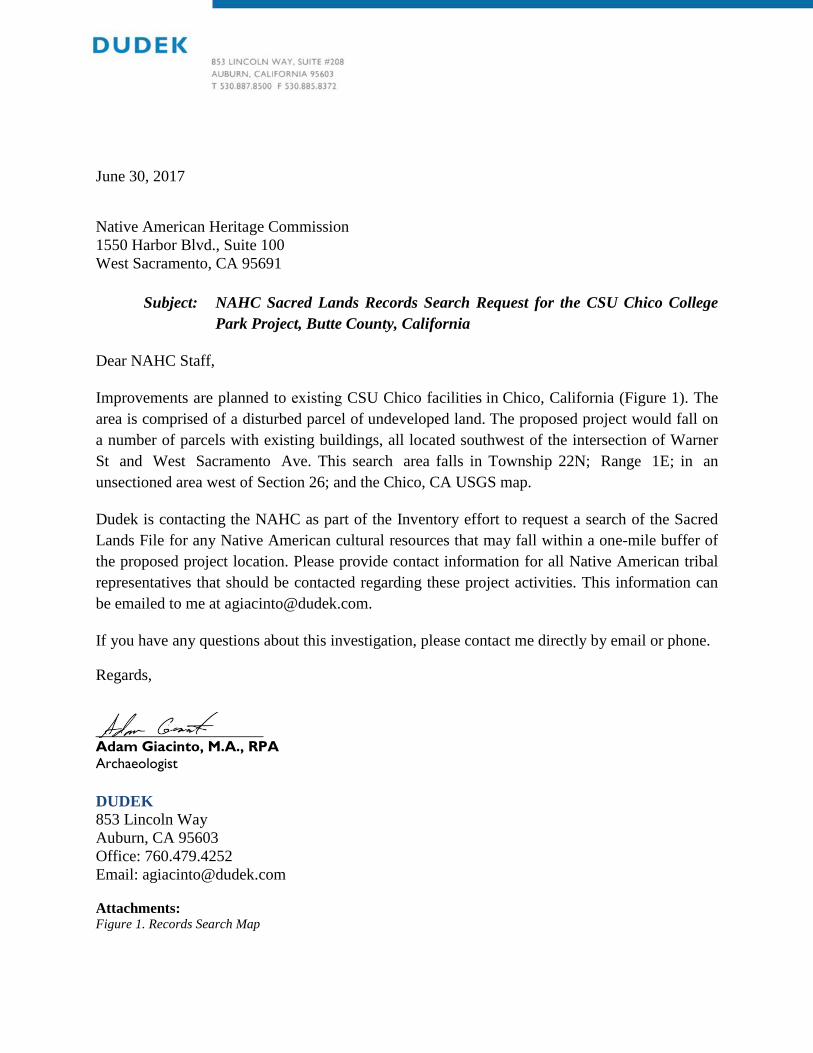
June 30, 2017
Native American Heritage Commission 1550 Harbor Blvd., Suite 100 West Sacramento, CA 95691
Subject: NAHC Sacred Lands Records Search Request for the CSU Chico College Park Project, Butte County, California
Dear NAHC Staff,
Improvements are planned to existing CSU Chico facilities in Chico, California (Figure 1). The area is comprised of a disturbed parcel of undeveloped land. The proposed project would fall on a number of parcels with existing buildings, all located southwest of the intersection of Warner St and West Sacramento Ave. This search area falls in Township 22N; Range 1E; in an unsectioned area west of Section 26; and the Chico, CA USGS map.
Dudek is contacting the NAHC as part of the Inventory effort to request a search of the Sacred Lands File for any Native American cultural resources that may fall within a one-mile buffer of the proposed project location. Please provide contact information for all Native American tribal representatives that should be contacted regarding these project activities. This information can be emailed to me at [email protected].
If you have any questions about this investigation, please contact me directly by email or phone.
Regards,
_____________________ Adam Giacinto, M.A., RPA Archaeologist
DUDEK 853 Lincoln Way Auburn, CA 95603 Office: 760.479.4252 Email: [email protected]
Attachments: Figure 1. Records Search Map

SOURCE: USGS 7.5-Minute Series Chico QuadrangleTownship 22N; Range 1E; Sections 21, 22, 23, 26, 27, 28, 33, 34, 35
CSU Chico College Park Project
0 2,0001,000Feet
³0 500
Meters
Legend1 Mile BufferStudy Area


YubaCity
WilliamsBealeAFBLinda
LomaRica
Challenge-Brownsville
Palermo
SouthOrovilleThermalito
Oroville OrovilleEast
Durham
Magalia
Concow
Chico Paradise
Chester
RedBluff
Glenn County
Tehama County
Shasta County
Nevada County
Sutter County
Colusa CountyColusa County
Lake County
Glenn County
Glenn County
Butte County
Butte County
Butte County
Butte CountyPlumas County
Plumas County
Tehama County
Tehama County
Tehama County
?65
?149
?172
?89
?70?191
?32
?162
?45
?20
?99
?36
§̈¦5
Regional MapSOURCE: ESRI Basemaps
Date:
4/18/2
017 -
Last
saved
by: rs
trobrid
ge -
Path:
Z:\Pr
ojects
\j1017
401\MA
PDOC
\DOCU
MENT
\IS\Fig
ure1_R
egiona
l.mxd
0 105 MilesnFIGURE 1
Project Site
!̂
CSU Chico College Park Project

CSU Chico College Park Project – Historic Property Assessment
SOURCE: SOURCE: USGS 7.5-Minute Series Chico QuadrangleTownship 22N; Range 1E; Section 27
Date:
6/28/2
017 -
Last
saved
by: rs
trobrid
ge -
Path:
Z:\Pr
ojects
\j1049
301\MA
PDOC
\DOCU
MENT
\Cultur
al\Histo
ricPres
ervatio
n\Figu
re1_P
rojectA
reaMa
p.mxd
0 2,0001,000 Feetn Study Area
FIGURE 2Project Area Map

CSU Chico College Park Project – Historic Property Assessment
SOURCE: Butte County GIS; Bing Maps (Accessed 2017)
Date:
6/28/2
017 -
Last
saved
by: rs
trobrid
ge -
Path:
Z:\Pr
ojects
\j1049
301\MA
PDOC
\DOCU
MENT
\Cultur
al\Histo
ricPres
ervatio
n\Figu
re2_A
PEMa
p.mxd
0 10050 Feetn Project Area
FIGURE 3 Site Map
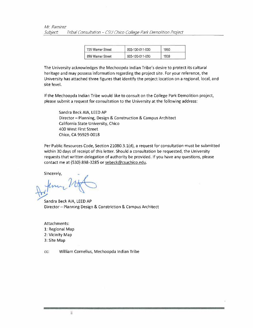
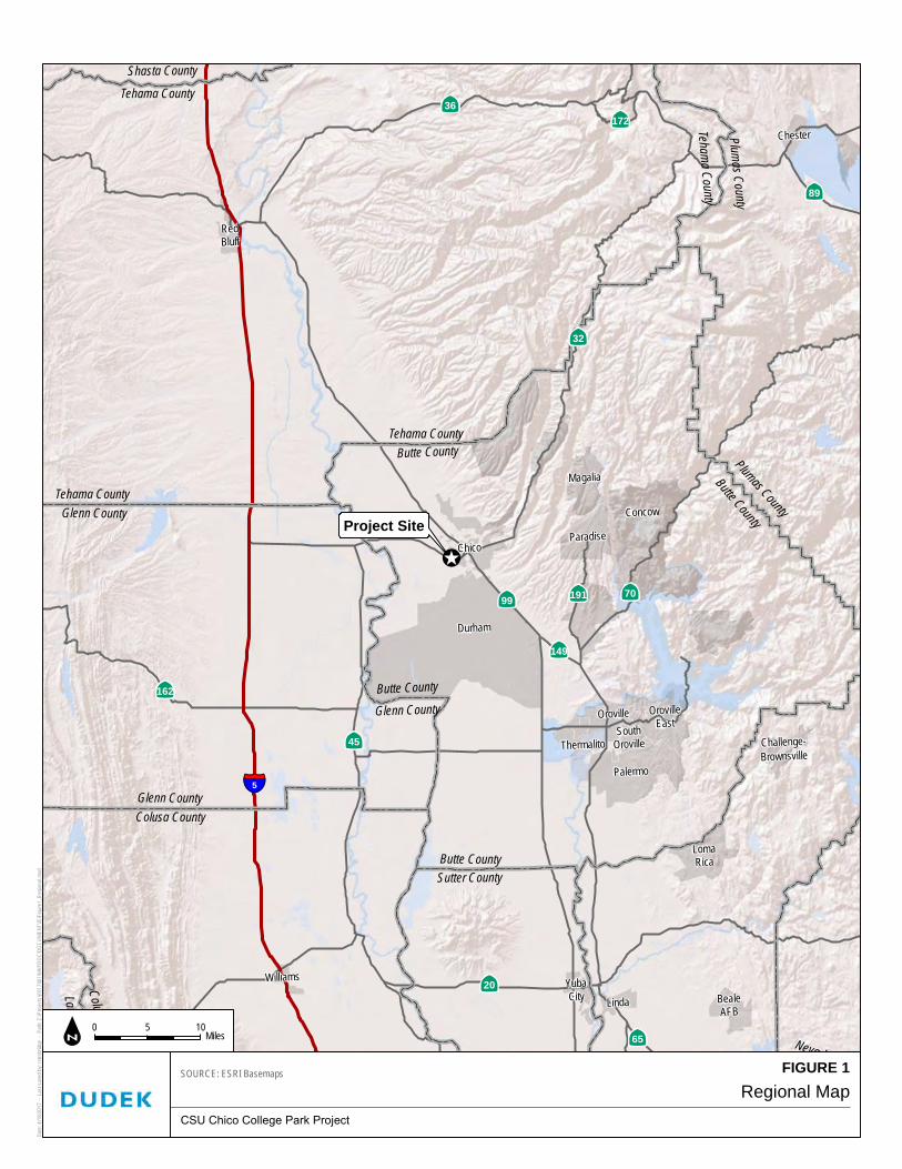

APPENDIX D DPR Forms


State of California The Resources Agency Primary # DEPARTMENT OF PARKS AND RECREATION HRI #
PRIMARY RECORD Trinomial
NRHP Status Code 6Z Other Listings Review Code Reviewer Date
Page 1 of 13 *Resource Name or #: 602 Brice Avenue
DPR 523A (1/95) *Required information
P1. Other Identifier:
*P2. Location: Not for Publication Unrestricted *a. County: Butte and (P2b and P2c or P2d. Attach a Location Map as necessary.)
*b. USGS 7.5' Quad: Chico Date: 1978 T 22N; R E; ¼ of ¼ of Sec 27; Mount Diablo B.M.
c. Address: 602 Brice Avenue City: Zip:
d. UTM: Zone:10S ; 598452.56 m E/ 4398647.23 m N (G.P.S.) Google Earth e. Other Locational Data: (e.g., parcel #, directions to resource, elevation, etc., as appropriate) Elevation:
APN. 003-130-006-000. The subject property is located at the corner of Warner Street and Brice Avenue. *P3a. Description: (Describe resource and its major elements. Include design, materials, condition, alterations, size, setting, and boundaries)
The subject property is a Ranch-style, single-family residence built in 1946 facing onto Brice Avenue. The one-story building is
roughly L-shape in plan with a cross-hipped roof sheathed in composition shingles. Exterior walls are clad in brick and stucco.
The main entrance to the house is located on the southeast elevation and is sheltered beneath a low-pitched, front-gabled roof
filled with horizontal wood siding. The southeast (main) elevation presents as two sections. The left (southern) recessed central
section is distinguished by an integral porch, brick cladding, and a large brick chimney. A central bay projects approximately 6
feet from the rest of the elevation and is stucco clad with a side entry point under an open wooden trellis supported by two
wooden posts. The integral porch has a painted concrete slab foundation accessed from a front walkway by a single step.
Fenestration across the elevation is irregular and contains a tripartite wood frame window featuring a fixed central pane flanked
by multiple side- lights, an entry door that is obscured by a security door, two additional tripartite windows in the main
projection, and a two-over-two wood frame window to the east of the side entry door. The northeast elevation of the building also
features an irregular fenestration and contains a tripartite window, side entry door that is obscured by a storm door, two two-
over-two windows, a multi-light entry door, five two-over-two windows, and a large carport that shelters a modern single-width
garage door.
*P3b. Resource Attributes: (List attributes and codes) HP2. Single Family Property *P4. Resources Present: Building Structure Object Site District Element of District Other (Isolates, etc.)
P5b. Description of Photo: (View,
date, accession #) Main Elevation
(view to northwest), 7/5/17, Photo
# IMG_3435
*P6. Date Constructed/Age and
Sources: Historic Prehistoric Both
1946 (Butte County Assessor)
*P7. Owner and Address:
CSU Chico
400 West First Street
Chico, CA 95929
*P8. Recorded by: (Name,
affiliation, and address)
Dudek, Sarah Corder, MFA
38 North Marengo Avenue
Pasadena, CA 91101
*P9. Date Recorded: 7/5/2017 *P10. Survey Type: (Describe)
Intensive
P5a. Photo or Drawing (Photo required for buildings, structures, and objects.)

State of California The Resources Agency Primary # __________________________________________________
DEPARTMENT OF PARKS AND RECREATION HRI # _____________________________________________________
PRIMARY RECORD Trinomial _________________________________________________
Page 2 of 13 Resource Name or #: (Assigned by recorder)_________________________________
DPR 523A-Test (8/94)
*P11. Report Citation: (Cite survey report and other sources, or enter "none.") Cultural Resources Report for the College Park
Demolition Project California State University, Chico, Butte County, California (Dudek 2017)
*Attachments: NONE Location Map Sketch Map Continuation Sheet Building, Structure, and Object Record
Archaeological Record District Record Linear Feature Record Milling Station Record Rock Art Record
Artifact Record Photograph Record Other (List):

State of California The Resources Agency Primary # DEPARTMENT OF PARKS AND RECREATION HRI#
LOCATION MAP Trinomial Page 2 of 13 *Resource Name or #: 602 Brice Avenue
*Map Name: Chico *Scale: 1:24,000 *Date of Map: 1978
DPR 523J (1/95) *Required information

State of California The Resources Agency Primary # DEPARTMENT OF PARKS AND RECREATION HRI#
BUILDING, STRUCTURE, AND OBJECT RECORD Page 3 of 13 *NRHP Status Code 6Z
*Resource Name or # (Assigned by recorder) 602 Brice Avenue
DPR 523B (1/95) *Required information
B1. Historic Name: B2. Common Name:
B3. Original Use: Single-family residence B4. Present Use: Single-family residence
*B5. Architectural Style: Ranch
*B6. Construction History: (Construction date, alterations, and date of alterations)
Constructed in 1946 (Butte County Assessor). The following City of Chico Building Permits (CCBPs) were found for the property:
construction of a carport with composition shingles set on brick and wood in front of the existing garage in 1950 (CCBP #10025); a
roof built over a new 8 X 25 ft. patio in 1952 (CCBP #685); addition of a louvered sunshade over the front porch, including change
of a window to a door in 1953 (CCBP #1426); installation of a television antenna in 1954 (CCBP #262); an electrical permit for an
addition in 1964 (CCBP #3871); replacement of ceramic tiles in a bathroom in 1965 (CCBP #5222); partial reroof with composition
shingles in 1996 (CCBP #B96-00430); and replacement of a water heater in 2001 (CCBP #PO1-00527). Observed alterations to the
house with unknown dates include the addition of security doors, addition of metal louvers over windows on the main elevation,
reconfiguration of entry points on the northeast elevation, addition of an open trellis on the northeast elevation, and replacement
of the garage door.
*B7. Moved? No Yes Unknown Date: Original Location:
*B8. Related Features:
B9a. Architect: Unknown b. Builder: Unknown
*B10. Significance: Theme: Area:
Period of Significance: Property Type: Applicable Criteria: N/A (Discuss importance in terms of historical or architectural context as defined by theme, period, and geographic scope. Also address integrity.)
Research of all City directories from the date of construction showed that the house was predominately owned and occupied by
Harry Nichols Jr. and his wife Sally. Mr. Nichols is listed in directories as a farmer. The only other name that was associated with
the house was Mr. Alan Sagouspe, who was listed as an owner of the property on a building permit from 2001 (CCBP # P01-
00527).
A review of historic maps and aerial photographs was conducted as part of the archival research effort for this property. All
Sanborn maps for the City of Chico were reviewed, and the project area was not included on any of the maps. Historic aerial
photographs were reviewed for the property from the following years: 1941, 1947, 1969, 1998, 2005, 2009, 2010, and 2012. In 1941,
most of the area was not developed, with the exception of a few buildings on Warner Avenue. In 1941, the intersecting streets of
Brice Avenue, La Vista Way, and Stadium Way are not visible. The 1947 aerial photograph indicates there was increased
development in the area, including an L-shaped residence on the corner of Warner Avenue and Brice Avenue, which is consistent
with the 1946 date of construction for 602 Brice Avenue. By 1947, the intersecting streets of Brice Avenue, Stadium Way, and La
Vista Way are visible. The remaining years of historic aerial photographs offer limited information, as the house is largely
obscured by trees (NETR 2017).
See Continuation Sheet
B11. Additional Resource Attributes: (List attributes and codes)
(This space reserved for official comments.)
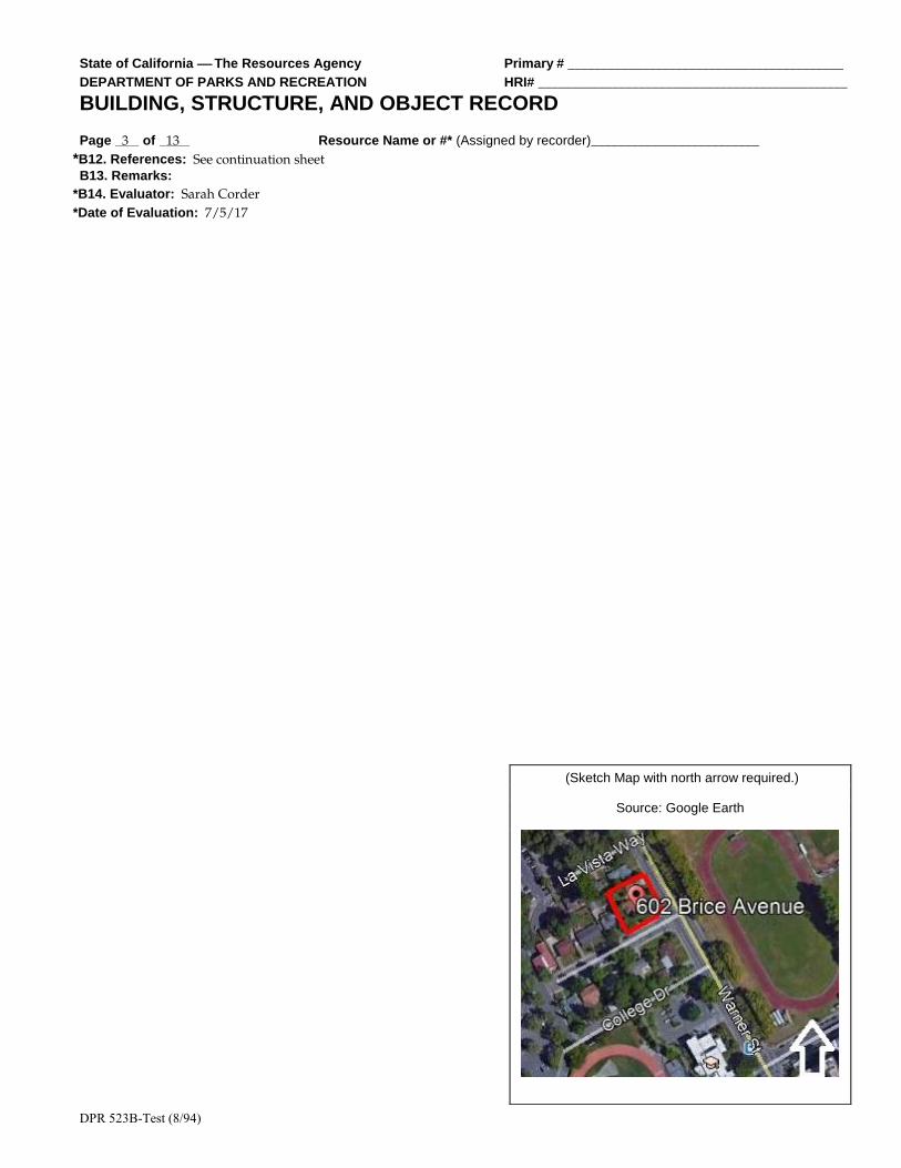
State of California The Resources Agency Primary # _________________________________________
DEPARTMENT OF PARKS AND RECREATION HRI# ______________________________________________
BUILDING, STRUCTURE, AND OBJECT RECORD
Page 3 of 13 Resource Name or #* (Assigned by recorder)_________________________
DPR 523B-Test (8/94)
*B12. References: See continuation sheet B13. Remarks:
*B14. Evaluator: Sarah Corder
*Date of Evaluation: 7/5/17
(Sketch Map with north arrow required.)
Source: Google Earth

State of California The Resources Agency Primary #
DEPARTMENT OF PARKS AND RECREATION HRI#
CONTINUATION SHEET Trinomial Page 4 of 13 *Resource Name or # (Assigned by recorder) 602 Brice Avenue
Recorded By: Sarah Corder *Date: 7/5/2017 Continuation Update
DPR 523L (1/95) *Required information
*B10. Significance (Continued):
By the 1920s, Chico had taken steps to make itself a modern city with the creation of paved streets, increased suburban
development, public parks, and the planning of State Highway 99. In the 1920s, the City paved streets and removed wooden
sidewalks. Chico Historian Debra Moon’s analysis of the Census information from 1900, 1910, and 1920 captures the essence of the
City’s growth in the early 20th century, and helps show a shift from a predominately agrarian community to a modern urban city
(Moon 2003):
A 1920 census for Chico showed a population of 15,517. Chico had grown more than expected even through some rough
times. The county’s population at that time was 42.2 percent urban compared to 1910, when the population was 27.9
percent urban, and 1900 when it was only 15.34 percent urban.
Although the growth of the population contributed to this shift, there were other factors in the late 19th and early 20th centuries
that helped to urbanize Chico. One such factor was the donation of Bidwell Park in 1905 by Annie Bidwell. The generous donation
of more than 1,900 acres for use as a public park was a big step toward urbanization in Chico in the 20th century (Booth et al. 2005;
DC 2017; Moon 2003).
Other steps toward urbanization included construction of the Chico Municipal Building in 1916, which helped to create a city plaza
concept with the combination of the municipal building and the post office. Downtown businesses also took steps toward
modernization and urbanization with the removal of wooden awnings and posts from their storefronts. Healthcare advancements
in Chico led to the start of the Enloe Hospital in 1913, which began a series of healthcare center developments spanning the 20th
century, resulting in the modern medical complexes seen in Chico today. The many steps toward modernization attracted not only
businesses and people to Chico, but also movie productions, including Robin Hood, Gone with the Wind, Kane, Last of the
Cowboys, Folly of a Life of Crime, and Alamo Charlie. However, modernization and urbanization did not result in the goal for
Chico of being the new county seat for Butte County in the 1914 county seat race (Booth et al. 2005; DC 2017; Moon 2003).
Like other cities in the United States, advancements in aviation had a profound effect on Chico. In 1935, the City acquired land
located immediately north of town to create a municipal airport. However, these plans were sidelined by World War II, since the
War Department decided to lease the airport land for establishment of an Army Corps base. The decision by the War Department
to lease the airport land was significant to residential and commercial development patterns of Chico, since it brought new people
to the area for employment and training. At the height of its use, the Army base employed 4,000 people, and thousands of people
received basic training or support training at the facility. The base continued in its operation until 1945, after which many of the
people employed and/or trained at the base chose to make Chico their permanent home. To support this population boom, houses
needed to be constructed quickly and cost effectively, so popular styles like the Ranch house became a feasible option (Booth et al.
2005; DC 2017; Moon 2003).
Development and increased suburbanization continued in Chico in the late 1940s and 1950s, and by 1961, an article from the San
Francisco Examiner captured the essence of mid-20th century development in Chico (SFE 1961):
A tour of the city and its outskirts displays the growth of subdivisions, the establishment of shopping centers and the
construction of factories for light industry.
The increased population also facilitated the need for churches, schools, service stations, and infrastructure improvements such as
additional stoplights and parking meters. Historic aerial photographs from the 1940s show that neighborhoods were being plotted
for increased residential developments, especially in the College Park area (Booth et al. 2005; DC 2017; Moon 2003; NETR 2017).
Another important institution growing throughout the first half of the 20th century was CSU Chico. Population increases, steps
toward modernization, improvements in transportation, and the close of World War II were all significant to the growth and

State of California The Resources Agency Primary # _________________________________________
DEPARTMENT OF PARKS AND RECREATION HRI# ______________________________________________
BUILDING, STRUCTURE, AND OBJECT RECORD
Page 5 of 13 Resource Name or #* (Assigned by recorder)_________________________
DPR 523B-Test (8/94)
development of the City and CSU Chico. Development of the City and CSU Chico ran parallel to each other, and influenced larger
patterns of residential, cultural, and economic development (Booth et al. 2005; Moon 2003).

State of California The Resources Agency Primary #
DEPARTMENT OF PARKS AND RECREATION HRI#
CONTINUATION SHEET Trinomial Page 5 of 13 *Resource Name or # (Assigned by recorder) 602 Brice Avenue
Recorded By: Sarah Corder *Date: 7/5/2017 Continuation Update
DPR 523L (1/95) *Required information
Ranch Style (c. 1935–1975)
The Ranch house is a style of architecture that was popular starting in the 1930s and fell out of popularity by the 1980s. In the 1930s
and early 1940s, the Ranch house was part of the Small House movement that was brought into fashion by the Federal Housing
Administration. Like the Minimal Traditional house, the Ranch house could be constructed quickly and use modern materials that
could be mass-produced. The style provided an easy option for large-scale housing tracts during the 1930s and 1940s to meet the
needs of relocated war-effort workers and those of soldiers returning home and starting families. Following the war years, a new
era of prosperity brought about a departure from the Small House movement, and the Ranch house became a popular house type
throughout the late 1940s through the 1970s (Gottfried and Jennings 2009; Hess 2004; McAlester 2015).
The Ranch house of the 1930s and 1940s maintained similar characteristics to newer versions, but small lot sizes in housing tracts
made the concept of the rambling Ranch house almost impossible. In the 1950s, post-war prosperity combined with increased lot
sizes made the larger and more recognizable Ranch house possible. The ability of the Ranch house to exist in different sizes and
arrangements made it one of the most popular house choices throughout the United States across multiple social classes (Gottfried
and Jennings 2009; Hess 2004; McAlester 2015).
Key characteristics of the Ranch style of architecture are the following (Gottfried and Jennings 2009; Hess 2004; McAlester 2015):
• One story in height
• Gabled or hipped roofs constructed with a low pitch and moderate overhang
• Offset entry points causing asymmetry in the façade
• Focus on horizontal and rambling forms
• Focus on informality
• Entry points are typically placed under the roof overhang on the façade
• Use of large picture-style windows on the façade
• Variations on the eave overhang, typically boxed eaves or exposed rafter tails, or the less-common boxed rafters
• Large chimneys
• Variety of exterior cladding, including brick and stone
• Attached garage, typically incorporated into the façade
• Front and rear yards
• Large rectangular blocks as the basis for plan design, as simply rectangular or a combination of rectangular
blocks to create L, U, and T shapes
NRHP/CRHR Designation Criteria: Criterion A/1 (Events)
Archival research did not find any associations with events that have made a significant contribution to the broad patterns of local
or regional history. The subject property is one of many single-family residences from approximately the same period of
construction (1930s–1950s), and no historical associations or patterns of development were identified. Residential development in
Chico followed industrial development with the rise of companies like the Diamond Match Company. Establishment of the Chico
Army Air Field (Air Field) in the early 1940s created an increased military presence in Chico in the years leading up to World War
II, which had a direct effect on residential development in Chico during and after the war. During the war, housing was needed for
active-duty service members and their families. Following the war, housing was needed for returning service members who were
ready to settle down and start families in Chico, and for service members who chose to stay in Chico following closure of the Air
Field in 1945. These patterns of development were seen across the United States in the years leading up to and following World
War II, when industry began to boom and residential development became a priority to house a growing post-war population. Due
to a lack of significant associations with events important to history, the subject property does not appear eligible under
NRHP/CRHR Criteria A/1.
State of California The Resources Agency Primary # _________________________________________
DEPARTMENT OF PARKS AND RECREATION HRI# ______________________________________________
BUILDING, STRUCTURE, AND OBJECT RECORD
Page 7 of 13 Resource Name or #* (Assigned by recorder)_________________________
DPR 523B-Test (8/94)
Criterion B/2 (Persons)
All owner and occupant names identified with the subject property were researched for possible significance. Archival research
failed to indicate any associations with significant persons. For these reasons, the subject property does not appear eligible under
NRHP/CRHR Criteria B/2.
State of California The Resources Agency Primary #
DEPARTMENT OF PARKS AND RECREATION HRI#
CONTINUATION SHEET Trinomial Page 6 of 13 *Resource Name or # (Assigned by recorder) 602 Brice Avenue
Recorded By: Sarah Corder *Date: 7/5/2017 Continuation Update
DPR 523L (1/95) *Required information
Criterion C/3 (Architecture)
To support a rapidly growing population in the years surrounding World War II, builders in Chico turned to one of the most
popular architectural styles of the time, the Ranch style. The subject property was constructed in 1946 when Chico (and much of the
United States) was experiencing a residential boom in response to local industrial and military-related growth. Although the
subject property retains the most basic elements of the Ranch style (i.e., one story in height, use of large picture windows, variety of
cladding, asymmetry in the façade), the building exhibits substantial alterations that have compromised its integrity, including
reconfiguration of entry points on the northeast elevation, addition of an open trellis on the northeast elevation, addition of a
carport, addition of louvers over windows on the main elevation, and replacement of the original garage door. The result is a
relatively altered and unremarkable example of a Ranch-style residence. Archival building permit research did not identify the
name(s) of the original builder or architect, but the building is not likely to be the work of a master architect or important creative
individual. Finally, the subject property does not appear eligible as a contributor to a historic district. For all of these reasons, the
subject property does not appear eligible under NRHP/CRHR Criteria C/3.
Criterion C/4 (Information Potential)
There is no evidence to suggest that this property has the potential to yield information important to state or local history, nor is it
associated with a known archaeological resource. Therefore, the property is recommended not eligible under NRHP/CRHR
Criterion D/4.
California Historical Landmark Criteria:
In consideration of the subject property’s history and requisite integrity, Dudek finds the property not eligible for designation as a
CHL based on the following significance evaluation and in consideration of CHL eligibility criteria.
The first, last, only, or most significant of its type in the state or within a large geographic region (Northern, Central, o r Southern California).
The subject property is a modest and altered example of a Ranch-style single-family residence constructed in 1946. The building
represents a common residential house form that was popular throughout the United States following World War II due to the
ability to mass produce materials and plans. It is not the first or last Ranch-style residence to be constructed in Chico, nor is it a
significant example of its type. The subject property is not known to be the work of an important architect, builder, engineer, or
designer, nor was it built using an innovative construction technique. Therefore, the subject property is recommended not eligible
for listing as a CHL under this criterion.
Associated with an individual or group having a profound influence on the history of California.
All owner and occupant names identified with the subject property were researched for possible significance. Archival research
failed to reveal any associations with significant individuals from the past. Therefore, the subject property is recommended not
eligible for listing as a CHL under this criterion.
A prototype of, or an outstanding example of, a period, style, architectural movement or construction or is one of the more notable works or the best surviving work in a region of a pioneer architect, designer or master builder.
The building represents a common Ranch-style house that was popular throughout the United States in the years following World
War II due to the ability to mass produce materials and plans. The subject property is not a prototype or outstanding example of its
style. It exhibits the most basic design features of the Ranch style, but is altered from its original form and cannot be considered a
valuable example of the style. Furthermore, the building is not known to be the work of an important architect, builder, engineer, or
designer, and is not known to have been built using an innovative construction technique. Therefore, the subject property is
recommended not eligible for listing as a CHL under this criterion.
City of Chico Criteria:
City of Chico historic resource designation criteria closely follow those of the NRHP and CRHR with regard to consideration of
important events, people, and architectural merit. Based on the NRHP/CRHR/CHL criteria discussion above, the subject property
is recommended as not eligible for listing under all City of Chico designation criteria.

State of California The Resources Agency Primary # _________________________________________
DEPARTMENT OF PARKS AND RECREATION HRI# ______________________________________________
BUILDING, STRUCTURE, AND OBJECT RECORD
Page 9 of 13 Resource Name or #* (Assigned by recorder)_________________________
DPR 523B-Test (8/94)
Integrity:
Location: The building is sited on the original location of construction in its original orientation. Therefore, the subject property
retains integrity of location.

State of California The Resources Agency Primary #
DEPARTMENT OF PARKS AND RECREATION HRI#
CONTINUATION SHEET Trinomial Page 7 of 13 *Resource Name or # (Assigned by recorder) 602 Brice Avenue
Recorded By: Sarah Corder *Date: 7/5/2017 Continuation Update
DPR 523L (1/95) *Required information
Design: The building was subjected to several alterations over time that have significantly compromised its integrity of design,
including reconfiguration of entry points on the northeast elevation, addition of a carport in front of the original garage, addition of
an open trellis on the northeast elevation, the addition of louvers over windows on the main elevation, and replacement of the
garage door. Therefore, the building does not maintain integrity of design.
Setting: Although the subject property maintains its original property boundaries, the surrounding areas have changed
significantly over time. The property’s integrity of setting was compromised by development of CSU Chico, as noted when
comparing the 1969 historic aerial photograph to the 1998 historic aerial photograph. In 1969, there are large open parcels of land to
the south and west of the neighborhood, but by 1998, there is significant development on these large parcels, including large
campus buildings, access roads, and parking lots. Additionally, the areas to the south and west are now heavily landscaped and
pedestrianized. Therefore, the property’s integrity of setting is present, but is diminished by development in and around the CSU
Chico campus (NETR 2017).
Materials: Numerous alterations to the house have compromised the property’s material integrity, including the addition of metal
louvered sunshades, construction of a wooden trellis, addition of the carport, and replacement of the garage door. All of these
alterations introduced new materials to the subject property that were not part of the original design. Therefore, the building does
not maintain integrity of materials.
Workmanship: Similar to the issue with materials, the physical evidence of craftsman’s skills in constructing the original building
was compromised by the exterior alterations to the building. Therefore, the building no longer retains its integrity of workmanship.
Feeling: The alterations made to the subject property significantly impact the building’s ability to correlate to a single-family
residence designed in the Ranch style of architecture. Currently the building reads as two separate properties when evaluating the
southeast (main) elevation and the northeast (side) elevation. Multiple entry points on the northeast elevation create a feeling of a
multi-family unit and distract from the original design and feeling as a single-family residence. Therefore, the property no longer
retains its integrity of feeling.
Association: The property has no direct links with important events or people. Therefore, the building does not have integrity of
association.
In summary, the subject property appears not eligible under all NRHP, CRHR, and CHL designation criteria. Further, the property
exhibits diminished integrity of setting, feeling, and association, and no longer retains integrity of design, materials, or
workmanship. Consequently, the property does not maintain the requisite integrity to warrant listing in the NRHP or CRHR, or as
a CHL.
*B12. References (Continued):
Booth, Edward, John Nopel, Keith Johnson, and Darcey Davis. 2005. Images of America Chico. Charleston, South Carolina: Arcadia
Publishing.
Chico City Directories Various Years.
DC (Downtown Chico). 2017. “History Timeline of Downtown Chico.” Accessed July 31, 2017.
http://www.downtownchico.com/history-timeline.htm.
Gottfried, Herbert, and Jan Jennings. 2009. American Vernacular Buildings and Interiors 1870–1960. New York: WW. Norton and
Company.
Hess, Alan. 2004. The Ranch House. New York: Harry N. Abrams.
McAlester, Virginia Savage. 2015. A Field Guide to American Houses. New York: Alfred A. Knopf.
Moon, Debra. 2003. Chico, Life and Times of a City of Fortune. Charleston, South Carolina: Arcadia Publishing.
NETR (National Environmental Title Research). 2017. Historic aerial photographs dates 1941, 1947, 1969, 1998, 2005, 2009, 2010, and
2012. Accessed August 31, 2017. https://www.historicaerials.com/viewer#.
State of California The Resources Agency Primary # _________________________________________
DEPARTMENT OF PARKS AND RECREATION HRI# ______________________________________________
BUILDING, STRUCTURE, AND OBJECT RECORD
Page 11 of 13 Resource Name or #* (Assigned by recorder)_________________________
DPR 523B-Test (8/94)
SFE (San Francisco Examiner). 1961. “Chico – A Memorial to a Courageous Pioneer.” San Francisco Examiner. August 13, 1961.
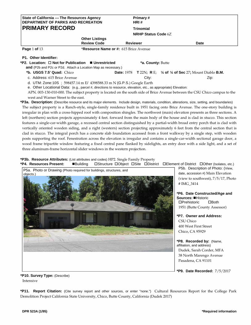
State of California The Resources Agency Primary # DEPARTMENT OF PARKS AND RECREATION HRI #
PRIMARY RECORD Trinomial
NRHP Status Code 6Z Other Listings Review Code Reviewer Date
Page 1 of 13 *Resource Name or #: 615 Brice Avenue
DPR 523A (1/95) *Required information
P1. Other Identifier:
*P2. Location: Not for Publication Unrestricted *a. County: Butte and (P2b and P2c or P2d. Attach a Location Map as necessary.)
*b. USGS 7.5' Quad: Chico Date: 1978 T 22N; R E; ¼ of ¼ of Sec 27; Mount Diablo B.M.
c. Address: 615 Brice Avenue City: Zip:
d. UTM: Zone:10S ; 598457.14 m E/ 4398588.33 m N (G.P.S.) Google Earth e. Other Locational Data: (e.g., parcel #, directions to resource, elevation, etc., as appropriate) Elevation:
APN. 003-130-010-000. The subject property is located on the south side of Brice Avenue between the CSU Chico campus to the
west and Warner Street to the east. *P3a. Description: (Describe resource and its major elements. Include design, materials, condition, alterations, size, setting, and boundaries)
The subject property is a Ranch-style, single-family residence built in 1951 facing onto Brice Avenue. The one-story building is
irregular in plan with a cross-hipped roof with composition shingles. The northwest (main) elevation presents as three sections. A
left (northern) section projects approximately 4 feet. forward from the main body of the house and is clad in stucco. This section
features a single-car-width garage, a recessed central section distinguished by a partial-width broad entry porch that is clad with
vertically oriented wooden siding, and a right (western) section projecting approximately 6 feet from the central section that is
clad in stucco. The integral porch has a concrete slab foundation accessed from a front walkway by a single step, with wooden
posts supporting the roof. Fenestration across the elevation is irregular and contains a single-car-width sectional garage door, a
wood frame tripartite window featuring a fixed central pane flanked by sidelights, an entry door with a side light, and a set of
three aluminum-frame horizontal slider windows in the western projection.
*P3b. Resource Attributes: (List attributes and codes) HP2. Single Family Property *P4. Resources Present: Building Structure Object Site District Element of District Other (Isolates, etc.)
P5b. Description of Photo: (View,
date, accession #) Main Elevation
(view to southwest), 7/5/17, Photo
# IMG_3414
*P6. Date Constructed/Age and
Sources: Historic Prehistoric Both
1951 (Butte County Assessor)
*P7. Owner and Address:
CSU Chico
400 West First Street
Chico, CA 95929
*P8. Recorded by: (Name,
affiliation, and address)
Dudek, Sarah Corder, MFA
38 North Marengo Avenue
Pasadena, CA 91101
*P9. Date Recorded: 7/5/2017 *P10. Survey Type: (Describe)
Intensive
*P11. Report Citation: (Cite survey report and other sources, or enter "none.") Cultural Resources Report for the College Park
Demolition Project California State University, Chico, Butte County, California (Dudek 2017)
P5a. Photo or Drawing (Photo required for buildings, structures, and objects.)

State of California The Resources Agency Primary # __________________________________________________
DEPARTMENT OF PARKS AND RECREATION HRI # _____________________________________________________
PRIMARY RECORD Trinomial _________________________________________________
Page 2 of 13 Resource Name or #: (Assigned by recorder)_________________________________
DPR 523A-Test (8/94)
*Attachments: NONE Location Map Sketch Map Continuation Sheet Building, Structure, and Object Record Archaeological Record District Record Linear Feature Record Milling Station Record Rock Art Record
Artifact Record Photograph Record Other (List):
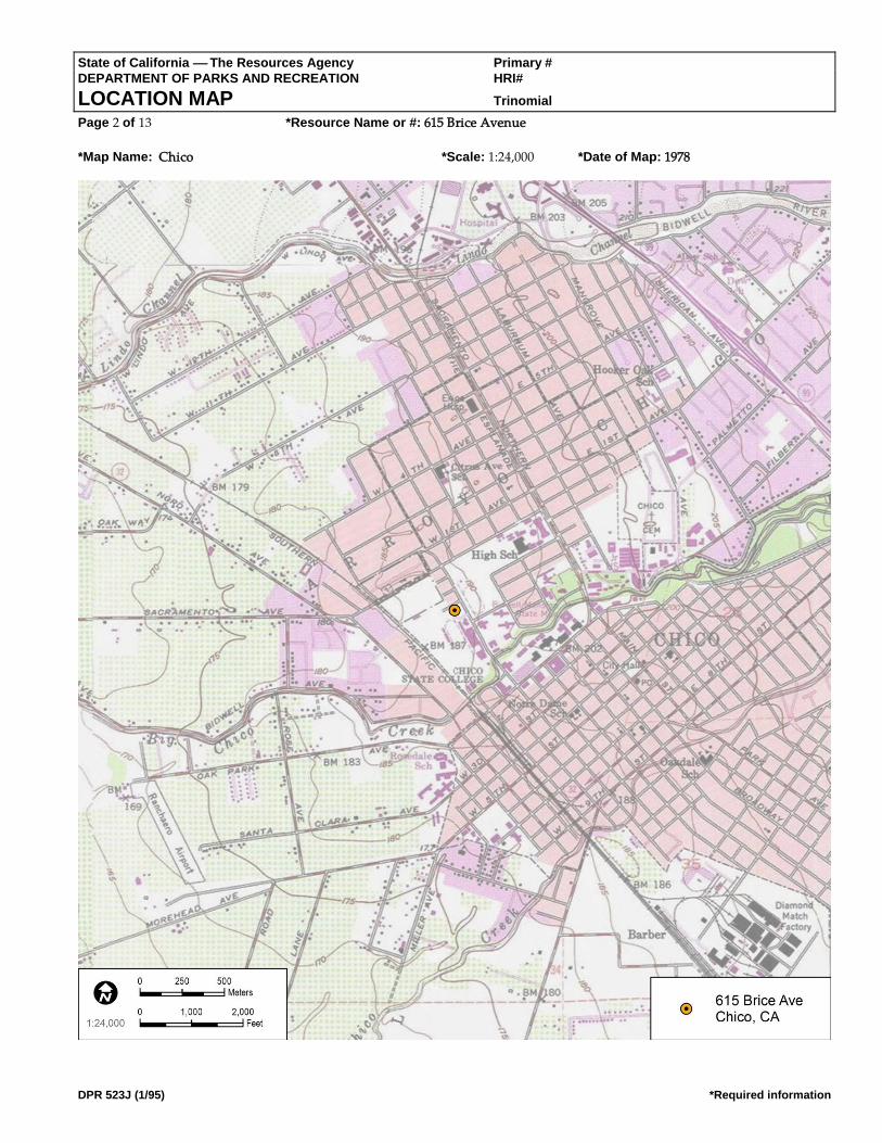
State of California The Resources Agency Primary # DEPARTMENT OF PARKS AND RECREATION HRI#
LOCATION MAP Trinomial Page 2 of 13 *Resource Name or #: 615 Brice Avenue
*Map Name: Chico *Scale: 1:24,000 *Date of Map: 1978
DPR 523J (1/95) *Required information

State of California The Resources Agency Primary # DEPARTMENT OF PARKS AND RECREATION HRI#
BUILDING, STRUCTURE, AND OBJECT RECORD Page 3 of 13 *NRHP Status Code 6Z
*Resource Name or # (Assigned by recorder) 615 Brice Avenue
DPR 523B (1/95) *Required information
B1. Historic Name: B2. Common Name:
B3. Original Use: Single-family residence B4. Present Use: Single-family residence
*B5. Architectural Style: Ranch
*B6. Construction History: (Construction date, alterations, and date of alterations)
Constructed in 1951 (Butte County Assessor). The following City of Chico Building Permits (CCBPs) were found for the property:
original building permit for a one-story wood and stucco house with an attached garage in 1951 (CCBP #262); plumbing and
sewer permit for one toilet, one basin, one bath, one sink, and one tray in 1951 (CCBP #241); electrical permit for new dwelling 6
circuits, 16 switches, 13 outlets, meter, and #12 wire in 1951 (CCBP #4783); construction of the roof and north and west walls on
the patio with wood frame and stucco with dimensions of 15 X 20 ft. in 1953 (CCBP #1341); installation of a water heater in 1957
(CCBP #710); replacement of the furnace in 1965 (CCBP #5139); electrical permit for a new meter in 1979 (CCBP #9235);
replacement of the shake roof in 1984 (CCBP #5033); and reroof with composition shingles in 2002 (CCBP #B02-395). Observed
alterations to the house with unknown dates include replacement windows, replacement front entry door, and replacement
garage door.
*B7. Moved? No Yes Unknown Date: Original Location:
*B8. Related Features:
B9a. Architect: Unknown b. Builder: Unknown
*B10. Significance: Theme: Area: Period of Significance: Property Type: Applicable Criteria: N/A (Discuss importance in terms of historical or architectural context as defined by theme, period, and geographic scope. Also address integrity.)
Archival research found the following people associated with the property:
• 1952–1963 – James and Thelma Bachand, sergeant for the Chico Police Department
• 1965 – Philip and Kristen Mast, student
• 1966–1978 – George Bachand, retired
• 1979 – Betty French
• 1984 – Barbara Stanley, DDS, dentist
• 2002 – Michael and Kristene Wagner
Based on archival research, it appears that the early owners of the house also occupied the house. However, more recent City
directories and building permits suggest that the house was likely a
rental property for California State University Chico students and was
no longer owner-occupied starting in 1990.
See Continuation Sheet
B11. Additional Resource Attributes: (List attributes and codes)
*B12. References: See continuation Sheet
B13. Remarks:
(This space reserved for official comments.)
(Sketch Map with north arrow required.) Source: Google Earth
State of California The Resources Agency Primary # _________________________________________
DEPARTMENT OF PARKS AND RECREATION HRI# ______________________________________________
BUILDING, STRUCTURE, AND OBJECT RECORD
Page 3 of 13 Resource Name or #* (Assigned by recorder)_________________________
DPR 523B-Test (8/94)
*B14. Evaluator: Sarah Corder
*Date of Evaluation: 7/5/17

State of California The Resources Agency Primary # DEPARTMENT OF PARKS AND RECREATION HRI#
CONTINUATION SHEET Trinomial Page 4 of 13 *Resource Name or # (Assigned by recorder) 615 Brice Avenue
Recorded By: Sarah Corder *Date: 07/05/2017 Continuation Update
DPR 523L (1/95) *Required information
*B10. Significance (Continued):
A review of historic maps and aerial photographs was conducted as part of the archival research effort for this property. All
Sanborn maps for the City of Chico were reviewed, and the project area was not included on any of the maps. Historic aerial
photographs were reviewed for the property from the following years: 1941, 1947, 1969, 1998, 2005, 2009, 2010, and 2012. In 1941,
most of the area was not developed, with the exception of a few buildings on Warner Avenue. In 1941, the intersecting streets of
Brice Avenue, La Vista Way, and Stadium Way are not visible on the map. The 1947 aerial photograph indicates that there is
increased development in the area, but there is no building on the parcel associated with 615 Brice Avenue. By 1947, the
intersecting streets of Brice Avenue, Stadium Way, and La Vista Way are visible. The 1969 aerial photograph indicates additional
development in the area, including the parcel associated with 615 Brice Avenue, which is consistent with the 1951 date of
construction. The remaining years of historic aerial photographs offer limited information, as the house is largely obscured by trees
(NETR 2017).
By the 1920s, Chico had taken steps to make itself a modern city with the creation of paved streets, increased suburban
development, public parks, and the planning of State Highway 99. In the 1920s, the City paved streets and removed wooden
sidewalks. Chico Historian Debra Moon’s analysis of the Census information from 1900, 1910, and 1920 captures the essence of the
City’s growth in the early 20th century, and helps show a shift from a predominately agrarian community to a modern urban city
(Moon 2003):
A 1920 census for Chico showed a population of 15,517. Chico had grown more than expected even through some rough
times. The county’s population at that time was 42.2 percent urban compared to 1910, when the population was 27.9
percent urban, and 1900 when it was only 15.34 percent urban.
Although the growth of the population contributed to this shift, there were other factors in the late 19th and early 20th centuries
that helped to urbanize Chico. One such factor was the donation of Bidwell Park in 1905 by Annie Bidwell. The generous donation
of more than 1,900 acres for use as a public park was a big step toward urbanization in Chico in the 20th century (Booth et al. 2005;
DC 2017; Moon 2003).
Other steps toward urbanization included construction of the Chico Municipal Building in 1916, which helped to create a city plaza
concept with the combination of the municipal building and the post office. Downtown businesses also took steps toward
modernization and urbanization with the removal of wooden awnings and posts from their storefronts. Healthcare advancements
in Chico led to the start of the Enloe Hospital in 1913, which began a series of healthcare center developments spanning the 20th
century, resulting in the modern medical complexes seen in Chico today. The many steps toward modernization attracted not only
businesses and people to Chico, but also movie productions, including Robin Hood, Gone with the Wind, Kane, Last of the
Cowboys, Folly of a Life of Crime, and Alamo Charlie. However, modernization and urbanization did not result in the goal for
Chico of being the new county seat for Butte County in the 1914 county seat race (Booth et al. 2005; DC 2017; Moon 2003).
Like other cities in the United States, advancements in aviation had a profound effect on Chico. In 1935, the City acquired land
located immediately north of town to create a municipal airport. However, these plans were sidelined by World War II, since the
War Department decided to lease the airport land for establishment of an Army Corps base. The decision by the War Department
to lease the airport land was significant to residential and commercial development patterns of Chico, since it brought new people
to the area for employment and training. At the height of its use, the Army base employed 4,000 people, and thousands of people
received basic training or support training at the facility. The base continued in its operation until 1945, after which many of the
people employed and/or trained at the base chose to make Chico their permanent home. To support this population boom, houses
needed to be constructed quickly and cost effectively, so popular styles like the Ranch house became a feasible option (Booth et al.
2005; DC 2017; Moon 2003).
Development and increased suburbanization continued in Chico in the late 1940s and 1950s, and by 1961, an article from the San
Francisco Examiner captured the essence of mid-20th century development in Chico (SFE 1961):

State of California The Resources Agency Primary # DEPARTMENT OF PARKS AND RECREATION HRI#
CONTINUATION SHEET Trinomial Page 4 of 13 *Resource Name or # (Assigned by recorder) 615 Brice Avenue
Recorded By: Sarah Corder *Date: 07/05/2017 Continuation Update
DPR 523B-Test (8/94)
A tour of the city and its outskirts displays the growth of subdivisions, the establishment of shopping centers and the
construction of factories for light industry.
The increased population also facilitated the need for churches, schools, service stations, and infrastructure improvements such as
additional stoplights and parking meters. Historic aerial photographs from the 1940s show that neighborhoods were being plotted
for increased residential developments, especially in the College Park area (Booth et al. 2005; DC 2017; Moon 2003; NETR 2017).

State of California The Resources Agency Primary # DEPARTMENT OF PARKS AND RECREATION HRI#
CONTINUATION SHEET Trinomial Page 5 of 13 *Resource Name or # (Assigned by recorder) 615 Brice Avenue
Recorded By: Sarah Corder *Date: 07/05/2017 Continuation Update
DPR 523L (1/95) *Required information
Another important institution growing throughout the first half of the 20th century was CSU Chico. Population increases, steps
toward modernization, improvements in transportation, and the close of World War II were all significant to the growth and
development of the City and CSU Chico. Development of the City and CSU Chico ran parallel to each other, and influenced larger
patterns of residential, cultural, and economic development (Booth et al. 2005; Moon 2003).
Ranch Style (c. 1935–1975)
The Ranch house is a style of architecture that was popular starting in the 1930s and fell out of popularity by the 1980s. In the 1930s
and early 1940s, the Ranch house was part of the Small House movement that was brought into fashion by the Federal Housing
Administration. Like the Minimal Traditional house, the Ranch house could be constructed quickly and use modern materials that
could be mass-produced. The style provided an easy option for large-scale housing tracts during the 1930s and 1940s to meet the
needs of relocated war-effort workers and those of soldiers returning home and starting families. Following the war years, a new
era of prosperity brought about a departure from the Small House movement, and the Ranch house became a popular house type
throughout the late 1940s through the 1970s (Gottfried and Jennings 2009; Hess 2004; McAlester 2015).
The Ranch house of the 1930s and 1940s maintained similar characteristics to newer versions, but small lot sizes in housing tracts
made the concept of the rambling Ranch house almost impossible. In the 1950s, post-war prosperity combined with increased lot
sizes made the larger and more recognizable Ranch house possible. The ability of the Ranch house to exist in different sizes and
arrangements made it one of the most popular house choices throughout the United States across multiple social classes (Gottfried
and Jennings 2009; Hess 2004; McAlester 2015).
Key characteristics of the Ranch style of architecture are the following (Gottfried and Jennings 2009; Hess 2004; McAlester 2015):
• One story in height
• Gabled or hipped roofs constructed with a low pitch and moderate overhang
• Offset entry points causing asymmetry in the façade
• Focus on horizontal and rambling forms
• Focus on informality
• Entry points are typically placed under the roof overhang on the façade
• Use of large picture-style windows on the façade
• Variations on the eave overhang, typically boxed eaves or exposed rafter tails, or the less-common boxed rafters
• Large chimneys
• Variety of exterior cladding, including brick and stone
• Attached garage, typically incorporated into the façade
• Front and rear yards
• Large rectangular blocks as the basis for plan design, as simply rectangular or a combination of rectangular
blocks to create L, U, and T shapes
NRHP/CRHR Designation Criteria: Criterion A/1 (Events)
Archival research did not find any associations with events that have made a significant contribution to the broad patterns of local
or regional history. The subject property is one of many single-family residences from approximately the same period of
construction (1930s–1950s), and no historical associations or patterns of development were identified. Residential development in
Chico followed industrial development with the rise of companies like the Diamond Match Company. Establishment of the Chico
Army Air Field in the early 1940s created an increased military presence in Chico in the years leading up to World War II, which
had a direct effect on residential development in Chico during and after the war. During the war, housing was needed for active-
duty service members and their families. Following the war, housing was needed for returning service members who were ready to
settle down and start families in Chico, and for service members who chose to stay in Chico following closure of the Air Field in

State of California The Resources Agency Primary # DEPARTMENT OF PARKS AND RECREATION HRI#
CONTINUATION SHEET Trinomial Page 4 of 13 *Resource Name or # (Assigned by recorder) 615 Brice Avenue
Recorded By: Sarah Corder *Date: 07/05/2017 Continuation Update
DPR 523B-Test (8/94)
1945. These patterns of development were seen across the United States in the years leading up to and following World War II,
when industry began to boom and residential development became a priority to house a growing post-war population. Due to a
lack of significant associations with events important to history, the subject property does not appear eligible under NRHP/CRHR
Criteria A/1.

State of California The Resources Agency Primary # DEPARTMENT OF PARKS AND RECREATION HRI#
CONTINUATION SHEET Trinomial Page 6 of 13 *Resource Name or # (Assigned by recorder) 615 Brice Avenue
Recorded By: Sarah Corder *Date: 07/05/2017 Continuation Update
DPR 523L (1/95) *Required information
Criterion B/2 (Persons)
All owner and occupant names identified with the subject property were researched for possible significance. Archival research
failed to indicate any associations with significant persons. For this reason, the subject property does not appear eligible under
NRHP/CRHR Criteria B/2.
Criterion C/3 (Architecture)
To support a rapidly growing population in the years surrounding World War II, builders in Chico turned to one of the most
popular architectural styles of the time, the Ranch Style. The subject property was constructed in 1951 when Chico (and much of the
United States) was experiencing a residential boom in response to local industrial and military-related growth. Although the
subject property retains the most basic elements of the Ranch style (i.e., one story in height, use of large picture windows, variety of
cladding, asymmetry in the façade), the building exhibits substantial alterations that have compromised its integrity, including
replacement roof, replacement windows, replacement garage door, and replacement entry door. The result is a relatively altered
and unremarkable example of a Ranch-style residence. Archival building permit research did not identify the name(s) of the
original builder or architect, but the building is not likely to be the work of a master architect or important creative individual.
Finally, the subject property does not appear eligible as a contributor to a historic district. For all of these reasons, the subject
property does not appear eligible under NRHP/CRHR Criteria C/3.
Criterion C/4 (Information Potential)
There is no evidence to suggest that this property has the potential to yield information important to state or local history, nor is it
associated with a known archaeological resource. Therefore, the property is recommended not eligible under NRHP/CRHR
Criterion D/4.
California Historical Landmark Designation Criteria:
In consideration of the subject property’s history and requisite integrity, Dudek finds the property not eligible for designation as a
CHL based on the following significance evaluation and in consideration of CHL eligibility criteria:
The first, last, only, or most significant of its type in the state or within a large geographic region (Northern, Central, or Southern California).
The subject property is a modest and altered example of a Ranch style single-family residence constructed in 1951. The building
represents a common residential house form that was popular throughout the United States following World War II due to the
ability to mass produce materials and plans. It is not the first or the last Ranch-style residence to be constructed in Chico, nor is it a
significant example of its type. The subject property is not known to be the work of an important architect, builder, engineer, or
designer, nor was it built using an innovative construction technique. Therefore, the subject property is recommended not eligible
for listing as a CHL under this criterion.
Associated with an individual or group having a profound influence on the history of California.
All owner and occupant names identified with the subject property were researched for possible significance. Archival research
failed to reveal any associations with significant individuals from the past. Therefore, the subject property is recommended not
eligible for listing as a CHL under this criterion.
A prototype of, or an outstanding example of, a period, style, architectural movement or construction or is one of the more notable works or the best surviving work in a region of a pioneer architect, designer or master builder.
The building represents a common Ranch-style house that was popular throughout the United States in the years following World
War II due to the ability to mass produce materials and plans. The subject property is not a prototype or outstanding example of its
style. It exhibits the most basic design features of the Ranch style, but is altered from its original form and cannot be considered a
valuable example of the style. Furthermore, the building is not known to be the work of an important architect, builder, engineer, or
designer, and is not known to have been built using an innovative construction technique. Therefore, the subject property is
recommended not eligible for listing as a CHL under this criterion.
City of Chico Criteria:

State of California The Resources Agency Primary # DEPARTMENT OF PARKS AND RECREATION HRI#
CONTINUATION SHEET Trinomial Page 4 of 13 *Resource Name or # (Assigned by recorder) 615 Brice Avenue
Recorded By: Sarah Corder *Date: 07/05/2017 Continuation Update
DPR 523B-Test (8/94)
City of Chico historic resource designation criteria closely follow those of the NRHP and CRHR with regard to consideration of
important events, people, and architectural merit. Based on the NRHP/CRHR/CHL criteria discussion above, the subject property
is recommended as not eligible for listing under all City of Chico designation criteria.

State of California The Resources Agency Primary # DEPARTMENT OF PARKS AND RECREATION HRI#
CONTINUATION SHEET Trinomial Page 7 of 13 *Resource Name or # (Assigned by recorder) 615 Brice Avenue
Recorded By: Sarah Corder *Date: 07/05/2017 Continuation Update
DPR 523L (1/95) *Required information
Integrity:
Location: The building is sited on the original location of construction in its original orientation. Therefore, the subject property
retains integrity of location.
Design: The building was subjected to several alterations over time that have significantly compromised its integrity of design,
including replacement roof, replacement windows, replacement entry door, and replacement garage door. Therefore, the building
does not maintain integrity of design.
Setting: Although the subject property maintains its original property boundaries, the surrounding areas have changed
significantly over time. The surrounding area’s integrity was compromised by development of CSU Chico, as noted when
comparing the 1969 historic aerial photograph to the 1998 historic aerial photograph. In 1969, there are large open parcels of land to
the south and west of the neighborhood, but by 1998, there is significant development on these large parcels, including large
campus buildings, access roads, and parking lots. Additionally, the areas to the south and west are now heavily landscaped and
pedestrianized (NETR 2017). Therefore, the property’s integrity of setting is present but is diminished by development in and
around the CSU Chico campus.
Materials: There have been numerous alterations to the house that have compromised the property’s material integrity, including
roof replacement, window replacement, door replacement, and garage door replacement. All of these alterations introduced new
materials to the subject property that were not part of the original design. Therefore, the building does not maintain integrity of
materials.
Workmanship: Similar to the issue with materials, the physical evidence of a craftsman’s skills in constructing the original building
was compromised by the exterior alterations to the building. Therefore, the building no longer retains its integrity of workmanship.
Feeling: Alterations made to the subject property and the surrounding residential neighborhood have impacted the building’s
ability to convey its historic sense of post–World War II residential development in Chico. Therefore, the property no longer retains
its integrity of feeling.
Association: The property has no direct links with important events or people. Therefore, the building does not have integrity of
association.
In summary, the subject property appears not eligible under all NRHP, CRHR, and CHL designation criteria. Further, the property
exhibits diminished integrity of, setting, feeling, and association, and no longer retains integrity of design, materials, or
workmanship. Consequently, the property does not maintain requisite integrity to warrant listing in the NRHP or CRHR, or as a
CHL.
*B12. References (Continued):
Booth, Edward, John Nopel, Keith Johnson, and Darcey Davis. 2005. Images of America Chico. Charleston, South Carolina: Arcadia
Publishing.
Chico City Directories Various Years.
DC (Downtown Chico). 2017. “History Timeline of Downtown Chico.” Accessed July 31, 2017.
http://www.downtownchico.com/history-timeline.htm.
Gottfried, Herbert, and Jan Jennings. 2009. American Vernacular Buildings and Interiors 1870–1960. New York: WW. Norton and
Company.
Hess, Alan. 2004. The Ranch House. New York: Harry N. Abrams.
McAlester, Virginia Savage. 2015. A Field Guide to American Houses. New York: Alfred A. Knopf.
Moon, Debra. 2003. Chico, Life and Times of a City of Fortune. Charleston, South Carolina: Arcadia Publishing.

State of California The Resources Agency Primary # DEPARTMENT OF PARKS AND RECREATION HRI#
CONTINUATION SHEET Trinomial Page 4 of 13 *Resource Name or # (Assigned by recorder) 615 Brice Avenue
Recorded By: Sarah Corder *Date: 07/05/2017 Continuation Update
DPR 523B-Test (8/94)
NETR (National Environmental Title Research). 2017. Historic aerial photographs dates 1941, 1947, 1969, 1998, 2005, 2009, 2010, and
2012. Accessed August 31, 2017. https://www.historicaerials.com/viewer#.
SFE (San Francisco Examiner). 1961. “Chico – A Memorial to a Courageous Pioneer.” San Francisco Examiner. August 13, 1961.
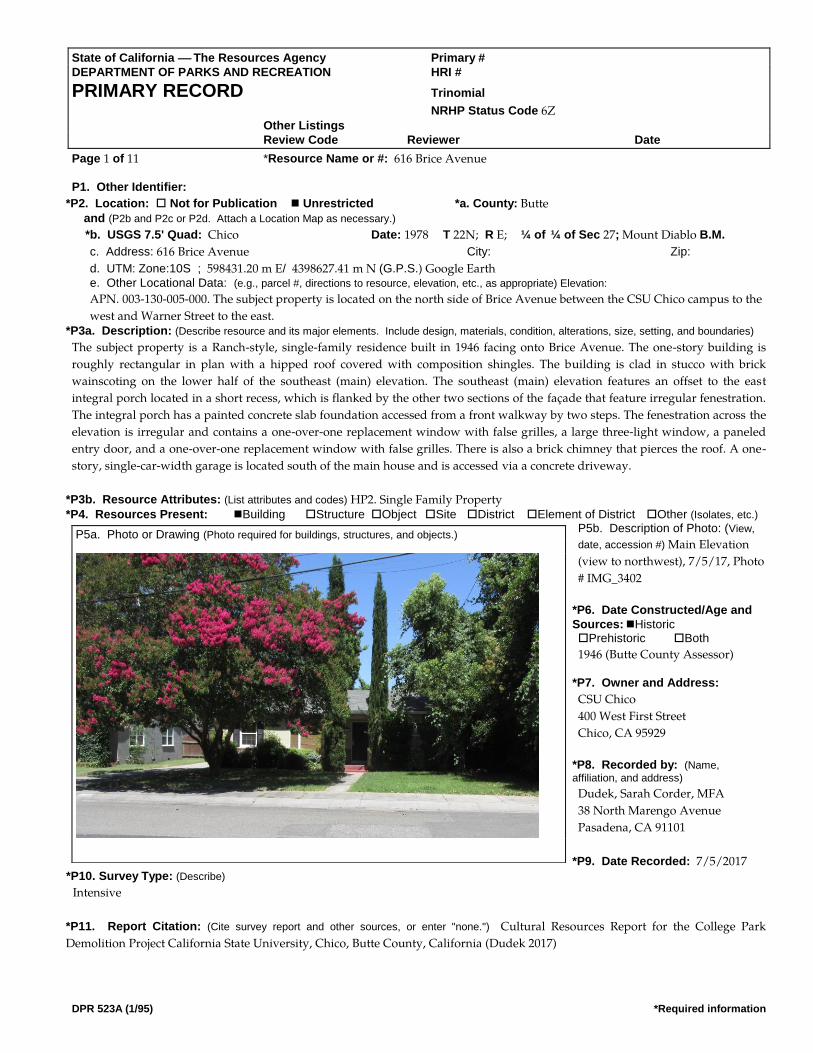
State of California The Resources Agency Primary # DEPARTMENT OF PARKS AND RECREATION HRI #
PRIMARY RECORD Trinomial
NRHP Status Code 6Z Other Listings Review Code Reviewer Date
Page 1 of 11 *Resource Name or #: 616 Brice Avenue
DPR 523A (1/95) *Required information
P1. Other Identifier:
*P2. Location: Not for Publication Unrestricted *a. County: Butte and (P2b and P2c or P2d. Attach a Location Map as necessary.)
*b. USGS 7.5' Quad: Chico Date: 1978 T 22N; R E; ¼ of ¼ of Sec 27; Mount Diablo B.M.
c. Address: 616 Brice Avenue City: Zip:
d. UTM: Zone:10S ; 598431.20 m E/ 4398627.41 m N (G.P.S.) Google Earth e. Other Locational Data: (e.g., parcel #, directions to resource, elevation, etc., as appropriate) Elevation:
APN. 003-130-005-000. The subject property is located on the north side of Brice Avenue between the CSU Chico campus to the
west and Warner Street to the east. *P3a. Description: (Describe resource and its major elements. Include design, materials, condition, alterations, size, setting, and boundaries)
The subject property is a Ranch-style, single-family residence built in 1946 facing onto Brice Avenue. The one-story building is
roughly rectangular in plan with a hipped roof covered with composition shingles. The building is clad in stucco with brick
wainscoting on the lower half of the southeast (main) elevation. The southeast (main) elevation features an offset to the east
integral porch located in a short recess, which is flanked by the other two sections of the façade that feature irregular fenestration.
The integral porch has a painted concrete slab foundation accessed from a front walkway by two steps. The fenestration across the
elevation is irregular and contains a one-over-one replacement window with false grilles, a large three-light window, a paneled
entry door, and a one-over-one replacement window with false grilles. There is also a brick chimney that pierces the roof. A one-
story, single-car-width garage is located south of the main house and is accessed via a concrete driveway.
*P3b. Resource Attributes: (List attributes and codes) HP2. Single Family Property *P4. Resources Present: Building Structure Object Site District Element of District Other (Isolates, etc.)
P5b. Description of Photo: (View,
date, accession #) Main Elevation
(view to northwest), 7/5/17, Photo
# IMG_3402
*P6. Date Constructed/Age and
Sources: Historic Prehistoric Both
1946 (Butte County Assessor)
*P7. Owner and Address:
CSU Chico
400 West First Street
Chico, CA 95929
*P8. Recorded by: (Name,
affiliation, and address)
Dudek, Sarah Corder, MFA
38 North Marengo Avenue
Pasadena, CA 91101
*P9. Date Recorded: 7/5/2017 *P10. Survey Type: (Describe)
Intensive
*P11. Report Citation: (Cite survey report and other sources, or enter "none.") Cultural Resources Report for the College Park
Demolition Project California State University, Chico, Butte County, California (Dudek 2017)
P5a. Photo or Drawing (Photo required for buildings, structures, and objects.)

State of California The Resources Agency Primary # __________________________________________________
DEPARTMENT OF PARKS AND RECREATION HRI # _____________________________________________________
PRIMARY RECORD Trinomial _________________________________________________
Page 2 of 11 Resource Name or #: (Assigned by recorder)_________________________________
DPR 523A-Test (8/94)
*Attachments: NONE Location Map Sketch Map Continuation Sheet Building, Structure, and Object Record Archaeological Record District Record Linear Feature Record Milling Station Record Rock Art Record
Artifact Record Photograph Record Other (List):
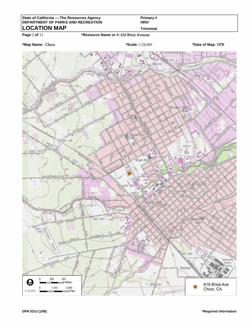
State of California The Resources Agency Primary # DEPARTMENT OF PARKS AND RECREATION HRI#
LOCATION MAP Trinomial Page 2 of 11 *Resource Name or #: 616 Brice Avenue
*Map Name: Chico *Scale: 1:24,000 *Date of Map: 1978
DPR 523J (1/95) *Required information

State of California The Resources Agency Primary # DEPARTMENT OF PARKS AND RECREATION HRI#
BUILDING, STRUCTURE, AND OBJECT RECORD Page 3 of 11 *NRHP Status Code 6Z
*Resource Name or # (Assigned by recorder) 616 Brice Avenue
DPR 523B (1/95) *Required information
B1. Historic Name: B2. Common Name:
B3. Original Use: Single-family residence B4. Present Use: Single-family residence
*B5. Architectural Style: Ranch
*B6. Construction History: (Construction date, alterations, and date of alterations)
Constructed in 1946 (Butte County Assessor). The following City of Chico Building Permits (CCBPs) were found for the property:
a plumbing and sewer connection permit in 1951 (CCBP #217), electrical permit for clothes dryer in 1953 (CCBP #5292), 12 X 18 ft.
addition to the rear of house in 1956 (CCBP #623), construction of a 17 X 24 ft. roof patio in 1956 (CCBP #623), construction of a 9 X
15 ft. addition to the side of the garage in 1956 (CCBP #623), sewer work from 1964 to 1965 (CCBP #3123 and CCBP #3306),
installation of composition roofing in 1984 (CCBP #5300), and reroofing with composition roofing in 1992 (CCBP #B1146). The
only observed alteration to the house is replacement vinyl windows on all visible elevations.
*B7. Moved? No Yes Unknown Date: Original Location:
*B8. Related Features:
B9a. Architect: Unknown b. Builder: Unknown
*B10. Significance: Theme: Area:
Period of Significance: Property Type: Applicable Criteria: N/A (Discuss importance in terms of historical or architectural context as defined by theme, period, and geographic scope. Also address integrity.)
Archival research found the following people associated with the property:
• 1948–1952 – T.J. and Margaret Broedlow, manager of Zellerbach Paper Company
• 1953–1970 – Paul G. Jones, campus barber
• 1984 – Paragon Property Management
• 1992 – Mike Costanza
Based on archival research, it appears that the early owners of the house also occupied the house. However, more recent City
directories and building permits suggest that the house was likely a rental property for CSU Chico students and was no longer
owner-occupied starting in the mid-1980s.
See Continuation Sheet B11. Additional Resource Attributes: (List attributes and codes)
*B12. References: See Continuation Sheet. B13. Remarks:
*B14. Evaluator: Sarah Corder
*Date of Evaluation: 7/5/17
(This space reserved for official comments.)
(Sketch Map with north arrow required.) Source: Google Earth

State of California The Resources Agency Primary # DEPARTMENT OF PARKS AND RECREATION HRI#
CONTINUATION SHEET Trinomial Page 4 of 11 *Resource Name or # (Assigned by recorder) 616 Brice Avenue
Recorded By: Sarah Corder *Date: 07/05/2017 Continuation Update
DPR 523L (1/95) *Required information
*B10. Significance (Continued):
A review of historic maps and aerial photographs was conducted as part of the archival research effort for this property. All
Sanborn maps for the City of Chico were reviewed, and the project area was not included on any of the maps. Historic aerial
photographs were reviewed for the property from the following years: 1941, 1947, 1969, 1998, 2005, 2009, 2010, and 2012. In 1941,
most of the area was not developed, with the exception of a few buildings on Warner Avenue. In 1941, the intersecting streets of
Brice Avenue, La Vista Way, and Stadium Way are not visible. The 1947 aerial photograph indicates that there was increased
development in the area, but the subject property is not visible due to tree coverage and poor image quality. By 1947, the
intersecting streets of Brice Avenue, Stadium Way, and La Vista Way are visible. The remaining years of historic aerial photographs
offer limited information, since the house is largely obscured by trees (NETR 2017).
By the 1920s, Chico had taken steps to make itself a modern city with the creation of paved streets, increased suburban
development, public parks, and the planning of State Highway 99. In the 1920s, the City paved streets and removed wooden
sidewalks. Chico Historian Debra Moon’s analysis of the Census information from 1900, 1910, and 1920 captures the essence of the
City’s growth in the early 20th century, and helps show a shift from a predominately agrarian community to a modern urban city
(Moon 2003):
A 1920 census for Chico showed a population of 15,517. Chico had grown more than expected even through some rough
times. The county’s population at that time was 42.2 percent urban compared to 1910, when the population was 27.9
percent urban, and 1900 when it was only 15.34 percent urban.
Although the growth of the population contributed to this shift, there were other factors in the late 19th and early 20th centuries
that helped to urbanize Chico. One such factor was the donation of Bidwell Park in 1905 by Annie Bidwell. The generous donation
of more than 1,900 acres for use as a public park was a big step toward urbanization in Chico in the 20th century (Booth et al. 2005;
DC 2017; Moon 2003).
Other steps toward urbanization included construction of the Chico Municipal Building in 1916, which helped to create a city plaza
concept with the combination of the municipal building and the post office. Downtown businesses also took steps toward
modernization and urbanization with the removal of wooden awnings and posts from their storefronts. Healthcare advancements
in Chico led to the start of the Enloe Hospital in 1913, which began a series of healthcare center developments spanning the 20th
century, resulting in the modern medical complexes seen in Chico today. The many steps toward modernization attracted not only
businesses and people to Chico, but also movie productions, including Robin Hood, Gone with the Wind, Kane, Last of the
Cowboys, Folly of a Life of Crime, and Alamo Charlie. However, modernization and urbanization did not result in the goal for
Chico of being the new county seat for Butte County in the 1914 county seat race (Booth et al. 2005; DC 2017; Moon 2003).
Like other cities in the United States, advancements in aviation had a profound effect on Chico. In 1935, the City acquired land
located immediately north of town to create a municipal airport. However, these plans were sidelined by World War II, since the
War Department decided to lease the airport land for establishment of an Army Corps base. The decision by the War Department
to lease the airport land was significant to residential and commercial development patterns of Chico, since it brought new people
to the area for employment and training. At the height of its use, the Army base employed 4,000 people, and thousands of people
received basic training or support training at the facility. The base continued in its operation until 1945, after which many of the
people employed and/or trained at the base chose to make Chico their permanent home. To support this population boom, houses
needed to be constructed quickly and cost effectively, so popular styles like the Ranch house became a feasible option (Booth et al.
2005; DC 2017; Moon 2003).
Development and increased suburbanization continued in Chico in the late 1940s and 1950s, and by 1961, an article from the San
Francisco Examiner captured the essence of mid-20th century development in Chico (SFE 1961):
A tour of the city and its outskirts displays the growth of subdivisions, the establishment of shopping centers and the
construction of factories for light industry.

State of California The Resources Agency Primary # DEPARTMENT OF PARKS AND RECREATION HRI#
CONTINUATION SHEET Trinomial Page 5 of 11 *Resource Name or # (Assigned by recorder) 616 Brice Avenue
Recorded By: Sarah Corder *Date: 07/05/2017 Continuation Update
DPR 523L (1/95) *Required information
The increased population also facilitated the need for churches, schools, service stations, and infrastructure improvements such as
additional stoplights and parking meters. Historic aerial photographs from the 1940s show that neighborhoods were being plotted
for increased residential developments, especially in the College Park area (Booth et al. 2005; DC 2017; Moon 2003; NETR 2017).
Another important institution growing throughout the first half of the 20th century was CSU Chico. Population increases, steps
toward modernization, improvements in transportation, and the close of World War II were all significant to the growth and
development of the City and CSU Chico. Development of the City and CSU Chico ran parallel to each other, and influenced larger
patterns of residential, cultural, and economic development (Booth et al. 2005; Moon 2003).
Ranch Style (c. 1935–1975)
The Ranch house is a style of architecture that was popular starting in the 1930s and fell out of popularity by the 1980s. In the 1930s
and early 1940s, the Ranch house was part of the Small House movement that was brought into fashion by the Federal Housing
Administration. Like the Minimal Traditional house, the Ranch house could be constructed quickly and use modern materials that
could be mass-produced. The style provided an easy option for large-scale housing tracts during the 1930s and 1940s to meet the
needs of relocated war-effort workers and those of soldiers returning home and starting families. Following the war years, a new
era of prosperity brought about a departure from the Small House movement, and the Ranch house became a popular house type
throughout the late 1940s through the 1970s (Gottfried and Jennings 2009; Hess 2004; McAlester 2015).
The Ranch house of the 1930s and 1940s maintained similar characteristics to newer versions, but small lot sizes in housing tracts
made the concept of the rambling Ranch house almost impossible. In the 1950s, post-war prosperity combined with increased lot
sizes made the larger and more recognizable Ranch house possible. The ability of the Ranch house to exist in different sizes and
arrangements made it one of the most popular house choices throughout the United States across multiple social classes (Gottfried
and Jennings 2009; Hess 2004; McAlester 2015).
Key characteristics of the Ranch style of architecture are the following (Gottfried and Jennings 2009; Hess 2004; McAlester 2015):
• One story in height
• Gabled or hipped roofs constructed with a low pitch and moderate overhang
• Offset entry points causing asymmetry in the façade
• Focus on horizontal and rambling forms
• Focus on informality
• Entry points are typically placed under the roof overhang on the façade
• Use of large picture-style windows on the façade
• Variations on the eave overhang, typically boxed eaves or exposed rafter tails, or the less-common boxed rafters
• Large chimneys
• Variety of exterior cladding, including brick and stone
• Attached garage, typically incorporated into the façade
• Front and rear yards
• Large rectangular blocks as the basis for plan design, as simply rectangular or a combination of rectangular
blocks to create L, U, and T shapes
NRHP/CRHR Designation Criteria: Criterion A/1 (Events)
Archival research did not find any associations with events that have made a significant contribution to the broad patterns of local
or regional history. The subject property is one of many single-family residences from approximately the same period of
construction (1930s–1950s), and no historical associations or patterns of development were identified. Residential development in
Chico followed industrial development with the rise of companies like the Diamond Match Company. Establishment of the Chico
Army Air Field in the early 1940s created an increased military presence in Chico in the years leading up to World War II, which

State of California The Resources Agency Primary # DEPARTMENT OF PARKS AND RECREATION HRI#
CONTINUATION SHEET Trinomial Page 8 of 11 *Resource Name or # (Assigned by recorder) 616 Brice Avenue
Recorded By: Sarah Corder *Date: 07/05/2017 Continuation Update
DPR 523L (1/95) *Required information
had a direct effect on residential development in Chico during and after the war. During the war, housing was needed for active-
duty service members and their families. Following the war, housing was needed for returning service members who were ready to
settle down and start families in Chico, and for service members who chose to stay in Chico following closure of the Air Field in
1945. These patterns of development were seen across the United States in the years leading up to and following World War II,
when industry began to boom and residential development became a priority to house a growing post-war population. Due to a
lack of significant associations with events important to history, the subject property does not appear eligible under NRHP/CRHR
Criteria A/1.

State of California The Resources Agency Primary # DEPARTMENT OF PARKS AND RECREATION HRI#
CONTINUATION SHEET Trinomial Page 6 of 11 *Resource Name or # (Assigned by recorder) 616 Brice Avenue
Recorded By: Sarah Corder *Date: 07/05/2017 Continuation Update
DPR 523L (1/95) *Required information
Criterion B/2 (Persons)
All owner and occupant names identified with the subject property were researched for possible significance. Archival research
failed to indicate any associations with significant persons. For this reason, the subject property does not appear eligible under
NRHP/CRHR Criteria B/2.
Criterion C/3 (Architecture)
To support a rapidly growing population in the years surrounding World War II, builders in Chico turned to one of the most
popular architectural styles of the time, the Ranch style. The subject property was constructed in 1946 when Chico (and much of the
United States) was experiencing a residential boom in response to local industrial and military-related growth. Although the
subject property retains the most basic elements of the Ranch style (i.e., one story in height, variety of cladding, asymmetry in the
façade), the building exhibits substantial alterations that have compromised its integrity, including replacement windows,
replacement entry door, and replacement roofing. The result is a relatively altered and unremarkable example of a Ranch-style
residence. Archival building permit research did not identify the name(s) of the original builder or architect, but the building is not
likely to be the work of a master architect or important creative individual. Finally, the subject property does not appear eligible as
a contributor to a historic district. For all of these reasons, the subject property does not appear eligible under NRHP/CRHR
Criteria C/3.
Criterion D/4 (Information Potential):
There is no evidence to suggest that this property has the potential to yield information important to state or local history, nor is it
associated with a known archaeological resource. Therefore, the property is recommended not eligible under NRHP/CRHR
Criterion D/4.
California Historical Landmark Designation Criteria:
In consideration of the subject property’s history and requisite integrity, Dudek finds the property not eligible for designation as a
CHL based on the following significance evaluation and in consideration of CHL eligibility criteria.
The first, last, only, or most significant of its type in the state or within a large geographic region (Northern, Central, or Southern California).
The subject property is a modest and altered example of a Ranch-style single-family residence constructed in 1946. The building
represents a common residential house form that was popular throughout the United States following World War II due to the
ability to mass produce materials and plans. It is not the first or last Ranch-style residence to be constructed in Chico, nor is it a
significant example of its type. The subject property is not known to be the work of an important architect, builder, engineer, or
designer, nor was it built using an innovative construction technique. Therefore, the subject property is recommended not eligible
for listing as a CHL under this criterion.
Associated with an individual or group having a profound influence on the history of California.
All owner and occupant names identified with the subject property were researched for possible significance. Archival research
failed to reveal any associations with significant individuals from the past. Therefore, the subject property is recommended not
eligible for listing as a CHL under this criterion.
A prototype of, or an outstanding example of, a period, style, architectural movement or construction or is one of the more notable works or the best surviving work in a region of a pioneer architect, designer or master builder.
The building represents a common Ranch-style house that was popular throughout the United States in the years following World
War II due to the ability to mass produce materials and plans. The subject property is not a prototype or outstanding example of its
style. It exhibits the most basic design features of the Ranch style, but is altered from its original form and cannot be considered a
valuable example of the style. Furthermore, the building is not known to be the work of an important architect, builder, engineer, or
designer, and is not known to have been built using an innovative construction technique. Therefore, the subject property is
recommended not eligible for listing as a CHL under this criterion.
City of Chico Criteria:

State of California The Resources Agency Primary # DEPARTMENT OF PARKS AND RECREATION HRI#
CONTINUATION SHEET Trinomial Page 8 of 11 *Resource Name or # (Assigned by recorder) 616 Brice Avenue
Recorded By: Sarah Corder *Date: 07/05/2017 Continuation Update
DPR 523L (1/95) *Required information
City of Chico historic resource designation criteria closely follow those of the NRHP and CRHR with regard to consideration of
important events, people, and architectural merit. Based on the NRHP/CRHR/CHL criteria discussion above, the subject property
is recommended as not eligible for listing under all City of Chico designation criteria.

State of California The Resources Agency Primary # DEPARTMENT OF PARKS AND RECREATION HRI#
CONTINUATION SHEET Trinomial Page 7 of 11 *Resource Name or # (Assigned by recorder) 616 Brice Avenue
Recorded By: Sarah Corder *Date: 07/05/2017 Continuation Update
DPR 523L (1/95) *Required information
Integrity:
Location: The building is sited on the original location of construction in its original orientation. Therefore, the subject property
retains integrity of location.
Design: The building was subjected to several alterations over time that have significantly compromised its integrity of design,
including replacement roofing, replacement windows, and replacement entry door. Therefore, the building does not maintain
integrity of design.
Setting: Although the subject property maintains its original property boundaries, the surrounding areas have changed
significantly over time. The surrounding area’s integrity was compromised by development of CSU Chico, as noted when
comparing the 1969 historic aerial photograph to the 1998 historic aerial photograph. In 1969, there are large open parcels of land to
the south and west of the neighborhood, but by 1998, there is significant development on these large parcels, including large
campus buildings, access roads, and parking lots. Additionally, the areas to the south and west are now heavily landscaped and
pedestrianized (NETR 2017). Therefore, the property’s integrity of setting is present but is diminished by development in and
around the CSU Chico campus.
Materials: Numerous alterations to the house have compromised the property’s material integrity, including roof replacement,
window replacement, and door replacement. All of these alterations introduced new materials to the subject property that were not
part of the original design. Therefore, the building does not maintain integrity of materials.
Workmanship: Similar to the issue with materials, the physical evidence of a craftsman’s skills in constructing the original building
was compromised by the exterior alterations to the building. Therefore, the building no longer retains its integrity of workmanship.
Feeling: Alterations made to the subject property and the surrounding residential neighborhood have impacted the building’s
ability to convey its historic sense of post–World War II residential development in Chico. Therefore, the property no longer retains
its integrity of feeling.
Association: The property has no direct links with important events or people. Therefore, the building does not have integrity of
association.
In summary, the subject property appears not eligible under all NRHP, CRHR, and CHL designation criteria. Further, the property
exhibits diminished integrity of, setting, feeling, and association, and no longer retains integrity of design, materials, or
workmanship. Consequently, the property does not maintain requisite integrity to warrant listing in the NRHP or CRHR, or as a
CHL.
*B12. References (Continued):
Booth, Edward, John Nopel, Keith Johnson, and Darcey Davis. 2005. Images of America Chico. Charleston, South Carolina: Arcadia
Publishing.
Chico City Directories Various Years.
DC (Downtown Chico). 2017. “History Timeline of Downtown Chico.” Accessed July 31, 2017.
http://www.downtownchico.com/history-timeline.htm.
Gottfried, Herbert, and Jan Jennings. 2009. American Vernacular Buildings and Interiors 1870–1960. New York: WW. Norton and
Company.
Hess, Alan. 2004. The Ranch House. New York: Harry N. Abrams.
McAlester, Virginia Savage. 2015. A Field Guide to American Houses. New York: Alfred A. Knopf.
Moon, Debra. 2003. Chico, Life and Times of a City of Fortune. Charleston, South Carolina: Arcadia Publishing.
State of California The Resources Agency Primary # DEPARTMENT OF PARKS AND RECREATION HRI#
CONTINUATION SHEET Trinomial Page 8 of 11 *Resource Name or # (Assigned by recorder) 616 Brice Avenue
Recorded By: Sarah Corder *Date: 07/05/2017 Continuation Update
DPR 523L (1/95) *Required information
NETR (National Environmental Title Research). 2017. Historic aerial photographs dates 1941, 1947, 1969, 1998, 2005, 2009, 2010, and
2012. Accessed August 31, 2017. https://www.historicaerials.com/viewer#.
SFE (San Francisco Examiner). 1961. “Chico – A Memorial to a Courageous Pioneer.” San Francisco Examiner. August 13, 1961.

State of California The Resources Agency Primary # DEPARTMENT OF PARKS AND RECREATION HRI #
PRIMARY RECORD Trinomial
NRHP Status Code 6Z Other Listings Review Code Reviewer Date
Page 1 of 12 *Resource Name or #: 628 Brice Avenue
DPR 523A (1/95) *Required information
P1. Other Identifier:
*P2. Location: Not for Publication Unrestricted *a. County: Butte and (P2b and P2c or P2d. Attach a Location Map as necessary.)
*b. USGS 7.5' Quad: Chico Date: 1978 T 22N; R E; ¼ of ¼ of Sec 27; Mount Diablo B.M.
c. Address: 628 Brice Avenue City: Zip:
d. UTM: Zone:10S ; 598392.36 m E/ 4398607.16 m N (G.P.S.) Google Earth e. Other Locational Data: (e.g., parcel #, directions to resource, elevation, etc., as appropriate) Elevation:
APN. 003-130-003-000. The subject property is located on the north side of Brice Avenue between the CSU Chico campus to the
west and Warner Street to the east. *P3a. Description: (Describe resource and its major elements. Include design, materials, condition, alterations, size, setting, and boundaries)
The subject property is a Ranch-style, single-family residence built in 1948 facing onto Brice Avenue. The one-story building is
roughly rectangular in plan, with stucco cladding and a cross-gabled roof covered with composition shingles. The front-facing
gable is filled with horizontal wood siding and contains a louvered vent. The southeast (main) elevation presents as two sections:
a left (southern) section distinguished by a partial-width broad entry porch, and a right (eastern) section projecting approximately
4 feet. The integral porch consists of a painted concrete slab accessed by a front walkway and three concrete steps. The porch’s
overhanging eave is supported by three 4 X 4 in. painted wood posts. Fenestration across the elevation is irregular, consisting of a
two-over-two wood frame window, a large tripartite picture window with a central pane surrounded by multiple lights, a simple
wooden entry door located at the easternmost edge of the porch, and a two-over-two wood frame window that features wooden
board and batten shutters. The front yard of the house is circumscribed by a white picket fence, and there is a concrete driveway
located to the south.
*P3b. Resource Attributes: (List attributes and codes) HP2. Single Family Property *P4. Resources Present: Building Structure Object Site District Element of District Other (Isolates, etc.)
P5b. Description of Photo: (View,
date, accession #) Main Elevation
(view to northwest), 7/5/17, Photo
# IMG_3397
*P6. Date Constructed/Age and
Sources: Historic Prehistoric Both
1948 (Butte County Assessor)
*P7. Owner and Address:
CSU Chico
400 West First Street
Chico, CA 95929
*P8. Recorded by: (Name,
affiliation, and address)
Dudek, Sarah Corder, MFA
38 North Marengo Avenue
Pasadena, CA 91101
*P9. Date Recorded: 7/5/2017 *P10. Survey Type: (Describe)
Intensive
*P11. Report Citation: (Cite survey report and other sources, or enter "none.") Cultural Resources Report for the College Park
Demolition Project California State University, Chico, Butte County, California (Dudek 2017)
P5a. Photo or Drawing (Photo required for buildings, structures, and objects.)

State of California The Resources Agency Primary # __________________________________________________
DEPARTMENT OF PARKS AND RECREATION HRI # _____________________________________________________
PRIMARY RECORD Trinomial _________________________________________________
Page 2 of 12 Resource Name or #: (Assigned by recorder)_________________________________
DPR 523A-Test (8/94)
*Attachments: NONE Location Map Sketch Map Continuation Sheet Building, Structure, and Object Record Archaeological Record District Record Linear Feature Record Milling Station Record Rock Art Record
Artifact Record Photograph Record Other (List):
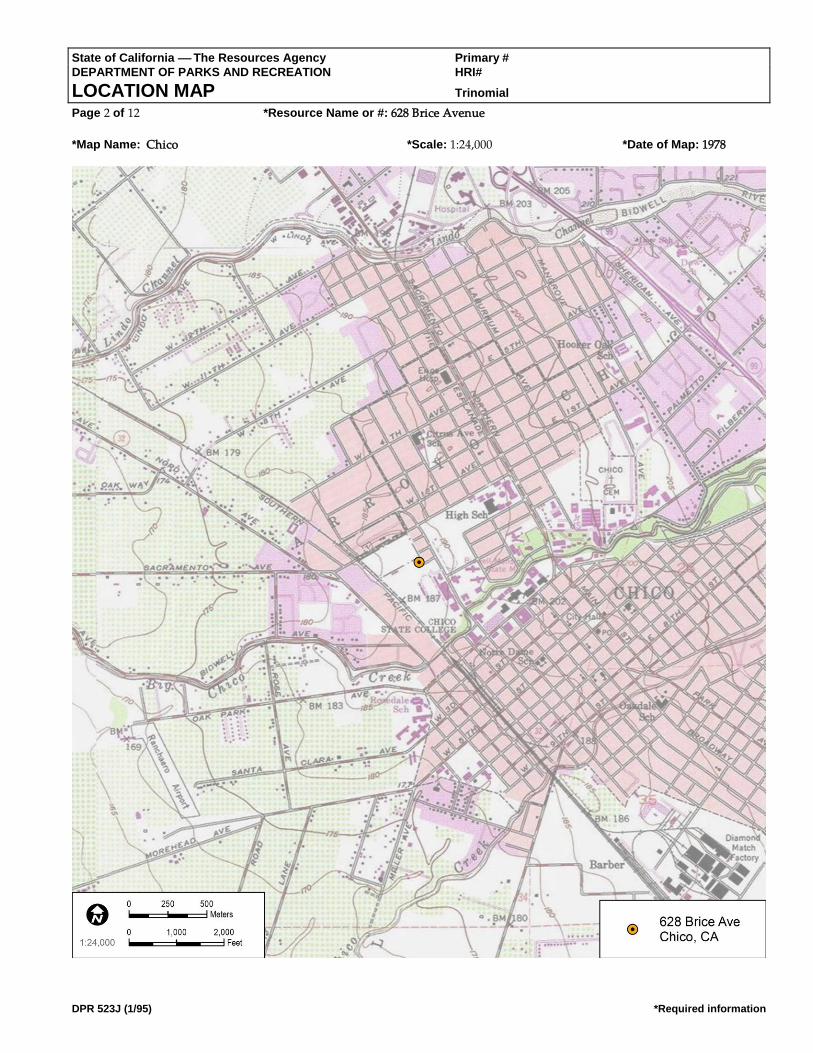
State of California The Resources Agency Primary # DEPARTMENT OF PARKS AND RECREATION HRI#
LOCATION MAP Trinomial Page 2 of 12 *Resource Name or #: 628 Brice Avenue
*Map Name: Chico *Scale: 1:24,000 *Date of Map: 1978
DPR 523J (1/95) *Required information

State of California The Resources Agency Primary # DEPARTMENT OF PARKS AND RECREATION HRI#
BUILDING, STRUCTURE, AND OBJECT RECORD Page 3 of 12 *NRHP Status Code 6Z
*Resource Name or # (Assigned by recorder) 628 Brice Avenue
DPR 523B (1/95) *Required information
B1. Historic Name: B2. Common Name:
B3. Original Use: Single-family residence B4. Present Use: Single-family residence
*B5. Architectural Style: Ranch
*B6. Construction History: (Construction date, alterations, and date of alterations)
Constructed in 1948 (Butte County Assessor). The following City of Chico Building Permits (CCBPs) were found for the property:
television antenna in 1953 (CCBP #199), multiple requests from 1963 to 1971 to the city for filling in holes caused by construction
(CCBP #s 405, 3296, 7788, 6500), replacement gas service in 1981 (CCBP #103400), installation of composition roofing in 1986
(CCBP #B7988), electrical service upgrade in 1995 (CCBP #C95-01161), and an addition and remodel of a room and bathroom in
2001 (CBPP #C01-00733). The only observed alteration to the house is a replacement entry door on the main elevation.
*B7. Moved? No Yes Unknown Date: Original Location:
*B8. Related Features:
B9a. Architect: Unknown b. Builder: Unknown
*B10. Significance: Theme: Area:
Period of Significance: Property Type: Applicable Criteria: N/A (Discuss importance in terms of historical or architectural context as defined by theme, period, and geographic scope. Also address integrity.)
Archival research found the following people associated with the property:
• 1950–1958 – Helen Rahe, secretary
• 1960–1962 – Mack McConnelly
• 1963 – James Martin, teacher at Chico State
• 1964–1970s – Ed McConnley, retired
• 1975 – Julio Medina, builder
• 1986–1990s – Alan Miller
• 2001 – Tom Patty
Based on archival research, it appears that the early owners of the house also occupied the house. However, more recent City
directories and building permits suggest that the house was likely a rental property for CSU Chico students and is no longer
owner occupied.
See Continuation Sheet
B11. Additional Resource Attributes: (List attributes and codes)
*B12. References: See Continuation Sheet.
B13. Remarks:
*B14. Evaluator: Sarah Corder
*Date of Evaluation: 7/5/17
(This space reserved for official comments.)
(Sketch Map with north arrow required.)
Source: Google Earth
State of California The Resources Agency Primary # DEPARTMENT OF PARKS AND RECREATION HRI#
CONTINUATION SHEET Trinomial Page 4 of 12 *Resource Name or # (Assigned by recorder) 628 Brice Avenue
Recorded By: Sarah Corder *Date: 07/05/2017 Continuation Update
DPR 523L (1/95) *Required information
*B10. Significance (Continued):
A review of historic maps and aerial photographs was conducted as part of the archival research effort for this property. All
Sanborn maps for the City of Chico were reviewed, and the project area was not included on any of the maps. Historic aerial
photographs were reviewed for the property from the following years: 1941, 1947, 1969, 1998, 2005, 2009, 2010, and 2012. In 1941,
most of the area was not developed, with the exception of a few buildings on Warner Avenue. The 1947 aerial photograph indicates
that there is increased development in the area, but there is no building on the parcel associated with 628 Brice Avenue. By 1947,
the intersecting streets of Brice Avenue, Stadium Way, and La Vista Way are visible. The 1969 aerial photograph indicates
additional development in the area, including the parcel associated with 628 Brice Avenue, which is consistent with the 1948 date
of construction. The remaining years of historic aerial photographs offer limited information, since the house is largely obscured by
trees (NETR 2017).
By the 1920s, Chico had taken steps to make itself a modern city with the creation of paved streets, increased suburban
development, public parks, and the planning of State Highway 99. In the 1920s, the City paved streets and removed wooden
sidewalks. Chico Historian Debra Moon’s analysis of the Census information from 1900, 1910, and 1920 captures the essence of the
City’s growth in the early 20th century, and helps show a shift from a predominately agrarian community to a modern urban city
(Moon 2003):
A 1920 census for Chico showed a population of 15,517. Chico had grown more than expected even through some rough
times. The county’s population at that time was 42.2 percent urban compared to 1910, when the population was 27.9
percent urban, and 1900 when it was only 15.34 percent urban.
Although the growth of the population contributed to this shift, there were other factors in the late 19th and early 20th centuries
that helped to urbanize Chico. One such factor was the donation of Bidwell Park in 1905 by Annie Bidwell. The generous donation
of more than 1,900 acres for use as a public park was a big step toward urbanization in Chico in the 20th century (Booth et al. 2005;
DC 2017; Moon 2003).
Other steps toward urbanization included construction of the Chico Municipal Building in 1916, which helped to create a city
plaza concept with the combination of the municipal building and the post office. Downtown businesses also took steps toward
modernization and urbanization with the removal of wooden awnings and posts from their storefronts. Healthcare advancements
in Chico led to the start of the Enloe Hospital in 1913, which began a series of healthcare center developments spanning the 20th
century, resulting in the modern medical complexes seen in Chico today. The many steps toward modernization attracted not only
businesses and people to Chico, but also movie productions, including Robin Hood, Gone with the Wind, Kane, Last of the
Cowboys, Folly of a Life of Crime, and Alamo Charlie. However, modernization and urbanization did not result in the goal for
Chico of being the new county seat for Butte County in the 1914 county seat race (Booth et al. 2005; DC 2017; Moon 2003).
Like other cities in the United States, advancements in aviation had a profound effect on Chico. In 1935, the City acquired land
located immediately north of town to create a municipal airport. However, these plans were sidelined by World War II, since the
War Department decided to lease the airport land for establishment of an Army Corps base. The decision by the War Department
to lease the airport land was significant to residential and commercial development patterns of Chico, since it brought new people
to the area for employment and training. At the height of its use, the Army base employed 4,000 people, and thousands of people
received basic training or support training at the facility. The base continued in its operation until 1945, after which many of the
people employed and/or trained at the base chose to make Chico their permanent home. To support this population boom, houses
needed to be constructed quickly and cost effectively, so popular styles like the Ranch house became a feasible option (Booth et al.
2005; DC 2017; Moon 2003).
Development and increased suburbanization continued in Chico in the late 1940s and 1950s, and by 1961, an article from the San
Francisco Examiner captured the essence of mid-20th century development in Chico (SFE 1961):

State of California The Resources Agency Primary # DEPARTMENT OF PARKS AND RECREATION HRI#
CONTINUATION SHEET Trinomial Page 4 of 12 *Resource Name or # (Assigned by recorder) 628 Brice Avenue
Recorded By: Sarah Corder *Date: 07/05/2017 Continuation Update
DPR 523L (1/95) *Required information
A tour of the city and its outskirts displays the growth of subdivisions, the establishment of shopping centers and the
construction of factories for light industry.

State of California The Resources Agency Primary # DEPARTMENT OF PARKS AND RECREATION HRI#
CONTINUATION SHEET Trinomial Page 5 of 12 *Resource Name or # (Assigned by recorder) 628 Brice Avenue
Recorded By: Sarah Corder *Date: 07/05/2017 Continuation Update
DPR 523L (1/95) *Required information
The increased population also facilitated the need for churches, schools, service stations, and infrastructure improvements such as
additional stoplights and parking meters. Historic aerial photographs from the 1940s show that neighborhoods were being plotted
for increased residential developments, especially in the College Park area (Booth et al. 2005; DC 2017; Moon 2003; NETR 2017).
Another important institution growing throughout the first half of the 20th century was CSU Chico. Population increases, steps
toward modernization, improvements in transportation, and the close of World War II were all significant to the growth and
development of the City and CSU Chico. Development of the City and CSU Chico ran parallel to each other, and influenced larger
patterns of residential, cultural, and economic development (Booth et al. 2005; Moon 2003).
Ranch Style (c. 1935–1975)
The Ranch house is a style of architecture that was popular starting in the 1930s and fell out of popularity by the 1980s. In the 1930s
and early 1940s, the Ranch house was part of the Small House movement that was brought into fashion by the Federal Housing
Administration. Like the Minimal Traditional house, the Ranch house could be constructed quickly and use modern materials that
could be mass-produced. The style provided an easy option for large-scale housing tracts during the 1930s and 1940s to meet the
needs of relocated war-effort workers and those of soldiers returning home and starting families. Following the war years, a new
era of prosperity brought about a departure from the Small House movement, and the Ranch house became a popular house type
throughout the late 1940s through the 1970s (Gottfried and Jennings 2009; Hess 2004; McAlester 2015).
The Ranch house of the 1930s and 1940s maintained similar characteristics to newer versions, but small lot sizes in housing tracts
made the concept of the rambling Ranch house almost impossible. In the 1950s, post-war prosperity combined with increased lot
sizes made the larger and more recognizable Ranch house possible. The ability of the Ranch house to exist in different sizes and
arrangements made it one of the most popular house choices throughout the United States across multiple social classes (Gottfried
and Jennings 2009; Hess 2004; McAlester 2015).
Key characteristics of the Ranch style of architecture are the following (Gottfried and Jennings 2009; Hess 2004; McAlester 2015):
• One story in height
• Gabled or hipped roofs constructed with a low pitch and moderate overhang
• Offset entry points causing asymmetry in the façade
• Focus on horizontal and rambling forms
• Focus on informality
• Entry points are typically placed under the roof overhang on the façade
• Use of large picture-style windows on the façade
• Variations on the eave overhang, typically boxed eaves or exposed rafter tails, or the less-common boxed rafters
• Large chimneys
• Variety of exterior cladding, including brick and stone
• Attached garage, typically incorporated into the façade
• Front and rear yards
• Large rectangular blocks as the basis for plan design, as simply rectangular or a combination of rectangular
blocks to create L, U, and T shapes
NRHP/CRHR Designation Criteria: Criterion A/1 (Events)
Archival research did not find any associations with events that have made a significant contribution to the broad patterns of local
or regional history. The subject property is one of many single-family residences from approximately the same period of
construction (1930s–1950s), and no historical associations or patterns of development were identified. Residential development in
Chico followed industrial development with the rise of companies like the Diamond Match Company. Establishment of the Chico
Army Air Field in the early 1940s created an increased military presence in Chico in the years leading up to World War II, which

State of California The Resources Agency Primary # DEPARTMENT OF PARKS AND RECREATION HRI#
CONTINUATION SHEET Trinomial Page 4 of 12 *Resource Name or # (Assigned by recorder) 628 Brice Avenue
Recorded By: Sarah Corder *Date: 07/05/2017 Continuation Update
DPR 523L (1/95) *Required information
had a direct effect on residential development in Chico during and after the war. During the war, housing was needed for active-
duty service members and their families. Following the war, housing was needed for returning service members who were ready to
settle down and start families in Chico, and for service members who chose to stay in Chico following closure of the Air Field in
1945. These patterns of development were seen across the United States in the years leading up to and following World War II,
when industry began to boom and residential development became a priority to house a growing post-war population. Due to a
lack of significant associations with events important to history, the subject property does not appear eligible under NRHP/CRHR
Criteria A/1.

State of California The Resources Agency Primary # DEPARTMENT OF PARKS AND RECREATION HRI#
CONTINUATION SHEET Trinomial Page 6 of 12 *Resource Name or # (Assigned by recorder) 628 Brice Avenue
Recorded By: Sarah Corder *Date: 07/05/2017 Continuation Update
DPR 523L (1/95) *Required information
Criterion B/2 (Persons)
All owner and occupant names identified with the subject property were researched for possible significance. Archival research
failed to indicate any associations with significant persons. For these reasons, the subject property does not appear eligible under
NRHP/CRHR Criteria B/2.
Criterion C/3 (Architecture)
To support a rapidly growing population in the years surrounding World War II, builders in Chico turned to one of the most
popular architectural styles of the time, the Ranch style. The subject property was constructed in 1948 when Chico (and much of the
United States) was experiencing a residential boom in response to local industrial and military-related growth. Although the
subject property retains the most basic elements of the Ranch style (i.e., one story in height, variety of cladding, asymmetry in the
façade) and is relatively unaltered on the exterior, the building is an unremarkable and an ubiquitous example of a Ranch-style
residence seen throughout the United States, and does not warrant consideration as an individual property. Further, the subject
property is not eligible as a contributor to a historic district, since the surrounding neighborhood contains modest examples of
altered Ranch-style residences. Archival building permit research did not identify the name(s) of the original builder or architect,
but the building is not likely to be the work of a master architect or important creative individual. For all of these reasons, the
subject property does not appear eligible under NRHP/CRHR Criteria C/3.
Criterion D/4 (Information Potential):
There is no evidence to suggest that this property has the potential to yield information important to state or local history, nor is it
associated with a known archaeological resource. Therefore, the property is recommended not eligible under NRHP/CRHR
Criterion D/4.
California Historical Landmark Designation Criteria:
In consideration of the subject property’s history and requisite integrity, Dudek finds the property not eligible for designation as a
CHL based on the following significance evaluation and in consideration of CHL eligibility criteria.
The first, last, only, or most significant of its type in the state or within a large geographic region (Northern, Central, or Southern California).
The subject property is a modest and altered example of a Ranch-style single-family residence constructed in 1948. The building
represents a common residential house form that was popular throughout the United States following World War II due to the
ability to mass produce materials and plans. It is not the first nor last Ranch-style residence to be constructed in Chico, nor is it a
significant example of its type. The subject property is not known to be the work of an important architect, builder, engineer, or
designer, nor was it built using an innovative construction technique. Therefore, the subject property is recommended not eligible
for listing as a CHL under this criterion.
Associated with an individual or group having a profound influence on the history of California.
All owner and occupant names identified with the subject property were researched for possible significance. Archival research
failed to reveal any associations with significant individuals from the past. Therefore, the subject property is recommended not
eligible for listing as a CHL under this criterion.
A prototype of, or an outstanding example of, a period, style, architectural movement or construction or is one of the more notable works or the best surviving work in a region of a pioneer architect, designer or master builder.
The building represents a common Ranch-style house that was popular throughout the United States in the years following World
War II due to the ability to mass produce materials and plans. The subject property is not a prototype or outstanding example of its
style. It exhibits the most basic design features of the Ranch style, but is altered from its original form and cannot be considered a
valuable example of the style. Furthermore, the building is not known to be the work of an important architect, builder, engineer, or
designer, and is not known to have been built using an innovative construction technique. Therefore, the subject property is
recommended not eligible for listing as a CHL under this criterion.

State of California The Resources Agency Primary # DEPARTMENT OF PARKS AND RECREATION HRI#
CONTINUATION SHEET Trinomial Page 4 of 12 *Resource Name or # (Assigned by recorder) 628 Brice Avenue
Recorded By: Sarah Corder *Date: 07/05/2017 Continuation Update
DPR 523L (1/95) *Required information
City of Chico Criteria:
City of Chico historic resource designation criteria closely follow those of the NRHP and CRHR with regard to consideration of
important events, people, and architectural merit. Based on the NRHP/CRHR/CHL criteria discussion above, the subject property
is recommended as not eligible for listing under all City of Chico designation criteria.

State of California The Resources Agency Primary # DEPARTMENT OF PARKS AND RECREATION HRI#
CONTINUATION SHEET Trinomial Page 7 of 12 *Resource Name or # (Assigned by recorder) 628 Brice Avenue
Recorded By: Sarah Corder *Date: 07/05/2017 Continuation Update
DPR 523L (1/95) *Required information
Integrity:
Location: The building is sited on the original location of construction in its original orientation. Therefore, the subject property
retains integrity of location.
Design: The building was subjected to several alterations over time that have significantly compromised its integrity of design,
including replacement roofing and replacement entry door. Therefore, the building does not maintain integrity of design.
Setting: Although the subject property maintains its original property boundaries, the surrounding areas have changed
significantly over time. The surrounding area’s integrity was compromised by development of CSU Chico, as noted when
comparing the 1969 historic aerial photograph to the 1998 historic aerial photograph. In 1969, there are large open parcels of land to
the south and west of the neighborhood, but by 1998, there is significant development on these large parcels, including large
campus buildings, access roads, and parking lots. Additionally, the areas to the south and west are now heavily landscaped and
pedestrianized (NETR 2017). Therefore, the property’s integrity of setting is present but is diminished by development in and
around the CSU Chico campus.
Materials: Numerous alterations to the house have compromised the property’s material integrity, including roof replacement and
door replacement. All of these alterations introduced new materials to the subject property that were not part of the original design.
Therefore, the building does not maintain integrity of materials.
Workmanship: Similar to the issue with materials, the physical evidence of a craftsman’s skills in constructing the original building
was compromised by the exterior alterations to the building. Therefore, the building no longer retains its integrity of workmanship.
Feeling: Alterations made to the subject property and the surrounding residential neighborhood have impacted the building’s
ability to convey its historic sense of post–World War II residential development in Chico. Therefore, the property no longer retains
its integrity of feeling.
Association: The property has no direct links with important events or people. Therefore, the building does not have integrity of
association.
In summary, the subject property appears not eligible under all NRHP, CRHR, and CHL designation criteria. Further, the property
exhibits diminished integrity of setting, feeling, and association, and no longer retains integrity of design, materials, or
workmanship. Consequently, the property does not maintain requisite integrity to warrant listing in the NRHP or CRHR, or as a
CHL.
*B12. References (Continued):
Booth, Edward, John Nopel, Keith Johnson, and Darcey Davis. 2005. Images of America Chico. Charleston, South Carolina: Arcadia
Publishing.
Chico City Directories Various Years.
DC (Downtown Chico). 2017. “History Timeline of Downtown Chico.” Accessed July 31, 2017.
http://www.downtownchico.com/history-timeline.htm.
Gottfried, Herbert, and Jan Jennings. 2009. American Vernacular Buildings and Interiors 1870–1960. New York: WW. Norton and
Company.
Hess, Alan. 2004. The Ranch House. New York: Harry N. Abrams.
McAlester, Virginia Savage. 2015. A Field Guide to American Houses. New York: Alfred A. Knopf.
Moon, Debra. 2003. Chico, Life and Times of a City of Fortune. Charleston, South Carolina: Arcadia Publishing.

State of California The Resources Agency Primary # DEPARTMENT OF PARKS AND RECREATION HRI#
CONTINUATION SHEET Trinomial Page 4 of 12 *Resource Name or # (Assigned by recorder) 628 Brice Avenue
Recorded By: Sarah Corder *Date: 07/05/2017 Continuation Update
DPR 523L (1/95) *Required information
NETR (National Environmental Title Research). 2017. Historic aerial photographs dates 1941, 1947, 1969, 1998, 2005, 2009, 2010, and
2012. Accessed August 31, 2017. https://www.historicaerials.com/viewer#.
SFE (San Francisco Examiner). 1961. “Chico – A Memorial to a Courageous Pioneer.” San Francisco Examiner. August 13, 1961.

State of California The Resources Agency Primary # DEPARTMENT OF PARKS AND RECREATION HRI #
PRIMARY RECORD Trinomial
NRHP Status Code 6Z Other Listings Review Code Reviewer Date
Page 1 of 12 *Resource Name or #: 608 La Vista Way
DPR 523A (1/95) *Required information
P1. Other Identifier:
*P2. Location: Not for Publication Unrestricted *a. County: Butte and (P2b and P2c or P2d. Attach a Location Map as necessary.)
*b. USGS 7.5' Quad: Chico Date: 1978 T 22N; R E; ¼ of ¼ of Sec 27; Mount Diablo B.M.
c. Address: 608 La Vista Way City: Zip:
d. UTM: Zone:10S ; 598420.53 m E/ 4398706.58 m N (G.P.S.) Google Earth e. Other Locational Data: (e.g., parcel #, directions to resource, elevation, etc., as appropriate) Elevation:
APN. 003-120-013-000. The subject property is located on the corner of Warner Street and La Vista Way. *P3a. Description: (Describe resource and its major elements. Include design, materials, condition, alterations, size, setting, and boundaries)
The subject property is a Ranch-style, single-family residence built in 1940 facing onto La Vista Way. The one-story building is
irregular in plan, with a gabled roof sheathed in composition shingles. Exterior cladding includes horizontal and vertical wood
siding and stucco. The southeast (main) elevation presents as five sections. The left is a front-gabled single-car-width garage clad
in horizontal wood siding. A short enclosed breezeway clad in horizontal wood siding connects the garage to the house. The
breezeway contains a simple wooden entry door sheltered beneath a side-entry porch. The next section of the house projects
approximately 3 feet from the central block and is clad in stucco. The central block of the house is distinguished by a partial-width
broad-entry porch and is clad in vertical wood siding. The last section of the house (to the far right) is on the same plane as the
central block and is distinguished by a large brick eave-wall chimney, and is clad in horizontal wood siding. The integral porch
has a painted concrete slab foundation accessed from a front walkway by a single step, with three 4 X 4 in. wooden posts
supporting the roof. Fenestration on the primary elevation is irregular and contains a single-car-width sectional garage door, a
one-over-one wood-frame window, an simple wooden entry door, a bay window in the projection, paired six-over-one windows,
a main entry door obscured by a security screen, and two six-over-one windows flanking the brick chimney. A large air
conditioning unit is mounted in the center of the roof.
*P3b. Resource Attributes: (List attributes and codes) HP2. Single Family Property *P4. Resources Present: Building Structure Object Site District Element of District Other (Isolates, etc.)
P5b. Description of Photo: (View,
date, accession #) Main Elevation
(view to northwest), 7/5/17, Photo
# IMG_3316
*P6. Date Constructed/Age and
Sources: Historic Prehistoric Both
1940 (Butte County Assessor)
*P7. Owner and Address:
CSU Chico
400 West First Street
Chico, CA 95929
*P8. Recorded by: (Name,
affiliation, and address)
Dudek, Sarah Corder, MFA
38 North Marengo Avenue
Pasadena, CA 91101
*P9. Date Recorded: 7/5/2017 *P10. Survey Type: (Describe)
Intensive
P5a. Photo or Drawing (Photo required for buildings, structures, and objects.)

State of California The Resources Agency Primary # __________________________________________________
DEPARTMENT OF PARKS AND RECREATION HRI # _____________________________________________________
PRIMARY RECORD Trinomial _________________________________________________
Page 2 of 12 Resource Name or #: (Assigned by recorder)_________________________________
DPR 523A-Test (8/94)
*P11. Report Citation: (Cite survey report and other sources, or enter "none.") Cultural Resources Report for the College Park
Demolition Project California State University, Chico, Butte County, California (Dudek 2017)
*Attachments: NONE Location Map Sketch Map Continuation Sheet Building, Structure, and Object Record
Archaeological Record District Record Linear Feature Record Milling Station Record Rock Art Record
Artifact Record Photograph Record Other (List):

State of California The Resources Agency Primary # DEPARTMENT OF PARKS AND RECREATION HRI#
LOCATION MAP Trinomial Page 2 of 12 *Resource Name or #: 608 La Vista Way
*Map Name: Chico *Scale: 1:24,000 *Date of Map: 1978
DPR 523J (1/95) *Required information

State of California The Resources Agency Primary # DEPARTMENT OF PARKS AND RECREATION HRI#
BUILDING, STRUCTURE, AND OBJECT RECORD Page 3 of 12 *NRHP Status Code 6Z
*Resource Name or # (Assigned by recorder) 608 La Vista Way
DPR 523B (1/95) *Required information
B1. Historic Name: B2. Common Name:
B3. Original Use: Single-family residence B4. Present Use: Single-family residence
*B5. Architectural Style: Ranch
*B6. Construction History: (Construction date, alterations, and date of alterations)
According to Butte County Assessor records, the residence was constructed in 1940; however, no original building permit was
found. The following CCBP was found for the property: installation of new roof-mounted 3-ton HVAC unit in 1997 (CCBP #97-
00192). The building permit folder also contained a service request from 1974 for tree trimming (CCBP #1929) and a code violation
in 2002 for illegal dumping of tree trimmings. Observed alterations to the house from unknown dates include additions to the
south of the house with an enclosed breezeway, a garage, reconfiguration of entry points on the south side of the main elevation,
and addition of security door on main entry door.
*B7. Moved? No Yes Unknown Date: Original Location:
*B8. Related Features:
B9a. Architect: Unknown b. Builder: Unknown
*B10. Significance: Theme: Area:
Period of Significance: Property Type: Applicable Criteria: N/A (Discuss importance in terms of historical or architectural context as defined by theme, period, and geographic scope. Also address integrity.)
Archival research found the following people associated with the property:
• 1945 – Henry E. and Mabel Wiest, vice president of North Valley Tractor and Equipment Company
• 1948–1950 – Donald J. and Kathleen Quinn, secretary of the Chico Chamber of Commerce
• 1953–1956 – Henry E. and Frances L. Wiest, driver for Chico Wood Products
• 1958 – Clinton E. and Patricia Walden, drapery installer for Chico Carpet and Draperies
• 1960 – Eugene McElroy, salesman
• 1961 – Frances Ramsdell
• 1962 – Henry Wiest
• 1963–1980 – Sidney Shnayer, teacher at Chico State
• 1997 – John Jeffries
• 2002 – Fraser and Mary Panerio Page et al.
See Continuation Sheet
B11. Additional Resource Attributes: (List attributes and codes)
*B12. References: See Continuation Sheet
B13. Remarks:
*B14. Evaluator: Sarah Corder
*Date of Evaluation: 7/5/17
(This space reserved for official comments.)
(Sketch Map with north arrow required.) Source: Google Earth

State of California The Resources Agency Primary # DEPARTMENT OF PARKS AND RECREATION HRI#
CONTINUATION SHEET Trinomial Page 4 of 12 *Resource Name or # (Assigned by recorder) 608 La Vista Way
Recorded By: Sarah Corder *Date: 07/05/2017 Continuation Update
DPR 523L (1/95) *Required information
*B10. Significance (Continued):
A review of historic maps and aerial photographs was conducted as part of the archival research effort for this property. All
Sanborn maps for the City of Chico were reviewed, and the project area was not included on any of the maps. Historic aerial
photographs were reviewed for the property from the following years: 1941, 1947, 1969, 1998, 2005, 2009, 2010, and 2012. In 1941,
most of the area was not developed, with the exception of a few buildings on Warner Avenue. Poor image quality resulted in
limited information about the building, which should be visible in 1941 given its 1940 date of construction. The 1947 and 1969 aerial
photographs indicate that there is increased development in the area, and there is an irregular-shaped building located on the
parcel associated with 608 La Vista Way. The remaining years of historic aerial photographs offer limited information, since the
house is largely obscured by trees (NETR 2017).
By the 1920s, Chico had taken steps to make itself a modern city with the creation of paved streets, increased suburban
development, public parks, and the planning of State Highway 99. In the 1920s, the City paved streets and removed wooden
sidewalks. Chico Historian Debra Moon’s analysis of the Census information from 1900, 1910, and 1920 captures the essence of the
City’s growth in the early 20th century, and helps show a shift from a predominately agrarian community to a modern urban city
(Moon 2003):
A 1920 census for Chico showed a population of 15,517. Chico had grown more than expected even through some rough
times. The county’s population at that time was 42.2 percent urban compared to 1910, when the population was 27.9
percent urban, and 1900 when it was only 15.34 percent urban.
Although the growth of the population contributed to this shift, there were other factors in the late 19th and early 20th centuries
that helped to urbanize Chico. One such factor was the donation of Bidwell Park in 1905 by Annie Bidwell. The generous donation
of more than 1,900 acres for use as a public park was a big step toward urbanization in Chico in the 20th century (Booth et al. 2005;
DC 2017; Moon 2003).
Other steps toward urbanization included construction of the Chico Municipal Building in 1916, which helped to create a city plaza
concept with the combination of the municipal building and the post office. Downtown businesses also took steps toward
modernization and urbanization with the removal of wooden awnings and posts from their storefronts. Healthcare advancements
in Chico led to the start of the Enloe Hospital in 1913, which began a series of healthcare center developments spanning the 20th
century, resulting in the modern medical complexes seen in Chico today. The many steps toward modernization attracted not only
businesses and people to Chico, but also movie productions, including Robin Hood, Gone with the Wind, Kane, Last of the
Cowboys, Folly of a Life of Crime, and Alamo Charlie. However, modernization and urbanization did not result in the goal for
Chico of being the new county seat for Butte County in the 1914 county seat race (Booth et al. 2005; DC 2017; Moon 2003).
Like other cities in the United States, advancements in aviation had a profound effect on Chico. In 1935, the City acquired land
located immediately north of town to create a municipal airport. However, these plans were sidelined by World War II, since the
War Department decided to lease the airport land for establishment of an Army Corps base. The decision by the War Department
to lease the airport land was significant to residential and commercial development patterns of Chico, since it brought new people
to the area for employment and training. At the height of its use, the Army base employed 4,000 people, and thousands of people
received basic training or support training at the facility. The base continued in its operation until 1945, after which many of the
people employed and/or trained at the base chose to make Chico their permanent home. To support this population boom, houses
needed to be constructed quickly and cost effectively, so popular styles like the Ranch house became a feasible option (Booth et al.
2005; DC 2017; Moon 2003).
Development and increased suburbanization continued in Chico in the late 1940s and 1950s, and by 1961, an article from the San
Francisco Examiner captured the essence of mid-20th century development in Chico (SFE 1961):
State of California The Resources Agency Primary # DEPARTMENT OF PARKS AND RECREATION HRI#
CONTINUATION SHEET Trinomial Page 4 of 12 *Resource Name or # (Assigned by recorder) 608 La Vista Way
Recorded By: Sarah Corder *Date: 07/05/2017 Continuation Update
DPR 523L (1/95) *Required information
A tour of the city and its outskirts displays the growth of subdivisions, the establishment of shopping centers and the
construction of factories for light industry.

State of California The Resources Agency Primary # DEPARTMENT OF PARKS AND RECREATION HRI#
BUILDING, STRUCTURE, AND OBJECT RECORD Page 5 of 12 *NRHP Status Code 6Z
*Resource Name or # (Assigned by recorder) 608 La Vista Way
DPR 523L (1/95) *Required information
The increased population also facilitated the need for churches, schools, service stations, and infrastructure improvements such as
additional stoplights and parking meters. Historic aerial photographs from the 1940s show that neighborhoods were being plotted
for increased residential developments, especially in the College Park area (Booth et al. 2005; DC 2017; Moon 2003; NETR 2017).
Another important institution growing throughout the first half of the 20th century was CSU Chico. Population increases, steps
toward modernization, improvements in transportation, and the close of World War II were all significant to the growth and
development of the City and CSU Chico. Development of the City and CSU Chico ran parallel to each other, and influenced larger
patterns of residential, cultural, and economic development (Booth et al. 2005; Moon 2003).
Ranch Style (c. 1935–1975)
The Ranch house is a style of architecture that was popular starting in the 1930s and fell out of popularity by the 1980s. In the 1930s
and early 1940s, the Ranch house was part of the Small House movement that was brought into fashion by the Federal Housing
Administration. Like the Minimal Traditional house, the Ranch house could be constructed quickly and use modern materials that
could be mass-produced. The style provided an easy option for large-scale housing tracts during the 1930s and 1940s to meet the
needs of relocated war-effort workers and those of soldiers returning home and starting families. Following the war years, a new
era of prosperity brought about a departure from the Small House movement, and the Ranch house became a popular house type
throughout the late 1940s through the 1970s (Gottfried and Jennings 2009; Hess 2004; McAlester 2015).
The Ranch house of the 1930s and 1940s maintained similar characteristics to newer versions, but small lot sizes in housing tracts
made the concept of the rambling Ranch house almost impossible. In the 1950s, post-war prosperity combined with increased lot
sizes made the larger and more recognizable Ranch house possible. The ability of the Ranch house to exist in different sizes and
arrangements made it one of the most popular house choices throughout the United States across multiple social classes (Gottfried
and Jennings 2009; Hess 2004; McAlester 2015).
Key characteristics of the Ranch style of architecture are the following (Gottfried and Jennings 2009; Hess 2004; McAlester 2015):
• One story in height
• Gabled or hipped roofs constructed with a low pitch and moderate overhang
• Offset entry points causing asymmetry in the façade
• Focus on horizontal and rambling forms
• Focus on informality
• Entry points are typically placed under the roof overhang on the façade
• Use of large picture-style windows on the façade
• Variations on the eave overhang, typically boxed eaves or exposed rafter tails, or the less-common boxed rafters
• Large chimneys
• Variety of exterior cladding, including brick and stone
• Attached garage, typically incorporated into the façade
• Front and rear yards
• Large rectangular blocks as the basis for plan design, as simply rectangular or a combination of rectangular
blocks to create L, U, and T shapes
NRHP/CRHR Designation Criteria: Criterion A/1 (Events)
Archival research did not find any associations with events that have made a significant contribution to the broad patterns of local
or regional history. The subject property is one of many single-family residences from approximately the same period of
construction (1930s–1950s), and no historical associations or patterns of development were identified. Residential development in
Chico followed industrial development with the rise of companies like the Diamond Match Company. Establishment of the Chico
Army Air Field in the early 1940s created an increased military presence in Chico in the years leading up to World War II, which

State of California The Resources Agency Primary # DEPARTMENT OF PARKS AND RECREATION HRI#
CONTINUATION SHEET Trinomial Page 4 of 12 *Resource Name or # (Assigned by recorder) 608 La Vista Way
Recorded By: Sarah Corder *Date: 07/05/2017 Continuation Update
DPR 523L (1/95) *Required information
had a direct effect on residential development in Chico during and after the war. During the war, housing was needed for active-
duty service members and their families. Following the war, housing was needed for returning service members who were ready to
settle down and start families in Chico, and for service members who chose to stay in Chico following closure of the Air Field in
1945. These patterns of development were seen across the United States in the years leading up to and following World War II,
when industry began to boom and residential development became a priority to house a growing post-war population. Due to a
lack of significant associations with events important to history, the subject property does not appear eligible under NRHP/CRHR
Criteria A/1.
State of California The Resources Agency Primary # DEPARTMENT OF PARKS AND RECREATION HRI#
BUILDING, STRUCTURE, AND OBJECT RECORD Page 6 of 12 *NRHP Status Code 6Z
*Resource Name or # (Assigned by recorder) 608 La Vista Way
DPR 523L (1/95) *Required information
Criterion B/2 (Persons)
All owner and occupant names identified with the subject property were researched for possible significance. Archival research
failed to indicate any associations with significant persons. For this reason, the subject property does not appear eligible under
NRHP/CRHR Criteria B/2.
Criterion C/3 (Architecture)
To support a rapidly growing population in the years surrounding World War II, builders in Chico turned to one of the most
popular architectural styles of the time, the Ranch style. The subject property was constructed in 1940 when Chico (and much of the
United States) was experiencing a residential boom in response to local industrial and military-related growth. Although the
subject property retains the most basic elements of the Ranch style (i.e., one story in height, variety of cladding, asymmetry in the
façade, large chimney), the building exhibits substantial alterations, including additions to the south of the house with an enclosed
breezeway, a garage, reconfiguration of entry points on the south side of the main elevation, addition of a security door at the main
entry point, and the addition of rooftop air conditioning unit. The result it is a relatively altered and unremarkable example of a
Ranch-style residence. Archival building permit research did not identify the name(s) of the original builder or architect, but the
building is not likely to be the work of a master architect or important creative individual. Finally, the subject property does not
appear eligible as a contributor to a historic district. For all of these reasons, the subject property does not appear eligible under
NRHP/CRHR Criteria C/3.
Criterion D/4 (Information Potential):
There is no evidence to suggest that this property has the potential to yield information important to state or local history, nor is it
associated with a known archaeological resource. Therefore, the property is recommended not eligible under NRHP/CRHR
Criterion D/4.
California Historical Landmark Designation Criteria:
In consideration of the subject property’s history and requisite integrity, Dudek finds the property not eligible for designation as a
CHL based on the following significance evaluation and in consideration of CHL eligibility criteria.
The first, last, only, or most significant of its type in the state or within a large geographic region (Northern, Central, o r Southern California).
The subject property is a modest and altered example of a Ranch-style single-family residence constructed in 1940. The building
represents a common residential house form that was popular throughout the United States during World War II due to the ability
to mass produce materials and plans. It is not the first or the last Ranch-style residence to be constructed in Chico, nor is it a
significant example of its type. The subject property is not known to be the work of an important architect, builder, engineer, or
designer, nor was it built using an innovative construction technique. Therefore, the subject property is recommended not eligible
for listing as a CHL under this criterion.
Associated with an individual or group having a profound influence on the history of California.
All owner and occupant names identified with the subject property were researched for possible significance. Archival research
failed to reveal any associations with significant individuals from the past. Therefore, the subject property is recommended not
eligible for listing as a CHL under this criterion.
A prototype of, or an outstanding example of, a period, style, architectural movement or construction or is one of the more notable works or the best surviving work in a region of a pioneer architect, designer or master builder.
The building represents a common Ranch-style house that was popular throughout the United States in the years following World
War II due to the ability to mass produce materials and plans. The subject property is not a prototype or outstanding example of its
style. It exhibits the most basic design features of the Ranch style, but is altered from its original form and cannot be considered a
valuable example of the style. Furthermore, the building is not known to be the work of an important architect, builder, engineer, or
designer, and is not known to have been built using an innovative construction technique. Therefore, the subject property is
recommended not eligible for listing as a CHL under this criterion.

State of California The Resources Agency Primary # DEPARTMENT OF PARKS AND RECREATION HRI#
CONTINUATION SHEET Trinomial Page 4 of 12 *Resource Name or # (Assigned by recorder) 608 La Vista Way
Recorded By: Sarah Corder *Date: 07/05/2017 Continuation Update
DPR 523L (1/95) *Required information
City of Chico Criteria:
City of Chico historic resource designation criteria closely follow those of the NRHP and CRHR with regard to consideration of
important events, people, and architectural merit. Based on the NRHP/CRHR/CHL criteria discussion above, the subject property
is recommended as not eligible for listing under all City of Chico designation criteria.

State of California The Resources Agency Primary # DEPARTMENT OF PARKS AND RECREATION HRI#
BUILDING, STRUCTURE, AND OBJECT RECORD Page 7 of 12 *NRHP Status Code 6Z
*Resource Name or # (Assigned by recorder) 608 La Vista Way
DPR 523L (1/95) *Required information
Integrity:
Location: The building is sited on the original location of construction in its original orientation. Therefore, the subject property
retains integrity of location.
Design: The building was subjected to several alterations over time that have significantly compromised its integrity of design,
including construction of an addition, reconfiguration of entry points on the main elevation, addition of rooftop air conditioning
unit, and addition of a security door to the main entry point. Therefore, the building does not maintain integrity of design.
Setting: Although the subject property maintains its original property boundaries, the surrounding areas have changed
significantly over time. However, the surrounding area’s integrity was compromised by development of CSU Chico, as noted when
comparing the 1969 historic aerial photograph to the 1998 historic aerial photograph. In 1969, there are large open parcels of land to
the south and west of the neighborhood, but by 1998, there is significant development on these large parcels, including large
campus buildings, access roads, and parking lots. Additionally, the areas to the south and west are now heavily landscaped and
pedestrianized (NETR 2017). Therefore, the property’s integrity of setting is present but is diminished by development in and
around the CSU Chico campus.
Materials: Numerous alterations to the house have compromised the property’s material integrity, including an addition to the
south of the house, reconfiguration of entry points, addition of a rooftop air conditioning unit, and installation of a security door.
All of these alterations introduced new materials to the subject property that were not part of the original design. Therefore, the
building does not maintain integrity of materials.
Workmanship: Similar to the issue with materials, the physical evidence of a craftsman’s skills in constructing the original building
was compromised by the exterior alterations to the building. Therefore, the building no longer retains its integrity of workmanship.
Feeling: Alterations made to the subject property and the surrounding residential neighborhood have impacted the building’s
ability to convey its historic sense of post–World War II residential development in Chico. Therefore, the property no longer retains
its integrity of feeling.
Association: The property has no direct links with important events or people. Therefore, the building does not have integrity of
association.
In summary, the subject property appears not eligible under all NRHP, CRHR, and CHL designation criteria. Further, the property
exhibits diminished integrity of setting, feeling, and association, and no longer retains integrity of design, materials, or
workmanship. Consequently, the property does not maintain requisite integrity to warrant listing in the NRHP or CRHR, or as a
CHL.
*B12. References (Continued):
Booth, Edward, John Nopel, Keith Johnson, and Darcey Davis. 2005. Images of America Chico. Charleston, South Carolina: Arcadia
Publishing.
Chico City Directories Various Years.
DC (Downtown Chico). 2017. “History Timeline of Downtown Chico.” Accessed July 31, 2017.
http://www.downtownchico.com/history-timeline.htm.
Gottfried, Herbert, and Jan Jennings. 2009. American Vernacular Buildings and Interiors 1870–1960. New York: WW. Norton and
Company.
Hess, Alan. 2004. The Ranch House. New York: Harry N. Abrams.
McAlester, Virginia Savage. 2015. A Field Guide to American Houses. New York: Alfred A. Knopf.
Moon, Debra. 2003. Chico, Life and Times of a City of Fortune. Charleston, South Carolina: Arcadia Publishing.

State of California The Resources Agency Primary # DEPARTMENT OF PARKS AND RECREATION HRI#
CONTINUATION SHEET Trinomial Page 4 of 12 *Resource Name or # (Assigned by recorder) 608 La Vista Way
Recorded By: Sarah Corder *Date: 07/05/2017 Continuation Update
DPR 523L (1/95) *Required information
NETR (National Environmental Title Research). 2017. Historic aerial photographs dates 1941, 1947, 1969, 1998, 2005, 2009, 2010, and
2012. Accessed August 31, 2017. https://www.historicaerials.com/viewer#.
SFE (San Francisco Examiner). 1961. “Chico – A Memorial to a Courageous Pioneer.” San Francisco Examiner. August 13, 1961.

State of California The Resources Agency Primary # DEPARTMENT OF PARKS AND RECREATION HRI #
PRIMARY RECORD Trinomial
NRHP Status Code 6Z Other Listings Review Code Reviewer Date
Page 1 of 11 *Resource Name or #: 615 La Vista Way
DPR 523A (1/95) *Required information
P1. Other Identifier:
*P2. Location: Not for Publication Unrestricted *a. County: Butte and (P2b and P2c or P2d. Attach a Location Map as necessary.)
*b. USGS 7.5' Quad: Chico Date: 1978 T 22N; R E; ¼ of ¼ of Sec 27; Mount Diablo B.M.
c. Address: 615 La Vista Way City: Zip:
d. UTM: Zone:10S ; 598420.80 m E/ 4398658.78 m N (G.P.S.) Google Earth e. Other Locational Data: (e.g., parcel #, directions to resource, elevation, etc., as appropriate) Elevation:
APN. 003-120-016-000. The subject property is located on the south side of La Vista Way between the CSU Chico campus to the
west and Warner Street to the east.
*P3a. Description: (Describe resource and its major elements. Include design, materials, condition, alterations, size, setting, and boundaries)
The subject property is a Ranch-style, single-family residence built in 1947 facing onto La Vista Way. The one-story building is
irregular in plan with horizontal wood siding and a cross-hipped roof sheathed in composition shingles and featuring a
decorative scallop trim below the fascia. The northwest (main) elevation presents as two sections: a left (northeast) section set back
approximately 4 feet from the central block of the house that features a single-car-width garage, and a central block of the house
that contains the offset main entrance. The front entrance is located beneath a shed roof extension and sits atop a concrete slab
foundation accessed from a front walkway by two steps. The porch roof is supported by one wooden knee bracket. The other
bracket appears to be missing, which is causing structural failure of the porch roof. Fenestration across the primary elevation is
irregular and contains a single-car-width sectional garage door, paired one-over-one vinyl replacement windows, a replacement
paneled entry door with divided fanlight detail, and two paired one-over-one replacement windows.
*P3b. Resource Attributes: (List attributes and codes) HP2. Single Family Property *P4. Resources Present: Building Structure Object Site District Element of District Other (Isolates, etc.)
P5b. Description of Photo: (View,
date, accession #) Main Elevation
(view to southeast), 7/5/17, Photo
# IMG_3348
*P6. Date Constructed/Age and
Sources: Historic Prehistoric Both
1947 (Butte County Assessor)
*P7. Owner and Address:
CSU Chico
400 West First Street
Chico, CA 95929
*P8. Recorded by: (Name,
affiliation, and address)
Dudek, Sarah Corder, MFA
38 North Marengo Avenue
Pasadena, CA 91101
*P9. Date Recorded: 7/5/2017 *P10. Survey Type: (Describe)
Intensive
*P11. Report Citation: (Cite survey report and other sources, or enter "none.") Cultural Resources Report for the College Park
Demolition Project California State University, Chico, Butte County, California (Dudek 2017)
P5a. Photo or Drawing (Photo required for buildings, structures, and objects.)
State of California The Resources Agency Primary # __________________________________________________
DEPARTMENT OF PARKS AND RECREATION HRI # _____________________________________________________
PRIMARY RECORD Trinomial _________________________________________________
Page 2 of 11 Resource Name or #: (Assigned by recorder)_________________________________
DPR 523A-Test (8/94)
*Attachments: NONE Location Map Sketch Map Continuation Sheet Building, Structure, and Object Record Archaeological Record District Record Linear Feature Record Milling Station Record Rock Art Record
Artifact Record Photograph Record Other (List):

State of California The Resources Agency Primary # DEPARTMENT OF PARKS AND RECREATION HRI#
LOCATION MAP Trinomial Page 2 of 11 *Resource Name or #: 615 La Vista Way
*Map Name: Chico *Scale: 1:24,000 *Date of Map: 1978
DPR 523J (1/95) *Required information

State of California The Resources Agency Primary # DEPARTMENT OF PARKS AND RECREATION HRI#
BUILDING, STRUCTURE, AND OBJECT RECORD Page 3 of 11 *NRHP Status Code 6Z
*Resource Name or # (Assigned by recorder) 615 La Vista Way
DPR 523B (1/95) *Required information
B1. Historic Name: B2. Common Name:
B3. Original Use: Single-family residence B4. Present Use: Single-family residence
*B5. Architectural Style: Ranch
*B6. Construction History: (Construction date, alterations, and date of alterations)
Constructed in 1947 (Butte County Assessor). The following City of Chico Building Permits (CCBPs) were found for the property:
construction of an addition measuring 9 X 12 ft. to the kitchen for use as a breakfast nook in 1955 (CCBP #257), erection of a
television antenna in 1956 (CCBP #204), an upgrade to the electrical system in 1957 (CCBP #23), sewer repairs in 1984 (CCBP
#5024), roof repairs in 1984 (CCBP #2061), removal and replacement of the composition shingle roof in 1996 (CCBP #96-00237), an
upgrade to the electrical system in 1998 (CCBP #98-00030), replacement of the HVAC unit in 2000 (CCBP #00-00981), and sewer
lateral repair in 2012 (CBPP #413706). Observed alterations to the house with unknown dates include replacement windows,
replacement entry door, and replacement garage door.
*B7. Moved? No Yes Unknown Date: Original Location:
*B8. Related Features:
B9a. Architect: Unknown b. Builder: Unknown
*B10. Significance: Theme: Area: Period of Significance: Property Type: Applicable Criteria: (Discuss importance in terms of historical or architectural context as defined by theme, period, and geographic scope. Also address integrity.)
Archival research found the following people associated with the property:
• 1948 – C.E. and Thelma Nicklett, salesman
• 1952 – Carl and Ethel Duley, principal of Hooker Oak School
• 1955 – Earl Perry
• 1956–1969 – Harry E. and Jesse Wilson, employee of Pac Telephone
• 1970–1978 – Sam S. Simmons
• 1984 – Joe and Noel Collura
• 1996–2000 – Kristen Swigart
See Continuation Sheet
B11. Additional Resource Attributes: (List attributes and codes)
*B12. References: See Continuation Sheet
B13. Remarks:
*B14. Evaluator: Sarah Corder
*Date of Evaluation: 7/5/17
(This space reserved for official comments.)
(Sketch Map with north arrow required.) Source: Google Earth

State of California The Resources Agency Primary # DEPARTMENT OF PARKS AND RECREATION HRI#
CONTINUATION SHEET Trinomial Page 4 of 11 *Resource Name or # (Assigned by recorder) 615 La Vista Way
Recorded By: Sarah Corder *Date: 07/05/2017 Continuation Update
DPR 523L (1/95) *Required information
*B10. Significance (Continued):
A review of historic maps and aerial photographs was conducted as part of the archival research effort for this property. All
Sanborn maps for the City of Chico were reviewed, and the project area was not included on any of the maps. Historic aerial
photographs were reviewed for the property from the following years: 1941, 1947, 1969, 1998, 2005, 2009, 2010, and 2012. In 1941,
most of the area was not developed, with the exception of a few buildings on Warner Avenue. In 1941, the intersecting streets of
Brice Avenue, La Vista Way, and Stadium Way are not visible. The 1947 aerial photograph indicates that there is increased
development in the area, including a rectangular building on the parcel associated with 615 La Vista Way, which is consistent with
the 1947 date of construction. By 1947, the intersecting streets of Brice Avenue, Stadium Way, and La Vista Way are visible. The
remaining years of historic aerial photographs offer limited information, since the house is largely obscured by trees (NETR 2017).
By the 1920s, Chico had taken steps to make itself a modern city with the creation of paved streets, increased suburban
development, public parks, and the planning of State Highway 99. In the 1920s, the City paved streets and removed wooden
sidewalks. Chico Historian Debra Moon’s analysis of the Census information from 1900, 1910, and 1920 captures the essence of the
City’s growth in the early 20th century, and helps show a shift from a predominately agrarian community to a modern urban city
(Moon 2003):
A 1920 census for Chico showed a population of 15,517. Chico had grown more than expected even through some rough
times. The county’s population at that time was 42.2 percent urban compared to 1910, when the population was 27.9
percent urban, and 1900 when it was only 15.34 percent urban.
Although the growth of the population contributed to this shift, there were other factors in the late 19th and early 20th centuries
that helped to urbanize Chico. One such factor was the donation of Bidwell Park in 1905 by Annie Bidwell. The generous donation
of more than 1,900 acres for use as a public park was a big step toward urbanization in Chico in the 20th century (Booth et al. 2005;
DC 2017; Moon 2003).
Other steps toward urbanization included construction of the Chico Municipal Building in 1916, which helped to create a city
plaza concept with the combination of the municipal building and the post office. Downtown businesses also took steps toward
modernization and urbanization with the removal of wooden awnings and posts from their storefronts. Healthcare advancements
in Chico led to the start of the Enloe Hospital in 1913, which began a series of healthcare center developments spanning the 20th
century, resulting in the modern medical complexes seen in Chico today. The many steps toward modernization attracted not only
businesses and people to Chico, but also movie productions, including Robin Hood, Gone with the Wind, Kane, Last of the
Cowboys, Folly of a Life of Crime, and Alamo Charlie. However, modernization and urbanization did not result in the goal for
Chico of being the new county seat for Butte County in the 1914 county seat race (Booth et al. 2005; DC 2017; Moon 2003).
Like other cities in the United States, advancements in aviation had a profound effect on Chico. In 1935, the City acquired land
located immediately north of town to create a municipal airport. However, these plans were sidelined by World War II, since the
War Department decided to lease the airport land for establishment of an Army Corps base. The decision by the War Department
to lease the airport land was significant to residential and commercial development patterns of Chico, since it brought new people
to the area for employment and training. At the height of its use, the Army base employed 4,000 people, and thousands of people
received basic training or support training at the facility. The base continued in its operation until 1945, after which many of the
people employed and/or trained at the base chose to make Chico their permanent home. To support this population boom, houses
needed to be constructed quickly and cost effectively, so popular styles like the Ranch house became a feasible option (Booth et al.
2005; DC 2017; Moon 2003).
Development and increased suburbanization continued in Chico in the late 1940s and 1950s, and by 1961, an article from the San
Francisco Examiner captured the essence of mid-20th century development in Chico (SFE 1961):

State of California The Resources Agency Primary # DEPARTMENT OF PARKS AND RECREATION HRI#
CONTINUATION SHEET Trinomial Page 4 of 11 *Resource Name or # (Assigned by recorder) 615 La Vista Way
Recorded By: Sarah Corder *Date: 07/05/2017 Continuation Update
DPR 523L (1/95) *Required information
A tour of the city and its outskirts displays the growth of subdivisions, the establishment of shopping centers and the
construction of factories for light industry.
The increased population also facilitated the need for churches, schools, service stations, and infrastructure improvements such as
additional stoplights and parking meters. Historic aerial photographs from the 1940s show that neighborhoods were being plotted
for increased residential developments, especially in the College Park area (Booth et al. 2005; DC 2017; Moon 2003; NETR 2017).
Another important institution growing throughout the first half of the 20th century was CSU Chico. Population increases, steps
toward modernization, improvements in transportation, and the close of World War II were all significant to the growth and

State of California The Resources Agency Primary # DEPARTMENT OF PARKS AND RECREATION HRI#
BUILDING, STRUCTURE, AND OBJECT RECORD Page 5 of 11 *NRHP Status Code 6Z
*Resource Name or # (Assigned by recorder) 615 La Vista Way
DPR 523L (1/95) *Required information
development of the City and CSU Chico. Development of the City and CSU Chico ran parallel to each other, and influenced larger
patterns of residential, cultural, and economic development (Booth et al. 2005; Moon 2003).
Ranch Style (c. 1935–1975)
The Ranch house is a style of architecture that was popular starting in the 1930s and fell out of popularity by the 1980s. In the
1930s and early 1940s, the Ranch house was part of the Small House movement that was brought into fashion by the Federal
Housing Administration. Like the Minimal Traditional house, the Ranch house could be constructed quickly and use modern
materials that could be mass-produced. The style provided an easy option for large-scale housing tracts during the 1930s and
1940s to meet the needs of relocated war-effort workers and those of soldiers returning home and starting families. Following the
war years, a new
era of prosperity brought about a departure from the Small House movement, and the Ranch house became a popular house type
throughout the late 1940s through the 1970s (Gottfried and Jennings 2009; Hess 2004; McAlester 2015).
The Ranch house of the 1930s and 1940s maintained similar characteristics to newer versions, but small lot sizes in housing tracts
made the concept of the rambling Ranch house almost impossible. In the 1950s, post-war prosperity combined with increased lot
sizes made the larger and more recognizable Ranch house possible. The ability of the Ranch house to exist in different sizes and
arrangements made it one of the most popular house choices throughout the United States across multiple social classes (Gottfried
and Jennings 2009; Hess 2004; McAlester 2015).
Key characteristics of the Ranch style of architecture are the following (Gottfried and Jennings 2009; Hess 2004; McAlester 2015):
• One story in height
• Gabled or hipped roofs constructed with a low pitch and moderate overhang
• Offset entry points causing asymmetry in the façade
• Focus on horizontal and rambling forms
• Focus on informality
• Entry points are typically placed under the roof overhang on the façade
• Use of large picture-style windows on the façade
• Variations on the eave overhang, typically boxed eaves or exposed rafter tails, or the less-common boxed rafters
• Large chimneys
• Variety of exterior cladding, including brick and stone
• Attached garage, typically incorporated into the façade
• Front and rear yards
• Large rectangular blocks as the basis for plan design, as simply rectangular or a combination of rectangular
blocks to create L, U, and T shapes
NRHP/CRHR Designation Criteria: Criterion A/1 (Events)
Archival research did not find any associations with events that have made a significant contribution to the broad patterns of local
or regional history. The subject property is one of many single-family residences from approximately the same period of
construction (1930s–1950s), and no historical associations or patterns of development were identified. Residential development in
Chico followed industrial development with the rise of companies like the Diamond Match Company. Establishment of the Chico
Army Air Field in the early 1940s created an increased military presence in Chico in the years leading up to World War II, which
had a direct effect on residential development in Chico during and after the war. During the war, housing was needed for active-
duty service members and their families. Following the war, housing was needed for returning service members who were ready to
settle down and start families in Chico, and for service members who chose to stay in Chico following closure of the Air Field in
1945. These patterns of development were seen across the United States in the years leading up to and following World War II,
when industry began to boom and residential development became a priority to house a growing post-war population. Due to a

State of California The Resources Agency Primary # DEPARTMENT OF PARKS AND RECREATION HRI#
CONTINUATION SHEET Trinomial Page 4 of 11 *Resource Name or # (Assigned by recorder) 615 La Vista Way
Recorded By: Sarah Corder *Date: 07/05/2017 Continuation Update
DPR 523L (1/95) *Required information
lack of significant associations with events important to history, the subject property does not appear eligible under NRHP/CRHR
Criteria A/1.
Criterion B/2 (Persons)
All owner and occupant names identified with the subject property were researched for possible significance. Archival research
failed to indicate any associations with significant persons. For this reason, the subject property does not appear eligible under
NRHP/CRHR Criteria B/2.

State of California The Resources Agency Primary # DEPARTMENT OF PARKS AND RECREATION HRI#
BUILDING, STRUCTURE, AND OBJECT RECORD Page 6 of 11 *NRHP Status Code 6Z
*Resource Name or # (Assigned by recorder) 615 La Vista Way
DPR 523L (1/95) *Required information
Criterion C/3 (Architecture)
To support a rapidly growing population in the years surrounding World War II, builders in Chico turned to one of the most
popular architectural styles of the time, the Ranch style. The subject property was constructed in 1947 when Chico (and much of the
United States) was experiencing a residential boom in response to local industrial and military-related growth. Although the
subject property retains the most basic elements of the Ranch style (i.e., one story in height, asymmetry in the façade, attached
garage), the building exhibits substantial alterations, including replacement windows, replacement entry door, replacement garage
door, and replacement roofing. The result it is a relatively altered and unremarkable example of a Ranch-style residence. Archival
building permit research did not identify the name(s) of the original builder or architect, but the building is not likely to be the
work of a master architect or important creative individual. Finally, the subject property does not appear eligible as a contributor to
a historic district. For all of these reasons, the subject property does not appear eligible under NRHP/CRHR Criteria C/3.
Criterion D/4 (Information Potential):
There is no evidence to suggest that this property has the potential to yield information important to state or local history, nor is it
associated with a known archaeological resource. Therefore, the property is recommended not eligible under NRHP/CRHR
Criterion D/4.
California Historical Landmark Designation Criteria:
In consideration of the subject property’s history and requisite integrity, Dudek finds the property not eligible for designation as a
CHL based on the following significance evaluation and in consideration of CHL eligibility criteria.
The first, last, only, or most significant of its type in the state or within a large geographic region (Northern, Central, or Southern California).
The subject property is a modest and altered example of a Ranch-style single-family residence constructed in 1947. The building
represents a common residential house form that was popular throughout the United States following World War II due to the
ability to mass produce materials and plans. It is not the first or last Ranch-style residence to be constructed in Chico, nor is it a
significant example of its type. The subject property is not known to be the work of an important architect, builder, engineer, or
designer, nor was it built using an innovative construction technique. Therefore, the subject property is recommended not eligible
for listing as a CHL under this criterion.
Associated with an individual or group having a profound influence on the history of California.
All owner and occupant names identified with the subject property were researched for possible significance. Archival research
failed to reveal any associations with significant individuals from the past. Therefore, the subject property is recommended not
eligible for listing as a CHL under this criterion.
A prototype of, or an outstanding example of, a period, style, architectural movement or construction or is one of the more notable works or the best surviving work in a region of a pioneer architect, designer or master builder.
The building represents a common Ranch-style house that was popular throughout the United States in the years following World
War II due to the ability to mass produce materials and plans. The subject property is not a prototype or outstanding example of its
style. It exhibits the most basic design features of the Ranch style, but is altered from its original form and cannot be considered a
valuable example of the style. Furthermore, the building is not known to be the work of an important architect, builder, engineer, or
designer, and is not known to have been built using an innovative construction technique. Therefore, the subject property is
recommended not eligible for listing as a CHL under this criterion.
City of Chico Criteria:
City of Chico historic resource designation criteria closely follow those of the NRHP and CRHR with regard to consideration of
important events, people, and architectural merit. Based on the NRHP/CRHR/CHL criteria discussion above, the subject property
is recommended as not eligible for listing under all City of Chico designation criteria.
Integrity:

State of California The Resources Agency Primary # DEPARTMENT OF PARKS AND RECREATION HRI#
CONTINUATION SHEET Trinomial Page 7 of 11 *Resource Name or # (Assigned by recorder) 615 La Vista Way
Recorded By: Sarah Corder *Date: 07/05/2017 Continuation Update
DPR 523L (1/95) *Required information
Location: The building is sited on the original location of construction in its original orientation. Therefore, the subject property
retains integrity of location.
Design: The building was subjected to several alterations over time that have significantly compromised its integrity of design,
including replacement windows, replacement entry door, replacement garage door, and replacement roofing. Therefore, the
building does not maintain integrity of design.
Setting: Although the subject property maintains its original property boundaries, the surrounding areas have changed
significantly over time. The surrounding area’s integrity was compromised by development of CSU Chico, as noted when
comparing the 1969 historic aerial photograph to the 1998 historic aerial photograph. In 1969, there are large open parcels of land to
the south and west of the neighborhood, but by 1998, there is significant development on these large parcels, including large
campus buildings, access roads, and parking lots. Additionally, the areas to the south and west are now heavily landscaped and
pedestrianized (NETR 2017). Therefore, the property’s integrity of setting is present but is diminished by development in and
around the CSU Chico campus.
Materials: Numerous alterations to the house have compromised the property’s material integrity, including replacement
windows, replacement entry door, replacement garage door, and replacement roofing. All of these alterations introduced new
materials to the subject property that were not part of the original design. Therefore, the building does not maintain integrity of
materials.
Workmanship: Similar to the issue with materials, the physical evidence of a craftsman’s skills in constructing the original building
was compromised by the exterior alterations to the building. Therefore, the building no longer retains its integrity of workmanship.
Feeling: Alterations made to the subject property and the surrounding residential neighborhood have impacted the building’s
ability to convey its historic sense of post–World War II residential development in Chico. Therefore, the property no longer retains
its integrity of feeling.
Association: The property has no direct links with important events or people. Therefore, the building does not have integrity of
association.
In summary, the subject property appears not eligible under all NRHP, CRHR, and CHL designation criteria. Further, the property
exhibits diminished integrity of setting, feeling, and association, and no longer retains integrity of design, materials, or
workmanship. Consequently, the property does not maintain requisite integrity to warrant listing in the NRHP or CRHR, or as a
CHL.
*B12. References (Continued):
Booth, Edward, John Nopel, Keith Johnson, and Darcey Davis. 2005. Images of America Chico. Charleston, South Carolina: Arcadia
Publishing.
Chico City Directories Various Years.
DC (Downtown Chico). 2017. “History Timeline of Downtown Chico.” Accessed July 31, 2017.
http://www.downtownchico.com/history-timeline.htm.
Gottfried, Herbert, and Jan Jennings. 2009. American Vernacular Buildings and Interiors 1870–1960. New York: WW. Norton and
Company.
Hess, Alan. 2004. The Ranch House. New York: Harry N. Abrams.
McAlester, Virginia Savage. 2015. A Field Guide to American Houses. New York: Alfred A. Knopf.
Moon, Debra. 2003. Chico, Life and Times of a City of Fortune. Charleston, South Carolina: Arcadia Publishing.

State of California The Resources Agency Primary # DEPARTMENT OF PARKS AND RECREATION HRI#
CONTINUATION SHEET Trinomial Page 7 of 11 *Resource Name or # (Assigned by recorder) 615 La Vista Way
Recorded By: Sarah Corder *Date: 07/05/2017 Continuation Update
DPR 523L (1/95) *Required information
NETR (National Environmental Title Research). 2017. Historic aerial photographs dates 1941, 1947, 1969, 1998, 2005, 2009, 2010, and
2012. Accessed August 31, 2017. https://www.historicaerials.com/viewer#.
SFE (San Francisco Examiner). 1961. “Chico – A Memorial to a Courageous Pioneer.” San Francisco Examiner. August 13, 1961.

State of California The Resources Agency Primary # DEPARTMENT OF PARKS AND RECREATION HRI #
PRIMARY RECORD Trinomial
NRHP Status Code 6Z Other Listings Review Code Reviewer Date
Page 1 of 12 *Resource Name or #: 629 La Vista Way
DPR 523A (1/95) *Required information
P1. Other Identifier:
*P2. Location: Not for Publication Unrestricted *a. County: Butte and (P2b and P2c or P2d. Attach a Location Map as necessary.)
*b. USGS 7.5' Quad: Chico Date: 1978 T 22N; R E; ¼ of ¼ of Sec 27; Mount Diablo B.M.
c. Address: 629 La Vista Way City: Zip:
d. UTM: Zone:10S ; 598396.24 m E/ 4398642.36 m N (G.P.S.) Google Earth e. Other Locational Data: (e.g., parcel #, directions to resource, elevation, etc., as appropriate) Elevation:
APN. 003-120-015-000. The subject property is located on the north side of La Vista Way between the CSU Chico campus to the
west and Warner Street to the east.
*P3a. Description: (Describe resource and its major elements. Include design, materials, condition, alterations, size, setting, and boundaries)
The subject property is a Ranch-style, single-family residence built in 1947 facing onto La Vista Way. The one-story building is
irregular in plan with horizontal wood siding and a cross-hipped roof covered with composition shingles. The northwest (main)
elevation presents as three sections: a left (eastern) section set back approximately 4 ft. from the main body of the house accessed
by a concrete driveway, a central section with an entry porch in the cross-hip roof, and a right (western) section projecting
approximately 4 ft. from the central section. The porch has a painted concrete slab foundation and is accessed from a front
walkway by a single step, with a single 4 X 4 in. wooden post supporting the roof. The porch also features a simple wood railing
and raked detailing on the fascia. Fenestration across the elevation is irregular and consists of a replacement entry door in the
eastern recessed section, a one-over-one wood frame window, a large fixed picture window with diagonal wooden shutters, a
paneled main entry door, and a two-over-two wood frame window on the right projection.
*P3b. Resource Attributes: (List attributes and codes) HP2. Single Family Property *P4. Resources Present: Building Structure Object Site District Element of District Other (Isolates, etc.)
P5b. Description of Photo: (View,
date, accession #) Main Elevation
(view to southeast), 7/5/17, Photo
# IMG_3351
*P6. Date Constructed/Age and
Sources: Historic Prehistoric Both
1947 (Butte County Assessor)
*P7. Owner and Address:
CSU Chico
400 West First Street
Chico, CA 95929
*P8. Recorded by: (Name,
affiliation, and address)
Dudek, Sarah Corder, MFA
38 North Marengo Avenue
Pasadena, CA 91101
*P9. Date Recorded: 7/5/2017 *P10. Survey Type: (Describe)
Intensive
*P11. Report Citation: (Cite survey report and other sources, or enter "none.") Cultural Resources Report for the College Park
Demolition Project California State University, Chico, Butte County, California (Dudek 2017)
P5a. Photo or Drawing (Photo required for buildings, structures, and objects.)

State of California The Resources Agency Primary # __________________________________________________
DEPARTMENT OF PARKS AND RECREATION HRI # _____________________________________________________
PRIMARY RECORD Trinomial _________________________________________________
Page 2 of 12 Resource Name or #: (Assigned by recorder)_________________________________
DPR 523A-Test (8/94)
*Attachments: NONE Location Map Sketch Map Continuation Sheet Building, Structure, and Object Record Archaeological Record District Record Linear Feature Record Milling Station Record Rock Art Record
Artifact Record Photograph Record Other (List):

State of California The Resources Agency Primary # DEPARTMENT OF PARKS AND RECREATION HRI#
LOCATION MAP Trinomial Page 2 of 12 *Resource Name or #: 629 La Vista Way
*Map Name: Chico *Scale: 1:24,000 *Date of Map: 1978
DPR 523J (1/95) *Required information

State of California The Resources Agency Primary # DEPARTMENT OF PARKS AND RECREATION HRI#
BUILDING, STRUCTURE, AND OBJECT RECORD Page 3 of 12 *NRHP Status Code 6Z
*Resource Name or # (Assigned by recorder) 629 La Vista Way
DPR 523B (1/95) *Required information
B1. Historic Name: B2. Common Name:
B3. Original Use: Single-family residence B4. Present Use: Single-family residence
*B5. Architectural Style: Ranch
*B6. Construction History: (Construction date, alterations, and date of alterations)
Constructed in 1947 (Butte County Assessor). The following City of Chico Building Permits (CCBPs) were found for the property:
TV antenna in 1953 (CCBP #10), reroof with composition shingles in 1995 (CCBP #1995), and electrical work in 1999 (CBPP #99-
00171). There is also an encroachment permit with no permit number from 2002 that indicates sewer work was completed. Other
observed alterations to the house with unknown dates include replacement windows, replacement door, and addition of a rooftop
HVAC unit.
*B7. Moved? No Yes Unknown Date: Original Location:
*B8. Related Features:
B9a. Architect: Unknown b. Builder: Unknown
*B10. Significance: Theme: Area: Period of Significance: Property Type: Applicable Criteria: (Discuss importance in terms of historical or architectural context as defined by theme, period, and geographic scope. Also address integrity.)
Archival research found the following people associated with the property:
• 1948 – J.J. and Phyllis Neves, baker
• 1950–1956 – Henry A. and Phyllis Clough, postal carrier
• 1957 – Julia Wainscott, secretary at Chico State
• 1958 – Elwun P. and Hazel Milhorn, engineer
• 1960–1961 – Lester Anderson
• 1962–1970 – Henry Clough, field claim representative for Farmers Insurance
• 1975–1978 – Dennis German, welder
• 1985 – Jeff Huber
• 1990 – Mike Francis, student
• 1995–1999 – Francis Stanley Allen
See Continuation Sheet
B11. Additional Resource Attributes: (List attributes and codes)
*B12. References: See Continuation Sheet
B13. Remarks:
*B14. Evaluator: Sarah Corder
*Date of Evaluation: 7/5/17
(This space reserved for official comments.)
(Sketch Map with north arrow required.) Source: Google Earth

State of California The Resources Agency Primary # DEPARTMENT OF PARKS AND RECREATION HRI#
CONTINUATION SHEET Trinomial Page 4 of 12 *Resource Name or # (Assigned by recorder) 629 La Vista Way
Recorded By: Sarah Corder *Date: 07/05/2017 Continuation Update
DPR 523L (1/95) *Required information
*B10. Significance (Continued):
A review of historic maps and aerial photographs was conducted as part of the archival research effort for this property. All
Sanborn maps for the City of Chico were reviewed, and the project area was not included on any of the maps. Historic aerial
photographs were reviewed for the property from the following years: 1941, 1947, 1969, 1998, 2005, 2009, 2010, and 2012. In 1941,
most of the area was not developed, with the exception of a few buildings on Warner Avenue. In 1941, the intersecting streets of
Brice Avenue, La Vista Way, and Stadium Way are not visible. The 1947 aerial photograph indicates that there was increased
development in the area, and construction activity at 629 La Vista Way suggests that the house was in the process of being built,
which is consistent with the 1947 date of construction. By 1947, the intersecting streets of Brice Avenue, Stadium Way, and La Vista
Way are visible. The remaining years of historic aerial photographs offer limited information, since the house is largely obscured by
trees (NETR 2017).
By the 1920s, Chico had taken steps to make itself a modern city with the creation of paved streets, increased suburban
development, public parks, and the planning of State Highway 99. In the 1920s, the City paved streets and removed wooden
sidewalks. Chico Historian Debra Moon’s analysis of the Census information from 1900, 1910, and 1920 captures the essence of the
City’s growth in the early 20th century, and helps show a shift from a predominately agrarian community to a modern urban city
(Moon 2003):
A 1920 census for Chico showed a population of 15,517. Chico had grown more than expected even through some rough
times. The county’s population at that time was 42.2 percent urban compared to 1910, when the population was 27.9
percent urban, and 1900 when it was only 15.34 percent urban.
Although the growth of the population contributed to this shift, there were other factors in the late 19th and early 20th centuries
that helped to urbanize Chico. One such factor was the donation of Bidwell Park in 1905 by Annie Bidwell. The generous donation
of more than 1,900 acres for use as a public park was a big step toward urbanization in Chico in the 20th century (Booth et al. 2005;
DC 2017; Moon 2003).
Other steps toward urbanization included construction of the Chico Municipal Building in 1916, which helped to create a city plaza
concept with the combination of the municipal building and the post office. Downtown businesses also took steps toward
modernization and urbanization with the removal of wooden awnings and posts from their storefronts. Healthcare advancements
in Chico led to the start of the Enloe Hospital in 1913, which began a series of healthcare center developments spanning the 20th
century, resulting in the modern medical complexes seen in Chico today. The many steps toward modernization attracted not only
businesses and people to Chico, but also movie productions, including Robin Hood, Gone with the Wind, Kane, Last of the
Cowboys, Folly of a Life of Crime, and Alamo Charlie. However, modernization and urbanization did not result in the goal for
Chico of being the new county seat for Butte County in the 1914 county seat race (Booth et al. 2005; DC 2017; Moon 2003).
Like other cities in the United States, advancements in aviation had a profound effect on Chico. In 1935, the City acquired land
located immediately north of town to create a municipal airport. However, these plans were sidelined by World War II, since the
War Department decided to lease the airport land for establishment of an Army Corps base. The decision by the War Department
to lease the airport land was significant to residential and commercial development patterns of Chico, since it brought new people
to the area for employment and training. At the height of its use, the Army base employed 4,000 people, and thousands of people
received basic training or support training at the facility. The base continued in its operation until 1945, after which many of the
people employed and/or trained at the base chose to make Chico their permanent home. To support this population boom, houses
needed to be constructed quickly and cost effectively, so popular styles like the Ranch house became a feasible option (Booth et al.
2005; DC 2017; Moon 2003).
Development and increased suburbanization continued in Chico in the late 1940s and 1950s, and by 1961, an article from the San
Francisco Examiner captured the essence of mid-20th century development in Chico (SFE 1961):

State of California The Resources Agency Primary # DEPARTMENT OF PARKS AND RECREATION HRI#
CONTINUATION SHEET Trinomial Page 4 of 12 *Resource Name or # (Assigned by recorder) 629 La Vista Way
Recorded By: Sarah Corder *Date: 07/05/2017 Continuation Update
DPR 523L (1/95) *Required information
A tour of the city and its outskirts displays the growth of subdivisions, the establishment of shopping centers and the
construction of factories for light industry.

State of California The Resources Agency Primary # DEPARTMENT OF PARKS AND RECREATION HRI#
CONTINUATION SHEET Trinomial Page 5 of 12 *Resource Name or # (Assigned by recorder) 629 La Vista Way
Recorded By: Sarah Corder *Date: 07/05/2017 Continuation Update
DPR 523L (1/95) *Required information
The increased population also facilitated the need for churches, schools, service stations, and infrastructure improvements such as
additional stoplights and parking meters. Historic aerial photographs from the 1940s show that neighborhoods were being plotted
for increased residential developments, especially in the College Park area (Booth et al. 2005; DC 2017; Moon 2003; NETR 2017).
Another important institution growing throughout the first half of the 20th century was CSU Chico. Population increases, steps
toward modernization, improvements in transportation, and the close of World War II were all significant to the growth and
development of the City and CSU Chico. Development of the City and CSU Chico ran parallel to each other, and influenced larger
patterns of residential, cultural, and economic development (Booth et al. 2005; Moon 2003).
Ranch Style (c. 1935–1975)
The Ranch house is a style of architecture that was popular starting in the 1930s and fell out of popularity by the 1980s. In the 1930s
and early 1940s, the Ranch house was part of the Small House movement that was brought into fashion by the Federal Housing
Administration. Like the Minimal Traditional house, the Ranch house could be constructed quickly and use modern materials that
could be mass-produced. The style provided an easy option for large-scale housing tracts during the 1930s and 1940s to meet the
needs of relocated war-effort workers and those of soldiers returning home and starting families. Following the war years, a new
era of prosperity brought about a departure from the Small House movement, and the Ranch house became a popular house type
throughout the late 1940s through the 1970s (Gottfried and Jennings 2009; Hess 2004; McAlester 2015).
The Ranch house of the 1930s and 1940s maintained similar characteristics to newer versions, but small lot sizes in housing tracts
made the concept of the rambling Ranch house almost impossible. In the 1950s, post-war prosperity combined with increased lot
sizes made the larger and more recognizable Ranch house possible. The ability of the Ranch house to exist in different sizes and
arrangements made it one of the most popular house choices throughout the United States across multiple social classes (Gottfried
and Jennings 2009; Hess 2004; McAlester 2015).
Key characteristics of the Ranch style of architecture are the following (Gottfried and Jennings 2009; Hess 2004; McAlester 2015):
• One story in height
• Gabled or hipped roofs constructed with a low pitch and moderate overhang
• Offset entry points causing asymmetry in the façade
• Focus on horizontal and rambling forms
• Focus on informality
• Entry points are typically placed under the roof overhang on the façade
• Use of large picture-style windows on the façade
• Variations on the eave overhang, typically boxed eaves or exposed rafter tails, or the less-common boxed rafters
• Large chimneys
• Variety of exterior cladding, including brick and stone
• Attached garage, typically incorporated into the façade
• Front and rear yards
• Large rectangular blocks as the basis for plan design, as simply rectangular or a combination of rectangular
blocks to create L, U, and T shapes
NRHP/CRHR Designation Criteria: Criterion A/1 (Events)
Archival research did not find any associations with events that have made a significant contribution to the broad patterns of local
or regional history. The subject property is one of many single-family residences from approximately the same period of
construction (1930s–1950s), and no historical associations or patterns of development were identified. Residential development in
Chico followed industrial development with the rise of companies like the Diamond Match Company. Establishment of the Chico
Army Air Field in the early 1940s created an increased military presence in Chico in the years leading up to World War II, which
State of California The Resources Agency Primary # DEPARTMENT OF PARKS AND RECREATION HRI#
CONTINUATION SHEET Trinomial Page 4 of 12 *Resource Name or # (Assigned by recorder) 629 La Vista Way
Recorded By: Sarah Corder *Date: 07/05/2017 Continuation Update
DPR 523L (1/95) *Required information
had a direct effect on residential development in Chico during and after the war. During the war, housing was needed for active-
duty service members and their families. Following the war, housing was needed for returning service members who were ready to
settle down and start families in Chico, and for service members who chose to stay in Chico following closure of the Air Field in
1945. These patterns of development were seen across the United States in the years leading up to and following World War II,
when industry began to boom and residential development became a priority to house a growing post-war population. Due to a
lack of significant associations with events important to history, the subject property does not appear eligible under NRHP/CRHR
Criteria A/1.

State of California The Resources Agency Primary # DEPARTMENT OF PARKS AND RECREATION HRI#
CONTINUATION SHEET Trinomial Page 6 of 12 *Resource Name or # (Assigned by recorder) 629 La Vista Way
Recorded By: Sarah Corder *Date: 07/05/2017 Continuation Update
DPR 523L (1/95) *Required information
Criterion B/2 (Persons)
All owner and occupant names identified with the subject property were researched for possible significance. Archival research
failed to indicate any associations with significant persons. For these reasons, the subject property does not appear eligible under
NRHP/CRHR Criteria B/2.
Criterion C/3 (Architecture)
To support a rapidly growing population in the years surrounding World War II, builders in Chico turned to one of the most
popular architectural styles of the time, the Ranch style. The subject property was constructed in 1947 when Chico (and much of the
United States) was experiencing a residential boom in response to local industrial and military-related growth. Although the
subject property retains the most basic elements of the Ranch style (i.e., one story in height, asymmetry in the façade, use of large
picture-style windows), the building exhibits substantial alterations, including replacement windows, replacement entry door,
replacement roofing, and addition of a rooftop air conditioning unit. The result it is a relatively altered and unremarkable example
of a Ranch-style residence. Archival building permit research did not identify the name(s) of the original builder or architect, but
the building is not likely to be the work of a master architect or important creative individual. Finally, the subject property does not
appear eligible as a contributor to a historic district. For all of these reasons, the subject property does not appear eligible under
NRHP/CRHR Criteria C/3.
Criterion D/4 (Information Potential):
There is no evidence to suggest that this property has the potential to yield information important to state or local history, nor is it
associated with a known archaeological resource. Therefore, the property is recommended not eligible under NRHP/CRHR
Criterion D/4.
California Historical Landmark Designation Criteria:
In consideration of the subject property’s history and requisite integrity, Dudek finds the property not eligible for designation as a
CHL based on the following significance evaluation and in consideration of CHL eligibility criteria.
The first, last, only, or most significant of its type in the state or within a large geographic region (Northern, Central, o r Southern California).
The subject property is a modest and altered example of a Ranch-style single-family residence constructed in 1947. The building
represents a common residential house form that was popular throughout the United States following World War II due to the
ability to mass produce materials and plans. It is not the first or the last Ranch-style residence to be constructed in Chico, nor is it a
significant example of its type. The subject property is not known to be the work of an important architect, builder, engineer, or
designer, nor was it built using an innovative construction technique. Therefore, the subject property is recommended not eligible
for listing as a CHL under this criterion.
Associated with an individual or group having a profound influence on the history of California.
All owner and occupant names identified with the subject property were researched for possible significance. Archival research
failed to reveal any associations with significant individuals from the past. Therefore, the subject property is recommended not
eligible for listing as a CHL under this criterion.
A prototype of, or an outstanding example of, a period, style, architectural movement or construction or is one of the more notable works or the best surviving work in a region of a pioneer architect, designer or master builder.
The building represents a common Ranch-style house that was popular throughout the United States in the years following World
War II due to the ability to mass produce materials and plans. The subject property is not a prototype or outstanding example of its
style. It exhibits the most basic design features of the Ranch style, but is altered from its original form and cannot be considered a
valuable example of the style. Furthermore, the building is not known to be the work of an important architect, builder, engineer, or
designer, and is not known to have been built using an innovative construction technique. Therefore, the subject property is
recommended not eligible for listing as a CHL under this criterion.
City of Chico Criteria:

State of California The Resources Agency Primary # DEPARTMENT OF PARKS AND RECREATION HRI#
CONTINUATION SHEET Trinomial Page 4 of 12 *Resource Name or # (Assigned by recorder) 629 La Vista Way
Recorded By: Sarah Corder *Date: 07/05/2017 Continuation Update
DPR 523L (1/95) *Required information
City of Chico historic resource designation criteria closely follow those of the NRHP and CRHR with regard to consideration of
important events, people, and architectural merit. Based on the NRHP/CRHR/CHL criteria discussion above, the subject property
is recommended as not eligible for listing under all City of Chico designation criteria.

State of California The Resources Agency Primary # DEPARTMENT OF PARKS AND RECREATION HRI#
CONTINUATION SHEET Trinomial Page 7 of 12 *Resource Name or # (Assigned by recorder) 629 La Vista Way
Recorded By: Sarah Corder *Date: 07/05/2017 Continuation Update
DPR 523L (1/95) *Required information
Integrity:
Location: The building is sited on the original location of construction in its original orientation. Therefore, the subject property
retains integrity of location.
Design: The building was subjected to several alterations over time that have significantly compromised its integrity of design,
including replacement windows, replacement entry door, replacement roofing, and addition of a rooftop air conditioning unit.
Therefore, the building does not maintain integrity of design.
Setting: Although the subject property maintains its original property boundaries, the surrounding areas have changed
significantly over time. The surrounding area’s integrity was compromised by development of CSU Chico, as indicated when
comparing the 1969 historic aerial photograph to the 1998 historic aerial photograph. In 1969, there are large open parcels of land to
the south and west of the neighborhood, but by 1998, there is significant development on these large parcels, including large
campus buildings, access roads, and parking lots. Additionally, the areas to the south and west are now heavily landscaped and
pedestrianized (NETR 2017). Therefore, the property’s integrity of setting is present but is diminished by development in and
around the CSU Chico campus.
Materials: Numerous alterations to the house have compromised the property’s material integrity, including replacement
windows, replacement entry door, replacement roofing, and addition of a rooftop air conditioning unit. All of these alterations
introduced new materials to the subject property that were not part of the original design. Therefore, the building does not
maintain integrity of materials.
Workmanship: Similar to the issue with materials, the physical evidence of a craftsman’s skills in constructing the original building
was compromised by the exterior alterations to the building. Therefore, the building no longer retains its integrity of workmanship.
Feeling: Alterations made to the subject property and the surrounding residential neighborhood have impacted the building’s
ability to convey its historic sense of post–World War II residential development in Chico. Therefore, the property no longer retains
its integrity of feeling.
Association: The property has no direct links with important events or people. Therefore, the building does not have integrity of
association.
In summary, the subject property appears not eligible under all NRHP, CRHR, and CHL designation criteria. Further, the property
exhibits diminished integrity of setting, feeling, and association, and no longer retains integrity of design, materials, or
workmanship. Consequently, the property does not maintain requisite integrity to warrant listing in the NRHP or CRHR, or as a
CHL.
*B12. References (Continued):
Booth, Edward, John Nopel, Keith Johnson, and Darcey Davis. 2005. Images of America Chico. Charleston, South Carolina: Arcadia
Publishing.
Chico City Directories Various Years.
DC (Downtown Chico). 2017. “History Timeline of Downtown Chico.” Accessed July 31, 2017.
http://www.downtownchico.com/history-timeline.htm.
Gottfried, Herbert, and Jan Jennings. 2009. American Vernacular Buildings and Interiors 1870–1960. New York: WW. Norton and
Company.
Hess, Alan. 2004. The Ranch House. New York: Harry N. Abrams.
McAlester, Virginia Savage. 2015. A Field Guide to American Houses. New York: Alfred A. Knopf.
Moon, Debra. 2003. Chico, Life and Times of a City of Fortune. Charleston, South Carolina: Arcadia Publishing.

State of California The Resources Agency Primary # DEPARTMENT OF PARKS AND RECREATION HRI#
CONTINUATION SHEET Trinomial Page 4 of 12 *Resource Name or # (Assigned by recorder) 629 La Vista Way
Recorded By: Sarah Corder *Date: 07/05/2017 Continuation Update
DPR 523L (1/95) *Required information
NETR (National Environmental Title Research). 2017. Historic aerial photographs dates 1941, 1947, 1969, 1998, 2005, 2009, 2010, and
2012. Accessed August 31, 2017. https://www.historicaerials.com/viewer#.
SFE (San Francisco Examiner). 1961. “Chico – A Memorial to a Courageous Pioneer.” San Francisco Examiner. August 13, 1961.

State of California The Resources Agency Primary # DEPARTMENT OF PARKS AND RECREATION HRI #
PRIMARY RECORD Trinomial
NRHP Status Code 6Z Other Listings Review Code Reviewer Date
Page 1 of 15 *Resource Name or #: 630 Stadium Way
DPR 523A (1/95) *Required information
P1. Other Identifier:
*P2. Location: Not for Publication Unrestricted *a. County: Butte and (P2b and P2c or P2d. Attach a Location Map as necessary.)
*b. USGS 7.5' Quad: Chico Date: 1978 T 22N; R E; ¼ of ¼ of Sec 27; Mount Diablo B.M.
c. Address: 630 Stadium Way City: Chico Zip: 95926
d. UTM: Zone:10S ; 598337.23 m E/ 4398750.89 m N (G.P.S.) Google Earth e. Other Locational Data: (e.g., parcel #, directions to resource, elevation, etc., as appropriate) Elevation:
APN. 003-120-009-000. The subject property is located on the north side of Stadium Way between the CSU Chico campus to the
west and Warner Street to the east.
*P3a. Description: (Describe resource and its major elements. Include design, materials, condition, alterations, size, setting, and boundaries)
The subject property is a Ranch-style, single-family residence built in 1947 facing onto Stadium Way. The one-story building is
irregular in plan with horizontal wood siding and gabled roof covered in composition shingles. The single-car garage contains a
low-pitched front-gabled roof with narrow eaves clad in composition shingles. The garage is connected to the main house via a
short breezeway. The left (southern) section is recessed approximately 6 feet from the main body of the house that is distinguished
by an entry door with concrete stoop. The center section projects approximately 4 feet forward and is distinguished by an integral
covered porch. The right (northeastern) section is slightly recessed from the projection and features a set of paired windows. The
front door is oriented perpendicular to the main elevation, facing south onto the porch. The floor of the porch is concrete and is
accessed from a front walkway, with two 4 X 4 in. painted wood posts supporting the roof. Fenestration across the primary
elevation is irregular, containing a modern entry door, a one-over-one wood window, a large tripartite picture window with a
fixed center pane flanked by two sliding windows, and a set of paired single lite windows.
*P3b. Resource Attributes: (List attributes and codes) HP2. Single Family Property *P4. Resources Present: Building Structure Object Site District Element of District Other (Isolates, etc.)
P5b. Description of Photo: (View,
date, accession #) Main Elevation
(view to northwest), 7/5/17, Photo
# IMG_3532
*P6. Date Constructed/Age and
Sources: Historic Prehistoric Both
1947 (Butte County Assessor)
*P7. Owner and Address:
CSU Chico
400 West First Street
Chico, CA 95929
*P8. Recorded by: (Name,
affiliation, and address)
Dudek, Sarah Corder, MFA
38 North Marengo Avenue
Pasadena, CA 91101
*P9. Date Recorded: 7/5/2017 *P10. Survey Type: (Describe)
Intensive
*P11. Report Citation: (Cite survey report and other sources, or enter "none.") Cultural Resources Report for the College Park
Demolition Project California State University, Chico, Butte County, California (Dudek 2017)
P5a. Photo or Drawing (Photo required for buildings, structures, and objects.)

State of California The Resources Agency Primary # __________________________________________________
DEPARTMENT OF PARKS AND RECREATION HRI # _____________________________________________________
PRIMARY RECORD Trinomial _________________________________________________
Page 2 of 15 Resource Name or #: (Assigned by recorder)_________________________________
DPR 523A-Test (8/94)
*Attachments: NONE Location Map Sketch Map Continuation Sheet Building, Structure, and Object Record
Archaeological Record District Record Linear Feature Record Milling Station Record Rock Art Record
Artifact Record Photograph Record Other (List):
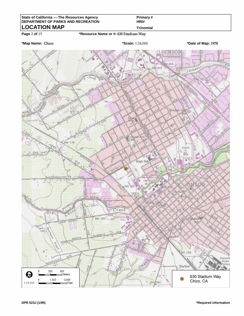
State of California The Resources Agency Primary # DEPARTMENT OF PARKS AND RECREATION HRI#
LOCATION MAP Trinomial Page 2 of 15 *Resource Name or #: 630 Stadium Way
*Map Name: Chico *Scale: 1:24,000 *Date of Map: 1978
DPR 523J (1/95) *Required information

State of California The Resources Agency Primary # DEPARTMENT OF PARKS AND RECREATION HRI#
BUILDING, STRUCTURE, AND OBJECT RECORD Page 3 of 15 *NRHP Status Code 6Z
*Resource Name or # (Assigned by recorder) 630 Stadium Way
DPR 523B (1/95) *Required information
B1. Historic Name: B2. Common Name:
B3. Original Use: Single-family residence B4. Present Use: Single-family residence
*B5. Architectural Style: Ranch
*B6. Construction History: (Construction date, alterations, and date of alterations)
Constructed in 1947 (Butte County Assessor). The following City of Chico Building Permits (CCBPs) were found for the property:
construction of a 9 X 14 ft. addition to rear of house in 1950 (CCBP #9969); construction of an addition to the end of the garage in
1950 (CCBP #9969); construction of a television antenna in 1954 (CCBP #00446); construction of a television antenna in 1955 (CCBP
#74); kitchen remodel with movement of a window and addition of drain board in 1955 (CCBP #307); plumbing work in 1956
(CCBP #449); addition of family room, addition of a serving room, and modifications to a bathroom in 1956 (CCBP #961);
construction of an addition in 1957 (CCBP #702); addition of a swimming pool in 1959 (CCBP #2266); remodel in 1966 (CCBP
#2557); a reroof in 1981 (CCBP #1225); repairs due to fire damage in 1981 (CCBP #1366); electrical work in 1988 (CCBP #7949);
sewer lateral repair in 1999 (CCBP #411075); and a reroof with composition shingles in 2005 (CCBP #05-00224). Observed
alterations to the house with unknown dates include replacement windows and door.
*B7. Moved? No Yes Unknown Date: Original Location:
*B8. Related Features:
B9a. Architect: Unknown b. Builder: Unknown
*B10. Significance: Theme: Area: Period of Significance: Property Type: Applicable Criteria: (Discuss importance in terms of historical or architectural context as defined by theme, period, and geographic scope. Also address integrity.)
Archival research found the following people associated with the property:
• 1948 – Evelyn McKenzie
• 1950–1958 – Earl and Wandalee Dohrn, service station manager and Dohrn’s Shell Service
• 1960–1975 – William Hutchinson, writer
• 1980–1988 – Michael Vaupel
• 1990 – Corbs Gorath, student
• 2005 – Frederick and Jessalyn Gorath
• 2007 – Robert Ciapponi
See Continuation Sheet
B11. Additional Resource Attributes: (List attributes and codes)
*B12. References: See Continuation Sheet
B13. Remarks:
*B14. Evaluator: Sarah Corder
(This space reserved for official comments.)
(Sketch Map with north arrow required.) Source: Google Earth
State of California The Resources Agency Primary # DEPARTMENT OF PARKS AND RECREATION HRI#
CONTINUATION SHEET Trinomial Page 4 of 15 *Resource Name or # (Assigned by recorder) 630 Stadium Way
Recorded By: Sarah Corder *Date: 07/05/2017 Continuation Update
DPR 523L (1/95) *Required information
*Date of Evaluation: 7/5/17

State of California The Resources Agency Primary # DEPARTMENT OF PARKS AND RECREATION HRI#
CONTINUATION SHEET Trinomial Page 4 of 15 *Resource Name or # (Assigned by recorder) 630 Stadium Way
Recorded By: Sarah Corder *Date: 07/05/2017 Continuation Update
DPR 523L (1/95) *Required information
*B10. Significance (Continued):
A review of historic maps and aerial photographs was conducted as part of the archival research effort for this property. All
Sanborn maps for the City of Chico were reviewed, and the project area was not included on any of the maps. Historic aerial
photographs were reviewed for the property from the following years: 1941, 1947, 1969, 1998, 2005, 2009, 2010, and 2012. In 1941,
most of the area was not developed, with the exception of a few buildings on Warner Avenue. In 1941, the intersecting streets of
Brice Avenue, La Vista Way, and Stadium Way are not visible. The 1947 aerial photograph indicates that there is increased
development in the area, including an irregular shaped residence on the corner of Warner Avenue and Brice Avenue, which is
consistent with the 1947 date of construction for 630 Stadium Way. By 1947, the intersecting streets of Brice Avenue, Stadium Way,
and La Vista Way are visible. The remaining years of historic aerial photographs offer limited information, since the house is
largely obscured by trees (NETR 2017).
By the 1920s, Chico had taken steps to make itself a modern city with the creation of paved streets, increased suburban
development, public parks, and the planning of State Highway 99. In the 1920s, the City paved streets and removed wooden
sidewalks. Chico Historian Debra Moon’s analysis of the Census information from 1900, 1910, and 1920 captures the essence of the
City’s growth in the early 20th century, and helps show a shift from a predominately agrarian community to a modern urban city
(Moon 2003):
A 1920 census for Chico showed a population of 15,517. Chico had grown more than expected even through some rough
times. The county’s population at that time was 42.2 percent urban compared to 1910, when the population was 27.9
percent urban, and 1900 when it was only 15.34 percent urban.
Although the growth of the population contributed to this shift, there were other factors in the late 19th and early 20th centuries
that helped to urbanize Chico. One such factor was the donation of Bidwell Park in 1905 by Annie Bidwell. The generous donation
of more than 1,900 acres for use as a public park was a big step toward urbanization in Chico in the 20th century (Booth et al. 2005;
DC 2017; Moon 2003).
Other steps toward urbanization included construction of the Chico Municipal Building in 1916, which helped to create a city plaza
concept with the combination of the municipal building and the post office. Downtown businesses also took steps toward
modernization and urbanization with the removal of wooden awnings and posts from their storefronts. Healthcare advancements
in Chico led to the start of the Enloe Hospital in 1913, which began a series of healthcare center developments spanning the 20th
century, resulting in the modern medical complexes seen in Chico today. The many steps toward modernization attracted not only
businesses and people to Chico, but also movie productions, including Robin Hood, Gone with the Wind, Kane, Last of the
Cowboys, Folly of a Life of Crime, and Alamo Charlie. However, modernization and urbanization did not result in the goal for
Chico of being the new county seat for Butte County in the 1914 county seat race (Booth et al. 2005; DC 2017; Moon 2003).
Like other cities in the United States, advancements in aviation had a profound effect on Chico. In 1935, the City acquired land
located immediately north of town to create a municipal airport. However, these plans were sidelined by World War II, since the
War Department decided to lease the airport land for establishment of an Army Corps base. The decision by the War Department
to lease the airport land was significant to residential and commercial development patterns of Chico, since it brought new people
to the area for employment and training. At the height of its use, the Army base employed 4,000 people, and thousands of people
received basic training or support training at the facility. The base continued in its operation until 1945, after which many of the
people employed and/or trained at the base chose to make Chico their permanent home. To support this population boom, houses
needed to be constructed quickly and cost effectively, so popular styles like the Ranch house became a feasible option (Booth et al.
2005; DC 2017; Moon 2003).
Development and increased suburbanization continued in Chico in the late 1940s and 1950s, and by 1961, an article from the San
Francisco Examiner captured the essence of mid-20th century development in Chico (SFE 1961):

State of California The Resources Agency Primary # DEPARTMENT OF PARKS AND RECREATION HRI#
CONTINUATION SHEET Trinomial Page 4 of 15 *Resource Name or # (Assigned by recorder) 630 Stadium Way
Recorded By: Sarah Corder *Date: 07/05/2017 Continuation Update
DPR 523L (1/95) *Required information
A tour of the city and its outskirts displays the growth of subdivisions, the establishment of shopping centers and the
construction of factories for light industry.

State of California The Resources Agency Primary # DEPARTMENT OF PARKS AND RECREATION HRI#
CONTINUATION SHEET Trinomial Page 5 of 9 *Resource Name or # (Assigned by recorder) 630 Stadium Way
Recorded By: Sarah Corder *Date: 07/05/2017 Continuation Update
DPR 523L (1/95) *Required information
The increased population also facilitated the need for churches, schools, service stations, and infrastructure improvements such as
additional stoplights and parking meters. Historic aerial photographs from the 1940s show that neighborhoods were being plotted
for increased residential developments, especially in the College Park area (Booth et al. 2005; DC 2017; Moon 2003; NETR 2017).
Another important institution growing throughout the first half of the 20th century was CSU Chico. Population increases, steps
toward modernization, improvements in transportation, and the close of World War II were all significant to the growth and
development of the City and CSU Chico. Development of the City and CSU Chico ran parallel to each other, and influenced larger
patterns of residential, cultural, and economic development (Booth et al. 2005; Moon 2003).
Ranch Style (c. 1935–1975)
The Ranch house is a style of architecture that was popular starting in the 1930s and fell out of popularity by the 1980s. In the 1930s
and early 1940s, the Ranch house was part of the Small House movement that was brought into fashion by the Federal Housing
Administration. Like the Minimal Traditional house, the Ranch house could be constructed quickly and use modern materials that
could be mass-produced. The style provided an easy option for large-scale housing tracts during the 1930s and 1940s to meet the
needs of relocated war-effort workers and those of soldiers returning home and starting families. Following the war years, a new
era of prosperity brought about a departure from the Small House movement, and the Ranch house became a popular house type
throughout the late 1940s through the 1970s (Gottfried and Jennings 2009; Hess 2004; McAlester 2015).
The Ranch house of the 1930s and 1940s maintained similar characteristics to newer versions, but small lot sizes in housing tracts
made the concept of the rambling Ranch house almost impossible. In the 1950s, post-war prosperity combined with increased lot
sizes made the larger and more recognizable Ranch house possible. The ability of the Ranch house to exist in different sizes and
arrangements made it one of the most popular house choices throughout the United States across multiple social classes (Gottfried
and Jennings 2009; Hess 2004; McAlester 2015).
Key characteristics of the Ranch style of architecture are the following (Gottfried and Jennings 2009; Hess 2004; McAlester 2015):
• One story in height
• Gabled or hipped roofs constructed with a low pitch and moderate overhang
• Offset entry points causing asymmetry in the façade
• Focus on horizontal and rambling forms
• Focus on informality
• Entry points are typically placed under the roof overhang on the façade
• Use of large picture-style windows on the façade
• Variations on the eave overhang, typically boxed eaves or exposed rafter tails, or the less-common boxed rafters
• Large chimneys
• Variety of exterior cladding, including brick and stone
• Attached garage, typically incorporated into the façade
• Front and rear yards
• Large rectangular blocks as the basis for plan design, as simply rectangular or a combination of rectangular
blocks to create L, U, and T shapes
NRHP/CRHR Designation Criteria: Criterion A/1 (Events)
Archival research did not find any associations with events that have made a significant contribution to the broad patterns of local
or regional history. The subject property is one of many single-family residences from approximately the same period of
construction (1930s–1950s), and no historical associations or patterns of development were identified. Residential development in
Chico followed industrial development with the rise of companies like the Diamond Match Company. Establishment of the Chico
Army Air Field in the early 1940s created an increased military presence in Chico in the years leading up to World War II, which
had a direct effect on residential development in Chico during and after the war. During the war, housing was needed for active-
State of California The Resources Agency Primary # DEPARTMENT OF PARKS AND RECREATION HRI#
CONTINUATION SHEET Trinomial Page 6 of 15 *Resource Name or # (Assigned by recorder) 630 Stadium Way
Recorded By: Sarah Corder *Date: 07/05/2017 Continuation Update
DPR 523L (1/95) *Required information
duty service members and their families. Following the war, housing was needed for returning service members who were ready to
settle down and start families in Chico, and for service members who chose to stay in Chico following closure of the Air Field in
1945. These patterns of development were seen across the United States in the years leading up to and following World War II,
when industry began to boom and residential development became a priority to house a growing post-war population. Due to a
lack of significant associations with events important to history, the subject property does not appear eligible under NRHP/CRHR
Criteria A/1.
Criterion B/2 (Persons)
All owner and occupant names identified with the subject property were researched for possible significance. Only one name
warranted further research: William Henry Hutchinson (also known as “Old Hutch”). See Section 2.2, above, for more information.
Following NRHP Guidance for Criterion B (Boland n.d.; NPS 1990), it is important to first assess the importance of Old Hutch in
relation to the historic context. Archival research reveals that Hutchinson is significant within the local context of CSU Chico, with a
period of significance from 1960 to 1976. This period captures the time when he lived at residence, his tenure as a full-time
professor at CSU Chico, and publication of perhaps his most important book. For the subject property to be eligible under this
criterion, it must be shown that Hutchinson gained importance while occupying the subject property.
Permit records and City directories confirm that Old Hutch lived at the residence on Stadium Way from at least 1960 through 1976,
although it is very likely that he lived at the home until at least 1978 when he retired as a professor. This is further evidenced by the
fact that the next owner did not occupy the property until 1980. Research indicates that his time at the subject property overlaps
some of his most important contributions to Chico and CSU Chico. Hutchinson was a professor of California and Western History
at CSU Chico from 1953 through 1978 (he became a full-time professor beginning in 1964). He earned his Master’s Degree in
History from CSU Chico in 1961. In 1965, he was voted “Best Californian” by the Common Wealth Club. Hutchinson received the
Chico State Distinguished Teacher Award in 1968, and was labeled an Outstanding Professor in the CSU system in 1977. His
Pulitzer Prize–nominated book Oil, Land, and Politics: The California Career of Thomas R. Bard was published in 1966 (Watkins et
al. 1990).
Hutchinson also authored numerous books prior to his residency at Stadium Way, including his 1946 edits to a collection of
previously unpublished works by Eugene Manlove Rhodes, The Little Waddies. Hutchinson edited other writings of Rhodes,
including The Rhodes Reader (1957) and The Line of Least Resistance (1958). Hutchinson completed his first biography on Rhodes
in 1956, titled A Bar Cross Man.
It is also necessary to ascertain the length of time and nature of Hutchinson’s association with the subject property. Old Hutch lived
at the subject property from at least 1960 through 1976 (very likely until 1978), and he continued to live in Chico until his death in
1990. The subject property was his primary residence during that time, and he shared it with his wife Esther Ethel Ormsby (1908–
1990), also known to locals as “Red.” City directories from 1960 and 1976 verify that Old Hutch and Red lived at the subject
property. Census records also provide a timeline of Hutchinson’s other residences throughout his life, including his home in
Denver, Colorado (beginning with his birth in 1911); a short stint in Eastland, Texas, in the 1920s; a return to Denver in the 1930s;
working as a chief purser on passenger vessels during the Great Depression; serving as a lieutenant commander in the U.S.
Maritime Service during World War II (California State Library 1998); and a residence in San Francisco, California, in the 1940s
(although he was at sea for several years). After his time at the subject property, he moved to another residence in Chico in 1980
located at 1611 Spruce Avenue, north of CSU Chico. In consideration of Hutchinson’s productive life as a writer and a professor,
the subject property is the most relevant.
Hutchinson’s local significance is more closely aligned with the recent history of CSU Chico than any broader associations with the
City of Chico. Although Hutchinson lived at the subject property during his time as a professor and writer, the property itself does
not convey his importance to CSU Chico, nor can it be directly tied to his important publications. Although Hutchinson published
arguably his most important work while living at the subject property, this significance is not conveyed by the property. It is also
unknown where Hutchinson did most of his writing and research. Further, none of the local historians or faculty interviewed about

State of California The Resources Agency Primary # DEPARTMENT OF PARKS AND RECREATION HRI#
CONTINUATION SHEET Trinomial Page 6 of 15 *Resource Name or # (Assigned by recorder) 630 Stadium Way
Recorded By: Sarah Corder *Date: 07/05/2017 Continuation Update
DPR 523L (1/95) *Required information
the Hutchinson house drew any important connections between the man and the property. Further, after his retirement, CSU Chico
dedicated the courtyard between Trinity Hall and Kendall Hall in his honor on June 11, 1979. Labeled with wooden signage as
“W.H. Hutchinson/Old Hutch’s Plaza,” the plaza is a place strongly associated with Hutchinson, as students and faculty have fond
memories of him sitting on a specific bench in the courtyard enjoying the environment or chatting with students (CSUC 2016). An
off-campus residence such as the subject property is less closely associated with his important contributions to CSU Chico and his
work as a respected local historian and author.
The subject property itself has integrity issues. Although the subject property’s exterior retains requisite integrity to the period of
significance, the property’s interior has been altered since Old Hutch and Red occupied it. It appears that the Hutchinsons added a
swimming pool to the property when they first moved in, and remodeled the home in 1966. Building permit research indicates that
repairs had to be made to the home after a fire in 1981, although the extent of interior repair/alteration is unclear.
State of California The Resources Agency Primary # DEPARTMENT OF PARKS AND RECREATION HRI#
CONTINUATION SHEET Trinomial Page 7 of 9 *Resource Name or # (Assigned by recorder) 630 Stadium Way
Recorded By: Sarah Corder *Date: 07/05/2017 Continuation Update
DPR 523L (1/95) *Required information
In consideration of the information presented here, it does not appear that the subject property meets the high burden of proof
required under this criterion, as Hutchinson’s important contributions as a professor and writer are much more closely aligned
with the CSU Chico campus than the off-campus home he shared with his wife. Further, the subject property does not contain
specific features or elements that convey Old Hutch’s significance, and its integrity has been altered since the couple vacated it.
Finally, the home has not been identified as important by the local historians and faculty who knew him. For all of these reasons,
the subject property does not appear eligible under NRHP/CRHR Criteria B/2.
Criterion C/3 (Architecture)
To support a rapidly growing population in the years surrounding World War II, builders in Chico turned to one of the most
popular architectural styles of the time, the Ranch style. The subject property was constructed in 1947 when Chico (and much of the
United States) was experiencing a residential boom in response to local industrial and military-related growth. Although the
subject property retains the most basic elements of the Ranch style (i.e., one story in height, asymmetry in the façade, gabled
roofline), the building exhibits alterations, including replacement windows, replacement door, and replacement roofing. The result
is an altered and unremarkable example of a Ranch-style residence. Archival building permit research did not identify the name(s)
of the original builder or architect, but the building is not likely to be the work of a master architect or important creative
individual. Finally, the subject property does not appear eligible as a contributor to a historic district. For all of these reasons, the
subject property does not appear eligible under NRHP/CRHR Criteria C/3.
Criterion D/4 (Information Potential):
There is no evidence to suggest that this property has the potential to yield information important to state or local history, nor is it
associated with a known archaeological resource. Therefore, the property is recommended not eligible under NRHP/CRHR
Criterion D/4.
California Historical Landmark Designation Criteria:
In consideration of the subject property’s history and requisite integrity, Dudek finds the property not eligible for designation as a
CHL based on the following significance evaluation and in consideration of CHL eligibility criteria.
The first, last, only, or most significant of its type in the state or within a large geographic region (North ern, Central, or Southern California).
The subject property is a modest and altered example of a Ranch-style single-family residence constructed in 1947. The building
represents a common residential house form that was popular throughout the United States following World War II due to the
ability to mass produce materials and plans. It is not the first or the last Ranch-style residence to be constructed in Chico, nor is it a
significant example of its type. The subject property is not known to be the work of an important architect, builder, engineer, or
designer, nor was it built using an innovative construction technique. Therefore, the subject property is recommended not eligible
for listing as a CHL under this criterion.
Associated with an individual or group having a profound influence on the history of California.
All owner and occupant names identified with the subject property were researched for possible significance. Archival research
failed to reveal any associations with significant individuals from the past. As discussed in consideration of NRHP/CRHR
Criterion B/2, W.H. Hutchinson’s important contributions as a CSU Chico professor and writer are much more closely aligned with
the CSU Chico campus than the off-campus home he shared with his wife. Further, the subject property does not contain specific
features or elements that convey his significance, and its integrity has been altered since the property was vacated by the
Hutchinsons in the late 1970s. Finally, the home has not been identified as important by the local historians and faculty who knew
him. Therefore, the subject property is recommended not eligible for listing as a CHL under this criterion.
A prototype of, or an outstanding example of, a period, style, architectural movement or construction or is one of the more notable works or the best surviving work in a region of a pioneer architect, designer or master builder.
The building represents a common Ranch-style house that was popular throughout the United States in the years following World
War II due to the ability to mass produce materials and plans. The subject property is not a prototype or outstanding example of its
style. It exhibits the most basic design features of the Ranch style, but is altered from its original form and cannot be considered a

State of California The Resources Agency Primary # DEPARTMENT OF PARKS AND RECREATION HRI#
CONTINUATION SHEET Trinomial Page 6 of 15 *Resource Name or # (Assigned by recorder) 630 Stadium Way
Recorded By: Sarah Corder *Date: 07/05/2017 Continuation Update
DPR 523L (1/95) *Required information
valuable example of the style. Furthermore, the building is not known to be the work of an important architect, builder, engineer, or
designer, and is not known to have been built using an innovative construction technique. Therefore, the subject property is
recommended not eligible for listing as a CHL under this criterion.

State of California The Resources Agency Primary # DEPARTMENT OF PARKS AND RECREATION HRI#
CONTINUATION SHEET Trinomial Page 8 of 9 *Resource Name or # (Assigned by recorder) 630 Stadium Way
Recorded By: Sarah Corder *Date: 07/05/2017 Continuation Update
DPR 523L (1/95) *Required information
City of Chico Criteria:
City of Chico historic resource designation criteria closely follow those of the NRHP and CRHR with regard to consideration of
important events, people, and architectural merit. Based on the NRHP/CRHR/CHL criteria discussion above, the subject property
is recommended as not eligible for listing under all City of Chico designation criteria.
Integrity:
Location: The building is sited on the original location of construction in its original orientation. Therefore, the subject property
retains integrity of location.
Design: The building was subjected to several alterations over time that have compromised its integrity of design, including
replacement windows, replacement door, and replacement roofing. Therefore, the building does not maintain integrity of design.
Setting: Although the subject property maintains its original property boundaries, the surrounding areas have changed
significantly over time. However, the surrounding area’s integrity was compromised by CSU Chico development, as noted when
comparing the 1969 historic aerial photograph to the 1998 historic aerial photograph. In 1969, there are large open parcels of land to
the south and west of the neighborhood, but by 1998, there is significant development on these large parcels, including large
campus buildings, access roads, and parking lots. Additionally, the areas to the south and west are now heavily landscaped and
pedestrianized (NETR 2017). Therefore, the property’s integrity of setting is present but is diminished by development in and
around the CSU Chico campus.
Materials: Numerous alterations to the house have compromised the property’s material integrity, including replacement
windows, replacement door, and replacement roofing. All of these alterations introduced new materials to the subject property that
were not part of the original design. Therefore, the building does not maintain integrity of materials.
Workmanship: Similar to the issue with materials, the physical evidence of a craftsman’s skills in constructing the original building
was compromised by the exterior alterations to the building. Therefore, the building no longer retains its integrity of workmanship.
Feeling: Alterations made to the subject property and the surrounding residential neighborhood have impacted the building’s
ability to convey its historic sense of post–World War II residential development in Chico. Therefore, the property no longer retains
its integrity of feeling.
Association: The property has no important associations with important events or people. Therefore, the building does not have
integrity of association.
In summary, the subject property appears not eligible under all NRHP, CRHR, and CHL designation criteria. Further, the property
exhibits diminished integrity of setting, feeling, and association, and no longer retains integrity of design, materials, or
workmanship. Consequently, the property does not maintain requisite integrity to warrant listing in the NRHP or CRHR, or as a
CHL.
*B12. References (Continued):
Booth, Edward, John Nopel, Keith Johnson, and Darcey Davis. 2005. Images of America Chico. Charleston, South Carolina: Arcadia
Publishing.
Chico City Directories Various Years.
DC (Downtown Chico). 2017. “History Timeline of Downtown Chico.” Accessed July 31, 2017.
http://www.downtownchico.com/history-timeline.htm.
Gottfried, Herbert, and Jan Jennings. 2009. American Vernacular Buildings and Interiors 1870–1960. New York: WW. Norton and
Company.
Hess, Alan. 2004. The Ranch House. New York: Harry N. Abrams.
State of California The Resources Agency Primary # DEPARTMENT OF PARKS AND RECREATION HRI#
CONTINUATION SHEET Trinomial Page 6 of 15 *Resource Name or # (Assigned by recorder) 630 Stadium Way
Recorded By: Sarah Corder *Date: 07/05/2017 Continuation Update
DPR 523L (1/95) *Required information
McAlester, Virginia Savage. 2015. A Field Guide to American Houses. New York: Alfred A. Knopf.
Moon, Debra. 2003. Chico, Life and Times of a City of Fortune. Charleston, South Carolina: Arcadia Publishing.
NETR (National Environmental Title Research). 2017. Historic aerial photographs dates 1941, 1947, 1969, 1998, 2005, 2009, 2010, and
2012. Accessed August 31, 2017. https://www.historicaerials.com/viewer#.
SFE (San Francisco Examiner). 1961. “Chico – A Memorial to a Courageous Pioneer.” San Francisco Examiner. August 13, 1961.

State of California The Resources Agency Primary # DEPARTMENT OF PARKS AND RECREATION HRI#
CONTINUATION SHEET Trinomial Page 9 of 9 *Resource Name or # (Assigned by recorder) 630 Stadium Way
Recorded By: Sarah Corder *Date: 07/05/2017 Continuation Update
DPR 523L (1/95) *Required information
Watkins, T., Doyce B. Nunis Jr., Thomas R. Cox, and Don Bufkin. 1990. “News and Notes.” Western Historical Quarterly. Vol. 21 ,
No. 3 (Aug. 1990), pp. 405–408. Published by Oxford University Press. Electronic document:
http://www.jstor.org/stable/969746.

State of California The Resources Agency Primary # DEPARTMENT OF PARKS AND RECREATION HRI #
PRIMARY RECORD Trinomial
NRHP Status Code 6Z Other Listings Review Code Reviewer Date
Page 1 of 12 *Resource Name or #: 725 Warner Street
DPR 523A (1/95) *Required information
P1. Other Identifier:
*P2. Location: Not for Publication Unrestricted *a. County: Butte and (P2b and P2c or P2d. Attach a Location Map as necessary.)
*b. USGS 7.5' Quad: Chico Date: 1978 T 22N; R E; ¼ of ¼ of Sec 27; Mount Diablo B.M.
c. Address: 725 Warner Street City: Chico Zip: 95926
d. UTM: Zone:10S ; 598483.95 m E/ 4398599.74 m N (G.P.S.) Google Earth e. Other Locational Data: (e.g., parcel #, directions to resource, elevation, etc., as appropriate) Elevation:
APN. 003-130-011-000. The subject property is located on the corner of Brice Avenue and Warner Street.
*P3a. Description: (Describe resource and its major elements. Include design, materials, condition, alterations, size, setting, and boundaries)
The subject property is a Ranch-style, single-family residence built in 1950 facing onto Warner Street. The one-story building is
irregular in plan with horizontal wood siding and a cross-hipped roof sheathed in composition shingles. The northeast (main)
elevation presents as three sections: a left (eastern) section that is part of the central block of the house, a center projection that
projects approximately 6 ft. from the central block of the house and is distinguished by large corner windows, and a right (north)
section that is part of the central block of the house and is distinguished by a partial-width broad entry porch. The integral porch
has a concrete slab foundation accessed from a front walkway by a single step, with three 4 X 4 in. wooden posts supporting the
roof. Fenestration across the elevation is irregular and contains a corner window on the east side of the elevation, two corner
windows in the projection, an entry door with side light, and a tripartite picture window consisting of a single fixed pane with
multiple side lights. All windows are wood framed.
*P3b. Resource Attributes: (List attributes and codes) HP2. Single Family Property *P4. Resources Present: Building Structure Object Site District Element of District Other (Isolates, etc.)
P5b. Description of Photo: (View,
date, accession #) Main Elevation
(view to southwest), 7/5/17, Photo
# IMG_3571
*P6. Date Constructed/Age and
Sources: Historic Prehistoric Both
1950 (Butte County Assessor)
*P7. Owner and Address:
CSU Chico
400 West First Street
Chico, CA 95929
*P8. Recorded by: (Name,
affiliation, and address)
Dudek, Sarah Corder, MFA
38 North Marengo Avenue
Pasadena, CA 91101
*P9. Date Recorded: 7/5/2017 *P10. Survey Type: (Describe)
Intensive
*P11. Report Citation: (Cite survey report and other sources, or enter "none.") Cultural Resources Report for the College Park
Demolition Project California State University, Chico, Butte County, California (Dudek 2017)
P5a. Photo or Drawing (Photo required for buildings, structures, and objects.)

State of California The Resources Agency Primary # __________________________________________________
DEPARTMENT OF PARKS AND RECREATION HRI # _____________________________________________________
PRIMARY RECORD Trinomial _________________________________________________
Page 2 of 12 Resource Name or #: (Assigned by recorder)_________________________________
DPR 523A-Test (8/94)
*Attachments: NONE Location Map Sketch Map Continuation Sheet Building, Structure, and Object Record Archaeological Record District Record Linear Feature Record Milling Station Record Rock Art Record
Artifact Record Photograph Record Other (List):

State of California The Resources Agency Primary # DEPARTMENT OF PARKS AND RECREATION HRI#
LOCATION MAP Trinomial Page 2 of 12 *Resource Name or #: 725 Warner Street
*Map Name: Chico *Scale: 1:24,000 *Date of Map: 1978
DPR 523J (1/95) *Required information

State of California The Resources Agency Primary # DEPARTMENT OF PARKS AND RECREATION HRI#
BUILDING, STRUCTURE, AND OBJECT RECORD Page 3 of 12 *NRHP Status Code 6Z
*Resource Name or # (Assigned by recorder) 725 Warner Street
DPR 523B (1/95) *Required information
B1. Historic Name: B2. Common Name:
B3. Original Use: Single-family residence B4. Present Use: Single-family residence
*B5. Architectural Style: Ranch
*B6. Construction History: (Construction date, alterations, and date of alterations)
Constructed in 1950 (Butte County Assessor). The following City of Chico Building Permits (CCBPs) were found for the property:
request for inspection for building, plumbing, and electrical in 1959 (CCBP #2145); request for gutter inspection in 1962 (CCBP
#401553); construction of patio cover over existing patio slab in 1982 (CCBP #4917); request for a building footing inspection in
1982 with no permit number; installation of new built-up roof with tar and gravel in 1991 (CCBP #523); reroof with composition
shingles in 1995 (CCBP #94-02737); reroof of garage in 1997 (CCBP #97-01381); multiple sewer repairs in 2001 (CCBP #s 411410
and 01-01114); upgrade to electrical panel in 2001 (CCBP #01-01530); and replacement of riser in 2009 (CCBP #09-02164). Observed
alterations to the house with unknown dates include replacement windows and entry door.
*B7. Moved? No Yes Unknown Date: Original Location:
*B8. Related Features:
B9a. Architect: Unknown b. Builder: Unknown
*B10. Significance: Theme: Area: Period of Significance: Property Type: Applicable Criteria: (Discuss importance in terms of historical or architectural context as defined by theme, period, and geographic scope. Also address integrity.)
Archival research found the following people associated with the property:
• 1952–1956 – Pollard and Holis Nuner, employee of East Del Mar Motel
• 1957–2000s – Fred Lucchesi, accountant
A review of historic maps and aerial photographs was conducted as part of the archival research effort for this property. All
Sanborn maps for the City of Chico were reviewed, and the project area was not included on any of the maps. Historic aerial
photographs were reviewed for the property from the following years: 1941, 1947, 1969, 1998, 2005, 2009, 2010, and 2012. In 1941,
most of the area was not developed, with the exception of a few buildings on Warner Avenue. The 1947 aerial photograph
indicates that there is increased development in the area, but there is no building on the parcel associated with 725 Warner Street.
By 1947, the intersecting streets of Brice Avenue, Stadium Way, and La Vista Way are visible. The 1969 aerial photograph indicates
additional development in the area, including the parcel associated with 725 Warner Street, which is consistent with the 1950 date
of construction. The remaining years of historic aerial photographs
offer limited information because the house is largely obscured by trees
(NETR 2017).
See Continuation Sheet
B11. Additional Resource Attributes: (List attributes and codes)
*B12. References: See Continuation Sheet B13. Remarks:
*B14. Evaluator: Sarah Corder
(This space reserved for official comments.)
(Sketch Map with north arrow required.) Source: Google Earth

State of California The Resources Agency Primary # DEPARTMENT OF PARKS AND RECREATION HRI#
CONTINUATION SHEET Trinomial Page 4 of 12 *Resource Name or # (Assigned by recorder) 725 Warner Street
Recorded By: Sarah Corder *Date: 07/05/2017 Continuation Update
DPR 523L (1/95) *Required information
*Date of Evaluation: 7/5/17

State of California The Resources Agency Primary # DEPARTMENT OF PARKS AND RECREATION HRI#
CONTINUATION SHEET Trinomial Page 4 of 12 *Resource Name or # (Assigned by recorder) 725 Warner Street
Recorded By: Sarah Corder *Date: 07/05/2017 Continuation Update
DPR 523L (1/95) *Required information
*B10. Significance (Continued):
By the 1920s, Chico had taken steps to make itself a modern city with the creation of paved streets, increased suburban
development, public parks, and the planning of State Highway 99. In the 1920s, the City paved streets and removed wooden
sidewalks. Chico Historian Debra Moon’s analysis of the Census information from 1900, 1910, and 1920 captures the essence of the
City’s growth in the early 20th century, and helps show a shift from a predominately agrarian community to a modern urban city
(Moon 2003):
A 1920 census for Chico showed a population of 15,517. Chico had grown more than expected even through some rough
times. The county’s population at that time was 42.2 percent urban compared to 1910, when the population was 27.9
percent urban, and 1900 when it was only 15.34 percent urban.
Although the growth of the population contributed to this shift, there were other factors in the late 19th and early 20th centuries
that helped to urbanize Chico. One such factor was the donation of Bidwell Park in 1905 by Annie Bidwell. The generous donation
of more than 1,900 acres for use as a public park was a big step toward urbanization in Chico in the 20th century (Booth et al. 2005;
DC 2017; Moon 2003).
Other steps toward urbanization included construction of the Chico Municipal Building in 1916, which helped to create a city plaza
concept with the combination of the municipal building and the post office. Downtown businesses also took steps toward
modernization and urbanization with the removal of wooden awnings and posts from their storefronts. Healthcare advancements
in Chico led to the start of the Enloe Hospital in 1913, which began a series of healthcare center developments spanning the 20th
century, resulting in the modern medical complexes seen in Chico today. The many steps toward modernization attracted not only
businesses and people to Chico, but also movie productions, including Robin Hood, Gone with the Wind, Kane, Last of the
Cowboys, Folly of a Life of Crime, and Alamo Charlie. However, modernization and urbanization did not result in the goal for
Chico of being the new county seat for Butte County in the 1914 county seat race (Booth et al. 2005; DC 2017; Moon 2003).
Like other cities in the United States, advancements in aviation had a profound effect on Chico. In 1935, the City acquired land
located immediately north of town to create a municipal airport. However, these plans were sidelined by World War II, since the
War Department decided to lease the airport land for establishment of an Army Corps base. The decision by the War Department
to lease the airport land was significant to residential and commercial development patterns of Chico, since it brought new people
to the area for employment and training. At the height of its use, the Army base employed 4,000 people, and thousands of people
received basic training or support training at the facility. The base continued in its operation until 1945, after which many of the
people employed and/or trained at the base chose to make Chico their permanent home. To support this population boom, houses
needed to be constructed quickly and cost effectively, so popular styles like the Ranch house became a feasible option (Booth et al.
2005; DC 2017; Moon 2003).
Development and increased suburbanization continued in Chico in the late 1940s and 1950s, and by 1961, an article from the San
Francisco Examiner captured the essence of mid-20th century development in Chico (SFE 1961):
A tour of the city and its outskirts displays the growth of subdivisions, the establishment of shopping centers and the
construction of factories for light industry.
The increased population also facilitated the need for churches, schools, service stations, and infrastructure improvements such as
additional stoplights and parking meters. Historic aerial photographs from the 1940s show that neighborhoods were being plotted
for increased residential developments, especially in the College Park area (Booth et al. 2005; DC 2017; Moon 2003; NETR 2017).
Another important institution growing throughout the first half of the 20th century was CSU Chico. Population increases, steps
toward modernization, improvements in transportation, and the close of World War II were all significant to the growth and
development of the City and CSU Chico. Development of the City and CSU Chico ran parallel to each other, and influenced larger
patterns of residential, cultural, and economic development (Booth et al. 2005; Moon 2003).

State of California The Resources Agency Primary # DEPARTMENT OF PARKS AND RECREATION HRI#
CONTINUATION SHEET Trinomial Page 4 of 12 *Resource Name or # (Assigned by recorder) 725 Warner Street
Recorded By: Sarah Corder *Date: 07/05/2017 Continuation Update
DPR 523L (1/95) *Required information

State of California The Resources Agency Primary # DEPARTMENT OF PARKS AND RECREATION HRI#
CONTINUATION SHEET Trinomial Page 5 of 12 *Resource Name or # (Assigned by recorder) 725 Warner Street
Recorded By: Sarah Corder *Date: 07/05/2017 Continuation Update
DPR 523L (1/95) *Required information
Ranch Style (c. 1935–1975)
The Ranch house is a style of architecture that was popular starting in the 1930s and fell out of popularity by the 1980s. In the 1930s
and early 1940s, the Ranch house was part of the Small House movement that was brought into fashion by the Federal Housing
Administration. Like the Minimal Traditional house, the Ranch house could be constructed quickly and use modern materials that
could be mass-produced. The style provided an easy option for large-scale housing tracts during the 1930s and 1940s to meet the
needs of relocated war-effort workers and those of soldiers returning home and starting families. Following the war years, a new
era of prosperity brought about a departure from the Small House movement, and the Ranch house became a popular house type
throughout the late 1940s through the 1970s (Gottfried and Jennings 2009; Hess 2004; McAlester 2015).
The Ranch house of the 1930s and 1940s maintained similar characteristics to newer versions, but small lot sizes in housing tracts
made the concept of the rambling Ranch house almost impossible. In the 1950s, post-war prosperity combined with increased lot
sizes made the larger and more recognizable Ranch house possible. The ability of the Ranch house to exist in different sizes and
arrangements made it one of the most popular house choices throughout the United States across multiple social classes (Gottfried
and Jennings 2009; Hess 2004; McAlester 2015).
Key characteristics of the Ranch style of architecture are the following (Gottfried and Jennings 2009; Hess 2004; McAlester 2015):
• One story in height
• Gabled or hipped roofs constructed with a low pitch and moderate overhang
• Offset entry points causing asymmetry in the façade
• Focus on horizontal and rambling forms
• Focus on informality
• Entry points are typically placed under the roof overhang on the façade
• Use of large picture-style windows on the façade
• Variations on the eave overhang, typically boxed eaves or exposed rafter tails, or the less-common boxed rafters
• Large chimneys
• Variety of exterior cladding, including brick and stone
• Attached garage, typically incorporated into the façade
• Front and rear yards
• Large rectangular blocks as the basis for plan design, as simply rectangular or a combination of rectangular
blocks to create L, U, and T shapes
NRHP/CRHR Designation Criteria: Criterion A/1 (Events)
Archival research did not find any associations with events that have made a significant contribution to the broad patterns of local
or regional history. The subject property is one of many single-family residences from approximately the same period of
construction (1930s–1950s), and no historical associations or patterns of development were identified. Residential development in
Chico followed industrial development with the rise of companies like the Diamond Match Company. Establishment of the Chico
Army Air Field in the early 1940s created an increased military presence in Chico in the years leading up to World War II, which
had a direct effect on residential development in Chico during and after the war. During the war, housing was needed for active-
duty service members and their families. Following the war, housing was needed for returning service members who were ready to
settle down and start families in Chico, and for service members who chose to stay in Chico following closure of the Air Field in
1945. These patterns of development were seen across the United States in the years leading up to and following World War II,
when industry began to boom and residential development became a priority to house a growing post-war population. Due to a
lack of significant associations with events important to history, the subject property does not appear eligible under NRHP/CRHR
Criteria A/1.

State of California The Resources Agency Primary # DEPARTMENT OF PARKS AND RECREATION HRI#
CONTINUATION SHEET Trinomial Page 4 of 12 *Resource Name or # (Assigned by recorder) 725 Warner Street
Recorded By: Sarah Corder *Date: 07/05/2017 Continuation Update
DPR 523L (1/95) *Required information
Criterion B/2 (Persons)
All owner and occupant names identified with the subject property were researched for possible significance. Archival research
failed to indicate any associations with significant persons. For these reasons, the subject property does not appear eligible under
NRHP/CRHR Criteria B/2.

State of California The Resources Agency Primary # DEPARTMENT OF PARKS AND RECREATION HRI#
CONTINUATION SHEET Trinomial Page 6 of 12 *Resource Name or # (Assigned by recorder) 725 Warner Street
Recorded By: Sarah Corder *Date: 07/05/2017 Continuation Update
DPR 523L (1/95) *Required information
Criterion C/3 (Architecture)
To support a rapidly growing population in the years surrounding World War II, builders in Chico turned to one of the most
popular architectural styles of the time, the Ranch style. The subject property was constructed in 1950 when Chico (and much of the
United States) was experiencing a residential boom in response to local industrial and military-related growth. Although the
subject property retains the most basic elements of the Ranch style (i.e., one story in height, asymmetry in the façade, use of large
picture-style windows), the building exhibits substantial alterations, including replacement windows, a replacement entry door,
and replacement roofing. The result is a relatively altered and unremarkable example of a Ranch-style residence. Archival building
permit research did not identify the name(s) of the original builder or architect, but the building is not likely to be the work of a
master architect or important creative individual. Finally, the subject property does not appear eligible as a contributor to a historic
district. For all of these reasons, the subject property does not appear eligible under NRHP/CRHR Criteria C/3.
Criterion D/4 (Information Potential):
There is no evidence to suggest that this property has the potential to yield information important to state or local history, nor is it
associated with a known archaeological resource. Therefore, the property is recommended not eligible under NRHP/CRHR
Criterion D/4.
California Historical Landmark Designation Criteria:
In consideration of the subject property’s history and requisite integrity, Dudek finds the property not eligible for designation as a
CHL based on the following significance evaluation and in consideration of CHL eligibility criteria.
The first, last, only, or most significant of its type in the state or within a large geographic region (Northern, Central, o r Southern California).
The subject property is a modest and altered example of a Ranch-style single-family residence constructed in 1950. The building
represents a common residential house form that was popular throughout the United States following World War II due to the
ability to mass produce materials and plans. It is not the first or the last Ranch-style residence to be constructed in Chico, nor is it a
significant example of its type. The subject property is not known to be the work of an important architect, builder, engineer, or
designer, nor was it built using an innovative construction technique. Therefore, the subject property is recommended not eligible
for listing as a CHL under this criterion.
Associated with an individual or group having a profound influence on the history of California.
All owner and occupant names identified with the subject property were researched for possible significance. Archival research
failed to reveal any associations with significant individuals from the past. Therefore, the subject property is recommended not
eligible for listing as a CHL under this criterion.
A prototype of, or an outstanding example of, a period, style, architectural movement or construction or is one of the more notable works or the best surviving work in a region of a pioneer architect, designer or master builder.
The building represents a common Ranch-style house that was popular throughout the United States in the years following World
War II due to the ability to mass produce materials and plans. The subject property is not a prototype or outstanding example of its
style. It exhibits the most basic design features of the Ranch style, but is altered from its original form and cannot be considered a
valuable example of the style. Furthermore, the building is not known to be the work of an important architect, builder, engineer, or
designer, and is not known to have been built using an innovative construction technique. Therefore, the subject property is
recommended not eligible for listing as a CHL under this criterion.
City of Chico Criteria:
City of Chico historic resource designation criteria closely follow those of the NRHP and CRHR with regard to consideration of
important events, people, and architectural merit. Based on the NRHP/CRHR/CHL criteria discussion above, the subject property
is recommended not eligible for listing under all City of Chico designation criteria.
Integrity:

State of California The Resources Agency Primary # DEPARTMENT OF PARKS AND RECREATION HRI#
CONTINUATION SHEET Trinomial Page 7 of 12 *Resource Name or # (Assigned by recorder) 725 Warner Street
Recorded By: Sarah Corder *Date: 07/05/2017 Continuation Update
DPR 523L (1/95) *Required information
Location: The building is sited on the original location of construction in its original orientation. Therefore, the subject property
retains integrity of location.
Design: The building was subjected to several alterations over time that have significantly compromised its integrity of design,
including replacement windows, replacement entry door, and replacement roofing. Therefore, the building does not maintain
integrity of design.
Setting: Although the subject property maintains its original property boundaries, the surrounding areas have changed
significantly over time. The surrounding area’s integrity was compromised by CSU Chico development, as noted when comparing
the 1969 historic aerial photograph to the 1998 historic aerial photograph. In 1969, there are large open parcels of land to the south
and west of the neighborhood, but by 1998, there is significant development on these large parcels, including large campus
buildings, access roads, and parking lots. Additionally, the areas to the south and west are now heavily landscaped and
pedestrianized (NETR 2017). Therefore, the property’s integrity of setting is present but is diminished by development in and
around the CSU Chico campus.
Materials: Numerous alterations to the house have compromised the property’s material integrity, including replacement
windows, replacement entry door, and replacement roofing. All of these alterations introduced new materials to the subject
property that were not part of the original design. Therefore, the building does not maintain integrity of materials.
Workmanship: Similar to the issue with materials, the physical evidence of a craftsman’s skills in constructing the original building
was compromised by the exterior alterations to the building. Therefore, the building no longer retains its integrity of workmanship.
Feeling: Alterations made to the subject property and the surrounding residential neighborhood have impacted the building’s
ability to convey its historic sense of post–World War II residential development in Chico. Therefore, the property no longer retains
its integrity of feeling.
Association: The property has no direct links to important events or people. Therefore, the building does not have integrity of
association.
In summary, the subject property appears not eligible under all NRHP, CRHR, and CHL designation criteria. Further, the property
exhibits diminished integrity of setting, feeling, and association, and no longer retains integrity of design, materials, or
workmanship. Consequently, the property does not maintain requisite integrity to warrant listing in the NRHP or CRHR, or as a
CHL.
*B12. References (Continued):
Booth, Edward, John Nopel, Keith Johnson, and Darcey Davis. 2005. Images of America Chico. Charleston, South Carolina: Arcadia
Publishing.
Chico City Directories Various Years.
DC (Downtown Chico). 2017. “History Timeline of Downtown Chico.” Accessed July 31, 2017.
http://www.downtownchico.com/history-timeline.htm.
Gottfried, Herbert, and Jan Jennings. 2009. American Vernacular Buildings and Interiors 1870–1960. New York: WW. Norton and
Company.
Hess, Alan. 2004. The Ranch House. New York: Harry N. Abrams.
McAlester, Virginia Savage. 2015. A Field Guide to American Houses. New York: Alfred A. Knopf.
Moon, Debra. 2003. Chico, Life and Times of a City of Fortune. Charleston, South Carolina: Arcadia Publishing.

State of California The Resources Agency Primary # DEPARTMENT OF PARKS AND RECREATION HRI#
CONTINUATION SHEET Trinomial Page 7 of 12 *Resource Name or # (Assigned by recorder) 725 Warner Street
Recorded By: Sarah Corder *Date: 07/05/2017 Continuation Update
DPR 523L (1/95) *Required information
NETR (National Environmental Title Research). 2017. Historic aerial photographs dates 1941, 1947, 1969, 1998, 2005, 2009, 2010, and
2012. Accessed August 31, 2017. https://www.historicaerials.com/viewer#.
SFE (San Francisco Examiner). 1961. “Chico – A Memorial to a Courageous Pioneer.” San Francisco Examiner. August 13, 1961.

State of California The Resources Agency Primary # DEPARTMENT OF PARKS AND RECREATION HRI #
PRIMARY RECORD Trinomial
NRHP Status Code 6Z Other Listings Review Code Reviewer Date
Page 1 of 11 *Resource Name or #: 899 Warner Street
DPR 523A (1/95) *Required information
P1. Other Identifier:
*P2. Location: Not for Publication Unrestricted *a. County: Butte and (P2b and P2c or P2d. Attach a Location Map as necessary.)
*b. USGS 7.5' Quad: Chico Date: 1978 T 22N; R E; ¼ of ¼ of Sec 27; Mount Diablo B.M.
c. Address: 899 Warner Street City: Chico Zip: 95926
d. UTM: Zone:10S ; 598402.19 m E/ 4398739.78 m N (G.P.S.) Google Earth e. Other Locational Data: (e.g., parcel #, directions to resource, elevation, etc., as appropriate) Elevation:
APN. 003-120-011-000. The subject property is located on the corner of Stadium Way and Warner Street.
*P3a. Description: (Describe resource and its major elements. Include design, materials, condition, alterations, size, setting, and boundaries)
The subject property is a single-family residence built in 1939 facing onto Warner Street. Due to extensive alterations to the
residence, the original architectural style cannot be determined. The one-story building is irregular in plan with replacement
horizontal wood siding and a hipped roof sheathed in composition shingles. The northeast (main) elevation presents as two
sections: the central block of the house, which features an offset entry point, and the right (northern) section, which features a
large brick exterior eave wall chimney and is recessed approximately 4 feet from the central block of the house. The main point of
entry features a poured concrete stoop clad with brick veneer and is accessed from a front walkway and curved two steps. The
front entry is also accented by brick veneer detailing at-grade flanking the entry door and under a fixed wood frame picture
window. Fenestration across the elevation is irregular and contains a one-over-one wood frame window, a simple wood entry
door, the large picture window, and another window that is largely obscured by a tree on the north side of the house.
*P3b. Resource Attributes: (List attributes and codes) HP2. Single Family Property *P4. Resources Present: Building Structure Object Site District Element of District Other (Isolates, etc.)
P5b. Description of Photo: (View,
date, accession #) Main Elevation
(view to southwest), 7/5/17, Photo
# IMG_3558
*P6. Date Constructed/Age and
Sources: Historic Prehistoric Both
1939 (Butte County Assessor)
*P7. Owner and Address:
CSU Chico
400 West First Street
Chico, CA 95929
*P8. Recorded by: (Name,
affiliation, and address)
Dudek, Sarah Corder, MFA
38 North Marengo Avenue
Pasadena, CA 91101
*P9. Date Recorded: 7/5/2017 *P10. Survey Type: (Describe)
Intensive
*P11. Report Citation: (Cite survey report and other sources, or enter "none.") Cultural Resources Report for the College Park
Demolition Project California State University, Chico, Butte County, California (Dudek 2017)
P5a. Photo or Drawing (Photo required for buildings, structures, and objects.)

State of California The Resources Agency Primary # __________________________________________________
DEPARTMENT OF PARKS AND RECREATION HRI # _____________________________________________________
PRIMARY RECORD Trinomial _________________________________________________
Page 2 of 11 Resource Name or #: (Assigned by recorder)_________________________________
DPR 523A-Test (8/94)
*Attachments: NONE Location Map Sketch Map Continuation Sheet Building, Structure, and Object Record Archaeological Record District Record Linear Feature Record Milling Station Record Rock Art Record
Artifact Record Photograph Record Other (List):

State of California The Resources Agency Primary # DEPARTMENT OF PARKS AND RECREATION HRI#
LOCATION MAP Trinomial Page 2 of 11 *Resource Name or #: 899 Warner Street
*Map Name: Chico *Scale: 1:24,000 *Date of Map: 1978
DPR 523J (1/95) *Required information

State of California The Resources Agency Primary # DEPARTMENT OF PARKS AND RECREATION HRI#
BUILDING, STRUCTURE, AND OBJECT RECORD Page 3 of 11 *NRHP Status Code 6Z
*Resource Name or # (Assigned by recorder) 899 Warner Street
DPR 523B (1/95) *Required information
B1. Historic Name: B2. Common Name:
B3. Original Use: Single-family residence B4. Present Use: Single-family residence
*B5. Architectural Style: Altered beyond recognition
*B6. Construction History: (Construction date, alterations, and date of alterations)
Constructed in 1939 (Butte County Assessor). The following City of Chico Building Permits (CCBPs) were found for the property:
electrical work in 1957 (CCBP #943); removal and replacement of old window sash in 1960 (CCBP #2861); repairs to composition
shingle roof in 1973 (CCBP #8501); removal and replacement of existing siding on the house and garage in 1986 (CCBP #7989);
replacement of windows in 1986 (CCBP #7989); electrical work, including new wiring in walls and new box, in 1986 (CCBP #8399);
reroof with composition shingles in 1987 (CCBP #9457); and installation of a Payne heating and cooling unit in 1987 (CCBP #9497).
Observed alterations to the house with unknown dates include a replacement entry door, addition of brick veneer detailing, and
reconfiguration of openings on the main elevation.
*B7. Moved? No Yes Unknown Date: Original Location:
*B8. Related Features:
B9a. Architect: Unknown b. Builder: Unknown
*B10. Significance: Theme: Area: Period of Significance: Property Type: Applicable Criteria: (Discuss importance in terms of historical or architectural context as defined by theme, period, and geographic scope. Also address integrity.)
Archival research found the following people associated with the property:
• 1940–1980 – Van and Alice Normoyle
• 1985–1987 – Sharon Wallace
Van Normoyle had a variety of occupations according to archival research, including salesman, manager of the Park Hotel, and
restaurateur.
See Continuation Sheet
B11. Additional Resource Attributes: (List attributes and codes)
*B12. References: See Continuation Sheet
B13. Remarks:
*B14. Evaluator: Sarah Corder
*Date of Evaluation: 7/5/17
(This space reserved for official comments.)
(Sketch Map with north arrow required.)
Source: Google Earth

State of California The Resources Agency Primary # DEPARTMENT OF PARKS AND RECREATION HRI#
CONTINUATION SHEET Trinomial Page 4 of 11 *Resource Name or # (Assigned by recorder) 899 Warner Street
Recorded By: Sarah Corder *Date: 07/05/2017 Continuation Update
DPR 523L (1/95) *Required information
*B10. Significance (Continued):
A review of historic maps and aerial photographs was conducted as part of the archival research effort for this property. All
Sanborn maps for the City of Chico were reviewed, and the project area was not included on any of the maps. Historic aerial
photographs were reviewed for the property from the following years: 1941, 1947, 1969, 1998, 2005, 2009, 2010, and 2012. In 1941,
most of the area was not developed, with the exception of a few buildings on Warner Avenue. Poor image quality resulted in
limited information about the subject property, which should be visible in 1941 given its 1939 date of construction. The 1947 aerial
photograph indicates additional development in the area, including a building located on the parcel associated with 899 Warner
Street. The remaining years of historic aerial photographs offer limited information because the house is largely obscured by trees
(NETR 2017).
By the 1920s, Chico had taken steps to make itself a modern city with the creation of paved streets, increased suburban
development, public parks, and the planning of State Highway 99. In the 1920s, the City paved streets and removed wooden
sidewalks. Chico Historian Debra Moon’s analysis of the Census information from 1900, 1910, and 1920 captures the essence of the
City’s growth in the early 20th century, and helps show a shift from a predominately agrarian community to a modern urban city
(Moon 2003):
A 1920 census for Chico showed a population of 15,517. Chico had grown more than expected even through some rough
times. The county’s population at that time was 42.2 percent urban compared to 1910, when the population was 27.9
percent urban, and 1900 when it was only 15.34 percent urban.
Although the growth of the population contributed to this shift, there were other factors in the late 19th and early 20th centuries
that helped to urbanize Chico. One such factor was the donation of Bidwell Park in 1905 by Annie Bidwell. The generous donation
of more than 1,900 acres for use as a public park was a big step toward urbanization in Chico in the 20th century (Booth et al. 2005;
DC 2017; Moon 2003).
Other steps toward urbanization included construction of the Chico Municipal Building in 1916, which helped to create a city plaza
concept with the combination of the municipal building and the post office. Downtown businesses also took steps toward
modernization and urbanization with the removal of wooden awnings and posts from their storefronts. Healthcare advancements
in Chico led to the start of the Enloe Hospital in 1913, which began a series of healthcare center developments spanning the 20th
century, resulting in the modern medical complexes seen in Chico today. The many steps toward modernization attracted not only
businesses and people to Chico, but also movie productions, including Robin Hood, Gone with the Wind, Kane, Last of the
Cowboys, Folly of a Life of Crime, and Alamo Charlie. However, modernization and urbanization did not result in the goal for
Chico of being the new county seat for Butte County in the 1914 county seat race (Booth et al. 2005; DC 2017; Moon 2003).
Like other cities in the United States, advancements in aviation had a profound effect on Chico. In 1935, the City acquired land
located immediately north of town to create a municipal airport. However, these plans were sidelined by World War II, since the
War Department decided to lease the airport land for establishment of an Army Corps base. The decision by the War Department
to lease the airport land was significant to residential and commercial development patterns of Chico, since it brought new people
to the area for employment and training. At the height of its use, the Army base employed 4,000 people, and thousands of people
received basic training or support training at the facility. The base continued in its operation until 1945, after which many of the
people employed and/or trained at the base chose to make Chico their permanent home. To support this population boom, houses
needed to be constructed quickly and cost effectively, so popular styles like the Ranch house became a feasible option (Booth et al.
2005; DC 2017; Moon 2003).
Development and increased suburbanization continued in Chico in the late 1940s and 1950s, and by 1961, an article from the San
Francisco Examiner captured the essence of mid-20th century development in Chico (SFE 1961):

State of California The Resources Agency Primary # DEPARTMENT OF PARKS AND RECREATION HRI#
CONTINUATION SHEET Trinomial Page 8 of 11 *Resource Name or # (Assigned by recorder) 899 Warner Street
Recorded By: Sarah Corder *Date: 07/05/2017 Continuation Update
DPR 523B-Test (8/94)
A tour of the city and its outskirts displays the growth of subdivisions, the establishment of shopping centers and the
construction of factories for light industry.

State of California The Resources Agency Primary # DEPARTMENT OF PARKS AND RECREATION HRI#
CONTINUATION SHEET Trinomial Page 5 of 11 *Resource Name or # (Assigned by recorder) 899 Warner Street
Recorded By: Sarah Corder *Date: 07/05/2017 Continuation Update
DPR 523L (1/95) *Required information
The increased population also facilitated the need for churches, schools, service stations, and infrastructure improvements such as
additional stoplights and parking meters. Historic aerial photographs from the 1940s show that neighborhoods were being plotted
for increased residential developments, especially in the College Park area (Booth et al. 2005; DC 2017; Moon 2003; NETR 2017).
Another important institution growing throughout the first half of the 20th century was CSU Chico. Population increases, steps
toward modernization, improvements in transportation, and the close of World War II were all significant to the growth and
development of the City and CSU Chico. Development of the City and CSU Chico ran parallel to each other, and influenced larger
patterns of residential, cultural, and economic development (Booth et al. 2005; Moon 2003).
NRHP/CRHR Designation Criteria: Criterion A/1 (Events)
Archival research did not find any associations with events that have made a significant contribution to the broad patterns of local
or regional history. The subject property is one of many single-family residences from approximately the same period of
construction (1930s–1950s), and no historical associations or patterns of development were identified. Residential development in
Chico followed industrial development with the rise of companies like the Diamond Match Company. Establishment of the Chico
Army Air Field in the early 1940s created an increased military presence in Chico in the years leading up to World War II, which
had a direct effect on residential development in Chico during and after the war. During the war, housing was needed for active-
duty service members and their families. Following the war, housing was needed for returning service members who were ready to
settle down and start families in Chico, and for service members who chose to stay in Chico following closure of the Air Field in
1945. These patterns of development were seen across the United States in the years leading up to and following World War II,
when industry began to boom and residential development became a priority to house a growing post-war population. Due to a
lack of significant associations with events important to history, the subject property does not appear eligible under NRHP/CRHR
Criteria A/1.
Criterion B/2 (Persons)
All owner and occupant names identified with the subject property were researched for possible significance. Archival research
failed to indicate any associations with significant persons. For these reasons, the subject property does not appear eligible under
NRHP/CRHR Criteria B/2.
Criterion C/3 (Architecture)
To support a rapidly growing population in the years surrounding World War II, builders in Chico turned to one of the most
popular architectural styles of the time, the Ranch style. The subject property was constructed in 1939 when Chico (and much of the
United States) was experiencing a residential boom in response to local industrial and military-related growth. Although it is likely
that the subject property was originally constructed as a Ranch-style house, all character-defining features of any architectural style
have been lost. The result it is a heavily altered and unremarkable example of a vernacular residence. Archival building permit
research did not identify the name(s) of the original builder or architect, but the building is not likely to be the work of a master
architect or important creative individual. Finally, the subject property does not appear eligible as a contributor to a historic district.
For all of these reasons, the subject property does not appear eligible under NRHP/CRHR Criteria C/3.
Criterion D/4 (Information Potential):
There is no evidence to suggest that this property has the potential to yield information important to state or local history, nor is it
associated with a known archaeological resource. Therefore, the property is recommended not eligible under NRHP/CRHR
Criterion D/4.
California Historical Landmark Designation Criteria:
In consideration of the subject property’s history and requisite integrity, Dudek finds the property not eligible for designation as a
CHL based on the following significance evaluation and in consideration of CHL eligibility criteria.
The first, last, only, or most significant of its type in the state or within a large geographic region (Northern, Central, o r Southern California).

State of California The Resources Agency Primary # DEPARTMENT OF PARKS AND RECREATION HRI#
CONTINUATION SHEET Trinomial Page 8 of 11 *Resource Name or # (Assigned by recorder) 899 Warner Street
Recorded By: Sarah Corder *Date: 07/05/2017 Continuation Update
DPR 523B-Test (8/94)
The subject property is a modest and heavily altered vernacular single-family residence that was constructed in 1939. The building
represents a common residential house form that was popular throughout the United States during World War II due to the ability
to mass produce materials and plans. It is not the first or the last vernacular residence to be constructed in Chico, nor is it a
significant example of its type. The subject property is not known to be the work of an important architect, builder, engineer, or
designer, nor was it built using an innovative construction technique. Therefore, the subject property is recommended not eligible
for listing as a CHL under this criterion.

State of California The Resources Agency Primary # DEPARTMENT OF PARKS AND RECREATION HRI#
CONTINUATION SHEET Trinomial Page 6 of 11 *Resource Name or # (Assigned by recorder) 899 Warner Street
Recorded By: Sarah Corder *Date: 07/05/2017 Continuation Update
DPR 523L (1/95) *Required information
Associated with an individual or group having a profound influence on the history of California.
All owner and occupant names identified with the subject property were researched for possible significance. Archival research
failed to reveal any associations with significant individuals from the past. Therefore, the subject property is recommended not
eligible for listing as a CHL under this criterion.
A prototype of, or an outstanding example of, a period, style, architectural movement or construction or is one of the more notable works or the best surviving work in a region of a pioneer architect, designer or master builder.
The building represents a common vernacular house that was popular throughout the United States in the years during World War
II due to the ability to mass produce materials and plans. The subject property is not a prototype or outstanding example of a
particular style. It is heavily altered from its original form and cannot be considered a valuable example of the style. Furthermore,
the building is not known to be the work of an important architect, builder, engineer, or designer, and is not known to have been
built using an innovative construction technique. Therefore, the subject property is recommended not eligible for listing as a CHL
under this criterion.
City of Chico Criteria:
City of Chico historic resource designation criteria closely follow those of the NRHP and CRHR with regard to consideration of
important events, people, and architectural merit. Based on the NRHP/CRHR/CHL criteria discussion above, the subject property
is recommended not eligible for listing under all City of Chico designation criteria.
Integrity:
Location: The building is sited on the original location of construction in its original orientation. Therefore, the subject property
retains integrity of location.
Design: The building was subjected to several alterations over time that have significantly compromised its integrity of design,
including replacement siding, entry reconfiguration, replacement windows, replacement entry door, and replacement roofing.
Therefore, the building does not maintain integrity of design.
Setting: Although the subject property maintains its original property boundaries, the surrounding areas have changed
significantly over time. However, the surrounding area’s integrity was compromised by CSU Chico development, as noted when
comparing the 1969 historic aerial photograph to the 1998 historic aerial photograph. In 1969, there are large open parcels of land to
the south and west of the neighborhood, but by 1998, there is significant development on these large parcels, including large
campus buildings, access roads, and parking lots. Additionally, the areas to the south and west are now heavily landscaped and
pedestrianized (NETR 2017). Therefore, the property’s integrity of setting is present but is diminished by development in and
around the CSU Chico campus.
Materials: Numerous alterations to the house have compromised the property’s material integrity, including replacement siding,
entry reconfiguration, replacement windows, replacement entry door, and replacement roofing. All of these alterations introduced
new materials to the subject property that were not part of the original design. Therefore, the building does not maintain integrity
of materials.
Workmanship: Similar to the issue with materials, the physical evidence of a craftsman’s skills in constructing the original building
was compromised by the exterior alterations to the building. Therefore, the building no longer retains its integrity of workmanship.
Feeling: Alterations made to the subject property and the surrounding residential neighborhood have impacted the building’s
ability to convey its historic sense of post–World War II residential development in Chico. Therefore, the property no longer retains
its integrity of feeling.
Association: The property has no direct links with important events or people. Therefore, the building does not have integrity of
association.

State of California The Resources Agency Primary # DEPARTMENT OF PARKS AND RECREATION HRI#
CONTINUATION SHEET Trinomial Page 8 of 11 *Resource Name or # (Assigned by recorder) 899 Warner Street
Recorded By: Sarah Corder *Date: 07/05/2017 Continuation Update
DPR 523B-Test (8/94)
In summary, the subject property appears not eligible under all NRHP, CRHR, and CHL designation criteria. Further, the property
exhibits diminished integrity of setting, feeling, and association, and no longer retains integrity of design, materials, or
workmanship. Consequently, the property does not maintain requisite integrity to warrant listing in the NRHP or CRHR, or as a
CHL.

State of California The Resources Agency Primary # DEPARTMENT OF PARKS AND RECREATION HRI#
CONTINUATION SHEET Trinomial Page 7 of 11 *Resource Name or # (Assigned by recorder) 899 Warner Street
Recorded By: Sarah Corder *Date: 07/05/2017 Continuation Update
DPR 523L (1/95) *Required information
*B12. References (Continued):
Booth, Edward, John Nopel, Keith Johnson, and Darcey Davis. 2005. Images of America Chico. Charleston, South Carolina: Arcadia
Publishing.
Chico City Directories Various Years.
DC (Downtown Chico). 2017. “History Timeline of Downtown Chico.” Accessed July 31, 2017.
http://www.downtownchico.com/history-timeline.htm.
Moon, Debra. 2003. Chico, Life and Times of a City of Fortune. Charleston, South Carolina: Arcadia Publishing.
NETR (National Environmental Title Research). 2017. Historic aerial photographs dates 1941, 1947, 1969, 1998, 2005, 2009, 2010, and
2012. Accessed August 31, 2017. https://www.historicaerials.com/viewer#.
SFE (San Francisco Examiner). 1961. “Chico – A Memorial to a Courageous Pioneer.” San Francisco Examiner. August 13, 1961.
APPENDIX C Response to Comments

INTENTIONALLY LEFT BLANK

COMMENTS AND RESPONSES TO COMMENTS
On November 1, 2017, the California State University Chico (CSU Chico) campus circulated for
public review a Draft Initial Study/ Mitigated Negative Declaration (IS/MND) for the College Park
Demolition Project (“Project”). As required by Section 15073 of the California Environmental
Quality Act (CEQA) Guidelines, the IS/MND was circulated for a minimum of 30 days. The
comment period closed on November 30, 2017. CSU Chico received seven comment letters on the
IS/MND. Section 15074(b) of the CEQA Guidelines requires the decision-making body to
consider the IS/MND and comments received on it prior to considering the project for approval.
Responses to comments are not required by CEQA, although responses may be provided at the
discretion of the lead agency. The CSU Chico campus has prepared responses to comments
received on the IS/MND.
Comments were received during the public review period from the following:
Letter A: Mechoopda Indian Tribe of Chico Rancheria
Letter B: Mansion Park Neighbors
Letter C: Mark Woodson
Letter D: Butte County Air Quality Management District
Letter E: Central Valley Regional Water Quality Control Board
Letter F: Sharon Wallace

INTENTIONALLY LEFT BLANK

Comment Letter A
A-1
INTENTIONALLY LEFT BLANK

Response to Comment Letter A
Mechoopda Indian Tribe of Chico Rancheria
November 15, 2017
Response A-1:
The Tribe states that it has no comment at this time and does not require consultation. The Tribe
further requests that they be kept informed of any new information or evidence of human remains.
The University will notify the tribe of any new information, including evidence of human remains.
INTENTIONALLY LEFT BLANK

Mr.RobbiStiversVicePresidentforBusinessandFinanceCaliforniaStateUniversity,Chico400WestFirstStreetChico,CA95929-0018
November17,2017
Subject:CSUChicoCEQANotice–DraftInitialStudy/MitigatedNegativeDeclaration–COLLEGEPARKDEMOLITIONPROJECT
DearMr.Stivers,
ThankyoufortheopportunitytoreviewtheDraftInitialStudy/MitigatedNegativeDeclaration– COLLEGEPARKDEMOLITIONPROJECT(“Project”).AsresidentsoftheadjacentMansionParkneighborhood,wevaluetheoutreachandopportunitytocommentonthedocument.
In2005,theUniversitypreparedandadoptedaMasterPlan.Thedocumentincludedasetofguidingprinciples1whichareacornerstoneofthePlanandwereintendedtoguidefuturedevelopmentofCSUfacilitiesinChico.
Unfortunately,theproposedProjectisinconsistentwithandinfactconflictswithmostoftheseprinciples.Amorethoughtfulandwell-integratedplanshouldbedevelopedtopreservetheuniqueandpleasantcharacteroftheschoolandsurroundingcommunity,andtoassuretheenvironmentisnotadverselyaffected.
1http://www.csuchico.edu/pdc/documents/Master-Plan/master-plan-presentation.pdf
CSUMasterPlan-GuidingPrinciples
1. RespectforCommunityValuesandHistory2. PreservationofCurrentCSUChicoCampus
Character3. MaintaintheResidentialCharacterofCampus4. PrepareforLongTermDevelopmentofCampus
Comment Letter B
B-1

TheMasterPlanspecifiesnewhousingandafullyself-containedparkingstructureintheProjectlocationasillustratedbelow.Thesefeatures,asdescribed,fullyintegratewiththecommunityandsurroundingneighborhoods.Incontrast,theProjectasproposedisvoidofthestructures,landscapingandotherarchitecturalfeaturesfoundwithinCSU’sPlananddiminishesthecharacteroftheMansionParkandAvenueneighborhoods.
Figure1:DevelopmentProposedinApprovedMasterPlan
Figure2:ProposedProject:GravelParkingLot
TheDraftInitialStudyutilizesthe2005MasterPlanEIRalongwithmitigationmeasuresasthebasisforaNegativeDeclaration.IntheirStudy,CSUCstates:“TheprojectconformstotheMasterPlanbuildingprogramand,therefore,theCEQAanalysisfortheprojectwillbetieredtothe2005MasterPlanEIR”.Theapproachisseriouslyflawed,astheprojectbearsnoresemblancetothelevelofdevelopmentdescribedwithintheEIR.Asapproved,the2005MasterPlanEIRcannotbeusedbythisprojectforatieredMitigatedNegativeDeclaration.TodosoignoressubstantialchangestotheenvironmentnotfullydescribedwithintheEIRandviolatesCaliforniaEnvironmentalQualityAct(“CEQA”)requirementsdetailedwithin14CCR15152(f).
Further,theProjectisidentifiedasan“interimmeasure”butdoesnotidentifyadditionaldetailsrelatedtothedurationofthisinterimmeasure,orwhatwillultimatelyreplaceit.FailuretodescribeanticipatedfutureprojectsatthissiteisaviolationofCEQA14CCR15355sincetheDraftInitialStudydoesnotaddresscumulativeimpacts.
Withinthedocument,theUniversitystatesthatoneoftheirobjectivesisto“Promotefacilitiesthatminimizeaestheticandfunctionalconflictswithneighboringusesandfacilities”2. TheProjectdoesnotblendwiththeaestheticandfunctionalcharacteristicsoftheneighboringproperties,andinfactintroducessignificantnewandundesirablevisualandenvironmentalattributesnotincludedwithinthereport.Theseincludelossoflandscaping,includingmature
2http://www.csuchico.edu/pdc/documents/CollegeParkDraft_IS-MND.pdf,pg8
B-2
B-3
B-4

trees,architecturalinterestrelatedtoexistinghousingstock,dustcontainment,andcontrolandmanagementofurbanheating.
ThehomeownerswithinMansionParkfurtherfindthefollowingspecificdeclarationstobewithoutmeritandbelievetheymustbefurtherexploredanddiscussedwithinamorecomprehensivesetofmeasures:
1. Aesthetics:Theprojectwillhaveasubstantialandadverseeffectonthevisualcharacterofthesiteresultingfromtheremovalofexistingstructures,treesandlandscaping.ThePlan’sconclusionthatanadjacentparkingareaprovidesevidencethattheaestheticsofthesitewillnotchangeiserroneous,soadeterminationof“NoImpact”cannotbemade.
2. AirQuality:ThePlancitesdustmitigationmeasurestobeincorporatedduringconstruction,butneitherconsidersnorproposesmitigationmeasuresrelatedtodustcontroloverthelifeoftheproject.ThePlan’sstatementthat“airpollutantemissionsresultingfromtheproposedprojectwouldbesimilarorlessthanprior”isfalseandmadewithoutfullconsiderationofdustproducedbytheprojectoveritslifetime.Adeterminationof“NoImpact”cannotreasonablybemade.
3. AirQuality:TheplandoesnotaddresstheurbanheatingthattheProjectwillproduce.Theexistingareabenefitsfromsignificanttreecoverthatprovidesshade,whichkeepsthesurroundingareaupto12degreesF.coolerthansurroundingareasexposedtofullsunlight.Adeterminationof“NoImpact”cannotreasonablybemadewhennolandscapingorshadecoverisproposedbytheproject.
4. LandUsePlanning:ThePlanproposesagravelparkingsurfaceofnearly2acres.SincegravelisgenerallynotadesirablepavingsurfaceanddoesnotgenerallycomplywithCityorCountylanduseplanningstandardsorpermitrequirements,adeterminationof“NoImpact”cannotbemadeunderCEQA.
5. Transportation/Traffic:Theplanproposesaparkingareaofnearly2acreswhichwillbeutilizedbystudentswhileattendingschool.Trafficintoandoutoftheparkingareaduringpeakhoursmustbeconsideredasapartoftheproject’simpact.Adeterminationof“NoImpact”onsurroundingtrafficpatternscannotbemadewithoutadditionalconsiderationanddiscussionofconjestionduringthesehours.
NotwithstandingtheaforementionedinconsistenciesandomissionsrelatedtothePlanandCEQArequirements,homeownerswithinMansionParkaresupportiveoftheUniversity’sintenttodevelopcampusfacilitiesconsistentwiththosevaluesdescribedwithintheirapprovedEIR.
B-4 Cont.
B-5
B-6
B-7
B-8
B-10
B-9

WebelievethePlanmustincludethefollowingMitigationMeasurestofullycomplywithCEQArequirementsrelatedtoaNegativeDeclaration:
1. Reviseprojectdescriptiontoincorporatehardscapeinlieuofgravelparking.Hardparkingsurfaces(concreteorasphalt)mitigateAirQualityproblemsassociatedwithdustandprovideamoreuniformareathatdoesnotrequirecontinualmaintenance.Hardsurfacesarealsomorepedestrianfriendly,andcomplywithADArequirements.
2. IncorporatesubstantialuseoftreeplantingstoprovideshadeasneededtocontrolurbanheatingassociatedwiththeProject.
3. Incorporatesubstantialuseoflandscapingtoscreentheparkinglotandtoprovidescenicqualitieswithinthearea.
4. Describethedurationofthisprojectandfuturedevelopmentofthesite.ThesedetailsmustincluderoughschedulesaswellasconceptualplansconsistentwiththeapprovedEIR.
TheresidentsofMansionParkwouldappreciatetheopportunitytodiscusstheproposedmitigationmeasuresinordertoexplorehowthisprojectcanmoveforwardwhilepreservingthenaturalandurbanenvironmentinourneighborhood.
Sincerely,
MansionParkneighbors
WilliamCochran(lead)[email protected],President,ChicoAvenuesNeighborhoodAssociation@118WFrancesWillardJannReed(secretary)andLesterWong@347LegionAveGaryandLoriSmith@645EsplanadeGingerandRichardClotworthy@725EsplanadeRobertFortino@346LegionAveLarryandMaryWahl@312MansionAveCliffandSharonMinor@336MansionAveRossLemcke@119WFrancesWillardAveVerlaWinslow@131WFrancesWillardAveJennBrownandAndyHurd@126WFrancesWillardGreggandPhyllisBerryman@205WFrancesWillardGiovannaJackson@209WFrancesWillardAve
B-11
B-12

MansionParkNeighbors(continued)
BarbaraWagoner@118WFrancesWillardAveJimandPaulaKarman@307WFrancesWillardAveOuidaandRodQuacchia@143LincolnAvePaulMelcon@205WLincolnAveJaneWanderer@346MansionAvePaulineGehrmannandMichaelMcNamara@330LegionAvePeterandKathrynHogue@308WFrancesWillardDavidZeichick@311LegionAveDorisMeriam@520CitrusAveCamilledeGanonandKevinMyers@144WFrancesWillardMelissaCafferata-Ainsworth@235WFrancesWillardAve

INTENTIONALLY LEFT BLANK
Response to Comment Letter B
Mansion Park Neighbors
Sent by Jann Reed, Secretary
November 17, 2017
Response B-1:
The commenter lists the Guiding Principles of the University Advisory Board developed during
the Campus Master Plan update process (note that these are not the same as the campus planning
principles that appear in the adopted 2005 Master Plan). The commenter further states the proposed
project is inconsistent with these principles. Comment noted. Specific comments are addressed
below.
Response B-2:
The commenter states the Master Plan specifies a new housing and self-contained parking structure
at the project site, and that the “Project as proposed” is void of the structures, landscaping and
other architectural features found in the plan. The commenter states that the project bears no
resemblance to the level of development described within the [Master Plan] EIR and therefore, the
Mitigated Negative Declaration (MND) cannot be tiered from the EIR under CEQA Guidelines
Section 15152(f).
The CEQA Guidelines state that subsequent projects should be examined in light of the Program
EIR, in this case the Master Plan EIR, to determine whether additional environmental
documentation must be prepared (CEQA Guidelines Section 15168[c]). If, pursuant to CEQA
Guidelines Section 15162, no new significant effects would result from the proposed project, all
significant effects have been adequately addressed and no new mitigation measures would be
required, then subsequent projects within the scope of the approved Master Plan may rely on the
environmental analysis provided in the Program EIR and no additional environmental
documentation would be required. Otherwise, subsequent environmental documentation must be
prepared.
The MND clearly states the long-range plan for the project site under the Master Plan is to develop
student housing and a parking structure, as noted by the commenter. The proposed project would
demolish existing structures on University-owned parcels, and allow an interim use that preserves
the land for the ultimate planned use and alleviates the near-term University parking shortage at
this location. The University cannot implement the ultimate build-out of the project site at this
time, as it does not control all of the parcels necessary to develop the site as planned. However,
the Master Plan EIR does assume the acquisition of the project site, demolition of the existing
structures, and the development of parking on the project site. The Master Plan EIR assumes a

much greater level of parking, campus-wide, than is currently being developed. Thus, the proposed
project is “within the scope” of the Master Plan EIR.
Tiering refers to using the analysis of general matters contained in a broader EIR, such as the
Master Plan EIR, with later EIRs or Negative Declarations on narrower projects, incorporating
by reference the general discussions from the broader EIR, and concentrating the later EIR or
Negative Declaration solely on the issues specific to the project (CEQA Guidelines Section
15152(a)). A later EIR is required when the Initial Study (IS) or other analysis finds that the
later project may cause a significant effect on the environment that was not adequately addressed
in the prior EIR (CEQA Guidelines Section 15152(f)). A later Negative Declaration is required
when additional analysis needs to be provided and potential mitigation measures considered to
ensure that no significant effects on the environment would occur (CEQA Guidelines Sections
15152(f) and 15070). A tiered Mitigated Negative Declaration is the appropriate CEQA
document, as the project-level analysis provided in this document indicates that with the
implementation of Master Plan EIR mitigation measures and additional project-level mitigation
measures no significant effects on the environment would occur with the proposed project.
Response B-3:
The commenter states that the MND does not identify additional details related to the duration of
the interim use or what will ultimately replace it. Commenter further states that this failure to
describe an anticipated future project violates CEQA by failing to address cumulative impacts.
Regarding what will replace the interim use, the commenter is incorrect. The MND clearly states
that the project site is planned for student housing and parking, as described by the commenter in
the previous comment. The timeline for development of the student housing project is not known,
and depends on several factors including the willing sale of the necessary remaining parcels in the
project area, and adequate funding to design and construct the project. The MND does not rely
upon a definite end date to the interim use in its approach to impacts.
The MND relies upon the cumulative analysis of the Master Plan EIR, which considers build out
of the University campus and surrounding development. The proposed project, by partially
implementing the acquisition and demolition component of the ultimate development at the project
site, and providing for an interim use prior to build out of the site, is consistent with the cumulative
analysis. The ultimate development of the site was identified in the Master Plan and has been
considered in the Master Plan EIR, and is not a separate future project.
Response B-4:
The commenter states the project does not blend with the aesthetic and functional characteristics
of the neighboring properties and introduces undesirable visual and environmental attributes,
including loss of landscaping, architectural interest, dust containment and management of urban
heating. These issues are addressed in Responses B-5 through B-7, below.

Response B-5:
The commenter states the project will have a substantial and adverse effect on the visual character
of the site resulting from the removal of existing structures, trees, and landscaping.
The discussion on page 19-20 of the MND considers the change in the project site. The project site
does not contain recognized significant visual resources and is not within the viewshed of a scenic
view or scenic highway. Both the current and proposed land uses would be considered urban, so
natural or open space views would not be affected. The introduction of parking, as stated in the
MND, is new to the project but is not new to the area. The analysis also considers the amount of
sensitive viewers and the exposure to the sight. Sensitive viewers are those which are likely to
have a high expectation of visual quality and a high response to changes. For example, people
engaging in outdoor recreation in natural areas would be considered sensitive, while motorists
commuting to work would be less sensitive. Residential uses may be considered sensitive when
they enjoy a level of scenic quality.1 In this case, the sensitive user groups are limited, consisting
of a few houses interspersed with the University owned parcels. Homes north of West Sacramento
Avenue may also be sensitive but have limited exposure.
Response B-6:
The commenter states that the project considers dust mitigation measures to be incorporated during
construction but not over the life of the project, and that a determination of “No Impact” cannot
reasonably be made.
The project would be subject to standard dust control measures after construction (as stated on
page 30 of the MND). The Butte County Air Quality Management District has reviewed the
project, agreed with the finding of no significant impact, and also reiterated that the project is
subject to the District’s Rule 205 for operational dust control. There is no substantial evidence that
the project would have a significant air quality impact after consideration of compliance with
standard dust control rules.
Response B-7:
The commenter states the “plan” does not address the urban heating the project will produce, and
that the existing trees keep the area 12 degrees Fahrenheit cooler than the surrounding areas.
“Urban heating” also known as urban heat islands, is the phenomenon of increased temperatures
in urban settings due to hard reflective surfaces such as roofs and paving, as compared to more
vegetated rural areas. This is a community-level issue typically associated with very urban areas
1 The concept of viewer sensitivity is based on a standard reference for visual impact assessment: U.S. Department of Transportation, Federal Highway Administration, Office of Environmental Policy, Visual Impact Assessment for Highway Projects, 1981.
(discussions often focus on cities with one million or more people). While the project site may be
exposed to increased sunlight, there is no evidence that a change from residential development to
parking in a 2-acre area (with significant amounts of open space in the project vicinity) would have
a significant effect on temperatures in the City of Chico, or result in an air quality impact.
Response B-8:
The commenter states that gravel is generally not a desirable paving surface and does not comply
with City or County land use standards or permit requirements, and therefore a determination of
“No Impact” cannot be made.
The University recognizes that there are pros and cons to gravel as compared to an asphalt concrete
paving surface. As the proposed parking is an interim use, the cost and potential environmental
impacts (including air quality and water quality) of both constructing and later demolishing an
asphalt concrete parking area outweighs the maintenance issues associated with the use of gravel
(see also Response B-11). The University is subject to the California Building Standards Code
(California Code of Regulations, Title 24). The lot will also conform to the storm drainage
requirements that both the City and the University must implement (see Response E-3). There are
no other City or County standards that would apply to the construction of the parking lot.
Response B-9:
The commenter states that peak hour traffic into and out of the project site must be considered
before a determination of “No Impact” can be made.
The commenter is directed to the discussion of peak hour traffic on pages 95 and 96 of the MND.
The proposed project is consistent with the Master Plan EIR assumptions regarding the campus
population and the number of parking spaces to be provided by the University. As discussed on
page 95, the number of current parking spaces utilized by the campus is far below the amount
analyzed in the Master Plan EIR. The intersection of West Sacramento Avenue and Warner Street,
a key access point to the project site, was studied in the Master Plan EIR. In addition, the MND
examined the number of net peak hour traffic trips that may be associated with the proposed project
to determine if there were site or project specific factors that might consider additional study. The
peak hour volumes are below the number that would typically trigger a traffic study (see page 96
of the MND).
Regarding the term “No Impact, it should be noted that the Mitigated Negative Declaration actually
reads “No New or Increased Impact.” This impact category does not mean there would be no
impact whatsoever, but that that there would not be a new impact, or substantially greater impact,
than those impacts already discussed in the Master Plan EIR. The distinction, while minor, is
important with regards to traffic, as the MND acknowledges there will be an increase in traffic

volumes associated with campus development, but this increase has been adequately addressed in
the Master Plan EIR.
Response B-10:
Commenter states that notwithstanding the previous “inconsistencies and omissions” the
homeowners within Mansion Park are supportive of the University’s intent to develop campus
facilities consistent with those values described within the approved EIR.
Response B-11:
Commenter states their belief that the MND must include four additional mitigation measures.
Each of these is discussed below.
“Hardscape” in lieu of gravel parking: As discussed above, neither surface is clearly
superior as an interim use. Gravel has the advantage of being relatively easy to install and,
as importantly, to later remove. Gravel also has impervious qualities that will reduce the
speed and peak volume of storm water runoff. Gravel does require maintenance, including
dust control as described by District Rule 205. Asphalt concrete creates a pervious system
requiring additional storm water controls, would create greater air quality emissions during
the construction and removal phase, and would be hotter (an issue raised earlier by the
commenter). Most importantly, a change in surface is not required to mitigate a significant
environmental effect.
Incorporate substantial use of tree plantings to provide shade to control “urban heating”:
As discussed in Response B-7, there is no substantial evidence that the proposed project
would substantially contribute to an urban heat island in the City of Chico. Furthermore,
given the average growth rate of large shade trees, such trees would be removed to
accommodate the planned student housing project before they could offer substantial
shade.
Incorporate substantial use of landscaping to screen the parking lot: The existing street
trees will be retained to the extent feasible to provide screening. A substantial investment
in landscaping would not be the best use of public resources if they would be removed in
the near future to accommodate future student housing, which would include substantial
landscaping.
Describe the duration of the project and future development of the site, and include rough
schedules and conceptual plans consistent with the approved EIR: By its very nature, the
Master Plan is a programmatic document that does not include exact schedules or
conceptual plans. The Master Plan describes the physical framework needed to
accommodate growth and change on the CSU Chico Campus over an approximately ten to

twenty year period. The plan looks at the ultimate campus population served, and goals
regarding the function of the campus, rather than an exact plan year. The project described
in the Master Plan are constructed as funding becomes available and they are needed. In
this case, acquisition of additional parcels are also necessary. Therefore, it is not possible,
nor required, to provide an exact development schedule. The Master Plan describes the
location, function, and estimated size, but, as a plan-level document, does not attempt to
provide site specific details.
Response B-12:
Commenter provides closing statement.

From: Mark [mailto:[email protected]] Sent: Wednesday, November 22, 2017 3:46 PM To: Planning, Design & Construction <[email protected]> Subject: College park
The sign leading into Chico says-“City of Trees”
this proposal will make that sign be not true.
I am totally against cutting those trees.
Mark WoodsonWoodson Appraisal
Comment Letter C
C-1

INTENTIONALLY LEFT BLANK

Response to Comment Letter C
Mark Woodson
November 22, 2017
Response C-1:
The commenter states his opposition to the cutting of trees on the project site. This comment is
noted.

INTENTIONALLY LEFT BLANK

Comment Letter D
D-1
D-2
D-3

INTENTIONALLY LEFT BLANK
Response to Comment Letter D
Butte County Air Quality Management District
November 27, 2017
Response D-1:
The Butte County Air Quality Management District (District) recognizes that the MND shows air
quality impacts to be less than significant, and that there are no new or increased impacts that are
not already addressed in the 205 Master Plan EIR.
Response D-2.
The District recognizes that if dust control measures are implemented consistent with District Rule
205, Fugitive Dust Emissions, and Master Plan Mitigation Measure 3.2-1, the project impacts will
be less than significant. The District also notes that the requirements of Rule 205 apply to the
operational phase of the proposed interim unpaved parking lot.
The University acknowledges this requirement (also stated on page 30 of the MND) and will work
to control fugitive dust during both the construction and operational phases consistent with District
standards.
Response D-3.
The District provides the reference for reporting demolition activities that may involve asbestos to
the EPA and CARB.
All demolition activities shall be consistent with these requirements, per the project description
(Section 2.4.1 of the MND) and the air quality discussion (Chapter 4, Item III.d).

INTENTIONALL LEFT BLANK
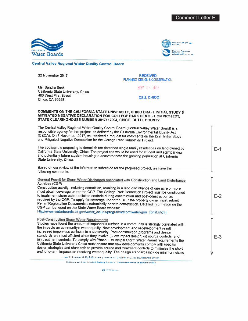
Comment Letter E
E-1
E-2
E-3

E-3Cont.
Response to Comment Letter E
Central Valley Regional Water Quality Control Board
November 22, 2017
Response E-1:
The Central Valley Regional Water Quality Control Board (Water Board) states they will be a
responsible agency for the project and offers their comments on the proposed project. See specific
comments and responses below.
Response E-2:
The Water Board states the project will be subject to the General Permit for Storm Water
Discharges Associated with Construction and Land Disturbance Activities (CGP) and the project
will be subject to storm water pollution controls during construction and post-construction per the
CGP.
The University acknowledges this requirements and notes that MND discusses the CGP and its
requirements on pages 79 and 80.
Response E-3:
The Water Board notes that a community’s water quality is correlated with the amount of
impervious surface. The Water Board states the project must be conditioned to comply with post-
construction standards adopted by the City of Chico in compliance with their Phase II Municipal
Storm Water Permit.
The proposed project includes demolition of existing structures and driveways, and the extent of
impervious surfaces on the site will decrease compared to existing conditions. While gravel
surfacing slows runoff rates, the parking lot’s base will be compacted and unlikely to allow an
appreciable volume of storm runoff to percolate into the subsurface, thus gravel surfacing
addresses stormwater runoff rates, but does not decrease the overall volume and provides marginal
stormwater quality benefits (some filtering of sediment). Because the development will consist of
a parking lot greater than 5,000 square feet, it is subject to the most recent standards and
performance criteria contained in the Waste Discharge Requirements for Storm Water Discharges
from Small Municipal Separate Storm Sewer Systems (Small MS4 General Permit). Both the City
of Chico and the University are subject to this permit and require development and redevelopment
projects to adhere to the Small MS4 Permit and follow published guidance for compliance, namely
the applicable portions of the City’s Post-Construction Standards Plan.

INTENTIONALLY LEFT BLANK

Sharon Wallace 2805OakWay-Chico,CA95973
November30,2017CaliforniaStateUniversity,ChicoPlanning,Design,&Construction400WestFirstStreetChico,CA95929-0018RE:CollegeParkDemolitionProjectInitialStudy/NegativeDeclarationPublicCommentDearMr.GuzziandMs.Wright:ThankyouforthisopportunitytopresentcommentstotheCollegeParkDemolitionProjectdocument.Ihavejustafewpointedareasofcomment,butwouldalsoliketoexpressanoverallconcernthatIandothershavehad--mostnotably,CharlesWithuhnfromChicoTreeAdvocatesandJohnMerz,recentpastChairandBoardMemberoftheSacramentoPreservationTrust--abouttheabsenceofpublichearingsonthefateoftheCollegeParkneighborhood,andforthisInitialStudy/NegativeDeclarationphaseoftheproject,inparticular.Webelievethatgreatercommunityawareness,attentionandcommentswouldhaveresultedifhearingshadbeenheld.AsabriefintroductiontomyinvolvementwiththeCollegeParkneighborhood,youwillfindthatmynameappearsseveraltimesinthedocumentasapreviousowner/residentof899WarnerSt,oneofthe10propertiesslatedforremovalinthisphaseofdemolition.Thestructurewasbuiltin1939andwasownedbytheNormoylefamily,fromwhommyfamilypurchasedin1981.Itdeservesmentioninginthedocumentdiscussionsofarchitecturalvaluesandvernacularhistoryoftheareathatthishomewasactuallyconsideredapre-warBungalow,andwastheFIRSThomebuiltintheneighborhood.Manyofthehomeswhichwerebuiltlaterhavebeencalled“ranch”styleinthedocument,severalofwhichmorecorrectlyshouldbereferredtoasexamplesofChico’spost-warPrairieplans,similarinstyle(althoughmuchmoremodestlyso)tothehomesbeingdesignedbyFrankLloydWrightandhisassociatesatthetime.WhileIrecognizethatmanyofthestructureshavefallenintodisrepairinrecentyears(duelargelytoremainingvacantaftertheUniversityortheUniversityFoundationpurchasedthem)andmanyrepairsinarrearhavenotbeenattendedto,theneighborhoodupuntilabout10yearsago(whenUniversitypurchasesbegan)servedaveryimportantroleinthelivesofstudents,professors,othercitizens,andChico,ingeneral.Forone,itprovidedaninstitutionalbufferandtransitionbetweentheUniversityandtheChiconeighborhoodsimmediatelytothenorth.Thisrolewillnowbeeliminatedwiththedestructionofawholeneighborhoodinfavor(immediately)ofgravelparking,andthenlater,moreinstitutionalstructures–whichwillundoubtedlynegativelyimpacttheborderingneighborhood’s“sanctities”andwillincreasetrafficintheareaadjacenttotheUniversity,especiallyalongWestSacramentoandWarnerSt.Althoughthedocumentassertsthattheparkinglotwillmerelyreplaceparkingspacesthathavebeenrecently(orwillbe)lost,itremainstobeseenwhatwillactuallybecomeoftheleasedCUSDlotatthecornerofWarnerandW.Sacramento,anditwouldbevaluabletoseethatagreement(orended-agreement)withCUSDincludedinthisdocumentandintheparkingspacefiguresascalculated.
Comment Letter F
F-1
F-2
F-3

Inadditiontotheabovenarrativediscussion,Iwouldliketoincludethesespecificitemsforfurtherconsideration,especiallyinlightofthecomprehensivechangeinlandusewhichwillbeoccurringwiththedestructionofanentireneighborhood,beginninginitiallywiththeremovalofthese10structuresandaccompanyingpropertylandscapingand“openspace,”ifyouwill.
Ibelieveitisimperativethatthisdocumentandallsubsequentdocumentsconsiderthehealth,safetyandwell-beingofstudents,professorsandallcitizenstravellingthroughthecampusareaandusingcitystreetsinthisprojectarea.
• Withtheremovalofanentireneighborhoodandtheintroductionofparkedcarsinitsplace,utmostconsiderationshouldbegiveninyourplansanddesignstoimprovingthetrafficcirculationintheWarnerandWestSacramentoarea–especiallyforbicyclistsandpedestrians.NosuchdiscussionhasbeenprovidedwiththisNegativeDeclarationwhichcouldhavebeenaddressedataminimumonPages95-98oftheDUDEKreport.
Asidefromtrafficcirculationandbicycleandpedestriansafety,anotherimportantfeatureoftheneighborhoodhasbeentheinventoryofmagnificentandmaturetrees,especiallyCitystreettreeswhichIampleasedtoseeinthereportwillbeanissueofconcern,includingfurtherconsultationwithChicoCityadministrators,perPage39.TheCity’sTreeOrdinanceandtheirrecommendationsforsavingandprotectingtreesduringandafterconstructionwillbeuseful.
Lastly,greateremphasisontheinitialProjectPlanObjectivesandamorein-depthdiscussionabouthowtoachievetheseObjectivesshouldbethroughpublichearings,andfurtherdiscussionswithrespondentstothisreportandtothosegroupsbrieflyapproachedbytheconsultant.IwillclosewithsomehighlightedObjectivesfromPages8-9.
Campus Environment · Promote a strong expression of landscape including a range of sizes and appropriate species of trees· Promote a walkable campus that provides a logical progression of spaces linking destinations· Emphasize a scale of facilities that is compatible with human activities and perceptions· Discourage the presence of the automobile and other motorized vehicles while encouragingpedestrian and bicycle modes of movement · Promote built systems that respect, maintain and work with the natural environment
Relationship with the Community · Promote facilities that minimize aesthetic and functional conflicts with neighboring usesand facilities · Permit a free flow of pedestrian activity between the University and downtown Chico
With that, I look forward to reading your responses to my and other commenters to this Draft Initial Study document.
Sincerely, Sharon Wallace 2805 Oak Way, Chico
(530) 342-0910 home (530) 828-2226 cell
F-4
F-5
F-6
F-7

Response to Comment Letter F
Sharon Wallace
November 30, 2017
Response F-1:
Commenter expresses concern regarding the lack of public hearings on the proposed project.
This comment is noted. CEQA does not require public hearings. The project site was identified as
a planned University expansion area in the 2005 Master Plan, which was developed over a five
year period. The University has acquired properties consistent with the Master Plan, as they have
become available for sale.
Response F-2:
The commenter notes that she previously lived at 899 Warner Street (one of the ten residences
proposed for demolition). As stated in the cultural resources technical report (Appendix B of the
MND), the commenter notes that the residence was built in 1939 and originally owned by the
Normoyle family. The commenter states that the cultural resources report should state that the
subject residence was considered a pre-war Bungalow and that it was the first home built in the
neighborhood. The subject residence was constructed prior to World War II and may have been
constructed as a Bungalow, however, the property has undergone substantial exterior alterations
that have compromised many of the original character-defining features. The residence fails to
exhibit even the most basic characteristics of a Bungalow, lacking nearly all of the style’s major
character-defining features including a porch, roof supports, tapered columns, significant eave
overhangs with exposed rafters, natural material finishes, and paired windows. Further, the claim
that this house represents the first house constructed in the neighborhood could not be
substantiated. Although possible, historic aerial photographs of the neighborhood from 1941 show
several other structures in the vicinity of the subject residence. No earlier aerials were available.
A review of all available building development documents also could not confirm this claim. The
commenter also states that many of the later-built homes referred to as Ranch style in the report,
should more correctly be referred to as “Chico’s post-war Prairie plans” and draws comparisons
to “homes being designed by Frank Lloyd Wright and his associates at the time.” None of the
homes evaluated in the cultural resources technical report can be defined as even modest Prairie
style residences. With the exception of one residence that exhibits wide overhanging eaves (725
Warner Street), just one of the many characteristics of the style, there are no other character-
defining features on any of the residences that are clearly indicative of the Prairie style.

Response F-3:
Commenter states that the neighborhood has served as an “institutional buffer and transition
between the University and the Chico neighborhoods” immediately to the north and that this role
will be eliminated. Commenter states that gravel parking and (later) institutional structures will
increase traffic in the area adjacent to the University, especially along West Sacramento and
Warner Street. Commenter further questions what will become of the parking spaces formerly
leased by the University from Chico Unified School District (CUSD) and that it would have been
valuable to see that agreement in the document.
Traffic impacts are discussed on pages 95 through 98 of the MND. The University does not have
any control over how CUSD uses its property. As stated in Section 2.4.2, the University has been
informed it will not have access to the 140 CUSD-owned parking spaces as of Summer 2018.
Response F-4
Commenter states that additional comments follow in light of the “comprehensive change in land
use.” Specific comments are addressed below.
Response F-5
Commenter states that “this document and all subsequent documents” should consider the safety
and well-being of students, professors, and all others travelling through the campus area and using
City streets in the project area. Commenter further states that the utmost consideration should be
given to improving the traffic circulation in the Warner and West Sacramento area, especially for
bicyclists and pedestrians. Commenters states that no such discussion has been provided in the
Negative Declaration, citing pages 95-98.
The 2005 Master Plan recognizes the importance of safe pedestrian and bicycle circulation. In
addition, the University prepared the Transportation Demand Management Plan in 2009 to support
alternative transportation, including bicycle, pedestrian, and transit. The 2005 Master Plan and
Master Plan EIR also recognize the need for additional parking to support the campus. The
proposed project would provide interim parking, including replacement of existing parking that
will be unavailable as of Summer 2018, without conflicting with the Master Plan’s long term vision
for the site, which is student housing with a permanent parking structure. As described on page
95-98, the proposed project is consistent with Master Plan EIR assumptions regarding increases in
traffic, and would not generate sufficient traffic levels to warrant a project-specific study or to
indicate a potential conflict between vehicles and pedestrians/cyclists. It is anticipated that bicycles
and pedestrians will continue to use Warner Street as a primary access to the campus

Response F-6
Commenter states that an important feature of the project area is the trees, including City street
trees. As the commenter notes, any street tree removals (that may be necessary due to the health
of the trees, or for the safe ingress/egress of parking lot visitors) will be coordinated with the City.
Response F-7
Commenter states that greater discussion of the project objectives and how to achieve them should
be done through public hearings and further discussion. Commenter identifies several of the
Campus Master Plan objectives cited in the MND.
The Campus Master Plan objectives guide the overall development of the campus. In addition,
project specific objectives have been identified for the proposed project, which includes the
acquisition of land for future student housing and parking near existing campus residential areas
consistent with the Master Plan., and implementation of an appropriate interim use that eliminates
unsafe conditions and minimizes costs.

INTENTIONALLY LEFT BLANK

APPENDIX D Mitigation Monitoring
and Reporting Program

INTENTIONALLY LEFT BLANK
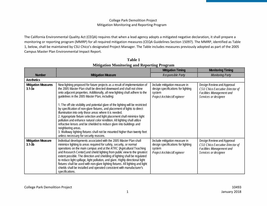
College Park Demolition Project Mitigation Monitoring and Reporting Program
College Park Demolition Project 10493 1 January 2018
The California Environmental Quality Act (CEQA) requires that when a lead agency adopts a mitigated negative declaration, it shall prepare a monitoring or reporting program (MMRP) for all required mitigation measures (CEQA Guidelines Section 15097). The MMRP, identified as Table 1, below, shall be maintained by CSU Chico’s designated Project Manager. The Table includes measures previously adopted as part of the 2005 Campus Master Plan Environmental Impact Report.
Table 1 Mitigation Monitoring and Reporting Program
Number Mitigation Measure Mitigation Timing Monitoring Timing Responsible Party Monitoring Party
Aesthetics Mitigation Measures 3.1-3a
New lighting proposed for future projects as a result of implementation of the 2005 Master Plan shall be directed downward and shall not shine onto adjacent properties. Additionally, all new lighting shall adhere to the guidelines in the 2005 Master Plan, including: 1. The off site visibility and potential glare of the lighting will be restricted by specification of non-glare fixtures, and placement of lights to direct illumination into only those areas where it is needed. 2. Appropriate fixture selection and light placement shall minimize light pollution and enhance natural color rendition. All lighting shall utilize refractive lenses and be shielded to reduce glare into buildings and neighboring areas. 3. Walkway lighting fixtures shall not be mounted higher than twenty feet unless necessary for security reasons.
Include mitigation measure in design specifications for lighting system Project Architect/Engineer
Design Review and Approval CSU Chico Executive Director of Facilities Management and Services or designee
Mitigation Measure 3.1-3b
Individual developments associated with the 2005 Master Plan shall minimize lighting to areas required for safety, security, or normal operations on the main campus and at the ATRC [Agricultural Teaching and Research Center] and shield lighting from public view to the greatest extent possible. The direction and shielding of lighting shall be regulated to reduce light spillage, light pollution, and glare. Highly directional light fixtures shall be used with non-glare lighting fixtures. All lighting and light shields shall be installed and operated consistent with manufacturer’s specifications.
Include mitigation measure in design specifications for lighting system Project Architect/Engineer
Design Review and Approval CSU Chico Executive Director of Facilities Management and Services or designee

College Park Demolition Project 10493 2 January 2018
Number Mitigation Measure Mitigation Timing Monitoring Timing Responsible Party Monitoring Party
Air Quality Mitigation Measure 3.2-1
Consistent with BCAQMD Indirect Source Review Guidelines, the following construction dust and equipment exhaust emissions measures should be required in all construction contracts: • Watering should be used to control dust generation during demolition of structures and break-up of pavement. • Cover all trucks hauling demolition debris from the site. • Use dust-proof chutes to load debris into trucks whenever feasible. • Water all active construction sites at least twice daily. Frequency should be based on the type of operation, soil and wind exposure. • Use chemical soil stabilizers on inactive construction areas (disturbed lands within construction projects that are unused for at least four consecutive days). • On-site vehicles limited to a speed of 15 mph on unpaved areas. • Plant vegetative ground cover in disturbed areas as soon as possible. • Cover inactive storage piles. • Paved streets adjacent to the development site should be swept or washed at the end of each day as necessary to remove excessive accumulations of silt and/or mud which may have accumulated as a result of activities on the development site. • Post a publicly visible sign with the telephone number and person to contact regarding dust complaints. This person shall respond and take corrective action within 24 hours. The telephone number of the BCAQMD shall also be visible to ensure compliance with BCAQMD Rule 201 and 207 (Nuisance and Fugitive Dust Emissions). • Provide temporary traffic control as appropriate during all phases of construction to improve traffic flow (e.g., flag person). • Require contractors to minimize exhaust emissions by maintaining equipment engines in good condition and in proper tune according to manufacturer's specifications and by not allowing construction equipment to be left idling for long periods.
Include dust and equipment exhaust emissions measures in project specifications Project Manager
(1) Confirm specifications prior to Construction Plans Approval CSU Chico Executive Director of Facilities Management and Services or designee (2) During demolition Construction Inspector
Biological Resources Mitigation Measure BIO-1
To avoid impacts to special-status and native migratory birds protected by the federal Migratory Bird Treaty Act (MBTA), a nesting bird survey will be completed by a qualified biologist no earlier than 2 weeks prior to
Conduct survey no more than 2 weeks prior to demolition and
Confirm survey results prior to demolition and grading

College Park Demolition Project 10493 3 January 2018
Number Mitigation Measure Mitigation Timing Monitoring Timing Responsible Party Monitoring Party
construction during the nesting season (February 1–August 30) to determine if any special-status or other native migratory birds are nesting on or near the site (including a 250-foot buffer for raptors and a 0.5-mile buffer for Swainson’s hawk). If any active nests are observed during surveys, an avoidance buffer will be determined and flagged by the qualified biologist based on species, location, and planned construction activity. These nests would be avoided until the chicks have fledged and the nests are no longer active. Any nesting habitat (i.e., trees and vegetation) will be removed outside of the breeding bird season to avoid impacts to nesting birds. If it is infeasible to remove trees or other vegetation outside of the breeding season, a survey will be performed no earlier than 1 week prior to removal to determine if active nests are present. (Note: This mitigation measure incorporates and supersedes Master Plan EIR Mitigation Measure 3.3-1b.)
grading during the nesting season (Feb 1 – Aug 30). Project Manager
CSU Chico Executive Director of Facilities Management and Services or designee
Mitigation Measure BIO-2
To avoid impacts to special-status bat species, no sooner than 30 days prior to demolition, a preconstruction roosting bat survey shall be performed by a qualified biologist (i.e. a biologist with several years’ experience performing roosting bat surveys, capable of identifying signs of roosting such as urine stains, guano piles, etc.) to determine if roosting bats or maternity colonies exist in any of the ten homes. If any active roosts are observed, consultation with CDFW will be sought to potentially develop an exclusion plan, under the direction of CDFW. If maternity roosts are observed, demolition should be postponed until the maternity colonies have dispersed, usually between late August and the end of September.
Conduct roosting bat survey no earlier than 30 days prior to demolition. Project Manager
Prior to demolition CSU Chico Executive Director of Facilities Management and Services or designee
Hydrology and Water Quality Mitigation Measure 3.5-3
Future development projects that may occur as a result of implementation of the CSU Chico Campus Master Plan 2004 shall comply with Best Management Practices. Examples of Best Management Practices include, but are not limited to the following:
• Placing fiber rolls around on-site drain inlets to prevent sediment and construction related debris from entering inlets.
Include best management practices in project plans and specifications Project Manager Ongoing implementation Contractor
Plan Approval CSU Chico Executive Director of Facilities Management and Services or designee Ongoing monitoring of implementation Construction Inspector

College Park Demolition Project 10493 4 January 2018
Number Mitigation Measure Mitigation Timing Monitoring Timing Responsible Party Monitoring Party
• Placing fiber rolls along the perimeter of the site to reduce runoff flow velocities and prevent sediment from leaving the site.
• Placing silt fences downgradient of disturbed areas to slow down runoff and retain sediment.
• Specifying that all disturbed soil will be seeded, mulched, or otherwise protected by October 15th.
• Stabilizing construction entrance to reduce the tracking of mud and dirt onto public roads by construction vehicles.
• Applying hydraulic mulch that temporarily protects exposed soil from erosion by raindrop impact or wind.
Noise Mitigation Measure 3.9-3a
All heavy construction equipment and all stationary noise sources (such as diesel generators) shall be in good working order and have manufacturer installed mufflers.
Include measure in project specifications Project Manager Ongoing implementation Contractor
Plan Approval CSU Chico Executive Director of Facilities Management and Services or designee Ongoing monitoring of implementation Construction Inspector
Mitigation Measure 3.9-3b
Equipment warm up areas, water tanks, and equipment storage areas shall be located in an area as far away from existing residences as is feasible.
Include measure in project specifications Project Manager Ongoing implementation Contractor
Plan Approval CSU Chico Executive Director of Facilities Management and Services or designee Ongoing monitoring of implementation Construction Inspector
Mitigation Measure 3.9-3c
All construction shall be between the hours of 7:00 a.m. and 9:00p.m. daily except Sundays and holidays. Construction activities between the hours of 10:00 a.m. and 6:00 p.m. on Sundays and holidays shall meet at least one of the following noise limitations:
1. No individual piece of equipment shall produce a noise level exceeding 83 dBA at a distance of twenty-five feet from the source. If the device is housed within a structure on the property, the measurement shall be made outside the structure
Include measure in project specifications Project Manager Ongoing implementation Contractor
Plan Approval CSU Chico Executive Director of Facilities Management and Services or designee Ongoing monitoring of implementation Construction Inspector

College Park Demolition Project 10493 5 January 2018
Number Mitigation Measure Mitigation Timing Monitoring Timing Responsible Party Monitoring Party
at a distance as close to twenty-five feet from the equipment as possible.
2. The noise level at any point outside of the property plan of the project shall not exceed 86 dBA.
Public Services & Facilities Mitigation Measure 3.11-1a
Currently there are several “Blue Light” emergency telephones located throughout the campus which ring directly into the Communications Center of the University Police Department. These auto-dialing phones may be used to summon emergency police, fire or medical assistance. Before construction is completed on new facilities on the main campus, new “Blue Light” phones can be added to ensure safety at these locations. Community Service Officers (CSO) of the CSU Chico Police Department are student positions. The CSO provides support to the staff of sworn and non-sworn police personnel. Duties include parking enforcement, special event security, escort detail, bicycle licensing, property engraving, room unlocks, clerical dispatch support, and campus lot patrol. More of these positions can be created if needed to ensure proper enforcement of laws and safety concerns.
Determine need prior to construction Project manager to coordinate with University Police Department
Prior to project completion CSU Chico Executive Director of Facilities Management and Services or designee

College Park Demolition Project 10493 6 January 2018
INTENTIONALLY LEFT BLANK