INFORMATION FOR GUIDES OPERATING IN THE ADDO ...
140
INFORMATION FOR GUIDES OPERATING IN THE ADDO ELEPHANT NATIONAL PARK
-
Upload
khangminh22 -
Category
Documents
-
view
5 -
download
0
Transcript of INFORMATION FOR GUIDES OPERATING IN THE ADDO ...
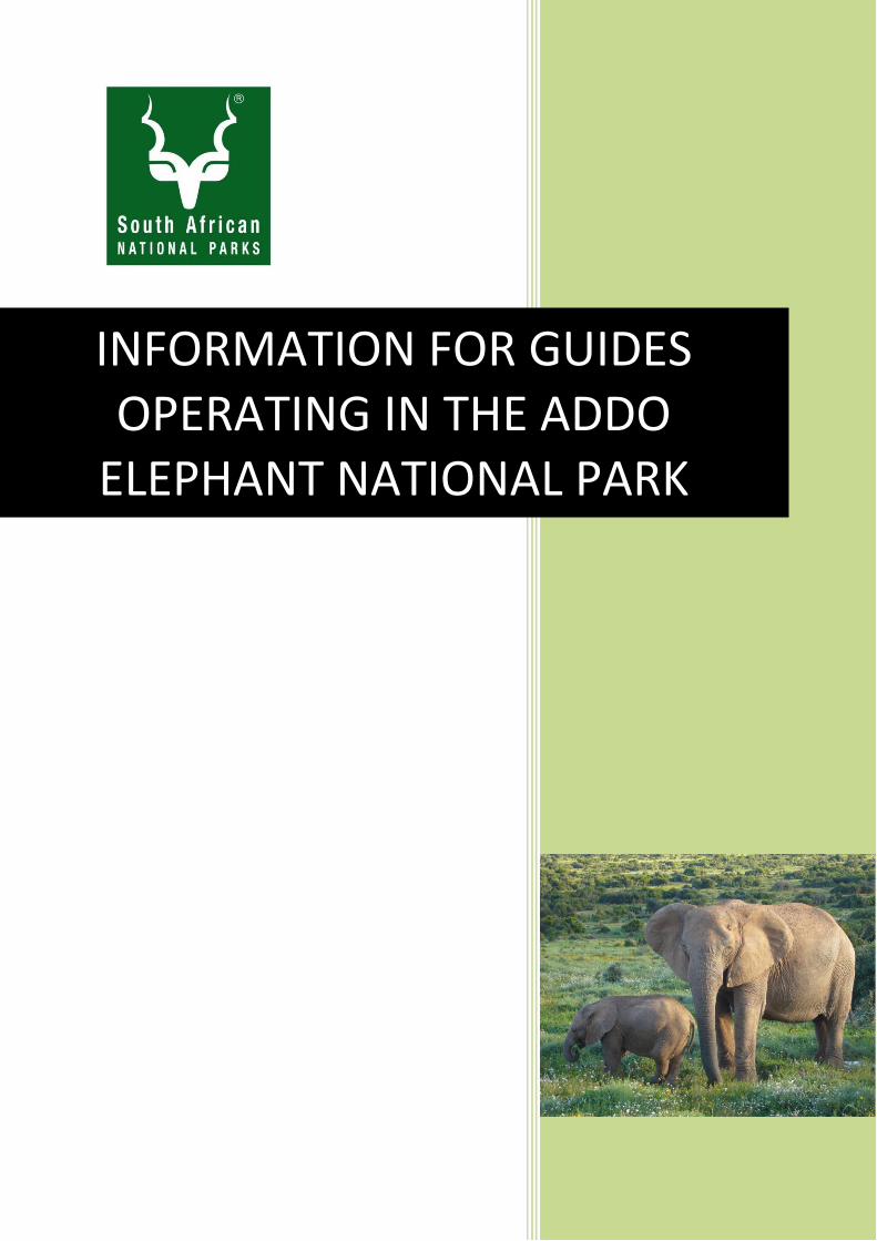
INFORMATION FOR GUIDES OPERATING IN THE ADDO
ELEPHANT NATIONAL PARK

2
INTRODUCTION
The aim of this manual is to provide information for nature/field guides operating in the Addo Elephant National Park (AENP). This will help to clarify facts about the AENP and will hopefully allow guides to give the correct information to tourists about various aspects of the park.
The manual will also be useful to students and new employees of the AENP as part of their orientation.
Naturally, as new information becomes available and as certain facts about the park (for example, the status of the elephant population) change, this manual will need to be updated.
The Addo Elephant National Park is still a developing park. New developments occur regularly. It is thus in the nature guide’s interest to make an effort to keep up to date on new developments. It is the third largest national park in South Africa and is renowned for its exceptional elephant viewing, currently the primary attraction, and reason for inclusion in most itineraries for visitors to the Garden Route or Eastern Cape. Besides other species the park includes a wide range of spectacular land- and seascapes, fauna and flora and, if including its concessionaires, offers a wide variety of accommodation facilities and activities in order to access a diverse market. The park has both terrestrial and marine components and existing boat charters currently offer boat cruises around the St Croix and Bird islands if permits allow, however no boats are permitted to land on the islands, and the park currently generates no income from any such activities. The park also includes the largest coastal transgressive dune field in the southern hemisphere, which at 88 km in length offers spectacular views and activity potential, an example of which is the existing Alexandria Hiking Trail. Whilst the diversity of the park needs to be promoted to increase visitor awareness, the park extent and thus the travel distances to the remoter areas of the park, as well as the fact that certain areas of the park are not yet fenced, have limited the availability of game and visitor facilities within certain sections of the park.
The park is rich in cultural and heritage value, though much of this still needs to be investigated and documented prior to potential utilisation as part of the tourism product.
Every effort has been undertaken to ensure the accuracy of the information in the manual. In addition, this manual does not claim to contain all information about all aspects of the park. Some sections are more detailed than others. Any suggestions about new information or corrections that should be included in this manual should be given to the Regional Ranger. Animal numbers are not included as these are in a continual state of change.
This manual does not include all the knowledge needed by nature guides, such as detailed knowledge about animal behaviour, ecology etc. This type of information can be obtained from other books / reference material. A list of recommended reading is given at the end of the manual.

3
CONTENTS
1. History of the Park 4
2. Conservation Priorities/Mission 10
3. Expansion of the Addo Elephant National Park (AENP) 14
Creation of the Greater Addo Project 14
Current status of the AENP 15
4. Biomes 18
Subtropical Thicket 18
Grassland 36
Fynbos 40
Nama Karoo 41
Forest 44
Invasive alien plants 47
5. Information on sections of the AENP 49
Addo section 49
Nyathi section 50
Zuurberg section 51
Kabouga section 53
Darlington section 54
Colchester section 55
Woody Cape section 56
Marine Protected Area 58
6. Species information and Identification 66
Mammals 66
Reptiles 86
Birds 93
Arthropods 96
7. Geology 99
8. Night Skies 105
9. Research in the Park 116
10. South African National Parks Honorary Rangers 118
11. Good field guiding practice 119
12. Relevant legislation 123
References 125
Recommended reading 126
Appendix A: Location of SAN Parks 127
Appendix B: Map of the AENP 128
Appendix C: Map of the Marine Protected Area 129
Appendix D: Reptile and Mammal Species lists 130
Appendix E: Some useful elephant pictures 137
Appendix F: Use Zones 140

4
1. HISTORY OF THE ADDO ELEPHANT NATIONAL PARK
The natural and cultural heritage of the park has been studied by the Albany Museum, recording hundreds of sites of significance. This was done under what was known as the AENP cultural mapping pilot project conducted during 2002 by various researchers from the Albany Museum in Grahamstown. The Stone Age in the park begins in the Middle Stone Age (MSA) between 125 000 and 30 000 years ago. Scatters of MSA tools are reported along the Sundays River Valley and also inland at Addo Heights and Korhaansvlakte.
The later Stone Age peoples were ancestral to the San (Bushmen) and Khoekhoen (Hottentot) peoples who lived in Southern Africa between 30, 000 and 1, 000 years ago. In South Africa these small hunter-gatherer groups lived at the coast, where they exploited the marine resources such as shell fish, fish, seals, and sea birds. Many hundreds of shell middens are found along the coast in the park. Inland groups frequently lived in caves and rock shelters and there are many sites in the Zuurberg Mountain which testify to this. There are also rock paintings in some of these caves.
Excavations were carried out at Melkhoutboom and Vygeboom and these uncovered graves with rich grave goods indicating a complex belief system. These sites contain well preserved plant remains which indicate how they utilized their environment. The majority of hunter-gatherer groups had been pushed out of the Zuurberg Mountain range by the 1820’s and were forced to move further inland to escape European settlement on their lands. The Khoikhoi pastoralists by the 16th and 17th centuries, were spread all along the Coastal forelands from Namibia to the Eastern Cape. Many of the shell middens in the park contain pottery, confirming the presence of the Khoikhoi in the area.
There are numerous place names in the park which are derived from Khoikhoi, for example Kaba, Coerney (originally Koernoe), Nanaga, Boknes, Gorah, Kabouga, Kariega, Sapkamma, and others. The name ‘Addo’ is thought to be derived from the Khoikhoi word ‘!Ga-dao’ pronounced ‘gha (with a click)-dough’ meaning drift (dao) where the poisonous Noorsboom plant (!Ga) grows. This later became ‘Kadouw’ or Addo bush. These names confirm the presence of Khoikhoi tribal groupings such as the Inqua, Damasqua and Gonaqua. They were absorbed into the colonial lifestyle of the 18th century, becoming farm workers for the Dutch and British or clients of the Xhosa where they were engaged in elephant hunting. A few groups settled at missions such as Enon, Bethelsdorp, and Theopolis. They were largely wiped out in the 1700’s by the smallpox epidemic and human persecution. They left behind rock paintings on the walls of caves they inhabited as well as shell middens in the sand dunes in the area.
As the Portuguese advanced towards the East, they continued the practice of erecting inscribed limestone crosses to proclaim their presence. In 1938 Eric Axelson discovered the fragments of the Kwaaihoek cross. Today the stone copy of the padrao positioned by Bartholomew Dias in 1488 on Kwaaihoek falls within the footprint of the park. The Dutch farmers who had started farming in the Western Cape moved to the Eastern Cape in the 18th century.
Nomadic Xhosa tribes had kraals in the area, including Chief Cungwa of the Gqunukhwebe (near the Sundays River mouth and inland) and Chief Habana of the Dange (near the Wit River which rises in the Zuurberg and flows into the Sundays River).
The area occupied by the Addo Elephant National Park was described by travellers during the 18th and 19th centuries as ‘an impenetrable thorny thicket’ and a ‘hunter’s hell’. Much of it is still like that today.
Hunting for ivory began in earnest in the early 1700’s as people began settling in the Sundays River valley and further east. Here they began to clear the land to make way for cattle and crop farming. In 1786 Commandant Daniel Willem Kuuhn was granted a loan farm called De Gora. Large sections of this farm form part of the park as we know it today. Early writings record the presence of lions, ‘panthers’, rhino, buffalo, springbuck and wild dogs in the area of Sandflats (Patterson). There are records of red hartebeest, eland, hyaena, jackal and various antelope on the plains.
5
As more farmers moved into the area they clashed with the Xhosa over the possession of cattle and land. The Third Frontier War occurred during 1811/12. The military were tasked with driving the Xhosa from the Addo bush. To this end military posts were established at Addo Drift, Coerney, Slagboom and Rietberg under the command of Major J G Cuyler.
With the passage of time, hunting and the collection of ivory in the area increased. This had a detrimental effect on the animals. In by the early 1820’s Thomas Pringle noted that game on the Zuurberg was scarce. He put this down to hunting. In the 1830’s, a Mr. Thackwray was killed by an elephant while hunting. Legend says that he was challenged to chalk a cross on the back leg of a sleeping elephant to win the heart of a lady. He was crushed in the attempt.
Hunting went on unabated to the extent that an advert appeared in The Grahamstown Journal in September 1834 forbidding hunting by travellers on the farm Quagga’s Vlakte. Although the game in the area was under extreme pressure, in 1837 it was reported that 7.6 tons of ivory and 13 tons of aloe for medicinal purposes were exported via Port Elizabeth.
The last lion in the Albany area was shot in 1849. In 1853, the last rhino in the area was shot at Grassridge. The last lion in the Eastern Cape was shot in East Griqualand in 1879. The last black rhino in the Eastern Cape was shot at Graaff-Reinet in 1880.
With the advent of people moving into the region there was a demand for firewood for the kilns making bricks for use in Port Elizabeth. The Addo bush was now in demand to meet the need. This put pressure on the habitat for the game however, some buffalo and elephant survived.
In July 1886, the Cape Parliament passed legislation to protect elephant and buffalo in the districts of Uitenhage and Albany and hunting was limited to specific periods. Sadly, at this time the animal disease known as the rinderpest swept through the districts of Albany and Uitenhage. This decimated the animal populations but those in the Addo Bush managed to survive the disease.
By the 1900s hunters had exterminated most of the remaining elephants (and other game) in the area. Only isolated herds remained – the largest of these was in the Addo region: 140 elephants.
In 1900, Mr. Henry Attrill (who was married to the widow of the farm Gorah) and his foster son, Sidney, went hunting elephants. Attrill was killed by one. His death resulted in a call to ‘deal with’ the elephants in the area. The call was made to stamp them out completely. In addition to the death of Attrill the elephants were causing the farmers damage by way of infrastructure and crops. On January 13th, 1902, Sidney disappeared into the bush. His body was later found. The cause of his death was never clearly established. It was rumoured that he had committed suicide possibly because of a love affair.
Several irrigation schemes were proposed for the area towards the late 1800’s. In 1913, Sir Percy Fitzpatrick proposed the Cape Sundays River Settlement Scheme next to the Mentone / Strathmore Forest Reserve. The area would be farmed by ex-British World War 1 servicemen. Water for this development would come via a network of canals from a dam to be built on the Sundays River near Jansenville. Construction began in 1917 and as the dam filled up it flooded the village of Darlington. Originally the dam was named Lake Mentz, after the Minister of Lands at the time. In 1995, the dam was re-named to Darlington Dam.
Growth in agriculture in the region led to conflict with elephants as they damaged crops and competed with farmers’ needs for water. Local farmers put pressure on the government to exterminate elephants. In 1916, people, including the Port Elizabeth and Uitenhage Farmers’ Associations, called on the government to exterminate the elephants.
In 1919, Major P.J. Pretorius was tasked to shoot the remaining elephants. He set up his camp in Kinkelbos and used various methods while hunting, including a ladder to see above the thick Addo bush. Using a .475 Jeffries Cordite Express double-barrelled rifle he shot 114 elephants between 1919 and 1920 and also caught two elephant calves that he sold to Mr. Boswell for his circus. Pretorius applied to shoot one elephant in the Knysna forest for “scientific purposes” but shot between two and five (according to various reports).

6
His activities generated publicity and sympathy for the elephants, prompting a halt to the killing when only 16 elephants remained. He shot the first elephant in June 1919 and left the area in August 1920 at which stage there were only 16 elephants left.
During the 1920s there was little protection for the remaining elephants. They took refuge on the land of a sympathetic farmer, Mr. J.T. Harvey, near Barkly Bridge.
In 1925, the Minister of Lands, Colonel Denys Reitz set aside the Strathmore and Mentone Forest Reserve for the elephants. These areas had been set aside as forest reserves as early as 1890. In addition to the farm Kenmure, these areas became the core of the Addo Elephant National Park.
In 1926, the National Parks Act was passed by Parliament and the Kruger National Park was declared. This was followed by a proposal to develop a national park in Addo to protect the remaining elephants.
In 1931, the park (about 2000 ha) was proclaimed to protect the remaining Addo Elephants. The first Park manager, Stephen Harold Trollope (a former Kruger National Park ranger), chased elephants into the Park area using shotguns, firecrackers and fires. Only one bull remained outside the park and it was unfortunately shot by Trollope when it charged one of his men. So died what would have been the twelfth elephant in the park.
The area was inadequately fenced and the movement of elephants continued to cause problems on surrounding farmland. Elephants were killed as a result of conflicts with farmers and collisions with trains.
In 1933, Trollope started supplying oranges, hay, pumpkins, lucerne, and pineapples to elephants in order to keep them within the Park boundaries, which was effective. Since elephants visited the feeding site at certain times, the practice of inviting visitors began. In 1934, he experimented with electric fencing using only one strand but the elephants learned to push over the supporting poles which weren’t electrified. His successor, Johnson also tried this method. One night in 1936 the elephants left the park and paid a visit to the Coerney Station forcing the staff to lock themselves in with the Station Master. In the process of their visit, the elephants destroyed a wood and iron building.
In 1943, Graham Armstrong was appointed as warden of the park. He tried trap-guns, tins hung on the fence that would rattle and disturb the animals. He tried a trip wire that caused a gun to discharge and in the process ignited a bottle of benzene which would set the grass on fire. The noise and fire helped but the elephants soon found an alternative route. He continued to experiment with methods of containing the elephants. Later, after he realised that the shock from the electric fence that the elephants received was too low he tried using a parallel electric fence but the elephants always found a way around it.
Below are two extracts from some of the many letters sent to the Parks Board:
“As you are probably aware, I am one of the people who has to put up with the elephants in the Addo Reserve. I could excuse it if they troubled me only once, but I simply cannot stand the way they have been carrying on lately. Last week they were in my veld no less than three times. The result? Fences were trampled down, poles were broken, and the standards of my dip smashed. If they damage my dip in any way I am going to hold you responsible. Most important is the wastage of my water, all by
7
the elephants. Where do you think I am going to find water for my animals if this carries on, especially now when we find ourselves in a critical position?
What do you think happens when they break my fences? My stock simply strays into other people’s lands with the result that I have to pay pound money. Not only is this unpleasant, but it also leads to bad friendship between me and my neighbours.
The elephants constitute a great danger to the public. Travellers passing at night simply do not realise the great danger waiting for them and not only once, but many times their way has been blocked by the elephants.”
and,
“I have to report that, as a result of your buffalo breaking a fence on my farm, I have lost seven trained trek oxen, valued at £25 each, which escaped through the broken fence into the adjoining bush. I shall be glad to hear what you propose to do by way of compensating me for this loss.”
In one case there was trouble over a borehole. A neighbour sank a hole and put in a casing. His efforts to drive the casing all the way in were fruitless and it projected about 45 cm above the ground. To protect the open pipe he blocked it with a wooden plug. One night, the elephants visited the borehole, trod on the pipe and pushed it level with the ground. But the plug was even more firmly wedged in. The owner was furious about the plug, forgetting all about the casing which was now in the correct position. Luckily, Ranger Armstrong had no difficulty removing the plug which was made of spekboom.
An American soldier based in Kodiak, Alaska longed to become another Major Pretorius, who it is claimed, shot more elephants than anyone else. He offered his services to help get rid of the remaining elephants in the Addo area. He wrote the following”
“For what it costs me to write and send this letter, I am losing little or nothing if I do not prosper by this venture. I have never had experience in hunting elephants, but I am more than willing to learn in any way possible.
I have experience in firing the 45-calibre pistol. The Browning automatic rifle, Mark 1 rifle, 30-calibre rifle-grenade and the 50- and 30-calibre machine guns. I am an expert with the Mark 1 rifle.
I have had experience with Kodiak bears which are the largest in the world, weighing 2 200 lbs and standing 12 feet in height. But alongside your game they are pretty small.
If you would care to give me information on the matter, I would be most willing to accept the job of trying to rid your land of these wild elephants.”
He was not appointed!
Armstrong experimented with a fence built of railway lines, poles, lift cable, and wire. He eventually succeeded in building an elephant proof fence. This fence was first used to protect the windmills. This design eventually became the standard and in 1951 the City Council of Port Elizabeth agreed to donate 200 x 4 metre used tramlines for the erection of an experimental fence. Waygood Otis, the lift manufacturers, offered to supply large quantities of used steel cable. Armstrong built an experimental section of 750 metres near his house. One night he watched the elephants trying to reach some oranges that he had placed outside the fence. Bulls and cows tried to push the fence over but it held firm. Two weeks later, Armstrong decided that he had beaten the elephants.
The death in January 1952 of one of farmer Harvey’s employees as a result of an elephant attack on the Addo Heights Road brought about demands to erect a suitable fence to contain the elephants and prevent further attacks. More tramlines arrived from Port Elizabeth and from the City of Johannesburg as well as kilometres of lift-shaft cable. Work on the fence began in earnest.
In September 1954, Graham Armstrong completed an elephant-proof fence constructed with tram rails and lift cables. Approximately 2000 hectares had been enclosed. 4m-long rails are planted 10m apart. They have a mass of about 360kg and are planted 1.6m into the ground. At least 8 people are required to lift and plant a rail. Wooden poles were planted 0.9m deep every 1m (between the rails). Five droppers were suspended between the poles and the rail. Five strands of metal cable (14-16mm

8
diameter) were pulled horizontally along the fence, along with two strands of straining wire that were used to secure the netting. This Armstrong fence, named after its developer, is still used around some of the park today. With the addition of a substantial electric current the method of construction has been used until as recently as 10 years ago. Today, a predator-proof electric fence is used.
In 1954, there were 22 elephants protected in the park. The last of the disease-free Cape buffalo were also protected by the establishment of the Park, as were the flightless dung beetle (endemic to the area, not just the park). Eland, the largest of the African antelope, were introduced into the park in 1957 and by 1971 had increased to such an extent that they were being sold to suitable game farms.
In 1968, the elephant bull Hapoor managed to cross the fence. It is believed that he used his massive weight to flatten the fence enough in order to get over it. The fence sprung back up behind him. His escape was detected by a former Addo ranger, Kleinbooi Kilane, who reported the escape to the warden, Sep le Roux. An attempt was made to chase him back into the park but he resisted and was eventually shot. He was about 50 when he died and his preserved head is on display at the Main Rest Camp in the Interpretive Centre.
Hapoor left his mark on the park. His leadership was challenged in May 1959 by a young bull known as Bellevue who wanted to depose him. A fight to the death followed in which Bellevue was killed and Hapoor emerged unscathed. Bellevue is believed to be the first elephant killed by Hapoor.
In 1966, the senior female of the herd, Granny (Ouma), developed an abscess and the staff decided to immobilise her so that they could treat the wound. One morning Ouma went down to drink on her own and having quenched her thirst, she disappeared into the bush. Sometime later Lanky, one of her sons who was now a full grown bull, went in search of her. He found her and pushed her and supported her until they re-joined the herd.
A few days later the elephants came down to drink and Ouma was among them but the others had to help her to move. It was now that the decision to immobilise her for treatment was taken. A few minutes after the dart struck she fell to the ground but immediately got up again and turned around a few times. Hapoor, who was standing nearby ambled up to her and when she moved off to a smaller dam he assisted her. Another cow, Eentand who was watching Ouma also came to her assistance. The trio moved off into the bushes where Ouma fell down again. At this point, Hapoor killed her. The only indication that he had done something was the blood on one of his tusks.
Hapoor made his way back to the feeding place where the elephants gathered around him. He led them back to the carcass where they stood around while he trumpeted over it as if daring anyone to challenge his right to kill Ouma.
Closer investigation showed that Hapoor had stabbed her four times with his tusk. Once between the ear and the eye – in exactly the place where a hunter would have aimed – and three times in a half circle behind the ear. All his stabs were directed at her brain.
This was not the end of the drama as Lanky appeared out of the bushes and followed Ouma’s tracks until he found her carcass. He stood over her until he was chased away so that the carcass could be removed.
In 1968, Lanky deposed Hapoor who was now 44 years old. He was driven out of the herd and became a loner. This situation did not suit him and he consequently climbed over the fence to leave the park. The 210 cm high fence was flattened to a height of 180 cm without breaking, bending or pulling out any of the rails, Hapoor climbed to his short-lived freedom. Sadly, knowing that the fence would no longer stop him and bearing in mind his aggressive nature, after trying to get him back into the park it was decided that he should be shot. He died at the hand of those who had protected him but against whom he had always borne a grudge.
The feeding of citrus etc. continued after the fence was erected in order to increase the chance of visitors seeing the elephants from outside the fence. The Sundays River Citrus Co-operative was donating substandard oranges and grapefruit. A viewing ramp and floodlights were erected for visitors.
9
By 1976 about 25-30 tons of oranges were fed during the winter months. For want of a better system, a truck would enter the game area and dump the oranges. Elephants would run behind the vehicle screaming, roaring and grabbing oranges from the truck. They would be scared away from the entrance gate when the truck departed by cracking whips, throwing bricks and shouts. The vegetation around the feeding area was decimated, as elephants didn’t move out of the area for fear of missing the feeding sessions. Levels of aggression between the elephants rose and many were injured. Many elephant cows showed signs of stress by the secretions from their temporal glands when competing for oranges. Because of the negative impact on the vegetation and the elephants, the practice of feeding citrus was gradually phased out by 1979.
In 1981, the first tourist drove through the park.
In 1992, the farm Gorah was included into the park. The elephants made a rush for the area because of the abundance of prickly pears – a favourite of theirs. Park officials had to construct a new tourist road into the area as the elephants were no longer visible to the tourists in the original section and they complained of not seeing elephants.
In 1992, hippopotamus were introduced to a section of the Sundays River at Kabouga.
The current Rhino (bicornis bicornis) were introduced to the park in 1994 after the removal of the original (bicornis michaeli) which were the wrong species for the area.
Burchell’s Zebra and Warthog were introduced in 1996.
In 2003, 6 Kalahari lions were introduced to the park as were the first hyaenas.
The expansion of the Addo Elephant National Park into a ‘Greater Addo’ was first officially mentioned at the Open Africa Initiative in 1997. The plans to expand the park received a significant boost when academics from the Terrestrial Ecology Research Unit (TERU) at the University of Port Elizabeth drafted a proposal outlining the opportunities that could possibly be created through an expansion initiative. Dr Anthony Hall-Martin was instrumental in this process.
Through the combined efforts of SANParks and private donor agencies such as the International Fund for Animal Welfare, Leslie Hill Succulent Trust, Humane Society of the United States and the Rhino and Elephant Foundation, the park has expanded to its present (2016) size of over 176 000 ha. The existing Marine Area is about an additional 4 000 ha. Once finally completed, the end result will make Addo the 3rd largest conservation area in SA after Kruger and Kgalagadi and the only park in the world to encompass the Big Seven.
10
2. CONSERVATION PRIORITIES
Conservation priorities have changed over the years from the original goal of protecting the last remaining Addo elephants to the protection of vulnerable species (elephant, buffalo, rhino, dung beetle) and Subtropical Thicket as well as the protection of biodiversity.
SANParks follows the practice of only introducing animals into a national park that would have occurred historically in the area. For this reason species such as white rhino, giraffe, impala, waterbuck, red lechwe, blue wildebeest, nyala and sable antelope are not present in the park. However, some of these species have been introduced onto neighbouring properties and have escaped into the park. When this happens it is necessary to remove these animals from the park as they could ultimately increase and outcompete the locally indigenous species.
When national parks were first introduced the only available ‘business model’ for them was that of a commercial farm which was primarily production and profit oriented. The parks were managed along these lines for many years and as a result much of the managerial thinking was wrong. A national park is not about numbers, production and profit; it is about the fauna and the flora in the area. Today the focus of running a national park is based on the concept of a functional ecological system across the biomes. This means maintaining a balance of what typically occurs within the area.
VISION
The vision is an inspirational statement designed to provide a picture of the envisaged future for the park. It answers the question of ‘where do we want to go?’ SANParks’ corporate vision, which holds for all national parks, is as follows:
“A sustainable National Park System connecting society”
MISSION
The mission defines the fundamental purpose of the park, succinctly describing why it exists and what it does to achieve its vision. The following mission was developed after consultation with stakeholders at a workshop on 20 May 2014:
“Addo Elephant National Park seeks to be a key role player in providing benefits to society by being well integrated into the regional landscape, conserving and restoring the characteristic terrestrial and aquatic biodiversity, as well as ecological processes, cultural, historical and scenic resources of the Algoa Bay to Karoo gradient”
VALUES
SANParks has adopted eleven corporate values which serve as guiding principles around which all employee behaviour and actions are governed and shaped. Stakeholders recognised and endorsed the SANParks corporate and conservation values as outlined in the Co-ordinated Policy Framework. These values are:
Corporate values:
Show leadership in all we do.
Be guided by environmental ethics in all we do.
Promote transformation within, and outside of the organisation.
Strive for scientific and service excellence at all times.
Act with professionalism at all times.
Adopt, and encourage initiative and innovation by all.

11
Treat all our stakeholders with equity and justice
Exercise discipline at all times.
Show respect to all.
Act with honesty and integrity.
Strive for transparency and open communication at all times.
Biodiversity values:
We adopt a complex systems view of the world while striving to ensure the natural functioning and long term persistence of the ecosystems under our care.
We aim at persistent achievement of biodiversity representivity and complementarity to promote resilience and ensure ecosystem integrity.
We can intervene in ecosystems responsibly and sustainably, but we focus management on complementing natural processes under a "minimum interference" philosophy.
We accept with humility the mandate of custodianship of biodiversity for future generations while recognising that both natural and social systems change over time.
HIGH LEVEL OBJECTIVES
While the Mission sets out the “Where do we want to go,” high level objectives act as the roadmap to achieve the Mission. These high level objectives tend to flow naturally from the vital attributes. The desired state is achieved by means of a hierarchy of objectives, starting with an overall objective aligned with SANParks’ organizational structure and the park’s Vision and Mission statements, then broad, high level objectives and then to finer and finer levels of detail, ending with specific operational or management actions. The initial stakeholder engagement meeting gave rise to a set of high level objectives. These were refined to reflect the following:
1. Bioregional high level objective: To enhance co-operative management through a bioregional approach by using a range of inclusion options to consolidate the park across a patchwork of conservation-friendly land / sea -uses to primarily enhance ecosystem patterns and processes, connectivity and mitigate for conflicts.
2. Biodiversity high level objective: To ensure the persistence of AENP’s biodiversity assets by conserving and restoring ecological patterns and processes representative of Algoa Bay to Karoo environment.
3. Responsible tourism high level objective: To promote Addo Elephant National Park as a unique destination, providing a range of appropriate and innovative tourism products and services that offer a variety of recreational and learning experiences, with direct and indirect benefits to society, in accordance with responsible tourism principles.
4. Social high level objective: To maintain and strengthen several stakeholder relations and political good will by adhering and enhancing existing formal agreements; maintaining integrated and collaborative institutional relationships; and providing socio economic empowerment opportunities associated with the Addo brand in a secure learning environment.
5. Cultural heritage high level objective: To provide opportunities to have a full suite of cultural experiences by protecting and enhancing cultural and historical heritage assets as well as raising awareness and education of tangible and intangible cultural values typical of the Addo region.
6. Effective park management high level objective: To strive for effective and efficient management and administrative support services through good corporate governance enabling the park to achieve its objectives.

12
SANParks endorses the term “conservation” as formulated by the International Union for the Conservation of Nature (IUCN):
“Conservation is…. the management of human use of the biosphere so that it may yield the greatest sustained benefit to present generations while maintaining its potential to meet the needs and aspirations of future generations.”
This means that SANParks accepts the following:
1. Conservation is a human activity performed for the benefit of humanity.
2. Conservation comprises a variety of management options, ranging from total protection to intensive multiple use of natural systems and resources, whether in different geographical regions or in different parts (zones) of one particular area.
3. Conservation includes the protection of the products of civilization which are of cultural value.
4. SANParks accepts the following guidelines for national parks, as defined by the IUCN:
“A national park is a relatively large area
1. where one or several ecosystems are not materially altered by human exploitation or occupation; where plant and animal species, geomorphological sites and habitats are of special scientific, educational and recreational interest; or which contains a natural landscape or great beauty; and
2. where the highest competent authority of the country has taken steps to prevent or to eliminate as soon as possible exploitation or occupation in the whole area and to enforce effectively the respect of ecological, geomorphological or aesthetic features which have led to its establishment; and
3. where visitors are allowed to enter, under special conditions, for inspirational, educative, cultural and recreation purposes.”
Legislation
The National Environmental Management: Protected Areas Act, 2003 was promulgated:
“To provide for the protection and conservation of ecologically viable areas representative of South Africa’s biological diversity and its natural landscapes and seascapes; for the establishment of a national register of all national, provincial and local protected areas; for the management of those areas in accordance with national norms and standards; for intergovernmental co-operation and public consultation in matters concerning protected areas; and for matters in connection therewith.”
The original National Parks Act stated that:
“The object of the constitution of a park is the establishment, preservation and study therein of wild animal, marine and plant life and objects of geological, archaeological, historical, ethnological, oceanographic, educational and other scientific interest and objects relating to the said life or the first mentioned objects or to events in the history of the park, in such a manner that the area which constitutes the park shall, as far as may be and for the benefit and enjoyment of visitors, be retained in its natural state.”
In 1926, an autonomous statutory body, the South African National Parks Board of Trustees, was created and was empowered by the National Parks Act to control, manage and maintain the parks for the purposes as specified in the Act. This has now been replaced by the Protected Areas Act and this ensures that the organization that is responsible for the control and management of the national conservation areas is not part of the civil service structure and therefore not subject to political change or pressure.
Only Parliament can change the status of a national park.
The role of the Board is to give the Directorate and the Chief Executive strategic direction by determining the overarching policy and to ensure that it is competently executed without direct participation in the control, management, and maintenance of parks.

13
The Board:
determines the overall vision and mission of SANParks,
oversees the management and financial accountability of the Chief Executive and Directors,
formulates regulations for approval by the Minister when necessary, and
approves annual reports and financial statements.
The first national park in South Africa was the Kruger National Park, proclaimed in 1926.
Today there are 19 national parks in South Africa (See the location of the parks on Appendix A). The Head Office at Groenkloof in Pretoria is an additional national park. The other 19 parks are:
Addo Elephant National Park
Agulhas National Park
Augrabies Falls National Park
Bontebok National Park
Camdeboo National Park
Garden Route National Park
Golden Gate Highlands National Park
Karoo National Park
Kgalagadi Transfrontier Park
Kruger National Park
Mapungubwe National Park
Marakele National Park
Mokala National Park
Mountain Zebra National Park
Namaqua National Park
Table Mountain National Park
Tankwa Karoo National Park
West Coast National Park
|Ai-|Ais/Richtersveld Transfrontier Park

14
3. EXPANSION OF THE ADDO ELEPHANT NATIONAL PARK (AENP)
The park extends over a vast area, approximately 135 km east-west, between the Bushman’s and Riet Rivers; and 80km north-south, from Karoo Basin to the Indian Ocean, traversing a number of different landscape types. In the southeast, the park has about 65 km of coastline, and contains one of the largest mobile dune fields in the southern hemisphere. Dune heights are typically 40 - 60 m above mean sea level (amsl), although one ridge reaches over 100 m amsl. Off shore are two island groups. Islands of the St Croix Island group are between one and six kilometres offshore, while the Bird Island group is about 8.5 km offshore. The St Croix group, close to Coega comprises three islands. St Croix is the largest, and features a 0 - 24 m amsl northwest-southeast tending ridgeline, while Brenton and Jahleel are smaller rocky outcrops of less than five metres. Although the Bird Island group is larger, no island reaches above 7 m amsl. Bird Island, Seal Island, and Stag Island are reasonably flat, while Black Rocks is essentially a rocky outcrop. Inland of the dune fields are the undulating, ancient wave-cut platforms, and rolling hills, shallowly incised by drainage lines. Elevation increases gradually from 60 m in the south to about 150 m at the foot slopes of the Zuurberg Mountain range. The east-west trending mountain range is part of the Cape Fold Belt, and dominates the northern vistas of the park. The mountain is not particularly high, only reaching 951 m amsl in the park; however, this is sufficient to form a rain shadow to the north. The terrain is deeply incised and topographically heterogeneous, with deep ravines, which restricts access. North of the mountain range, are the semi-arid plains of the Karoo, at an elevation of about 300 m.
Creation of the Greater Addo Project
In 1997, the Terrestrial Ecology Research Unit at UPE published a report: “A proposal for a Greater Addo National Park” (Kerley & Boshoff, 1997) calling for the amalgamation of the AENP and the Woody Cape Nature Reserve and further expansion into the surrounding areas to stimulate sustainable development and contribute to the conservation of biodiversity.
In 2000, a funding proposal was made to the Global Environmental Facility (GEF) for the planning and implementation of the Greater Addo Project.
In 2001, the Department of Environmental Affairs & Tourism (DEAT) approved the expansion principle.
With funding from GEF, a detailed research process took place in order to determine which land should ideally be included in the AENP. A Conservation Planning Framework identified the land classes in the proposed area and then took into account factors such as ecological processes, potential threats and vulnerability of each land class, as well as conservation targets for populations of fauna.
Money for the purchase of land comes from the Park Development Fund. This is an internal cost centre where funds are generated through the sale of wildlife assets (e.g. white rhino), DEAT and donors. It was also the first time in many years that central government has allocated funds for land purchase to expand national parks.
Land purchase always occurs on a willing buyer - willing seller principle. In some cases, especially in the Darlington Dam area, land inside the AENP area is exchanged for land outside the AENP area (i.e. SANParks purchases the land outside the area in order to exchange it). SANParks can invoke the right to compel a landowner to sell land but this has never occurred within the history of purchase of land for the AENP and SANParks avoids this situation at all costs.
SANParks is compelled by law to look after the interests of any workers who are affected by the land purchase. SANParks engaged consultants to track down and create a database of all workers who were affected by SANParks' purchase of land since 1997. SANParks must ensure that all these workers have the same or better housing, salary and benefits (e.g. rations, right to keep livestock on land etc.). Either the worker moves to a new farm with the original landowner or SANParks must give the worker employment – permanent or, if this is not available, contractual.

15
Once land has been purchased, the process of rehabilitating the land must begin. Since 2000, SANParks has received R150 million from the government (DEAT) for this purpose. This money was given through a Poverty Relief programme. Future grants may be given by DEAT (to be used through a poverty relief programme again) to complete the work on newly purchased land. The money is also used to improve tourism infrastructure, for example the proposed building of additional tourist facilities in the Colchester area.
The costs of fencing and improving the additional land bought by SANParks is often more expensive that the cost of the land itself. The actual purchase of the land is therefore just the first step in the process.
The rehabilitation of purchased land includes: removal of old farm fences and structures (e.g. buildings, reservoirs), repair of gravel roads, fencing of the new areas and removal of alien plants.
There are strict guidelines for poverty relief programmes – so called Expanded Public Works Programmes. All labour employed must be sourced from local communities. Individuals are usually identified though community structures. The labour component must be 60% women, 20% youth (18-25 year olds) and 2% disabled people. Not more than one person per household may be employed. The wages per day are relatively low for unskilled labour. All these guidelines are aimed at spreading the money as widely as possible among the local communities’ previously unemployed people. The workers must undergo 2 days of training (including literacy, numeracy, contractor development) for every 22 days worked. This is in order to equip people with skills that will enable them to find employment once they have exited the programme. A person may be employed for a maximum of 2 years in such a programme. The DEAT’s poverty relief programmes are taking place in a number of national parks across the country. These programmes include:
The bio-control programme,
The working for water programme,
The working for land programme,
The working for the coast programme, and
The carbon programme.
The Working for Water programme has been running for a number of years in the AENP. This work focuses on the control of invasive alien plants. Work is carried out across the AENP wherever the need is greatest at the time. Plants being targeted are: black wattle, gums (Eucalyptus species), Prosopis (mesquite), bug weed, castor oil plant, rooikrans, Port Jackson, prickly pear and jointed cactus. Working for Water projects are spread all over the country. Other projects in the park include, Working on Fire and Working for The Coast.
Current status of the AENP
The AENP stretches from Woody Cape in the south (the area between Bushman’s River mouth in the east and Sundays River mouth in the west), moving northwards across the area originally known as Olifantsplaat and Vetmaakvlakte, across the original elephant enclosure, across to the Nyathi Concession area, encompassing a large part of the Zuurberg mountain range, moving westwards, and then northwards across the Zuurberg to the Darlington Dam area up to the R400. (See the map of AENP: Appendix B)
The highest point in the park is 951 m above mean sea level. The latter is of note as this determines the park’s airspace (2, 500 feet above the highest point, thus 5, 620 feet) above the park The park ranges in altitude from 0 m to 951 m.
The AENP encompasses five of South Africa’s seven biomes:
Forest (Alexandria forest) in the Woody Cape area,
Subtropical Thicket in the original Addo section, Kabouga, Colchester, and Nyathi sections,

16
Grassland in the Zuurberg section,
Fynbos in the Zuurberg section,
Nama Karoo in the Darlington section.
The Subtropical Thicket is the largest biome in the AENP, covering 69% of the area.
Forest covers 10% of the area.
Nama Karoo covers 7% of the area.
Fynbos and Grassland each cover 5% of the area. (The remaining area is covered by the dune field).
In these 5 biomes, 43 distinct land classes have been mapped. 29 of the 43 land classes (67%) have been identified as experiencing a high level of threat (potential threats include grazing, agriculture, alien plant infestation, mining and human settlement disturbances).
The park currently covers approximately 178, 918 ha of which 124, 925 ha are declared while 46, 932 ha are in the process of being declared, and 7, 022 ha are declared as MPA. The park has reached a size where the park ecosystem is now relatively intact and able to accommodate many ecological processes.
The Marine Protected Area (MPA) forms part of the AENP. It basically encompasses the Bird Island group (Bird, Stag, Seal Island and Black Rocks) as well as the St. Croix Island group (St. Croix, Jahleel and Brenton islands). A future, far larger MPA is in the process of being proclaimed extending from Canon Rocks in the east to Coega in the west.
Elephant Management
South African national parks are managed as natural systems in which conservationists try as best as possible to mimic natural processes. Nowhere in a natural system would one find water holes dispersed evenly across the landscape. Nature has a way of avoiding this at all costs to prevent the homogenous use of vegetation which ultimately will lead to the extinction or degrading of species.
Hapoor is a good example of what could potentially happen at water holes if limitless water is provided. The habitat is altered significantly. We have to try and avoid the same thing happening around all the other water points.
For the park to be sustainable into the future, we try to mimic nature as closely as possible. For this reason the Park has a water gradient in place that has been around for a couple of years now. AENP’s imaginary river is represented by the line from Marion Baree via Spekboom, Hapoor, Rooidam, Ghwari, Woodlands, Nyathi and Domkrag, where large amounts of water are provided. The remaining water holes in the Park are there to meet the needs of the other species.
In this way elephants are forced to not homogenously use the landscape. In times when there are good rains elephants will be found across the park when all pans and dams have water. During drier periods, elephants move back to the main water sources, thus protecting the Colchester thicket from being over-browsed during dry periods. The water holes in the Colchester section are purposefully limited in number as well as the quantity of water available.
Stress is part of nature and it is vital that everyone understand this. Drought times are supposed to induce stress which affects the elephants’ inter-calving intervals. Conservationists need to mimic this or else our elephants will keep up a growth rate of between seven and nine percent per annum. This is not a sustainable model and the very elephants we are trying to protect will become the biggest threat to our precious national park.
Currently AENP is experimenting with elephant exclusion water points. This is to ensure that elephants don’t out-compete other species, especially the rare and threatened species. These exclusion waterholes will be in the vicinity of Lismore and Peasland. The hope is that the general, loyal visitor will understand. Resources must be managed in line with the needs of all the animals in the park.
The structure is rectangular in shape, with four telephone posts in the corners. An electric strand is suspended at two metres in height and has vertical one metre strands hanging off the main strand
17
at 800mm intervals. These strands are electrified to stop elephants from walking in. They will soon realise that the water point is not available to them and proceed to areas with water that is able to sustain them. Other game is then able to use these water points without having to compete with elephants.
Some may think this is cruel, but the alternative requires the reduction in elephant densities. This approach buys time and protects the Park from catastrophic homogenisation of the landscape.
AENP hopes to extend the elephant home range in the near future. The completion of an elephant proof fence in the Darlington section will see the introduction of elephants from Addo into a 50 000 hectare area around the Darlington dam. It is planned to erect a suitable fence around 29 000 hectares of land in the Kabouga section which will allow for the removal of another large number of elephants across to this area.
In an endeavour to manage the elephant numbers in the Nyathi and Kuzuko areas, contraceptives are being used on the elephants. This is an expensive method but works very effectively.
Use Zones
The primary function of a protected area is to conserve biodiversity. Other functions such as the need to ensure that visitors have access to the park, and that adjoining communities and local economies derive benefits from the area, potentially conflict with and compromise this primary function. In order to meet these needs and to reduce the potential for conflict between the various stakeholders, the park has been divided into zones for different uses. Use-zoning is the primary tool to ensure that visitors can have a wide range of quality experiences without comprising the integrity of the environment.
The expectations and recreational objectives of people that visit the park may differ. Some people are visiting the park purely to see wildlife as well as natural landscapes. Others wish to experience intangible attributes such as solitude, remoteness, wildness, and serenity (which can be grouped as wilderness qualities), while some visit to engage in a range of nature-based recreational activities, or to socialise in a rest camp. Different people have different accommodation requirements ranging from extreme “roughing it up” to luxury catered accommodation. There is often conflict between the requirements of different users and different activities. Appropriate use zoning serves to minimise conflicts between different users of a park by separating potentially conflicting activities – such as game viewing and day-visitor picnic areas – whilst ensuring that activities which do not negatively impact on the park’s vital attributes or objectives (especially the conservation of the protected area’s natural systems and its biodiversity) can continue in appropriate areas. Use zones serve to ensure that high intensity facilities and activities are placed in areas that are robust enough to tolerate intensive use, as well as to protect more sensitive areas of the park from over-utilisation.
SANParks has adopted a multiple zoning system for its parks. The system comprises of:
Visitor use zones covering the entire park,
Special management overlays; and
A buffer zone.
More information on the various zones can be found in Appendix F

18
4. BIOMES
Biomes can be defined as the major communities of the world, classified according to their predominant vegetation and characterized by adaptations of organisms to that particular environment.
Ecosystems are communities of organisms that inhabit specific physical environments. Biomes are composed of several ecosystems and represent a regional community of organisms named after the dominant vegetation. Ecologists do not always agree on the exact number of ecosystems and biomes, as the number will vary depending upon how the biomes are defined, for instance: according to species or according to the particular climate characteristics that are considered.
South Africa is characterized by a wide diversity of plant life and is ranked as the third most biologically diverse country in the world (mainly due to the richness of plant life). Over 18 000 species of vascular plants occur in South Africa, of which over 80% occur nowhere else. This diversity is caused by variations in climate, geology, soils and landscape forms. However, South Africa also has the highest concentration of threatened plant groups in the world. Approximately 3 435 of South African plant groups are considered to be globally threatened by extinction. A further 204 groups are estimated to be threatened at a local level. The Cape floral fynbos kingdom is most threatened.
1. Subtropical Thicket
(= Valley Bushveld = Valley Thicket = Addo bush)
Subtropical thicket consists of closed, shrub land to low forest. It is often almost impenetrable, is generally not divided into strata, and has little herbaceous cover. It was formerly classified as a type of savanna but has since been classified as a separate biome. A large diversity of animals is associated with the rich plant diversity.
The subtropical thicket contains 112 different vegetation types and comprised of 1558 plant species. 322 of these species (20%) are endemic and found nowhere else. covers an area of 48 000km2 stretching from Riversdale in the Western Cape to the Kei River in the Eastern Cape.
Each vegetation type contains unique plant species.
Dune Thicket occurs along the coastal strip in a narrow band.
Normal Thicket occurs in the higher rainfall areas and woody species are dominant; grasses are present and there are less succulents.
Valley Thicket is found in valleys with a high woody component and more succulents. Arid Thicket is found in the interior with succulents being dominant and a small woody component. It is adapted to withstand the valley’s temperature variations from 7°C to over 40°C and unpredictable rainfall (varies between 200mm – 600mm) occurring at any time of the year.
The area has few grasses and few large trees. Vegetation is varied in height, most shrubs are up to 3-4 metres. Taller plants are euphorbias and aloes. The understory consists of dwarf succulents and bulbous plants.
Adaptations to survive severe environmental conditions include:
Leaves small/absent/leathery/unpalatable.
Water stored in succulent stems/leaves.
Thorns and/or poisonous/bitter sap for protection from browsers.
Ability to tolerate disturbance by trampling animals – drop, re-root quickly and form new plants.
Underground storage organs which sprout quickly after rains e.g. bulbs, corms, rootstock.
Flowering not restricted to specific season but after good rains.

19
Pollinated by birds and most fruit dispersed by birds.
Mosaics of vegetation are created in thicket by geological processes, grazing by mega-herbivores and by fire.
48 species of medium to large mammals occur in this biome (26 herbivores, 16 carnivores, 4 omnivores and 2 insectivores).
Little is known about the insect species associated with Subtropical Thicket but for every one plant species, there are between 8 and 35 organisms dependent on this species.
Thicket is crucial in maintaining life support systems. It holds soil well and it keeps rivers clean by holding the very fine soil found on steep river banks. This is important in riverine and estuarine ecosystems.
Lichens and mosses play an important role in this biome, providing good ground cover and breaking the energy of raindrops, allowing them to penetrate the soil effectively.
Many thicket species have great horticultural potential. Some have already been widely exploited e.g. the strelitzia - a symbol on SA coins, hailed as the emblem of Las Vegas (while actually endemic to SA!); pelargoniums from which all hybrids are descended are widely exploited in European countries (but originally from SA).
The Subtropical Thicket biome faces extreme threat from overgrazing, bush-clearing for agriculture and inadequate representation in reserves.
Typical plants:
Information on some species (not all) in this vegetation type. This does not cover the guide’s need to be able to identify the species. Some of these species may be represented in other biomes as well. In addition, some of the plants described in other biomes may also be represented in this biome.
Spekboom Portulacaria afra
Source: http://www.plantzafrica.com
Trees grow up to 4m tall (when not browsed by elephants).
Browsed by all herbivorous animals in the valley.
Pink flowers after the first rains.
Succulent leaves edible (sour taste).
Leaves used medicinally. Dry stems beaten flat and used to thatch houses.
Larvae of one of cicada species lives only on spekboom.
Needle-bush (Bee-sting bush) Azima tetracantha
Source: http://www.operationwildflower.org.za
Shrub forms impenetrable thickets. Bright green leaves.
Thorns arranged in 4 rows along the length of the stems. Stinging jabs (hence name).
Birds e.g. Southern Tchagra and Blue billed Fire finch nest in shrub.
White berries eaten by birds (e.g. Green-spotted Dove), monkeys, children.
20
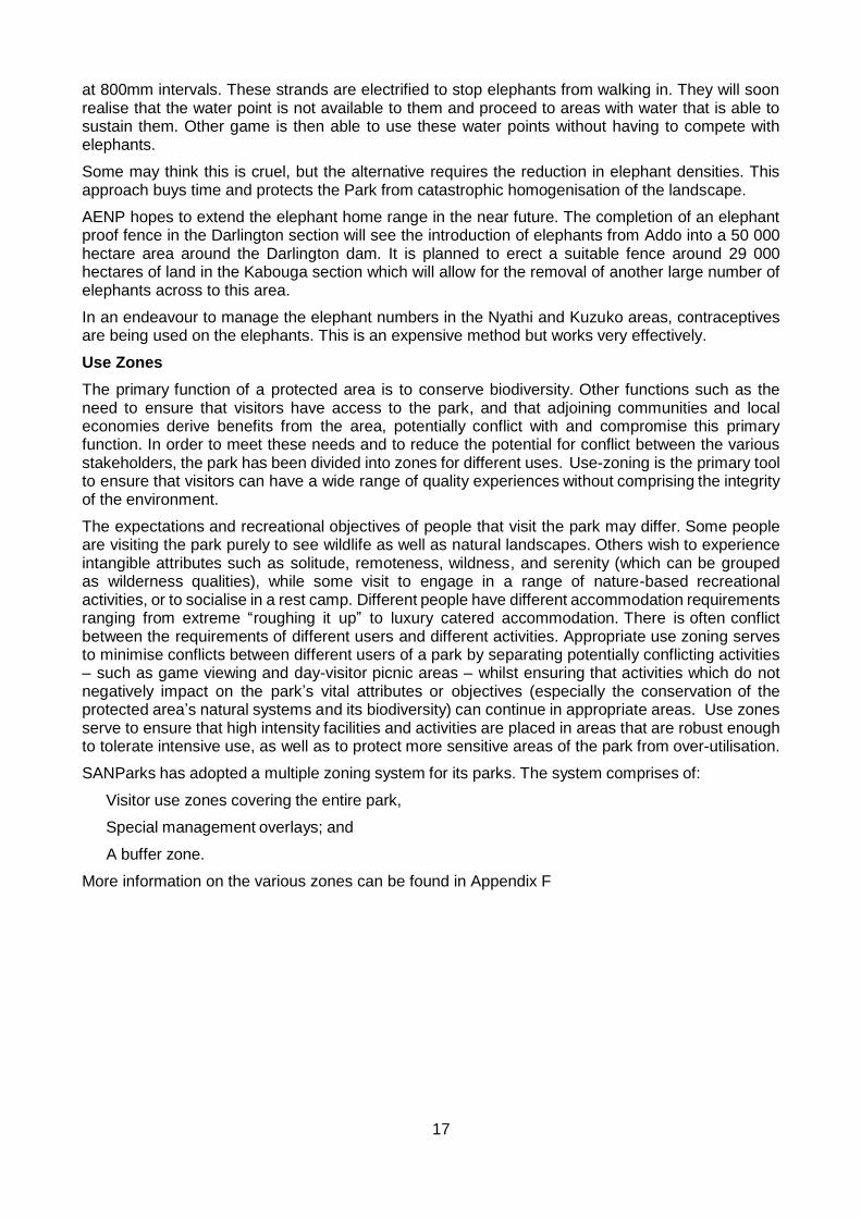
Plumbago Plumbago auriculata
Source: http://www.plantzafrica.com
Light green leaves. Shrub spreads quickly over large areas. New shoots sprout quickly from large underground rootstock.
Light blue flowers pollinated by butterflies.
Host for larvae of common blue butterfly.
Elephants, rhinos, antelope browse. Birds and mammals disperse sticky seed.
Widely used as an ornamental garden plant, even in Europe.
Calyx tubes covered with sticky hairs – used by children to decorate hair, clothes, ears.
Traditional healers use leaves and stems as remedies and lucky charms to protect against evil and lightning.
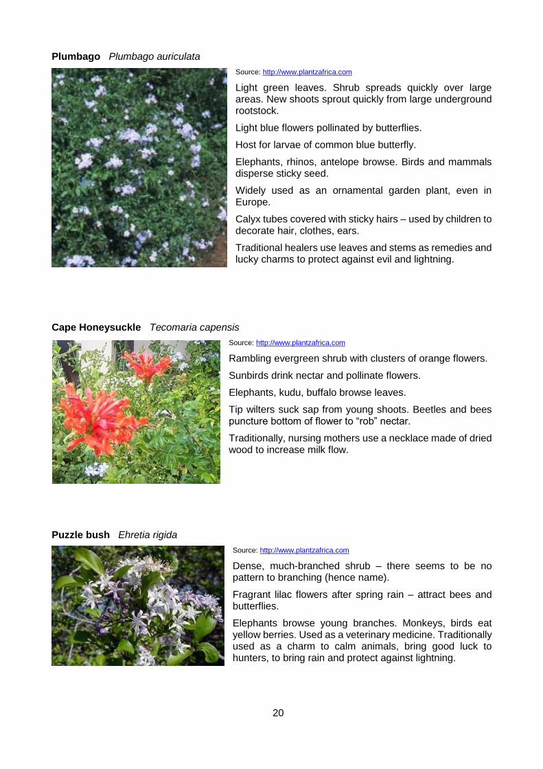
Cape Honeysuckle Tecomaria capensis
Source: http://www.plantzafrica.com
Rambling evergreen shrub with clusters of orange flowers.
Sunbirds drink nectar and pollinate flowers.
Elephants, kudu, buffalo browse leaves.
Tip wilters suck sap from young shoots. Beetles and bees puncture bottom of flower to “rob” nectar.
Traditionally, nursing mothers use a necklace made of dried wood to increase milk flow.
Puzzle bush Ehretia rigida
Source: http://www.plantzafrica.com
Dense, much-branched shrub – there seems to be no pattern to branching (hence name).
Fragrant lilac flowers after spring rain – attract bees and butterflies.
Elephants browse young branches. Monkeys, birds eat yellow berries. Used as a veterinary medicine. Traditionally used as a charm to calm animals, bring good luck to hunters, to bring rain and protect against lightning.

21
Karoo boer-bean Schotia afra
Source: http://www.KumbulaNursery.co.za
Parapinnately compound leaves – browsed by elephants, favourite food of kudu.
Seed pods (flat and broad containing bean-like seeds) relished by kudu, elephant and monkeys.
Reddish-pink flowers utilized by birds, birds, fruit bats, monkeys, baboons, many insects.
Green pods roasted on coals and seeds then eaten. Ripe beans can be roasted and used as coffee substitute. Dried seed pod remains found in Stone Age shelters in the Gamtoos Valley.
White-eyes eat larvae and aphids off tree.
Bark used medicinally. Wood used for furniture.
Milkwood Sideroxylon inerme
Source: http://www.plantzafrica.com
Tree with a rounded canopy and downward-curving branches – offer shelter to animals.
Sap is a milky latex (hence name).
Kudu browse leaves, fruit – sticky purple berries - eaten by birds and animals (incl. bats)
Small flowers have a yeasty smell, attract flies, beetles, and mousebirds.
Tough wood used for spoons and sledges. Used medicinally to banish nightmares.
This species is protected in South Africa and three trees have been proclaimed national monuments:
The Post Office tree in Mossel Bay – in 1500 Portuguese sailors left a shoe containing a letter describing Bartholomew Diaz’s drowning at sea. The message was discovered over a year later.
The Treaty Tree in Woodstock, Cape Town – in a house next to this tree, the Cape was handed over to the British in 1806 after the Battle of Blaauberg.
The Fingo Milkwood Tree near Peddie (Eastern Cape) – in the shade of this tree in 1835, the Fingo people reaffirmed their loyalty to God and the British King after British soldiers led them to safety (when being pursued by Chief Hintza and his warriors).
River euphorbia Euphorbia triangularis
Source: http://davesgarden.com
Spiny succulent tree up to 18m high on rocky hillsides and river valleys. Often grow in dense stands on slopes. Two/more branches from the base of the stem, each with a crown of upward curving branchlets. Branchlets are 3-winged and constricted forming segments with parallel sides. Spines paired.
22
Greenish yellow flowers in clusters. Fruit reddish, on stalks.
All euphorbias exude a milky latex – most are mildly to extremely toxic.
Well-utilized by elephants.
Pollinated by ants, bees, and flies.
Host to the root parasite Hydnora africana (Jackal’s Food) – woody pomegranate-like flowers develop underground and only the tip is visible above the surface; fetid smell attracts flies and beetles which are trapped and kept captive for a few days during which time they pollinate the flower; eaten by jackals, baboons, porcupines, bush pigs and some people (tastes like a sweet potato).
Traditionally planted at Xhosa villages to celebrate the birth of and to protect twins. Leaf sap used as a body wash by twins for cultural purposes.
Stock thieves have used the sap of the plant to avoid detection of stolen animals – the sap applied to the animal’s skin causes the hair to fall out and grow back a different colour.
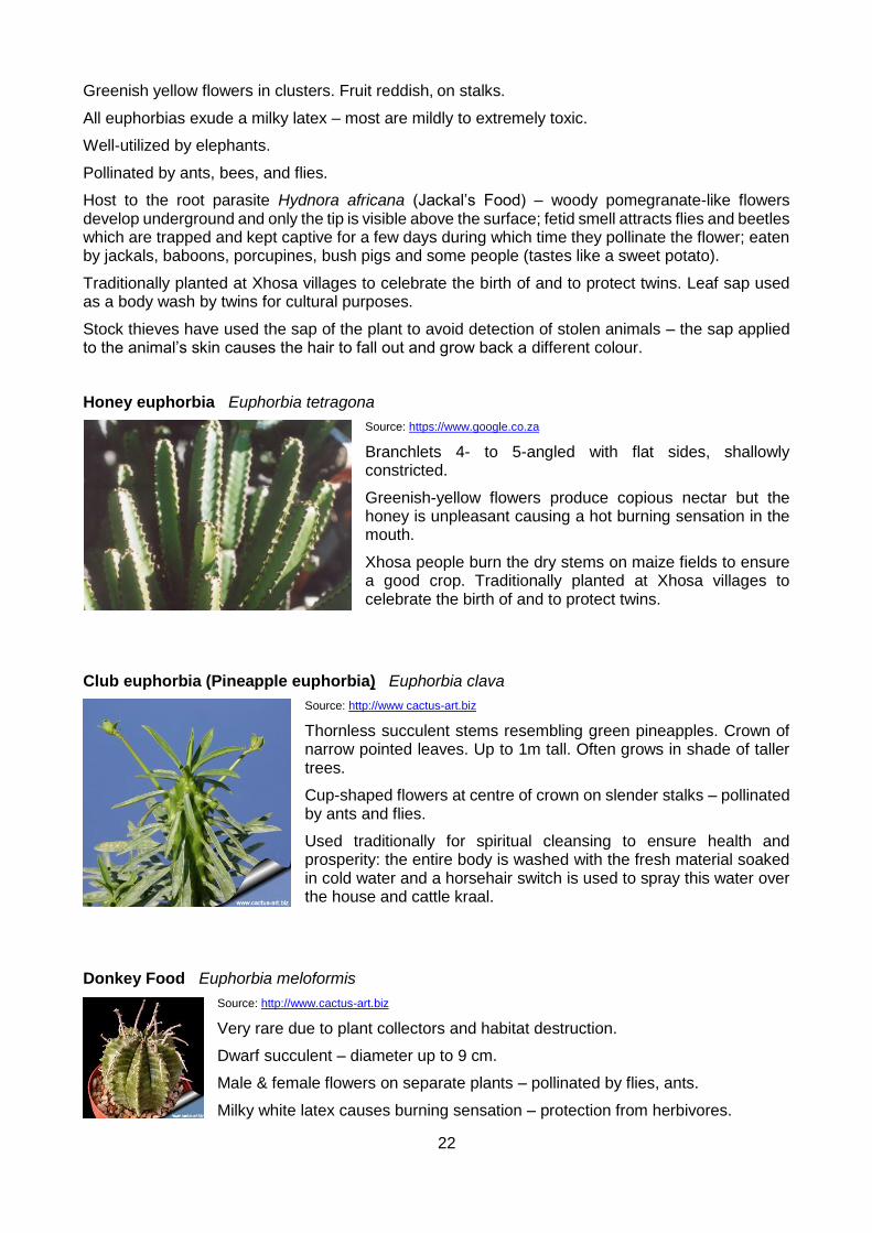
Honey euphorbia Euphorbia tetragona
Source: https://www.google.co.za
Branchlets 4- to 5-angled with flat sides, shallowly constricted.
Greenish-yellow flowers produce copious nectar but the honey is unpleasant causing a hot burning sensation in the mouth.
Xhosa people burn the dry stems on maize fields to ensure a good crop. Traditionally planted at Xhosa villages to celebrate the birth of and to protect twins.
Club euphorbia (Pineapple euphorbia) Euphorbia clava
Source: http://www cactus-art.biz
Thornless succulent stems resembling green pineapples. Crown of narrow pointed leaves. Up to 1m tall. Often grows in shade of taller trees.
Cup-shaped flowers at centre of crown on slender stalks – pollinated by ants and flies.
Used traditionally for spiritual cleansing to ensure health and prosperity: the entire body is washed with the fresh material soaked in cold water and a horsehair switch is used to spray this water over the house and cattle kraal.
Donkey Food Euphorbia meloformis
Source: http://www.cactus-art.biz
Very rare due to plant collectors and habitat destruction.
Dwarf succulent – diameter up to 9 cm.
Male & female flowers on separate plants – pollinated by flies, ants.
Milky white latex causes burning sensation – protection from herbivores.

23
Aloe
There are 4 species of single-stemmed aloe in the valley – ferox (bitter aloe), speciosa (tilted head aloe), pluridens (French aloe) and africana (curved aloe).
Curved Aloe Aloe africana
Source: http://www.plantzafrica.com
Endemic to the area between Humansdorp and Port Alfred.
Bright orange flower spikes stand out above the canopy in winter and early spring.
Dry leaves protect geckos, spiders lizards.
Doves and mousebirds may nest between the curved leaves.
Elephants, baboons and vervet monkeys eat flowers.
Pollinated by sunbirds, Cape white-eyes, bees, wasps.
Dried, powdered leaves added to snuff. Ash of burnt leaves used as insecticide for stored grain. Bitter leaf sap used to wean calves and babies by rubbing it on the mother’s nipples.
Bitter Aloe Aloe ferox
Source: https://www.google.co.za
Bitter leaf sap used to wean calves and babies by rubbing it on the mother’s nipples.
Leaves soaked in poultry drinking water to prevent external parasites.
Aloes leaves have spiny sides – for protection against herbivores (as aloes hold a lot of moisture in a dry area). Bitter taste also a protection against herbivores.
There are 3 species of climbing aloe in the valley – Aloe gracilis (larger red flowers), Aloe tenuior (yellow or orange flowers) and
Climbing Aloe Aloe ciliaris
Source: https://www.google.co.za
Miniature leaf rosettes with serrated edges, no thorns.
Large dark-orange flowers all year. Attract many sunbirds.
24
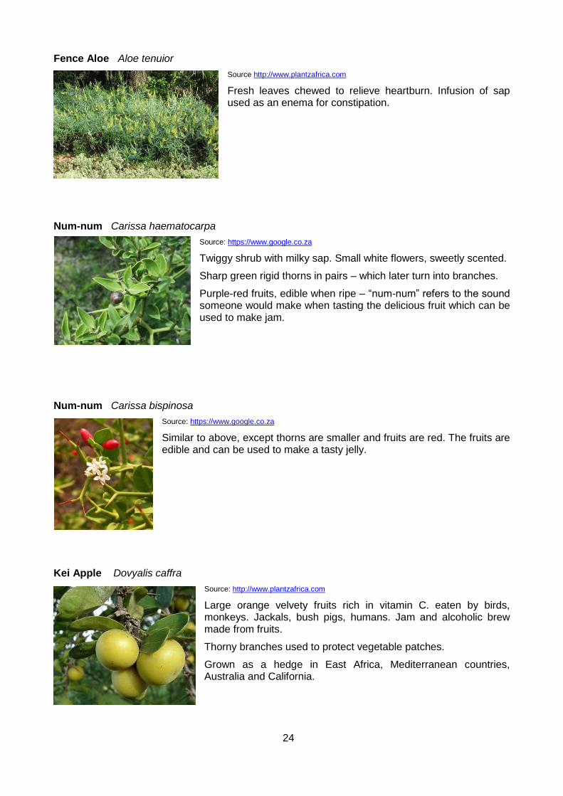
Fence Aloe Aloe tenuior
Source http://www.plantzafrica.com
Fresh leaves chewed to relieve heartburn. Infusion of sap used as an enema for constipation.
Num-num Carissa haematocarpa
Source: https://www.google.co.za
Twiggy shrub with milky sap. Small white flowers, sweetly scented.
Sharp green rigid thorns in pairs – which later turn into branches.
Purple-red fruits, edible when ripe – “num-num” refers to the sound someone would make when tasting the delicious fruit which can be used to make jam.
Num-num Carissa bispinosa
Source: https://www.google.co.za
Similar to above, except thorns are smaller and fruits are red. The fruits are edible and can be used to make a tasty jelly.
Kei Apple Dovyalis caffra
Source: http://www.plantzafrica.com
Large orange velvety fruits rich in vitamin C. eaten by birds, monkeys. Jackals, bush pigs, humans. Jam and alcoholic brew made from fruits.
Thorny branches used to protect vegetable patches.
Grown as a hedge in East Africa, Mediterranean countries, Australia and California.

25
Mother-in-law’s tongue Sansevieria hyacinthoides
Source: https://www.google.co.za
Elongated, sharp-tipped (hence name), leaves browsed by kudu, rhino.
Porcupines and baboons dig up rhizomes. New plants form from the fragments.
Flowers sweet-scented, pollinated by moths. Bloom after fist spring rains.
Leaf margins are sometimes stripped by weaver birds for making a nest.
Leaf fibres used to make twine for weaving baskets, ropes, string.
Traditional herbalists use to make medicine (leaf juices used for earache and toothache) and as a protective charm against lightning. Roots are chewed to expel intestinal worms. The plant can be
used as a source of ‘water’ however the liquid is bitter.
Red geranium Geranium inquinans
Source: http://www.plantzafrica.com
Endemic to valley thicket but exported to European gardens. Ancestor of cultivated red geraniums in Europe.
Soft, velvety aromatic leaves.
Scarlet red flowers all year.
Brittle, succulent stems break easily, form new plants.
Medicinally used for headaches, colds and body deodorant.
Ivy-leaved Pelargonium Pelargonium peltatum
Source: http://www.plantzafrica.com
Ancestor of all modern colourful hybrid ivy pelargoniums grown world-wide.
Scrambling shrub. Broken-off pieces root easily.
Lilac flowers throughout year. Pollinated by butterflies and moths.
Young shoots may be used in salad (sour taste).
Leaf sap used as remedy for sore throats.

26
Firethorn Putterlickia pyracantha
Source: https://www.google.co.za
Long, sharp thorns bright red to purplish-red when young.
Pink 3-angled fruits split open to display red-brown shiny seeds, eaten by mousebirds and doves.
Small succulents grow in the shelter of the thorns.
Thorny branches used to make cattle kraals and fences.
Wild caper Capparis sepiaria var. citrifolia
Source: https://www.google.co.za
Dense spiny bush.
2 sharp, downward hooked thorns at the base of each leaf (formed from modified stipules) – sometimes called “Cat’s claw” because of this.
Flowers whitish in terminal clusters (Oct – Nov).
Fruits berry-like first orange, turning purplish-black.
Related species C. tomentosa used medicinally to cure a variety of complaints such as coughs, colds, impotence, and infertility. A stick coated with a powdered mixture of the roots pointed towards the clouds is believed to protect against floods.
Common guarri Euclea undulata
Source: https://www.google.co.za
Dense shrub/small tree with grey scaly bark.
Leathery leaves with conspicuously wavy margins.
Flowers small, whitish (Dec – Apr).
Fruit berry-like, green turning reddish-brown, then black (Apr – Oct).
Caterpillars of a certain moth species make communal nests (leaves bound together with silk) on this species.
Leaves used as fodder for stock. Wood used for fencing posts and joinery.
Medicinal uses: powdered root used as drastic purgative, bark used for headaches, root used for toothache and heart ailments. Chewed twig used as a toothbrush.

27
Melktou Sarcostemma viminale
Source: https://www.google.co.za
Leafless succulent scrambler with smooth grey-green to reddish-green stems and milky sap – which is poisonous.
Flowers yellow in clusters.
Wind dispersal – seeds with long white silky hairs released from pods.
Traditional use: lower stems are dried, powdered, mixed with water and given to cattle to induce lactation.
Thorny taaibos Rhus longispina
Source: https://www.google.co.za
Spiny shrub/small tree. Tri-foliate leaves with a winged petiole (looks like another leaf forming). Small yellowish flowers covered with red glandular hairs.
Thin flattened brown fruits.
Common spike-thorn (Gewone Pendoring) Gymnosporia buxifolia
Source: http://pza.sanbi.org
One of the most common and widespread shrubs in Africa. It has had over 40 names.
Shrub or small tree occurring over a wide range of habitats. Leaves in clusters. Sharp spines. Flowers whitish, unpleasant smell, axillary clusters.
Fruit round, brown.
The wound made by the spines often becomes inflamed, as if it has been poisoned (hence name).

28
Sweet thorn (Soetdoring) Acacia karroo
Source: http://karoospace.co.za
One of the most widespread tree in South Africa and Africa.
Its presence is considered to be indicative of sweet veld (hence name, or others say that the name comes from the sweet gum or from the new green thorns which are sweet when chewed). Can also be an indicator of bush encroachment. Is a pioneer plant.
Young plants protect themselves from herbivory by producing copious white thorns.
Bipinnately compound leaves – excellent fodder and well-loved by kudus and other browsers.
Brown, leguminous seed pods also eaten by many animals. Seeds ground and used as a coffee substitute.
Bright yellow ‘puffball’ flowers yield pollen and nectar for bees.
Tree yields a clear golden – red gum that is edible and used commercially.
Inner bark used to make rope.
Children use thorns as horns on clay animals. Slender ants make nests inside the thorns – look for an entry hole near the base of swollen thorns (thorns swell as reaction to a growth hormone injected by the ants). They hollow out the inside of the thorn and lay eggs inside. There may also be scale insects associated with these ants.
Wild plum Harpephyllum caffrum
Source: http://www.plantzafrica.com
Evergreen tree, up to 15m tall.
5-8 imparapinnate leaflets, turn red before falling.
Whitish flowers in terminal clusters.
Fleshy red plum-like fruits.
Fruit used to make jelly. Wood used for furniture and planks.
Bark medicinally used for skin complaints, as an emetic and to purify blood.
Pig’s ear Cotyledon orbiculata
Source: https://www.google.co.za
Succulent shrub often intertwined with other shrubs.
Fleshy grey-green leaves with reddish edge.
Red & yellow bell-shaped flowers with large protruding anthers.
Sunbirds pollinate.
Broken-off pieces form new plants.
Leaves crushed to make a paste to treat pimples.

29
Bear claws Cotyledon tomentosa
Source: https://www.google.co.za
Leaves succulent, covered with downy hairs, tip of leaf has ¾ reddish points.
Grows in clefts, rock crevices and between boulders.
Flowers orange-red pendulous in spring – pollinated by bees and wasps.
Kerky bush (Money plant) Crassula ovata
Source: https://www.google.co.za
Dark green oval leaves on swollen branches. Shrub up to 2m tall.
Blooms after spring rains – masses of pink or white flowers – visited by insects.
Popular pot-plant in Europe and America.
Sosatie plant Crassula perforata
Source: https://southafricaninsects.wordpress.com
Thick succulent rounded leaves look like beads threaded on wiry brown stems or slices on a sosatie (kebab) stick.
Tortoises eat leaves. Flowers (small white) attract bees and butterflies.
Mini Pine Tree Crassula tetragona
Source: https://en.wikipedia.org
Leaves cylindrical, arranged in four neat rows along slender, erect stems.
Long spike of small tubular white flowers in spring.
Older leaves drop off – eaten by tortoises, field mice, beetle larvae.

30
April fool Haemanthus coccineus
Source: http://www.plantzafrica.com
Geophyte up to 20cm tall – the bulb is large, vertically flattened.
Flowering stem red or speckled with red. Flowers red with bright yellow conspicuous anthers. Flowers Feb – April.
2 (rarely 3) spreading flattened leaves, speckled red on underside – dry or absent at flowering.
Cape smilax Asparagus asparagoides
Source: https://en.wikipedia.org
Scrambler. Ovate glossy ‘leaves’ (phyllodes).
Small star-shaped white flowers, red berry fruits – hand from thin stalks.
Fruits eaten by mousebirds, starlings.
Root traditionally used as balm for sore eyes, a purgative and fertility charm for cattle.
Burn jelly plant Bulbine frutescens
Source: http://herbclass.com
Well adapted to dry conditions – grows in bare patches between other shrubs.
Small orange/yellow flowers on long thin flowering stem.
Porcupines eat succulent roots. Broken pieces generate new plants.
Yellow leaf sap used to treat burns, insect bites, rashes and wounds – ant-bacterial and soothing properties.
Bushy Bulbine Bulbine abyssinica
Source: http://www.plantzafrica.com
Small yellow flowers on long thin flowering stem.
Rootstock traditionally sliced up and boiled to make an infusion for bladder infections and used as an enema to relieve colic in weaning babies.
31
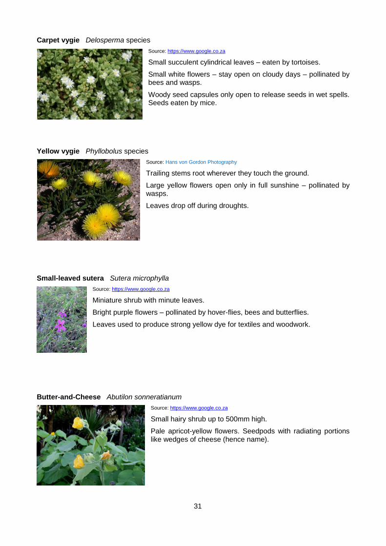
Carpet vygie Delosperma species
Source: https://www.google.co.za
Small succulent cylindrical leaves – eaten by tortoises.
Small white flowers – stay open on cloudy days – pollinated by bees and wasps.
Woody seed capsules only open to release seeds in wet spells. Seeds eaten by mice.
Yellow vygie Phyllobolus species
Source: Hans von Gordon Photography
Trailing stems root wherever they touch the ground.
Large yellow flowers open only in full sunshine – pollinated by wasps.
Leaves drop off during droughts.
Small-leaved sutera Sutera microphylla
Source: https://www.google.co.za
Miniature shrub with minute leaves.
Bright purple flowers – pollinated by hover-flies, bees and butterflies.
Leaves used to produce strong yellow dye for textiles and woodwork.
Butter-and-Cheese Abutilon sonneratianum
Source: https://www.google.co.za
Small hairy shrub up to 500mm high.
Pale apricot-yellow flowers. Seedpods with radiating portions like wedges of cheese (hence name).
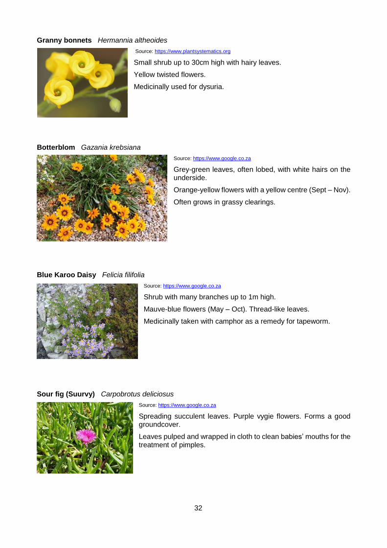
32
Granny bonnets Hermannia altheoides
Source: https://www.plantsystematics.org
Small shrub up to 30cm high with hairy leaves.
Yellow twisted flowers.
Medicinally used for dysuria.
Botterblom Gazania krebsiana
Source: https://www.google.co.za
Grey-green leaves, often lobed, with white hairs on the underside.
Orange-yellow flowers with a yellow centre (Sept – Nov).
Often grows in grassy clearings.
Blue Karoo Daisy Felicia filifolia
Source: https://www.google.co.za
Shrub with many branches up to 1m high.
Mauve-blue flowers (May – Oct). Thread-like leaves.
Medicinally taken with camphor as a remedy for tapeworm.
Sour fig (Suurvy) Carpobrotus deliciosus
Source: https://www.google.co.za
Spreading succulent leaves. Purple vygie flowers. Forms a good groundcover.
Leaves pulped and wrapped in cloth to clean babies’ mouths for the treatment of pimples.
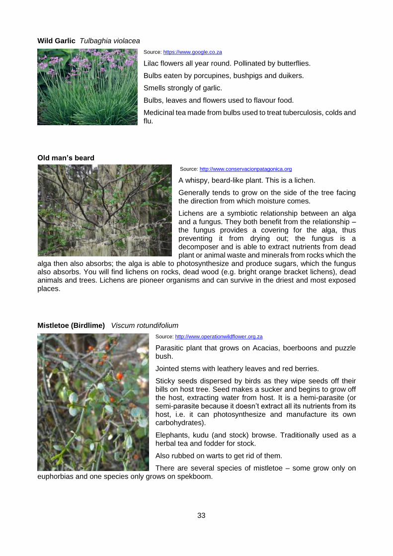
33
Wild Garlic Tulbaghia violacea
Source: https://www.google.co.za
Lilac flowers all year round. Pollinated by butterflies.
Bulbs eaten by porcupines, bushpigs and duikers.
Smells strongly of garlic.
Bulbs, leaves and flowers used to flavour food.
Medicinal tea made from bulbs used to treat tuberculosis, colds and flu.
Old man’s beard
Source: http://www.conservacionpatagonica.org
A whispy, beard-like plant. This is a lichen.
Generally tends to grow on the side of the tree facing the direction from which moisture comes.
Lichens are a symbiotic relationship between an alga and a fungus. They both benefit from the relationship – the fungus provides a covering for the alga, thus preventing it from drying out; the fungus is a decomposer and is able to extract nutrients from dead plant or animal waste and minerals from rocks which the
alga then also absorbs; the alga is able to photosynthesize and produce sugars, which the fungus also absorbs. You will find lichens on rocks, dead wood (e.g. bright orange bracket lichens), dead animals and trees. Lichens are pioneer organisms and can survive in the driest and most exposed places.
Mistletoe (Birdlime) Viscum rotundifolium
Source: http://www.operationwildflower.org.za
Parasitic plant that grows on Acacias, boerboons and puzzle bush.
Jointed stems with leathery leaves and red berries.
Sticky seeds dispersed by birds as they wipe seeds off their bills on host tree. Seed makes a sucker and begins to grow off the host, extracting water from host. It is a hemi-parasite (or semi-parasite because it doesn’t extract all its nutrients from its host, i.e. it can photosynthesize and manufacture its own carbohydrates).
Elephants, kudu (and stock) browse. Traditionally used as a herbal tea and fodder for stock.
Also rubbed on warts to get rid of them.
There are several species of mistletoe – some grow only on euphorbias and one species only grows on spekboom.
34
Match flower Moquinella rubra
Source: http://www.ispotnature.org
Parasitic plant that grows on Acacias, boerboons, guarris, rhus.
Thin tubular orange flowers with black tip (when mature) look like matches, split explosively into 5 narrow lobes.
Flowers autumn.
Some grasses:
Common finger grass Digitaria eriantha
Source: http://www.krugerpark.co.za
A palatable valuable grazing grass, one of the most widely spread grasses in South Africa.
Dominance of this grass indicates veld in good condition. It is a climax grass and decreases with over- or undergrazing.
Broad-leaved panicum Panicum deustum
Source: https://www.google.co.za
A palatable nutritious grass, especially in winter when it retains its nutritional value.
It is a climax grass and decreases with over- or undergrazing.
It grows in shady areas, dense bush and forest areas.

35
Red grass (Rooigras) Themeda triandra
Source: https://www.google.co.za
A palatable valuable grazing grass – the most important grazing grass in open grassland areas in South Africa.
A very good indicator of healthy veld - a climax grass that decreases with over- or undergrazing.
Turpentine grass Cymbopogon plurinodis
Source: www.ispotnature.org
A climax grass that is unpalatable because of its high percentage of essential oils which give it a bitter taste. The fresh leaves and inflorescence give off a turpentine smell when crushed.
Occurs in open grasslands or open patches in bush, often associated with Red grass.
Couch grass (Kweekgras) Cynodon dactylon
Source: https://www.google.co.za
A short mat-forming pioneer grass that is abundant in overgrazed veld.
Can endure heavy grazing and remains green until late winter.
Grows in all types of soil, especially sandy and fertile soils.
A good grazing grass and used in traditional medicine.
Rescue grass Bromus catharticus
Source: https://en.wikipedia.org
A palatable pioneer grass that grows in disturbed and damp places.

36
Weeping love grass Eragrostis curvula
Source: http://www.bulkseed.co.za
A subclimax or climax grass that is abundant in overgrazed veld.
Palatable and grows in disturbed places.
Narrow curly leaf Eragrostis chloromelas
Source: http://wildflowernursery.co.za
A subclimax or climax grass that is abundant in overgrazed veld.
Less palatable than weeping love grass. Grows on stony slopes and open grassland.
2. Grassland
Grassland is defined as those areas where grasses dominate the vegetation and where woody plants are absent or rare. They occupy 24,1% of the country’s surface area. Most grassland occurs in high-rainfall areas, where thunderstorms and hail are common in summer and frost is common in winter.
The grassland biome is regarded as the third-richest area in terms of plant species diversity, with a total number of 3 788 species. The most noteworthy species with a wide distribution is rooigras (Themeda triandra).
Typical plants:
Zuurberg hunchback Oldenburgia arbuscula
Source: https://www.google.co.za
Bushy shrub or gnarled small tree found in mountainous areas on hard sandstone outcrops. Dark thick corky bark.
Stiff leathery dark glossy leaves with woolly hairs on the underside (leaves resemble loquat leaves). Said to be poisonous.
Purple flowers are large and flat-headed, 10-13 cm in diameter.
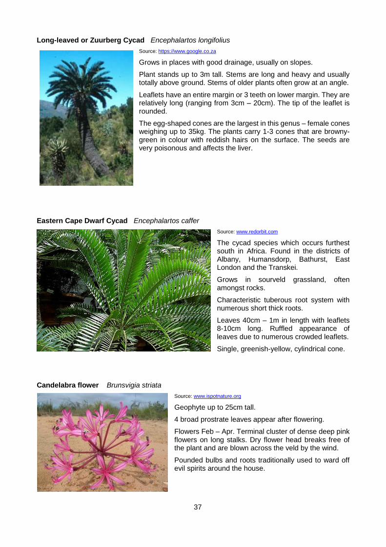
37
Long-leaved or Zuurberg Cycad Encephalartos longifolius
Source: https://www.google.co.za
Grows in places with good drainage, usually on slopes.
Plant stands up to 3m tall. Stems are long and heavy and usually totally above ground. Stems of older plants often grow at an angle.
Leaflets have an entire margin or 3 teeth on lower margin. They are relatively long (ranging from 3cm – 20cm). The tip of the leaflet is rounded.
The egg-shaped cones are the largest in this genus – female cones weighing up to 35kg. The plants carry 1-3 cones that are browny-green in colour with reddish hairs on the surface. The seeds are very poisonous and affects the liver.
Eastern Cape Dwarf Cycad Encephalartos caffer
Source: www.redorbit.com
The cycad species which occurs furthest south in Africa. Found in the districts of Albany, Humansdorp, Bathurst, East London and the Transkei.
Grows in sourveld grassland, often amongst rocks.
Characteristic tuberous root system with numerous short thick roots.
Leaves 40cm – 1m in length with leaflets 8-10cm long. Ruffled appearance of leaves due to numerous crowded leaflets.
Single, greenish-yellow, cylindrical cone.
Candelabra flower Brunsvigia striata
Source: www.ispotnature.org
Geophyte up to 25cm tall.
4 broad prostrate leaves appear after flowering.
Flowers Feb – Apr. Terminal cluster of dense deep pink flowers on long stalks. Dry flower head breaks free of the plant and are blown across the veld by the wind.
Pounded bulbs and roots traditionally used to ward off evil spirits around the house.

38
Tritonia Tritonia laxifolius
Source: http://www.africanbulbs.com
Geophyte with a corm.
Orange flowers face to one side. Flowers Mar – May.
Common Grasses:
Guinea grass Panicum maximum
Source: http://www.plantzafrica.com
Very palatable with a high leaf yield. A subclimax or climax grass that decreases with over- or undergrazing.
Prefers shade and damp conditions but can grow in a variety of habitats.
Quaking grass Briza maxima and B.minor
Grow in damp and disturbed places in fynbos and grassland. These species sometimes occur together.
Both have little grazing value and are pioneer grasses.
Source: https://en.wikipedia.org https://commons.wikimedia.org
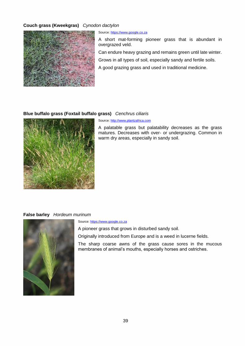
39
Couch grass (Kweekgras) Cynodon dactylon
Source: https://www.google.co.za
A short mat-forming pioneer grass that is abundant in overgrazed veld.
Can endure heavy grazing and remains green until late winter.
Grows in all types of soil, especially sandy and fertile soils.
A good grazing grass and used in traditional medicine.
Blue buffalo grass (Foxtail buffalo grass) Cenchrus ciliaris
Source: http://www.plantzafrica.com
A palatable grass but palatability decreases as the grass matures. Decreases with over- or undergrazing. Common in warm dry areas, especially in sandy soil.
False barley Hordeum murinum
Source: https://www.google.co.za
A pioneer grass that grows in disturbed sandy soil.
Originally introduced from Europe and is a weed in lucerne fields.
The sharp coarse awns of the grass cause sores in the mucous membranes of animal’s mouths, especially horses and ostriches.
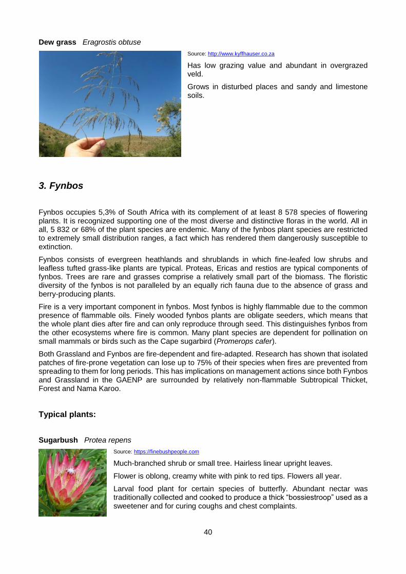
40
Dew grass Eragrostis obtuse
Source: http://www.kyffhauser.co.za
Has low grazing value and abundant in overgrazed veld.
Grows in disturbed places and sandy and limestone soils.
3. Fynbos
Fynbos occupies 5,3% of South Africa with its complement of at least 8 578 species of flowering plants. It is recognized supporting one of the most diverse and distinctive floras in the world. All in all, 5 832 or 68% of the plant species are endemic. Many of the fynbos plant species are restricted to extremely small distribution ranges, a fact which has rendered them dangerously susceptible to extinction.
Fynbos consists of evergreen heathlands and shrublands in which fine-leafed low shrubs and leafless tufted grass-like plants are typical. Proteas, Ericas and restios are typical components of fynbos. Trees are rare and grasses comprise a relatively small part of the biomass. The floristic diversity of the fynbos is not paralleled by an equally rich fauna due to the absence of grass and berry-producing plants.
Fire is a very important component in fynbos. Most fynbos is highly flammable due to the common presence of flammable oils. Finely wooded fynbos plants are obligate seeders, which means that the whole plant dies after fire and can only reproduce through seed. This distinguishes fynbos from the other ecosystems where fire is common. Many plant species are dependent for pollination on small mammals or birds such as the Cape sugarbird (Promerops cafer).
Both Grassland and Fynbos are fire-dependent and fire-adapted. Research has shown that isolated patches of fire-prone vegetation can lose up to 75% of their species when fires are prevented from spreading to them for long periods. This has implications on management actions since both Fynbos and Grassland in the GAENP are surrounded by relatively non-flammable Subtropical Thicket, Forest and Nama Karoo.
Typical plants:
Sugarbush Protea repens
Source: https://finebushpeople.com
Much-branched shrub or small tree. Hairless linear upright leaves.
Flower is oblong, creamy white with pink to red tips. Flowers all year.
Larval food plant for certain species of butterfly. Abundant nectar was traditionally collected and cooked to produce a thick “bossiestroop” used as a sweetener and for curing coughs and chest complaints.
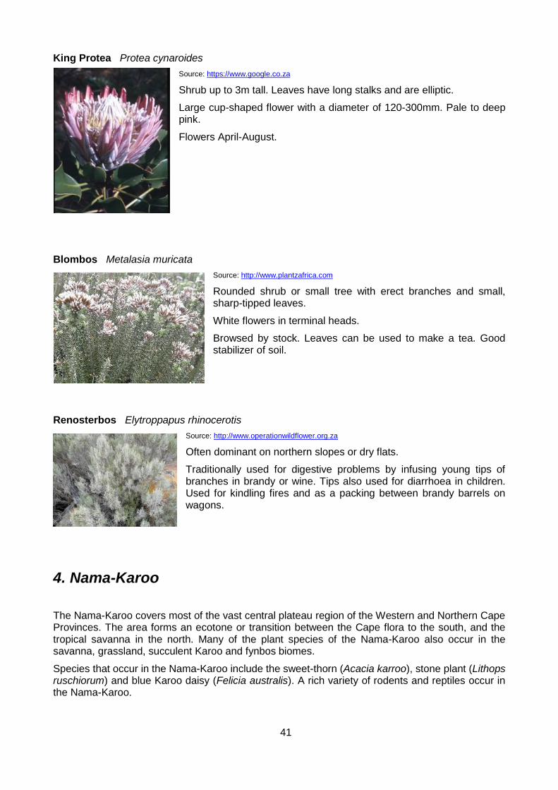
41
King Protea Protea cynaroides
Source: https://www.google.co.za
Shrub up to 3m tall. Leaves have long stalks and are elliptic.
Large cup-shaped flower with a diameter of 120-300mm. Pale to deep pink.
Flowers April-August.
Blombos Metalasia muricata
Source: http://www.plantzafrica.com
Rounded shrub or small tree with erect branches and small, sharp-tipped leaves.
White flowers in terminal heads.
Browsed by stock. Leaves can be used to make a tea. Good stabilizer of soil.
Renosterbos Elytroppapus rhinocerotis
Source: http://www.operationwildflower.org.za
Often dominant on northern slopes or dry flats.
Traditionally used for digestive problems by infusing young tips of branches in brandy or wine. Tips also used for diarrhoea in children. Used for kindling fires and as a packing between brandy barrels on wagons.
4. Nama-Karoo
The Nama-Karoo covers most of the vast central plateau region of the Western and Northern Cape Provinces. The area forms an ecotone or transition between the Cape flora to the south, and the tropical savanna in the north. Many of the plant species of the Nama-Karoo also occur in the savanna, grassland, succulent Karoo and fynbos biomes.
Species that occur in the Nama-Karoo include the sweet-thorn (Acacia karroo), stone plant (Lithops ruschiorum) and blue Karoo daisy (Felicia australis). A rich variety of rodents and reptiles occur in the Nama-Karoo.

42
Typical plants:
Noors Euphorbia coerulescens
Source: http://kumbulanursery.co.za
Dominant species in Noorsveld.
Eaten by black rhino and kudu. Farmers feed chopped up noors to stock in times of drought.
Red Treasure Crassula perfoliata
Source: http://www.florafinder.com
Grey-green succulent leaves. Plant stands up to 1.5m tall.
Red/pink/white flowers in a flat-topped cluster. Flowers Oct – Jan.
Kerky bush Crassula ovata
Source: http://www.plantzafrica.com
Shrub or small sturdy tree with a thick stem. Succulent leaves which may have a red horny edge.
White to pink flowers in dense terminal clusters, May-July.
Widely grown in gardens. Young leaves eaten by stock and game. Roots eaten by the Khoikhoi and used medicinally.
Karoo cycad Encephalartos lehmanii
Source: http://www.plantzafrica.com
Height 1.5 – 3m. Often branched from base and reclining.
Narrow leaflets are blue-grey with entire margin (or 1-2 small teeth on lower margin). Swollen leaf bases have conspicuous red-brown collar.

43
Jacket plum Pappea capensis
Source: http://redlist.sanbi.org
Small to medium tree often occurring on termite mounds and among rocks.
Oblong leathery leaves with a rounded base and apex. Pale yellow-greenish flowers (separate sexes on separate trees). Fruit furry green almost spherical capsule, splitting to reveal a shiny black seed in a bright red jelly-like seed coat.
Leaves are a very important browse plant for game. Also used by stock. A leaf infusion is used as a cure for sore eyes.
Fruits are edible and can be made into a jelly, alcoholic beverage and vinegar. The seed yields an oil that is edible, used medicinally (as a remedy for ringworm and to restore hair) and used for lubrication (by farmers to oil guns).
A root infusion is given to cattle as a purge.
Shepherd’s tree Boscia albitrunca
Source: http://www.prota4u.org
Stocky tree up to 7m high with well-rounded crown. Conspicuous whitish-grey/yellowish smooth bark. Leaves reduced and leathery.
Flowers small, petals absent, sweet scent.
In arid areas, this tree may be called the “tree of life” because it gives food to animals and humans. The leaves are high in crude protein and a nourishing fodder for game and stock.
Larval food for butterflies of the family Pieridae.
Roots are dried, roasted and ground to be used as a coffee or chicory substitute or are pounded to obtain a white meal for porridge.
Flower buds can be pickled to be used as capers.
A cold infusion of leaves is applied as a lotion to the inflamed eyes of cattle.
In some areas, local people believe that, if the wood is burnt, cows will only give birth to bull calves. Others believe that, if the fruits wither, the millet crop will fail.
Karoo shepherd’s tree Boscia oleoides
Source: https://www.ispotnature.org
See notes for Boscia albitrunca (similar).
The only species of Boscia which possesses petals (small, white).
The leaves are rich in crude protein.
44
Other common plants include:
Yellow Pomegranate Rhigozum obovatum
Karoo Num Num Carissa haematocarpa
Thorny Elm chaetacme_aristata
Bitter Aloe Aloe ferox
Spekboom Portulacaria afra
Common Bush Guarie Euclea undulata
Namaqua Kumi Bush Rhus undulata
Boer Bean Schotia afra
Sneezewood Ptearoxylon obliquum
5. Forest
The forests of South Africa include the indigenous evergreen and semi-deciduous closed forests of the coastal lowlands and escarpment slopes and cover only about 0.25% of the land area.
With a few exceptions such as the forests of the Knysna area and the KwaZulu-Natal coastal dune systems, forests are small, usually occupying less than 1 000 ha. These forests amount to little more than patches scattered through the higher rainfall areas. The total area of forests in South Africa is probably less than 2 000 km². The forest structure results in reduced light levels in the area beneath the canopy where species such as tree ferns are common. Typical mammals include the bushbuck (Tragelaphus scriptus) and bush pig (Potamochoerus porcus) and typical birds include the Knysna lourie (Tauraco corythaix). Despite the small land surface area that they occupy, forests have relatively high species richness. Only fynbos exceeds the species richness found in forests.
Interesting things happen in the forests: Throughout the world, there are about 900 different species of ficus tree, some of which are found in the Addo forests. What is interesting about these trees is that a different type of wasp is responsible for pollinating each type of ficus. They do this by entering a small opening, the ostiole, at the base of the fruit, the syconium, which is made up inside of many tiny flowers. Here they lay their eggs. The plant is able to close the ostiole in order to limit the number of wasps that enter the syconium.
After the eggs have been laid and pollination has occurred, the ovaries of the syconium enlarge, filling the fruit completely and crushing the remains of the wasps. While normal seeds develop in the ovaries of the long-styled flowers, a wasp larvae lives in each of the galled short-styled ovaries. After several weeks, when the central cavity has formed again, the male wasps begin to emerge from their galls. They are larva-like insects without wings.
The males now search with their antennae for galls containing female wasps. He bites a hole in the wall of the gall, inserts the tubular segments of his gaster and mates. As soon as all females have been impregnated, the males cut one or more tunnels through the wall of the syconium. The influx of fresh air depletes the high concentration of carbon dioxide inside the syconium and an equilibrium is reached between the internal and external atmosphere. The increase in oxygen is a signal for the male flowers to start ripening. The females now enlarge the mating holes and emerge from their galls. They are winged and more delicate than the males.
As the female leaves the syconium, the pollen from the male flowers is scratched together with the hairy forelegs and collected into the special pockets. These females then crawl out through the tunnels and fly off to find another fig tree of the same species in the receptive stage. The process is then repeated - a cycle lasting 50-60 days.
Alexandria forest (Acocks Veld Type No. 2) or Indian Ocean forest can be distinguished from other forest types by the relatively low percentage of shade-loving trees in the species composition, and

45
is thus phytogeographically distinct from forests in other regions. This veld type is highly threatened with only about 5% of the original extent of the veld type presently conserved under formal conservation. Woody Cape Nature Reserve represents more than 90% of the Alexandria forest veld type conserved.
The Alexandria forest receives the highest rainfall in the GAENP, about 600-700mm per year.
Afro-montane forest is found in the ravines and valleys in several sections of the park.
Between the non-vegetated dunes and the hills, there is a transition from Dune Forest to Alexandria Forest.
Typical plants:
Weeping boer-bean Schotia brachypetala
Source: http://www.plantzafrica.com
Large tree in open woodland, scrub forest and along riverbanks.
4-6 pairs of sub- or opposite leaflets. Deep red to pink flowers producing copious nectar that drips from the flowers, giving the tree its common name. Nectar attracts insects and birds.
Flattened woody pod with characteristic rim carries pale brown seeds which can be roasted and eaten.
Wood used for furniture. Bark used for tanning and to make a decoction to relieve heartburn and hangovers.
Real Yellowwood Podocarpus latifolius
Source: https://en.wikipedia.org
Large tree of height 20 – 30m.
Bark peels in narrow vertical flakes.
Leaves held horizontally or slightly drooping.
Female cones have a bright red to purple fleshy receptacle.
Outeniqua Yellowwood Podocarpus falcatus
Source: http://www.plantzafrica.com
Tallest indigenous forest tree in SA, reaching up to 60m.
Bark flakes in round or rectangular patches.
Leaves narrow, sickle-shaped, slightly twisted at the base.
Female cones have no fleshy receptacle, seed yellow.

46
Cape Chestnut Calodendrum capense
Source: http://www.plantzafrica.com
Small to tall tree found in forest, wooded ravines and scrub.
Leaves large, elliptic, dark green and aromatic.
Conspicuous large pale pink flowers.
Fruit is a brown woody capsule with a knobby surface.
The pale yellow wood is suitable for furniture.
Several species of swallowtail (Papilio) butterflies breed on this tree.
Fruits are eaten by samango monkeys, rameron pigeons and Cape parrot (where these species occur).
Coast coral tree Erythrina caffra
Source: http://kumbulanursery.co.za
Medium to large tree occurring in coastal forest, can reach 20m in favourable conditions.
Trifoliate leaves with the terminal leaflet being the largest.
Orange-scarlet flowers are produced before the leaves. The standard petal curls back to expose the stamens. Sunbirds are attracted to the nectar.
Dark-coloured cylindrical pod, lobed between the seeds.
In some areas, local people will not burn the wood for fear of attracting lightning.
Alexandria Cycad Encephalartos arenarius
Source: http://www.wikiwand.com
This cycad occurs in the coastal forest area and has leaves up to 1.5m long.
The lower margin of the leaflet has 2-3 large teeth, while the upper margin is smooth.
Cones (1-3) are dark to bluish-green and seeds are red.
Similar to the Albany cycad (Encephalartos latifrons).
Other plants that commonly occur in the Alexandria forest:
Cape Plane Ochna arborea
Needle Bush Azima tetracantha
White Pear Apodytes dimidiata
Cross – Berry Grewia occidentalis

47
White Milkwood Sideroxylon inerme
Wild Caper–Bush Capparis sepiaria var. citrifolia
Common Cabbage Tree Cussonia spicata
Plumbago Plumbago auriculata
Sweet Thorn Acacia karoo
Veld Fig Ficus burtt-dayvi
Wild Olive Olea europea subsp. africana
Kooboo – berry Cassine aethiopica
Invasive alien plants
Prickly Pear (Turksvy) Opuntia ficus-indica
Source: https://en.wikipedia.org
This plant, which originated in Mexico, was brought into the Eastern Cape by the government in the 1950s as a fodder in an effort to relieve the effects of drought. It later became invasive. Spineless cultivars – which are not invasive – have been developed.
Cactus-like plant with oval-shaped succulent leaves held on a thick stalk. Leaves are covered with spines. Showy yellow flowers.
Produces green edible fruit, also covered with spines.
Leaves are eaten by elephants and baboons. Fruit is eaten by humans, elephants, baboons, and kudu.
This plant is not eradicated in the park because the elephants remove the plants by eating them.
Biological controls for the plant include cochineal (seen as white fluffy spots on the plant) and the Cactoblastis moth. The larvae of this moth develop inside the leaves and eat them from the inside. Leaves will have holes in them or will die off.
Jointed cactus (Katjie) Opuntia aurantiaca
Source: http://www.biodiversityexplorer.org
Introduced from South America. A much-branched spiny succulent spreading shrub. Each “joint” that breaks off can start a new plant. The plant spreads by sticking into passing animals (or humans) with very effective and painful thorns. The victim then brushes the “joint” off in another location.
Can only grow up to about 0.5m high unless supported by a woody shrub, when it can grow up to 2m tall. Bright yellow flowers November to January.
Biological control: cochineal. Chemical control: spraying with MSMA.

48
Black Wattle Acacia mearnsii
Source: https://commons.wikimedia.org
Introduced from Australia for timber.
Evergreen tree with dark olive-green leaves (with short crowded leaflets).
Pale-yellow “puffball” flowerheads, August to September.
Hairy dark brown pods.
Biological control: seed weevils. Chemical control: spraying with herbicide such as Garlon or cutting the tree and treating the stump.
Rooikrans Acacia cyclops
Source: http://boggomsbaai.co.za
Introduced from Australia for dune reclamation.
Evergreen shrub or small tree.
Bright yellow “puffball” flowerheads, October to February.
Seeds black encircled by a fleshy bright orange stalk, carried in twisted brown pods.
Biological control: weevils that feed on the seeds. Chemical control: spraying with herbicide such as Garlon or cutting the tree and treating the stump with herbicide.
Other invasive plants include:
Scotch Thistle Cirsium vulgare
Bug weed Solanum mauritianum
Port Jackson Acacia saligna
Castor Oil Plant Ricinus communis
Blue Gums Eucalyptus spp.
Pines Pinus
Torch Cactus Echinopsis spachiana
Queen of the Night Cereus jamacaru
Mesquite Prosopis
Mexican Poppy Argemone mexicana
Sisal Agave sisalana
Sesbania Sesbania punicea
Lantana Lantana camara

49
5. INFORMATION OF SECTIONS OF THE AENP
The park straddles the summer rainfall area lying predominantly to the north of the Zuurberg range, and the all-year rainfall areas to the south of the mountain range. The park’s climate is best described as warm temperate. One of the major correlates of Thicket vegetation area is the absence of a pronounced seasonal pattern. During drought periods, fogs may be a source of moisture as is evidenced by a high incidence of bark and ground lichens. Mean annual rainfall varies from 900 mm in the Alexandria forests, to 450 mm at the park’s administrative office complex, to an excess of 600 mm on the Zuurberg Mountains, to 350 mm in the northern Karoo rain-shadow areas. Temperatures vary from 15°C to 45°C in January and 5°C to18°C in July.
ADDO MAIN CAMP SECTION
The main park area – about 13 000 hectares (1 hectare = 10 000 square metres).
A series of low undulating hills varying in height from 71 to 354 metres above sea level.
The area is classified as semi-arid to arid, receiving an average rainfall of less than 445mm per year. Rainfall is relatively evenly distributed throughout the year, but there are two peaks, in February-March and October-November. Frost occurs at times in winter.
Temperatures:
Daily max – Jan 32°C July 18°C
Daily min – Jan 15°C July 5°C
There is no natural water in this section of the park and all waterholes are fed by boreholes. There are a number of small pans in the area but these are dry except in years of exceptional rainfall.
Fauna: Elephant, Buffalo (disease-free), Black Rhino, Eland, Burchell's Zebra, Kudu, Red Hartebeest, Warthog, Ostrich, Bushbuck, Meerkat, Black-backed Jackal, Caracal, Bush pig, Vervet Monkey, Common Duiker, Steenbok, Cape Grysbok, Yellow Mongoose among animals in this area.
Lion were released in October 2003 and Spotted hyaena in November 2003.
The Dam, Domkrag, is named after a giant male Leopard Tortoise that used to frequent the park. He was given the name because of his ability to position himself beneath vehicles and then lift them up. ‘Domkrag’ is Afrikaans for a ‘jack’ as in automotive. He died in 1976 from starvation after falling into an aardvark hole.
Situated outside the south western border of the park is Caesar’s Dam which supplies water to the Hapoor waterhole. The dam was built by the Department of Irrigation during the 1920s in which time the area was dominated by a fierce elephant bull. He was greatly feared and became a legendary figure in the area. As ruler of the area he became known as Caesar and his name was given to the dam.
Biomes and vegetation: Subtropical Thicket, Bontveld in the Zuurkop area. Bontveld is a mosaic of woody thickets and small patches of grassveld confined to this highest plateau of the Addo area of the park.
The Botanical Reserve was enclosed in 1984 to provide a witness stand of vegetation not utilized by large herbivores. Between 1953 and 1984 elephants did not have access to this area of Bontveld but the area was used by Buffalo, Eland, Kudu, Bushbuck and Duiker.
Research has indicated that grasses most heavily grazed by large herbivores in the AENP are Turpentine Grass (Cymbopogon plurinodis), Red Grass (Themeda triandra) and Panicum stapfianum. Finger Grass (Digitaria eriantha), Eragrostis obtusa and Merxemuellera disticha are less
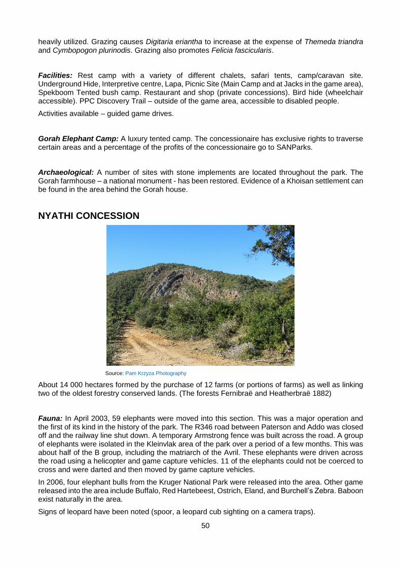
50
heavily utilized. Grazing causes Digitaria eriantha to increase at the expense of Themeda triandra and Cymbopogon plurinodis. Grazing also promotes Felicia fascicularis.
Facilities: Rest camp with a variety of different chalets, safari tents, camp/caravan site. Underground Hide, Interpretive centre, Lapa, Picnic Site (Main Camp and at Jacks in the game area), Spekboom Tented bush camp. Restaurant and shop (private concessions). Bird hide (wheelchair accessible). PPC Discovery Trail – outside of the game area, accessible to disabled people.
Activities available – guided game drives.
Gorah Elephant Camp: A luxury tented camp. The concessionaire has exclusive rights to traverse certain areas and a percentage of the profits of the concessionaire go to SANParks.
Archaeological: A number of sites with stone implements are located throughout the park. The Gorah farmhouse – a national monument - has been restored. Evidence of a Khoisan settlement can be found in the area behind the Gorah house.
NYATHI CONCESSION
Source: Pam Krzyza Photography
About 14 000 hectares formed by the purchase of 12 farms (or portions of farms) as well as linking two of the oldest forestry conserved lands. (The forests Fernibraë and Heatherbraë 1882)
Fauna: In April 2003, 59 elephants were moved into this section. This was a major operation and the first of its kind in the history of the park. The R346 road between Paterson and Addo was closed off and the railway line shut down. A temporary Armstrong fence was built across the road. A group of elephants were isolated in the Kleinvlak area of the park over a period of a few months. This was about half of the B group, including the matriarch of the Avril. These elephants were driven across the road using a helicopter and game capture vehicles. 11 of the elephants could not be coerced to cross and were darted and then moved by game capture vehicles.
In 2006, four elephant bulls from the Kruger National Park were released into the area. Other game released into the area include Buffalo, Red Hartebeest, Ostrich, Eland, and Burchell’s Zebra. Baboon exist naturally in the area.
Signs of leopard have been noted (spoor, a leopard cub sighting on a camera traps).

51
Biomes and vegetation: Subtropical Thicket, Afromontane forest in the kloofs, riverine forest along river courses, Fynbos and Grassland on the Zuurberg mountains (see Zuurberg section).
In 2003, three sets of exclusion plots were created in the old rhino camp area of the Nyathi area in order for studies to be done on the impact of herbivores on vegetation. Rhino have had access to the area between 1995 and 2003. More recently, after a period of 70 years elephant have been introduced.
Facilities: Nyathi Rest Camp, formerly known as Nguni Lodge – a 5 star, self-catering SANParks rest camp and Riverbend Country Lodge – a contracted partner and concessionaire.
Activities available: 1 and 3 hour horse trails.
ZUURBERG SECTION
Source: Pam Krzyza Photography
Named after the Zuurberg mountain range which runs west to east. A large section of this area is set aside as a wilderness area with little human activity taking place.
Height above sea level varies from 250 to 970m.
Mean annual rainfall is generally in excess of 600mm. Rainfall peaks in spring and autumn. Unlike other fynbos areas, the winter months are the driest. Thunderstorms occur in summer months when lightning fires can be caused.
Forms part of the Cape Fold Belt, consisting of hard quartzitic rock of the Witteberg Group with narrow bands of shale. The soils are generally more fertile and finely textures than soils of the Cape Fold Belt to the west.
The Sundays River is fed by the Kabouga, Krom, Groot Ui, Klein Ui, and Wit Rivers which rise in the Zuurberg Mountain.
Fauna: Mountain Zebra, Leopard, Mountain Reedbuck, Red Hartebeest, Eland, Common Duiker, Grysbok, Baboon, Grey Rhebok, Klipspringer, Black-backed Jackal, Caracal, Rock Dassie, Tree Dassie are among animals found in this area. It is believed that one of the largest concentrations of Blue Duiker in South Africa occurs over the Zuurberg and Kabouga area.
Biomes and vegetation: 33% Grassy Fynbos, 5% Mountain Fynbos, Afromontane forest (12%) and 18% Grassland. Subtropical Thicket (32%) in lower-lying areas.
A total of 1 100 species recorded (540 genera and 129 families).
52
Largest families are the Asteraceae (148 species) and the Pocaceae (90 species).
Three species of endangered cycads: Encephalartos longifolia, E. lehmanii and E. caffer. Several endemic succulents. Oldenburgia arbuscula (Zuurberg hunchback).
Afromontane forest: evergreen trees with canopy heights of 10-14m on south-facing slopes and valley bottoms. Trees with canopy heights of 2-9m on northern slopes and valley bottoms (actually grouped with Subtropical Thicket).
Mountain fynbos: highest species richness of Zuurberg’s vegetation types. Occurs on wet southern slopes and on sandy soils in low-lying areas. Low grass cover and high proportion of Restionaceae. Protea repens and Protea lorifolia occur in localised, inaccessible areas.
Grassy Fynbos: Occurs on all plateau tops and gentle northern and southern slopes in higher-lying areas. Sourveld with fynbos elements.
Grassland – Sweetveld where Proteas, Ericas and restios are totally absent.
Facilities: Narina Bush Camp near Slagboom – tented bush camp with four tents (sleep 2 people each). Access by car, horse trail or walking trail.
Activities available: Walking trails (one hour or four hour options) and horse trails (one hour, three hour and five hour options) available. Excellent bird watching.
History: 1896 – Department of Forestry proclaimed the area as a conservation and water catchment area. Forestry was only practiced to a limited degree on some of the higher-lying slopes.
The Zuurberg Pass was built between 1848 and 1858 by hundreds of convicts.
Several outspans (free resting places for travellers and their wagons) operated in the area at the time. One of the earliest was Hubbard’s on the banks of the Sunday’s River at Addo Drift. Another was situated at what is now Coerney Station. Stubb’s and Boontjies River were outspans on the Zuurberg Pass. Matthew’s Inn is today the Zuurberg Inn. Webster’s (Ann’s Villa) was at the foot of the northern slopes.
During the Frontier Wars, there were defence military posts at Addo Drift, Addo Heights, Coerney, Slagboom, Sandflats and Rietberg.
1985 – This area was proclaimed as the Zuurberg National Park – an area of just over 20 000ha.
1994 – This section joined to the Addo Elephant National Park.
2016 – A memorial was erected to commemorate an incident in the area that occurred in December 1811 when Andries Stockenstroom and a party of men were murdered at Doringnek whilst negotiating with a group of Imidange under the leadership of Xasa and some Khoi under the leadership of David Stuurman. The negotiation was in respect of the Xhosa vacating the Eastern Cape area and moving back to beyond the Fish River in exchange for a sum of money rather than fighting a war. Stockenstroom was mistaken to be the head of the British army and it was thought by his attackers that killing him, which they did, would collapse the British war effort. This murderous act led to the start of the Third Border War of 1811 – 12 in which 20,000 Xhosa under Ndlambé were forced back across the Fish River by the British Army under the leadership of Colonel John Graham assisted by Piet Retief and his commando from Stellenbosch. Piet Retief later married the widow of Andries Stockenstroom. Retief too was murdered some years later during peaceful negotiations with the Zulus under King Shaka.
Archaeological: Melkhoutboom Cave where artefacts dating back 15 000 years have been excavated. This indicates that the Cape Fold mountains where a prime focus of prehistoric settlement.
53
A large number and range of plant species (prehistoric food waste) was discovered. The record shows that roots, tubers, corms and bulbs of the families Hypoxidaceae and Iridaceae provided the staple food for the hunter-gatherers. The corms of Watsonias appear to have been a staple food. At certain times of the year. Seeds were collected from Schotia latifolia, Podocarpus falcatus (Outeniqua yellowwood), Calodendrum capense (Cape Chestnut) and Pappea capensis (Jacket plum) – the latter three species all have high oil content in their seeds. Harpephyllum caffrum (Wild plum) and a cycad species were also used.
Red grass (Themeda triandra) was used as bedding. Netting was made from Cyperus textilis and the reeds Phragmites communis were used to make arrow shafts.
Animal remains indicate that Steenbok, Grysbok and Kudu were eaten. As all these antelope are nocturnal and prefer thick bush, it seems that passive hunting by means of snares was preferred.
Stone tools were used for hunting, cutting up carcasses, scraping hides, leather work and wood work. They are generally of a very small size which indicates that they may have been mounted on a bone or wooden handle.
There are indications that the hunter-gatherers occupation of these mountainous sites was in the summer months. One reason for this may be that the corms of Watsonias become less palatable in autumn and winter. During winter they exploited the coastal areas. Evidence of this is indicated by the presence of marine shells in all the shelters. The commonest marine species found are the white sand mussel and an estuarine shell. The shells appear to have been used for decorative purposes.
Numerous San paintings can also be found in the Zuurberg Mountains such as the two sites in caves near the existing tourist facilities, while the mountains were also the staging grounds for a number of conflicts during the Anglo-Boer War
KABOUGA SECTION
This is located in The Kabouga and Pietersenskraal areas. Some of the land in this area has been rehabilitated via the poverty relief program.
The Kabouga River is an important migration route for eels of the family Anguillidae. They use the river as a route from the ocean to their maturation grounds in the upper reaches of the river. The river’s importance as a migration route has been exacerbated by the transformation of the flow of the Sundays River due to human impact (dam, irrigation canals etc.).
Fauna: Leopard, Bushbuck, Kudu, Common Duiker, Blue Duiker, Caracal, Baboon, Lynx, Jackal, Bush pig, Mountain Reedbuck, Hippo, Warthog, Klipspringer, Red Hartebeest and Ostrich (last five species all introduced) are among the animals in the area. Over time, the Klipspringer have disappeared.
Biomes and vegetation types: valley bush thicket, afromontane forests and riverine thicket, as well as the vegetation types which occur on the Zuurberg mountains which traverse this area.
Facilities: Kabouga guest house sleeps six people.
Mvubu Camp – camp site with braai places and a basic shower and toilet – fishing is allowed in this area.
Bedrogfontein 4x4 trail – start at Kabouga to Darlington (one way). Minimum time – 6 hours. Options of difficult river crossings.

54
Source: https://www.mountainpassessouthafrica.co.za
History: The Bedrogfontein 4x4 route follows a pass built by Sir Harry Smith. It featured during the Anglo Boer War when a commando under the leadership of General Smuts was involved in a skirmish with a British force that was moving up the pass. A number of British soldiers and horses died during this event which took place shortly after many in the Boer commando had suffered severe food poisoning after eating the green fruit of cycads. Names of soldiers can be seen carved into some of the trees. There are San Rock paintings in the area.
DARLINGTON DAM SECTION Source: SANParks.org
This section (52,000 hectares) comprises the area surrounding the Darlington Dam (formerly known as Lake Mentz) which supplies irrigation water to the Sundays River Valley. The Fish-Sundays River Canal Scheme comprises a canal and tunnel system which supplies Orange River water via the Great Fish River valley to the Sundays River valley to supplement existing water
supply in the Eastern Cape.
The area has been fenced off and game has been introduced. A contractual agreement with the private Kuzuko Game Reserve was concluded and the fences were dropped increasing the area to 66 000 hectares. Poverty relief projects have been part of the land rehabilitation program
Since 1992 water from the Sundays River valley has been supplied to Port Elizabeth. It is estimated that up to 200 million m3 of Orange River water could eventually be transferred to the Port Elizabeth metropolitan area annually.
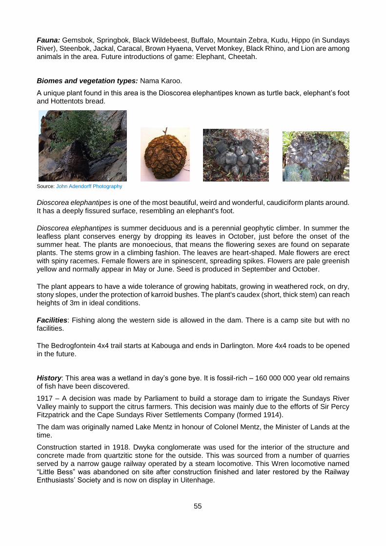
55
Fauna: Gemsbok, Springbok, Black Wildebeest, Buffalo, Mountain Zebra, Kudu, Hippo (in Sundays River), Steenbok, Jackal, Caracal, Brown Hyaena, Vervet Monkey, Black Rhino, and Lion are among animals in the area. Future introductions of game: Elephant, Cheetah.
Biomes and vegetation types: Nama Karoo.
A unique plant found in this area is the Dioscorea elephantipes known as turtle back, elephant’s foot and Hottentots bread.
Source: John Adendorff Photography
Dioscorea elephantipes is one of the most beautiful, weird and wonderful, caudiciform plants around. It has a deeply fissured surface, resembling an elephant's foot.
Dioscorea elephantipes is summer deciduous and is a perennial geophytic climber. In summer the leafless plant conserves energy by dropping its leaves in October, just before the onset of the summer heat. The plants are monoecious, that means the flowering sexes are found on separate plants. The stems grow in a climbing fashion. The leaves are heart-shaped. Male flowers are erect with spiny racemes. Female flowers are in spinescent, spreading spikes. Flowers are pale greenish yellow and normally appear in May or June. Seed is produced in September and October.
The plant appears to have a wide tolerance of growing habitats, growing in weathered rock, on dry, stony slopes, under the protection of karroid bushes. The plant's caudex (short, thick stem) can reach heights of 3m in ideal conditions.
Facilities: Fishing along the western side is allowed in the dam. There is a camp site but with no facilities.
The Bedrogfontein 4x4 trail starts at Kabouga and ends in Darlington. More 4x4 roads to be opened in the future.
History: This area was a wetland in day’s gone bye. It is fossil-rich – 160 000 000 year old remains of fish have been discovered.
1917 – A decision was made by Parliament to build a storage dam to irrigate the Sundays River Valley mainly to support the citrus farmers. This decision was mainly due to the efforts of Sir Percy Fitzpatrick and the Cape Sundays River Settlements Company (formed 1914).
The dam was originally named Lake Mentz in honour of Colonel Mentz, the Minister of Lands at the time.
Construction started in 1918. Dwyka conglomerate was used for the interior of the structure and concrete made from quartzitic stone for the outside. This was sourced from a number of quarries served by a narrow gauge railway operated by a steam locomotive. This Wren locomotive named “Little Bess” was abandoned on site after construction finished and later restored by the Railway Enthusiasts’ Society and is now on display in Uitenhage.
56
The labour force at the peak of construction was about 480 people. In October 1918, an influenza epidemic killed more than 20 of the labourers.
The dam wall was completed in 1921 and the dam was officially opened in 1923. It was only filled to capacity for the first time in 1928 as a result of the drought. When filling up, the dam flooded the town of Darlington.
COLCHESTER SECTION
This section (13 000 hectares) comprises the area south of the Addo Heights Road. It was formed by the purchase of the Olifantsplaat and Vetmaakvlakte farms. The area has natural water pans dug out by the elephants over 1,000’s of years.
An entrance road from the N2 at Colchester enters the Park at Matyholweni and provides access to the Main Camp area via a network of roads and loops. Together with the Main Camp Area, Colchester section forms one ecological functional unit of 26 000 ha. The fence separating the two areas was removed in 2006.
Fauna: Generally the same animals found in the Main Camp Area.
Biomes and vegetation types: Subtropical Thicket.
Facilities: An exclusive rest camp (named “Matyholweni”) has been developed close to the entrance gate. It has 15 self-catering chalets all with satellite TV and air conditioning. It is planned to develop a caravan park, picnic site and a bush camp in the section.
History: J.T. Harvey owned some of the land in this area. Harvey originally hunted elephants in the area (before the park was proclaimed) but later gave sanctuary to the last remaining 16 elephants (after Pretorius’ hunting session). The elephants were rounded up from Harvey’s land in 1931 by the first Park Warden, Trollope, to drive them into the park area. 11 survived and made it into the reserve.
Fossils and stone artefacts have been found in the area.
Harvey’s loop is located on the original old Harvey farm. Vukani loop is named after Harold Trollope who rounded up the remaining elephant in 1931. Vukani means ‘Wake up; Wake up’, the traditional name by which he was known. He was an early riser and made sure that his team were up and about the same time that he was.
A number of ‘bee’ projects are being carried out in Colchester. Bees and elephants do not make comfortable companions and when it comes to a show-down, generally the bees win. In an endeavour to protect particular plants and structures from the elephants, bee hives have successfully been introduced as a deterrent. A major problem here is the presence of Badgers that attack and destroy the hives in their quest to get to the honey. They are skilled and determined.
Colchester forms an integral part of the water gradient for the elephants. The area has been purposefully kept short of water and the supply is carefully regulated. A non-homogenous landscape has been allowed to develop. Under normal circumstances it gets dryer further away from a river or other natural water source. Normally the animals congregate in the vicinity of the water supply. As the supply dries up the animals are forced to move further away in search of food and water. In the case of Colchester water pans form after the rains thus attracting the elephants. The elephants move to these and when they are dry the elephants move back to the Main Camp Area. As a result there is good seasonal use of the park.

57
WOODY CAPE SECTION
Source: Pam Krzyza Photography
This section comprises land between the mouth of the Sundays River and Woody Cape. The mean annual rainfall varies from 392mm at Sundays River Mouth to 700mm near Woody Cape and 900mm in the Alexandria Forest. Boknes to Bushman’s River Mouth is the transition zone from all year rainfall to summer rainfall. The dunefield occurs in a rain shadow which receives lower rainfall than both Port Elizabeth and Alexandria. Fog and mist are common, with frost being rare.
Fauna:
The rare Damara tern, Black oystercatcher and White-fronted plover breed above the mean high water mark between October and March. The juvenile birds however forage in the beach zone.
Within the dunefield the only endemic vertebrate is the pigmy, hairy-footed gerbil (Gerbillurus paeba exilis), while the Damara tern is a rare, breeding resident species. The only known endemic invertebrate is a species of locust (Acrotylus hirsutus) which inhabits the dune slacks.
In the forest there are the rare tree dassie and crowned eagle.
Kudu, Common Duiker and Grysbok also occur in the area. Sightings of leopard spoor occur every so often. Oribi were introduced in 2004.
Biomes and vegetation types: Rare and endemic plant species have been estimated at five percent of the total. Known plant endemic species are Smellophylum capense, Sterculia alexandri and Atalya capensis. The rare cycad Encephalartos arenarius has a large population in the reserve.
On the western border of the dunefield 36 dune slacks are found 5 - 18km east of the river mouth. The vegetated slacks are seen as open but discrete functioning ecosystems. Birds breed in these areas and the vegetation is sensitive. Vehicle tracks in these areas are visible for long periods.
The Alexandria dunefield is the largest and least degraded coastal dunefield in South Africa. It has a maximum width of 3km. The average height of dunes is 30m (height from dune top to dune bottom) while the tallest dune is 140 metres above mean sea level. Fossil dunes landward of the dune field, which now form part of the Alexandria forest area, reach 350 metres. Transverse dunes (transverse to the sea) are the dominant dunes on the dunefield due to the prevailing south-easterly wind. Sand moves at a rate of 20 cubic metres per metre of width per year on the dunefield and 350 000 cubic metres of sand moves into the dunefield per year. The dunefield gets about 3mm thicker each year. The landward face of the dune (where the vegetation starts) moves further inland at 0.25m per year. This dunefield has been growing for about 6.5 million years (which was when the sea moved to its

58
present level). Bush pockets occur in the valleys of transverse dunes near the back of the dunefield. There is a definite zonation of vegetation in these pockets with the most mature vegetation being at that face of the pocket that moves. Dune pockets move at about 3-5m per year, the same rate at which dunes move. The dunefield is an important link between the terrestrial and marine environments and supports some key biological processes.
Facilities: Accommodation is available in the Langebos huts (8 people) and the fire-tower (2 people).
Activities: Alexandria Hiking Trail – a 2-day trail with overnight accommodation in huts.
History: 1896 the area was proclaimed un-demarcated State Forest. The farm boundaries and State Forest boundaries were demarcated in 1915 and 1975. Until roughly 1950, large areas of the dunes were not fenced. Cattle farming was the dominant land use of the region prior to 1900, resulting in numerous trek paths over the dunes. Towards the latter 1960s the stabilizing of driftsand on a large scale was started. A start was made with the building of a littoral or foredune at the Sundays River mouth in 1970, with the aim of "stabilizing or regaining" the whole area. This included the planting of rooikrans and other alien vegetation. In 1979 a decision was made to revise the original policy as stabilization of the entire region could not be justified economically or ecologically.
In April 1987 Cape Nature Conservation took over the management of the ground from Forestry. In April 2002, South African National Parks took over the management of the area.
Originally a forestry station now combined with the Woody Cape Nature Reserve which includes a marine reserve (of about 120 000 ha), including Bird island and the St. Croix island group. Bird Island is home to breeding colonies of Cape Gannet and African Penguin. The Alexandria Dunefield covers approximately 15 800 ha (50km long and 3 to 4km wide) between Sundays River Mouth to the west and Cannon Rocks to the east and is internationally recognized as one the worlds’ largest and most important transgressive coastal dunefields. The dune system is extremely dynamic with sand being continually blown in, building up and traversing inland. The dunefield supplies water to the towns of Alexandria and Bushman's River Mouth from fountains and boreholes in the dunefield aquifer.
Archaeological: Khoi/San (Strandloper) settlements in the Alexandria dunes – remnants of which are midden sites comprising mostly fragments of harvested shellfish. Pottery fragments and primitive tools can also be found. There are 3 types of middens:
Those containing microlithic stone toolkits made from fine-grained materials (silcrete and chalcedony) found in caves and shelters inland. These people were most likely seasonal harvesters dating back 5 000 years.
Permanent residents of the dunes carved tools from quartzite and hornfels pebbles obtained from the beach. Their middens date back 4 000 years.
Middens deposited by pastoralists containing remains of domesticated herds. These middens date back 2 000 years.
The three rocky promontories in the region of Boknes have been called Kwaaihoek 1, 2 and 3. The name is presumably derived from the frequently inclement weather, especially the strong winds. The largest of these promontories is Kwaaihoek 3, which has significant historical importance. Prince Henry of Portugal sent Bartholomew Diaz on a mission to find a sea route around the tip of southern Africa in the 1480s. All along the route of his historic voyage, Diaz left limestone beacons as symbols of Portuguese sovereignty. The last cross erected was on Kwaaihoek 3 on 12 May 1488. By 1575 the cross was no longer evident and only in the 1930s did it receive any further attention. Prof. Axelson of Wits University found over 5 000 pieces of the cross and built a replica. The replica was erected on the 20 June 1941. This sank into the soft sand and required excavation on the sea-facing cliff. It is believed that the cross was later lost to the sea. Subsequently a second replica of the Diaz Cross was erected.

59
St. Croix Island was used as a whaling station in the 19th century. Numerous shipwrecks have occurred on the islands.
THE MARINE PROTECTED AREA
The marine section of the park, situated in Algoa Bay, falls within the warm temperate bio-geographic marine province, and consist of the Bird and St Croix island groups and surrounding waters. The Bird Island marine protected area (MPA) contributes towards the 9% of the South African coastline which is considered a no-take or completely protected area. The Algoa Bay marine environment is mostly influenced by prevailing easterly (summer) and westerly (winter) winds, driving the long shore ocean currents. There is also an important link between the Alexandria dune field and the ocean. These dunes are characterised by shallow groundwater tables (aquifers) with water discharged to the surface in several places in a pulsing fashion from the aquifer into the surf-zone, releasing nutrient-rich water. The wind and currents play an important role in sand movement and deposition in the Alexandria dune field system. The Bay consists mostly of soft bottom sediments and dispersed reefs.
Dominant marine fauna can be grouped into marine mammals (seals, whales, dolphins), birds (penguins, gannets, terns etc.), fish (migratory and reef species) and highly diverse benthic fauna on the reefs. The two island groups within the Bay are important as breeding grounds for birds and seals. A number of birds of conservation significance occur on the islands: the endangered African penguin Spheniscus demersus, comprising more than 50% of the world population, the Cape gannet Morus capensis, comprising 40% of the world population, the endangered roseate tern Sterna dougallii, and the endemic African black oystercatcher Haematopus moquini. The group represents the easternmost breeding range for this species (Heemstra and Heemstra 2004; Griffiths 2000). Algoa Bay also houses a large South African Cape fur seal Arctocephalus pusillus population. The South African Cape fur seal’s range is restricted to islands and the mainland coast between the rich fishing grounds of northern Namibia and Algoa Bay on the south-eastern coast of South Africa. This population of marine mammals also serves as a feeding area for the threatened great white shark Carcharodon carcharias. Furthermore, the islands provide sub-tidal rocky habitat for an extensive population of abalone Haliotis midae, although the stock is under pressure owing to illegal exploitation. Most reef fish species for example red stump nose Chrysoblephus gibbiceps, dageraad Chrysoblephus cristiceps and red steenbras Petrus rupestris are endemic and overexploited, with a similar situation for the surf zone fish such as dusky kob Argyrosomus japonicus and white steenbras Lithognathus lithognathus, with their populations having collapsed.
The larger 120, 000 ha proposed MPA would assist in rebuilding these stocks, as well as help protect important nursery areas for the juveniles of these species such as the Sundays River estuary and associated surf zone. This larger area will also offer protection to spawning areas for chokka squid Loligo vulgaris reynaudii, a commercially important species, as well as important feeding areas for the penguin population.
In April 2002, AENP took over the management of the Woody Cape Nature Reserve from the Department of Economic Affairs, Environment and Tourism (DEAET), which included all seven islands of Algoa Bay, approximately 110km of coastline stretching from Sunday’s River in the West up to Bushmen’s River to the East. However it was not a continuous protected area with 15km of coastline under the Ndlambe Municipality management between Cannon Rocks and Boknes.

60
Map of Algoa Bay indicating position of Bird Island MPA (yellow)
In June 2004, the area around the Bird Island Group was proclaimed a Marine Protected Area which covers approximately 20 square nautical miles around Bird Island. In February 2008 a separate marine unit was formed in order to ensure the objectives of the MPA were met. These objectives are (in no order of priority):
Objective 1: To promote the conservation of sea birds
Source: http://a-z-animals.com
The African Penguin, Spheniscus demersus used to be South Africa’s most abundant sea bird and is endemic as a breeding species to Southern Africa and mostly occurs within 20km. The population has suffered a massive decline since the 1920s when there were estimated to be over 1 million breeding pairs. Today their population stands at about 2.5% of what it used to be 80 years ago and with more than 50% decrease in three recent generations.
The African penguin is currently listed as an endangered species moving towards Critically
Endangered. The main reasons for the drop in African Penguin numbers is due to historical activities such as egg collection, habitat modification on breeding islands by the removal of guano which is an

61
essential material for penguin burrow nests. Oil spills are responsible not only for killing many of these birds but also for affecting breeding success of surviving animals despite human rescue efforts. As the main prey species of the African Penguin are small pelagic fish, their presence is correlated with abundance of sardine and anchovy, a food source that is competed for with purse seine fisheries.
The Addo Elephant National Park is responsible for the management of approximately 50% of the total population of African Penguins. St. Croix Island is the largest breeding colony throughout their range and faces a major challenge with the development of the IDZ of Coega.
The Minister of Environmental Affairs approved and signed the Biodiversity Management Plan (BMP) in October 2013. This outlines several programmes to reduce their population decline which are in place such as Chick Bolstering, provision of artificial houses and predator culling. These programmes require intense monitoring and management.
Objective 2: To conserve/promote the last viable population of abalone stocks
Source: http://www.sanbi.org
Abalone fisheries around the world have collapsed or are facing collapse due to abalone harvesting, legal and illegal, at unsustainable levels. Perlemoen (Haliotis midae) in particular is under intense pressure from highly organized illegal collection which has risen dramatically since the 1990s (Hauck and Sweijd, 1999; Tarr, 2000). Illegal fishing has rendered traditional management measures to sustain a rights-based fisheries ineffective.
Authors such as Tarr (2000) and Steinberg (2005) link the rise of the illicit abalone trade in the 1990s to numerous factors including the large demand for this resource in Asia which is an exceptionally profitable trade believed to be run by Chinese triads and other organized criminal enterprises on a national and international scale (Gastrow, 2001; Steinberg, 2005; Willock et al.2004).
Bird Island’s abalone population is considered to be the last remaining viable stock in the Eastern Cape and as such serves to play a critical role in the re-seeding of previously exploited areas.
Objective 3: To conserve/promote the recovery of linefish stocks
Source: http://showme.co.za
In December 2000, the Minister of Environmental Affairs declared a State of Emergency in the South African Line Fishery and recognized the urgent need to rebuild overexploited linefish stocks. The majority of marine resources are overexploited and several of these species are threatened (DAFF 2012). Over 630 different species are caught in the fishing sector (commercial, subsistence and
recreational) and fishing is identified as the greatest driver of marine ecosystem change and greatest pressure on Marine biodiversity in this country (Lombard et al 2004, Sink et al 2012).

62
Reef fish are particularly susceptible to overexploitation due to their longevity, slow growth rates, late maturity and high residency (Buxton 1993; Brouwer and Griffiths 2005). Many species also exhibit complex life history strategies including serial hermaphroditism with size-based sexual dimorphism. These life history characteristics coupled with high fishing pressure exerted by the commercial and recreational linefish sectors, and inefficient and poorly enforced management regulations have resulted in a steady decline in fish stocks (Sauer et al. 2003). Analysis of national linefish catch data has shown that catch-per-unit-effort (CPUE), an indicator of the abundance and status of fish stocks, declined by 90% over the twentieth century (Griffiths 2000). This resulted in the line fishery being declared to be in a state of emergency in December 2000 leading to a revision in management regulations and reduction in effort in the commercial sector (Sauer et al. 2003). However, while size and bag regulations were amended for the recreational sectors over this period, effort remained unlimited and the recreational sector therefore continued to contribute significantly to the overall harvest of linefish. A recent estimate of the recreational harvest indicated that it may be as much as twice that of the landed weight of the commercial sector (Atkinson and Clark 2005) and recreational ski boat angling is estimated to have contributed 20-80% to the catches of at least nine collapsed stocks in South Africa (Griffiths and Lamberth 2002). Several reef associated species are also landed as bycatch in the commercial trawl fisheries, further contributing to their dire status. Marine Protected Areas are a valuable means for management of linefish resources as they afford breeding populations protection in spatially defined areas in which strict monitoring and control of activities can be enforced. This increases the chances of successful spawning events contributing to larval dispersal into adjacent fished areas and may contribute to density dependent spill over of mature fish as the stocks recover.
THE PROPOSED GREATER AENP MPA
The proposed MPA will stretch from Canon Rocks in the East to the Coega Port in the West. This encompasses all the area below the high water mark. It includes Bird Island and the St Croix Island groups of islands as well as the marine area in between and back to the shore. The Sunday’s River Estuary is included in this MPA. (See Appendix C)
The MPA is divided into restricted and controlled zones. Restricted zones are indicated in dark blue and controlled zones are indicated in light blue on Appendix B.
St Croix Island is situated in Algoa Bay, located 4 km from the land at the nearest point and is 21km north-east of the harbour at Port Elizabeth. There are two nearby islands, Jahleel Island, 6km to the west, and Brenton Rock, 2km to the south.
The Bird Island group of islands is located 47km east of St Croix Island on the eastern edge of Algoa Bay, opposite Woody Cape and is situated 8,4km from the coast. This group comprises Bird Island, which is the only manned island in Algoa Bay, Stag Island, Seal Island and Black Rocks.
St Croix Island has an area of 11,9ha, a long axis running roughly north-west to south-east, with a prominent ridge rising to 53m along this axis. The ridge slopes gradually down to sea level on most of the north side with few level areas, except near the north-west end. On the south side the ridge drops off precipitously for part of its length, and steeply for the remainder, to the flat area below. Most of the flat areas on the island are located on the south side.
The island is composed of Table Mountain Sandstone, a resistant quartzitic rock. Substrate is mainly bare rock with a thin layer of stones, sand and guano, particularly in the low lying areas. The island shelves off rapidly into water about 10m deep on the south side. There is a narrow intertidal area which broadens on the south and east sides.
Bird Island is a low flat island, rising to 9m above mean sea level at its highest point, with an area of 19ha. Bird Island was previously regularly scraped for guano, but it was last scraped in 1989. In November 1994 the contractors removed all their stockpiled guano and scraping equipment from the island. Guano scraping penetrated down to the fossil beds of the islands. The holes formed present a problem for breeding gannets as they fill up with water. The holes therefore have to be periodically drained by staff.

63
The Sundays River from the estuary up to where the power lines cross the river is included in the MPA.
Seas of the south-eastern coast of Africa are dominated by the warm Agulhas Current, with core surface temperatures varying from 22°C in August to 27°C in March. The Agulhas current flows in a south-westerly direction closely following the continental shelf until near East London where it diverges from the coast.
Within Algoa Bay currents flow predominantly northwards and eastwards, which is related to the dominant south-westerly winds. Reversals do occur, presumably in response to winds with an easterly component, but in general circulation is cyclonic. Mean sea surface temperatures at a point about 10 km south of Cape Recife show a marked seasonal pattern with mean temperatures of about 16°C in August rising to about 21°C in January. The large ranges in sea temperatures in February especially are related to the high incidence of winds with an easterly component at that time, which are thought to be responsible for upwellings which develop from time to time.
Fauna: Fourteen species of sea-birds, three species of shorebirds and 33 species of terrestrial birds have been recorded at the islands.
The Cape Gannet colony at Bird Island is the largest gannetry in the world. The population is currently estimated at +-180 000 individuals.
The breeding season extends from the beginning of September to the end of March. Gannets do not breed at any other Algoa Bay island. They are highly susceptible to disturbance during the egg-laying phase. Gulls prey on Gannet eggs and chicks.
The African Penguin colony at St Croix is the largest in the world. It is estimated that there are over 50 000 African Penguins in Algoa Bay (60% of population), with over 40 000 of these on St Croix alone. The latest figure for the Bird Island group is 10 000 birds. At St Croix there are three egg-laying peaks (January; March/April; and June/July). The penguins moult annually, with a peak in late October/early November. African Penguins are highly susceptible to disturbance throughout their breeding cycle. The African Penguin is classified as rare and endangered.
Bird and St Croix Islands are the only two South African localities where Roseate Terns breed. The South African population is approximately 500. They breed in winter, from June to September, and are extremely susceptible to disturbance. Roseate Terns are classified as endangered in the Red Data Book, which reflects their position in a southern African context. Internationally they are not endangered. Almost the entire Indian Ocean breeding population of Antarctic Tern roosts on Bird Island during the winter.
Seals and sea-birds which breed and rest on the islands play an integral role in the functioning of the marine ecosystem of Algoa Bay. The most easterly breeding colony of Cape Fur Seals (Arctocephalus pusillus), is situated at Black Rocks in the Bird Island Group.
About 10% of South Africa’s endangered Humpback Dolphin frequents the area.
Two lizard species are present at St Croix, Cordylus cordylus and Pachydactylus maculatus. The latter exhibits gigantism at the island. In February 1996 a snake was killed at Bird Island. It is thought to have been introduced on a helicopter flight.
Bird Island is the only South African coastal island where wing reduction occurs in flies. Not much is known about other insects at the islands.
The only introduced mammal on the islands is the house mouse, which occurs at Bird and St Croix Islands. The European rabbit formerly occurred at Bird Island, but was eradicated in 1990.
Since rabbits have been removed from the Bird Island the M. aitonis has grown a lot denser. Roseate terns rely on sight as a defence mechanism. In 1994 black-backed gulls use this dense vegetation to stalk nesting roseate terns. No chicks fledged. This vegetation behind the lighthouse was cleared in 1995 as an experiment to determine whether there would be an increase in breeding success. The experiment was successful, with 220 chicks fledging in the 1995 breeding season.

64
Vegetation: On St Croix vegetation is confined to the top of the ridge. Seventeen species of plants have been recorded. The dominant species is the indigenous fleshy annual herb Mesembryanthemum aitonis. Both, Jahleel and Brenton carry substantially more vegetation than St Croix. M. aitonis is also dominant at Bird Island, where 33 species of terrestrial plants have been recorded. Twenty of these have been classified as alien to the island.
History: Both were formerly under control of the Guano Islands section of the Division of Sea Fisheries. East Cape Nature Conservation, which subsequently became the Directorate of Nature Conservation of the Eastern Cape Province, has managed them since April 1992. In 1981 the St Croix Island group, St Croix, Jahleel and Brenton and the sea area 300 meters around each, was proclaimed as South Africa's first island marine reserve. This was extended to 500m in 1991. In 1987 the Bird Island group was proclaimed a reserve, and transferred to the Chief Directorate Nature and Environmental Conservation) of the Cape Provincial Administration in April 1992. In April 2002, Woody Cape was transferred to SANParks.
The south western section of the area is at risk resulting from the development of a deep water harbour in the mouth of the Coega River. This harbour was developed to improve the service to international shipping and to take pressure of the Port Elizabeth harbour.
IMPORTANCE OF THE GREATER ADDO ELEPHANT NATIONAL PARK MPA
National and bioregional importance
Conservation of marine biodiversity consists of protecting a representative of different habitats, processes and threatened species in a particular area (Lombard et al. 2004; Gell & Roberts 2003).The AENP MPA falls within the Agulhas bioregion which stretches from Cape Point in the south west to the Mbashe River north of East London. Several features of the bioregion are still in need of protection. These include the intertidal habitats and reef systems down to 30m. The Addo MPA adds to the protection of several of these features, including high levels of endemism of fish, invertebrates and seaweeds.
Further, the Minister of Environmental Affairs & Tourism declared a state of emergency in the South African line fishery in 2000 (Government Gazette No. 21949 of 2000). The poor state of linefish species was attributed to three factors:
unrestricted fishing effort,
poor compliance, and
vulnerable life histories of the fish.
In support of this, it was found that extractive use of living marine resources was identified as the overriding threat to South African marine biodiversity. Fishing pressure was top of the list of 10 biodiversity threats identified and immediate intervention was proposed by Lombard et al. (2004). With the highest levels of linefish endemism along the coast, the Addo MPA will play an important role toward conserving and building up linefish stocks. The islands in Algoa Bay also have the largest breeding colonies for the threatened Cape gannet and endangered and African penguin along the SA coast. Algoa bay is also a log spiral bay with sandy beaches which are underrepresented nationally.

65
Important features of the Addo MPA
Habitats and associated biological importance
The AENP MPA contains a mosaic of different habitats including sandy beaches, two rocky headlands (Woody Cape; Cape Padrone), one permanently open estuary (Sundays River), two island groups (St Croix; Bird Island), subtidal / offshore reefs, and soft muddy/ sandy offshore bottom sediments. Each of these habitats has a distinct and different importance to the biodiversity that they sustain, and these are described below.
Sandy beaches
Sundays beach and the associated Anaulus australis (diatom) zone is the longest and most productive sandy beach nationally (CES 2001). This productivity is due to the freshwater seepage from the dunefield aquifer into the surf zone. The diatom A. australis forms the basis of the surfzone food chain in Algoa Bay (Newman & Nell 2002). Sandy beaches also play an important role in the feeding of certain linefish species e.g. white streenbras and kob. The sandy beach surfzone is an important nursery habitat for fish larvae within the bay (Pattrick 2007). The protection of this feature will contribute significantly to the national target for sandy beaches.
Rocky headlands
The intertidal rocky shores play a vital role in the ecology of the nearshore ecosystem, providing suitable habitat for the protection and growth of sedentary and resident reef-associated species. These include benthic invertebrates (mussels, limpets, abalone etc.), seaweeds and fishes. Although this habitat type comprises a small portion of the total AENP MPA, it contributes significantly to the total diversity of organisms. Woody Cape is also associated with cold water upwelling and high productivity in the area (Port Alfred upwelling cell). This type of flat reef is presently underrepresented in other protected areas along the coastline of South Africa and will contribute to the national target.
Estuaries
Permanently open estuary (Sundays River Estuary):
Estuaries are unique environments where environmental factors such as water temperature, salinity and turbidity changes with time of day, with the tide and with season. This makes the biodiversity that it sustains unique because the organisms need to be adapted to live with such environmental changes. The middle reaches of the estuary, where freshwater mix with seawater, is particularly productive and sustains large plankton communities.
Permanently open estuaries in the warm temperate region (Agulhas bioregion) are considered endangered environments. Currently the protection status of this environment is very low, while threats such as fishing, development and pollution are considered high. The Sundays River Estuary is in the top quarter of 250 South African estuaries in terms of conservation value (Turpie 2004). It has an important nursery and feeding function for fish. Several important coastal fishery species (e.g. dusky kob, spotted grunter, white steenbras and leervis) are wholly dependent on estuaries as nursery areas. Open estuaries are also important for nutrient input into the marine environment and insures the land-sea process integrity. This will contribute significantly to the national estuarine target.
Island groups:
Two island groups are located in Algoa Bay, the islands of the Cross (St Croix, Jahleel, Brenton) situated near Coega and the Bird Island group (Bird, Seal, Stag, & Black Rock) situated near Woody Cape. These islands are the only important seabird islands along an 1 800km stretch of coastline between Dyer Island near Hermanus in the Western Cape Province and Inhaca Island in Mozambique. The islands are classed as Important Bird Areas (IBA), because they regularly hold significant numbers of globally threatened bird species as well as holding large concentrations of seabirds (Barnes 1998). Five keystone species occurring on the islands are African Penguin, Cape Gannet, Roseate Tern, Antarctic Tern and Kelp Gull. It hosts the largest breeding colonies for both the endangered Penguin and threatened gannets in SA.

66
The islands also form ecological distinct subtidal habitats, containing many endemic species of invertebrates, seaweeds and fish. Bird Island is of particular importance to the threatened abalone. Black Rocks is an important seal breeding colony, and associated with a great white shark feeding area. Conservation of these islands will complete the national target.
Subtidal / offshore reefs (10-30m depth):
These areas were identified by the National Spatial Biodiversity Assessment as in need of protection. The reefs sustain high biodiversity of sessile/benthic invertebrates endemic to the area. It also received a threat rating of 9/10 for extractive living marine resource use (Lombard et al. 2004). Algoa Bay has the highest number of endemic fish species occurring along the whole South African coast. This is due to the overlapping of both west coast and east coast species in this region. High diversity of endemic species in Algoa Bay includes fish (34%), benthic invertebrates (45%), seaweeds (38%), and sandy beach macro fauna (53%). This will contribute significantly to the conservation of endemic reef fish.
Soft muddy/ sandy offshore bottom sediments.
Not much is known about these environments, however these areas are already protected from bottom trawling through national legislation. Current threats are dredging and dumping of sediments by the Coega Harbour Development. Conservation of these sediments will contribute to the national target.
Processes and associated biological importance
Important processes that take place in the MPA consist of both abiotic (environmental or climatic) and biotic (biological) processes (Lombard et al. 2004). The important abiotic processes are: 1) freshwater flow from the river into the estuary and 2) estuarine nutrient rich water flow into the marine environment, 3) freshwater seepage from the dunes into the surf zone, 4) longshore (west to east) sand distribution by wind and currents and 5) the upwelling of cold nutrient rich water (Port Alfred upwelling cell). The biodiversity importance of these processes is as follows, the freshwater seepage from the dunefield supports the growth of a diatom, Anaulus australis which constitutes the basis of the food chain in the Algoa Bay surfzone. The upwelling cell to the east of Bird Island supports major productivity in the area of the capes as well as playing an important role in the climatic conditions associated with the productive dairy farming industry. Freshwater flow into the estuary is important to sustain environmental parameters (e.g. turbidity, salinity) and biological productivity. In turn the estuarine water supplies nutrients the nearshore environment, as well as chemical cue’s for organisms needing to find the estuary (e.g. fish and mud prawn larvae, adult fish).
Connectivity between habitats is important to maintain both biological and physical processes. This means that the biotic processes are maintained between the environments e.g. freshwater flow from estuary to sea or sand movement from beach to dunefield is undisturbed by anthropogenic processes. Connectivity of biological processes also means that organisms (fish) can move freely between different habitats e.g. adult kob can move undisturbed from the surf zone into the estuary, and back into the bay after spending time feeding in the estuary. Other biotic processes (Lombard et al. 2004) are the use of the Sunday’s estuary and the associated surf zone by larvae and juveniles of several important fish species as a nursery ground. The adults of specifically kob, white steenbras, leervis, and Cape stumpnose use the areas as feeding grounds, while large aggregations of kob take place around St Croix Islands and associated reefs (feeding areas for both large and small kob). These processes are important for the completion of the lifecycles of several species. This means that without the nursery and feeding ground function that the estuary plays, these fish could not grow, mature, and reproduce.

67
6. SPECIES INFORMATION & IDENTIFICATION
Basic information is provided here on some species (not all) in the park. It is expected of a guide that they are able to identify all the species and to have a detailed knowledge of animal behaviour.
No numbers of animals are included in this document. This information changes from time to time and is available from Reception.
Lists can be downloaded from the AENP website for all the different species. (See Appendix D).
Mammals
Identifying features of mammals:
Mammary glands
3 ear ossicles (bones in the ear)
External ear
Hair on the body
External testes (except elephant, dassie, and some marine mammals)
Key – SA Red Data Book – (2004) Status.
CE = Critically Endangered E = Endangered V = Vulnerable NT = Near Threatened I = Introduced
All other species are classified as “Least Concern” or “Data Deficient”
Elephant Loxodonta africana
Source: https://en.wikipedia.org
There are 2 subspecies of African elephants: African savannah elephant (Loxodonta africana africana) and African forest elephant (Loxodonta africana cyclotis). Addo’s elephants are the former subspecies. The Indian elephant (Elephas maximus) shows many different characteristics to the African elephant.
Cows are generally tuskless in Addo – there are only a few elephant cows in the park with tusks). This is the result of the geographic isolation of the population and the small (original) population size causing non-selective genetic changes. Research indicates that the opinion that differences are a result of hunting selection (for ivory) in the 19th century or a result of the characteristics of the region’s vegetation are unfounded. Tusklessness has increased since the formation of the park in 1931. An elephant’s tusks play an important role in feeding. The elephant uses these elongated incisor teeth to help in breaking off branches, stripping bark and digging up roots and water. Males may use them in fights.
(See Appendix E for more information on the elephants)

68
Differences between African and Asian elephants:
Characteristic African elephant Asian elephant
Scientific name Loxodonta africana Elephas maximus
Weight 3.5 – 7 tonnes 3 – 5 tonnes
Shoulder height 2.5 – 4 metres 2 – 3.5 metres
Shape of back concave Convex
Ears Larger and shaped like Africa Smaller and shaped like India
Hairiness Less hairy More hairy
Teeth Chewing surface of the tooth has lozenge-shaped loops
Chewing surface of tooth has parallel loops
Tusks Both males and females have tusks Males have tusks. Females have no tusks or very small tusks
Trunk Tip of the trunk has two prehensile “fingers”
Tip of the trunk has one prehensile “finger”
The gestation period is 22 months. Calf weighs about 110 kg at birth. Generally one calf is born.
As far as is known, twice in Addo’s history have twin elephants been born (this has never been documented in Kruger but has been documented in Etosha). In October 1998, twins (both female) were born but one died at the age of 2 months. In April 2003, twins Des and Dawn (one male, one female) were born but the female died at the age of about 1.5 months. In both cases, it was obvious that one of the twins gradually lost condition and suckled less frequently than the other.
Elephants reach maturity by about 12 years. Young bulls will leave the breeding herd at this age (or be forced to leave by the older cows if they don’t leave of their own accord) but young cows will remain with their herd. Herds are led by a matriarch (head cow). Therefore all the females in a family group are related.
Bulls congregate in small bachelor herds (which are very loose associations, i.e. bulls leave and join freely) or are solitary, except when they join female herds to breed.
Bulls come into “musth” – raised testosterone levels that signify their readiness to breed. Bulls in musth will urinate frequently on their hind legs and a secretion from the temporal gland will run down the sides of their head between the eye and the ear. They may be aggressive during this stage and will cover long distances in search of cows in oestrus. Once they locate a cow in oestrus, they will stay close by and attempt to mate with her.
A number of males in the park father elephant calves but the population is genetically homozygous i.e. there is not genetic variation from one individual to the next. For this reason SANParks introduced the Kruger bulls into the park. 8 Kruger bulls (4 in the Addo area and 4 in the Nyathi area) have been introduced. Some of these have died as a result of fighting. The park is a limited space which restricts young bulls from moving off and establishing themselves is areas. There is no escape for them. This results in a high conflict potential with the older bulls as the youngsters move in making the Addo bulls quite aggressive towards contenders – more so than in the Kruger National Park.
Longevity is about 55-60 years. Cows are longer-lived than bulls (probably due to more fighting between bulls). The elephant population doubles every 13.6 years.
Elephants consume between 200 and 300 kg of plant material per day and spend about 75% of their time eating. They drink between 150 and 200 litres of water daily.
Research has indicated that elephants in the AENP utilize over 70 plant species. The succulents spekboom (Portulacaria afra) and Platythyra haeckeliana and couch grass (Cynodon dactylon) are dominant in their diet (NB: this study was during the winter months). Only one other grass (Panicum
69
deustum) featured greatly in their diet. Elephants consume about 36.4% grasses, 39.6% shrubs, 16.0% succulents and 8.1% forbs (volume eaten). No geophytes are eaten and wild caper bush (Capparis sepiaria var. citrifolia) is avoided.
Elephants have 6 pairs of teeth, each of which consists of one tooth in each quarter of the jaw. As each tooth is worn down, it is replaced by the next set moving forwards. When the last set has worn down, the elephant cannot chew food properly and hence usually dies of malnutrition.
The movement of the trunk is controlled by about 60 000 muscles and the trunk can take in 70 litres of water at a time. Apart from drinking, the trunk is used to smell, in feeding and for communication (touch).
Young calves learn to use their trunks by imitating adults and by experimenting.
The ears of an elephant make up 20% of its surface area and give out 75% of the heat loss required to maintain body temperature. The ears have a rich network of blood vessels - through which 5-12 litres of blood flow per minute – enabling heat to be lost from the blood to the surrounding air. Elephants flap their ears and spray water on the ear surface to increase the rate of heat loss.
An elephant’s foot has a thick layer of cartilage on the sole which acts as a shock absorber. When placed on the ground, the soles splay out and when the foot is raised, they shrink. This layer enables the elephant to move silently and to carry its great weight.
Elephant are the dominant game in the Park – they will chase other game away from waterholes. They have no natural enemies, except for the vulnerability of young calves to predators such as lions and spotted hyaenas.
Elephants fulfil an important role in the ecosystem by opening up dense bush which makes food available for smaller browsers. They also play a role in seed dispersal of plants via their dung. Dung is also an important source of food for dung beetles, particularly the flightless dung beetle.
The nearest living relatives of the elephant (Order: Proboscoidea) are dassies (or hyraxes, Order: Hyracoidea) and dugongs and manatees (Order: Syrenia). They have a common ancestor. Elephants and dassies have similarities in dental structure and foot structure.
Individual identification of elephants:
Sex
Most cows have no tusks however, since the introduction of the Kruger bulls this phenomenon is changing. Look for mammary glands between the front legs for cows. Cow’s forehead is more angular than a males rounded forehead. From behind: females have a more rounded body shape and the vulva is squared off, with the opening facing the ground; males have a narrower body shape and the penis sheath is more rounded with opening facing forward.
Bulls have a prominent concave lumbar region while the cows are more flat.
Age
This can be roughly estimated by body size and developmental age. Elephants grow throughout life therefore older elephants are larger and have longer backs (concave in old elephants). Bulls overtake the oldest cows in growth at the age of 17 years. An elephant less than a year old can walk underneath its mother and suckles regularly. Very young elephants have lots of hair on their bodies. A calf will suckle up to the age of 3 years, or until its mother has a new calf. Male calves begin to show tusks at the age of 2.5 years. 10 year-olds are about 75% of adult female’s size but sexually immature. Cow’s breasts start to develop at 11 years with birth of first calf. Males come into musth from about 25 years old.
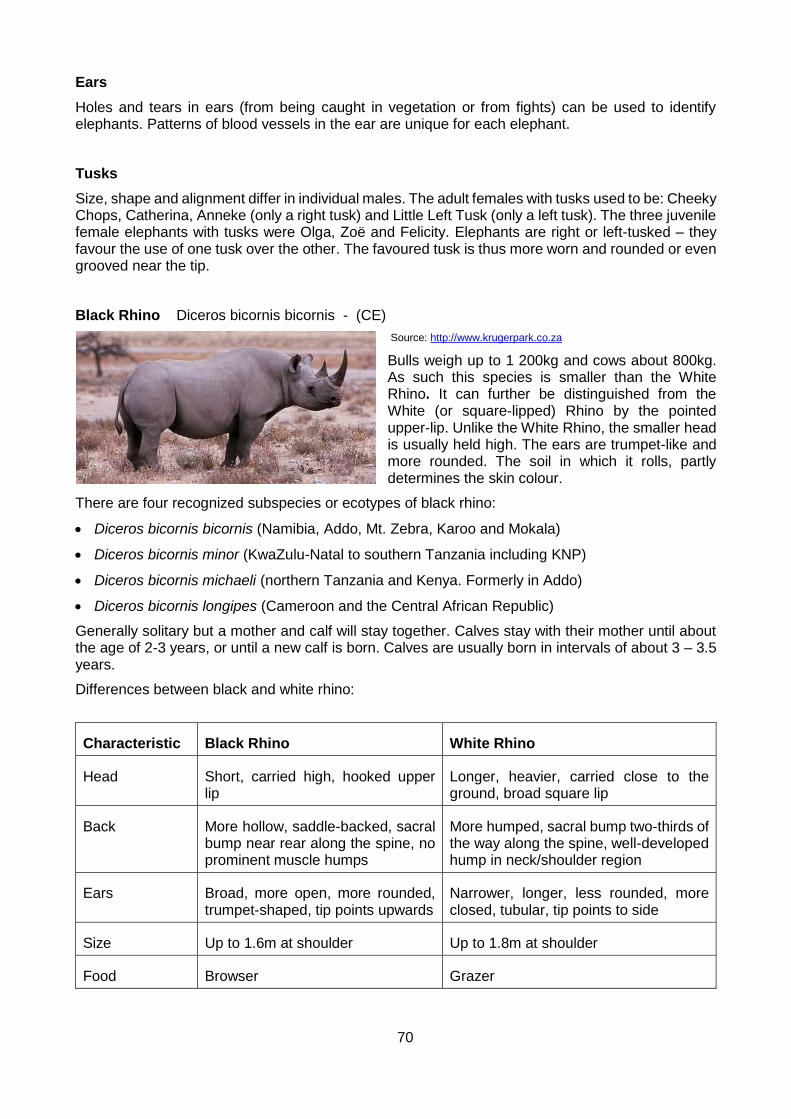
70
Ears
Holes and tears in ears (from being caught in vegetation or from fights) can be used to identify elephants. Patterns of blood vessels in the ear are unique for each elephant.
Tusks
Size, shape and alignment differ in individual males. The adult females with tusks used to be: Cheeky Chops, Catherina, Anneke (only a right tusk) and Little Left Tusk (only a left tusk). The three juvenile female elephants with tusks were Olga, Zoë and Felicity. Elephants are right or left-tusked – they favour the use of one tusk over the other. The favoured tusk is thus more worn and rounded or even grooved near the tip.
Black Rhino Diceros bicornis bicornis - (CE)
Source: http://www.krugerpark.co.za
Bulls weigh up to 1 200kg and cows about 800kg. As such this species is smaller than the White Rhino. It can further be distinguished from the White (or square-lipped) Rhino by the pointed upper-lip. Unlike the White Rhino, the smaller head is usually held high. The ears are trumpet-like and more rounded. The soil in which it rolls, partly determines the skin colour.
There are four recognized subspecies or ecotypes of black rhino:
Diceros bicornis bicornis (Namibia, Addo, Mt. Zebra, Karoo and Mokala)
Diceros bicornis minor (KwaZulu-Natal to southern Tanzania including KNP)
Diceros bicornis michaeli (northern Tanzania and Kenya. Formerly in Addo)
Diceros bicornis longipes (Cameroon and the Central African Republic)
Generally solitary but a mother and calf will stay together. Calves stay with their mother until about the age of 2-3 years, or until a new calf is born. Calves are usually born in intervals of about 3 – 3.5 years.
Differences between black and white rhino:
Characteristic Black Rhino White Rhino
Head Short, carried high, hooked upper lip
Longer, heavier, carried close to the ground, broad square lip
Back More hollow, saddle-backed, sacral bump near rear along the spine, no prominent muscle humps
More humped, sacral bump two-thirds of the way along the spine, well-developed hump in neck/shoulder region
Ears Broad, more open, more rounded, trumpet-shaped, tip points upwards
Narrower, longer, less rounded, more closed, tubular, tip points to side
Size Up to 1.6m at shoulder Up to 1.8m at shoulder
Food Browser Grazer

71
Horns Front horn base more rounded Front horn base more square
Spoor Smaller, rounder Longer, more deeply notched
Speed 55km/h at gallop 40km/h at gallop
Calf Runs behind mother, gestation 15 months
Runs in front of mother, gestation 16 months
Dung Orange to yellow colour when wet and dry
Dark or light grey when wet drying to pale yellow or white
Black rhino are browsers. They bite off material leaving a clean-angled edge of about 45 degrees. This is often visible in the dung. Elephants fray the edge (toothbrush-effect) of plants that they browse. Black rhino favour Acacia species and Euphorbia species as browse in the AENP.
They deposit dung in middens and mark territory by spray-urinating and by scraping dung (dung is thus transferred to the feet and walked onto the paths that the rhino travels).
Black rhino have territories but do not defend them vigorously (as white rhino do). Territories are less prevalent when rhino share the same habitat as elephants.
Black rhino are marked with ear notches at the age of 2-3 years before they leave their mothers or on arrival in the park (if transferred). The ear notches are placed at specific places on the left and/or right ear to allow for easy identification (from ground and air). Plastic ear tags were tried before ear notches were introduced but fell out after a few years. All adult rhino have microchips planted in their horns. This is done for DNA fingerprinting and individual recognition.
Further identifying characteristics include the relative sizes and shapes of the anterior and posterior horns, the appearance of the flanks and the presence or absence of hair fringes on the ears.
White rhino probably got their name from the Dutch word “wijd” (pronounced ‘vate’) meaning ‘wide’, referring to their broad upper lip. Over time, this was corrupted to “white.” As black rhino are usually a darker colour than white rhino, they became “black” rhino.
Rhino have poor eyesight but can detect motion. They have excellent senses of smell and hearing.
The male rhino has a fold of skin between the back legs. The female has a vulva, visible as an oval of dark tissue below the tail and anus.
Although black rhino are reputedly more aggressive than white rhino, individual rhino are known for having different temperaments and different tendencies (for example, whether they will charge or run away).
History of black rhino in AENP:
4 wild-caught black rhino of the East African subspecies, Diceros bicornis michaeli from Kenya were introduced to the AENP in 1961-2. At the time, the status of the black rhino in Africa was critical and these were the only available rhino when national parks were attempting to restock parks with all naturally occurring game.
Every individual was known and named and their feeding habits, behaviour and ecology studied.
During 1977, bulls from Natal of the subspecies D. b. minor were introduced but removed by 1981 due to a decision by the African Rhino Specialist group of the IUCN. 3 calves possibly sired by these 3 bulls were also removed in 1983 and sent to the National Zoological Gardens in Pretoria.
Between 1998 and 2003, the michaeli rhino were translocated to Thaba Tholo Game Reserve, Mkomazi and Portland Zoo in the UK. Some of these rhino had to be airlifted from the botanical reserve where they were enclosed. The bush there is too thick for game capture vehicles to enter. An Oryx helicopter from the SANDF assisted in this operation in 2003.
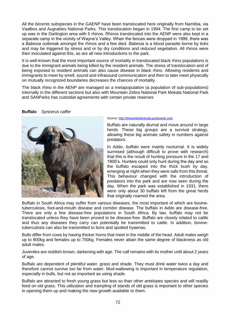
72
All the bicornis subspecies in the GAENP have been translocated here originally from Namibia, via Vaalbos and Augrabies National Parks. This translocation began in 1994. The first camp to be set up was in the Darlington area with 5 rhinos. Rhinos translocated into the AENP were also kept in a separate camp in the vicinity of Wayne’s Valley. When the fences were dropped in 1999, there was a Babesia outbreak amongst the rhinos and a few died. Babesia is a blood parasite borne by ticks and may be triggered by stress and or by dry conditions and reduced vegetation. All rhinos were then inoculated against this, as are all new introductions to the park.
It is well-known that the most important source of mortality in translocated black rhino populations is due to the immigrant animals being killed by the resident animals. The stress of translocation and of being exposed to resident animals can also cause disease in black rhino. Allowing residents and immigrants to meet by smell, sound and infrasound communication and then to later meet physically on mutually recognized boundaries decreases the chances of mortality.
The black rhino in the AENP are managed as a metapopulation (a population of sub-populations) internally in the different sections but also with Mountain Zebra National Park Mokala National Park and SANParks has custodial agreements with certain private reserves
Buffalo Syncerus caffer
Source: http://theworldofanimals.proboards.com
Buffalo are naturally diurnal and move around in large herds. These big groups are a survival strategy, allowing these big animals safety in numbers against predators.
In Addo, buffalo were mainly nocturnal. It is widely surmised (although difficult to prove with research) that this is the result of hunting pressure in the 17 and 1800’s. Hunters could only hunt during the day and so the buffalo escaped into the thick bush by day, emerging at night when they were safe from this threat. This behaviour changed with the introduction of predators into the park and are now seen during the day. When the park was established in 1931, there were only about 30 buffalo left from the great herds that originally roamed the area.
Buffalo in South Africa may suffer from various diseases, the most important of which are bovine-tuberculosis, foot-and-mouth disease and corridor disease. The buffalo in Addo are disease-free. There are only a few disease-free populations in South Africa. By law, buffalo may not be translocated unless they have been proved to be disease-free. Buffalo are closely related to cattle and thus any diseases they carry can potentially be transmitted to cattle. In addition, bovine-tuberculosis can also be transmitted to lions and spotted hyaenas.
Bulls differ from cows by having thicker horns that meet in the middle of the head. Adult males weigh up to 800kg and females up to 750kg. Females never attain the same degree of blackness as old adult males.
Juveniles are reddish-brown, darkening with age. The calf remains with its mother until about 2 years of age.
Buffalo are dependent of plentiful water, grass and shade. They must drink water twice a day and therefore cannot survive too far from water. Mud-wallowing is important in temperature regulation, especially in bulls, but not as important as using shade.
Buffalo are attracted to fresh young grass but less so than other antelopes species and will readily feed on old grass. This utilization and trampling of stands of old grass is important to other species in opening them up and making the new growth available to them.

73
Buffalo show threat displays by holding the head high with the nose pointing to the ground, sometimes combined with a lateral display of the body to emphasize size. Submission is shown by holding the head low with the horns back and putting the nose under the neck or belly of an opponent buffalo.
Addo Buffalo, the only truly disease-free buffalo in South Africa are sought after by the private sector and over the years many have been sold. The revenue (R100 million) generated by these sales has been used to purchase vast tracks of land for conservation.
Lion Panthera leo - (V)
Source: Christal Gibson Photography
The largest of the African carnivores, lions are the only cats that regularly hunt in groups and that live in closely-knit social groups. A pride is the basic unit of lion social life, consisting of 4-12 closely related females and their cubs and 1-6 closely related males who are not related to the females. The females are the stable nucleus of the pride but males are usually exchanged every few years.
Lions are most active at night in order to avoid the heat of the day. They spend many hours sleeping or resting but despite their lethargy will become aggressive if disturbed. Lions generally rest on the ground but can climb trees to avoid flies or take advantage of a cool breeze.
Lions hunt together by stalking their prey. One lioness will charge the prey while the others close in on the flanks. The prey is killed by a suffocating bite to the throat or over the muzzle. Lions cannot reach speeds higher than 56km/h – most antelope run faster than this - and therefore rely on ambush of their prey.
Kalahari lions are known to be adept at hunting porcupines – by attacking from two directions at once, they avoid the prickly defences. Lions will also dig out and eat warthogs. They will readily eat carrion if they find it and are known to steal kills from hyaenas and other cats.
The disadvantage of a larger size and a mane result in male lions not usually taking part in the hunt. However, a male may take part if the prey is very large, using his greater strength and weight to bring down the prey.
The function of the characteristic mane of the male lion is twofold: as a sexual signal to the female and as a protection for the head and neck during fighting with other males.
Lions have been recorded to eat almost anything from termites to young elephants. Their favourite prey is medium and large antelopes. A pride of lions will often specialize in a particular type of prey – selecting this prey species even when it is not the most abundant food source. These preferences are also passed on as a pride tradition.
When feeding, lions are often aggressive and male lions dominate females and cubs. Cubs usually get the least out of a kill and the main cause of death in cubs is starvation. Lions can eat up to 15% of their body weight in one sitting if food is abundant. This equals five times their average daily needs.
Females become sexually receptive about once every two years (if they raise their cubs to weaning). If the female loses her cubs, she may come into oestrus within four weeks. Males detect the female’s condition by scent. The male and female will associate closely and will groom each other and rub against each other. Mating takes place about four times an hour – for less than a minute each time - over one to two days.
After a gestation period of 110 days, a lioness will leave the pride to give birth. The cubs will be born in thick cover and the mother will usually move them every so often to avoid danger. The lioness will introduce her cubs to the pride when they are four to eight weeks old. All lactating lionesses in a pride will suckle all cubs – thus advancing their own genes by helping to raise their sisters’ offspring.

74
Cubs begin to eat meat at the age of three months but are only weaned at about six months old.
When new males take over a pride, they will kill all the young cubs. The females will then come into oestrus and the new males can mate with them to sire their own cubs. Although this may seem cruel in our human view, it is their way of ensuring that their own genes are perpetuated and not those of an unrelated male.
Male cubs leave their birth pride at the age of two to three years – of their own accord or driven out by the pride males. Females remain with their birth pride.
According to records, the last lion in the Eastern Cape was shot in 1879 in what was then the East Griqualand area (in the vicinity of Kokstad). Nearby private game reserves have re-introduced lions but the AENP's lions were the first completely wild lions in the area.
Six lions from the Kalahari were translocated in August 2003 into holding camps in the AENP. They remained in these camps for just over one month in order to acclimatize to the local conditions, electric fence and each other – they were selected from separate groups in the Kalahari.
Lions were particularly chosen from the Kalahari as it is believed that they are most genetically similar to the extinct Cape lions, which would have occurred in the Addo area. In addition, the Kalahari lions have a valuable disease-free (from bovine tuberculosis and Feline Immunodeficiency Virus-FIV) status.
The 6 lions were: one female of about 5-6 years old, a female of 1.5 years old and four males of ages between 2 and 3.5 years old (ages approximate and as of Aug 2003). The ratio of males to females was selected in order to minimize the breeding rate.
Most of the lions are fitted with collars which are used to assist in the event of a break-out, to determine prey killed and spatial use of the park. It cost R600.000-00 to recover Sylvester when he escaped from The Karoo National Park as his collar had limited capabilities.
A Predator Management Plan similar to the one used to manage the rhino is followed in Addo. Lions are regularly swopped between parks. This mimics coalition take-overs and improves genetics although it can lead to the natural phenomenon of infanticide. Contraception is also used to mimic mortality and to control numbers. Fences create problems and mimicking processes helps to resolve these.
The aim across the GAENP is to have between 20 and 30 lions at any one time.
Spotted Hyaena Crocuta crocuta - (NT)
Source: https://en.wikipedia.org
Usually active at night but also during the day, especially in cooler weather. They live in clans of up 80 members. The core of a clan is the dominant female and successive generations of her daughters and their offspring.
Females are larger than males and dominate them. Female cubs also dominate males and inherit their mother’s rank. Immigrant males (males who are accepted from outside after weeks of cautious approaches and bearing retaliation from the clan) dominate resident males. Females get to eat
more meat at a kill.
Females appear to have male genitals – the female has an erectile clitoris that is as large as the male penis and a false scrotum filled with fat. To tell the difference: female scrotum is less deeply lobed and more hairy than the male scrotum; female belly curves up less sharply than male belly; females teats will often be visible as she will often be in milk; a male will appear fearful/submissive when interacting with a female.

75
They have an elaborate greeting ceremony – involving standing next to each other and sniffing and licking the other one’s genitals – it is used to reinforce clan bonds.
When two female cubs are born, one usually kills the other. This is called siblicide. This is a manifestation for the need for dominance within the matriarchal society. They have a gestation period of 3 months and 2 – 3 cubs are born.
Signs of aggression include a curled tail over the back, ears pricked forward, mouth closed. Signs of fear include ears low, open mouth, slinking away in a crouched posture; tail between legs.
The clan is territorial and mark their territory by anal pasting, defecating in middens and pawing the ground to release smelly secretions from glands on their feet. Anal pasting is done at kills, near the den and along territory borders. The hyaena walks over grass and releases a white secretion (2-5 cm long) from the anal sac (which lies between the tail and the rectum). Anal pasting is also done by aardwolf and brown hyaena. The aardwolf leaves a thin smear of dark-brown or black secretion on a grass stem while the brown hyaena leaves a brown smear above a blob of white paste.
They get 75% of their food from their own kills but will scavenge and will steal fresh kills from other predators such as cheetahs, leopards, wild dogs and lions – whether or not they will attempt to steal and are successful in stealing a kill from the above predators will depend on the number of hyaenas challenging the number of other predators.
Hyaenas can sprint up to 60km/h and can keep up a 40km/h speed for 4-5km. They are not good stalkers and rely on speed and stamina for the kill. They use group action especially effectively against prey that can defend themselves – one can distract the dangerous side of the prey, while others attack the vulnerable sides.
They kill prey by biting chunks out of it as it runs and prey dies from shock and loss of blood.
They compete with lions for food.
Hyaenas have very powerful jaws, able to crush bones. Their faeces often crumble to a white powder (high calcium content).
1 – 4 cubs are born in a den (converted aardvark holes, caves, drainage culverts). They are weaned at 10-14 months old.
Four spotted hyaenas were introduced into the AENP (Nov 2003) from Madikwe Game Reserve in the north-west and four from Kruger National Park. Their number has grown and stabilised at between 20 and 30 animals found in the Main Camp and Colchester areas.
Hyaenas are more closely related to cats than to dogs. Their direct ancestors were actually civets
Brown Hyaena Hyaena brunnea
Source: http://www.krugerpark.co.za
The brown hyaena has pointed ears and striped legs with a dark brown to black shaggy coat, white shoulders and neck. It stands 800mm at the shoulder and weighs 40kg. They have a long cream-coloured mane which extends from the back of their neck across the shoulder bones. The head and neck, are grey, and the legs, are covered with brown and grey bars. The Brown Hyaena is a carnivore
that has adapted to a scavenging lifestyle. It will supplement its diet with insects, birds' eggs and wild fruits and even occasionally kill small animals. The Brown Hyaena is mainly a scavenger, feeding upon carcasses of large herbivores killed by other animals. Their jaw and dentary adaptations allow them to break open the long bones of these large animals and feed on the marrow inside.
Brown Hyaenas are non-seasonal breeders and have a gestation period of about 90 days. Females give birth to 1 to 4 young. Young are suckled for more than a year and live in the den for up to 18 months. Mother's milk is supplemented with meat from three months of age. At birth Brown Hyaena have the same body colouration as adults and reach full size by 30 months.

76
They are solitary and nocturnal, lying during the day in thick bush or in deserted Aardvark burrows. Brown Hyaenas live in small clans ranging from a breeding pair and their young to groups of several mature males and females. The clan cooperatively defends a territory, but do not forage together.
Five were introduced into the Darlington section in 2015. Historically, they were always found in the Karoo.
Hippopotamus Hippopotamus amphibious
Source: http://www.krugerpark.co.za
The Hippopotamus is a massive, semi-aquatic mammal with a mass of up to 2,5 tonnes. The Hippopotamus is typically a slate brown colour to muddy brown, with purplish hues often visible. A massive animal, it measures 1500mm in height at the shoulder and has a length of 4310-5160mm, of which about 560mm is tail. The eyes and nostrils protrude, allowing the animal to see and breathe while otherwise submerged in the water.
A Hippo's teeth are shown in yawning to warn potential competitors and are used for self-defence from each other or enemies. The teeth are the hippo's most valuable weapon and can bite a medium-sized crocodile in half.
The Hippopotamus is strictly a vegetarian. They require a large amount of energy and therefore need a food source that is in rich supply. If they were carnivorous, there would be more competition for food, thus requiring more energy to get it. Its diet consists mainly of terrestrial grasses and they may eat up to 68kg of grass a night. At dusk, Hippopotamuses leave the water and sometimes walk as far as 8km inland to graze on short grass, which is their main form of sustenance. The 2 essential requirements of a hippo is water deep enough to submerge in and a good supply of grassland nearby.
Breeding occurs in water where large males are buoyant and their weight and size aren't fatal to the cow. This could also be dangerous for the male as his hind legs on their own aren't strong enough to support him. The male becomes very aggressive during this act and will often lash out or attack other bulls that are close by (sometimes including the young male offspring of the concerned cow).
Hippos are usually found in large social groups called rafts, of which there is one male and many females and their young. Dominant males are very territorial, but will occasionally accept other males as long as they are submissive and show no interest in the females. They sleep in or alongside the water during the day and at night forage for grass close to the water. They are strong and fast swimmers, and will attack when wounded or agitated.
The fact that it is responsible for most human fatalities and injuries in the wilds renders it the most dangerous mammal in Africa. It is a myth that the mother carries her calf. What happens is that in cold conditions a young hippo will rest the front part of the body onto that of an adult to sunbathe, due to their smaller body mass the young body will heat faster than adults.
The preferred habitat of this species is deep water with adjacent reed beds and grasslands.
Cheetah Acinonyx jubatus
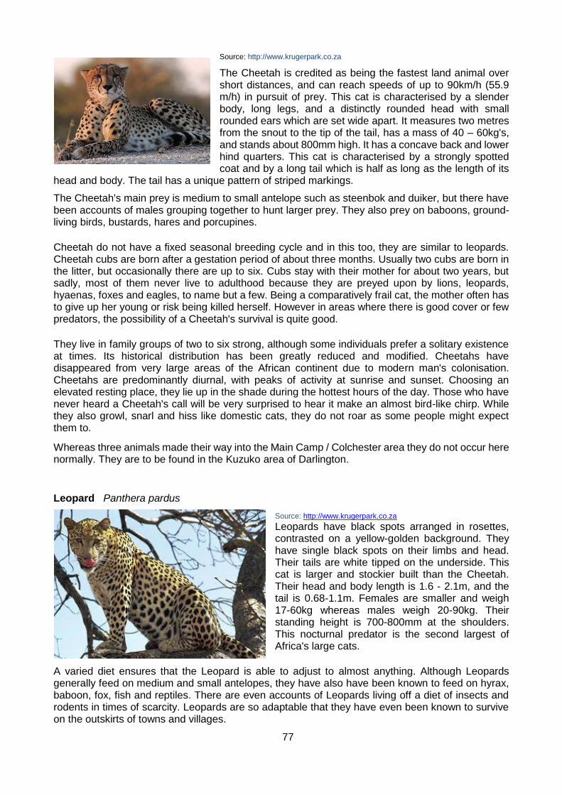
77
Source: http://www.krugerpark.co.za
The Cheetah is credited as being the fastest land animal over short distances, and can reach speeds of up to 90km/h (55.9 m/h) in pursuit of prey. This cat is characterised by a slender body, long legs, and a distinctly rounded head with small rounded ears which are set wide apart. It measures two metres from the snout to the tip of the tail, has a mass of 40 – 60kg's, and stands about 800mm high. It has a concave back and lower hind quarters. This cat is characterised by a strongly spotted coat and by a long tail which is half as long as the length of its
head and body. The tail has a unique pattern of striped markings.
The Cheetah's main prey is medium to small antelope such as steenbok and duiker, but there have been accounts of males grouping together to hunt larger prey. They also prey on baboons, ground-living birds, bustards, hares and porcupines.
Cheetah do not have a fixed seasonal breeding cycle and in this too, they are similar to leopards. Cheetah cubs are born after a gestation period of about three months. Usually two cubs are born in the litter, but occasionally there are up to six. Cubs stay with their mother for about two years, but sadly, most of them never live to adulthood because they are preyed upon by lions, leopards, hyaenas, foxes and eagles, to name but a few. Being a comparatively frail cat, the mother often has to give up her young or risk being killed herself. However in areas where there is good cover or few predators, the possibility of a Cheetah's survival is quite good.
They live in family groups of two to six strong, although some individuals prefer a solitary existence at times. Its historical distribution has been greatly reduced and modified. Cheetahs have disappeared from very large areas of the African continent due to modern man's colonisation. Cheetahs are predominantly diurnal, with peaks of activity at sunrise and sunset. Choosing an elevated resting place, they lie up in the shade during the hottest hours of the day. Those who have never heard a Cheetah's call will be very surprised to hear it make an almost bird-like chirp. While they also growl, snarl and hiss like domestic cats, they do not roar as some people might expect them to.
Whereas three animals made their way into the Main Camp / Colchester area they do not occur here normally. They are to be found in the Kuzuko area of Darlington.
Leopard Panthera pardus
Source: http://www.krugerpark.co.za
Leopards have black spots arranged in rosettes, contrasted on a yellow-golden background. They have single black spots on their limbs and head. Their tails are white tipped on the underside. This cat is larger and stockier built than the Cheetah. Their head and body length is 1.6 - 2.1m, and the tail is 0.68-1.1m. Females are smaller and weigh 17-60kg whereas males weigh 20-90kg. Their standing height is 700-800mm at the shoulders. This nocturnal predator is the second largest of Africa's large cats.
A varied diet ensures that the Leopard is able to adjust to almost anything. Although Leopards generally feed on medium and small antelopes, they have also have been known to feed on hyrax, baboon, fox, fish and reptiles. There are even accounts of Leopards living off a diet of insects and rodents in times of scarcity. Leopards are so adaptable that they have even been known to survive on the outskirts of towns and villages.

78
Young are born any time of the year as they are non-seasonal breeders. Leopard cubs are born after a gestation period of three and a half months and females usually give birth to two or three cubs in hidden lairs of natural holes or thick bush. The Leopard mother takes great care to hide the cubs from predators like lion, cheetah and hyaena, who would jump at the chance to make an easy meal of the cubs. Cubs stay with the mother for at least a year, during which time they learn the ways of the wild and how to survive on their own.
They lie up in hiding during the day and hunt at night, although in some areas day time hunting is common. Their hunting technique entails stalking and pouncing, killing larger prey with a holding bite to the throat which asphyxiates larger prey. Smaller prey species are killed by a bite to the back of the neck which usually severs the spinal cord. They pluck fur off the carcass before starting to feed on the softer parts of the body. The remains of the catch and stomach contents will be covered with grass and sand. They are agile climbers and when there is competition from other predators the carcass will be cached out of reach in the fork of a large tree. Males defend large territories which overlap the territories of two or even three females. Females defend their territories against other females.
The Leopard tolerates variable climatic conditions and occurs in a wide range of habitats. Found from coastal areas to elevations of 2 000m above sea level in forests, deserts, semi-deserts, bushveld, mountains, woodlands and rocky areas. They are not dependant on surface water. This master of stealth needs some form of cover such as thick bush or rocks. Though they diminished in numbers over the years, Leopards are still found in wild mountains and thick bush throughout South Africa, except for the intensively farmed central interior.
Eland Taurotragus oryx
Source: https://www.google.co.za
The largest African antelope. Males stand 1.7m at the shoulder and weigh up to 700kg while females stand 1.5m and weigh up to 460kg. The male’s horns are much heavier than the female’s horns. At age 15 months, male’s horns show the first clear signs of the spiral ridge.
The hair on the body is short except for a longer tuft of dark brown hair on the forehead. This hair is often matted with a strong smell due to a secretion from the glandular region in the skin at its base.
They are well adapted to dry conditions and independent of drinking water. The pale coat reflects sunlight so that the body doesn’t heat up. They can concentrate urine and faeces to minimize water loss. They have a flap of skin under the neck in which they store fat which can be converted
They are predominantly browsers but will also graze. Eland congregate in small herds. Females and calves form a nursery herd. Males later join these herds to form breeding herds.
Dominance in both sexes is maintained by ritual displays. Both sexes have horns.
When running, adult eland produce a clicking sound that emanates from the hooves. Due to the fact they are cloven hoof animals, when the hoof is put on the ground it splays open and when the foot is lifted the two halves click together producing the clicking sound. The function of this seems to be to enable members of a herd to maintain contact with each other.

79
Kudu Tragelaphus strepsicoros
Source: Pam Krzyza Photography
Adult males stand about 1.4m at the shoulder and weigh about 250kg. Males have a better developed beard, fringe down the throat and fringe on the belly than females. Females stand about 1.25m at the shoulder and weigh about 200kg.
They are the second tallest antelope with the longest horns along the outer curve totalling 182cm. Only males have horns. The horn buds appear at age 5-6 months. The first inward curve appears at 14-17 months and is completed by age 21 months. The second outward curve appears at about 30 months old.
They are found in small herds – average size of 4 kudus. They are sometimes found in large groups.
They are browsers and favour spekboom, Aloe species and Euphorbia species as browse. They also eat grass.
When kudus run, they curl their tails up. This is a group coordination display and a visual indication of their direction of flight. Males hold their noses straight forward so that their horns lie back across their shoulders to avoid contact with low branches when running.
They have white vertical body stripes for camouflage and this is called disruptive camouflage.
Their gestation period is 9 months.
Kudus have a loud, harsh bark alarm call. Only males have horns.
Red Hartebeest Alcelaphus buselaphus
Source: http://thezt2roundtable.com
The male is bigger with heavier horns than the female. Although not so obvious in the field, males have a more obvious saddle – a region of darker colour that stretches from the shoulders to the base of the tail. They have pre-orbital glands with small pores opening just in front of the eyes exude a waxy substance that was sought after by the San.
Red hartebeest thermoregulate by allowing their body temperature to rise during the heat of the day and by panting. Their dense red reflective
coat also helps to control temperature.
They are predominantly grazers and prefer open country. Hartebeest congregate in small herds (up to about 20). The breeding males herd females and are territorial, defending their territories against intruding males. Other males form bachelor herds or are sometimes solitary.
Their gestation period is 8months.
Females have their first calves at the age of about 3 years. The calves are left hidden in a secluded place while the mother re-joins the herd to feed, returning to suckle the calf. Calves are weaned by about 7 months old.

80
Burchell’s Zebra Equus burchelli
Source: https://www.flickr.com
They can be distinguished from the two species of Mountain Zebra by the greyish or yellowish stripes between the black stripes on the hindquarters, the lack of a “gridiron” pattern on the top of the hindquarters and the absence of a dewlap.
Stallions usually have thicker necks than mares and stand about 1.36m at the shoulder, weighing 320kg. Each individual is uniquely marked. The function of the stripes may be to provide camouflage or may be to confuse an attacking predator as to direction. The stripes are each animal’s unique
finger print as no two zebras will have the same stripe pattern.
This zebra is a savanna plains species, preferring open woodland, open scrub and grassland. They are dependent on water and are seldom found 10-12km away from it.
Small family groups consist of a stallion and one or more mares with their foals. Stallions rejected from the family groups form bachelor herds or stay solitary. Stallions usually take a position on the periphery of the herd or at the rear when on the run.
Their gestation period is 12 months.
When attacked, the stallion will defend members of his herd and mares will defend their foals.
Burchell’s zebra are not territorial and their home ranges often overlap with other family groups.
Research has indicated that Burchell’s zebra (Equus burchelli) is only sub-specifically different from the extinct Quagga (E. quagga). The name “quagga” is actually imitative of the call of all zebras, but is reserved for the now extinct Equus quagga. Historical records have not helped in recording the early history of the quagga as E. burchelli, E. quagga and E. zebra (mountain zebra) were not clearly recognized as different by early travellers and were often called “horses” or “mules”. “Quagga” was also used to describe E. burchelli, although later the terms “bontquagga” was used. Experiments using colour variants of E. burchelli to possibly resuscitate the quagga are underway in various areas of South Africa. The so-called “white rump” zebras in the AENP may possibly be closer to the quagga. The quagga had a white rump and underparts with foreparts striped and the head, body and neck rufous-brown becoming tawny towards the rump.
Cape Mountain zebra Equus zebra zebra - (V)
Source: http://www.biodiversityexplorer.org
These differ from Burchell’s zebra by having narrower and more numerous black stripes on their head and body. The stripes on their rump are broader and have no shadow stripes in between. The stripes fade out on the lower flanks. They have white underparts with a central black longitudinal stripe. There is a gridiron pattern on the rump from the pelvis to the base of the tail.
Stallions stand about 1.27m at the shoulder and weigh about 234kg, while mares stand 1.24m at the shoulder and weigh about 240-250kg. (i.e. smaller in mass and size than
Burchell’s zebras). Their ears are noticeably larger than those of Burchell’s zebras.
Historically they occurred throughout the mountainous areas of the Cape. In the 1930s, it became clear that they should be afforded special protection.
They occur up to altitudes of 2 000m but will move to lower altitudes during winter and harsh weather.

81
Breeding herds are made up of a stallion and mares with their foals. There is a dominance hierarchy among the mares. Mares with new-born foals are extremely aggressive, which may lead to a temporary rise in status. The stallion will take up a position at the rear of the herd when in flight, but will lead the herd to water.
Mountain zebras drink water daily and avoid muddy water.
They are not territorial and their home ranges overlap.
Mountain zebra do not appear to associate with antelope as Burchell’s zebra do. They will respond to the flight and alarm signals of black wildebeest (in areas where they occur together with this species) but seldom react to smaller species of antelope.
They are predominantly grazers but will take limited amount of browse.
The foals of Mountain and Burchell’s zebra eat the faeces of adults in order to obtain intestinal micro-organisms needed to digest cellulose.
Their gestation period is 12 months.
Black-backed Jackal Canis mesomelas
Source: http://www.theanimalfiles.com
They are most active early morning and evening (activity pattern matches that of small mammal prey). They are less active at full moon and dark moon.
Jackals living in close proximity to urban or farming areas become nocturnal to avoid contact with people (and the associated negative effects). They live alone or in small groups and pairs usually stay together for life.
Large numbers found at carcasses are temporary groupings and have no lasting social structure.
Pairs are territorial and will chase intruding jackals out. The female of the pair will chase an intruding female and the male of the pair will chase an intruding male. Both male and female scent mark with urine.
Home ranges and territories are overlapping and may reach up to 20km². If food is scarce, or a large food source concentrated in one area, territorial boundaries and home ranges tend to break down.
Families respond only to the contact calls of their own members. Contact calls are the characteristic, long drawn-out howls.
Apart from different noises, jackals also communicate with facial expressions, body posture and tails. A tail tucked in between the legs indicates fear or submission; swished from side to side indicates aggression and arched upwards indicates excitement.
Jackals catch most of their own food (despite their reputation as scavengers). Eat fruit, insects, rodents, birds, reptiles and small antelope. They catch prey by pouncing, pinning down with forepaws and biting across the back (larger prey are bitten on the throat).
When scavenging, they locate carcasses by smell, watching vultures and the sounds made by predators.
They can survive without water by eating fruits with a high moisture content.
Both parents participate equally in parental care. Young are weaned at 2-4 months. Use old aardvark holes as dens. Their gestation period is 2+ months.
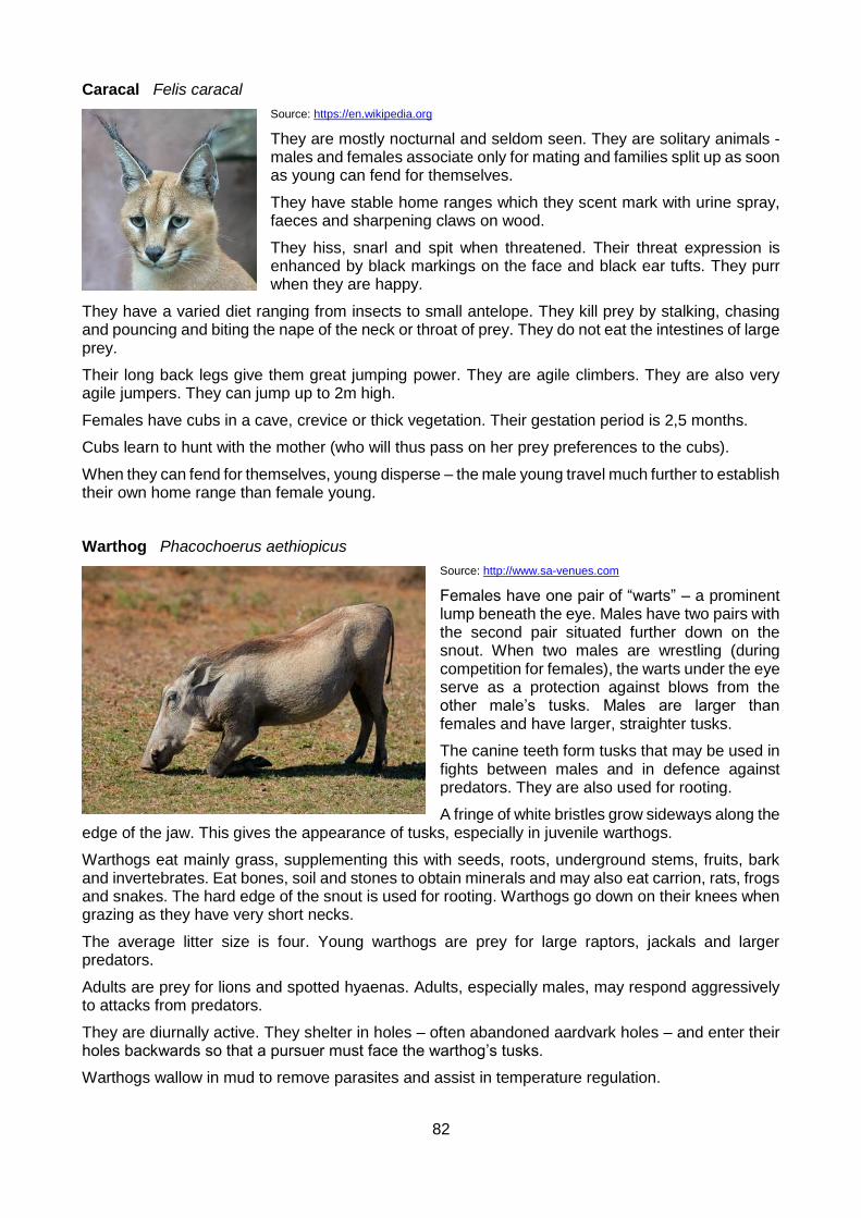
82
Caracal Felis caracal
Source: https://en.wikipedia.org
They are mostly nocturnal and seldom seen. They are solitary animals - males and females associate only for mating and families split up as soon as young can fend for themselves.
They have stable home ranges which they scent mark with urine spray, faeces and sharpening claws on wood.
They hiss, snarl and spit when threatened. Their threat expression is enhanced by black markings on the face and black ear tufts. They purr when they are happy.
They have a varied diet ranging from insects to small antelope. They kill prey by stalking, chasing and pouncing and biting the nape of the neck or throat of prey. They do not eat the intestines of large prey.
Their long back legs give them great jumping power. They are agile climbers. They are also very agile jumpers. They can jump up to 2m high.
Females have cubs in a cave, crevice or thick vegetation. Their gestation period is 2,5 months.
Cubs learn to hunt with the mother (who will thus pass on her prey preferences to the cubs).
When they can fend for themselves, young disperse – the male young travel much further to establish their own home range than female young.
Warthog Phacochoerus aethiopicus
Source: http://www.sa-venues.com
Females have one pair of “warts” – a prominent lump beneath the eye. Males have two pairs with the second pair situated further down on the snout. When two males are wrestling (during competition for females), the warts under the eye serve as a protection against blows from the other male’s tusks. Males are larger than females and have larger, straighter tusks.
The canine teeth form tusks that may be used in fights between males and in defence against predators. They are also used for rooting.
A fringe of white bristles grow sideways along the edge of the jaw. This gives the appearance of tusks, especially in juvenile warthogs.
Warthogs eat mainly grass, supplementing this with seeds, roots, underground stems, fruits, bark and invertebrates. Eat bones, soil and stones to obtain minerals and may also eat carrion, rats, frogs and snakes. The hard edge of the snout is used for rooting. Warthogs go down on their knees when grazing as they have very short necks.
The average litter size is four. Young warthogs are prey for large raptors, jackals and larger predators.
Adults are prey for lions and spotted hyaenas. Adults, especially males, may respond aggressively to attacks from predators.
They are diurnally active. They shelter in holes – often abandoned aardvark holes – and enter their holes backwards so that a pursuer must face the warthog’s tusks.
Warthogs wallow in mud to remove parasites and assist in temperature regulation.
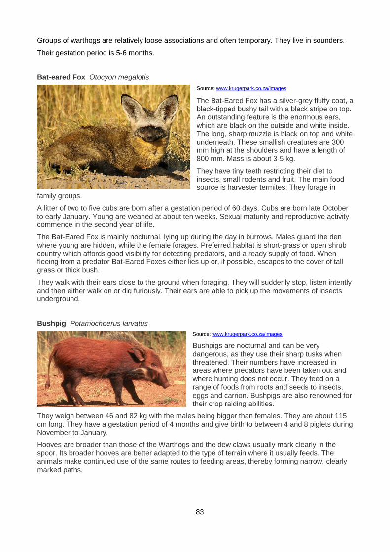
83
Groups of warthogs are relatively loose associations and often temporary. They live in sounders.
Their gestation period is 5-6 months.
Bat-eared Fox Otocyon megalotis
Source: www.krugerpark.co.za/images
The Bat-Eared Fox has a silver-grey fluffy coat, a black-tipped bushy tail with a black stripe on top. An outstanding feature is the enormous ears, which are black on the outside and white inside. The long, sharp muzzle is black on top and white underneath. These smallish creatures are 300 mm high at the shoulders and have a length of 800 mm. Mass is about 3-5 kg.
They have tiny teeth restricting their diet to insects, small rodents and fruit. The main food source is harvester termites. They forage in
family groups.
A litter of two to five cubs are born after a gestation period of 60 days. Cubs are born late October to early January. Young are weaned at about ten weeks. Sexual maturity and reproductive activity commence in the second year of life.
The Bat-Eared Fox is mainly nocturnal, lying up during the day in burrows. Males guard the den where young are hidden, while the female forages. Preferred habitat is short-grass or open shrub country which affords good visibility for detecting predators, and a ready supply of food. When fleeing from a predator Bat-Eared Foxes either lies up or, if possible, escapes to the cover of tall grass or thick bush.
They walk with their ears close to the ground when foraging. They will suddenly stop, listen intently and then either walk on or dig furiously. Their ears are able to pick up the movements of insects underground.
Bushpig Potamochoerus larvatus
Source: www.krugerpark.co.za/images
Bushpigs are nocturnal and can be very dangerous, as they use their sharp tusks when threatened. Their numbers have increased in areas where predators have been taken out and where hunting does not occur. They feed on a range of foods from roots and seeds to insects, eggs and carrion. Bushpigs are also renowned for their crop raiding abilities.
They weigh between 46 and 82 kg with the males being bigger than females. They are about 115 cm long. They have a gestation period of 4 months and give birth to between 4 and 8 piglets during November to January.
Hooves are broader than those of the Warthogs and the dew claws usually mark clearly in the spoor. Its broader hooves are better adapted to the type of terrain where it usually feeds. The animals make continued use of the same routes to feeding areas, thereby forming narrow, clearly marked paths.
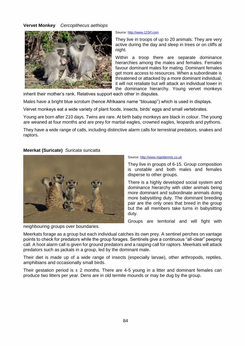
84
Vervet Monkey Cercopithecus aethiops
Source: http://www.123rf.com
They live in troops of up to 20 animals. They are very active during the day and sleep in trees or on cliffs at night.
Within a troop there are separate dominance hierarchies among the males and females. Females favour dominant males for mating. Dominant females get more access to resources. When a subordinate is threatened or attacked by a more dominant individual, it will not retaliate but will attack an individual lower in the dominance hierarchy. Young vervet monkeys
inherit their mother’s rank. Relatives support each other in disputes.
Males have a bright blue scrotum (hence Afrikaans name “blouaap”) which is used in displays.
Vervet monkeys eat a wide variety of plant foods, insects, birds’ eggs and small vertebrates.
Young are born after 210 days. Twins are rare. At birth baby monkeys are black in colour. The young are weaned at four months and are prey for martial eagles, crowned eagles, leopards and pythons.
They have a wide range of calls, including distinctive alarm calls for terrestrial predators, snakes and raptors.
Meerkat (Suricate) Suricata suricatta
Source: http://www.nigeldennis.co.uk
They live in groups of 6-15. Group composition is unstable and both males and females disperse to other groups.
There is a highly developed social system and dominance hierarchy with older animals being more dominant and subordinate animals doing more babysitting duty. The dominant breeding pair are the only ones that breed in the group but the all members take turns in babysitting duty.
Groups are territorial and will fight with neighbouring groups over boundaries.
Meerkats forage as a group but each individual catches its own prey. A sentinel perches on vantage points to check for predators while the group forages. Sentinels give a continuous “all-clear” peeping call. A hoot alarm call is given for ground predators and a rasping call for raptors. Meerkats will attack predators such as jackals in a group, led by the dominant male.
Their diet is made up of a wide range of insects (especially larvae), other arthropods, reptiles, amphibians and occasionally small birds.
Their gestation period is ± 2 months. There are 4-5 young in a litter and dominant females can produce two litters per year. Dens are in old termite mounds or may be dug by the group.
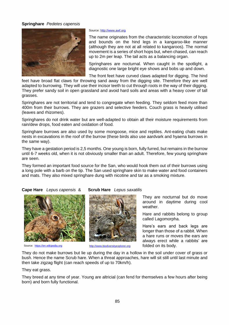
85
Springhare Pedetes capensis
Source: http://www.awf.org
The name originates from the characteristic locomotion of hops and bounds on the hind legs in a kangaroo-like manner (although they are not at all related to kangaroos). The normal movement is a series of short hops but, when chased, can reach up to 2m per leap. The tail acts as a balancing organ.
Springhares are nocturnal. When caught in the spotlight, a diagnostic one large bright eye shows and bobs up and down.
The front feet have curved claws adapted for digging. The hind feet have broad flat claws for throwing sand away from the digging site. Therefore they are well adapted to burrowing. They will use their incisor teeth to cut through roots in the way of their digging. They prefer sandy soil in open grassland and avoid hard soils and areas with a heavy cover of tall grasses.
Springhares are not territorial and tend to congregate when feeding. They seldom feed more than 400m from their burrows. They are grazers and selective feeders. Couch grass is heavily utilised (leaves and rhizomes).
Springhares do not drink water but are well-adapted to obtain all their moisture requirements from rain/dew drops, food eaten and oxidation of food.
Springhare burrows are also used by some mongoose, mice and reptiles. Ant-eating chats make nests in excavations in the roof of the burrow (these birds also use aardvark and hyaena burrows in the same way).
They have a gestation period is 2,5 months. One young is born, fully furred, but remains in the burrow until 6-7 weeks old, when it is not obviously smaller than an adult. Therefore, few young springhare are seen.
They formed an important food source for the San, who would hook them out of their burrows using a long pole with a barb on the tip. The San used springhare skin to make water and food containers and mats. They also mixed springhare dung with nicotine and tar as a smoking mixture.
Cape Hare Lepus capensis & Scrub Hare Lepus saxatilis
They are nocturnal but do move around in daytime during cool weather.
Hare and rabbits belong to group called Lagomorpha.
Hare’s ears and back legs are longer than those of a rabbit. When a hare runs or moves the ears are always erect while a rabbits’ are folded on its body.
They do not make burrows but lie up during the day in a hollow in the soil under cover of grass or bush. Hence the name Scrub hare. When a threat approaches, hare will sit still until last minute and then take zigzag flight (can reach speeds of up to 70km/h).
They eat grass.
They breed at any time of year. Young are altricial (can fend for themselves a few hours after being born) and born fully functional.
Source: https://en.wikipedia.org
http://www.biodiversityexplorer.org

86
Porcupine Hystrix africaeaustralis
Source: http://www.biodiversityexplorer.org
They are nocturnal. They dig their own burrows or use burrows made by aardvark, springhares or use cavities made by tree roots, rock crevices or caves.
They live in family groups of up to six but group members forage alone and only one pair in the group will breed successfully (others breed but do not conceive).
Porcupines travel up to 16km in search of food, often on well-established tracks. Eat any vegetation and will also gnaw on bones for calcium and phosphorus.
They are strong swimmers with buoyancy aided by hollow quills.
They detect danger with keen sense of smell and hearing and will flee. If cornered, will defend itself by raising and rattling quills. Also shakes tail to rattle hollow quills and stamps feet. If threat comes closer, will run at attacker to lodge quills in attackers face, paws etc. Quills break off easily and cause infection. The head is vulnerable to attack as it is not covered with quills.
Their gestation period is 3 months. One young is born and suckled for 3 months. The youngster forages under the protection of both parents and later one (usually male) adult.
Quills are made up of keratin and are hollow. Porcupines do not shoot their quills.
Reptiles
Reptiles are ectothermic or cold blooded. This means they require an external heat source like the sun to warm up. They need to get to an optimal operating temperature of between 32 – 36 degrees Celsius. Tortoises and the two monitor lizards hibernate in winter while all other reptiles go into a semi hibernation state. This means that on warm days they might come out to bask in the sun but will not really eat. If they do it could kill them as they rely on heat source to help with digesting the food. The days are cold and can cause the food to rot inside the stomach killing the snake. Snakes rely on the Jacobson’s organ to convert sent particles into smell. This organ is situated in the roof of the mouth.
Species found in the Park
Lizard’s species - 14
Geckos - 6
Snakes - 27
Chameleons - 3
Amphibians - 19
Tortoises - 5
Tortoises and Terrapins - 5 Species
Leopard Tortoise Geochelone pardalis (Domkrag was one of these)
Green parrot-beaked tortoise Homopus areolatus
Angulate Tortoise Chersina angulata
87
Tented Tortoise Psammobates tentorius
Marsh/Helmeted Terrapin Pelomedusa subrufa
Chameleons - 3 Species
Smith’s Dwarf Chameleon Microsaura taenibroncha
Gray’s Dwarf Chameleon Microsaura ventralis
Dwarf Chameleon Bradypodion ventralis
Geckos - 6 Species
Marico Gecko Pachydactylus mariquensis mariquensis
Spotted Gecko Pachydactylus maculates maculates
Essex’s Leaf Toad Gecko Goggia essexi
Peringuey’s Gecko Phyllodactylus peringueyi
Puffadder Gecko Phyllodactylus maculates
Common Cape Gecko Phyllodactylus capensis
Lizards - 14 Species
Rock Monitor Varanus niloticus niloticus
Water Monitor Varanus exanthematicus albigularis
Tasman’s Girdled Lizard Cordylus tasmani
Cape Girdled Lizard Cordylus cordylus
Southern Rock Agama Agama atra atra
Burrowing Skink Scelotes anguina
Golden Legless Skink Acontias meleagris orientalis
Tasman’s Burrowing Skink Acontias percivali tasmani
Slendertailed Legless Skink Acontias gracilicauda gracilicauda
Smiths Striped Skink Mabuya homalocephala smithii
Cape Skink Mabuya capensis
Common Skink Mabuya variegate
Striped Skink Mabuya striata
Cape Grass Lizard Chamaesaura anguina
Amphibians - 19 Species
Common Platanna Xenopus laevis
Karoo Toad Bufo gariepensis
Raucous Toad Bufo rangeri
Leopard Toad Bufo pardalis
African Bullfrog Pyxicephalus adspersus

88
Common River Frog Rana angloensis
Cape Giant River Frog Rana fuscigula
Striped Rana Rana fasciata
Clicking Stream Frog Rana grayi
Bubbling Kassina senegalensis
Rattling Kassina Kassina wealii
Common Caco Cacosternum boettgeri
Bronze Caco Cacosternum nanum
Striped Pyxie Tomopterna delalndii
Puddle Frog Phrynobatrachus natalensis
Painted Reed Frog Hyperolius marmoratus
Yellow – Striped Reed Frog Hyperolius semidiscus
Armoured Reed Frog Hyperolius viridiflavus
Bushveld Rain Frog Breviceps adspersus pentheri
Snakes - 27 Species
Puffadder Bitis arientans
Cape Cobra Naja nivea
Berg Adder Bitis atropos
Night Adder Causus rhombeatus
Rinkals Hemachatus haemachatus
Coral Snake Aspidelaps lubricus
Boomslang Dispholidus types
Rhombic Skaapsteker Psammophylax rhombeatus
Herald Snake Crotaphopeltis hotamboeia
Brown House Snake Lamprophis fuliginosus
Olive House Snake Lamprophis inornatus
Aurora House Snake Lamprophis guttatus
Common Brown Water Snake Lycodonomorphus rufulus
Mole Snake Pseudaspis cana
Variegated Bush Snake Philothamnus semivariegatus
Green Water Snake Philothamnus hoplogaster
Common Slug Eater Duberria lutrix
Cape Wolf Snake Lycophidion capensis
Common Egg Eater Dasypeltis scabra
Blind Snake Typhlops sp
Thread Snakes Leptotyphlops sp
Spotted Harlequin Homoroselapslacteus

89
Cross Marked Sand Snake Psammophis crucifer
Shovel Nosed Snake Prosymna sp
Natal Green Snake Philothamnus natalensis
Horned Adder Bitis caudali
Yellow Bellied Sea Snake Pelamis platurus
VENOMOUS SNAKES
When snakes are identified, care must be taken to properly identify them as there are various colour variations in each snake species which could lead to a misidentification. The best is to take a photograph of the snake. Venom is protein based saliva. The venom is a tool to help the breaking down of the prey from inside which speeds up the digestion process. During an envenomation, snakes generally inject about 10% of their total venom with each bite or spray. In some cases, it may be a dry bite where no venom is injected.
Puffadder Bitis arientans
Source: Pam Krzyza Photography
They have hinged front fangs with an arrow-shaped head. The most dangerous snake but not the most toxic. Along with the death adder in Australia, is the fastest striking snake in the world. The male has a longer tail than the female.
Venom – Strongly cytotoxic – attacks the tissues and blood cells. It yields 100 – 350mg of venom of which 100mg is fatal to a human. Causes burning at the bite site and swelling of the limb to such a degree that the limb will swell up to 3 times larger than it’s normal size. It causes necrosis.
Behaviour – A sluggish snake which may hiss when disturbed and will often not move away. It relies on camouflage to stay undetected. People are often bitten when they step on the snake without seeing it. It is usually active at night and basks in the sun and often on tar roads during the day. It moves with a rectilinear motion. Strong swimmers. Eats mostly rodents, frogs, toads and small mammals.
Cape Cobra Nija nivea
Source: http://www.biodiversityexplorer.org
It has fixed front fangs. The colour varies from deep yellow through brown to black. It may even be speckled brown and yellow.
Venom –Highly neurotoxic, the strongest venom of all cobras in Africa. It yields 120 – 250mg of venom of which 15 – 20mg is fatal to a human. Quickly causes paralysis of the nerves which leads to respiratory failure, difficulty in breathing and heart failure.
Behaviour – Often found near buildings. Active day and night. When threatened, the cobra will turn towards the attacker and rise up, spreading its hood. It will strike easily if it feels threatened. Moves with a serpentine motion. They may hunt their prey by chasing after it. Eats mostly rodent and frogs as well as other snakes.

90
Berg Adder Bitis atropos
Source: https://en.wikipedia.org
They have hinged front fangs.
Venom – Mildly neurotoxic. It yields 22 – 28mg of venom Usually minor neurological symptoms occur with a specific action on the optical and facial nerves that leads to drooping eyelids, dizziness and temporary loss of smell and taste.
Behaviour – Lies in the sun to bake on rocks or footpaths but will seek shelter when disturbed. An aggressive snake that will hiss and strike easily if approached. Found in mountainous areas. Eats mostly rodent.
Rinkhals Hemachaus haemachatus
Source: Pam Krzyza Photography
They have fixed front fangs. This is not a true cobra. A true spitting cobra can spit from any position with the head flat on the ground to the head raised. The rinkhals can only “spray” when it is hooded. The venom is more accurately flung at the victim than spat.
Venom – Cytotoxic and Neurotoxic causing difficulty in breathing, painful swelling, nausea and dizziness.
Behaviour – Found in grasslands and also near (and in) houses. Active at night but is found in the day. Will flee if disturbed unless it is trapped – when it will raise its upper body and spread its hood and hiss. Can spray venom up to 3m. May fane death if the attacker approaches too close and may strike if picked up in this state. Eats mostly rodents and frogs.
Coral Snake Aspidelaps lubricus
Source: http://www.venomland.org
A small snake with an average size of 50-60cm, but some are known to reach over 75cm in length. The body scales are smooth. Colour ranges from orange to coral red, but some can be a bit yellowish. It has 20-47 narrow, well-defined black crossbars, which may encircle the body and tail. On the body 15-39, and 3-10 crossbars on the tail. The first band forms a broad collar behind the head, from which a chevron extends forward on to the crown of the head. The black bars are narrower than the orange
interspaces. A short, vertical black stripe runs across each eye to the mouth. When disturbed this little snake will produce a relative loud hissing while they rear and spread a narrow hood. Normally these snakes will lunge forward with the mouth closed. It is a terrestrial snake which spends much time underground. It lives in sandy and stony areas like semi-arid scrubland and desert fringes
Venom – Little is known about the venom but it is probably neurotoxic. It yields 50mg of venom. No anti-venom for this snake.
Behaviour – Very active in the rain and spends much of its time underground. Aggressive and will strike repeatedly.

91
Boomslang Dispholidus typus
Source: https://en.wikipedia.org
Although it is rear fanged, the fangs are situated below the eye and not at the back of the mouth. It does not readily bite. The male is green and black or yellow and black and the female is brown.
Venom – Strongly haemotoxic, it yields 1mg of venom. Prevents the blood from clotting – causing massive internal bleeding and bleeding from the mucous membranes. The venom works slowly and could take 24-48 hours to start showing serious symptoms.
Behaviour – spends most of its time in trees and bushes. Active in the day and shy. Well camouflaged and hard to see. Will flee when threatened. Few people are bitten. Eats mostly chameleons and birds.
Night Adder (Causus Rhombeatus)
Source: Pam Krzyza Photography
It is front fanged and the colour varies from grey to olive or light brown to pinkish brown.
It has a series of dark brown rhombic markings / blotches along the centre of the body and tail.
It has a distinctive dark brown to black “V” shape marking on the head, away from the nose. It may coil up and hiss when threatened.
Venom – The venom is mildly cytotoxic causing severe pain and swelling but no necrosis. Anti-venom is not required. Envenomation is treated symptomatically.
Behaviour - Prefers a damp environment, often found close to water, as their main diet consists of frogs and toads. Mostly active at night and overcast days, but may bask in the sun.
Treatment of snakebite:
NB: Anti-venom can only be administered by a medical doctor. More than 8 out of 10 people are allergic to the anti-venom which has a very short shelf life and is very expensive. It would be advisable to contact a venom expert in the case of a snake bite.
1. Do not panic.
2. Wipe the excess venom off the bite site. Never cut and try to suck out the venom.
3. Apply a pressure bandage to reduce the absorption of the venom (except for a cytotoxic bite).
4. Immobilize the limb that has been bitten using splints and keep victim still and quiet.
5. Treat the victim for shock.*
6. Get the victim to a doctor as soon as possible. While you are doing this – monitor the vital signs (ABC - Airways, Breathing, Circulation) and apply first aid as required.
7. Take a photograph of the snake for identification purposes.

92
* Treatment for shock:
Loosen the victim’s clothing.
Keep the victim warm.
Elevate the victim’s feet.
Drop the bitten limb below the level of the heart (to slow the flow of venom to the heart).
Cytotoxic venom
It attack’s the victim’s body tissues causing necrosis / gangrene. This bite can lead to death but the victim may die from a secondary infection caused by the venom and not necessarily from the venom itself.
Symptoms – Swelling of the bitten area and immediate burning pain. This type of venom causes tissue damage (necrosis).
Treatment – Do not apply a pressure bandage. Follow the procedure as above.
Neurotoxic venom
It cuts off the communication from the brain to the lungs and heart.
Symptoms – Dizziness. Gradual paralysis and difficulty in swallowing and breathing. Metal taste in mouth. Can lead to respiratory difficulty, unconsciousness, and heart failure.
Treatment –Apply a pressure bandage. Wrap the bandage from the bite towards the heart as far as possible. Follow procedure as above.
Haemotoxic venom
This slow acting venom prevents clotting of the blood, anaemia, shock and possible kidney failure.
Symptoms – Dizziness and severe headache several hours after the bite. Other symptoms include nose bleeds, bruising, vomiting blood, blood in the urine, and bleeding from mucous membranes followed by internal bleeding.
Treatment – As detailed above.
Venom in the eyes
Treatment - Rinse eyes immediately with copious amounts of water or any other suitable liquid for at least 20 minutes. Get the victim to a doctor as soon as possible.
Interesting facts about snakes:
Snakes don't make nests.
Snakes don't live in pairs or family groups so their 'mate' won't come and take revenge.
Snakes don't attack people or animals. They merely defend themselves when they feel cornered or threatened.
Snakes first line of defence is to flee. Alternatively they may hiss, fane death, make a hood, do displays (like the egg eater), even mock strike. Their very last form of defence is to bite, and that will only happen if you get too close or try to grab or kill the snake. Even then, many times it’s a dry bite where no venom is injected.

93
There is no need to cut the bite and suck on it. You won’t suck out the venom if there has been an envenomation. Doing this actually causes more trauma to the bite site.
A puff adder does not strike 'backwards'.
Polyvalent anti-venom is used to treat most venomous snake bites. A different anti-venom is used in the case of a boomslang bite.
BIRDS
There are 449 bird species in the GAENP according to the Bird Atlas Project. This reflects the high diversity of habitats in the park. Four of southern Africa’s Big Five Eagles occur in the GAENP – the Martial, Black, Crowned and African Fish Eagle.
Ostrich Struthio camelus
Source: http://ibc.lynxeds.com
These birds are unusual in being flightless, lacking a preen gland and having only two toes developed. The largest bird in the world. Male birds are black and females grey-brown.
They nest on the ground. Several females may lay eggs in one nest. Ostriches are polygamous. Both parents sit on the nest, the male often at night and the female during the day – for camouflage. The incubation period is 39 – 53 days.
The egg shell is about 3mm thick and one egg is equivalent to 24 chicken eggs and weighs in at 1.1kg.
The bird can reach speeds of up to 60km/h.
Black Korhaan Eupodotis afra
Source: http://www.pers-birding-pages.com
They are found in open grassland and karoo areas. They are often solitary.
The male is conspicuous, often standing on a termite mound or hummock. Very vocal with a loud harsh crowing “kraak kraak”, falling in volume towards the end. In display, the male flies up calling, cruises, then slowly descends with rapidly flapping wings and dangling yellow legs. The female is seldom seen.
It has bold plumage and habits that are associated with its unpalatable flesh.
It eats mainly plants, also some insects.
They breed during July to March. The nest is made among grass tufts or on the exposed ground. One egg (sometimes two) is incubated by the female only.

94
Malachite sunbird Nectarina famosa
Source: http://ibc.lynxeds.com
The male is metallic bright green in breeding plumage. Non-breeding plumage is similar to the female (plus a few metallic green feathers). The female is yellowish grey with yellow cheeks. It is the only completely green sunbird in South Africa
It probes flowers for nectar and catches insects in flight. Also eats spiders.
It is a very active and aggressive bird.
They breed during August to January in the Eastern Cape. The nest is an oval of grass, leaves and twigs bound together with spider webs. Two eggs are laid.
Bokmakierie Telophorus zeylonus
Source: http://www.laine-dirk.co.za
They have diagnostic colouring and a variable loud ringing song, almost always in duet. Sings all year round from the top of a bush, tree, fence post etc. The “Bokmakierie” sound gives the bird its name.
It forages low in undergrowth and its diet consists of insects, snakes, lizards, frogs and small birds.
They breed during July to March in the Eastern Cape.
Birds of Prey
It must be noted that when it comes to birds of prey, with the exception of the Secretary Birds the females are always larger than the males.
Martial Eagle Polemaetus bellicosus - (V)
Source: http://www.biodiversityexplorer.org
Along with the Crowned Eagle, this is the largest African eagle. Females are larger than males and weigh up to 6kg.
Eagles are distinguished from snake eagles and buzzards by having feathered legs.
They usually hunt from a perch but may hunt on the wing. They are often silent but may give a whistling ‘kleeou’ in display.
Their prey includes birds, monitor lizards and small antelope up to the size of duiker.
They breed mainly between April and June.
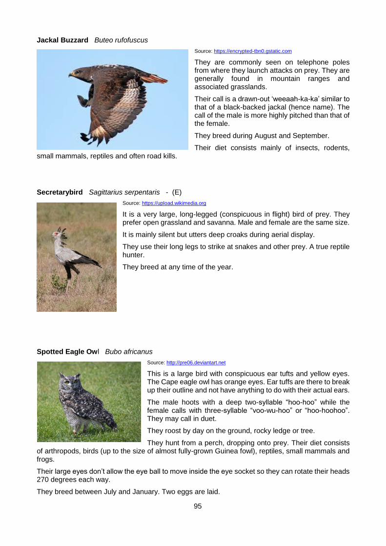
95
Jackal Buzzard Buteo rufofuscus
Source: https://encrypted-tbn0.gstatic.com
They are commonly seen on telephone poles from where they launch attacks on prey. They are generally found in mountain ranges and associated grasslands.
Their call is a drawn-out ‘weeaah-ka-ka’ similar to that of a black-backed jackal (hence name). The call of the male is more highly pitched than that of the female.
They breed during August and September.
Their diet consists mainly of insects, rodents, small mammals, reptiles and often road kills.
Secretarybird Sagittarius serpentaris - (E)
Source: https://upload.wikimedia.org
It is a very large, long-legged (conspicuous in flight) bird of prey. They prefer open grassland and savanna. Male and female are the same size.
It is mainly silent but utters deep croaks during aerial display.
They use their long legs to strike at snakes and other prey. A true reptile hunter.
They breed at any time of the year.
Spotted Eagle Owl Bubo africanus
Source: http://pre06.deviantart.net
This is a large bird with conspicuous ear tufts and yellow eyes. The Cape eagle owl has orange eyes. Ear tuffs are there to break up their outline and not have anything to do with their actual ears.
The male hoots with a deep two-syllable “hoo-hoo” while the female calls with three-syllable “voo-wu-hoo” or “hoo-hoohoo”. They may call in duet.
They roost by day on the ground, rocky ledge or tree.
They hunt from a perch, dropping onto prey. Their diet consists of arthropods, birds (up to the size of almost fully-grown Guinea fowl), reptiles, small mammals and frogs.
Their large eyes don’t allow the eye ball to move inside the eye socket so they can rotate their heads 270 degrees each way.
They breed between July and January. Two eggs are laid.
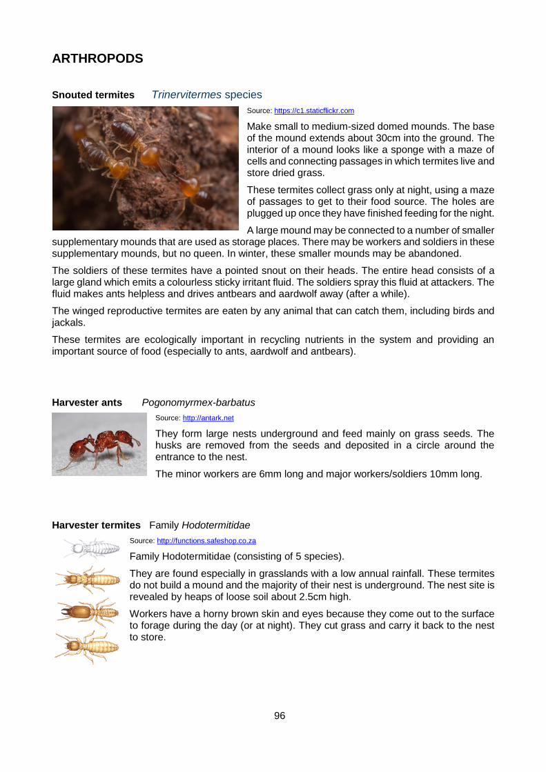
96
ARTHROPODS
Snouted termites Trinervitermes species
Source: https://c1.staticflickr.com
Make small to medium-sized domed mounds. The base of the mound extends about 30cm into the ground. The interior of a mound looks like a sponge with a maze of cells and connecting passages in which termites live and store dried grass.
These termites collect grass only at night, using a maze of passages to get to their food source. The holes are plugged up once they have finished feeding for the night.
A large mound may be connected to a number of smaller supplementary mounds that are used as storage places. There may be workers and soldiers in these supplementary mounds, but no queen. In winter, these smaller mounds may be abandoned.
The soldiers of these termites have a pointed snout on their heads. The entire head consists of a large gland which emits a colourless sticky irritant fluid. The soldiers spray this fluid at attackers. The fluid makes ants helpless and drives antbears and aardwolf away (after a while).
The winged reproductive termites are eaten by any animal that can catch them, including birds and jackals.
These termites are ecologically important in recycling nutrients in the system and providing an important source of food (especially to ants, aardwolf and antbears).
Harvester ants Pogonomyrmex-barbatus
Source: http://antark.net
They form large nests underground and feed mainly on grass seeds. The husks are removed from the seeds and deposited in a circle around the entrance to the nest.
The minor workers are 6mm long and major workers/soldiers 10mm long.
Harvester termites Family Hodotermitidae
Source: http://functions.safeshop.co.za
Family Hodotermitidae (consisting of 5 species).
They are found especially in grasslands with a low annual rainfall. These termites do not build a mound and the majority of their nest is underground. The nest site is revealed by heaps of loose soil about 2.5cm high.
Workers have a horny brown skin and eyes because they come out to the surface to forage during the day (or at night). They cut grass and carry it back to the nest to store.

97
Flightless Dung Beetle Circellium bachus
Source: http:// http://www.phillipskop.co.za
Once widespread throughout southern Africa, now only a few populations are found scattered in the E. Cape, the largest of these is in the AENP.
Named Circellium bacchus – “bacchus” is the Greek god of wine, referring to the beetle’s motion when rolling a dung ball which may appear similar to a person who has drunk too much wine.
Unlike most dung beetles, it is strictly ectothermic (cold-blooded). Most dung beetles use flight and their own terrestrial activity to warm up (i.e. they produce heat
endothermically). The flightless dung beetle possesses only vestigial wings and it is thought the ability to produce heat endothermically was lost due to atrophy of the flight muscles.
The flightless dung beetle uses elephant, rhino and buffalo dung. It may also use kudu and bushbuck dung. Dung is used to make food balls (eaten by the adults) and brood balls (the egg is laid inside this ball and the larva hatches to feed on it). The latter are almost twice as large as the former.
The beetles are active in the day, with peaks in mid-morning and late afternoon. Midday temperatures are too hot for these beetles and they are dependent on shade for survival. There is a dramatic increase of beetles after rain. They have an operating temperature of between 12 to 26 degrees, anything below or above you will not see them.
Beetles do not compete at the dung pad but there is fierce competition for the completed dung balls. Brood balls are rolled by the female, with the male in pursuit. The female buries the ball in soft sand and mating takes place below the ground surface. The female lays one egg in a ball, which hatches after a few days. The larvae feeds and pupates, emerging as an immature adult.
Flightless dung beetles are threatened by cars that drive over dung, crushing the beetles. They are also threatened by the actions of graders on the gravel roads of the park. Gravel roads need to be periodically scraped, especially after rainy periods and the grader creates a steep incline on the sides of the road. The beetles cannot negotiate this incline. The adults may bury the brood balls in this soft sand because they cannot push the balls over it. The balls are then crushed when the grader next works. The adults also die in the midday heat because they cannot get to shade over the incline.
The flightless dung beetles in generally a dung feeder and as such fulfils an important ecological role by redistributing dung and speeding up decomposition, thus recycling nutrients. The beetles are eaten by mongooses, meerkat and bat-eared foxes.
Buprestid beetles Buprestis aurulenta
Source: https://s-media-cache-ak0.pinimg.com
These are metallic or bronzed hard-bodied beetles with an elongated shape. The larvae are wood-borers and have no legs, wedging themselves in the channels they make in the wood.
The adults feed on pollen or sometimes on leaves and bark.

98
Scorpions buthidae and scorpidae
Source: http://www.wildcard.co.za http://i1074.photobucket.com
There are two species found in the park namely Buthidae which has a thick tail and small pincers. It uses the venom to kill its prey. The Scorpidae has a thin tail with large pincers. It uses the pincers to crush its prey.
Scorpion sting treatment:
Do:
1. Apply a cold compress and an analgesic (Aspirin, Paracetamol) to relieve pain, and transport to a hospital.
2. Monitor cardiac and respiratory functions and treat as required. 3. Immobilize and clean the wound. 4. Administer anti-venom only in the case of severe systemic envenomation. 5. Administer antihistamine and steroids only in cases of allergic reaction to anti-venom. 6. Administer a tetanus toxoid to prevent infection. 7. Envenomation of the eyes must be flushed with water or any bland fluid (milk, urine). In
severe cases anti-venom can be diluted 1 to 5 or 1 to 10 with water.
Don’t:
1. Use traditional remedies such as incisions, suction, tourniquet or the application of ointments. 2. Use alcohol as it will only mask any symptoms. 3. Administer anti-venom if no signs or symptoms of severe envenomation presents itself. 4. Administer spider or snake anti-venom. 5. Administer atropine to reduce salivation in the case of Parabuthus granulatus stings as it may
lead to unopposed adrenergic reaction. 6. Administer barbiturates, opiates, morphine or morphine derivatives as this could greatly
increase convulsions and cause respiratory distress.

99
7. GEOLOGY
The Greater Addo Elephant National Park encompasses a unique and complex bit of earth history covering about the last 500 million years. This includes the more recent events during the evolution of planet Earth, which is estimated to be about 4.5 billion years old.
It must be remembered that the earth is a dynamic planet, which is permanently changing and evolving. The earth has a radius of about 6 300km and is covered by a 40km thick crust. The surface crust is continuously being driven by convection currents in the underlying mantle. This causes the crustal plates (continents and oceans) to move relative to each other, a process called “continental drift.” Crustal plates can drift (float) from the warmer tropics to the colder pole regions, all the time changing the way in which a landscape evolves. The combination of earth processes and climatic conditions has a significant impact on the final landscape appearance.
The Oldest Rocks – Peninsula Formation Quartzitic Sandstone
The oldest rocks encountered in the Park occur as small islands in Algoa Bay. The Bird Island complex comprises Black Rock, Stag, Seal and Bird Islands and occurs about 10km south of the Woody Cape cliffs. These rocky islands are made up of quartzitic sandstone of the Peninsula Formation, which forms part of the Table Mountain Group, which in turn forms part of the Cape Supergroup. This is the same formation that occurs along the Port Elizabeth beachfront (Summerstrand) and on Table Mountain in Cape Town.
The Peninsula Formation rocks were formed about 500 million years ago (during the Ordovician Period) in a shallow marine beach environment. A large trough (basin) developed within the Gondwana landmass due to tectonic (crustal plate movement) activity. This basin filled with silica-rich sands, which have re-cemented to form relatively pure (clean) quartzitic sandstone. Quartzitic sandstone is very hard and forms the very prominent landscapes in the Eastern Cape Province. The Cockscomb Peak in the Groot Winterhoekberge is an excellent example of how weathering-resistant quartzitic sandstone is relative to the surrounding, softer bedrock material.
Witteberg Group rocks
A gap in the geological record of about 100 million years occurs to the next geological unit (this gap is referred to as an “unconformity”). The Witteberg Group rocks of the Cape Supergroup comprise quartzitic sandstone, sandstone and shale and were deposited about 400 million years ago during the Devonian Period. These rock types make up the Zuurberg mountain range to the north of the existing Addo Elephant National Park. Witteberg Group rocks have been grouped into two smaller subgroups, the lowermost one referred to as the Lake Mentz Subgroup and the upper unit called the Kommadagga Subgroup. Both of these stratigraphic units were named after places from the Eastern Cape Province. The Lake Mentz area is now called Darlington Dam.
The Devonian Period coincides with the evolution of the first land plants and marine fish. These would have both been fairly primitive specimens, with the zoological record dominated by marine invertebrates. The Witteberg Group was deposited in a tidal flat environment. The quartzitic sandstone and sandstone rock types would have been deposited in the intertidal zone, where clean sands were being reworked by marine action. The darker (and softer) shale was formed within the mudflat environment.
Glacial Dwyka Group Tillite
A very significant marker horizon occurs on top of the Witteberg Group rocks. During the Carboniferous Period (about 300 million years ago), Africa (as part of Pangea – a super-continent formed from a number of continents joined together) was located at much higher latitudes and experienced colder climatic conditions. Southern Africa, as we know it today, was an ice sheet
100
dominated by glaciers during these times. These ice sheets migrated towards the south and southwest from what is today Zimbabwe and Botswana. En route these ice sheets ripped up pieces of rock from the floor of the glacier and carried a multitude of rock types over thousands of kilometres.
Inevitably, the continents moved to warmer latitudes, resulting in climatic warming. The ice sheets began to melt and released all of the rock material that had been consumed by the glacial fronts. In modern glaciers, the dumping of material from retreating glaciers is called “terminal moraine”. This terminal moraine during the Carboniferous Period became cemented to form a rock type called “tillite”. Tillite is a grey-brown, fine-grained rock mass with numerous small foreign clasts of various rock types and colours. Many of the clasts are polished (have a smooth surface) due to the friction when they were picked up by the moving ice sheets.
The tillite deposits in the GAENP are referred to as the Dwyka Group rocks of the Karoo Supergroup. The Dwyka Group occurs as a horizontal band along the northern edges of the Zuurberg mountain range and along the southern shores of Darlington Lake. This lithological horizon is an indicator horizon, which separates the Cape Supergroup rocks to the south and the Karoo Supergroup rocks to the north. Dwyka Group rocks are fairly easy to spot in the veld, as they weather to form an irregular landscape that looks like tombstones – so called “tombstone weathering”.
Ecca and Beaufort Sediments of the Karoo Supergroup
The Dwyka Group is overlain by the Ecca and Beaufort Group rocks, of the Karoo Supergroup. These rock types occur in the Darlington Dam area, in the northern part of the Greater Addo Elephant National Park and cover a period of between about 250 and 300 million years (Permian Period). The Karoo landscape represents a significant climatic warming after the Dwyka glaciation. Karoo Supergroup sediments were deposited into a large inland sea (with an inlet where present day East London is), with northwards flowing rivers depositing sediment into a massive basin that extends into Zimbabwe and Botswana. The huge mountain ranges to the south of the Karoo Basin were probably larger than the present day Himalayas and were undoubtedly the source of all the sediments that form the present day Karoo landscape.
The Ecca Group sediments were deposited in a marine origin within the inland Karoo Sea. This stratigraphic unit comprises sandstone, shale and mudstone. The Ecca coincides with the evolution of large forests (conifers) and the first reptiles. The large forests gave rise to the significant coal reserves that occur in the eastern part of South Africa at present. Some of the smaller formations within the Ecca Group were named after places within the Eastern Cape Province. These include the Ripon Formation (named after a railway siding south of Cookhouse) and the Waterford Formation (named after a village south-east of Jansenville.
The Beaufort Group depositionary history represents a change from marine to fluvial (riverine) environments. The Beaufort landscape was characterised by large meandering river channels in a fairly flat land surface. The climate would have been fairly hot, with terrestrial vegetation restricted to a narrow green belt along the riparian habitats flanking the drainage channels. The remainder of the Karoo landscape would probably have been fairly dry and arid. Only the Koonap Formation of the Beaufort Group occurs within the boundaries of the Park, around the northern fringes of Darlington Dam.
Beaufort Group rocks are very important from an anthropological point of view. Beaufort times are characterised by the emergence of the mammal-like-reptiles, which are the precursors to the dinosaurs. These animals comprised both carnivores and herbivores and dominated the Beaufort landscape during the Permian Period.
Mesozoic Algoa Basin
The Mesozoic Algoa Basin represents a very significant geological event along the south-eastern coast of southern Africa. The Algoa Basin extends along the Algoa Bay coastline from Bethelsdorp in the south-west to the Sundays River mouth in the north-east. It probably extends even further beneath the surface cover material to the Woody Cape cliffs area. It extends inland along what is

101
called a “panhandle” to the Erekroonspoort area, about 25km east of Jansenville.
Towards the end of the Triassic (about 230 million years ago) the Pangea mega-continent began to break apart. Two new super continents began to form, namely the northern Laurasia and the southern Gondwana. The stresses associated with splitting of the land masses caused the folding of the Cape Supergroup rocks along the southern margin of southern Africa, to form what is today known as the Cape Fold Belt. The further break up of Gondwana into Africa, South America and a host of other land masses also resulted in the formation of half-graben faults along the south-eastern margin of the present-day coastline. These half-graben faults formed deep basins, which subsequently began to fill with sediments.
The breaking up of the continental land mass initially resulted in what we call Zuurberg volcanics. These are extrusive (igneous rocks that flow across the surface) rocks derived from great depth and associated with volcanic activity due to crustal tectonics. The resulted Zuurberg Group rocks comprise basalt, tuff, and breccia. The Zuurberg Group is made of the Coerney and Slagboom Formations (named after a river about 25km east of Kirkwood) and a farmstead about 17km north-east of Kirkwood, respectively. The Zuurberg Group is named after the Zuurberg mountain range. An excellent basaltic outcrop occurs in a small quarry to the north-east of Tembani, within the Nyathi Concession area.
During the Jurassic Period (about 140 to 190 million years ago) torrential streams eroded the quartzitic sandstone highlands and deposited extensive boulder beds and gravels. The resultant red-coloured conglomeritic Enon Formation (named after the small village of Enon to the north of Port Elizabeth) is a very prominent horizon along the southern foothills of the Zuurberg Mountain range. The Mimosa quarry to the north-west of the Mimosa farmstead is an excellent outcrop of the Enon Formation conglomerate. The quarry was apparently used to source the quartzitic sandstone material used to construct many of the gravel roads within the present Addo Elephant National Park.
The Kirkwood Formation sedimentation began towards the end of the Jurassic Period (about 140 to 150 million years ago). The Kirkwood Formation represents an accumulation of fine-grained sediments under fluvial conditions. The resultant mudstone and subordinate sandstone also contains foliage and wood fossils. The fluvial deposition began to fill the Algoa Basin and was followed by marine ingression to form the Sundays River Formation. The Sundays River Formation contains numerous marine fossils, such as ammonites, belemnites, bivalves and gastropods (shells). From oldest to youngest, the Enon, Kirkwood and Sundays River Formation are collectively referred to as the Uitenhage Group.
Extensive oil exploration was undertaken throughout the Uitenhage Group rocks during the 1960’s by Soekor (South African Oil Exploration Corporation). It was during this exploration exercise that the highly visible cut-lines were cleared throughout the Addo region and today represent highly disturbed transects within the Subtropical Thicket. It is interesting to note that some of the exploratory boreholes in the Colchester area proved Algoa Group sediments in excess of 2km. These oil exploration drives apparently revealed minor, but insignificant, reserves of oil and gas.
Local press releases during the first quarter of 2003 stated that oil exploration had recommenced within the Mesozoic Algoa Basin. This may prove successful if one considers that the economically viable reserves encountered in the Mossel Bay area (Mossgas) are derived from very similar geological environments.
The northern part of the Addo section of the Park (including the rest camp) is underlain by sediments of the Sundays River Formation. Further to the south, the Park is underlain by sediments of the Kirkwood Formation. These formations appear very similar in surface outcrop and generally comprise reddish and greenish-grey coloured mudstone, which weathers to reveal a very slippery, clayey material when wet. This material is also very problematic from a construction point of view, as it swells when it gets wet. Much structural damage has been caused to dwellings in the region, where inadequate precautionary measures have been taken when building. The Addo brickfields used to use the clays of the Kirkwood Formation to make clay bricks. These sediments also contain sandstone with conglomerates and are of marine origin. The sandstone bands are dark-brown when rich in iron. Clays with scattered sandstone pieces are often visible on bare weathered patches and
102
at dams in the park. The Sundays River Formation is generally rich in invertebrate fossils, mainly of molluscs. The genera Trigonia and Exogyra of the Lamellibranchiata are widely distributed.
Tertiary Alexandria Formation
By the end of the Cretaceous Period (about 80 million years ago), the present configuration of the Southern African coastline was established. The evolution of the landscape from this time onwards was dictated to a large extent by fluctuating sea levels. Climatic cooling results in more seawater freezing in the Polar Regions, which will correspond with a dropping of global sea level. By the same token, sea level rise will be associated with global warming.
One such sea level rise from about 20 to 2 million years ago, resulted in the flooding of the Eastern Cape coastline to form the marine Alexandria Formation. This formation has deposited 10’s of kilometres inland of the present coastline and has resulted in a fairly level wave-cut platform. These levels occur in about three different heights (each representing a different sea level), each formed during a still-stand followed by further lowering of sea level. The maximum landward extent of the raised sea level resulted in the development of the Grassridge Platform, which occurs at heights of 245 - 320 metres above mean sea level. The shoreline of this sea level curved inland from the vicinity of Port Elizabeth to Paterson and Port Alfred. Under the water of the fluctuating sea levels, were deposited the sediments of the Alexandria Formation.
The lower Coega Platform occurs further seawards, at an average height of about 200 metres above mean sea level. This Platform ends inland against a former cliff line that is exposed near the N2 highway in the vicinity of the Coega salt pans, between Colchester and Port Elizabeth.
The Alexandria Formation near Colchester would form part of the Coega Platform, whilst the same formation within the Addo Elephant Park near Addo Heights, would form part of the older Grassridge Platform.
The Tertiary Alexandria Formation generally attains a maximum thickness of about 13 metres near Colchester and comprises calcareous sandstone, coquinite (cemented shell-rock) and quartzitic sandstone gravel. The Tertiary Period (65 to 2 million years ago) also coincides with the rise of the mammals. Dinosaurs became extinct at the end of the Cretaceous Period (about 65 million years ago) and small quadrupeds and flowering plants dominated the landscape.
The Alexandria Formation is easily discernible within the current Addo Elephant National Park and stands out as a white-coloured band near the upper portions of the hills. The best outcrop within the Park would be at the Zuurkop Lookout, where this material was previously mined to produce the white coloured material used to surface the gravel road in this part of the Park. In 3-D it should be remembered that this formation represents a fairly flat sea-level deposit - a thin disk into the landscape beneath the overlying cover material such as at Addo Heights. This cover material is known as the Nanaga Formation in the Park.
Aeolian Nanaga Formation
During each still-stand of sea level, a coastal dunefield was deposited. This process still occurs today along the existing coastline of Algoa Bay. The resultant ancient dunefield cordons formed during the Tertiary Period have been preserved as rolling hills of the Grassridge and Nanaga areas and called the Nanaga Formation. This Aeolian (wind deposited) deposit attains thicknesses of up to 250 metres and extends from Paterson in the north, down to Woody Cape in the south.
This formation obviously gets progressively younger towards the coast, as the sea level receded. The formation generally comprises semi- to well-consolidated calcareous dune rock (sandstone). A good outcrop would be the road cutting along the N2 highway about 5km north of the Nanaga intersection. The Nanaga Formation is very prominent as fine-grained red sands, which form the high-lying topography in the Park, such as at Addo Heights.

103
Recent (Quaternary) Deposits
Recent (the Quaternary Period covers a time scale from about 2 million years ago to present) geological evolution and geomorphologic evolution of our region is highly complex and driven by climatic variation and associated sea level fluctuations. Of interest would be a coastal marine formation called the Salnova Formation. This formation generally occurs at a height of about 20 metres below sea level and comprises calcrete with quartzitic sandstone boulders and shell material. Salnova Formation outcrop occurs near Cannon Rocks, in the extreme eastern part of the proposed Greater Addo Elephant National Park. It also occurs near the Coega River mouth, to the south of the Park.
Another Aeolian formation along the coastal zone includes the well-consolidated Nahoon Formation. This calcareous sandstone formation attains thicknesses of up to about 50 metres and has had a significant effect on the weathering rates of the Eastern Cape Province coastline. These aeolianites (dune rock) typically protrude has coastal headlands into the sea, producing Kwaaihoek near Boknes (Diaz Cross), Bushman’s River Mouth, Bats Cave (Great Fish River), Nahoon Point (East London) and Flat Rocks (Port Elizabeth). In the Park, this formation is responsible for the very scenic Woody Cape Cliffs.
The most recent of all geological formations is the Aeolian Schelm Hoek Formation. This comprises wind-blown sand adjacent to the present day coastline and is still being deposited at present. The Schelm Hoek Formation is included as the Alexandria dune sea in the south-eastern part of the Park. This formation includes an older generation vegetated dune and a younger generation, non-vegetated sand dune. The migration of non-vegetated Schelm Hoek Formation has been retarded to a certain extent by the infestation of Australian wattle species. This is especially noticeable along the eastern side of the Sundays River mouth.
Alexandria Dunefield:
The soils of the dunefield are recently deposited sands of marine origin. The high biogenic component (40% calcium carbonate) is the collective remains of algal calcite, bone fragments and mostly marine gastropod shell fragments. The remaining 60% is composed of varying sizes of quartz sand grains. Dune sands have large interstitial air spaces. These act as poor conductors of heat. Dunes thus have high daily temperature fluctuations on the surface and a steep temperature gradient from the surface to a shallow depth. They are excessively porous to rain water, in other words, low water holding capacity and thus are a dry habitat and are easily leached.
Characteristics of the coastal dune sands:
Typically alkaline from the calcareous content.
Constantly wind-formed with lighter grains further inland and heavier sand grains in the foredunes. High dunes have fine sands at the crest and coarser grains at the base.
Strong inland winds causes a great and nearly constant deposition of salt spray.
Bare yellow-brown to beige sand dunes soak up rain with minimal runoff. Grey sands, stained with humus, covered by woody vegetation, show large runoffs causing gully erosion during heavy rains. When pre-wetting occurs the runoff is minimal. This is caused by a water repellent layer beneath the litter. The soil grains become encrusted with an organic skin originating from plant waxes, phenols and amines and fungal mycelia and metabolites, and decomposition products. Fire transforms and volatizes these products thus influencing the water repellence. Only where the vegetation becomes well established (for example, main slipface), will the soil structure improve.
Geomorphology
The land that rose above the level of the sea that cut the marine platform (Alexandria Formation in the Park) was drained by various rivers. Along these rivers, cycles of erosion worked their way into much of the interior of southern Africa, giving rise to the African Erosion Surface (African Land

104
Surface). This surface exists at different altitudes and developed over the last 100 million years (since the Mid-Cretaceous Period). They are capped by hard silcretes and, in the Park, characterised by Grassy Fynbos vegetation. These African Land Surfaces are clearly visible along the upper reaches of the Zuurberg mountain range in the Park.
The geomorphological evolution of the area included in the Park still continues today. Inland remnants have been preserved for many millions of years, but bear testimony to prolonged but still continuing fluvial (river) processes. The marine processes are still shaping the coastline, be it the deposition of sand in the Alexandria dune sea, or the erosion of the Nahoon Formation along the Woody Cape cliffs.
It should be remembered that all river systems attempt to erode the surrounding landscape down to sea level. Geological processes such as sea level change and tectonic activity prevent this strategy from ever being realised. It is, nevertheless, important to remember that erosion still continues (as does deposition) and the morphology of both the inland and the coastal region continues to evolve.

105
8 NIGHT SKIES
(An app called ‘Sky view free’ which is a great aid in studying the night sky can be downloaded onto a smartphone. This app enables you to point your phone at a star or planet for it to be identified.)
Look up at night and you will see many things that together make up the night sky.
Galaxy
Source: https://tse2.mm.bing.net
A galaxy is an accumulation of stars held together by gravity. There are between 100 and 400 billion galaxies in the universe. The Milky Way is a galaxy containing 100 000 million stars. Two types of galaxies exist: spiral and elliptical. The Milky Way is a spiral galaxy.
Solar system
Source: https://tse2.mm.bing.net
Our solar system consists of the sun (a star), 8 planets, and the moons associated with each of the planets. Pluto was considered to be the 9th planet but is now referred to as a ‘dwarf planet’.
Star
A star is a gaseous body that emits light (burning gas). It will appear as a pinprick of light or a twinkling light when looking through binoculars.
Stars are formed inside nebulae. Nebulae are clouds of gas and dust. As a nebula collapses, matter becomes more densely packed and heats up. This occurs until the matter becomes stable. A star can produce light and heat for about 10 000 million years.
Near the end of a star’s life, a number of changes occur. Some stars expand to become red giants. Later, the outer layers of the red giant are cast off to form nebulae and he inner layers become a white dwarf (which shines feebly). Later this cools down to form a cold, dark black dwarf.
Other stars become red super giants and then cause an explosion. They either become a neutron star (small and very dense) or collapse into a black hole.
The temperature of a star is related to its colour. From coldest to hottest, stars colours are red to yellow to white to bluish-white. The surface temperature of our sun is about 6 000 °C.
Planet
A planet is a world such as earth that orbits the sun and reflects the sun’s light. A planet will appear as a round ball when looking through binoculars.

106
Moon
A heavenly body made of rock circling the planets. Our moon is about 400 000km from earth. The moon rotates around its own axis at the same speed as it rotates around the earth (taking 27.3 days) therefore we see only one side of the moon. The sun, moon and earth exert a gravitational pull on each other this causes tides in the water on earth.
Constellation
This is a pattern (according to human viewers) of stars in the sky, e.g. the Southern Cross, Orion, Scorpius.
Asteroids
Bodies of rock orbiting the sun, mainly between Mars and Jupiter.
Meteors
There are many particles (or chunks of rock) that are in orbit around the earth. When one of these enters the earth’s atmosphere, its friction with the air causes it to ignite and so appears to us as a “shooting star”. The meteor generally burns up before it reaches the earth’s surface. Larger particles may reach the ground and form a crater at the point of impact – these are called meteorites.
Planets
Mercury
Source: https://tse1.mm.bing.net
The closest planet to the sun, the eighth largest and the fourth
brightest planet (brighter than Sirius – the brightest star) but often obscured because it is so close to the sun. It can only be seen when it is farthest away from the sun as viewed from the earth, in the early evening or morning.
In Roman mythology Mercury is the god of commerce, travel and thievery, the Roman counterpart of the Greek god Hermes, the messenger of the Gods. The planet probably received this name
because it moves so quickly across the sky.
Mercury has been known since at least the time of the Sumerians (3rd millennium BC). It was sometimes given separate names for its apparitions as a morning star and as an evening star. Greek astronomers knew, however, that the two names referred to the same body. Heraclitus even believed that Mercury and Venus orbit the Sun, not the Earth.

107
Venus
Source: http://www.planetsforkids.org
It is the second planet from the sun, the sixth largest and the brightest of all planets and stars as it is always close to the sun. Venus appears as the “evening star” for about 8.5 months of the year and then as the “morning star” for a few months of the year. For some time – 2 days to 2 months - it also disappears behind the sun and is not visible. Venus displays phases like the moon that can be best seen just after sunset or at sunrise.
Venus (Greek: Aphrodite; Babylonian: Ishtar) is the goddess of love and beauty. The planet is so named probably because it is the brightest of
the planets known to the ancients. With a few exceptions, the surface features on Venus are named for female figures.
Venus has been known since prehistoric times. It is the brightest object in the sky except for the Sun and the Moon. Like Mercury, it was popularly thought to be two separate bodies: Eosphorus as the morning star and Hesperus as the evening star, but the Greek astronomers knew better. Venus's apparition as the morning star is also sometimes called Lucifer.
Earth
Source: https://tse1.mm.bing.net
It is the third planet from the sun and the fifth largest.
Earth is the only planet whose English name does not derive from Greek/Roman mythology. The name derives from Old English and Germanic. There are, of course, hundreds of other names for the planet in other languages. In Roman Mythology, the goddess of the
Earth was Tellus - the fertile soil (Greek: Gaia, terra mater - Mother Earth).
It was not until the time of Copernicus (the sixteenth century) that it was understood that the Earth is just another planet.
Earth, of course, can be studied without the aid of spacecraft. Nevertheless it was not until the twentieth century that we had maps of the entire planet. Pictures of the planet taken from space are of considerable importance; for example, they are an enormous help in weather prediction and especially in tracking and predicting hurricanes. And, they are extraordinarily beautiful.
Mars
Source: https://tse2.mm.bing.net
It is the fourth planet from the sun and the seventh largest. At some times, Mars is brighter than Jupiter. It has a red colour (because it is covered with a rock and sand desert). It has 2 moons but these are invisible when looking through binoculars. In the month of August 2003, Mars was closer to the earth than usual and very bright in the night sky. Mars reached its closest point to the earth on the 27th August 2003 – about 34 million km away from earth. The next time Mars will be this close to earth will probably be in the year 2237.
Mars (Greek: Ares) is the god of War. The planet probably got this name due to its red colour; Mars is sometimes referred to as the Red Planet. (An interesting side note: the Roman god Mars was a god of agriculture before becoming associated with the Greek Ares; those in favour of colonizing and terraforming Mars may prefer this symbolism.) The name of the month March derives from Mars.

108
Mars has been known since prehistoric times. Of course, it has been extensively studied with ground-based observatories. But even very large telescopes find Mars a difficult target, it's just too small. It is still a favourite of science fiction writers as the most favourable place in the Solar System (other than Earth!) for human habitation. But the famous "canals" "seen" by Lowell and others were, unfortunately, just as imaginary as Barsoomian princesses.
Jupiter
Source: https://tse4.mm.bing.net
It is the fifth planet from the sun and by far the largest. It is more than twice as big as all the other planets combined and is one of the brightest in the night sky. It has 16 moons – one or more of the four largest moons can be seen as little specks of light near the planet.
Jupiter (a.k.a. Jove; Greek Zeus) was the King of the Gods, the ruler of Olympus and the patron of the Roman state. Zeus was the son of Cronus (Saturn).
Jupiter is the fourth brightest object in the sky (after the Sun, the Moon and Venus). It has been known since prehistoric times as a bright "wandering star". But in 1610 when Galileo first pointed a telescope at the sky he discovered Jupiter's four large moons Io, Europa, Ganymede and Callisto (now known as the Galilean moons) and recorded their motions back and forth around Jupiter. This was the first discovery of a centre of motion not apparently centred on the Earth. It was a major point in favour of Copernicus's heliocentric theory of the motions of the planets (along with other new evidence from his telescope: the phases of Venus and the mountains on the Moon). Galileo's outspoken support of the Copernican theory got him in trouble with the Inquisition. Today anyone can repeat Galileo's observations (without fear of retribution :-) using binoculars or an inexpensive telescope.
Saturn
Source: https://tse2.mm.bing.net
It is the sixth planet from the sun and is the second largest after Jupiter. Seen through binoculars, Saturn and its moons look like an elongated rice grain. The rings of Saturn can only be seen properly through a telescope.
In Roman mythology, Saturn is the god of agriculture. The associated Greek god, Cronus, was the son of Uranus and Gaia and the father of Zeus (Jupiter). Saturn is the root of the English word "Saturday".
Saturn has been known since prehistoric times. Galileo was the first to observe it with a telescope in 1610; he noted its odd appearance but was confused by it. Early observations of Saturn were complicated by the fact that the Earth passes through the plane of Saturn's rings every few years as Saturn moves in its orbit. A low resolution image of Saturn therefore changes drastically. It was not until 1659 that Christiaan Huygens correctly inferred the geometry of the rings. Saturn's rings remained unique in the known solar system until 1977 when very faint rings were discovered around Uranus (and shortly thereafter around Jupiter and Neptune).
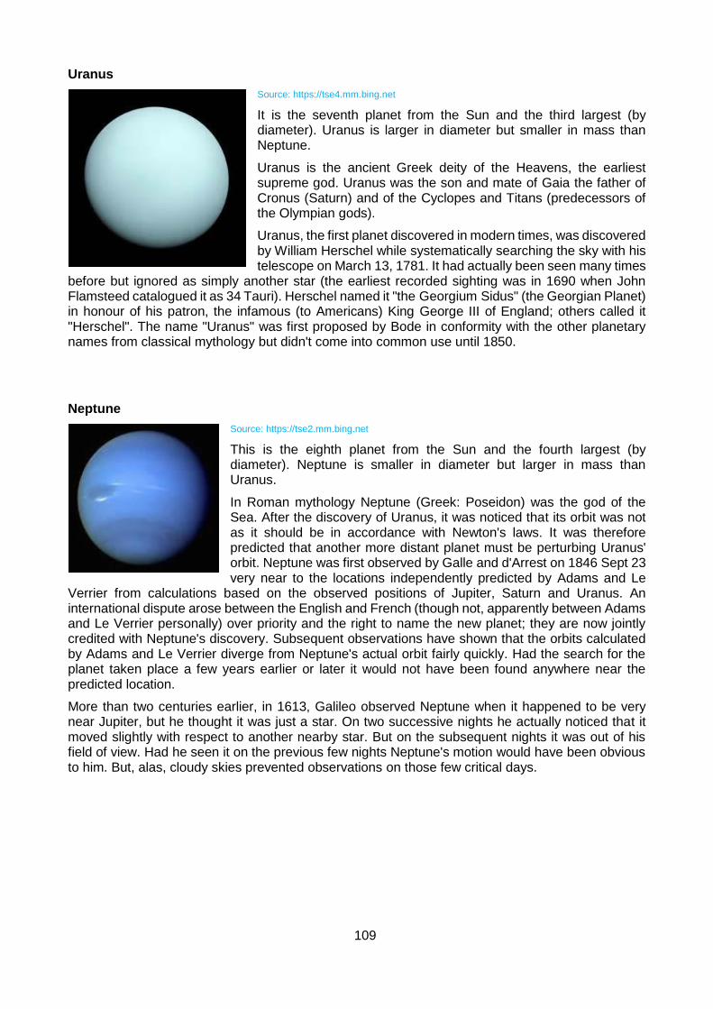
109
Uranus
Source: https://tse4.mm.bing.net
It is the seventh planet from the Sun and the third largest (by diameter). Uranus is larger in diameter but smaller in mass than Neptune.
Uranus is the ancient Greek deity of the Heavens, the earliest supreme god. Uranus was the son and mate of Gaia the father of Cronus (Saturn) and of the Cyclopes and Titans (predecessors of the Olympian gods).
Uranus, the first planet discovered in modern times, was discovered by William Herschel while systematically searching the sky with his telescope on March 13, 1781. It had actually been seen many times
before but ignored as simply another star (the earliest recorded sighting was in 1690 when John Flamsteed catalogued it as 34 Tauri). Herschel named it "the Georgium Sidus" (the Georgian Planet) in honour of his patron, the infamous (to Americans) King George III of England; others called it "Herschel". The name "Uranus" was first proposed by Bode in conformity with the other planetary names from classical mythology but didn't come into common use until 1850.
Neptune
Source: https://tse2.mm.bing.net
This is the eighth planet from the Sun and the fourth largest (by diameter). Neptune is smaller in diameter but larger in mass than Uranus.
In Roman mythology Neptune (Greek: Poseidon) was the god of the Sea. After the discovery of Uranus, it was noticed that its orbit was not as it should be in accordance with Newton's laws. It was therefore predicted that another more distant planet must be perturbing Uranus' orbit. Neptune was first observed by Galle and d'Arrest on 1846 Sept 23 very near to the locations independently predicted by Adams and Le
Verrier from calculations based on the observed positions of Jupiter, Saturn and Uranus. An international dispute arose between the English and French (though not, apparently between Adams and Le Verrier personally) over priority and the right to name the new planet; they are now jointly credited with Neptune's discovery. Subsequent observations have shown that the orbits calculated by Adams and Le Verrier diverge from Neptune's actual orbit fairly quickly. Had the search for the planet taken place a few years earlier or later it would not have been found anywhere near the predicted location.
More than two centuries earlier, in 1613, Galileo observed Neptune when it happened to be very near Jupiter, but he thought it was just a star. On two successive nights he actually noticed that it moved slightly with respect to another nearby star. But on the subsequent nights it was out of his field of view. Had he seen it on the previous few nights Neptune's motion would have been obvious to him. But, alas, cloudy skies prevented observations on those few critical days.

110
Pluto
Source: https://tse4.mm.bing.net
This planet orbits beyond the orbit of Neptune (usually). It is much smaller than any of the official planets and is now classified as a "dwarf planet".
In Roman mythology, Pluto (Greek: Hades) is the god of the underworld. The planet received this name (after many other suggestions) perhaps because it's so far from the Sun that it is in perpetual darkness and perhaps because "PL" are the initials of Percival Lowell.
Pluto was discovered in 1930 by a fortunate accident. Calculations which later turned out to be in error had predicted a planet beyond Neptune, based on the motions of Uranus and Neptune. Not knowing of the error, Clyde W. Tombaugh at Lowell Observatory in Arizona did a very careful sky survey which turned up Pluto anyway.
After the discovery of Pluto, it was quickly determined that Pluto was too small to account for the discrepancies in the orbits of the other planets. The search for Planet X continued but nothing was found. Nor is it likely that it ever will be: the discrepancies vanish if the mass of Neptune determined from the Voyager 2 encounter with Neptune is used. There is no Planet X. But that doesn't mean there aren't other objects out there, only that there isn't a relatively large and close one like Planet X was assumed to be. In fact, we now know that there are a very large number of small objects in the Kuiper Belt beyond the orbit of Neptune, some roughly the same size as Pluto.
All these planets can be seen from earth because they revolve around the sun on a planetary pathway on the same plane. They deviate very little from this pathway and it roughly follows the line east to west or west to east.
Venus revolves around the sun in the opposite direction to the Earth. This is why it sometimes appears as the ‘evening star’ and at other times as the ‘morning star’.
Planets are visible because they reflect the light of the sun.
The Moon
The phases of the moon are created by the position of the moon relative to the sun and the earth.
Source: http://i1018.photobucket.com
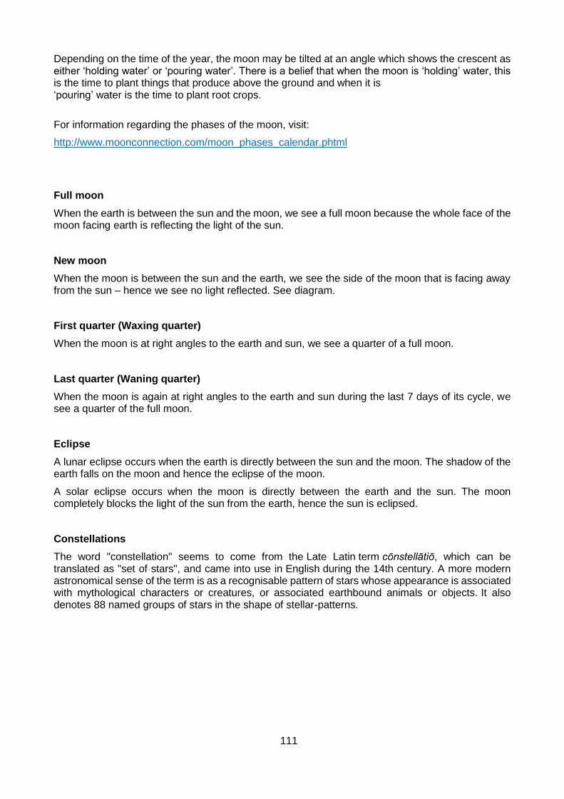
111
Depending on the time of the year, the moon may be tilted at an angle which shows the crescent as either ‘holding water’ or ‘pouring water’. There is a belief that when the moon is ‘holding’ water, this is the time to plant things that produce above the ground and when it is ‘pouring’ water is the time to plant root crops.
For information regarding the phases of the moon, visit:
http://www.moonconnection.com/moon_phases_calendar.phtml
Full moon
When the earth is between the sun and the moon, we see a full moon because the whole face of the moon facing earth is reflecting the light of the sun.
New moon
When the moon is between the sun and the earth, we see the side of the moon that is facing away from the sun – hence we see no light reflected. See diagram.
First quarter (Waxing quarter)
When the moon is at right angles to the earth and sun, we see a quarter of a full moon.
Last quarter (Waning quarter)
When the moon is again at right angles to the earth and sun during the last 7 days of its cycle, we see a quarter of the full moon.
Eclipse
A lunar eclipse occurs when the earth is directly between the sun and the moon. The shadow of the earth falls on the moon and hence the eclipse of the moon.
A solar eclipse occurs when the moon is directly between the earth and the sun. The moon completely blocks the light of the sun from the earth, hence the sun is eclipsed.
Constellations
The word "constellation" seems to come from the Late Latin term cōnstellātiō, which can be translated as "set of stars", and came into use in English during the 14th century. A more modern astronomical sense of the term is as a recognisable pattern of stars whose appearance is associated with mythological characters or creatures, or associated earthbound animals or objects. It also denotes 88 named groups of stars in the shape of stellar-patterns.
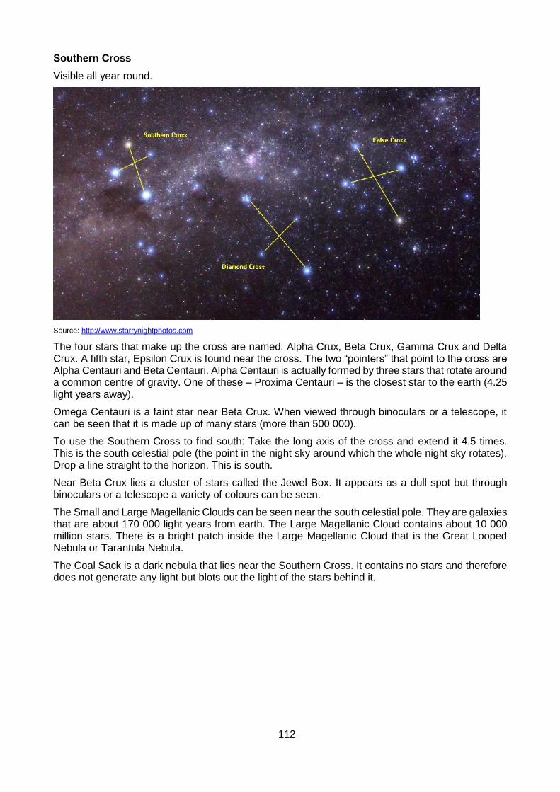
112
Southern Cross
Visible all year round.
Source: http://www.starrynightphotos.com
The four stars that make up the cross are named: Alpha Crux, Beta Crux, Gamma Crux and Delta Crux. A fifth star, Epsilon Crux is found near the cross. The two “pointers” that point to the cross are Alpha Centauri and Beta Centauri. Alpha Centauri is actually formed by three stars that rotate around a common centre of gravity. One of these – Proxima Centauri – is the closest star to the earth (4.25 light years away).
Omega Centauri is a faint star near Beta Crux. When viewed through binoculars or a telescope, it can be seen that it is made up of many stars (more than 500 000).
To use the Southern Cross to find south: Take the long axis of the cross and extend it 4.5 times. This is the south celestial pole (the point in the night sky around which the whole night sky rotates). Drop a line straight to the horizon. This is south.
Near Beta Crux lies a cluster of stars called the Jewel Box. It appears as a dull spot but through binoculars or a telescope a variety of colours can be seen.
The Small and Large Magellanic Clouds can be seen near the south celestial pole. They are galaxies that are about 170 000 light years from earth. The Large Magellanic Cloud contains about 10 000 million stars. There is a bright patch inside the Large Magellanic Cloud that is the Great Looped Nebula or Tarantula Nebula.
The Coal Sack is a dark nebula that lies near the Southern Cross. It contains no stars and therefore does not generate any light but blots out the light of the stars behind it.

113
Orion
Orion is best seen in the summer and lies upside down in the southern hemisphere.
Source: https://bestdoubles.files.wordpress.com
The two most prominent stars of Orion are Betelgeuse (one of Orion’s shoulders) and Rigel (one of Orion’s feet). Betelgeuse is a red supergiant (dying star). Rigel is a bluish-white star.
In Greek mythology, Orion was a hunter who boasted he could kill all the animals in the forest. The Greek gods did not approve of this attitude and sent a scorpion to sting him in the heel. He died from the sting and Jupiter put him up in the sky. To be fair, he put the scorpion up in the sky too but at the opposite end of the sky so that it could never sting Orion again. That is why Orion and Scorpius are always on opposite ends of the sky. When Orion is in the east, Scorpius is in the west. When Orion is in the evening sky, Scorpius is in the morning sky.
Orion’s two dogs that went hunting with him are associated with Orion in the sky. Sirius is the big dog and the brightest star in the sky (8.7 light years away, temperature 11 000 °C). Procyon is the small dog.
Three stars (sometimes referred to as the three kings) in a straight line form Orion’s belt from which his sword hangs. There is a faint cluster of stars in the middle of the sword which is a nebula containing four bright stars.
The San have a different interpretation of this constellation. They believe that the three stars of the belt are three eland walking towards a waterhole. The waterhole (Cirius) lies between two dunes (formed by the two feet and two shoulders of Orion). Orion’s head is a hunter shooting at them. The arrow shot by the hunter is Orion’s sword.
There are various stories about Orion.

114
You can use Orion to find direction. The belt and sword form a pot. The handle of the pot points towards the north celestial pole. When the handle of the pot is vertical, you can extend the line to north on the horizon.
There is cluster of seven visible stars near Orion. This is called the Seven Sisters and its shape resembles a tennis racquet. This star cluster is actually made up of over 400 stars, the brightest of which is 350 times brighter than the sun.
Taurus
A V-shaped constellation lying between Orion and the Seven Sisters.
Source: http://www.buzzle.com
Most visible in summer and when Orion is visible. The V-shape is the horns of the bull (upside down in the southern hemisphere). The Seven Sisters make up the shoulder of the bull.
One myth about Taurus is that Zeus took on the disguise of a snow-white bull to impress Europa. She admired the bull and climbed on its back. Zeus then revealed his identity and married her.
Leo
Leo lies upside down in the southern hemisphere.
Source: http://astronomyonline.org
It looks like a sickle. Regulus – at the top of the sickle handle – is the brightest star.

115
Scorpius
Scorpius can be best seen in the winter sky. The stars form the shape of a scorpion.
Source: ttp://www.rocketmime.com
The brightest star is Antares which is a red giant (a dying star) and has an orange-red colour. Antares means “not Mars” – Mars and Antares sometimes appear close together and have a similar colour. Antares is made up of two stars but one of them is very faint.
116
8. RESEARCH IN THE PARK
Over the years research has been conducted in the park by various people and this will continue to take place.
Elephants
1960s: Iain Douglas Hamilton pioneered individual identification of elephants in conjunction with Cynthia Moss’s long-term study of the Amboseli elephants Kenya.
1976 – 1979: Dr Anthony Hall-Martin researched the Addo elephant population. In this study he built up a complete photographic identification file for the population (a total of 96 elephants in May 1978), documented the sex, estimated age, and developmental status of all individuals, and kept records of births and deaths within the population. Additionally, notes were kept on observed association patterns and social behaviour.
1996: further intensive research project on the Addo elephants by Anna Whitehouse (neé Woodd). All the elephants were identified, named and photographic identification files compiled. Association patterns were observed to determine which elephants belonged to which family group and which calves belonged to which cows.
Maternal family trees dating back to the creation of the park in 1931 were reconstructed using photographs and written records.
Other aspects studied:
Ranging behaviour (radio collars fitted to a number of males and females to track movements), including speed of movement, distances travelled, home range sizes, centres of activity and association patterns.
Impact on vegetation – elephants cause a reduction in species diversity and density but impact is less negative than that of goats.
Population genetics and paternity – investigated using biopsy darting. Population genetic diversity lower than in Kruger but no signs of inbreeding depression. A number of different males father calves. The paternity testing cannot show who actually did the mating at the moment because there is not genetic variation from one individual to the next (the population is homozygous).
Other mammals
Since 1978: An aerial helicopter survey of all large mammal species has been carried out in the AENP at least once a year (excluding 1980, 1982, and 1984). A total count of all elephants is made, any carcasses seen are noted and, additionally, the number of calves estimated to be less than one year has been recorded in censuses conducted from 1986 onwards. While Anna Whitehouse was busy with the elephant surveys, the aerial surveys were normally marginally lower than what Anna recorded which is possibly due to the really small calves being overlooked from the air.
The aerial surveys of the parks have also largely concentrated on the main elephant camp but given that the park is expanding will now need to look at including the Darlington, Nyathi and Zuurberg areas on a more regular basis.
Algoa Bay islands
Regular research is conducted by various local and foreign institutions in Algoa Bay and on the islands.
Previous research includes: work on the penguins of St Croix, research on seals and gannets, tracking of penguins; study of epiphytes around St Croix; research on fishes and invertebrates

117
around St Croix, work on the seals at Black Rock, and the monitoring and diet studies on Cape Gannets.
Current Research Projects
Research is an on-going feature of a game reserve and the AENP is no exception to the rule. The nature of the research changes from time to time and as such, no details of specific projects are provided here.
The process for conducting research in the park is for the researcher to provide the Park with a proposal outlining the nature, scope, and purpose of the research. This will be considered by the relevant management who will approve or reject the proposal.
118
9. SOUTH AFRICAN NATIONAL PARKS HONORARY RANGERS
The SANParks Honorary Rangers (SHR) is the SANParks volunteer organization, functioning according to an official agreement with SANParks. The SHR provide the people of South Africa and the business community with the opportunity to support the national parks. The SHR is the SANParks preferred channel for public support towards the national parks.
The SANParks Honorary Rangers movement has a long history. Volunteers were active in the Kruger National Park as early as 1902, helping to alleviate the workload of full-time rangers, but the organisation was officially established on 5th May 1964. A National Executive Committee is elected from time to time at the SANParks HRs’ Annual General Meeting. The NEC promotes and implements the vision, mission and objectives of the SHRs on a national level.
SHR members are involved on various levels, from assisting at entry gates, patrolling the fences, raising funds for counter poaching activities, assisting with visitor management, manning road-blocks, conducting spot checks, running youth activities and even giving specialist advice on infrastructure and scientific projects. SHR members on duty function with the full backing and support of SANParks management.
The SHR has nationally provided SANParks with more than R248,6 million in donations and volunteer support over the past 10 years and will continue to support the national parks.
Unlike many fundraising initiatives the SANParks Honorary Rangers utilise 100% of all money raised for the purpose for which they were donated. No public money is used to run activities and every cent donated by the public for counter-poaching or other identified projects is used to fund the actual projects or counter-poaching needs in South African National Parks.
119
10. GOOD FIELD GUIDING PRACTICE
Before anybody can operate in the AENP as a field guide it is a requirement that they achieve a minimum of 80% in an exam based on the contents of this document. These exams are conducted quarterly. Questions will be asked on every chapter of the manual. People wishing to write the exam should contact the Game Drive Reception at Addo Main Camp to make the necessary arrangements.
GENERAL:
Everybody involved in providing a guiding service within a national park is expected to do so in accordance with the FGASA Guiding Principles and Code of Conduct. These include:
Perform the duties of field guiding with responsibility, integrity, and objectivity and in accordance with the appropriate standards
Implement that responsibility by applying professional skills and knowledge that he/she has acquired through training and experience
Operate within his/her own levels of expertise and refrain from entering areas for which he/she is not qualified
Operate within the legal and statutory requirements of the country, being aware of the legal requirements, environmental acts and ordinances of the particular province.
The field guide needs to give particular attention to the legislation pertaining to tourism, nature conservation, species protection, traversing rights, firearms and ammunition.
The field guide needs to be aware of the Tourism Act pertaining to the register, requirements for registration, training requirements, classes of tour guides, insignia for tour guides and nature guides.
Maintain the best possible relationship between the field guide and the landowner by respecting and protecting the property, while operating strictly within the required guidelines and regulations pertaining to the landowner’s property at all times.
The field guide must be responsible for the safety, comfort and enjoyment of all participants. He/she must accept responsibility for conduct of self as well as the conduct of persons in his/her care.
The highest possible standard of safety measures should be maintained at all times.
No behaviour by either guide or client should be tolerated that will:
Invade the privacy of any other member in the group
Spoil the comfort, enjoyment or experience of others
Jeopardise the safety of anyone in attendance
Spoil the atmosphere of the area of operation
The guide must respect the cultural differences and individual views and beliefs of each client.
The guide must refrain from using any language and conduct that could offend other members in the group.
The guide must refrain from consuming alcohol or using any other intoxicating substances that could impair judgment or jeopardise the safety standards.
The number of people comprising a party should be appropriate to the qualifications of the guide, the nature of the trail, the terrain and the type of activities engaged in.
All guiding activities should be conducted in such a manner as to cause the least possible damage to the environment and encouragement should be given to remove litter thus improving the environment.

120
A field guide should give support and assistance to bona fide organisations and individuals that engage in educational and scientific projects that could benefit the environment.
A field guide should be neat and tidy and portray a professional image.
A field guide should be punctual.
A field guide should be friendly but not familiar, helpful and compassionate, flexible and tolerant, honest and open, assertive and resourceful.
A field guide should have good communication skills, knowledge and interpretative skills, orientation skills, client and problem handling skills.
Use of a spotlight
Note: Only SANParks guides and concessionaires operate drives at night.
Once an animal has been spotted, use the light sparingly. Do not shine the light directly in the animal’s eyes but rather at the ground to the front or behind the animal.
It is better for a trained person to handle the spotlight so that they do not blind animals or the people on the vehicle with the light.
If guests will be using spotlights, explain to them how to do so correctly.
VEHICLES:
Before the drive:
Thoroughly check the vehicle and all the necessary equipment.
Introduce yourself to the guests.
Find out if guests have any particular interests (but do not make any promises about catering for these interests).
Explain the rules to guests – no standing up on the vehicle, no getting off the vehicle (unless instructed to do so), no body parts hanging out of the vehicle, no smoking or misuse of alcohol, no shouting or loud talking.
Explain how guests should act in the presence of dangerous animals (predators, elephants, black rhino, buffalo) and what to do if an animal charges.
Briefly explain to the guests why these rules are necessary. Animals are not threatened by a vehicle, but once a person steps off (or hangs out of) a vehicle, this changes the familiar shape and signals danger. In addition, getting off a vehicle or making a loud noise may chase animals away, even before they are seen, reducing the viewing opportunities for your guests and for other tourists.
Explain that no litter, even biodegradable items (such as apple cores) may be left in the park.
Remember that animals have the right of way. Guides and guests should respect this natural environment and realise they are observers. Keep disturbance to a minimum.
During the drive:
The speed limit is 40km/h. Obey the normal rules of the road per the National Road Act.
Stick to tourist roads. Do not drive off-road nor down any no-entry roads.
Interpret the surroundings at regularly, respond to questions and explain unusual sightings.
When talking to guests, stop the vehicle, switch off the engine and face the guests so that you can communicate properly.
121
It is dangerous to drive and talk backwards to guests at the same time. If you need to do this, you need to get a separate driver.
Allow guests enough time to view animals, but read their signals in terms of when they would like to leave a sighting. Ask guests if everyone is happy to leave a sighting.
Check that guests stick to the rules set out before the drive. Set a good example. If one guest is disobeying the rules, repeat the rules to the group and/or speak to this particular guest separately.
Approach animals with caution, respecting their personal space.
Always leave an escape route open when viewing dangerous game.
Judge the reactions of game – aim not to influence the animal’s behaviour at all. Be sensitive to changes in behaviour signalling an imminent charge. No actions to provoke an animal to react (e.g. banging on the door of the vehicle) should be allowed.
Respect the needs of other tourists in the game area. Do not block the view of other vehicles. If there is limited access to a viewing, allow other vehicles the chance to access it.
Position your vehicle at a sighting so as not to block the view of others, not to block the road, and to take into account the direction of the sun for the comfort of your guests.
After the drive:
Thank the guests for taking part in the activity.
Answer any questions to which you did not know the answer.
Ask for feedback, if possible, or ask guests to (voluntarily) fill in a feedback form.
The following pledge, provided by Thompson’s Tours, is one that all guides should subscribe to. Titled “Thompsons guiding promise to the Kruger National Park”, the pledge promises to:
Always honour and respect the rights of all visitors and wildlife in the Kruger National Park.
Always respect all speed limits at all times.
Respect the rights of all parties to see rare sightings of all game and will not obscure the view.
Treat all fellow visitors with respect and will be grateful that they are visiting our beautiful country.
Speak to all people with humility and good manners.
Will drive with dignity and be recognised for good behaviour on the roads.
Will be a credit to our company without exception;
Become the benchmark for responsible guiding in this country.
In the AENP game viewing vehicles are closely monitored by SANParks Rangers including SANParks Honorary Rangers. It is essential that these vehicles comply with the relevant park regulations.
SANParks staff, including Honorary Rangers have the right at any time to request the following from a guide:
Proof that they have completed the Addo Guiding course
Proof that the vehicle is registered in the park
Proof that everyone on board is in possession of a valid ticket
Proof that everyone on board is a guest at the relevant lodge represented by the vehicle
Note: Only Gorah and AENP vehicles may drive off-road.

122
Example of an illegal game drive vehicle.

123
11. RELEVANT LEGISLATION
Please acquaint yourself with the contents of The National Environmental Management: Protected Areas Act 57 of 2003 as amended (available at The Social Ecology office or from the internet).
Some of the rules and regulations pertaining to national parks include:
You may not enter a park or reside in a park without permission of the relevant staff.
You may not take weapons, explosives, poisons or traps into a park without permission.
You may not hunt, injure or kill any animal in a park.
You may not take any animal, plant or part thereof (alive or dead) out of a park.
You may not take domestic animals into a park.
You may not feed any animal in a park.
You may not damage any living thing or any other feature in a park.
You may not wilfully or negligently make a fire in a park (except at a designated area).
You may not drive a vehicle without a valid driver’s license in a park.
The rules and regulations contained in the National Road Traffic Act all apply within the park.
Designated employees have the same powers of arrest and detention of a peace officer (as granted by the Criminal Procedures Act of 1977).
Any employee of the park may – within a park or within 10 km of the boundary of park – search any premises, place, vehicle, vessel or tent without a warrant.
Neither the board, not any employee, will be responsible for any damage or loss caused by an animal in or from a park (unless it is attributable to negligence or omission on their part).
Severe fines may be imposed on anybody disregarding the rules and regulation in force in the park. This includes wilfully disturbing the animals or other visitors, being outside of a vehicle while within the game area – apart from in specifically designated places, damaging and or removing flora and so on.
Act No. 3 of 2014 Tourism Act, 2014
Procedure relating to registration of tourist guides
Section 50.
(1)(a) Any person who wishes to be registered as a tourist guide must apply to a Provincial Registrar in the prescribed manner.
(b)The application must be accompanied by the prescribed registration fee.
(2) No person may be registered as a tourist guide in terms of this Act unless he or she shows proof of the competence contemplated in section 51.
(3) No person may be registered as a tourist guide in terms of this Act if he or she—
(a) has been convicted of an offence in the Republic, other than an offence committed prior to 27 April 1994 associated with political objectives, and sentenced to imprisonment without the option of a fine or, in the case of fraud or any other offence involving dishonesty, to a fine or imprisonment or both;

124
(b) subject to subsection (4), has been convicted of an offence in a foreign country and sentenced to imprisonment without the option of a fine or, in the case of fraud or any other offence involving dishonesty, to a fine or imprisonment or both;
(c) loses his or her South African citizenship or right of permanent residence or work permit in the Republic;
(d) has failed to pass the prescribed quality assurance process that a tourist guide must complete not later than two years after the date of his or her last registration as a tourist guide.
(4) An offence contemplated in subsection (3)(b) must constitute an offence under South African law.
(5) If the Provincial Registrar is satisfied that the applicant complies with the competence for registration as a tourist guide and that the applicant is not subject to any disqualification mentioned in subsection (3), he or she must register the applicant as a tourist guide.
(6) When the Provincial Registrar registers any person as a tourist guide, he or she must issue to that person a registration certificate and a badge, which must be in the prescribed form.
(7) Registration as a tourist guide is valid—
(a) for a period of three years, reckoned from the date of issue of the registration certificate; and
(b) in all the provinces of the Republic.
(8)(a) Any person registered as a tourist guide may before the end of the period for which he or she has been registered, apply to the Provincial Registrar on the prescribed form for the renewal of his or her registration as a tourist guide in respect of the ensuing period of three years.
(b) If the person so applies for the renewal of his or her registration, his or her registration must upon payment of the prescribed fee be renewed, unless he or she has become subject to any disqualification referred to in subsection (3) since the previous registration or renewal of registration.
(9) If a tourist guide has since his or her registration acquired a competence contemplated in section 51 in a prescribed field of specialisation or an additional competence within a prescribed field of specialisation, the Provincial Registrar must, on the application of the tourist guide made in the prescribed manner, accompanied by the prescribed fee, issue to the tourist guide a new registration certificate reflecting that competence and also a new badge, which must be in the prescribed form.
(10) Subject to subsections (11) and (12), the Provincial Registrar may refuse to approve an application for registration as a tourist guide if the applicant’s registration was withdrawn on the grounds of misconduct in terms of section 55 at any time within a period of three years preceding the date of application.
(11) Before the Provincial Registrar refuses to approve an application for registration under subsection (10), he or she must, by notice sent by registered post or any other effective method, inform the applicant of the possible refusal and the reason therefor and call upon the applicant to submit such representations in connection therewith as he or she may wish to make, within a period specified in the notice, which, in any case, may not be fewer than 30 days from the date of the notice.
(12) Before the Provincial Registrar decides on an application under this section, he or she must consider the representations, if any, made by the applicant in accordance with subsection (11).
There is a R100 000 fine for tour operators using unregistered (unqualified) tourist guides and a fine for the individual who is guiding illegally.
For more information, contact the THETHA call centre for information: 0860 100 221. Website: www.thetha.org.za

125
REFERENCES:
Adcock, K. & Emslie, R. 2003. Monitoring African Rhino Trainer’s Guide. IUCN SSC African Rhino Specialist Group.
Apps, P. 1992. Wild Ways. Southern Book Publishers.
Apps, P (ed.). 2000. Smithers’ Mammals of southern Africa. A Filed Guide. Struik Publishers, Cape Town.
Briers, J H and Powell M (compilers). 1994. Woody Cape Nature Reserve Management Plan. Unpublished Report. Directorate of Nature Conservation. Department of Economic Affairs, Environment and Tourism. Bisho.
Coates Palgrave, C. 1981. Trees of Southern Africa. Struik Publishers, Cape Town.
CSIR Report No. ENV-S-C 2002-010. Final Report Conservation Planning Framework for the Greater Addo Elephant National Park. February 2002.
Department of Environmental Affairs & Tourism website: www.environment.gov.za/enviro-info/
Dold, T. & Cocks, M. 2001. A succulent herbal – the medicinal and cultural use of some succulent plants traded in the Eastern Cape Province of South Africa. In cactus and Succulent Journal Vol. 73, No. 3.
Fourie, J. & Rust, I. 2002. An introduction to Nature Guiding. Bush Wise Publishing.
Fourie, J. & Almond, J. 2003. Advanced Nature Guiding. Bush Wise Publishing.
Hall-Martin, A. 1980. Elephants and Oranges in The Eastern Cape Naturalist No. 69 March 1980.
Hall-Martin, A. 1986. Recruitment in a small black rhino population. Pachyderm No. 7.
La Cock, G. (Compiler). 1995. Algoa Island Nature Reserve Management Plan. Unpublished Report. Directorate of Nature Conservation. Department of Economic Affairs, Environment and Tourism. Bisho.
Maclean, G. 1985. Roberts’ Birds of southern Africa. John Voelcker Bird Fund.
Manning J. 2001. Eastern Cape South African Wildflower Guide 11. Botanical Society of South Africa.
Novellie, P. 1988. The impact of large herbivores on the grassveld in the Addo Elephant National Park. S. Afr. J. Wildl. Res. 1988, 18(1).
Novellie, P. 1992. Report on the conservation status of the Eastern Cape Subtropical Thicket (Acocks Veld Types Valley Bushveld, Spekboomveld and Noorsveld) with recommendations for the extension of the Addo Elephant National Park.
Paley, R.G.T. & Kerley, G.I.H. 1998. The winter diet of elephant in Eastern Cape Subtropical Thicket, Addo Elephant National Park. Koedoe 41(1). Pretoria.
Rynhoud, M. 2003 (pers. comm.). The Geology of the Greater Addo Elephant National Park.
Skaife, S.H. 1979. African Insect Life. Struik Publishers, Cape Town.
Skinner, J.D. and Smithers, R.H.N. 1990. The Mammals of the Southern African Subregion. University of Pretoria.
Stone R., Malan, C. & Loedolff, J. 2000(?). Valley Thicket pamphlet. Botanical Society of South Africa.
Urquhart, C. & Klages, N. 1997. Addo More than Elephants. Bluecliff Publishing. Port Elizabeth.
Van Oudtshoorn, F. 1999. Guide to the Grasses of Southern Africa. Briza Publications, Pretoria.
Van Wyk, B. & Van Wyk, P. 1997. Field Guide to the Trees of Southern Africa. Struik Publishers. Cape Town.
Whitehouse, A. & Irwin, P. 2002. A Field Guide to the Addo elephants.

126
RECOMMENDED READING
Apps, P. 1992. Wild Ways. Southern Book Publishers.
Apps, P (ed.). 2000. Smithers’ Mammals of southern Africa. A Field Guide. Struik Publishers, Cape Town.
Branch, B. 1988. Field Guide to the Snakes and other Retiles of southern Africa. Struik, Cape Town.
Conradie, F. 1988. Stargazing for the Novice. Kransberg Kommunikasies, Thabazimbi.
Fourie, J. & Rust, I. 2002. An Introduction to Nature Guiding. Bush Wise Publishing.
Fourie, J. & Almond, J. 2003. Advanced Nature Guiding. Bush Wise Publishing.
Fourie, J. Animal Alert. Bush Wise Publishing.
Liebenberg, L. 1992. A Field Guide to the Animal Tracks of southern Africa. David Philip Publishers, Cape Town.
Manning J. 2001. Eastern Cape South African Wildflower Guide 11. Botanical Society of South Africa.
Skaife, S.H. 1979. African Insect Life. Struik Publishers, Cape Town.
Urquhart, C. & Klages, N. 1997. Addo More than Elephants. Bluecliff Publishing. Port Elizabeth.
Whitehouse, A. & Irwin, P. 2002. A Field Guide to the Addo elephants.

127
ANNEXURE A LOCATION OF SOUTH AFRICAN NATIONAL PARKS
1. Addo Elephant National Park 2. Agulhas National Park 3. Augrabies Falls National Park 4. Bontebok National Park 5. Camdeboo National Park 6. Garden Route National Park (Wilderness; Knysna and Tsitsikamma) 7. Golden Gate Highlands National Park 8. Karoo National Park 9. Kalahari Gemsbok National Park 10 Kruger National Park 11. Mapungubwe National Park 12. Marakele National Park 13. Mokala National Park 14. Mountain Zebra National Park 15. Namaqua National Park 16. Richtersveld National Park 17. Table Mountain National Park 18. Tankwa Karoo National Park 19. West Coast Nationa Park.ark.

128
ANNEXURE B THE GREATER ADDO ELEPHANT NATIONAL PARK

129
ANNEXURE C THE GREATER AENP MARINE PROTECTED AREA

130
ANNEXURE D SPECIES CHECKLISTS
Reptiles
Common Name Scientific Name
Snakes
Cape cobra Naja nivea
Puff adder Bitis arietans
Albany adder Bitis albanica
Night adder Causes rhombeatus
Berg adder Bitis atropos
Horned adder Bitis cornuta
Boomslang Dispholidus typus
Rinkhals Hemachatus haemachatus
Herald/Red-lipped snake Crotaphopeltis hotamboeia
Olive house snake Lamprophis inornatus
Night snake Lamprophis aurora
Brown house snake Lamprophis capensis
Speckled house snake Homoroselaps lacteus
Wolf snake Lycophidion capense
Spotted harlequin snake Philothamnus semivariegatus
Speckled bush snake Bitis atropos
Green water snake Philothamnus hoplogaster
Natal green water snake Philothamnus natalensis occidentalis
Shovel-nosed snake Prosymna sundevalli
Mole snake Pseudapsis cana
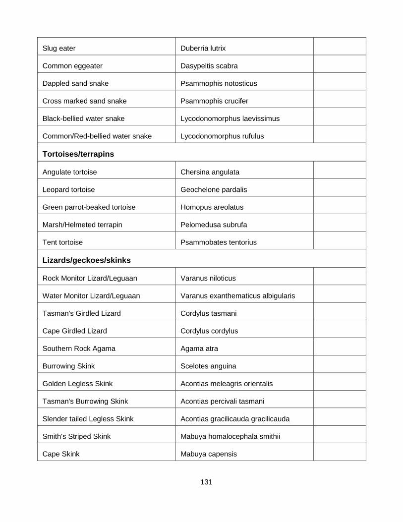
131
Slug eater Duberria lutrix
Common eggeater Dasypeltis scabra
Dappled sand snake Psammophis notosticus
Cross marked sand snake Psammophis crucifer
Black-bellied water snake Lycodonomorphus laevissimus
Common/Red-bellied water snake Lycodonomorphus rufulus
Tortoises/terrapins
Angulate tortoise Chersina angulata
Leopard tortoise Geochelone pardalis
Green parrot-beaked tortoise Homopus areolatus
Marsh/Helmeted terrapin Pelomedusa subrufa
Tent tortoise Psammobates tentorius
Lizards/geckoes/skinks
Rock Monitor Lizard/Leguaan Varanus niloticus
Water Monitor Lizard/Leguaan Varanus exanthematicus albigularis
Tasman's Girdled Lizard Cordylus tasmani
Cape Girdled Lizard Cordylus cordylus
Southern Rock Agama Agama atra
Burrowing Skink Scelotes anguina
Golden Legless Skink Acontias meleagris orientalis
Tasman's Burrowing Skink Acontias percivali tasmani
Slender tailed Legless Skink Acontias gracilicauda gracilicauda
Smith's Striped Skink Mabuya homalocephala smithii
Cape Skink Mabuya capensis
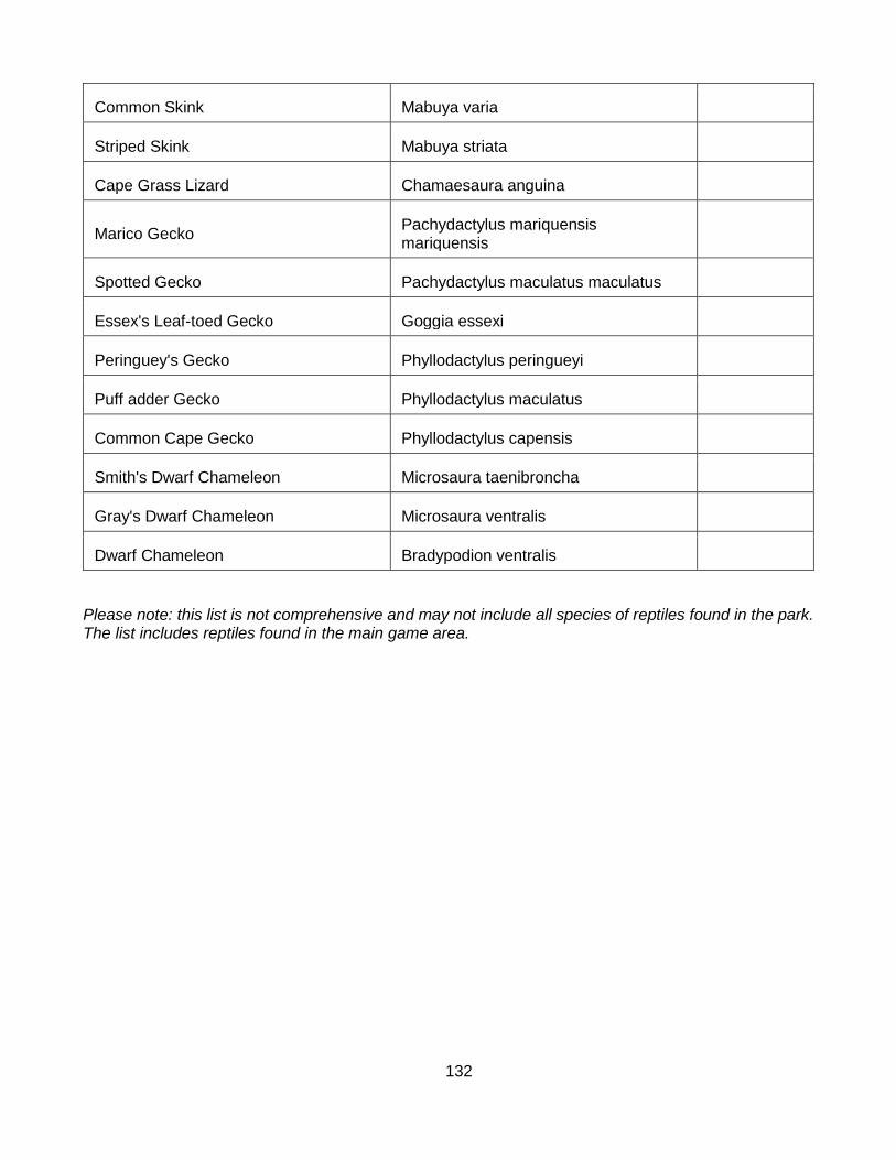
132
Common Skink Mabuya varia
Striped Skink Mabuya striata
Cape Grass Lizard Chamaesaura anguina
Marico Gecko Pachydactylus mariquensis mariquensis
Spotted Gecko Pachydactylus maculatus maculatus
Essex's Leaf-toed Gecko Goggia essexi
Peringuey's Gecko Phyllodactylus peringueyi
Puff adder Gecko Phyllodactylus maculatus
Common Cape Gecko Phyllodactylus capensis
Smith's Dwarf Chameleon Microsaura taenibroncha
Gray's Dwarf Chameleon Microsaura ventralis
Dwarf Chameleon Bradypodion ventralis
Please note: this list is not comprehensive and may not include all species of reptiles found in the park. The list includes reptiles found in the main game area.
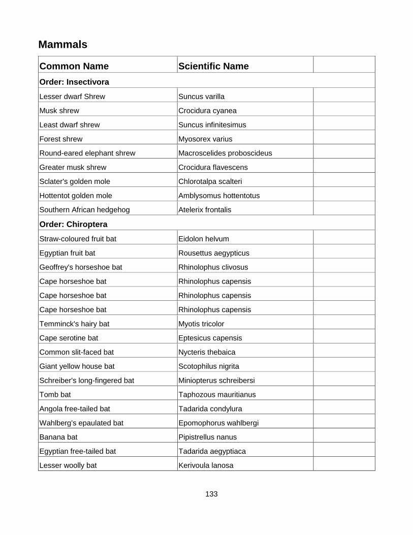
133
Mammals
Common Name Scientific Name
Order: Insectivora
Lesser dwarf Shrew Suncus varilla
Musk shrew Crocidura cyanea
Least dwarf shrew Suncus infinitesimus
Forest shrew Myosorex varius
Round-eared elephant shrew Macroscelides proboscideus
Greater musk shrew Crocidura flavescens
Sclater's golden mole Chlorotalpa scalteri
Hottentot golden mole Amblysomus hottentotus
Southern African hedgehog Atelerix frontalis
Order: Chiroptera
Straw-coloured fruit bat Eidolon helvum
Egyptian fruit bat Rousettus aegypticus
Geoffrey's horseshoe bat Rhinolophus clivosus
Cape horseshoe bat Rhinolophus capensis
Cape horseshoe bat Rhinolophus capensis
Cape horseshoe bat Rhinolophus capensis
Temminck's hairy bat Myotis tricolor
Cape serotine bat Eptesicus capensis
Common slit-faced bat Nycteris thebaica
Giant yellow house bat Scotophilus nigrita
Schreiber's long-fingered bat Miniopterus schreibersi
Tomb bat Taphozous mauritianus
Angola free-tailed bat Tadarida condylura
Wahlberg's epaulated bat Epomophorus wahlbergi
Banana bat Pipistrellus nanus
Egyptian free-tailed bat Tadarida aegyptiaca
Lesser woolly bat Kerivoula lanosa

134
Order: Primata
Vervet monkey Cercopithecus pygerythrus
Chacma baboon Papio ursinus
Order: Carnivora
Family: Protelidae
Aardwolf Proteles cristata
Family: Hyenidae
Spotted Hyaena Crocuta crocuta
Brown Hyaena Parahyaena brunnea
Family: Canidae
Bat-eared fox Otocyon megalotis
Cape fox Vulpes chama
Blackbacked Jackal Canis mesomelas
Family: Mustelidae
Striped polecat Ictonyx striatus
Striped weasel Poecilogale albinucha
Honey badger Mellivora capensis
Cape clawless otter Aonyx capensis
Family: Viverridae
Small-spotted genet Genetta genetta
Large-spotted genet Genetta tigrina
Family: Herpestidae
Small grey mongoose Galerella pulverulenta
Large grey mongoose Herpestes ichneumon
Water mongoose Atilax paludinosus
Yellow mongoose Atilax paludinosus
Suricate / Meerkat Suricata suricatta
Family: Felidae
African Wildcat Felis lybica
Black-footed cat Felis nigripes
Caracal / Rooikat Caracal caracal

135
Lion Panthera leo
Leopard Panthera pardus
Order: Tubulidentata
Antbear / Aardvark Orycteropus afer
Order: Hyracoidea
Rock Hyrax / Dassie Procavia capensis
Tree Dassie Dendrohyrax arboreus
Order: Lagomorpha
Cape hare Lepus capensis
Scrub hare Lepus saxatilis
Smith's Red Rock Rabbit Pronolagus rupestris
Order: Rodentia
Common mole rat Cryptomys hottentotus
Cape mole rat Georychus capensis
Porcupine Hystrix africae-australis
Cape springhare Pedetes capensis
Woodland dormouse Graphiurus murinus
Spectacled dormouse Graphiurus ocularis
Grey climbing mouse Dendromus melanotis
Pouched mouse Saccostomus campestris
Dwarf mouse Laggada minutoides
House mouse Mus domesticus
Namaqua rock mouse Aethomys namaquensis
Multimammate mouse Mastomys natalensis
Pygmy mouse Mus minutoides
Brant's climbing mouse Dendromus mesomelas
Woodland mouse Grammomys dolichurus
House rat Rattus rattus
Striped field mouse Rhabdomys pumilio
Vlei rat Otomys irroratus
Angoni vlei rat Otomys angoniensis
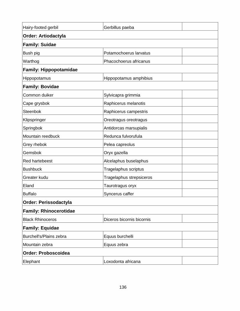
136
Hairy-footed gerbil Gerbillus paeba
Order: Artiodactyla
Family: Suidae
Bush pig Potamochoerus larvatus
Warthog Phacochoerus africanus
Family: Hippopotamidae
Hippopotamus Hippopotamus amphibius
Family: Bovidae
Common duiker Sylvicapra grimmia
Cape grysbok Raphicerus melanotis
Steenbok Raphicerus campestris
Klipspringer Oreotragus oreotragus
Springbok Antidorcas marsupialis
Mountain reedbuck Redunca fulvorufula
Grey rhebok Pelea capreolus
Gemsbok Oryx gazella
Red hartebeest Alcelaphus buselaphus
Bushbuck Tragelaphus scriptus
Greater kudu Tragelaphus strepsiceros
Eland Taurotragus oryx
Buffalo Syncerus caffer
Order: Perissodactyla
Family: Rhinocerotidae
Black Rhinoceros Diceros bicornis bicornis
Family: Equidae
Burchell's/Plains zebra Equus burchelli
Mountain zebra Equus zebra
Order: Proboscoidea
Elephant Loxodonta africana
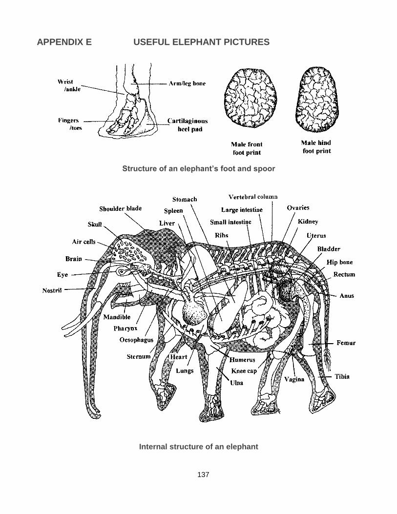
137
APPENDIX E USEFUL ELEPHANT PICTURES
Structure of an elephant’s foot and spoor
Internal structure of an elephant

138
Comparison of body profiles: Male on the left and female on the right
Comparison of body profiles: Male on the left and female on the right

139
Relative size of different aged elephants
Calves under one year can generally walk under the mother
Some differences between an African (Left) and an Indian (Right) elephant
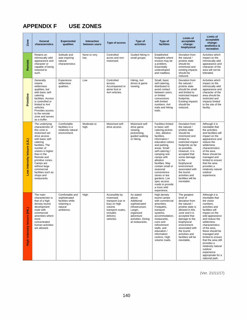
140
APPENDIX F USE ZONES
Zo
ne
General characteristics
Experiential qualities
Interaction between users
Type of access Type of
activities Type of facilities
Limits of acceptable
change: biophysical
Limits of acceptable
change: aesthetics & recreation
Rem
ote
Retains an intrinsically wild appearance and character or capable of being restored to such.
Solitude and awe inspiring natural characteristics
None to very low.
Controlled acces and non-motorised.
Guided hiking in small groups.
Established footpaths where erosion may be a problem, Essentially undeveloped and roadless.
Deviation from the natural / pristine state should be minimized and existing impacts should be reduced.
Activities which impact on the intrinsically wild appearance and character of the area will not be tolerated.
Pri
mit
ive
Generally retains wilderness qualities, but with basic self-catering facilities. Access is controlled or limited to 4x4 vehicles. Provides access to the remote zone and serves as a buffer.
Experience wilderness qualities.
Low Controlled access. Accompanied or alone foot or 4x4 vehicles.
Hiking, 4x4 drives & game viewing.
Small, basic self-catering, distributed to avoid contact between users, or limited concessions with limited numbers: 4x4 trails and hiking trails.
Deviation from the natural / pristine state should be small and limited to restricted impact footprints. Existing impacts should be reduced.
Activities which impact on the intrinsically wild appearance and character of the area should be restricted and impacts limited to the site of the facility.
Lo
w in
ten
sit
y l
eis
ure
(L
IL)
The underlying characteristic of this zone is motorized sel-drive access with basic self-catering facilities. The number of visitors is higher than in the Remote and primitive zones. Camps are without large commercial facilities such as shops and restaurants.
Comfortable facilities in a relatively natural environment.
Moderate to high.
Motorised self-drive access.
Motorised self-drive game viewing, picknicking, guided walking or hiking.
Facilities limited to basic self-catering picknic –ites, ablution facilities, information / education cetres and parking areas. Small self-catering / camping rest camps with ablution facilities. May contain small or seasonal convenience stores or tea gardens. Loe spec access roads to provide a more wild experience.
Deviation from the natural / pristine state should be minimized and limited to restricted impact footprints as far as possible. However, it is accepted that some damage to the biophysical environment associated with the tourist activities and facilities will be inevitable.
Although it is inevitable that the activities and facilities will impact on the appearance and reduce the wilderness characteristics of the area these should be managed and limited to ensure that the area provides a relatively natural outdoor experience.
Hig
h in
ten
sit
y l
eis
ure
(H
IL)
The main characteristic is that of a high density tourist development node with commercial amenities where more concentrated human activities are allowed.
Comfortable and sophisticated facilities while retaining a natural ambience.
High. Accessible by motorized transport (car or bus) on high volume transport routes, includes delivery vehicles.
As stated above. Additional sophisticated infrastructure. Larger, organized adventure activities. Dining at restaurants.
High density tourist camps with commercial amenities. Footpaths, transport systems, accommodation, restaurants, curio and refreshment stalls, and education / information centres. High volume roads.
The greatest level of deviation from the natural / pristine state is allowed in this zone and it is accepted that damage to the biophysical environment associated with the tourist activities and facilities will be inevitable.
Although it is inevitable that the visitor numbers, activities and facilities will impact on the wild appearance and reduce the wilderness characteristics of the area, these should be managed and limited to ensure that the area still provides a relatively natural outdoor experience appropriate for a national park.
(Ver. 21/11/17)