Indian Minerals Yearbook 2014
68
4-1 EXPLORATION & DEVELOPMENT Indian Minerals Yearbook 2014 (Part- I : GENERAL REVIEWS) 53 rd Edition EXPLORATION & DEVELOPMENT (ADVANCE RELEASE) GOVERNMENT OF INDIA MINISTRY OF MINES INDIAN BUREAU OF MINES Indira Bhavan, Civil Lines, NAGPUR – 440 001 PHONE/FAX NO. (0712) 2565471 PBX : (0712) 2562649, 2560544, 2560648 E-MAIL : [email protected] Website: www.ibm.gov.in March, 2016
-
Upload
khangminh22 -
Category
Documents
-
view
2 -
download
0
Transcript of Indian Minerals Yearbook 2014

4-1
EXPLORATION & DEVELOPMENT
Indian Minerals Yearbook 2014 (Part- I : GENERAL REVIEWS)
53rd
Edition
EXPLORATION & DEVELOPMENT
(ADVANCE RELEASE)
GOVERNMENT OF INDIA
MINISTRY OF MINES
INDIAN BUREAU OF MINES
Indira Bhavan, Civil Lines,
NAGPUR – 440 001
PHONE/FAX NO. (0712) 2565471 PBX : (0712) 2562649, 2560544, 2560648
E-MAIL : [email protected] Website: www.ibm.gov.in
March, 2016

4-2
EXPLORATION & DEVELOPMENT
4 Exploration & Development
GOVERNMENT’S POLICY
The National Mineral Policy, 2008 for non-
fueland non-coal minerals, introduced by the
Government in replacement of the National Mineral
Policy 1993 lay enormous thrust on the various
aspects of mineral industry, such as regulation of
minerals, role of State in mineral development,
survey and exploration, database of mineral
resources and tenements, strategy of mineral
development, etc. Among other things, strong
emphasis is laid on the following:
* To judiciously exploit and utilise the
count ry ' s minera l po ten t ia l i t i es ,
sys temat ic reg iona l and de ta i l ed
exploration will be carried out using state-
of-the-art techniques in a time bound
manner. Zero-waste mining will be the
national goal and mining technology will
be upgraded to ensure exploration and
utilisation of entire run-of-the-mine.
* To make regula tory envi ronment
conduc ive to p r iva te inves tment ,
p rocedures fo r g ran t o f minera l
concessions, such as Reconnaissance
Permits, Prospecting Licences and Mining
Leases shall be transparent and seamless
wi th secur i ty of tenure guaranteed .
Prospec t ing and min ing sha l l be
recognised as independent activities with
transferability of concessions playing a
key role in mineral development.
* To attract large investments and high
technology, a new concession, namely, a
Large Area Prospecting Licence (LAPL)
wil l be introduced. Durat ion of al l
concessions will be rationalised and
areas of operations enlarged suitably,
within each State.
* IBM will maintain a digitised database
comprising a Resource Inventory and a
Tenement Regis t ry. The Tenement
Registry will give information of leasehold
and freehold areas in terms of greenfield,
brownfield and relinquished areas, etc.
Data filing will be rigorously applied and
concession holders will be monitored.
Lock-in arrangement will be assured and
the data will be released to prospectors
after integration.
* Prospecting being a high-risk venture,
access to risk funds from capital markets
will be facilitated.
This policy initiative is expected to encourage
greater involvement of private sector in survey
and exploration of minerals.
The High-Level Committee constituted by the
Government of India which brought out the
National Mineral Policy, 2008 has recommended
amendments to the MMDR Act, 1957 with the
purpose of providing necessary initiatives to
attract investment and participation of private and
publ ic sec tors in a reas of explora t ion and
exploitation of minerals. The MMDR Bill, 2011
was introduced in Lok Sabha on 12.12.2011, which
was referred to Standing Committee on Coal &
Steel. The Committee submitted its 36th
Report on
the MMDR Bill on 07.05.2013.
Subsequent ly, the Mines and Minera l s
(Development and Regulation) Amendment Act,
2015 has been notified on 27th
March, 2015 to
amend the MMDR Act, 1957. The Amendment
removes descret ion in the grant of mineral
concessions. Henceforth, all mineral concessions
wi l l be g ran ted by the respec t ive S ta te
Governments only through auctions, which will
bring greater transparency and remove discretion
in allocation of mineral resources. There would
be no renewal of any mineral concession. The
tenure of mineral concessions has been increased
to 50 years compared to earlier provisions of 30
years. Thereafter, all mining lease would be put
up for auction. Establishment of District Mineral
Foundation in any district affected by mining
re la ted opera t ions and Nat iona l Minera l
Exploration Trust for the purpose of regional and
detailed exploration has also been incorporated
in the Act.

4-3
EXPLORATION & DEVELOPMENT
ORGANISATIONS INVOLVEDGSI, AMD, DGMs of various states, public
sector companies like NMDC, MECL, MOIL, etc.
continued their efforts in respect of surveying,
mapping and exploration of new deposits and re-
assessment o f o ld depos i t s /mines dur ing
2013-14.
In oil sector, ONGC, OIL and a few joint
venture and private companies were engaged in
exploration of onshore and offshore areas.
IBMIBM, as a facilitator to the Mineral Industry,
(a) provides technical consultancy services for
conducting feasibility studies, environment
impact assessments, environment management
plans, etc; (b) carries out mining research project
on need-based aspects of mining; (c) conducts
minera l benef ic ia t ion s tud ies , inc lud ing
mineralogical testing and chemical analysis and
(d) prepares mineral maps.
During 2013-14, work related to updation of
100 multi-mineral leasehold maps with forest
overlays on1:50,000 scale in respect of Andhra
Pradesh and Bihar states were taken up. So far,
scanning and georeferencing of 714 key plans and
108 toposheets have been completed. Forest
overlays are prepared in collaboration with Forest
Survey of India.
During 2013-14, IBM conducted 55 ore
dressing investigations, chemical analysis in
respect of 41,483 radicals, and 2,356 mineralogical
studies and nine in-plant study.
Ind ian Bureau of Mines under takes
preparation of National Inventory of mineral
resources on a quinquennial basis. Under this
programme, implementation of UNFC system was
adopted in 2002 replacing the earlier resource
c lass i f i ca t ion based on Ind ian sys tem.
Subsequently, NMI as on 1.4.2005 and 1.4.2010
were updated. Updation of the NMI of mineral
resources in respect of 25 selected minerals based
on 1.4.2013 has been taken up.
GSI
GSI pursued i t s sys temat ic geo log ica l
mapping in 2013-14 and had completed 5,264 sq
km large-scale mapping, 62.525 sq km detailed
mapping and 68 ,037 m dr i l l ing as aga ins t
preceding year's achievement of 4,917 sq km large-
scale mapping, 45.43 sq km detailed mapping and
70,007 m drilling. Out of the total mappable areas
of 3.14580 million sq km of the country, 3.09875
million sq km has been covered so far by systematic
mapping bringing the total coverage to 98.50%.
Reserves Established
Reserves/resources established in the course
of mineral exploration during 2013-14 are furnished
below:
i) About 1,828 million tonnes resources of
coal in various coalfields of Assam, Chhattisgarh,
Madhya Pradesh, Odisha and West Bengal were
estimated.
ii) Tentative reserves of 7.99 lakh tonnes of
wollastonite were estimated in Ghoda-Bhameriya
area, Banaskantha district, Gujarat.
iii) In Salaidih-Harwariya area, Sonbhadra
district, Uttar Pradesh the possible tentative
reserves of andalusite were estimated at 26.06
million tonnes.
Survey
Marine Survey
GSI continued its offshore geoscientific
studies both in Exclusive Economic Zone (EEZ)
and Territorial Waters (TW) along the East and
West Coasts of India. Survey in the near-shore
zones (0 m - 10 m isobaths) were carried out using
hired small mechanical boats.
During 2013-14, a total of nineteen cruises
were undertaken using four vessels.
The following marine geoscientific surveys
were carried out during 2013-14 Field Season:
1. Six cruises aboard R.V. Ratnakar and R.V.
Samudra Manthan within EEZ conducted the
following:
R.V. Samudra Ratnakar
SR-001A(SR): In tegra ted Survey for High
Resolution Seabed mapping in the Continental
Shelf area off Netravathi River Mouth, Mangalore,
Karnataka.
SR-002 (ER): Multichannel bathymetric mapping
of part of Central Andaman Trough and study of

4-4
EXPLORATION & DEVELOPMENT
evolutionary history and possible locales of
submarine hydrothermal mineralisation in the
basin and surrounding areas.
SR-003 (ER): Multibeam bathymetric survey on the
eastern extension of Sewell Rise and southern
extension of West Andaman Fault.
RV Samudra Manthan
SM-230 (SR): Study of the physiography of the
middle to lower part of Bengal fan belonging to
the continental rise and abyssal plain region off
Pudimadaka to Godavari, Andhra Pradesh coast
using Multibeam bathymetric survey.
SM-231(ER): Multibeam bathymetric survey and
magnetic profiling of sea bed in the Narcondam-
Barren Basin, North Andaman sea.
SM-232 (SR): Magnetic survey within EEZ off
Puri-Balasore, Odisha Coast.
2. Eight cruises aboard R.V.Samudra Kaustubh
within the Territorial Waters (TW)EEZ off the East
coast conducted:
ST-229 (SR): Study of the geophysical parameters
(Seismic and Magnetic) of the seabed within
territorial waters off Kakinada Coast, Andhra
Pradesh.
ST-230 (SR): Placer mineral resource evaluation in
the territorial waters off north of Bhimunipatnam,
Andhra Pradesh.
ST-231 (ER): Placer mineral resource evaluation in
the territorial waters off Palur-Malud, Odisha.
ST-232(ER): Seabed survey of continental region
off West Bengal with an emphasis on sub seabed
and faunal study to distinguish the sea level
fluctuation.
ST-233(ER): Geotechnical appraisal off Satpara,
Odisha.
ST-234 (ER): Parametric surveys off Rushikulya
River Mouth, Odisha.
ST-235 (SR): Mapping of seabed in the TW and
EEZ Southeast off Gopalapatnam, Tamil Nadu
coast, Bay of Bengal.
ST-236 (SR): Mapping of seabed in the TW and
EEZ north off Rameshwaram, Tamil Nadu coast.
3. Five cruises aboard R.V. Samudra Shaudhikama
within the TW off the West Coast conducted:
SD-248 (SR): Study of the geophysical parameters
(Seismic and Magnetic) of the seabed within
territorial waters off Honavar, Karnataka.
SD-253 (SR): Preliminary evaluation of heavy
mineral occurrence off Trivandrum-Attipara area,
Kerala.
SD-254 (SR): Preliminary evaluation of sand
resources off Cochin, Kerala.
SD-252 (SR) : Geotechnica l appra i sa l o f f
Manjeshwaram, Kasargod , Kera la fo r the
development of a harbour/minor port.
SD-251 (SR) : Pre l iminary eva lua t ion of
Construction grade sand and associated placer
minerals, if any, off Paravur, Kollam district, Kerala.
Airborne Survey
GSI pursued airborne geophysical survey for
generating database by employing magnetic and
gamma ray spectrometric techniques. The survey
was followed by data processing, preparation of
aerogeophysical maps and interpretations that
help in ground evaluation and add information to
geological maps and would aid prospecting and
exploration for minerals. The data from the aerial
surveys thus form an important backup for refining
the geological understanding of an area, with
focus on identification of favourable locales of
mineralisation, crystal structure, etc.
During 2013-14, aerogeophysical survey by
the Twin Otter Aircraft (VT-ELX) was carried out
in Venguria-Jamnagar area along the western
offshore and also in Chandrapur-Brahmapuri area
of Maharashtra. Multisensor aerogeophysical
data have been acquired along total flights line of
38,308 line km in Vengurla-Jamnagar area and
14,072 line km in parts of Chandrapur-Brahmapuri
area.
S ince the acquis i t ion and induct ion of
TOASS, a total of 495,062 line km, over an area of
294,045 sq km, was covered by multi-sensor
survey involv ing magnet ic , spec t romet r ic ,
radiometric and electromagnetic methods till the
field season 2010-12 in the following areas:
Mamandur (Tamil Nadu), Aladahalli, Gadag,
Wajrakarur-Vedavathi basin (Karnataka and

4-5
EXPLORATION & DEVELOPMENT
Andhra Pradesh), Agartala-Silchar (for ONGC in
Tripura and Assam), Ratnagiri (Maharashtra),
Siliguri-Guwahati (for ONGC in West Bengal and
Assam) , Tosham-Singhana (Haryana and
Rajasthan), Sukinda-Baripada (Odisha), Bundi-
Bharatpur (Rajasthan), Agucha-Malpura-Chaksu
(Rajasthan), Moradabad -Bareilly (for OIL in Uttar
Pradesh), Gorakhpur-Muzaffarpur (for OIL in
Uttar Pradesh and Bihar), Satyamangalam (Tamil
Nadu), Hindoli (Rajasthan), Bhilwara (Rajasthan),
Gangapur-Nasirabad (Rajasthan), Chhattisgarh
bas in(Chha t t i sgarh and Odisha) , Be tu l -
Chhindwara (Madhya Pradesh), Narayanpet-
Raichur (Andhra Pradesh and Karnataka) ,
Hungund-Mudhol (Karnataka), Lalitpur (Uttar
Pradesh), Mahoba-Panna (Uttar Pradesh and
Madhya Pradesh) , Na lgonda-Mahbubnagar
(Andhra Pradesh) , Banga lore -Penukonda
(Karnataka and Andhra Pradesh), Mulbagal-
Tambalpalle (Karnataka and Andhra Pradesh),
Nagpur-Wardha val ley area (Maharasht ra) ,
Ba ihar -Kat ru a rea (Madhya Pradesh and
Chhat t isgarh) , Kanker area (Chhat t isgarh) ,
Mauranipur-Sarila area (Madhya Pradesh and
Uttar Pradesh), Hosadurg-Vengurla area over
Western offshore and Chandrapur-Brahmapuri
(Maharashtra).
Ground evaluation of aerogeophysical data is
carried out with the help of aerial photos and
imageries, mostly by detailed mapping, sampling,
pitting and trenching, and wherever necessary, by
drilling.
MECL
The highlights of exploration carried out by
MECL during 2013-14 are given below:
i) The company has registered 346,553 m of
drilling for various minerals, out of which 322,111
m was through departmental resources.
ii) A total of 165,998 m of geophysical logging
was carried out.
iii) A total of 99 sq km of geological mapping was
done for different minerals in various parts of the
country.
iv) Inlaboratories, a total of 36,438 samples were
analysed and 93,122 radicals were determined
along with petrological and ore microscopic
studies of 440 samples.
v) A total of 26 detailed geological reports for mineral
exploration, geophysical survey, environmental &
remote sensing studies were submitted.
vi) A total of 1,143 million tonnes of reserves were
added to NMI. Mineral-wise details of reserves
established by MECL during 2013-14 are:
• Coal - A total of 936 million tonnes of non-coking
coal and coking coal in Mand-Raigarh Coalfield,
Chha t t i sgarh ; Jhar ia & South Karanpura
Coalfields, Jharkhand; Godavari Valley Coalfield,
Andhra Pradesh and Singrauli Coalfield, Madhya
Pradesh were established.
• Lignite - 31 million tonnes of lignite reserves
were established in Rajasthan.
• Limestone - 172 million tonnes of limestone
reserves were established in Gulbarga, Karnataka.
• Copper - 4 million tonnes of copper ore reserves
were established in Banera and Muradpur Central
blocks, Rajasthan.
MINERAL-WISE EXPLORATION ACTIVITIES
PETROLEUM AND NATURAL GAS
The Government of India has formulated a
New Exploration Licencing Policy (NELP) to
accelerate and expand exploration of oil and gas
in the country. A total of 254 blocks have been
awarded so far in IX rounds of NELP. Exploration
under NELP has shown positive results, in both
inland and offshore areas. An Uniform Licencing
Policy (ULP) subsuming NELP and CPM policy is
proposed to enable E & P operators to explore
and extract all hydrocarbon resources and 52 oil
& gas exploration blocks to be offered under ULP
in the Xth round of NELP.
ONGC
Business Development and Joint Ventures
Group of ONGC ( BD & JV), in line with the ONGC's
pursuit for Business Growth Plans has initiated
several measures for achieving enhanced value
chain integration in hydrocarbon business in the
field of Petrochemicals, Power & Fertilizer.
ONGC continued its operations for exploration
of oil and gas. Out of 26 identified sedimentary
basins in onshore and offshore areas of the
country, exploration was continued in Cambay
Basin, Gujarat; Jaisalmer in Rajasthan; Upper
Assam, Tripura, Mizoram in Assam-Arakan;
Himalayan foothills, Himachal Pradesh; Vindhyan/

4-6
EXPLORATION & DEVELOPMENT
Gondwana (Madhya Pradesh); Krishna-Godavari
(Andhra Pradesh); Cauvery (Tamil Nadu); West
Bengal and in East Coast and West Coast offshore
areas.
During 2013-14, ONGC acquired a total of 475
LK of 2D seismic data from inland. During the
same period, 8,371 SK of 3D seismic data was
also acquired which included 1,174 sq km inland
and 7,197 sq km off-shore areas. ONGC's 106
exploratory wells comprised 68 wells to a total
depth of 185.109 km in inland areas and 38 wells
to a total depth of 135.656 km in offshore areas.
During 2013-14, ONGC reported 14 new
hydrocarbons discoveries, namely, Seripalem-1,
Geddanapalli-3 and Mandapeta South-1 in KG
Onland; Gandhar-686, SB-300, and Nandasan-III
in Western Onshore basin; Khubal-7 in AAFB
Tripura basin; KGOSNO41NANL-2, KGOSN-
041NANL-1 and KGD982 NA-M-3 KG Offshore
basin and GK-289, GK-42-3, MBSO51NAA-1 and
B-173A-8 in Western Offshore basin. As a result
of these exploratory efforts, ONGC accreted 84.99
million tonnes reserves during 2013-14, leading
to 2,849.04 million tonnes ultimate reserves of oil
and oil-equivalent gas (O+OEG) at the end of the
year in areas under its operations.
OILOIL owns a vast array of advanced computing
systems to process and interpret geo-scientific
data through integrated exploration applications
such as Remote Sensing, Structural & Stratigraphic
Interpretation, Seismic Attribute Analysis, Source
Rock Evaluation, Biostratigraphy, Sequence
Stratigraphy, Petrophysics, Basin Analysis, Tecnho-
Economic Evaluation etc.
During 2013-14, OIL carried out 105,111 m
drilling in 34 wells in onshore areas of Assam.
Significant discoveries of oil/gas struck by
OIL in Assam in India and Overseas during 2013-
14 are as below:
i) The Well Sologuri 1 (Loc. DIBC) located in
Wes t So logur i s t ruc ture (Onshore) wi th in
Dibrugarh PEL in the Dibrugarh district, Assam
was drilled down to a depth of 3,962 m within
basement to probe the hydrocarbon prospects
within Paleocene-Eocene formations. The well
has encountered a few prospective sand ranges
within Lakadong+Therr ia format ion and is
currently producing oil from one of the tested
sands. The discovery of oil in this well has opened
up new avenues for exploration and exploitation
of hydrocarbon in Paleocene-Eocene formations
in Sologuri area.
ii) The Well South Kathaloni 3 (Loc.HVX)
located in South Kathaloni structure (Onshore)
within Hugrijan ML in the Dibrugarh district,
Assam was dri l led down to 3,710 m within
basement to probe the hydrocarbon prospects
within Paleocene-Eocene formations. The well has
encountered a few prospective sand ranges within
Lakadong+Therria formation and is currently
producing oil from one of the tested sands. The
discovery of oil in this well has opened up new
avenues for exploration and exploitation of
hydrocarbon in Paleocene-Eocene formations in
South Kathaloni area.
iii) The Well, Baruanagar 3 (Loc.BE) located
in Baruanagar structure (Onshore) within Borhat
PEL (now conver ted to Borhat ML) in the
Dibrugarh district, Assam was drilled down to
4,375 m to probe the hydrocarbon prospects within
Lakodong+Therria formation. The well has
encountered a few prospective sand ranges within
Lakadong+Therria formation. The discovery of
oil in this well has opened up a new area for
exploration and exploitation of oil in Baruanagar
area.
(iv) The Well Naharkatiya 610 (Loc.HVJ)
located in East Deohal structure (Onshore) within
Hugrijan ML in the Tinsukia district, Assam was
drilled down to 2,984 m to probe the hydrocarbon
prospects within Barail Formation. The well has
encountered prospective sand range within Barail
Formation and is currently producing gas from the
tested sands. The discovery of gas in this well has
opened up new areas for exploration and exploitation
of hydrocarbon in Barail Formation in East Deohal
structure.
(v) The Well Naharkatiya 614 (Loc. NLE) located
in the central part of Jaipur Structure (Onshore)
within Naharkatiya Extension ML in Dibrugarh
district, Assam was drilled down to a depth of
3,233 m to probe the hydrocarbon prospects within
Barail and Tipam formations. The well has
encountered a few prospective sand ranges within
Tipam Formation and is currently producing oil from
one of the tested sands. The discovery of oil in the
Middle Tipam Formation has opened up a new
reservoir for exploration and exploitation of oil in
Jaipur area.

4-7
EXPLORATION & DEVELOPMENT
(vi) The Well Naharkatiya 405 (Loc. HDL-II) liesin the South Nagajan area of Greater Jorajan oil-field(Onshore) within Hugrijan ML in the Tinsukiadistrict, Assam and has discovered gas on testingthe new/unappraised Upper Tipam Sand duringworkover operations. The discovery of gas in thiswell has opened up a new reservoir for explorationand exploitation of gas in South Nagajan area.
(vii) The Well Lassa 1 (Loc. SC) located in Lassastructure of Shakthi Block, Gabon, South Africa wasdrilled to a depth of 2,141 m within basement to probethe hydrocarbon prospects within N'Dombo
Formation. The well has encountered twohydrocarbon prospective sand ranges within thetargeted formation and on testing produced oil alongwith some amount of gas. The oil discovery in theShakthi Block, Gabon, within the N'Dombo Formationin well Lassa 1 marks Oil India Limited 's maidensuccess in overseas exploration venture as operatorand open up areas for future exploration andexploitation within the block.
The physical achievements of explorationactivities pursued for petroleum and natural gasduring 2013-14 are given in Table - 1.
Table – 1 : Exploration for Petroleum & Natural Gas by ONGC and OIL, 2013-14
Drilling
Agency/location/State Seismic Survey Exploratory Development
2D(GLKM) 3D(SQKM) Wells Meterage Wells Meterage
(No) (km) (No) (km)
ONGC: Total 475 8371 106 320.765 283 596.794
Inland: Total 475 1174 68 185.109 216 432.363
Andhra Pradesh – 53 7 22.232 12 35.982
Assam 77 7 7 41.556 24 89.292
Bihar – _ 1 2.894 – –
Gujarat 268 404 30 60.431 165 273.721
Madhya Pradesh _ 267 3 3.888 _ _
Mizoram 9 _ _ – _ _
Rajasthan – 95 – – _ _
Tamil Nadu – 170 11 36.955 10 21.26
Tripura 65 38 7 12.684 5 12.108
Uttar Pradesh _ – 1 1.955 – –
West Bengal 55 141 1 2.514 _ _
Offshore: Total – 7197 38 135.656 67 164.431
East Coast Offshore – 2692 17 71.163 – –
West Coast Offshore _ 4505 21 64.493 67 164.431
OIL : Total* 499 928 – – – –
Inland: Total 499 745 – _ – _
Andhra Pradesh 266 131 _ _ _ _
Assam & Arunachal Pradesh 233 190 – – – –
Mizoram – 316 – – – –
Rajasthan – 108 – – – –
Offshore: Total – 183 – – – –
Maharashtra – 183 – – – –
Figures rounded off.
* During 2013-14 , OIL carried out 1,05,111 m drilling in 34 wells in onshore areas of Assam.

4-8
EXPLORATION & DEVELOPMENT
Reliance Industries Ltd (RIL)
RIL a long wi th JV par tners made two
significant hydrocarbon discoveries in 2013-14,
i.e. Discovery (D-55) in well MJ1 drilled in the block
KG-D6 situated in the Krishna-Godavari basin and
Discovery (D-56) in exploration block CY-D5
situated in the Cauvery basin.
DISCOVERY D-55 - Discovery in
Development area of block KG-D6 (D1-D3 field):
The KG-D6-MJ1 well was drilled in a water depth
of 1,024 m, and to a total depth of 4,509 m, to
explore the prospects of a Mesozoic Synrift Clastic
reservoir, lying over 2,000 m below the already
producing reservoirs in the D1-D3 gas fields.
Formation evaluation indicates a gross gas and
condensate column in the well of about 155 m in
the Mesozoic reservoirs. In drill stem testing, the
well flowed at 30.6 million standard cubic feet per
day (MMSCFD) and 2,121 barrels of oil per Day
(BOPD). The discovery, named 'D-55', has been
notified to the Government of India.
DISCOVERY D-56- Discovery in block DY-D5:
As part of the minimum work programme in this
block, exploratory well CYIII-D5-S1 which was
drilled in a water depth of 1,743 m, to a total depth
of 5,731 m, with the primary objective of exploring
Mesozoic-aged reservoirs has resulted in gas
condensate discovery. The formation evaluation
indicated a gross gas and condensate column in
the well of about 143 m in the Mesozoic-aged
reservoirs. In drill stem testing, the well flowed at
35.2 MMSCFD and 413 BOPD. The discovery,
named 'D-56', has been notified to the Government
of India. This is the second discovery in the block
which will enable scope for integration of all
discoveries for early monetisation.
COAL
The agencies engaged in exploration for coal
during 2013-14 were mainly GSI, CMPDI, MECL
and State Directorates of Geology & Mining.
GSI
The GSI continued its operations for search
and assessment of coal resources in the country
through regional exploration in coalfields of
Andhra Pradesh, Assam, Bihar, Chhattisgarh,
Madhya Pradesh, Maharashtra Odisha and West
Bengal. An additional resources of 1,827.90
million tonnes of coal have been assessed from
the data generated from regional exploration
during 2013-14.
In Andhra Pradesh Regional exploration
under G-2 s tage con t inued a t Bugga-
Khammamtogu sector, Khammam district. The
objectives were to explore and evaluate coal
resource potentiality of Barakar coal seams
already established in the Manuguru mining
block. A total of 1,076.55 m was drilled in
boreholes GBK- 4 to 6 of which 847 m were
geophysically logged. An area of 0.75 sq km of
the block was mapped on a scale of 1:10,000.
Seven to nine Barakar coal /carbonaceous shale
bands varying in thickness from 0.50 m to 4.80 m
were intersected between 37.10 m and 516.35 m
depths. Regional exploration under G-2 stage was
continued at Pagaderu (west) sector, Khammam
district in the dip side of Manuguru mining block
and northeast of Bugga-Khammamtogu sector to
establish the dip continuity of the Barakar and
Lower Kamthi seams. A total of 1,230.30 m was
drilled in four boreholes GPDW- 3 to 6 of which
654m was geophysically logged. 3.00 sq km area
was mapped on 1:10,000 scale. Twenty seven
Lower Kamthi coal /carbonaceous shale bands
varying in thickness from 0.50 m to 3.70 m and
eight Barakar coal / carbonaceous shale bands
varying in thickness from 0.55 m to 1.70 m were
intersected between 11.75 m and 447.28 m depths.
Regional explorat ion under G-2 stage was
initiated at Pagaderu (east) sector, Khammam
district in the northern side of Manuguru mining
block and adjacent to Pagaderu (west) sector to
establish the dip continuity of the Barakar and
Lower Kamthi seams. A total of 294.50 m has been
drilled in borehole GPDE-1. Thin coal seams
ranging in thickness from 0.50 m to 1.20 m were
intersected from a depth of 14.45 m to 285.20 m.
100 sq km area has been mapped on a scale of
1:12,500 in Khairi Sector, northwestern part of
Dorli-Bellampalli coal belt in the northwestern
margin of Main bas in of Godavar i va l ley
Coalfield, Adilabad district to examine the coal
for delineating its extension below Deccan Trap
cover and identifying Barakar coal seams in the
northwestern side of Dorli mining block.
In Assam, Regional exploration under G-3
s tage was taken up ad jacen t to Sukchar -
Singrimari area of Dhubri district at the border of
Assam and Meghalaya to explore the behaviour
and the extension of Gondwana coal and their
resource potentiality. A total of 346.45 m was
drilled in two boreholes SK- 1 and 2. Exploration
revealed 0.90 m thick coal seam occurring at a

4-9
EXPLORATION & DEVELOPMENT
depth of 109 m. Area map of the coalfield was
also updated on a scale of 1:10,000 covering 3 sq
km. The new project of Shalibhuin-Nakaigiri-
Ujanggiri area, under the Dhubri district of Assam
and West Garo Hills of Meghalaya is under
abeyance due to adverse ground conditions. Area
map of the coalfield was also updated on a scale
of 1:10,000 covering 1.40 sq km.
In Bihar, taking up the exploration for coal
for the first time in the reconstituted state under
G-2 stage in Mirjagaon area, Bhagalpur district,
to the north of already explored Hura North
Extension shows encouraging results. A total of
798.25 m was drilled in two boreholes RBMG-1
and RBMG-2 during 2013-14. Eighteen Barakar
coal seams varying in thickness from 0.40 m to
7.65 m were intersected between 109.75 m and
443.40 m depths in borehole RBMG-1 whereas
eight Barakar coal seams varying in thickness
from 0.90 m to 10.40 m (Seam No. XIV) were
intersected between 172.10 m and 321.80 m depths
in borehole RBMG-2. Strike continuity of the
seams for about 2 km towards further north of
Hura North Extension block and down-dip
continuity of the seams for about 3 km in the
sou theas te rn par t o f the b lock has been
established.
In Chhattisgarh, Regional exploration under
G-2 stage continued at Samarsingha block,
Raigarh district. The objectives were to establish
the development pat tern and cont inui ty of
Barakar coal seams, already recorded in the
Nawagaon block to the nor th , and Si thra-
Kurekela area in the west, to assess the coal
resource potentiality of the area and to generate
baseline data for CBM exploration. A total of
2,768.20 m was drilled in seven boreholes MRSS-
7 to 13 and 1,068.20 m was geophysically logged.
An area of 6.00 sq km was mapped on a scale of
1:10,000. Twelve regional Barakar coal seams ( I
to X, XII & XIII in ascending order) and few local
seams have been intersected between depths of
16.85 m and 624.77 m. Thickness of individual coal
section varies from 0.59 m to 10.75 m. Seam IV is
the thickest seam with cumulative thickness
ranging from 5.50 to l0.75 m. The continuity of
the coal seams have been established along dip
direction towards south-west for about 5 km.
Additional data was generated for the CBM
exploration. Regional exploration under G-2 stage
continued at Amlidhonda block, Raigarh district.
The objectives were to establish the development
pattern and continuity of Barakar coal seams,
already recorded in the Gare block to the north,
and Kesarchuan-Lamdand block in the east, to
assess the coal resource potentiality of the area
and to genera te base l ine da ta fo r CBM
exploration. A total of 4,610.70 m was drilled in
twelve boreholes, MRA- 5 to 16 and 1,786.08 m
was geophysically logged during the field season
2013-14. Six regional Barakar coal seams (Seam
III, IV, VI, VII, IX and X ) varying in thickness
from 1.30 m to 11.13 m and few local coal seams
were intersected between 101.23 m and 425.04 m
depths. Coal seams IX (2.85 m to 5.96 m) and
combined coal seams VI+VII (4.91 m to 10.52 m)
are important for their thickness and regional
persistency. Continuity of the coal seams have
been established for nearly 4 km along strike and
4 km in dip direction within the block. An area of
8.00 sq km was mapped on 1:10,000 scale.
Additional data was generated for the CBM
exploration. Promotional exploration under G-2
stage was continued at Vijaynagar-Giddhi block,
Surguja district. The objectives were to establish
the stratigraphy and structural disposition of
Lower Gondwana sequences, continuity of
Barakar Coal seams, coal resource potentiality of
the area and to generate baseline data for CBM
exploration. A total of 1,262.45 m was drilled in
four boreholes TRVG- 9 to 12 and 1.00 sq km area
was mapped on 1:10,000 scale. Ten regional
Barakar coal seams (Seam II to VIII, XI to XIII)
varying in cumulative thickness from 0.71 m to
17.00 m and few local coal seams were intersected
between 18.00 m and 521,90 m depths. Seam No.III
(cumulative thickness from 9.89 m to 17.00 m) and
IV (10.79 m) are important for their thickness and
regional persistency. Continuity of the coal seams
has been established over 6.5 km along strike and
l km in dip direction. Promotional exploration
under G-2 stage has been initiated at Pipraul
block, Surguja district. The objectives were to
es tab l i sh the s t ra t ig raphy and s t ruc tura l
disposition of Lower Gondwana sequences,
continuity of Barakar Coal seams, coal resource
potentiality of the area and to generate baseline
data for CBM exploration. A total of 1,565.20 m
drilling was achieved in 4 boreholes; TRP-1 to 4,
and 596.43 m was geophysically logged. An area
of 2 sq km was mapped on 1:10,000 scale. Regional
Barakar coal seams III Top (cumulative thickness

4-10
EXPLORATION & DEVELOPMENT
11.46 m), III Bottom (5.94 m), II (1.13 m), I (1.25 m)
and two local coal seams with 1.65 m and 1,49 m
thickness were intersected between 383.43 m and
548.54 m depths in borehole TRP-2.
In Madhya Pradesh, Regional exploration
under G-3 stage continued at Sarai (west) sector,
S ingrau l i d i s t r ic t . The ob jec t ives were to
establish the development pattern and resource
potentiality of coal horizons in Raniganj and
Barakar formations as intersected in adjacent
Hat ta -Dudhmaniya and Sara i (eas t ) a rea ,
stratigraphy and structural framework of the area
and to genera te base l ine da ta fo r CBM
exploration. Total drilling in the area for 2013-14
is 2,539.65 m in six boreholes, SSW-4 to 9. Large-
Scale Mapping on a scale of 1:10,000 was
completed for 5 sq km area and 1,131 m was
geophysically logged. Three regional Raniganj
coal seams / zones R-I to R-III (in ascending order)
have been intersected in the depth range from
33.85 m to 229.80 m. The individual thickness of
Raniganj coal seam varies from 0.50 m to 1.96 m.
Seven regional Barakar coal seams / zones I to
VII (in ascending order) have been intersected in
the depth range from 263 to 585.81m. The
thickness of individual coal seams vary from 0.50
m to 3.50 m. Seam No. IV (cumulative thickness
3.41 m) and III (3.50 m) are important for their
thickness and regional persistency. Promotional
exploration under G-2 stage continued at Malka
block, Shahdol district. The objectives were to
establish the development pattern and resource
potentiality of coal horizons in Raniganj and
Barakar formations as intersected in adjacent
Chainpa, Maiki and Maiki (North) blocks and
structural set up of the area. A total of 1,800.50 m
was drilled in four boreholes namely, SMLK-1 to
4 and 630 m was geophysical logged. An area of
5 sq km area was mapped on 1:10.000 scale. Coal
seams of both Raniganj and Barakar formations
were intersected at Malka block. Five regional
Barakar coal seams namely, I, II, III, IV and V (in
ascending order), have been intersected within a
depth range from 380.95 m to 558.50 m with
cumulative coal thickness of individual seam
ranging from 0.60 m to 5.67 m. Seam III is the
thickest seam. Raniganj coal seams, ranging in
thickness from 0.55 m to 4.70 m, are interbanded
in nature and were intersected between the depth
range of 12.95 m and 223.05 m. Continuity of the
coal seam has been established along dip and
strike directions for about 3 km and 7.5 km,
respectively. Promotional exploration under G-2
stage continued at Bihar block, Shahdol district.
The objectives were to establish the development
pattern of superior grade Barakar coal seams at
sha l low dep th as in te r sec ted in ad jacen t
Devanitola and Pachri blocks, structural set up
of the area and evaluate the coal resources. A total
of 3,042.25 m was drilled in ten boreholes SBR- 1
to 10 and 2,169.65 m was geophysically logged.
An area of 6 sq km area was also mapped on
1:10,000 scale. Four regional Barakar coal seams
(Seam No. I to IV in ascending order) varying in
cumulative thickness from 0.50 m to 9.20 m and
few local coal seams were intersected between
109.40 m and 338.65 m depths. Seam No III with
cumulative thickness from 8.06 m to 9.20 m, is
important for thickness and regional persistency.
Continuity of the coal seam has been established
for over 6 km in strike and over 2 km in dip
direction within the block. Regional exploration
under G-3 stage was continued at trap covered
area of Bhurkumdhana sector in Chhindwara
district. The objectives were to establish the dip
continuity of Barakar coal seams, already recorded
in the Payalidhana sector to the south, under
favourable structural set up and to assess the coal
resource potentiality of the area. A total of 1315.30
m drilling in four boreholes PBK- 1 and 3 to 5 was
achieved during the 2013-14 excluding the
redrilling in one borehole. An area of 3.00 sq km
area was mapped on a scale of 1:12,500. Four
regional Barakar coal seams (I to IV in ascending
order) have been intersected in PBK-3 within the
depth range from 379.85 m to 418.70 m. The
cumulative thickness of coal is 13.50 m. Regional
exploration under G-3 stage was proposed at trap-
covered area of Dhorakuhi sector in Chhindwara
district as a successor item of Bhurkumdhana
sector. The objectives were to establish the dip
continuity of Barakar coal seams, already recorded
in the Payalidhana sector to the southwest, under
favourable structural set up and to assess the coal
resource potentiality of the area. However, due
to slow drilling progress in Bhurkumdhana sector,
drilling could not be initiated during the 2013-14.
An area of 6.00 sq km has been mapped on a scale
of 1:12,500.

4-11
EXPLORATION & DEVELOPMENT
In Maharashtra, exploration under G-4 stage
continued at the Trap-covered area of Jhamkola,
southwest of Parsoda-Ghonsa coal bel t in
Yavatmal district. However, drilling was proposed
to be outsourced during 2013-14. The objectives
were to establish the occurrence of Barakar coal
seams and to assess the coa l resource
potentiality of the area. During the period 154.80
m was drilled in one borehole WJ-3 in Jhamkola
with in-house drill machine and the borehole was
abandoned wi th in Motur Format ion . The
borehole WJ-4 outsourced to M/s. APC Drilling
& Construction Company, Namakkal, commenced
on 22.03.2013 and progressed up to 66.00 m in
Deccan Trap. Large-Scale Mapping covering an
area of 5 sq km was carried out on 1:12,500 scale.
Regional explorat ion under G-3 stage was
proposed at the Trap-covered area of Dabhadi
sector, northwest of Khadakdoh-Chichghat coal
belt in Yavatmal district as a successor item of
Jhamkola with outsourced drilling. The objectives
were to establish the occurrence of Barakar coal
seams and to assess the coa l resource
potentiality of the area. However, no drilling has
been done during the field season. An area of
16.00 sq km of the coalfield was also updated on
a scale of 1:12,500.
In Odisha, promotional exploration under G-4
stage in Chadchadi block, Sambalpur and Deogarh
districts continued to explore continuity of the
regional coal seams of Barakar and Karharbari
formations already intersected in the Nuagaon
North area towards north, and to appraise the coal
resource potentiality of the area. A total of 330.80
m was drilled and 656 m of geophysical logging
has been done in borehole TCD-1 during the field
season. One coal seam of 4.17 m thickness was
intersected between 577.17 m and 581.34 m depth.
A total of 1.50 sq km area was mapped on a scale
of 1:10,000. However, the item was abandoned
prematurely due to over lapping with CBM
leasehold area and exploration activity was
shif ted to Kantaikoliya block. Promotional
exploration under G-3 stage was initiated at
Kantaikoliya block, Angul district on 13.11.2013
to explore the strike continuity of the regional coal
seam zones of Barakar and Karharbari formations,
already established in the central part of Talcher
Coalfield, identification of suitable blocks for
regional exploration and to appraise the coal
resource potentiality of the area. A total of
682.20 m of drilling has been completed so far in
two boreholes TKK-1 and TKK-2. The thickest
seam recorded from the Kantaikoliya block is of
5.23 m at a depth of 146.24 m and thinner seams
are confined to depths between 61.35 m and 254.61
m. Preliminary exploration for coal by scout
drilling under G-4 stage was proposed in north-
eastern extension of Nuagaon North block, Angul
district to explore continuity of the regional coal
seam zones of Barakar Formation already explored
in Nuagaon North area and Sarapal-Nuapara block
and to appraise the coal resource potentiality of
the area. A total of 2 sq km area has been mapped
on a scale of 1: 10,000. However, the item was
abandoned due to over lapp ing wi th CBM
leasehold area. Promotional exploration under G-
2 stage continued at Grindola block, Jharsuguda
district with the objectives to establish the
continuity of Raniganj and Barakar coal seams of
Kuraloi (A) Nor th b lock, s t ra t igraphy and
s t ruc tura l se t up of the a rea and resource
potentiality. A total of 2,203.30 m drilling was done
in five boreholes, IBGD- 3 to 7 during the period.
Four regional Raniganj coal seam zones, R-I to R-
IV, varying in cumulative thickness from 1,22 m to
22.05 m were intersected within a depth range of
36.33 m to 204.80 m. Four regional Barakar seam
zones Rampur, Lajkura,Parkhani and Belpahar in
ascending order were intersected between 231.00
m and 794.14 m depths. Thickness of Barakar seam
zones vary from 12.52 m to 62.89 m, thickest being
Lajkura in borehole IBGD-5. Promot iona l
exploration under G-2 stage in Bandbahal block
in Jharsuguda district was continued during 2013-
14, with the objectives to establish the continuity
of regional Barakar and Raniganj seams along with
establishing the structural set-up of the area. A
total of 2,260.20 m was drilled in five boreholes
IBBA- 1 to 4 and 1,603 m was geophysically
logged. An area 4.00 sq km has been mapped on a
scale of 1:10,000. Four regional Raniganj coal seam
zones, R-I to R-IV, varying in cumulative thickness
from 1.57 m to 19.01 m were intersected within a
depth range of 82.59 m to 242.95 m. Four regional
Barakar seam zones Rampur, Lajkura, Parkhani and
Belpahar in ascending order were intersected
between 243.89 m and 797.61 m depths. Thickness
of Barakar seam zones vary from 3.79 m to 67.69 m,
thickest being Lajkura in borehole IBBA-1. A
reduction in thickness of Rampur seam zone in this
part of the coalfield is conspicuous. Promotional
4-12
EXPLORATION & DEVELOPMENT
exploration under G-2 stage in Bartap block in
Jharsuguda district was taken up as a successor item
of Grindola block during the 2013-14, with the
objectives to establish the continuity of regional
Barakar and Raniganj seams along with establishing
the structural set-up of the area. An area of 2 sq km has
been mapped on a scale of 1:10,000. However, due to
extension of time frame of Grindola block, drilling in
Bartap block could not be initiated during the field
season. Bioturbation within Raniganj Formation has
been noted in Ib River coalfield.
In West Bengal, promotional exploration under G-
2 stage was initiated at Kamalpur block, Barddhaman
district with the objectives to establish the development
pattern and structural disposition of Raniganj seams
under Panchet cover, strike continuity of coal horizons
intersected in adjacent Bishtupur-Dandeshwar block,
resource potentiality and preliminary assessment of
CBM potentiality of the area. A total of 1,303.35 m was
drilled in two boreholes RKP-1 and RKP-2 and 1,303.00
m was geophysically logged. 4.00 sq km area was
mapped on a scale of 1:10,000. Thin coal seams of
Raniganj Formation varying in thickness from 1.00 m
to 1.70 m were intersected between 458.00 m to 646.40
m depth. The item was abandoned prematurely on
11.01.2014 due to overlapping with CBM leasehold area.
Gaurangapur-Bankati block has been taken up as an
alternative item. Promotional exploration under G-4
stage was initiated at Gaurangapur-Bankati block,
Barddhaman district on 17.01.2014 with the objectives
to establish eastward continuity of the regional coal
seams of Raniganj Formation, already established in
the Bishtupur-Dandeswar Sector and to demarcate
suitable blocks for follow up regional exploration for
coal under G2 Stage in the eastern part of Raniganj
Coalfield. A total of 833.10 m was drilled in two boreholes
RGB-1 and RGB-2. Seven thin coal seams/bands with
thickness varying from 0.50 m to 1.78 m were intersected
between 275.35 m and 316.00 m depths in borehole
RGB-1 whereas nine thin coal seams/ bands with
thickness varying from 0.40 m to 1.80 m were intersected
between 249.05 m and 417.17 m depth in borehole
RGB-2. Needle Shale of Talcher Formation, Ajoy River
section, Raniganj Coalfield has been noted.Regional
exploration under G-2 stage continued at Gazipur West
block, Birbhum district to examine the extent of coal-
bearing Barakar and other Gondwana formations below
the Tertiary and Rajmahal Trap cover and to appraise
the coal and lignite seam development, if any. A total
of 1,325.30 m drilling was done in three boreholes
BGZW- 2 to 4 and 556.60 m geophysical logging. Six sq
km area was mapped on a scale of 1:10,000. Three
regional coal seams, zones IV, III and II of Barakar
Formation with cumulative thickness 4.82 m, 13.12 m
and 1.91 m, respectively were intersected in between
599.43 m and 720.57 m depth. Tests for baseline data
generation for CBM were conducted. Regional
exploration under G-3 stage continued in Heruka sector
in Birbhum district, south of already explored
Dhobbanpur sector, to establish the continuity and
development pattern of coal-bearing Barakar Formation
below the Tertiary rocks. A total of 2,142.10 m drilling
was done in five boreholes BHK-4 to 8 and 1,481m
geophysically logged. An area of 6.00 sq km was
mapped on a scale of 1:10,000. Thin seams/bands in-
between the depths of 392.06 m and 471.94 m with a
maximum thickness of 0.97 m was intersected in one
borehole. Tests for baseline data generation for CBM
were conducted. Regional exploration under G-4 stage
has been initiated on 12.03.2014 in Djhara sector in
Birbhum district, south of Gazipur (west) block and
east of Heruka Sector, to establish continuity of coal-
bearing Barakar Formation below the cover of Tertiary
sedimentaries, to examine the development pattern of
coal and lignite seams and generation of baseline data
related to CBM. About 336.10 m has been drilled in this
sector in borehole BDJ-1. Columnar joints within
Rajmahal Trap is one of the notable features in Birbhum
coalfield.
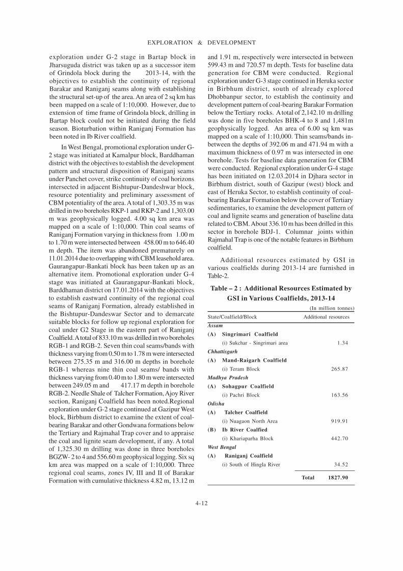
Additional resources estimated by GSI in
various coalfields during 2013-14 are furnished in
Table-2.
Table – 2 : Additional Resources Estimated by
GSI in Various Coalfields, 2013-14
(In million tonnes)
State/Coalfield/Block Additional resources
Assam
(A) Singrimari Coalfield
(i) Sukchar - Singrimari area 1.34
Chhattisgarh
(A) Mand-Raigarh Coalfield
(i) Teram Block 265.87
Madhya Pradesh
(A) Sohagpur Coalfield
(i) Pachri Block 163.56
Odisha
(A) Talcher Coalfield
(i) Nuagaon North Area 919.91
(B) Ib River Coalfied
(i) Khariaparha Block 442.70
West Bengal
(A) Raniganj Coalfield
(i) South of Hingla River 34.52
Total 1827.90

4-13
EXPLORATION & DEVELOPMENT
CMPDICMPDI continued its coal exploration activities
in 2013-14, mainly in CIL and Non-CIL/Captive
Mining Blocks. Exploration in CIL blocks was taken
up to cater to the project planning/production
support needs of subsidiaries of CIL whereas
exploration in Non-CIL/Captive Mining Blocks was
undertaken to facilitate allotment of coal blocks to
prospective entrepreneurs for captive mining. A total
of 120 to 140 drills were deployed in 2013-14, out of
which 57 were departmental drills.
CMPDI deployed its departmental resources for
exploration of CIL/Non-CIL/Promotional blocks,
whereas State Governments of Madhya Pradesh and
Odisha deployed resources in CIL blocks only.
Besides, eight other contractual agencies have also
deployed resources for detailed drilling/exploration
in CIL/Non-CIL blocks.
In 2013-14, CMPDI and i ts contractual
agencies took up exploratory drilling in 100
blocks/mines spread over 22 coalfields in six
states. These coalfields with no. of blocks/mines
are: Raniganj (6), Bajora (1), Brahmani (1),
Rajmahal (3), Jharia (3), West Bokaro (2), Ramgarh
(2), South Karanpura (5), North Karanpura (7),
Kamptee (8), Nand-Bander (2), Wardha Valley (5),
Singrauli (4), Sohagpur (11), Mand Raigarh (11),
Tatapani-Ramkola (4), Korba (6), Bisrampur (2),
Talcher (10), Ib Valley (6) and Sonhat (1). Out of
100 blocks/mines, 26 were Non-CIL/Captive
blocks and 74 CIL blocks/mines. Departmental
drills of CMPDI took up exploratory drilling in 53
blocks/mines, whereas contractual agencies
drilled in 47 blocks/mines.
A total of 6.97 lakh m of exploratory drilling
was carried out by CMPDI in 2013-14 through
depar tmenta l resources (3 .25 lakh m) and
outsourcing (3.71 lakh m) to State Governments/
MECL/Tendering (CIL/Non-CIL blocks). Details of
exploratory drilling carried out by CMPDI in 2013-
14 are given in Table - 3.
Sl. Agency Targe t Exploratory drilling Achieved
No. (m) achieved (m) (%)
1 . Depar tmenta l 2 8 5 , 0 0 0 3 2 5 , 3 6 2 1 1 4
2 . Outsourcing
i ) State Govts. 9 ,000 5 ,942 6 6
ii) MECL (MoU) 1 8 5 , 0 0 0 1 ,71 ,006 9 2
iii) Tendering (CIL Blocks) 2 4 2 , 0 0 0 1 5 6 , 3 5 9 6 5
iv) Tendering (Non-CIL Blocks) 1 7 9 , 0 0 0 38 ,171 2 1
Total 9 , 0 0 0 0 0 6 9 6 , 8 4 0 77%
Table - 3 : Exploratory Drilling by CMPDI (Departmental and Outsourcing) in 2013-14
Singareni Collieries Company Ltd
(SCCL)
During 2013-14, the total production of coal
from SCCL mines was at 50.47 million tonnes. The
total proved geological reserves of coal in
Godavari Valley Coalfield are placed at 10,073.54
million tonnes as on 1.4.2014.
State DirectoratesThe details of exploration for coal carried out
by the State Directorates of Geology & Miningduring 2013-14 are given in Table-4.
LIGNITE
GSI, MECL,State Directorates of Gujarat &Rajas than , GMDC and NLC conduc tedinves t iga t ion fo r l ign i te dur ing2013-14.

4-14
EXPLORATION & DEVELOPMENT
GSIGSI continued exploration for lignite in the
East Coast lignite fields of Tamil Nadu, at the
Tertiary sequence in Palana and Nagaur basins,
Rajasthan and also within Tertiary sediments in
Birbhum & Bardhaman districts, West Bengal to
identify and assess lignite potentiality.
The search for lignite resources has been
accorded priority in the states of Tamil Nadu and
Rajasthan which are devoid of any coal deposit.
In Tamil Nadu, promotional exploration under
G-3 stage continued at Uttarkosamangai sector,
Ramnad sub-basin, Ramanathapuram district to
delineate lignite-bearing areas and to assess the
resource potentiality. A total of 3,817.55 m was
drilled in twelve boreholes RUL- 13 to 24.
Geophysical logging of 3,240 m was conducted to
demarcate the lignite zones. Three lignite seams
varying in cumulative thickness from 5.00 m to
24.30 m were intersected between 175 m to 405 m
depths within Neyveli Formation. The strike
continuity of about 7 km and dip continuity of
about 6.5 km has so far been established.
In Rajasthan, promotional exploration under
G-4 stage continued at Kharicharan area, Palana
basin, Jaisalmer and Bikaner districts to locate
lignite-bearing blocks, stratigraphic set-up of the
area and preliminary assessment of resource. A
total of 653.50 m drilling has been done in seven
boreholes RPKS-10 to 16 without intersecting any
lignite seam. Promotional exploration under G-4
stage was also initiated at Panna sector, Palana
basin, Jaisalmer and Bikaner districts to locate
lignite-bearing blocks, stratigraphic set-up of the
area and preliminary assessment of resource. A
total of 2,124.50 m was drilled in ten boreholes
RPP- 1 to 10 and 1,256.80 m was geophysically
logged to ascertain the presence of lignite zones.
The maximum thickness of lignite seam intersected
is of 1m at 83 m depth along with thinner bands of
about 0.10 m to 0.80 m thickness within a depth of
83 m to 118.35 m.
In West Bengal, preliminary exploration under
G-4 stage by scout drilling was initiated at
Krishnanagar area, Birbhum district for assessing
the resource potentiality of lignite within Tertiary
sediments and to delineate stratigraphy and
structural framework of the area. Exploration in
Krishnanagar area does not yield any lignite seam
although very thin coal bands of a maximum
thickness 0.45 m were intersected in between the
depths of 14.90 m and 26.90 m with a total drilling
of 179.80 m in four boreholes RKN 1 to 4. An area
of 40 sq km was mapped on a scale of 1:25,000.
Promot iona l exp lora t ion under G-4 s tage
continued at Adharsuli sector, Bardhaman district
to search for the development of lignite within
Tertiary sediments and to establish resource
potentiality. Adharshuli Block was taken up based
on sporadic intersection of lignite in earlier
explored blocks in the surrounding area. During
2013-14 a total of 740.90 m has been drilled in four
boreholes RAS 6 to 9. However, no lignite seam
has been intersected.
STATE DIRECTORATES/GMDC/NLC Particulars of exploration for lignite as carried out
by these agencies are given in Table-5.
NON-FERROUS METALSBASE METALS
GSI and HZL conducted investigations for copper,
lead and zinc ores in different parts of the country during
2013-14.
GSIThe details of exploration activities carried out by
GSI during 2013-14 are given in Table-6.
HZLDuring the year, greenfield exploration was
carried out over 392 sq km in a Reconnaissance
Permit (RP) in Rajasthan and based on the review of
geological data and project generation studies, 3 new
RPs (6,291sq km) and one Prospecting Licence (PL)
(25 sq km) were applied in Karnataka, Madhya
Pradesh and Rajasthan. A total of 125,643 m core
drilling was completed at various exploration sites
throughout the mines and tenements. A borehole of
1,774 m was drilled at Rajpura-Dariba, which is the
deepest ever at any base metal exploration site in
India. The total reserves and resources at 31st
March
2014 were 365.1 million tonnes containing 35.2 million
tonnes of zinc-lead metal and 926 million ounces of
silver.

4-15
EXPLORATION & DEVELOPMENT
Table – 4 : Exploration for Coal by State Directorates of Geology & Mining, 2013-14
Geological mapping DrillingState/ Location RemarksDistrict Area Scale Boreholes Meterage
(sq km)
AssamKarbi Anglong Sapra Teron 2.6 1:25,000 04 168
Gaon, LalderaNepali Basti
ChhattisgarhSurguja Saidu area 160 1:50,000 01 872.05
2.24 1;4,000
-do- Ghutaro-Birjupali 125 1:50,000 - -area 0.50 1;4,000 - -
Jammu & KashmirRajouri Mahogla 0.1 1:1,000 - 16
MaharashtraChandrapur Nandori - - - 3,577.44
area
-do- Wilson Block - - - 1,480.50
-do- Chalbardi - - - 1,553area
Nagpur Dawa - - - 1,849Phukeshwa
-do- Nand-Panjrepar - - - 7,042area
Yavatmal Adkoli - - - 1,894Khadakdoharea
-do- Ashtona - - - 1,282.75Kothurnaarea
One coal seam is encounteredin an average depth of 13.5 mto 15 m with a thickness vary-ing from 1.5 m to 4.5 m. Total0.33 million tonnes of coal re-sources were estimated.
Total 65.57 m coal core and 35rock sampling were carried out.Coal resources were estimatedat 105.20 lakh tonnes under332 category.
Only survey work has been car-ried out alongwith 28 nos. ofsampling. Resources were notestimated.
Total fifty nos. pitting/trench-ing have been carried out.
Middle workable composite coalseam ranges in thickness from10 m to 18.60 m upto a depthof 378.15 m. So far 194.83 mil-lion tonnes coal estimated.
Workable composite coal seamranges in thickness from 11 mto 18 m within depth rangesfrom 174 m to 342 m. So far59.99 million tonnes coal wereestimated.
So far 4.17 million tonnes coalreserves proved from the area.
Exploration work indicates fiveseams ranging in thickness from1.30 m to 3.65 m at 30.420 mdepth. So far 10.531 milliontonnes coal were estimated.
Six coal seams ranging from0.30 m to 5.82 m thicknesswere established. The depthrange is from 50.25 m to435.60 m. So far 31.97 mil-lion tonnes coal were estimated.
One coal seam ranging in thick-ness from 4.81 m to 9.65 mwithin depth range of 143 m to250 m was established. So far5.49 million tonnes coal wasestablished.
Total two workable coal seamswith thickness of 1.84 - 4.25 mand 0.4-7.75 m were intersectedwithin a depth range of139.69m to 237 m. So far 1.87million tonnes coal were esti-mated.
4-16
EXPLORATION & DEVELOPMENT
Table–5: Exploration for Lignite by DGMs & Central/State Undertakings, 2013-14
Mapping Drilling Sampling
Agency/State/ (No.) Result
District/Location Area Scale No. of Meterage
(sq km) boreholes
DGM, Gujarat
Bharuch
Tq. Valiya - - 16 5,768.5 -
DMG, Rajasthan
Bikaner
N/v Kenya-ki-Basti - - 25 4,314.5 194
and Diyatra
N/v Ambasar, - - 02 349 -
Barsinghsar
and Hadla
GMDC, Gujarat
Kachchh
N/v Panandhro - - - - -
NLC
Tamil Nadu
Thanjavur & - - 42 13,600 179
Nagapattinam
Kallalangudi block
Cuddalore - - 35 14,569 169
East of Sethiathope
block
Vayalamur block - - 04 1,862 09
Rajasthan
Barmer
Baytu block - - 18 7,214.70 14
Bhurtiya block - - 45 15,014.90 221
Matasar Tala block - - 05 2,902 12
Nagaur
Phalodi, Gangardi & - - 23 5,008.90 94
Ucharda blocks
Deswal block - - 04 866.30 01
Jaisalmer
Aslai-Soda - - 04 356 -
Lignite is found to occur in lower
Eocene age and area under study is
164 sq km.
Geological reserves of 15.40
million tonnes of lignite have been
computed.
Lignite is not encountered in two
drilled boreholes.
Balance reserves of lignite at the
end of March 2014 was 4.18
million tonnes.
It is inferred that this block has
got substantial lignite resources.
It is inferred that the block has
got substantial lignite resources.
Lignite has been encountered in
two boreholes.
Work was in progress.
Work was in progress.
Work was completed.

4-17
EXPLORATION & DEVELOPMENT
Table - 6 : Exploration for Base Metals by GSI, 2013-14
State/District Name of block Details of exploration Results
Haryana
COPPER
Mahendragarh Jagreet-ki- Mapping, pitting,
Dhani sampling, drilling
and analysis
(Contd.)
Reconnaissance stage investigation (G-4) was
carried out to assess the potentiality of copper
mineralisation in depth as well as strike extension in
alluvial-covered area. Detailed Mapping (DM) of
1.50 sq km area has been carried out on 1:2,000
scale. Total eighty SS and 50 PTS were collected. A
total of 422.75 m drilling has been carried out in
three boreholes JDBH-1 to JDBH-3. Sulphide
mineralisation in the form of pyrite, pyrrhotite,
chalcopyrite and bornite is observed along fracture/
foliation planes in caclareous quartz-biotite schist
from 41 m to 55 m in JDBH-1, 62 m to 88.70 m
in JDBH-2 and 27 m to 51.20 m in JDBH-3.
Analytical results of 50 soil samples indicate Cu
values from 15 ppm to 41 ppm, Pb 12 ppm to 27
ppm and Zn 20 ppm to 98 ppm. 14 pit samples
indicate range of values for Cu 12 ppm to 35
ppm, Pb 15ppm to 42 ppm and Zn ppm 31 to 145
ppm. Total REE values ranging from 57.6 ppm to
262.2 ppm has been recorded from soil and pit
samples.
Reconnaissance stage investigation (G-4) for
basemetal was carried out for establishing
basemetal and associated gold mineralisation. The
work carried out includes 50 sq km of Large Scale
Mapping (LSM) on 1:12,500 scale, ground
geophysical survey (magnetic, SP & IP) and
sampling. LSM reveals that the major part of the
investigation area is covered by quartzo-
feldspathic biotite gneiss, known as Amgaon
Gneiss, where the rocks of Sukma Group (quartzite
and BMQ) occur as older supracrustals within the
basement gneiss. NW-SE-trending quartz reefs
developed along the shear zone within the
basement gneisses are hosting the basemetal
mineralisation. A quartz reef trending NW-SE is
exposed in the Denwari area for about 1.5 km
strike length and the width varies from 5 m to 25
m. Another quartz reef located near Minjhari area
is continuously exposed for about 2 km with width
ranging from 5 m to 20 m and trending along N-
S to NW-SE. Major ore minerals noticed in the
quartz reef are pyrite, galena, sphalerite and
chalcopyrite occurring in the form of veinlets,
specks and fine dissemination. Partially received
analytical results of samples (BRS+PTS+SS)
collected from quartz reefs of Minjhari area show
Cu value ranging from 30 ppm to 2,000 ppm; Pb
varies from 10 ppm to 750 ppm; Zn varies from
15 ppm to 750 ppm and Au varies from 50 ppb to
150 ppb. Based on the analytical results (BRS,
PTS and soil samples) two potential zones of
copper mineralisation were identified in the
Minjhari area.
Maharashtra
BASE METAL
Chandrapur Bamni Mapping, geophysical
area survey and sampling

4-18
EXPLORATION & DEVELOPMENT
State/District/ Name of block Details of exploration Results
(Contd.)
Table - 6 (Contd.)
Reconnaissance stage investigation (G-4) for
identification of target areas for basemetal
exploration was carried out to trace the north-
eastern extension of Kayad basemetal deposit.
LSM (1: 10,000) of 47.5 sq km area along
with collection of 187 BRS/SSS has been
accomplished. The area exposes rocks
belonging to the Delhi Supergroup comprising
quartz-mica schist , calc-si l icate rock,
quartzite, amphibolite and very thin lenticular
bodies of carbonaceous schist. Quartz-mica
schist is the host rock for sulphide
mineralisation. Surface indications of
mineralisation include malachite staining and
fresh sulphides in dug well samples. Analytical
results of 21 BRS show 10 ppm to 0.62% Zn, 10
ppm to 110 ppm Cu and < 25 to 180 ppm Pb.
Rajasthan
BASE METAL
Ajmer Chandlyawas Mapping, sampling
and analysis
COPPER
Alwar Khera block, Drilling
Mundiyawas-
Khera area
Prospecting stage investigation (G-3) was
carried out to evaluate the depth potential of
copper and precious metal mineralisation.
During 2012-13, six boreholes had been drilled
and all the boreholes intersected sulphide
mineralisation in the form of disseminations,
streaks, str ingers, veinlets and fracture
fillings of chalcopyrite, pyrrhotite, pyrite and
rare specks of bornite and covellite within
quartz and carbonate veins. During 2013-14,
a total of 308.55 m drilling was carried out in
three boreholes KBH-11 to KBH-13. The
borehole KBH-11 intersected sulphide
mineralisation from 44.55 m to 78.65 m
depth. The sulphide mineralisation is present in
the form of foliation-parallel f ine
disseminations of arsenopyrite and fracture
and vein-filled coarse-grained chalcopyrite
with minor pyrrhotite. The borehole KBH-
12 intersected sulphide mineralisation in the
form of occasional specks, stringers and fracture-
filled pyrrhotite, chalcopyrite and arsenopyrite
from 6 m to 100 m depth. The borehole KBH-
13 intersected sulphide mineralisation in the
form of specks, fracture and vein-fi l led
pyrrhoti te with minor chalcopyrite and
arsenopyrite from 6 m depth onwards.

4-19
EXPLORATION & DEVELOPMENT
State/District/ Name of block Details of exploration Results
(Contd.)
Table - 6 (Contd.)
COPPER
Alwar Khera SE block, Drilling
Mundiyawas-
Khera area
Reconnaissance stage investigation (G-4) was carried
out for copper and associated precious metals to
evaluate the subsurface potential of Cu and precious
metal mineralisation. The rock types exposed in
the Khera SE block are interbanded sequence of felsic
volcanic rocks (lithic tuff), meta-greywacke,
quartzi te, phyll i te, carbon phyll i te and
tremolite-bearing dolomitic marble of the
Thanagazi Formation of the Ajabgarh Group of the
Delhi Supergroup. A total of 392.20 m drilling has
been carried out in three boreholes KEBH-1 to
KEBH-3. The borehole KEBH-1 has intersected
sulphides in the form of chalcopyrite,
arsenopyrite and pyrrhotite, besides native copper,
bornite and covellite from 67.20 m to 87.85 m depth
within dolomitic marble. The borehole KEBH-
2 has intersected phyllite and dolomitic marble
with specks of pyrrhoti te and chalcopyrite
between 61 m and 65 m, 92.70 m and 95.80 m,
114 m and 117 m and 122 m to 127 m depths.
The borehole KEBH-3 has intersected occasional
specks; occasional disseminations, stringers, vein-
filled and fracture-filled chalcopyrite, pyrrhotite
and arsenopyrite from 70 m to 106.65 m depth
in dolomitic marble intercalated with thin
quartzite bands.
-do- Mundiyawas block, Aerial reconnaissance/
Mundiyawas- PGRS/mapping
Khera area and sampling
Reconnaissance stage investigation (G-4) for
basemetal was carried out for copper and associated
precious metals to evaluate the potentiality of Cu
and precious metal mineralisation. Aerial
reconnaissance and PGRS (1: 25/50,000) of 50 sq
km and DM (1: 2,000) of 1.8 sq km area along
with collection of 135 BRS/PTS/SS and 10
channel samples have been accomplished. The
study area exposes the rocks of Thanagazi Formation
of Ajabgarh Group of Delhi Supergroup. The main
rock types observed are mica schist, quartzite, carbon
phyllite, felsic volcanics, dolomite and amphibole-
bearing dolomite with some intrusive quartz and
calcite veins. Mineralisation is manifested by
malachite stains and presence of rare specks and
disseminations of chalcopyrite and arsenopyrite
within dolomite observed on the western side of
Bal-ki-Dhani, north of Mundiyawas-ki-Dhani.
Profuse malachite staining is observed in
tremolite-bearing dolomite on north-west of
Mundiyawas-ki-Dhani. Investigation has been
completed.

4-20
EXPLORATION & DEVELOPMENT
State/District/ Name of block Details of exploration Results
(Contd.)
Table - 6 (Contd.)
BASE METAL
Bhilwara Kundiyan- Mapping and
Parmeshwarpura sampling
and Dhamna-
Devariya block
Reconnaissance stage investigation (G-4) for
basemetal was carried out to assess the basemetal
potentiality for future probing. LSM on 1: 12,500
scale over an area of 40 sq km along with collection
of 30 BRS/PTS/SS has been accomplished. The
different lithologies observed in the area are
amphibolites, schist, calc-silicate, quartzite and
metabasic rocks of Potla Formation of Mangalwar
Complex of Bhilwara Supergroup, calc-silicate,
metabasic and metapelitic rocks of Rewara
Formation of Pur-Banera Group. Surface indications
of sulphide mineralisation are found in well dumps
in the NW of Bamaniya area in the form of profuse
malachite stains, veinlets, stringers & disseminations
of chalcopyrite, pyrite and pyrrhotite in metabasic
rock and in isolated outcrops in NW of Dhamana,
SE of Kundiyan, Parmeshwarpura and Somarwaro-
ka-Khera areas in the form of malachite stains,
veinlets, stringers and disseminations of bornite,
covellite, chalcopyrite and pyrite in calc-silicate
rock.
COPPER
Bhilwara Kamalpura Drilling and
block analysisReconnaissance stage investigation (G-4) was carried
out for copper and tungsten to test the surface copper
anomalies at depth by drilling and prospecting of
tungsten. The copper mineralisation in the Kamalpura
Block is confined to garnetiferous amphibole-mica
schist and calc-silicate rock. The sulphide
mineralisation occurs as fine disseminations of
chalcopyrite and pyrrhotite and occasional bornite. A
total of 200.50 m has been drilled out in three
boreholes KMB-1 to KMB-3. The borehole KMB-1
has intersected two mineralised zones of 4.75 m and
6.30 m width with 0.34 % and 0.65 % Cu, respectively.
The third borehole KMB-3 intersected three
mineralised zones of 18 m, 10 m and 7 m width with
0.30, 0.40 and 0.40 % Cu (VE), respectively.
Reconnaissance stage investigation (G-4) was carried
out for copper and associated minerals in the gap area
situated between already explored Bokri and Malwali
prospects of the Eastern Khetri Metallotect ,
Jhunjhunu distr ict to assess the basemetal
potentiality in the gap area. Aerial reconnaissance
& PGRS (1: 25/50,000) of 100 sq km, LSM (1; 10,000)
of 50 sq km and DM (1: 2,000) of 0.2 sq km area
have been carried out. Twenty three PTS were
collected. The rocks exposed in the area form part
of the Proterozoic Delhi Supergroup. The litho-units
exposed in the area include quartz-mica schist,
micaceous quartzite, calc-silicate rock, dolomite,
chlorite-magnetite-garnet schist, carbonaceous
phyllite, iron ore represented by magnetite and
hematite, alkali aplite, amphibolite and dolerite
dykes, pegmatite, quartz-porphyry and quartz veins.
Old workings along the fault zone and also in carbonate
rocks were recorded.
BASE METAL
Jhunjhunu Bokri and Aerial reconnaissance/
Malwali prospect PGRS/ mapping and
sampling

4-21
EXPLORATION & DEVELOPMENT
Table - 6 (Contd.)
State/District Name of block Details of exploration Results
(Contd.)
BASE METAL
Sikar Nanagwas Drilling
area
-do- Dariba North Drilling and
block analysis
Prospect ing s tage invest igat ion (G-3) was
carried out to test subsurface continuity of
basemeta l minera l i sa t ion and assoc ia ted
precious metals. A total of 920.65 m has been
drilled in six boreholes WNBH-5 to KEBH-
10 .
Details of sulphide mineralisation zones
intersected in boreholes are furnished
below:
Borehole number Depth of intersection of
mineralised zones
WNBH-5 30.10 m to 41.65 m &
56 .45
m to 79.00 m
WNBH-6 37.00 m to 40.80 m &
51 .50
m to 58.40 m
WNBH-7 84.30 m to 90.50 m
WNBH-8 65.05 m to 74.35 m
WNBH-9 57.90 m to 68.85 m &
73 .75
m to 98.75 m
WNBH-10 44.90 m to 48.65 m,
57 .20
m to 63.40 m & 78.90m to
94.35 m
The boreho les in te r sec ted su lph ide
minera l i sa t ion in the fo rm of specks ,
disseminations, fracture filling and veinlets of
chalcopyrite, bornite, covellite and pyrite.
P rospec t ing s t age inves t iga t ion (G-3) was
car r ied out to assess zones of basemeta l
mineralisation and associated precious metals
through subsurface probing and to trace the
nor thern cont inui ty of subsurface su lphide
minera l i sa t ion , which has a l r eady been
es tab l i shed by d r i l l ing in the sou the rn
continuation of Dariba North Block. During
2013-14, a total of 595.90 m has been drilled
in four boreholes DNBH-6 to DNBH-9. The
sulphide mineralisation intersected in vavious
boreholes between 28.5 m to 104.5 m, width
f rom 1 m to 6 .4 m and Cu f rom 0 .11% to
42%. The mineralisation mostly occurs in the
fo rm of f ine , dus ty fo l i a t ion-para l l e l
disseminations, streaks, stringers, veins and
specks of bornite, covellite, chalcopyrite and
pyr rho t i t e .

4-22
EXPLORATION & DEVELOPMENT
Table - 6 (Contd.)
State/District Name of block Details of exploration Results
(Contd.)
BASE METAL
Sikar Palaswala- Drilling and
ki-Dhani analysis
block
-do- Teliwala- Mapping and
Ramliyas sampling
block
Reconnaissance stage investigation (G-4) for
basemetal was carried out to test the subsurface
continuity of the basemetal mineralisation and
associated precious metals delineated on surface
in Palaswala-ki-Dhani block. During 2013-14, a
total of 298.70 m has been drilled in two boreholes
PDBH-1 to PDBH-2. The borehole PDBH-1 has
intersected a mineralised zone of 12.80 m with
0.32% Cu at cut off 0.2%, within this 8.45 m with
0.41% Cu at cut off 0.4% between 73.80 m and
100.80 m depth. The mineralisation is present in
the form of fine dissemination of pyrite,
chalcopyrite, bornite and chalcocite mainly restricted
to quartz and calcite veins and occasional grains of
specularite. The borehole PDBH-2 has intersected a
mineralised zone of 6.20 m with 0.21% Cu between
92.85 m and 109.40 m depth.
Reconnaissance stage investigation (G-4) for
basemetal was carried out in Teliwala-Ramliyas Block,
Sikar district to delineate the zones of basemetal
mineralisation and associated precious metals. DM
(1: 2,000) of 1.3 sq km area along with collection of
144 BRS/SSS/GCS and 140 channel samples has
been accomplished. The area exposes rocks
belonging to the Kushalgarh Formation of
Ajabgarh Group of Delhi Supergroup. The litho-
units exposed in the block are amphibole-bearing
marble, dolomitic marble and scapolite-bearing banded
calc-sil icates with quartz and calcite veins.
Sulphide mineralisation is manifested in the form of
malachite stains, chalcopyrite and bornite. At places,
pyrites have been recorded in veins cutting across
the main foliation. The average width of exposed
mineralised zones varies from 20 m to 30 m, with
1 km strike length.
Sirohi Bhimana and Mapping and
Kivarli blocks samplingReconnaissance stage investigation (G-4) was
carried out to delineate target areas for identification
of basemetal mineralised zones for future follow
up investigation. DM (1: 2,000) of 0.88 sq km
area has been carried out. Total 240 BRS/SS and
23 PTS were collected. The rock types exposed in
the area include quartz-plagioclase-chlorite (Hb)
rock, chlorite schist, metabasic and quartz veins. A
small patch of oxidation zone with muscovite
development is recorded in the northeastern part
of the Bhimana Block, which coincides with an IP
anomaly that extends for about 250 m.
.
4-23
EXPLORATION & DEVELOPMENT
Table - 6 (Concld.)
State/District Name of block Details of exploration Results
COPPER
Udaipur Chari NW block Mapping and
sampling
S i k k i m
BASEMETAL
East District Dickchu Mapping & sampling
prospect
Reconnaissance stage investigation (G-4) was carried
out to evaluate the northwestern extension of Chari
copper deposit and to identify target areas for sulphide
mineralisation. DM (1: 2,000) of 0.80 sq km area
has been carried out. Total 38 channel samples, 379
BRS/SS and 6 PTS were collected. The rock types
exposed in the area belong to the Debari Group
of the Proterozoic Aravalli Supergroup. The
important litho-units exposed are chlorite schist,
basic metavolcanics, amphiboli te, gabbro,
quartzite, phyllite and quartz and carbonate veins.
Metavolcanics is the host rock for basemetal
mineralisation. Surface indications of mineralisation
include malachite staining and fresh sulphides in old
working rubbles.
Reconnaissance stage investigation (G-4) was
carried out in extension areas of Dikchu basemetal
prospect, East district to assess the basemetal and
gold potentiality. An area of 35.5 sq km was mapped
on 1: 12,500 scale. Total 30 BRS, 7 SSS and 12 PTS
were collected. The rocks exposed in the area
belong to Central Crystalline Gneissic Complex
(CCGC), Daling Group, Lingtse Granite Gneiss
and basic intrusive. The litho-units present are
phyllite with interbands of fine-grained quartzite,
Lingtse streaky granite gneiss, mylonite,
chlorite schist/phyllite, quartz-biotite schist,
garnetiferous quartz-biotite schist and banded gneiss.
Sulphide mineralisation in the form of dissemination
is observed within the garnetiferous mica schist
and arenaceous phyll i te of Gorubathan
Formation, banded gneiss of CCGC and in
amphiboli te bands that intrude both the
garnetiferous mica schist and banded gneiss.

4-24
EXPLORATION & DEVELOPMENT
BauxiteState Directorates
During 2013-14, Directorate of Geology &
Mining, Chhattisgarh conducted exploration for
bauxite in Darai area, Kabirdham district (Mapping on
1:50,000 and 1:4,000 scales in 64 sq km and 2.04 sq km
areas, respectively; 112.8 cu m pitting; 1,146.9 m drilling
in 94 boreholes; 895 sample collections and estimation
of about 4.43 lakh tonnes of bauxite); in Kindha area,
Raigarh district (Mapping on 1:50,000 and 1:4,000 scales
in 120 sq km and 2.2 sq km areas, respectively and 49
nos. of sampling) and in Dandkeshra block Mainpat
plateau, Surguja district (Mapping on 1:50,000 and
1:4,000 scales in 140 and 1.36 sq km areas, respectively;
102 cu m pitting; 1,089 m drilling in 96 boreholes; 1,055
nos. of sample collection and estimation of about 4
lakh tonnes of metal grade bauxite).
During 2013-14, Directorate of Mining & Geology,
Kerala carried out exploration for
bauxite/aluminous laterite along with china clay in
Ulloor, Vaipiriyam, Korom and Eramom areas in Kannur
district. Sixteen boreholes were drilled in Ulloor area
with a cumulative thickness of 376 m and average
thickness of lateritic/bauxitic overburden is 4.5 m. In
Vaipiriyam area- 45 m drilling in two boreholes; in Korom
area- 167 m drilling in 5 boreholes and in Eramom area-
223.5 m drilling in 11 boreholes have been carried out.
The average thickness of aluminous laterite/laterite in
Eramom area is about 7 m.
During 2013-14, Directorate of Geology and Mining,
Maharashtra carried out 40 sq km mapping and surface
sampling for bauxite in Guhaghar area, Ratnagiri district.
The area shows existence of low grade bauxite and
laterite.
GMDC
M/s GMDC Ltd carried out exploration of bauxite
for the year 2014 in its various leases/mines (Asambiya
Nana Mota, Ramaniya, Pundi-Tumbdi-Faradi, Wandh-
Bhadai - Dhokla, Wandh-2 Mine, Sherdi - Bhadai -
Hamala, Kotdi - Mahaderpuri - Boha, Miyani - Khirsara
- Nudhtad, Mota Nandra Naredi, Wamoti Moti, Wamoti
Nani Moti, Womoti Moti-Daban, Mothala - Moti
Balachod and Kandhay by 20,027 m drilling in 1,953
boreholes with 2,093 nos. sampling.
FERROUS MINERALS
CHROMITE
GSI
In Andhra Pradesh, reconnaissance stage (G-4)
investigation was carried out in the Chimalpahad
Ultramafic Complex, Khammam district to delineate
mineralised zones of chromite and PGE and
associated minerals. Aerial reconnaissance and PGRS
(1: 50,000) of 300 sq km and LSM (1: 2,000) of 80 sq km
area have been carried out. One hundred twenty two
BRS, 35 PTS and 40 SSS were collected. The area exposes
litho-units of the Chimalpahad Ultramafic Complex
represented by anorthosite, leucogabbro, gabbro and
pyroxenite which are intruded within amphibolites of
Khammam Schist Belt. The chromite occurs as
podiform lenses within the ultramafic units viz.
dunite, pyroxenite, websterite and talc-tremolite schist.
The zones rich in mafic and felsic layering in the
periphery of the Chimalpahad Ultramafic Complex near
Burdharaghavpuram, Chimalpad, Rangapuram,
Ramanapalem areas are favourable locations to access
PGE, yet to be confirmed by analytical data. A zone of Ti-
V magnetite has been traced near Rampuram Tanda,
Vinobanagar, Rangapuram, Bajumallayagudem and
Burdharaghavpuram villages which may be favourable
locales for PGE mineralisation. These bodies are
associated with pyroxenite and leucogabbro of
Chimalpahad Ultramafic Complex, having extension
over a strike length of approx 200 m -300 m. V-Ti magnetite
is confirmed by laboratory data which reveal Fe2O
3 upto
69.33%, TiO2 up to 24.41%, Cr
2O
3 up to 0.26% and
vanadium up to 1,470 ppm.
In Manipur, reconnaissance stage (G-4)
investigation was carried out in Mantum Clung Block,
Kudengthabi area, Chandel district to delineate
chromite bodies within meta ultramafics emplaced in
the Tertiary sedimentary sequence. An area of 4.89 sq
km has been covered by Magnetic (TF) Survey. The
study area is occupied by Tertiary sedimentary sequence
(Disang Formation and Oceanic Pelagic sediments)
comprising shale, slate, quartzite, phyllitic shale,
bedded chert, limestone, pyroclastics interbedded
with chert and intraformational conglomerate. The
igneous members of ophiolite suite of rocks intruded
into the Tertiary sedimentary sequence, comprised
of basalts, granites, gabbros, serpentinite and
ultramafics. The ultramafics are peridotite, dunite,
harzburgite, pyroxenite, etc. Chromites are

4-25
EXPLORATION & DEVELOPMENT
observed within ultramafics. Few sharp magnetic
anomalies more than 2,000 nT were observed at
places within ultramafics may correspond to
chromite mineralisation. These anomalies are of
three types i.e. distinct low, sharp high and
bipo la r anomal ies . These sharp magne t ic
anomalies are of isolated nature with limited areal
extension. The magnetic contour map brings out
distinctly the magnetic variations over ultramafic
bodies and u l t ramaf ics hav ing chromi te
mineralisation.
In Odisha, reconnaissance s tage (G-4)
investigation was carried out around Tulasipasi,
Mahupal and Bhuasuni Parbat, Dhenkanal district
for search of chromite bodies in the transition
zone of Eastern Ghat Mobile Belt (EGMB) and
Singhbhum Craton (SC) south of Sukinda
ultramafic complex. DM (1: 2,000) of 1.14 sq km
area has been carried out. Total 76 PTS, 23 BRS
and 23 SS were collected. The area mapped is
occupied by rock types be longing to the
transition zone lying between the Singbhum
Craton and EGMB containing rocks of both
cratonic and mobile belt affinity. The rock types
exposed include mainly granite gneiss ± garnet,
quartzite ± sillimanite and laterite with minor
bands/lenses of charnockite, quartz-sericite
schist, metabasalt, amphibolite, chlorite schist
and phyllite with small lensoidal bodies of mafic-
ultramafic rocks. Gabbro/dolerite dykes with NW-
SE and NE-SW trends have intruded into all the
rock types. The chromite mineralisation is
orthomagmatic confined to the chromiferous
dunite, chromitite and occasionally in gabbros.
Maximum mineralisation has been seen within the
chromiferous laterite with minimum Cr2O
3 of 20-
25% (V.E.).
IRON ORE
GSI
In Chhattisgarh, prospecting stage (G-3)
investigation was carried out for assessment of
iron ore within Chilpi Group in Bhalapuri, Eklama-
Chelikama block, Kabirdham (Kawardha) district.
Th is was a sponsored pro jec t wi th M/s
Chhattisgarh Mineral Development Corporation
for two-year duration initiated in 2012-13. The
work carried out includes 3.2 sq km of DM (1:
2,000) coupled with 678.60 m of drilling. The iron
ore occurs at the contact of BHJQ and massive
quartzite as NE-SW- and NNE-SSW-trending
discontinuous band. Iron ore is massive, steel
grey, mostly hematite along with goethite,
specularite and rarely magnetite. Ore band is
discontinuously exposed for a strike length of 9
km with average 8 m -1l m width. A total of 678.6
m drilling has been carried out in 13 boreholes.
Drilling has proved occurrence of iron ore band
up to 60 m vertical depth in Kesda and Bhalapuri
blocks. Analytical results of surface (grab,
channel) samples of iron ore show Fe content
ranging from 58.98%-67.89% with an average of
64.94%, while analyses of core samples yield Fe
content up to 68.24% potentiality in the rocks of
Iron ore and Kolhan Group.
In Jharkhand, reconnaissance stage (G-4)
inves t iga t ion was ca r r ied ou t in par t s o f
Bambasai-Dumurjowa-Mongra block, West
Singhbhum district for assessment of low-grade
i ron ore , managanese o re and l imes tone
potentiality in rocks of iron ore and Kolhan Group.
Large Scale Mapping (1:12,500) of 79 sq km area
has been carried out. Fifty two GCS and 15 PTS
were collected. The mapped area is characterised
by the presence of OMG/IOG rocks, Singhbhum
gran i te & granodior i t e , amygdula r basa l t
(Jagannathpur lava), Kolhan Group of rocks,
dolerite dykes, quartz veins and laterites. In the
mapped area two dolomitic limestone bodies have
been identified: 1). The Kochhra limestone has
the strike extension of two kms and width of 50-
70 m. 2). The Karamburu limestone extends up to
a km with the average width of 20 m. Analytical
result of limestone samples yielded CaO 48.19%
and SiO210 percent.
In Megha laya , r econna issance s tage
investigation (G-4) was carried out around
Rambrai in West Khasi Hill district to delineate
the vanadiferous-titaniferous magnetite bodies
within Precambrian Gneissic Complex. LSM (1:
25,000) of 20 sq km DM (1: 5,000) of 1.4 sq km and
geophysical survey (Magnetic) of 3.2 L km area
have been carried out. Forty five BRS have been
collected. The litho-units exposed in the area are

4-26
EXPLORATION & DEVELOPMENT
gran i te gne i ss , banded gne i ss , g ran i te ,
charnock i te and metanor i t e . La te r i t i sed
metanorite body with bands of titaniferous-
vanadiferous magnetite having a strike length of
1,800 m and width of 300 m was delineated NW of
Moulih village. The analytical results of 26
samples show Fe2O
3 between 6.82% and 30.96%,
TiO2 between 1.86% and 4.3%, vanadium up to
1,398 ppm, Cu up to 556 ppm and zirconium up to
1,802 ppm. The other two metanorite bodies were
also identified and delineated in the northern part
of the mapped area. These bodies are 200 m &
600 m in width and 1,500 m & 900 m in length and
are associated with magnetite band (2 mm to 4
mm). Samples have been collected from these
bodies. EPMA study indicated presence of
ampbibole, pyroxene, plagioclase, titaniferous-
vanadi fe rous magne t i t e , i lmeni te , pyr i t e ,
pent landi te and chalcopyr i te wi th in these
metanorite bodies.
In Odisha , p rospec t ing s tage (G-3)
investigation was carried out in Kalamang West
Block, Bonai Kendujhar belt of Sundergarh district
for assessment of iron ore potential in the eastern
continuity of the area between Ghoraburhani and
Sagasai East Block for augmentation of resources.
The work carried out includes pitting & trenching
coupled with 1,060.55 m of drilling. The area is
mostly covered by ferruginous laterite with minor
iron ore. Drilling in 14 boreholes (SKB-1 to SKB-
14) carried out during 2012-13 established that
the thickness of ore zone varies from 1m to 73.95
m. Twelve boreholes viz. SKB-15 to SKB-26 have
been completed during 2013-14. Out of twelve,
eight boreholes have intersected mineralised
zones, the details of intersections in the boreholes
are as follows:
Borehole No. Depth of intersection
SKB-15 0.0-9 m, 44-47 m, 77-79 m & 85m-
98m
SKB-16 8-11 m, 16.10-32.40 m &
37.30- 83.55 m
SKB-18 0.0-4.10 m, 55.60-65.60 m
SKB-19 0.0-54 m
SKB-20 5-62 m
SKB-23 14.90 m -18.85 m & 44.10-51.50 m
SKB-24 0.0-77.60 m
SKB-25 0.0-49 m
The analytical results received for 285 core
samples show encouraging results with Fe content
varying from 45.79% to 65.8%, SiO2 from 0.94% to
13.32% and AI2O
3 from 0.5% to 12.14%. Out of 285
samples, 241 samples have shown Fe content >
45%. Prospecting stage (G-3) investigation was
carried out in Mendhamaruni block Sundergarh
district for assessment of iron ore potentiality for
augmentation of resources. An area of 0.35 sq km
has been covered by Detailed Mapping on a scale
of 1:2,000 and the litho-units exposed in the area
are mainly shale (Fe-shale/variegated shale) and
Fe-laterite. A total of 496.55 m drilling has been
completed in four boreholes viz. SMB-1 to SKB-4.
Out of four, three boreholes have intersected
mineralised zones, the details of intersections in
the boreholes are as follows:
Borehole No. Depth of intersection
SMB-1 0.0-85.4 m
SMB-2 6.8 m - 95.80 m
SMB-3 60.55 m -137.70 m
The mineralised zones intersected comprise
Hard Laminated Ore, Soft Laminated Ore Powdery
Ore and Blue Dust. The analytical data of 239
core samples show the average Fe content of BH:
SMB-1, SMB-2 & SMB-3 are 62.46%, 58.38% and
64.89%, respectively.
In Rajasthan, reconnaissance stage (G-4)
investigation was carried out in Karauli-Bundi
area in parts of Karauli, Sawai Madhopur, Tonk,
Bundi and Bhilwara districts to delineate iron ore
bodies in the rocks of Hindoli Group for future
probing. LSM (1: 25,000) of 130 sq km area has
been carried out. Forty-five BRS have been
collected. The main litho-units exposed in the area
are chert breccia, ferruginous chert breccia and
quartzite with small patches of shale/porcelanite
and dolomite at places. Ferruginous body has
been mapped on 1: 25,000 scale of about 25 sq km
in Korma area, Bundi district. The main litho-units
exposed in this area are ferruginous breccia,
phyllite and dolomite with quartz veins. A number
of old workings of variable dimensions have been
observed near Khiniya and Korma areas in Bundi
dis t r ic t . The ore bodies mainly consis t of
hematite. XRF analysis of 15 grab samples of iron
ore body revea l s Fe2O
3 con ten t o f 34%
(nearly 20 % Fe).

4-27
EXPLORATION & DEVELOPMENT
In Uttarakhand, reconnaissance stage (G-4)
investigation was carried out in undifferentiated
Ramgarh Group in parts of Nainital district to
delineate iron and sulphide mineral occurrences
and assessment of economic potentiality of the
area. LSM (1: 25,000) of 85 sq km area has been
carried out. One hundred twenty eight BRS/SS/
SSS and 30 PTS were col lected. The area
comprises undifferentiated rocks of Proterozoic
Ramgarh Group and Neoproterozoic Betalghat
Formation and Nagthat Formation (Jaunsar
Group). In the mapped area, the Ramgarh Group
consists of granite gneisses and a sequence of
quartzite with few thin bands of phyllite and
mafic sills. The rocks of Nagthat Formation
(Jaunsar Group) include quartzite. In the area, iron
ore is manifested as patches of limonite lenses,
specks of magnetite in the calcareous phyllite and
as ferruginisation of the quartzite band. The
results of 41 analyses of bedrock samples/stream
sediment samples for Fe and Cu, Pb, Zn, etc.
yielded very low values.
State Directorates
During 2013-14, Directorate of Geology and
Mining, Uttar Pradesh carried out exploration for
iron ore in Baragaon area, Jhansi district by 02 sq
km mapping on a scale of 1:25,000; 4 nos. trenching
with 231.65 cu m excavation and 20 nos. sampling.
The value of iron is 32-52 percent.
NMDC
Dur ing 2013-14 , NMDC car r ied ou t
exploration for iron ore in Bailadila Iron ore
Deposi t , South Bastar, Dantewada dis t r ic t ,
Chhat t isgarh by mapping, pi t t ing, dr i l l ing,
sampling, chemical analysis etc. Deposit nos. 14
& 11 C: mapping on 1:2,000 scale; pitting 364 nos.
and 2,798 m drilling in 33 boreholes; Deposit no.
05: - 1,754 m drilling in 14 boreholes and chemical
analysis of 1,754 nos. samples and Deposits no.
10/11 A: 987 m drilling in 12 boreholes. Similarly,
in Donimalai Iron Ore Mines, Bellary district,
Karnataka 2,060.2 m drilling in 22 boreholes and
collection of 846 samples have been carried out.
MANGANESE ORE
In Karna taka , reconna issance s tage
investigation (G-4) was carried out in Ramanguli
area, Uttad Kannad district for the assessment of
manganese potentiality. LSM (1: 12,500) of 75 sq
km and PT of 30 cu m area have been carried out.
Seventy-five BRS, 44 PTS and 15 PCS were
co l lec ted . In the s tud ied a rea manganese
mineralisation has been observed in phyllite,
l a te r i t i c BMQ and quar tz i t e . Pyro lus i t e ,
ps i lomelane and suspec ted need le -shaped
cryptomelane, jacobsite were observed in the west
in Ramanguli area. Manganese mineralisation has
been traced north of Kodlagadde, for a strike
length of 600 m having width of 20 m and depth of
15 m within phyllite. The analytical results of 12
bedrock samples were received so far, in which 3
samples show Mn content 13.9%, 21.77% and
7.94%, respectively. Analytical results of 3 PCS
samples yielded Mn content 29.28%, 21.03% and
43.6%. Gold mineralisation has been observed in
BIF west of Sunjog and along the contact between
quartz-chlorite schist and argillite in nala section/
Gangaval l i r iver sec t ion in Idgundi b lock.
Occurrences of approximate 12 m wide clay
horizon having a strike length of about >0.8 km
has also been recorded.
In Maharash t ra , r econna issance s tage
investigation (G-4) for manganese was carried out
in Chorbahuli extension area, Nagpur district for
assessment of manganese potentiality. The work
carried out includes 150 sq km of LSM (1:12,500),
Ground Geophys ica l Survey (Gravi ty and
Magnetic) and sampling. The area exposes biotite
gneiss of Tirodi Biotite Gneiss, calcareous marble
with or without manganese ore and calc-silicate
of Lohangi Formation, quartz-mica schist and mica
schis t of Mansar Formation, quar tz i te and
dolomitic marble of Bichua Formation, foliated
granite and pegmatite bodies. Two to five m wide
manganese-bearing horizon is recorded within the
marble band of Lohangi Formation for a strike
length of 4.5 km. But the Mn mineralisation is not
continuously present throughout the marble
band. Analytical results of BRS collected from
Mn-bearing horizon show Mn value ranging from
1.75 to 21.62 %.
In Odisha , reconnaissance s tage (G-4)
investigation was carried out in Dengula-Bandhal
area, Bonai-Kendujhar Belt, Sundergarh district
to iden t i fy po ten t ia l a reas o f manganese
mineral isat ion for future explorat ion. LSM
(1: 10,000) of 40 sq km and DM (1: 2,000) of
4-28
EXPLORATION & DEVELOPMENT
0.40 sq km area has been carried out. Forty-five
BRS, 16 PTS and 45 PCS were collected. The litho
assemblages noticed in the mapped area are shale
and laterite. Manganese mineralisation in the
mapped area is mostly confined to the variegated
shale and in laterite capping . Chemical analysis
of eleven bedrock samples collected from LSM
area show manganese percentage varied from 0.92
to 41.28.
MOIL
During 2013-14, MOIL carried out 13,463 m
exploratory drilling involving 58 boreholes in
seven mines: two mines Tirodi & Bharweli situated
in Balaghat district, Madhya Pradesh; and five
mines Dongri Buzurg & Chikla in Bhandara district
and Gumgaon, Kandri & Mansar in Nagpur
dis t r ic t , a l l in Maharasht ra . The repor ted
resources of manganese ore were Bharweli (23.69
million tonnes), Tirodi (1.16 million tonnes),
Gumgaon (4.20 million tonnes), Sitapatore/Sukli
(0.40 million tonnes), Kandri (5.53 million tonnes),
Mansar (4.60 million tonnes), Chikla (4.98 million
tonnes), Dongri-Buzurg (11.79 million tonnes),
Ukwa (8.57 million tonnes) and Beldongri (0.32
million tonnes).
STRATEGIC METALS
TUNGSTEN
GSI
In Maharash t ra , r econna issance s tage
investigation (G-4) was carried out in and around
Inzewara, Bhandara district to identify target
zones of tungsten and associated mineralisation.
The work carried out includes 200 sq km aerial
reconnaissance, 100 sq km LSM on a scale of 1:
12,500, 100 soil sampling on 50 m x 200 m grid,
pitting & trenching of 102 cu m and collection of
51 BRS. The area exposes rocks of basement
Amgaon Gneissic Complex and Sakoli Group.
Tungsten mineralisation is confined mainly to the
quartz veins and the tourmaline greisens within
the mica schist. In Salheli area, one grab sample
of quartz vein boulders containing scheelite
recorded 0.62% of W. BRS samples of 5 quartz-
tourmaline veins and greisens from SW of
Inzewara gave values ranging from 70 ppm. to
175 ppm. Pitting and trenching in Salheti area
established 10 m strike length of scheelite-
bearing quartz vein having a thickness of 0.5 m.
Sixteen pit samples from the Salheti area show
W values ranging from 200 ppm to 0.15% and
three pit samples recorded Au values of 148 ppb,
164 ppb and 208 ppb. Out of 19 soil samples from
Salheti one soil sample has given Au value of
547 ppb. The SEM-EDX studies of both the
quartz vein and the quartz-chlorite schist of
Salheti area confirmed the presence of scheelite.
A single platinum grain and REEs like xenotime
and monazite were also observed in the quartz-
chlorite schist near to the scheelite-bearing
quartz vein. Gold grain of 2 ì m size was observed
in SEM studies from smoky quartz vein located
west of Chandrapur village.
RARE METALS & RARE EARTHS
(RM/REE) ELEMENTS
GSI
In Andhra Pradesh, reconnaissance stage
investigation (G-4) was carried out in the area
between Vutukuru and Kalichedu in Nellore
district to delineate potential areas for REE and
other strategic minerals. LSM (1: 12,500) of 155 sq
km area has been carried out. One hundred twenty
nine BRS, 99 SSS, 48 PTS and 42 nos. of PCS were
collected. Thirty one pegmatite bodies within
migmatitised pelitic schist, quartzite, quartz-mica
schist having variable strike length extending
from 1 m to 120 m with a width ranging from 1 m to
50 m and 26 aplite bodies within amphibolite and
quartzite having variable length ranges from 1 m
to 60 m with a width ranging from 1 mm to 30 m
have been del ineated. EPMA study reveals
presence of columbite-tantalite mineral within the
pegmatite. Analytical results of 116 geochemical
samples (77 BRS & 39 SSS) show total REE, LREE
& HREE values ranging from 2 ppm to 572 ppm, 1
ppm to 500 ppm and 0.32 ppm to 250 ppm,
respectively.
In Assam, reconnaissance stage investigation
(G-4) was carried out in southern part of Agia
around Sujukona Hill and Tukureswari Hill in parts
of Goalpara district to evaluate potentiality of
REE within Precambrian Gneissic Complex. LSM
(1: 12,500) of 69 sq km area has been carried out.
Total 93 BRS, 70 SSS and 24 PCS were collected.
The s tud ied a rea exposes banded gne i ss ,

4-29
EXPLORATION & DEVELOPMENT
migmatitic granite gneiss, basic granulite, quartz-
biotite gneiss ± sillimanite, metadolerite with thin
and occasional quartz and pegmatite veins. Shear
zones of very restricted extent are observed south
of Phuphunga Hill with a cumulative thickness
of about 30 m, around Bormohora with a thickness
of approximately 7 m along Dwipkai nala. A small
pyrite-rich shear zone within mylonitised biotite
gneiss is exposed in the western flank of Sijukona
Hill. Sulphide mineralisation in the form of pyrite
and pyrrhot i te has been not iced south of
Phuphunga. Samples collected across the shear
zones and sulphide zones were submitted for
chemical analysis.
In Jharkhand , reconna issance s tage
inves t iga t ion (G-4) was ca r r ied ou t in
Dublaberatoli-Sundil area Ranchi district in
po ten t ia l pegmat i t es hos ted wi th in the
Chhotanagpur Gneissie Complex to assess RM
and REE potentiality. The study area is a part of
Chottanagpur Gneissic Complex and forms the
western extension of North Purulia Shear Zone.
Detailed mapping over 0.30 sq km was carried out
on a scale of 1:500 to delineate the individual
pegmatite bodies. Pegmatite body of length of
2 km and width of 50 m to 70 m was demarcated.
The identified mineral phases in the pegmatite
body are columbite, cebaite, barite, rutile, anatase,
lepidolite, fluocerite, becquerelite, beddeleyite,
thoriani te , pol luci te , fenicl inoho mquisi te ,
zinnwaldite, apatite, kainosite, allanite and
spodumene. Concentration of total REE up to 600
ppm is reported in the pegmatite body. In a few
samples concentration of Ce, La and Nd is
remarkably high, as high as Ce-242.69 ppm, La-
121.14 ppm and Nd-111.63 ppm. Concentration of
rare metals like Li (10 ppm - 117 ppm), Cs (<10
ppm - 52 ppm) and Rb (175 ppm - 580 ppm) has
been recorded f rom the pegmat i te . A
reconnaissance stage investigation (G-4) was
carried out to assess the potentiality of RM &
REE in Chhotanagpur Gneissic Complex in and
around Kasidih area Ranchi district. Detailed
Mapping on a scale of 1: 500 over an area of 0.4
sq km along with pitting and trenching of 30 cu m
was accomplished. The litho-units present in the
area a re g ran i te gne i ss , ca lc - s i l i ca te and
pegmatite. The WNW-ESE-trending pegmatite
bodies having a dimension of approx. 100 m -
2,000 m length and 40 m -200 m (approx.) width
were demarcated. The result of EPMA analysis
shows the occurrences of xenotime, monazite,
zircon, uraninite, sphene, apatite, epidote, rutile
and garnet in some samples of pegmatite. XRD
study of pegmat i te ind ica tes p resence of
columbite, leucosphenite, zorite, pollucite and
amblygoni te . To ta l REE concent ra t ion in
pegmatite samples shows values from 150 ppm to
400 ppm. A reconnaissance stage investigation
(G-4) was carried out to assess titanium and
vanadium potentiality in bauxite of Serangdag
Plateau in Garna Hanrup-Kaprapat-Risapattoli-
Kurbetola area of Gumla district. This was taken
up on request from DMG, Jharkhand as a two-year
programme initiated in 2013-14. Reconnaissance
mapping of 19 sq km area has been carried out. A
total of 220.50 m drilling in five boreholes has
been completed. Bauxitic zones with cumulative
thickness varying from 25 m to 39 m have been
intersected in five boreholes between 0.30 m and
39 m depth.
In Karna taka , reconna issance s tage
investigation (G-4) was carried out around
Mincheri, Inchanal and Hireupperi areas, Raichur
distr ict to explore the potent ial i ty of REE
mineralisation. LSM (1: 12,500) of 60 sq km area
has been carried out. Total 110 BRS, 43 PTS and
14 PCS were collected. The litho-units comprising
of amphibolite, banded magnetite quartzite, talc-
tremolite schist belonging to Older Metamorphic
Group of the Gurgunta Schist Belt occur as
enclaves within the Peninsular Gneiss. Other
exposed rocks are diorites. quartz diorites,
monzonites, pink granite, pink porphyrit ic
grani te , grey biot i te grani te and alkal ine ,
carbonate-bearing syenite plugs. Near Kesaratti
aegirine syenite plug of 100 sq km dimension has
been demarcated. Analytical results of 11 samples
collected from the plug have yielded La (23.71
ppm -53.52 ppm); Ce (51ppm - 99.16 ppm); Pr (5.7
ppm -11.7 ppm); Nd (20.83 ppm - 42.62 ppm); Eu
(1.16 ppm - 2.24 ppm) and Sm (3.8 ppm - 7.35 ppm).
A 1.9-km-long and 50 m - wide N-S-trending
mylonitised quartz reef exposed near Mincheri
has been mapped and sampled systematically.
Out of the 15 samples collected from the reef, 4
samples have given values of La (39 ppm - 107
ppm); Ce (68ppm -167 ppm); Pr (7.2 ppm -19.1

4-30
EXPLORATION & DEVELOPMENT
ppm); Nd (26.53 ppm - 63.45 ppm). Another 1.2
km long smoky to white quartz vein varying in
width from 1 m to 8 m parallel to the NS trending
mylonitised Mincheri quartz reef has been
mapped. The quartz veins to the West of Mincheri
reef have yielded 500 ppm to 1,000 ppm of La, 100
ppm Nb, 10 ppm Y and 200 ppm Zr.
In Madhya Pradesh, reconnaissance stage
investigation (G-4) was carried out in Sarkana-
Malguwan-Gairwar area in Chhatarpur district
to evaluate the potentiality of REE mineralisation
of the carbonatite-syenite-lamprophyre and felsic
intrusives within Banded Gneissic Complex. Large
Scale Mapping of 141 sq km on a scale of 1: 12,500
was carried out. Seventy of stream sediment
samples, 200 bed rock samples and 35 nos. of
petrochemical samples have been collected for
assessment of REE potentiality. Besides, 50 rock
chips for petrographic studies, 20 samples each
for ore microscopic studies, SEM-EDX studies,
EPMA studies, and XRD studies were also
collected. Satellite imageries study covering an
area of 800 sq km was carried out. The mapped
area exposes rocks of Bundelkhand Granitoid
Complex with supracrustal enclaves. Numerous
prominent pegmatites, quartz veins and quartz
reefs intruded into the Bundelkhand Granitoid
Complex. The stream sediment and bed rock
samples collected from the pegmatite, syenite,
ca rbona t i t e and bas ic rocks do no t g ive
encouraging values of REE minerals.
In Maharash t ra , r econna issance s tage
investigation (G-4) for REE/RM mineralisation
was carried out in Sausar Mobile Belt and Tirodi
Biotite Gneiss in Nagpur district to delineate
pegmat i te bodies , charac te r i se the pe t ro-
mineralogy and to evaluate the potentiality of
REE/RM in pegmatite. Large Scale Mapping on a
scale of 1: 10,000 was carried out covering an area
of 150 sq km which was followed by detailed
mapping on 1:1,000 in an area of 0.32 sq km. The
rocks exposed in the area belong to Basement
Complex comprise Tirodi Biotite Gneiss (TBG),
augen gneiss, amphibolites and granite gneiss
and rocks of Sausar Group which include pink
marble and calc-sillicates of Lohangi Formation,
marble and quar tz -mica schis t o f Mansar
Formation and interbanded quartzite-quartz-mica
schist of Chorbaoli Formation. These rocks are
intruded by granite, pegmatite and number of
quartz veins. Length of pegmatite ranges between
5 m and 550 m and width between 0.5 m and 30 m.
Talus sample collected near weathered pegmatite
shows the highest total REE value of 6,300 ppm.
Two stream sediment samples collected from first
order stream near this pegmatite also give the
concentration of total REE up to 3,970 ppm.
Analytical results of beryl samples reveal higher
concentration of Be (3.58%), Li (405 ppm) and
W(945 ppm). The highest concentration of
Cesium (2,295 ppm) is noted in pegmatite located
NNE of Ramzam village. The concentration of Ta,
Rb and W in the same sample is 628 ppm, 2,500 ppm
and 210 ppm, respectively. SEM data for ten
pegmatites indicated the presence of monazite,
zircon and xenotime and Nb-Ta-bearing phases.
In Meghalaya, reconnaissance stage
investigation (G-4) was carried out in parts of
Nongpoh Pluton, Ri-Bhoi district to evaluate
potentiality of REE in Nongpoh granite and to locate
mafic / lamprophyre / lamproite rock around
lineament intersections and mineralised zones along
the contact of granite and Precambrian gneiss. LSM
(1: 12,500) of 55 sq km area has been carried out.
Total 46 BRS, 43 SSS, 13 SS and 22 PCS were
collected. Litho-units observed in the area include
sillimanite-biotite gneiss, granite gneiss, diorite
gneiss of Precambrian Gneissic Complex, mafic rock/
lamprophyre, diorite-granodiorite, porphyritic
granite and non-porphyritic granite of Nongpoh
pluton. Disseminated grains of pyrite and
chalcopyrite are observed in gneisses, diorite/
granodiorite, mafic intrusive rock, porphyritic
granite, quartz and pegmatite veins. Scheelite grains
have been identified by EPMA study in garnet-
epidote rock. Analytical results of 8 SSS show REE
value ranging between 226 ppm and 2,984 ppm, 9
samples of porphyritic granite show value between
562 ppm and 980 ppm and 6 samples of non-
porphyritic granite show value between 578 ppm
and 2,148 ppm. Two granite samples yield REE
value between 1,803 ppm and 2,148 ppm have visible
spindle-shaped sphene (titanite) and allanite in hand
specimen.

4-31
EXPLORATION & DEVELOPMENT
In Ra jas than , reconna issance s tage
investigation (G-4) was carried out in the Dhani
granite in Pali district to assess the potentiality
of REE mineralisation. DM (1: 2,000) of 0.70 km2
area has been carried out. Total 150 channel
samples and six PCS were collected. In addition,
a quantum of 188 m of dr i l l ing has been
accomplished. The area is represented by Dhani
granite, Erinpura granite and Sirohi Group of
metasediments comprising alternate sequence of
biotite schist, quartzite and impure carbonate
rocks. Nine scout boreholes were drilled in Dhani
area during 2010-12, 2012-13 and 2013-14. The
boreholes DGBH-1 and DGBH-2 were drilled in
2010-12. No significant REE mineralisation has
been in te r sec ted in these boreholes . S ix
boreholes DGBH-3 to DGBH-8 were drilled in
2012-13, out of which 5 boreholes, viz. DGBH-3,
DGBH-4, DGBH-5, DGBH-6 and DGBH-7
encountered 13 REE-rich zones at cut off grade
0.1% total REE and width lm. The borehole DGBH-
9 drilled during 2013-14 encountered one REE
rich zone of 0.54 m at cut off grade 0.1% total
REE and width l m. EPMA study indicated the
presence of synchysite (Ce) and monazite in
altered Dhani granite intersected in borehole
DGBH-3 during 2012-13. Two bed rock samples
from highly kaolinised rocks show REE of 0.206%
and 0.545%, respectively. A reconnaissance stage
investigation (G-4) was carried out in Gothara
granite of Khetri Fold Belt, Jhunjhunu district
to assess the potentiality of REE mineralisation.
LSM (1: 12,500) of 19 sq km and DM (1:2,000) of
0.49 sq km area have been carried out. Total 224
BRS/PT/SS have been collected. Within the
mapped a rea , the rocks exposed a re
metasedimentaries of NDFB, post- tectonic
intrusive granites (Gothara granite), basic dykes
and later quartz veins. The metasediments
comprise amphibole quartzite, magnetite-bearing
quartzite, garnetiferous mica schist, staurolite
schis t and ca lc-s i l ica tes . A c lus ter of o ld
workings were found east of Rajota located 50 m
south of the g ran i te con tac t wi th in the
metased imentary count ry. Su lph ide
mineralisation in the form of malachite staining
and specks of chalcopyrite, pyrite, covellite and
bornite has been observed within the dump
material. Out of 90 bed rock samples collected
from the LSM area, 31 yielded REE > 500 ppm
and 10 samples yielded REE ranging from 0.1%
ppm to 1% ppm. Out of 134 grid bed rock samples
collected from the DM (1: 2,000) area, the result
of 21 samples has been received so far. Out of
these 21 samples, 7 samples yielded a REE >
500 ppm and 2 samples yielded a REE > 1000 ppm.
In Tami lnadu , reconna issance s tage
investigation (G-4) was carried out in parts of
Paramathi-Sarkar Valavandi-Kavundanur areas of
Namakkal and Trichy districts to locate potential
zones of REE and associated minerals within pink
granite/gneiss and pegmatite. LSM (1: 12,500)
of 78 sq km area has been carried out. Total 50
BRS and 30 PS were collected. The study area
exposes calc-granulite, BMQ, pyroxene granulite,
pink migmatitic gneiss, biotite gneiss, granite,
granite gneiss, charnockite, hornblende-biotite
gne iss , pyroxene gne iss , metapyroxeni te ,
metagabbro and pegmatite and quartz veins.
Analytical results of 20 BRS received so far out
of which three nos. of samples collected from
pink granite and pink migmatite yielded 914.89
ppm of REE (La to Lu), 1359.59 ppm of LREE (La
to Sm) and l14.41 ppm of HREE (Tb to Lu). The
samples collected from pegmatite bodies are not
showing any encouraging values of REEs. XRD
study reveals presence of almandine, apatite,
allanite, ilmenite and epidote within granite and
pegmatite.
State DirectorateDuring 2013-14, Directorate of Geology &
Mining, Uttar Pradesh carried out exploration for
REE near Khajraha Buzurg village, Jhansi district
by mapping on a scale of 1: 2,000 scale in 0.5 sq
km area and 10 nos. of sampling. The encouraging
value of average grade 560 g/t is assessed.

4-32
EXPLORATION & DEVELOPMENT
BEACH SAND/PLACER MINERALS
GSI
(i) To evaluate placer mineral resource, an
area of 50 sq km within the territorial waters off
north of Bhimunipatnam, Andhra Pradesh was
covered. Total 66 vibrocore seabed sediment
samples, varying in length from 0.46 m to 3.78 m
with an average core length of 2.10 m were
collected on a grid pattern of 1 km x 1 km within
the water depths of 22.56 m to 39.47 m. Besides,
current observations and water samples at surface
and sub-surface levels from three stations each
were collected and 55 LKM of bathymetric survey
along 11 coast-perpendicular transects of 5 km
each was carried out. The bathymetry reveals that
the con tours a re para l l e l to the coas t
configuration of NE-SW and the area is with a
gentle gradient of 1:295. The geomorphologic
feature observed in the area of study is a terrace
with a relief of 2 m to 3 m at a water depth of
around 32 m. The onboard observation of seabed
samples reveals that the predominant sediment
type is grey medium to fine sand at surface and
grey fine sand admixture with green compact clay
at sub-surface level. The vibrocore sediments
were sub-sampled at half a metre interval for
evaluation of heavy mineral resources. Preliminary
studies indicate low concentration of heavy
minerals in the area. Heavy mineral analysis
indicate the weight percentage variation of 0.49
to 8.54 % with an average of 2.69 % in general.
The down core variation of weight percentage of
total heavy minerals is 0.82 to 6.75 wt% with an
average of 3.36 wt% at surface level, 0.70 to 5.50
wt% (average 3.13 wt%) at 0.50 -1.00 m level, 0.82
to 8.54 wt% (av. 2.96 wt%) at 1.00 - 1.50 m level,
0.66 to 5.82 wt% (av. 2.45 wt%) at 1.50 - 2.00 m
level, 0.49 to 3.49 wt% (av. 1.71 wt%) at 2.00 - 2.50
m level and 0.50 to 3.23 wt% (av. 1.52 wt%) at 2.50
- 3 .00 m level. The studies indicate decline in the
average weight percentage of heavy minerals
towards sub-surface. Heavy minerals in the area
constitute, in general, ilmenite, sillimanite, garnet,
zircon, monazite, rutile and others. However,
further studies are in progress. The ocean water
current direction is SW, which is near normal
condition in the north-east monsoon period,
during which time the present work was carried
out. The current speed decreases towards sub-
surface level.
( i i )For pre l iminary evaluat ion of sand
resources off Kochi, Kerala,an area of 280 sq km
was covered for sampling and 73 vibrocores were
collected. The water depth varies from 26.4 m to
43.8 m. The length of the cores vary for 19 cm to
4.76 m. The top sediments of the cores are
analysed onboard and properties like sediment
type , co lour, pH and tempera ture a re
determined.The study area is about 20 km due
west off Kochi. The area is a rectangle with a
length of 40 km and width of 6 km and trend is
NW-SE. Sampling in additional area of 40 sq km
is carried out on eastern side of the area. The
study indicated a channel along central part from
north to south and two ridges on either side. The
topography is rugged with ridges & depressions
and the water depth varies from 26.4 m to 43.8 m.
The bathymetry survey was carried out using the
instrument Ratheon 1,500 Echo Sounder. The
vibro core samples were collected in a 2 km x 2 km
grid pattern starting from NW part of the area
and gradually proceeding towards southern part.
In total 73 samples were collected. Longest core
recovered was 4.76 m and shortest one is 19 cm.
Based on visual estimation of surface sediments
of vibrocore samples, a Sediment Distribution
Map (SDM) was prepared. From the SDM, it is
evident that sand is mainly occurring on the
northern and southern part and as pockets in clay
at the central part and sand occupies 50% of total
sur face a rea . The d i f fe ren t types o f sand
occurring in the area are coarse sand, medium
sand, fine sand & clayey sand and types of clay
are silty clay, sandy clay & pure clay. Sand is the
predominant unit followed by clay, sandy clay &
silty clay. Central part of the area is mainly
occupied by clay, silty clay & sandy clay. The
vibrocores were cut & logged in GS1 laboratory,
Mangalore. Out of 73 cores, 39 cores contain only
sand with thickness varying from 19 cm to 3.14
m. Eighteen cores contain only clay and 16 cores
contains both sand & clay. In two cores, laterites
are found at both top & bottom part as boulders.
Oxidised clay, wood etc. is found in few cores.
The size of wood ranges from 1 cm size to 5 cm
size. The occurrence of laterites, wood pieces and
oxidised clay in the area indicates a paleo-
strandline formed by sub-aerial exposure during
the Pleistocene time. The seabed during that time
was 150 m below the present-day sea level. Some

4-33
EXPLORATION & DEVELOPMENT
representative samples from clay, sand, sandy
clay, silty clay, etc. are given for chemical analysis
for detecting major oxides, trace elements and
chlor ide con ten t . The ch lor ide con ten t i s
important because if it is <0.01% the sand can be
used for construction purpose as it contains salt
within the prescribed limit. The reserve estimation
of sand in the area can be done only after getting
the percentage of sand in each core by grain size
analysis. Some samples contain heavy minerals
like ilmenite, monazite, sillimanite, zircon, etc. Two
beach samples were collected from Kochi &
Cherayi areas to study the difference between
present-day beach sand and paleo sand. Field
work around Perumbavoor area is conducted to
study the geology of the area and the relation
between the occurrence of sand off Kochi and
the hinterland rocks. Three quarries were visited
and the rock samples were collected for further
study.
(iii) The high demand for construction-grade
sand, particularly in the State of Kerala,
coupled with the government’s ban on mining the
onland resources instigated Marine and Coastal
Survey Division of GSI to explore for marine sand
resources as a productive alternative. Marine and
Coastal Survey Division of GSI commenced
exploration for this resource way back in the
1990s. Survey of the marine sand resources off
Paravur, Quilon district, Kerala, was taken up by
GSI as a continuation of the sand investigation
programmes carried out for the last 10 years. This
offshore sand is also known for the occurrence of
heavy placer minerals. As part of the study an
area of 48 sq km was surveyed by bathymetric
surveys along 38 LKM and vibrocoring operations
recovered 24 vibrocore samples. An aggregate of
15.32 m of core was recovered. The bathymetric
survey of 38 lkm shows a gentle increase in the
slope towards west with the depths ranging from
48 m to 61 m. The area is a part of ‘the continental
shelf and has an overall gradient of 1 in 1,575.
The sediment distribution map of the area is
prepared based on the visual estimation of the
sediments at the top of the cores during the core
logging. Medium sand occurs as the dominant
surface sediment in the area followed mainly by
sand further down. Towards the northern part of
the area, a fining of the sand is seen to increase.
The coarser fractions are found at the central part
of the area. Total 24 core samples were collected
from the study area. Greater water depths and
presence of a shell horizon resulted in poor core
recovery at many stations. The maximum core
length was obtained for VC - 24 which yielded
1.49 m. Most of the cores have a medium to coarse
sand horizon with shell fragments at the top
followed by a shell-rich zone composed mainly of
shells of lamellibranchia and gastropods. Minor
amounts of heavy minerals are observed at places
within the core. In VC - 24, the 02-30 cm level is
occupied by medium to coarse sand with shells
of lamellibranchia and beyond this up to the 54
cm depth level it is mainly a fine to medium sand.
Further down core up to 130 cm it is seen to be a
clayey sand with gastropod shells followed by
sand-silt-clay up to the core bottom. Within the
clayey sand unit, pockets of clay are found at the
71-74 cm and 78-80 cm depths.
(iv) An area of 78 sq km (30 sq km onshore &
48 sq km offshore) was covered in the Ajanur-
Nileshwaram sector of Kasaragod district, Kerala
as part of implementation of the second phase of
FS Item No. 070. Keeping in view of the main
objectives of the project aimed at: a) mapping the
0 to 10 m isobath zone, b) understanding the
geomorphologic features of the nearshore zone,
c) assessment of heavy minerals in the beach and
offshore sector and d) demarcation of zone of
active erosion, beach profiling during different
seasons a long wi th ba thymet r ic and grab
sampling in the offshore regions and sampling in
1 km x 1 km grid were carried out. In order to
demarcate the zone of active erosion, shoreline
changes dur ing a span of 100 years were
computed using multi-temporal satellite images
and toposheets with the help of Digital Shoreline
Analysis System (DSAS), an extension of Arc-
GIS. Beach profile measurements were carried out
along five transects spaced at 4-5 km interval
during four seasons of the year before and after
SW and NE monsoons. Total 40 samples on 1 km x
1 km grid were collected from the offshore region
using a mechanised boat and 20 samples on similar
grid were collected from the beach zone. A total
of 83 beach samples were collected from the profile
transects during four seasons to understand the
seasonal variations in granulometric parameters

4-34
EXPLORATION & DEVELOPMENT
and sediment trend analysis. For computation of
decadal changes in shoreline configuration, SOI
Toposheets of 1913, 1969 and satellite images of
2000 and 2013 have been used. The results of
beach profiling showed accretion as the dominant
process in an annual cycle in the area. The results
of the study of seasonal change from beach profile
measurements corroborate with the decadal
change computed using satellite images and
toposheets which showed the present study area
as a zone of accretion. The results are in contrast
to the annual changes noticed in the northern part
of the area (Chandragiri-Chittari sector) during the
last field season. The millennial-scale shoreline
change record preserved in the fo rm of
geomorphology of the a rea a l so shows
characteristic features of an emerging coast which
indicates that the area is under accretion phase
on a millennial, annual and seasonal scale. In
order to understand the causative factor for such
changes, structural features of the area were
studied that clearly showed sets of coast-parallel
and coast-perpendicular faults intersecting in the
northern boundary of the area. The free air gravity
anomaly showed that the area forms a structural
basement high in comparison to the northern
sector. The heavy mineral (HM) analysis showed
some promising zones of HM accumulation in the
beach and sand dunes o f the a rea wi th
concentration ranging from 1 to 45%. Ilmenite,
s i l l imani te and pyroboles (pyroxenes and
amphiboles) form the major HM constituents of
the area with considerable amounts of kyanite,
garnet, monazite, rutile and zircon. The present
s tudy a rea has charnocki t i c t e r ra in in the
hinterland region, whereas the northern sector
study during the previous f ie ld season has
gneissic terrain in the hinterland region. The
effect of the hinterland geology in the HM
concentration will be brought out after completion
of laboratory studies.
(v) To assess the heavy mineral potential in
nearshore a rea o ff At t ipa ra near
Thiruvananthapuram, Kerala, sea bed surveys
were carr ied out using a mechanised boat .
Bathymetry surveys and sample collections were
taken up in the nearshore areas, where mapping
could not be done by earlier R.V. Samudra
Shaudhikama cruises. An area of 20 sq km in the
nearshore (from shoreline to about 20 m water
depth) was covered during the survey. Objectives
of the survey included mapping of the gap areas
in the near shore sector (between 0 and 20 m) to
prepare ba thymet ry and sur face sed iment
distribution map and to assess the heavy mineral
concentrations in the surface samples in the near
shore sector off Attipara, Thiruvananthapuram,
Kerala. During the boat work, 90 LKM bathymetry
data and grab samples from 60 locations were
collected. Accurate location along 15 km of the
shoreline was also recorded at about 200 m
interval to get the exact present-day shoreline.
Bathymetry survey was carried out for 90 LKM
along 53 transects of 08" (240 m) interval and M1.9
to 1.2 km length in the near shore areas up to
water depths of around 20 m using a portable
single beam echo sounder and portable GPS. Even
though it was recorded continuously, data at one-
minute time interval (150 m) were used to prepare
bathymetry map. Measured water depth varies
from 2.2 m to 22.81 m. Bathymetry contours are
almost parallel to the shore line. Slope of sea floor
is steeper up to the 10 m water depths (about 1 in
25 to 1 in 30). Beyond that, it is gentle. General
slope of the sea floor in the northern part is about
1 in 70 and in southern sector about 1 in 50. In
other words, the 20 m isobath can be marked at
about 1.4 km away from the shore in the northern
part of the area, and just at about one km in the
southern part.In the inner shelf off the northern
part of Quilon, the general slope of the area is
gentler than 1 in 600 and the 20 m water depth is
beyond 12 km. But, as seen in the surveyed area,
inner shelf off Arabian Sea is very steep towards
south of Quilon. A total of 59 grab samples of
bottom sediments were collected from the sea and
14 samples from the shoreline. All the 73 samples
are sandy in nature containing more than 95 %
sand fraction. Coarse to medium sand is the major
sediment type in the northern part of the area in the
nearshore areas up to 9 m isobaths and in the deeper
part beyond 13 m water depths. Detached patches
of silty sand or fine sand blankets cover the sea
floor between 9 m and 13 m water depth. Fine sand
is major sediment in the southern part of the area.
Heavy mineral content in the sediments varies from
0.3% to 9% with an average of 3%. Maximum
concentration of 9% could be seen in a sample from
the southern part at water depths of about 17 m.

4-35
EXPLORATION & DEVELOPMENT
Concentration of heavies in the near shore
sediments at around 12 m water depth in the
southern part is appreciable and varies from 4.5 to
6%. There is no marked pattern of heavy mineral
concentration in the sediments. Even then, it can be
generalised that heavy mineral concentration is more
in the middle part of the area at around 12 m water
depth. Preliminary studies show that ilmenite is the
major heavy mineral occurring in the sediments.
Other minerals include sillimanite, garnet, zircon,
monazite and amphiboles.
(vi) For identification of heavy mineral
occurrences, coastal survey has been carried out
between Apsarakonda and Swarnagadde near
Honavar, Uttar Kannada district, Karnataka and an
area of 32 sq km was covered. The bathymetric
survey of 0-10 m was carried out along 24 lkm. Total
40 samples were collected from the study area
comprising 24 grab samples and 16 beach samples.
The bathymetry contours are steeper up to 5 m and
are almost parallel to the coast line. The bathymetry
contours protrude towards the open sea in the
northern part of the study area is due to the sediment
input from the Sharavati River. Field observation
on the berms and beach deposits shows high
concentration of heavy mineral (black sands) and
the enrichment may go up to 20% at places. The
size and heavy mineral studies were in progress to
ascertain the exact heavy mineral content in the
offshore as well as on the onshore deposits.
(vii) Placer mineral resource evaluation in the
Territorial Waters off Palur-Malud, Odisha was taken
up to assess the Heavy mineral concentration and
to fill up the gap area in closed-grid vibrocoring for
evaluating placer mineral resources. An area of 48
sq km between the Chilka Lake (southern extension)
in the north-east and Rushikulya River confluence
in the south-west has been covered. Bathymetric
survey was carried out at 9 shore-perpendicular lines
with one km spacing along with two cross lines sub-
parallel to shore. The plot of bathymetric data
reveals a particular alignment of contours parallel to
the coast line. The seafloor is smooth and gently
sloping. The contour spacing varies at regular
intervals, giving an impression of terracing. Study
of seabed morphology map reveals presence of two
submerged ridges (paleo-strand lines), one between
21 m - 23m water depth and the other beyond 30 m
water depth (picked up from an area to the south-
western part of the survey area). The top sediment
in the near shore zone is dominantly very fine sand
up to 12 m water depths. The 12 m - 19m zone is
characterised by fine sand while the sediments from
the deeper part (> 19 m) are mainly medium to coarse
sand and consist of lots of shells and shell fragments.
The bottom sediments reflect all types of sand
depending upon the recovery below sea floor. The
26 m bathymetry contour is marked by the presence
of variegated compact sticky silty sand/sandy silt at
more than 50 cm below sea floor. The surface
sediment collected from deepest part of the survey
area ~ 29 m or more water depth is dominated by fine
sand or its admixtures. The nature and character of
the sediments observed in the core sediment samples
more than 26 m depth indicates substantial oxidation
of the sediment, which is possibly due to sub-aerial
exposure during the changes in the sea level.
However, further studies are required to reveal more
details about the shoreline. The water sample is
collected at 3 stations from water depths of 17.10 m,
22 m and 25 m. The values of different parameters of
water analysis, the percentage of heavy mineral
content in 45 sub-samples so far analysed ranges
from 1.51wt% to 9.04 wt% with average being 4.69
wt%. Sand samples show dominance of economic
heavy minerals like ilmenite, sillimanite, garnet,
monazite, zircon and rutile in order of abundance.
Presence of rounded pebbles of basic rocks within
the core sediment samples indicate fluvial source/
buried channel in the area.
AMD
During 2013-14, AMD carried out
reconnaissance survey (302.62 sq km) and detailed
survey (14.45 sq km) in coastal tracts and inland area,
in parts of Andhra Pradesh, Kerala, Odisha and Tamil
Nadu for delineating the potential heavy mineral
(HM) concentrations:
(i) Bajarkot-Brahamapur tract, Ganjam district,
Odisha records THM ranging from 0.67 % to 56.27
percent.
(ii) The four inland red sediment occurrences
exposed between Patsonapuram-Agastinuagan,
Ganjam district, Odisha records THM ranging from
2.01% to 57.31 percent.
(i i i) Swarnamukhi River Confluence-
Kothapatnam tract, SPSR Nellore district, Andhra
Pradesh records THM up to 1.55 percent.

4-36
EXPLORATION & DEVELOPMENT
(iv) Vaipar-Vembar-Naripaiyur tract, Tuticorin
and Ramanathapuram districts, Tamil Nadu records
THM% of 5-15 percent.
In addition to reconnaissance surveys, a
detailed survey was carried out in (a) Malikipuram,
East Godavari district, Andhra Pradesh and (b)
Chavara, Kerala.
PLATINUM GROUP OF METALS
GSI
In Andhra Pradesh, reconnaissance stage
investigation (G-4) was carried out in Chimakurthi
Igneous Complex in Prakasam district to delineate
the PGE potential zones. The quantum of exploration
work accomplished includes Large-Scale Mapping
(1: 12,500 scale) of 85 sq km area, pitting and
trenching of 80 cu m and collection of 80 pitting and
trenching, 120 bed rock samples, 20 petrological
samples, 20 petrochemical samples, 15 SEM samples,
15 EPMA samples and 19 ore microscopy samples.
Litho packages observed are Khondalite Group
consisting of quartzite and garnet-sillimanite-
cordierite-K-feldspar-quartz gneiss, granulite and
meta-pelite. Chimakurthi Igneous Complex consisting
of pyroxenite, leucogabbro/ norite, gabbro/norite,
nepheline synenite and quartz monzonite and
Peninsular Gneissic Complex comprising of hybrid
granite gneiss/grey migmatite. EPMA study of
sulphide minerals of Chimakurthi Igneous Complex
indicates presence of pyrite, pentlandite and
chalcopyrite. Chrome spinels are also present in
stream sediments. Out of 50 stream sediment samples
collected during 2012-13, two samples gave
anomalous values of REE 753.77 ppm & 1,866.71 ppm.
In Arunachal Pradesh, reconnaissance stage
investigation (G-4) was carried out to search for
PGE and gold mineralisation in mafic-ultramafic
suites of Anjaw, Lohit and Lower Dibang valley
districts. An area of 42 sq km was covered by Large
Scale Mapping (1: 12,500) along with collection of
31 BRS. In the study area, rocks of Tidding and
Yang Sang Chu formations of Dibang Group are
exposed. The Yang Sang Chu Formation consists
of garnetiferous graphitic phyllite, schist and
schistose amphibolite. The Tidding Formation, a
low-grade volcano-sedimentary sequence
conformably overlies the Yang Sang Chu Formation
and comprises chlorite schist, crystalline limestone
and serpentinites. Close to the contact with the
limestone, small parallel-oriented shear zones have
developed in the serpentinite body, which may be
the possible sites for PGE mineralisation. Analytical
results of 10 samples for PGE (less than 5 ppb to 15
ppb) and 6 samples for gold (less than 50 ppb) show
low value and are not encouraging. Analytical
results of the serpentinite indicate that the Tidding
serpentinite can be used as flux material in iron and
steel industry. Chemical analysis of 50 BRS show
value of SiO2 ranging from 37.73 to 42.5%, MgO
from 39.34 to 44.77%, A12O
3 from 0.17 to 1.06%, CaO
from 0.04 to 1.49%, Total FeO from 4.05 to 7.82%,
TiO2 from 0.04 to 1.25%, Na
2O from 0.02 to 5.82%,
K2O from 0.07 to 3.48%, P
2O
5 from 0.05 to 0.54%,
MnO from 0.01 to 0.18%.
In Gujarat, reconnaissance stage investigation
(G-4) was carried out in ultramafic and felsic rocks
near Kanpura and Kengora, Banaskantha district
to delineate the possible zones of PGE and REE
mineralisation in ultramafic and felsic rocks,
respectively. Large-scale mapping (1: 10,000) of 65
sq km area has been carried out. Total 90 GCS, 35
channel /grab sample and 15 PTS were collected.
The study area is represented by metasediments of
Delhi Supergroup intruded by basic-ultrabasic and
granitic rocks. These metasediments comprise calc-
silicate, migmatitic paragneiss and quartzite. The
basic suite of rocks comprise epidiorite, hornblende
schist and intrusive pyroxenite, anorthosite and
gabbro. The gabbroic suite of rocks is found
associated with the anorthosite, norite and
pyroxenite and occurs extensively in the area
between Dhanpura and Kengora. Subsequently,
the Delhi Supergroup of rocks is intruded by
granite of different phases like Sendra-Ambaji,
Er inpura gran i te and s t i l l younger dykes
belonging to Malani suite. The mineralisation is
observed in the layered gabbro as disseminated
sulphides and cubes of cupriferous pyrite at
various locations around Kanpura and Pindoli.
These could be the hos t s fo r PGE. The
investigation was closed due to non-availability
of forest c learance. Reconnaissance s tage
investigation (G-4) was carried out in and
around Ajapur-Vanka-Surela-Rabaran area
Banaskantha district to delineate the possible
zone of PGE, REE and Cu mineralisation in
ultramafic rocks related to Phulad Ophiolite and
felsic rocks. Large Scale Mapping (1: 10,000) of
74 sq km area has been carried out. Total 104
BRS+SS, 70 channel /grab samples and 41 PTS
were collected. The rocks exposed in the area
are hornblende schist/ amphibolites, epidiorite,

4-37
EXPLORATION & DEVELOPMENT
pyroxenite and layered gabbro-anorthosite.
Sulphide mineralisation has been recorded in
pegmatite and metabasic veins intruded within
gabbro and in granite mylonite/felsic tuff. The
suspected sulphide minerals are chalcopyrite
and galena.
In Karna taka , reconna issance s tage
investigation (G-4) was carried out for PGE
minerals in the mafic-ul t ramafic rocks of
Nuggihal l i Schis t Bel t , Hassan dis t r ic t to
delineate the strike continuity of PGE mineralised
zone and search for PGE mineralisation in the
adjoining area. The quantum of exploration work
accomplished includes Detailed Mapping (1:
2,000 scale) of 0.75 sq km area, pitting and
trenching of 220 cu m and collection of 220
trench sample, 42 petrological samples, 25
petrochemical samples, 18 SEM samples, 20
EPMA samples and 23 ore microscopy samples.
Nuggihalli Schist Belt is an important Archaean
greenstone bel t (3.3 - 3 .1 Ga) compris ing
dominantly of ultramafic-mafic and subordinate
metasedimentary rocks engulfed by Peninsular
Gneissic Complex (PGC). The various lithologies
are classified as talc-serpentine-chlorite schist
(TSC), serpentinite (SERP), talc-tremolite schist
(TTS), tremolite-chlorite schist (TCS), gabbroic
anorthosite (GA) -anorthosite gabbro (AG) and
TVM possibly emplaced into the amphibolite
country rock. Base metal mineralisation in the
gabbro, TVM and serpentinite occur in the form
of disseminations and patches of malachite. Two
TVM bands a re recorded wi th in the
differentiated metagabbro-anorthosite and the
contact zone is identified as the target area for
PGE mineralisation. At places, metapyroxenite,
serpentinite and metagabbro show evidences of
shearing and contain sulphide mineralisation in
a 3 m wide zone in the form of malachite and
azurite in pyroxenite. A total of 15 samples (467
points) were analysed by SEM-EDX. A total of 5
grains of Au-Pt ± Cu (1-3 (ì m) and single relict
grain of Pt-Rh (3ì m) have been identified. Few
REE phases rich in La, Nd, Ce, Yb and Bi were
a l so iden t i f i ed . Reconna issance s tage
invest igat ion (G-4) was carr ied out in the
ultramafic-mafic rocks around Bettadasenahalli,
Ti rumalapura , Yedegondanaha l l i a reas ,
Holenarsipura Schist Belt, Hassan district to
assess the PGE and Ni-Cr potentiality of the area.
The quantum of exploration work accomplished
includes Large Scale Mapping (1: 12,500 scale)
of 59 sq km area, pitting and trenching of 70 cu m
and co l lec t ion of 45 t rench samples , 34
petrological samples, 17 petrochemistry samples
and f ive ore microscopy samples . The
Holenarasipur belt comprises meta-ultramafites,
metamafites and metasediments of the Sargur
Complex and bas ic metavolcan ics wi th
in te r s t ra t i f i ed sed iments succeeded by
polymictic conglomerate-metapelites and banded
magnet i te of the Bababudan Group of the
Dharwar Supergroup. The Peninsular Gneissic
Complex is intrusive into the Sargurs and serves
as basement for the Bababudan sequence.
Metaultramafites comprise serpentinite, talc-
t remol i te -chlor i te schis t , metamaf i tes a re
amphibolites, anorthosite gabbro, metapelites
comprising kyanite-staurolite-garnet-mica-schist,
quartzite, autoclastic conglomerate and iron
s tone . In the s tud ied a rea , su lph ide
mineralisation is observed in amphibolites along
the fracture planes in the form of chalcopyrite,
pyrite, pyrrhotite, pentlandite and malachite,
whereas serpentinite shows sulphide in the form
of pyrite. Thin chromite band has been observed
within talc-tremolite-chlorite schist.
In Maharash t ra , r econna issance s tage
investigation (G-4) was carried out in north
Shiroda in Precambrian terrain of Sindhudurg
district to target causative bodies of Ni, Cr, Co
anomalies reflected by stream sediment values
of NGCM. Large Scale Mapping (1: 10,000) of 102
sq km area has been carried out. Total 96 BRS
and eight PCS were collected. Aerial photo
interpretation (aerial reconnaisance) of 150 sq km
has been carried out. The main rock type exposed
in the area is laterite due to the extensive
weathering of Dharwarian rocks. The Dharwarian
rocks comprise a suite of tonalite-trondjhemite-
granodior i t e (TTG) gne i sses -gran i to ids -
migmatites carrying enclaves of BIF, amphibolites
and ultramafites. This forms the basement for a suite
of supracrustals (meta-volcanosedimentary
package with quartzite and amphibole schists/
metabasalt as an important lithotype/ rocks). Area
covered by primary & secondary laterites has been
identified. Classification of laterites in relation to
its source rock has been made based on
physicochemical parameters. The relationship
between ultramafic rock (serpentinite) and laterite
has been identified. Systematic sampling of the
laterites has been carried out. Analytical results of
samples (n=96) show that Ni ranges from 10 ppm to
2,480 ppm and Cr ranges from 33 ppm to 5,833 ppm.
Reconnaissance stage investigation (G-4) was

4-38
EXPLORATION & DEVELOPMENT
carried out in Akeri and Khardewadi areas in
Sindhudurg district for preliminary assessment of
PGE, Ni and chromium with the objective to
delineate the zones of PGE, Ni and Cr and to evaluate
its potentiality in the mafic-ultramafic rocks of the
Sindhudurg belt. Large Scale Mapping (1:10,000)
of 24 sq km area has been carried out. Total 82 BRS
and 11 PCS were collected. The gneiss-migmatite
rocks containing the dismembered lenticular bodies
of mafic-ultramafic suite of rocks of Precambrian
age represent the investigation area. About five to
six small isolated serpentinite bodies were recorded
mainly in the lower slope areas of isolated lateritic
plateau. Composite bed rock sample collected from
central portion of the main serpentinite body has
yielded 1,930 ppm of Ni and 2,336 ppm of Cr. Stream
sediment samples of the study area, mainly draining
from laterite and some from known ultramafic bodies
and laterite gave elevated concentration of Ni (min.-
278 ppm/ common-700-900 ppm/ max. 1215 ppm;
n=21) and Cr (min.l,500ppm/ common-2,000-6,000
ppm/ max. 1.72%; n=21) suggested that the upper
catchment area of Khardewadi-Sadekarwadi lateritic
plateau belongs to ultramafic suite of rock. Akeri
ultramafic body showed the presence of multiple
sulphide phases viz. pyrrhotite-millerite-
pentlandite-chalcopyrite. Microprobing confirmed
the presence of few PGM (Ir-Os alloy) grains of size
3 to 5 micron in the Akeri ultramafic body. Pentlandite
-nicolite-chalcopyrite phase is commonly noted in
the serpentinite belong to the Akeri block.
Analytical results of three groove samples of laterite
developed over ultramafic body (Khardewadi) gave
an increasing order of nickel concentration (i.e. 920
ppm -1,915 ppm - 2,095 ppm) and decreasing chrome
concentration (i.e. 8,150 ppm - 4,050 ppm - 2,320
ppm) vertically downward with every l m sample
interval. A silicified mylonitic zone bordering the
main Khardewadi ultramafic body revealed the
significant nickel values of 466 ppm -1,545 ppm and
Cr values of 1,208 ppm - 2,170 ppm. Reconnaissance
stage investigation (G-4) was carried out in Deccan
basalt in Nandurbar and Dhule districts to locate
and assess PGE and gold mineralisation and its
potentiality of dykes from Deccan trap terrain. Large
Scale Mapping (1: 12,500) of 79 sq km area has been
carried out. Total 163 BRS and 9 PCS were collected.
Lithologically, the entire area is occupied by the
Deccan basaltic flows. A total of 31 dykes were
mapped and a total dyke length of over 77 km has
been studied from the five blocks. Based on the
findings of 2012-13, dykes promising for
mineralisation have been identified and systematic
sampling has been carried out. Available trace
elemental analyses of the samples collected from
different blocks in toposheet nos.46 K/1,2,3 & 4
reveal that the dykes (n=113) of the study area have
concentration of Co (10-80 ppm), Cu (57-562 ppm),
Cr (10-112 ppm) and Ni (11-70 ppm) and Au (<25-78
ppb). Available PGE results of 6 dyke samples
collected from topoheet no. 46K/3 reveal PGE value
ranges from 7.5 ppb to 40 ppb, with majority having
values around 30-40 ppb. SEM-EDX and EPMA
studies of selected dyke rock samples of Field
Season 2012-13 revealed occurrence of PGE mineral
(sudburite-hosted niccolite) in dyke of Vadbare and
a gold speck in dyke of Shanimandal.
In Nagaland, reconnaissance stage
investigation (G-4) was taken up in Ophiolite belt
of Nagaland to search for PGE mineralisation
through traverse mapping and detailed sampling.
An area of 129 sq km was covered by geological
traverses. Total 25 PCS and 21 samples for PGE
analysis were collected. The rocks observed are
serpentinised peridotite, chromitite, dunite, gabbro
and volcanics as part of Ophiolite suites and
associated ocean pelagic sediment (OPS) in the form
of chert and deep-ocean green and brown clays with
balls of greywackes. These tectonite units are
surrounded by shale and slaty phyllite of the Disang
Formation. Peridotite and dunite are highly
serpentinised and specks of chromite are seen in
both the varieties. Pods of chromite have been
observed at SW of Chokla, NNE of Chipur and Pang
village. Malachite stains have been recorded NNE
of Wui village in quartz veins within ultramafics and
specks of pyrite and chalcopyrite were observed in
basalts and ultramafics. The available PGE analytical
data of peridotite (3 samples) show total PGE value
of 47.5 ppb. Analytical data recorded from peridotite
show Cr value ranging from 598 ppm to 3,939 ppm
and Ni value from 669 ppm to 2,645 ppm. In basalt
Cr value ranges from 48 ppm to 1,033 ppm and Ni
value from 39 ppm to 638 ppm. In gabbro Ni value is
up to 3,092 ppm.
In Tamil Nadu, a prospecting stage (G-3)
investigation for Platinum Group of Elements was
carried out in T1 and T
2 sectors of Tasampalaiyam
Block in Sitampundi Complex in Namakkal district.
The item was oriented to prove the depth persistence
of the PGE mineralisation in the eastern part of
Tasampalaiyam Block (T1 and T
2 sectors) and to
evaluate the resource potential of this block. The
Sitampundi Anorthosite Complex (SAC) exposes
hornblende anorthosite gneiss with bands and
lenses of chromitite / chromiferrous meta-
pyroxenite, pyroxene granite and amphibolites

4-39
EXPLORATION & DEVELOPMENT
within the Bhavani Gneissic Complex. Preliminary
investigation (2009-10) for PGE in Tasampalaiyam
block led to the delineation of a prominent zone of
chromitite and chromiferous metapyroxenite bands
for a cumulative strike length of about 2.5 km in T1
and T2 sectors of the block. PGE mineralisation is
mostly confined to the chromitite and chromiferous
metapyroxenite bands/ layers within the meta-
anorthosite. A total of 28 boreholes (TH-1 to Th-19,
TPH-1 to TPH-9) were drilled in T1 & T
2 Sector
involving 2,916 m of drilling (FS 2012-13 & 2013-14).
A total of 12 first level boreholes (TH-1 to TH-12)
and six second level boreholes (TPH-1 to TPH-6)
were drilled in T1 sector and these boreholes have
intersected bands/layers of chromitite/chromiferous
meta-pyroxenite and sulphide-rich zones in
anorthosite. A total of 82 core samples collected from
six boreholes (TH-7 to TH-12) were analysed and
the following PGE mineralised zones were delineated.
A total of seven first level boreholes (TH-13 to TH-
19) and three second level boreholes (TPH-7 to TPH-
9) were drilled in T2 sector. A total of 81 core samples
collected from BH: TH-13,17,18 &19 were analysed
and PGE mineralised zones were delineated in
boreholes indicate TH-13 & 17 mineralised zones as
delineated, indicate Pt + Pd from 0.28 ppm to 2.2
ppm in various boreholes. Ore microscopic studies
indicate presence of four major sulphide phases
namely, pyrite (FeS2), chalcopyrite (CuFeS
2),
pentlandite (NiS) and millerite (NiFeS). The SEM-
EDX studies indicate the presence of native
platinum, Pt telluride, Pd telluride, Pt+Pd telluride,
Pd+Ni telluride, Pt+Pd+Ni telluride, Pd+Au+Ag
telluride, Pd sulphide, Ru sulphide, Pt+Rh sulphide,
Pt+Rh sulphide, Ru+Os sulphide, Ru+lr sulphide,
Ru+Ir+Os sulphide, Ru+Pt+Pd telluride and Pd+Au
telluride. A prospecting stage (G-3) investigation
for PGE was carried out in Solavanur Block in
Mettuppalaiyam mafic-ultramafic complex in Erode
district to systematically prove the persistence of
the PGE-mineralised zone and to evaluate the PGE
resource potential of this block. The
Mettuppalaiyam Ultramafic Complex (MUC) is
characterised by a group of mafic ultramafic rocks
ranging in composition from dunite through
peridotite, meta pyroxenite, amphibolite,
garnetiferous gabbro, gabbroic anorthosite to
anorthosite with or without chromite layers
occurring as large enclaves within the Bhavani
Gneissic Complex. During Field Season 2012-13, First
ten level (30 m vertical depth) boreholes (SL-1 to
SL-10) were completed with a cumulative drilling
meterage of 929.25 m. Analytical results of 240 core
samples (pertaining to borehole SL-1, 2, 3, 6, 7 & 8)
yielded Pt value ranging from < 5 ppb to 227 ppb
and Pd < 5 ppb to 740 ppb. In field season 2013-14,
a total of 1015.1 m drilling has been carried out in
seven second level (60 m vertical depth) boreholes
(SL-11 to SL-17). All the boreholes intersected meta-
pyroxenite and chromiferous meta-pyroxenite. EPMA
study reveals the presence of primary as well as
secondary PGM’s mainly associated with
disseminated sulphides (bornite, pentlandite,
chalcopyrite). The Primary PGM’s are Ru-Os-Ir-Pd-
Rh-Fe-S, Cu-Fe-Ni-Ag-Pd-S & Ni-Fe-Pd-Cu-S with
Pd value ranging from 3.41 % to 17.24 %. The
secondary PGMs were observed near grain
boundaries of sulphides and are alloyed with
bismuth tellurides as Pd-Bi-Te-Cu-Fe- S, Pd-Bi-Te,
Ni-Fe-Cu-S-Pd-Bi-Te, Cu-Fe-Ni-S-Pd-Bi, Ag-Au-Pd-
Pt-Cu-Fe-Bi-Te & Cu-Fe-Ni-S-Pd-Bi-Te. Total 11
PGM alloy grains have been identified with grain
size varying from 0.5 micrometres to 10 micrometres.
Reconnaissance stage (G-4) investigation for
Platinum Group of Elements (PGE) was carried out
in Solavanur Extension block, Mettuppalaiyam
Mafic-Ultramafic Complex in Erode district to prove
the persistence of the PGE-mineralised zone in
Solavanur Block and to trace PGE-mineralised meta
pyroxenite bands in Solavanur Extension Block. The
various litho-units exposed are gabbro and its
variants, metapyroxenite with/without garnets
belonging to the mafic-ultramafic differentiated
sequence. The other litho-units found in the area
are hornblende-biotite gneiss, dunite, younger
pegmatites and quartz veins. Shearing of different
intensities is observed in all the rock types. Total 22
discontinuous outcrops of metapyroxenite in the
form of patches/ lenses/ thin linear bodies exposed
at different levels have been delineated with width
varying from 10 cm to a max width of 4 m. Analytical
results of 2 petrochemistry samples from
metapyroxenite show 3,231 ppm and 2,253 ppm of
Cr and 918.9 ppm and 797.9 ppm of Ni.
Reconnaissance stage (G-4) investigation for
Platinum Group of Element (PGE) was carried out in
K a r a t t a d i p a l a i y a m - G o p i c h e t t p a l a i y a m -
Dasampalaiyam sector Mettupalaiyam Ultramafic
Belt (MUB), Erode district with the objective to map
all the ultramafics bodies within MUB and to assess
the PGE potentiality. During 2013-14, an area of 120
sq km area was mapped on a scale of 1:12,500 along
with collection of 200 bed rock samples, 155 PTS
from the ultramafics and 32 petrological samples from
various litho-units. The litho-units exposed in the
area are banded gneiss, biotite gneiss, hornblende-

4-40
EXPLORATION & DEVELOPMENT
biotite gneiss (HBG), dunite, peridotite, pyroxenite,
gabbro, tremolite-actinolite schist, charnockite,
quartzite, amphibolites, K-feldspar rich pegmatoids,
granite and quartz veins. A total of nine lenses of
ultramafic body have been delineated with size
ranging from 60 m to 950 m length and 10 m to 90 m
width. Out of these nine bodies, four major ultramafic
bodies range in length from 150 m to 550 m and width
30 m to 97 m and five minor ultramafic bodies are
less than 150m length and 25 m width. Apart from
these nine ultramafic bodies mapped, three
ultramafic bodies viz. Sanarpalaiyam - Odathurai eri,
Odathurai sluice and Perundalaiyur having 40 m to
400 m length and 2 m to 4.50m width were delineated
by trenching. In addition, 24 minor mafic lenses/
bands of gabbroic composition ± garnet are also
delineated.
In West Bengal, reconnaissance stage
investigation (G-4) was carried out in parts of
Bagalia- Sonaijuri -Kashipur-Gopalpur sector Purulia
district to search for Ni, Cr & PGE group of elements
in mafic-ultramafic rocks and to understand its
relation with surrounding CGC rocks. This was taken
up as a new item (NGCM spin off) of two-year
duration initiated during 2013-14. The work
components include 100 sq km of Large Scale
Mapping (1: 12,500) supplemented by a quantum of
5 cu m of PT and collection of 50 BRS, 25 PCS and 2
PTS. The area exposes rocks of Chhotanagpur
Gneissic Complex (CGC) and is characterised by
migmatites, streaky biotite granite gneiss,
porphyroclastic granite gneiss, biotite-quartz diorite
with enclaves of unclassified metamorphites. The
unclassified metamorphites comprise of amphibolite,
pyroxene granulite and calc-silicate rocks. Analytical
results of eight bed rock samples of mafic/ ultramaftc
rocks show Ni value ranging from 51ppm to 632 ppm
& Cr value from 110 ppm to1,821 ppm and 05
petrochemical samples show Ni value from 455 ppm
to1,033 ppm & Cr value from 1,208 ppm to 2,009 ppm.
One BRS from Karunmandi reported Pd value of 320
ppb and Pt value of 75 ppb. Other samples recorded
Pd values in the range of < 5 ppb to 20 ppb while Pt
values are in the range of < 10 ppb to 68 ppb. Ore
microscopic studies indicate presence of nickel
sulphide phase (pentlandite as confirmed also by
EPMA/Raman Spectroscopy studies) chalcopyrite,
pyrrhotite and magnetite in the mafic/ultramafic
rocks of Asanbani area. Few scattered grains of silver
were also observed.
State Directorate
During 2013-14, DGM, Uttar Pradesh carried out
exploration for platinum group of elements near
village Dangli-Ikauna, Lalitpur district by mapping
on a scale of 1:1,000 in 0.41 sq km area, trenching - 02
nos. - 120 cu m, drilling - 317.8 m in two boreholes
and 212 core samples were analysed. Tentative
reserves of about 0.01 million tonnes with average
grade 0.5 g/t is estimated.
DIAMOND
GSI, continued with i ts engagement in
exploration for diamond during 2013-14.
GSI In Andhra Pradesh reconnaissance stage
(G-4) investigation was carried out for search of
kimberlite/lamproite in Koilkonda-Devarakadra Block
in Mahabubnagar and Rangareddy districts to locate
kimberlite/ lamproite. During 2012-13 & 2013-14, a
total of 1,440 sq km area falling in TS 56 H/13 & 14
was covered by reconnaissance survey on a scale of
1: 50,000. An integrated structural lineament map was
prepared with the aid of satellite imagery, aerial
photographs, toposheet and geological map. A total
of 310 stream sediment samples from appropriate trap
sites from 2nd, 3rd, 4th and 5th order streams were
collected. The heavy mineral study indicated
assemblages of magnetite, spinel, epidote, garnet,
zircon, amphibole, ilmenite, goethite and hematite
which are typical of granitoids and gneiss-migmatite
provenance. Total 57 suspected kimberlite indicator
minerals (KIM’s) have been submitted for EPMA.
Among the 34 grains studied under EPMA, ilmenites,
one diopside, one spinel, one garnet grain show
kimberlite affinity. EPMA data confirmed 16 grains
(garnet, diopside, spinel and ilmenite) as KIM’s.
Garnet is pyrope in composition which have high
Mg and falling in the field of G9 garnet field on binary
plot of conventional Cr2O
3 v/s CaO diagram. G9 garnet
is lherzolitic origin. Ilmenites have high Mg and are
falling in the field of kimberlitic-ilmenite field on binary
plot of MgO v/s TiO2 for kimberlite & non-kimberlitic
ilmenite. Diopside is falling on the Cr diopside field
for kimberlite xenoliths and xenocrysts on binary plot
of Ca/(Ca+Mg) v/s Na2O. The spinel grains are rich
in chromium indicating mantle origin.
Reconnaissance stage (G-4) investigation was carried
out in Jadcherla-Yeljal Block in Mahabubnagar,

4-41
EXPLORATION & DEVELOPMENT
Rangareddy and Hyderabad districts to locate
kimberlite/lamproite bodies. An area of 720 sq km by
aerial reconnaissance and PGRS (1:50,000) studies
and 680 sq km area by REC Survey (1: 50,000) have
been covered. Total 148 SSS are collected. The
investigation area forms intervening block between
Narayanpet Kimberlite Field to the west and
Ramadugu and Krishna Lamproite Fields to the east.
The area exposes the rocks of Dharwar Supergroup
of Archean age and Peninsular Gneissic Complex
(PGC)-II of Archean to Paleoproterozoic age. Both
acid and basic igneous rocks intrude the above pile
of rocks. A lamprophyre dyke having dimension of
50 m x 30 m, located 1.5 km north of Raghavapuram,
trending N-S has been recorded. Three kilometres
SE of Bodijanampeta, another lamprophyre body of
dimension 150 m x 80 m was noticed.
In Chhattisgarh, reconnaissance stage
investigation (G-4) was carried out in Raipur
Kimberlite Field to search for kimberlite clan rocks
in Dhamtari, Kanker and Durg districts to locate
kimberlite clan rocks in the granitic basement along
the high permeable zones characterised by mafic
dykes. Reconnaissance survey of 700 sq km was
carried out in parts of Dhamtari, Kanker and Durg
districts. A total of 150 stream sediment samples, 20
petrological samples, 20 PCS samples were collected
for further studies. Regional reconnaissance was
conducted in the priority zone within the mafic dyke
swarms. The study area is predominantly covered
with granitoids of Paleoproterozoic age. NW-SE to
NE - SW- trending basic / mafic / ultramafic dykes
were seen within the granitoids. The stream sediment
samples were processed through HMS and binocular
studies and the heavy minerals were separated.
Heavy mineral separation of 40 samples was done.
Heavy mineral study reveals presence of indicator
minerals such as garnet, spinel and ilemenite. There
are nearly 145 mafic dykes present in the study area.
The mafic dykes were sampled for petrographic and
petrochemical characterisation. The PCS samples
were submitted for chemical analysis and further
characterisation. Reconnaissance stage
investigation (G-4) was carried out in Raipur
Kimberlite Field to search for kimberlite clan rocks
in Dhamtari and Kanker districts in the granitic
basement along the high-permeable zones
characterised by mafic dykes. Reconnaissance
survey of 700 sq km was carried out in parts of in
Dhamtari and Kanker districts. A total of 158 stream
sediment samples, 29 petrological samples, 23 PCS
samples were collected for further studies. PGRS
studies of IRS LISS III data for 700 sq km were carried
out. The area is predominantly covered by granite
with scattered basic dykes and pink and grey aplitic
vein and pegmatite vein. The stream sediment
samples were processed through HMS and binocular
studies and the heavy minerals were separated.
Binocular study reveals presence of indicator
minerals such as garnet and spinel. Reconnaissance
stage investigation (G-4) was carried out in Mainpur
Kimberlite Field to search for kimberlite clan rocks
Gariaband district in the granitic basement along
the high-permeable zones characterized by mafic
dykes. Reconnaissance survey of 700 sq km was
carried out in parts of in Gariaband district. A total
of 151 stream sediment samples, 21 petrological
samples, 21 PCS samples were collected for
further studies. Binocular observation indicated
the presence of garnet, ilmenite, spinel, zircon and
other opaques in the stream sediment samples.
PGRS studies of IRS LISS III data for 700 sq km
were carried out. The aeromagnetic map pertaining
to the area has been received from AMSE wing, GSI.
The high magnetic anomalous zones in Chhura-
Fingeshwar area have been selected for ground
checks. The area is traversed by NW-SE, NE-SW
and E-W-trending lineaments with zones of
intersecting lineaments. The area is predominantly
covered by granite gneisses, amphibolites,
sandstone, laterite, mafic dykes and quartz veins.
In Karnataka, reconnaissance stage (G-4)
investigation was carried out in Maski Block,
Raichur, Koppal and Bellary districts to locate
Kimberlite bodies. An area of 750 sq km by Aerial
Reconnaissance and PGRS (1:50,000) studies and
754 sq km area by REC Survey (1: 50,000) have
been covered. Total 160 SSS were collected. The
area under investigation exposes predominantly
metavolcanic-rich schistose rocks of Hungund-
Kustagi Schist Belts and Kalmagi Layered Ultramafic
complex of Dharwar Supergroup of Archean age,
Peninsular Gneiss and granites of Neo-archean age
traversed by younger gabbro and dolerite dykes.
The litho-units of Hungund-Kushtagi Schist belt
are represented by amphibolite, metabasalt,
pillowed metabasalt, acid metavolcanics, quartz-
chlorite-sericite schist and BIF. The litho-units of
Kalmagi Ultramafic complex are represented by
pyroxenite and anorthositic gabbro. The Peninsular
gneiss in this area is represented by hornblende-
biotite-granite gneiss. Granitoids are represented in
the area by the grey and pink granites equivalent to
Closepet granite. Lineaments inferred from remote
sensing study trend NW - SE, NNW- SSE and NE -
SW. Intersection of lineaments is inferred around

4-42
EXPLORATION & DEVELOPMENT
Kalmagi. The study of stream sediment samples
revealed that the present area contains heavy
minerals such as amphiboles, epidote, garnet,
ilmenite, magnetite, pyroxenes, zircon, tourmaline,
spinel and sphene. Based on morphological
characters some grains were submitted for EPMA
analysis. The EPMA results indicated that the
grains are of crustal origin. Reconnaissance stage
(G-4) investigation in Tawergeri Block in parts of
Koppal and Bellary districts was carried out with
an objective to search for kimberlites through
indicator mineral survey and geological traverses.
An area of 720 sq km was surveyed by aerial
reconnaissance and PGRS (1:50,000) studies and
720 sq km area by REC Survey (1: 50,000) has been
covered. Total 150 SSS and 4 PCS were collected.
The studied area exposes rocks belonging to
Dharwar Supergroup, Peninsular Gneissic Complex
and granites equivalents of Closepet Granite. Basic
dykes have intruded these rock types. The
unclassified units of Dharwar Supergroup consist
of fuchsite quartzite, amphibolite and meta
ultramafites. Regional as well as detailed stream
sediment sampling was done from available trap
sites. Samples were processed for heavy minerals
and examined under binocular microscope for
kimberlite indicator minerals. The stream sediment
samples yielded heavy minerals such as spinel,
epidote, garnet, ilmenite, magnetite, zircon, biotite,
tourmaline and sphene. A total of 34 grains of
suspected kimberlitic affinity such as garnets, spinel
and ilmenite were submitted for EPMA. The major
oxide composition of these heavy minerals indicated
that they are of crustal origin. Reconnaissance stage
(G-4) investigation in Nadigaddamalkapur and
Turkandoni, Raichur district was carried out with
an objective to delineate surface configuration and
understand subsurface nature of the recently
discovered Nadigaddamalkapur (MNK-2) and
Turkandoni (TK-1& TK-2) kimberlite pipes. The
Nadigaddamalkapur (MNK-2) Kimberlite is highly
weathered, fragile in nature and green in colour.
Textural characteristics indicate that it represents
diatxeme facies kimberlite. Pitting of 130 cu m and
detailed mapping of 0.2 sq km area have been
covered over the MNK-2 pipe. Kimberlite indicator
minerals like chrome-diopside, garnet, ilmenite and
spinel was recovered from the samples. A total of
284 grains collected from Nadigaddamalkapur
(MNK-2) pipe were sent for EPMA study.
Geophysical survey carried out over the
Nadigaddamalkapur (MNK-2) Kimberlite demarcated
inferred dimension of 300 m x 200 m with 30 m thick
weathered kimberlite. Pitting work demarcated
inferred dimension of 140 m x 140 m with 0.5 to 1 m
thick black cotton soil. The two Kimberlite bodies
(TK-1&2) reported near Turkandoni too are highly
weathered giving rise to a greenish clayey material.
Pipe TK-1&2 appears like circular body having radius
of about 150 m. Pitting work carried out over the
TK-1 pipe demarcated inferred dimension of 80 m x
40 m. Kimberlite indicator minerals like chrome-
diopside, garnet, ilmenite and spinel were recovered
from the samples and submitted for EPMA study.
NMDC
During 2013-14, NMDC conducted exploration
for diamond under PL in Rampur-Moutwa area,
(9.02 sq km), Panna and Satna districts, Madhya
Pradesh by Ground Magnetic Survey, generation
and interpretation of magnetic anomaly map,
stream sediments sampling from second order
stream and grid loam sampling, Gravity Survey and
detail studies/refining of geophysical data. First
PL renewal application has been submitted on
03.10.2014.
GOLD
The GSI, HGML and DGM, Uttar Pradesh
were engaged in the exploration for gold during
2013-14. An account of exploration work done
by GSI is g iven in Table-7 . The deta i ls of
exploration carried out by HGML and DGM, Uttar
Pradesh are given in Table- 8.
INDUSTRIAL MINERALS
The details of exploration work carried
out fo r indus t r ia l minera l s by GSI , S ta te
Governments and Central/State Undertakings
during 2013-14 are given in Table - 9.
DECORATIVE DIMENSION STONES
The details of exploration work carried out for
granite, sandstone and decorative dimension
stones by GSI and State DGMs during 2013-14 are
furnished in Table - 10.

4-43
EXPLORATION & DEVELOPMENT
(Contd.)
Andhra Pradesh
Anantapur Area between Mapping, sampling
Tanakallu & and chemical
Kandukuru analysis
Bihar
Gaya Majhauli-Ajaynagar Mapping,
Ghansura area pitting,
and
sampling
State/District Location Details of work done Results obtained/Remarks
Table - 7: Exploration for Gold by GSI, 2013-14
Reconnaissance s tage (G-4) invest igat ion for
gold and associated minerals was carried out to
identify auriferous zones in the area. The Kadiri
schist belt consists of metamorphosed acid to
bas ic vo lcan ic rocks which a re in t ruded by
younger granites, quartz veins/reefs, pegmatite
and bas ic dykes . Dur ing 2013-14 , De ta i l ed
Mapping (1:1,000) of an area of 0.9 sq km has
been carried out in the Kottapalle and Kandukuru
blocks. A total of 251 bedrock/soil samples, 30
s t ream sed iment sample and 71 PTS were
collected along with 75 cu m of trenching and
sampling. The Kottapalle block comprises meta-
andesite, meta-rhyodacite and hornblende schist
intruded by granite & gabbroic/ dolerite dykes
whereas Kandukuru block exposes older schistose
rocks (metabasic/ amphibolites). The sulphide
mineralisation mainly pyrite, chalcopyrite and
spha le r i t e mani fes ted in the fo rm of f ine
disseminations and veins is noticed in all the
rocks of schist belt. The chemical analyses of
the samples received so far have yielded >25
ppb to 65 ppb of Au (65 ppb in one sample of
quar t z f e ldspa r porphyry, sou th o f
Kamata inpal le) . In the Kot tapal le b lock, the
meta-andesite and hornblende schist contact is
sheared and sporadic sulphide mineral isat ion
noticed, manifested mostly in the form of pyrite
specks . In Kandukuru b lock , no su lph ide
mineralisation or wall rock alterations has been
noticed. Analytical results of 22 samples for bed
rock a re r ece ived and a l l the samples have
ana lysed Au<25 ppb . The ana ly t i ca l r e su l t s
pertaining to Kottapalle and Kandukuru blocks
are not encouraging.
Reconnaissance stage investigation (G—4) was
carried out in volcano-sediments, volcanics and
assoc ia ted p lu ton ic rocks a round Majhau l i -
Ajaynagar-Ghansura area for identification of
aur i fe rous zones for fo l low up probing . The
inves t iga t ion invo lved De ta i l ed Mapping
(1: 1,000) coupled with dri l l ing of 750 m and
sampling. The area exposes rocks belonging to
Chhotanagpur Gne i s s i c Complex and Ra jg i r
metasediments . Total f ive boreholes NB-01 to
NB-05 have been completed. All the boreholes
intersected sulphide mineralisat ion of variable
thickness. The sulphide minerals found include
pyr i t e , a r senopyr i t e , cove l i t e , pyr rho t i t e and
chalcopyri te .

4-44
EXPLORATION & DEVELOPMENT
(Contd.)
Table - 7 (Contd.)
State/District Location Details of work done Results obtained/Remarks
Jamui Jhajha-Jamui Mapping, pitting and
Shear zone, sampling
NE of Sono area
Jharkhand
East Singhbhum Bhitar Dari- Mapping
Hakegora pitting and
area drilling
Ranchi Sindauri- Drilling, pitting
Ghanshyampur and sampling
area
Reconnaissance stage investigation (G-4) was
carried out along and adjoining Jhajha-Jamui
Shear Zone at northeast of Sono area to assess
the po ten t i a l i ty o f go ld and assoc ia ted
basemetal mineralisat ion. The work carried
out includes Large Scale Mapping (1: 12,500)
of 100 sq km followed by PT and sampling.
The area exposes rocks belonging to Munger
Group and Bihar Mica Belt / Chhottanagpur
Gneissic Complex. Large-scale mapping has
es tab l i shed the mani fes ta t ion o f
mineral isat ion in the form of disseminated
su lph ides , f e r rug inous encrus ta t ions ,
limonitisation within grunerite quartzite and
amphibole-bearing ferruginous quartzite. The
sulphides include specks and grains of pyrite
and arsenopyrite. Analytical results of 22 BRS
samples have yielded anomalous gold values
up to 112 ppb.
Reconnaissance stage investigation (G-4) was
carried out to assess their gold potentiality.
The investigation involved Detailed Mapping
(1: 1,000), geophysical survey (SP & IP), PT
and sampling. Detailed Mapping covering an
area of 0.4 sq km has been carried out. A total
of 160 geochemical samples, 60 P&T samples
were collected. The area exposes rocks of Iron
Ore Group ( IOG) which occur a s a th ick
volcano-sedimentary pi le with a number of
o the r s igneous in t rus ives and ex t rus ives .
Disseminated sulphide mineralisation in the
fo rm of pyr i t e & cha lcopyr i t e g ra ins and
malach i t e s t a ins wi th suspec ted go ld
mineralisation is noted within the quartz veins
and veinlets traversing the phyllite/ tuffaceous
phylli te unit .
P rospec t ing s tage inves t iga t ion (G-3) was
carried out to assess their gold potentiali ty.
The investigation involved Detailed Mapping
(1:1,000) coupled with drilling along with PT
and sampling. The area exposes metasediments
of Singhbhum Group, rocks of Chhotanagpur
Gneissic Complex and volcanic rocks of Dalma
Group. A total of 839.55 m of dr i l l ing has
been accomplished in four boreholes. Total
47 mineralised zones were intersected with a
to ta l cumula t ive wid th o f 270 .35 m. The
su lph ide minera l i sed zones in te r sec ted in
boreholes comprise stringers of arsenopyrite,
pyr rhot i te , pyr i te , cha lcopyr i te a long wi th
suspected gold grains.

4-45
EXPLORATION & DEVELOPMENT
State/District Locat ion Details of work done Results obtained/Remarks
Table - 7 (Contd.)
Sareikela-
Kharsawan Largadih-Balidih Drilling,
block Pitting
and
sampling
Karnataka
Chitradurga Dindavara- Mapping,
Lakkavan- trenching,
ahalli-Malagondan- sampling
ahalli block and
chemical
analysis
-do- Paramanahalli- Mapping,
Hiriyur area trenching,
sampling
and
chemical
analysis
Prospecting stage investigation (G-3) was carried
out for gold to assess the gold potentiality. This was
a new item initiated during 2012-13 as a follow up
of request received from DMG, Jharkhand and
continued in 2013-14. The investigation involved
drilling along with PT and sampling. The area
exposes Dalma volcanics and metasedimentaries of
Singhbhum Group. A total of 40 geochemical
samples, 40 P&T samples were collected. A total of
723.05 m of drilling has been accomplished in four
boreholes. The mineralised zone intersected between
21.35 m to 170 m in various boreholes. The sulphide
mineralised zones intersected in boreholes comprise
dissemination and stringers of pyrite, arsenopyrite,
chalcopyrite and sphalerite.
Reconnaissance stage (G-4) investigation was carried
out to assess the gold potentiality of the earlier
demarcated mineralised zones in the area. During
2013-14, a total area of 0.20 sq km was covered by
Detailed Mapping on 1: 1,000 scale and 49 cu m of
trenching has been done. Total forty-nine trench
samples, six bedrock samples and two PS samples
were collected. The main lithounits in the area
comprise the BIF/BMC, argillite-greywacke suite of
rocks. Gold mineralisation in the block is confined
to sheared BIF with quartz-carbonate veins/veinlets
having sulphides like pyrite, pyrrhotite and
arsenopyrite with minor chalcopyrite. Analytical
results of 30 trench samples from Dindavara block
show <25 ppb to 53 ppb Au value, at the contact of
BIF and argillite. In Malagondanahalli block four
BIF bands have been traced for a strike length
between 25 m and 50 m. So far received analytical
results are not showing encouraging gold values.
Reconnaissance stage (G-4) investigation was carried
out to locate possible zones of gold mineralisation
in the eastern part of Chitradurga Schist Belt (CSB)
and to assess the auriferous potentiality in the area.
A total area of 116 sq km was covered by Large
Scale Mapping on 1: 12,500 scale and 236 cu m of
trenching has been done. Total 202 trench samples,
140 bedrock samples, 16 SSS, 16 PS samples and 15
PCS samples were collected. The area exposes meta-
argillite suite of rocks with BIF bands and younger
dykes. The meta-argillites consist of meta-
greywackes, chlorite phyllites and metamorphosed
marly sediments. In the course of mapping two BIF
bands west of Tavandi were identified, in addition
to the bands in 1:50,000 maps. Localised shears are
identified along the quartz veins. The sheared contact
of argillite and BIF band show intense carbonitisation
and silicification. Presence of discontinuous
alteration zones and sulphide-rich zones indicate
localised mineralisation.
(Contd.)

4-46
EXPLORATION & DEVELOPMENT
State/District Locat ion Details of work done Results obtained/Remarks
Table - 7 (Contd.)
(Contd.)
Ajjanahalli Drilling
Tumkur Blocks-E & C and
geochemical
analysis
-do- Gungrupenta Mapping,
South Block trenching
and
sampling
-do- Dodbanakunte- Mapping,
Ramanahalli trenching
area and
analysis
Prospecting stage investigation (G-3) was carried
out for assessment of gold mineralisation. In
Block- E, a total of 804.30 m drilling has been
carried out in seven boreholes (ADEG-14 to
ADEG-20). The borehole ADEG-14 has
intersected gold mineralised zone of 2 m with an
average value of 0.41 g/t (max value 0.70 g/t/
0.5m) whereas in borehole ADEG-17 the same
mineralised zone continues with a width of 4.5 m
showing an average gold value of 1.12 g/t (max
value 2.10 g/t/0.5m). In borehole ADEG-15 and
16, few encouraging gold assay values indicated a
mineralised zone of 1.5 m with an average of
0.24 g/t and 2.5 m with an average of 0.12g/t,
respectively. In Block-C, total 747.50 m drilling
has been carried out in three boreholes (ACG-11,
12 & 13) and two boreholes ACG 14 and 15 are in
progress. Gold mineralisation is confined to
sheared BIF with quartz-carbonate veins/veinlets
having sulphides like pyrite, pyrrhotite, and
arsenopyrite with minor chalcopyrite.
Reconnaissance stage (G-4) investigation was •
carried out for assessment of gold mineralisation.
The main litho-units in the area are BIF/BMC,
metabasalt and argillite-greywacke of Hiriyur
Formation of Chitradurga Group within the Dharwar
Supergroup. In this block (G-4) exploration is being
carried out by detailed mapping (1: 1,000 scale),
trenching and bedrock sampling. Total six parallel
to sub-parallel BIF bands having a strike length of
6,800 m and average band width of 2 m to 15 m
have been established by Detailed Mapping and
trenching. Gold mineralisation in the block is
confined to sheared BIF with quartz-carbonate veins/
veinlets having sulphides like pyrite, pyrrhotite, and
arsenopyrite with minor chalcopyrite. The analytical
results for 200 samples yielded gold value up to 0.3
g/t/lm in trench samples and 0.6 g/t/lm in BRS.
Reconnaissance stage (G-4) investigation was carried
out for assessment of gold mineralisation. A total
area of 65 sq km was covered by Large Scale Mapping
on a scale of 1: 12,500 and 105 cu m of trenching
has been done. Total 88 trench samples, 100
bedrock samples, 13 PS samples and 10 PCS samples
were collected. The area exposes rocks of Peninsular
Gneiss, Vanivilas Formation and Hiriyur Formation
of Chitradurga Group of Dharwar Supergroup. The
litho-units comprise Fe-Mn chert/phyllite, banded
ferruginous chert (BFC), dolomitic limestone of
Vanivilas Formation, metavolcanics (metabasalt)
and volcano-sedimentary rocks (BIF band and
phyllite) of Hiriyur Formation. The BIF is
represented mainly by banded hematite quartzite
(BHQ) and banded hematite chert (BHC). A total of
12 BHQ bands were delineated in the area. Out of
12 bands, five bands are important, as they are
sulphidic/carbonate facies with quartz veins and
having a total of 25 LKM strike length. Sulphide
phases are pyrite, pyrrhotite and arsenopyrite.
Partially received analytical results for the trench/
bedrock samples have indicated Au values ranging
from 115 ppb to 135 ppb.

4-47
EXPLORATION & DEVELOPMENT
State/District Locat ion Details of work done Results obtained/Remarks
Table - 7 (Contd.)
(Contd.)
Kerala
Thrissur Anappara Mapping
area and
sampling
Madhya Pradesh
Betul Amla, Bel Nadi, Mapping,
Jambara, sampling
Sonatalai etc. and
analysis
Katni Nanhwara- Mapping,
Vilayat Kalan pitting,
area trenching,
sampling
and analysis
Reconnaissance stage (G-4) investigation was
carried out around Anappara area to delineatemineralised zones for gold and copper. A totalarea of 42 sq km was covered by Large ScaleMapping on a scale of 1: 12,500. The mappedarea is predominantly covered by charnockiteswith elongate bodies of alkali granites andassociated pegmatites, diorite and lamprophyredykes. Quartz-anhydrite-magneti te-sulphideveins and quartz-carbonate-sulphide veinsassociated with the alkali granites are present atseveral places. A total of 85 bedrock sampleshave been collected mainly from the anhydrite-sulphide-bearing zones and quartz-carbonate-sulphide zones. Soil sampling on 250 m x 50 mgrid is being carried out over Muttikkal andAnappara areas to cover the sulphide-bearingveins. A total of 45 stream sediment sampleshave been collected for major, trace and REE
geochemistry of the associated rocks.
Reconnaissance stage investigation (G-4) was
carried out for delineation of auriferous zones
for follow up probing. The work carried out
includes Large Scale Mapping (1: 12,500) of 100
sq km followed by 400 bed rock and 175 stream
sediment sampling. The area exposes rocks
belonging to Proterozoic Betul belt with outliers
of Deccan basalt . Large Scale Mapping has
established incidence of disseminated sulphide
mineralisation in foliated rhyolite, metabasics
(amphibolites) and quartz veins. The sulphides
include specks of sphaleri te, chalcopyrite,
pyrite, bornite, covellite and malachite. The part
analysis of 97 BRS and 44 SSS received so far
doesn’t show significant Au mineralisation. The
gold values of two BRS from Parsori-Toranwara
quartz vein and Ratera Kalan pyroxenite have
indicated 70 ppb and 60 ppb Au, respectively.
Reconnaissance stage investigation (G-4) was
carried out for delineation of auriferous zones
for follow up probing. Large Scale Mapping on
a scale of 1: 12,500 of 100 sq km area and pitting
& trenching of 100 cubic metre along with
collection of 100 bed rock samples, 15 stream
sediments samples and 100 pitting and trenching
samples were carried out in Nanhwara-Vilayat
Kalan area. The area exposes rocks belonging to
Mahakoshal Group comprises of phyll i te,
quartzite, dolomite, banded/brecciated quartzite,
metavolcanics (Agori Formation) and sheared
polymictic conglomerate (Parsoi Formation)
which are at places intruded by younger quartz
veins. The analytical results of 225 samples
(including BRS, SSS and PTS samples) collected
during 2012-13 indicate gold content of 805
ppb for 1 PTS, 13 samples show Au values ranging
from 100 ppb to 180 ppb and rest of the Au
values are below 100 ppb. Analytical results of
the 43 samples (including 34 BRS, 2 SSS and 7
PTS) collected during 2013-14 have shown Au
values below 50 ppb.

4-48
EXPLORATION & DEVELOPMENT
State/District Locat ion Details of work done Results obtained/Remarks
Table - 7 (Contd.)
Reconnaissance stage investigation (G-4) was carried
out in Badampahar-Gorumahisani belt to search for
potential blocks for gold mineralisation. Detailled
Mapping was carried out on a scale of 1: 1,000 over
an area of 0.70 sq km to the west of Tilaijhari village.
A total of 140 BRS/SS and 40 PTS were collected.
The area is occupied mainly by schistose to massive
metabasalts, amygdular metabasalt, amphibolite,
chlorite-actinolite-hornblende schist, talc-tremolite-
serpentine schist with pockets of metagabbro and
metapyroxenite. Sulphide mineralisation was noticed
in the sheared contact of metabasalt and
granodiorite. Besides, the acid volcanics and black
chert contain disseminations of sulphides. The
sulphides include pyrite, chalcopyrite and
occasionally arsenopyrite.
Prospecting stage investigation (G-3) was carried
out to assess the potentiality of gold-copper
mineralisation.Three mineralised zones of 400 m
strike length and each with the exposed width from
5 m to 30 m having average gold content of 1.18
ppm were delineated. The drilling in each zone
intersected the surface mineralised zones besides
some additional zones. The cumulative thickness
of sulphide zones intersected in 8 boreholes ranges
from 60 m to 114.15 m with total sulphides ranging
from 0.5% to 2 %. The sulphide minerals include
pyrrhotite, pyrite chalcopyrite and arsenopyrite.
Reconnaissance stage investigation (G-4) was carried
out to delineate potential zones for gold and
associated base metal mineralisation for future
exploration. Detailled Mapping (1: 2,000) of 0.73
sq km area has been carried out. Total 235 channel
samples have been collected. The area exposes rocks
belonging to Jagpura Formation of Debari Group of
the Paleoproterozoic Aravalli Supergroup
comprising impure marble, albite-rich rock, calc-
silicate, amphibolite, pegmatite and. quartz vein.
Four mineralised zones were identified at the eastern
contact of impure marble and albite-rich rock and
in the calc-silicate rock on the basis of surface
features such as ferruginisation and malachite
staining. About 7-10 metre thick two ferruginised
impure marble bands are present in the western
part of area. The northern band is about 50 m long.
Analytical results of channel samples collected from
northern impure marble band indicate presence of
7 m thick zone having 0.16 ppm average gold with
0.14% copper. The second band is nearly 550 m
long. Analytical results of channel samples collected
from the second band indicate presence of 3-m-
thick zone with 0.14% average copper at 0.1% cut
off. Three patches of ferruginised albite-rich rock
having cumulative strike length of about 100 m
with 5 m to 20 m width have been observed in the
mapped area. Old workings are recorded in the
eastern part of the area within impure marble as
well as in calc-silicate and also at the contact of
these units.
Odisha
Mayurbhanj Barkeram- Mapping
Chalkadisahi and
and Champani- pitting
Hatia blocks
Rajasthan
Banswara Jagpura Drilling
area and
geo-chemical
analysis
-do- Gundelapara South Mapping,
Block Sampling
and
analysis
(Contd.)

4-49
EXPLORATION & DEVELOPMENT
Rajasthan
Banswara, Areas between Mapping and
Udaipur Khamera and and
and Dungarpur Devla Pal sampling
Uttar Pradesh
Sonbhadra Parsoi Mapping,
area sampling,
drilling and
analysis
Reconnaissance stage investigation (G-4) was
carried out to assess the potentiality of gold-
copper mineralisation. Large Scale Mapping (1:
10,000) of 66 sq km area has been carried out.
Total 80 BRS, 98 channel samples and 3 PTS
were collected. The area exposes rocks of Debari
Group of Aravalli Supergroup comprising
magnetite-bearing schist, staurolite-bearing schist,
quartzite, dolomitic marble and amphibolite with
quartz, carbonate and pegmatite veins. Some old
workings in association with malachite staining
and ferruginisation are recorded from the calc-
silicate and carbonate bands present within
magnetite-bearing schist. Seven ferruginised/
gossanised zones were recorded.
Prospecting stage investigation (G-3) was carried
out to assess the auriferous mineralised zones
belonging to Mahakoshal Group. Large Scale
Mapping (1: 12,500) of 36 sq km and Detailed
Mapping (1: 2,000) of 0.34 sq km area have
been carried out. Total 350 BRS/SS/ channel
samples and 23 PTS were collected. A total of
724.95 m drilling has been carried out in six
boreholes (PRS-7, PRS-8 & PHA-1 to PHA-4)
. Analytical results of core samples of BH-PRS-
1 (FS 2012-13) have yielded Au value up to 1.77
ppm. One gold-bearing zone of 1.05g/t x 1.96
m occurring between 147 and 149 m depth has
been established in BH-PRS-1. Two samples from
BH-PRS-5 have given Au values of 0.170 ppm
and 0.15 ppm. Similarly two core samples of
PRS-6 have yielded Au values of 0.81 ppm and
0.09 ppm. The analytical results of trench
samples in Phaphrakund-Arangi area have given
high values of Au like 1 ppm, 1.3 ppm, 1.6 ppm
in T-13, 3.2 ppm in T-l l, 2.75 ppm in T-4 and
0.45 ppm in T-8.
State/District Locat ion Details of work done Results obtained/Remarks
Table - 7 (Concld.)

4-50
EXPLORATION & DEVELOPMENT
Karnataka
Raichur Hutti HGML Underground mapping -1,892 m
on 1:400 scale; trenching - 6 nos
- 177.75 cu m; surface drilling -
2,821.8 m (13 boreholes);
underground drilling - 919.70 m
(18 boreholes); collection
of samples 11,787 nos; and
exploratory mining - 2,109.05m.
-do- Hira-Buddini HGML Exploratory mining - 290.5 m
and samples analysed - 1,484
-do- Uti HGML Exploratory mining - 507.10 m
and samples analysed - 1,885
Uttar Pradesh
Lalitpur Girar-Tori- DGM -
Khutgaon area
-do Berwar DGM Mapping 1:1,000 - 0.5 sq km;
trenching 02 nos. - 132 cu m and
chemical analysis - 90
Sonbhadra Hardi DGM Mapping - 1:5,000 -1 sq km;
trenching -02 nos. - 120 cum;
drilling - 198 m in four boreholes
and chemical analysis of 120
samples
Table – 8: Exploration for Gold by HGML and State Directorates, 2013-14
State / District Locat ion Agency Details of work done Results obtained
As on 31-03-2014, reserves of
gold ore were estimated at 9.21
million tonnes with 5.28 g/t Au
under proved and 7.23 million
tonnes with 4.83 g/t Au under
probable category.
About 0.541 million tonnes of
proved reserves of gold ore with
4.31 g/t Au were computed.
Total mineable reserves were
estimated at 2.18 million tonnes
ore with 2.59 g/t Au.
In BHQ of Girar block, the
probable reserves of 1,687 kg of
average grade 0.35 g/t were
assessed.
Tentative reserves of gold was
assessed at 87.5 kg with an
average value of 0.2 g/t
-

4-51
EXPLORATION & DEVELOPMENT
Table - 9: Exploration for Industrial Minerals by GSI, DGMs and
Central/State Undertakings, 2013-14
Agency/ Locat ion Geological mapping Drilling Sampling Remarks
Mineral/
State/District Scale Area Boreholes Meterage
(sq km)
Geological Survey of India
ANDALUSITE
Uttar Pradesh
Sonbhadra Salaidih- 1:25,000 200 - - 309
Harwariya 1:12,500 91
area
(Contd.)
Reconnaissance stage (G-4)
investigation was carried
out for andalusite to
delineate and assess the
andalusite-bearing zones.
LSM had delineated 65.14
sq km area of andalusite-
bearing phyllite/schist out
of total 91 sq km area
mapped. These andalusite-
bearing phyllite and schist
of Parsoi formation of
Mahakoshal Group, form
a linear ridge in ENE-WSW
direction. The andalusite
content in phyllite/schist,
in general, varies from
15% to 20 % by weight.
The chemical analysis of
samples viz. residual
andalusite crystals collected
from surface and streams
give average AI2O
3 content
42%, while the andalusite
crystals separated from
bedrock by crushing and
sieving yielded average
30% AI2O
3. Scheelite
(CaWO4) mineralisation
was noted under UV lamp
survey in hormfels.
Sulphide disseminations
(pyrite +few arsenopyrite)
are noted in brecciated
rock in Ghiwihi area.
Different andalusite-
bearing bands were
demarcated on map based
on andalusite content The
possible tentative reserve
of andalusite is 25.90 MT
approx. per l m depth for
an area of 67.99 sq km The
possible andalusite placer
reserve calculated is 0.16
million tonnes approx. for
average gravel bed
thickness of 1.75 m and
area covered by residual/
float deposit is 0.34 sq km.

4-52
EXPLORATION & DEVELOPMENT
Agency/ Locat ion Geological mapping Drilling Sampling Remarks
Mineral/
State/District Scale Area Boreholes Meterage
(sq km)
APATITE
West Bengal
Purulia Lanka-Parbahal - - 08 384.15
area
GRAPHITE
Madhya Pradesh
Betul Tikri, Gauthana 1:2,000 - 04 464.40 -
and Chiklar
areas
(Contd.)
Table - 9(Contd.)
Prospecting stage
investigation (G-3) for
apatite and associated
minerals in the apatite-
magnetite rocks was
carried out to assess the
resources of apatite and
associated REE-RM. The
investigation was carried
out involving drilling, PT
and sampling. The study
area exposes rocks of
Chhotanagpur Gneissic
Complex. Out of eight
boreholes, only one
borehole intersected l m
thick mineralised zone
between 12 and 13 m
depth.
Prospecting stage
investigation (G-3) was
carried out to evaluate the
extent and potential of
graphite mineralisation.
The investigation was
carried out involving
Detailled Mapping on
1: 2,000 scale coupled
with drilling. The various
litho associations of the
area include Archean-
Proterozoic gneisses,
p o l y d e f o r m e d
supracrustals and a variety
of minor intrusives. The
graphite-bearing zones
were hosted in quartz mica
schist, which forms a part
of the supracrustals and
occurs as enclaves within
the Betul gneisses. The
southern band which has
proved graphite
mineralisation for a strike
length of 700 m.
Thickness of the
mineralised zones varies
from 6.85 m to 29.69 m,
continuing up to 45 m
vertical depth and fixed
carbon content varies
from 3.30 % to 15.71 %.

4-53
EXPLORATION & DEVELOPMENT
Agency/ Locat ion Geological mapping Drilling Sampling Remarks
Mineral/
State/District Scale Area Boreholes Meterage
(sq km)
Table - 9 (Contd.)
LIMESTONE
Andhra Pradesh
Cuddapah & Area between 1:12,500 91 - - 202
Kurnool Kolimigundla and
Jamalamadugu
Guntur Areas between 1:5,000 09 33 1650 87
Mittagudipadu-Goli
and Jettipalem
Reconnaissance stage
investigation (G-4) was
carried out to delineate the
cement-grade limestone.
The Narji Limestone
Formation of Kurnool
Group is the dominant
lithology observed in the
area disconformably
underlained by Gandikota
Quartzite of Cuddapah
Supergroup and con-
formably overlain by Owk
Shale which is in turn
overlain by plateau quartzite
of Paniam Formation. In
the studied area limestone is
exposed along 18 km long
and 60m wide canal with
vertical thickness of 12-15
m with approximate 2-6 m
overburden. Analytical
results of 92 BRS of bedded
massive limestone show high
CaO% (average 44.18%) and
corresponding low SiO2%
(16.16%). The massive
limestone is cement grade in
nature.
Prospecting stageinvestigation (G-3) wascarried out to assess thepotentiality of limestone.Litho-units belonging toNarji Formation of KurnoolGroup viz. 1) Lower purplelimestone, 2) Middlemassive limestone and 3)Upper flaggy limestone areexposed in the area. Coreand DTH drilling revealedthat the thickness ofmassive and variegatedlimestone units whichprogressively increasesfrom west to east and north-eastern part of the area isabout 18 to 25 m. Theanalytical results in respectof massive/ variegatedlimestone are encouragingand the deposit may beproved useful for thedevelopment of cementindustry in the area.
(Contd.)

4-54
EXPLORATION & DEVELOPMENT
Nalgonda &
Guntur Western part of 1:12,500 98 - - 201
districts
Arunachal Pradesh
East Siang - 1:12,500 73 - - 82
(Contd.)
Agency/ Locat ion Geological mapping Drilling Sampling Remarks
Mineral/
State/District Scale Area Boreholes Meterage
(sq km)
Table - 9 (Contd.)
Reconna i s sance s t ageinvestigation (G-4) wascarried out to delineatethe cement g radel imes tone in the a rea .In the studied area theNarji Limestone is lyingover the Banganapa l l iQuar tz i t e and sha le .Thickness of the beddedlimestone is < lm to~1.5 m near the contactwi th sha le and theth ickness inc reasestowards sou th .Th ickness o f themass ive l imes tone i sgenerally 1 to 5 m nearMudimanikyam and i tranges more than 5 m atp laces . The ana ly t ica lresults of 62 BRS, 8 PCSand 2 PTS show h ighCaO% (42% to 49.18%)and these are of cementgrade to marg ina l lycement grade in naturedue to va r i a t ion o fother oxides.
Reconna i s sance s t age
inves t iga t ion (G-4)
was ca r r i ed ou t in to
de l inea te the economic
po ten t i a l i ty o f
l imes tone / do lomi t i c
l imes tone a long the
eas te rn con t inu i ty o f
wes te rn l imb o f S iang
antiform. The rocks in
the study area comprise
purple/grey quartzites of
the Miri Formation and
l imes tone bands wi th
intercala t ion of purple /
pink shales/grey shales of
Da lbu ing Format ion .
Minor bands of limestone
were observed within the
quar tz i t e s o f Mi r i
Format ion . The en t i r e
l i tho package o f
Dalbuing Formation has
been d iv ided in to four
types on the bas i s o f
l i tho log ica l and asso-
ciated characters.

4-55
EXPLORATION & DEVELOPMENT
(Contd.)
West Siang Daba Gamlin 1:12,500 45 - - 104
area
Himachal Pradesh
Shimla & Mandi - 1:50,000 300 - - 100
1:12,500 110 - - -
Prospecting stage
investigation (G-3)
was carried out to assess
the potentiality of
limestone. The area
exposes quartzite,
phyllite, carbonaceous
phyllite, with patches of
garnetiferous mica schist,
graphite schist and
carbonate bands of
Khetabari Formation of
Bomdila Group. Five
discontinuous dolomitic
limestone bands having a
general strike of NE-SW
with moderate-steep
northwesterly dip, occur
within carbonaceous
phyllite. The outcrop
width varies from 8 m -
50 m over variable strike
length of 50-300 m.
Three carbonate caves
SW of Daba Gamlin were
observed. The openings
vary from 4-6 m and cave
is branched inside. The
walls as well as floor bear
dark grey fine grained
dolomitic limestone.
Developments of
numerous stalactites and
stalagmites have been
observed within the cave.
Reconnaissance stage
investigation (G-4) to
delineate and assess the
quality of limestone/
dolomite bands in
different members of
Shali Group for use in
cement, fertilizer,
poultry grit and glass
industries. PGRS studies
and LSM have been
carried out. In the
studied area rocks of Shali
Group are exposed. Shali
Group is predominantly
comprises carbonate
rocks with subordinate
purple, olive green, grey
phyllitized shale partings
and white and pink/
purple quartz arenite.
Agency/ Locat ion Geological mapping Drilling Sampling Remarks
Mineral/
State/District Scale Area Boreholes Meterage
(sq km)
Table - 9 (Contd.)

4-56
EXPLORATION & DEVELOPMENT
(Contd.)
Agency/ Locat ion Geological mapping Drilling Sampling Remarks
Mineral/
State/District Scale Area Boreholes Meterage
(sq km)
Table - 9 (Contd.)
Meghalaya
East Khasi Hills Mawlong- 1:5,000 1.20 02 65.40 17
Ishamati
block
Jaintia Hills Larket block, 1:5,000 1.40 02 140.60 19
Litang valley
Prospecting stage investi-
gation (G-3) was to assess
the potentiality of lime-
stone along the western
continuity. The main
litho-units observed in the
area are Upper Sylhet lime-
stone of Sheila Formation
and splintery shale of
Kopli Formation. All the
boreholes intersected boul-
ders of limestone.
Prospecting stage
investigation (G-3) was
carried out to explore
limestone resources in the
peripheral area of the
Litang valley limestone
deposit. Geologically the
area exposes the middle
Tertiary sedimentary
sequence comprising
Kopili and Sheila
formations of Middle to
Upper Eocene age and
recent to sub recent
alluvium. The Sheila
Formation is represented
by nummulitic limestone
and the Kopili Formation
by shale and ferruginous
nummulitic argillaceous
limestone/marl. The
borehole JNLK-1
intersected 79.08 m thick
limestone between 6.84m
to 85.92 m depth.
Analytical results of 7
grab samples collected
from the limestone ridge
show an average CaO
50.75%, Fe2O
3 0.21%,
MgO 0.81% and SiO2
3.51%. The analytical
data indicate chemical
grade limestone.

4-57
EXPLORATION & DEVELOPMENT
Agency/ Locat ion Geological mapping Drilling Sampling Remarks
Mineral/
State/District Scale Area Boreholes Meterage
(sq km)
Table - 9 (Contd.)
Rajasthan
Jaisalmer Minyun-ki-Dhani, 1:5,000 2.50 09 443 -
East Block -A
-do- Sabbu-ka-Toba 1:5,000 2.80 10 452 -
Block-A
Prospecting stage
investigation (G-3) was
carried out for low-silica
SMS-grade & LD-grade
limestone. The area
exposes scattered
outcrops of calcrete,
ferricrete, gritty
ferruginous sandstone,
gritty weathered
sandstone and
foraminiferal limestone.
Drilling has been
established for 25 m to
30 m thickness of
limestone with CaO
ranging from 48% to
54%, which qualifies for
cement grade, the SMS
grade has to be
ascertained after the
decrepitating test is
performed.
Prospecting stage
investigation (G-3) was
carried out for low-silica
SMS and LD-grade
limestone. The area
exposes scattered
outcrops of hard, nodular
impure limestone &
gritty ferruginous
s a n d s t o n e / n o d u l a r
ironstone. The lithology
intersected in the
boreholes is few metres
of loose sand followed by
a thick limestone
horizon made up of hard,
impure chalky
limestone, few thin bands
of hard & compact
limestone & clayey
limestone up to a depth
of about 30 m, followed
by clays up to 50 m. A
total 252 core samples
from seven boreholes
have been submitted for
chemical analysis.
(Contd)
4-58
EXPLORATION & DEVELOPMENT
Agency/ Locat ion Geological mapping Drilling Sampling Remarks
Mineral/
State/District Scale Area Boreholes Meterage
(sq km)
Table - 9 (Contd.)
MAGNESITE
Gujarat
Panchmahal Near Chalvad- 1:5,000 3.40 - - 133
Gandhra -Ranjitpura
and Wadli areas
PHOSPHORITE
Andhra Pradesh
Kurnool &
Anantapur Area between 1:25,000 122 - - 324
Ankireddipalle
and Owk
Reconnaissance stageinvestigation (G-4) wascarried out for demarcationof dolomitic limestone bandwith a focus on investi-gation for magnesite, nearChalvad-Gandhra-Ranjit-pura and Wadli areas tolocate magnesite bandswithin dolomitic limestone.Three variants of dolomiteare exposed in the mappedarea viz. siliceous dolomite,brownish grey dolomite andtremolite-bearing dolomite.Crystals of magnesite occuras patches in associationwith talc within brownishgrey dolomite. NearRanjitpura village, 10 mlong and 2 m wide alternatebands of rhodonite andmagnesite are observed inassociation with chert veinwithin this dolomite. Theinvestigation has beenclosed due to non-availability of forestclearance.
Reconnaissance stage (G-4)
investigation was carried out
in the area between
Ankireddipalle and Owk for
delineating the potential
zones of phosphorite. The
Owk shales host the
phosphatic bands. The
phosphatic bands are mainly
associated with the khaki-
green shale at the interface
of khaki-green and
variegated shale. Two types
of phosphatic bands have
been delineated viz. 1. The
interbanded phosphatic band
occurring between the
khaki-green shale and upper
variegated shale and 2.
Phosphatic bands occurring
within khaki-green shale,
which are discontinuous and
lensoidal in nature.
Analytical results of 118
BRS and 18 PTS collected
during 2012-13 & 2013-14
show 5.01- 19.08% and 5.6
to 15.1% of P2O
5,
respectively.
(Contd)

4-59
EXPLORATION & DEVELOPMENT
Agency/ Locat ion Geological mapping Drilling Sampling Remarks
Mineral/
State/District Scale Area Boreholes Meterage
(sq km)
Table - 9 (Contd.)
Rajasthan
Rajsamand Lal-Madri and 1:25/50,000 70 - - 130
Karoli-ki-Dhani 1:25,000 100 - - -
areas 1:5,000 1.5 - - -
-
POTASH
Uttar Pradesh
Sonbhadra Newari-Barwadih 1:25,000 90 - - 343
area 1:1,000 0.42 - - -
Reconnaissance stage
investigation (G-4) was
carried out for low-grade
phosphorite. Ferruginous
chert unit occurring in the
form of discontinuous
massive parallel bands and
as lenses within the
dolomitic marble is hosting
the phosphorite
mineralisation. The general
thickness of these bands
varies between 5 m and
25 m, whereas the strike
length varies between 50 m
and 500 m. Based on the
Shapiro’s kit analysis a zone
of 50 m x 5 m with 10 to
12% P2O
5 has been
demarcated.
Reconnaissance stageinvestigation (G-4) wascarried out for potash. Themain source of potash isobserved in two forms, viz.in bedded form and pelletalform in sandstone ofBasuhari Formation. InSemiyan area, potash-bearing glauconite layer witha strike length of 300 mwith an average width of 15-20 m was delineated on thesurface. Samples fromTrench (Tr-1) indicate wt.avg. of K
2O = 4.305% x 10
m. Spot samples analysedfor potash from the arearange from 4.63% to6.22%. In Semiyan-Chitikpurwa area, potash-bearing glauconite layer of40 m strike length withaverage thickness of 10 mhas been delineated. Thespot samples indicate K
2O
maximum up to 7.02% intransitional faciesglauconitic sandstone. I Spotsamples from Kurcha areashow K
2O value ranging
from 5.23% to 6.51%. Inthe south of Manib-ki-Pahari area, one samplefrom glauconitic sandstoneyielded 6.04% K
2O and
seven samples yielded4.52%, 4.34%, 4.11%,4.34% 4.52%, 4.36% and4.11% K
2O. Chemical
results of 78 spot samplesfrom glauconitic sandstoneindicate K
2O ranging from
0.26% to 6.92%.
(contd)

4-60
EXPLORATION & DEVELOPMENT
Agency/ Locat ion Geological mapping Drilling Sampling Remarks
Mineral/
State/District Scale Area Boreholes Meterage
(sq km)
Table - 9 (Contd.)
PYROPHYLLITE
Uttar Pradesh
Lalitpur Karitoran- 1:25,000 200 - - 226
Tikra 1:12,500 85 - - -
area 1:2,000 0.50 - - -
-
WOLLASTONITE
Gujarat
Banaskantha Dhanpura- 1:10,000 50 - - 82
Ghoda area
Reconnaissance stage
(G-4) investigation was
carried out to delineate and
assess the pyrophyllite-
diaspore mineralisation.
Analytical results of ten
samples of quartz-sericite-
pyrophyllite schist yielded
AI2O
3 ranging from 20% to
22.36% and 51 samples
yielded <20%Al2O
3.
Reconnaissance stage(G-4) investigation wascarried out to assess thepotentiality ofwollastonite and searchfor other strategicminerals. The study wasmainly confined to thecontact zone of extensivecalc- silicate/gneissicterrain with intrusivegranite. During 2012-13,a number of skarn zoneshave been recorded nearthe contact of calc-silicate/gneiss rocks andintrusive granites. Theseskarns are characterised bythe presence ofwollastonite (CaSiO
3),
scheelite, powellite,garnet, tourmaline,vesuvianite, calcite,hornblende, felspar,apatite, epidote, quartz,pyrite/chalcopyrite andiron oxides. Two newwollastonite occurrencesare identified in Ghoda-Bhameriya area in additionto already assessed depositsin Ghoda-Dhanpura area byearlier workers. During2013-14, skarn zones havebeen recorded 1 km SSE &N of Siyawa village. Theseskarns are characterised bythe presence ofwollastonite (CaSiO
3),
calcite, felspar, diopside,tourmaline, amphiboleand quartz.The tentativecumulative reservescalculated at 7,98,896tonnes for the differentoccurrences ofwollastonite.
(Contd)

4-61
EXPLORATION & DEVELOPMENT
(Contd.)
Agency/ Locat ion Geological mapping Drilling Sampling Remarks
Mineral/
State/District Scale Area Boreholes Meterage
(sq km)
Table - 9 (Contd.)
Gujarat Mineral Development Corporation Ltd
BALL CLAY & SILICA SAND
Gujarat
Bharuch N/v Amod, - - - - -
Maljipura and
Bhuri
Rajasthan State Mines & Minerals Ltd
ROCK PHOSPHATE
Rajasthan
Udaipur Jhamarkotra - - 02 149.5 -
Mines
State Directorates of Geology and Mining
BENTONITE
Rajasthan
Barmer N/v Devka, 1 cm = 500 m 100 - - -
Pusad and 1 cm = 100 m 05 - - -
Rajral 1 cm = 20 m 03 - - -
CHINA CLAY
Kerala
Kollam Kanjiracode - - 09 421 -
area
CHINA CLAY AND ALUMINOUS LATERITE
Kannur Ulloor - - 16 376 -
Production of ball clay and
silica sand was at 1.27 and
0.76 lakh tonnes,
respectively.
As on 1.4.2014, the
balance resources and
reserves are placed at 49.39
and 28.754 million tonnes,
respectively.
Three plots of bentonite
each of 2 hect were
delineated N/v Devka.
A tentative resource of
0.73 million tonnes of dull
white to slightly greyish
sandy clay is estimated over
an area of 1.5077 hectares.
A tentative resource of
variegated clay estimated
about 13 million tonnes
and that of laterite/
aluminous laterite is 7.2
million tonnes.
-do- Koram - - 05 167.5 -
-do- Eramom - - 11 223.5 -
CHINA CLAY/BAUXITE
Kannur Vaipiriyam - - 02 45 -
Resources will becomputed aftercompletion of theinvestigation.
Average thickness of clayis about 7 m. Resourceswill be computed aftertopographic survey andchemical analysis.
The average thickness ofclay is about12 m. Resources will becomputed aftercompletion ofinvestigation.

4-62
EXPLORATION & DEVELOPMENT
Agency/ Locat ion Geological mapping Drilling Sampling Remarks
Mineral/
State/District Scale Area Boreholes Meterage
(sq km)
Table - 9 (Contd.)
CHINA CLAY/SILICA SANDGujaratKachchh Tq. Rapar - - 198 9,898 -
DOLOMITEChhattisgarhJanjgir-Champa Pachri- 1:50,000 120 - 1236.65 905
Bhalwahi 1:4,000 2.10 - - -area
RajasthanUdaipur N/v Selu, 1:10,000 10 - - -
Bansaliya, 1:4,000 01 - - -Sangat andKaloda
GLUCONITE (POTASH) BEARING SHALE & SAND STONERajasthanChittorgarh N/v Abapur, - 150 - - 15
Bhimpuriya - 10 - - -and Achalpura - 01 - - -
GYPSUMJammu & KashmirRamban Sildhar 1:1,000 0.1 - - 25
area
RajasthanHanumangarh N/v Baramsar,1 cm = 100 m 06 - - 12
Ramka 1 cm = 20 m 04 - - -
LIMESTONEChhattisgarhRaipur Kesla area 1:50,000 76 33 1065.40 836
1:4,000 1.682 - - -
-do- Tekapar-Kalkasa 1:50,000 93 - 816.50 659area 1:4,000 1.45 - - -
Sukma Birsatpal 1:50,000 40 - - 03
GujaratJunagadh Tq Una 1:8,000 568 86 2,576 600
Himachal PradeshShimla Ogli - - - - 78
area
Resources yet to beassesed.
Total 300 lakh tonnes ofdolomite resourceestimated (332).
-
The glauconitic shale haslow potash value (K
2O-
2.13% to 2.49% andNa
2O-0.91% to 2.79%)
and have a strike length ofabout 4,250 m.
Total 25 cu m pitting/trenching has been done.
-
Total 586.84 lakh tonnesof limestone has beenestimated out of which562.58 lakh tonnes (333)and 24.26 lakh tonnes(332).
Total 122 and 46.40 lakhtonnes of limestoneresources has been inferredunder 333 and 332categories, respectively.
Resources were notestimated
Resources were notestimated.
(Contd.)
Detailed geologicalmapping is proposed for2014-15.

4-63
EXPLORATION & DEVELOPMENT
Agency/ Locat ion Geological mapping Drilling Sampling Remarks
Mineral/
State/District Scale Area Boreholes Meterage
(sq km)
Table - 9 (Contd.)
Jammu & KashmirRajouri Kabian 1:1,000 0.1 - - 25
area
Kargil Matayan 1:1,000 0.1 - - 75Drass
RajasthanChittorgarh N/v Anjankhera- 1 :4,000 04 08 435 141
Nilod
Churu N/v Asrasar, 1 cm = 500 m 300 - - 12Telap and 1 cm = 100 cm 10 - - -Mundra 1 cm = 20 cm 03 - - -
Jaipur& Alwar N/v Bithloda, - - 04 404.50 140
Mandha, Bhankri .Karoi etc.
Jaisalmer N/v Sam 1:50,000 100 28 1299 715(Rahu-ki-Par) 1:10,000 15 - - -
1:2,000 05 - - -
Nagaur N/v Harima and1 cm = 20 m 2.25 25 1000 508Khetolav
-do- Block-I-N/v 1 cm = 100 m 15 21 734.50 225Bhed-Ghodhan1 cm = 20 m 02 - - -Block - IIN/v Taras-Charda
Sirohi Parts of Tehsil 1:10,000 05 - - 20Pindwara 1:4,000 02 - - -
Udaipur N/v Ghasa 1:50,000 200 - - 45Palana, Thamla 1:10,000 15 - - -etc. 1:4,000 1.5 - - -
POTASHGujaratKachchh Tq. Khavda - - - - 392
Total 25 cu m pitting/trenching has been done.
Total 20 cu m pitting/trenching has been carriedout.
Reserves will be computedafter receiving of analysisresults of core samples.
-
Limestone/impurelimestone wasencountered at variousdepths.
Resources of cementgrade limestone wereestimated at 204 milliontonnes.
Geological reserves of64.93 million tonnes ofcement grade limestonewere inferred.
Geological reserves of36.67 million tonnes inBlock-I and 36.28million tonnes in Block-II were estimated.
About 16 million tonnesreserves of limestonewere expected from thearea.
-
Total 392 pits were madefor potash exploration.
(Contd.)

4-64
EXPLORATION & DEVELOPMENT
Agency/ Locat ion Geological mapping Drilling Sampling Remarks
Mineral/
State/District Scale Area Boreholes Meterage
(sq km)
Table - 9 (Concld.)
So far 3.82 million
tonnes of reserves were
proved.
Impure limestone/
dolomitic limestone was
observed in pits N/v
Raori and Chainpura.
Total 25 cu m pitting/
trenching has been done.
Quartz veins with
cumulative thickness of 10
m and hard & compact
quartzite were observed.
No rock phosphate deposit
was located.
Dolomitic limestone was
located at various localities
PYROPHYLLITE/SILLIMANITE
Maharashtra
Chandrapur Walni-Khatgaon - - - 1,039.50 -
area
QUARTZ, ORTHOQUARTZITE,
LIMESTONE, SILICASAND,
SOAPSTONE, OCHRE ETC.
Rajasthan
Jaipur Various villages 1:50,000 202 - - 16
of Jamwa, 1:10,000 16 - - -
Ramgarh and
Bassi Tehsils
QUARTZITE
Jammu & Kashmir
Udhampur Sudh- 1:1,000 0.1 - - 25
Mahadev area
RED OCHRE, YELLOW OCHRE,
QUARTZ & MASONRY STONE
Rajasthan
Alwar Tintpur 1:10,000 10 - - 12
1:4,000 01 - - -
ROCK PHOSPHATE
Rajasthan
Udaipur N/v Bagurwa, 1:50,000 160 - - 51
Adwas, Ajabara 1:10,000 10 - - -
etc. 1:4,000 01 - - -
SOAPSTONE, MAGNESITE,
KYANITE ETC.
Rajasthan N/v Arjunpura 1:50,000 160 - - 40
Ajmer Kothaj, Makreda 1:10,000 10 - - -
etc. 1:2,000 01 - - -
4-65
EXPLORATION & DEVELOPMENT
Agency/ Locat ion Geological mapping Drilling Sampling Remarks
Mineral/
State/District Scale Area Boreholes Meterage
(sq km)
Geological Survey of IndiaGRANITEJammu & Kashmir Ladakh Granitoid PGRS 300 - 155
Complex 1:12,500 50 - - - -
LIMESTONEJammu & KashmirLadakh Region Zanskar PGRS 300 - - 171
basin 1:12,500 50 - - -
DIRECTORATES OF GEOLOGY & MININGCONSTRUCTION MINERALSMaharashtraNasik Around - 110 - - -
Yeola
DECORATIVE STONE/MASONRY STONERajasthanJaipur,Sikar - 1:10,000 11 - - -and Jhunjhunu - 1:4,000 5.27 - - -
GRANITEChhattisgarhDantewara Chingavaram 1:50,000 25 - - 02
Bhusarasarea
Kanker Mudpar-Bundeli, 1:50,000 270 - - 32Bhanbhera area 1:4,000 180
Jammu & KashmirLeh Khaltsi 1:1,000 0.1 - - 20
-do- Hemishukpachan 1:12,500 20 - - 10
RajasthanBhilwara N/v Nareli, - 110 - - -
Duwala etc. - 10 - - -- 05 - - -
Three different types ofgranitic phases have beenobserved. Fifty four slabsamples for geotechnicalstudies, 26 samples forpolishing character, 21samples for thin sectionstudies and 26 each forREE and whole rockanalysis were collected.
Samples collected includefor polishing character(16), geochemical (106),geotechnical (22) wholerock analysis (25) andpaleontological studies (2).
The suitable areas forexcavating constructionminerals are located aroundthe villages Badapur, Sateli,etc.
Investigation is aimed toassess marketable andblockable granite/marbleareas and to ascertain itssuitability as decorativestone/masonry stone.
-
Resources estimated at8,000 cu m in Mudpar-Bundeli area and 85.5 cu m(334) in Bhanbhera area.
Twenty nos. pitting/trenching have beencarried out.
-
Resources were notestimated.
Table - 10 : Exploration for Granite and Other Dimension Stones
by GSI and State Directorates in 2013-14
(Contd.)

4-66
EXPLORATION & DEVELOPMENT
Agency/ Locat ion Geological mapping Drilling Sampling Remarks
Mineral/
State/District Scale Area Boreholes Meterage
(sq km)
Table - 10 (Contd.)
RajasthanJalore N/v Dhawala 1:4,000 02 - - -
MASONRY STONEBhilwara and N/v Khamore 1:10,000 20 - - -Rajsamand Saroth 1:4,000 4.00 - - - -
and Amner
MASONRY STONE, GRANITE,MARBLE,PHYLLITE, SCHISTAjmer and - 1:50,000 100 - - -Tonk - 1:10,000 11 - - -
1:2,,000 4.50 - - -
MASONRY STONE/PHYLLITE & BASALTJalore Raniwara 1:10,000 05 - - 07
Tehsil 1:4,000 01 - - -
MASONRY STONE & SAND STONEAlwar, Bharatpur - - 6.75 - - 08and Dhaulpur
RHYOLITE
Barmer N/v Asada, 1 cm = 500 m 200 - - 20
Jasol and 1 cm = 100 m 05 - - -
Variya 1 cm = 20 m 02 - - -
-do- N/v Luma,
Bisala, 1 cm = 500 m 150 - - 22
Somaniyou-ki1 cm = 100 m 05 - - -
Dhani 1 cm = 20 m 1.50 - - -
-do- N/v Kuship,
Hinglaj mata,
Kerli pahari, 1 cm = 500 m 250 - - 36
Indrana, 1 cm = 100 m 05 - - -
Thapan etc. 1 cm = 20 m 02 - - -
RHYOLITE (MASONRY STONE)Jaisalmer N/v Pokaran 1:50,000 150 - - 12
Barli etc. 1:1,000 10 - - -1:2,000 01 - - -
Preliminary survey hasbeen carried out to locatethe blockable granite.
Calc-silicate andamphibolite rocks arelocated in the area.
Total 55 plots weredelineated of size one hecteach for masonry stone.
Areas suitable for themasonry stone weremapped N/v Tavidar,Tavidar choraha andPadavi and plots were alsodelineated.
Total 67 plots of 1-4 hectsize were delineated formasonry stone and sandstone.
Total 35 plots of one hecteach were delineated.
A total of 40 plots weredelineated for masonrystone of one hect each.
N/v Thapan total 86 plotsfor masonry stone havebeen proposed of one hecteach.
About 0.25 sq km potentialarea of rhyolite N/v Buknaand south of Pokarantehsil were observed.
(Contd)

4-67
EXPLORATION & DEVELOPMENT
Agency/ Locat ion Geological mapping Drilling Sampling Remarks
Mineral/
State/District Scale Area Boreholes Meterage
(sq km)
SANDSTONE (DIMENSIONAL STONE)Nagaur N/v Khari,
Goga Nada 1:10,000 25 - - 08and Thalunja 1:2,000 03 - - -
SANDSTONE, MASONRY STONE& LIMESTONEBundi N/v Chatarganj, 1:50,000 155 - - 12
Gordhanpura, 1:10,000 10 - - -Chauhada etc. 1:2,000 1.75 - - -
SANDSTONE & RIVER SANDMizoram Toposheet 84 A/151:25,000 180 - - -
NE & NW
SILICEOUS YELLOWISH LIMESTONE(MASONRY STONE)Jaisalmer N/v Polji-ki 1:50,000 50 - - 05
Dehri, Bhinya 1:10,000 10 - - -Jaga etc. 1:2,000 02 - - -
SPLITTABLE SANDSTONE ANDMASONRY STONEJhalawar & N/v Kham Khera, 1:50,000 150 - - -Baran Nanera, Mawasa, 1:10,000 11 - - -
Pathariya 1:2,000 1.50 - - -Lambawar etc.
SPLITTABLE SCHIST/PHYLLITEDungarpur N/v Balwara, 1:50,000 50 - - 13
Mara, Ghata 1:10,000 05 - - -etc. 1:2,000 03 - - -
Preliminary survey showsalternate beds of shale andsandstone SSW of Kharivillage and sandstone nearGoga Nada and Thalunjavillages.
Reserves of masonry stoneand limestone areestimated at 80 milliontonnes and 0.726 milliontonnes, respectively.
-
Occurrences of yellowishbrownish colouredlimestone was observed inabout 0.50 sq km area and20 plots N/v Bhinyafor masonry stone weredelineated.
A total reserves ofsandstone in nonforestareas are estimated about13.725 million tonnes.
-
Table - 10 (Concld.)